Marine Environments of Palau Patrick L. Colin Colin Marine Environments of Palau Marine Environments of Palau details the shallow water habitats of the remarkable islands of Palau in the western Pacific Ocean. Considered one of the "Seven Wonders of the Underwater World," Palau is renowned for its superb diving and snorkeling. is volume covers Palau as it has never been before, providing information not only on the popular spots that every tourist will want to visit, but also the more remote and exotic habitats that are seldom seen. Over 1,200 full- color underwater, aerial, and surface photographs by Dr. Patrick Colin illustrate this volume, detailing the environments from the outermost deep and barrier reefs to the innermost reaches of the Rock Islands. is book is intended for divers and snorkelers, students, amateur naturalists, and anyone else with an interest in the remarkable environments and habitants of the tropical Indo-Pacific. 9 780615 274843 ISBN-13 978-0-615-27484-3 ISBN-10 0-615-27484-6

Welcome message from author
This document is posted to help you gain knowledge. Please leave a comment to let me know what you think about it! Share it to your friends and learn new things together.
Transcript
Marine Environments
of Palau
Patrick L. Colin
ColinM
ar
ine En
vir
on
men
ts of Pa
lau
Marine Environments of Palau details the shallow water habitats of
the remarkable islands of Palau in the western Pacific Ocean. Considered one of the
"Seven Wonders of the Underwater World," Palau is renowned for its superb diving
and snorkeling. This volume covers Palau as it has never been before, providing
information not only on the popular spots that every tourist will want to visit, but
also the more remote and exotic habitats that are seldom seen. Over 1,200 full-
color underwater, aerial, and surface photographs by Dr. Patrick Colin illustrate
this volume, detailing the environments from the outermost deep and barrier reefs
to the innermost reaches of the Rock Islands. This book is intended for divers and
snorkelers, students, amateur naturalists, and anyone else with an interest in the
remarkable environments and habitants of the tropical Indo-Pacific.
9 7 8 0 6 1 5 2 7 4 8 4 3
ISBN-13 978-0-615-27484-3ISBN-10 0-615-27484-6
Patrick L. ColinCoral Reef Research Foundation
Koror, Palau
Marine Environments
of Palau
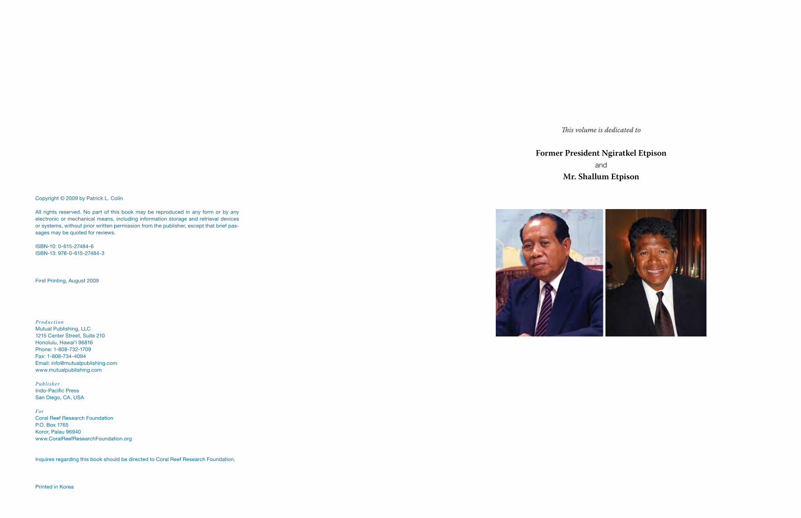
This volume is dedicated to
Former President Ngiratkel Etpisonand
Mr. Shallum Etpison
Copyright © 2009 by Patrick L. Colin
All rights reserved. No part of this book may be reproduced in any form or by any electronic or mechanical means, including information storage and retrieval devices or systems, without prior written permission from the publisher, except that brief pas-sages may be quoted for reviews.
ISBN-10: 0-615-27484-6ISBN-13: 978-0-615-27484-3
First Printing, August 2009
ProductionMutual Publishing, LLC1215 Center Street, Suite 210Honolulu, Hawai‘i 96816Phone: 1-808-732-1709Fax: 1-808-734-4094Email: [email protected]
Publisher Indo-Pacific PressSan Diego, CA, USA
For Coral Reef Research FoundationP.O. Box 1765Koror, Palau 96940www.CoralReefResearchFoundation.org
Inquires regarding this book should be directed to Coral Reef Research Foundation.
Printed in Korea
Table of Contents
Preface vi
Acknowledgements viii
Chapter 1 Introductory Materials 1
Chapter 2 Barrier Reefs and Outer Fringing Reefs 29
Chapter 3 Reef Passages and Channels on the Outer Reefs 81
Chapter 4 Atolls, Banks and Oceanic Islands of Palau 117
Chapter 5 Offshore Environments 133
Chapter 6 Shallow Lagoon Fringing Flats and Nearshore Patch Reefs 141
Chapter 7 Lagoon Patch Reefs 165
Chapter 8 Seagrass Areas 177
Chapter 9 The Rock Islands 195
Chapter 10 Marine Lakes 237
Chapter 11 Lagoon Sediment Bottoms 257
Chapter 12 Deep Lagoon Bottoms 277
Chapter 13 The Lagoon Pelagic Environment 283
Chapter 14 Basalt Islands: Shores, Mangroves and Estuaries 291
Chapter 15 Disturbed and Human Mediated Environments of Palau 307
Chapter 16 Dangers to the Marine Environments of Palau 317
Chapter 17 Marine Protected Areas and Conservation 347
Chapter 18 Taxonomic and Biogeographic Considerations for Conservation 359
Chapter 19 Status and Change in Marine Environments 371
Glossary 396
References Cited 398
Place Names Index 407
Subject Index 408
Scientific Names Index 412
tions among resources users, it is nearly impossible for an outsider to totally comprehend the meaning of it all. Future work on these aspects of Palau’s marine environment needs to be left to the growing cohort of young Palauan biologists to document and analyze for future generations. In this volume I have used “Palau” for the name of this island group, the English equivalent of “Belau” in the Palauan language. Palau is the name by which the country is known in the international community, within the United Nations and in the vast majority of published literature in English, so is used here. This work is dedicated to two true Palauan men who have been instrumental in in-creasing knowledge of Palau’s marine environment. Ngiratkel Etpison, former President of Palau and founding Chairman of the NECO group, grew up during the Japanese adminis-tration of Palau and after WWII started one of the largest commercial companies in Palau. The development of this business infrastructure facilitated Palau’s development of tourism and other sources of economic support while retaining its innate natural resources and beauty. He was critical in the establishment of CRRF’s research facility in Palau and was a strong supporter until his death in 1997. His son, Mr. Shallum Etpison, has continued this tradition and has been an ardent supporter of increasing cultural and scientific knowledge of Palau on many fronts. Many of his efforts in this regard are not widely known to the general public, but his enthusiasm and passion for all things Palauan runs deep and true.
Patrick L. Colin, Koror, Palau6 January 2009
Preface
“Marine Environments of Palau” has been nearly seven years in preparation. This work began in 2002 as a brief attempt to document the marine environments of Palau as part of Palau’s National Biodiversity Strategic Action Plan (NBSAP) under the United Nations Convention on Biological Diversity. Funding to prepare this initial report, completed in 2003, was provided by The Nature Conservancy through their support of developing eco-regional planning for Palau. It was then decided that a more extensive treatment would be useful and include information available in both the scientific and popular literature, as well as incorporating what had been learned during ten years of field work by the Coral Reef Research Foundation (CRRF) in Palau. CRRF, a non-profit organization dedicated to increasing knowledge of tropical marine ecosystems worldwide was formed in 1991 by a group of marine scientists. It has held the U.S. National Cancer Institute’s (NCI) marine collection contract since 1992, facilitating much of this field work. CRRF began marine research in Chuuk in 1993 and moved its base of operations to Palau in 1995 with completion of a laboratory and field station. The work for the U.S. NCI continues to this day and has been the basis for development of the present volume. It is intended that this volume be the first of a series of more detailed treatments of the marine fauna and flora of Palau and nearby regions resulting from the NCI work. In 2004 the Government of Spain’s Agencia Espanola de Cooperacion Internacional para el Desarrollo (AECID) funded a grant to the Palau National Government, admin-istered by the Palau Conservation Society, entitled “Empowering Local Communities to Promote, Enhance and Protect Marine Biodiversity.” The goal stated in the title was to be accomplished through greater access to needed information, greater capacity for marine resource-use planning and through information dissemination. The printing and distribu-tion of the present volume was supported under this project. Although I had spent most of my adult life living on and visiting tropical islands as part of my research in tropical marine biology, I had never visited Palau until 1993. I had spent time in a number of the most highly esteemed areas of the world, and anticipated that while beautiful, Palau would simply be another island group in the uppermost tier of tropi-cal marine locations. How wrong I was! My first morning in Palau, I was treated to an ex-tensive boat trip through the Rock Islands near Koror. Though magical above water, I had never seen anything quite like the lush coral communities along the steep slopes and walls of the inner Rock Islands. The veritable maze of islands and channels with some new vista at every turn was remarkable. The communities on the reef flats around the islands and extensive sea grass beds were equally impressive and a visit to a marine cavern revealed an entirely new fauna to me. Quickly I realized that this was not “just another island” but that the Rock Islands and many other areas of Palau were unique, exceeding any other area I had ever visited in their biological and oceanographic complexity in such a small area. That one could spend many lifetimes of documenting and studying interesting creatures and environments was apparent. Palau has been the subject of a vast number of articles in popular magazines and books, mostly concerned with sport diving; showcasing sharks, turtles and other “charismatic megafauna”, as well as impressive walls and caverns. There is a huge gulf between popular attention devoted to the impressive dive sites (much less than 1% of the marine areas of Palau) and the vastly larger and in many ways more fascinating remainder of the marine environments. While “Blue Corner” may be regarded as the “best dive site in the Pacific,” the areas that Palauans use on a daily basis as a source of food are poorly known by the outside world. In some respects, these large areas lack the dramatic appeal of the major dive sites, but are the critical areas for biodiversity conservation and fishery management. Even the most mundane area just off the shore of islands around Koror can hold fascinat-ing creatures that are going about their lives as they have for millions of years. As a foreigner in Palau, it is apparent that there are many aspects of the marine envi-ronments here, particularly those concerned with the cultural relationship between hu-mans and their resources, that I will never be privileged to understand. Without growing up within the culture using the resources, with all the subtleties of language and interac-
Reproduction and printing of this volume provided by AECID
vi vii
Etpison, Bert Yates, Henni Rall, Josie Minon and many oth-er personnel and dive guides of NECO Marine have been critical to our success. The Nature Conservancy provided funds for the initial preparation of a draft document outlining marine environ-ments of Palau for the Palau National Biodiversity Strate-gic Action Plan (NBSAP). Mr. David Hinchley, the TNC Country Officer for Palau at the time, provided logistical and moral support for this endeavor. The NBSAP was orga-nized through the Office of Environmental Response and Coordination (OERC) under the President’s Office, Youlsau Bells, Director. A number of our scientific colleagues have made contri-butions to knowledge which aided this volume. Dr. William Hamner and Ms. Peggy Hamner, now retired from UCLA, have conducted research in Palau for nearly three decades, in later years with CRRF staff. Additionally they provided extensive improvement to an early draft of this volume. Dr. Eric Wolanski, formerly of the Australian Institute of Marine Science, provided informative discussion about the physical oceanography of Palau. Ms. Alma Ridep-Morris of James Cook University and previously with the Bureau of Marine Resources of the Palau National Government pro-vided information on coral diseases in Palau. Drs. John D. Faulkner, William Fenical, Margo Haygood, Carole Bewley, Eric Schmidt and Paul Jensen have worked extensively on Palau’s natural product chemistry from Scripps Institu-tion of Oceanography or their later institutions. Significant contributions to knowledge of Palau marine habitats have been provided by Drs. Jon Whitman, John Bruno, and their colleagues. A number of colleagues from the University of Guam marine laboratory have added research work relative to this volume, including Drs. Gustav Paulay, Terry Don-aldson, Robert Thacker and Valerie Paul and Mr. Raphael Ritson-Williams. Writing of the chapter on Marine Lakes of Palau was greatly aided by the suggestions of Drs. Mike Dawson and Laura Martin, Ms. Lori J.B. Colin and Sharon Patris. Their knowledge of these systems is significant and in the future they will be writing a definitive treatment of these unusual marine habitats. Funding used to support aspects of the research pro-grams of CRRF (other than the U.S. NCI), all of which have contributed to this volume, has been provided by the Da-vid and Lucile Packard Foundation, the U.S. National Sci-ence Foundation, National Fish and Wildlife Foundation, Marine Resources Pacific Consortium (MAREPAC), The Nature Conservancy, the Con Amor Foundation, and from internal funds of CRRF. Finally to my colleagues from CRRF I would like to offer my most grateful thanks for your dedication and hard work over the past 17 years. I have to offer particular acknowl-edgment to my wife, Lori J.B. Colin. Without her efforts this program and the success of our research facility in Palau would have never happened. Lori has provided an essential element of consistency and detail for the NCI work, as well as maintaining her own research interests on marine lakes
of Palau. The present and previous staff of CRRF has been essential to the success of our work: (in alphabetical order) Emilio Basilius, Mike Dawson, Laura Martin, Matthew Mesubed, Nathan Morris, Sharon Patris and Larry Shar-ron have been particularly critical in this regard. I would also like to thank former employees of CRRF who have also aided our work: Carla Salii, Lolita Penland, Patricia Davis and Julian Dendy. Since 2002 Mr. Mike Gerstein of San Di-ego, CA has provided dedicated accounting and logistical services to CRRF and his efforts are greatly appreciated. CRRF’s principal consulting taxonomists provided un-equalled service in the identification of all NCI collections and the description of new species from NCI material col-lected in Palau and elsewhere. These scientists (listed in taxonomic order) include Drs. Michelle Kelly (sponges), Belinda Alvarez de Glasby (sponges), John N.A. Hooper (sponges), Leen van Ofwegen (octocorals), Phil Alderslade (soft corals), Bert Hokesema (stony corals), Gary Williams (octocorals), Dennis Opresko (antipatharians), Dale Calder (hydroids), Charles Messing (crinoids), Chris Mah (echi-noderms), Francoise and Claude Monniot (ascidians) and Gavino Trono (algae). Dr. Emre Turak provided help on identification of stony corals. Drs. John and Nancy Ogden provided aerial photos from their 1978 research work in Palau. Interesting discus-sions and other contributions were provided by Mr. Doug Faulkner (pioneering underwater photographer and ar-dent defender of Palau’s natural world), Mr. Peter Jennings, Ann and Clarence Kitalong, and Jon Vogt. Ms. Robin De-Meo of the Natural Resources Conservation Service of the U.S. Dept. of Agriculture provided the first access to Iko-nos imagery of Palau and her efforts in protecting Palau’s terrestrial environments are well remembered. The Palau International Coral Reef Center (PICRC) has engaged in monitoring efforts on Palau’s reefs for some time and their information has proved valuable in the present effort. I would like to thank the staff of Mutual Publishing for their patient assistance during the preparation of this vol-ume. Courtney Young (designer), Karen Lofstrom (copyedi-tor), Jane Gillespie, and Bennett Hymer were all extremely helpful and their attention provided improvements to the book in many ways. Mandy Etpison also assisted with the design of the covers and other portions of the book. Any errors or omissions in this volume are the responsibility of the author. Finally the People of Palau are thanked for allowing our activities in their country; part of a chain of research inves-tigations on the natural world of Palau leading back nearly two centuries. To all the people of Palau I wish to offer a heartfelt “Mesulang”.
I would like to thank the Government of Spain through its Agencia Espanola de Coop-eracion Internacional para el Desarrollo (AECID) as part of the project with the Palau National Government entitled “Empowering Local Communities to Promote, Enhance and Protect Marine Biodiversity”, for the funding to the Coral Reef Research Foundation (CRRF) to print and distribute this volume. The Palau Conservation Society (PCS), dedicated to preserving the natural wonders of Palau for future generations, facilitated CRRF’s inclusion in the grant and provided admin-istrative support. The assistance of Executive Director Ms. Tiare Holm, Mr. Scott Keiffer, Dr. Elizabeth Matthews and Mr. Asap Bukuruo are gratefully acknowledged. The develop-ment of the “Northern Reef Program” of PCS with Ngarchelong and Kayangel States has allowed the opportunity to conduct research in these areas which are poorly known scien-tifically and relatively distant from our home base in Koror. The Palau National Government and the Bureau of Marine Resources of the Ministry of Resources and Development, through Director Theo Isamu, have been supportive over the years of CRRF’s marine research and are gratefully acknowledged. The Palau Auto-mated Land and Information System (PALARIS) and the Belau National Museum are also thanked for assistance with maps and documents. Traditional leaders of Palau, led by Re-klai Rafael Ngirmang and Ibedul Yutaka Gibbons, allowed research in Palau’s waters. The Koror State Government is thanked for their assistance and support of the past and ongoing projects of CRRF. Governor Yositaka Adachi, former Governor John C. Gibbons, Director of Conservation and Law Enforcement Mr. Adalbert Eledui, Ms. Ilebrang Olkeriil and the Koror State Rangers are all thanked for their continued support. The other state governments of Palau have been kind to allow access to their waters for observation and other scientific research. Kayangel State allowed special access to Velasco Reef, and Ngat-pang and Ngaremlengui States allowed access to ship grounding sites and were supportive of research efforts on these incidents. Most of the field work to gather the information and photographs for this volume was conducted during the course of work by CRRF for the US National Cancer Institute’s (NCI) marine collection program. Since 1993 the NCI has supported marine work in Palau aimed at discovering new cancer treatment drugs from the ocean. This has involved learn-ing about the taxonomy, distribution and abundance of marine invertebrates and marine plants, as well as examining community structure, distribution and oceanography of Palau habitats, in an effort to sample every species possible for inclusion in the screening by the NCI’s natural products chemists. Dr. David Newman of the NCI has served as Project Officer for CRRF since 1992 and has been continually encouraging and supportive of our work in Palau, for which we are extremely grateful. Dr. Gordon Cragg, Chief of the Natural Products Research Branch through 2005 helped in many ways. Ms. Elsa Carlton served as Contract Officer for this program from 1992 to 2007; a duty which has now been undertak-en by Ms. Robin Irving and both are acknowledged for their support. Dr. Kirk Gustafson and coworkers in the NCI’s research laboratories have reported on new compounds from Palauan organisms. The knowledge gained during this program, which continues to this day, has provided new insights into the species diversity, biogeography and ecology of ma-rine organisms from Palau, as well as the world tropics. It is CRRF’s commitment to con-tinue publication of this knowledge to provide the maximum scientific products possible from the funds which have been devoted to this drug discovery work. Accessing and reading the diverse and scattered literature on Palau’s marine environ-ment for this volume was made possible and infinitely simpler through the compilation of the Palau Cultural and Environmental Bibliography by Mr. Dave Sapio during his tenure with the Peace Corps in Palau. This bibliography, in combination with the scanned docu-ments, is a superb resource for future use. Our friends at NECO Marine, Palau’s largest dive shop located next door to the CRRF laboratory on Malakal Island in Koror, have provided continued support and encourage-ment over the years. Palau’s former President Ngiratkel Etpison made our establishment in Palau possible, and this support has been continued by his son Shallum Etpison. Mandy
Acknowledgements
viii ix
1
1CH
AP
TE
R
Introductory Materials
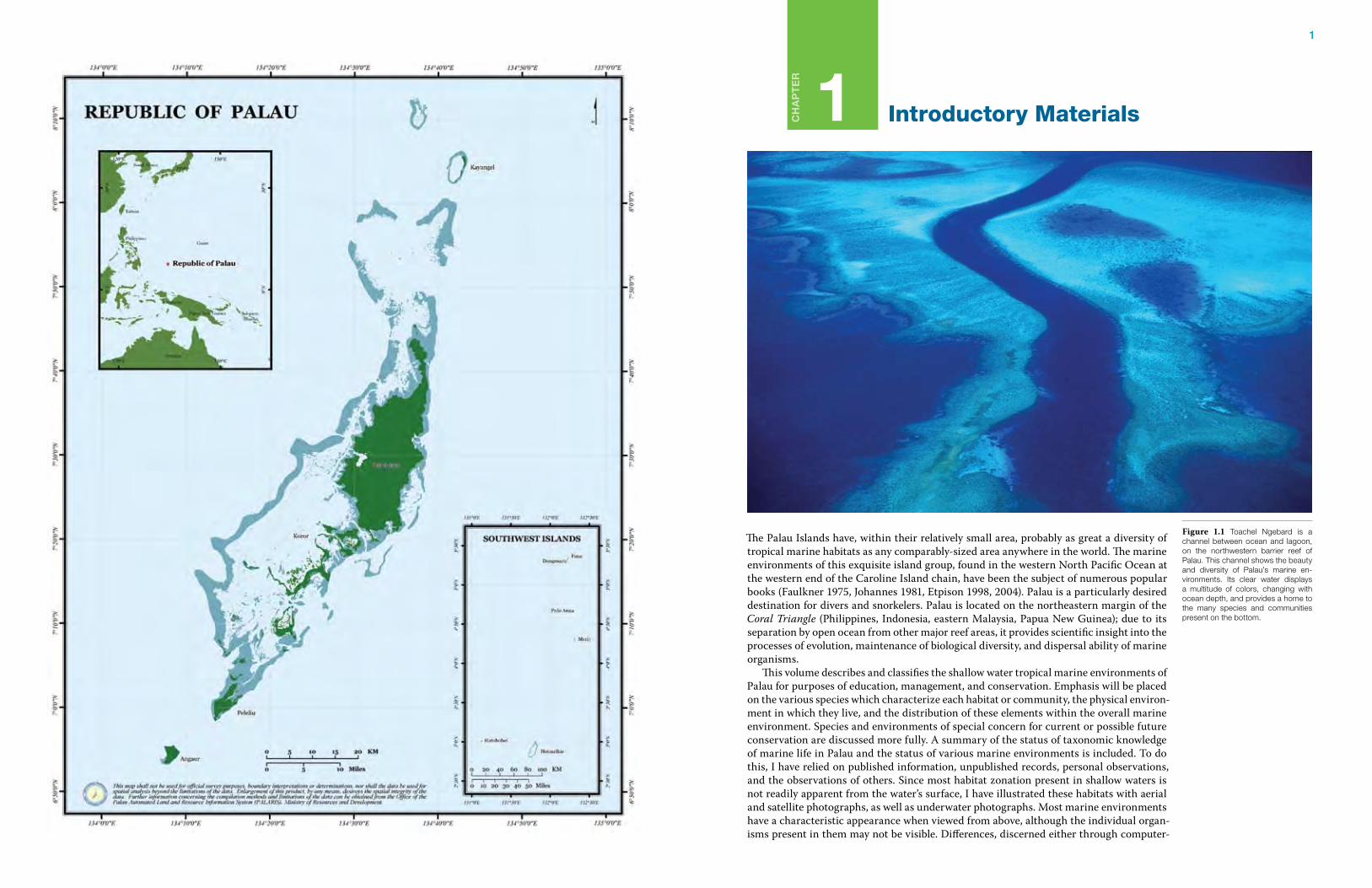
The Palau Islands have, within their relatively small area, probably as great a diversity of tropical marine habitats as any comparably-sized area anywhere in the world. The marine environments of this exquisite island group, found in the western North Pacific Ocean at the western end of the Caroline Island chain, have been the subject of numerous popular books (Faulkner 1975, Johannes 1981, Etpison 1998, 2004). Palau is a particularly desired destination for divers and snorkelers. Palau is located on the northeastern margin of the Coral Triangle (Philippines, Indonesia, eastern Malaysia, Papua New Guinea); due to its separation by open ocean from other major reef areas, it provides scientific insight into the processes of evolution, maintenance of biological diversity, and dispersal ability of marine organisms. This volume describes and classifies the shallow water tropical marine environments of Palau for purposes of education, management, and conservation. Emphasis will be placed on the various species which characterize each habitat or community, the physical environ-ment in which they live, and the distribution of these elements within the overall marine environment. Species and environments of special concern for current or possible future conservation are discussed more fully. A summary of the status of taxonomic knowledge of marine life in Palau and the status of various marine environments is included. To do this, I have relied on published information, unpublished records, personal observations, and the observations of others. Since most habitat zonation present in shallow waters is not readily apparent from the water’s surface, I have illustrated these habitats with aerial and satellite photographs, as well as underwater photographs. Most marine environments have a characteristic appearance when viewed from above, although the individual organ-isms present in them may not be visible. Differences, discerned either through computer-
Figure 1.1 Toachel Ngebard is a channel between ocean and lagoon, on the northwestern barrier reef of Palau. This channel shows the beauty and diversity of Palau’s marine en-vironments. Its clear water displays a multitude of colors, changing with ocean depth, and provides a home to the many species and communities present on the bottom.
2 Marine Environments of Palau 3Introductory Materials
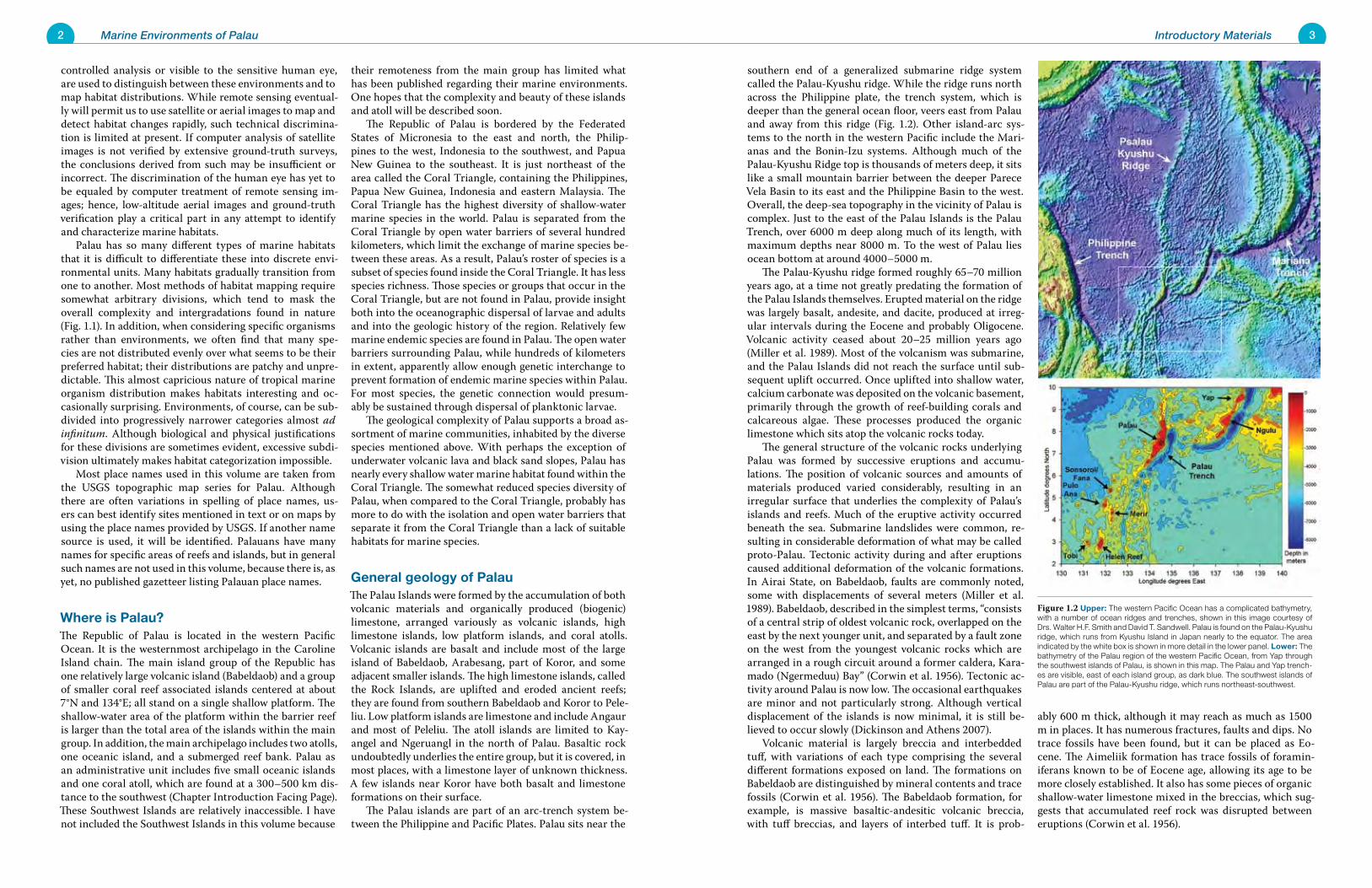
southern end of a generalized submarine ridge system called the Palau-Kyushu ridge. While the ridge runs north across the Philippine plate, the trench system, which is deeper than the general ocean floor, veers east from Palau and away from this ridge (Fig. 1.2). Other island-arc sys-tems to the north in the western Pacific include the Mari-anas and the Bonin-Izu systems. Although much of the Palau-Kyushu Ridge top is thousands of meters deep, it sits like a small mountain barrier between the deeper Parece Vela Basin to its east and the Philippine Basin to the west. Overall, the deep-sea topography in the vicinity of Palau is complex. Just to the east of the Palau Islands is the Palau Trench, over 6000 m deep along much of its length, with maximum depths near 8000 m. To the west of Palau lies ocean bottom at around 4000–5000 m. The Palau-Kyushu ridge formed roughly 65–70 million years ago, at a time not greatly predating the formation of the Palau Islands themselves. Erupted material on the ridge was largely basalt, andesite, and dacite, produced at irreg-ular intervals during the Eocene and probably Oligocene. Volcanic activity ceased about 20–25 million years ago (Miller et al. 1989). Most of the volcanism was submarine, and the Palau Islands did not reach the surface until sub-sequent uplift occurred. Once uplifted into shallow water, calcium carbonate was deposited on the volcanic basement, primarily through the growth of reef-building corals and calcareous algae. These processes produced the organic limestone which sits atop the volcanic rocks today. The general structure of the volcanic rocks underlying Palau was formed by successive eruptions and accumu-lations. The position of volcanic sources and amounts of materials produced varied considerably, resulting in an irregular surface that underlies the complexity of Palau’s islands and reefs. Much of the eruptive activity occurred beneath the sea. Submarine landslides were common, re-sulting in considerable deformation of what may be called proto-Palau. Tectonic activity during and after eruptions caused additional deformation of the volcanic formations. In Airai State, on Babeldaob, faults are commonly noted, some with displacements of several meters (Miller et al. 1989). Babeldaob, described in the simplest terms, “consists of a central strip of oldest volcanic rock, overlapped on the east by the next younger unit, and separated by a fault zone on the west from the youngest volcanic rocks which are arranged in a rough circuit around a former caldera, Kara-mado (Ngermeduu) Bay” (Corwin et al. 1956). Tectonic ac-tivity around Palau is now low. The occasional earthquakes are minor and not particularly strong. Although vertical displacement of the islands is now minimal, it is still be-lieved to occur slowly (Dickinson and Athens 2007). Volcanic material is largely breccia and interbedded tuff, with variations of each type comprising the several different formations exposed on land. The formations on Babeldaob are distinguished by mineral contents and trace fossils (Corwin et al. 1956). The Babeldaob formation, for example, is massive basaltic-andesitic volcanic breccia, with tuff breccias, and layers of interbed tuff. It is prob-
ably 600 m thick, although it may reach as much as 1500 m in places. It has numerous fractures, faults and dips. No trace fossils have been found, but it can be placed as Eo-cene. The Aimeliik formation has trace fossils of foramin-iferans known to be of Eocene age, allowing its age to be more closely established. It also has some pieces of organic shallow-water limestone mixed in the breccias, which sug-gests that accumulated reef rock was disrupted between eruptions (Corwin et al. 1956).
controlled analysis or visible to the sensitive human eye, are used to distinguish between these environments and to map habitat distributions. While remote sensing eventual-ly will permit us to use satellite or aerial images to map and detect habitat changes rapidly, such technical discrimina-tion is limited at present. If computer analysis of satellite images is not verified by extensive ground-truth surveys, the conclusions derived from such may be insufficient or incorrect. The discrimination of the human eye has yet to be equaled by computer treatment of remote sensing im-ages; hence, low-altitude aerial images and ground-truth verification play a critical part in any attempt to identify and characterize marine habitats. Palau has so many different types of marine habitats that it is difficult to differentiate these into discrete envi-ronmental units. Many habitats gradually transition from one to another. Most methods of habitat mapping require somewhat arbitrary divisions, which tend to mask the overall complexity and intergradations found in nature (Fig. 1.1). In addition, when considering specific organisms rather than environments, we often find that many spe-cies are not distributed evenly over what seems to be their preferred habitat; their distributions are patchy and unpre-dictable. This almost capricious nature of tropical marine organism distribution makes habitats interesting and oc-casionally surprising. Environments, of course, can be sub-divided into progressively narrower categories almost ad infinitum. Although biological and physical justifications for these divisions are sometimes evident, excessive subdi-vision ultimately makes habitat categorization impossible. Most place names used in this volume are taken from the USGS topographic map series for Palau. Although there are often variations in spelling of place names, us-ers can best identify sites mentioned in text or on maps by using the place names provided by USGS. If another name source is used, it will be identified. Palauans have many names for specific areas of reefs and islands, but in general such names are not used in this volume, because there is, as yet, no published gazetteer listing Palauan place names.
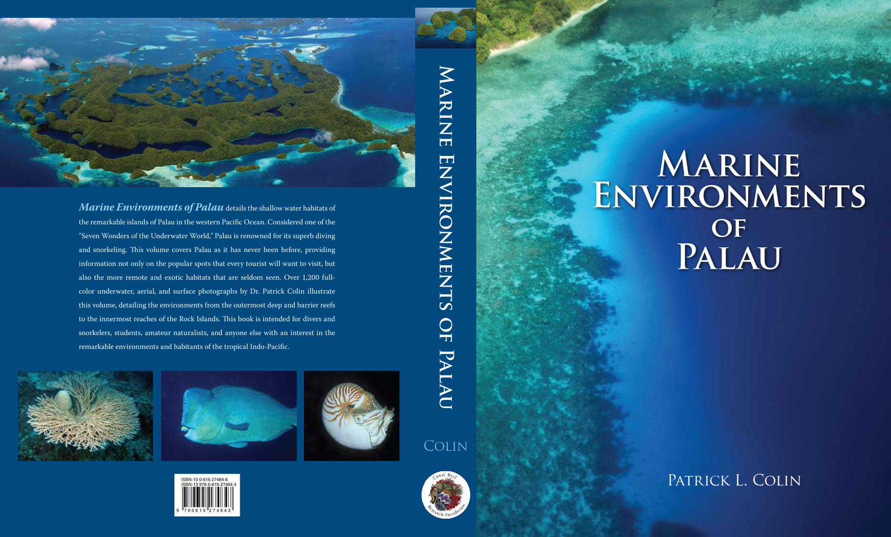
Where is Palau?The Republic of Palau is located in the western Pacific Ocean. It is the westernmost archipelago in the Caroline Island chain. The main island group of the Republic has one relatively large volcanic island (Babeldaob) and a group of smaller coral reef associated islands centered at about 7°N and 134°E; all stand on a single shallow platform. The shallow-water area of the platform within the barrier reef is larger than the total area of the islands within the main group. In addition, the main archipelago includes two atolls, one oceanic island, and a submerged reef bank. Palau as an administrative unit includes five small oceanic islands and one coral atoll, which are found at a 300–500 km dis-tance to the southwest (Chapter Introduction Facing Page). These Southwest Islands are relatively inaccessible. I have not included the Southwest Islands in this volume because
their remoteness from the main group has limited what has been published regarding their marine environments. One hopes that the complexity and beauty of these islands and atoll will be described soon. The Republic of Palau is bordered by the Federated States of Micronesia to the east and north, the Philip-pines to the west, Indonesia to the southwest, and Papua New Guinea to the southeast. It is just northeast of the area called the Coral Triangle, containing the Philippines, Papua New Guinea, Indonesia and eastern Malaysia. The Coral Triangle has the highest diversity of shallow-water marine species in the world. Palau is separated from the Coral Triangle by open water barriers of several hundred kilometers, which limit the exchange of marine species be-tween these areas. As a result, Palau’s roster of species is a subset of species found inside the Coral Triangle. It has less species richness. Those species or groups that occur in the Coral Triangle, but are not found in Palau, provide insight both into the oceanographic dispersal of larvae and adults and into the geologic history of the region. Relatively few marine endemic species are found in Palau. The open water barriers surrounding Palau, while hundreds of kilometers in extent, apparently allow enough genetic interchange to prevent formation of endemic marine species within Palau. For most species, the genetic connection would presum-ably be sustained through dispersal of planktonic larvae. The geological complexity of Palau supports a broad as-sortment of marine communities, inhabited by the diverse species mentioned above. With perhaps the exception of underwater volcanic lava and black sand slopes, Palau has nearly every shallow water marine habitat found within the Coral Triangle. The somewhat reduced species diversity of Palau, when compared to the Coral Triangle, probably has more to do with the isolation and open water barriers that separate it from the Coral Triangle than a lack of suitable habitats for marine species.
General geology of PalauThe Palau Islands were formed by the accumulation of both volcanic materials and organically produced (biogenic) limestone, arranged variously as volcanic islands, high limestone islands, low platform islands, and coral atolls. Volcanic islands are basalt and include most of the large island of Babeldaob, Arabesang, part of Koror, and some adjacent smaller islands. The high limestone islands, called the Rock Islands, are uplifted and eroded ancient reefs; they are found from southern Babeldaob and Koror to Pele-liu. Low platform islands are limestone and include Angaur and most of Peleliu. The atoll islands are limited to Kay-angel and Ngeruangl in the north of Palau. Basaltic rock undoubtedly underlies the entire group, but it is covered, in most places, with a limestone layer of unknown thickness. A few islands near Koror have both basalt and limestone formations on their surface. The Palau islands are part of an arc-trench system be-tween the Philippine and Pacific Plates. Palau sits near the
Figure 1.2 Upper: The western Pacific Ocean has a complicated bathymetry, with a number of ocean ridges and trenches, shown in this image courtesy of Drs. Walter H.F. Smith and David T. Sandwell. Palau is found on the Palau-Kyushu ridge, which runs from Kyushu Island in Japan nearly to the equator. The area indicated by the white box is shown in more detail in the lower panel. Lower: The bathymetry of the Palau region of the western Pacific Ocean, from Yap through the southwest islands of Palau, is shown in this map. The Palau and Yap trench-es are visible, east of each island group, as dark blue. The southwest islands of Palau are part of the Palau-Kyushu ridge, which runs northeast-southwest.
4 Marine Environments of Palau 5Introductory Materials
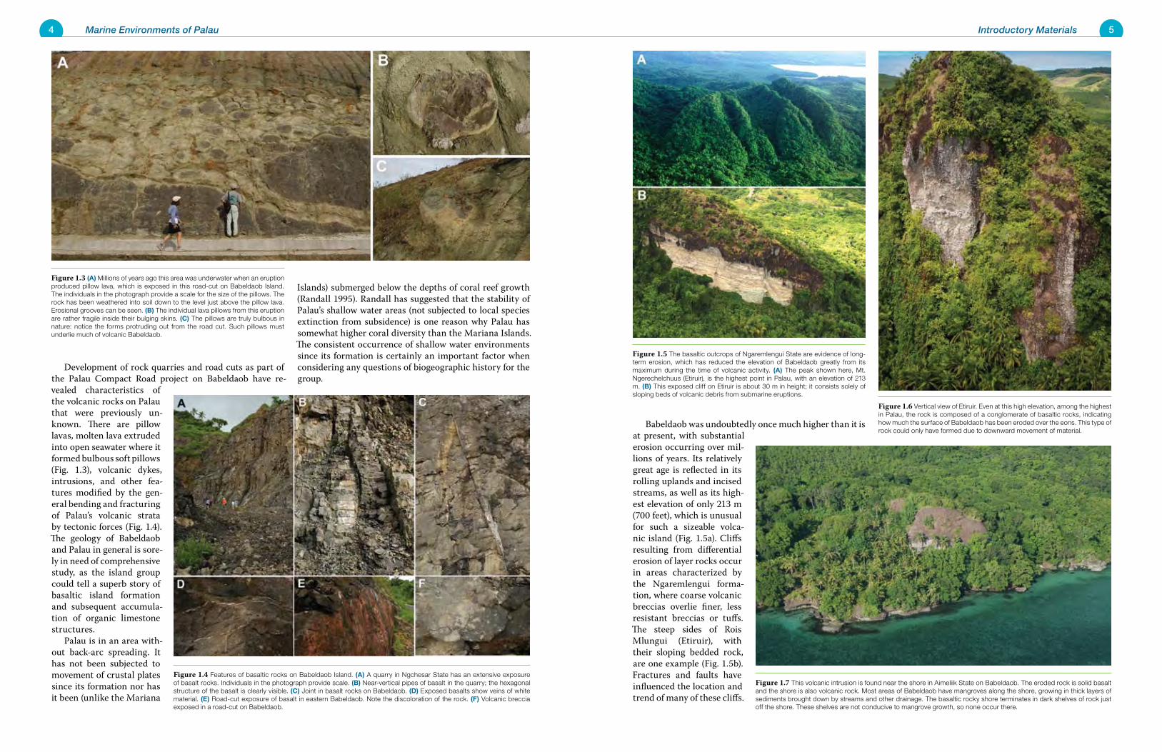
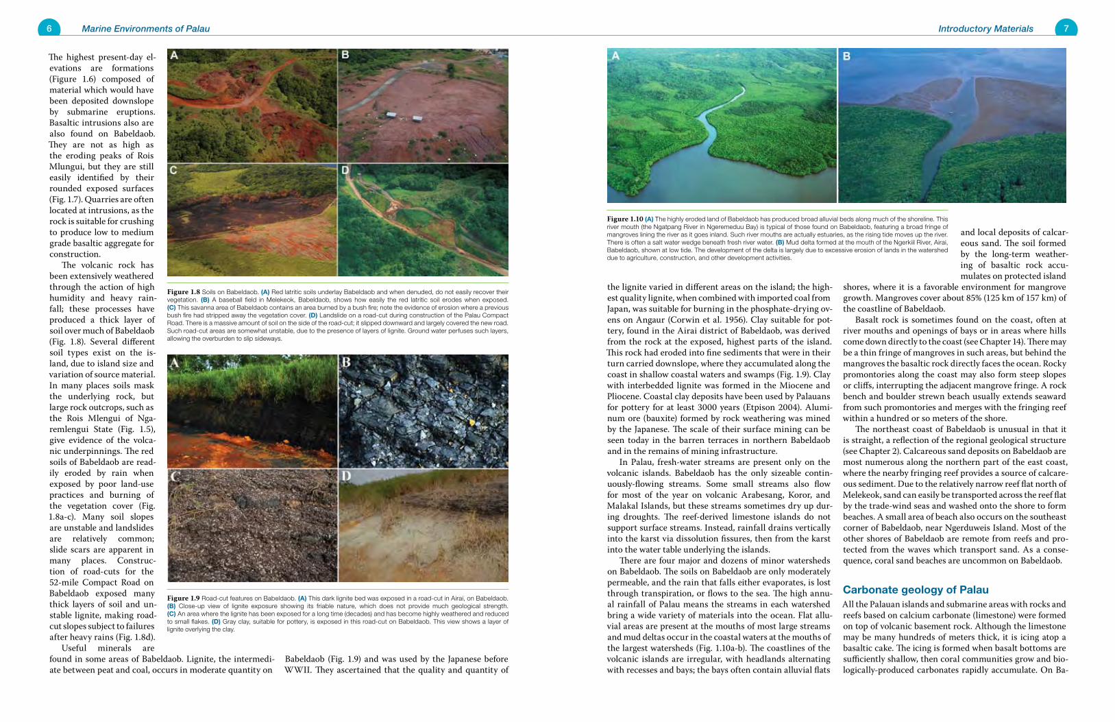
Babeldaob was undoubtedly once much higher than it is at present, with substantial erosion occurring over mil-lions of years. Its relatively great age is reflected in its rolling uplands and incised streams, as well as its high-est elevation of only 213 m (700 feet), which is unusual for such a sizeable volca-nic island (Fig. 1.5a). Cliffs resulting from differential erosion of layer rocks occur in areas characterized by the Ngaremlengui forma-tion, where coarse volcanic breccias overlie finer, less resistant breccias or tuffs. The steep sides of Rois Mlungui (Etiruir), with their sloping bedded rock, are one example (Fig. 1.5b). Fractures and faults have influenced the location and trend of many of these cliffs.
Development of rock quarries and road cuts as part of the Palau Compact Road project on Babeldaob have re-vealed characteristics of the volcanic rocks on Palau that were previously un-known. There are pillow lavas, molten lava extruded into open seawater where it formed bulbous soft pillows (Fig. 1.3), volcanic dykes, intrusions, and other fea-tures modified by the gen-eral bending and fracturing of Palau’s volcanic strata by tectonic forces (Fig. 1.4). The geology of Babeldaob and Palau in general is sore-ly in need of comprehensive study, as the island group could tell a superb story of basaltic island formation and subsequent accumula-tion of organic limestone structures. Palau is in an area with-out back-arc spreading. It has not been subjected to movement of crustal plates since its formation nor has it been (unlike the Mariana
Islands) submerged below the depths of coral reef growth (Randall 1995). Randall has suggested that the stability of Palau’s shallow water areas (not subjected to local species extinction from subsidence) is one reason why Palau has somewhat higher coral diversity than the Mariana Islands. The consistent occurrence of shallow water environments since its formation is certainly an important factor when considering any questions of biogeographic history for the group.
Figure 1.6 Vertical view of Etiruir. Even at this high elevation, among the highest in Palau, the rock is composed of a conglomerate of basaltic rocks, indicating how much the surface of Babeldaob has been eroded over the eons. This type of rock could only have formed due to downward movement of material.
Figure 1.4 Features of basaltic rocks on Babeldaob Island. (A) A quarry in Ngchesar State has an extensive exposure of basalt rocks. Individuals in the photograph provide scale. (B) Near-vertical pipes of basalt in the quarry; the hexagonal structure of the basalt is clearly visible. (C) Joint in basalt rocks on Babeldaob. (D) Exposed basalts show veins of white material. (E) Road-cut exposure of basalt in eastern Babeldaob. Note the discoloration of the rock. (F) Volcanic breccia exposed in a road-cut on Babeldaob.
Figure 1.5 The basaltic outcrops of Ngaremlengui State are evidence of long-term erosion, which has reduced the elevation of Babeldaob greatly from its maximum during the time of volcanic activity. (A) The peak shown here, Mt. Ngerechelchuus (Etiruir), is the highest point in Palau, with an elevation of 213 m. (B) This exposed cliff on Etiruir is about 30 m in height; it consists solely of sloping beds of volcanic debris from submarine eruptions.
Figure 1.3 (A) Millions of years ago this area was underwater when an eruption produced pillow lava, which is exposed in this road-cut on Babeldaob Island. The individuals in the photograph provide a scale for the size of the pillows. The rock has been weathered into soil down to the level just above the pillow lava. Erosional grooves can be seen. (B) The individual lava pillows from this eruption are rather fragile inside their bulging skins. (C) The pillows are truly bulbous in nature: notice the forms protruding out from the road cut. Such pillows must underlie much of volcanic Babeldaob.
Figure 1.7 This volcanic intrusion is found near the shore in Aimeliik State on Babeldaob. The eroded rock is solid basalt and the shore is also volcanic rock. Most areas of Babeldaob have mangroves along the shore, growing in thick layers of sediments brought down by streams and other drainage. The basaltic rocky shore terminates in dark shelves of rock just off the shore. These shelves are not conducive to mangrove growth, so none occur there.
6 Marine Environments of Palau 7Introductory Materials
the lignite varied in different areas on the island; the high-est quality lignite, when combined with imported coal from Japan, was suitable for burning in the phosphate-drying ov-ens on Angaur (Corwin et al. 1956). Clay suitable for pot-tery, found in the Airai district of Babeldaob, was derived from the rock at the exposed, highest parts of the island. This rock had eroded into fine sediments that were in their turn carried downslope, where they accumulated along the coast in shallow coastal waters and swamps (Fig. 1.9). Clay with interbedded lignite was formed in the Miocene and Pliocene. Coastal clay deposits have been used by Palauans for pottery for at least 3000 years (Etpison 2004). Alumi-num ore (bauxite) formed by rock weathering was mined by the Japanese. The scale of their surface mining can be seen today in the barren terraces in northern Babeldaob and in the remains of mining infrastructure. In Palau, fresh-water streams are present only on the volcanic islands. Babeldaob has the only sizeable contin-uously-flowing streams. Some small streams also flow for most of the year on volcanic Arabesang, Koror, and Malakal Islands, but these streams sometimes dry up dur-ing droughts. The reef-derived limestone islands do not support surface streams. Instead, rainfall drains vertically into the karst via dissolution fissures, then from the karst into the water table underlying the islands. There are four major and dozens of minor watersheds on Babeldaob. The soils on Babeldaob are only moderately permeable, and the rain that falls either evaporates, is lost through transpiration, or flows to the sea. The high annu-al rainfall of Palau means the streams in each watershed bring a wide variety of materials into the ocean. Flat allu-vial areas are present at the mouths of most large streams and mud deltas occur in the coastal waters at the mouths of the largest watersheds (Fig. 1.10a-b). The coastlines of the volcanic islands are irregular, with headlands alternating with recesses and bays; the bays often contain alluvial flats
and local deposits of calcar-eous sand. The soil formed by the long-term weather-ing of basaltic rock accu-mulates on protected island
shores, where it is a favorable environment for mangrove growth. Mangroves cover about 85% (125 km of 157 km) of the coastline of Babeldaob. Basalt rock is sometimes found on the coast, often at river mouths and openings of bays or in areas where hills come down directly to the coast (see Chapter 14). There may be a thin fringe of mangroves in such areas, but behind the mangroves the basaltic rock directly faces the ocean. Rocky promontories along the coast may also form steep slopes or cliffs, interrupting the adjacent mangrove fringe. A rock bench and boulder strewn beach usually extends seaward from such promontories and merges with the fringing reef within a hundred or so meters of the shore. The northeast coast of Babeldaob is unusual in that it is straight, a reflection of the regional geological structure (see Chapter 2). Calcareous sand deposits on Babeldaob are most numerous along the northern part of the east coast, where the nearby fringing reef provides a source of calcare-ous sediment. Due to the relatively narrow reef flat north of Melekeok, sand can easily be transported across the reef flat by the trade-wind seas and washed onto the shore to form beaches. A small area of beach also occurs on the southeast corner of Babeldaob, near Ngerduweis Island. Most of the other shores of Babeldaob are remote from reefs and pro-tected from the waves which transport sand. As a conse-quence, coral sand beaches are uncommon on Babeldaob.
Carbonate geology of PalauAll the Palauan islands and submarine areas with rocks and reefs based on calcium carbonate (limestone) were formed on top of volcanic basement rock. Although the limestone may be many hundreds of meters thick, it is icing atop a basaltic cake. The icing is formed when basalt bottoms are sufficiently shallow, then coral communities grow and bio-logically-produced carbonates rapidly accumulate. On Ba-
The highest present-day el-evations are formations (Figure 1.6) composed of material which would have been deposited downslope by submarine eruptions. Basaltic intrusions also are also found on Babeldaob. They are not as high as the eroding peaks of Rois Mlungui, but they are still easily identified by their rounded exposed surfaces (Fig. 1.7). Quarries are often located at intrusions, as the rock is suitable for crushing to produce low to medium grade basaltic aggregate for construction. The volcanic rock has been extensively weathered through the action of high humidity and heavy rain-fall; these processes have produced a thick layer of soil over much of Babeldaob (Fig. 1.8). Several different soil types exist on the is-land, due to island size and variation of source material. In many places soils mask the underlying rock, but large rock outcrops, such as the Rois Mlengui of Nga-remlengui State (Fig. 1.5), give evidence of the volca-nic underpinnings. The red soils of Babeldaob are read-ily eroded by rain when exposed by poor land-use practices and burning of the vegetation cover (Fig. 1.8a-c). Many soil slopes are unstable and landslides are relatively common; slide scars are apparent in many places. Construc-tion of road-cuts for the 52-mile Compact Road on Babeldaob exposed many thick layers of soil and un-stable lignite, making road-cut slopes subject to failures after heavy rains (Fig. 1.8d). Useful minerals are found in some areas of Babeldaob. Lignite, the intermedi-ate between peat and coal, occurs in moderate quantity on
Babeldaob (Fig. 1.9) and was used by the Japanese before WWII. They ascertained that the quality and quantity of
Figure 1.10 (A) The highly eroded land of Babeldaob has produced broad alluvial beds along much of the shoreline. This river mouth (the Ngatpang River in Ngeremeduu Bay) is typical of those found on Babeldaob, featuring a broad fringe of mangroves lining the river as it goes inland. Such river mouths are actually estuaries, as the rising tide moves up the river. There is often a salt water wedge beneath fresh river water. (B) Mud delta formed at the mouth of the Ngerkiil River, Airai, Babeldaob, shown at low tide. The development of the delta is largely due to excessive erosion of lands in the watershed due to agriculture, construction, and other development activities.
Figure 1.8 Soils on Babeldaob. (A) Red latritic soils underlay Babeldaob and when denuded, do not easily recover their vegetation. (B) A baseball field in Melekeok, Babeldaob, shows how easily the red latritic soil erodes when exposed. (C) This savanna area of Babeldaob contains an area burned by a bush fire; note the evidence of erosion where a previous bush fire had stripped away the vegetation cover. (D) Landslide on a road-cut during construction of the Palau Compact Road. There is a massive amount of soil on the side of the road-cut; it slipped downward and largely covered the new road. Such road-cut areas are somewhat unstable, due to the presence of layers of lignite. Ground water perfuses such layers, allowing the overburden to slip sideways.
Figure 1.9 Road-cut features on Babeldaob. (A) This dark lignite bed was exposed in a road-cut in Airai, on Babeldaob. (B) Close-up view of lignite exposure showing its friable nature, which does not provide much geological strength. (C) An area where the lignite has been exposed for a long time (decades) and has become highly weathered and reduced to small flakes. (D) Gray clay, suitable for pottery, is exposed in this road-cut on Babeldaob. This view shows a layer of lignite overlying the clay.
8 Marine Environments of Palau 9Introductory Materials
for their land area. Ngeruktabel has 91 km of shoreline on an island of only 18.4 km2 in area. While Ngeruktabel is only 5.6% of the land area of Babeldaob, its shoreline is 58% that of the larger island. Similarly, Mecherchar has 43 km of shoreline with only 7.9 km2 of land area. The high rela-tive extent of shoreline compared to land area has many implications for marine communities in the Rock Islands. As uplift occurred, new reef fronts developed (in many cases far beyond the former reef) along the crest of the un-derlying volcanic ridge. The same conditions of underlying rock structure, waves, and wind that shaped early reefs ap-pear to exist today, as the shapes of some islands, such as Ngeruktabel, resemble present-day areas of living reef. The Palau Limestone is Miocene to Pleistocene in age. The older Miocene age rock, as diagnosed by trace fossils, has been found exposed at only two points on the ridge crests: the first on Peleliu, at the top of one of the ridges; the second near the old German lighthouse on Ngeruktabel Island, at about 150 m elevation. The biogenic carbonates of the Rock Islands include the skeletons of corals, spicules of soft corals, the plates of calcareous algae, tests of foraminifera, mollusc shells, cor-alline algae, and other sources. Some joints occur in this limestone, but many of the large blocks lack them. Some skeletons, such as those of stony corals, can directly build the framework of the reef. Other coral skeletons may be broken or eroded into pieces after death, but carbonate-producing organisms, such as coralline algae, help cement the pieces together into a relatively solid structure. Chemi-cal processes within the reef also help cement the loose framework together. Carbonate particles may be trans-ported down slopes or by suspension in the water column to help fill in the lagoon. Wave action across the barrier reef transports particles to become part of the back-reef sedi-ments, which form the margin of the lagoon and slope away into the depths of the lagoon. On outer slopes, carbonate materials may be transported down the outer reef slope. These materials can include large pieces of cleaved-off reef. Such processes produce the talus and sediment slope found hundreds of meters deep around Palau. These processes are discussed further in Chapter 2. Corwin et al. (1956) outlined a possible history of the formation of the high limestone islands, a history based on two principles: first, the long ridges mark former exposed reef fronts; second, the areas of scattered irregular islands developed within lagoons. Corwin and his colleagues sug-gested that the first reefs may have formed in shallow wa-ters, as an ellipse around Malakal Island. To the northeast a sequence of reefs grew, facing the northeast and resting in part upon what became the emerged parts of Koror and Ba-beldaob. The Koror reef formed a lagoon within which the islands of Iwayama Bay developed from lagoon sedimenta-tion and subsequent partial erosion. The Rock Islands of Airai represent additional reef fronts to the northeast, or “interstream remnants” of an elevated fringing reef on the south side of Babeldaob. The suggested formation sequence is based on a limited amount of field work and subsequent
interpretation of this scanty knowledge base. It should not be considered absolute and is certainly open to alternate interpretations, even in the absence of additional geologi-cal information. The limestone islands have no surface drainage, little soil, and high small-scale relief resulting from karstic ero-sion (Fig. 1.11). Legge and Rogers (1984) describe the karst terrain of Palau and provide a detailed terminology to de-scribe the conditions of karstified limestone in Palau. Caves and subsurface features are abundant and are conduits for transporting rainwater to the brackish groundwater lens beneath the islands. Where the carbonate-volcanic contact is aerially exposed, small freshwater springs form when the rain water moving downward through the carbonate rocks hits the more impervious basaltic rocks, flows out at the base of cliffs and downhill to the sea. A prime exam-ple of this type of spring is found in the northeastern area of Ulebsechel Island (Koror), adjacent to the reef passage known as Omodes. There, an isolated basaltic outcrop oc-curs, surrounded by rugged rock island carbonate areas. In the interior of the larger islands, numerous depres-sions below sea level occur, often deep enough to form what are called “marine lakes”. These are often located between the elevated reef fronts and are isolated at some distance from the lagoon. They are filled with brackish ground water or water of higher salinity conveyed directly from lagoon areas. There are no fresh water lakes in the Rock Islands. Sinkholes that do not reach downward all the way to sea level are also common on Rock Islands. These sinkholes are usually not the result of collapse of overlying rock into un-derground streams, but are a consequence of the deepening of basins between ridges as rainwater dissolves away the limestone. These solution features result from a continuing processes; the portions that are presently below sea level would have been elevated as much as 120 m above sea level during the peak of the last glaciation, about 20,000 years ago. Tunnels and caverns were also formed in the elevated rock, and are now submerged. Their occurrence and extent have only partially been identified and explored. Solution nips or notches occur at sea level on all lime-stone coasts and around the edges of marine lakes as well (Figure 1.12). Similar notches are known from a number of other island groups, such as in Indonesia at Kakaban and Maratua Islands, Banggai Island, the Banda Islands, and the Raja Ampat area (Tomascik et al. 1998: 227). Notches have a fairly characteristic profile. Starting from low tide level they slope upward at about 20° from the horizontal, becoming vertical at mid-tide level and changing to over-hanging at the upper limits of the tide range. Above the maximum high tide level, the faces of the Rock Islands usu-ally have a consistent slope (gently sloping to vertical) for some vertical distance above the notch. They serve as a ba-sic tide gauge, allowing boaters to make a quick assessment of the state of the tide (and whether there is enough water to float over shallow flats) based on what position in the notch the water level reaches.
beldaob, even the oldest volcanic surfaces must have been covered initially by carbonate deposits which have sub-sequently eroded away. Inclusions of calcareous rock and other reef materials in interbed tuffs imply that organic limestone was being deposited even during periods of ac-tive volcanism. These areas now lack overlying limestone rocks, but the marks of their former presence are preserved in the tuffs. Today, aerially-exposed calcium carbonate rocks occur on the southern portion of the main Palau platform. Their northern limit is the Rock Islands of Koror and southern Babeldaob (Airai State), reaching to the southern end of the platform at Peleliu. Outlying Angaur, Kayangel Atoll, and Ngeruangl Atoll/Velasco Reef are also limestone is-lands and reefs. Peleliu is composed of late tertiary andesitic volcanics com-pletely capped by an up-lifted and karstified coral reef platform (Bowman and Iliffe 1987). Where surface rocks transition from vol-canics to limestone, as in the area between southern Babeldaob and Koror, some interesting anomalies can occur. The volcanic islands of Arabesang and Malakal are separated by a limestone island ridge, Ngargol. Koror Island itself has a high lime-stone ridge in the east and volcanic rock in the west. The deposition of coralline material in Palau has been continuous since the Miocene to present. Several types of deposits exist, all of them of biological origin.
The older deposits from the Miocene to Pleistocene •make up the Palau limestone, which has been sub-stantially uplifted to form the high limestone is-lands.
The Peleliu limestone is a younger deposit, Pleisto-•cene to recent in age, which forms low platform and reef islands; it is believed to have a thickness of about 30 m (100 feet). Pleistocene to recent microfossils found in the rocks are of species that still live in the surrounding seas.
Atolls are another type of formation, built from reef •deposits and sediment laid down as the underlying volcanic basement has subsided.
Atoll islands are only slightly above sea level; they •are built from reef materials washed up by storms.
The types and thickness of carbonate deposits overlying volcanics at Kayangel Atoll and Velasco Reef are a matter of some interest, because these formations may contain deposits of oil and natural gas. Seismic data indicates that Velasco Reef may have at least 2700 m of carbonate sedi-ments and rock on top of a volcanic basement, with sedi-ments increasing to more than 3600 m in thickness away from the reef (Ford 2003). No chemogenic carbonates have been reported from Palau, although suitable conditions for chemical precipitation of calcium carbonate from seawater might occur (given the right conditions of pH and carbonate solution) around the extensive sand flats north of Peleliu.
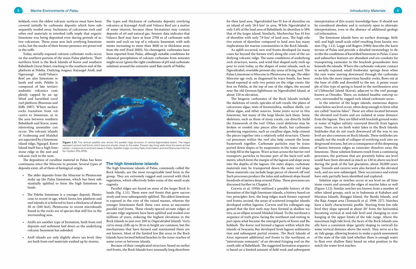
The high limestone islandsThe high limestone islands of Palau, commonly called the Rock Islands, are the most recognizable land form in the group. They are extremely rugged and covered with thick vegetation, which effectively hides some of the small-scale rugosity. Parallel ridges are found on most of the larger Rock Is-lands (Fig. 1.11). These were reef fronts that grew succes-sively and were subsequently uplifted. The oldest limestone is exposed in the core of the raised masses, whereas the younger limestones flank these core areas as successive parallel reef fronts. These closely-spaced arcuate ridges or arcuate ridge segments have been uplifted and eroded over millions of years, reducing the highest elevations in the Rock Islands to just over 200 m (Ngeruktabel Island). Verti-cal to steep cliffs up to 30 m in height are common, but the mechanisms that have formed and maintained them are not known. Most of the limited low flat areas in the Rock Islands have formed behind beaches in the inner reaches of some coves or between islands. Because of their complicated structure, based on earlier reef fronts, the Rock Islands have unusually long shorelines
Figure 1.11 This vertical satellite view shows the parallel ridge structure of central Ngeruktabel Island. The ridges represent ancient reef fronts, which become shorter closer to the water. Present-day living reefs show the same arched pattern, a response to wind and waves in Palau. Satellite image courtesy Palau Automated Land and Resources Informa-tion System (PALARIS).
10 Marine Environments of Palau 11Introductory Materials
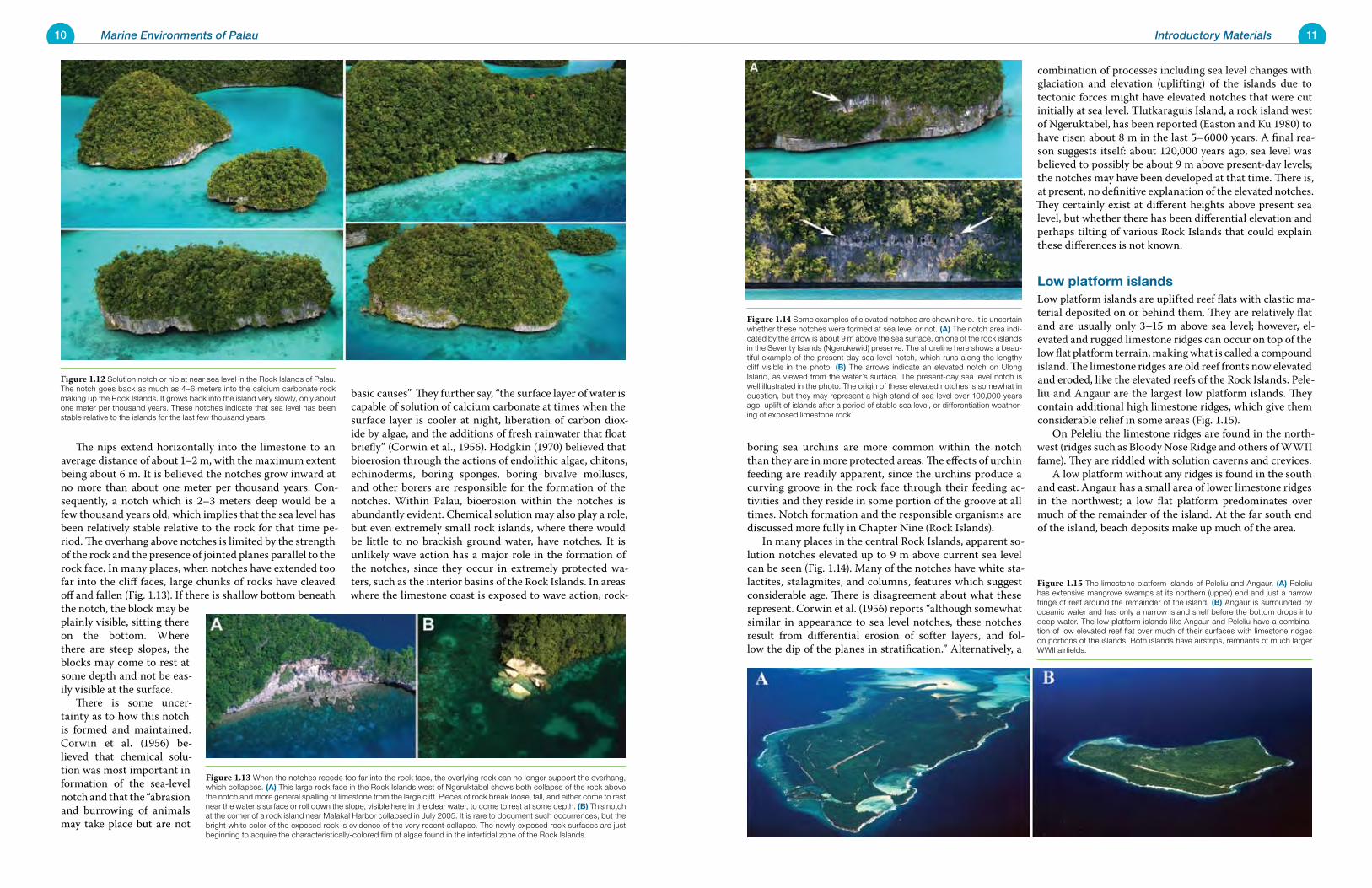
boring sea urchins are more common within the notch than they are in more protected areas. The effects of urchin feeding are readily apparent, since the urchins produce a curving groove in the rock face through their feeding ac-tivities and they reside in some portion of the groove at all times. Notch formation and the responsible organisms are discussed more fully in Chapter Nine (Rock Islands). In many places in the central Rock Islands, apparent so-lution notches elevated up to 9 m above current sea level can be seen (Fig. 1.14). Many of the notches have white sta-lactites, stalagmites, and columns, features which suggest considerable age. There is disagreement about what these represent. Corwin et al. (1956) reports “although somewhat similar in appearance to sea level notches, these notches result from differential erosion of softer layers, and fol-low the dip of the planes in stratification.” Alternatively, a
combination of processes including sea level changes with glaciation and elevation (uplifting) of the islands due to tectonic forces might have elevated notches that were cut initially at sea level. Tlutkaraguis Island, a rock island west of Ngeruktabel, has been reported (Easton and Ku 1980) to have risen about 8 m in the last 5–6000 years. A final rea-son suggests itself: about 120,000 years ago, sea level was believed to possibly be about 9 m above present-day levels; the notches may have been developed at that time. There is, at present, no definitive explanation of the elevated notches. They certainly exist at different heights above present sea level, but whether there has been differential elevation and perhaps tilting of various Rock Islands that could explain these differences is not known.
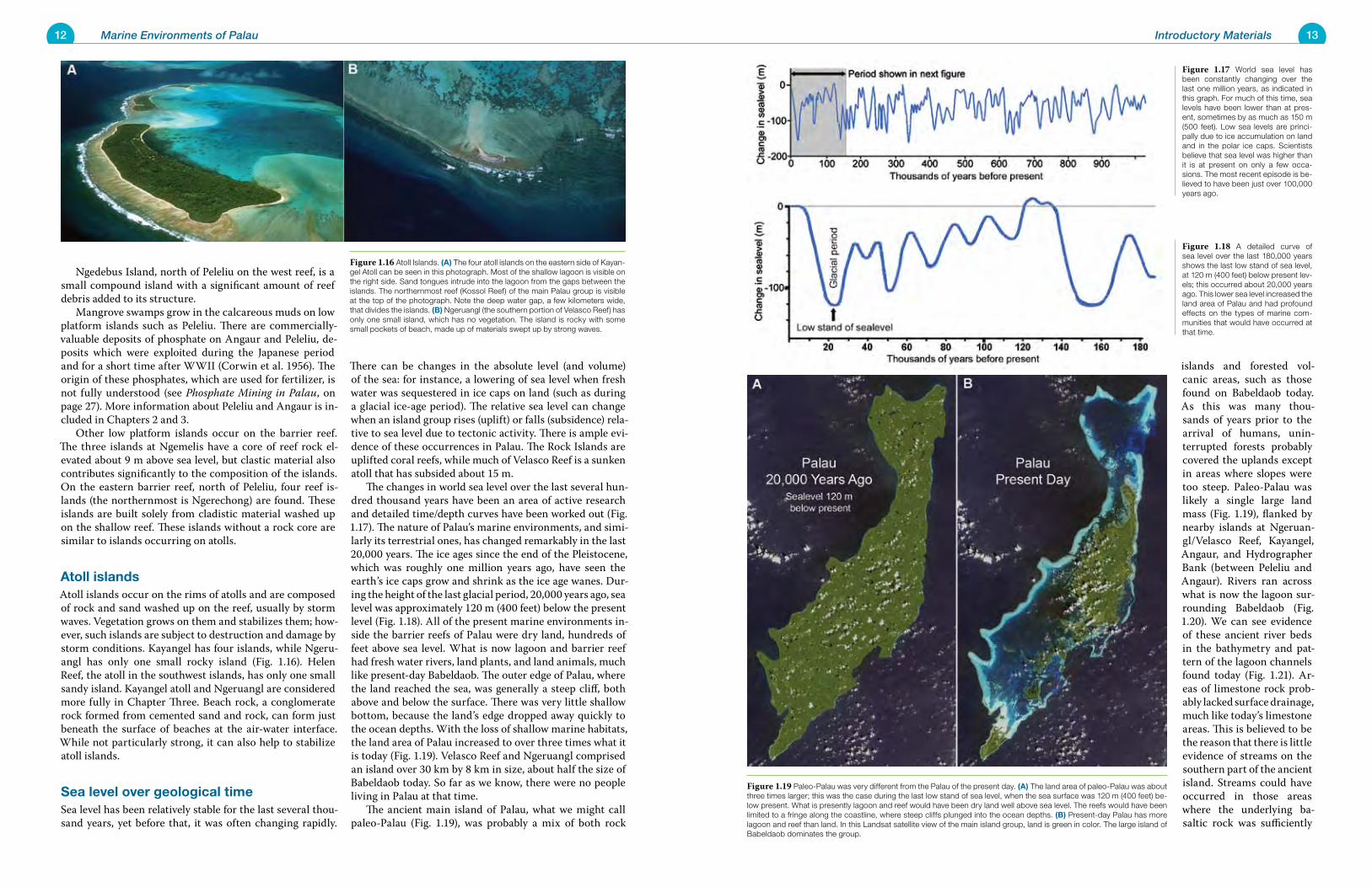
Low platform islandsLow platform islands are uplifted reef flats with clastic ma-terial deposited on or behind them. They are relatively flat and are usually only 3–15 m above sea level; however, el-evated and rugged limestone ridges can occur on top of the low flat platform terrain, making what is called a compound island. The limestone ridges are old reef fronts now elevated and eroded, like the elevated reefs of the Rock Islands. Pele-liu and Angaur are the largest low platform islands. They contain additional high limestone ridges, which give them considerable relief in some areas (Fig. 1.15). On Peleliu the limestone ridges are found in the north-west (ridges such as Bloody Nose Ridge and others of WWII fame). They are riddled with solution caverns and crevices. A low platform without any ridges is found in the south and east. Angaur has a small area of lower limestone ridges in the northwest; a low flat platform predominates over much of the remainder of the island. At the far south end of the island, beach deposits make up much of the area.
The nips extend horizontally into the limestone to an average distance of about 1–2 m, with the maximum extent being about 6 m. It is believed the notches grow inward at no more than about one meter per thousand years. Con-sequently, a notch which is 2–3 meters deep would be a few thousand years old, which implies that the sea level has been relatively stable relative to the rock for that time pe-riod. The overhang above notches is limited by the strength of the rock and the presence of jointed planes parallel to the rock face. In many places, when notches have extended too far into the cliff faces, large chunks of rocks have cleaved off and fallen (Fig. 1.13). If there is shallow bottom beneath the notch, the block may be plainly visible, sitting there on the bottom. Where there are steep slopes, the blocks may come to rest at some depth and not be eas-ily visible at the surface. There is some uncer-tainty as to how this notch is formed and maintained. Corwin et al. (1956) be-lieved that chemical solu-tion was most important in formation of the sea-level notch and that the “abrasion and burrowing of animals may take place but are not
basic causes”. They further say, “the surface layer of water is capable of solution of calcium carbonate at times when the surface layer is cooler at night, liberation of carbon diox-ide by algae, and the additions of fresh rainwater that float briefly” (Corwin et al., 1956). Hodgkin (1970) believed that bioerosion through the actions of endolithic algae, chitons, echinoderms, boring sponges, boring bivalve molluscs, and other borers are responsible for the formation of the notches. Within Palau, bioerosion within the notches is abundantly evident. Chemical solution may also play a role, but even extremely small rock islands, where there would be little to no brackish ground water, have notches. It is unlikely wave action has a major role in the formation of the notches, since they occur in extremely protected wa-ters, such as the interior basins of the Rock Islands. In areas where the limestone coast is exposed to wave action, rock-
Figure 1.13 When the notches recede too far into the rock face, the overlying rock can no longer support the overhang, which collapses. (A) This large rock face in the Rock Islands west of Ngeruktabel shows both collapse of the rock above the notch and more general spalling of limestone from the large cliff. Pieces of rock break loose, fall, and either come to rest near the water’s surface or roll down the slope, visible here in the clear water, to come to rest at some depth. (B) This notch at the corner of a rock island near Malakal Harbor collapsed in July 2005. It is rare to document such occurrences, but the bright white color of the exposed rock is evidence of the very recent collapse. The newly exposed rock surfaces are just beginning to acquire the characteristically-colored film of algae found in the intertidal zone of the Rock Islands.
Figure 1.14 Some examples of elevated notches are shown here. It is uncertain whether these notches were formed at sea level or not. (A) The notch area indi-cated by the arrow is about 9 m above the sea surface, on one of the rock islands in the Seventy Islands (Ngerukewid) preserve. The shoreline here shows a beau-tiful example of the present-day sea level notch, which runs along the lengthy cliff visible in the photo. (B) The arrows indicate an elevated notch on Ulong Island, as viewed from the water’s surface. The present-day sea level notch is well illustrated in the photo. The origin of these elevated notches is somewhat in question, but they may represent a high stand of sea level over 100,000 years ago, uplift of islands after a period of stable sea level, or differentiation weather-ing of exposed limestone rock.
Figure 1.12 Solution notch or nip at near sea level in the Rock Islands of Palau. The notch goes back as much as 4–6 meters into the calcium carbonate rock making up the Rock Islands. It grows back into the island very slowly, only about one meter per thousand years. These notches indicate that sea level has been stable relative to the islands for the last few thousand years.
Figure 1.15 The limestone platform islands of Peleliu and Angaur. (A) Peleliu has extensive mangrove swamps at its northern (upper) end and just a narrow fringe of reef around the remainder of the island. (B) Angaur is surrounded by oceanic water and has only a narrow island shelf before the bottom drops into deep water. The low platform islands like Angaur and Peleliu have a combina-tion of low elevated reef flat over much of their surfaces with limestone ridges on portions of the islands. Both islands have airstrips, remnants of much larger WWII airfields.
12 Marine Environments of Palau 13Introductory Materials
islands and forested vol-canic areas, such as those found on Babeldaob today. As this was many thou-sands of years prior to the arrival of humans, unin-terrupted forests probably covered the uplands except in areas where slopes were too steep. Paleo-Palau was likely a single large land mass (Fig. 1.19), flanked by nearby islands at Ngeruan-gl/Velasco Reef, Kayangel, Angaur, and Hydrographer Bank (between Peleliu and Angaur). Rivers ran across what is now the lagoon sur-rounding Babeldaob (Fig. 1.20). We can see evidence of these ancient river beds in the bathymetry and pat-tern of the lagoon channels found today (Fig. 1.21). Ar-eas of limestone rock prob-ably lacked surface drainage, much like today’s limestone areas. This is believed to be the reason that there is little evidence of streams on the southern part of the ancient island. Streams could have occurred in those areas where the underlying ba-saltic rock was sufficiently
Ngedebus Island, north of Peleliu on the west reef, is a small compound island with a significant amount of reef debris added to its structure. Mangrove swamps grow in the calcareous muds on low platform islands such as Peleliu. There are commercially-valuable deposits of phosphate on Angaur and Peleliu, de-posits which were exploited during the Japanese period and for a short time after WWII (Corwin et al. 1956). The origin of these phosphates, which are used for fertilizer, is not fully understood (see Phosphate Mining in Palau, on page 27). More information about Peleliu and Angaur is in-cluded in Chapters 2 and 3. Other low platform islands occur on the barrier reef. The three islands at Ngemelis have a core of reef rock el-evated about 9 m above sea level, but clastic material also contributes significantly to the composition of the islands. On the eastern barrier reef, north of Peleliu, four reef is-lands (the northernmost is Ngerechong) are found. These islands are built solely from cladistic material washed up on the shallow reef. These islands without a rock core are similar to islands occurring on atolls.
Atoll islandsAtoll islands occur on the rims of atolls and are composed of rock and sand washed up on the reef, usually by storm waves. Vegetation grows on them and stabilizes them; how-ever, such islands are subject to destruction and damage by storm conditions. Kayangel has four islands, while Ngeru-angl has only one small rocky island (Fig. 1.16). Helen Reef, the atoll in the southwest islands, has only one small sandy island. Kayangel atoll and Ngeruangl are considered more fully in Chapter Three. Beach rock, a conglomerate rock formed from cemented sand and rock, can form just beneath the surface of beaches at the air-water interface. While not particularly strong, it can also help to stabilize atoll islands.
Sea level over geological timeSea level has been relatively stable for the last several thou-sand years, yet before that, it was often changing rapidly.
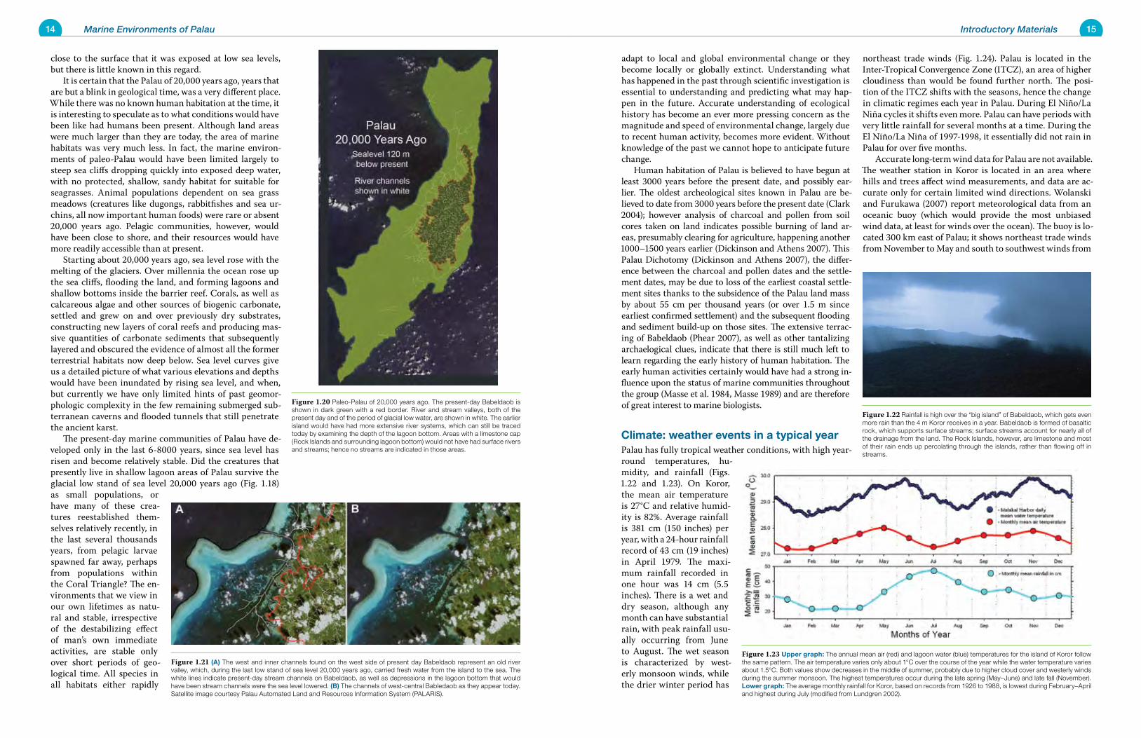
There can be changes in the absolute level (and volume) of the sea: for instance, a lowering of sea level when fresh water was sequestered in ice caps on land (such as during a glacial ice-age period). The relative sea level can change when an island group rises (uplift) or falls (subsidence) rela-tive to sea level due to tectonic activity. There is ample evi-dence of these occurrences in Palau. The Rock Islands are uplifted coral reefs, while much of Velasco Reef is a sunken atoll that has subsided about 15 m. The changes in world sea level over the last several hun-dred thousand years have been an area of active research and detailed time/depth curves have been worked out (Fig. 1.17). The nature of Palau’s marine environments, and simi-larly its terrestrial ones, has changed remarkably in the last 20,000 years. The ice ages since the end of the Pleistocene, which was roughly one million years ago, have seen the earth’s ice caps grow and shrink as the ice age wanes. Dur-ing the height of the last glacial period, 20,000 years ago, sea level was approximately 120 m (400 feet) below the present level (Fig. 1.18). All of the present marine environments in-side the barrier reefs of Palau were dry land, hundreds of feet above sea level. What is now lagoon and barrier reef had fresh water rivers, land plants, and land animals, much like present-day Babeldaob. The outer edge of Palau, where the land reached the sea, was generally a steep cliff, both above and below the surface. There was very little shallow bottom, because the land’s edge dropped away quickly to the ocean depths. With the loss of shallow marine habitats, the land area of Palau increased to over three times what it is today (Fig. 1.19). Velasco Reef and Ngeruangl comprised an island over 30 km by 8 km in size, about half the size of Babeldaob today. So far as we know, there were no people living in Palau at that time. The ancient main island of Palau, what we might call paleo-Palau (Fig. 1.19), was probably a mix of both rock
Figure 1.17 World sea level has been constantly changing over the last one million years, as indicated in this graph. For much of this time, sea levels have been lower than at pres-ent, sometimes by as much as 150 m (500 feet). Low sea levels are princi-pally due to ice accumulation on land and in the polar ice caps. Scientists believe that sea level was higher than it is at present on only a few occa-sions. The most recent episode is be-lieved to have been just over 100,000 years ago.
Figure 1.18 A detailed curve of sea level over the last 180,000 years shows the last low stand of sea level, at 120 m (400 feet) below present lev-els; this occurred about 20,000 years ago. This lower sea level increased the land area of Palau and had profound effects on the types of marine com-munities that would have occurred at that time.
Figure 1.19 Paleo-Palau was very different from the Palau of the present day. (A) The land area of paleo-Palau was about three times larger; this was the case during the last low stand of sea level, when the sea surface was 120 m (400 feet) be-low present. What is presently lagoon and reef would have been dry land well above sea level. The reefs would have been limited to a fringe along the coastline, where steep cliffs plunged into the ocean depths. (B) Present-day Palau has more lagoon and reef than land. In this Landsat satellite view of the main island group, land is green in color. The large island of Babeldaob dominates the group.
Figure 1.16 Atoll Islands. (A) The four atoll islands on the eastern side of Kayan-gel Atoll can be seen in this photograph. Most of the shallow lagoon is visible on the right side. Sand tongues intrude into the lagoon from the gaps between the islands. The northernmost reef (Kossol Reef) of the main Palau group is visible at the top of the photograph. Note the deep water gap, a few kilometers wide, that divides the islands. (B) Ngeruangl (the southern portion of Velasco Reef) has only one small island, which has no vegetation. The island is rocky with some small pockets of beach, made up of materials swept up by strong waves.
14 Marine Environments of Palau 15Introductory Materials
adapt to local and global environmental change or they become locally or globally extinct. Understanding what has happened in the past through scientific investigation is essential to understanding and predicting what may hap-pen in the future. Accurate understanding of ecological history has become an ever more pressing concern as the magnitude and speed of environmental change, largely due to recent human activity, becomes more evident. Without knowledge of the past we cannot hope to anticipate future change. Human habitation of Palau is believed to have begun at least 3000 years before the present date, and possibly ear-lier. The oldest archeological sites known in Palau are be-lieved to date from 3000 years before the present date (Clark 2004); however analysis of charcoal and pollen from soil cores taken on land indicates possible burning of land ar-eas, presumably clearing for agriculture, happening another 1000–1500 years earlier (Dickinson and Athens 2007). This Palau Dichotomy (Dickinson and Athens 2007), the differ-ence between the charcoal and pollen dates and the settle-ment dates, may be due to loss of the earliest coastal settle-ment sites thanks to the subsidence of the Palau land mass by about 55 cm per thousand years (or over 1.5 m since earliest confirmed settlement) and the subsequent flooding and sediment build-up on those sites. The extensive terrac-ing of Babeldaob (Phear 2007), as well as other tantalizing archaelogical clues, indicate that there is still much left to learn regarding the early history of human habitation. The early human activities certainly would have had a strong in-fluence upon the status of marine communities throughout the group (Masse et al. 1984, Masse 1989) and are therefore of great interest to marine biologists.
Climate: weather events in a typical yearPalau has fully tropical weather conditions, with high year-round temperatures, hu-midity, and rainfall (Figs. 1.22 and 1.23). On Koror, the mean air temperature is 27°C and relative humid-ity is 82%. Average rainfall is 381 cm (150 inches) per year, with a 24-hour rainfall record of 43 cm (19 inches) in April 1979. The maxi-mum rainfall recorded in one hour was 14 cm (5.5 inches). There is a wet and dry season, although any month can have substantial rain, with peak rainfall usu-ally occurring from June to August. The wet season is characterized by west-erly monsoon winds, while the drier winter period has
northeast trade winds (Fig. 1.24). Palau is located in the Inter-Tropical Convergence Zone (ITCZ), an area of higher cloudiness than would be found further north. The posi-tion of the ITCZ shifts with the seasons, hence the change in climatic regimes each year in Palau. During El Niño/La Niña cycles it shifts even more. Palau can have periods with very little rainfall for several months at a time. During the El Niño/La Niña of 1997-1998, it essentially did not rain in Palau for over five months. Accurate long-term wind data for Palau are not available. The weather station in Koror is located in an area where hills and trees affect wind measurements, and data are ac-curate only for certain limited wind directions. Wolanski and Furukawa (2007) report meteorological data from an oceanic buoy (which would provide the most unbiased wind data, at least for winds over the ocean). The buoy is lo-cated 300 km east of Palau; it shows northeast trade winds from November to May and south to southwest winds from
close to the surface that it was exposed at low sea levels, but there is little known in this regard. It is certain that the Palau of 20,000 years ago, years that are but a blink in geological time, was a very different place. While there was no known human habitation at the time, it is interesting to speculate as to what conditions would have been like had humans been present. Although land areas were much larger than they are today, the area of marine habitats was very much less. In fact, the marine environ-ments of paleo-Palau would have been limited largely to steep sea cliffs dropping quickly into exposed deep water, with no protected, shallow, sandy habitat for suitable for seagrasses. Animal populations dependent on sea grass meadows (creatures like dugongs, rabbitfishes and sea ur-chins, all now important human foods) were rare or absent 20,000 years ago. Pelagic communities, however, would have been close to shore, and their resources would have more readily accessible than at present. Starting about 20,000 years ago, sea level rose with the melting of the glaciers. Over millennia the ocean rose up the sea cliffs, flooding the land, and forming lagoons and shallow bottoms inside the barrier reef. Corals, as well as calcareous algae and other sources of biogenic carbonate, settled and grew on and over previously dry substrates, constructing new layers of coral reefs and producing mas-sive quantities of carbonate sediments that subsequently layered and obscured the evidence of almost all the former terrestrial habitats now deep below. Sea level curves give us a detailed picture of what various elevations and depths would have been inundated by rising sea level, and when, but currently we have only limited hints of past geomor-phologic complexity in the few remaining submerged sub-terranean caverns and flooded tunnels that still penetrate the ancient karst. The present-day marine communities of Palau have de-veloped only in the last 6-8000 years, since sea level has risen and become relatively stable. Did the creatures that presently live in shallow lagoon areas of Palau survive the glacial low stand of sea level 20,000 years ago (Fig. 1.18) as small populations, or have many of these crea-tures reestablished them-selves relatively recently, in the last several thousands years, from pelagic larvae spawned far away, perhaps from populations within the Coral Triangle? The en-vironments that we view in our own lifetimes as natu-ral and stable, irrespective of the destabilizing effect of man’s own immediate activities, are stable only over short periods of geo-logical time. All species in all habitats either rapidly
Figure 1.21 (A) The west and inner channels found on the west side of present day Babeldaob represent an old river valley, which, during the last low stand of sea level 20,000 years ago, carried fresh water from the island to the sea. The white lines indicate present-day stream channels on Babeldaob, as well as depressions in the lagoon bottom that would have been stream channels were the sea level lowered. (B) The channels of west-central Babledaob as they appear today. Satellite image courtesy Palau Automated Land and Resources Information System (PALARIS).
Figure 1.22 Rainfall is high over the “big island” of Babeldaob, which gets even more rain than the 4 m Koror receives in a year. Babeldaob is formed of basaltic rock, which supports surface streams; surface streams account for nearly all of the drainage from the land. The Rock Islands, however, are limestone and most of their rain ends up percolating through the islands, rather than flowing off in streams.
Figure 1.20 Paleo-Palau of 20,000 years ago. The present-day Babeldaob is shown in dark green with a red border. River and stream valleys, both of the present day and of the period of glacial low water, are shown in white. The earlier island would have had more extensive river systems, which can still be traced today by examining the depth of the lagoon bottom. Areas with a limestone cap (Rock Islands and surrounding lagoon bottom) would not have had surface rivers and streams; hence no streams are indicated in those areas.
Figure 1.23 Upper graph: The annual mean air (red) and lagoon water (blue) temperatures for the island of Koror follow the same pattern. The air temperature varies only about 1°C over the course of the year while the water temperature varies about 1.5°C. Both values show decreases in the middle of summer, probably due to higher cloud cover and westerly winds during the summer monsoon. The highest temperatures occur during the late spring (May–June) and late fall (November). Lower graph: The average monthly rainfall for Koror, based on records from 1926 to 1988, is lowest during February–April and highest during July (modified from Lundgren 2002).
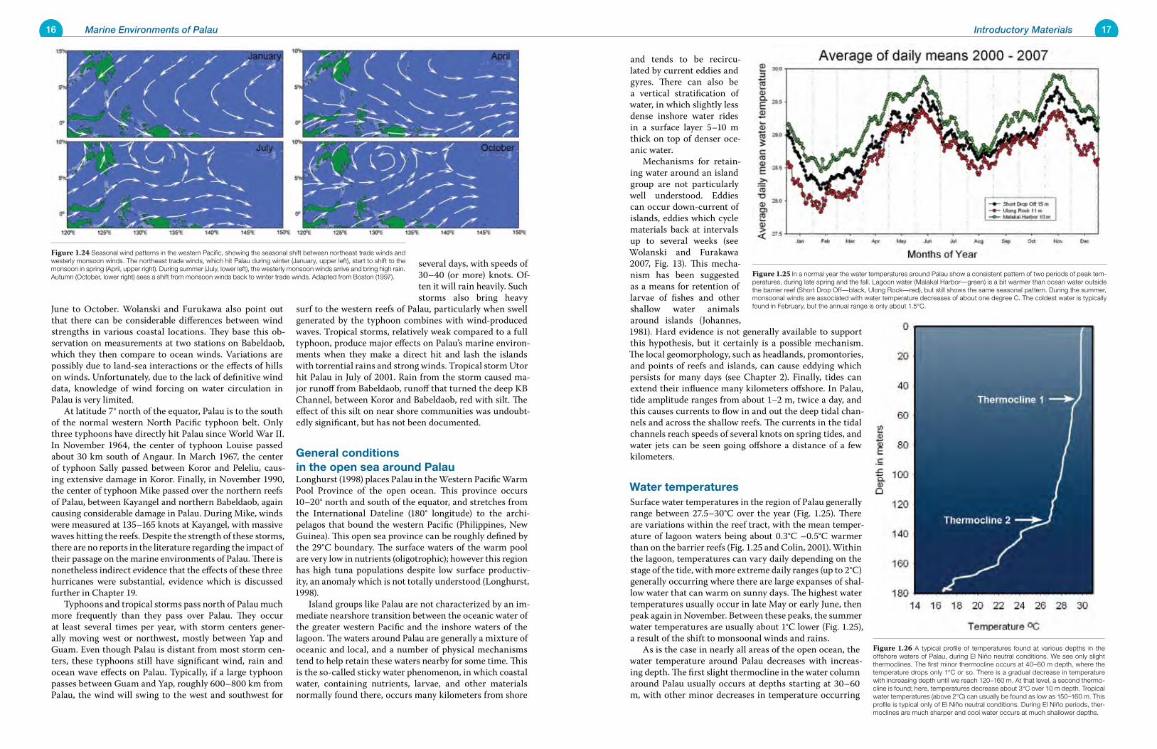
16 Marine Environments of Palau 17Introductory Materials
and tends to be recircu-lated by current eddies and gyres. There can also be a vertical stratification of water, in which slightly less dense inshore water rides in a surface layer 5–10 m thick on top of denser oce-anic water. Mechanisms for retain-ing water around an island group are not particularly well understood. Eddies can occur down-current of islands, eddies which cycle materials back at intervals up to several weeks (see Wolanski and Furakawa 2007, Fig. 13). This mecha-nism has been suggested as a means for retention of larvae of fishes and other shallow water animals around islands (Johannes, 1981). Hard evidence is not generally available to support this hypothesis, but it certainly is a possible mechanism. The local geomorphology, such as headlands, promontories, and points of reefs and islands, can cause eddying which persists for many days (see Chapter 2). Finally, tides can extend their influence many kilometers offshore. In Palau, tide amplitude ranges from about 1–2 m, twice a day, and this causes currents to flow in and out the deep tidal chan-nels and across the shallow reefs. The currents in the tidal channels reach speeds of several knots on spring tides, and water jets can be seen going offshore a distance of a few kilometers.
Water temperaturesSurface water temperatures in the region of Palau generally range between 27.5–30°C over the year (Fig. 1.25). There are variations within the reef tract, with the mean temper-ature of lagoon waters being about 0.3°C –0.5°C warmer than on the barrier reefs (Fig. 1.25 and Colin, 2001). Within the lagoon, temperatures can vary daily depending on the stage of the tide, with more extreme daily ranges (up to 2°C) generally occurring where there are large expanses of shal-low water that can warm on sunny days. The highest water temperatures usually occur in late May or early June, then peak again in November. Between these peaks, the summer water temperatures are usually about 1°C lower (Fig. 1.25), a result of the shift to monsoonal winds and rains. As is the case in nearly all areas of the open ocean, the water temperature around Palau decreases with increas-ing depth. The first slight thermocline in the water column around Palau usually occurs at depths starting at 30–60 m, with other minor decreases in temperature occurring
June to October. Wolanski and Furukawa also point out that there can be considerable differences between wind strengths in various coastal locations. They base this ob-servation on measurements at two stations on Babeldaob, which they then compare to ocean winds. Variations are possibly due to land-sea interactions or the effects of hills on winds. Unfortunately, due to the lack of definitive wind data, knowledge of wind forcing on water circulation in Palau is very limited. At latitude 7° north of the equator, Palau is to the south of the normal western North Pacific typhoon belt. Only three typhoons have directly hit Palau since World War II. In November 1964, the center of typhoon Louise passed about 30 km south of Angaur. In March 1967, the center of typhoon Sally passed between Koror and Peleliu, caus-ing extensive damage in Koror. Finally, in November 1990, the center of typhoon Mike passed over the northern reefs of Palau, between Kayangel and northern Babeldaob, again causing considerable damage in Palau. During Mike, winds were measured at 135–165 knots at Kayangel, with massive waves hitting the reefs. Despite the strength of these storms, there are no reports in the literature regarding the impact of their passage on the marine environments of Palau. There is nonetheless indirect evidence that the effects of these three hurricanes were substantial, evidence which is discussed further in Chapter 19. Typhoons and tropical storms pass north of Palau much more frequently than they pass over Palau. They occur at least several times per year, with storm centers gener-ally moving west or northwest, mostly between Yap and Guam. Even though Palau is distant from most storm cen-ters, these typhoons still have significant wind, rain and ocean wave effects on Palau. Typically, if a large typhoon passes between Guam and Yap, roughly 600–800 km from Palau, the wind will swing to the west and southwest for
several days, with speeds of 30–40 (or more) knots. Of-ten it will rain heavily. Such storms also bring heavy
surf to the western reefs of Palau, particularly when swell generated by the typhoon combines with wind-produced waves. Tropical storms, relatively weak compared to a full typhoon, produce major effects on Palau’s marine environ-ments when they make a direct hit and lash the islands with torrential rains and strong winds. Tropical storm Utor hit Palau in July of 2001. Rain from the storm caused ma-jor runoff from Babeldaob, runoff that turned the deep KB Channel, between Koror and Babeldaob, red with silt. The effect of this silt on near shore communities was undoubt-edly significant, but has not been documented.
General conditions in the open sea around PalauLonghurst (1998) places Palau in the Western Pacific Warm Pool Province of the open ocean. This province occurs 10–20° north and south of the equator, and stretches from the International Dateline (180° longitude) to the archi-pelagos that bound the western Pacific (Philippines, New Guinea). This open sea province can be roughly defined by the 29°C boundary. The surface waters of the warm pool are very low in nutrients (oligotrophic); however this region has high tuna populations despite low surface productiv-ity, an anomaly which is not totally understood (Longhurst, 1998). Island groups like Palau are not characterized by an im-mediate nearshore transition between the oceanic water of the greater western Pacific and the inshore waters of the lagoon. The waters around Palau are generally a mixture of oceanic and local, and a number of physical mechanisms tend to help retain these waters nearby for some time. This is the so-called sticky water phenomenon, in which coastal water, containing nutrients, larvae, and other materials normally found there, occurs many kilometers from shore
Figure 1.25 In a normal year the water temperatures around Palau show a consistent pattern of two periods of peak tem-peratures, during late spring and the fall. Lagoon water (Malakal Harbor—green) is a bit warmer than ocean water outside the barrier reef (Short Drop Off—black, Ulong Rock—red), but still shows the same seasonal pattern. During the summer, monsoonal winds are associated with water temperature decreases of about one degree C. The coldest water is typically found in February, but the annual range is only about 1.5°C.
Figure 1.24 Seasonal wind patterns in the western Pacific, showing the seasonal shift between northeast trade winds and westerly monsoon winds. The northeast trade winds, which hit Palau during winter (January, upper left), start to shift to the monsoon in spring (April, upper right). During summer (July, lower left), the westerly monsoon winds arrive and bring high rain. Autumn (October, lower right) sees a shift from monsoon winds back to winter trade winds. Adapted from Boston (1997).
Figure 1.26 A typical profile of temperatures found at various depths in the offshore waters of Palau, during El Niño neutral conditions. We see only slight thermoclines. The first minor thermocline occurs at 40–60 m depth, where the temperature drops only 1°C or so. There is a gradual decrease in temperature with increasing depth until we reach 120–160 m. At that level, a second thermo-cline is found; here, temperatures decrease about 3°C over 10 m depth. Tropical water temperatures (above 2°C) can usually be found as low as 150–160 m. This profile is typical only of El Niño neutral conditions. During El Niño periods, ther-moclines are much sharper and cool water occurs at much shallower depths.
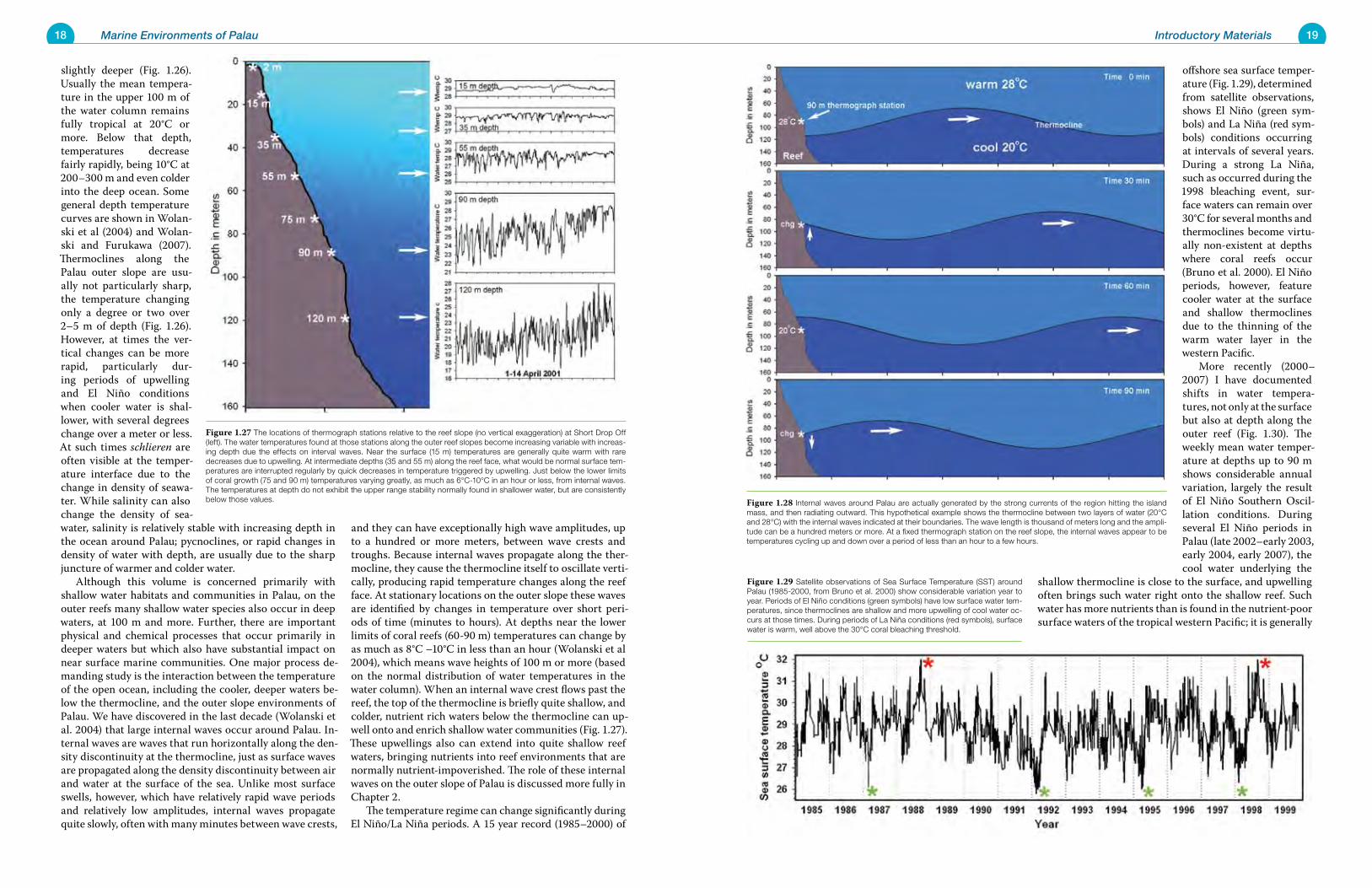
18 Marine Environments of Palau 19Introductory Materials
offshore sea surface temper-ature (Fig. 1.29), determined from satellite observations, shows El Niño (green sym-bols) and La Niña (red sym-bols) conditions occurring at intervals of several years. During a strong La Niña, such as occurred during the 1998 bleaching event, sur-face waters can remain over 30°C for several months and thermoclines become virtu-ally non-existent at depths where coral reefs occur (Bruno et al. 2000). El Niño periods, however, feature cooler water at the surface and shallow thermoclines due to the thinning of the warm water layer in the western Pacific. More recently (2000–2007) I have documented shifts in water tempera-tures, not only at the surface but also at depth along the outer reef (Fig. 1.30). The weekly mean water temper-ature at depths up to 90 m shows considerable annual variation, largely the result of El Niño Southern Oscil-lation conditions. During several El Niño periods in Palau (late 2002–early 2003, early 2004, early 2007), the cool water underlying the
shallow thermocline is close to the surface, and upwelling often brings such water right onto the shallow reef. Such water has more nutrients than is found in the nutrient-poor surface waters of the tropical western Pacific; it is generally
slightly deeper (Fig. 1.26). Usually the mean tempera-ture in the upper 100 m of the water column remains fully tropical at 20°C or more. Below that depth, temperatures decrease fairly rapidly, being 10°C at 200–300 m and even colder into the deep ocean. Some general depth temperature curves are shown in Wolan-ski et al (2004) and Wolan-ski and Furukawa (2007). Thermoclines along the Palau outer slope are usu-ally not particularly sharp, the temperature changing only a degree or two over 2–5 m of depth (Fig. 1.26). However, at times the ver-tical changes can be more rapid, particularly dur-ing periods of upwelling and El Niño conditions when cooler water is shal-lower, with several degrees change over a meter or less. At such times schlieren are often visible at the temper-ature interface due to the change in density of seawa-ter. While salinity can also change the density of sea-water, salinity is relatively stable with increasing depth in the ocean around Palau; pycnoclines, or rapid changes in density of water with depth, are usually due to the sharp juncture of warmer and colder water. Although this volume is concerned primarily with shallow water habitats and communities in Palau, on the outer reefs many shallow water species also occur in deep waters, at 100 m and more. Further, there are important physical and chemical processes that occur primarily in deeper waters but which also have substantial impact on near surface marine communities. One major process de-manding study is the interaction between the temperature of the open ocean, including the cooler, deeper waters be-low the thermocline, and the outer slope environments of Palau. We have discovered in the last decade (Wolanski et al. 2004) that large internal waves occur around Palau. In-ternal waves are waves that run horizontally along the den-sity discontinuity at the thermocline, just as surface waves are propagated along the density discontinuity between air and water at the surface of the sea. Unlike most surface swells, however, which have relatively rapid wave periods and relatively low amplitudes, internal waves propagate quite slowly, often with many minutes between wave crests,
and they can have exceptionally high wave amplitudes, up to a hundred or more meters, between wave crests and troughs. Because internal waves propagate along the ther-mocline, they cause the thermocline itself to oscillate verti-cally, producing rapid temperature changes along the reef face. At stationary locations on the outer slope these waves are identified by changes in temperature over short peri-ods of time (minutes to hours). At depths near the lower limits of coral reefs (60-90 m) temperatures can change by as much as 8°C –10°C in less than an hour (Wolanski et al 2004), which means wave heights of 100 m or more (based on the normal distribution of water temperatures in the water column). When an internal wave crest flows past the reef, the top of the thermocline is briefly quite shallow, and colder, nutrient rich waters below the thermocline can up-well onto and enrich shallow water communities (Fig. 1.27). These upwellings also can extend into quite shallow reef waters, bringing nutrients into reef environments that are normally nutrient-impoverished. The role of these internal waves on the outer slope of Palau is discussed more fully in Chapter 2. The temperature regime can change significantly during El Niño/La Niña periods. A 15 year record (1985–2000) of
Figure 1.27 The locations of thermograph stations relative to the reef slope (no vertical exaggeration) at Short Drop Off (left). The water temperatures found at those stations along the outer reef slopes become increasing variable with increas-ing depth due the effects on interval waves. Near the surface (15 m) temperatures are generally quite warm with rare decreases due to upwelling. At intermediate depths (35 and 55 m) along the reef face, what would be normal surface tem-peratures are interrupted regularly by quick decreases in temperature triggered by upwelling. Just below the lower limits of coral growth (75 and 90 m) temperatures varying greatly, as much as 6°C-10°C in an hour or less, from internal waves. The temperatures at depth do not exhibit the upper range stability normally found in shallower water, but are consistently below those values. Figure 1.28 Internal waves around Palau are actually generated by the strong currents of the region hitting the island
mass, and then radiating outward. This hypothetical example shows the thermocline between two layers of water (20°C and 28°C) with the internal waves indicated at their boundaries. The wave length is thousand of meters long and the ampli-tude can be a hundred meters or more. At a fixed thermograph station on the reef slope, the internal waves appear to be temperatures cycling up and down over a period of less than an hour to a few hours.
Figure 1.29 Satellite observations of Sea Surface Temperature (SST) around Palau (1985-2000, from Bruno et al. 2000) show considerable variation year to year. Periods of El Niño conditions (green symbols) have low surface water tem-peratures, since thermoclines are shallow and more upwelling of cool water oc-curs at those times. During periods of La Niña conditions (red symbols), surface water is warm, well above the 30°C coral bleaching threshold.
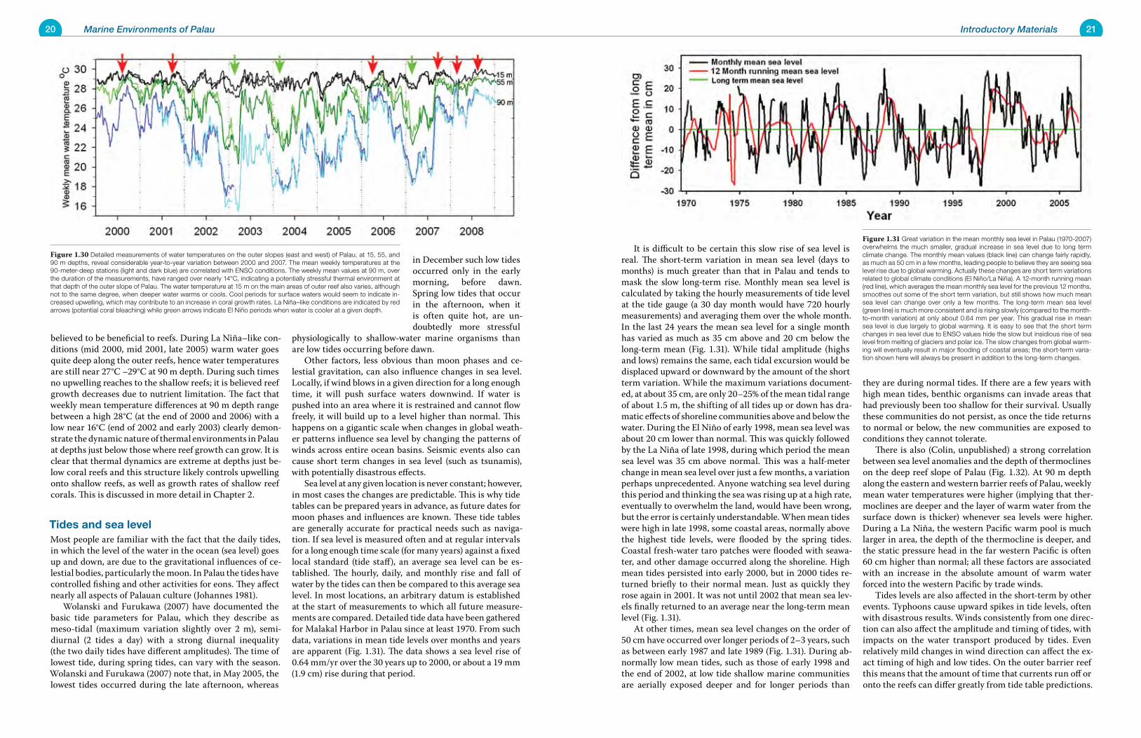
20 Marine Environments of Palau 21Introductory Materials
It is difficult to be certain this slow rise of sea level is real. The short-term variation in mean sea level (days to months) is much greater than that in Palau and tends to mask the slow long-term rise. Monthly mean sea level is calculated by taking the hourly measurements of tide level at the tide gauge (a 30 day month would have 720 hourly measurements) and averaging them over the whole month. In the last 24 years the mean sea level for a single month has varied as much as 35 cm above and 20 cm below the long-term mean (Fig. 1.31). While tidal amplitude (highs and lows) remains the same, each tidal excursion would be displaced upward or downward by the amount of the short term variation. While the maximum variations document-ed, at about 35 cm, are only 20–25% of the mean tidal range of about 1.5 m, the shifting of all tides up or down has dra-matic effects of shoreline communities above and below the water. During the El Niño of early 1998, mean sea level was about 20 cm lower than normal. This was quickly followed by the La Niña of late 1998, during which period the mean sea level was 35 cm above normal. This was a half-meter change in mean sea level over just a few months, a variation perhaps unprecedented. Anyone watching sea level during this period and thinking the sea was rising up at a high rate, eventually to overwhelm the land, would have been wrong, but the error is certainly understandable. When mean tides were high in late 1998, some coastal areas, normally above the highest tide levels, were flooded by the spring tides. Coastal fresh-water taro patches were flooded with seawa-ter, and other damage occurred along the shoreline. High mean tides persisted into early 2000, but in 2000 tides re-turned briefly to their normal mean. Just as quickly they rose again in 2001. It was not until 2002 that mean sea lev-els finally returned to an average near the long-term mean level (Fig. 1.31). At other times, mean sea level changes on the order of 50 cm have occurred over longer periods of 2–3 years, such as between early 1987 and late 1989 (Fig. 1.31). During ab-normally low mean tides, such as those of early 1998 and the end of 2002, at low tide shallow marine communities are aerially exposed deeper and for longer periods than
they are during normal tides. If there are a few years with high mean tides, benthic organisms can invade areas that had previously been too shallow for their survival. Usually these communities do not persist, as once the tide returns to normal or below, the new communities are exposed to conditions they cannot tolerate. There is also (Colin, unpublished) a strong correlation between sea level anomalies and the depth of thermoclines on the deep reef slope of Palau (Fig. 1.32). At 90 m depth along the eastern and western barrier reefs of Palau, weekly mean water temperatures were higher (implying that ther-moclines are deeper and the layer of warm water from the surface down is thicker) whenever sea levels were higher. During a La Niña, the western Pacific warm pool is much larger in area, the depth of the thermocline is deeper, and the static pressure head in the far western Pacific is often 60 cm higher than normal; all these factors are associated with an increase in the absolute amount of warm water forced into the western Pacific by trade winds. Tides levels are also affected in the short-term by other events. Typhoons cause upward spikes in tide levels, often with disastrous results. Winds consistently from one direc-tion can also affect the amplitude and timing of tides, with impacts on the water transport produced by tides. Even relatively mild changes in wind direction can affect the ex-act timing of high and low tides. On the outer barrier reef this means that the amount of time that currents run off or onto the reefs can differ greatly from tide table predictions.
believed to be beneficial to reefs. During La Niña–like con-ditions (mid 2000, mid 2001, late 2005) warm water goes quite deep along the outer reefs, hence water temperatures are still near 27°C –29°C at 90 m depth. During such times no upwelling reaches to the shallow reefs; it is believed reef growth decreases due to nutrient limitation. The fact that weekly mean temperature differences at 90 m depth range between a high 28°C (at the end of 2000 and 2006) with a low near 16°C (end of 2002 and early 2003) clearly demon-strate the dynamic nature of thermal environments in Palau at depths just below those where reef growth can grow. It is clear that thermal dynamics are extreme at depths just be-low coral reefs and this structure likely controls upwelling onto shallow reefs, as well as growth rates of shallow reef corals. This is discussed in more detail in Chapter 2.
Tides and sea levelMost people are familiar with the fact that the daily tides, in which the level of the water in the ocean (sea level) goes up and down, are due to the gravitational influences of ce-lestial bodies, particularly the moon. In Palau the tides have controlled fishing and other activities for eons. They affect nearly all aspects of Palauan culture (Johannes 1981). Wolanski and Furukawa (2007) have documented the basic tide parameters for Palau, which they describe as meso-tidal (maximum variation slightly over 2 m), semi-diurnal (2 tides a day) with a strong diurnal inequality (the two daily tides have different amplitudes). The time of lowest tide, during spring tides, can vary with the season. Wolanski and Furukawa (2007) note that, in May 2005, the lowest tides occurred during the late afternoon, whereas
in December such low tides occurred only in the early morning, before dawn. Spring low tides that occur in the afternoon, when it is often quite hot, are un-doubtedly more stressful
physiologically to shallow-water marine organisms than are low tides occurring before dawn. Other factors, less obvious than moon phases and ce-lestial gravitation, can also influence changes in sea level. Locally, if wind blows in a given direction for a long enough time, it will push surface waters downwind. If water is pushed into an area where it is restrained and cannot flow freely, it will build up to a level higher than normal. This happens on a gigantic scale when changes in global weath-er patterns influence sea level by changing the patterns of winds across entire ocean basins. Seismic events also can cause short term changes in sea level (such as tsunamis), with potentially disastrous effects. Sea level at any given location is never constant; however, in most cases the changes are predictable. This is why tide tables can be prepared years in advance, as future dates for moon phases and influences are known. These tide tables are generally accurate for practical needs such as naviga-tion. If sea level is measured often and at regular intervals for a long enough time scale (for many years) against a fixed local standard (tide staff), an average sea level can be es-tablished. The hourly, daily, and monthly rise and fall of water by the tides can then be compared to this average sea level. In most locations, an arbitrary datum is established at the start of measurements to which all future measure-ments are compared. Detailed tide data have been gathered for Malakal Harbor in Palau since at least 1970. From such data, variations in mean tide levels over months and years are apparent (Fig. 1.31). The data shows a sea level rise of 0.64 mm/yr over the 30 years up to 2000, or about a 19 mm (1.9 cm) rise during that period.
Figure 1.31 Great variation in the mean monthly sea level in Palau (1970-2007) overwhelms the much smaller, gradual increase in sea level due to long term climate change. The monthly mean values (black line) can change fairly rapidly, as much as 50 cm in a few months, leading people to believe they are seeing sea level rise due to global warming. Actually these changes are short term variations related to global climate conditions (El Niño/La Niña). A 12-month running mean (red line), which averages the mean monthly sea level for the previous 12 months, smoothes out some of the short term variation, but still shows how much mean sea level can change over only a few months. The long-term mean sea level (green line) is much more consistent and is rising slowly (compared to the month-to-month variation) at only about 0.64 mm per year. This gradual rise in mean sea level is due largely to global warming. It is easy to see that the short term changes in sea level due to ENSO values hide the slow but insidious rise of sea level from melting of glaciers and polar ice. The slow changes from global warm-ing will eventually result in major flooding of coastal areas; the short-term varia-tion shown here will always be present in addition to the long-term changes.
Figure 1.30 Detailed measurements of water temperatures on the outer slopes (east and west) of Palau, at 15, 55, and 90 m depths, reveal considerable year-to-year variation between 2000 and 2007. The mean weekly temperatures at the 90-meter-deep stations (light and dark blue) are correlated with ENSO conditions. The weekly mean values at 90 m, over the duration of the measurements, have ranged over nearly 14°C, indicating a potentially stressful thermal environment at that depth of the outer slope of Palau. The water temperature at 15 m on the main areas of outer reef also varies, although not to the same degree, when deeper water warms or cools. Cool periods for surface waters would seem to indicate in-creased upwelling, which may contribute to an increase in coral growth rates. La Niña–like conditions are indicated by red arrows (potential coral bleaching) while green arrows indicate El Niño periods when water is cooler at a given depth.
22 Marine Environments of Palau 23Introductory Materials
contradictory) conclusions have been reached. Heron et al. (2007) reported the possible existence of three previously undocumented features termed the Palau Eddy, the Caro-line Eddy. and the Micronesian Eddy (Fig. 1.34). Wolanski and Fukuwara (2007) provide a somewhat different inter-pretation of surface currents near Palau and give some in-dication of seasonal variation in currents during a typical year (Fig. 1.35). They report also that, during events such as the 1998 La Niña in Palau, the general pattern of ocean
currents is disrupted (Fig. 1.36) and abnormal persistence of warm water around Palau may occur (Fig. 1.37), although there is some disagreement as to whether satellite-derived sea surface height and wind (from scatterometer data) data can actually be used to determine surface currents in equa-torial regions. Such data are used in programs such as the US Navy’s OSCAR (Ocean Surface Current Analyses), but as Heron et al. (2007:415) say “the accuracy of the OSCAR system is still under investigation.” The ocean currents around Palau should remain an area of active investigation. The seasonality of currents around Palau has not been examined and an understanding of their dynamics may be critical in understanding the upwelling and productivity of the ocean around Palau.
Nearshore and inshore currents of PalauPalau is awash in ocean currents. Wolanski et al. (2004) have shown that the various headlands of Palau cause ed-dying and other perturbations of surface currents, which produce strong flow along reefs in some areas. It is no se-cret among divers that Palau has strong currents along some of its reefs. The area known as Blue Corner is re-nowned for its eddying currents, which cause many large fishes, including sharks, to congregate in this area. The easternmost extension of Mutremdiu Reef has a deep shelf which sticks out several hundred meters off the reef, and at times currents of at least 1 knot have been seen there. When the current is against the swell direction, large breaking waves are kicked up in a limited area while areas nearby are relatively calm. The deep water gaps between islands, such as the gap between Ngurangl and Kayangel, Kayangel and the north reefs of Babeldaob, and Peleliu and Angaur, all have strong currents. The reef at the southern end of Peleliu, which is
Wolanski and Furukawa (2007) have documented unusual short-term fluc-tuations in mean sea level of 5–10 cm in Palau dur-ing 2001-2002 lasting 1–3 weeks. Although these fluc-tuations were of unknown origin, Wolanski and Fu-rukawa suggested that they might be due to passage of oceanic eddies. Occasional small tsunamis (to 100 cm) have been recorded by the Malakal Harbor tide gauge (Wolanski and Furukawa 2007), but that no histori-cal data exists on the oc-currence of larger tsunamis in Palau. The barrier reef surrounding much of Palau and the rapidity with which the sea floor rises around Palau provide some degree of protection from the most devastating types of tsuna-mis.
Ocean and inshore currentsThe oceanic currents near Palau are complicated and not well documented. Palau is located in an area of extremely dynamic ocean currents in the western Pacific. With its position at 7°–8°N of the equator, the main island group of Palau sits astride the Inter-Tropical Convergence Zone (ITCZ) for at least part of the year, and between the North Equatorial Current (NEC) and the North Equatorial Coun-ter Current (NECC). Wolanski and Furukawa (2007) also surmised that “currents around Palau are enormously vari-able and controlled by the passage of eddies.” Until the last few years, our knowledge of Palau’s cur-rents was based on only a few published studies, which pro-vided a rudimentary interpretation (Fig. 1.33) of the occur-rence of currents (Kashino et al. 1998, Fine et al. 1994). The usual interpretation was that the NEC usually passes north of Palau at about 12°N; when it reaches the Philippines at the western boundary of the Pacific Ocean, it splits into a north flowing current (which becomes the Kuroshiro) and a south flowing segment (the Mindanao Current or MC). The MC flows along the east side of Mindanao and eventu-ally contributes much of the flow through Indonesia into the Indian Ocean; this current is known as the Indone-sia Throughflow. This flow is also driven by the prevailing trade winds, which cause an increase of sea level on the western sides of the oceans and a lowering on its eastern sides (Wyrtki 1987). This pressure gradient (sea level can be as much as one meter lower on the Indian Ocean side)
on the western side of the Pacific oceans drives the Indone-sian Throughflow, because the tropical Pacific is connected to the Indian Ocean through Indonesia. According to the older explanation, part of the MC also swings around to the east, a few degrees north of the equator, and joins the easterly NECC flow between 5° to 10° north of the equator, thereby diverting a large amount of water from the NEC into the NECC. The MC results in the cyclonically rotating (counterclockwise) Mindanao Eddy (ME). These quasi-permanent features were believed to dominate circulation in the western Pacific (Wyrtki 1961). A seasonal coastal current (approximately May to October) along the northern side of New Guinea (NGCC), actually a branch of the South Equatorial Current (SEC), also joins the NECC near the island of Halmahera in Indonesia. The flow of MC and NGCC results in the formation of a second eddy (Fig. 1.33), the Halmahera Eddy (HE), rotating anti-cyclonically between Palau and Halmahera. The southwest islands of Palau are in the general area of the HE and the surface circulation around them is controlled by this eddy. Wyrtki (1961) suggested that the ME is centered near Palau in January, the time of weakest flow, and close to Mindanao in May. Lukas et al. (1998), using differences in tides be-tween Palau and Davao (Mindanao), reported year-to-year variation in the location of the ME that may be greater than the variation within a single year. In recent years, this interpretation has been reexamined using new techniques and data and somewhat different (but
Figure 1.34 Wolanski and Furukawa (2007) have attempted to refine our under-standing of surface currents near Palau. Their interpretation of the data provides a more complicated picture of possible surface circulation than that shown in Figure 1.32. This picture shows the surface currents around Palau as described by Wolanski and Furukawa. They postulate a number of eddies which usually, but not always, exist in the western Pacific near Palau. It is to be hoped that future investigations will increase our understanding of oceanic currents around Palau.
Figure 1.33 This generalized depiction of surface currents in the western Pa-cific near Palau is based on Kashino et al. (1998) and Fine et al. (1994) and re-flects a model of the currents that has recently been modified. Two eddies were said to exist to the south and west of Palau: the Mindanao Eddy (ME) and the Halmahera Eddy (HE). The surface Mindanao Current (MC), the North Equatorial Counter Current (NECC), and the New Guinea Coast Current (NGCC), as well as the Mindanao Undercurrent (MUC), are all said to be found in the seas near Palau. The North Equatorial Current, running from east to west, occurs north of 10°N and is not shown in this figure. While relatively recent, this model of the surface currents in the vicinity of Palau may not agree with the most recent interpretation of new data.
Figure 1.35 There is a certain amount of seasonal variation in oceanic currents around Palau, as indicated by this interpretation of 2005 data (from Wolanski and Furukawa 2007). The variation is due to regional changes in current pat-terns, as the North Equatorial Counter Current moves with the seasons. The currents that actually occur along the reefs of Palau can differ from the oceanic currents, as the projections and undulations of the reefs and the overall effect of the land mass of Palau on the oceanic currents modify the oceanic currents. In some instances, currents along the reef can run in a direction opposite to that of currents found further offshore.
Figure 1.32 Mean sea level is closely correlated with mean water temperature, at depths of 90 m, along Palau’s reefs. The upper panel shows the variation in monthly mean water temperature at 90 m on both the east (black line) and west (red line) sides of Palau. The lower panel shows that variations in monthly mean sea level, determined by measuring the water level (tide) in Malakal Harbor every hour and averaging those values for each month, mirrors the changes in the 90 m depth water temperatures. During periods where there are high water temperatures at 90 m, the layer of warm water around Palau is much thicker. The higher sea levels are partially a reflection of the reduced density (due to expansion) of the warmer water, which supports a higher column of ocean water and thus makes the sea level higher.
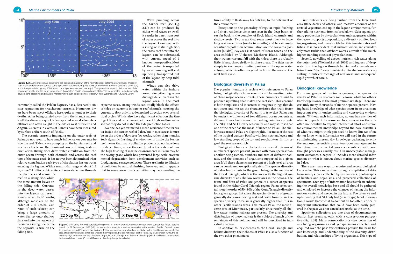
24 Marine Environments of Palau 25Introductory Materials
ture’s ability to flush away his detritus, to the detriment of the environment. Exceptions to the generality of regular rapid flushing and short residence times are seen in the deep basin ar-eas far back in the complex of Rock Island channels and shallow reefs. Two areas that seem most likely to have long residence times (weeks to months) and be extremely sensitive to pollution accumulation are the Iwayama (Ari-mizu [Nikko]) Bay area just south of Koror town and the area enfolded by U-shaped Mecharar Island. Although their waters rise and fall with the tides, there is probably little, if any, through-flow in these areas. The tides serve simply to exchange a limited portion of the upper water column, which is often recycled back into the area on the next tidal cycle.
Biological diversity in PalauThe popular literature is replete with references to Palau being biologically rich because it is at the meeting point of three major ocean currents; these currents are said to produce upwelling that makes the reef rich. This account is both simplistic and incorrect; it imagines things that do not occur and misses the characteristics that truly foster the biological diversity of Palau. It is true that Palau can be under the influence of two different ocean currents at different times, but it is not the meeting point for currents. The NEC and NECC vary seasonally, and may shift so that one or the other has the most influence on Palau. The shal-low seas around Palau are oligotrophic, like most of the rest of the tropical western Pacific, with low nutrient levels and low standing crops of phyto- and zooplankton. In this re-gard the seas are not rich. Biological richness can be better expressed in terms of numbers of species present (an area with more species than another being richer), numbers and area of different habi-tats, and the biomass of organisms supported in a given area. If all three elements are present at a high level, an area can be considered exceptionally rich. The species diversity of Palau has its basis in the group being on the margin of the Coral Triangle, which is the area with the highest ma-rine diversity of any shallow water area in the oceans. The fauna and flora of Palau are generally a subset of species found in the richer Coral Triangle region; Palau often con-tains on the order of 50–80% of the Coral Triangle diversity for a given group. But since the species diversity of groups generally decreases moving east and north from Palau, the species diversity in Palau is generally higher than it is in other Pacific islands areas. This makes Palau the most di-verse area of Micronesia, particularly since nearly all shal-low water marine habitats are present. The diversity and distribution of these habitats is the subject of much of the remainder of this volume, and will be described in indi-vidual chapters. In addition to its closeness to the Coral Triangle and habitat diversity, the richness of Palau is also a function of the two other phenomena.
First, nutrients are being flushed from the large land area (Babeldaob and others), and massive amounts of ter-restrial vegetation end up in the lagoon environments, fur-ther adding nutrients from its breakdown. Subsequent pri-mary production by phytoplankton and sea grasses within the lagoon supports zooplankton, a diversity of filter feed-ing organisms, and many motile benthic invertebrates and fishes. It is no accident that inshore waters are consider-ably more turbid than offshore waters, a result of the much higher standing stocks of phytoplankton. Second, upwelling of deeper, nutrient rich water along the outer reefs (Wolanski et al. 2004) and ingress of deep water into the lagoon through barrier reef channels may bring those “deep” ocean nutrients into shallow waters re-sulting in nutrient recharge of reef areas and subsequent rapid growth of corals.
Biological knowledgeFor some groups of marine organisms, the species di-versity of Palau is relatively well known, while for others knowledge is only at the most preliminary stage. There are certainly many thousands of marine species present. Hav-ing basic knowledge of what species occur in an area is an important step in understanding and conserving environ-ments. Without such information, no one has any idea of what is important to conserve. In conservation there is often no incentive to expend intellectual effort and strive for environmental knowledge beyond the bare essentials of what you might think you need to know. But we often do not know what information we will need in the future, so minimizing present day knowledge gathering to only the supposed essentials guarantees poor management in the future. Environmental ignorance combined with poor thought processes usually result in unacceptable manage-ment outcomes. Chapter 18 includes more detailed infor-mation on what is known about marine species diversity in Palau. There are many ways to acquire and record biological knowledge. This can be done through compilation of data from surveys, data collected by instruments, photographs of habitats and organisms, and preserved collections of specimens. Each type of information has its role in enhanc-ing the overall knowledge base and all should be gathered and employed to increase the chances of having the infor-mation wanted and needed in the future. Too often we end up lamenting that “if I only had (insert type) bit of informa-tion, I would know what to do,” but all too often, critically important information that could have been easily gath-ered in the past was not considered useful at the time. Specimen collections are one area of documentation that at first seems at odds with a conservation perspec-tive (Fig. 1.38). Many conservationists view collection of any living organism as evil, yet specimens collected and acquired over the past few centuries provide the basis for our knowledge and understanding of the diversity, distri-bution, and relationships of living organisms. This type of
commonly called the Peleliu Express, has a deservedly sin-ister reputation for treacherous currents. Numerous div-ers have been swept offshore here, quite a number to their deaths. After being carried away from the island’s narrow shelf, the divers are quickly transported several kilometers offshore and often caught in the eddies west of Peleliu and Angaur. Currents in excess of 3 knots have been measured by surface drifters south of Peleliu. The oceanic currents impinging on the outer reefs of Palau do not seem to have much influence on currents in-side the reef. Tides, wave pumping on the barrier reef, and weather effects are the dominant forces driving inshore circulation. Rising tides drive water circulation from the outer ocean through both channels and across the reef-tops of the outer reefs. It has not yet been determined what relative contribution each type of circulation has on water entering the lagoon. With a mean tidal range of about 1.5 m, some 2.4 billion cubic meters of seawater enters through the channels and across the reef on a rising tide, while the same amount leaves on the falling tide. Currents in the deep water passes into the lagoon can reach speeds of up to 10 km/hr, although most are on the order of 2–6 km/hr. Cur-rents of such velocity can bring a large amount of water far up onto shallow flats and into the lagoons of Palau on a rising tide, while the opposite is true on the falling tide.
Wave pumping across the barrier reef (see Fig. 2.17) can be produced by either wind waves or swell; it results in a net transport of water across the reef into the lagoon. Combined with a rising or static high tide, the cross-reef flow into the lagoon can be substantial, with current speed of 1 knot or more possible. Most of the water transported by wave pumping will end up being transported out of the lagoon by deep tidal channels. Winds can also drive water within the inshore areas, strengthening or re-ducing tidal currents in the lagoon area. In the most
extreme cases, strong winds can totally block the effects of tides on currents in barrier reef channels, causing the current to flow only in a downwind direction over several tidal cycles. Winds also have significant effect on the tim-ing of tides and can change the times of high and low water so that they do not match the tide prediction tables. No one has yet estimated a mean residence time for wa-ter inside the barrier reef of Palau, but in most areas it must be on the order of days to a few weeks, rather than months. Such dynamic flushing of environments inside the barrier reef means that many pollution products do not have long residence times, unless they settle out of the water column. The high flushing of marine environments in Palau may be the saving grace which has prevented large-scale environ-mental degradation from development activities such as dredging and sewage pollution. There are limits to dilution of pollution by natural flushing, however, and it appears that in some areas man’s activities may be exceeding na-
Figure 1.37 During the 1998 coral bleaching event, an area of exceptionally warm ocean water surrounded Palau. Satellite data from 22 September, 1998 (left), shows surface water temperature anomalies in the western Pacific. Oceanic water temperature around Palau (red symbol) was 1°C or more above normal (yellow area) during the coral bleaching event. This area of high temperatures extended west to the Philippines, but did not occur east of Palau. By 8 December, 1998, the ab-normally high temperatures had dissipated (right), but the damage from the coral bleaching (which had lasted 4–5 months) had already been done. (From NOAA coral bleaching hotspots website)
Figure 1.36 Abnormal climate conditions can cause a breakdown of the normal current patterns around Palau. This is evi-dent in this comparison of surface current patterns: a period during July 1998, at the time of the coral bleaching event (left) and a time period during July 2005, when current patterns were normal (right). The general surface circulation around Palau decreased greatly and the warm water pool in the western Pacific became largely static. The water heated up and eventually caused coral bleaching and massive mortality in Palauan coral colonies. (Redrawn from Wolanski and Furukawa 2007)
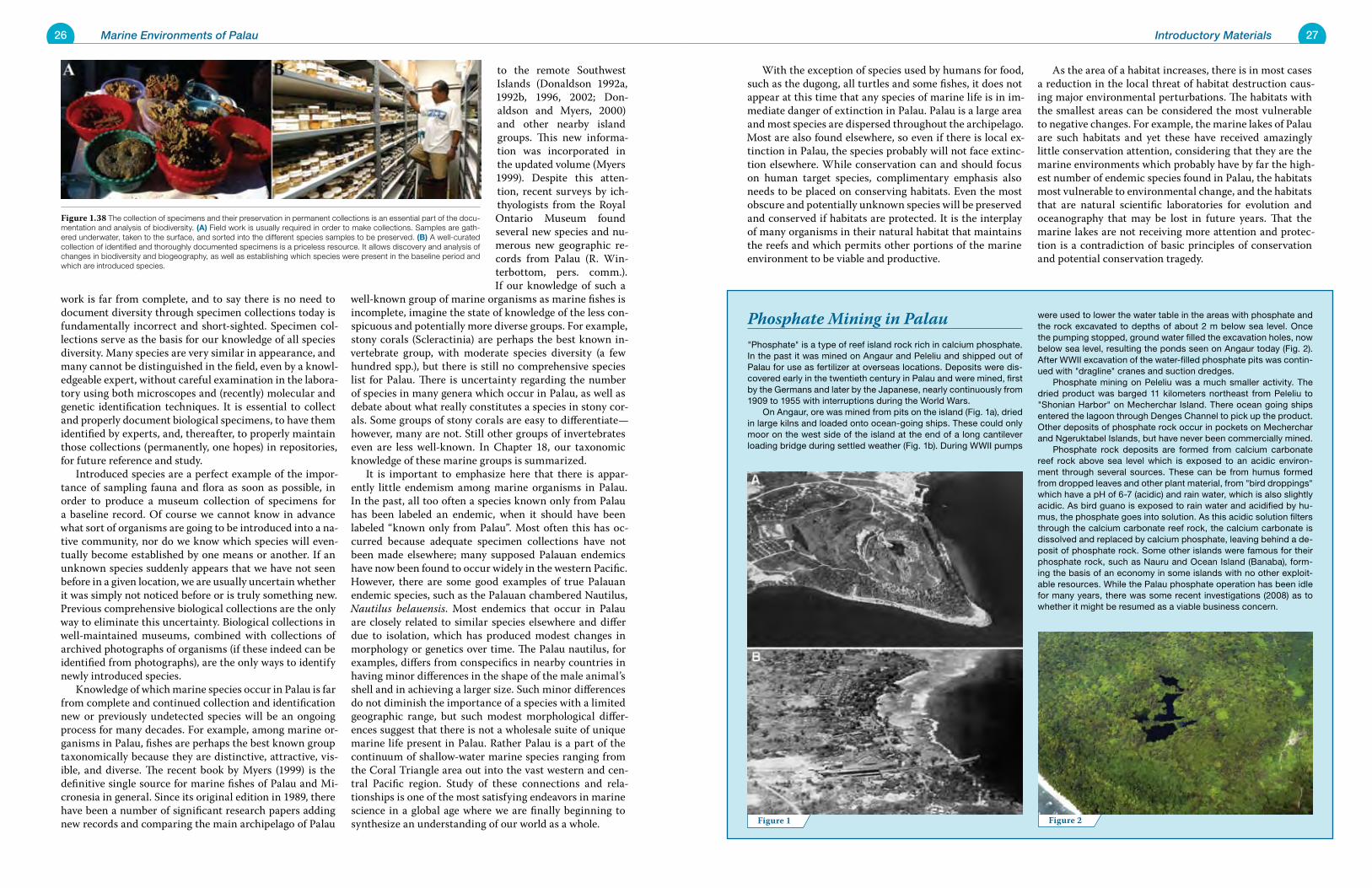
26 Marine Environments of Palau 27Introductory Materials
With the exception of species used by humans for food, such as the dugong, all turtles and some fishes, it does not appear at this time that any species of marine life is in im-mediate danger of extinction in Palau. Palau is a large area and most species are dispersed throughout the archipelago. Most are also found elsewhere, so even if there is local ex-tinction in Palau, the species probably will not face extinc-tion elsewhere. While conservation can and should focus on human target species, complimentary emphasis also needs to be placed on conserving habitats. Even the most obscure and potentially unknown species will be preserved and conserved if habitats are protected. It is the interplay of many organisms in their natural habitat that maintains the reefs and which permits other portions of the marine environment to be viable and productive.
As the area of a habitat increases, there is in most cases a reduction in the local threat of habitat destruction caus-ing major environmental perturbations. The habitats with the smallest areas can be considered the most vulnerable to negative changes. For example, the marine lakes of Palau are such habitats and yet these have received amazingly little conservation attention, considering that they are the marine environments which probably have by far the high-est number of endemic species found in Palau, the habitats most vulnerable to environmental change, and the habitats that are natural scientific laboratories for evolution and oceanography that may be lost in future years. That the marine lakes are not receiving more attention and protec-tion is a contradiction of basic principles of conservation and potential conservation tragedy.
work is far from complete, and to say there is no need to document diversity through specimen collections today is fundamentally incorrect and short-sighted. Specimen col-lections serve as the basis for our knowledge of all species diversity. Many species are very similar in appearance, and many cannot be distinguished in the field, even by a knowl-edgeable expert, without careful examination in the labora-tory using both microscopes and (recently) molecular and genetic identification techniques. It is essential to collect and properly document biological specimens, to have them identified by experts, and, thereafter, to properly maintain those collections (permanently, one hopes) in repositories, for future reference and study. Introduced species are a perfect example of the impor-tance of sampling fauna and flora as soon as possible, in order to produce a museum collection of specimens for a baseline record. Of course we cannot know in advance what sort of organisms are going to be introduced into a na-tive community, nor do we know which species will even-tually become established by one means or another. If an unknown species suddenly appears that we have not seen before in a given location, we are usually uncertain whether it was simply not noticed before or is truly something new. Previous comprehensive biological collections are the only way to eliminate this uncertainty. Biological collections in well-maintained museums, combined with collections of archived photographs of organisms (if these indeed can be identified from photographs), are the only ways to identify newly introduced species. Knowledge of which marine species occur in Palau is far from complete and continued collection and identification new or previously undetected species will be an ongoing process for many decades. For example, among marine or-ganisms in Palau, fishes are perhaps the best known group taxonomically because they are distinctive, attractive, vis-ible, and diverse. The recent book by Myers (1999) is the definitive single source for marine fishes of Palau and Mi-cronesia in general. Since its original edition in 1989, there have been a number of significant research papers adding new records and comparing the main archipelago of Palau
to the remote Southwest Islands (Donaldson 1992a, 1992b, 1996, 2002; Don-aldson and Myers, 2000) and other nearby island groups. This new informa-tion was incorporated in the updated volume (Myers 1999). Despite this atten-tion, recent surveys by ich-thyologists from the Royal Ontario Museum found several new species and nu-merous new geographic re-cords from Palau (R. Win-terbottom, pers. comm.). If our knowledge of such a
well-known group of marine organisms as marine fishes is incomplete, imagine the state of knowledge of the less con-spicuous and potentially more diverse groups. For example, stony corals (Scleractinia) are perhaps the best known in-vertebrate group, with moderate species diversity (a few hundred spp.), but there is still no comprehensive species list for Palau. There is uncertainty regarding the number of species in many genera which occur in Palau, as well as debate about what really constitutes a species in stony cor-als. Some groups of stony corals are easy to differentiate—however, many are not. Still other groups of invertebrates even are less well-known. In Chapter 18, our taxonomic knowledge of these marine groups is summarized. It is important to emphasize here that there is appar-ently little endemism among marine organisms in Palau. In the past, all too often a species known only from Palau has been labeled an endemic, when it should have been labeled “known only from Palau”. Most often this has oc-curred because adequate specimen collections have not been made elsewhere; many supposed Palauan endemics have now been found to occur widely in the western Pacific. However, there are some good examples of true Palauan endemic species, such as the Palauan chambered Nautilus, Nautilus belauensis. Most endemics that occur in Palau are closely related to similar species elsewhere and differ due to isolation, which has produced modest changes in morphology or genetics over time. The Palau nautilus, for examples, differs from conspecifics in nearby countries in having minor differences in the shape of the male animal’s shell and in achieving a larger size. Such minor differences do not diminish the importance of a species with a limited geographic range, but such modest morphological differ-ences suggest that there is not a wholesale suite of unique marine life present in Palau. Rather Palau is a part of the continuum of shallow-water marine species ranging from the Coral Triangle area out into the vast western and cen-tral Pacific region. Study of these connections and rela-tionships is one of the most satisfying endeavors in marine science in a global age where we are finally beginning to synthesize an understanding of our world as a whole.
"Phosphate" is a type of reef island rock rich in calcium phosphate. In the past it was mined on Angaur and Peleliu and shipped out of Palau for use as fertilizer at overseas locations. Deposits were dis-covered early in the twentieth century in Palau and were mined, first by the Germans and later by the Japanese, nearly continuously from 1909 to 1955 with interruptions during the World Wars. On Angaur, ore was mined from pits on the island (Fig. 1a), dried in large kilns and loaded onto ocean-going ships. These could only moor on the west side of the island at the end of a long cantilever loading bridge during settled weather (Fig. 1b). During WWII pumps
were used to lower the water table in the areas with phosphate and the rock excavated to depths of about 2 m below sea level. Once the pumping stopped, ground water filled the excavation holes, now below sea level, resulting the ponds seen on Angaur today (Fig. 2). After WWII excavation of the water-filled phosphate pits was contin-ued with "dragline" cranes and suction dredges. Phosphate mining on Peleliu was a much smaller activity. The dried product was barged 11 kilometers northeast from Peleliu to "Shonian Harbor" on Mecherchar Island. There ocean going ships entered the lagoon through Denges Channel to pick up the product. Other deposits of phosphate rock occur in pockets on Mecherchar and Ngeruktabel Islands, but have never been commercially mined. Phosphate rock deposits are formed from calcium carbonate reef rock above sea level which is exposed to an acidic environ-ment through several sources. These can be from humus formed from dropped leaves and other plant material, from "bird droppings" which have a pH of 6-7 (acidic) and rain water, which is also slightly acidic. As bird guano is exposed to rain water and acidified by hu-mus, the phosphate goes into solution. As this acidic solution filters through the calcium carbonate reef rock, the calcium carbonate is dissolved and replaced by calcium phosphate, leaving behind a de-posit of phosphate rock. Some other islands were famous for their phosphate rock, such as Nauru and Ocean Island (Banaba), form-ing the basis of an economy in some islands with no other exploit-able resources. While the Palau phosphate operation has been idle for many years, there was some recent investigations (2008) as to whether it might be resumed as a viable business concern.
Phosphate Mining in Palau
Figure 2Figure 1
Figure 1.38 The collection of specimens and their preservation in permanent collections is an essential part of the docu-mentation and analysis of biodiversity. (A) Field work is usually required in order to make collections. Samples are gath-ered underwater, taken to the surface, and sorted into the different species samples to be preserved. (B) A well-curated collection of identified and thoroughly documented specimens is a priceless resource. It allows discovery and analysis of changes in biodiversity and biogeography, as well as establishing which species were present in the baseline period and which are introduced species.
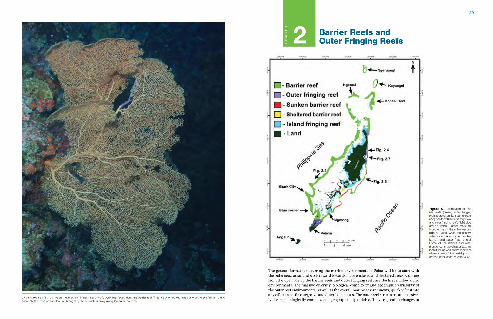
29
CH
AP
TE
R
2 Barrier Reefs and Outer Fringing Reefs
The general format for covering the marine environments of Palau will be to start with the outermost areas and work inward towards more enclosed and sheltered areas. Coming from the open ocean, the barrier reefs and outer fringing reefs are the first shallow water environments. The massive diversity, biological complexity and geographic variability of the outer reef environments, as well as the overall marine environments, quickly frustrate any effort to easily categorize and describe habitats. The outer reef structures are massive-ly diverse, biologically complex, and geographically variable. They respond to changes in
Figure 2.1 Distribution of bar-rier reefs (green), outer fringing reefs (purple), sunken barrier reefs (red), sheltered barrier reef (yellow) and inner fringing reefs (light blue) around Palau. Barrier reefs are found on nearly the entire western side of Palau, while the eastern side has a mix of barrier, sunken barrier, and outer fringing reef. Some of the islands and reefs mentioned in the chapter text are identified, as well as the locations where some of the aerial photo-graphs in the chapter were taken.
Large Anella sea fans can be as much as 3 m in height and typify outer reef faces along the barrier reef. They are oriented with the plane of the sea fan vertical to passively filter feed on zooplankton brought by the currents running along the outer reef face.
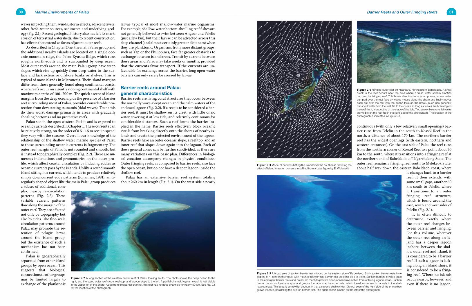
30 Marine Environments of Palau 31Barrier Reefs and Outer Fringing Reefs
waves impacting them, winds, storm effects, adjacent rivers, other fresh water sources, sediments and underlying geol-ogy (Fig. 2.1). Recent geological history also has left its mark: erosion of terrestrial watersheds, due to recent construction, has effects that extend as far as adjacent outer reefs. As described in Chapter One, the main Palau group and the additional nearby islands are located on a single oce-anic mountain ridge, the Palau-Kyushu Ridge, which runs roughly north-south and is surrounded by deep ocean. Most outer reefs around the main Palau group have steep slopes which rise up quickly from deep water to the sur-face and lack extensive offshore banks or shelves. This is typical of most islands in Micronesia. Their island margins differ from those generally found along continental coasts, where reefs occur on a gently sloping continental shelf with maximum depths of 100–200 m. The quick ascent of island margins from the deep ocean, plus the presence of a barrier reef surrounding most of Palau, provides considerable pro-tection from devastating tsunamis (tidal waves). Tsunamis do their worst damage primarily in areas with gradually shoaling bottoms and no protective reefs. Palau sits in the open western Pacific and is exposed to oceanic currents described in Chapter 1. These currents can be relatively strong, on the order of 0.5–1.5 m sec-1 in speed; they vary with the seasons. Overall, our knowledge of the relationship of the shallow water marine species of Palau to these surrounding oceanic currents is fragmentary. The outer reef margin of Palau is not rounded and smooth, but is instead topographically complex (Fig. 2.2). There are nu-merous indentations and promontories on the outer pro-file, which affect coastal circulation by inducing eddies as oceanic currents pass by the islands. Unlike a round smooth island sitting in a current, which tends to produce relatively simple downcurrent eddy patterns (Johannes, 1981), an ir-regularly shaped object like the main Palau group produces a subset of additional, com-plex, nearby re-circulation patterns (Fig. 2.3). These variable current patterns flow along the margin of the outer reef. They are affected not only by topography but also by tides. The fine-scale circulation patterns around Palau may promote the re-tention of pelagic larvae around the island group, but the existence of such a mechanism has not been confirmed. Palau is geographically separated from other island groups by open ocean. This suggests that biological connections to other groups may be limited largely to exchange of the planktonic
larvae typical of most shallow-water marine organisms. For example, shallow-water bottom-dwelling reef fishes are not generally believed to swim between Angaur and Peleliu (just a few km), but their larvae can be advected across this deep channel (and almost certainly greater distances) when they are planktonic. Organisms from more distant groups, such as Yap or the Philippines, face far greater obstacles to exchange between island areas. Transit by current between these areas and Palau may take weeks or months, provided that the currents favor transport. If the currents are un-favorable for exchange across the barrier, long open-water barriers can only rarely be crossed by larvae.
Barrier reefs around Palau: general characteristicsBarrier reefs are living coral structures that occur between the normally wave-swept ocean and the calm waters of the enclosed lagoon (Fig. 2.2). If a reef is to be considered a bar-rier reef, it must be shallow on its crest, with little or no water covering it at low tide, and relatively continuous for considerable distances. Such a reef forms the barrier im-plied in the name. Barrier reefs effectively block oceanic swells from breaking directly onto the shores of nearby is-lands and create the protected environment of the lagoon. Barrier reefs have an outer oceanic slope, a reef top, and an inner reef that slopes down again into the lagoon. Each of these general zones can be further subdivided, as there are many variations on this basic plan. Differences in biologi-cal zonation accompany changes in physical conditions. Outer fringing reefs, as compared to barrier reefs, also face the open ocean, but do not have a deeper lagoon inside the shallow reef. Palau has an extensive barrier reef system totaling about 260 km in length (Fig. 2.1). On the west side a nearly
continuous (with only a few relatively small openings) bar-rier runs from Peleliu in the south to Kossol Reef in the north, a distance of about 170 km. The northern barrier reef has the widest openings (with eastern, northern and western entrances). On the east side of Palau the reef runs from the northern corner of Kossol Reef to a point about 30 km to the south, where it transitions into a fringing reef at the northern end of Babeldaob, off Ngarchelong State. The outer reef remains a fringing reef south to Melekeok State, about half way down the eastern Babeldaob coast, where
it changes back to a barrier reef. It then extends, with some small gaps, another 60 km south to Peleliu, where it transitions to an outer fringing reef structure, which is found around the east, south and west sides of Peleliu (Fig. 2.1). It is often difficult to determine exactly where the outer reef changes be-tween barrier and fringing. For this volume, wherever the outer reef along an is-land has a deeper lagoon inshore, between the shal-low outer reef and island, it is considered to be a barrier reef. If such a lagoon is lack-ing along an island shore, it is considered to be a fring-ing reef. Where no islands occur nearby, however, and even if there is no lagoon,
Figure 2.4 Fringing outer reef off Ngaraard, northeastern Babeldaob. A small break in the reef occurs near the area where a fresh water stream empties out over the fringing reef. This break also functions as a rip area, where water pumped over the reef face by waves moves along the shore and finally moves back out over the reef into the ocean through the break. Such rips generally transport water from the reef flat to the ocean as long as waves are breaking on the reef-front, irrespective of the stage of the tide. Two arrow-like stone fish weirs are visible on the reef flat in the right side of the photograph. The location of the photograph is indicated in Figure 2.1.
Figure 2.3 Model of currents hitting the island from the southeast, showing the effect of island mass on currents (modified from a base figure by E. Wolanski).
Figure 2.2 A long section of the western barrier reef of Palau, looking south. The photo shows the deep ocean to the right, and the steep outer reef slope, reef-top, and lagoon slope to the left. A partial channel, Ngerumekaol, is just visible in the upper left of the photo. Aside from this partial channel, this reef has no deep channels for nearly 50 km. See Fig. 2.1 for the location of the photograph.
Figure 2.5 A broad area of sunken barrier reef is found on the eastern side of Babeldaob. Such sunken barrier reefs have depths of 4–8 m on their tops, with much shallower true barrier reef on either side of them. Sunken barriers fill wide gaps in the emergent barrier reefs and do not do much to prevent open-ocean wave action from entering lagoon areas. Sunken barrier bottoms often have spur and groove formations at the outer side, which transform to sand channels in the shal-lowest areas. This area is somewhat unusual in that a second shallow reef (Dibard, seen of the right side of the photo) has grown inshore, paralleling the sunken barrier reef. The open ocean is seen on the left of the photograph.
32 Marine Environments of Palau 33Barrier Reefs and Outer Fringing Reefs
the outer reef is considered a barrier reef. The distinc-tions described above are important because water circulation across a fringing reef differs in many ways from circulation across a barrier reef. Tidal rise and fall can sweep large amounts of water across a barrier reef separating the ocean and a deep lagoon. The tide ei-ther fills (on a rising tide) or empties (on a falling tide) the lagoon. The cross-barrier flow, combined with water transport through channels in the barrier reefs, provides the volume of water needed to raise and lower the lagoon water level with the tides. Because the area of the lagoon is usually much greater than the reef top, the flow of water to or from the lagoon can require several hours each day, with slack currents on the top of the reef occurring only at high and low tides. A fringing reef lacks a large deeper area inshore, as a consequence, there is only a limited scope for water transport across the shallow reef. If a tidal current brings water onto a fringing reef flat on a ris-ing tide, only a relatively small amount of water is required to fill up the reef flat (as compared to the water needed to fill a large lagoon) and the tidal currents that flow across fringing reefs are greatly reduced (as compared to the flows across barrier reefs). Wherever heavy surf pounds on a fringing reef, seawa-ter is transported onto the reef flat by wave pumping and, since it quickly backs up against the shoreline, strong later-al currents form along the shore. The water will move back out over the reef in rip areas with a slightly deeper reef lip, or through shallow channels that allow the free flow of wa-ter back to the ocean (Fig. 2.4). Sand scouring on reef flats behind outer fringing reefs may be important in structuring benthic communities that occur there. On barrier reefs there is typically a trans-port of sand and other loose material lagoonward, where it forms the back reef slope of the barrier reef. Such a sink for sedimentary material is not found on fringing reefs. The sediment swept onto or produced on top of the reef must either be transported along the shore to be carried offshore by rip currents, or transported to shore, where it accumu-lates as beaches. The lovely white sand beaches found along the northeastern coast of Babeldaob are produced by this mechanism. There are many broad gaps in the barrier reef of Palau, gaps which are perhaps best described as “sunken”, with live corals usually found within 4-8 m of the surface (Figs.
2.5 and 2.1). These shallow sections of sunken barrier reef are part of the continuous lip of the barrier reef; they are considered sunken only because they are several me-ters lower than the reef nearby (Figs. 2.5-2.6). There are a number of ways these sunken segments of the barrier reef could have formed. They might be areas of the barrier reef which were unable to grow so as to keep pace with the rise of sea level after the last glaciation. Perhaps growth of the reef may have been inhibited by local current flow, or oth-er, unknown, factors. It is also possible that some barrier reef sections have subsided, so they are now several me-ters beneath the surface. Some sunken barrier segments are found directly across from the mouths of rivers. In one case there is almost a double barrier reef, with a shallower
section growing up behind the deeper seaward portion of the reef (Fig. 2.5). The reasons why these openings have this geomorphology are complex and are discussed further in Chapter 3 (Channels and Passages). It is interesting that Palauan legend has recorded in-stances of possible island and reef subsidence, which must have occurred within the period of human habitation. The
legend of Meduu ra Ngibtal concerns a village in Ngiwal State that subsided beneath the waves after its inhabit-ants, out of jealousy, destroyed a magic breadfruit tree that brought forth fishes from a broken branch. This portion of the sunken barrier reef off Ngemai reef, in Ngiwal State, is known as “the sunken village;” it features an unusual, submerged off-shore reef structure (Fig. 2.7). It is certain-ly possible this legend records subsidence of a part of the outer reef that once supported a village, a subsidence that probably occurred within the last few thousand years. A cursory underwater survey of the area (Marksbury 1978) failed to find any evidence of previous habitation, but, given the passage of time since the subsidence and the constant exposure to waves and currents, it is unlikely that any easily discovered evidence of habitation would remain. Addition-ally Velasco Reef, a sunken atoll in the far north of Palau, has subsided about 15 m, and it has a similar legend of once having had islands and shallow reefs which unexpectedly sank and forced the residents to leave (see Chapter 4).
Figure 2.7 The reef known to Palauans as Ngibtal, the “sunken village”, is the area of reef, to the right of the shallow barrier reef, where waves are breaking. Waves break on the “sunken village” only when there is large swell from the east. The Ngiwal Causeway can be seen on the far left of this vertical aerial photograph.
Figure 2.8 The sheltered barrier reef off Malakal Harbor, Koror, consists of Lighthouse Reef (left) and Ngederrak Reef (right). Protection from strong wave action directly influences the types of reef communities that occur on the front and top of the reef. Two channels cross this sheltered barrier reef: the Lighthouse Channel (about 25–30 m deep) on the left of Ngederrak Reef and the Ngel Chan-nel (14–18 m deep) on its right. Scale is approximate.
Figure 2.6 (A) An area of sunken barrier reef on the eastern side of Palau. Waves are breaking on the shallowest portion of the sunken barrier, eventhough it is several meters deep. (B) The sunken barrier reef at the southern end of Idims Reef has well-developed spur and groove. A small basin about 20 m deep exists on the top of the shallow barrier reef, one of the few such basins on Palau’s reefs. These basins are probably remnants of depressions on what would have been an elevated ridge during glacial low water. There may have been many such basins once, basins now filled in with coral growth. They were formed when sea level rose up to its present level, several thousand years ago.
Figure 2.9 Ikonos satellite image of the area of the sunken barrier reef offshore of Malakal Harbor and Uchelbeluu Reef. The true barrier reef of Uchelbeluu serves to protect the sheltered Lighthouse and Ngederrak reefs from the full force of oceanic waves and northeast trade winds. The barrier reefs also protect the shallow areas from the large swell usually coming from the north and east. Scale is approximate. Satellite image courtesy Palau Automated Land and Re-sources Information System (PALARIS).
34 Marine Environments of Palau 35Barrier Reefs and Outer Fringing Reefs
Sheltered barrier reefs
There are also areas of reef, such as Ngederrak Reef and Lighthouse Reef in Koror, which superficially appear to be outer barrier reefs (Fig. 2.8). However, these reefs are paralleled by a sunken barrier reef about 2–3 km further offshore. These reefs are also shel-tered from major ocean swells from the east and north by their position west of the fold of barrier reef formed by Uchelbeluu Reef (Fig. 2.9). The geomorphol-ogy of these sheltered-bar-rier reefs resembles that of a barrier reef: their tops are emergent at low tides and they are broken by deep channels leading into the lagoon However, they differ from other east side barrier reefs in community struc-ture. The area between the sunken barrier reef and the sheltered barrier reef (Ngederrak/Lighthouse Reefs) is a ba-sin reaching depths of about 75 m (Fig. 2.9). It is discussed more fully in Chapter 5 (Offshore Environments). The communities on reef-tops of sheltered barrier reefs differ in many ways from those of true barrier and outer fringing reefs. In general, the sheltered barriers have high levels of rubble underlying the living coral, while true bar-rier and outer fringing reefs have largely rocky, cemented limestone foundations on the seaward upper surfaces. A comparison of the structure visible on the reef-tops shows the contrast between exposed barrier reef (Uchelbeluu Reef; Fig. 2.9 right side) with the sheltered barrier reef (Fig. 2.9 left side). The amount of protection afforded against NE-trade-wind seas is evident in Figure 2.9; compare the white area of breaking waves on the east side of Uchelbeluu Reef with the absence of breaking seas on the sheltered bar-rier reef. The true barrier reef has an extensive sand zone behind the top of the fore-reef, while the sheltered barrier reef has dark colored coral and algal flats across most of its width. Only a narrow margin of sand is found on the lagoon side of the sheltered barrier. The distinct cross-reef zonation of the true barrier gives way to a variable zonation across the sheltered barriers, whose shallow flats can be al-ternately lush (with high density coral coverage) or barren (with fields of dead coral). Quite disparate substrates can occur close to each other (Fig. 2.8).
Distribution and geomorphology of the barrier reefThe length of barrier-reef segments varies between different areas (Table 2.1). The barrier reef as a whole totals about 260 km. The width of the barrier reef often varies by an order of magnitude. The narrowest sections (other than the ends of long sections), found principally on the eastern barrier, are only about 100–200 m wide; much of the western barrier reef is 1–3 km wide. The width of the reef is controlled by several factors, including the direction of prevailing winds and seas, and the effects of geological history. The front of the barrier reef facing the ocean is hard rock and generally steep in profile, although this slope can vary considerably from perhaps a 30-45° slope to vertical and in some cases overhanging face (Fig. 2.10). Along Palau’s western barrier reef, slopes vary from moderately steep to near-vertical (Fig. 2.11a). Slopes tend to be vertical where the reef faces to the southwest, and more gently sloping when facing to the northwest, where they are affected by the large swell produced by passage of typhoons and tropi-cal storms north of Palau (Fig. 2.11b). On the eastern reefs, the outer slope is generally not as steep as it is on the west-ern reefs. The few areas that are near-vertical are protected from large waves while still facing deep water. Over the course of the average year, the barrier reefs of Palau are battered on all sides by wave action. The northeast trade winds hit the eastern barrier reefs during the win-
Segment Length (km) Area (km2)
1 Peleliu to German Channel 16.1 18*
2 German Channel to Ngerumekaol (Ulong channel) 33.1 51
3 Ngerumekaol to West Channel 49.7 79
4 West channel to Aiwokako Passage 14.7 25
5 Aiwokako passage to Ngamegei Passage 11.0 22
6 Ngamegei Passage to Ebiil 4.2 4
7 Ebiil to Tochelir ra Ngebard 13.3 23
8 Tochelir ra Ngebard to Western Entrance 7.4 10
9 Western Entrance to North Entrance 14.3 19
10 North Entrance to East Entrance (Kossol Reef) 26.7 48
11 East Entrance to Ngarchelong 10.1 15*
12 Melekeok to Idims 16.1 4*
13 Idims to Uchelbeluu Reef north end 14.7 10**
14 Ngeremdiu Reef to Chesau 9.2 6**
15 Chesau to Ngerechong channel 7.4 4**
16 Ngerechong channel to Peleliu 15.6 17*
Total 263.7 355
* transition from fringing to barrier reef
** excludes sunken barrier reef
Table 2.1 Barrier reef segments, length, and area
Figure 2.11 (A) Aerial view of the western barrier reef on a very calm day. The cross-reef zonation can be very clearly seen, with several zones easily distin-guished. The white boat is anchored at a popular dive site known as Siaes Tun-nel; there, the reef drops near vertically to about 60 m, has a slight slope between 60 and 90 m, and becomes vertical again below that depth. (B) Calm day with oceanic swell breaking on the western barrier reef, north of the West Passage. The sloping bottom here produces a clean build and break of the swells.
Figure 2.10 The outer reef face on the barrier reef varies from steeply sloping (yellow line) to near vertical and overhanging (red line). The distribution of various types of outer reef slope around the main island group of Palau (based on aerial pho-tographs and limited diving information) shows that areas protected from both the NE trade wind seas and large swell from the north and northwest, generated by passage of typhoons to the north of Palau, seem to have steeper faces. Vertical and overhanging reefs are particularly spectacular places for scuba diving and are avidly sought by the diving industry.
Figure 2.12 (A) Eastern barrier reef off Melekeok/Ngchesar States at low tide, showing the emergent reef-top. No flow normally occurs across this barrier reef at such low tides. (B) When the tide is higher, large waves can break across the reef, transporting water into the lagoon through wave pumping. This photograph shows the western barrier reef looking south, during the monsoonal winds. Dur-ing the summer months, the monsoonal winds drive heavy surf onto the western barrier reef of Palau. The Blue Corner area is at the top of the photograph.
36 Marine Environments of Palau 37Barrier Reefs and Outer Fringing Reefs
ter and spring (Fig. 2.12a). The summer monsoon winds bring heavy seas to the western-side reefs (Fig 2.12b). When northeasterly trade winds are light or calms prevail, the western barrier reef of Palau can be extremely calm (Fig. 2.11a). At other times, large oceanic swell, with-out wind-driven waves, breaks on the reef (Fig. 2.11b). Such swell, which can be several meters in height, gener-ally comes from the northeast, north, and northwest (Fig. 2.11b). It is often the result of tropical storms or typhoons passing north of Palau on westward or northwestward tracks. Barrier reefs that have a vertical profile (Figs. 2.10 and 2.11a) generally face to the southwest or south. There appears to be a correlation between the occurrence of ver-tical outer reef faces and protection from the northern and western oceanic swell. Barrier reefs with an almost vertical profile from deep water right to the surface, have live corals growing along the immediate seaward edge. These corals can grow along the seaward edge of the reef only because this section of the reef is not subjected to the pound-ing waves associated with heavy swell, waves which tear living corals from the
reef face and which move broken materials and rubble across the reef flat into the lagoon. Barrier reefs that have a sloping profile also usually have a well developed spur and groove system along the seaward edge. This system absorbs much of the energy of incom-ing waves and helps transport rubble and sand seaward into the depths. The elevated spurs have live corals with morphologies that resist wave damage (Figure 2.13). Sand channels from the spur and groove may extend far down-ward from the finger-like structures, to depths hundreds of meters below the reef top. At their bases are large piles of rubble (talus) transported from the shallow reef above The shallow top of the barrier reef is hard, with a rocky pavement largely cemented by coralline algae. The algal pavement transitions into isolated coral heads on the la-goon edge (Fig. 2.14). Further towards the lagoon side of the
barrier reefs, the bottom has more rubble and coarse sedi-ment; coral heads are interspersed with small coral patches (Fig. 2.14). Much of this loose bioclastic material has been washed from or across the reef. It accumulates at the la-goon margin, where the depth increases, and forms a slope into the lagoon depths. In places, large coral boulders have been thrown up onto the flat reef-top. If these boulders are submerged at high tides, they can pose a hazard to small boats crossing the barrier reef flat at high tide (Fig. 2.15). At low tide, such rocks are prominent features sticking up on the reef flat. In areas where reef material is thrown onto the top of the reef by storms, and where this material is not washed across the reef-top into the back reef, rubble accumulates. Eventually low islands are formed. If these rubble depos-its remain consistently above sea level for even a few years, vegetation can take hold. Thereafter, strong roots help con-solidate the rubble, so that the newly-formed barrier-reef island can better withstand storms. Subsequent storms may reshape these islands, but they are seldom eliminated. It is also possible that formation of barrier-reef islands was aided by slightly higher sea levels in the last few thousand years, but this is still a matter of conjecture.
Figure 2.14 Oblique aerial view of the western barrier reef, showing the cross-reef section from the ocean (right) to lagoon slope (left). The narrow fore-reef drops quickly to great depths on the ocean side. The reef-top is colored dark and on the lagoon side, transitions to pavement and then isolated coral heads (tan area). The gently sloping back-reef area is domi-nated by a sandy bottom with widely scattered coral heads. As it becomes deeper, the back-reef slope becomes a large shelf covered with megaripples, then a sand slope. The slope drops onto a 6 m deep sandy apron, which is covered with thousands of small patch reefs.
Figure 2.15 Storm waves can throw large pieces of reef rock onto the reef-top. (A) These large rocks are usually submerged at high tides, but are quite evident at low tides. Such large blocks can be quite isolated, only one or a few occurring for long stretches of reef. (B) Storm debris can be quite abundant in some areas, with blocks of all sizes being thrown up onto the shallow reef.
Figure 2.13 Spur and groove zones on outer reef slopes. (A) Area off Ngaraard State, on the eastern side of Babeldaob. (B) Outer slope of northwestern barrier reef. A complicated pattern of small spur and groove exists here, sloping steeply into deep water. Also, note the lack of a dark Sargassum zone on the reef crest. The small boat on the left provides scale. Slight surf on the reef is produced by breaking swell, not wind-driven waves.
Figure 2.16 Sea level rise after the last glacial maximum (reaching its peak some 20,000 years ago) re-sulted in extreme changes in the types of geomorphological structure that were available as substrates for reef growth. (A) At glacial maximum (20,000 before present), with sea level about 120 m (400 feet) below pres-ent, the sea surface impinged upon a steep or near vertical reef limestone slope. The limestone on which the reef was growing had been formed during the previous high stand of the ocean. This reef rock had been erod-ed by aerial exposure. The only habi-tat available for reefs was this slope, which quickly reached depths beyond the growth limits of reef corals (black arrow). (B) 10,000 years ago, sea level was still 60 m (200 feet) below pres-ent-day levels; new reef growth was forced to move up the slope as the sea rose. This left the lower reef below the depths where reefs could grow. Inshore areas behind the barrier reef would have soon been flooded and marine habitats established there. (C) By 6000 years before present, sea level was approaching present day level, about 4 m below present, and the sea was close to rising above the eroded fossil reef remnant. The layer of recent reef limestone deposited on the basement rock was becom-ing thicker. (D) In the present day, the recent reef is built on top of the fos-sil reef basement and water is able to pass over the barrier reef.
38 Marine Environments of Palau 39Barrier Reefs and Outer Fringing Reefs
The growth of a barrier reef is influenced by several factors, such as the rise and fall of sea level with ice ages and interglacial periods (a process occurring over many millennia) and the accumulation on the reef’s lagoon side of sedimentary materials (a process taking place over a shorter time scale). Since the last glacial low water, about 20,000 years ago, sea level has risen about 120 m (400 feet) be-fore reaching its present lev-el (Fig. 2.16). Over this time period, the geomorphology of the seaward marine habi-tats of Palau has changed, from a steep-to-vertical cliff with a steeply sloping nar-row shelf below the water, to a broad, flat barrier reef or outer fringing reef. The rela-tionship of sea level changes to reef growth is discussed later in this chapter. Three factors drive the movement of water, sedi-ments and plankton across the barrier reef: the tides, waves and wind (Hamner et al 2007). Flow can go in either direction (ocean to lagoon or the reverse) and the three factors can either work together, maximiz-ing water movement in one direction (causing the highest speeds), or oppose one another, greatly reducing flow. The tides cause transport of water, one way or another, by the simple raising or lowering of sea level in the ocean, with re-sultant flow into or out of the lagoon due to gravity. Waves and ocean swell break upon the barrier reef; this pushes water across the barrier reef (wave pumping), and produces a flow which can increase (or resist) flow resulting from the tide alone. Wind direction has additional effects on water movement, in some cases helping to push the water by increasing the wave height, or, opposing the waves produced on the reef by oceanic swell and thus reducing the flow across the reef. Winds can also alter the timing and levels of the tides. Passage across the barrier reef area can modify the already existing temperature and salinity differences be-tween lagoon and oceanic water. This is discussed more fully subsequently. Biological factors can also modify this water as it crosses the reef: particulate plankton-feeding
fishes and filter-feeding invertebrates remove a substantial amount of the zooplankton, phytoplankton, and bacteria from the water, while spawning invertebrates and fish can add zooplanktonic larvae to the water as it moves across the reef. The level of the tide is the most consistent force regulat-ing water flow across the barrier reef, a force exerted with every tidal cycle. As the tide falls, the water depth over the barrier reef falls and the lowering of sea level eventually re-stricts cross-reef flow (Fig. 2.17). At low tide, much of the barrier reef of Palau becomes emergent, producing a near-total stoppage of flow between lagoon and ocean over the barrier reef (Fig. 2.12a). The deeper reef channels through the reef then become the only exchange portals between la-goon and ocean. These exchange portals function through-out all tidal levels. On a falling tide, it may take as much as an hour for tidal currents to move a parcel of water from lagoon to ocean across the entire shallow section of the barrier reef, as this
distance may be as much as 2–3 km. Studies have shown that drifters started on the inside edge of the barrier reef were found to move directly across the reef at 0.3–0.6 m sec-1 while on the reef top (an average of about 0.5 m sec-1), but to slow to a 0.1–0.25 m sec-1 flow rate once off the shal-lows and into deep ocean water (Fig. 2.17). Even at maximal tidal flow rates, on a sunny day there can be considerable heating of the water while it crosses the shallow reef. Even more heating may occur during calm periods, when all sur-face waters, ocean or lagoon, can heat up in a thin layer on the surface and vertical mixing is minimal. When lagoon water crosses the reef during falling tides and reaches the open ocean, it is usually warmer than the oceanic water. Because warm water is less dense than cool water, once across the reef the lagoon water floats on top of the oceanic water in a layer 2–3 m thick. This surface water often remains, unmixed, as a warm layer on top of relatively cooler oceanic water, for a few hundred meters out from the reef. This is layering is quite evident to divers navigating the western barrier reef on a falling tide. The layer of lagoon water is both warm and turbid, but it is only a few meters thick. This layer of ebb-tide water can also be seen clearly from the air (Fig. 2.18). On rare occasions the water crossing the reef from lagoon to ocean is denser than offshore water, probably due to higher salinity from evapo-ration (salinity increases density). When this dense lagoon water reaches the outer slope it flows down along the reef face, rather than floating seaward on top of the ocean wa-ter. This downwelling current can be quite distressing and exceptionally dangerous to divers caught in it. They can be dragged downward without warning and reach great-er depths than they had planned. These downward flows, however, are only a few meters thick. Divers who swim away from the wall can escape and ascend safely.
How the volume of water exchanged across the barrier reef compares to the volume of water passing through the deeper channels on tidal cycles is not known. The cross-barrier-reef exchange is limited to the near surface water, which is no more than a few meters deep, and its flow is de-pendent on tidal amplitude. The flow that enters the lagoon from the ocean through the channels is also dependent on tidal range, but is not limited by the shallow sill of the barrier reef. On a rising tide, the profile of oceanic water equaling the depth of the channel flows into the channel, top to bottom, maintaining any vertical stratification. Sim-ilarly, on a falling tide, lagoon water fills the channel top to bottom, but may not be similarly stratified compared to the ocean. It is believed that cross-barrier reef flow produces a net inflow from ocean to lagoon, with the excess water exit-ing through the channel on the falling tide, but this has not been quantitatively determined as yet. The limited work on water exchange through tidal channels has indicated there is a net outflow of water from lagoon to ocean. The deeper channels (the deepest is 70–80 m) are also roiled by large amounts of vertical, helical mixing, which is due to the turbulence produced as currents rush in (or out) from the open ocean. The absence of islands on the northern reef tract of Palau allows open circulation through that region, which perhaps helps to keep open the large shallow passages of that part of Palau (Fig. 2.1). It would be useful to know more about water transport between ocean and lagoon in the far north of Palau. The fronts and eddies of strong oceanic cur-rents between Kossol Reef and Kayangel are usually visible from the air. Such currents probably promote considerable flow through the shallow passages in the northern part of the Palau reefs, in addition to the flow caused by tidal cur-rents. Where islands such as Babeldaob prevent east-west transport, reef gaps do not have to transport as much vol-ume of water. Since a much smaller amount of water must be exchanged with the tides, these gaps may be becoming narrow channels or even closing due to coral growth. Palau has two seasonal wind regimes: the trade winds (northeasterly) during the winter, and monsoonal winds (westerly and southwesterly) during the summer. Both re-
Figure 2.17 The cross-reef (lagoon to ocean) flow, on a falling tide, on the western barrier reef (at Siaes Reef) was exam-ined using current-following drifters. It is shown here in a vertical view against a satellite image background. A GPS on the drifter records its position every minute; the dots show the tracks of four drifters which were started near-simultaneously on the lagoon side. Drifters crossing the shallow reef moved across the reef at 0.3–0.6 m sec-1 while in shallow water, but slowed to only 0.1–0.25 m sec-1 once off the reef into deep ocean water. Even at the maximal speeds on the reef-top, it can take as much as an hour for a parcel of water to cross the shallow reef from lagoon to ocean on a falling tide, during which time the water can be heated or cooled by atmospheric conditions.
Figure 2.18 Tidal currents bring lagoon water across the reef on a falling tide. This water is warm and more turbid than oceanic water, hence it moves some distance offshore as a sheet a few meters thick. (A) The advancing edge of the lagoon water is easily seen in this vertical aerial photograph of the Turtle Cove area; it appears as white slicks of floating material. (B) Water flowing off the eastern barrier reef, north of Peleliu, is more turbid (evident in the lighter color) than oceanic water.
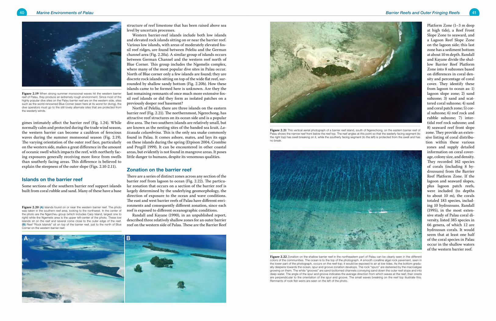
40 Marine Environments of Palau 41Barrier Reefs and Outer Fringing Reefs
gimes intimately affect the barrier reef (Fig. 1.24). While normally calm and protected during the trade wind season, the western barrier can become a cauldron of ferocious waves during the summer monsoonal season (Fig. 2.19). The varying orientation of the outer reef face, particularly on the western side, makes a great difference in the amount of oceanic swell which impacts the reef, with northerly fac-ing exposures generally receiving more force from swells than southerly facing areas. This difference is believed to explain the steepness of the outer slope (Figs. 2.10-2.11).
Islands on the barrier reefSome sections of the southern barrier reef support islands built from coral rubble and sand. Many of these have a base
structure of reef limestone that has been raised above sea level by uncertain processes. Western barrier-reef islands include both low islands and elevated rock islands sitting on or near the barrier reef. Various low islands, with areas of moderately elevated fos-sil reef ridges, are found between Peleliu and the German channel area (Fig. 2.20a). A similar group of islands occurs between German Channel and the western reef north of Blue Corner. This group includes the Ngemelis complex, where many of the most popular dive sites in Palau occur. North of Blue corner only a few islands are found; they are discrete rock islands sitting on top of the wide flat reef, sur-rounded by shallow sandy bottom (Fig. 2.20b). How these islands came to be formed here is unknown. Are they the last remaining remnants of once much more extensive fos-sil reef islands or did they form as isolated patches on a previously deeper reef basement? North of Peleliu, there are three islands on the eastern barrier reef (Fig. 2.21). The northernmost, Ngerechong, has attractive reef structures on its ocean side and is a popular dive area. The two southern islands are relatively small, but are known as the nesting sites of the banded sea krait, La-ticauda columbrina. This is the only sea snake commonly found in Palau. It comes ashore, mates, and lays its eggs on these islands during the spring (Etpison 2004, Crombie and Pregill 1999). It can be encountered in other coastal areas, but evidently is not found in mangrove areas. It poses little danger to humans, despite its venomous qualities.
Zonation on the barrier reefThere are a series of distinct zones across any section of the barrier reef from lagoon to ocean (Fig. 2.22). The particu-lar zonation that occurs on a section of the barrier reef is largely determined by the underlying geomorphology, the direction of exposure to the ocean and wave conditions. The east and west barrier reefs of Palau have different envi-ronments and consequently different zonation, since each reef is exposed to different oceanographic conditions. Randall and Kayane (1990), in an unpublished report, described three relatively shallow zones for an outer barrier reef on the western side of Palau. These are the Barrier Reef
Platform Zone (1–3 m deep at high tide), a Reef Front Slope Zone to seaward, and a Lagoon Reef Slope Zone on the lagoon side; this last zone has a sediment bottom at about 10 m depth. Randall and Kayane divide the shal-low Barrier Reef Platform Zone into 8 subzones based on differences in coral den-sity and percentage of coral cover. They identify these from lagoon to ocean as: 1) lagoon slope zone; 2) sand subzone; 3) sand and scat-tered coral subzone; 4) sand and coral patch zone; 5) cor-al subzone; 6) reef rock and rubble subzone; 7) inter-tidal reef rock subzone; and 8) seaward reef front slope
zone. They provide an exten-sive listing of coral distribu-tion within these various zones and supply detailed information on coral cover-age, colony size, and density. They recorded 162 species of corals (including 8 hy-drozoans) from the Barrier Reef Platform Zone. If the lagoon and seaward slopes, plus lagoon patch reefs, were included (to depths to about 10 m), the corals totaled 183 species, includ-ing 10 hydrozoans. Randall (1995), in the most exten-sive study of Palau coral di-versity, listed 385 species in 66 genera, of which 12 are hydrozoan corals. It would seem that at least one half of the coral species in Palau occur in the shallow waters of the western barrier reef.
Figure 2.21 This vertical aerial photograph of a barrier reef island, south of Ngerechong, on the eastern barrier reef of Palau shows the narrow reef front below the reef top. The reef angles at this point so that the easterly facing segment (to the right top) has swell breaking on it, while the southerly facing segment (to the left) is protected from the swell and has no break.
Figure 2.22 Zonation on the shallow barrier reef in the northeastern part of Palau can be clearly seen in the different colors of the communities. The ocean is to the top of the photograph. A smooth coralline algal rock pavement, seen in the lower part of the photograph, occurs on the reef-top; it would be exposed to air at low tides. As the bottom gradu-ally deepens towards the ocean, spur and groove zonation develops. The rock “spurs” are darkened by the macroalgae growing on them. The white “grooves” are sand-bottomed channels conveying sand down the outer reef slope and into deep water. The angle of the spur and groove indicates the average direction from which waves at the reef; their crests are perpendicular to the orientation of the spur and groove. The small waves breaking on the reef top illustrate this. Remnants of rook fish weirs are seen on the left of the photo.
Figure 2.19 When strong summer monsoonal waves hit the western barrier reef of Palau, they produce an extremely rough environment. Since most of the highly popular dive sites on the Palau barrier reef are on the western side, sites such as the world-renowned Blue Corner (seen here at its worst for diving), the dive operators must go to the still lovely alternate sites that are protected from the westerly winds.
Figure 2.20 (A) Islands found on or near the western barrier reef. The photo was taken in the southern reef area, looking to the northwest. In the center of the photo are the Ngercheu group (which includes Carp Island, largest one to right) while the Ngemelis area is the upper left-center of the photo. These low islands sit on the reef and several come close to the outer edge of the reef. (B) Reef “Rock Islands” sit on top of the barrier reef, just to the north of Blue Corner on the western barrier reef.
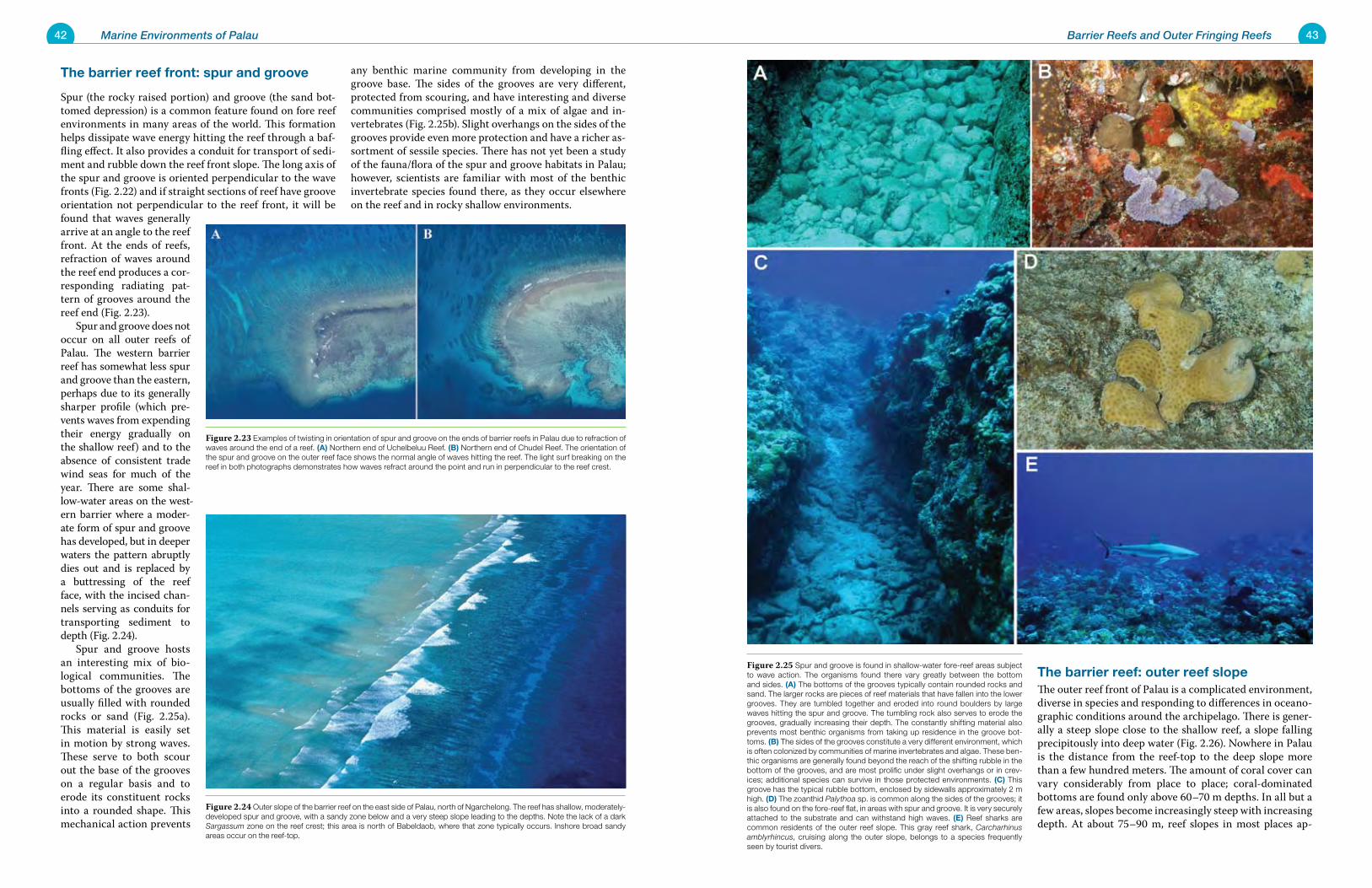
42 Marine Environments of Palau 43Barrier Reefs and Outer Fringing Reefs
The barrier reef front: spur and groove
Spur (the rocky raised portion) and groove (the sand bot-tomed depression) is a common feature found on fore reef environments in many areas of the world. This formation helps dissipate wave energy hitting the reef through a baf-fling effect. It also provides a conduit for transport of sedi-ment and rubble down the reef front slope. The long axis of the spur and groove is oriented perpendicular to the wave fronts (Fig. 2.22) and if straight sections of reef have groove orientation not perpendicular to the reef front, it will be found that waves generally arrive at an angle to the reef front. At the ends of reefs, refraction of waves around the reef end produces a cor-responding radiating pat-tern of grooves around the reef end (Fig. 2.23). Spur and groove does not occur on all outer reefs of Palau. The western barrier reef has somewhat less spur and groove than the eastern, perhaps due to its generally sharper profile (which pre-vents waves from expending their energy gradually on the shallow reef) and to the absence of consistent trade wind seas for much of the year. There are some shal-low-water areas on the west-ern barrier where a moder-ate form of spur and groove has developed, but in deeper waters the pattern abruptly dies out and is replaced by a buttressing of the reef face, with the incised chan-nels serving as conduits for transporting sediment to depth (Fig. 2.24). Spur and groove hosts an interesting mix of bio-logical communities. The bottoms of the grooves are usually filled with rounded rocks or sand (Fig. 2.25a). This material is easily set in motion by strong waves. These serve to both scour out the base of the grooves on a regular basis and to erode its constituent rocks into a rounded shape. This mechanical action prevents
any benthic marine community from developing in the groove base. The sides of the grooves are very different, protected from scouring, and have interesting and diverse communities comprised mostly of a mix of algae and in-vertebrates (Fig. 2.25b). Slight overhangs on the sides of the grooves provide even more protection and have a richer as-sortment of sessile species. There has not yet been a study of the fauna/flora of the spur and groove habitats in Palau; however, scientists are familiar with most of the benthic invertebrate species found there, as they occur elsewhere on the reef and in rocky shallow environments.
The barrier reef: outer reef slopeThe outer reef front of Palau is a complicated environment, diverse in species and responding to differences in oceano-graphic conditions around the archipelago. There is gener-ally a steep slope close to the shallow reef, a slope falling precipitously into deep water (Fig. 2.26). Nowhere in Palau is the distance from the reef-top to the deep slope more than a few hundred meters. The amount of coral cover can vary considerably from place to place; coral-dominated bottoms are found only above 60–70 m depths. In all but a few areas, slopes become increasingly steep with increasing depth. At about 75–90 m, reef slopes in most places ap-
Figure 2.25 Spur and groove is found in shallow-water fore-reef areas subject to wave action. The organisms found there vary greatly between the bottom and sides. (A) The bottoms of the grooves typically contain rounded rocks and sand. The larger rocks are pieces of reef materials that have fallen into the lower grooves. They are tumbled together and eroded into round boulders by large waves hitting the spur and groove. The tumbling rock also serves to erode the grooves, gradually increasing their depth. The constantly shifting material also prevents most benthic organisms from taking up residence in the groove bot-toms. (B) The sides of the grooves constitute a very different environment, which is often colonized by communities of marine invertebrates and algae. These ben-thic organisms are generally found beyond the reach of the shifting rubble in the bottom of the grooves, and are most prolific under slight overhangs or in crev-ices; additional species can survive in those protected environments. (C) This groove has the typical rubble bottom, enclosed by sidewalls approximately 2 m high. (D) The zoanthid Palythoa sp. is common along the sides of the grooves; it is also found on the fore-reef flat, in areas with spur and groove. It is very securely attached to the substrate and can withstand high waves. (E) Reef sharks are common residents of the outer reef slope. This gray reef shark, Carcharhinus amblyrhincus, cruising along the outer slope, belongs to a species frequently seen by tourist divers.
Figure 2.23 Examples of twisting in orientation of spur and groove on the ends of barrier reefs in Palau due to refraction of waves around the end of a reef. (A) Northern end of Uchelbeluu Reef. (B) Northern end of Chudel Reef. The orientation of the spur and groove on the outer reef face shows the normal angle of waves hitting the reef. The light surf breaking on the reef in both photographs demonstrates how waves refract around the point and run in perpendicular to the reef crest.
Figure 2.24 Outer slope of the barrier reef on the east side of Palau, north of Ngarchelong. The reef has shallow, moderately-developed spur and groove, with a sandy zone below and a very steep slope leading to the depths. Note the lack of a dark Sargassum zone on the reef crest; this area is north of Babeldaob, where that zone typically occurs. Inshore broad sandy areas occur on the reef-top.
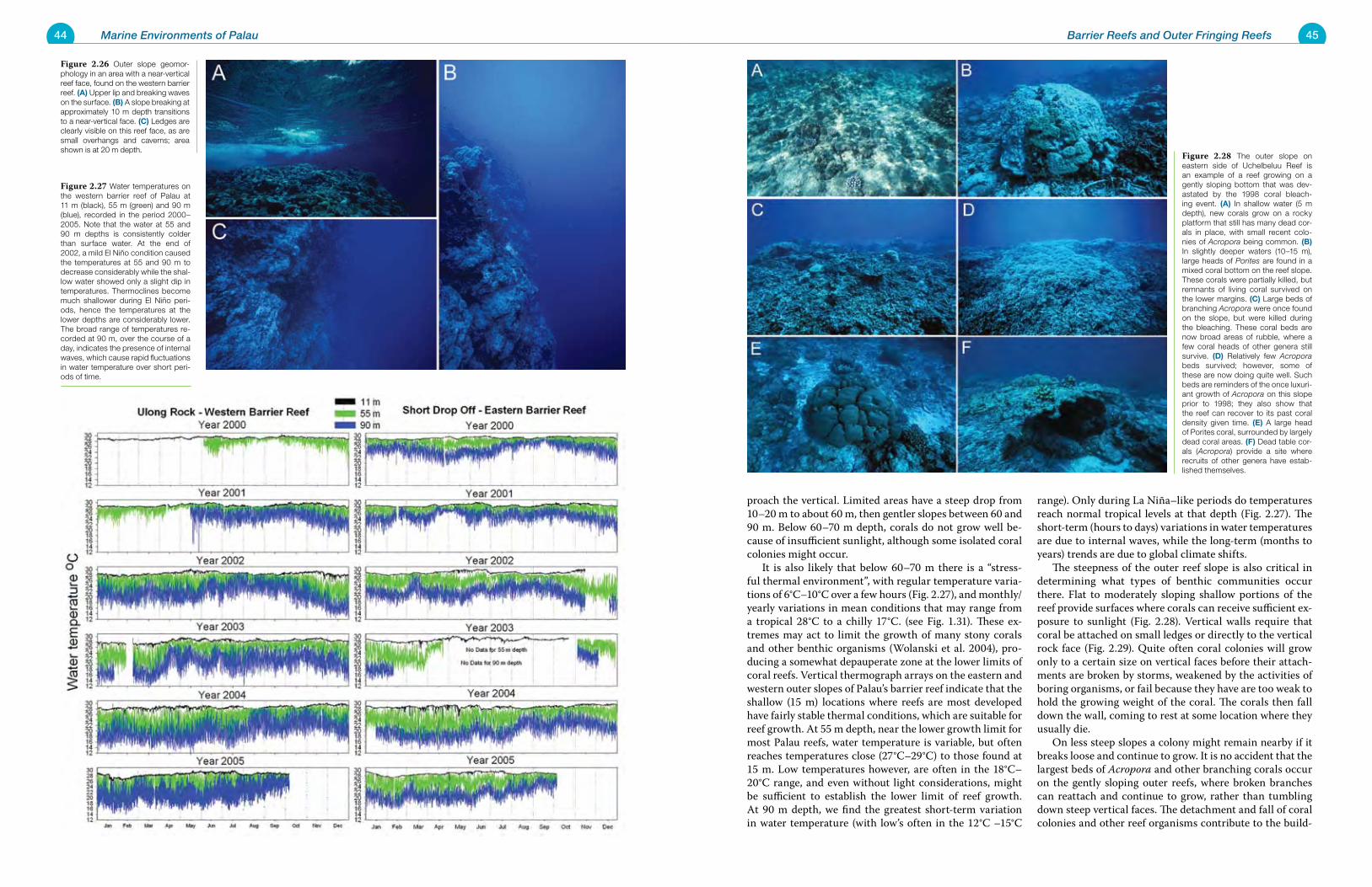
44 Marine Environments of Palau 45Barrier Reefs and Outer Fringing Reefs
proach the vertical. Limited areas have a steep drop from 10–20 m to about 60 m, then gentler slopes between 60 and 90 m. Below 60–70 m depth, corals do not grow well be-cause of insufficient sunlight, although some isolated coral colonies might occur. It is also likely that below 60–70 m there is a “stress-ful thermal environment”, with regular temperature varia-tions of 6°C–10°C over a few hours (Fig. 2.27), and monthly/yearly variations in mean conditions that may range from a tropical 28°C to a chilly 17°C. (see Fig. 1.31). These ex-tremes may act to limit the growth of many stony corals and other benthic organisms (Wolanski et al. 2004), pro-ducing a somewhat depauperate zone at the lower limits of coral reefs. Vertical thermograph arrays on the eastern and western outer slopes of Palau’s barrier reef indicate that the shallow (15 m) locations where reefs are most developed have fairly stable thermal conditions, which are suitable for reef growth. At 55 m depth, near the lower growth limit for most Palau reefs, water temperature is variable, but often reaches temperatures close (27°C–29°C) to those found at 15 m. Low temperatures however, are often in the 18°C–20°C range, and even without light considerations, might be sufficient to establish the lower limit of reef growth. At 90 m depth, we find the greatest short-term variation in water temperature (with low’s often in the 12°C –15°C
range). Only during La Niña–like periods do temperatures reach normal tropical levels at that depth (Fig. 2.27). The short-term (hours to days) variations in water temperatures are due to internal waves, while the long-term (months to years) trends are due to global climate shifts. The steepness of the outer reef slope is also critical in determining what types of benthic communities occur there. Flat to moderately sloping shallow portions of the reef provide surfaces where corals can receive sufficient ex-posure to sunlight (Fig. 2.28). Vertical walls require that coral be attached on small ledges or directly to the vertical rock face (Fig. 2.29). Quite often coral colonies will grow only to a certain size on vertical faces before their attach-ments are broken by storms, weakened by the activities of boring organisms, or fail because they have are too weak to hold the growing weight of the coral. The corals then fall down the wall, coming to rest at some location where they usually die. On less steep slopes a colony might remain nearby if it breaks loose and continue to grow. It is no accident that the largest beds of Acropora and other branching corals occur on the gently sloping outer reefs, where broken branches can reattach and continue to grow, rather than tumbling down steep vertical faces. The detachment and fall of coral colonies and other reef organisms contribute to the build-
Figure 2.27 Water temperatures on the western barrier reef of Palau at 11 m (black), 55 m (green) and 90 m (blue), recorded in the period 2000–2005. Note that the water at 55 and 90 m depths is consistently colder than surface water. At the end of 2002, a mild El Niño condition caused the temperatures at 55 and 90 m to decrease considerably while the shal-low water showed only a slight dip in temperatures. Thermoclines become much shallower during El Niño peri-ods, hence the temperatures at the lower depths are considerably lower. The broad range of temperatures re-corded at 90 m, over the course of a day, indicates the presence of internal waves, which cause rapid fluctuations in water temperature over short peri-ods of time.
Figure 2.26 Outer slope geomor-phology in an area with a near-vertical reef face, found on the western barrier reef. (A) Upper lip and breaking waves on the surface. (B) A slope breaking at approximately 10 m depth transitions to a near-vertical face. (C) Ledges are clearly visible on this reef face, as are small overhangs and caverns; area shown is at 20 m depth.
Figure 2.28 The outer slope on eastern side of Uchelbeluu Reef is an example of a reef growing on a gently sloping bottom that was dev-astated by the 1998 coral bleach-ing event. (A) In shallow water (5 m depth), new corals grow on a rocky platform that still has many dead cor-als in place, with small recent colo-nies of Acropora being common. (B) In slightly deeper waters (10–15 m), large heads of Porites are found in a mixed coral bottom on the reef slope. These corals were partially killed, but remnants of living coral survived on the lower margins. (C) Large beds of branching Acropora were once found on the slope, but were killed during the bleaching. These coral beds are now broad areas of rubble, where a few coral heads of other genera still survive. (D) Relatively few Acropora beds survived; however, some of these are now doing quite well. Such beds are reminders of the once luxuri-ant growth of Acropora on this slope prior to 1998; they also show that the reef can recover to its past coral density given time. (E) A large head of Porites coral, surrounded by largely dead coral areas. (F) Dead table cor-als (Acropora) provide a site where recruits of other genera have estab-lished themselves.
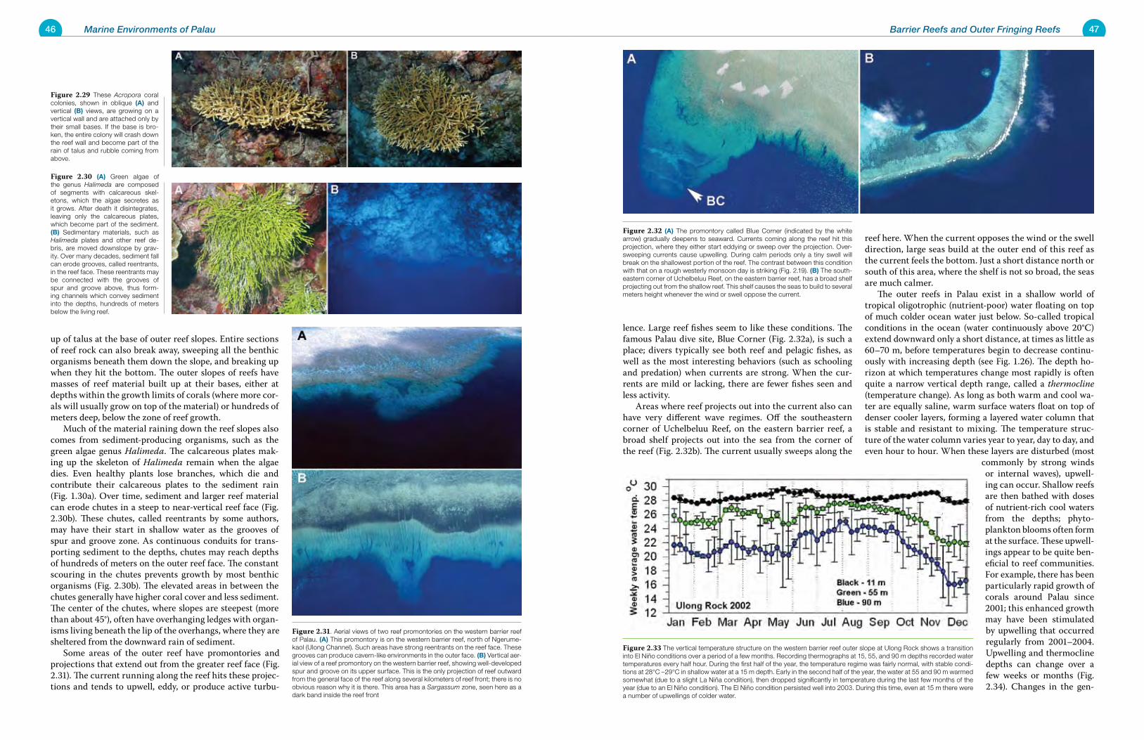
46 Marine Environments of Palau 47Barrier Reefs and Outer Fringing Reefs
up of talus at the base of outer reef slopes. Entire sections of reef rock can also break away, sweeping all the benthic organisms beneath them down the slope, and breaking up when they hit the bottom. The outer slopes of reefs have masses of reef material built up at their bases, either at depths within the growth limits of corals (where more cor-als will usually grow on top of the material) or hundreds of meters deep, below the zone of reef growth. Much of the material raining down the reef slopes also comes from sediment-producing organisms, such as the green algae genus Halimeda. The calcareous plates mak-ing up the skeleton of Halimeda remain when the algae dies. Even healthy plants lose branches, which die and contribute their calcareous plates to the sediment rain (Fig. 1.30a). Over time, sediment and larger reef material can erode chutes in a steep to near-vertical reef face (Fig. 2.30b). These chutes, called reentrants by some authors, may have their start in shallow water as the grooves of spur and groove zone. As continuous conduits for trans-porting sediment to the depths, chutes may reach depths of hundreds of meters on the outer reef face. The constant scouring in the chutes prevents growth by most benthic organisms (Fig. 2.30b). The elevated areas in between the chutes generally have higher coral cover and less sediment. The center of the chutes, where slopes are steepest (more than about 45°), often have overhanging ledges with organ-isms living beneath the lip of the overhangs, where they are sheltered from the downward rain of sediment. Some areas of the outer reef have promontories and projections that extend out from the greater reef face (Fig. 2.31). The current running along the reef hits these projec-tions and tends to upwell, eddy, or produce active turbu-
lence. Large reef fishes seem to like these conditions. The famous Palau dive site, Blue Corner (Fig. 2.32a), is such a place; divers typically see both reef and pelagic fishes, as well as the most interesting behaviors (such as schooling and predation) when currents are strong. When the cur-rents are mild or lacking, there are fewer fishes seen and less activity. Areas where reef projects out into the current also can have very different wave regimes. Off the southeastern corner of Uchelbeluu Reef, on the eastern barrier reef, a broad shelf projects out into the sea from the corner of the reef (Fig. 2.32b). The current usually sweeps along the
reef here. When the current opposes the wind or the swell direction, large seas build at the outer end of this reef as the current feels the bottom. Just a short distance north or south of this area, where the shelf is not so broad, the seas are much calmer. The outer reefs in Palau exist in a shallow world of tropical oligotrophic (nutrient-poor) water floating on top of much colder ocean water just below. So-called tropical conditions in the ocean (water continuously above 20°C) extend downward only a short distance, at times as little as 60–70 m, before temperatures begin to decrease continu-ously with increasing depth (see Fig. 1.26). The depth ho-rizon at which temperatures change most rapidly is often quite a narrow vertical depth range, called a thermocline (temperature change). As long as both warm and cool wa-ter are equally saline, warm surface waters float on top of denser cooler layers, forming a layered water column that is stable and resistant to mixing. The temperature struc-ture of the water column varies year to year, day to day, and even hour to hour. When these layers are disturbed (most
commonly by strong winds or internal waves), upwell-ing can occur. Shallow reefs are then bathed with doses of nutrient-rich cool waters from the depths; phyto-plankton blooms often form at the surface. These upwell-ings appear to be quite ben-eficial to reef communities. For example, there has been particularly rapid growth of corals around Palau since 2001; this enhanced growth may have been stimulated by upwelling that occurred regularly from 2001–2004. Upwelling and thermocline depths can change over a few weeks or months (Fig. 2.34). Changes in the gen-
Figure 2.31. Aerial views of two reef promontories on the western barrier reef of Palau. (A) This promontory is on the western barrier reef, north of Ngerume-kaol (Ulong Channel). Such areas have strong reentrants on the reef face. These grooves can produce cavern-like environments in the outer face. (B) Vertical aer-ial view of a reef promontory on the western barrier reef, showing well-developed spur and groove on its upper surface. This is the only projection of reef outward from the general face of the reef along several kilometers of reef front; there is no obvious reason why it is there. This area has a Sargassum zone, seen here as a dark band inside the reef front
Figure 2.32 (A) The promontory called Blue Corner (indicated by the white arrow) gradually deepens to seaward. Currents coming along the reef hit this projection, where they either start eddying or sweep over the projection. Over-sweeping currents cause upwelling. During calm periods only a tiny swell will break on the shallowest portion of the reef. The contrast between this condition with that on a rough westerly monsoon day is striking (Fig. 2.19). (B) The south-eastern corner of Uchelbeluu Reef, on the eastern barrier reef, has a broad shelf projecting out from the shallow reef. This shelf causes the seas to build to several meters height whenever the wind or swell oppose the current.
Figure 2.29 These Acropora coral colonies, shown in oblique (A) and vertical (B) views, are growing on a vertical wall and are attached only by their small bases. If the base is bro-ken, the entire colony will crash down the reef wall and become part of the rain of talus and rubble coming from above.
Figure 2.30 (A) Green algae of the genus Halimeda are composed of segments with calcareous skel-etons, which the algae secretes as it grows. After death it disintegrates, leaving only the calcareous plates, which become part of the sediment. (B) Sedimentary materials, such as Halimeda plates and other reef de-bris, are moved downslope by grav-ity. Over many decades, sediment fall can erode grooves, called reentrants, in the reef face. These reentrants may be connected with the grooves of spur and groove above, thus form-ing channels which convey sediment into the depths, hundreds of meters below the living reef.
Figure 2.33 The vertical temperature structure on the western barrier reef outer slope at Ulong Rock shows a transition into El Niño conditions over a period of a few months. Recording thermographs at 15, 55, and 90 m depths recorded water temperatures every half hour. During the first half of the year, the temperature regime was fairly normal, with stable condi-tions at 28°C –29°C in shallow water at a 15 m depth. Early in the second half of the year, the water at 55 and 90 m warmed somewhat (due to a slight La Niña condition), then dropped significantly in temperature during the last few months of the year (due to an El Niño condition). The El Niño condition persisted well into 2003. During this time, even at 15 m there were a number of upwellings of colder water.
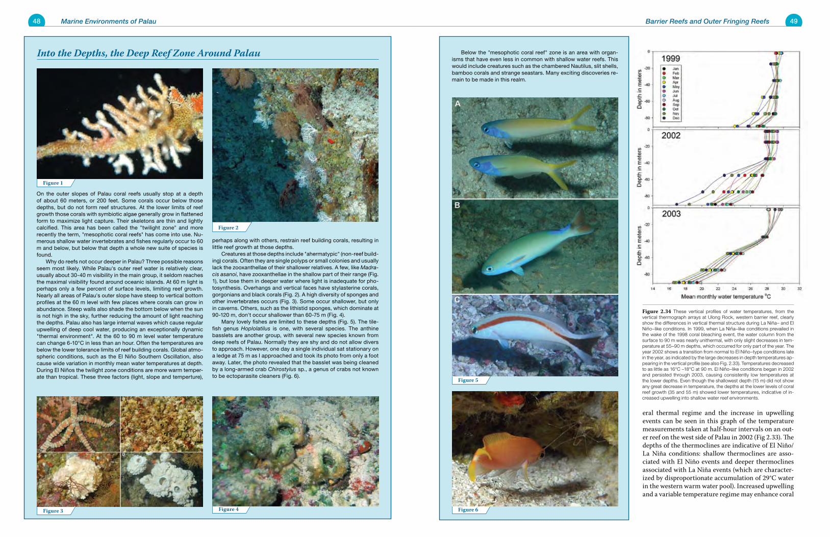
48 Marine Environments of Palau 49Barrier Reefs and Outer Fringing Reefs
Below the "mesophotic coral reef" zone is an area with organ-isms that have even less in common with shallow water reefs. This would include creatures such as the chambered Nautilus, slit shells, bamboo corals and strange seastars. Many exciting discoveries re-main to be made in this realm.
On the outer slopes of Palau coral reefs usually stop at a depth of about 60 meters, or 200 feet. Some corals occur below those depths, but do not form reef structures. At the lower limits of reef growth those corals with symbiotic algae generally grow in flattened form to maximize light capture. Their skeletons are thin and lightly calcified. This area has been called the "twilight zone" and more recently the term, "mesophotic coral reefs" has come into use. Nu-merous shallow water invertebrates and fishes regularly occur to 60 m and below, but below that depth a whole new suite of species is found. Why do reefs not occur deeper in Palau? Three possible reasons seem most likely. While Palau's outer reef water is relatively clear, usually about 30-40 m visibility in the main group, it seldom reaches the maximal visibility found around oceanic islands. At 60 m light is perhaps only a few percent of surface levels, limiting reef growth. Nearly all areas of Palau's outer slope have steep to vertical bottom profiles at the 60 m level with few places where corals can grow in abundance. Steep walls also shade the bottom below when the sun is not high in the sky, further reducing the amount of light reaching the depths. Palau also has large internal waves which cause regular upwelling of deep cool water, producing an exceptionally dynamic "thermal environment". At the 60 to 90 m level water temperature can change 6-10°C in less than an hour. Often the temperatures are below the lower tolerance limits of reef building corals. Global atmo-spheric conditions, such as the El Niño Southern Oscillation, also cause wide variation in monthly mean water temperatures at depth. During El Niños the twilight zone conditions are more warm temper-ate than tropical. These three factors (light, slope and temperture),
perhaps along with others, restrain reef building corals, resulting in little reef growth at those depths. Creatures at those depths include "ahermatypic" (non-reef build-ing) corals. Often they are single polyps or small colonies and usually lack the zooxanthellae of their shallower relatives. A few, like Madra-cis asanoi, have zooxanthellae in the shallow part of their range (Fig. 1), but lose them in deeper water where light is inadequate for pho-tosynthesis. Overhangs and vertical faces have stylasterine corals, gorgonians and black corals (Fig. 2). A high diversity of sponges and other invertebrates occurs (Fig. 3). Some occur shallower, but only in caverns. Others, such as the lithistid sponges, which dominate at 90-120 m, don't occur shallower than 60-75 m (Fig. 4). Many lovely fishes are limited to these depths (Fig. 5). The tile-fish genus Hoplolatilus is one, with several species. The anthine basslets are another group, with several new species known from deep reefs of Palau. Normally they are shy and do not allow divers to approach. However, one day a single individual sat stationary on a ledge at 75 m as I approached and took its photo from only a foot away. Later, the photo revealed that the basslet was being cleaned by a long-armed crab Chirostylus sp., a genus of crabs not known to be ectoparasite cleaners (Fig. 6).
Into the Depths, the Deep Reef Zone Around Palau
eral thermal regime and the increase in upwelling events can be seen in this graph of the temperature measurements taken at half-hour intervals on an out-er reef on the west side of Palau in 2002 (Fig 2.33). The depths of the thermoclines are indicative of El Niño/La Niña conditions: shallow thermoclines are asso-ciated with El Niño events and deeper thermoclines associated with La Niña events (which are character-ized by disproportionate accumulation of 29°C water in the western warm water pool). Increased upwelling and a variable temperature regime may enhance coral
Figure 6
Figure 5
Figure 4Figure 3
Figure 2
Figure 1
Figure 2.34 These vertical profiles of water temperatures, from the vertical thermograph arrays at Ulong Rock, western barrier reef, clearly show the differences in vertical thermal structure during La Niña– and El Niño–like conditions. In 1999, when La Niña–like conditions prevailed in the wake of the 1998 coral bleaching event, the water column from the surface to 90 m was nearly unithermal, with only slight decreases in tem-perature at 55–90 m depths, which occurred for only part of the year. The year 2002 shows a transition from normal to El Niño–type conditions late in the year, as indicated by the large decreases in depth temperatures ap-pearing in the vertical profile (see also Fig. 2.33). Temperatures decreased to as little as 16°C –18°C at 90 m. El Niño–like conditions began in 2002 and persisted through 2003, causing consistently low temperatures at the lower depths. Even though the shallowest depth (15 m) did not show any great decrease in temperature, the depths at the lower levels of coral reef growth (35 and 55 m) showed lower temperatures, indicative of in-creased upwelling into shallow water reef environments.
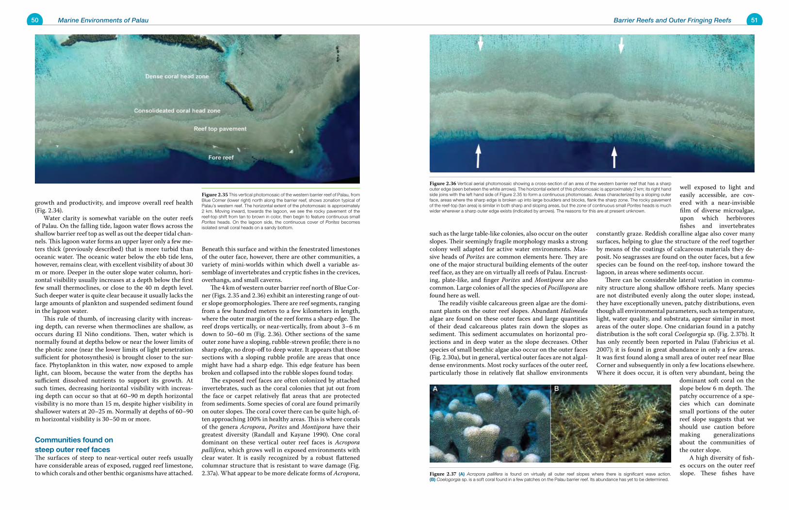
50 Marine Environments of Palau 51Barrier Reefs and Outer Fringing Reefs
growth and productivity, and improve overall reef health (Fig. 2.34). Water clarity is somewhat variable on the outer reefs of Palau. On the falling tide, lagoon water flows across the shallow barrier reef top as well as out the deeper tidal chan-nels. This lagoon water forms an upper layer only a few me-ters thick (previously described) that is more turbid than oceanic water. The oceanic water below the ebb tide lens, however, remains clear, with excellent visibility of about 30 m or more. Deeper in the outer slope water column, hori-zontal visibility usually increases at a depth below the first few small thermoclines, or close to the 40 m depth level. Such deeper water is quite clear because it usually lacks the large amounts of plankton and suspended sediment found in the lagoon water. This rule of thumb, of increasing clarity with increas-ing depth, can reverse when thermoclines are shallow, as occurs during El Niño conditions. Then, water which is normally found at depths below or near the lower limits of the photic zone (near the lower limits of light penetration sufficient for photosynthesis) is brought closer to the sur-face. Phytoplankton in this water, now exposed to ample light, can bloom, because the water from the depths has sufficient dissolved nutrients to support its growth. At such times, decreasing horizontal visibility with increas-ing depth can occur so that at 60–90 m depth horizontal visibility is no more than 15 m, despite higher visibility in shallower waters at 20–25 m. Normally at depths of 60–90 m horizontal visibility is 30–50 m or more.
Communities found on steep outer reef facesThe surfaces of steep to near-vertical outer reefs usually have considerable areas of exposed, rugged reef limestone, to which corals and other benthic organisms have attached.
Beneath this surface and within the fenestrated limestones of the outer face, however, there are other communities, a variety of mini-worlds within which dwell a variable as-semblage of invertebrates and cryptic fishes in the crevices, overhangs, and small caverns. The 4 km of western outer barrier reef north of Blue Cor-ner (Figs. 2.35 and 2.36) exhibit an interesting range of out-er slope geomorphologies. There are reef segments, ranging from a few hundred meters to a few kilometers in length, where the outer margin of the reef forms a sharp edge. The reef drops vertically, or near-vertically, from about 3–6 m down to 50–60 m (Fig. 2.36). Other sections of the same outer zone have a sloping, rubble-strewn profile; there is no sharp edge, no drop-off to deep water. It appears that those sections with a sloping rubble profile are areas that once might have had a sharp edge. This edge feature has been broken and collapsed into the rubble slopes found today. The exposed reef faces are often colonized by attached invertebrates, such as the coral colonies that jut out from the face or carpet relatively flat areas that are protected from sediments. Some species of coral are found primarily on outer slopes. The coral cover there can be quite high, of-ten approaching 100% in healthy areas. This is where corals of the genera Acropora, Porites and Montipora have their greatest diversity (Randall and Kayane 1990). One coral dominant on these vertical outer reef faces is Acropora pallifera, which grows well in exposed environments with clear water. It is easily recognized by a robust flattened columnar structure that is resistant to wave damage (Fig. 2.37a). What appear to be more delicate forms of Acropora,
such as the large table-like colonies, also occur on the outer slopes. Their seemingly fragile morphology masks a strong colony well adapted for active water environments. Mas-sive heads of Porites are common elements here. They are one of the major structural building elements of the outer reef face, as they are on virtually all reefs of Palau. Encrust-ing, plate-like, and finger Porites and Montipora are also common. Large colonies of all the species of Pocillopora are found here as well. The readily visible calcareous green algae are the domi-nant plants on the outer reef slopes. Abundant Halimeda algae are found on these outer faces and large quantities of their dead calcareous plates rain down the slopes as sediment. This sediment accumulates on horizontal pro-jections and in deep water as the slope decreases. Other species of small benthic algae also occur on the outer faces (Fig. 2.30a), but in general, vertical outer faces are not algal-dense environments. Most rocky surfaces of the outer reef, particularly those in relatively flat shallow environments
well exposed to light and easily accessible, are cov-ered with a near-invisible film of diverse microalgae, upon which herbivores fishes and invertebrates
constantly graze. Reddish coralline algae also cover many surfaces, helping to glue the structure of the reef together by means of the coatings of calcareous materials they de-posit. No seagrasses are found on the outer faces, but a few species can be found on the reef-top, inshore toward the lagoon, in areas where sediments occur. There can be considerable lateral variation in commu-nity structure along shallow offshore reefs. Many species are not distributed evenly along the outer slope; instead, they have exceptionally uneven, patchy distributions, even though all environmental parameters, such as temperature, light, water quality, and substrata, appear similar in most areas of the outer slope. One cnidarian found in a patchy distribution is the soft coral Coelogorgia sp. (Fig. 2.37b). It has only recently been reported in Palau (Fabricius et al. 2007); it is found in great abundance in only a few areas. It was first found along a small area of outer reef near Blue Corner and subsequently in only a few locations elsewhere. Where it does occur, it is often very abundant, being the
dominant soft coral on the slope below 6 m depth. The patchy occurrence of a spe-cies which can dominate small portions of the outer reef slope suggests that we should use caution before making generalizations about the communities of the outer slope. A high diversity of fish-es occurs on the outer reef slope. These fishes have
Figure 2.35 This vertical photomosaic of the western barrier reef of Palau, from Blue Corner (lower right) north along the barrier reef, shows zonation typical of Palau’s western reef. The horizontal extent of the photomosaic is approximately 2 km. Moving inward, towards the lagoon, we see the rocky pavement of the reef-top shift from tan to brown in color, then begin to feature continuous small Porites heads. On the lagoon side, the continuous cover of Porites becomes isolated small coral heads on a sandy bottom.
Figure 2.36 Vertical aerial photomosaic showing a cross-section of an area of the western barrier reef that has a sharp outer edge (seen between the white arrows). The horizontal extent of this photomosaic is approximately 2 km; its right hand side joins with the left hand side of Figure 2.35 to form a continuous photomosaic. Areas characterized by a sloping outer face, areas where the sharp edge is broken up into large boulders and blocks, flank the sharp zone. The rocky pavement of the reef-top (tan area) is similar in both sharp and sloping areas, but the zone of continuous small Porites heads is much wider wherever a sharp outer edge exists (indicated by arrows). The reasons for this are at present unknown.
Figure 2.37 (A) Acropora pallifera is found on virtually all outer reef slopes where there is significant wave action. (B) Coelogorgia sp. is a soft coral found in a few patches on the Palau barrier reef. Its abundance has yet to be determined.
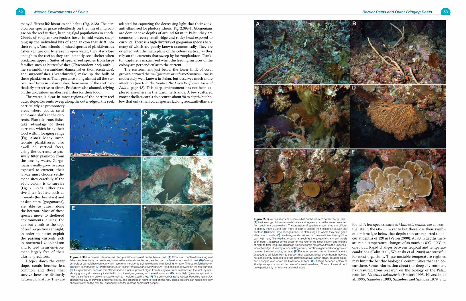
52 Marine Environments of Palau 53Barrier Reefs and Outer Fringing Reefs
many different life histories and habits (Fig. 2.38). The her-bivorous species graze relentlessly on the film of microal-gae on the reef surface, keeping algal populations in check. Clouds of zooplankton feeders hover in mid-water, snap-ping up the individual bits of zooplankton that drift into their range. Vast schools of mixed species of planktivorous fishes venture out to graze in open water; they stay close enough to the reef so they can instantly seek shelter when predators appear. Suites of specialized species from large families such as butterflyfishes (Chaeotodontidae), anthii-ine serranids (Serranidae), damselfishes (Pomacentridae), and surgeonfishes (Acanthuridae) make up the bulk of these planktivores. Their presence along almost all the ver-tical reef faces in Palau makes these areas of the reef par-ticularly attractive to divers. Predators also abound, relying on the ubiquitous smaller reef fishes for their food. The water is clear in most regions of the barrier-reef outer slope. Currents sweep along the outer edge of the reef, particularly at promontory areas where eddies swirl and cause shifts in the cur-rents. Planktivorous fishes take advantage of these currents, which bring their food within foraging range (Fig. 2.38a). Many inver-tebrate planktivores also dwell on vertical faces, using the currents to pas-sively filter plankton from the passing water. Gorgo-nians usually grow in areas exposed to current; their larvae must choose settle-ment sites carefully if the adult colony is to survive (Fig. 2.39c-d). Other pas-sive filter feeders, such as crinoids (feather stars) and basket stars (gorgonacea), are able to crawl along the bottom. Most of these species move to sheltered environments during the day but climb to the tops of reef projections at night, in order to better exploit the passing currents rich in nocturnal zooplankton and to feed in an environ-ment largely free of their diurnal predators. Deeper down the outer slope, corals become less common and those that survive here are distinctly flattened in nature. They are
adapted for capturing the decreasing light that their zoox-anthellae need for photosynthesis (Fig. 2.39e-f). Gorgonians are dominant at depths of around 60 m in Palau; they are common on every small ridge and rocky head exposed to currents. There is a high diversity of gorgonian species here, many of which are poorly known taxonomically. They are oriented with the main plane of the colony vertical, as they rely on the currents that sweep by for zooplankton. Plank-ton capture is maximized when the feeding surfaces of the colony are perpendicular to the current. The environment just below the lower limit of coral growth, termed the twilight zone or sub-reef environment, is moderately well-known in Palau, but deserves much more attention (see Into the Depths, the Deep Reef Zone Around Palau, page 48). This deep environment has not been ex-plored elsewhere in the Caroline Islands. A few scattered zooxanthellate corals do occur to about 90 m depth, but be-low that only small coral species lacking zooxanthellae are
found. A few species, such as Madracis asanoi, are zooxan-thellate in the 60–90 m range but these lose their symbi-otic microalgae below that depth; they are reported to oc-cur at depths of 120 m (Veron 2000). At 90 m depths there are rapid temperature changes of as much as 8°C –10°C in one hour. Rapid changes between tropical and temperate conditions (Colin 2001, Wolanski et al. 2004) are stressful for most organisms. These unstable temperature regimes may limit the benthic biological communities that can oc-cur there. Some information about this deep environment has resulted from research on the biology of the Palau nautilus, Nautilus belauensis (Hattori 1995, Hayasaka et al. 1995, Saunders 1983, Saunders and Spinosa 1979, and
Figure 2.39 Vertical reef-face communities on the western barrier reef of Palau. (A) A wide range of diverse invertebrates and algae occur on the areas protected from sediment downwelling. The profusion of species is such that it is difficult to identify them all, and even more difficult to assess their relationships with one another. (B) Some large sponges occur in stable regions where they have good attachment points. (C) Overhangs and crevices that have sufficient through-flow can host many filter-feeding organisms, such as the gorgonians and soft corals seen here. Tubastrea corals occur on the roof of the small cavern and expand at night to filter feed. (D) This large Siphonogorgia fan grows from the undersur-face of a ledge. A variety of encrusting corals, coralline algae, and sponges also grow on the overhanging surface. (E) Flattened plate corals on the reef face are exposed to sufficient light to support their zooxanthellae, even though they are not consistently exposed to direct light from above. Green algae, coralline algae, and sponges also cover the limestone surface. (F) A large flattened colony of Montipora sp. occurs at the base of a small overhang. Coral colonies do not grow particularly large on vertical reef faces.
Figure 2.38 Herbivores, planktivores, and predators co-exist on the barrier reef. (A) Clouds of zooplankton-eating reef fishes, such as these damselfishes, hover in the water above the reef, feeding on zooplankton as they drift past. (B) Grazing schools of parrotfishes can overwhelm territorial herbivores trying to defend their feeding territory. This parrotfish behavior is known as mobbing. (C) Parrotfishes, such as this female Scarus xanthopleura, feed on algae growing on the reef surface. (D) Surgeonfishes, such as this Ctenochaetus striatus, prevent algae from taking over rock surfaces on the reef, by con-stantly grazing at the nearly invisible film of microalgae growing on the reef surfaces. (E) Houndfish, Tylosurus sp., swims near the surface and prey on unwary small- to medium-sized fishes. (F) The omnivorous spiny lobster, Panulirus versicolor, spends the day in crevices and small caves, and emerges at night to feed on the reef. These lobsters can range into very shallow water on the reef flat, but usually shelter in areas somewhat deeper.
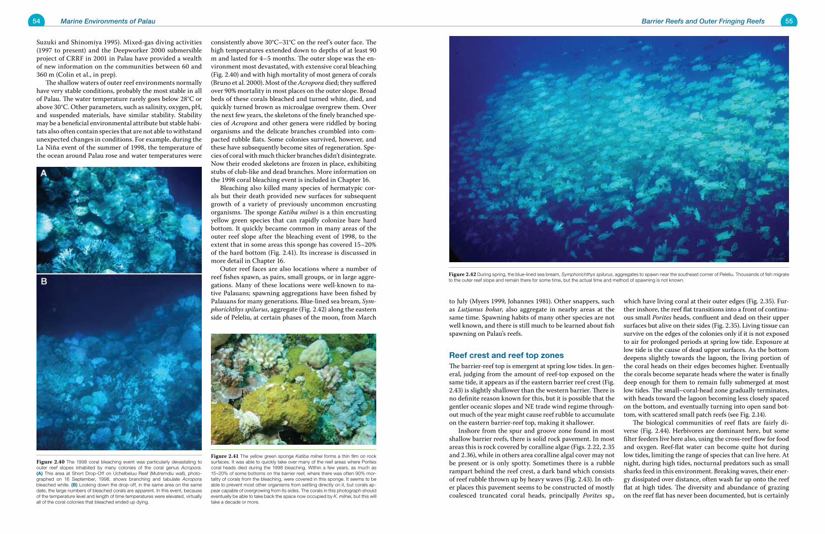
54 Marine Environments of Palau 55Barrier Reefs and Outer Fringing Reefs
Suzuki and Shinomiya 1995). Mixed-gas diving activities (1997 to present) and the Deepworker 2000 submersible project of CRRF in 2001 in Palau have provided a wealth of new information on the communities between 60 and 360 m (Colin et al., in prep). The shallow waters of outer reef environments normally have very stable conditions, probably the most stable in all of Palau. The water temperature rarely goes below 28°C or above 30°C. Other parameters, such as salinity, oxygen, pH, and suspended materials, have similar stability. Stability may be a beneficial environmental attribute but stable habi-tats also often contain species that are not able to withstand unexpected changes in conditions. For example, during the La Niña event of the summer of 1998, the temperature of the ocean around Palau rose and water temperatures were
consistently above 30°C–31°C on the reef ’s outer face. The high temperatures extended down to depths of at least 90 m and lasted for 4–5 months. The outer slope was the en-vironment most devastated, with extensive coral bleaching (Fig. 2.40) and with high mortality of most genera of corals (Bruno et al. 2000). Most of the Acropora died; they suffered over 90% mortality in most places on the outer slope. Broad beds of these corals bleached and turned white, died, and quickly turned brown as microalgae overgrew them. Over the next few years, the skeletons of the finely branched spe-cies of Acropora and other genera were riddled by boring organisms and the delicate branches crumbled into com-pacted rubble flats. Some colonies survived, however, and these have subsequently become sites of regeneration. Spe-cies of coral with much thicker branches didn’t disintegrate. Now their eroded skeletons are frozen in place, exhibiting stubs of club-like and dead branches. More information on the 1998 coral bleaching event is included in Chapter 16. Bleaching also killed many species of hermatypic cor-als but their death provided new surfaces for subsequent growth of a variety of previously uncommon encrusting organisms. The sponge Katiba milnei is a thin encrusting yellow green species that can rapidly colonize bare hard bottom. It quickly became common in many areas of the outer reef slope after the bleaching event of 1998, to the extent that in some areas this sponge has covered 15–20% of the hard bottom (Fig. 2.41). Its increase is discussed in more detail in Chapter 16. Outer reef faces are also locations where a number of reef fishes spawn, as pairs, small groups, or in large aggre-gations. Many of these locations were well-known to na-tive Palauans; spawning aggregations have been fished by Palauans for many generations. Blue-lined sea bream, Sym-phorichthys spilurus, aggregate (Fig. 2.42) along the eastern side of Peleliu, at certain phases of the moon, from March
to July (Myers 1999, Johannes 1981). Other snappers, such as Lutjanus bohar, also aggregate in nearby areas at the same time. Spawning habits of many other species are not well known, and there is still much to be learned about fish spawning on Palau’s reefs.
Reef crest and reef top zonesThe barrier-reef top is emergent at spring low tides. In gen-eral, judging from the amount of reef-top exposed on the same tide, it appears as if the eastern barrier reef crest (Fig. 2.43) is slightly shallower than the western barrier. There is no definite reason known for this, but it is possible that the gentler oceanic slopes and NE trade wind regime through-out much of the year might cause reef rubble to accumulate on the eastern barrier-reef top, making it shallower. Inshore from the spur and groove zone found in most shallow barrier reefs, there is solid rock pavement. In most areas this is rock covered by coralline algae (Figs. 2.22, 2.35 and 2.36), while in others area coralline algal cover may not be present or is only spotty. Sometimes there is a rubble rampart behind the reef crest, a dark band which consists of reef rubble thrown up by heavy waves (Fig. 2.43). In oth-er places this pavement seems to be constructed of mostly coalesced truncated coral heads, principally Porites sp.,
which have living coral at their outer edges (Fig. 2.35). Fur-ther inshore, the reef flat transitions into a front of continu-ous small Porites heads, confluent and dead on their upper surfaces but alive on their sides (Fig. 2.35). Living tissue can survive on the edges of the colonies only if it is not exposed to air for prolonged periods at spring low tide. Exposure at low tide is the cause of dead upper surfaces. As the bottom deepens slightly towards the lagoon, the living portion of the coral heads on their edges becomes higher. Eventually the corals become separate heads where the water is finally deep enough for them to remain fully submerged at most low tides. The small–coral-head zone gradually terminates, with heads toward the lagoon becoming less closely spaced on the bottom, and eventually turning into open sand bot-tom, with scattered small patch reefs (see Fig. 2.14). The biological communities of reef flats are fairly di-verse (Fig. 2.44). Herbivores are dominant here, but some filter feeders live here also, using the cross-reef flow for food and oxygen. Reef-flat water can become quite hot during low tides, limiting the range of species that can live here. At night, during high tides, nocturnal predators such as small sharks feed in this environment. Breaking waves, their ener-gy dissipated over distance, often wash far up onto the reef flat at high tides. The diversity and abundance of grazing on the reef flat has never been documented, but is certainly
Figure 2.42 During spring, the blue-lined sea bream, Symphorichthys spilurus, aggregates to spawn near the southeast corner of Peleliu. Thousands of fish migrate to the outer reef slope and remain there for some time, but the actual time and method of spawning is not known.
Figure 2.41 The yellow green sponge Katiba milnei forms a thin film on rock surfaces. It was able to quickly take over many of the reef areas where Porites coral heads died during the 1998 bleaching. Within a few years, as much as 15–20% of some bottoms on the barrier reef, where there was often 90% mor-tality of corals from the bleaching, were covered in this sponge. It seems to be able to prevent most other organisms from settling directly on it, but corals ap-pear capable of overgrowing from its sides. The corals in this photograph should eventually be able to take back the space now occupied by K. milnei, but this will take a decade or more.
Figure 2.40 The 1998 coral bleaching event was particularly devastating to outer reef slopes inhabited by many colonies of the coral genus Acropora. (A) This area at Short Drop-Off on Uchelbeluu Reef (Mutremdiu wall), photo-graphed on 16 September, 1998, shows branching and tabulate Acropora bleached white. (B) Looking down the drop-off, in the same area on the same date, the large numbers of bleached corals are apparent. In this event, because of the temperature level and length of time temperatures were elevated, virtually all of the coral colonies that bleached ended up dying.
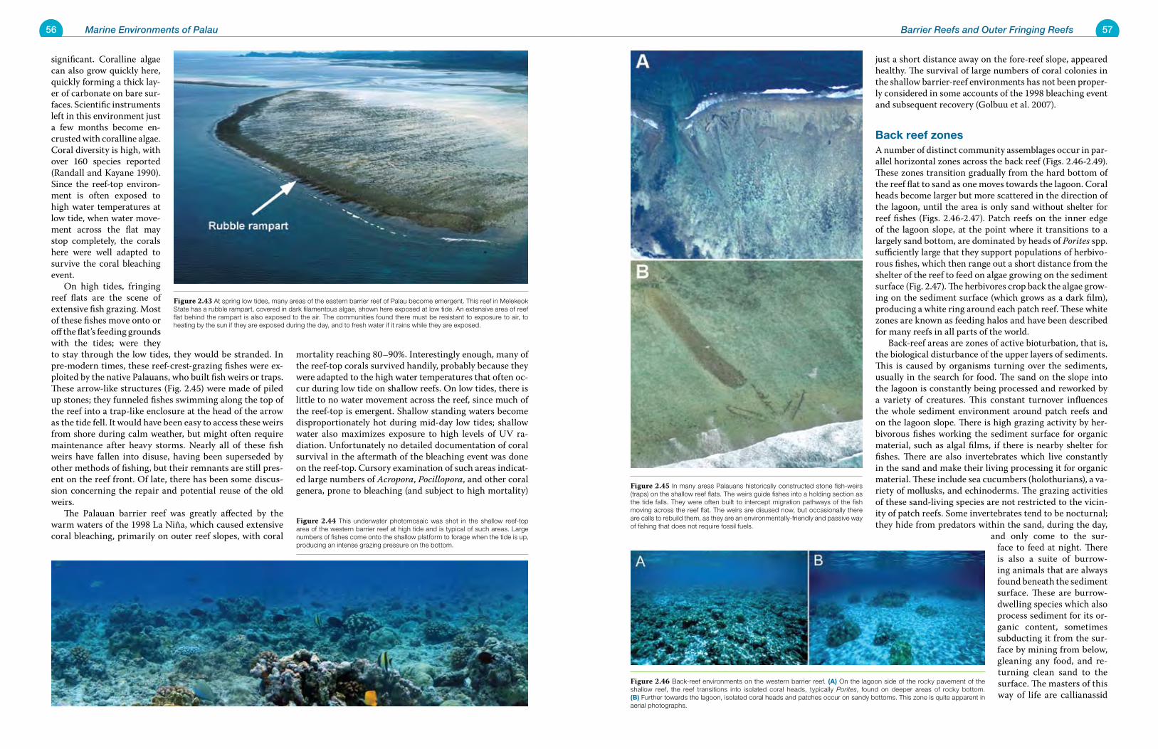
56 Marine Environments of Palau 57Barrier Reefs and Outer Fringing Reefs
significant. Coralline algae can also grow quickly here, quickly forming a thick lay-er of carbonate on bare sur-faces. Scientific instruments left in this environment just a few months become en-crusted with coralline algae. Coral diversity is high, with over 160 species reported (Randall and Kayane 1990). Since the reef-top environ-ment is often exposed to high water temperatures at low tide, when water move-ment across the flat may stop completely, the corals here were well adapted to survive the coral bleaching event. On high tides, fringing reef flats are the scene of extensive fish grazing. Most of these fishes move onto or off the flat’s feeding grounds with the tides; were they to stay through the low tides, they would be stranded. In pre-modern times, these reef-crest-grazing fishes were ex-ploited by the native Palauans, who built fish weirs or traps. These arrow-like structures (Fig. 2.45) were made of piled up stones; they funneled fishes swimming along the top of the reef into a trap-like enclosure at the head of the arrow as the tide fell. It would have been easy to access these weirs from shore during calm weather, but might often require maintenance after heavy storms. Nearly all of these fish weirs have fallen into disuse, having been superseded by other methods of fishing, but their remnants are still pres-ent on the reef front. Of late, there has been some discus-sion concerning the repair and potential reuse of the old weirs. The Palauan barrier reef was greatly affected by the warm waters of the 1998 La Niña, which caused extensive coral bleaching, primarily on outer reef slopes, with coral
mortality reaching 80–90%. Interestingly enough, many of the reef-top corals survived handily, probably because they were adapted to the high water temperatures that often oc-cur during low tide on shallow reefs. On low tides, there is little to no water movement across the reef, since much of the reef-top is emergent. Shallow standing waters become disproportionately hot during mid-day low tides; shallow water also maximizes exposure to high levels of UV ra-diation. Unfortunately no detailed documentation of coral survival in the aftermath of the bleaching event was done on the reef-top. Cursory examination of such areas indicat-ed large numbers of Acropora, Pocillopora, and other coral genera, prone to bleaching (and subject to high mortality)
just a short distance away on the fore-reef slope, appeared healthy. The survival of large numbers of coral colonies in the shallow barrier-reef environments has not been proper-ly considered in some accounts of the 1998 bleaching event and subsequent recovery (Golbuu et al. 2007).
Back reef zonesA number of distinct community assemblages occur in par-allel horizontal zones across the back reef (Figs. 2.46-2.49). These zones transition gradually from the hard bottom of the reef flat to sand as one moves towards the lagoon. Coral heads become larger but more scattered in the direction of the lagoon, until the area is only sand without shelter for reef fishes (Figs. 2.46-2.47). Patch reefs on the inner edge of the lagoon slope, at the point where it transitions to a largely sand bottom, are dominated by heads of Porites spp. sufficiently large that they support populations of herbivo-rous fishes, which then range out a short distance from the shelter of the reef to feed on algae growing on the sediment surface (Fig. 2.47). The herbivores crop back the algae grow-ing on the sediment surface (which grows as a dark film), producing a white ring around each patch reef. These white zones are known as feeding halos and have been described for many reefs in all parts of the world. Back-reef areas are zones of active bioturbation, that is, the biological disturbance of the upper layers of sediments. This is caused by organisms turning over the sediments, usually in the search for food. The sand on the slope into the lagoon is constantly being processed and reworked by a variety of creatures. This constant turnover influences the whole sediment environment around patch reefs and on the lagoon slope. There is high grazing activity by her-bivorous fishes working the sediment surface for organic material, such as algal films, if there is nearby shelter for fishes. There are also invertebrates which live constantly in the sand and make their living processing it for organic material. These include sea cucumbers (holothurians), a va-riety of mollusks, and echinoderms. The grazing activities of these sand-living species are not restricted to the vicin-ity of patch reefs. Some invertebrates tend to be nocturnal; they hide from predators within the sand, during the day,
and only come to the sur-face to feed at night. There is also a suite of burrow-ing animals that are always found beneath the sediment surface. These are burrow-dwelling species which also process sediment for its or-ganic content, sometimes subducting it from the sur-face by mining from below, gleaning any food, and re-turning clean sand to the surface. The masters of this way of life are callianassid
Figure 2.45 In many areas Palauans historically constructed stone fish-weirs (traps) on the shallow reef flats. The weirs guide fishes into a holding section as the tide falls. They were often built to intercept migration pathways of the fish moving across the reef flat. The weirs are disused now, but occasionally there are calls to rebuild them, as they are an environmentally-friendly and passive way of fishing that does not require fossil fuels.
Figure 2.46 Back-reef environments on the western barrier reef. (A) On the lagoon side of the rocky pavement of the shallow reef, the reef transitions into isolated coral heads, typically Porites, found on deeper areas of rocky bottom. (B) Further towards the lagoon, isolated coral heads and patches occur on sandy bottoms. This zone is quite apparent in aerial photographs.
Figure 2.44 This underwater photomosaic was shot in the shallow reef-top area of the western barrier reef at high tide and is typical of such areas. Large numbers of fishes come onto the shallow platform to forage when the tide is up, producing an intense grazing pressure on the bottom.
Figure 2.43 At spring low tides, many areas of the eastern barrier reef of Palau become emergent. This reef in Melekeok State has a rubble rampart, covered in dark filamentous algae, shown here exposed at low tide. An extensive area of reef flat behind the rampart is also exposed to the air. The communities found there must be resistant to exposure to air, to heating by the sun if they are exposed during the day, and to fresh water if it rains while they are exposed.
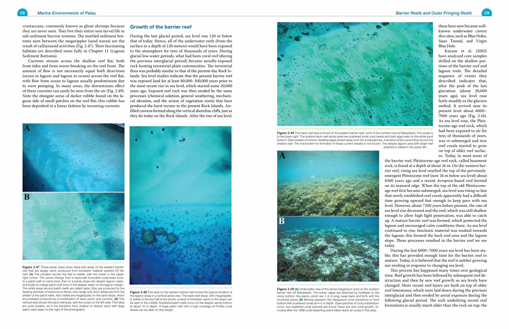
58 Marine Environments of Palau 59Barrier Reefs and Outer Fringing Reefs
crustaceans, commonly known as ghost shrimps because they are never seen. They live their entire non-larval life in sub-sediment burrow systems. The mottled sediment bot-toms seen between the megaripples (sand waves) are the result of callianassid activities (Fig. 2.47). Their fascinating habitats are described more fully in Chapter 11 (Lagoon Sediment Bottoms). Currents stream across the shallow reef flat, both from tides and from waves breaking on the reef front. The amount of flow is not necessarily equal both directions (ocean to lagoon and lagoon to ocean) across the reef flat, with flow from ocean to lagoon usually predominant due to wave pumping. In many areas, the downstream effect of these currents can easily be seen from the air (Fig. 2.49). Note the elongate areas of darker rubble found on the la-goon side of small patches on the reef flat; this rubble has been deposited in a linear fashion by incoming currents.
Growth of the barrier reef
During the last glacial period, sea level was 120 m below that of today. Hence, all of the underwater reefs (from the surface to a depth of 120 meters) would have been exposed to the atmosphere for tens of thousands of years. During glacial low-water periods, what had been coral reef (during the previous interglacial period) became aerially-exposed rock hosting terrestrial plant communities. The terrestrial flora was probably similar to that of the present-day Rock Is-lands. Sea level studies indicate that the present barrier reef was exposed land for at least 80,000–100,000 years prior to the most recent rise in sea level, which started some 20,000 years ago. Exposed reef rock was then eroded by the same processes (chemical solution, general weathering, mechani-cal abrasion, and the action of vegetation roots) that have produced the karst terrain in the present Rock Islands. Air-filled caverns formed along the vertical shoreline cliffs, just as they do today on the Rock Islands. After the rise of sea level,
these have now became well-known underwater cavern dive sites, such as Blue Holes, Siaes Tunnel, and Virgin Blue Hole. Kayane et al. (2002) have analyzed core samples drilled on the shallow por-tions of the barrier reef and lagoon reefs. The detailed sequence of events they described indicates that, after the peak of the last glaciation (about 20,000 years ago), sea level rose fairly steadily as the glaciers melted. It arrived near its present level about 6000–7000 years ago (Fig. 2.16). As sea level rose, the Pleis-tocene-age reef rock, which had been exposed to air for tens of thousands of years, was re-submerged and new reef corals started to grow on top of older reef surfac-es. Today, in most areas of
the barrier reef, Pleistocene-age reef rock, called basement rock, is found at a depth of about 16 m. On the western bar-rier reef, rising sea level reached the top of the previously-emergent Pleistocene reef (now 16 m below sea level) about 8300 years ago and a recent Acropora-based reef formed on its seaward edge. When the top of the old Pleistocene-age reef first became submerged, sea level was rising so fast that newly established reef corals apparently had a difficult time growing upward fast enough to keep pace with sea level. However, about 7200 years before present, the rate of sea level rise decreased and the reef, which was still shallow enough to allow high light penetration, was able to catch up. A mature barrier reef was formed, which protected the lagoon and encouraged calm conditions there. As sea level continued to rise, bioclastic material was washed towards the lagoon; this formed the back reef area and the lagoon slope. These processes resulted in the barrier reef we see today. During the last 6000–7000 years sea level has been sta-ble; this has provided enough time for the barrier reef to mature. Today, it is believed that the reef is neither growing nor eroding in response to changing sea level. This process has happened many times over geological time. Reef growth has been followed by subsequent reef de-struction and then by new reef growth as sea levels have changed. More recent reef layers are built on top of older reef limestones, which were laid down during the previous interglacial and then eroded by aerial exposure during the following glacial period. The rock underlying recent reef formations is usually much older than the rock on top; the
Figure 2.50 (A) Underwater view of the dense Sargassum zone on the western barrier reef off Babeldaob. The brown algae are attached by holdfasts to the rocky bottom; the plants, which are 1–2 m long, sway back and forth with the incoming waves (B) Moving seaward, the Sargassum zone transitions to hard bottom with scattered corals at 4–5 m depth. Open patches of rocky substratum occur, but scattered coral colonies are found; these are new coral growth, re-cruited after the 1998 coral-bleaching event killed nearly all corals in this area.
Figure 2.49 This back-reef area is found on the eastern barrier reef, north of the northern end of Babeldaob. The ocean is to the lower right. The shallow back-reef sandy area has scattered small coral heads and dark algal mats on the white sand bottom. Dark streaks of bottom-dwelling algae stream away from the small patches, indicative of the current flow across the shallow reef. The mechanism for formation of these current streaks is not known. The deeper lagoon area with larger reef
patches is visible in the upper left.
Figure 2.47 These aerial views show back-reef areas of the western barrier reef that are largely sand, produced from bioclastic material washed off the reef. (A) The zonation across the reef is visible, with the ocean in the upper right corner. The zones change from a back-reef truncated coral-head zone, to a patch reef on sand zone, then to a sandy slope into deeper lagoon water, and finally to a large patch-reef zone in the deeper water on the lagoon margin. The white areas around patch reefs are called halos; they are produced by the feeding activities of herbivorous fishes, who range only short distances from the shelter of the patch reefs. Also visible are megaripples on the sand slope, which are probably produced by a combination of wave action and currents. (B) This vertical view shows the back-reef area, with the ocean on the left side. The halos are quite evident, as is the transition from shallow to deeper sand with large patch reefs (seen on the right of the photograph).
Figure 2.48 This area on the western barrier reef shows the typical zonation of the lagoon slope in a vertical aerial view. The back-reef slope, with megaripples, is visible in the top half of the photo; a wave of bioclastic sand on the slope can be seen in the middle. Scattered patch reefs occur on the deeper sandy bottom at about 10 m depth. A large patch reef with a high coverage of Porites coral heads can be seen on the margin.
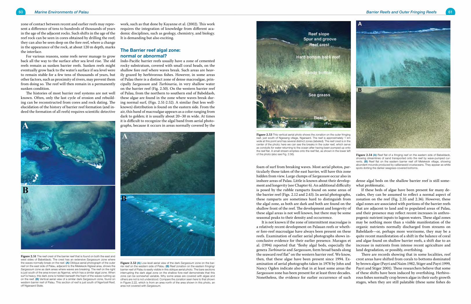
60 Marine Environments of Palau 61Barrier Reefs and Outer Fringing Reefs
zone of contact between recent and earlier reefs may repre-sent a difference of tens to hundreds of thousands of years in the age of the adjacent rocks. Such shifts in the age of the reef rock can be seen in cores obtained by drilling the reef; they can also be seen deep on the fore reef, where a change in the appearance of the rock, at about 120 m depth, marks the interface. For various reasons, some reefs never manage to grow back all the way to the surface after sea level rise. The old reefs remain as sunken barrier reefs. Sunken reefs might eventually grow back to the water’s surface if sea level were to remain stable for a few tens of thousands of years, but other factors, such as proximity of rivers, may prevent them from doing so. The reef will then remain in a permanently sunken condition. The histories of most barrier reef systems are not well known. Often, only the last cycle of erosion and rebuild-ing can be reconstructed from cores and rock dating. The elucidation of the history of barrier reef formation (and in-deed the formation of all reefs) requires scientific detective
work, such as that done by Kayanne et al. (2002). This work requires the integration of knowledge from different aca-demic disciplines, such as geology, chemistry, and biology. It is demanding but also exciting.
The Barrier reef algal zone: normal or abnormal? Indo-Pacific barrier reefs usually have a zone of cemented rocky substratum, covered with small coral heads, on the shallow fore reef where waves break. Such areas are heav-ily grazed by herbivorous fishes. However, in some areas of Palau there is a distinct zone of dense macroalgae, prin-cipally Sargassum and Turbinaria, in very shallow water on the barrier reef (Fig. 2.50). On the western barrier reef of Palau, from the northern to southern end of Babeldaob, these algae are found in the zone where waves break dur-ing normal surf, (Figs. 2.51-2.52). A similar (but less well-known) distribution is found on the eastern side. From the air, this band of macroalgae appears as a color ranging from dark to golden; it is usually about 20–30 m wide. At times it is difficult to recognize the algal band from aerial photo-graphs, because it occurs in areas normally covered by the
foam of surf from breaking waves. Most aerial photos, par-ticularly those taken of the east barrier, will have this zone hidden from view. Large clumps of Sargassum occur also in inshore areas of Palau. Little is known about their develop-ment and longevity (see Chapter 6). An additional difficulty is posed by the rubble ramparts found on some areas of the barrier reef (Figs. 2.12 and 2.43). In aerial photographs, these ramparts are sometimes hard to distinguish from the algal zone, as both are dark and both are found on the shallow front of the reef. The development and longevity of these algal areas is not well known, but there may be some seasonal peaks to their density and occurrence. It is not known if the zone of intermittent macroalgae is a relatively recent development on Palauan reefs or wheth-er fore-reef macroalgae have always been present on these reefs. Examination of earlier aerial photographs shows in-conclusive evidence for their earlier presence. Maragos et al. (1994) reported that “fleshy algal beds, especially the genera Turbinaria and Sargassum, form broad bands along the seaward reef flat” on the western barrier reef. We know, then, that these algae have been present since 1994. Ex-amination of aerial photographs taken in 1978 by John and Nancy Ogden indicate also that in at least some areas the Sargassum zone has been present for at least three decades. Nonetheless, the evidence for earlier occurrence of such
dense algal beds on the shallow barrier reef is still some-what problematic. If these beds of algae have been present for many de-cades, they can be assumed to reflect a normal aspect of zonation on the reef (Fig. 2.35 and 2.36). However, these algal zones are associated with portions of the barrier reefs that are adjacent to land and to populated areas of Palau, and their presence may reflect recent increases in anthro-pogenic nutrient inputs to lagoon waters. These algal zones may be nothing more than a visible manifestation of the organic nutrients normally discharged from streams on Babeldaob—or, perhaps more worrisome, they may be a quite recent manifestation of a shift in the balance of coral and algae found on shallow barrier reefs, a shift due to an increase in nutrients from intense recent agriculture and land degradation, or possibly, overfishing. There are records showing that in some localities, reef crest areas have shifted from corals to bottoms dominated by brown algae (Payri and Naim 1982, Stiger and Payri 1999, Payri and Stiger 2001). These researchers believe that some of these shifts have been induced by overfishing. Herbivo-rous fishes normally crop brown algae in their early growth stages, when they are still palatable (these same fishes do
Figure 2.54 (A) Reef flat of a fringing reef on the eastern side of Babeldaob, showing streamlines of sand transported onto the reef by wave-pumped cur-rents. (B) Reef flat on the eastern barrier reef off Melekeok village, showing abundant mounds produced by callianassid crustaceans. They appear as white spots dotting the darker seagrass-covered bottoms.
Figure 2.53 This vertical aerial photo shows the zonation on the outer fringing reef, just south of Ngesang village, Ngaraard. The reef is approximately 1 km wide at this point and has several distinct zones (labeled). The reef crest is in the center of the photo; here we can see the breaks in the outer reef, which serve as conduits for water returning to the ocean after having been pumped up onto the reef flat. A small stream empties onto the reef flat, as shown in the lower left of the photo (also see Fig. 2.56).
Figure 2.51 The reef crest of the barrier reef that is found on both the east and west sides of Babeldaob. The crest has an extensive Sargassum zone where the waves normally break on the reef. (A) Oblique aerial photograph of the outer reef on the east side of Palau, adjacent to the Melekeok-Ngiwal area, shows the Sargassum zone as dark areas where waves are breaking. The reef on the right is just south of the area known as Ngemai, which has a similar algal zone. When surf is heavy, this dark zone is hidden beneath the foam of the waves rushing up on the reef. (B) Vertical aerial view of a similar dark Sargassum zone, found on western barrier reef of Palau. This section of reef is just south of Ngertoell Reef, off Ngaraard State.
Figure 2.52 (A) Low-level aerial view of the dark Sargassum zone on the bar-rier reef on the western side of Palau. (B) Reef zonation on the eastern fringing/barrier reef of Palau is easily visible in this oblique aerial photo. The bare sections interrupting the dark algal zone on the shallow fore-reef demonstrate that this zone can be somewhat variable. Why some areas are covered with algae and others are not is not understood. Compare the zonation seen here to that shown in Figure 2.22, which is from an area north of the area shown in this photo, an area not covered with Sargassum.
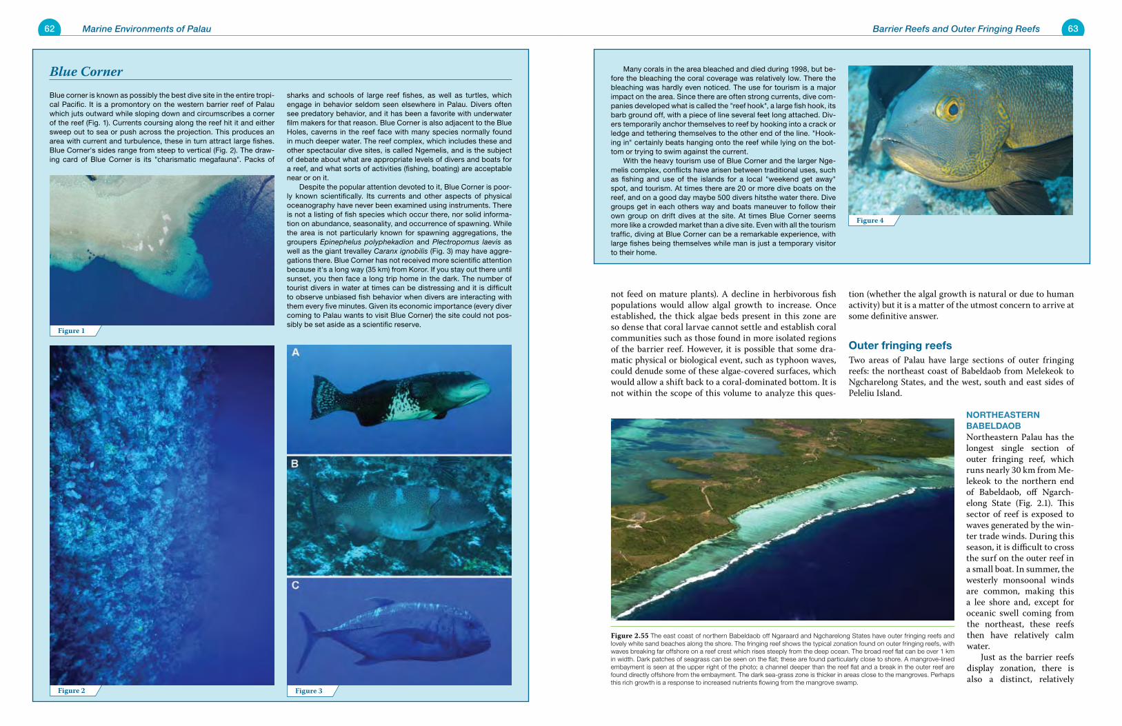
62 Marine Environments of Palau 63Barrier Reefs and Outer Fringing Reefs
Many corals in the area bleached and died during 1998, but be-fore the bleaching the coral coverage was relatively low. There the bleaching was hardly even noticed. The use for tourism is a major impact on the area. Since there are often strong currents, dive com-panies developed what is called the "reef hook", a large fish hook, its barb ground off, with a piece of line several feet long attached. Div-ers temporarily anchor themselves to reef by hooking into a crack or ledge and tethering themselves to the other end of the line. "Hook-ing in" certainly beats hanging onto the reef while lying on the bot-tom or trying to swim against the current. With the heavy tourism use of Blue Corner and the larger Nge-melis complex, conflicts have arisen between traditional uses, such as fishing and use of the islands for a local "weekend get away" spot, and tourism. At times there are 20 or more dive boats on the reef, and on a good day maybe 500 divers hitsthe water there. Dive groups get in each others way and boats maneuver to follow their own group on drift dives at the site. At times Blue Corner seems more like a crowded market than a dive site. Even with all the tourism traffic, diving at Blue Corner can be a remarkable experience, with large fishes being themselves while man is just a temporary visitor to their home.
Blue corner is known as possibly the best dive site in the entire tropi-cal Pacific. It is a promontory on the western barrier reef of Palau which juts outward while sloping down and circumscribes a corner of the reef (Fig. 1). Currents coursing along the reef hit it and either sweep out to sea or push across the projection. This produces an area with current and turbulence, these in turn attract large fishes. Blue Corner's sides range from steep to vertical (Fig. 2). The draw-ing card of Blue Corner is its "charismatic megafauna". Packs of
sharks and schools of large reef fishes, as well as turtles, which engage in behavior seldom seen elsewhere in Palau. Divers often see predatory behavior, and it has been a favorite with underwater film makers for that reason. Blue Corner is also adjacent to the Blue Holes, caverns in the reef face with many species normally found in much deeper water. The reef complex, which includes these and other spectacular dive sites, is called Ngemelis, and is the subject of debate about what are appropriate levels of divers and boats for a reef, and what sorts of activities (fishing, boating) are acceptable near or on it. Despite the popular attention devoted to it, Blue Corner is poor-ly known scientifically. Its currents and other aspects of physical oceanography have never been examined using instruments. There is not a listing of fish species which occur there, nor solid informa-tion on abundance, seasonality, and occurrence of spawning. While the area is not particularly known for spawning aggregations, the groupers Epinephelus polyphekadion and Plectropomus laevis as well as the giant trevalley Caranx ignobilis (Fig. 3) may have aggre-gations there. Blue Corner has not received more scientific attention because it's a long way (35 km) from Koror. If you stay out there until sunset, you then face a long trip home in the dark. The number of tourist divers in water at times can be distressing and it is difficult to observe unbiased fish behavior when divers are interacting with them every five minutes. Given its economic importance (every diver coming to Palau wants to visit Blue Corner) the site could not pos-sibly be set aside as a scientific reserve.
Blue Corner
not feed on mature plants). A decline in herbivorous fish populations would allow algal growth to increase. Once established, the thick algae beds present in this zone are so dense that coral larvae cannot settle and establish coral communities such as those found in more isolated regions of the barrier reef. However, it is possible that some dra-matic physical or biological event, such as typhoon waves, could denude some of these algae-covered surfaces, which would allow a shift back to a coral-dominated bottom. It is not within the scope of this volume to analyze this ques-
tion (whether the algal growth is natural or due to human activity) but it is a matter of the utmost concern to arrive at some definitive answer.
Outer fringing reefsTwo areas of Palau have large sections of outer fringing reefs: the northeast coast of Babeldaob from Melekeok to Ngcharelong States, and the west, south and east sides of Peleliu Island.
NORTHEASTERN BABELDAOBNortheastern Palau has the longest single section of outer fringing reef, which runs nearly 30 km from Me-lekeok to the northern end of Babeldaob, off Ngarch-elong State (Fig. 2.1). This sector of reef is exposed to waves generated by the win-ter trade winds. During this season, it is difficult to cross the surf on the outer reef in a small boat. In summer, the westerly monsoonal winds are common, making this a lee shore and, except for oceanic swell coming from the northeast, these reefs then have relatively calm water. Just as the barrier reefs display zonation, there is also a distinct, relatively
Figure 4
Figure 2 Figure 3
Figure 1
Figure 2.55 The east coast of northern Babeldaob off Ngaraard and Ngcharelong States have outer fringing reefs and lovely white sand beaches along the shore. The fringing reef shows the typical zonation found on outer fringing reefs, with waves breaking far offshore on a reef crest which rises steeply from the deep ocean. The broad reef flat can be over 1 km in width. Dark patches of seagrass can be seen on the flat; these are found particularly close to shore. A mangrove-lined embayment is seen at the upper right of the photo; a channel deeper than the reef flat and a break in the outer reef are found directly offshore from the embayment. The dark sea-grass zone is thicker in areas close to the mangroves. Perhaps this rich growth is a response to increased nutrients flowing from the mangrove swamp.
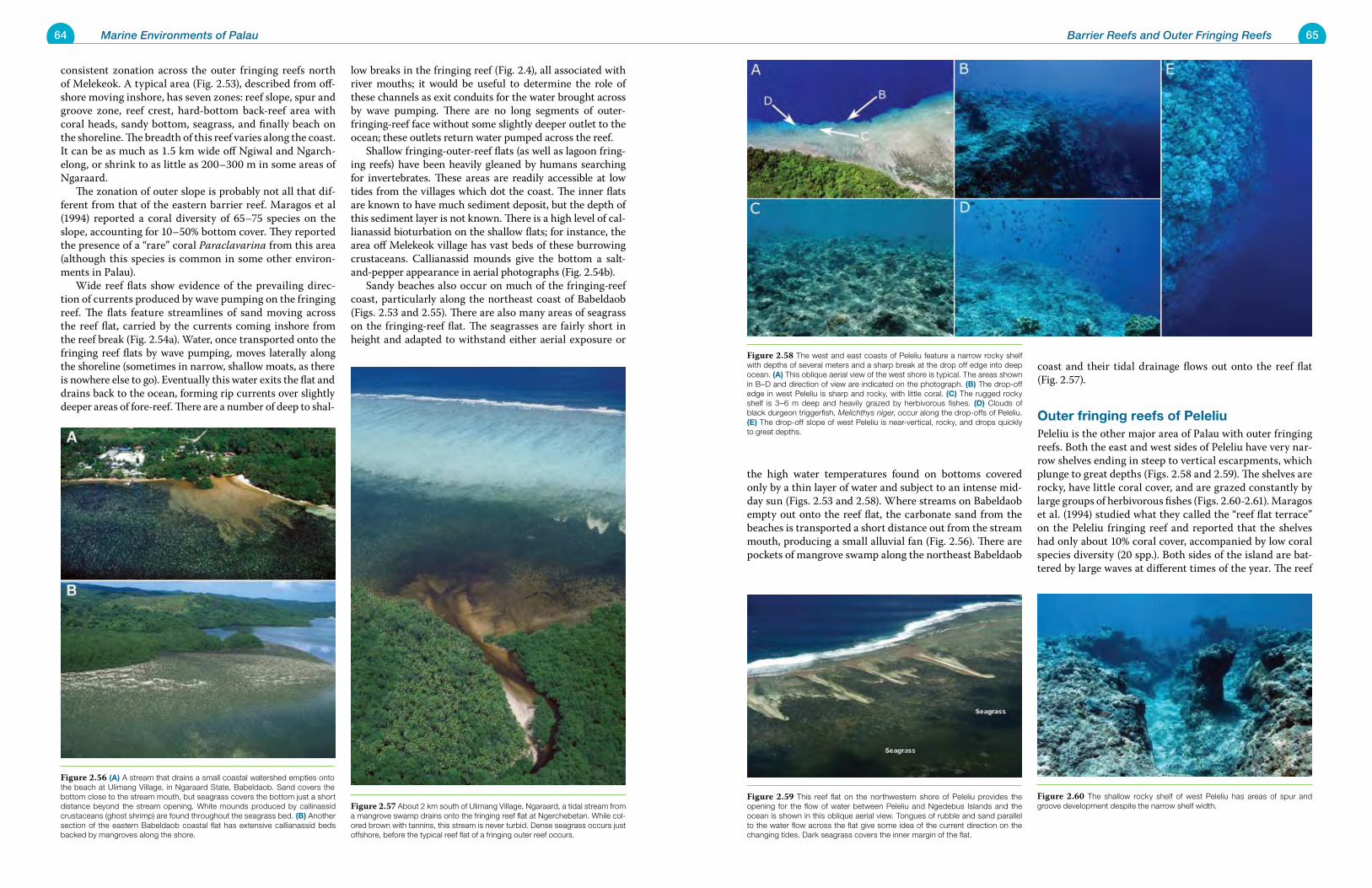
64 Marine Environments of Palau 65Barrier Reefs and Outer Fringing Reefs
consistent zonation across the outer fringing reefs north of Melekeok. A typical area (Fig. 2.53), described from off-shore moving inshore, has seven zones: reef slope, spur and groove zone, reef crest, hard-bottom back-reef area with coral heads, sandy bottom, seagrass, and finally beach on the shoreline. The breadth of this reef varies along the coast. It can be as much as 1.5 km wide off Ngiwal and Ngarch-elong, or shrink to as little as 200–300 m in some areas of Ngaraard. The zonation of outer slope is probably not all that dif-ferent from that of the eastern barrier reef. Maragos et al (1994) reported a coral diversity of 65–75 species on the slope, accounting for 10–50% bottom cover. They reported the presence of a “rare” coral Paraclavarina from this area (although this species is common in some other environ-ments in Palau). Wide reef flats show evidence of the prevailing direc-tion of currents produced by wave pumping on the fringing reef. The flats feature streamlines of sand moving across the reef flat, carried by the currents coming inshore from the reef break (Fig. 2.54a). Water, once transported onto the fringing reef flats by wave pumping, moves laterally along the shoreline (sometimes in narrow, shallow moats, as there is nowhere else to go). Eventually this water exits the flat and drains back to the ocean, forming rip currents over slightly deeper areas of fore-reef. There are a number of deep to shal-
low breaks in the fringing reef (Fig. 2.4), all associated with river mouths; it would be useful to determine the role of these channels as exit conduits for the water brought across by wave pumping. There are no long segments of outer-fringing-reef face without some slightly deeper outlet to the ocean; these outlets return water pumped across the reef. Shallow fringing-outer-reef flats (as well as lagoon fring-ing reefs) have been heavily gleaned by humans searching for invertebrates. These areas are readily accessible at low tides from the villages which dot the coast. The inner flats are known to have much sediment deposit, but the depth of this sediment layer is not known. There is a high level of cal-lianassid bioturbation on the shallow flats; for instance, the area off Melekeok village has vast beds of these burrowing crustaceans. Callianassid mounds give the bottom a salt-and-pepper appearance in aerial photographs (Fig. 2.54b). Sandy beaches also occur on much of the fringing-reef coast, particularly along the northeast coast of Babeldaob (Figs. 2.53 and 2.55). There are also many areas of seagrass on the fringing-reef flat. The seagrasses are fairly short in height and adapted to withstand either aerial exposure or
the high water temperatures found on bottoms covered only by a thin layer of water and subject to an intense mid-day sun (Figs. 2.53 and 2.58). Where streams on Babeldaob empty out onto the reef flat, the carbonate sand from the beaches is transported a short distance out from the stream mouth, producing a small alluvial fan (Fig. 2.56). There are pockets of mangrove swamp along the northeast Babeldaob
coast and their tidal drainage flows out onto the reef flat (Fig. 2.57).
Outer fringing reefs of PeleliuPeleliu is the other major area of Palau with outer fringing reefs. Both the east and west sides of Peleliu have very nar-row shelves ending in steep to vertical escarpments, which plunge to great depths (Figs. 2.58 and 2.59). The shelves are rocky, have little coral cover, and are grazed constantly by large groups of herbivorous fishes (Figs. 2.60-2.61). Maragos et al. (1994) studied what they called the “reef flat terrace” on the Peleliu fringing reef and reported that the shelves had only about 10% coral cover, accompanied by low coral species diversity (20 spp.). Both sides of the island are bat-tered by large waves at different times of the year. The reef
Figure 2.57 About 2 km south of Ulimang Village, Ngaraard, a tidal stream from a mangrove swamp drains onto the fringing reef flat at Ngerchebetan. While col-ored brown with tannins, this stream is never turbid. Dense seagrass occurs just offshore, before the typical reef flat of a fringing outer reef occurs.
Figure 2.58 The west and east coasts of Peleliu feature a narrow rocky shelf with depths of several meters and a sharp break at the drop off edge into deep ocean. (A) This oblique aerial view of the west shore is typical. The areas shown in B–D and direction of view are indicated on the photograph. (B) The drop-off edge in west Peleliu is sharp and rocky, with little coral. (C) The rugged rocky shelf is 3–6 m deep and heavily grazed by herbivorous fishes. (D) Clouds of black durgeon triggerfish, Melichthys niger, occur along the drop-offs of Peleliu. (E) The drop-off slope of west Peleliu is near-vertical, rocky, and drops quickly to great depths.
Figure 2.56 (A) A stream that drains a small coastal watershed empties onto the beach at Ulimang Village, in Ngaraard State, Babeldaob. Sand covers the bottom close to the stream mouth, but seagrass covers the bottom just a short distance beyond the stream opening. White mounds produced by callinassid crustaceans (ghost shrimp) are found throughout the seagrass bed. (B) Another section of the eastern Babeldaob coastal flat has extensive callianassid beds backed by mangroves along the shore.
Figure 2.60 The shallow rocky shelf of west Peleliu has areas of spur and groove development despite the narrow shelf width.
Figure 2.59 This reef flat on the northwestern shore of Peleliu provides the opening for the flow of water between Peleliu and Ngedebus Islands and the ocean is shown in this oblique aerial view. Tongues of rubble and sand parallel to the water flow across the flat give some idea of the current direction on the changing tides. Dark seagrass covers the inner margin of the flat.
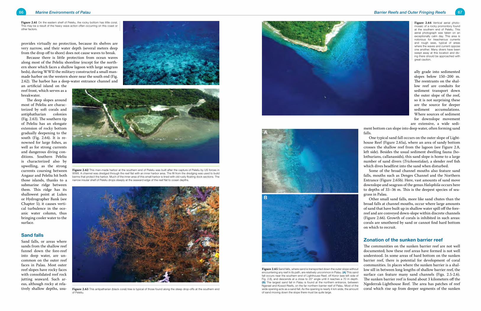
66 Marine Environments of Palau 67Barrier Reefs and Outer Fringing Reefs
provides virtually no protection, because its shelves are very narrow, and their water depth (several meters deep from the drop off to shore) does not cause waves to break. Because there is little protection from ocean waves along most of the Peleliu shoreline (except for the north-ern shore which faces a shallow lagoon with large seagrass beds), during WWII the military constructed a small man-made harbor on the western shore near the south end (Fig. 2.62). The harbor has a deep-water entrance channel and an artificial island on the reef front, which serves as a breakwater. The deep slopes around most of Peleliu are charac-terized by soft corals and antiphatharian colonies (Fig. 2.63). The southern tip of Peleliu has an elongate extension of rocky bottom gradually deepening to the south (Fig. 2.64). It is re-nowned for large fishes, as well as for strong currents and dangerous diving con-ditions. Southern Peleliu is characterized also by upwelling, as the strong currents coursing between Angaur and Peleliu hit both those islands, thanks to a submarine ridge between them. This ridge has its shallowest point at Lukes or Hydrographer Bank (see Chapter 5); it causes verti-cal turbulence in the oce-anic water column, thus bringing cooler water to the surface.
Sand fallsSand falls, or areas where sands from the shallow reef funnel down the fore-reef into deep water, are un-common on the outer reef faces in Palau. Most outer reef slopes have rocky faces with consolidated reef rock jutting seaward. Such ar-eas, although rocky at rela-tively shallow depths, usu-
ally grade into sedimented slopes below 150–200 m. The reentrants on the shal-low reef are conduits for sediment transport down the outer slope of the reef, so it is not surprising these are the source for deeper sediment accumulations. Where sources of sediment for downslope movement
are extensive, a wide sedi-ment bottom can slope into deep water, often forming sand falls. One typical sand fall occurs on the outer slope of Light-house Reef (Figure 2.65a), where an area of sandy bottom crosses the shallow reef from the lagoon (see Figure 2.8, left side). Besides the usual sediment dwelling fauna (ho-lothurians, callanassids), this sand slope is home to a large number of sand divers (Trichonotidae), a slender reef fish which dives headfirst into the sand when disturbed. Some of the broad channel mouths also feature sand falls, mouths such as Denges Channel and the Northern Entrance (Figure 2.65b). Here, vast amounts of sand move downslope and seagrass of the genus Halophila occurs here to depths of 33–36 m. This is the deepest species of sea-grass in Palau. Other small sand falls, more like sand chutes than the broad falls at channel mouths, occur where large amounts of sand that have built up in shallow water spill off the fore-reef and are conveyed down-slope within discrete channels (Figure 2.66). Growth of corals is inhibited in such areas: corals are smothered by sand or cannot find hard bottom on which to recruit.
Zonation of the sunken barrier reefThe communities on the sunken barrier reef are not well documented; how these reef areas have formed is not well understood. In some areas of hard bottom on the sunken barrier reef, there is potential for development of coral communities. In places where the sunken barrier is a shal-low sill in between long lengths of shallow barrier reef, the surface can feature many sand channels (Figs. 2.5-2.6). The sunken barrier reef is found about 3 kilometers off the Ngederrak-Lighthouse Reef. The area has patches of reef coral which rise up from deeper segments of the sunken Figure 2.63 This antipatharian (black coral) tree is typical of those found along the steep drop-offs at the southern end
of Peleliu.
Figure 2.64 Vertical aerial photo-mosaic of a rocky promontory found at the southern end of Peleliu. This aerial photograph was taken on an exceptionally calm day. This area is notorious for treacherous currents and rough seas, typical of areas where the waves and current oppose one another. Many divers have been swept away at this location and div-ing there should be approached with great caution.
Figure 2.61 On the eastern shelf of Peleliu, the rocky bottom has little coral. This may be a result of the heavy wave action often occurring on this coast or other factors.
Figure 2.62 This man-made harbor at the southern end of Peleliu was built after the capture of Peleliu by US forces in WWII. A channel was dredged through the reef flat with an inner harbor area. The fill from the dredging was used to build berms that protect the harbor. Much of the inner area of this small harbor is lined with old rusty floating dock sections. The narrow insular shelf of Peleliu drops steeply at the seaward edge of the reef flat to ocean depths.
Figure 2.65 Sand falls, where sand is transported down the outer slope without encountering any reef in its path, are relatively uncommon in Palau. (A) This sand fall occurs near the southern end of Lighthouse Reef, off Koror (see left side of Fig. 2.8), and descends at a close to 20° angle until it reaches a 70 m depth. (B) The largest sand fall in Palau is found at the northern entrance, between Ngerael and Kossol Reefs, on the far northern barrier reef of Palau. Most of the wide opening acts as a sand fall. As the opening is nearly 4 km wide, the amount of sand moving down the slope there must be quite large.
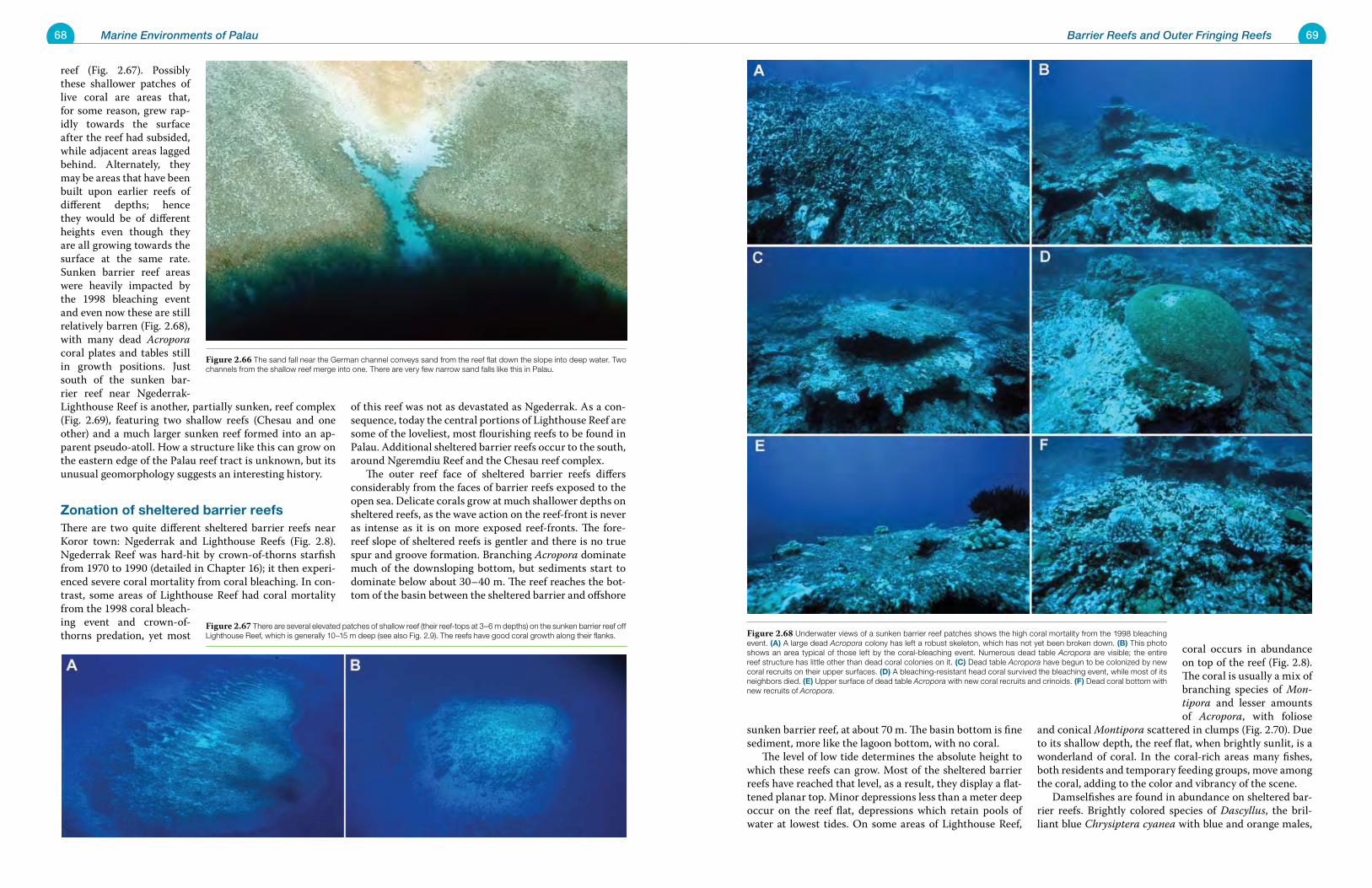
68 Marine Environments of Palau 69Barrier Reefs and Outer Fringing Reefs
reef (Fig. 2.67). Possibly these shallower patches of live coral are areas that, for some reason, grew rap-idly towards the surface after the reef had subsided, while adjacent areas lagged behind. Alternately, they may be areas that have been built upon earlier reefs of different depths; hence they would be of different heights even though they are all growing towards the surface at the same rate. Sunken barrier reef areas were heavily impacted by the 1998 bleaching event and even now these are still relatively barren (Fig. 2.68), with many dead Acropora coral plates and tables still in growth positions. Just south of the sunken bar-rier reef near Ngederrak-Lighthouse Reef is another, partially sunken, reef complex (Fig. 2.69), featuring two shallow reefs (Chesau and one other) and a much larger sunken reef formed into an ap-parent pseudo-atoll. How a structure like this can grow on the eastern edge of the Palau reef tract is unknown, but its unusual geomorphology suggests an interesting history.
Zonation of sheltered barrier reefsThere are two quite different sheltered barrier reefs near Koror town: Ngederrak and Lighthouse Reefs (Fig. 2.8). Ngederrak Reef was hard-hit by crown-of-thorns starfish from 1970 to 1990 (detailed in Chapter 16); it then experi-enced severe coral mortality from coral bleaching. In con-trast, some areas of Lighthouse Reef had coral mortality from the 1998 coral bleach-ing event and crown-of-thorns predation, yet most
of this reef was not as devastated as Ngederrak. As a con-sequence, today the central portions of Lighthouse Reef are some of the loveliest, most flourishing reefs to be found in Palau. Additional sheltered barrier reefs occur to the south, around Ngeremdiu Reef and the Chesau reef complex. The outer reef face of sheltered barrier reefs differs considerably from the faces of barrier reefs exposed to the open sea. Delicate corals grow at much shallower depths on sheltered reefs, as the wave action on the reef-front is never as intense as it is on more exposed reef-fronts. The fore-reef slope of sheltered reefs is gentler and there is no true spur and groove formation. Branching Acropora dominate much of the downsloping bottom, but sediments start to dominate below about 30–40 m. The reef reaches the bot-tom of the basin between the sheltered barrier and offshore
sunken barrier reef, at about 70 m. The basin bottom is fine sediment, more like the lagoon bottom, with no coral. The level of low tide determines the absolute height to which these reefs can grow. Most of the sheltered barrier reefs have reached that level, as a result, they display a flat-tened planar top. Minor depressions less than a meter deep occur on the reef flat, depressions which retain pools of water at lowest tides. On some areas of Lighthouse Reef,
coral occurs in abundance on top of the reef (Fig. 2.8). The coral is usually a mix of branching species of Mon-tipora and lesser amounts of Acropora, with foliose
and conical Montipora scattered in clumps (Fig. 2.70). Due to its shallow depth, the reef flat, when brightly sunlit, is a wonderland of coral. In the coral-rich areas many fishes, both residents and temporary feeding groups, move among the coral, adding to the color and vibrancy of the scene. Damselfishes are found in abundance on sheltered bar-rier reefs. Brightly colored species of Dascyllus, the bril-liant blue Chrysiptera cyanea with blue and orange males,
Figure 2.67 There are several elevated patches of shallow reef (their reef-tops at 3–6 m depths) on the sunken barrier reef off Lighthouse Reef, which is generally 10–15 m deep (see also Fig. 2.9). The reefs have good coral growth along their flanks.
Figure 2.66 The sand fall near the German channel conveys sand from the reef flat down the slope into deep water. Two channels from the shallow reef merge into one. There are very few narrow sand falls like this in Palau.
Figure 2.68 Underwater views of a sunken barrier reef patches shows the high coral mortality from the 1998 bleaching event. (A) A large dead Acropora colony has left a robust skeleton, which has not yet been broken down. (B) This photo shows an area typical of those left by the coral-bleaching event. Numerous dead table Acropora are visible; the entire reef structure has little other than dead coral colonies on it. (C) Dead table Acropora have begun to be colonized by new coral recruits on their upper surfaces. (D) A bleaching-resistant head coral survived the bleaching event, while most of its neighbors died. (E) Upper surface of dead table Acropora with new coral recruits and crinoids. (F) Dead coral bottom with new recruits of Acropora.
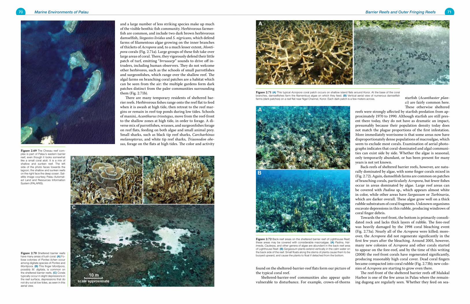
70 Marine Environments of Palau 71Barrier Reefs and Outer Fringing Reefs
and a large number of less striking species make up much of the visible benthic fish community. Herbivorous farmer-fish are common, and include two dark brown herbivorous damselfish, Stegastes lividus and S. nigricans, which defend farms of filamentous algae growing on the inner branches of thickets of Acropora and, to a much lesser extent, Monti-pora corals (Fig. 2.71a). Large groups of these fish take over large areas of coral. There, they vigorously defend their little patch of turf, emitting “brruuurp” sounds to drive off in-truders, including human observers. They do not welcome other herbivores, such as the schools of small parrotfishes and surgeonfishes, which range over the shallow reef. The algal farms on branching coral patches are a habitat which can be seen from the air: the multiple gardens form dark patches distinct from the paler communities surrounding them (Fig. 2.71b). There are many temporary residents of sheltered bar-rier reefs. Herbivorous fishes range onto the reef flat to feed when it is awash at high tide, then retreat to the reef mar-gins or remain in reef-top ponds during low tides. Schools of manini, Acanthurus triostegus, move from the reef-front to the shallow zones at high tide, in order to forage. A di-verse mix of parrotfishes, wrasses, and surgeonfishes forage on reef flats, feeding on both algae and small animal prey. Small sharks, such as black tip reef sharks, Carcharhinus melanopterus, and white tip reef sharks, Triaenodon obe-sus, forage on the flats at high tides. The color and activity
found on the sheltered-barrier-reef flats form our picture of the typical coral reef. Sheltered-barrier-reef communities also appear quite vulnerable to disturbance. For example, crown-of-thorns
starfish (Acanthaster plan-ci) are fairly common here. These otherwise sheltered
reefs were strongly affected by starfish predation from ap-proximately 1970 to 1990. Although starfish are still pres-ent there today, they do not have as dramatic an impact, presumably because their population density today does not match the plague proportions of the first infestation. More immediately worrisome is that some areas now have disproportionately dense populations of macroalgae, which seem to exclude most corals. Examination of aerial photo-graphs indicates that coral-dominated and algal communi-ties can exist side by side. Whether the algae is seasonal, only temporarily abundant, or has been present for many years is not yet known. Back-reefs of sheltered barrier reefs, however, are natu-rally dominated by algae, with some finger corals mixed in (Fig. 2.72). Again, damselfish farms are common on patches of branching corals, particularly Acropora, but fewer fishes occur in areas dominated by algae. Large reef areas can be covered with Padina sp., which appears almost white in color, while other areas have Sargassum or Turbinaria, which are darker overall. These algae grow well on a thick rubble substratum of coral fragments. Unknown organisms excavate depressions in this rubble, producing windrows of coral finger debris. Towards the reef-front, the bottom is primarily consoli-dated rock and lacks thick layers of rubble. The fore-reef was heavily damaged by the 1998 coral bleaching event (Fig. 2.73a). Nearly all of the Acropora were killed; more-over, the Acropora did not regenerate significantly in the first few years after the bleaching. Around 2001, however, many new colonies of Acropora and other corals started to appear on the fore-reef, and by the time of this writing (2008) the reef-front corals have regenerated significantly, producing reasonably high coral cover. Dead coral fingers became compacted into coral rubble (Fig. 2.73b); new colo-nies of Acropora are starting to grow even there. The reef-front of the sheltered barrier reefs off Malakal Harbor is one of the few areas in Palau where the remain-ing dugong are regularly seen. Whether they feed on sea-
Figure 2.70 Sheltered barrier reefs have many areas of lush coral. (A) Fo-liose colonies of Porites lichen occur among digitate species of Porites and Montipora. (B) This finger Montipora, possibly M. digitata, is common on the sheltered barrier reefs. (C) Corals typically occur in slight depressions in the reef surface, depressions that do not dry out at low tides, as seen in this aerial view.
Figure 2.69 The Chesau reef com-plex is part of Palau’s eastern barrier reef, even though it looks somewhat like a small coral atoll. It is a mix of shallow and sunken reef. The left side of the photo faces towards the lagoon; the shallow and sunken reefs on the right face the deep ocean. Sat-ellite image courtesy Palau Automat-ed Land and Resources Information System (PALARIS).
Figure 2.71 (A) This typical Acropora coral patch occurs on shallow island flats around Koror. At the base of the coral branches, damselfishes farm the filamentous algae on which they feed. (B) Vertical aerial view of numerous damselfish farms (dark patches) on a reef flat near Ngel Channel, Koror. Each dark patch is a few meters across.
Figure 2.72 Back-reef areas on the sheltered barrier reef of Lighthouse Reef; these areas may be covered with considerable macroalgae. (A) Padina, Hal-imeda, Caulerpa, and other genera of algae are abundant in the back reef area of Lighthouse Reef. (B) Sargassum plants extend vertically in the calm water on the back side of the reef. Small floats along the stems of plants cause them to be buoyed upward, and cause the plants to float if detached from the bottom.
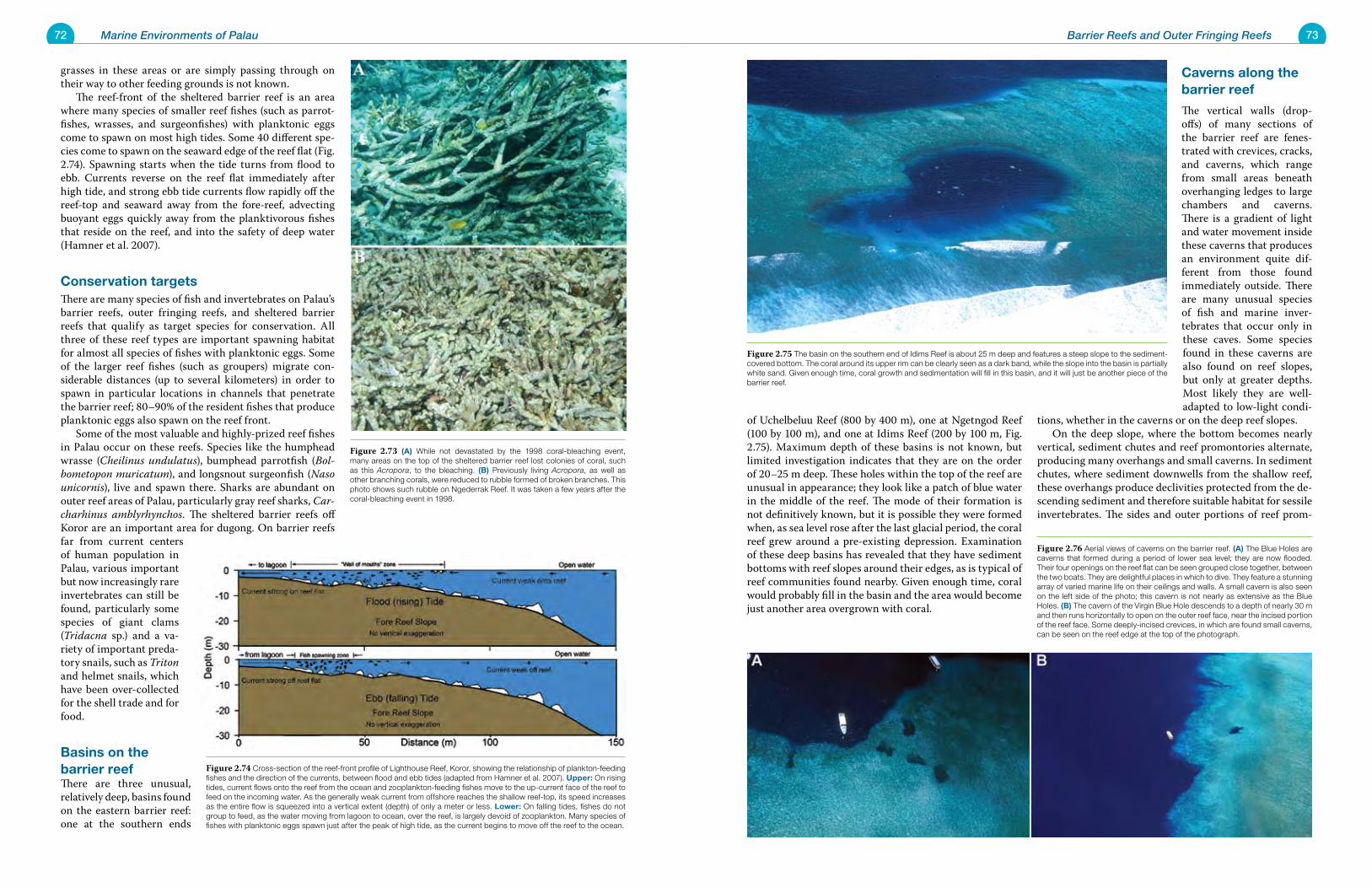
72 Marine Environments of Palau 73Barrier Reefs and Outer Fringing Reefs
grasses in these areas or are simply passing through on their way to other feeding grounds is not known. The reef-front of the sheltered barrier reef is an area where many species of smaller reef fishes (such as parrot-fishes, wrasses, and surgeonfishes) with planktonic eggs come to spawn on most high tides. Some 40 different spe-cies come to spawn on the seaward edge of the reef flat (Fig. 2.74). Spawning starts when the tide turns from flood to ebb. Currents reverse on the reef flat immediately after high tide, and strong ebb tide currents flow rapidly off the reef-top and seaward away from the fore-reef, advecting buoyant eggs quickly away from the planktivorous fishes that reside on the reef, and into the safety of deep water (Hamner et al. 2007).
Conservation targetsThere are many species of fish and invertebrates on Palau’s barrier reefs, outer fringing reefs, and sheltered barrier reefs that qualify as target species for conservation. All three of these reef types are important spawning habitat for almost all species of fishes with planktonic eggs. Some of the larger reef fishes (such as groupers) migrate con-siderable distances (up to several kilometers) in order to spawn in particular locations in channels that penetrate the barrier reef; 80–90% of the resident fishes that produce planktonic eggs also spawn on the reef front. Some of the most valuable and highly-prized reef fishes in Palau occur on these reefs. Species like the humphead wrasse (Cheilinus undulatus), bumphead parrotfish (Bol-bometopon muricatum), and longsnout surgeonfish (Naso unicornis), live and spawn there. Sharks are abundant on outer reef areas of Palau, particularly gray reef sharks, Car-charhinus amblyrhynchos. The sheltered barrier reefs off Koror are an important area for dugong. On barrier reefs far from current centers of human population in Palau, various important but now increasingly rare invertebrates can still be found, particularly some species of giant clams (Tridacna sp.) and a va-riety of important preda-tory snails, such as Triton and helmet snails, which have been over-collected for the shell trade and for food.
Basins on the barrier reefThere are three unusual, relatively deep, basins found on the eastern barrier reef: one at the southern ends
of Uchelbeluu Reef (800 by 400 m), one at Ngetngod Reef (100 by 100 m), and one at Idims Reef (200 by 100 m, Fig. 2.75). Maximum depth of these basins is not known, but limited investigation indicates that they are on the order of 20–25 m deep. These holes within the top of the reef are unusual in appearance; they look like a patch of blue water in the middle of the reef. The mode of their formation is not definitively known, but it is possible they were formed when, as sea level rose after the last glacial period, the coral reef grew around a pre-existing depression. Examination of these deep basins has revealed that they have sediment bottoms with reef slopes around their edges, as is typical of reef communities found nearby. Given enough time, coral would probably fill in the basin and the area would become just another area overgrown with coral.
Caverns along the barrier reef
The vertical walls (drop-offs) of many sections of the barrier reef are fenes-trated with crevices, cracks, and caverns, which range from small areas beneath overhanging ledges to large chambers and caverns. There is a gradient of light and water movement inside these caverns that produces an environment quite dif-ferent from those found immediately outside. There are many unusual species of fish and marine inver-tebrates that occur only in these caves. Some species found in these caverns are also found on reef slopes, but only at greater depths. Most likely they are well-adapted to low-light condi-
tions, whether in the caverns or on the deep reef slopes. On the deep slope, where the bottom becomes nearly vertical, sediment chutes and reef promontories alternate, producing many overhangs and small caverns. In sediment chutes, where sediment downwells from the shallow reef, these overhangs produce declivities protected from the de-scending sediment and therefore suitable habitat for sessile invertebrates. The sides and outer portions of reef prom-
Figure 2.74 Cross-section of the reef-front profile of Lighthouse Reef, Koror, showing the relationship of plankton-feeding fishes and the direction of the currents, between flood and ebb tides (adapted from Hamner et al. 2007). Upper: On rising tides, current flows onto the reef from the ocean and zooplankton-feeding fishes move to the up-current face of the reef to feed on the incoming water. As the generally weak current from offshore reaches the shallow reef-top, its speed increases as the entire flow is squeezed into a vertical extent (depth) of only a meter or less. Lower: On falling tides, fishes do not group to feed, as the water moving from lagoon to ocean, over the reef, is largely devoid of zooplankton. Many species of fishes with planktonic eggs spawn just after the peak of high tide, as the current begins to move off the reef to the ocean.
Figure 2.73 (A) While not devastated by the 1998 coral-bleaching event, many areas on the top of the sheltered barrier reef lost colonies of coral, such as this Acropora, to the bleaching. (B) Previously living Acropora, as well as other branching corals, were reduced to rubble formed of broken branches. This photo shows such rubble on Ngederrak Reef. It was taken a few years after the coral-bleaching event in 1998.
Figure 2.76 Aerial views of caverns on the barrier reef. (A) The Blue Holes are caverns that formed during a period of lower sea level; they are now flooded. Their four openings on the reef flat can be seen grouped close together, between the two boats. They are delightful places in which to dive. They feature a stunning array of varied marine life on their ceilings and walls. A small cavern is also seen on the left side of the photo; this cavern is not nearly as extensive as the Blue Holes. (B) The cavern of the Virgin Blue Hole descends to a depth of nearly 30 m and then runs horizontally to open on the outer reef face, near the incised portion of the reef face. Some deeply-incised crevices, in which are found small caverns, can be seen on the reef edge at the top of the photograph.
Figure 2.75 The basin on the southern end of Idims Reef is about 25 m deep and features a steep slope to the sediment-covered bottom. The coral around its upper rim can be clearly seen as a dark band, while the slope into the basin is partially white sand. Given enough time, coral growth and sedimentation will fill in this basin, and it will just be another piece of the barrier reef.
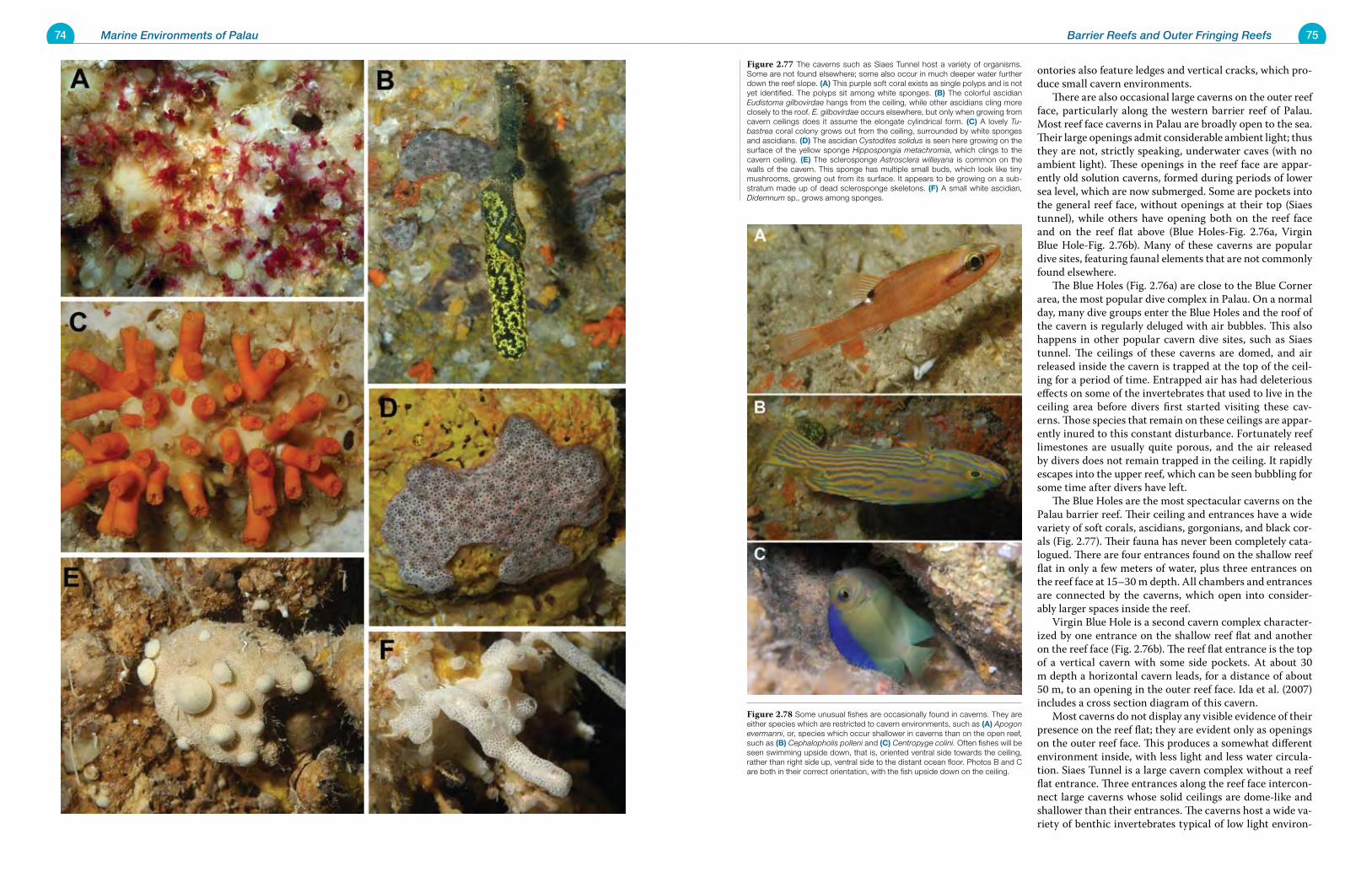
74 Marine Environments of Palau 75Barrier Reefs and Outer Fringing Reefs
ontories also feature ledges and vertical cracks, which pro-duce small cavern environments. There are also occasional large caverns on the outer reef face, particularly along the western barrier reef of Palau. Most reef face caverns in Palau are broadly open to the sea. Their large openings admit considerable ambient light; thus they are not, strictly speaking, underwater caves (with no ambient light). These openings in the reef face are appar-ently old solution caverns, formed during periods of lower sea level, which are now submerged. Some are pockets into the general reef face, without openings at their top (Siaes tunnel), while others have opening both on the reef face and on the reef flat above (Blue Holes-Fig. 2.76a, Virgin Blue Hole-Fig. 2.76b). Many of these caverns are popular dive sites, featuring faunal elements that are not commonly found elsewhere. The Blue Holes (Fig. 2.76a) are close to the Blue Corner area, the most popular dive complex in Palau. On a normal day, many dive groups enter the Blue Holes and the roof of the cavern is regularly deluged with air bubbles. This also happens in other popular cavern dive sites, such as Siaes tunnel. The ceilings of these caverns are domed, and air released inside the cavern is trapped at the top of the ceil-ing for a period of time. Entrapped air has had deleterious effects on some of the invertebrates that used to live in the ceiling area before divers first started visiting these cav-erns. Those species that remain on these ceilings are appar-ently inured to this constant disturbance. Fortunately reef limestones are usually quite porous, and the air released by divers does not remain trapped in the ceiling. It rapidly escapes into the upper reef, which can be seen bubbling for some time after divers have left. The Blue Holes are the most spectacular caverns on the Palau barrier reef. Their ceiling and entrances have a wide variety of soft corals, ascidians, gorgonians, and black cor-als (Fig. 2.77). Their fauna has never been completely cata-logued. There are four entrances found on the shallow reef flat in only a few meters of water, plus three entrances on the reef face at 15–30 m depth. All chambers and entrances are connected by the caverns, which open into consider-ably larger spaces inside the reef. Virgin Blue Hole is a second cavern complex character-ized by one entrance on the shallow reef flat and another on the reef face (Fig. 2.76b). The reef flat entrance is the top of a vertical cavern with some side pockets. At about 30 m depth a horizontal cavern leads, for a distance of about 50 m, to an opening in the outer reef face. Ida et al. (2007) includes a cross section diagram of this cavern. Most caverns do not display any visible evidence of their presence on the reef flat; they are evident only as openings on the outer reef face. This produces a somewhat different environment inside, with less light and less water circula-tion. Siaes Tunnel is a large cavern complex without a reef flat entrance. Three entrances along the reef face intercon-nect large caverns whose solid ceilings are dome-like and shallower than their entrances. The caverns host a wide va-riety of benthic invertebrates typical of low light environ-
Figure 2.77 The caverns such as Siaes Tunnel host a variety of organisms. Some are not found elsewhere; some also occur in much deeper water further down the reef slope. (A) This purple soft coral exists as single polyps and is not yet identified. The polyps sit among white sponges. (B) The colorful ascidian Eudistoma gilbovirdae hangs from the ceiling, while other ascidians cling more closely to the roof. E. gilbovirdae occurs elsewhere, but only when growing from cavern ceilings does it assume the elongate cylindrical form. (C) A lovely Tu-bastrea coral colony grows out from the ceiling, surrounded by white sponges and ascidians. (D) The ascidian Cystodites solidus is seen here growing on the surface of the yellow sponge Hippospongia metachromia, which clings to the cavern ceiling. (E) The sclerosponge Astrosclera willeyana is common on the walls of the cavern. This sponge has multiple small buds, which look like tiny mushrooms, growing out from its surface. It appears to be growing on a sub-stratum made up of dead sclerosponge skeletons. (F) A small white ascidian, Didemnum sp., grows among sponges.
Figure 2.78 Some unusual fishes are occasionally found in caverns. They are either species which are restricted to cavern environments, such as (A) Apogon evermanni, or, species which occur shallower in caverns than on the open reef, such as (B) Cephalopholis polleni and (C) Centropyge colini. Often fishes will be seen swimming upside down, that is, oriented ventral side towards the ceiling, rather than right side up, ventral side to the distant ocean floor. Photos B and C are both in their correct orientation, with the fish upside down on the ceiling.
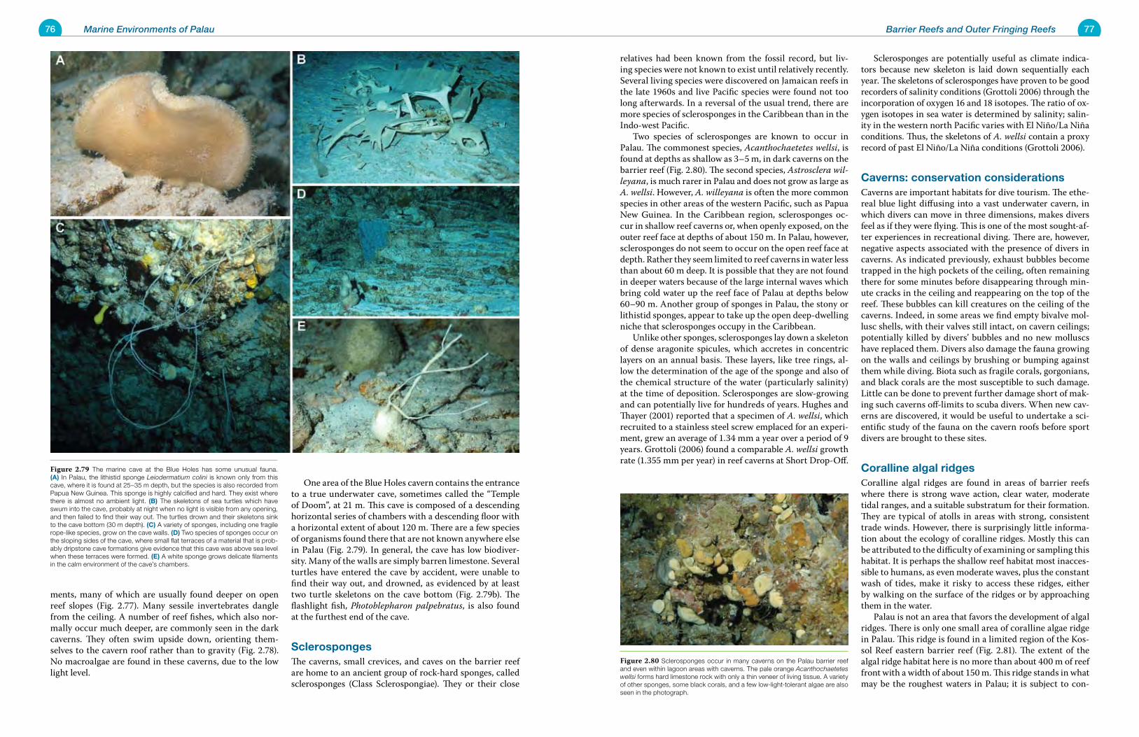
76 Marine Environments of Palau 77Barrier Reefs and Outer Fringing Reefs
ments, many of which are usually found deeper on open reef slopes (Fig. 2.77). Many sessile invertebrates dangle from the ceiling. A number of reef fishes, which also nor-mally occur much deeper, are commonly seen in the dark caverns. They often swim upside down, orienting them-selves to the cavern roof rather than to gravity (Fig. 2.78). No macroalgae are found in these caverns, due to the low light level.
One area of the Blue Holes cavern contains the entrance to a true underwater cave, sometimes called the “Temple of Doom”, at 21 m. This cave is composed of a descending horizontal series of chambers with a descending floor with a horizontal extent of about 120 m. There are a few species of organisms found there that are not known anywhere else in Palau (Fig. 2.79). In general, the cave has low biodiver-sity. Many of the walls are simply barren limestone. Several turtles have entered the cave by accident, were unable to find their way out, and drowned, as evidenced by at least two turtle skeletons on the cave bottom (Fig. 2.79b). The flashlight fish, Photoblepharon palpebratus, is also found at the furthest end of the cave.
SclerospongesThe caverns, small crevices, and caves on the barrier reef are home to an ancient group of rock-hard sponges, called sclerosponges (Class Sclerospongiae). They or their close
relatives had been known from the fossil record, but liv-ing species were not known to exist until relatively recently. Several living species were discovered on Jamaican reefs in the late 1960s and live Pacific species were found not too long afterwards. In a reversal of the usual trend, there are more species of sclerosponges in the Caribbean than in the Indo-west Pacific. Two species of sclerosponges are known to occur in Palau. The commonest species, Acanthochaetetes wellsi, is found at depths as shallow as 3–5 m, in dark caverns on the barrier reef (Fig. 2.80). The second species, Astrosclera wil-leyana, is much rarer in Palau and does not grow as large as A. wellsi. However, A. willeyana is often the more common species in other areas of the western Pacific, such as Papua New Guinea. In the Caribbean region, sclerosponges oc-cur in shallow reef caverns or, when openly exposed, on the outer reef face at depths of about 150 m. In Palau, however, sclerosponges do not seem to occur on the open reef face at depth. Rather they seem limited to reef caverns in water less than about 60 m deep. It is possible that they are not found in deeper waters because of the large internal waves which bring cold water up the reef face of Palau at depths below 60–90 m. Another group of sponges in Palau, the stony or lithistid sponges, appear to take up the open deep-dwelling niche that sclerosponges occupy in the Caribbean. Unlike other sponges, sclerosponges lay down a skeleton of dense aragonite spicules, which accretes in concentric layers on an annual basis. These layers, like tree rings, al-low the determination of the age of the sponge and also of the chemical structure of the water (particularly salinity) at the time of deposition. Sclerosponges are slow-growing and can potentially live for hundreds of years. Hughes and Thayer (2001) reported that a specimen of A. wellsi, which recruited to a stainless steel screw emplaced for an experi-ment, grew an average of 1.34 mm a year over a period of 9 years. Grottoli (2006) found a comparable A. wellsi growth rate (1.355 mm per year) in reef caverns at Short Drop-Off.
Sclerosponges are potentially useful as climate indica-tors because new skeleton is laid down sequentially each year. The skeletons of sclerosponges have proven to be good recorders of salinity conditions (Grottoli 2006) through the incorporation of oxygen 16 and 18 isotopes. The ratio of ox-ygen isotopes in sea water is determined by salinity; salin-ity in the western north Pacific varies with El Niño/La Niña conditions. Thus, the skeletons of A. wellsi contain a proxy record of past El Niño/La Niña conditions (Grottoli 2006).
Caverns: conservation considerationsCaverns are important habitats for dive tourism. The ethe-real blue light diffusing into a vast underwater cavern, in which divers can move in three dimensions, makes divers feel as if they were flying. This is one of the most sought-af-ter experiences in recreational diving. There are, however, negative aspects associated with the presence of divers in caverns. As indicated previously, exhaust bubbles become trapped in the high pockets of the ceiling, often remaining there for some minutes before disappearing through min-ute cracks in the ceiling and reappearing on the top of the reef. These bubbles can kill creatures on the ceiling of the caverns. Indeed, in some areas we find empty bivalve mol-lusc shells, with their valves still intact, on cavern ceilings; potentially killed by divers’ bubbles and no new molluscs have replaced them. Divers also damage the fauna growing on the walls and ceilings by brushing or bumping against them while diving. Biota such as fragile corals, gorgonians, and black corals are the most susceptible to such damage. Little can be done to prevent further damage short of mak-ing such caverns off-limits to scuba divers. When new cav-erns are discovered, it would be useful to undertake a sci-entific study of the fauna on the cavern roofs before sport divers are brought to these sites.
Coralline algal ridgesCoralline algal ridges are found in areas of barrier reefs where there is strong wave action, clear water, moderate tidal ranges, and a suitable substratum for their formation. They are typical of atolls in areas with strong, consistent trade winds. However, there is surprisingly little informa-tion about the ecology of coralline ridges. Mostly this can be attributed to the difficulty of examining or sampling this habitat. It is perhaps the shallow reef habitat most inacces-sible to humans, as even moderate waves, plus the constant wash of tides, make it risky to access these ridges, either by walking on the surface of the ridges or by approaching them in the water. Palau is not an area that favors the development of algal ridges. There is only one small area of coralline algae ridge in Palau. This ridge is found in a limited region of the Kos-sol Reef eastern barrier reef (Fig. 2.81). The extent of the algal ridge habitat here is no more than about 400 m of reef front with a width of about 150 m. This ridge stands in what may be the roughest waters in Palau; it is subject to con-
Figure 2.80 Sclerosponges occur in many caverns on the Palau barrier reef and even within lagoon areas with caverns. The pale orange Acanthochaetetes wellsi forms hard limestone rock with only a thin veneer of living tissue. A variety of other sponges, some black corals, and a few low-light-tolerant algae are also seen in the photograph.
Figure 2.79 The marine cave at the Blue Holes has some unusual fauna. (A) In Palau, the lithistid sponge Leiodermatium colini is known only from this cave, where it is found at 25–35 m depth, but the species is also recorded from Papua New Guinea. This sponge is highly calcified and hard. They exist where there is almost no ambient light. (B) The skeletons of sea turtles which have swum into the cave, probably at night when no light is visible from any opening, and then failed to find their way out. The turtles drown and their skeletons sink to the cave bottom (30 m depth). (C) A variety of sponges, including one fragile rope-like species, grow on the cave walls. (D) Two species of sponges occur on the sloping sides of the cave, where small flat terraces of a material that is prob-ably dripstone cave formations give evidence that this cave was above sea level when these terraces were formed. (E) A white sponge grows delicate filaments in the calm environment of the cave’s chambers.
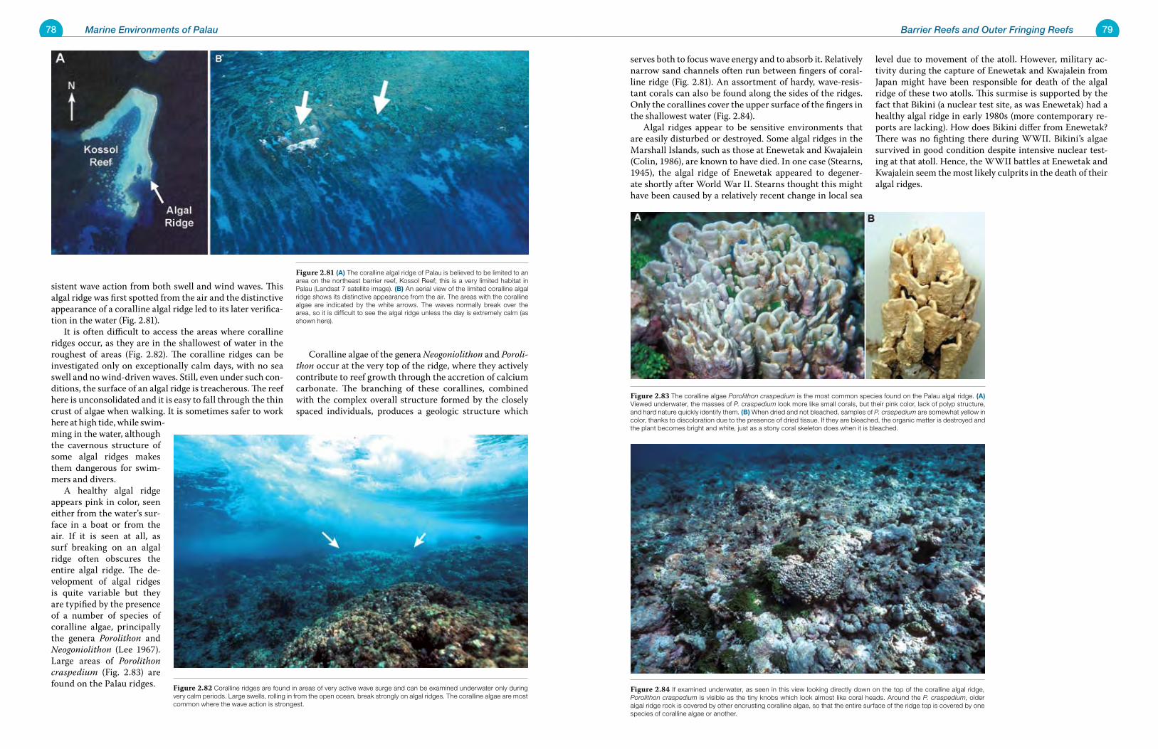
78 Marine Environments of Palau 79Barrier Reefs and Outer Fringing Reefs
sistent wave action from both swell and wind waves. This algal ridge was first spotted from the air and the distinctive appearance of a coralline algal ridge led to its later verifica-tion in the water (Fig. 2.81). It is often difficult to access the areas where coralline ridges occur, as they are in the shallowest of water in the roughest of areas (Fig. 2.82). The coralline ridges can be investigated only on exceptionally calm days, with no sea swell and no wind-driven waves. Still, even under such con-ditions, the surface of an algal ridge is treacherous. The reef here is unconsolidated and it is easy to fall through the thin crust of algae when walking. It is sometimes safer to work here at high tide, while swim-ming in the water, although the cavernous structure of some algal ridges makes them dangerous for swim-mers and divers. A healthy algal ridge appears pink in color, seen either from the water’s sur-face in a boat or from the air. If it is seen at all, as surf breaking on an algal ridge often obscures the entire algal ridge. The de-velopment of algal ridges is quite variable but they are typified by the presence of a number of species of coralline algae, principally the genera Porolithon and Neogoniolithon (Lee 1967). Large areas of Porolithon craspedium (Fig. 2.83) are found on the Palau ridges.
Coralline algae of the genera Neogoniolithon and Poroli-thon occur at the very top of the ridge, where they actively contribute to reef growth through the accretion of calcium carbonate. The branching of these corallines, combined with the complex overall structure formed by the closely spaced individuals, produces a geologic structure which
serves both to focus wave energy and to absorb it. Relatively narrow sand channels often run between fingers of coral-line ridge (Fig. 2.81). An assortment of hardy, wave-resis-tant corals can also be found along the sides of the ridges. Only the corallines cover the upper surface of the fingers in the shallowest water (Fig. 2.84). Algal ridges appear to be sensitive environments that are easily disturbed or destroyed. Some algal ridges in the Marshall Islands, such as those at Enewetak and Kwajalein (Colin, 1986), are known to have died. In one case (Stearns, 1945), the algal ridge of Enewetak appeared to degener-ate shortly after World War II. Stearns thought this might have been caused by a relatively recent change in local sea
level due to movement of the atoll. However, military ac-tivity during the capture of Enewetak and Kwajalein from Japan might have been responsible for death of the algal ridge of these two atolls. This surmise is supported by the fact that Bikini (a nuclear test site, as was Enewetak) had a healthy algal ridge in early 1980s (more contemporary re-ports are lacking). How does Bikini differ from Enewetak? There was no fighting there during WWII. Bikini’s algae survived in good condition despite intensive nuclear test-ing at that atoll. Hence, the WWII battles at Enewetak and Kwajalein seem the most likely culprits in the death of their algal ridges.
Figure 2.83 The coralline algae Porolithon craspedium is the most common species found on the Palau algal ridge. (A) Viewed underwater, the masses of P. craspedium look more like small corals, but their pink color, lack of polyp structure, and hard nature quickly identify them. (B) When dried and not bleached, samples of P. craspedium are somewhat yellow in color, thanks to discoloration due to the presence of dried tissue. If they are bleached, the organic matter is destroyed and the plant becomes bright and white, just as a stony coral skeleton does when it is bleached.
Figure 2.84 If examined underwater, as seen in this view looking directly down on the top of the coralline algal ridge, Porolithon craspedium is visible as the tiny knobs which look almost like coral heads. Around the P. craspedium, older algal ridge rock is covered by other encrusting coralline algae, so that the entire surface of the ridge top is covered by one species of coralline algae or another.
Figure 2.82 Coralline ridges are found in areas of very active wave surge and can be examined underwater only during very calm periods. Large swells, rolling in from the open ocean, break strongly on algal ridges. The coralline algae are most common where the wave action is strongest.
Figure 2.81 (A) The coralline algal ridge of Palau is believed to be limited to an area on the northeast barrier reef, Kossol Reef; this is a very limited habitat in Palau (Landsat 7 satellite image). (B) An aerial view of the limited coralline algal ridge shows its distinctive appearance from the air. The areas with the coralline algae are indicated by the white arrows. The waves normally break over the area, so it is difficult to see the algal ridge unless the day is extremely calm (as shown here).
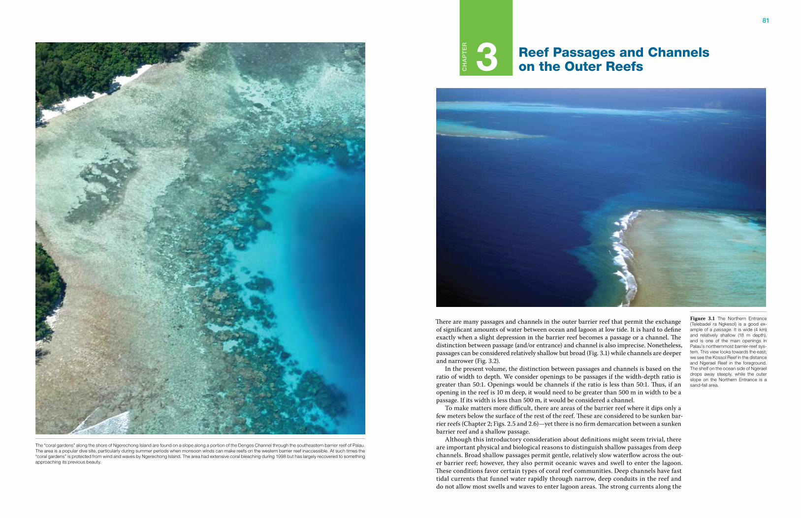
81
Ch
ap
te
r
3 Reef Passages and Channels on the Outer Reefs
There are many passages and channels in the outer barrier reef that permit the exchange of significant amounts of water between ocean and lagoon at low tide. It is hard to define exactly when a slight depression in the barrier reef becomes a passage or a channel. The distinction between passage (and/or entrance) and channel is also imprecise. Nonetheless, passages can be considered relatively shallow but broad (Fig. 3.1) while channels are deeper and narrower (Fig. 3.2). In the present volume, the distinction between passages and channels is based on the ratio of width to depth. We consider openings to be passages if the width-depth ratio is greater than 50:1. Openings would be channels if the ratio is less than 50:1. Thus, if an opening in the reef is 10 m deep, it would need to be greater than 500 m in width to be a passage. If its width is less than 500 m, it would be considered a channel. To make matters more difficult, there are areas of the barrier reef where it dips only a few meters below the surface of the rest of the reef. These are considered to be sunken bar-rier reefs (Chapter 2; Figs. 2.5 and 2.6)—yet there is no firm demarcation between a sunken barrier reef and a shallow passage. Although this introductory consideration about definitions might seem trivial, there are important physical and biological reasons to distinguish shallow passages from deep channels. Broad shallow passages permit gentle, relatively slow waterflow across the out-er barrier reef; however, they also permit oceanic waves and swell to enter the lagoon. These conditions favor certain types of coral reef communities. Deep channels have fast tidal currents that funnel water rapidly through narrow, deep conduits in the reef and do not allow most swells and waves to enter lagoon areas. The strong currents along the
Figure 3.1 The Northern Entrance (Telebadel ra Ngkesol) is a good ex-ample of a passage. It is wide (4 km) and relatively shallow (18 m depth), and is one of the main openings in Palau’s northernmost barrier-reef sys-tem. This view looks towards the east; we see the Kossol Reef in the distance and Ngerael Reef in the foreground. The shelf on the ocean side of Ngerael drops away steeply, while the outer slope on the Northern Entrance is a sand-fall area.
The “coral gardens” along the shore of Ngerechong Island are found on a slope along a portion of the Denges Channel through the southeastern barrier reef of Palau. The area is a popular dive site, particularly during summer periods when monsoon winds can make reefs on the western barrier reef inaccessible. At such times the “coral gardens” is protected from wind and waves by Ngerechong Island. The area had extensive coral bleaching during 1998 but has largely recovered to something approaching its previous beauty.
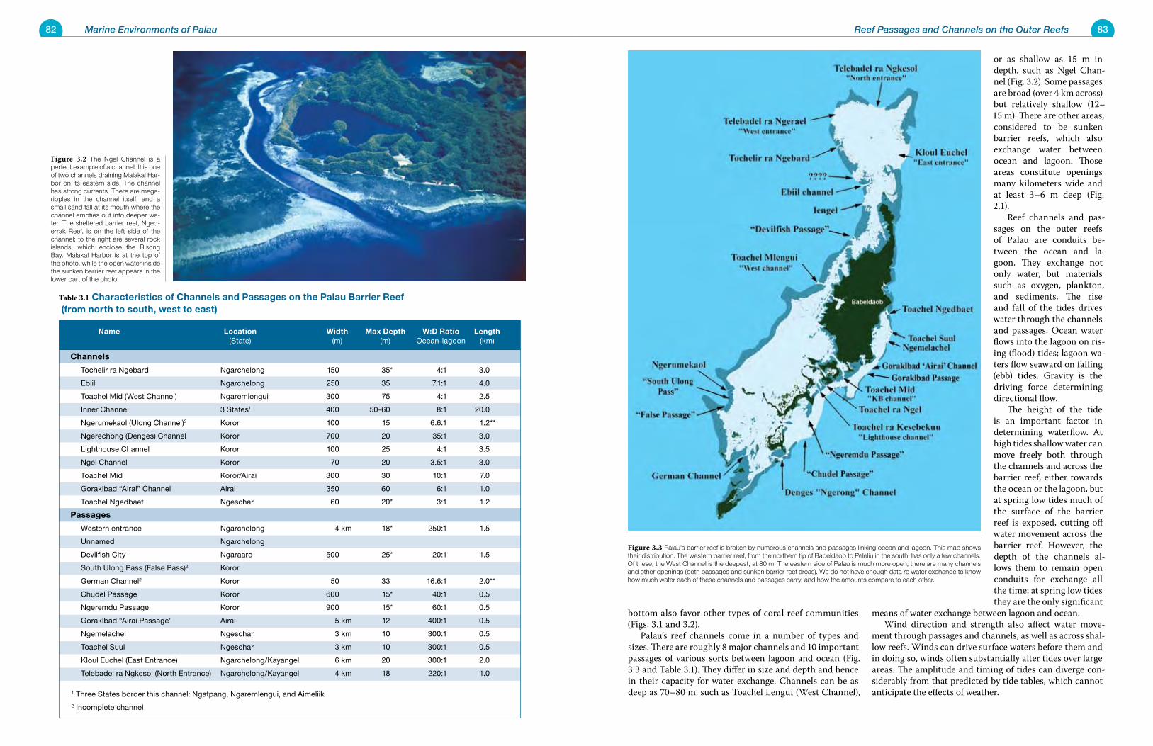
82 Marine Environments of Palau 83Reef Passages and Channels on the Outer Reefs
bottom also favor other types of coral reef communities (Figs. 3.1 and 3.2). Palau’s reef channels come in a number of types and sizes. There are roughly 8 major channels and 10 important passages of various sorts between lagoon and ocean (Fig. 3.3 and Table 3.1). They differ in size and depth and hence in their capacity for water exchange. Channels can be as deep as 70–80 m, such as Toachel Lengui (West Channel),
or as shallow as 15 m in depth, such as Ngel Chan-nel (Fig. 3.2). Some passages are broad (over 4 km across) but relatively shallow (12–15 m). There are other areas, considered to be sunken barrier reefs, which also exchange water between ocean and lagoon. Those areas constitute openings many kilometers wide and at least 3–6 m deep (Fig. 2.1). Reef channels and pas-sages on the outer reefs of Palau are conduits be-tween the ocean and la-goon. They exchange not only water, but materials such as oxygen, plankton, and sediments. The rise and fall of the tides drives water through the channels and passages. Ocean water flows into the lagoon on ris-ing (flood) tides; lagoon wa-ters flow seaward on falling (ebb) tides. Gravity is the driving force determining directional flow. The height of the tide is an important factor in determining waterflow. At high tides shallow water can move freely both through the channels and across the barrier reef, either towards the ocean or the lagoon, but at spring low tides much of the surface of the barrier reef is exposed, cutting off water movement across the barrier reef. However, the depth of the channels al-lows them to remain open conduits for exchange all the time; at spring low tides they are the only significant
means of water exchange between lagoon and ocean. Wind direction and strength also affect water move-ment through passages and channels, as well as across shal-low reefs. Winds can drive surface waters before them and in doing so, winds often substantially alter tides over large areas. The amplitude and timing of tides can diverge con-siderably from that predicted by tide tables, which cannot anticipate the effects of weather.
Name Location Width Max Depth W:D ratio Length (State) (m) (m) Ocean-lagoon (km)
Channels
Tochelir ra Ngebard Ngarchelong 150 35* 4:1 3.0
Ebiil Ngarchelong 250 35 7.1:1 4.0
Toachel Mid (West Channel) Ngaremlengui 300 75 4:1 2.5
Inner Channel 3 States1 400 50-60 8:1 20.0
Ngerumekaol (Ulong Channel)2 Koror 100 15 6.6:1 1.2**
Ngerechong (Denges) Channel Koror 700 20 35:1 3.0
Lighthouse Channel Koror 100 25 4:1 3.5
Ngel Channel Koror 70 20 3.5:1 3.0
Toachel Mid Koror/Airai 300 30 10:1 7.0
Goraklbad “Airai” Channel Airai 350 60 6:1 1.0
Toachel Ngedbaet Ngeschar 60 20* 3:1 1.2
passages
Western entrance Ngarchelong 4 km 18* 250:1 1.5
Unnamed Ngarchelong
Devilfish City Ngaraard 500 25* 20:1 1.5
South Ulong Pass (False Pass)2 Koror
German Channel2 Koror 50 33 16.6:1 2.0**
Chudel Passage Koror 600 15* 40:1 0.5
Ngeremdu Passage Koror 900 15* 60:1 0.5
Goraklbad “Airai Passage” Airai 5 km 12 400:1 0.5
Ngemelachel Ngeschar 3 km 10 300:1 0.5
Toachel Suul Ngeschar 3 km 10 300:1 0.5
Kloul Euchel (East Entrance) Ngarchelong/Kayangel 6 km 20 300:1 2.0
Telebadel ra Ngkesol (North Entrance) Ngarchelong/Kayangel 4 km 18 220:1 1.0
1 Three States border this channel: Ngatpang, Ngaremlengui, and Aimeliik
2 Incomplete channel
Table 3.1 Characteristics of Channels and passages on the palau Barrier reef (from north to south, west to east)
Figure 3.2 The Ngel Channel is a perfect example of a channel. It is one of two channels draining Malakal Har-bor on its eastern side. The channel has strong currents. There are mega-ripples in the channel itself, and a small sand fall at its mouth where the channel empties out into deeper wa-ter. The sheltered barrier reef, Nged-errak Reef, is on the left side of the channel; to the right are several rock islands, which enclose the Risong Bay. Malakal Harbor is at the top of the photo, while the open water inside the sunken barrier reef appears in the lower part of the photo.
Figure 3.3 Palau’s barrier reef is broken by numerous channels and passages linking ocean and lagoon. This map shows their distribution. The western barrier reef, from the northern tip of Babeldaob to Peleliu in the south, has only a few channels. Of these, the West Channel is the deepest, at 80 m. The eastern side of Palau is much more open; there are many channels and other openings (both passages and sunken barrier reef areas). We do not have enough data re water exchange to know how much water each of these channels and passages carry, and how the amounts compare to each other.
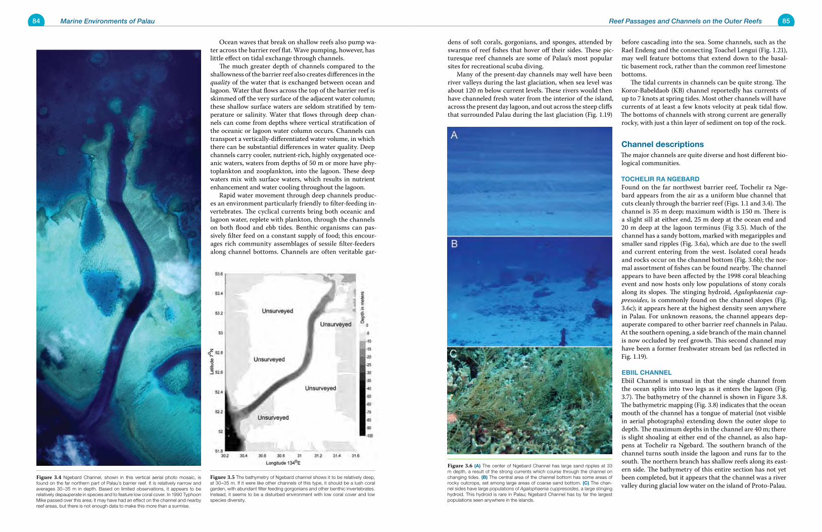
84 Marine Environments of Palau 85Reef Passages and Channels on the Outer Reefs
Ocean waves that break on shallow reefs also pump wa-ter across the barrier reef flat. Wave pumping, however, has little effect on tidal exchange through channels. The much greater depth of channels compared to the shallowness of the barrier reef also creates differences in the quality of the water that is exchanged between ocean and lagoon. Water that flows across the top of the barrier reef is skimmed off the very surface of the adjacent water column; these shallow surface waters are seldom stratified by tem-perature or salinity. Water that flows through deep chan-nels can come from depths where vertical stratification of the oceanic or lagoon water column occurs. Channels can transport a vertically-differentiated water volume, in which there can be substantial differences in water quality. Deep channels carry cooler, nutrient-rich, highly oxygenated oce-anic waters, waters from depths of 50 m or more have phy-toplankton and zooplankton, into the lagoon. These deep waters mix with surface waters, which results in nutrient enhancement and water cooling throughout the lagoon. Rapid water movement through deep channels produc-es an environment particularly friendly to filter-feeding in-vertebrates. The cyclical currents bring both oceanic and lagoon water, replete with plankton, through the channels on both flood and ebb tides. Benthic organisms can pas-sively filter feed on a constant supply of food; this encour-ages rich community assemblages of sessile filter-feeders along channel bottoms. Channels are often veritable gar-
dens of soft corals, gorgonians, and sponges, attended by swarms of reef fishes that hover off their sides. These pic-turesque reef channels are some of Palau’s most popular sites for recreational scuba diving. Many of the present-day channels may well have been river valleys during the last glaciation, when sea level was about 120 m below current levels. These rivers would then have channeled fresh water from the interior of the island, across the present day lagoon, and out across the steep cliffs that surrounded Palau during the last glaciation (Fig. 1.19)
before cascading into the sea. Some channels, such as the Rael Endeng and the connecting Toachel Lengui (Fig. 1.21), may well feature bottoms that extend down to the basal-tic basement rock, rather than the common reef limestone bottoms. The tidal currents in channels can be quite strong. The Koror-Babeldaob (KB) channel reportedly has currents of up to 7 knots at spring tides. Most other channels will have currents of at least a few knots velocity at peak tidal flow. The bottoms of channels with strong current are generally rocky, with just a thin layer of sediment on top of the rock.
Channel descriptionsThe major channels are quite diverse and host different bio-logical communities.
toCheLir ra NgeBarDFound on the far northwest barrier reef, Tochelir ra Nge-bard appears from the air as a uniform blue channel that cuts cleanly through the barrier reef (Figs. 1.1 and 3.4). The channel is 35 m deep; maximum width is 150 m. There is a slight sill at either end, 25 m deep at the ocean end and 20 m deep at the lagoon terminus (Fig 3.5). Much of the channel has a sandy bottom, marked with megaripples and smaller sand ripples (Fig. 3.6a), which are due to the swell and current entering from the west. Isolated coral heads and rocks occur on the channel bottom (Fig. 3.6b); the nor-mal assortment of fishes can be found nearby. The channel appears to have been affected by the 1998 coral bleaching event and now hosts only low populations of stony corals along its slopes. The stinging hydroid, Agalophaenia cup-presoides, is commonly found on the channel slopes (Fig. 3.6c); it appears here at the highest density seen anywhere in Palau. For unknown reasons, the channel appears dep-auperate compared to other barrier reef channels in Palau. At the southern opening, a side branch of the main channel is now occluded by reef growth. This second channel may have been a former freshwater stream bed (as reflected in Fig. 1.19).
eBiiL ChaNNeLEbiil Channel is unusual in that the single channel from the ocean splits into two legs as it enters the lagoon (Fig. 3.7). The bathymetry of the channel is shown in Figure 3.8. The bathymetric mapping (Fig. 3.8) indicates that the ocean mouth of the channel has a tongue of material (not visible in aerial photographs) extending down the outer slope to depth. The maximum depths in the channel are 40 m; there is slight shoaling at either end of the channel, as also hap-pens at Tochelir ra Ngebard. The southern branch of the channel turns south inside the lagoon and runs far to the south. The northern branch has shallow reefs along its east-ern side. The bathymetry of this entire section has not yet been completed, but it appears that the channel was a river valley during glacial low water on the island of Proto-Palau.
Figure 3.4 Ngebard Channel, shown in this vertical aerial photo mosaic, is found on the far northern part of Palau’s barrier reef. It is relatively narrow and averages 30–35 m in depth. Based on limited observations, it appears to be relatively depauperate in species and to feature low coral cover. In 1990 Typhoon Mike passed over this area; it may have had an effect on the channel and nearby reef areas, but there is not enough data to make this more than a surmise.
Figure 3.5 The bathymetry of Ngebard channel shows it to be relatively deep, at 30–35 m. If it were like other channels of this type, it should be a lush coral garden, with abundant filter feeding gorgonians and other benthic invertebrates. Instead, it seems to be a disturbed environment with low coral cover and low species diversity.
Figure 3.6 (a) The center of Ngebard Channel has large sand ripples at 33 m depth, a result of the strong currents which course through the channel on changing tides. (B) The central area of the channel bottom has some areas of rocky outcrops, set among large areas of coarse sand bottom. (C) The chan-nel sides have large populations of Agalophaenia cuppresoides, a large stinging hydroid. This hydroid is rare in Palau; Ngebard Channel has by far the largest populations seen anywhere in the islands.
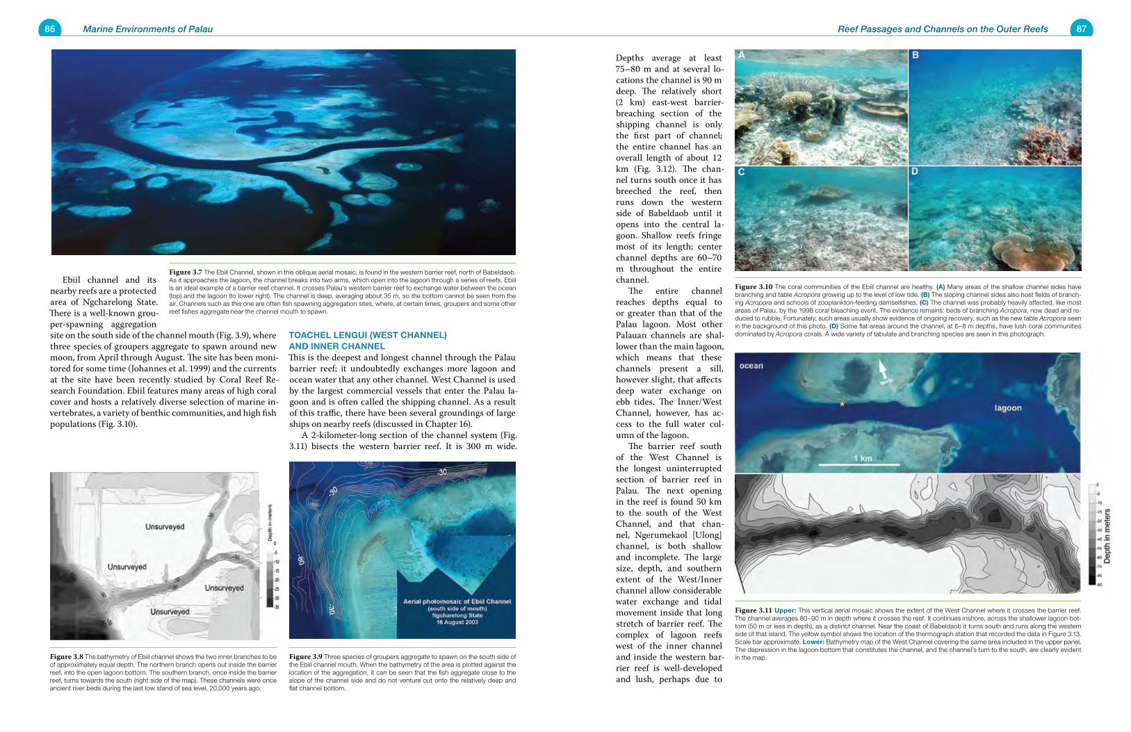
86 Marine Environments of Palau 87Reef Passages and Channels on the Outer Reefs
Ebiil channel and its nearby reefs are a protected area of Ngcharelong State. There is a well-known grou-per-spawning aggregation site on the south side of the channel mouth (Fig. 3.9), where three species of groupers aggregate to spawn around new moon, from April through August. The site has been moni-tored for some time (Johannes et al. 1999) and the currents at the site have been recently studied by Coral Reef Re-search Foundation. Ebiil features many areas of high coral cover and hosts a relatively diverse selection of marine in-vertebrates, a variety of benthic communities, and high fish populations (Fig. 3.10).
toaCheL LeNgui (West ChaNNeL) aND iNNer ChaNNeLThis is the deepest and longest channel through the Palau barrier reef; it undoubtedly exchanges more lagoon and ocean water that any other channel. West Channel is used by the largest commercial vessels that enter the Palau la-goon and is often called the shipping channel. As a result of this traffic, there have been several groundings of large ships on nearby reefs (discussed in Chapter 16). A 2-kilometer-long section of the channel system (Fig. 3.11) bisects the western barrier reef. It is 300 m wide.
Depths average at least 75–80 m and at several lo-cations the channel is 90 m deep. The relatively short (2 km) east-west barrier-breaching section of the shipping channel is only the first part of channel; the entire channel has an overall length of about 12 km (Fig. 3.12). The chan-nel turns south once it has breeched the reef, then runs down the western side of Babeldaob until it opens into the central la-goon. Shallow reefs fringe most of its length; center channel depths are 60–70 m throughout the entire channel. The entire channel reaches depths equal to or greater than that of the Palau lagoon. Most other Palauan channels are shal-lower than the main lagoon, which means that these channels present a sill, however slight, that affects deep water exchange on ebb tides. The Inner/West Channel, however, has ac-cess to the full water col-umn of the lagoon. The barrier reef south of the West Channel is the longest uninterrupted section of barrier reef in Palau. The next opening in the reef is found 50 km to the south of the West Channel, and that chan-nel, Ngerumekaol [Ulong] channel, is both shallow and incomplete. The large size, depth, and southern extent of the West/Inner channel allow considerable water exchange and tidal movement inside that long stretch of barrier reef. The complex of lagoon reefs west of the inner channel and inside the western bar-rier reef is well-developed and lush, perhaps due to
Figure 3.8 The bathymetry of Ebiil channel shows the two inner branches to be of approximately equal depth. The northern branch opens out inside the barrier reef, into the open lagoon bottom. The southern branch, once inside the barrier reef, turns towards the south (right side of the map). These channels were once ancient river beds during the last low stand of sea level, 20,000 years ago.
Figure 3.9 Three species of groupers aggregate to spawn on the south side of the Ebiil channel mouth. When the bathymetry of the area is plotted against the location of the aggregation, it can be seen that the fish aggregate close to the slope of the channel side and do not venture out onto the relatively deep and flat channel bottom.
Figure 3.7 The Ebiil Channel, shown in this oblique aerial mosaic, is found in the western barrier reef, north of Babeldaob. As it approaches the lagoon, the channel breaks into two arms, which open into the lagoon through a series of reefs. Ebiil is an ideal example of a barrier reef channel. It crosses Palau’s western barrier reef to exchange water between the ocean (top) and the lagoon (to lower right). The channel is deep, averaging about 35 m, so the bottom cannot be seen from the air. Channels such as this one are often fish spawning aggregation sites, where, at certain times, groupers and some other reef fishes aggregate near the channel mouth to spawn.
Figure 3.10 The coral communities of the Ebiil channel are healthy. (a) Many areas of the shallow channel sides have branching and table Acropora growing up to the level of low tide. (B) The sloping channel sides also host fields of branch-ing Acropora and schools of zooplankton-feeding damselfishes. (C) The channel was probably heavily affected, like most areas of Palau, by the 1998 coral bleaching event. The evidence remains: beds of branching Acropora, now dead and re-duced to rubble. Fortunately, such areas usually show evidence of ongoing recovery, such as the new table Acropora seen in the background of this photo. (D) Some flat areas around the channel, at 6–8 m depths, have lush coral communities dominated by Acropora corals. A wide variety of tabulate and branching species are seen in this photograph.
Figure 3.11 upper: This vertical aerial mosaic shows the extent of the West Channel where it crosses the barrier reef. The channel averages 80–90 m in depth where it crosses the reef. It continues inshore, across the shallower lagoon bot-tom (50 m or less in depth), as a distinct channel. Near the coast of Babeldaob it turns south and runs along the western side of that island. The yellow symbol shows the location of the thermograph station that recorded the data in Figure 3.13. Scale bar approximate. Lower: Bathymetry map of the West Channel covering the same area included in the upper panel. The depression in the lagoon bottom that constitutes the channel, and the channel’s turn to the south, are clearly evident in the map.
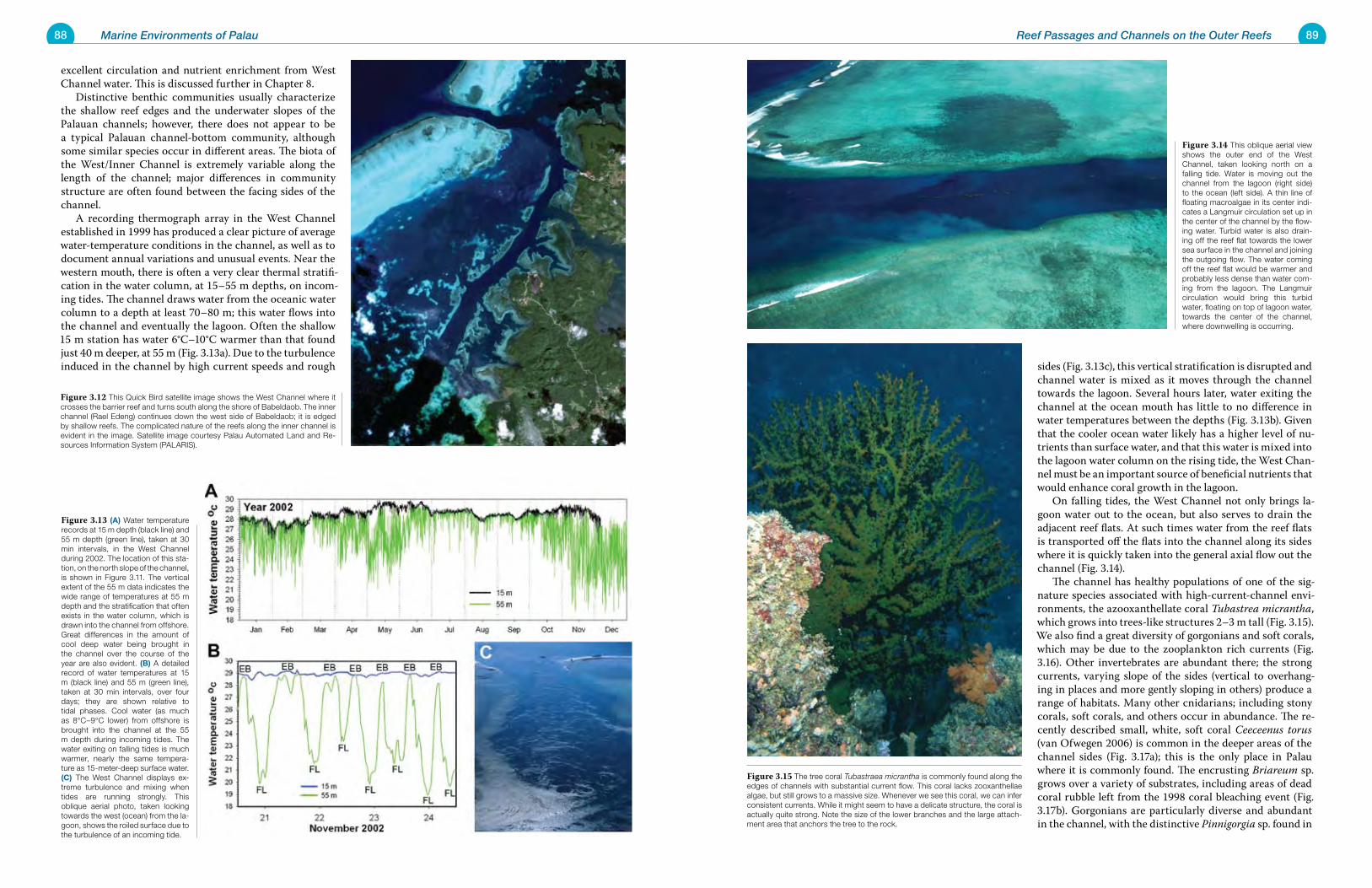
88 Marine Environments of Palau 89Reef Passages and Channels on the Outer Reefs
excellent circulation and nutrient enrichment from West Channel water. This is discussed further in Chapter 8. Distinctive benthic communities usually characterize the shallow reef edges and the underwater slopes of the Palauan channels; however, there does not appear to be a typical Palauan channel-bottom community, although some similar species occur in different areas. The biota of the West/Inner Channel is extremely variable along the length of the channel; major differences in community structure are often found between the facing sides of the channel. A recording thermograph array in the West Channel established in 1999 has produced a clear picture of average water-temperature conditions in the channel, as well as to document annual variations and unusual events. Near the western mouth, there is often a very clear thermal stratifi-cation in the water column, at 15–55 m depths, on incom-ing tides. The channel draws water from the oceanic water column to a depth at least 70–80 m; this water flows into the channel and eventually the lagoon. Often the shallow 15 m station has water 6°C–10°C warmer than that found just 40 m deeper, at 55 m (Fig. 3.13a). Due to the turbulence induced in the channel by high current speeds and rough sides (Fig. 3.13c), this vertical stratification is disrupted and
channel water is mixed as it moves through the channel towards the lagoon. Several hours later, water exiting the channel at the ocean mouth has little to no difference in water temperatures between the depths (Fig. 3.13b). Given that the cooler ocean water likely has a higher level of nu-trients than surface water, and that this water is mixed into the lagoon water column on the rising tide, the West Chan-nel must be an important source of beneficial nutrients that would enhance coral growth in the lagoon. On falling tides, the West Channel not only brings la-goon water out to the ocean, but also serves to drain the adjacent reef flats. At such times water from the reef flats is transported off the flats into the channel along its sides where it is quickly taken into the general axial flow out the channel (Fig. 3.14). The channel has healthy populations of one of the sig-nature species associated with high-current-channel envi-ronments, the azooxanthellate coral Tubastrea micrantha, which grows into trees-like structures 2–3 m tall (Fig. 3.15). We also find a great diversity of gorgonians and soft corals, which may be due to the zooplankton rich currents (Fig. 3.16). Other invertebrates are abundant there; the strong currents, varying slope of the sides (vertical to overhang-ing in places and more gently sloping in others) produce a range of habitats. Many other cnidarians; including stony corals, soft corals, and others occur in abundance. The re-cently described small, white, soft coral Ceeceenus torus (van Ofwegen 2006) is common in the deeper areas of the channel sides (Fig. 3.17a); this is the only place in Palau where it is commonly found. The encrusting Briareum sp. grows over a variety of substrates, including areas of dead coral rubble left from the 1998 coral bleaching event (Fig. 3.17b). Gorgonians are particularly diverse and abundant in the channel, with the distinctive Pinnigorgia sp. found in
Figure 3.12 This Quick Bird satellite image shows the West Channel where it crosses the barrier reef and turns south along the shore of Babeldaob. The inner channel (Rael Edeng) continues down the west side of Babeldaob; it is edged by shallow reefs. The complicated nature of the reefs along the inner channel is evident in the image. Satellite image courtesy Palau Automated Land and Re-sources Information System (PALARIS).
Figure 3.13 (a) Water temperature records at 15 m depth (black line) and 55 m depth (green line), taken at 30 min intervals, in the West Channel during 2002. The location of this sta-tion, on the north slope of the channel, is shown in Figure 3.11. The vertical extent of the 55 m data indicates the wide range of temperatures at 55 m depth and the stratification that often exists in the water column, which is drawn into the channel from offshore. Great differences in the amount of cool deep water being brought in the channel over the course of the year are also evident. (B) A detailed record of water temperatures at 15 m (black line) and 55 m (green line), taken at 30 min intervals, over four days; they are shown relative to tidal phases. Cool water (as much as 8°C–9°C lower) from offshore is brought into the channel at the 55 m depth during incoming tides. The water exiting on falling tides is much warmer, nearly the same tempera-ture as 15-meter-deep surface water. (C) The West Channel displays ex-treme turbulence and mixing when tides are running strongly. This oblique aerial photo, taken looking towards the west (ocean) from the la-goon, shows the roiled surface due to the turbulence of an incoming tide.
Figure 3.14 This oblique aerial view shows the outer end of the West Channel, taken looking north on a falling tide. Water is moving out the channel from the lagoon (right side) to the ocean (left side). A thin line of floating macroalgae in its center indi-cates a Langmuir circulation set up in the center of the channel by the flow-ing water. Turbid water is also drain-ing off the reef flat towards the lower sea surface in the channel and joining the outgoing flow. The water coming off the reef flat would be warmer and probably less dense than water com-ing from the lagoon. The Langmuir circulation would bring this turbid water, floating on top of lagoon water, towards the center of the channel, where downwelling is occurring.
Figure 3.15 The tree coral Tubastraea micrantha is commonly found along the edges of channels with substantial current flow. This coral lacks zooxanthellae algae, but still grows to a massive size. Whenever we see this coral, we can infer consistent currents. While it might seem to have a delicate structure, the coral is actually quite strong. Note the size of the lower branches and the large attach-ment area that anchors the tree to the rock.
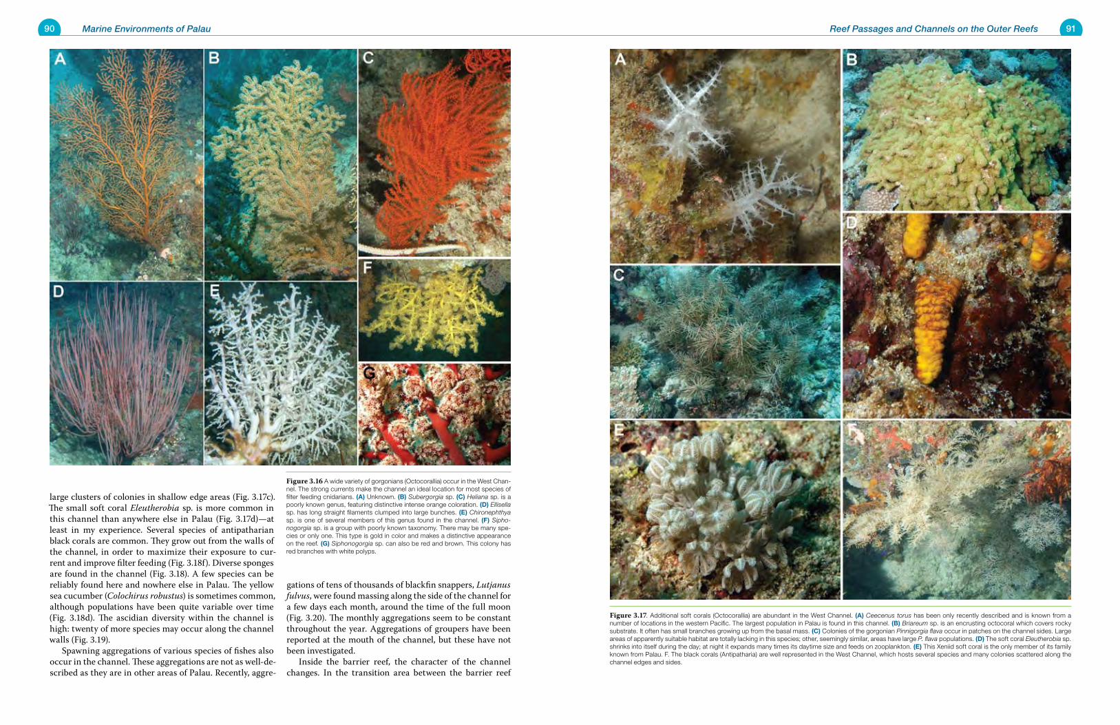
90 Marine Environments of Palau 91Reef Passages and Channels on the Outer Reefs
large clusters of colonies in shallow edge areas (Fig. 3.17c). The small soft coral Eleutherobia sp. is more common in this channel than anywhere else in Palau (Fig. 3.17d)—at least in my experience. Several species of antipatharian black corals are common. They grow out from the walls of the channel, in order to maximize their exposure to cur-rent and improve filter feeding (Fig. 3.18f). Diverse sponges are found in the channel (Fig. 3.18). A few species can be reliably found here and nowhere else in Palau. The yellow sea cucumber (Colochirus robustus) is sometimes common, although populations have been quite variable over time (Fig. 3.18d). The ascidian diversity within the channel is high: twenty of more species may occur along the channel walls (Fig. 3.19). Spawning aggregations of various species of fishes also occur in the channel. These aggregations are not as well-de-scribed as they are in other areas of Palau. Recently, aggre-
gations of tens of thousands of blackfin snappers, Lutjanus fulvus, were found massing along the side of the channel for a few days each month, around the time of the full moon (Fig. 3.20). The monthly aggregations seem to be constant throughout the year. Aggregations of groupers have been reported at the mouth of the channel, but these have not been investigated. Inside the barrier reef, the character of the channel changes. In the transition area between the barrier reef
Figure 3.16 A wide variety of gorgonians (Octocorallia) occur in the West Chan-nel. The strong currents make the channel an ideal location for most species of filter feeding cnidarians. (a) Unknown. (B) Subergorgia sp. (C) Heliana sp. is a poorly known genus, featuring distinctive intense orange coloration. (D) Ellisella sp. has long straight filaments clumped into large bunches. (e) Chironephthya sp. is one of several members of this genus found in the channel. (F) Sipho-nogorgia sp. is a group with poorly known taxonomy. There may be many spe-cies or only one. This type is gold in color and makes a distinctive appearance on the reef. (g) Siphonogorgia sp. can also be red and brown. This colony has red branches with white polyps.
Figure 3.17. Additional soft corals (Octocorallia) are abundant in the West Channel. (a) Ceecenus torus has been only recently described and is known from a number of locations in the western Pacific. The largest population in Palau is found in this channel. (B) Briareum sp. is an encrusting octocoral which covers rocky substrate. It often has small branches growing up from the basal mass. (C) Colonies of the gorgonian Pinnigorgia flava occur in patches on the channel sides. Large areas of apparently suitable habitat are totally lacking in this species; other, seemingly similar, areas have large P. flava populations. (D) The soft coral Eleutherobia sp. shrinks into itself during the day; at night it expands many times its daytime size and feeds on zooplankton. (e) This Xeniid soft coral is the only member of its family known from Palau. F. The black corals (Antipatharia) are well represented in the West Channel, which hosts several species and many colonies scattered along the channel edges and sides.
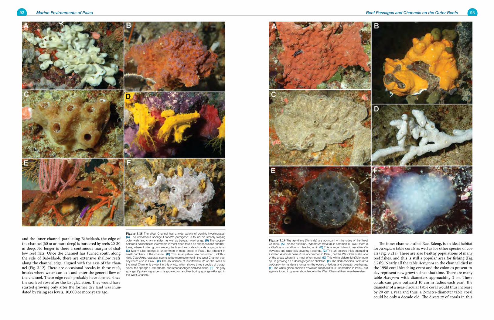
92 Marine Environments of Palau 93Reef Passages and Channels on the Outer Reefs
and the inner channel paralleling Babeldaob, the edge of the channel (60 m or more deep) is bordered by reefs 20-30 m deep. No longer is there a continuous margin of shal-low reef flats. Once the channel has turned south along the side of Babeldaob, there are extensive shallow reefs along the channel edge, aligned with the axis of the chan-nel (Fig. 3.12). There are occasional breaks in these reefs, breaks where water can exit and enter the general flow of the channel. These edge reefs probably have formed since the sea level rose after the last glaciation. They would have started growing only after the former dry land was inun-dated by rising sea levels, 10,000 or more years ago.
The inner channel, called Rael Edeng, is an ideal habitat for Acropora table corals as well as for other species of cor-als (Fig. 3.21a). There are also healthy populations of many reef fishes, and this is still a popular area for fishing (Fig. 3.21b). Nearly all the table Acropora in the channel died in the 1998 coral bleaching event and the colonies present to-day represent new growth since that time. There are many table Acropora with diameters approaching 2 m. These corals can grow outward 10 cm in radius each year. The diameter of a near-circular table coral would thus increase by 20 cm a year and thus, a 2-meter-diameter table coral could be only a decade old. The diversity of corals in this
Figure 3.18 The West Channel has a wide variety of benthic invertebrates. (a) The calcareous sponge Leucetta primigenia is found on steeply-sloping outer walls and channel sides, as well as beneath overhangs. (B) The copper-colored Echinochalina intermedia is most often found on channel sides and bot-toms, where it often grows among the branches of dead corals or gorgonians. (C) Sticky tube sponge is uncommon in most areas of Palau, but present in small numbers in the channel. (D) This small yellow sea cucumber (Holothu-rian), Colochirus robustus, seems to be more common in the West Channel than anywhere else in Palau. (e) The abundance of invertebrate life on the sides of the West Channel is evident in this photo, which shows three species of gorgo-nians, the sponge E. intermedia, and other sponges and ascidians. (F) This gray sponge, Dysidea nigrescens, is growing on another boring sponge (Aka sp.) in the West Channel.
Figure 3.19 The ascidians (Tunicata) are abundant on the sides of the West Channel. (a) This red ascidian, Didemnum rubeum, is common in Palau; there is a Phyllidia sp. nudibranch feeding on it. (B) This orange didemnid ascidian (Di-demnum sp.) is partially covering a sponge. (C) The tan-colored thick-encrusting ascidian Aplidium caelestis is uncommon in Palau, but the West Channel is one of the areas where it is most often found. (D) This white didemnid (Didemnum sp.) is growing on a dead gorgonian skeleton. (e) The dark ascidian Eudistoma globosum forms dense lumps on the edges of ledges and beneath overhangs. (F) The white globe ascidian Polycitor translucidus is uncommon in Palau, but again is found in greater abundance in the West Channel than anywhere else.
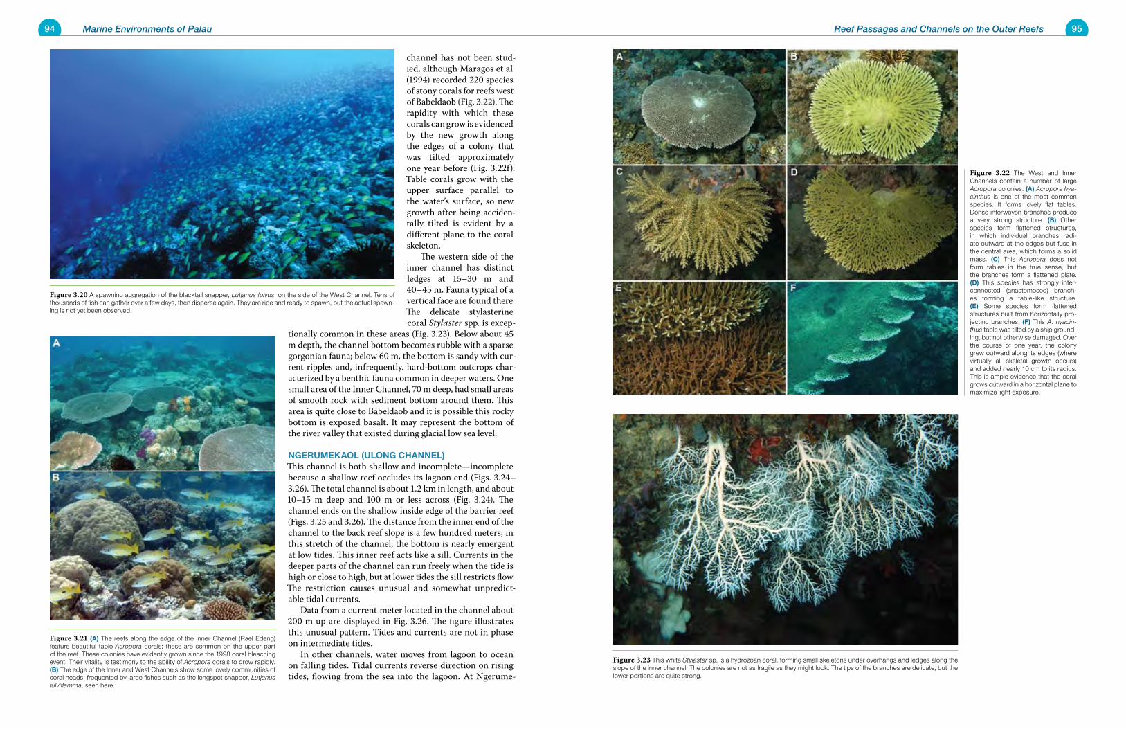
94 Marine Environments of Palau 95Reef Passages and Channels on the Outer Reefs
channel has not been stud-ied, although Maragos et al. (1994) recorded 220 species of stony corals for reefs west of Babeldaob (Fig. 3.22). The rapidity with which these corals can grow is evidenced by the new growth along the edges of a colony that was tilted approximately one year before (Fig. 3.22f). Table corals grow with the upper surface parallel to the water’s surface, so new growth after being acciden-tally tilted is evident by a different plane to the coral skeleton. The western side of the inner channel has distinct ledges at 15–30 m and 40–45 m. Fauna typical of a vertical face are found there. The delicate stylasterine coral Stylaster spp. is excep-
tionally common in these areas (Fig. 3.23). Below about 45 m depth, the channel bottom becomes rubble with a sparse gorgonian fauna; below 60 m, the bottom is sandy with cur-rent ripples and, infrequently. hard-bottom outcrops char-acterized by a benthic fauna common in deeper waters. One small area of the Inner Channel, 70 m deep, had small areas of smooth rock with sediment bottom around them. This area is quite close to Babeldaob and it is possible this rocky bottom is exposed basalt. It may represent the bottom of the river valley that existed during glacial low sea level.
NgeruMekaoL (uLoNg ChaNNeL)This channel is both shallow and incomplete—incomplete because a shallow reef occludes its lagoon end (Figs. 3.24–3.26). The total channel is about 1.2 km in length, and about 10–15 m deep and 100 m or less across (Fig. 3.24). The channel ends on the shallow inside edge of the barrier reef (Figs. 3.25 and 3.26). The distance from the inner end of the channel to the back reef slope is a few hundred meters; in this stretch of the channel, the bottom is nearly emergent at low tides. This inner reef acts like a sill. Currents in the deeper parts of the channel can run freely when the tide is high or close to high, but at lower tides the sill restricts flow. The restriction causes unusual and somewhat unpredict-able tidal currents. Data from a current-meter located in the channel about 200 m up are displayed in Fig. 3.26. The figure illustrates this unusual pattern. Tides and currents are not in phase on intermediate tides. In other channels, water moves from lagoon to ocean on falling tides. Tidal currents reverse direction on rising tides, flowing from the sea into the lagoon. At Ngerume-
Figure 3.20 A spawning aggregation of the blacktail snapper, Lutjanus fulvus, on the side of the West Channel. Tens of thousands of fish can gather over a few days, then disperse again. They are ripe and ready to spawn, but the actual spawn-ing is not yet been observed.
Figure 3.21 (a) The reefs along the edge of the Inner Channel (Rael Edeng) feature beautiful table Acropora corals; these are common on the upper part of the reef. These colonies have evidently grown since the 1998 coral bleaching event. Their vitality is testimony to the ability of Acropora corals to grow rapidly. (B) The edge of the Inner and West Channels show some lovely communities of coral heads, frequented by large fishes such as the longspot snapper, Lutjanus fulviflamma, seen here.
Figure 3.22 The West and Inner Channels contain a number of large Acropora colonies. (a) Acropora hya-cinthus is one of the most common species. It forms lovely flat tables. Dense interwoven branches produce a very strong structure. (B) Other species form flattened structures, in which individual branches radi-ate outward at the edges but fuse in the central area, which forms a solid mass. (C) This Acropora does not form tables in the true sense, but the branches form a flattened plate. (D) This species has strongly inter-connected (anastomosed) branch-es forming a table-like structure. (e) Some species form flattened structures built from horizontally pro-jecting branches. (F) This A. hyacin-thus table was tilted by a ship ground-ing, but not otherwise damaged. Over the course of one year, the colony grew outward along its edges (where virtually all skeletal growth occurs) and added nearly 10 cm to its radius. This is ample evidence that the coral grows outward in a horizontal plane to maximize light exposure.
Figure 3.23 This white Stylaster sp. is a hydrozoan coral, forming small skeletons under overhangs and ledges along the slope of the inner channel. The colonies are not as fragile as they might look. The tips of the branches are delicate, but the lower portions are quite strong.
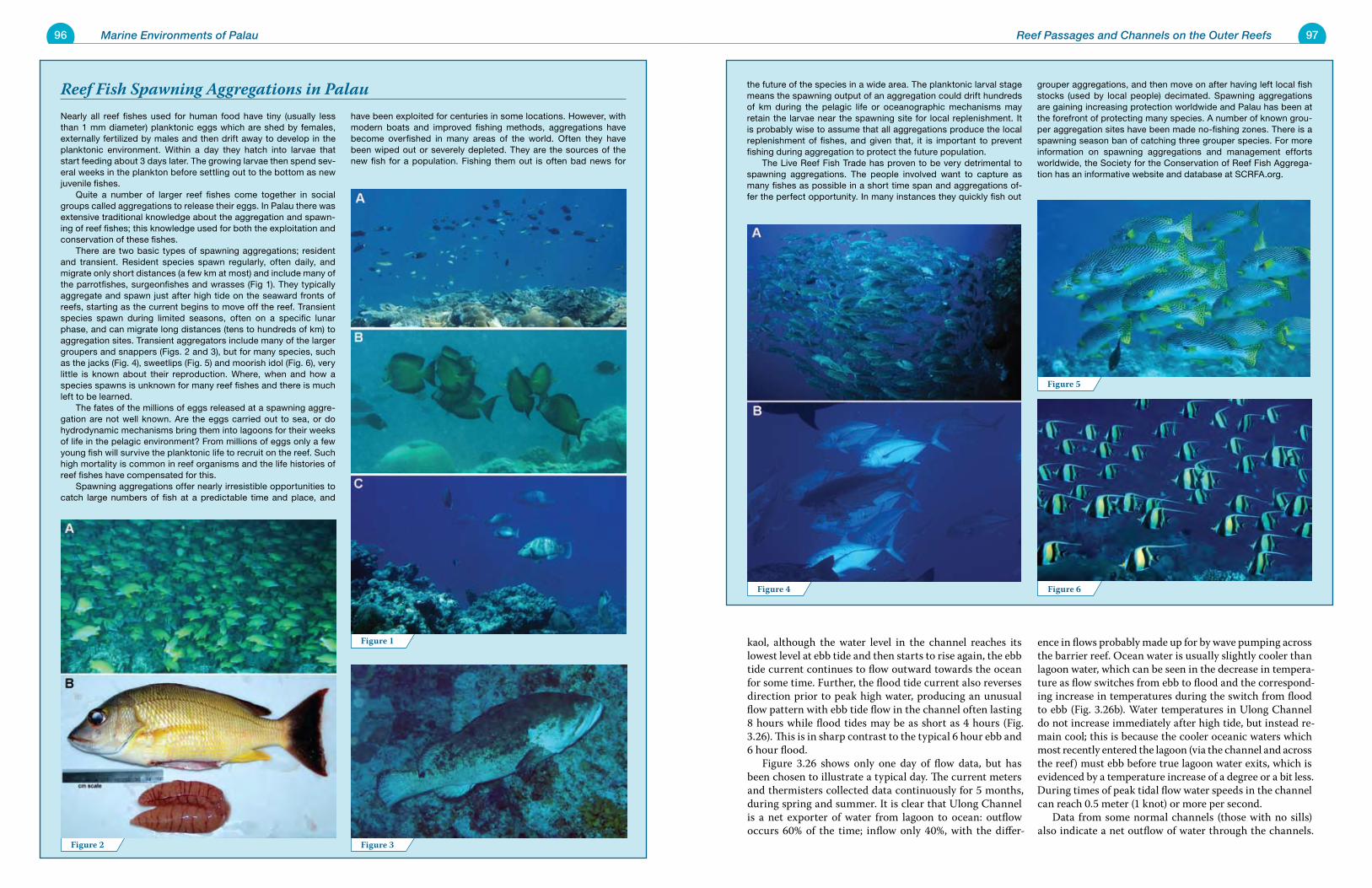
96 Marine Environments of Palau 97
Nearly all reef fishes used for human food have tiny (usually less than 1 mm diameter) planktonic eggs which are shed by females, externally fertilized by males and then drift away to develop in the planktonic environment. Within a day they hatch into larvae that start feeding about 3 days later. The growing larvae then spend sev-eral weeks in the plankton before settling out to the bottom as new juvenile fishes. Quite a number of larger reef fishes come together in social groups called aggregations to release their eggs. In Palau there was extensive traditional knowledge about the aggregation and spawn-ing of reef fishes; this knowledge used for both the exploitation and conservation of these fishes. There are two basic types of spawning aggregations; resident and transient. Resident species spawn regularly, often daily, and migrate only short distances (a few km at most) and include many of the parrotfishes, surgeonfishes and wrasses (Fig 1). They typically aggregate and spawn just after high tide on the seaward fronts of reefs, starting as the current begins to move off the reef. Transient species spawn during limited seasons, often on a specific lunar phase, and can migrate long distances (tens to hundreds of km) to aggregation sites. Transient aggregators include many of the larger groupers and snappers (Figs. 2 and 3), but for many species, such as the jacks (Fig. 4), sweetlips (Fig. 5) and moorish idol (Fig. 6), very little is known about their reproduction. Where, when and how a species spawns is unknown for many reef fishes and there is much left to be learned. The fates of the millions of eggs released at a spawning aggre-gation are not well known. Are the eggs carried out to sea, or do hydrodynamic mechanisms bring them into lagoons for their weeks of life in the pelagic environment? From millions of eggs only a few young fish will survive the planktonic life to recruit on the reef. Such high mortality is common in reef organisms and the life histories of reef fishes have compensated for this. Spawning aggregations offer nearly irresistible opportunities to catch large numbers of fish at a predictable time and place, and
have been exploited for centuries in some locations. However, with modern boats and improved fishing methods, aggregations have become overfished in many areas of the world. Often they have been wiped out or severely depleted. They are the sources of the new fish for a population. Fishing them out is often bad news for
Reef Fish Spawning Aggregations in Palau
Reef Passages and Channels on the Outer Reefs
the future of the species in a wide area. The planktonic larval stage means the spawning output of an aggregation could drift hundreds of km during the pelagic life or oceanographic mechanisms may retain the larvae near the spawning site for local replenishment. It is probably wise to assume that all aggregations produce the local replenishment of fishes, and given that, it is important to prevent fishing during aggregation to protect the future population. The Live Reef Fish Trade has proven to be very detrimental to spawning aggregations. The people involved want to capture as many fishes as possible in a short time span and aggregations of-fer the perfect opportunity. In many instances they quickly fish out
grouper aggregations, and then move on after having left local fish stocks (used by local people) decimated. Spawning aggregations are gaining increasing protection worldwide and Palau has been at the forefront of protecting many species. A number of known grou-per aggregation sites have been made no-fishing zones. There is a spawning season ban of catching three grouper species. For more information on spawning aggregations and management efforts worldwide, the Society for the Conservation of Reef Fish Aggrega-tion has an informative website and database at SCRFA.org.
kaol, although the water level in the channel reaches its lowest level at ebb tide and then starts to rise again, the ebb tide current continues to flow outward towards the ocean for some time. Further, the flood tide current also reverses direction prior to peak high water, producing an unusual flow pattern with ebb tide flow in the channel often lasting 8 hours while flood tides may be as short as 4 hours (Fig. 3.26). This is in sharp contrast to the typical 6 hour ebb and 6 hour flood. Figure 3.26 shows only one day of flow data, but has been chosen to illustrate a typical day. The current meters and thermisters collected data continuously for 5 months, during spring and summer. It is clear that Ulong Channel is a net exporter of water from lagoon to ocean: outflow occurs 60% of the time; inflow only 40%, with the differ-
ence in flows probably made up for by wave pumping across the barrier reef. Ocean water is usually slightly cooler than lagoon water, which can be seen in the decrease in tempera-ture as flow switches from ebb to flood and the correspond-ing increase in temperatures during the switch from flood to ebb (Fig. 3.26b). Water temperatures in Ulong Channel do not increase immediately after high tide, but instead re-main cool; this is because the cooler oceanic waters which most recently entered the lagoon (via the channel and across the reef) must ebb before true lagoon water exits, which is evidenced by a temperature increase of a degree or a bit less. During times of peak tidal flow water speeds in the channel can reach 0.5 meter (1 knot) or more per second. Data from some normal channels (those with no sills) also indicate a net outflow of water through the channels.
Figure 1
Figure 3Figure 2
Figure 4
Figure 5
Figure 6
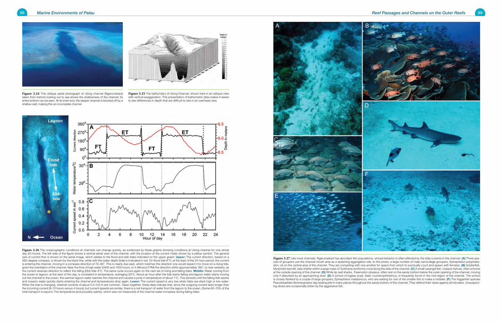
98 Marine Environments of Palau 99Reef Passages and Channels on the Outer Reefs
Figure 3.27 Like most channels, Ngerumekaol has abundant fish populations, whose behavior is often affected by the tidal currents in the channel. (a) Three spe-cies of groupers use the channel mouth area as a spawning aggregation site. In this photo, a large number of male camouflage groupers, Epinephelus polypheka-dion, sit on the central area of the channel. They are competing with one another for space from which to eventually court and spawn with females. (B) Soldierfish, Myripristis berndti, take shelter within a large mass of Turbinaria reniformis coral along the side of the channel. (C) A small carangid fish, Uraspis helvola, often schools at the outside opening of the channel. (D) White tip reef sharks, Triaenodon obsesus, often rest on the sandy bottom below the outer opening of the channel, moving only if disturbed by an approaching diver. (e) A school of bigeye scad, Selar crumenophthalmus, is frequently found in the mid-region of the channel. The school is closely flanked by a couple of large groupers, Epinephelus malabaricus, who are waiting for one of the smaller fish to make a mistake. (F) The triggerfish species Pseudobalistes flavimarginatus dig nesting pits in many places throughout the sandy bottom of the channel. They defend their nests against all intruders. Unsuspect-ing divers are occasionally bitten by the aggressive fish.
Figure 3.24 This oblique aerial photograph of Ulong channel (Ngerumekaol) taken from inshore looking out to sea shows the shallowness of the channel: its entire bottom can be seen. At its inner end, the deeper channel is blocked off by a shallow reef, making this an incomplete channel.
Figure 3.25 The bathymetry of Ulong Channel, shown here in an oblique view with vertical exaggeration. This presentation of bathymetric data makes it easier to see differences in depth that are difficult to see in an overhead view.
Figure 3.26 The oceanographic conditions at channels can change quickly, as evidenced by these graphs showing conditions at Ulong channel for one whole day (24 hours). The left side of the figure shows a vertical aerial view of the channel, with the location of the current meter shown by a yellow symbol. The general axis of current flow is shown on the aerial image, which relates to the flood and ebb tides indicated on the upper graph. upper: The current direction, based on a 360-degree compass, is shown by the black line, while with the water depth (tide) is indicated in red. On flood tide (FT), at the start of the 24-hour period, the current is entering the channel, moving in a compass direction of 70–80°. This is nearly due east, which matches the direction one would expect it to move on a rising tide, given the orientation of the channel. Near the time of high water (0400 and 1400 hours, or 4 AM and 2 PM) the direction shifts approximately 180°, to near westerly, as the current reverses direction to reflect the falling (Ebb tide–ET). The same cycle occurs again on the next set of rising and falling tides. Middle: Water coming from the ocean to lagoon, at the start of the day, is consistent in temperature, averaging 29°C. About an hour after the tide starts falling and lagoon water starts moving out the channel to the ocean, the warmer lagoon water reaches the channel and causes a jump in temperature of about 1°C. This persists until the falling tide wanes and oceanic water quickly starts entering the channel and temperatures drop again. Lower: The current speed is very low when tides are slack high or low water. When the tide is changing, channel currents of about 0.4–0.6 m are common. Taken together, these data indicate that, since the outgoing current lasts longer than the incoming current (8–10 hours versus 4 hours), but current speeds are similar, there is a net transport of water from the lagoon to the ocean. (Some 60–70% of the total transport is export.) The temperature (and possibly salinity, which was not measured) of the channel water increases during falling tides.
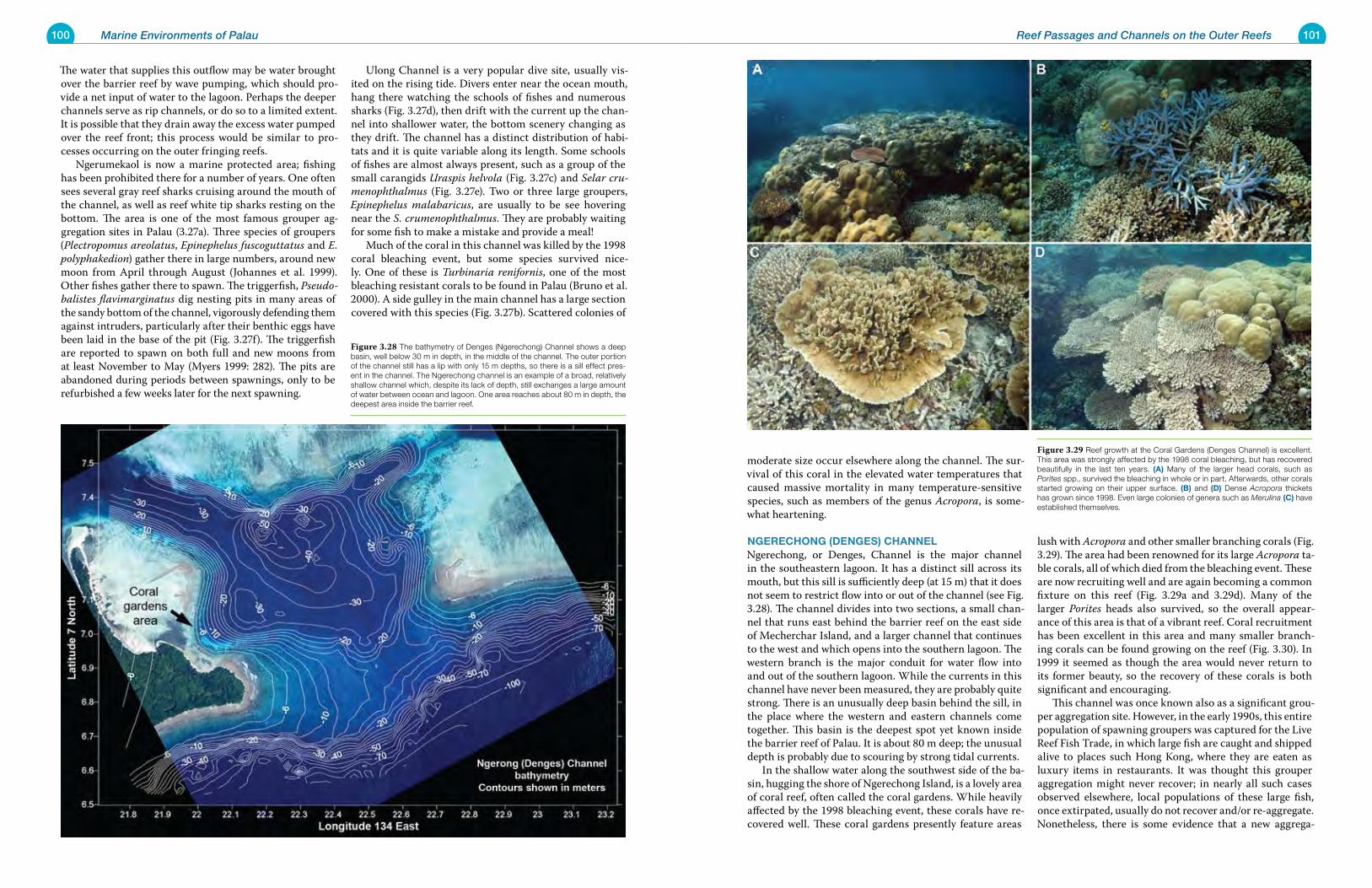
100 Marine Environments of Palau 101Reef Passages and Channels on the Outer Reefs
The water that supplies this outflow may be water brought over the barrier reef by wave pumping, which should pro-vide a net input of water to the lagoon. Perhaps the deeper channels serve as rip channels, or do so to a limited extent. It is possible that they drain away the excess water pumped over the reef front; this process would be similar to pro-cesses occurring on the outer fringing reefs. Ngerumekaol is now a marine protected area; fishing has been prohibited there for a number of years. One often sees several gray reef sharks cruising around the mouth of the channel, as well as reef white tip sharks resting on the bottom. The area is one of the most famous grouper ag-gregation sites in Palau (3.27a). Three species of groupers (Plectropomus areolatus, Epinephelus fuscoguttatus and E. polyphakedion) gather there in large numbers, around new moon from April through August (Johannes et al. 1999). Other fishes gather there to spawn. The triggerfish, Pseudo-balistes flavimarginatus dig nesting pits in many areas of the sandy bottom of the channel, vigorously defending them against intruders, particularly after their benthic eggs have been laid in the base of the pit (Fig. 3.27f). The triggerfish are reported to spawn on both full and new moons from at least November to May (Myers 1999: 282). The pits are abandoned during periods between spawnings, only to be refurbished a few weeks later for the next spawning.
Ulong Channel is a very popular dive site, usually vis-ited on the rising tide. Divers enter near the ocean mouth, hang there watching the schools of fishes and numerous sharks (Fig. 3.27d), then drift with the current up the chan-nel into shallower water, the bottom scenery changing as they drift. The channel has a distinct distribution of habi-tats and it is quite variable along its length. Some schools of fishes are almost always present, such as a group of the small carangids Uraspis helvola (Fig. 3.27c) and Selar cru-menophthalmus (Fig. 3.27e). Two or three large groupers, Epinephelus malabaricus, are usually to be see hovering near the S. crumenophthalmus. They are probably waiting for some fish to make a mistake and provide a meal! Much of the coral in this channel was killed by the 1998 coral bleaching event, but some species survived nice-ly. One of these is Turbinaria renifornis, one of the most bleaching resistant corals to be found in Palau (Bruno et al. 2000). A side gulley in the main channel has a large section covered with this species (Fig. 3.27b). Scattered colonies of
moderate size occur elsewhere along the channel. The sur-vival of this coral in the elevated water temperatures that caused massive mortality in many temperature-sensitive species, such as members of the genus Acropora, is some-what heartening.
NgereChoNg (DeNges) ChaNNeLNgerechong, or Denges, Channel is the major channel in the southeastern lagoon. It has a distinct sill across its mouth, but this sill is sufficiently deep (at 15 m) that it does not seem to restrict flow into or out of the channel (see Fig. 3.28). The channel divides into two sections, a small chan-nel that runs east behind the barrier reef on the east side of Mecherchar Island, and a larger channel that continues to the west and which opens into the southern lagoon. The western branch is the major conduit for water flow into and out of the southern lagoon. While the currents in this channel have never been measured, they are probably quite strong. There is an unusually deep basin behind the sill, in the place where the western and eastern channels come together. This basin is the deepest spot yet known inside the barrier reef of Palau. It is about 80 m deep; the unusual depth is probably due to scouring by strong tidal currents. In the shallow water along the southwest side of the ba-sin, hugging the shore of Ngerechong Island, is a lovely area of coral reef, often called the coral gardens. While heavily affected by the 1998 bleaching event, these corals have re-covered well. These coral gardens presently feature areas
lush with Acropora and other smaller branching corals (Fig. 3.29). The area had been renowned for its large Acropora ta-ble corals, all of which died from the bleaching event. These are now recruiting well and are again becoming a common fixture on this reef (Fig. 3.29a and 3.29d). Many of the larger Porites heads also survived, so the overall appear-ance of this area is that of a vibrant reef. Coral recruitment has been excellent in this area and many smaller branch-ing corals can be found growing on the reef (Fig. 3.30). In 1999 it seemed as though the area would never return to its former beauty, so the recovery of these corals is both significant and encouraging. This channel was once known also as a significant grou-per aggregation site. However, in the early 1990s, this entire population of spawning groupers was captured for the Live Reef Fish Trade, in which large fish are caught and shipped alive to places such Hong Kong, where they are eaten as luxury items in restaurants. It was thought this grouper aggregation might never recover; in nearly all such cases observed elsewhere, local populations of these large fish, once extirpated, usually do not recover and/or re-aggregate. Nonetheless, there is some evidence that a new aggrega-
Figure 3.28 The bathymetry of Denges (Ngerechong) Channel shows a deep basin, well below 30 m in depth, in the middle of the channel. The outer portion of the channel still has a lip with only 15 m depths, so there is a sill effect pres-ent in the channel. The Ngerechong channel is an example of a broad, relatively shallow channel which, despite its lack of depth, still exchanges a large amount of water between ocean and lagoon. One area reaches about 80 m in depth, the deepest area inside the barrier reef.
Figure 3.29 Reef growth at the Coral Gardens (Denges Channel) is excellent. This area was strongly affected by the 1998 coral bleaching, but has recovered beautifully in the last ten years. (a) Many of the larger head corals, such as Porites spp., survived the bleaching in whole or in part. Afterwards, other corals started growing on their upper surface. (B) and (D) Dense Acropora thickets has grown since 1998. Even large colonies of genera such as Merulina (C) have established themselves.
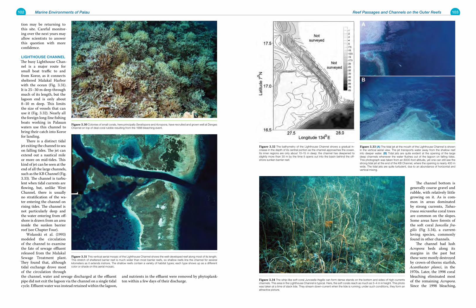
102 Marine Environments of Palau 103Reef Passages and Channels on the Outer Reefs
tion may be returning to this site. Careful monitor-ing over the next years may allow scientists to answer this question with more confidence.
Lighthouse ChaNNeLThe busy Lighthouse Chan-nel is a major route for small boat traffic to and from Koror, as it connects sheltered Malakal Harbor with the ocean (Fig. 3.31). It is 25–30 m deep through much of its length, but the lagoon end is only about 8–10 m deep. This limits the size of vessels that can use it (Fig. 3.32). Nearly all the foreign long-line fishing boats working in Palauan waters use this channel to bring their catch into Koror for landing. There is a distinct tidal jet exiting the channel to sea on falling tides. The jet can extend out a nautical mile or more on mid-tides. This kind of jet can be seen at the end of all the large channels, such as the KB Channel (Fig. 3.33). The channel is turbu-lent when tidal currents are flowing, but, unlike West Channel, there is usually no stratification of the wa-ter entering the channel on rising tides. The channel is not particularly deep and the water entering from off-shore is drawn from an area inside the sunken barrier reef (see Chapter Four). Wolanski et al. (1993) modeled the circulation of the channel to examine the fate of sewage effluent released from the Malakal Sewage Treatment plant. They found that, although tidal exchange drove most of the circulation through the channel, water and sewage discharged at the effluent pipe did not exit the lagoon via the channel on a single tidal cycle. Effluent water was instead retained within the lagoon,
and nutrients in the effluent were removed by phytoplank-ton within a few days of their discharge.
The channel bottom is generally coarse gravel and rubble, with relatively little growing on it. As is com-mon in areas dominated by strong currents, Tubas-traea micrantha coral trees are common on the slopes. Some areas have forests of the soft coral Juncella fra-gilis (Fig 3.34), a current-loving species, commonly found in other channels. The channel had lush Acropora beds along its margins in the past but these were mostly destroyed by crown-of-thorns starfish, Acanthaster planci, in the 1970s. Later, the 1998 coral bleaching eliminated most of the remaining Acropora. Since the 1998 bleaching,
Figure 3.30 Colonies of small corals, here principally Seratiopora and Acropora, have recruited and grown well at Denges Channel on top of deal coral rubble resulting from the 1998 bleaching event.
Figure 3.31 This vertical aerial mosaic of the Lighthouse Channel shows the well-developed reef along most of its length. This stretch of sheltered barrier reef is much wider than most barrier reefs, so shallow reefs line the channel for several kilometers as it extends inshore. The shallow reefs contain a variety of habitat types; each type shows up as a different color or shade on this aerial mosaic.
Figure 3.32 The bathymetry of the Lighthouse Channel shows a gradual in-crease in the depth of its central portion as the channel approaches the ocean. Its inner regions are only about 10–15 m deep; the channel has deepened to slightly more than 30 m by the time it opens out into the basin behind the off-shore sunken barrier reef.
Figure 3.33 (a) The tidal jet at the mouth of the Lighthouse Channel is shown in the vertical aerial view. The jet transports water away from the shallow reef into deeper water. (B) Tidal jets are quite evident at the opening of the large deep channels whenever the water flushes out of the lagoon on falling tides. This photograph was taken from an 8000-foot altitude, yet one can still see the strong tidal jet at the end of the KB Channel, where the opening is nearly 400 m wide. The tidal jets are quite turbulent, due to an abundance of horizontal and vertical mixing.
Figure 3.34 The whip-like soft coral Junceella fragilis can form dense stands on the bottom and sides of high-currents channels. This area in the Lighthouse Channel is typical. Here, the soft corals reach as much as 3–4 m in height. This photo was taken at a time of slack tide. They stream down-current when the tide is running; under such conditions, they form an attractive picture.
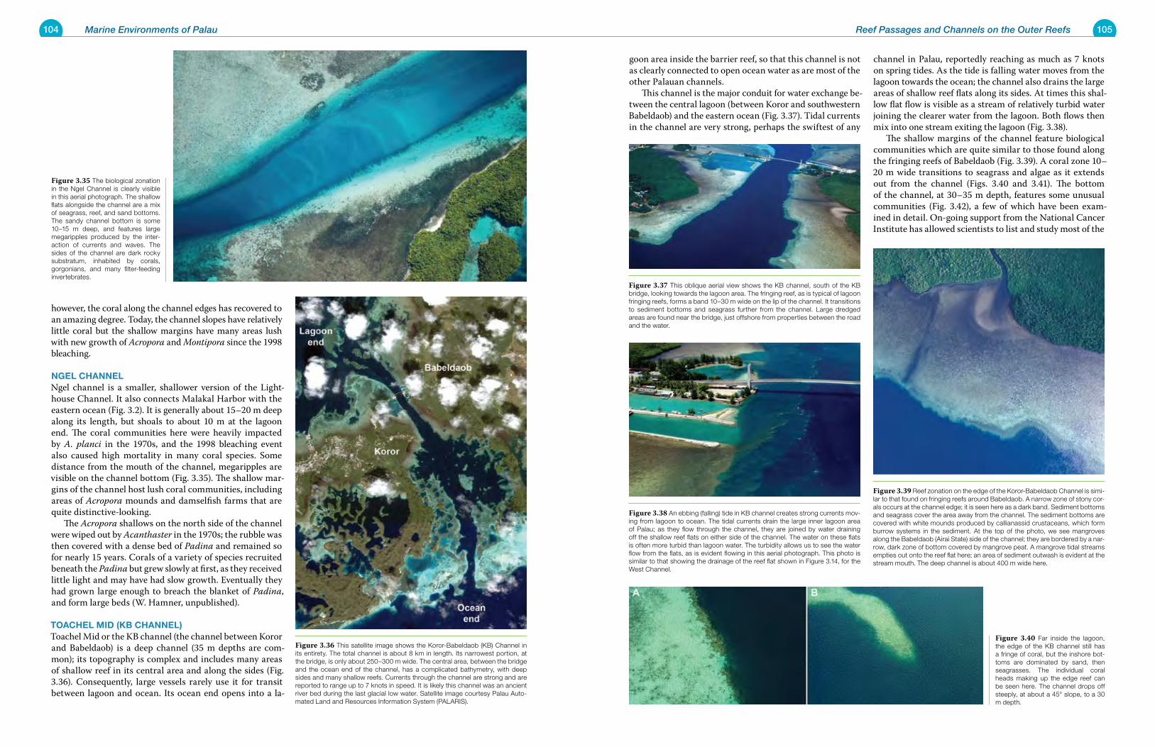
104 Marine Environments of Palau 105Reef Passages and Channels on the Outer Reefs
however, the coral along the channel edges has recovered to an amazing degree. Today, the channel slopes have relatively little coral but the shallow margins have many areas lush with new growth of Acropora and Montipora since the 1998 bleaching.
NgeL ChaNNeLNgel channel is a smaller, shallower version of the Light-house Channel. It also connects Malakal Harbor with the eastern ocean (Fig. 3.2). It is generally about 15–20 m deep along its length, but shoals to about 10 m at the lagoon end. The coral communities here were heavily impacted by A. planci in the 1970s, and the 1998 bleaching event also caused high mortality in many coral species. Some distance from the mouth of the channel, megaripples are visible on the channel bottom (Fig. 3.35). The shallow mar-gins of the channel host lush coral communities, including areas of Acropora mounds and damselfish farms that are quite distinctive-looking. The Acropora shallows on the north side of the channel were wiped out by Acanthaster in the 1970s; the rubble was then covered with a dense bed of Padina and remained so for nearly 15 years. Corals of a variety of species recruited beneath the Padina but grew slowly at first, as they received little light and may have had slow growth. Eventually they had grown large enough to breach the blanket of Padina, and form large beds (W. Hamner, unpublished).
toaCheL MiD (kB ChaNNeL)Toachel Mid or the KB channel (the channel between Koror and Babeldaob) is a deep channel (35 m depths are com-mon); its topography is complex and includes many areas of shallow reef in its central area and along the sides (Fig. 3.36). Consequently, large vessels rarely use it for transit between lagoon and ocean. Its ocean end opens into a la-
goon area inside the barrier reef, so that this channel is not as clearly connected to open ocean water as are most of the other Palauan channels. This channel is the major conduit for water exchange be-tween the central lagoon (between Koror and southwestern Babeldaob) and the eastern ocean (Fig. 3.37). Tidal currents in the channel are very strong, perhaps the swiftest of any
channel in Palau, reportedly reaching as much as 7 knots on spring tides. As the tide is falling water moves from the lagoon towards the ocean; the channel also drains the large areas of shallow reef flats along its sides. At times this shal-low flat flow is visible as a stream of relatively turbid water joining the clearer water from the lagoon. Both flows then mix into one stream exiting the lagoon (Fig. 3.38). The shallow margins of the channel feature biological communities which are quite similar to those found along the fringing reefs of Babeldaob (Fig. 3.39). A coral zone 10–20 m wide transitions to seagrass and algae as it extends out from the channel (Figs. 3.40 and 3.41). The bottom of the channel, at 30–35 m depth, features some unusual communities (Fig. 3.42), a few of which have been exam-ined in detail. On-going support from the National Cancer Institute has allowed scientists to list and study most of the
Figure 3.35 The biological zonation in the Ngel Channel is clearly visible in this aerial photograph. The shallow flats alongside the channel are a mix of seagrass, reef, and sand bottoms. The sandy channel bottom is some 10–15 m deep, and features large megaripples produced by the inter-action of currents and waves. The sides of the channel are dark rocky substratum, inhabited by corals, gorgonians, and many filter-feeding invertebrates.
Figure 3.36 This satellite image shows the Koror-Babeldaob (KB) Channel in its entirety. The total channel is about 8 km in length. Its narrowest portion, at the bridge, is only about 250–300 m wide. The central area, between the bridge and the ocean end of the channel, has a complicated bathymetry, with deep sides and many shallow reefs. Currents through the channel are strong and are reported to range up to 7 knots in speed. It is likely this channel was an ancient river bed during the last glacial low water. Satellite image courtesy Palau Auto-mated Land and Resources Information System (PALARIS).
Figure 3.37 This oblique aerial view shows the KB channel, south of the KB bridge, looking towards the lagoon area. The fringing reef, as is typical of lagoon fringing reefs, forms a band 10–30 m wide on the lip of the channel. It transitions to sediment bottoms and seagrass further from the channel. Large dredged areas are found near the bridge, just offshore from properties between the road and the water.
Figure 3.38 An ebbing (falling) tide in KB channel creates strong currents mov-ing from lagoon to ocean. The tidal currents drain the large inner lagoon area of Palau; as they flow through the channel, they are joined by water draining off the shallow reef flats on either side of the channel. The water on these flats is often more turbid than lagoon water. The turbidity allows us to see the water flow from the flats, as is evident flowing in this aerial photograph. This photo is similar to that showing the drainage of the reef flat shown in Figure 3.14, for the West Channel.
Figure 3.39 Reef zonation on the edge of the Koror-Babeldaob Channel is simi-lar to that found on fringing reefs around Babeldaob. A narrow zone of stony cor-als occurs at the channel edge; it is seen here as a dark band. Sediment bottoms and seagrass cover the area away from the channel. The sediment bottoms are covered with white mounds produced by callianassid crustaceans, which form burrow systems in the sediment. At the top of the photo, we see mangroves along the Babeldaob (Airai State) side of the channel; they are bordered by a nar-row, dark zone of bottom covered by mangrove peat. A mangrove tidal streams empties out onto the reef flat here; an area of sediment outwash is evident at the stream mouth. The deep channel is about 400 m wide here.
Figure 3.40 Far inside the lagoon, the edge of the KB channel still has a fringe of coral, but the inshore bot-toms are dominated by sand, then seagrasses. The individual coral heads making up the edge reef can be seen here. The channel drops off steeply, at about a 45° slope, to a 30 m depth.
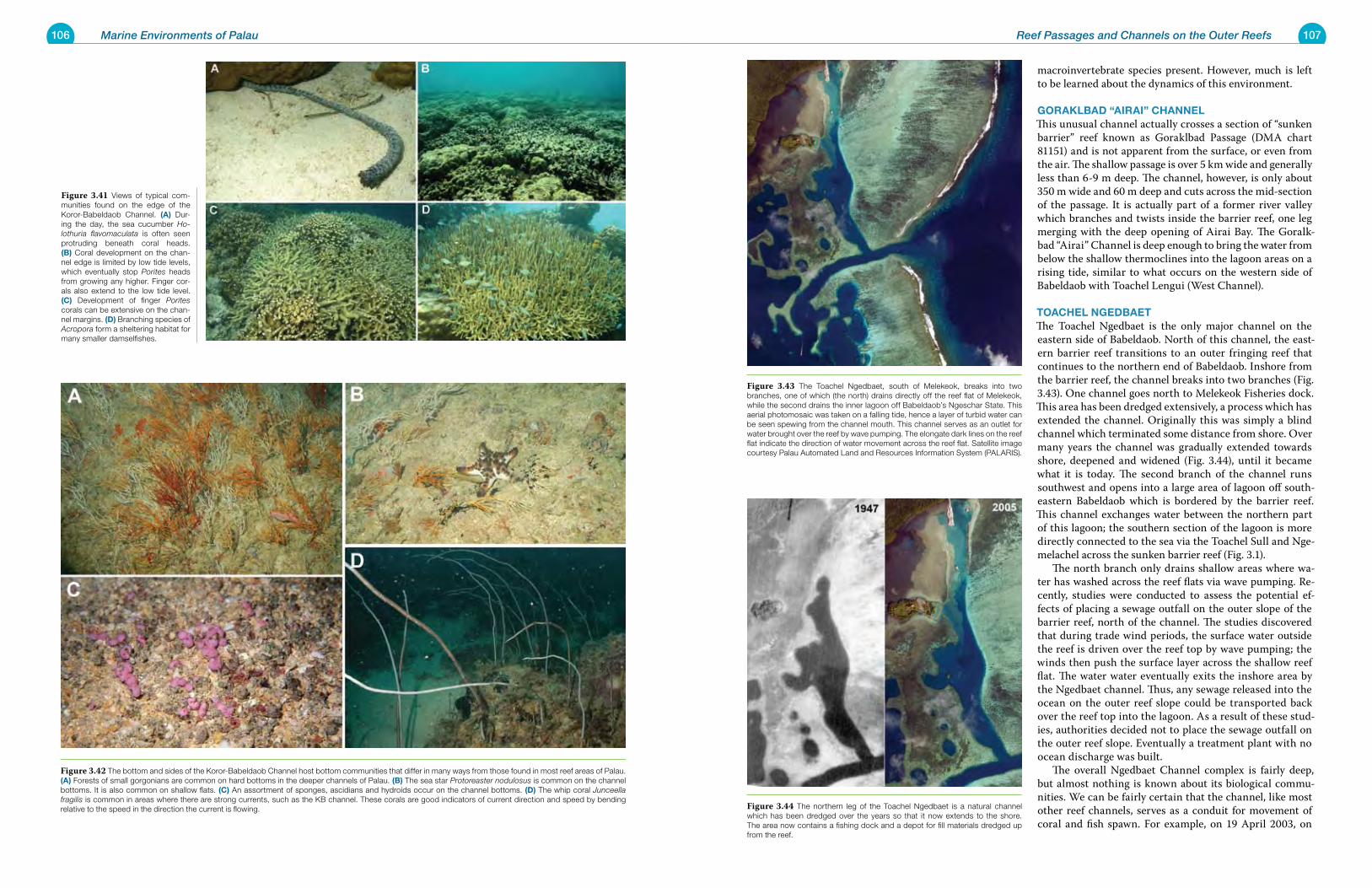
106 Marine Environments of Palau 107Reef Passages and Channels on the Outer Reefs
macroinvertebrate species present. However, much is left to be learned about the dynamics of this environment.
gorakLBaD “airai” ChaNNeL This unusual channel actually crosses a section of “sunken barrier” reef known as Goraklbad Passage (DMA chart 81151) and is not apparent from the surface, or even from the air. The shallow passage is over 5 km wide and generally less than 6-9 m deep. The channel, however, is only about 350 m wide and 60 m deep and cuts across the mid-section of the passage. It is actually part of a former river valley which branches and twists inside the barrier reef, one leg merging with the deep opening of Airai Bay. The Goralk-bad “Airai” Channel is deep enough to bring the water from below the shallow thermoclines into the lagoon areas on a rising tide, similar to what occurs on the western side of Babeldaob with Toachel Lengui (West Channel).
toaCheL NgeDBaetThe Toachel Ngedbaet is the only major channel on the eastern side of Babeldaob. North of this channel, the east-ern barrier reef transitions to an outer fringing reef that continues to the northern end of Babeldaob. Inshore from the barrier reef, the channel breaks into two branches (Fig. 3.43). One channel goes north to Melekeok Fisheries dock. This area has been dredged extensively, a process which has extended the channel. Originally this was simply a blind channel which terminated some distance from shore. Over many years the channel was gradually extended towards shore, deepened and widened (Fig. 3.44), until it became what it is today. The second branch of the channel runs southwest and opens into a large area of lagoon off south-eastern Babeldaob which is bordered by the barrier reef. This channel exchanges water between the northern part of this lagoon; the southern section of the lagoon is more directly connected to the sea via the Toachel Sull and Nge-melachel across the sunken barrier reef (Fig. 3.1). The north branch only drains shallow areas where wa-ter has washed across the reef flats via wave pumping. Re-cently, studies were conducted to assess the potential ef-fects of placing a sewage outfall on the outer slope of the barrier reef, north of the channel. The studies discovered that during trade wind periods, the surface water outside the reef is driven over the reef top by wave pumping; the winds then push the surface layer across the shallow reef flat. The water water eventually exits the inshore area by the Ngedbaet channel. Thus, any sewage released into the ocean on the outer reef slope could be transported back over the reef top into the lagoon. As a result of these stud-ies, authorities decided not to place the sewage outfall on the outer reef slope. Eventually a treatment plant with no ocean discharge was built. The overall Ngedbaet Channel complex is fairly deep, but almost nothing is known about its biological commu-nities. We can be fairly certain that the channel, like most other reef channels, serves as a conduit for movement of coral and fish spawn. For example, on 19 April 2003, on
Figure 3.41 Views of typical com-munities found on the edge of the Koror-Babeldaob Channel. (a) Dur-ing the day, the sea cucumber Ho-lothuria flavomaculata is often seen protruding beneath coral heads. (B) Coral development on the chan-nel edge is limited by low tide levels, which eventually stop Porites heads from growing any higher. Finger cor-als also extend to the low tide level. (C) Development of finger Porites corals can be extensive on the chan-nel margins. (D) Branching species of Acropora form a sheltering habitat for many smaller damselfishes.
Figure 3.42 The bottom and sides of the Koror-Babeldaob Channel host bottom communities that differ in many ways from those found in most reef areas of Palau. (a) Forests of small gorgonians are common on hard bottoms in the deeper channels of Palau. (B) The sea star Protoreaster nodulosus is common on the channel bottoms. It is also common on shallow flats. (C) An assortment of sponges, ascidians and hydroids occur on the channel bottoms. (D) The whip coral Junceella fragilis is common in areas where there are strong currents, such as the KB channel. These corals are good indicators of current direction and speed by bending relative to the speed in the direction the current is flowing.
Figure 3.43 The Toachel Ngedbaet, south of Melekeok, breaks into two branches, one of which (the north) drains directly off the reef flat of Melekeok, while the second drains the inner lagoon off Babeldaob’s Ngeschar State. This aerial photomosaic was taken on a falling tide, hence a layer of turbid water can be seen spewing from the channel mouth. This channel serves as an outlet for water brought over the reef by wave pumping. The elongate dark lines on the reef flat indicate the direction of water movement across the reef flat. Satellite image courtesy Palau Automated Land and Resources Information System (PALARIS).
Figure 3.44 The northern leg of the Toachel Ngedbaet is a natural channel which has been dredged over the years so that it now extends to the shore. The area now contains a fishing dock and a depot for fill materials dredged up from the reef.
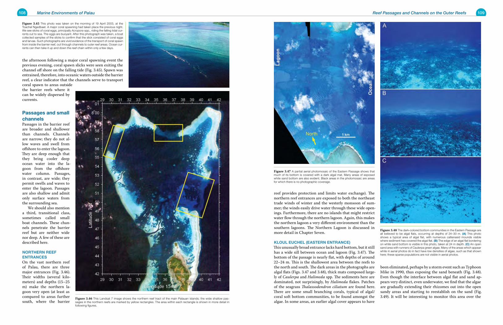
108 Marine Environments of Palau 109Reef Passages and Channels on the Outer Reefs
the afternoon following a major coral spawning event the previous evening, coral spawn slicks were seen exiting the channel off shore on the falling tide (Fig. 3.45). Spawn was entrained, therefore, into oceanic waters outside the barrier reef, a clear indicator that the channels serve to transport coral spawn to areas outside the barrier reefs where it can be widely dispersed by currents.
passages and small channelsPassages in the barrier reef are broader and shallower than channels. Channels are narrow; they do not al-low waves and swell from offshore to enter the lagoon. They are deep enough that they bring cooler deep ocean water into the la-goon from the offshore water column. Passages, in contrast, are wide; they permit swells and waves to enter the lagoon. Passages are also shallow and admit only surface waters from the surrounding sea. We should also mention a third, transitional class, sometimes called small boat channels. These chan-nels penetrate the barrier reef but are neither wide nor deep. A few of these are described here.
NortherN reeF eNtraNCesOn the vast northern reef of Palau, there are three major entrances (Fig. 3.46). Their widths (several kilo-meters) and depths (15–25 m) make the northern la-goon very open (at least as compared to areas further south, where the barrier
reef provides protection and limits water exchange). The northern reef entrances are exposed to both the northeast trade winds of winter and the westerly monsoon of sum-mer; the winds easily drive water through these wide open-ings. Furthermore, there are no islands that might restrict water flow through the northern lagoon. Again, this makes the northern lagoon a very different environment than the southern lagoons. The Northern Lagoon is discussed in more detail in Chapter Seven.
kLouL euCheL (easterN eNtraNCe)This unusually broad entrance lacks hard bottom, but it still has a wide sill between ocean and lagoon (Fig. 3.47). The bottom of the passage is nearly flat, with depths of around 22–24 m. This is the shallowest area between the reefs to the north and south. The dark areas in the photographs are algal flats (Figs. 3.47 and 3.48), thick mats composed large-ly of Caulerpa and Halimeda spp. The sediments here are dominated, not surprisingly, by Halimeda flakes. Patches of the seagrass Thalassodendron ciliatum are found here. There are some small branching corals, typical of algal/coral soft bottom communities, to be found amongst the algae. In some areas, an earlier algal cover appears to have
been eliminated, perhaps by a storm event such as Typhoon Mike in 1990, thus exposing the sand beneath (Fig. 3.48). Even though the interface between algal flat and sand ap-pears very distinct, even underwater, we find that the algae are gradually extending their rhizomes out into the open sandy areas and starting to reestablish on the sand (Fig. 3.49). It will be interesting to monitor this area over the
Figure 3.45 This photo was taken on the morning of 19 April 2003, at the Toachel Ngedbaet. A major coral spawning had taken place the previous night. We see slicks of coral eggs, principally Acropora spp., riding the falling tidal cur-rents out to sea. The eggs are buoyant. After this photograph was taken, a boat collected samples of the slicks to confirm that the slick consisted of coral eggs and larvae. Such photographs are vivid evidence of the transport of coral spawn from inside the barrier reef, out through channels to outer reef areas. Ocean cur-rents can then take it up and down the reef chain within only a few days.
Figure 3.46 This Landsat 7 image shows the northern reef tract of the main Palauan islands; the wide shallow pas-sages in the northern reefs are marked by yellow rectangles. The area within each rectangle is shown in more detail in following figures.
Figure 3.47 A partial aerial photomosaic of the Eastern Passage shows that much of its bottom is covered with a dark algal mat. Many areas of exposed white sand bottom are also evident. Black areas in the photomosaic are areas for which there is no photographic coverage.
Figure 3.48 The dark-colored bottom communities in the Eastern Passage are all believed to be algal flats, occurring at depths of 24–30 m. (a) This photo shows a typical area of algal flat, with numerous callianasid mounds visible where sediment has covered the algal flat. (B) The edge of an algal flat bordering on white sand bottom is visible in this photo, taken at 24 m depth. (C) An open sand area with runners of Caulerpa green algae. Many of the areas which appear white in aerial photos do in fact have low densities of algae, such as that shown here; these sparse populations are not visible in aerial photos.
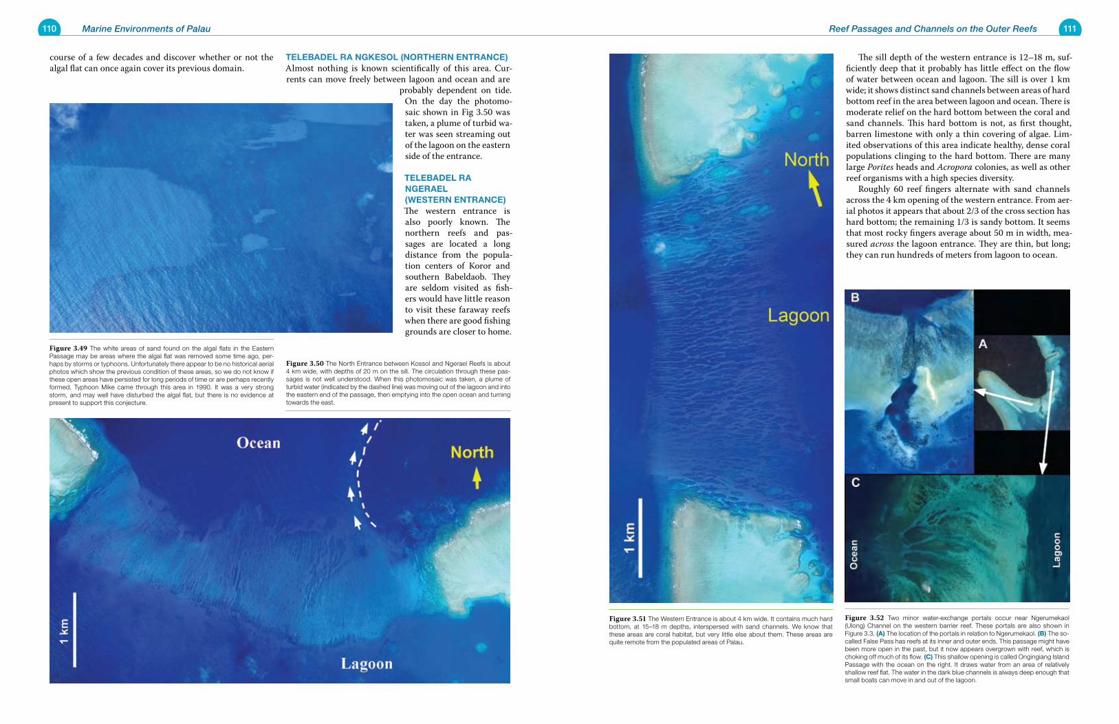
110 Marine Environments of Palau 111Reef Passages and Channels on the Outer Reefs
course of a few decades and discover whether or not the algal flat can once again cover its previous domain.
teLeBaDeL ra NgkesoL (NortherN eNtraNCe)Almost nothing is known scientifically of this area. Cur-rents can move freely between lagoon and ocean and are
probably dependent on tide. On the day the photomo-saic shown in Fig 3.50 was taken, a plume of turbid wa-ter was seen streaming out of the lagoon on the eastern side of the entrance.
teLeBaDeL ra NgeraeL (WesterN eNtraNCe) The western entrance is also poorly known. The northern reefs and pas-sages are located a long distance from the popula-tion centers of Koror and southern Babeldaob. They are seldom visited as fish-ers would have little reason to visit these faraway reefs when there are good fishing grounds are closer to home.
The sill depth of the western entrance is 12–18 m, suf-ficiently deep that it probably has little effect on the flow of water between ocean and lagoon. The sill is over 1 km wide; it shows distinct sand channels between areas of hard bottom reef in the area between lagoon and ocean. There is moderate relief on the hard bottom between the coral and sand channels. This hard bottom is not, as first thought, barren limestone with only a thin covering of algae. Lim-ited observations of this area indicate healthy, dense coral populations clinging to the hard bottom. There are many large Porites heads and Acropora colonies, as well as other reef organisms with a high species diversity. Roughly 60 reef fingers alternate with sand channels across the 4 km opening of the western entrance. From aer-ial photos it appears that about 2/3 of the cross section has hard bottom; the remaining 1/3 is sandy bottom. It seems that most rocky fingers average about 50 m in width, mea-sured across the lagoon entrance. They are thin, but long; they can run hundreds of meters from lagoon to ocean.
Figure 3.49 The white areas of sand found on the algal flats in the Eastern Passage may be areas where the algal flat was removed some time ago, per-haps by storms or typhoons. Unfortunately there appear to be no historical aerial photos which show the previous condition of these areas, so we do not know if these open areas have persisted for long periods of time or are perhaps recently formed. Typhoon Mike came through this area in 1990. It was a very strong storm, and may well have disturbed the algal flat, but there is no evidence at present to support this conjecture.
Figure 3.50 The North Entrance between Kossol and Ngerael Reefs is about 4 km wide, with depths of 20 m on the sill. The circulation through these pas-sages is not well understood. When this photomosaic was taken, a plume of turbid water (indicated by the dashed line) was moving out of the lagoon and into the eastern end of the passage, then emptying into the open ocean and turning towards the east.
Figure 3.51 The Western Entrance is about 4 km wide. It contains much hard bottom, at 15–18 m depths, interspersed with sand channels. We know that these areas are coral habitat, but very little else about them. These areas are quite remote from the populated areas of Palau.
Figure 3.52 Two minor water-exchange portals occur near Ngerumekaol (Ulong) Channel on the western barrier reef. These portals are also shown in Figure 3.3. (a) The location of the portals in relation to Ngerumekaol. (B) The so-called False Pass has reefs at its inner and outer ends. This passage might have been more open in the past, but it now appears overgrown with reef, which is choking off much of its flow. (C) This shallow opening is called Ongingiang Island Passage with the ocean on the right. It draws water from an area of relatively shallow reef flat. The water in the dark blue channels is always deep enough that small boats can move in and out of the lagoon.
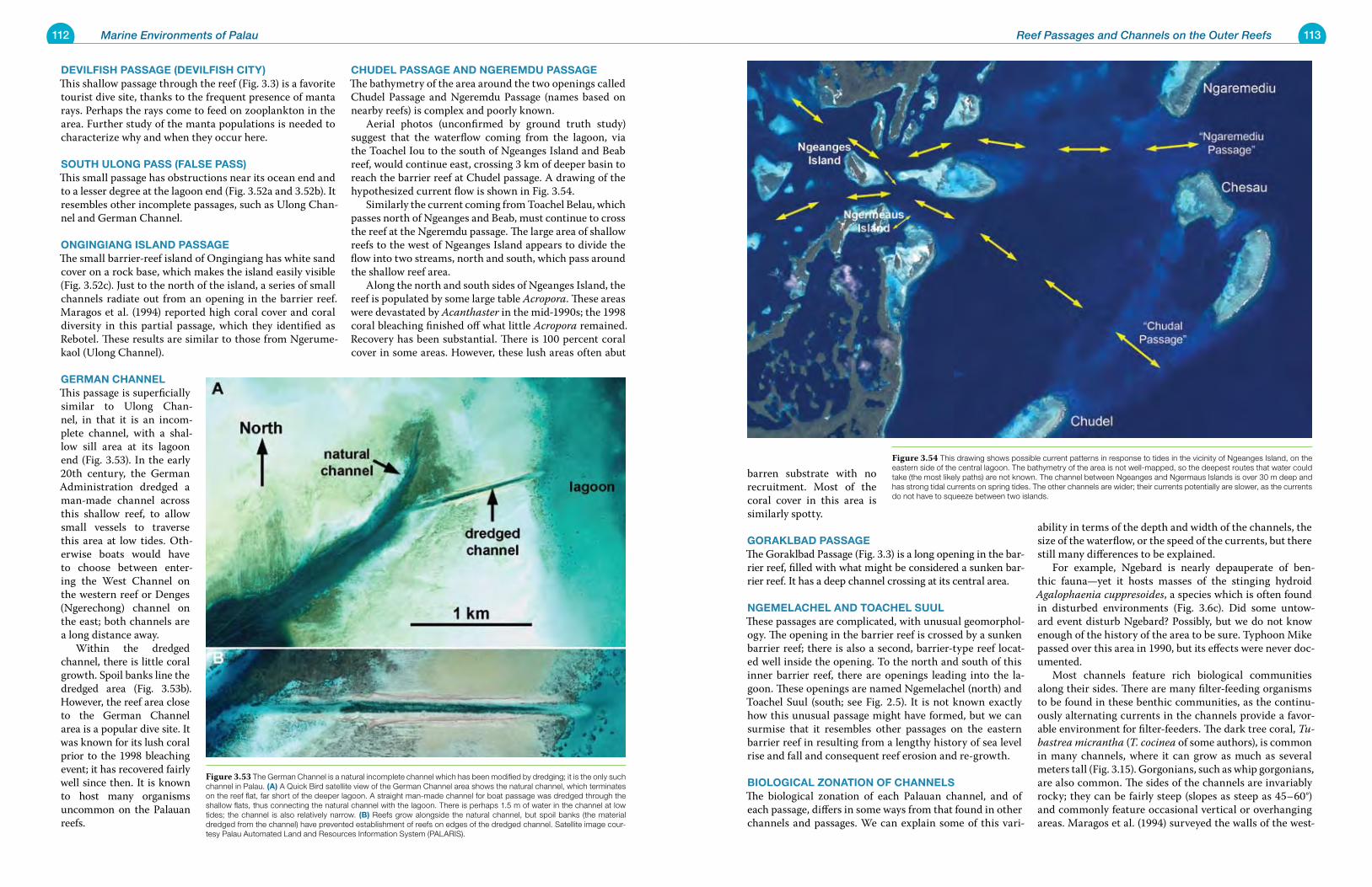
112 Marine Environments of Palau 113Reef Passages and Channels on the Outer Reefs
DeviLFish passage (DeviLFish City)This shallow passage through the reef (Fig. 3.3) is a favorite tourist dive site, thanks to the frequent presence of manta rays. Perhaps the rays come to feed on zooplankton in the area. Further study of the manta populations is needed to characterize why and when they occur here.
south uLoNg pass (FaLse pass)This small passage has obstructions near its ocean end and to a lesser degree at the lagoon end (Fig. 3.52a and 3.52b). It resembles other incomplete passages, such as Ulong Chan-nel and German Channel.
oNgiNgiaNg isLaND passageThe small barrier-reef island of Ongingiang has white sand cover on a rock base, which makes the island easily visible (Fig. 3.52c). Just to the north of the island, a series of small channels radiate out from an opening in the barrier reef. Maragos et al. (1994) reported high coral cover and coral diversity in this partial passage, which they identified as Rebotel. These results are similar to those from Ngerume-kaol (Ulong Channel).
gerMaN ChaNNeLThis passage is superficially similar to Ulong Chan-nel, in that it is an incom-plete channel, with a shal-low sill area at its lagoon end (Fig. 3.53). In the early 20th century, the German Administration dredged a man-made channel across this shallow reef, to allow small vessels to traverse this area at low tides. Oth-erwise boats would have to choose between enter-ing the West Channel on the western reef or Denges (Ngerechong) channel on the east; both channels are a long distance away. Within the dredged channel, there is little coral growth. Spoil banks line the dredged area (Fig. 3.53b). However, the reef area close to the German Channel area is a popular dive site. It was known for its lush coral prior to the 1998 bleaching event; it has recovered fairly well since then. It is known to host many organisms uncommon on the Palauan reefs.
ChuDeL passage aND NgereMDu passageThe bathymetry of the area around the two openings called Chudel Passage and Ngeremdu Passage (names based on nearby reefs) is complex and poorly known. Aerial photos (unconfirmed by ground truth study) suggest that the waterflow coming from the lagoon, via the Toachel Iou to the south of Ngeanges Island and Beab reef, would continue east, crossing 3 km of deeper basin to reach the barrier reef at Chudel passage. A drawing of the hypothesized current flow is shown in Fig. 3.54. Similarly the current coming from Toachel Belau, which passes north of Ngeanges and Beab, must continue to cross the reef at the Ngeremdu passage. The large area of shallow reefs to the west of Ngeanges Island appears to divide the flow into two streams, north and south, which pass around the shallow reef area. Along the north and south sides of Ngeanges Island, the reef is populated by some large table Acropora. These areas were devastated by Acanthaster in the mid-1990s; the 1998 coral bleaching finished off what little Acropora remained. Recovery has been substantial. There is 100 percent coral cover in some areas. However, these lush areas often abut
barren substrate with no recruitment. Most of the coral cover in this area is similarly spotty.
gorakLBaD passageThe Goraklbad Passage (Fig. 3.3) is a long opening in the bar-rier reef, filled with what might be considered a sunken bar-rier reef. It has a deep channel crossing at its central area.
NgeMeLaCheL aND toaCheL suuLThese passages are complicated, with unusual geomorphol-ogy. The opening in the barrier reef is crossed by a sunken barrier reef; there is also a second, barrier-type reef locat-ed well inside the opening. To the north and south of this inner barrier reef, there are openings leading into the la-goon. These openings are named Ngemelachel (north) and Toachel Suul (south; see Fig. 2.5). It is not known exactly how this unusual passage might have formed, but we can surmise that it resembles other passages on the eastern barrier reef in resulting from a lengthy history of sea level rise and fall and consequent reef erosion and re-growth.
BioLogiCaL zoNatioN oF ChaNNeLsThe biological zonation of each Palauan channel, and of each passage, differs in some ways from that found in other channels and passages. We can explain some of this vari-
ability in terms of the depth and width of the channels, the size of the waterflow, or the speed of the currents, but there still many differences to be explained. For example, Ngebard is nearly depauperate of ben-thic fauna—yet it hosts masses of the stinging hydroid Agalophaenia cuppresoides, a species which is often found in disturbed environments (Fig. 3.6c). Did some untow-ard event disturb Ngebard? Possibly, but we do not know enough of the history of the area to be sure. Typhoon Mike passed over this area in 1990, but its effects were never doc-umented. Most channels feature rich biological communities along their sides. There are many filter-feeding organisms to be found in these benthic communities, as the continu-ously alternating currents in the channels provide a favor-able environment for filter-feeders. The dark tree coral, Tu-bastrea micrantha (T. cocinea of some authors), is common in many channels, where it can grow as much as several meters tall (Fig. 3.15). Gorgonians, such as whip gorgonians, are also common. The sides of the channels are invariably rocky; they can be fairly steep (slopes as steep as 45–60°) and commonly feature occasional vertical or overhanging areas. Maragos et al. (1994) surveyed the walls of the west-
Figure 3.53 The German Channel is a natural incomplete channel which has been modified by dredging; it is the only such channel in Palau. (a) A Quick Bird satellite view of the German Channel area shows the natural channel, which terminates on the reef flat, far short of the deeper lagoon. A straight man-made channel for boat passage was dredged through the shallow flats, thus connecting the natural channel with the lagoon. There is perhaps 1.5 m of water in the channel at low tides; the channel is also relatively narrow. (B) Reefs grow alongside the natural channel, but spoil banks (the material dredged from the channel) have prevented establishment of reefs on edges of the dredged channel. Satellite image cour-tesy Palau Automated Land and Resources Information System (PALARIS).
Figure 3.54 This drawing shows possible current patterns in response to tides in the vicinity of Ngeanges Island, on the eastern side of the central lagoon. The bathymetry of the area is not well-mapped, so the deepest routes that water could take (the most likely paths) are not known. The channel between Ngeanges and Ngermaus Islands is over 30 m deep and has strong tidal currents on spring tides. The other channels are wider; their currents potentially are slower, as the currents do not have to squeeze between two islands.
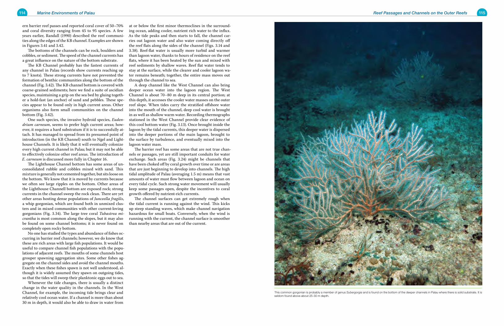
114 Marine Environments of Palau 115Reef Passages and Channels on the Outer Reefs
ern barrier reef passes and reported coral cover of 50–70% and coral diversity ranging from 45 to 95 species. A few years earlier, Randall (1990) described the reef communi-ties along the edges of the KB channel. Examples are shown in Figures 3.41 and 3.42. The bottoms of the channels can be rock, boulders and cobbles, or sediment. The speed of the channel currents has a great influence on the nature of the bottom substrate. The KB Channel probably has the fastest currents of any channel in Palau (records show currents reaching up to 7 knots). These strong currents have not prevented the formation of benthic communities along the bottom of the channel (Fig. 3.42). The KB channel bottom is covered with coarse-grained sediments; here we find a suite of ascidian species, maintaining a grip on the sea bed by gluing togeth-er a hold-fast (an anchor) of sand and pebbles. These spe-cies appear to be found only in high current areas. Other organisms also form small communities on the channel bottom (Fig. 3.42). One such species, the invasive hydroid species, Euden-drium carneum, seems to prefer high current areas; how-ever, it requires a hard substratum if it is to successfully at-tach. It has managed to spread from its presumed point of introduction (in the KB Channel) south to Ngel and Light-house Channels. It is likely that it will eventually colonize every high current channel in Palau; but it may not be able to effectively colonize other reef areas. The introduction of E. carneum is discussed more fully in Chapter 16. The Lighthouse Channel bottom has some areas of un-consolidated rubble and cobbles mixed with sand. This mixture is generally not cemented together, but sits loose on the bottom. We know that it is moved by currents because we often see large ripples on the bottom. Other areas of the Lighthouse Channell bottom are exposed rock; strong currents in the channel sweep the rock clean. There are yet other areas hosting dense populations of Junceella fragilis, a whip gorgonian, which are found both in unmixed clus-ters and in mixed communities with other current-loving gorgonians (Fig. 3.34). The large tree coral Tubastrea mi-crantha is most common along the slopes, but it may also be found on some channel bottoms; it is never found on completely open rocky bottom. No one has studied the types and abundance of fishes oc-curring in barrier reef channels; however, we do know that these are rich areas with large fish populations. It would be useful to compare channel fish populations with the popu-lations of adjacent reefs. The mouths of some channels host grouper spawning aggregation sites. Some other fishes ag-gregate on the channel sides and avoid the channel mouths. Exactly when these fishes spawn is not well understood, al-though it is widely assumed they spawn on outgoing tides, so that the tides will sweep their planktonic eggs out to sea. Whenever the tide changes, there is usually a distinct change in the water quality in the channels. In the West Channel, for example, the incoming tide brings clear and relatively cool ocean water. If a channel is more than about 30 m in depth, it would also be able to draw in water from
at or below the first minor thermoclines in the surround-ing ocean, adding cooler, nutrient rich water to the influx. As the tide peaks and then starts to fall, the channel car-ries out lagoon water and also water coming directly off the reef flats along the sides of the channel (Figs. 3.14 and 3.38). Reef-flat water is usually more turbid and warmer than lagoon water, thanks to hours of residence on the reef flats, where it has been heated by the sun and mixed with reef sediments by shallow waves. Reef flat water tends to stay at the surface, while the clearer and cooler lagoon wa-ter remains beneath; together, the entire mass moves out through the channel to sea. A deep channel like the West Channel can also bring deeper ocean water into the lagoon region. The West Channel is about 70–80 m deep in its central portion; at this depth, it accesses the cooler water masses on the outer reef slope. When tides carry the stratified offshore water into the mouth of the channel, deep cool water is brought in as well as shallow warm water. Recording thermographs stationed in the West Channel provide clear evidence of this cool bottom water (Fig. 3.13). Once brought inside the lagoon by the tidal currents, this deeper water is dispersed into the deeper portions of the main lagoon, brought to the surface by turbulence, and eventually mixed into the lagoon water mass. The barrier reef has some areas that are not true chan-nels or passages, yet are still important conduits for water exchange. Such areas (Fig. 3.24) might be channels that have been choked off by coral growth over time or are areas that are just beginning to develop into channels. The high tidal amplitude of Palau (averaging 1.5 m) means that vast amounts of water must flow between lagoon and ocean on every tidal cycle. Such strong water movement will usually keep some passages open, despite the incentives to coral growth offered by nutrient-rich currents. The channel surfaces can get extremely rough when the tidal current is running against the wind. This kicks up steep standing waves, which make channel navigation hazardous for small boats. Conversely, when the wind is running with the current, the channel surface is smoother than nearby areas that are out of the current.
This common gorgonian is probably a member of genus Subergorgia and is found on the bottom of the deeper channels in Palau where there is solid substrate. It is seldom found above about 25-30 m depth.
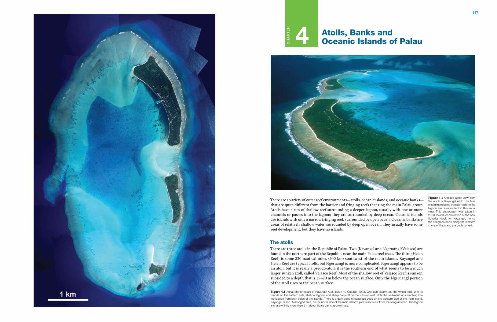
117
Ch
ap
te
r
4 Atolls, Banks and Oceanic Islands of Palau
There are a variety of outer reef environments—atolls, oceanic islands, and oceanic banks—that are quite different from the barrier and fringing reefs that ring the main Palau group. Atolls have a rim of shallow reef surrounding a deeper lagoon, usually with one or more channels or passes into the lagoon; they are surrounded by deep ocean. Oceanic islands are islands with only a narrow fringing reef, surrounded by open ocean. Oceanic banks are areas of relatively shallow water, surrounded by deep open ocean. They usually have some reef development, but they have no islands.
the atollsThere are three atolls in the Republic of Palau. Two (Kayangel and Ngeruangl/Velasco) are found in the northern part of the Republic, near the main Palau reef tract. The third (Helen Reef) is some 320 nautical miles (500 km) southwest of the main islands. Kayangel and Helen Reef are typical atolls, but Ngeruangl is more complicated. Ngeruangl appears to be an atoll, but it is really a pseudo-atoll; it is the southern end of what seems to be a much larger sunken atoll, called Velasco Reef. Most of the shallow reef of Velasco Reef is sunken, subsided to a depth that is 15–20 m below the ocean surface. Only the Ngeruangl portion of the atoll rises to the ocean surface.
Figure 4.1 Aerial photomosaic of Kayangel Atoll, taken 10 October 2003. One can clearly see the whole atoll, with its islands on the eastern side, shallow lagoon, and sharp drop-off on the western reef. Note the sediment fans reaching into the lagoon from both sides of the islands. There is a dark band of seagrass beds on the western side of the main island, Kayangel Island. A dredged area, on the north side of the main island’s pier, stands out from the seagrass bed. The lagoon is shallow, little more than 9 m deep. Scale bar is approximate.
Figure 4.2 Oblique aerial view from the north of Kayangel Atoll. The fans of sediment being transported into the lagoon are quite evident in this aerial view. This photograph was taken in 2000, before construction of the new fisheries dock for Kayangel; hence the seagrass beds along the western shore of the island are undisturbed.
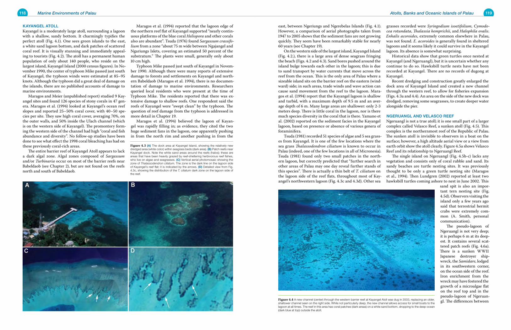
118 Marine Environments of Palau 119Atolls, Banks and Oceanic Islands of Palau
east, between Ngeriungs and Ngerebelas Islands (Fig. 4.1). However, a comparison of aerial photographs taken from 1947 to 2005 shows that the sediment fans are not growing quickly. They seem have been remarkably stable for nearly 60 years (see Chapter 19). On the western side of the largest island, Kayangel Island (Fig. 4.2.), there is a large area of dense seagrass fringing the beach (Figs. 4.2 and 4.3). Sand bores pushed around the island bulge towards each other in the lagoon; this is due to sand transport by water currents that move across the reef from the ocean. This is the only area of Palau where a sizeable island sits on the barrier reef on the eastern (wind-ward) side; in such areas, trade winds and wave action can cause sand movement from the reef to the lagoon. Mara-gos et al. (1994) report that the Kayangel lagoon is shallow and turbid, with a maximum depth of 9.5 m and an aver-age depth of 6 m. Many large areas are shallower: only 2-3 meters deep. There is little coral in the lagoon, nor is there much species diversity in the coral that is there. Yamano et al. (2002) reported on the sediment facies in the Kayangel lagoon, based on presence or absence of various genera of foraminifera. Tsuda (1981) recorded 51 species of algae and 5 sea grass-es from Kayangel. It is one of the few locations where the sea grass Thalassodendron ciliatum is known to occur in Palau (indeed, one of the few locations in all of Micronesia). Tsuda (1981) found only two small patches in the north-ern lagoon, but correctly predicted that “further search in other areas of Palau may one day reveal further stands of this species”. There is actually a thin belt of T. ciliatum on the lagoon side of the reef flats, throughout most of Kay-angel’s northwestern lagoon (Fig. 4.3c and 4.3d). Other sea
grasses recorded were Syringodium isoetifolium, Cymodo-cea rotundata, Thalassia hemprichii, and Halophila ovalis. Enhalis acoroides, extremely common elsewhere in Palau, was not found. E. acoroides is generally found in sheltered lagoons and it seems likely it could survive in the Kayangel lagoon. Its absence is somewhat surprising. Historical data show that green turtles once nested at Kayangel (and Ngeruangl), but it is uncertain whether any continue to do so. Hawksbill turtle nests have not been recorded at Kayangel. There are no records of dugong at Kayangel. Recent dredging and construction greatly enlarged the dock area of Kayangel Island and created a new channel through the western reef, to allow for fisheries expansion (Figs. 4.3a and 4.4). An area on the side of the new dock was dredged, removing some seagrasses, to create deeper water alongside the pier.
NgeruaNgL aND veLasCo reeFNgeruangl is not a true atoll; it is one small part of a larger complex called Velasco Reef, a sunken atoll (Fig. 4.5). This complex is the northernmost reef of the Republic of Palau. The sunken atoll is invisible to observers in a boat on the surface; however, a high altitude aerial view or a view from earth orbit show the atoll clearly. Figure 4.5a shows Velasco Reef and its relationship to Ngeruangl Reef. The single island on Ngeruangl (Fig. 4.5b-c) lacks any vegetation and consists only of coral rubble and sand. Its sandy beaches are turtle nesting sites. It was previously thought to be only a green turtle nesting site (Maragos et al., 1994). Then Lundgren (2002) reported at least two hawksbill turtles coming ashore to nest in June 2002. This
sand spit is also an impor-tant tern nesting site (Fig. 4.5d). Observers visiting the island only a few years ago said that terrestrial hermit crabs were extremely com-mon (A. Smith, personal communication). The pseudo-lagoon of Ngeruangl is not very deep; it is perhaps 6 m at its deep-est. It contains several scat-tered patch reefs (Fig. 4.6a). There is a sunken WWII Japanese destroyer ship-wreck, the Samidare, lodged in its southwestern corner, on the ocean side of the reef. Iron enrichment from the wreck may have fostered the growth of a microalgae flat on the reef top and in the pseudo-lagoon of Ngeruan-gl. The differences between
kayaNgeL atoLLKayangel is a moderately large atoll, surrounding a lagoon with a shallow, sandy bottom. It charmingly typifies the perfect atoll (Fig. 4.1). One sees green islands to the east, a white sand lagoon bottom, and dark patches of scattered coral reef. It is visually stunning and immediately appeal-ing to tourists (Fig. 4.2). The atoll has a permanent human population of only about 140 people, who reside on the largest island, Kayangel Island (2000 census figures). In No-vember 1990, the center of typhoon Mike passed just south of Kayangel, the typhoon winds were estimated at 85–95 knots. Although the typhoon did a great deal of damage on the islands, there are no published accounts of damage to marine environments. Maragos and Meier (unpublished report) studied 9 Kay-angel sites and found 126 species of stony corals in 47 gen-era. Maragos et al. (1994) looked at Kayangel’s ocean reef slopes and reported 25–50% coral cover, with 40–50 spe-cies per site. They saw high coral cover, averaging 70%, on the outer walls, and 50% inside the Ulach channel (which is on the western side of Kayangel). The promontory form-ing the western side of the channel had high “coral and fish abundance and diversity”. No follow-up studies have been done to see what effect the 1998 coral bleaching has had on these previously coral-rich areas. The entire barrier reef of Kayangel Atoll appears to lack a dark algal zone. Algal zones composed of Sargassum and/or Turbinaria occur on most of the barrier reefs near Babeldaob (see Chapter 2), but are not found on the reefs north and south of Babeldaob.
Maragos et al. (1994) reported that the lagoon edge of the northern reef flat of Kayangel supported “nearly contin-uous platforms of the blue coral Heliopora and other corals also are abundant”. Tsuda (1976) found Sargassum crassifo-lium from a zone “about 75 m wide between Ngajangel and Ngariungs Islets, covering an estimated 50 percent of the substratum.” The plants were small, generally only about 10 cm high. Typhoon Mike passed just south of Kayangel in Novem-ber 1990. Although there were many reports of extensive damage to forests and settlements on Kayangel and north-ern Babeldaob (Maragos et al. 1994), there is no documen-tation of damage to marine environments. Researchers queried local residents who were present at the time of Typhoon Mike. The residents reported that there was ex-tensive damage to shallow reefs. One respondent said the reefs of Kayangel were “swept clean” by the typhoon. The question of reef damage from the typhoon is addressed in more detail in Chapter 19. Maragos et al. (1994) believed the lagoon of Kayan-gel was rapidly filling in; as evidence, they cited the two huge sediment fans in the lagoon, one apparently pushing in from the north rim and another pushing in from the
Figure 4.4 A new channel (center) through the western barrier reef at Kayangel Atoll was dug in 2003, replacing an older, shallower channel seen on the right side. While not particularly deep, the new channel allows access for small boats to the lagoon at all times. The reef in this area has coral patches (dark areas) on a white sand bottom, dropping to the deep ocean (dark blue at top) outside the atoll.
Figure 4.3 (a) The dock area at Kayangel Island, showing the relatively new dredged area (white color) within seagrass beds (dark area). (B) Patch reefs near Kayangel dock. Note the white sand areas around the reefs (halos); these are areas that have been heavily grazed by reef-sheltering herbivorous reef fishes, who live on algae and seagrasses. (C) Vertical aerial photomosaic showing the zone of Thalassodendron ciliatum. The zone is the dark line on the lagoon side of Kayangel’s reef flat; it is indicated by the arrows. (D) Detailed view from Fig. 4.3c, showing the distribution of the T. ciliatum dark zone on the lagoon side of the reef.
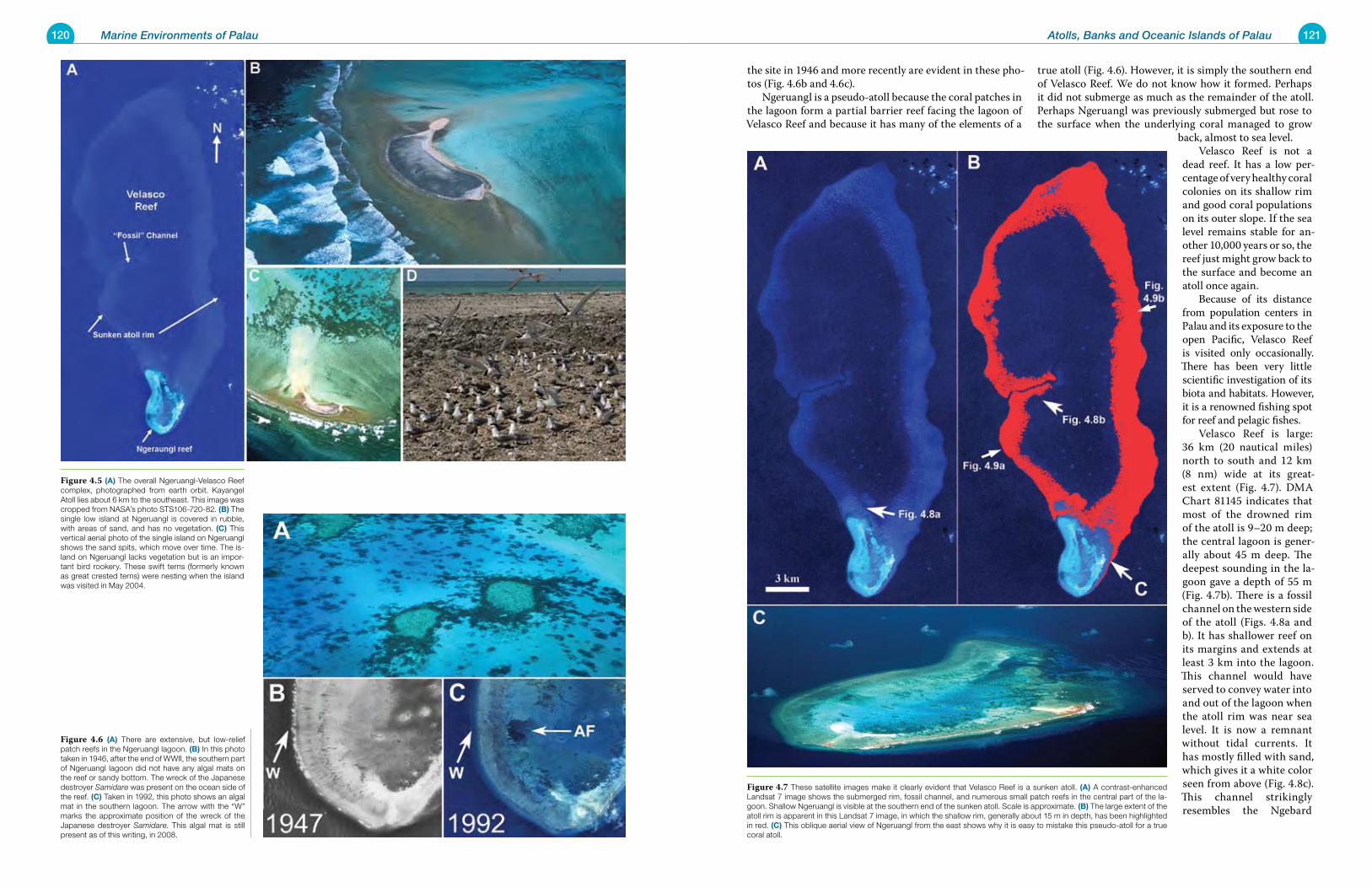
120 Marine Environments of Palau 121Atolls, Banks and Oceanic Islands of Palau
the site in 1946 and more recently are evident in these pho-tos (Fig. 4.6b and 4.6c). Ngeruangl is a pseudo-atoll because the coral patches in the lagoon form a partial barrier reef facing the lagoon of Velasco Reef and because it has many of the elements of a
true atoll (Fig. 4.6). However, it is simply the southern end of Velasco Reef. We do not know how it formed. Perhaps it did not submerge as much as the remainder of the atoll. Perhaps Ngeruangl was previously submerged but rose to the surface when the underlying coral managed to grow
back, almost to sea level. Velasco Reef is not a dead reef. It has a low per-centage of very healthy coral colonies on its shallow rim and good coral populations on its outer slope. If the sea level remains stable for an-other 10,000 years or so, the reef just might grow back to the surface and become an atoll once again. Because of its distance from population centers in Palau and its exposure to the open Pacific, Velasco Reef is visited only occasionally. There has been very little scientific investigation of its biota and habitats. However, it is a renowned fishing spot for reef and pelagic fishes. Velasco Reef is large: 36 km (20 nautical miles) north to south and 12 km (8 nm) wide at its great-est extent (Fig. 4.7). DMA Chart 81145 indicates that most of the drowned rim of the atoll is 9–20 m deep; the central lagoon is gener-ally about 45 m deep. The deepest sounding in the la-goon gave a depth of 55 m (Fig. 4.7b). There is a fossil channel on the western side of the atoll (Figs. 4.8a and b). It has shallower reef on its margins and extends at least 3 km into the lagoon. This channel would have served to convey water into and out of the lagoon when the atoll rim was near sea level. It is now a remnant without tidal currents. It has mostly filled with sand, which gives it a white color seen from above (Fig. 4.8c). This channel strikingly resembles the Ngebard
Figure 4.7 These satellite images make it clearly evident that Velasco Reef is a sunken atoll. (a) A contrast-enhanced Landsat 7 image shows the submerged rim, fossil channel, and numerous small patch reefs in the central part of the la-goon. Shallow Ngeruangl is visible at the southern end of the sunken atoll. Scale is approximate. (B) The large extent of the atoll rim is apparent in this Landsat 7 image, in which the shallow rim, generally about 15 m in depth, has been highlighted in red. (C) This oblique aerial view of Ngeruangl from the east shows why it is easy to mistake this pseudo-atoll for a true coral atoll.
Figure 4.6 (a) There are extensive, but low-relief patch reefs in the Ngeruangl lagoon. (B) In this photo taken in 1946, after the end of WWII, the southern part of Ngeruangl lagoon did not have any algal mats on the reef or sandy bottom. The wreck of the Japanese destroyer Samidare was present on the ocean side of the reef. (C) Taken in 1992, this photo shows an algal mat in the southern lagoon. The arrow with the “W” marks the approximate position of the wreck of the Japanese destroyer Samidare. This algal mat is still present as of this writing, in 2008.
Figure 4.5 (a) The overall Ngeruangl-Velasco Reef complex, photographed from earth orbit. Kayangel Atoll lies about 6 km to the southeast. This image was cropped from NASA’s photo STS106-720-82. (B) The single low island at Ngeruangl is covered in rubble, with areas of sand, and has no vegetation. (C) This vertical aerial photo of the single island on Ngeruangl shows the sand spits, which move over time. The is-land on Ngeruangl lacks vegetation but is an impor-tant bird rookery. These swift terns (formerly known as great crested terns) were nesting when the island was visited in May 2004.
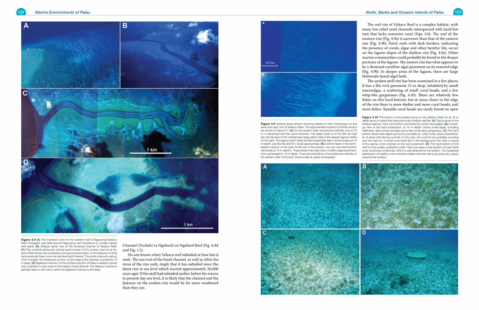
122 Marine Environments of Palau 123Atolls, Banks and Oceanic Islands of Palau
The reef rim of Velasco Reef is a complex habitat, with many low-relief sand channels interspersed with hard bot-tom that lacks extensive coral (Figs. 4.9). The reef of the western rim (Fig. 4.9a) is narrower than that of the eastern rim (Fig. 4.9b). Patch reefs with dark borders, indicating the presence of corals, algae and other benthic life, occur on the lagoon slopes of the shallow rim (Fig. 4.9a). Other marine communities could probably be found in the deeper portions of the lagoon. The eastern rim has what appears to be a drowned coralline algal pavement on its seaward edge (Fig. 4.9b). In deeper areas of the lagoon, there are large Halimeda-based algal beds. The sunken atoll rim has been examined in a few places. It has a flat rock pavement 15 m deep, inhabited by small macroalgae, a scattering of small coral heads, and a few whip-like gorgonians (Fig. 4.10). There are relatively few fishes on this hard bottom, but in areas closer to the edge of the rim there is more shelter and more coral heads, and more fishes. Sizeable coral heads are rarely found on open
Channel (Tochelir ra Ngebard) on Ngebard Reef (Fig. 4.8d and Fig. 1.1). No one knows when Velasco reef subsided or how fast it sank. The survival of the fossil channel, as well as other fea-tures of the rim reefs, imply that it has subsided since the latest rise in sea level which started approximately 20,000 years ago). If the atoll had subsided earlier, before the return to present-day sea level, it is likely that the channel and the features on the sunken rim would be far more weathered than they are.
Figure 4.9 Vertical aerial photos showing details of reef morphology on the west and east rims of Velasco Reef. The approximate locations of these photos are shown in Figure 4.7. (a) On the western side, the previous reef flat, now at 15 m, is dissected with low sand channels. The deep ocean is to the left; the reef top can be seen in the central area; large patch reefs in the deeper lagoon visible on the right. The lagoon patch reefs are flat-topped (the light colored areas), at 15 m depth, just like the atoll rim. Scale approximate. (B) A photo taken in the north-eastern section of the atoll. At the top of the picture, one can see hard bottom reef areas at 15 m depths. These areas may have been coralline algal pavement, now submerged to 15 m depth. There are indications of possible prior islands on the eastern side of the atoll. Same scale as upper photograph.
Figure 4.10 The bottom communities found on the Velasco Reef rim at 15 m depth grow on areas that were previously shallow reef flat. (a) Typical area on the shallow reef top: hard rock bottom dominated by small macroalgae. (B) A close-up view of the hard substratum, at 15 m depth, shows small algae, including Halimeda, dark boring sponges and a few small whip gorgonians. (C) The hard bottom areas have algae and some Junceella sp. whip corals, biota characteris-tic of areas with strong currents. In this case, the currents are probably coursing over the reef rim. A small coral head sits in the background; this view is typical of the sparse coral colonies on the rock pavement. (D) The hard bottom of the reef rim has widely scattered corals. Here one sees a near-perfect circular table coral (Turbinaria reniformis), which is well attached to the bottom. The scattered distribution of healthy coral colonies implies that the reef is growing very slowly towards the surface.
Figure 4.8 (a) The transition zone on the western reef of Ngaurangl-Velasco Reef. Emergent reef (left) around Ngeruangl reef transitions to sunken barrier reef (right). (B) Oblique aerial view of the drowned channel of Velasco Reef. (C) This contrast-enhanced vertical aerial mosaic of the sunken channel at Ve-lasco Reef shows the complexity and good preservation of the features of what had previously been a normal sea level atoll channel. The entire channel is about 3 km in length; the shallowest portion, at the edge of the channel, is presently 15 m deep. (D) Ngebard channel, on the northern section of Palau’s western barrier reef, is similar in many ways to the Velasco fossil channel. The Velasco channel is partially filled-in with sand, while the Ngebard channel is still deep.
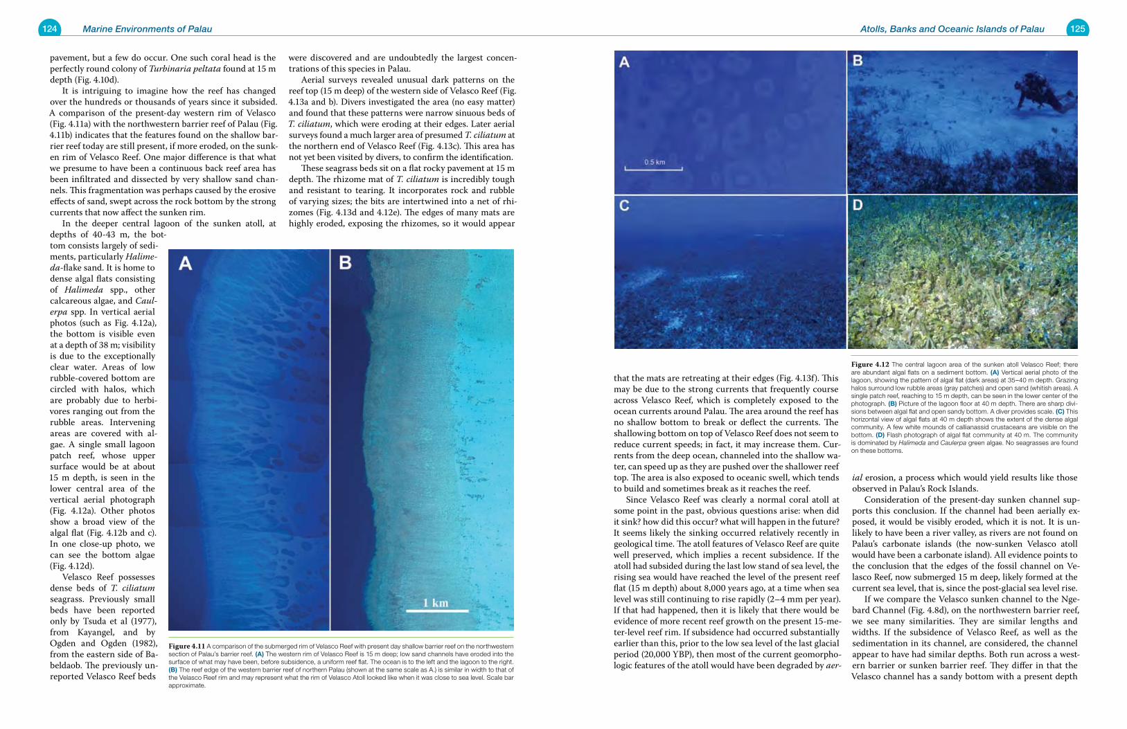
124 Marine Environments of Palau 125Atolls, Banks and Oceanic Islands of Palau
pavement, but a few do occur. One such coral head is the perfectly round colony of Turbinaria peltata found at 15 m depth (Fig. 4.10d). It is intriguing to imagine how the reef has changed over the hundreds or thousands of years since it subsided. A comparison of the present-day western rim of Velasco (Fig. 4.11a) with the northwestern barrier reef of Palau (Fig. 4.11b) indicates that the features found on the shallow bar-rier reef today are still present, if more eroded, on the sunk-en rim of Velasco Reef. One major difference is that what we presume to have been a continuous back reef area has been infiltrated and dissected by very shallow sand chan-nels. This fragmentation was perhaps caused by the erosive effects of sand, swept across the rock bottom by the strong currents that now affect the sunken rim. In the deeper central lagoon of the sunken atoll, at depths of 40-43 m, the bot-tom consists largely of sedi-ments, particularly Halime-da-flake sand. It is home to dense algal flats consisting of Halimeda spp., other calcareous algae, and Caul-erpa spp. In vertical aerial photos (such as Fig. 4.12a), the bottom is visible even at a depth of 38 m; visibility is due to the exceptionally clear water. Areas of low rubble-covered bottom are circled with halos, which are probably due to herbi-vores ranging out from the rubble areas. Intervening areas are covered with al-gae. A single small lagoon patch reef, whose upper surface would be at about 15 m depth, is seen in the lower central area of the vertical aerial photograph (Fig. 4.12a). Other photos show a broad view of the algal flat (Fig. 4.12b and c). In one close-up photo, we can see the bottom algae (Fig. 4.12d). Velasco Reef possesses dense beds of T. ciliatum seagrass. Previously small beds have been reported only by Tsuda et al (1977), from Kayangel, and by Ogden and Ogden (1982), from the eastern side of Ba-beldaob. The previously un-reported Velasco Reef beds
were discovered and are undoubtedly the largest concen-trations of this species in Palau. Aerial surveys revealed unusual dark patterns on the reef top (15 m deep) of the western side of Velasco Reef (Fig. 4.13a and b). Divers investigated the area (no easy matter) and found that these patterns were narrow sinuous beds of T. ciliatum, which were eroding at their edges. Later aerial surveys found a much larger area of presumed T. ciliatum at the northern end of Velasco Reef (Fig. 4.13c). This area has not yet been visited by divers, to confirm the identification. These seagrass beds sit on a flat rocky pavement at 15 m depth. The rhizome mat of T. ciliatum is incredibly tough and resistant to tearing. It incorporates rock and rubble of varying sizes; the bits are intertwined into a net of rhi-zomes (Fig. 4.13d and 4.12e). The edges of many mats are highly eroded, exposing the rhizomes, so it would appear
that the mats are retreating at their edges (Fig. 4.13f). This may be due to the strong currents that frequently course across Velasco Reef, which is completely exposed to the ocean currents around Palau. The area around the reef has no shallow bottom to break or deflect the currents. The shallowing bottom on top of Velasco Reef does not seem to reduce current speeds; in fact, it may increase them. Cur-rents from the deep ocean, channeled into the shallow wa-ter, can speed up as they are pushed over the shallower reef top. The area is also exposed to oceanic swell, which tends to build and sometimes break as it reaches the reef. Since Velasco Reef was clearly a normal coral atoll at some point in the past, obvious questions arise: when did it sink? how did this occur? what will happen in the future? It seems likely the sinking occurred relatively recently in geological time. The atoll features of Velasco Reef are quite well preserved, which implies a recent subsidence. If the atoll had subsided during the last low stand of sea level, the rising sea would have reached the level of the present reef flat (15 m depth) about 8,000 years ago, at a time when sea level was still continuing to rise rapidly (2–4 mm per year). If that had happened, then it is likely that there would be evidence of more recent reef growth on the present 15-me-ter-level reef rim. If subsidence had occurred substantially earlier than this, prior to the low sea level of the last glacial period (20,000 YBP), then most of the current geomorpho-logic features of the atoll would have been degraded by aer-
ial erosion, a process which would yield results like those observed in Palau’s Rock Islands. Consideration of the present-day sunken channel sup-ports this conclusion. If the channel had been aerially ex-posed, it would be visibly eroded, which it is not. It is un-likely to have been a river valley, as rivers are not found on Palau’s carbonate islands (the now-sunken Velasco atoll would have been a carbonate island). All evidence points to the conclusion that the edges of the fossil channel on Ve-lasco Reef, now submerged 15 m deep, likely formed at the current sea level, that is, since the post-glacial sea level rise. If we compare the Velasco sunken channel to the Nge-bard Channel (Fig. 4.8d), on the northwestern barrier reef, we see many similarities. They are similar lengths and widths. If the subsidence of Velasco Reef, as well as the sedimentation in its channel, are considered, the channel appear to have had similar depths. Both run across a west-ern barrier or sunken barrier reef. They differ in that the Velasco channel has a sandy bottom with a present depth
Figure 4.11 A comparison of the submerged rim of Velasco Reef with present day shallow barrier reef on the northwestern section of Palau’s barrier reef. (a) The western rim of Velasco Reef is 15 m deep; low sand channels have eroded into the surface of what may have been, before subsidence, a uniform reef flat. The ocean is to the left and the lagoon to the right. (B) The reef edge of the western barrier reef of northern Palau (shown at the same scale as A.) is similar in width to that of the Velasco Reef rim and may represent what the rim of Velasco Atoll looked like when it was close to sea level. Scale bar approximate.
Figure 4.12 The central lagoon area of the sunken atoll Velasco Reef; there are abundant algal flats on a sediment bottom. (a) Vertical aerial photo of the lagoon, showing the pattern of algal flat (dark areas) at 35–40 m depth. Grazing halos surround low rubble areas (gray patches) and open sand (whitish areas). A single patch reef, reaching to 15 m depth, can be seen in the lower center of the photograph. (B) Picture of the lagoon floor at 40 m depth. There are sharp divi-sions between algal flat and open sandy bottom. A diver provides scale. (C) This horizontal view of algal flats at 40 m depth shows the extent of the dense algal community. A few white mounds of callianassid crustaceans are visible on the bottom. (D) Flash photograph of algal flat community at 40 m. The community is dominated by Halimeda and Caulerpa green algae. No seagrasses are found on these bottoms.
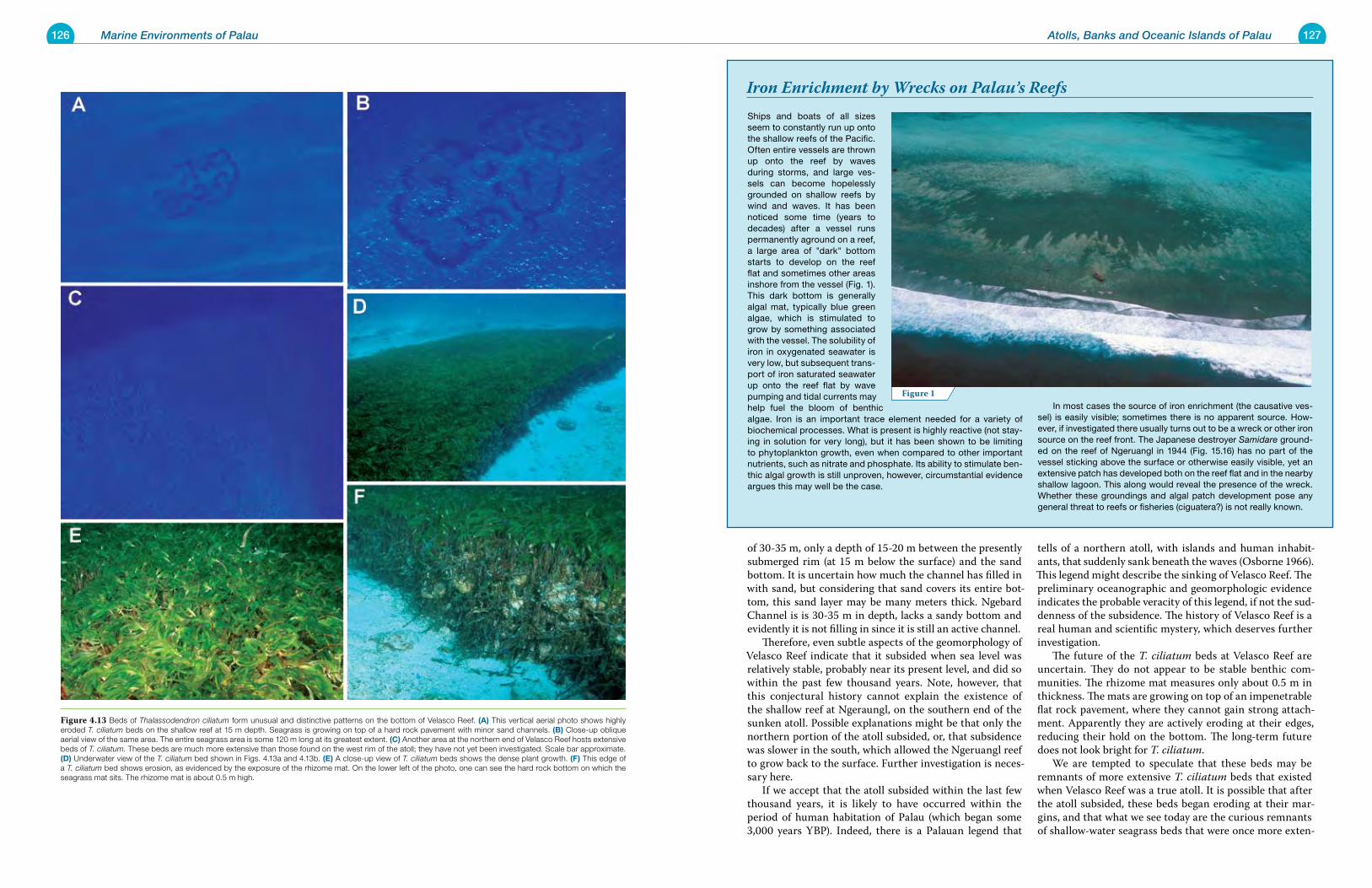
126 Marine Environments of Palau 127Atolls, Banks and Oceanic Islands of Palau
Ships and boats of all sizes seem to constantly run up onto the shallow reefs of the Pacific. Often entire vessels are thrown up onto the reef by waves during storms, and large ves-sels can become hopelessly grounded on shallow reefs by wind and waves. It has been noticed some time (years to decades) after a vessel runs permanently aground on a reef, a large area of "dark" bottom starts to develop on the reef flat and sometimes other areas inshore from the vessel (Fig. 1). This dark bottom is generally algal mat, typically blue green algae, which is stimulated to grow by something associated with the vessel. The solubility of iron in oxygenated seawater is very low, but subsequent trans-port of iron saturated seawater up onto the reef flat by wave pumping and tidal currents may help fuel the bloom of benthic algae. Iron is an important trace element needed for a variety of biochemical processes. What is present is highly reactive (not stay-ing in solution for very long), but it has been shown to be limiting to phytoplankton growth, even when compared to other important nutrients, such as nitrate and phosphate. Its ability to stimulate ben-thic algal growth is still unproven, however, circumstantial evidence argues this may well be the case.
In most cases the source of iron enrichment (the causative ves-sel) is easily visible; sometimes there is no apparent source. How-ever, if investigated there usually turns out to be a wreck or other iron source on the reef front. The Japanese destroyer Samidare ground-ed on the reef of Ngeruangl in 1944 (Fig. 15.16) has no part of the vessel sticking above the surface or otherwise easily visible, yet an extensive patch has developed both on the reef flat and in the nearby shallow lagoon. This along would reveal the presence of the wreck. Whether these groundings and algal patch development pose any general threat to reefs or fisheries (ciguatera?) is not really known.
of 30-35 m, only a depth of 15-20 m between the presently submerged rim (at 15 m below the surface) and the sand bottom. It is uncertain how much the channel has filled in with sand, but considering that sand covers its entire bot-tom, this sand layer may be many meters thick. Ngebard Channel is is 30-35 m in depth, lacks a sandy bottom and evidently it is not filling in since it is still an active channel. Therefore, even subtle aspects of the geomorphology of Velasco Reef indicate that it subsided when sea level was relatively stable, probably near its present level, and did so within the past few thousand years. Note, however, that this conjectural history cannot explain the existence of the shallow reef at Ngeraungl, on the southern end of the sunken atoll. Possible explanations might be that only the northern portion of the atoll subsided, or, that subsidence was slower in the south, which allowed the Ngeruangl reef to grow back to the surface. Further investigation is neces-sary here. If we accept that the atoll subsided within the last few thousand years, it is likely to have occurred within the period of human habitation of Palau (which began some 3,000 years YBP). Indeed, there is a Palauan legend that
tells of a northern atoll, with islands and human inhabit-ants, that suddenly sank beneath the waves (Osborne 1966). This legend might describe the sinking of Velasco Reef. The preliminary oceanographic and geomorphologic evidence indicates the probable veracity of this legend, if not the sud-denness of the subsidence. The history of Velasco Reef is a real human and scientific mystery, which deserves further investigation. The future of the T. ciliatum beds at Velasco Reef are uncertain. They do not appear to be stable benthic com-munities. The rhizome mat measures only about 0.5 m in thickness. The mats are growing on top of an impenetrable flat rock pavement, where they cannot gain strong attach-ment. Apparently they are actively eroding at their edges, reducing their hold on the bottom. The long-term future does not look bright for T. ciliatum. We are tempted to speculate that these beds may be remnants of more extensive T. ciliatum beds that existed when Velasco Reef was a true atoll. It is possible that after the atoll subsided, these beds began eroding at their mar-gins, and that what we see today are the curious remnants of shallow-water seagrass beds that were once more exten-
Figure 1
Iron Enrichment by Wrecks on Palau’s Reefs
Figure 4.13 Beds of Thalassodendron ciliatum form unusual and distinctive patterns on the bottom of Velasco Reef. (a) This vertical aerial photo shows highly eroded T. ciliatum beds on the shallow reef at 15 m depth. Seagrass is growing on top of a hard rock pavement with minor sand channels. (B) Close-up oblique aerial view of the same area. The entire seagrass area is some 120 m long at its greatest extent. (C) Another area at the northern end of Velasco Reef hosts extensive beds of T. ciliatum. These beds are much more extensive than those found on the west rim of the atoll; they have not yet been investigated. Scale bar approximate. (D) Underwater view of the T. ciliatum bed shown in Figs. 4.13a and 4.13b. (e) A close-up view of T. ciliatum beds shows the dense plant growth. (F) This edge of a T. ciliatum bed shows erosion, as evidenced by the exposure of the rhizome mat. On the lower left of the photo, one can see the hard rock bottom on which the seagrass mat sits. The rhizome mat is about 0.5 m high.
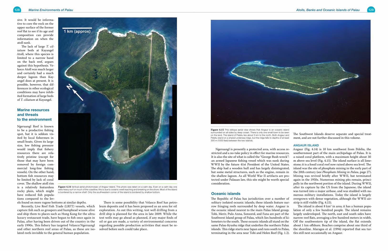
128 Marine Environments of Palau 129Atolls, Banks and Oceanic Islands of Palau
Ngeruangl is presently a protected area, with access re-stricted and a no-take policy in effect for marine resources. It is also the site of what is called the “George Bush wreck”: an armed Japanese fishing vessel which was sunk during WWII by the future 41st President of the United States. The ship had a wooden hull and has largely disintegrated, but some metal structures, such as the engine, remain in the shallow lagoon. As all World War II artifacts are pro-tected under Palauan law, this site might be worth special consideration.
oceanic islandsThe Republic of Palau has jurisdiction over a number of solitary isolated oceanic islands; these islands feature nar-row fringing reefs surrounded by deep water. Angaur is the oceanic island nearest to the main Palau Island group; Tobi, Merir, Pulo Anna, Sonsorol, and Fana are part of the Southwest Island group of Palau, which lies hundreds of ki-lometers to the south. These oceanic islands all stand on the same Palau-Kyushu ridge that underlies the northern Palau islands. This ridge starts near Japan and runs south to Palau, terminating in the area near Tobi and Helen Reef (Fig. 1.2).
The Southwest Islands deserve separate and special treat-ment, and are not further discussed in this volume.
aNgaur isLaNDAngaur (Fig. 4.14) is 10 km southwest from Peleliu, the southernmost part of the main archipelago of Palau. It is a raised coral platform, with a maximum height about 30 m above sea level (Fig. 4.15). The island surface is all lime-stone; it is a fossil coral reef now raised above sea level. The island was the site of phosphate mining in the early part of the 20th century (see Phosphate Mining in Palau, page 27). Mining was revived briefly after WWII, but terminated again in the 1950s. Numerous mining pits remain, princi-pally in the northwest portion of the island. During WWII, after its capture by the US from the Japanese, the island was turned into a major airbase, and was studded with nu-merous military installations. Today the island is largely overgrown with dense vegetation, although the WWII air-strip is still visible (Fig. 4.15). The island is about 8 km2 in area; it has a human popu-lation of only a few hundred people. The island remains largely undeveloped. The north, east and south sides have narrow reef flats, averaging a few hundred meters in width. Off the southwestern tip of the island, the flat extends about 1 km offshore. Beaches comprise about one third of the shoreline. Maragos et al. (1994) reported that sea tur-tles still nest occasionally on Angaur.
sive. It would be informa-tive to core the rock on the upper surface of the former reef flat to see if its age and composition can provide information on when the atoll sank. The lack of large T. cil-iatum beds at Kayangel Atoll, where this species is limited to a narrow band on the back reef, argues against this hypothesis. Ve-lasco Atoll was much larger and certainly had a much deeper lagoon than Kay-angel does at present. It is possible, however, that dif-ferences in other ecological conditions may have inhib-ited formation of large beds of T. ciliatum at Kayangel.
Marine resources and threats to the environment
Ngeruangl Reef is known to be a productive fishing spot, but it is seldom vis-ited by local fishermen in small boats. Given its large size, low fishing pressure would imply that fishery resources there are rela-tively pristine (except for those that may have been removed by foreign com-mercial long-line fishing vessels). On the other hand, bottom fish resources may be limited by lack of coral cover. The shallow atoll rim is a relatively featureless rocky plain, which might have reduced fish popula-tions compared to the lev-els found on more rugose bottoms at similar depths. Recently, Live Reef Fish Trade (LRFT) vessels, which capture fish such as groupers and humphead wrasse alive and ship them to places such as Hong Kong for the ultra-luxury restaurant trade, have begun to fish once again in Palau, after having been driven out of the country in the early 1990s. This fishery has targeted Velasco/Ngeruangl and other northern reef areas of Palau, as these are iso-lated reefs invisible to the general human population.
There is some possibility that Velasco Reef has petro-leum deposits and it has been proposed as an area for oil exploration. As out this writing, test well drilling from a drill ship is planned for the area in late 2009. While the test wells may go ahead as planned, if any major finds of oil or gas are made, a variety of environmental concerns regarding possible production activities that must be re-solved before such could take place.
Figure 4.15 This oblique aerial view shows that Angaur is an oceanic island surrounded on all sides by deep ocean. There is only one small town to be seen on the land. The island of Peleliu lies about 5 km to the north. Both Angaur and Peleliu stand on a shared undersea ridge, but the ridge falls to depths of at least 300 m (1000 feet) between the two islands.
Figure 4.14 Vertical aerial photomosaic of Angaur Island. This photo was taken on a calm day. Even on a calm day one sees heavy surf on much of the coastline; this is due to oceanic swell reaching and breaking on the shore. Most of the island is bordered by a narrow shelf. Only the southwestern corner of the island is bordered by shallow bottom.
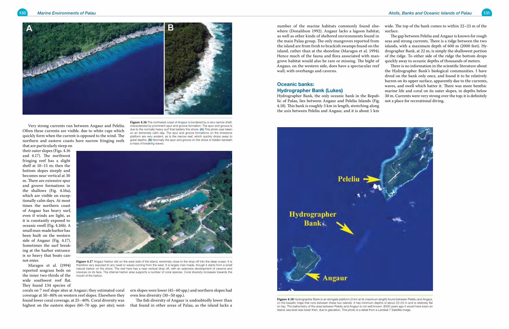
130 Marine Environments of Palau 131Atolls, Banks and Oceanic Islands of Palau
number of the marine habitats commonly found else-where (Donaldson 1992). Angaur lacks a lagoon habitat, as well as other kinds of sheltered environments found in the main Palau group. The only mangroves reported from the island are from fresh to brackish swamps found on the island, rather than at the shoreline (Maragos et al. 1994). Hence much of the fauna and flora associated with man-grove habitat would also be rare or missing. The bight of Angaur, on the western side, does have a spectacular reef wall, with overhangs and caverns.
oceanic banks: hydrographer Bank (Lukes)Hydrographer Bank, the only oceanic bank in the Repub-lic of Palau, lies between Angaur and Peleliu Islands (Fig. 4.18). This bank is roughly 3 km in length, stretching along the axis between Peleliu and Angaur, and it is about 1 km
wide. The top of the bank comes to within 22–23 m of the surface. The gap between Peleliu and Angaur is known for rough seas and strong currents. There is a ridge between the two islands, with a maximum depth of 600 m (2000 feet). Hy-drographer Bank, at 22 m, is simply the shallowest portion of the ridge. To either side of the ridge the bottom drops quickly away to oceanic depths of thousands of meters. There is no information in the scientific literature about the Hydrographer Bank’s biological communities. I have dived on the bank only once, and found it to be relatively barren on its upper surface, apparently due to the currents, waves, and swell which batter it. There was more benthic marine life and coral on its outer slopes, in depths below 30 m. Currents were very strong over the top; it is definitely not a place for recreational diving.
Very strong currents run between Angaur and Peleliu. Often these currents are visible. due to white caps which quickly form when the current is opposed to the wind. The northern and eastern coasts have narrow fringing reefs that are particularly steep on their outer slopes (Figs. 4.16 and 4.17). The northwest fringing reef has a slight shelf at 10–15 m; then the bottom slopes steeply and becomes near vertical at 30 m. There are extensive spur and groove formations in the shallows (Fig. 4.16a), which are visible on excep-tionally calm days. At most times the northern coast of Angaur has heavy surf, even if winds are light, as it is constantly exposed to oceanic swell (Fig. 4.16b). A small man-made harbor has been built on the western side of Angaur (Fig. 4.17). Sometimes the surf break-ing at the harbor entrance is so heavy that boats can-not enter. Maragos et al. (1994) reported seagrass beds on the inner two-thirds of the wide southwest reef flat. They found 134 species of corals on 7 reef slope sites at Angaur; they estimated coral coverage at 50–80% on western reef slopes. Elsewhere they found lower coral coverage, at 25–40%. Coral diversity was highest on the eastern slopes (60–70 spp. per site); west-
ern slopes were lower (45–60 spp.) and northern slopes had even less diversity (30–50 spp.). The fish diversity of Angaur is undoubtedly lower than that found in other areas of Palau, as the island lacks a
Figure 4.18 Hydrographer Bank is an elongate platform (3 km at its maximum length) found between Peleliu and Angaur, on the basaltic ridge that runs between these two islands. It has minimum depths of about 22–23 m and is relatively flat on top. The bathymetry of the area between Peleliu and Angaur is not well known. 8000 years ago it would have been an island; sea level was lower then, due to glaciation. This photo is a detail from a Landsat 7 Satellite image.
Figure 4.17 Angaur Harbor sits on the west side of the island, extremely close to the drop-off into the deep ocean. It is therefore very exposed to any swell or waves coming from the west. It is largely man-made, though it starts from a small natural harbor on the shore. The reef here has a near vertical drop off, with an extensive development of caverns and crevices on its face. The internal harbor area supports a number of coral species. Coral diversity increases towards the mouth of the harbor.
Figure 4.16 The northwest coast of Angaur is bordered by a very narrow shelf, characterized by prominent spur and groove formation. The spur and groove is due to the normally heavy surf that batters this shore. (a) This photo was taken on an extremely calm day. The spur and groove formations on the limestone platform are very evident, as is the narrow reef, which quickly drops away to great depths. (B) Normally the spur and groove on the shore is hidden beneath a mass of breaking waves.
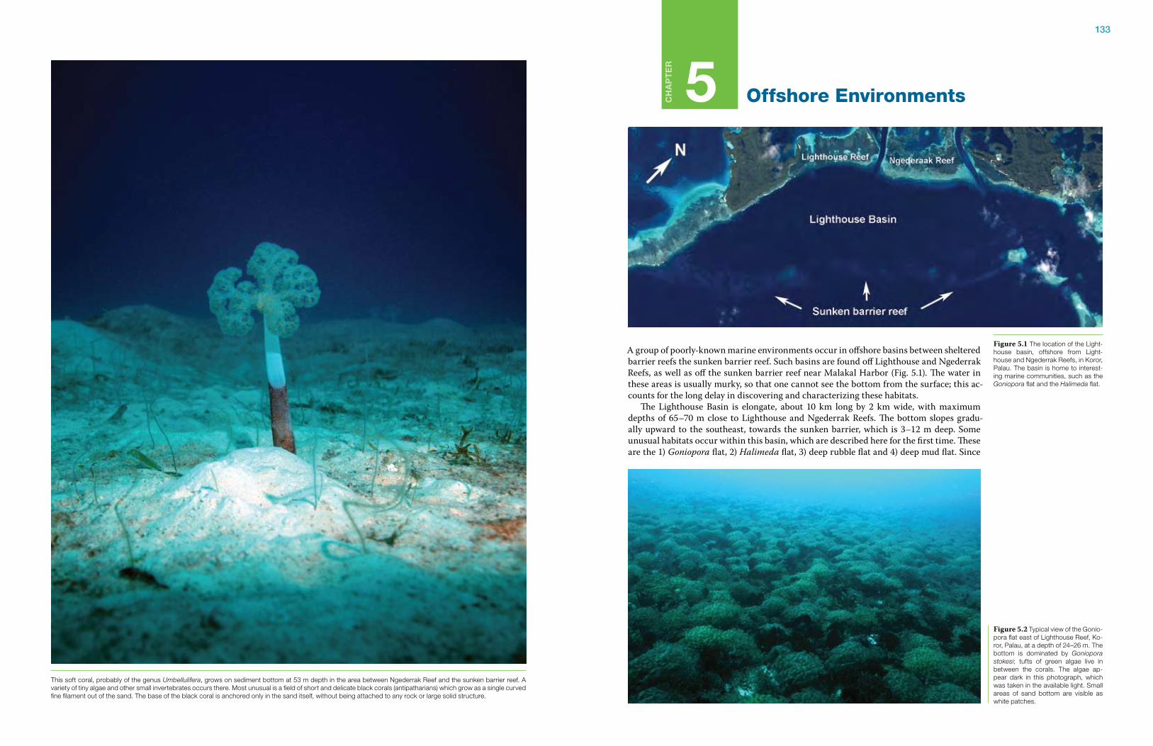
133
Ch
ap
te
r
5 Offshore Environments
A group of poorly-known marine environments occur in offshore basins between sheltered barrier reefs the sunken barrier reef. Such basins are found off Lighthouse and Ngederrak Reefs, as well as off the sunken barrier reef near Malakal Harbor (Fig. 5.1). The water in these areas is usually murky, so that one cannot see the bottom from the surface; this ac-counts for the long delay in discovering and characterizing these habitats. The Lighthouse Basin is elongate, about 10 km long by 2 km wide, with maximum depths of 65–70 m close to Lighthouse and Ngederrak Reefs. The bottom slopes gradu-ally upward to the southeast, towards the sunken barrier, which is 3–12 m deep. Some unusual habitats occur within this basin, which are described here for the first time. These are the 1) Goniopora flat, 2) Halimeda flat, 3) deep rubble flat and 4) deep mud flat. Since
Figure 5.1 The location of the Light-house basin, offshore from Light-house and Ngederrak Reefs, in Koror, Palau. The basin is home to interest-ing marine communities, such as the Goniopora flat and the Halimeda flat.
Figure 5.2 Typical view of the Gonio-pora flat east of Lighthouse Reef, Ko-ror, Palau, at a depth of 24–26 m. The bottom is dominated by Goniopora stokesi; tufts of green algae live in between the corals. The algae ap-pear dark in this photograph, which was taken in the available light. Small areas of sand bottom are visible as white patches.
This soft coral, probably of the genus Umbellulifera, grows on sediment bottom at 53 m depth in the area between Ngederrak Reef and the sunken barrier reef. A variety of tiny algae and other small invertebrates occurs there. Most unusual is a field of short and delicate black corals (antipatharians) which grow as a single curved fine filament out of the sand. The base of the black coral is anchored only in the sand itself, without being attached to any rock or large solid structure.
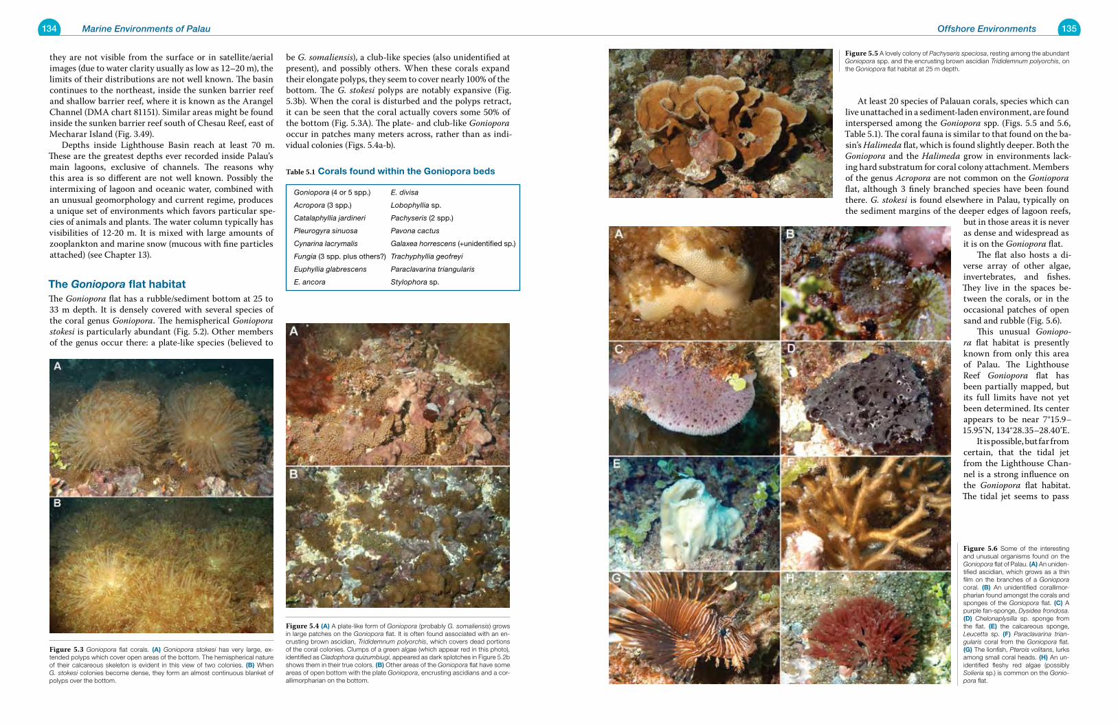
134 Marine Environments of Palau 135Offshore Environments
At least 20 species of Palauan corals, species which can live unattached in a sediment-laden environment, are found interspersed among the Goniopora spp. (Figs. 5.5 and 5.6, Table 5.1). The coral fauna is similar to that found on the ba-sin’s Halimeda flat, which is found slightly deeper. Both the Goniopora and the Halimeda grow in environments lack-ing hard substratum for coral colony attachment. Members of the genus Acropora are not common on the Goniopora flat, although 3 finely branched species have been found there. G. stokesi is found elsewhere in Palau, typically on the sediment margins of the deeper edges of lagoon reefs,
but in those areas it is never as dense and widespread as it is on the Goniopora flat. The flat also hosts a di-verse array of other algae, invertebrates, and fishes. They live in the spaces be-tween the corals, or in the occasional patches of open sand and rubble (Fig. 5.6). This unusual Goniopo-ra flat habitat is presently known from only this area of Palau. The Lighthouse Reef Goniopora flat has been partially mapped, but its full limits have not yet been determined. Its center appears to be near 7°15.9–15.95’N, 134°28.35–28.40’E. It is possible, but far from certain, that the tidal jet from the Lighthouse Chan-nel is a strong influence on the Goniopora flat habitat. The tidal jet seems to pass
they are not visible from the surface or in satellite/aerial images (due to water clarity usually as low as 12–20 m), the limits of their distributions are not well known. The basin continues to the northeast, inside the sunken barrier reef and shallow barrier reef, where it is known as the Arangel Channel (DMA chart 81151). Similar areas might be found inside the sunken barrier reef south of Chesau Reef, east of Mecharar Island (Fig. 3.49). Depths inside Lighthouse Basin reach at least 70 m. These are the greatest depths ever recorded inside Palau’s main lagoons, exclusive of channels. The reasons why this area is so different are not well known. Possibly the intermixing of lagoon and oceanic water, combined with an unusual geomorphology and current regime, produces a unique set of environments which favors particular spe-cies of animals and plants. The water column typically has visibilities of 12-20 m. It is mixed with large amounts of zooplankton and marine snow (mucous with fine particles attached) (see Chapter 13).
the Goniopora flat habitatThe Goniopora flat has a rubble/sediment bottom at 25 to 33 m depth. It is densely covered with several species of the coral genus Goniopora. The hemispherical Goniopora stokesi is particularly abundant (Fig. 5.2). Other members of the genus occur there: a plate-like species (believed to
be G. somaliensis), a club-like species (also unidentified at present), and possibly others. When these corals expand their elongate polyps, they seem to cover nearly 100% of the bottom. The G. stokesi polyps are notably expansive (Fig. 5.3b). When the coral is disturbed and the polyps retract, it can be seen that the coral actually covers some 50% of the bottom (Fig. 5.3A). The plate- and club-like Goniopora occur in patches many meters across, rather than as indi-vidual colonies (Figs. 5.4a-b).
Goniopora (4 or 5 spp.) E. divisa
Acropora (3 spp.) Lobophyllia sp.
Catalaphyllia jardineri Pachyseris (2 spp.)
Pleurogyra sinuosa Pavona cactus
Cynarina lacrymalis Galaxea horrescens (+unidentified sp.)
Fungia (3 spp. plus others?) Trachyphyllia geofreyi
Euphyllia glabrescens Paraclavarina triangularis
E. ancora Stylophora sp.
Table 5.1 Corals found within the goniopora beds
Figure 5.6 Some of the interesting and unusual organisms found on the Goniopora flat of Palau. (a) An uniden-tified ascidian, which grows as a thin film on the branches of a Goniopora coral. (B) An unidentified corallimor-pharian found amongst the corals and sponges of the Goniopora flat. (C) A purple fan-sponge, Dysidea frondosa. (D) Chelonaplysilla sp. sponge from the flat. (e) the calcareous sponge, Leucetta sp. (F) Paraclavarina trian-gularis coral from the Goniopora flat. (g) The lionfish, Pterois volitans, lurks among small coral heads. (h) An un-identified fleshy red algae (possibly Solieria sp.) is common on the Gonio-pora flat.
Figure 5.5 A lovely colony of Pachyseris speciosa, resting among the abundant Goniopora spp. and the encrusting brown ascidian Trididemnum polyorchis, on the Goniopora flat habitat at 25 m depth.
Figure 5.3 Goniopora flat corals. (a) Goniopora stokesi has very large, ex-tended polyps which cover open areas of the bottom. The hemispherical nature of their calcareous skeleton is evident in this view of two colonies. (B) When G. stokesi colonies become dense, they form an almost continuous blanket of polyps over the bottom.
Figure 5.4 (a) A plate-like form of Goniopora (probably G. somaliensis) grows in large patches on the Goniopora flat. It is often found associated with an en-crusting brown ascidian, Trididemnum polyorchis, which covers dead portions of the coral colonies. Clumps of a green algae (which appear red in this photo), identified as Cladophora quizumbiugi, appeared as dark splotches in Figure 5.2b shows them in their true colors. (B) Other areas of the Goniopora flat have some areas of open bottom with the plate Goniopora, encrusting ascidians and a cor-allimorpharian on the bottom.
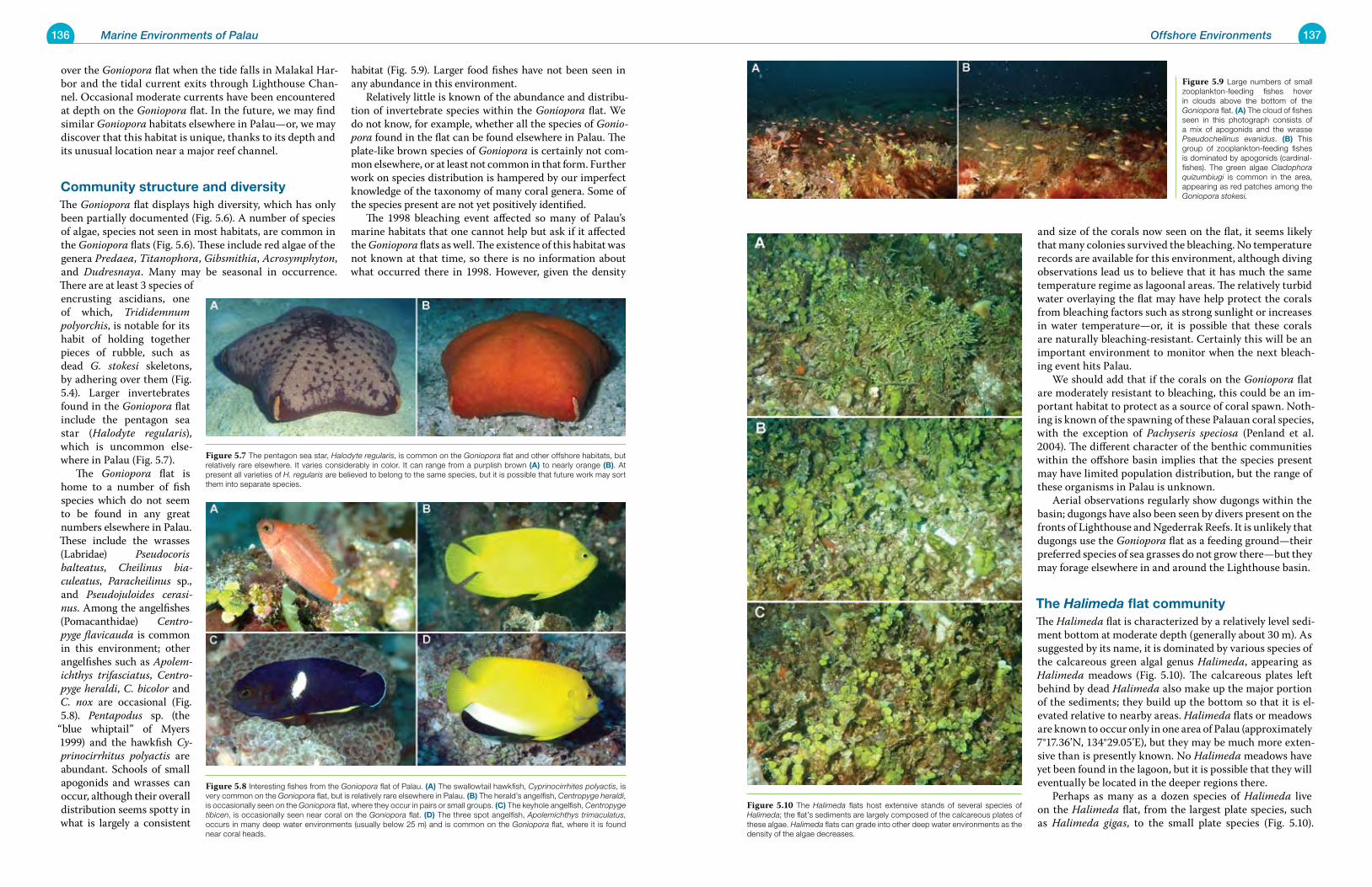
136 Marine Environments of Palau 137Offshore Environments
and size of the corals now seen on the flat, it seems likely that many colonies survived the bleaching. No temperature records are available for this environment, although diving observations lead us to believe that it has much the same temperature regime as lagoonal areas. The relatively turbid water overlaying the flat may have help protect the corals from bleaching factors such as strong sunlight or increases in water temperature—or, it is possible that these corals are naturally bleaching-resistant. Certainly this will be an important environment to monitor when the next bleach-ing event hits Palau. We should add that if the corals on the Goniopora flat are moderately resistant to bleaching, this could be an im-portant habitat to protect as a source of coral spawn. Noth-ing is known of the spawning of these Palauan coral species, with the exception of Pachyseris speciosa (Penland et al. 2004). The different character of the benthic communities within the offshore basin implies that the species present may have limited population distribution, but the range of these organisms in Palau is unknown. Aerial observations regularly show dugongs within the basin; dugongs have also been seen by divers present on the fronts of Lighthouse and Ngederrak Reefs. It is unlikely that dugongs use the Goniopora flat as a feeding ground—their preferred species of sea grasses do not grow there—but they may forage elsewhere in and around the Lighthouse basin.
the Halimeda flat communityThe Halimeda flat is characterized by a relatively level sedi-ment bottom at moderate depth (generally about 30 m). As suggested by its name, it is dominated by various species of the calcareous green algal genus Halimeda, appearing as Halimeda meadows (Fig. 5.10). The calcareous plates left behind by dead Halimeda also make up the major portion of the sediments; they build up the bottom so that it is el-evated relative to nearby areas. Halimeda flats or meadows are known to occur only in one area of Palau (approximately 7°17.36’N, 134°29.05’E), but they may be much more exten-sive than is presently known. No Halimeda meadows have yet been found in the lagoon, but it is possible that they will eventually be located in the deeper regions there. Perhaps as many as a dozen species of Halimeda live on the Halimeda flat, from the largest plate species, such as Halimeda gigas, to the small plate species (Fig. 5.10).
over the Goniopora flat when the tide falls in Malakal Har-bor and the tidal current exits through Lighthouse Chan-nel. Occasional moderate currents have been encountered at depth on the Goniopora flat. In the future, we may find similar Goniopora habitats elsewhere in Palau—or, we may discover that this habitat is unique, thanks to its depth and its unusual location near a major reef channel.
Community structure and diversityThe Goniopora flat displays high diversity, which has only been partially documented (Fig. 5.6). A number of species of algae, species not seen in most habitats, are common in the Goniopora flats (Fig. 5.6). These include red algae of the genera Predaea, Titanophora, Gibsmithia, Acrosymphyton, and Dudresnaya. Many may be seasonal in occurrence. There are at least 3 species of encrusting ascidians, one of which, Trididemnum polyorchis, is notable for its habit of holding together pieces of rubble, such as dead G. stokesi skeletons, by adhering over them (Fig. 5.4). Larger invertebrates found in the Goniopora flat include the pentagon sea star (Halodyte regularis), which is uncommon else-where in Palau (Fig. 5.7). The Goniopora flat is home to a number of fish species which do not seem to be found in any great numbers elsewhere in Palau. These include the wrasses (Labridae) Pseudocoris balteatus, Cheilinus bia-culeatus, Paracheilinus sp., and Pseudojuloides cerasi-nus. Among the angelfishes (Pomacanthidae) Centro-pyge flavicauda is common in this environment; other angelfishes such as Apolem-ichthys trifasciatus, Centro-pyge heraldi, C. bicolor and C. nox are occasional (Fig. 5.8). Pentapodus sp. (the
“blue whiptail” of Myers 1999) and the hawkfish Cy-prinocirrhitus polyactis are abundant. Schools of small apogonids and wrasses can occur, although their overall distribution seems spotty in what is largely a consistent
habitat (Fig. 5.9). Larger food fishes have not been seen in any abundance in this environment. Relatively little is known of the abundance and distribu-tion of invertebrate species within the Goniopora flat. We do not know, for example, whether all the species of Gonio-pora found in the flat can be found elsewhere in Palau. The plate-like brown species of Goniopora is certainly not com-mon elsewhere, or at least not common in that form. Further work on species distribution is hampered by our imperfect knowledge of the taxonomy of many coral genera. Some of the species present are not yet positively identified. The 1998 bleaching event affected so many of Palau’s marine habitats that one cannot help but ask if it affected the Goniopora flats as well. The existence of this habitat was not known at that time, so there is no information about what occurred there in 1998. However, given the density
Figure 5.9 Large numbers of small zooplankton-feeding fishes hover in clouds above the bottom of the Goniopora flat. (a) The cloud of fishes seen in this photograph consists of a mix of apogonids and the wrasse Pseudocheilinus evanidus. (B) This group of zooplankton-feeding fishes is dominated by apogonids (cardinal-fishes). The green algae Cladophora quizumbiugi is common in the area, appearing as red patches among the Goniopora stokesi.
Figure 5.10 The Halimeda flats host extensive stands of several species of Halimeda; the flat’s sediments are largely composed of the calcareous plates of these algae. Halimeda flats can grade into other deep water environments as the density of the algae decreases.
Figure 5.7 The pentagon sea star, Halodyte regularis, is common on the Goniopora flat and other offshore habitats, but relatively rare elsewhere. It varies considerably in color. It can range from a purplish brown (a) to nearly orange (B). At present all varieties of H. regularis are believed to belong to the same species, but it is possible that future work may sort them into separate species.
Figure 5.8 Interesting fishes from the Goniopora flat of Palau. (a) The swallowtail hawkfish, Cyprinocirrhites polyactis, is very common on the Goniopora flat, but is relatively rare elsewhere in Palau. (B) The herald’s angelfish, Centropyge heraldi, is occasionally seen on the Goniopora flat, where they occur in pairs or small groups. (C) The keyhole angelfish, Centropyge tibicen, is occasionally seen near coral on the Goniopora flat. (D) The three spot angelfish, Apolemichthys trimaculatus, occurs in many deep water environments (usually below 25 m) and is common on the Goniopora flat, where it is found near coral heads.
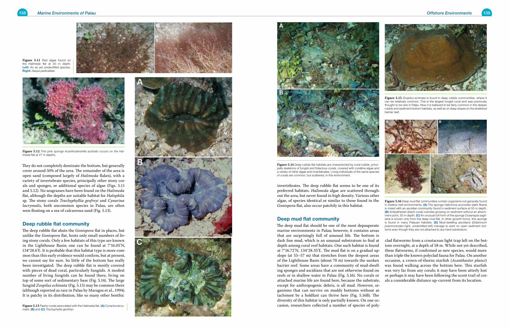
138 Marine Environments of Palau 139Offshore Environments
invertebrates. The deep rubble flat seems to be one of its preferred habitats. Halimeda algae are scattered through-out the area, but never found in high density. Various other algae, of species identical or similar to those found in the Goniopora flat, also occur patchily in this habitat.
Deep mud flat communityThe deep mud flat should be one of the most depauperate marine environments in Palau; however, it contains areas that are surprisingly full of unusual life. The bottom is dark fine mud, which is an unusual substratum to find at depth among coral reef habitats. One such habitat is found at 7°16.72’N, 134°28.35’E. The mud flat is on a gradual up-slope (at 53–57 m) that stretches from the deepest areas of the Lighthouse Basin (about 70 m) towards the sunken barrier reef. Some areas have a community of mud-dwell-ing sponges and ascidians that are not otherwise found on reefs or in shallow water in Palau (Fig. 5.16). No corals or attached marine life are found here, because the substrate, except for anthropogenic debris, is all mud. However, or-ganisms that can survive on muddy bottoms without at-tachment by a holdfast can thrive here (Fig. 5.16B). The diversity of this habitat is only partially known. On one oc-casion, researchers collected a number of species of poly-
clad flatworms from a crustacean light trap left on the bot-tom overnight, at a depth of 58 m. While not yet described, these flatworms, if confirmed as new species, would more than triple the known polyclad fauna for Palau. On another occasion, a crown-of-thorns starfish (Acanthaster planci) was found walking across the bottom here. This starfish was very far from any corals; it may have been utterly lost or perhaps it may have been following the scent trail of cor-als a considerable distance up-current from its location.
They do not completely dominate the bottom, but generally cover around 50% of the area. The remainder of the area is open sand (composed largely of Halimeda flakes), with a variety of invertebrate species, principally other stony cor-als and sponges, or additional species of algae (Figs. 5.11 and 5.12). No seagrasses have been found on the Halimeda flat, although the depths are suitable habitat for Halophila sp. The stony corals Trachyphyllia geofreyi and Cynarina lacrymalis, both uncommon species in Palau, are often seen floating on a sea of calcareous sand (Fig. 5.13).
Deep rubble flat communityThe deep rubble flat abuts the Goniopora flat in places, but unlike the Goniopora flat, hosts only small numbers of liv-ing stony corals. Only a few habitats of this type are known in the Lighthouse Basin; one can be found at 7°16.05’N, 134°28.6’E. It is probable that this habitat type is more com-mon than this early evidence would confirm, but at present, we cannot say for sure. So little of the bottom has really been investigated. The deep rubble flat is mostly covered with pieces of dead coral, particularly fungiids. A modest number of living fungiids can be found there, living on top of some sort of sedimentary base (Fig. 5.14). The large fungiid Zoopilus echinata (Fig. 5.15) may be common there (although reported as rare in Palau by Maragos et al., 1994). It is patchy in its distribution, like so many other benthic
Figure 5.14 Deep rubble-flat habitats are characterized by coral rubble, princi-pally skeletons of fungiid and foliacious corals, covered with coralline algae and a variety of other algae and invertebrates. Living individuals of the same species of corals are common, but scattered, in this environment.
Figure 5.15 Zoopilus echinata is found in deep rubble communities, where it can be relatively common. This is the largest fungiid coral and was previously thought to be rare in Palau. Now it is believed to be fairly common in the deeper rubble and sediment bottom habitats, as well as on deep slopes on the sheltered barrier reef.
Figure 5.16 Deep mud flat communities contain organisms not generally found in shallow reef environments. (a) The sponge Halichona acoroides (dark fibers) is mixed with an ascidian community found in sediment surface at 55 m depth. (B) Antipatharian (black coral) colonies growing on sediment without an attach-ment point, 55 m depth. (C) An unusual tuft form of the sponge Oceanapia sagit-taria is known only from the deep mud flat. In other growth forms, this sponge is found in many Palauan habitats. (D) Mud-dwelling ascidians (Didemnum psammotodes-right, unidentified-left) manage to exist on open sediment bot-toms even though they are not attached to any hard substratum.
Figure 5.12 This pink sponge Acanthodendrilla australis occurs on the Hal-imeda flat at 27 m depths.
Figure 5.11 Red algae found on the Halimeda flat at 30 m depth. Left: An as yet unidentified species. right: Dasya pedicellata.
Figure 5.13 Fleshy corals associated with the Halimeda flat. (a) Cynarina lacry-malis. (B) and (C) Trachyphyllia geofreyi.
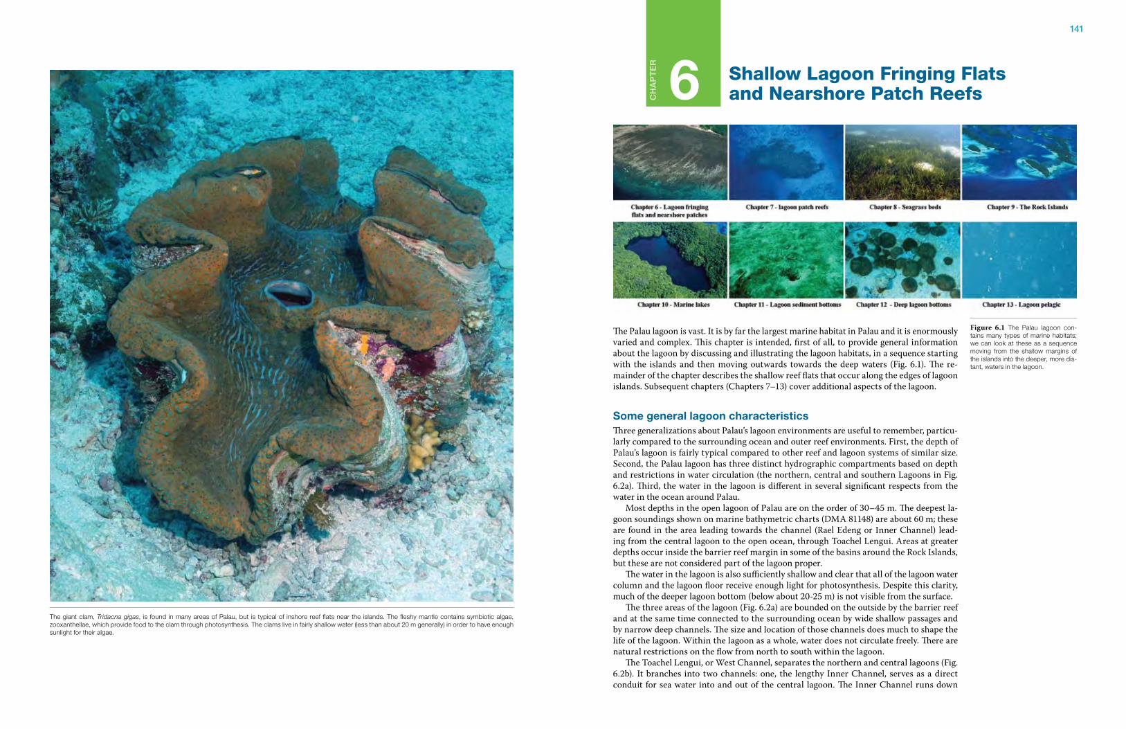
141
Ch
ap
te
r
6 Shallow Lagoon Fringing Flats and Nearshore Patch Reefs
The Palau lagoon is vast. It is by far the largest marine habitat in Palau and it is enormously varied and complex. This chapter is intended, first of all, to provide general information about the lagoon by discussing and illustrating the lagoon habitats, in a sequence starting with the islands and then moving outwards towards the deep waters (Fig. 6.1). The re-mainder of the chapter describes the shallow reef flats that occur along the edges of lagoon islands. Subsequent chapters (Chapters 7–13) cover additional aspects of the lagoon.
some general lagoon characteristicsThree generalizations about Palau’s lagoon environments are useful to remember, particu-larly compared to the surrounding ocean and outer reef environments. First, the depth of Palau’s lagoon is fairly typical compared to other reef and lagoon systems of similar size. Second, the Palau lagoon has three distinct hydrographic compartments based on depth and restrictions in water circulation (the northern, central and southern Lagoons in Fig. 6.2a). Third, the water in the lagoon is different in several significant respects from the water in the ocean around Palau. Most depths in the open lagoon of Palau are on the order of 30–45 m. The deepest la-goon soundings shown on marine bathymetric charts (DMA 81148) are about 60 m; these are found in the area leading towards the channel (Rael Edeng or Inner Channel) lead-ing from the central lagoon to the open ocean, through Toachel Lengui. Areas at greater depths occur inside the barrier reef margin in some of the basins around the Rock Islands, but these are not considered part of the lagoon proper. The water in the lagoon is also sufficiently shallow and clear that all of the lagoon water column and the lagoon floor receive enough light for photosynthesis. Despite this clarity, much of the deeper lagoon bottom (below about 20-25 m) is not visible from the surface. The three areas of the lagoon (Fig. 6.2a) are bounded on the outside by the barrier reef and at the same time connected to the surrounding ocean by wide shallow passages and by narrow deep channels. The size and location of those channels does much to shape the life of the lagoon. Within the lagoon as a whole, water does not circulate freely. There are natural restrictions on the flow from north to south within the lagoon. The Toachel Lengui, or West Channel, separates the northern and central lagoons (Fig. 6.2b). It branches into two channels: one, the lengthy Inner Channel, serves as a direct conduit for sea water into and out of the central lagoon. The Inner Channel runs down
Figure 6.1 The Palau lagoon con-tains many types of marine habitats; we can look at these as a sequence moving from the shallow margins of the islands into the deeper, more dis-tant, waters in the lagoon.
The giant clam, Tridacna gigas, is found in many areas of Palau, but is typical of inshore reef flats near the islands. The fleshy mantle contains symbiotic algae, zooxanthellae, which provide food to the clam through photosynthesis. The clams live in fairly shallow water (less than about 20 m generally) in order to have enough sunlight for their algae.
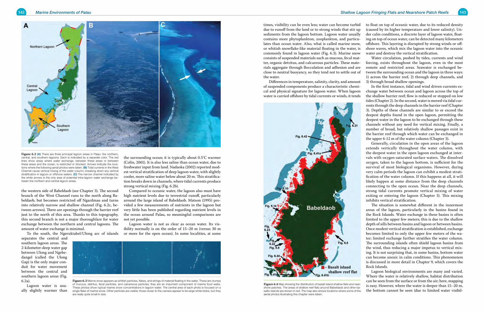
142 Marine Environments of Palau 143Shallow Lagoon Fringing Flats and Nearshore Patch Reefs
times, visibility can be even less; water can become turbid due to runoff from the land or to strong winds that stir up sediments from the lagoon bottom. Lagoon water usually contains more phytoplankton, zooplankton, and particu-lates than ocean water. Also, what is called marine snow, or whitish snowflake-like material floating in the water, is commonly found in lagoon water (Fig. 6.3). Marine snow consists of suspended materials such as mucous, fecal mat-ter, organic detritus, and calcareous particles. These mate-rials aggregate through flocculation and adhesion and are close to neutral buoyancy, so they tend not to settle out of the water. Differences in temperature, salinity, clarity, and amount of suspended components produce a characteristic chemi-cal and physical signature for lagoon water. When lagoon water is carried offshore by tidal currents or winds, it tends
to float on top of oceanic water, due to its reduced density (caused by its higher temperature and lower salinity). Un-der calm conditions, a discrete layer of lagoon water, float-ing on top of ocean water, can be detected many kilometers offshore. This layering is disrupted by strong winds or off-shore waves, which mix the lagoon water into the oceanic water and destroy the vertical stratification. Water circulation, pushed by tides, currents and wind forcing, exists throughout the lagoon, even in the most remote and restricted areas. Seawater is exchanged be-tween the surrounding ocean and the lagoon in three ways: 1) across the barrier reef, 2) through deep channels, and 3) through broad shallow openings. In the first instance, tidal and wind driven currents ex-change water between ocean and lagoon across the top of the shallow barrier reef; flow is reduced or stopped on low tides (Chapter 2). In the second, water is moved via tidal cur-rents through the deep channels in the barrier reef (Chapter 3). Depths of these channels are similar to or exceed the deepest depths found in the open lagoon, permitting the deepest water in the lagoon to be exchanged through these channels without any need for vertical mixing. Finally, a number of broad, but relatively shallow passages exist in the barrier reef through which water can be exchanged in the upper 6-12 m of the water column (Chapter 3). Generally, circulation in the open areas of the lagoon extends vertically throughout the water column, with the deepest water in the open lagoon exchanged at inter-vals with oxygen-saturated surface waters. The dissolved oxygen, taken to the lagoon bottom, is sufficient for the survival of most biological organisms. However, during very calm periods the lagoon can exhibit a modest strati-fication of the water column. If this happens at all, it will likely happen at some distance from the deep channels connecting to the open ocean. Near the deep channels, strong tidal currents promote vertical mixing of water exiting or entering the lagoon (Chapter 3). This mixing inhibits vertical stratification. The situation is somewhat different in the innermost areas of the lagoon, particularly in the basins found in the Rock Islands. Water exchange in these basins is often limited to the upper few meters; this is due to the shallow depth of sills between basins and lagoon or between basins. Once modest vertical stratification is established, exchange becomes limited to only the upper few meters of the wa-ter; limited exchange further stratifies the water column. The surrounding islands often shield lagoon basins from the wind, thus reducing a major impetus to vertical mix-ing. It is not surprising that, in some basins, bottom water can become anoxic in calm conditions. This phenomenon is discussed in more detail in Chapter 9, which covers the Rock Islands. Lagoon biological environments are many and varied. Where the water is relatively shallow, habitat distribution can be seen from the surface or from the air; here, mapping is easy. However, where the water is deeper than 15–20 m, the bottom cannot be seen (due to limited water visibil-
the western side of Babeldaob (see Chapter 3). The second branch of the West Channel runs to the north along Ba-beldaob, but becomes restricted off Ngardmau and turns into relatively narrow and shallow channel (Fig. 6.2c, be-tween arrows). There are openings through the barrier reef just to the north of this area. Thanks to this topography, this second branch is not a major thoroughfare for water exchange between the northern and central lagoons. The amount of water exchange is minimal. To the south, the Ngeruktabel/Ulong arc of islands separates the central and southern lagoon areas. The 2-kilometer-deep water gap between Ulong and Ngebe-dangel (called the Ulong Gap) is the only major con-duit for water movement between the central and southern lagoon areas (Fig. 6.2a). Lagoon water is usu-ally slightly warmer than
the surrounding ocean; it is typically about 0.5°C warmer (Colin, 2001). It is also less saline than ocean water, due to freshwater input from land. Nadaoka (2002) reported mod-est vertical stratification of deep lagoon water, with slightly cooler, more saline water below about 20 m. This stratifica-tion breaks down in channels, where tidal currents produce strong vertical mixing (Fig. 6.2b). Compared to oceanic water, the lagoon also must have high nutrient levels due to terrestrial runoff, particularly around the large island of Babeldaob. Matson (1995) pro-vided a few measurements of nutrients in the lagoon but very little has been published regarding nutrient levels in the ocean around Palau, so meaningful comparisons are not yet possible. Lagoon water is not as clear as ocean water. Its vis-ibility normally is on the order of 15–20 m (versus 30 m or more for the open ocean). In some localities, at some
Figure 6.4 Map showing the distribution of basalt island shallow flats and near-shore patches. The areas of shallow reef flats around Babeldaob and other ba-saltic islands are shown in red. The map also shows locations where some of the aerial photos illustrating this chapter were taken.
Figure 6.2 (a) There are three principal lagoon areas in Palau: the northern, central, and southern lagoons. Each is indicated by a separate color. The red lines show areas where water exchange, between these areas or between these areas and the ocean, is restricted or blocked. Arrows indicate the loca-tions where the following aerial photos were taken. (B) Tidal currents in the West Channel cause vertical mixing of the water column, breaking down any vertical stratification in lagoon or offshore waters. (C) The narrow channel indicated by the white arrows is the only area of potential intra-lagoon water exchange be-tween the northern and central lagoon areas.
Figure 6.3 Marine snow appears as whitish particles, flakes, and strings of material floating in the water. These are clumps of mucous, detritus, fecal particles, and calcareous particles; they are an important component of marine food webs. These photos show typical marine snow concentrations in lagoon water. The central area of each photo is focused on a single flake of marine snow. Other particles are visible; those closer to the camera appear to be large white blobs, but they are really quite small in size.
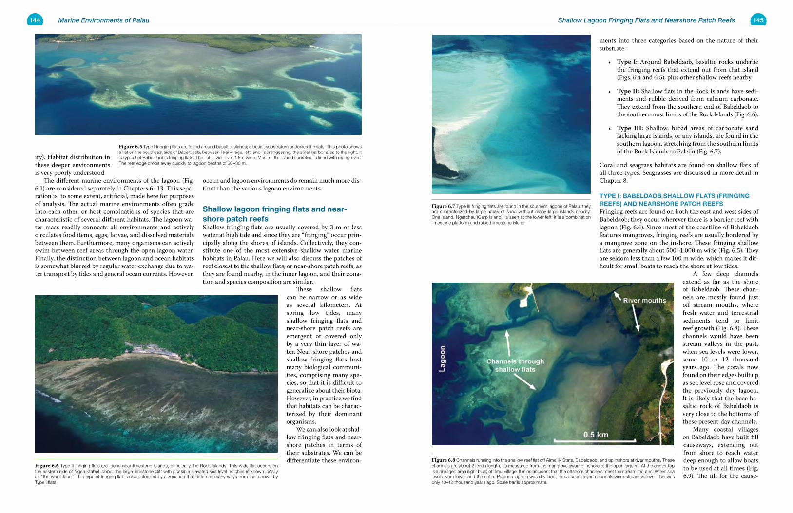
144 Marine Environments of Palau 145Shallow Lagoon Fringing Flats and Nearshore Patch Reefs
ments into three categories based on the nature of their substrate.
Type I:• Around Babeldaob, basaltic rocks underlie the fringing reefs that extend out from that island (Figs. 6.4 and 6.5), plus other shallow reefs nearby.
Type II:• Shallow flats in the Rock Islands have sedi-ments and rubble derived from calcium carbonate. They extend from the southern end of Babeldaob to the southernmost limits of the Rock Islands (Fig. 6.6).
Type III:• Shallow, broad areas of carbonate sand lacking large islands, or any islands, are found in the southern lagoon, stretching from the southern limits of the Rock Islands to Peleliu (Fig. 6.7).
Coral and seagrass habitats are found on shallow flats of all three types. Seagrasses are discussed in more detail in Chapter 8.
type i: BaBeLDaoB shaLLoW FLats (FriNgiNg reeFs) aND Nearshore patCh reeFsFringing reefs are found on both the east and west sides of Babeldaob; they occur wherever there is a barrier reef with lagoon (Fig. 6.4). Since most of the coastline of Babeldaob features mangroves, fringing reefs are usually bordered by a mangrove zone on the inshore. These fringing shallow flats are generally about 500–1,000 m wide (Fig. 6.5). They are seldom less than a few 100 m wide, which makes it dif-ficult for small boats to reach the shore at low tides.
A few deep channels extend as far as the shore of Babeldaob. These chan-nels are mostly found just off stream mouths, where fresh water and terrestrial sediments tend to limit reef growth (Fig. 6.8). These channels would have been stream valleys in the past, when sea levels were lower, some 10 to 12 thousand years ago. The corals now found on their edges built up as sea level rose and covered the previously dry lagoon. It is likely that the base ba-saltic rock of Babeldaob is very close to the bottoms of these present-day channels. Many coastal villages on Babeldaob have built fill causeways, extending out from shore to reach water deep enough to allow boats to be used at all times (Fig. 6.9). The fill for the cause-
ity). Habitat distribution in these deeper environments is very poorly understood. The different marine environments of the lagoon (Fig. 6.1) are considered separately in Chapters 6–13. This sepa-ration is, to some extent, artificial, made here for purposes of analysis. The actual marine environments often grade into each other, or host combinations of species that are characteristic of several different habitats. The lagoon wa-ter mass readily connects all environments and actively circulates food items, eggs, larvae, and dissolved materials between them. Furthermore, many organisms can actively swim between reef areas through the open lagoon water. Finally, the distinction between lagoon and ocean habitats is somewhat blurred by regular water exchange due to wa-ter transport by tides and general ocean currents. However,
ocean and lagoon environments do remain much more dis-tinct than the various lagoon environments.
shallow lagoon fringing flats and near-shore patch reefsShallow fringing flats are usually covered by 3 m or less water at high tide and since they are “fringing” occur prin-cipally along the shores of islands. Collectively, they con-stitute one of the most extensive shallow water marine habitats in Palau. Here we will also discuss the patches of reef closest to the shallow flats, or near-shore patch reefs, as they are found nearby, in the inner lagoon, and their zona-tion and species composition are similar.
These shallow flats can be narrow or as wide as several kilometers. At spring low tides, many shallow fringing flats and near-shore patch reefs are emergent or covered only by a very thin layer of wa-ter. Near-shore patches and shallow fringing flats host many biological communi-ties, comprising many spe-cies, so that it is difficult to generalize about their biota. However, in practice we find that habitats can be charac-terized by their dominant organisms. We can also look at shal-low fringing flats and near-shore patches in terms of their substrates. We can be differentiate these environ-
Figure 6.7 Type III fringing flats are found in the southern lagoon of Palau; they are characterized by large areas of sand without many large islands nearby. One island, Ngercheu (Carp Island), is seen at the lower left; it is a combination limestone platform and raised limestone island.
Figure 6.8 Channels running into the shallow reef flat off Aimeliik State, Babeldaob, end up inshore at river mouths. These channels are about 2 km in length, as measured from the mangrove swamp inshore to the open lagoon. At the center top is a dredged area (light blue) off Imul village. It is no accident that the offshore channels meet the stream mouths. When sea levels were lower and the entire Palauan lagoon was dry land, these submerged channels were stream valleys. This was only 10–12 thousand years ago. Scale bar is approximate.
Figure 6.5 Type I fringing flats are found around basaltic islands; a basalt substratum underlies the flats. This photo shows a flat on the southeast side of Babeldaob, between Rrai village, left, and Taprengesang, the small harbor area to the right. It is typical of Babeldaob’s fringing flats. The flat is well over 1 km wide. Most of the island shoreline is lined with mangroves. The reef edge drops away quickly to lagoon depths of 20–30 m.
Figure 6.6 Type II fringing flats are found near limestone islands, principally the Rock Islands. This wide flat occurs on the eastern side of Ngeruktabel Island; the large limestone cliff with possible elevated sea level notches is known locally as “the white face.” This type of fringing flat is characterized by a zonation that differs in many ways from that shown by Type I flats.
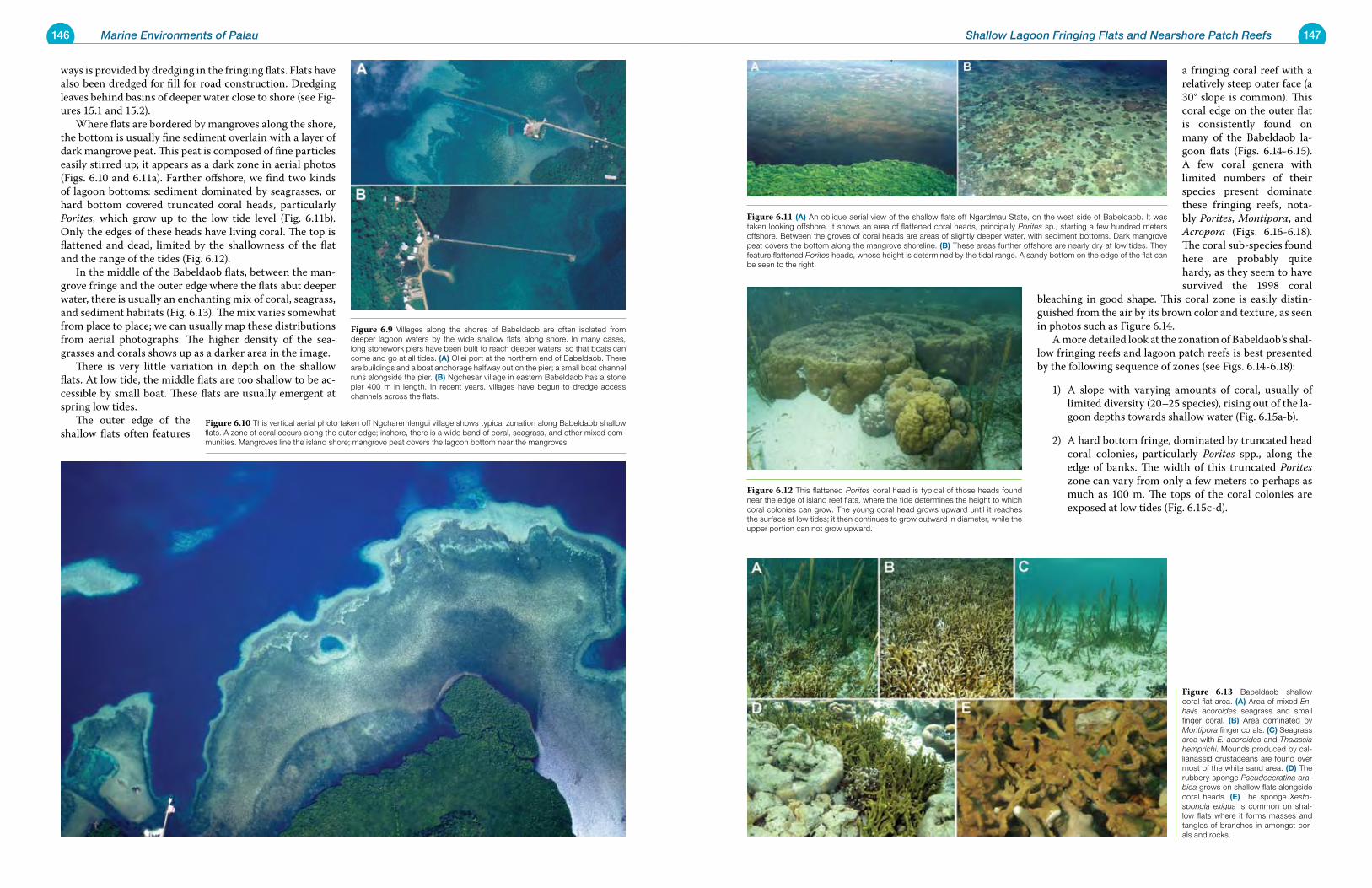
146 Marine Environments of Palau 147Shallow Lagoon Fringing Flats and Nearshore Patch Reefs
a fringing coral reef with a relatively steep outer face (a 30° slope is common). This coral edge on the outer flat is consistently found on many of the Babeldaob la-goon flats (Figs. 6.14-6.15). A few coral genera with limited numbers of their species present dominate these fringing reefs, nota-bly Porites, Montipora, and Acropora (Figs. 6.16-6.18). The coral sub-species found here are probably quite hardy, as they seem to have survived the 1998 coral
bleaching in good shape. This coral zone is easily distin-guished from the air by its brown color and texture, as seen in photos such as Figure 6.14. A more detailed look at the zonation of Babeldaob’s shal-low fringing reefs and lagoon patch reefs is best presented by the following sequence of zones (see Figs. 6.14-6.18):
A slope with varying amounts of coral, usually of 1) limited diversity (20–25 species), rising out of the la-goon depths towards shallow water (Fig. 6.15a-b).
A hard bottom fringe, dominated by truncated head 2) coral colonies, particularly Porites spp., along the edge of banks. The width of this truncated Porites zone can vary from only a few meters to perhaps as much as 100 m. The tops of the coral colonies are exposed at low tides (Fig. 6.15c-d).
ways is provided by dredging in the fringing flats. Flats have also been dredged for fill for road construction. Dredging leaves behind basins of deeper water close to shore (see Fig-ures 15.1 and 15.2). Where flats are bordered by mangroves along the shore, the bottom is usually fine sediment overlain with a layer of dark mangrove peat. This peat is composed of fine particles easily stirred up; it appears as a dark zone in aerial photos (Figs. 6.10 and 6.11a). Farther offshore, we find two kinds of lagoon bottoms: sediment dominated by seagrasses, or hard bottom covered truncated coral heads, particularly Porites, which grow up to the low tide level (Fig. 6.11b). Only the edges of these heads have living coral. The top is flattened and dead, limited by the shallowness of the flat and the range of the tides (Fig. 6.12). In the middle of the Babeldaob flats, between the man-grove fringe and the outer edge where the flats abut deeper water, there is usually an enchanting mix of coral, seagrass, and sediment habitats (Fig. 6.13). The mix varies somewhat from place to place; we can usually map these distributions from aerial photographs. The higher density of the sea-grasses and corals shows up as a darker area in the image. There is very little variation in depth on the shallow flats. At low tide, the middle flats are too shallow to be ac-cessible by small boat. These flats are usually emergent at spring low tides. The outer edge of the shallow flats often features
Figure 6.11 (a) An oblique aerial view of the shallow flats off Ngardmau State, on the west side of Babeldaob. It was taken looking offshore. It shows an area of flattened coral heads, principally Porites sp., starting a few hundred meters offshore. Between the groves of coral heads are areas of slightly deeper water, with sediment bottoms. Dark mangrove peat covers the bottom along the mangrove shoreline. (B) These areas further offshore are nearly dry at low tides. They feature flattened Porites heads, whose height is determined by the tidal range. A sandy bottom on the edge of the flat can be seen to the right.
Figure 6.12 This flattened Porites coral head is typical of those heads found near the edge of island reef flats, where the tide determines the height to which coral colonies can grow. The young coral head grows upward until it reaches the surface at low tides; it then continues to grow outward in diameter, while the upper portion can not grow upward.
Figure 6.13 Babeldaob shallow coral flat area. (a) Area of mixed En-halis acoroides seagrass and small finger coral. (B) Area dominated by Montipora finger corals. (C) Seagrass area with E. acoroides and Thalassia hemprichi. Mounds produced by cal-lianassid crustaceans are found over most of the white sand area. (D) The rubbery sponge Pseudoceratina ara-bica grows on shallow flats alongside coral heads. (e) The sponge Xesto-spongia exigua is common on shal-low flats where it forms masses and tangles of branches in amongst cor-als and rocks.
Figure 6.9 Villages along the shores of Babeldaob are often isolated from deeper lagoon waters by the wide shallow flats along shore. In many cases, long stonework piers have been built to reach deeper waters, so that boats can come and go at all tides. (a) Ollei port at the northern end of Babeldaob. There are buildings and a boat anchorage halfway out on the pier; a small boat channel runs alongside the pier. (B) Ngchesar village in eastern Babeldaob has a stone pier 400 m in length. In recent years, villages have begun to dredge access channels across the flats.
Figure 6.10 This vertical aerial photo taken off Ngcharemlengui village shows typical zonation along Babeldaob shallow flats. A zone of coral occurs along the outer edge; inshore, there is a wide band of coral, seagrass, and other mixed com-munities. Mangroves line the island shore; mangrove peat covers the lagoon bottom near the mangroves.
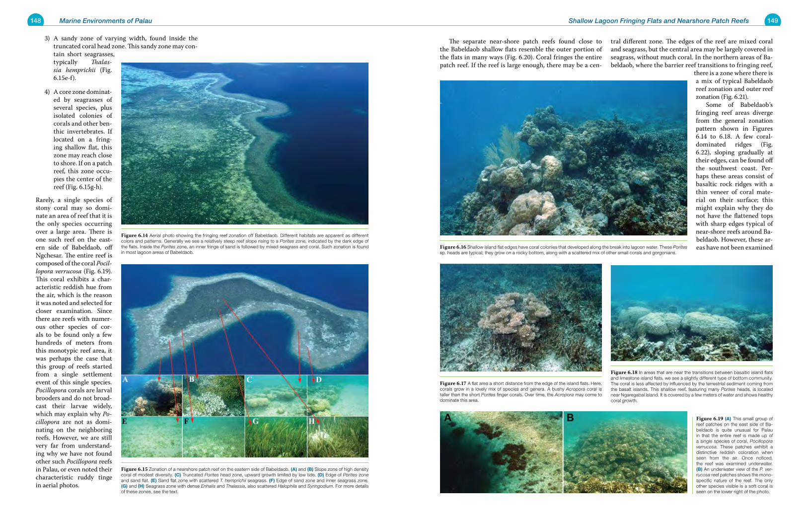
148 Marine Environments of Palau 149Shallow Lagoon Fringing Flats and Nearshore Patch Reefs
The separate near-shore patch reefs found close to the Babeldaob shallow flats resemble the outer portion of the flats in many ways (Fig. 6.20). Coral fringes the entire patch reef. If the reef is large enough, there may be a cen-
tral different zone. The edges of the reef are mixed coral and seagrass, but the central area may be largely covered in seagrass, without much coral. In the northern areas of Ba-beldaob, where the barrier reef transitions to fringing reef,
there is a zone where there is a mix of typical Babeldaob reef zonation and outer reef zonation (Fig. 6.21). Some of Babeldaob’s fringing reef areas diverge from the general zonation pattern shown in Figures 6.14 to 6.18. A few coral-dominated ridges (Fig. 6.22), sloping gradually at their edges, can be found off the southwest coast. Per-haps these areas consist of basaltic rock ridges with a thin veneer of coral mate-rial on their surface; this might explain why they do not have the flattened tops with sharp edges typical of near-shore reefs around Ba-beldaob. However, these ar-eas have not been examined
A sandy zone of varying width, found inside the 3) truncated coral head zone. This sandy zone may con-tain short seagrasses, typically Thalas-sia hemprichii (Fig. 6.15e-f).
A core zone dominat-4) ed by seagrasses of several species, plus isolated colonies of corals and other ben-thic invertebrates. If located on a fring-ing shallow flat, this zone may reach close to shore. If on a patch reef, this zone occu-pies the center of the reef (Fig. 6.15g-h).
Rarely, a single species of stony coral may so domi-nate an area of reef that it is the only species occurring over a large area. There is one such reef on the east-ern side of Babeldaob, off Ngchesar. The entire reef is composed of the coral Pocil-lopora verrucosa (Fig. 6.19). This coral exhibits a char-acteristic reddish hue from the air, which is the reason it was noted and selected for closer examination. Since there are reefs with numer-ous other species of cor-als to be found only a few hundreds of meters from this monotypic reef area, it was perhaps the case that this group of reefs started from a single settlement event of this single species. Pocillopora corals are larval brooders and do not broad-cast their larvae widely, which may explain why Po-cillopora are not as domi-nating on the neighboring reefs. However, we are still very far from understand-ing why we have not found other such Pocillopora reefs in Palau, or even noted their characteristic ruddy tinge in aerial photos.
Figure 6.16 Shallow island flat edges have coral colonies that developed along the break into lagoon water. These Porites sp. heads are typical; they grow on a rocky bottom, along with a scattered mix of other small corals and gorgonians.
Figure 6.17 A flat area a short distance from the edge of the island flats. Here, corals grow in a lovely mix of species and genera. A bushy Acropora coral is taller than the short Porites finger corals. Over time, the Acropora may come to dominate this area.
Figure 6.18 In areas that are near the transitions between basaltic island flats and limestone island flats, we see a slightly different type of bottom community. The coral is less affected by influenced by the terrestrial sediment coming from the basalt islands. This shallow reef, featuring many Porites heads, is located near Ngaregabal Island. It is covered by a few meters of water and shows healthy coral growth.
Figure 6.19 (a) This small group of reef patches on the east side of Ba-beldaob is quite unusual for Palau in that the entire reef is made up of a single species of coral, Pocillopora verrucosa. These patches exhibit a distinctive reddish coloration when seen from the air. Once noticed, the reef was examined underwater. (B) An underwater view of the P. ver-rucosa reef patches shows the mono-specific nature of the reef. The only other species visible is a soft coral is seen on the lower right of the photo.
Figure 6.14 Aerial photo showing the fringing reef zonation off Babeldaob. Different habitats are apparent as different colors and patterns. Generally we see a relatively steep reef slope rising to a Porites zone, indicated by the dark edge of the flats. Inside the Porites zone, an inner fringe of sand is followed by mixed seagrass and coral. Such zonation is found in most lagoon areas of Babeldaob.
Figure 6.15 Zonation of a nearshore patch reef on the eastern side of Babeldaob. (a) and (B) Slope zone of high density coral of modest diversity. (C) Truncated Porites head zone, upward growth limited by low tide. (D) Edge of Porites zone and sand flat. (e) Sand flat zone with scattered T. hemprichii seagrass. (F) Edge of sand zone and inner seagrass zone. (g) and (h) Seagrass zone with dense Enhalis and Thalassia, also scattered Halophila and Syringodium. For more details of these zones, see the text.
150 Marine Environments of Palau 151Shallow Lagoon Fringing Flats and Nearshore Patch Reefs
Figure 6.23 upper:Aerial photomosaic of reefs off the southwest corner of Babeldaob, between that island (right side) and Ngaregabal Island (left). This reef complex jutting out from Babeldaob is evidently built on a basaltic ridge, or peaks, as there are basalt outcrops in the midst of the reef. Ngaregabal Island is basaltic (a) as are the small outcrops that barely protrude above sea level (B) and (C) Scale bar approximate.
Figure 6.24 This is a typical coral-rich patch reef in the western lagoon, near Ngaregabal Island. It is dominated by Porites head and finger corals. The tops of these reefs are just at the water’s surface at low tide. A white sandy bottom, of about 6 m depth, lies between the reefs.
Figure 6.20 Smaller inshore basalt island patch reefs have essentially the same zonation as the fringing reef around Babeldaob.
Figure 6.21 At the northern end of Babeldaob, the basalt island shallow flats start to transition to outer fringing reef. Here, the lagoon contains large areas of algal bottom, growing in wa-ters only a few meters deep. A fringe of reef corals grows along the edges of the basins found in the sandy flat.
Figure 6.22 The fringing reefs along the southwestern coast of Babeldaob, off Aimeliik State, differ in some ways from the typical Ba-beldaob fringing flats. The bottom is covered with ridges, which run out from shore and hold basins within their folds and turns. This photo was taken in summer 1998, during the bleaching event; the white spots are bleached coral heads.
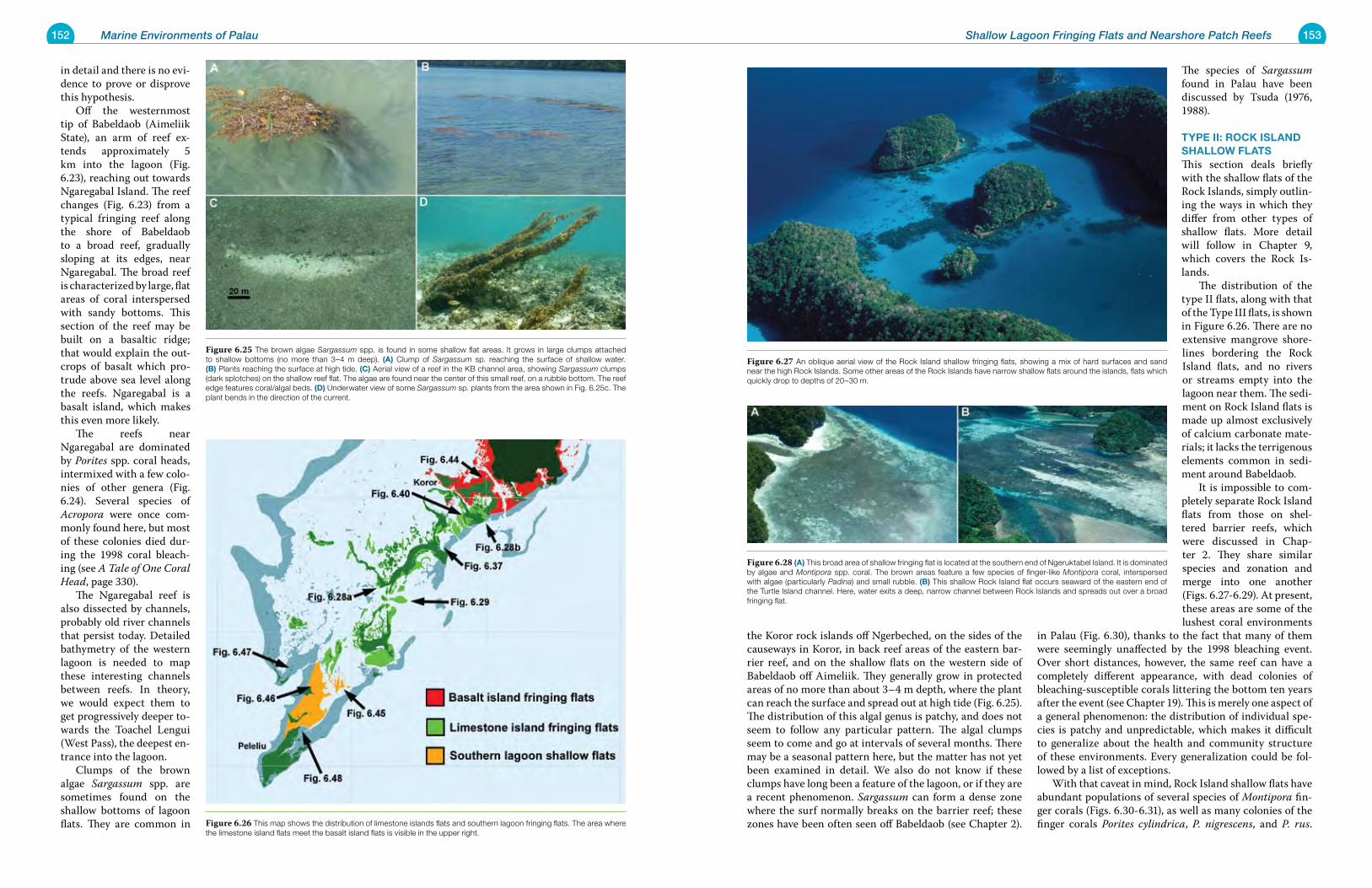
152 Marine Environments of Palau 153Shallow Lagoon Fringing Flats and Nearshore Patch Reefs
the Koror rock islands off Ngerbeched, on the sides of the causeways in Koror, in back reef areas of the eastern bar-rier reef, and on the shallow flats on the western side of Babeldaob off Aimeliik. They generally grow in protected areas of no more than about 3–4 m depth, where the plant can reach the surface and spread out at high tide (Fig. 6.25). The distribution of this algal genus is patchy, and does not seem to follow any particular pattern. The algal clumps seem to come and go at intervals of several months. There may be a seasonal pattern here, but the matter has not yet been examined in detail. We also do not know if these clumps have long been a feature of the lagoon, or if they are a recent phenomenon. Sargassum can form a dense zone where the surf normally breaks on the barrier reef; these zones have been often seen off Babeldaob (see Chapter 2).
The species of Sargassum found in Palau have been discussed by Tsuda (1976, 1988).
type ii: roCk isLaND shaLLoW FLatsThis section deals briefly with the shallow flats of the Rock Islands, simply outlin-ing the ways in which they differ from other types of shallow flats. More detail will follow in Chapter 9, which covers the Rock Is-lands. The distribution of the type II flats, along with that of the Type III flats, is shown in Figure 6.26. There are no extensive mangrove shore-lines bordering the Rock Island flats, and no rivers or streams empty into the lagoon near them. The sedi-ment on Rock Island flats is made up almost exclusively of calcium carbonate mate-rials; it lacks the terrigenous elements common in sedi-ment around Babeldaob. It is impossible to com-pletely separate Rock Island flats from those on shel-tered barrier reefs, which were discussed in Chap-ter 2. They share similar species and zonation and merge into one another (Figs. 6.27-6.29). At present, these areas are some of the lushest coral environments
in Palau (Fig. 6.30), thanks to the fact that many of them were seemingly unaffected by the 1998 bleaching event. Over short distances, however, the same reef can have a completely different appearance, with dead colonies of bleaching-susceptible corals littering the bottom ten years after the event (see Chapter 19). This is merely one aspect of a general phenomenon: the distribution of individual spe-cies is patchy and unpredictable, which makes it difficult to generalize about the health and community structure of these environments. Every generalization could be fol-lowed by a list of exceptions. With that caveat in mind, Rock Island shallow flats have abundant populations of several species of Montipora fin-ger corals (Figs. 6.30-6.31), as well as many colonies of the finger corals Porites cylindrica, P. nigrescens, and P. rus.
in detail and there is no evi-dence to prove or disprove this hypothesis. Off the westernmost tip of Babeldaob (Aimeliik State), an arm of reef ex-tends approximately 5 km into the lagoon (Fig. 6.23), reaching out towards Ngaregabal Island. The reef changes (Fig. 6.23) from a typical fringing reef along the shore of Babeldaob to a broad reef, gradually sloping at its edges, near Ngaregabal. The broad reef is characterized by large, flat areas of coral interspersed with sandy bottoms. This section of the reef may be built on a basaltic ridge; that would explain the out-crops of basalt which pro-trude above sea level along the reefs. Ngaregabal is a basalt island, which makes this even more likely. The reefs near Ngaregabal are dominated by Porites spp. coral heads, intermixed with a few colo-nies of other genera (Fig. 6.24). Several species of Acropora were once com-monly found here, but most of these colonies died dur-ing the 1998 coral bleach-ing (see A Tale of One Coral Head, page 330). The Ngaregabal reef is also dissected by channels, probably old river channels that persist today. Detailed bathymetry of the western lagoon is needed to map these interesting channels between reefs. In theory, we would expect them to get progressively deeper to-wards the Toachel Lengui (West Pass), the deepest en-trance into the lagoon. Clumps of the brown algae Sargassum spp. are sometimes found on the shallow bottoms of lagoon flats. They are common in
Figure 6.27 An oblique aerial view of the Rock Island shallow fringing flats, showing a mix of hard surfaces and sand near the high Rock Islands. Some other areas of the Rock Islands have narrow shallow flats around the islands, flats which quickly drop to depths of 20–30 m.
Figure 6.28 (a) This broad area of shallow fringing flat is located at the southern end of Ngeruktabel Island. It is dominated by algae and Montipora spp. coral. The brown areas feature a few species of finger-like Montipora coral, interspersed with algae (particularly Padina) and small rubble. (B) This shallow Rock Island flat occurs seaward of the eastern end of the Turtle Island channel. Here, water exits a deep, narrow channel between Rock Islands and spreads out over a broad fringing flat.
Figure 6.25 The brown algae Sargassum spp. is found in some shallow flat areas. It grows in large clumps attached to shallow bottoms (no more than 3–4 m deep). (a) Clump of Sargassum sp. reaching the surface of shallow water. (B) Plants reaching the surface at high tide. (C) Aerial view of a reef in the KB channel area, showing Sargassum clumps (dark splotches) on the shallow reef flat. The algae are found near the center of this small reef, on a rubble bottom. The reef edge features coral/algal beds. (D) Underwater view of some Sargassum sp. plants from the area shown in Fig. 6.25c. The plant bends in the direction of the current.
Figure 6.26 This map shows the distribution of limestone islands flats and southern lagoon fringing flats. The area where the limestone island flats meet the basalt island flats is visible in the upper right.
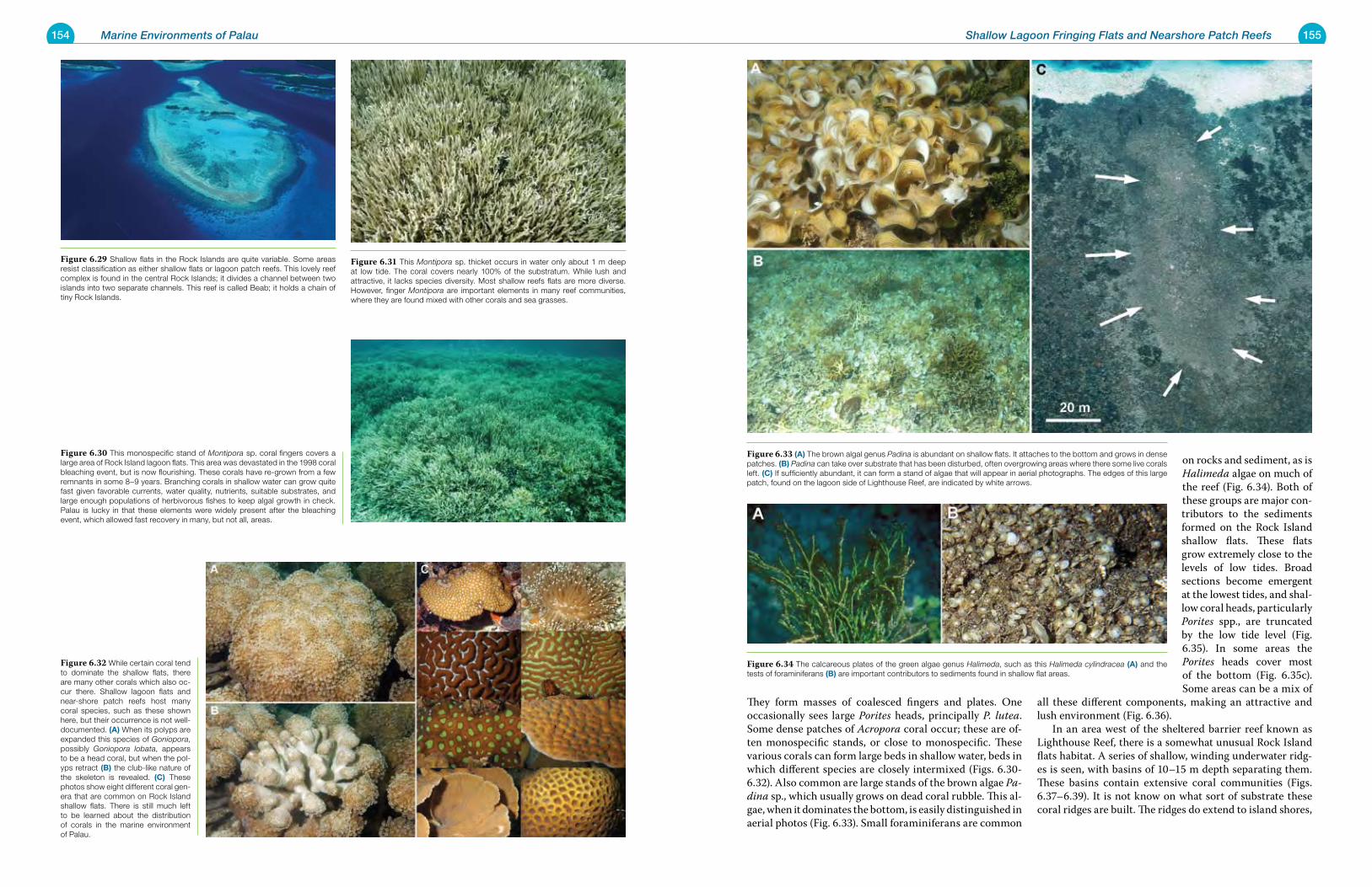
154 Marine Environments of Palau 155Shallow Lagoon Fringing Flats and Nearshore Patch Reefs
They form masses of coalesced fingers and plates. One occasionally sees large Porites heads, principally P. lutea. Some dense patches of Acropora coral occur; these are of-ten monospecific stands, or close to monospecific. These various corals can form large beds in shallow water, beds in which different species are closely intermixed (Figs. 6.30-6.32). Also common are large stands of the brown algae Pa-dina sp., which usually grows on dead coral rubble. This al-gae, when it dominates the bottom, is easily distinguished in aerial photos (Fig. 6.33). Small foraminiferans are common
on rocks and sediment, as is Halimeda algae on much of the reef (Fig. 6.34). Both of these groups are major con-tributors to the sediments formed on the Rock Island shallow flats. These flats grow extremely close to the levels of low tides. Broad sections become emergent at the lowest tides, and shal-low coral heads, particularly Porites spp., are truncated by the low tide level (Fig. 6.35). In some areas the Porites heads cover most of the bottom (Fig. 6.35c). Some areas can be a mix of
all these different components, making an attractive and lush environment (Fig. 6.36). In an area west of the sheltered barrier reef known as Lighthouse Reef, there is a somewhat unusual Rock Island flats habitat. A series of shallow, winding underwater ridg-es is seen, with basins of 10–15 m depth separating them. These basins contain extensive coral communities (Figs. 6.37–6.39). It is not know on what sort of substrate these coral ridges are built. The ridges do extend to island shores,
Figure 6.33 (a) The brown algal genus Padina is abundant on shallow flats. It attaches to the bottom and grows in dense patches. (B) Padina can take over substrate that has been disturbed, often overgrowing areas where there some live corals left. (C) If sufficiently abundant, it can form a stand of algae that will appear in aerial photographs. The edges of this large patch, found on the lagoon side of Lighthouse Reef, are indicated by white arrows.
Figure 6.34 The calcareous plates of the green algae genus Halimeda, such as this Halimeda cylindracea (a) and the tests of foraminiferans (B) are important contributors to sediments found in shallow flat areas.
Figure 6.29 Shallow flats in the Rock Islands are quite variable. Some areas resist classification as either shallow flats or lagoon patch reefs. This lovely reef complex is found in the central Rock Islands; it divides a channel between two islands into two separate channels. This reef is called Beab; it holds a chain of tiny Rock Islands.
Figure 6.30 This monospecific stand of Montipora sp. coral fingers covers a large area of Rock Island lagoon flats. This area was devastated in the 1998 coral bleaching event, but is now flourishing. These corals have re-grown from a few remnants in some 8–9 years. Branching corals in shallow water can grow quite fast given favorable currents, water quality, nutrients, suitable substrates, and large enough populations of herbivorous fishes to keep algal growth in check. Palau is lucky in that these elements were widely present after the bleaching event, which allowed fast recovery in many, but not all, areas.
Figure 6.31 This Montipora sp. thicket occurs in water only about 1 m deep at low tide. The coral covers nearly 100% of the substratum. While lush and attractive, it lacks species diversity. Most shallow reefs flats are more diverse. However, finger Montipora are important elements in many reef communities, where they are found mixed with other corals and sea grasses.
Figure 6.32 While certain coral tend to dominate the shallow flats, there are many other corals which also oc-cur there. Shallow lagoon flats and near-shore patch reefs host many coral species, such as these shown here, but their occurrence is not well-documented. (a) When its polyps are expanded this species of Goniopora, possibly Goniopora lobata, appears to be a head coral, but when the pol-yps retract (B) the club-like nature of the skeleton is revealed. (C) These photos show eight different coral gen-era that are common on Rock Island shallow flats. There is still much left to be learned about the distribution of corals in the marine environment of Palau.
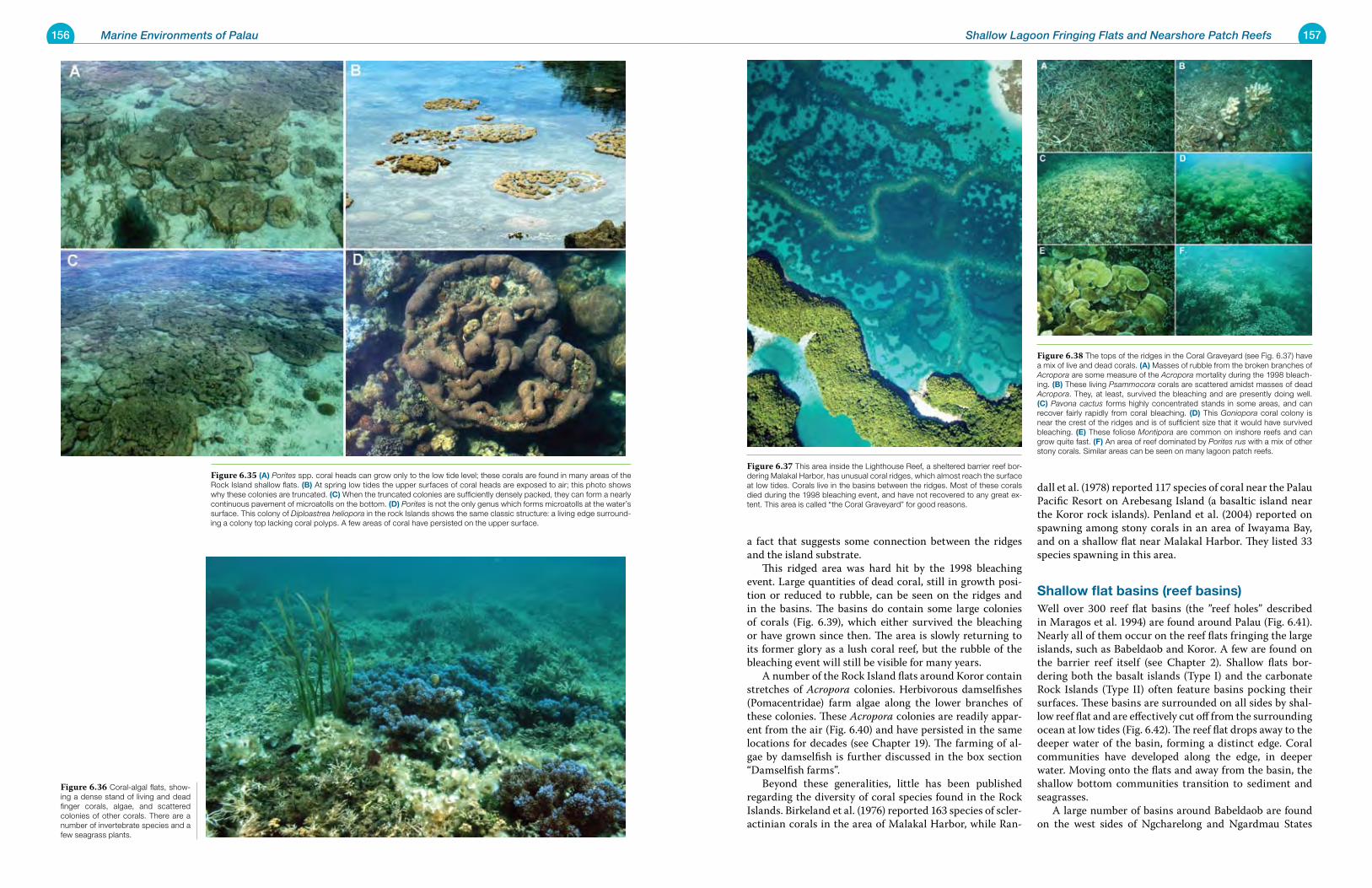
156 Marine Environments of Palau 157Shallow Lagoon Fringing Flats and Nearshore Patch Reefs
a fact that suggests some connection between the ridges and the island substrate. This ridged area was hard hit by the 1998 bleaching event. Large quantities of dead coral, still in growth posi-tion or reduced to rubble, can be seen on the ridges and in the basins. The basins do contain some large colonies of corals (Fig. 6.39), which either survived the bleaching or have grown since then. The area is slowly returning to its former glory as a lush coral reef, but the rubble of the bleaching event will still be visible for many years. A number of the Rock Island flats around Koror contain stretches of Acropora colonies. Herbivorous damselfishes (Pomacentridae) farm algae along the lower branches of these colonies. These Acropora colonies are readily appar-ent from the air (Fig. 6.40) and have persisted in the same locations for decades (see Chapter 19). The farming of al-gae by damselfish is further discussed in the box section “Damselfish farms”. Beyond these generalities, little has been published regarding the diversity of coral species found in the Rock Islands. Birkeland et al. (1976) reported 163 species of scler-actinian corals in the area of Malakal Harbor, while Ran-
dall et al. (1978) reported 117 species of coral near the Palau Pacific Resort on Arebesang Island (a basaltic island near the Koror rock islands). Penland et al. (2004) reported on spawning among stony corals in an area of Iwayama Bay, and on a shallow flat near Malakal Harbor. They listed 33 species spawning in this area.
shallow flat basins (reef basins)Well over 300 reef flat basins (the ”reef holes” described in Maragos et al. 1994) are found around Palau (Fig. 6.41). Nearly all of them occur on the reef flats fringing the large islands, such as Babeldaob and Koror. A few are found on the barrier reef itself (see Chapter 2). Shallow flats bor-dering both the basalt islands (Type I) and the carbonate Rock Islands (Type II) often feature basins pocking their surfaces. These basins are surrounded on all sides by shal-low reef flat and are effectively cut off from the surrounding ocean at low tides (Fig. 6.42). The reef flat drops away to the deeper water of the basin, forming a distinct edge. Coral communities have developed along the edge, in deeper water. Moving onto the flats and away from the basin, the shallow bottom communities transition to sediment and seagrasses. A large number of basins around Babeldaob are found on the west sides of Ngcharelong and Ngardmau States
Figure 6.37 This area inside the Lighthouse Reef, a sheltered barrier reef bor-dering Malakal Harbor, has unusual coral ridges, which almost reach the surface at low tides. Corals live in the basins between the ridges. Most of these corals died during the 1998 bleaching event, and have not recovered to any great ex-tent. This area is called “the Coral Graveyard” for good reasons.
Figure 6.38 The tops of the ridges in the Coral Graveyard (see Fig. 6.37) have a mix of live and dead corals. (a) Masses of rubble from the broken branches of Acropora are some measure of the Acropora mortality during the 1998 bleach-ing. (B) These living Psammocora corals are scattered amidst masses of dead Acropora. They, at least, survived the bleaching and are presently doing well. (C) Pavona cactus forms highly concentrated stands in some areas, and can recover fairly rapidly from coral bleaching. (D) This Goniopora coral colony is near the crest of the ridges and is of sufficient size that it would have survived bleaching. (e) These foliose Montipora are common on inshore reefs and can grow quite fast. (F) An area of reef dominated by Porites rus with a mix of other stony corals. Similar areas can be seen on many lagoon patch reefs.
Figure 6.36 Coral-algal flats, show-ing a dense stand of living and dead finger corals, algae, and scattered colonies of other corals. There are a number of invertebrate species and a few seagrass plants.
Figure 6.35 (a) Porites spp. coral heads can grow only to the low tide level; these corals are found in many areas of the Rock Island shallow flats. (B) At spring low tides the upper surfaces of coral heads are exposed to air; this photo shows why these colonies are truncated. (C) When the truncated colonies are sufficiently densely packed, they can form a nearly continuous pavement of microatolls on the bottom. (D) Porites is not the only genus which forms microatolls at the water’s surface. This colony of Diploastrea heliopora in the rock Islands shows the same classic structure: a living edge surround-ing a colony top lacking coral polyps. A few areas of coral have persisted on the upper surface.
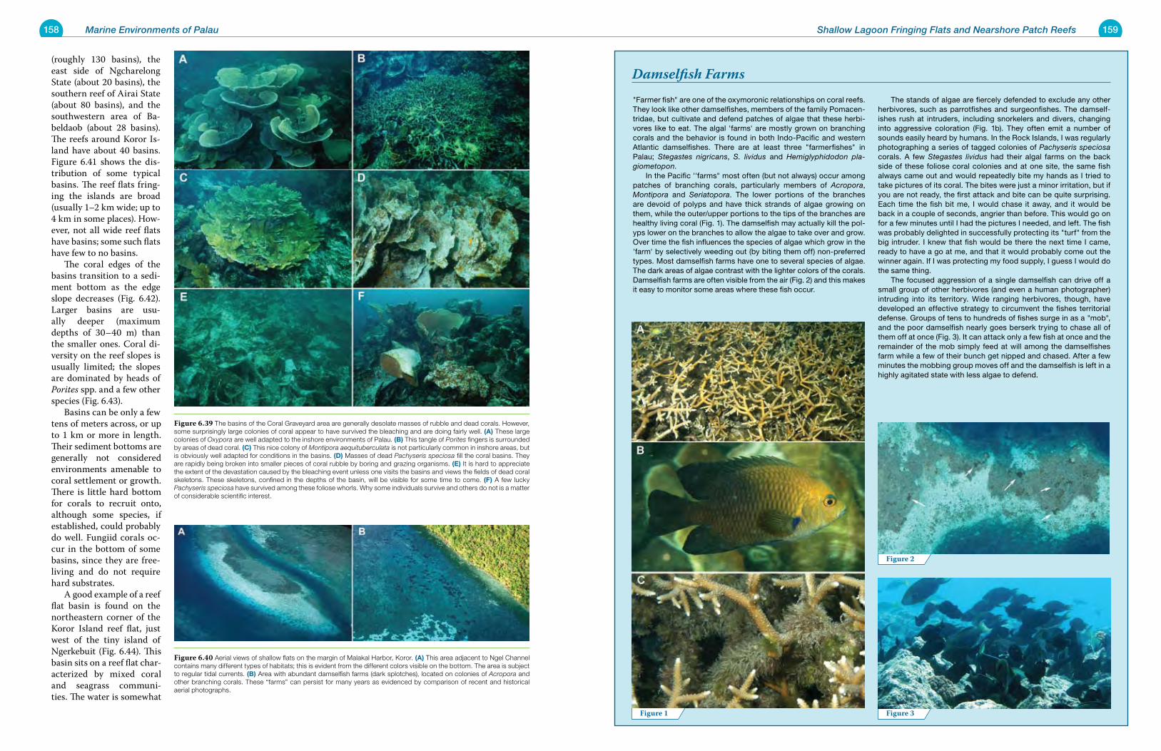
158 Marine Environments of Palau 159Shallow Lagoon Fringing Flats and Nearshore Patch Reefs
"Farmer fish" are one of the oxymoronic relationships on coral reefs. They look like other damselfishes, members of the family Pomacen-tridae, but cultivate and defend patches of algae that these herbi-vores like to eat. The algal 'farms' are mostly grown on branching corals and the behavior is found in both Indo-Pacific and western Atlantic damselfishes. There are at least three "farmerfishes" in Palau; Stegastes nigricans, S. lividus and Hemiglyphidodon pla-giometopon. In the Pacific ''farms" most often (but not always) occur among patches of branching corals, particularly members of Acropora, Montipora and Seriatopora. The lower portions of the branches are devoid of polyps and have thick strands of algae growing on them, while the outer/upper portions to the tips of the branches are healthy living coral (Fig. 1). The damselfish may actually kill the pol-yps lower on the branches to allow the algae to take over and grow. Over time the fish influences the species of algae which grow in the 'farm' by selectively weeding out (by biting them off) non-preferred types. Most damselfish farms have one to several species of algae. The dark areas of algae contrast with the lighter colors of the corals. Damselfish farms are often visible from the air (Fig. 2) and this makes it easy to monitor some areas where these fish occur.
The stands of algae are fiercely defended to exclude any other herbivores, such as parrotfishes and surgeonfishes. The damself-ishes rush at intruders, including snorkelers and divers, changing into aggressive coloration (Fig. 1b). They often emit a number of sounds easily heard by humans. In the Rock Islands, I was regularly photographing a series of tagged colonies of Pachyseris speciosa corals. A few Stegastes lividus had their algal farms on the back side of these foliose coral colonies and at one site, the same fish always came out and would repeatedly bite my hands as I tried to take pictures of its coral. The bites were just a minor irritation, but if you are not ready, the first attack and bite can be quite surprising. Each time the fish bit me, I would chase it away, and it would be back in a couple of seconds, angrier than before. This would go on for a few minutes until I had the pictures I needed, and left. The fish was probably delighted in successfully protecting its "turf" from the big intruder. I knew that fish would be there the next time I came, ready to have a go at me, and that it would probably come out the winner again. If I was protecting my food supply, I guess I would do the same thing. The focused aggression of a single damselfish can drive off a small group of other herbivores (and even a human photographer) intruding into its territory. Wide ranging herbivores, though, have developed an effective strategy to circumvent the fishes territorial defense. Groups of tens to hundreds of fishes surge in as a "mob", and the poor damselfish nearly goes berserk trying to chase all of them off at once (Fig. 3). It can attack only a few fish at once and the remainder of the mob simply feed at will among the damselfishes farm while a few of their bunch get nipped and chased. After a few minutes the mobbing group moves off and the damselfish is left in a highly agitated state with less algae to defend.
Damselfish Farms(roughly 130 basins), the east side of Ngcharelong State (about 20 basins), the southern reef of Airai State (about 80 basins), and the southwestern area of Ba-beldaob (about 28 basins). The reefs around Koror Is-land have about 40 basins. Figure 6.41 shows the dis-tribution of some typical basins. The reef flats fring-ing the islands are broad (usually 1–2 km wide; up to 4 km in some places). How-ever, not all wide reef flats have basins; some such flats have few to no basins. The coral edges of the basins transition to a sedi-ment bottom as the edge slope decreases (Fig. 6.42). Larger basins are usu-ally deeper (maximum depths of 30–40 m) than the smaller ones. Coral di-versity on the reef slopes is usually limited; the slopes are dominated by heads of Porites spp. and a few other species (Fig. 6.43). Basins can be only a few tens of meters across, or up to 1 km or more in length. Their sediment bottoms are generally not considered environments amenable to coral settlement or growth. There is little hard bottom for corals to recruit onto, although some species, if established, could probably do well. Fungiid corals oc-cur in the bottom of some basins, since they are free-living and do not require hard substrates. A good example of a reef flat basin is found on the northeastern corner of the Koror Island reef flat, just west of the tiny island of Ngerkebuit (Fig. 6.44). This basin sits on a reef flat char-acterized by mixed coral and seagrass communi-ties. The water is somewhat
Figure 1 Figure 3
Figure 2
Figure 6.39 The basins of the Coral Graveyard area are generally desolate masses of rubble and dead corals. However, some surprisingly large colonies of coral appear to have survived the bleaching and are doing fairly well. (a) These large colonies of Oxypora are well adapted to the inshore environments of Palau. (B) This tangle of Porites fingers is surrounded by areas of dead coral. (C) This nice colony of Montipora aequituberculata is not particularly common in inshore areas, but is obviously well adapted for conditions in the basins. (D) Masses of dead Pachyseris speciosa fill the coral basins. They are rapidly being broken into smaller pieces of coral rubble by boring and grazing organisms. (e) It is hard to appreciate the extent of the devastation caused by the bleaching event unless one visits the basins and views the fields of dead coral skeletons. These skeletons, confined in the depths of the basin, will be visible for some time to come. (F) A few lucky Pachyseris speciosa have survived among these foliose whorls. Why some individuals survive and others do not is a matter of considerable scientific interest.
Figure 6.40 Aerial views of shallow flats on the margin of Malakal Harbor, Koror. (a) This area adjacent to Ngel Channel contains many different types of habitats; this is evident from the different colors visible on the bottom. The area is subject to regular tidal currents. (B) Area with abundant damselfish farms (dark splotches), located on colonies of Acropora and other branching corals. These “farms” can persist for many years as evidenced by comparison of recent and historical aerial photographs.
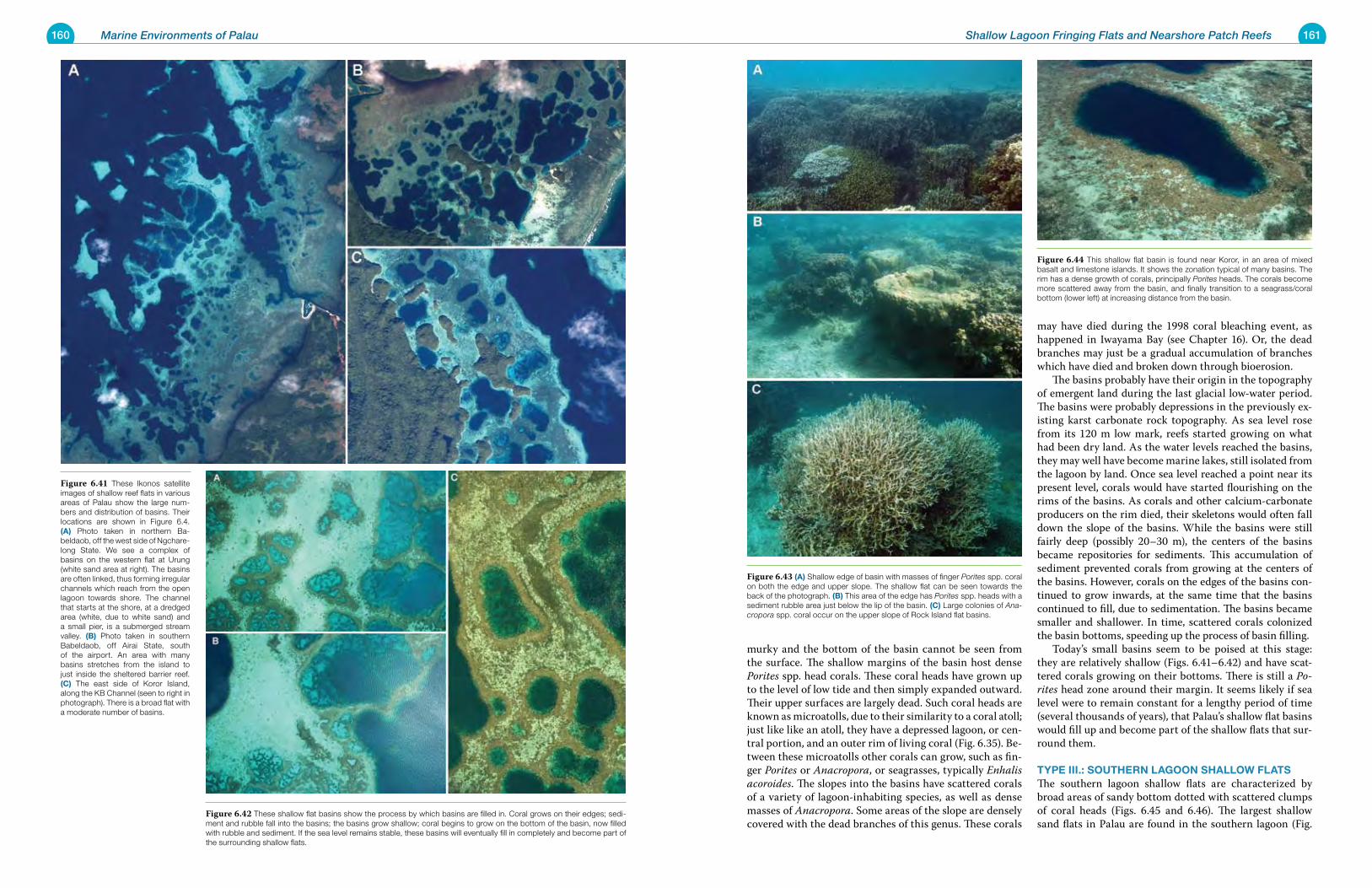
160 Marine Environments of Palau 161Shallow Lagoon Fringing Flats and Nearshore Patch Reefs
murky and the bottom of the basin cannot be seen from the surface. The shallow margins of the basin host dense Porites spp. head corals. These coral heads have grown up to the level of low tide and then simply expanded outward. Their upper surfaces are largely dead. Such coral heads are known as microatolls, due to their similarity to a coral atoll; just like like an atoll, they have a depressed lagoon, or cen-tral portion, and an outer rim of living coral (Fig. 6.35). Be-tween these microatolls other corals can grow, such as fin-ger Porites or Anacropora, or seagrasses, typically Enhalis acoroides. The slopes into the basins have scattered corals of a variety of lagoon-inhabiting species, as well as dense masses of Anacropora. Some areas of the slope are densely covered with the dead branches of this genus. These corals
may have died during the 1998 coral bleaching event, as happened in Iwayama Bay (see Chapter 16). Or, the dead branches may just be a gradual accumulation of branches which have died and broken down through bioerosion. The basins probably have their origin in the topography of emergent land during the last glacial low-water period. The basins were probably depressions in the previously ex-isting karst carbonate rock topography. As sea level rose from its 120 m low mark, reefs started growing on what had been dry land. As the water levels reached the basins, they may well have become marine lakes, still isolated from the lagoon by land. Once sea level reached a point near its present level, corals would have started flourishing on the rims of the basins. As corals and other calcium-carbonate producers on the rim died, their skeletons would often fall down the slope of the basins. While the basins were still fairly deep (possibly 20–30 m), the centers of the basins became repositories for sediments. This accumulation of sediment prevented corals from growing at the centers of the basins. However, corals on the edges of the basins con-tinued to grow inwards, at the same time that the basins continued to fill, due to sedimentation. The basins became smaller and shallower. In time, scattered corals colonized the basin bottoms, speeding up the process of basin filling. Today’s small basins seem to be poised at this stage: they are relatively shallow (Figs. 6.41–6.42) and have scat-tered corals growing on their bottoms. There is still a Po-rites head zone around their margin. It seems likely if sea level were to remain constant for a lengthy period of time (several thousands of years), that Palau’s shallow flat basins would fill up and become part of the shallow flats that sur-round them.
type iii.: southerN LagooN shaLLoW FLatsThe southern lagoon shallow flats are characterized by broad areas of sandy bottom dotted with scattered clumps of coral heads (Figs. 6.45 and 6.46). The largest shallow sand flats in Palau are found in the southern lagoon (Fig.
Figure 6.43 (a) Shallow edge of basin with masses of finger Porites spp. coral on both the edge and upper slope. The shallow flat can be seen towards the back of the photograph. (B) This area of the edge has Porites spp. heads with a sediment rubble area just below the lip of the basin. (C) Large colonies of Ana-cropora spp. coral occur on the upper slope of Rock Island flat basins.
Figure 6.44 This shallow flat basin is found near Koror, in an area of mixed basalt and limestone islands. It shows the zonation typical of many basins. The rim has a dense growth of corals, principally Porites heads. The corals become more scattered away from the basin, and finally transition to a seagrass/coral bottom (lower left) at increasing distance from the basin.
Figure 6.41 These Ikonos satellite images of shallow reef flats in various areas of Palau show the large num-bers and distribution of basins. Their locations are shown in Figure 6.4. (a) Photo taken in northern Ba-beldaob, off the west side of Ngchare-long State. We see a complex of basins on the western flat at Urung (white sand area at right). The basins are often linked, thus forming irregular channels which reach from the open lagoon towards shore. The channel that starts at the shore, at a dredged area (white, due to white sand) and a small pier, is a submerged stream valley. (B) Photo taken in southern Babeldaob, off Airai State, south of the airport. An area with many basins stretches from the island to just inside the sheltered barrier reef. (C) The east side of Koror Island, along the KB Channel (seen to right in photograph). There is a broad flat with a moderate number of basins.
Figure 6.42 These shallow flat basins show the process by which basins are filled in. Coral grows on their edges; sedi-ment and rubble fall into the basins; the basins grow shallow; coral begins to grow on the bottom of the basin, now filled with rubble and sediment. If the sea level remains stable, these basins will eventually fill in completely and become part of the surrounding shallow flats.
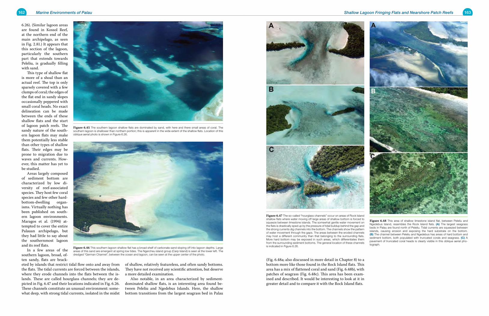
162 Marine Environments of Palau 163Shallow Lagoon Fringing Flats and Nearshore Patch Reefs
(Fig. 6.48a; also discussed in more detail in Chapter 8) to a bottom more like those found in the Rock Island flats. This area has a mix of flattened coral and sand (Fig. 6.48b), with patches of seagrass (Fig. 6.48c). This area has been exam-ined and described. It would be interesting to look at it in greater detail and to compare it with the Rock Island flats.
6.26). (Similar lagoon areas are found in Kossol Reef, at the northern end of the main archipelago, as seen in Fig. 2.81.) It appears that this section of the lagoon, particularly the southern part that extends towards Peleliu, is gradually filling with sand. This type of shallow flat is more of a shoal than an actual reef. The top is only sparsely covered with a few clumps of coral; the edges of the flat end in sandy slopes occasionally peppered with small coral heads. No exact delineation can be made between the ends of these shallow flats and the start of lagoon patch reefs. The sandy nature of the south-ern lagoon flats may make them potentially less stable than other types of shallow flats. Their edges may be prone to migration due to waves and currents. How-ever, this matter has yet to be studied. Areas largely composed of sediment bottom are characterized by low di-versity of reef-associated species. They host few coral species and few other hard-bottom-dwelling organ-isms. Virtually nothing has been published on south-ern lagoon environments. Maragos et al. (1994) at-tempted to cover the entire Palauan archipelago, but they had little to say about the southernmost lagoon and its reef flats. In a few areas of the southern lagoon, broad, of-ten sandy, flats are brack-eted by islands that restrict tidal flow onto and away from the flats. The tidal currents are forced between the islands, where they erode channels into the flats between the is-lands. These are called hourglass channels; they are de-picted in Fig. 6.47 and their locations indicated in Fig. 6.26. These channels constitute an unusual environment: some-what deep, with strong tidal currents, isolated in the midst
of shallow, relatively featureless, and often sandy bottoms. They have not received any scientific attention, but deserve a more detailed examination. Also notable, in an area characterized by sediment-dominated shallow flats, is an interesting area found be-tween Peleliu and Ngedebus Islands. Here, the shallow bottom transitions from the largest seagrass bed in Palau
Figure 6.47 The so-called “hourglass channels” occur on areas of Rock Island shallow flats where water moving off large areas of shallow bottom is forced to squeeze between limestone islands. The somewhat gentle water movement on the flats is drastically sped up by the pressure of tidal buildup behind the gap and the strong currents dig channels into the bottom. The channels show the pattern of water movement through the gaps. The areas between the eroded channels may host a different community than that belonging to the surrounding flats. More hard bottom may be exposed in such areas, which differentiates them from the surrounding sediment bottoms. The general location of these channels is indicated in Figure 6.26.
Figure 6.48 This area of shallow limestone island flat, between Peleliu and Ngedebus Island, resembles the Rock Island flats. (a) The largest seagrass beds in Palau are found north of Peleliu. Tidal currents are squeezed between islands, causing erosion and exposing the hard substrate on the bottom. (B) The channel between Peleliu and Ngedebus has areas of hard bottom and sediment bottom, both populated with truncated corals and seagrass. (C) A pavement of truncated coral heads is clearly visible in this oblique aerial pho-tograph.
Figure 6.46 This southern lagoon shallow flat has a broad shelf of carbonate sand sloping off into lagoon depths. Large areas of this sand are emergent at spring low tides. The Ngercheu island group (Carp Island) is seen at the lower left. The dredged “German Channel”, between the ocean and lagoon, can be seen at the upper center of the photo.
Figure 6.45 The southern lagoon shallow flats are dominated by sand, with here and there small areas of coral. The southern lagoon is shallower than northern portion; this is apparent in the wide extent of the shallow flats. Location of this oblique aerial photo is shown in Figure 6.26.
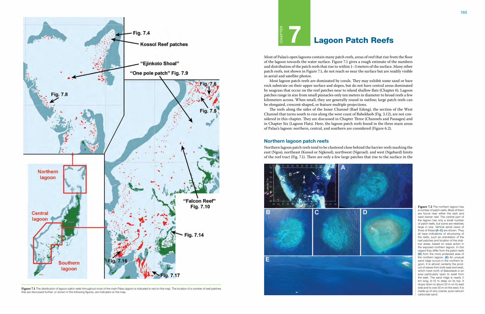
165
Ch
ap
te
r
7 Lagoon Patch Reefs
Most of Palau’s open lagoons contain many patch reefs, areas of reef that rise from the floor of the lagoon towards the water surface. Figure 7.1 gives a rough estimate of the numbers and distribution of the patch reefs that rise to within 1–3 meters of the surface. Many other patch reefs, not shown in Figure 7.1, do not reach so near the surface but are readily visible in aerial and satellite photos. Most lagoon patch reefs are dominated by corals. They may exhibit some sand or bare rock substrate on their upper surface and slopes, but do not have central areas dominated by seagrass that occur on the reef patches near to island shallow flats (Chapter 6). Lagoon patches range in size from small pinnacles only ten meters in diameter to broad reefs a few kilometers across. When small, they are generally round in outline; large patch reefs can be elongated, crescent-shaped, or feature multiple projections. The reefs along the sides of the Inner Channel (Rael Edeng), the section of the West Channel that turns south to run along the west coast of Babeldaob (Fig. 3.12), are not con-sidered in this chapter. They are discussed in Chapter Three (Channels and Passages) and in Chapter Six (Lagoon Flats). Here, the lagoon patch reefs found in the three main areas of Palau’s lagoon: northern, central, and southern are considered (Figure 6.2).
Northern lagoon patch reefsNorthern lagoon patch reefs tend to be clustered close behind the barrier reefs marking the east (Ngos), northeast (Kossol or Ngkesol), northwest (Ngerael). and west (Ngebard) limits of the reef tract (Fig. 7.1). There are only a few large patches that rise to the surface in the
Figure 7.2 The northern lagoon has a number of patch reefs. Most of them are found near either the east and west barrier reef. The central part of the lagoon has only a small number of patch reefs, but some are relatively large in size. Vertical aerial views of three of these (a–C) are shown. They all have indications of structuring of the reefs, such as orientiation of the reef patches and location of the shal-low areas, based on wave action in the exposed northern lagoon. In this regard they differ from the patch reefs (D) from the more protected area of the northern lagoon. (e) An unusual sand ridge occurs in the northern la-goon. It is almost certainly the prod-uct of waves from both east and west, which meet north of Babeldaob in an area particularly open to swell from the east. The sand ridge is nearly 2 km long, 9–12 m deep on its top. It drops down to about 20 m on its east side and to over 30 m on the west. It is made up of very coarse, pure calcium carbonate sand.
Figure 7.1 The distribution of lagoon patch reefs throughout most of the main Palau lagoon is indicated in red on the map. The location of a number of reef patches that are discussed further, or shown in the following figures, are indicated on the map.
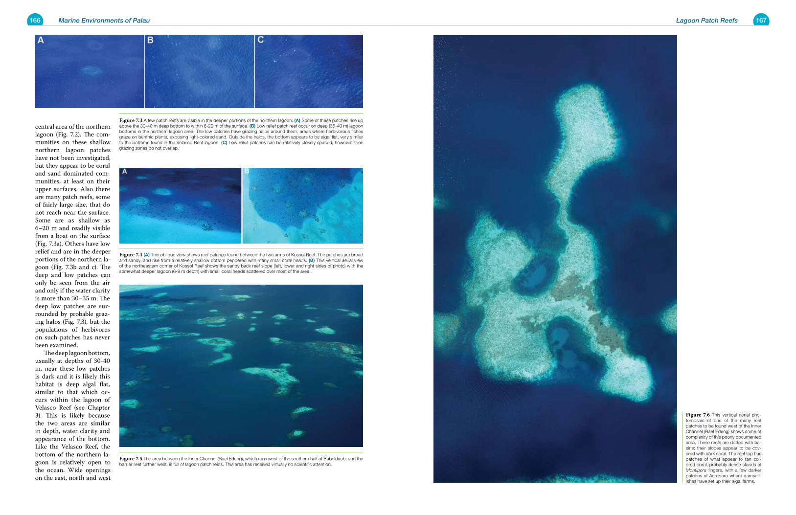
166 Marine Environments of Palau 167Lagoon Patch Reefs
central area of the northern lagoon (Fig. 7.2). The com-munities on these shallow northern lagoon patches have not been investigated, but they appear to be coral and sand dominated com-munities, at least on their upper surfaces. Also there are many patch reefs, some of fairly large size, that do not reach near the surface. Some are as shallow as 6–20 m and readily visible from a boat on the surface (Fig. 7.3a). Others have low relief and are in the deeper portions of the northern la-goon (Fig. 7.3b and c). The deep and low patches can only be seen from the air and only if the water clarity is more than 30–35 m. The deep low patches are sur-rounded by probable graz-ing halos (Fig. 7.3), but the populations of herbivores on such patches has never been examined. The deep lagoon bottom, usually at depths of 30-40 m, near these low patches is dark and it is likely this habitat is deep algal flat, similar to that which oc-curs within the lagoon of Velasco Reef (see Chapter 3). This is likely because the two areas are similar in depth, water clarity and appearance of the bottom. Like the Velasco Reef, the bottom of the northern la-goon is relatively open to the ocean. Wide openings on the east, north and west
Figure 7.6 This vertical aerial pho-tomosaic of one of the many reef patches to be found west of the Inner Channel (Rael Edeng) shows some of complexity of this poorly documented area. These reefs are dotted with ba-sins; their slopes appear to be cov-ered with dark coral. The reef top has patches of what appear to tan col-ored coral, probably dense stands of Montipora fingers, with a few darker patches of Acropora where damself-ishes have set up their algal farms.
Figure 7.3 A few patch reefs are visible in the deeper portions of the northern lagoon. (a) Some of these patches rise up above the 30-40 m deep bottom to within 6-20 m of the surface. (B) Low relief patch reef occur on deep (35-40 m) lagoon bottoms in the northern lagoon area. The low patches have grazing halos around them; areas where herbivorous fishes graze on benthic plants, exposing light-colored sand. Outside the halos, the bottom appears to be algal flat, very similar to the bottoms found in the Velasco Reef lagoon. (C) Low relief patches can be relatively closely spaced, however, their grazing zones do not overlap.
Figure 7.4 (a) This oblique view shows reef patches found between the two arms of Kossol Reef. The patches are broad and sandy, and rise from a relatively shallow bottom peppered with many small coral heads. (B) This vertical aerial view of the northeastern corner of Kossol Reef shows the sandy back reef slope (left, lower and right sides of photo) with the somewhat deeper lagoon (6-9 m depth) with small coral heads scattered over most of the area.
Figure 7.5 The area between the Inner Channel (Rael Edeng), which runs west of the southern half of Babeldaob, and the barrier reef further west, is full of lagoon patch reefs. This area has received virtually no scientific attention.
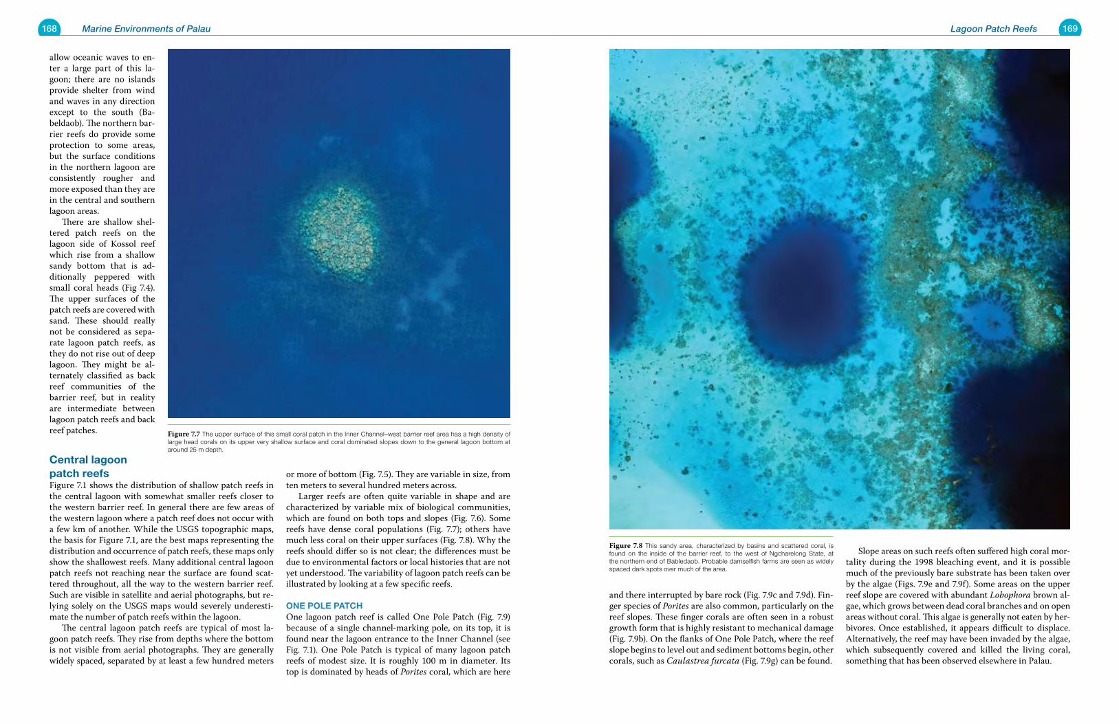
168 Marine Environments of Palau 169Lagoon Patch Reefs
and there interrupted by bare rock (Fig. 7.9c and 7.9d). Fin-ger species of Porites are also common, particularly on the reef slopes. These finger corals are often seen in a robust growth form that is highly resistant to mechanical damage (Fig. 7.9b). On the flanks of One Pole Patch, where the reef slope begins to level out and sediment bottoms begin, other corals, such as Caulastrea furcata (Fig. 7.9g) can be found.
Slope areas on such reefs often suffered high coral mor-tality during the 1998 bleaching event, and it is possible much of the previously bare substrate has been taken over by the algae (Figs. 7.9e and 7.9f). Some areas on the upper reef slope are covered with abundant Lobophora brown al-gae, which grows between dead coral branches and on open areas without coral. This algae is generally not eaten by her-bivores. Once established, it appears difficult to displace. Alternatively, the reef may have been invaded by the algae, which subsequently covered and killed the living coral, something that has been observed elsewhere in Palau.
allow oceanic waves to en-ter a large part of this la-goon; there are no islands provide shelter from wind and waves in any direction except to the south (Ba-beldaob). The northern bar-rier reefs do provide some protection to some areas, but the surface conditions in the northern lagoon are consistently rougher and more exposed than they are in the central and southern lagoon areas. There are shallow shel-tered patch reefs on the lagoon side of Kossol reef which rise from a shallow sandy bottom that is ad-ditionally peppered with small coral heads (Fig 7.4). The upper surfaces of the patch reefs are covered with sand. These should really not be considered as sepa-rate lagoon patch reefs, as they do not rise out of deep lagoon. They might be al-ternately classified as back reef communities of the barrier reef, but in reality are intermediate between lagoon patch reefs and back reef patches.
Central lagoon patch reefsFigure 7.1 shows the distribution of shallow patch reefs in the central lagoon with somewhat smaller reefs closer to the western barrier reef. In general there are few areas of the western lagoon where a patch reef does not occur with a few km of another. While the USGS topographic maps, the basis for Figure 7.1, are the best maps representing the distribution and occurrence of patch reefs, these maps only show the shallowest reefs. Many additional central lagoon patch reefs not reaching near the surface are found scat-tered throughout, all the way to the western barrier reef. Such are visible in satellite and aerial photographs, but re-lying solely on the USGS maps would severely underesti-mate the number of patch reefs within the lagoon. The central lagoon patch reefs are typical of most la-goon patch reefs. They rise from depths where the bottom is not visible from aerial photographs. They are generally widely spaced, separated by at least a few hundred meters
or more of bottom (Fig. 7.5). They are variable in size, from ten meters to several hundred meters across. Larger reefs are often quite variable in shape and are characterized by variable mix of biological communities, which are found on both tops and slopes (Fig. 7.6). Some reefs have dense coral populations (Fig. 7.7); others have much less coral on their upper surfaces (Fig. 7.8). Why the reefs should differ so is not clear; the differences must be due to environmental factors or local histories that are not yet understood. The variability of lagoon patch reefs can be illustrated by looking at a few specific reefs.
oNe poLe patChOne lagoon patch reef is called One Pole Patch (Fig. 7.9) because of a single channel-marking pole, on its top, it is found near the lagoon entrance to the Inner Channel (see Fig. 7.1). One Pole Patch is typical of many lagoon patch reefs of modest size. It is roughly 100 m in diameter. Its top is dominated by heads of Porites coral, which are here
Figure 7.8 This sandy area, characterized by basins and scattered coral, is found on the inside of the barrier reef, to the west of Ngcharelong State, at the northern end of Babledaob. Probable damselfish farms are seen as widely spaced dark spots over much of the area.
Figure 7.7 The upper surface of this small coral patch in the Inner Channel–west barrier reef area has a high density of large head corals on its upper very shallow surface and coral dominated slopes down to the general lagoon bottom at around 25 m depth.
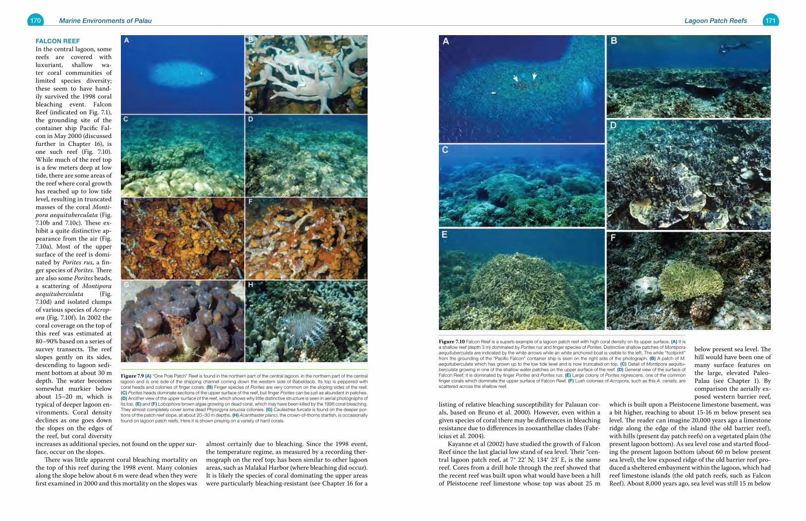
170 Marine Environments of Palau 171Lagoon Patch Reefs
listing of relative bleaching susceptibility for Palauan cor-als, based on Bruno et al. 2000). However, even within a given species of coral there may be differences in bleaching resistance due to differences in zooxanthellae clades (Fabr-icius et al. 2004). Kayanne et al (2002) have studied the growth of Falcon Reef since the last glacial low stand of sea level. Their “cen-tral lagoon patch reef, at 7° 22’ N; 134° 23’ E, is the same reef. Cores from a drill hole through the reef showed that the recent reef was built upon what would have been a hill of Pleistocene reef limestone whose top was about 25 m
below present sea level. The hill would have been one of many surface features on the large, elevated Paleo-Palau (see Chapter 1). By comparison the aerially ex-posed western barrier reef,
which is built upon a Pleistocene limestone basement, was a bit higher, reaching to about 15-16 m below present sea level. The reader can imagine 20,000 years ago a limestone ridge along the edge of the island (the old barrier reef), with hills (present day patch reefs) on a vegetated plain (the present lagoon bottom). As sea level rose and started flood-ing the present lagoon bottom (about 60 m below present sea level), the low exposed ridge of the old barrier reef pro-duced a sheltered embayment within the lagoon, which had reef limestone islands (the old patch reefs, such as Falcon Reef). About 8,000 years ago, sea level was still 15 m below
FaLCoN reeFIn the central lagoon, some reefs are covered with luxuriant, shallow wa-ter coral communities of limited species diversity; these seem to have hand-ily survived the 1998 coral bleaching event. Falcon Reef (indicated on Fig. 7.1), the grounding site of the container ship Pacific Fal-con in May 2000 (discussed further in Chapter 16), is one such reef (Fig. 7.10). While much of the reef top is a few meters deep at low tide, there are some areas of the reef where coral growth has reached up to low tide level, resulting in truncated masses of the coral Monti-pora aequituberculata (Fig. 7.10b and 7.10c). These ex-hibit a quite distinctive ap-pearance from the air (Fig. 7.10a). Most of the upper surface of the reef is domi-nated by Porites rus, a fin-ger species of Porites. There are also some Porites heads, a scattering of Montipora aequituberculata (Fig. 7.10d) and isolated clumps of various species of Acrop-ora (Fig. 7.10f). In 2002 the coral coverage on the top of this reef was estimated at 80–90% based on a series of survey transects. The reef slopes gently on its sides, descending to lagoon sedi-ment bottom at about 30 m depth. The water becomes somewhat murkier below about 15–20 m, which is typical of deeper lagoon en-vironments. Coral density declines as one goes down the slopes on the edges of the reef, but coral diversity increases as additional species, not found on the upper sur-face, occur on the slopes. There was little apparent coral bleaching mortality on the top of this reef during the 1998 event. Many colonies along the slope below about 6 m were dead when they were first examined in 2000 and this mortality on the slopes was
almost certainly due to bleaching. Since the 1998 event, the temperature regime, as measured by a recording ther-mograph on the reef top; has been similar to other lagoon areas, such as Malakal Harbor (where bleaching did occur). It is likely the species of coral dominating the upper areas were particularly bleaching-resistant (see Chapter 16 for a
Figure 7.10 Falcon Reef is a superb example of a lagoon patch reef with high coral density on its upper surface. (a) It is a shallow reef (depth 3 m) dominated by Porites rus and finger species of Porites. Distinctive shallow patches of Montipora aequituberculata are indicated by the white arrows while an white anchored boat is visible to the left. The while “footprint” from the grounding of the “Pacific Falcon” container ship is seen on the right side of the photograph. (B) A patch of M. aequituberculata which has grown up to the low tide level and is now truncated on top. (C) Detail of Montipora aequitu-berculata growing in one of the shallow water patches on the upper surface of the reef. (D) General view of the surface of Falcon Reef; it is dominated by finger Porites and Porites rus. (e) Large colony of Porites nigrescens, one of the common finger corals which dominate the upper surface of Falcon Reef. (F) Lush colonies of Acropora, such as this A. cerialis, are scattered across the shallow reef.
Figure 7.9 (a) “One Pole Patch” Reef is found in the northern part of the central lagoon. in the northern part of the central lagoon and is one side of the shipping channel coming down the western side of Babeldaob. Its top is peppered with coral heads and colonies of finger corals. (B) Finger species of Porites are very common on the sloping sides of the reef. (C) Porites heads dominate sections of the upper surface of the reef, but finger Porites can be just as abundant in patches. (D) Another view of the upper surface of the reef, which shows why little distinctive structure is seen in aerial photographs of its top. (e) and (F) Lobophora brown algae growing on dead coral, which may have been killed by the 1998 coral bleaching. They almost completely cover some dead Physogyra sinuosa colonies. (g) Caulastrea furcata is found on the deeper por-tions of the patch reef slope, at about 20–30 m depths. (h) Acanthaster planci, the crown-of-thorns starfish, is occasionally found on lagoon patch reefs. Here it is shown preying on a variety of hard corals.
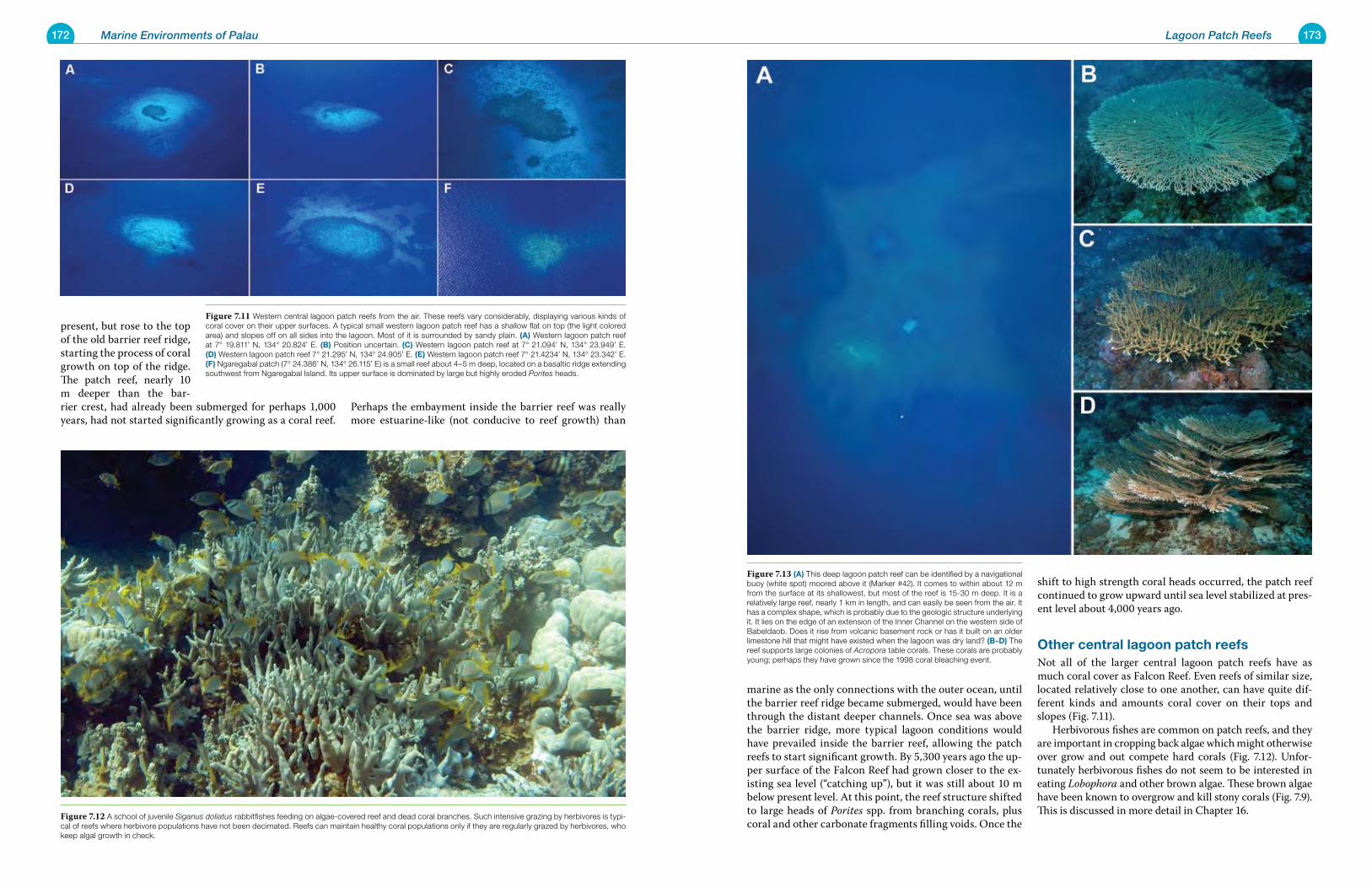
172 Marine Environments of Palau 173Lagoon Patch Reefs
marine as the only connections with the outer ocean, until the barrier reef ridge became submerged, would have been through the distant deeper channels. Once sea was above the barrier ridge, more typical lagoon conditions would have prevailed inside the barrier reef, allowing the patch reefs to start significant growth. By 5,300 years ago the up-per surface of the Falcon Reef had grown closer to the ex-isting sea level (“catching up”), but it was still about 10 m below present level. At this point, the reef structure shifted to large heads of Porites spp. from branching corals, plus coral and other carbonate fragments filling voids. Once the
shift to high strength coral heads occurred, the patch reef continued to grow upward until sea level stabilized at pres-ent level about 4,000 years ago.
other central lagoon patch reefsNot all of the larger central lagoon patch reefs have as much coral cover as Falcon Reef. Even reefs of similar size, located relatively close to one another, can have quite dif-ferent kinds and amounts coral cover on their tops and slopes (Fig. 7.11). Herbivorous fishes are common on patch reefs, and they are important in cropping back algae which might otherwise over grow and out compete hard corals (Fig. 7.12). Unfor-tunately herbivorous fishes do not seem to be interested in eating Lobophora and other brown algae. These brown algae have been known to overgrow and kill stony corals (Fig. 7.9). This is discussed in more detail in Chapter 16.
present, but rose to the top of the old barrier reef ridge, starting the process of coral growth on top of the ridge. The patch reef, nearly 10 m deeper than the bar-rier crest, had already been submerged for perhaps 1,000 years, had not started significantly growing as a coral reef.
Perhaps the embayment inside the barrier reef was really more estuarine-like (not conducive to reef growth) than
Figure 7.13 (a) This deep lagoon patch reef can be identified by a navigational buoy (white spot) moored above it (Marker #42). It comes to within about 12 m from the surface at its shallowest, but most of the reef is 15-30 m deep. It is a relatively large reef, nearly 1 km in length, and can easily be seen from the air. It has a complex shape, which is probably due to the geologic structure underlying it. It lies on the edge of an extension of the Inner Channel on the western side of Babeldaob. Does it rise from volcanic basement rock or has it built on an older limestone hill that might have existed when the lagoon was dry land? (B-D) The reef supports large colonies of Acropora table corals. These corals are probably young; perhaps they have grown since the 1998 coral bleaching event.
Figure 7.12 A school of juvenile Siganus doliatus rabbitfishes feeding on algae-covered reef and dead coral branches. Such intensive grazing by herbivores is typi-cal of reefs where herbivore populations have not been decimated. Reefs can maintain healthy coral populations only if they are regularly grazed by herbivores, who keep algal growth in check.
Figure 7.11 Western central lagoon patch reefs from the air. These reefs vary considerably, displaying various kinds of coral cover on their upper surfaces. A typical small western lagoon patch reef has a shallow flat on top (the light colored area) and slopes off on all sides into the lagoon. Most of it is surrounded by sandy plain. (a) Western lagoon patch reef at 7° 19.811’ N, 134° 20.824’ E. (B) Position uncertain. (C) Western lagoon patch reef at 7° 21.094’ N, 134° 23.949’ E. (D) Western lagoon patch reef 7° 21.295’ N, 134° 24.905’ E. (e) Western lagoon patch reef 7° 21.4234’ N, 134° 23.342’ E. (F) Ngaregabal patch (7° 24.386’ N, 134° 26.115’ E) is a small reef about 4–5 m deep, located on a basaltic ridge extending southwest from Ngaregabal Island. Its upper surface is dominated by large but highly eroded Porites heads.
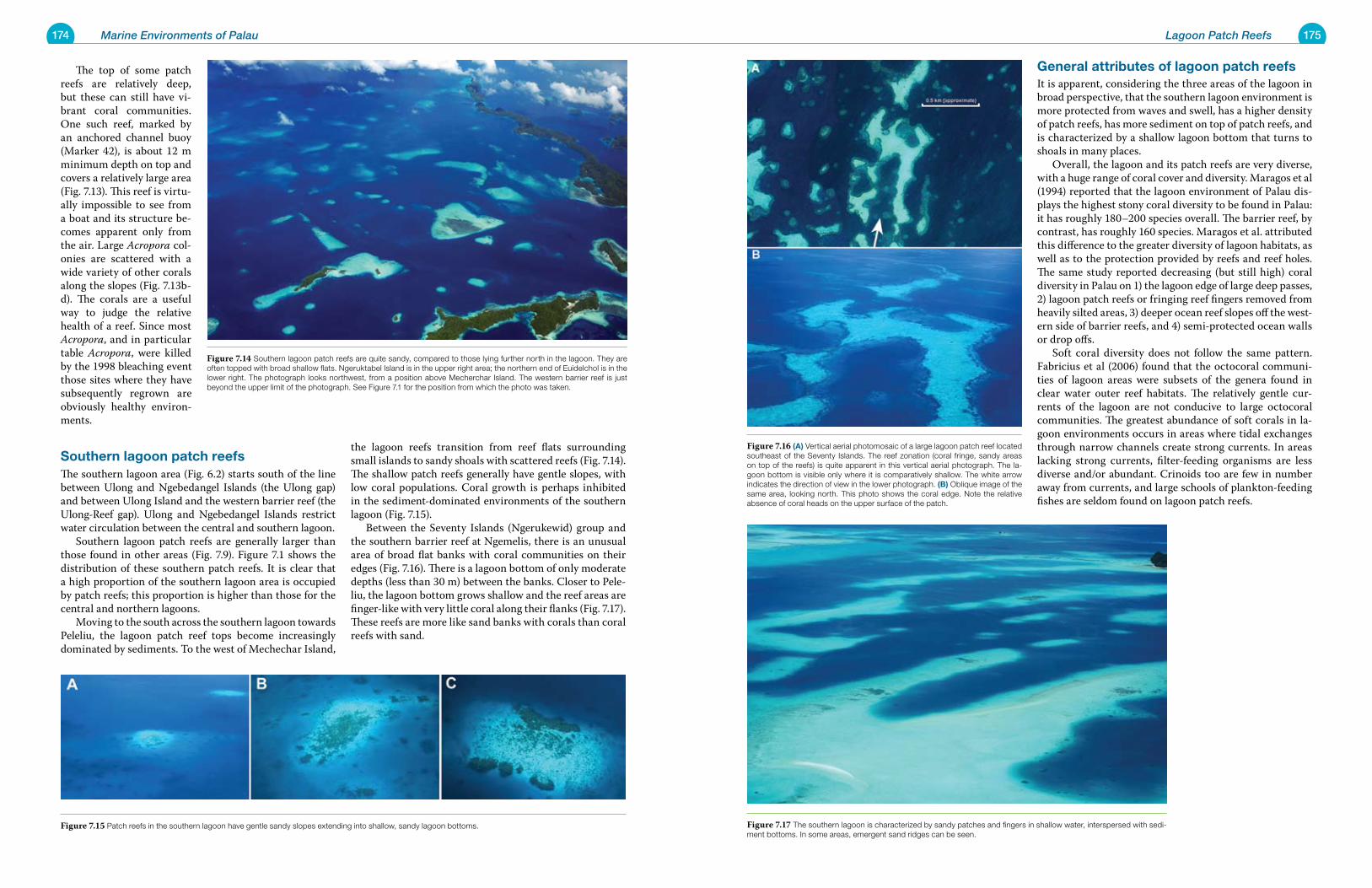
174 Marine Environments of Palau 175Lagoon Patch Reefs
general attributes of lagoon patch reefsIt is apparent, considering the three areas of the lagoon in broad perspective, that the southern lagoon environment is more protected from waves and swell, has a higher density of patch reefs, has more sediment on top of patch reefs, and is characterized by a shallow lagoon bottom that turns to shoals in many places. Overall, the lagoon and its patch reefs are very diverse, with a huge range of coral cover and diversity. Maragos et al (1994) reported that the lagoon environment of Palau dis-plays the highest stony coral diversity to be found in Palau: it has roughly 180–200 species overall. The barrier reef, by contrast, has roughly 160 species. Maragos et al. attributed this difference to the greater diversity of lagoon habitats, as well as to the protection provided by reefs and reef holes. The same study reported decreasing (but still high) coral diversity in Palau on 1) the lagoon edge of large deep passes, 2) lagoon patch reefs or fringing reef fingers removed from heavily silted areas, 3) deeper ocean reef slopes off the west-ern side of barrier reefs, and 4) semi-protected ocean walls or drop offs. Soft coral diversity does not follow the same pattern. Fabricius et al (2006) found that the octocoral communi-ties of lagoon areas were subsets of the genera found in clear water outer reef habitats. The relatively gentle cur-rents of the lagoon are not conducive to large octocoral communities. The greatest abundance of soft corals in la-goon environments occurs in areas where tidal exchanges through narrow channels create strong currents. In areas lacking strong currents, filter-feeding organisms are less diverse and/or abundant. Crinoids too are few in number away from currents, and large schools of plankton-feeding fishes are seldom found on lagoon patch reefs.
The top of some patch reefs are relatively deep, but these can still have vi-brant coral communities. One such reef, marked by an anchored channel buoy (Marker 42), is about 12 m minimum depth on top and covers a relatively large area (Fig. 7.13). This reef is virtu-ally impossible to see from a boat and its structure be-comes apparent only from the air. Large Acropora col-onies are scattered with a wide variety of other corals along the slopes (Fig. 7.13b-d). The corals are a useful way to judge the relative health of a reef. Since most Acropora, and in particular table Acropora, were killed by the 1998 bleaching event those sites where they have subsequently regrown are obviously healthy environ-ments.
southern lagoon patch reefs The southern lagoon area (Fig. 6.2) starts south of the line between Ulong and Ngebedangel Islands (the Ulong gap) and between Ulong Island and the western barrier reef (the Ulong-Reef gap). Ulong and Ngebedangel Islands restrict water circulation between the central and southern lagoon. Southern lagoon patch reefs are generally larger than those found in other areas (Fig. 7.9). Figure 7.1 shows the distribution of these southern patch reefs. It is clear that a high proportion of the southern lagoon area is occupied by patch reefs; this proportion is higher than those for the central and northern lagoons. Moving to the south across the southern lagoon towards Peleliu, the lagoon patch reef tops become increasingly dominated by sediments. To the west of Mechechar Island,
the lagoon reefs transition from reef flats surrounding small islands to sandy shoals with scattered reefs (Fig. 7.14). The shallow patch reefs generally have gentle slopes, with low coral populations. Coral growth is perhaps inhibited in the sediment-dominated environments of the southern lagoon (Fig. 7.15). Between the Seventy Islands (Ngerukewid) group and the southern barrier reef at Ngemelis, there is an unusual area of broad flat banks with coral communities on their edges (Fig. 7.16). There is a lagoon bottom of only moderate depths (less than 30 m) between the banks. Closer to Pele-liu, the lagoon bottom grows shallow and the reef areas are finger-like with very little coral along their flanks (Fig. 7.17). These reefs are more like sand banks with corals than coral reefs with sand.
Figure 7.16 (a) Vertical aerial photomosaic of a large lagoon patch reef located southeast of the Seventy Islands. The reef zonation (coral fringe, sandy areas on top of the reefs) is quite apparent in this vertical aerial photograph. The la-goon bottom is visible only where it is comparatively shallow. The white arrow indicates the direction of view in the lower photograph. (B) Oblique image of the same area, looking north. This photo shows the coral edge. Note the relative absence of coral heads on the upper surface of the patch.
Figure 7.17 The southern lagoon is characterized by sandy patches and fingers in shallow water, interspersed with sedi-ment bottoms. In some areas, emergent sand ridges can be seen.
Figure 7.14 Southern lagoon patch reefs are quite sandy, compared to those lying further north in the lagoon. They are often topped with broad shallow flats. Ngeruktabel Island is in the upper right area; the northern end of Euidelchol is in the lower right. The photograph looks northwest, from a position above Mecherchar Island. The western barrier reef is just beyond the upper limit of the photograph. See Figure 7.1 for the position from which the photo was taken.
Figure 7.15 Patch reefs in the southern lagoon have gentle sandy slopes extending into shallow, sandy lagoon bottoms.
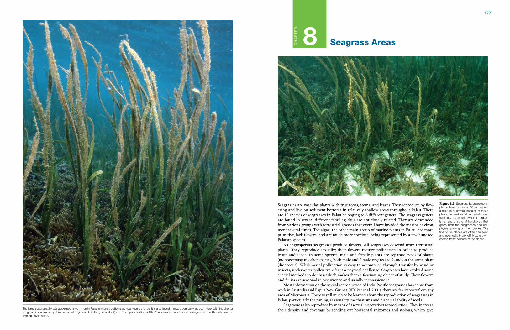
177
Ch
ap
te
r
8 Seagrass Areas
Seagrasses are vascular plants with true roots, stems, and leaves. They reproduce by flow-ering and live on sediment bottoms in relatively shallow areas throughout Palau. There are 10 species of seagrasses in Palau belonging to 6 different genera. The seagrass genera are found in several different families; thus are not closely related. They are descended from various groups with terrestrial grasses that overall have invaded the marine environ-ment several times. The algae, the other main group of marine plants in Palau, are more primitive, lack flowers, and are much more speciose, being represented by a few hundred Palauan species. As angiosperms seagrasses produce flowers. All seagrasses descend from terrestrial plants. They reproduce sexually; their flowers require pollination in order to produce fruits and seeds. In some species, male and female plants are separate types of plants (monoeceous); in other species, both male and female organs are found on the same plant (dioeceous). While aerial pollination is easy to accomplish through transfer by wind or insects, underwater pollen transfer is a physical challenge. Seagrasses have evolved some special methods to do this, which makes them a fascinating object of study. Their flowers and fruits are seasonal in occurrence and usually inconspicuous. Most information on the sexual reproduction of Indo-Pacific seagrasses has come from work in Australia and Papua New Guinea (Walker et al. 2001); there are few reports from any area of Micronesia. There is still much to be learned about the reproduction of seagrasses in Palau, particularly the timing, seasonality, mechanisms and dispersal ability of seeds. Seagrasses also reproduce by means of asexual (vegetative) reproduction. They increase their density and coverage by sending out horizontal rhizomes and stolons, which give
Figure 8.1. Seagrass beds are com-plicated environments. Often they are a mixture of several species of these plants, as well as algae, small coral colonies, sediment-dwelling organ-isms, and a suite of herbivores that graze both the seagrasses and epi-phytes growing on their blades. The tips of the blades are often damaged and eventually break off. New growth comes from the base of the blades.
The large seagrass, Enhalis acoroides, is common in Palau on sandy bottoms as nearly pure stands. It is also found in mixed company, as seen here, with the shorter seagrass Thalassia hemprichii and small finger corals of the genus Montipora. The upper portions of the E. acoroides blades become degenerate and heavily covered with epiphytic algae.
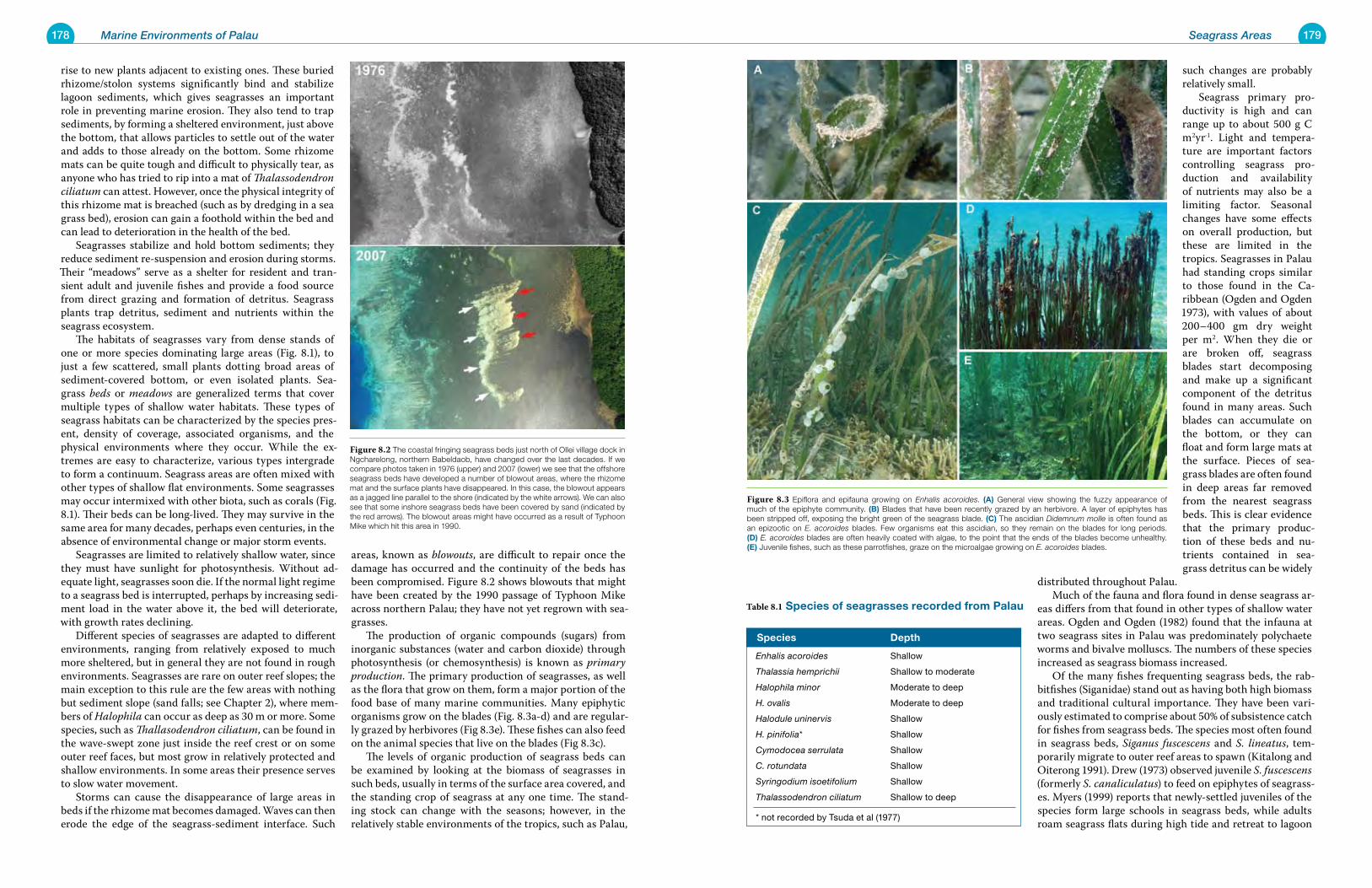
178 Marine Environments of Palau 179Seagrass Areas
such changes are probably relatively small. Seagrass primary pro-ductivity is high and can range up to about 500 g C m2yr-1. Light and tempera-ture are important factors controlling seagrass pro-duction and availability of nutrients may also be a limiting factor. Seasonal changes have some effects on overall production, but these are limited in the tropics. Seagrasses in Palau had standing crops similar to those found in the Ca-ribbean (Ogden and Ogden 1973), with values of about 200–400 gm dry weight per m2. When they die or are broken off, seagrass blades start decomposing and make up a significant component of the detritus found in many areas. Such blades can accumulate on the bottom, or they can float and form large mats at the surface. Pieces of sea-grass blades are often found in deep areas far removed from the nearest seagrass beds. This is clear evidence that the primary produc-tion of these beds and nu-trients contained in sea-grass detritus can be widely
distributed throughout Palau. Much of the fauna and flora found in dense seagrass ar-eas differs from that found in other types of shallow water areas. Ogden and Ogden (1982) found that the infauna at two seagrass sites in Palau was predominately polychaete worms and bivalve molluscs. The numbers of these species increased as seagrass biomass increased. Of the many fishes frequenting seagrass beds, the rab-bitfishes (Siganidae) stand out as having both high biomass and traditional cultural importance. They have been vari-ously estimated to comprise about 50% of subsistence catch for fishes from seagrass beds. The species most often found in seagrass beds, Siganus fuscescens and S. lineatus, tem-porarily migrate to outer reef areas to spawn (Kitalong and Oiterong 1991). Drew (1973) observed juvenile S. fuscescens (formerly S. canaliculatus) to feed on epiphytes of seagrass-es. Myers (1999) reports that newly-settled juveniles of the species form large schools in seagrass beds, while adults roam seagrass flats during high tide and retreat to lagoon
rise to new plants adjacent to existing ones. These buried rhizome/stolon systems significantly bind and stabilize lagoon sediments, which gives seagrasses an important role in preventing marine erosion. They also tend to trap sediments, by forming a sheltered environment, just above the bottom, that allows particles to settle out of the water and adds to those already on the bottom. Some rhizome mats can be quite tough and difficult to physically tear, as anyone who has tried to rip into a mat of Thalassodendron ciliatum can attest. However, once the physical integrity of this rhizome mat is breached (such as by dredging in a sea grass bed), erosion can gain a foothold within the bed and can lead to deterioration in the health of the bed. Seagrasses stabilize and hold bottom sediments; they reduce sediment re-suspension and erosion during storms. Their “meadows” serve as a shelter for resident and tran-sient adult and juvenile fishes and provide a food source from direct grazing and formation of detritus. Seagrass plants trap detritus, sediment and nutrients within the seagrass ecosystem. The habitats of seagrasses vary from dense stands of one or more species dominating large areas (Fig. 8.1), to just a few scattered, small plants dotting broad areas of sediment-covered bottom, or even isolated plants. Sea-grass beds or meadows are generalized terms that cover multiple types of shallow water habitats. These types of seagrass habitats can be characterized by the species pres-ent, density of coverage, associated organisms, and the physical environments where they occur. While the ex-tremes are easy to characterize, various types intergrade to form a continuum. Seagrass areas are often mixed with other types of shallow flat environments. Some seagrasses may occur intermixed with other biota, such as corals (Fig. 8.1). Their beds can be long-lived. They may survive in the same area for many decades, perhaps even centuries, in the absence of environmental change or major storm events. Seagrasses are limited to relatively shallow water, since they must have sunlight for photosynthesis. Without ad-equate light, seagrasses soon die. If the normal light regime to a seagrass bed is interrupted, perhaps by increasing sedi-ment load in the water above it, the bed will deteriorate, with growth rates declining. Different species of seagrasses are adapted to different environments, ranging from relatively exposed to much more sheltered, but in general they are not found in rough environments. Seagrasses are rare on outer reef slopes; the main exception to this rule are the few areas with nothing but sediment slope (sand falls; see Chapter 2), where mem-bers of Halophila can occur as deep as 30 m or more. Some species, such as Thallasodendron ciliatum, can be found in the wave-swept zone just inside the reef crest or on some outer reef faces, but most grow in relatively protected and shallow environments. In some areas their presence serves to slow water movement. Storms can cause the disappearance of large areas in beds if the rhizome mat becomes damaged. Waves can then erode the edge of the seagrass-sediment interface. Such
areas, known as blowouts, are difficult to repair once the damage has occurred and the continuity of the beds has been compromised. Figure 8.2 shows blowouts that might have been created by the 1990 passage of Typhoon Mike across northern Palau; they have not yet regrown with sea-grasses. The production of organic compounds (sugars) from inorganic substances (water and carbon dioxide) through photosynthesis (or chemosynthesis) is known as primary production. The primary production of seagrasses, as well as the flora that grow on them, form a major portion of the food base of many marine communities. Many epiphytic organisms grow on the blades (Fig. 8.3a-d) and are regular-ly grazed by herbivores (Fig 8.3e). These fishes can also feed on the animal species that live on the blades (Fig 8.3c). The levels of organic production of seagrass beds can be examined by looking at the biomass of seagrasses in such beds, usually in terms of the surface area covered, and the standing crop of seagrass at any one time. The stand-ing stock can change with the seasons; however, in the relatively stable environments of the tropics, such as Palau,
species Depth
Enhalis acoroides Shallow
Thalassia hemprichii Shallow to moderate
Halophila minor Moderate to deep
H. ovalis Moderate to deep
Halodule uninervis Shallow
H. pinifolia* Shallow
Cymodocea serrulata Shallow
C. rotundata Shallow
Syringodium isoetifolium Shallow
Thalassodendron ciliatum Shallow to deep
* not recorded by Tsuda et al (1977)
Table 8.1 species of seagrasses recorded from palau
Figure 8.3 Epiflora and epifauna growing on Enhalis acoroides. (a) General view showing the fuzzy appearance of much of the epiphyte community. (B) Blades that have been recently grazed by an herbivore. A layer of epiphytes has been stripped off, exposing the bright green of the seagrass blade. (C) The ascidian Didemnum molle is often found as an epizootic on E. acoroides blades. Few organisms eat this ascidian, so they remain on the blades for long periods. (D) E. acoroides blades are often heavily coated with algae, to the point that the ends of the blades become unhealthy. (e) Juvenile fishes, such as these parrotfishes, graze on the microalgae growing on E. acoroides blades.
Figure 8.2 The coastal fringing seagrass beds just north of Ollei village dock in Ngcharelong, northern Babeldaob, have changed over the last decades. If we compare photos taken in 1976 (upper) and 2007 (lower) we see that the offshore seagrass beds have developed a number of blowout areas, where the rhizome mat and the surface plants have disappeared. In this case, the blowout appears as a jagged line parallel to the shore (indicated by the white arrows). We can also see that some inshore seagrass beds have been covered by sand (indicated by the red arrows). The blowout areas might have occurred as a result of Typhoon Mike which hit this area in 1990.
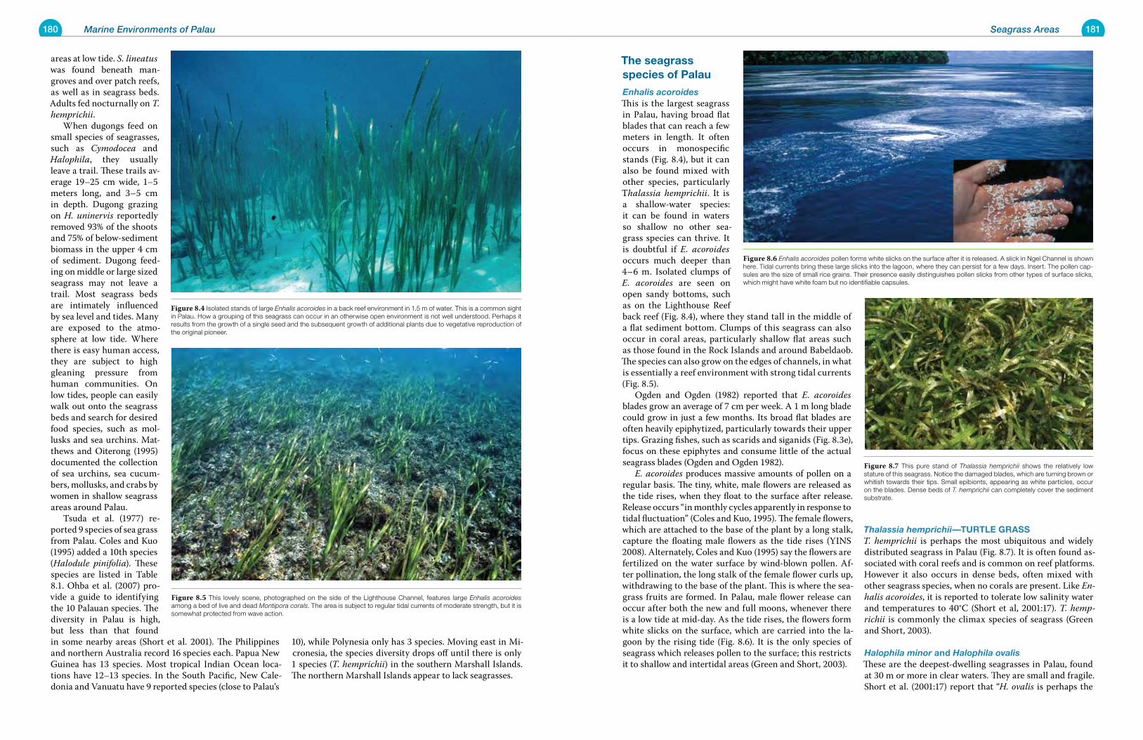
180 Marine Environments of Palau 181Seagrass Areas
the seagrass species of palau
Enhalis acoroidesThis is the largest seagrass in Palau, having broad flat blades that can reach a few meters in length. It often occurs in monospecific stands (Fig. 8.4), but it can also be found mixed with other species, particularly Thalassia hemprichii. It is a shallow-water species: it can be found in waters so shallow no other sea-grass species can thrive. It is doubtful if E. acoroides occurs much deeper than 4–6 m. Isolated clumps of E. acoroides are seen on open sandy bottoms, such as on the Lighthouse Reef back reef (Fig. 8.4), where they stand tall in the middle of a flat sediment bottom. Clumps of this seagrass can also occur in coral areas, particularly shallow flat areas such as those found in the Rock Islands and around Babeldaob. The species can also grow on the edges of channels, in what is essentially a reef environment with strong tidal currents (Fig. 8.5). Ogden and Ogden (1982) reported that E. acoroides blades grow an average of 7 cm per week. A 1 m long blade could grow in just a few months. Its broad flat blades are often heavily epiphytized, particularly towards their upper tips. Grazing fishes, such as scarids and siganids (Fig. 8.3e), focus on these epiphytes and consume little of the actual seagrass blades (Ogden and Ogden 1982). E. acoroides produces massive amounts of pollen on a regular basis. The tiny, white, male flowers are released as the tide rises, when they float to the surface after release. Release occurs “in monthly cycles apparently in response to tidal fluctuation” (Coles and Kuo, 1995). The female flowers, which are attached to the base of the plant by a long stalk, capture the floating male flowers as the tide rises (YINS 2008). Alternately, Coles and Kuo (1995) say the flowers are fertilized on the water surface by wind-blown pollen. Af-ter pollination, the long stalk of the female flower curls up, withdrawing to the base of the plant. This is where the sea-grass fruits are formed. In Palau, male flower release can occur after both the new and full moons, whenever there is a low tide at mid-day. As the tide rises, the flowers form white slicks on the surface, which are carried into the la-goon by the rising tide (Fig. 8.6). It is the only species of seagrass which releases pollen to the surface; this restricts it to shallow and intertidal areas (Green and Short, 2003).
Thalassia hemprichii—turtLe grassT. hemprichii is perhaps the most ubiquitous and widely distributed seagrass in Palau (Fig. 8.7). It is often found as-sociated with coral reefs and is common on reef platforms. However it also occurs in dense beds, often mixed with other seagrass species, when no corals are present. Like En-halis acoroides, it is reported to tolerate low salinity water and temperatures to 40°C (Short et al, 2001:17). T. hemp-richii is commonly the climax species of seagrass (Green and Short, 2003).
Halophila minor and Halophila ovalisThese are the deepest-dwelling seagrasses in Palau, found at 30 m or more in clear waters. They are small and fragile. Short et al. (2001:17) report that “H. ovalis is perhaps the
areas at low tide. S. lineatus was found beneath man-groves and over patch reefs, as well as in seagrass beds. Adults fed nocturnally on T. hemprichii. When dugongs feed on small species of seagrasses, such as Cymodocea and Halophila, they usually leave a trail. These trails av-erage 19–25 cm wide, 1–5 meters long, and 3–5 cm in depth. Dugong grazing on H. uninervis reportedly removed 93% of the shoots and 75% of below-sediment biomass in the upper 4 cm of sediment. Dugong feed-ing on middle or large sized seagrass may not leave a trail. Most seagrass beds are intimately influenced by sea level and tides. Many are exposed to the atmo-sphere at low tide. Where there is easy human access, they are subject to high gleaning pressure from human communities. On low tides, people can easily walk out onto the seagrass beds and search for desired food species, such as mol-lusks and sea urchins. Mat-thews and Oiterong (1995) documented the collection of sea urchins, sea cucum-bers, mollusks, and crabs by women in shallow seagrass areas around Palau. Tsuda et al. (1977) re-ported 9 species of sea grass from Palau. Coles and Kuo (1995) added a 10th species (Halodule pinifolia). These species are listed in Table 8.1. Ohba et al. (2007) pro-vide a guide to identifying the 10 Palauan species. The diversity in Palau is high, but less than that found in some nearby areas (Short et al. 2001). The Philippines and northern Australia record 16 species each. Papua New Guinea has 13 species. Most tropical Indian Ocean loca-tions have 12–13 species. In the South Pacific, New Cale-donia and Vanuatu have 9 reported species (close to Palau’s
10), while Polynesia only has 3 species. Moving east in Mi-cronesia, the species diversity drops off until there is only 1 species (T. hemprichii) in the southern Marshall Islands. The northern Marshall Islands appear to lack seagrasses.
Figure 8.7 This pure stand of Thalassia hemprichii shows the relatively low stature of this seagrass. Notice the damaged blades, which are turning brown or whitish towards their tips. Small epibionts, appearing as white particles, occur on the blades. Dense beds of T. hemprichii can completely cover the sediment substrate.
Figure 8.6 Enhalis acoroides pollen forms white slicks on the surface after it is released. A slick in Ngel Channel is shown here. Tidal currents bring these large slicks into the lagoon, where they can persist for a few days. Insert. The pollen cap-sules are the size of small rice grains. Their presence easily distinguishes pollen slicks from other types of surface slicks, which might have white foam but no identifiable capsules.
Figure 8.5 This lovely scene, photographed on the side of the Lighthouse Channel, features large Enhalis acoroides among a bed of live and dead Montipora corals. The area is subject to regular tidal currents of moderate strength, but it is somewhat protected from wave action.
Figure 8.4 Isolated stands of large Enhalis acoroides in a back reef environment in 1.5 m of water. This is a common sight in Palau. How a grouping of this seagrass can occur in an otherwise open environment is not well understood. Perhaps it results from the growth of a single seed and the subsequent growth of additional plants due to vegetative reproduction of the original pioneer.
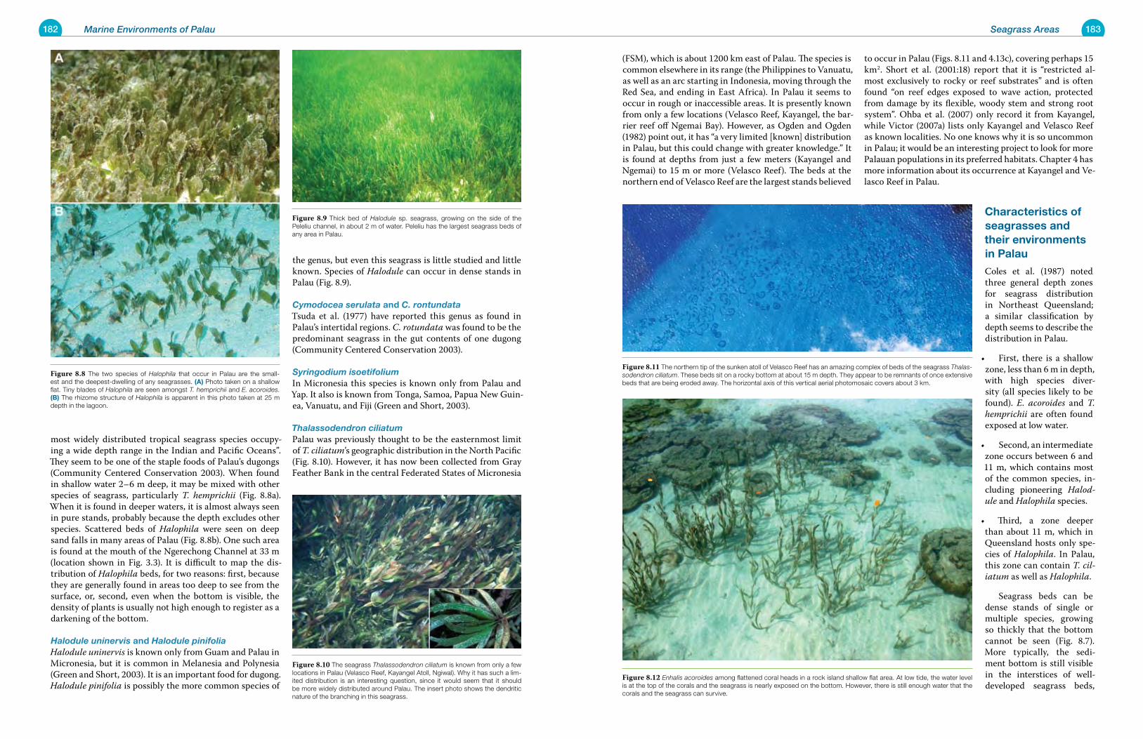
182 Marine Environments of Palau 183Seagrass Areas
(FSM), which is about 1200 km east of Palau. The species is common elsewhere in its range (the Philippines to Vanuatu, as well as an arc starting in Indonesia, moving through the Red Sea, and ending in East Africa). In Palau it seems to occur in rough or inaccessible areas. It is presently known from only a few locations (Velasco Reef, Kayangel, the bar-rier reef off Ngemai Bay). However, as Ogden and Ogden (1982) point out, it has “a very limited [known] distribution in Palau, but this could change with greater knowledge.” It is found at depths from just a few meters (Kayangel and Ngemai) to 15 m or more (Velasco Reef). The beds at the northern end of Velasco Reef are the largest stands believed
to occur in Palau (Figs. 8.11 and 4.13c), covering perhaps 15 km2. Short et al. (2001:18) report that it is “restricted al-most exclusively to rocky or reef substrates” and is often found “on reef edges exposed to wave action, protected from damage by its flexible, woody stem and strong root system”. Ohba et al. (2007) only record it from Kayangel, while Victor (2007a) lists only Kayangel and Velasco Reef as known localities. No one knows why it is so uncommon in Palau; it would be an interesting project to look for more Palauan populations in its preferred habitats. Chapter 4 has more information about its occurrence at Kayangel and Ve-lasco Reef in Palau.
Characteristics of seagrasses and their environments in palau
Coles et al. (1987) noted three general depth zones for seagrass distribution in Northeast Queensland; a similar classification by depth seems to describe the distribution in Palau.
First, there is a shallow •zone, less than 6 m in depth, with high species diver-sity (all species likely to be found). E. acoroides and T. hemprichii are often found exposed at low water.
Second, an intermediate •zone occurs between 6 and 11 m, which contains most of the common species, in-cluding pioneering Halod-ule and Halophila species.
Third, a zone deeper •than about 11 m, which in Queensland hosts only spe-cies of Halophila. In Palau, this zone can contain T. cil-iatum as well as Halophila.
Seagrass beds can be dense stands of single or multiple species, growing so thickly that the bottom cannot be seen (Fig. 8.7). More typically, the sedi-ment bottom is still visible in the interstices of well-developed seagrass beds,
most widely distributed tropical seagrass species occupy-ing a wide depth range in the Indian and Pacific Oceans”. They seem to be one of the staple foods of Palau’s dugongs (Community Centered Conservation 2003). When found in shallow water 2–6 m deep, it may be mixed with other species of seagrass, particularly T. hemprichii (Fig. 8.8a). When it is found in deeper waters, it is almost always seen in pure stands, probably because the depth excludes other species. Scattered beds of Halophila were seen on deep sand falls in many areas of Palau (Fig. 8.8b). One such area is found at the mouth of the Ngerechong Channel at 33 m (location shown in Fig. 3.3). It is difficult to map the dis-tribution of Halophila beds, for two reasons: first, because they are generally found in areas too deep to see from the surface, or, second, even when the bottom is visible, the density of plants is usually not high enough to register as a darkening of the bottom.
Halodule uninervis and Halodule pinifoliaHalodule uninervis is known only from Guam and Palau in Micronesia, but it is common in Melanesia and Polynesia (Green and Short, 2003). It is an important food for dugong. Halodule pinifolia is possibly the more common species of
the genus, but even this seagrass is little studied and little known. Species of Halodule can occur in dense stands in Palau (Fig. 8.9).
Cymodocea serulata and C. rontundataTsuda et al. (1977) have reported this genus as found in Palau’s intertidal regions. C. rotundata was found to be the predominant seagrass in the gut contents of one dugong (Community Centered Conservation 2003).
Syringodium isoetifolium In Micronesia this species is known only from Palau and Yap. It also is known from Tonga, Samoa, Papua New Guin-ea, Vanuatu, and Fiji (Green and Short, 2003).
Thalassodendron ciliatumPalau was previously thought to be the easternmost limit of T. ciliatum’s geographic distribution in the North Pacific (Fig. 8.10). However, it has now been collected from Gray Feather Bank in the central Federated States of Micronesia
Figure 8.11 The northern tip of the sunken atoll of Velasco Reef has an amazing complex of beds of the seagrass Thalas-sodendron ciliatum. These beds sit on a rocky bottom at about 15 m depth. They appear to be remnants of once extensive beds that are being eroded away. The horizontal axis of this vertical aerial photomosaic covers about 3 km.
Figure 8.12 Enhalis acoroides among flattened coral heads in a rock island shallow flat area. At low tide, the water level is at the top of the corals and the seagrass is nearly exposed on the bottom. However, there is still enough water that the corals and the seagrass can survive.
Figure 8.10 The seagrass Thalassodendron ciliatum is known from only a few locations in Palau (Velasco Reef, Kayangel Atoll, Ngiwal). Why it has such a lim-ited distribution is an interesting question, since it would seem that it should be more widely distributed around Palau. The insert photo shows the dendritic nature of the branching in this seagrass.
Figure 8.9 Thick bed of Halodule sp. seagrass, growing on the side of the Peleliu channel, in about 2 m of water. Peleliu has the largest seagrass beds of any area in Palau.
Figure 8.8 The two species of Halophila that occur in Palau are the small-est and the deepest-dwelling of any seagrasses. (a) Photo taken on a shallow flat. Tiny blades of Halophila are seen amongst T. hemprichii and E. acoroides. (B) The rhizome structure of Halophila is apparent in this photo taken at 25 m depth in the lagoon.
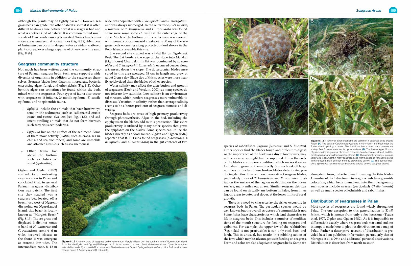
184 Marine Environments of Palau 185Seagrass Areas
species of rabbitfishes (Siganus fuscecens and S. lineatus). Other species find the blades tough and difficult to digest, so the importance of the blades as a direct food source may not be as great as might first be supposed. Often the ends of the blades are in poor condition, which makes it easier for fishes to graze on them directly. Storms break off large numbers of blades. These broken blades deteriorate, pro-ducing detritus. It is common to see rafts of seagrass blades, particularly those of T. hemprichii and E. acoroides, float-ing on the surface of the lagoon or drifting on the ocean surface, many miles out at sea. Similar seagrass detritus can be found on virtually any bottom in Palau, from inner lagoon areas to outer reef slopes, at the lower limits of coral growth. There is a need to characterize the fishes occurring in seagrass beds in Palau. The particular species would be well known, but the overall structure of communities is not. Some fishes have characteristics which lend themselves to life in seagrass beds. This includes a number of modifica-tions of the mouth structure for feeding on seagrass and epibionts. For example, the upper jaw of the rabbitfishes (Siganidae) is not protrusible; it can only rock back and forth. This is unusual, but results in a nibbling action of the jaws which may be advantageous in feeding on seagrass. Form and color are also adaptive in seagrass beds. Some are
elongate in form, to better blend in among the thin blades. A number of the fishes found in seagrass beds have greenish coloration, which helps them blend into their background; such species include wrasses (particularly Chelio inermis) as well as small species of lethrinids and rabbitfishes.
Distribution of seagrasses in palauMost species of seagrasses are found widely throughout Palau. The one exception to this generalization is T. cil-iatum, which is known from only a few locations (Tsuda et al. 1977, Ogden and Ogden 1982). As it is impossible to differentiate exactly where seagrass beds start and end, no attempt is made here to plot out distributions on a map of Palau. Rather, a descriptive account of distribution is pro-vided based on published information, particularly that of Maragos et al. (1994), and additional personal observations. Distribution is described from north to south.
although the plants may be tightly packed. However, sea-grass beds can grade into other habitats, so that it is often difficult to draw a line between what is a seagrass bed and what is another kind of habitat. It is common to find small stands of E. acoroides among truncated Porites heads in in-shore areas emergent at spring tides (Fig. 8.12). Members of Halophila can occur in deeper water as widely scattered plants, spread over a large expanse of otherwise white sand (Fig. 8.8b).
seagrass community structureNot much has been written about the community struc-ture of Palauan seagrass beds. Such areas support a wide diversity of organisms in addition to the seagrasses them-selves. Seagrass blades host diatoms, microalgae, bacteria, encrusting algae, fungi, and other debris (Fig. 8.3). Other benthic algae can sometimes be found within the beds, mixed with the seagrasses. Four types of fauna also occur with seagrasses: 1) infauna, 2) motile epifauna, 3) sessile epifauna, and 4) epibenthic fauna.
Infauna• include the animals that have burrow sys-tems in the sediments, such as callianassid crusta-ceans and tunnel dwellers (see Fig. 11.5), and sed-iment-dwelling animals that do not form burrows, such as various echinoderms.
Epifauna• live on the surface of the sediment. Some of them move actively (motile, such as crabs, sea ur-chins, and sea cucumbers) and some are immobile and attached (sessile; such as sea anemones).
Other fauna live •above the bottom, such as fishes or squid (epibenthic).
Ogden and Ogden (1982) studied two contrasting seagrass areas in Palau and concluded that, in general, Palauan seagrass distribu-tion was patchy. The first site they studied was a seagrass bed located off a beach just west of Ngerem-diu point, on Ngeruktabel Island; this beach is locally known as “Margie’s Beach” (Fig. 8.13). The sea grass bed displayed 3 distinct zones. A band of H. uninervis and C. rotundata, some 4–6 m wide, occurred closest to the shore; it was emergent at extreme low tides. The intermediate zone, 8–12 m
wide, was populated with T. hemprichii and S. isoetifolium and was always submerged. In the outer zone, 6–9 m wide, a mixture of T. hemprichii and C. rotundata was found. There were some some H. ovalis at the outer edge of the zone. Much of the bottom of this outer zone was covered with mounds of callianassid crustaceans. Many of the sea-grass beds occurring along protected island shores in the Rock Islands resemble this site. The second site studied was a tidal flat on Ngederrak Reef. The flat borders the edge of the slope into Malakal (Lighthouse) Channel. This flat was dominated by E. acor-oides and T. hemprichii. C. serrulata occurred deeper along a transect down the slope. The E. acoroides blades mea-sured in this area averaged 75 cm in length and grew at about 2 cm a day. Blade tips of this species were more heav-ily epiphytized than the blades of other species. Water salinity may affect the distribution and growth of seagrasses (Koch and Verduin, 2001), as many species do not tolerate low salinities. Low salinity is an environmen-tal stressor, which renders seagrasses more vulnerable to diseases. Variation in salinity, rather than average salinity, seems to be a better predictor of seagrass biomass and di-versity. Seagrass beds are areas of high primary productivity through photosynthesis. Algae in the bed, including the epiphytes on the blades, add to this production. This extra productivity is utilized by many other species that graze the epiphytes on the blades. Some species can utilize the blades directly as a food source. Ogden and Ogden (1982) reported that R. T. Tsuda found seagrasses (E acoroides, T. hemprichii and C. rontundata) in the gut contents of two Figure 8.14 A variety of other organisms are common in seagrass beds around
Palau. (a) The seastar Culcita novaeguineae is common in the beds near the Turtle Island opening in Koror. This individual has a small dark commensal shrimp Periclimenes soror on its upper surface. (B) The brown algae Hormo-physa cuneiformis grows a clumps of branches heavily covered with silt and fila-mentous algae among the seagrass blades. (C) The spaghetti sponge, Haliclona koremella, is abundant in many seagrass beds with the sponge variously colored from iridescent blue (as seen here) to brown and yellow. (D) The sponge Hali-clona symbiotica has fine fibrous branches tangled among seagrass blades.
Figure 8.13 A narrow band of seagrass bed off-shore from Margie’s Beach, on the southern side of Ngeruktabel Island. From this site Ogden and Ogden (1982) reported 3 distinct zones: 1) a band of Halodule uninervis and Cymodocea rotun-data, 4–6 m wide; 2) a zone 8–12 m wide, with Thalassia hemprichii and Syringodium isoetifolium; 3) a 6–9 m wide outer zone of mixed T. hemprichii and C. rotundata.
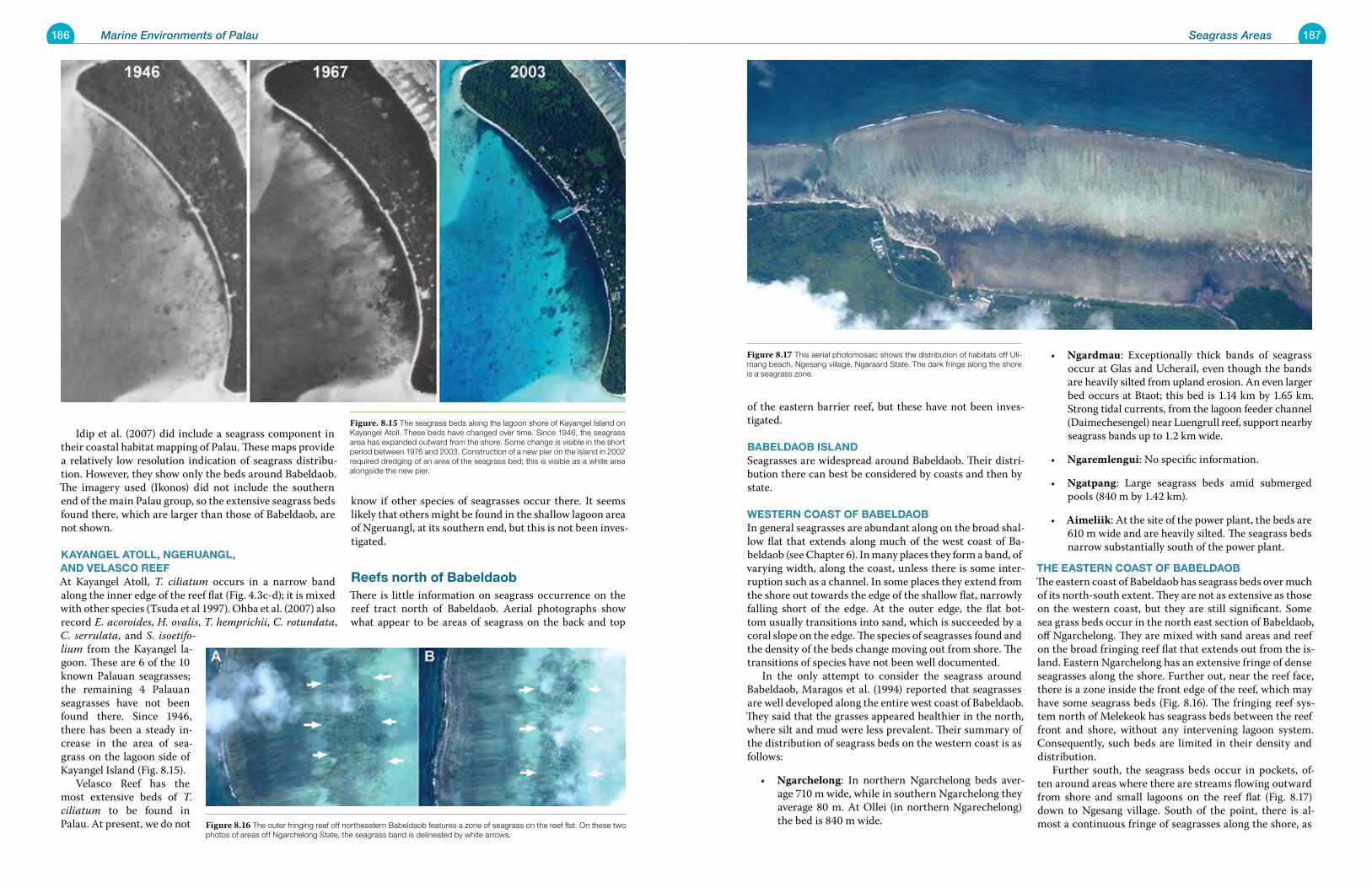
186 Marine Environments of Palau 187Seagrass Areas
of the eastern barrier reef, but these have not been inves-tigated.
BaBeLDaoB isLaNDSeagrasses are widespread around Babeldaob. Their distri-bution there can best be considered by coasts and then by state.
WesterN Coast oF BaBeLDaoBIn general seagrasses are abundant along on the broad shal-low flat that extends along much of the west coast of Ba-beldaob (see Chapter 6). In many places they form a band, of varying width, along the coast, unless there is some inter-ruption such as a channel. In some places they extend from the shore out towards the edge of the shallow flat, narrowly falling short of the edge. At the outer edge, the flat bot-tom usually transitions into sand, which is succeeded by a coral slope on the edge. The species of seagrasses found and the density of the beds change moving out from shore. The transitions of species have not been well documented. In the only attempt to consider the seagrass around Babeldaob, Maragos et al. (1994) reported that seagrasses are well developed along the entire west coast of Babeldaob. They said that the grasses appeared healthier in the north, where silt and mud were less prevalent. Their summary of the distribution of seagrass beds on the western coast is as follows:
Ngarchelong• : In northern Ngarchelong beds aver-age 710 m wide, while in southern Ngarchelong they average 80 m. At Ollei (in northern Ngarechelong) the bed is 840 m wide.
Ngardmau• : Exceptionally thick bands of seagrass occur at Glas and Ucherail, even though the bands are heavily silted from upland erosion. An even larger bed occurs at Btaot; this bed is 1.14 km by 1.65 km. Strong tidal currents, from the lagoon feeder channel (Daimechesengel) near Luengrull reef, support nearby seagrass bands up to 1.2 km wide.
Ngaremlengui• : No specific information.
Ngatpang• : Large seagrass beds amid submerged pools (840 m by 1.42 km).
Aimeliik• : At the site of the power plant, the beds are 610 m wide and are heavily silted. The seagrass beds narrow substantially south of the power plant.
the easterN Coast oF BaBeLDaoBThe eastern coast of Babeldaob has seagrass beds over much of its north-south extent. They are not as extensive as those on the western coast, but they are still significant. Some sea grass beds occur in the north east section of Babeldaob, off Ngarchelong. They are mixed with sand areas and reef on the broad fringing reef flat that extends out from the is-land. Eastern Ngarchelong has an extensive fringe of dense seagrasses along the shore. Further out, near the reef face, there is a zone inside the front edge of the reef, which may have some seagrass beds (Fig. 8.16). The fringing reef sys-tem north of Melekeok has seagrass beds between the reef front and shore, without any intervening lagoon system. Consequently, such beds are limited in their density and distribution. Further south, the seagrass beds occur in pockets, of-ten around areas where there are streams flowing outward from shore and small lagoons on the reef flat (Fig. 8.17) down to Ngesang village. South of the point, there is al-most a continuous fringe of seagrasses along the shore, as
Idip et al. (2007) did include a seagrass component in their coastal habitat mapping of Palau. These maps provide a relatively low resolution indication of seagrass distribu-tion. However, they show only the beds around Babeldaob. The imagery used (Ikonos) did not include the southern end of the main Palau group, so the extensive seagrass beds found there, which are larger than those of Babeldaob, are not shown.
kayaNgeL atoLL, NgeruaNgL, aND veLasCo reeFAt Kayangel Atoll, T. ciliatum occurs in a narrow band along the inner edge of the reef flat (Fig. 4.3c-d); it is mixed with other species (Tsuda et al 1997). Ohba et al. (2007) also record E. acoroides, H. ovalis, T. hemprichii, C. rotundata, C. serrulata, and S. isoetifo-lium from the Kayangel la-goon. These are 6 of the 10 known Palauan seagrasses; the remaining 4 Palauan seagrasses have not been found there. Since 1946, there has been a steady in-crease in the area of sea-grass on the lagoon side of Kayangel Island (Fig. 8.15). Velasco Reef has the most extensive beds of T. ciliatum to be found in Palau. At present, we do not
know if other species of seagrasses occur there. It seems likely that others might be found in the shallow lagoon area of Ngeruangl, at its southern end, but this is not been inves-tigated.
reefs north of BabeldaobThere is little information on seagrass occurrence on the reef tract north of Babeldaob. Aerial photographs show what appear to be areas of seagrass on the back and top
Figure 8.17 This aerial photomosaic shows the distribution of habitats off Uli-mang beach, Ngesang village, Ngaraard State. The dark fringe along the shore is a seagrass zone.
Figure 8.16 The outer fringing reef off northeastern Babeldaob features a zone of seagrass on the reef flat. On these two photos of areas off Ngarchelong State, the seagrass band is delineated by white arrows.
Figure. 8.15 The seagrass beds along the lagoon shore of Kayangel Island on Kayangel Atoll. These beds have changed over time. Since 1946, the seagrass area has expanded outward from the shore. Some change is visible in the short period between 1976 and 2003. Construction of a new pier on the island in 2002 required dredging of an area of the seagrass bed; this is visible as a white area alongside the new pier.
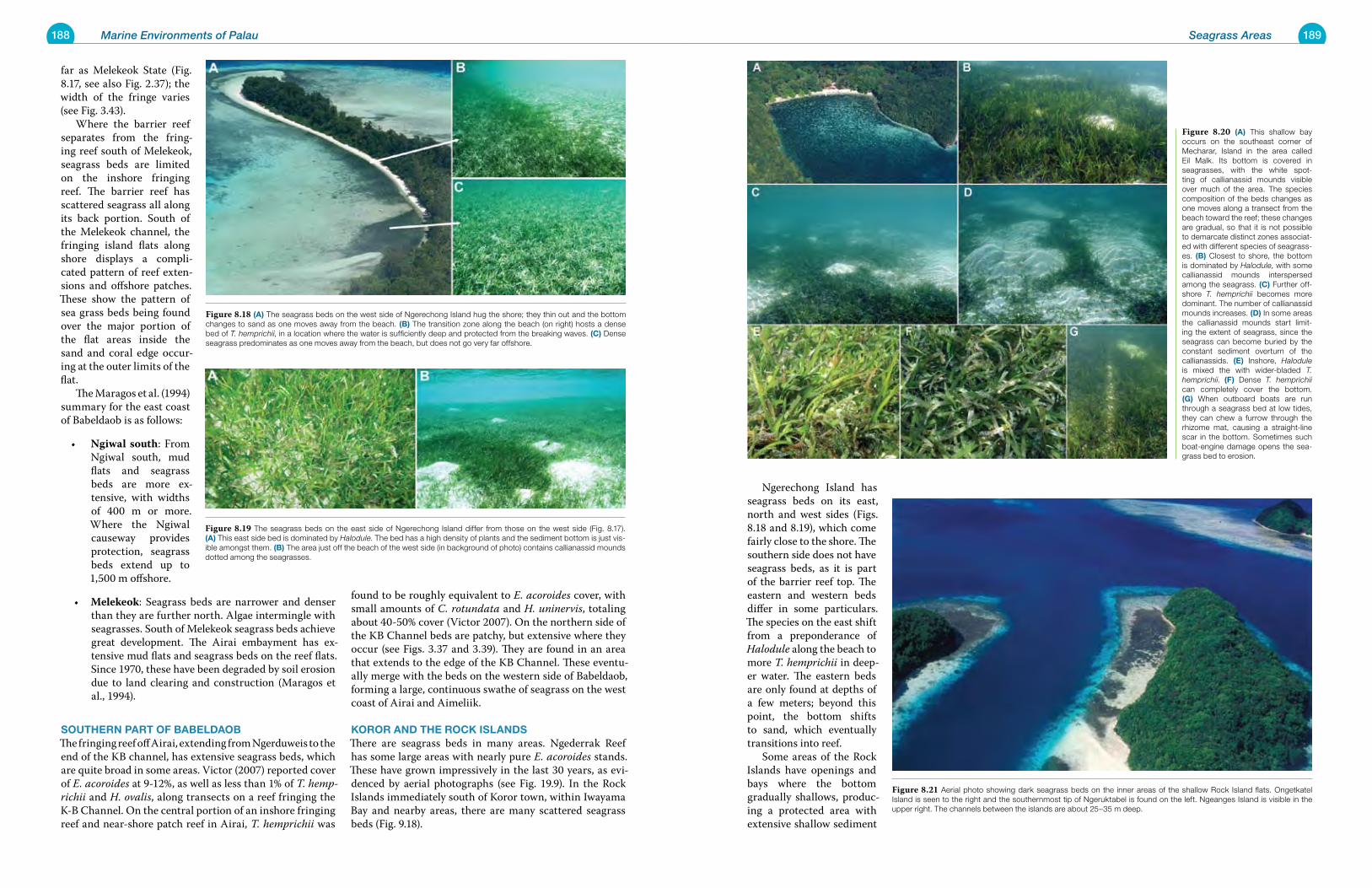
188 Marine Environments of Palau 189Seagrass Areas
Ngerechong Island has seagrass beds on its east, north and west sides (Figs. 8.18 and 8.19), which come fairly close to the shore. The southern side does not have seagrass beds, as it is part of the barrier reef top. The eastern and western beds differ in some particulars. The species on the east shift from a preponderance of Halodule along the beach to more T. hemprichii in deep-er water. The eastern beds are only found at depths of a few meters; beyond this point, the bottom shifts to sand, which eventually transitions into reef. Some areas of the Rock Islands have openings and bays where the bottom gradually shallows, produc-ing a protected area with extensive shallow sediment
far as Melekeok State (Fig. 8.17, see also Fig. 2.37); the width of the fringe varies (see Fig. 3.43). Where the barrier reef separates from the fring-ing reef south of Melekeok, seagrass beds are limited on the inshore fringing reef. The barrier reef has scattered seagrass all along its back portion. South of the Melekeok channel, the fringing island flats along shore displays a compli-cated pattern of reef exten-sions and offshore patches. These show the pattern of sea grass beds being found over the major portion of the flat areas inside the sand and coral edge occur-ing at the outer limits of the flat. The Maragos et al. (1994) summary for the east coast of Babeldaob is as follows:
Ngiwal south• : From Ngiwal south, mud flats and seagrass beds are more ex-tensive, with widths of 400 m or more. Where the Ngiwal causeway provides protection, seagrass beds extend up to 1,500 m offshore.
Melekeok• : Seagrass beds are narrower and denser than they are further north. Algae intermingle with seagrasses. South of Melekeok seagrass beds achieve great development. The Airai embayment has ex-tensive mud flats and seagrass beds on the reef flats. Since 1970, these have been degraded by soil erosion due to land clearing and construction (Maragos et al., 1994).
southerN part oF BaBeLDaoBThe fringing reef off Airai, extending from Ngerduweis to the end of the KB channel, has extensive seagrass beds, which are quite broad in some areas. Victor (2007) reported cover of E. acoroides at 9-12%, as well as less than 1% of T. hemp-richii and H. ovalis, along transects on a reef fringing the K-B Channel. On the central portion of an inshore fringing reef and near-shore patch reef in Airai, T. hemprichii was
found to be roughly equivalent to E. acoroides cover, with small amounts of C. rotundata and H. uninervis, totaling about 40-50% cover (Victor 2007). On the northern side of the KB Channel beds are patchy, but extensive where they occur (see Figs. 3.37 and 3.39). They are found in an area that extends to the edge of the KB Channel. These eventu-ally merge with the beds on the western side of Babeldaob, forming a large, continuous swathe of seagrass on the west coast of Airai and Aimeliik.
koror aND the roCk isLaNDsThere are seagrass beds in many areas. Ngederrak Reef has some large areas with nearly pure E. acoroides stands. These have grown impressively in the last 30 years, as evi-denced by aerial photographs (see Fig. 19.9). In the Rock Islands immediately south of Koror town, within Iwayama Bay and nearby areas, there are many scattered seagrass beds (Fig. 9.18).
Figure 8.21 Aerial photo showing dark seagrass beds on the inner areas of the shallow Rock Island flats. Ongetkatel Island is seen to the right and the southernmost tip of Ngeruktabel is found on the left. Ngeanges Island is visible in the upper right. The channels between the islands are about 25–35 m deep.
Figure 8.20 (a) This shallow bay occurs on the southeast corner of Mecharar, Island in the area called Eil Malk. Its bottom is covered in seagrasses, with the white spot-ting of callianassid mounds visible over much of the area. The species composition of the beds changes as one moves along a transect from the beach toward the reef; these changes are gradual, so that it is not possible to demarcate distinct zones associat-ed with different species of seagrass-es. (B) Closest to shore, the bottom is dominated by Halodule, with some callianassid mounds interspersed among the seagrass. (C) Further off-shore T. hemprichii becomes more dominant. The number of callianassid mounds increases. (D) In some areas the callianassid mounds start limit-ing the extent of seagrass, since the seagrass can become buried by the constant sediment overturn of the callianassids. (e) Inshore, Halodule is mixed the with wider-bladed T. hemprichii. (F) Dense T. hemprichii can completely cover the bottom. (g) When outboard boats are run through a seagrass bed at low tides, they can chew a furrow through the rhizome mat, causing a straight-line scar in the bottom. Sometimes such boat-engine damage opens the sea-grass bed to erosion.
Figure 8.19 The seagrass beds on the east side of Ngerechong Island differ from those on the west side (Fig. 8.17). (a) This east side bed is dominated by Halodule. The bed has a high density of plants and the sediment bottom is just vis-ible amongst them. (B) The area just off the beach of the west side (in background of photo) contains callianassid mounds dotted among the seagrasses.
Figure 8.18 (a) The seagrass beds on the west side of Ngerechong Island hug the shore; they thin out and the bottom changes to sand as one moves away from the beach. (B) The transition zone along the beach (on right) hosts a dense bed of T. hemprichii, in a location where the water is sufficiently deep and protected from the breaking waves. (C) Dense seagrass predominates as one moves away from the beach, but does not go very far offshore.
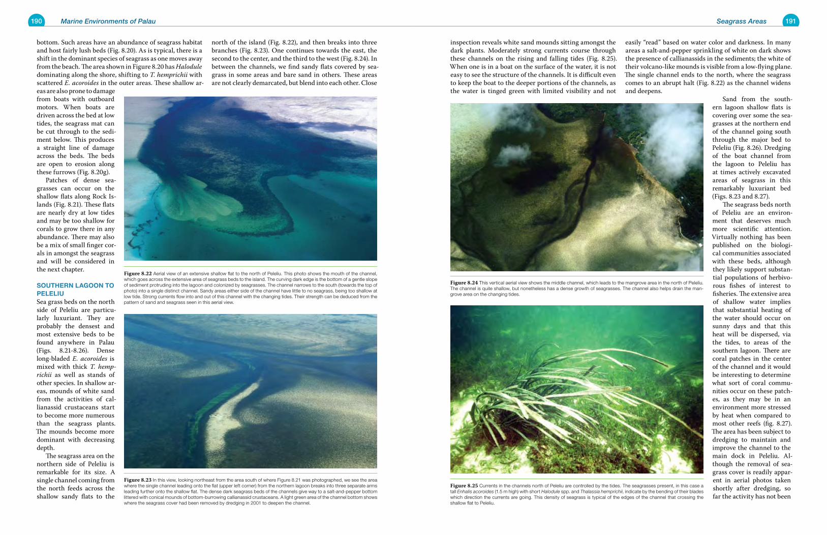
190 Marine Environments of Palau 191Seagrass Areas
inspection reveals white sand mounds sitting amongst the dark plants. Moderately strong currents course through these channels on the rising and falling tides (Fig. 8.25). When one is in a boat on the surface of the water, it is not easy to see the structure of the channels. It is difficult even to keep the boat to the deeper portions of the channels, as the water is tinged green with limited visibility and not
easily “read” based on water color and darkness. In many areas a salt-and-pepper sprinkling of white on dark shows the presence of callianassids in the sediments; the white of their volcano-like mounds is visible from a low-flying plane. The single channel ends to the north, where the seagrass comes to an abrupt halt (Fig. 8.22) as the channel widens and deepens.
Sand from the south-ern lagoon shallow flats is covering over some the sea-grasses at the northern end of the channel going south through the major bed to Peleliu (Fig. 8.26). Dredging of the boat channel from the lagoon to Peleliu has at times actively excavated areas of seagrass in this remarkably luxuriant bed (Figs. 8.23 and 8.27). The seagrass beds north of Peleliu are an environ-ment that deserves much more scientific attention. Virtually nothing has been published on the biologi-cal communities associated with these beds, although they likely support substan-tial populations of herbivo-rous fishes of interest to fisheries. The extensive area of shallow water implies that substantial heating of the water should occur on sunny days and that this heat will be dispersed, via the tides, to areas of the southern lagoon. There are coral patches in the center of the channel and it would be interesting to determine what sort of coral commu-nities occur on these patch-es, as they may be in an environment more stressed by heat when compared to most other reefs (fig. 8.27). The area has been subject to dredging to maintain and improve the channel to the main dock in Peleliu. Al-though the removal of sea-grass cover is readily appar-ent in aerial photos taken shortly after dredging, so far the activity has not been
bottom. Such areas have an abundance of seagrass habitat and host fairly lush beds (Fig. 8.20). As is typical, there is a shift in the dominant species of seagrass as one moves away from the beach. The area shown in Figure 8.20 has Halodule dominating along the shore, shifting to T. hemprichii with scattered E. acoroides in the outer areas. These shallow ar-eas are also prone to damage from boats with outboard motors. When boats are driven across the bed at low tides, the seagrass mat can be cut through to the sedi-ment below. This produces a straight line of damage across the beds. The beds are open to erosion along these furrows (Fig. 8.20g). Patches of dense sea-grasses can occur on the shallow flats along Rock Is-lands (Fig. 8.21). These flats are nearly dry at low tides and may be too shallow for corals to grow there in any abundance. There may also be a mix of small finger cor-als in amongst the seagrass and will be considered in the next chapter.
southerN LagooN to peLeLiuSea grass beds on the north side of Peleliu are particu-larly luxuriant. They are probably the densest and most extensive beds to be found anywhere in Palau (Figs. 8.21-8.26). Dense long-bladed E. acoroides is mixed with thick T. hemp-richii as well as stands of other species. In shallow ar-eas, mounds of white sand from the activities of cal-lianassid crustaceans start to become more numerous than the seagrass plants. The mounds become more dominant with decreasing depth. The seagrass area on the northern side of Peleliu is remarkable for its size. A single channel coming from the north feeds across the shallow sandy flats to the
north of the island (Fig. 8.22), and then breaks into three branches (Fig. 8.23). One continues towards the east, the second to the center, and the third to the west (Fig. 8.24). In between the channels, we find sandy flats covered by sea-grass in some areas and bare sand in others. These areas are not clearly demarcated, but blend into each other. Close
Figure 8.25 Currents in the channels north of Peleliu are controlled by the tides. The seagrasses present, in this case a tall Enhalis acoroides (1.5 m high) with short Halodule spp. and Thalassia hemprichii, indicate by the bending of their blades which direction the currents are going. This density of seagrass is typical of the edges of the channel that crossing the shallow flat to Peleliu.
Figure 8.24 This vertical aerial view shows the middle channel, which leads to the mangrove area in the north of Peleliu. The channel is quite shallow, but nonetheless has a dense growth of seagrasses. The channel also helps drain the man-grove area on the changing tides.
Figure 8.23 In this view, looking northeast from the area south of where Figure 8.21 was photographed, we see the area where the single channel leading onto the flat (upper left corner) from the northern lagoon breaks into three separate arms leading further onto the shallow flat. The dense dark seagrass beds of the channels give way to a salt-and-pepper bottom littered with conical mounds of bottom-burrowing callianassid crustaceans. A light green area of the channel bottom shows where the seagrass cover had been removed by dredging in 2001 to deepen the channel.
Figure 8.22 Aerial view of an extensive shallow flat to the north of Peleliu. This photo shows the mouth of the channel, which goes across the extensive area of seagrass beds to the island. The curving dark edge is the bottom of a gentle slope of sediment protruding into the lagoon and colonized by seagrasses. The channel narrows to the south (towards the top of photo) into a single distinct channel. Sandy areas either side of the channel have little to no seagrass, being too shallow at low tide. Strong currents flow into and out of this channel with the changing tides. Their strength can be deduced from the pattern of sand and seagrass seen in this aerial view.
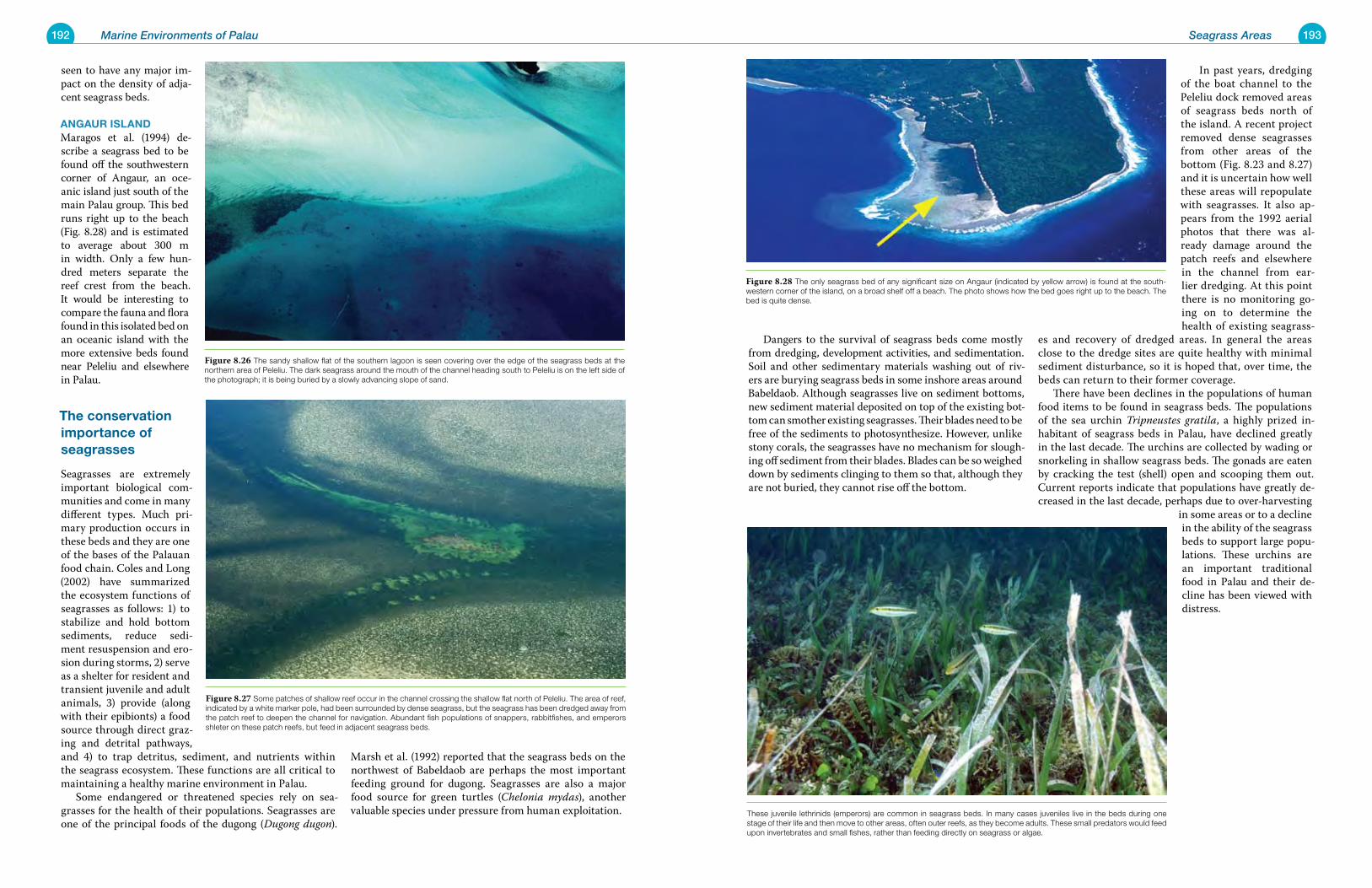
192 Marine Environments of Palau 193Seagrass Areas
Dangers to the survival of seagrass beds come mostly from dredging, development activities, and sedimentation. Soil and other sedimentary materials washing out of riv-ers are burying seagrass beds in some inshore areas around Babeldaob. Although seagrasses live on sediment bottoms, new sediment material deposited on top of the existing bot-tom can smother existing seagrasses. Their blades need to be free of the sediments to photosynthesize. However, unlike stony corals, the seagrasses have no mechanism for slough-ing off sediment from their blades. Blades can be so weighed down by sediments clinging to them so that, although they are not buried, they cannot rise off the bottom.
In past years, dredging of the boat channel to the Peleliu dock removed areas of seagrass beds north of the island. A recent project removed dense seagrasses from other areas of the bottom (Fig. 8.23 and 8.27) and it is uncertain how well these areas will repopulate with seagrasses. It also ap-pears from the 1992 aerial photos that there was al-ready damage around the patch reefs and elsewhere in the channel from ear-lier dredging. At this point there is no monitoring go-ing on to determine the health of existing seagrass-
es and recovery of dredged areas. In general the areas close to the dredge sites are quite healthy with minimal sediment disturbance, so it is hoped that, over time, the beds can return to their former coverage. There have been declines in the populations of human food items to be found in seagrass beds. The populations of the sea urchin Tripneustes gratila, a highly prized in-habitant of seagrass beds in Palau, have declined greatly in the last decade. The urchins are collected by wading or snorkeling in shallow seagrass beds. The gonads are eaten by cracking the test (shell) open and scooping them out. Current reports indicate that populations have greatly de-creased in the last decade, perhaps due to over-harvesting
in some areas or to a decline in the ability of the seagrass beds to support large popu-lations. These urchins are an important traditional food in Palau and their de-cline has been viewed with distress.
seen to have any major im-pact on the density of adja-cent seagrass beds.
aNgaur isLaNDMaragos et al. (1994) de-scribe a seagrass bed to be found off the southwestern corner of Angaur, an oce-anic island just south of the main Palau group. This bed runs right up to the beach (Fig. 8.28) and is estimated to average about 300 m in width. Only a few hun-dred meters separate the reef crest from the beach. It would be interesting to compare the fauna and flora found in this isolated bed on an oceanic island with the more extensive beds found near Peleliu and elsewhere in Palau.
the conservation importance of seagrasses
Seagrasses are extremely important biological com-munities and come in many different types. Much pri-mary production occurs in these beds and they are one of the bases of the Palauan food chain. Coles and Long (2002) have summarized the ecosystem functions of seagrasses as follows: 1) to stabilize and hold bottom sediments, reduce sedi-ment resuspension and ero-sion during storms, 2) serve as a shelter for resident and transient juvenile and adult animals, 3) provide (along with their epibionts) a food source through direct graz-ing and detrital pathways, and 4) to trap detritus, sediment, and nutrients within the seagrass ecosystem. These functions are all critical to maintaining a healthy marine environment in Palau. Some endangered or threatened species rely on sea-grasses for the health of their populations. Seagrasses are one of the principal foods of the dugong (Dugong dugon).
Marsh et al. (1992) reported that the seagrass beds on the northwest of Babeldaob are perhaps the most important feeding ground for dugong. Seagrasses are also a major food source for green turtles (Chelonia mydas), another valuable species under pressure from human exploitation.
Figure 8.28 The only seagrass bed of any significant size on Angaur (indicated by yellow arrow) is found at the south-western corner of the island, on a broad shelf off a beach. The photo shows how the bed goes right up to the beach. The bed is quite dense.
Figure 8.27 Some patches of shallow reef occur in the channel crossing the shallow flat north of Peleliu. The area of reef, indicated by a white marker pole, had been surrounded by dense seagrass, but the seagrass has been dredged away from the patch reef to deepen the channel for navigation. Abundant fish populations of snappers, rabbitfishes, and emperors shleter on these patch reefs, but feed in adjacent seagrass beds.
Figure 8.26 The sandy shallow flat of the southern lagoon is seen covering over the edge of the seagrass beds at the northern area of Peleliu. The dark seagrass around the mouth of the channel heading south to Peleliu is on the left side of the photograph; it is being buried by a slowly advancing slope of sand.
These juvenile lethrinids (emperors) are common in seagrass beds. In many cases juveniles live in the beds during one stage of their life and then move to other areas, often outer reefs, as they become adults. These small predators would feed upon invertebrates and small fishes, rather than feeding directly on seagrass or algae.
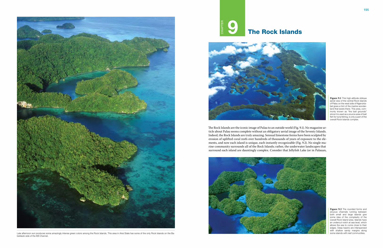
195
Ch
ap
te
r
9 The Rock Islands
The Rock Islands are the iconic image of Palau to an outside world (Fig. 9.1). No magazine ar-ticle about Palau seems complete without an obligatory aerial image of the Seventy Islands. Indeed, the Rock Islands are truly amazing. Sensual limestone forms have been sculpted by erosion of uplifted coral reefs over hundreds of thousands of years of exposure to the ele-ments, and now each island is unique, each instantly recognizable (Fig. 9.2). No single ma-rine community surrounds all of the Rock Islands; rather, the underwater landscapes that surround each island are dauntingly complex. Consider that Jellyfish Lake (or in Palauan,
Figure 9.1 This high-altitude oblique aerial view of the central Rock Islands of Palau on the west side of Ngerukta-bel gives a hint of the marine wonder-land that exists there. This area, com-monly known as “the bait grounds” since it is used as a source area of bait fish for tuna fishing, is only a part of the overall Rock Islands complex.
Figure 9.2 The rounded forms and sinuous channels running between both small and large islands give some idea of the complexity of the overall Rock Island area. Islands have an undercut notch at sea level, which allows the sea to come close to their edges. Deep basins are interspersed with shallow sandy margins along some islands with reef communities.Late afternoon sun produces some amazingly intense green colors among the Rock Islands. This area in Airai State has some of the only Rock Islands on the Ba-
beldaob side of the KB Channel.
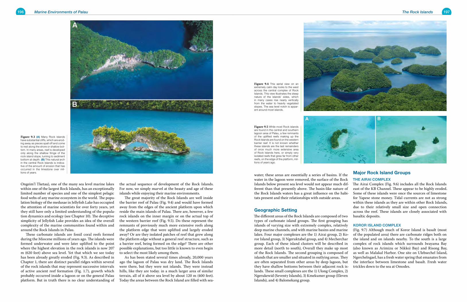
196 Marine Environments of Palau 197The Rock Islands
water; these areas are essentially a series of basins. If the water in the lagoon were removed, the surface of the Rock Islands below present sea level would not appear much dif-ferent than that presently above. The basin-like nature of the Rock Islands waters has a great influence on the habi-tats present and their relationships with outside areas.
Geographic SettingThe different areas of the Rock Islands are composed of two types of carbonate island groups. The first grouping has islands of varying size with extremely complex, relatively deep marine channels, and with marine basins and marine lakes. Four major complexes are the 1) Airai group, 2) Ko-ror Island group, 3) Ngeruktabel group, and 4) Mecherchar group. Each of these island clusters will be described in more detail (north to south), Overall they make up most of the Rock Islands. The second grouping is composed of islands that are smaller and situated in outlying areas. They are often separated from other areas by deep lagoon, but they have shallow bottoms between their adjacent rock is-lands. These small complexes are the 1) Ulong Complex, 2) Ngerukewid (Seventy Islands), 3) Kmekumer group (Eleven Islands), and 4) Balomekang group.
Major rock Island Groupsthe aIraI CoMplexThe Airai Complex (Fig. 9.6) includes all the Rock Islands east of the KB Channel. These appear to be highly eroded. Some of these islands were once the sources of limestone for Yapese stone money. Tidal currents are not as strong within these islands as they are within other Rock Islands, due to their relatively small size and open connection across the reef. These islands are closely associated with basaltic deposits.
Koror ISland CoMplex (Fig. 9.7) Although much of Koror Island is basalt (most of the populated area) there are carbonate ridges both on the island and on islands nearby. To the south is a large complex of rock islands which surrounds Iwayama Bay (also known as Arimizu or Nikko) Bay) and Risong Bay, as well as Malakal Harbor. One site on Ulebsechel Island, Ngerchelngael, has a fresh water spring that emanates from the interface between limestone and basalt. Fresh water trickles down to the sea at Omodes.
Ongeim’l Tketau), one of the many sea level marine lakes within one of the largest Rock Islands, has an exceptionally limited number of species and one of the simplest pelagic food webs of any marine ecosystem in the world. The popu-lation biology of the medusae in Jellyfish Lake has occupied the attention of marine scientists for over forty years, yet they still have only a limited understanding of the popula-tion dynamics and ecology (see Chapter 10). The deceptive simplicity of Jellyfish Lake provides an idea of the overall complexity of the marine communities found within and around the Rock Islands in Palau. These carbonate islands are fossil coral reefs formed during the Miocene millions of years ago. The islands were formed underwater and were later uplifted to the point where the highest elevation in the rock islands is now 207 m (620 feet) above sea level. Yet that which we see today has been already greatly eroded (Fig. 9.3). As described in Chapter 1, there are distinct parallel ridges within several of the rock islands that may represent successive intervals of active ancient reef formation (Fig. 1.7), growth which probably occurred inside a lagoon or on the general Palau platform. But in truth there is no clear understanding of
the actual sequence of development of the Rock Islands. For now, we simply marvel at the beauty and age of these islands while enjoying their marine environments. The great majority of the Rock Islands are well inside the barrier reef of Palau (Fig. 9.4) and would have formed away from the edges of the ancient platform upon which reside the main islands of Palau. There are, however, a few rock islands on the inner margin or on the actual top of the western barrier reef (Fig. 9.5). Do these represent the remnants of previously much more extensive reefs along the platform edge that were uplifted and largely eroded away? Or are they isolated patches of reef that grew along the platform edge without a general reef structure, such as a barrier reef, being formed on the edge? There are other possible explanations, but too little is known to even begin to select the most likely among them. As has been stated several times already, 20,000 years ago the lagoon of Palau was dry land. The Rock Islands were there, but they were not islands. They were instead hills, like they are today. in a much larger area of similar terrain, all of it above sea level by about 120 m (400 feet). Today the areas between the Rock Island are filled with sea-
Figure 9.5 While most Rock islands are found in the central and southern lagoon area of Palau, a few remnants of the uplifted reefs making up the Rock Islands are found on the western barrier reef. It is not known whether these islands are the last remainders of once much more extensive area of Rock Islands here, or simply very isolated reefs that grew far from other reefs, on the edge of the platform, mil-lions of years ago.
Figure 9.4 This aerial view on an extremely calm day looks to the west across the central complex of Rock Islands. This view illustrates the steep nature of the islands’ sides, which in many cases rise nearly vertically from the water to heavily vegetated slopes. The sea level notch is appar-ent around most islands.
Figure 9.3 (a) Many Rock Islands have substantial cliffs, which are erod-ing away as pieces spall off and come to rest along the shore or shallow bot-tom. In many areas, reef is developed only along the shallow fringe of the rock island slope, turning to sediment bottom at depth. (B) This natural arch in the central Rock Islands is indica-tive of the amount of erosion that has occurred in the limestone over mil-lions of years.
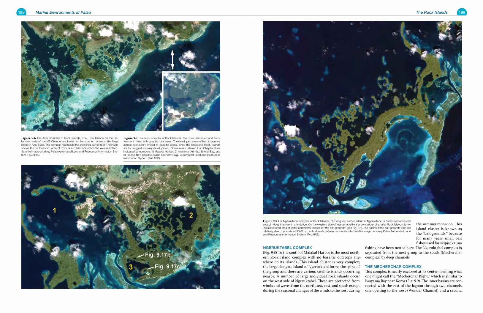
198 Marine Environments of Palau 199The Rock Islands
nGeruKtaBel CoMplex (Fig. 9.8) To the south of Malakal Harbor is the most north-ern Rock Island complex with no basaltic outcrops any-where on its islands. This island cluster is very complex; the large elongate island of Ngertuktabl forms the spine of the group and there are various satellite islands occurring nearby. A number of large individual rock islands occur on the west side of Ngeruktabel. These are protected from winds and waves from the northeast, east, and south except during the seasonal changes of the winds to the west during
the summer monsoon. This island cluster is known as the “bait grounds,” because for many years small bait fishes used for skipjack tuna
fishing have been netted here. The Ngeruktabel complex is separated from the next group to the south (Mecherchar complex) by deep channels.
the MeCherChar CoMplexThis complex is nearly enclosed at its center, forming what one might call the “Mecherchar Bight,” which is similar to Iwayama Bay near Koror (Fig. 9.9). The inner basins are con-nected with the rest of the lagoon through two channels, one opening to the west (Wonder Channel) and a second,
Figure 9.8 The Ngeruktabel complex of Rock Islands. The long and arched island of Ngeruktabel is comprised of several sets of ridges that vary in orientation. On the western side of Ngeruktabel lie a large number of smaller Rock Islands, form-ing a sheltered area of water commonly known as “the bait grounds” (see Fig. 9.1). The basins in the bait grounds area are relatively deep, up to about 30–35 m, with sill reefs between some islands. Satellite image courtesy Palau Automated Land and Resources Information System (PALARIS).
Figure 9.6 The Airai Complex of Rock Islands. The Rock Islands on the Ba-beldaob side of the KB Channel are limited to the southern areas of the large island in Airai State. The complex reaches to the sheltered barrier reef. The insert shows the northeastern area of Rock Island hills located on the Airai mainland. Satellite image courtesy Palau Automated Land and Resources Information Sys-tem (PALARIS).
Figure 9.7 The Koror complex of Rock Islands. The Rock Islands around Koror town are mixed with basaltic rock areas. The developed areas of Koror town are almost exclusively limited to basaltic areas, since the limestone Rock Islands are too rugged for easy development. Some areas referred to in Chapter 9 are indicated by numbers: 1) Malakal Harbor, 2) Iwayama (Arimizu, Nikko) Bay, and 3) Risong Bay. Satellite image courtesy Palau Automated Land and Resources Information System (PALARIS).
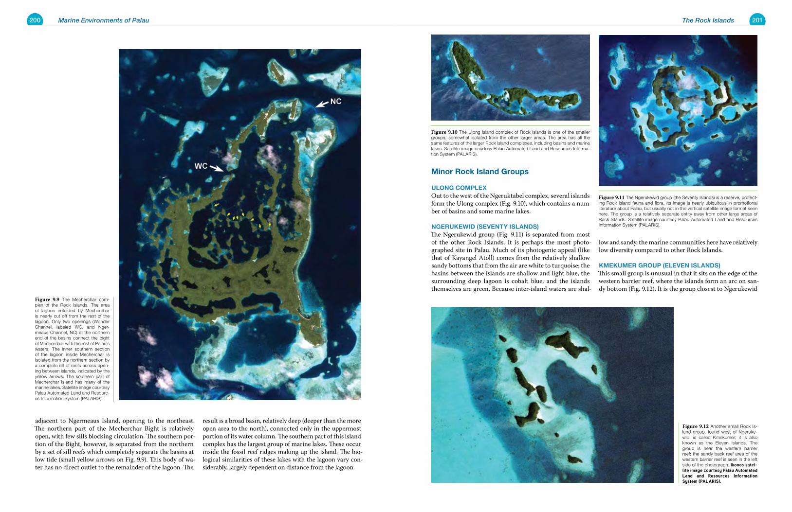
200 Marine Environments of Palau 201The Rock Islands
Minor rock Island Groups
ulonG CoMplexOut to the west of the Ngeruktabel complex, several islands form the Ulong complex (Fig. 9.10), which contains a num-ber of basins and some marine lakes.
nGeruKewId (Seventy ISlandS)The Ngerukewid group (Fig. 9.11) is separated from most of the other Rock Islands. It is perhaps the most photo-graphed site in Palau. Much of its photogenic appeal (like that of Kayangel Atoll) comes from the relatively shallow sandy bottoms that from the air are white to turquoise; the basins between the islands are shallow and light blue, the surrounding deep lagoon is cobalt blue, and the islands themselves are green. Because inter-island waters are shal-
low and sandy, the marine communities here have relatively low diversity compared to other Rock Islands.
KMeKuMer Group (eleven ISlandS)This small group is unusual in that it sits on the edge of the western barrier reef, where the islands form an arc on san-dy bottom (Fig. 9.12). It is the group closest to Ngerukewid
adjacent to Ngermeaus Island, opening to the northeast. The northern part of the Mecherchar Bight is relatively open, with few sills blocking circulation. The southern por-tion of the Bight, however, is separated from the northern by a set of sill reefs which completely separate the basins at low tide (small yellow arrows on Fig. 9.9). This body of wa-ter has no direct outlet to the remainder of the lagoon. The
result is a broad basin, relatively deep (deeper than the more open area to the north), connected only in the uppermost portion of its water column. The southern part of this island complex has the largest group of marine lakes. These occur inside the fossil reef ridges making up the island. The bio-logical similarities of these lakes with the lagoon vary con-siderably, largely dependent on distance from the lagoon.
Figure 9.11 The Ngerukewid group (the Seventy Islands) is a reserve, protect-ing Rock Island fauna and flora. Its image is nearly ubiquitous in promotional literature about Palau, but usually not in the vertical satellite image format seen here. The group is a relatively separate entity away from other large areas of Rock Islands. Satellite image courtesy Palau Automated Land and Resources Information System (PALARIS).
Figure 9.10 The Ulong Island complex of Rock Islands is one of the smaller groups, somewhat isolated from the other larger areas. The area has all the same features of the larger Rock Island complexes, including basins and marine lakes. Satellite image courtesy Palau Automated Land and Resources Informa-tion System (PALARIS).
Figure 9.12 Another small Rock Is-land group, found west of Ngeruke-wid, is called Kmekumer; it is also known as the Eleven Islands. The group is near the western barrier reef; the sandy back reef area of the western barrier reef is seen in the left side of the photograph. Ikonos satel-lite image courtesy Palau Automated Land and Resources Information System (PALARIS).
Figure 9.9 The Mecherchar com-plex of the Rock Islands. The area of lagoon enfolded by Mecherchar is nearly cut off from the rest of the lagoon. Only two openings (Wonder Channel, labeled WC, and Nger-meaus Channel, NC) at the northern end of the basins connect the bight of Mecherchar with the rest of Palau’s waters. The inner southern section of the lagoon inside Mecherchar is isolated from the northern section by a complete sill of reefs across open-ing between islands, indicated by the yellow arrows. The southern part of Mecherchar Island has many of the marine lakes. Satellite image courtesy Palau Automated Land and Resourc-es Information System (PALARIS).
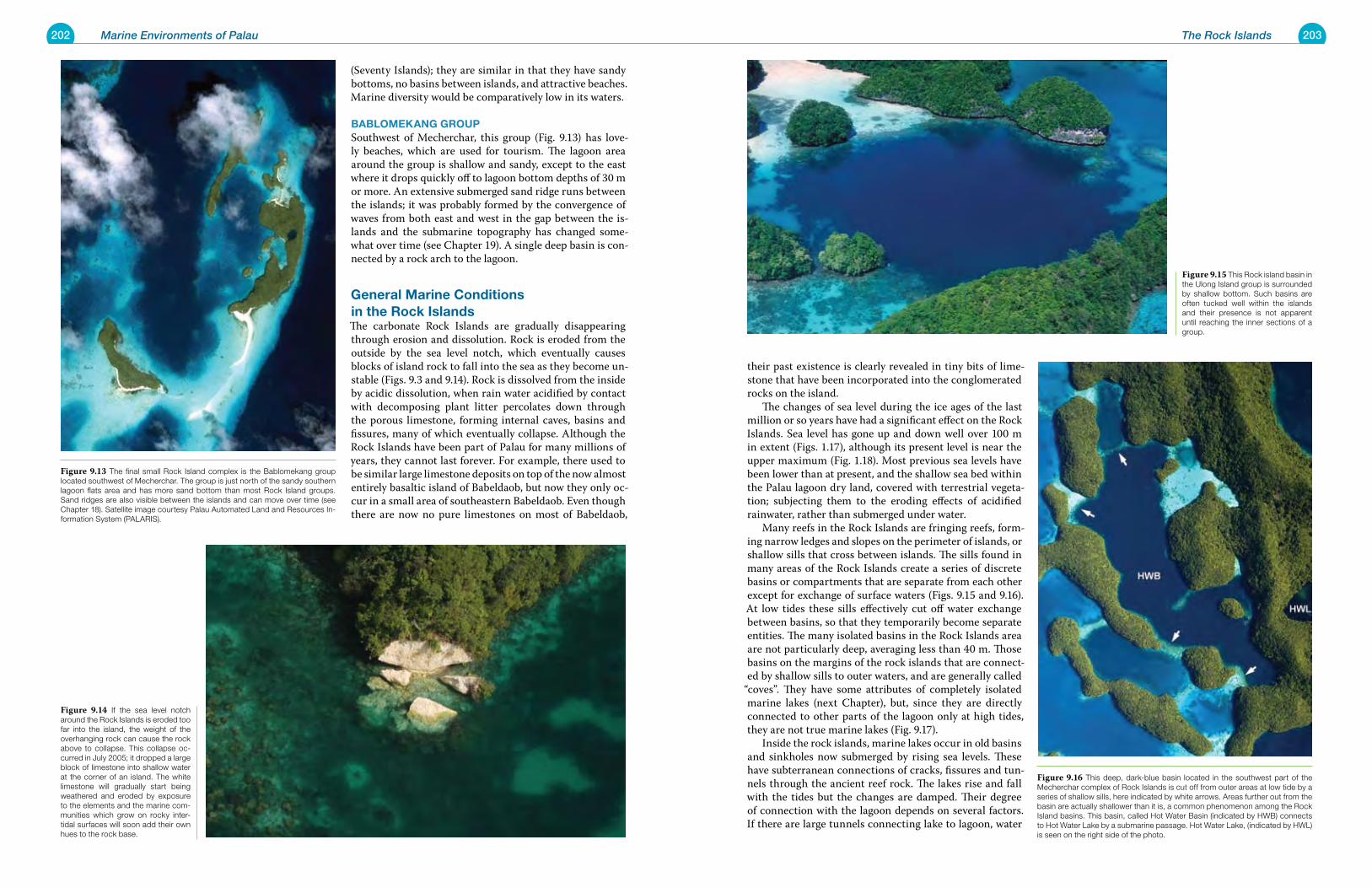
202 Marine Environments of Palau 203The Rock Islands
their past existence is clearly revealed in tiny bits of lime-stone that have been incorporated into the conglomerated rocks on the island. The changes of sea level during the ice ages of the last million or so years have had a significant effect on the Rock Islands. Sea level has gone up and down well over 100 m in extent (Figs. 1.17), although its present level is near the upper maximum (Fig. 1.18). Most previous sea levels have been lower than at present, and the shallow sea bed within the Palau lagoon dry land, covered with terrestrial vegeta-tion; subjecting them to the eroding effects of acidified rainwater, rather than submerged under water. Many reefs in the Rock Islands are fringing reefs, form-ing narrow ledges and slopes on the perimeter of islands, or shallow sills that cross between islands. The sills found in many areas of the Rock Islands create a series of discrete basins or compartments that are separate from each other except for exchange of surface waters (Figs. 9.15 and 9.16). At low tides these sills effectively cut off water exchange between basins, so that they temporarily become separate entities. The many isolated basins in the Rock Islands area are not particularly deep, averaging less than 40 m. Those basins on the margins of the rock islands that are connect-ed by shallow sills to outer waters, and are generally called
“coves”. They have some attributes of completely isolated marine lakes (next Chapter), but, since they are directly connected to other parts of the lagoon only at high tides, they are not true marine lakes (Fig. 9.17). Inside the rock islands, marine lakes occur in old basins and sinkholes now submerged by rising sea levels. These have subterranean connections of cracks, fissures and tun-nels through the ancient reef rock. The lakes rise and fall with the tides but the changes are damped. Their degree of connection with the lagoon depends on several factors. If there are large tunnels connecting lake to lagoon, water
(Seventy Islands); they are similar in that they have sandy bottoms, no basins between islands, and attractive beaches. Marine diversity would be comparatively low in its waters.
BaBloMeKanG GroupSouthwest of Mecherchar, this group (Fig. 9.13) has love-ly beaches, which are used for tourism. The lagoon area around the group is shallow and sandy, except to the east where it drops quickly off to lagoon bottom depths of 30 m or more. An extensive submerged sand ridge runs between the islands; it was probably formed by the convergence of waves from both east and west in the gap between the is-lands and the submarine topography has changed some-what over time (see Chapter 19). A single deep basin is con-nected by a rock arch to the lagoon.
General Marine Conditions in the rock IslandsThe carbonate Rock Islands are gradually disappearing through erosion and dissolution. Rock is eroded from the outside by the sea level notch, which eventually causes blocks of island rock to fall into the sea as they become un-stable (Figs. 9.3 and 9.14). Rock is dissolved from the inside by acidic dissolution, when rain water acidified by contact with decomposing plant litter percolates down through the porous limestone, forming internal caves, basins and fissures, many of which eventually collapse. Although the Rock Islands have been part of Palau for many millions of years, they cannot last forever. For example, there used to be similar large limestone deposits on top of the now almost entirely basaltic island of Babeldaob, but now they only oc-cur in a small area of southeastern Babeldaob. Even though there are now no pure limestones on most of Babeldaob,
Figure 9.15 This Rock island basin in the Ulong Island group is surrounded by shallow bottom. Such basins are often tucked well within the islands and their presence is not apparent until reaching the inner sections of a group.
Figure 9.16 This deep, dark-blue basin located in the southwest part of the Mecherchar complex of Rock Islands is cut off from outer areas at low tide by a series of shallow sills, here indicated by white arrows. Areas further out from the basin are actually shallower than it is, a common phenomenon among the Rock Island basins. This basin, called Hot Water Basin (indicated by HWB) connects to Hot Water Lake by a submarine passage. Hot Water Lake, (indicated by HWL) is seen on the right side of the photo.
Figure 9.13 The final small Rock Island complex is the Bablomekang group located southwest of Mecherchar. The group is just north of the sandy southern lagoon flats area and has more sand bottom than most Rock Island groups. Sand ridges are also visible between the islands and can move over time (see Chapter 18). Satellite image courtesy Palau Automated Land and Resources In-formation System (PALARIS).
Figure 9.14 If the sea level notch around the Rock Islands is eroded too far into the island, the weight of the overhanging rock can cause the rock above to collapse. This collapse oc-curred in July 2005; it dropped a large block of limestone into shallow water at the corner of an island. The white limestone will gradually start being weathered and eroded by exposure to the elements and the marine com-munities which grow on rocky inter-tidal surfaces will soon add their own hues to the rock base.
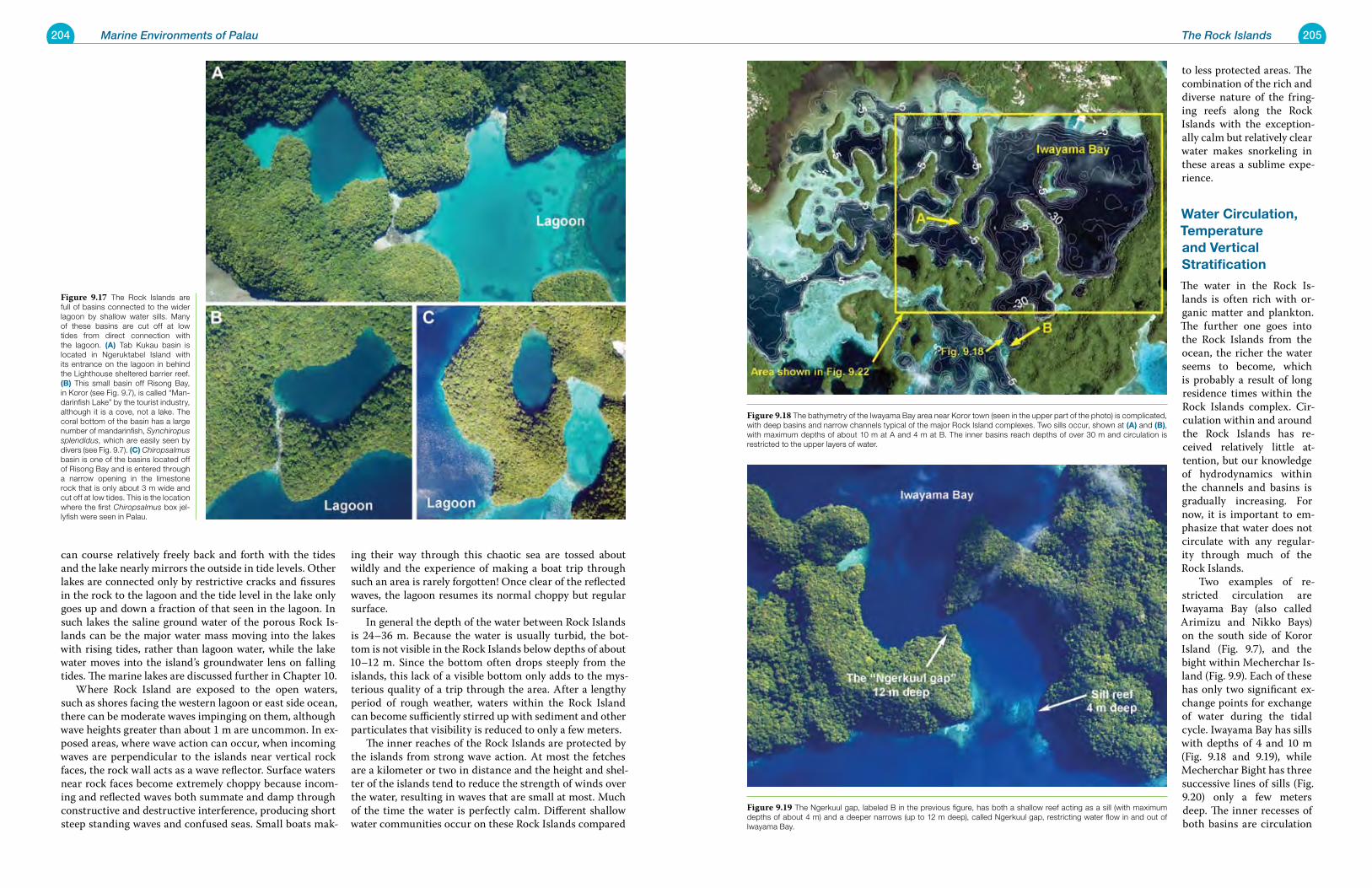
204 Marine Environments of Palau 205The Rock Islands
to less protected areas. The combination of the rich and diverse nature of the fring-ing reefs along the Rock Islands with the exception-ally calm but relatively clear water makes snorkeling in these areas a sublime expe-rience.
water Circulation, temperature and vertical Stratification
The water in the Rock Is-lands is often rich with or-ganic matter and plankton. The further one goes into the Rock Islands from the ocean, the richer the water seems to become, which is probably a result of long residence times within the Rock Islands complex. Cir-culation within and around the Rock Islands has re-ceived relatively little at-tention, but our knowledge of hydrodynamics within the channels and basins is gradually increasing. For now, it is important to em-phasize that water does not circulate with any regular-ity through much of the Rock Islands. Two examples of re-stricted circulation are Iwayama Bay (also called Arimizu and Nikko Bays) on the south side of Koror Island (Fig. 9.7), and the bight within Mecherchar Is-land (Fig. 9.9). Each of these has only two significant ex-change points for exchange of water during the tidal cycle. Iwayama Bay has sills with depths of 4 and 10 m (Fig. 9.18 and 9.19), while Mecherchar Bight has three successive lines of sills (Fig. 9.20) only a few meters deep. The inner recesses of both basins are circulation
can course relatively freely back and forth with the tides and the lake nearly mirrors the outside in tide levels. Other lakes are connected only by restrictive cracks and fissures in the rock to the lagoon and the tide level in the lake only goes up and down a fraction of that seen in the lagoon. In such lakes the saline ground water of the porous Rock Is-lands can be the major water mass moving into the lakes with rising tides, rather than lagoon water, while the lake water moves into the island’s groundwater lens on falling tides. The marine lakes are discussed further in Chapter 10. Where Rock Island are exposed to the open waters, such as shores facing the western lagoon or east side ocean, there can be moderate waves impinging on them, although wave heights greater than about 1 m are uncommon. In ex-posed areas, where wave action can occur, when incoming waves are perpendicular to the islands near vertical rock faces, the rock wall acts as a wave reflector. Surface waters near rock faces become extremely choppy because incom-ing and reflected waves both summate and damp through constructive and destructive interference, producing short steep standing waves and confused seas. Small boats mak-
ing their way through this chaotic sea are tossed about wildly and the experience of making a boat trip through such an area is rarely forgotten! Once clear of the reflected waves, the lagoon resumes its normal choppy but regular surface. In general the depth of the water between Rock Islands is 24–36 m. Because the water is usually turbid, the bot-tom is not visible in the Rock Islands below depths of about 10–12 m. Since the bottom often drops steeply from the islands, this lack of a visible bottom only adds to the mys-terious quality of a trip through the area. After a lengthy period of rough weather, waters within the Rock Island can become sufficiently stirred up with sediment and other particulates that visibility is reduced to only a few meters. The inner reaches of the Rock Islands are protected by the islands from strong wave action. At most the fetches are a kilometer or two in distance and the height and shel-ter of the islands tend to reduce the strength of winds over the water, resulting in waves that are small at most. Much of the time the water is perfectly calm. Different shallow water communities occur on these Rock Islands compared
Figure 9.18 The bathymetry of the Iwayama Bay area near Koror town (seen in the upper part of the photo) is complicated, with deep basins and narrow channels typical of the major Rock Island complexes. Two sills occur, shown at (a) and (B), with maximum depths of about 10 m at A and 4 m at B. The inner basins reach depths of over 30 m and circulation is restricted to the upper layers of water.
Figure 9.19 The Ngerkuul gap, labeled B in the previous figure, has both a shallow reef acting as a sill (with maximum depths of about 4 m) and a deeper narrows (up to 12 m deep), called Ngerkuul gap, restricting water flow in and out of Iwayama Bay.
Figure 9.17 The Rock Islands are full of basins connected to the wider lagoon by shallow water sills. Many of these basins are cut off at low tides from direct connection with the lagoon. (a) Tab Kukau basin is located in Ngeruktabel Island with its entrance on the lagoon in behind the Lighthouse sheltered barrier reef. (B) This small basin off Risong Bay, in Koror (see Fig. 9.7), is called “Man-darinfish Lake” by the tourist industry, although it is a cove, not a lake. The coral bottom of the basin has a large number of mandarinfish, Synchiropus splendidus, which are easily seen by divers (see Fig. 9.7). (C) Chiropsalmus basin is one of the basins located off of Risong Bay and is entered through a narrow opening in the limestone rock that is only about 3 m wide and cut off at low tides. This is the location where the first Chiropsalmus box jel-lyfish were seen in Palau.
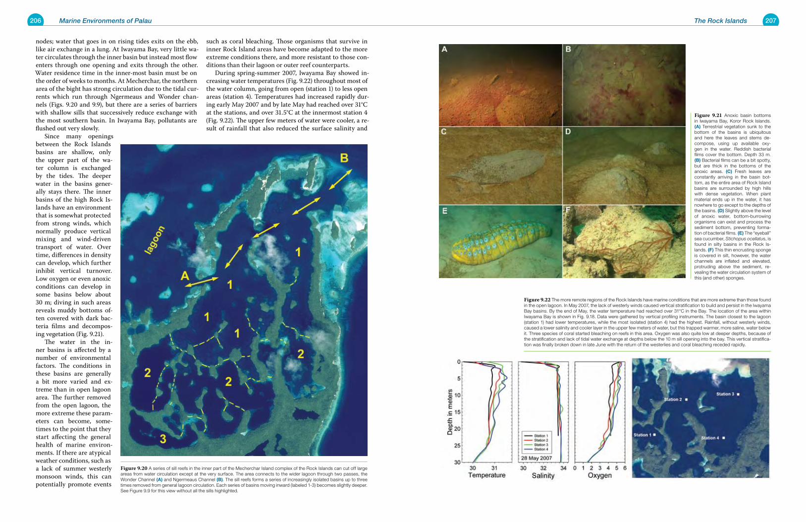
206 Marine Environments of Palau 207The Rock Islands
nodes; water that goes in on rising tides exits on the ebb, like air exchange in a lung. At Iwayama Bay, very little wa-ter circulates through the inner basin but instead most flow enters through one opening and exits through the other. Water residence time in the inner-most basin must be on the order of weeks to months. At Mecherchar, the northern area of the bight has strong circulation due to the tidal cur-rents which run through Ngermeaus and Wonder chan-nels (Figs. 9.20 and 9.9), but there are a series of barriers with shallow sills that successively reduce exchange with the most southern basin. In Iwayama Bay, pollutants are flushed out very slowly. Since many openings between the Rock Islands basins are shallow, only the upper part of the wa-ter column is exchanged by the tides. The deeper water in the basins gener-ally stays there. The inner basins of the high Rock Is-lands have an environment that is somewhat protected from strong winds, which normally produce vertical mixing and wind-driven transport of water. Over time, differences in density can develop, which further inhibit vertical turnover. Low oxygen or even anoxic conditions can develop in some basins below about 30 m; diving in such areas reveals muddy bottoms of-ten covered with dark bac-teria films and decompos-ing vegetation (Fig. 9.21). The water in the in-ner basins is affected by a number of environmental factors. The conditions in these basins are generally a bit more varied and ex-treme than in open lagoon area. The further removed from the open lagoon, the more extreme these param-eters can become, some-times to the point that they start affecting the general health of marine environ-ments. If there are atypical weather conditions, such as a lack of summer westerly monsoon winds, this can potentially promote events
such as coral bleaching. Those organisms that survive in inner Rock Island areas have become adapted to the more extreme conditions there, and more resistant to those con-ditions than their lagoon or outer reef counterparts. During spring-summer 2007, Iwayama Bay showed in-creasing water temperatures (Fig. 9.22) throughout most of the water column, going from open (station 1) to less open areas (station 4). Temperatures had increased rapidly dur-ing early May 2007 and by late May had reached over 31°C at the stations, and over 31.5°C at the innermost station 4 (Fig. 9.22). The upper few meters of water were cooler, a re-sult of rainfall that also reduced the surface salinity and
Figure 9.21 Anoxic basin bottoms in Iwayama Bay, Koror Rock Islands. (a) Terrestrial vegetation sunk to the bottom of the basins is ubiquitous and here the leaves and stems de-compose, using up available oxy-gen in the water. Reddish bacterial films cover the bottom. Depth 33 m. (B) Bacterial films can be a bit spotty, but are thick in the bottoms of the anoxic areas. (C) Fresh leaves are constantly arriving in the basin bot-tom, as the entire area of Rock Island basins are surrounded by high hills with dense vegetation. When plant material ends up in the water, it has nowhere to go except to the depths of the basins. (d) Slightly above the level of anoxic water, bottom-burrowing organisms can exist and process the sediment bottom, preventing forma-tion of bacterial films. (e) The “eyeball” sea cucumber, Stichopus ocellatus, is found in silty basins in the Rock Is-lands. (F) This thin encrusting sponge is covered in silt, however, the water channels are inflated and elevated, protruding above the sediment, re-vealing the water circulation system of this (and other) sponges.
Figure 9.22 The more remote regions of the Rock Islands have marine conditions that are more extreme than those found in the open lagoon. In May 2007, the lack of westerly winds caused vertical stratification to build and persist in the Iwayama Bay basins. By the end of May, the water temperature had reached over 31°C in the Bay. The location of the area within Iwayama Bay is shown in Fig. 9.18. Data were gathered by vertical profiling instruments. The basin closest to the lagoon (station 1) had lower temperatures, while the most isolated (station 4) had the highest. Rainfall, without westerly winds, caused a lower salinity and cooler layer in the upper few meters of water, but this trapped warmer, more saline, water below it. Three species of coral started bleaching on reefs in this area. Oxygen was also quite low at deeper depths, because of the stratification and lack of tidal water exchange at depths below the 10 m sill opening into the bay. This vertical stratifica-tion was finally broken down in late June with the return of the westerlies and coral bleaching receded rapidly.
Figure 9.20 A series of sill reefs in the inner part of the Mecherchar Island complex of the Rock Islands can cut off large areas from water circulation except at the very surface. The area connects to the wider lagoon through two passes, the Wonder Channel (a) and Ngermeaus Channel (B). The sill reefs forms a series of increasingly isolated basins up to three times removed from general lagoon circulation. Each series of basins moving inward (labeled 1-3) becomes slightly deeper. See Figure 9.9 for this view without all the sills highlighted.
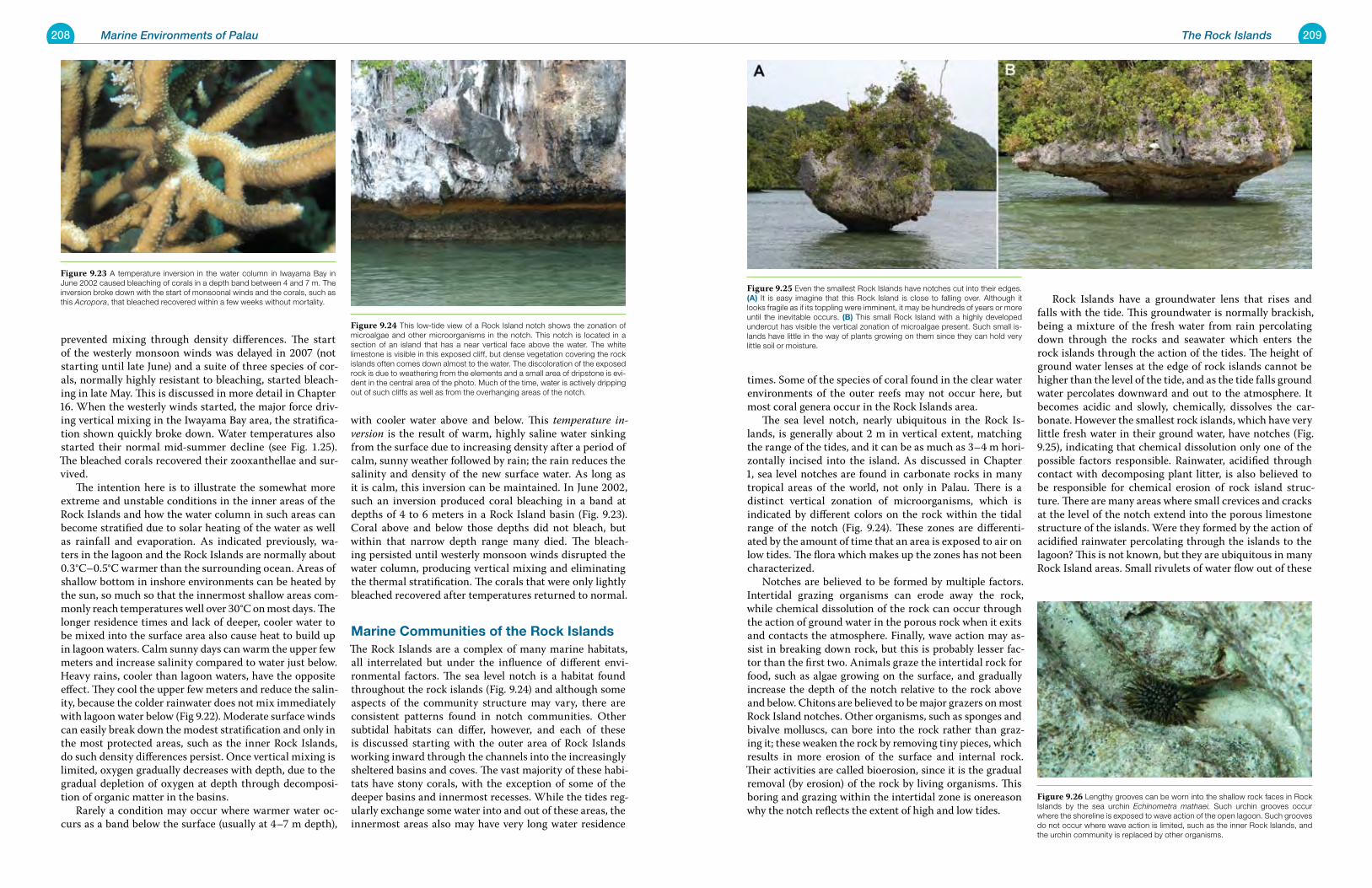
208 Marine Environments of Palau 209The Rock Islands
times. Some of the species of coral found in the clear water environments of the outer reefs may not occur here, but most coral genera occur in the Rock Islands area. The sea level notch, nearly ubiquitous in the Rock Is-lands, is generally about 2 m in vertical extent, matching the range of the tides, and it can be as much as 3–4 m hori-zontally incised into the island. As discussed in Chapter 1, sea level notches are found in carbonate rocks in many tropical areas of the world, not only in Palau. There is a distinct vertical zonation of microorganisms, which is indicated by different colors on the rock within the tidal range of the notch (Fig. 9.24). These zones are differenti-ated by the amount of time that an area is exposed to air on low tides. The flora which makes up the zones has not been characterized. Notches are believed to be formed by multiple factors. Intertidal grazing organisms can erode away the rock, while chemical dissolution of the rock can occur through the action of ground water in the porous rock when it exits and contacts the atmosphere. Finally, wave action may as-sist in breaking down rock, but this is probably lesser fac-tor than the first two. Animals graze the intertidal rock for food, such as algae growing on the surface, and gradually increase the depth of the notch relative to the rock above and below. Chitons are believed to be major grazers on most Rock Island notches. Other organisms, such as sponges and bivalve molluscs, can bore into the rock rather than graz-ing it; these weaken the rock by removing tiny pieces, which results in more erosion of the surface and internal rock. Their activities are called bioerosion, since it is the gradual removal (by erosion) of the rock by living organisms. This boring and grazing within the intertidal zone is onereason why the notch reflects the extent of high and low tides.
Rock Islands have a groundwater lens that rises and falls with the tide. This groundwater is normally brackish, being a mixture of the fresh water from rain percolating down through the rocks and seawater which enters the rock islands through the action of the tides. The height of ground water lenses at the edge of rock islands cannot be higher than the level of the tide, and as the tide falls ground water percolates downward and out to the atmosphere. It becomes acidic and slowly, chemically, dissolves the car-bonate. However the smallest rock islands, which have very little fresh water in their ground water, have notches (Fig. 9.25), indicating that chemical dissolution only one of the possible factors responsible. Rainwater, acidified through contact with decomposing plant litter, is also believed to be responsible for chemical erosion of rock island struc-ture. There are many areas where small crevices and cracks at the level of the notch extend into the porous limestone structure of the islands. Were they formed by the action of acidified rainwater percolating through the islands to the lagoon? This is not known, but they are ubiquitous in many Rock Island areas. Small rivulets of water flow out of these
prevented mixing through density differences. The start of the westerly monsoon winds was delayed in 2007 (not starting until late June) and a suite of three species of cor-als, normally highly resistant to bleaching, started bleach-ing in late May. This is discussed in more detail in Chapter 16. When the westerly winds started, the major force driv-ing vertical mixing in the Iwayama Bay area, the stratifica-tion shown quickly broke down. Water temperatures also started their normal mid-summer decline (see Fig. 1.25). The bleached corals recovered their zooxanthellae and sur-vived. The intention here is to illustrate the somewhat more extreme and unstable conditions in the inner areas of the Rock Islands and how the water column in such areas can become stratified due to solar heating of the water as well as rainfall and evaporation. As indicated previously, wa-ters in the lagoon and the Rock Islands are normally about 0.3°C–0.5°C warmer than the surrounding ocean. Areas of shallow bottom in inshore environments can be heated by the sun, so much so that the innermost shallow areas com-monly reach temperatures well over 30°C on most days. The longer residence times and lack of deeper, cooler water to be mixed into the surface area also cause heat to build up in lagoon waters. Calm sunny days can warm the upper few meters and increase salinity compared to water just below. Heavy rains, cooler than lagoon waters, have the opposite effect. They cool the upper few meters and reduce the salin-ity, because the colder rainwater does not mix immediately with lagoon water below (Fig 9.22). Moderate surface winds can easily break down the modest stratification and only in the most protected areas, such as the inner Rock Islands, do such density differences persist. Once vertical mixing is limited, oxygen gradually decreases with depth, due to the gradual depletion of oxygen at depth through decomposi-tion of organic matter in the basins. Rarely a condition may occur where warmer water oc-curs as a band below the surface (usually at 4–7 m depth),
with cooler water above and below. This temperature in-version is the result of warm, highly saline water sinking from the surface due to increasing density after a period of calm, sunny weather followed by rain; the rain reduces the salinity and density of the new surface water. As long as it is calm, this inversion can be maintained. In June 2002, such an inversion produced coral bleaching in a band at depths of 4 to 6 meters in a Rock Island basin (Fig. 9.23). Coral above and below those depths did not bleach, but within that narrow depth range many died. The bleach-ing persisted until westerly monsoon winds disrupted the water column, producing vertical mixing and eliminating the thermal stratification. The corals that were only lightly bleached recovered after temperatures returned to normal.
Marine Communities of the rock IslandsThe Rock Islands are a complex of many marine habitats, all interrelated but under the influence of different envi-ronmental factors. The sea level notch is a habitat found throughout the rock islands (Fig. 9.24) and although some aspects of the community structure may vary, there are consistent patterns found in notch communities. Other subtidal habitats can differ, however, and each of these is discussed starting with the outer area of Rock Islands working inward through the channels into the increasingly sheltered basins and coves. The vast majority of these habi-tats have stony corals, with the exception of some of the deeper basins and innermost recesses. While the tides reg-ularly exchange some water into and out of these areas, the innermost areas also may have very long water residence
Figure 9.26 Lengthy grooves can be worn into the shallow rock faces in Rock Islands by the sea urchin Echinometra mathaei. Such urchin grooves occur where the shoreline is exposed to wave action of the open lagoon. Such grooves do not occur where wave action is limited, such as the inner Rock Islands, and the urchin community is replaced by other organisms.
Figure 9.23 A temperature inversion in the water column in Iwayama Bay in June 2002 caused bleaching of corals in a depth band between 4 and 7 m. The inversion broke down with the start of monsoonal winds and the corals, such as this Acropora, that bleached recovered within a few weeks without mortality.
Figure 9.24 This low-tide view of a Rock Island notch shows the zonation of microalgae and other microorganisms in the notch. This notch is located in a section of an island that has a near vertical face above the water. The white limestone is visible in this exposed cliff, but dense vegetation covering the rock islands often comes down almost to the water. The discoloration of the exposed rock is due to weathering from the elements and a small area of dripstone is evi-dent in the central area of the photo. Much of the time, water is actively dripping out of such cliffs as well as from the overhanging areas of the notch.
Figure 9.25 Even the smallest Rock Islands have notches cut into their edges. (a) It is easy imagine that this Rock Island is close to falling over. Although it looks fragile as if its toppling were imminent, it may be hundreds of years or more until the inevitable occurs. (B) This small Rock Island with a highly developed undercut has visible the vertical zonation of microalgae present. Such small is-lands have little in the way of plants growing on them since they can hold very little soil or moisture.
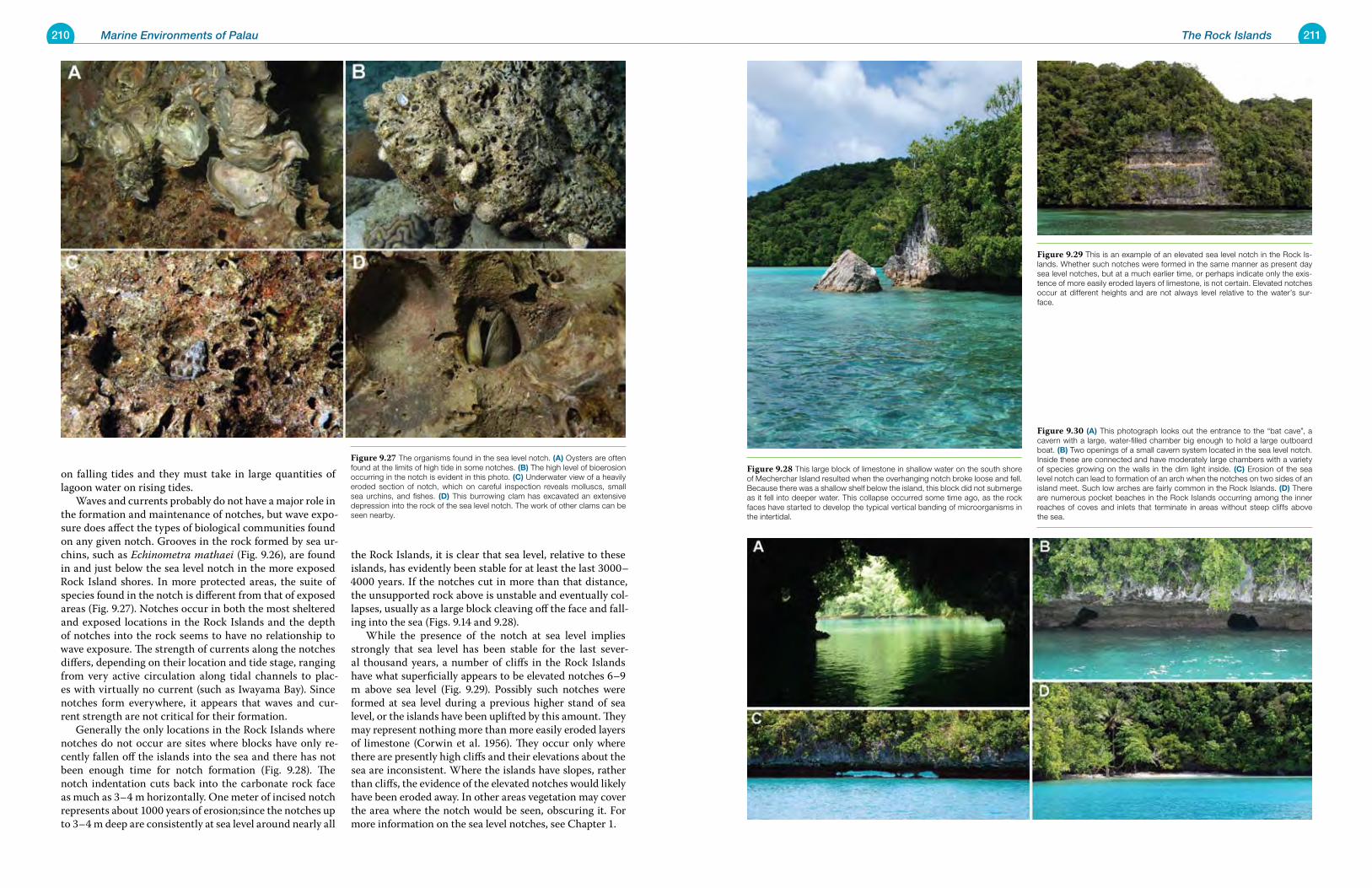
210 Marine Environments of Palau 211The Rock Islands
on falling tides and they must take in large quantities of lagoon water on rising tides. Waves and currents probably do not have a major role in the formation and maintenance of notches, but wave expo-sure does affect the types of biological communities found on any given notch. Grooves in the rock formed by sea ur-chins, such as Echinometra mathaei (Fig. 9.26), are found in and just below the sea level notch in the more exposed Rock Island shores. In more protected areas, the suite of species found in the notch is different from that of exposed areas (Fig. 9.27). Notches occur in both the most sheltered and exposed locations in the Rock Islands and the depth of notches into the rock seems to have no relationship to wave exposure. The strength of currents along the notches differs, depending on their location and tide stage, ranging from very active circulation along tidal channels to plac-es with virtually no current (such as Iwayama Bay). Since notches form everywhere, it appears that waves and cur-rent strength are not critical for their formation. Generally the only locations in the Rock Islands where notches do not occur are sites where blocks have only re-cently fallen off the islands into the sea and there has not been enough time for notch formation (Fig. 9.28). The notch indentation cuts back into the carbonate rock face as much as 3–4 m horizontally. One meter of incised notch represents about 1000 years of erosion;since the notches up to 3–4 m deep are consistently at sea level around nearly all
the Rock Islands, it is clear that sea level, relative to these islands, has evidently been stable for at least the last 3000–4000 years. If the notches cut in more than that distance, the unsupported rock above is unstable and eventually col-lapses, usually as a large block cleaving off the face and fall-ing into the sea (Figs. 9.14 and 9.28). While the presence of the notch at sea level implies strongly that sea level has been stable for the last sever-al thousand years, a number of cliffs in the Rock Islands have what superficially appears to be elevated notches 6–9 m above sea level (Fig. 9.29). Possibly such notches were formed at sea level during a previous higher stand of sea level, or the islands have been uplifted by this amount. They may represent nothing more than more easily eroded layers of limestone (Corwin et al. 1956). They occur only where there are presently high cliffs and their elevations about the sea are inconsistent. Where the islands have slopes, rather than cliffs, the evidence of the elevated notches would likely have been eroded away. In other areas vegetation may cover the area where the notch would be seen, obscuring it. For more information on the sea level notches, see Chapter 1.
Figure 9.29 This is an example of an elevated sea level notch in the Rock Is-lands. Whether such notches were formed in the same manner as present day sea level notches, but at a much earlier time, or perhaps indicate only the exis-tence of more easily eroded layers of limestone, is not certain. Elevated notches occur at different heights and are not always level relative to the water’s sur-face.
Figure 9.30 (a) This photograph looks out the entrance to the “bat cave”, a cavern with a large, water-filled chamber big enough to hold a large outboard boat. (B) Two openings of a small cavern system located in the sea level notch. Inside these are connected and have moderately large chambers with a variety of species growing on the walls in the dim light inside. (C) Erosion of the sea level notch can lead to formation of an arch when the notches on two sides of an island meet. Such low arches are fairly common in the Rock Islands. (d) There are numerous pocket beaches in the Rock Islands occurring among the inner reaches of coves and inlets that terminate in areas without steep cliffs above the sea.
Figure 9.28 This large block of limestone in shallow water on the south shore of Mecherchar Island resulted when the overhanging notch broke loose and fell. Because there was a shallow shelf below the island, this block did not submerge as it fell into deeper water. This collapse occurred some time ago, as the rock faces have started to develop the typical vertical banding of microorganisms in the intertidal.
Figure 9.27 The organisms found in the sea level notch. (a) Oysters are often found at the limits of high tide in some notches. (B) The high level of bioerosion occurring in the notch is evident in this photo. (C) Underwater view of a heavily eroded section of notch, which on careful inspection reveals molluscs, small sea urchins, and fishes. (d) This burrowing clam has excavated an extensive depression into the rock of the sea level notch. The work of other clams can be seen nearby.
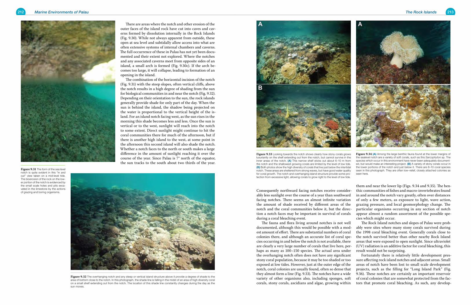
212 Marine Environments of Palau 213The Rock Islands
Consequently northward facing notches receive consider-ably less sunlight over the course of a year than southward facing notches. There seems an almost infinite variation the amount of shade received by different areas of the notch and the coral communities below it, but the direc-tion a notch faces may be important in survival of corals during a coral bleaching event. The fauna and flora living around notches is not well documented, although this would be possible with a mod-est amount of effort. There are substantial numbers of coral colonies there, and although an accurate list of coral spe-cies occurring in and below the notch is not available, there are clearly a very large number of corals that live here, per-haps as many as 100–150 species. The actual area under the overhanging notch often does not have any significant stony coral population, because it may be too shaded or too exposed at low tides. However, just at the outer edge of the notch, coral colonies are usually found, often so dense that they almost form a line (Fig. 9.33). The notches have a wide variety of other organisms also, including sponges, soft corals, stony corals, ascidians and algae, growing within
them and near the lower lip (Figs. 9.34 and 9.35). The ben-thic communities of fishes and macro-invertebrates found in and around the notch vary greatly, often over distances of only a few meters, as exposure to light, wave action, grazing pressure, and local geomorphology change. The particular organisms occurring in any section of notch appear almost a random assortment of the possible spe-cies which might occur. The Rock Island notches and slopes of Palau were prob-ably were sites where many stony corals survived during the 1998 coral bleaching event. Generally corals close to the notch survived better than other nearby Rock Island areas that were exposed to open sunlight. Since ultraviolet (UV) radiation is an additive factor for coral bleaching, this result would not be surprising. Fortunately there is relatively little development pres-sure affecting rock island notches and adjacent areas. Small areas of notch have been lost to small scale development projects, such as the filling for “Long Island Park” (Fig. 9.36). These notches are certainly an important reservoir of coral colonies that are somewhat protected from the fac-tors that promote coral bleaching. As such, any develop-
There are areas where the notch and other erosion of the outer faces of the island rock have cut into caves and cav-erns formed by dissolution internally in the Rock Islands (Fig. 9.30). While not always apparent from outside, these open at sea level and subtidally allow access into what are often extensive systems of internal chambers and caverns. The full occurrence of these in Palau has not yet been docu-mented and their extent not explored. Where the notches and any associated caverns meet from opposite sides of an island, a small arch is formed (Fig. 9.30c). If the arch be-comes too large, it will collapse, leading to formation of an opening in the island. The combination of the horizontal incision of the notch (Fig. 9.31) with the steep slopes, often vertical cliffs, above the notch results in a high degree of shading from the sun for biological communities in and near the notch (Fig. 9.32). Depending on their orientation to the sun, the rock islands generally provide shade for only part of the day. When the sun is behind the island, the shadow being projected on the water is proportional to the vertical height of the is-land. For an island notch facing west, as the sun rises in the morning this shade becomes less and less. Once the sun is vertical or to the west, sunlight will reach into the notch to some extent. Direct sunlight might continue to hit the coral communities there for much of the afternoon, but if there is another high island to the west, at some point in the afternoon this second island will also shade the notch. Whether a notch faces to the north or south makes a large difference in the amount of sunlight reaching it over the course of the year. Since Palau is 7° north of the equator, the sun tracks to the south about two thirds of the year.
Figure 9.34 (a) Among the large benthic fauna found at the lower margins of the sealevel notch are a variety of soft corals, such as this Sarcophyton sp. The species which occur in this environment have never been adequately document-ed, but would make an interesting project. (B) A variety of stony corals occur in the lower portions of the notch and just below it. There are 8–10 coral species seen in this photograph. They are often low–relief, closely attached colonies as seen here.
Figure 9.33 Looking towards the notch shows clearly how stony corals grows luxuriantly on the shelf extending out from the notch, but cannot survive in the inner areas of the notch. (a) This narrow shelf sticks out about 6–10 m from the notch and the shallowest growing corals are limited by the level of low tide. (B) Both photos show the high diversity of corals that live just below the intertidal notch. These areas are sheltered from strong waves, but have good water quality for coral growth. The notch and overhanging island structure provide some pro-tection from excessive light, allowing corals to grow right to the level of low tide.
Figure 9.31 The form of the sea level notch is quite evident in this “in and out” view taken on a mid-level tide. The bioerosion of the rock on the low-er portion of the notch is evidenced by the small scale holes and pits exca-vated in the limestone by the actions of grazing and boring organisms.
Figure 9.32 The overhanging notch and any steep or vertical island structure above it provide a degree of shade to the area of bottom close to the notch. In this photograph, the shade line is falling in the midst of an area of high diversity coral on a small shelf extending out from the notch. The location of this shade line constantly changes during the day as the sun moves.
214 Marine Environments of Palau 215The Rock Islands
ment project that would have a major effect on notch com-munities should be avoided. The greatest danger to notch communities probably comes from possible pollution with
products that float on the water surface. Obviously, petro-leum products immediately come to mind. It is conceiv-able that a large scale oil spill in that area of rock islands could wipe out a large area of notch communities, while those corals and other organisms somewhat deeper may be less affected. Knowledge of currents in the rock islands will be important in predicting where petroleum spills might move and affect intertidal rock island communities.
outer Island arcThe outer islands in the Rock Islands are exposed to much more wave action than are the inner areas. To the west of
Figure 9.36 While most of the ar-eas of the Rock Islands with sea level notches have been protected from development, those areas that are connected by road in the greater Koror area have not been. This de-velopment in the Long Island area of Koror involved dredging and filling to produce a park area. In 1997, a paved causeway (Long Island) existed that had formerly been the termination of a cable ferry route across the chan-nel here. This was no longer needed when the causeway and bridge shown were constructed. By 2005, the area between the causeway and the Rock Island shore was filled in, as was an area further along the channel. By 2005, areas of sand appear to have been deposited on the shallow flat on the other side of the causeway, seen on the right in the photograph. The area appears to have been a mixed coral/algal flat in 1997.
Figure 9.37 Tlutkaraguis Island, on the western margin of the Ngeruktabel Rock Island group, has multiple caves and arches through the island. It is surrounded by a shallow sandy bottom, littered with many small blocks. The blocks have apparently fallen from the island over time. It is tempting to assume the shallow flats around the island are the product of its slow erosion over hundreds of thousands of years.
Figure 9.35 Some corals and other invertebrates typical of Rock Island slopes just below the notches. (a) The blue tube sponge Cribrochalina olemda is found in many reef environments. This individual exhibits considerable damage to its structure, and some areas (brown) that are possibly dying. Here it occurs among a variety of low stony coral colonies. (B) This lovely colony of Psammocora con-tigua is well attached to the substrate among a variety of other corals. There is a great deal of competition for space among stony corals living just below the sea-level notch zone. (C) The stony coral Psammocora digitata occurs among other low coral colonies. P. digitata is distinctive with its club-like branches rounded on their ends. (d) The gorgonian Rumphella sp. (e) The bubble corals, such as this Pleurogyra sinuosa, are common elements of the Rock Island fauna. (F) The solitary ascidian Polycarpa capitosa is commonly found along Rock Is-land slopes and overhangs.
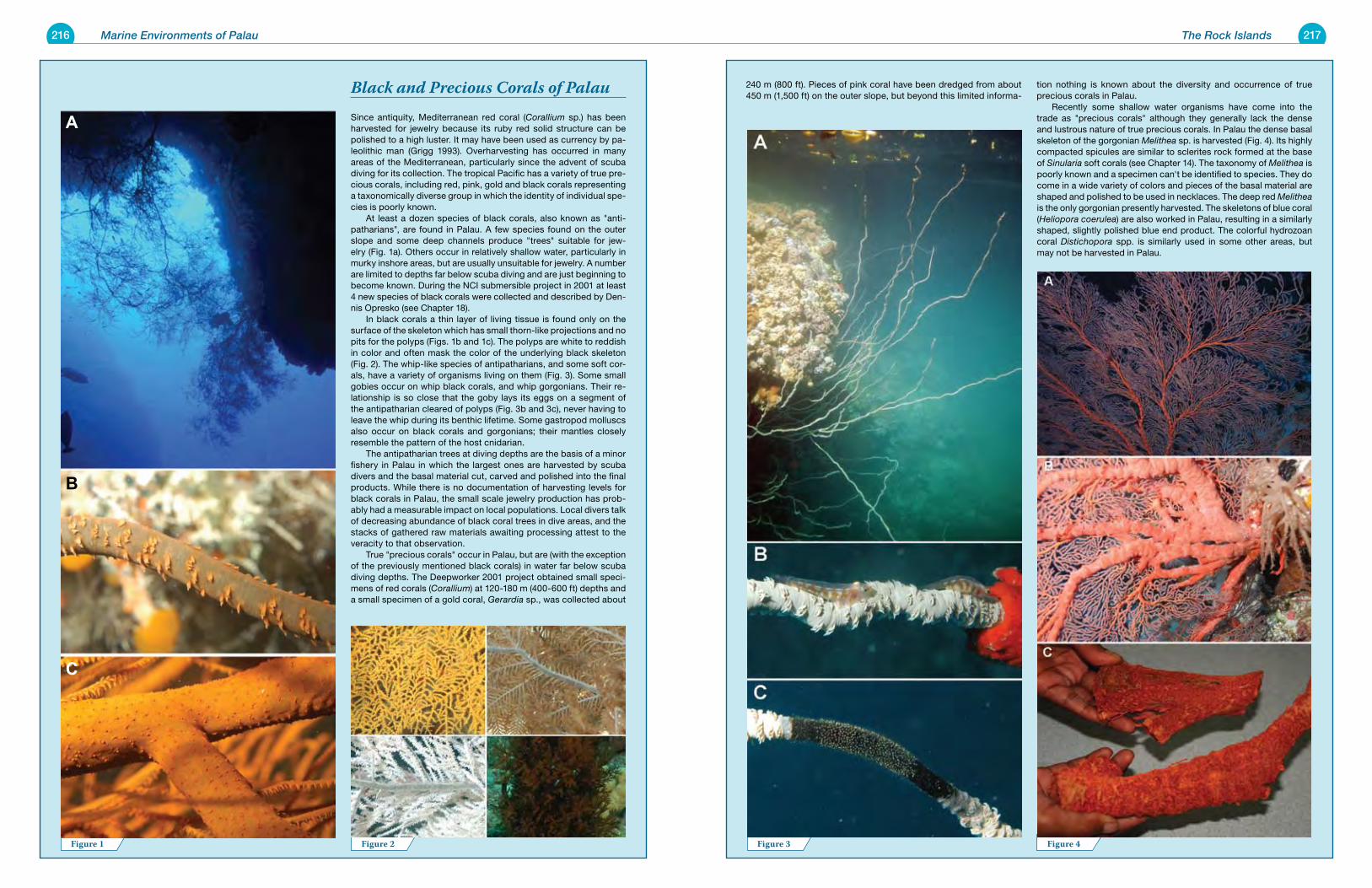
216 Marine Environments of Palau 217The Rock Islands
240 m (800 ft). Pieces of pink coral have been dredged from about 450 m (1,500 ft) on the outer slope, but beyond this limited informa-
tion nothing is known about the diversity and occurrence of true precious corals in Palau. Recently some shallow water organisms have come into the trade as "precious corals" although they generally lack the dense and lustrous nature of true precious corals. In Palau the dense basal skeleton of the gorgonian Melithea sp. is harvested (Fig. 4). Its highly compacted spicules are similar to sclerites rock formed at the base of Sinularia soft corals (see Chapter 14). The taxonomy of Melithea is poorly known and a specimen can't be identified to species. They do come in a wide variety of colors and pieces of the basal material are shaped and polished to be used in necklaces. The deep red Melithea is the only gorgonian presently harvested. The skeletons of blue coral (Heliopora coerulea) are also worked in Palau, resulting in a similarly shaped, slightly polished blue end product. The colorful hydrozoan coral Distichopora spp. is similarly used in some other areas, but may not be harvested in Palau.
Black and Precious Corals of PalauSince antiquity, Mediterranean red coral (Corallium sp.) has been harvested for jewelry because its ruby red solid structure can be polished to a high luster. It may have been used as currency by pa-leolithic man (Grigg 1993). Overharvesting has occurred in many areas of the Mediterranean, particularly since the advent of scuba diving for its collection. The tropical Pacific has a variety of true pre-cious corals, including red, pink, gold and black corals representing a taxonomically diverse group in which the identity of individual spe-cies is poorly known. At least a dozen species of black corals, also known as "anti-patharians", are found in Palau. A few species found on the outer slope and some deep channels produce "trees" suitable for jew-elry (Fig. 1a). Others occur in relatively shallow water, particularly in murky inshore areas, but are usually unsuitable for jewelry. A number are limited to depths far below scuba diving and are just beginning to become known. During the NCI submersible project in 2001 at least 4 new species of black corals were collected and described by Den-nis Opresko (see Chapter 18). In black corals a thin layer of living tissue is found only on the surface of the skeleton which has small thorn-like projections and no pits for the polyps (Figs. 1b and 1c). The polyps are white to reddish in color and often mask the color of the underlying black skeleton (Fig. 2). The whip-like species of antipatharians, and some soft cor-als, have a variety of organisms living on them (Fig. 3). Some small gobies occur on whip black corals, and whip gorgonians. Their re-lationship is so close that the goby lays its eggs on a segment of the antipatharian cleared of polyps (Fig. 3b and 3c), never having to leave the whip during its benthic lifetime. Some gastropod molluscs also occur on black corals and gorgonians; their mantles closely resemble the pattern of the host cnidarian. The antipatharian trees at diving depths are the basis of a minor fishery in Palau in which the largest ones are harvested by scuba divers and the basal material cut, carved and polished into the final products. While there is no documentation of harvesting levels for black corals in Palau, the small scale jewelry production has prob-ably had a measurable impact on local populations. Local divers talk of decreasing abundance of black coral trees in dive areas, and the stacks of gathered raw materials awaiting processing attest to the veracity to that observation. True "precious corals" occur in Palau, but are (with the exception of the previously mentioned black corals) in water far below scuba diving depths. The Deepworker 2001 project obtained small speci-mens of red corals (Corallium) at 120-180 m (400-600 ft) depths and a small specimen of a gold coral, Gerardia sp., was collected about
Figure 3 Figure 4Figure 1 Figure 2
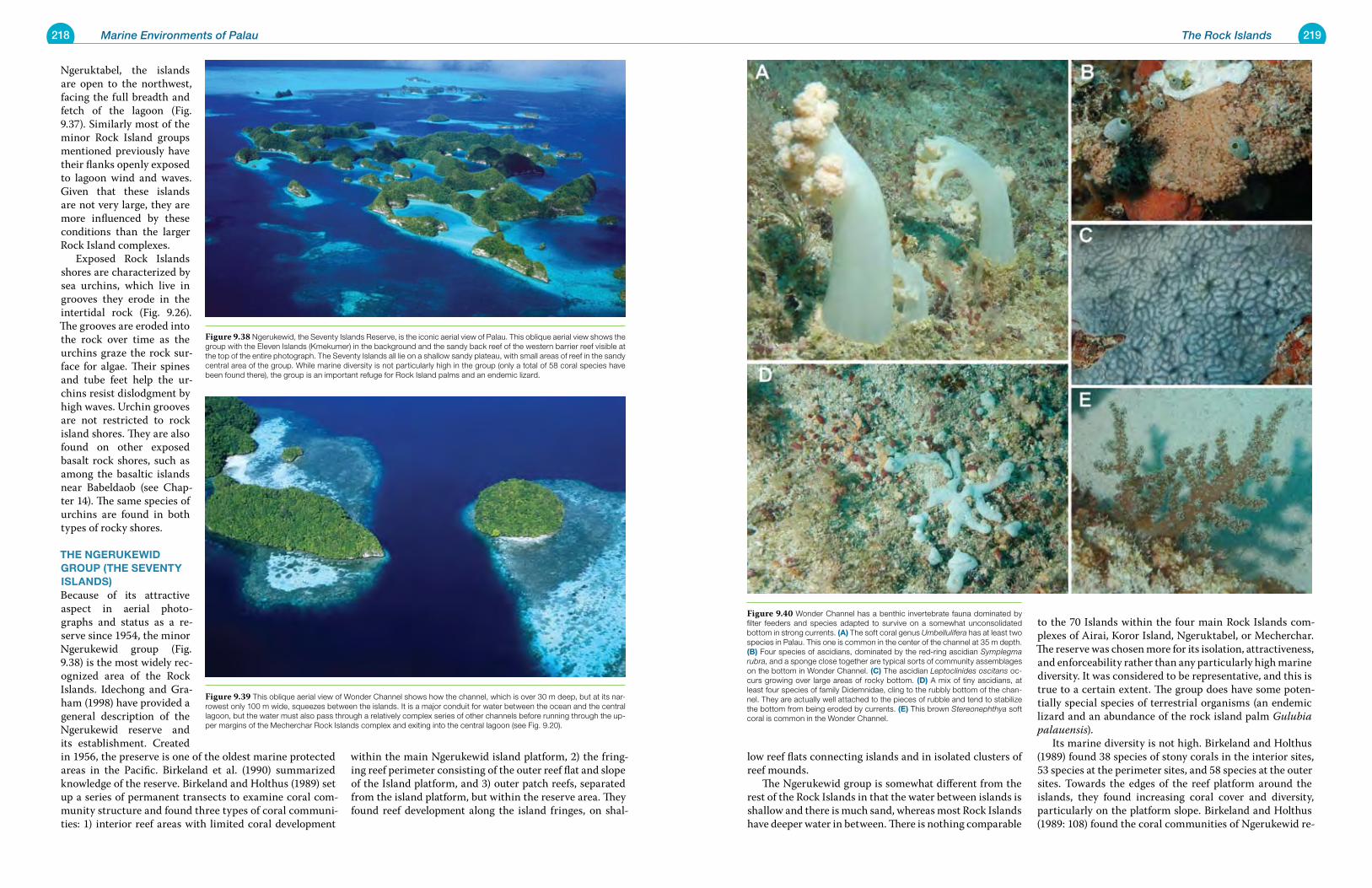
218 Marine Environments of Palau 219The Rock Islands
low reef flats connecting islands and in isolated clusters of reef mounds. The Ngerukewid group is somewhat different from the rest of the Rock Islands in that the water between islands is shallow and there is much sand, whereas most Rock Islands have deeper water in between. There is nothing comparable
to the 70 Islands within the four main Rock Islands com-plexes of Airai, Koror Island, Ngeruktabel, or Mecherchar. The reserve was chosen more for its isolation, attractiveness, and enforceability rather than any particularly high marine diversity. It was considered to be representative, and this is true to a certain extent. The group does have some poten-tially special species of terrestrial organisms (an endemic lizard and an abundance of the rock island palm Gulubia palauensis). Its marine diversity is not high. Birkeland and Holthus (1989) found 38 species of stony corals in the interior sites, 53 species at the perimeter sites, and 58 species at the outer sites. Towards the edges of the reef platform around the islands, they found increasing coral cover and diversity, particularly on the platform slope. Birkeland and Holthus (1989: 108) found the coral communities of Ngerukewid re-
Ngeruktabel, the islands are open to the northwest, facing the full breadth and fetch of the lagoon (Fig. 9.37). Similarly most of the minor Rock Island groups mentioned previously have their flanks openly exposed to lagoon wind and waves. Given that these islands are not very large, they are more influenced by these conditions than the larger Rock Island complexes. Exposed Rock Islands shores are characterized by sea urchins, which live in grooves they erode in the intertidal rock (Fig. 9.26). The grooves are eroded into the rock over time as the urchins graze the rock sur-face for algae. Their spines and tube feet help the ur-chins resist dislodgment by high waves. Urchin grooves are not restricted to rock island shores. They are also found on other exposed basalt rock shores, such as among the basaltic islands near Babeldaob (see Chap-ter 14). The same species of urchins are found in both types of rocky shores.
the nGeruKewId Group (the Seventy ISlandS)Because of its attractive aspect in aerial photo-graphs and status as a re-serve since 1954, the minor Ngerukewid group (Fig. 9.38) is the most widely rec-ognized area of the Rock Islands. Idechong and Gra-ham (1998) have provided a general description of the Ngerukewid reserve and its establishment. Created in 1956, the preserve is one of the oldest marine protected areas in the Pacific. Birkeland et al. (1990) summarized knowledge of the reserve. Birkeland and Holthus (1989) set up a series of permanent transects to examine coral com-munity structure and found three types of coral communi-ties: 1) interior reef areas with limited coral development
within the main Ngerukewid island platform, 2) the fring-ing reef perimeter consisting of the outer reef flat and slope of the Island platform, and 3) outer patch reefs, separated from the island platform, but within the reserve area. They found reef development along the island fringes, on shal-
Figure 9.40 Wonder Channel has a benthic invertebrate fauna dominated by filter feeders and species adapted to survive on a somewhat unconsolidated bottom in strong currents. (a) The soft coral genus Umbellulifera has at least two species in Palau. This one is common in the center of the channel at 35 m depth. (B) Four species of ascidians, dominated by the red-ring ascidian Symplegma rubra, and a sponge close together are typical sorts of community assemblages on the bottom in Wonder Channel. (C) The ascidian Leptoclinides oscitans oc-curs growing over large areas of rocky bottom. (d) A mix of tiny ascidians, at least four species of family Didemnidae, cling to the rubbly bottom of the chan-nel. They are actually well attached to the pieces of rubble and tend to stabilize the bottom from being eroded by currents. (e) This brown Stereonephthya soft coral is common in the Wonder Channel.
Figure 9.38 Ngerukewid, the Seventy Islands Reserve, is the iconic aerial view of Palau. This oblique aerial view shows the group with the Eleven Islands (Kmekumer) in the background and the sandy back reef of the western barrier reef visible at the top of the entire photograph. The Seventy Islands all lie on a shallow sandy plateau, with small areas of reef in the sandy central area of the group. While marine diversity is not particularly high in the group (only a total of 58 coral species have been found there), the group is an important refuge for Rock Island palms and an endemic lizard.
Figure 9.39 This oblique aerial view of Wonder Channel shows how the channel, which is over 30 m deep, but at its nar-rowest only 100 m wide, squeezes between the islands. It is a major conduit for water between the ocean and the central lagoon, but the water must also pass through a relatively complex series of other channels before running through the up-per margins of the Mecherchar Rock Islands complex and exiting into the central lagoon (see Fig. 9.20).
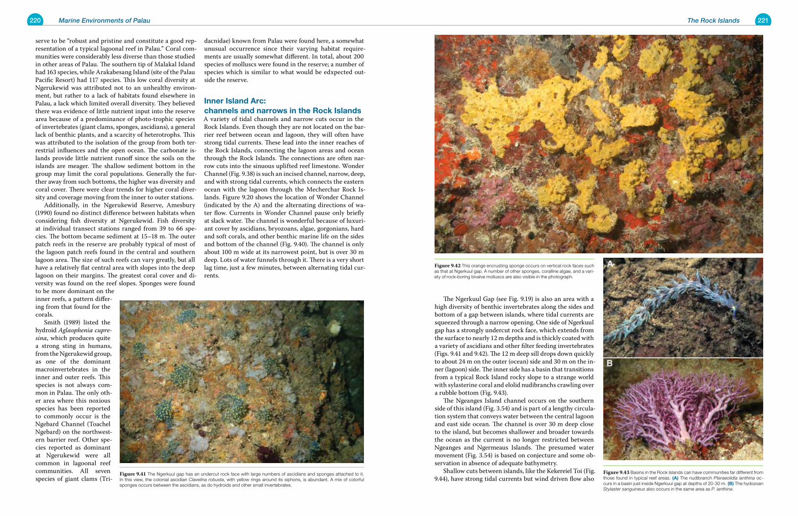
220 Marine Environments of Palau 221The Rock Islands
The Ngerkuul Gap (see Fig. 9.19) is also an area with a high diversity of benthic invertebrates along the sides and bottom of a gap between islands, where tidal currents are squeezed through a narrow opening. One side of Ngerkuul gap has a strongly undercut rock face, which extends from the surface to nearly 12 m depths and is thickly coated with a variety of ascidians and other filter feeding invertebrates (Figs. 9.41 and 9.42). The 12 m deep sill drops down quickly to about 24 m on the outer (ocean) side and 30 m on the in-ner (lagoon) side. The inner side has a basin that transitions from a typical Rock Island rocky slope to a strange world with sylasterine coral and elolid nudibranchs crawling over a rubble bottom (Fig. 9.43). The Ngeanges Island channel occurs on the southern side of this island (Fig. 3.54) and is part of a lengthy circula-tion system that conveys water between the central lagoon and east side ocean. The channel is over 30 m deep close to the island, but becomes shallower and broader towards the ocean as the current is no longer restricted between Ngeanges and Ngermeaus Islands. The presumed water movement (Fig. 3.54) is based on conjecture and some ob-servation in absence of adequate bathymetry. Shallow cuts between islands, like the Kekereiel Toi (Fig. 9.44), have strong tidal currents but wind driven flow also
serve to be “robust and pristine and constitute a good rep-resentation of a typical lagoonal reef in Palau.” Coral com-munities were considerably less diverse than those studied in other areas of Palau. The southern tip of Malakal Island had 163 species, while Arakabesang Island (site of the Palau Pacific Resort) had 117 species. This low coral diversity at Ngerukewid was attributed not to an unhealthy environ-ment, but rather to a lack of habitats found elsewhere in Palau, a lack which limited overall diversity. They believed there was evidence of little nutrient input into the reserve area because of a predominance of photo-trophic species of invertebrates (giant clams, sponges, ascidians), a general lack of benthic plants, and a scarcity of heterotrophs. This was attributed to the isolation of the group from both ter-restrial influences and the open ocean. The carbonate is-lands provide little nutrient runoff since the soils on the islands are meager. The shallow sediment bottom in the group may limit the coral populations. Generally the fur-ther away from such bottoms, the higher was diversity and coral cover. There were clear trends for higher coral diver-sity and coverage moving from the inner to outer stations. Additionally, in the Ngerukewid Reserve, Amesbury (1990) found no distinct difference between habitats when considering fish diversity at Ngerukewid. Fish diversity at individual transect stations ranged from 39 to 66 spe-cies. The bottom became sediment at 15–18 m. The outer patch reefs in the reserve are probably typical of most of the lagoon patch reefs found in the central and southern lagoon area. The size of such reefs can vary greatly, but all have a relatively flat central area with slopes into the deep lagoon on their margins. The greatest coral cover and di-versity was found on the reef slopes. Sponges were found to be more dominant on the inner reefs, a pattern differ-ing from that found for the corals. Smith (1989) listed the hydroid Aglaophenia cupre-sina, which produces quite a strong sting in humans, from the Ngerukewid group, as one of the dominant macroinvertebrates in the inner and outer reefs. This species is not always com-mon in Palau. The only oth-er area where this noxious species has been reported to commonly occur is the Ngebard Channel (Toachel Ngebard) on the northwest-ern barrier reef. Other spe-cies reported as dominant at Ngerukewid were all common in lagoonal reef communities. All seven species of giant clams (Tri-
dacnidae) known from Palau were found here, a somewhat unusual occurrence since their varying habitat require-ments are usually somewhat different. In total, about 200 species of molluscs were found in the reserve; a number of species which is similar to what would be edxpected out-side the reserve.
Inner Island arc: channels and narrows in the rock IslandsA variety of tidal channels and narrow cuts occur in the Rock Islands. Even though they are not located on the bar-rier reef between ocean and lagoon, they will often have strong tidal currents. These lead into the inner reaches of the Rock Islands, connecting the lagoon areas and ocean through the Rock Islands. The connections are often nar-row cuts into the sinuous uplifted reef limestone. Wonder Channel (Fig. 9.38) is such an incised channel, narrow, deep, and with strong tidal currents, which connects the eastern ocean with the lagoon through the Mecherchar Rock Is-lands. Figure 9.20 shows the location of Wonder Channel (indicated by the A) and the alternating directions of wa-ter flow. Currents in Wonder Channel pause only briefly at slack water. The channel is wonderful because of luxuri-ant cover by ascidians, bryozoans, algae, gorgonians, hard and soft corals, and other benthic marine life on the sides and bottom of the channel (Fig. 9.40). The channel is only about 100 m wide at its narrowest point, but is over 30 m deep. Lots of water funnels through it. There is a very short lag time, just a few minutes, between alternating tidal cur-rents.
Figure 9.42 This orange encrusting sponge occurs on vertical rock faces such as that at Ngerkuul gap. A number of other sponges, coralline algae, and a vari-ety of rock-boring bivalve molluscs are also visible in the photograph.
Figure 9.43 Basins in the Rock Islands can have communities far different from those found in typical reef areas. (a) The nudibranch Pteraeolidia ianthina oc-curs in a basin just inside Ngerkuul gap at depths of 20-30 m. (B) The hydozoan Stylaster sanguineus also occurs in the same area as P. ianthina.
Figure 9.41 The Ngerkuul gap has an undercut rock face with large numbers of ascidians and sponges attached to it. In this view, the colonial ascidian Clavelina robusta, with yellow rings around its siphons, is abundant. A mix of colorful sponges occurs between the ascidians, as do hydroids and other small invertebrates.
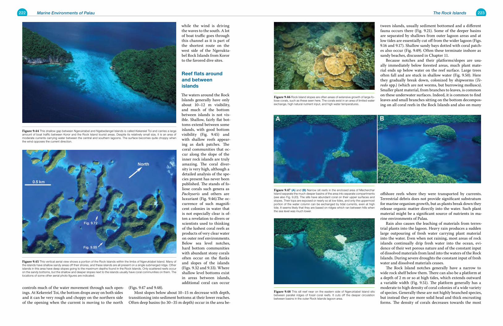
222 Marine Environments of Palau 223The Rock Islands
tween islands, usually sediment bottomed and a different fauna occurs there (Fig. 9.21). Some of the deeper basins are separated by shallows from outer lagoon areas and at low tides are essentially cut off from the wider lagoon (Figs. 9.16 and 9.17). Shallow sandy bays dotted with coral patch-es also occur (Fig. 9.49). Often these terminate inshore as sandy beaches, discussed in Chapter 11. Because notches and their platforms/slopes are usu-ally immediately below forested areas, much plant mate-rial ends up below water on the reef surface. Large trees often fall and are stuck in shallow water (Fig. 9.50). Here they gradually break down, colonized by shipworms (Te-redo spp.) (which are not worms, but burrowing molluscs). Smaller plant material, from branches to leaves, is common on these underwater surfaces. Indeed, it is common to find leaves and small branches sitting on the bottom decompos-ing on all coral reefs in the Rock Islands and also on many
offshore reefs where they were transported by currents. Terrestrial debris does not provide significant substratum for marine organism growth, but as plants break down they release organic matter directly into the water. Such plant material might be a significant source of nutrients in ma-rine environments of Palau. Rain also causes the leaching of materials from terres-trial plants into the lagoon. Heavy rain produces a sudden large outpouring of fresh water carrying plant material into the water. Even when not raining, most areas of rock islands continually drip fresh water into the ocean, evi-dence of their wet porous nature and of the constant input of dissolved materials from land into the waters of the Rock Islands. During severe droughts the constant input of fresh water and dissolved materials ceases. The Rock Island notches generally have a narrow to wide rock shelf below them. There can also be a platform at a depth of 2 m or so at high tides, which extends outward a variable width (Fig. 9.51). The platform generally has a moderate to high density of coral colonies of a wide variety of species. Generally these are not highly branched species, but instead they are more solid head and thick encrusting forms. The density of corals decreases towards the most
controls much of the water movement through such open-ings. At Kekereiel Toi, the bottom drops away on both sides and it can be very rough and choppy on the northern side of the opening when the current is moving to the north
while the wind is driving the waves to the south. A lot of boat traffic goes through this channel as it is part of the shortest route on the west side of the Ngerukta-bel Rock Islands from Koror to the favored dive sites.
reef flats around and between islands
The waters around the Rock Islands generally have only about 10–12 m visibility, and much of the bottom between islands is not vis-ible. Shallow, fairly flat bot-toms extend between some islands, with good bottom visibility (Fig. 9.45) and with shallow reefs appear-ing as dark patches. The coral communities that oc-cur along the slope of the inner rock islands are truly amazing. The coral diver-sity is very high, although a detailed analysis of the spe-cies present has never been published. The stands of fo-liose corals such genera as Pachyseris and others are luxuriant (Fig. 9.46).The oc-currence of such magnifi-cent colonies in water that is not especially clear is of-ten a revelation to divers or scientists used to thinking of the lushest coral reefs as products of very clear water on outer reef environments. Below sea level notches, hard bottom communities with abundant stony corals often occur on the flanks and slopes of the islands (Figs. 9.32 and 9.33). Where shallow level bottoms exist in areas between islands, additional coral can occur
(Figs. 9.47 and 9.48). Most slopes below about 10–15 m decrease with depth, transitioning into sediment bottoms at their lower reaches. Often deep basins (to 30–35 m depth) occur in the area be-
Figure 9.47 (a) and (B) Narrow sill reefs in the enclosed area of Mecherchar Island separate the much deeper basins of the area into separate compartments (see also Fig. 9.20). The sills have abundant coral on their upper surfaces and slopes. Their tops are exposed or nearly so at low tides, and only the uppermost portion of the water column can be exchanged by tidal currents, even at high tide. It seems likely that they are based on ridges which ran between hills when the sea level was much lower.
Figure 9.48 This sill reef near on the eastern side of Ngeruktabel Island sits between parallel ridges of fossil coral reefs. It cuts off the deeper circulation between basins in the outer Rock Islands lagoon area.
Figure 9.46 Rock Island slopes are often areas of extensive growth of large fo-liose corals, such as these seen here. The corals exist in an area of limited water exchange, high natural nutrient input, and high water temperatures.
Figure 9.44 This shallow gap between Ngeruktabel and Ngebedangel Islands is called Kekereiel Toi and carries a large amount of boat traffic between Koror and the Rock Island tourist areas. Despite its relatively small size, it is an area of moderate currents carrying water between the central and southern lagoons. The surface becomes quite choppy when the wind opposes the current direction.
Figure 9.45 This vertical aerial view shows a portion of the Rock Islands within the limbs of Ngeruktabel Island. Many of the islands have shallow sandy areas off their shores, and these islands are all present on a single submerged ridge. Other islands in this area have deep slopes going to the maximum depths found in the Rock Islands. Only scattered reefs occur on the sandy bottoms, but the shallow and deeper slopes next to the islands usually have coral communities on them. The locations of some other aerial photo figures are indicated.
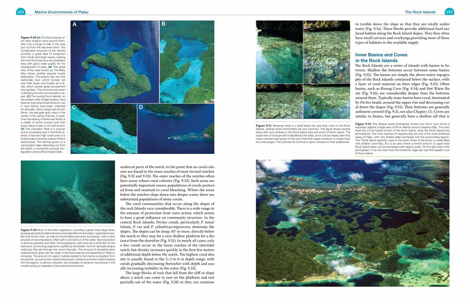
224 Marine Environments of Palau 225The Rock Islands
to tumble down the slope so that they are totally under-water (Fig. 9.3a). These blocks provide additional hard sur-faced habitat along the Rock Island slopes. They they often have small crevices and overhangs,providing more of these types of habitats to the available supply.
Inner Basins and Coves in the rock IslandsThe Rock Islands are a series of islands with basins in be-tween. Shallow flat bottoms occur between some basins (Fig. 9.52). The basins are simply the above-water topogra-phy of the Rock Islands continued below the surface, with a layer of coral material on their edges (Fig. 9.53). Often basins, such as Risong Cove (Fig. 9.54) and Hot Water Ba-sin (Fig. 9.16), are considerably deeper than the bottoms around them. Typically inner basins have coral, dominated by Porites heads, around the upper rim and decreasing cor-al down the slopes (Fig. 9.55). Their bottoms are generally sediment covered (Fig. 9.21, see also Chapter 11). Coves are similar to basins, but generally have a shallow sill that is
undercut parts of the notch, to the point that no coral colo-nies are found in the inner reaches of most incised notches (Fig. 9.32 and 9.33). The outer reaches of the notches often have many robust coral colonies (Fig. 9.33). Such areas are potentially important source populations of corals protect-ed from and resistant to coral bleaching. Where the areas below the notches slope down into deeper water, there are substantial populations of stony corals. The coral communities that occur along the slopes of the rock Islands vary considerably. There is a wide range in the amount of protection from wave action, which seems to have a great influence on community structure. In the central Rock Islands, Porites corals, particularly P. lutea/lobata, P. rus and P. cylindricus/nigrescens, dominate the slopes. The slopes can be steep, 45° or more, directly below the notch or they may for a very shallow platform for a dis-tance from the shoreline (Fig. 9.51). In nearly all cases, only a few corals occur in the lower reaches of the intertidal notch, but density increases quickly in the first few meters of additional depth below the notch. The highest coral den-sity is usually found in the 2–3 to 6 m depth range, with corals gradually decreasing thereafter with depth and usu-ally increasing turbidity in the water (Fig. 9.33). The large blocks of rock that fall from the cliff or slope above a notch can come to rest on the platform and rest partially out of the water (Fig. 9.28) or they can continue
Figure 9.51 Wherever there is a shelf below the sea level notch in the Rock Islands, diverse coral communities are very common. This figure shows several areas with such shelves in the Rock Island area just south of Koror Island. The upper limit of coral growth is dictated by the tides, and it can be clearly seen that many colonies have grown to the point that their upper surfaces no longer have live coral polyps. The colonies do continue to grow outward on their peripheries.
Figure 9.52 This oblique aerial photograph shows how Koror town forms a backdrop against a large area of Rock Islands around Iwayama Bay. The town itself sits on the basalt portion of the Koror Island, while the Rock Islands are all limestone. The inner reaches of Iwayama Bay are one of the most sheltered areas of Palau, with very limited water exchange with the surrounding lagoon. The “Turtle Island opening”, seen in the lower center of the photo, is nearly filled with shallow coral flats, but is an area where a limited amount of upper level Rock Island water can be exchanged with lagoon water. On the right side of the photograph, it can be seen how the limestone ridge lies over the basaltic rock of Koror Island.
Figure 9.49 (a) The Rock Islands of-ten have shallow sand around them, with only a fringe of reef in the area just out from the sea level notch. The complicated structure of the islands provides a great deal of protection from winds and large waves, making the inner Rock Islands a very sheltered area with good water quality for the development of reefs. (B) This aerial view of the area known as The Milky Way shows another popular tourist destination. The bottom has very fine carbonate mud, which tourists rub over their faces and bodies as a fa-cial, which causes great amusement among them. The mud has even been collected and sold commercially in Ja-pan. (C) The central Rock Islands, on the western side of Ngeruktabel, have been an area where bait fishes for use in tuna fishing have been collected for decades. Here a large ball of such fishes, the elongate gray mass in the center of the sandy channel, is seen. Over-harvesting of these bait fishes is a matter of some concern and their exact status today is not well known. (d) The Cemetery Reef is a popular tourist snorkeling spot in the Rock Is-lands. It has very high coral cover of a limited suite of species typical of Rock Island areas. The reef has grown on a submerged ridge extending out from the island, a somewhat unusual con-figuration among Rock Island reefs.
Figure 9.50 Much of the thick vegetation, including a great many large trees, growing along Rock Island shores eventually falls into the water. Large tree trunks, like that shown here, as well an innumerable branches and leaves, start a slow process of decomposition, often half in and half out of the water. Decomposition is done by bacteria and other microorganisms, seen here as a white film on the tree trunk, and boring organisms, typified by the teredo “worms” (actually bivalve molluscs) that eat through the wood internally. The amount of terrestrial plant material which goes into the water in the Rock Islands and elsewhere in Palau is immense. The amount of organic material added to the marine ecosystem from land plants, as well as the material dissolved in streams and other waters flowing into the lagoon, is almost unknown, but probably of extreme importance in the overall cycling of materials in the marine environment.
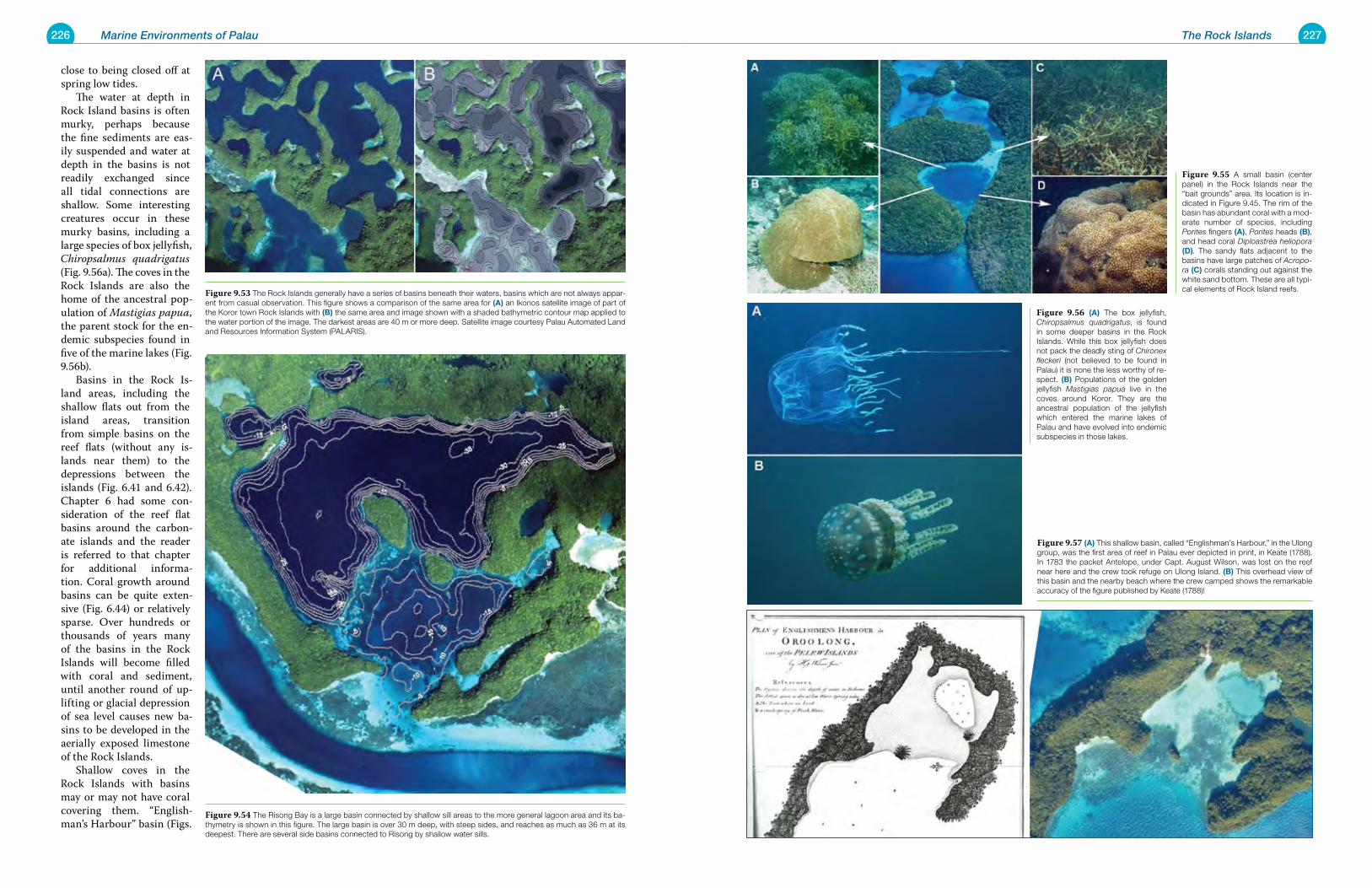
226 Marine Environments of Palau 227The Rock Islands
close to being closed off at spring low tides. The water at depth in Rock Island basins is often murky, perhaps because the fine sediments are eas-ily suspended and water at depth in the basins is not readily exchanged since all tidal connections are shallow. Some interesting creatures occur in these murky basins, including a large species of box jellyfish, Chiropsalmus quadrigatus (Fig. 9.56a). The coves in the Rock Islands are also the home of the ancestral pop-ulation of Mastigias papua, the parent stock for the en-demic subspecies found in five of the marine lakes (Fig. 9.56b). Basins in the Rock Is-land areas, including the shallow flats out from the island areas, transition from simple basins on the reef flats (without any is-lands near them) to the depressions between the islands (Fig. 6.41 and 6.42). Chapter 6 had some con-sideration of the reef flat basins around the carbon-ate islands and the reader is referred to that chapter for additional informa-tion. Coral growth around basins can be quite exten-sive (Fig. 6.44) or relatively sparse. Over hundreds or thousands of years many of the basins in the Rock Islands will become filled with coral and sediment, until another round of up-lifting or glacial depression of sea level causes new ba-sins to be developed in the aerially exposed limestone of the Rock Islands. Shallow coves in the Rock Islands with basins may or may not have coral covering them. “English-man’s Harbour” basin (Figs.
Figure 9.55 A small basin (center panel) in the Rock Islands near the “bait grounds” area. Its location is in-dicated in Figure 9.45. The rim of the basin has abundant coral with a mod-erate number of species, including Porites fingers (a), Porites heads (B), and head coral Diploastrea heliopora (d). The sandy flats adjacent to the basins have large patches of Acropo-ra (C) corals standing out against the white sand bottom. These are all typi-cal elements of Rock Island reefs.
Figure 9.56 (a) The box jellyfish, Chiropsalmus quadrigatus, is found in some deeper basins in the Rock Islands. While this box jellyfish does not pack the deadly sting of Chironex fleckeri (not believed to be found in Palau) it is none the less worthy of re-spect. (B) Populations of the golden jellyfish Mastigias papua live in the coves around Koror. They are the ancestral population of the jellyfish which entered the marine lakes of Palau and have evolved into endemic subspecies in those lakes.
Figure 9.57 (a) This shallow basin, called “Englishman’s Harbour,” in the Ulong group, was the first area of reef in Palau ever depicted in print, in Keate (1788). In 1783 the packet Antelope, under Capt. August Wilson, was lost on the reef near here and the crew took refuge on Ulong Island. (B) This overhead view of this basin and the nearby beach where the crew camped shows the remarkable accuracy of the figure published by Keate (1788)!
Figure 9.53 The Rock Islands generally have a series of basins beneath their waters, basins which are not always appar-ent from casual observation. This figure shows a comparison of the same area for (a) an Ikonos satellite image of part of the Koror town Rock Islands with (B) the same area and image shown with a shaded bathymetric contour map applied to the water portion of the image. The darkest areas are 40 m or more deep. Satellite image courtesy Palau Automated Land and Resources Information System (PALARIS).
Figure 9.54 The Risong Bay is a large basin connected by shallow sill areas to the more general lagoon area and its ba-thymetry is shown in this figure. The large basin is over 30 m deep, with steep sides, and reaches as much as 36 m at its deepest. There are several side basins connected to Risong by shallow water sills.
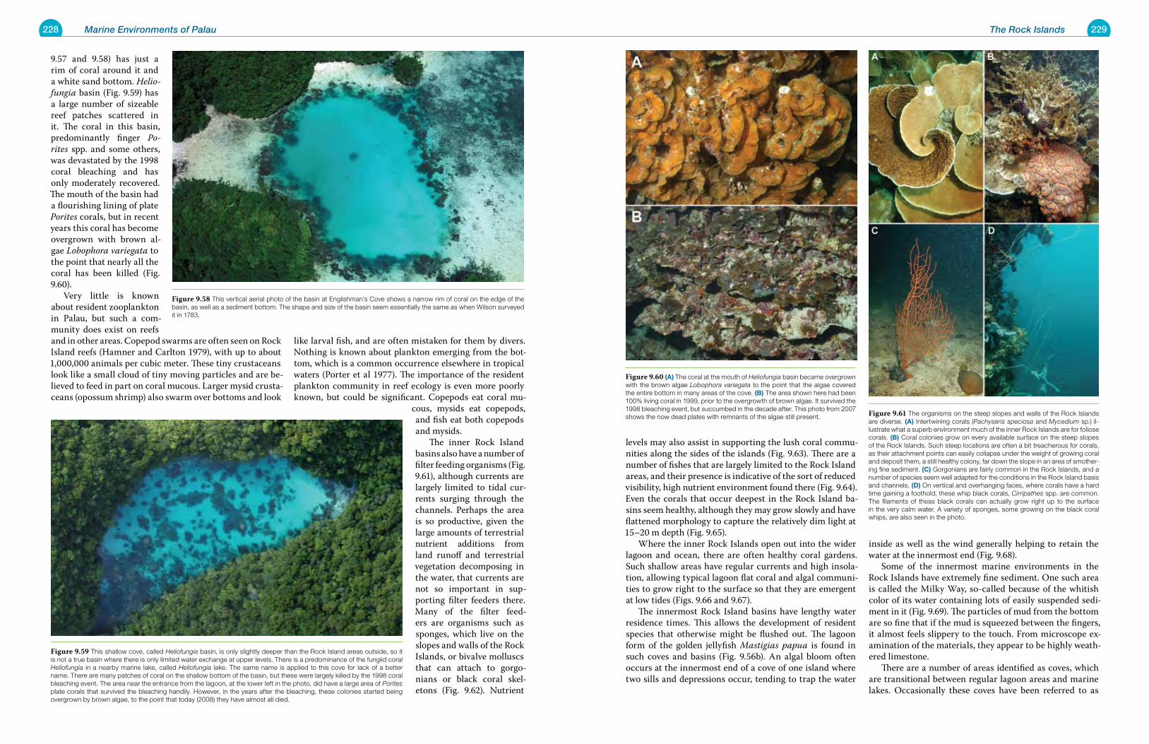
228 Marine Environments of Palau 229The Rock Islands
levels may also assist in supporting the lush coral commu-nities along the sides of the islands (Fig. 9.63). There are a number of fishes that are largely limited to the Rock Island areas, and their presence is indicative of the sort of reduced visibility, high nutrient environment found there (Fig. 9.64). Even the corals that occur deepest in the Rock Island ba-sins seem healthy, although they may grow slowly and have flattened morphology to capture the relatively dim light at 15–20 m depth (Fig. 9.65). Where the inner Rock Islands open out into the wider lagoon and ocean, there are often healthy coral gardens. Such shallow areas have regular currents and high insola-tion, allowing typical lagoon flat coral and algal communi-ties to grow right to the surface so that they are emergent at low tides (Figs. 9.66 and 9.67). The innermost Rock Island basins have lengthy water residence times. This allows the development of resident species that otherwise might be flushed out. The lagoon form of the golden jellyfish Mastigias papua is found in such coves and basins (Fig. 9.56b). An algal bloom often occurs at the innermost end of a cove of one island where two sills and depressions occur, tending to trap the water
inside as well as the wind generally helping to retain the water at the innermost end (Fig. 9.68). Some of the innermost marine environments in the Rock Islands have extremely fine sediment. One such area is called the Milky Way, so-called because of the whitish color of its water containing lots of easily suspended sedi-ment in it (Fig. 9.69). The particles of mud from the bottom are so fine that if the mud is squeezed between the fingers, it almost feels slippery to the touch. From microscope ex-amination of the materials, they appear to be highly weath-ered limestone. There are a number of areas identified as coves, which are transitional between regular lagoon areas and marine lakes. Occasionally these coves have been referred to as
9.57 and 9.58) has just a rim of coral around it and a white sand bottom. Helio-fungia basin (Fig. 9.59) has a large number of sizeable reef patches scattered in it. The coral in this basin, predominantly finger Po-rites spp. and some others, was devastated by the 1998 coral bleaching and has only moderately recovered. The mouth of the basin had a flourishing lining of plate Porites corals, but in recent years this coral has become overgrown with brown al-gae Lobophora variegata to the point that nearly all the coral has been killed (Fig. 9.60). Very little is known about resident zooplankton in Palau, but such a com-munity does exist on reefs and in other areas. Copepod swarms are often seen on Rock Island reefs (Hamner and Carlton 1979), with up to about 1,000,000 animals per cubic meter. These tiny crustaceans look like a small cloud of tiny moving particles and are be-lieved to feed in part on coral mucous. Larger mysid crusta-ceans (opossum shrimp) also swarm over bottoms and look
like larval fish, and are often mistaken for them by divers. Nothing is known about plankton emerging from the bot-tom, which is a common occurrence elsewhere in tropical waters (Porter et al 1977). The importance of the resident plankton community in reef ecology is even more poorly known, but could be significant. Copepods eat coral mu-
cous, mysids eat copepods, and fish eat both copepods and mysids. The inner Rock Island basins also have a number of filter feeding organisms (Fig. 9.61), although currents are largely limited to tidal cur-rents surging through the channels. Perhaps the area is so productive, given the large amounts of terrestrial nutrient additions from land runoff and terrestrial vegetation decomposing in the water, that currents are not so important in sup-porting filter feeders there. Many of the filter feed-ers are organisms such as sponges, which live on the slopes and walls of the Rock Islands, or bivalve molluscs that can attach to gorgo-nians or black coral skel-etons (Fig. 9.62). Nutrient
Figure 9.60 (a) The coral at the mouth of Heliofungia basin became overgrown with the brown algae Lobophora variegata to the point that the algae covered the entire bottom in many areas of the cove. (B) The area shown here had been 100% living coral in 1999, prior to the overgrowth of brown algae. It survived the 1998 bleaching event, but succumbed in the decade after. This photo from 2007 shows the now dead plates with remnants of the algae still present. Figure 9.61 The organisms on the steep slopes and walls of the Rock Islands
are diverse. (a) Intertwining corals (Pachyseris speciosa and Mycedium sp.) il-lustrate what a superb environment much of the inner Rock Islands are for foliose corals. (B) Coral colonies grow on every available surface on the steep slopes of the Rock Islands. Such steep locations are often a bit treacherous for corals, as their attachment points can easily collapse under the weight of growing coral and deposit them, a still healthy colony, far down the slope in an area of smother-ing fine sediment. (C) Gorgonians are fairly common in the Rock Islands, and a number of species seem well adapted for the conditions in the Rock Island basis and channels. (d) On vertical and overhanging faces, where corals have a hard time gaining a foothold, these whip black corals, Cirripathes spp. are common. The filaments of these black corals can actually grow right up to the surface in the very calm water. A variety of sponges, some growing on the black coral whips, are also seen in the photo.
Figure 9.58 This vertical aerial photo of the basin at Englishman’s Cove shows a narrow rim of coral on the edge of the basin, as well as a sediment bottom. The shape and size of the basin seem essentially the same as when Wilson surveyed it in 1783.
Figure 9.59 This shallow cove, called Heliofungia basin, is only slightly deeper than the Rock Island areas outside, so it is not a true basin where there is only limited water exchange at upper levels. There is a predominance of the fungiid coral Heliofungia in a nearby marine lake, called Heliofungia lake. The same name is applied to this cove for lack of a better name. There are many patches of coral on the shallow bottom of the basin, but these were largely killed by the 1998 coral bleaching event. The area near the entrance from the lagoon, at the lower left in the photo, did have a large area of Porites plate corals that survived the bleaching handily. However, in the years after the bleaching, these colonies started being overgrown by brown algae, to the point that today (2008) they have almost all died.
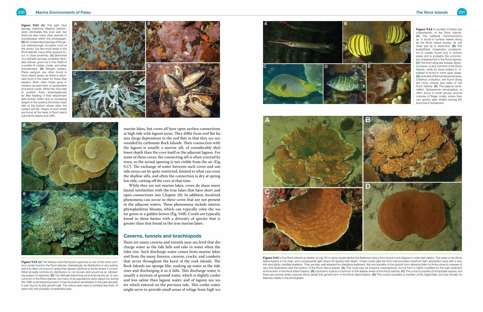
230 Marine Environments of Palau 231The Rock Islands
marine lakes, but coves all have open surface connections at high tide with lagoon areas. They differ from reef flat ba-sins (large depressions in the reef flat) in that they are sur-rounded by carbonate Rock Islands. Their connection with the lagoon is usually a narrow sill, of considerably shal-lower depth than the cove itself or the adjacent lagoon. For some of these coves, the connecting sill is often covered by trees, so the actual opening is not visible from the air (Fig. 9.17). The exchange of water between such coves and out-side areas can be quite restricted, limited to what can cross the shallow sills, and often the connection is dry at spring low tide, cutting off the cove at that time. While they are not marine lakes, coves do share many faunal similarities with the true lakes that have short and open connections (see Chapter 10). In addition, localized phenomena can occur in these coves that are not present in the adjacent waters. These phenomena include intense phytoplankton blooms, which can typically color the wa-ter green or a golden brown (Fig. 9.68). Corals are typically found in these basins with a diversity of species that is greater than that found in the true marine lakes.
Caverns, tunnels and brachiopodsThere are many caverns and tunnels near sea level that dis-charge water as the tide falls and take in water when the tides rise. Such discharge water comes from marine lakes and from the many fissures, caverns, cracks, and conduits that occur throughout the karst of the rock islands. The Rock Islands are sponge-like, soaking up water as the tide rises and discharging it as it falls. This discharge water is usually a mixture of ground water, which is slightly cooler and less saline than lagoon water, and of lagoon sea wa-ter which entered on the previous tide. This cooler water might serve to provide small areas of refuge from high wa-
Figure 9.64 A number of fishes are characteristic of the Rock Islands. (a) The halfbeak Hemirhamphus sp. is found in surface waters along all the Rock Island shores, its red lower jaw tip is distinctive. (B) The butterflyfish Chaetodon octofascia-tus is usually found only in inshore areas and is probably the common-est chaetodontid in the Rock Islands. (C) The short sling-jaw wrasse, Epibu-lus brevis, is very common in the Rock Islands, while its close relative E. in-sidiator is found in more open areas. (d) Juveniles of the humphead wrasse, Cheilinus undulatus, are found along the rocky shores and reefs of the Rock Islands. (e) The pajama cardi-nalfish, Sphaeramia nematoptera, is often found in small groups around colonies of finger corals, where they can quickly seek shelter among the branches if threatened.
Figure 9.65 In the Rock Islands at depths of only 20 m stony corals exhibit the flattened colony form found much deeper in outer reef waters. The water in the Rock Island basins is not clear, and consequently light drops off quickly with depth. These corals take the form that provides maximum light absorption area with a very thin and lightly calcified skeleton. They are also well adapted for shedding sediment, the two benefits of the growth form allowing them to thrive close to masses of very fine sediments near the bottom of the Rock Island slopes. (a) This coral may be Oxypora crassispinosa, but its form is highly modified for the high sediment environment in the Rock Island basins. (B) Leptoseris scabra is common in the deeper areas of the Rock Islands. (C) This coral is possibly Echinophyllia aspera, but there are several others species which adopt this growth form in the Rock Island basins. (d) This coral is possibly a member of the Agaricidae, but has virtually no features visible in the photograph.
Figure 9.62 (a) The light blue sponge Haliclona (Gellius) amboin-ensis dominates this rock wall, but there are also many other species of invertebrates within the photograph. (B) An undescribed sponge of the ge-nus Xestospongia occupies most of this photo, but like most areas in the Rock Islands, many other species oc-cur in close proximity. (C) Branches of a niphatid sponge, probably Niph-ates obtusa, grow out in the midst of a jumble of rubble, corals, and other invertebrates. (d) Winged oysters, Pteria penguin, are often found in Rock Island areas, as there is abun-dant food in the water for these filter feeders. Most often these grow in clusters, as seen here, on gorgonians and black corals. While this may help to position them advantageously for filter feeding, if their attachment gets broken (often due to increasing weight of the oysters) the entire mass falls to the bottom where often the oysters will die. Heaps of such shells are found at the base of Rock Island submarine slopes and cliffs.
Figure 9.63 (a) The foliose coral Pachyseris speciosa is one of the most com-mon corals found in the Rock Islands. Interestingly, its distribution is very patchy and it is often not found in areas that appear identical to those where it occurs. What actually controls its distribution is not known and would be an interest-ing subject to examine. (B) The delicate branching coral Anacropora sp. is very common in the Rock Islands, but many of its populations were wiped out during the 1998 coral bleaching event. It has recovered remarkably in the past decade, in part due to its fast growth rate. The colony seen here is certainly less than 10 years old, and possibly considerably less.
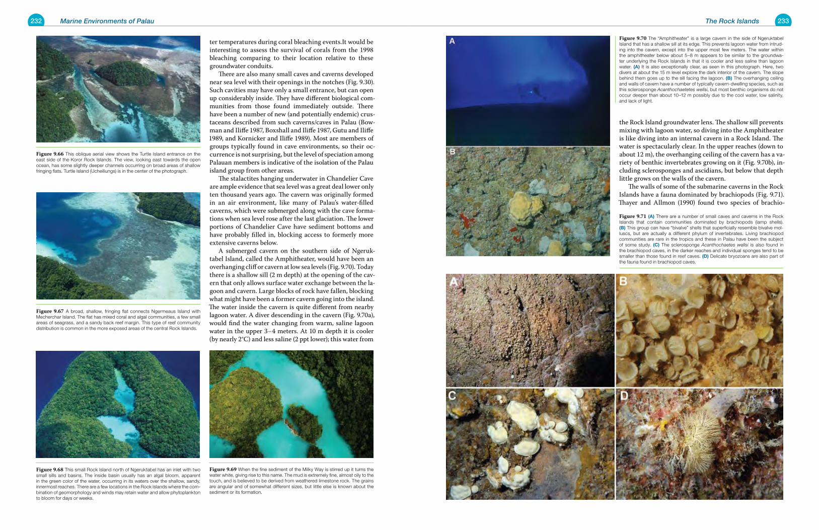
232 Marine Environments of Palau 233The Rock Islands
the Rock Island groundwater lens. The shallow sill prevents mixing with lagoon water, so diving into the Amphitheater is like diving into an internal cavern in a Rock Island. The water is spectacularly clear. In the upper reaches (down to about 12 m), the overhanging ceiling of the cavern has a va-riety of benthic invertebrates growing on it (Fig. 9.70b), in-cluding sclerosponges and ascidians, but below that depth little grows on the walls of the cavern. The walls of some of the submarine caverns in the Rock Islands have a fauna dominated by brachiopods (Fig. 9.71). Thayer and Allmon (1990) found two species of brachio-
ter temperatures during coral bleaching events.It would be interesting to assess the survival of corals from the 1998 bleaching comparing to their location relative to these groundwater conduits. There are also many small caves and caverns developed near sea level with their openings in the notches (Fig. 9.30). Such cavities may have only a small entrance, but can open up considerably inside. They have different biological com-munities from those found immediately outside. There have been a number of new (and potentially endemic) crus-taceans described from such caverns/caves in Palau (Bow-man and Iliffe 1987, Boxshall and Iliffe 1987, Gutu and Iliffe 1989, and Kornicker and Iliffe 1989). Most are members of groups typically found in cave environments, so their oc-currence is not surprising, but the level of speciation among Palauan members is indicative of the isolation of the Palau island group from other areas. The stalactites hanging underwater in Chandelier Cave are ample evidence that sea level was a great deal lower only ten thousand years ago. The cavern was originally formed in an air environment, like many of Palau’s water-filled caverns, which were submerged along with the cave forma-tions when sea level rose after the last glaciation. The lower portions of Chandelier Cave have sediment bottoms and have probably filled in, blocking access to formerly more extensive caverns below. A submerged cavern on the southern side of Ngeruk-tabel Island, called the Amphitheater, would have been an overhanging cliff or cavern at low sea levels (Fig. 9.70). Today there is a shallow sill (2 m depth) at the opening of the cav-ern that only allows surface water exchange between the la-goon and cavern. Large blocks of rock have fallen, blocking what might have been a former cavern going into the island. The water inside the cavern is quite different from nearby lagoon water. A diver descending in the cavern (Fig. 9.70a), would find the water changing from warm, saline lagoon water in the upper 3–4 meters. At 10 m depth it is cooler (by nearly 2°C) and less saline (2 ppt lower); this water from
Figure 9.70 The “Amphitheater” is a large cavern in the side of Ngeruktabel Island that has a shallow sill at its edge. This prevents lagoon water from intrud-ing into the cavern, except into the upper most few meters. The water within the amphitheater below about 5–8 m appears to be similar to the groundwa-ter underlying the Rock Islands in that it is cooler and less saline than lagoon water. (a) It is also exceptionally clear, as seen in this photograph. Here, two divers at about the 15 m level explore the dark interior of the cavern. The slope behind them goes up to the sill facing the lagoon. (B) The overhanging ceiling and walls of cavern have a number of typically cavern-dwelling species, such as this sclerosponge Acanthochaetetes wellsi, but most benthic organisms do not occur deeper than about 10–12 m possibly due to the cool water, low salinity, and lack of light.
Figure 9.71 (a) There are a number of small caves and caverns in the Rock Islands that contain communities dominated by brachiopods (lamp shells). (B) This group can have “bivalve” shells that superficially resemble bivalve mol-luscs, but are actually a different phylum of invertebrates. Living brachiopod communities are rare in the tropics and these in Palau have been the subject of some study. (C) The sclerosponge Acanthochaetes wellsi is also found in the brachiopod caves, in the darker reaches and individual sponges tend to be smaller than those found in reef caves. (d) Delicate bryozoans are also part of the fauna found in brachiopod caves.
Figure 9.66 This oblique aerial view shows the Turtle Island entrance on the east side of the Koror Rock Islands. The view, looking east towards the open ocean, has some slightly deeper channels occurring on broad areas of shallow fringing flats. Turtle Island (Ucheiliungs) is in the center of the photograph.
Figure 9.67 A broad, shallow, fringing flat connects Ngermeaus Island with Mecherchar Island. The flat has mixed coral and algal communities, a few small areas of seagrass, and a sandy back reef margin. This type of reef community distribution is common in the more exposed areas of the central Rock Islands.
Figure 9.68 This small Rock Island north of Ngeruktabel has an inlet with two small sills and basins. The inside basin usually has an algal bloom, apparent in the green color of the water, occurring in its waters over the shallow, sandy, innermost reaches. There are a few locations in the Rock Islands where the com-bination of geomorphology and winds may retain water and allow phytoplankton to bloom for days or weeks.
Figure 9.69 When the fine sediment of the Milky Way is stirred up it turns the water white, giving rise to this name. The mud is extremely fine, almost oily to the touch, and is believed to be derived from weathered limestone rock. The grains are angular and of somewhat different sizes, but little else is known about the sediment or its formation.
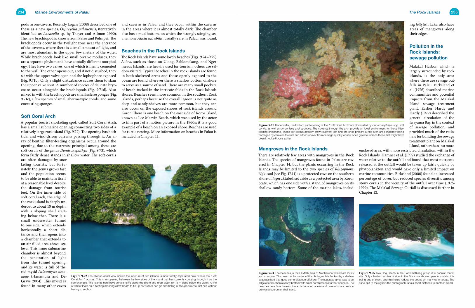
234 Marine Environments of Palau 235The Rock Islands
Mangroves in the rock IslandsThere are relatively few areas with mangroves in the Rock Islands. The species of mangroves found in Palau are cov-ered in Chapter 14, but the plants occurring in the Rock Islands may be limited to the two species of Rhizophora. Ngkisaol (see Fig. 17.11) is a protected cove on the southern shore of Ngeruktabel, set aside as a protected area by Koror State, which has one side with a stand of mangroves on its shallow sandy bottom. Some of the marine lakes, includ-
ing Jellyfish Lake, also have areas of mangroves along their edges.
pollution in the rock Islands: sewage pollution
Malakal Harbor, which is largely surrounded by rock islands, is the only area where there are sewage out-falls in Palau. Birkeland et al. (1976) described marine communities and potential impacts from the Malakal Island sewage treatment plant. Earlier Hardy and Hardy (1972) described the general circulation of the Iwayama Bay, in the context of sewage pollution, and provided much of the ratio-nale for building the sewage treatment plant on Malakal Island, rather than in a more
enclosed area, with more restricted circulation, within the Rock Islands. Hamner et al. (1997) studied the exchange of water relative to the outfall and found that most nutrients released at the outfall would be taken up fairly quickly by phytoplankton and would have only a limited impact on marine communities. Birkeland (2000) found an increased percentage of cover, but reduced species diversity, among stony corals in the vicinity of the outfall over time (1976-1999). The Malakal Sewage Outfall is discussed further in Chapter 13.
pods in one cavern. Recently Logan (2008) described one of these as a new species, Ospreyella palauensis, (tentatively identified as Lacazella sp. by Thayer and Allmon 1990). The new brachiopod is known from Palau and Pohnpei. The brachiopods occur in the twilight zone near the entrance of the caverns, where there is a small amount of light, and are most abundant in the upper few meters of the water. While brachiopods look like small bivalve molluscs, they are a separate phylum and have a totally different morphol-ogy. They have two valves, one of which is firmly cemented to the wall. The other opens out, and if not disturbed, they sit with the upper valve open and the lophophore exposed (Fig. 9.71b). Only a slight disturbance causes them to slam the upper valve shut. A number of species of delicate bryo-zoans occur alongside the brachiopods (Fig. 9.71d). Also mixed in with the brachiopods are small sclerosponges (Fig. 9.71c), a few species of small ahermatypic corals, and some encrusting sponges.
Soft Coral archA popular tourist snorkeling spot, called Soft Coral Arch, has a small submarine opening connecting two sides of a relatively large rock island (Fig. 9.72). The opening has both tidal and wind-driven currents passing through it. An ar-ray of benthic filter-feeding organisms occur around the opening, due to the currents; principal among these are soft corals of the genus Dendronephthya (Fig. 9.73), which form fairly dense stands in shallow water. The soft corals are often damaged by snor-keling tourists, but fortu-nately the genus grows fast and the population seems to be able to maintain itself at a reasonable level despite the damage from tourist feet. On the inner side of soft coral arch, the edge of the rock island is deeply un-dercut to about 10 m depth, with a sloping shelf start-ing below that. There is a small underwater tunnel to one side, which extends horizontally a short dis-tance and then opens into a chamber that extends to an air-filled area above sea level. This inner submarine chamber is almost beyond the penetration of light from the tunnel opening, and its water is full of the red mysid Palaumysis simo-neae (Hanamura and De-Grave 2004). This mysid is found in many other caves
and caverns in Palau, and they occur within the caverns in the areas where it is almost totally dark. The chamber also has a mud bottom. on which the strongly stinging sea anemone Alicia mirabilis, usually rare in Palau, was found.
Beaches in the rock IslandsThe Rock Islands have some lovely beaches (Figs. 9.74–9.75). A few, such as those on Ulong, Bablomekang. and Nger-meaus Islands, are heavily used for tourism; others are sel-dom visited. Typical beaches in the rock islands are found in both sheltered areas and those openly exposed to the ocean are found wherever there is shallow bottom offshore to serve as a source of sand. There are many small pockets of beach tucked in the intricate folds in the Rock Islands shores. Beaches seem more common in the southern Rock Islands, perhaps because the overall lagoon is not quite as deep and sandy shelves are more common, but they can also occur on the exposed shores of rock islands around Koror. There is one beach on the east side of Koror Island, known as Lee Marvin Beach, which was used by the actor to film part of a motion picture in the 1960s; it is a good example of a beach on an exposed shore. Beaches are used for turtle nesting. More information on beaches in Palau is included in Chapter 11.
Figure 9.74 The beaches in the El Malik area of Mecherchar Island are lovely and extensive. The beach in the center of the photograph is flanked by a shallow seagrass bed that goes some distance offshore. The seagrass gives way to an edge of coral, then a sandy bottom with small coral patches further offshore. The beaches here face the east towards the open ocean and have offshore reefs to provide a source for their sand.
Figure 9.75 Two Dog Beach in the Bablometkang group is a popular tourist site. Only a limited number of sites in the Rock Islands are open to tourists, this being one of them, and this helps reduce the stress on many other areas. The sand spit to the right in the photograph runs a short distance to another island.
Figure 9.73 Underwater, the bottom and opening of the “Soft Coral Arch” are dominated by Dendronephthya spp. soft corals, as well as gorgonians and sponges. The currents through the arch provide an ideal environment for these filter-feeding cnidarians. These soft corals actually grow relatively fast and the ones present at the arch are constantly being damaged by careless tourists and either recover from damage quickly or new ones grow to replace those that might have been knocked loose earlier.
Figure 9.72 The oblique aerial view shows the juncture of two islands, almost totally separated now, where the “Soft Coral Arch” occurs. This is an opening between the two sides of the island that has currents coursing through it as the tide changes. The islands here have vertical cliffs along the shore and drop away 10–15 m deep below the water. A line of white floats on a floating mooring allow boats to tie up so visitors can go snorkeling at this popular tourist site without having to anchor.
237
Ch
ap
te
r
10 Marine Lakes
Marine lakes are “small bodies of seawater entirely surrounded by land” (Dawson and Hamner 2005) (Fig. 10.1). That land is porous, riddled with crevices, caverns and channels. Thus all marine lakes in Palau rise and fall with the tide as seawater passes through these openings, evidence of their varying connections to the surrounding ocean. These connec-tions vary in degree, from cracks and fissures leading to lakes far inland to relatively short, direct submarine or surface tunnels between lagoon and lake. Those lakes far from the sea, lacking direct exchange with the ocean, have strongly damped tides, rising and falling only a fraction of the waters outside them. It is extremely difficult to exchange any living or-ganisms through the tiny fissures connecting the lagoon and these lakes. Those lakes with nearly direct connections can be so close that some lakes just have rocky arches which separate them from the lagoon. From the surface such lakes appear to be surrounded by land, but the short and open connection with the lagoon allows virtually any organism to pass between them. Some of these connective tunnels are completely water filled at high tide but partially emergent (have air flowing through them) at low tide. Some of the longer direct tunnels, those that are large enough for a diver to swim through, are more than 100 meters in length. These act as tidal conduits, allowing large amounts of water to flow through quickly. While marine species can be transported rapidly in or out by tidal currents, completely submerged tunnels restrict exchange of species due to their complete darkness and because of the presence of robust populations of filter-feeding invertebrates that encrust the walls of the tunnels.
The serenity of the jellyfish lakes of Palau is shown in this remarkable ba-tik by artist Margo Vitarelli. The batik has all the elements found in Ongeim’l Tketau (Jellyfish Lake) on Mecherchar Island. Batik from the collection of Drs. Laura Martin and Michael Dawson.
Tketau Lake on Mecherchar Island is the largest and deepest marine lake in Palau, and has islands within the lake. It is fairly well connected to the adjacent lagoon, with corals and many fishes typical of the wider lagoon. It’s maximum depth is 60 m, deeper than the Palau lagoon.
238 Marine Environments of Palau 239Marine Lakes
to the commonly used Jellyfish Lake, but usage of appropri-ate names is not always respected or understood by the pub-lic. Moreover, appropriate Palauan names may not available, and descriptive names that incorporate a common or im-portant organism present in the lake or some feature of the lake are useful. Table 10.1 provides a list of published and known names of the known marine lakes, with references to publications in which particular names were used (indi-cated in Figs. 10.2, 10.3 & 10.4). Hamner and Hamner (1998) applied many of the accepted English names to the lakes; some additional names have been added in this volume.
Formation of marine lakes in palauThe Rock Islands are uplifted fossil reefs that formed dur-ing the Miocene about 25 million years ago (see Chapters
1 and 9). In more recent geological history, during the last glacial low water about 20,000 years ago, sea level was 120 m below its current level and Palau was a single large island (see Fig. 1.19). Neither the lagoon nor the present marine lakes existed when sea level was 120 m below present, as this sea level would have still been about 60m lower than the deepest part of the lagoon today. The present Rock Is-lands would have been porous limestone hills and valleys on this single island, riddled with sinkholes, caverns and caves. Rain would have quickly percolated down through rock to the water table below, and there would have been no surface fresh water among the limestone hills, just as there is no standing fresh water in the Rock Islands today. The ground water that would have occurred beneath the limestone platform of southern Palau would have been fresh water, or nearly so, as the ocean was many kilometers away from the central part of the southern island (where the Rock Islands are today). It is unknown how deep the deepest valleys might have been. The present-day deep-est marine lake is about 60 m deep, but may have filled in
How many marine lakes does Palau have? In this vol-ume, 57 marine lakes (Figs. 10.2-10.4) are identified using the definition of Dawson and Hamner (2005). Only one of these lakes, the popular Jellyfish Lake (Ongeim’l Tketau), is
open to visitors. Using looser criteria, as many as 70 bod-ies of water are sometimes identified as marine lakes. For example, there are many coves (Chapter 9) that are often referred to as ”lakes.” A popular tourist site called “Man-darin Fish Lake” (Fig. 9.17b) is not really a lake but a cove accessible to small boats at high tide. The names of the various marine lakes are a bit uncer-tain. Some are widely known and have well-remembered Palauan names. For other lakes, there seem to be no com-mon Palauan names available today. Unfortunately there has been a tendency for people to simply apply their own moniker to a given lake without worrying about whether the lake had any previous or generally accepted name. Certainly, traditional names, such as Ongeim’l Tketau, are preferable
Figure 10.2 Map of the Rock Island area of Palau, showing the general loca-tion of the satellite images shown in the following two figures (10.3 and 10.4). Base map courtesy Palau Automated Land and Information Resources System (PALARIS)
Figure 10.1 Six examples of the more than 50 marine lakes found in the Rock Islands of Palau; the details of these specific lakes are included in Table 10.1. (a) Mekeald Lake occurs on the large island of Ngeruktabel and is coraliffer-ous, with abundant species of stony corals and sponges along its slopes. (B) Heliofungia Lake is another coralliferous lake connected to the lagoon by tunnels. (C) Big Fish Lake is on Ngeruktabel and relatively small and shallow. (d) Ngchas Lake is found on Ngeruktabel Island and was a local fishing spot before the lakes were closed. (e) Ongael Lake is a shallow lake with abundant Halimeda green algae covering the bottom. It harbors the endemic golden jelly Mastigias papua remengesaui. (F) Goby Lake on Koror Island has a side basin whose connection is not visible in this aerial photo, due to overhanging trees. It has a common goby-like eleotrid fish, hence its common name (although the fish is not a true goby).
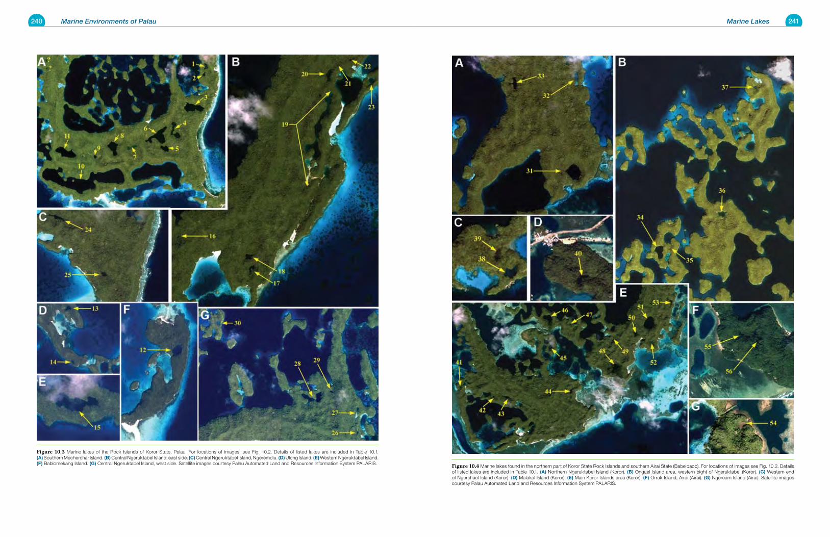
240 Marine Environments of Palau 241Marine Lakes
Figure 10.4 Marine lakes found in the northern part of Koror State Rock Islands and southern Airai State (Babeldaob). For locations of images see Fig. 10.2. Details of listed lakes are included in Table 10.1. (a) Northern Ngeruktabel Island (Koror). (B) Ongael Island area, western bight of Ngeruktabel (Koror). (C) Western end of Ngerchaol Island (Koror). (d) Malakal Island (Koror). (e) Main Koror Islands area (Koror). (F) Orrak Island, Airai (Airai). (G) Ngeream Island (Airai). Satellite images courtesy Palau Automated Land and Resources Information System PALARIS.
Figure 10.3 Marine lakes of the Rock Islands of Koror State, Palau. For locations of images, see Fig. 10.2. Details of listed lakes are included in Table 10.1. (a) Southern Mecherchar Island. (B) Central Ngeruktabel Island, east side. (C) Central Ngeruktabel Island, Ngeremdiu. (d) Ulong Island. (e) Western Ngeruktabel Island. (F) Bablomekang Island. (G) Central Ngeruktabel Island, west side. Satellite images courtesy Palau Automated Land and Resources Information System PALARIS.
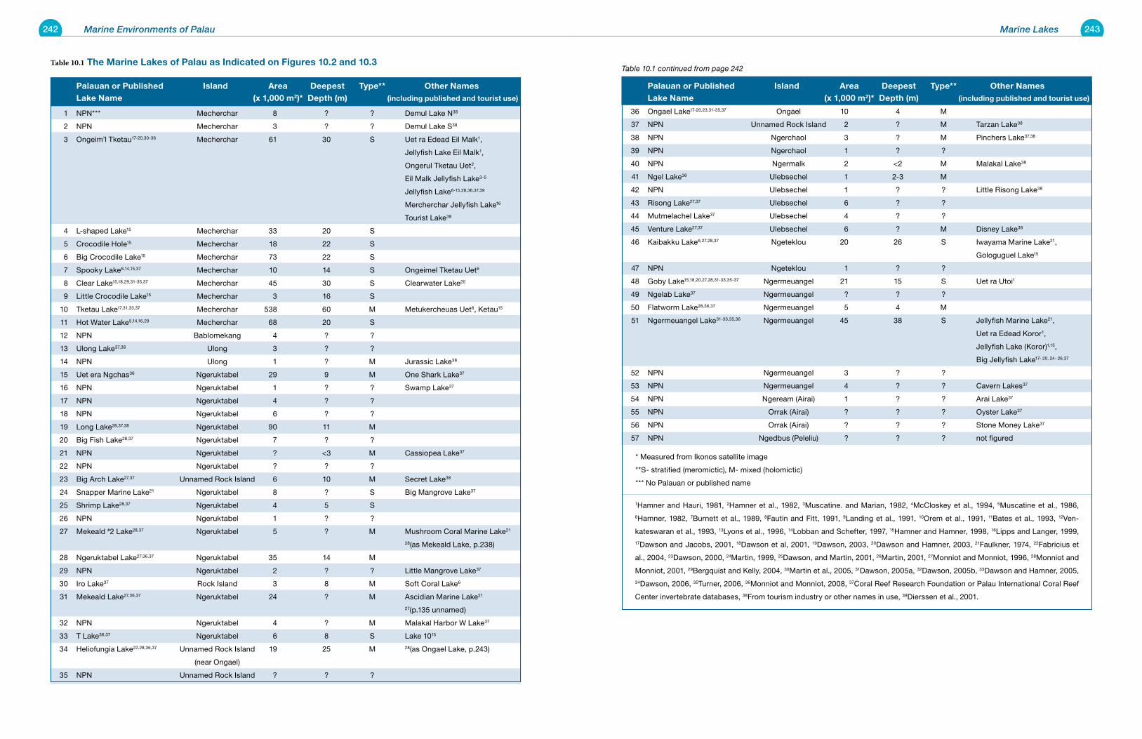
242 Marine Environments of Palau 243Marine Lakes
palauan or published Island area deepest type** other names lake name (x 1,000 m2)* depth (m) (including published and tourist use)
36 Ongael Lake17-20,23,31-35,37 Ongael 10 4 M
37 NPN Unnamed Rock Island 2 ? M Tarzan Lake38
38 NPN Ngerchaol 3 ? M Pinchers Lake37,38
39 NPN Ngerchaol 1 ? ?
40 NPN Ngermalk 2 <2 M Malakal Lake38
41 Ngel Lake36 Ulebsechel 1 2-3 M
42 NPN Ulebsechel 1 ? ? Little Risong Lake38
43 Risong Lake27,37 Ulebsechel 6 ? ?
44 Mutmelachel Lake37 Ulebsechel 4 ? ?
45 Venture Lake27,37 Ulebsechel 6 ? M Disney Lake38
46 Kaibakku Lake6,27,28,37 Ngeteklou 20 26 S Iwayama Marine Lake21,
Gologuguel Lake15
47 NPN Ngeteklou 1 ? ?
48 Goby Lake15,18,20,27,28,31-33,35-37 Ngermeuangel 21 15 S Uet ra Utoi1
49 Ngelab Lake37 Ngermeuangel ? ? ?
50 Flatworm Lake28,36,37 Ngermeuangel 5 4 M
51 Ngermeuangel Lake31-33,35,36 Ngermeuangel 45 38 S Jellyfish Marine Lake21,
Uet ra Edead Koror1,
Jellyfish Lake (Koror)1,15,
Big Jellyfish Lake17- 20, 24- 26,37
52 NPN Ngermeuangel 3 ? ?
53 NPN Ngermeuangel 4 ? ? Cavern Lakes37
54 NPN Ngeream (Airai) 1 ? ? Arai Lake37
55 NPN Orrak (Airai) ? ? ? Oyster Lake37
56 NPN Orrak (Airai) ? ? ? Stone Money Lake37
57 NPN Ngedbus (Peleliu) ? ? ? not figured
* Measured from Ikonos satellite image
**S- stratified (meromictic), M- mixed (holomictic)
*** No Palauan or published name
1Hamner and Hauri, 1981, 2Hamner et al., 1982, 3Muscatine. and Marian, 1982, 4McCloskey et al., 1994, 5Muscatine et al., 1986, 6Hamner, 1982, 7Burnett et al., 1989, 8Fautin and Fitt, 1991, 9Landing et al., 1991, 10Orem et al., 1991, 11Bates et al., 1993, 12Ven-
kateswaran et al., 1993, 13Lyons et al., 1996, 14Lobban and Schefter, 1997, 15Hamner and Hamner, 1998, 16Lipps and Langer, 1999, 17Dawson and Jacobs, 2001, 18Dawson et al, 2001, 19Dawson, 2003, 20Dawson and Hamner, 2003, 21Faulkner, 1974, 22Fabricius et
al., 2004, 23Dawson, 2000, 24Martin, 1999, 25Dawson, and Martin, 2001, 26Martin, 2001, 27Monniot and Monniot, 1996, 28Monniot and
Monniot, 2001, 29Bergquist and Kelly, 2004, 30Martin et al., 2005, 31Dawson, 2005a, 32Dawson, 2005b, 33Dawson and Hamner, 2005, 34Dawson, 2006, 35Turner, 2006, 36Monniot and Monniot, 2008, 37Coral Reef Research Foundation or Palau International Coral Reef
Center invertebrate databases, 38From tourism industry or other names in use, 39Dierssen et al., 2001.
Table 10.1 continued from page 242Table 10.1 the Marine lakes of palau as Indicated on Figures 10.2 and 10.3
palauan or published Island area deepest type** other names lake name (x 1,000 m2)* depth (m) (including published and tourist use)
1 NPN*** Mecherchar 8 ? ? Demul Lake N38
2 NPN Mecherchar 3 ? ? Demul Lake S38
3 Ongeim’l Tketau17-20,30-36 Mecherchar 61 30 S Uet ra Edead Eil Malk1,
Jellyfish Lake Eil Malk1,
Ongerul Tketau Uet2,
Eil Malk Jellyfish Lake3-5
Jellyfish Lake6-15,28,36,37,39
Mercherchar Jellyfish Lake16
Tourist Lake38
4 L-shaped Lake15 Mecherchar 33 20 S
5 Crocodile Hole15 Mecherchar 18 22 S
6 Big Crocodile Lake15 Mecherchar 73 22 S
7 Spooky Lake6,14,15,37 Mecherchar 10 14 S Ongeimel Tketau Uet6
8 Clear Lake15,18,29,31-35,37 Mecherchar 45 30 S Clearwater Lake20
9 Little Crocodile Lake15 Mecherchar 3 16 S
10 Tketau Lake17,31,33,37 Mecherchar 538 60 M Metukercheuas Uet6, Ketau15
11 Hot Water Lake5,14,16,29 Mecherchar 68 20 S
12 NPN Bablomekang 4 ? ?
13 Ulong Lake37,38 Ulong 3 ? ?
14 NPN Ulong 1 ? M Jurassic Lake38
15 Uet era Ngchas36 Ngeruktabel 29 9 M One Shark Lake37
16 NPN Ngeruktabel 1 ? ? Swamp Lake37
17 NPN Ngeruktabel 4 ? ?
18 NPN Ngeruktabel 6 ? ?
19 Long Lake28,37,38 Ngeruktabel 90 11 M
20 Big Fish Lake28,37 Ngeruktabel 7 ? ?
21 NPN Ngeruktabel ? <3 M Cassiopea Lake37
22 NPN Ngeruktabel ? ? ?
23 Big Arch Lake27,37 Unnamed Rock Island 6 10 M Secret Lake38
24 Snapper Marine Lake21 Ngeruktabel 8 ? S Big Mangrove Lake37
25 Shrimp Lake28,37 Ngeruktabel 4 5 S
26 NPN Ngeruktabel 1 ? ?
27 Mekeald #2 Lake28,37 Ngeruktabel 5 ? M Mushroom Coral Marine Lake21
28(as Mekeald Lake, p.238)
28 Ngeruktabel Lake27,36,37 Ngeruktabel 35 14 M
29 NPN Ngeruktabel 2 ? ? Little Mangrove Lake37
30 Iro Lake37 Rock Island 3 8 M Soft Coral Lake6
31 Mekeald Lake27,36,37 Ngeruktabel 24 ? M Ascidian Marine Lake21
27(p.135 unnamed)
32 NPN Ngeruktabel 4 ? M Malakal Harbor W Lake37
33 T Lake36,37 Ngeruktabel 6 8 S Lake 1015
34 Heliofungia Lake22,28,36,37 Unnamed Rock Island 19 25 M 28(as Ongael Lake, p.243)
(near Ongael)
35 NPN Unnamed Rock Island ? ? ?
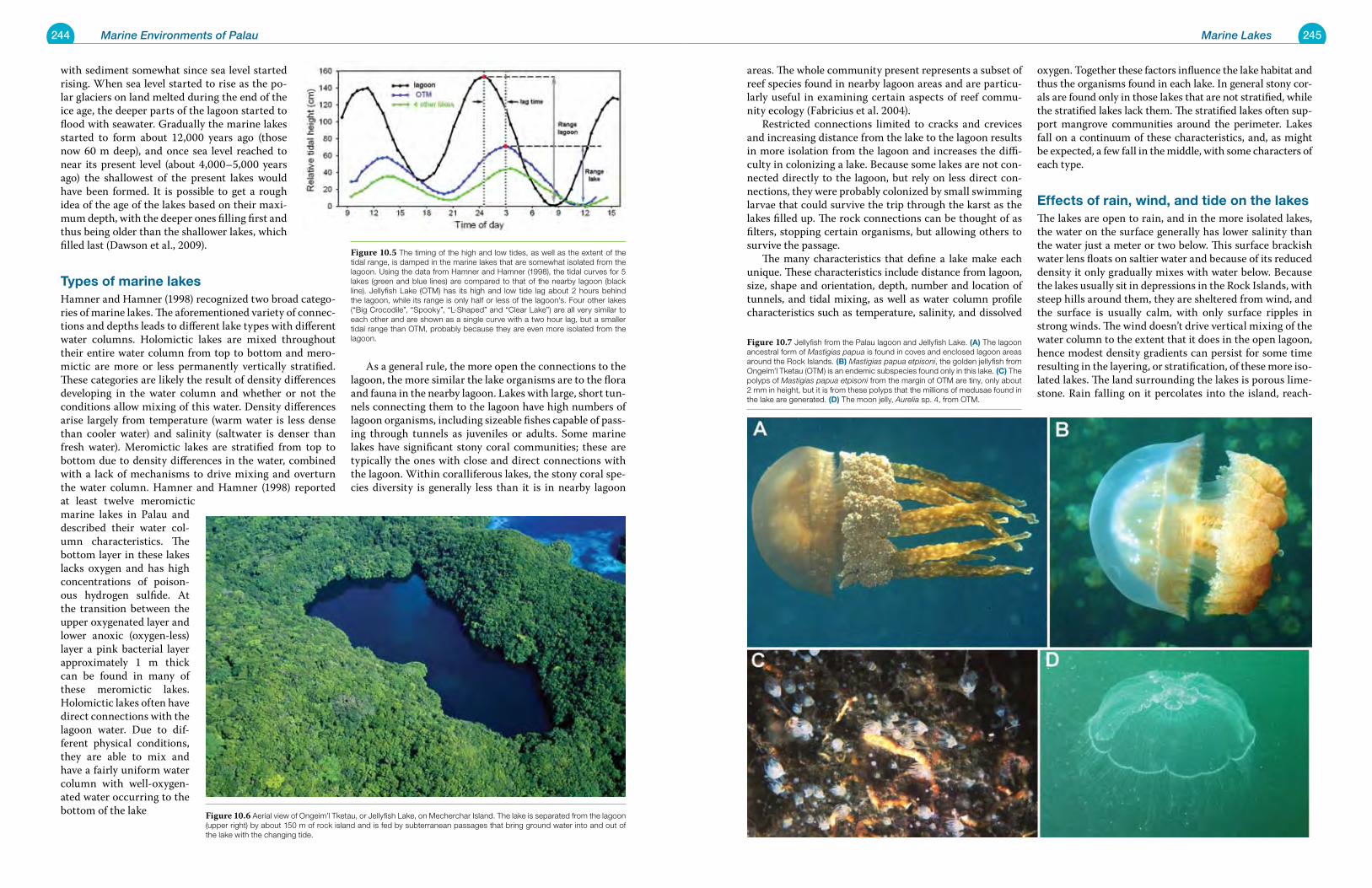
244 Marine Environments of Palau 245Marine Lakes
areas. The whole community present represents a subset of reef species found in nearby lagoon areas and are particu-larly useful in examining certain aspects of reef commu-nity ecology (Fabricius et al. 2004). Restricted connections limited to cracks and crevices and increasing distance from the lake to the lagoon results in more isolation from the lagoon and increases the diffi-culty in colonizing a lake. Because some lakes are not con-nected directly to the lagoon, but rely on less direct con-nections, they were probably colonized by small swimming larvae that could survive the trip through the karst as the lakes filled up. The rock connections can be thought of as filters, stopping certain organisms, but allowing others to survive the passage. The many characteristics that define a lake make each unique. These characteristics include distance from lagoon, size, shape and orientation, depth, number and location of tunnels, and tidal mixing, as well as water column profile characteristics such as temperature, salinity, and dissolved
oxygen. Together these factors influence the lake habitat and thus the organisms found in each lake. In general stony cor-als are found only in those lakes that are not stratified, while the stratified lakes lack them. The stratified lakes often sup-port mangrove communities around the perimeter. Lakes fall on a continuum of these characteristics, and, as might be expected, a few fall in the middle, with some characters of each type.
effects of rain, wind, and tide on the lakesThe lakes are open to rain, and in the more isolated lakes, the water on the surface generally has lower salinity than the water just a meter or two below. This surface brackish water lens floats on saltier water and because of its reduced density it only gradually mixes with water below. Because the lakes usually sit in depressions in the Rock Islands, with steep hills around them, they are sheltered from wind, and the surface is usually calm, with only surface ripples in strong winds. The wind doesn’t drive vertical mixing of the water column to the extent that it does in the open lagoon, hence modest density gradients can persist for some time resulting in the layering, or stratification, of these more iso-lated lakes. The land surrounding the lakes is porous lime-stone. Rain falling on it percolates into the island, reach-
with sediment somewhat since sea level started rising. When sea level started to rise as the po-lar glaciers on land melted during the end of the ice age, the deeper parts of the lagoon started to flood with seawater. Gradually the marine lakes started to form about 12,000 years ago (those now 60 m deep), and once sea level reached to near its present level (about 4,000–5,000 years ago) the shallowest of the present lakes would have been formed. It is possible to get a rough idea of the age of the lakes based on their maxi-mum depth, with the deeper ones filling first and thus being older than the shallower lakes, which filled last (Dawson et al., 2009).
types of marine lakesHamner and Hamner (1998) recognized two broad catego-ries of marine lakes. The aforementioned variety of connec-tions and depths leads to different lake types with different water columns. Holomictic lakes are mixed throughout their entire water column from top to bottom and mero-mictic are more or less permanently vertically stratified. These categories are likely the result of density differences developing in the water column and whether or not the conditions allow mixing of this water. Density differences arise largely from temperature (warm water is less dense than cooler water) and salinity (saltwater is denser than fresh water). Meromictic lakes are stratified from top to bottom due to density differences in the water, combined with a lack of mechanisms to drive mixing and overturn the water column. Hamner and Hamner (1998) reported at least twelve meromictic marine lakes in Palau and described their water col-umn characteristics. The bottom layer in these lakes lacks oxygen and has high concentrations of poison-ous hydrogen sulfide. At the transition between the upper oxygenated layer and lower anoxic (oxygen-less) layer a pink bacterial layer approximately 1 m thick can be found in many of these meromictic lakes. Holomictic lakes often have direct connections with the lagoon water. Due to dif-ferent physical conditions, they are able to mix and have a fairly uniform water column with well-oxygen-ated water occurring to the bottom of the lake
As a general rule, the more open the connections to the lagoon, the more similar the lake organisms are to the flora and fauna in the nearby lagoon. Lakes with large, short tun-nels connecting them to the lagoon have high numbers of lagoon organisms, including sizeable fishes capable of pass-ing through tunnels as juveniles or adults. Some marine lakes have significant stony coral communities; these are typically the ones with close and direct connections with the lagoon. Within coralliferous lakes, the stony coral spe-cies diversity is generally less than it is in nearby lagoon
Figure 10.7 Jellyfish from the Palau lagoon and Jellyfish Lake. (a) The lagoon ancestral form of Mastigias papua is found in coves and enclosed lagoon areas around the Rock Islands. (B) Mastigias papua etpisoni, the golden jellyfish from Ongeim’l Tketau (OTM) is an endemic subspecies found only in this lake. (C) The polyps of Mastigias papua etpisoni from the margin of OTM are tiny, only about 2 mm in height, but it is from these polyps that the millions of medusae found in the lake are generated. (d) The moon jelly, Aurelia sp. 4, from OTM.
Figure 10.5 The timing of the high and low tides, as well as the extent of the tidal range, is damped in the marine lakes that are somewhat isolated from the lagoon. Using the data from Hamner and Hamner (1998), the tidal curves for 5 lakes (green and blue lines) are compared to that of the nearby lagoon (black line). Jellyfish Lake (OTM) has its high and low tide lag about 2 hours behind the lagoon, while its range is only half or less of the lagoon’s. Four other lakes (“Big Crocodile”, “Spooky”, “L-Shaped” and “Clear Lake”) are all very similar to each other and are shown as a single curve with a two hour lag, but a smaller tidal range than OTM, probably because they are even more isolated from the lagoon.
Figure 10.6 Aerial view of Ongeim’l Tketau, or Jellyfish Lake, on Mecherchar Island. The lake is separated from the lagoon (upper right) by about 150 m of rock island and is fed by subterranean passages that bring ground water into and out of the lake with the changing tide.
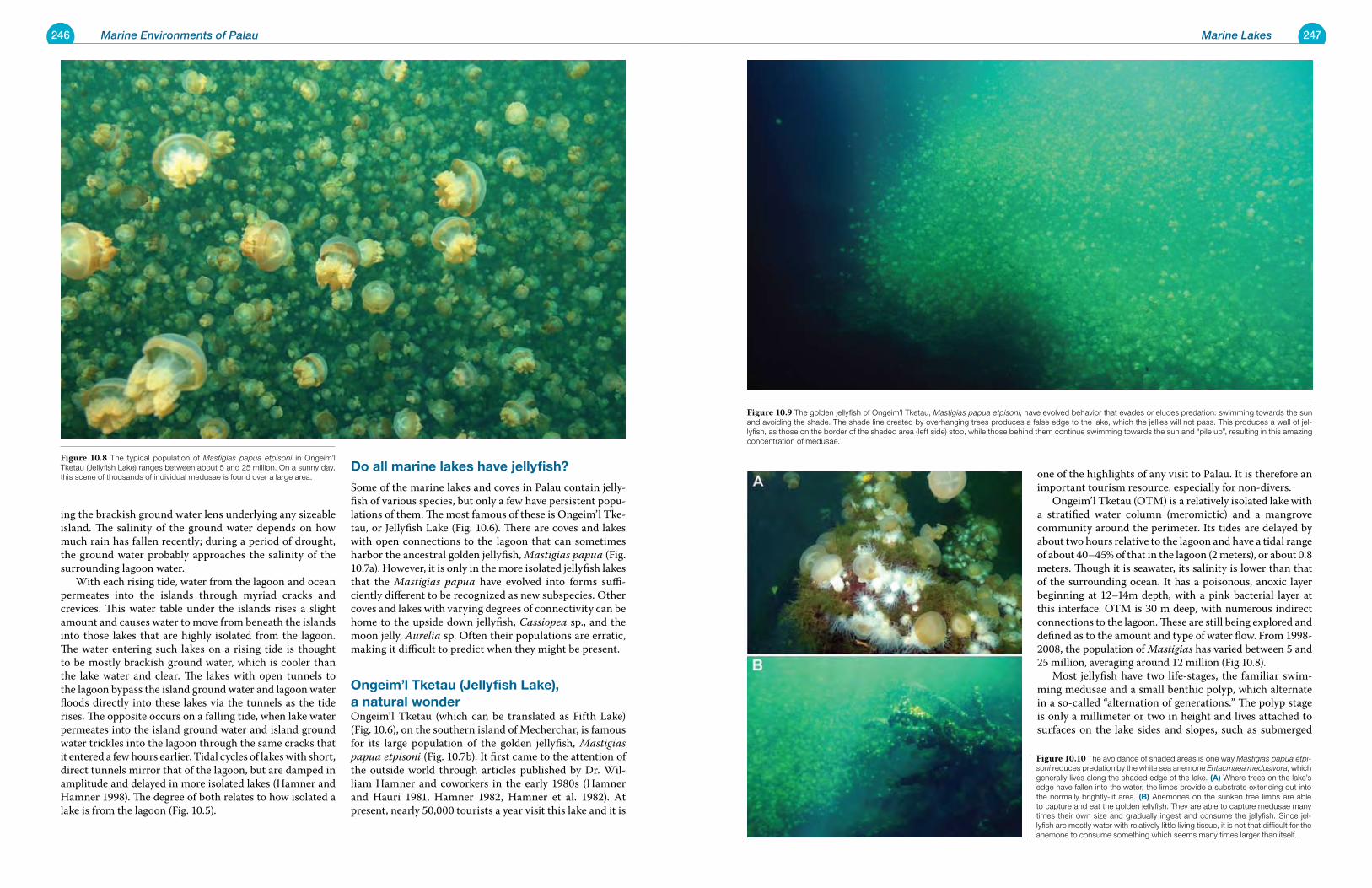
246 Marine Environments of Palau 247Marine Lakes
one of the highlights of any visit to Palau. It is therefore an important tourism resource, especially for non-divers. Ongeim’l Tketau (OTM) is a relatively isolated lake with a stratified water column (meromictic) and a mangrove community around the perimeter. Its tides are delayed by about two hours relative to the lagoon and have a tidal range of about 40–45% of that in the lagoon (2 meters), or about 0.8 meters. Though it is seawater, its salinity is lower than that of the surrounding ocean. It has a poisonous, anoxic layer beginning at 12–14m depth, with a pink bacterial layer at this interface. OTM is 30 m deep, with numerous indirect connections to the lagoon. These are still being explored and defined as to the amount and type of water flow. From 1998-2008, the population of Mastigias has varied between 5 and 25 million, averaging around 12 million (Fig 10.8). Most jellyfish have two life-stages, the familiar swim-ming medusae and a small benthic polyp, which alternate in a so-called “alternation of generations.” The polyp stage is only a millimeter or two in height and lives attached to surfaces on the lake sides and slopes, such as submerged
ing the brackish ground water lens underlying any sizeable island. The salinity of the ground water depends on how much rain has fallen recently; during a period of drought, the ground water probably approaches the salinity of the surrounding lagoon water. With each rising tide, water from the lagoon and ocean permeates into the islands through myriad cracks and crevices. This water table under the islands rises a slight amount and causes water to move from beneath the islands into those lakes that are highly isolated from the lagoon. The water entering such lakes on a rising tide is thought to be mostly brackish ground water, which is cooler than the lake water and clear. The lakes with open tunnels to the lagoon bypass the island ground water and lagoon water floods directly into these lakes via the tunnels as the tide rises. The opposite occurs on a falling tide, when lake water permeates into the island ground water and island ground water trickles into the lagoon through the same cracks that it entered a few hours earlier. Tidal cycles of lakes with short, direct tunnels mirror that of the lagoon, but are damped in amplitude and delayed in more isolated lakes (Hamner and Hamner 1998). The degree of both relates to how isolated a lake is from the lagoon (Fig. 10.5).
do all marine lakes have jellyfish?
Some of the marine lakes and coves in Palau contain jelly-fish of various species, but only a few have persistent popu-lations of them. The most famous of these is Ongeim’l Tke-tau, or Jellyfish Lake (Fig. 10.6). There are coves and lakes with open connections to the lagoon that can sometimes harbor the ancestral golden jellyfish, Mastigias papua (Fig. 10.7a). However, it is only in the more isolated jellyfish lakes that the Mastigias papua have evolved into forms suffi-ciently different to be recognized as new subspecies. Other coves and lakes with varying degrees of connectivity can be home to the upside down jellyfish, Cassiopea sp., and the moon jelly, Aurelia sp. Often their populations are erratic, making it difficult to predict when they might be present.
ongeim’l tketau (Jellyfish lake), a natural wonderOngeim’l Tketau (which can be translated as Fifth Lake) (Fig. 10.6), on the southern island of Mecherchar, is famous for its large population of the golden jellyfish, Mastigias papua etpisoni (Fig. 10.7b). It first came to the attention of the outside world through articles published by Dr. Wil-liam Hamner and coworkers in the early 1980s (Hamner and Hauri 1981, Hamner 1982, Hamner et al. 1982). At present, nearly 50,000 tourists a year visit this lake and it is
Figure 10.9 The golden jellyfish of Ongeim’l Tketau, Mastigias papua etpisoni, have evolved behavior that evades or eludes predation: swimming towards the sun and avoiding the shade. The shade line created by overhanging trees produces a false edge to the lake, which the jellies will not pass. This produces a wall of jel-lyfish, as those on the border of the shaded area (left side) stop, while those behind them continue swimming towards the sun and “pile up”, resulting in this amazing concentration of medusae.
Figure 10.10 The avoidance of shaded areas is one way Mastigias papua etpi-soni reduces predation by the white sea anemone Entacmaea medusivora, which generally lives along the shaded edge of the lake. (a) Where trees on the lake’s edge have fallen into the water, the limbs provide a substrate extending out into the normally brightly-lit area. (B) Anemones on the sunken tree limbs are able to capture and eat the golden jellyfish. They are able to capture medusae many times their own size and gradually ingest and consume the jellyfish. Since jel-lyfish are mostly water with relatively little living tissue, it is not that difficult for the anemone to consume something which seems many times larger than itself.
Figure 10.8 The typical population of Mastigias papua etpisoni in Ongeim’l Tketau (Jellyfish Lake) ranges between about 5 and 25 million. On a sunny day, this scene of thousands of individual medusae is found over a large area.
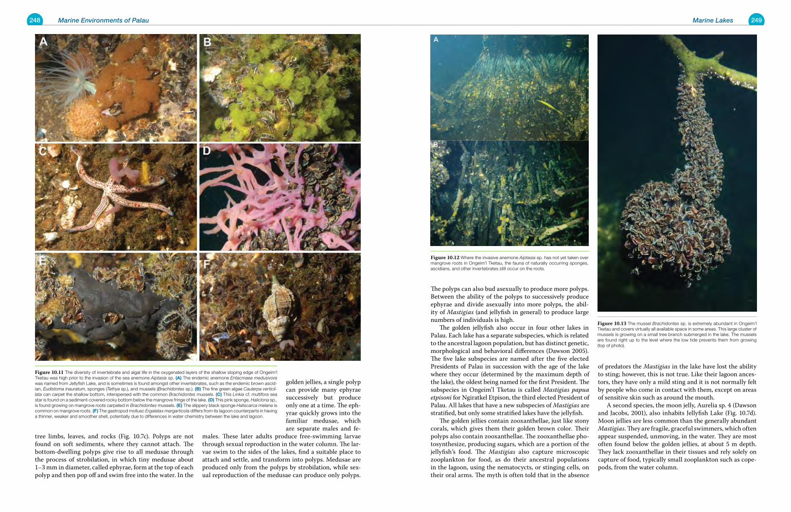
248 Marine Environments of Palau 249Marine Lakes
The polyps can also bud asexually to produce more polyps. Between the ability of the polyps to successively produce ephyrae and divide asexually into more polyps, the abil-ity of Mastigias (and jellyfish in general) to produce large numbers of individuals is high. The golden jellyfish also occur in four other lakes in Palau. Each lake has a separate subspecies, which is related to the ancestral lagoon population, but has distinct genetic, morphological and behavioral differences (Dawson 2005). The five lake subspecies are named after the five elected Presidents of Palau in succession with the age of the lake where they occur (determined by the maximum depth of the lake), the oldest being named for the first President. The subspecies in Ongeim’l Tketau is called Mastigias papua etpisoni for Ngiratkel Etpison, the third elected President of Palau. All lakes that have a new subspecies of Mastigias are stratified, but only some stratified lakes have the jellyfish. The golden jellies contain zooxanthellae, just like stony corals, which gives them their golden brown color. Their polyps also contain zooxanthellae. The zooxanthellae pho-tosynthesize, producing sugars, which are a portion of the jellyfish’s food. The Mastigias also capture microscopic zooplankton for food, as do their ancestral populations in the lagoon, using the nematocycts, or stinging cells, on their oral arms. The myth is often told that in the absence
of predators the Mastigias in the lake have lost the ability to sting; however, this is not true. Like their lagoon ances-tors, they have only a mild sting and it is not normally felt by people who come in contact with them, except on areas of sensitive skin such as around the mouth. A second species, the moon jelly, Aurelia sp. 4 (Dawson and Jacobs, 2001), also inhabits Jellyfish Lake (Fig. 10.7d). Moon jellies are less common than the generally abundant Mastigias. They are fragile, graceful swimmers, which often appear suspended, unmoving, in the water. They are most often found below the golden jellies, at about 5 m depth. They lack zooxanthellae in their tissues and rely solely on capture of food, typically small zooplankton such as cope-pods, from the water column.
tree limbs, leaves, and rocks (Fig. 10.7c). Polyps are not found on soft sediments, where they cannot attach. The bottom-dwelling polyps give rise to all medusae through the process of strobilation, in which tiny medusae about 1–3 mm in diameter, called ephyrae, form at the top of each polyp and then pop off and swim free into the water. In the
golden jellies, a single polyp can provide many ephyrae successively but produce only one at a time. The eph-yrae quickly grows into the familiar medusae, which are separate males and fe-
males. These later adults produce free-swimming larvae through sexual reproduction in the water column. The lar-vae swim to the sides of the lakes, find a suitable place to attach and settle, and transform into polyps. Medusae are produced only from the polyps by strobilation, while sex-ual reproduction of the medusae can produce only polyps.
Figure 10.13 The mussel Brachidontes sp. is extremely abundant in Ongeim’l Tketau and covers virtually all available space in some areas. This large cluster of mussels is growing on a small tree branch submerged in the lake. The mussels are found right up to the level where the low tide prevents them from growing (top of photo).
Figure 10.12 Where the invasive anemone Aiptasia sp. has not yet taken over mangrove roots in Ongeim’l Tketau, the fauna of naturally occurring sponges, ascidians, and other invertebrates still occur on the roots.
Figure 10.11 The diversity of invertebrate and algal life in the oxygenated layers of the shallow sloping edge of Ongeim’l Tketau was high prior to the invasion of the sea anemone Aiptasia sp. (a) The endemic anemone Entacmaea medusivora was named from Jellyfish Lake, and is sometimes is found amongst other invertebrates, such as the endemic brown ascid-ian, Eudistoma inauratum, sponges (Tethya sp.), and mussels (Brachidontes sp.). (B) The fine green algae Caulerpa verticil-lata can carpet the shallow bottom, interspersed with the common Brachidontes mussels. (C) This Linkia cf. multifora sea star is found on a sediment-covered rocky bottom below the mangrove fringe of the lake. (d) This pink sponge, Haliclona sp., is found growing on mangrove roots carpeted in Brachidontes mussels. (e) The slippery black sponge Haliscarca melana is common on mangrove roots. (F) The gastropod mollusc Ergalatax margarticola differs from its lagoon counterparts in having a thinner, weaker and smoother shell, potentially due to differences in water chemistry between the lake and lagoon.
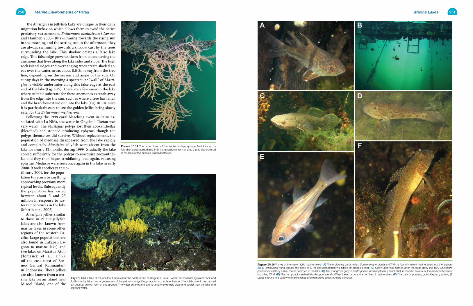
250 Marine Environments of Palau 251Marine Lakes
The Mastigias in Jellyfish Lake are unique in their daily migration behavior, which allows them to avoid the native predatory sea anemone, Entacmaea medusivora (Dawson and Hamner, 2003). By swimming towards the rising sun in the morning and the setting sun in the afternoon, they are always swimming towards a shadow cast by the trees surrounding the lake. This shadow creates a false lake edge. This false edge prevents them from encountering the anemone that lives along the lake sides and slope. The high rock island ridges and overhanging trees create shaded ar-eas over the water, areas about 0.5-3m away from the tree line, depending on the season and angle of the sun. On sunny days in the morning a spectacular “wall” of Masti-gias is visible underwater along this false edge at the east end of the lake (Fig. 10.9). There are a few areas in the lake where suitable substrate for these anemones extends away from the edge into the sun, such as where a tree has fallen and the branches extend out into the lake (Fig. 10.10). Here it is particularly easy to see the golden jellies being slowly eaten by the Entacmaea medusivora. Following the 1998 coral bleaching event in Palau as-sociated with La Niña, the water in Ongeim’l Tketau was very warm. The Mastigias polyps lost their zooxanthellae (bleached) and stopped producing ephyrae, though the polyps themselves did survive. Without replacements, the population of medusae disappeared from the lake rapidly and completely. Mastigias jellyfish were absent from the lake for nearly 12 months during 1999. Gradually the lake cooled sufficiently for the polyps to reacquire zooxanthel-lae and they then began strobilating once again, releasing ephyrae. Medusae were seen once again in the lake in early 2000. It took another year, un-til early 2001, for the popu-lation to return to anything approaching previous, more typical levels. Subsequently the population has varied between about 5 and 25 million in response to wa-ter temperatures in the lake (Martin et al, 2005). Mastigias jellies similar to those in Palau’s jellyfish lakes are also known from marine lakes in some other regions of the western Pa-cific. Large populations are also found in Kakaban La-goon (a marine lake) and two lakes on Maratua Atoll (Tomasick et al., 1997), off the east coast of Bor-neo (central Kalimantan) in Indonesia. These jellies are also known from a ma-rine lake on an island near Misool Island, one of the
Figure 10.16 Fishes of the meromictic marine lakes. (a) The orbiculate cardinalfish, Sphaeramia orbicularis (OTM), is found in many marine lakes and the lagoon. (B) S. orbicularis hang around the dock at OTM and sometimes will nibble on people’s feet. (C) Goby Lake was named after the large goby-like fish, Ophiocara porocephala (Goby Lake), that is common in the lake. (d) The mangrove goby, Acentrogobius janthinopterus (Clear Lake), is found in several of the meromictic lakes, including OTM. (e) The humpback cardinalfish, Apogon lateralis (Clear Lake), occurs in a number of marine lakes. (F) The colorful puntang goby, Exyrias puntang (T Lake) is found in a variety of marine lakes and mangrove areas outside the lakes.Figure 10.15 One of the shallow tunnels near the eastern end of Ongeim’l Tketau, which serves to bring water back and
forth into the lake, has large masses of the yellow sponge Dragmacidon sp. in its entrance. The tidal current has caused an unusual growth form of this sponge. The water entering the lake is usually extremely clear and cooler than the lake (and lagoon) water.
Figure 10.14 The large clump of the fragile, whispy sponge Haliclona sp. is found on a submerged tree limb, hanging down from an area that is also covered in mussels of the species Brachidontes sp.
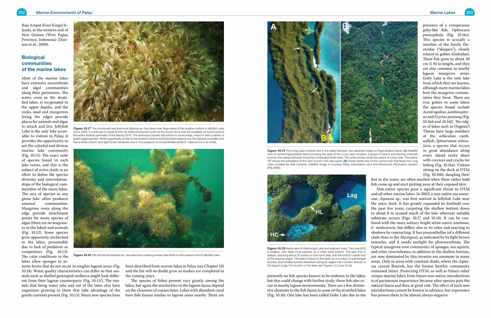
252 Marine Environments of Palau 253Marine Lakes
presently no fish species known to be endemic to the lakes, but this could change with further study; these fish also oc-cur in nearby lagoon environments. There are a few distinc-tive elements to the fish fauna in some of the stratified lakes (Fig. 10.16). One lake has been called Goby Lake due to the
presence of a conspicuous goby-like fish, Ophiocara porocephala (Fig. 10.16c). This species is actually a member of the family Ele-otridae (“sleepers”), closely related to gobies (Gobiidae). These fish grow to about 30 cm (1 ft) in length, and they are also common in nearby lagoon mangrove areas. Goby Lake is the only lake from which they are known, although many marine lakes host the mangrove commu-nities they favor. There are true gobies in some lakes; the species found include Acentrogobius janthinopter-us and Exyrias puntang (Fig. 10.16d and 10.16f). The edg-es of lakes such as Ongeim’l Tketau have large numbers of the orbiculate cardi-nalfish, Sphaeramia orbicu-laris, a species that occurs in great abundance along every island rocky shore with crevices and cracks for hiding (Fig. 10.16a). Visitors sitting on the dock at OTM (Fig. 10.16b), dangling their
feet in the water, are often startled when these rather bold fish come up and start picking away at their exposed skin. Non-native species pose a significant threat to OTM and all other marine lakes. In 2003, a non-native sea anem-one, Aiptasia sp., was first noticed in Jellyfish Lake near the entry dock. It has greatly expanded its foothold over the past five years, carpeting the shallow bottom down to about 8 m around much of the lake wherever suitable substrate occurs (Figs. 10.17 and 10.18). It can be con-fused with the more solitary bright white native anemone, E. medusivora, but differs also in its color and reacting to shadows by contracting. It has zooxanthellae (of a different clade than in the Mastigias), as indicated by its light brown tentacles, and it needs sunlight for photosynthesis. The typical mangrove-root community of sponges, sea squirts, and other invertebrates, in addition to the shallow bottom, are now dominated by this invasive sea anemone in many areas. Only in areas with constant shade, where the Aipta-sia cannot flourish, has the former benthic community remained intact. Protecting OTM, as well as Palau’s other unique marine lakes, from future non-native introductions is of paramount importance because alien species puts the natural fauna and flora at great risk. The effect of such new introductions cannot be known in advance, but experience has proven them to be almost always negative.
Raja Ampat (Four Kings) Is-lands, at the western end of New Guinea (West Papua Province, Indonesia) (Daw-son et al., 2009).
Biological communities of the marine lakes
Most of the marine lakes have extensive invertebrate and algal communities along their perimeters. The water, even in the strati-fied lakes, is oxygenated in the upper depths, and the rocks, mud and mangroves lining the edges provide places for animals and algae to attach and live. Jellyfish Lake is the only lake acces-sible to visitors in Palau; it provides the opportunity to see the colorful and diverse marine lake community (Fig. 10.11). The exact suite of species found in each lake varies, and this is the subject of active study in an effort to define the species diversity and interrelation-ships of the biological com-munities of the many lakes. The mix of species in any given lake often produces unusual communities. Mangrove roots along the edge provide attachment points for many species of algae (there are no seagrass-es in the lakes) and animals (Fig. 10.12). Some species grow apparently unchecked in the lakes, presumably due to lack of predators or competitors (Fig. 10.13). The calm conditions in the lakes allow sponges to as-sume forms that do not occur in rougher lagoon areas (Fig. 10.14). Water quality characteristics can differ so that ani-mals such as shelled gastropod molluscs might look differ-ent from their lagoon counterparts (Fig. 10.11f). The tun-nels that bring water into and out of the lakes also have organisms growing in them that take advantage of the gentle currents present (Fig. 10.15). Many new species have
been described from marine lakes in Palau (see Chapter 18) and the list will no doubt grow as studies are completed in the coming years. The species of fishes present vary greatly among the lakes, but again the similarities to the lagoon fauna depend on the closeness of connections. Lakes with abundant coral have fish faunas similar to lagoon areas nearby. There are
Figure 10.18 The introduced Aiptasia sp. sea anemone covering sunken tree limbs on the western end of Jellyfish Lake.
Figure 10.19 The Long Lake complex lies in the valley between two separate ridges on Ngeruktabel Island. (a) Satellite view of central Ngeruktabel Island showing the area of the Long Lake complex, a group of basins and feeding channels found in the valleys between long lines of elevated fossil reefs. The white arrows show the extent of Long Lake. The yellow “B” shows the orientation of the view found in the next panel. (B) Closer aerial view of the marine river that feeds the Long Lake complex by tidal currents. Satellite image A courtesy Palau Automated Land and Resources Information System (PALARIS).
Figure 10.17 The introduced sea anemone Aiptasia sp. has taken over large areas of the shallow bottom in Jellyfish Lake since 2003. It continues to expand from its initial introduction point at the tourist dock and will probably be found around the entire shallow perimeter of the lake by 2010. The anemone carpets the bottom in some areas, mixed in with a variety of green algae species. While superficially similar to the endemic anemone Entacmaea medusivora, the Aiptasia is smaller and has a white column and light brown tentacles due to the presence of zooxanthellae (while E. medusivora is all white).
Figure 10.20 Aerial view of Heliofungia Lake and adjacent cove. The cove (HC) is shallow, with dead coral patches on a white sand bottom. The lake (HL) is deeper, reaching about 25 meters on the north side, with the bottom visible only at the sloping edges. The lake is linked to the basin by a number of submerged tunnels, plus smaller tunnels elsewhere along its edges that connect directly to the lagoon (Lag). For location of the lake, see Figures 10.2 and 10.4b.
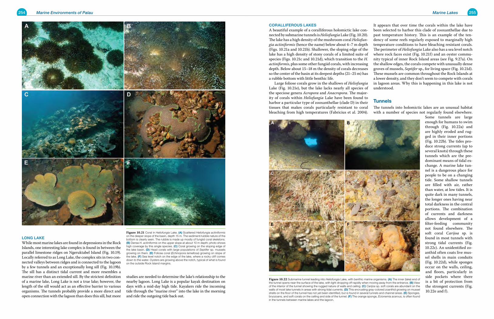
254 Marine Environments of Palau 255Marine Lakes
CorallIFerouS laKeSA beautiful example of a coralliferous holomictic lake con-nected by submarine tunnels is Heliofungia Lake (Fig. 10.20). The lake has a high density of the mushroom coral Heliofun-gia actiniformis (hence the name) below about 4–7 m depth (Figs. 10.21a and 10.21b). Shallower, the sloping edge of the lake has a high density of stony corals of a limited suite of species (Figs. 10.21c and 10.21d), which transition to the H. actiniformis, plus some other fungiid corals, with increasing depth. Below about 15–18 m the density of corals decreases so the center of the basin at its deepest depths (21–25 m) has a rubble bottom with little benthic life. Large foliose corals grow in the shallows of Heliofungia Lake (Fig. 10.21e), but the lake lacks nearly all species of the speciose genera Acropora and Anacropora. The major-ity of corals within Heliofungia Lake have been found to harbor a particular type of zooxanthellae (clade D) in their tissues that makes corals particularly resistant to coral bleaching from high temperatures (Fabricius et al. 2004).
It appears that over time the corals within the lake have been selected to harbor this clade of zooxanthellae due to past temperature history. This is an example of the ten-dency of some reefs regularly exposed to marginally high temperature conditions to have bleaching resistant corals. The perimeter of Heliofungia Lake also has a sea level notch where rock faces exist (Fig. 10.21f) and an oyster commu-nity typical of inner Rock Island areas (see Fig. 9.27a). On the shallow edges, the corals compete with unusually dense groves of mussels, Septifer sp., for living space (Fig. 10.21d). These mussels are common throughout the Rock Islands at a lower density, and they don’t seem to compete with corals in lagoon areas. Why this is happening in this lake is not understood.
tunnelsThe tunnels into holomictic lakes are an unusual habitat with a number of species not regularly found elsewhere.
Some tunnels are large enough for humans to swim through (Fig. 10.22a) and are highly eroded and rug-ged in their inner portions (Fig. 10.22b). The tides pro-duce strong currents (up to several knots) through these tunnels which are the pre-dominant means of tidal ex-change. A marine lake tun-nel is a dangerous place for people to be on a changing tide. Some shallow tunnels are filled with air, rather than water, at low tides. It is quite dark in many tunnels, the longer ones having near total darkness in the central portions. The combination of currents and darkness allows development of a filter-feeding community not found elsewhere. The soft coral Carijoa sp. is found in most tunnels with strong tidal currents (Fig. 10.22c). An unidentified zo-anthid often coats live mus-sel shells in main conduits (Fig. 10.22d), while sponges occur on the walls, ceiling, and floors, particularly in side pockets where there is a bit of protection from the strongest currents (Fig. 10.22e and f).
lonG laKeWhile most marine lakes are found in depressions in the Rock Islands, one interesting lake complex is found in between the parallel limestone ridges on Ngeruktabel Island (Fig. 10.19). Locally referred to as Long Lake, the complex sits in two con-nected valleys between ridges and is connected to the lagoon by a few tunnels and an exceptionally long sill (Fig. 10.19b). The sill has a distinct tidal current and more resembles a marine river than an extended sill. By the strictest definition of a marine lake, Long Lake is not a true lake; however, the length of the sill would act as an effective barrier to various organisms. The tunnels probably provide a more direct and open connection with the lagoon than does this sill, but more
studies are needed to determine the lake’s relationship to the nearby lagoon. Long Lake is a popular kayak destination on days with a mid-day high tide. Kayakers ride the incoming tide through the “marine river” into the lake in the morning and ride the outgoing tide back out.
Figure 10.22 Submarine tunnel leading into Heliofungia Lake, with benthic marine organisms. (a) The inner (lake) end of the tunnel opens near the surface of the lake, with light dropping off rapidly when moving away from the entrance. (B) View of the interior of the tunnel showing the rugged nature of walls and ceiling. (C) Carijoa sp. soft corals are abundant on the walls of most lake tunnels in areas with strong tidal currents. (d) This encrusting gray-colored zoanthid growing on mussel shells on the floor of the tunnel has not yet been identified, but is found in several tunnels and channel areas. (e) Sponges, bryozoans, and soft corals on the ceiling and side of the tunnel. (F) The orange sponge, Ecionemia acervus, is often found in the tunnels between marine lakes and the lagoon.
Figure 10.21 Coral in Heliofungia Lake. (a) Scattered Heliofungia actiniformis on the deeper slope of the basin, depth 15 m. The sediment/rubble nature of the bottom is clearly seen. The rubble is made up mostly of fungiid coral skeletons. (B) Dense H. actiniformis on the upper slope at about 10 m depth; photo shows high coverage by this single species. (C) Coral growing on the sloping edge of the lake basin. (d) Head corals with large populations of Septifer sp. mussels growing on them. (e) Foliose coral (Echinopora lamellosa) growing on slope of the lake. (F) Sea level notch on the edge of the lake, where a rocky cliff comes down to the water. Oysters are growing above the notch, typical of what is found on the outside Rock Island margins.
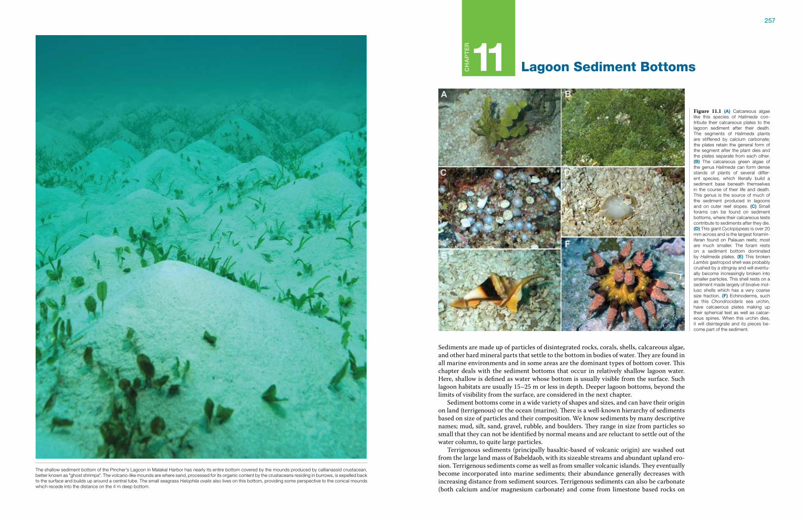
257
Ch
ap
te
r
11 Lagoon Sediment Bottoms
Sediments are made up of particles of disintegrated rocks, corals, shells, calcareous algae, and other hard mineral parts that settle to the bottom in bodies of water. They are found in all marine environments and in some areas are the dominant types of bottom cover. This chapter deals with the sediment bottoms that occur in relatively shallow lagoon water. Here, shallow is defined as water whose bottom is usually visible from the surface. Such lagoon habitats are usually 15–25 m or less in depth. Deeper lagoon bottoms, beyond the limits of visibility from the surface, are considered in the next chapter. Sediment bottoms come in a wide variety of shapes and sizes, and can have their origin on land (terrigenous) or the ocean (marine). There is a well-known hierarchy of sediments based on size of particles and their composition. We know sediments by many descriptive names; mud, silt, sand, gravel, rubble, and boulders. They range in size from particles so small that they can not be identified by normal means and are reluctant to settle out of the water column, to quite large particles. Terrigenous sediments (principally basaltic-based of volcanic origin) are washed out from the large land mass of Babeldaob, with its sizeable streams and abundant upland ero-sion. Terrigenous sediments come as well as from smaller volcanic islands. They eventually become incorporated into marine sediments; their abundance generally decreases with increasing distance from sediment sources. Terrigenous sediments can also be carbonate (both calcium and/or magnesium carbonate) and come from limestone based rocks on
Figure 11.1 (a) Calcareous algae like this species of Halimeda con-tribute their calcareous plates to the lagoon sediment after their death. The segments of Halimeda plants are stiffened by calcium carbonate; the plates retain the general form of the segment after the plant dies and the plates separate from each other. (B) The calcareous green algae of the genus Halimeda can form dense stands of plants of several differ-ent species, which literally build a sediment base beneath themselves in the course of their life and death. This genus is the source of much of the sediment produced in lagoons and on outer reef slopes. (C) Small forams can be found on sediment bottoms, where their calcareous tests contribute to sediments after they die. (d) This giant Cycloplypeas is over 20 mm across and is the largest foramin-iferan found on Palauan reefs; most are much smaller. The foram rests on a sediment bottom dominated by Halimeda plates. (e) This broken Lambis gastropod shell was probably crushed by a stingray and will eventu-ally become increasingly broken into smaller particles. This shell rests on a sediment made largely of bivalve mol-lusc shells which has a very coarse size fraction. (F) Echinoderms, such as this Chondrocidaris sea urchin, have calcaerous plates making up their spherical test as well as calcar-eous spines. When this urchin dies, it will disintegrate and its pieces be-come part of the sediment.
The shallow sediment bottom of the Pincher's Lagoon in Malakal Harbor has nearly its entire bottom covered by the mounds produced by callianassid crustacean, better known as "ghost shrimps". The volcano-like mounds are where sand, processed for its organic content by the crustaceans residing in burrows, is expelled back to the surface and builds up around a central tube. The small seagrass Halophila ovalis also lives on this bottom, providing some perspective to the conical mounds which recede into the distance on the 4 m deep bottom.
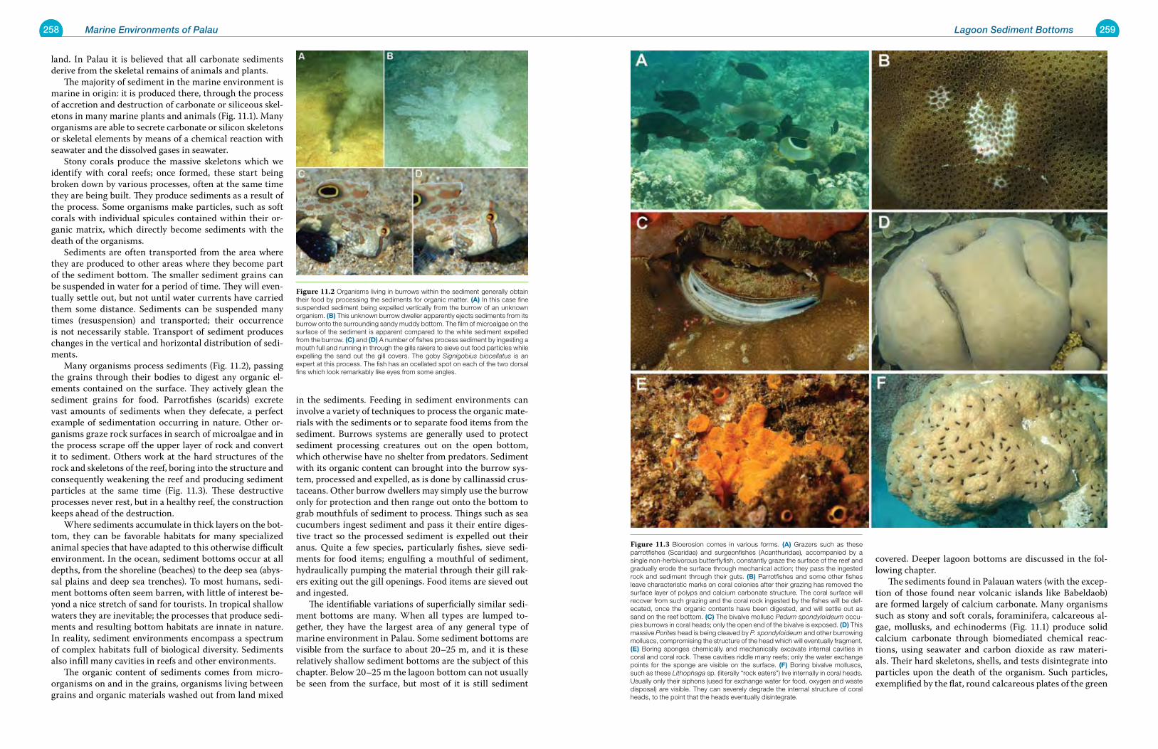
258 Marine Environments of Palau 259Lagoon Sediment Bottoms
covered. Deeper lagoon bottoms are discussed in the fol-lowing chapter. The sediments found in Palauan waters (with the excep-tion of those found near volcanic islands like Babeldaob) are formed largely of calcium carbonate. Many organisms such as stony and soft corals, foraminifera, calcareous al-gae, mollusks, and echinoderms (Fig. 11.1) produce solid calcium carbonate through biomediated chemical reac-tions, using seawater and carbon dioxide as raw materi-als. Their hard skeletons, shells, and tests disintegrate into particles upon the death of the organism. Such particles, exemplified by the flat, round calcareous plates of the green
land. In Palau it is believed that all carbonate sediments derive from the skeletal remains of animals and plants. The majority of sediment in the marine environment is marine in origin: it is produced there, through the process of accretion and destruction of carbonate or siliceous skel-etons in many marine plants and animals (Fig. 11.1). Many organisms are able to secrete carbonate or silicon skeletons or skeletal elements by means of a chemical reaction with seawater and the dissolved gases in seawater. Stony corals produce the massive skeletons which we identify with coral reefs; once formed, these start being broken down by various processes, often at the same time they are being built. They produce sediments as a result of the process. Some organisms make particles, such as soft corals with individual spicules contained within their or-ganic matrix, which directly become sediments with the death of the organisms. Sediments are often transported from the area where they are produced to other areas where they become part of the sediment bottom. The smaller sediment grains can be suspended in water for a period of time. They will even-tually settle out, but not until water currents have carried them some distance. Sediments can be suspended many times (resuspension) and transported; their occurrence is not necessarily stable. Transport of sediment produces changes in the vertical and horizontal distribution of sedi-ments. Many organisms process sediments (Fig. 11.2), passing the grains through their bodies to digest any organic el-ements contained on the surface. They actively glean the sediment grains for food. Parrotfishes (scarids) excrete vast amounts of sediments when they defecate, a perfect example of sedimentation occurring in nature. Other or-ganisms graze rock surfaces in search of microalgae and in the process scrape off the upper layer of rock and convert it to sediment. Others work at the hard structures of the rock and skeletons of the reef, boring into the structure and consequently weakening the reef and producing sediment particles at the same time (Fig. 11.3). These destructive processes never rest, but in a healthy reef, the construction keeps ahead of the destruction. Where sediments accumulate in thick layers on the bot-tom, they can be favorable habitats for many specialized animal species that have adapted to this otherwise difficult environment. In the ocean, sediment bottoms occur at all depths, from the shoreline (beaches) to the deep sea (abys-sal plains and deep sea trenches). To most humans, sedi-ment bottoms often seem barren, with little of interest be-yond a nice stretch of sand for tourists. In tropical shallow waters they are inevitable; the processes that produce sedi-ments and resulting bottom habitats are innate in nature. In reality, sediment environments encompass a spectrum of complex habitats full of biological diversity. Sediments also infill many cavities in reefs and other environments. The organic content of sediments comes from micro-organisms on and in the grains, organisms living between grains and organic materials washed out from land mixed
in the sediments. Feeding in sediment environments can involve a variety of techniques to process the organic mate-rials with the sediments or to separate food items from the sediment. Burrows systems are generally used to protect sediment processing creatures out on the open bottom, which otherwise have no shelter from predators. Sediment with its organic content can brought into the burrow sys-tem, processed and expelled, as is done by callinassid crus-taceans. Other burrow dwellers may simply use the burrow only for protection and then range out onto the bottom to grab mouthfuls of sediment to process. Things such as sea cucumbers ingest sediment and pass it their entire diges-tive tract so the processed sediment is expelled out their anus. Quite a few species, particularly fishes, sieve sedi-ments for food items; engulfing a mouthful of sediment, hydraulically pumping the material through their gill rak-ers exiting out the gill openings. Food items are sieved out and ingested. The identifiable variations of superficially similar sedi-ment bottoms are many. When all types are lumped to-gether, they have the largest area of any general type of marine environment in Palau. Some sediment bottoms are visible from the surface to about 20–25 m, and it is these relatively shallow sediment bottoms are the subject of this chapter. Below 20–25 m the lagoon bottom can not usually be seen from the surface, but most of it is still sediment
Figure 11.3 Bioerosion comes in various forms. (a) Grazers such as these parrotfishes (Scaridae) and surgeonfishes (Acanthuridae), accompanied by a single non-herbivorous butterflyfish, constantly graze the surface of the reef and gradually erode the surface through mechanical action; they pass the ingested rock and sediment through their guts. (B) Parrotfishes and some other fishes leave characteristic marks on coral colonies after their grazing has removed the surface layer of polyps and calcium carbonate structure. The coral surface will recover from such grazing and the coral rock ingested by the fishes will be def-ecated, once the organic contents have been digested, and will settle out as sand on the reef bottom. (C) The bivalve mollusc Pedum spondyloideum occu-pies burrows in coral heads; only the open end of the bivalve is exposed. (d) This massive Porites head is being cleaved by P. spondyloideum and other burrowing molluscs, compromising the structure of the head which will eventually fragment. (e) Boring sponges chemically and mechanically excavate internal cavities in coral and coral rock. These cavities riddle many reefs; only the water exchange points for the sponge are visible on the surface. (F) Boring bivalve molluscs, such as these Lithophaga sp. (literally “rock eaters”) live internally in coral heads. Usually only their siphons (used for exchange water for food, oxygen and waste disposal) are visible. They can severely degrade the internal structure of coral heads, to the point that the heads eventually disintegrate.
Figure 11.2 Organisms living in burrows within the sediment generally obtain their food by processing the sediments for organic matter. (a) In this case fine suspended sediment being expelled vertically from the burrow of an unknown organism. (B) This unknown burrow dweller apparently ejects sediments from its burrow onto the surrounding sandy muddy bottom. The film of microalgae on the surface of the sediment is apparent compared to the white sediment expelled from the burrow. (C) and (d) A number of fishes process sediment by ingesting a mouth full and running in through the gills rakers to sieve out food particles while expelling the sand out the gill covers. The goby Signigobius biocellatus is an expert at this process. The fish has an ocellated spot on each of the two dorsal fins which look remarkably like eyes from some angles.
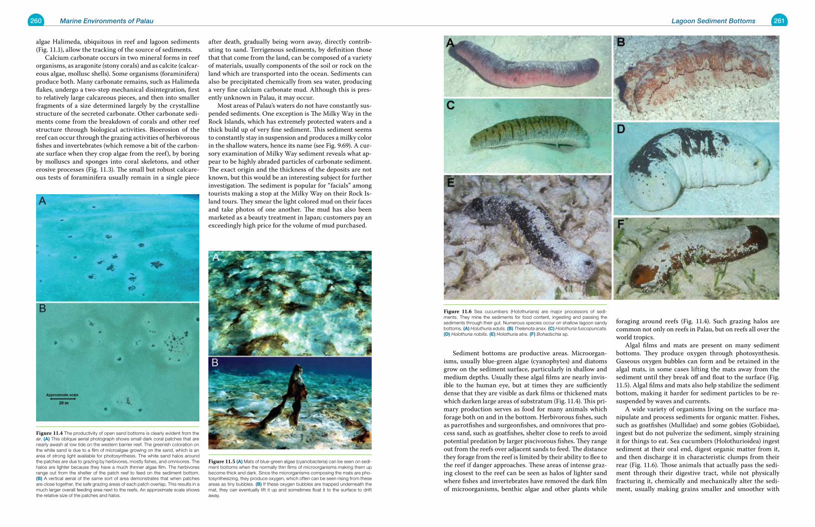
260 Marine Environments of Palau 261Lagoon Sediment Bottoms
Sediment bottoms are productive areas. Microorgan-isms, usually blue-green algae (cyanophytes) and diatoms grow on the sediment surface, particularly in shallow and medium depths. Usually these algal films are nearly invis-ible to the human eye, but at times they are sufficiently dense that they are visible as dark films or thickened mats which darken large areas of substratum (Fig. 11.4). This pri-mary production serves as food for many animals which forage both on and in the bottom. Herbivorous fishes, such as parrotfishes and surgeonfishes, and omnivores that pro-cess sand, such as goatfishes, shelter close to reefs to avoid potential predation by larger piscivorous fishes. They range out from the reefs over adjacent sands to feed. The distance they forage from the reef is limited by their ability to flee to the reef if danger approaches. These areas of intense graz-ing closest to the reef can be seen as halos of lighter sand where fishes and invertebrates have removed the dark film of microorganisms, benthic algae and other plants while
foraging around reefs (Fig. 11.4). Such grazing halos are common not only on reefs in Palau, but on reefs all over the world tropics. Algal films and mats are present on many sediment bottoms. They produce oxygen through photosynthesis. Gaseous oxygen bubbles can form and be retained in the algal mats, in some cases lifting the mats away from the sediment until they break off and float to the surface (Fig. 11.5). Algal films and mats also help stabilize the sediment bottom, making it harder for sediment particles to be re-suspended by waves and currents. A wide variety of organisms living on the surface ma-nipulate and process sediments for organic matter. Fishes, such as goatfishes (Mullidae) and some gobies (Gobiidae), ingest but do not pulverize the sediment, simply straining it for things to eat. Sea cucumbers (Holothurioidea) ingest sediment at their oral end, digest organic matter from it, and then discharge it in characteristic clumps from their rear (Fig. 11.6). Those animals that actually pass the sedi-ment through their digestive tract, while not physically fracturing it, chemically and mechanically alter the sedi-ment, usually making grains smaller and smoother with
algae Halimeda, ubiquitous in reef and lagoon sediments (Fig. 11.1), allow the tracking of the source of sediments. Calcium carbonate occurs in two mineral forms in reef organisms, as aragonite (stony corals) and as calcite (calcar-eous algae, mollusc shells). Some organisms (foraminifera) produce both. Many carbonate remains, such as Halimeda flakes, undergo a two-step mechanical disintegration, first to relatively large calcareous pieces, and then into smaller fragments of a size determined largely by the crystalline structure of the secreted carbonate. Other carbonate sedi-ments come from the breakdown of corals and other reef structure through biological activities. Bioerosion of the reef can occur through the grazing activities of herbivorous fishes and invertebrates (which remove a bit of the carbon-ate surface when they crop algae from the reef), by boring by molluscs and sponges into coral skeletons, and other erosive processes (Fig. 11.3). The small but robust calcare-ous tests of foraminifera usually remain in a single piece
after death, gradually being worn away, directly contrib-uting to sand. Terrigenous sediments, by definition those that that come from the land, can be composed of a variety of materials, usually components of the soil or rock on the land which are transported into the ocean. Sediments can also be precipitated chemically from sea water, producing a very fine calcium carbonate mud. Although this is pres-ently unknown in Palau, it may occur. Most areas of Palau’s waters do not have constantly sus-pended sediments. One exception is The Milky Way in the Rock Islands, which has extremely protected waters and a thick build up of very fine sediment. This sediment seems to constantly stay in suspension and produces a milky color in the shallow waters, hence its name (see Fig. 9.69). A cur-sory examination of Milky Way sediment reveals what ap-pear to be highly abraded particles of carbonate sediment. The exact origin and the thickness of the deposits are not known, but this would be an interesting subject for further investigation. The sediment is popular for “facials” among tourists making a stop at the Milky Way on their Rock Is-land tours. They smear the light colored mud on their faces and take photos of one another. The mud has also been marketed as a beauty treatment in Japan; customers pay an exceedingly high price for the volume of mud purchased.
Figure 11.6 Sea cucumbers (Holothurians) are major processors of sedi-ments. They mine the sediments for food content, ingesting and passing the sediments through their gut. Numerous species occur on shallow lagoon sandy bottoms. (a) Holuthuria edulis. (B) Thelenota anax. (C) Holothuria fuscopuncata. (d) Holothuria nobilis. (e) Holothuria atra. (F) Bohadschia sp.
Figure 11.5 (a) Mats of blue-green algae (cyanobacteria) can be seen on sedi-ment bottoms when the normally thin films of microorganisms making them up become thick and dark. Since the microrganisms composing the mats are pho-tosynthesizing, they produce oxygen, which often can be seen rising from these areas as tiny bubbles. (B) If these oxygen bubbles are trapped underneath the mat, they can eventually lift it up and sometimes float it to the surface to drift away.
Figure 11.4 The productivity of open sand bottoms is clearly evident from the air. (a) This oblique aerial photograph shows small dark coral patches that are nearly awash at low tide on the western barrier reef. The greenish coloration on the white sand is due to a film of microalgae growing on the sand, which is an area of strong light available for photosynthesis. The white sand halos around the patches are due to grazing by herbivores, mostly fishes, and omnivores. The halos are lighter because they have a much thinner algae film. The herbivores range out from the shelter of the patch reef to feed on the sediment bottom. (B) A vertical aerial of the same sort of area demonstrates that when patches are close together, the safe grazing areas of each patch overlap. This results in a much larger overall feeding area next to the reefs. An approximate scale shows the relative size of the patches and halos.
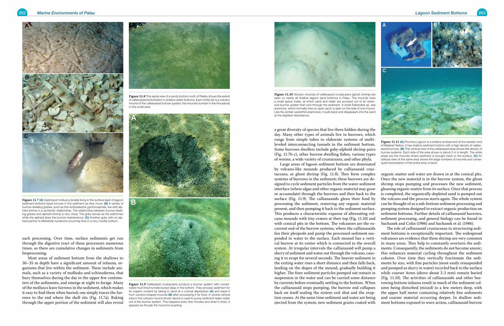
262 Marine Environments of Palau 263Lagoon Sediment Bottoms
a great diversity of species that live there hidden during the day. Many other types of animals live in burrows, which range from simple tubes to elaborate systems of multi-leveled interconnecting tunnels in the sediment bottom. Some burrows dwellers include goby-alpheid shrimp pairs (Fig. 11.7b-c), other burrow-dwelling fishes, various types of worms, a wide variety of crustaceans, and other phyla. Large areas of lagoon sediment bottom are dominated by volcano-like mounds produced by callianassid crus-taceans, or ghost shrimp (Fig. 11.8). They form complex systems of burrows in the sediment; these burrows are de-signed to cycle sediment particles from the water-sediment interface (where algae and other organic material may grow or accumulate) through the burrows and then back to the surface (Fig. 11.9). The callianassids glean their food by processing the sediment, removing any organic material present, and then pumping it back to the sediment surface. This produces a characteristic expanse of alternating vol-cano mounds with tiny craters at their top (Fig. 11.10) and with conical pits in the bottom. The volcanoes are the ex-current end of the burrow systems, where the callianassids fan their pleopods and pump the processed sediment sus-pended in water to the surface. Each mound has a verti-cal burrow at its center which is connected to the overall system. At irregular intervals the callianassid will pump a slurry of sediment and water out through the volcano, caus-ing it to erupt for several seconds. The heavier sediment in the exiting water rises a short distance and then falls back, landing on the slopes of the mound, gradually building it higher. The finer sediment particles pumped out remain in suspension in the water and can be carried some distance by currents before eventually settling to the bottom. When the callianassid stops pumping, the burrow end collapses back on itself sealing the system exit shut and the erup-tion ceases. At the same time sediment and water are being ejected from the system, new sediment grains coated with
organic matter and water are drawn in at the conical pits. Once the new material is in the burrow system, the ghost shrimp stops pumping and processes the new sediment, gleaning organic matter from its surface. Once that process is completed, the organically-depleted sand is pumped out the volcano and the process starts again. The whole system can be thought of as a sub-bottom sediment processing and pumping system designed to extract organic production on sediment bottoms. Further details of callianassid burrows, sediment processing, and general biology can be found in Suchanek and Colin (1986) and Suchanek et al. (1986). The role of callianassid crustaceans in structuring sedi-ment bottoms is exceptionally important. The widespread volcanoes are evidence that these shrimp are very common in many areas. They help to constantly overturn the sedi-ments. Consequently, the sediments do not become anoxic; this enhances material cycling throughout the sediment column. Over time they vertically fractionate the sedi-ments by size, with fine particles (most easily resuspended and pumped as slurry in water) recycled back to the surface while coarser items (above about 2-3 mm) remain buried (Fig. 11.10). The activities of callianassids and other bur-rowing bottom infauna result in much of the sediment col-umn being disturbed (mixed) to a few meters deep, with the upper half meter containing relatively fine sediments and coarser material occurring deeper. In shallow sedi-ment bottoms exposed to wave action, callianassid burrow
each processing. Over time, surface sediments get run through the digestive tract of these processors numerous times, so there are cumulative changes in sediments from bioprocessing. Most areas of sediment bottom from the shallows to 30–35 m depth have a significant amount of infauna, or-ganisms that live within the sediment. These include ani-mals, such as a variety of mollusks and echinoderms, that bury themselves during the day in the upper few centime-ters of the sediments, and emerge at night to forage. Many of the molluscs leave furrows in the sediment, which makes it easy to find them when buried; one simply traces the fur-rows to the end where the shell sits (Fig. 11.7a). Raking through the upper portion of the sediment will also reveal
Figure 11.10 Volcano mounds of callianassid crustaceans (ghost shrimp) are seen on nearly all shallow lagoon sand bottoms in Palau. The mounds have a small apical crater, at which sand and water are pumped out of an exten-sive burrow system that runs through the sediment. A small Edwardsia sp. sea anemone, which normally lives on open sand, is seen on the side of one mound. Like the similar cerianthid anemones, it pulls back and disappears into the sand at the slightest disturbance.
Figure 11.11 (a) Pinchers Lagoon is a shallow embayment at the western end of Malakal Harbor; it has shallow sediment bottom with a high density of callian-assid burrows. (B) This vertical view of the callianassid area shows the density of burrow systems. Each side of the area shown is about 2 m in length. The white areas are the mounds where sediment is brought back to the surface. (C) An oblique view of the same area shows the large numbers of mounds and conse-quent bioturbation of the entire area of sand.
Figure 11.7 (a) Gastropod molluscs (snails) living in the surface layer of lagoon sediment bottoms leave furrows in the sediment as they move. (B) A variety of burrow-dwelling gobies, such as this Amblyeleotris gymnocephala, live with alp-heid shrimp in a symbiotic relationship. The relationship between burrow dwell-ing gobies and alpheid shrimp is very close. The goby serves as the watchman while the alpheid does the burrow maintenance. (C) Another goby with an alp-heid partner is Mahidolia mystacina occurring here in a very muddy bottom.
Figure 11.8 This aerial view of a sandy bottom north of Peleliu shows the extent of callianassid bioturbation in shallow water bottoms. Each white dot is a volcano mound of the callianassid burrow system; the mounds number in the thousands in this small area.
Figure 11.9 Callianasid crustaceans produce a burrow system with compli-cated mud-lined tunnels buried deep in the bottom. They process sediment for its organic content by taking in sand at a conical depression (a) and expel it from volcano-shaped mounds (B) after processing it for food. A central vertical tube in the volcano mound shown above is used to pump sediment-laden water out of the burrow system. This happens every few minutes and when it does, it appears as though the mound is erupting.
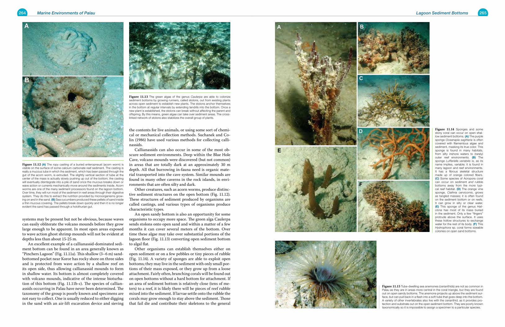
264 Marine Environments of Palau 265Lagoon Sediment Bottoms
systems may be present but not be obvious, because waves can easily obliterate the volcano mounds before they grow large enough to be apparent. In most open areas exposed to wave action ghost shrimp mounds will not be evident at depths less than about 15-25 m. An excellent example of a callianassid-dominated sedi-ment bottom can be found in an area generally known as “Pinchers Lagoon” (Fig. 11.11a). This shallow (3–6 m) sand-bottomed pocket near Koror has rocky shore on three sides and is protected from wave action by a shallow reef on its open side, thus allowing callianassid mounds to form in shallow water. Its bottom is almost completely covered with volcano mounds, indicative of the intense bioturba-tion of this bottom (Fig. 11.11b-c). The species of callian-assids occurring in Palau have never been determined. The taxonomy of the group is poorly known and specimens are not easy to collect. One is usually reduced to either digging in the sand with an air-lift excavation device and sieving
the contents for live animals, or using some sort of chemi-cal or mechanical collection methods. Suchanek and Co-lin (1986) have used various methods for collecting calli-nassids. Callianassids can also occur in some of the most ob-scure sediment environments. Deep within the Blue Hole Cave, volcano mounds were discovered (but not common) in areas that are totally dark at an approximately 30 m depth. All that burrowing in-fauna need is organic mate-rial transported into the cave system. Similar mounds are found in many other caverns in the rock islands, in envi-ronments that are often silty and dark. Other creatures, such as acorn worms, produce distinc-tive sediment structures on the open bottom (Fig. 11.12). These structures of sediment produced by organisms are called castings, and various types of organisms produce characteristic types. An open sandy bottom is also an opportunity for some organisms to occupy more space. The green alga Caulerpa sends stolons onto open sand and within a matter of a few months it can cover several meters of the bottom. Over time these algae may take over substantial portions of the lagoon floor (Fig. 11.13) converting open sediment bottom to algal flat. Other organisms can establish themselves either on open sediment or on a few pebbles or tiny pieces of rubble (Fig. 11.14). A variety of sponges are able to exploit open bottoms; they may live in the sediment with only small por-tions of their mass exposed, or they grow up from a loose attachment. Fairly often, branching corals will be found out on open bottoms without a hard bottom for attachment. If an area of sediment bottom is relatively close (tens of me-ters) to a reef, it is likely there will be pieces of reef rubble mixed into the sediment. If larvae settle onto the rubble the corals may grow enough to stay above the sediment. Those that fail die and contribute their skeletons to the general
Figure 11.14 Sponges and some stony coral can occur on open shal-low sediment bottoms. (a) The purple sponge Oceanapia sagittaria is often covered with filamentous algae and sediment, masking its true color. This sponge is found in many habitats, from silty inshore waters to (rarely) outer reef environments. (B) The sponge Luffariella variabilis is, as its name implies, variable; it is found in many lagoon and reef environments. It has a fibrous skeletal structure made up of orange colored fibers. (C) Some species of Acropora coral can occur on sediment and rubble bottoms away from the more typi-cal reef habitat. (d) The orange vine sponge, Clathria cervicornis, grows as tangled masses; it is often found on the sediment bottom or on reefs. It can grow in silty or clear water. (e) This sponge of the genus Hali-clona has most of its mass buried in the sediment. Only a few “fingers” protrude above the surface. It uses these hollow structures to exchange water for the rest of its body. (F) This Hydnophora sp. coral forms sizeable colonies on open sand bottoms.
Figure 11.15 Tube-dwelling sea anemones (cerianthids) are not as common in Palau as they are in areas more central in the coral triangle, but they are found out on open sandy bottoms. The anemone projects up above the sediment sur-face, but can pull back in a flash into a soft tube that goes deep into the bottom. A variety of other invertebrates also live with the cerianthid, as it provides pro-tection and substrate out on the open sediment bottom. They are poorly known taxonomically so it is impossible to assign a specimen to a particular species.
Figure 11.12 (a) The ropy casting of a buried enteropneust (acorn worm) is visible on the surface of some calcium carbonate reef sediment. The casting is really a mucous tube in which the sediment, which has been passed through the gut of the acorn worm, is extruded. The slightly vertical section of tube at the center of the mass is actually slowly pushing up out of the bottom; the casting will eventually disintegrate into a pile of sand once the mucous breaks down or wave action or currents mechanically move around the sediments inside. Acorn worms are one of the many sediment processors found on the lagoon bottom. Over time, they will run most of the sediment in reef areas through their digestive system. They do this to extract the nutrition provided by microorganisms grow-ing on and in the sand. (B) Sea cucumbers produced these pellets of sand inside a thin mucous covering. The pellets break down quickly and then it is no longer evident the sand has passed through a holothurian gut.
Figure 11.13 The green algae of the genus Caulerpa are able to colonize sediment bottoms by growing runners, called stolons, out from existing plants across open sediment to establish new plants. The stolons anchor themselves in the bottom at regular intervals by extending tendrils into the bottom. Once a new plant is established, the stolons can break without affecting the parent and offspring. By this means, green algae can take over sediment areas. The cross-linked network of stolons also stabilizes the overall group of plants.
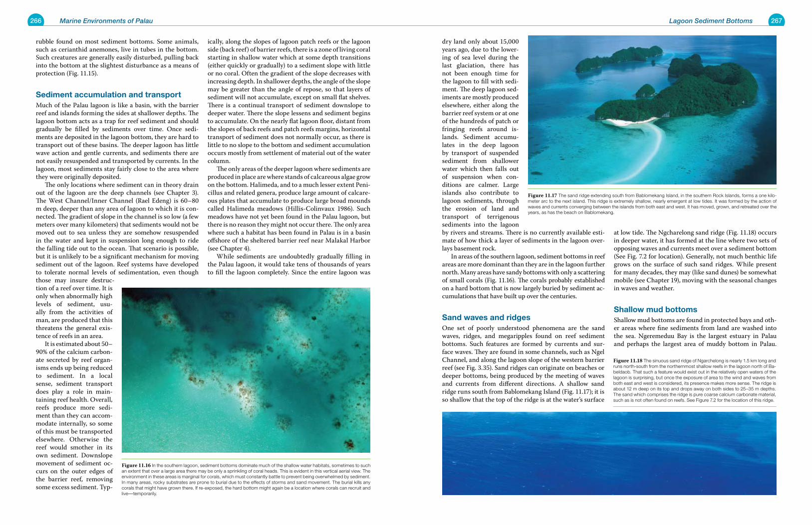
266 Marine Environments of Palau 267Lagoon Sediment Bottoms
dry land only about 15,000 years ago, due to the lower-ing of sea level during the last glaciation, there has not been enough time for the lagoon to fill with sedi-ment. The deep lagoon sed-iments are mostly produced elsewhere, either along the barrier reef system or at one of the hundreds of patch or fringing reefs around is-lands. Sediment accumu-lates in the deep lagoon by transport of suspended sediment from shallower water which then falls out of suspension when con-ditions are calmer. Large islands also contribute to lagoon sediments, through the erosion of land and transport of terrigenous sediments into the lagoon by rivers and streams. There is no currently available esti-mate of how thick a layer of sediments in the lagoon over-lays basement rock. In areas of the southern lagoon, sediment bottoms in reef areas are more dominant than they are in the lagoon further north. Many areas have sandy bottoms with only a scattering of small corals (Fig. 11.16). The corals probably established on a hard bottom that is now largely buried by sediment ac-cumulations that have built up over the centuries.
Sand waves and ridges One set of poorly understood phenomena are the sand waves, ridges, and megaripples found on reef sediment bottoms. Such features are formed by currents and sur-face waves. They are found in some channels, such as Ngel Channel, and along the lagoon slope of the western barrier reef (see Fig. 3.35). Sand ridges can originate on beaches or deeper bottoms, being produced by the meeting of waves and currents from different directions. A shallow sand ridge runs south from Bablomekang Island (Fig. 11.17); it is so shallow that the top of the ridge is at the water’s surface
at low tide. The Ngcharelong sand ridge (Fig. 11.18) occurs in deeper water, it has formed at the line where two sets of opposing waves and currents meet over a sediment bottom (See Fig. 7.2 for location). Generally, not much benthic life grows on the surface of such sand ridges. While present for many decades, they may (like sand dunes) be somewhat mobile (see Chapter 19), moving with the seasonal changes in waves and weather.
Shallow mud bottomsShallow mud bottoms are found in protected bays and oth-er areas where fine sediments from land are washed into the sea. Ngeremeduu Bay is the largest estuary in Palau and perhaps the largest area of muddy bottom in Palau.
rubble found on most sediment bottoms. Some animals, such as cerianthid anemones, live in tubes in the bottom. Such creatures are generally easily disturbed, pulling back into the bottom at the slightest disturbance as a means of protection (Fig. 11.15).
Sediment accumulation and transportMuch of the Palau lagoon is like a basin, with the barrier reef and islands forming the sides at shallower depths. The lagoon bottom acts as a trap for reef sediment and should gradually be filled by sediments over time. Once sedi-ments are deposited in the lagoon bottom, they are hard to transport out of these basins. The deeper lagoon has little wave action and gentle currents, and sediments there are not easily resuspended and transported by currents. In the lagoon, most sediments stay fairly close to the area where they were originally deposited. The only locations where sediment can in theory drain out of the lagoon are the deep channels (see Chapter 3). The West Channel/Inner Channel (Rael Edeng) is 60–80 m deep, deeper than any area of lagoon to which it is con-nected. The gradient of slope in the channel is so low (a few meters over many kilometers) that sediments would not be moved out to sea unless they are somehow resuspended in the water and kept in suspension long enough to ride the falling tide out to the ocean. That scenario is possible, but it is unlikely to be a significant mechanism for moving sediment out of the lagoon. Reef systems have developed to tolerate normal levels of sedimentation, even though those may insure destruc-tion of a reef over time. It is only when abnormally high levels of sediment, usu-ally from the activities of man, are produced that this threatens the general exis-tence of reefs in an area. It is estimated about 50–90% of the calcium carbon-ate secreted by reef organ-isms ends up being reduced to sediment. In a local sense, sediment transport does play a role in main-taining reef health. Overall, reefs produce more sedi-ment than they can accom-modate internally, so some of this must be transported elsewhere. Otherwise the reef would smother in its own sediment. Downslope movement of sediment oc-curs on the outer edges of the barrier reef, removing some excess sediment. Typ-
ically, along the slopes of lagoon patch reefs or the lagoon side (back reef) of barrier reefs, there is a zone of living coral starting in shallow water which at some depth transitions (either quickly or gradually) to a sediment slope with little or no coral. Often the gradient of the slope decreases with increasing depth. In shallower depths, the angle of the slope may be greater than the angle of repose, so that layers of sediment will not accumulate, except on small flat shelves. There is a continual transport of sediment downslope to deeper water. There the slope lessens and sediment begins to accumulate. On the nearly flat lagoon floor, distant from the slopes of back reefs and patch reefs margins, horizontal transport of sediment does not normally occur, as there is little to no slope to the bottom and sediment accumulation occurs mostly from settlement of material out of the water column. The only areas of the deeper lagoon where sediments are produced in place are where stands of calcareous algae grow on the bottom. Halimeda, and to a much lesser extent Peni-cillus and related genera, produce large amount of calcare-ous plates that accumulate to produce large broad mounds called Halimeda meadows (Hillis-Colinvaux 1986). Such meadows have not yet been found in the Palau lagoon, but there is no reason they might not occur there. The only area where such a habitat has been found in Palau is in a basin offshore of the sheltered barrier reef near Malakal Harbor (see Chapter 4). While sediments are undoubtedly gradually filling in the Palau lagoon, it would take tens of thousands of years to fill the lagoon completely. Since the entire lagoon was
Figure 11.17 The sand ridge extending south from Bablomekang Island, in the southern Rock Islands, forms a one kilo-meter arc to the next island. This ridge is extremely shallow, nearly emergent at low tides. It was formed by the action of waves and currents converging between the islands from both east and west. It has moved, grown, and retreated over the years, as has the beach on Bablomekang.
Figure 11.18 The sinuous sand ridge of Ngarchelong is nearly 1.5 km long and runs north-south from the northernmost shallow reefs in the lagoon north of Ba-beldaob. That such a feature would exist out in the relatively open waters of the lagoon is surprising, but once the exposure of area to the wind and waves from both east and west is considered, its presence makes more sense. The ridge is about 12 m deep on its top and drops away on both sides to 25–35 m depths. The sand which comprises the ridge is pure coarse calcium carbonate material, such as is not often found on reefs. See Figure 7.2 for the location of this ridge.
Figure 11.16 In the southern lagoon, sediment bottoms dominate much of the shallow water habitats, sometimes to such an extent that over a large area there may be only a sprinkling of coral heads. This is evident in this vertical aerial view. The environment in these areas is marginal for corals, which must constantly battle to prevent being overwhelmed by sediment. In many areas, rocky substrates are prone to burial due to the effects of storms and sand movement. The burial kills any corals that might have grown there. If re-exposed, the hard bottom might again be a location where corals can recruit and live—temporarily.
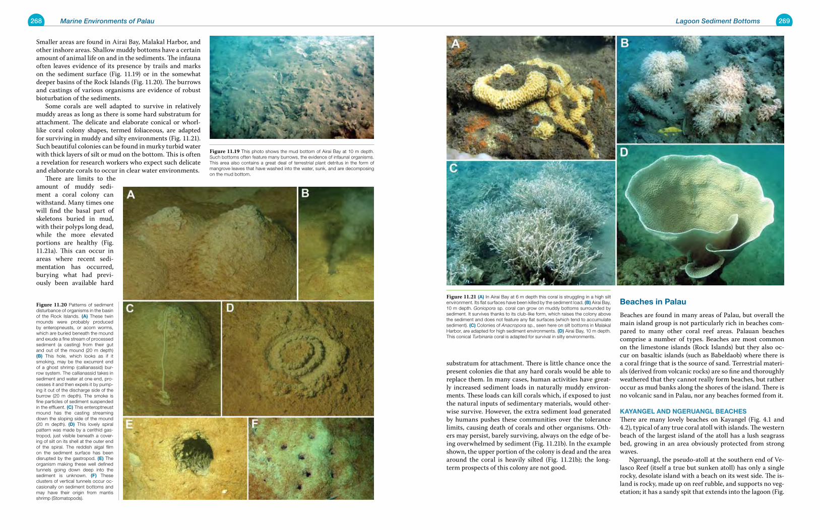
268 Marine Environments of Palau 269Lagoon Sediment Bottoms
substratum for attachment. There is little chance once the present colonies die that any hard corals would be able to replace them. In many cases, human activities have great-ly increased sediment loads in naturally muddy environ-ments. These loads can kill corals which, if exposed to just the natural inputs of sedimentary materials, would other-wise survive. However, the extra sediment load generated by humans pushes these communities over the tolerance limits, causing death of corals and other organisms. Oth-ers may persist, barely surviving, always on the edge of be-ing overwhelmed by sediment (Fig. 11.21b). In the example shown, the upper portion of the colony is dead and the area around the coral is heavily silted (Fig. 11.21b); the long-term prospects of this colony are not good.
Beaches in palau
Beaches are found in many areas of Palau, but overall the main island group is not particularly rich in beaches com-pared to many other coral reef areas. Palauan beaches comprise a number of types. Beaches are most common on the limestone islands (Rock Islands) but they also oc-cur on basaltic islands (such as Babeldaob) where there is a coral fringe that is the source of sand. Terrestrial materi-als (derived from volcanic rocks) are so fine and thoroughly weathered that they cannot really form beaches, but rather occur as mud banks along the shores of the island. There is no volcanic sand in Palau, nor any beaches formed from it.
KayanGel and nGeruanGl BeaCheSThere are many lovely beaches on Kayangel (Fig. 4.1 and 4.2), typical of any true coral atoll with islands. The western beach of the largest island of the atoll has a lush seagrass bed, growing in an area obviously protected from strong waves. Ngeruangl, the pseudo-atoll at the southern end of Ve-lasco Reef (itself a true but sunken atoll) has only a single rocky, desolate island with a beach on its west side. The is-land is rocky, made up on reef rubble, and supports no veg-etation; it has a sandy spit that extends into the lagoon (Fig.
Smaller areas are found in Airai Bay, Malakal Harbor, and other inshore areas. Shallow muddy bottoms have a certain amount of animal life on and in the sediments. The infauna often leaves evidence of its presence by trails and marks on the sediment surface (Fig. 11.19) or in the somewhat deeper basins of the Rock Islands (Fig. 11.20). The burrows and castings of various organisms are evidence of robust bioturbation of the sediments. Some corals are well adapted to survive in relatively muddy areas as long as there is some hard substratum for attachment. The delicate and elaborate conical or whorl-like coral colony shapes, termed foliaceous, are adapted for surviving in muddy and silty environments (Fig. 11.21). Such beautiful colonies can be found in murky turbid water with thick layers of silt or mud on the bottom. This is often a revelation for research workers who expect such delicate and elaborate corals to occur in clear water environments. There are limits to the amount of muddy sedi-ment a coral colony can withstand. Many times one will find the basal part of skeletons buried in mud, with their polyps long dead, while the more elevated portions are healthy (Fig. 11.21a). This can occur in areas where recent sedi-mentation has occurred, burying what had previ-ously been available hard
Figure 11.21 (a) In Airai Bay at 6 m depth this coral is struggling in a high silt environment. Its flat surfaces have been killed by the sediment load. (B) Airai Bay, 10 m depth. Goniopora sp. coral can grow on muddy bottoms surrounded by sediment. It survives thanks to its club-like form, which raises the colony above the sediment and does not feature any flat surfaces (which tend to accumulate sediment). (C) Colonies of Anacropora sp., seen here on silt bottoms in Malakal Harbor, are adapted for high sediment environments. (d) Airai Bay, 10 m depth. This conical Turbinaria coral is adapted for survival in silty environments.
Figure 11.20 Patterns of sediment disturbance of organisms in the basin of the Rock Islands. (a) These twin mounds were probably produced by enteropneusts, or acorn worms, which are buried beneath the mound and exude a fine stream of processed sediment (a casting) from their gut and out of the mound (20 m depth) (B) This hole, which looks as if it smoking, may be the excurrent end of a ghost shrimp (callianassid) bur-row system. The callianassid takes in sediment and water at one end, pro-cesses it and then expels it by pump-ing it out of the discharge side of the burrow (20 m depth). The smoke is fine particles of sediment suspended in the effluent. (C) This enteroptneust mound has the casting streaming down the sloping side of the mound (20 m depth). (d) This lovely spiral pattern was made by a cerithid gas-tropod, just visible beneath a cover-ing of silt on its shell at the outer end of the spiral. The reddish algal film on the sediment surface has been disrupted by the gastropod. (e) The organism making these well defined tunnels going down deep into the sediment is unknown. (F) These clusters of vertical tunnels occur oc-casionally on sediment bottoms and may have their origin from mantis shrimp (Stomatopods).
Figure 11.19 This photo shows the mud bottom of Airai Bay at 10 m depth. Such bottoms often feature many burrows, the evidence of infaunal organisms. This area also contains a great deal of terrestrial plant detritus in the form of mangrove leaves that have washed into the water, sunk, and are decomposing on the mud bottom.
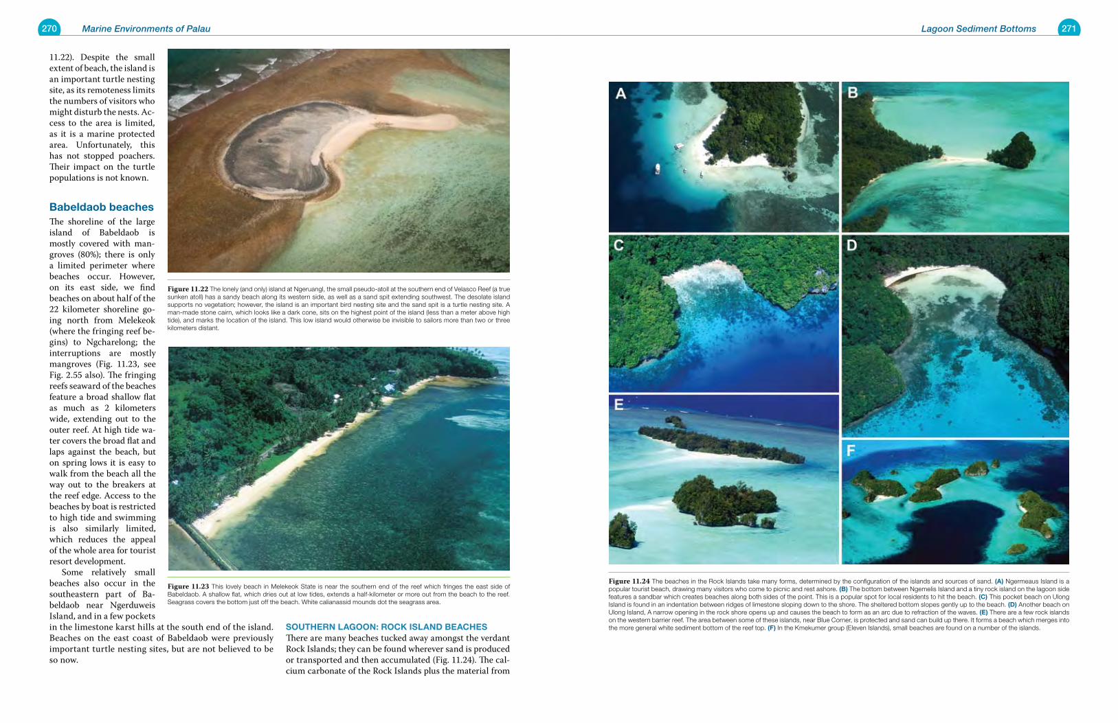
270 Marine Environments of Palau 271Lagoon Sediment Bottoms
11.22). Despite the small extent of beach, the island is an important turtle nesting site, as its remoteness limits the numbers of visitors who might disturb the nests. Ac-cess to the area is limited, as it is a marine protected area. Unfortunately, this has not stopped poachers. Their impact on the turtle populations is not known.
Babeldaob beachesThe shoreline of the large island of Babeldaob is mostly covered with man-groves (80%); there is only a limited perimeter where beaches occur. However, on its east side, we find beaches on about half of the 22 kilometer shoreline go-ing north from Melekeok (where the fringing reef be-gins) to Ngcharelong; the interruptions are mostly mangroves (Fig. 11.23, see Fig. 2.55 also). The fringing reefs seaward of the beaches feature a broad shallow flat as much as 2 kilometers wide, extending out to the outer reef. At high tide wa-ter covers the broad flat and laps against the beach, but on spring lows it is easy to walk from the beach all the way out to the breakers at the reef edge. Access to the beaches by boat is restricted to high tide and swimming is also similarly limited, which reduces the appeal of the whole area for tourist resort development. Some relatively small beaches also occur in the southeastern part of Ba-beldaob near Ngerduweis Island, and in a few pockets in the limestone karst hills at the south end of the island. Beaches on the east coast of Babeldaob were previously important turtle nesting sites, but are not believed to be so now.
Southern laGoon: roCK ISland BeaCheSThere are many beaches tucked away amongst the verdant Rock Islands; they can be found wherever sand is produced or transported and then accumulated (Fig. 11.24). The cal-cium carbonate of the Rock Islands plus the material from
Figure 11.24 The beaches in the Rock Islands take many forms, determined by the configuration of the islands and sources of sand. (a) Ngermeaus Island is a popular tourist beach, drawing many visitors who come to picnic and rest ashore. (B) The bottom between Ngemelis Island and a tiny rock island on the lagoon side features a sandbar which creates beaches along both sides of the point. This is a popular spot for local residents to hit the beach. (C) This pocket beach on Ulong Island is found in an indentation between ridges of limestone sloping down to the shore. The sheltered bottom slopes gently up to the beach. (d) Another beach on Ulong Island, A narrow opening in the rock shore opens up and causes the beach to form as an arc due to refraction of the waves. (e) There are a few rock islands on the western barrier reef. The area between some of these islands, near Blue Corner, is protected and sand can build up there. It forms a beach which merges into the more general white sediment bottom of the reef top. (F) In the Kmekumer group (Eleven Islands), small beaches are found on a number of the islands.
Figure 11.22 The lonely (and only) island at Ngeruangl, the small pseudo-atoll at the southern end of Velasco Reef (a true sunken atoll) has a sandy beach along its western side, as well as a sand spit extending southwest. The desolate island supports no vegetation; however, the island is an important bird nesting site and the sand spit is a turtle nesting site. A man-made stone cairn, which looks like a dark cone, sits on the highest point of the island (less than a meter above high tide), and marks the location of the island. This low island would otherwise be invisible to sailors more than two or three kilometers distant.
Figure 11.23 This lovely beach in Melekeok State is near the southern end of the reef which fringes the east side of Babeldaob. A shallow flat, which dries out at low tides, extends a half-kilometer or more out from the beach to the reef. Seagrass covers the bottom just off the beach. White calianassid mounds dot the seagrass area.
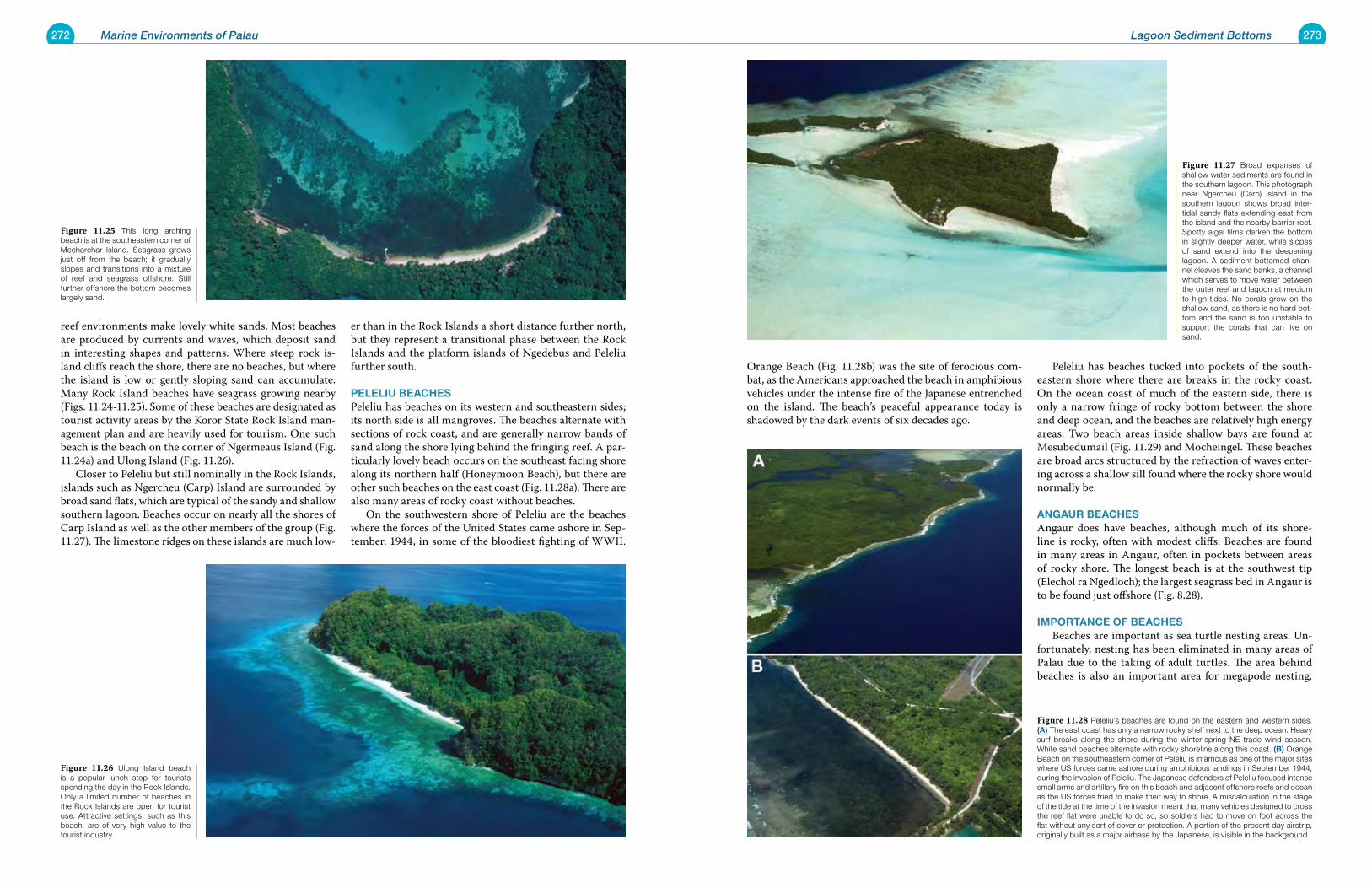
272 Marine Environments of Palau 273Lagoon Sediment Bottoms
Orange Beach (Fig. 11.28b) was the site of ferocious com-bat, as the Americans approached the beach in amphibious vehicles under the intense fire of the Japanese entrenched on the island. The beach’s peaceful appearance today is shadowed by the dark events of six decades ago.
Peleliu has beaches tucked into pockets of the south-eastern shore where there are breaks in the rocky coast. On the ocean coast of much of the eastern side, there is only a narrow fringe of rocky bottom between the shore and deep ocean, and the beaches are relatively high energy areas. Two beach areas inside shallow bays are found at Mesubedumail (Fig. 11.29) and Mocheingel. These beaches are broad arcs structured by the refraction of waves enter-ing across a shallow sill found where the rocky shore would normally be.
anGaur BeaCheSAngaur does have beaches, although much of its shore-line is rocky, often with modest cliffs. Beaches are found in many areas in Angaur, often in pockets between areas of rocky shore. The longest beach is at the southwest tip (Elechol ra Ngedloch); the largest seagrass bed in Angaur is to be found just offshore (Fig. 8.28).
IMportanCe oF BeaCheS Beaches are important as sea turtle nesting areas. Un-fortunately, nesting has been eliminated in many areas of Palau due to the taking of adult turtles. The area behind beaches is also an important area for megapode nesting.
reef environments make lovely white sands. Most beaches are produced by currents and waves, which deposit sand in interesting shapes and patterns. Where steep rock is-land cliffs reach the shore, there are no beaches, but where the island is low or gently sloping sand can accumulate. Many Rock Island beaches have seagrass growing nearby (Figs. 11.24-11.25). Some of these beaches are designated as tourist activity areas by the Koror State Rock Island man-agement plan and are heavily used for tourism. One such beach is the beach on the corner of Ngermeaus Island (Fig. 11.24a) and Ulong Island (Fig. 11.26). Closer to Peleliu but still nominally in the Rock Islands, islands such as Ngercheu (Carp) Island are surrounded by broad sand flats, which are typical of the sandy and shallow southern lagoon. Beaches occur on nearly all the shores of Carp Island as well as the other members of the group (Fig. 11.27). The limestone ridges on these islands are much low-
er than in the Rock Islands a short distance further north, but they represent a transitional phase between the Rock Islands and the platform islands of Ngedebus and Peleliu further south.
pelelIu BeaCheSPeleliu has beaches on its western and southeastern sides; its north side is all mangroves. The beaches alternate with sections of rock coast, and are generally narrow bands of sand along the shore lying behind the fringing reef. A par-ticularly lovely beach occurs on the southeast facing shore along its northern half (Honeymoon Beach), but there are other such beaches on the east coast (Fig. 11.28a). There are also many areas of rocky coast without beaches. On the southwestern shore of Peleliu are the beaches where the forces of the United States came ashore in Sep-tember, 1944, in some of the bloodiest fighting of WWII.
Figure 11.27 Broad expanses of shallow water sediments are found in the southern lagoon. This photograph near Ngercheu (Carp) Island in the southern lagoon shows broad inter-tidal sandy flats extending east from the island and the nearby barrier reef. Spotty algal films darken the bottom in slightly deeper water, while slopes of sand extend into the deepening lagoon. A sediment-bottomed chan-nel cleaves the sand banks, a channel which serves to move water between the outer reef and lagoon at medium to high tides. No corals grow on the shallow sand, as there is no hard bot-tom and the sand is too unstable to support the corals that can live on sand.
Figure 11.28 Peleliu’s beaches are found on the eastern and western sides. (a) The east coast has only a narrow rocky shelf next to the deep ocean. Heavy surf breaks along the shore during the winter-spring NE trade wind season. White sand beaches alternate with rocky shoreline along this coast. (B) Orange Beach on the southeastern corner of Peleliu is infamous as one of the major sites where US forces came ashore during amphibious landings in September 1944, during the invasion of Peleliu. The Japanese defenders of Peleliu focused intense small arms and artillery fire on this beach and adjacent offshore reefs and ocean as the US forces tried to make their way to shore. A miscalculation in the stage of the tide at the time of the invasion meant that many vehicles designed to cross the reef flat were unable to do so, so soldiers had to move on foot across the flat without any sort of cover or protection. A portion of the present day airstrip, originally built as a major airbase by the Japanese, is visible in the background.
Figure 11.25 This long arching beach is at the southeastern corner of Mecharchar Island. Seagrass grows just off from the beach; it gradually slopes and transitions into a mixture of reef and seagrass offshore. Still further offshore the bottom becomes largely sand.
Figure 11.26 Ulong Island beach is a popular lunch stop for tourists spending the day in the Rock Islands. Only a limited number of beaches in the Rock Islands are open for tourist use. Attractive settings, such as this beach, are of very high value to the tourist industry.
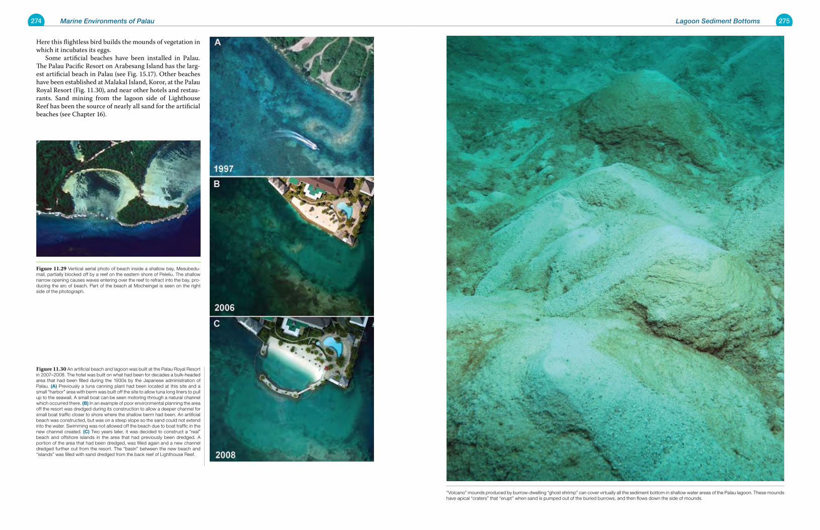
274 Marine Environments of Palau 275Lagoon Sediment Bottoms
Here this flightless bird builds the mounds of vegetation in which it incubates its eggs. Some artificial beaches have been installed in Palau. The Palau Pacific Resort on Arabesang Island has the larg-est artificial beach in Palau (see Fig. 15.17). Other beaches have been established at Malakal Island, Koror, at the Palau Royal Resort (Fig. 11.30), and near other hotels and restau-rants. Sand mining from the lagoon side of Lighthouse Reef has been the source of nearly all sand for the artificial beaches (see Chapter 16).
Figure 11.29 Vertical aerial photo of beach inside a shallow bay, Mesubedu-mail, partially blocked off by a reef on the eastern shore of Peleliu. The shallow narrow opening causes waves entering over the reef to refract into the bay, pro-ducing the arc of beach. Part of the beach at Mocheingel is seen on the right side of the photograph.
Figure 11.30 An artificial beach and lagoon was built at the Palau Royal Resort in 2007–2008. The hotel was built on what had been for decades a bulk-headed area that had been filled during the 1930s by the Japanese administration of Palau. (a) Previously a tuna canning plant had been located at this site and a small “harbor” area with berm was built off the site to allow tuna long liners to pull up to the seawall. A small boat can be seen motoring through a natural channel which occurred there. (B) In an example of poor environmental planning the area off the resort was dredged during its construction to allow a deeper channel for small boat traffic closer to shore where the shallow berm had been. An artificial beach was constructed, but was on a steep slope so the sand could not extend into the water. Swimming was not allowed off the beach due to boat traffic in the new channel created. (C) Two years later, it was decided to construct a “real” beach and offshore islands in the area that had previously been dredged. A portion of the area that had been dredged, was filled again and a new channel dredged further out from the resort. The “basin” between the new beach and “islands” was filled with sand dredged from the back reef of Lighthouse Reef.
“Volcano” mounds produced by burrow-dwelling “ghost shrimp” can cover virtually all the sediment bottom in shallow water areas of the Palau lagoon. These mounds have apical “craters” that “erupt” when sand is pumped out of the buried burrows, and then flows down the side of mounds.
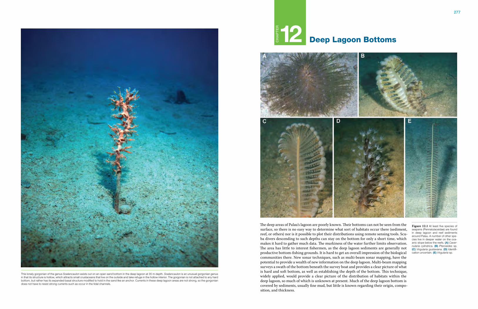
277
Ch
ap
te
r
12 Deep Lagoon Bottoms
The deep areas of Palau’s lagoon are poorly known. Their bottoms can not be seen from the surface, so there is no easy way to determine what sort of habitats occur there (sediment, reef, or others) nor is it possible to plot their distributions using remote sensing tools. Scu-ba divers descending to such depths can stay on the bottom for only a short time, which makes it hard to gather much data. The murkiness of the water further limits observation. The area has little to interest fishermen, as the deep lagoon sediments are generally not productive bottom-fishing grounds. It is hard to get an overall impression of the biological communities there. New sonar techniques, such as multi-beam sonar mapping, have the potential to provide a wealth of new information on the deep lagoon. Multi-beam mapping surveys a swath of the bottom beneath the survey boat and provides a clear picture of what is hard and soft bottom, as well as establishing the depth of the bottom. This technique, widely applied, would provide a clear picture of the distribution of habitats within the deep lagoon, so much of which is unknown at present. Much of the deep lagoon bottom is covered by sediments, usually fine mud, but little is known regarding their origin, compo-sition, and thickness.
Figure 12.1 At least five species of seapens (Pennatulaceidae) are found in deep lagoon and reef sediments around Palau. A number of other spe-cies live in deeper water on the oce-anic slope below the reefs. (a) Caver-nularia cylindrica. (B) Pteroeides sp. (C) Virgularia gustaviana. (d) Identifi-cation uncertain. (e) Virgularia sp.
This lonely gorgonian of the genus Soelencaulon exists out on an open sand bottom in the deep lagoon at 35 m depth. Soelencaulon is an unusual gorgonian genus in that its structure is hollow, which attracts small crustaceans that live on the outside and take refuge in the hollow interior. The gorgonian is not attached to any hard bottom, but rather has its expanded basal structure modified to hold in the sand like an anchor. Currents in these deep lagoon areas are not strong, so the gorgonian does not have to resist strong currents such as occur in the tidal channels.
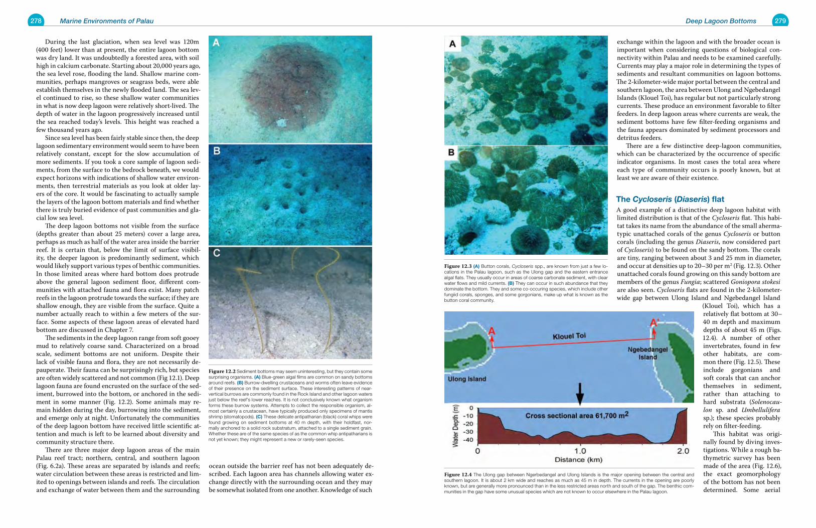
278 Marine Environments of Palau 279Deep Lagoon Bottoms
exchange within the lagoon and with the broader ocean is important when considering questions of biological con-nectivity within Palau and needs to be examined carefully. Currents may play a major role in determining the types of sediments and resultant communities on lagoon bottoms. The 2-kilometer-wide major portal between the central and southern lagoon, the area between Ulong and Ngebedangel Islands (Klouel Toi), has regular but not particularly strong currents. These produce an environment favorable to filter feeders. In deep lagoon areas where currents are weak, the sediment bottoms have few filter-feeding organisms and the fauna appears dominated by sediment processors and detritus feeders. There are a few distinctive deep-lagoon communities, which can be characterized by the occurrence of specific indicator organisms. In most cases the total area where each type of community occurs is poorly known, but at least we are aware of their existence.
the Cycloseris (Diaseris) flatA good example of a distinctive deep lagoon habitat with limited distribution is that of the Cycloseris flat. This habi-tat takes its name from the abundance of the small aherma-typic unattached corals of the genus Cycloseris or button corals (including the genus Diaseris, now considered part of Cycloseris) to be found on the sandy bottom. The corals are tiny, ranging between about 3 and 25 mm in diameter, and occur at densities up to 20–30 per m2 (Fig. 12.3). Other unattached corals found growing on this sandy bottom are members of the genus Fungia; scattered Goniopora stokesi are also seen. Cycloseris flats are found in the 2-kilometer-wide gap between Ulong Island and Ngebedangel Island
(Klouel Toi), which has a relatively flat bottom at 30–40 m depth and maximum depths of about 45 m (Figs. 12.4). A number of other invertebrates, found in few other habitats, are com-mon there (Fig. 12.5). These include gorgonians and soft corals that can anchor themselves in sediment, rather than attaching to hard substrata (Solenocau-lon sp. and Umbellulifera sp.); these species probably rely on filter-feeding. This habitat was origi-nally found by diving inves-tigations. While a rough ba-thymetric survey has been made of the area (Fig. 12.6), the exact geomorphology of the bottom has not been determined. Some aerial
During the last glaciation, when sea level was 120m (400 feet) lower than at present, the entire lagoon bottom was dry land. It was undoubtedly a forested area, with soil high in calcium carbonate. Starting about 20,000 years ago, the sea level rose, flooding the land. Shallow marine com-munities, perhaps mangroves or seagrass beds, were able establish themselves in the newly flooded land. The sea lev-el continued to rise, so these shallow water communities in what is now deep lagoon were relatively short-lived. The depth of water in the lagoon progressively increased until the sea reached today’s levels. This height was reached a few thousand years ago. Since sea level has been fairly stable since then, the deep lagoon sedimentary environment would seem to have been relatively constant, except for the slow accumulation of more sediments. If you took a core sample of lagoon sedi-ments, from the surface to the bedrock beneath, we would expect horizons with indications of shallow water environ-ments, then terrestrial materials as you look at older lay-ers of the core. It would be fascinating to actually sample the layers of the lagoon bottom materials and find whether there is truly buried evidence of past communities and gla-cial low sea level. The deep lagoon bottoms not visible from the surface (depths greater than about 25 meters) cover a large area, perhaps as much as half of the water area inside the barrier reef. It is certain that, below the limit of surface visibil-ity, the deeper lagoon is predominantly sediment, which would likely support various types of benthic communities. In those limited areas where hard bottom does protrude above the general lagoon sediment floor, different com-munities with attached fauna and flora exist. Many patch reefs in the lagoon protrude towards the surface; if they are shallow enough, they are visible from the surface. Quite a number actually reach to within a few meters of the sur-face. Some aspects of these lagoon areas of elevated hard bottom are discussed in Chapter 7. The sediments in the deep lagoon range from soft gooey mud to relatively coarse sand. Characterized on a broad scale, sediment bottoms are not uniform. Despite their lack of visible fauna and flora, they are not necessarily de-pauperate. Their fauna can be surprisingly rich, but species are often widely scattered and not common (Fig 12.1). Deep lagoon fauna are found encrusted on the surface of the sed-iment, burrowed into the bottom, or anchored in the sedi-ment in some manner (Fig. 12.2). Some animals may re-main hidden during the day, burrowing into the sediment, and emerge only at night. Unfortunately the communities of the deep lagoon bottom have received little scientific at-tention and much is left to be learned about diversity and community structure there. There are three major deep lagoon areas of the main Palau reef tract; northern, central, and southern lagoon (Fig. 6.2a). These areas are separated by islands and reefs; water circulation between these areas is restricted and lim-ited to openings between islands and reefs. The circulation and exchange of water between them and the surrounding
ocean outside the barrier reef has not been adequately de-scribed. Each lagoon area has channels allowing water ex-change directly with the surrounding ocean and they may be somewhat isolated from one another. Knowledge of such
Figure 12.3 (a) Button corals, Cycloseris spp., are known from just a few lo-cations in the Palau lagoon, such as the Ulong gap and the eastern entrance algal flats. They usually occur in areas of coarse carbonate sediment, with clear water flows and mild currents. (B) They can occur in such abundance that they dominate the bottom. They and some co-occuring species, which include other fungiid corals, sponges, and some gorgonians, make up what is known as the button coral community.
Figure 12.4 The Ulong gap between Ngerbedangel and Ulong Islands is the major opening between the central and southern lagoon. It is about 2 km wide and reaches as much as 45 m in depth. The currents in the opening are poorly known, but are generally more pronounced than in the less restricted areas north and south of the gap. The benthic com-munities in the gap have some unusual species which are not known to occur elsewhere in the Palau lagoon.
Figure 12.2 Sediment bottoms may seem uninteresting, but they contain some surprising organisms. (a) Blue-green algal films are common on sandy bottoms around reefs. (B) Burrow-dwelling crustaceans and worms often leave evidence of their presence on the sediment surface. These interesting patterns of near-vertical burrows are commonly found in the Rock Island and other lagoon waters just below the reef’s lower reaches. It is not conclusively known what organism forms these burrow systems. Attempts to collect the responsible organism, al-most certainly a crustacean, have typically produced only specimens of mantis shrimp (stomatopods). (C) These delicate antipatharian (black) coral whips were found growing on sediment bottoms at 40 m depth, with their holdfast, nor-mally anchored to a solid rock substratum, attached to a single sediment grain. Whether these are of the same species of as the common whip antipatharians is not yet known; they might represent a new or rarely-seen species.
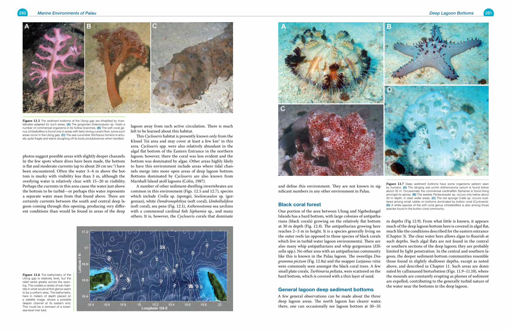
280 Marine Environments of Palau 281Deep Lagoon Bottoms
and define this environment. They are not known in sig-nificant numbers in any other environment in Palau.
Black coral forest One portion of the area between Ulong and Ngebedangel Islands has a hard bottom, with large colonies of antipatha-rians (black corals) growing on the relatively flat bottom at 30 m depth (Fig. 12.8). The antipatharian growing here reaches 2–3 m in height. It is a species generally living on the outer reefs (as opposed to those species of black corals which live in turbid water lagoon environments). There are also many whip antipatharians and whip gorgonians (Elli-sella spp.). No other area with an antipatharian community like this is known in the Palau lagoon. The sweetlips Dia-gramma pictum (Fig. 12.8a) and the snapper Lutjanus vitta were commonly seen amongst the black coral trees. A few small plate corals, Turbinaria peltata, were scattered on the hard bottom, which is covered with a thin layer of sand.
General lagoon deep sediment bottomsA few general observations can be made about the three deep lagoon areas. The north lagoon has clearer water, there, one can occasionally see lagoon bottom at 30–35
m depths (Fig 12.9). From what little is known, it appears much of the deep lagoon bottom here is covered in algal flat, much like the conditions described for the eastern entrance (Chapter 3). The clear water here allows algae to flourish at such depths. Such algal flats are not found in the central or southern sections of the deep lagoon; they are probably limited by light penetration. In the central and southern la-goon, the deeper sediment-bottom communities resemble those found in slightly shallower depths, except as noted above, and described in Chapter 11. Such areas are domi-nated by callianassid bioturbation (Figs. 11.9–11.10), where the mounds are constantly erupting as plumes of sediment are expelled, contributing to the generally turbid nature of the water near the bottoms in the deep lagoon.
photos suggest possible areas with slightly deeper channels. In the few spots where dives have been made, the bottom is flat and moderate currents (up to about 20 cm sec-1) have been encountered. Often the water 3–6 m above the bot-tom is murky with visibility less than 3 m, although the overlying water is relatively clear with 15–20 m visibility. Perhaps the currents in this area cause the water just above the bottom to be turbid—or perhaps this water represents a separate water mass from that found above. There are certainly currents between the south and central deep la-goon coming through this opening, producing very differ-ent conditions than would be found in areas of the deep
lagoon away from such active circulation. There is much left to be learned about this habitat. This Cycloseris habitat is presently known only from the Klouel Toi area and may cover at least a few km2 in this area. Cycloseris spp. were also relatively abundant in the algal flat bottom of the Eastern Entrance in the northern lagoon; however, there the coral was less evident and the bottom was dominated by algae. Other areas highly likely to have this environment include areas where tidal chan-nels merge into more open areas of deep lagoon bottom. Bottoms dominated by Cycloseris are also known from Marshall Island atoll lagoons (Colin, 1987). A number of other sediment-dwelling invertebrates are common in this environment (Figs. 12.5 and 12.7), species which include Crella sp. (sponge), Soelencaulon sp. (gor-gonian), white Dendronephthya (soft coral), Umbellulifera (soft coral), sea pens (Fig. 12.1), Asthenostoma sea urchins with a commensal cardinal fish Siphamia sp., and many others. It is, however, the Cycloseris corals that dominate
Figure 12.7 Deep sediment bottoms have some organisms seldom seen by humans. (a) The stinging sea urchin Asthenosoma varium is found below about 35 m. Occasionally the commensal cardinalfish Siphamia is found living amongst its spines. (B) The seastar Pentaceraster sp. occurs only below about 30 m depth, in clear water areas. (C) The red sponge Crella sp. occurs scat-tered among small rubble on bottoms dominated by button coral (Cycloseris). (d) A white species of the soft coral genus Umbellulifera is also among those species found in the button coral community.
Figure 12.6 The bathymetry of the Ulong gap is relatively level, but the relief varies greatly across the open-ing. This creates a variety of sub-habi-tats in what would at first glance seem to be a uniform area. The bathymetry, here in meters of depth placed on a satellite image, shows a possible deeper channel at its eastern end. This could be a remnant of a lower-sea-level river bed.
Figure 12.5 The sediment bottoms of the Ulong gap are inhabited by inver-tebrates adapted for such areas. (a) The gorgonian Solenocaulon sp. hosts a number of commensal organisms in its hollow branches. (B) The soft coral ge-nus Umbellulifera is found only in areas with fairly strong current flow; some such areas occur in the Ulong gap. (C) The sea cucumber Stichopus horrens is actu-ally quite fragile and starts sloughing off its body protuberances when handled.
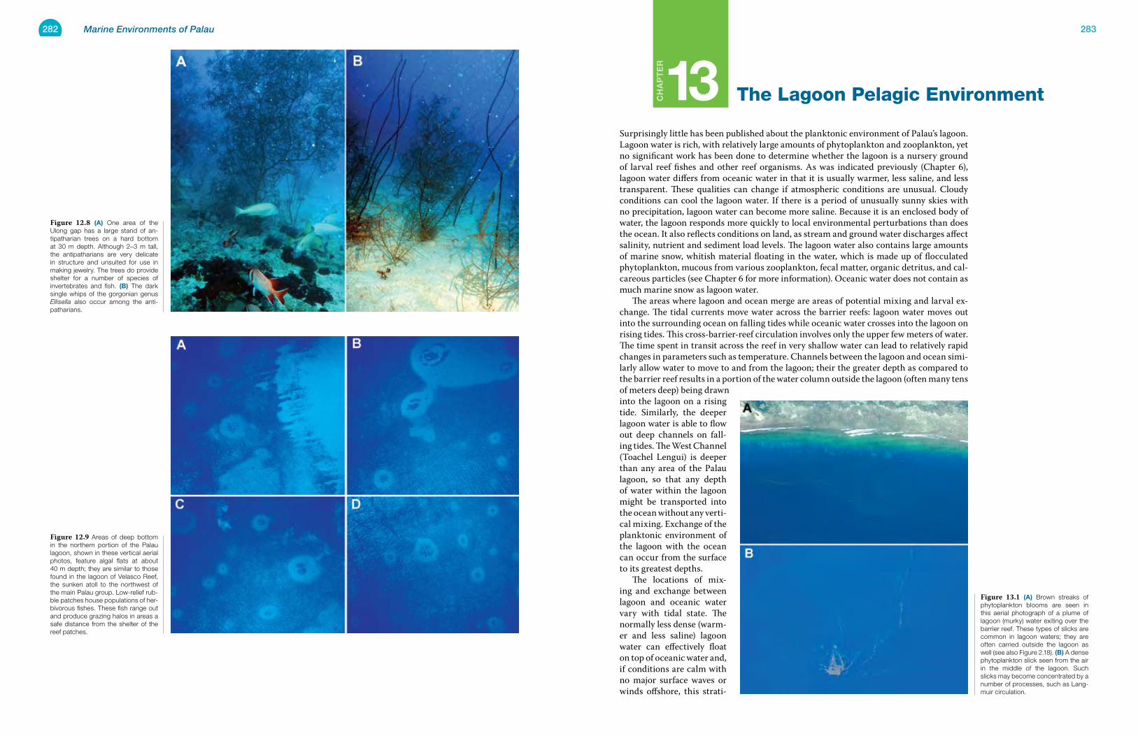
282 Marine Environments of Palau 283
Ch
ap
te
r
13 The Lagoon Pelagic Environment
Surprisingly little has been published about the planktonic environment of Palau’s lagoon. Lagoon water is rich, with relatively large amounts of phytoplankton and zooplankton, yet no significant work has been done to determine whether the lagoon is a nursery ground of larval reef fishes and other reef organisms. As was indicated previously (Chapter 6), lagoon water differs from oceanic water in that it is usually warmer, less saline, and less transparent. These qualities can change if atmospheric conditions are unusual. Cloudy conditions can cool the lagoon water. If there is a period of unusually sunny skies with no precipitation, lagoon water can become more saline. Because it is an enclosed body of water, the lagoon responds more quickly to local environmental perturbations than does the ocean. It also reflects conditions on land, as stream and ground water discharges affect salinity, nutrient and sediment load levels. The lagoon water also contains large amounts of marine snow, whitish material floating in the water, which is made up of flocculated phytoplankton, mucous from various zooplankton, fecal matter, organic detritus, and cal-careous particles (see Chapter 6 for more information). Oceanic water does not contain as much marine snow as lagoon water. The areas where lagoon and ocean merge are areas of potential mixing and larval ex-change. The tidal currents move water across the barrier reefs: lagoon water moves out into the surrounding ocean on falling tides while oceanic water crosses into the lagoon on rising tides. This cross-barrier-reef circulation involves only the upper few meters of water. The time spent in transit across the reef in very shallow water can lead to relatively rapid changes in parameters such as temperature. Channels between the lagoon and ocean simi-larly allow water to move to and from the lagoon; their the greater depth as compared to the barrier reef results in a portion of the water column outside the lagoon (often many tens of meters deep) being drawn into the lagoon on a rising tide. Similarly, the deeper lagoon water is able to flow out deep channels on fall-ing tides. The West Channel (Toachel Lengui) is deeper than any area of the Palau lagoon, so that any depth of water within the lagoon might be transported into the ocean without any verti-cal mixing. Exchange of the planktonic environment of the lagoon with the ocean can occur from the surface to its greatest depths. The locations of mix-ing and exchange between lagoon and oceanic water vary with tidal state. The normally less dense (warm-er and less saline) lagoon water can effectively float on top of oceanic water and, if conditions are calm with no major surface waves or winds offshore, this strati-
Figure 13.1 (a) Brown streaks of phytoplankton blooms are seen in this aerial photograph of a plume of lagoon (murky) water exiting over the barrier reef. These types of slicks are common in lagoon waters; they are often carried outside the lagoon as well (see also Figure 2.18). (B) A dense phytoplankton slick seen from the air in the middle of the lagoon. Such slicks may become concentrated by a number of processes, such as Lang-muir circulation.
Figure 12.9 Areas of deep bottom in the northern portion of the Palau lagoon, shown in these vertical aerial photos, feature algal flats at about 40 m depth; they are similar to those found in the lagoon of Velasco Reef, the sunken atoll to the northwest of the main Palau group. Low-relief rub-ble patches house populations of her-bivorous fishes. These fish range out and produce grazing halos in areas a safe distance from the shelter of the reef patches.
Figure 12.8 (a) One area of the Ulong gap has a large stand of an-tipatharian trees on a hard bottom at 30 m depth. Although 2–3 m tall, the antipatharians are very delicate in structure and unsuited for use in making jewelry. The trees do provide shelter for a number of species of invertebrates and fish. (B) The dark single whips of the gorgonian genus Ellisella also occur among the anti-patharians.
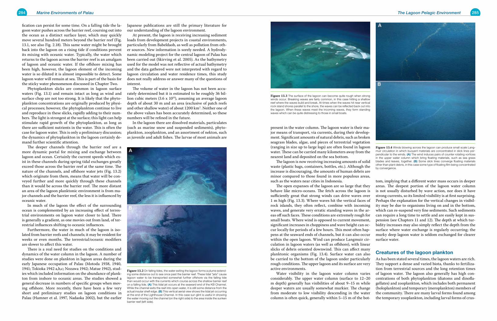
284 Marine Environments of Palau 285The Lagoon Pelagic Environment
present in the water column. The lagoon water is their ma-jor means of transport, via currents, during their develop-ment. Significant amounts of natural debris, such as broken seagrass blades, algae, and pieces of terrestrial vegetation (ranging in size up to large logs) are often found in lagoon water. These can be carried many kilometers away from the nearest land and deposited on the sea bottom. The lagoon is now receiving increasing amounts of solid waste (plastic bags, containers, bottles, etc.). Although the increase is discouraging, the amounts of human debris are minor compared to those found in more populous areas, such as the waters near cities in Indonesia. The open expanses of the lagoon are so large that they behave like micro-oceans. The fetch across the lagoon is sufficiently great that strong winds can drive waves over 1 m high (Fig. 13.3). Where waves hit the vertical faces of rock islands, they often reflect, combine with incoming waves, and generate very erratic standing waves in the ar-eas off such faces. These conditions are extremely rough for small boats. Where wind is opposed to current movement, significant increases in choppiness and wave height can oc-cur locally for periods of a few hours. This most often hap-pens at the seaward ends of channels, but it can also occur within the open lagoon. Wind can produce Langmuir cir-culation in lagoon waters (as well as offshore), with linear slicks of debris oriented downwind. This can affect many planktonic organisms (Fig. 13.4). Surface water can also be carried to the bottom of the lagoon under particularly rough conditions. The upper lagoon and its surface are very active environments. Water visibility in the lagoon water column varies considerably. The upper water column (surface to 12–20 m depth) generally has visibilities of about 9–15 m while deeper waters are usually somewhat murkier. The change from moderate to low visibility descending in the water column is often quick, generally within 5–15 m of the bot-
tom, implying that a different water mass occurs in deeper areas. The deepest portion of the lagoon water column is not usually disturbed by wave action, nor does it have strong currents, so its limited visibility is at first surprising. Perhaps the explanation for the vertical changes in visibil-ity may be due to organisms living on and in the bottom, which can re-suspend very fine sediments. Such sediments can require a long time to settle and are easily kept in sus-pension (see Chapters 11 and 12). The depth at which tur-bidity increases may also simply reflect the depth from the surface where water exchange is regularly occurring; the murky deep lagoon water is seldom exchanged for clearer surface water.
Creatures of the lagoon planktonAs has been stated several times, the lagoon waters are rich. They support a dense and varied biota, thanks to fertiliza-tion from terrestrial sources and the long retention times of lagoon water. The lagoon also generally has high con-centrations of both phytoplankton (diatoms and dinofla-gellates) and zooplankton, which includes both permanent (holoplankton) and temporary (meroplankton) members of the community. There are many larval forms found among the temporary zooplankton, including larval forms of crus-
fication can persist for some time. On a falling tide the la-goon water pushes across the barrier reef, coursing out into the ocean as a distinct surface layer, which may quickly move several hundred meters beyond the barrier reef (Fig. 13.1, see also Fig. 2.18). This same water might be brought back into the lagoon on a rising tide if conditions prevent its mixing with oceanic water. Typically, the water which returns to the lagoon across the barrier reef is an amalgam of lagoon and oceanic water. If the offshore mixing has been high, however, the lagoon element of the incoming water is so diluted it is almost impossible to detect. Some lagoon water will remain at sea. This is part of the basis for the sticky water phenomenon discussed in Chapter Two. Phytoplankton slicks are common in lagoon surface waters (Fig. 13.1) and remain intact as long as wind and surface chop are not too strong. It is likely that the phyto-plankton concentrations are originally produced by physi-cal processes; however, the phytoplankton continue to live and reproduce in these slicks, rapidly adding to their num-bers. The light is strongest at the surface; this light can help stimulate rapid growth of the phytoplankton, as long as there are sufficient nutrients in the water. This is often the case for lagoon water. This is only a preliminary discussion; the dynamics of phytoplankton in the lagoon certainly de-mand further scientific attention. The deeper channels through the barrier reef are a more dynamic portal for mixing and exchange between lagoon and ocean. Certainly the current speeds which ex-ist in these channels during spring tidal exchanges greatly exceed those across the barrier reef at the same time. The nature of the channels, and offshore water jets (Fig. 13.2) which originate from them, means that water will be con-veyed further and more quickly through these channels than it would be across the barrier reef. The more distant an area of the lagoon planktonic environment is from ma-jor channels and the barrier reef, the less it is influenced by oceanic water. In much of the lagoon the effect of the surrounding ocean is complemented by an increasing effect of terres-trial environments on lagoon water closer to land. There is generally a gradient, as one movies out from land, of ter-restrial influences shifting to oceanic influences. Furthermore, the water in much of the lagoon is iso-lated from barrier reefs and channels; it may be resident for weeks or even months. The terrestrial/oceanic modifiers are slower to affect this water. There is a real need for studies on the conditions and dynamics of the water column in the lagoon. A number of studies were done on plankton in lagoon areas during the early Japanese occupation of Palau (Motoda 1938, 1940, 1941; Tokioka 1942 a,b,c; Nozawa 1942; Matue 1942), stud-ies which included information on the abundance of plank-ton from inshore to oceanic areas. The studies showed a general decrease in numbers of specific groups when mov-ing offshore. More recently, there have been a few very short and preliminary studies on lagoon conditions in Palau (Hamner et al. 1997, Nadaoka 2002), but the earlier
Japanese publications are still the primary literature for our understanding of the lagoon environment. At present, the lagoon is receiving increasing sediment loads from development projects in coastal environments, particularly from Babeldaob, as well as pollution from oth-er sources. New information is sorely needed. A hydrody-namic modeling project for the central lagoon of Palau has been carried out (Skirving et al. 2005). As the bathymetry used for the model was not reflective of actual bathymetry and the data gathered were not interpreted with regard to lagoon circulation and water residence times, this study does not really address or answer many of the questions of interest. The volume of water in the lagoon has not been accu-rately determined but it is estimated to be roughly 36 bil-lion cubic meters (3.6 x 10¹⁰), assuming an average lagoon depth of about 30 m and an area (exclusive of patch reefs and other shallow water) of about 1200 km2. Neither one of the above values has been accurately determined, so these numbers will be refined in the future. In the lagoon there are dissolved materials, particulates (such as marine snow and suspended sediments), phyto-plankton, zooplankton, and an assortment of nekton, such as juvenile and adult fishes. The larvae of most animals are
Figure 13.3 The surface of the lagoon can become quite rough when strong winds occur. Breaking waves are fairly common, in this case hitting a shallow reef where the waves build and break. At times when the waves hit near vertical rock island shores parallel to the shore, the waves can be reflected back out into the lagoon. When these waves meet the incoming waves, they form standing waves which can be quite distressing to those in small boats.
Figure 13.4 Winds blowing across the lagoon can produce small scale Lang-muir circulation in which buoyant materials are concentrated in slick lines per-pendicular to the winds. (a) The wind induces pairs of counter rotating vortices in the upper water column which bring floating materials, such as sea grass blades and leaves, together. (B) Some slick lines converge floating materials other than plant debris, in this case some type of floating film being concentrated by convergence.
Figure 13.2 On falling tides, the water exiting the lagoon forms a plume extend-ing some distance out to sea once past the barrier reef. These tidal “jets” cause lagoon water to be transported somewhat further offshore via the falling tide than would occur with the currents which course across the shallow barrier reef on a falling tide. (a) This tidal jet occurs at the seaward end of the KB Channel. While the channel exits the reef into open water, it is still some distance from the actual insular shelf edge. (B) This vertical aerial view shows the tidal jet occurring at the end of the Lighthouse Channel. In this case sun glint is useful in showing the water moving out the channel (on the right side) to the area inside the sunken barrier reef (left side).
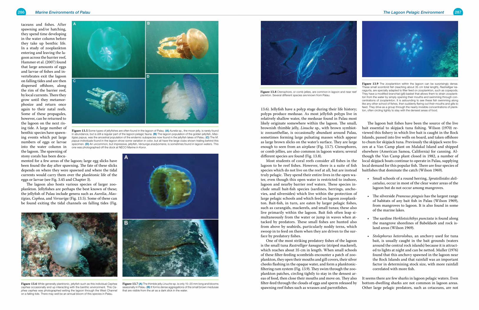
286 Marine Environments of Palau 287The Lagoon Pelagic Environment
13.6). Jellyfish have a polyp stage during their life history; polyps produce medusae. As most jellyfish polyps live in relatively shallow water, the medusae found in Palau most likely originate somewhere within the lagoon. The small, brownish thimble jelly, Linuche sp., with brown symbiot-ic zooxanthellae, is occasionally abundant around Palau, sometimes forming large pulsating masses which appear as large brown slicks on the water’s surface. They are large enough to seen from an airplane (Fig. 13.7). Ctenophores, or comb jellies, are also common in lagoon waters; several different species are found (Fig. 13.8). Most students of coral reefs consider all fishes in the lagoon to be reef fishes. However, there is a suite of fish species which do not live on the reef at all, but are instead truly pelagic. They spend their entire lives in the open wa-ter, even though this open water is restricted to inshore, lagoon and nearby barrier reef waters. These species in-clude small bait-fish species (sardines, herrings, ancho-vies, and silversides) which live within the protection of large pelagic schools and which feed on lagoon zooplank-ton. Bait-fish, in turn, are eaten by larger pelagic fishes, such as carangids, mackerels, and small tunas; these also live primarily within the lagoon. Bait fish often leap si-multaneously from the water or jump in waves when at-tacked by predators. These small fishes are hunted also from above by seabirds, particularly noddy terns, which swoop in to feed on them when they are driven to the sur-face by predatory fishes. One of the most striking predatory fishes of the lagoon is the small tuna Rastrelliger kanagurta (striped mackerel), which reaches about 35 cm in length. When small schools of these filter-feeding scombrids encounter a patch of zoo-plankton, they open their mouths and gill covers, their silver cheeks flashing in the opaque water, and form a planktonic-filtering ram system (Fig. 13.9). They swim through the zoo-plankton patches, circling tightly to stay in the densest ar-eas of food, then close their mouths and move on. They also filter-feed through the clouds of eggs and sperm released by spawning reef fishes such as wrasses and parrotfishes.
The lagoon bait fishes have been the source of the live bait essential to skipjack tuna fishing. Wilson (1970) re-viewed this fishery in which live bait is caught in the Rock Islands, passed into live wells on board, and taken offshore to chum for skipjack tuna. Previously the skipjack were fro-zen at a Van Camp plant on Malakal Island and shipped elsewhere (American Samoa, California) for canning. Al-though the Van Camp plant closed in 1982, a number of local skipjack boats continue to operate in Palau, supplying local demand for this popular fish. There are four species of baitfishes that dominate the catch (Wilson 1969).
Small schools of a round herring, • Spratelloides deli-catulus, occur in most of the clear water areas of the lagoon but do not occur among mangroves.
The silverside • Pranesus pinguis has the largest range of habitats of any bait fish in Palau (Wilson 1969), from mangroves to lagoon. It is also found in some of the marine lakes.
The sardine• Herklotsichthys punctata is found along the mangrove shorelines of Babeldaob and rock is-land areas (Wilson 1969).
Stolephorus heterolobus• , an anchovy used for tuna bait, is usually caught in the bait grounds (waters around the central rock islands) because it is attract-ed to lights at night and can be netted. Muller (1976) found that this anchovy spawned in the lagoon near the Rock Islands and that rainfall was an important factor in determining stock size, with more rainfall correlated with more fish.
It seems there are few sharks in lagoon pelagic waters. Even bottom-dwelling sharks are not common in lagoon areas. Other large pelagic predators, such as cetaceans, are not
taceans and fishes. After spawning and/or hatching, they spend time developing in the water column before they take up benthic life. In a study of zooplankton entering and leaving the la-goon across the barrier reef, Hammer et al. (2007) found that large amounts of eggs and larvae of fishes and in-vertebrates exit the lagoon on falling tides and are then dispersed offshore, along the rim of the barrier reef, by local currents. There they grow until they metamor-phosize and return once again to their natal reefs. Some of these propagules, however, can be returned to the lagoon on the next ris-ing tide. A large number of benthic species have spawn-ing events which put large numbers of eggs or larvae into the water column in the lagoon. The spawning of stony corals has been docu-mented for a few areas of the lagoon; large egg slicks have been found the day after spawning. The fate of these slicks depends on where they were spawned and where the tidal currents would carry them over the planktonic life of the eggs or larvae (see Fig. 3.45 and Chapter 3). The lagoon also hosts various species of larger zoo-plankton. Jellyfishes are perhaps the best known of these; the jellyfish of Palau include genera such as Aurelia, Mas-tigias, Cephea, and Versuriga (Fig. 13.5). Some of these can be found exiting the tidal channels on falling tides (Fig.
Figure 13.6 While generally planktonic, jellyfish such as this individual Cephea cephea occasionally end up interacting with the benthic environment. This Ce-phea cephea was photographed exiting the lagoon through the West Channel on a falling tide. There may well be an annual bloom of this species in Palau.
Figure 13.7 (a) The thimble jelly Linuche sp. is only 15–20 mm long and blooms seasonally in Palau. (B) It forms dense aggregations of the small brown medusae that are visible from the air as a dark slick in the water.
Figure 13.8 Ctenophore, or comb jellies, are common in lagoon and near reef plankton. Several different species are known from Palau.
Figure 13.5 Some types of jellyfishes are often found in the lagoon of Palau. (a) Aurelia sp., the moon jelly, is rarely found in abundance, but is still a regular part of the lagoon pelagic fauna. (B) The lagoon population of the golden jellyfish, Mas-tigias papua, was the ancestral population of the endemic subspecies now found in the jellyfish lakes of Palau. (C) The M. papua individuals found in the lagoon show some variation in color, but all have the large clubs shown trailing behind this specimen. (d) An uncommon, but impressive, jellyfish, Versuriga anadyomene, is sometimes found in lagoon waters. This one was photographed off the dock at NECO Marine in Koror.
Figure 13.9 The zooplankton within the lagoon can be surprisingly dense. These small scombrid fish (reaching about 35 cm total length), Rastrelliger ka-nagurta, are specially adapted to filter feed on zooplankton, such as copepods. They have a modified branchial (gill) basket that allows them to strain zooplank-ton from the water by simply opening their mouths and swimming through con-centrations of zooplankton. It is astounding to see these fish swimming along like any other school of fishes, then suddenly flaring out their mouths and gills to feed. They drive as a group through the nearly invisible concentrations of plank-ton, often circling tightly to stay with the densest areas of food.
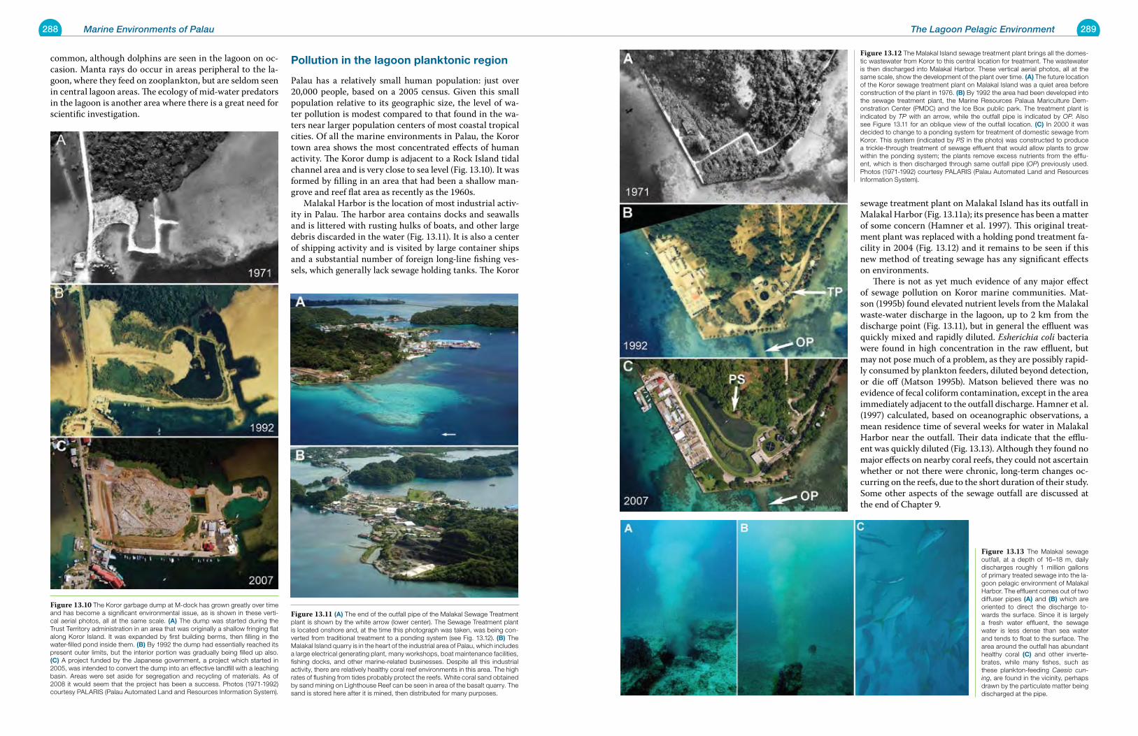
288 Marine Environments of Palau 289The Lagoon Pelagic Environment
sewage treatment plant on Malakal Island has its outfall in Malakal Harbor (Fig. 13.11a); its presence has been a matter of some concern (Hamner et al. 1997). This original treat-ment plant was replaced with a holding pond treatment fa-cility in 2004 (Fig. 13.12) and it remains to be seen if this new method of treating sewage has any significant effects on environments. There is not as yet much evidence of any major effect of sewage pollution on Koror marine communities. Mat-son (1995b) found elevated nutrient levels from the Malakal waste-water discharge in the lagoon, up to 2 km from the discharge point (Fig. 13.11), but in general the effluent was quickly mixed and rapidly diluted. Esherichia coli bacteria were found in high concentration in the raw effluent, but may not pose much of a problem, as they are possibly rapid-ly consumed by plankton feeders, diluted beyond detection, or die off (Matson 1995b). Matson believed there was no evidence of fecal coliform contamination, except in the area immediately adjacent to the outfall discharge. Hamner et al. (1997) calculated, based on oceanographic observations, a mean residence time of several weeks for water in Malakal Harbor near the outfall. Their data indicate that the efflu-ent was quickly diluted (Fig. 13.13). Although they found no major effects on nearby coral reefs, they could not ascertain whether or not there were chronic, long-term changes oc-curring on the reefs, due to the short duration of their study. Some other aspects of the sewage outfall are discussed at the end of Chapter 9.
common, although dolphins are seen in the lagoon on oc-casion. Manta rays do occur in areas peripheral to the la-goon, where they feed on zooplankton, but are seldom seen in central lagoon areas. The ecology of mid-water predators in the lagoon is another area where there is a great need for scientific investigation.
pollution in the lagoon planktonic region
Palau has a relatively small human population: just over 20,000 people, based on a 2005 census. Given this small population relative to its geographic size, the level of wa-ter pollution is modest compared to that found in the wa-ters near larger population centers of most coastal tropical cities. Of all the marine environments in Palau, the Koror town area shows the most concentrated effects of human activity. The Koror dump is adjacent to a Rock Island tidal channel area and is very close to sea level (Fig. 13.10). It was formed by filling in an area that had been a shallow man-grove and reef flat area as recently as the 1960s. Malakal Harbor is the location of most industrial activ-ity in Palau. The harbor area contains docks and seawalls and is littered with rusting hulks of boats, and other large debris discarded in the water (Fig. 13.11). It is also a center of shipping activity and is visited by large container ships and a substantial number of foreign long-line fishing ves-sels, which generally lack sewage holding tanks. The Koror
Figure 13.11 (a) The end of the outfall pipe of the Malakal Sewage Treatment plant is shown by the white arrow (lower center). The Sewage Treatment plant is located onshore and, at the time this photograph was taken, was being con-verted from traditional treatment to a ponding system (see Fig. 13.12). (B) The Malakal Island quarry is in the heart of the industrial area of Palau, which includes a large electrical generating plant, many workshops, boat maintenance facilities, fishing docks, and other marine-related businesses. Despite all this industrial activity, there are relatively healthy coral reef environments in this area. The high rates of flushing from tides probably protect the reefs. White coral sand obtained by sand mining on Lighthouse Reef can be seen in area of the basalt quarry. The sand is stored here after it is mined, then distributed for many purposes.
Figure 13.12 The Malakal Island sewage treatment plant brings all the domes-tic wastewater from Koror to this central location for treatment. The wastewater is then discharged into Malakal Harbor. These vertical aerial photos, all at the same scale, show the development of the plant over time. (a) The future location of the Koror sewage treatment plant on Malakal Island was a quiet area before construction of the plant in 1976. (B) By 1992 the area had been developed into the sewage treatment plant, the Marine Resources Palaua Mariculture Dem-onstration Center (PMDC) and the Ice Box public park. The treatment plant is indicated by TP with an arrow, while the outfall pipe is indicated by OP. Also see Figure 13.11 for an oblique view of the outfall location. (C) In 2000 it was decided to change to a ponding system for treatment of domestic sewage from Koror. This system (indicated by PS in the photo) was constructed to produce a trickle-through treatment of sewage effluent that would allow plants to grow within the ponding system; the plants remove excess nutrients from the efflu-ent, which is then discharged through same outfall pipe (OP) previously used. Photos (1971-1992) courtesy PALARIS (Palau Automated Land and Resources Information System).
Figure 13.10 The Koror garbage dump at M-dock has grown greatly over time and has become a significant environmental issue, as is shown in these verti-cal aerial photos, all at the same scale. (a) The dump was started during the Trust Territory administration in an area that was originally a shallow fringing flat along Koror Island. It was expanded by first building berms, then filling in the water-filled pond inside them. (B) By 1992 the dump had essentially reached its present outer limits, but the interior portion was gradually being filled up also. (C) A project funded by the Japanese government, a project which started in 2005, was intended to convert the dump into an effective landfill with a leaching basin. Areas were set aside for segregation and recycling of materials. As of 2008 it would seem that the project has been a success. Photos (1971-1992) courtesy PALARIS (Palau Automated Land and Resources Information System).
Figure 13.13 The Malakal sewage outfall, at a depth of 16–18 m, daily discharges roughly 1 million gallons of primary treated sewage into the la-goon pelagic environment of Malakal Harbor. The effluent comes out of two diffuser pipes (a) and (B) which are oriented to direct the discharge to-wards the surface. Since it is largely a fresh water effluent, the sewage water is less dense than sea water and tends to float to the surface. The area around the outfall has abundant healthy coral (C) and other inverte-brates, while many fishes, such as these plankton-feeding Caesio cun-ing, are found in the vicinity, perhaps drawn by the particulate matter being discharged at the pipe.
291
Ch
ap
te
r
14 Basalt Islands: Shores, Mangroves and Estuaries
Figure 14.1 The locations of stands of mangrove forest on Babeldaob, as well as on Koror and Arebesang Islands, are shown in red on this map; rivers and streams are shown in white. About 80% of the shoreline of Babeldaob is made up of mangrove forests, which can be as much as 1 km wide along the shore. The man-grove forests run up the rivers a con-siderable distance from the lagoon, due to the ingress of saltwater, which produces estuarine conditions far beyond the mouths of the rivers. The approximate locations of some other Figures in this chapter are shown.
The Tabecheding River winds its way inland from Ngeremeduu Bay, lined by dense mangroves along the first few kilometers of its length. Only once the river reaches higher ground where salt water can not intrude does the mangrove fringe stop. The lower mangroves are home to saltwater crocodiles which are becoming increas-ingly common in Palau.
292 Marine Environments of Palau 293Basalt Islands: Shores, Mangroves and Estuaries
Palau’s basalt islands have shorelines dominated by man-groves. 80% of Babeldaob’s shoreline is covered in mangrove (Fig. 14.1). The remaining 20% is beaches (roughly 14 km), rocky shores (where basalt makes up the shoreline), and human-altered areas. Basalt island beaches were discussed in Chapter 11; basalt rocky shores and mangroves are con-sidered here. In addition to the large island of Babeldaob, a number of smaller volcanic islands have similar amounts of mangroves; some limestone islands also have this type of shoreline (Fig. 14.2). Babeldaob has the largest estuarine area in Micronesia: Ngeremeduu Bay, a shallow muddy-bottomed embayment of about 4 km2 in area, largely bor-dered by mangroves. Maragos et al. (1994) cited mangroves as good habitats for saltwater crocodiles, several species of birds, mangrove crabs, and clams. Mangroves protect shorelines, reduce outwash of eroded soils onto seagrass and coral reef habitats, produce safe anchorages for small boats, and provide wood for fuel and building materials. Rocky shores occur along only a small percentage of the total coastline of Babeldaob. Intermittent basaltic rock, sometimes only a few tens of meters in extent, interrupts the shoreline between mangroves. Without mangroves to break up waves or sequester sediments, organisms along rocky shores face an environment that is very different from that found in nearby mangroves. Where basaltic rock outcrops reach the water (Fig. 14.3a), there is no sea level notch, as there is on carbonate rock shores. Some basalt outcrops have small overhanging cliffs (Fig. 14.3b and 14.3c) as a result of wave action undercutting rock faces composed of basalt rock conglomerates (breccias, tuffs). These rock outcrops often continue out from shore as flat shelves, many of which are emergent on low tides (Fig. 14.4). There is little sediment on these submarine shelves. Basalt is exceptionally hard, so burrowing organisms are uncom-mon. Boulders of various sizes, fallen from overhanging
Figure 14.2 Typical mangrove shorelines on Babeldaob. (a) Shore-line in northeastern portion of Airai Bay has a wide mangrove fringe. (B) Shoreline with narrow mangrove fringe in Ngatpang. A rocky basalt slope comes down relatively close to the shore; there is no buildup of an al-luvial plane offshore. (C) The mouth of the Ngatpang River in Ngeremeduu Bay shows how mangrove forests can penetrate far up the rivers due to es-tuarine conditions. (d) Small clumps of mangrove trees eventually become large islands of trees. Airai Bay, Airai State.
Figure 14.3 Basaltic rocky shores on Babeldaob Island. (a) In areas where a hard, smooth volcanic rock extends into the sea, there is no undercutting of the shoreline. (B) and (C) Areas where conglomerate volcanics (breccias, tuffs) form the rocky shore of Babeldaob are eroded by wave action, forming small overhangs and cliffs.
Figure 14.4 Where basaltic rock occurs along the lagoon shore, the area just below the water’s edge often has a sub-merged shelf of basaltic rock. Such areas, such as this one shown in an aerial view off Aimeliik on Babeldaob, are usually narrow and quickly transition to sediment bottoms away from the shore.
Figure 14.5 Due to the wide flats along the shore of Babeldaob, most villages need jetties that reach out into water deep enough for small boats at all tides. The jetty at in Ngechesar village in Ngechesar State is nearly 500 m long; there is a small house at its outer end. Recent dredging along the shore now allows boats to be anchored there at low tides, but access to the inner mooring area is still limited at low tide.
294 Marine Environments of Palau 295Basalt Islands: Shores, Mangroves and Estuaries
slopes, come to rest on the shallow rocky shelves. Few, if any, stony or soft coral colonies occur below basalt cliffs and shores, quite unlike the situation in carbonate rock is-lands elsewhere in Palau. The water quality in these areas is estuarine, similar to that found in nearby mangroves or in areas where streams are emptying into the ocean. Wa-ter quality may limit which benthic species can survive on these surfaces. Reef flats generally occur off all shores of Babeldaob. They are relatively wide (up to a few kilometers) and shal-low (usually emergent at low tides); they were discussed extensively in Chapter 6. Due to these shallow flats, most of the villages along the shore of Babeldaob had to build lengthy jetties just to reach water sufficiently deep for small boats at all tides (Fig. 14.5). Some villages have chan-nels dredged into the sediment bottom to shore to provide boat access at all tides. During construction of the Palau Compact Road, some villages extracted fill materials for road construction from shallow near-shore bottoms by dredging, which also produced desired deep-water access close to shore (Fig. 14.6).
Mangrove habitats of palau: general considerationsThe species of plants that are considered mangroves grow above mean sea level in the intertidal zone, between high and low tides. These plants are generally more than a half-
meter in height and are variously trees, shrubs, palms, or ground ferns. Together the species form forests in the in-tertidal; they grow well in wet, soft, and oxygen-deficient muds. The broad extent of mangrove habitat in Palau is apparent in the United States Geological Survey (USGS) topographic maps for Palau (1983, 1:25,000). All mangrove forests are shown with the same identifier on these charts. However. some differences exist between forests. Cole et al (1987, 1999) reported Babeldaob to have 4025 hectares of mangrove forest amounting to 9% of the 44,134 hectare island. Taken together, Koror, Malakal, and Ara-besang Islands contain 205 hectares of mangrove forest, while Peleliu has 435 hectares. Angaur and Kayangel lack naturally occurring mangrove forest (although some man-groves have reportedly been introduced to an island on Kayangel). On Babeldaob the extensive mangrove fringe reaches widths up to nearly 1 km (Fig. 14.1). The widest fringe is associated with streams going inland through low swampy areas, thus allowing salt water to reach far inland with the high tide (Fig. 14.7). There is a recognizable zonation of mangrove trees along the shore of Babeldaob (Fig. 14.8). The bottom immediately along the mangrove fringe is usu-
ally sediment; a layer of mangrove peat makes its appear-ance as a dark zone along the mangrove fringe (Fig. 14.9). Mangroves stands reach 15–20 m in height near open wa-ter, while in interior areas, shorter trees grow where water circulation is limited and soils are firm (Cole et al. 1987). Sonneratia alba and Rhizophora mucronata dominate on the seaward side of mangroves. At the mouths of large riv-ers, R. mucronata and R. apiculata may grow in pure stands (Cole et al, 1987), although small numbers of Sonneratia or Bruguiera may also occur. On the landward side of man-groves, other species may predominate, such as L. litorea and Xylocarpus granatum. These species, plus Bruguiera, occur at the transition of estuaries into rivers (Cole et al., 1987). The Nipa palm (Nypa fruticans) occurs in thin zones along the lower portion and mouths of rivers (Cole et al. 1987). Fehlman (1960), in a description of mangrove fishes collected from a stream mouth on the southwestern part of Babeldaob, reported that three species of Rhizophoridae (Rhizophora mucronata, R. apiculata, and Bruguiera con-jugata) were found along the banks of the stream, while three other trees in different families contributed to the near-impenetrable vegetation along the banks. Smith (1984) describes a number of zones of the man-grove fringe based on Palauan ethnography based on the various uses of these zones by local communities in Ngarchemlengui State. The thick tangle of prop roots and branches was a major factor limiting use of mangroves by communities, although mangrove trees were favored for building due to resistance to insect damage and lasting quality of the wood. The landward area of the mangroves, near the high tide limit is known as kedokeb. Palauans reported to Smith (1984) that twice each month kebokeb was invaded by man-grove crabs seeking sheltered areas for molting and mat-ing. He indicated that on the spring tides of the full and new moons, the crabs leave their burrows on the fringing reef and travel through the mangroves to the soft mud of kedokeb. They occupy or excavate shallow burrows in the mud. Smith (1984) describes how Palauan fishers examine depressions on the inner area of the mangroves and can determine whether crabs are present, and whether it is a single crab (molted) or a pair (mating). Mangroves and coral reefs often occur in close proxim-ity to each other. Extensive mangrove forests with their at-tendant streams impinge directly on shallow fringing reefs and the deeper lagoon, providing an easy exchange of nu-trients, larvae, and juvenile stages of fishes moving to outer reefs (Fig. 14.9). True mangroves cannot tolerate fresh water for any length of time. Mangroves cut off from salt water quickly die (Fig. 14.10).Their distribution is a reliable indicator of where brackish water conditions occur in the rivers and streams of Palau. Tides are the driving force bringing salt water up rivers, often as a deeper lens below fresh or slight-ly brackish water. An area of low ground, not rocky, where there are no mangroves, is an area to which salt water seldom pene-
Figure 14.6 Coastal dredging of near-shore shallow flats was conducted for coral fill in many states on Babeldaob during construction for the Palau Com-pact Road. These dredge sites also now serve as small boat harbors; an extra benefit from the dredging. (a) Imul Village in Aimeliik State. (B) Ngiwal State. (C) Melekeok State. (d) Taprengesang in Ngchesar State. The silt curtain was not very effective on the day this photo was taken.
Figure 14.7 This aerial photo of the mangrove fringe along west coast of Ba-beldaob in Airai State shows several zones from the lagoon to the inshore edge. The total width of the fringe is about 300 m; it includes both areas that are regu-larly inundated by seawater as well as some additional forested land further in-shore. The mangroves on the water’s edge are typically taller than ones further inshore. Also, the frequency of the various species varies from zone to zone.
Figure 14.8 Most mangrove shores on Babeldaob have a sharp edge where the mangrove forest ends and immediately transitions to a shallow muddy bot-tom offshore. A layer of dark peat covers the bottom just seaward of the man-grove plants; this layer is easily suspended. Aerial photos show dark zones along the mangroves, but the actual bottom beneath the peat is lighter in color. Often there is a offshore rapid transition from mangrove zones to seagrass and reef-dominated bottoms.
Figure 14.9 If watersheds are not heavily impacted by land clearing, streams will send relatively clear water, with low sediment loads, flowing into mangrove-bordered lagoons. When the water is clear, it is possible to see the shallow-bottom community types at the stream mouth. This area of extremely healthy mangroves is typical of many mangrove forests found in Palau.
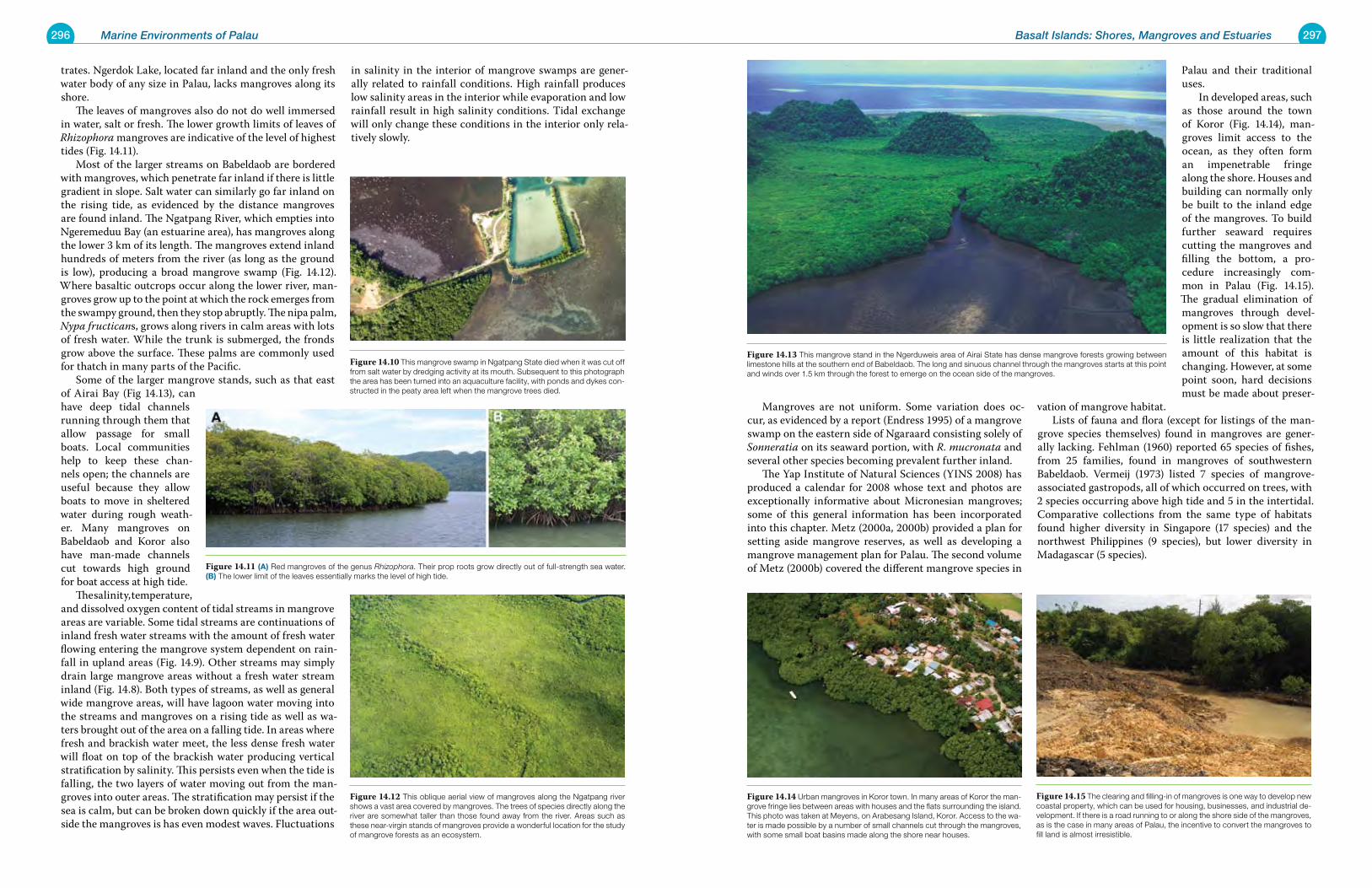
296 Marine Environments of Palau 297Basalt Islands: Shores, Mangroves and Estuaries
trates. Ngerdok Lake, located far inland and the only fresh water body of any size in Palau, lacks mangroves along its shore. The leaves of mangroves also do not do well immersed in water, salt or fresh. The lower growth limits of leaves of Rhizophora mangroves are indicative of the level of highest tides (Fig. 14.11). Most of the larger streams on Babeldaob are bordered with mangroves, which penetrate far inland if there is little gradient in slope. Salt water can similarly go far inland on the rising tide, as evidenced by the distance mangroves are found inland. The Ngatpang River, which empties into Ngeremeduu Bay (an estuarine area), has mangroves along the lower 3 km of its length. The mangroves extend inland hundreds of meters from the river (as long as the ground is low), producing a broad mangrove swamp (Fig. 14.12). Where basaltic outcrops occur along the lower river, man-groves grow up to the point at which the rock emerges from the swampy ground, then they stop abruptly. The nipa palm, Nypa fructicans, grows along rivers in calm areas with lots of fresh water. While the trunk is submerged, the fronds grow above the surface. These palms are commonly used for thatch in many parts of the Pacific. Some of the larger mangrove stands, such as that east of Airai Bay (Fig 14.13), can have deep tidal channels running through them that allow passage for small boats. Local communities help to keep these chan-nels open; the channels are useful because they allow boats to move in sheltered water during rough weath-er. Many mangroves on Babeldaob and Koror also have man-made channels cut towards high ground for boat access at high tide. The salinity, temperature, and dissolved oxygen content of tidal streams in mangrove areas are variable. Some tidal streams are continuations of inland fresh water streams with the amount of fresh water flowing entering the mangrove system dependent on rain-fall in upland areas (Fig. 14.9). Other streams may simply drain large mangrove areas without a fresh water stream inland (Fig. 14.8). Both types of streams, as well as general wide mangrove areas, will have lagoon water moving into the streams and mangroves on a rising tide as well as wa-ters brought out of the area on a falling tide. In areas where fresh and brackish water meet, the less dense fresh water will float on top of the brackish water producing vertical stratification by salinity. This persists even when the tide is falling, the two layers of water moving out from the man-groves into outer areas. The stratification may persist if the sea is calm, but can be broken down quickly if the area out-side the mangroves is has even modest waves. Fluctuations
in salinity in the interior of mangrove swamps are gener-ally related to rainfall conditions. High rainfall produces low salinity areas in the interior while evaporation and low rainfall result in high salinity conditions. Tidal exchange will only change these conditions in the interior only rela-tively slowly.
Mangroves are not uniform. Some variation does oc-cur, as evidenced by a report (Endress 1995) of a mangrove swamp on the eastern side of Ngaraard consisting solely of Sonneratia on its seaward portion, with R. mucronata and several other species becoming prevalent further inland. The Yap Institute of Natural Sciences (YINS 2008) has produced a calendar for 2008 whose text and photos are exceptionally informative about Micronesian mangroves; some of this general information has been incorporated into this chapter. Metz (2000a, 2000b) provided a plan for setting aside mangrove reserves, as well as developing a mangrove management plan for Palau. The second volume of Metz (2000b) covered the different mangrove species in
Palau and their traditional uses. In developed areas, such as those around the town of Koror (Fig. 14.14), man-groves limit access to the ocean, as they often form an impenetrable fringe along the shore. Houses and building can normally only be built to the inland edge of the mangroves. To build further seaward requires cutting the mangroves and filling the bottom, a pro-cedure increasingly com-mon in Palau (Fig. 14.15). The gradual elimination of mangroves through devel-opment is so slow that there is little realization that the amount of this habitat is changing. However, at some point soon, hard decisions must be made about preser-
vation of mangrove habitat. Lists of fauna and flora (except for listings of the man-grove species themselves) found in mangroves are gener-ally lacking. Fehlman (1960) reported 65 species of fishes, from 25 families, found in mangroves of southwestern Babeldaob. Vermeij (1973) listed 7 species of mangrove-associated gastropods, all of which occurred on trees, with 2 species occurring above high tide and 5 in the intertidal. Comparative collections from the same type of habitats found higher diversity in Singapore (17 species) and the northwest Philippines (9 species), but lower diversity in Madagascar (5 species).
Figure 14.10 This mangrove swamp in Ngatpang State died when it was cut off from salt water by dredging activity at its mouth. Subsequent to this photograph the area has been turned into an aquaculture facility, with ponds and dykes con-structed in the peaty area left when the mangrove trees died.
Figure 14.11 (a) Red mangroves of the genus Rhizophora. Their prop roots grow directly out of full-strength sea water. (B) The lower limit of the leaves essentially marks the level of high tide.
Figure 14.12 This oblique aerial view of mangroves along the Ngatpang river shows a vast area covered by mangroves. The trees of species directly along the river are somewhat taller than those found away from the river. Areas such as these near-virgin stands of mangroves provide a wonderful location for the study of mangrove forests as an ecosystem.
Figure 14.13 This mangrove stand in the Ngerduweis area of Airai State has dense mangrove forests growing between limestone hills at the southern end of Babeldaob. The long and sinuous channel through the mangroves starts at this point and winds over 1.5 km through the forest to emerge on the ocean side of the mangroves.
Figure 14.14 Urban mangroves in Koror town. In many areas of Koror the man-grove fringe lies between areas with houses and the flats surrounding the island. This photo was taken at Meyens, on Arabesang Island, Koror. Access to the wa-ter is made possible by a number of small channels cut through the mangroves, with some small boat basins made along the shore near houses.
Figure 14.15 The clearing and filling-in of mangroves is one way to develop new coastal property, which can be used for housing, businesses, and industrial de-velopment. If there is a road running to or along the shore side of the mangroves, as is the case in many areas of Palau, the incentive to convert the mangroves to fill land is almost irresistible.
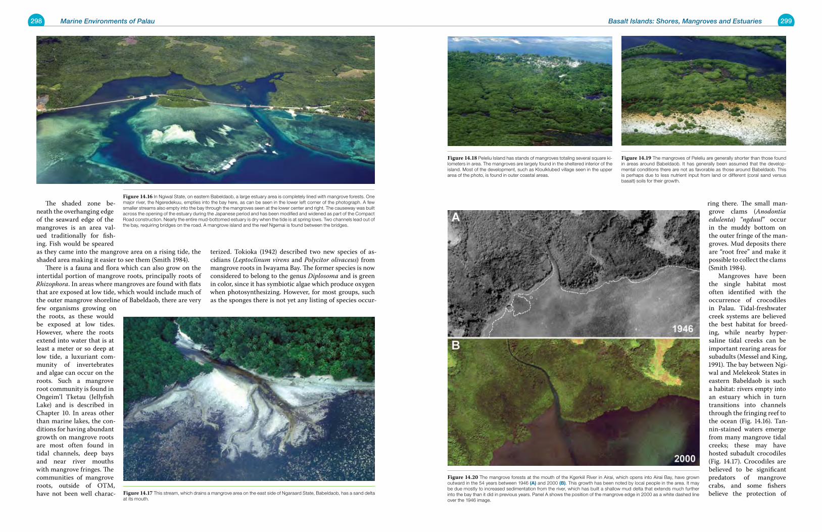
298 Marine Environments of Palau 299Basalt Islands: Shores, Mangroves and Estuaries
The shaded zone be-neath the overhanging edge of the seaward edge of the mangroves is an area val-ued traditionally for fish-ing. Fish would be speared as they came into the mangrove area on a rising tide, the shaded area making it easier to see them (Smith 1984). There is a fauna and flora which can also grow on the intertidal portion of mangrove roots, principally roots of Rhizophora. In areas where mangroves are found with flats that are exposed at low tide, which would include much of the outer mangrove shoreline of Babeldaob, there are very few organisms growing on the roots, as these would be exposed at low tides. However, where the roots extend into water that is at least a meter or so deep at low tide, a luxuriant com-munity of invertebrates and algae can occur on the roots. Such a mangrove root community is found in Ongeim’l Tketau (Jellyfish Lake) and is described in Chapter 10. In areas other than marine lakes, the con-ditions for having abundant growth on mangrove roots are most often found in tidal channels, deep bays and near river mouths with mangrove fringes. The communities of mangrove roots, outside of OTM, have not been well charac-
terized. Tokioka (1942) described two new species of as-cidians (Leptoclinum virens and Polycitor olivaceus) from mangrove roots in Iwayama Bay. The former species is now considered to belong to the genus Diplosoma and is green in color, since it has symbiotic algae which produce oxygen when photosynthesizing. However, for most groups, such as the sponges there is not yet any listing of species occur-
ring there. The small man-grove clams (Anodontia edulenta) “ngduul” occur in the muddy bottom on the outer fringe of the man-groves. Mud deposits there are “root free” and make it possible to collect the clams (Smith 1984). Mangroves have been the single habitat most often identified with the occurrence of crocodiles in Palau. Tidal-freshwater creek systems are believed the best habitat for breed-ing, while nearby hyper-saline tidal creeks can be important rearing areas for subadults (Messel and King, 1991). The bay between Ngi-wal and Melekeok States in eastern Babeldaob is such a habitat: rivers empty into an estuary which in turn transitions into channels through the fringing reef to the ocean (Fig. 14.16). Tan-nin-stained waters emerge from many mangrove tidal creeks; these may have hosted subadult crocodiles (Fig. 14.17). Crocodiles are believed to be significant predators of mangrove crabs, and some fishers believe the protection of
Figure 14.16 In Ngiwal State, on eastern Babeldaob, a large estuary area is completely lined with mangrove forests. One major river, the Ngeredekuu, empties into the bay here, as can be seen in the lower left corner of the photograph. A few smaller streams also empty into the bay through the mangroves seen at the lower center and right. The causeway was built across the opening of the estuary during the Japanese period and has been modified and widened as part of the Compact Road construction. Nearly the entire mud-bottomed estuary is dry when the tide is at spring lows. Two channels lead out of the bay, requiring bridges on the road. A mangrove island and the reef Ngemai is found between the bridges.
Figure 14.17 This stream, which drains a mangrove area on the east side of Ngaraard State, Babeldaob, has a sand delta at its mouth.
Figure 14.18 Peleliu Island has stands of mangroves totaling several square ki-lometers in area. The mangroves are largely found in the sheltered interior of the island. Most of the development, such as Kloulklubed village seen in the upper area of the photo, is found in outer coastal areas.
Figure 14.19 The mangroves of Peleliu are generally shorter than those found in areas around Babeldaob. It has generally been assumed that the develop-mental conditions there are not as favorable as those around Babeldaob. This is perhaps due to less nutrient input from land or different (coral sand versus basalt) soils for their growth.
Figure 14.20 The mangrove forests at the mouth of the Kgerkiil River in Airai, which opens into Airai Bay, have grown outward in the 54 years between 1946 (a) and 2000 (B). This growth has been noted by local people in the area. It may be due mostly to increased sedimentation from the river, which has built a shallow mud delta that extends much further into the bay than it did in previous years. Panel A shows the position of the mangrove edge in 2000 as a white dashed line over the 1946 image.
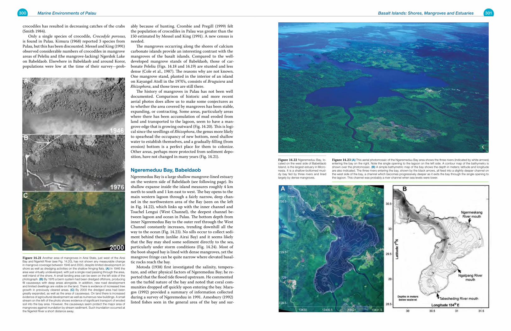
300 Marine Environments of Palau 301Basalt Islands: Shores, Mangroves and Estuaries
crocodiles has resulted in decreasing catches of the crabs (Smith 1984). Only a single species of crocodile, Crocodyle porosus, is found in Palau. Kimura (1968) reported 3 species from Palau, but this has been discounted. Messel and King (1991) observed considerable numbers of crocodiles in mangrove areas of Peleliu and (the mangrove-lacking) Ngerdok Lake on Babeldaob. Elsewhere in Babeldaob and around Koror, populations were low at the time of their survey—prob-
ably because of hunting. Crombie and Pregill (1999) felt the population of crocodiles in Palau was greater than the 150 estimated by Messel and King (1991). A new census is needed. The mangroves occurring along the shores of calcium carbonate islands provide an interesting contrast with the mangroves of the basalt islands. Compared to the well-developed mangrove stands of Babeldaob, those of car-bonate Peleliu (Figs. 14.18 and 14.19) are stunted and less dense (Cole et al., 1987). The reasons why are not known. One mangrove stand, planted in the interior of an island on Kayangel Atoll in the 1970’s, consists of Bruguiera and Rhizophora, and those trees are still there. The history of mangroves in Palau has not been well documented. Comparison of historic and more recent aerial photos does allow us to make some conjectures as to whether the area covered by mangroves has been stable, expanding, or contracting. Some areas, particularly areas where there has been accumulation of mud eroded from land and transported to the lagoon, seem to have a man-grove edge that is growing outward (Fig. 14.20). This is logi-cal since the seedlings of Rhizophora, the genus more likely to spearhead the occupancy of new bottom, need shallow water to establish themselves, and a gradually-filling (from erosion) bottom is a perfect place for them to colonize. Other areas, perhaps more protected from sediment depo-sition, have not changed in many years (Fig. 14.21).
ngeremeduu Bay, BabeldaobNgeremeduu Bay is a large shallow mangrove-lined estuary on the western side of Babeldaob (see following page). Its shallow expanse inside the island measures roughly 4 km north to south and 1 km east to west. The bay opens to the main western lagoon through a fairly narrow, deep chan-nel in the northwestern area of the Bay (seen on the left in Fig. 14.22), which links up with the inner channel and Toachel Lengui (West Channel), the deepest channel be-tween lagoon and ocean in Palau. The bottom depth from inner Ngeremeduu Bay to the outer reef through the West Channel constantly increases, trending downhill all the way to the ocean (Fig. 14.23). No sills occur to collect sedi-ment behind them (unlike Airai Bay) and it seems likely that the Bay may shed some sediment directly to the sea, particularly under storm conditions (Fig. 14.24). Most of the boot-shaped bay is lined with dense mangroves, yet the mangrove fringe can be quite narrow where elevated basal-tic rocks reach the bay. Motoda (1938) first investigated the salinity, tempera-ture, and other physical factors of Ngeremeduu Bay; he re-ported that the flood tide flowed upstream. He commented on the turbid nature of the bay and noted that coral com-munities dropped off quickly upon entering the bay. Mara-gos (1992) provided a summary of information collected during a survey of Ngeremeduu in 1991. Amesbury (1992) listed fishes seen in the general area of the bay and sur-
Figure 14.21 Another area of mangroves in Airai State, just west of the Airai Bay and Ngerkiil River (see Fig. 14.20), has not shown any measurable change in mangrove coverage between 1946 and 2000, despite limited development on shore as well as dredging activities on the shallow fringing flats. (a) In 1946 the area was virtually undeveloped, with just a single road passing through the area, well inland of the shore. A small landing area can be seen on the left side of the photograph. (B) By 1976 a berm system had been dredged offshore, producing fill causeways with deep areas alongside. In addition, new road development and limited dwellings are visible on the land. There is evidence of increased tree growth in previously cleared areas. (C) By 2000 the dredged area had been greatly expanded, as well as the area of causeways. On land there is increased evidence of agricultural development as well as numerous new buildings. A small stream on the left of the photo shows evidence of significant transport of eroded soil into the bay area. However, the causeways seem protect the major area of mangroves against inundation by stream sediment. Such inundation occurred at the Ngerkiil River a short distance away.
Figure 14.22 Ngeremeduu Bay, lo-cated on the west side of Babeldaob Island, is the largest estuary in Micro-nesia. It is a shallow-bottomed mud-dy bay fed by three rivers and lined largely by dense mangroves.
Figure 14.23 (a) This aerial photomosaic of the Ngeremeduu Bay area shows the three rivers (indicated by white arrows) entering the bay on the right. Note the single opening to the lagoon on the left side. A contour map of the bathymetry is shown over the photomosaic. (B) A simple bathymetric map of the bay shows the depth in meters; latitude and longitude are also indicated. The three rivers entering the bay, shown by the black arrows, all feed into a slightly deeper channel on the west side of the bay, a channel which becomes progressively deeper as it exits the bay through the single opening to the lagoon. This channel was probably a river channel when sea levels were lower.
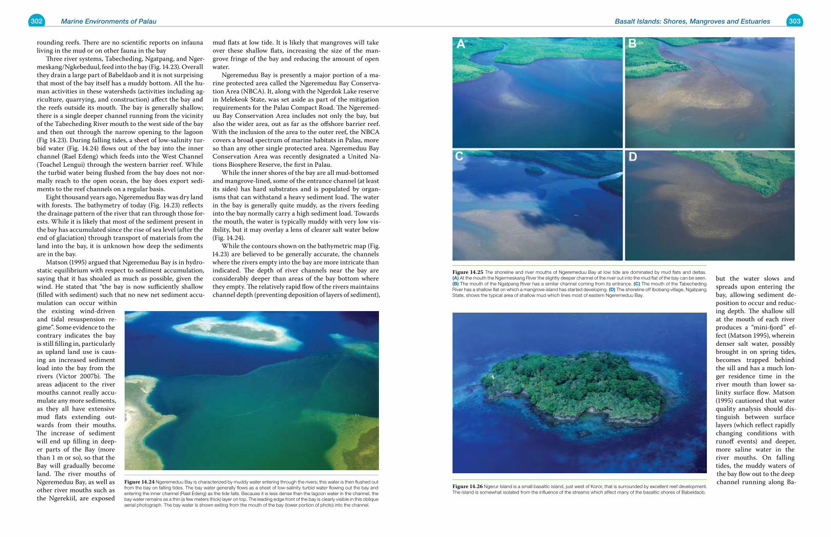
302 Marine Environments of Palau 303Basalt Islands: Shores, Mangroves and Estuaries
rounding reefs. There are no scientific reports on infauna living in the mud or on other fauna in the bay Three river systems, Tabecheding, Ngatpang, and Nger-meskang/Ngkebeduul, feed into the bay (Fig. 14.23). Overall they drain a large part of Babeldaob and it is not surprising that most of the bay itself has a muddy bottom. All the hu-man activities in these watersheds (activities including ag-riculture, quarrying, and construction) affect the bay and the reefs outside its mouth. The bay is generally shallow; there is a single deeper channel running from the vicinity of the Tabecheding River mouth to the west side of the bay and then out through the narrow opening to the lagoon (Fig 14.23). During falling tides, a sheet of low-salinity tur-bid water (Fig. 14.24) flows out of the bay into the inner channel (Rael Edeng) which feeds into the West Channel (Toachel Lengui) through the western barrier reef. While the turbid water being flushed from the bay does not nor-mally reach to the open ocean, the bay does export sedi-ments to the reef channels on a regular basis. Eight thousand years ago, Ngeremeduu Bay was dry land with forests. The bathymetry of today (Fig. 14.23) reflects the drainage pattern of the river that ran through those for-ests. While it is likely that most of the sediment present in the bay has accumulated since the rise of sea level (after the end of glaciation) through transport of materials from the land into the bay, it is unknown how deep the sediments are in the bay. Matson (1995) argued that Ngeremeduu Bay is in hydro-static equilibrium with respect to sediment accumulation, saying that it has shoaled as much as possible, given the wind. He stated that “the bay is now sufficiently shallow (filled with sediment) such that no new net sediment accu-mulation can occur within the existing wind-driven and tidal resuspension re-gime”. Some evidence to the contrary indicates the bay is still filling in, particularly as upland land use is caus-ing an increased sediment load into the bay from the rivers (Victor 2007b). The areas adjacent to the river mouths cannot really accu-mulate any more sediments, as they all have extensive mud flats extending out-wards from their mouths. The increase of sediment will end up filling in deep-er parts of the Bay (more than 1 m or so), so that the Bay will gradually become land. The river mouths of Ngeremeduu Bay, as well as other river mouths such as the Ngerekiil, are exposed
mud flats at low tide. It is likely that mangroves will take over these shallow flats, increasing the size of the man-grove fringe of the bay and reducing the amount of open water. Ngeremeduu Bay is presently a major portion of a ma-rine protected area called the Ngeremeduu Bay Conserva-tion Area (NBCA). It, along with the Ngerdok Lake reserve in Melekeok State, was set aside as part of the mitigation requirements for the Palau Compact Road. The Ngeremed-uu Bay Conservation Area includes not only the bay, but also the wider area, out as far as the offshore barrier reef. With the inclusion of the area to the outer reef, the NBCA covers a broad spectrum of marine habitats in Palau, more so than any other single protected area. Ngeremeduu Bay Conservation Area was recently designated a United Na-tions Biosphere Reserve, the first in Palau. While the inner shores of the bay are all mud-bottomed and mangrove-lined, some of the entrance channel (at least its sides) has hard substrates and is populated by organ-isms that can withstand a heavy sediment load. The water in the bay is generally quite muddy, as the rivers feeding into the bay normally carry a high sediment load. Towards the mouth, the water is typically muddy with very low vis-ibility, but it may overlay a lens of clearer salt water below (Fig. 14.24). While the contours shown on the bathymetric map (Fig. 14.23) are believed to be generally accurate, the channels where the rivers empty into the bay are more intricate than indicated. The depth of river channels near the bay are considerably deeper than areas of the bay bottom where they empty. The relatively rapid flow of the rivers maintains channel depth (preventing deposition of layers of sediment),
but the water slows and spreads upon entering the bay, allowing sediment de-position to occur and reduc-ing depth. The shallow sill at the mouth of each river produces a “mini-fjord” ef-fect (Matson 1995), wherein denser salt water, possibly brought in on spring tides, becomes trapped behind the sill and has a much lon-ger residence time in the river mouth than lower sa-linity surface flow. Matson (1995) cautioned that water quality analysis should dis-tinguish between surface layers (which reflect rapidly changing conditions with runoff events) and deeper, more saline water in the river mouths. On falling tides, the muddy waters of the bay flow out to the deep channel running along Ba-Figure 14.24 Ngeremeduu Bay is characterized by muddy water entering through the rivers; this water is then flushed out
from the bay on falling tides. The bay water generally flows as a sheet of low-salinity turbid water flowing out the bay and entering the inner channel (Rael Edeng) as the tide falls. Because it is less dense than the lagoon water in the channel, the bay water remains as a thin (a few meters thick) layer on top. The leading edge front of the bay is clearly visible in this oblique aerial photograph. The bay water is shown exiting from the mouth of the bay (lower portion of photo) into the channel.
Figure 14.25 The shoreline and river mouths of Ngeremeduu Bay at low tide are dominated by mud flats and deltas. (a) At the mouth the Ngermeskang River the slightly deeper channel of the river out into the mud flat of the bay can be seen. (B) The mouth of the Ngatpang River has a similar channel coming from its entrance. (C) The mouth of the Tabecheding River has a shallow flat on which a mangrove island has started developing. (d) The shoreline off Ibobang village, Ngatpang State, shows the typical area of shallow mud which lines most of eastern Ngeremeduu Bay.
Figure 14.26 Ngerur Island is a small basaltic island, just west of Koror, that is surrounded by excellent reef development. The island is somewhat isolated from the influence of the streams which affect many of the basaltic shores of Babeldaob.
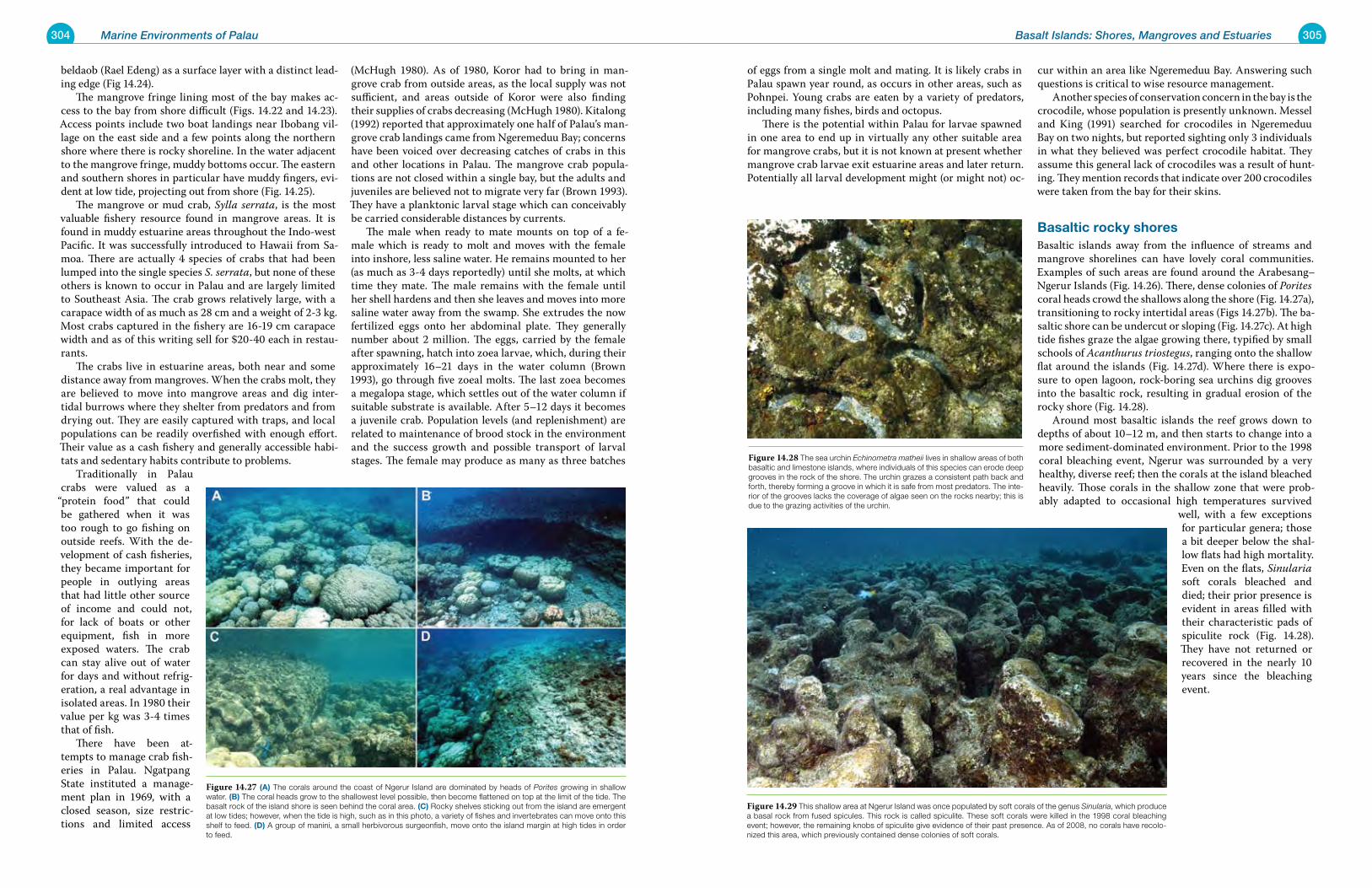
304 Marine Environments of Palau 305Basalt Islands: Shores, Mangroves and Estuaries
beldaob (Rael Edeng) as a surface layer with a distinct lead-ing edge (Fig 14.24). The mangrove fringe lining most of the bay makes ac-cess to the bay from shore difficult (Figs. 14.22 and 14.23). Access points include two boat landings near Ibobang vil-lage on the east side and a few points along the northern shore where there is rocky shoreline. In the water adjacent to the mangrove fringe, muddy bottoms occur. The eastern and southern shores in particular have muddy fingers, evi-dent at low tide, projecting out from shore (Fig. 14.25). The mangrove or mud crab, Sylla serrata, is the most valuable fishery resource found in mangrove areas. It is found in muddy estuarine areas throughout the Indo-west Pacific. It was successfully introduced to Hawaii from Sa-moa. There are actually 4 species of crabs that had been lumped into the single species S. serrata, but none of these others is known to occur in Palau and are largely limited to Southeast Asia. The crab grows relatively large, with a carapace width of as much as 28 cm and a weight of 2-3 kg. Most crabs captured in the fishery are 16-19 cm carapace width and as of this writing sell for $20-40 each in restau-rants. The crabs live in estuarine areas, both near and some distance away from mangroves. When the crabs molt, they are believed to move into mangrove areas and dig inter-tidal burrows where they shelter from predators and from drying out. They are easily captured with traps, and local populations can be readily overfished with enough effort. Their value as a cash fishery and generally accessible habi-tats and sedentary habits contribute to problems. Traditionally in Palau crabs were valued as a
“protein food” that could be gathered when it was too rough to go fishing on outside reefs. With the de-velopment of cash fisheries, they became important for people in outlying areas that had little other source of income and could not, for lack of boats or other equipment, fish in more exposed waters. The crab can stay alive out of water for days and without refrig-eration, a real advantage in isolated areas. In 1980 their value per kg was 3-4 times that of fish. There have been at-tempts to manage crab fish-eries in Palau. Ngatpang State instituted a manage-ment plan in 1969, with a closed season, size restric-tions and limited access
(McHugh 1980). As of 1980, Koror had to bring in man-grove crab from outside areas, as the local supply was not sufficient, and areas outside of Koror were also finding their supplies of crabs decreasing (McHugh 1980). Kitalong (1992) reported that approximately one half of Palau’s man-grove crab landings came from Ngeremeduu Bay; concerns have been voiced over decreasing catches of crabs in this and other locations in Palau. The mangrove crab popula-tions are not closed within a single bay, but the adults and juveniles are believed not to migrate very far (Brown 1993). They have a planktonic larval stage which can conceivably be carried considerable distances by currents. The male when ready to mate mounts on top of a fe-male which is ready to molt and moves with the female into inshore, less saline water. He remains mounted to her (as much as 3-4 days reportedly) until she molts, at which time they mate. The male remains with the female until her shell hardens and then she leaves and moves into more saline water away from the swamp. She extrudes the now fertilized eggs onto her abdominal plate. They generally number about 2 million. The eggs, carried by the female after spawning, hatch into zoea larvae, which, during their approximately 16–21 days in the water column (Brown 1993), go through five zoeal molts. The last zoea becomes a megalopa stage, which settles out of the water column if suitable substrate is available. After 5–12 days it becomes a juvenile crab. Population levels (and replenishment) are related to maintenance of brood stock in the environment and the success growth and possible transport of larval stages. The female may produce as many as three batches
of eggs from a single molt and mating. It is likely crabs in Palau spawn year round, as occurs in other areas, such as Pohnpei. Young crabs are eaten by a variety of predators, including many fishes, birds and octopus. There is the potential within Palau for larvae spawned in one area to end up in virtually any other suitable area for mangrove crabs, but it is not known at present whether mangrove crab larvae exit estuarine areas and later return. Potentially all larval development might (or might not) oc-
cur within an area like Ngeremeduu Bay. Answering such questions is critical to wise resource management. Another species of conservation concern in the bay is the crocodile, whose population is presently unknown. Messel and King (1991) searched for crocodiles in Ngeremeduu Bay on two nights, but reported sighting only 3 individuals in what they believed was perfect crocodile habitat. They assume this general lack of crocodiles was a result of hunt-ing. They mention records that indicate over 200 crocodiles were taken from the bay for their skins.
Basaltic rocky shoresBasaltic islands away from the influence of streams and mangrove shorelines can have lovely coral communities. Examples of such areas are found around the Arabesang–Ngerur Islands (Fig. 14.26). There, dense colonies of Porites coral heads crowd the shallows along the shore (Fig. 14.27a), transitioning to rocky intertidal areas (Figs 14.27b). The ba-saltic shore can be undercut or sloping (Fig. 14.27c). At high tide fishes graze the algae growing there, typified by small schools of Acanthurus triostegus, ranging onto the shallow flat around the islands (Fig. 14.27d). Where there is expo-sure to open lagoon, rock-boring sea urchins dig grooves into the basaltic rock, resulting in gradual erosion of the rocky shore (Fig. 14.28). Around most basaltic islands the reef grows down to depths of about 10–12 m, and then starts to change into a more sediment-dominated environment. Prior to the 1998 coral bleaching event, Ngerur was surrounded by a very healthy, diverse reef; then the corals at the island bleached heavily. Those corals in the shallow zone that were prob-ably adapted to occasional high temperatures survived
well, with a few exceptions for particular genera; those a bit deeper below the shal-low flats had high mortality. Even on the flats, Sinularia soft corals bleached and died; their prior presence is evident in areas filled with their characteristic pads of spiculite rock (Fig. 14.28). They have not returned or recovered in the nearly 10 years since the bleaching event.
Figure 14.27 (a) The corals around the coast of Ngerur Island are dominated by heads of Porites growing in shallow water. (B) The coral heads grow to the shallowest level possible, then become flattened on top at the limit of the tide. The basalt rock of the island shore is seen behind the coral area. (C) Rocky shelves sticking out from the island are emergent at low tides; however, when the tide is high, such as in this photo, a variety of fishes and invertebrates can move onto this shelf to feed. (d) A group of manini, a small herbivorous surgeonfish, move onto the island margin at high tides in order to feed.
Figure 14.28 The sea urchin Echinometra matheii lives in shallow areas of both basaltic and limestone islands, where individuals of this species can erode deep grooves in the rock of the shore. The urchin grazes a consistent path back and forth, thereby forming a groove in which it is safe from most predators. The inte-rior of the grooves lacks the coverage of algae seen on the rocks nearby; this is due to the grazing activities of the urchin.
Figure 14.29 This shallow area at Ngerur Island was once populated by soft corals of the genus Sinularia, which produce a basal rock from fused spicules. This rock is called spiculite. These soft corals were killed in the 1998 coral bleaching event; however, the remaining knobs of spiculite give evidence of their past presence. As of 2008, no corals have recolo-nized this area, which previously contained dense colonies of soft corals.
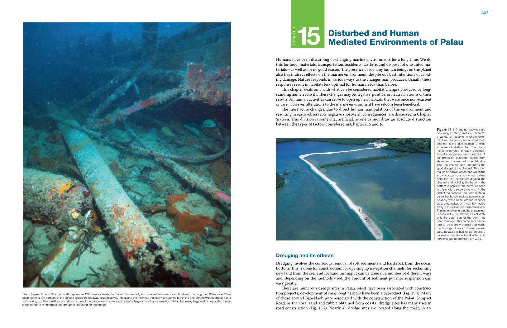
307
Ch
ap
te
r
15 Disturbed and Human Mediated Environments of Palau
Humans have been disturbing or changing marine environments for a long time. We do this for food, materials, transportation, accidents, warfare, and disposal of unwanted ma-terials—as well as for no good reason. The presence of so many human beings on the planet also has indirect effects on the marine environment, despite our best intentions of avoid-ing damage. Nature responds in various ways to the changes man produces. Usually these responses result in habitats less optimal for human needs than before. This chapter deals only with what can be considered habitat changes produced by long-standing human activity. These changes may be negative, positive, or neutral in terms of their results. All human activities can serve to open up new habitats that were once non-existent or rare. However, alterations to the marine environment have seldom been beneficial. The most acute changes, due to direct human manipulation of the environment and resulting in easily-observable negative short-term consequences, are discussed in Chapter Sixteen. This division is somewhat artificial, as one cannot draw an absolute distinction between the types of factors considered in Chapters 15 and 16.
Dredging and its effects
Dredging involves the conscious removal of soft sediments and hard rock from the ocean bottom. This is done for construction, for opening up navigation channels, for reclaiming new land from the sea, and for sand mining. It can be done in a number of different ways and, depending on the methods used, the amount of sediment put into suspension can vary greatly. There are numerous dredge sites in Palau. Most have been associated with construc-tion projects; development of small boat harbors have been a byproduct (Fig. 15.1). Many of those around Babeldaob were associated with the construction of the Palau Compact Road, as the coral sand and rubble obtained from coastal dredge sites has many uses in road construction (Fig. 15.2). Nearly all dredge sites are located along the coast, in ar-
Figure 15.1 Dredging activities are occurring in many areas of Palau for a variety of reasons. A photo taken off Airai village shows a small boat channel being dug across a wide expanse of shallow flat. The chan-nel is excavated through construc-tion of a temporary berm beside it. A self-propelled excavator starts from shore and moves onto the flat, dig-ging the channel and depositing the spoil alongside the channel. This then makes an above-water road which the excavator can use to go out further onto the flat, alternately digging the channel and building the berm. If the bottom is shallow, the berm, as seen in this photo, can be quite long. At the end of the process, the berm material can either be left in place (where it can possibly wash back into the channel) as a breakwater, or it can be hauled away in trucks for use as fill elsewhere. The material generated by this project is destined for fill, although as of 2007 only the outer part of the berm has been removed. This particular channel had to be sharply angled and made much longer than absolutely neces-sary, because it had to go around a Japanese era stone breakwater built across a gap about half a km wide.
The collapse of the KB Bridge on 26 September 1996 was a disaster for Palau. This tragedy also created an immense artificial reef spanning the 300 m wide, 35 m deep channel. On portions of the sunken bridge the roadway is still relatively intact, and this view has the roadway near the top of the photograph with guard rail posts still sticking up. The box-like concrete structure of the bridge was hollow and created a large amount of cavern-like habitat that many large reef fishes prefer, hence large numbers of snappers and groupers are found on the bridge.
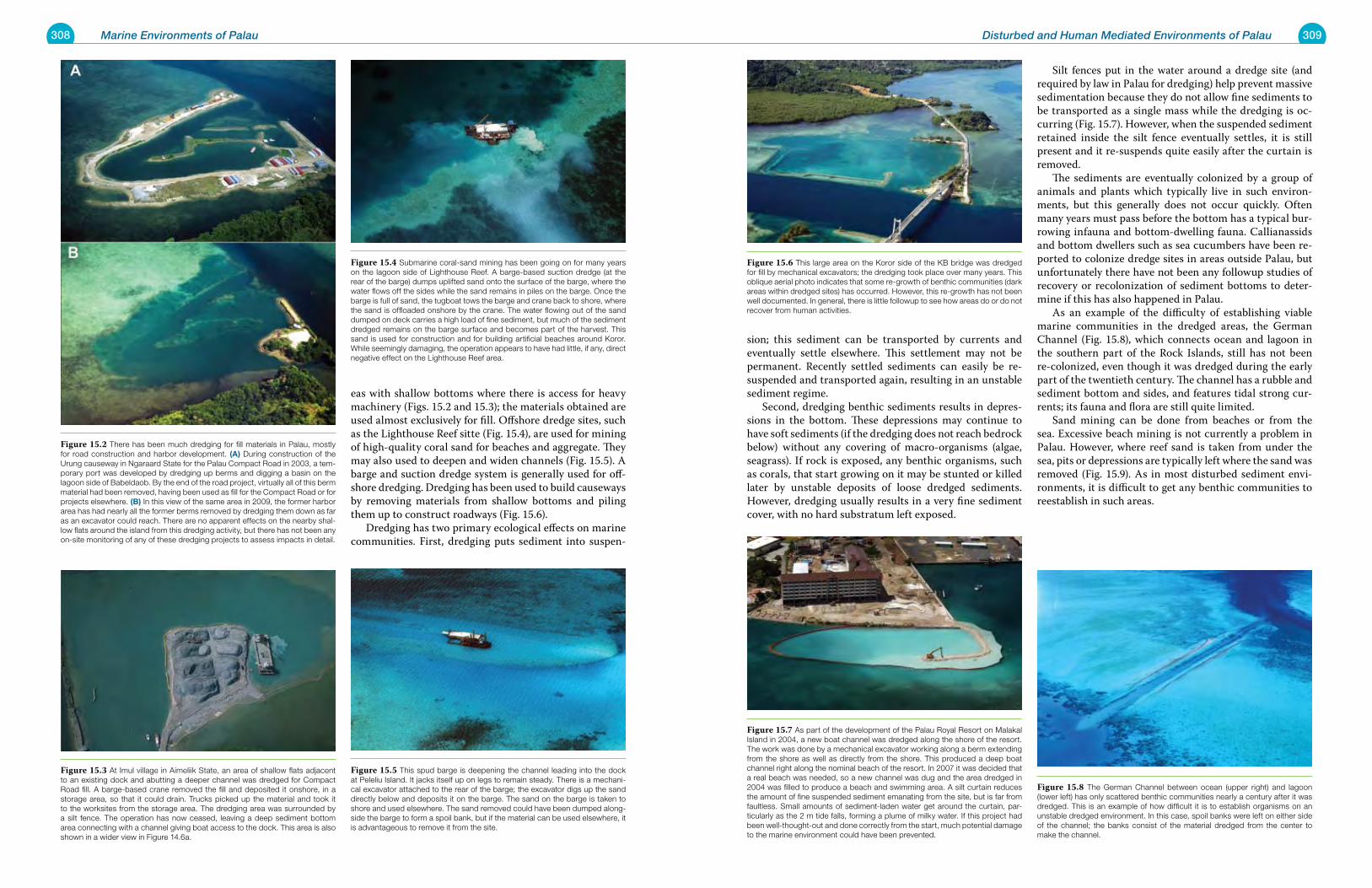
308 Marine Environments of Palau 309Disturbed and Human Mediated Environments of Palau
eas with shallow bottoms where there is access for heavy machinery (Figs. 15.2 and 15.3); the materials obtained are used almost exclusively for fill. Offshore dredge sites, such as the Lighthouse Reef sitte (Fig. 15.4), are used for mining of high-quality coral sand for beaches and aggregate. They may also used to deepen and widen channels (Fig. 15.5). A barge and suction dredge system is generally used for off-shore dredging. Dredging has been used to build causeways by removing materials from shallow bottoms and piling them up to construct roadways (Fig. 15.6). Dredging has two primary ecological effects on marine communities. First, dredging puts sediment into suspen-
sion; this sediment can be transported by currents and eventually settle elsewhere. This settlement may not be permanent. Recently settled sediments can easily be re-suspended and transported again, resulting in an unstable sediment regime. Second, dredging benthic sediments results in depres-sions in the bottom. These depressions may continue to have soft sediments (if the dredging does not reach bedrock below) without any covering of macro-organisms (algae, seagrass). If rock is exposed, any benthic organisms, such as corals, that start growing on it may be stunted or killed later by unstable deposits of loose dredged sediments. However, dredging usually results in a very fine sediment cover, with no hard substratum left exposed.
Silt fences put in the water around a dredge site (and required by law in Palau for dredging) help prevent massive sedimentation because they do not allow fine sediments to be transported as a single mass while the dredging is oc-curring (Fig. 15.7). However, when the suspended sediment retained inside the silt fence eventually settles, it is still present and it re-suspends quite easily after the curtain is removed. The sediments are eventually colonized by a group of animals and plants which typically live in such environ-ments, but this generally does not occur quickly. Often many years must pass before the bottom has a typical bur-rowing infauna and bottom-dwelling fauna. Callianassids and bottom dwellers such as sea cucumbers have been re-ported to colonize dredge sites in areas outside Palau, but unfortunately there have not been any followup studies of recovery or recolonization of sediment bottoms to deter-mine if this has also happened in Palau. As an example of the difficulty of establishing viable marine communities in the dredged areas, the German Channel (Fig. 15.8), which connects ocean and lagoon in the southern part of the Rock Islands, still has not been re-colonized, even though it was dredged during the early part of the twentieth century. The channel has a rubble and sediment bottom and sides, and features tidal strong cur-rents; its fauna and flora are still quite limited. Sand mining can be done from beaches or from the sea. Excessive beach mining is not currently a problem in Palau. However, where reef sand is taken from under the sea, pits or depressions are typically left where the sand was removed (Fig. 15.9). As in most disturbed sediment envi-ronments, it is difficult to get any benthic communities to reestablish in such areas.
Figure 15.2 There has been much dredging for fill materials in Palau, mostly for road construction and harbor development. (a) During construction of the Urung causeway in Ngaraard State for the Palau Compact Road in 2003, a tem-porary port was developed by dredging up berms and digging a basin on the lagoon side of Babeldaob. By the end of the road project, virtually all of this berm material had been removed, having been used as fill for the Compact Road or for projects elsewhere. (B) In this view of the same area in 2009, the former harbor area has had nearly all the former berms removed by dredging them down as far as an excavator could reach. There are no apparent effects on the nearby shal-low flats around the island from this dredging activity, but there has not been any on-site monitoring of any of these dredging projects to assess impacts in detail.
Figure 15.3 At Imul village in Aimeliik State, an area of shallow flats adjacent to an existing dock and abutting a deeper channel was dredged for Compact Road fill. A barge-based crane removed the fill and deposited it onshore, in a storage area, so that it could drain. Trucks picked up the material and took it to the worksites from the storage area. The dredging area was surrounded by a silt fence. The operation has now ceased, leaving a deep sediment bottom area connecting with a channel giving boat access to the dock. This area is also shown in a wider view in Figure 14.6a.
Figure 15.4 Submarine coral-sand mining has been going on for many years on the lagoon side of Lighthouse Reef. A barge-based suction dredge (at the rear of the barge) dumps uplifted sand onto the surface of the barge, where the water flows off the sides while the sand remains in piles on the barge. Once the barge is full of sand, the tugboat tows the barge and crane back to shore, where the sand is offloaded onshore by the crane. The water flowing out of the sand dumped on deck carries a high load of fine sediment, but much of the sediment dredged remains on the barge surface and becomes part of the harvest. This sand is used for construction and for building artificial beaches around Koror. While seemingly damaging, the operation appears to have had little, if any, direct negative effect on the Lighthouse Reef area.
Figure 15.5 This spud barge is deepening the channel leading into the dock at Peleliu Island. It jacks itself up on legs to remain steady. There is a mechani-cal excavator attached to the rear of the barge; the excavator digs up the sand directly below and deposits it on the barge. The sand on the barge is taken to shore and used elsewhere. The sand removed could have been dumped along-side the barge to form a spoil bank, but if the material can be used elsewhere, it is advantageous to remove it from the site.
Figure 15.6 This large area on the Koror side of the KB bridge was dredged for fill by mechanical excavators; the dredging took place over many years. This oblique aerial photo indicates that some re-growth of benthic communities (dark areas within dredged sites) has occurred. However, this re-growth has not been well documented. In general, there is little followup to see how areas do or do not recover from human activities.
Figure 15.7 As part of the development of the Palau Royal Resort on Malakal Island in 2004, a new boat channel was dredged along the shore of the resort. The work was done by a mechanical excavator working along a berm extending from the shore as well as directly from the shore. This produced a deep boat channel right along the nominal beach of the resort. In 2007 it was decided that a real beach was needed, so a new channel was dug and the area dredged in 2004 was filled to produce a beach and swimming area. A silt curtain reduces the amount of fine suspended sediment emanating from the site, but is far from faultless. Small amounts of sediment-laden water get around the curtain, par-ticularly as the 2 m tide falls, forming a plume of milky water. If this project had been well-thought-out and done correctly from the start, much potential damage to the marine environment could have been prevented.
Figure 15.8 The German Channel between ocean (upper right) and lagoon (lower left) has only scattered benthic communities nearly a century after it was dredged. This is an example of how difficult it is to establish organisms on an unstable dredged environment. In this case, spoil banks were left on either side of the channel; the banks consist of the material dredged from the center to make the channel.
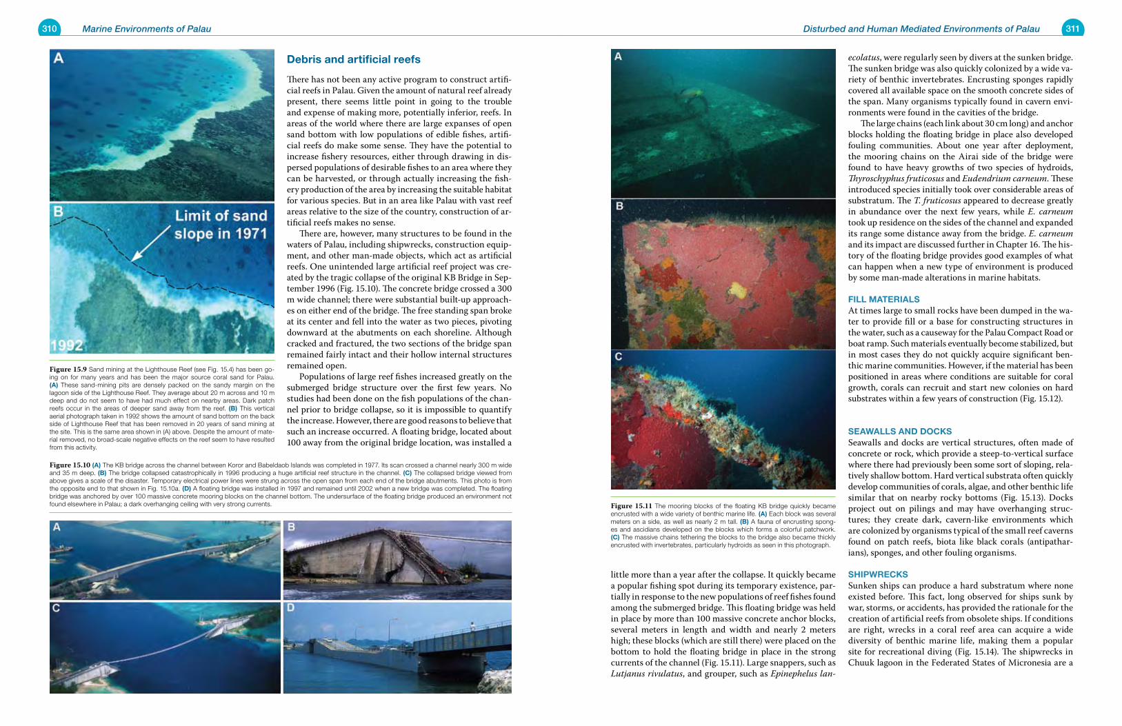
310 Marine Environments of Palau 311Disturbed and Human Mediated Environments of Palau
Debris and artificial reefs
There has not been any active program to construct artifi-cial reefs in Palau. Given the amount of natural reef already present, there seems little point in going to the trouble and expense of making more, potentially inferior, reefs. In areas of the world where there are large expanses of open sand bottom with low populations of edible fishes, artifi-cial reefs do make some sense. They have the potential to increase fishery resources, either through drawing in dis-persed populations of desirable fishes to an area where they can be harvested, or through actually increasing the fish-ery production of the area by increasing the suitable habitat for various species. But in an area like Palau with vast reef areas relative to the size of the country, construction of ar-tificial reefs makes no sense. There are, however, many structures to be found in the waters of Palau, including shipwrecks, construction equip-ment, and other man-made objects, which act as artificial reefs. One unintended large artificial reef project was cre-ated by the tragic collapse of the original KB Bridge in Sep-tember 1996 (Fig. 15.10). The concrete bridge crossed a 300 m wide channel; there were substantial built-up approach-es on either end of the bridge. The free standing span broke at its center and fell into the water as two pieces, pivoting downward at the abutments on each shoreline. Although cracked and fractured, the two sections of the bridge span remained fairly intact and their hollow internal structures remained open. Populations of large reef fishes increased greatly on the submerged bridge structure over the first few years. No studies had been done on the fish populations of the chan-nel prior to bridge collapse, so it is impossible to quantify the increase. However, there are good reasons to believe that such an increase occurred. A floating bridge, located about 100 away from the original bridge location, was installed a
little more than a year after the collapse. It quickly became a popular fishing spot during its temporary existence, par-tially in response to the new populations of reef fishes found among the submerged bridge. This floating bridge was held in place by more than 100 massive concrete anchor blocks, several meters in length and width and nearly 2 meters high; these blocks (which are still there) were placed on the bottom to hold the floating bridge in place in the strong currents of the channel (Fig. 15.11). Large snappers, such as Lutjanus rivulatus, and grouper, such as Epinephelus lan-
ecolatus, were regularly seen by divers at the sunken bridge. The sunken bridge was also quickly colonized by a wide va-riety of benthic invertebrates. Encrusting sponges rapidly covered all available space on the smooth concrete sides of the span. Many organisms typically found in cavern envi-ronments were found in the cavities of the bridge. The large chains (each link about 30 cm long) and anchor blocks holding the floating bridge in place also developed fouling communities. About one year after deployment, the mooring chains on the Airai side of the bridge were found to have heavy growths of two species of hydroids, Thyroschyphus fruticosus and Eudendrium carneum. These introduced species initially took over considerable areas of substratum. The T. fruticosus appeared to decrease greatly in abundance over the next few years, while E. carneum took up residence on the sides of the channel and expanded its range some distance away from the bridge. E. carneum and its impact are discussed further in Chapter 16. The his-tory of the floating bridge provides good examples of what can happen when a new type of environment is produced by some man-made alterations in marine habitats.
Fill materialsAt times large to small rocks have been dumped in the wa-ter to provide fill or a base for constructing structures in the water, such as a causeway for the Palau Compact Road or boat ramp. Such materials eventually become stabilized, but in most cases they do not quickly acquire significant ben-thic marine communities. However, if the material has been positioned in areas where conditions are suitable for coral growth, corals can recruit and start new colonies on hard substrates within a few years of construction (Fig. 15.12).
seawalls anD DoCksSeawalls and docks are vertical structures, often made of concrete or rock, which provide a steep-to-vertical surface where there had previously been some sort of sloping, rela-tively shallow bottom. Hard vertical substrata often quickly develop communities of corals, algae, and other benthic life similar that on nearby rocky bottoms (Fig. 15.13). Docks project out on pilings and may have overhanging struc-tures; they create dark, cavern-like environments which are colonized by organisms typical of the small reef caverns found on patch reefs, biota like black corals (antipathar-ians), sponges, and other fouling organisms.
shipwreCksSunken ships can produce a hard substratum where none existed before. This fact, long observed for ships sunk by war, storms, or accidents, has provided the rationale for the creation of artificial reefs from obsolete ships. If conditions are right, wrecks in a coral reef area can acquire a wide diversity of benthic marine life, making them a popular site for recreational diving (Fig. 15.14). The shipwrecks in Chuuk lagoon in the Federated States of Micronesia are a
Figure 15.9 Sand mining at the Lighthouse Reef (see Fig. 15.4) has been go-ing on for many years and has been the major source coral sand for Palau. (a) These sand-mining pits are densely packed on the sandy margin on the lagoon side of the Lighthouse Reef. They average about 20 m across and 10 m deep and do not seem to have had much effect on nearby areas. Dark patch reefs occur in the areas of deeper sand away from the reef. (B) This vertical aerial photograph taken in 1992 shows the amount of sand bottom on the back side of Lighthouse Reef that has been removed in 20 years of sand mining at the site. This is the same area shown in (A) above. Despite the amount of mate-rial removed, no broad-scale negative effects on the reef seem to have resulted from this activity.
Figure 15.10 (a) The KB bridge across the channel between Koror and Babeldaob Islands was completed in 1977. Its scan crossed a channel nearly 300 m wide and 35 m deep. (B) The bridge collapsed catastrophically in 1996 producing a huge artificial reef structure in the channel. (C) The collapsed bridge viewed from above gives a scale of the disaster. Temporary electrical power lines were strung across the open span from each end of the bridge abutments. This photo is from the opposite end to that shown in Fig. 15.10a. (D) A floating bridge was installed in 1997 and remained until 2002 when a new bridge was completed. The floating bridge was anchored by over 100 massive concrete mooring blocks on the channel bottom. The undersurface of the floating bridge produced an environment not found elsewhere in Palau; a dark overhanging ceiling with very strong currents. Figure 15.11 The mooring blocks of the floating KB bridge quickly became
encrusted with a wide variety of benthic marine life. (a) Each block was several meters on a side, as well as nearly 2 m tall. (B) A fauna of encrusting spong-es and ascidians developed on the blocks which forms a colorful patchwork. (C) The massive chains tethering the blocks to the bridge also became thickly encrusted with invertebrates, particularly hydroids as seen in this photograph.
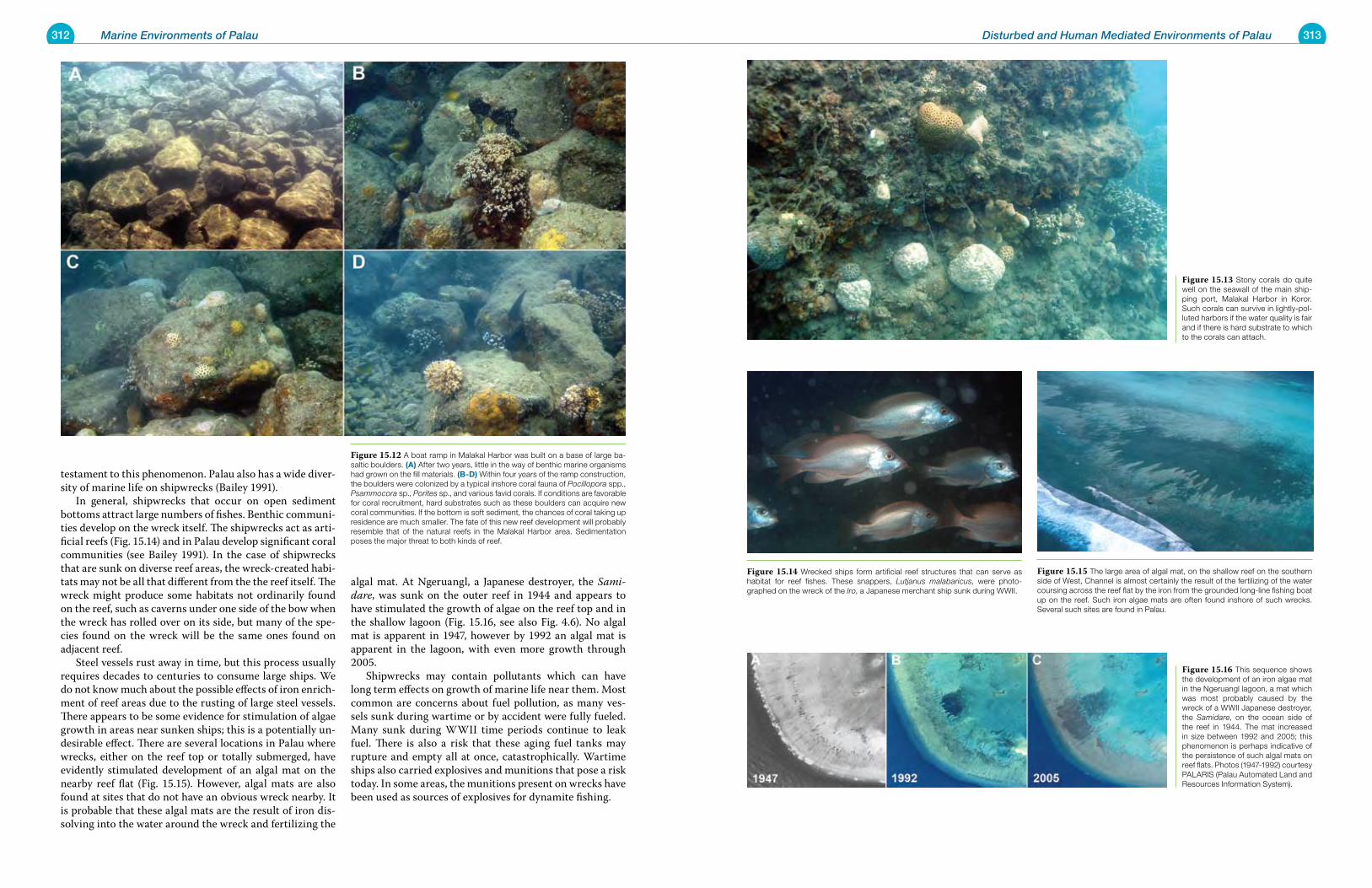
312 Marine Environments of Palau 313Disturbed and Human Mediated Environments of Palau
testament to this phenomenon. Palau also has a wide diver-sity of marine life on shipwrecks (Bailey 1991). In general, shipwrecks that occur on open sediment bottoms attract large numbers of fishes. Benthic communi-ties develop on the wreck itself. The shipwrecks act as arti-ficial reefs (Fig. 15.14) and in Palau develop significant coral communities (see Bailey 1991). In the case of shipwrecks that are sunk on diverse reef areas, the wreck-created habi-tats may not be all that different from the the reef itself. The wreck might produce some habitats not ordinarily found on the reef, such as caverns under one side of the bow when the wreck has rolled over on its side, but many of the spe-cies found on the wreck will be the same ones found on adjacent reef. Steel vessels rust away in time, but this process usually requires decades to centuries to consume large ships. We do not know much about the possible effects of iron enrich-ment of reef areas due to the rusting of large steel vessels. There appears to be some evidence for stimulation of algae growth in areas near sunken ships; this is a potentially un-desirable effect. There are several locations in Palau where wrecks, either on the reef top or totally submerged, have evidently stimulated development of an algal mat on the nearby reef flat (Fig. 15.15). However, algal mats are also found at sites that do not have an obvious wreck nearby. It is probable that these algal mats are the result of iron dis-solving into the water around the wreck and fertilizing the
algal mat. At Ngeruangl, a Japanese destroyer, the Sami-dare, was sunk on the outer reef in 1944 and appears to have stimulated the growth of algae on the reef top and in the shallow lagoon (Fig. 15.16, see also Fig. 4.6). No algal mat is apparent in 1947, however by 1992 an algal mat is apparent in the lagoon, with even more growth through 2005. Shipwrecks may contain pollutants which can have long term effects on growth of marine life near them. Most common are concerns about fuel pollution, as many ves-sels sunk during wartime or by accident were fully fueled. Many sunk during WWII time periods continue to leak fuel. There is also a risk that these aging fuel tanks may rupture and empty all at once, catastrophically. Wartime ships also carried explosives and munitions that pose a risk today. In some areas, the munitions present on wrecks have been used as sources of explosives for dynamite fishing.
Figure 15.12 A boat ramp in Malakal Harbor was built on a base of large ba-saltic boulders. (a) After two years, little in the way of benthic marine organisms had grown on the fill materials. (B-D) Within four years of the ramp construction, the boulders were colonized by a typical inshore coral fauna of Pocillopora spp., Psammocora sp., Porites sp., and various favid corals. If conditions are favorable for coral recruitment, hard substrates such as these boulders can acquire new coral communities. If the bottom is soft sediment, the chances of coral taking up residence are much smaller. The fate of this new reef development will probably resemble that of the natural reefs in the Malakal Harbor area. Sedimentation poses the major threat to both kinds of reef.
Figure 15.13 Stony corals do quite well on the seawall of the main ship-ping port, Malakal Harbor in Koror. Such corals can survive in lightly-pol-luted harbors if the water quality is fair and if there is hard substrate to which to the corals can attach.
Figure 15.14 Wrecked ships form artificial reef structures that can serve as habitat for reef fishes. These snappers, Lutjanus malabaricus, were photo-graphed on the wreck of the Iro, a Japanese merchant ship sunk during WWII.
Figure 15.15 The large area of algal mat, on the shallow reef on the southern side of West, Channel is almost certainly the result of the fertilizing of the water coursing across the reef flat by the iron from the grounded long-line fishing boat up on the reef. Such iron algae mats are often found inshore of such wrecks. Several such sites are found in Palau.
Figure 15.16 This sequence shows the development of an iron algae mat in the Ngeruangl lagoon, a mat which was most probably caused by the wreck of a WWII Japanese destroyer, the Samidare, on the ocean side of the reef in 1944. The mat increased in size between 1992 and 2005; this phenomenon is perhaps indicative of the persistence of such algal mats on reef flats. Photos (1947-1992) courtesy PALARIS (Palau Automated Land and Resources Information System).
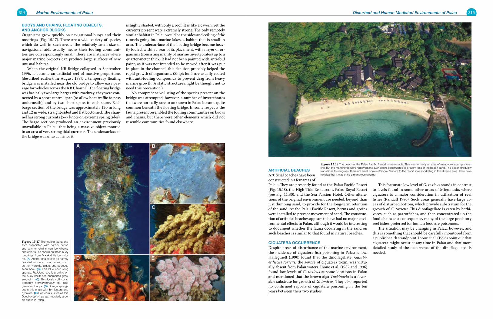
314 Marine Environments of Palau 315Disturbed and Human Mediated Environments of Palau
Buoys anD Chains, Floating oBjeCts, anD anChor BloCksOrganisms grow quickly on navigational buoys and their moorings (Fig. 15.17). There are a wide variety of species which do well in such areas. The relatively small size of navigational aids usually means their fouling communi-ties are correspondingly small. There are instances where major marine projects can produce large surfaces of new unusual habitat. When the original KB Bridge collapsed in September 1996, it became an artificial reef of massive proportions (described earlier). In August 1997, a temporary floating bridge was installed near the old bridge to allow easy pas-sage for vehicles across the KB Channel. The floating bridge was basically two large barges with roadway; they were con-nected by a short central span (to allow boat traffic to pass underneath), and by two short spans to each shore. Each barge section of the bridge was approximately 120 m long and 12 m wide, straight-sided and flat bottomed. The chan-nel has strong currents (5–7 knots on extreme spring tides). The barge sections produced an environment previously unavailable in Palau, that being a massive object moored in an area of very strong tidal currents. The undersurface of the bridge was unusual since it
is highly shaded, with only a roof. It is like a cavern, yet the currents present were extremely strong. The only remotely similar habitat in Palau would be the sides and ceiling of the tunnels going into marine lakes, a habitat that is small in area. The undersurface of the floating bridge became heav-ily fouled, within a year of its placement, with a layer or or-ganisms (consisting mainly of marine invertebrates) up to a quarter-meter thick. It had not been painted with anti-foul paint, as it was not intended to be moved after it was put in place in the channel; this decision probably helped the rapid growth of organisms. (Ship’s hulls are usually coated with anti-fouling compounds to prevent drag from heavy marine growth. A static structure might be thought not to need this precaution.) No comprehensive listing of the species present on the bridge was attempted; however, a number of invertebrates that were normally rare to unknown in Palau became quite common beneath the floating bridge. In some respects the fauna present resembled the fouling communities on buoys and chains, but there were other elements which did not resemble communities found elsewhere.
artiFiCial BeaChesArtificial beaches have been constructed in a few areas of Palau. They are presently found at the Palau Pacific Resort (Fig. 15.18). the High Tide Restaurant, Palau Royal Resort (see Fig. 11.30), and the Sea Passion Hotel. Other altera-tions of the original environment are needed, beyond than just dumping sand, to provide for the long-term retention of the sand. At the Palau Pacific Resort, berms and groins were installed to prevent movement of sand. The construc-tion of artificial beaches appears to have had no major envi-ronmental effects in Palau, although it would be interesting to document whether the fauna occurring in the sand on such beaches is similar to that found in natural beaches.
Ciguatera oCCurrenCeDespite areas of disturbance of the marine environment, the incidence of ciguatera fish poisoning in Palau is low. Hallegraeff (1990) found that the dinoflagellate, Gambi-erdiscus toxicus, the source of ciguatera toxin, was virtu-ally absent from Palau waters. Inoue et al. (1987 and 1996) found low levels of G. toxicus at some locations in Palau and mentioned that the brown alga Turbinaria is a favor-able substrate for growth of G. toxicus. They also reported no confirmed reports of ciguatera poisoning in the ten years between their two studies.
This fortunate low level of G. toxicus stands in contrast to levels found in some other areas of Micronesia, where ciguatera is a major consideration in utilization of reef fishes (Randall 1980). Such areas generally have large ar-eas of disturbed bottom, which provide substratum for the growth of G. toxicus. This dinoflagellate is eaten by herbi-vores, such as parrotfishes, and then concentrated up the food chain; as a consequence, many of the large predatory reef fishes preferred for human food are poisonous. The situation may be changing in Palau, however, and this is something that should be carefully monitored from a public health standpoint. Inoue et al. (1996) point out that ciguatera might occur at any time in Palau and that more detailed study of the occurrence of the dinoflagellates is needed.
Figure 15.17 The fouling fauna and flora associated with harbor buoys and anchor chains can be diverse and colorful, as shown on these buoy moorings from Malakal Harbor, Ko-ror. (a) Anchor chains can be heavily coasted with encrusting fauna, such as the hydroids, algae, and sponges seen here. (B) This blue encrusting sponge, Haliclona sp., is growing on the buoy itself; sea anemones grow around it. (C) This lovely soft coral, probably Stereonephthya sp., also grows on buoys. (D) Orange sponge coats this chain with brittlestars and hydroids. (e) Soft corals, such as this Dendronephythya sp., regularly grow on buoys in Palau.
Figure 15.18 The beach at the Palau Pacific Resort is man-made. This was formerly an area of mangrove swamp shore-line, but the mangroves were removed and twin groins constructed to prevent loss of the beach sand. The beach gradually transitions to seagrass; there are small corals offshore. Visitors to the resort love snorkeling in this diverse area. They have no idea that it was once a mangrove swamp.
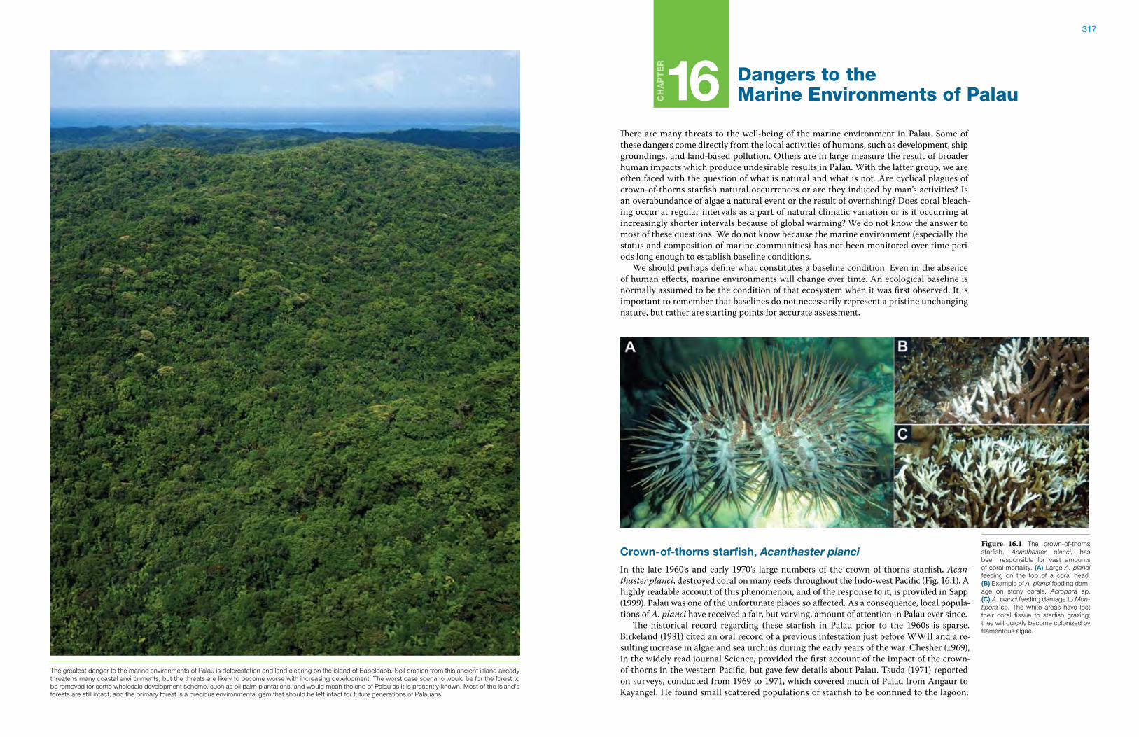
317
Ch
ap
te
r
16 Dangers to the Marine Environments of Palau
There are many threats to the well-being of the marine environment in Palau. Some of these dangers come directly from the local activities of humans, such as development, ship groundings, and land-based pollution. Others are in large measure the result of broader human impacts which produce undesirable results in Palau. With the latter group, we are often faced with the question of what is natural and what is not. Are cyclical plagues of crown-of-thorns starfish natural occurrences or are they induced by man’s activities? Is an overabundance of algae a natural event or the result of overfishing? Does coral bleach-ing occur at regular intervals as a part of natural climatic variation or is it occurring at increasingly shorter intervals because of global warming? We do not know the answer to most of these questions. We do not know because the marine environment (especially the status and composition of marine communities) has not been monitored over time peri-ods long enough to establish baseline conditions. We should perhaps define what constitutes a baseline condition. Even in the absence of human effects, marine environments will change over time. An ecological baseline is normally assumed to be the condition of that ecosystem when it was first observed. It is important to remember that baselines do not necessarily represent a pristine unchanging nature, but rather are starting points for accurate assessment.
Crown-of-thorns starfish, Acanthaster planci
In the late 1960’s and early 1970’s large numbers of the crown-of-thorns starfish, Acan-thaster planci, destroyed coral on many reefs throughout the Indo-west Pacific (Fig. 16.1). A highly readable account of this phenomenon, and of the response to it, is provided in Sapp (1999). Palau was one of the unfortunate places so affected. As a consequence, local popula-tions of A. planci have received a fair, but varying, amount of attention in Palau ever since. The historical record regarding these starfish in Palau prior to the 1960s is sparse. Birkeland (1981) cited an oral record of a previous infestation just before WWII and a re-sulting increase in algae and sea urchins during the early years of the war. Chesher (1969), in the widely read journal Science, provided the first account of the impact of the crown-of-thorns in the western Pacific, but gave few details about Palau. Tsuda (1971) reported on surveys, conducted from 1969 to 1971, which covered much of Palau from Angaur to Kayangel. He found small scattered populations of starfish to be confined to the lagoon;
Figure 16.1 The crown-of-thorns starfish, Acanthaster planci, has been responsible for vast amounts of coral mortality. (a) Large A. planci feeding on the top of a coral head. (B) Example of A. planci feeding dam-age on stony corals, Acropora sp. (C) A. planci feeding damage to Mon-tipora sp. The white areas have lost their coral tissue to starfish grazing; they will quickly become colonized by filamentous algae.
The greatest danger to the marine environments of Palau is deforestation and land clearing on the island of Babeldaob. Soil erosion from this ancient island already threatens many coastal environments, but the threats are likely to become worse with increasing development. The worst case scenario would be for the forest to be removed for some wholesale development scheme, such as oil palm plantations, and would mean the end of Palau as it is presently known. Most of the island's forests are still intact, and the primary forest is a precious environmental gem that should be left intact for future generations of Palauans.
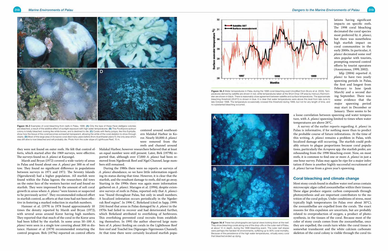
318 Marine Environments of Palau 319Dangers to the Marine Environments of Palau
they were not found on outer reefs. He felt that control ef-forts, which started after the 1969 surveys, were effective. The surveys found no A. planci at Kayangel. Marsh and Bryan (1972) covered a wide variety of areas in Palau and found about one A. planci per 300 m of reef tow. They found no significant difference in populations between surveys in 1971 and 1972. The Seventy Islands (Ngerukewid) had a higher population. All starfish were found within the Palau lagoon; the researchers did tows on the outer face of the western barrier reef and found no starfish. They were impressed by the amount of soft coral growth in areas where A. planci “were known or suspected to be previously active”. They recommended reduced effort in starfish control, as efforts at that time had not been effec-tive in fostering a marked reduction in starfish numbers. Hamner et al. (1979) in 1978 found approximately 10 times the density reported by Marsh and Bryan (1972), with several areas around Koror having high numbers. They reported that that much of the coral in the Koror area had been killed by the starfish. In some areas 50–100 A. planci were seen in a single tow covering about 300 m dis-tance. Hamner et al (1979) recommended restarting the control program. Birk (1979a) reported on control efforts
centered around southeast-ern Malakal Harbor in Ko-ror. Nearly 50,000 A. planci were removed from the reefs and channel around
Malakal Harbor; however researchers believed that at least an equal number were still present. Later, Birk (1979b) re-ported that, although over 17,000 A. planci had been re-moved from Ngederrak Reef and Ngel Channel, large num-bers still remained. During the 1980s there were no reports or surveys of A. planci abundance, so we have little information regard-ing its status during that time. However, it is clear that the starfish, and the resultant damage to reefs, did not go away. Starting in the 1990s there was again more information gathered on A. planci. Maragos et al. (1994), despite exten-sive surveys of reefs in Palau, reported only that A. planci-was “found throughout Palau, but only in small numbers. A localized infestation occurs periodically in the Ngeder-rak Reef region”. In 1996 C. Birkeland (cited in Sapp, 1999: 216) found that areas in Palau damaged by A. planci in the 1970s had failed to recover and had deteriorated further, which Birkeland attributed to overfishing of herbivores. This overfishing prevented coral recruits from establish-ing themselves. In 1995 the author observed large num-bers of A. planci feeding on corals in the Lighthouse Reef fore-reef and Toachel Iou (Ngeanges-Ngermeaus Channel). At that time there were certainly localized starfish popu-
lations having significant impacts on specific reefs. The 1998 coral bleaching decimated the coral species most preferred by A. planci, but there was nonetheless high starfish impact on coral communities in the early 2000s. In particular, A. planci decimated some reef sites popular with tourists, prompting renewed control efforts by tourist operators (Anonymous, 1999, 2002). Idip (2004) reported A. planci to have two yearly spawning periods in Palau, the first and longest from February to June (peak March) and a second dur-ing September. There was some evidence that the major spawning period may start in December or January. There seems to be
a loose correlation between spawning and water tempera-ture, with A. planci spawning limited to times when water temperatures are above 28°C. A survey of the earlier reports regarding A. planci in Palau is informative, if for nothing more than to predict the probable course of future infestations. At the time of this writing, A. planci remains a problem in Palau, with localized damage still occurring. The starfish could prob-ably return to plague proportions because coral popula-tions, particularly the Acropora spp. the starfish prefer, are rebounding from the 1998 bleaching event. Now, on most reefs, it is common to find one or more A. planci in just a one hour survey. Palau may again be ripe for a major infes-tation if there is another highly successful recruitment of A. planci larvae from a given year’s spawning.
Coral bleaching and climate changeMost stony corals found in shallow water reef areas contain microscopic algae called zooxanthellae within their tissues. These algae produce organic carbon compounds through photosynthesis and are important contributors to the nu-trition of the coral polyps. Under conditions of stress, most typically high temperatures (in Palau over about 30°C), the zooxanthellae are expelled from the corals. The exact reasons for this expulsion are uncertain, but are probably related to overproduction of oxygen, a product of photo-synthesis, in the tissues of the coral. Because most of the color of stony corals comes from the zooxanthellae, once they are expelled, the corals turn white: the coral tissue is somewhat translucent and the white calcium carbonate skeleton of the coral colony is visible through the coral tis-
Figure 16.2 Examples of coral bleaching from reefs in Palau, 1998. (a) Only the tops of these Favia stelligera colonies are bleached, a result of the additive effect of sunlight exposure with high water temperatures. (B) This Pocillopora eydouxi colony is totally bleached, looking like white bones, and is destined to die. (C) Corals with fleshy polyps, like this Euphyllia, show how the tissue of the coral becomes somewhat transparent, allowing the white of the coral skeleton to show through clearly. (D) Most of this large area of Acropora coral died many years before (from Acanthaster planci?); the only area which was still alive is now bleached and will probably die. Photo from the outer slope of Lighthouse Reef, 15 m.
Figure 16.3 Water temperatures in Palau during the 1998 coral bleaching event (modified from Bruno et al. 2000). Tem-peratures derived by satellite are shown in red, while temperatures taken at the Short Drop-Off area by mercury thermom-eter are shown in black. There is reasonably close agreement between satellite and surface temperatures. The approximate bleaching threshold (29.8°C) is shown in blue. It is clear that water temperatures were above this level from late June to late October 1998. The temperature occasionally crossed this threshold during 1999, but not for any length of time, and no substantial bleaching occurred.
Figure 16.4 These two photographs are typical views looking down at the reef. They show bleaching corals along one of the drop-offs on the outer reef of Palau, at about 12 m depth, during the 1998 bleaching event. The outer reef slopes were perhaps the hardest hit environments, suffering up to 90% coral mortality. Because of the persistence of the high water temperatures, virtually every coral that bleached ended up dying.
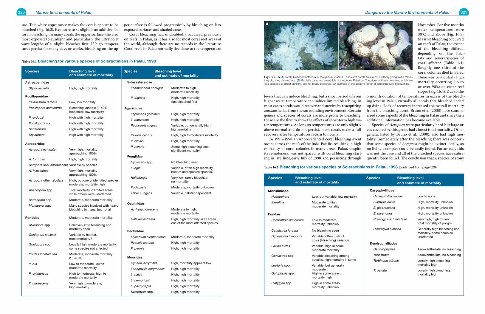
320 Marine Environments of Palau 321Dangers to the Marine Environments of Palau
sue. This white appearance makes the corals appear to be bleached (Fig. 16.2). Exposure to sunlight is an additive fac-tor in bleaching. In many corals the upper surface, the area most exposed to sunlight and particularly the ultraviolet wave lengths of sunlight, bleaches first. If high tempera-tures persist for many days or weeks, bleaching on the up-
per surface is followed progressively by bleaching on less-exposed surfaces and shaded areas. Coral bleaching had undoubtedly occurred previously on reefs in Palau, as it has also for most coral reef areas of the world, although there are no records in the literature. Coral reefs in Palau normally live close to the temperature
levels that can induce bleaching, but a short period of even higher water temperature can induce limited bleaching. In most cases corals would recover and survive by reacquiring zooxanthellae from the surrounding environment. Certain genera and species of corals are more prone to bleaching; these are the first to show the effects of short-term high wa-ter temperatures. As long as temperatures are only slightly above normal and do not persist, most corals make a full recovery after temperatures return to normal. In 1997–1998 an unprecedented coral bleaching event swept across the reefs of the Indo-Pacific, resulting in high mortality of coral colonies in many areas. Palau, despite its remoteness, was not spared, with coral bleaching start-ing in late June/early July of 1998 and persisting through
November. For five months water temperatures were 30°C and above (Fig. 16.3). Massive bleaching occurred on reefs of Palau; the extent of the bleaching differed, depending on the habi-tats and genera/species of coral affected (Table 16.1). Roughly one third of the coral colonies died in Palau. There was particularly high mortality occurring (up to or over 90%) on outer reef slopes (Fig. 16.4). Due to the
5 month duration of temperatures in excess of the bleach-ing level in Palau, virtually all corals that bleached ended up dying. Lack of recovery increased the overall mortality from the bleaching event. Bruno et al (2000) have summa-rized some aspects of the bleaching in Palau and since then additional information has become available. Species of Acropora were particularly hard hit; large ar-eas covered by this genus had almost total mortality. Other genera, listed by Bruno et al. (2000), also had high mor-tality. Immediately after the bleaching there was concern that some species of Acropora might be extinct locally, as no living examples could be easily found. Fortunately this was not the case and all of the bleached species have subse-quently been found. The conclusion that a species of stony
Table 16.1 Bleaching for various species of scleractinians in palau, 1998
species Bleaching level and estimate of mortality
astrocoeniidae
Stylocoeniella High, high mortality
pocilloporidae
Palauastrea ramosa Low, low mortality
Pocillopora damicornis Bleaching variable (0-50% bleached), low mortality
P. eydouxi High with high mortality
Pocillopora sp. High with high mortality
Seriatopora High with high mortality
Stylophora High with high mortality
acroporidae
Acropora echinata Very high, mortality approaching 100%
A. formosa High, high mortality
Acropora spp. arborescent Variable by species
A. hyacinthus Very high, mortality approaching 100%
Acropora other tabulate High, but one unidentified species moderate, mortality high
Anacropora spp. Total mortality in limited areas while others were unaffected
Astreopora spp. Moderate, moderate mortality
Montipora spp. Many species involved with heavy bleaching in many, but not all
poritidae Moderate, moderate mortality
Alveopora spp. Relatively little bleaching and mortality seen
Goniopora stokesii Variable by habitat, most mortality?
Goniopora spp. Locally high, moderate mortality, some species not affected
Porites lobata/lutea Moderate, moderate mortality (10-40%)
P. rus Low to moderate, low to moderate mortality
P. cylindricus High to moderate, high to moderate mortality
P. nigrescens Very high to moderate, high mortality
species Bleaching level and estimate of mortality
siderastereidae
Psammocora contigua Moderate to high, moderate mortality
P. digitata High, high mortality, tips bleached first
agariciidae
Leptoseris gardineri High, high mortality
L. papyracea High, high mortality
Pachyseris rugosa Variable, but generally high, high mortality
Pavona cactus High, high to moderate mortality
P. clavus High, high mortality
P. minuta Some high bleaching seen, significant mortality
Fungiidae
Cycloseris spp. No bleaching seen
Fungia Variable, often high mortality, habitat and species specific?
Heliofungia Very low, rarely bleached, no mortality
Podabacia Moderate, mortality unknown
Other Fungiids Variable, habitat dependent
oculinidae
Acrhelia horrecens Moderate to high, moderate mortality
Galaxea astreata High, high mortality in all areas, one of the most affected species
pectinidae
Mycedium elephantotus Moderate, moderate mortality
Pectinia lactuca High, high mortality
P. peonia High, high mortality
mussidae
Cynaria lacrymalis High, mortality appears low
Lobophyllia corymbosa High, high mortality
L. nataii High, high mortality
L. hemprichii High, high mortality
L. pachysepta High, high mortality
Symphyllia spp. High, high mortality
species Bleaching level and estimate of mortality
merulinidae
Hydnophora Low, but variable, low mortality
Merulina Moderate to high, moderate mortality
Favidae
Barabattoia amicorum Low to moderate, mortality unknown Caulastrea furcata No bleaching seen
Diploastrea heliopora Variable, often distinct color (bleaching) variation
Favia/Favites Variable, high in some, moderate mortality
Goniastrea spp. Variable bleaching among species, high mortality in some
Leptoria spp. Variable, but generally moderate Oulophyllia spp. High in some areas, mortality high
Platygyra spp. High in some areas, mortality unknown
species Bleaching level and estimate of mortality
Caryophylliidae
Catalaphyllia jardinei Low to none
Euphyllia divisa High, mortality unknown
E. glabrescens High, mortality unknown
E. parancora High, mortality unknown
Physogyra lichtensteini Very high, high to near total mortality of polyps
Pleurogyra sinuosa Generally high bleaching and mortality, some colonies unaffected
Dendrophylliadae
Dendrophylliaa Azooxanthellate, no bleaching
Tubastraea Azooxanthellate, no bleaching
Turbinaria bifrons Locally high bleaching, mortality high
T. peltata Locally high bleaching, mortality high
Table 16.1 Bleaching for various species of scleractinians in palau, 1998 (continued from page 320)
Figure 16.5 (a) Totally bleached soft coral of the genus Sinularia. These soft corals are almost certainly going to die. When they do, they disintegrate. (B) Partially bleached zoanthids of the genus Palythoa. The sides of these colonies, which are less exposed to direct sunlight, are not totally bleached, an example of the additive factor of light exposure in bleaching.
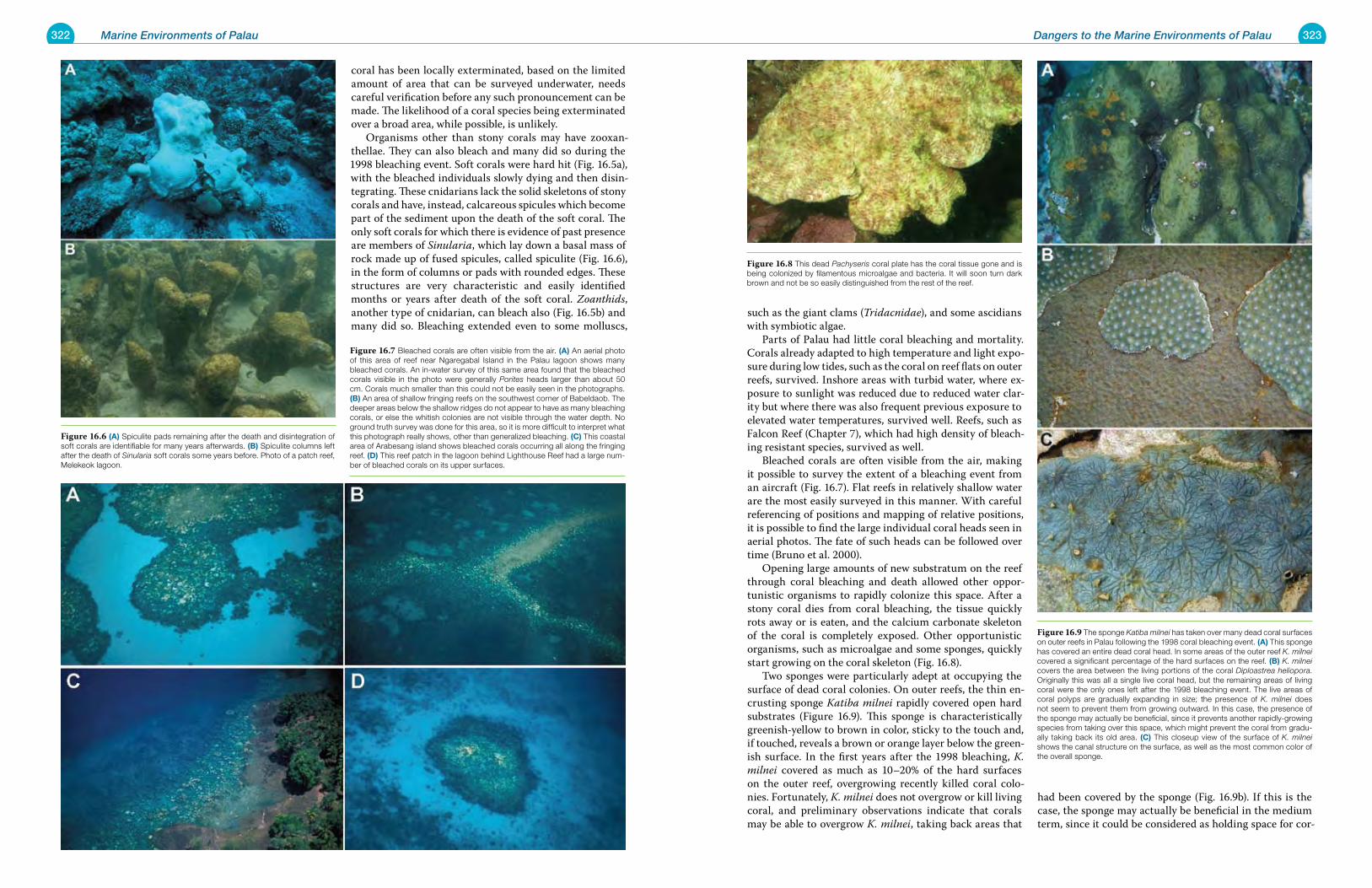
322 Marine Environments of Palau 323Dangers to the Marine Environments of Palau
coral has been locally exterminated, based on the limited amount of area that can be surveyed underwater, needs careful verification before any such pronouncement can be made. The likelihood of a coral species being exterminated over a broad area, while possible, is unlikely. Organisms other than stony corals may have zooxan-thellae. They can also bleach and many did so during the 1998 bleaching event. Soft corals were hard hit (Fig. 16.5a), with the bleached individuals slowly dying and then disin-tegrating. These cnidarians lack the solid skeletons of stony corals and have, instead, calcareous spicules which become part of the sediment upon the death of the soft coral. The only soft corals for which there is evidence of past presence are members of Sinularia, which lay down a basal mass of rock made up of fused spicules, called spiculite (Fig. 16.6), in the form of columns or pads with rounded edges. These structures are very characteristic and easily identified months or years after death of the soft coral. Zoanthids, another type of cnidarian, can bleach also (Fig. 16.5b) and many did so. Bleaching extended even to some molluscs,
such as the giant clams (Tridacnidae), and some ascidians with symbiotic algae. Parts of Palau had little coral bleaching and mortality. Corals already adapted to high temperature and light expo-sure during low tides, such as the coral on reef flats on outer reefs, survived. Inshore areas with turbid water, where ex-posure to sunlight was reduced due to reduced water clar-ity but where there was also frequent previous exposure to elevated water temperatures, survived well. Reefs, such as Falcon Reef (Chapter 7), which had high density of bleach-ing resistant species, survived as well. Bleached corals are often visible from the air, making it possible to survey the extent of a bleaching event from an aircraft (Fig. 16.7). Flat reefs in relatively shallow water are the most easily surveyed in this manner. With careful referencing of positions and mapping of relative positions, it is possible to find the large individual coral heads seen in aerial photos. The fate of such heads can be followed over time (Bruno et al. 2000). Opening large amounts of new substratum on the reef through coral bleaching and death allowed other oppor-tunistic organisms to rapidly colonize this space. After a stony coral dies from coral bleaching, the tissue quickly rots away or is eaten, and the calcium carbonate skeleton of the coral is completely exposed. Other opportunistic organisms, such as microalgae and some sponges, quickly start growing on the coral skeleton (Fig. 16.8). Two sponges were particularly adept at occupying the surface of dead coral colonies. On outer reefs, the thin en-crusting sponge Katiba milnei rapidly covered open hard substrates (Figure 16.9). This sponge is characteristically greenish-yellow to brown in color, sticky to the touch and, if touched, reveals a brown or orange layer below the green-ish surface. In the first years after the 1998 bleaching, K. milnei covered as much as 10–20% of the hard surfaces on the outer reef, overgrowing recently killed coral colo-nies. Fortunately, K. milnei does not overgrow or kill living coral, and preliminary observations indicate that corals may be able to overgrow K. milnei, taking back areas that
had been covered by the sponge (Fig. 16.9b). If this is the case, the sponge may actually be beneficial in the medium term, since it could be considered as holding space for cor-
Figure 16.6 (a) Spiculite pads remaining after the death and disintegration of soft corals are identifiable for many years afterwards. (B) Spiculite columns left after the death of Sinularia soft corals some years before. Photo of a patch reef, Melekeok lagoon.
Figure 16.7 Bleached corals are often visible from the air. (a) An aerial photo of this area of reef near Ngaregabal Island in the Palau lagoon shows many bleached corals. An in-water survey of this same area found that the bleached corals visible in the photo were generally Porites heads larger than about 50 cm. Corals much smaller than this could not be easily seen in the photographs. (B) An area of shallow fringing reefs on the southwest corner of Babeldaob. The deeper areas below the shallow ridges do not appear to have as many bleaching corals, or else the whitish colonies are not visible through the water depth. No ground truth survey was done for this area, so it is more difficult to interpret what this photograph really shows, other than generalized bleaching. (C) This coastal area of Arabesang island shows bleached corals occurring all along the fringing reef. (D) This reef patch in the lagoon behind Lighthouse Reef had a large num-ber of bleached corals on its upper surfaces.
Figure 16.8 This dead Pachyseris coral plate has the coral tissue gone and is being colonized by filamentous microalgae and bacteria. It will soon turn dark brown and not be so easily distinguished from the rest of the reef.
Figure 16.9 The sponge Katiba milnei has taken over many dead coral surfaces on outer reefs in Palau following the 1998 coral bleaching event. (a) This sponge has covered an entire dead coral head. In some areas of the outer reef K. milnei covered a significant percentage of the hard surfaces on the reef. (B) K. milnei covers the area between the living portions of the coral Diploastrea heliopora. Originally this was all a single live coral head, but the remaining areas of living coral were the only ones left after the 1998 bleaching event. The live areas of coral polyps are gradually expanding in size; the presence of K. milnei does not seem to prevent them from growing outward. In this case, the presence of the sponge may actually be beneficial, since it prevents another rapidly-growing species from taking over this space, which might prevent the coral from gradu-ally taking back its old area. (C) This closeup view of the surface of K. milnei shows the canal structure on the surface, as well as the most common color of the overall sponge.
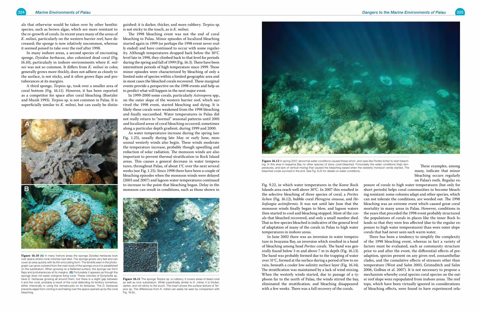
324 Marine Environments of Palau 325Dangers to the Marine Environments of Palau
als that otherwise would be taken over by other benthic species, such as brown algae, which are more resistant to the re-growth of corals. In recent years many of the areas of K. milnei, particularly on the western barrier reef, have de-creased; the sponge is now relatively uncommon, whereas it seemed poised to take over the reef after 1998. In many inshore areas, a second species of encrusting sponge, Dysidea herbacea, also colonized dead coral (Fig. 16.10), particularly in inshore environments where K. mil-nei was not so common. It differs from K. milnei in color, generally grows more thickly, does not adhere as closely to the surface, is not sticky, and it often grows flaps and pro-tuberances at its margins. A third sponge, Terpios sp., took over a smaller area of coral bottom (Fig. 16.11). However, it has been reported as a competitor for space after coral bleaching (Ruetzler and Muzik 1993). Terpios sp. is not common in Palau. It is superficially similar to K. milnei, but can easily be distin-
guished: it is darker, thicker, and more rubbery. Terpios sp. is not sticky to the touch, as is K. milnei. The 1998 bleaching event was not the end of coral bleaching in Palau. Minor episodes of localized bleaching started again in 1999 (or perhaps the 1998 event never real-ly ended) and have continued to occur with some regular-ity. Although temperatures dropped back below the 30°C level late in 1998, they climbed back to that level for periods during the spring and fall of 1999 (Fig. 16.3). There have been intermittent periods of high temperature since 1999. These minor episodes were characterized by bleaching of only a limited suite of species within a limited geographic area and in most cases the bleached corals recovered. These marginal events provide a perspective on the 1998 events and help us to predict what will happen in the next major event. In 1999-2000 some corals, particularly Astreopora spp., on the outer slope of the western barrier reef, which sur-vived the 1998 event, started bleaching and dying. It is likely these corals were weakened from the 1998 bleaching and finally succumbed. Water temperatures in Palau did not really return to “normal” seasonal patterns until 2001 and localized areas of coral bleaching occurred, sometimes along a particular depth gradient, during 1999 and 2000. As water temperatures increase during the spring (see Fig. 1.25), usually during late May or early June, mon-soonal westerly winds also begin. These winds moderate the temperature increase, probably though upwelling and reduction of solar radiation. The monsoon winds are also important to prevent thermal stratification in Rock Island areas. This causes a general decrease in water tempera-tures, throughout Palau, of about 1°C over the next several weeks (see Fig. 1.25). Since 1998 there have been a couple of bleaching episodes when the monsoon winds were delayed (2003 and 2007) and lagoon water temperatures continued to increase to the point that bleaching began. Delay in the monsoon can result in conditions, such as those shown in
Fig. 9.22, in which water temperatures in the Koror Rock Islands area reach well above 30°C. In 2007 this resulted in the selective bleaching of three species of coral, a Porites lichen (Fig. 16.12), bubble coral Plerogyra sinuosa, and He-liofungia actiniformis. It was not until late June that the monsoon winds finally began to blow, and lagoon waters then started to cool and bleaching stopped. Most of the cor-als that bleached recovered, and only a small number died. That so few species bleached is indicative of the general level of adaptation of many of the corals in Palau to high water temperatures in inshore areas. In June 2002 there was an inversion in water tempera-ture in Iwayama Bay, an inversion which resulted in a band of bleaching among head Porites corals. The band was gen-erally found below 3 m and above 7 m in depth (Fig. 16.13). The band was probably formed due to the trapping of water over 31°C, formed at the surface during a period of low to no rain, beneath a cooler low-salinity surface layer (Fig. 16.14). The stratification was maintained by a lack of wind mixing. When the westerly winds started, due to passage of a ty-phoon far to the north of Palau, the winds stirred the bay, eliminated the stratification, and bleaching disappeared with a few weeks. There was a full recovery of the corals.
These examples, among many, indicate that minor bleaching occurs regularly on Palau’s reefs. Regular ex-
posure of corals to high water temperatures (but only for short periods) helps coral communities to become bleach-ing resistant: some colonies adapt and other species, which can not tolerate the conditions, are weeded out. The 1998 bleaching was an extreme event which caused great coral mortality in many areas in Palau. However, conditions in the years that preceded the 1998 event probably structured the populations of corals in places like the inner Rock Is-lands so that they were less affected (due to the regular ex-posure to high water temperatures) than were outer slope corals that had never seen such warm water. There has been a tendency to simplify the complexity of the 1998 bleaching event, whereas in fact a variety of factors must be evaluated, such as community structure prior to and after the event, the differential effects of pre-adaption, species present on any given reef, zooxanthellae clades, and the cumulative effects of stressors other than temperature (West and Salm 2003, Grimsditch and Salm 2006, Golbuu et al. 2007). It is not necessary to propose a mechanism whereby coral species coral species on the out-er reef slope were repopulated from inshore areas. The reef tops, which have been virtually ignored in considerations of bleaching effects, were found to have experienced rela-
Figure 16.11 The sponge Terpios sp. is rubbery; it covers areas of dead coral as well as rock substratum. While superficially similar to K. milnei, it is thicker, darker, and not sticky to the touch. The insert shows the surface texture of Ter-pios sp. The differences from K. milnei can easily be seen by comparison with Fig. 16.9c.
Figure 16.10 (a) In many inshore areas the sponge Dysidea herbacea took over space where coral colonies had died. The sponge grows very fast and can cover an area quickly with its thin encrusting form. The tendrils seen in the photo-graph can grow outward from the main body of the sponge once it is established on the substratum. When growing on a flattened surface, the sponge can form flaps and protuberances at its margins. (B) Fortunately it appears as though the sponge does not easily overgrow living coral. These colonies of Symphyllia sp. have D. herbacea growing all around them, but there is a slight gap between it and the coral, probably a result of the coral defending its territory somehow, either chemically or using the nematocysts on its tentacles. The D. herbacea prevents algae from coming in and taking over the space opened up by the coral bleaching.
Figure 16.12 In spring 2007, abnormal water conditions caused these whorl- and vase-like Porites lichen to start bleach-ing. In this area in Iwayama Bay no other species of stony coral bleached. Fortunately the water conditions (high tem-peratures, and lack of vertical mixing) that caused the bleaching eased when the westerly monsoon winds started. The bleached corals survived in the end. See Fig. 9.22 for details on water conditions.
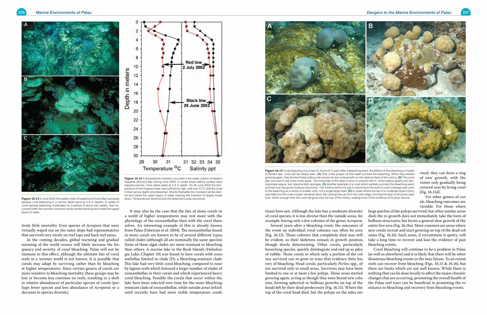
326 Marine Environments of Palau 327Dangers to the Marine Environments of Palau
tively little mortality. Even species of Acropora that were virtually wiped out on the outer slope had representatives that survived very nicely on reef tops and back reef areas. In the coming decades, global warming and gradual warming of the world oceans will likely increase the fre-quency and severity of coral bleaching. Palau will not be immune to this effect, although the ultimate fate of coral reefs in a warmer world is not known. It is possible that corals may adapt by surviving rather than by bleaching at higher temperatures. Since certain genera of corals are more sensitive to bleaching mortality, these groups may be lost or become less common on reefs, resulting in a shift in relative abundances of particular species of corals (per-haps fewer species and less abundance of Acropora) or a decrease in species diversity.
It may also be the case that the fate of stony corals in a world of higher temperatures may rest more with the physiology of the zooxanthellae than with the coral them-selves. An interesting example of this is already known from Palau (Fabricius et al. 2004). The zooxanthellae found in stony corals are known to be of several different types, called clades (although all are nominally the same species). Some of these algal clades are more resistant to bleaching than others. A marine lake in the Rock Islands (Heliofun-gia Lake; Chapter 10) was found to have corals with zoox-anthellae limited to clade (D), a bleaching-resistant clade. This lake had very little coral bleaching, compared to near-by lagoon reefs which featured a larger number of clades of zooxanthellae in their corals and which experienced heavy coral bleaching. Possibly the corals that occur within the lake have been selected over time for the more bleaching-resistant clade of zooxanthellae, while outside areas (which until recently have had more stable temperature condi-
tions) have not. Although the lake has a moderate diversity of coral species, it is less diverse than the outside areas, for example, having only a few colonies of the genus Acropora. Several years after a bleaching event, the outcomes of the event on individual coral colonies can often be seen (Fig. 16.15). Those colonies that completely died may still be evident, as their skeletons remain in growth position, though slowly deteriorating. Other corals, particularly branching species, quickly disintegrate and end up as piles of rubble. Those corals in which only a portion of the col-ony survived can re-grow in ways that evidence their his-tory of bleaching. Head corals, particularly Porites spp., of-ten survived only in small areas. Survivors may have been limited to one or at most a few polyps. Those areas started growing again, acting as though they were brand new colo-nies, forming spherical or bulbous growths on top of the heads left by their dead predecessor (Fig. 16.15). Where the top of the coral head died, but the polyps on the sides sur-
vived, they can form a ring of new growth, with the center only gradually being covered over by living coral (Fig. 16.15d). For other genera of cor-als, bleaching outcomes are variable. For those where
large patches of the polyps survived, but other similar areas died, the re-growth does not immediately take the form of bulbous structures, but forms a general slow growth of the entire live area (Fig. 16.16a). More common are areas where new corals recruit and start growing on top of the dead col-onies (Fig. 16.16). Such areas, if recruitment is spotty, will take a long time to recover and lose the evidence of past bleaching events. Coral bleaching will continue to be a problem in Palau (as well as elsewhere) and it is likely that there will be other disastrous bleaching events in the near future. To an extent reefs can recover from bleaching (Figs. 16.15 & 16.16), but there are limits which are not well known. While there is nothing that can be done locally to affect the major climatic changes that are occurring, promoting the overall health of the Palau reef tract can be beneficial in promoting the re-sistance to bleaching and recovery from bleaching events.
Figure 16.13 In June 2002 the eastern side of Iwayama (Arimizu) Bay had areas develop coral bleaching in a narrow depth band at 4-6 m depths. A variety of coral species bleaching moderately for a period of about two weeks, then re-covered after the summer monsoon winds started blowing and mixed the upper layers of water.
Figure 16.14 A temperature inversion occurred in the water column of eastern Iwayama (Arimizu) Bay during June 2002. A cooler lower salinity surface layer trapped warmer, more saline water at 4-6 m depth. On 26 June 2002 the tem-perature of this trapped water was sufficiently high, well over 31°C, that the coral in that narrow depth zone bleached. Shortly thereafter the monsoon winds start-ed and mixed the upper layers of water causing the inversion to largely break down. Temperatures declined and the bleached corals recovered.
Figure 16.15 Coral bleaching outcomes (1). Some 6–7 years after a bleaching event, the effects of the bleaching on heads of Porites spp. coral can be clearly seen. (a) Only a few polyps on this head survived the bleaching. When they started growing again, they formed these bulbous structures of new coral growth on the dead surface of the colony. (B) This coral also survived in just a few small areas. The remainder of the dead colony is covered with K. milnei (yellow green) and Xes-tospongia exigua, two opportunistic sponges. (C) Another example of a coral which partially survived the bleaching event and has now has grown bulbous structures. This coral is well on its way to returning to the level of coral coverage seen prior to the bleaching as a series of smaller units, not a single large head. (D) In cases where the top of a moderate-sized colony was killed but the outer margin remained alive; the coral grows up from the outer edge, forming the type of structure seen here. Given enough time the coral will grow over the top of the colony, erasing most of the evidence of its prior trauma.
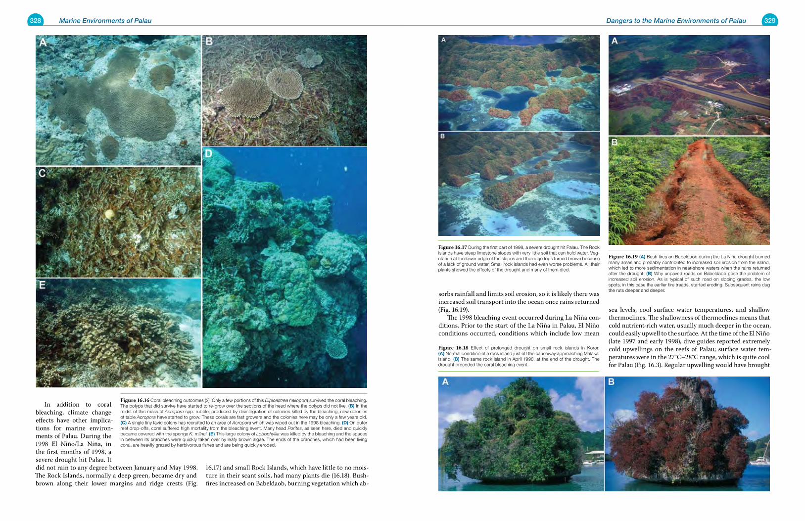
328 Marine Environments of Palau 329Dangers to the Marine Environments of Palau
In addition to coral bleaching, climate change effects have other implica-tions for marine environ-ments of Palau. During the 1998 El Niño/La Niña, in the first months of 1998, a severe drought hit Palau. It did not rain to any degree between January and May 1998. The Rock Islands, normally a deep green, became dry and brown along their lower margins and ridge crests (Fig.
16.17) and small Rock Islands, which have little to no mois-ture in their scant soils, had many plants die (16.18). Bush-fires increased on Babeldaob, burning vegetation which ab-
sorbs rainfall and limits soil erosion, so it is likely there was increased soil transport into the ocean once rains returned (Fig. 16.19). The 1998 bleaching event occurred during La Niña con-ditions. Prior to the start of the La Niña in Palau, El Niño conditions occurred, conditions which include low mean
sea levels, cool surface water temperatures, and shallow thermoclines. The shallowness of thermoclines means that cold nutrient-rich water, usually much deeper in the ocean, could easily upwell to the surface. At the time of the El Niño (late 1997 and early 1998), dive guides reported extremely cold upwellings on the reefs of Palau; surface water tem-peratures were in the 27°C–28°C range, which is quite cool for Palau (Fig. 16.3). Regular upwelling would have brought
Figure 16.16 Coral bleaching outcomes (2). Only a few portions of this Diploastrea heliopora survived the coral bleaching. The polyps that did survive have started to re-grow over the sections of the head where the polyps did not live. (B) In the midst of this mass of Acropora spp. rubble, produced by disintegration of colonies killed by the bleaching, new colonies of table Acropora have started to grow. These corals are fast growers and the colonies here may be only a few years old. (C) A single tiny favid colony has recruited to an area of Acropora which was wiped out in the 1998 bleaching. (D) On outer reef drop-offs, coral suffered high mortality from the bleaching event. Many head Porites, as seen here, died and quickly became covered with the sponge K. milnei. (e) This large colony of Lobophyllia was killed by the bleaching and the spaces in between its branches were quickly taken over by leafy brown algae. The ends of the branches, which had been living coral, are heavily grazed by herbivorous fishes and are being quickly eroded.
Figure 16.17 During the first part of 1998, a severe drought hit Palau. The Rock Islands have steep limestone slopes with very little soil that can hold water. Veg-etation at the lower edge of the slopes and the ridge tops turned brown because of a lack of ground water. Small rock islands had even worse problems. All their plants showed the effects of the drought and many of them died.
Figure 16.18 Effect of prolonged drought on small rock islands in Koror. (a) Normal condition of a rock island just off the causeway approaching Malakal Island. (B) The same rock island in April 1998, at the end of the drought. The drought preceded the coral bleaching event.
Figure 16.19 (a) Bush fires on Babeldaob during the La Niña drought burned many areas and probably contributed to increased soil erosion from the island, which led to more sedimentation in near-shore waters when the rains returned after the drought. (B) Why unpaved roads on Babeldaob pose the problem of increased soil erosion. As is typical of such road on sloping grades, the low spots, in this case the earlier tire treads, started eroding. Subsequent rains dug the ruts deeper and deeper.
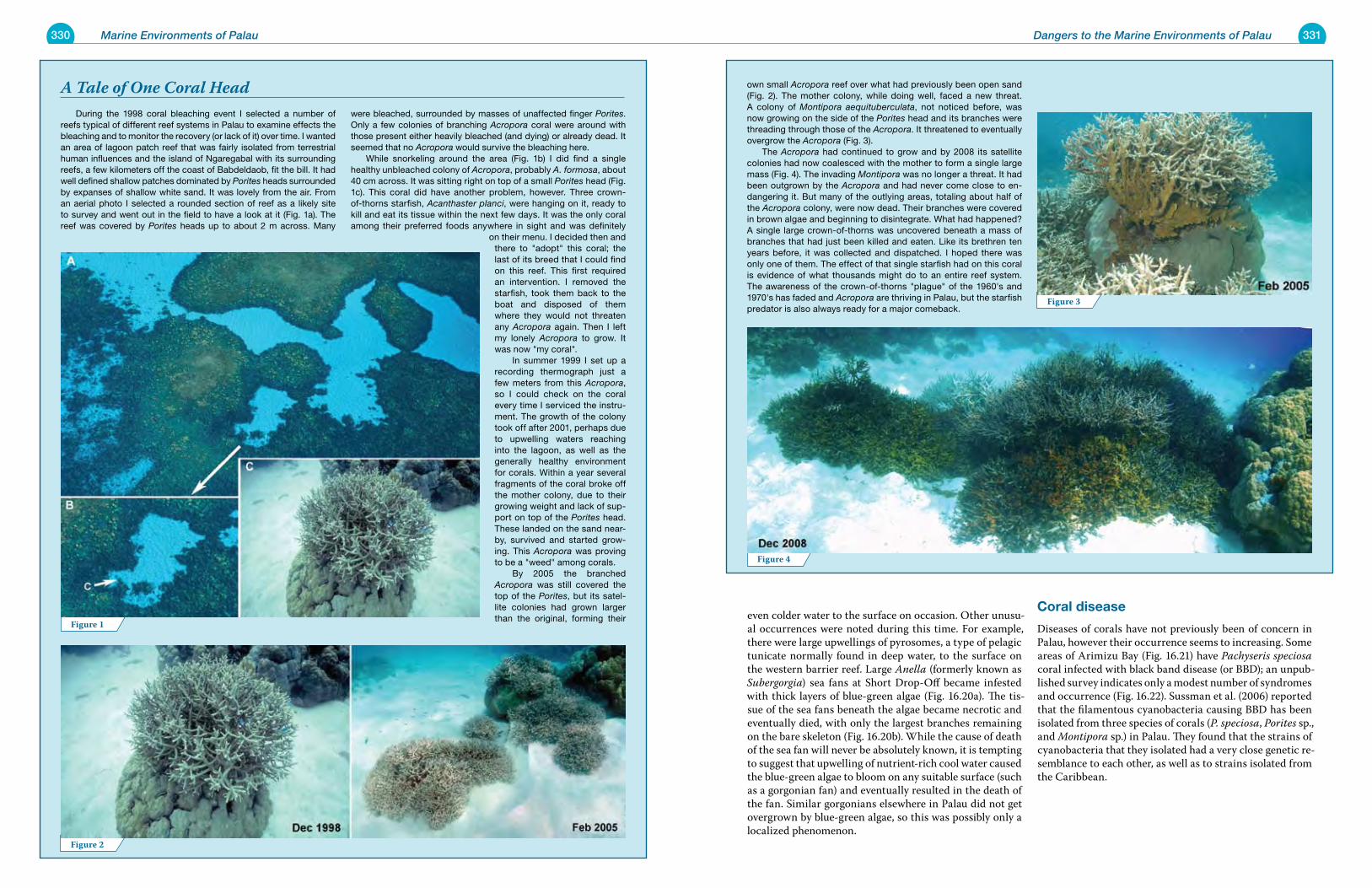
330 Marine Environments of Palau 331
During the 1998 coral bleaching event I selected a number of reefs typical of different reef systems in Palau to examine effects the bleaching and to monitor the recovery (or lack of it) over time. I wanted an area of lagoon patch reef that was fairly isolated from terrestrial human influences and the island of Ngaregabal with its surrounding reefs, a few kilometers off the coast of Babdeldaob, fit the bill. It had well defined shallow patches dominated by Porites heads surrounded by expanses of shallow white sand. It was lovely from the air. From an aerial photo I selected a rounded section of reef as a likely site to survey and went out in the field to have a look at it (Fig. 1a). The reef was covered by Porites heads up to about 2 m across. Many
were bleached, surrounded by masses of unaffected finger Porites. Only a few colonies of branching Acropora coral were around with those present either heavily bleached (and dying) or already dead. It seemed that no Acropora would survive the bleaching here. While snorkeling around the area (Fig. 1b) I did find a single healthy unbleached colony of Acropora, probably A. formosa, about 40 cm across. It was sitting right on top of a small Porites head (Fig. 1c). This coral did have another problem, however. Three crown-of-thorns starfish, Acanthaster planci, were hanging on it, ready to kill and eat its tissue within the next few days. It was the only coral among their preferred foods anywhere in sight and was definitely
on their menu. I decided then and there to "adopt" this coral; the last of its breed that I could find on this reef. This first required an intervention. I removed the starfish, took them back to the boat and disposed of them where they would not threaten any Acropora again. Then I left my lonely Acropora to grow. It was now "my coral". In summer 1999 I set up a recording thermograph just a few meters from this Acropora, so I could check on the coral every time I serviced the instru-ment. The growth of the colony took off after 2001, perhaps due to upwelling waters reaching into the lagoon, as well as the generally healthy environment for corals. Within a year several fragments of the coral broke off the mother colony, due to their growing weight and lack of sup-port on top of the Porites head. These landed on the sand near-by, survived and started grow-ing. This Acropora was proving to be a "weed" among corals. By 2005 the branched Acropora was still covered the top of the Porites, but its satel-lite colonies had grown larger than the original, forming their
A Tale of One Coral Head
Dangers to the Marine Environments of Palau
own small Acropora reef over what had previously been open sand (Fig. 2). The mother colony, while doing well, faced a new threat. A colony of Montipora aequituberculata, not noticed before, was now growing on the side of the Porites head and its branches were threading through those of the Acropora. It threatened to eventually overgrow the Acropora (Fig. 3). The Acropora had continued to grow and by 2008 its satellite colonies had now coalesced with the mother to form a single large mass (Fig. 4). The invading Montipora was no longer a threat. It had been outgrown by the Acropora and had never come close to en-dangering it. But many of the outlying areas, totaling about half of the Acropora colony, were now dead. Their branches were covered in brown algae and beginning to disintegrate. What had happened? A single large crown-of-thorns was uncovered beneath a mass of branches that had just been killed and eaten. Like its brethren ten years before, it was collected and dispatched. I hoped there was only one of them. The effect of that single starfish had on this coral is evidence of what thousands might do to an entire reef system. The awareness of the crown-of-thorns "plague" of the 1960's and 1970's has faded and Acropora are thriving in Palau, but the starfish predator is also always ready for a major comeback.
even colder water to the surface on occasion. Other unusu-al occurrences were noted during this time. For example, there were large upwellings of pyrosomes, a type of pelagic tunicate normally found in deep water, to the surface on the western barrier reef. Large Anella (formerly known as Subergorgia) sea fans at Short Drop-Off became infested with thick layers of blue-green algae (Fig. 16.20a). The tis-sue of the sea fans beneath the algae became necrotic and eventually died, with only the largest branches remaining on the bare skeleton (Fig. 16.20b). While the cause of death of the sea fan will never be absolutely known, it is tempting to suggest that upwelling of nutrient-rich cool water caused the blue-green algae to bloom on any suitable surface (such as a gorgonian fan) and eventually resulted in the death of the fan. Similar gorgonians elsewhere in Palau did not get overgrown by blue-green algae, so this was possibly only a localized phenomenon.
Coral disease
Diseases of corals have not previously been of concern in Palau, however their occurrence seems to increasing. Some areas of Arimizu Bay (Fig. 16.21) have Pachyseris speciosa coral infected with black band disease (or BBD); an unpub-lished survey indicates only a modest number of syndromes and occurrence (Fig. 16.22). Sussman et al. (2006) reported that the filamentous cyanobacteria causing BBD has been isolated from three species of corals (P. speciosa, Porites sp., and Montipora sp.) in Palau. They found that the strains of cyanobacteria that they isolated had a very close genetic re-semblance to each other, as well as to strains isolated from the Caribbean.
Figure 2
Figure 1
Figure 3
Figure 4
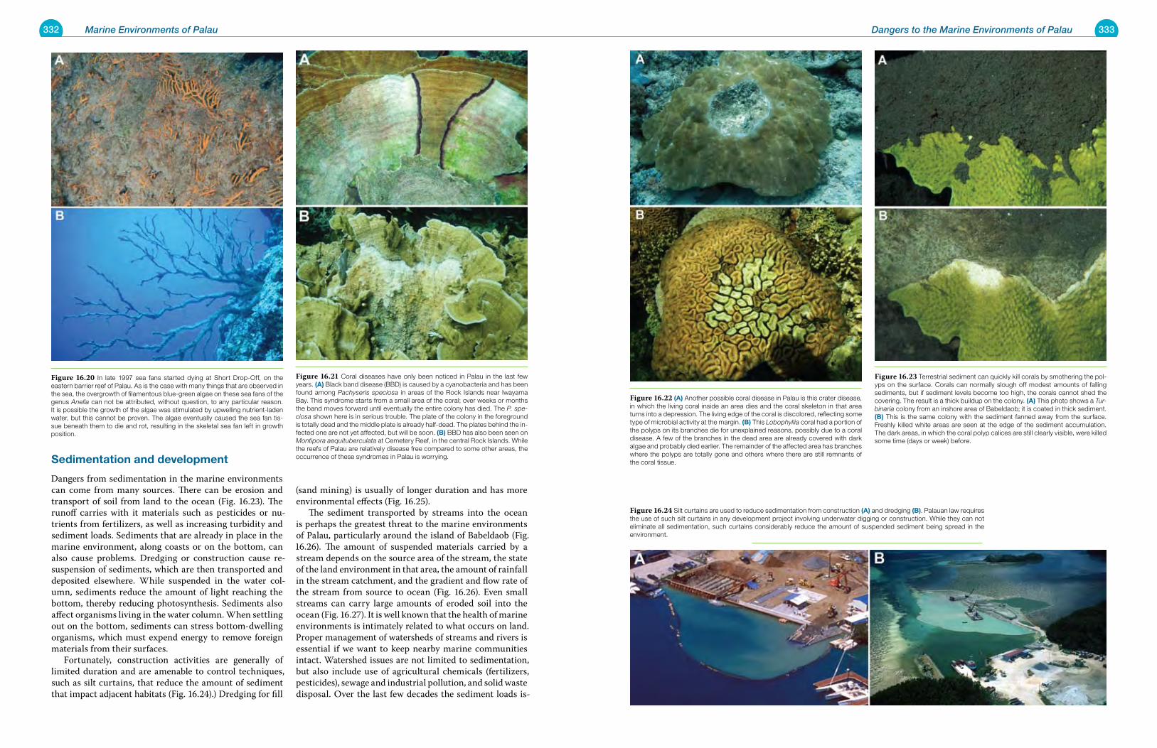
332 Marine Environments of Palau 333Dangers to the Marine Environments of Palau
sedimentation and development
Dangers from sedimentation in the marine environments can come from many sources. There can be erosion and transport of soil from land to the ocean (Fig. 16.23). The runoff carries with it materials such as pesticides or nu-trients from fertilizers, as well as increasing turbidity and sediment loads. Sediments that are already in place in the marine environment, along coasts or on the bottom, can also cause problems. Dredging or construction cause re-suspension of sediments, which are then transported and deposited elsewhere. While suspended in the water col-umn, sediments reduce the amount of light reaching the bottom, thereby reducing photosynthesis. Sediments also affect organisms living in the water column. When settling out on the bottom, sediments can stress bottom-dwelling organisms, which must expend energy to remove foreign materials from their surfaces. Fortunately, construction activities are generally of limited duration and are amenable to control techniques, such as silt curtains, that reduce the amount of sediment that impact adjacent habitats (Fig. 16.24).) Dredging for fill
(sand mining) is usually of longer duration and has more environmental effects (Fig. 16.25). The sediment transported by streams into the ocean is perhaps the greatest threat to the marine environments of Palau, particularly around the island of Babeldaob (Fig. 16.26). The amount of suspended materials carried by a stream depends on the source area of the stream, the state of the land environment in that area, the amount of rainfall in the stream catchment, and the gradient and flow rate of the stream from source to ocean (Fig. 16.26). Even small streams can carry large amounts of eroded soil into the ocean (Fig. 16.27). It is well known that the health of marine environments is intimately related to what occurs on land. Proper management of watersheds of streams and rivers is essential if we want to keep nearby marine communities intact. Watershed issues are not limited to sedimentation, but also include use of agricultural chemicals (fertilizers, pesticides), sewage and industrial pollution, and solid waste disposal. Over the last few decades the sediment loads is-
Figure 16.22 (a) Another possible coral disease in Palau is this crater disease, in which the living coral inside an area dies and the coral skeleton in that area turns into a depression. The living edge of the coral is discolored, reflecting some type of microbial activity at the margin. (B) This Lobophyllia coral had a portion of the polyps on its branches die for unexplained reasons, possibly due to a coral disease. A few of the branches in the dead area are already covered with dark algae and probably died earlier. The remainder of the affected area has branches where the polyps are totally gone and others where there are still remnants of the coral tissue.
Figure 16.23 Terrestrial sediment can quickly kill corals by smothering the pol-yps on the surface. Corals can normally slough off modest amounts of falling sediments, but if sediment levels become too high, the corals cannot shed the covering. The result is a thick buildup on the colony. (a) This photo shows a Tur-binaria colony from an inshore area of Babeldaob; it is coated in thick sediment. (B) This is the same colony with the sediment fanned away from the surface. Freshly killed white areas are seen at the edge of the sediment accumulation. The dark areas, in which the coral polyp calices are still clearly visible, were killed some time (days or week) before.
Figure 16.24 Silt curtains are used to reduce sedimentation from construction (a) and dredging (B). Palauan law requires the use of such silt curtains in any development project involving underwater digging or construction. While they can not eliminate all sedimentation, such curtains considerably reduce the amount of suspended sediment being spread in the environment.
Figure 16.20 In late 1997 sea fans started dying at Short Drop-Off, on the eastern barrier reef of Palau. As is the case with many things that are observed in the sea, the overgrowth of filamentous blue-green algae on these sea fans of the genus Anella can not be attributed, without question, to any particular reason. It is possible the growth of the algae was stimulated by upwelling nutrient-laden water, but this cannot be proven. The algae eventually caused the sea fan tis-sue beneath them to die and rot, resulting in the skeletal sea fan left in growth position.
Figure 16.21 Coral diseases have only been noticed in Palau in the last few years. (a) Black band disease (BBD) is caused by a cyanobacteria and has been found among Pachyseris speciosa in areas of the Rock Islands near Iwayama Bay. This syndrome starts from a small area of the coral; over weeks or months the band moves forward until eventually the entire colony has died. The P. spe-ciosa shown here is in serious trouble. The plate of the colony in the foreground is totally dead and the middle plate is already half-dead. The plates behind the in-fected one are not yet affected, but will be soon. (B) BBD has also been seen on Montipora aequituberculata at Cemetery Reef, in the central Rock Islands. While the reefs of Palau are relatively disease free compared to some other areas, the occurrence of these syndromes in Palau is worrying.
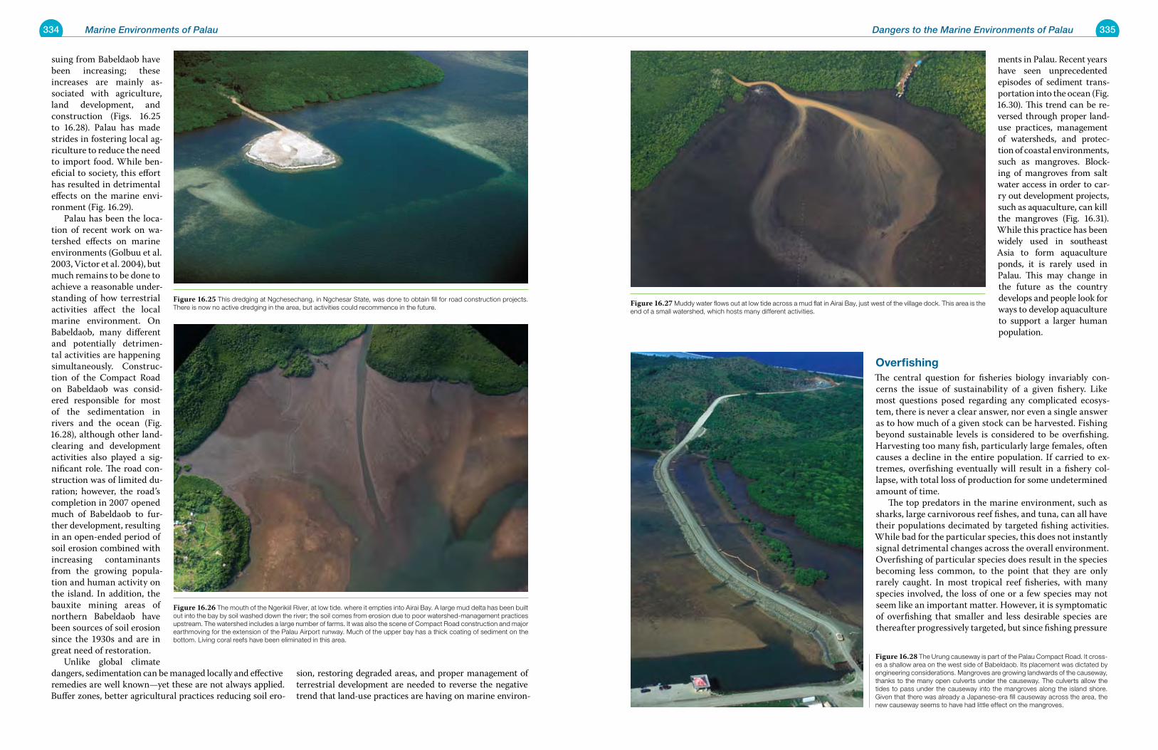
334 Marine Environments of Palau 335Dangers to the Marine Environments of Palau
suing from Babeldaob have been increasing; these increases are mainly as-sociated with agriculture, land development, and construction (Figs. 16.25 to 16.28). Palau has made strides in fostering local ag-riculture to reduce the need to import food. While ben-eficial to society, this effort has resulted in detrimental effects on the marine envi-ronment (Fig. 16.29). Palau has been the loca-tion of recent work on wa-tershed effects on marine environments (Golbuu et al. 2003, Victor et al. 2004), but much remains to be done to achieve a reasonable under-standing of how terrestrial activities affect the local marine environment. On Babeldaob, many different and potentially detrimen-tal activities are happening simultaneously. Construc-tion of the Compact Road on Babeldaob was consid-ered responsible for most of the sedimentation in rivers and the ocean (Fig. 16.28), although other land-clearing and development activities also played a sig-nificant role. The road con-struction was of limited du-ration; however, the road’s completion in 2007 opened much of Babeldaob to fur-ther development, resulting in an open-ended period of soil erosion combined with increasing contaminants from the growing popula-tion and human activity on the island. In addition, the bauxite mining areas of northern Babeldaob have been sources of soil erosion since the 1930s and are in great need of restoration. Unlike global climate dangers, sedimentation can be managed locally and effective remedies are well known—yet these are not always applied. Buffer zones, better agricultural practices reducing soil ero-
sion, restoring degraded areas, and proper management of terrestrial development are needed to reverse the negative trend that land-use practices are having on marine environ-
ments in Palau. Recent years have seen unprecedented episodes of sediment trans-portation into the ocean (Fig. 16.30). This trend can be re-versed through proper land-use practices, management of watersheds, and protec-tion of coastal environments, such as mangroves. Block-ing of mangroves from salt water access in order to car-ry out development projects, such as aquaculture, can kill the mangroves (Fig. 16.31). While this practice has been widely used in southeast Asia to form aquaculture ponds, it is rarely used in Palau. This may change in the future as the country develops and people look for ways to develop aquaculture to support a larger human population.
overfishingThe central question for fisheries biology invariably con-cerns the issue of sustainability of a given fishery. Like most questions posed regarding any complicated ecosys-tem, there is never a clear answer, nor even a single answer as to how much of a given stock can be harvested. Fishing beyond sustainable levels is considered to be overfishing. Harvesting too many fish, particularly large females, often causes a decline in the entire population. If carried to ex-tremes, overfishing eventually will result in a fishery col-lapse, with total loss of production for some undetermined amount of time. The top predators in the marine environment, such as sharks, large carnivorous reef fishes, and tuna, can all have their populations decimated by targeted fishing activities. While bad for the particular species, this does not instantly signal detrimental changes across the overall environment. Overfishing of particular species does result in the species becoming less common, to the point that they are only rarely caught. In most tropical reef fisheries, with many species involved, the loss of one or a few species may not seem like an important matter. However, it is symptomatic of overfishing that smaller and less desirable species are thereafter progressively targeted, but since fishing pressure
Figure 16.26 The mouth of the Ngerikiil River, at low tide. where it empties into Airai Bay. A large mud delta has been built out into the bay by soil washed down the river; the soil comes from erosion due to poor watershed-management practices upstream. The watershed includes a large number of farms. It was also the scene of Compact Road construction and major earthmoving for the extension of the Palau Airport runway. Much of the upper bay has a thick coating of sediment on the bottom. Living coral reefs have been eliminated in this area.
Figure 16.25 This dredging at Ngchesechang, in Ngchesar State, was done to obtain fill for road construction projects. There is now no active dredging in the area, but activities could recommence in the future.
Figure 16.27 Muddy water flows out at low tide across a mud flat in Airai Bay, just west of the village dock. This area is the end of a small watershed, which hosts many different activities.
Figure 16.28 The Urung causeway is part of the Palau Compact Road. It cross-es a shallow area on the west side of Babeldaob. Its placement was dictated by engineering considerations. Mangroves are growing landwards of the causeway, thanks to the many open culverts under the causeway. The culverts allow the tides to pass under the causeway into the mangroves along the island shore. Given that there was already a Japanese-era fill causeway across the area, the new causeway seems to have had little effect on the mangroves.
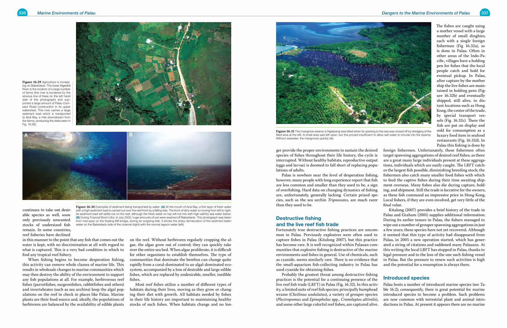
336 Marine Environments of Palau 337Dangers to the Marine Environments of Palau
continues to take out desir-able species as well, soon only previously unwanted stocks of undersized fish remain. In some countries, reef fisheries have declined in this manner to the point that any fish that comes out the water is kept, with no discrimination at all with regard to what is captured. This is a very bad condition in which to find any tropical reef fishery. When fishing begins to become desperation fishing, this activity can remove whole classes of marine life. This results in wholesale changes to marine communities which may then destroy the ability of the environment to support any fish populations at all. For example, herbivorous reef fishes (parrotfishes, surgeonfishes, rabbitfishes and others) and invertebrates (such as sea urchins) keep the algal pop-ulations on the reef in check in places like Palau. Marine plants are their food source and, ideally, the populations of herbivores are balanced by the availability of edible plants
on the reef. Without herbivores regularly cropping the al-gae, the algae grow out of control; they can quickly take over the entire sea bed. When algae proliferate, it is difficult for other organisms to establish themselves. The type of communities that dominate the benthos can change quite rapidly from a coral-dominated to an algal-dominated eco-system, accompanied by a loss of desirable and large edible fishes, which are replaced by undesirable, smaller, inedible fishes. Most reef fishes utilize a number of different types of habitats during their lives, moving as they grow or chang-ing their diet with growth. All habitats needed by fishes in their life history are important to maintaining healthy stocks of such fishes. When habitats change and no lon-
ger provide the proper environments to sustain the desired species of fishes throughout their life history, the cycle is interrupted. Without healthy habitats, reproductive output (eggs and larvae) is doomed to fall short of replacing popu-lations of adults. Palau is nowhere near the level of desperation fishing, however, many people with long experience report that fish are less common and smaller than they used to be, a sign of overfishing. Hard data on changing dynamics of fishing are, unfortunately, generally lacking. Certain prized spe-cies, such as the sea urchin Tripneustes, are much rarer than they used to be.
Destructive fishing and the live reef fish tradeFortunately true destructive fishing practices are uncom-mon in Palau. Previously explosives were often used to capture fishes in Palau (Kitalong 2007), but this practice has become rare. It is well recognized within Palauan com-munities that explosive fishing is destructive of the marine environments and fishes in general. Use of chemicals, such as cyanide, seems similarly rare. There is no evidence that the small-aquarium fish-collecting industry in Palau has used cyanide for obtaining fishes. Probably the greatest threat among destructive fishing practices is the potential for a continuing presence of the live reef fish trade (LRFT) in Palau (Fig. 16.32). In this activ-ity, a limited suite of reef fish species: principally humphead wrasse (Cheilinus undulatus), a variety of grouper species (Plectropomus and Epinephelus spp., Cromileptes altivelis), and some other large colorful reef fishes, are captured alive.
The fishes are caught using a mother vessel with a large number of small dinghies, each with a single foreign fisherman (Fig 16.32a), as is done in Palau. Often in other areas of the Indo-Pa-cific, villages have a holding pen for fishes that the local people catch and hold for eventual pickup. In Palau, after capture by the mother ship the live fishes are main-tained in holding pens (Fig-ure 16.32b) and eventually shipped, still alive, to dis-tant locations such as Hong Kong, the center of the trade, by special transport ves-sels (Fig. 16.32c). There the fish are put on display and sold for consumption as a luxury food item in seafood restaurants (Fig. 16.32d). In Palau this fishing is done by
foreign fishermen. Unfortunately, these fishermen often target spawning aggregations of desired reef fishes, as there are a great many large individuals present at these aggrega-tions, individuals which are easily caught. The LRFT catch-es the largest fish possible, diminishing breeding stock; the fishermen also catch many smaller food fishes with which to feed the captive fishes during their time awaiting ship-ment overseas. Many fishes also die during capture, hold-ing, and shipment. Still the trade is lucrative for the owners, as these fish command an impressive price in Hong Kong. Local fishers, if they are even involved, get very little of the final value. Kitalong (2007) provides a brief history of the trade in Palau and Graham (2001) supplies additional information. During its earlier tenure in Palau, the fishers managed to wipe out a number of grouper spawning aggregations in just a few years; these species have not yet recovered. Although it seemed that this type of activity had disappeared from Palau, in 2005 a new operation started, which has gener-ated a string of citations and saddened many Palauans. At this writing the local LRFT has stopped in Palau, thanks to legal pressure and to the loss of the one such fishing vessel in Palau. But the pressure to renew such activities is high and the potential for a resumption is always there.
introduced speciesPalau hosts a number of introduced marine species (see Ta-ble 16.2); consequently, there is great potential for marine introduced species to become a problem. Such problems are now common with terrestrial plant and animal intro-ductions in Palau. At present it appears there are no marine
Figure 16.30 Examples of sediment being transported by water. (a) At the mouth of Airai Bay, a thin layer of fresh water with a high sediment load is carried out over the reef front by a falling tide. The front of dirty water is moving from left to right. Its sediment load will settle out on the reef, although the fresh water on top will not mix with high-salinity sea water below. (B) During Tropical Storm Utor, in July 2002, huge amounts of soil were washed off Babeldaob. This photograph was taken from mid-span on the floating KB bridge, during an outgoing tide. It shows the sharp demarcation of the sediment-laden water on the Babeldaob side of the channel (right) with the normal lagoon water (left).
Figure 16.29 Agriculture is increas-ing on Babeldaob. The lower Ngerikiil River is the location of a large number of farms (the river is bordered by the sinuous line of trees on the left hand side of the photograph) and sup-ported a large amount of Palau Com-pact Road construction in its upper watershed. This river carries a large sediment load which is transported to Airai Bay, a mile downstream from the farms, producing the delta seen in Fig. 16.26).
Figure 16.31 This mangrove swamp in Ngatpang was killed when its opening to the sea was closed off by dredging of the filled area at the left. A small area was left open, but this proved insufficient to allow salt water to intrude into the swamp. Without seawater, the mangroves quickly die.
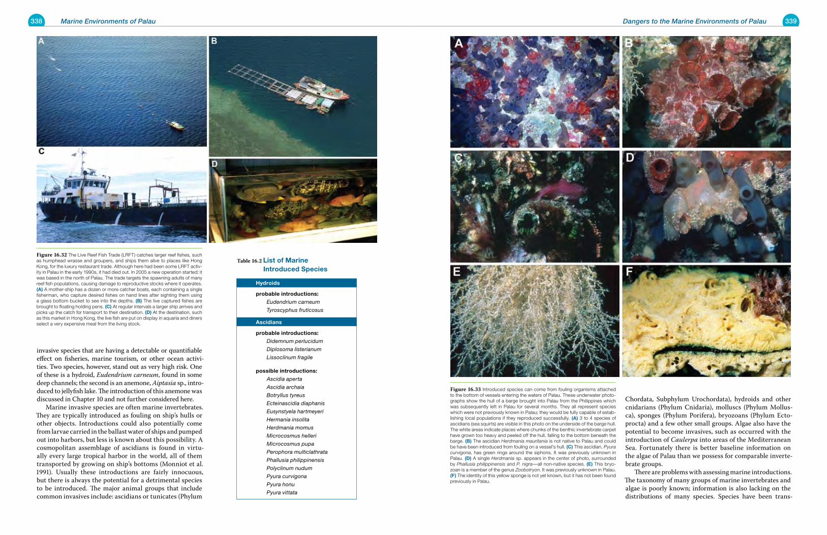
338 Marine Environments of Palau 339Dangers to the Marine Environments of Palau
invasive species that are having a detectable or quantifiable effect on fisheries, marine tourism, or other ocean activi-ties. Two species, however, stand out as very high risk. One of these is a hydroid, Eudendrium carneum, found in some deep channels; the second is an anemone, Aiptasia sp., intro-duced to jellyfish lake. The introduction of this anemone was discussed in Chapter 10 and not further considered here. Marine invasive species are often marine invertebrates. They are typically introduced as fouling on ship’s hulls or other objects. Introductions could also potentially come from larvae carried in the ballast water of ships and pumped out into harbors, but less is known about this possibility. A cosmopolitan assemblage of ascidians is found in virtu-ally every large tropical harbor in the world, all of them transported by growing on ship’s bottoms (Monniot et al. 1991). Usually these introductions are fairly innocuous, but there is always the potential for a detrimental species to be introduced. The major animal groups that include common invasives include: ascidians or tunicates (Phylum
Chordata, Subphylum Urochordata), hydroids and other cnidarians (Phylum Cnidaria), molluscs (Phylum Mollus-ca), sponges (Phylum Porifera), bryozoans (Phylum Ecto-procta) and a few other small groups. Algae also have the potential to become invasives, such as occurred with the introduction of Caulerpa into areas of the Mediterranean Sea. Fortunately there is better baseline information on the algae of Palau than we possess for comparable inverte-brate groups. There are problems with assessing marine introductions. The taxonomy of many groups of marine invertebrates and algae is poorly known; information is also lacking on the distributions of many species. Species have been trans-
Table 16.2 list of marine introduced species hydroids
probable introductions:
Eudendrium carneum
Tyroscyphus fruticosus
ascidians
probable introductions:
Didemnum perlucidum
Diplosoma listerianum
Lissoclinum fragile
possible introductions:
Ascidia aperta
Ascidia archaia
Botryllus tyreus
Ecteinascidia diaphanis
Eusynstyela hartmeyeri
Hermania insolita
Herdmania momus
Microcosmus helleri
Microcosmus pupa
Perophora multiclathrata
Phallusia philippinensis
Polyclinum nudum
Pyura curvigona
Pyura honu
Pyura vittata
Figure 16.33 Introduced species can come from fouling organisms attached to the bottom of vessels entering the waters of Palau. These underwater photo-graphs show the hull of a barge brought into Palau from the Philippines which was subsequently left in Palau for several months. They all represent species which were not previously known in Palau; they would be fully capable of estab-lishing local populations if they reproduced successfully. (a) 3 to 4 species of ascidians (sea squirts) are visible in this photo on the underside of the barge hull. The white areas indicate places where chunks of the benthic invertebrate carpet have grown too heavy and peeled off the hull, falling to the bottom beneath the barge. (B) The ascidian Herdmania mauritania is not native to Palau and could be have been introduced from fouling on a vessel’s hull. (C) This ascidian, Pyura curvigona, has green rings around the siphons. It was previously unknown in Palau. (D) A single Herdmania sp. appears in the center of photo, surrounded by Phallusia philippinensis and P. nigra—all non-native species. (e) This bryo-zoan is a member of the genus Zoobotryon. It was previously unknown in Palau. (F) The identity of this yellow sponge is not yet known, but it has not been found previously in Palau.
Figure 16.32 The Live Reef Fish Trade (LRFT) catches larger reef fishes, such as humphead wrasse and groupers, and ships them alive to places like Hong Kong, for the luxury restaurant trade. Although here had been some LRFT activ-ity in Palau in the early 1990s, it had died out. In 2005 a new operation started; it was based in the north of Palau. The trade targets the spawning adults of many reef fish populations, causing damage to reproductive stocks where it operates. (a) A mother-ship has a dozen or more catcher boats, each containing a single fisherman, who capture desired fishes on hand lines after sighting them using a glass bottom bucket to see into the depths. (B) The live captured fishes are brought to floating holding pens. (C) At regular intervals a larger ship arrives and picks up the catch for transport to their destination. (D) At the destination, such as this market in Hong Kong, the live fish are put on display in aquaria and diners select a very expensive meal from the living stock.
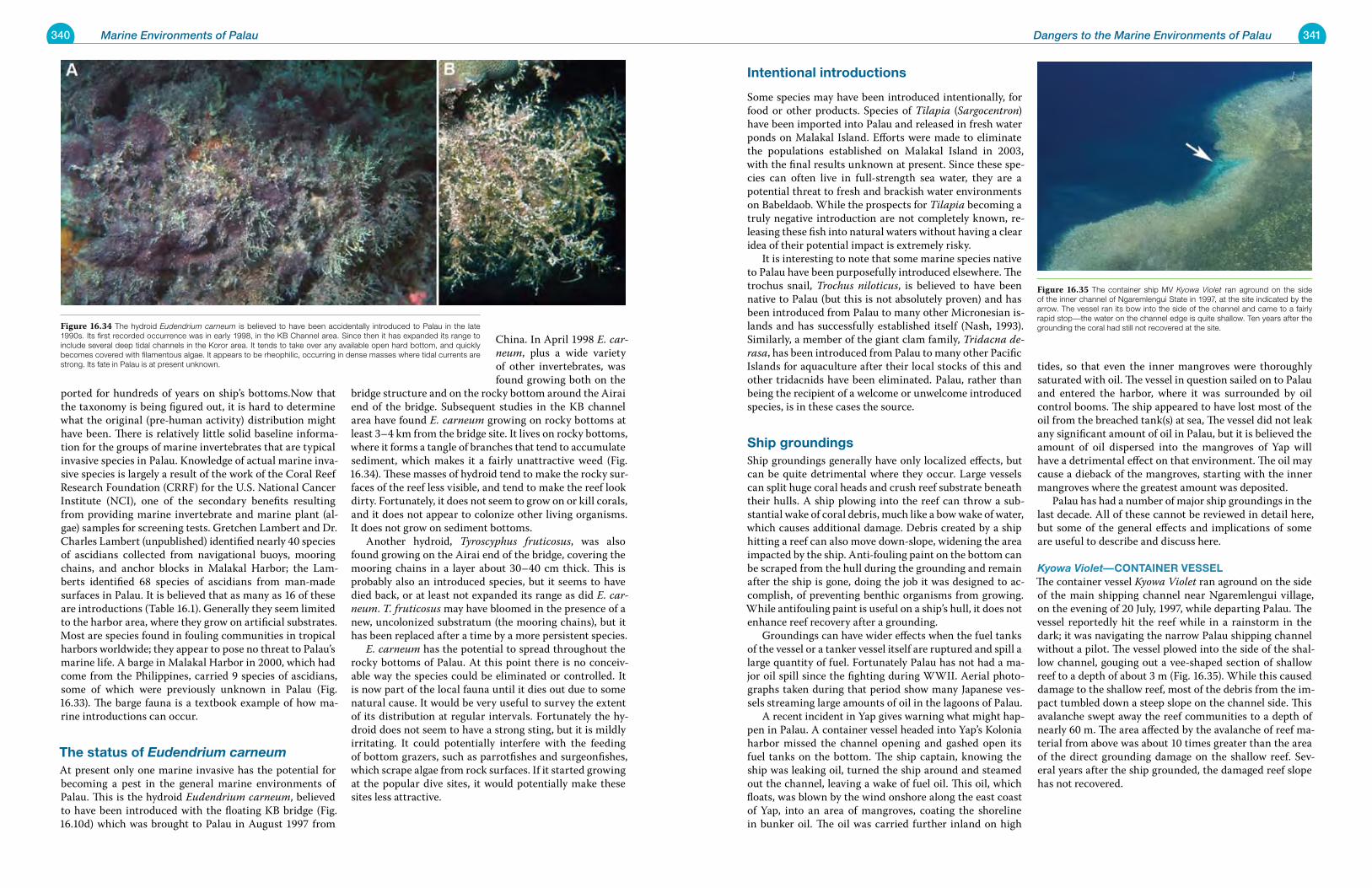
340 Marine Environments of Palau 341Dangers to the Marine Environments of Palau
ported for hundreds of years on ship’s bottoms.Now that the taxonomy is being figured out, it is hard to determine what the original (pre-human activity) distribution might have been. There is relatively little solid baseline informa-tion for the groups of marine invertebrates that are typical invasive species in Palau. Knowledge of actual marine inva-sive species is largely a result of the work of the Coral Reef Research Foundation (CRRF) for the U.S. National Cancer Institute (NCI), one of the secondary benefits resulting from providing marine invertebrate and marine plant (al-gae) samples for screening tests. Gretchen Lambert and Dr. Charles Lambert (unpublished) identified nearly 40 species of ascidians collected from navigational buoys, mooring chains, and anchor blocks in Malakal Harbor; the Lam-berts identified 68 species of ascidians from man-made surfaces in Palau. It is believed that as many as 16 of these are introductions (Table 16.1). Generally they seem limited to the harbor area, where they grow on artificial substrates. Most are species found in fouling communities in tropical harbors worldwide; they appear to pose no threat to Palau’s marine life. A barge in Malakal Harbor in 2000, which had come from the Philippines, carried 9 species of ascidians, some of which were previously unknown in Palau (Fig. 16.33). The barge fauna is a textbook example of how ma-rine introductions can occur.
the status of Eudendrium carneumAt present only one marine invasive has the potential for becoming a pest in the general marine environments of Palau. This is the hydroid Eudendrium carneum, believed to have been introduced with the floating KB bridge (Fig. 16.10d) which was brought to Palau in August 1997 from
China. In April 1998 E. car-neum, plus a wide variety of other invertebrates, was found growing both on the
bridge structure and on the rocky bottom around the Airai end of the bridge. Subsequent studies in the KB channel area have found E. carneum growing on rocky bottoms at least 3–4 km from the bridge site. It lives on rocky bottoms, where it forms a tangle of branches that tend to accumulate sediment, which makes it a fairly unattractive weed (Fig. 16.34). These masses of hydroid tend to make the rocky sur-faces of the reef less visible, and tend to make the reef look dirty. Fortunately, it does not seem to grow on or kill corals, and it does not appear to colonize other living organisms. It does not grow on sediment bottoms. Another hydroid, Tyroscyphus fruticosus, was also found growing on the Airai end of the bridge, covering the mooring chains in a layer about 30–40 cm thick. This is probably also an introduced species, but it seems to have died back, or at least not expanded its range as did E. car-neum. T. fruticosus may have bloomed in the presence of a new, uncolonized substratum (the mooring chains), but it has been replaced after a time by a more persistent species. E. carneum has the potential to spread throughout the rocky bottoms of Palau. At this point there is no conceiv-able way the species could be eliminated or controlled. It is now part of the local fauna until it dies out due to some natural cause. It would be very useful to survey the extent of its distribution at regular intervals. Fortunately the hy-droid does not seem to have a strong sting, but it is mildly irritating. It could potentially interfere with the feeding of bottom grazers, such as parrotfishes and surgeonfishes, which scrape algae from rock surfaces. If it started growing at the popular dive sites, it would potentially make these sites less attractive.
intentional introductions
Some species may have been introduced intentionally, for food or other products. Species of Tilapia (Sargocentron) have been imported into Palau and released in fresh water ponds on Malakal Island. Efforts were made to eliminate the populations established on Malakal Island in 2003, with the final results unknown at present. Since these spe-cies can often live in full-strength sea water, they are a potential threat to fresh and brackish water environments on Babeldaob. While the prospects for Tilapia becoming a truly negative introduction are not completely known, re-leasing these fish into natural waters without having a clear idea of their potential impact is extremely risky. It is interesting to note that some marine species native to Palau have been purposefully introduced elsewhere. The trochus snail, Trochus niloticus, is believed to have been native to Palau (but this is not absolutely proven) and has been introduced from Palau to many other Micronesian is-lands and has successfully established itself (Nash, 1993). Similarly, a member of the giant clam family, Tridacna de-rasa, has been introduced from Palau to many other Pacific Islands for aquaculture after their local stocks of this and other tridacnids have been eliminated. Palau, rather than being the recipient of a welcome or unwelcome introduced species, is in these cases the source.
ship groundingsShip groundings generally have only localized effects, but can be quite detrimental where they occur. Large vessels can split huge coral heads and crush reef substrate beneath their hulls. A ship plowing into the reef can throw a sub-stantial wake of coral debris, much like a bow wake of water, which causes additional damage. Debris created by a ship hitting a reef can also move down-slope, widening the area impacted by the ship. Anti-fouling paint on the bottom can be scraped from the hull during the grounding and remain after the ship is gone, doing the job it was designed to ac-complish, of preventing benthic organisms from growing. While antifouling paint is useful on a ship’s hull, it does not enhance reef recovery after a grounding. Groundings can have wider effects when the fuel tanks of the vessel or a tanker vessel itself are ruptured and spill a large quantity of fuel. Fortunately Palau has not had a ma-jor oil spill since the fighting during WWII. Aerial photo-graphs taken during that period show many Japanese ves-sels streaming large amounts of oil in the lagoons of Palau. A recent incident in Yap gives warning what might hap-pen in Palau. A container vessel headed into Yap’s Kolonia harbor missed the channel opening and gashed open its fuel tanks on the bottom. The ship captain, knowing the ship was leaking oil, turned the ship around and steamed out the channel, leaving a wake of fuel oil. This oil, which floats, was blown by the wind onshore along the east coast of Yap, into an area of mangroves, coating the shoreline in bunker oil. The oil was carried further inland on high
tides, so that even the inner mangroves were thoroughly saturated with oil. The vessel in question sailed on to Palau and entered the harbor, where it was surrounded by oil control booms. The ship appeared to have lost most of the oil from the breached tank(s) at sea, The vessel did not leak any significant amount of oil in Palau, but it is believed the amount of oil dispersed into the mangroves of Yap will have a detrimental effect on that environment. The oil may cause a dieback of the mangroves, starting with the inner mangroves where the greatest amount was deposited. Palau has had a number of major ship groundings in the last decade. All of these cannot be reviewed in detail here, but some of the general effects and implications of some are useful to describe and discuss here.
Kyowa Violet—Container vesselThe container vessel Kyowa Violet ran aground on the side of the main shipping channel near Ngaremlengui village, on the evening of 20 July, 1997, while departing Palau. The vessel reportedly hit the reef while in a rainstorm in the dark; it was navigating the narrow Palau shipping channel without a pilot. The vessel plowed into the side of the shal-low channel, gouging out a vee-shaped section of shallow reef to a depth of about 3 m (Fig. 16.35). While this caused damage to the shallow reef, most of the debris from the im-pact tumbled down a steep slope on the channel side. This avalanche swept away the reef communities to a depth of nearly 60 m. The area affected by the avalanche of reef ma-terial from above was about 10 times greater than the area of the direct grounding damage on the shallow reef. Sev-eral years after the ship grounded, the damaged reef slope has not recovered.
Figure 16.34 The hydroid Eudendrium carneum is believed to have been accidentally introduced to Palau in the late 1990s. Its first recorded occurrence was in early 1998, in the KB Channel area. Since then it has expanded its range to include several deep tidal channels in the Koror area. It tends to take over any available open hard bottom, and quickly becomes covered with filamentous algae. It appears to be rheophilic, occurring in dense masses where tidal currents are strong. Its fate in Palau is at present unknown.
Figure 16.35 The container ship MV Kyowa Violet ran aground on the side of the inner channel of Ngaremlengui State in 1997, at the site indicated by the arrow. The vessel ran its bow into the side of the channel and came to a fairly rapid stop—the water on the channel edge is quite shallow. Ten years after the grounding the coral had still not recovered at the site.
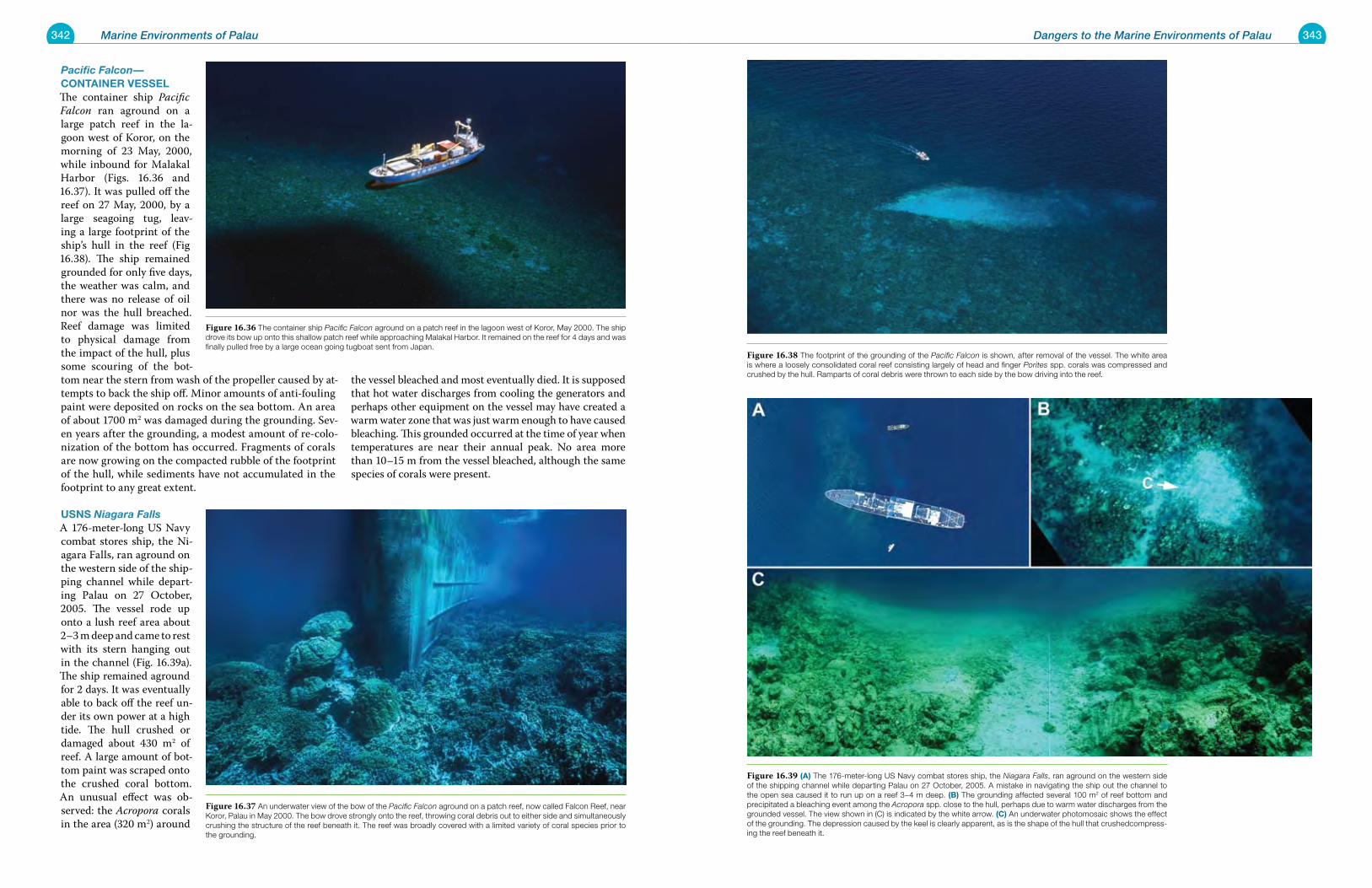
342 Marine Environments of Palau 343Dangers to the Marine Environments of Palau
Pacific Falcon—Container vesselThe container ship Pacific Falcon ran aground on a large patch reef in the la-goon west of Koror, on the morning of 23 May, 2000, while inbound for Malakal Harbor (Figs. 16.36 and 16.37). It was pulled off the reef on 27 May, 2000, by a large seagoing tug, leav-ing a large footprint of the ship’s hull in the reef (Fig 16.38). The ship remained grounded for only five days, the weather was calm, and there was no release of oil nor was the hull breached. Reef damage was limited to physical damage from the impact of the hull, plus some scouring of the bot-tom near the stern from wash of the propeller caused by at-tempts to back the ship off. Minor amounts of anti-fouling paint were deposited on rocks on the sea bottom. An area of about 1700 m2 was damaged during the grounding. Sev-en years after the grounding, a modest amount of re-colo-nization of the bottom has occurred. Fragments of corals are now growing on the compacted rubble of the footprint of the hull, while sediments have not accumulated in the footprint to any great extent.
usns Niagara FallsA 176-meter-long US Navy combat stores ship, the Ni-agara Falls, ran aground on the western side of the ship-ping channel while depart-ing Palau on 27 October, 2005. The vessel rode up onto a lush reef area about 2–3 m deep and came to rest with its stern hanging out in the channel (Fig. 16.39a). The ship remained aground for 2 days. It was eventually able to back off the reef un-der its own power at a high tide. The hull crushed or damaged about 430 m2 of reef. A large amount of bot-tom paint was scraped onto the crushed coral bottom. An unusual effect was ob-served: the Acropora corals in the area (320 m2) around
the vessel bleached and most eventually died. It is supposed that hot water discharges from cooling the generators and perhaps other equipment on the vessel may have created a warm water zone that was just warm enough to have caused bleaching. This grounded occurred at the time of year when temperatures are near their annual peak. No area more than 10–15 m from the vessel bleached, although the same species of corals were present.
Figure 16.36 The container ship Pacific Falcon aground on a patch reef in the lagoon west of Koror, May 2000. The ship drove its bow up onto this shallow patch reef while approaching Malakal Harbor. It remained on the reef for 4 days and was finally pulled free by a large ocean going tugboat sent from Japan.
Figure 16.37 An underwater view of the bow of the Pacific Falcon aground on a patch reef, now called Falcon Reef, near Koror, Palau in May 2000. The bow drove strongly onto the reef, throwing coral debris out to either side and simultaneously crushing the structure of the reef beneath it. The reef was broadly covered with a limited variety of coral species prior to the grounding.
Figure 16.38 The footprint of the grounding of the Pacific Falcon is shown, after removal of the vessel. The white area is where a loosely consolidated coral reef consisting largely of head and finger Porites spp. corals was compressed and crushed by the hull. Ramparts of coral debris were thrown to each side by the bow driving into the reef.
Figure 16.39 (a) The 176-meter-long US Navy combat stores ship, the Niagara Falls, ran aground on the western side of the shipping channel while departing Palau on 27 October, 2005. A mistake in navigating the ship out the channel to the open sea caused it to run up on a reef 3–4 m deep. (B) The grounding affected several 100 m2 of reef bottom and precipitated a bleaching event among the Acropora spp. close to the hull, perhaps due to warm water discharges from the grounded vessel. The view shown in (C) is indicated by the white arrow. (C) An underwater photomosaic shows the effect of the grounding. The depression caused by the keel is clearly apparent, as is the shape of the hull that crushedcompress-ing the reef beneath it.
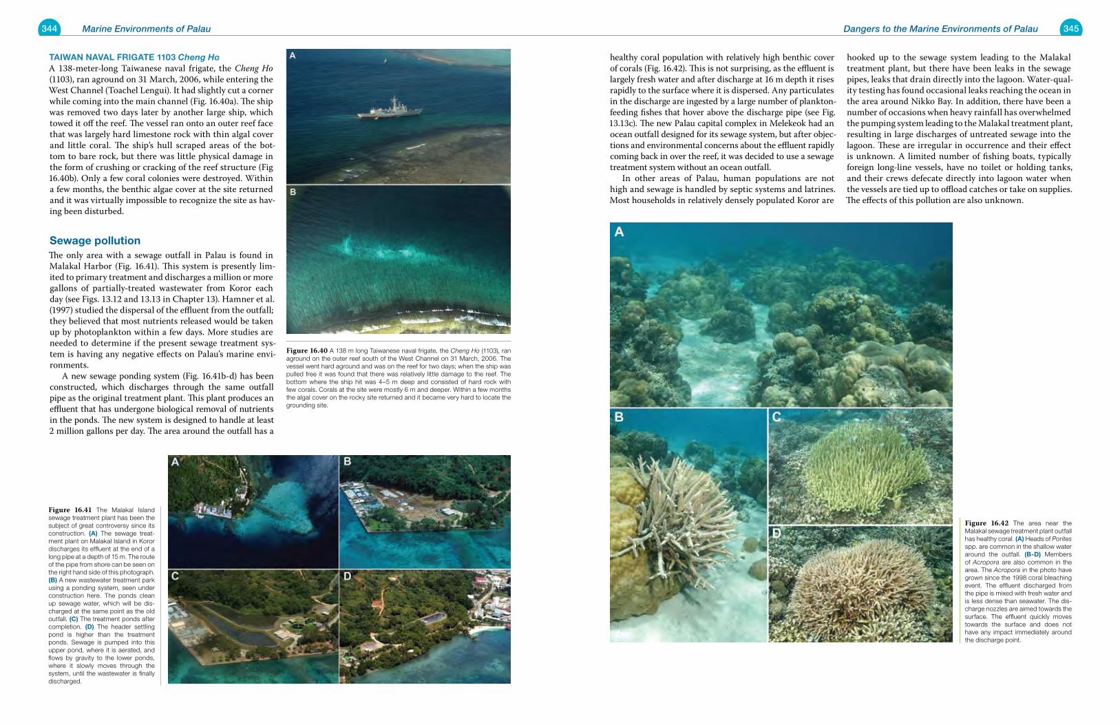
344 Marine Environments of Palau 345Dangers to the Marine Environments of Palau
taiwan naval Frigate 1103 Cheng HoA 138-meter-long Taiwanese naval frigate, the Cheng Ho (1103), ran aground on 31 March, 2006, while entering the West Channel (Toachel Lengui). It had slightly cut a corner while coming into the main channel (Fig. 16.40a). The ship was removed two days later by another large ship, which towed it off the reef. The vessel ran onto an outer reef face that was largely hard limestone rock with thin algal cover and little coral. The ship’s hull scraped areas of the bot-tom to bare rock, but there was little physical damage in the form of crushing or cracking of the reef structure (Fig 16.40b). Only a few coral colonies were destroyed. Within a few months, the benthic algae cover at the site returned and it was virtually impossible to recognize the site as hav-ing been disturbed.
sewage pollutionThe only area with a sewage outfall in Palau is found in Malakal Harbor (Fig. 16.41). This system is presently lim-ited to primary treatment and discharges a million or more gallons of partially-treated wastewater from Koror each day (see Figs. 13.12 and 13.13 in Chapter 13). Hamner et al. (1997) studied the dispersal of the effluent from the outfall; they believed that most nutrients released would be taken up by photoplankton within a few days. More studies are needed to determine if the present sewage treatment sys-tem is having any negative effects on Palau’s marine envi-ronments. A new sewage ponding system (Fig. 16.41b-d) has been constructed, which discharges through the same outfall pipe as the original treatment plant. This plant produces an effluent that has undergone biological removal of nutrients in the ponds. The new system is designed to handle at least 2 million gallons per day. The area around the outfall has a
healthy coral population with relatively high benthic cover of corals (Fig. 16.42). This is not surprising, as the effluent is largely fresh water and after discharge at 16 m depth it rises rapidly to the surface where it is dispersed. Any particulates in the discharge are ingested by a large number of plankton-feeding fishes that hover above the discharge pipe (see Fig. 13.13c). The new Palau capital complex in Melekeok had an ocean outfall designed for its sewage system, but after objec-tions and environmental concerns about the effluent rapidly coming back in over the reef, it was decided to use a sewage treatment system without an ocean outfall. In other areas of Palau, human populations are not high and sewage is handled by septic systems and latrines. Most households in relatively densely populated Koror are
hooked up to the sewage system leading to the Malakal treatment plant, but there have been leaks in the sewage pipes, leaks that drain directly into the lagoon. Water-qual-ity testing has found occasional leaks reaching the ocean in the area around Nikko Bay. In addition, there have been a number of occasions when heavy rainfall has overwhelmed the pumping system leading to the Malakal treatment plant, resulting in large discharges of untreated sewage into the lagoon. These are irregular in occurrence and their effect is unknown. A limited number of fishing boats, typically foreign long-line vessels, have no toilet or holding tanks, and their crews defecate directly into lagoon water when the vessels are tied up to offload catches or take on supplies. The effects of this pollution are also unknown.
Figure 16.41 The Malakal Island sewage treatment plant has been the subject of great controversy since its construction. (a) The sewage treat-ment plant on Malakal Island in Koror discharges its effluent at the end of a long pipe at a depth of 15 m. The route of the pipe from shore can be seen on the right hand side of this photograph. (B) A new wastewater treatment park using a ponding system, seen under construction here. The ponds clean up sewage water, which will be dis-charged at the same point as the old outfall. (C) The treatment ponds after completion. (D) The header settling pond is higher than the treatment ponds. Sewage is pumped into this upper pond, where it is aerated, and flows by gravity to the lower ponds, where it slowly moves through the system, until the wastewater is finally discharged.
Figure 16.40 A 138 m long Taiwanese naval frigate, the Cheng Ho (1103), ran aground on the outer reef south of the West Channel on 31 March, 2006. The vessel went hard aground and was on the reef for two days; when the ship was pulled free it was found that there was relatively little damage to the reef. The bottom where the ship hit was 4–5 m deep and consisted of hard rock with few corals. Corals at the site were mostly 6 m and deeper. Within a few months the algal cover on the rocky site returned and it became very hard to locate the grounding site.
Figure 16.42 The area near the Malakal sewage treatment plant outfall has healthy coral. (a) Heads of Porites spp. are common in the shallow water around the outfall. (B-D) Members of Acropora are also common in the area. The Acropora in the photo have grown since the 1998 coral bleaching event. The effluent discharged from the pipe is mixed with fresh water and is less dense than seawater. The dis-charge nozzles are aimed towards the surface. The effluent quickly moves towards the surface and does not have any impact immediately around the discharge point.
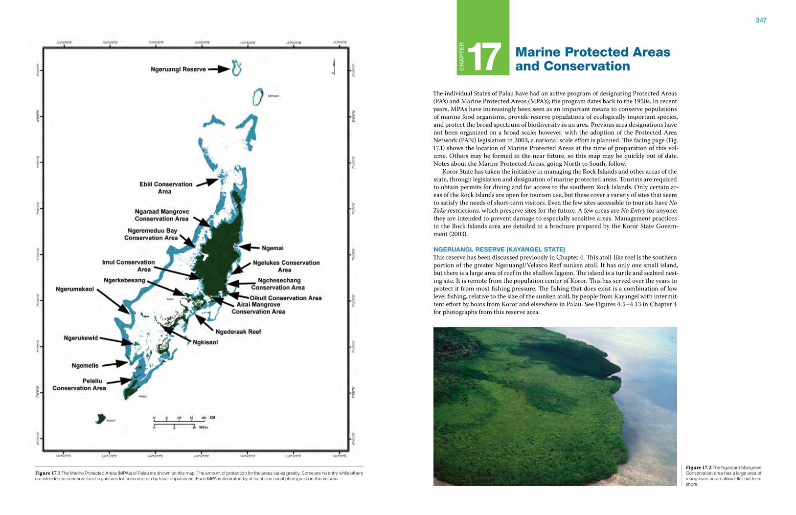
347
Ch
ap
te
r
17 Marine Protected Areas and Conservation
The individual States of Palau have had an active program of designating Protected Areas (PA’s) and Marine Protected Areas (MPA’s); the program dates back to the 1950s. In recent years, MPAs have increasingly been seen as an important means to conserve populations of marine food organisms, provide reserve populations of ecologically important species, and protect the broad spectrum of biodiversity in an area. Previous area designations have not been organized on a broad scale; however, with the adoption of the Protected Area Network (PAN) legislation in 2003, a national scale effort is planned. The facing page (Fig. 17.1) shows the location of Marine Protected Areas at the time of preparation of this vol-ume. Others may be formed in the near future, so this map may be quickly out of date. Notes about the Marine Protected Areas, going North to South, follow. Koror State has taken the initiative in managing the Rock Islands and other areas of the state, through legislation and designation of marine protected areas. Tourists are required to obtain permits for diving and for access to the southern Rock Islands. Only certain ar-eas of the Rock Islands are open for tourism use, but these cover a variety of sites that seem to satisfy the needs of short-term visitors. Even the few sites accessible to tourists have No Take restrictions, which preserve sites for the future. A few areas are No Entry for anyone; they are intended to prevent damage to especially sensitive areas. Management practices in the Rock Islands area are detailed in a brochure prepared by the Koror State Govern-ment (2003).
ngeruangl reserve (kayangel state)This reserve has been discussed previously in Chapter 4. This atoll-like reef is the southern portion of the greater Ngeruangl/Velasco Reef sunken atoll. It has only one small island, but there is a large area of reef in the shallow lagoon. The island is a turtle and seabird nest-ing site. It is remote from the population center of Koror. This has served over the years to protect it from most fishing pressure. The fishing that does exist is a combination of low level fishing, relative to the size of the sunken atoll, by people from Kayangel with intermit-tent effort by boats from Koror and elsewhere in Palau. See Figures 4.5–4.13 in Chapter 4 for photographs from this reserve area.
Figure 17.1 The Marine Protected Areas (MPAs) of Palau are shown on this map. The amount of protection for the areas varies greatly. Some are no entry while others are intended to conserve food organisms for consumption by local populations. Each MPA is illustrated by at least one aerial photograph in this volume.
Figure 17.2 The Ngaraard Mangrove Conservation area has a large area of mangroves on an alluvial flat out from shore.
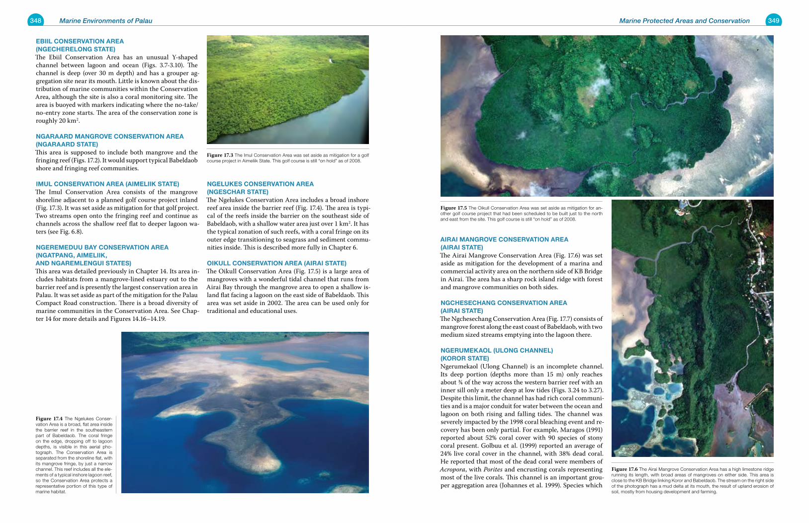
348 Marine Environments of Palau 349Marine Protected Areas and Conservation
eBiil Conservation area (ngeCherelong state)The Ebiil Conservation Area has an unusual Y-shaped channel between lagoon and ocean (Figs. 3.7-3.10). The channel is deep (over 30 m depth) and has a grouper ag-gregation site near its mouth. Little is known about the dis-tribution of marine communities within the Conservation Area, although the site is also a coral monitoring site. The area is buoyed with markers indicating where the no-take/no-entry zone starts. The area of the conservation zone is roughly 20 km2.
ngaraarD mangrove Conservation area (ngaraarD state)This area is supposed to include both mangrove and the fringing reef (Figs. 17.2). It would support typical Babeldaob shore and fringing reef communities.
imul Conservation area (aimeliik state) The Imul Conservation Area consists of the mangrove shoreline adjacent to a planned golf course project inland (Fig. 17.3). It was set aside as mitigation for that golf project. Two streams open onto the fringing reef and continue as channels across the shallow reef flat to deeper lagoon wa-ters (see Fig. 6.8).
ngeremeDuu Bay Conservation area (ngatpang, aimeliik, anD ngaremlengui states) This area was detailed previously in Chapter 14. Its area in-cludes habitats from a mangrove-lined estuary out to the barrier reef and is presently the largest conservation area in Palau. It was set aside as part of the mitigation for the Palau Compact Road construction. There is a broad diversity of marine communities in the Conservation Area. See Chap-ter 14 for more details and Figures 14.16–14.19.
ngelukes Conservation area (ngesChar state)The Ngelukes Conservation Area includes a broad inshore reef area inside the barrier reef (Fig. 17.4). The area is typi-cal of the reefs inside the barrier on the southeast side of Babeldaob, with a shallow water area just over 1 km2. It has the typical zonation of such reefs, with a coral fringe on its outer edge transitioning to seagrass and sediment commu-nities inside. This is described more fully in Chapter 6.
oikull Conservation area (airai state) The Oikull Conservation Area (Fig. 17.5) is a large area of mangroves with a wonderful tidal channel that runs from Airai Bay through the mangrove area to open a shallow is-land flat facing a lagoon on the east side of Babeldaob. This area was set aside in 2002. The area can be used only for traditional and educational uses.
airai mangrove Conservation area (airai state)The Airai Mangrove Conservation Area (Fig. 17.6) was set aside as mitigation for the development of a marina and commercial activity area on the northern side of KB Bridge in Airai. The area has a sharp rock island ridge with forest and mangrove communities on both sides.
ngCheseChang Conservation area (airai state)The Ngchesechang Conservation Area (Fig. 17.7) consists of mangrove forest along the east coast of Babeldaob, with two medium sized streams emptying into the lagoon there.
ngerumekaol (ulong Channel) (koror state)Ngerumekaol (Ulong Channel) is an incomplete channel. Its deep portion (depths more than 15 m) only reaches about ¾ of the way across the western barrier reef with an inner sill only a meter deep at low tides (Figs. 3.24 to 3.27). Despite this limit, the channel has had rich coral communi-ties and is a major conduit for water between the ocean and lagoon on both rising and falling tides. The channel was severely impacted by the 1998 coral bleaching event and re-covery has been only partial. For example, Maragos (1991) reported about 52% coral cover with 90 species of stony coral present. Golbuu et al. (1999) reported an average of 24% live coral cover in the channel, with 38% dead coral. He reported that most of the dead coral were members of Acropora, with Porites and encrusting corals representing most of the live corals. This channel is an important grou-per aggregation area (Johannes et al. 1999). Species which
Figure 17.3 The Imul Conservation Area was set aside as mitigation for a golf course project in Aimeliik State. This golf course is still “on hold” as of 2008.
Figure 17.4 The Ngelukes Conser-vation Area is a broad, flat area inside the barrier reef in the southeastern part of Babeldaob. The coral fringe on the edge, dropping off to lagoon depths, is visible in this aerial pho-tograph. The Conservation Area is separated from the shoreline flat, with its mangrove fringe, by just a narrow channel. This reef includes all the ele-ments of a typical inshore lagoon reef, so the Conservation Area protects a representative portion of this type of marine habitat.
Figure 17.5 The Oikull Conservation Area was set aside as mitigation for an-other golf course project that had been scheduled to be built just to the north and east from the site. This golf course is still “on hold” as of 2008.
Figure 17.6 The Airai Mangrove Conservation Area has a high limestone ridge running its length, with broad areas of mangroves on either side. This area is close to the KB Bridge linking Koror and Babeldaob. The stream on the right side of the photograph has a mud delta at its mouth, the result of upland erosion of soil, mostly from housing development and farming.
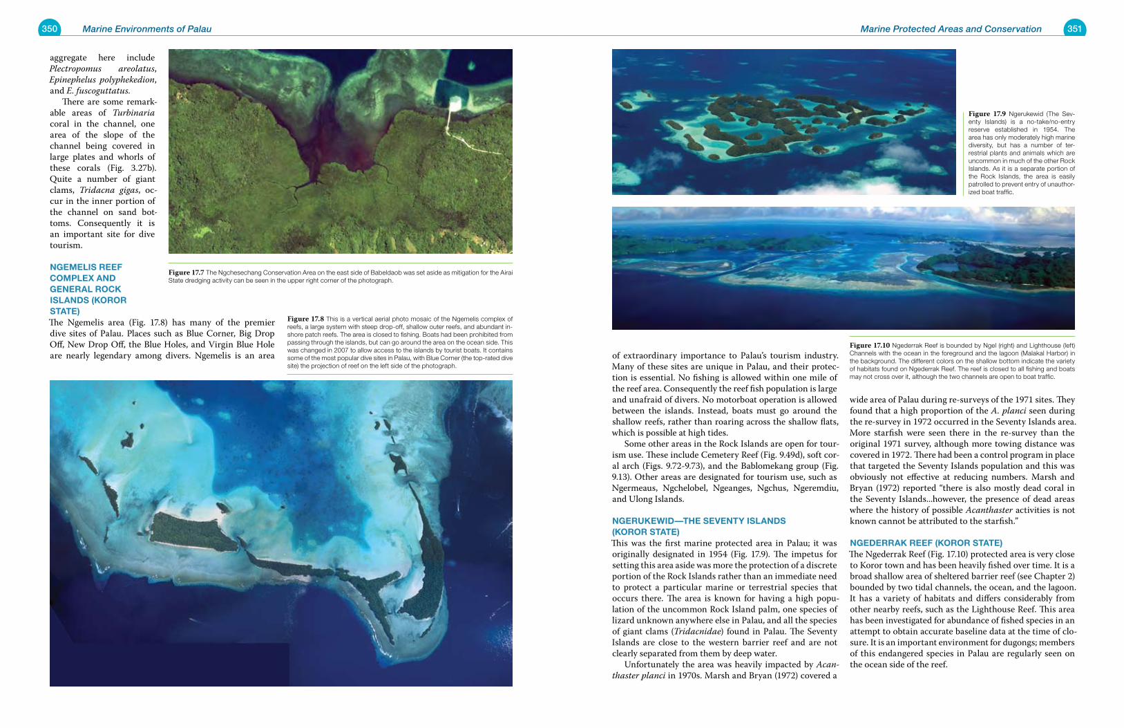
350 Marine Environments of Palau 351Marine Protected Areas and Conservation
aggregate here include Plectropomus areolatus, Epinephelus polyphekedion, and E. fuscoguttatus. There are some remark-able areas of Turbinaria coral in the channel, one area of the slope of the channel being covered in large plates and whorls of these corals (Fig. 3.27b). Quite a number of giant clams, Tridacna gigas, oc-cur in the inner portion of the channel on sand bot-toms. Consequently it is an important site for dive tourism.
ngemelis reeF Complex anD general roCk islanDs (koror state)The Ngemelis area (Fig. 17.8) has many of the premier dive sites of Palau. Places such as Blue Corner, Big Drop Off, New Drop Off, the Blue Holes, and Virgin Blue Hole are nearly legendary among divers. Ngemelis is an area of extraordinary importance to Palau’s tourism industry.
Many of these sites are unique in Palau, and their protec-tion is essential. No fishing is allowed within one mile of the reef area. Consequently the reef fish population is large and unafraid of divers. No motorboat operation is allowed between the islands. Instead, boats must go around the shallow reefs, rather than roaring across the shallow flats, which is possible at high tides. Some other areas in the Rock Islands are open for tour-ism use. These include Cemetery Reef (Fig. 9.49d), soft cor-al arch (Figs. 9.72-9.73), and the Bablomekang group (Fig. 9.13). Other areas are designated for tourism use, such as Ngermeaus, Ngchelobel, Ngeanges, Ngchus, Ngeremdiu, and Ulong Islands.
ngerukewiD—the seventy islanDs (koror state) This was the first marine protected area in Palau; it was originally designated in 1954 (Fig. 17.9). The impetus for setting this area aside was more the protection of a discrete portion of the Rock Islands rather than an immediate need to protect a particular marine or terrestrial species that occurs there. The area is known for having a high popu-lation of the uncommon Rock Island palm, one species of lizard unknown anywhere else in Palau, and all the species of giant clams (Tridacnidae) found in Palau. The Seventy Islands are close to the western barrier reef and are not clearly separated from them by deep water. Unfortunately the area was heavily impacted by Acan-thaster planci in 1970s. Marsh and Bryan (1972) covered a
wide area of Palau during re-surveys of the 1971 sites. They found that a high proportion of the A. planci seen during the re-survey in 1972 occurred in the Seventy Islands area. More starfish were seen there in the re-survey than the original 1971 survey, although more towing distance was covered in 1972. There had been a control program in place that targeted the Seventy Islands population and this was obviously not effective at reducing numbers. Marsh and Bryan (1972) reported “there is also mostly dead coral in the Seventy Islands...however, the presence of dead areas where the history of possible Acanthaster activities is not known cannot be attributed to the starfish.”
ngeDerrak reeF (koror state)The Ngederrak Reef (Fig. 17.10) protected area is very close to Koror town and has been heavily fished over time. It is a broad shallow area of sheltered barrier reef (see Chapter 2) bounded by two tidal channels, the ocean, and the lagoon. It has a variety of habitats and differs considerably from other nearby reefs, such as the Lighthouse Reef. This area has been investigated for abundance of fished species in an attempt to obtain accurate baseline data at the time of clo-sure. It is an important environment for dugongs; members of this endangered species in Palau are regularly seen on the ocean side of the reef.
Figure 17.8 This is a vertical aerial photo mosaic of the Ngemelis complex of reefs, a large system with steep drop-off, shallow outer reefs, and abundant in-shore patch reefs. The area is closed to fishing. Boats had been prohibited from passing through the islands, but can go around the area on the ocean side. This was changed in 2007 to allow access to the islands by tourist boats. It contains some of the most popular dive sites in Palau, with Blue Corner (the top-rated dive site) the projection of reef on the left side of the photograph.
Figure 17.7 The Ngchesechang Conservation Area on the east side of Babeldaob was set aside as mitigation for the Airai State dredging activity can be seen in the upper right corner of the photograph.
Figure 17.9 Ngerukewid (The Sev-enty Islands) is a no-take/no-entry reserve established in 1954. The area has only moderately high marine diversity, but has a number of ter-restrial plants and animals which are uncommon in much of the other Rock Islands. As it is a separate portion of the Rock Islands, the area is easily patrolled to prevent entry of unauthor-ized boat traffic.
Figure 17.10 Ngederrak Reef is bounded by Ngel (right) and Lighthouse (left) Channels with the ocean in the foreground and the lagoon (Malakal Harbor) in the background. The different colors on the shallow bottom indicate the variety of habitats found on Ngederrak Reef. The reef is closed to all fishing and boats may not cross over it, although the two channels are open to boat traffic.
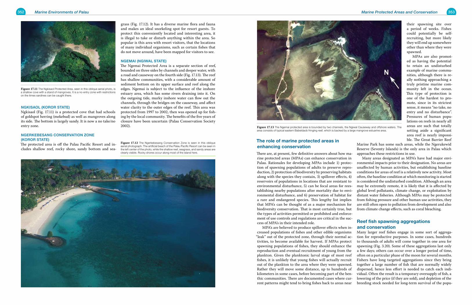
352 Marine Environments of Palau 353Marine Protected Areas and Conservation
ngkisaol (koror state) Ngkisaol (Fig. 17.11) is a protected cove that had schools of goldspot herring (mekebud) as well as mangroves along its side. The bottom is largely sandy. It is now a no take/no entry zone.
ngerkeBesang Conservation Zone (koror state)The protected area is off the Palau Pacific Resort and in-cludes shallow reef, rocky shore, sandy bottom and sea-
grass (Fig. 17.12). It has a diverse marine flora and fauna and makes an ideal snorkeling spot for resort guests. To protect this conveniently located and interesting area, it is illegal to take or disturb anything within the area. So popular is this area with resort visitors, that the locations of many individual organisms, such as certain fishes that do not move around, have been mapped for visitors to see.
ngemai (ngiwal state)The Ngemai Protected Area is a separate section of reef, bounded on three sides by channels and deeper water, with a road and causeway on the fourth side (Fig. 17.13). The reef has shallow communities, with a considerable amount of sediment bottom on its upper surface and reef along the edges. Ngemai is subject to the influence of the inshore estuary area, which has some rivers draining into it. On the outgoing tide, murky inshore water can flow out the channels, through the bridges on the causeway, and affect water clarity to the outer edges of the reef. This area was protected from 1997 to 2002, then was opened up for fish-ing by the local community. The benefits of the five years of closure have been uncertain (Palau Conservation Society 2002).
the role of marine protected areas in enhancing conservationThere are, at present, few definitive answers about how ma-rine protected areas (MPAs) can enhance conservation in Palau. Rationales for developing MPAs include 1) protec-tion of spawning populations of adults to preserve repro-duction, 2) protection of biodiversity by preserving habitats along with the species they contain, 3) spillover effects, 4) reservoirs of populations in locations that are resistant to environmental disturbance, 5) can be focal areas for rees-tablishing nearby populations after mortality due to envi-ronmental disturbance, and 6) preservation of habitat for a rare and endangered species. This lengthy list implies that MPA’s can be thought of as a major mechanism for biodiversity conservation. That is most certainly true, but the types of activities permitted or prohibited and enforce-ment of use controls and regulations are critical in the suc-cess of MPA’s in their intended role. MPA’s are believed to produce spillover effects when in-creased populations of fishes and other edible organisms
“leak” out of the protected zone, through their normal ac-tivities, to become available for harvest. If MPAs protect spawning populations of fishes, they should enhance the reproduction and eventual recruitment of young from the plankton. Given the planktonic larval stage of most reef fishes, it is unlikely that young fishes will actually recruit out of the plankton to the area where they were spawned. Rather they will move some distance, up to hundreds of kilometers in some cases, before becoming part of the ben-thic communities. There are documented cases where cur-rent patterns might tend to bring fishes back to areas near
their spawning site over a period of weeks. Fishes could potentially be self-recruiting, but more likely they will end up somewhere other than where they were spawned. MPAs are also promot-ed as having the potential to retain an undisturbed example of marine commu-nities, although there is re-ally nothing approaching a truly pristine marine com-munity left in the ocean. This type of protection is one of the hardest to pro-mote, since in its strictest sense, it means “no take, no entry and no disturbance”. Pressures of human popu-lations on reefs in nearly all areas are such that totally setting aside a significant area reef is nearly impossi-ble. The Great Barrier Reef
Marine Park has some such areas, while the Ngerukewid Reserve (Seventy Islands) is the only area in Palau which approaches these restrictions in use. Many areas designated as MPA’s have had major envi-ronmental impacts prior to their designation. No areas are unaffected by human activities, but establishing baseline conditions for areas of reef is a relatively new activity. Most often, the baseline condition at which monitoring is started is considered the undisturbed condition. Although an area may be extremely remote, it is likely that it is affected by global level pollutants, climate change, or exploitation by distant water fisheries. Although MPAs may be protected from fishing pressure and other human use activities, they are still often open to pollution from development and also from climate change effects, such as coral bleaching.
reef fish spawning aggregations and conservationMany larger reef fishes engage in some sort of aggrega-tion for reproductive purposes. In some cases, hundreds to thousands of adults will come together in one area for spawning (Fig. 3.20). Some of these aggregations last only a few days; others can occur over a longer period of time, often on a particular phase of the moon for several months. Fishers have long targeted aggregations since they bring together a large number of fish that are normally widely dispersed, hence less effort is needed to catch each indi-vidual. Often the result is a temporary oversupply of fish, a lowering of the price (if they are sold), and depletion of the breeding stock needed for long-term survival of the popu-
Figure 17.12 The Ngerkebesang Conservation Zone is seen in this oblique aerial photograph. The artificial beach of the Palau Pacific Resort can be seen in the left center of the photo, while the shallow reef, seagrass, and sandy areas are clearly visible. Rocky shores occur along most of the island here.
Figure 17.11 The Ngkisaol Protected Area, seen in this oblique aerial photo, is a shallow cove with a stand of mangroves. It is a no-entry zone with restrictions on the times sardines can be caught there.
Figure 17.13 The Ngemai protected area is bounded by two channels, the Ngiwal Causeway and offshore waters. The area consists of typical eastern Babeldaob fringing reef, which is backed by a large mangrove estuarine area.
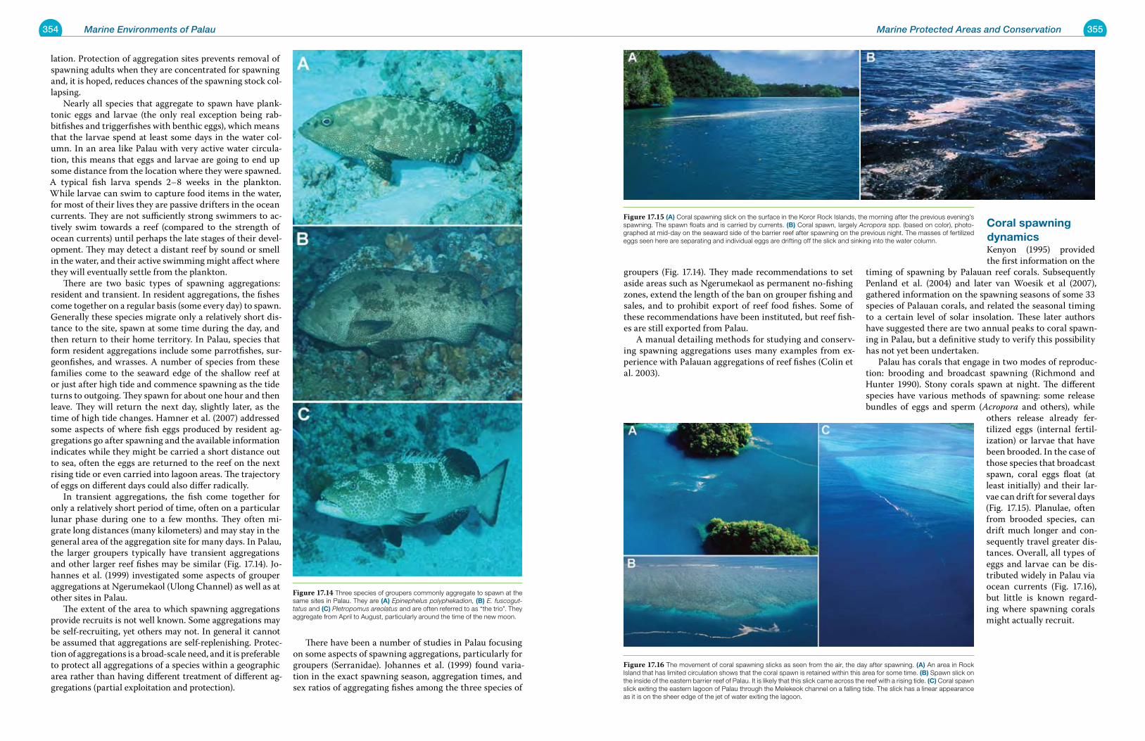
354 Marine Environments of Palau 355Marine Protected Areas and Conservation
lation. Protection of aggregation sites prevents removal of spawning adults when they are concentrated for spawning and, it is hoped, reduces chances of the spawning stock col-lapsing. Nearly all species that aggregate to spawn have plank-tonic eggs and larvae (the only real exception being rab-bitfishes and triggerfishes with benthic eggs), which means that the larvae spend at least some days in the water col-umn. In an area like Palau with very active water circula-tion, this means that eggs and larvae are going to end up some distance from the location where they were spawned. A typical fish larva spends 2–8 weeks in the plankton. While larvae can swim to capture food items in the water, for most of their lives they are passive drifters in the ocean currents. They are not sufficiently strong swimmers to ac-tively swim towards a reef (compared to the strength of ocean currents) until perhaps the late stages of their devel-opment. They may detect a distant reef by sound or smell in the water, and their active swimming might affect where they will eventually settle from the plankton. There are two basic types of spawning aggregations: resident and transient. In resident aggregations, the fishes come together on a regular basis (some every day) to spawn. Generally these species migrate only a relatively short dis-tance to the site, spawn at some time during the day, and then return to their home territory. In Palau, species that form resident aggregations include some parrotfishes, sur-geonfishes, and wrasses. A number of species from these families come to the seaward edge of the shallow reef at or just after high tide and commence spawning as the tide turns to outgoing. They spawn for about one hour and then leave. They will return the next day, slightly later, as the time of high tide changes. Hamner et al. (2007) addressed some aspects of where fish eggs produced by resident ag-gregations go after spawning and the available information indicates while they might be carried a short distance out to sea, often the eggs are returned to the reef on the next rising tide or even carried into lagoon areas. The trajectory of eggs on different days could also differ radically. In transient aggregations, the fish come together for only a relatively short period of time, often on a particular lunar phase during one to a few months. They often mi-grate long distances (many kilometers) and may stay in the general area of the aggregation site for many days. In Palau, the larger groupers typically have transient aggregations and other larger reef fishes may be similar (Fig. 17.14). Jo-hannes et al. (1999) investigated some aspects of grouper aggregations at Ngerumekaol (Ulong Channel) as well as at other sites in Palau. The extent of the area to which spawning aggregations provide recruits is not well known. Some aggregations may be self-recruiting, yet others may not. In general it cannot be assumed that aggregations are self-replenishing. Protec-tion of aggregations is a broad-scale need, and it is preferable to protect all aggregations of a species within a geographic area rather than having different treatment of different ag-gregations (partial exploitation and protection).
There have been a number of studies in Palau focusing on some aspects of spawning aggregations, particularly for groupers (Serranidae). Johannes et al. (1999) found varia-tion in the exact spawning season, aggregation times, and sex ratios of aggregating fishes among the three species of
groupers (Fig. 17.14). They made recommendations to set aside areas such as Ngerumekaol as permanent no-fishing zones, extend the length of the ban on grouper fishing and sales, and to prohibit export of reef food fishes. Some of these recommendations have been instituted, but reef fish-es are still exported from Palau. A manual detailing methods for studying and conserv-ing spawning aggregations uses many examples from ex-perience with Palauan aggregations of reef fishes (Colin et al. 2003).
Coral spawning dynamicsKenyon (1995) provided the first information on the
timing of spawning by Palauan reef corals. Subsequently Penland et al. (2004) and later van Woesik et al (2007), gathered information on the spawning seasons of some 33 species of Palauan corals, and related the seasonal timing to a certain level of solar insolation. These later authors have suggested there are two annual peaks to coral spawn-ing in Palau, but a definitive study to verify this possibility has not yet been undertaken. Palau has corals that engage in two modes of reproduc-tion: brooding and broadcast spawning (Richmond and Hunter 1990). Stony corals spawn at night. The different species have various methods of spawning: some release bundles of eggs and sperm (Acropora and others), while
others release already fer-tilized eggs (internal fertil-ization) or larvae that have been brooded. In the case of those species that broadcast spawn, coral eggs float (at least initially) and their lar-vae can drift for several days (Fig. 17.15). Planulae, often from brooded species, can drift much longer and con-sequently travel greater dis-tances. Overall, all types of eggs and larvae can be dis-tributed widely in Palau via ocean currents (Fig. 17.16), but little is known regard-ing where spawning corals might actually recruit.
Figure 17.14 Three species of groupers commonly aggregate to spawn at the same sites in Palau. They are (a) Epinephelus polyphekadion, (B) E. fuscogut-tatus and (C) Pletropomus areolatus and are often referred to as “the trio”. They aggregate from April to August, particularly around the time of the new moon.
Figure 17.15 (a) Coral spawning slick on the surface in the Koror Rock Islands, the morning after the previous evening’s spawning. The spawn floats and is carried by currents. (B) Coral spawn, largely Acropora spp. (based on color), photo-graphed at mid-day on the seaward side of the barrier reef after spawning on the previous night. The masses of fertilized eggs seen here are separating and individual eggs are drifting off the slick and sinking into the water column.
Figure 17.16 The movement of coral spawning slicks as seen from the air, the day after spawning. (a) An area in Rock Island that has limited circulation shows that the coral spawn is retained within this area for some time. (B) Spawn slick on the inside of the eastern barrier reef of Palau. It is likely that this slick came across the reef with a rising tide. (C) Coral spawn slick exiting the eastern lagoon of Palau through the Melekeok channel on a falling tide. The slick has a linear appearance as it is on the sheer edge of the jet of water exiting the lagoon.
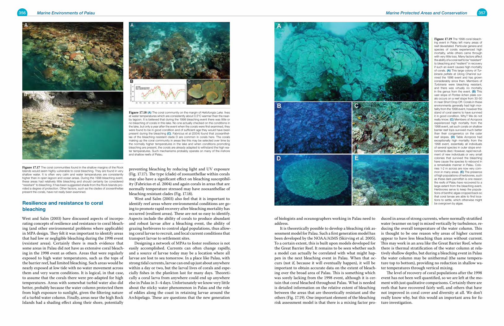
356 Marine Environments of Palau 357Marine Protected Areas and Conservation
resilience and resistance to coral bleaching
West and Salm (2003) have discussed aspects of incorpo-rating concepts of resilience and resistance to coral bleach-ing (and other environmental problems where applicable) in MPA design. They felt it was important to identify areas that had low or negligible bleaching during the 1998 event (resistant areas). Certainly there is much evidence that some areas in Palau did not have as extensive coral bleach-ing in the 1998 event as others. Areas that were regularly exposed to high water temperatures, such as the tops of the barrier reef, had limited bleaching. Such areas would be nearly exposed at low tide with no water movement across them and very warm conditions. It is logical, in that case, to assume that the corals there were pre-adapted for high temperatures. Areas with somewhat turbid water also did better, probably because the water column protected them from high exposure to sunlight, given the filtering nature of a turbid water column. Finally, areas near the high Rock Islands had a shading effect along their shore, potentially
preventing bleaching by reducing light and UV exposure (Fig. 17.17). The type (clade) of zooxanthellae within corals may also have a significant effect on bleaching susceptibil-ity (Fabricius et al. 2004) and again corals in areas that are normally temperature stressed may have zooxanthellae of bleaching resistant clades (Fig. 17.18). West and Salm (2003) also feel that it is important to identify reef areas where environmental conditions are go-ing to promote rapid recovery after bleaching mortality has occurred (resilient areas). These are not so easy to identify. Aspects include the ability of corals to produce abundant and robust larvae after a bleaching event, the ability of grazing herbivores to control algal populations, thus allow-ing coral larvae to recruit, and local current conditions that transport larvae to settlement sites. Designing a network of MPAs to foster resilience is not easily accomplished. Currents can often change rapidly, and a source of larvae today may be a location where all larvae are lost to sea tomorrow. In a place like Palau, with strong tidal currents, larvae can end up just about anywhere within a day or two, but the larval lives of corals and espe-cially fishes in the plankton last for many days. Theoreti-cally a coral larva from anywhere could end up anywhere else in Palau in 3–4 days. Unfortunately we know very little about the sticky water phenomenon in Palau and the role of eddies along the coast in retaining larvae around the Archipelago. These are questions that the new generation
of biologists and oceanographers working in Palau need to address. It is theoretically possible to develop a bleaching risk as-sessment model for Palau. Such a first generation model has been developed by the NOAA/AIMS (Skirving et al. 2005). To a certain extent, this is built upon models developed for the Great Barrier Reef. It remains to be seen whether such a model can actually be correlated with what might hap-pen in the next bleaching event in Palau. When that oc-curs (not if, because it will eventually happen), it will be important to obtain accurate data on the extent of bleach-ing over the broad area of Palau. This is something which was sorely lacking from the 1998 event, although it is cer-tain that coral bleached throughout Palau. What is needed is detailed information on the relative extent of bleaching between the areas that are theoretically resistant and the others (Fig. 17.19). One important element of the bleaching risk assessment model is that there is a mixing factor pro-
duced in areas of strong currents, where normally stratified water (warmer on top) is mixed vertically by turbulence, re-ducing the overall temperature of the water column. This is thought to be one reason why areas of higher current appear to have less bleaching than areas without current. This may work in an area like the Great Barrier Reef, where there is thermal stratification of the water column at rela-tively shallow depths, but during a bleaching event in Palau the water column may be unithermal (the same tempera-ture top to bottom), providing no reduction in shallow wa-ter temperatures through vertical mixing. The level of recovery of coral populations after the 1998 event has not been well quantified, so we are left at the mo-ment with just qualitative comparisons. Certainly there are reefs that have recovered fairly well, and others that have not improved in coral cover and diversity at all. We don’t really know why, but this would an important area for fu-ture investigation.
Figure 17.17 The coral communities found in the shallow margins of the Rock Islands would seem highly vulnerable to coral bleaching. They are found in very shallow water. It is often very calm and water temperatures are consistently higher than in open lagoon and ocean areas. During the 1998 bleaching event, these areas had relatively little bleaching and should certainly be considered “resistant” to bleaching. It has been suggested shade from the Rock Islands pro-vided a degree of protection. Other factors, such as the clades of zooxanthellae present the corals, have not really been examined.
Figure 17.18 (a) The coral community on the margin of Heliofungia Lake. lives at water temperatures which are consistently about 0.5°C warmer than the near-by lagoon. It is believed that during the 1998 bleaching event there was little or no bleaching of corals in this lake. No one actually checked on the conditions in the lake, but only a year after the event when the corals were first examined, they were found to be in good condition and of sufficient age they would have been present during the bleaching (C). Fabricius et al (2004) found that zooxanthel-lae of the bleaching resistant clade D are common in corals here. The corals making up the coral community in areas like this may be selected over time by the normally higher temperatures in the lake and when conditions promoting bleaching are present, the corals are already adapted to withstand the high wa-ter temperatures. Such mechanisms probably operate on many of the inshore and shallow reefs of Palau.
Figure 17.19 The 1998 coral bleach-ing event in Palau left many areas of reef devastated. Particular genera and species of corals experienced high mortality, while others came through with very little loss. Many factors affect the ability of a coral reef to be “resistant” to bleaching and “resilient” in recovery if such an event causes high mortality of corals. (a) This large colony of Tur-binaria peltata at Ulong Channel sur-vived the 1998 event and has grown considerably since then. Members of Turbinaria were bleaching resistant, and there was virtually no mortality in the genus from the event. (B) This vast slope of Porites lichen plate cor-als occurs on a reef slope from 30-50 m near Short Drop Off. Corals in these environments generally had high mor-tality from the 1998 event, however this stand of coral seems to have survived it in good condition. Why? We do not really know. (C) Members of Acropora experienced high mortality from the 1998 event, yet such corals on shallow barrier reef tops survived much better than their congenerics on the outer reef slopes. (D) Table Acropora had exceptionally high mortality from the 1998 event, essentially all individuals of several species in outer slope envi-ronments died. However, rapid recruit-ment of new individuals or very small colonies that survived the bleaching have cause the species to rebound in a remarkable manner in Palau. Colo-nies 1-2 m across are now very com-mon in many areas. (e) The presence of high populations of herbivores, such as these dark parrotfish is one reason the reefs of Palau have recovered to a large extent from the bleaching event. Herbivores serve to keep the popula-tions of benthic algae cropped back so that coral larvae are able to find loca-tions to settle, which otherwise might be overgrown by algae.
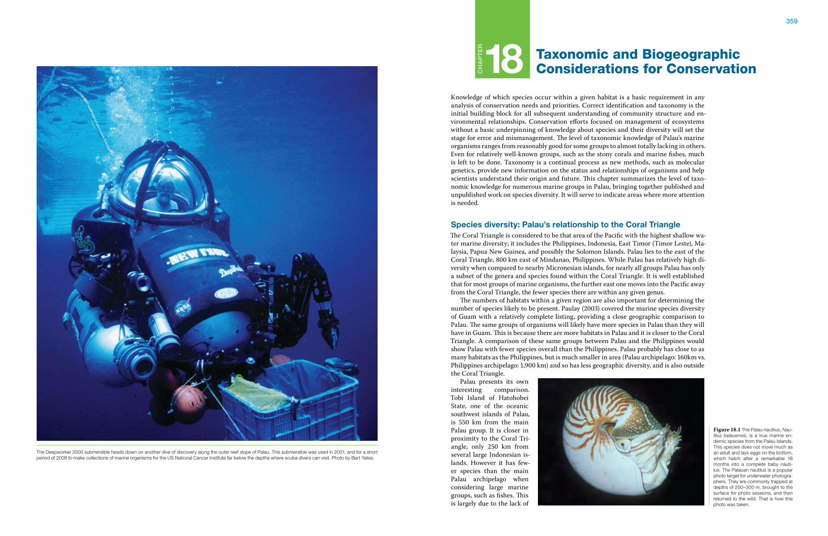
359
Ch
ap
te
r
18 Taxonomic and BiogeographicConsiderations for Conservation
Knowledge of which species occur within a given habitat is a basic requirement in any analysis of conservation needs and priorities. Correct identification and taxonomy is the initial building block for all subsequent understanding of community structure and en-vironmental relationships. Conservation efforts focused on management of ecosystems without a basic underpinning of knowledge about species and their diversity will set the stage for error and mismanagement. The level of taxonomic knowledge of Palau’s marine organisms ranges from reasonably good for some groups to almost totally lacking in others. Even for relatively well-known groups, such as the stony corals and marine fishes, much is left to be done. Taxonomy is a continual process as new methods, such as molecular genetics, provide new information on the status and relationships of organisms and help scientists understand their origin and future. This chapter summarizes the level of taxo-nomic knowledge for numerous marine groups in Palau, bringing together published and unpublished work on species diversity. It will serve to indicate areas where more attention is needed.
species diversity: palau’s relationship to the Coral triangleThe Coral Triangle is considered to be that area of the Pacific with the highest shallow wa-ter marine diversity; it includes the Philippines, Indonesia, East Timor (Timor Leste), Ma-laysia, Papua New Guinea, and possibly the Solomon Islands. Palau lies to the east of the Coral Triangle, 800 km east of Mindanao, Philippines. While Palau has relatively high di-versity when compared to nearby Micronesian islands, for nearly all groups Palau has only a subset of the genera and species found within the Coral Triangle. It is well established that for most groups of marine organisms, the further east one moves into the Pacific away from the Coral Triangle, the fewer species there are within any given genus. The numbers of habitats within a given region are also important for determining the number of species likely to be present. Paulay (2003) covered the marine species diversity of Guam with a relatively complete listing, providing a close geographic comparison to Palau. The same groups of organisms will likely have more species in Palau than they will have in Guam. This is because there are more habitats in Palau and it is closer to the Coral Triangle. A comparison of these same groups between Palau and the Philippines would show Palau with fewer species overall than the Philippines. Palau probably has close to as many habitats as the Philippines, but is much smaller in area (Palau archipelago: 160km vs. Philippines archipelago: 1,900 km) and so has less geographic diversity, and is also outside the Coral Triangle. Palau presents its own interesting comparison. Tobi Island of Hatohobei State, one of the oceanic southwest islands of Palau, is 550 km from the main Palau group. It is closer in proximity to the Coral Tri-angle, only 250 km from several large Indonesian is-lands. However it has few-er species than the main Palau archipelago when considering large marine groups, such as fishes. This is largely due to the lack of
Figure 18.1 The Palau nautilus, Nau-tilus belauensis, is a true marine en-demic species from the Palau Islands. This species does not move much as an adult and lays eggs on the bottom, which hatch after a remarkable 18 months into a complete baby nauti-lus. The Palauan nautilus is a popular photo target for underwater photogra-phers. They are commonly trapped at depths of 200–300 m, brought to the surface for photo sessions, and then returned to the wild. That is how this photo was taken.
The Deepworker 2000 submersible heads down on another dive of discovery along the outer reef slope of Palau. This submersible was used in 2001, and for a short period of 2008 to make collections of marine organisms for the US National Cancer Institute far below the depths where scuba divers can visit. Photo by Bert Yates.
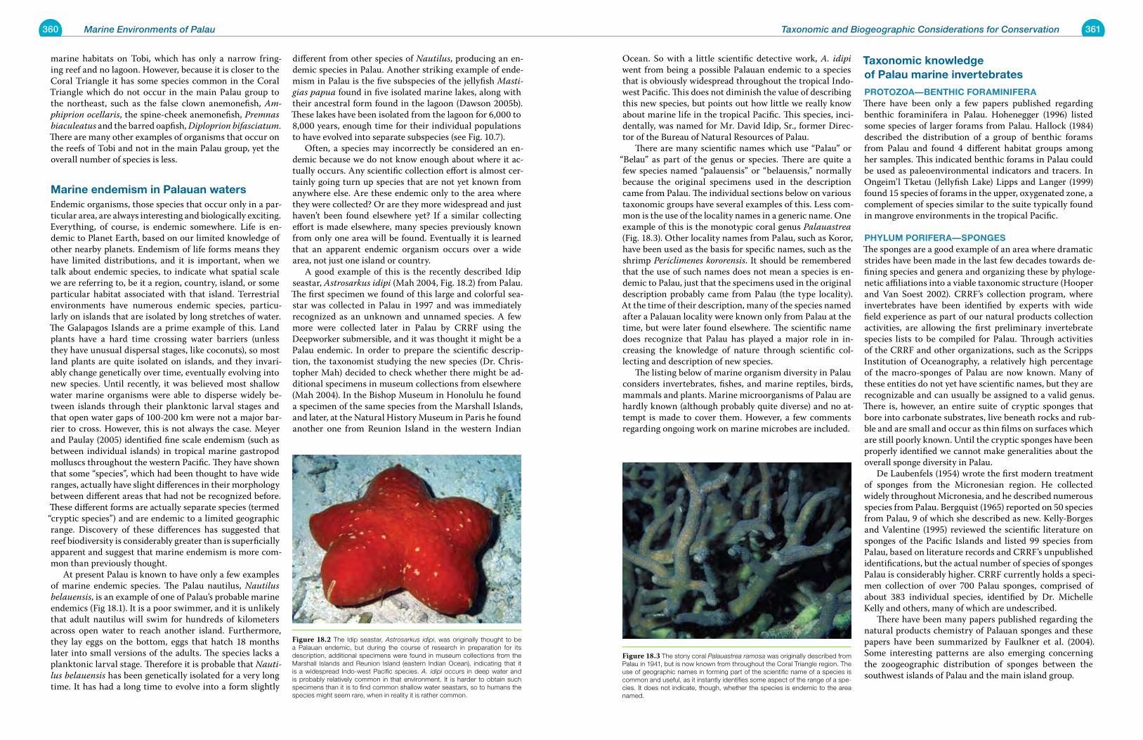
360 Marine Environments of Palau 361Taxonomic and Biogeographic Considerations for Conservation
marine habitats on Tobi, which has only a narrow fring-ing reef and no lagoon. However, because it is closer to the Coral Triangle it has some species common in the Coral Triangle which do not occur in the main Palau group to the northeast, such as the false clown anemonefish, Am-phiprion ocellaris, the spine-cheek anemonefish, Premnas biaculeatus and the barred oapfish, Diploprion bifasciatum. There are many other examples of organisms that occur on the reefs of Tobi and not in the main Palau group, yet the overall number of species is less.
marine endemism in palauan watersEndemic organisms, those species that occur only in a par-ticular area, are always interesting and biologically exciting. Everything, of course, is endemic somewhere. Life is en-demic to Planet Earth, based on our limited knowledge of other nearby planets. Endemism of life forms means they have limited distributions, and it is important, when we talk about endemic species, to indicate what spatial scale we are referring to, be it a region, country, island, or some particular habitat associated with that island. Terrestrial environments have numerous endemic species, particu-larly on islands that are isolated by long stretches of water. The Galapagos Islands are a prime example of this. Land plants have a hard time crossing water barriers (unless they have unusual dispersal stages, like coconuts), so most land plants are quite isolated on islands, and they invari-ably change genetically over time, eventually evolving into new species. Until recently, it was believed most shallow water marine organisms were able to disperse widely be-tween islands through their planktonic larval stages and that open water gaps of 100-200 km were not a major bar-rier to cross. However, this is not always the case. Meyer and Paulay (2005) identified fine scale endemism (such as between individual islands) in tropical marine gastropod molluscs throughout the western Pacific. They have shown that some “species”, which had been thought to have wide ranges, actually have slight differences in their morphology between different areas that had not be recognized before. These different forms are actually separate species (termed “cryptic species”) and are endemic to a limited geographic range. Discovery of these differences has suggested that reef biodiversity is considerably greater than is superficially apparent and suggest that marine endemism is more com-mon than previously thought. At present Palau is known to have only a few examples of marine endemic species. The Palau nautilus, Nautilus belauensis, is an example of one of Palau’s probable marine endemics (Fig 18.1). It is a poor swimmer, and it is unlikely that adult nautilus will swim for hundreds of kilometers across open water to reach another island. Furthermore, they lay eggs on the bottom, eggs that hatch 18 months later into small versions of the adults. The species lacks a planktonic larval stage. Therefore it is probable that Nauti-lus belauensis has been genetically isolated for a very long time. It has had a long time to evolve into a form slightly
different from other species of Nautilus, producing an en-demic species in Palau. Another striking example of ende-mism in Palau is the five subspecies of the jellyfish Masti-gias papua found in five isolated marine lakes, along with their ancestral form found in the lagoon (Dawson 2005b). These lakes have been isolated from the lagoon for 6,000 to 8,000 years, enough time for their individual populations to have evolved into separate subspecies (see Fig. 10.7). Often, a species may incorrectly be considered an en-demic because we do not know enough about where it ac-tually occurs. Any scientific collection effort is almost cer-tainly going turn up species that are not yet known from anywhere else. Are these endemic only to the area where they were collected? Or are they more widespread and just haven’t been found elsewhere yet? If a similar collecting effort is made elsewhere, many species previously known from only one area will be found. Eventually it is learned that an apparent endemic organism occurs over a wide area, not just one island or country. A good example of this is the recently described Idip seastar, Astrosarkus idipi (Mah 2004, Fig. 18.2) from Palau. The first specimen we found of this large and colorful sea-star was collected in Palau in 1997 and was immediately recognized as an unknown and unnamed species. A few more were collected later in Palau by CRRF using the Deepworker submersible, and it was thought it might be a Palau endemic. In order to prepare the scientific descrip-tion, the taxonomist studying the new species (Dr. Chris-topher Mah) decided to check whether there might be ad-ditional specimens in museum collections from elsewhere (Mah 2004). In the Bishop Museum in Honolulu he found a specimen of the same species from the Marshall Islands, and later, at the Natural History Museum in Paris he found another one from Reunion Island in the western Indian
Ocean. So with a little scientific detective work, A. idipi went from being a possible Palauan endemic to a species that is obviously widespread throughout the tropical Indo-west Pacific. This does not diminish the value of describing this new species, but points out how little we really know about marine life in the tropical Pacific. This species, inci-dentally, was named for Mr. David Idip, Sr., former Direc-tor of the Bureau of Natural Resources of Palau. There are many scientific names which use “Palau” or
“Belau” as part of the genus or species. There are quite a few species named “palauensis” or “belauensis,” normally because the original specimens used in the description came from Palau. The individual sections below on various taxonomic groups have several examples of this. Less com-mon is the use of the locality names in a generic name. One example of this is the monotypic coral genus Palauastrea (Fig. 18.3). Other locality names from Palau, such as Koror, have been used as the basis for specific names, such as the shrimp Periclimenes kororensis. It should be remembered that the use of such names does not mean a species is en-demic to Palau, just that the specimens used in the original description probably came from Palau (the type locality). At the time of their description, many of the species named after a Palauan locality were known only from Palau at the time, but were later found elsewhere. The scientific name does recognize that Palau has played a major role in in-creasing the knowledge of nature through scientific col-lecting and description of new species. The listing below of marine organism diversity in Palau considers invertebrates, fishes, and marine reptiles, birds, mammals and plants. Marine microorganisms of Palau are hardly known (although probably quite diverse) and no at-tempt is made to cover them. However, a few comments regarding ongoing work on marine microbes are included.
taxonomic knowledge of palau marine invertebrates
protoZoa—BenthiC ForaminiFeraThere have been only a few papers published regarding benthic foraminifera in Palau. Hohenegger (1996) listed some species of larger forams from Palau. Hallock (1984) described the distribution of a group of benthic forams from Palau and found 4 different habitat groups among her samples. This indicated benthic forams in Palau could be used as paleoenvironmental indicators and tracers. In Ongeim’l Tketau (Jellyfish Lake) Lipps and Langer (1999) found 15 species of forams in the upper, oxygenated zone, a complement of species similar to the suite typically found in mangrove environments in the tropical Pacific.
phylum poriFera—spongesThe sponges are a good example of an area where dramatic strides have been made in the last few decades towards de-fining species and genera and organizing these by phyloge-netic affiliations into a viable taxonomic structure (Hooper and Van Soest 2002). CRRF’s collection program, where invertebrates have been identified by experts with wide field experience as part of our natural products collection activities, are allowing the first preliminary invertebrate species lists to be compiled for Palau. Through activities of the CRRF and other organizations, such as the Scripps Institution of Oceanography, a relatively high percentage of the macro-sponges of Palau are now known. Many of these entities do not yet have scientific names, but they are recognizable and can usually be assigned to a valid genus. There is, however, an entire suite of cryptic sponges that bore into carbonate substrates, live beneath rocks and rub-ble and are small and occur as thin films on surfaces which are still poorly known. Until the cryptic sponges have been properly identified we cannot make generalities about the overall sponge diversity in Palau. De Laubenfels (1954) wrote the first modern treatment of sponges from the Micronesian region. He collected widely throughout Micronesia, and he described numerous species from Palau. Bergquist (1965) reported on 50 species from Palau, 9 of which she described as new. Kelly-Borges and Valentine (1995) reviewed the scientific literature on sponges of the Pacific Islands and listed 99 species from Palau, based on literature records and CRRF’s unpublished identifications, but the actual number of species of sponges Palau is considerably higher. CRRF currently holds a speci-men collection of over 700 Palau sponges, comprised of about 383 individual species, identified by Dr. Michelle Kelly and others, many of which are undescribed. There have been many papers published regarding the natural products chemistry of Palauan sponges and these papers have been summarized by Faulkner et al. (2004). Some interesting patterns are also emerging concerning the zoogeographic distribution of sponges between the southwest islands of Palau and the main island group.
Figure 18.2 The Idip seastar, Astrosarkus idipi, was originally thought to be a Palauan endemic, but during the course of research in preparation for its description, additional specimens were found in museum collections from the Marshall Islands and Reunion Island (eastern Indian Ocean), indicating that it is a widespread Indo-west Pacific species. A. idipi occurs in deep water and is probably relatively common in that environment. It is harder to obtain such specimens than it is to find common shallow water seastars, so to humans the species might seem rare, when in reality it is rather common.
Figure 18.3 The stony coral Palauastrea ramosa was originally described from Palau in 1941, but is now known from throughout the Coral Triangle region. The use of geographic names in forming part of the scientific name of a species is common and useful, as it instantly identifies some aspect of the range of a spe-cies. It does not indicate, though, whether the species is endemic to the area named.
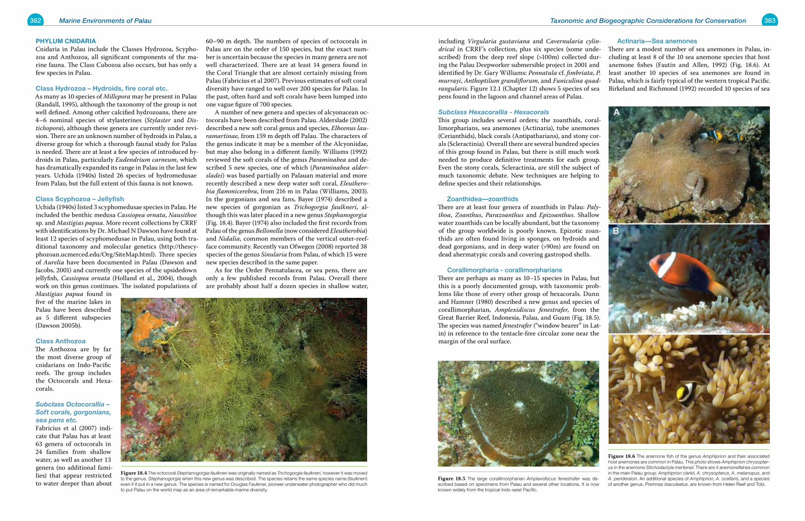
362 Marine Environments of Palau 363Taxonomic and Biogeographic Considerations for Conservation
phylum CniDariaCnidaria in Palau include the Classes Hydrozoa, Scypho-zoa and Anthozoa, all significant components of the ma-rine fauna. The Class Cubozoa also occurs, but has only a few species in Palau.
Class hydrozoa – hydroids, fire coral etc.As many as 10 species of Millepora may be present in Palau (Randall, 1995), although the taxonomy of the group is not well defined. Among other calcified hydrozoans, there are 4–6 nominal species of stylasterines (Stylaster and Dis-tichopora), although these genera are currently under revi-sion. There are an unknown number of hydroids in Palau, a diverse group for which a thorough faunal study for Palau is needed. There are at least a few species of introduced hy-droids in Palau, particularly Eudendrium carneum, which has dramatically expanded its range in Palau in the last few years. Uchida (1940s) listed 26 species of hydromedusae from Palau, but the full extent of this fauna is not known.
Class scyphozoa – jellyfish Uchida (1940s) listed 3 scyphomedusae species in Palau. He included the benthic medusa Cassiopea ornata, Nausithoe sp. and Mastigias papua. More recent collections by CRRF with identifications by Dr. Michael N Dawson have found at least 12 species of scyphomedusae in Palau, using both tra-ditional taxonomy and molecular genetics (http://thescy-phozoan.ucmerced.edu/Org/SiteMap.html). Three species of Aurelia have been documented in Palau (Dawson and Jacobs, 2001) and currently one species of the upsidedown jellyfish, Cassiopea ornata (Holland et al., 2004), though work on this genus continues. The isolated populations of Mastigias papua found in five of the marine lakes in Palau have been described as 5 different subspecies (Dawson 2005b).
Class anthozoa The Anthozoa are by far the most diverse group of cnidarians on Indo-Pacific reefs. The group includes the Octocorals and Hexa-corals.
Subclass Octocorallia – Soft corals, gorgonians, sea pens etc.Fabricius et al (2007) indi-cate that Palau has at least 63 genera of octocorals in 24 families from shallow water, as well as another 13 genera (no additional fami-lies) that appear restricted to water deeper than about
60–90 m depth. The numbers of species of octocorals in Palau are on the order of 150 species, but the exact num-ber is uncertain because the species in many genera are not well characterized. There are at least 14 genera found in the Coral Triangle that are almost certainly missing from Palau (Fabricius et al 2007). Previous estimates of soft coral diversity have ranged to well over 200 species for Palau. In the past, often hard and soft corals have been lumped into one vague figure of 700 species. A number of new genera and species of alcyonacean oc-tocorals have been described from Palau. Alderslade (2002) described a new soft coral genus and species, Elbeenus lau-ramartinae, from 159 m depth off Palau. The characters of the genus indicate it may be a member of the Alcyoniidae, but may also belong in a different family. Williams (1992) reviewed the soft corals of the genus Paraminabea and de-scribed 5 new species, one of which (Paraminabea alder-sladei) was based partially on Palauan material and more recently described a new deep water soft coral, Eleuthero-bia flammicerebra, from 216 m in Palau (Williams, 2003). In the gorgonians and sea fans, Bayer (1974) described a new species of gorgonian as Trichogorgia faulkneri, al-though this was later placed in a new genus Stephanogorgia (Fig. 18.4). Bayer (1974) also included the first records from Palau of the genus Bellonella (now considered Eleutherobia) and Nidalia, common members of the vertical outer-reef-face community. Recently van Ofwegen (2008) reported 38 species of the genus Sinularia from Palau, of which 15 were new species described in the same paper. As for the Order Pennatulacea, or sea pens, there are only a few published records from Palau. Overall there are probably about half a dozen species in shallow water,
including Virgularia gustaviana and Cavernularia cylin-drical in CRRF’s collection, plus six species (some unde-scribed) from the deep reef slope (>100m) collected dur-ing the Palau Deepworker submersible project in 2001 and identified by Dr. Gary Williams: Pennatula cf. fimbriata, P. murrayi, Anthoptilum grandiflorum, and Funiculina quad-rangularis. Figure 12.1 (Chapter 12) shows 5 species of sea pens found in the lagoon and channel areas of Palau.
Subclass Hexacorallia - HexacoralsThis group includes several orders; the zoanthids, coral-limorpharians, sea anemones (Actinaria), tube anemones (Cerianthids), black corals (Antipatharians), and stony cor-als (Scleractinia). Overall there are several hundred species of this group found in Palau, but there is still much work needed to produce definitive treatments for each group. Even the stony corals, Scleractinia, are still the subject of much taxonomic debate. New techniques are helping to define species and their relationships.
Zoanthidea—zoanthidsThere are at least four genera of zoanthids in Palau: Paly-thoa, Zoanthus, Parazoanthus and Epizoanthus. Shallow water zoanthids can be locally abundant, but the taxonomy of the group worldwide is poorly known. Epizotic zoan-thids are often found living in sponges, on hydroids and dead gorgonians, and in deep water (>90m) are found on dead ahermatypic corals and covering gastropod shells.
Corallimorpharia - corallimorphariansThere are perhaps as many as 10–15 species in Palau, but this is a poorly documented group, with taxonomic prob-lems like those of every other group of hexacorals. Dunn and Hamner (1980) described a new genus and species of corallimorpharian, Amplexidiscus fenestrafer, from the Great Barrier Reef, Indonesia, Palau, and Guam (Fig. 18.5). The species was named fenestrafer (“window bearer” in Lat-in) in reference to the tentacle-free circular zone near the margin of the oral surface.
Actinaria—Sea anemonesThere are a modest number of sea anemones in Palau, in-cluding at least 8 of the 10 sea anemone species that host anemone fishes (Fautin and Allen, 1992) (Fig. 18.6). At least another 10 species of sea anemones are found in Palau, which is fairly typical of the western tropical Pacific. Birkeland and Richmond (1992) recorded 10 species of sea
Figure 18.4 The octocoral Stephanogorgia faulkneri was originally named as Trichogorgia faulkneri, however it was moved to the genus, Stephanogorgia when this new genus was described. The species retains the same species name (faulkneri) even if it put in a new genus. The species is named for Douglas Faulkner, pioneer underwater photographer who did much to put Palau on the world map as an area of remarkable marine diversity.
Figure 18.5 The large corallimorpharian Amplexidiscus fenestrafer was de-scribed based on specimens from Palau and several other locations. It is now known widely from the tropical Indo-west Pacific.
Figure 18.6 The anemone fish of the genus Amphiprion and their associated host anemones are common in Palau. This photo shows Amphiprion chrysopter-us in the anemone Stichodactyla mertensii. There are 4 anemonefishes common in the main Palau group: Amphiprion clarkii, A. chrysopterus, A. melanopus, and A. perideraion. An additional species of Amphiprion, A. ocellaris, and a species of another genus, Premnas biaculeatus, are known from Helen Reef and Tobi.
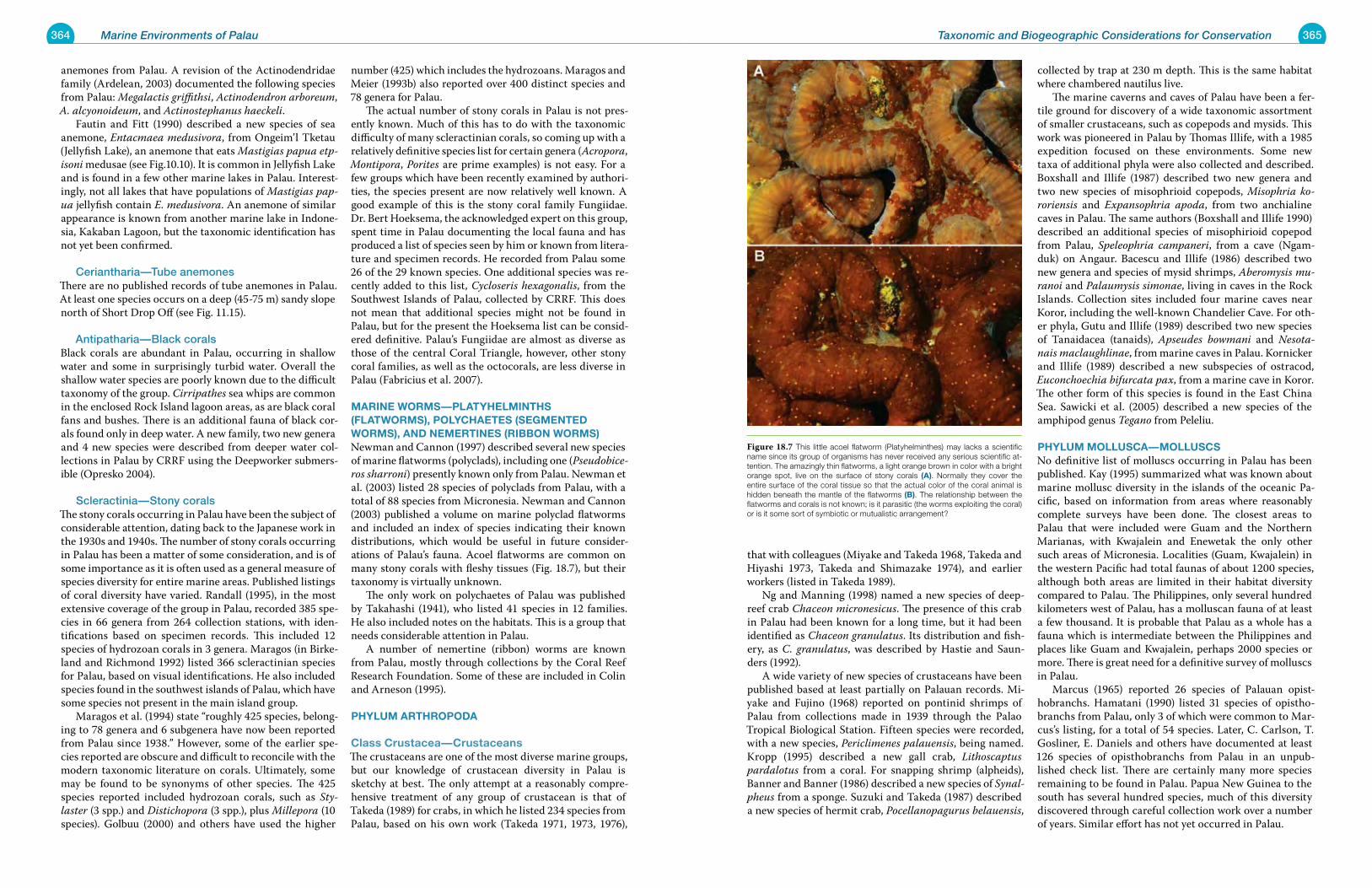
364 Marine Environments of Palau 365Taxonomic and Biogeographic Considerations for Conservation
anemones from Palau. A revision of the Actinodendridae family (Ardelean, 2003) documented the following species from Palau: Megalactis griffithsi, Actinodendron arboreum, A. alcyonoideum, and Actinostephanus haeckeli. Fautin and Fitt (1990) described a new species of sea anemone, Entacmaea medusivora, from Ongeim’l Tketau (Jellyfish Lake), an anemone that eats Mastigias papua etp-isoni medusae (see Fig.10.10). It is common in Jellyfish Lake and is found in a few other marine lakes in Palau. Interest-ingly, not all lakes that have populations of Mastigias pap-ua jellyfish contain E. medusivora. An anemone of similar appearance is known from another marine lake in Indone-sia, Kakaban Lagoon, but the taxonomic identification has not yet been confirmed.
Ceriantharia—Tube anemonesThere are no published records of tube anemones in Palau. At least one species occurs on a deep (45-75 m) sandy slope north of Short Drop Off (see Fig. 11.15).
Antipatharia—Black corals Black corals are abundant in Palau, occurring in shallow water and some in surprisingly turbid water. Overall the shallow water species are poorly known due to the difficult taxonomy of the group. Cirripathes sea whips are common in the enclosed Rock Island lagoon areas, as are black coral fans and bushes. There is an additional fauna of black cor-als found only in deep water. A new family, two new genera and 4 new species were described from deeper water col-lections in Palau by CRRF using the Deepworker submers-ible (Opresko 2004).
Scleractinia—Stony coralsThe stony corals occurring in Palau have been the subject of considerable attention, dating back to the Japanese work in the 1930s and 1940s. The number of stony corals occurring in Palau has been a matter of some consideration, and is of some importance as it is often used as a general measure of species diversity for entire marine areas. Published listings of coral diversity have varied. Randall (1995), in the most extensive coverage of the group in Palau, recorded 385 spe-cies in 66 genera from 264 collection stations, with iden-tifications based on specimen records. This included 12 species of hydrozoan corals in 3 genera. Maragos (in Birke-land and Richmond 1992) listed 366 scleractinian species for Palau, based on visual identifications. He also included species found in the southwest islands of Palau, which have some species not present in the main island group. Maragos et al. (1994) state “roughly 425 species, belong-ing to 78 genera and 6 subgenera have now been reported from Palau since 1938.” However, some of the earlier spe-cies reported are obscure and difficult to reconcile with the modern taxonomic literature on corals. Ultimately, some may be found to be synonyms of other species. The 425 species reported included hydrozoan corals, such as Sty-laster (3 spp.) and Distichopora (3 spp.), plus Millepora (10 species). Golbuu (2000) and others have used the higher
number (425) which includes the hydrozoans. Maragos and Meier (1993b) also reported over 400 distinct species and 78 genera for Palau. The actual number of stony corals in Palau is not pres-ently known. Much of this has to do with the taxonomic difficulty of many scleractinian corals, so coming up with a relatively definitive species list for certain genera (Acropora, Montipora, Porites are prime examples) is not easy. For a few groups which have been recently examined by authori-ties, the species present are now relatively well known. A good example of this is the stony coral family Fungiidae. Dr. Bert Hoeksema, the acknowledged expert on this group, spent time in Palau documenting the local fauna and has produced a list of species seen by him or known from litera-ture and specimen records. He recorded from Palau some 26 of the 29 known species. One additional species was re-cently added to this list, Cycloseris hexagonalis, from the Southwest Islands of Palau, collected by CRRF. This does not mean that additional species might not be found in Palau, but for the present the Hoeksema list can be consid-ered definitive. Palau’s Fungiidae are almost as diverse as those of the central Coral Triangle, however, other stony coral families, as well as the octocorals, are less diverse in Palau (Fabricius et al. 2007).
marine worms—platyhelminths (Flatworms), polyChaetes (segmenteD worms), anD nemertines (riBBon worms) Newman and Cannon (1997) described several new species of marine flatworms (polyclads), including one (Pseudobice-ros sharroni) presently known only from Palau. Newman et al. (2003) listed 28 species of polyclads from Palau, with a total of 88 species from Micronesia. Newman and Cannon (2003) published a volume on marine polyclad flatworms and included an index of species indicating their known distributions, which would be useful in future consider-ations of Palau’s fauna. Acoel flatworms are common on many stony corals with fleshy tissues (Fig. 18.7), but their taxonomy is virtually unknown. The only work on polychaetes of Palau was published by Takahashi (1941), who listed 41 species in 12 families. He also included notes on the habitats. This is a group that needs considerable attention in Palau. A number of nemertine (ribbon) worms are known from Palau, mostly through collections by the Coral Reef Research Foundation. Some of these are included in Colin and Arneson (1995).
phylum arthropoDa
Class Crustacea—CrustaceansThe crustaceans are one of the most diverse marine groups, but our knowledge of crustacean diversity in Palau is sketchy at best. The only attempt at a reasonably compre-hensive treatment of any group of crustacean is that of Takeda (1989) for crabs, in which he listed 234 species from Palau, based on his own work (Takeda 1971, 1973, 1976),
that with colleagues (Miyake and Takeda 1968, Takeda and Hiyashi 1973, Takeda and Shimazake 1974), and earlier workers (listed in Takeda 1989). Ng and Manning (1998) named a new species of deep-reef crab Chaceon micronesicus. The presence of this crab in Palau had been known for a long time, but it had been identified as Chaceon granulatus. Its distribution and fish-ery, as C. granulatus, was described by Hastie and Saun-ders (1992). A wide variety of new species of crustaceans have been published based at least partially on Palauan records. Mi-yake and Fujino (1968) reported on pontinid shrimps of Palau from collections made in 1939 through the Palao Tropical Biological Station. Fifteen species were recorded, with a new species, Periclimenes palauensis, being named. Kropp (1995) described a new gall crab, Lithoscaptus pardalotus from a coral. For snapping shrimp (alpheids), Banner and Banner (1986) described a new species of Synal-pheus from a sponge. Suzuki and Takeda (1987) described a new species of hermit crab, Pocellanopagurus belauensis,
collected by trap at 230 m depth. This is the same habitat where chambered nautilus live. The marine caverns and caves of Palau have been a fer-tile ground for discovery of a wide taxonomic assortment of smaller crustaceans, such as copepods and mysids. This work was pioneered in Palau by Thomas Illife, with a 1985 expedition focused on these environments. Some new taxa of additional phyla were also collected and described. Boxshall and Illife (1987) described two new genera and two new species of misophrioid copepods, Misophria ko-roriensis and Expansophria apoda, from two anchialine caves in Palau. The same authors (Boxshall and Illife 1990) described an additional species of misophirioid copepod from Palau, Speleophria campaneri, from a cave (Ngam-duk) on Angaur. Bacescu and Illife (1986) described two new genera and species of mysid shrimps, Aberomysis mu-ranoi and Palaumysis simonae, living in caves in the Rock Islands. Collection sites included four marine caves near Koror, including the well-known Chandelier Cave. For oth-er phyla, Gutu and Illife (1989) described two new species of Tanaidacea (tanaids), Apseudes bowmani and Nesota-nais maclaughlinae, from marine caves in Palau. Kornicker and Illife (1989) described a new subspecies of ostracod, Euconchoechia bifurcata pax, from a marine cave in Koror. The other form of this species is found in the East China Sea. Sawicki et al. (2005) described a new species of the amphipod genus Tegano from Peleliu.
phylum mollusCa—mollusCs No definitive list of molluscs occurring in Palau has been published. Kay (1995) summarized what was known about marine mollusc diversity in the islands of the oceanic Pa-cific, based on information from areas where reasonably complete surveys have been done. The closest areas to Palau that were included were Guam and the Northern Marianas, with Kwajalein and Enewetak the only other such areas of Micronesia. Localities (Guam, Kwajalein) in the western Pacific had total faunas of about 1200 species, although both areas are limited in their habitat diversity compared to Palau. The Philippines, only several hundred kilometers west of Palau, has a molluscan fauna of at least a few thousand. It is probable that Palau as a whole has a fauna which is intermediate between the Philippines and places like Guam and Kwajalein, perhaps 2000 species or more. There is great need for a definitive survey of molluscs in Palau. Marcus (1965) reported 26 species of Palauan opist-hobranchs. Hamatani (1990) listed 31 species of opistho-branchs from Palau, only 3 of which were common to Mar-cus’s listing, for a total of 54 species. Later, C. Carlson, T. Gosliner, E. Daniels and others have documented at least 126 species of opisthobranchs from Palau in an unpub-lished check list. There are certainly many more species remaining to be found in Palau. Papua New Guinea to the south has several hundred species, much of this diversity discovered through careful collection work over a number of years. Similar effort has not yet occurred in Palau.
Figure 18.7 This little acoel flatworm (Platyhelminthes) may lacks a scientific name since its group of organisms has never received any serious scientific at-tention. The amazingly thin flatworms, a light orange brown in color with a bright orange spot, live on the surface of stony corals (a). Normally they cover the entire surface of the coral tissue so that the actual color of the coral animal is hidden beneath the mantle of the flatworms (B). The relationship between the flatworms and corals is not known; is it parasitic (the worms exploiting the coral) or is it some sort of symbiotic or mutualistic arrangement?
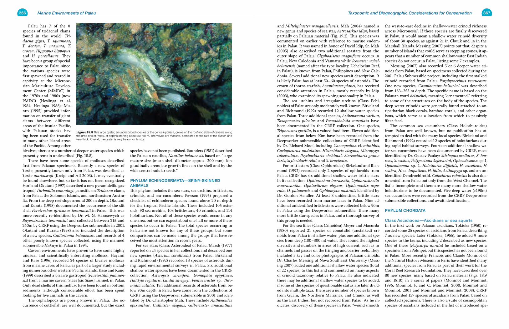
366 Marine Environments of Palau 367Taxonomic and Biogeographic Considerations for Conservation
Palau has 7 of the 8 species of tridacnid clams found in the world: Tri-dacna gigas, T. squamosa, T. derasa, T. maxima, T. crocea, Hippopus hippopus and H. porcellanus. They have been a group of special importance to Palau since the various species were first spawned and reared in captivity at the Microne-sian Mariculture Develop-ment Center (MMDC) in the 1970s and 1980s (now PMDC) (Heslinga et al. 1984, Heslinga 1988). Mu-nro (1995) provided infor-mation on transfer of giant clams between different areas of the insular Pacific, with Palauan stocks hav-ing been used for transfer to many other island areas of the Pacific. Among other bivalves, there are a number of deeper water species which presently remain undescribed (Fig. 18.8). There have been some species of molluscs described first from Palauan specimens. Recently a new species of Turbo, presently known only from Palau, was described as Turbo markusrufi (Kreipl and Alf 2003). It may eventually be found elsewhere, but so far it has not been recognized. Hori and Okutani (1997) described a new pyramidellid gas-tropod, Turbonilla cummingi, parasitic on Tridacna clams, from Palau, the Solomon Islands, and northeastern Austra-lia. From the deep reef slope around 200 m depth, Okutani and Kurata (1998) documented the occurrence of the slit shell Perotrochus africanus teramachii in Palau. This was more recently re-identified by Dr. M. G. Harasewych as Bayerotrochus teramachii and collected between 215 and 240m by CRRF using the Deepworker submersible in 2001. Okutani and Kurata (1998) also included the description of a new species, Calliostoma belauensis, and records of 4 other poorly known species collected, using the manned submersible Hakuyo in Palau in 1994. Cavern environments have proven to have some highly unusual and scientifically interesting molluscs. Hayami and Kase (1996) recorded 24 species of bivalve molluscs from marine caves of Palau, as part of a larger study includ-ing numerous other western Pacific islands. Kase and Kano (1999) described a bizarre gastropod (Pluviostilla palauen-sis) from a marine cavern, Siaes [sic Siaes] Tunnel, in Palau. Only dead shells of this mollusc have been found in bottom sediments, although considerable effort has been spent looking for live animals in the cavern. The cephalopods are poorly known in Palau. The oc-currence of cuttlefish are well documented, but the exact
species have not been published. Saunders (1981) described the Palauan nautilus, Nautilus belauensis, based on “large mature size (mean shell diameter approx. 200 mm), lon-gitudinally crenulate growth lines on the shell and by the wide central radular teeth.”
phylum eChinoDermata—spiny-skinneD animalsThis phylum includes the sea stars, sea urchins, brittlestars, crinoids, and sea cucumbers. Pawson (1995) prepared a checklist of echinoderm species found above 20 m depth for the tropical Pacific Islands. These included 105 aster-oids, 90 sea urchins, 103 brittlestars, 40 crinoids, and 114 holothurians. Not all of these species would occur in any one area, but we can expect about one half or more of these species to occur in Palau. The total species occurring in Palau are not known for any of these groups, but some comparisons can be made among the groups that have re-ceived the most attention in recent years. For sea stars (Class Asteroidea) of Palau, Marsh (1977) reported on 24 species in her collections and described one new species (Asterina corallicola) from Palau. Birkeland and Richmond (1992) recorded 13 species of asteroids dur-ing rapid environmental surveys in Palau. Six additional shallow water species have been documented in the CRRF collection: Asteropsis carinifera, Gomophia egyptiaca, Halityle regularis, Luidia savignyi, Pentaceraster sp., Thro-midia catalai. Ten additional records of asteroids from be-low 90m depth in Palau have come from the collections of CRRF using the Deepworker submersible in 2001 and iden-tified by Dr. Christopher Mah. These include Anthenoides epixanthus, Calliaster elegans, Gilbertaster anacanthus
and Milteliphaster wanganellensis. Mah (2004) named a new genus and species of sea star, Astrosarkus idipi, based partially on Palauan material (Fig. 19.2). This species was commented on earlier with reference to marine endem-ics in Palau. It was named in honor of David Idip, Sr. Mah (2005) also described two additional seastars from the outer slope of Palau. Glyphodiscus magnificus occurs in Palau, New Caledonia and Vanuatu while Iconaster uchel-beluuensis (named after the type locality, Uchelbeluu Reef, in Palau), is known from Palau, Philippines and New Cale-donia. Several additional new species await description. It is likely Palau has at least 50–60 species of asteroids. The crown of thorns starfish, Acanthaster planci, has received considerable attention in Palau, mostly recently by Idip (2003), who examined its spawning seasonality in Palau. The sea urchins and irregular urchins (Class Echi-noidea) of Palau are only moderately well-known. Birkeland and Richmond (1992) recorded 12 shallow water species from Palau. Three additional species, Asthenosoma varium, Toxopneustes pileolus and Pseudoboletia maculata have been documented in the CRRF collection. One species, Tripneustes gratilla, is a valued food item. Eleven addition-al species from below 90m have been recorded from the Deepworker submersible collections of CRRF, identified by Dr. Richard Mooi, including Caenopedina cf. mirabilis, Coelopleurus undulatus, Histocidaris elegans, Micropyga tuberculata, Psychocidaris ohshimai, Stereocidaris granu-laris, Stylocidaris reini, and S. bracteata. For brittlestars (Class Ophiuroidea) Birkeland and Rich-mond (1992) recorded only 2 species of ophiuroids from Palau. CRRF has six additional shallow water brittle stars in its collection, Ophiarachna incrassata, Ophiarachnella macracantha, Ophiarthrum elegans, Ophiomastix aspe-rula, O. palaoensis and Ophiomyxa australis identified by Dr. Gordon Hendler. At least 3 unidentified brittle stars have been recorded from marine lakes in Palau. Nine ad-ditional unidentified brittle stars were collected below 90m in Palau using the Deepworker submersible. There many more brittle star species in Palau, and a thorough survey of this group is needed. For the sea lilies (Class Crinoidea) Meyer and Macurda (1980) reported 21 species of comatulid (unstalked) cri-noids from Palau in shallow water, plus one additional spe-cies from deep (180–300 m) water. They found the highest diversity and numbers in areas of high current, such as in channels and passes on the fringing and barrier reefs. They included a key and color photographs of Palauan crinoids. Dr. Charles Messing of Nova Southeast University (Mess-ing 2007) added one additional shallow water species (total of 22 species) to this list and commented on many aspects of crinoid taxonomy relative to Palau. He also indicated there may be additional shallow water species to be added, if some of the species of questionable status are later divid-ed into multiple taxa. There are a number of species known from Guam, the Northern Marianas, and Chuuk, as well as the East Indies, but not recorded from Palau. As he in-dicates, discovery of these species in Palau “would smooth
the west-to-east decline in shallow-water crinoid richness across Micronesia”. If these species are finally discovered in Palau, it would mean a shallow water crinoid diversity of about 30 species, as against 21 in Chuuk and 14 in the Marshall Islands. Messing (2007) points out that, despite a number of islands that could serve as stepping stones, it ap-pears that a number of common shallow-water East Indian species do not occur in Palau, listing some 7 examples. Messing (2007) also recorded 5 or 6 deeper water cri-noids from Palau, based on specimens collected during the 2001 Palau Submersible project, including the first stalked crinoid recorded from Palau, Porphyrocrinus verrucosus. One new species, Cosmiometra belsuchel was described from 183–253 m depth. The specific name is based on the Palauan word belsuchel, meaning “ornamented,” referring to some of the structures on the body of the species. The deep water crinoids were generally found attached to an-tipatharian black corals, bamboo corals, and other organ-isms, which serve as a location from which to passively filter-feed. The common sea cucumbers (Class Holothuroidea) from Palau are well known, but no publication has at-tempted to deal with the many local species. Birkeland and Richmond (1992) recorded 12 species of holothurians dur-ing rapid habitat surveys. Fourteen additional shallow wa-ter sea cucumbers have been documented by CRRF, most identified by Dr. Gustav Paulay: Stichopus ocellatus, S. hor-rens, S. vastus, Polypectana kefersteini, Opheodesoma sp. 1, Opheodesoma sp. 2, Holothuria difficilis, H. excellens, H. scabra, H. cf. impatiens, H. hilla, Actinopyga sp. and an un-identified Dendrochirotid. Colochirus robustus is also doc-umented from Palau but only from the West Channel. The list is incomplete and there are many more shallow water holothurians to be documented. Five deep water (>190m) sea cucumbers were recorded from the CRRF Deepworker submersible collections, and await identification.
phylum ChorData
Class ascidiacea—ascidians or sea squirts In the first work on Palauan ascidians, Tokioka (1950) re-corded some 25 species of ascidians from Palau, describing 7 as new species. Later (Tokioka, 1955), he added 9 more species to the fauna, including 2 described as new species. One of these (Polycarpa aurata) he included based on a specimen from Pohnpei, but this species has not been found in Palau. More recently, Francois and Claude Monniot of the Natural History Museum in Paris have identified many additional species from Palau as part of their work for the Coral Reef Research Foundation. They have described over 80 new species, many based on Palau material (Figs. 18.9 and 18.10) in a series of papers (Monniot and Monniot, 1996, Monniot, F. and C. Monniot, 2000, Monniot and Monniot, 2001 and Monniot and Monniot, 2008). CRRF has recorded 137 species of ascidians from Palau, based on collected specimens. There is also a suite of cosmopolitan species of ascidians included in the list of introduced spe-
Figure 18.8 This large oyster, an undescribed species of the genus Hyotissa, grows on the roof and sides of caverns along the drop offs of Palau, at depths starting about 50–60 m. The valves are massive, compared to the size of the oyster, and very thick. Overall, the oyster is very heavy for its size.
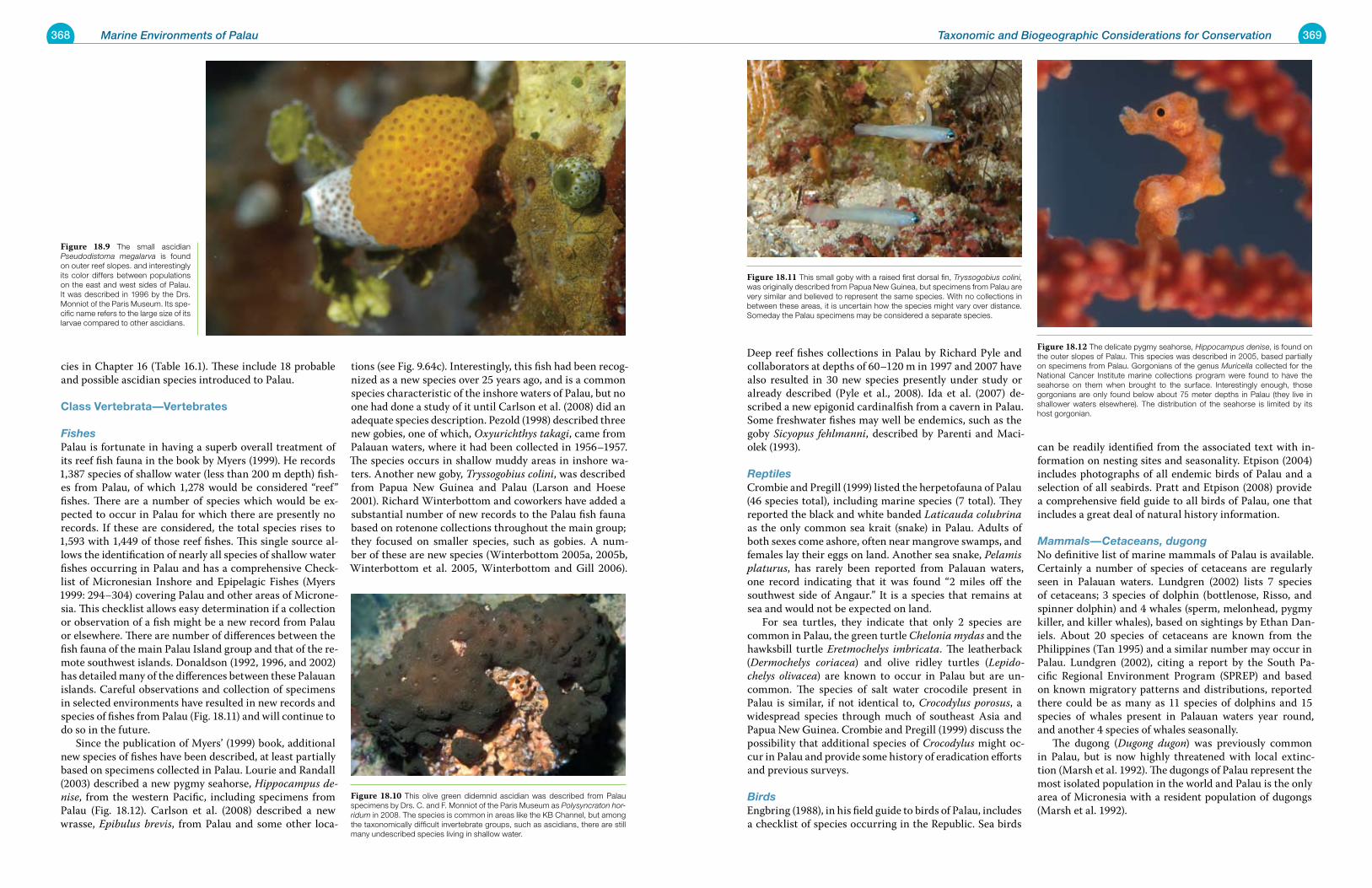
368 Marine Environments of Palau 369Taxonomic and Biogeographic Considerations for Conservation
cies in Chapter 16 (Table 16.1). These include 18 probable and possible ascidian species introduced to Palau.
Class vertebrata—vertebrates
FishesPalau is fortunate in having a superb overall treatment of its reef fish fauna in the book by Myers (1999). He records 1,387 species of shallow water (less than 200 m depth) fish-es from Palau, of which 1,278 would be considered “reef” fishes. There are a number of species which would be ex-pected to occur in Palau for which there are presently no records. If these are considered, the total species rises to 1,593 with 1,449 of those reef fishes. This single source al-lows the identification of nearly all species of shallow water fishes occurring in Palau and has a comprehensive Check-list of Micronesian Inshore and Epipelagic Fishes (Myers 1999: 294–304) covering Palau and other areas of Microne-sia. This checklist allows easy determination if a collection or observation of a fish might be a new record from Palau or elsewhere. There are number of differences between the fish fauna of the main Palau Island group and that of the re-mote southwest islands. Donaldson (1992, 1996, and 2002) has detailed many of the differences between these Palauan islands. Careful observations and collection of specimens in selected environments have resulted in new records and species of fishes from Palau (Fig. 18.11) and will continue to do so in the future. Since the publication of Myers’ (1999) book, additional new species of fishes have been described, at least partially based on specimens collected in Palau. Lourie and Randall (2003) described a new pygmy seahorse, Hippocampus de-nise, from the western Pacific, including specimens from Palau (Fig. 18.12). Carlson et al. (2008) described a new wrasse, Epibulus brevis, from Palau and some other loca-
tions (see Fig. 9.64c). Interestingly, this fish had been recog-nized as a new species over 25 years ago, and is a common species characteristic of the inshore waters of Palau, but no one had done a study of it until Carlson et al. (2008) did an adequate species description. Pezold (1998) described three new gobies, one of which, Oxyurichthys takagi, came from Palauan waters, where it had been collected in 1956–1957. The species occurs in shallow muddy areas in inshore wa-ters. Another new goby, Tryssogobius colini, was described from Papua New Guinea and Palau (Larson and Hoese 2001). Richard Winterbottom and coworkers have added a substantial number of new records to the Palau fish fauna based on rotenone collections throughout the main group; they focused on smaller species, such as gobies. A num-ber of these are new species (Winterbottom 2005a, 2005b, Winterbottom et al. 2005, Winterbottom and Gill 2006).
Deep reef fishes collections in Palau by Richard Pyle and collaborators at depths of 60–120 m in 1997 and 2007 have also resulted in 30 new species presently under study or already described (Pyle et al., 2008). Ida et al. (2007) de-scribed a new epigonid cardinalfish from a cavern in Palau. Some freshwater fishes may well be endemics, such as the goby Sicyopus fehlmanni, described by Parenti and Maci-olek (1993).
ReptilesCrombie and Pregill (1999) listed the herpetofauna of Palau (46 species total), including marine species (7 total). They reported the black and white banded Laticauda colubrina as the only common sea krait (snake) in Palau. Adults of both sexes come ashore, often near mangrove swamps, and females lay their eggs on land. Another sea snake, Pelamis platurus, has rarely been reported from Palauan waters, one record indicating that it was found “2 miles off the southwest side of Angaur.” It is a species that remains at sea and would not be expected on land. For sea turtles, they indicate that only 2 species are common in Palau, the green turtle Chelonia mydas and the hawksbill turtle Eretmochelys imbricata. The leatherback (Dermochelys coriacea) and olive ridley turtles (Lepido-chelys olivacea) are known to occur in Palau but are un-common. The species of salt water crocodile present in Palau is similar, if not identical to, Crocodylus porosus, a widespread species through much of southeast Asia and Papua New Guinea. Crombie and Pregill (1999) discuss the possibility that additional species of Crocodylus might oc-cur in Palau and provide some history of eradication efforts and previous surveys.
BirdsEngbring (1988), in his field guide to birds of Palau, includes a checklist of species occurring in the Republic. Sea birds
can be readily identified from the associated text with in-formation on nesting sites and seasonality. Etpison (2004) includes photographs of all endemic birds of Palau and a selection of all seabirds. Pratt and Etpison (2008) provide a comprehensive field guide to all birds of Palau, one that includes a great deal of natural history information.
Mammals—Cetaceans, dugongNo definitive list of marine mammals of Palau is available. Certainly a number of species of cetaceans are regularly seen in Palauan waters. Lundgren (2002) lists 7 species of cetaceans; 3 species of dolphin (bottlenose, Risso, and spinner dolphin) and 4 whales (sperm, melonhead, pygmy killer, and killer whales), based on sightings by Ethan Dan-iels. About 20 species of cetaceans are known from the Philippines (Tan 1995) and a similar number may occur in Palau. Lundgren (2002), citing a report by the South Pa-cific Regional Environment Program (SPREP) and based on known migratory patterns and distributions, reported there could be as many as 11 species of dolphins and 15 species of whales present in Palauan waters year round, and another 4 species of whales seasonally. The dugong (Dugong dugon) was previously common in Palau, but is now highly threatened with local extinc-tion (Marsh et al. 1992). The dugongs of Palau represent the most isolated population in the world and Palau is the only area of Micronesia with a resident population of dugongs (Marsh et al. 1992).
Figure 18.10 This olive green didemnid ascidian was described from Palau specimens by Drs. C. and F. Monniot of the Paris Museum as Polysyncraton hor-ridum in 2008. The species is common in areas like the KB Channel, but among the taxonomically difficult invertebrate groups, such as ascidians, there are still many undescribed species living in shallow water.
Figure 18.9 The small ascidian Pseudodistoma megalarva is found on outer reef slopes. and interestingly its color differs between populations on the east and west sides of Palau. It was described in 1996 by the Drs. Monniot of the Paris Museum. Its spe-cific name refers to the large size of its larvae compared to other ascidians.
Figure 18.11 This small goby with a raised first dorsal fin, Tryssogobius colini, was originally described from Papua New Guinea, but specimens from Palau are very similar and believed to represent the same species. With no collections in between these areas, it is uncertain how the species might vary over distance. Someday the Palau specimens may be considered a separate species.
Figure 18.12 The delicate pygmy seahorse, Hippocampus denise, is found on the outer slopes of Palau. This species was described in 2005, based partially on specimens from Palau. Gorgonians of the genus Muricella collected for the National Cancer Institute marine collections program were found to have the seahorse on them when brought to the surface. Interestingly enough, those gorgonians are only found below about 75 meter depths in Palau (they live in shallower waters elsewhere). The distribution of the seahorse is limited by its host gorgonian.
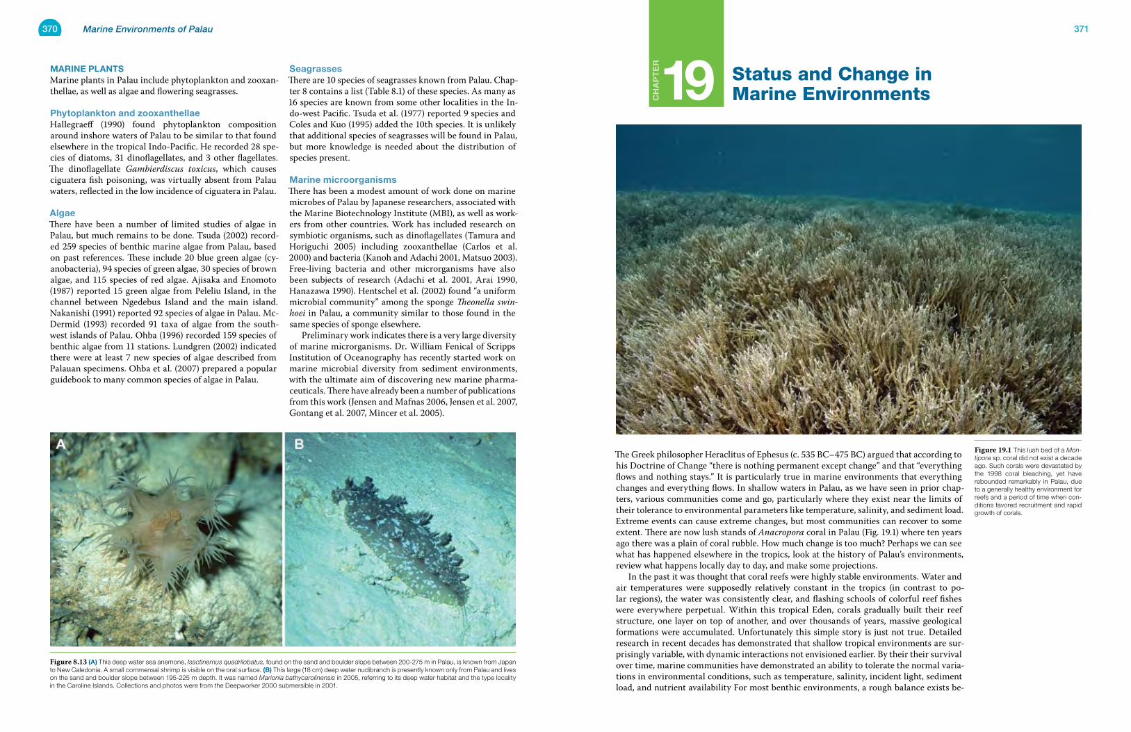
370 Marine Environments of Palau 371
Ch
ap
te
r
marine plantsMarine plants in Palau include phytoplankton and zooxan-thellae, as well as algae and flowering seagrasses.
phytoplankton and zooxanthellaeHallegraeff (1990) found phytoplankton composition around inshore waters of Palau to be similar to that found elsewhere in the tropical Indo-Pacific. He recorded 28 spe-cies of diatoms, 31 dinoflagellates, and 3 other flagellates. The dinoflagellate Gambierdiscus toxicus, which causes ciguatera fish poisoning, was virtually absent from Palau waters, reflected in the low incidence of ciguatera in Palau.
algaeThere have been a number of limited studies of algae in Palau, but much remains to be done. Tsuda (2002) record-ed 259 species of benthic marine algae from Palau, based on past references. These include 20 blue green algae (cy-anobacteria), 94 species of green algae, 30 species of brown algae, and 115 species of red algae. Ajisaka and Enomoto (1987) reported 15 green algae from Peleliu Island, in the channel between Ngedebus Island and the main island. Nakanishi (1991) reported 92 species of algae in Palau. Mc-Dermid (1993) recorded 91 taxa of algae from the south-west islands of Palau. Ohba (1996) recorded 159 species of benthic algae from 11 stations. Lundgren (2002) indicated there were at least 7 new species of algae described from Palauan specimens. Ohba et al. (2007) prepared a popular guidebook to many common species of algae in Palau.
seagrassesThere are 10 species of seagrasses known from Palau. Chap-ter 8 contains a list (Table 8.1) of these species. As many as 16 species are known from some other localities in the In-do-west Pacific. Tsuda et al. (1977) reported 9 species and Coles and Kuo (1995) added the 10th species. It is unlikely that additional species of seagrasses will be found in Palau, but more knowledge is needed about the distribution of species present.
marine microorganismsThere has been a modest amount of work done on marine microbes of Palau by Japanese researchers, associated with the Marine Biotechnology Institute (MBI), as well as work-ers from other countries. Work has included research on symbiotic organisms, such as dinoflagellates (Tamura and Horiguchi 2005) including zooxanthellae (Carlos et al. 2000) and bacteria (Kanoh and Adachi 2001, Matsuo 2003). Free-living bacteria and other microrganisms have also been subjects of research (Adachi et al. 2001, Arai 1990, Hanazawa 1990). Hentschel et al. (2002) found “a uniform microbial community” among the sponge Theonella swin-hoei in Palau, a community similar to those found in the same species of sponge elsewhere. Preliminary work indicates there is a very large diversity of marine microrganisms. Dr. William Fenical of Scripps Institution of Oceanography has recently started work on marine microbial diversity from sediment environments, with the ultimate aim of discovering new marine pharma-ceuticals. There have already been a number of publications from this work (Jensen and Mafnas 2006, Jensen et al. 2007, Gontang et al. 2007, Mincer et al. 2005).
19 Status and Change in Marine Environments
The Greek philosopher Heraclitus of Ephesus (c. 535 BC–475 BC) argued that according to his Doctrine of Change “there is nothing permanent except change” and that “everything flows and nothing stays.” It is particularly true in marine environments that everything changes and everything flows. In shallow waters in Palau, as we have seen in prior chap-ters, various communities come and go, particularly where they exist near the limits of their tolerance to environmental parameters like temperature, salinity, and sediment load. Extreme events can cause extreme changes, but most communities can recover to some extent. There are now lush stands of Anacropora coral in Palau (Fig. 19.1) where ten years ago there was a plain of coral rubble. How much change is too much? Perhaps we can see what has happened elsewhere in the tropics, look at the history of Palau’s environments, review what happens locally day to day, and make some projections. In the past it was thought that coral reefs were highly stable environments. Water and air temperatures were supposedly relatively constant in the tropics (in contrast to po-lar regions), the water was consistently clear, and flashing schools of colorful reef fishes were everywhere perpetual. Within this tropical Eden, corals gradually built their reef structure, one layer on top of another, and over thousands of years, massive geological formations were accumulated. Unfortunately this simple story is just not true. Detailed research in recent decades has demonstrated that shallow tropical environments are sur-prisingly variable, with dynamic interactions not envisioned earlier. By their their survival over time, marine communities have demonstrated an ability to tolerate the normal varia-tions in environmental conditions, such as temperature, salinity, incident light, sediment load, and nutrient availability For most benthic environments, a rough balance exists be-
Figure 19.1 This lush bed of a Mon-tipora sp. coral did not exist a decade ago. Such corals were devastated by the 1998 coral bleaching, yet have rebounded remarkably in Palau, due to a generally healthy environment for reefs and a period of time when con-ditions favored recruitment and rapid growth of corals.
Figure 8.13 (a) This deep water sea anemone, Isactinernus quadrilobatus, found on the sand and boulder slope between 200-275 m in Palau, is known from Japan to New Caledonia. A small commensal shrimp is visible on the oral surface. (B) This large (18 cm) deep water nudibranch is presently known only from Palau and lives on the sand and boulder slope between 195-225 m depth. It was named Marionia bathycarolinensis in 2005, referring to its deep water habitat and the type locality in the Caroline Islands. Collections and photos were from the Deepworker 2000 submersible in 2001.
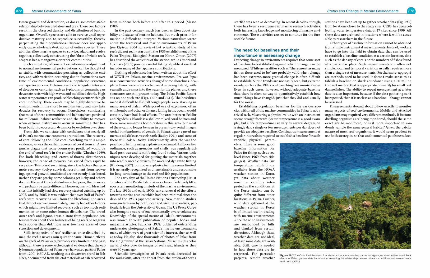
372 Marine Environments of Palau 373Status and Change in Marine Environments
tween growth and destruction, as does a somewhat stable relationship between predators and prey. These two factors result in the observed density and distribution of benthic organisms. Overall, species are able to survive until repro-ductive maturity and to reproduce successfully, thereby perpetuating their populations. Disease does not appar-ently cause wholesale destruction of entire species. These abilities allow marine species to survive, adapt, and evolve together, collectively constructing the fabric of whole reefs, seagrass beds, mangroves, or other communities. Such a situation, of constant evolutionary readjustment to normal environmental perturbations, can be thought of as stable, with communities persisting as collective enti-ties, and with variation occurring due to fluctuations over time of environmental conditions, population structure, and species success. Extreme events at irregular intervals of decades or centuries, such as typhoons or tsunamis, can devastate reefs with high waves and mobilized debris. High water temperatures can produce bleaching events with high coral mortality. These events may be highly disruptive to environments in the short to medium term, and may take decades for recovery to occur. Nonetheless, considering that most of these communities and habitats have persisted for millennia, habitat resilience and the ability to recover when extreme disturbances occur is something that has been built into ecosystem dynamics by evolution over time. From this, we can state with confidence that nearly all of Palau’s marine environments are resilient. The recovery of coral following the 1998 coral bleaching event is ample evidence, as was the earlier recovery of coral from an Acan-thaster plague that some doomsayers predicted would be the end of coral reefs in the entire Pacific (Chesher 1969). For both bleaching and crown-of-thorns disturbances, however, the range of recovery has varied from rapid to very slow. This is not surprising, since the factors that pro-mote recovery (polyp survival, recruitment from spawn-ing, optimal growth conditions) are not evenly distributed. Rather, they are patchy; some colonies get lucky and others do not. The next time a disturbance happens, the recovery will probably be quite different. However, many of bleached sites that initially had slow recovery started catching up by 2002, and by 2005 it was evident that over half of Palau’s reefs were recovering well from the bleaching. The areas that did not recover immediately, usually had other factors which might have limited recovery, such as too much sedi-mentation or some other human disturbance. The broad outer reefs and lagoon areas distant from population cen-ters went on about their business of being reefs or seagrass beds sooner than did those near towns or areas of con-struction and development. Still, irrespective of reef resilience, once disturbed by man the reef is never again quite the same. Human effects on the reefs of Palau were probably very limited in the past, although there is some archeological evidence that the ear-ly human population of Palau over-harvested parts of Palau from 1200–1450 AD, resulting in a downward trend in fish sizes, documented from skeletal materials of fish recovered
from middens both before and after this period (Masse 1989). In the past century, much has been written about sta-bility and status of marine habitats, but much prior infor-mation is difficult to interpret. Various naturalists wrote about the terrestrial and marine environments of Palau (see Etpison 2004 for review) but scientific study of the reefs did not really start until the 1935 establishment of the Palao Tropical Biological Station on Koror. Omori (2007) has described the activities of the station, while Omori and Yukihara (2007) provide a useful listing of publications that includes many of the Japanese contributions. Nothing of substance has been written about the effect of WWII on Palau’s marine environments. Pre-war Japa-nese construction activities changed some shorelines. Sea-plane bases were constructed on Arabesang Island, with seawalls and ramps into the water for the planes, and these structures are still present today. The Palau Pacific Resort sits on one such site (Figs. 15.18 and 17.12). The hostilities made it difficult to fish, although people were starving in many areas of Palau. Widespread use of explosives, often with bombs and other ordinance falling in the ocean, would certainly have had local effects. The area between Peleliu and Ngedebus Islands is a shallow mixed coral bottom and there were numerous bomb craters in this area, but most of these can no longer be seen in present-day aerial images. Aerial bombardment of vessels in Palau’s water caused nu-merous oil slicks as vessels sank (Bailey 1991), and some of these still leak oil today. Unfortunately, after the war the practice of fishing using explosives continued. Leftover live ordinance, such as grenades and shells, was regularly uti-lized post-war and is still being found today. Various tech-niques were developed for putting the materials together into readily useable devices for so-called dynamite fishing (Kitalong 2007). but today explosive fishing seems limited. It is generally recognized as unsustainable and responsible for long-term damage to the reef and fish populations. The early days of the United Nations Trusteeship (Trust Territory of the Pacific Islands) was a time of relatively little ecosystem monitoring or study of the marine environment. The late 1960s and early 1970s saw a renewal of the efforts towards marine studies which had been minimal since the days of the 1930s Japanese activity. New marine studies were undertaken by both local and visiting scientists, par-ticularly from the University of Guam. The US Peace Corps also brought a cadre of environmentally-aware volunteers. Knowledge of the special nature of Palau’s environments was known through publication of popular books and magazine articles. Faulkner (1974) published outstanding underwater photographs of Palau’s marine environments, many of which were of great scientific interest, then as well as today. He also shot thousands of photos of Palau from the air (archived at the Belau National Museum); his color aerial photos provide images of reefs and islands as they were 30 years ago. Scientific investigation of Palau’s reefs decreased in the mid-1980s, after the threat from the crown-of-thorns
starfish was seen as decreasing. In recent decades, though, there has been a resurgence in marine research activities. both increasing knowledge and monitoring of marine envi-ronments. These activities are set to continue for the fore-seeable future.
the need for baselines and their importance in assessing changeDetecting change in environments requires that some sort of baseline be established against which change can be measured. While generalities such as “there aren’t as many fish as there used to be” are probably valid when change has been extreme, more gradual change is often difficult to establish. Subtle trends are not easily seen, but extreme events, such as the 1998 coral bleaching, are unmistakable. Even in such cases, however, without adequate baseline data there is often no way to quantitatively establish how much things have changed, just that they did and usually for the worse. Establishing population baselines for the various spe-cies within all of the marine communities in Palau is not a trivial task. Measuring a physical value with an instrument seems straightforward (water temperature is a good exam-ple), but since temperature can vary by several degrees on a single day, a single or few measurements per day does not provide an adequate baseline. Continuous measurement at regular intervals is required to establish a baseline for such variable physical param-eters. There is some good baseline information for Palau for things such as sea level (since 1969, from tide gauges). Weather data (air temperature, rainfall) are available from the NOAA weather station in Koror, yet data about weather must be carefully inter-preted as the conditions at the Koror station can be quite different from other locations in Palau. Further, wind data gathered at the weather station in Koror is of limited use in dealing with marine environments since the wind instruments are surrounded by hills and blanked from certain directions. Although these weather data are not ideal, at least some data are avail-able. Still, care is needed in how those data are in-terpreted. For particular projects, remote weather
stations have been set up to gather weather data (Fig. 19.2) from locations closer to the study sites. CRRF has been col-lecting water temperature data at 17 sites since 1999. All these data are archived in locations where it will be acces-sible to researchers in the future. Other types of baseline information cannot be obtained from simple instrumental measurements. Instead, workers have to go into the field to obtain data that can be used to establish a baseline condition at a certain location, data such as the density of corals or the numbers of fishes found at a particular place. Such measurements are often not simple; local and temporal variation usually requires more than a single set of measurements. Furthermore, appropri-ate methods need to be used; it doesn’t make sense to es-tablish a baseline on shark abundance using a 50 m line transect method that is appropriate primarily for small reef damselfishes. The ability to repeat measurement at a later date is also important, because if the data gathering can’t be repeated, then it is useless as a baseline—change cannot be assessed. Disagreements abound about to how exactly to monitor many aspects of reef environments. Mobile and attached organisms may required very different methods. If bottom-dwelling organisms are being monitored, should the same exact site be monitored, or is it more important to ran-domly sample the same general habitat? Given the patchy nature of most reef organisms, it would seem prudent to use both strategies, so that undocumented patchiness does
Figure 19.2 The Coral Reef Research Foundation autonomous weather station, on Ngeanges Island in the central Rock Islands of Palau, gathers data important in examining the relationship between climatic conditions and environmental health and stability.
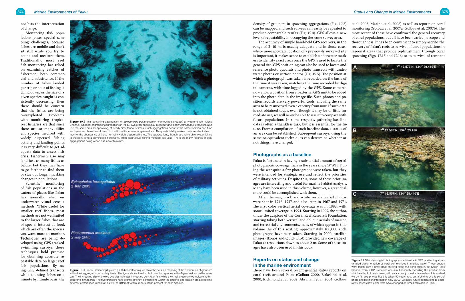
374 Marine Environments of Palau 375Status and Change in Marine Environments
not bias the interpretation of change. Monitoring fish popu-lations poses special sam-pling challenges, because fishes are mobile and don’t sit still while you try to count and measure them. Traditionally, most reef fish monitoring has relied on examining catches of fishermen, both commer-cial and subsistence. If the number of fishes landed per trip or hour of fishing is going down, or the size of a given species caught is con-sistently decreasing, then there should be concern that the fishes are being overexploited. Problems with monitoring tropical reef fisheries are that since there are so many differ-ent species involved with widely dispersed fishing activity and landing points, it is very difficult to get ad-equate data to assess fish-eries. Fishermen also may land just as many fishes as before, but they may have to go farther to find them or stay out longer, masking changes in populations. Scientific monitoring of fish populations in the waters of places like Palau has generally relied on underwater visual census methods. While useful for smaller reef fishes, most methods are not well suited to the larger fishes that are of special interest as food, which are often the species you want most to monitor. Techniques are being de-veloped using GPS tracked swimming surveys; these techniques hold promise for obtaining accurate re-peatable data on larger reef fish populations. By us-ing GPS defined transects while counting fishes on a minute by minute basis, the
density of groupers in spawning aggregations (Fig. 19.3) can be mapped and such surveys can easily be repeated to produce comparable results (Fig. 19.4). GPS allows a new level of repeatability in occupying the same survey area. The accuracy of simple hand-held GPS receivers, in the range of 2–10 m, is usually adequate and in those cases where more accurate location of a previously surveyed site is important, it makes sense to establish underwater mark-ers to identify exact areas once the GPS is used to locate the general site. GPS positioning can also be used to locate and reference photo quadrats and photo transects with under-water photos or surface photos (Fig. 19.5). The position at which a photograph was taken is recorded on the basis of the time it was taken, matching the time recorded by digi-tal cameras, with time logged by the GPS. Some cameras now allow a position from an external GPS unit to be added into the photo data in the image file. Such photos and po-sition records are very powerful tools, allowing the same area to be resurveyed even a century from now. If such data is not obtained today, even though it may be of little im-mediate use, we will never be able to use it to compare with future populations. In some respects, gathering baseline data is often a thankless task, but it is essential for the fu-ture. From a compilation of such baseline data, a status of an area can be established. Subsequent surveys, using the same or equivalent techniques can determine whether or not things have changed.
photographs as a baselinePalau is fortunate in having a substantial amount of aerial photographic coverage than in the years since WWII. Dur-ing the war quite a few photographs were taken, but they were intended for strategic use and reflect the priorities of military activities. Despite this, some of these prior im-ages are interesting and useful for marine habitat analysis. Many have been used in this volume, however, a great deal more could be accomplished with them. After the war, black and white vertical aerial photos were shot in 1946–1947 and also later, in 1967 and 1971. The first color vertical aerial coverage was in 1992, with some limited coverage in 1994. Starting in 1997, the author, under the auspices of the Coral Reef Research Foundation, starting taking both vertical and oblique aerials of marine and terrestrial environments, many of which appear in this volume. As of this writing, approximately 100,000 such photographs have been taken. Starting in 2000, satellite images (Ikonos and Quick Bird) provided new coverage of Palau at resolutions down to about 2 m. Some of these im-ages have also been used in this book.
reports on status and change in the marine environmentThere have been several recent general status reports on coral reefs around Palau (Golbuu 2000, Birkeland et al. 2000, Richmond et al. 2002, Abraham et al. 2004, Golbuu
et al. 2005, Marino et al. 2008) as well as reports on coral monitoring (Golbuu et al. 2007a, Golbuu et al. 2007b). The most recent of these have confirmed the general recovery of coral populations, but all have been varied in scope and thoroughness. It has been convenient to simply ascribe the recovery of Palau’s reefs to survival of coral populations in lagoonal areas that provide replenishment through coral spawning (Figs. 17.15 and 17.16) or to survival of remnant
Figure 19.3 This spawning aggregation of Epinephelus polyphekadion (camouflage grouper) at Ngerumekaol (Ulong Channel) is typical of grouper aggregations in Palau. Two other species, E. fuscoguttatus and Plectropomus areolatus, also use the same area for spawning, at nearly simultaneous times. Such aggregations occur at the same location and time each year and have been known to traditional fishermen for generations. This predictability makes them excellent sites to monitor the abundance of these normally widely-dispersed fishes. The aggregations, though, are vulnerable to overfishing to the point of total elimination if intensive, often destructive, fishing methods are used. There are many records of local aggregations being wiped out, never to return.
Figure 19.4 Global Positioning System (GPS) based techniques allow the detailed mapping of the distribution of groupers within their aggregation, on a daily basis. The figure shows the distribution of two species within Ngerumekaol on the same day. The increasing size of the red bubbles indicates increasing density of fish, while the small green circles indicate no fish occurring in that area. The two groupers have slightly different distributions within the channel aggregation area, reflecting different preferences in habitat, as well as different total numbers of fish present for each species.
Figure 19.5 Modern digital photography combined with GPS positioning allows detailed documentation of coral communities in shallow water. These photos were taken from a small boat cruising along the coral edge in the Koror Rock Islands, while a GPS receiver was simultaneously recording the position from which each photo was taken, with an accuracy of just a few meters. It is too bad we don’t have photos like this taken 50 years ago, but archiving of this sort of photo and position information now (2009) will allow future generations to accu-rately assess how coral reefs have changed or remained stable in Palau.
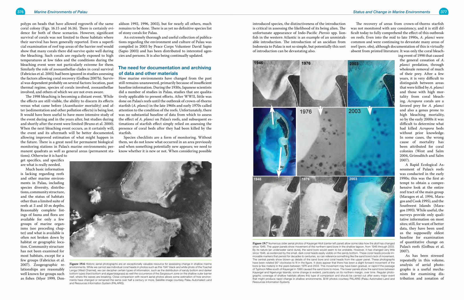
376 Marine Environments of Palau 377Status and Change in Marine Environments
polyps on heads that have allowed regrowth of the same coral colony (Figs. 16.15 and 16.16). There is certainly evi-dence for both of these scenarios. However, significant survival of corals was not limited to those habitats where their survival has been generally reported. Even a superfi-cial examination of reef top areas of the barrier reef would show that many corals there did survive quite well during the bleaching. Such corals are regularly exposed to high temperatures at low tides and the conditions during the bleaching event were not particularly extreme for them. Similarly the role of zooxanthellae clades in coral survival (Fabricius et al. 2005) had been ignored in studies assessing the factors allowing coral recovery (Golbuu 2007b). Surviv-al was dependent probably on several factors: location, past thermal regime, species of corals involved, zooxanthellae involved, and others of which we are not even aware. The 1998 bleaching is becoming a distant event. While the effects are still visible, the ability to discern its effects versus what came before (Acanthaster mortality) and af-ter (sedimentation and other pollution effects) is being lost. It would have been useful to have more intensive study of the event during and in the years after, but studies during and shortly after the event were limited (Bruno et al. 2000). When the next bleaching event occurs, as it certainly will, the event and its aftermath will be better documented, allowing improved estimation of what might happen in the future. There is a great need for permanent biological monitoring stations in Palau’s marine environments; per-manent quadrats as well as general areas (permanent sta-tions). Otherwise it is hard to get specifics, and specifics are what is really needed. Much basic information is lacking regarding reefs and other marine environ-ments in Palau, including species diversity, distribu-tions, community structure, and the status of habitats other than a limited suite of reefs at 3 and 10 m depths. Reasonably complete list-ings of fauna and flora are available for only a few groups of marine organ-isms (see preceding chap-ter) and what is available is often not broken down by habitat or geographic loca-tion. Community structure has not been examined for most habitats, except for a few groups (Fabricius et al. 2007). Zoogeographic re-lationships are reasonably well known for groups such as fishes (Myer 1999, Don-
aldson 1992, 1996, 2002), but for nearly all others, much remains to be done. There is as yet no definitive species list of stony corals for Palau. An extremely thorough and useful collection of publica-tions regarding the environment and culture of Palau was compiled in 2003 by Peace Corps Volunteer David Sapio (Sapio 2003) and has been distributed to interested agen-cies and persons. It is also being continually updated.
the need for documentation and archiving of data and other materialsHow marine environments have changed from the past still remains unanswered, primarily because of insufficient baseline information. During the 1930s, Japanese scientists did a number of studies in Palau, studies that are qualita-tively applicable to present efforts. After WWII, little was done on Palau’s reefs until the outbreak of crown-of-thorns starfish (A. planci) in the late 1960s and early 1970s called attention to the condition of the reefs. Unfortunately, there was no substantial baseline of data from which to assess the effect of A. planci on Palau’s reefs, and subsequent es-timations of starfish effect simply relied on assessing the presence of coral beds after they had been killed by the starfish. Species checklists are a form of monitoring. Without them, we do not know what occurred in an area previously and when something potentially new appears; we need to know whether it is new or not. When considering possible
introduced species, the distinctiveness of the introduction is critical in assessing the likelihood of its being alien. The unfortunate appearance of Indo-Pacific Pterois spp. lion-fish in the western Atlantic is an example of an unmistak-able introduction. The introduction of an ascidian from Indonesia to Palau is not so simple, but potentially this sort of introduction can be devastating also.
The recovery of areas from crown-of-thorns starfish was not monitored with any consistency, and it is still dif-ficult today to fully comprehend the effect of this outbreak on reefs. Even into the mid to late 1990s, A. planci were common and were continuing to devastate many areas of reef (pers. obs), although documentation of this is virtually absent from printed literature. It was only the coral bleach-
ing event of 1998 that caused the general cessation of A. planci predation, through wholesale removal of much of their prey. After a few years, it is very difficult to distinguish between areas that were killed by A. planci and those with high mor-tality from coral bleach-ing. Acropora corals are a favored prey for A. planci and also a genus prone to high bleaching mortality, so by the early 2000s it was difficult to determine what had killed Acropora beds without prior knowledge. In some cases, the wrong cause of mortality has been attributed for coral colonies (West and Salm 2004, Grimsditch and Salm 2007). A Rapid Ecological As-sessment of Palau’s reefs was conducted in the early 1990s; this was the first at-tempt to obtain a compre-hensive look at the entire reef tract of the main group (Maragos et al. 1994, Mara-gos and Cook 1995), and the Southwest Islands (Mara-gos 1993). While useful, the surveys provide only quali-tative information on most sites; still, for want of better data, they have been used as the supposedly oldest baseline for examination of quantitative change on Palau’s reefs (Golbuu et al. 2007). As has been stressed repeatedly in this volume, analysis of aerial photo-graphs is a useful mecha-nism for examining dis-tribution and zonation of
Figure 19.6 Historic aerial photographs are an exceptionally valuable resource for assessing change in shallow marine environments. While we cannot see individual coral heads in photos such as this 1947 black and white photo of the Toachel Lengui (West Channel), we can decipher certain types of information, such as the distribution of sandy bottom and darker bottom types (hard bottom and algae/seagrass) as well the occurrence of the Sargassum zone on the shallow outer barrier reef, where the waves are breaking. Close comparison with recent aerial photos allows some estimation of how environ-ments have changed or remained the same over half a century or more. Satellite image courtesy Palau Automated Land and Resources Information System (PALARIS).
Figure 19.7 Numerous older aerial photos of Kayangel Atoll (center left panel) allow some idea how the atoll has changed since 1946. The upper panels show movement of the northern sand bore in the shallow lagoon, from 1946 through 2003. By its nature (an underwater sand dune), the sand bore would seem to be unstable. However, it has changed very little since 1946, as evidenced by the small, dark coral heads easily visible on the sandy bottom. These coral heads provide im-movable markers that persist for decades to centuries, so can reference something like the sand bore’s lack of movement. The central panels show blown-up details of the sand bore and coral heads from the upper panel. These photographs have been rotated 90° clockwise to fit in the figure. It does appear that there has been a slight forward movement of the bore (a few meters) in the years between 1976 and 2003. This movement may have been gradual, or rapid if the passage of Typhoon Mike south of Kayangel in 1990 caused the sand bore to move. The lower panels show the sand bore between Kayangel and Ngeriungs Islands; some change is evident, particularly on its northern margin, over time. Regular photo-graphic coverage of shallow habitats allows this type of comparison and should be carried out after every major event that might produce rapid change in shallow environments. B/W photos courtesy PALARIS (Palau Automated Land and Resources Information System).
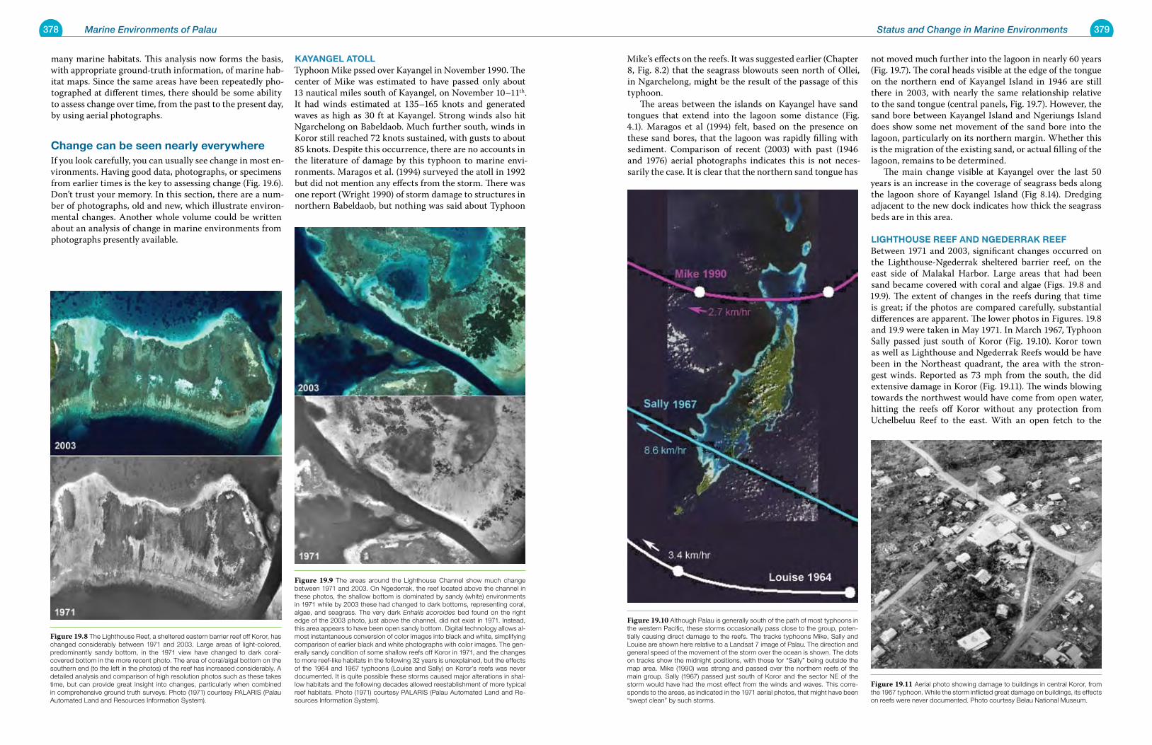
378 Marine Environments of Palau 379Status and Change in Marine Environments
many marine habitats. This analysis now forms the basis, with appropriate ground-truth information, of marine hab-itat maps. Since the same areas have been repeatedly pho-tographed at different times, there should be some ability to assess change over time, from the past to the present day, by using aerial photographs.
Change can be seen nearly everywhereIf you look carefully, you can usually see change in most en-vironments. Having good data, photographs, or specimens from earlier times is the key to assessing change (Fig. 19.6). Don’t trust your memory. In this section, there are a num-ber of photographs, old and new, which illustrate environ-mental changes. Another whole volume could be written about an analysis of change in marine environments from photographs presently available.
kayangel atollTyphoon Mike pssed over Kayangel in November 1990. The center of Mike was estimated to have passed only about 13 nautical miles south of Kayangel, on November 10–11th. It had winds estimated at 135–165 knots and generated waves as high as 30 ft at Kayangel. Strong winds also hit Ngarchelong on Babeldaob. Much further south, winds in Koror still reached 72 knots sustained, with gusts to about 85 knots. Despite this occurrence, there are no accounts in the literature of damage by this typhoon to marine envi-ronments. Maragos et al. (1994) surveyed the atoll in 1992 but did not mention any effects from the storm. There was one report (Wright 1990) of storm damage to structures in northern Babeldaob, but nothing was said about Typhoon
Mike’s effects on the reefs. It was suggested earlier (Chapter 8, Fig. 8.2) that the seagrass blowouts seen north of Ollei, in Ngarchelong, might be the result of the passage of this typhoon. The areas between the islands on Kayangel have sand tongues that extend into the lagoon some distance (Fig. 4.1). Maragos et al (1994) felt, based on the presence on these sand bores, that the lagoon was rapidly filling with sediment. Comparison of recent (2003) with past (1946 and 1976) aerial photographs indicates this is not neces-sarily the case. It is clear that the northern sand tongue has
not moved much further into the lagoon in nearly 60 years (Fig. 19.7). The coral heads visible at the edge of the tongue on the northern end of Kayangel Island in 1946 are still there in 2003, with nearly the same relationship relative to the sand tongue (central panels, Fig. 19.7). However, the sand bore between Kayangel Island and Ngeriungs Island does show some net movement of the sand bore into the lagoon, particularly on its northern margin. Whether this is the migration of the existing sand, or actual filling of the lagoon, remains to be determined. The main change visible at Kayangel over the last 50 years is an increase in the coverage of seagrass beds along the lagoon shore of Kayangel Island (Fig 8.14). Dredging adjacent to the new dock indicates how thick the seagrass beds are in this area.
lighthouse reeF anD ngeDerrak reeF Between 1971 and 2003, significant changes occurred on the Lighthouse-Ngederrak sheltered barrier reef, on the east side of Malakal Harbor. Large areas that had been sand became covered with coral and algae (Figs. 19.8 and 19.9). The extent of changes in the reefs during that time is great; if the photos are compared carefully, substantial differences are apparent. The lower photos in Figures. 19.8 and 19.9 were taken in May 1971. In March 1967, Typhoon Sally passed just south of Koror (Fig. 19.10). Koror town as well as Lighthouse and Ngederrak Reefs would be have been in the Northeast quadrant, the area with the stron-gest winds. Reported as 73 mph from the south, the did extensive damage in Koror (Fig. 19.11). The winds blowing towards the northwest would have come from open water, hitting the reefs off Koror without any protection from Uchelbeluu Reef to the east. With an open fetch to the
Figure 19.8 The Lighthouse Reef, a sheltered eastern barrier reef off Koror, has changed considerably between 1971 and 2003. Large areas of light-colored, predominantly sandy bottom, in the 1971 view have changed to dark coral-covered bottom in the more recent photo. The area of coral/algal bottom on the southern end (to the left in the photos) of the reef has increased considerably. A detailed analysis and comparison of high resolution photos such as these takes time, but can provide great insight into changes, particularly when combined in comprehensive ground truth surveys. Photo (1971) courtesy PALARIS (Palau Automated Land and Resources Information System).
Figure 19.9 The areas around the Lighthouse Channel show much change between 1971 and 2003. On Ngederrak, the reef located above the channel in these photos, the shallow bottom is dominated by sandy (white) environments in 1971 while by 2003 these had changed to dark bottoms, representing coral, algae, and seagrass. The very dark Enhalis acoroides bed found on the right edge of the 2003 photo, just above the channel, did not exist in 1971. Instead, this area appears to have been open sandy bottom. Digital technology allows al-most instantaneous conversion of color images into black and white, simplifying comparison of earlier black and white photographs with color images. The gen-erally sandy condition of some shallow reefs off Koror in 1971, and the changes to more reef-like habitats in the following 32 years is unexplained, but the effects of the 1964 and 1967 typhoons (Louise and Sally) on Koror’s reefs was never documented. It is quite possible these storms caused major alterations in shal-low habitats and the following decades allowed reestablishment of more typical reef habitats. Photo (1971) courtesy PALARIS (Palau Automated Land and Re-sources Information System).
Figure 19.10 Although Palau is generally south of the path of most typhoons in the western Pacific, these storms occasionally pass close to the group, poten-tially causing direct damage to the reefs. The tracks typhoons Mike, Sally and Louise are shown here relative to a Landsat 7 image of Palau. The direction and general speed of the movement of the storm over the ocean is shown. The dots on tracks show the midnight positions, with those for “Sally” being outside the map area. Mike (1990) was strong and passed over the northern reefs of the main group. Sally (1967) passed just south of Koror and the sector NE of the storm would have had the most effect from the winds and waves. This corre-sponds to the areas, as indicated in the 1971 aerial photos, that might have been “swept clean” by such storms.
Figure 19.11 Aerial photo showing damage to buildings in central Koror, from the 1967 typhoon. While the storm inflicted great damage on buildings, its effects on reefs were never documented. Photo courtesy Belau National Museum.
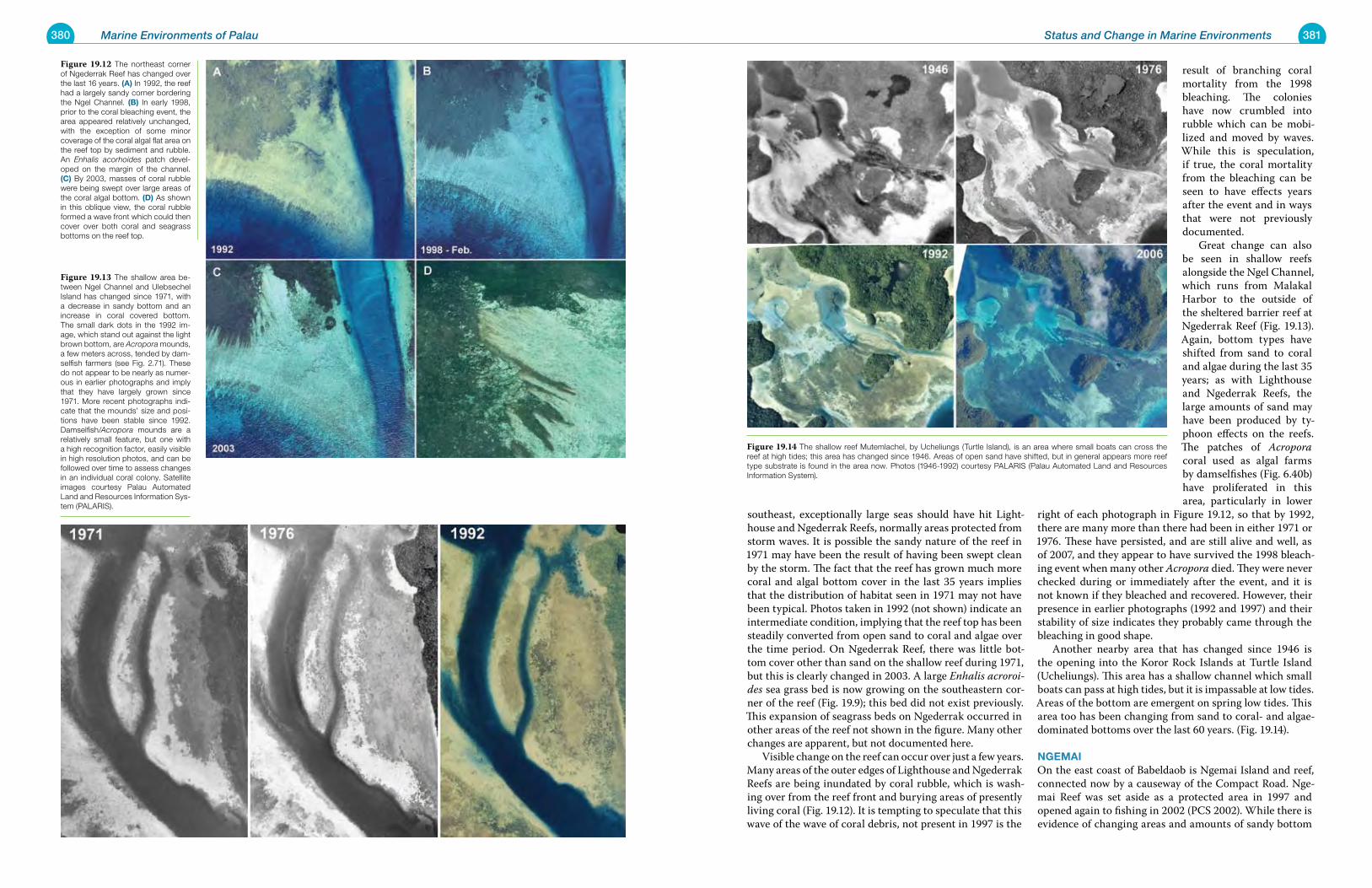
380 Marine Environments of Palau 381Status and Change in Marine Environments
southeast, exceptionally large seas should have hit Light-house and Ngederrak Reefs, normally areas protected from storm waves. It is possible the sandy nature of the reef in 1971 may have been the result of having been swept clean by the storm. The fact that the reef has grown much more coral and algal bottom cover in the last 35 years implies that the distribution of habitat seen in 1971 may not have been typical. Photos taken in 1992 (not shown) indicate an intermediate condition, implying that the reef top has been steadily converted from open sand to coral and algae over the time period. On Ngederrak Reef, there was little bot-tom cover other than sand on the shallow reef during 1971, but this is clearly changed in 2003. A large Enhalis acroroi-des sea grass bed is now growing on the southeastern cor-ner of the reef (Fig. 19.9); this bed did not exist previously. This expansion of seagrass beds on Ngederrak occurred in other areas of the reef not shown in the figure. Many other changes are apparent, but not documented here. Visible change on the reef can occur over just a few years. Many areas of the outer edges of Lighthouse and Ngederrak Reefs are being inundated by coral rubble, which is wash-ing over from the reef front and burying areas of presently living coral (Fig. 19.12). It is tempting to speculate that this wave of the wave of coral debris, not present in 1997 is the
result of branching coral mortality from the 1998 bleaching. The colonies have now crumbled into rubble which can be mobi-lized and moved by waves. While this is speculation, if true, the coral mortality from the bleaching can be seen to have effects years after the event and in ways that were not previously documented. Great change can also be seen in shallow reefs alongside the Ngel Channel, which runs from Malakal Harbor to the outside of the sheltered barrier reef at Ngederrak Reef (Fig. 19.13). Again, bottom types have shifted from sand to coral and algae during the last 35 years; as with Lighthouse and Ngederrak Reefs, the large amounts of sand may have been produced by ty-phoon effects on the reefs. The patches of Acropora coral used as algal farms by damselfishes (Fig. 6.40b) have proliferated in this area, particularly in lower
right of each photograph in Figure 19.12, so that by 1992, there are many more than there had been in either 1971 or 1976. These have persisted, and are still alive and well, as of 2007, and they appear to have survived the 1998 bleach-ing event when many other Acropora died. They were never checked during or immediately after the event, and it is not known if they bleached and recovered. However, their presence in earlier photographs (1992 and 1997) and their stability of size indicates they probably came through the bleaching in good shape. Another nearby area that has changed since 1946 is the opening into the Koror Rock Islands at Turtle Island (Ucheliungs). This area has a shallow channel which small boats can pass at high tides, but it is impassable at low tides. Areas of the bottom are emergent on spring low tides. This area too has been changing from sand to coral- and algae-dominated bottoms over the last 60 years. (Fig. 19.14).
ngemaiOn the east coast of Babeldaob is Ngemai Island and reef, connected now by a causeway of the Compact Road. Nge-mai Reef was set aside as a protected area in 1997 and opened again to fishing in 2002 (PCS 2002). While there is evidence of changing areas and amounts of sandy bottom
Figure 19.12 The northeast corner of Ngederrak Reef has changed over the last 16 years. (a) In 1992, the reef had a largely sandy corner bordering the Ngel Channel. (B) In early 1998, prior to the coral bleaching event, the area appeared relatively unchanged, with the exception of some minor coverage of the coral algal flat area on the reef top by sediment and rubble. An Enhalis acorhoides patch devel-oped on the margin of the channel. (C) By 2003, masses of coral rubble were being swept over large areas of the coral algal bottom. (D) As shown in this oblique view, the coral rubble formed a wave front which could then cover over both coral and seagrass bottoms on the reef top.
Figure 19.13 The shallow area be-tween Ngel Channel and Ulebsechel Island has changed since 1971, with a decrease in sandy bottom and an increase in coral covered bottom. The small dark dots in the 1992 im-age, which stand out against the light brown bottom, are Acropora mounds, a few meters across, tended by dam-selfish farmers (see Fig. 2.71). These do not appear to be nearly as numer-ous in earlier photographs and imply that they have largely grown since 1971. More recent photographs indi-cate that the mounds’ size and posi-tions have been stable since 1992. Damselfish/Acropora mounds are a relatively small feature, but one with a high recognition factor, easily visible in high resolution photos, and can be followed over time to assess changes in an individual coral colony. Satellite images courtesy Palau Automated Land and Resources Information Sys-tem (PALARIS).
Figure 19.14 The shallow reef Mutemlachel, by Ucheliungs (Turtle Island), is an area where small boats can cross the reef at high tides; this area has changed since 1946. Areas of open sand have shifted, but in general appears more reef type substrate is found in the area now. Photos (1946-1992) courtesy PALARIS (Palau Automated Land and Resources Information System).
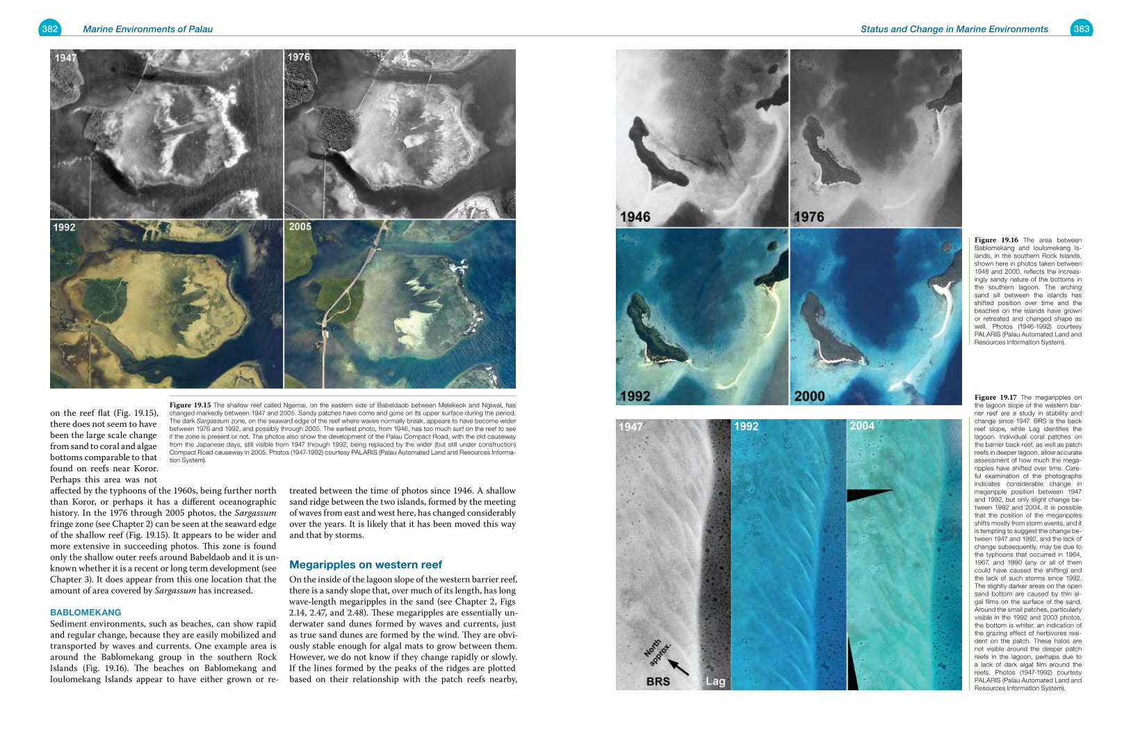
382 Marine Environments of Palau 383Status and Change in Marine Environments
on the reef flat (Fig. 19.15), there does not seem to have been the large scale change from sand to coral and algae bottoms comparable to that found on reefs near Koror. Perhaps this area was not affected by the typhoons of the 1960s, being further north than Koror, or perhaps it has a different oceanographic history. In the 1976 through 2005 photos, the Sargassum fringe zone (see Chapter 2) can be seen at the seaward edge of the shallow reef (Fig. 19.15). It appears to be wider and more extensive in succeeding photos. This zone is found only the shallow outer reefs around Babeldaob and it is un-known whether it is a recent or long term development (see Chapter 3). It does appear from this one location that the amount of area covered by Sargassum has increased.
BaBlomekangSediment environments, such as beaches, can show rapid and regular change, because they are easily mobilized and transported by waves and currents. One example area is around the Bablomekang group in the southern Rock Islands (Fig. 19.16). The beaches on Bablomekang and Ioulomekang Islands appear to have either grown or re-
treated between the time of photos since 1946. A shallow sand ridge between the two islands, formed by the meeting of waves from east and west here, has changed considerably over the years. It is likely that it has been moved this way and that by storms.
megaripples on western reef On the inside of the lagoon slope of the western barrier reef, there is a sandy slope that, over much of its length, has long wave-length megaripples in the sand (see Chapter 2, Figs 2.14, 2.47, and 2.48). These megaripples are essentially un-derwater sand dunes formed by waves and currents, just as true sand dunes are formed by the wind. They are obvi-ously stable enough for algal mats to grow between them. However, we do not know if they change rapidly or slowly. If the lines formed by the peaks of the ridges are plotted based on their relationship with the patch reefs nearby,
Figure 19.15 The shallow reef called Ngemai, on the eastern side of Babeldaob between Melekeok and Ngiwal, has changed markedly between 1947 and 2005. Sandy patches have come and gone on its upper surface during the period. The dark Sargassum zone, on the seaward edge of the reef where waves normally break, appears to have become wider between 1976 and 1992, and possibly through 2005. The earliest photo, from 1946, has too much surf on the reef to see if the zone is present or not. The photos also show the development of the Palau Compact Road, with the old causeway from the Japanese days, still visible from 1947 through 1992, being replaced by the wider (but still under construction) Compact Road causeway in 2005. Photos (1947-1992) courtesy PALARIS (Palau Automated Land and Resources Informa-tion System).
Figure 19.16 The area between Bablomekang and Ioulomekang Is-lands, in the southern Rock Islands, shown here in photos taken between 1946 and 2000, reflects the increas-ingly sandy nature of the bottoms in the southern lagoon. The arching sand sill between the islands has shifted position over time and the beaches on the islands have grown or retreated and changed shape as well. Photos (1946-1992) courtesy PALARIS (Palau Automated Land and Resources Information System).
Figure 19.17 The megaripples on the lagoon slope of the western bar-rier reef are a study in stability and change since 1947. BRS is the back reef slope, while Lag identifies the lagoon. Individual coral patches on the barrier back reef, as well as patch reefs in deeper lagoon, allow accurate assessment of how much the mega-ripples have shifted over time. Care-ful examination of the photographs indicates considerable change in megaripple position between 1947 and 1992, but only slight change be-tween 1992 and 2004. It is possible that the position of the megaripples shifts mostly from storm events, and it is tempting to suggest the change be-tween 1947 and 1992, and the lack of change subsequently, may be due to the typhoons that occurred in 1964, 1967, and 1990 (any or all of them could have caused the shifting) and the lack of such storms since 1992. The slightly darker areas on the open sand bottom are caused by thin al-gal films on the surface of the sand. Around the small patches, particularly visible in the 1992 and 2003 photos, the bottom is whiter, an indication of the grazing effect of herbivores resi-dent on the patch. These halos are not visible around the deeper patch reefs in the lagoon, perhaps due to a lack of dark algal film around the reefs. Photos (1947-1992) courtesy PALARIS (Palau Automated Land and Resources Information System).
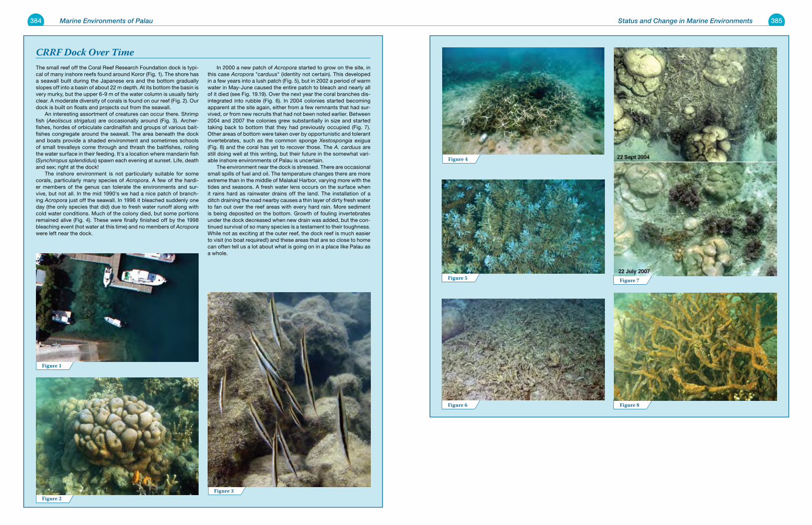
384 Marine Environments of Palau 385
The small reef off the Coral Reef Research Foundation dock is typi-cal of many inshore reefs found around Koror (Fig. 1). The shore has a seawall built during the Japanese era and the bottom gradually slopes off into a basin of about 22 m depth. At its bottom the basin is very murky, but the upper 6-9 m of the water column is usually fairly clear. A moderate diversity of corals is found on our reef (Fig. 2). Our dock is built on floats and projects out from the seawall. An interesting assortment of creatures can occur there. Shrimp fish (Aeoliscus strigatus) are occasionally around (Fig. 3). Archer-fishes, hordes of orbiculate cardinalfish and groups of various bait-fishes congregate around the seawall. The area beneath the dock and boats provide a shaded environment and sometimes schools of small trevalleys come through and thrash the baitfishes, roiling the water surface in their feeding. It's a location where mandarin fish (Synchiropus splendidus) spawn each evening at sunset. Life, death and sex; right at the dock! The inshore environment is not particularly suitable for some corals, particularly many species of Acropora. A few of the hardi-er members of the genus can tolerate the environments and sur-vive, but not all. In the mid 1990's we had a nice patch of branch-ing Acropora just off the seawall. In 1996 it bleached suddenly one day (the only species that did) due to fresh water runoff along with cold water conditions. Much of the colony died, but some portions remained alive (Fig. 4). These were finally finished off by the 1998 bleaching event (hot water at this time) and no members of Acropora were left near the dock.
In 2000 a new patch of Acropora started to grow on the site, in this case Acropora "carduus" (identity not certain). This developed in a few years into a lush patch (Fig. 5), but in 2002 a period of warm water in May-June caused the entire patch to bleach and nearly all of it died (see Fig. 19.19). Over the next year the coral branches dis-integrated into rubble (Fig. 6). In 2004 colonies started becoming apparent at the site again, either from a few remnants that had sur-vived, or from new recruits that had not been noted earlier. Between 2004 and 2007 the colonies grew substantially in size and started taking back to bottom that they had previously occupied (Fig. 7). Other areas of bottom were taken over by opportunistic and tolerant invertebrates, such as the common sponge Xestospongia exigua (Fig. 8) and the coral has yet to recover those. The A. carduus are still doing well at this writing, but their future in the somewhat vari-able inshore environments of Palau is uncertain. The environment near the dock is stressed. There are occasional small spills of fuel and oil. The temperature changes there are more extreme than in the middle of Malakal Harbor, varying more with the tides and seasons. A fresh water lens occurs on the surface when it rains hard as rainwater drains off the land. The installation of a ditch draining the road nearby causes a thin layer of dirty fresh water to fan out over the reef areas with every hard rain. More sediment is being deposited on the bottom. Growth of fouling invertebrates under the dock decreased when new drain was added, but the con-tinued survival of so many species is a testament to their toughness. While not as exciting at the outer reef, the dock reef is much easier to visit (no boat required!) and these areas that are so close to home can often tell us a lot about what is going on in a place like Palau as a whole.
Status and Change in Marine Environments
Figure 1
Figure 2Figure 3
CRRF Dock Over Time
Figure 4
Figure 5
Figure 6
Figure 7
Figure 8
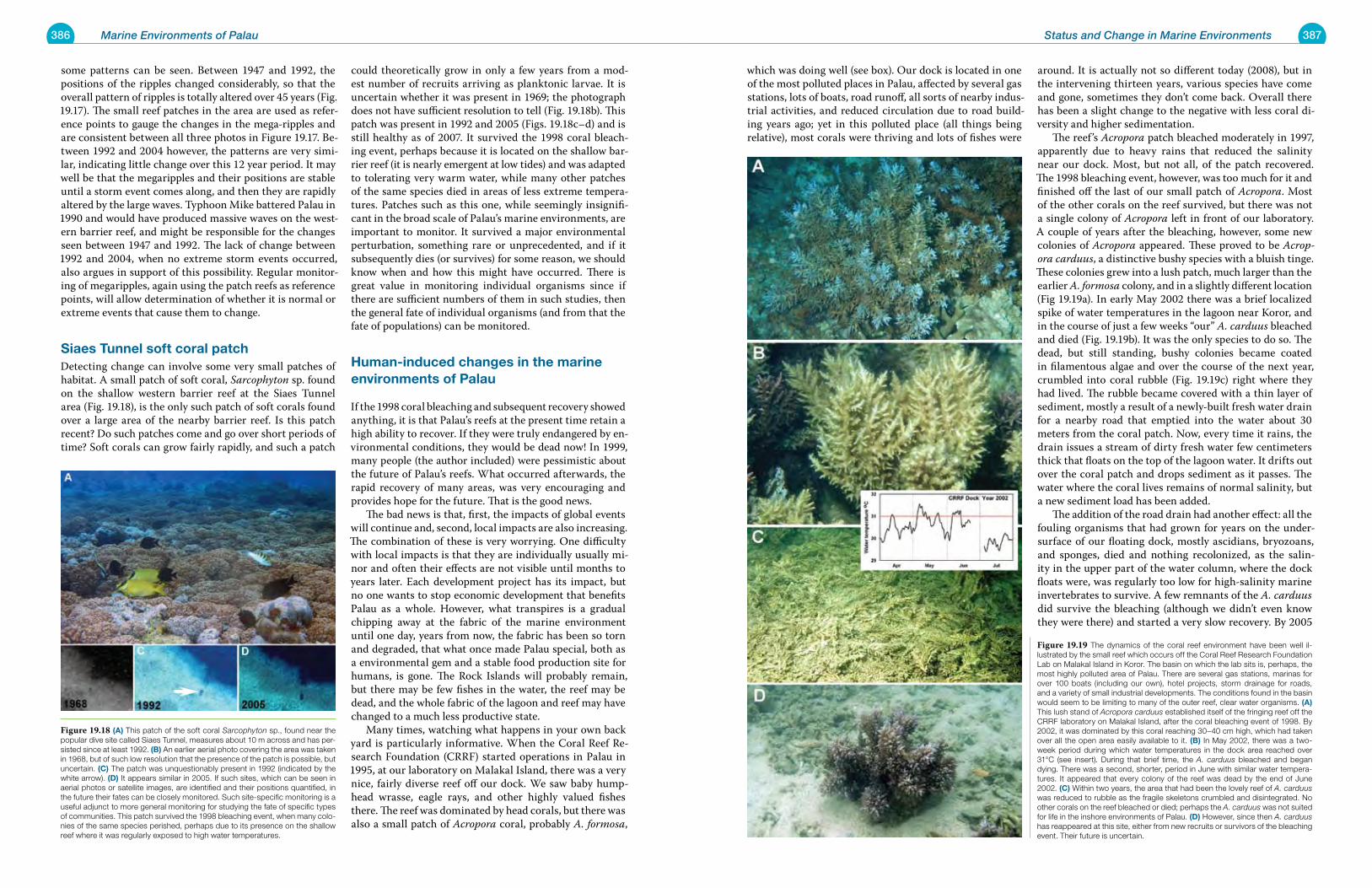
386 Marine Environments of Palau 387Status and Change in Marine Environments
some patterns can be seen. Between 1947 and 1992, the positions of the ripples changed considerably, so that the overall pattern of ripples is totally altered over 45 years (Fig. 19.17). The small reef patches in the area are used as refer-ence points to gauge the changes in the mega-ripples and are consistent between all three photos in Figure 19.17. Be-tween 1992 and 2004 however, the patterns are very simi-lar, indicating little change over this 12 year period. It may well be that the megaripples and their positions are stable until a storm event comes along, and then they are rapidly altered by the large waves. Typhoon Mike battered Palau in 1990 and would have produced massive waves on the west-ern barrier reef, and might be responsible for the changes seen between 1947 and 1992. The lack of change between 1992 and 2004, when no extreme storm events occurred, also argues in support of this possibility. Regular monitor-ing of megaripples, again using the patch reefs as reference points, will allow determination of whether it is normal or extreme events that cause them to change.
siaes tunnel soft coral patchDetecting change can involve some very small patches of habitat. A small patch of soft coral, Sarcophyton sp. found on the shallow western barrier reef at the Siaes Tunnel area (Fig. 19.18), is the only such patch of soft corals found over a large area of the nearby barrier reef. Is this patch recent? Do such patches come and go over short periods of time? Soft corals can grow fairly rapidly, and such a patch
could theoretically grow in only a few years from a mod-est number of recruits arriving as planktonic larvae. It is uncertain whether it was present in 1969; the photograph does not have sufficient resolution to tell (Fig. 19.18b). This patch was present in 1992 and 2005 (Figs. 19.18c–d) and is still healthy as of 2007. It survived the 1998 coral bleach-ing event, perhaps because it is located on the shallow bar-rier reef (it is nearly emergent at low tides) and was adapted to tolerating very warm water, while many other patches of the same species died in areas of less extreme tempera-tures. Patches such as this one, while seemingly insignifi-cant in the broad scale of Palau’s marine environments, are important to monitor. It survived a major environmental perturbation, something rare or unprecedented, and if it subsequently dies (or survives) for some reason, we should know when and how this might have occurred. There is great value in monitoring individual organisms since if there are sufficient numbers of them in such studies, then the general fate of individual organisms (and from that the fate of populations) can be monitored.
human-induced changes in the marine environments of palau
If the 1998 coral bleaching and subsequent recovery showed anything, it is that Palau’s reefs at the present time retain a high ability to recover. If they were truly endangered by en-vironmental conditions, they would be dead now! In 1999, many people (the author included) were pessimistic about the future of Palau’s reefs. What occurred afterwards, the rapid recovery of many areas, was very encouraging and provides hope for the future. That is the good news. The bad news is that, first, the impacts of global events will continue and, second, local impacts are also increasing. The combination of these is very worrying. One difficulty with local impacts is that they are individually usually mi-nor and often their effects are not visible until months to years later. Each development project has its impact, but no one wants to stop economic development that benefits Palau as a whole. However, what transpires is a gradual chipping away at the fabric of the marine environment until one day, years from now, the fabric has been so torn and degraded, that what once made Palau special, both as a environmental gem and a stable food production site for humans, is gone. The Rock Islands will probably remain, but there may be few fishes in the water, the reef may be dead, and the whole fabric of the lagoon and reef may have changed to a much less productive state. Many times, watching what happens in your own back yard is particularly informative. When the Coral Reef Re-search Foundation (CRRF) started operations in Palau in 1995, at our laboratory on Malakal Island, there was a very nice, fairly diverse reef off our dock. We saw baby hump-head wrasse, eagle rays, and other highly valued fishes there. The reef was dominated by head corals, but there was also a small patch of Acropora coral, probably A. formosa,
which was doing well (see box). Our dock is located in one of the most polluted places in Palau, affected by several gas stations, lots of boats, road runoff, all sorts of nearby indus-trial activities, and reduced circulation due to road build-ing years ago; yet in this polluted place (all things being relative), most corals were thriving and lots of fishes were
around. It is actually not so different today (2008), but in the intervening thirteen years, various species have come and gone, sometimes they don’t come back. Overall there has been a slight change to the negative with less coral di-versity and higher sedimentation. The reef’s Acropora patch bleached moderately in 1997, apparently due to heavy rains that reduced the salinity near our dock. Most, but not all, of the patch recovered. The 1998 bleaching event, however, was too much for it and finished off the last of our small patch of Acropora. Most of the other corals on the reef survived, but there was not a single colony of Acropora left in front of our laboratory. A couple of years after the bleaching, however, some new colonies of Acropora appeared. These proved to be Acrop-ora carduus, a distinctive bushy species with a bluish tinge. These colonies grew into a lush patch, much larger than the earlier A. formosa colony, and in a slightly different location (Fig 19.19a). In early May 2002 there was a brief localized spike of water temperatures in the lagoon near Koror, and in the course of just a few weeks “our” A. carduus bleached and died (Fig. 19.19b). It was the only species to do so. The dead, but still standing, bushy colonies became coated in filamentous algae and over the course of the next year, crumbled into coral rubble (Fig. 19.19c) right where they had lived. The rubble became covered with a thin layer of sediment, mostly a result of a newly-built fresh water drain for a nearby road that emptied into the water about 30 meters from the coral patch. Now, every time it rains, the drain issues a stream of dirty fresh water few centimeters thick that floats on the top of the lagoon water. It drifts out over the coral patch and drops sediment as it passes. The water where the coral lives remains of normal salinity, but a new sediment load has been added. The addition of the road drain had another effect: all the fouling organisms that had grown for years on the under-surface of our floating dock, mostly ascidians, bryozoans, and sponges, died and nothing recolonized, as the salin-ity in the upper part of the water column, where the dock floats were, was regularly too low for high-salinity marine invertebrates to survive. A few remnants of the A. carduus did survive the bleaching (although we didn’t even know they were there) and started a very slow recovery. By 2005
Figure 19.18 (a) This patch of the soft coral Sarcophyton sp., found near the popular dive site called Siaes Tunnel, measures about 10 m across and has per-sisted since at least 1992. (B) An earlier aerial photo covering the area was taken in 1968, but of such low resolution that the presence of the patch is possible, but uncertain. (C) The patch was unquestionably present in 1992 (indicated by the white arrow). (D) It appears similar in 2005. If such sites, which can be seen in aerial photos or satellite images, are identified and their positions quantified, in the future their fates can be closely monitored. Such site-specific monitoring is a useful adjunct to more general monitoring for studying the fate of specific types of communities. This patch survived the 1998 bleaching event, when many colo-nies of the same species perished, perhaps due to its presence on the shallow reef where it was regularly exposed to high water temperatures.
Figure 19.19 The dynamics of the coral reef environment have been well il-lustrated by the small reef which occurs off the Coral Reef Research Foundation Lab on Malakal Island in Koror. The basin on which the lab sits is, perhaps, the most highly polluted area of Palau. There are several gas stations, marinas for over 100 boats (including our own), hotel projects, storm drainage for roads, and a variety of small industrial developments. The conditions found in the basin would seem to be limiting to many of the outer reef, clear water organisms. (a) This lush stand of Acropora carduus established itself of the fringing reef off the CRRF laboratory on Malakal Island, after the coral bleaching event of 1998. By 2002, it was dominated by this coral reaching 30–40 cm high, which had taken over all the open area easily available to it. (B) In May 2002, there was a two-week period during which water temperatures in the dock area reached over 31°C (see insert). During that brief time, the A. carduus bleached and began dying. There was a second, shorter, period in June with similar water tempera-tures. It appeared that every colony of the reef was dead by the end of June 2002. (C) Within two years, the area that had been the lovely reef of A. carduus was reduced to rubble as the fragile skeletons crumbled and disintegrated. No other corals on the reef bleached or died; perhaps the A. carduus was not suited for life in the inshore environments of Palau. (D) However, since then A. carduus has reappeared at this site, either from new recruits or survivors of the bleaching event. Their future is uncertain.
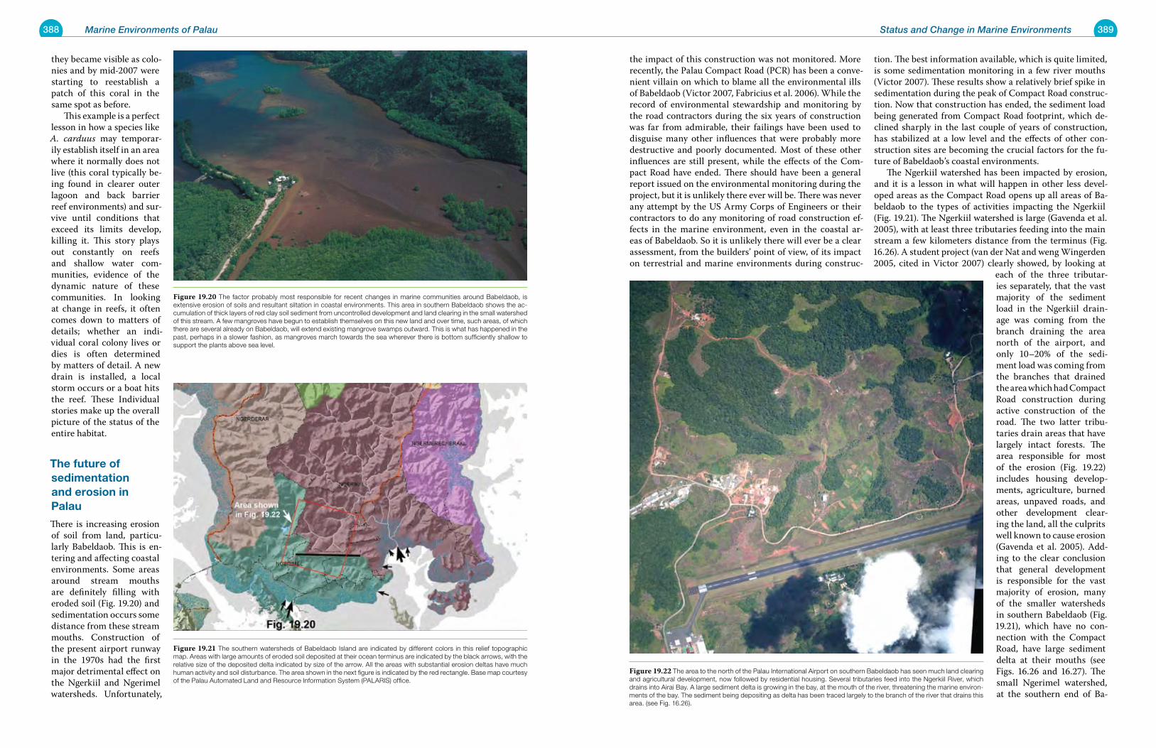
388 Marine Environments of Palau 389Status and Change in Marine Environments
they became visible as colo-nies and by mid-2007 were starting to reestablish a patch of this coral in the same spot as before. This example is a perfect lesson in how a species like A. carduus may temporar-ily establish itself in an area where it normally does not live (this coral typically be-ing found in clearer outer lagoon and back barrier reef environments) and sur-vive until conditions that exceed its limits develop, killing it. This story plays out constantly on reefs and shallow water com-munities, evidence of the dynamic nature of these communities. In looking at change in reefs, it often comes down to matters of details; whether an indi-vidual coral colony lives or dies is often determined by matters of detail. A new drain is installed, a local storm occurs or a boat hits the reef. These Individual stories make up the overall picture of the status of the entire habitat.
the future of sedimentation and erosion in palau
There is increasing erosion of soil from land, particu-larly Babeldaob. This is en-tering and affecting coastal environments. Some areas around stream mouths are definitely filling with eroded soil (Fig. 19.20) and sedimentation occurs some distance from these stream mouths. Construction of the present airport runway in the 1970s had the first major detrimental effect on the Ngerkiil and Ngerimel watersheds. Unfortunately,
the impact of this construction was not monitored. More recently, the Palau Compact Road (PCR) has been a conve-nient villain on which to blame all the environmental ills of Babeldaob (Victor 2007, Fabricius et al. 2006). While the record of environmental stewardship and monitoring by the road contractors during the six years of construction was far from admirable, their failings have been used to disguise many other influences that were probably more destructive and poorly documented. Most of these other influences are still present, while the effects of the Com-pact Road have ended. There should have been a general report issued on the environmental monitoring during the project, but it is unlikely there ever will be. There was never any attempt by the US Army Corps of Engineers or their contractors to do any monitoring of road construction ef-fects in the marine environment, even in the coastal ar-eas of Babeldaob. So it is unlikely there will ever be a clear assessment, from the builders’ point of view, of its impact on terrestrial and marine environments during construc-
tion. The best information available, which is quite limited, is some sedimentation monitoring in a few river mouths (Victor 2007). These results show a relatively brief spike in sedimentation during the peak of Compact Road construc-tion. Now that construction has ended, the sediment load being generated from Compact Road footprint, which de-clined sharply in the last couple of years of construction, has stabilized at a low level and the effects of other con-struction sites are becoming the crucial factors for the fu-ture of Babeldaob’s coastal environments. The Ngerkiil watershed has been impacted by erosion, and it is a lesson in what will happen in other less devel-oped areas as the Compact Road opens up all areas of Ba-beldaob to the types of activities impacting the Ngerkiil (Fig. 19.21). The Ngerkiil watershed is large (Gavenda et al. 2005), with at least three tributaries feeding into the main stream a few kilometers distance from the terminus (Fig. 16.26). A student project (van der Nat and weng Wingerden 2005, cited in Victor 2007) clearly showed, by looking at
each of the three tributar-ies separately, that the vast majority of the sediment load in the Ngerkiil drain-age was coming from the branch draining the area north of the airport, and only 10–20% of the sedi-ment load was coming from the branches that drained the area which had Compact Road construction during active construction of the road. The two latter tribu-taries drain areas that have largely intact forests. The area responsible for most of the erosion (Fig. 19.22) includes housing develop-ments, agriculture, burned areas, unpaved roads, and other development clear-ing the land, all the culprits well known to cause erosion (Gavenda et al. 2005). Add-ing to the clear conclusion that general development is responsible for the vast majority of erosion, many of the smaller watersheds in southern Babeldaob (Fig. 19.21), which have no con-nection with the Compact Road, have large sediment delta at their mouths (see Figs. 16.26 and 16.27). The small Ngerimel watershed, at the southern end of Ba-
Figure 19.20 The factor probably most responsible for recent changes in marine communities around Babeldaob, is extensive erosion of soils and resultant siltation in coastal environments. This area in southern Babeldaob shows the ac-cumulation of thick layers of red clay soil sediment from uncontrolled development and land clearing in the small watershed of this stream. A few mangroves have begun to establish themselves on this new land and over time, such areas, of which there are several already on Babeldaob, will extend existing mangrove swamps outward. This is what has happened in the past, perhaps in a slower fashion, as mangroves march towards the sea wherever there is bottom sufficiently shallow to support the plants above sea level.
Figure 19.21 The southern watersheds of Babeldaob Island are indicated by different colors in this relief topographic map. Areas with large amounts of eroded soil deposited at their ocean terminus are indicated by the black arrows, with the relative size of the deposited delta indicated by size of the arrow. All the areas with substantial erosion deltas have much human activity and soil disturbance. The area shown in the next figure is indicated by the red rectangle. Base map courtesy of the Palau Automated Land and Resource Information System (PALARIS) office.
Figure 19.22 The area to the north of the Palau International Airport on southern Babeldaob has seen much land clearing and agricultural development, now followed by residential housing. Several tributaries feed into the Ngerkiil River, which drains into Airai Bay. A large sediment delta is growing in the bay, at the mouth of the river, threatening the marine environ-ments of the bay. The sediment being depositing as delta has been traced largely to the branch of the river that drains this area. (see Fig. 16.26).
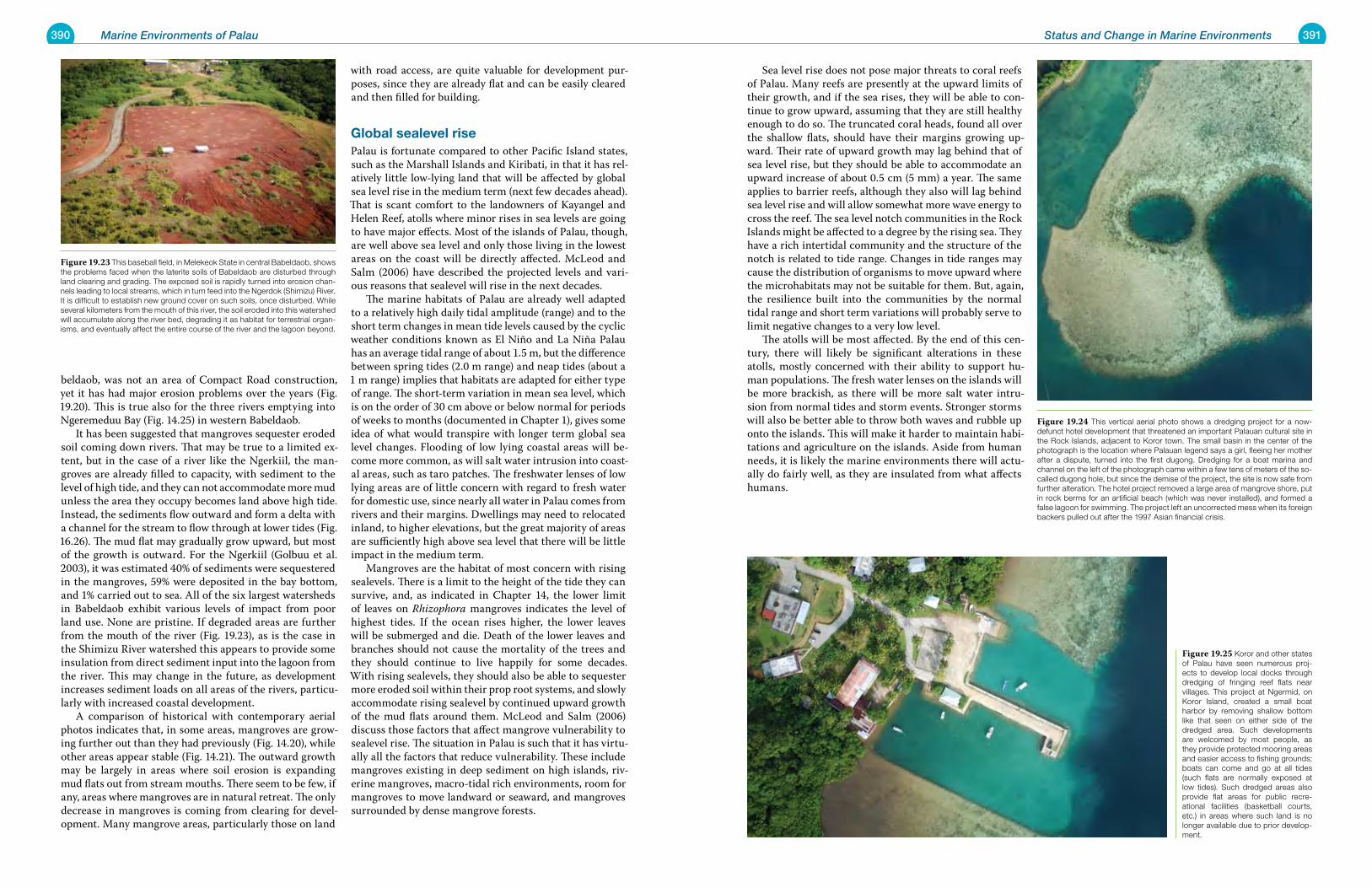
390 Marine Environments of Palau 391Status and Change in Marine Environments
beldaob, was not an area of Compact Road construction, yet it has had major erosion problems over the years (Fig. 19.20). This is true also for the three rivers emptying into Ngeremeduu Bay (Fig. 14.25) in western Babeldaob. It has been suggested that mangroves sequester eroded soil coming down rivers. That may be true to a limited ex-tent, but in the case of a river like the Ngerkiil, the man-groves are already filled to capacity, with sediment to the level of high tide, and they can not accommodate more mud unless the area they occupy becomes land above high tide. Instead, the sediments flow outward and form a delta with a channel for the stream to flow through at lower tides (Fig. 16.26). The mud flat may gradually grow upward, but most of the growth is outward. For the Ngerkiil (Golbuu et al. 2003), it was estimated 40% of sediments were sequestered in the mangroves, 59% were deposited in the bay bottom, and 1% carried out to sea. All of the six largest watersheds in Babeldaob exhibit various levels of impact from poor land use. None are pristine. If degraded areas are further from the mouth of the river (Fig. 19.23), as is the case in the Shimizu River watershed this appears to provide some insulation from direct sediment input into the lagoon from the river. This may change in the future, as development increases sediment loads on all areas of the rivers, particu-larly with increased coastal development. A comparison of historical with contemporary aerial photos indicates that, in some areas, mangroves are grow-ing further out than they had previously (Fig. 14.20), while other areas appear stable (Fig. 14.21). The outward growth may be largely in areas where soil erosion is expanding mud flats out from stream mouths. There seem to be few, if any, areas where mangroves are in natural retreat. The only decrease in mangroves is coming from clearing for devel-opment. Many mangrove areas, particularly those on land
with road access, are quite valuable for development pur-poses, since they are already flat and can be easily cleared and then filled for building.
global sealevel risePalau is fortunate compared to other Pacific Island states, such as the Marshall Islands and Kiribati, in that it has rel-atively little low-lying land that will be affected by global sea level rise in the medium term (next few decades ahead). That is scant comfort to the landowners of Kayangel and Helen Reef, atolls where minor rises in sea levels are going to have major effects. Most of the islands of Palau, though, are well above sea level and only those living in the lowest areas on the coast will be directly affected. McLeod and Salm (2006) have described the projected levels and vari-ous reasons that sealevel will rise in the next decades. The marine habitats of Palau are already well adapted to a relatively high daily tidal amplitude (range) and to the short term changes in mean tide levels caused by the cyclic weather conditions known as El Niño and La Niña Palau has an average tidal range of about 1.5 m, but the difference between spring tides (2.0 m range) and neap tides (about a 1 m range) implies that habitats are adapted for either type of range. The short-term variation in mean sea level, which is on the order of 30 cm above or below normal for periods of weeks to months (documented in Chapter 1), gives some idea of what would transpire with longer term global sea level changes. Flooding of low lying coastal areas will be-come more common, as will salt water intrusion into coast-al areas, such as taro patches. The freshwater lenses of low lying areas are of little concern with regard to fresh water for domestic use, since nearly all water in Palau comes from rivers and their margins. Dwellings may need to relocated inland, to higher elevations, but the great majority of areas are sufficiently high above sea level that there will be little impact in the medium term. Mangroves are the habitat of most concern with rising sealevels. There is a limit to the height of the tide they can survive, and, as indicated in Chapter 14, the lower limit of leaves on Rhizophora mangroves indicates the level of highest tides. If the ocean rises higher, the lower leaves will be submerged and die. Death of the lower leaves and branches should not cause the mortality of the trees and they should continue to live happily for some decades. With rising sealevels, they should also be able to sequester more eroded soil within their prop root systems, and slowly accommodate rising sealevel by continued upward growth of the mud flats around them. McLeod and Salm (2006) discuss those factors that affect mangrove vulnerability to sealevel rise. The situation in Palau is such that it has virtu-ally all the factors that reduce vulnerability. These include mangroves existing in deep sediment on high islands, riv-erine mangroves, macro-tidal rich environments, room for mangroves to move landward or seaward, and mangroves surrounded by dense mangrove forests.
Sea level rise does not pose major threats to coral reefs of Palau. Many reefs are presently at the upward limits of their growth, and if the sea rises, they will be able to con-tinue to grow upward, assuming that they are still healthy enough to do so. The truncated coral heads, found all over the shallow flats, should have their margins growing up-ward. Their rate of upward growth may lag behind that of sea level rise, but they should be able to accommodate an upward increase of about 0.5 cm (5 mm) a year. The same applies to barrier reefs, although they also will lag behind sea level rise and will allow somewhat more wave energy to cross the reef. The sea level notch communities in the Rock Islands might be affected to a degree by the rising sea. They have a rich intertidal community and the structure of the notch is related to tide range. Changes in tide ranges may cause the distribution of organisms to move upward where the microhabitats may not be suitable for them. But, again, the resilience built into the communities by the normal tidal range and short term variations will probably serve to limit negative changes to a very low level. The atolls will be most affected. By the end of this cen-tury, there will likely be significant alterations in these atolls, mostly concerned with their ability to support hu-man populations. The fresh water lenses on the islands will be more brackish, as there will be more salt water intru-sion from normal tides and storm events. Stronger storms will also be better able to throw both waves and rubble up onto the islands. This will make it harder to maintain habi-tations and agriculture on the islands. Aside from human needs, it is likely the marine environments there will actu-ally do fairly well, as they are insulated from what affects humans.
Figure 19.23 This baseball field, in Melekeok State in central Babeldaob, shows the problems faced when the laterite soils of Babeldaob are disturbed through land clearing and grading. The exposed soil is rapidly turned into erosion chan-nels leading to local streams, which in turn feed into the Ngerdok (Shimizu) River. It is difficult to establish new ground cover on such soils, once disturbed. While several kilometers from the mouth of this river, the soil eroded into this watershed will accumulate along the river bed, degrading it as habitat for terrestrial organ-isms, and eventually affect the entire course of the river and the lagoon beyond.
Figure 19.24 This vertical aerial photo shows a dredging project for a now-defunct hotel development that threatened an important Palauan cultural site in the Rock Islands, adjacent to Koror town. The small basin in the center of the photograph is the location where Palauan legend says a girl, fleeing her mother after a dispute, turned into the first dugong. Dredging for a boat marina and channel on the left of the photograph came within a few tens of meters of the so-called dugong hole, but since the demise of the project, the site is now safe from further alteration. The hotel project removed a large area of mangrove shore, put in rock berms for an artificial beach (which was never installed), and formed a false lagoon for swimming. The project left an uncorrected mess when its foreign backers pulled out after the 1997 Asian financial crisis.
Figure 19.25 Koror and other states of Palau have seen numerous proj-ects to develop local docks through dredging of fringing reef flats near villages. This project at Ngermid, on Koror Island, created a small boat harbor by removing shallow bottom like that seen on either side of the dredged area. Such developments are welcomed by most people, as they provide protected mooring areas and easier access to fishing grounds; boats can come and go at all tides (such flats are normally exposed at low tides). Such dredged areas also provide flat areas for public recre-ational facilities (basketball courts, etc.) in areas where such land is no longer available due to prior develop-ment.
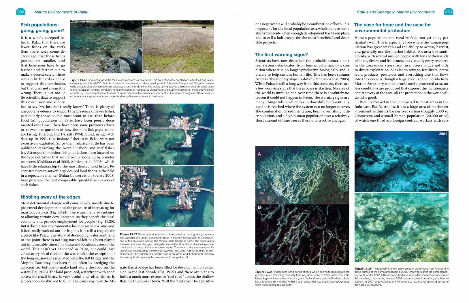
392 Marine Environments of Palau 393Status and Change in Marine Environments
Fish populations: going, going, gone?
It is a widely accepted be-lief in Palau that there are fewer fishes on the reefs than there were some de-cades ago, that those fishes present are smaller, and that fishermen have to go farther and farther out to make a decent catch. There is really little hard evidence to support this conclusion, but that does not mean it is wrong. There is just too lit-tle scientific data to support this conclusion and science has to say “we just don’t really know.” There is plenty of anecdotal evidence to support the presence of fewer fishes, particularly those people most want to eat, than before. Food fish populations in Palau have been poorly docu-mented over time. There have been some previous efforts to answer the question of how the food fish populations are faring. Kitalong and Dalzell (1994) found, using catch data up to 1991, that inshore fisheries in Palau were not excessively exploited. Since then, relatively little has been published regarding the overall inshore and reef fisher-ies. Attempts to monitor fish populations have focused on the types of fishes that would occur along 50 by 5 meter transects (Goldbuu et al 2005, Marino et al. 2008), which have little relationship to the most desired food fishes. Re-cent attempts to survey large desired food fishes in the field in a repeatable manner (Palau Conservation Society 2008) have provided the first comparable quantitative surveys of such fishes.
nibbling away at the edgesMost detrimental change will come slowly, mostly due to piecemeal development and the pressure of increasing hu-man populations (Fig. 19.24). There are many advantages to allowing certain developments, as they benefit the local economy and provide employment for people (Fig. 19.25). But if the marine environment is lost one piece at a time, and it isn’t really noticed until it is gone, it is still a tragedy for a place like Palau. The story of developing waterfront land to the point there is nothing natural left has been played out innumerable times in a thousand locations around the world. This hasn’t yet happened in Palau, but could. Just about every bit of road on the water, with the exception of the long causeways associated with the KB bridge and the Meyens Causeway, has been filled, often by dredging the adjacent sea bottom to make land along the road on the water (Fig. 19.26). The land produced, waterfront with good access for small boats, is very useful and, often times, is simply too valuable not to fill it. The causeway near the Mi-
nato Bashi bridge has been filled for development on either side in the last decade (Fig. 19.27) and there are plans to build a much more extensive “reef road” across the shallow flats north of Koror town. Will the “reef road” be a positive
or a negative? It will probably be a combination of both. It is important for the local population as a whole to have some ability to decide when enough development has taken place and to call a halt except for the most beneficial and desir-able projects.
the first warning signs?Scientists have now described the probable scenario as a reef system deteriorates, from human activities, to a con-dition where it is no longer productive biologically and is unable to help sustain human life. This has been summa-rized as “the slippery slope to slime” (Pandolphi et al. 2005). While Palau is still a long way from this scenario, there are a few worrying signs that the process is starting. No area of the world is immune and over time there is absolutely no reason it could not happen in Palau. The warning signs are many; things take a while to run downhill, but eventually a point is reached where the system can no longer recover. The combination of sedimentation, heavy overfishing, oth-er pollution, and a high human population over a relatively short amount of time causes these unattractive changes.
the case for hope and the case for environmental protection
Human populations and coral reefs do not get along par-ticularly well. This is especially true where the human pop-ulation has great wealth and the ability to access, harvest, and generally use the marine habitat. An area like south Florida, with several million people with tens of thousands of boats, divers, and fishermen, has virtually every resource in the area under stress from use. Stress is due not only to direct exploitation, but also to sewage, fertilizers, petro-leum products, pesticides and everything else that flows into the ocean. Although a large area like the Florida Keys Marine Sanctuary can be proclaimed a protected area, un-less conditions are produced that support the maintenance and recovery of the area, all the protection in the world will do little good. Palau is blessed in that, compared to most areas in the Indo-west Pacific tropics, it has a large area of marine en-vironment within its barrier reef system (roughly 1000 sq kilometers) and a small human population (20,000 or so), of which one third are foreign contract workers with rela-
Figure 19.26 Some change in the marine environment is irreversible, This area of shallow coral heads near the Long Island causeway was filled (2007 photo is of the exact same area) to allow development of this site. The gradual filling of commer-cially valuable sites along roadways, causeways and islands in Koror is slowly eating away at the marine environments close to the population centers. While any single project does not destroy vast amounts of submarine habitat, the piecemeal loss mounts up. The acceptance of the loss of small pieces of the marine environment, in the name of progress, also makes for more ready acceptance of major projects altering the environment in the future.
Figure 19.27 The urge and incentive to turn roadside running along the water into valuable and useful waterfront property is amply illustrated in this compari-son of the causeway east of the Minato Bashi Bridge in Koror. The areas along the new land were dredged (to largely provide the fill for the land) allowing move-ment and mooring of boats in these areas. The area of the causeway on its upper side (indicated by the white arrow) was filled using red soil trucked in from elsewhere. The reddish color of the area is apparent and it still has the shallow flats along its shore since the area was not dredged for fill.
Figure 19.28 Anacropora is the genus of coral which seems to disintegrate the quickest after bleaching mortality than any other coral in Palau. After the 1998 bleaching event vast areas of Anacropora died and were reduced to dead rubble like this is only six months. Within a year, areas that had been Anacropora beds were not recognizable as such.
Figure 19.29 The recovery of the shallow areas of Lighthouse Reef is evident in these photos of the same area taken in 2001, three years after the coral bleach-ing event, and in 2007. Little recovery had occurred in the years immediately after the bleaching, but starting in about 2001 recovery started becoming much more evident. In 2007 large colonies of Montipora sp. had started growing on top of the rubble of Acropora.
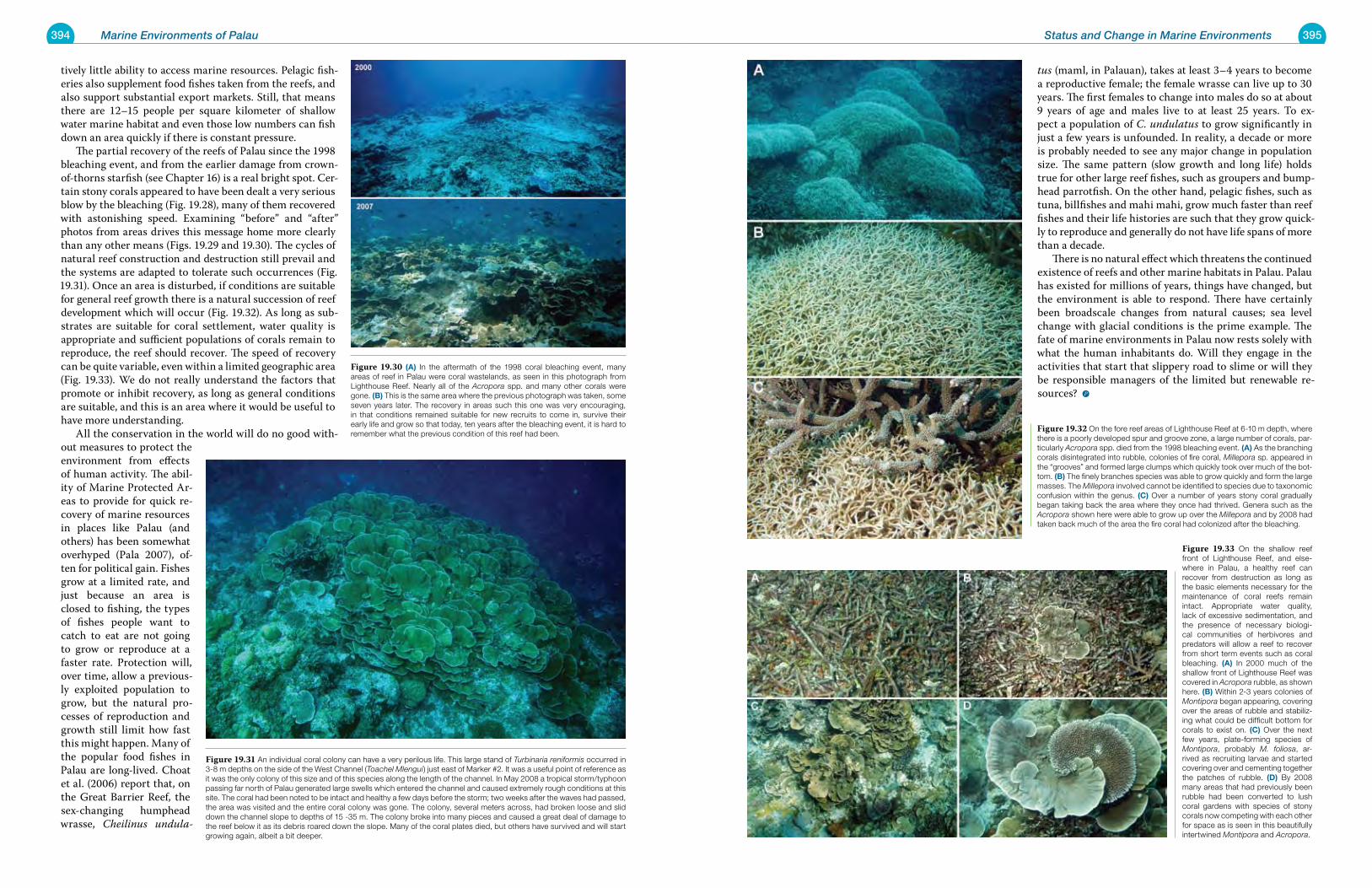
394 Marine Environments of Palau 395Status and Change in Marine Environments
tively little ability to access marine resources. Pelagic fish-eries also supplement food fishes taken from the reefs, and also support substantial export markets. Still, that means there are 12–15 people per square kilometer of shallow water marine habitat and even those low numbers can fish down an area quickly if there is constant pressure. The partial recovery of the reefs of Palau since the 1998 bleaching event, and from the earlier damage from crown-of-thorns starfish (see Chapter 16) is a real bright spot. Cer-tain stony corals appeared to have been dealt a very serious blow by the bleaching (Fig. 19.28), many of them recovered with astonishing speed. Examining “before” and “after” photos from areas drives this message home more clearly than any other means (Figs. 19.29 and 19.30). The cycles of natural reef construction and destruction still prevail and the systems are adapted to tolerate such occurrences (Fig. 19.31). Once an area is disturbed, if conditions are suitable for general reef growth there is a natural succession of reef development which will occur (Fig. 19.32). As long as sub-strates are suitable for coral settlement, water quality is appropriate and sufficient populations of corals remain to reproduce, the reef should recover. The speed of recovery can be quite variable, even within a limited geographic area (Fig. 19.33). We do not really understand the factors that promote or inhibit recovery, as long as general conditions are suitable, and this is an area where it would be useful to have more understanding. All the conservation in the world will do no good with-out measures to protect the environment from effects of human activity. The abil-ity of Marine Protected Ar-eas to provide for quick re-covery of marine resources in places like Palau (and others) has been somewhat overhyped (Pala 2007), of-ten for political gain. Fishes grow at a limited rate, and just because an area is closed to fishing, the types of fishes people want to catch to eat are not going to grow or reproduce at a faster rate. Protection will, over time, allow a previous-ly exploited population to grow, but the natural pro-cesses of reproduction and growth still limit how fast this might happen. Many of the popular food fishes in Palau are long-lived. Choat et al. (2006) report that, on the Great Barrier Reef, the sex-changing humphead wrasse, Cheilinus undula-
tus (maml, in Palauan), takes at least 3–4 years to become a reproductive female; the female wrasse can live up to 30 years. The first females to change into males do so at about 9 years of age and males live to at least 25 years. To ex-pect a population of C. undulatus to grow significantly in just a few years is unfounded. In reality, a decade or more is probably needed to see any major change in population size. The same pattern (slow growth and long life) holds true for other large reef fishes, such as groupers and bump-head parrotfish. On the other hand, pelagic fishes, such as tuna, billfishes and mahi mahi, grow much faster than reef fishes and their life histories are such that they grow quick-ly to reproduce and generally do not have life spans of more than a decade. There is no natural effect which threatens the continued existence of reefs and other marine habitats in Palau. Palau has existed for millions of years, things have changed, but the environment is able to respond. There have certainly been broadscale changes from natural causes; sea level change with glacial conditions is the prime example. The fate of marine environments in Palau now rests solely with what the human inhabitants do. Will they engage in the activities that start that slippery road to slime or will they be responsible managers of the limited but renewable re-sources?
Figure 19.31 An individual coral colony can have a very perilous life. This large stand of Turbinaria reniformis occurred in 3-8 m depths on the side of the West Channel (Toachel Mlengui) just east of Marker #2. It was a useful point of reference as it was the only colony of this size and of this species along the length of the channel. In May 2008 a tropical storm/typhoon passing far north of Palau generated large swells which entered the channel and caused extremely rough conditions at this site. The coral had been noted to be intact and healthy a few days before the storm; two weeks after the waves had passed, the area was visited and the entire coral colony was gone. The colony, several meters across, had broken loose and slid down the channel slope to depths of 15 -35 m. The colony broke into many pieces and caused a great deal of damage to the reef below it as its debris roared down the slope. Many of the coral plates died, but others have survived and will start growing again, albeit a bit deeper.
Figure 19.30 (a) In the aftermath of the 1998 coral bleaching event, many areas of reef in Palau were coral wastelands, as seen in this photograph from Lighthouse Reef. Nearly all of the Acropora spp. and many other corals were gone. (B) This is the same area where the previous photograph was taken, some seven years later. The recovery in areas such this one was very encouraging, in that conditions remained suitable for new recruits to come in, survive their early life and grow so that today, ten years after the bleaching event, it is hard to remember what the previous condition of this reef had been.
Figure 19.32 On the fore reef areas of Lighthouse Reef at 6-10 m depth, where there is a poorly developed spur and groove zone, a large number of corals, par-ticularly Acropora spp. died from the 1998 bleaching event. (a) As the branching corals disintegrated into rubble, colonies of fire coral, Millepora sp. appeared in the “grooves” and formed large clumps which quickly took over much of the bot-tom. (B) The finely branches species was able to grow quickly and form the large masses. The Millepora involved cannot be identified to species due to taxonomic confusion within the genus. (C) Over a number of years stony coral gradually began taking back the area where they once had thrived. Genera such as the Acropora shown here were able to grow up over the Millepora and by 2008 had taken back much of the area the fire coral had colonized after the bleaching.
Figure 19.33 On the shallow reef front of Lighthouse Reef, and else-where in Palau, a healthy reef can recover from destruction as long as the basic elements necessary for the maintenance of coral reefs remain intact. Appropriate water quality, lack of excessive sedimentation, and the presence of necessary biologi-cal communities of herbivores and predators will allow a reef to recover from short term events such as coral bleaching. (a) In 2000 much of the shallow front of Lighthouse Reef was covered in Acropora rubble, as shown here. (B) Within 2-3 years colonies of Montipora began appearing, covering over the areas of rubble and stabiliz-ing what could be difficult bottom for corals to exist on. (C) Over the next few years, plate-forming species of Montipora, probably M. foliosa, ar-rived as recruiting larvae and started covering over and cementing together the patches of rubble. (D) By 2008 many areas that had previously been rubble had been converted to lush coral gardens with species of stony corals now competing with each other for space as is seen in this beautifully intertwined Montipora and Acropora.
P
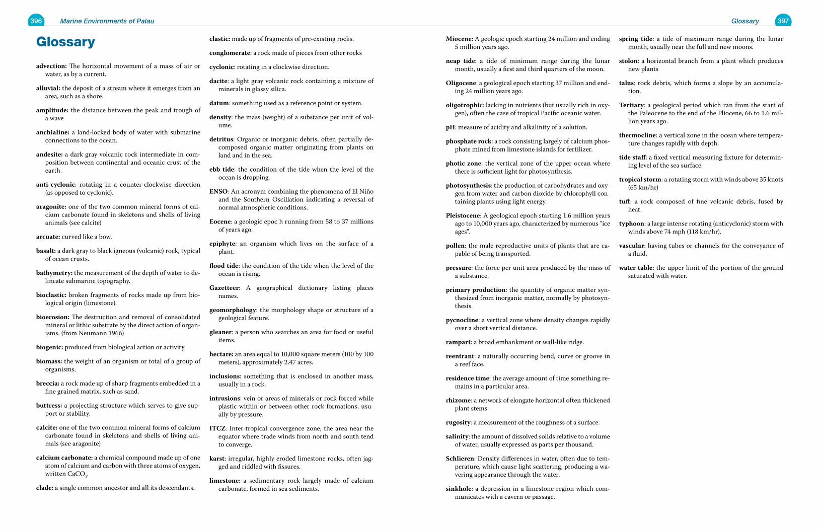
396 Marine Environments of Palau 397Glossary
Glossary
advection: The horizontal movement of a mass of air or water, as by a current.
alluvial: the deposit of a stream where it emerges from an area, such as a shore.
amplitude: the distance between the peak and trough of a wave
anchialine: a land-locked body of water with submarine connections to the ocean.
andesite: a dark gray volcanic rock intermediate in com-position between continental and oceanic crust of the earth.
anti-cyclonic: rotating in a counter-clockwise direction (as opposed to cyclonic).
aragonite: one of the two common mineral forms of cal-cium carbonate found in skeletons and shells of living animals (see calcite)
arcuate: curved like a bow.
basalt: a dark gray to black igneous (volcanic) rock, typical of ocean crusts.
bathymetry: the measurement of the depth of water to de-lineate submarine topography.
bioclastic: broken fragments of rocks made up from bio-logical origin (limestone).
bioerosion: The destruction and removal of consolidated mineral or lithic substrate by the direct action of organ-isms. (from Neumann 1966)
biogenic: produced from biological action or activity.
biomass: the weight of an organism or total of a group of organisms.
breccia: a rock made up of sharp fragments embedded in a fine grained matrix, such as sand.
buttress: a projecting structure which serves to give sup-port or stability.
calcite: one of the two common mineral forms of calcium carbonate found in skeletons and shells of living ani-mals (see aragonite)
calcium carbonate: a chemical compound made up of one atom of calcium and carbon with three atoms of oxygen, written CaCO3.
clade: a single common ancestor and all its descendants.
clastic: made up of fragments of pre-existing rocks.
conglomerate: a rock made of pieces from other rocks
cyclonic: rotating in a clockwise direction.
dacite: a light gray volcanic rock containing a mixture of minerals in glassy silica.
datum: something used as a reference point or system.
density: the mass (weight) of a substance per unit of vol-ume.
detritus: Organic or inorganic debris, often partially de-composed organic matter originating from plants on land and in the sea.
ebb tide: the condition of the tide when the level of the ocean is dropping.
ENSO: An acronym combining the phenomena of El Niño and the Southern Oscillation indicating a reversal of normal atmospheric conditions.
Eocene: a geologic epoc h running from 58 to 37 millions of years ago.
epiphyte: an organism which lives on the surface of a plant.
flood tide: the condition of the tide when the level of the ocean is rising.
Gazetteer: A geographical dictionary listing places names.
geomorphology: the morphology shape or structure of a geological feature.
gleaner: a person who searches an area for food or useful items.
hectare: an area equal to 10,000 square meters (100 by 100 meters), approximately 2.47 acres.
inclusions: something that is enclosed in another mass, usually in a rock.
intrusions: vein or areas of minerals or rock forced while plastic within or between other rock formations, usu-ally by pressure.
ITCZ: Inter-tropical convergence zone, the area near the equator where trade winds from north and south tend to converge.
karst: irregular, highly eroded limestone rocks, often jag-ged and riddled with fissures.
limestone: a sedimentary rock largely made of calcium carbonate, formed in sea sediments.
Miocene: A geologic epoch starting 24 million and ending 5 million years ago.
neap tide: a tide of minimum range during the lunar month, usually a first and third quarters of the moon.
Oligocene: a geological epoch starting 37 million and end-ing 24 million years ago.
oligotrophic: lacking in nutrients (but usually rich in oxy-gen), often the case of tropical Pacific oceanic water.
pH: measure of acidity and alkalinity of a solution.
phosphate rock: a rock consisting largely of calcium phos-phate mined from limestone islands for fertilizer.
photic zone: the vertical zone of the upper ocean where there is sufficient light for photosynthesis.
photosynthesis: the production of carbohydrates and oxy-gen from water and carbon dioxide by chlorophyll con-taining plants using light energy.
Pleistocene: A geological epoch starting 1.6 million years ago to 10,000 years ago, characterized by numerous "ice ages".
pollen: the male reproductive units of plants that are ca-pable of being transported.
pressure: the force per unit area produced by the mass of a substance.
primary production: the quantity of organic matter syn-thesized from inorganic matter, normally by photosyn-thesis.
pycnocline: a vertical zone where density changes rapidly over a short vertical distance.
rampart: a broad embankment or wall-like ridge.
reentrant: a naturally occurring bend, curve or groove in a reef face.
residence time: the average amount of time something re-mains in a particular area.
rhizome: a network of elongate horizontal often thickened plant stems.
rugosity: a measurement of the roughness of a surface.
salinity: the amount of dissolved solids relative to a volume of water, usually expressed as parts per thousand.
Schlieren: Density differences in water, often due to tem-perature, which cause light scattering, producing a wa-vering appearance through the water.
sinkhole: a depression in a limestone region which com-municates with a cavern or passage.
spring tide: a tide of maximum range during the lunar month, usually near the full and new moons.
stolon: a horizontal branch from a plant which produces new plants
talus: rock debris, which forms a slope by an accumula-tion.
Tertiary: a geological period which ran from the start of the Paleocene to the end of the Pliocene, 66 to 1.6 mil-lion years ago.
thermocline: a vertical zone in the ocean where tempera-ture changes rapidly with depth.
tide staff: a fixed vertical measuring fixture for determin-ing level of the sea surface.
tropical storm: a rotating storm with winds above 35 knots (65 km/hr)
tuff: a rock composed of fine volcanic debris, fused by heat.
typhoon: a large intense rotating (anticyclonic) storm with winds above 74 mph (118 km/hr).
vascular: having tubes or channels for the conveyance of a fluid.
water table: the upper limit of the portion of the ground saturated with water.
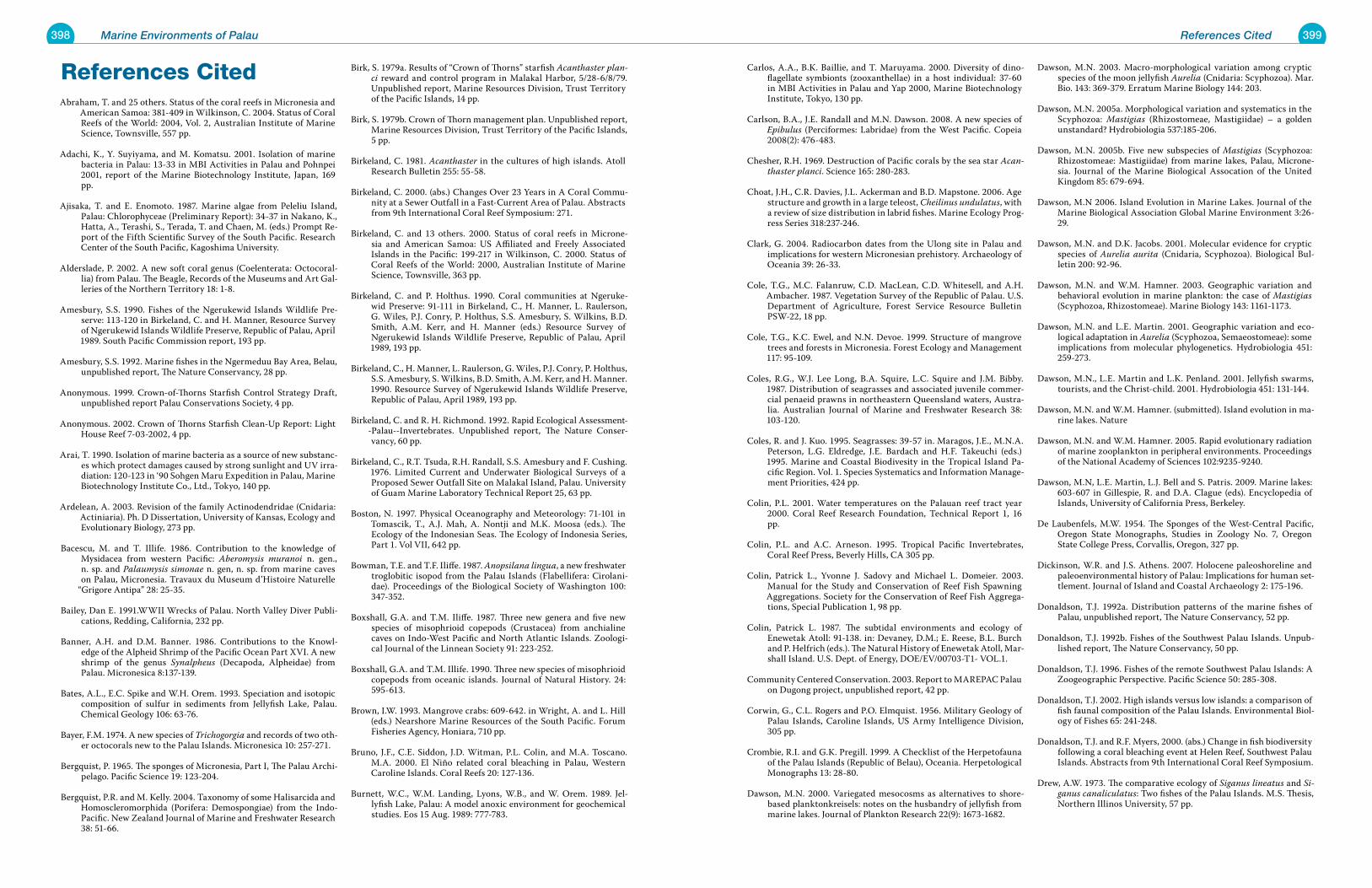
398 Marine Environments of Palau 399References Cited
References CitedAbraham, T. and 25 others. Status of the coral reefs in Micronesia and
American Samoa: 381-409 in Wilkinson, C. 2004. Status of Coral Reefs of the World: 2004, Vol. 2, Australian Institute of Marine Science, Townsville, 557 pp.
Adachi, K., Y. Suyiyama, and M. Komatsu. 2001. Isolation of marine bacteria in Palau: 13-33 in MBI Activities in Palau and Pohnpei 2001, report of the Marine Biotechnology Institute, Japan, 169 pp.
Ajisaka, T. and E. Enomoto. 1987. Marine algae from Peleliu Island, Palau: Chlorophyceae (Preliminary Report): 34-37 in Nakano, K., Hatta, A., Terashi, S., Terada, T. and Chaen, M. (eds.) Prompt Re-port of the Fifth Scientific Survey of the South Pacific. Research Center of the South Pacific, Kagoshima University.
Alderslade, P. 2002. A new soft coral genus (Coelenterata: Octocoral-lia) from Palau. The Beagle, Records of the Museums and Art Gal-leries of the Northern Territory 18: 1-8.
Amesbury, S.S. 1990. Fishes of the Ngerukewid Islands Wildlife Pre-serve: 113-120 in Birkeland, C. and H. Manner, Resource Survey of Ngerukewid Islands Wildlife Preserve, Republic of Palau, April 1989. South Pacific Commission report, 193 pp.
Amesbury, S.S. 1992. Marine fishes in the Ngermeduu Bay Area, Belau, unpublished report, The Nature Conservancy, 28 pp.
Anonymous. 1999. Crown-of-Thorns Starfish Control Strategy Draft, unpublished report Palau Conservations Society, 4 pp.
Anonymous. 2002. Crown of Thorns Starfish Clean-Up Report: Light House Reef 7-03-2002, 4 pp.
Arai, T. 1990. Isolation of marine bacteria as a source of new substanc-es which protect damages caused by strong sunlight and UV irra-diation: 120-123 in ‘90 Sohgen Maru Expedition in Palau, Marine Biotechnology Institute Co., Ltd., Tokyo, 140 pp.
Ardelean, A. 2003. Revision of the family Actinodendridae (Cnidaria: Actiniaria). Ph. D Dissertation, University of Kansas, Ecology and Evolutionary Biology, 273 pp.
Bacescu, M. and T. Illife. 1986. Contribution to the knowledge of Mysidacea from western Pacific: Aberomysis muranoi n. gen., n. sp. and Palaumysis simonae n. gen, n. sp. from marine caves on Palau, Micronesia. Travaux du Museum d’Histoire Naturelle
“Grigore Antipa” 28: 25-35.
Bailey, Dan E. 1991.WWII Wrecks of Palau. North Valley Diver Publi-cations, Redding, California, 232 pp.
Banner, A.H. and D.M. Banner. 1986. Contributions to the Knowl-edge of the Alpheid Shrimp of the Pacific Ocean Part XVI. A new shrimp of the genus Synalpheus (Decapoda, Alpheidae) from Palau. Micronesica 8:137-139.
Bates, A.L., E.C. Spike and W.H. Orem. 1993. Speciation and isotopic composition of sulfur in sediments from Jellyfish Lake, Palau. Chemical Geology 106: 63-76.
Bayer, F.M. 1974. A new species of Trichogorgia and records of two oth-er octocorals new to the Palau Islands. Micronesica 10: 257-271.
Bergquist, P. 1965. The sponges of Micronesia, Part I, The Palau Archi-pelago. Pacific Science 19: 123-204.
Bergquist, P.R. and M. Kelly. 2004. Taxonomy of some Halisarcida and Homoscleromorphida (Porifera: Demospongiae) from the Indo-Pacific. New Zealand Journal of Marine and Freshwater Research 38: 51-66.
Birk, S. 1979a. Results of “Crown of Thorns” starfish Acanthaster plan-ci reward and control program in Malakal Harbor, 5/28-6/8/79. Unpublished report, Marine Resources Division, Trust Territory of the Pacific Islands, 14 pp.
Birk, S. 1979b. Crown of Thorn management plan. Unpublished report, Marine Resources Division, Trust Territory of the Pacific Islands, 5 pp.
Birkeland, C. 1981. Acanthaster in the cultures of high islands. Atoll Research Bulletin 255: 55-58.
Birkeland, C. 2000. (abs.) Changes Over 23 Years in A Coral Commu-nity at a Sewer Outfall in a Fast-Current Area of Palau. Abstracts from 9th International Coral Reef Symposium: 271.
Birkeland, C. and 13 others. 2000. Status of coral reefs in Microne-sia and American Samoa: US Affiliated and Freely Associated Islands in the Pacific: 199-217 in Wilkinson, C. 2000. Status of Coral Reefs of the World: 2000, Australian Institute of Marine Science, Townsville, 363 pp.
Birkeland, C. and P. Holthus. 1990. Coral communities at Ngeruke-wid Preserve: 91-111 in Birkeland, C., H. Manner, L. Raulerson, G. Wiles, P.J. Conry, P. Holthus, S.S. Amesbury, S. Wilkins, B.D. Smith, A.M. Kerr, and H. Manner (eds.) Resource Survey of Ngerukewid Islands Wildlife Preserve, Republic of Palau, April 1989, 193 pp.
Birkeland, C., H. Manner, L. Raulerson, G. Wiles, P.J. Conry, P. Holthus, S.S. Amesbury, S. Wilkins, B.D. Smith, A.M. Kerr, and H. Manner. 1990. Resource Survey of Ngerukewid Islands Wildlife Preserve, Republic of Palau, April 1989, 193 pp.
Birkeland, C. and R. H. Richmond. 1992. Rapid Ecological Assessment--Palau--Invertebrates. Unpublished report, The Nature Conser-vancy, 60 pp.
Birkeland, C., R.T. Tsuda, R.H. Randall, S.S. Amesbury and F. Cushing. 1976. Limited Current and Underwater Biological Surveys of a Proposed Sewer Outfall Site on Malakal Island, Palau. University of Guam Marine Laboratory Technical Report 25, 63 pp.
Boston, N. 1997. Physical Oceanography and Meteorology: 71-101 in Tomascik, T., A.J. Mah, A. Nontji and M.K. Moosa (eds.). The Ecology of the Indonesian Seas. The Ecology of Indonesia Series, Part 1. Vol VII, 642 pp.
Bowman, T.E. and T.F. Iliffe. 1987. Anopsilana lingua, a new freshwater troglobitic isopod from the Palau Islands (Flabellifera: Cirolani-dae). Proceedings of the Biological Society of Washington 100: 347-352.
Boxshall, G.A. and T.M. Iliffe. 1987. Three new genera and five new species of misophrioid copepods (Crustacea) from anchialine caves on Indo-West Pacific and North Atlantic Islands. Zoologi-cal Journal of the Linnean Society 91: 223-252.
Boxshall, G.A. and T.M. Illife. 1990. Three new species of misophrioid copepods from oceanic islands. Journal of Natural History. 24: 595-613.
Brown, I.W. 1993. Mangrove crabs: 609-642. in Wright, A. and L. Hill (eds.) Nearshore Marine Resources of the South Pacific. Forum Fisheries Agency, Honiara, 710 pp.
Bruno, J.F., C.E. Siddon, J.D. Witman, P.L. Colin, and M.A. Toscano. M.A. 2000. El Niño related coral bleaching in Palau, Western Caroline Islands. Coral Reefs 20: 127-136.
Burnett, W.C., W.M. Landing, Lyons, W.B., and W. Orem. 1989. Jel-lyfish Lake, Palau: A model anoxic environment for geochemical studies. Eos 15 Aug. 1989: 777-783.
Carlos, A.A., B.K. Baillie, and T. Maruyama. 2000. Diversity of dino-flagellate symbionts (zooxanthellae) in a host individual: 37-60 in MBI Activities in Palau and Yap 2000, Marine Biotechnology Institute, Tokyo, 130 pp.
Carlson, B.A., J.E. Randall and M.N. Dawson. 2008. A new species of Epibulus (Perciformes: Labridae) from the West Pacific. Copeia 2008(2): 476-483.
Chesher, R.H. 1969. Destruction of Pacific corals by the sea star Acan-thaster planci. Science 165: 280-283.
Choat, J.H., C.R. Davies, J.L. Ackerman and B.D. Mapstone. 2006. Age structure and growth in a large teleost, Cheilinus undulatus, with a review of size distribution in labrid fishes. Marine Ecology Prog-ress Series 318:237-246.
Clark, G. 2004. Radiocarbon dates from the Ulong site in Palau and implications for western Micronesian prehistory. Archaeology of Oceania 39: 26-33.
Cole, T.G., M.C. Falanruw, C.D. MacLean, C.D. Whitesell, and A.H. Ambacher. 1987. Vegetation Survey of the Republic of Palau. U.S. Department of Agriculture, Forest Service Resource Bulletin PSW-22, 18 pp.
Cole, T.G., K.C. Ewel, and N.N. Devoe. 1999. Structure of mangrove trees and forests in Micronesia. Forest Ecology and Management 117: 95-109.
Coles, R.G., W.J. Lee Long, B.A. Squire, L.C. Squire and J.M. Bibby. 1987. Distribution of seagrasses and associated juvenile commer-cial penaeid prawns in northeastern Queensland waters, Austra-lia. Australian Journal of Marine and Freshwater Research 38: 103-120.
Coles, R. and J. Kuo. 1995. Seagrasses: 39-57 in. Maragos, J.E., M.N.A. Peterson, L.G. Eldredge, J.E. Bardach and H.F. Takeuchi (eds.) 1995. Marine and Coastal Biodivesity in the Tropical Island Pa-cific Region. Vol. 1. Species Systematics and Information Manage-ment Priorities, 424 pp.
Colin, P.L. 2001. Water temperatures on the Palauan reef tract year 2000. Coral Reef Research Foundation, Technical Report 1, 16 pp.
Colin, P.L. and A.C. Arneson. 1995. Tropical Pacific Invertebrates, Coral Reef Press, Beverly Hills, CA 305 pp.
Colin, Patrick L., Yvonne J. Sadovy and Michael L. Domeier. 2003. Manual for the Study and Conservation of Reef Fish Spawning Aggregations. Society for the Conservation of Reef Fish Aggrega-tions, Special Publication 1, 98 pp.
Colin, Patrick L. 1987. The subtidal environments and ecology of Enewetak Atoll: 91-138. in: Devaney, D.M.; E. Reese, B.L. Burch and P. Helfrich (eds.). The Natural History of Enewetak Atoll, Mar-shall Island. U.S. Dept. of Energy, DOE/EV/00703-T1- VOL.1.
Community Centered Conservation. 2003. Report to MAREPAC Palau on Dugong project, unpublished report, 42 pp.
Corwin, G., C.L. Rogers and P.O. Elmquist. 1956. Military Geology of Palau Islands, Caroline Islands, US Army Intelligence Division, 305 pp.
Crombie, R.I. and G.K. Pregill. 1999. A Checklist of the Herpetofauna of the Palau Islands (Republic of Belau), Oceania. Herpetological Monographs 13: 28-80.
Dawson, M.N. 2000. Variegated mesocosms as alternatives to shore-based planktonkreisels: notes on the husbandry of jellyfish from marine lakes. Journal of Plankton Research 22(9): 1673-1682.
Dawson, M.N. 2003. Macro-morphological variation among cryptic species of the moon jellyfish Aurelia (Cnidaria: Scyphozoa). Mar. Bio. 143: 369-379. Erratum Marine Biology 144: 203.
Dawson, M.N. 2005a. Morphological variation and systematics in the Scyphozoa: Mastigias (Rhizostomeae, Mastigiidae) – a golden unstandard? Hydrobiologia 537:185-206.
Dawson, M.N. 2005b. Five new subspecies of Mastigias (Scyphozoa: Rhizostomeae: Mastigiidae) from marine lakes, Palau, Microne-sia. Journal of the Marine Biological Assocation of the United Kingdom 85: 679-694.
Dawson, M.N 2006. Island Evolution in Marine Lakes. Journal of the Marine Biological Association Global Marine Environment 3:26-29.
Dawson, M.N. and D.K. Jacobs. 2001. Molecular evidence for cryptic species of Aurelia aurita (Cnidaria, Scyphozoa). Biological Bul-letin 200: 92-96.
Dawson, M.N. and W.M. Hamner. 2003. Geographic variation and behavioral evolution in marine plankton: the case of Mastigias (Scyphozoa, Rhizostomeae). Marine Biology 143: 1161-1173.
Dawson, M.N. and L.E. Martin. 2001. Geographic variation and eco-logical adaptation in Aurelia (Scyphozoa, Semaeostomeae): some implications from molecular phylogenetics. Hydrobiologia 451: 259-273.
Dawson, M.N., L.E. Martin and L.K. Penland. 2001. Jellyfish swarms, tourists, and the Christ-child. 2001. Hydrobiologia 451: 131-144.
Dawson, M.N. and W.M. Hamner. (submitted). Island evolution in ma-rine lakes. Nature
Dawson, M.N. and W.M. Hamner. 2005. Rapid evolutionary radiation of marine zooplankton in peripheral environments. Proceedings of the National Academy of Sciences 102:9235-9240.
Dawson, M.N, L.E. Martin, L.J. Bell and S. Patris. 2009. Marine lakes: 603-607 in Gillespie, R. and D.A. Clague (eds). Encyclopedia of Islands, University of California Press, Berkeley.
De Laubenfels, M.W. 1954. The Sponges of the West-Central Pacific, Oregon State Monographs, Studies in Zoology No. 7, Oregon State College Press, Corvallis, Oregon, 327 pp.
Dickinson, W.R. and J.S. Athens. 2007. Holocene paleoshoreline and paleoenvironmental history of Palau: Implications for human set-tlement. Journal of Island and Coastal Archaeology 2: 175-196.
Donaldson, T.J. 1992a. Distribution patterns of the marine fishes of Palau, unpublished report, The Nature Conservancy, 52 pp.
Donaldson, T.J. 1992b. Fishes of the Southwest Palau Islands. Unpub-lished report, The Nature Conservancy, 50 pp.
Donaldson, T.J. 1996. Fishes of the remote Southwest Palau Islands: A Zoogeographic Perspective. Pacific Science 50: 285-308.
Donaldson, T.J. 2002. High islands versus low islands: a comparison of fish faunal composition of the Palau Islands. Environmental Biol-ogy of Fishes 65: 241-248.
Donaldson, T.J. and R.F. Myers, 2000. (abs.) Change in fish biodiversity following a coral bleaching event at Helen Reef, Southwest Palau Islands. Abstracts from 9th International Coral Reef Symposium.
Drew, A.W. 1973. The comparative ecology of Siganus lineatus and Si-ganus canaliculatus: Two fishes of the Palau Islands. M.S. Thesis, Northern Illinos University, 57 pp.
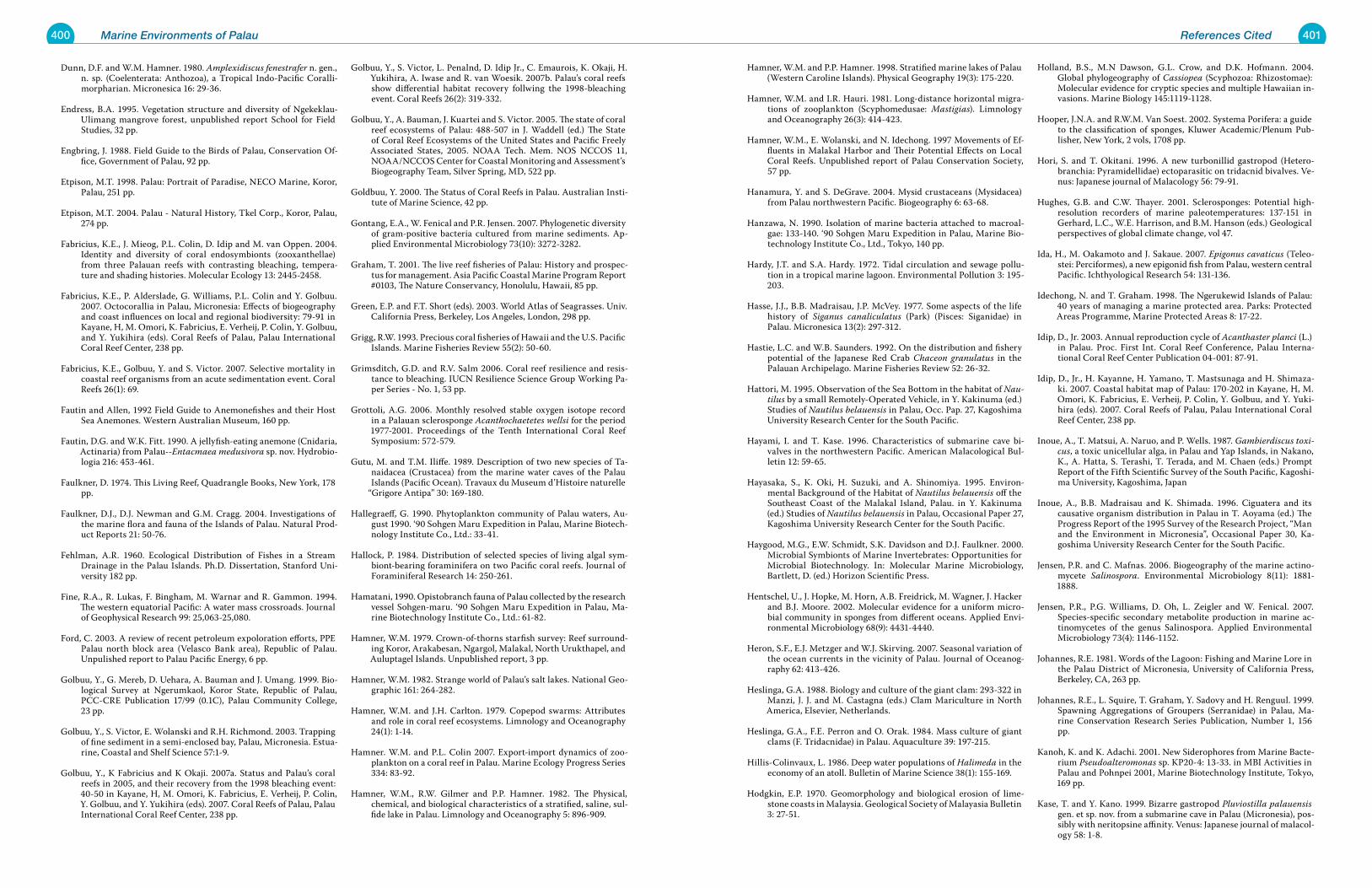
400 Marine Environments of Palau 401References Cited
Dunn, D.F. and W.M. Hamner. 1980. Amplexidiscus fenestrafer n. gen., n. sp. (Coelenterata: Anthozoa), a Tropical Indo-Pacific Coralli-morpharian. Micronesica 16: 29-36.
Endress, B.A. 1995. Vegetation structure and diversity of Ngekeklau-Ulimang mangrove forest, unpublished report School for Field Studies, 32 pp.
Engbring, J. 1988. Field Guide to the Birds of Palau, Conservation Of-fice, Government of Palau, 92 pp.
Etpison, M.T. 1998. Palau: Portrait of Paradise, NECO Marine, Koror, Palau, 251 pp.
Etpison, M.T. 2004. Palau - Natural History, Tkel Corp., Koror, Palau, 274 pp.
Fabricius, K.E., J. Mieog, P.L. Colin, D. Idip and M. van Oppen. 2004. Identity and diversity of coral endosymbionts (zooxanthellae) from three Palauan reefs with contrasting bleaching, tempera-ture and shading histories. Molecular Ecology 13: 2445-2458.
Fabricius, K.E., P. Alderslade, G. Williams, P.L. Colin and Y. Golbuu. 2007. Octocorallia in Palau, Micronesia: Effects of biogeography and coast influences on local and regional biodiversity: 79-91 in Kayane, H, M. Omori, K. Fabricius, E. Verheij, P. Colin, Y. Golbuu, and Y. Yukihira (eds). Coral Reefs of Palau, Palau International Coral Reef Center, 238 pp.
Fabricius, K.E., Golbuu, Y. and S. Victor. 2007. Selective mortality in
coastal reef organisms from an acute sedimentation event. Coral Reefs 26(1): 69.
Fautin and Allen, 1992 Field Guide to Anemonefishes and their Host Sea Anemones. Western Australian Museum, 160 pp.
Fautin, D.G. and W.K. Fitt. 1990. A jellyfish-eating anemone (Cnidaria, Actinaria) from Palau--Entacmaea medusivora sp. nov. Hydrobio-logia 216: 453-461.
Faulkner, D. 1974. This Living Reef, Quadrangle Books, New York, 178 pp.
Faulkner, D.J., D.J. Newman and G.M. Cragg. 2004. Investigations of the marine flora and fauna of the Islands of Palau. Natural Prod-uct Reports 21: 50-76.
Fehlman, A.R. 1960. Ecological Distribution of Fishes in a Stream Drainage in the Palau Islands. Ph.D. Dissertation, Stanford Uni-versity 182 pp.
Fine, R.A., R. Lukas, F. Bingham, M. Warnar and R. Gammon. 1994. The western equatorial Pacific: A water mass crossroads. Journal of Geophysical Research 99: 25,063-25,080.
Ford, C. 2003. A review of recent petroleum expoloration efforts, PPE Palau north block area (Velasco Bank area), Republic of Palau. Unpulished report to Palau Pacific Energy, 6 pp.
Golbuu, Y., G. Mereb, D. Uehara, A. Bauman and J. Umang. 1999. Bio-logical Survey at Ngerumkaol, Koror State, Republic of Palau, PCC-CRE Publication 17/99 (0.1C), Palau Community College, 23 pp.
Golbuu, Y., S. Victor, E. Wolanski and R.H. Richmond. 2003. Trapping of fine sediment in a semi-enclosed bay, Palau, Micronesia. Estua-rine, Coastal and Shelf Science 57:1-9.
Golbuu, Y., K Fabricius and K Okaji. 2007a. Status and Palau’s coral reefs in 2005, and their recovery from the 1998 bleaching event: 40-50 in Kayane, H, M. Omori, K. Fabricius, E. Verheij, P. Colin, Y. Golbuu, and Y. Yukihira (eds). 2007. Coral Reefs of Palau, Palau International Coral Reef Center, 238 pp.
Golbuu, Y., S. Victor, L. Penalnd, D. Idip Jr., C. Emaurois, K. Okaji, H. Yukihira, A. Iwase and R. van Woesik. 2007b. Palau’s coral reefs show differential habitat recovery follwing the 1998-bleaching event. Coral Reefs 26(2): 319-332.
Golbuu, Y., A. Bauman, J. Kuartei and S. Victor. 2005. The state of coral reef ecosystems of Palau: 488-507 in J. Waddell (ed.) The State of Coral Reef Ecosystems of the United States and Pacific Freely Associated States, 2005. NOAA Tech. Mem. NOS NCCOS 11, NOAA/NCCOS Center for Coastal Monitoring and Assessment’s Biogeography Team, Silver Spring, MD, 522 pp.
Goldbuu, Y. 2000. The Status of Coral Reefs in Palau. Australian Insti-tute of Marine Science, 42 pp.
Gontang, E.A., W. Fenical and P.R. Jensen. 2007. Phylogenetic diversity of gram-positive bacteria cultured from marine sediments. Ap-plied Environmental Microbiology 73(10): 3272-3282.
Graham, T. 2001. The live reef fisheries of Palau: History and prospec-tus for management. Asia Pacific Coastal Marine Program Report #0103, The Nature Conservancy, Honolulu, Hawaii, 85 pp.
Green, E.P. and F.T. Short (eds). 2003. World Atlas of Seagrasses. Univ. California Press, Berkeley, Los Angeles, London, 298 pp.
Grigg, R.W. 1993. Precious coral fisheries of Hawaii and the U.S. Pacific Islands. Marine Fisheries Review 55(2): 50-60.
Grimsditch, G.D. and R.V. Salm 2006. Coral reef resilience and resis-tance to bleaching. IUCN Resilience Science Group Working Pa-per Series - No. 1, 53 pp.
Grottoli, A.G. 2006. Monthly resolved stable oxygen isotope record in a Palauan sclerosponge Acanthochaetetes wellsi for the period 1977-2001. Proceedings of the Tenth International Coral Reef Symposium: 572-579.
Gutu, M. and T.M. Iliffe. 1989. Description of two new species of Ta-naidacea (Crustacea) from the marine water caves of the Palau Islands (Pacific Ocean). Travaux du Museum d’Histoire naturelle
“Grigore Antipa” 30: 169-180.
Hallegraeff, G. 1990. Phytoplankton community of Palau waters, Au-gust 1990. ‘90 Sohgen Maru Expedition in Palau, Marine Biotech-nology Institute Co., Ltd.: 33-41.
Hallock, P. 1984. Distribution of selected species of living algal sym-biont-bearing foraminifera on two Pacific coral reefs. Journal of Foraminiferal Research 14: 250-261.
Hamatani, 1990. Opistobranch fauna of Palau collected by the research vessel Sohgen-maru. ‘90 Sohgen Maru Expedition in Palau, Ma-rine Biotechnology Institute Co., Ltd.: 61-82.
Hamner, W.M. 1979. Crown-of-thorns starfish survey: Reef surround-ing Koror, Arakabesan, Ngargol, Malakal, North Urukthapel, and Auluptagel Islands. Unpublished report, 3 pp.
Hamner, W.M. 1982. Strange world of Palau’s salt lakes. National Geo-graphic 161: 264-282.
Hamner, W.M. and J.H. Carlton. 1979. Copepod swarms: Attributes and role in coral reef ecosystems. Limnology and Oceanography 24(1): 1-14.
Hamner. W.M. and P.L. Colin 2007. Export-import dynamics of zoo-plankton on a coral reef in Palau. Marine Ecology Progress Series 334: 83-92.
Hamner, W.M., R.W. Gilmer and P.P. Hamner. 1982. The Physical, chemical, and biological characteristics of a stratified, saline, sul-fide lake in Palau. Limnology and Oceanography 5: 896-909.
Hamner, W.M. and P.P. Hamner. 1998. Stratified marine lakes of Palau (Western Caroline Islands). Physical Geography 19(3): 175-220.
Hamner, W.M. and I.R. Hauri. 1981. Long-distance horizontal migra-tions of zooplankton (Scyphomedusae: Mastigias). Limnology and Oceanography 26(3): 414-423.
Hamner, W.M., E. Wolanski, and N. Idechong. 1997 Movements of Ef-fluents in Malakal Harbor and Their Potential Effects on Local Coral Reefs. Unpublished report of Palau Conservation Society, 57 pp.
Hanamura, Y. and S. DeGrave. 2004. Mysid crustaceans (Mysidacea) from Palau northwestern Pacific. Biogeography 6: 63-68.
Hanzawa, N. 1990. Isolation of marine bacteria attached to macroal-gae: 133-140. ‘90 Sohgen Maru Expedition in Palau, Marine Bio-technology Institute Co., Ltd., Tokyo, 140 pp.
Hardy, J.T. and S.A. Hardy. 1972. Tidal circulation and sewage pollu-tion in a tropical marine lagoon. Environmental Pollution 3: 195-203.
Hasse, J.J., B.B. Madraisau, J.P. McVey. 1977. Some aspects of the life history of Siganus canaliculatus (Park) (Pisces: Siganidae) in Palau. Micronesica 13(2): 297-312.
Hastie, L.C. and W.B. Saunders. 1992. On the distribution and fishery potential of the Japanese Red Crab Chaceon granulatus in the Palauan Archipelago. Marine Fisheries Review 52: 26-32.
Hattori, M. 1995. Observation of the Sea Bottom in the habitat of Nau-tilus by a small Remotely-Operated Vehicle, in Y. Kakinuma (ed.) Studies of Nautilus belauensis in Palau, Occ. Pap. 27, Kagoshima University Research Center for the South Pacific.
Hayami, I. and T. Kase. 1996. Characteristics of submarine cave bi-valves in the northwestern Pacific. American Malacological Bul-letin 12: 59-65.
Hayasaka, S., K. Oki, H. Suzuki, and A. Shinomiya. 1995. Environ-mental Background of the Habitat of Nautilus belauensis off the Southeast Coast of the Malakal Island, Palau. in Y. Kakinuma (ed.) Studies of Nautilus belauensis in Palau, Occasional Paper 27, Kagoshima University Research Center for the South Pacific.
Haygood, M.G., E.W. Schmidt, S.K. Davidson and D.J. Faulkner. 2000. Microbial Symbionts of Marine Invertebrates: Opportunities for Microbial Biotechnology. In: Molecular Marine Microbiology, Bartlett, D. (ed.) Horizon Scientific Press.
Hentschel, U., J. Hopke, M. Horn, A.B. Freidrick, M. Wagner, J. Hacker and B.J. Moore. 2002. Molecular evidence for a uniform micro-bial community in sponges from different oceans. Applied Envi-ronmental Microbiology 68(9): 4431-4440.
Heron, S.F., E.J. Metzger and W.J. Skirving. 2007. Seasonal variation of the ocean currents in the vicinity of Palau. Journal of Oceanog-raphy 62: 413-426.
Heslinga, G.A. 1988. Biology and culture of the giant clam: 293-322 in Manzi, J. J. and M. Castagna (eds.) Clam Mariculture in North America, Elsevier, Netherlands.
Heslinga, G.A., F.E. Perron and O. Orak. 1984. Mass culture of giant clams (F. Tridacnidae) in Palau. Aquaculture 39: 197-215.
Hillis-Colinvaux, L. 1986. Deep water populations of Halimeda in the economy of an atoll. Bulletin of Marine Science 38(1): 155-169.
Hodgkin, E.P. 1970. Geomorphology and biological erosion of lime-stone coasts in Malaysia. Geological Society of Malayasia Bulletin 3: 27-51.
Holland, B.S., M.N Dawson, G.L. Crow, and D.K. Hofmann. 2004. Global phylogeography of Cassiopea (Scyphozoa: Rhizostomae): Molecular evidence for cryptic species and multiple Hawaiian in-vasions. Marine Biology 145:1119-1128.
Hooper, J.N.A. and R.W.M. Van Soest. 2002. Systema Porifera: a guide to the classification of sponges, Kluwer Academic/Plenum Pub-lisher, New York, 2 vols, 1708 pp.
Hori, S. and T. Okitani. 1996. A new turbonillid gastropod (Hetero-branchia: Pyramidellidae) ectoparasitic on tridacnid bivalves. Ve-nus: Japanese journal of Malacology 56: 79-91.
Hughes, G.B. and C.W. Thayer. 2001. Sclerosponges: Potential high-resolution recorders of marine paleotemperatures: 137-151 in Gerhard, L.C., W.E. Harrison, and B.M. Hanson (eds.) Geological perspectives of global climate change, vol 47.
Ida, H., M. Oakamoto and J. Sakaue. 2007. Epigonus cavaticus (Teleo-stei: Perciformes), a new epigonid fish from Palau, western central Pacific. Ichthyological Research 54: 131-136.
Idechong, N. and T. Graham. 1998. The Ngerukewid Islands of Palau: 40 years of managing a marine protected area. Parks: Protected Areas Programme, Marine Protected Areas 8: 17-22.
Idip, D., Jr. 2003. Annual reproduction cycle of Acanthaster planci (L.) in Palau. Proc. First Int. Coral Reef Conference, Palau Interna-tional Coral Reef Center Publication 04-001: 87-91.
Idip, D., Jr., H. Kayanne, H. Yamano, T. Mastsunaga and H. Shimaza-ki. 2007. Coastal habitat map of Palau: 170-202 in Kayane, H, M. Omori, K. Fabricius, E. Verheij, P. Colin, Y. Golbuu, and Y. Yuki-hira (eds). 2007. Coral Reefs of Palau, Palau International Coral Reef Center, 238 pp.
Inoue, A., T. Matsui, A. Naruo, and P. Wells. 1987. Gambierdiscus toxi-cus, a toxic unicellular alga, in Palau and Yap Islands, in Nakano, K., A. Hatta, S. Terashi, T. Terada, and M. Chaen (eds.) Prompt Report of the Fifth Scientific Survey of the South Pacific, Kagoshi-ma University, Kagoshima, Japan
Inoue, A., B.B. Madraisau and K. Shimada. 1996. Ciguatera and its causative organism distribution in Palau in T. Aoyama (ed.) The Progress Report of the 1995 Survey of the Research Project, “Man and the Environment in Micronesia”, Occasional Paper 30, Ka-goshima University Research Center for the South Pacific.
Jensen, P.R. and C. Mafnas. 2006. Biogeography of the marine actino-mycete Salinospora. Environmental Microbiology 8(11): 1881-1888.
Jensen, P.R., P.G. Williams, D. Oh, L. Zeigler and W. Fenical. 2007. Species-specific secondary metabolite production in marine ac-tinomycetes of the genus Salinospora. Applied Environmental Microbiology 73(4): 1146-1152.
Johannes, R.E. 1981. Words of the Lagoon: Fishing and Marine Lore in the Palau District of Micronesia, University of California Press, Berkeley, CA, 263 pp.
Johannes, R.E., L. Squire, T. Graham, Y. Sadovy and H. Renguul. 1999. Spawning Aggregations of Groupers (Serranidae) in Palau, Ma-rine Conservation Research Series Publication, Number 1, 156 pp.
Kanoh, K. and K. Adachi. 2001. New Siderophores from Marine Bacte-rium Pseudoalteromonas sp. KP20-4: 13-33. in MBI Activities in Palau and Pohnpei 2001, Marine Biotechnology Institute, Tokyo, 169 pp.
Kase, T. and Y. Kano. 1999. Bizarre gastropod Pluviostilla palauensis gen. et sp. nov. from a submarine cave in Palau (Micronesia), pos-sibly with neritopsine affinity. Venus: Japanese journal of malacol-ogy 58: 1-8.
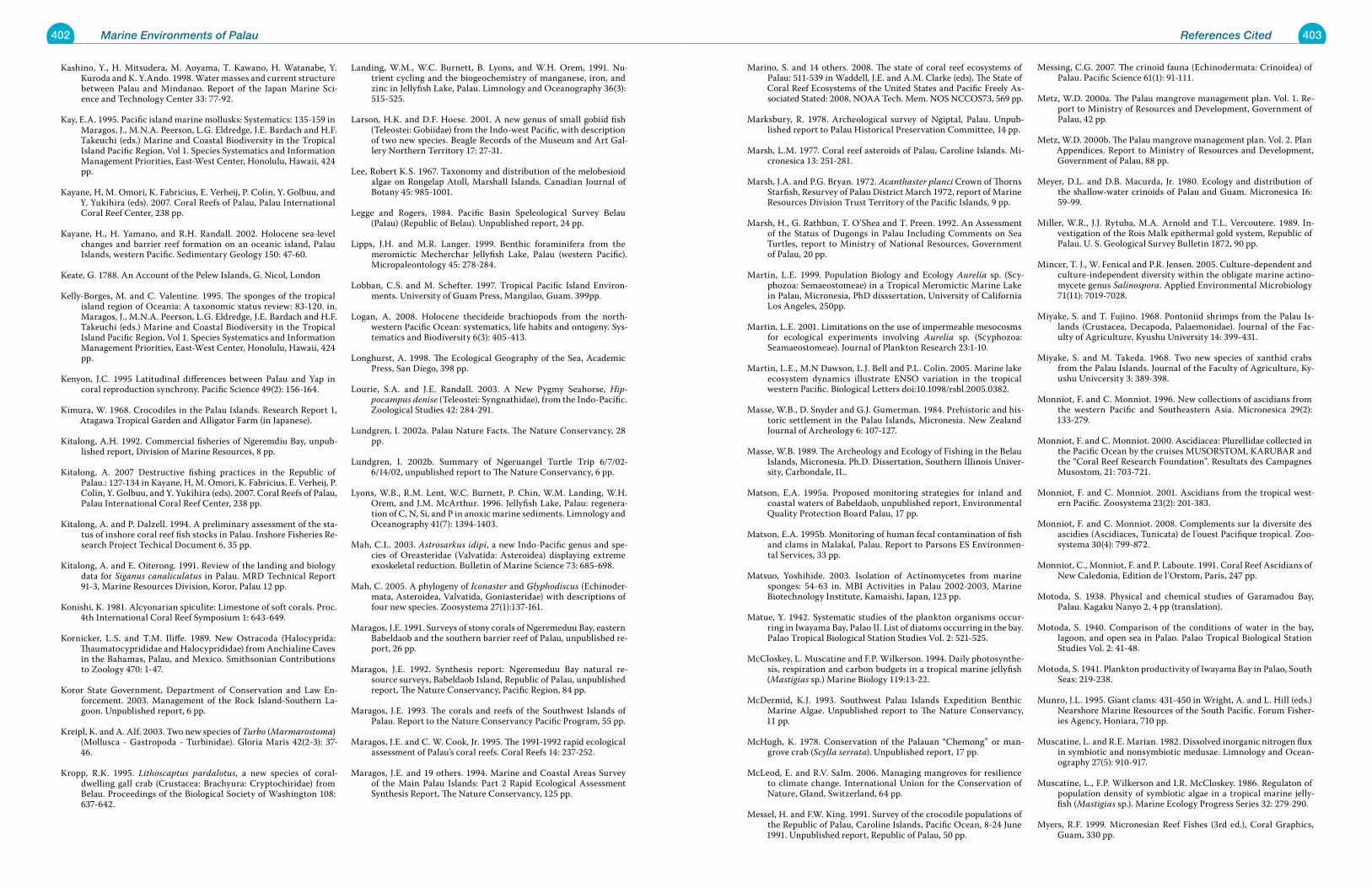
402 Marine Environments of Palau 403References Cited
Kashino, Y., H. Mitsudera, M. Aoyama, T. Kawano, H. Watanabe, Y. Kuroda and K. Y.Ando. 1998. Water masses and current structure between Palau and Mindanao. Report of the Japan Marine Sci-ence and Technology Center 33: 77-92.
Kay, E.A. 1995. Pacific island marine mollusks: Systematics: 135-159 in Maragos, J., M.N.A. Peerson, L.G. Eldredge, J.E. Bardach and H.F. Takeuchi (eds.) Marine and Coastal Biodiversity in the Tropical Island Pacific Region, Vol 1. Species Systematics and Information Management Priorities, East-West Center, Honolulu, Hawaii, 424 pp.
Kayane, H, M. Omori, K. Fabricius, E. Verheij, P. Colin, Y. Golbuu, and Y. Yukihira (eds). 2007. Coral Reefs of Palau, Palau International Coral Reef Center, 238 pp.
Kayane, H., H. Yamano, and R.H. Randall. 2002. Holocene sea-level changes and barrier reef formation on an oceanic island, Palau Islands, western Pacific. Sedimentary Geology 150: 47-60.
Keate, G. 1788. An Account of the Pelew Islands, G. Nicol, London
Kelly-Borges, M. and C. Valentine. 1995. The sponges of the tropical island region of Oceania: A taxonomic status review: 83-120. in. Maragos, J., M.N.A. Peerson, L.G. Eldredge, J.E. Bardach and H.F. Takeuchi (eds.) Marine and Coastal Biodiversity in the Tropical Island Pacific Region, Vol 1. Species Systematics and Information Management Priorities, East-West Center, Honolulu, Hawaii, 424 pp.
Kenyon, J.C. 1995 Latitudinal differences between Palau and Yap in coral reproduction synchrony. Pacific Science 49(2): 156-164.
Kimura, W. 1968. Crocodiles in the Palau Islands. Research Report 1, Atagawa Tropical Garden and Alligator Farm (in Japanese).
Kitalong, A.H. 1992. Commercial fisheries of Ngeremdiu Bay, unpub-lished report, Division of Marine Resources, 8 pp.
Kitalong, A. 2007 Destructive fishing practices in the Republic of Palau.: 127-134 in Kayane, H, M. Omori, K. Fabricius, E. Verheij, P. Colin, Y. Golbuu, and Y. Yukihira (eds). 2007. Coral Reefs of Palau, Palau International Coral Reef Center, 238 pp.
Kitalong, A. and P. Dalzell. 1994. A preliminary assessment of the sta-tus of inshore coral reef fish stocks in Palau. Inshore Fisheries Re-search Project Techical Document 6, 35 pp.
Kitalong, A. and E. Oiterong. 1991. Review of the landing and biology data for Siganus canaliculatus in Palau. MRD Technical Report 91-3, Marine Resources Division, Koror, Palau 12 pp.
Konishi, K. 1981. Alcyonarian spiculite: Limestone of soft corals. Proc. 4th International Coral Reef Symposium 1: 643-649.
Kornicker, L.S. and T.M. Iliffe. 1989. New Ostracoda (Halocyprida: Thaumatocyprididae and Halocyprididae) from Anchialine Caves in the Bahamas, Palau, and Mexico. Smithsonian Contributions to Zoology 470: 1-47.
Koror State Government, Department of Conservation and Law En-forcement. 2003. Management of the Rock Island-Southern La-goon. Unpublished report, 6 pp.
Kreipl, K. and A. Alf. 2003. Two new species of Turbo (Marmarostoma)(Mollusca - Gastropoda - Turbinidae). Gloria Maris 42(2-3): 37-46.
Kropp, R.K. 1995. Lithoscaptus pardalotus, a new species of coral-dwelling gall crab (Crustacea: Brachyura: Cryptochiridae) from Belau. Proceedings of the Biological Society of Washington 108: 637-642.
Landing, W.M., W.C. Burnett, B. Lyons, and W.H. Orem, 1991. Nu-trient cycling and the biogeochemistry of manganese, iron, and zinc in Jellyfish Lake, Palau. Limnology and Oceanography 36(3): 515-525.
Larson, H.K. and D.F. Hoese. 2001. A new genus of small gobiid fish (Teleostei: Gobiidae) from the Indo-west Pacific, with description of two new species. Beagle Records of the Museum and Art Gal-lery Northern Territory 17: 27-31.
Lee, Robert K.S. 1967. Taxonomy and distribution of the melobesioid algae on Rongelap Atoll, Marshall Islands. Canadian Journal of Botany 45: 985-1001.
Legge and Rogers, 1984. Pacific Basin Speleological Survey Belau (Palau) (Republic of Belau). Unpublished report, 24 pp.
Lipps, J.H. and M.R. Langer. 1999. Benthic foraminifera from the meromictic Mecherchar Jellyfish Lake, Palau (western Pacific). Micropaleontology 45: 278-284.
Lobban, C.S. and M. Schefter. 1997. Tropical Pacific Island Environ-ments. University of Guam Press, Mangilao, Guam. 399pp.
Logan, A. 2008. Holocene thecideide brachiopods from the north-western Pacific Ocean: systematics, life habits and ontogeny. Sys-tematics and Biodiversity 6(3): 405-413.
Longhurst, A. 1998. The Ecological Geography of the Sea, Academic Press, San Diego, 398 pp.
Lourie, S.A. and J.E. Randall. 2003. A New Pygmy Seahorse, Hip-pocampus denise (Teleostei: Syngnathidae), from the Indo-Pacific. Zoological Studies 42: 284-291.
Lundgren, I. 2002a. Palau Nature Facts. The Nature Conservancy, 28 pp.
Lundgren, I. 2002b. Summary of Ngeruangel Turtle Trip 6/7/02-6/14/02, unpublished report to The Nature Conservancy, 6 pp.
Lyons, W.B., R.M. Lent, W.C. Burnett, P. Chin, W.M. Landing, W.H. Orem, and J.M. McArthur. 1996. Jellyfish Lake, Palau: regenera-tion of C, N, Si, and P in anoxic marine sediments. Limnology and Oceanography 41(7): 1394-1403.
Mah, C.L. 2003. Astrosarkus idipi, a new Indo-Pacific genus and spe-cies of Oreasteridae (Valvatida: Asteroidea) displaying extreme exoskeletal reduction. Bulletin of Marine Science 73: 685-698.
Mah, C. 2005. A phylogeny of Iconaster and Glyphodiscus (Echinoder-mata, Asteroidea, Valvatida, Goniasteridae) with descriptions of four new species. Zoosystema 27(1):137-161.
Maragos, J.E. 1991. Surveys of stony corals of Ngeremeduu Bay, eastern Babeldaob and the southern barrier reef of Palau, unpublished re-port, 26 pp.
Maragos, J.E. 1992. Synthesis report: Ngeremeduu Bay natural re-source surveys, Babeldaob Island, Republic of Palau, unpublished report, The Nature Conservancy, Pacific Region, 84 pp.
Maragos, J.E. 1993. The corals and reefs of the Southwest Islands of Palau. Report to the Nature Conservancy Pacific Program, 55 pp.
Maragos, J.E. and C. W. Cook, Jr. 1995. The 1991-1992 rapid ecological assessment of Palau’s coral reefs. Coral Reefs 14: 237-252.
Maragos, J.E. and 19 others. 1994. Marine and Coastal Areas Survey of the Main Palau Islands: Part 2 Rapid Ecological Assessment Synthesis Report, The Nature Conservancy, 125 pp.
Marino, S. and 14 others. 2008. The state of coral reef ecosystems of Palau: 511-539 in Waddell, J.E. and A.M. Clarke (eds), The State of Coral Reef Ecosystems of the United States and Pacific Freely As-sociated Stated: 2008, NOAA Tech. Mem. NOS NCCOS73, 569 pp.
Marksbury, R. 1978. Archeological survey of Ngiptal, Palau. Unpub-lished report to Palau Historical Preservation Committee, 14 pp.
Marsh, L.M. 1977. Coral reef asteroids of Palau, Caroline Islands. Mi-cronesica 13: 251-281.
Marsh, J.A. and P.G. Bryan. 1972. Acanthaster planci Crown of Thorns Starfish, Resurvey of Palau District March 1972, report of Marine Resources Division Trust Territory of the Pacific Islands, 9 pp.
Marsh, H., G. Rathbun, T. O’Shea and T. Preen. 1992. An Assessment of the Status of Dugongs in Palau Including Comments on Sea Turtles, report to Ministry of National Resources, Government of Palau, 20 pp.
Martin, L.E. 1999. Population Biology and Ecology Aurelia sp. (Scy-phozoa: Semaeostomeae) in a Tropical Meromictic Marine Lake in Palau, Micronesia, PhD disssertation, University of California Los Angeles, 250pp.
Martin, L.E. 2001. Limitations on the use of impermeable mesocosms for ecological experiments involving Aurelia sp. (Scyphozoa: Seamaeostomeae). Journal of Plankton Research 23:1-10.
Martin, L.E., M.N Dawson, L.J. Bell and P.L. Colin. 2005. Marine lake ecosystem dynamics illustrate ENSO variation in the tropical western Pacific. Biological Letters doi:10.1098/rsbl.2005.0382.
Masse, W.B., D. Snyder and G.J. Gumerman. 1984. Prehistoric and his-toric settlement in the Palau Islands, Micronesia. New Zealand Journal of Archeology 6: 107-127.
Masse, W.B. 1989. The Archeology and Ecology of Fishing in the Belau Islands, Micronesia. Ph.D. Dissertation, Southern Illinois Univer-sity, Carbondale, IL.
Matson, E.A. 1995a. Proposed monitoring strategies for inland and coastal waters of Babeldaob, unpublished report, Environmental Quality Protection Board Palau, 17 pp.
Matson, E.A. 1995b. Monitoring of human fecal contamination of fish and clams in Malakal, Palau. Report to Parsons ES Environmen-tal Services, 33 pp.
Matsuo, Yoshihide. 2003. Isolation of Actinomycetes from marine sponges: 54-63 in. MBI Activities in Palau 2002-2003, Marine Biotechnology Institute, Kamaishi, Japan, 123 pp.
Matue, Y. 1942. Systematic studies of the plankton organisms occur-ring in Iwayama Bay, Palao II. List of diatoms occurring in the bay. Palao Tropical Biological Station Studies Vol. 2: 521-525.
McCloskey, L. Muscatine and F.P. Wilkerson. 1994. Daily photosynthe-sis, respiration and carbon budgets in a tropical marine jellyfish (Mastigias sp.) Marine Biology 119:13-22.
McDermid, K.J. 1993. Southwest Palau Islands Expedition Benthic Marine Algae. Unpublished report to The Nature Conservancy, 11 pp.
McHugh, K. 1978. Conservation of the Palauan “Chemong” or man-grove crab (Scylla serrata). Unpublished report, 17 pp.
McLeod, E. and R.V. Salm. 2006. Managing mangroves for resilience to climate change. International Union for the Conservation of Nature, Gland, Switzerland, 64 pp.
Messel, H. and F.W. King. 1991. Survey of the crocodile populations of the Republic of Palau, Caroline Islands, Pacific Ocean, 8-24 June 1991. Unpublished report, Republic of Palau, 50 pp.
Messing, C.G. 2007. The crinoid fauna (Echinodermata: Crinoidea) of Palau. Pacific Science 61(1): 91-111.
Metz, W.D. 2000a. The Palau mangrove management plan. Vol. 1. Re-port to Ministry of Resources and Development, Government of Palau, 42 pp.
Metz, W.D. 2000b. The Palau mangrove management plan. Vol. 2. Plan Appendices. Report to Ministry of Resources and Development, Government of Palau, 88 pp.
Meyer, D.L. and D.B. Macurda, Jr. 1980. Ecology and distribution of the shallow-water crinoids of Palau and Guam. Micronesica 16: 59-99.
Miller, W.R., J.J. Rytuba, M.A. Arnold and T.L. Vercoutere. 1989. In-vestigation of the Rois Malk epithermal gold system, Republic of Palau. U. S. Geological Survey Bulletin 1872, 90 pp.
Mincer, T. J., W. Fenical and P.R. Jensen. 2005. Culture-dependent and culture-independent diversity within the obligate marine actino-mycete genus Salinospora. Applied Environmental Microbiology 71(11): 7019-7028.
Miyake, S. and T. Fujino. 1968. Pontoniid shrimps from the Palau Is-lands (Crustacea, Decapoda, Palaemonidae). Journal of the Fac-ulty of Agriculture, Kyushu University 14: 399-431.
Miyake, S. and M. Takeda. 1968. Two new species of xanthid crabs from the Palau Islands. Journal of the Faculty of Agriculture, Ky-ushu Univcersity 3: 389-398.
Monniot, F. and C. Monniot. 1996. New collections of ascidians from the western Pacific and Southeastern Asia. Micronesica 29(2): 133-279.
Monniot, F. and C. Monniot. 2000. Ascidiacea: Plurellidae collected in the Pacific Ocean by the cruises MUSORSTOM, KARUBAR and the “Coral Reef Research Foundation”. Resultats des Campagnes Musostom, 21: 703-721.
Monniot, F. and C. Monniot. 2001. Ascidians from the tropical west-ern Pacific. Zoosystema 23(2): 201-383.
Monniot, F. and C. Monniot. 2008. Complements sur la diversite des ascidies (Ascidiaces, Tunicata) de l’ouest Pacifique tropical. Zoo-systema 30(4): 799-872.
Monniot, C., Monniot, F. and P. Laboute. 1991. Coral Reef Ascidians of New Caledonia, Edition de l’Orstom, Paris, 247 pp.
Motoda, S. 1938. Physical and chemical studies of Garamadou Bay, Palau. Kagaku Nanyo 2, 4 pp (translation).
Motoda, S. 1940. Comparison of the conditions of water in the bay, lagoon, and open sea in Palao. Palao Tropical Biological Station Studies Vol. 2: 41-48.
Motoda, S. 1941. Plankton productivity of Iwayama Bay in Palao, South Seas: 219-238.
Munro, J.L. 1995. Giant clams: 431-450 in Wright, A. and L. Hill (eds.) Nearshore Marine Resources of the South Pacific. Forum Fisher-ies Agency, Honiara, 710 pp.
Muscatine, L. and R.E. Marian. 1982. Dissolved inorganic nitrogen flux in symbiotic and nonsymbiotic medusae. Limnology and Ocean-ography 27(5): 910-917.
Muscatine, L., F.P. Wilkerson and I.R. McCloskey. 1986. Regulaton of population density of symbiotic algae in a tropical marine jelly-fish (Mastigias sp.). Marine Ecology Progress Series 32: 279-290.
Myers, R.F. 1999. Micronesian Reef Fishes (3rd ed.), Coral Graphics, Guam, 330 pp.
404 Marine Environments of Palau 405References Cited
Nadaoka, K. 2002. Report on field surveys for currents and sedimanta-tion in the lagoon of Palau. Report from Tokyo Institute of Tech-nology, 12 pp.
Nakanishi, K. 1991. Distribution of seaweeds in southern sea of the Palau Islands. Report ‘91 Sohgen Maru Expedition in Palau: 76-129.
Nash, W.J. 1993. Trochus: 451-496 in Wright, A. and L. Hill (eds.) Near-shore Marine Resources of the South Pacific. Forum Fisheries Agency, Honiara, 710 pp.
Neumann, A.C. 1966. Observations on coastal erosion in Bermuda and measurements of the boring rate of the sponge Cliona lampa. Limnology and Oceanography 11: 92-104.
Newman, L.J. and L.R.G. Cannon. 1997. Nine new species of Pseudo-biceros (Platyhelminthes: Polycladida) from the Indo-Pacific. The Raffles Bulletin of Zoology 45: 341-368.
Newman, L.J. and L.R.G. Cannon. 2003. Marine Flatworms. The World of Polyclads, CSIRO Publishing, 97 pp.
Newman, L.J., G. Paulay and R. Ritson-Williams. 2003. Checklist of polyclad flatworms (Platyheminthes) from Micronesian coral reefs. Micronesica 35-36: 189-199.
New York Times (Editorial). 2007, Pacific Miracles, 21 April 2007 Edi-tion.
Ng, P.K.L. and R.B. Manning. 1998. A new deep-water crab from Belau, Micronesia, with a key to the Pacific species of Chaceon (Crusta-cea: Decapoda: Brachyura: Geryonidae). Proceedings of the Bio-logical Society of Washington 111: 389-397.
Nozawa, K. 1942. Systematic studies of the plankton organisms occur-ring in Iwayama Bay, Palao V. Two planktonic suctorians from Palao. Palao Tropical Biological Station Studies Vol. 2: 581-584.
Ofwegen, L.P. van. 2005. A new genus of nephtheid soft corals (Octo-corallia: Alcyonacea: Nephtheidae) from the Indo-Pacific. Zoolo-gische Mededelingen Leiden 79: 1-236.
Ofwegen, L.P. van. 2008. The genus Sinularia at Palau. Zoologische Mededelingen Leiden 82: 631-735.
Ogden, J.C. and N.B. Ogden. 1982. A preliminary study of two rep-resentative seagrass communities in Palau, Western Caroline Is-lands. Aquatic Botany 12: 229-244.
Ohba, H., S. Victor, Y. Golbuu and H. Yukihira. 2007. Tropical Marine Plants of Palau, Palau International Coral Reef Center, 154 pp.
Ohba, H. 1996. The benthic marine flora of the Palau Islands (WCI): New records, missing records and implications for biodiversity: 45-54, in T. Aoyama (Ed.), Progress Report of the 1995 Survey of the Research Project, “Man and the Environment in Micronesia.” Kagoshima University, Research Center for the South Pacific, Oc-casional Paper No. 30.
Okutani, T. and Y. Kurata. 1998. An unusual molluscan assemblage containing Perotrochus africanus teramachii on the insular shelf of Palau Islands. Venus: Japanese Journal of Malacology 57: 11-16.
Omori, M. 2007. Appendix 1: Scientific research of Palau: 204-209 in Kayane, H, M. Omori, K. Fabricius, E. Verheij, P. Colin, Y. Golbuu, and Y. Yukihira (eds). 2007. Coral Reefs of Palau, Palau Interna-tional Coral Reef Center, 238 pp.
Omori, M. and H. Yukihara 2007. Appendix 2: Bibliography of marine science in Palau: 210-229 in Kayane, H, M. Omori, K. Fabricius, E. Verheij, P. Colin, Y. Golbuu, and Y. Yukihira (eds). 2007. Coral Reefs of Palau, Palau International Coral Reef Center, 238 pp.
Opresko, D.M. 2004. Revision of the Antipatharia (Cnidaria: Antho-zoa). Part IV. Establishment of a new family, Aphanipathidae. Zo-ologische Mededelingen Leiden 78: 209-240.
Orem, W.H., W.C. Burnett, W.M. Landing, W.B. Lyons, and W. Show-ers. 1991. Jellyfish Lake, Palau: Early diagenisis of organic matter in sediments of an anoxic marine lake. Limnology and Oceanog-raphy 36(3): 526-543.
Osborne, D. 1966. The Archeology of the Palau Islands. An Intensive Survey. Bernice P. Bishop Museum Bulletin 230: 1-497.
Pala, C. 2007. No-fishing zones in tropics yield fast payoffs for reefs, New York Times article, Environmental Section, 18 April 2007.
Palau Conservation Society. 2002. Ngemai Conservation Area: Moni-toring Results 1997-2001, Unpublished report of the Palau Con-servation Society, 19 pp.
Palau Conservation Society 2008. Northern Reefs Assessment. Unpub-lished report, 16 pp.
Parenti, L.R. and J.A. Maciolek. 1993. New sicydiine gobies from Ponape and Palau, Micronesia, with comments on systematics of the subfamily Sicydiinae (Teleostei: Gobidae). Bulletin of Marine Science 53: 945-972.
Paulay, G. 2003. The Marine Biodiversity of Guam, Micronesica 35-36, 682 pp.
Pawson, D.L. 1995. Echinoderms of the tropical island Pacific: Status of their systematics and notes on their ecology and biogeography: 171-192 in Maragos, J.,M.N.A. Peerson, L.G. Eldredge, J.E. Bar-dackk and H.F. Takeuchi (eds.) Marine and Coastal Biodiversity in the Tropical Island Pacific Region, Vol 1. Species Systematics and Information Mangement Priorities, East-West Center, Hono-lulu, Hawaii, 424 pp.
Payri, C. and O. Naim. 1982. Variations entre 1971 et 1980 de la bio-masse et de la composition des populations de macro-algues sur le recif corallien de Tiaura (Ile de Moore, Polynesie francaise). Cryptogamie Algologie 3: 229-240.
Payri, C. and V. Stiger. 2001. Macroalgal community changes on French Polynesia reefs, 1980-2000. Phycologia 40(4): 111.
Penland, L., J. Kloulechad, D. Idip and R. van Woesik. 2004. Coral spawning in the western Pacific Ocean is related to solar insola-tion: evidence of multiple spawning events in Palau. Coral Reefs 23: 133-140.
Pezold, F. 1998. Three New Species of Oxyurichthys (Teleostei: Gobii-dae) from the Indian and Pacific Oceans. Copeia 1998: 687-695.
Phear, S. 2007. The monumental earthworks of Palau, Micronesia: A landscape perspective. BAR International Series 1626
Porter, J.W., K.G. Porter and Z. Batac-Catalan. 1977. Quantitative sam-pling of Indo-Pacific demersal reef plankton. Proceedings of the Third International Coral Reef Symposium, Vol. 1: 105-112.
Pratt, H.D. and M.T. Etpison. 2008. The Birds and Bats of Palau. Mu-tual Publishing, Honolulu, 290 pp.
Pyle, R.L., J.L. Earle and B.D. Greene. 2008. Five new species of the damselfish genus Chromis (Perciformes: Labroidei: Pomacentri-dae) from deep coral reefs in the western Pacific. Zootaxa 1671: 3-31.
Randall, J.E. 1980. A survey of ciguatera at Enewetak and Bikini, Mar-shall Islands, with notes on the systematics and food habits of ciguatoxic fishes. Fisheries Bulletin 78(2): 201-249.
Randall, R.H. 1990. The General Geographic and Geologic Setting, Physiographic Description, and Community Structure of the Reef-Building Corals of Ngesaol Reef, Palau. University of Guam report, 43 pp.
Randall, R.H. 1995. Biogeography of reef-building corals in the Mari-ana and Palau Islands in relation to back-arc rifting and the for-mation of the eastern Philippine Sea. Natural History Research 3: 193-210.
Randall, R.H. and H. Kayane. 1990. Coral community structure of Palau barrier reef. Unpublished report, 58 pp.
Randall, R.H., C. Birkeland, S.S. Amesbury, D. Lassuy and J.R. Eads. 1978. Marine survey of a proposed resort site at Arakebesan Is-land, Palau. University of Guam Technical Report 44: 1-80.
Richmond, R. and 17 others. 2002. Status of coral reefs in Micronesia and American Samoa: US Affiliated and Freely Associated Islands in the Pacific: 217-236 in Wilkinson, C. (ed.) 2002. Status of Coral Reefs of the World: 2002, Australian Institute of Marine Science, Townsville, 378 pp.
Richmond, R.H. and C.L. Hunter 1990. Reproduction and recruitment of corals: Comparisons among the Caribbean, the tropical Pacific, and the Red Sea. Marine Ecology Progress Series 60: 185-203.
Ruetzler, K. and K. Muzik. 1993. Terpios hoshinota, a new cyanobacte-riosponge threatening Pacific reefs. Scientia Marina 57: 395-403.
Sapio, David 2003. Palau Environment and Culture Bibliography, 6 CD collections, Marepac, Palau.
Sapp, J. 1999. What Is Natural?, Oxford University Press, New York, 275 pp.
Saunders, W.B. 1981. A new species of Nautilus from Palau. The Veliger 24: 1-7.
Saunders, W.B. 1983. The role of living Nautilus in Its natural habitat: Evidence from deep water remote camera photosequences, Sum-mary Report to Marine Resources, Palau, 12 pp.
Saunders, W.B. and C. Spinosa. 1979. Nautilus movement and distribu-tion in Palau, western Caroline Islands. Science 204: 1199-1201.
Sawicki, T.R., J.R. Holsinger and T.R. Illife. 2005. New species of am-phipod crustaceans of the genera Tegano and Melita (Hadzioidea: Melitidae) from subterranean groundwaters in Guam, Palau and the Philippines. Journal of Crustacean Biology 25(1): 49-74.
Short, F.T.,R.G. Coles and C. Pergent-Martini. 2001. Global seagrass distribution: 5-30 in. Short, F.T., R.G. Coles (eds.), Global Sea-grass Research Methods, Elsevier, Amsterdam, 473 pp.
Skirving, W. S. Heron, C. Steinberg, A.E. Strong, C. McLean, M. Heron, S. Choukroun, F. Arzayus and A. Bauman. 2005. Palau Modeling Final Report. Report to The Nature Conservancy, 35 pp.
Smith, B.D. 1989. Marine macroinvertebrates of the Ngerukewid Is-lands wildlife reserve: 131-147. in Birkeland, C., H. Manner, L. Raulerson, G. Wiles, P.J. Conry, P. Holthus, S.S. Amesbury, S. Wilkins, B.D. Smith, A.M. Kerr, and H. Manner (eds.), Resource Survey of Ngerukewid Islands Wildlife Preserve, Republic of Palau, April 1989, 193 pp.
Smith, G.F. 1984. A Belauan Ethnography of Marine Environments. MS Thesis, University of Hawaii, 86 pp. Stearns, Harold T. 1945. Decadent coral reef on Eniwetok Island, Marshall group. Bulletin of the Geological Society of America. 56: 783-788.
Stiger, V. and C. Payri. 1999. Spatial and seasonal variation in the bio-logical characteristics of two invasive brown algae, Turbinaria or-nata (Turner) J. Agardh and Sargassum mangarenvense (Grunow) Setchell (Sargassaceae, Fucales) spreading on the reefs of Tahiti (French Polynesia). Botanica Marina 42: 295-306.
Suchanek, Thomas H. and Patrick L. Colin. 1986. Rates and effect of bioturbation by invertebrates and fishes at Enewetak and bikini Atolls. Bulletin of Marine Science 38(1): 25-34.
Suchanek, Thomas H., Patrick L. Colin, Gary M. McMurtry and Cindy S. Suchanek. 1986. Bioturbation and redistribution of sediments radionuclides in Enewetak Atoll lagoon by callianassid shrimp: biological aspects. Bulletin of Marine Science 38(1): 144-154.
Sussman, M., D.G. Bourne and B.L. Willis. 2006. A single cyanobacte-ria ribotype is associated with both red and black bands on dis-eased corals in Palau. Diseases of Aquatic Organisms 69: 111-118.
Suzuki, H. and A. Shinomiya. 1995. Study on the fauna associated with Nautilus belauensis in the area off the southeast coast of the Palau Islands. In Kakinuma, Y. (ed.) Studies of Nautilus belauen-sis in Palau, Kagoshima University Research Center for the South Pacific Occ. Pap. 27
Suzuki, H. and M. Takeda. 1987. Occurrence of a new hermit crab of the genus Porcellanopagurus (Decapoda, Paguridae) in the sea adjacent to the Palau Islands. Procedings of the Japanese Society of Systematic Zoology 36: 17-24.
Takahashi, K. 1941. Polychaeta of the Palao Islands of the South Sea Islands. Palao Tropical Biological Station Studies Vol. 2: 157-217.
Takeda, M. 1989. Biogeographical distribution of crabs from the Palau Islands: 45-56 in Ohba, H., I. Hayami and K. Mochizuki (eds.) Current Aspects of Biogeography in West Pacific and East Asian Regions, University of Tokyo
Takeda, M. 1971. New and rare crabs from the Palau Islands. Micro-nesica 7: 185-213.
Takeda, M. 1973. Studies on the Crustacea Brachyura of the Palau Is-lands I. Dromiidae, Dynomenidae, Calappidae, Leucosiidae, Hy-menosomatidae, Majidae and Parthenopidae. Bulletin of Liberal Arts and Sciences Course, Nihon University School of Medicine 1: 75-122.
Takeda, M. 1976. Studies on the Crustacea Brachyura of the Palau Is-lands, III. Xanthidae (1). Researches on Crustacea, Carcinological Society of Japan 7: 69-99.
Takeda, M. and H. Hiyashi. 1973. On a small collection of crabs from the Palau Islands. Bulletin of Liberal Arts and Sciences Course, Nihon University School of Medicine 1: 69-74.
Takeda, M. and S. Shimazake 1974. Studies on the Crustacea Brachyu-ra of the Palau Islands II. Atelecyclidae, Portunidae, Goneplaci-dae, Pinnotheridae and Palicidae. Bulletin of Liberal Arts and Sci-ences Course, Nihon University School of Medicine 2: 48-79.
Tamura, M. and T. Horiguchi. 2005. Pileidinium ciceropse gen. et sp. nov. (Dinophyceae), a sand-dwelling dinoflagellate from Palau. European Journal of Phycology 40(3): 281-291.
Tan, J.M.L. 1995. A Field Guide to Whales and Dolphins in the Philip-pines, Bookmark Inc., Philippines, 129 pp.
Thayer, C.W. and R.A. Allmon. 1990. Unpalatalble thecideid brachio-pods from Palau: Eoclogical and evoluationary implications: 253-260 in Mackinnon, D.I., D.E. Lee and J.D. Campbell (eds). Bra-chiopods Through Time, Balkema, Rotterdam.
Tokioka, T. 1950. Ascidians from the Palao Islands. Publications of the Seto Marine Biological Laboratory. 1: 115-154.
Tokioka, T. 1955. Ascidians from the Palao Islands II. Publications of the Seto Marine Biological Laboratory 5: 43-57.
406 Marine Environments of Palau 407Index
Tokioka, T. 1942a. Systematic studies of the plankton organisms oc-curring in Iwayama Bay, Palao. I. Introductory notes, with some references to the surface water temperature and the settling vol-ume of planktons in the bay. Palao Tropical Biological Station Studies Vol. 2: 507-519
Tokioka, T. 1942b. Systematic studies of the plankton organisms oc-curring in Iwayama Bay, Palao. III. Chaetognaths from the bay and adjacent waters. Palao Tropical Biological Station Studies Vol. 2: 527-548.
Tokioka, T. 1942c. Systematic studies of the plankton organisms oc-curring in Iwayama Bay, Palao. VII. A Preliminary report on the appendicularian fauna of the bay and the adjacent waters. Palao Tropical Biological Station Studies Vol. 2: 613-616.
Tomascik, T., A.J. Mah, A. Nontji and M.K. Moosa. 1998. The Ecology of Indonesian Seas, Part I. Periplus Editions, 642 pp.
Tsuda, R.T. 1971. Status of Acanthaster Planci and Coral Reefs in the Mariana and Caroline Islands, June 1970 to May 1971, report from University of Guam, 127 pp.
Tsuda, R.T. 1976. Occurrence of the genus Sargassum (phaeophyta) on two Pacific atolls. Micronesica 12(2): 279-282.
Tsuda, R.T. 1977. Distribution of seagrasses in Micronesia. Microne-sica 13(2): 191-198.
Tsuda, R.T. 1988. Sargassum from Micronesia: 59-63 in Abbott, I.A. (ed.) Taxonomy of Economic Seaweeds, Vol. II. California Sea Grant Program, University of California, La Jolla
Tsuda, R.T. 2002. Checklist of the Marine Benthic Algae from the Palau Archipelago Based on Past References, Palau International Coral Reef Center Publication 02-019, 25 pp.
Tsuda, R.T. 1981. Marine benthic algae of Kayangel Atoll, Palau. Atoll Research Bulletin 255: 43-48.
Turner, P.S. 2006. Darwin’s Jellyfishes. National Wildlife 44(5): 32r-32x (International section).
Uchida, T. 1940’s. Some Medusae from the Central Pacific. Journal of the Faculty of Science Hokkaido University 9: 297-319.
Venkateswaran, K., A. Shimada, A Maruyama, T. Higashihara and T. Maruyama. 1993. Microbial characteristics of Palau Jellyfish Lake. Canadian Journal of Microbiology 39: 506-512.
Vermeij, G.J. 1973. Molluscs in Mangrove Swamps: Physiognomy, Di-versity, and Regional Differences. Systematic Zoology 22: 609-624.
Veron, J.E.N. 2000. Corals of the World, 3 Vol., Australian Institute of Marine Science, Townsville, Australia, 490 pp.
Victor, S. 2007a. Segrasses of Palau: Status and threats: 103-109 in Kayane, H, M. Omori, K. Fabricius, E. Verheij, P. Colin, Y. Golbuu, and Y. Yukihira (eds). 2007. Coral Reefs of Palau, Palau Interna-tional Coral Reef Center, 238 pp.
Victor, S. 2007b. Effects of sedimentation on Palau’s coral reefs: 112-122 in Kayane, H, M. Omori, K. Fabricius, E. Verheij, P. Colin, Y. Golbuu, and Y. Yukihira (eds). 2007. Coral Reefs of Palau, Palau International Coral Reef Center, 238 pp.
Victor, S., Y. Golbuu, E. Wolanski and R. Richmond. 2004. Fine sedi-ment trapping in two mangrove-fringed estuaries exposed to contrasting land-use intensity, Palau, Micronesia. Wetlands Ecol-ogy Management 12: 277-283.
West, J.M. and R.V. Salm. 2003. Resistance and resilience to coral bleaching: Implications for coral reef conservation and manage-ment. Conservation Biology 17: 956-967.
Williams, G.C. 2003. Capitate taxa of the soft coral genus Eleutherobia (Octocorallia: Alcyoniidae) from Palau and South Africa; a new species and a new combination. Zoologische Mededelingen Le-iden 345: 419-436.
Williams, G.W. 1992. Revision of the soft coral genus Minabea (Octo-coralia: Alcyoniidae) with new taxa from the Indo-west Pacific. Proceedings of the California Academy of Sciences 48(1): 1-26.
Wilson, P.T. 1969. Observations of various tuna bait species and their habitats in the Palau Islands. Unpublished report, Marine Re-sources Division, Trust Territory of the Pacific Islands, 28 pp.
Wilson, P.T. 1970. The Skipjack Fishery of the Palau Islands. Trust Ter-ritory of the Pacific Islands, Marine Research Division, 9 pp.
Winterbottom, R. (2005a). Two new species of the Trimma tevegae species group from the western Pacific (Percomorpha; Gobiidae). Aqua 10(1): 51-56.
Winterbottom, R. (2005b). Feia dabra, a new species of gobiid fish (Acanthopterygii; Perciformes) from Palau. Aqua 10(2): 45~50.
Winterbottom, R., A. Iwata and T. Kozawa. (2005). Vanderhorstia nan-nai, a new species of shrimp-associated goby from Palau and the Philippines (Pisces: Gobiidae). Aqua 9(3): 109-114.
Winterbottom, R. and A. C. Gill. (2006). Paraxenisthmus cerberusi, a new species of xenisthmid fish from Palau. Copeia (1): 10-13.
Woesik, R. van, L. Penland, D. Idip Jr. and S. Victor. 2007. Coral spawn-ing in Palau: 73-78 in Kayane, H, M. Omori, K. Fabricius, E. Ver-heij, P. Colin, Y. Golbuu, and Y. Yukihira (eds). 2007. Coral Reefs of Palau, Palau International Coral Reef Center, 238 pp.
Wolanski, E., P.L. Colin, J. Naithani, E. Deleersnijder and Y. Golbuu. 2004. Large amplitude, leaky, island-generated, internal waves around Palau, Micronesia. Estuarine, Coastal and Shelf Science 60: 705-716.
Wolanski, E. and K. Furukawa. 2007. The oceanography of Palau: 59-72 in Kayane, H, M. Omori, K. Fabricius, E. Verheij, P. Colin, Y. Golbuu, and Y. Yukihira (eds). 2007. Coral Reefs of Palau, Palau International Coral Reef Center, 238 pp.
Wyrtki, K. 1961. Physical oceanography of the southeast Asian waters, vol. 2, NAGA Report, University of California San Diego, 195 pp.
Wyrtki, K. 1987. Indonesian Throughflow and the associated pressure gradient. J. Geophys. Res. 92 (C12): 12941-12946.
Yamano, H., H. Kayanne, F. Matsuda and Y. Tsuji. 2002. Lagoonal fa-cies, ages, and sedimentation in three atolls in the Pacific. Marine Geology 185: 233-247.
YINS. 2008. Yap Almanac Calendar: Mangroves and Seagrasses. Yap Institute of Natural Sciences, 20 pp.
Index
place names index
a
Aimeliik State, 5, 145, 150, 152, 294, 308, 348
Airai Bay, 107, 268-269, 292, 296, 299-300, 334-336, 348, 389
Airai State, 3, 8, 105, 158, 160, 194, 198, 241, 292, 295, 297, 300, 348-350
Aiwokako Passage, 35Angaur island, 128-129, 192Arakabesang Island, 220Arangel Channel, 134Babeldaob Island, 4, 186, 292, 301, 388Bablomekang, 202, 234, 240, 242, 267,
351, 382-383
B
Banda, Indonesia, 9Beab reef, 112Bloody Nose Ridge, 11
C
Caroline Islands, 52Carp Island, 40, 145, 162, 272-273Cemetery Reef, 224, 332, 351Chesau, 35, 68, 70, 134Chudel Reef, 42
D
Denges Channel, 27, 67, 80, 82, 101-102
e
Ebiil Channel, 85-87Eil Malk, 189, 242Elechol ra Ngedloch, 273Englishman’s Cove, 228Etiruir, 5
F
Federated States of Micronesia, 2, 182, 311
h
Hatohobei State, 359Helen Reef, 12, 117, 129, 363, 390Honeymoon Beach, 272
i
Idims, 32, 35, 73Imul village, 145, 294, 308
Indonesia, 1-2, 9, 22, 182, 250, 252, 285, 359, 363-364, 377
Ioulomekang, 382-383Iwayama, 9, 24, 157, 161, 188, 197-199,
205-208, 210, 225, 235, 243, 298, 325-326, 332
Iwayama Bay, 9, 157, 161, 188, 197, 199, 205-208, 210, 225, 235, 298, 325, 332
k
Kakaban island, Indonesia, 9, 250, 364Karamado, 3Kayangel atoll, 8, 12, 117-120, 128, 182,
186, 201, 300, 377-378Kayangel State, 347Kekereiel Toi, 221-222Kloul Euchel, 82, 109Kmekumer, 197, 201, 218, 271Koror State, 235, 240-241, 272, 347, 349-
352Koror town, 24, 68, 188, 198, 205, 225-
226, 288, 297, 351, 379, 391-392Kossol Reef, 12, 31, 35, 39, 77-78, 81, 162,
166, 168
l
Lukes, 66, 131
m
Malakal Harbor, 10, 17, 20-22, 33, 71, 82, 102, 104, 133, 136, 157-158, 170, 197-199, 235, 242, 256, 263, 266, 268-269, 288-289, 312-314, 318, 340, 342, 344, 351, 379, 381, 384
Malakal Island, 9, 220, 235, 241, 274, 287-289, 309, 329, 341, 344, 386-387
Maratua Island, Indonesia, 9, 250Mecherchar island, 27, 101, 174, 200,
205-206, 211, 223, 232, 235-237, 240, 244
Meduu ra Ngibtal, 33Mekeald, 238, 242Melekeok State, 31, 56, 187, 270, 294, 302,
390Mesubedumail, 273-274Mocheingel, 273-274Mutremdiu, 23, 54
n
Ngaraard State, 36, 60, 64, 187, 298, 308, 348
Ngarchelong State, 31, 63, 186Ngardmau State, 147Ngaregabal reef, 152Ngaremlengui State, 5-6, 341Ngargol, 8Ngeruangl, 2, 8, 12, 117, 119-122, 127-
129, 186, 269-270, 312-313, 347Ngatpang River, 7, 292, 296, 303
Ngatpang State, 296, 303-304Ngchelobel, 351Ngchesar State, 4, 294, 334Ngchesar village, 146Ngchesechang Conservation Area (Airai
State), 335, 349-350Ngchus, 351Ngeanges Island, 112-113, 189, 221, 373Ngebedangel Island, 279Ngedebus Island, 11, 163, 370Ngederrak Reef, 33-34, 68, 72, 82, 132,
184, 188, 318, 351, 379-381Ngel Channel, 33, 71, 82-83, 104, 158,
181, 267, 318, 380-381Ngelukes Conservation Area, 348Ngemai, 33, 60, 182-183, 298, 352-353,
381-382Ngemelachel, 82, 107, 113Ngemelis, 12, 40, 62-63, 174, 271, 350Ngerael, 67, 81, 110, 165Ngerbeched, 153Ngerchebetan, 64Ngerchelngael, 197Ngercheu group, 40Ngerduweis, 7, 188, 270, 297Ngerebelas Islands, 119Ngerechelchuus, 5Ngerechong, 12, 35, 40-41, 80, 82, 100-
101, 112, 181, 188Ngeremdiu reef, 35, 68, 240Ngeremeduu Bay, 7, 267, 290, 292, 296,
300-305, 348, 390Ngerikiil River, 334, 336Ngerimel, 388-389Ngeriungs, 119, 377, 379Ngerkebesang Conservation Zone, 352Ngerkuul, 205, 220-221Ngerkuul Gap, 205, 220-221Ngermeaus, 200, 206, 221, 232, 234, 271-
272, 351Ngertoell Reef, 60Ngeruangl, 2, 8, 12, 117, 119-122, 127-
129, 186, 269-270, 312-313, 347Ngerukewid, 11, 174, 197, 201, 218-220,
318, 351, 353Ngeruktabel Island, 8-9, 174, 204, 222-
223, 232-233, 238, 240-241, 253-254Ngerumekaol, 30, 35, 46, 82, 87, 94, 98-
100, 111-112, 349, 354-355, 374Ngiwal State, 33, 294, 298, 352Ngkesol, 81-82, 110, 165Ngkisaol, 235, 352Ngos, 165Nikko Bay, 24, 197-198, 345
o
Oikull Conservation Area, 348-349Ollei port, 146Omodes, 9, 197Ongael, 238, 241-243
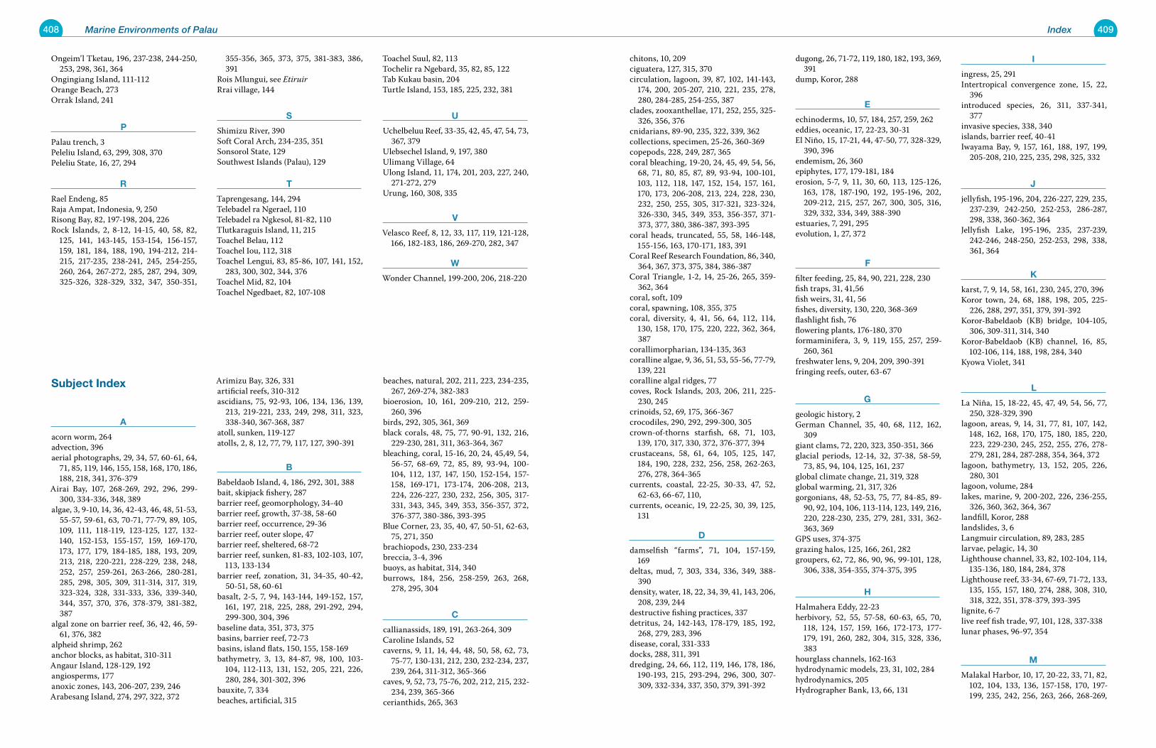
408 Marine Environments of Palau 409Index
Ongeim’l Tketau, 196, 237-238, 244-250, 253, 298, 361, 364
Ongingiang Island, 111-112Orange Beach, 273Orrak Island, 241
p
Palau trench, 3Peleliu Island, 63, 299, 308, 370Peleliu State, 16, 27, 294
r
Rael Endeng, 85Raja Ampat, Indonesia, 9, 250Risong Bay, 82, 197-198, 204, 226Rock Islands, 2, 8-12, 14-15, 40, 58, 82,
125, 141, 143-145, 153-154, 156-157, 159, 181, 184, 188, 190, 194-212, 214-215, 217-235, 238-241, 245, 254-255, 260, 264, 267-272, 285, 287, 294, 309, 325-326, 328-329, 332, 347, 350-351,
355-356, 365, 373, 375, 381-383, 386, 391
Rois Mlungui, see EtiruirRrai village, 144
s
Shimizu River, 390Soft Coral Arch, 234-235, 351Sonsorol State, 129Southwest Islands (Palau), 129
t
Taprengesang, 144, 294Telebadel ra Ngerael, 110Telebadel ra Ngkesol, 81-82, 110Tlutkaraguis Island, 11, 215Toachel Belau, 112Toachel Iou, 112, 318Toachel Lengui, 83, 85-86, 107, 141, 152,
283, 300, 302, 344, 376Toachel Mid, 82, 104Toachel Ngedbaet, 82, 107-108
Toachel Suul, 82, 113Tochelir ra Ngebard, 35, 82, 85, 122Tab Kukau basin, 204Turtle Island, 153, 185, 225, 232, 381
u
Uchelbeluu Reef, 33-35, 42, 45, 47, 54, 73, 367, 379
Ulebsechel Island, 9, 197, 380Ulimang Village, 64Ulong Island, 11, 174, 201, 203, 227, 240,
271-272, 279Urung, 160, 308, 335
v
Velasco Reef, 8, 12, 33, 117, 119, 121-128, 166, 182-183, 186, 269-270, 282, 347
w
Wonder Channel, 199-200, 206, 218-220
chitons, 10, 209ciguatera, 127, 315, 370circulation, lagoon, 39, 87, 102, 141-143,
174, 200, 205-207, 210, 221, 235, 278, 280, 284-285, 254-255, 387
clades, zooxanthellae, 171, 252, 255, 325-326, 356, 376
cnidarians, 89-90, 235, 322, 339, 362collections, specimen, 25-26, 360-369copepods, 228, 249, 287, 365coral bleaching, 19-20, 24, 45, 49, 54, 56,
68, 71, 80, 85, 87, 89, 93-94, 100-101, 103, 112, 118, 147, 152, 154, 157, 161, 170, 173, 206-208, 213, 224, 228, 230, 232, 250, 255, 305, 317-321, 323-324, 326-330, 345, 349, 353, 356-357, 371-373, 377, 380, 386-387, 393-395
coral heads, truncated, 55, 58, 146-148, 155-156, 163, 170-171, 183, 391
Coral Reef Research Foundation, 86, 340, 364, 367, 373, 375, 384, 386-387
Coral Triangle, 1-2, 14, 25-26, 265, 359-362, 364
coral, soft, 109coral, spawning, 108, 355, 375coral, diversity, 4, 41, 56, 64, 112, 114,
130, 158, 170, 175, 220, 222, 362, 364, 387
corallimorpharian, 134-135, 363coralline algae, 9, 36, 51, 53, 55-56, 77-79,
139, 221coralline algal ridges, 77coves, Rock Islands, 203, 206, 211, 225-
230, 245crinoids, 52, 69, 175, 366-367crocodiles, 290, 292, 299-300, 305crown-of-thorns starfish, 68, 71, 103,
139, 170, 317, 330, 372, 376-377, 394crustaceans, 58, 61, 64, 105, 125, 147,
184, 190, 228, 232, 256, 258, 262-263, 276, 278, 364-365
currents, coastal, 22-25, 30-33, 47, 52, 62-63, 66-67, 110,
currents, oceanic, 19, 22-25, 30, 39, 125, 131
D
damselfish “farms”, 71, 104, 157-159, 169
deltas, mud, 7, 303, 334, 336, 349, 388-390
density, water, 18, 22, 34, 39, 41, 143, 206, 208, 239, 244
destructive fishing practices, 337detritus, 24, 142-143, 178-179, 185, 192,
268, 279, 283, 396disease, coral, 331-333docks, 288, 311, 391dredging, 24, 66, 112, 119, 146, 178, 186,
190-193, 215, 293-294, 296, 300, 307-309, 332-334, 337, 350, 379, 391-392
dugong, 26, 71-72, 119, 180, 182, 193, 369, 391
dump, Koror, 288
e
echinoderms, 10, 57, 184, 257, 259, 262eddies, oceanic, 17, 22-23, 30-31El Niño, 15, 17-21, 44, 47-50, 77, 328-329,
390, 396endemism, 26, 360epiphytes, 177, 179-181, 184erosion, 5-7, 9, 11, 30, 60, 113, 125-126,
163, 178, 187-190, 192, 195-196, 202, 209-212, 215, 257, 267, 300, 305, 316, 329, 332, 334, 349, 388-390
estuaries, 7, 291, 295evolution, 1, 27, 372
F
filter feeding, 25, 84, 90, 221, 228, 230fish traps, 31, 41,56fish weirs, 31, 41, 56fishes, diversity, 130, 220, 368-369flashlight fish, 76flowering plants, 176-180, 370formaminifera, 3, 9, 119, 155, 257, 259-
260, 361 freshwater lens, 9, 204, 209, 390-391fringing reefs, outer, 63-67
g
geologic history, 2German Channel, 35, 40, 68, 112, 162,
309giant clams, 72, 220, 323, 350-351, 366glacial periods, 12-14, 32, 37-38, 58-59,
73, 85, 94, 104, 125, 161, 237global climate change, 21, 319, 328global warming, 21, 317, 326gorgonians, 48, 52-53, 75, 77, 84-85, 89-
90, 92, 104, 106, 113-114, 123, 149, 216, 220, 228-230, 235, 279, 281, 331, 362-363, 369
GPS uses, 374-375grazing halos, 125, 166, 261, 282groupers, 62, 72, 86, 90, 96, 99-101, 128,
306, 338, 354-355, 374-375, 395
h
Halmahera Eddy, 22-23herbivory, 52, 55, 57-58, 60-63, 65, 70,
118, 124, 157, 159, 166, 172-173, 177-179, 191, 260, 282, 304, 315, 328, 336, 383
hourglass channels, 162-163hydrodynamic models, 23, 31, 102, 284hydrodynamics, 205Hydrographer Bank, 13, 66, 131
i
ingress, 25, 291Intertropical convergence zone, 15, 22,
396introduced species, 26, 311, 337-341,
377invasive species, 338, 340islands, barrier reef, 40-41Iwayama Bay, 9, 157, 161, 188, 197, 199,
205-208, 210, 225, 235, 298, 325, 332
j
jellyfish, 195-196, 204, 226-227, 229, 235, 237-239, 242-250, 252-253, 286-287, 298, 338, 360-362, 364
Jellyfish Lake, 195-196, 235, 237-239, 242-246, 248-250, 252-253, 298, 338, 361, 364
k
karst, 7, 9, 14, 58, 161, 230, 245, 270, 396Koror town, 24, 68, 188, 198, 205, 225-
226, 288, 297, 351, 379, 391-392Koror-Babeldaob (KB) bridge, 104-105,
306, 309-311, 314, 340Koror-Babeldaob (KB) channel, 16, 85,
102-106, 114, 188, 198, 284, 340 Kyowa Violet, 341
l
La Niña, 15, 18-22, 45, 47, 49, 54, 56, 77, 250, 328-329, 390
lagoon, areas, 9, 14, 31, 77, 81, 107, 142, 148, 162, 168, 170, 175, 180, 185, 220, 223, 229-230, 245, 252, 255, 276, 278-279, 281, 284, 287-288, 354, 364, 372
lagoon, bathymetry, 13, 152, 205, 226, 280, 301
lagoon, volume, 284lakes, marine, 9, 200-202, 226, 236-255,
326, 360, 362, 364, 367landfill, Koror, 288landslides, 3, 6Langmuir circulation, 89, 283, 285larvae, pelagic, 14, 30Lighthouse channel, 33, 82, 102-104, 114,
135-136, 180, 184, 284, 378Lighthouse reef, 33-34, 67-69, 71-72, 133,
135, 155, 157, 180, 274, 288, 308, 310, 318, 322, 351, 378-379, 393-395
lignite, 6-7live reef fish trade, 97, 101, 128, 337-338lunar phases, 96-97, 354
m
Malakal Harbor, 10, 17, 20-22, 33, 71, 82, 102, 104, 133, 136, 157-158, 170, 197-199, 235, 242, 256, 263, 266, 268-269,
subject index
a
acorn worm, 264advection, 396aerial photographs, 29, 34, 57, 60-61, 64,
71, 85, 119, 146, 155, 158, 168, 170, 186, 188, 218, 341, 376-379
Airai Bay, 107, 268-269, 292, 296, 299-300, 334-336, 348, 389
algae, 3, 9-10, 14, 36, 42-43, 46, 48, 51-53, 55-57, 59-61, 63, 70-71, 77-79, 89, 105, 109, 111, 118-119, 123-125, 127, 132-140, 152-153, 155-157, 159, 169-170, 173, 177, 179, 184-185, 188, 193, 209, 213, 218, 220-221, 228-229, 238, 248, 252, 257, 259-261, 263-266, 280-281, 285, 298, 305, 309, 311-314, 317, 319, 323-324, 328, 331-333, 336, 339-340, 344, 357, 370, 376, 378-379, 381-382, 387
algal zone on barrier reef, 36, 42, 46, 59-61, 376, 382
alpheid shrimp, 262anchor blocks, as habitat, 310-311Angaur Island, 128-129, 192angiosperms, 177anoxic zones, 143, 206-207, 239, 246Arabesang Island, 274, 297, 322, 372
Arimizu Bay, 326, 331artificial reefs, 310-312ascidians, 75, 92-93, 106, 134, 136, 139,
213, 219-221, 233, 249, 298, 311, 323, 338-340, 367-368, 387
atoll, sunken, 119-127atolls, 2, 8, 12, 77, 79, 117, 127, 390-391
B
Babeldaob Island, 4, 186, 292, 301, 388bait, skipjack fishery, 287barrier reef, geomorphology, 34-40barrier reef, growth, 37-38, 58-60barrier reef, occurrence, 29-36barrier reef, outer slope, 47barrier reef, sheltered, 68-72barrier reef, sunken, 81-83, 102-103, 107,
113, 133-134barrier reef, zonation, 31, 34-35, 40-42,
50-51, 58, 60-61basalt, 2-5, 7, 94, 143-144, 149-152, 157,
161, 197, 218, 225, 288, 291-292, 294, 299-300, 304, 396
baseline data, 351, 373, 375basins, barrier reef, 72-73basins, island flats, 150, 155, 158-169bathymetry, 3, 13, 84-87, 98, 100, 103-
104, 112-113, 131, 152, 205, 221, 226, 280, 284, 301-302, 396
bauxite, 7, 334beaches, artificial, 315
beaches, natural, 202, 211, 223, 234-235, 267, 269-274, 382-383
bioerosion, 10, 161, 209-210, 212, 259-260, 396
birds, 292, 305, 361, 369black corals, 48, 75, 77, 90-91, 132, 216,
229-230, 281, 311, 363-364, 367bleaching, coral, 15-16, 20, 24, 45,49, 54,
56-57, 68-69, 72, 85, 89, 93-94, 100-104, 112, 137, 147, 150, 152-154, 157-158, 169-171, 173-174, 206-208, 213, 224, 226-227, 230, 232, 256, 305, 317-331, 343, 345, 349, 353, 356-357, 372, 376-377, 380-386, 393-395
Blue Corner, 23, 35, 40, 47, 50-51, 62-63, 75, 271, 350
brachiopods, 230, 233-234breccia, 3-4, 396buoys, as habitat, 314, 340burrows, 184, 256, 258-259, 263, 268,
278, 295, 304
C
callianassids, 189, 191, 263-264, 309Caroline Islands, 52caverns, 9, 11, 14, 44, 48, 50, 58, 62, 73,
75-77, 130-131, 212, 230, 232-234, 237, 239, 264, 311-312, 365-366
caves, 9, 52, 73, 75-76, 202, 212, 215, 232-234, 239, 365-366
cerianthids, 265, 363
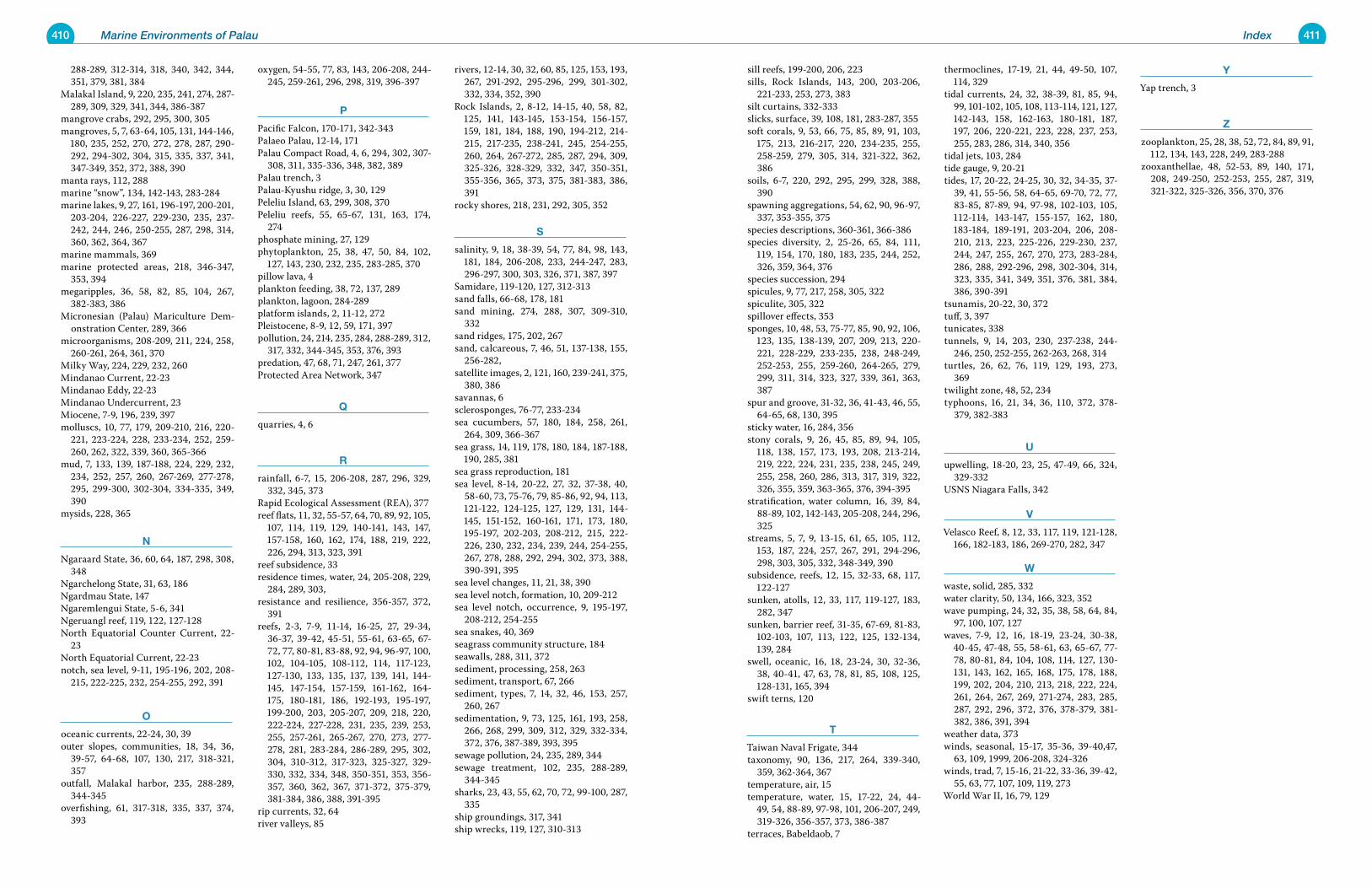
410 Marine Environments of Palau 411Index
288-289, 312-314, 318, 340, 342, 344, 351, 379, 381, 384
Malakal Island, 9, 220, 235, 241, 274, 287-289, 309, 329, 341, 344, 386-387
mangrove crabs, 292, 295, 300, 305mangroves, 5, 7, 63-64, 105, 131, 144-146,
180, 235, 252, 270, 272, 278, 287, 290-292, 294-302, 304, 315, 335, 337, 341, 347-349, 352, 372, 388, 390
manta rays, 112, 288marine “snow”, 134, 142-143, 283-284marine lakes, 9, 27, 161, 196-197, 200-201,
203-204, 226-227, 229-230, 235, 237-242, 244, 246, 250-255, 287, 298, 314, 360, 362, 364, 367
marine mammals, 369marine protected areas, 218, 346-347,
353, 394megaripples, 36, 58, 82, 85, 104, 267,
382-383, 386Micronesian (Palau) Mariculture Dem-
onstration Center, 289, 366microorganisms, 208-209, 211, 224, 258,
260-261, 264, 361, 370Milky Way, 224, 229, 232, 260Mindanao Current, 22-23Mindanao Eddy, 22-23Mindanao Undercurrent, 23Miocene, 7-9, 196, 239, 397molluscs, 10, 77, 179, 209-210, 216, 220-
221, 223-224, 228, 233-234, 252, 259-260, 262, 322, 339, 360, 365-366
mud, 7, 133, 139, 187-188, 224, 229, 232, 234, 252, 257, 260, 267-269, 277-278, 295, 299-300, 302-304, 334-335, 349, 390
mysids, 228, 365
n
Ngaraard State, 36, 60, 64, 187, 298, 308, 348
Ngarchelong State, 31, 63, 186Ngardmau State, 147Ngaremlengui State, 5-6, 341Ngeruangl reef, 119, 122, 127-128North Equatorial Counter Current, 22-
23North Equatorial Current, 22-23notch, sea level, 9-11, 195-196, 202, 208-
215, 222-225, 232, 254-255, 292, 391
o
oceanic currents, 22-24, 30, 39outer slopes, communities, 18, 34, 36,
39-57, 64-68, 107, 130, 217, 318-321, 357
outfall, Malakal harbor, 235, 288-289, 344-345
overfishing, 61, 317-318, 335, 337, 374, 393
oxygen, 54-55, 77, 83, 143, 206-208, 244-245, 259-261, 296, 298, 319, 396-397
p
Pacific Falcon, 170-171, 342-343Palaeo Palau, 12-14, 171Palau Compact Road, 4, 6, 294, 302, 307-
308, 311, 335-336, 348, 382, 389Palau trench, 3Palau-Kyushu ridge, 3, 30, 129Peleliu Island, 63, 299, 308, 370Peleliu reefs, 55, 65-67, 131, 163, 174,
274phosphate mining, 27, 129phytoplankton, 25, 38, 47, 50, 84, 102,
127, 143, 230, 232, 235, 283-285, 370pillow lava, 4plankton feeding, 38, 72, 137, 289plankton, lagoon, 284-289 platform islands, 2, 11-12, 272Pleistocene, 8-9, 12, 59, 171, 397pollution, 24, 214, 235, 284, 288-289, 312,
317, 332, 344-345, 353, 376, 393predation, 47, 68, 71, 247, 261, 377Protected Area Network, 347
q
quarries, 4, 6
r
rainfall, 6-7, 15, 206-208, 287, 296, 329, 332, 345, 373
Rapid Ecological Assessment (REA), 377reef flats, 11, 32, 55-57, 64, 70, 89, 92, 105,
107, 114, 119, 129, 140-141, 143, 147, 157-158, 160, 162, 174, 188, 219, 222, 226, 294, 313, 323, 391
reef subsidence, 33residence times, water, 24, 205-208, 229,
284, 289, 303, resistance and resilience, 356-357, 372,
391reefs, 2-3, 7-9, 11-14, 16-25, 27, 29-34,
36-37, 39-42, 45-51, 55-61, 63-65, 67-72, 77, 80-81, 83-88, 92, 94, 96-97, 100, 102, 104-105, 108-112, 114, 117-123, 127-130, 133, 135, 137, 139, 141, 144-145, 147-154, 157-159, 161-162, 164-175, 180-181, 186, 192-193, 195-197, 199-200, 203, 205-207, 209, 218, 220, 222-224, 227-228, 231, 235, 239, 253, 255, 257-261, 265-267, 270, 273, 277-278, 281, 283-284, 286-289, 295, 302, 304, 310-312, 317-323, 325-327, 329-330, 332, 334, 348, 350-351, 353, 356-357, 360, 362, 367, 371-372, 375-379, 381-384, 386, 388, 391-395
rip currents, 32, 64river valleys, 85
rivers, 12-14, 30, 32, 60, 85, 125, 153, 193, 267, 291-292, 295-296, 299, 301-302, 332, 334, 352, 390
Rock Islands, 2, 8-12, 14-15, 40, 58, 82, 125, 141, 143-145, 153-154, 156-157, 159, 181, 184, 188, 190, 194-212, 214-215, 217-235, 238-241, 245, 254-255, 260, 264, 267-272, 285, 287, 294, 309, 325-326, 328-329, 332, 347, 350-351, 355-356, 365, 373, 375, 381-383, 386, 391
rocky shores, 218, 231, 292, 305, 352
s
salinity, 9, 18, 38-39, 54, 77, 84, 98, 143, 181, 184, 206-208, 233, 244-247, 283, 296-297, 300, 303, 326, 371, 387, 397
Samidare, 119-120, 127, 312-313sand falls, 66-68, 178, 181sand mining, 274, 288, 307, 309-310,
332sand ridges, 175, 202, 267sand, calcareous, 7, 46, 51, 137-138, 155,
256-282, satellite images, 2, 121, 160, 239-241, 375,
380, 386savannas, 6sclerosponges, 76-77, 233-234sea cucumbers, 57, 180, 184, 258, 261,
264, 309, 366-367sea grass, 14, 119, 178, 180, 184, 187-188,
190, 285, 381sea grass reproduction, 181sea level, 8-14, 20-22, 27, 32, 37-38, 40,
58-60, 73, 75-76, 79, 85-86, 92, 94, 113, 121-122, 124-125, 127, 129, 131, 144-145, 151-152, 160-161, 171, 173, 180, 195-197, 202-203, 208-212, 215, 222-226, 230, 232, 234, 239, 244, 254-255, 267, 278, 288, 292, 294, 302, 373, 388, 390-391, 395
sea level changes, 11, 21, 38, 390sea level notch, formation, 10, 209-212sea level notch, occurrence, 9, 195-197,
208-212, 254-255sea snakes, 40, 369seagrass community structure, 184seawalls, 288, 311, 372sediment, processing, 258, 263sediment, transport, 67, 266sediment, types, 7, 14, 32, 46, 153, 257,
260, 267sedimentation, 9, 73, 125, 161, 193, 258,
266, 268, 299, 309, 312, 329, 332-334, 372, 376, 387-389, 393, 395
sewage pollution, 24, 235, 289, 344sewage treatment, 102, 235, 288-289,
344-345sharks, 23, 43, 55, 62, 70, 72, 99-100, 287,
335ship groundings, 317, 341ship wrecks, 119, 127, 310-313
sill reefs, 199-200, 206, 223sills, Rock Islands, 143, 200, 203-206,
221-233, 253, 273, 383 silt curtains, 332-333slicks, surface, 39, 108, 181, 283-287, 355soft corals, 9, 53, 66, 75, 85, 89, 91, 103,
175, 213, 216-217, 220, 234-235, 255, 258-259, 279, 305, 314, 321-322, 362, 386
soils, 6-7, 220, 292, 295, 299, 328, 388, 390
spawning aggregations, 54, 62, 90, 96-97, 337, 353-355, 375
species descriptions, 360-361, 366-386species diversity, 2, 25-26, 65, 84, 111,
119, 154, 170, 180, 183, 235, 244, 252, 326, 359, 364, 376
species succession, 294spicules, 9, 77, 217, 258, 305, 322spiculite, 305, 322spillover effects, 353sponges, 10, 48, 53, 75-77, 85, 90, 92, 106,
123, 135, 138-139, 207, 209, 213, 220-221, 228-229, 233-235, 238, 248-249, 252-253, 255, 259-260, 264-265, 279, 299, 311, 314, 323, 327, 339, 361, 363, 387
spur and groove, 31-32, 36, 41-43, 46, 55, 64-65, 68, 130, 395
sticky water, 16, 284, 356stony corals, 9, 26, 45, 85, 89, 94, 105,
118, 138, 157, 173, 193, 208, 213-214, 219, 222, 224, 231, 235, 238, 245, 249, 255, 258, 260, 286, 313, 317, 319, 322, 326, 355, 359, 363-365, 376, 394-395
stratification, water column, 16, 39, 84, 88-89, 102, 142-143, 205-208, 244, 296, 325
streams, 5, 7, 9, 13-15, 61, 65, 105, 112, 153, 187, 224, 257, 267, 291, 294-296, 298, 303, 305, 332, 348-349, 390
subsidence, reefs, 12, 15, 32-33, 68, 117, 122-127
sunken, atolls, 12, 33, 117, 119-127, 183, 282, 347
sunken, barrier reef, 31-35, 67-69, 81-83, 102-103, 107, 113, 122, 125, 132-134, 139, 284
swell, oceanic, 16, 18, 23-24, 30, 32-36, 38, 40-41, 47, 63, 78, 81, 85, 108, 125, 128-131, 165, 394
swift terns, 120
t
Taiwan Naval Frigate, 344taxonomy, 90, 136, 217, 264, 339-340,
359, 362-364, 367temperature, air, 15temperature, water, 15, 17-22, 24, 44-
49, 54, 88-89, 97-98, 101, 206-207, 249, 319-326, 356-357, 373, 386-387
terraces, Babeldaob, 7
thermoclines, 17-19, 21, 44, 49-50, 107, 114, 329
tidal currents, 24, 32, 38-39, 81, 85, 94, 99, 101-102, 105, 108, 113-114, 121, 127, 142-143, 158, 162-163, 180-181, 187, 197, 206, 220-221, 223, 228, 237, 253, 255, 283, 286, 314, 340, 356
tidal jets, 103, 284tide gauge, 9, 20-21tides, 17, 20-22, 24-25, 30, 32, 34-35, 37-
39, 41, 55-56, 58, 64-65, 69-70, 72, 77, 83-85, 87-89, 94, 97-98, 102-103, 105, 112-114, 143-147, 155-157, 162, 180, 183-184, 189-191, 203-204, 206, 208-210, 213, 223, 225-226, 229-230, 237, 244, 247, 255, 267, 270, 273, 283-284, 286, 288, 292-296, 298, 302-304, 314, 323, 335, 341, 349, 351, 376, 381, 384, 386, 390-391
tsunamis, 20-22, 30, 372tuff, 3, 397tunicates, 338tunnels, 9, 14, 203, 230, 237-238, 244-
246, 250, 252-255, 262-263, 268, 314turtles, 26, 62, 76, 119, 129, 193, 273,
369twilight zone, 48, 52, 234typhoons, 16, 21, 34, 36, 110, 372, 378-
379, 382-383
u
upwelling, 18-20, 23, 25, 47-49, 66, 324, 329-332
USNS Niagara Falls, 342
v
Velasco Reef, 8, 12, 33, 117, 119, 121-128, 166, 182-183, 186, 269-270, 282, 347
w
waste, solid, 285, 332water clarity, 50, 134, 166, 323, 352wave pumping, 24, 32, 35, 38, 58, 64, 84,
97, 100, 107, 127waves, 7-9, 12, 16, 18-19, 23-24, 30-38,
40-45, 47-48, 55, 58-61, 63, 65-67, 77-78, 80-81, 84, 104, 108, 114, 127, 130-131, 143, 162, 165, 168, 175, 178, 188, 199, 202, 204, 210, 213, 218, 222, 224, 261, 264, 267, 269, 271-274, 283, 285, 287, 292, 296, 372, 376, 378-379, 381-382, 386, 391, 394
weather data, 373winds, seasonal, 15-17, 35-36, 39-40,47,
63, 109, 1999, 206-208, 324-326winds, trad, 7, 15-16, 21-22, 33-36, 39-42,
55, 63, 77, 107, 109, 119, 273World War II, 16, 79, 129
y
Yap trench, 3
Z
zooplankton, 25, 28, 38, 52, 72, 84, 89, 91, 112, 134, 143, 228, 249, 283-288
zooxanthellae, 48, 52-53, 89, 140, 171, 208, 249-250, 252-253, 255, 287, 319, 321-322, 325-326, 356, 370, 376
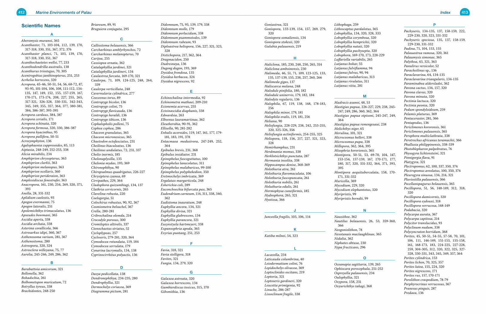
412 Marine Environments of Palau 413Index
scientific names
a
Aberomysis muranoi, 365Acanthaster, 71, 103-104, 112, 139, 170,
317-318, 330, 351, 367, 372, 376Acanthaster planci, 71, 103, 139, 170,
317-318, 330, 351, 367Acanthochaetetes wellsi, 77, 233Acanthodendrilla australis, 138Acanthurus triostegus, 70, 305Acentrogobius janthinopterus, 251, 253Acrhelia horrecens, 320Acropora, 45-46, 50-51, 54, 56, 68-72, 87,
93-95, 101-104, 106, 108, 111-112, 134-135, 147, 149, 152, 155, 157-159, 167, 170-171, 173-174, 208, 227, 255, 265, 317-321, 326-328, 330-331, 342-343, 345, 349, 355, 357, 364, 377, 380-381, 384, 386-387, 393-395
Acropora carduus, 384, 387Acropora cerialis, 171Acropora echinata, 320Acropora formosa, 320, 330, 386-387Acropora hyacinthus, 95Acropora pallifera, 50-51Acrosymphyton, 136Agalophaenia cuppresoides, 85, 113Aiptasia, 248-249, 252-253, 338Alicia mirabilis, 234Amphiprion chrysopterus, 363Amphiprion clarkii, 363Amphiprion melanopus, 363Amphiprion ocellaris, 360Amphiprion perideraion, 363Amplexidiscus fenestrafer, 363Anacropora, 161, 230, 254, 269, 320, 371,
393Anella, 28, 331-332Aplidium caelestis, 93Apogon evermanni, 75Apogon lateralis, 251Apolemichthys trimaculatus, 136Apseudes bowmani, 365Ascidia aperta, 338Ascidia archaia, 338Asterina corallicola, 366Astrosarkus idipi, 360, 367Asthenosoma varium, 281, 367Asthenostoma, 280Astreopora, 320, 324Astrosclera willeyana, 75, 77Aurelia, 245-246, 249, 286, 362
B
Barabattoia amicorum, 321Bellonella, 362Bohadschia, 261Bolbometopon muricatum, 72Botryllus tyreus, 338Brachidontes, 248-250
Briareum, 89, 91Bruguiera conjugata, 295
C
Calliostoma belauensis, 366Carcharhinus amblyrhynchos, 72Carcharhinus melanopterus, 70Carijoa, 255Cassiopea ornata, 362Catalaphyllia jardinei, 321Catalaphyllia jardineri, 134Caulastrea furcata, 169-170, 321Caulerpa, 71, 109, 124-125, 248, 264,
339Caulerpa verticillata, 248Cavernularia cylindrica, 277Ceeceenus torus, 89Centropyge bicolor, 136Centropyge colini, 75Centropyge flavicauda, 136Centropyge heraldi, 136Centropyge tibicen, 136Cephalopholis polleni, 75Cephea cephea, 286Chaceon granulatus, 365Chaceon micronesicus, 365Chaetodon octofasciatus, 231Cheilinus biaculeatus, 136Cheilinus undulatus, 72, 231, 337Chelio inermis, 185Chelonaplysilla, 135Chelonia mydas, 193, 369Chironephthya, 90Chiropsalmus quadrigatus, 226-227Chrysiptera cyanea, 69Cirripathes, 229, 364Cladophora quizumbiugi, 134, 137Clathria cervicornis, 265Clavelina robusta, 220Coelogorgia, 51Colochirus robustus, 90, 92, 367Cosmiometra belsuchel, 367Crella, 280-281Cribrochalina olemda, 214Crocodyle porosus, 300Cromileptes altivelis, 337Ctenochaetus striatus, 52Cycloplypeas, 257Cycloseris, 279-281, 320, 364Cymodocea rotundata, 119, 184Cymodocea serrulata, 179Cynarina lacrymalis, 134, 138Cyprinocirrhitus polyactis, 136
D
Dasya pedicellata, 138Dendronephthya, 234-235, 280Dendrophyllia, 321Dermochelys coriacea, 369Diagramma pictum, 281
Didemnum, 75, 93, 139, 179, 338Didemnum molle, 179Didemnum perlucidum, 338Didemnum psammotodes, 139Didemnum rubeum, 93Diploastrea heliopora, 156, 227, 321, 323,
328Distichopora, 217, 362, 364Dragmacidon, 250Dudresnaya, 136Dugong dugon, 193, 369Dysidea frondosa, 135Dysidea herbacea, 324Dysidea nigrescens, 92
e
Echinochalina intermedia, 92Echinometra mathaei, 209-210Ecionemia acervus, 255Ecteinascidia diaphanis, 338Edwardsia, 263Elbeenus lauramartinae, 362Eleutherobia, 90-91, 362Ellisella, 90, 281-282Enhalis acoroides, 119, 147, 161, 177, 179-
181, 183, 191, 378Entacmaea medusivora, 247-249, 252,
364Epibulus brevis, 231, 368Epibulus insidiator, 231Epinephelus fuscoguttatus, 100Epinephelus lanecolatus, 311Epinephelus malabaricus, 99-100Epinephelus polyphekedion, 350Eretmochelys imbricata, 369Ergalatax margarticola, 248Esherichia coli, 289Euconchoechia bifurcata pax, 365Eudendrium carneum, 114, 311, 338, 340,
362Eudistoma inauratum, 248Euphyllia ancora, 134, 321Euphyllia divisa, 321Euphyllia glabrescens, 134Euphyllia parancora, 321Eusynstyela hartmeyeri, 338Expansophria apoda, 365Exyrias puntang, 251, 253
F
Favia, 318, 321Favia stelligera, 318Favites, 321Fungia, 134, 279, 320
g
Galaxea astreata, 320Galaxea horrescens, 134Gambierdiscus toxicus, 315, 370Gibsmithia, 136
Goniastrea, 321Goniopora, 133-139, 154, 157, 269, 279,
320Goniopora somaliensis, 134Goniopora stokesii, 320Gulubia palauensis, 219
h
Haliclona, 185, 230, 248, 250, 265, 314Haliclona amboinensis, 230Halimeda, 46, 51, 71, 109, 123-125, 133,
135, 137-139, 155, 238, 257, 260, 266Halimeda gigas, 137Haliscarca melana, 248Halodule pinifolia, 180, 182Halodule uninervis, 179, 182, 184Halodyte regularis, 136Halophila, 67, 119, 138, 148, 178-183,
256Halophila minor, 179, 181Halophila ovalis, 119, 181, 256Heliana, 90Heliofungia, 228-229, 238, 242, 253-255,
320, 325-326, 356Heliofungia actiniformis, 254-255, 325Heliopora, 118, 156, 217, 227, 321, 323,
328Hemirhamphus, 231Herdmania momus, 338Herklotsichthys punctata, 287Hermania insolita, 338Hippocampus denise, 368-369Holothuria atra, 261Holothuria flavomaculata, 106Holothuria fuscopuncata, 261Holothuria nobilis, 261Holuthuria edulis, 261Hormophysa cuneiformis, 185Hydnophora, 265, 321Hyotissa, 366
j
Junceella fragilis, 103, 106, 114
k
Katiba milnei, 54, 323
l
Lacazella, 234Laticauda columbrina, 40Leiodermatium colini, 76Lepidochelys olivacea, 369Leptoclinides oscitans, 219Leptoria, 321Leptoseris gardineri, 320Leucetta primigenia, 92Linuche, 286-287Lissoclinum fragile, 338
Lithophaga, 259Lithoscaptus pardalotus, 365Lobophyllia, 134, 320, 328, 333Lobophyllia corymbosa, 320Lobophyllia hemprichii, 320Lobophyllia nataii, 320Lobophyllia pachysepta, 320Lobophora, 169-170, 173, 228-229Luffariella variabilis, 265Lutjanus bohar, 55Lutjanus fulviflamma, 94Lutjanus fulvus, 90, 94Lutjanus malabaricus, 313Lutjanus rivulatus, 311Lutjanus vitta, 281
m
Madracis asanoi, 48, 53Mastigias papua, 226-227, 229, 238, 245-
247, 249, 286, 360, 362, 364Mastigias papua etpisoni, 245-247, 249,
364Mastigias papua remengesaui, 238Melichthys niger, 65Merulina, 101, 321Microcosmus helleri, 338Microcosmus pupa, 338Millepora, 362, 364, 395Misophria kororiensis, 365Montipora, 50-51, 53, 69-70, 104, 147,
153-154, 157-159, 167, 170-171, 177, 180, 317, 320, 331-332, 364, 371, 393, 395
Montipora aequituberculata, 158, 170-171, 331-332
Muricella, 369Mycedium, 229, 320Mycedium elephantotus, 320Myripristis, 99Myripristis berndti, 99
n
Nausithoe, 362Nautilus belauensis, 26, 53, 359-360,
366Neogoniolithon, 78Nesotanais maclaughlinae, 365Nidalia, 362Niphates obtusa, 230Nypa fructicans, 296
o
Oceanapia sagittaria, 139, 265Ophiocara porocephala, 251-252Ospreyella palauensis, 234Oulophyllia, 321Oxypora, 158, 231Oxyurichthys takagi, 368
p
Pachyseris, 134-135, 137, 158-159, 222, 229-230, 320, 323, 331-332
Pachyseris speciosa, 135, 137, 158-159, 229-230, 331-332
Padina, 71, 104, 153, 155Palauastrea ramosa, 320, 361Palaumysis simonae, 365Palythoa, 43, 321, 363Panulirus versicolor, 52Paracheilinus sp., 136Paraclavarina, 64, 134-135Paraclavarina triangularis, 134-135Paraminabea aldersladei, 362Pavona cactus, 134, 157, 320Pavona clavus, 320Pavona minuta, 320Pectinia lactuca, 320Pectinia peonia, 320Pedum spondyloideum, 259Pelamis platurus, 369Pentaceraster, 281, 366Pentapodus, 136Periclimenes kororensis, 361Periclimenes palauensis, 365Perophora multiclathrata, 338Perotrochus africanus teramachii, 366Phallusia philippinensis, 338-339Photoblepharon palpebratus, 76Physogyra lichtensteini, 321Pinnigorgia flava, 91Platygyra, 321Plectropomus, 62, 100, 337, 350, 374Plectropomus areolatus, 100, 350, 374Pleurogyra sinuosa, 134, 214, 321Pluviostilla palauensis, 366Pocellanopagurus belauensis, 365Pocillopora, 51, 56, 148-149, 312, 318,
320Pocillopora damicornis, 320Pocillopora eydouxi, 318Pocillopora verrucosa, 148-149Podabacia, 320Polycarpa aurata, 367Polycarpa capitosa, 214Polycitor translucidus, 93Polyclinum nudum, 338Polysyncraton horridum, 368Porites, 45, 50-51, 54-55, 57-58, 70, 101,
106, 111, 146-149, 151-153, 155-158, 161, 168-173, 183, 224-225, 227-228, 259, 304-305, 312, 320, 322, 325, 327-328, 330-331, 343, 345, 349, 357, 364
Porites cylindrica, 153Porites lichen, 70, 325, 357Porites lutea, 155, 224, 320Porites nigrescens, 171Porites rus, 157, 170-171Porolithon craspedium, 78-79Porphyrocrinus verrucosus, 367Pranesus pinguis, 287Predaea, 136
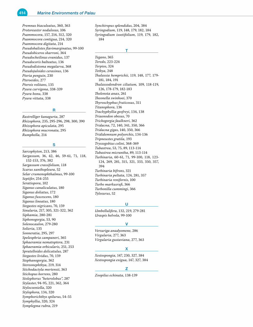
414 Marine Environments of Palau
Premnas biaculeatus, 360, 363Protoreaster nodulosus, 106Psammocora, 157, 214, 312, 320Psammocora contigua, 214, 320Psammocora digitata, 214Pseudobalistes flavimarginatus, 99-100Pseudobiceros sharroni, 364Pseudocheilinus evanidus, 137Pseudocoris balteatus, 136Pseudodistoma megalarva, 368Pseudojuloides cerasinus, 136Pteria penguin, 230Pteroeides, 277Pterois volitans, 135Pyura curvigona, 338-339Pyura honu, 338Pyura vittata, 338
r
Rastrelliger kanagurta, 287Rhizophora, 235, 295-296, 298, 300, 390Rhizophora apiculata, 295Rhizophora mucronata, 295Rumphella, 214
s
Sarcophyton, 213, 386Sargassum, 36, 42, 46, 59-61, 71, 118,
152-153, 376, 382Sargassum crassifolium, 118Scarus xanthopleura, 52Selar crumenophthalmus, 99-100Septifer, 254-255Seratiopora, 102Siganus canaliculatus, 180Siganus doliatus, 172Siganus fuscescens, 180Siganus lineatus, 180Stegastes nigricans, 70, 159Sinularia, 217, 305, 321-322, 362Siphamia, 280-281Siphonogorgia, 53, 90Solenocaulon, 279-280Solieria, 135Sonneratia, 295, 297Speleophria campaneri, 365Sphaeramia nematoptera, 231Sphaeramia orbicularis, 251, 253Spratelloides delicatulus, 287Stegastes lividus, 70, 159Stephanogorgia, 362Stereonephthya, 219, 314Stichodactyla mertensii, 363Stichopus horrens, 280Stolephorus “heterolobus”, 287Stylaster, 94-95, 221, 362, 364Stylocoeniella, 320Stylophora, 134, 320Symphorichthys spilurus, 54-55Symphyllia, 320, 324Symplegma rubra, 219
Synchiropus splendidus, 204, 384Syringodium, 119, 148, 179, 182, 184Syringodium isoetifolium, 119, 179, 182,
184
t
Tegano, 365Teredo, 223-224Terpios, 324Tethya, 248Thalassia hemprichii, 119, 148, 177, 179-
181, 184, 191Thalassodendron ciliatum, 109, 118-119,
126, 178-179, 182-183Thelenota anax, 261Theonella swinhoei, 370Thyroschyphus fruticosus, 311Titanophora, 136Trachyphyllia geofreyi, 134, 138Triaenodon obesus, 70Trichogorgia faulkneri, 362Tridacna, 72, 140, 341, 350, 366Tridacna gigas, 140, 350, 366Trididemnum polyorchis, 134-136Tripneustes gratila, 193Tryssogobius colini, 368-369Tubastrea, 53, 75, 89, 113-114Tubastrea micrantha, 89, 113-114Turbinaria, 60-61, 71, 99-100, 118, 123-
124, 269, 281, 315, 321, 333, 350, 357, 394
Turbinaria bifrons, 321Turbinaria peltata, 124, 281, 357Turbinaria renifornis, 100Turbo markusrufi, 366Turbonilla cummingi, 366Tylosurus, 52
u
Umbellulifera, 132, 219, 279-281Uraspis helvola, 99-100
v
Versuriga anadyomene, 286Virgularia, 277, 363Virgularia gustaviana, 277, 363
x
Xestospongia, 147, 230, 327, 384Xestospongia exigua, 147, 327, 384
Z
Zoopilus echinata, 138-139
Related Documents