OceanWise Ltd Marine and Coastal Data Products User Guide Version : 1.6 Published : October 2015

Welcome message from author
This document is posted to help you gain knowledge. Please leave a comment to let me know what you think about it! Share it to your friends and learn new things together.
Transcript
OceanWise Ltd
Marine and Coastal
Data Products
User Guide
Version : 1.6
Published : October 2015
Marine and Coastal Data Products User Guide
1
Contents
1. Introduction .............................................................................................................................. 4
2. Copyright Notices .................................................................................................................... 7
3. Raster Charts ............................................................................................................................. 8
3.1 Background ........................................................................................................................ 8
3.2 File Naming ........................................................................................................................ 9
3.3 Coordinate Reference System..................................................................................... 9
3.4 Symbology .......................................................................................................................... 9
3.5 Metadata ............................................................................................................................. 9
3.6 Data Formats ..................................................................................................................... 9
4. Raster Charts XL (eXcluding Land) ............................................................................... 11
4.1 Background ..................................................................................................................... 11
4.2 File Naming ..................................................................................................................... 12
4.3 Coordinate Reference System.................................................................................. 12
4.4 Symbology ....................................................................................................................... 12
4.5 Metadata .......................................................................................................................... 13
4.6 Data Formats .................................................................................................................. 13
5. Marine Themes ...................................................................................................................... 14
5.1 Background ..................................................................................................................... 14
5.2 Data Structure ................................................................................................................ 14
5.3 INSPIRE Compliance ................................................................................................... 18
5.4 Source Data Provenance and Scale ........................................................................ 19
5.5 Data sourced from ENCs ............................................................................................ 20
5.6 Creation of Marine Themes ...................................................................................... 20
5.7 Coordinate Reference System.................................................................................. 22
5.8 Metadata .......................................................................................................................... 22
Marine and Coastal Data Products User Guide
2
5.9 Data Formats .................................................................................................................. 23
5.10 Symbology ................................................................................................................... 23
6. Marine Themes Digital Elevation Model ..................................................................... 25
6.1 Background ..................................................................................................................... 25
6.2 DEM Creation ................................................................................................................. 25
6.2.1 Data Sources .......................................................................................................... 25
6.2.2 Data Processing .................................................................................................... 26
6.3 Coordinate Reference System.................................................................................. 27
6.4 File Naming ..................................................................................................................... 28
6.5 Symbology ....................................................................................................................... 28
6.6 Metadata .......................................................................................................................... 28
6.7 Data Formats .................................................................................................................. 30
Annex 1 Marine Themes Feature Catalogue
Marine and Coastal Data Products User Guide
3
Preface
This user guide provides an overview of the family of Marine and Coastal Data Products created and maintained by OceanWise Limited. It provides guidelines on how to derive the maximum benefit from the products and answers many common questions.
If you experience any problems using the data and you have obtained a copy or are accessing the data from an OceanWise distributor, please contact your distributor. If not, or you have any other concerns, please email OceanWise directly at [email protected].
We would like to know what you think of the data and supporting documents including this user guide. Please email your comments to [email protected].
Usage of the data is in accordance with the standard terms and conditions document you received with your order.
This guide is provided for guidance only and does not constitute any warranty, representation, undertaking, commitment or obligation (express or implied) about the product or its suitability for any particular or intended purpose. It is your responsibility to ensure that this product is suitable for your intended purpose.
OceanWise does not accept any liability (whether for breach of contract, negligence or otherwise) for any loss or liability you or any third party may suffer in relying on this guide and any guidance, suggestion, advice or explanation provided in it.
We reserve the right to change the information in this guide at any time without notice. We do not accept responsibility for the content of any third party websites referenced or accessed in or through this guide.
Marine Themes and Raster Charts are trade marks of OceanWise Limited, a company registered in England, Company No. 07206926 at address 14 South Way, Newhaven, East Sussex BN9 9LL, UK.
Notice: The UK Hydrographic Office and its licensors make no warranties or representations, express or implied, with respect to this product. The UK Hydrographic Office and its licensors have not verified the information within this product or quality assured it.
Marine and Coastal Data Products User Guide
4
1. Introduction
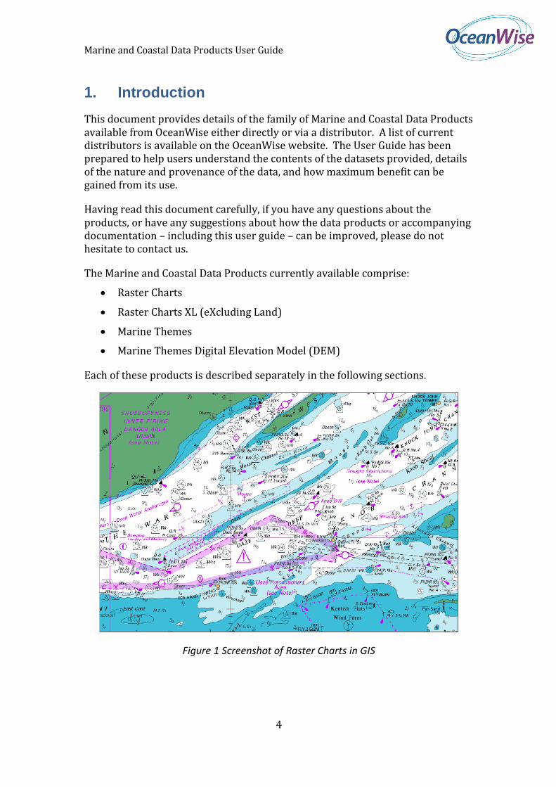
This document provides details of the family of Marine and Coastal Data Products available from OceanWise either directly or via a distributor. A list of current distributors is available on the OceanWise website. The User Guide has been prepared to help users understand the contents of the datasets provided, details of the nature and provenance of the data, and how maximum benefit can be gained from its use.
Having read this document carefully, if you have any questions about the products, or have any suggestions about how the data products or accompanying documentation – including this user guide – can be improved, please do not hesitate to contact us.
The Marine and Coastal Data Products currently available comprise:
Raster Charts
Raster Charts XL (eXcluding Land)
Marine Themes
Marine Themes Digital Elevation Model (DEM)
Each of these products is described separately in the following sections.
Figure 1 Screenshot of Raster Charts in GIS
Marine and Coastal Data Products User Guide
5
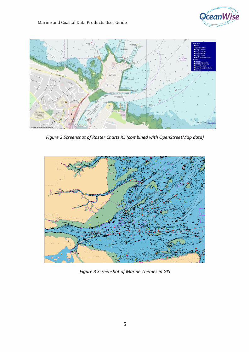
Figure 2 Screenshot of Raster Charts XL (combined with OpenStreetMap data)
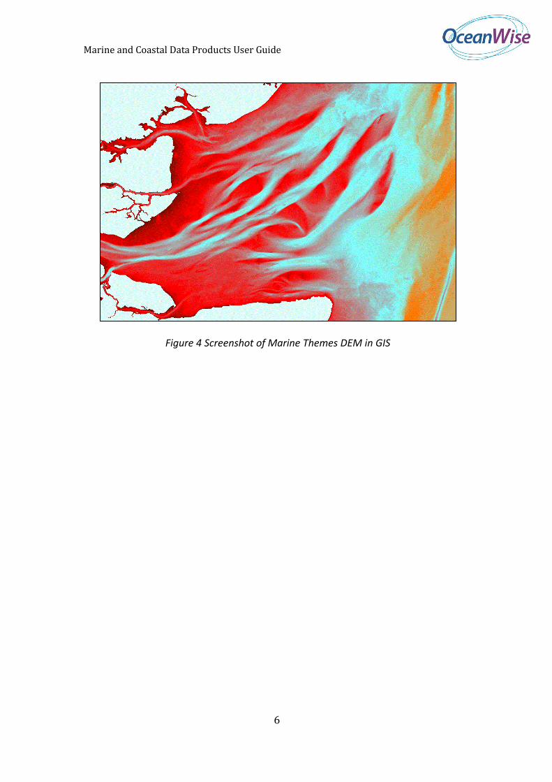
Figure 3 Screenshot of Marine Themes in GIS
Marine and Coastal Data Products User Guide
6
3 Screenshot of Marine DEM in GIS
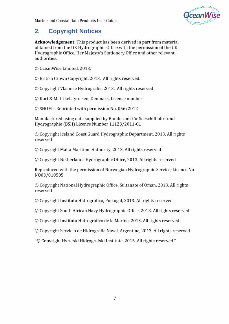
Figure 4 Screenshot of Marine Themes DEM in GIS
Marine and Coastal Data Products User Guide
7
2. Copyright Notices
Acknowledgement: This product has been derived in part from material obtained from the UK Hydrographic Office with the permission of the UK Hydrographic Office, Her Majesty’s Stationery Office and other relevant authorities.
© OceanWise Limited, 2013.
© British Crown Copyright, 2013. All rights reserved.
© Copyright Vlaamse Hydrografie, 2013. All rights reserved
© Kort & Matrikelstyrelsen, Denmark, Licence number
© SHOM – Reprinted with permission No. 056/2012
Manufactured using data supplied by Bundesamt für Seeschifffahrt und Hydrographie (BSH) Licence Number 11123/2011-01
© Copyright Iceland Coast Guard Hydrographic Department, 2013. All rights reserved
© Copyright Malta Maritime Authority, 2013. All rights reserved
© Copyright Netherlands Hydrographic Office, 2013. All rights reserved
Reproduced with the permission of Norwegian Hydrographic Service, Licence No NO03/010505
© Copyright National Hydrographic Office, Sultanate of Oman, 2013. All rights reserved
© Copyright Instituto Hidrográfico, Portugal, 2013. All rights reserved
© Copyright South African Navy Hydrographic Office, 2013. All rights reserved
© Copyright Instituto Hidrográfico de la Marina, 2013. All rights reserved
© Copyright Servicio de Hidrografia Naval, Argentina, 2013. All rights reserved
“© Copyright Hvratski Hidrografski Institute, 2015. All rights reserved.“
Marine and Coastal Data Products User Guide
8
3. Raster Charts
3.1 Background
Raster Charts comprises the well-known and popular nautical chart series from the UK Hydrographic Office, supplied as individual image files for easy loading and use in geographical information systems (GIS). It provides a comprehensive marine map base and is ideal for applications where a set of familiar features and related symbology is required for reference or as a backdrop to other data.
The Product is supplied as individual charts at different scales depending on their geographic coverage. Small scale charts cover the whole of British Waters, for example, while large scale charts cover individual estuaries and harbours in greater detail. There are many different scales of chart depending on the geographic area they cover.
Because of the way the original charts are compiled, individual charts may overlap with adjacent charts at the same or different scale levels, and charts at a given scale level may not provide complete coverage, the latter being particularly true for large scale charts that cover, for example, the approaches to a harbour or the harbour itself.
For convenience, we have grouped charts of a similar scale level into bands corresponding to the following levels:
Small: Chart scales of less than 1: 150,000
Medium: Chart scales of equal to or greater than 1:150,000, and less than 1: 30,000
Large: Chart scales equal to or greater than 1: 30,000.
Customers may choose to purchase a single chart or a number of charts covering a similar area by selecting these within the scale bands described above.
Because of the way Hydrographic Offices charge for content, more than one chart may be automatically included in your selection for no additional cost. However, if a single chart is required, without purchasing other charts in the same scale band and selected area, this may be arranged. In a few cases, some very small scale charts (of less than 1: 350,000) may attract a discount. Please contact us with your requirements and we will be pleased to provide advice and, if appropriate, revised pricing for single charts.
The UK Hydrographic Office website contains the details of all original charts and their geographic coverage. Please note though that not all of these charts have been captured digitally and a few that have been captured cannot be supplied for reasons of copyright or national security.
Please contact us if you require a chart that you know exists in its original form but that you cannot find on your chosen distributor’s website.
Marine and Coastal Data Products User Guide
9
3.2 File Naming
Each chart is provided as a separate file that is named according to the number of the original chart. Where the original chart contained smaller charts, known as panels, on the same sheet, each panel chart is provided as a separate file using the following naming convention:
For charts comprising a main chart and one or more smaller charts on the same sheet, these are supplied as separate files and are given the name XXXX-0 for the main chart and XXXX-1 for the first panel, XXXX-2 for the second panel etc.
For charts comprising two or more smaller charts on the same sheet without a main chart, these are also supplied as separate files but the file named XXXX-0 is omitted.
3.3 Coordinate Reference System
Charts are mostly standardised to the WGS84 Datum, especially in UK waters, and are projected either to Mercator or Transverse Mercator. The files containing these charts, and any that are referenced to a different system, include appropriate georeference metadata which is available to the user or system to ensure accurate positioning in Geographic Information Systems (GIS).
All depths and drying heights are referenced to Chart Datum, which approximates to Lowest Astronomical Tide (LAT).
3.4 Symbology
Charts are symbolised to the international standard known as INT1. If you are unfamiliar with this standard or you require further information, details are contained in the publication ‘Symbols and Abbreviations Used on Admiralty Charts 5011’ available from the UK Hydrographic Office and most retail and online chandlers.
3.5 Metadata
Metadata is presently not supplied with the Raster Charts Product.
3.6 Data Formats
The Raster Charts Product is supplied in the GeoTIFF format, which is read by GIS software. If you are a MapInfo user and require TAB files for the charts you have purchased, please contact your distributor or OceanWise directly.
The Raster Charts Product is available in the following delivery methods:
FTP Download
CD-ROM or DVD
Web Mapping Service.
Marine and Coastal Data Products User Guide
10
The available delivery methods may vary according to your chosen distributor. Please select one that suits your requirements or contact OceanWise for further information.
Marine and Coastal Data Products User Guide
11
4. Raster Charts XL (eXcluding Land)
4.1 Background
Raster Charts are familiar to many working in the marine domain, however the yellow land, title blocks and unique Coordinate Reference Systems can make working with more than one chart at a time messy and time consuming.
With the wider availability of off-the-shelf open source land mapping more users have access to these comprehensive datasets which they do not want obstructed by the vague yellow land.
Raster Charts XL comprises the well-known and popular nautical chart series from the UK Hydrographic Office with one major difference - all land has been removed. In addition the information panels, scale bars and title blocks have also been removed leaving just the marine data.
The Charts are supplied as individual image files for easy loading and use in geographical information systems (GIS) or Web Mapping services. It still provides a comprehensive marine map base and is ideal for applications where a set of familiar features and related symbology is required for reference or as a backdrop to other data but can now be used alongside more appropriate land mapping.
The Product is supplied as individual charts at different scales depending on their geographic coverage. Small scale charts cover the whole of British Waters, for example, while large scale charts cover individual estuaries and harbours in greater detail. There are many different scales of chart depending on the geographic area they cover.
Because of the way the original charts are compiled, individual charts may overlap with adjacent charts at the same or different scale levels, and charts at a given scale level may not provide complete coverage, the latter being particularly true for large scale charts that cover, for example, the approaches to a harbour or the harbour itself.
For convenience, we have grouped charts of a similar scale level into bands corresponding to the following levels:
Small: Chart scales of less than 1: 150,000
Medium: Chart scales of equal to or greater than 1:150,000, and less than 1: 30,000
Large: Chart scales equal to or greater than 1: 30,000.
Customers may choose to purchase a single chart or a number of charts covering a similar area by selecting these within the scale bands described above.
Marine and Coastal Data Products User Guide
12
Because of the way Hydrographic Offices charge for content, more than one chart may be automatically included in your selection for no additional cost. However, if a single chart is required, without purchasing other charts in the same scale band and selected area, this may be arranged. In a few cases, some very small scale charts (of less than 1: 350,000) may attract a discount. Please contact us with your requirements and we will be pleased to provide advice and, if appropriate, revised pricing for single charts.
The UK Hydrographic Office website contains the details of all original charts and their geographic coverage. Please note though that not all of these charts have been captured digitally and a few that have been captured cannot be supplied for reasons of copyright or national security.
Please contact us if you require a chart that you know exists in its original form but that you cannot find on your chosen distributor’s website.
4.2 File Naming
Each chart is provided as a separate file that is named according to the number of the original chart. Where the original chart contained smaller charts, known as panels, on the same sheet, each panel chart is provided as a separate file using the following naming convention:
For charts comprising a main chart and one or more smaller charts on the same sheet, these are supplied as separate files and are given the name XXXX-0 for the main chart and XXXX-1 for the first panel, XXXX-2 for the second panel etc.
For charts comprising two or more smaller charts on the same sheet without a main chart, these are also supplied as separate files but the file named XXXX-0 is omitted.
4.3 Coordinate Reference System
Raster Charts XL have been standardised to the World Mercator projection on WGS84 Datum (EPSG::3395).
All depths and drying heights are referenced to Chart Datum, which approximates to Lowest Astronomical Tide (LAT).
4.4 Symbology
Charts are symbolised to the international standard known as INT1. If you are unfamiliar with this standard or you require further information, details are contained in the publication ‘Symbols and Abbreviations Used on Admiralty Charts 5011’ available from the UK Hydrographic Office and most retail and online chandlers.

Marine and Coastal Data Products User Guide
13
4.5 Metadata
Metadata is presently not supplied with the Raster Charts XL Product.
4.6 Data Formats
The Raster Charts XL Product is supplied in the GeoTIFF format, which is read by GIS software. If you are a MapInfo user and require TAB files for the charts you have purchased, please contact your distributor or OceanWise directly.
The Raster Charts XL Product is available in the following delivery methods:
FTP Download
CD-ROM or DVD
Web Mapping Service.
The available delivery methods may vary according to your chosen distributor. Please select one that suits your requirements or contact OceanWise for further information.
Marine and Coastal Data Products User Guide
14
5. Marine Themes
5.1 Background
Marine Themes comprises authoritative data from different public sector data agencies, including the UK and other Hydrographic Offices. The dataset uses different sources of data available for a particular feature and scale range, derived either from the production Electronic Navigational Charts (ENCs) or from original source datasets, where available.
Marine Themes is supplied as individual themed layers corresponding to marine reference data or base mapping required for general situation awareness, planning, site selection and investigation and outline engineering design. As with Ordnance Survey MasterMap™ Topography Layer, Marine Themes contains unique identifiers that can be used for data linking and feature attributes that can be queried for differential display and spatial analysis.
5.2 Data Structure
Marine Themes is provided at four levels of scale or resolution, MTS, MTM, MTL and MTF. The first three levels correspond to the compilation scale of the input data where this is derived directly from ENCs. The latter, MTF, corresponds to data that has been acquired from primary sources to create seamless layers of data for a particular Feature Type. Because of the availability and nature of the source data, features are included at the most appropriate level. The four levels are defined as follows:
Small Scale (MTS): Derived from ENCs in the scale range 1: 150,000 and smaller. Coverage includes all waters
Medium Scale (MTM): Derived from ENCs in the scale range 1: 150,000 to 1: 30,000. Coverage includes coastal waters
Large Scale (MTL): Derived from ENCs in the scale range 1: 30,000 and greater. Coverage includes most harbours
Scale Independent (MTF): Data based on primary sources and provided as a seamless layer of data for all waters
Marine Themes is structured into eight Themes, with each Theme comprising various Feature Types pertinent to that Theme. Summary details are provided below. A full list of Feature Types is provided in Annex 1.
A separate document, the ‘Marine Themes Feature Catalogue’, contains a full list of Feature Types and their definition. Photographs of features in the real world,
Marine and Coastal Data Products User Guide
15
and a screenshot of their presence in GIS, are included where available. The catalogue will be available on-line in the near future.
A unique Feature Code and one or more Descriptive Terms define each Feature Type. Feature Codes contain five characters commencing with the number of the relevant theme. For example the Feature Type ‘Bathymetry, Area, Subtidal’ has the unique Feature Code of 10011, the first 1 indicating the feature belongs to the Theme ‘Elevation’ (See Annex 1). A list of the Themes is presented in Table 1 below.
The nature or character of each Feature Type is further defined by up to twenty base Attributes, including the Feature Code and Description outlined above. Where the Theme is sourced entirely from a primary data source additional attributes have been added appropriate to the data. The Attributes provided for each Marine Theme is presented in Table 2 overleaf.
Table 1 List of Marine Themes
CODE NAME DESCRIPTION
10000 Elevation
The Earth's surface divided into multiple subtidal, intertidal and land areas, contours and spot soundings. Includes bathymetry and multiple shorelines categorised by tidal level and type.
20000 Shipwrecks & Obstructions
Sunken ships and other disused man-made objects. Includes objects being re-used for another purpose and those of historical interest.
30000 Transport Transport networks and related infrastructure. Includes aids to navigation.
40000 Industrial Facilities
Production, industrial, aquaculture and research facilities. Includes hydrocarbon and renewable energy infrastructure, submarine cables and equipment for environmental monitoring.
50000 Administrative & Management Units
Areas of administration, governance and management at international, national, regional and local levels. Includes national boundaries, dumping sites, safety and prohibition zones and regulated fairways.
60000 Geographical Regions
Names of subtidal and intertidal areas, and other geographical or topographical features of public or historical interest.
70000 Geology Geological units including bedrock features and sea bed sediments
80000 Tides & Tidal Currents
Tide related features including stations and streams
Marine and Coastal Data Products User Guide
16
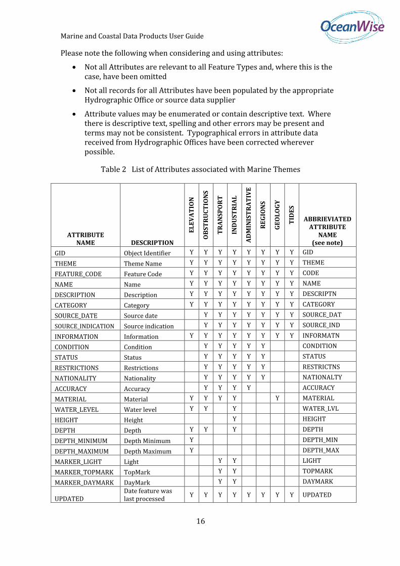
Please note the following when considering and using attributes:
Not all Attributes are relevant to all Feature Types and, where this is the case, have been omitted
Not all records for all Attributes have been populated by the appropriate Hydrographic Office or source data supplier
Attribute values may be enumerated or contain descriptive text. Where there is descriptive text, spelling and other errors may be present and terms may not be consistent. Typographical errors in attribute data received from Hydrographic Offices have been corrected wherever possible.
Table 2 List of Attributes associated with Marine Themes
ATTRIBUTE NAME DESCRIPTION
EL
EV
AT
ION
OB
ST
RU
CT
ION
S
TR
AN
SP
OR
T
IND
US
TR
IAL
AD
MIN
IST
RA
TIV
E
RE
GIO
NS
GE
OL
OG
Y
TID
ES
ABBRIEVIATED ATTRIBUTE
NAME (see note)
GID Object Identifier Y Y Y Y Y Y Y Y GID
THEME Theme Name Y Y Y Y Y Y Y Y THEME
FEATURE_CODE Feature Code Y Y Y Y Y Y Y Y CODE
NAME Name Y Y Y Y Y Y Y Y NAME
DESCRIPTION Description Y Y Y Y Y Y Y Y DESCRIPTN
CATEGORY Category Y Y Y Y Y Y Y Y CATEGORY
SOURCE_DATE Source date Y Y Y Y Y Y Y SOURCE_DAT
SOURCE_INDICATION Source indication Y Y Y Y Y Y Y SOURCE_IND
INFORMATION Information Y Y Y Y Y Y Y Y INFORMATN
CONDITION Condition Y Y Y Y Y CONDITION
STATUS Status Y Y Y Y Y STATUS
RESTRICTIONS Restrictions Y Y Y Y Y RESTRICTNS
NATIONALITY Nationality Y Y Y Y Y NATIONALTY
ACCURACY Accuracy Y Y Y Y ACCURACY
MATERIAL Material Y Y Y Y Y MATERIAL
WATER_LEVEL Water level Y Y Y WATER_LVL
HEIGHT Height Y HEIGHT
DEPTH Depth Y Y Y DEPTH
DEPTH_MINIMUM Depth Minimum Y DEPTH_MIN
DEPTH_MAXIMUM Depth Maximum Y DEPTH_MAX
MARKER_LIGHT Light Y Y LIGHT
MARKER_TOPMARK TopMark Y Y TOPMARK
MARKER_DAYMARK DayMark Y Y DAYMARK
UPDATED Date feature was last processed
Y Y Y Y Y Y Y Y UPDATED
Marine and Coastal Data Products User Guide
17
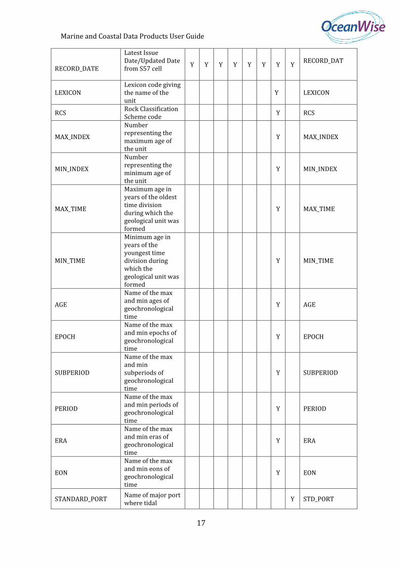
RECORD_DATE
Latest Issue Date/Updated Date from S57 cell
Y Y Y Y Y Y Y Y RECORD_DAT
LEXICON Lexicon code giving the name of the unit
Y LEXICON
RCS Rock Classification Scheme code
Y RCS
MAX_INDEX
Number representing the maximum age of the unit
Y MAX_INDEX
MIN_INDEX
Number representing the minimum age of the unit
Y MIN_INDEX
MAX_TIME
Maximum age in years of the oldest time division during which the geological unit was formed
Y MAX_TIME
MIN_TIME
Minimum age in years of the youngest time division during which the geological unit was formed
Y MIN_TIME
AGE
Name of the max and min ages of geochronological time
Y AGE
EPOCH
Name of the max and min epochs of geochronological time
Y EPOCH
SUBPERIOD
Name of the max and min subperiods of geochronological time
Y SUBPERIOD
PERIOD
Name of the max and min periods of geochronological time
Y PERIOD
ERA
Name of the max and min eras of geochronological time
Y ERA
EON
Name of the max and min eons of geochronological time
Y EON
STANDARD_PORT Name of major port where tidal
Y STD_PORT
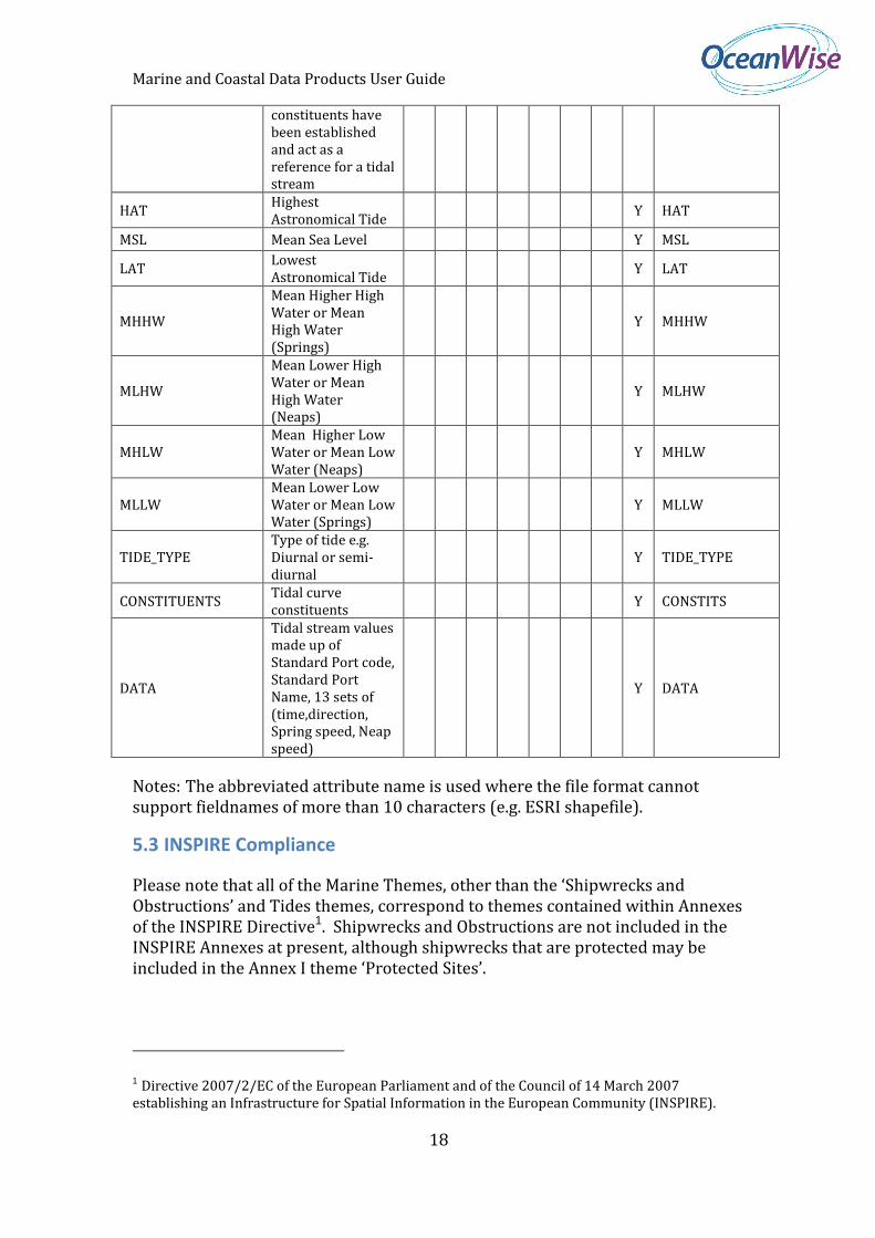
Marine and Coastal Data Products User Guide
18
constituents have been established and act as a reference for a tidal stream
HAT Highest Astronomical Tide
Y HAT
MSL Mean Sea Level Y MSL
LAT Lowest Astronomical Tide
Y LAT
MHHW
Mean Higher High Water or Mean High Water (Springs)
Y MHHW
MLHW
Mean Lower High Water or Mean High Water (Neaps)
Y MLHW
MHLW Mean Higher Low Water or Mean Low Water (Neaps)
Y MHLW
MLLW Mean Lower Low Water or Mean Low Water (Springs)
Y MLLW
TIDE_TYPE Type of tide e.g. Diurnal or semi-diurnal
Y TIDE_TYPE
CONSTITUENTS Tidal curve constituents
Y CONSTITS
DATA
Tidal stream values made up of Standard Port code, Standard Port Name, 13 sets of (time,direction, Spring speed, Neap speed)
Y DATA
Notes: The abbreviated attribute name is used where the file format cannot support fieldnames of more than 10 characters (e.g. ESRI shapefile).
5.3 INSPIRE Compliance
Please note that all of the Marine Themes, other than the ‘Shipwrecks and Obstructions’ and Tides themes, correspond to themes contained within Annexes of the INSPIRE Directive1. Shipwrecks and Obstructions are not included in the INSPIRE Annexes at present, although shipwrecks that are protected may be included in the Annex I theme ‘Protected Sites’.
1 Directive 2007/2/EC of the European Parliament and of the Council of 14 March 2007 establishing an Infrastructure for Spatial Information in the European Community (INSPIRE).
Marine and Coastal Data Products User Guide
19
Whilst it may be possible for Marine Themes to comply with the INSPIRE specifications for data in the future, this is not the case at present. There are a number of factors that do not allow compliance at this stage, including the lack of a published final specification for all relevant themes, the nature and availability of data from public sector data agencies, including the UK and other Hydrographic Offices, and the ability of some GIS to load the GML data format. It is our intention though to create an INSPIRE compliant version of the Marine Themes in the future.
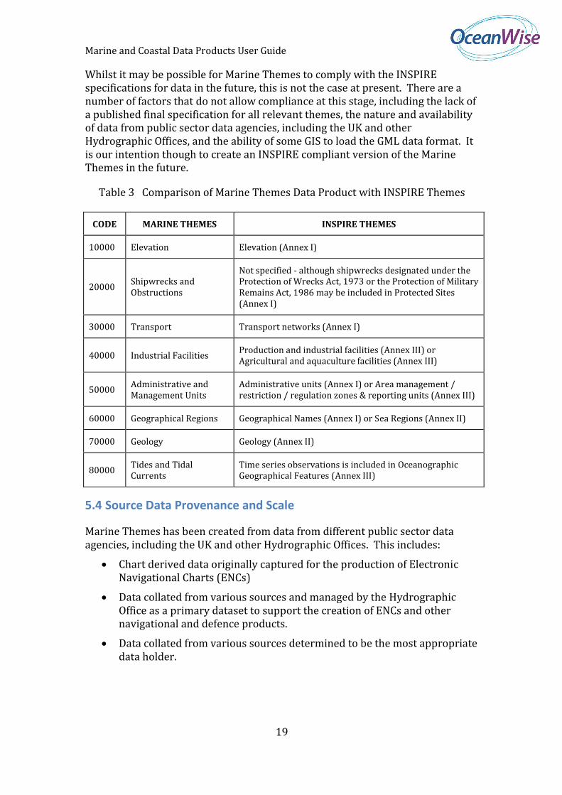
Table 3 Comparison of Marine Themes Data Product with INSPIRE Themes
CODE MARINE THEMES INSPIRE THEMES
10000 Elevation Elevation (Annex I)
20000 Shipwrecks and Obstructions
Not specified - although shipwrecks designated under the Protection of Wrecks Act, 1973 or the Protection of Military Remains Act, 1986 may be included in Protected Sites (Annex I)
30000 Transport Transport networks (Annex I)
40000 Industrial Facilities Production and industrial facilities (Annex III) or Agricultural and aquaculture facilities (Annex III)
50000 Administrative and Management Units
Administrative units (Annex I) or Area management / restriction / regulation zones & reporting units (Annex III)
60000 Geographical Regions Geographical Names (Annex I) or Sea Regions (Annex II)
70000 Geology Geology (Annex II)
80000 Tides and Tidal Currents
Time series observations is included in Oceanographic Geographical Features (Annex III)
5.4 Source Data Provenance and Scale
Marine Themes has been created from data from different public sector data agencies, including the UK and other Hydrographic Offices. This includes:
Chart derived data originally captured for the production of Electronic Navigational Charts (ENCs)
Data collated from various sources and managed by the Hydrographic Office as a primary dataset to support the creation of ENCs and other navigational and defence products.
Data collated from various sources determined to be the most appropriate data holder.
Marine and Coastal Data Products User Guide
20
These sources contain numerous features held to different standards e.g. IHO S-57. Their characteristics and how these are managed in the design and creation of the Marine Themes are explained below.
5.5 Data sourced from ENCs
Many of the features held digitally within Hydrographic Offices only exist in the form they were captured to support the creation of ENCs. In other words, they are only in their product form, rather than as source datasets that can then be used to support product development. As with paper and raster charts (see Section 3), ENCs are compiled at different scale levels, overlap with adjacent ENCs and do not necessarily provide complete coverage of the Earth’s surface (sea surface and seabed).
A real world feature may exist in several ENCs at different scales and may be represented differently in each case. For example, at ENC boundaries, a single feature in the real world will be represented as separate records (one for each ENC) with split geometries. Features present on one chart may be missing from an adjacent chart, their geometries discontinuous and their attributes captured differently.
There are many reasons why a feature contained in the data may not be wholly representative of the feature in the real world. This includes how the feature was portrayed by the Hydrographic Office on the original paper chart, the scale of that chart and the precision of capture, digitising errors, deliberate bias towards safety in compilation, and where its purpose is purely cartographic. Examples include the processing and selection of water depth to introduce a shoal bias, the coordinates of administrative areas being offset from any legal definition and geographical regions used for labelling. As a consequence, users should contact OceanWise, the Hydrographic Office or other relevant authority with regard to the accuracy and provenance of a given feature prior to its use for legal, contractual or regulatory purposes.
5.6 Creation of Marine Themes
Marine Themes uses the most complete and comprehensive geometric representation of a real world feature derived from one or more ENC or primary source dataset. This does not mean automatically using the representation of a feature derived from the largest scale ENC, as the feature may not be present at all scale levels, or may not be appropriate to the resolution of the final data product. Where possible, features are joined at chart boundaries to create as near a seamless layer as possible. The most up to date attribute data is used to populate the attributes for each conjoined feature. Errors in spelling or terminology are corrected where these are present and obvious. Where there is any doubt, features are left as separate records. The seeming discrepancy is reported to the relevant Hydrographic Office for consideration and any corrections included in future updates.
Marine and Coastal Data Products User Guide
21
Where features exist in primary source datasets, these are used to complement or replace those features derived from ENCs, as they are more comprehensive and accurate. Examples where this is the case include the ‘Wrecks and Obstructions Theme’ and ‘Military Practice Areas’ Feature Type. As Hydrographic Offices streamline their production lines and aim to make their data fit for uses other than navigation, it is expected that more data will be managed at source and hence used to replace ENC derived data in Marine Themes. We continue to work closely with Hydrographic Offices to encourage and help with this process.
In UK Waters Marine Themes Wrecks and Obstructions Layer is populated (as a single seamless layer) by data from UKHO Wrecks and Obstructions database and carefully selected chart derived data i.e. ENCs. We have de-conflicted and excluded any wrecks derived from ENCs (i.e. S-57) as these replicate features in the UKHO database and give a false indication of the quantity of wrecks in an area. We have however retained obstructions from S-57 where these do not conflict with the UKHO database, as there are many of these that are not in the source database. Some are underwater rocks but others indicate the presence of debris which may be manmade.
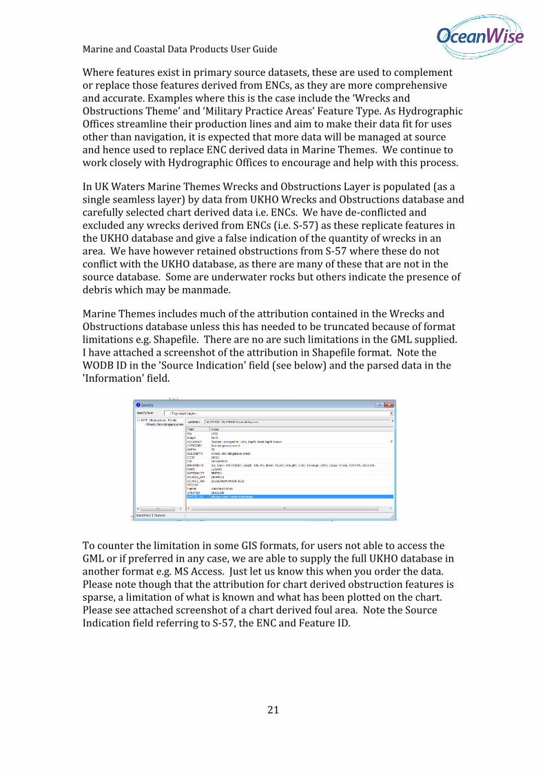
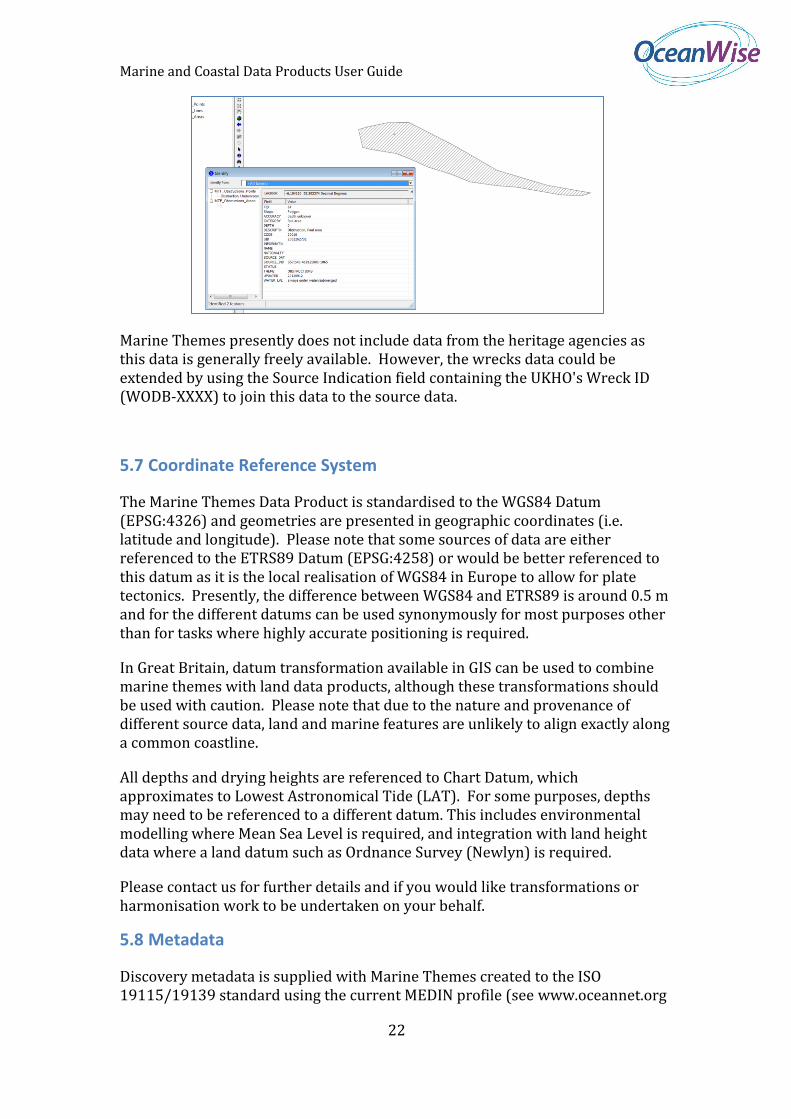
Marine Themes includes much of the attribution contained in the Wrecks and Obstructions database unless this has needed to be truncated because of format limitations e.g. Shapefile. There are no are such limitations in the GML supplied. I have attached a screenshot of the attribution in Shapefile format. Note the WODB ID in the 'Source Indication' field (see below) and the parsed data in the 'Information' field.
To counter the limitation in some GIS formats, for users not able to access the GML or if preferred in any case, we are able to supply the full UKHO database in another format e.g. MS Access. Just let us know this when you order the data. Please note though that the attribution for chart derived obstruction features is sparse, a limitation of what is known and what has been plotted on the chart. Please see attached screenshot of a chart derived foul area. Note the Source Indication field referring to S-57, the ENC and Feature ID.
Marine and Coastal Data Products User Guide
22
Marine Themes presently does not include data from the heritage agencies as this data is generally freely available. However, the wrecks data could be extended by using the Source Indication field containing the UKHO's Wreck ID (WODB-XXXX) to join this data to the source data.
5.7 Coordinate Reference System
The Marine Themes Data Product is standardised to the WGS84 Datum (EPSG:4326) and geometries are presented in geographic coordinates (i.e. latitude and longitude). Please note that some sources of data are either referenced to the ETRS89 Datum (EPSG:4258) or would be better referenced to this datum as it is the local realisation of WGS84 in Europe to allow for plate tectonics. Presently, the difference between WGS84 and ETRS89 is around 0.5 m and for the different datums can be used synonymously for most purposes other than for tasks where highly accurate positioning is required.
In Great Britain, datum transformation available in GIS can be used to combine marine themes with land data products, although these transformations should be used with caution. Please note that due to the nature and provenance of different source data, land and marine features are unlikely to align exactly along a common coastline.
All depths and drying heights are referenced to Chart Datum, which approximates to Lowest Astronomical Tide (LAT). For some purposes, depths may need to be referenced to a different datum. This includes environmental modelling where Mean Sea Level is required, and integration with land height data where a land datum such as Ordnance Survey (Newlyn) is required.
Please contact us for further details and if you would like transformations or harmonisation work to be undertaken on your behalf.
5.8 Metadata
Discovery metadata is supplied with Marine Themes created to the ISO 19115/19139 standard using the current MEDIN profile (see www.oceannet.org
Marine and Coastal Data Products User Guide
23
for details). The MEDIN profile is a superset of the Gemini 2.1 profile, which is used widely in the UK.
In addition to dataset level i.e. discovery metadata, record level i.e. use metadata is supplied with Marine Themes as an attribute of all features types, providing the user with essential information on the source of each feature and, where known, the accuracy and method of capture.
5.9 Data Formats
The Marine Themes Product is supplied in a number of data formats which are listed below:
GML
ESRI Shapefile
MapInfo TAB
MapInfo MID/MIF
The Marine Themes Product is available in the following delivery methods:
FTP Download
CD-ROM or DVD
Web Mapping Service
Web Feature Service.
The available formats and delivery methods may vary according to your chosen distributor. Please select one that suits your requirements or contact OceanWise for further information.
5.10 Symbology
Symbology may be applied to Marine Themes to determine how the data is portrayed in GIS. How this is achieved depends on the format in which the data is supplied and the target application. Descriptions of the methods used for commonly used systems are provided below.
For Cadcorp users a MarineThemes Named Object Library (NOL) file is supplied which contains Pens, Brushes and Symbols along with Themes that can be applied directly to Cadcorp overlays.
ESRI Layer Files are supplied with the data, which applies standard ESRI symbology. There is a Layer File (*.lyr – ArcGIS 9.x+) for each theme and scale level, which contains links to the source data. The Layer Files must reside in the same folder as the data.
An ESRI Stylefile is supplied for use where Layer files may not be appropriate e.g. when supplied data is subsequently loaded into a local data store (Geodatabase)

Marine and Coastal Data Products User Guide
24
The following reference scales for each Marine Theme scale level are recommended for users of ESRI ArcGIS:
Small scale (MTS) 1: 500,000 Medium scale (MTM) 1: 250,000 Large scale (MTL) 1: 100,000 Scale Independent (MTF) 1: 100,000
Due to the way the data is stored and extracted, symbology is not included in MapInfo TAB format automatically. Instead, symbology can be applied to TAB files post supply using a utility tool. Please contact us for details.
Due to the nature of the features within each Theme, the Theme order suggested below will give the best display within a GIS system, where 1 is the top-most Theme on display (actual order is GIS dependant).
1. Obstructions
2. Tides
3. Industrial
4. Transport
5. Administrative
6. Geology
7. Regions
8. Elevation
Within each Theme, Shapefiles are provided for Point, Line and Area features. Points should be displayed on top of Lines, which in turn should be displayed on top of Areas. This does not affect other file formats which can handle multiple geometry types.
NOTE: Although all files are supplied for each order, some files may not contain data due to the spatial variation in some features.
Marine and Coastal Data Products User Guide
25
6. Marine Themes Digital Elevation Model
6.1 Background
Marine Themes Digital Elevation Model (DEM) comprises a gridded (raster) dataset of seabed elevation relative to a specified datum. The surface has been created from hydrographic survey and chart derived data depending on the data available for a particular area and has a resolution of 1 and 6 arc seconds, which is approximately 30 and 180 m, respectively. The 1 arc second DEM is provided as individually named half degree tiles and the 6 arc second as individually named two degree tiles. Depending on the resolution of input data the 1 arc second DEM is not available for all areas.
The DEM has been created by utilising these different sources of data in order of resolution, survey method and age in a process known as ‘de-confliction’. A meta-layer that accompanies the DEM describes the source data used in any given area. The DEM coastline is the High Water Line on the largest scale of ENC available for any given area. This coastline corresponds to the coastline feature contained within Marine Themes (MTL Elevation), conjoined and height attributed to create a contiguous three dimensional line which was used as a break line.
6.2 DEM Creation
6.2.1 Data Sources
Typical sources of data used in the creation of the DEM include:
Civil and Military Survey Programmes
Port and Harbour Authorities
Pipeline, cable and other site surveys from industry
Output from scientific and environmental studies and surveys
Compilations of the above used in the creation of ENCs
All of the above sources have been quality controlled, so only those verified as fit for use in charting were used in the creation of the DEM.
Whilst Hydrographic Offices are permitted to use all of the data it holds for charting, some data sources may be restricted for commercial or security reasons. Wherever permitted the most up to date, highest resolution data has been used in DEM creation.
New sources of data either acquired from surveys or released from archive by Hydrographic Offices and other data holders will be incorporated into the DEM during the revision cycle in the future. The meta-layer (also known as a coverage layer) will be updated to reflect these changes.
Marine and Coastal Data Products User Guide
26
6.2.2 Data Processing
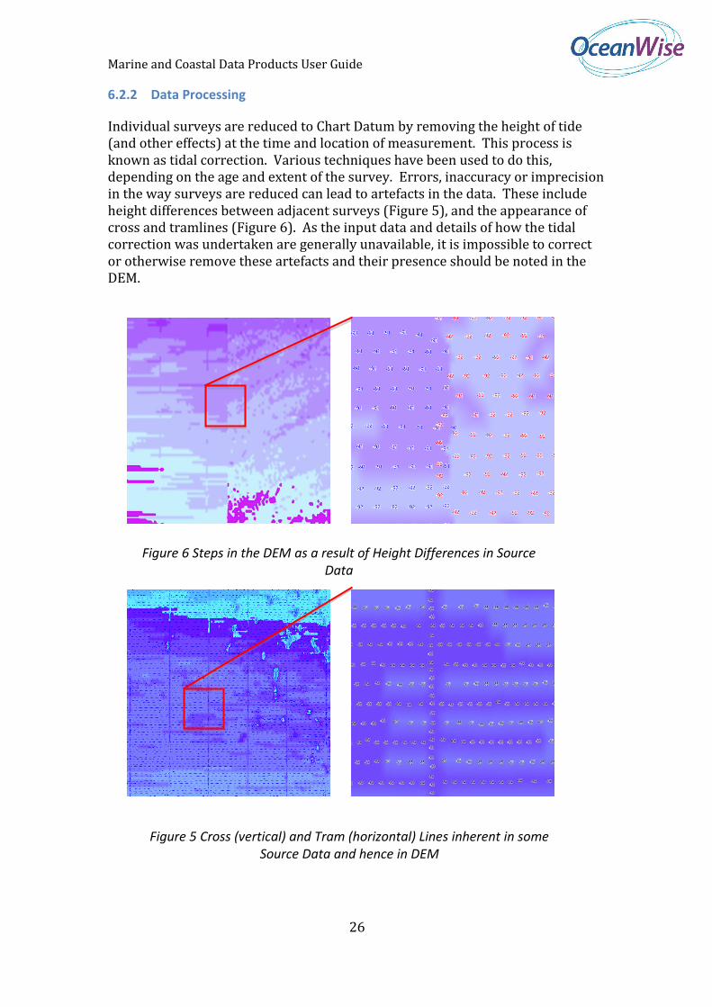
Individual surveys are reduced to Chart Datum by removing the height of tide (and other effects) at the time and location of measurement. This process is known as tidal correction. Various techniques have been used to do this, depending on the age and extent of the survey. Errors, inaccuracy or imprecision in the way surveys are reduced can lead to artefacts in the data. These include height differences between adjacent surveys (Figure 5), and the appearance of cross and tramlines (Figure 6). As the input data and details of how the tidal correction was undertaken are generally unavailable, it is impossible to correct or otherwise remove these artefacts and their presence should be noted in the DEM.
Figure 6 Steps in the DEM as a result of Height Differences in Source Data
Figure 5 Cross (vertical) and Tram (horizontal) Lines inherent in some Source Data and hence in DEM
Marine and Coastal Data Products User Guide
27
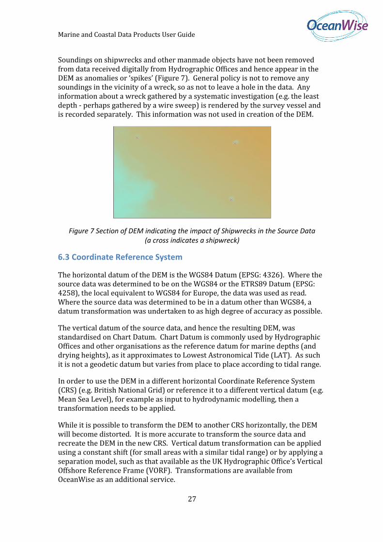
Soundings on shipwrecks and other manmade objects have not been removed from data received digitally from Hydrographic Offices and hence appear in the DEM as anomalies or ‘spikes’ (Figure 7). General policy is not to remove any soundings in the vicinity of a wreck, so as not to leave a hole in the data. Any information about a wreck gathered by a systematic investigation (e.g. the least depth - perhaps gathered by a wire sweep) is rendered by the survey vessel and is recorded separately. This information was not used in creation of the DEM.
Figure 7 Section of DEM indicating the impact of Shipwrecks in the Source Data (a cross indicates a shipwreck)
6.3 Coordinate Reference System
The horizontal datum of the DEM is the WGS84 Datum (EPSG: 4326). Where the source data was determined to be on the WGS84 or the ETRS89 Datum (EPSG: 4258), the local equivalent to WGS84 for Europe, the data was used as read. Where the source data was determined to be in a datum other than WGS84, a datum transformation was undertaken to as high degree of accuracy as possible.
The vertical datum of the source data, and hence the resulting DEM, was standardised on Chart Datum. Chart Datum is commonly used by Hydrographic Offices and other organisations as the reference datum for marine depths (and drying heights), as it approximates to Lowest Astronomical Tide (LAT). As such it is not a geodetic datum but varies from place to place according to tidal range.
In order to use the DEM in a different horizontal Coordinate Reference System (CRS) (e.g. British National Grid) or reference it to a different vertical datum (e.g. Mean Sea Level), for example as input to hydrodynamic modelling, then a transformation needs to be applied.
While it is possible to transform the DEM to another CRS horizontally, the DEM will become distorted. It is more accurate to transform the source data and recreate the DEM in the new CRS. Vertical datum transformation can be applied using a constant shift (for small areas with a similar tidal range) or by applying a separation model, such as that available as the UK Hydrographic Office’s Vertical Offshore Reference Frame (VORF). Transformations are available from OceanWise as an additional service.
Marine and Coastal Data Products User Guide
28
Please contact your chosen distributor or OceanWise directly for details.
6.4 File Naming
Each half degree (1 arc second DEM) or two degree (6 arc second DEM) tile is provided as an individual file named according to the following convention. Each file is prefixed with “MTF”, which means Marine Themes Feature:
TGYYYHXXXX.asc e.g. MTF5051010050.asc
Where T is the tile size (5 for 0.5 degrees, 2 for 2 degrees) G denotes the northern or southern hemisphere, 0 for north and 1 for south YYY is the latitude of the most southern and most western corner of the tile e.g. 505 is 50.5 degrees or 50 degrees 30 minutes H denotes the eastern or western hemisphere, 0 for east and 1 for west XXXX is the longitude of the most southern and western corner of the tile e.g. 0050 is 005.0 degrees or 005 degrees 0 minutes .asc is the extension of the file indicating its format e.g. ASCII grid.
6.5 Symbology
OceanWise provides a recommended colour ramp for its DEM. The colour ramp is contained within a Layer file (for ESRI ArcGIS users) which is available from your chosen distributor. Shading and other relief effects can be added as required. Please consult you GIS manual for details.
6.6 Metadata
Discovery metadata is supplied with Marine DEM created to the ISO 19115/19139 standard using the current MEDIN profile (see www.oceannet.org for details). The MEDIN profile is a superset of the Gemini 2.1 profile, which is used widely in the UK.
In addition to dataset level i.e. discovery metadata, evaluation level metadata is supplied in the form of a meta-layer or coverage layer describing the input data used in DEM creation for any given area. This meta-layer is supplied as a separate file in GIS format e.g. GML.
Marine and Coastal Data Products User Guide
29
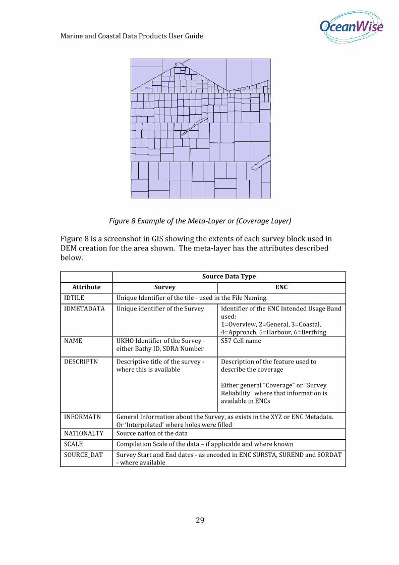
Figure 8 Example of the Meta-Layer or (Coverage Layer)
Figure 8 is a screenshot in GIS showing the extents of each survey block used in DEM creation for the area shown. The meta-layer has the attributes described below.
Source Data Type
Attribute Survey ENC
IDTILE Unique Identifier of the tile - used in the File Naming.
IDMETADATA Unique identifier of the Survey Identifier of the ENC Intended Usage Band used: 1=Overview, 2=General, 3=Coastal, 4=Approach, 5=Harbour, 6=Berthing
NAME UKHO Identifier of the Survey - either Bathy ID, SDRA Number
S57 Cell name
DESCRIPTN Descriptive title of the survey - where this is available
Description of the feature used to describe the coverage Either general "Coverage" or "Survey Reliability" where that information is available in ENCs
INFORMATN General Information about the Survey, as exists in the XYZ or ENC Metadata. Or ‘Interpolated’ where holes were filled
NATIONALTY Source nation of the data
SCALE Compilation Scale of the data – if applicable and where known
SOURCE_DAT Survey Start and End dates - as encoded in ENC SURSTA, SUREND and SORDAT - where available
Marine and Coastal Data Products User Guide
30
SOURCE_IND Concatenation of source identifiers, where known e.g. for GB data: HOID Hydrographic Identifier ORID Originators Identifier HOIN Hydrographic Instruction
ENC Source Indication - encoded as SORIND (S-57 Attribute)
UPDATED Date the data was incorporated into the output Grid
6.7 Data Formats
The Marine DEM is supplied in a number of data formats which are listed below:
ESRI ASCII Grid
Surfer 7 Grid
GeoTIFF
It is available in the following delivery methods:
FTP Download
CD-ROM or DVD
Web Mapping Service.
The available formats and delivery methods may vary according to your chosen distributor. Please select one that suits your requirements or contact OceanWise for further information.
Marine and Coastal Data Products User Guide
31
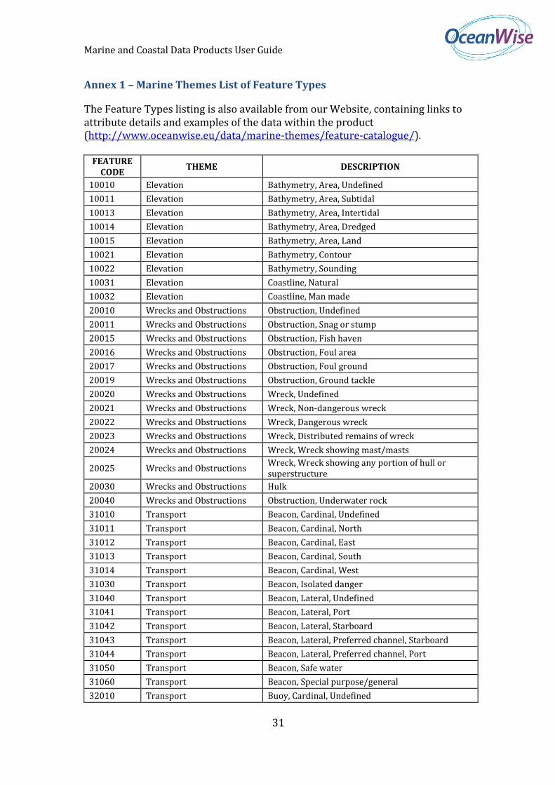
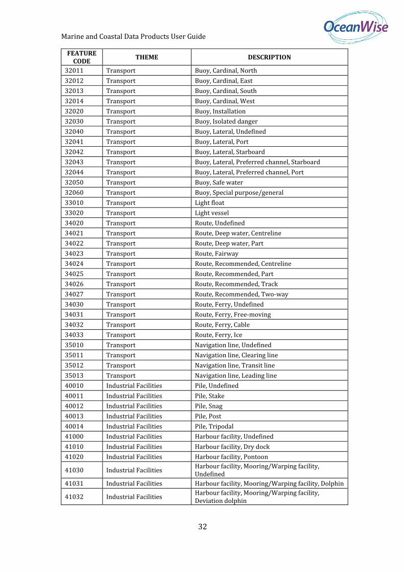
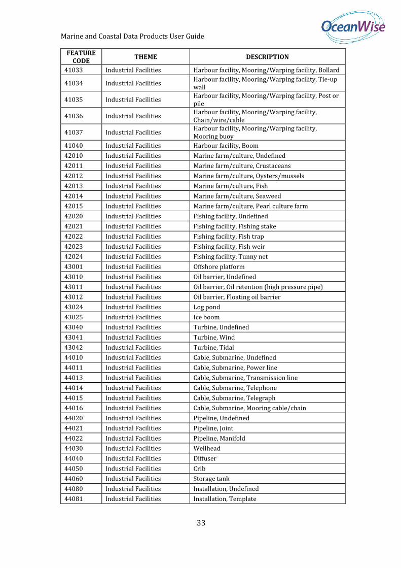
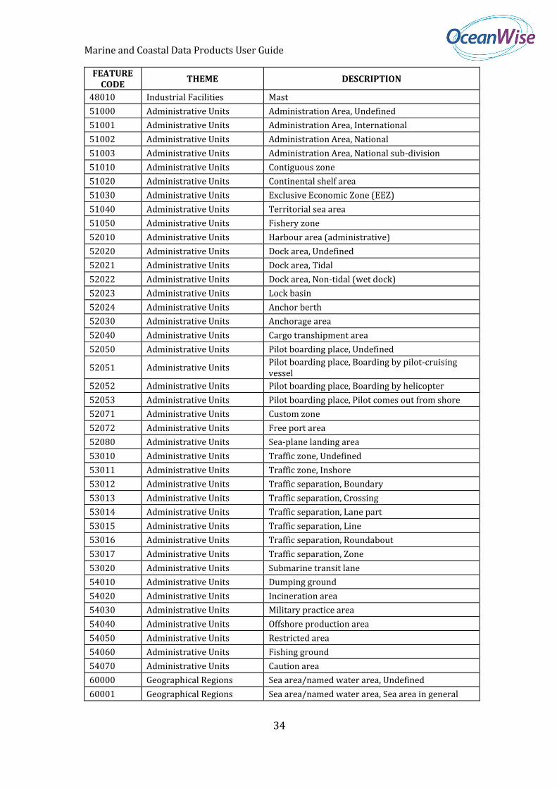
Annex 1 – Marine Themes List of Feature Types
The Feature Types listing is also available from our Website, containing links to attribute details and examples of the data within the product (http://www.oceanwise.eu/data/marine-themes/feature-catalogue/).
FEATURE CODE
THEME DESCRIPTION
10010 Elevation Bathymetry, Area, Undefined
10011 Elevation Bathymetry, Area, Subtidal
10013 Elevation Bathymetry, Area, Intertidal
10014 Elevation Bathymetry, Area, Dredged
10015 Elevation Bathymetry, Area, Land
10021 Elevation Bathymetry, Contour
10022 Elevation Bathymetry, Sounding
10031 Elevation Coastline, Natural
10032 Elevation Coastline, Man made
20010 Wrecks and Obstructions Obstruction, Undefined
20011 Wrecks and Obstructions Obstruction, Snag or stump
20015 Wrecks and Obstructions Obstruction, Fish haven
20016 Wrecks and Obstructions Obstruction, Foul area
20017 Wrecks and Obstructions Obstruction, Foul ground
20019 Wrecks and Obstructions Obstruction, Ground tackle
20020 Wrecks and Obstructions Wreck, Undefined
20021 Wrecks and Obstructions Wreck, Non-dangerous wreck
20022 Wrecks and Obstructions Wreck, Dangerous wreck
20023 Wrecks and Obstructions Wreck, Distributed remains of wreck
20024 Wrecks and Obstructions Wreck, Wreck showing mast/masts
20025 Wrecks and Obstructions Wreck, Wreck showing any portion of hull or superstructure
20030 Wrecks and Obstructions Hulk
20040 Wrecks and Obstructions Obstruction, Underwater rock
31010 Transport Beacon, Cardinal, Undefined
31011 Transport Beacon, Cardinal, North
31012 Transport Beacon, Cardinal, East
31013 Transport Beacon, Cardinal, South
31014 Transport Beacon, Cardinal, West
31030 Transport Beacon, Isolated danger
31040 Transport Beacon, Lateral, Undefined
31041 Transport Beacon, Lateral, Port
31042 Transport Beacon, Lateral, Starboard
31043 Transport Beacon, Lateral, Preferred channel, Starboard
31044 Transport Beacon, Lateral, Preferred channel, Port
31050 Transport Beacon, Safe water
31060 Transport Beacon, Special purpose/general
32010 Transport Buoy, Cardinal, Undefined
Marine and Coastal Data Products User Guide
32
FEATURE CODE
THEME DESCRIPTION
32011 Transport Buoy, Cardinal, North
32012 Transport Buoy, Cardinal, East
32013 Transport Buoy, Cardinal, South
32014 Transport Buoy, Cardinal, West
32020 Transport Buoy, Installation
32030 Transport Buoy, Isolated danger
32040 Transport Buoy, Lateral, Undefined
32041 Transport Buoy, Lateral, Port
32042 Transport Buoy, Lateral, Starboard
32043 Transport Buoy, Lateral, Preferred channel, Starboard
32044 Transport Buoy, Lateral, Preferred channel, Port
32050 Transport Buoy, Safe water
32060 Transport Buoy, Special purpose/general
33010 Transport Light float
33020 Transport Light vessel
34020 Transport Route, Undefined
34021 Transport Route, Deep water, Centreline
34022 Transport Route, Deep water, Part
34023 Transport Route, Fairway
34024 Transport Route, Recommended, Centreline
34025 Transport Route, Recommended, Part
34026 Transport Route, Recommended, Track
34027 Transport Route, Recommended, Two-way
34030 Transport Route, Ferry, Undefined
34031 Transport Route, Ferry, Free-moving
34032 Transport Route, Ferry, Cable
34033 Transport Route, Ferry, Ice
35010 Transport Navigation line, Undefined
35011 Transport Navigation line, Clearing line
35012 Transport Navigation line, Transit line
35013 Transport Navigation line, Leading line
40010 Industrial Facilities Pile, Undefined
40011 Industrial Facilities Pile, Stake
40012 Industrial Facilities Pile, Snag
40013 Industrial Facilities Pile, Post
40014 Industrial Facilities Pile, Tripodal
41000 Industrial Facilities Harbour facility, Undefined
41010 Industrial Facilities Harbour facility, Dry dock
41020 Industrial Facilities Harbour facility, Pontoon
41030 Industrial Facilities Harbour facility, Mooring/Warping facility, Undefined
41031 Industrial Facilities Harbour facility, Mooring/Warping facility, Dolphin
41032 Industrial Facilities Harbour facility, Mooring/Warping facility, Deviation dolphin
Marine and Coastal Data Products User Guide
33
FEATURE CODE
THEME DESCRIPTION
41033 Industrial Facilities Harbour facility, Mooring/Warping facility, Bollard
41034 Industrial Facilities Harbour facility, Mooring/Warping facility, Tie-up wall
41035 Industrial Facilities Harbour facility, Mooring/Warping facility, Post or pile
41036 Industrial Facilities Harbour facility, Mooring/Warping facility, Chain/wire/cable
41037 Industrial Facilities Harbour facility, Mooring/Warping facility, Mooring buoy
41040 Industrial Facilities Harbour facility, Boom
42010 Industrial Facilities Marine farm/culture, Undefined
42011 Industrial Facilities Marine farm/culture, Crustaceans
42012 Industrial Facilities Marine farm/culture, Oysters/mussels
42013 Industrial Facilities Marine farm/culture, Fish
42014 Industrial Facilities Marine farm/culture, Seaweed
42015 Industrial Facilities Marine farm/culture, Pearl culture farm
42020 Industrial Facilities Fishing facility, Undefined
42021 Industrial Facilities Fishing facility, Fishing stake
42022 Industrial Facilities Fishing facility, Fish trap
42023 Industrial Facilities Fishing facility, Fish weir
42024 Industrial Facilities Fishing facility, Tunny net
43001 Industrial Facilities Offshore platform
43010 Industrial Facilities Oil barrier, Undefined
43011 Industrial Facilities Oil barrier, Oil retention (high pressure pipe)
43012 Industrial Facilities Oil barrier, Floating oil barrier
43024 Industrial Facilities Log pond
43025 Industrial Facilities Ice boom
43040 Industrial Facilities Turbine, Undefined
43041 Industrial Facilities Turbine, Wind
43042 Industrial Facilities Turbine, Tidal
44010 Industrial Facilities Cable, Submarine, Undefined
44011 Industrial Facilities Cable, Submarine, Power line
44013 Industrial Facilities Cable, Submarine, Transmission line
44014 Industrial Facilities Cable, Submarine, Telephone
44015 Industrial Facilities Cable, Submarine, Telegraph
44016 Industrial Facilities Cable, Submarine, Mooring cable/chain
44020 Industrial Facilities Pipeline, Undefined
44021 Industrial Facilities Pipeline, Joint
44022 Industrial Facilities Pipeline, Manifold
44030 Industrial Facilities Wellhead
44040 Industrial Facilities Diffuser
44050 Industrial Facilities Crib
44060 Industrial Facilities Storage tank
44080 Industrial Facilities Installation, Undefined
44081 Industrial Facilities Installation, Template
Marine and Coastal Data Products User Guide
34
FEATURE CODE
THEME DESCRIPTION
48010 Industrial Facilities Mast
51000 Administrative Units Administration Area, Undefined
51001 Administrative Units Administration Area, International
51002 Administrative Units Administration Area, National
51003 Administrative Units Administration Area, National sub-division
51010 Administrative Units Contiguous zone
51020 Administrative Units Continental shelf area
51030 Administrative Units Exclusive Economic Zone (EEZ)
51040 Administrative Units Territorial sea area
51050 Administrative Units Fishery zone
52010 Administrative Units Harbour area (administrative)
52020 Administrative Units Dock area, Undefined
52021 Administrative Units Dock area, Tidal
52022 Administrative Units Dock area, Non-tidal (wet dock)
52023 Administrative Units Lock basin
52024 Administrative Units Anchor berth
52030 Administrative Units Anchorage area
52040 Administrative Units Cargo transhipment area
52050 Administrative Units Pilot boarding place, Undefined
52051 Administrative Units Pilot boarding place, Boarding by pilot-cruising vessel
52052 Administrative Units Pilot boarding place, Boarding by helicopter
52053 Administrative Units Pilot boarding place, Pilot comes out from shore
52071 Administrative Units Custom zone
52072 Administrative Units Free port area
52080 Administrative Units Sea-plane landing area
53010 Administrative Units Traffic zone, Undefined
53011 Administrative Units Traffic zone, Inshore
53012 Administrative Units Traffic separation, Boundary
53013 Administrative Units Traffic separation, Crossing
53014 Administrative Units Traffic separation, Lane part
53015 Administrative Units Traffic separation, Line
53016 Administrative Units Traffic separation, Roundabout
53017 Administrative Units Traffic separation, Zone
53020 Administrative Units Submarine transit lane
54010 Administrative Units Dumping ground
54020 Administrative Units Incineration area
54030 Administrative Units Military practice area
54040 Administrative Units Offshore production area
54050 Administrative Units Restricted area
54060 Administrative Units Fishing ground
54070 Administrative Units Caution area
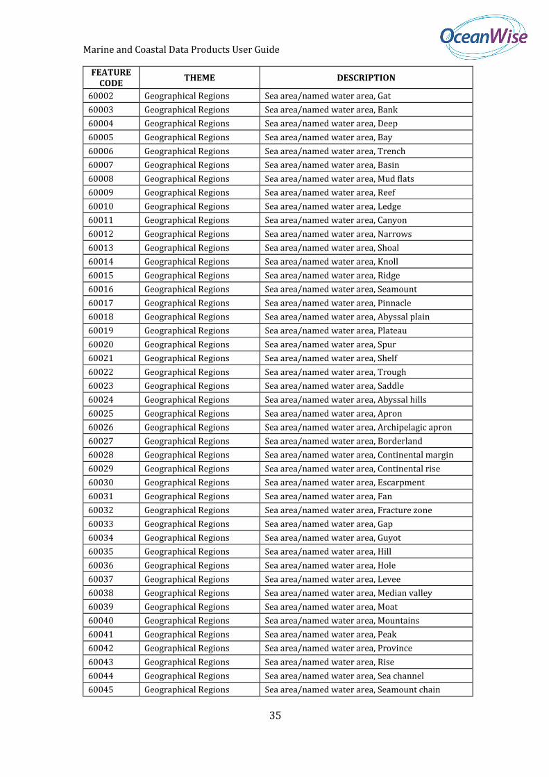
60000 Geographical Regions Sea area/named water area, Undefined
60001 Geographical Regions Sea area/named water area, Sea area in general
Marine and Coastal Data Products User Guide
35
FEATURE CODE
THEME DESCRIPTION
60002 Geographical Regions Sea area/named water area, Gat
60003 Geographical Regions Sea area/named water area, Bank
60004 Geographical Regions Sea area/named water area, Deep
60005 Geographical Regions Sea area/named water area, Bay
60006 Geographical Regions Sea area/named water area, Trench
60007 Geographical Regions Sea area/named water area, Basin
60008 Geographical Regions Sea area/named water area, Mud flats
60009 Geographical Regions Sea area/named water area, Reef
60010 Geographical Regions Sea area/named water area, Ledge
60011 Geographical Regions Sea area/named water area, Canyon
60012 Geographical Regions Sea area/named water area, Narrows
60013 Geographical Regions Sea area/named water area, Shoal
60014 Geographical Regions Sea area/named water area, Knoll
60015 Geographical Regions Sea area/named water area, Ridge
60016 Geographical Regions Sea area/named water area, Seamount
60017 Geographical Regions Sea area/named water area, Pinnacle
60018 Geographical Regions Sea area/named water area, Abyssal plain
60019 Geographical Regions Sea area/named water area, Plateau
60020 Geographical Regions Sea area/named water area, Spur
60021 Geographical Regions Sea area/named water area, Shelf
60022 Geographical Regions Sea area/named water area, Trough
60023 Geographical Regions Sea area/named water area, Saddle
60024 Geographical Regions Sea area/named water area, Abyssal hills
60025 Geographical Regions Sea area/named water area, Apron
60026 Geographical Regions Sea area/named water area, Archipelagic apron
60027 Geographical Regions Sea area/named water area, Borderland
60028 Geographical Regions Sea area/named water area, Continental margin
60029 Geographical Regions Sea area/named water area, Continental rise
60030 Geographical Regions Sea area/named water area, Escarpment
60031 Geographical Regions Sea area/named water area, Fan
60032 Geographical Regions Sea area/named water area, Fracture zone
60033 Geographical Regions Sea area/named water area, Gap
60034 Geographical Regions Sea area/named water area, Guyot
60035 Geographical Regions Sea area/named water area, Hill
60036 Geographical Regions Sea area/named water area, Hole
60037 Geographical Regions Sea area/named water area, Levee
60038 Geographical Regions Sea area/named water area, Median valley
60039 Geographical Regions Sea area/named water area, Moat
60040 Geographical Regions Sea area/named water area, Mountains
60041 Geographical Regions Sea area/named water area, Peak
60042 Geographical Regions Sea area/named water area, Province
60043 Geographical Regions Sea area/named water area, Rise
60044 Geographical Regions Sea area/named water area, Sea channel
60045 Geographical Regions Sea area/named water area, Seamount chain
Marine and Coastal Data Products User Guide
36
FEATURE CODE
THEME DESCRIPTION
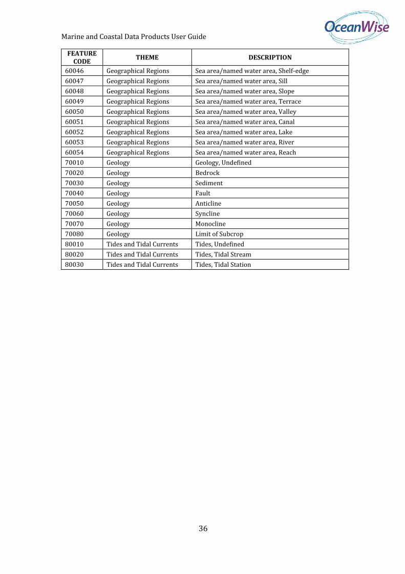
60046 Geographical Regions Sea area/named water area, Shelf-edge
60047 Geographical Regions Sea area/named water area, Sill
60048 Geographical Regions Sea area/named water area, Slope
60049 Geographical Regions Sea area/named water area, Terrace
60050 Geographical Regions Sea area/named water area, Valley
60051 Geographical Regions Sea area/named water area, Canal
60052 Geographical Regions Sea area/named water area, Lake
60053 Geographical Regions Sea area/named water area, River
60054 Geographical Regions Sea area/named water area, Reach
70010 Geology Geology, Undefined
70020 Geology Bedrock
70030 Geology Sediment
70040 Geology Fault
70050 Geology Anticline
70060 Geology Syncline
70070 Geology Monocline
70080 Geology Limit of Subcrop
80010 Tides and Tidal Currents Tides, Undefined
80020 Tides and Tidal Currents Tides, Tidal Stream
80030 Tides and Tidal Currents Tides, Tidal Station
Related Documents