CONVENTION ON BIOLOGICAL DIVERSITY UNEP/CBD/SBSTTA/20/CRP.10 28 April 2016 ORIGINAL: ENGLISH SUBSIDIARY BODY ON SCIENTIFIC, TECHNICAL AND TECHNOLOGICAL ADVICE Twentieth meeting Montreal, Canada, 25-30 April 2016 Agenda item 4.1 MARINE AND COASTAL BIODIVERSITY: ECOLOGICALLY OR BIOLOGICALLY SIGNIFICANT MARINE AREAS Draft recommendation submitted by the Chair The Subsidiary Body on Scientific, Technical and Technological Advice Requests the Executive Secretary: (a) To develop options regarding procedures within the Convention to modify the description of areas, both within and beyond national jurisdictions, decided by the Conference of the Parties for inclusion in the repository, based on new information that has become available since the previous regional workshops on ecologically or biologically significant areas; (b) To develop options to facilitate the process of description of new areas against the criteria for ecologically or biologically significant areas; (c) To make a draft report on options available for peer-review by Parties for further refinement; (d) To submit the final report to the Conference of the Parties for consideration at its thirteenth meeting, building on the work of the Subsidiary Body on Scientific, Technical and Technological Advice at its twentieth meeting. The Subsidiary Body on Scientific, Technical and Technological Advice recommends that the Conference of the Parties at its thirteenth meeting adopt a decision along the following lines: The Conference of the Parties,

Welcome message from author
This document is posted to help you gain knowledge. Please leave a comment to let me know what you think about it! Share it to your friends and learn new things together.
Transcript
CONVENTION ONBIOLOGICAL DIVERSITY
UNEP/CBD/SBSTTA/20/CRP.1028 April 2016
ORIGINAL: ENGLISH
SUBSIDIARY BODY ON SCIENTIFIC, TECHNICAL AND TECHNOLOGICAL ADVICE
Twentieth meetingMontreal, Canada, 25-30 April 2016Agenda item 4.1
MARINE AND COASTAL BIODIVERSITY: ECOLOGICALLY OR BIOLOGICALLY SIGNIFICANT MARINE AREAS
Draft recommendation submitted by the Chair
The Subsidiary Body on Scientific, Technical and Technological Advice
Requests the Executive Secretary:
(a) To develop options regarding procedures within the Convention to modify the description of areas, both within and beyond national jurisdictions, decided by the Conference of the Parties for inclusion in the repository, based on new information that has become available since the previous regional workshops on ecologically or biologically significant areas;
(b) To develop options to facilitate the process of description of new areas against the criteria for ecologically or biologically significant areas;
(c) To make a draft report on options available for peer-review by Parties for further refinement;
(d) To submit the final report to the Conference of the Parties for consideration at its thirteenth meeting, building on the work of the Subsidiary Body on Scientific, Technical and Technological Advice at its twentieth meeting.
The Subsidiary Body on Scientific, Technical and Technological Advice recommends that the Conference of the Parties at its thirteenth meeting adopt a decision along the following lines:
The Conference of the Parties,
Recalling decisions X/29, XI/17 and XII/22 on ecologically or biologically significant marine areas,
Also recalling that the United Nations Convention on the Law of the Sea sets out the legal framework within which all activities in the oceans and seas must be carried out,
Reiterating the central role of the General Assembly of the United Nations in addressing issues relating to the conservation and sustainable use of biodiversity in marine areas beyond national jurisdiction,
1. Welcomes the summary reports prepared by the Subsidiary Body on Scientific, Technical and Technological Advice at its twentieth meeting and the reports of the regional workshops for
UNEP/CBD/SBSTTA/20/CRP.10Page 2
describing ecological or biologically significant marine areas held in three regions: North-East Indian Ocean (Colombo, Sri Lanka, 22-27 March 2015); North-West Indian Ocean (Dubai, United Arab Emirates, 19-25 April 2015); and the Seas of East Asia (Xiamen, China, 13-18 December 2015) and expresses its gratitude to the Government of Japan (through the Japan Biodiversity Fund) and the European Commission for their financial support and to hosting countries and collaborating organizations involved in the organization of the regional workshops referred to above;
2. Requests the Executive Secretary to include the summary reports prepared by the Subsidiary Body on Scientific, Technical and Technological Advice at its twentieth meeting, annexed to the present draft decision, in the repository of ecologically or biologically significant areas, and to present the summary reports to the United Nations General Assembly, in particular its Preparatory Committee established by General Assembly resolution 69/292 on the development of an international legally binding instrument under the United Nations Convention on the Law of the Sea on the conservation and sustainable use of marine biological diversity of areas beyond national jurisdiction, as well as Parties, other Governments and relevant international organizations in line with the purpose and procedures set out in decisions X/29, XI/17 and XII/22, and further requests the Executive Secretary to present the reports to the Ad Hoc Working Group of the Whole on the Regular Process for Global Reporting and Assessment of the State of the Marine Environment, including Socioeconomic Aspects;
3. Encourages Parties in the North-East Atlantic region to finalize the ongoing process for the description of areas meeting the criteria for ecologically or biologically significant areas in this region;
4. Notes with satisfaction that the summary reports on the description of areas meeting the criteria for ecologically or biologically significant areas have informed the United Nations General Assembly, the Food and Agriculture Organization of the United Nations, the International Maritime Organization, the Convention on the Conservation of Migratory Species of Wild Animals and the Intergovernmental Oceanographic Commission/Ocean Biogeographic Information System, as well as a number of regional and subregional processes, and invites competent organizations to make use of the information on ecologically or biologically significant area in their relevant activities;
5. Expresses appreciation to those Parties that have initiated or completed national exercises to describe areas meeting the criteria for ecologically or biologically significant areas or other relevant compatible and complementary nationally or intergovernmentally agreed scientific criteria, and those that have participated in the regional workshops under the Convention to describe areas within their national jurisdiction meeting the criteria for ecologically or biologically significant areas, and invites Parties to provide information on any additional national exercises;
6. Requests the Executive Secretary, subject to the availability of financial resources, in line with paragraph 36 of decision X/29, paragraph 12 of decision XI/17 and paragraph 6 of decision XII/22, to continue to facilitate the description of areas meeting the criteria for ecologically or biologically significant areas through the organization of additional regional or subregional workshops where Parties wish workshops to be held;
[7. Takes note of the practical options for further enhancing scientific methodologies and approaches, including collaborative arrangements, for the description of areas meeting the criteria for ecologically or biologically significant areas, as contained in annex I to the present draft decision;]
[8. Requests the Executive Secretary to facilitate the implementation of the practical options, referred to in the above paragraph, and establish, following the guidance on the expert groups contained in the consolidated modus operandi of SBSTTA (decision VIII/10, annex III (h) ), an informal advisory group for ecologically or biologically significant marine areas, in accordance with the terms of reference
UNEP/CBD/SBSTTA/20/CRP.10Page 3
provided in annex II to the present draft decision, subject to available financial resources, and report on its progress and submit the outputs of its work after peer-review, for consideration to a meeting of the Subsidiary Body of Scientific, Technical and Technological Advice, prior to the fourteenth meeting of the Conference of the Parties;]
9. Recalling paragraph 24 of decision XI/17 and paragraph 15 of decision XII/22, welcomes the training manual on the use of traditional knowledge in the application of the criteria for ecologically or biologically significant areas, and requests the Executive Secretary, in collaboration with Parties, other Governments, donors, relevant organizations, and indigenous peoples and local communities to use this training manual in organizing training activities, as appropriate and subject to the availability of financial resources;
10. Recalling paragraph 11 of decision XII/22, invites Parties, other Governments and competent intergovernmental organizations to share their experiences in undertaking scientific and technical analysis of the status of marine and coastal biodiversity in areas within their respective jurisdictions or mandates, described as meeting the criteria for ecologically or biologically significant areas and contained in the repository of ecologically or biologically significant areas, through national reports and/or voluntary reports, and requests the Executive Secretary to make this information available through the clearing-house mechanism;
11. Recalling paragraph (d) of the annex to decision X/29, in which the Conference of the Parties endorsed guidance for the implementation of the programme of work on marine and coastal biodiversity, including the indicative list of activities for operational objective 2.4 of programme element 2 on marine and coastal living resources, further encourages Parties and invites other Governments and intergovernmental organizations, within their respective jurisdiction and competence, to take measures to ensure conservation and sustainable use by implementing relevant tools, including area-based management tools such MPAs, environmental impact assessments and strategic environmental assessments, and to share their experience in taking these measures, through national reports and/or voluntary reports, and requests the Executive Secretary to make this information available through the clearing-house mechanism;
12. Invites Parties, as appropriate, to consider designating national focal points for the programme of work on marine and coastal biodiversity in support of the Convention’s national focal point to facilitate effective and coordinated communication in support of the implementation of the Convention’s programme of work on marine and coastal biodiversity.
UNEP/CBD/SBSTTA/20/CRP.10Page 4
Annex I
PRACTICAL OPTIONS FOR FURTHER ENHANCING SCIENTIFIC METHODOLOGIES AND APPROACHES, INCLUDING COLLABORATIVE ARRANGEMENTS, ON THE
DESCRIPTION OF AREAS MEETING THE CRITERIA FOR ECOLOGICALLY OR BIOLOGICALLY SIGNIFICANT AREAS
Some of the activities suggested below could be undertaken, on a voluntary basis, by Parties and other Governments, in collaboration with relevant organizations, facilitated by the Executive Secretary, and some are to be undertaken by the Executive Secretary, as specified, subject to available financial resources, in line with the purpose and procedures set out in decisions X/29, XI/17 and XII/22, in accordance with national legislation, for areas within national jurisdiction, and in accordance with international law, including the United Nations Convention on the Law of the Sea, for areas beyond national jurisdiction, as appropriate. The results of the activities outlined below to be undertaken by the Executive Secretary shall be submitted, after peer-review, as appropriate, for consideration to the Subsidiary Body on Scientific, Technical and Technological Advice at a meeting held prior to the fourteenth meeting of the Conference of the Parties.
1. Improving data compilation and synthesis and application of the EBSA criteria
1.1 Improving the scientific guidance for the application of the EBSA criteria
Existing scientific guidance includes the training manual and modules for the description of EBSAs (UNEP/CBD/SBSTTA/16/INF/9, prepared in 2012) and the scientific and technical guidance on the use of biogeographic classification systems and the application of the scientific criteria for the EBSAs (UNEP/CBD/SBSTTA/14/INF/4, prepared in 2009). The Executive Secretary could improve existing guidance by incorporating the lessons learned from the EBSA regional workshops and national exercises on the description of EBSAs held thus far. In particular, more detailed guidance could be provided on the following: interpretation of each criterion, examples of how to apply the criteria; assessments/rankings of the regional significance of areas relative to each of the EBSA criteria; the issue of thresholds in determining the degree to which an area meets each of the criteria; expert evaluation; areas that meet multiple criteria; dealing with relatively small ecosystem features vs. very extensive oceanographic features; areas that are overlapping or nested within broader areas meeting the EBSA criteria; and different ecological and biological characteristics of areas meeting the EBSA criteria.
1.2 Improving the systematic assessment of areas against the EBSA criteria
Future applications of the EBSA criteria through appropriate processes could be supported by prior systematic assessments of areas at the national, regional or subregional scale undertaken by Parties and other Governments, in collaboration with relevant organizations.
1.3. Characterizing areas meeting the EBSA criteria
The description of areas meeting the EBSA criteria could be enhanced by adding information on the characterization of areas meeting the EBSA criteria. This characterization could generally be related to the spatial and temporal dynamics of ecological and biological characteristics and the degree to which the boundaries are ecologically distinct within an area.
1.4. Improving data availability and accessibility
A number of steps can be taken to improve the availability of relevant data and the ability of experts to make use of it, including:

UNEP/CBD/SBSTTA/20/CRP.10Page 5
For Parties and other Governments
(a) Coordinating with experts, relevant scientific institutions and regional organizations, e.g. through EBSA preparatory meetings, to provide scientific input to EBSA regional or subregional workshops and/or national exercises on the description of EBSAs;
(b) Making available, as appropriate, the direct online links to (or hardcopies of) respective scientific papers or reports, relevant to the scientific data/information, including the results of statistical analysis or modelling, submitted to the workshops;
(c) Involving various sectors, business communities and civil society who hold relevant scientific information, while also exploring ways and means to address their concerns related to data confidentiality;
(d) Facilitating the full and effective participation of indigenous peoples and local communities, in the description of areas meeting the EBSA criteria.
CBD Secretariat and relevant organizations
(e) Facilitating EBSA training opportunities at least two to three months prior to the regional workshops, so that participants are fully aware of the types and range of data that would be useful to compile and so that the workshop organizers are aware of the types of information, including traditional knowledge, that could be available to the workshop;
(f) Engaging relevant United Nations/international organizations, regional seas organizations, regional fisheries bodies, large marine ecosystem programmes, or other relevant regional initiatives, and international networks of scientific institutions to better connect information sources;
1.5. Enhancing the use of the traditional, scientific, technical and technological knowledge of indigenous peoples and local communities
Given the unique challenges associated with the use of traditional knowledge, more work should be done to identify effective ways of including that information. Training activities could be organized, targeting both the experts from indigenous peoples and local community and from scientific institutions prior to workshops at the relevant scale. This would build on the training manual on incorporating traditional knowledge into the description of EBSAs, as contained in document UNEP/CBD/SBSTTA/20/INF/21, as well as the relevant work by the Intergovernmental science-policy Platform on Biodiversity and Ecosystem Services.1
2. Approaches for incorporating new information and new consideration of existing information in future description of areas meeting the EBSA criteria, including both scientific and traditional knowledge
In support of incorporating new information and new consideration of existing information, a number of steps can be taken, including:
Parties and other Governments
(a) Exploring ways to make use of the national biodiversity clearing-house mechanism (CHM) and/or other relevant online portals for making available new scientific information related to existing and future description of areas meeting the EBSA criteria;
1 For example, the report from the Expert workshop on Indigenous and Local Knowledge Systems to IPBES, June 2013, Tokyo, as contained in document IPBES/2/INF/1.
UNEP/CBD/SBSTTA/20/CRP.10Page 6
(b) Undertaking a gap analysis with regard to available information on the geographic coverage as well as coverage of ecological and biological features of existing descriptions of areas meeting the EBSA criteria within their respective national jurisdiction;
(c) Providing new scientific information as well as the results of the gap analyses as inputs to future national, regional or subregional workshops;
(d) Facilitating the compilation of traditional knowledge related to the existing and future description of areas meeting the EBSA criteria, with the prior informed consent of indigenous peoples and local communities, where relevant;
(e) Inviting relevant organizations, in particular scientific institutions, and individual experts to provide new information related to existing and future description of areas meeting the EBSA criteria;
CBD Secretariat and relevant organizations
(f) Updating existing scientific guidance and develop guidelines regarding new information collection, protocol for data quality control, and guidelines for gap analysis;
(g) Facilitating relevant training opportunities, in partnerships with relevant United Nations/international organizations or initiatives, such as and the Ocean Biogeographic Information System of Intergovernmental Oceanographic Commission/UNESCO and the Global Ocean Biodiversity Initiative (GOBI).
3. Enhancing the EBSA repository and information-sharing mechanism
The EBSA repository and information-sharing mechanism may be enhanced by the CBD Secretariat through a number of measures:
(a) Including in the functionality of the EBSA repository and information-sharing mechanism multi-faceted filtering with the ability to search based on ecological or biological characteristics;
(b) Applying cartographic methods to better visualize the information associated with the respective areas meeting the EBSA criteria on the map, by providing metadata, such as the characterization of ecological or biological features, ranking of different EBSA criterion, sources of information etc. Any additional precision in mapping should be in line with the original EBSA description, and facilitate better communication of the information in the EBSA description through publications and the EBSA website (www.cbd.int/ebsa);
(c) Providing links to relevant information portals, such as the Ocean Biogeographic Information System (OBIS) of IOC/UNESCO or other relevant global/regional information portals related to areas described as meeting the EBSA criteria;
(d) Facilitating access to more detailed information about each area meeting the EBSA criteria by linking the information-sharing mechanism with other databases and/or knowledge holders at national and global levels (e.g., experts, referenced authors), respecting formal information-sharing agreements, as appropriate.
UNEP/CBD/SBSTTA/20/CRP.10Page 7
Annex II
TERMS OF REFERENCE OF AN INFORMAL ADVISORY GROUP ON ECOLOGICALLY OR BIOLOGICALLY SIGNIFICANT MARINE AREAS
I. MANDATES
1. The informal advisory group shall, in providing scientific and technical advice to the Executive Secretary, have the following objectives:
(a) Provide scientific and technical advice on matters relating to revising and further developing existing scientific guidance, particularly regarding information collection, protocol for data quality control and sharing, gap analysis, systematic assessment against the EBSA criteria, and improvement of EBSA repository functionalities;
(b) Provide scientific and technical advice regarding the potential need for organizing additional subregional/regional/global workshops, based on the analysis of new information and a gap analysis with regard to the geographic coverage as well as coverage of ecological and biological features of existing areas meeting the EBSA criteria in areas beyond national jurisdiction.
II. COMPOSITION
2. The Executive Secretary, in consultation with the Bureau of the Subsidiary Body on Scientific, Technical and Technological Advice, will select scientific and technical experts from the nominations submitted by Parties, other Governments and relevant organizations. The informal advisory group shall be composed of up to 30 experts, comprising no more than fifteen experts, selected from a roster, developed based on nominations from Parties competent in the relevant field of expertise, with due regard to geographical representation to gender balance and to the special conditions of developing countries, in particular the least-developed and small island developing States, and countries with economies in transition, as well as a limited number of experts nominated by other Governments and by relevant organizations depending on the subject matter. The number of experts from other Governments and relevant organizations shall not exceed the number of experts nominated by Parties.
3. The informal advisory group members shall be selected for a two-year period. The term is renewable by the Executive Secretary in consultation with the Bureau of the Subsidiary Body on Scientific, Technical and Technological Advice. The Executive Secretary should ensure that changes in membership do not affect the continuity of the work.
4. The informal advisory group may also draw on existing expertise and liaise with relevant international, regional and national organizations, as appropriate, in the execution of its mandate.
III. OPERATIONAL PROCEDURES
5. The Secretariat will use available means of electronic communication to reduce the requirement for face-to-face meetings. Subject to the availability of financial resources, the informal advisory group will meet as needed to ensure timely provision of advice, and will, wherever possible, meet back-to-back with other relevant meetings.
6. The results of the activities outlined above by the informal advisory group shall be submitted, after peer-review, as appropriate, for consideration to the Subsidiary Body on Scientific, Technical and Technological Advice at a meeting held prior to a future meeting of the Conference of the Parties.
UNEP/CBD/SBSTTA/20/CRP.10Page 8
Addendum
SUMMARY REPORT ON THE DESCRIPTION OF AREAS MEETING THE SCIENTIFIC CRITERIA FOR ECOLOGICALLY OR BIOLOGICALLY SIGNIFICANT MARINE AREAS
BACKGROUND
1. Pursuant to decision X/29, paragraph 36, decision XI/17, paragraph 12 and decision XII/22, paragraph 6, the following three additional regional workshops were convened by the Executive Secretary of the Convention on Biological Diversity:
(a) North-East Indian Ocean (Colombo, Sri Lanka, 23 to 27 March 2015);2
(b) North-West Indian Ocean and Adjacent Gulf Areas (Dubai, United Arab Emirates, 20 to 25 April 2015);3
(c) Seas of East Asia (Xiamen, China, 14 to 18 December 2015);4
2. Pursuant to decision XI/17, paragraph 12, summaries of the results of these regional workshops are provided in tables 1 to 3 below, respectively, while full descriptions of how the areas meet the criteria for ecologically or biologically significant marine areas (EBSAs) are provided in the annexes to the respective reports of the workshops (UNEP/CBD/SBSTTA/20/INF/22, UNEP/CBD/SBSTTA/20/INF/23 and UNEP/CBD/SBSTTA/20/INF/24).
3. In decision X/29, paragraph 26, the Conference of Parties noted that the application of the EBSA criteria is a scientific and technical exercise, that areas found to meet the criteria may require enhanced conservation and management measures, and that this can be achieved through a variety of means, including marine protected areas and impact assessment., It also emphasized that the identification of ecologically or biologically significant areas and the selection of conservation and management measures is a matter for States and competent intergovernmental organizations, in accordance with international law, including the United Nations Convention on the Law of the Sea.5
4. The description of marine areas meeting the criteria for ecologically or biologically significant marine areas does not imply the expression of any opinion whatsoever concerning the legal status of any country, territory, city or area or of its authorities, or concerning the delimitation of its frontiers or boundaries. Nor does it have economic or legal implications; it is strictly a scientific and technical exercise.
Key to the tables
RANKING OF EBSA CRITERIARelevance
H: HighM: MediumL:Low-:No information
CRITERIA C1: Uniqueness or rarity C2: Special importance for life-history stages of species C3: Importance for threatened, endangered or declining
species and/or habitats C4: Vulnerability, fragility, sensitivity, or slow recovery C5: Biological productivity C6: Biological diversity C7: Naturalness
2 Report contained in UNEP/CBD/SBSTTA/20/INF/22.3 Report contained in UNEP/CBD/SBSTTA/20/INF/23.4 Report contained in UNEP/CBD/SBSTTA/20/INF/24.5 United Nations, Treaty Series, vol. 1833, No. 31363.
UNEP/CBD/SBSTTA/20/CRP.10Page 9
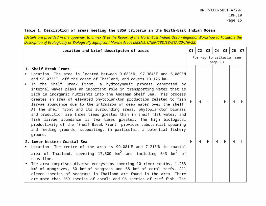
Table 1. Description of areas meeting the EBSA criteria in the North-East Indian Ocean
(Details are provided in the appendix to annex IV of the Report of the North-East Indian Ocean Regional Workshop to Facilitate the Description of Ecologically or Biologically Significant Marine Areas (EBSAs), UNEP/CBD/SBATTA/20/INF/22)
Location and brief description of areas C1 C2 C3 C4 C5 C6 C7For key to criteria, see page 8
1. Shelf Break Front Location: The area is located between 9.683ºN, 97.364ºE and 6.089ºN and 98.073ºE, off the coast of
Thailand, and covers 13,176 km2. In the Shelf Break Front, a hydrodynamic process generated by internal waves plays an important role
in transporting water that is rich in inorganic nutrients into the Andaman Shelf Sea. This process creates an area of elevated phytoplankton production related to fish larvae abundance due to the intrusion of deep water over the shelf. At the shelf front and its surrounding areas, phytoplankton biomass and production are three times greater than in shelf flat water, and fish larvae abundance is two times greater. The high biological productivity of the “Shelf Break Front” provides substantial spawning and feeding grounds, supporting, in particular, a potential fishery ground.
H H - - H H H
2. Lower Western Coastal Sea Location: The centre of the area is 99.081°E and 7.213°N in coastal area of Thailand, covering 17,500
km2 and including 643 km2 of coastline. The area comprises diverse ecosystems covering 10 river mouths, 1,263 km2 of mangroves, 80 km2 of
seagrass and 68 km2 of coral reefs. All eleven species of seagrass in Thailand are found in the area. There are more than 269 species of corals and 96 species of reef fish. The area is also home to many endangered marine species, such as dugongs, sea turtles, whales, dolphins, whale sharks and manta rays.
H H H H H H L
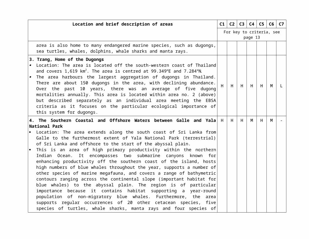
3. Trang, Home of the Dugongs Location: The area is located off the south-western coast of Thailand and covers 1,619 km2. The area is
centred at 99.349°E and 7.284°N. The area harbours the largest aggregation of dugongs in Thailand. There are about 150 dugongs in the
area, with declining abundance. Over the past 10 years, there was an average of five dugong mortalities annually. This area is located within area no. 2 (above) but described separately as an individual area meeting the EBSA criteria as it focuses on the particular ecological importance of this system for dugongs.
H H H H H M L
4. The Southern Coastal and Offshore Waters between Galle and Yala National Park Location: The area extends along the south coast of Sri Lanka from Galle to the furthermost extent of
Yala National Park (terrestrial) of Sri Lanka and offshore to the start of the abyssal plain. This is an area of high primary productivity within the northern Indian Ocean. It encompasses two
submarine canyons known for enhancing productivity off the southern coast of the island, hosts high
H H H M H M -
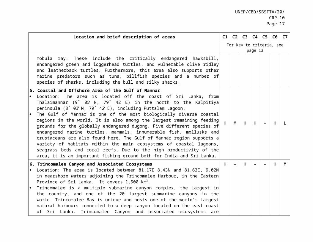
UNEP/CBD/SBSTTA/20/CRP.10Page 11
Location and brief description of areas C1 C2 C3 C4 C5 C6 C7For key to criteria, see page 8
numbers of blue whales throughout the year, supports a number of other species of marine megafauna, and covers a range of bathymetric contours ranging across the continental slope (important habitat for blue whales) to the abyssal plain. The region is of particular importance because it contains habitat supporting a year-round population of non-migratory blue whales. Furthermore, the area supports regular occurrences of 20 other cetacean species, five species of turtles, whale sharks, manta rays and four species of mobula ray. These include the critically endangered hawksbill, endangered green and loggerhead turtles, and vulnerable olive ridley and leatherback turtles. Furthermore, this area also supports other marine predators such as tuna, billfish species and a number of species of sharks, including the bull and silky sharks.
5. Coastal and Offshore Area of the Gulf of Mannar Location: The area is located off the coast of Sri Lanka, from Thalaimannar (9˚ 05̒ N, 79˚ 42̒ E) in the
north to the Kalpitiya peninsula (8˚ 03̒ N, 79˚ 42̒ E), including Puttalam Lagoon. The Gulf of Mannar is one of the most biologically diverse coastal regions in the world. It is also among
the largest remaining feeding grounds for the globally endangered dugong. Five different species of endangered marine turtles, mammals, innumerable fish, mollusks and crustaceans are also found here. The Gulf of Mannar region supports a variety of habitats within the main ecosystems of coastal lagoons, seagrass beds and coral reefs. Due to the high productivity of the area, it is an important fishing ground both for India and Sri Lanka.
H M H H - H L
6. Trincomalee Canyon and Associated Ecosystems Location: The area is located between 81.17E 8.43N and 81.63E, 9.02N in nearshore waters adjoining
the Trincomalee Harbour, in the Eastern Province of Sri Lanka. It covers 1,500 km2. Trincomalee is a multiple submarine canyon complex, the largest in the country, and one of the 20
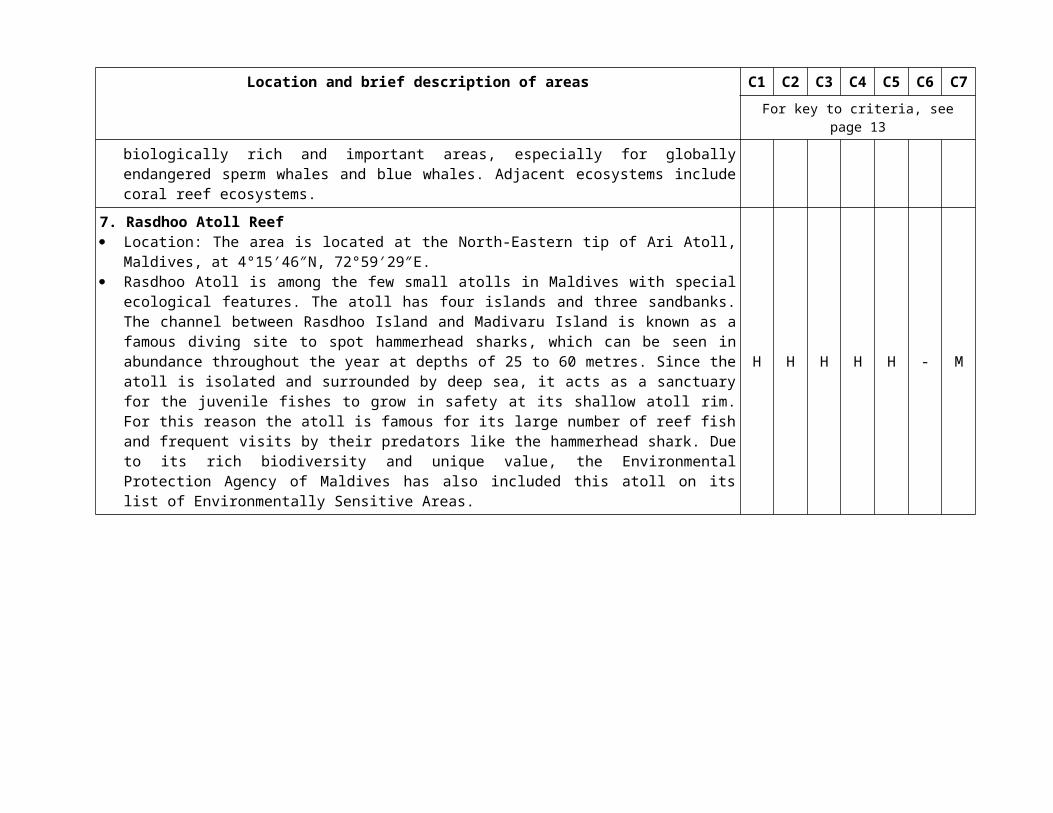
largest submarine canyons in the world. Trincomalee Bay is unique and hosts one of the world’s largest natural harbours connected to a deep canyon located on the east coast of Sri Lanka. Trincomalee Canyon and associated ecosystems are biologically rich and important areas, especially for globally endangered sperm whales and blue whales. Adjacent ecosystems include coral reef ecosystems.
H - H - - H M
7. Rasdhoo Atoll Reef Location: The area is located at the North-Eastern tip of Ari Atoll, Maldives, at 4°15′46″N, 72°59′29″E. Rasdhoo Atoll is among the few small atolls in Maldives with special ecological features. The atoll has
four islands and three sandbanks. The channel between Rasdhoo Island and Madivaru Island is known as a famous diving site to spot hammerhead sharks, which can be seen in abundance throughout the year at depths of 25 to 60 metres. Since the atoll is isolated and surrounded by deep sea, it acts as a sanctuary for the juvenile fishes to grow in safety at its shallow atoll rim. For this reason the atoll is famous for its large number of reef fish and frequent visits by their predators like the hammerhead shark. Due to its
H H H H H - M
Location and brief description of areas C1 C2 C3 C4 C5 C6 C7For key to criteria, see page 8
rich biodiversity and unique value, the Environmental Protection Agency of Maldives has also included this atoll on its list of Environmentally Sensitive Areas.
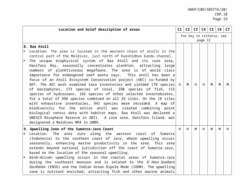
8. Baa Atoll Location: The area is located in the western chain of atolls in the central part of the Maldives, just north
of Kaashidhoo Kandu channel. The unique biophysical system of Baa Atoll and its core area, Hanifaru Bay, seasonally concentrates
plankton, attracting large numbers of planktivorous megafauna. The area is of world class importance for endangered reef manta rays. This atoll has been a focus of an Atoll Ecosystem Conservation project (AEC) co-funded by GEF. The AEC work examined taxa inventories and yielded 178 species of macrophytes, 173 species of coral, 350 species of fish, 115 species of hydrozoans, 182 species of other selected invertebrates, for a total of 998 species combined on all 29 sites. On the 18 sites with exhaustive inventories, 941 species were recorded. A map of biodiversity for the entire atoll was created combining point biological census data with habitat maps. Baa Atoll was declared a UNESCO Biosphere Reserve in 2011. A core area, Hanifaru Island, was designated a Maldives MPA in 2009.
H M H H M M M
9. Upwelling Zone of the Sumatra-Java Coast Location: The area runs along the western coast of Sumatra (Indonesia) to the southern coast of Java,
where upwelling occurs seasonally, enhancing marine productivity in the area. This area extends beyond national jurisdiction off the coast of Sumatra-Java, based on the location of the seasonal upwelling.
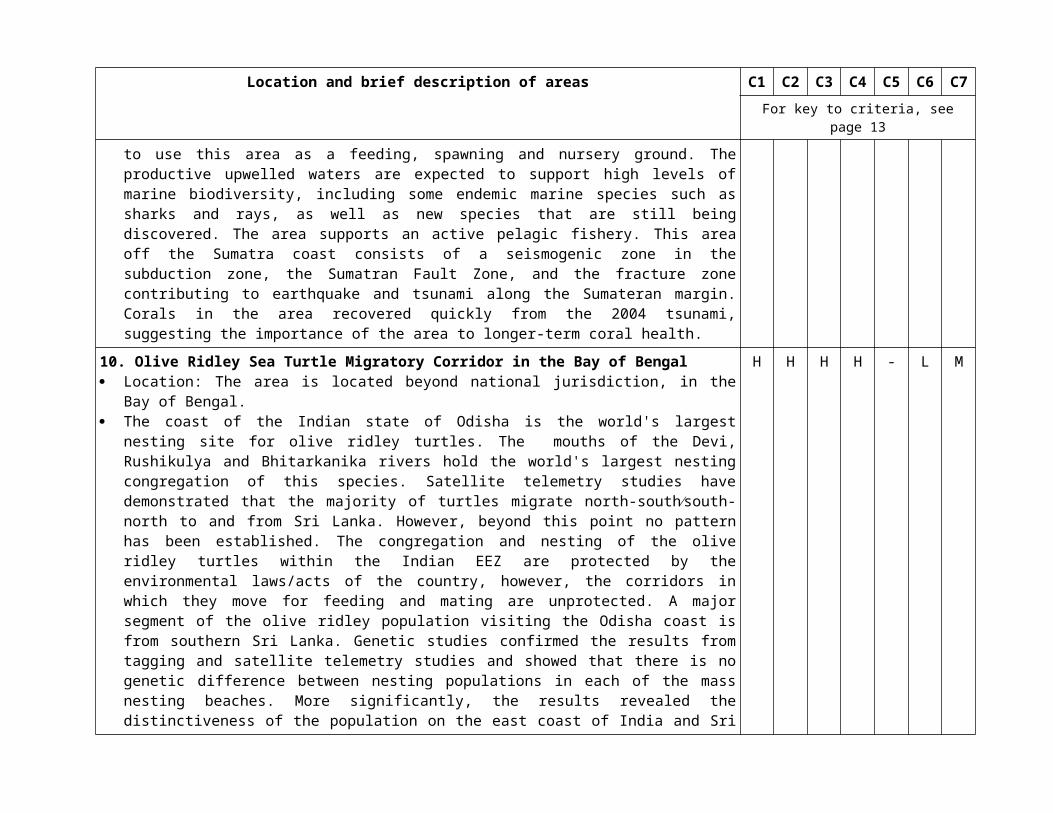
Wind-driven upwelling occurs in the coastal areas of Sumatra-Java during the southeast monsoon and is related to the El Nino Southern Oscillation (ENSO) and the Indian Ocean Dipole Mode (IODM). The upwelling zone is nutrient enriched, attracting fish and other marine animals to use this area as a feeding, spawning and nursery ground. The productive upwelled waters are expected to support high levels of marine biodiversity, including some endemic marine species such as sharks and rays, as well as new species that are still being discovered. The area supports an active pelagic fishery. This area off the Sumatra coast consists of a seismogenic zone in the subduction zone, the Sumatran Fault Zone, and the fracture zone contributing to earthquake and tsunami along the Sumateran margin. Corals in the area recovered quickly from the 2004 tsunami, suggesting the importance of the area to longer-term coral health.
H H M H M M H
10. Olive Ridley Sea Turtle Migratory Corridor in the Bay of Bengal Location: The area is located beyond national jurisdiction, in the Bay of Bengal. The coast of the Indian state of Odisha is the world's largest nesting site for olive ridley turtles. The
mouths of the Devi, Rushikulya and Bhitarkanika rivers hold the world's largest nesting congregation of this species. Satellite telemetry studies have demonstrated that the majority of turtles migrate north-south∕south-north to and from Sri Lanka. However, beyond this point no pattern has been established. The congregation and nesting of the olive ridley turtles within the Indian EEZ are protected by the
H H H H - L M
UNEP/CBD/SBSTTA/20/CRP.10Page 13
Location and brief description of areas C1 C2 C3 C4 C5 C6 C7For key to criteria, see page 8
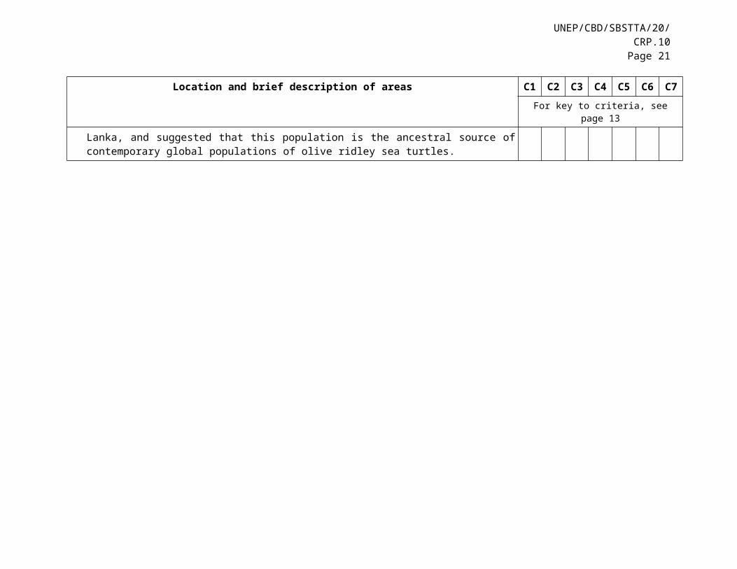
environmental laws/acts of the country, however, the corridors in which they move for feeding and mating are unprotected. A major segment of the olive ridley population visiting the Odisha coast is from southern Sri Lanka. Genetic studies confirmed the results from tagging and satellite telemetry studies and showed that there is no genetic difference between nesting populations in each of the mass nesting beaches. More significantly, the results revealed the distinctiveness of the population on the east coast of India and Sri Lanka, and suggested that this population is the ancestral source of contemporary global populations of olive ridley sea turtles.

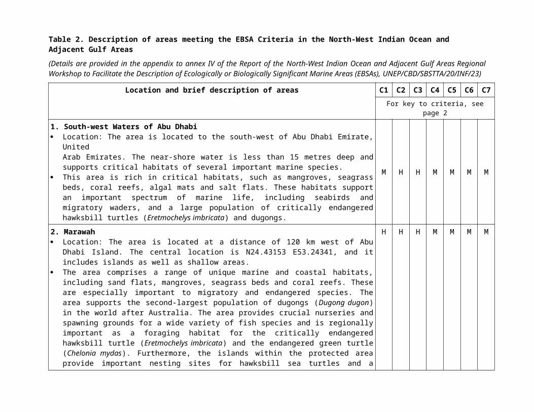
Table 2. Description of areas meeting the EBSA Criteria in the North-West Indian Ocean and Adjacent Gulf Areas
(Details are provided in the appendix to annex IV of the Report of the North-West Indian Ocean and Adjacent Gulf Areas Regional Workshop to Facilitate the Description of Ecologically or Biologically Significant Marine Areas (EBSAs), UNEP/CBD/SBSTTA/20/INF/23)
Location and brief description of areas C1 C2 C3 C4 C5 C6 C7For key to criteria, see page 2
1. South-west Waters of Abu Dhabi Location: The area is located to the south-west of Abu Dhabi Emirate, United
Arab Emirates. The near-shore water is less than 15 metres deep and supports critical habitats of several important marine species.
This area is rich in critical habitats, such as mangroves, seagrass beds, coral reefs, algal mats and salt flats. These habitats support an important spectrum of marine life, including seabirds and migratory waders, and a large population of critically endangered hawksbill turtles (Eretmochelys imbricata) and dugongs.
M H H M M M M
2. Marawah Location: The area is located at a distance of 120 km west of Abu Dhabi Island. The central location is
N24.43153 E53.24341, and it includes islands as well as shallow areas. The area comprises a range of unique marine and coastal habitats, including sand flats, mangroves,
seagrass beds and coral reefs. These are especially important to migratory and endangered species. The area supports the second-largest population of dugongs (Dugong dugon) in the world after Australia. The area provides crucial nurseries and spawning grounds for a wide variety of fish species and is regionally important as a foraging habitat for the critically endangered hawksbill turtle (Eretmochelys imbricata) and the endangered green turtle (Chelonia mydas). Furthermore, the islands within the protected area provide important nesting sites for hawksbill sea turtles and a number of migratory birds, including about 5 per cent of the world population of the vulnerable Socotra cormorant (Phalacrocorax nigrogularis).
H H H M M M M
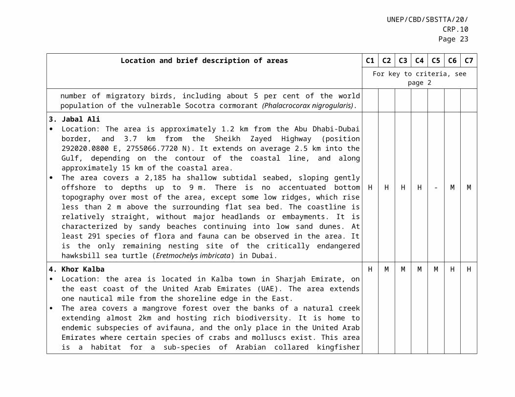
3. Jabal Ali Location: The area is approximately 1.2 km from the Abu Dhabi-Dubai border, and 3.7 km from the
Sheikh Zayed Highway (position 292020.0800 E, 2755066.7720 N). It extends on average 2.5 km into the Gulf, depending on the contour of the coastal line, and along approximately 15 km of the coastal area.
The area covers a 2,185 ha shallow subtidal seabed, sloping gently offshore to depths up to 9 m. There is no accentuated bottom topography over most of the area, except some low ridges, which rise less than 2 m above the surrounding flat sea bed. The coastline is relatively straight, without major headlands or embayments. It is characterized by sandy beaches continuing into low sand dunes. At least 291 species of flora and fauna can be observed in the area. It is the only remaining nesting site of the critically endangered hawksbill sea turtle (Eretmochelys imbricata) in Dubai.
H H H H - M M
UNEP/CBD/SBSTTA/20/CRP.10Page 15
Location and brief description of areas C1 C2 C3 C4 C5 C6 C7For key to criteria, see page 2
4. Khor Kalba Location: the area is located in Kalba town in Sharjah Emirate, on the east coast of the United Arab
Emirates (UAE). The area extends one nautical mile from the shoreline edge in the East. The area covers a mangrove forest over the banks of a natural creek extending almost 2km and hosting
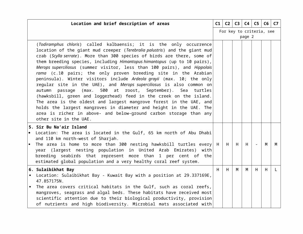
rich biodiversity. It is home to endemic subspecies of avifauna, and the only place in the United Arab Emirates where certain species of crabs and molluscs exist. This area is a habitat for a sub-species of Arabian collared kingfisher (Todiramphus chloris) called kalbaensis; it is the only occurrence location of the giant mud creeper (Terebralia palustris) and the giant mud crab (Scylla serrate). More than 300 species of birds are there, some of them breeding species, including Himantopus himantopus (up to 10 pairs), Merops superciliosus (summer visitor, less than 100 pairs), and Hippolais rama (c.10 pairs; the only proven breeding site in the Arabian peninsula). Winter visitors include Ardeola grayii (max. 10; the only regular site in the UAE), and Merops superciliosus is also common on autumn passage (max. 500 at roost, September). Sea turtles (hawksbill, green and loggerhead) feed in the creek on the island. The area is the oldest and largest mangrove forest in the UAE, and holds the largest mangroves in diameter and height in the UAE. The area is richer in above- and below-ground carbon storage than any other site in the UAE.
H M M M M H H
5. Sir Bu Na’air Island Location: The area is located in the Gulf, 65 km north of Abu Dhabi and 110 km north-west of Sharjah. The area is home to more than 300 nesting hawksbill turtles every year (largest nesting population in
United Arab Emirates) with breeding seabirds that represent more than 1 per cent of the estimated global population and a very healthy coral reef system.
H H H H - M M
6. Sulaibikhat Bay Location: Sulaibikhat Bay - Kuwait Bay with a position at 29.337169E, 47.857175N. The area covers critical habitats in the Gulf, such as coral reefs, mangroves, seagrass and algal beds.
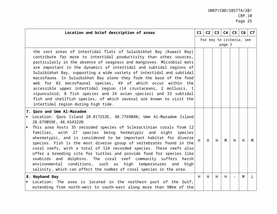
These habitats have received most scientific attention due to their biological productivity, provision of nutrients and high biodiversity. Microbial mats associated with the vast areas of intertidal flats of Sulaibikhat Bay (Kuwait Bay) contribute far more to intertidal productivity than other sources, particularly in the absence of seagrass and mangroves. Microbial mats are important in the dynamics of intertidal and subtidal regions of Sulaibikhat Bay, supporting a wide variety of intertidal and subtidal macrofauna. In Sulaibikhat Bay alone they form the base of the food web for 82 macrofaunal species, 49 of which occur within the accessible upper intertidal region (14 crustaceans, 2 molluscs, 1 sipunculoid, 8 fish species and 24 avian species) and 33 subtidal fish and shellfish species, of which several are known to visit the intertidal region during high tide.
H H M M H H L
7. Qaro and Umm Al-Maradem H H H M H H M
Location and brief description of areas C1 C2 C3 C4 C5 C6 C7For key to criteria, see page 2
Location: Qaro Island 28.817253E, 48.776904N; Umm Al-Maradem Island 28.679059E, 48.654322N This area hosts 35 recorded species of Scleractinian corals from 12 families, with 27 species being
hermatypic and eight species ahermatypic, and is considered to be important habitat for diverse species. Fish is the most diverse group of vertebrates found in the coral reefs, with a total of 124 recorded species. These reefs also offer a breeding site for turtles and provide food for species like seabirds and dolphins. The coral reef community suffers harsh environmental conditions, such as high temperatures and high salinity, which can affect the number of coral species in the area.
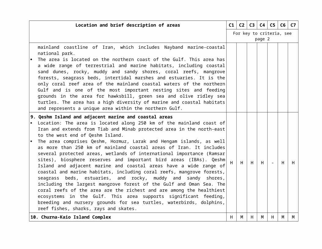
8. Nayband Bay Location: The area is located in the northern part of the Gulf, extending from north-west to south-east
along more than 90km of the mainland coastline of Iran, which includes Nayband marine-coastal national park.
The area is located on the northern coast of the Gulf. This area has a wide range of terrestrial and marine habitats, including coastal sand dunes, rocky, muddy and sandy shores, coral reefs, mangrove forests, seagrass beds, intertidal marshes and estuaries. It is the only coral reef area of the mainland coastal waters of the northern Gulf and is one of the most important nesting sites and feeding grounds in the area for hawksbill, green sea and olive ridley sea turtles. The area has a high diversity of marine and coastal habitats and represents a unique area within the northern Gulf.
H H H H - M L
9. Qeshm Island and adjacent marine and coastal areas Location: The area is located along 250 km of the mainland coast of Iran and extends from Tiab and
Minab protected area in the north-east to the west end of Qeshm Island. The area comprises Qeshm, Hormuz, Larak and Hengam islands, as well as more than 250 km of
mainland coastal areas of Iran. It includes several protected areas, wetlands of international importance (Ramsar sites), biosphere reserves and important bird areas (IBAs). Qeshm Island and adjacent marine and coastal areas have a wide range of coastal and marine habitats, including coral reefs, mangrove forests, seagrass beds, estuaries, and rocky, muddy and sandy shores, including the largest mangrove forest of the Gulf and Oman Sea. The coral reefs of the area are the richest and are among the healthiest ecosystems in the Gulf. This area supports significant feeding, breeding and nursery grounds for sea turtles, waterbirds, dolphins, reef fishes, sharks, rays and skates.
H H H H - H H
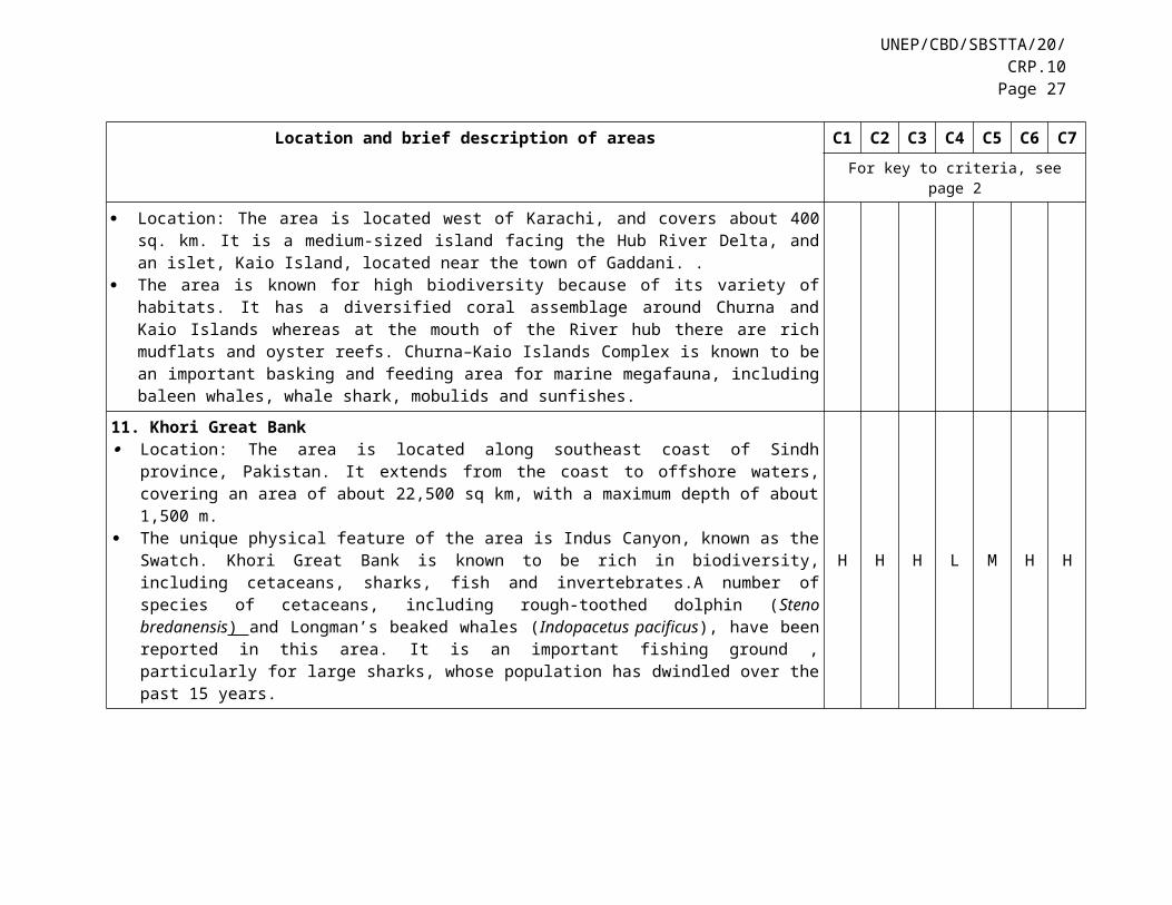
10. Churna-Kaio Island Complex Location: The area is located west of Karachi, and covers about 400 sq. km. It is a medium-sized island
facing the Hub River Delta, and an islet, Kaio Island, located near the town of Gaddani. . The area is known for high biodiversity because of its variety of habitats. It has a diversified coral
assemblage around Churna and Kaio Islands whereas at the mouth of the River hub there are rich mudflats and oyster reefs. Churna–Kaio Islands Complex is known to be an important basking and feeding area for marine megafauna, including baleen whales, whale shark, mobulids and sunfishes.
H M H M H M M
UNEP/CBD/SBSTTA/20/CRP.10Page 17
Location and brief description of areas C1 C2 C3 C4 C5 C6 C7For key to criteria, see page 2
11. Khori Great Bank Location: The area is located along southeast coast of Sindh province, Pakistan. It extends from the
coast to offshore waters, covering an area of about 22,500 sq km, with a maximum depth of about 1,500 m.
The unique physical feature of the area is Indus Canyon, known as the Swatch. Khori Great Bank is known to be rich in biodiversity, including cetaceans, sharks, fish and invertebrates.A number of species of cetaceans, including rough-toothed dolphin (Steno bredanensis) and Longman’s beaked whales (Indopacetus pacificus), have been reported in this area. It is an important fishing ground , particularly for large sharks, whose population has dwindled over the past 15 years.
H H H L M H H
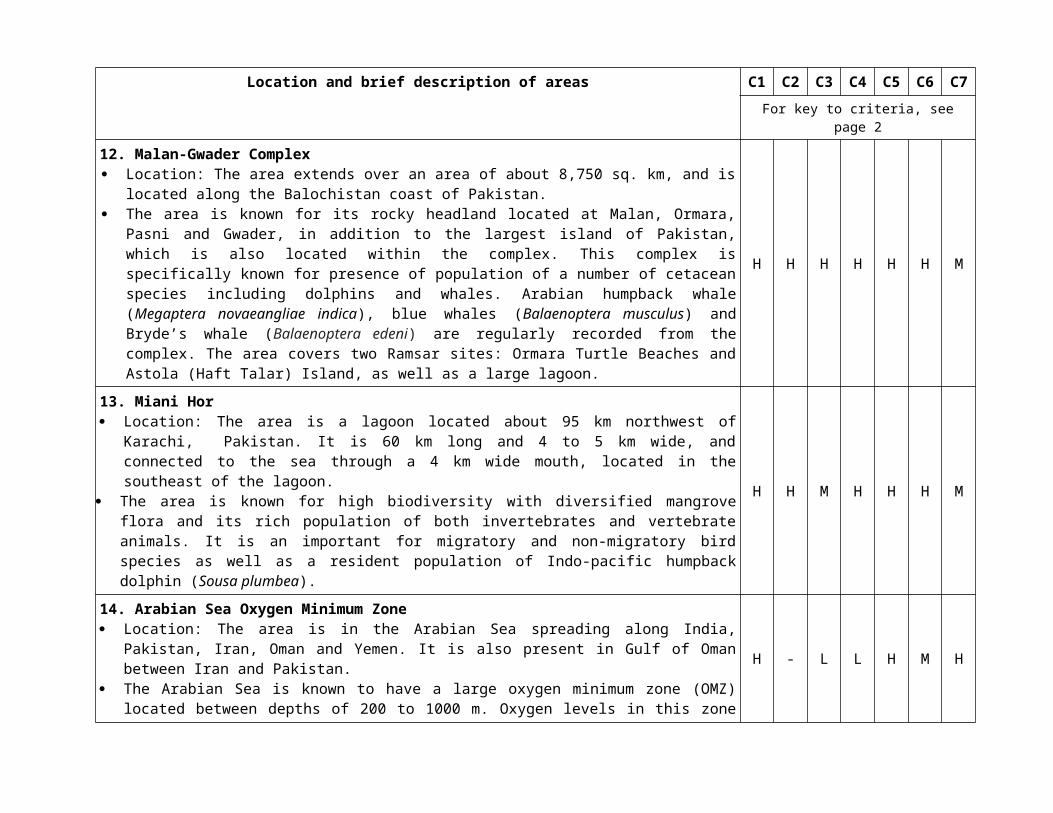
12. Malan-Gwader Complex Location: The area extends over an area of about 8,750 sq. km, and is located along the Balochistan
coast of Pakistan. The area is known for its rocky headland located at Malan, Ormara, Pasni and Gwader, in addition to
the largest island of Pakistan, which is also located within the complex. This complex is specifically known for presence of population of a number of cetacean species including dolphins and whales. Arabian humpback whale (Megaptera novaeangliae indica), blue whales (Balaenoptera musculus) and Bryde’s whale (Balaenoptera edeni) are regularly recorded from the complex. The area covers two Ramsar sites: Ormara Turtle Beaches and Astola (Haft Talar) Island, as well as a large lagoon.
H H H H H H M
13. Miani Hor Location: The area is a lagoon located about 95 km northwest of Karachi, Pakistan. It is 60 km long and
4 to 5 km wide, and connected to the sea through a 4 km wide mouth, located in the southeast of the lagoon.
The area is known for high biodiversity with diversified mangrove flora and its rich population of both invertebrates and vertebrate animals. It is an important for migratory and non-migratory bird species as well as a resident population of Indo-pacific humpback dolphin (Sousa plumbea).
H H M H H H M
14. Arabian Sea Oxygen Minimum Zone Location: The area is in the Arabian Sea spreading along India, Pakistan, Iran, Oman and Yemen. It is
also present in Gulf of Oman between Iran and Pakistan. The Arabian Sea is known to have a large oxygen minimum zone (OMZ) located between depths of 200
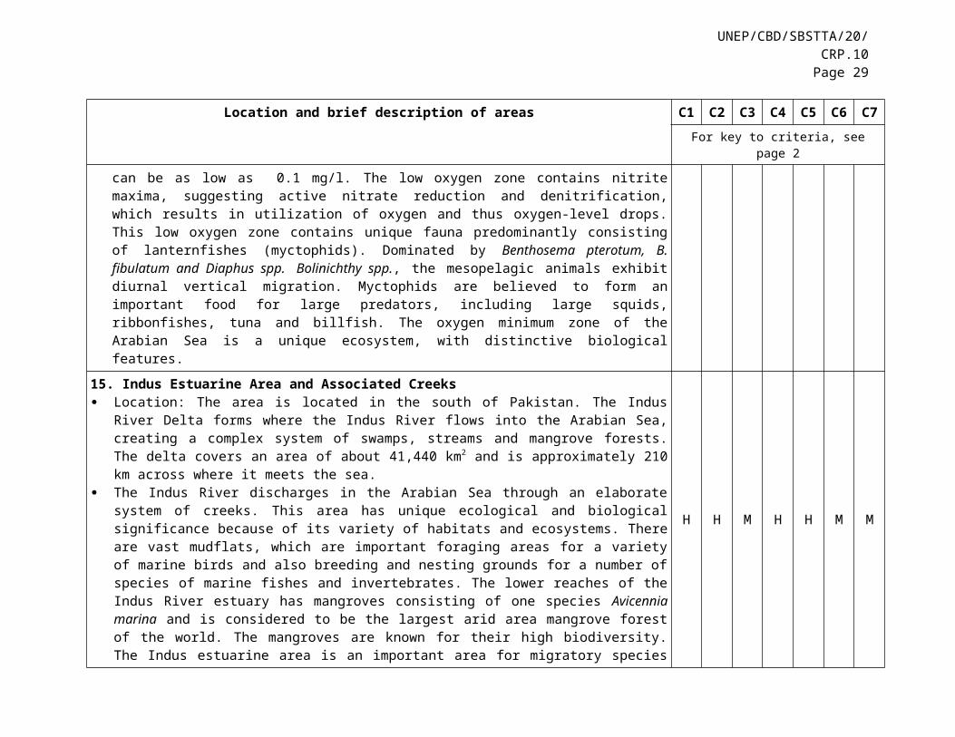
to 1000 m. Oxygen levels in this zone can be as low as 0.1 mg/l. The low oxygen zone contains nitrite maxima, suggesting active nitrate reduction and denitrification, which results in utilization of oxygen and thus oxygen-level drops. This low oxygen zone contains unique fauna predominantly consisting of lanternfishes (myctophids). Dominated by Benthosema pterotum, B. fibulatum and Diaphus spp.
H - L L H M H
Location and brief description of areas C1 C2 C3 C4 C5 C6 C7For key to criteria, see page 2
Bolinichthy spp., the mesopelagic animals exhibit diurnal vertical migration. Myctophids are believed to form an important food for large predators, including large squids, ribbonfishes, tuna and billfish. The oxygen minimum zone of the Arabian Sea is a unique ecosystem, with distinctive biological features.
15. Indus Estuarine Area and Associated Creeks Location: The area is located in the south of Pakistan. The Indus River Delta forms where the Indus
River flows into the Arabian Sea, creating a complex system of swamps, streams and mangrove forests. The delta covers an area of about 41,440 km2 and is approximately 210 km across where it meets the sea.
The Indus River discharges in the Arabian Sea through an elaborate system of creeks. This area has unique ecological and biological significance because of its variety of habitats and ecosystems. There are vast mudflats, which are important foraging areas for a variety of marine birds and also breeding and nesting grounds for a number of species of marine fishes and invertebrates. The lower reaches of the Indus River estuary has mangroves consisting of one species Avicennia marina and is considered to be the largest arid area mangrove forest of the world. The mangroves are known for their high biodiversity. The Indus estuarine area is an important area for migratory species of fish. The Indus estuarine area is known for its diversified bird fauna, which includes cranes, flamingos, pelicans, waders, coots, ducks, gulls and terns. The Indus estuary is inhabited by two cetaceans, i.e., the Indo-Pacific humpback dolphin (Sousa chinensis) and finless porpoise (Neophocaena phocaenoides).
H H M H H M M
16. Sandspit/Hawks Bay and the Adjoining Backwaters Location: The area is located about 15 km southwest of Karachi, Pakistan. The backwaters of Sandspit
are located at the extreme end of Manora Channel, on which Karachi Port is located. The coastline of Pakistan has a number of significant turtle-nesting beaches. They include the sandy
beaches at Sandspit (Hawkes Bay), on the Karachi coast, which host the nesting of the green turtle (Chelonia mydas). Nesting takes place throughout the year, peaking from September to October. In the backwaters of Sandspit is a mangrove forest consisting of dense and sparse growth of Avicennia marina. The area is known to be a home for a variety of resident and migratory birds, especially flamingos, pelican, terns, gulls and a variety of waders.
M H H M M M L
17. Angria Bank Location: The area is a submerged plateau located some 105 km west of Malvan, Maharashtra State of
India in the Arabian Sea (16o69’27.55” N, 72o06’19.15” E). It covers ca 1300 sq. km. It contains 350 sq. km of coral cover with a 5 km long buffer around this coral cover. About 5 km radius buffer area around the Angria Bank has been added to this area as many threatened migratory species, such as marine turtles, whales, dolphins and whale sharks, have been observed here.
The area, which contains the largest submerged coral reefs area of India, is unique due to its rich biodiversity, productivity and geological formation. Further, this site was reported with large
H M H H H - H
UNEP/CBD/SBSTTA/20/CRP.10Page 19
Location and brief description of areas C1 C2 C3 C4 C5 C6 C7For key to criteria, see page 2
aggregations of myctophids, which makes this bank an important fish spawning ground of the region. Various types of coral communities, such as brain corals, green corals, staghorn corals, plate corals and soft corals are present here, along with their associated fauna and flora, including big angel fishes, anemone fishes, groupers, snappers, barracudas, pipe fish, Murray eels, parrot fish, scorpion fish, trigger fishes, puffer fish, various algae species, sponges, echinoderms, crustaceans and starfishes. Further, several threatened species, such as marine turtles, whale sharks, whales and dolphins, have also been observed using this region as their foraging ground.
18. Socotra Archipelago Location: The area is located between 53°0'E and 54°35'E and 12°5'N and 12°43'N at the junction
between the Gulf of Aden and the north-western Indian Ocean. The area includes the main island of Socotra, together with Samha, Darsa, Abd al Kuri and the small
islets and rock outcrops Sabuniya and Kal Farun. The islands are separated from mainland Africa by a narrow strip of water known as the Socotra Passage, which is only 95 km wide, and from mainland Yemen by the 400 km wide Gulf of Aden. The islands support unusual coral communities and diverse assemblages of reef-associated fishes as well as megafauna including sharks, turtles, dolphins and whales. The islands are located at the epicentre of a highly productive upwelling region and the cross-road between three marine biogeographic provinces, which underpin the productivity and unique composition of the faunal assemblages. Species present include a mix of Arabian “endemics” and western Indian Ocean species, together with species characteristic of the wider Indo Pacific and rare species with restricted ranges (including Red Sea “endemics”) and/or highly disjunct global distributions, and a globally significant element of hybridizing fishes. The fish biomass productivity ranks among the highest in the Indian Ocean.
H H H M H H M
Location and brief description of areas C1 C2 C3 C4 C5 C6 C7For key to criteria, see page 2
19. The Great Whirl and Gulf of Aden Upwelling Ecosystem Location: The area includes waters mostly within the national jurisdictions of Somalia and Yemen. The
area extends several hundred nautical miles offshore. This is thus a transboundary area involving north-west Somalia, the Gulf of Aden (Yemen) and especially the Socotra archipelago, and at a lesser extent Oman.
The system forms along the east coast of Somalia during the summer monsoon season when the Somali current turns northwards. The whole system then migrates northwards, until it reaches the southern coast of the Socotra Archipelago, where it arches out into the Indian Ocean and spreads between the islands and mainland Somalia into the Gulf of Aden. On reaching the Gulf of Aden, the systems merge with the upwelling along the south coast of Yemen, propagating a complex system of gyres and eddies. This large area encompasses the entire dynamic of the seasonal high productivity and related marine pelagic life associated with the Great Whirl, the Socotra Gyre and the North Socotra Warm Eddy. The confluence of the Great Whirl with the upwelling in the Gulf of Aden makes it one of the world’s most productive regions in the world. The northwestern corner of the Indian Ocean is a highly dynamic and biodiverse region of the global oceans. Oceanic rossby waves and the seasonally reversing monsoonal winds drive an immense upwelling system during the summer months, known as the Great Whirl. It is the only major upwelling that occurs on the western boundary of an ocean. The Somali-Arabian sea upwelling system resulting from the Great Whirl and associated eddies increases planktonic productivity ten-fold in comparison with the surrounding oligotrophic water. This unique and complex feature supports rich meso-pelagic and pelagic ecosystems hosting plankton, fish, flag species of megafauna, especially sharks, cetaceans and turtles. The extreme environmental conditions create a uniquely season driven and transboundary pelagic ecosystem that has resulted in one of the most productive regions in the world.
H H H M H M M
20. Îles des Sept Frères et Godorya (Seven Brothers Islands and Godorya Location: The area is located on South-west between 12° 8' N, 43° 25' E and 12° 8' N, 43° 27.5' E;
North-east 12° 29' N, 43° 27.5' E and 12° 29' N, 43° 1.9' E This area covers the Seven Brothers and Ras Siyyan marine protected area (MPA), the largest MPA in
Djibouti (400 km2). It includes four mangrove forests, a portion of coastal habitats and the Sept Frères archipelago. It has high benthic and pelagic marine biodiversity, a mosaic of coastal, insular and marine habitats, and is also an important nesting site for sea turtles and sea birds.
H H H M H M M
UNEP/CBD/SBSTTA/20/CRP.10Page 21
Location and brief description of areas C1 C2 C3 C4 C5 C6 C7For key to criteria, see page 2
21. Southern Red Sea Islands Location: The southern part of the Red Sea specific to this area includes all of the islands of both Eritrea
and Yemen as a single ecosystem. This is an area of high productivity and high endemism, providing a migratory corridor for megafauna
and birds and a nesting and breeding ground for both turtles and birds. It provides habitat for vulnerable coral and mangrove that support diverse marine organisms. It has high levels of biological diversity and is an important area for life history stage of species.
H H H H H H H
22. Southern Red Sea Pelagic Ecosystems Location: The area is bounded approximately by the northern Eritrea border and the Bab Al-Mandab. This area has a high level of productivity (among the most productive in the Red Sea in terms of
chlorophyll-a), which is likely due to the influx of nutrient-rich water from the Gulf of Aden. The high productivity of this area makes it an important habitat for a number of species, including cetaceans, whale sharks, manta and devil rays, and birds. The area is also an important migratory corridor between the Red Sea and the Gulf of Aden/Indian Ocean for various species. These features make the area biologically diverse.
M H H M H H -
23. Sanganeb Atoll/Sha’ab Rumi Location: The area is located in the central Red Sea, close to the Red Sea’s centre of biodiversity, at
approximately 30km north-east of Port Sudan city, with location of 19° 42 N, 37° 26 E. Sha’ab Rumi is an annular reef situated north of Sanganeb (19°56.3’N 37°24.2’E), off the Red Sea coast of Sudan. The area is located in the north-western Indo-pacific bio-geographic region.
The Atoll encompasses an area of about 22km2 (a rectangular block of 7.3km by 3.2km) and runs within 1km of the edge of the reef. The area of reef flat and shallow fore reef is approximately 2km 2, and the area of enclosed lagoon is approximately 4.6km2. Sha’ab Rumi is well known for large numbers of schooling threatened scalloped hammerhead and grey reef sharks (Carcharhinus amblyrhynchos). Sanganeb is a wonderful example (perhaps the best in the entire region) of the deep-water offshore reefs of the central Red Sea. Sanganeb Atoll/Sha’ab Rumi contains one of the most unique reef structures in the Sudanese Red Sea, its steep slopes rising from a sea floor more than 800 m deep. It is characterized by a highly diverse coral fauna presenting 13 different bio-physiographic reef zones, each providing typical coral reef assemblages. The diverse population communities of flora and fauna are in a stable equilibrium with numerous endemic and endangered species such as sharks, bumphead parrotfish and groupers. A total of 86 coral species and over 251 species of fish have been recorded.
H M H H M H H
Location and brief description of areas C1 C2 C3 C4 C5 C6 C7For key to criteria, see page 2
24. Dungonab Bay/Mukawar Island Area Location: Dungonab Bay is located approximately 125 km north of Port Sudan, encompassing
Mukawar Island, which is 30km offshore of Dungonab Peninsula. The area covers a distance of approximately 70 km along the coast.
The area contains extensive and diverse seagrass beds, a regionally important population of dugong, regionally or globally important nesting areas for marine turtles and seabirds, and seasonal aggregations of whale sharks and manta rays that are unique in the entire western Indian Ocean region. The area is known to be of particular significance for birds and is designated as an Important Bird Area. The eastern shore of Mukawar Island is a turtle nesting site of regional and possibly international significance.
H H H M M M H
25. Suakin Archipelago and Sudanese Southern Red Sea Location: The area is situated in the southern waters of Sudan, which is on the extension of the
continental shelf. Shubuk is a very unusual barrier reef complex while the Suakin archipelago is one of several important
island groups within the Red Sea. The reefs and islands within this archipelago substantially increase the area of reef habitat available within Sudanese coastal waters and within this part of the Red Sea, which is known to support particularly high species diversity. The extension of these reefs offshore also greatly increases the biogeographical span and diversity of reef habitats. Furthermore, the inaccessibility of these reefs and islands enhances their significance, as they provide areas distant from direct human impacts on the mainland coast and refuges for some of the Red Sea’s important bird and turtle nesting sites. The Sudanese Red Sea coast is 750 km long and contains numerous uninhabited islands and submerged offshore reef structures. The combination of well-developed fringing coral reefs and offshore reef complexes and islands in the Shubuk region and the Suakin archipelago provides a high diversity of habitats that span a wide environmental gradient. It is these diverse ecosystems and environments that underpin the high biodiversity found within Sudanese waters. The Suakin Archipelago is of marked importance nationally and regionally.
H M H M H H M
UNEP/CBD/SBSTTA/20/CRP.10Page 23
Location and brief description of areas C1 C2 C3 C4 C5 C6 C7For key to criteria, see page 2
26. Wadi El-Gemal Elba Location: The area covers waters between Marsa Alam city of Egypt and the Egyptian-Sudanese
border, with a coastline of approximately 300km and a total area of some 5000 km2. The area is located within two protected areas, namely Wadi El Gemal-Hamata Protected Area and Gebel Elba National Park. The area also includes 20 offshore islands, from a few kilometres to more than 70km from the shoreline.
The area features high biological diversity and natural beauty. More than 200 species of hard and soft corals and at least 400 fish species have been recorded in the area. Endemic species are evident among various groups of fishes and invertebrates. At least seven species of seagrasses and two species of mangroves are found in the area (a substantial proportion of the total mangrove resources of Egypt). The largest stand of Avicennia marina extends 12 km, in a semi-continuous fringe, located at Hamata, and Rhyzophora muncronata exists only at Shelatin. The area has the largest seagrass meadows along the Egyptian coast that provide food for green turtles (Chelonia mydas) and dugongs (Dugong dugon). At least two species of marine turtles (out of five recorded species), the green and hawksbill (Eretmochelys imbricata), nest on islands and mainland beaches. The area accommodates the largest nesting population of green turtles in Egypt, on the beaches of Zabarged Island—about 600 females estimated in 2008. More than 100 species of birds have been recorded in the area, including 15 species of seabirds. The largest global colony of sooty falcons exists in Wadi El Gemal Island, whereas the white eyed gulls represent about 30 of the world population. The area supports a conspicuous cetacean fauna (15 species), as documented by recent dedicated surveys. Pantropical spotted dolphins, Stenella attenuata, represent the largest component with large groups found mostly in offshore waters, followed by spinner dolphins, Stenella longirostris, also found offshore but with part of the population moving inshore daily at daybreak to seek shelter in protected reefs (such as Samadai and Sattayah) to rest. The area also supports a very small remnant population of dugongs, Dugong dugon, mostly confined to the small coastal “marsas” where seagrass meadows cover the shallow sandy bottom.
H H M L L H M
Location and brief description of areas C1 C2 C3 C4 C5 C6 C7For key to criteria, see page 2
27. Arabian Basin Location: The area is located entirely beyond national jurisdictions. The area is approximately bordered
in the north by 64.46ºE, 17.32ºN; 67.36ºE, 17.32ºN; and in the south 67.36ºE, 10.81ºN; 64.46ºE, 10.81ºN.
The area is located in waters over the abyssal plain. This area is a key feeding area for the Trindade petrel (Pterodroma arminjoniana), which in the Indian Ocean breeds on one single island, Round Island, off the north coast of Mauritius. The species is listed as vulnerable on the IUCN Red List, and an extensive, multi-year tracking dataset shows that birds travel into the Arabian Basin during migration (May-July) and following fledging (year round) to feed. A range of other marine mega-fauna may also occur here, including three species of turtle, five species of baleen whale, three species of toothed whale, and at least a dozen species of dolphins, though their exact distributions and abundance within the area are unknown.
H H H M M M M
28. Daymaniyat Islands Location: The Daymaniyat Islands are located off the region of Al Batinah, Oman. The Daymaniyat Islands are an outstanding area of national and regional ecological and biogocial
importance. The islands host high densities of a variety of nesting seabirds, and up to 400 female hawksbill turtles nest annually, representing possibly the densest rookery in the world for this critically endangered species. The coral communities and reefs are among the best developed nationally and host at least one species that is endemic to Oman. Other species routinely found within the area include marine turtles, cetaceans and seabirds.
M H H H H M H
UNEP/CBD/SBSTTA/20/CRP.10Page 25
Location and brief description of areas C1 C2 C3 C4 C5 C6 C7For key to criteria, see page 2
29. Oman Arabian Sea Location: The area is located off southern Oman between the Ra’s al Hadd peninsula to the north and
the Oman-Yemen border to the south, and extends several hundred kilometres offshore. This area includes three core areas off the central and southern coast of Oman.
It is situated at the heart of one of the five largest upwelling areas of the world, which occurs both coastally and up to 300 to 400 km offshore and influences the water column to a depth of about 250 m. The high primary productivity associated with the monsoon-driven upwelling in the Arabian Sea fuels the ecosystem of the wider region. It also creates conditions suitable for feeding by at least 20 species of cetaceans, including the world’s most isolated whale, the endangered Arabian Sea humpback whale. Satellite tracking reveals preferred habitats of these whales as well as other taxa, such as endangered and critically endangered sea turtles. Shallow areas support important seagrass and macroalgae communities, and the unique co-existence of endemic macroalgae and coral communities. This unusual mix of tropical and neo-temperate species forms a community that is globally unique. One particular coral community represents perhaps the largest monospecific coral stand known on Earth, almost exclusively made up of an as yet undescribed species of cabbage coral. The unique conditions resulting from the south-west monsoon contribute to a high biodiversity of fish fauna, from the genetic, population and species level to the community and ecosystem levels. Demersal, pelagic and mesopelagic fishes all occur in relative abundance in the area compared to other parts of Oman. Birds are another important feature of the Arabian Sea, including some key populations of the regionally endemic near threatened Jouanin’s petrel and vulnerable Socotra cormorant. In winter, the coastal wetlands host half a million birds or more, predominantly gulls, terns and shorebirds.
H H H H H H M
30. Shatt Al-Arab Delta Location: The area is located at the northern end of an elongate shallow sea forming a southwesterly
triangular semi-island at the Iraqi Southern border at Faw city and extends northwesterly to form the marine territorial border with Kuwait at Knor Abdulla, ending in Knor Al-Zubair canal. The southern end of the river constitutes the border between Iraq and Iran down to the mouth of the river as it discharges into the Gulf. It has a length of 200 km. It varies in width from about 232 m at Basra to 800 m at its mouth.
The Shatt al-Arab Delta is formed by the confluence of the Euphrates and the Tigris rivers in the town of al-Qurnah in the Basra Governorate of southern Iraq. This area contains numerous unique marine, coastal and tidal habitats, including muddy intertidal areas. This area, and especially the coastal waters of Khor Abdulla on the opposite side of the Kuwaiti Bubiyan island, serve as incubation and hatchery areas for many fishes and other economically important marine and brackish water crustaceans and mollusks, as well as other invertebrate groups. The Shatt al-Arab Delta exerts a unique impact on the entire Gulf.
H H - H H H M
Location and brief description of areas C1 C2 C3 C4 C5 C6 C7For key to criteria, see page 2
31. Makran/Daran-Jiwani Area Location: The area is a transboundary coastal area between Iran and Pakistan that extends from Ganz in
Pakistan to Tang headland in Iran. The extensive sandy coasts of the area are particularly important as nesting grounds for both olive
ridley and green sea turtles. The mugger crocodile (Crocodylus palustris) has its western-most distribution in riverine and estuarine waters of the area. The eastern part of Chabahar Bay has the only known coral reef in the northern Oman Sea. Finless porpoises have been recorded from Gwater and Chabahar Bay. Jiwani headland and adjacent areas are known for high biodiversity of marine invertebrates as well as cetaceans. The coastal waters of the area are known for high catches of fishes and lobsters. The area is also rich in diversity of shorebirds.
H H H H H - M
UNEP/CBD/SBSTTA/20/CRP.10Page 27
Table 3. Description of areas meeting the EBSA criteria in the East Asian Seas
(Details are provided in the appendix to annex V of the Report of the CBD Regional Workshop to Facilitate the Description of Ecologically or Biologically Significant Marine Areas (EBSAs) in the Seas of East Asia, UNEP/CBD/SBSTTA/INF/24)
Location and brief description of areas C1 C2 C3 C4 C5 C6 C7For key to criteria, see page 2
1. Hainan Dongzhaigang Mangrove National Natural Reserve Location: The area is located in the northeast of the Meilan district, Haikou City (110°30'–110°37' E,
19°51'–20°01' N). It covers 5400 ha. The area covers an important coastal mangrove ecosystem and has most of the typical original natural
mangroves in China. The area also has very rich biodiversity, especially various marine and coastal species, for example, mangrove forests, waterfowl, phytoplankton and zooplankton. This estuary and coastal mudflat ecosystem is on the edge of boreal tropics, and is also an important habitat for wintering birds.
M H H H - H M
2. Shankou Mangrove National Nature Reserve Location: The area is located on either side of the Shatian Peninsula, southeast of Hepu County,
Guangxi Zhuang Autonomous Region of China. It is centred at 21°28'N, 109°43'E. It covers a total area of 8,000 hectares and stretches along the coast for some 50 km.
There are 14 species of mangrove and large populations of benthic diatoms, fish, shellfish, birds and insects in this area, and it has become one of the most typical coastal mangrove areas in China.
M - H M M M M
3. Nanji Islands Marine Reserve Location: The area has a total coverage of 201.06 km2, including land area of 11.13 km2. It is
located at121°05′E and 27°27′N. The area contains a high level of biodiversity, including 427 species of shellfish and 178
species of macro-benthic algae. It is known as “a kingdom of shells and algae”. There are also 459 species of micro-algae, 397 species of fish, 257 species of crustaceans and 158 species of other marine creatures. Among these, nine species are listed as endangered or vulnerable species by IUCN.
H M M L M H M
4. Cold Seeps Location: The area is located in the southwest Taiwan Basin at 21°12’N, 118°30’E; 21°12’N, 120°17’E;
22°19’, 118°30’E; and 22°19’, 120°17’E, and at a depth of 2900m-3000m. The area covers approximately 14,000 km2.
The deep-sea ecosystems of this area are unique not only for their communities of diverse bacteria, mussels, clams, hairy crabs and shrimps, but also for their habitats formed mainly by calcite, aragonite, dolomite, pyrite and authigenic minerals, including siderite, barite, gypsum, and natural sulphur, which support a high biomass of bacteria, mussels, clams, hairy crabs and shrimps.
H M L M H L H
Location and brief description of areas C1 C2 C3 C4 C5 C6 C7For key to criteria, see page 2
5. Muan Tidal Flat Location: The area is located in the south-western coastal area of the Korean peninsula, from 35°
04′20″N to 35° 07′52″N and from 126° 21′2″E to 126° 27′9″E. It covers about 42 km2. The area maintains its pristine condition with well-developed substrate for supporting numerous
migratory waterbird species and fisheries resources. The sediments characteristically contain 30-40% clay content. The area has high value for conservation as there are many globally endangered and protected species that hatch, nurse and feed in the area. This is a particularly rich feeding area for waterbirds. Some 29,000 winter waterbirds belonging to 48 species have been observed. In addition, 47 species of halophyte are distributed in Muan tidal flat. The diversity of benthic animals is also very high. The tidal flat has been a protected area since 2001 and was designated as a Ramsar site in 2008.
H H H L H H M
6. Intertidal Areas of East Asian Shallow Seas Location: This area encompasses 20 individual sites that form the basis of a Flyway-wide network
within the East Asian seas. The sites are located in Japan, Republic of Korea, China, Vietnam, Thailand, Malaysia, Indonesia, Philippines and Myanmar.
The intertidal zones of shallow coastal seas in East Asia are critically important for the survival of many migratory waterbird species that are dependent on these areas for different stages of their life cycle, mostly obviously during the migration periods, when some sites form critical bottlenecks, particularly in the Yellow Sea ecoregion (China, Republic of Korea, Democratic People’s Republic of Korea), as well as for breeding and non-breeding populations. Different species have different migratory strategies that depend on a network of sites throughout the Flyway, to be able to complete their migration. Intertidal mudflats and sandflats have been disappearing at an alarming rate in recent decades (60 per cent for the Yellow Sea in 50 years) leaving migratory waterbirds dependent on an ever-decreasing number of sites. As a consequence the populations of migratory waterbirds have declined precipitously, with up to 30 species endangered or critically endangered, and depending on a handful of sites, often unprotected, for their survival. All remaining intertidal areas of the East Asian Seas are of vital importance to saving migratory waterbirds dependent on them.
H H H H M M M
7. Lembeh Strait and Adjacent Waters Location: The Lembeh Strait lies between Minahasa Peninsula in northern Sulawesi and Lembeh Island,
North Sulawesi Province of Indonesia. Lembeh Strait is surounded by the Pacific Ocean in the north, mainland Sulawesi in the west, Lembeh Island in the east and Moluccas Sea in the south. The area is located at 125o09’ – 125o18’ E and 27o08’ – 27o25’ N. Lembeh Strait is 22 km long and 2 km wide.
Lembeh reefs and its surrounding waters are among the richest and most diverse in marine biota in Indonesia. Lembeh Strait is bordered by almost continuous fringing reefs while further offshore it is
H H H H L H L
UNEP/CBD/SBSTTA/20/CRP.10Page 29
Location and brief description of areas C1 C2 C3 C4 C5 C6 C7For key to criteria, see page 2
surrounded by deep, clear water. Lembeh Strait shows habitat heterogeneity and is rich in many different species, including endemic, rare and vulnerable species. Live coral cover ranging from 12.2 to 60.7%, and a total of 193 corals species belonging to 68 genera have been recognized from this area. However, the habitat is completely open and featureless, consisting of volcanic sand and plains bordered in the shallows by a few small coral patches. Various new species from this area have been described, such as hermit crabs, shrimps, snails, octopuses, cuttlefishes, sea slugs, fishes, corals and zooplanktons. Many new species have been recorded from this area, including Indonesian coelacanth (Latimeria menadoensis). In addition, Lembeh Strait and adjacent waters are known for abundant resources of tuna fisheries, estimated to amount to 587,000 tonnes.
8. Redang Island Archipelago and Adjacent Area Location: Redang Island is located about 45 km or 24.28 nautical miles to the northeast of Kuala
Terengganu. Redang Island has a surface area of about 2,483.58 ha — the largest of nine islands within the Redang Island archipelago. The archipelago area is approximately within the coordinates of 5o 43’ 28.92N, 102o 59’ 04.53”E and 5o 49’ 10.49”N, 103o 03’ 02.82E.
The coral reefs in Pulau Redang are among the best on the East coast of Malaysia and are generally in good condition. A study by Reef Check Malaysia in 2014 shows that the reefs around Redang islands are considered to be in “Good” condition, with live coral cover of 58.13 per cent, which is slightly above the average (56.38 per cent) for reefs within the Sunda Shelf region. The diversity of fish and invertebrates is average. Based on recent marine biological studies, Redang Island is believed to be the seed-source for most of the marine biodiversity of the eastern part of Peninsular Malaysia. The beaches in Terengganu offer nesting sites for the hawksbill turtle (Eretmochelys imbricata), the leatherback turtle (Dermochelys coriacea) and the endangered green turtle (Chelonia mydas). There are 36 turtle nesting sites on the beaches of Terengganu, out of a total of 78 nesting sites in Malaysia. Turtle landings occur at virtually every beach in Terengganu, but nesting is concentrated at Pulau Redang; Pulau Perhentian; Penarik; Rantau Abang; Paka; Geliga and Kijal.
M H H H - M L
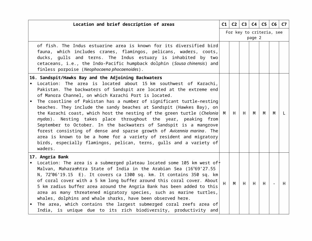
Location and brief description of areas C1 C2 C3 C4 C5 C6 C7For key to criteria, see page 2
9. Southern Straits of Malacca Location: This area covers the waters and beaches from the Negeri Sembilan to the Riau Archipelago,
Indonesia. The area encompasses the existing marine protected area, turtle-nesting and inter-nesting area, and turtle-feeding ground. The northern boundary of the area is 101.6ºE 2.42ºN, and the southern boundary is 104.98ºE 0.57ºN.
The area is unique because it is a shallow, narrow water mass sandwiched between Sumatera Island and Peninsular Malaysia, and linked with the Straits of Singapore and Riau Archipelago. It is an important foraging and inter-nesting habitat for one of the few viable populations of hawksbill turtles. The beaches of Negeri Sembilan and Melaka are home to the highest nesting population of hawksbill turtle and in the adjacent area, Sungai Linggi provides a crucial habitat for endangered painted terappins and river terappins. It harbours diverse marine resources within its seagrass bed, estuaries and mangroves.
H H H H M M L
10. Nino Konis Santana National Park Location: The area is located at 8°27′00″S and 127°20′00″E and covers 1,236 km2. This area is rich in marine biodiversity, including sharks, coral trout (Plectropomus species), and the
highly threatened Napoleon wrasse (Cheilinus undulatus) as well as other types of marine species that are densely concentrated around coral reefs in the area. The area also has a high level of productivity due to strong ocean mixing, which raises both nutrient concentrations in the area and supports the high level of biodiversity.
M M H M M H M
11. The Upper Gulf of Thailand Location: The area is centered at N13o 2' 39.994", E100o 27' 50.783. The area covers 9,565 km2, along
400 km of the coastline. The area covers the coastal area of Chon Buri, Chacheangsao, Samut Prakarn, Bangkok, Samut Sakhon, Samut Songkram and Phetchaburi provinces of Thailand.
The area is characterized by a range of habitats and a high level of biodiversity. The area contains mangrove forests, macrobenthic fauna, phytoplankton and zooplankton, as well as fish, birds (mangrove birds and migratory birds) and endangered marine species, such as hawksbill turtles (Eretmochelys imbricate), green turtles (Chelonia mydas), Irrawaddy dolphins (Orcaella brevirostris), finless porpoises (Neophocaena phocaenoides), Indo-Pacific humpback dolphins (Sousa chinensis), Indo-Pacific bottlenose dolphin (Tursiops aduncus) and Bryde’s whales (Balaenoptera edeni). The coastal water of this area serves as feeding ground, mating ground and nursing ground for Bryde’s whales.
M H H M M M L
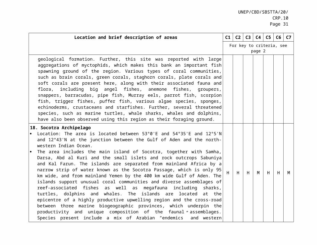
UNEP/CBD/SBSTTA/20/CRP.10Page 31
Location and brief description of areas C1 C2 C3 C4 C5 C6 C7For key to criteria, see page 2
12. Halong Bay-Catba Limestone Island Cluster Location: The marine waters of Halong bay-Catba Limestone Island Cluster are situated in the
nearshore area of the North-east Tonkin Gulf near Haiphong city, Vietnam. It includes Baitulong Bay National Park, Halong Bay World Natural Hetitage, Catba National Park, Catba Biosphere Reserve and Marine Park, as well as Longchau islands. Its total area is about 15.783 ha, with 9.658 ha in marine area.
The marine waters of Halong Bay-Catba Limestone Island Cluster is a highly unique set of 2400 limestone islands and islets that are associated with special island fringing reefs. It contains a remarkable diversity of coastal and marine habitats and ecosystems, including coral reefs, seagrass beds, mangroves, sandy and coral beaches, hard and soft bottom and substrata, tidal marshes, karst saline lakes, embayments, coastal bays, karst caves, underwater karst valleys, karst funnels, karst wells, channel stones and shallow-water areas. It also has a high diversity of species, including phytoplankton, zooplankton, mollusca, crustacean, marine fish, reptiles, snakes, sea turtles and mammals.
H H H H M H M
13. Tioman Marine Park Location: The Tioman Marine Park archipelago consists of nine islands, which are the largest of the 42
marine park islands of Peninsular Malaysia. It is located at 104 0 11’ E and 020 47’N. The archipelago is 19km in length and 11km wide, and covers 25,115 hectares of sea area.
The coral reefs in Tioman Marine Park are some of the best on the east coast of Malaysia. A study conducted in 2014 showed that this area’s coral was in good condition, with 60 per cent live coral cover, 26 per cent in excellent condition and 37 per cent in good condition. A total of 326 species of coral reef fish from 55 families were observed from coral reefs in Tioman Marine Park. Tioman island subtidal seagrass meadows provide good refuge for dugong traveling between islands on the east coast of Peninsular Malaysia. Some rare and important species have been observed, such as the Black Stripe Coris (Coris pictoides), two rare and undescribed gobies (Gobiidae) Amblyeleotris sp. and the rare perch parapercis sp. in addition seventeen species that are categorized to be rare worldwide were found in Tioman. With its high biological diversity, Tioman is believed to be the seed-source for most of the marine biodiversity of the eastern part of Malaysia.
H H H M M H M
14. Koh Rong Marine National Park Location: The area is located at at 10°35'7.49"N, 103°17'55.36"E. It encompasses approximately 78
km2 around the Koh Rong Archipelago, which lies 25 km off the coastal town of Sihanoukville, Cambodia.
The area is located around a large island in the Gulf of Thailand off the Cambodian mainland. The island has about 43 km of coastline with 23 beaches of varying length and composition. The area contains coral reefs and seagrass habitats, and supports regionally significant populations of several marine mammals, including the dugong, the false killer whale (Pseudorca crassidens), a long-beaked
L M H H M M M
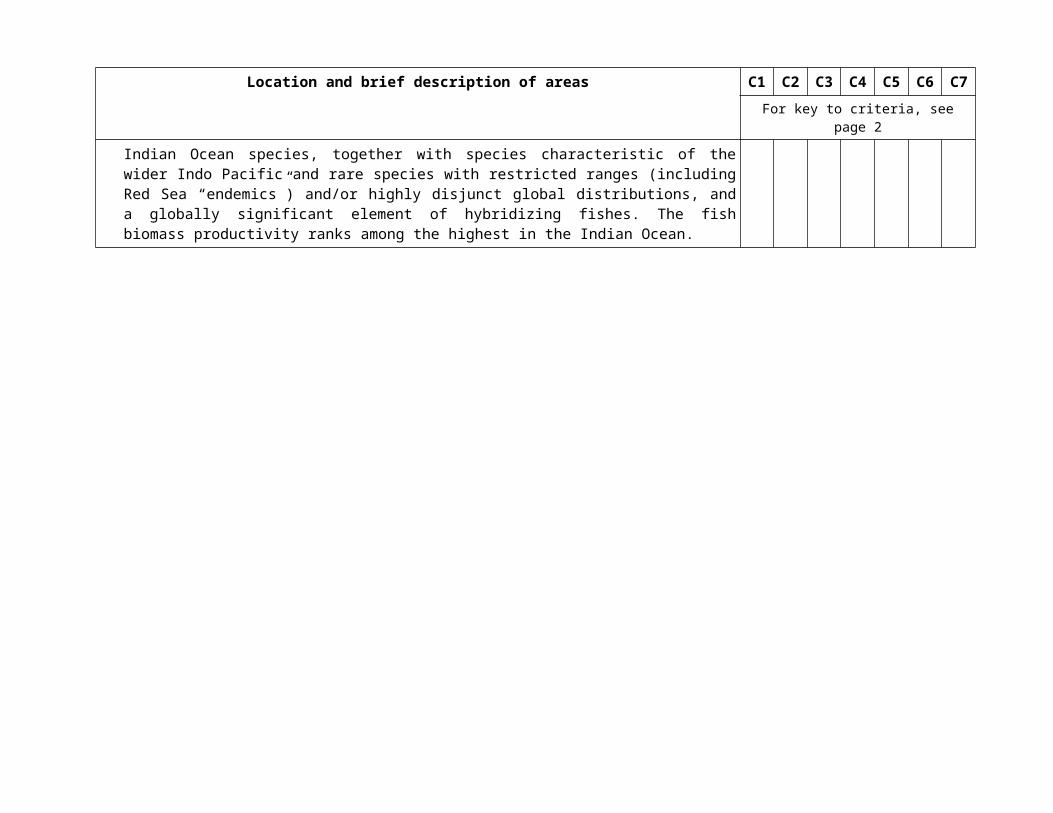
Location and brief description of areas C1 C2 C3 C4 C5 C6 C7For key to criteria, see page 2
form of common dolphin (Delphinus capensis tropicalis), pantropical spotted dolphin (Stenella attenuata), dwarf spinner dolphin (S. Longirostris roseiventris), Indo-Pacific bottlenose dolphin (Tursiops aduncus), and Indo-Pacific humpback dolphin. It also supports three globally threatened species of sea turtles, namely the green turtle (Chelonia mydas), the hawksbill (Eretmochelys imbricata) and the leatherback (Dermochelys coriacea).
15. Lampi Marine National Park Location: The area is located in Boke Pyin Township of Tanintharyi Division in Myanmar. This area is one of the 43 protected areas of Myanmar and its only national marine park. It is located in
the Myeik Archipelago, which comprises more than 800 islands distributed along 600km of coastline in the Andaman Sea. The area contains a number of ecologically important habitats, including mangrove forests, coral reefs and seagrasses, which serve as critical habitats for molluscs, crustaceans, echinoderms and fishes, as well as threatened species such as the green turtle and the dugong that feed on seagrass and a variety of birds that feed in the intertidal zone and sublittoral zone.
M H H M M H L
16. Raja Ampat and Northern Bird’s Head Location: The area is located in the northwestern part of Papua in eastern Indonesia. Situated near the
Equator in Southeast Asia, this area is at the heart of the Coral Triangle and encompasses myriad small islands and coral reefs. Raja Ampat consists of four main islands and hundreds of other small islands, located at the western side of the Bird’s Head Seascape. The boundary of the globally outstanding area of Raja Ampat and Northern Bird’s Head covers two adjacent areas within the Bismarck Solomon Seas Ecoregion.
The Bird’s Head Seascape is one of the world’s most important biodiversity hotspots, covering a high diversity of geographical features, habitats and marine species. Situated in the heart of the Coral Triangle, it is the global epicenter of tropical shallow-water marine biodiversity, with over 600 coral species and 1,638 reef fish species. The area is known for particularly significant diverse reef habitat and species richness, providing foraging ground for tuna as well as breeding habitats for leatherback turtles. The local eddies and turbulence in Raja Ampat, generated by strong current flow, lead to good larval connectivity among the reefs, which contributes to high coral reef resilience. The importance for life history stages of various threatened species like turtles and cetaceans as well as high endemism, together with the above features, makes this a globally important area.
H H H M H H H
17. Atauro Island Location: The area is located about 27 km north of the city of Dili, Timor-Leste, and measures about
144 km2 in area. This area is a home of marine megafauna in the ocean strait between Atauro and Timor-Leste. Atauro
M M M M M H L
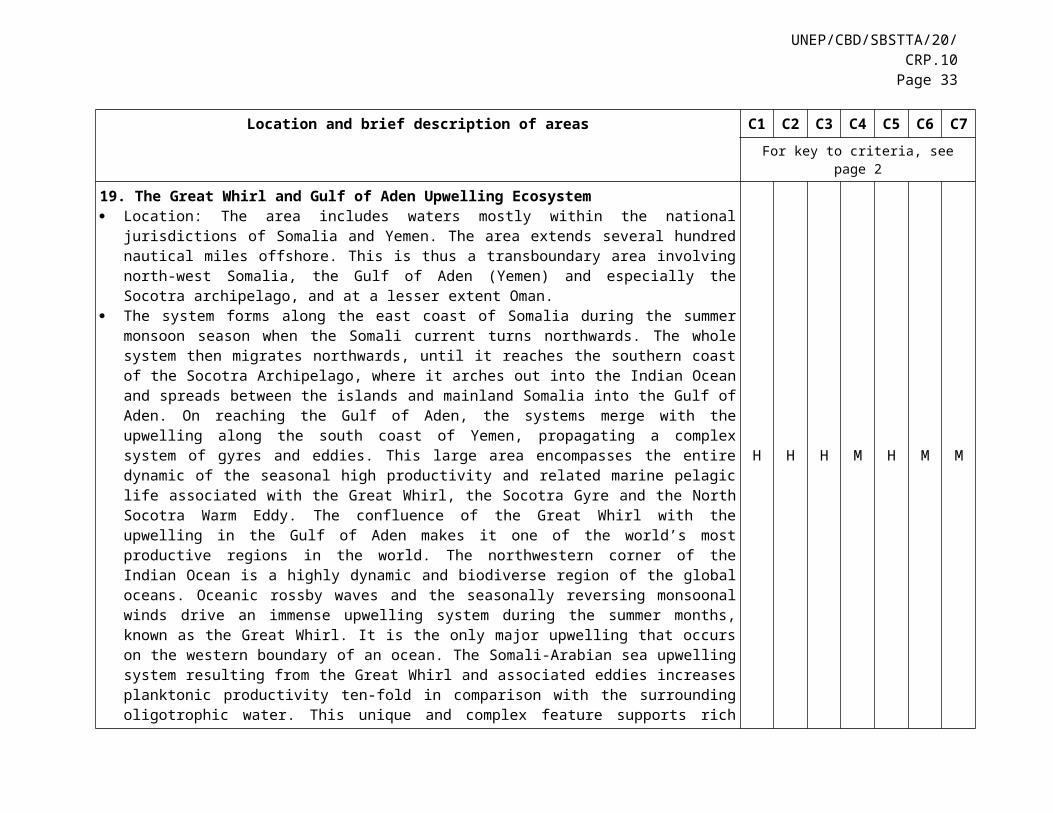
UNEP/CBD/SBSTTA/20/CRP.10Page 33
Location and brief description of areas C1 C2 C3 C4 C5 C6 C7For key to criteria, see page 2
Island is a small island surrounded by a pristine marine area. A study shows that Atauro Island hosts high biodiversity, with a new species called Humann’s Fairy-wrasse (Cirrhilabrus humanni) found around Atauro Island towards Alor Island, Indonesia. Atauro marine area is also considered a hotspot for dugong populations living and migrating within Indian and the Pacific Ocean.
18. Sulu-Sulawesi Marine Ecoregion Location: The Sulu-Sulawesi Marine Ecoregion (SSME) is located between 15° N / 116° E and 0° N /
127° just above the equator. It covers 1,003,526 km2. The area is situated at the apex of the Coral Triangle region in the Indo-West Pacific, at the global
centre of marine biodiversity. It is an area of maximum coral and tropical reef fish diversity, based on numerous scientific studies.. The SSME is home to coral reefs, seagrass meadows and mangrove forests, which in turn support fishes, sea turtles, dolphins, whales, sharks, rays, and other less-known but equally important marine flora and fauna.
H H H H H H L
19. Benham Rise Location: The area is bounded to the North and East by the West Philippine Basin, and to the West and
South by the island of Luzon. It is enclosed by the coordinates 123° 30' E to 126° 00' E longitude and 17° 42' N to 15° 36' N latitude.
The area is a relatively pristine 13-million-hectare undersea plateau off the eastern coast of Luzon Island. It is of critical ecological importance, including for offshore mesophotic coral reef biodiversity and for the sustainability of fisheries. Aside from being an important source of biodiversity and contributing to the resiliency of threatened ecosystems, it also forms part of the only known spawning area of the Pacific bluefin tuna, Thunnus orientalis. In addition, recent studies suggest that the interaction of the western boundary currents with the Benham Rise can lead to enhanced biological productivity.
H H H M - M H
20. Eastern Hokkaido Location: The area is located between 42.9°N and 45.4°N latitude, and between 144.3°E and 145.8°E
longitude. The area covers rocky shores around Shiretoko Peninsula; coastal and lagoonal areas along Nemuro Straits; rocky habitats around Nemuro Peninsula, Habomai Islands and Shikotan Island; and rocky shores and estuaries along the eastern Pacific coast.
The area covers the most pristine natural ecosystems of Japan. The marine ecosystem here is strongly influenced by the cold Oyashio currents and winter ice cover, making this area home to marine species specially adapted to a cold climate. The area contains various types of ecosystems, including brackish estuaries and a lagoon, intertidal flats, rocky intertidal shores, seagrass beds and kelp forests.
H H M H H M H
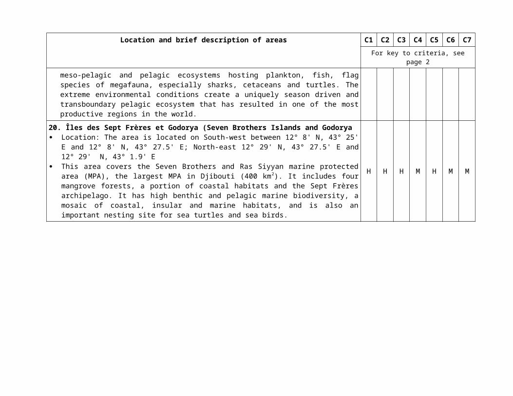
Location and brief description of areas C1 C2 C3 C4 C5 C6 C7For key to criteria, see page 2
21. Southwest Islands Location: The area is located between 23.9°N and 28.7°N latitude, and between 122.8°E and 130.2°E
longitude. It comprises Amami Island, Okinawa Island, Kerama Islands, Miyako Islands and Yaeyama Islands.
The southwest islands of Japan, including Amami Islands, Okinawa Islands, Miyako Islands and Yaeyama Islands, belong to the subtropical region, characterized by the occurrence of fringing, barrier and atoll reefs. In most areas, mangrove and seagrass beds occur within the reef, and the continuous seascape by these habitats hosts a wide variety of associated flora and fauna, including many endemic species.
H H H H H H H
22. Inland Sea Areas of Western Kyushu Location: The area is located between 31.9°N and 33.2°N latitude, and between 129.9°E and 130.7°E
longitude. It covers the Ariake Sea, Amakusa and Yatsushiro Sea (Nagasaki, Saga, Kumamoto and Kagoshima Prefectures).
This area is unique due to their large tidal amplitude. Extensive mud flats appear at inner parts of the waters in Ariake Sea and Yatsushiro Sea. In these intertidal flats, many benthic organisms belonging to diverse taxa occur, as do many endemic species. The outer coastal areas of this area hosts a variety of intertidal and subtidal habitats, including rocky shores, seaweed and seagrass beds, and temperate coral communities.
H H H M M H M
23. Southern Coastal Areas of Shikoku and Honshu Islands Location: The area is located between 32.7°N and 35.4°N latitude, and between 132.2°E and 139.9°E
longitude. It covers southwestern Shikoku Island (Kochi and Ehime Prefectures), Southern Kii Peninsula (Wakayama Prefecture), Shima Peninsula (Mie Prefectures), Izu Peninsula (Shizuoka Prefecture), Boso Peninsula (Chiba Prefecture) and Izu Shichito Islands.
This area is heavily influenced by the Kuroshio current, which characterizes the benthic flora and fauna of these regions. Open coastal areas are mostly rocky shore, whereas semi-enclosed bays behind the exposed capes are suitable habitats for soft-bottom benthic organisms, including seagrass beds. Temperate coral communities are also observed in most of these areas.
H H M H H H M

UNEP/CBD/SBSTTA/20/CRP.10Page 35
Location and brief description of areas C1 C2 C3 C4 C5 C6 C7For key to criteria, see page 2
24. South Kyushu including Yakushima and Tanegashima Islands Location: The area is located between 30.1°N and 31.8°N latitude, and between 130.3°E and 131.2°E
longitude. It covers Tanegashima Island, Yakushima Island, Kinko Bay and surrounding coastal areas (Kagoshima Prefecture).
The area is located at the southernmost part of the temperate zone. The southern limits of many temperate marine species are found around this region. The area comprises a variety of habitats, including rocky intertidal shores and subtidal seaweed beds at exposed coasts, seagrass beds at the inner part of the bay, and temperate coral reefs in Tanegashima and Yakushima Islands.
M M M M M H M
25. Ogasawara Islands Location: The area is located between 27.8°N and 26.5°N latitude, and between 142.0°E and 142.3°E
longitude. The Ogasawara Islands host a variety of endemic species. In 2011, the whole area was declared a
UNESCO World Heritage Site. Located in the subtropical climate region, the coastal sea areas have well-developed coral reefs specific to oceanic islands, and the islands are also known as important breeding grounds for seabird colonies.
H H H L H H H
26. Northern Coast of Hyogo, Kyoto, Fukui, Ishikawa and Toyama Prefectures Location: The area is located between 35.4°N and 37.6°N latitude, and between 134.5°E and
137.4°E longitude. It covers adjacent waters of Takeno coast and Maruyama River mouth, Wakasa-wan Bay, Echizen and Kaga coasts, outer coast of Noto Peninsula, and Nanao Bay and southern Toyama Bay.
The northern coast of the middle of Honshu Island is largely affected by the warm Tsugaru Current. The tidal range is very small compared to other parts of the Pacific coast, inhibiting the development of intertidal flats and rocky shores. However, the area is diverse in topography, including sand flats, exposed rocky coast, complex rias coast, semi-closed inner bay, and most notably, a deep bottom in Toyama Bay, which causes local upwelling and highly productive zones around the coast.
M H M M H M M
27. Ryukyu Trench Location: This area is located south of Ryukyu Islands, with a location between 26.6°N, 130.1°E and
22.7°N, 122.9°E. It corresponds to the intersection of the Philippine plate and Eurasian plate.The Ryukyu Trench contains
important chemosynthetic ecosystems in the slope at depths of 5,802-5,808m, 1,400–1,500 m and 636–812 m, which are home to six endemic species. Studies have suggested that the fauna of this trench are
H H M H L L H
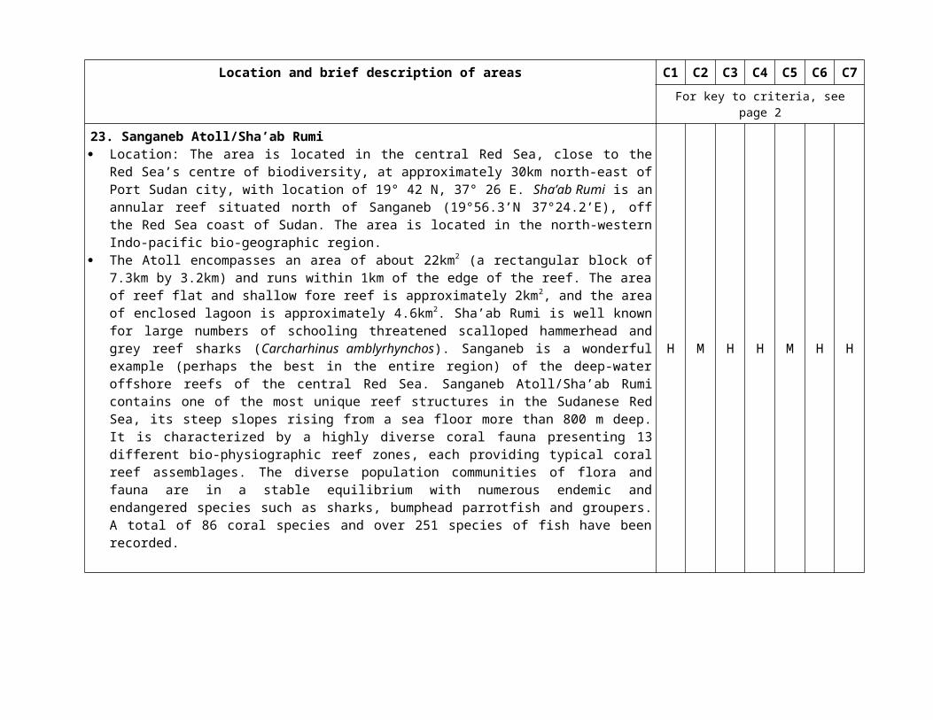
Location and brief description of areas C1 C2 C3 C4 C5 C6 C7For key to criteria, see page 2
distinct from the fauna of other trenches.
28. West Kuril Trench, Japan Trench, Izu-Ogasawara Trench and North of Mariana Trench Location: This area is located between 42.1°N, 146.8°E and 23.2°N, 141.1°E. Ocean trenches (area exceeding water depths of 6000 m) are unique habitats. Trench habitats are
especially well developed in the western Pacific region, from the Kuril to the Mariana trenches. The uniqueness of the biota inhabiting in this region has been recognized in many scientific articles. In some areas, chemosynthetic ecosystems are developing, and species living in such ecosystems have been known to be associated with only one or two seepages. Thus the species in the trench are endemic, very rare, vulnerable and prone to extinction. Fortunately, the naturalness of this trench environment is well–preserved, thus far, because it is extremely remote.
H H M H L L H
29. Nankai Trough Location: This area is located at south of Honshu Island, Japan, between 35.1°N, 138.8°E and 29.5°N,
130.4°E. The area is located along the convergent boundary between the Philippine Sea and Eurasian plates. This
area is associated with great earthquakes along the subduction zone. Many chemosynthetic communities have been recognized in a wide depth range from 270 to 4,800 m due to the existence of numerous methane seeps. Although species richness is not as high as the productive areas, the occurrences of endemic species are high in this region: more than 50% of the total number of species in this region is endemic. The seepage fields harbour higher diversity of the endobenthic invertebrates such as the vesicomyid clams.
H H M H - H L
30. Sagami Trough and Island and Seamount Chain of Izu-Ogasawara Location: This area is located in the western Pacific, South of Honshu Island, Japan, between 35.8°N,
141.6°E and 26.5°N, 138.6°E. This area includes the Tokyo Submarine Canyon and the submarine canyons that drop steeply from
Sagami and Suruga bays as well as the Sagami Trough, spanning 330 km between Sagami Bay, the Boso Peninsula, and Ohshima, and extend to the south to Myojin-sho, the Suiyo Seamount, the Mokuyo Seamount and the Kaikata Seamount. These seamounts are often tectonically active, and many chemosynthetic vent communities area developing in this area.
H H H H H - H
31. Convection Zone East of Honshu Location: The area is located in the east of the northern part of Honshu Island, Japan, between 41.2°N,
145.3°E and 35.9°N, 140.8°E. This is the area where the Oyashio Current (cold current) and the Kuroshio Current (warm current) mix.
Such a complex front structure forms eddies of both warm and cold water. In addition, Tsugaru Current (warm current) flows in off the Sanriku coast, resulting in a very complex oceanographic features.
H H H L H H L
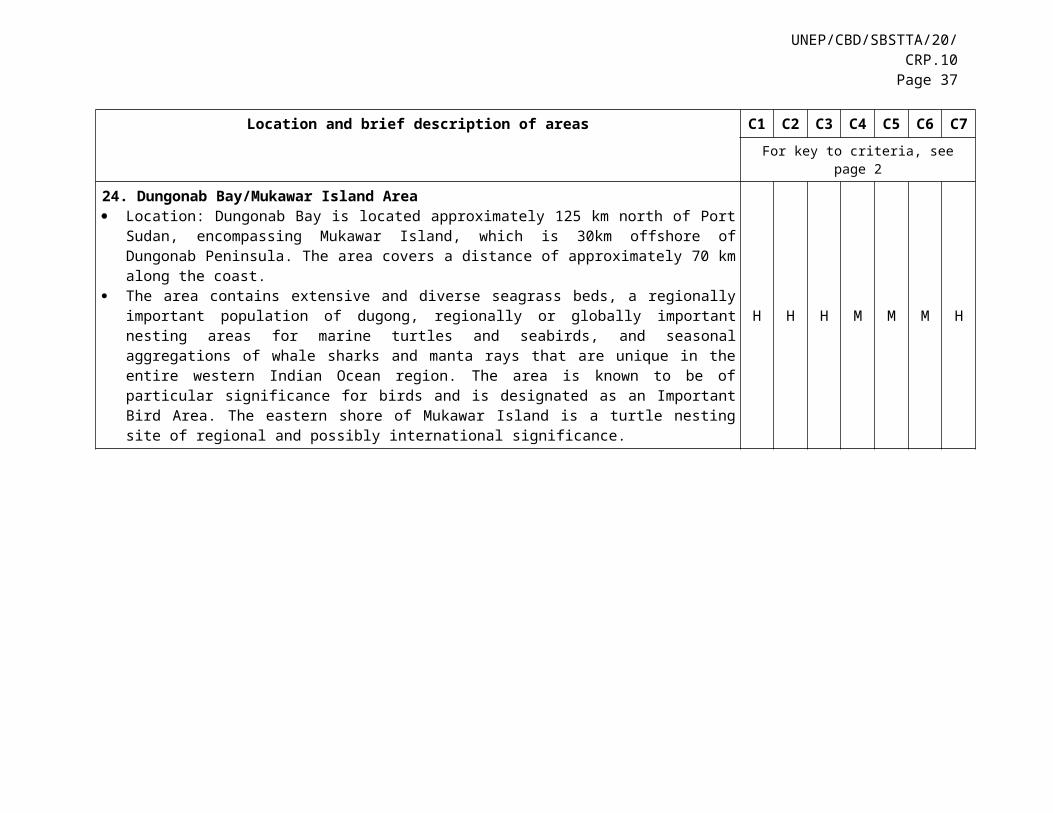
UNEP/CBD/SBSTTA/20/CRP.10Page 37
Location and brief description of areas C1 C2 C3 C4 C5 C6 C7For key to criteria, see page 2
Primary production is high in this area, and zooplankton, especially krill, is also rich. Consequently, pelagic fishes and mammals are present in very high in densities, as the area provides key feeding areas for these higher trophic-level animals. This area is also important as a feeding area of seabirds.
32. Bluefin Tuna Spawning Area Location: This area is located in the upper reaches of the Kuroshio warm current, which flows off
southern Japan, extending between 130.7 °E - 122.5°E and 23.0°N- 30.1 °N. The waters of the Kuroshio Current’s subtropical zone from the Nansei (Okinawa) Islands, where the
Kuroshio Current flows north to the waters off the coast of southern Kyushu, are connected to the Coral Triangle and provide a major spawning area for bluefin tuna.
M H H H M H M
33. Kyushu Palau Ridge Location: The area starts from southeast off Cape Toi located in the southeast side of Kyushu Island,
with southern extension near to Palau. It separates Shikoku and west Mariana Basins and Philippine Basin. It is located between 31.1°N - 17.0°N and 137.1°E- 132.4°E.
Kyushu-Palau Ridge is an ocean floor feature. It comprises a chain of many extinct volcanos mostly below sea level. 213 fish species were found in this area, 14 of which were new to science. A unique deep-sea butterfly fish has also been discovered from this area. This area was found to be the spawning ground of the white spotted conger eel.
H H - - - H H
34. Kuroshio Current South of Honshu Location : This area is located from the south and southeastern coast of Kyushu Island, south of Shikoku
Island and south of Honshu Island, Japan, between 35.9°N, 141.8°E and 30.0°N, 129.9°E. The Kuroshio warm current runs in parallel to coasts of Kyushu Island, Shikoku Island and Honshu
Island. This area consists of the waters of the Kuroshio Current’s subtropical zone from the waters off the southern coast of Kyushu Island where the current turns into follow currents off the Boso Peninsula, and the waters on the inside (landward side) of these. Once the Kuroshio Current goes eastward, it will become weaken and merged with the convex area off east Honshu (please refer to the area no. 35 below). This area is high in biodiversity because the oceanographic setting is complex. It hosts a particularly important spawning ground for commercially important fish and squid species. This area is also used as a reproductive area of finless porpoise. Three endangered fish species have been reported from this area.
H H M L H H L
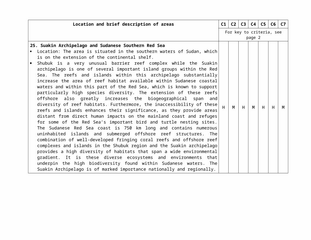
Location and brief description of areas C1 C2 C3 C4 C5 C6 C7For key to criteria, see page 2
35. Northeastern Honshu Location: The area covers intertidal and subtidal bottoms of Mutsu Bay coast, coast of Ogawahara
lagoons, and Sanriku rias coast of Japan. It is located at between 38.2°N and 41.6°N, and between 140.6°E and 142.2°E.
The area is known as a highly productive marine area. The area is influenced by three different types of currents, such as cold Oyashio, warm Kuroshio and Tsugaru currents. Diverse marine biota in this area includes both cold-temperature and warm-temperature adapted species. The area covers various types of coastal habitats including tidal flats, lagoons and rocky intertidal shore in intertidal zone, and seagrass beds and seaweed beds (dominated by kelps and sargassums) in subtidal waters.
H H H H H M H
36. Hydrothermal Vent Community on the Slope of the South West Islands Location: Western slope of the South West Islands, which is on the western side of the Okinawa
Trough. Many chemosynthetic ecosystem sites harbouring both hydrothermal vent and seepage communities
have been found in this area. The number of macro- and megafaunal species in the area is the highest among the several deep-sea chemosynthetic regions. The occurrence of endemic species is also high in this region: 68% of the species are endemic to this area. This area still possesses its natural landscape and environment due to its inaccessibility.
H H - H H H H
__________
Related Documents