Mapping water bodies exploited multi-sensors and multi resolution optical and SAR data: gained experience from plain flood monitoring in Western Europe and Asia Hervé YESOU Claire HUBER, Henri GIRAUD , Mathias STUDER, Sadri HAOUET, Paul de FRAIPONT Maria VIRELLI & Yves Louis DESNOS SERTIT, France, ASI, Italy, ESA-ESRIN 1 Mapping Water Bodies from Space - MWBS 2015 ESA ESRIN, 18-19 March 2015

Welcome message from author
This document is posted to help you gain knowledge. Please leave a comment to let me know what you think about it! Share it to your friends and learn new things together.
Transcript
Mapping water bodies exploited multi-sensors and
multi resolution optical and SAR data: gained
experience from plain flood monitoring in Western
Europe and Asia
Hervé YESOU
Claire HUBER, Henri GIRAUD , Mathias STUDER, Sadri HAOUET, Paul de FRAIPONT
Maria VIRELLI & Yves Louis DESNOS
SERTIT, France, ASI, Italy, ESA-ESRIN
1
Mapping Water Bodies from Space - MWBS 2015
ESA ESRIN, 18-19 March 2015
Context: better understanding in of water
bodies dynamic (water cycle and services)
2
• Test site Alsatian plain flood & Yangtze intermediate basin
• Dynamic of water bodies
• EO time series description/access
• Sentinel 1 versus Envisat ASAR
• Challenging problems, submerged /floating vegetation,
mud banks
• Water bodies from time series
• Validation via multi resolution approach
• Indicators derived from times series
• Perspectives recommendations
Mapping Water Bodies from Space - MWBS 2015
ESA ESRIN, 18-19 March 2015

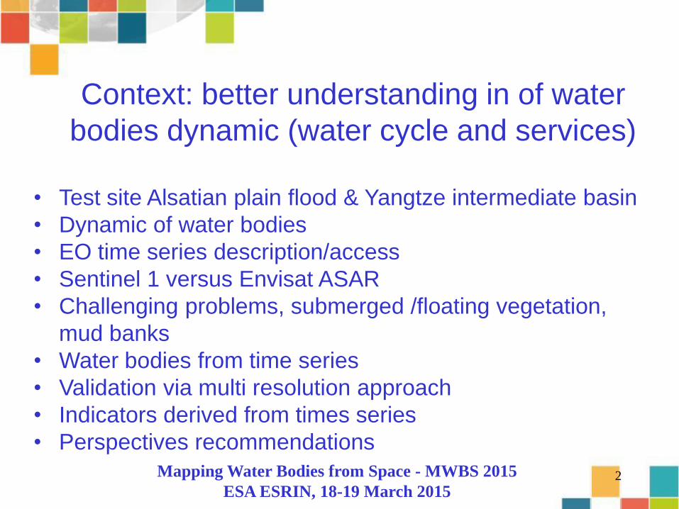
Test sites: Poyang Lake (PR China), Alsatian Flood Plain (Fr)
Poyang lake, Monsoon lake 15 years of monitoring
Mapping Water Bodies from Space - MWBS 2015
Test sites: Poyang Lake (PR China), Alsatian Flood Plain (Fr)
Poyang lake, Monsoon lake 15 years of monitoring
Alsatian Flood plain, less regularly monitor area, but lot of experiment, SPOT Take
Five, Pleiades, CSK, Terra SAR , Mapping Water Bodies from Space - MWBS 2015

3 Gorges Reservoir (3G) reservoir : 1084 km2 2 to 2.5km width, 40m of annual water height
variations
Yangtze river: 1-2 km , 9-12m of annual water height variations
Dongting Lake: 500-2500 km2 , 9-12m of annual water height variations
Poyang Lake: 700-3300 km2, 9-12m of annual water height variations
Anhui lakes: >10-100 km2 , 1-3 m of annual water height variations
Poyang study context: Yangtze middle watershed
• Diversity of types of water bodies, narrow reservoir, large flat depression, etc .. • water surface extent behaviors, depending of the season, size factor 5 • huge water height variations from 40 to 1 m depending of the water body

Context: Yangtze river’s monsoons lakes monitoring
Wucheng/Shenjiang Lakes
Poyang lake
Dongting Lake Poyang lake
• 6000 Lakes, pound, reservoirs •25% freshwater of SE Asia •1 ha to 3500 km2
•Large flooded lakes: 30-40 % of area, 2 majors and 4 small ones •Water services: • 330 000 000 inhabitants •Public health •Biodiversity stakes •Whithin climate change and water management (3GD)
7
Acknowledgement
No product without raw material !!!!!!
Major pillars :
• ESA MOST DRAGON (2004-2016 and more !!)
• CNES télé-épidémiologie and SWOT ( RTU + Take 5)
Others very valuable contributions:
- ASI for CSK time series 2010-2011, 2013-2015
- DLR for Tandem X and multimode data access
- Deimos
- etc
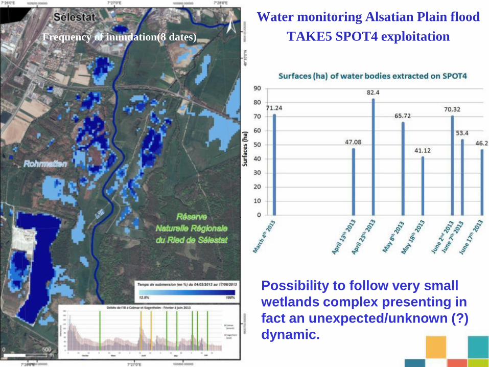
Water monitoring Alsatian Plain flood
TAKE5 SPOT4 exploitation Frequency of inundation(8 dates)
Possibility to follow very small
wetlands complex presenting in
fact an unexpected/unknown (?)
dynamic.

9
Change within 10 days Change within 40 days
Interest of High temporal revisit for monitoring hydrological behaviors Intra annual changes
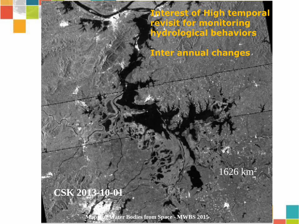
CSK 2013-10-01
1626 km2
Mapping Water Bodies from Space - MWBS 2015
Interest of High temporal revisit for monitoring hydrological behaviors Inter annual changes

Sentinel 1 2014-10-03
Interest of High temporal revisit for monitoring hydrological behaviors Inter annual changes
2718 km2
Mapping Water Bodies from Space - MWBS 2015
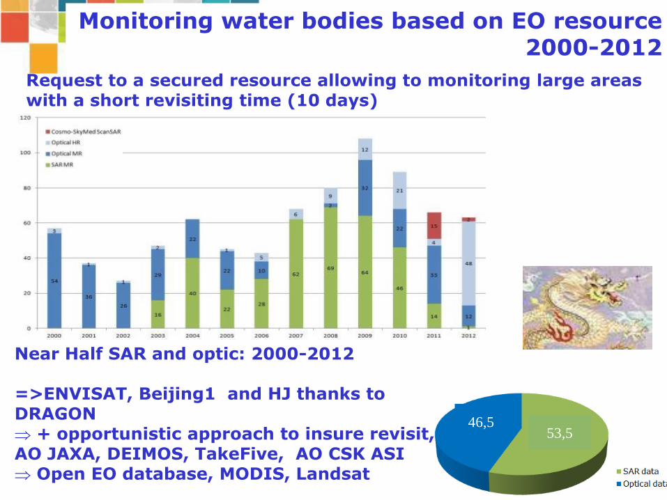
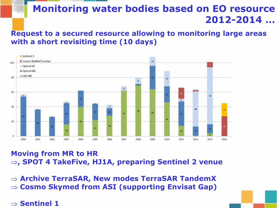
Monitoring water bodies based on EO resource 2000-2012
Request to a secured resource allowing to monitoring large areas with a short revisiting time (10 days)
53,5 46,5
Near Half SAR and optic: 2000-2012 =>ENVISAT, Beijing1 and HJ thanks to DRAGON + opportunistic approach to insure revisit, AO JAXA, DEIMOS, TakeFive, AO CSK ASI Open EO database, MODIS, Landsat
Request to a secured resource allowing to monitoring large areas with a short revisiting time (10 days)
Moving from MR to HR , SPOT 4 TakeFive, HJ1A, preparing Sentinel 2 venue
Archive TerraSAR, New modes TerraSAR TandemX Cosmo Skymed from ASI (supporting Envisat Gap)
Sentinel 1
Monitoring water bodies based on EO resource 2012-2014 …
14
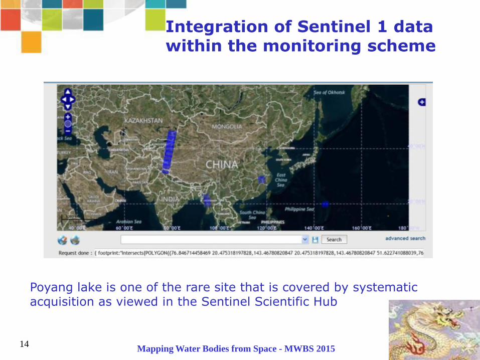
Integration of Sentinel 1 data within the monitoring scheme
Poyang lake is one of the rare site that is covered by systematic acquisition as viewed in the Sentinel Scientific Hub
Mapping Water Bodies from Space - MWBS 2015
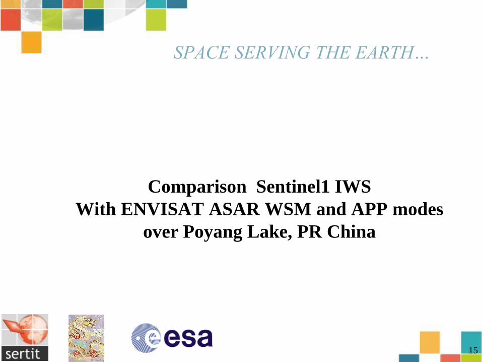
Comparison Sentinel1 IWS
With ENVISAT ASAR WSM and APP modes
over Poyang Lake, PR China
15
16
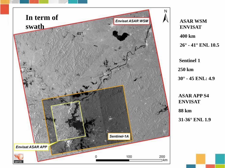
41°
ASAR WSM
ENVISAT
400 km
26° - 41° ENL 10.5
Sentinel 1
250 km
30° - 45 ENL: 4.9
ASAR APP S4
ENVISAT
88 km
31-36° ENL 1.9
In term of
swath
17
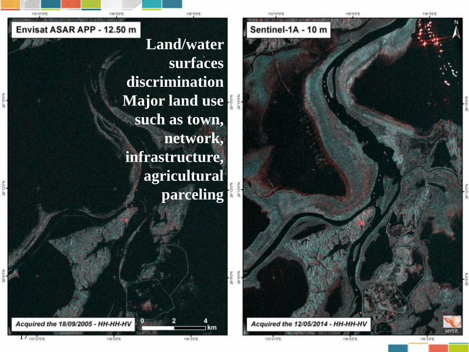
Land/water
surfaces
discrimination
Major land use
such as town,
network,
infrastructure,
agricultural
parceling
18
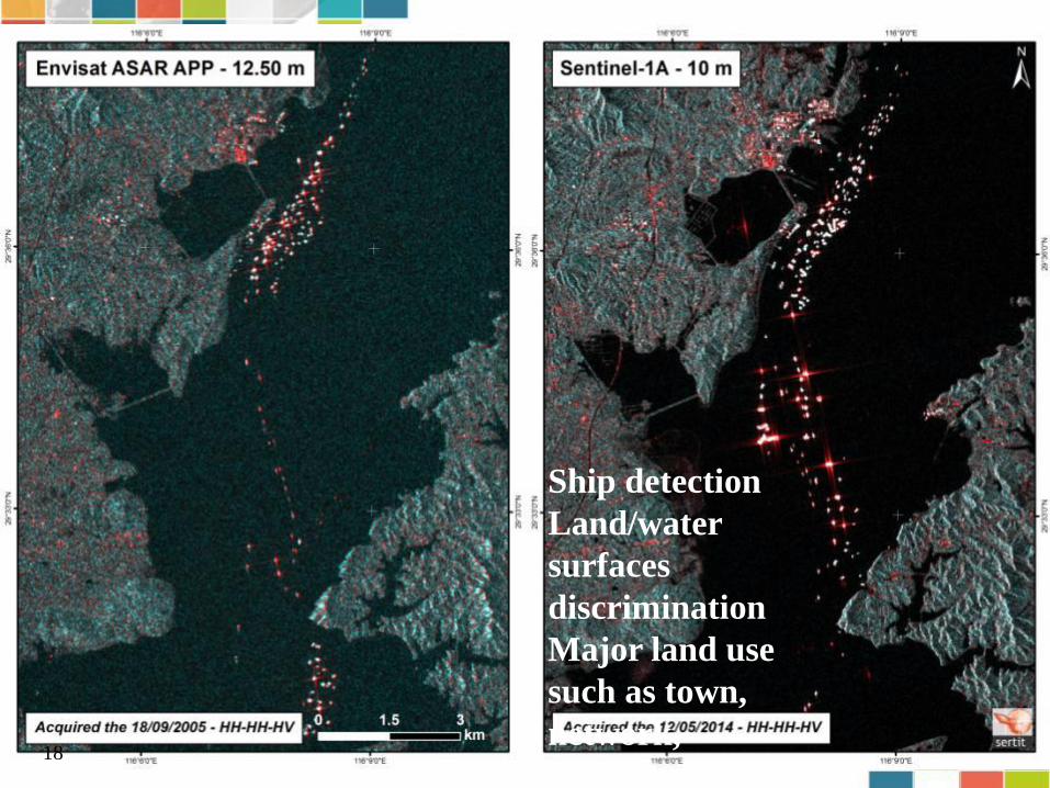
Ship detection
Land/water
surfaces
discrimination
Major land use
such as town,
network,
infrastructure
19
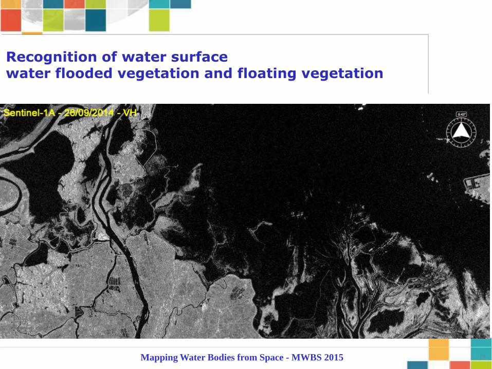
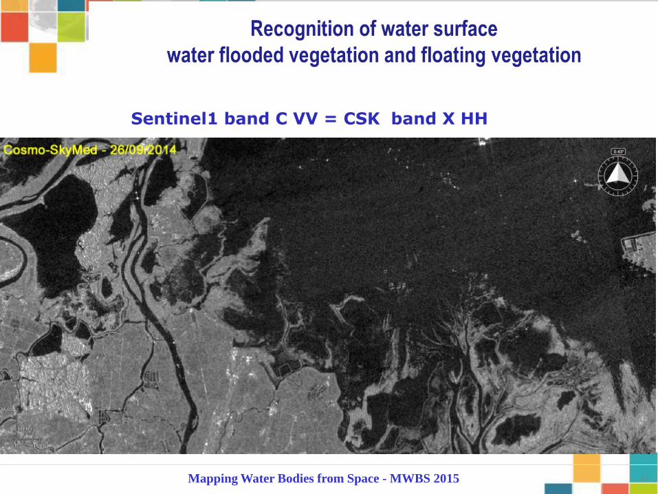
Recognition of water surface water flooded vegetation and floating vegetation
Mapping Water Bodies from Space - MWBS 2015
20
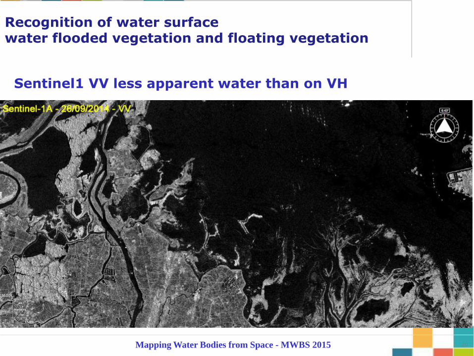
Sentinel1 VV less apparent water than on VH
Recognition of water surface water flooded vegetation and floating vegetation
Mapping Water Bodies from Space - MWBS 2015
21
Sentinel1 band C VV = CSK band X HH
Mapping Water Bodies from Space - MWBS 2015

22
Nymphoides Pelatum
Recognition of water surface water flooded vegetation and floating vegetation
Mapping Water Bodies from Space - MWBS 2015

23
Jacynth
Recognition of water surface water flooded vegetation and floating vegetation
Mapping Water Bodies from Space - MWBS 2015

24
CSK 0224-0726-0928- 2014
Shenjiang Lake
Anhui Pr, PR CHina

25 Mapping Water Bodies from Space - MWBS 2015
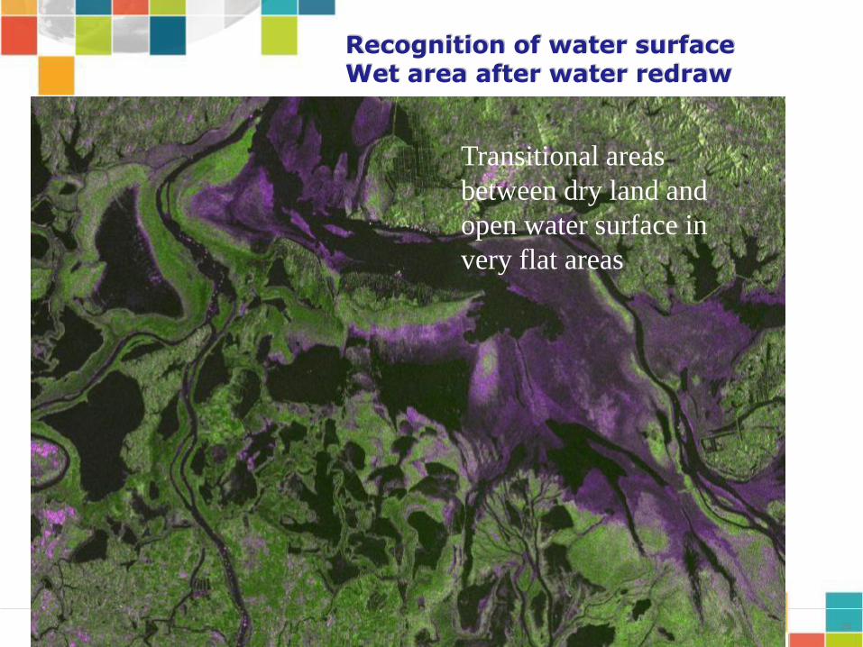
Recognition of water surface Wet area after water redraw
26
Recognition of water surface Wet area after water redraw
Transitional areas
between dry land and
open water surface in
very flat areas
Water extraction from Sentinel 1, CSK, HJ1A Time series
over Poyang Lake and Anhui lakes ,
PR China
27
28
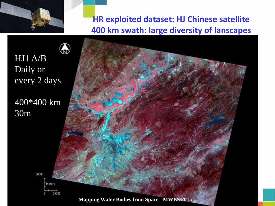
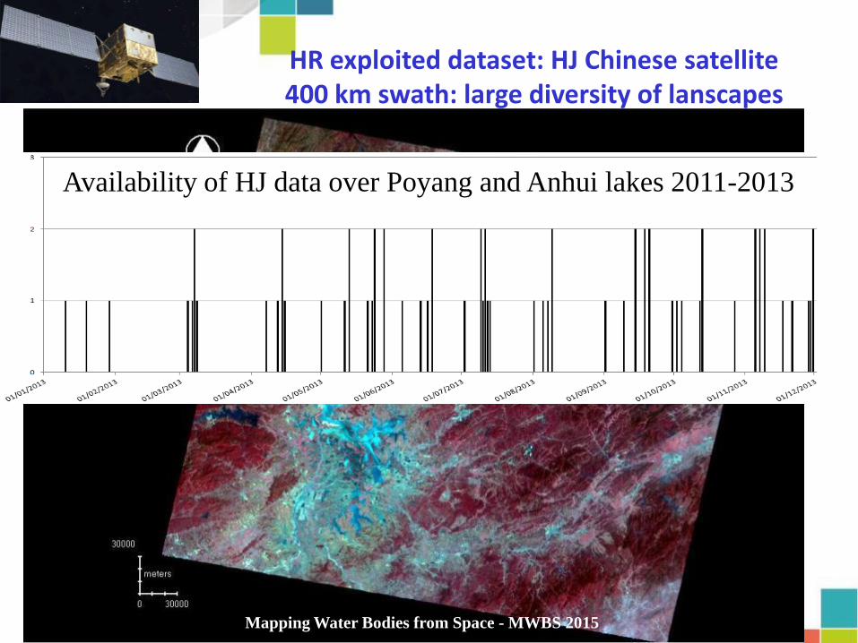
HR exploited dataset: HJ Chinese satellite 400 km swath: large diversity of lanscapes
HJ1 A/B
Daily or
every 2 days
400*400 km
30m
Mapping Water Bodies from Space - MWBS 2015
29
HR exploited dataset: HJ Chinese satellite 400 km swath: large diversity of lanscapes
HJ1 A/B
Daily or
every 2 days
400*400 km
30m
Mapping Water Bodies from Space - MWBS 2015
Availability of HJ data over Poyang and Anhui lakes 2011-2013

30
High variability of spectral answer
and contrast land/water
Shenjian Lake, Anhui Province
Mapping Water Bodies from Space - MWBS 2015

31
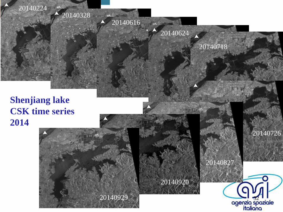
Poyang lake CSK time series
January to December 2014
32
20140224 20140328
20140616
20140624
20140718
20140726
20140827
20140920
20140929
Shenjiang lake
CSK time series
2014

33
20140921 20140926
20141003 20141008
20141015
20141015
20141101 20141108
20141020
20141113
20141120 20141125
20141202
20141207 20141214
20141219
20141226
Sentinel 1: High temporal revisit T0 , +5, +7
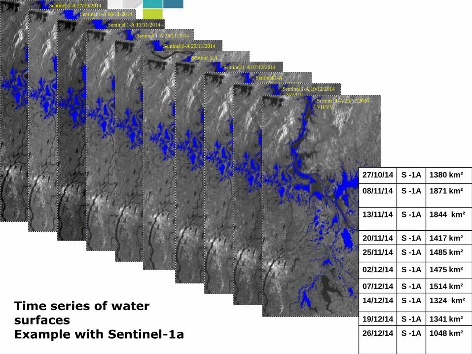
Sentinel 1-A 27/10/2014
– VH/VV Sentinel 1-A 08/11/2014
– VH/VV Sentinel 1-A 13/11/2014 –
VH/VV Sentinel 1-A 20/11/2014
– VH/VV Sentinel 1-A 25/11/2014
– VH/VV Sentinel 1-A
02/12/2014– VH/VV Sentinel 1-A 07/12/2014
– VH/VV Sentinel 1-A
14/12/2014 – VH/VV Sentinel 1-A 19/12/2014
– VH/VV Sentinel 1-A 26/12/2014 –
VH/VV
27/10/14 S -1A 1380 km²
08/11/14
S -1A
1871 km²
13/11/14
S -1A 1844 km²
20/11/14 S -1A 1417 km²
25/11/14 S -1A 1485 km²
02/12/14 S -1A 1475 km²
07/12/14 S -1A 1514 km²
14/12/14 S -1A 1324 km²
19/12/14 S -1A 1341 km²
26/12/14 S -1A 1048 km²
Time series of water surfaces Example with Sentinel-1a

SPOT4/ HJ/Deimos and Pleiades HR
TerraSAR, Wide ScanSAR to Staring Spot Light
Validation approach
Multi source & multiscale optical and SAR
VHR SAR (CSK, Multi
mode TerraSAR) or VHR
Optical (Pleaides,
Kompsat) imagery allow
to validate the HR
derived flood extent
Mapping Water Bodies from Space - MWBS 2015

Validation of water bodies delineation
Based on HR/VHR multi resolution approach
Stripmap (SM) / Spotlight standard (SL) / Staring Spotlight (ST)
Wide Scan SAR 200*200 km2, 30 m
Strip Map mode : 30*50 km2, 3m
SpotLight mode : 5*10 km2, 1m
Staring SpotLight : 3*4 km2, 25 cm
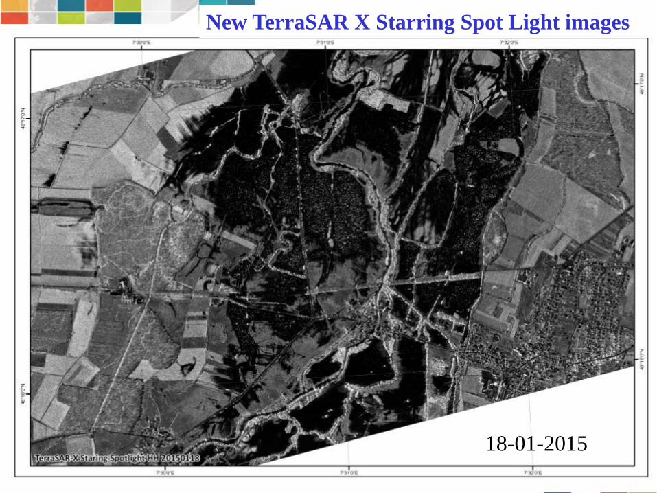
18-01-2015
New TerraSAR X Starring Spot Light images

18-01-2015 20-01-2015
20-01-2015
Classical TerraSAR X Strip map images
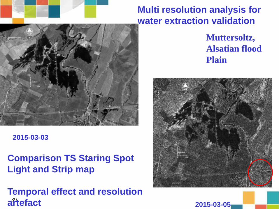
39
2015-03-03
2015-03-05
Multi resolution analysis for
water extraction validation
Comparison TS Staring Spot
Light and Strip map
Temporal effect and resolution
artefact
Muttersoltz,
Alsatian flood
Plain

40 12-02-2015

Analysis of temporal variations of water surfaces from 2000 to 2014. Our core information is 15 years of surface extents with a high frequency scoring (10 days in average)
Ends: Water surfaces monitoring
Mapping Water Bodies from Space - MWBS 2015
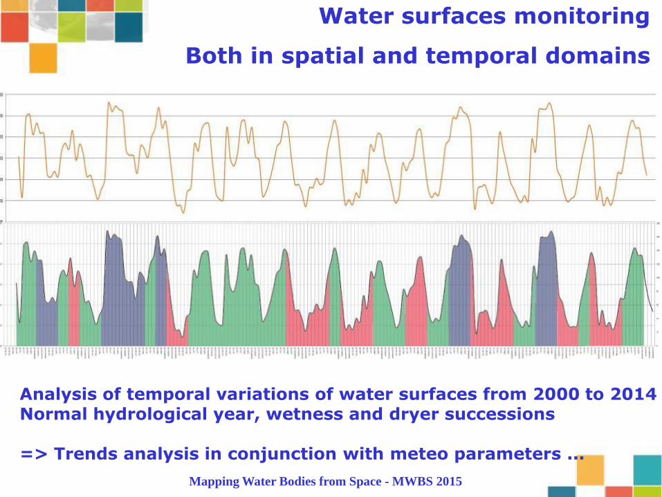
Analysis of temporal variations of water surfaces from 2000 to 2014 Normal hydrological year, wetness and dryer successions => Trends analysis in conjunction with meteo parameters ...
Water surfaces monitoring
Both in spatial and temporal domains
Mapping Water Bodies from Space - MWBS 2015
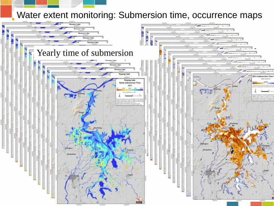
Water extent monitoring: Submersion time, occurrence maps
Yearly Residual analysis Yearly time of submersion
Yearly Residual analysis
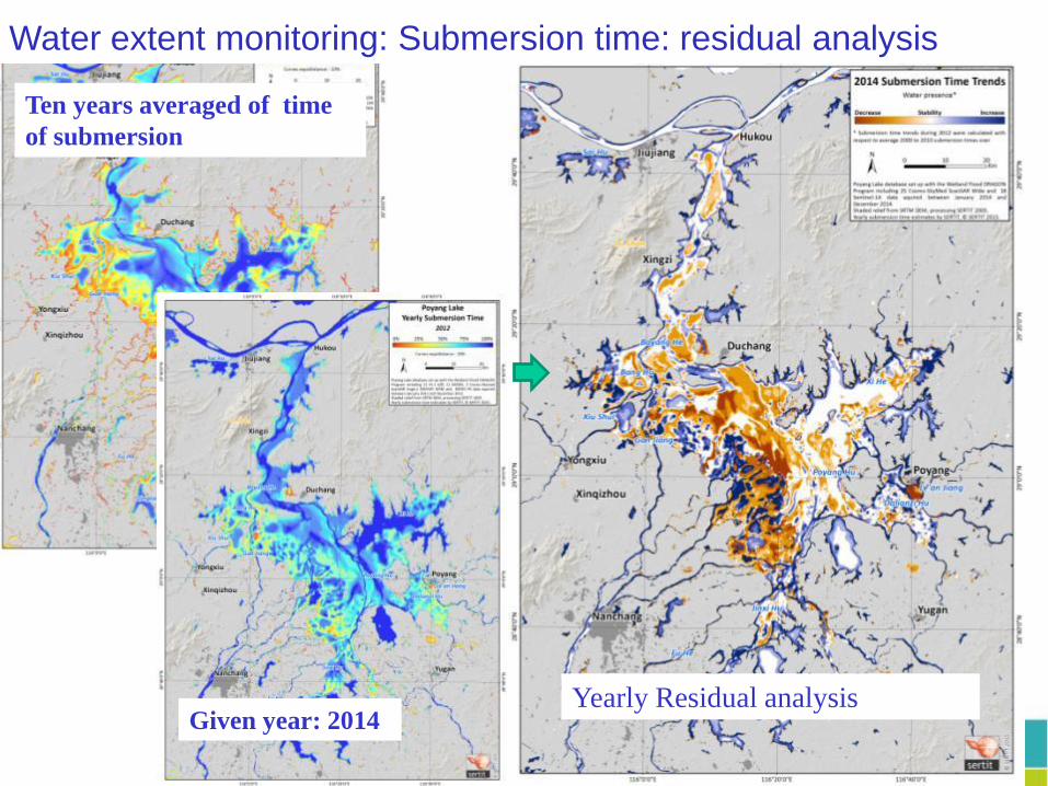
Ten years averaged of time
of submersion
Water extent monitoring: Submersion time: residual analysis Water extent monitoring: Submersion time: residual analysis
Given year: 2014

45
Water extent monitoring: Submersion time: residual analysis

46
Complementarity SAR Optical HR
High complementary-synergy
Temporal:
• Long term few weeks/month with none exploitable Optical data
• Short term: increase the revisit, that interesting because evolution in less than 5 days (multiscale)
=> More accurate indicators (be careful with trends motions…)
Thematic:
- Optical :
- Vegetation on optical: flooded, submerged floating vegetation
- Water quality
Be careful with scale of analysis (Vegetation versus Modis, versus SPOT… 20% break each time… )..
Water bodies monitoring request regular and long term time series, continuity and consistency are key words
Mapping Water Bodies from Space - MWBS 2015
47
Perspectives and recommendations
Sentinel1 : systematic VV/VH rather than HH/HV !!!!
More global coverage.. Poyang is covered by S1 but only one major sites over hundreds ,
Sentinel 2: the systematic will be really systematic all around the world .. And at which time
Pursuit of the synergy approach with Sentinel3 OCLI (and other L8, Proba 100m) ,
Integrate as much as possible others source of information , such as water height (Jason, Altika, coming S3 and Jason CS before SWOT 2020)
Mapping Water Bodies from Space - MWBS 2015
© YESOU, 2006
Thanks you
Questions ?
L’ESPACE… …AU SERVICE
DE LA TERRE
Herve YESOU
SERTIT
Université de Strasbourg
Institut Telecom Physiques Strasbourg
Parc d'Innovation
300, Bd Sébastien Brant
BP 10413
F - 67412 Illkirch Graffenstaden
+33 (0)3 68 85 46 43 (Tel)
+33 (0)3 68 85 46 46 (Fax)
http://sertit.u-strasbg.fr
Related Documents