Eos, Vol. 87, No. 16, 18 April 2006 EOS, TRANSACTIONS, AMERICAN GEOPHYSICAL UNION EDITORIAL Communicating Government Science PAGE 157 NASA Administrator Michael Griffin issued an agency-wide policy on 30 March clarify- ing how scientists should communicate with news media. The guidelines allow NASA sci- entists to communicate their scientific results to the media, but requires them to distinguish between professional and per- sonal views. Griffin said the guidelines resulted from an effort to revise NASA public affairs policies and "to make sure they are fair, reasonable, and easily understood." Griffin deserves thanks for clarifying agency rules, and he sets a standard for other agencies to follow. His approach to clarifying the communication policy should be applied broadly to U.S. federal agencies that support science or produce scientific results. Clearly and accurately presenting sci- entific information to the media is an impor- tant responsibility for federal agencies and the scientists working there. The NASA policy also sets rules for what the agency's public affairs officers are permitted, and not permitted, to do in terms of issuing, limiting, or editing the release of scientific information. In addition, the policy provides NASA scientists and public affairs officers with PAGES 157,160 Multibeam bathymetric data from selected U.S. continental margins are being collected for use in the future development of potential submissions that the United States may make to the United Nations Commission on the Law of the Sea (UNCLOS) to extend the nation's sovereign rights over the resources of the sea- floor and the subsurface. However, the new data also represent a valu- able resource for the next generation of marine geologists to study the complexity BY J.V GARDNER, L. A. MAYER, AND A. ARMSTRONG a method to resolve disputes over the release of scientific information. Clarifying and coordinating the rules should enable scientists to communicate their results without fear of retribution, par- ticularly important when those results bear on currently contentious policy issues such as climate change or the rebuilding of New Orleans, La. Other federal agencies also need a clear policy for scientists and public affairs officers. For example, scientists with the U.S. National Oceanic and Atmospheric Administration (NOAA) have been pressured from within their agency when attempting to speak to the media about research findings, accord- ing to a 6 April report in the Washington Post. NOAA officials have defended their actions, stating that the public affairs office was following long-standing policies not enforced in the past. This kind of confu- sion about communication policies hurts science and limits its utility in informing policy makers and the public. In a letter dated 7 April, U.S. Rep. Sher- wood Boehlert (R-N.Y), chair of the House of Representatives' Science Committee, urged NOAA Administrator Conrad Lauten- bacher to support "open and unfettered sci- of surficial processes of several U.S. conti- nental margins. For example, the details of the morphology of large sediment slides on the U.S.Atlantic continental slope and rise have been mapped, and enigmatic features such as a meandering channel on a chan- nel levee on the U.S.Alaskan Pacific margin have been discovered. The new data sets, first shown at the 2005 AGU Fall Meeting in San Francisco, Calif. [Gardner et al., 2005; Mayer et al., 2005], are now available on the Web at http://www. ccom.unh.edu/law_of_the_sea.html.UNCLOS requirements for an extended shelf submis- sion [United Nations, 1983] are based on VOLUME 87 NUMBER 16 18 APRIL 2006 PAGES 157-164 entific communication" at the agency. Boe- hlert noted, "NOAAs efforts to attract, retain and make full use of the nation's best scien- tists will be stymied if scientists and the sci- entific community at-large believe that NOAA seeks to limit the discussion of climate science and its implications." There is surely a better way to achieve clear policies across U.S. federal agencies than a piecemeal, agency-by-agency approach. This is an opportunity for President George W. Bush and his science advisor, Jack Mar- burger, to lay out a single policy for commu- nicating science to the media that all agen- cies could adopt. That policy could be similar to NASA's, which was drafted by a working group that included science, engi- neering, law, public affairs, and management representatives. The media is often a primary conduit to communicate the best scientific understand- ing of key issues to the public and to policy makers. President Bush should take this opportunity to clarify the rules of communi- cation for scientists and public affairs offi- cers in federal agencies and put an end to the real or perceived risks for government researchers who provide scientific informa- tion to reporters and thus the public. —SOROOSH SOROOSHIAN, CHAIR, AGU Committee on Public Affairs either of two formulae: a distance formula that allows an extension of the shelf to 60 nautical miles (nmi) beyond the foot of the continental slope (specifically defined by UNCLOS as the point of maximum change in gradient at its base), and a sediment-thick- ness formula that allows the extension of the shelf to where the thickness of sediment is one percent of the distance back to the foot of the slope. One objective of the new map- ping is thus to provide the data needed to define the location of the foot of the conti- nental slope. However, the extended submissions can- not extend beyond 100 nmi from the 2500- meter isobath (the location of which also is accurately mapped in these new surveys) or 350 nmi from the officially defined shoreline, whichever is more advantageous to the coastal state. A submission for an Mapping Supports Potential Submission to U.N. Law of the Sea

Welcome message from author
This document is posted to help you gain knowledge. Please leave a comment to let me know what you think about it! Share it to your friends and learn new things together.
Transcript
Eos Vol 87 No 16 18 April 2006
EOS TRANSACTIONS AMERICAN GEOPHYSICAL UNION
E D I T O R I A L
Communicating Government Science PAGE 157
NASA Administrator Michael Griffin issued an agency-wide policy on 30 March clarifyshying how scientists should communicate with news media The guidelines allow NASA scishyentists to communica te their scientific results to the media but requires them to distinguish between professional and pershysonal views Griffin said the guidelines resulted from an effort to revise NASA public affairs policies and to make sure they are fair reasonable and easily understood
Griffin deserves thanks for clarifying agency rules and he sets a standard for other agencies to follow His approach to clarifying the communicat ion policy should be applied broadly to US federal agencies that support s c i e n c e or produce scientific results Clearly and accurately presenting scishyentific information to the media is an imporshytant responsibility for federal agencies and the scientists working there
The NASA policy also sets rules for what the agencys public affairs officers are permitted and not permitted to do in terms of issuing limiting or editing the release of scientific information In addition the policy provides NASA scientists and public affairs officers with
PAGES 157 160
Multibeam bathymetric data from selected US continental margins are being collected for use in the future development of potential submissions that the United States may make to the United Nations Commission on the Law of the Sea (UNCLOS) to extend the nations sovereign rights over the resources of the sea-floor and the subsurface
However the new data also represent a valushyable resource for the next generation of marine geologists to study the complexity
B Y J V GARDNER L A MAYER AND A ARMSTRONG
a method to resolve disputes over the release of scientific information
Clarifying and coordinating the rules should enab le scientists to communica te their results without fear of retribution parshyticularly important when those results bear on currently content ious policy issues such as cl imate change or the rebuilding of New Orleans La
Other federal agencies also need a clear policy for scientists and public affairs officers For example scientists with the US National O c e a n i c and Atmospheric Administration (NOAA) have been pressured from within their agency when attempting to speak to the media about research findings accordshying to a 6 April report in the Washington Post NOAA officials have defended their act ions stating that the public affairs office was following long-standing pol icies not enforced in the past This kind of confushysion about communica t ion pol icies hurts s c i e n c e and limits its utility in informing policy makers and the public
In a letter dated 7 April US Rep Shershywood Boehler t (R-NY) chair of the House of Representatives S c i e n c e Committee urged NOAA Administrator Conrad Lauten-bache r to support open and unfettered sci-
of surficial processes of several US contishynental margins For example the details of the morphology of large sediment slides on the USAtlantic continental s lope and rise have b e e n mapped and enigmatic features such as a meandering channel on a chanshynel levee on the USAlaskan Pacific margin have been discovered
The new data sets first shown at the 2005 AGU Fall Meeting in San Francisco Calif [Gardner et al 2005 Mayer et al 2 0 0 5 ] are now available on the Web at httpwww ccomunhedulaw_of_the_seahtmlUNCLOS requirements for an extended shelf submisshysion [United Nations 1983] are based on
VOLUME 87 NUMBER 16
18 APRIL 2006
PAGES 157-164
entific communica t ion at the agency Boe shyhlert noted NOAAs efforts to attract retain and make full use of the nations best sc ienshytists will be stymied if scientists and the scishyentific community at-large bel ieve that NOAA seeks to limit the discussion of cl imate s c i e n c e and its implications
There is surely a better way to achieve clear policies across US federal agencies than a piecemeal agency-by-agency approach This is an opportunity for President George W Bush and his s c i ence advisor J ack Mar-burger to lay out a single policy for commushynicating sc i ence to the media that all agenshycies could adopt That policy could b e similar to NASAs which was drafted by a working group that included sc ience engishyneering law public affairs and management representatives
The media is often a primary conduit to communica te the best scientific understandshying of key issues to the public and to policy makers President Bush should take this opportunity to clarify the rules of communishycation for scientists and public affairs offishycers in federal agencies and put an end to the real or perceived risks for government researchers who provide scientific informashytion to reporters and thus the public
mdashSOROOSH SOROOSHIAN CHAIR AGU Committee on Public Affairs
either of two formulae a distance formula that allows an extension of the shelf to 60 nautical miles (nmi) beyond the foot of the continental slope (specifically defined by UNCLOS as the point of maximum change in gradient at its base ) and a sediment-thickshyness formula that allows the extension of the shelf to where the thickness of sediment is one percent of the distance back to the foot of the slope One objective of the new mapshyping is thus to provide the data needed to define the location of the foot of the contishynental slope
However the extended submissions canshynot extend beyond 100 nmi from the 2500-meter isobath ( the locat ion of which also is accurately mapped in these new surveys) or 350 nmi from the officially defined shoreline whichever is more advantageous to the coastal state A submission for an
Mapping Supports Potential Submission to UN Law of the Sea
Eos Vol 87 No 16 18 April 2006
extension of the US juridical shelf under UNCLOS would likely be based on a combishynation of bathymetric data ( the 2500-meter isobath and the foot of the s lope) and geoshyphysical data (the thickness of sediment) [Hutchinson et al 2 0 0 5 ]
The US Bathymetric Mapping Program
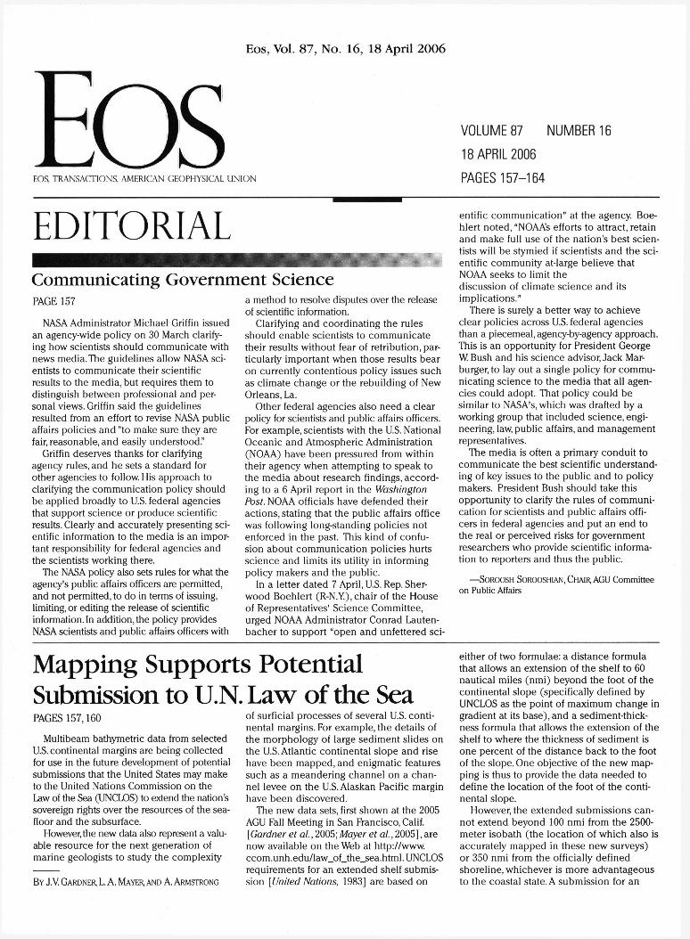
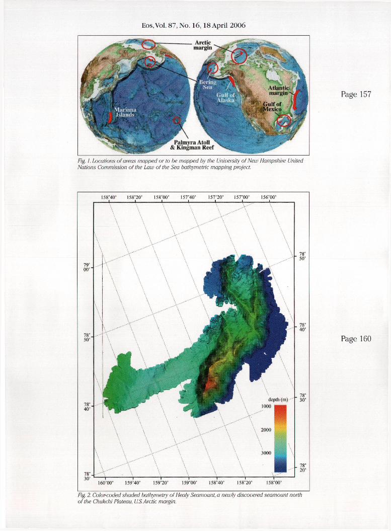
Though as of this writing the US Senate has not acceded to the UNCLOS treaty the University of New Hampshires Center for Coastal and Ocean MappingJoint Hydro-graphic Center has been directed by the US Congress through funding by the US National Ocean ic and Atmospheric Administration (NOAA) to conduct multibeam bathymetric mapping of selected US continental marshygins Mayer et al [2002] conducted a study of the US marine data archives to determine where additional bathymetric surveys might be beneficial in developing a potential US submission under UNCLOS Article 76 This study identified seven regions areas in the Arctic Ocean the Bering Sea and the Gulf of Mexico the entire USAtlantic marginthe Gulf of Alaska and areas surrounding the Mariana Islands Kingman Reef and Palmyra Atoll (Figure 1 and Table 1) where the United States may have a potential for extended shelf submission
To date about 25 percent of the identified Arctic Ocean area the entire area identified in the Bering Sea the entire USAtlantic margin and all of the area in the Gulf of Alaska have been mapped under this proshygram The purpose of this article is to briefly describe the completed mapping surveys announce the public availability of the data and encourage the use of these data for studies of the US continental margins
The multibeam echo sounder systems used in these surveys include an L3 SeaBeam 2112 aboard the US Coast Guard icebreaker Healy a Reson 8150 on the Thales GeoSolutions (now Fugro)-leased research vessel (RV) Davidson Kongsberg Maritime EM 121A sysshytems aboard the US Naval Oceanographic Office vessels USNS Henson and USNS Pathshyfinder and a Kongsberg Maritime EM 120 on the University of Hawaii RV Kilo Moana
The USArctic Margin
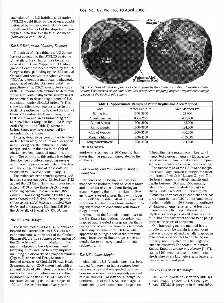
The largest potential for a US submission beyond the current 200-nmi US-exclusive e c o n o m i c zone is in the area of the Chukchi Plateau (Figure l ) a submerged extension of the Chukchi Shelf north of Alaska and the margin adjacent to the Alaska mainland Mapping in this area led to many surprises including the discovery of a major seamount (Figure 2 ) christened Healy Seamount located northeast of Chukchi Plateau Healy Seamount stands - 2 0 0 0 meters high with a summit depth of 940 meters and is - 4 6 kiloshymeters long and - 1 5 kilometers wide The northwest facing flanks rise -40deg whereas the southeast facing flanks have slopes of - 3 0 deg a n d the seafloor immediately to the
Fig 1 Locations of areas mapped or to be mapped by the University of New Hampshire United Nations Commission of the Law of the Sea bathymetric mapping project Original color image appears at the back of this volume
Table 1 A p p r o x i m a t e Ranges of W a t e r Depths a n d A r e a Mapped
Area Water Depth m Area Mapped km 2
Bering Sea 1200-3800 21000
Atlantic margin 800-5200 403000 Gulf of Alaska 1000-3900 162000
Arctic margin 1000-3800 124000
Gulf of Mexico 3 1000-3500 -30 000
Mariana Islands 3 1000-4500 -155 000
KingmanPalmyra 3 1000-4500 -54 000 aYet to be mapped
northwest is as much as 1000 meters shalshylower than the seafloor immediately to the southeast
Bowers Ridge and the Beringian Margin Bering Sea
Two areas of the Bering Sea have been mapped the northern flank of Bowers Ridge and a portion of the southern Beringian margin Mapping the northern flank of Bowshyers Ridge revealed a steep flank with slopes of 10deg-20deg The middle half of the ridge flank is bordered by two broad low-standing curvshying ridges that are concent r ic with Bowers Ridge proper
A section of the Beringian margin east of the US-Russia international boundary was mapped and revealed a steep margin that is deeply eroded and has numerous sediment-filled canyons some of which have what appear to be plunge pools at their termini Long sharp-crested linear ridges strike pershypendicular to the margin and terminate in sediment drifts
The US Atlantic Margin
Although the USAtlantic margin has been studied for more than half a century there were many new and unexpected observashytions made when it was completely mapped in 2004 and 2005 For instance although the northern third of the USAtlantic margin is dominated by well-documented large mass
failures there is a prevalence of large sedishyment-filled canyon channels with superimshyposed narrow channels that appear to represhysent a rejuvenation of channel down-cutting
The middle third of the USAtlantic margin has several large canyon channels the most prominent of which is Hudson CanyonThe Hudson channel is relatively straight until depths between 3000 and 3500 meters where the channel contorts through six sharp bends each gt90deg Johns Valley - 2 5 kilometers northeast of Hudson channel has three sharp bends of gt90deg at the same water depths In addi t ion-50 kilometers southwest of Hudson channel a series of at least four channels abruptly deepen their incision depth at water depths of - 3 0 0 0 meters The four channels have what appear to be plunge pools at the points of deepening
One interesting feature mapped in the middle third of the margin is a seamount that was discovered and partially mapped in 1967 however it had not been placed on any map and has effectively been ignored s ince its discovery The seamount named Knauss Knoll by Lowrie and Heezen [1967] stands 1200 meters above the continental rise is nine by six kilometers at its base and has a sharp summit peak
The US Gulf of Alaska Margin
The Gulf of Alaska has seen very little sysshytematic mapping s ince the US Geological Surveys EEZ-SCAN program in the mid-1980s
Eos Vol 87 No 16 18 April 2006
t c mdash i mdash J L I
160 800 159deg40 15920f 159deg00 158deg40 158deg20 158deg00
Fig 2 Colorltoded shaded bathymetry of Healy Seamount a newly discovered seamount north of the Chukchi Plateau USArctic margin Original color image appears at the back of this volshyume
Eos Vol 87 No 16 18 April 2006
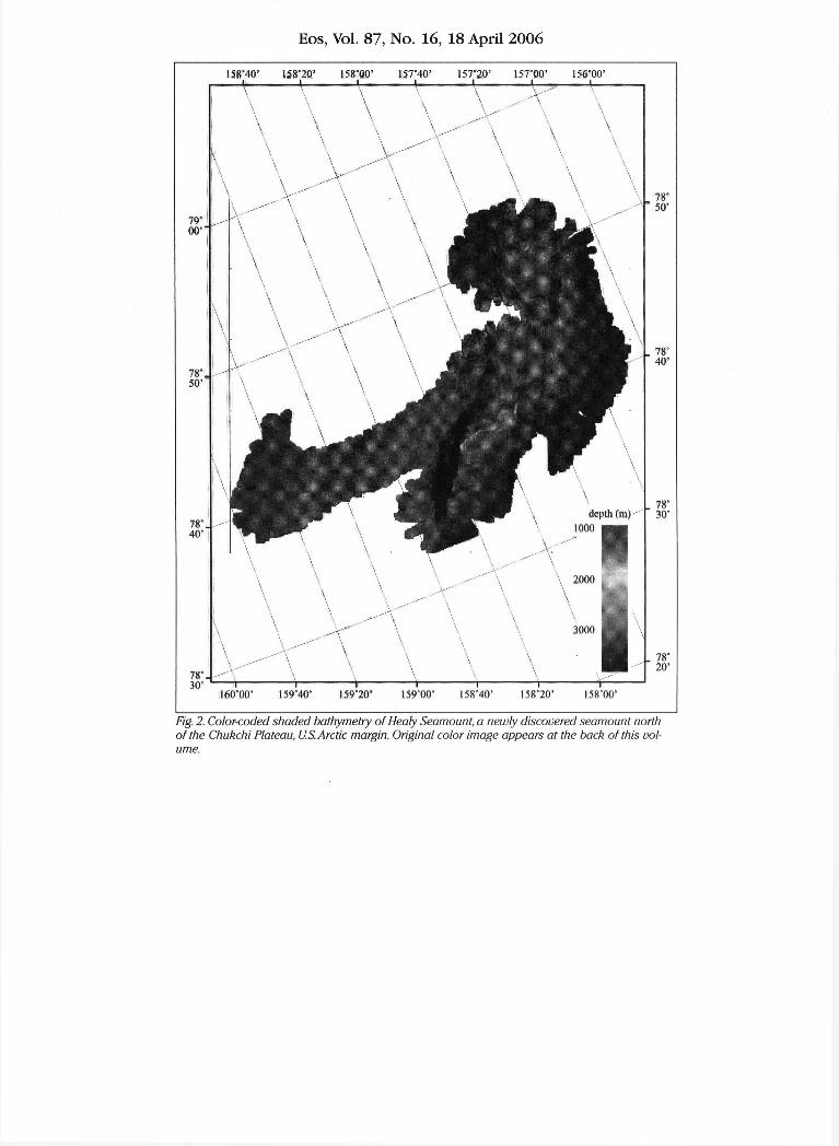
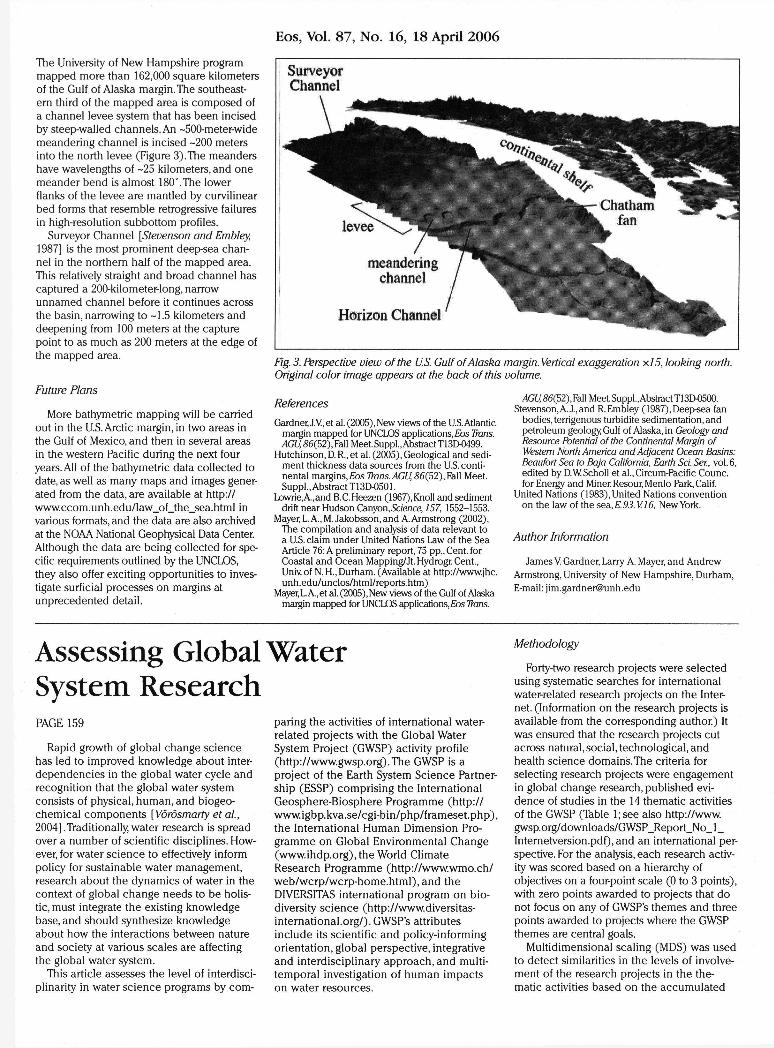
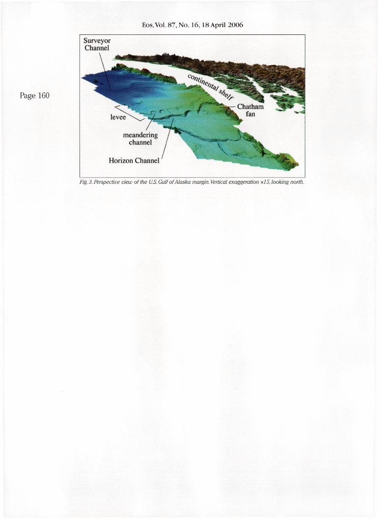
The University of New Hampshire program mapped more than 162000 square kilometers of the Gulf of Alaska marginThe southeastshyern third of the mapped area is composed of a channel levee system that has been incised by steep-walled channels An -500-meter-wide meandering channel is incised - 2 0 0 meters into the north levee (Figure 3) The meanders have wavelengths of - 2 5 kilometers and one meander bend is almost 180degThe lower flanks of the levee are mantled by curvilinear bed forms that resemble retrogressive failures in high-resolution subbottom profiles
Surveyor Channel [Stevenson and Embley 1987] is the most prominent deep-sea chanshynel in the northern half of the mapped area This relatively straight and broad channel has captured a 200-kilometer-long narrow unnamed channel before it continues across the basin narrowing to -1 5 kilometers and deepening from 100 meters at the capture point to as much as 200 meters at the edge of the mapped area
Future Plans
More bathymetric mapping will be carried out in the USArctic margin in two areas in the Gulf of Mexico and then in several areas in the western Pacific during the next four years All of the bathymetric data collected to date as well as many maps and images genershyated from the data are available at http wwwccomunhedulaw_of_the_seahtml in various formats and the data are also archived at the NOAA National Geophysical Data Center Although the data are being collected for speshycific requirements outlined by the UNCLOS they also offer exciting opportunities to invesshytigate surficial processes on margins at unprecedented detail
PAGE 159
Rapid growth of global change sc i ence has led to improved knowledge about inter-dependencies in the global water cycle and recognition that the global water system consists of physical human and biogeo-chemical components [Vorosmarty et al 2004]Traditionally water research is spread over a number of scientific disciplines Howshyever for water s c i e n c e to effectively inform policy for sustainable water management research about the dynamics of water in the context of global change needs to be holisshytic must integrate the existing knowledge base and should synthesize knowledge about how the interactions between nature and society at various scales are affecting the global water system
This article assesses the level of interdisci-plinarity in water s c i e n c e programs by com-
References
Gardner JV et al (2005) New views of the USAtlantic margin mapped for UNCLOS applications Eos Trans AGU 86(52) Fall Meet SupplAbstract T13D-0499
Hutchinson D R et al (2005) Geological and sedishyment thickness data sources from the US contishynental margins Eos Trans AGU 86(52) Fall Meet Suppl Abstract T13D-0501
LowrieAand BCHeezen (1967)Knoll and sediment drift near Hudson CanyonScience 157 1552-1553
Mayer LA M Jakobssonand AArmstrong (2002) the compilation and analysis of data relevant to a US claim under United Nations Law of the Sea Article 76 A preliminary report 75 pp Cent for Coastal and Ocean MappingJt HydrogrCent Univ of N H Durham (Available at httpwwwjhc unheduuncloshtmlreportshtm)
Mayer LA et al (2005) New views of the Gulf of Alaska margin mapped for UNCLOS applications Eos Trans
paring the activities of international water-related projects with the Global Water System Project (GWSP) activity profile (httpwwwgwsporg)The GWSP is a project of the Earth System S c i e n c e Partnershyship (ESSP) comprising the International Geosphere-Biosphere Programme (http wwwigbpkvasecgi-binphpframesetphp) the International Human Dimension Proshygramme on Global Environmental Change (wwwihdporg) the World Climate Research Programme (httpwwwwmoch webwcrpwcrp-homehtml) and the DIVERSITAS international program on bioshydiversity s c i e n c e (httpwwwdiversitas-internationalorg) GWSPs attributes include its scientific and policy-informing orientation global perspective integrative and interdisciplinary approach and multi-temporal investigation of human impacts on water resources
AGU86(52)M MeetSupplAbstractT13DO500 Stevenson A J and R Embley (1987) Deep-sea fan
bodies terrigenous turbidite sedimentation and petroleum geology Gulf of Alaska in Geology and Resource Potential of the Continental Margin of Western North America and Adjacent Ocean Basins Beaufort Sea to Baja California Earth Sci Ser vol 6 edited by DWScholl et alCircum-Pacific Counc for Energy and Miner Resour Menlo Park Calif
United Nations (1983) United Nations convention on the law of the sea E 93 VI6 New York
Author Information
James V Gardner Larry A Mayer and Andrew Armstrong University of New Hampshire Durham E-mail jimgardnerunhedu
Methodology
Forty-two research projects were selected using systematic searches for international water-related research projects on the Intershynet (Information on the research projects is available from the corresponding author) It was ensured that the research projects cut across natural social technological and health sc ience domains The criteria for selecting research projects were engagement in global change research published evishydence of studies in the 14 thematic activities of the GWSP (Table l s ee also httpwww gwsporgdownloadsGWSP_Report_No_l_ Internetversionpdf) and an international pershyspective For the analysis each research activshyity was scored based on a hierarchy of objectives on a four-point scale (0 to 3 points) with zero points awarded to projects that do not focus on any of GWSPs themes and three points awarded to projects where the GWSP themes are central goals
Multidimensional scaling (MDS) was used to detect similarities in the levels of involveshyment of the research projects in the theshymatic activities based on the accumulated
Assessing Global Water System Research
EosVol 87 No 1618 April 2006
Fig 1 Locations of areas mapped or to be mapped by the University of New Hampshire United Nations Commission of the Law of the Sea bathymetric mapping project
Page 157
79deg 00
78deg 50
7 8 s 40
158deg40 15820 I58deg00 157deg40 157deg20 157deg00 1 5 6 W I I I I l 1 1 mdash
78deg 30 r
160deg00 159deg40 159deg20
2000
3000
159deg00 158deg40
r 1
15820 1 5 8 W
78deg 50
78deg 40
78deg 30
78deg 20
Page 160
Fig 2 Color-coded shaded bathymetry of Healy Seamount a newly discovered seamount north of the Chukchi Plateau US Arctic margin
Eos Vol 87 No 1618 April 2006
Fig 3 Perspective view of the US Gulf of Alaska margin Vertical exaggeration x5 looking north
Eos Vol 87 No 16 18 April 2006
extension of the US juridical shelf under UNCLOS would likely be based on a combishynation of bathymetric data ( the 2500-meter isobath and the foot of the s lope) and geoshyphysical data (the thickness of sediment) [Hutchinson et al 2 0 0 5 ]
The US Bathymetric Mapping Program
Though as of this writing the US Senate has not acceded to the UNCLOS treaty the University of New Hampshires Center for Coastal and Ocean MappingJoint Hydro-graphic Center has been directed by the US Congress through funding by the US National Ocean ic and Atmospheric Administration (NOAA) to conduct multibeam bathymetric mapping of selected US continental marshygins Mayer et al [2002] conducted a study of the US marine data archives to determine where additional bathymetric surveys might be beneficial in developing a potential US submission under UNCLOS Article 76 This study identified seven regions areas in the Arctic Ocean the Bering Sea and the Gulf of Mexico the entire USAtlantic marginthe Gulf of Alaska and areas surrounding the Mariana Islands Kingman Reef and Palmyra Atoll (Figure 1 and Table 1) where the United States may have a potential for extended shelf submission
To date about 25 percent of the identified Arctic Ocean area the entire area identified in the Bering Sea the entire USAtlantic margin and all of the area in the Gulf of Alaska have been mapped under this proshygram The purpose of this article is to briefly describe the completed mapping surveys announce the public availability of the data and encourage the use of these data for studies of the US continental margins
The multibeam echo sounder systems used in these surveys include an L3 SeaBeam 2112 aboard the US Coast Guard icebreaker Healy a Reson 8150 on the Thales GeoSolutions (now Fugro)-leased research vessel (RV) Davidson Kongsberg Maritime EM 121A sysshytems aboard the US Naval Oceanographic Office vessels USNS Henson and USNS Pathshyfinder and a Kongsberg Maritime EM 120 on the University of Hawaii RV Kilo Moana
The USArctic Margin
The largest potential for a US submission beyond the current 200-nmi US-exclusive e c o n o m i c zone is in the area of the Chukchi Plateau (Figure l ) a submerged extension of the Chukchi Shelf north of Alaska and the margin adjacent to the Alaska mainland Mapping in this area led to many surprises including the discovery of a major seamount (Figure 2 ) christened Healy Seamount located northeast of Chukchi Plateau Healy Seamount stands - 2 0 0 0 meters high with a summit depth of 940 meters and is - 4 6 kiloshymeters long and - 1 5 kilometers wide The northwest facing flanks rise -40deg whereas the southeast facing flanks have slopes of - 3 0 deg a n d the seafloor immediately to the
Fig 1 Locations of areas mapped or to be mapped by the University of New Hampshire United Nations Commission of the Law of the Sea bathymetric mapping project Original color image appears at the back of this volume
Table 1 A p p r o x i m a t e Ranges of W a t e r Depths a n d A r e a Mapped
Area Water Depth m Area Mapped km 2
Bering Sea 1200-3800 21000
Atlantic margin 800-5200 403000 Gulf of Alaska 1000-3900 162000
Arctic margin 1000-3800 124000
Gulf of Mexico 3 1000-3500 -30 000
Mariana Islands 3 1000-4500 -155 000
KingmanPalmyra 3 1000-4500 -54 000 aYet to be mapped
northwest is as much as 1000 meters shalshylower than the seafloor immediately to the southeast
Bowers Ridge and the Beringian Margin Bering Sea
Two areas of the Bering Sea have been mapped the northern flank of Bowers Ridge and a portion of the southern Beringian margin Mapping the northern flank of Bowshyers Ridge revealed a steep flank with slopes of 10deg-20deg The middle half of the ridge flank is bordered by two broad low-standing curvshying ridges that are concent r ic with Bowers Ridge proper
A section of the Beringian margin east of the US-Russia international boundary was mapped and revealed a steep margin that is deeply eroded and has numerous sediment-filled canyons some of which have what appear to be plunge pools at their termini Long sharp-crested linear ridges strike pershypendicular to the margin and terminate in sediment drifts
The US Atlantic Margin
Although the USAtlantic margin has been studied for more than half a century there were many new and unexpected observashytions made when it was completely mapped in 2004 and 2005 For instance although the northern third of the USAtlantic margin is dominated by well-documented large mass
failures there is a prevalence of large sedishyment-filled canyon channels with superimshyposed narrow channels that appear to represhysent a rejuvenation of channel down-cutting
The middle third of the USAtlantic margin has several large canyon channels the most prominent of which is Hudson CanyonThe Hudson channel is relatively straight until depths between 3000 and 3500 meters where the channel contorts through six sharp bends each gt90deg Johns Valley - 2 5 kilometers northeast of Hudson channel has three sharp bends of gt90deg at the same water depths In addi t ion-50 kilometers southwest of Hudson channel a series of at least four channels abruptly deepen their incision depth at water depths of - 3 0 0 0 meters The four channels have what appear to be plunge pools at the points of deepening
One interesting feature mapped in the middle third of the margin is a seamount that was discovered and partially mapped in 1967 however it had not been placed on any map and has effectively been ignored s ince its discovery The seamount named Knauss Knoll by Lowrie and Heezen [1967] stands 1200 meters above the continental rise is nine by six kilometers at its base and has a sharp summit peak
The US Gulf of Alaska Margin
The Gulf of Alaska has seen very little sysshytematic mapping s ince the US Geological Surveys EEZ-SCAN program in the mid-1980s
Eos Vol 87 No 16 18 April 2006
t c mdash i mdash J L I
160 800 159deg40 15920f 159deg00 158deg40 158deg20 158deg00
Fig 2 Colorltoded shaded bathymetry of Healy Seamount a newly discovered seamount north of the Chukchi Plateau USArctic margin Original color image appears at the back of this volshyume
Eos Vol 87 No 16 18 April 2006
The University of New Hampshire program mapped more than 162000 square kilometers of the Gulf of Alaska marginThe southeastshyern third of the mapped area is composed of a channel levee system that has been incised by steep-walled channels An -500-meter-wide meandering channel is incised - 2 0 0 meters into the north levee (Figure 3) The meanders have wavelengths of - 2 5 kilometers and one meander bend is almost 180degThe lower flanks of the levee are mantled by curvilinear bed forms that resemble retrogressive failures in high-resolution subbottom profiles
Surveyor Channel [Stevenson and Embley 1987] is the most prominent deep-sea chanshynel in the northern half of the mapped area This relatively straight and broad channel has captured a 200-kilometer-long narrow unnamed channel before it continues across the basin narrowing to -1 5 kilometers and deepening from 100 meters at the capture point to as much as 200 meters at the edge of the mapped area
Future Plans
More bathymetric mapping will be carried out in the USArctic margin in two areas in the Gulf of Mexico and then in several areas in the western Pacific during the next four years All of the bathymetric data collected to date as well as many maps and images genershyated from the data are available at http wwwccomunhedulaw_of_the_seahtml in various formats and the data are also archived at the NOAA National Geophysical Data Center Although the data are being collected for speshycific requirements outlined by the UNCLOS they also offer exciting opportunities to invesshytigate surficial processes on margins at unprecedented detail
PAGE 159
Rapid growth of global change sc i ence has led to improved knowledge about inter-dependencies in the global water cycle and recognition that the global water system consists of physical human and biogeo-chemical components [Vorosmarty et al 2004]Traditionally water research is spread over a number of scientific disciplines Howshyever for water s c i e n c e to effectively inform policy for sustainable water management research about the dynamics of water in the context of global change needs to be holisshytic must integrate the existing knowledge base and should synthesize knowledge about how the interactions between nature and society at various scales are affecting the global water system
This article assesses the level of interdisci-plinarity in water s c i e n c e programs by com-
References
Gardner JV et al (2005) New views of the USAtlantic margin mapped for UNCLOS applications Eos Trans AGU 86(52) Fall Meet SupplAbstract T13D-0499
Hutchinson D R et al (2005) Geological and sedishyment thickness data sources from the US contishynental margins Eos Trans AGU 86(52) Fall Meet Suppl Abstract T13D-0501
LowrieAand BCHeezen (1967)Knoll and sediment drift near Hudson CanyonScience 157 1552-1553
Mayer LA M Jakobssonand AArmstrong (2002) the compilation and analysis of data relevant to a US claim under United Nations Law of the Sea Article 76 A preliminary report 75 pp Cent for Coastal and Ocean MappingJt HydrogrCent Univ of N H Durham (Available at httpwwwjhc unheduuncloshtmlreportshtm)
Mayer LA et al (2005) New views of the Gulf of Alaska margin mapped for UNCLOS applications Eos Trans
paring the activities of international water-related projects with the Global Water System Project (GWSP) activity profile (httpwwwgwsporg)The GWSP is a project of the Earth System S c i e n c e Partnershyship (ESSP) comprising the International Geosphere-Biosphere Programme (http wwwigbpkvasecgi-binphpframesetphp) the International Human Dimension Proshygramme on Global Environmental Change (wwwihdporg) the World Climate Research Programme (httpwwwwmoch webwcrpwcrp-homehtml) and the DIVERSITAS international program on bioshydiversity s c i e n c e (httpwwwdiversitas-internationalorg) GWSPs attributes include its scientific and policy-informing orientation global perspective integrative and interdisciplinary approach and multi-temporal investigation of human impacts on water resources
AGU86(52)M MeetSupplAbstractT13DO500 Stevenson A J and R Embley (1987) Deep-sea fan
bodies terrigenous turbidite sedimentation and petroleum geology Gulf of Alaska in Geology and Resource Potential of the Continental Margin of Western North America and Adjacent Ocean Basins Beaufort Sea to Baja California Earth Sci Ser vol 6 edited by DWScholl et alCircum-Pacific Counc for Energy and Miner Resour Menlo Park Calif
United Nations (1983) United Nations convention on the law of the sea E 93 VI6 New York
Author Information
James V Gardner Larry A Mayer and Andrew Armstrong University of New Hampshire Durham E-mail jimgardnerunhedu
Methodology
Forty-two research projects were selected using systematic searches for international water-related research projects on the Intershynet (Information on the research projects is available from the corresponding author) It was ensured that the research projects cut across natural social technological and health sc ience domains The criteria for selecting research projects were engagement in global change research published evishydence of studies in the 14 thematic activities of the GWSP (Table l s ee also httpwww gwsporgdownloadsGWSP_Report_No_l_ Internetversionpdf) and an international pershyspective For the analysis each research activshyity was scored based on a hierarchy of objectives on a four-point scale (0 to 3 points) with zero points awarded to projects that do not focus on any of GWSPs themes and three points awarded to projects where the GWSP themes are central goals
Multidimensional scaling (MDS) was used to detect similarities in the levels of involveshyment of the research projects in the theshymatic activities based on the accumulated
Assessing Global Water System Research
EosVol 87 No 1618 April 2006
Fig 1 Locations of areas mapped or to be mapped by the University of New Hampshire United Nations Commission of the Law of the Sea bathymetric mapping project
Page 157
79deg 00
78deg 50
7 8 s 40
158deg40 15820 I58deg00 157deg40 157deg20 157deg00 1 5 6 W I I I I l 1 1 mdash
78deg 30 r
160deg00 159deg40 159deg20
2000
3000
159deg00 158deg40
r 1
15820 1 5 8 W
78deg 50
78deg 40
78deg 30
78deg 20
Page 160
Fig 2 Color-coded shaded bathymetry of Healy Seamount a newly discovered seamount north of the Chukchi Plateau US Arctic margin
Eos Vol 87 No 1618 April 2006
Fig 3 Perspective view of the US Gulf of Alaska margin Vertical exaggeration x5 looking north
Eos Vol 87 No 16 18 April 2006
The University of New Hampshire program mapped more than 162000 square kilometers of the Gulf of Alaska marginThe southeastshyern third of the mapped area is composed of a channel levee system that has been incised by steep-walled channels An -500-meter-wide meandering channel is incised - 2 0 0 meters into the north levee (Figure 3) The meanders have wavelengths of - 2 5 kilometers and one meander bend is almost 180degThe lower flanks of the levee are mantled by curvilinear bed forms that resemble retrogressive failures in high-resolution subbottom profiles
Surveyor Channel [Stevenson and Embley 1987] is the most prominent deep-sea chanshynel in the northern half of the mapped area This relatively straight and broad channel has captured a 200-kilometer-long narrow unnamed channel before it continues across the basin narrowing to -1 5 kilometers and deepening from 100 meters at the capture point to as much as 200 meters at the edge of the mapped area
Future Plans
More bathymetric mapping will be carried out in the USArctic margin in two areas in the Gulf of Mexico and then in several areas in the western Pacific during the next four years All of the bathymetric data collected to date as well as many maps and images genershyated from the data are available at http wwwccomunhedulaw_of_the_seahtml in various formats and the data are also archived at the NOAA National Geophysical Data Center Although the data are being collected for speshycific requirements outlined by the UNCLOS they also offer exciting opportunities to invesshytigate surficial processes on margins at unprecedented detail
PAGE 159
Rapid growth of global change sc i ence has led to improved knowledge about inter-dependencies in the global water cycle and recognition that the global water system consists of physical human and biogeo-chemical components [Vorosmarty et al 2004]Traditionally water research is spread over a number of scientific disciplines Howshyever for water s c i e n c e to effectively inform policy for sustainable water management research about the dynamics of water in the context of global change needs to be holisshytic must integrate the existing knowledge base and should synthesize knowledge about how the interactions between nature and society at various scales are affecting the global water system
This article assesses the level of interdisci-plinarity in water s c i e n c e programs by com-
References
Gardner JV et al (2005) New views of the USAtlantic margin mapped for UNCLOS applications Eos Trans AGU 86(52) Fall Meet SupplAbstract T13D-0499
Hutchinson D R et al (2005) Geological and sedishyment thickness data sources from the US contishynental margins Eos Trans AGU 86(52) Fall Meet Suppl Abstract T13D-0501
LowrieAand BCHeezen (1967)Knoll and sediment drift near Hudson CanyonScience 157 1552-1553
Mayer LA M Jakobssonand AArmstrong (2002) the compilation and analysis of data relevant to a US claim under United Nations Law of the Sea Article 76 A preliminary report 75 pp Cent for Coastal and Ocean MappingJt HydrogrCent Univ of N H Durham (Available at httpwwwjhc unheduuncloshtmlreportshtm)
Mayer LA et al (2005) New views of the Gulf of Alaska margin mapped for UNCLOS applications Eos Trans
paring the activities of international water-related projects with the Global Water System Project (GWSP) activity profile (httpwwwgwsporg)The GWSP is a project of the Earth System S c i e n c e Partnershyship (ESSP) comprising the International Geosphere-Biosphere Programme (http wwwigbpkvasecgi-binphpframesetphp) the International Human Dimension Proshygramme on Global Environmental Change (wwwihdporg) the World Climate Research Programme (httpwwwwmoch webwcrpwcrp-homehtml) and the DIVERSITAS international program on bioshydiversity s c i e n c e (httpwwwdiversitas-internationalorg) GWSPs attributes include its scientific and policy-informing orientation global perspective integrative and interdisciplinary approach and multi-temporal investigation of human impacts on water resources
AGU86(52)M MeetSupplAbstractT13DO500 Stevenson A J and R Embley (1987) Deep-sea fan
bodies terrigenous turbidite sedimentation and petroleum geology Gulf of Alaska in Geology and Resource Potential of the Continental Margin of Western North America and Adjacent Ocean Basins Beaufort Sea to Baja California Earth Sci Ser vol 6 edited by DWScholl et alCircum-Pacific Counc for Energy and Miner Resour Menlo Park Calif
United Nations (1983) United Nations convention on the law of the sea E 93 VI6 New York
Author Information
James V Gardner Larry A Mayer and Andrew Armstrong University of New Hampshire Durham E-mail jimgardnerunhedu
Methodology
Forty-two research projects were selected using systematic searches for international water-related research projects on the Intershynet (Information on the research projects is available from the corresponding author) It was ensured that the research projects cut across natural social technological and health sc ience domains The criteria for selecting research projects were engagement in global change research published evishydence of studies in the 14 thematic activities of the GWSP (Table l s ee also httpwww gwsporgdownloadsGWSP_Report_No_l_ Internetversionpdf) and an international pershyspective For the analysis each research activshyity was scored based on a hierarchy of objectives on a four-point scale (0 to 3 points) with zero points awarded to projects that do not focus on any of GWSPs themes and three points awarded to projects where the GWSP themes are central goals
Multidimensional scaling (MDS) was used to detect similarities in the levels of involveshyment of the research projects in the theshymatic activities based on the accumulated
Assessing Global Water System Research
EosVol 87 No 1618 April 2006
Fig 1 Locations of areas mapped or to be mapped by the University of New Hampshire United Nations Commission of the Law of the Sea bathymetric mapping project
Page 157
79deg 00
78deg 50
7 8 s 40
158deg40 15820 I58deg00 157deg40 157deg20 157deg00 1 5 6 W I I I I l 1 1 mdash
78deg 30 r
160deg00 159deg40 159deg20
2000
3000
159deg00 158deg40
r 1
15820 1 5 8 W
78deg 50
78deg 40
78deg 30
78deg 20
Page 160
Fig 2 Color-coded shaded bathymetry of Healy Seamount a newly discovered seamount north of the Chukchi Plateau US Arctic margin
Eos Vol 87 No 1618 April 2006
Fig 3 Perspective view of the US Gulf of Alaska margin Vertical exaggeration x5 looking north
Eos Vol 87 No 1618 April 2006
Fig 3 Perspective view of the US Gulf of Alaska margin Vertical exaggeration x5 looking north
Related Documents