O Photonirvachak Journal of the Indian Society of Remote Sensing, Vol. 34, No. 4, 2006 SHORT NOTE MAPPING OF FAULT RUPTURE OF THE 28 MAY 2004 IRAN EARTHQUAKE (Mw= 6.2)USING SATELLITE IMAGE M. SHARIFIKIA*@, C. S. DUBEY**, B. K. SHARMA**, M. CHAUDHRY** AND RK. CHAMPATI RAY*** *Ministry of Industries and Mines, Tehran, Iran ** Department of Geology, University of Delhi, Delhi - 110 007, India *** Indian Institute of Remote Sensing (IIRS), Dehradun - 248 001, India @Corresponding author : [email protected] An earthquake of magnitude 6.2 Mw occurred in Central Alborz of northern lran (Firozabad-Kaior earthquake) at 17:08:46 (local time) on May 28, 2004. Most of the earthquake research centers reported the epicenter (Latitude: 36.283, Longitude: 51.616) of the earthquake near Firozabad village at a depth of 28.3 kin. The Firozabad-Tovir region is a small part of central Alborz Mountain, that is one of several zones of high tectonic activity within the overall plate-boundary zone, where the Arabian plate moves northward with respect to the Eurasian plate at a rate of about 20 mm/year. This area of Iran represents a unique region on Earth surface to study upper crustal response to continental collision during Late Miocene- recent time that involves intra continental shortening due to north-south collision of the Arabia and-the Eurasia (Axen et aL, 2001). Most of the deformation has been accommodated within Zagros, Alborz and Kopet-Dag areas along major strike slip faults (Berberian and Yeats, 1999). The northernmost ranges of Alborz Mountains extend laterally for 900 km around the south of Caspian Sea and 200-500 km north of the Neo- Tethyan suture (Fig. 1). The Alborz has an average elevation of nearly 3000 m and includes three of the highest peaks in Iran (the Quaternary Damavand volcano, 5670 m; Alam Kuh, 4822 m; and Takht-e- Soleiman, 4659 m). Elevation decreases abruptly northwards over -50-60 km to the Caspian Sea (-30 m below sea level). The south Caspian, site of intense oil exploration, is possibly the deepest sedimentary basin in the world, with a thickness of 20 km of Jurassic and younger sediments overlying magic basement (Neprochnov, 1968; Berberian, 1983; Devlin et al., 1999). Overall structural relief from the Alborz Mountains to the southernmost Caspian basement is -25 km. It is a part of the Alpine- Himalayan orogenic belt in Western Asia, which is bounded by Caspian Sea on the north and Central Iran on the south (Jackson et al., 2002). The study area, located around Firozabad-Tovir region bounded by longitude 51~176 and latitude 36~176 ", is a small part of the central Alborz Mountain consisting of dolomite, limestone, Received 9 March, 2006; in final lbrm 12 August, 2006

Welcome message from author
This document is posted to help you gain knowledge. Please leave a comment to let me know what you think about it! Share it to your friends and learn new things together.
Transcript
O Photonirvachak Journal of the Indian Society of Remote Sensing, Vol. 34, No. 4, 2006
SHORT NOTE
MAPPING OF FAULT RUPTURE OF THE 28 MAY 2004 IRAN EARTHQUAKE (Mw= 6.2)USING SATELLITE IMAGE
M. SHARIFIKIA*@, C. S. DUBEY**, B. K. SHARMA**, M. CHAUDHRY** AND RK. CHAMPATI RAY***
*Ministry of Industries and Mines, Tehran, Iran ** Department of Geology, University of Delhi, Delhi - 110 007, India
*** Indian Institute of Remote Sensing (IIRS), Dehradun - 248 001, India @Corresponding author : [email protected]
An earthquake of magnitude 6.2 Mw occurred in Central Alborz of northern lran (Firozabad-Kaior earthquake) at 17:08:46 (local time) on May 28, 2004. Most of the earthquake research centers reported the epicenter (Latitude: 36.283, Longitude: 51.616) of the earthquake near Firozabad village at a depth of 28.3 kin. The Firozabad-Tovir region is a small part of central Alborz Mountain, that is one of several zones of high tectonic activity within the overall plate-boundary zone, where the Arabian plate moves northward with respect to the Eurasian plate at a rate of about 20 mm/year. This area o f Iran represents a unique region on Earth surface to study upper crustal response to continental collision during Late Miocene- recent time that involves intra continental shortening due to north-south collision of the Arabia and-the Eurasia (Axen et aL, 2001). Most of the deformation has been accommodated within Zagros, Alborz and Kopet-Dag areas along major strike slip faults (Berberian and Yeats, 1999).
The northernmost ranges of Alborz Mountains extend laterally for 900 km around the south of
Caspian Sea and 200-500 km north of the Neo- Tethyan suture (Fig. 1). The Alborz has an average elevation of nearly 3000 m and includes three of the highest peaks in Iran (the Quaternary Damavand volcano, 5670 m; Alam Kuh, 4822 m; and Takht-e- Soleiman, 4659 m). Elevation decreases abruptly northwards over -50-60 km to the Caspian Sea (-30 m below sea level). The south Caspian, site of intense oil exploration, is possibly the deepest sedimentary basin in the world, with a thickness of 20 km of Jurassic and younger sediments overlying magic basement (Neprochnov, 1968; Berberian, 1983; Devlin et al., 1999). Overall structural relief from the Alborz Mountains to the southernmost Caspian basement is -25 km. It is a part of the Alpine- Himalayan orogenic belt in Western Asia, which is bounded by Caspian Sea on the north and Central Iran on the south (Jackson et al., 2002).
The study area, located around Firozabad-Tovir region bounded by longitude 51~176 and latitude 36~176 ", is a small part of the central Alborz Mountain consisting of dolomite, limestone,
Received 9 March, 2006; in final lbrm 12 August, 2006
424 M. Sharifikia et al.
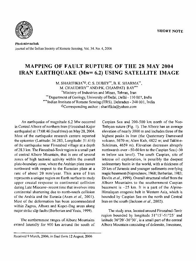
shale and sandstone (Fig. 1). The oldest rock formation of study area, the Kahar Formation comprising of limestone trending in northeasterly direction and dipping due northwest occurs in the western part of the area. The overlying Mobarak Formation is characterized by dolomite/limestone of Carboniferous age. These rocks follow southwest- northeast trends particularly in Firozabad village.
The shale/sandstone of Shemshak Formation of Jurassic age overlies the Mobarak Formation and is exposed in the west and northwestern part of the study area. The overlying Chalus Formation of Cretaceous age comprises mainly of limestone and volcanic rock. The volcanic rock of this formation is exposed in bands of varying thickness occurring in east-west direction in the western part and north-
Fig. 1. Geological map of study area, Inset: Location Map of the study area.
Mapping of Fault Rupture of the... 425
south direction in the middle part. Undifferentiated volcanic tuff and basalt is also observed near Tovir village in southwest, near Marzanabad in the north and Dashtnazir in northeastern part of study area. Limestone and marl of Chalus Formation are observed in northeastern part of the area (from Marzanabad town to Dashtnazir village).
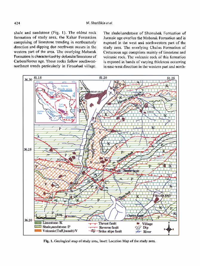
faults are observed trending in NE-SW direction. A number of strike-slip as well as normal faults have been observed in northwest and southeast the area (Fig. 2); some of faults are visible on the surface forming horst and graben structure on the right side of road section between Tovir - Marzanabad and bank of Chalus river (Fig. 2).
The study area is marked by a number of thrusts that are oriented in east-west and northeast- southwest direction. Sama Thrust is a major east west trending thrust in the area observed as a lineament even on medium resolution of satellite images (e.g. TM) and is observed in field as a contact between shale/sandstone of Shemshak Formation and tuff and basalt of Chalus Formation near Tovir village. Dashtnazir, Dizan and Marzanabad
The effect of the mentioned earthquake was felt up to Caspian Sea in the north, Tehran in the south, Taleghan in the west and Haraz River in tile east. All calculated focal mechanisms for the Firozabad- Kajur earthquake show that it has occurred on a reverse fault with large left lateral slip. Approximately 29 villages e.g. Firozabad, Tovir, Sama, Chalzamin, Makar, Dashtnazir were severely affected by the earthquake, but maximum damage was observed at
Fig. 2. Landsat TM image of the study area showing major structures and location of Tovir and Firozabad villages; yellow polygons are settlements.
426 M. Sharifikia et al.
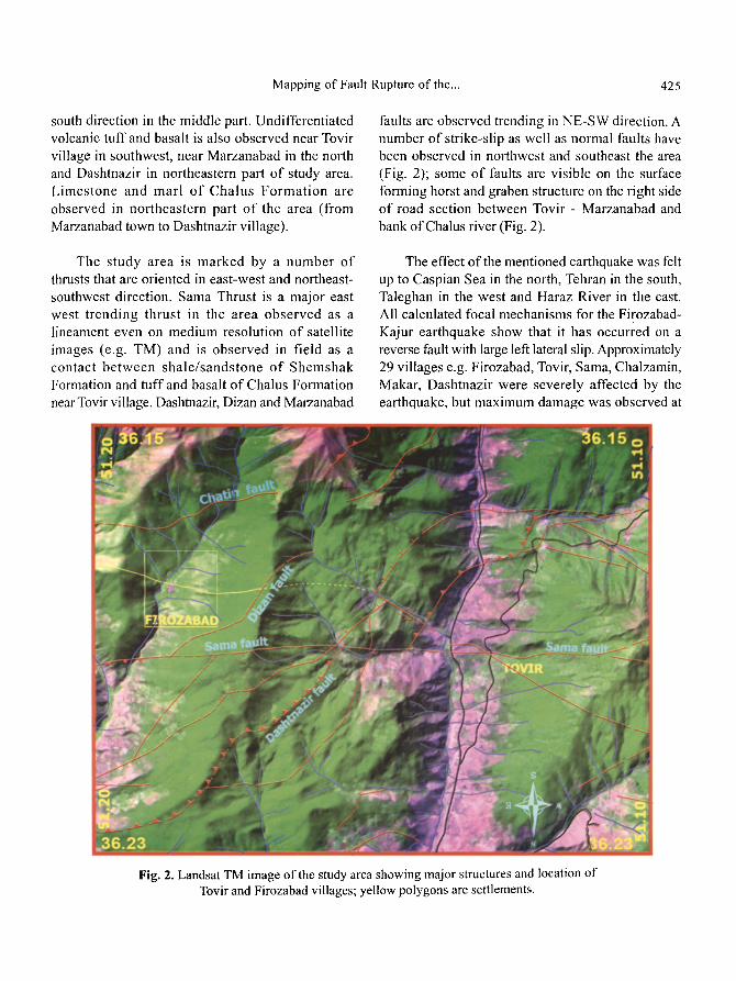
Firozabad village (Fig. 2). A trace of prominent fracture related to fault rupture striking in WNW-ESE (azimuth varying from 3100-290 ~ was mapped near Tovir village (Figs. 3a, b) in the vicinity of faulted rocks showing horst and graben structure (Fig. 3c). Along the road section to the north of Tovir, ground deformation is manifested in the form of ruptures showing displacement of approximately 7 cm along strike direction and 4 cm vertical throw with 5 cm aperture (Figs. 3a, b). Some associated fractures are trending in N60W-S60E direction. The fault related
fracture is also traceable in the Firozabad village trending in the same direction and depicts landsliding at the mountainous slopes (Fig. 3d). Small fractures trending east-west were also observed in the middle of the Firozabad village, which according to the villagers had openings of about 10 cm, which were immediately closed during the aftershocks of earthquake. A number of sfnall cracks were also found in Dashtnazir and Sama villages located in west and north of Firozabad village and east of Marzanabad town.
Fig. 3. Field observations in Tovir and Firozabad villages, a) Surface rupture near Tovir village, b) Close-up view (the red rectangle) showing lateral displacement of 8-10 cm,
c) Horse and graben structure in east of Tovir village, d) Probable. trace of fault rupture at the Firozabad village.
Mapping of Fault Rupture of the... 427
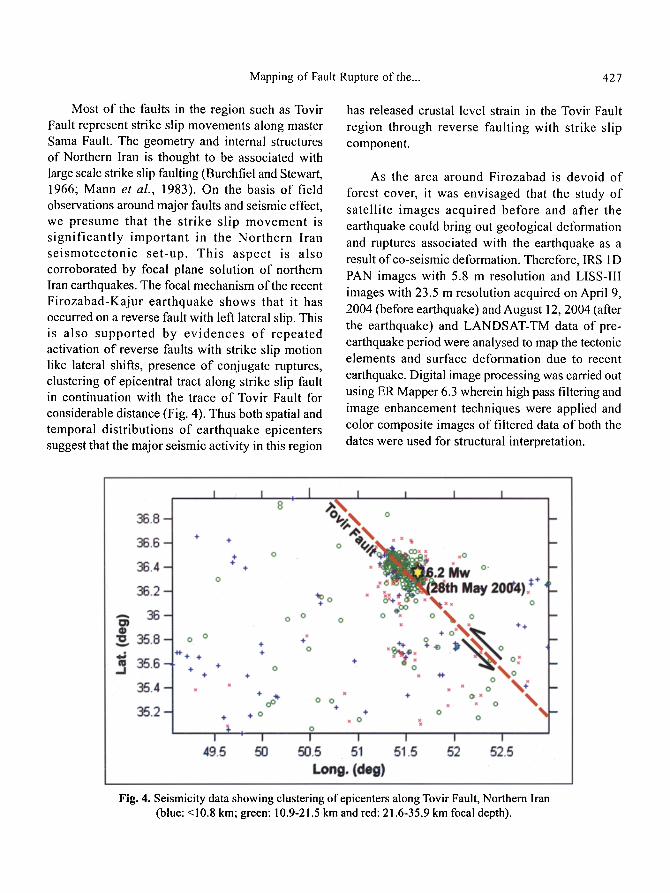
Most of the faults in the region such as Tovir Fault represent strike slip movements along master Sama Fault. The geometry and internal structures of Northern Iran is thought to be associated with large scale strike slip faulting (Burchfiel and Stewart, 1966; Mann et al., 1983). On the basis of field observations around major faults and seismic effect, we presume that the strike slip movement is s ignif icantly important in the Northern Iran se ismotectonic set-up. This aspect is also corroborated by focal plane solution of northern Iran earthquakes. The focal mechanism of the recent Firozabad-Kajur earthquake shows that it has occurred on a reverse fault with left lateral slip. This is also suppor ted by ev idences o f repeated activation of reverse faults with strike slip motion like lateral shifts, presence of conjugate ruptures, clustering of epicentral tract along strike slip fault in continuation with the trace of Tovir Fault for considerable distance (Fig. 4). Thus both spatial and temporal distributions of earthquake epicenters suggest that the major seismic activity in this region
has released crustal level strain in the Tovir Fault region through reverse faulting with strike slip component.
As the area around Firozabad is devoid of forest cover, it was envisaged that the study of satellite images acquired before and after the earthquake could bring out geological deformation and ruptures associated with the earthquake as a result of co-seismic deformation. Therefore, IRS 1D PAN images with 5.8 m resolution and LISS-III images with 23.5 m resolution acquired on April 9, 2004 (before earthquake) and August 12, 2004 (after the earthquake) and LANDSAT-TM data of pre- earthquake period were analysed to map the tectonic elements and surface deformation due to recent earthquake. Digital image processing was carried out using ER Mapper 6.3 wherein high pass filtering and image enhancement techniques were applied and color composite images of filtered data of both the dates were used for structural interpretation.
Fig. 4. Seismicity data showing clustering of epicenters along Tovir Fault, Northern lran (blue: <10.8 km; green: 10.9-21.5 km and red: 21.6-35.9 km focal depth).
428 M. Sharifikia et al.
Sama, Dashtnazir, Marzanabad and Chatin thrusts were identified on images acquired before and after earthquake. These faults were also validated on ground along with surface ruptures in the vicinity of the worst affected areas of Firozabad and Tovir village. In addition to all lineaments observed on the image acqui red before the earthquake, a new lineament was observed near Firozabad village on post earthquake data. Near Tovir village and surrounding places where large- scale ruptures were witnessed,this lineament follows the direction of the surface ruptures and can be correlated with the known Tovir Fault extending up to Lorosar. But beyond Lorosar up to Firozabad, the new lineament was observed extending through Firozabad in SE direction for considerable distance (Fig. 5).
It can be inferred that the causative fault of May 28, 2004 earthquake has a direct relationship with this lineament (Firozabad Fault) traced on the
post earthquake data. This fault is a blind fault that has not been mapped so far beyond Lorosar. It can also be inferred that the lineament observed in the west (at Tovir) is an extension of the lineament observed at Firozabad. The western part of the fault has been traced up to Lorosar village whereas the fault is observed from Firozabad in the east to the foothill of the mountains. The middle part of the fault could not be mapped due to excessive vegetation cover on high mountainous region (Fig. 6).
In addition to all tectonic lineaments observed on the satel l i te image acquired before this earthquake, a new l ineament is reported near Firozabad village on imagery acquired after May 28 earthquake. It is a prominent fracture probably fault rupture striking in WNW-ESE (azimuth varying from 310~ ~ that is traceable to the north of Tovir village in the vicinity of faulted rocks showing horse and graben structure. The location and direction of this lineament is confirmed by ground observation
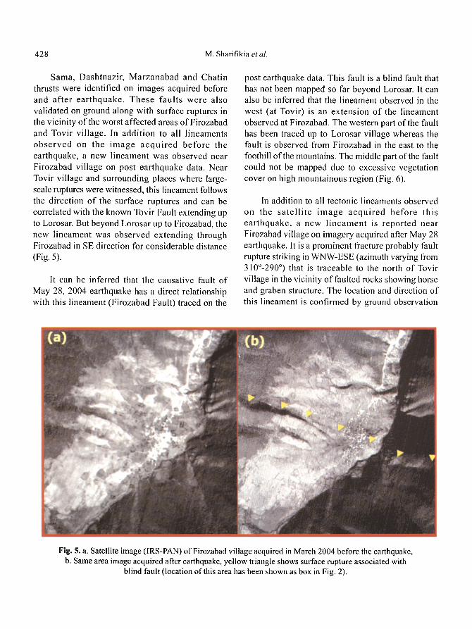
Fig. 5. a. Satellite image (IRS-PAN) of Firozabad village acquired in March 2004 before the earthquake, b. Same area image acquired after earthquake, yellow triangle shows surface rupture associated with
blind fault (location of this area has been shown as box in Fig. 2).
Mapping of Fault Rupture of the... 429
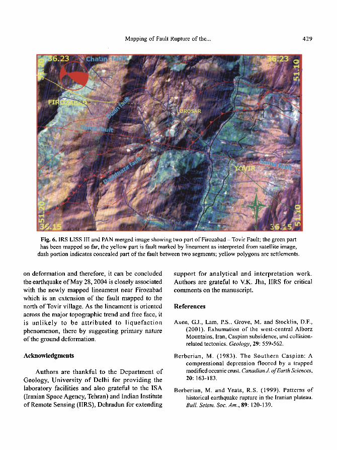
Fig. 6. IRS LISS III and PAN merged image showing two part of Firozabad -Tovir Fault; the green part has been mapped so far, the yellow part is fault marked by lineament as interpreted from satellite image,
dash portion indicates concealed part of the fault between two segments; yellow polygons are settlements.
on deformation and therefore, it can be concluded the earthquake of May 28, 2004 is closely associated with the newly mapped lineament near Firozabad which is an extension of the fault mapped to the north of Tovir village. As the lineament is oriented across the major topographic trend and free face, it is unl ike ly to be a t t r ibuted to l iquefac t ion phenomenon, there by suggesting primary nature of the ground deformation.
Acknowledgments
Authors are thankful to the Department of Geology, University of Delhi for providing the laboratory facilities and also grateful to the ISA (Iranian Space Agency, Tehran) and Indian Institute of Remote Sensing (IIRS), Dehradun for extending
support for analytical and interpretation work. Authors are grateful to V.K. Jha, IIRS for critical comments on the manuscript.
References
Axen, G.J., Lam, ES., Grove, M. and Stocklin, D.F., (2001). Exhumation of the west-central AIborz Mountains, Iran, Caspian subsidence, and collision- related tectonics. Geology, 29: 559-562.
Berberian, M. (1983). The Southern Caspian: A compressional depression floored by a trapped modified oceanic crust. Canadian,]. of Earth Sciences, 20: 163-183.
Berberian, M. and Yeats, R.S. (1999). Patterns of historical earthquake rupture in the Iranian plateau. Bull. Seism. Soc. Am., 89: 120-139.
430 M. Sharifikia etal.
Burchfiel and Stewart (1966). "Pull-apart" origin of the central segment of Death Valley, California. Bull. Geological Society of America, 77: 439-442.
Devlin, W.J., Cogswell, J.M., Gaskins, G.M., Isaksen, G.H., Pitcher, D.M., Puls, D.P., Stanley, K.O. and Wall, G.R.T. (1999). South Caspian Basin: Young Cool, and Full of Promise. GSA Today, 9: 1-9.
Jackson, J., Priestley, K., Allen, M. and Berberian, M.
(2002). Active tectonics of the South Caspian Basin. Geophysics J. International, 148:214-245.
Mann, P., Hempton, M., Bradley, D. and Burke, K. (1983). Development of pull-apart basins. J. Geol., 91: 529-554.
Neprochnov, Y.P. (1968). Structure of the earth's crust of epi-continental seas: Caspian, Black, and Mediterranean. Canadian J. of Earth Sciences, 5: 1037-1043.
Related Documents