Mapping from UAVs

Welcome message from author
This document is posted to help you gain knowledge. Please leave a comment to let me know what you think about it! Share it to your friends and learn new things together.
Transcript
Mapping from UAVs
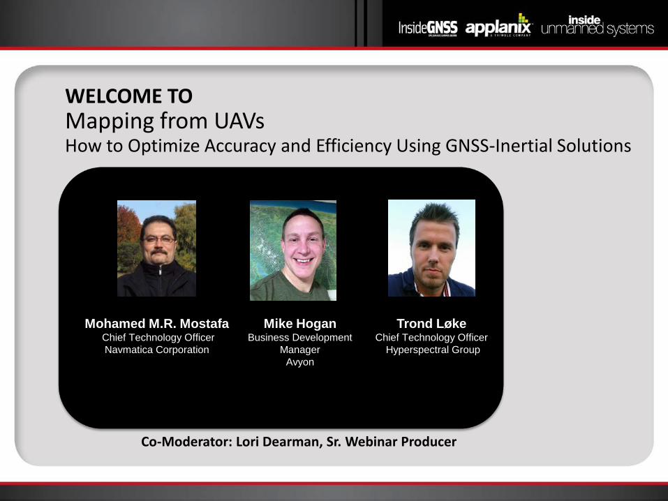
WELCOME TO Mapping from UAVs How to Optimize Accuracy and Efficiency Using GNSS-Inertial Solutions
Co-Moderator: Lori Dearman, Sr. Webinar Producer
Mike Hogan Business Development
Manager Avyon
Mohamed M.R. Mostafa Chief Technology Officer Navmatica Corporation
Trond Løke Chief Technology Officer
Hyperspectral Group
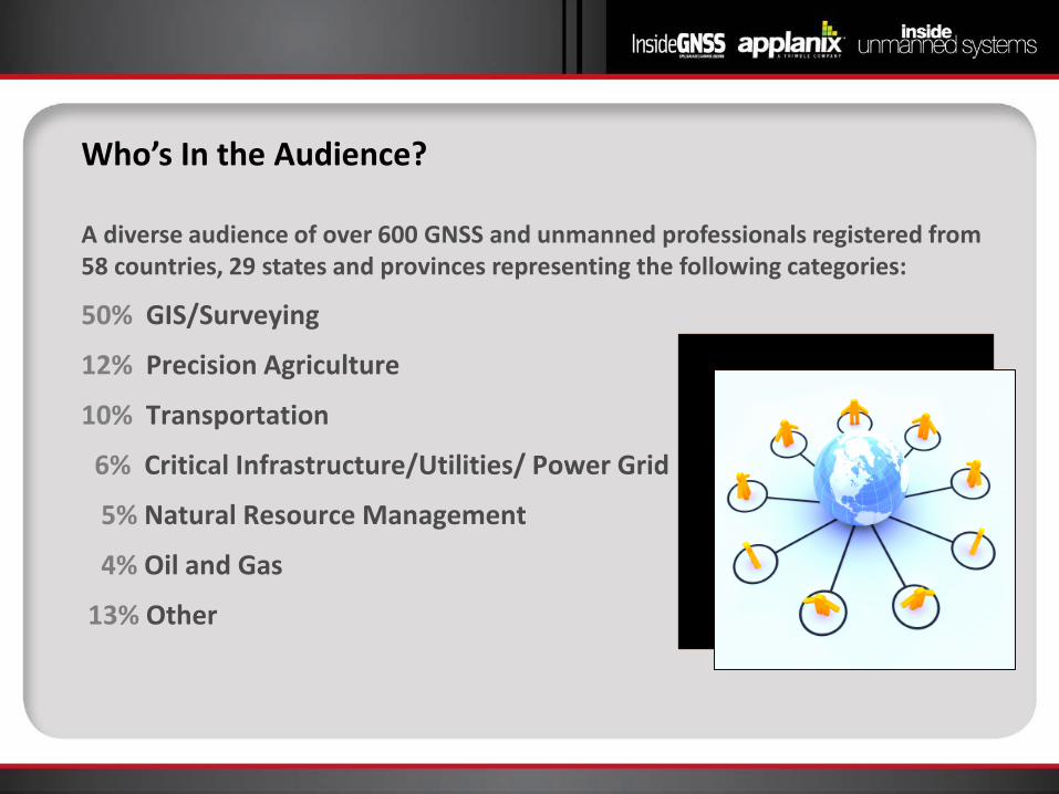
Who’s In the Audience?
50% GIS/Surveying
12% Precision Agriculture
10% Transportation
6% Critical Infrastructure/Utilities/ Power Grid
5% Natural Resource Management
4% Oil and Gas
13% Other
A diverse audience of over 600 GNSS and unmanned professionals registered from 58 countries, 29 states and provinces representing the following categories:

Welcome from Inside GNSS
Richard Fischer Publisher of Inside
Unmanned Systems Director of Business
Development Inside GNSS

Welcome from Applanix
Joe Hutton, MASc P.Eng, Director
Inertial Technology and Airborne Products

Demoz Gebre-Egziabher Aerospace Engineer and
Mechanics Faculty University of Minnesota

Poll #1
What type of sensor payload are you interested in using for mapping applications from UAV? (Select all that apply)
a. RGB b. Infra-red Camera c. LiDAR d. Multi-spectral Camera e. Hyperspectral Camera
Mohamed MR Mostafa Chief Technology Officer
Navmatica
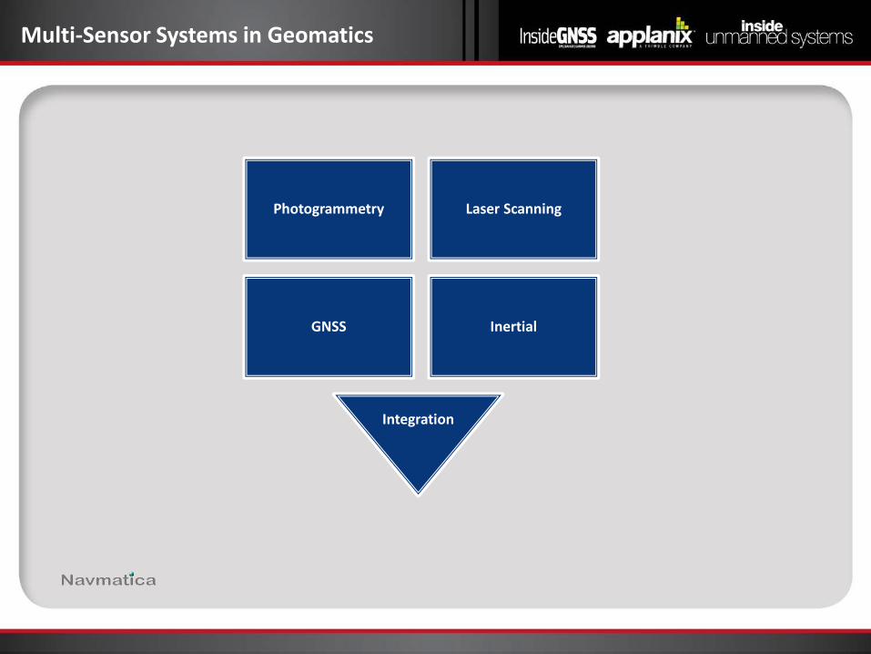
Multi-Sensor Systems in Geomatics
Photogrammetry Laser Scanning
GNSS Inertial
Integration
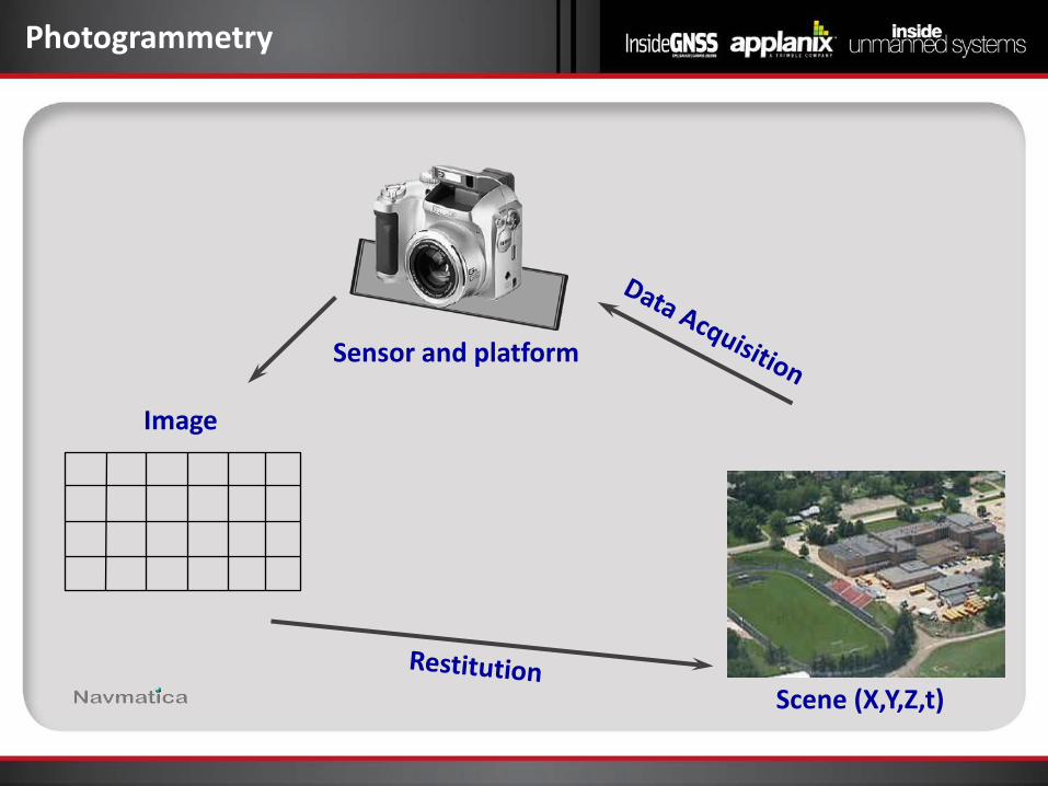
Photogrammetry
Scene (X,Y,Z,t)
Sensor and platform
Image
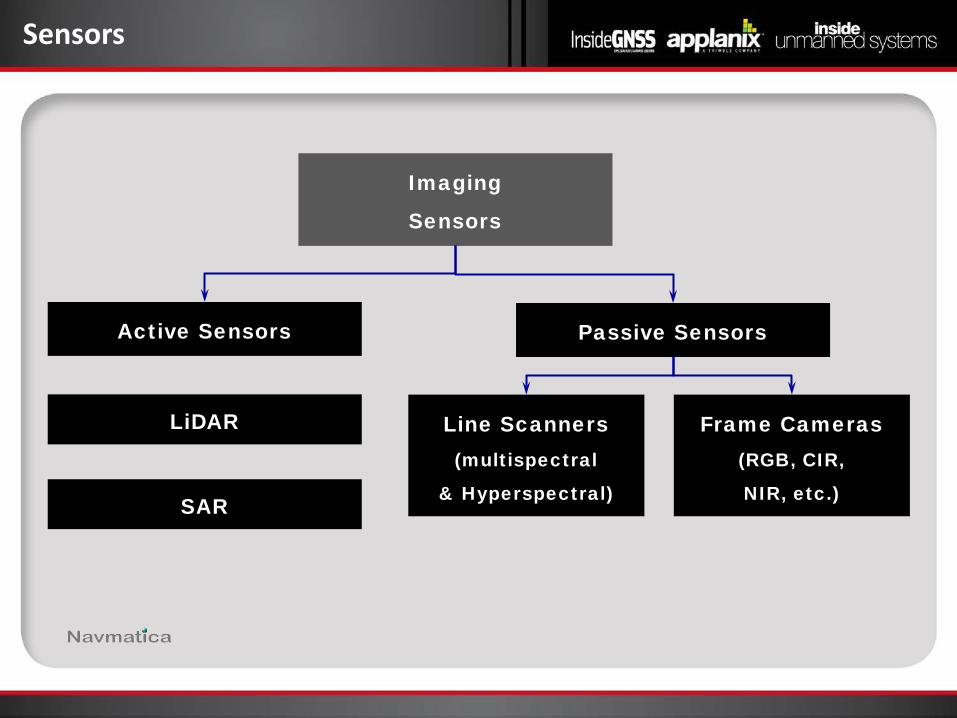
Sensors
Imaging
Sensors
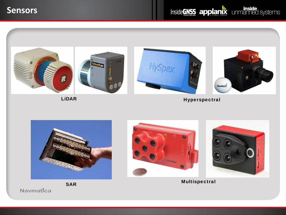
Line Scanners (multispectral
& Hyperspectral) SAR
LiDAR
Passive Sensors Active Sensors
Frame Cameras (RGB, CIR,
NIR, etc.)
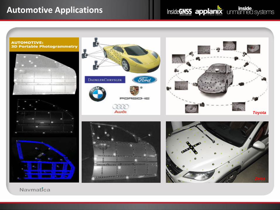
Automotive Applications
Toyota
Zeiss
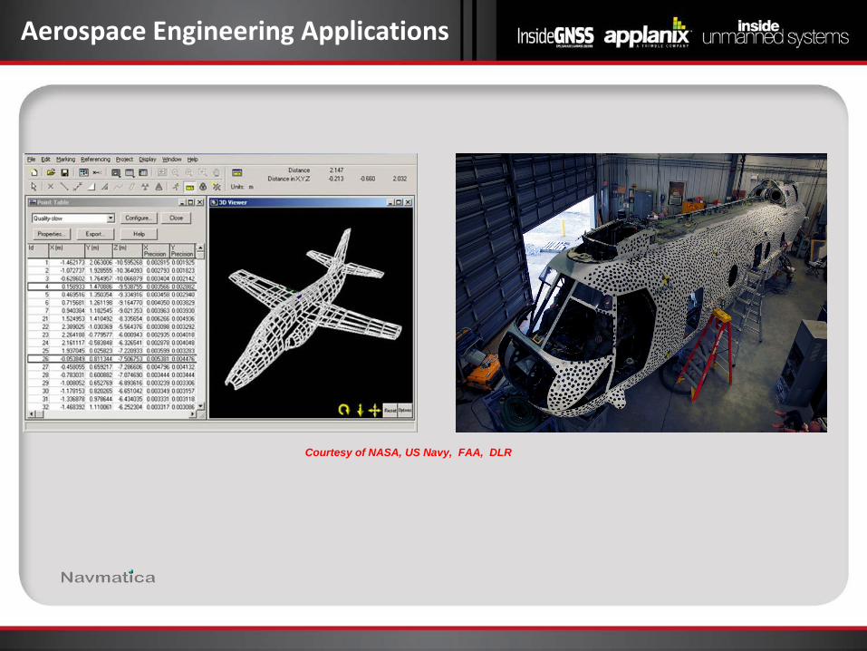
Aerospace Engineering Applications
Courtesy of NASA, US Navy, FAA, DLR

Medical Engineering Applications
Courtesy of University of Toronto
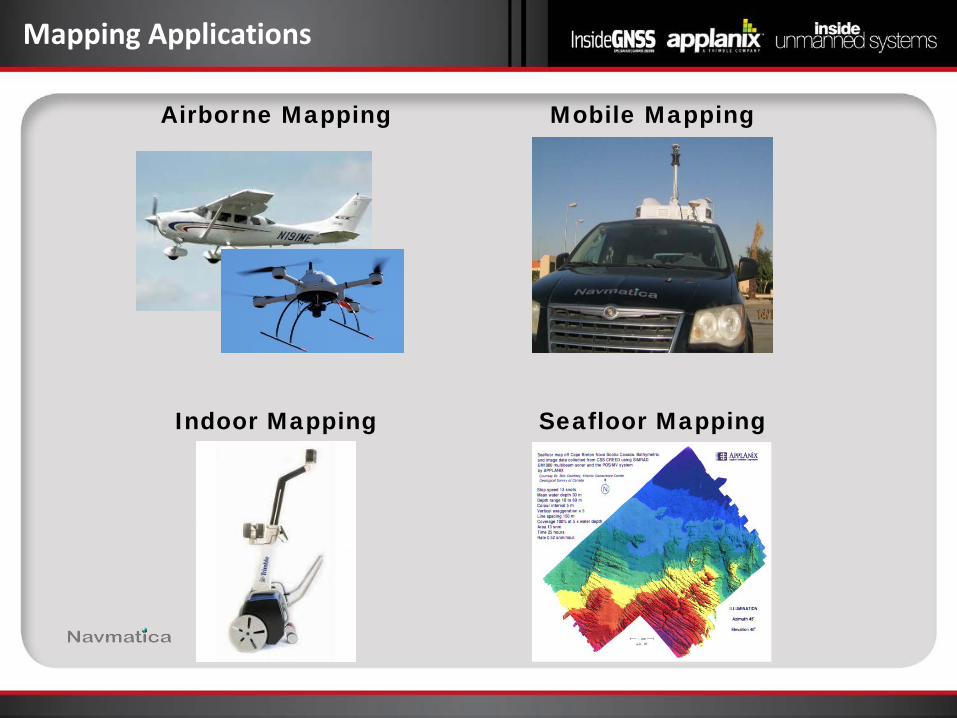
Mapping Applications
Mobile Mapping Airborne Mapping
Indoor Mapping Seafloor Mapping
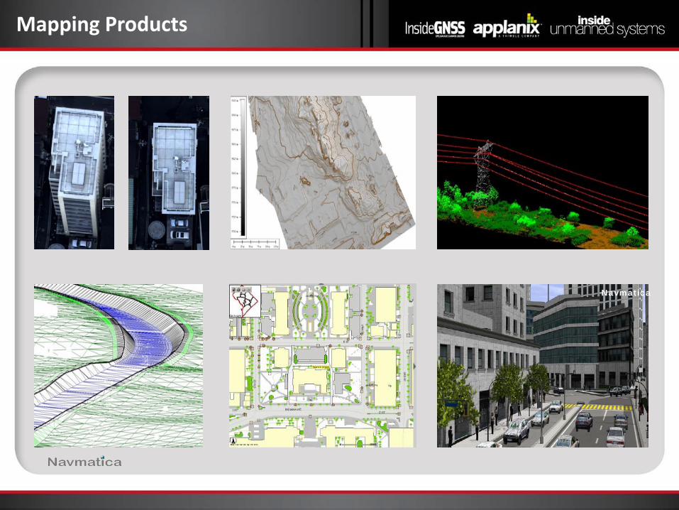
Mapping Products
Navmatica
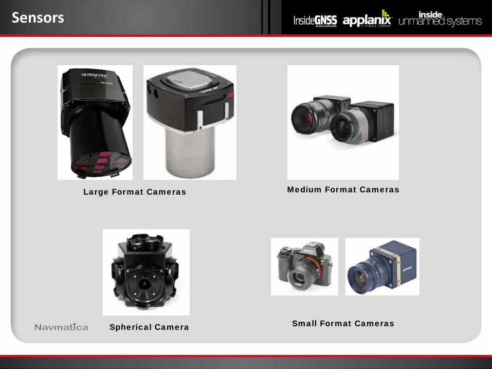
Sensors
Large Format Cameras
Spherical Camera
Medium Format Cameras
Small Format Cameras
Sensors
Hyperspectral
Multispectral SAR
LiDAR
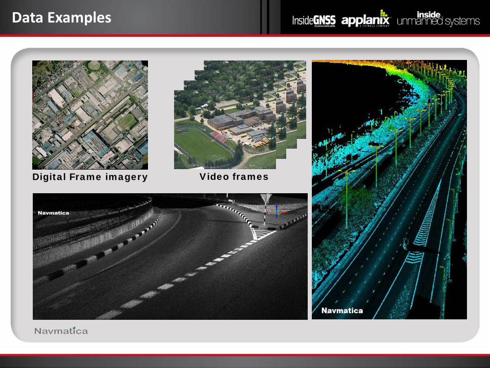
Data Examples
Digital Frame imagery Video frames

GNSS Revisited
GNSS
Real Time
Accuracy
Post-Processing
needed
Range Integration Applications
RTK ~ 5 cm No • Limited to
radio link range of 5 km
• Limited to loosely coupled
• Emergency Response • Reconnaissance • Surveillance • Monitoring • Moderate precision mapping
PPK ~ 5 m Yes • Unlimited • unlimited • High precision mapping
GNSS includes GPS, GLONASS, BeiDou, Galileo
Autonomous positioning accuracy ≅ 1.5 - 3 m.
Relative Positioning allows for cm level accuracy using:
• Base Stations
• CORS
• IGS
• Real-time or post-processed VRS
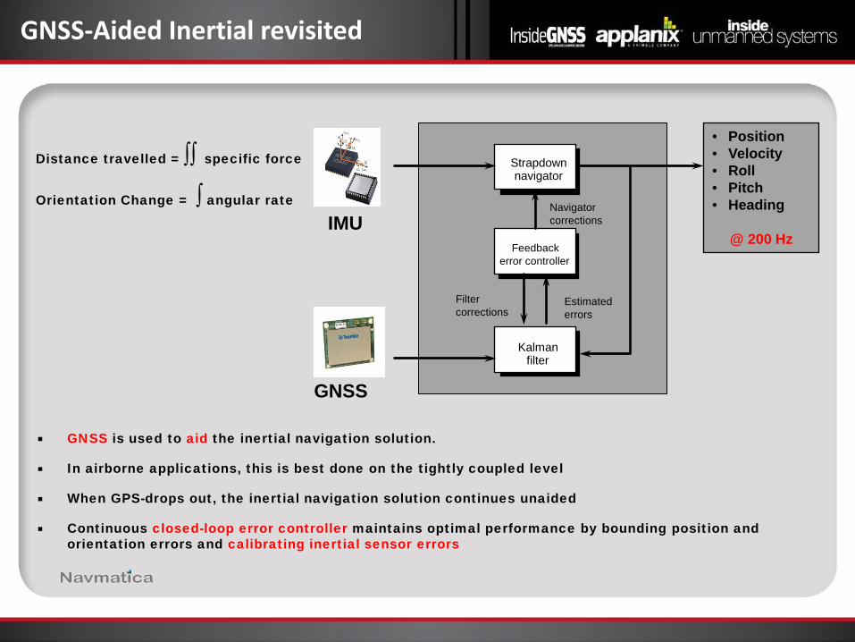
GNSS-Aided Inertial revisited
GNSS is used to aid the inertial navigation solution.
In airborne applications, this is best done on the tightly coupled level
When GPS-drops out, the inertial navigation solution continues unaided
Continuous closed-loop error controller maintains optimal performance by bounding position and orientation errors and calibrating inertial sensor errors
Distance travelled = ∫∫ specific force
Orientation Change = ∫ angular rate
Kalman filter
Feedback error controller
Strapdown navigator
Navigator corrections
Estimated errors
Filter corrections
IMU
GNSS
• Position • Velocity • Roll • Pitch • Heading
@ 200 Hz
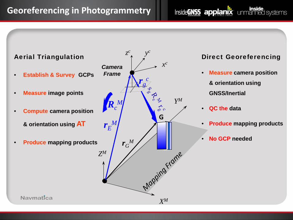
Direct Georeferencing
• Measure camera position
& orientation using
GNSS/Inertial
• QC the data
• Produce mapping products
• No GCP needed
Aerial Triangulation
• Establish & Survey GCPs
• Measure image points
• Compute camera position
& orientation using AT
• Produce mapping products
Georeferencing in Photogrammetry
ZM
XM
YM
G
rGM
rEM
RcM
Camera Frame
zc xc
yc
rgc
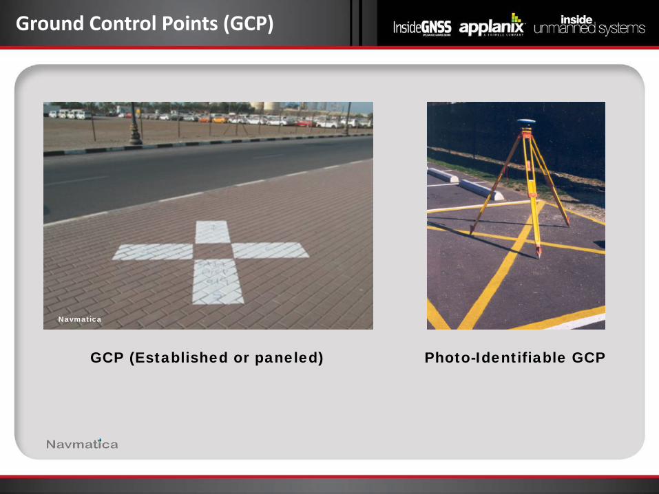
Ground Control Points (GCP)
GCP (Established or paneled) Photo-Identifiable GCP
Navmatica
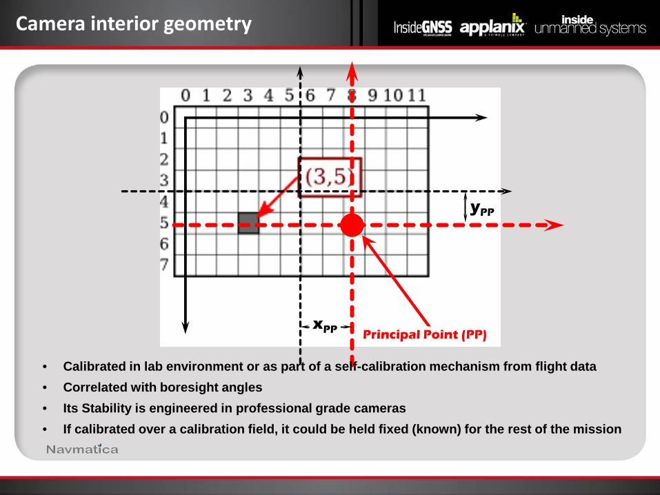
Camera interior geometry
xPP
yPP
Principal Point (PP)
• Calibrated in lab environment or as part of a self-calibration mechanism from flight data • Correlated with boresight angles • Its Stability is engineered in professional grade cameras • If calibrated over a calibration field, it could be held fixed (known) for the rest of the mission
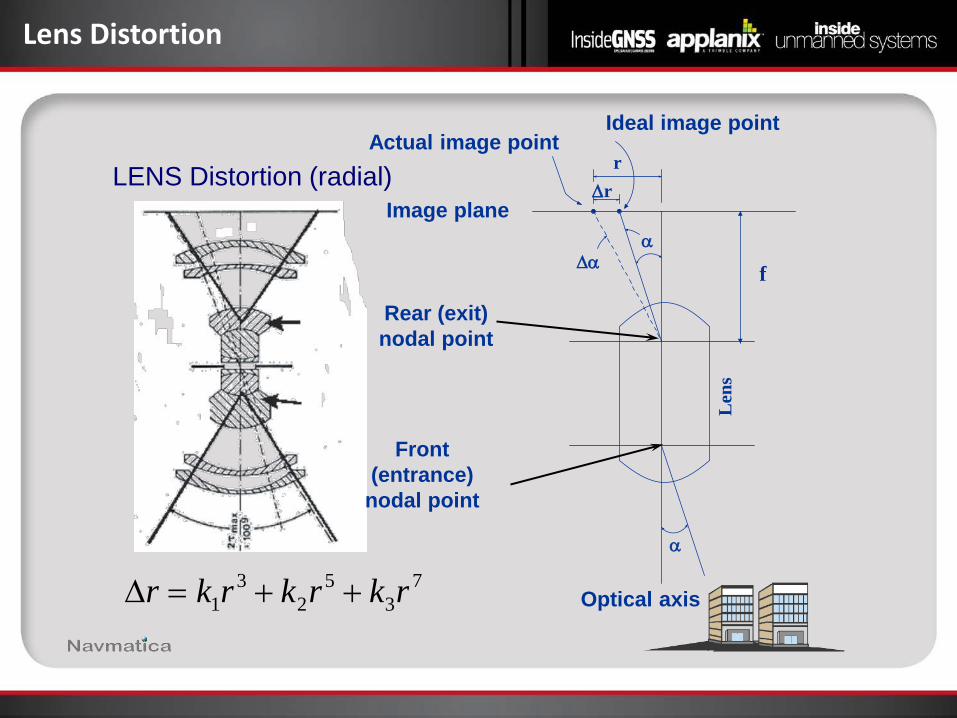
Lens Distortion
LENS Distortion (radial)
Optical axis
Front (entrance)
nodal point
Rear (exit) nodal point
α
α
Len
s
f ∆α
∆r r
Actual image point
Image plane
73
52
31 rkrkrkr ++=∆
Ideal image point
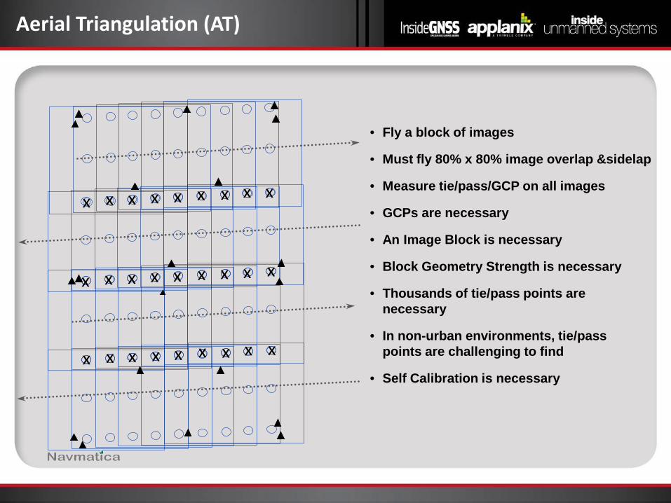
Aerial Triangulation (AT)
x x x x x x x x x
x x x x x x x x x
x x x x x x x x x
• Fly a block of images
• Must fly 80% x 80% image overlap &sidelap
• Measure tie/pass/GCP on all images
• GCPs are necessary
• An Image Block is necessary
• Block Geometry Strength is necessary
• Thousands of tie/pass points are necessary
• In non-urban environments, tie/pass points are challenging to find
• Self Calibration is necessary
ZM
XM
YM
G
rGM
rEM
RcM
Sensor Frame
zc xc
yc
rgc
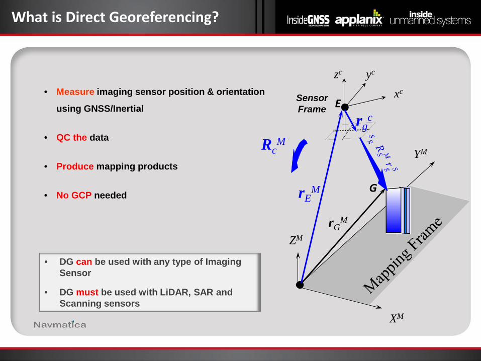
• DG can be used with any type of Imaging Sensor
• DG must be used with LiDAR, SAR and Scanning sensors
What is Direct Georeferencing?
E • Measure imaging sensor position & orientation
using GNSS/Inertial
• QC the data
• Produce mapping products
• No GCP needed
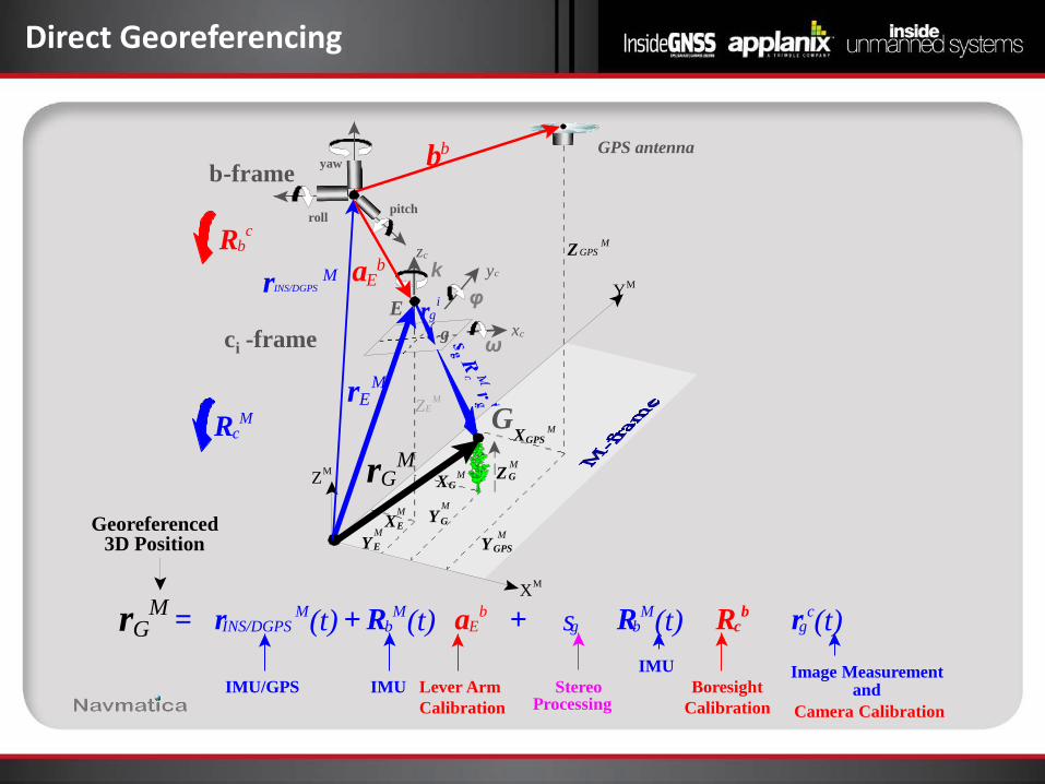
Direct Georeferencing
Y M
X M
Z M
Z E M
G
g
Y GPS M
X GPS M
GPS antenna
Z GPS M R b
c
R c M
r g i
c i -frame
E
X E M
Y E M
yaw
roll pitch
Y G M
X G M Z G
M
x c
z c
y c
r E M
r G M
b b
IMU/GPS Lever Arm Calibration
Stereo Processing Camera Calibration
Image Measurement and
Georeferenced 3D Position
Boresight Calibration
IMU
r G M = r INS/DGPS
M (t) + R b M (t) a E
b + s g R b M (t) R c
b r g c (t)
a E b
r INS/DGPS M
b -frame
IMU
k
ω
φ
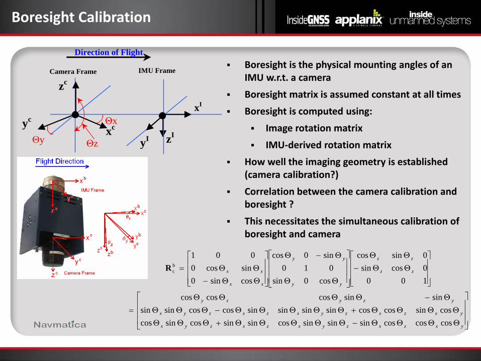
Boresight Calibration
Boresight is the physical mounting angles of an IMU w.r.t. a camera
Boresight matrix is assumed constant at all times Boresight is computed using:
Image rotation matrix IMU-derived rotation matrix
How well the imaging geometry is established (camera calibration?)
Correlation between the camera calibration and boresight ?
This necessitates the simultaneous calibration of boresight and camera
ΘΘΘΘ−ΘΘΘΘΘ+ΘΘΘΘΘΘΘ+ΘΘΘΘΘ−ΘΘΘ
Θ−ΘΘΘΘ=
ΘΘ−ΘΘ
ΘΘ
Θ−Θ
ΘΘ−ΘΘ=
yxzxzyxzxzyx
yxzxzyxzxzyx
yzyzy
zz
zz
yy
yy
xx
xx
coscoscossinsinsincossinsincossincoscossincoscossinsinsinsincoscossinsin
sinsincoscoscos
1000cossin0sincos
cos0sin010
sin0cos
cossin0sincos0
001bcR
Direction of Flight
yI zI xc
xI
Camera Frame IMU Frame
Θx
Θz Θy yc
zc
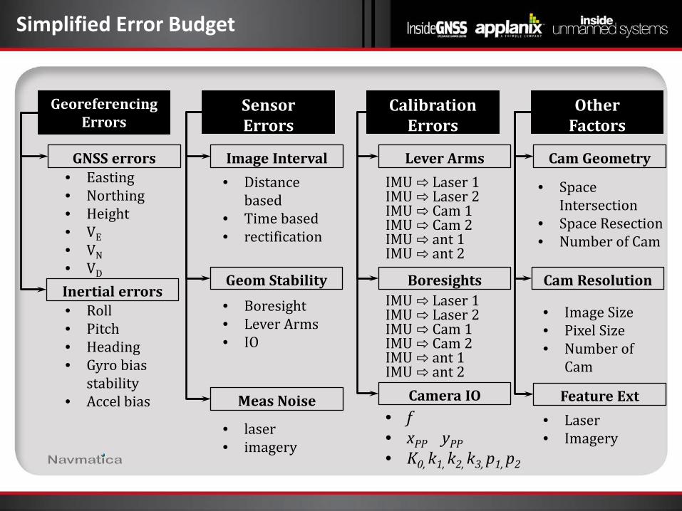
Simplified Error Budget
Georeferencing Errors
Sensor Errors
Calibration Errors
Other Factors
Lever Arms
Boresights
Camera IO
IMU ⇨ Laser 1 IMU ⇨ Laser 2 IMU ⇨ Cam 1 IMU ⇨ Cam 2 IMU ⇨ ant 1 IMU ⇨ ant 2
IMU ⇨ Laser 1 IMU ⇨ Laser 2 IMU ⇨ Cam 1 IMU ⇨ Cam 2 IMU ⇨ ant 1 IMU ⇨ ant 2
• f • xPP yPP • K0, k1, k2, k3, p1, p2
GNSS errors
Inertial errors
Cam Geometry
Cam Resolution
Feature Ext
Image Interval
Geom Stability
Meas Noise
• Space Intersection
• Space Resection • Number of Cam
• Image Size • Pixel Size • Number of
Cam
• Easting • Northing • Height • VE • VN • VD
• Roll • Pitch • Heading • Gyro bias
stability • Accel bias
• Distance based
• Time based • rectification
• Boresight • Lever Arms • IO
• laser • imagery
• Laser • Imagery
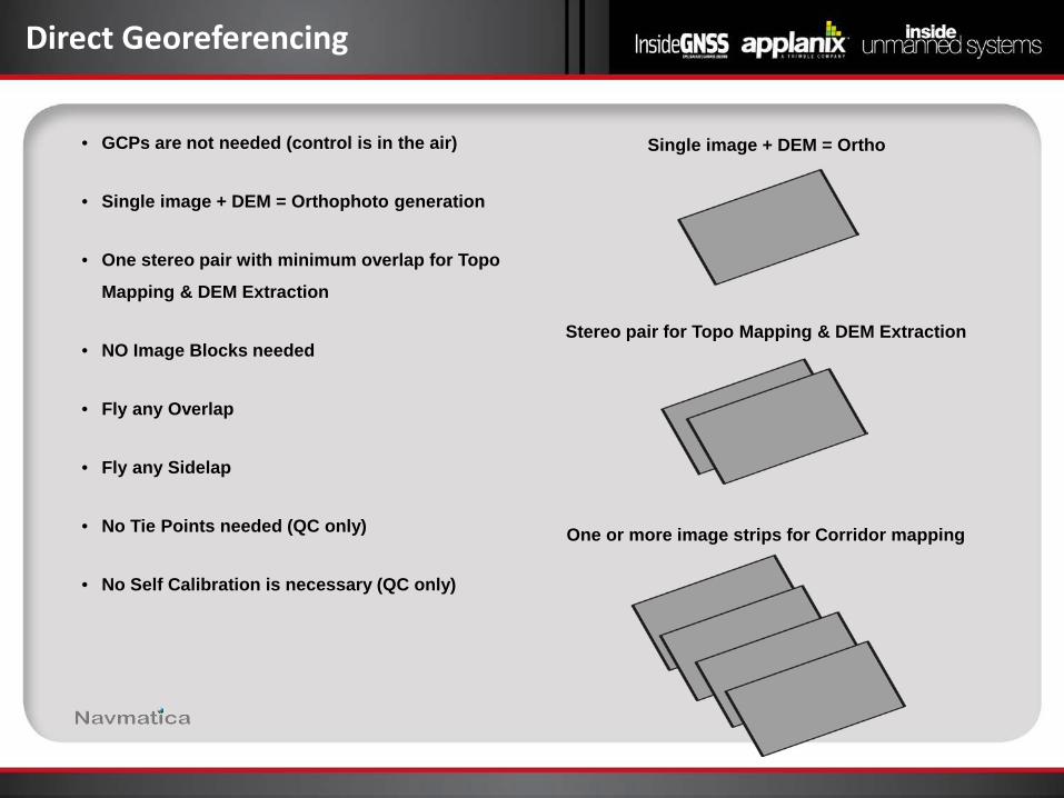
Direct Georeferencing
• GCPs are not needed (control is in the air)
• Single image + DEM = Orthophoto generation
• One stereo pair with minimum overlap for Topo
Mapping & DEM Extraction
• NO Image Blocks needed
• Fly any Overlap
• Fly any Sidelap
• No Tie Points needed (QC only)
• No Self Calibration is necessary (QC only)
Single image + DEM = Ortho
Stereo pair for Topo Mapping & DEM Extraction
One or more image strips for Corridor mapping
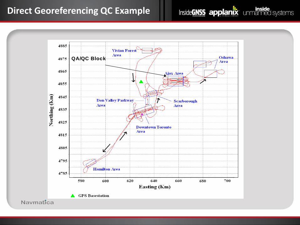
Direct Georeferencing QC Example
QA/QC Block
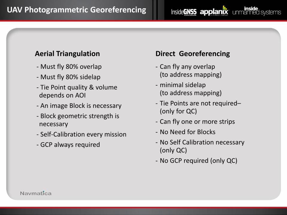
UAV Photogrammetric Georeferencing
Aerial Triangulation Direct Georeferencing
- Must fly 80% overlap - Must fly 80% sidelap - Tie Point quality & volume
depends on AOI - An image Block is necessary - Block geometric strength is
necessary - Self-Calibration every mission - GCP always required
- Can fly any overlap (to address mapping)
- minimal sidelap (to address mapping)
- Tie Points are not required– (only for QC)
- Can fly one or more strips - No Need for Blocks - No Self Calibration necessary
(only QC) - No GCP required (only QC)
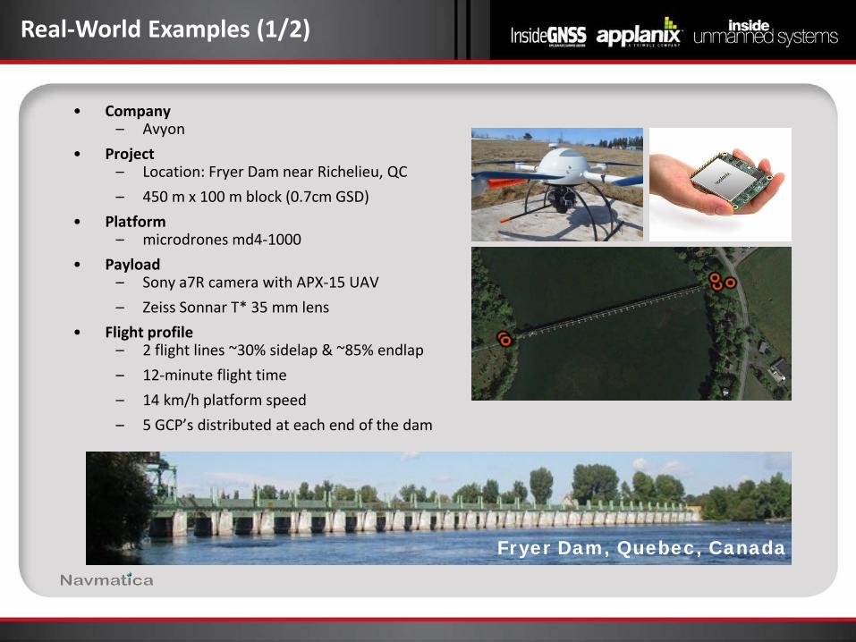
Real-World Examples (1/2)
• Company – Avyon
• Project – Location: Fryer Dam near Richelieu, QC – 450 m x 100 m block (0.7cm GSD)
• Platform – microdrones md4-1000
• Payload – Sony a7R camera with APX-15 UAV – Zeiss Sonnar T* 35 mm lens
• Flight profile – 2 flight lines ~30% sidelap & ~85% endlap – 12-minute flight time – 14 km/h platform speed – 5 GCP’s distributed at each end of the dam
Fryer Dam, Quebec, Canada
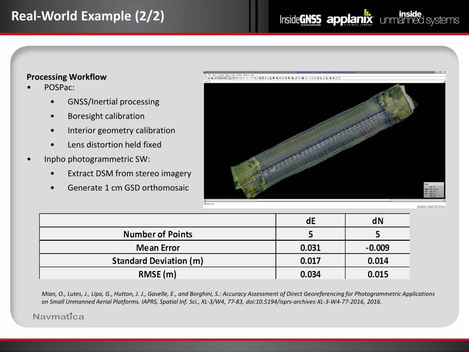
Real-World Example (2/2)
Processing Workflow • POSPac:
• GNSS/Inertial processing • Boresight calibration • Interior geometry calibration • Lens distortion held fixed
• Inpho photogrammetric SW: • Extract DSM from stereo imagery • Generate 1 cm GSD orthomosaic
Mian, O., Lutes, J., Lipa, G., Hutton, J. J., Gavelle, E., and Borghini, S.: Accuracy Assessment of Direct Georeferencing for Photogrammetric Applications on Small Unmanned Aerial Platforms. IAPRS, Spatial Inf. Sci., XL-3/W4, 77-83, doi:10.5194/isprs-archives-XL-3-W4-77-2016, 2016.
Mike Hogan Business Development
Avyon

Avyon Background
Avyon provides professional small Unmanned Aerial System (UAS) solutions to
various industries and markets in North America Main focus: survey and mapping Avyon Partners: Delair-Tech and microdrones

Fleet of Systems
Efficiency Safety Flexibility Multiple Sensors
Economical Repeatability
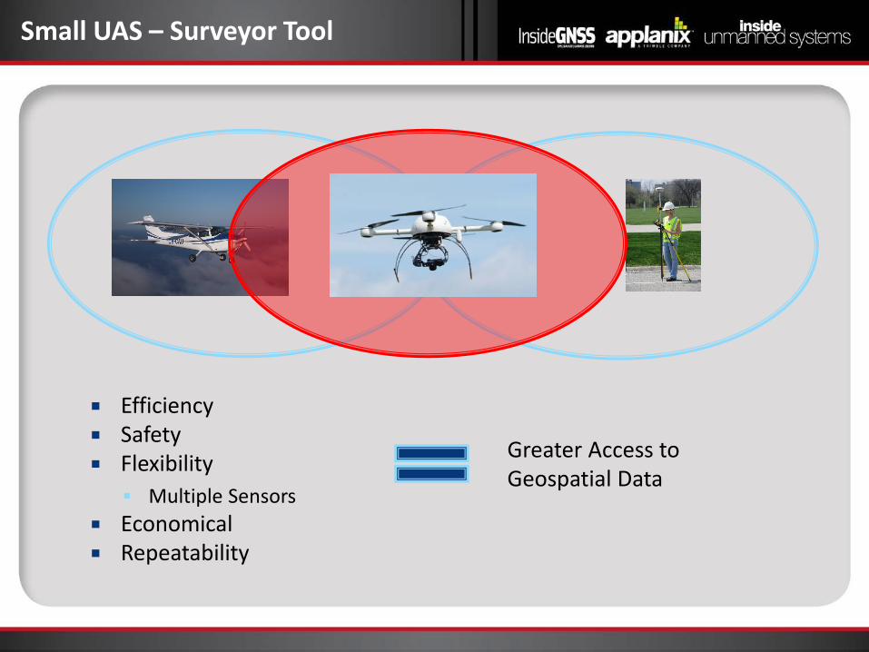
Small UAS – Surveyor Tool
Greater Access to Geospatial Data
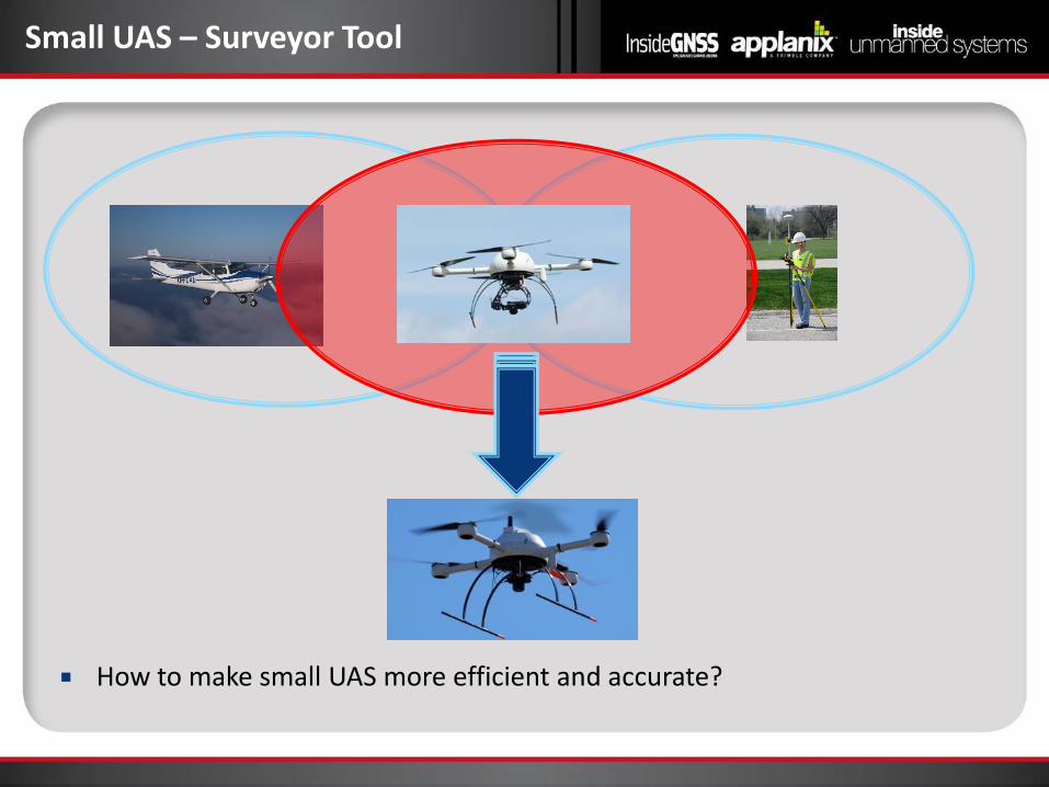
How to make small UAS more efficient and accurate?
Small UAS – Surveyor Tool
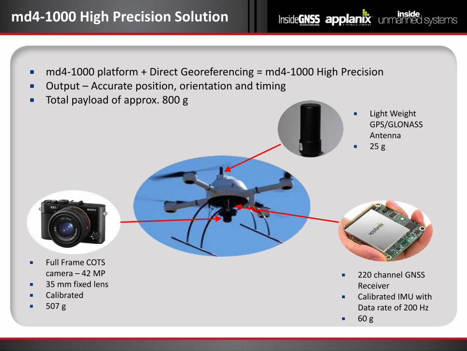
md4-1000 High Precision Solution
Light Weight GPS/GLONASS Antenna
25 g
220 channel GNSS Receiver
Calibrated IMU with Data rate of 200 Hz
60 g
Full Frame COTS camera – 42 MP
35 mm fixed lens Calibrated 507 g
md4-1000 platform + Direct Georeferencing = md4-1000 High Precision Output – Accurate position, orientation and timing Total payload of approx. 800 g

Ask the Experts – Part 1
Mohamed M.R. Mostafa Chief Technology Officer Navmatica Corporation
Mike Hogan Business Development Manager
Avyon
Trond Løke Chief Technology Officer
Hyperspectral Group
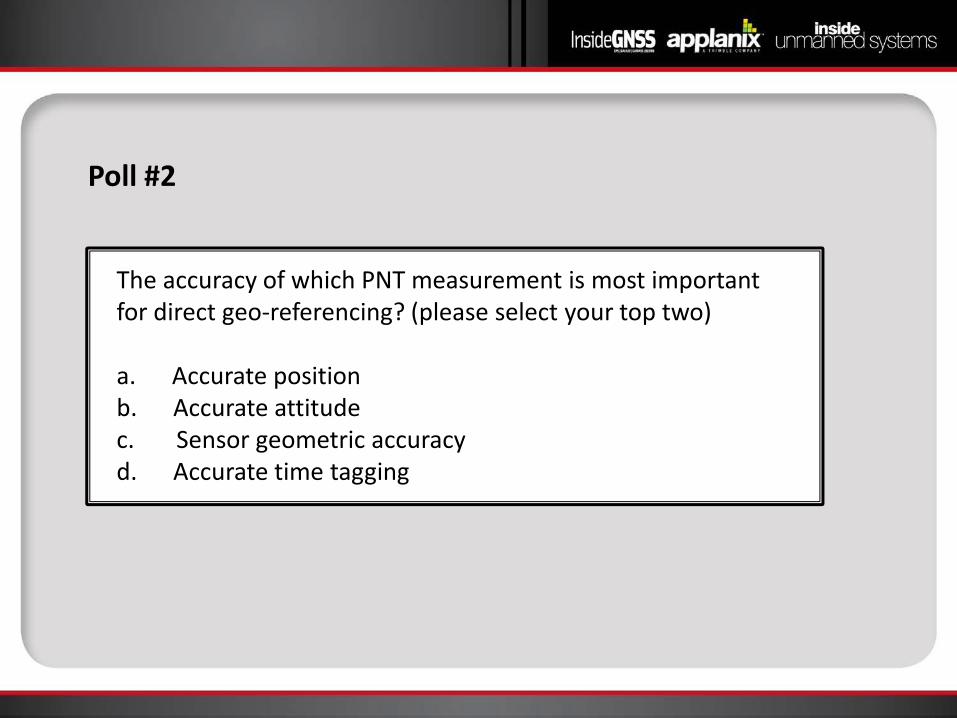
Poll #2
The accuracy of which PNT measurement is most important for direct geo-referencing? (please select your top two) a. Accurate position b. Accurate attitude c. Sensor geometric accuracy d. Accurate time tagging
Mike Hogan Business Development
Avyon
Potential Savings Project planning GCP layout and installation = no requirement for GCP Flight time – less side lap = decrease flt time or more area covered Data processing
Other opportunities Corridor mapping Mapping inaccessible areas
Opportunities for Efficiency
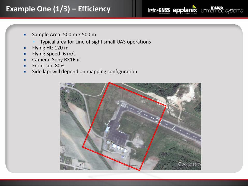
Sample Area: 500 m x 500 m Typical area for Line of sight small UAS operations
Flying Ht: 120 m Flying Speed: 6 m/s Camera: Sony RX1R ii Front lap: 80% Side lap: will depend on mapping configuration
Example One (1/3) – Efficiency
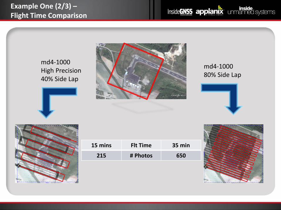
Example One (2/3) – Flight Time Comparison
md4-1000 80% Side Lap
md4-1000 High Precision 40% Side Lap
15 mins Flt Time 35 min
215 # Photos 650
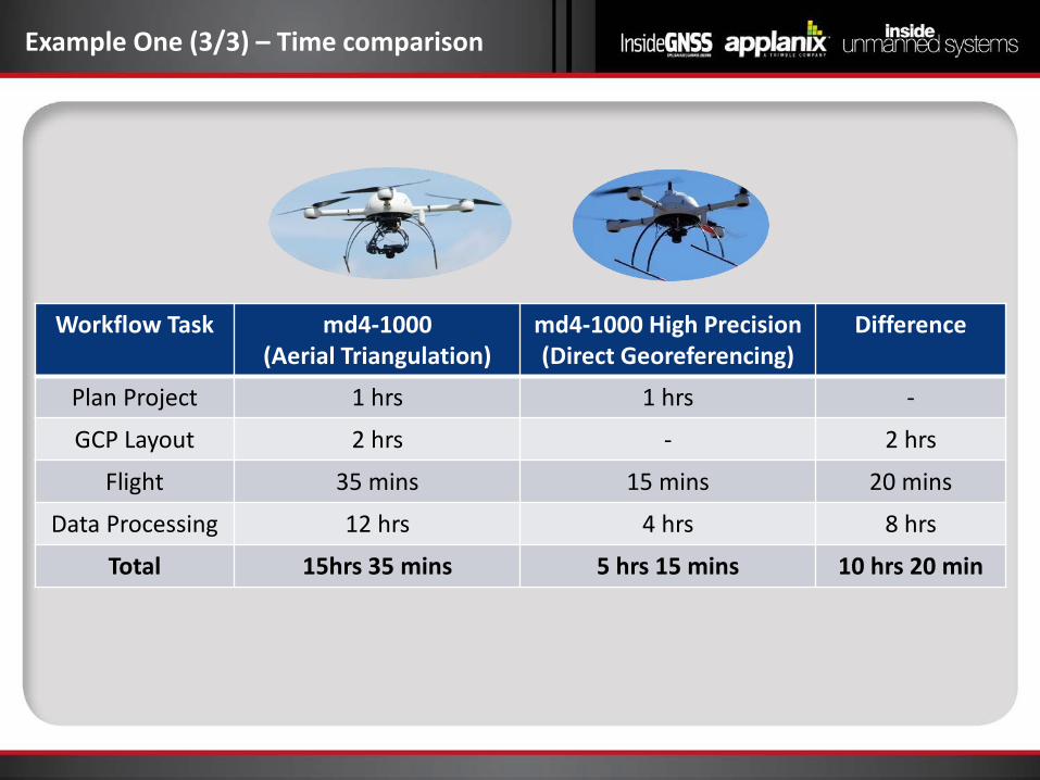
Workflow Task md4-1000 (Aerial Triangulation)
md4-1000 High Precision (Direct Georeferencing)
Difference
Plan Project 1 hrs 1 hrs -
GCP Layout 2 hrs - 2 hrs
Flight 35 mins 15 mins 20 mins
Data Processing 12 hrs 4 hrs 8 hrs
Total 15hrs 35 mins 5 hrs 15 mins 10 hrs 20 min
Example One (3/3) – Time comparison
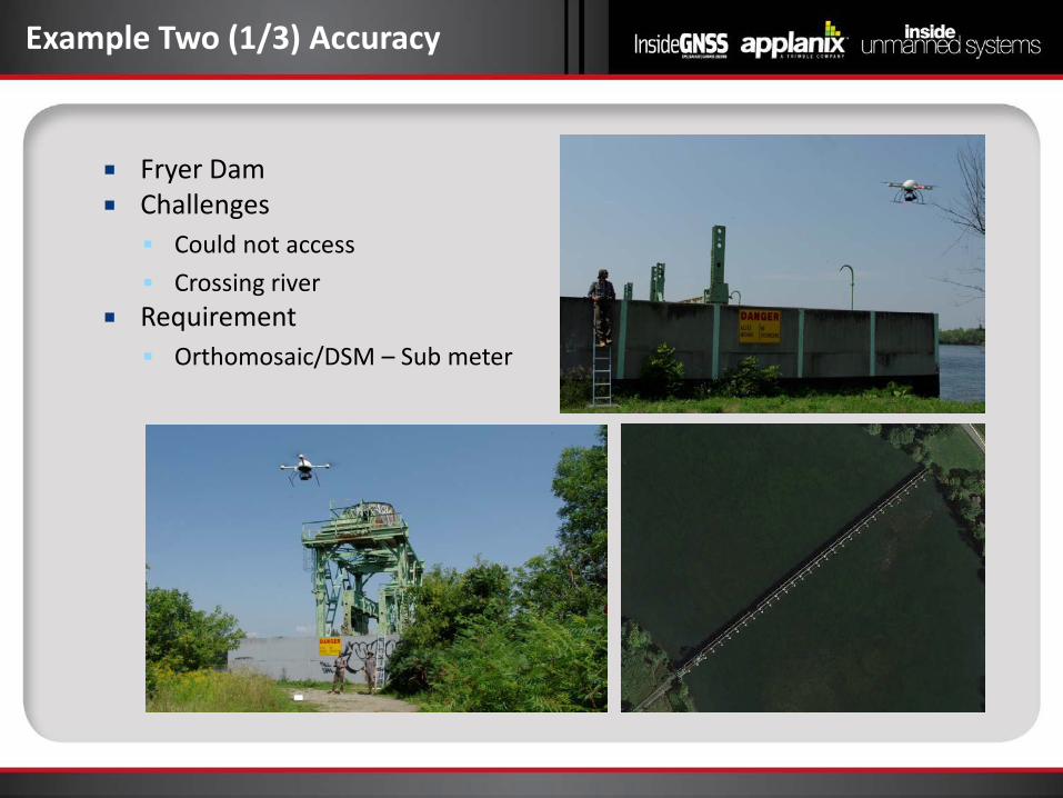
Fryer Dam Challenges Could not access Crossing river
Requirement Orthomosaic/DSM – Sub meter
Example Two (1/3) Accuracy
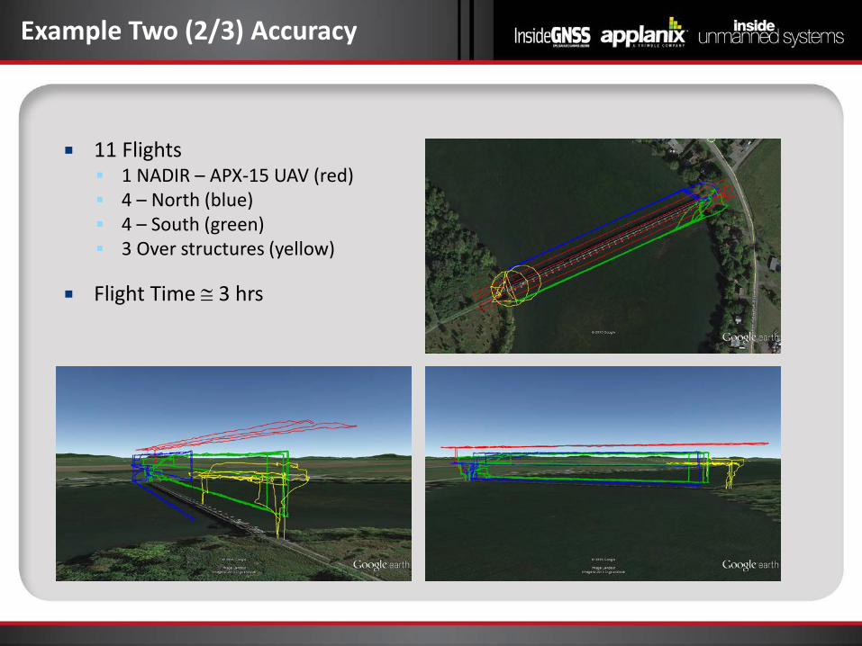
11 Flights 1 NADIR – APX-15 UAV (red) 4 – North (blue) 4 – South (green) 3 Over structures (yellow)
Flight Time ≅ 3 hrs
Example Two (2/3) Accuracy
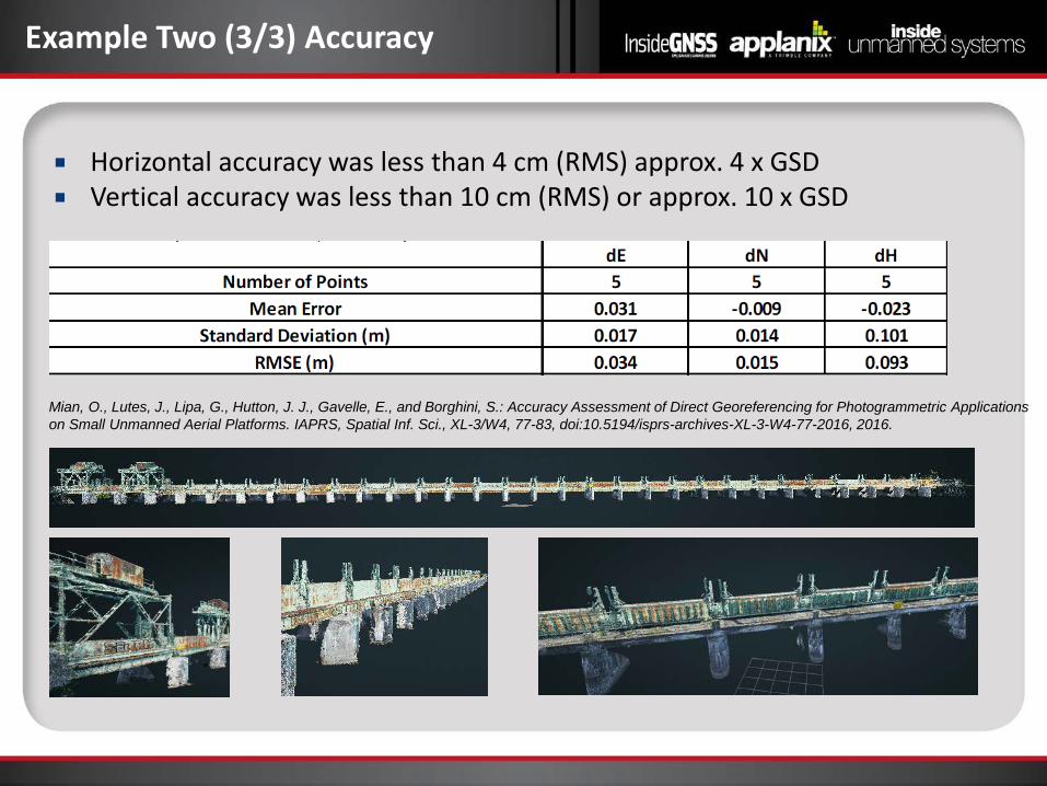
Horizontal accuracy was less than 4 cm (RMS) approx. 4 x GSD Vertical accuracy was less than 10 cm (RMS) or approx. 10 x GSD
Example Two (3/3) Accuracy
Mian, O., Lutes, J., Lipa, G., Hutton, J. J., Gavelle, E., and Borghini, S.: Accuracy Assessment of Direct Georeferencing for Photogrammetric Applications on Small Unmanned Aerial Platforms. IAPRS, Spatial Inf. Sci., XL-3/W4, 77-83, doi:10.5194/isprs-archives-XL-3-W4-77-2016, 2016.
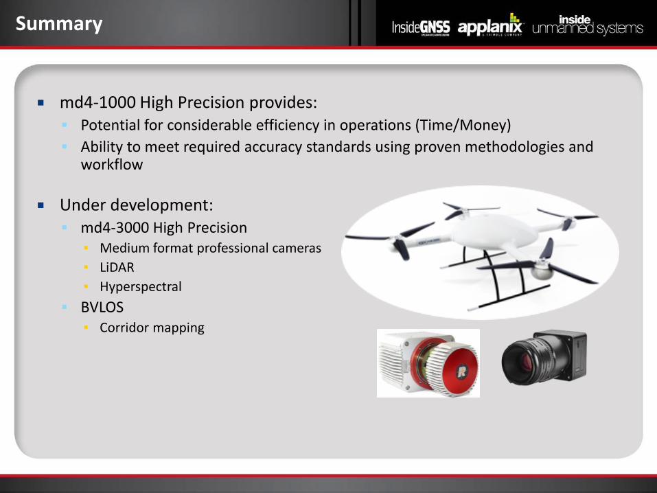
md4-1000 High Precision provides: Potential for considerable efficiency in operations (Time/Money) Ability to meet required accuracy standards using proven methodologies and
workflow
Under development: md4-3000 High Precision
▪ Medium format professional cameras ▪ LiDAR ▪ Hyperspectral
BVLOS ▪ Corridor mapping
Summary
Trond Løke CTO
HySpex Division
Key Specifications and Performance
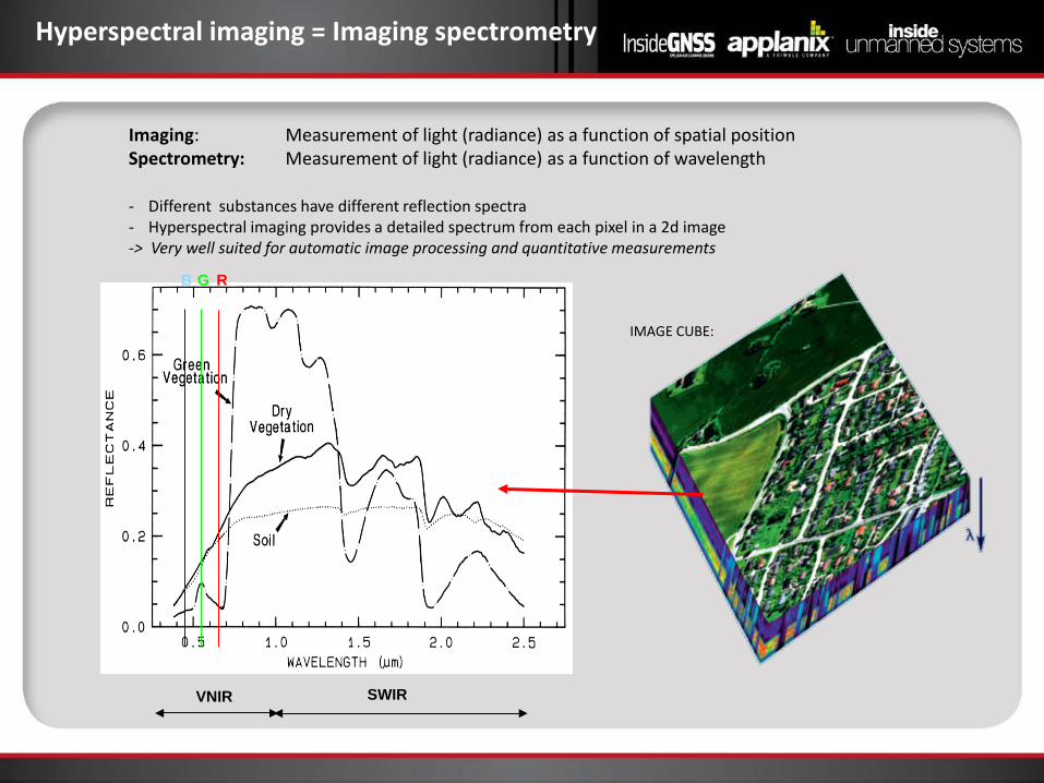
Hyperspectral imaging = Imaging spectrometry
Imaging: Measurement of light (radiance) as a function of spatial position Spectrometry: Measurement of light (radiance) as a function of wavelength
R G B
- Different substances have different reflection spectra - Hyperspectral imaging provides a detailed spectrum from each pixel in a 2d image -> Very well suited for automatic image processing and quantitative measurements
VNIR SWIR
IMAGE CUBE:
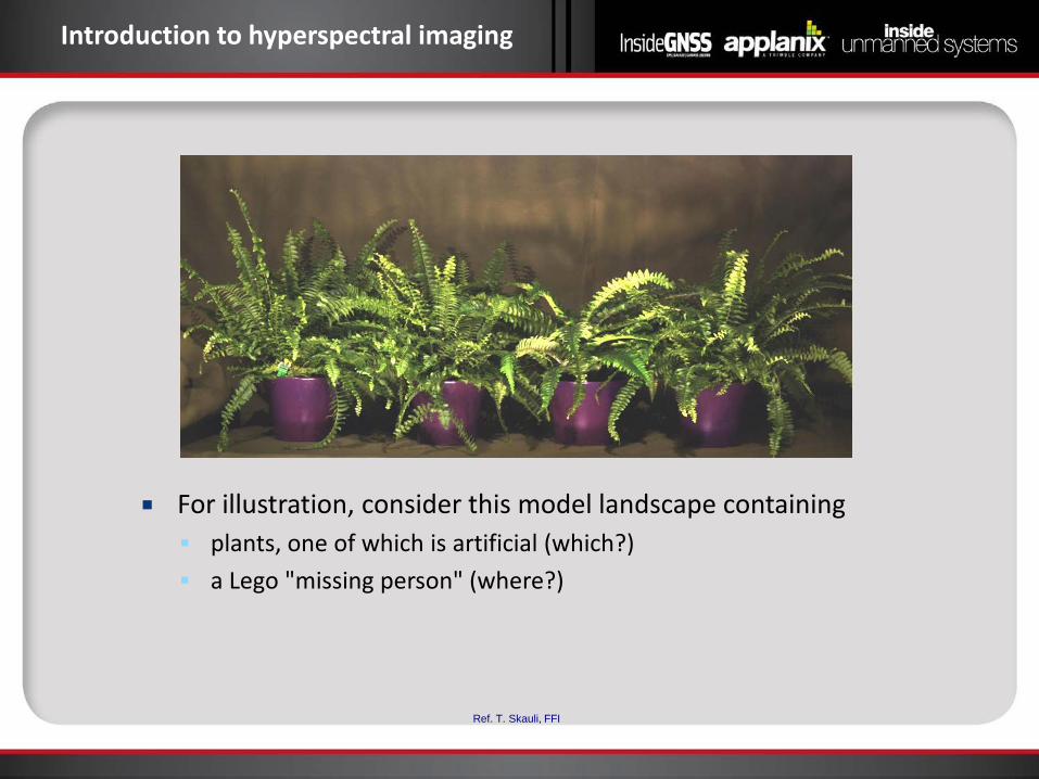
Introduction to hyperspectral imaging
For illustration, consider this model landscape containing plants, one of which is artificial (which?) a Lego "missing person" (where?)
Ref. T. Skauli, FFI
400 500 600 700 800 900 1000Bølgelengde (nm)
Inte
nsit
et
Wavelength (nm)
Inte
nsity
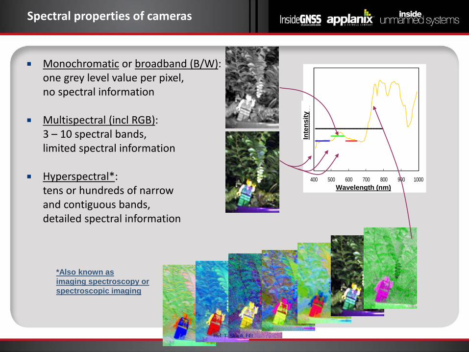
Spectral properties of cameras
Monochromatic or broadband (B/W): one grey level value per pixel, no spectral information
Multispectral (incl RGB): 3 – 10 spectral bands, limited spectral information
Hyperspectral*: tens or hundreds of narrow and contiguous bands, detailed spectral information
*Also known as imaging spectroscopy or spectroscopic imaging
Ref. T. Skauli, FFI
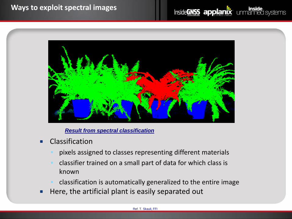
Ways to exploit spectral images
Classification pixels assigned to classes representing different materials classifier trained on a small part of data for which class is
known classification is automatically generalized to the entire image
Here, the artificial plant is easily separated out
Result from spectral classification
Ref. T. Skauli, FFI
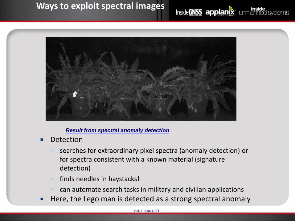
Ways to exploit spectral images
Detection searches for extraordinary pixel spectra (anomaly detection) or
for spectra consistent with a known material (signature detection)
finds needles in haystacks! can automate search tasks in military and civilian applications
Here, the Lego man is detected as a strong spectral anomaly
Result from spectral anomaly detection
Ref. T. Skauli, FFI
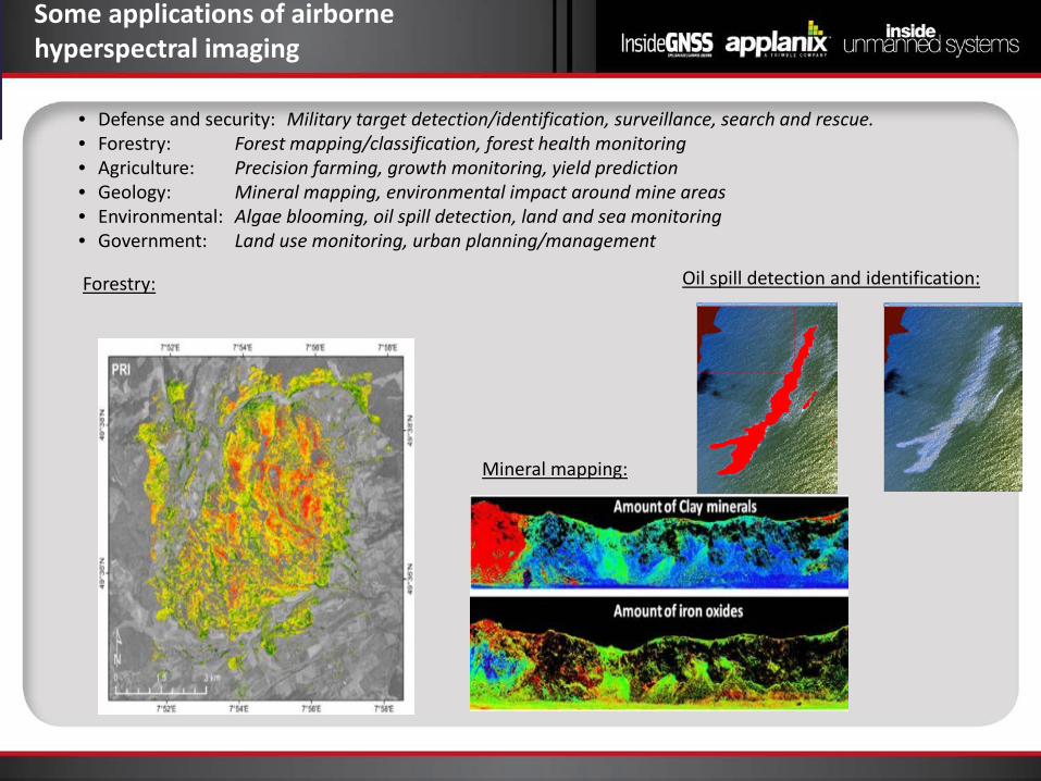
Some applications of airborne hyperspectral imaging
• Defense and security: Military target detection/identification, surveillance, search and rescue. • Forestry: Forest mapping/classification, forest health monitoring • Agriculture: Precision farming, growth monitoring, yield prediction • Geology: Mineral mapping, environmental impact around mine areas • Environmental: Algae blooming, oil spill detection, land and sea monitoring • Government: Land use monitoring, urban planning/management
Forestry: Oil spill detection and identification:
Mineral mapping:
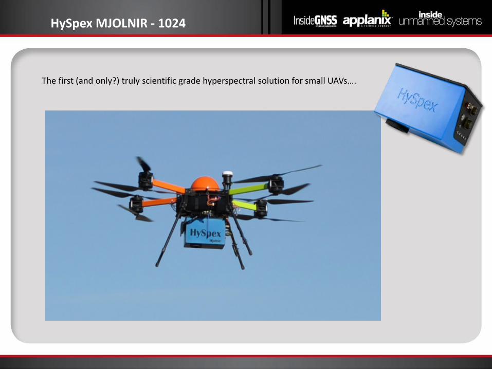
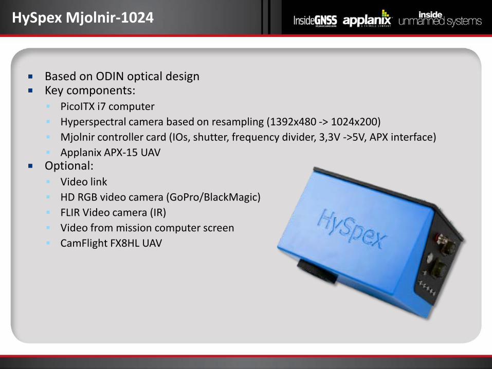
HySpex MJOLNIR - 1024
The first (and only?) truly scientific grade hyperspectral solution for small UAVs….
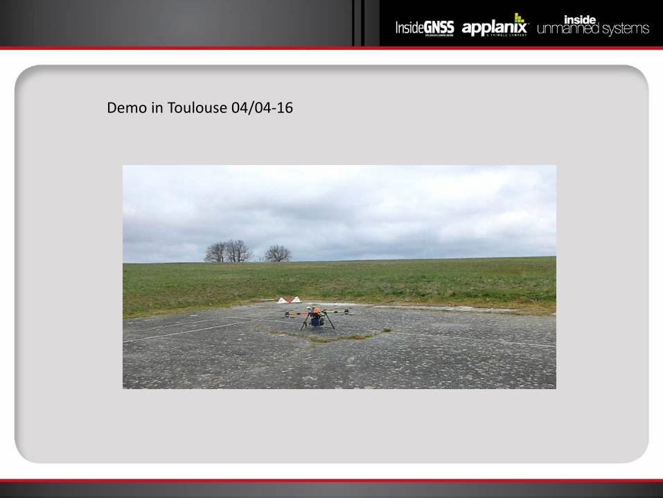
Demo in Toulouse 04/04-16
HySpex Mjolnir-1024
Based on ODIN optical design Key components: PicoITX i7 computer Hyperspectral camera based on resampling (1392x480 -> 1024x200) Mjolnir controller card (IOs, shutter, frequency divider, 3,3V ->5V, APX interface) Applanix APX-15 UAV
Optional: Video link HD RGB video camera (GoPro/BlackMagic) FLIR Video camera (IR) Video from mission computer screen CamFlight FX8HL UAV
HySpex Mjolnir-1024
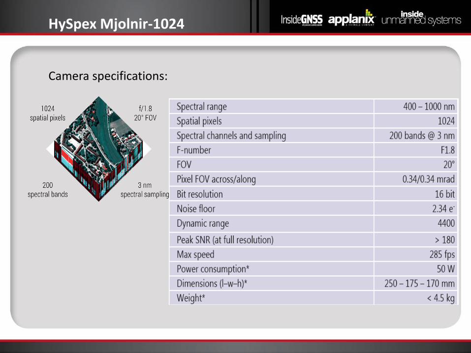
Camera specifications:
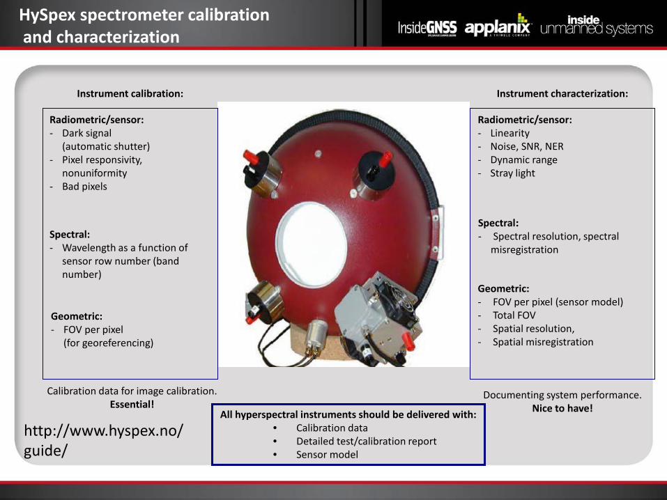
HySpex spectrometer calibration and characterization
Spectral: - Wavelength as a function of
sensor row number (band number)
Geometric: - FOV per pixel (sensor model) - Total FOV - Spatial resolution, - Spatial misregistration
Radiometric/sensor: - Dark signal
(automatic shutter) - Pixel responsivity,
nonuniformity - Bad pixels
All hyperspectral instruments should be delivered with: • Calibration data • Detailed test/calibration report • Sensor model
Instrument calibration: Instrument characterization:
Spectral: - Spectral resolution, spectral
misregistration
Radiometric/sensor: - Linearity - Noise, SNR, NER - Dynamic range - Stray light
Geometric: - FOV per pixel
(for georeferencing)
Calibration data for image calibration. Essential!
Documenting system performance. Nice to have!
http://www.hyspex.no/guide/
Performance and accuracies – Navigation System
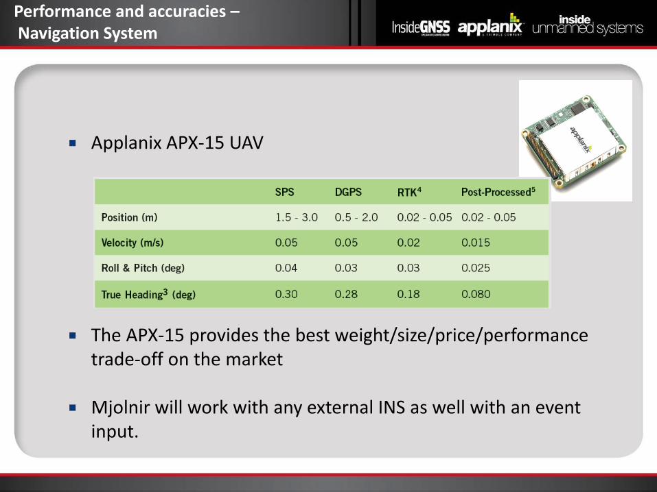
Applanix APX-15 UAV
The APX-15 provides the best weight/size/price/performance
trade-off on the market
Mjolnir will work with any external INS as well with an event input.
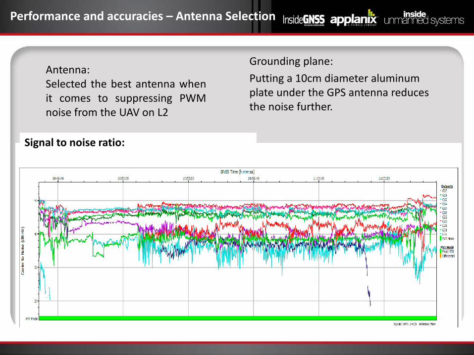
Performance and accuracies – Antenna Selection
Antenna: Selected the best antenna when it comes to suppressing PWM noise from the UAV on L2
Grounding plane: Putting a 10cm diameter aluminum plate under the GPS antenna reduces the noise further.
Signal to noise ratio:
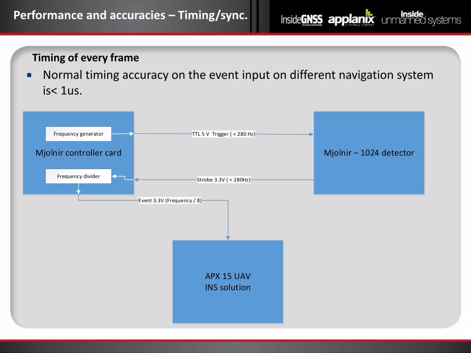
Normal timing accuracy on the event input on different navigation system is< 1us.
Performance and accuracies – Timing/sync.
Timing of every frame
Mjolnir controller card Mjolnir – 1024 detector
TTL 5 V Trigger ( < 280 Hz)
Strobe 3.3V ( < 280Hz)Frequency divider
Frequency generator
APX 15 UAVINS solution
Event 3.3V (Frequency / 8)
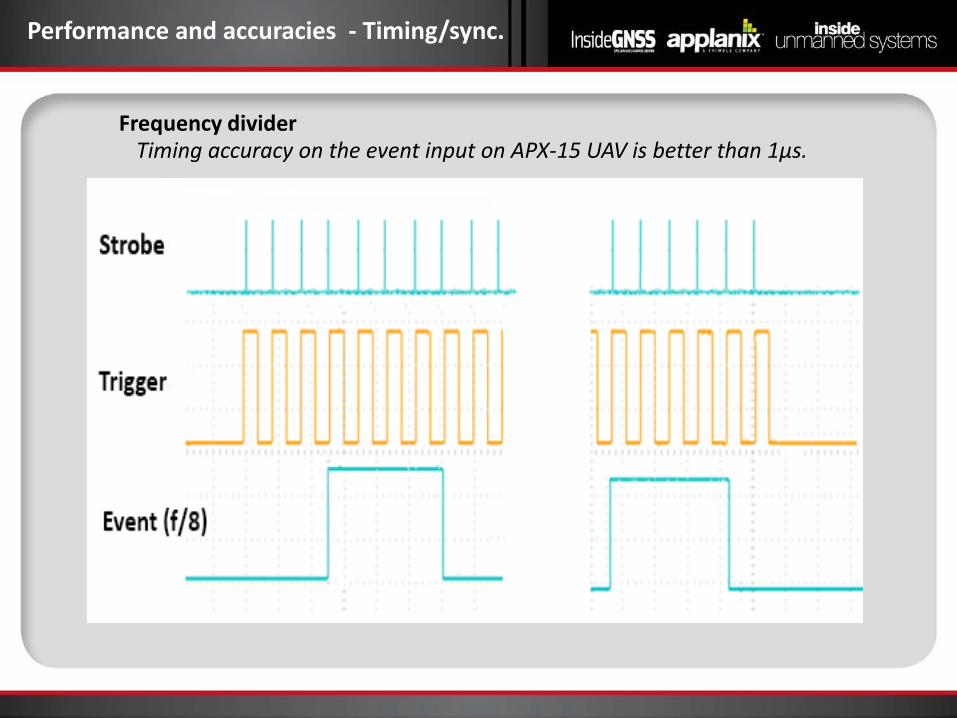
Timing accuracy on the event input on APX-15 UAV is better than 1µs.
Performance and accuracies - Timing/sync.
Frequency divider
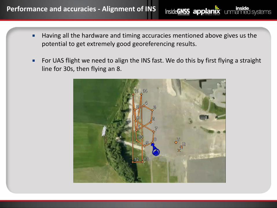
Performance and accuracies - Alignment of INS
Having all the hardware and timing accuracies mentioned above gives us the potential to get extremely good georeferencing results.
For UAS flight we need to align the INS fast. We do this by first flying a straight line for 30s, then flying an 8.
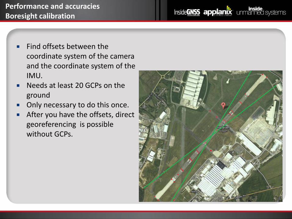
Find offsets between the coordinate system of the camera and the coordinate system of the IMU.
Needs at least 20 GCPs on the ground
Only necessary to do this once. After you have the offsets, direct
georeferencing is possible without GCPs.
Performance and accuracies Boresight calibration
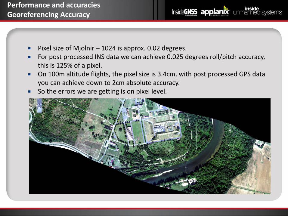
Performance and accuracies Georeferencing Accuracy
Pixel size of Mjolnir – 1024 is approx. 0.02 degrees. For post processed INS data we can achieve 0.025 degrees roll/pitch accuracy,
this is 125% of a pixel. On 100m altitude flights, the pixel size is 3.4cm, with post processed GPS data
you can achieve down to 2cm absolute accuracy. So the errors we are getting is on pixel level.
Mjolnir-1024: A generic camera system
We supply Mjolnir-1024 as a complete package with APX-15 INS solution and the Camflight UAV.
Mjolnir is a generic system and can be interfaced to any navigation system (only requirement is an event input). The event can even be divided down by a customized value if the navigation system cannot handle the full rate.
It should also be compatible with most UAVs that can lift the weight of Mjolnir.
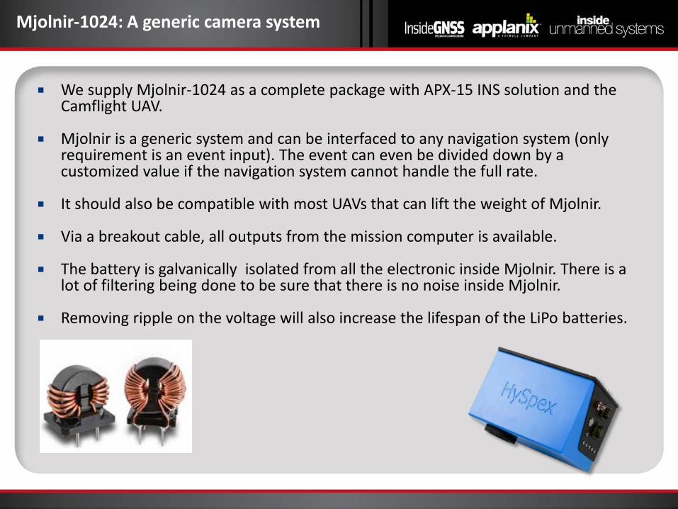
Via a breakout cable, all outputs from the mission computer is available.
The battery is galvanically isolated from all the electronic inside Mjolnir. There is a lot of filtering being done to be sure that there is no noise inside Mjolnir.
Removing ripple on the voltage will also increase the lifespan of the LiPo batteries.
Operational modes
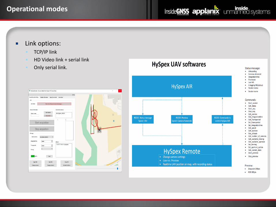
Link options: TCP/IP link HD Video link + serial link Only serial link.
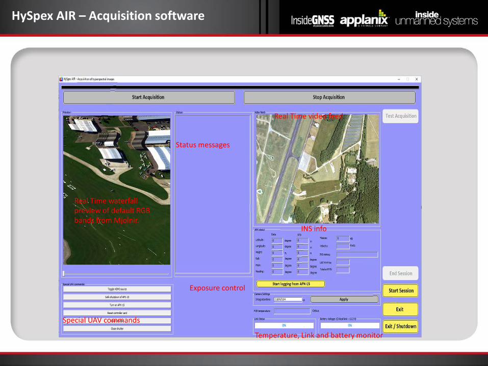
HySpex AIR – Acquisition software
Real Time waterfall preview of default RGB bands from Mjolnir.
Status messages
Real Time video feed
INS info
Exposure control
Temperature, Link and battery monitor
Special UAV commands
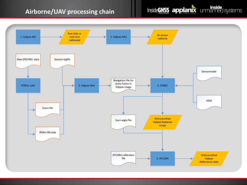
Airborne/UAV processing chain
1. HySpex AIRRaw data or
real time calibrated
2. HySpex RAD At-sensor radiance
4. PARGE
DEM
Sensormodel
Raw GPS/IMU data Session logfile
Event file
3. HySpex NAV
Navigation file for every frame in HySpex image
Orthorectified HySpex Radiance
image
5. ATCOR4
Scan angle file
ATCOR4 calibration file
Orthorectified HySpex
Reflectance data
POSPac UAV
200Hz INS data
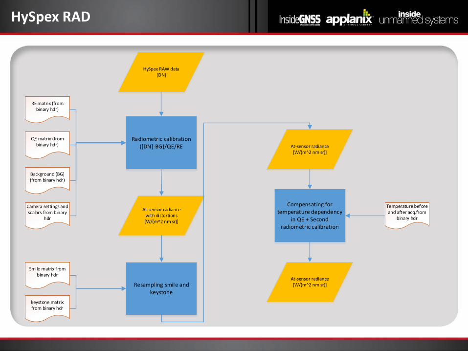
HySpex RAD
Radiometric calibration([DN]-BG)/QE/RE
HySpex RAW data[DN]
RE matrix (from binary hdr)
QE matrix (from binary hdr)
Background (BG) (from binary hdr)
Camera settings and scalars from binary
hdr
At-sensor radiance with distortions[W/(m^2 nm sr)]
Compensating for temperature dependency
in QE + Second radiometric calibration
Temperature before and after acq.from
binary hdr
At-sensor radiance[W/(m^2 nm sr)]
At-sensor radiance [W/(m^2 nm sr)]
Resampling smile and keystone
Smile matrix from binary hdr
keystone matrix from binary hdr
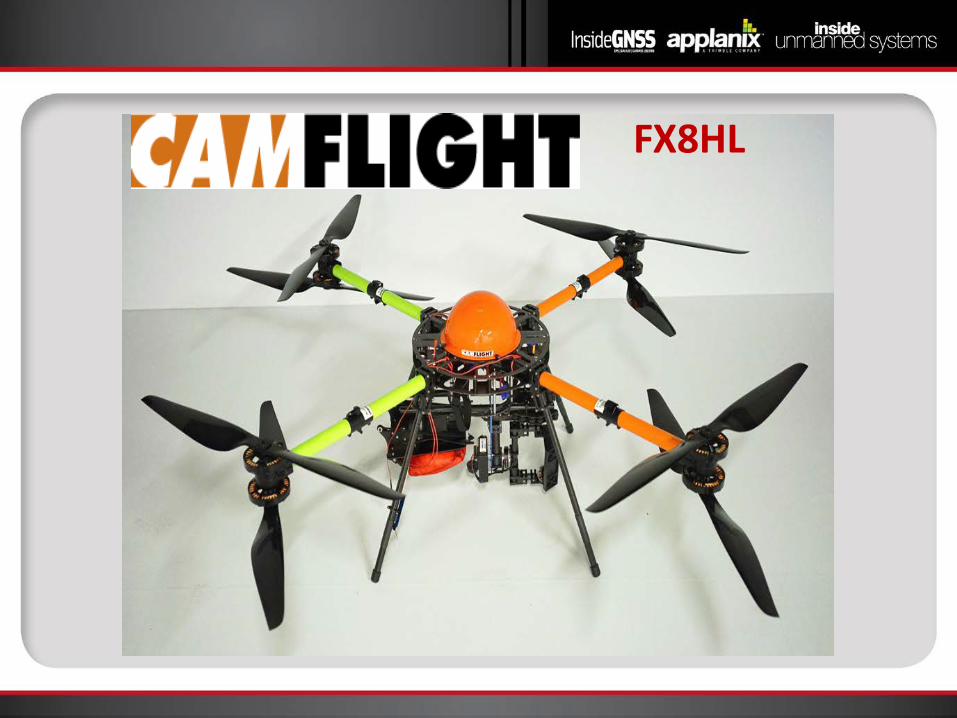
Camflight FX8 up to 8.3 kg. • Heavy payload: 8.3 Kg
• 25 - 30 min flights with 6 Kg.
• > 50 min flights with 1,5 Kg.
• Campos-m positioning system
• RTK link to base station
• Post processing of positions possible
• Photogrammetry without GCPs
•Autopilot from Lockheed Martin for high precision flights
•15 m² rescue parachute with backup battery and safety switch on remote controller
•Virtual cockpit ground control software for advanced flight plans
FX8HL
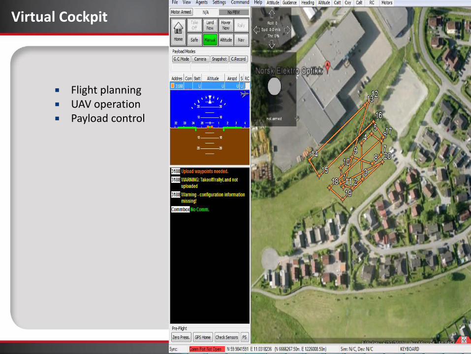
Virtual Cockpit
Flight planning UAV operation Payload control
Real-time processing software for airborne applications
Real time georeferencing and visualization
Real time classification: CRX, PCA , MNF
A goal in the long run is to implement custom algorithms to make real-time classified maps, real-time “target” detection, real-time indices maps etc.
RTGEO was tested successfully already in 2013, we have one beta customer using it in Germany
Our goal is to include this software in the UAV package.


Conclusions
Mjolnir-1024 is a state of the art scientific grade hyperspectral imaging system designed specifically for UAVs.
Based on NEO’s more than 20 years experience in hyperspectral imaging High quality components and rigorous testing ensures optimal performance
Demo data set available for evaluation, contact me and I will send you ftp info.
Questions/comments?
Contact info: [email protected], [email protected]

Next Steps
• Visit www.insidegnss.com/webinars for a PDF of the presentations and
a list of resources. • Review the recorded version of today's webinar
Contact Info:
• Inside GNSS- www.insidegnss.com • Applanix - www.applanix.com/
• Mohamed M.R. Mostafa- [email protected] • Mike Hogan- [email protected] • Trond Løke- [email protected], [email protected]

Poll #3
Having attended today’s webinar, my plans to purchase or acquire a GNSS-inertial solution:(please select one)
a. Increased b. Was just researching but now intend to purchase c. Was just researching but now see no need d. Decreased

Ask the Experts – Part 2
Inside GNSS @ www.insidegnss.com/
www.applanix.com/
Ask the Experts – Part 2
Mike Hogan Business Development Manager
Avyon
Mohamed M.R. Mostafa Chief Technology Officer Navmatica Corporation
Trond Løke Chief Technology Officer
Hyperspectral Group
Joe Hutton, MASc P.Eng, Director
Inertial Technology and Airborne Products

Thank you!
Joe Hutton, MASc P.Eng, Director
Inertial Technology and Airborne Products
Related Documents