Mapping flows Switzerland as operational landscape MARC ANGÉLIL, CARY SIRESS Angélil, M., & Siress, C. (2015). Mapping flows. Switzerland as operational landscape. Research In Urbanism Series, 3(1), 35-56. doi:10.7480/rius.3.831

Welcome message from author
This document is posted to help you gain knowledge. Please leave a comment to let me know what you think about it! Share it to your friends and learn new things together.
Transcript
Mapping flowsSwitzerland as operational landscapeMARC ANGÉLIL, CARY SIRESS
Angélil, M., & Siress, C. (2015). Mapping flows. Switzerland as operational landscape. Research In
Urbanism Series, 3(1), 35-56. doi:10.7480/rius.3.831
FLOW
SCAPES - D
ESIGN
ING
INFR
ASTRU
CTU
RE A
S LAN
DSC
APE
36
AbstractDrawing on episodes involving the use (and abuse) of maps in Switzerland, this essay pertains to the geopolitical agency of cartography in the production of urban territory. Maps generate and maintain particular discourses about the world, whether factual or fictional, with very real repercussions either way for the territory depicted. The UN motion made by Libyan leader Muammar al-Gadaffi to wipe Switzerland off the map, for instance, discloses just how much sway the cartographic imaginary holds in global relations. Guillaume-Henri Dufour’s mid-nineteenth century map re-territorialised a loose coalition of fiercely independent cantons into that unified economic and legislative space known as ‘Switzerland’, while underwriting an infrastructural machine that remains as central to Swiss self-esteem as it is to the nation’s economy. More recent examples of the map’s formative authority come by way of two unusual bids made in 2010 to redraw the boundaries of Switzerland. The controversial map by Armed Forces Chief André Blattmann recast Europe as enemy territory in an effort to rekindle patriotic identity and legitimise the need for an army. Conversely, right-wing politician Dominique Baettig put forth an equally contentious map calling for the annexation of regions from neighbouring countries that would create a new Swiss megacity in the heart of Europe. Regardless of how it is mapped, Switzerland’s contemporary urban fabric hardly adheres to an immaculate image, manifesting instead a disjunctive amalgam of bits and pieces that operate according to their own rules and agendas. And with such territorial entropy increasing on a planetary scale, we might wonder to what extent the map actively shapes these conditions as an actor in its own right rather than only neutrally reflecting them. In any case, territory is never simply given, but is constituted through the polymorphous elements, relations, and domains of reference that it assembles. Whereas the map might continue to express what is done in the name of territory, we do not yet know what territory itself can do.
KEYWORDS
mapping Switzerland; cartography; Swiss defence system; urban fabric; infrastructure network
MA
PPING
FLOW
S
37
1. ERASING SWITZERLAND OFF THE MAPA motion submitted by Libyan leader Muammar al-Gaddafi in 2009 to the
United Nations General Assembly made a plea for wiping Switzerland off the map and splitting its territories among neighbouring countries. His rather bold proposal – announced as an all-out Jihad or Holy War against the alpine state – came in response to the arrest of one of his sons in Geneva and the controversial ban on the construction of minarets in the country. In a ram-bling diatribe at the G8 Summit held in Italy in the same year Gaddafi labelled Switzerland a rogue nation:
“Switzerland is a world mafia and not a state. It is formed of an Italian com-munity that should return to Italy, another German community that should return to Germany, and a third French community that should return to France.” 1
An oil embargo was declared, billions were withdrawn from Swiss bank accounts, commercial flights between the two countries cancelled, and two Swiss businessmen arrested for alleged visa irregularities. Although such re-taliatory measures were quite serious and yielded much diplomatic damage, the media had a heyday with Gaddafi’s bizarre proposal, with countless maps drawn to illustrate Switzerland’s dissolution. Who would get the Gotthard and who would get the Matterhorn? But humour aside and notwithstanding Switzerland’s long-standing posture of neutrality, the short-lived episode brings to the forefront how politics and space are brought to interact on the very surface of the map. Whatever the intentions, whether justified or not, and whatever maps are drawn, they tend to leave their traces on both the ge-ography of ideology and space.
2. PUTTING SWITZERLAND ON THE MAPA significant amount of effort goes into maps and their production. As
a matter of fact, Switzerland has made a name for itself in the production of hyper-accurate maps. Its territory, itself a model of accuracy, has been me-ticulously plotted to the nth degree with an exactitude that would even make Borges’s fabled guild of cartographers green with envy.2 This passion for all things perfect is more than mere myth, it is the hallmark of Swiss identity both within and beyond its national borders. To keep things in good order – en état – is nearly constitutional law. In reality, map-making engenders territo-ry, if not the nation itself, in the process triangulating scientific knowledge, politics, and space.3 This threesome fuels an obsessive machine that runs at full speed, at times threatening to overheat while consuming ever more re-sources to produce an urban landscape that expands beyond the borders of the map itself. Since the 1970s, the rate of land consumption for new con-struction in Switzerland is estimated to have reached nearly 1m2/sec, a num-
FLOW
SCAPES - D
ESIGN
ING
INFR
ASTRU
CTU
RE A
S LAN
DSC
APE
38
ber often cited in parliamentary debates and in the media, though slightly above the more precise figure of 0.86m2/sec as calculated by the Swiss Federal Statistical Office; the plotting of territory and its dynamics through the ele-gance of number (Bundesamt für Statistik Schweiz, 2013).
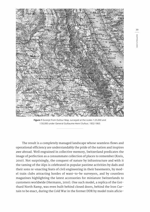
There is indeed a map that put Switzerland on the map. Not by coin-cidence that landmark document is attributed to a military surveyor, Guil-laume-Henri Dufour, whose training as an engineer and experience with for-tifications for the French military made him the prime choice for charting the first comprehensive map of the country, albeit a country that had not yet been constitutionally formed. The undertaking comprised a monumental task that lasted from 1832 to 1865 (Gugerli & Speich, 2002; Gugerli, 1999). Switzerland at the time was a loose coalition of independent cantons separated by a cap-sular mentality that survives to this day. Efforts were made nevertheless to standardise anything from different currencies to disparate measuring sys-tems in order to facilitate commerce and strengthen political cohesion while maintaining cultural diversity. With the objective of a unified Swiss economic and legislative space on the table, one of the initial measures was to create a new map that would give contours to “the topographical designation Switzer-land” with a precision “beyond all scientific doubt” (Gugerli, 1998) (figure 1).
The project set out to homogenise the heterogeneous and gained signif-icance as part of a progressive-liberal movement aiming to unite the country in a military, political, economic, and geographic sense (Gugerli, 1998: 96). A “gigantic machinery of a new national recording system had come to fruition”, and with it Switzerland was invented (Gugerli, 1998: 97).When the federal state was founded in 1848, the Dufour Map was well underway, giving legitimacy to the fledgling nation. Dufour himself profited from the enterprise, as he was elected General of the army just prior to the state’s formation, a move suggesting that the armed forces had already become more scientific in their orientation. Given that the map was underwritten by military interests, an-ything that either aided or obstructed the movement of troops was recorded in minute detail by squads of surveyors scaling mountainous terrain. Con-versely, the map warranted the creation of new infrastructure – roads, rail-ways, bridges, tunnels, and communication networks – likewise warranting the need to discipline, manage, and control territory. We encounter in this project an unexpected ménage à trois where knowledge, power, and space be-come entangled. It was little known at the time that to govern is to urbanise.
MA
PPING
FLOW
S
39
Figure 1 Excerpt from Dufour Map, surveyed at the scales 1:25,000 and 1:50,000 under General Guillaume-Henri Dufour, 1832-1865
The result is a completely managed landscape whose seamless flows and operational efficiency are understandably the pride of the nation and inspires awe abroad. Well engrained in collective memory, Switzerland predicates the image of perfection as a consummate collection of places to remember (Kreis, 2010). Not surprisingly, the conquest of nature by infrastructure and with it the taming of the Alps is celebrated in popular pastime activities by dads and their sons re-enacting feats of civil engineering in their basements, by mod-el train clubs attracting hordes of want-to-be surveyors, and by countless magazines highlighting the latest accessories for miniature Switzerlands to customers worldwide (Hermann, 2010). One such model, a replica of the Got-thard North Ramp, was even built behind closed doors, behind the Iron Cur-tain to be exact, during the Cold War in the former DDR by model train aficio-

FLOW
SCAPES - D
ESIGN
ING
INFR
ASTRU
CTU
RE A
S LAN
DSC
APE
40
nados who had never visited the actual site (figure 2). Though born of fantasy, the project required up-to-date maps that were smuggled in and used to plot an elaborate duplicate of the real setting, one replete with rock formations, trees, lakes, snow, and not to forget those Swiss chalets and all the other nec-essary technical amenities for a picture-perfect, Heidi-esque set. What was undertaken as an innocent leisurely pursuit eventually got the East German hobbyists in trouble with agents from the Ministry for State Security, more commonly known as the Stasi, who were suspicious of the clandestine opera-tion. But the story had a happy ending, as the maps used were deemed harm-less by authorities and the co-opted image of Switzerland deemed benign.
Figure 2 Model Train of the Gotthard North Ramp (scale 1:120), Model Train Club Leipzig, DDR, 1969-89
Without a doubt, the virtue of Swiss maps is their accuracy. Admittedly, as a cartographer’s dream such accurateness can be blinding. Maps, though cloaked in objectivity, are thoroughly ideological. They are vehicles for trans-lating values, motives, biases, beliefs, and desires into territory. Such trans-lations require protocols based on norms that ensure their replication as a system, which in turn validates the values inscribed in them and the powers
MA
PPING
FLOW
S
41
behind them. Therefore, any change in ideology will inevitably leave its mark on the land. But such agents for ideology never stand alone. They are often met with other competing objectives, a clash which translates into territorial conflict, however absurd the grounds might seem.
3. WALLING SWITZERLANDCase in point, a simple map can make a mountain out of a molehill. A
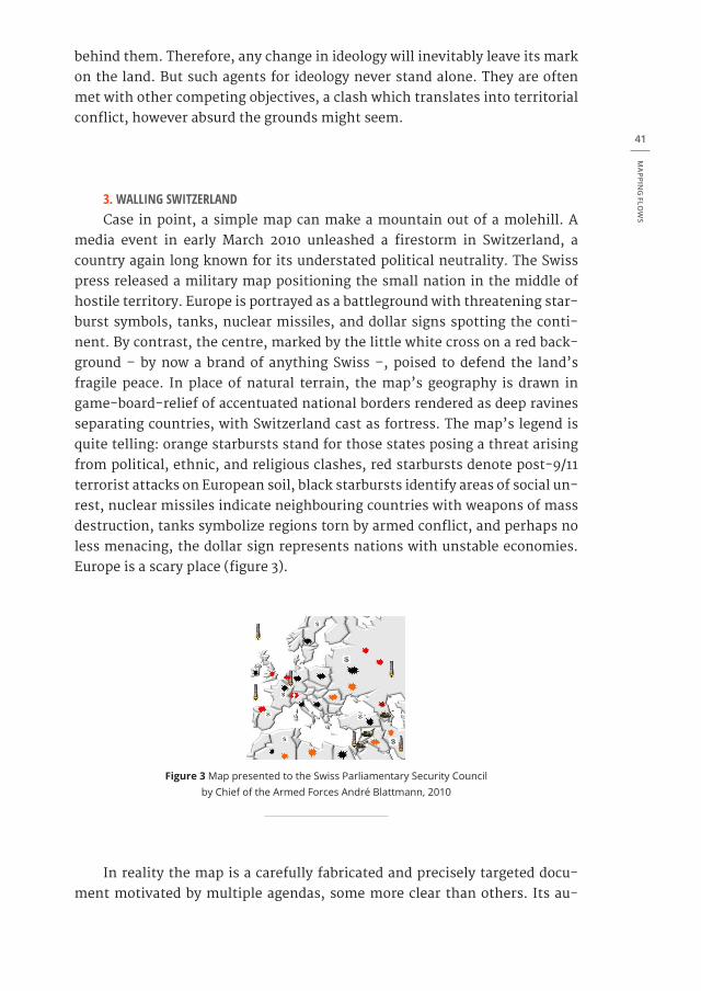
media event in early March 2010 unleashed a firestorm in Switzerland, a country again long known for its understated political neutrality. The Swiss press released a military map positioning the small nation in the middle of hostile territory. Europe is portrayed as a battleground with threatening star-burst symbols, tanks, nuclear missiles, and dollar signs spotting the conti-nent. By contrast, the centre, marked by the little white cross on a red back-ground – by now a brand of anything Swiss –, poised to defend the land’s fragile peace. In place of natural terrain, the map’s geography is drawn in game-board-relief of accentuated national borders rendered as deep ravines separating countries, with Switzerland cast as fortress. The map’s legend is quite telling: orange starbursts stand for those states posing a threat arising from political, ethnic, and religious clashes, red starbursts denote post-9/11 terrorist attacks on European soil, black starbursts identify areas of social un-rest, nuclear missiles indicate neighbouring countries with weapons of mass destruction, tanks symbolize regions torn by armed conflict, and perhaps no less menacing, the dollar sign represents nations with unstable economies. Europe is a scary place (figure 3).
Figure 3 Map presented to the Swiss Parliamentary Security Council by Chief of the Armed Forces André Blattmann, 2010
In reality the map is a carefully fabricated and precisely targeted docu-ment motivated by multiple agendas, some more clear than others. Its au-
FLOW
SCAPES - D
ESIGN
ING
INFR
ASTRU
CTU
RE A
S LAN
DSC
APE
42
thor, Chief of the Armed Forces André Blattmann, presented his case for maintaining the integrity of Switzerland in a routine military report to the Parliamentary Security Council. The transparencies used by Blattmann to make his point were, despite his authoritarian frankness, anything but trans-parent. The material subsequently made its way to the press who did not miss a beat to put it in the larger political context and thus highlight the ulterior motives of the campaign. To ease entry into the story, local television framed the incident in such a way as to reach the largest audience possible, thereby capitalising on the scandalous ramifications of vilifying neighbours. Popu-lar vacation destinations across the continent offered the perfect foil for the spin, with tourist sites now depicted as the source of unwanted migratory flows of people threatening to invade Confederate Helvetic space. In fact, an official message delivered to the public by the military commander himself: “[o]ne can imagine situations in which the army has to protect our infrastructure, for large migration streams might require troop deployment.”4 Yet another part of his argument showcased imminent economic risks, using EU-member state Greece as a convenient example of an already destabilised financial system on the doorstep of bankruptcy. As if this was not enough, he went on brazenly to warn citizens about the danger of Taliban-launched nuclear assaults on the nation’s power grid just to add fuel to the fire.5
Reactions to this episode – which unfolded on the heels of the equal-ly sensitive Minaret Initiative that had angered Gaddafi – was broad, cutting across party lines and national borders alike. As can be expected, local leaders throughout the country scrambled to soften the blow of political incorrect-ness, the liberal Swiss Social Party (SP/PS) moved to take advantage of Blatt-mann’s faux pas, and Greece was outraged.6 Ultimately, the fallout led to the heated question: of all nations, why does Switzerland need an army?7
This seems to be the very question that prompted military leaders to construct the map in the first place. Faced with budget cuts, a plan was con-cocted to breathe new life into the existential necessity of the army. And ter-ritory played no small part in the case made. Blattmann actually framed his argument in a newspaper interview from the vantage of real estate and the immense portfolio of property assets belonging to the armed forces, at the time of the interview valued at approximately 25 billion US dollars.8 To make the argument more palatable, he cited in his pitch the decrepit conditions of barracks and significant maintenance costs for their upkeep. The message was clear: more money is needed for the army. Yet, when asked why they had not resorted to selling portions of the land holdings, he called attention to the space required for military exercises and related installations. Clearly this was a concerted effort to cloud the more central issue of winning new prestige and thereby justifying the military’s raison d’être as raison d’état. Indeed, ac-cording to the Chief, the state of Switzerland does need an army!
MA
PPING
FLOW
S
43
A state of emergency had to be induced and a palpable sense of angst manufactured to prop up the call for protecting the homeland, with space played as an agent in a blatant politics of fear. With this agenda, a threat-map had to be deployed as tactical weapon. A difficult geography emerges in Blattmann’s doomsday scenario as impending terror is invoked to re-con-struct territory, thus further institutionalising national security. By present-ing conjecture as fact, he purposely plays the trump card of patriotic identity versus the evil other. Switzerland is interiorised, walled, not physically but dogmatically and ideologically, and all in order to secure more funds for the military and its industry.
There is a precedent to this protectionist impulse that remains deeply engrained in Swiss mentality. Known as the réduit, or redoubt, the Swiss-con-ceived alpine stronghold denotes a place of refuge during times of war. The term has both a physical and psychological dimension. On the one hand, it is comprised of a series of fortifications strategically situated across the country to defend prominent points and deter enemy attack. On the other hand, it figures as the core of ‘spiritual national defence’ invoked to raise collective morale and remind citizens of the country’s critical situation amidst hostile neighbours (Mooser, 2000). Blattmann plays on this very sentiment.
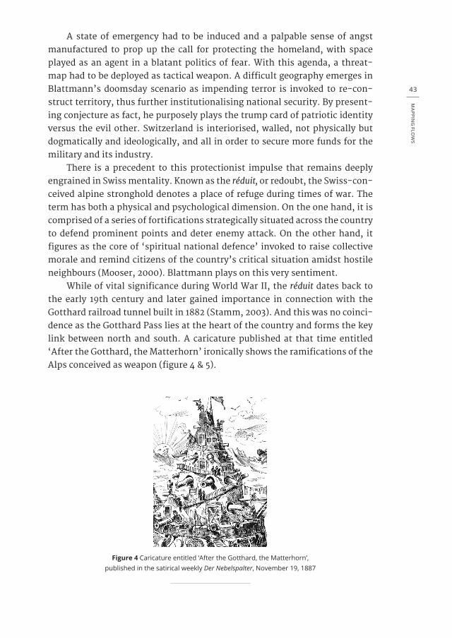
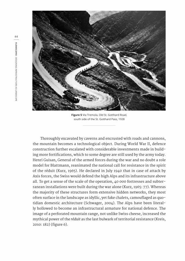
While of vital significance during World War II, the réduit dates back to the early 19th century and later gained importance in connection with the Gotthard railroad tunnel built in 1882 (Stamm, 2003). And this was no coinci-dence as the Gotthard Pass lies at the heart of the country and forms the key link between north and south. A caricature published at that time entitled ‘After the Gotthard, the Matterhorn’ ironically shows the ramifications of the Alps conceived as weapon (figure 4 & 5).
Figure 4 Caricature entitled ‘After the Gotthard, the Matterhorn’, published in the satirical weekly Der Nebelspalter, November 19, 1887
FLOW
SCAPES - D
ESIGN
ING
INFR
ASTRU
CTU
RE A
S LAN
DSC
APE
44
Figure 5 Via Tremola, Old St. Gotthard Road, south side of the St. Gotthard Pass, 1928
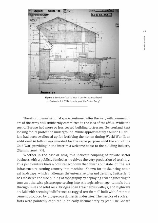
Thoroughly excavated by caverns and encrusted with roads and cannons, the mountain becomes a technological object. During World War II, defence construction further escalated with considerable investments made in build-ing more fortifications, which to some degree are still used by the army today. Henri Guisan, General of the armed forces during the war and no doubt a role model for Blattmann, reanimated the national call for resistance in the spirit of the réduit (Kurz, 1965). He declared in July 1940 that in case of attack by Axis forces, the Swiss would defend the high Alps and its infrastructure above all. To get a sense of the scale of the operation, 40 000 fortresses and subter-ranean installations were built during the war alone (Kurz, 1965: 77). Whereas the majority of these structures form extensive hidden networks, they most often surface in the landscape as idyllic, yet fake chalets, camouflaged as quo-tidian domestic architecture (Schwager, 2004). The Alps have been literal-ly hollowed to become an infrastructural armature for national defence. The image of a perforated mountain range, not unlike Swiss cheese, increased the mythical power of the réduit as the last bulwark of territorial resistance (Kreis, 2010: 182) (figure 6).
MA
PPING
FLOW
S
45
Figure 6 Section of World War II bunker camouflaged as Swiss chalet, 1944 (courtesy of the Swiss Army)
The effort to arm national space continued after the war, with command-ers of the army still stubbornly committed to the idea of the réduit. While the rest of Europe had more or less ceased building fortresses, Switzerland kept looking for its protection underground. While approximately a billion US dol-lars had been swallowed up for fortifying the nation during World War II, an additional 10 billion was invested for the same purpose until the end of the Cold War, providing in the interim a welcome boost to the building industry (Stamm, 2003: 77).
Whether in the past or now, this intricate coupling of private sector business with a publicly funded army drives the very production of territory. This joint venture fuels a political economy that churns out state-of-the-art infrastructure turning country into machine. Known for its daunting natu-ral landscape, which challenges the enterprise of grand designs, Switzerland has mastered the disciplining of topography by deploying civil engineering to turn an otherwise picturesque setting into strategic advantage: tunnels bore through miles of solid rock; bridges span treacherous valleys; and highways are laid with seeming indifference to rugged terrain – all built with first-rate cement produced by prosperous domestic industries. The heroics of such ef-forts were pointedly captured in an early documentary by Jean-Luc Godard
FLOW
SCAPES - D
ESIGN
ING
INFR
ASTRU
CTU
RE A
S LAN
DSC
APE
46
entitled Opération Béton released in 1958 – before Godard became the famed ‘Godard’ – that celebrates the construction of La Grande Dixence, a massive hydraulic dam built into the rocky landscape of the Alps. His voiceover ex-presses excitement about conquering topography and a sense of urgency as-sociated with this national cause.
To top off the overall operation, post-war legislation in 1963, fuelled by prevalent Cold War fears of a nuclear offensive on home soil, even dictates that all buildings must be equipped with a subterranean concrete shelter for every Swiss man and woman (Fuhrer & Wild, 2010; Aeberhard, 1983; Bach-mann & Grosjean, 1969). Constituting one of the biggest building projects implemented in the history of the country, this venture takes the concept of the réduit down to the smallest, most filigree scale to form a decentralised network of capsular space. Moreover, ‘fortress Switzerland’ as project works to merge civilian and military purpose to secure national protection. Moti-vated by this insular mentality, it becomes clear that Blattmann’s map is just a cog in the wheel of a more complex machine. By demonising surrounding countries, the map serves the battle cry for ever more infrastructure that, of course, enables Switzerland to function like a fine-tuned clockwork nation should.
4. GREATER SWITZERLANDIf Blattmann’s map seems outrageous, it was outdone by an even more
outlandish map published a few weeks later. Whereas the protectionist bid by Blattmann foresaw a walling of Switzerland, a subsequent initiative proposed by the right-wing Swiss People’s Party (SVP/UDC) envisioned instead an ex-pansionist course for the country. In place of a military cause, here diplomatic negotiation was enlisted – a Swiss asset if there ever was one. A motion was submitted to the Parliament on March 18, 2010 by Senate member Dominique Baettig and co-signed by 28 of his fellow party affiliates. The plan was driven by the desire for a ‘Greater Switzerland’ and commissioned the Swiss Nation-al Council to investigate the legislative steps required to achieve this objec-tive.9 Simply put, the appeal amounted to a coup as it concerned the annexa-tion of regions from neighbouring countries. Said takeover would seize parts of France, Germany, Austria, and Italy, thereby altering the familiar political geography of Europe. The arguments in favour of participating in Swiss wel-fare are hard to resist: a direct democracy, an affluent market economy, and low taxes. Polls taken in those respective territories showed an affirmative reaction by local populations.10 The message seemed obvious, everyone would love to be Swiss.
MA
PPING
FLOW
S
47
Known in his pastime as an avid hunter, Baettig made a name for himself in politics as a staunch conservative. His background includes involvement in right-wing radical activities and associated journals. He likes to see him-self as agitator or agent provocateur. In the context of the contentious Minaret Initiative, for example, he equated migrants with “territorially-foreign species of invasive insects” when provoking the Parliament to consider the economic consequences of uncontrolled immigration into Switzerland.11 Intervening in politics abroad, he even had the audacity in a speech in France to suggest that minarets are phallic symbols of male potency. He received accolades from a cheering crowd of extremists in a country where the Muslim issue is already explosive. Clearly, the ulterior motive was to attack what he considered an icon not just of religious but also of political power in the Islamic world. He was caught on camera at this event by Swiss TV, a bout of media exposure that only reinforced his position with supporters at home.12 What plainly func-tioned as propaganda ultimately served his later motion to gain a stronger foothold in Europe for the Helvetic Confederation through the appropriation of territory from neighbouring states.
Responses to Baettig’s proposition varied from applause to dismay, both nationally and internationally. Domestically, at the highest echelons of pow-er, an argument was made against disturbing friendly relations with European neighbours, as those relations had already been tested by recent disclosures of foreign deposits in Swiss banks made to evade taxes at home. To counter this argument, the SVP/UDC cited widespread discontent by inhabitants from bordering regions. Situated on the periphery of their respective nations, this presumably dispirited constituency, according to Baettig and his party, has been disenfranchised by their own governments. The case put forth was to appease these regions by assembling them as new cantons under the um-brella of Swiss democracy and, in effect, prompt their surreptitious defection from the European Union. Viewed by the Swiss conservatives with disdain, EU government officials continue to be portrayed as an elite classe politique operating top-down from their remote headquarters in Brussels, the very ar-gument made by Switzerland itself for not joining the EU. At stake is nothing less than the mobilization of sovereignty brought about by the annexation of territory.
This is a touchy issue with a sensitive history. The relationship between Switzerland and Europe has been marked by ambiguity both now and in the past. Although proudly autonomous, Switzerland is nevertheless tied to Eu-rope. The small Alpine country enjoys the best of both worlds by maintaining independence and cultivating select cross-border relations at the same time. Basically, it gets its cake and eats it too. But this works two ways, insofar as adjoining countries have always enjoyed a safe haven of courteous hospitali-ty coupled with gentlemanly discretion in financial matters. Maps of Europe
FLOW
SCAPES - D
ESIGN
ING
INFR
ASTRU
CTU
RE A
S LAN
DSC
APE
48
most often reveal this dual condition, with Switzerland depicted as either a blank hole or as privileged refuge. Whatever the case, to be situated in the middle proves to be an opportune place for manoeuvring, both politically and economically. This is certainly true for Switzerland in that it plays the role of strategic relay within a space of circulation. Here again, infrastructure is a crucial component in the business of routing and re-routing flows.
But these flows are not always visible as demonstrated by Switzerland’s part in World War II. Then, trade relations and territorial disposition, as we now know, went hand in hand with political diplomacy. The prevalent pic-ture painted during and after the war was that of a small country at the mer-cy of great powers – a classic David versus Goliath standoff. While figuring the réduit as key to defending Swiss independence might be reassuring even today, in reality accommodation, negotiation, and political savvy served as equally effective modes of keeping fascist aggression at bay. Yet, as advan-tageous as it was at the time for Switzerland to play strategic relay for finan-cial transactions, including loans and credit to Axis powers, the exposure of this very practice taints the image of the country’s neutrality. The so-called ‘Swiss miracle’ of coming out of the conflict unscathed is widely viewed today as a ‘Swiss malaise’ (Perrenoud, 2000: 26-27). It would seem that the busi-ness of give and take was crucial to national defence. Government authorities and industrial leaders acted, it is argued, more pragmatically than heroically when faced with the threat of invasion: industries supplied specialised prod-ucts and financial institutions offered the liquidity essential to the war ef-fort (Perrenoud, 2000: 28).13 To facilitate the movement of goods and money, things needed to be put in place and a complex apparatus was required, in-cluding everything from administrative procedures to logistical protocols and infrastructural systems that stretched far beyond national borders. Project ‘network Switzerland’ was furthered in the process.
Contrary to the réduit mentality behind Blattmann’s vision for a porcu-pine-like posture toward the outside, the move to extend political and eco-nomic tentacles into a larger arena reveals another attitude regarding territo-ry, one this time directed by circulation, movement, exchange, and so forth. This is what Baettig’s scheme banked on, for there are significant benefits to his expansionist dream. Take the State of Baden-Württemberg for example. As one of the most prosperous regions targeted in the venture, it performs as a German Silicon Valley and functions literally as the country’s economic motor, with elite universities and blue-chip company headquarters such as Porsche, Mercedes-Benz, Bosch, and SAP located there. The proposed incor-poration of the region into Greater Switzerland would yield a match made in heaven considering the parity of the work ethic between Swiss and Germans, a deeply engrained ethic founded on a prudent morality coupled with eco-nomic thrift as addressed by Max Weber in his early 20th century treatise The
MA
PPING
FLOW
S
49
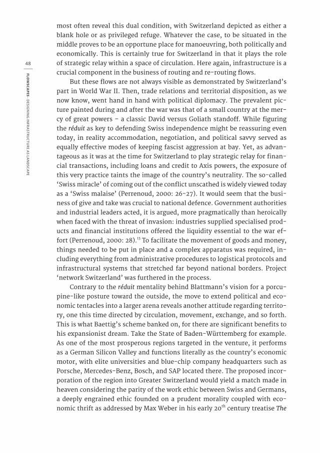
Protestant Ethic and the Spirit of Capitalism (Weber, 2011)). As a matter of fact, the territories of both countries are already integrated at least infrastructur-ally and commercially, forming a well-functioning transnational entity. But remember, Baden-Württemberg is only one piece of Baettig’s larger plan for a Greater Switzerland (figure 7).
Were his motion to be approved by all involved parties, including those from France, Austria, and Italy, Switzerland would gain an additional 17 mil-lion citizens and its territory would triple in size overnight. To all intents and purposes, this would give rise to a politically ratified metropolitan cluster, if not a megacity in the centre of Europe. Whereas current domestic planning efforts and academic studies are inclined to view Switzerland as a large urban conglomeration, most still treat the country as fixed in terms of sacrosanct borders. Conversely, research projects such as those by ETH Studio Basel and Avenir Suisse have begun to soften the edges of the nation and consider mergers forming between city regions on its periphery (Schneider & Eisinger, 2003; Diener et al., 2004). This very perspective of seeing Swiss urbanization leak beyond national borders was taken up in a landmark document entitled Spatial Concept Switzerland and ratified in 2012 that showed, for instance, the region of Ticino spilling into the agglomeration of Milan, that of Basel flowing out into the Rhine Valley, and that of Geneva extending well into French ter-ritory.14 Surprisingly, Baettig’s map was not far off the mark, for it seemed to anticipate the next logical step of a process already underway, one that chal-lenges the political make-up of Europe as mapped in terms of bounded sover-eign nations that are held in place by device of clearly drawn lines.
Figure 7 ‘La Grande Suisse’, foreseen expansion of Switzerland’s territory as proposed by the right-wing party, Le Temps, June 2010
FLOW
SCAPES - D
ESIGN
ING
INFR
ASTRU
CTU
RE A
S LAN
DSC
APE
50
5. ENTROPIC SWITZERLANDLooking back at two figments of cartographic imagination, Switzerland
seems to be faced with the incommensurable options of isolation or expan-sion: Blattmann is pitted against Baettig. Fantasy notwithstanding, the coun-try is in fact pursuing both routes. What seems like opposing ideologies ac-tually work in tandem to produce territory by taming space. Each plan relies on the provision of infrastructural networks to secure optimal channels for managing order. However, while each ideology aims for order, they unexpect-edly contribute to an entropic territorial condition. Against better judgment and counterintuitive to the will to discipline, more control creates more dis-order.
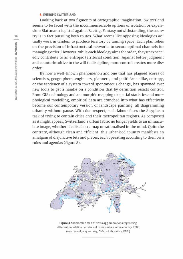
By now a well-known phenomenon and one that has plagued scores of scientists, geographers, engineers, planners, and politicians alike, entropy, or the tendency of a system toward spontaneous change, has spawned ever new tools to get a handle on a condition that by definition resists control. From GIS technology and anamorphic mapping to spatial statistics and mor-phological modelling, empirical data are crunched into what has effectively become our contemporary version of landscape painting, all diagramming urbanity without pause. With due respect, such labour faces the Sisyphean task of trying to contain cities and their metropolitan regions. As composed as it might appear, Switzerland’s urban fabric no longer yields to an immacu-late image, whether idealised on a map or rationalised in the mind. Quite the contrary, although clean and efficient, this urbanised country manifests an amalgam of disjunctive bits and pieces, each operating according to their own rules and agendas (figure 8).
Figure 8 Anamorphic map of Swiss agglomerations registering different population densities of communities in the country, 2000
(courtesy of Jacques Lévy, Chôros Laboratory, EPFL)
MA
PPING
FLOW
S
51
Though maps tend to homogenise whatever they address, the physical constitution of the territory at issue is comprised by a heterogeneous mix-ture of dense urban networks connected by endless conduits of infrastruc-ture, loose agglomerations lined with industrial and commercial strips, areas of little or no activity, land set aside for agriculture, restricted military com-pounds, and plenty of nature to go around, all shaped by the mechanics of political and economic interests. What results is a fractured space that never-theless functions as if by its own momentum, a diffuse arrangement not just of stuff, but also of regulations, standards, customs, and anything else needed to manage the operation of capitalising territory.
Switzerland’s federalist model of governance exacerbates this condi-tion, with over 2 700 constituent communities enjoying direct democratic representation. Everybody has a say. The distribution of power to localities is stamped directly into the land. Each community, for instance, devises its own zoning regulations that specify land-use in the spirit of the Charter of Ath-ens’s separation of functions, producing a spatial pixilation of sorts whereby the urban landscape is peppered with normalising codes ad infinitum. Though maps are the instrument of choice for translating normality into a geographic order, the resulting proliferation of regulation gives way to spatial cacoph-ony. This in turn requires even more elaborate administrative protocols for municipal officials who are more often than not overwhelmed by the task of controlling development. But this account is only from the bottom up. Top-down management of territory involving regional planning at both cantonal and federal levels is also at play, inevitably leading to conflict with communal ambitions. One example dates from 1958 when a bill was passed in a national referendum involving a constitutional amendment to give the green light to a new freeway system that by now stretches over 1800 km throughout the tiny nation (Heller & Volk, 1999). Add to this the recent trend of roundabouts that has altered the face of domestic transit, with thousands and thousands of traffic circles introduced as if overnight. Darling of engineers, these beloved technical objects are the subject of countless manuals that cite their efficien-cy in facilitating circulation. You never have to stop while driving around in circles (figure 9).
And, these are only a few examples of the regulatory frenzy that bom-bards territory at all scales. Disciplining space is the name of the game; dis-cipline normalises.
“Discipline, of course, analyses and breaks down; it breaks down individuals, places, time, movements, actions, and operations” (Foucoult, 2007: 56)
FLOW
SCAPES - D
ESIGN
ING
INFR
ASTRU
CTU
RE A
S LAN
DSC
APE
52
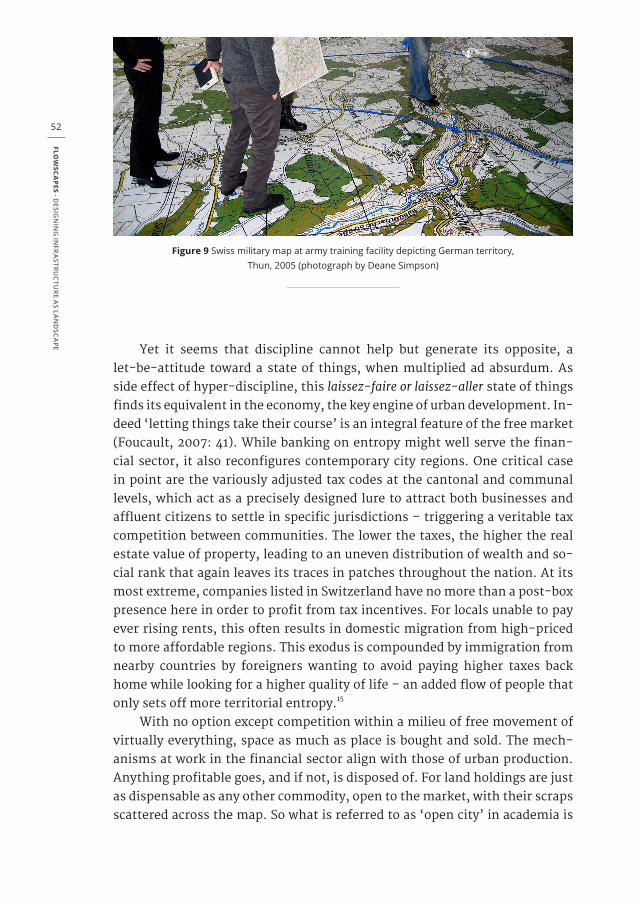
Figure 9 Swiss military map at army training facility depicting German territory, Thun, 2005 (photograph by Deane Simpson)
Yet it seems that discipline cannot help but generate its opposite, a let-be-attitude toward a state of things, when multiplied ad absurdum. As side effect of hyper-discipline, this laissez-faire or laissez-aller state of things finds its equivalent in the economy, the key engine of urban development. In-deed ‘letting things take their course’ is an integral feature of the free market (Foucault, 2007: 41). While banking on entropy might well serve the finan-cial sector, it also reconfigures contemporary city regions. One critical case in point are the variously adjusted tax codes at the cantonal and communal levels, which act as a precisely designed lure to attract both businesses and affluent citizens to settle in specific jurisdictions – triggering a veritable tax competition between communities. The lower the taxes, the higher the real estate value of property, leading to an uneven distribution of wealth and so-cial rank that again leaves its traces in patches throughout the nation. At its most extreme, companies listed in Switzerland have no more than a post-box presence here in order to profit from tax incentives. For locals unable to pay ever rising rents, this often results in domestic migration from high-priced to more affordable regions. This exodus is compounded by immigration from nearby countries by foreigners wanting to avoid paying higher taxes back home while looking for a higher quality of life – an added flow of people that only sets off more territorial entropy.15
With no option except competition within a milieu of free movement of virtually everything, space as much as place is bought and sold. The mech-anisms at work in the financial sector align with those of urban production. Anything profitable goes, and if not, is disposed of. For land holdings are just as dispensable as any other commodity, open to the market, with their scraps scattered across the map. So what is referred to as ‘open city’ in academia is
MA
PPING
FLOW
S
53
not necessarily an ideal setting for coexistence, for it is most often embraced by developers and investors as a pretext for anything goes (Christiaanse et al. 2009). Over and above hopeful thinking as so often manifested in pretty ren-derings, freedom of circulation rules as a technology of power in our current political economy.
At work here are modes of urban production that are not exclusive to Switzerland, as this itinerant economic geography knows no borders. With free circulation as its core principle, the urbanisation of territory gives rise to a transnational mentality of governance, a form of ‘governmentality’ to bor-row an expression of Michel Foucault, that is formed by a nexus where profit and power trump space (Foucault, 2007: 108).[16] Yet, the pace of de-territo-rialisation and the appetite for unhindered development at all costs demands another frame of mind than those that bank on discipline alone. We need to enter the clockwork itself, operating from the middle-out and reversing its prescribed course if necessary. This might require a modified political econ-omy that alters its view of territory as a neutral backdrop left submissive to forces that act upon it. Instead, territory can be viewed as active, as a dynamic network of actors in and of itself. This would mean that territory could take the lead and act to redirect political economy toward a more constructive mind-set, where the physical milieu is empowered and viewed as an equal delegate at the negotiating table. Then, the map could no longer master territory, nor would territory be scattered around as passive victim by the whims of special interests. Rather, territory would be re-territorialised on interests inherent to territory itself, as vital resource and source of cultural identity, and not just raw material awaiting development. But this may require a change of di-rection, if not a flight of imagination that goes against the flow and counter clockwise to taken-for-granted cycles of capital.
FLOW
SCAPES - D
ESIGN
ING
INFR
ASTRU
CTU
RE A
S LAN
DSC
APE
54
ENDNOTES
1 Excerpt of Gaddafi’s speech at the 35th G8 Summit in Abruzzo, Italy that took place in July 2009, see
Samira Shackle, ‘Colonel Gaddafi: “mad dog”?’, New Statesman, February 25, 2010.
2 “In that Empire, the cartographer’s art achieved such a degree of perfection that the map of a sin-
gle province occupied an entire city, and the map of the Empire, an entire province. In time, these
vast maps were no longer sufficient. The guild of cartographers created a map of the Empire, which
perfectly coincided with the Empire itself. But succeeding generations, with diminished interest in
the study of cartography, believed that this immense map was of no use, and not impiously, they
abandoned it to the inclemency of the sun and numerous winters. In the deserts of the west ruined
fragments of the map survive, inhabited by animals and beggars; in all the country there is no other
relic of the geographical disciplines.” Jorge Luis Borges (1935) Historia universal de la infamia ‘Etceteras’,
trans. Norman Thomas de Giovanni, A Universal History of Infamy (1975), London: Penguin Books, pp
28-29.
3 “The territory no longer precedes the map, nor survives it. Henceforth, it is the map that precedes the
territory – PRECESSION OF SIMULACRA – it is the map that engenders the territory and if we were to
revive the fable today, it would be the territory whose shreds are slowly rotting across the map. It is
the real, and not the map, whose vestiges subsist here and there, in the deserts which are no longer
those of the Empire, but our own.” Jean Baudrillard (1981) Simulacres et Simulation, ‘The Precession of
Simulacra’, in: Simulations, trans. Paul Foss, Paul Patton, and Philip Beitchman, New York: Semiotexte,
p. 2.
4 André Blattmann interviewed by Patrick Feuz and Daniel Foppa, “Denkbar wäre ein Pikett-WK”, Tag-
es-Anzeiger, March 10, 2010.
5 Patrick Feuz, “Achtung, eine A-Bombe! Armeechef warnt vor Nuklearangriff in der Schweiz”, Tages-An-
zeiger, March 17, 2010.
6 “Armee Chef Blattmanns kuriose Karte”, Tages-Anzeiger, March 15, 2010.
7 See Max Frisch (1989) Schweiz ohne Armee? Ein Palaver, Zurich: Limmat Verlag, written on the occasion
of the national referendum to abolish the Swiss Army and support a comprehensive politics of peace
in 1989 – with 35,6% of the voters in favor of the proposition.
8 Op. cit., Tages-Anzeiger, March 10, 2010.
9 Yves Petignat, “Boutefeu, l’UDC est prête à accueillir Aoste ou la Savoie”, Le Temps, June 10, 2010.
10 “Umfrage: Nachbarregionen wollen der Schweiz beitreten”, Die Weltwoche, July 22, 2010.
11 Heidi Gmür, “SVP-Nationalrat vergleicht Ausländer mit Insekten”, NZZ am Sonntag, October 18, 2009.
12 Hans Stutz, “Es ist mir eine Ehre”, Die Wochenzeitung (WOZ), December 10, 2009.
13 See also the report by the Independent Commission of Experts Switzerland – Second World War
(2002) Die Schweiz, der Nationalsozialismus und der Zweite Weltkrieg, also known as the Bergier Report,
Zurich: Pendo Verlag.
14 Raumkonzept Schweiz, published by the Swiss Confederation (Berne: Schweizerischer Bundesrat,
2012).
15 For more on the uneven distribution of wealth in Switzerland see Philipp Löpfe and Werner Vontobel,
‘Die Reichen ins Ghetto’, in Aufruhr im Paradies: Die Neue Zuwanderung Spaltet die Schweiz (Zurich: Orell
Füssli Verlag, 2011), 40-59.
16 Foucault defines the term as follows: “By ‘governmentality’ I understand the ensemble formed by
institutions, procedures, analyses and reflections, calculations, and tactics that allow the exercise of
this very specific, albeit very complex, power that has the population as its target, political economy
as its major form of knowledge, and apparatuses of security as its essential technical instrument.”
MA
PPING
FLOW
S
55
REFERENCES
Aeberhard, R. (1983) Vom Luftschutz zum Zivilschutz. Solothurn, Verlag Vogt-Schild
Bachmann, A. & G. Grosjean (1969) Zivilverteidigung, Eidgenössische Justiz- und Polizeidepartement.
Aarau, Miles-Verlag
Bundesamt für Statistik Schweiz (2013) Kulturlandverlust zu Gunsten von Siedlung und Wald: Bodennutzung-
swandel in m2 pro Sekunde (2000, revised 2013)
Christiaanse, K. et al. (2009) Open City: Designing Coexistence. Amsterdam, Sun Architecture
Diener, R., J. Herzog, M. Meili, P. de Meuron & Ch. Schmid (2004) Switzerland – An Urban Portrait. Basel,
Birkhäuser Verlag
Foucault, M. (2004/2007) Security, Territory, Population. Lectures at the Collège de France 1977-1978. New
York, Palgrave Macmillan
Frisch, M. (1989) Schweiz ohne Armee? Ein Palaver. Zurich, Limmat Verlag
Fuhrer, H.R. & M. Wild (2010) Alle roten Pfeile kommen aus Osten – zu Recht? Das Bild und die Bedrohung der
Schweiz 1945-1966 im Licht östlicher Archive. Baden, Verlag für Kultur und Geschichte
Gugerli, D. (1998) ‘Politics on the Topographer’s Table: The Helvetic Triangulation of Cartography, Politics,
and Representation’, in: T. Lenoir (ed.) Inscribing Science: Scientific Texts and the Materiality of Communi-
cation. Stanford, CA, Stanford University Press, pp 96-97
Gugerli, D. (1999) ‘Der Hirtenknabe, der General und die Karte’, in: WerkstattGeschichte nr. 23. Essen,
Klartext Verlag, pp 53-73
Gugerli, D. & D. Speich (2002) Topografien der Nation. Politik, kartografische Ordnung und Landschaft im 19.
Jahrhundert. Zurich, Chronos Verlag
Heller, M. & A. Volk (1999) Die Schweizer Autobahn. Zurich, Museum für Gestaltung
Hermann, C. (2010) ‘Schweizer Eisenbahn- und Bergidylle im Privatgarten’, in: E. Bierende et al. (eds.)
Helvetische Merkwürdigkeiten. Bern, Peter Lang, pp 19-39
Kreis, G. (2010) Schweizer Erinnerungsorte. Zurich, Verlag Neue Zürcher Zeitung
Kurz, H.R. (1965) General Henri Guisan. Zurich, Musterschmidt Verlag
Löpfe, Ph. & W. Vontobel (2011) Aufruhr im Paradies: Die Neue Zuwanderung Spaltet die Schweiz. Zurich,
Orell Füssli Verlag
Mooser, J. (2000) ‘Spiritual National Defence in the 1930s: Swiss Political Culture between the Wars’, in: G.
Kreis (ed.) Switzerland and the Second World War. London: Frank Cass, pp. 236-260
Perrenoud, M (2000) ‘Foreign Trade and Swiss Politics, 1939-45’, in: G. Kreis (ed.) Switzerland and the Sec-
ond World War. London, Frank Cass
Schneider, M. & A. Eisinger (2003) Stadtland Schweiz, an Avenir Suisse publication. Basel, Birkhäuser Ver-
lag
Schwager, Ch. (2004) Falsche Chalets. Zurich, Edition Patrick Frey
Stamm, P. (2003) ‘Farewell from the Réduit: The long walk’, in: Bunker: Unloaded. Lucerne, Edizioni Per-
iferia, p. 85 (originally published in 1998)
Weber, M. (2011) Die protestantische Ethik und der Geist des Kapitalismus.Munich, Verlag C. H. Beck (origi-
nally published in 1905)
FLOW
SCAPES - D
ESIGN
ING
INFR
ASTRU
CTU
RE A
S LAN
DSC
APE
56
Related Documents