Mapping Critical Minerals from the Sky Renew Your Membership Today! VOL. 31, NO. 11 | NOVEMBER 2021

Welcome message from author
This document is posted to help you gain knowledge. Please leave a comment to let me know what you think about it! Share it to your friends and learn new things together.
Transcript
Mapping Critical Minerals from the Sky
Renew Your Membership Today!
VOL. 31, NO. 11 | NOVEMBER 2021
|
CALENDAR2022
BUY ONLINE } rock.geosociety.org/storetoll‑free 1.800.472.1988 | +1.303.357.1000, option 3 | [email protected]
BUY ONLINE } rock.geosociety.org/store
ONLY
$ 9.95
SCIENCE4 Mapping Critical Minerals from the Sky Anjana K. Shah et al.
Cover: Perspective view of airborne radiometric thorium draped over shaded relief lidar elevation (hillshade). Areas where Ti-Zr–rare earth element (REE)- heavy mineral sands are concentrated appear as tho-rium highs (yellows). Top: The airplane that collected the data. Inset: Example of Holocene Ti-Zr-REE sand concentrations. Airplane photo: James W. Bursey, Terraquest, Inc. Sands photo: Anjana K. Shah, USGS. For the related article, see pages 4–10.
GSA NEWS11 GSA Connects 2022: Call for
Field Trip, Short Course, and Technical Session Proposals
12 Upcoming Award Deadlines
13 GSAScientificDivisionAwards
14 GSA Webinar Library
16 Research Grants
20 Thank You 2021 GeoCorps™ America Supporters
22 Thank You 2021 National Park Service Scientists in Parks Supporters
26 190th Anniversary of the Birth of Eduard Suess, the Father of Modern Global Geology
30 Penrose Conference Announcement: The Geological Fingerprints of Slow Earthquakes
32 2021–2022 GSA-USGS Congressional Science Fellow Announced
33 Why GSA Membership is Important to Me
34 GSA Foundation Update
36 Geoscience Jobs & Opportunities
39 2022 GSA Section Meetings
GSA TODAY (ISSN 1052-5173 USPS 0456-530) prints news and information for more than 22,000 GSA member readers and subscribing libraries, with 11 monthly issues (March-April is a combined issue). GSA TODAY is published by The Geological Society of America® Inc. (GSA) with offices at 3300 Penrose Place, Boulder, Colorado, USA, and a mail-ing address of P.O. Box 9140, Boulder, CO 80301-9140, USA. GSA provides this and other forums for the presentation of diverse opinions and positions by scientists worldwide, regardless of race, citizenship, gender, sexual orientation, religion, or political viewpoint. Opinions presented in this publication do not reflect official positions of the Society.
© 2021 The Geological Society of America Inc. All rights reserved. Copyright not claimed on content prepared wholly by U.S. government employees within the scope of their employment. Individual scientists are hereby granted permission, without fees or request to GSA, to use a single figure, table, and/or brief paragraph of text in subsequent work and to make/print unlimited copies of items in GSA TODAY for noncommercial use in classrooms to further education and science. In addition, an author has the right to use his or her article or a portion of the article in a thesis or dissertation without requesting permission from GSA, provided the bibliographic citation and the GSA copyright credit line are given on the appropriate pages. For any other use, contact [email protected].
Subscriptions: GSA members: Contact GSA Sales & Service, +1-888-443-4472; +1-303-357-1000 option 3; [email protected] for information and/or to place a claim for non-receipt or damaged copies. Nonmembers and institutions: GSA TODAY is US$108/yr; to subscribe, or for claims for non-receipt and damaged copies, contact [email protected]. Claims are honored for one year; please allow sufficient delivery time for overseas copies. Peri-odicals postage paid at Boulder, Colorado, USA, and at additional mailing offices. Postmaster: Send address changes to GSA Sales & Service, P.O. Box 9140, Boulder, CO 80301-9140.
GSA TODAY STAFF
Executive Director and Publisher: Vicki S. McConnell
Science Editors: Mihai N. Ducea, University of Arizona, Dept. of Geosciences, Gould-Simpson Building, 1040 E 4th Street, Tucson, Arizona 85721, USA, [email protected] .edu; Peter Copeland, University of Houston, Department of Earth and Atmospheric Sciences, Science & Research Building 1, 3507 Cullen Blvd., Room 314, Houston, Texas 77204-5008, USA, [email protected].
Managing Editor: Kristen “Kea” Giles, [email protected], [email protected]
Graphics Production: Emily Levine, [email protected]
Advertising Manager: Ann Crawford, +1-800-472-1988 ext. 1053; +1-303-357-1053; Fax: +1-303-357-1070; [email protected]
GSA Online: www.geosociety.org GSA TODAY: www.geosociety.org/gsatoday
Printed in the USA using pure soy inks.
NOVEMBER 2021 | VOLUME 31, NUMBER 11
Erratum: Due to editorial error, last month’s cover caption was incorrect. The caption was in conjunction with the science article, “The origin and tectonic significance of the Basin and Range–Rio Grande rift boundary in southern New Mexico, USA,” by Jason W. Ricketts and colleagues. The correct caption for the cover is “Photo of the basin and range topography that is typical across the Basin and Range–Rio Grande rift boundary in southern New Mexico, USA. View is from the Chiricahua Mountains, Arizona, looking east toward the Peloncillo Mountains, New Mexico, in the background. Photo by Jason W. Ricketts.”
Anjana K. Shah*, U.S. Geological Survey, DFC MS 973, P.O. Box 25046, Denver, Colorado 80225, USA, [email protected], ORCID: https://orcid.org/0000-0002-3198-081X; Robert H. Morrow IV, South Carolina Dept. of Natural Resources Geological Survey, 5 Geology Road, Columbia, South Carolina 29212, USA, [email protected], ORCID: https://orcid.org/0000-0001-5282-2389; Michael D. Pace, U.S. Geological Survey, DFC MS 973, P.O. Box 25046, Denver, Colorado 80225, USA, [email protected], ORCID: https://orcid.org/0000 -0003-2770-5724; M. Scott Harris, 202 Calhoun Street, College of Charleston, Charleston, South Carolina 29412, USA, [email protected], ORCID: https://orcid.org/0000-0002-9220-788X; and William R. Doar III, South Carolina Dept. of Natural Resources Geological Survey, 217 Ft. Johnson Road, Columbia, South Carolina 29412, USA, [email protected], ORCID: https://orcid.org/0000-0002-9895-8422
ABSTRACTCritical mineral resources titanium, zir-
conium, and rare earth elements occur in placer deposits over vast parts of the U.S. Atlantic Coastal Plain. Key questions regarding provenance, pathways of miner-als to deposit sites, and relations to geologic features remain unexplained. As part of a national effort to collect data over regions prospective for critical minerals, the first public high-resolution aeroradiometric sur-vey over the U.S. Atlantic Coastal Plain was conducted over Quaternary sediments in South Carolina. The new data provide an unprecedented view of potential deposits by imaging Th-bearing minerals in the heavy mineral assemblage. Sand ridges show the highest radiometric Th values with local-ized, linear anomalies, especially along the shoreface and in areas reworked by multiple processes and/or during multiple episodes. Estuarine areas with finer-grained sedi-ments show lower, distributed Th anoma-lies. Th values averaged over geologic unit areas are similar for both environments, suggesting that heavy minerals are present but have not been locally concentrated in the lower-energy estuarine environments. Radiometric K highlights immature miner-als such as mica and potassium feldspar. K is elevated within shallow sediments younger than ca. 130 ka, an attribute that persists in regional data from northern South Carolina to northern Florida. Both K and Th are elevated over the floodplains of the Santee River and other rivers with head-waters in the igneous and metamorphic Piedmont Terrane. The persistence of K
anomalies for distances of more than 100 km from the Santee River floodplain sug-gests that heavy minerals are delivered from the Piedmont to offshore areas by major rivers, transported along the coast by the longshore current, and redeposited onshore by marine processes.
INTRODUCTIONTechnologies ranging from advanced
electronics to renewable energy and medi-cal devices depend increasingly on miner-als considered “critical”; i.e., materials that are essential for the economy and its func-tions, but for which there is a risk of supply disruption (National Research Council, 2008; McCullough and Nassar, 2017; Schulz et al., 2017). The need for better knowledge of domestic critical mineral resources has resulted in funding for data collection over areas prospective for critical mineral depos-its, including 19 new airborne magnetic-radiometric surveys contracted through the U.S. Geological Survey since 2019 (Day et al., 2019; Earth MRI Acquisitions Viewer: https://ngmdb.usgs.gov/emri/#3/, accessed Feb. 2021). These new data are helping researchers address basic questions about critical mineral deposits such as ore gen-esis processes and exploration approaches; they can also have applications to other fields. As part of a multidisciplinary effort addressing mineral resource and earthquake hazard studies, an airborne radiometric and magnetic survey was flown over Lower Coastal Plain sediments near Charleston, South Carolina, USA, in 2019. The targets were potential critical mineral
placer deposits and subsurface faults of the Charleston seismic zone (Shah, 2020).
Placer deposits containing critical miner-als titanium (Ti; used for aircraft, medical devices, and pigments), zirconium (Zr; used in ceramics, fiber-optic components, and geothermal energy systems), and rare earth elements (REEs; used in batteries, super-magnets, solar and wind energy systems, and other advanced technology) are docu-mented in every continent except Antarctica. They currently supply 68% and 100% of global Ti and Zr, respectively (Jones et al., 2017; Woodruff et al., 2017). Prior to the 1960s they were also a primary source of REEs, but today carbonatite and ion-adsorp-tion clays are generally favored, probably because they involve reduced handling of thorium (Long et al., 2010; Mudd and Jowitt, 2016). Placer deposits have been mined for decades in the U.S. Atlantic Coastal Plain, where the potential resource area is vast, extending from southern New Jersey to northern Florida and Alabama; mining is currently active in Georgia and Florida (Force, 1991; Grosz and Schruben, 1994; Van Gosen et al., 2014; Berquist et al., 2015; Woodruff et al., 2017).
Also referred to as heavy-mineral sand deposits, placer deposits form when water and wind concentrate unconsolidated sedi-ments according to density, size, and shape. Minerals such as ilmenite and rutile (con-taining Ti), monazite and xenotime (con-taining REEs), and zircon (containing Zr) are relatively dense and typically become co-located when sediments are sorted through the reworking and winnowing of
Mapping Critical Minerals from the Sky
GSA Today, v. 31, https://doi.org/10.1130/GSATG512A.1. CC-BY-NC.
*Corresponding author.
4 GSA Today | November 2021
SandsClays and mudAlluvial sediment
A
LakeMarion
LakeMoultrie
Charleston
Santee Dam
N
B
N
AirborneSurvey Area
Holocene (H)
Wando (Wd; 70-130)Ten Mile Hill (TM; 200-240)Ladson (Ld; 240-730)Penholoway (P; 730-970)
Silver Bluff Beds (SB; 33-85)
Explana�on (ages in kyr)
Penholoway or Ladson
Waccamaw (W; ~1200)Okefenokee (1600)NeogenePaleogeneAr�ficial fill ordisturbed groundPhosphate spoil
80°30ʹW 80°W 79°30ʹW
80°30ʹW 80°W 79°30ʹW
32°3
0ʹN
33°N
33°3
0ʹN
32°3
0ʹN
33°N
33°3
0ʹN
less dense grains (Force, 1991). This depen-dence on physical processes makes mining and remediation relatively simple: mineral separation is conducted using density, mag-netic, or electrical methods, allowing waste, which consists primarily of lighter sands such as quartz, to be safely returned to mine pits (Van Gosen et al., 2014).
Several studies have shown that radiomet-ric methods can directly image shallow Ti-Zr-REE–heavy mineral sand concentra-tions due to the natural radioactivity of mon-azite, an REE-phosphate mineral containing small amounts of Th and U (Mahdavi, 1964; Robson and Sampath, 1977). Early airborne surveys used scintillation to measure the total gamma ray count (Force et al., 1982; Grosz, 1983; Mudge and Teakle, 2003). In subsequent years, airborne gamma spec-trometry methods were developed, allowing the distinction of signals due to K, Th, and U (International Atomic Energy Agency, 2003; Duval et al., 2005). In most of the United States, gamma spectrometry surveys are currently limited by coarse line spacing (1.6–10 km) but do show broad regions in the southeastern U.S. where Ti-Zr-REE deposits are prospective (Grosz et al., 1989; Shah et al., 2017).
The 2019 South Carolina survey, flown with modern equipment and 400-m flight line spacing, represents the first high-reso-lution public aeroradiometric survey over U.S. Atlantic Coastal Plain sediments. Coverage over 12,000 km2 with a footprint of 100–200 m provides data1 at a scale not feasible through drilling campaigns. The survey allows new, basic questions regard-ing the following to be addressed: (1) the geologic and geomorphologic features asso-ciated with placer deposits; (2) the corre-sponding geologic controls on formation; and (3) the provenance, dominant delivery pathways, and impacts on composition of the heavy mineral assemblage.
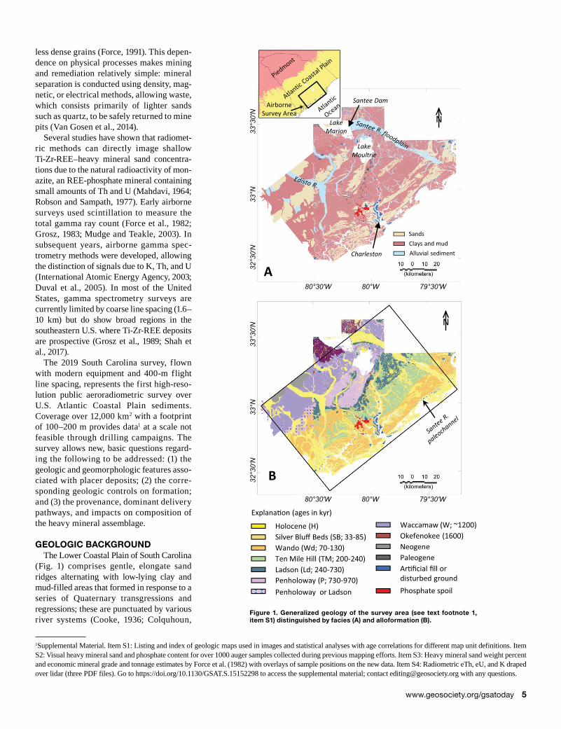
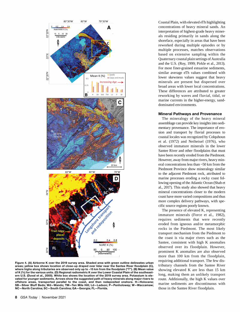
GEOLOGIC BACKGROUNDThe Lower Coastal Plain of South Carolina
(Fig. 1) comprises gentle, elongate sand ridges alternating with low-lying clay and mud-filled areas that formed in response to a series of Quaternary transgressions and regressions; these are punctuated by various river systems (Cooke, 1936; Colquhoun,
1Supplemental Material. Item S1: Listing and index of geologic maps used in images and statistical analyses with age correlations for different map unit definitions. Item S2: Visual heavy mineral sand and phosphate content for over 1000 auger samples collected during previous mapping efforts. Item S3: Heavy mineral sand weight percent and economic mineral grade and tonnage estimates by Force et al. (1982) with overlays of sample positions on the new data. Item S4: Radiometric eTh, eU, and K draped over lidar (three PDF files). Go to https://doi.org/10.1130/GSAT.S.15152298 to access the supplemental material; contact [email protected] with any questions.
Figure 1. Generalized geology of the survey area (see text footnote 1, item S1) distinguished by facies (A) and alloformation (B).
www.geosociety.org/gsatoday 5
1969; Doar and Kendall, 2014). Within the survey area, detailed geologic mapping and geochronological studies (see footnote 1, item S1) defined a series of Quaternary allo-formations that lie unconformably upon Neogene and Paleogene sediments. Most riv-ers in the study area drain from upland areas within the Atlantic Coastal Plain. The pri-mary exception is the Santee River, with headwaters originating in the Piedmont and traversing metamorphic and igneous ter-ranes for more than 100 km. The wide flood-plain of the Santee River is now exposed downriver of the 1941 Santee dam.
Heavy mineral sands, eroded from the neighboring metamorphic and igneous Piedmont Province, have been observed throughout the study area via auger samples collected by R. Weems, E. Force, and others (see footnote 1, items S2 and S3). These stud-ies found heavy mineral concentrations from 0% to more than 25% in layers up to several meters thick within Quaternary sediments. They contain ilmenite, epidote, and silli-manite with smaller amounts of rutile, monazite, leucoxene, and other minerals.
Aeroradioactivity total count surveys were flown in the study area with 1.6-km line spacing during the 1960s and early 1970s. Using these data to guide ground gamma spectrometry measurements and sample mineralogical analyses, Force et al. (1982) found direct correlations between radiometric Th and heavy mineral concen-trations, attributable to Th in monazite. Radiometric K correlated well with potas-sium feldspars and micas, which are consid-ered immature because leaching of potas-sium typically leads to alteration. They estimated grades of economic Ti-Zr-REE minerals as high as 2% and tonnage up to 70,000 metric tons at some locales (see footnote 1, item S3). They also found the mineralogy varies locally, and some heavy mineral concentrations contained large amounts of immature minerals with little economic value.
METHODSThe 2019 airborne magnetic and radiomet-
ric data were collected over a 134 km × 90 km area surrounding the city of Charleston, South Carolina, by contract for the U.S. Geological Survey (Figs. 2–4). This method provides sta-tistical estimates of K, Th, and U concentra-tions within the upper 1 m of the surface and several hundred meters in each horizontal direction (International Atomic Energy Agency, 2003). Th and U involve multiple
decay series, so measurements are typically referred to as equivalent uranium (eU) and thorium (eTh). The surveys were flown along NW-SE traverses at a nominal height of 100 m above ground, although areas above the city of Charleston were flown at >300 m above ground as per safety regulations. Data and details regarding contractor processing are provided by Shah (2020).
Previous geologic maps (see footnote 1, item S1) (Fig. 1) were used to calculate basic statistical measures (mean, median, stan-dard deviation, and skewness) for K and eTh over the total area of various geologic alloformations and sediment facies. For consistency between map units, we restricted the statistical calculations to the subset of the survey area mapped by Weems et al. (2014). Lidar elevation shaded relief maps (South Carolina lidar data: https://www.dnr.sc.gov/GIS/lidar.html, accessed Feb. 2020) were used to examine the geo-morphologic context of the airborne data. For ground truth, we used previously pub-lished visual estimates of heavy mineral content from more than 1000 auger samples (see footnote 1, item S2) and detailed miner-alogical analyses on several dozen samples collected over high total count anomalies, including weight percent heavy minerals and mineralogy (see footnote 1, item S3).
RESULTS
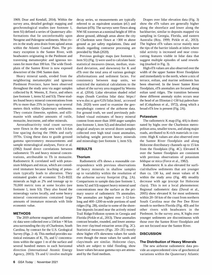
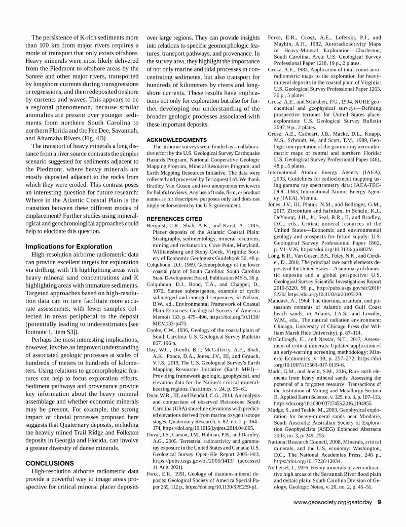
ThoriumRadiometric eTh shows a reasonable cor-
respondence with previous observations of heavy minerals in shallow samples up to variability within the resolution of the airborne survey footprint (Fig. 2A). Comparisons to sample data (see footnote 1, items S2 and S3) support heavy mineral sand concentrations near the surface as the pri-mary source of radiometric Th anomalies. The anomalies are highest over 3–12-km-long and 400–1200-m-wide portions of sand ridges (Fig. 2B), similar to some of the shore-line deposits located near the actively mined Trail Ridge/Folkston system in Georgia and Florida (Pirkle et al., 2013). These anomalies contrast broader, rounded, and lower anoma-lies over clay/mud estuarine areas (Fig. 2C). Statistical measures (Figs. 2D–2E) mostly show higher eTh skewness values for sands even though the mean values for sands and clays/muds are similar. Holocene clays, which are subject to tidal flooding, show lower values because gamma rays are attenu-ated by the fluid medium.
Drapes over lidar elevation data (Fig. 3) show the eTh values are generally higher along the shoreface and lower along the backbarrier, similar to deposits mapped via sampling in Georgia, Florida, and eastern Australia (Roy, 1999; Pirkle et al., 2013). The highest eTh values occur mainly near the tips of the barrier islands at inlets where tidal activity is increased and near cross-cutting features visible in lidar data that suggest multiple episodes of sand rework-ing (marked in Fig. 3).
High eTh values are also observed over the width of the upper Santee River floodplain and immediately to the north, where a mix of terrace, eolian, and marine sediments has been observed. In the lower Santee River floodplain, eTh anomalies are focused along eolian sand ridges. The transition between these different anomaly styles occurs near the head of an Illinoian (>130 ka) paleochan-nel (Colquhoun et al., 1972), along which a broad eTh low is present (Fig. 2A).
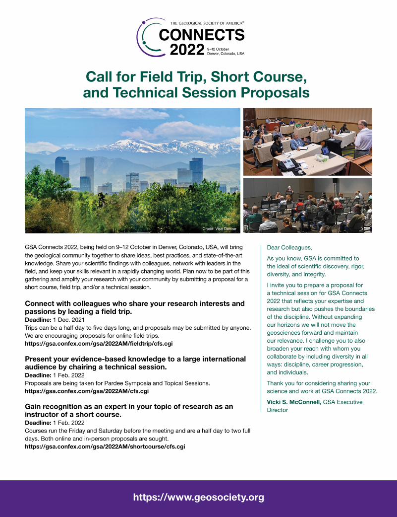
PotassiumThe radiometric K map (Fig. 4A) is domi-
nated by highs over the Charleston metro-politan area, smaller towns, and along major roads, attributed to K-rich materials in con-crete. High K values are also observed over the Santee River f loodplain and along Holocene distributary channels up to 15 km from the floodplain (Fig. 4C). Elevated K over the Santee floodplain are consistent with previous observations of potassium feldspar or mica (Force et al., 1982).
Radiometric K is also elevated for surfi-cial/shallow sediments that are younger than ca. 130 ka, and mean values of K within the study area (Fig. 4B) steadily decrease with age (except for Holocene clays). This is not a local phenomenon: Regional radiometric data (Duval et al., 2005) show elevated K for most sediments within 20–50 km of the coast from northern South Carolina near the Pee Dee River mouth to northern Florida (Fig. 4D) and for other rivers with headwaters in the Piedmont. In the survey area, K highs over younger sediments are discontinuous with those over the Santee River floodplain and are not focused near the Santee River.
DISCUSSION
The Distribution of Heavy MineralsThe new airborne radiometric data pro-
vide an unprecedented view of geochemical variations within the Quaternary Atlantic
6 GSA Today | November 2021
Santee Riverfloodplain
A
3B
3A
D-E
N
C
BN
N
D Increasing Age Increasing AgeE
Mean Th (ppm) Th Skewness
Detailedgeologic mapsunavailable
Detailedgeologic mapsunavailable
80°30ʹW 80°W 79°30ʹW
32°3
0ʹN
33°N
3
3°30
ʹN
80°30ʹW 80°W 79°30ʹW
80°30ʹW 80°W 79°30ʹW
32°3
0ʹN
33°N
33°3
0ʹN
32°3
0ʹN
33°N
33°3
0ʹN
A
10 km
M
M
+33°N79°45’W
N
M
B10 km
+32°40’N80°20W
N
M
0 2 4 6 8 10
Radiometric eTh (ppm)
Figure 2. (A) Airborne eTh over the 2019 survey area and approximate heavy mineral percentages (circles) from visual observations of auger samples (see text footnote 1, item S2); green box shows area used for statistical calculations (D and E); yellow boxes show loca-tions of close-ups in Figure 3. Gray dashed lines show the location of a buried paleochannel. (B–C) Airborne eTh for sands only (B) and clays/muds only (C). (D) Mean and (E) skewness values of eTh (parts per million [ppm]) for the various geologic units. H—Holocene; SB—Silver Bluff Beds; Wd—Wando; TM—Ten Mile Hill; Ld—Ladson; P—Penholoway; W—Waccamaw.
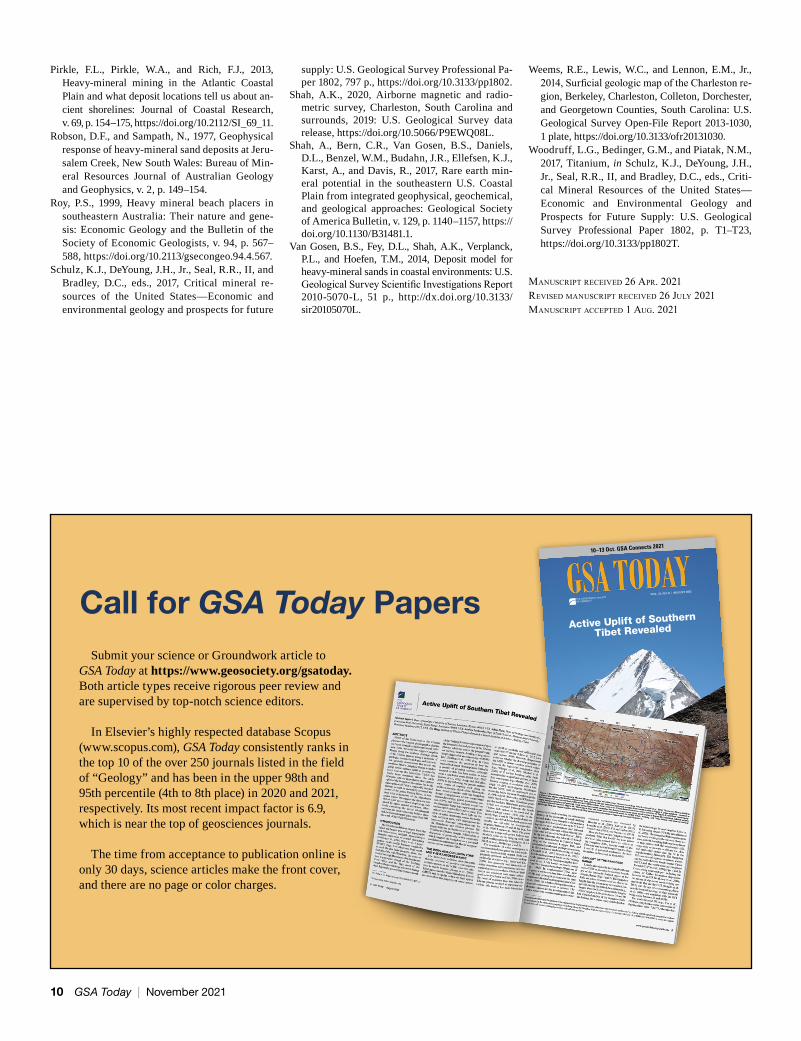
Figure 3. Close-ups of eTh draped over a lidar elevation shaded relief map (see text footnote 1, item S4) north (A) and south (B) of Charles-ton. eTh highs are often located along the shoreface and near streams or inlets. Highest values occur near areas marked “M” that expe-rienced multiple episodes of reworking by marine processes.
www.geosociety.org/gsatoday 7
C
A
N
+33°10’N79°45’W
T
TT
TT
10 km
N
NCSC
GA
FL
Trail ridgeplacer
deposits
D
N
Increasing Age
Mean K (%)
B
32°3
0ʹN
33
°N
3
3°30
ʹN
80°30ʹW 80°W 79°30ʹW
30°N
32°N
34
°N
82°W 80°W 78°W
C
Coastal Plain, with elevated eTh highlighting concentrations of heavy mineral sands. An interpretation of highest-grade heavy miner-als residing primarily in sands along the shoreface, especially in areas that have been reworked during multiple episodes or by multiple processes, matches observations based on extensive sampling within the Quaternary coastal plain settings of Australia and the U.S. (Roy, 1999; Pirkle et al., 2013). For most finer-grained estuarine sediments, similar average eTh values combined with lower skewness values suggest that heavy minerals are present but dispersed over broad areas with lower local concentrations. These differences are attributed to greater reworking by waves and f luvial, tidal, or marine currents in the higher-energy, sand-dominated environments.
Mineral Pathways and ProvenanceThe mineralogy of the heavy mineral
assemblage can provide key insights into sedi-mentary provenance. The importance of ero-sion and transport by fluvial processes to coastal locales was recognized by Colquhoun et al. (1972) and Neiheisel (1976), who observed immature minerals in the lower Santee River and other floodplains that must have been recently eroded from the Piedmont. However, away from major rivers, heavy min-eral concentrations less than ~50 km from the Piedmont Province show mineralogy similar to the adjacent Piedmont rock, attributed to marine processes eroding a rocky coast fol-lowing opening of the Atlantic Ocean (Shah et al., 2017). This study also showed that heavy mineral concentrations closer to the modern coast have more varied compositions and thus more complex delivery pathways, with spe-cific source regions poorly known.
The presence of elevated K, representing immature minerals (Force et al., 1982), requires sediments that were recently eroded from igneous and/or metamorphic rocks in the Piedmont. The most likely transport mechanism from the Piedmont to the coast is via major rivers such as the Santee, consistent with high K anomalies observed over its f loodplain. However, prominent K anomalies are also observed more than 100 km from the f loodplain, requiring additional transport. The few dis-tributary channels from the Santee River showing elevated K are less than 15 km long, making them an unlikely transport route. Additionally, the high K values over marine sediments are discontinuous with those in the Santee River floodplain.
Figure 4. (A) Airborne K over the 2019 survey area. Shaded area with green outline delineates urban areas; yellow box shows location of close-up draped over lidar near the Santee River floodplain (C), where highs along tributaries are observed only up to ~15 km from the floodplain (“T”). (B) Mean value of K (%) for the various units. (D) Regional radiometric K over the Lower Coastal Plain of the southeast-ern U.S. (Duval et al., 2005). White box shows the location of the 2019 survey area. Potassium is ele-vated for younger sediments. Arrows show the suggested path of heavy minerals along major rivers to offshore areas, transported parallel to the coast, and then redeposited onshore. H—Holocene; SB—Silver Bluff Beds; Wd—Wando; TM—Ten Mile Hill; Ld—Ladson; P—Penholoway; W—Waccamaw; NC—North Carolina; SC—South Carolina; GA—Georgia; FL—Florida.
8 GSA Today | November 2021
The persistence of K-rich sediments more than 100 km from major rivers requires a mode of transport that only exists offshore. Heavy minerals were most likely delivered from the Piedmont to offshore areas by the Santee and other major rivers, transported by longshore currents during transgressions or regressions, and then redeposited onshore by currents and waves. This appears to be a regional phenomenon, because similar anomalies are present over younger sedi-ments from northern South Carolina to northern Florida and the Pee Dee, Savannah, and Altamaha Rivers (Fig. 4D).
The transport of heavy minerals a long dis-tance from a river source contrasts the simpler scenario suggested for sediments adjacent to the Piedmont, where heavy minerals are mostly deposited adjacent to the rocks from which they were eroded. This contrast poses an interesting question for future research: Where in the Atlantic Coastal Plain is the transition between these different modes of emplacement? Further studies using mineral-ogical and geochronological approaches could help to elucidate this question.
Implications for ExplorationHigh-resolution airborne radiometric data
can provide excellent targets for exploration via drilling, with Th highlighting areas with heavy mineral sand concentrations and K highlighting areas with immature sediments. Targeted approaches based on high-resolu-tion data can in turn facilitate more accu-rate assessments, with fewer samples col-lected in areas peripheral to the deposit (potentially leading to underestimates [see footnote 1, item S3]).
Perhaps the most interesting implications, however, involve an improved understanding of associated geologic processes at scales of hundreds of meters to hundreds of kilome-ters. Using relations to geomorphologic fea-tures can help to focus exploration efforts. Sediment pathways and provenance provide key information about the heavy mineral assemblage and whether economic minerals may be present. For example, the strong impact of fluvial processes proposed here suggests that Quaternary deposits, including the heavily mined Trail Ridge and Folkston deposits in Georgia and Florida, can involve a greater diversity of dense minerals.
CONCLUSIONSHigh-resolution airborne radiometric data
provide a powerful way to image areas pro-spective for critical mineral placer deposits
over large regions. They can provide insights into relations to specific geomorphologic fea-tures, transport pathways, and provenance. In the survey area, they highlight the importance of not only marine and tidal processes in con-centrating sediments, but also transport for hundreds of kilometers by rivers and long-shore currents. These results have implica-tions not only for exploration but also for fur-ther developing our understanding of the broader geologic processes associated with these important deposits.
ACKNOWLEDGMENTSThe airborne surveys were funded as a collabora-
tive effort by the U.S. Geological Survey Earthquake Hazards Program, National Cooperative Geologic Mapping Program, Mineral Resources Program, and Earth Mapping Resources Initiative. The data were collected and processed by Terraquest Ltd. We thank Bradley Van Gosen and two anonymous reviewers for helpful reviews. Any use of trade, firm, or product names is for descriptive purposes only and does not imply endorsement by the U.S. government.
REFERENCES CITEDBerquist, C.R., Shah, A.K., and Karst, A., 2015,
Placer deposits of the Atlantic Coastal Plain: Stratigraphy, sedimentology, mineral resources, mining and reclamation, Cove Point, Maryland, Williamsburg and Stony Creek, Virginia: Soci-ety of Economic Geologists Guidebook 50, 48 p.
Colquhoun, D.J., 1969, Geomorphology of the lower coastal plain of South Carolina: South Carolina State Development Board, Publication MS-5, 36 p.
Colquhoun, D.J., Bond, T.A., and Chappel, D., 1972, Santee submergence, example of cyclic submerged and emerged sequences, in Nelson, B.W., ed., Environmental Framework of Coastal Plain Estuaries: Geological Society of America Memoir 133, p. 475–496, https://doi.org/10.1130/MEM133-p475.
Cooke, C.W., 1936, Geology of the coastal plain of South Carolina: U.S. Geological Survey Bulletin 867, 196 p.
Day, W.C., Drenth, B.J., McCafferty, A.E., Shah, A.K., Ponce, D.A., Jones, J.V., III, and Grauch, V.J.S., 2019, The U.S. Geological Survey’s Earth Mapping Resources Initiative (Earth MRI)—Providing framework geologic, geophysical, and elevation data for the Nation’s critical mineral-bearing regions: Fasttimes, v. 24, p. 55–61.
Doar, W.R., III, and Kendall, C.G., 2014, An analysis and comparison of observed Pleistocene South Carolina (USA) shoreline elevations with predict-ed elevations derived from marine oxygen isotope stages: Quaternary Research, v. 82, no. 1, p. 164–174, https://doi.org/10.1016/j.yqres.2014.04.005.
Duval, J.S., Carson, J.M., Holman, P.B., and Darnley, A.G., 2005, Terrestrial radioactivity and gamma-ray exposure in the United States and Canada: U.S. Geological Survey Open-File Report 2005-1413, https://pubs.usgs.gov/of/2005/1413/ (accessed 11 Aug. 2021).
Force, E.R., 1991, Geology of titanium-mineral de-posits: Geological Society of America Special Pa-per 259, 112 p., https://doi.org/10.1130/SPE259-p1.
Force, E.R., Grosz, A.E., Loferski, P.J., and Maybin, A.H., 1982, Aeroradioactivity Maps in Heavy-Mineral Exploration—Charleston, South Carolina, Area: U.S. Geological Survey Professional Paper 1218, 19 p., 2 plates.
Grosz, A.E., 1983, Application of total-count aero-radiometric maps to the exploration for heavy-mineral deposits in the coastal plain of Virginia: U.S. Geological Survey Professional Paper 1263, 20 p., 5 plates.
Grosz, A.E., and Schruben, P.G., 1994, NURE geo-chemical and geophysical surveys—Defining prospective terranes for United States placer exploration: U.S. Geological Survey Bulletin 2097, 9 p., 2 plates.
Grosz, A.E., Cathcart, J.B., Macke, D.L., Knapp, M.S., Schmidt, W., and Scott, T.M., 1989, Geo-logic interpretation of the gamma-ray aeroradio-metric maps of central and northern Florida: U.S. Geological Survey Professional Paper 1461, 48 p., 5 plates.
International Atomic Energy Agency (IAEA), 2003, Guidelines for radioelement mapping us-ing gamma ray spectrometry data: IAEA-TEC-DOC-1363, International Atomic Energy Agen-cy (IAEA), Vienna.
Jones, J.V., III, Piatak, N.M., and Bedinger, G.M., 2017, Zirconium and hafnium, in Schulz, K.J., DeYoung, J.H., Jr., Seal, R.R., II, and Bradley, D.C., eds., Critical mineral resources of the United States—Economic and environmental geology and prospects for future supply: U.S. Geological Survey Professional Paper 1802, p. V1–V26, https://doi.org/10.3133/pp1802V.
Long, K.R., Van Gosen, B.S., Foley, N.K., and Cordi-er, D., 2010, The principal rare earth elements de-posits of the United States—A summary of domes-tic deposits and a global perspective: U.S. Geological Survey Scientific Investigations Report 2010-5220, 96 p., http://pubs.usgs.gov/sir/2010/ 5220/, https://doi.org/10.3133/sir20105220.
Mahdavi, A., 1964, The thorium, uranium, and po-tassium contents of Atlantic and Gulf Coast beach sands, in Adams, J.A.S., and Lowder, W.M., eds., The natural radiation environment: Chicago, University of Chicago Press (for Wil-liam Marsh Rice University), p. 87–114.
McCullough, E., and Nassar, N.T., 2017, Assess-ment of critical minerals: Updated application of an early-warning screening methodology: Min-eral Economics, v. 30, p. 257–272, https://doi .org/10.1007/s13563-017-0119-6.
Mudd, G.M., and Jowitt, S.M., 2016, Rare earth ele-ments from heavy mineral sands: Assessing the potential of a forgotten resource: Transactions of the Institution of Mining and Metallurgy Section B, Applied Earth Science, v. 125, no. 3, p. 107–113, https://doi.org/10.1080/03717453.2016.1194955.
Mudge, S., and Teakle, M., 2003, Geophysical explo-ration for heavy-mineral sands near Mindarie, South Australia: Australian Society of Explora-tion Geophysicists (ASEG) Extended Abstracts 2003, no. 3, p. 249–255.
National Research Council, 2008, Minerals, critical minerals, and the U.S. economy: Washington, D.C., The National Academies Press, 246 p., https://doi.org/10.17226/12034.
Neiheisel, J., 1976, Heavy minerals in aeroradioac-tive high areas of the Savannah River flood plain and deltaic plain: South Carolina Division of Ge-ology, Geologic Notes, v. 20, no. 2, p. 45–51.
www.geosociety.org/gsatoday 9
Submit your science or Groundwork article to GSA Today at https://www.geosociety.org/gsatoday. Both article types receive rigorous peer review and are supervised by top-notch science editors.
In Elsevier’s highly respected database Scopus (www.scopus.com), GSA Today consistently ranks in the top 10 of the over 250 journals listed in the field of “Geology” and has been in the upper 98th and 95th percentile (4th to 8th place) in 2020 and 2021, respectively. Its most recent impact factor is 6.9, which is near the top of geosciences journals.
The time from acceptance to publication online is only 30 days, science articles make the front cover, and there are no page or color charges.
Active Uplift of Southern
Tibet Revealed
10–13 Oct. GSA Connects 2021
VOL. 31, NO. 8 | AUGUST 2021
Call for GSA Today Papers
Pirkle, F.L., Pirkle, W.A., and Rich, F.J., 2013, Heavy-mineral mining in the Atlantic Coastal Plain and what deposit locations tell us about an-cient shorelines: Journal of Coastal Research, v. 69, p. 154–175, https://doi.org/10.2112/SI_69_11.
Robson, D.F., and Sampath, N., 1977, Geophysical response of heavy-mineral sand deposits at Jeru-salem Creek, New South Wales: Bureau of Min-eral Resources Journal of Australian Geology and Geophysics, v. 2, p. 149–154.
Roy, P.S., 1999, Heavy mineral beach placers in southeastern Australia: Their nature and gene-sis: Economic Geology and the Bulletin of the Society of Economic Geologists, v. 94, p. 567–588, https://doi.org/10.2113/gsecongeo.94.4.567.
Schulz, K.J., DeYoung, J.H., Jr., Seal, R.R., II, and Bradley, D.C., eds., 2017, Critical mineral re-sources of the United States—Economic and environmental geology and prospects for future
supply: U.S. Geological Survey Professional Pa-per 1802, 797 p., https://doi.org/10.3133/pp1802.
Shah, A.K., 2020, Airborne magnetic and radio-metric survey, Charleston, South Carolina and surrounds, 2019: U.S. Geological Survey data release, https://doi.org/10.5066/P9EWQ08L.
Shah, A., Bern, C.R., Van Gosen, B.S., Daniels, D.L., Benzel, W.M., Budahn, J.R., Ellefsen, K.J., Karst, A., and Davis, R., 2017, Rare earth min-eral potential in the southeastern U.S. Coastal Plain from integrated geophysical, geochemical, and geological approaches: Geological Society of America Bulletin, v. 129, p. 1140–1157, https://doi.org/10.1130/B31481.1.
Van Gosen, B.S., Fey, D.L., Shah, A.K., Verplanck, P.L., and Hoefen, T.M., 2014, Deposit model for heavy-mineral sands in coastal environments: U.S. Geological Survey Scientific Investigations Report 2010-5070-L, 51 p., http://dx.doi.org/10.3133/sir20105070L.
Weems, R.E., Lewis, W.C., and Lennon, E.M., Jr., 2014, Surficial geologic map of the Charleston re-gion, Berkeley, Charleston, Colleton, Dorchester, and Georgetown Counties, South Carolina: U.S. Geological Survey Open-File Report 2013-1030, 1 plate, https://doi.org/10.3133/ofr20131030.
Woodruff, L.G., Bedinger, G.M., and Piatak, N.M., 2017, Titanium, in Schulz, K.J., DeYoung, J.H., Jr., Seal, R.R., II, and Bradley, D.C., eds., Criti-cal Mineral Resources of the United States—Economic and Environmental Geology and Prospects for Future Supply: U.S. Geological Survey Professional Paper 1802, p. T1–T23, https://doi.org/10.3133/pp1802T.
Manuscript received 26 apr. 2021 revised Manuscript received 26 July 2021 Manuscript accepted 1 aug. 2021
10 GSA Today | November 2021
GSA Connects 2022, being held on 9–12 October in Denver, Colorado, USA, will bring the geological community together to share ideas, best practices, and state-of-the-art knowledge. Share your scientific findings with colleagues, network with leaders in the field, and keep your skills relevant in a rapidly changing world. Plan now to be part of this gathering and amplify your research with your community by submitting a proposal for a short course, field trip, and/or a technical session.
Connect with colleagues who share your research interests and passions by leading a field trip. Deadline: 1 Dec. 2021Trips can be a half day to five days long, and proposals may be submitted by anyone. We are encouraging proposals for online field trips.https://gsa.confex.com/gsa/2022AM/fieldtrip/cfs.cgi
Present your evidence-based knowledge to a large international audience by chairing a technical session.Deadline: 1 Feb. 2022Proposals are being taken for Pardee Symposia and Topical Sessions. https://gsa.confex.com/gsa/2022AM/cfs.cgi
Gain recognition as an expert in your topic of research as an instructor of a short course.Deadline: 1 Feb. 2022Courses run the Friday and Saturday before the meeting and are a half day to two full days. Both online and in-person proposals are sought.https://gsa.confex.com/gsa/2022AM/shortcourse/cfs.cgi
Dear Colleagues,
As you know, GSA is committed to the ideal of scientific discovery, rigor, diversity, and integrity.
I invite you to prepare a proposal for a technical session for GSA Connects 2022 that reflects your expertise and research but also pushes the boundaries of the discipline. Without expanding our horizons we will not move the geosciences forward and maintain our relevance. I challenge you to also broaden your reach with whom you collaborate by including diversity in all ways: discipline, career progression, and individuals.
Thank you for considering sharing your science and work at GSA Connects 2022.
Vicki S. McConnell, GSA Executive Director
Call for Field Trip, Short Course, and Technical Session Proposals
https://www.geosociety.org
Credit: Visit Denver
www.grindstonelab.com
Grindstone Laboratory provides the highest quality in sample preparation and petrographic thin section production with premium customer service.
Woman Owned, Vet Owned
“We grind mountains into microns.” Discover Recent, Rare, and Out-of-Print Books• Geology of Mineral
Resources • Pegmatites• Paleontology• Fossil Specimens• Mineral Exploration
• Mineral Books and Specimens
• Select Mines and Mining Locations
• Ore Deposits
MS Book and Mineral Company • P.O. Box 6774, Lake Charles, LA 70606-6774 [email protected]
http://www.booksgeology.com
We purchase books, specimens, and entire collections.
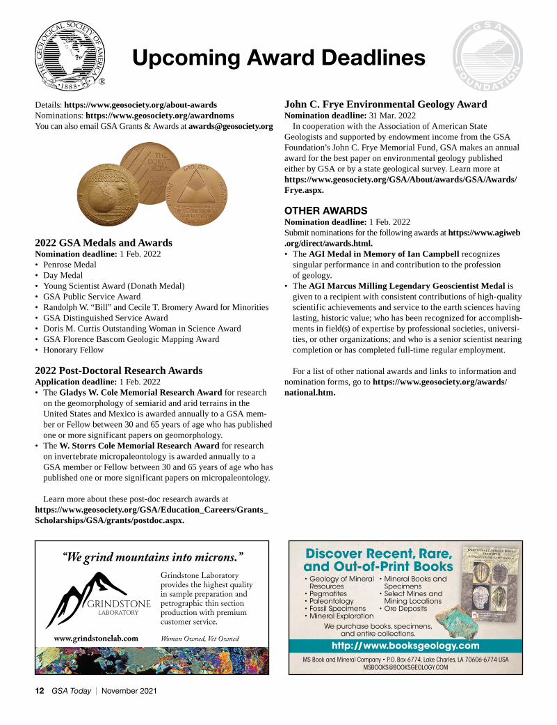
Upcoming Award Deadlines
Details: https://www.geosociety.org/about-awardsNominations: https://www.geosociety.org/awardnomsYou can also email GSA Grants & Awards at [email protected]
2022 GSA Medals and AwardsNomination deadline: 1 Feb. 2022• Penrose Medal• Day Medal• Young Scientist Award (Donath Medal)• GSA Public Service Award• Randolph W. “Bill” and Cecile T. Bromery Award for Minorities• GSA Distinguished Service Award• Doris M. Curtis Outstanding Woman in Science Award• GSA Florence Bascom Geologic Mapping Award• Honorary Fellow
2022 Post-Doctoral Research AwardsApplication deadline: 1 Feb. 2022• The Gladys W. Cole Memorial Research Award for research
on the geomorphology of semiarid and arid terrains in the United States and Mexico is awarded annually to a GSA mem-ber or Fellow between 30 and 65 years of age who has published one or more significant papers on geomorphology.
• The W. Storrs Cole Memorial Research Award for research on invertebrate micropaleontology is awarded annually to a GSA member or Fellow between 30 and 65 years of age who has published one or more significant papers on micropaleontology.
Learn more about these post-doc research awards at https://www.geosociety.org/GSA/Education_Careers/Grants_Scholarships/GSA/grants/postdoc.aspx.
John C. Frye Environmental Geology AwardNomination deadline: 31 Mar. 2022
In cooperation with the Association of American State Geologists and supported by endowment income from the GSA Foundation’s John C. Frye Memorial Fund, GSA makes an annual award for the best paper on environmental geology published either by GSA or by a state geological survey. Learn more at https://www.geosociety.org/GSA/About/awards/GSA/Awards/Frye.aspx.
OTHER AWARDSNomination deadline: 1 Feb. 2022Submit nominations for the following awards at https://www.agiweb .org/direct/awards.html.• The AGI Medal in Memory of Ian Campbell recognizes
singular performance in and contribution to the profession of geology.
• The AGI Marcus Milling Legendary Geoscientist Medal is given to a recipient with consistent contributions of high-quality scientific achievements and service to the earth sciences having lasting, historic value; who has been recognized for accomplish-ments in field(s) of expertise by professional societies, universi-ties, or other organizations; and who is a senior scientist nearing completion or has completed full-time regular employment.
For a list of other national awards and links to information and nomination forms, go to https://www.geosociety.org/awards/national.htm.
®
12 GSA Today | November 2021
GSA’s primary Division awards and the other Division awards presented at GSA Connects 2021 are listed below. Learn more about GSA’s scientific Divisions at https://www.geosociety.org/divisions.
ENERGY GEOLOGY DIVISIONGilbert H. Cady AwardXavier Querol, Institute of Environmental Assessment and Water Research, Barcelona
Antoinette Lierman Medlin Research AwardTBD
Curtis-Hedberg AwardArt Green
ENGINEERING AND ENVIRONMENTAL GEOLOGY DIVISIONE.B. Burwell, Jr., AwardA.W. Hatheway and T.B. Speight, 2018, Manufactured Gas Plant Remediation: A Case Study: Boca Raton, Florida, CRC Press, 1084 p.
Roy J. Shlemon Scholarship AwardsAdrienne Stephens, Portland State University
GEOARCHAEOLOGY DIVISIONRip Rapp Archaeological Geology AwardJoseph Schuldenrein, Geoarcheology Research Associates
Claude C. Albritton, Jr., Memorial Student Research AwardBenjamin Deans, Central Washington University
GEOBIOLOGY AND GEOMICROBIOLOGY DIVISIONOutstanding Contributions in Geobiosciences Award—Pre-TenureKimberly Lau, Penn State University
Outstanding Contributions in Geobiosciences Award—Post-TenurePhoebe Cohen, Williams College
Outstanding Contributions in Geobiosciences Award—Distinguished CareerFrank Corsetti, University of Southern California
GEOINFORMATICS DIVISIONM. Lee Alison Award for GeoinformaticsPeter Fox, RPI Tetherless World Constellation
GEOLOGY AND SOCIETY DIVISIONE-an Zen Fund Geoscience Outreach GrantSarah L. Sheffield and Kristina Barclay: Time Scavengers Undergraduate Science Communication Summer Virtual Internship ProgramSarah N. Lamm: Planetary Geology Day in Colby, Kansas, USA
GEOPHYSICS DIVISIONGeorge P. Woollard AwardCindy Ebinger, Tulane University
GEOSCIENCE EDUCATION DIVISIONBiggs Award for Excellence in Earth Science TeachingKatherine Ryker, University of South Carolina
Iris Moreno Totten Geoscience Education Research AwardLeilani A. Arthurs, University of Colorado
HISTORY AND PHILOSOPHY OF GEOLOGY DIVISIONMary C. Rabbitt History of Geology AwardStephen Rowland, University of Nevada, Las Vegas
Gerry and Sue Friedman Award for Distinguished ServiceJoanne (Jody) Bourgeois, University of Washington
HYDROGEOLOGY DIVISIONO.E. Meinzer AwardMark Person, New Mexico Tech
Birdsall-Dreiss Distinguished Lecturer (2021)Abraham Springer
George Burke Maxey Distinguished Service AwardProsun Bhattacharya
Kohout Early Career AwardNo award in 2021
LIMNOGEOLOGY DIVISIONIsrael C. Russell AwardDavid T. Long, Michigan State University
Kerry Kelts Student Research AwardNatalie Packard, University of Michigan
MINERALOGY, GEOCHEMISTRY, PETROLOGY, AND VOLCANOLOGY DIVISIONDistinguished Geologic Career AwardMichael Brown, University of Maryland
Early Career AwardXiao-Min Liu, University of North Carolina, Chapel Hill
GSA Scientific Division AwardsCongratulations to All 2021 GSA Division Award Recipients
www.geosociety.org/gsatoday 13
Whether you are entering the job market, looking for career advice for your students, or want to catch up on what GSA’s Bromery Awardees are doing, make sure to visit this GSA member resource. Webinar topics include:
• Career Development• Policy
Keep learning all year long by accessing the member-exclusive webinar library.
https://www.geosociety.org/webinars
• Grants and Programs• Educator Tools
PLANETARY GEOLOGY DIVISIONG.K. Gilbert AwardJanice Bishop, SETI Institute
Ronald Greeley Award for Distinguished ServiceJeffrey B. Plescia, Johns Hopkins UniversityChristian Koeberl, University of Vienna
Pellas-Ryder AwardJan Hellmann, Institut für Planetologie, University of Münster, Germany
QUATERNARY GEOLOGY AND GEOMORPHOLOGY DIVISIONKirk Bryan Award for Research ExcellenceMaureen H. Walczak, Oregon State University, for Walczak, M.H., and 13 others, 2020, Phasing of millennial-scale climate variability in the Pacific and Atlantic Oceans: Science, v. 370, p. 716–720, https://doi.org/10.1126/science.aba7096.
Distinguished Career AwardAlan Gillespie, University of Washington
Farouk El-Baz Award for Desert ResearchClaudio Latorre Hidalgo, Institute of Ecology and Biodiversity, Pontificia Universidad Católica de Chile
Gladys W. Cole Research AwardEllen Wohl, Colorado State University
SEDIMENTARY GEOLOGY DIVISIONLaurence L. Sloss AwardSidney Hemming, Columbia University
STRUCTURAL GEOLOGY AND TECTONICS DIVISIONCareer Contribution AwardBradley R. Hacker, University of California Santa Barbara
Outstanding Publication AwardPhilippe Yamato and Jean-Pierre Brun, 2016, Metamorphic record of catastrophic pressure drops in subduction zones: Nature Geoscience, v. 10, p. 46–50, https://doi.org/10.1038/ngeo2852.
Other awards presented at the annual meeting include:
CUSHMAN FOUNDATIONW. Storrs Cole Memorial Research AwardQing Tang, Virginia Tech
AMERICAN GEOSCIENCES INSTITUTEAGI Medal in Memory of Ian CampbellMarcia McNutt, National Academy of Sciences
Stay current on the latest resources and opportunities by subscribing to GSA’s monthly email newsletter designed for geoscience students and early career professionals. Each newsletter features job opportunities, upcoming webinars, career advice, and more.
Do you have an idea for an article that would benefit fellow readers? Email [email protected] to pitch your idea.
Subscribe or Contribute to GeoScene
www.geosociety.org/geoscene
14 GSA Today | November 2021
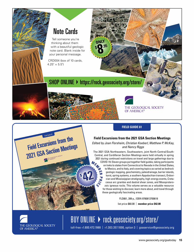
FIELD GUIDE 61
Field Excursions from the 2021 GSA Section MeetingsEdited by Joan Florsheim, Christian Koeberl, Matthew P. McKay,
and Nancy RiggsThe 2021 GSA Northeastern, Southeastern, joint North- Central/South- Central, and Cordilleran Section Meetings were held virtually in spring 2021 during continued restrictions on travel and large gatherings due to
COVID-19. Eleven groups put together � eld guides, taking participants on treks to states from Connecticut to Nevada in the United States,
to Mexico, and to Italy, and covering topics as varied as bedrock geologic mapping, geochemistry, paleodrainage, barrier islands, karst, spring systems, a southern Appalachian transect, Ordovi-cian and Mississippian stratigraphy, high- energy events, Creta-ceous arc granites and dextral shear zones, and Meso protero-
zoic igneous rocks. This volume serves as a valuable resource for those wishing to discover, learn more about, and travel through these geologically fascinating areas.
FLD061, 289 p., ISBN 9780813700618
list price $60.00 | member price $42.00
Edited by Joan Florsheim, Christian Koeberl, Matthew P. McKay, and Nancy Riggs
Field Excursions from the
Field Excursions from the
Field Excursions from the
2021 GSA Section Meetings
2021 GSA Section Meetings
2021 GSA Section Meetings
2021 GSA Section Meetings
2021 GSA Section Meetings
2021 GSA Section Meetings
Field Guide 61
BUY ONLINE } rock.geosociety.org/store/toll-free +1.800.472.1988 | +1.303.357.1000, option 3 | [email protected]
$ 42MMMMMMEEEMMM
BBBEEERRR
PPPRRR
IIICCCEEEEEE
$$$$$$$$$$$$$$ 424242424242424242424242424242424242424242
Note CardsTell someone you’re thinking about them with a beautiful geologic note card. Blank inside for your personal message.
CRD004 (box of 10 cards, 4.25" × 5.5")
SHOP ONLINE } https://rock.geosociety.org/store/
www.geosociety.org/gsatoday 15
Research Grants2022 GRADUATE STUDENT RESEARCH GRANTS PROGRAM GOALS• Support graduate student research in the geosciences and ulti-
mately enhance the geoscience workforce.• Provide career development opportunity for students by gaining
experience with grants writing, project development and research.• Increase the diversity of the geosciences through opportunities
for students of underrepresented communities to achieve suc-cess in research.
SOME PROPOSALS FUNDED IN 2021• Microplastic debris partitioning in urban stream waters and sed-
iments across space and time.• Exploration and evaluation of dimension stone in the state of
Puebla.• Inclusivity and Accessibility in Geoscience Education and
Culture as Perceived by Students with Disabilities.• Cosmogenic nuclide dating of Mars-analog paleosols.
MORE INFORMATION• ~300 recipients annually• Average grant amount: US$1,500–US$2,000 per student • Apply by 2 Feb. 2022• Contact: [email protected], +1-303-357-1025
https://www.geosociety.org/gradgrants
GSA invites the full participation of individuals currently being underserved in geoscience career fields. This includes, but is not limited to, individuals from racially and/or ethnically diverse com-munities, individuals with disabilities, individuals from LGBTIQ+ communities, and individuals who experience intersectionality with one or more of these identities. This program is supported by the National Science Foundation under Grant No. 1949901.
OTHER RESEARCH GRANTSGSA provides members with additional opportunities to apply for
research funding. Applications for these programs will be accepted beginning 1 Dec. 2021 through 1 Feb. 2022 at 5 p.m. MST.• Farouk El-Baz Student Research Grant—Desert Studies• Awards for Geochronology Student Research (AGeS) Program
(supported by the National Science Foundation under Grant No. 1759201.)
Contact: [email protected], +1-303-357-1025https://www.geosociety.org/grants
16 GSA Today | November 2021
SPECIAL PAPER 536
From Saline to Freshwater: The Diversity of Western Lakes in Space and Time
Edited by Scott W. Starratt and Michael R. RosenBeginning with the nineteenth-century territorial surveys, the lakes and lacustrine deposits in what is now the western United States were recog-nized for their economic value to the expanding nation. In the latter half
of the twentieth century, these systems have been acknowledged as outstanding examples of depositional systems serving as models for
energy exploration and environmental analysis, many with global applications in the twenty-� rst century. The localities presented in this volume extend from exposures of the Eocene Green River Formation in Utah and Florissant Formation in Colorado, through the Pleistocene and Holocene lakes of the Great Basin to lakes
along the California and Oregon coast. The chapters explore environmental variability, sedimentary processes, � re history, the
impact of lakes on crustal � exure, and abrupt climate events in arid regions, often through the application of new tools and proxies.
SPE536, 506 p., ISBN 9780813725369
list price $99.00 | member price $70.00
From Saline to Freshwater
From Saline to Freshwater
From Saline to Freshwater
Edited by Scott W. Starratt and Michael R. Rosen
The Diversity of Western Lakes in Space and Time
Special Paper 536
BUY ONLINE } https://rock.geosociety.org/store/toll-free +1.800.472.1988 | +1.303.357.1000, option 3 | [email protected]
$ 70MMMMMMEEEMMM
BBBEEERRR
PPPRRR
IIICCCEEEEEE
$$$$$$$$$$$$$$ 7070707070707070707070707070
www.geosociety.org/gsatoday 17
Stay Connected to the Community that is Advancing
Geoscience Discovery
“GSA is full of opportunities for everyone; it does not matter if you are a student, early career researcher, academic, or industry professional. Never underestimate the scope of networking, and GSA is a great place for that.”—Sinjini Sinha, member since 2017
Expand Your Knowledge Peer-reviewed publications, free online Geology, Geofacets, and GSA Today
Enrich Your Skillset Career guidance & lifelong learning opportunities—tech sessions, short courses, career workshops
Advance Scientific Discovery Publish & present research, travel & research grants, and field experiences
Be Recognized Honors & awards for outstanding contributions to science and the community
Support the Next Generation Mentoring, advocacy, volunteer & leadership opportunities
Connect with the Geoscience Community20,000 worldwide member community, scientific Divisions, geographic Sections Renew Your
2022 GSA Membership Today
www.geosociety.org/membersJoin or Renew at:
“Those early experiences—the financial support, the mentorship by established members of the earth-science community, and the shared love of geology—were fundamental to my development as a geologist. And for that, I am forever grateful to the GSA.” —Stephen Johnston, member since 1986
“GSA has provided me with the opportunity to give back to my GSA community in various ways, including chairing sessions, serving on the ad hoc ethics community, and facilitating social media training for scientists.”—Wendy Bohon, member since 2002
“GSA is an excellent example of a society that supports multidisciplinary fields that come together to further knowledge and inspire future generations of scientists.” —Fabian Hardy, member since 2014
Collaboration Scholarship Acco
untability Stew
ardship
GSA VALUES
Integrity Relevance
Re
spect
Inclusion
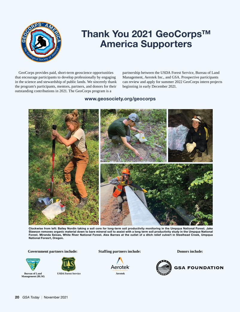
Clockwise from left: Bailey Nordin taking a soil core for long-term soil productivity monitoring in the Umpqua National Forest. Jake Slawson removes organic material down to bare mineral soil to assist with a long term soil productivity study in the Umpqua National Forest. Miranda Seixas, White River National Forest. Alex Barnes at the outlet of a ditch relief culvert in Steelhead Creek, Umpqua National Foresrt, Oregon.
GeoCorps provides paid, short-term geoscience opportunities that encourage participants to develop professionally by engaging in the science and stewardship of public lands. We sincerely thank the program’s participants, mentors, partners, and donors for their outstanding contributions in 2021. The GeoCorps program is a
partnership between the USDA Forest Service, Bureau of Land Management, Aerotek Inc., and GSA. Prospective participants can review and apply for summer 2022 GeoCorps intern projects beginning in early December 2021.
AerotekOur People Are Everything.TM
Bureau of Land Management (BLM)
USDA Forest Service
Thank You 2021 GeoCorps™ America Supporters
Donors include:Staffing partners include: Government partners include:
www.geosociety.org/geocorps
20 GSA Today | November 2021
2021 PARTICIPANTS
BUREAU OF LAND MANAGEMENT (BLM)Royal Gorge Field Office
Joshua BroussardApostolos (Paul) LandahlJulie SpawnRoberta Thompson
San Luis Valley Field OfficeHayden Yates
BLM DIRECT HIRE AUTHORITY FOR RESOURCE ASSISTANT INTERNSHIP PROGRAMLittle Snake Field Office
Aaron Evans
USDA FOREST SERVICEBridger-Teton National Forest
Brad EllisChippewa National Forest
Jon KingEmily Lugthart
Cleveland National ForestClaire Bartlett
Custer Gallatin National ForestKayla MaherMarcella Svetz
Huron-Manistee National ForestsNoah Leslie
Nebraska National Forest—National Grasslands Visitor Center
Mattison ShreeroPrescott National Forest
Maya BradfordSouthern Region (R8) Regional Office
Mason FredericksAmy Kennedy
Superior National ForestWystan DuhnSara O’Hop
Tongass National ForestBruno AbersoldChristian DeCelle
Umpqua National ForestAlexander BarnesKayla FitzpatrickBailey NordinJacob Slawson
White River National ForestAnna LedecziAlexander LylesMiranda Seixas
2021 MentorsFrances AlvaradoJames BaichtalJoe BlanchardStephanie CarterRebecca FinchamEmily FudgeSharon Fuller-BarnesNatasha GoedertAnna HarrisRenee Jacokes-ManciniMarjorie JerezJulie JohndreauJeff KrollTravis Mason-BushmanJonathan MeeksKaren MiddletonKristina (Daisy) MorganDavid MorleyLauren OswaldDan PikeAnna PlumbKim PotterJennifer PrusseMeghan ReedyDan SeifertZakiya ShivjiMelissa SmeinsJustin SnyderMark SommerLima SotoVictoria (Tori) StempniewiczRobin Thomas
www.geosociety.org/gsatoday 21
Stewards Individual Placement Program
National Park Service
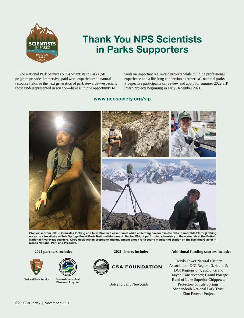
The National Park Service (NPS) Scientists in Parks (SIP) program provides immersive, paid work experiences in natural resource fields so the next generation of park stewards—especially those underrepresented in science—have a unique opportunity to
work on important real-world projects while building professional experience and a life-long connection to America’s national parks. Prospective participants can review and apply for summer 2022 SIP intern projects beginning in early December 2021.
Thank You NPS Scientists in Parks Supporters
2021 partners include: 2021 donors include: Additional funding sources include:
Devils Tower Natural History Association; DOI Regions 3, 4, and 5;
DOI Regions 6, 7, and 8; Grand Canyon Conservancy; Grand Portage
Band of Lake Superior Chippewa; Protectors of Tule Springs;
Shenandoah National Park Trust; Zion Forever Project
Bob and Sally Newcomb
Clockwise from left: J. Gonzales looking at a formation in a cave tunnel while collecting cavern climate data. Esmeralda Elsrouji taking notes on a fossil site at Tule Springs Fossil Beds National Monument. Rachel Wright performing chemistry in the water lab at the Buffalo National River Headquarters. Kirby Heck with microphone and equipment check for a sound monitoring station on the Kahiltna Glacier in Denali National Park and Preserve.
www.geosociety.org/sip
22 GSA Today | November 2021
SUMMER–WINTER 2021 SIP INTERN PARTICIPANTS
Acadia National ParkAnna Lee
Alaska Regional OfficeHayley BeitelMonika FlemingDana HansenTaylor Stinchcomb
Assateague Island National SeashoreKatie Gipson
Aztec Ruins National MonumentNicoletta BrowneShea Nolan
Badlands National ParkCharles BruceBlake ChapmanGrace DeVaultSerina GriffinLydia JonesBryce McElvogue
Bandelier National MonumentMarissa ArdovinoKathryn BrooksHenry DavieKara FoxMichelle HillElla Kasten
Big Bend National ParkIsabella FucignaKale’a Pawlak-Kjolhaug
Big South Fork National River and Recreation Area
Amanda WrightBig Thicket National Preserve
Kira WareBiscayne National Park
Zoe DellaertBryce Canyon National Park
Hannah MarshallBuffalo National River
Mariana PerezCourtney WernerRachel Wright
Cape Cod National SeashoreEliza Fitzgerald
Cape Hatteras National SeashoreKegan Kleeschulte
Cape Lookout National SeashoreRachel Hilt
Capitol Reef National ParkSara Drake
Carlsbad Caverns National ParkRiannon ColtonHenry Newell
Chaco Culture National Historical ParkAnna Sivils
Chattahoochee River National Recreation Area
Therese KellyChesapeake Bay Office
Colleen NortonChiricahua National Monument
Anna KurtinColonial National Historical Park
Mackenzie ChriscoeLenzie Ward
Colorado National MonumentBenjamin Landolt
Congaree National ParkKathryn Ayers
Coronado National MemorialHailey GalitEvan LaughlinAmelia Lewis
Curecanti National Recreation AreaAutumn Moya
Death Valley National ParkAlison FrameMaeve HollandCarmen KrausKimberly Nichter
Denali National Park and PreserveJohanne AlbrigtsenBaylee BessingpasIzabella BlockRebecca ConnerAmelia EvavoldKirby HeckAutumn HelfrichLauren HurstLoring SchaibleMargaret Stoneham
Denver Service Center Planning Division
Everly JaziEva Tsow
Dinosaur National MonumentColton SnyderEmma TrostKaylee VelasquezKathryn Whelton
Dry Tortugas National ParkKaliegh Schlender
El Malpais National MonumentOlivia Beaudette
Fire Island National SeashoreRia KobernussTaylor Solorzano
Florissant Fossil Beds National Monument
Astrid GarciaFort Laramie National Historic Site
Abigayle HansenFort Matanzas National Monument
Katherine Sweezey
Fossil Butte National MonumentSophia Cajune
Glacier National ParkKatherine BarrsHolli Holmes
Golden Gate National Recreation AreaJordan Gorostiza
Grand Canyon National ParkCarmen KrausBrittne MacClearyErikka OlsonDeron Clark
Grand Teton National ParkElizabeth CaseJamie Mcbryde
Great Basin National ParkJeremy OsowskiCallum RussellSerena Wurmser
Gulf Islands National SeashorePhilip IversenGrady JakobsbergDarby McGheeLeah VickeryJordan Wingate
Hagerman Fossil Beds National Monument
Scott KottkampElizabeth Nist
Harpers Ferry National Historical ParkMarcella Svetz
Isle Royale National ParkMadelyn Barrie
Jewel Cave National MonumentRiannon Colton
Jimmy Carter National Historical ParkJosephine Duffy
John Day Fossil Beds National Monument
Rudolph HummelKelly LubbersJasmine ReitzeKaili Schroeder
Joshua Tree National ParkCaroline Abramowitz
Kaloko-HonokōhauNationalHistoricalPark
Danielle WildeKatmai National Park and Preserve and the Alaska Regional Office
Matthew HarringtonLake Clark National Park and Preserve
Samuel GrafLake Mead National Recreation Area
Benjamin BanetLassen Volcanic National Park
Taylor ThomasLava Beds National Monument
Jordan Kemp
www.geosociety.org/gsatoday 23
Lewis and Clark National Historical Park
Emily ScottLittle Bighorn Battlefield National Monument
Remi MasseManassas National Battlefield Park
Kelly EwingMesa Verde National Park
Erin MarkeyClaire Stellick
Midwest Regional OfficeJoseph DeVito
Mojave National PreserveEmily Claire Johnson
Monocacy National BattlefieldOlivia BoraikoColleen Lewis
Mount Rainier National ParkOriana BosqueAndrea MinotHeather Silvola
Mount Rushmore National MemorialMax Maddox
National Park of American SamoaRobert Smith
Region 1 Office, Duty Station University of Rhode Island
Kendra DevereuxObed Wild and Scenic River
Katie SpiveyOlympic National Park
Jillian BrighamMegan CoyleMallory Mintz
Oregon Caves National Monument and Preserve
Javaria AzizPark Facility Management Division
Miriam RitchiePerry’s Victory and International Peace Memorial
Sophie RabinowiczPoint Reyes National Seashore
Ellen MurphyRedwood National Park
Kathryn McGeeSylvia van Royen
Rocky Mountain National ParkDiego AlvaradoRaymond FloresBenjamin Holt
Saguaro National ParkMattea Pulido
San Juan Island National Historical Park
Jeramy OttSanta Monica National Recreation Area
Evan Fitzmaurice
Shared Beringian Heritage ProgramMegan Withers
Shenandoah National ParkRebekah EverettHannah ProkopMarcus Tierrablanca
Sleeping Bear Dunes National Lakeshore Lauren CharlesHolly Francart
Theodore Roosevelt National Park Charles Salcido
Waco Mammoth National MonumentMargaret Rubin
War in the Pacific National Historical Park
Marisa AgarwalMichelle Diminuco
Western Pennsylvania ParksSam GovanCorrina Yobp
Whiskeytown National Recreation AreaOlivia BarnesLaina RoseAlice Stitzer
Wilderness Stewardship DivisionEmily L. BrentHannah Stelley
Wrangell–St. Elias National Park and Preserve
Anna Carrie ThompsonWupatki National Monument
Chad KwiatkowskiYellowstone National Park
Hannah BortelAnthony HimmelbergerMorgan Nasholds
Yosemite National ParkSara DonatichAutumn HelfrichLauren HurstDorothy ShreveJohn Stapke
Zion National ParkMadison Anderson
INVENTORY & MONITORING NETWORKSAppalachian Highlands
Ross ShipleyCentral Alaska
Robert SmithChihuahuan Desert
Kevin GrossCumberland Piedmont
Megan GarveyGreater Yellowstone
Elizabeth-Ann JamisonGulf Coast
Claudia Silver
KlamathAddis GonzalezKira Ware
Mediterranean CoastHunter KleinNicoletta Stork
Mojave DesertEmma KaufmanEvan Kolb
National Capital RegionEdward Cascella
Northeast Coastal and BarrierColleen KeenanBridget Ye
Northern Colorado PlateauBrian Schlaff
PacificIsland(withinHawaiʻiVolcanoesNational Park)
John BennerEsaac MazengiaJasmine-Marie MokuBrayden Pollvogt
Rocky MountainMatthew Robinson
San Francisco Bay AreaArista Regalia
Sierra NevadaAna Tobio
Sonoran DesertMariam Moazed
South Florida/CaribbeanJohn Sabin
Southeast Coast (within Congaree National Park)
Julieanne MontaquilaSouthern Plains
Jonathan SigwingSouthwest Alaska
Journey BerryKaitlyn Furey
Upper Columbia BasinJamela Thompson
NATURAL RESOURCE STEWARDSHIP AND SCIENCE DIRECTORATEGeologic Resources Division
Noah AngellBrian MulroyKarina Zyatitsky
Inventory & Monitoring DivisionMyles Cramer
Water Resources DivisionBrooke BaumanBrennan KessenichNina Elisaveta LoutchkoMatthew RigdonAutumn SandsAlyssa Winchell
24 GSA Today | November 2021
With an online degree from Penn, you can take the lead in applied geosciences
With Penn’s online Master of Science in Applied Geosciences, you stay ahead of the curve in remediation practices. Advance your career and learn from industry leaders about:
• Engineering geology techniques
• Stormwater systems
• New technologies and techniques
Apply by December 15 for early admission with a fall 2022 start.
Details at: www.upenn.edu/msgo
ROADSIDE GEOLOGY OF IDAHOSecond Edition
PAUL K. LINK, SHAWN WILLSEY, AND KEEGAN SCHMIDT
The rocks of Idaho span a vast chunk of Earth’s long-lived history and
tell stories with many plot twists. Learn all about the remarkable geology
of the Gem State with this completely revised, full-color edition. The
authors, a trio of experienced fi eld geologists, guide you to outcrops
and roadcuts where you can stretch your legs and expand your mind.
416 pages • 6 x 9 • 265 color photographs123 color illustrations • glossary • references • indexpaper $28.00 • Item 209 • ISBN 978-0-87842-702-4
Making
you
r
ro
ad
tripsbette
rfo
r
4
5
years!
NEWTO THE
SERIES!
www.geosociety.org/gsatoday 25
190th Anniversary of the Birth of Eduard Suess, the Father of Modern Global Geology
A.M. Celâl Şengör, ITU Faculty of Mines and the Eurasia Institute of Earth Sciences, Ayazağa 34469 Istanbul, Turkey, [email protected]
INTRODUCTIONWhen rational speculation began more than two-and-a-half
millennia ago on the eastern shores of the Aegean with a view to explaining observations made on natural objects and events, geol-ogy was born. For nearly two millennia, mankind had to make do with what could be seen on the surface of the earth. Despite this severe limitation, some very ingenious theories were put forward about the behavior of our planet: It was realized that mountains rose from the sea and volcanoes and earthquakes were somehow related to the heat within our globe and they seemed associated with moun-tain-building. This state of affairs changed dramatically when Descartes introduced the concept of a bed (i.e., a layer) in 1644. Descartes’ concept was purely imaginary, but it triggered a revolu-tion in the hands of Nicolaus Steno in 1667 and 1669, when the ori-gin of beds were recognized to be sedimentation, fossils former inhabitants of sedimentary basins, and the haphazard orientations of bedded sequences a result of subsequent deformation. This gave a great impetus to attempts to explain the history of the earth in terms of sedimentary sequences until it was realized that not all rocks were products of sedimentation. The next great step in the history of geology was taken by James Hutton in Scotland. Hutton argued that rocks rising as melts from the interior caused deformation of the sedimentary layers and that this process had been going on since as long ago as our observations could decipher. He further pointed out that no miracles are needed to explain the course of the geological history of the earth: The present-day phenomena we observe daily provided sufficient explanation of everything one could discover in the geological record.
Hutton’s theory coincided in time with the rise of biostratigraphy that enabled geologists to erect a calendar of events in the earth’s past, albeit without being able to put numbers of years onto it. These two developments gave geology an immense stimulus, and strati-graphic geology was able to erect a timetable for earth history by the middle of the nineteenth century, which we still use. All kinds of theories were advanced to explain the planet’s past, and their inventors picked and chose those observations agreeable to their particular hypothesis. With Lyell’s insistence that there never had been any global events in the past, geology became detailed but parochial. The spectacular failure of a few attempts at global geol-ogy encouraged this tendency to be local. It seemed that geology, while able to explain local observations, lacked a method with which earth as a whole could be understood.
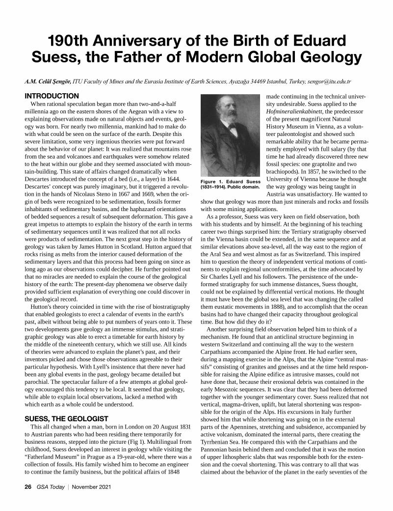
SUESS, THE GEOLOGISTThis all changed when a man, born in London on 20 August 1831
to Austrian parents who had been residing there temporarily for business reasons, stepped into the picture (Fig 1). Multilingual from childhood, Suess developed an interest in geology while visiting the “Fatherland Museum” in Prague as a 19-year-old, where there was a collection of fossils. His family wished him to become an engineer to continue the family business, but the political affairs of 1848
made continuing in the technical univer-sity undesirable. Suess applied to the Hofmineralienkabinett, the predecessor of the present magnificent Natural History Museum in Vienna, as a volun-teer paleontologist and showed such remarkable ability that he became perma-nently employed with full salary (by that time he had already discovered three new fossil species: one graptolite and two brachiopods). In 1857, he switched to the University of Vienna because he thought the way geology was being taught in Austria was unsatisfactory. He wanted to
show that geology was more than just minerals and rocks and fossils with some mining applications.
As a professor, Suess was very keen on field observation, both with his students and by himself. At the beginning of his teaching career two things surprised him: the Tertiary stratigraphy observed in the Vienna basin could be extended, in the same sequence and at similar elevations above sea-level, all the way east to the region of the Aral Sea and west almost as far as Switzerland. This inspired him to question the theory of independent vertical motions of conti-nents to explain regional unconformities, at the time advocated by Sir Charles Lyell and his followers. The persistence of the unde-formed stratigraphy for such immense distances, Suess thought, could not be explained by differential vertical motions. He thought it must have been the global sea level that was changing (he called them eustatic movements in 1888), and to accomplish that the ocean basins had to have changed their capacity throughout geological time. But how did they do it?
Another surprising field observation helped him to think of a mechanism. He found that an anticlinal structure beginning in western Switzerland and continuing all the way to the western Carpathians accompanied the Alpine front. He had earlier seen, during a mapping exercise in the Alps, that the Alpine “central mas-sifs” consisting of granites and gneisses and at the time held respon-sible for raising the Alpine edifice as intrusive masses, could not have done that, because their erosional debris was contained in the early Mesozoic sequences. It was clear that they had been deformed together with the younger sedimentary cover. Suess realized that not vertical, magma-driven, uplift, but lateral shortening was respon-sible for the origin of the Alps. His excursions in Italy further showed him that while shortening was going on in the external parts of the Apennines, stretching and subsidence, accompanied by active volcanism, dominated the internal parts, there creating the Tyrrhenian Sea. He compared this with the Carpathians and the Pannonian basin behind them and concluded that it was the motion of upper lithospheric slabs that was responsible both for the exten-sion and the coeval shortening. This was contrary to all that was claimed about the behavior of the planet in the early seventies of the
Figure 1. Eduard Suess (1831–1914). Public domain.
26 GSA Today | November 2021
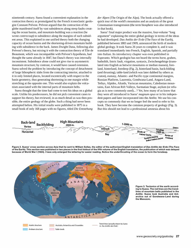
nineteenth century. Suess found a convenient explanation in the contraction theory as promulgated by the French iconoclastic geolo-gist Constant Prévost. Prévost argued that the contraction of the globe manifested itself by vast subsidences along steep faults creat-ing the ocean basins, and mountain-building was a reaction (he wrote contrecoup) to subsidence along the margins of such subsid-ent areas. This explained in one unified theory both the changing capacity of ocean basins and the shortening-driven mountain build-ing with subsidence in the back. James Dwight Dana, following also Prévost’s theory, but mixing it with the contraction theory of Élie de Beaumont, which was incompatible with Prévost’s hypothesis, had thought the same already in 1847, but Dana’s theory was internally inconsistent. Subsidence alone could not give rise to asymmetric mountain structure; by contrast, it would have caused extension. Suess solved the problem by introducing the concept of detachment of large lithospheric slabs from the contracting interior, attached to it in only limited places, located excentrically with respect to the basin geometry, thus generating shortening in one margin while stretching at the opposite one. This would also explain the volca-nism associated with the internal parts of mountain belts.
Suess thought that the time had come to test his ideas on a global scale. Unlike his predecessors, he did not pick convenient cases to support his theory, but reviewed, in as much detail as was then pos-sible, the entire geology of the globe. Such a thing had never been attempted before. His initial results were published in 1875 in a small book of only 168 pages with no figures, titled Die Entstehung
der Alpen (The Origin of the Alps). The book actually offered a quick tour of the world’s mountains and an analysis of the great Cenomanian transgression (the term biosphere was also introduced in that book).
Suess’ final major product was the massive, four-volume “long argument” explaining the entire global geology in terms of the ideas he had developed. Das Antlitz der Erde (The Face of the Earth), published between 1883 and 1909, announced the birth of modern global geology. It took Suess 26 years to complete it, and it was translated immediately into French, English, Spanish, and partially into Italian. Its introductory chapter was even published in Esperanto. Which geologist has not heard the terms horst, graben, batholith, listric fault, virgation, syntaxis, Zwischengebirge (trans-lated into English as betwixt mountains or median masses), fore-land, hinterland, foredeep (Fig. 2), hinterland basin, back-folding (and thrusting), table-land (which was later dubbed by others as craton), eustasy, Atlantic- and Pacific-type continental margins, Russian Platform, Laurentia, Gondwana-Land, Angara-Land, Tethys, Alpides, Altaids, Variscan mountains, Caledonian moun-tains, East African Rift Valleys, Sarmatian Stage, asylum (or refu-gia as is now commonly used)... ? Yet, how many of us know that they were all introduced in Suess’ magnum opus or in his indepen-dent papers and later incorporated into the Antlitz. We use his con-cepts so commonly that we no longer feel the need to refer to his book. They have become the common property of geology (Fig. 3). But this should not lead to a professional amnesia about his
Figure 2. Suess’ cross section across Asia that he sent to William Sollas, the editor of the authorized English translation of Das Antlitz der Erde (The Face of the Earth). This section was published in two pieces in the first foldout of the fifth volume of the English translation, the publication of which was delayed because of World War I (1924). I have only enlarged the lettering for easier reading. Notice the underthrusting of the ocean to form the foredeep.
Figure 3. Tectonics of the earth accord-ing to Suess. The red lines are the trend-lines of mountain belts published in the Antlitz. Suess took Australia and Ant-arctica out of Gondwana-Land during the Mesozoic.
www.geosociety.org/gsatoday 27
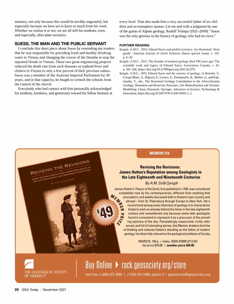
MEMOIR 216
Revising the Revisions: James Hutton’s Reputation among Geologists in
the Late Eighteenth and Nineteenth CenturiesBy A.M. Celâl Şengör
James Hutton’s Theory of the Earth, � rst published in 1785, was considered completely new by his contemporaries, different from anything that
preceded it, and widely discussed both in Hutton’s own country and abroad— from St. Petersburg through Europe to New York. Yet a
recent trend among some historians of geology is to characterize Hutton’s work as already behind the times in the late eighteenth century and remembered only because some later geologists found it convenient to represent it as a precursor of the prevail-
ing opinions of the day. Painstakingly researched, richly refer-enced, and full of interesting stories, this Memoir shatters that line
of thinking and restores Hutton’s standing as the father of modern geology, his ideas fully relevant to the geological problems of his day.
MWR216, 150 p. + index, ISBN 9780813712161 list price $70.00 | member price $49.00
By A.M. Celâl Sengör
Revising the Revisions
James Hutton’s Reputation among Geologists in
the Late Eighteenth and Nineteenth Centuries
Memoir 216
toll-free +1.800.472.1988 | +1.303.357.1000, option 3 | [email protected]
Buy Online } rock.geosociety.org/store
$ 49MMMMMMEEEMMM
BBBEEERRR
PPPRRR
IIICCCEEEEEE
$$$$$$$$$$$$$$ 494949494949494949494949494949494949494949
memory, not only because this would be terribly ungrateful, but especially because we have yet to learn so much from his work. Whether we realize it or not, we are all still his students, even, and especially, after plate tectonics.
SUESS, THE MAN AND THE PUBLIC SERVANTI conclude this short piece about Suess by reminding my readers
that he was responsible for providing fresh and healthy drinking water to Vienna and changing the course of the Danube to stop the repeated floods in Vienna. These two great engineering projects reduced the death rate from such diseases as typhoid fever and cholera in Vienna to only a few percent of their previous values. Suess was a member of the Austrian Imperial Parliament for 30 years, and in that capacity, he fought to wrench the schools from the control of the church.
Everybody who had contact with him personally acknowledged his modesty, kindness, and generosity toward his fellow humans at
every level. That also made him a very successful father of six chil-dren and an exemplary spouse. Let me end with a judgment by one of the giants of Alpine geology, Rudolf Trümpy (1921–2009): “Suess was the only genious in the history of geology who had no vices.”
FURTHER READINGŞengör, A.M.C., 2014, Eduard Suess and global tectonics: An illustrated ‘short
guide’: Austrian Journal of Earth Sciences (Suess special issue), v. 107, p. 6–82
Şengör, A.M.C., 2015, The founder of modern geology died 100 years ago: The scientific work and legacy of Eduard Suess: Geoscience Canada, v. 42, p. 181–246, https://doi.org/10.12789/geocanj.2015.42.070.
Şengör, A.M.C., 2019, Eduard Suess and the essence of geology, in Rossetti, F., Crespo Blanc, A., Riguzzi, F., Leroux, E., Pavlopoulos, K., Bellier, O., and Kap-simalis, V., eds., The Structural Geology Contribution to the Africa-Eurasia Geology: Basement and Reservoir Structure, Ore Mineralisation and Tectonic Modelling: Cham, Denmark, Springer, Advances in Science, Technology & Innovation, https://doi.org/10.1007/978-3-030-01455-1_5.
28 GSA Today | November 2021
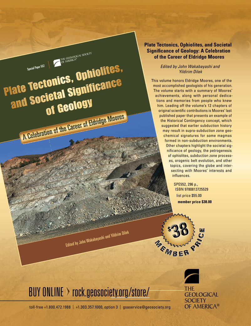
Plate Tectonics, Ophiolites, and Societal Signi� cance of Geology: A Celebration
of the Career of Eldridge Moores
Edited by John Wakabayashi and Yildirim Dilek
This volume honors Eldridge Moores, one of the most accomplished geologists of his generation. The volume starts with a summary of Moores’ achievements, along with personal dedica-tions and memories from people who knew him. Leading off the volume’s 12 chapters of original scienti� c contributions is Moores’ last published paper that presents an example of the Historical Contingency concept, which suggested that earlier subduction history may result in supra- subduction zone geo-chemical signatures for some magmas formed in non- subduction environments. Other chapters highlight the societal sig-ni� cance of geology, the petrogenesis of ophiolites, subduction zone process-es, orogenic belt evolution, and other topics, covering the globe and inter-secting with Moores’ interests and in� uences.
SPE552, 296 p., ISBN 9780813725529
list price $55.00
member price $38.00
Plate Tectonics, Ophiolites,
Plate Tectonics, Ophiolites,
Plate Tectonics, Ophiolites,
Plate Tectonics, Ophiolites,
Plate Tectonics, Ophiolites,
Plate Tectonics, Ophiolites,
Plate Tectonics, Ophiolites,
Plate Tectonics, Ophiolites,
Plate Tectonics, Ophiolites,
and Societal Significance
and Societal Significance
and Societal Significance
of Geologyof Geologyof Geology
Edited by John Wakabayashi and Yildirim Dilek
Special Paper 552
A Celebration of the Career of Eldridge Moores
A Celebration of the Career of Eldridge Moores
A Celebration of the Career of Eldridge Moores
A Celebration of the Career of Eldridge Moores
A Celebration of the Career of Eldridge Moores
A Celebration of the Career of Eldridge Moores
A Celebration of the Career of Eldridge Moores
A Celebration of the Career of Eldridge Moores
A Celebration of the Career of Eldridge Moores
A Celebration of the Career of Eldridge Moores
A Celebration of the Career of Eldridge Moores
A Celebration of the Career of Eldridge Moores
A Celebration of the Career of Eldridge Moores
A Celebration of the Career of Eldridge Moores
A Celebration of the Career of Eldridge Moores
BUY ONLINE rock.geosociety.org/store/toll-free +1.800.472.1988 | +1.303.357.1000, option 3 | [email protected]
$ 38
M
EM B E R P
RI C
E$ 38383838
MM
EEMM BB EE RR PP
RRII CC
EE
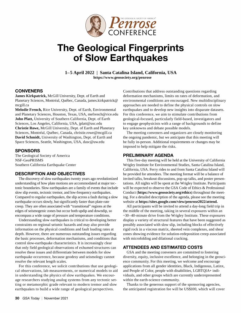
CONVENERSJames Kirkpatrick, McGill University, Dept. of Earth and Planetary Sciences, Montréal, Québec, Canada, [email protected] Melodie French, Rice University, Dept. of Earth, Environmental and Planetary Sciences, Houston, Texas, USA, [email protected] John Platt, University of Southern California, Dept. of Earth Sciences, Los Angeles, California, USA, [email protected] Christie Rowe, McGill University, Dept. of Earth and Planetary Sciences, Montréal, Québec, Canada, [email protected] David Schmidt, University of Washington, Dept. of Earth and Space Sciences, Seattle, Washington, USA, [email protected]
SPONSORSThe Geological Society of AmericaNSF-GeoPRISMSSouthern California Earthquake Center
DESCRIPTION AND OBJECTIVES The discovery of slow earthquakes twenty years ago revolutionized
understanding of how plate motions are accommodated at major tec-tonic boundaries. Slow earthquakes are a family of events that include slow slip events, tectonic tremor, and low-frequency earthquakes. Compared to regular earthquakes, the slip across a fault during a slow earthquake occurs slowly, but significantly faster than plate-rate creep. They are often associated with “transitional” regions at the edges of seismogenic zones but occur both updip and downdip, so encompass a wide range of pressure and temperature conditions.
Understanding slow earthquakes is critical to developing better constraints on regional seismic hazards and may also provide information on the physical conditions and fault loading rates at depth. However, there are numerous outstanding issues regarding the basic processes, deformation mechanisms, and conditions that control slow-earthquake characteristics. It is increasingly clear that only field geological observations of exhumed structures can resolve these issues and differentiate between models for slow earthquake occurrence, because geodesy and seismology cannot resolve the relevant length scales.
For this conference, we solicit contributions that use geologi-cal observations, lab measurements, or numerical models to aid in understanding the physics of slow earthquakes. We encour-age researchers studying analog systems from any tectonic set-ting or metamorphic grade relevant to modern tremor and slow earthquakes to build a wide range of geological perspectives.
Contributions that address outstanding questions regarding deformation mechanisms, limits on rates of deformation, and environmental conditions are encouraged. New multidisciplinary approaches are needed to define the physical controls on slow earthquakes and to develop new insights into disparate datasets. For this conference, we aim to stimulate contributions from geological-focused, particularly field-based, investigators and to engage geophysicists with a range of backgrounds to define key unknowns and debate possible models.
The meeting conveners and organizers are closely monitoring the ongoing pandemic, but we anticipate that this meeting will be fully in-person. Additional requirements or changes may be imposed to help mitigate the risks.
PRELIMINARY AGENDA This five-day meeting will be held at the University of California
Wrigley Institute for Environmental Studies, Santa Catalina Island, California, USA. Ferry rides to and from Santa Catalina Island will be provided for attendees. The meeting format will be a balance of invited talks, breakout discussions, pop-up talks, and poster presen-tations. All nights will be spent at the Wrigley Institute. Participants will be expected to observe the GSA Code of Ethics & Professional Conduct (https://www.geosociety.org/ethics) throughout the meet-ing. For a detailed description of the agenda, please see the meeting website at https://sites.google.com/view/penrose2022/attend.
All participants will be invited to attend a day-long field trip in the middle of the meeting, taking in several exposures within an ~30–40-minute drive from the Wrigley Institute. These exposures display a variety of structural features that have been suggested as possibly associated with slow slip, including blocks of effectively rigid rock in a viscous matrix, sheeted vein complexes, and shear zones showing evidence for solution-redeposition creep associated with microfolding and dilational cracking.
ATTENDEES AND ESTIMATED COSTS GSA and the meeting conveners are committed to fostering
diversity, equity, inclusive excellence, and belonging in the geosci-ence community. For this meeting, we welcome and encourage applications from all gender identities, Black, Indigenous, Latinx, and People of Color, people with disabilities, LGBTQIA+ indi-viduals, and other groups which are currently underrepresented within the earth-science community.
Thanks to the generous support of the sponsoring agencies, the anticipated registration fee will be US$100, which will cover
The Geological Fingerprints of Slow Earthquakes
1–5 April 2022 | Santa Catalina Island, California, USAhttps://www.geosociety.org/penrose
30 GSA Today | November 2021

CALL FOR PROPOSALS
USGS EDMAP ProgramTraining the next generation of geologic mappers
Part of the Na�onal Coopera�ve Geologic Mapping Program, the EDMAP program offers funding to
universi�es for 1-year undergraduate and graduate geologic and related Earth science mapping projects.
For more informa�on, go tohttps://ncgmp.usgs.gov
or email mmarke�@usgs.gov
Application period: mid-October - mid-December, 2021
To Apply: visit h�ps://www.grants.gov/, select “Grant Opportuni�es”, and type in keyword “EDMAP”
Paleozoic Stratigraphy and Resources of the Michigan Basin
Edited by G. Michael Grammer, William B. Harrison III, and David A. Barnes
This volume provides significant new insights into the Michigan Basin to both academic and applied geoscientists. It includes papers that discuss various aspects of the sedimentology and stratigraphy of key units within the basin, as well as papers that analyze the diverse distribution of natural resources present in this basin.
SPE531 • 339 p. • ISBN 9780813725314NOW $20.00
Edited by G. Michael Grammer, William B. Harrison III, and David A. Barnes
Paleozoic Stratigraphy and Resources of the Michigan Basin
Special Paper 531
Edited by G.M
. Gram
mer, W
.B. Harrison III, and D.A. Barnes
Paleozoic Stratigraphy and Resources of the Michigan Basin
Special Paper 531
four nights of lodging, meals, transportation to/from Santa Catalina Island, transportation for field trips, and facility usage. Participants will be expected to pay for travel expenses from their home to southern California. However, we have funds to support the travel of participants, which will be prioritized toward underrepresented groups as well as early-career and stu-dent participants. All participants will be expected to make their own travel arrangements to arrive at Long Beach, California,
USA, in time for a scheduled ferry to the Wrigley Institute on Santa Catalina Island.
The conference will be limited to 64 participants, and each par-ticipant will have to commit to attending for the full duration of the conference because transport to/from Catalina Island is provided at the beginning and end of the meeting, but otherwise is limited. For more information and registration, please see the meeting website at https://sites.google.com/view/penrose2022/attend.
www.geosociety.org/gsatoday 31
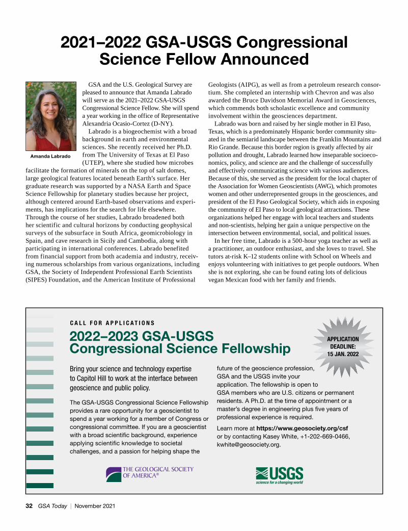
2021–2022 GSA-USGS Congressional Science Fellow Announced
GSA and the U.S. Geological Survey are pleased to announce that Amanda Labrado will serve as the 2021–2022 GSA-USGS Congressional Science Fellow. She will spend a year working in the office of Representative Alexandria Ocasio-Cortez (D-NY).
Labrado is a biogeochemist with a broad background in earth and environmental sciences. She recently received her Ph.D. from The University of Texas at El Paso (UTEP), where she studied how microbes
facilitate the formation of minerals on the top of salt domes, large geological features located beneath Earth’s surface. Her graduate research was supported by a NASA Earth and Space Science Fellowship for planetary studies because her project, although centered around Earth-based observations and experi-ments, has implications for the search for life elsewhere. Through the course of her studies, Labrado broadened both her scientific and cultural horizons by conducting geophysical surveys of the subsurface in South Africa, geomicrobiology in Spain, and cave research in Sicily and Cambodia, along with participating in international conferences. Labrado benefited from financial support from both academia and industry, receiv-ing numerous scholarships from various organizations, including GSA, the Society of Independent Professional Earth Scientists (SIPES) Foundation, and the American Institute of Professional
Geologists (AIPG), as well as from a petroleum research consor-tium. She completed an internship with Chevron and was also awarded the Bruce Davidson Memorial Award in Geosciences, which commends both scholastic excellence and community involvement within the geosciences department.
Labrado was born and raised by her single mother in El Paso, Texas, which is a predominately Hispanic border community situ-ated in the semiarid landscape between the Franklin Mountains and Rio Grande. Because this border region is greatly affected by air pollution and drought, Labrado learned how inseparable socioeco-nomics, policy, and science are and the challenge of successfully and effectively communicating science with various audiences. Because of this, she served as the president for the local chapter of the Association for Women Geoscientists (AWG), which promotes women and other underrepresented groups in the geosciences, and president of the El Paso Geological Society, which aids in exposing the community of El Paso to local geological attractions. These organizations helped her engage with local teachers and students and non-scientists, helping her gain a unique perspective on the intersection between environmental, social, and political issues.
In her free time, Labrado is a 500-hour yoga teacher as well as a practitioner, an outdoor enthusiast, and she loves to travel. She tutors at-risk K–12 students online with School on Wheels and enjoys volunteering with initiatives to get people outdoors. When she is not exploring, she can be found eating lots of delicious vegan Mexican food with her family and friends.
Amanda Labrado
Bring your science and technology expertise to Capitol Hill to work at the interface between geoscience and public policy.
The GSA-USGS Congressional Science Fellowship provides a rare opportunity for a geoscientist to spend a year working for a member of Congress or congressional committee. If you are a geoscientist with a broad scientific background, experience applying scientific knowledge to societal challenges, and a passion for helping shape the
future of the geoscience profession, GSA and the USGS invite your application. The fellowship is open to GSA members who are U.S. citizens or permanent residents. A Ph.D. at the time of appointment or a master’s degree in engineering plus five years of professional experience is required.
Learn more at https://www.geosociety.org/csf or by contacting Kasey White, +1-202-669-0466, [email protected].
2022–2023 GSA-USGS Congressional Science Fellowship
C A L L F O R A P P L I C A T I O N S
APPLICATION DEADLINE:
15 JAN. 2022
32 GSA Today | November 2021
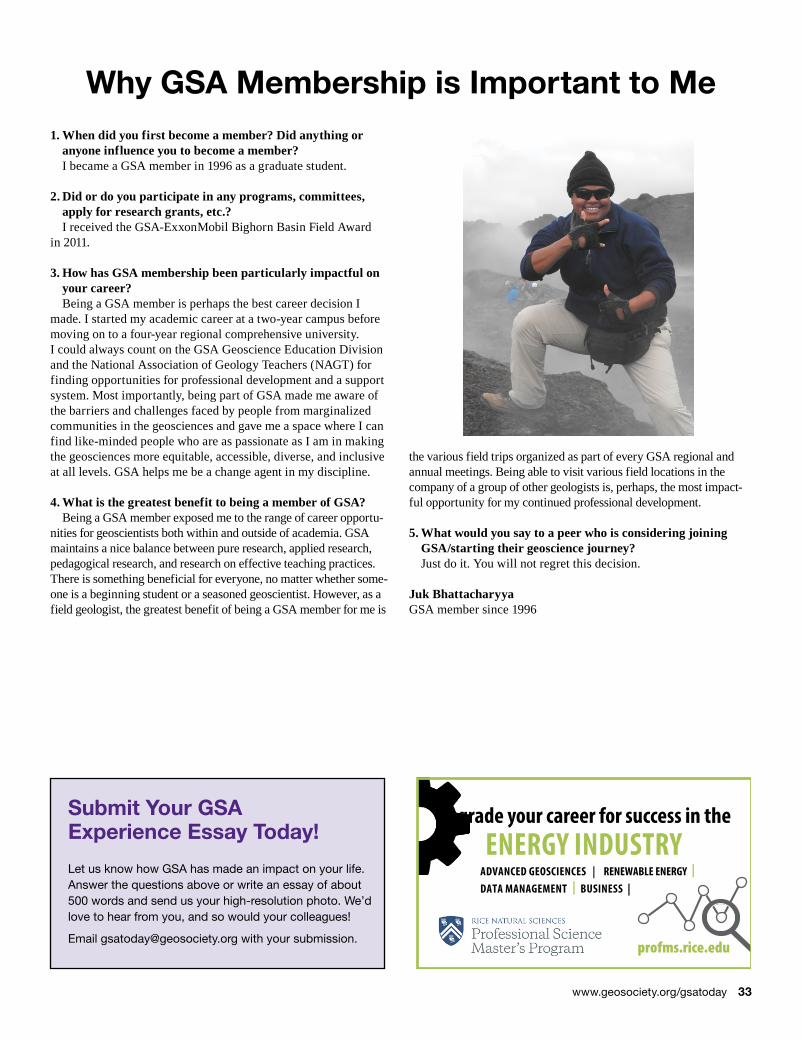
Submit Your GSA Experience Essay Today!
Let us know how GSA has made an impact on your life. Answer the questions above or write an essay of about 500 words and send us your high-resolution photo. We’d love to hear from you, and so would your colleagues!
Email [email protected] with your submission.
Upgrade your career for success in theENERGY INDUSTRY
ADVANCED GEOSCIENCES | RENEWABLE ENERGY | DATA MANAGEMENT | BUSINESS |
profms.rice.edu
Why GSA Membership is Important to Me1. When did you first become a member? Did anything or
anyone influence you to become a member?I became a GSA member in 1996 as a graduate student.
2. Did or do you participate in any programs, committees, apply for research grants, etc.?I received the GSA-ExxonMobil Bighorn Basin Field Award
in 2011.
3. How has GSA membership been particularly impactful on your career?Being a GSA member is perhaps the best career decision I
made. I started my academic career at a two-year campus before moving on to a four-year regional comprehensive university. I could always count on the GSA Geoscience Education Division and the National Association of Geology Teachers (NAGT) for finding opportunities for professional development and a support system. Most importantly, being part of GSA made me aware of the barriers and challenges faced by people from marginalized communities in the geosciences and gave me a space where I can find like-minded people who are as passionate as I am in making the geosciences more equitable, accessible, diverse, and inclusive at all levels. GSA helps me be a change agent in my discipline.
4. What is the greatest benefit to being a member of GSA?Being a GSA member exposed me to the range of career opportu-
nities for geoscientists both within and outside of academia. GSA maintains a nice balance between pure research, applied research, pedagogical research, and research on effective teaching practices. There is something beneficial for everyone, no matter whether some-one is a beginning student or a seasoned geoscientist. However, as a field geologist, the greatest benefit of being a GSA member for me is
the various field trips organized as part of every GSA regional and annual meetings. Being able to visit various field locations in the company of a group of other geologists is, perhaps, the most impact-ful opportunity for my continued professional development. 5. What would you say to a peer who is considering joining
GSA/starting their geoscience journey?Just do it. You will not regret this decision.
Juk BhattacharyyaGSA member since 1996
www.geosociety.org/gsatoday 33
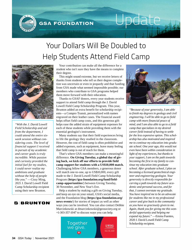
Your Dollars Will Be Doubled to Help Students Attend Field Camp
Your contribution can make all the difference for a student who isn’t sure they have the means to complete their degree.
This might sound extreme, but we receive letters of thanks from students who tell us their degree comple-tion was uncertain or even in jeopardy and that funding from GSA made what seemed impossible possible; our members who contribute to GSA programs helped them move forward with their education.
Thanks to GSAF donors, every year students receive support to attend field camp through the J. David Lowell Field Camp Scholarship Program. This year, Brunton added an extra benefit for scholarship recipi-ents—a Compro Transit, personalized with names engraved on their leather cases. The financial award helps offset field camp costs, and this generous gift helps ease the added strain of equipment expenses for each of these students while providing them with the essential geologist’s instrument.
Many students say that their field experiences bring to life the geology they studied in the classroom. However, the cost of field camp is often prohibitive and added expenses, such as equipment, leave many feeling that field camp is out of reach for them.
That’s where GSA members can make a meaningful difference. On Giving Tuesday, a global day of giv-ing back, we kick off our efforts to provide field camp support for students with a US$10,000 match. Challenging fellow GSA members, a generous donor will match one-to-one, up to US$10,000, every gift made to the J. David Lowell Field Camp Scholarship Program (https://gsa-foundation.org/fund/field-camp-opportunities/) between Giving Tuesday, 30 November, and New Year’s Eve.
Help a student by making a gift on Giving Tuesday, and keep an eye on your email, GSA’s social media, and the Foundation blog (https://gsa-foundation.org/news-events/) for stories of impact as well as other ways you can be involved. You can also contact Debbie Marcinkowski at [email protected] or +1-303-357-1047 to discuss ways you can help.
“With the J. David Lowell Field Scholarship and aid from the department, I could attend the entire six-week session without con-sidering costs. The level of financial support I received in pursuit of my academic and career goals is truly incredible. While passion and curiosity provided the initial fuel for my studies, I could never realize my ambitions and graduate without the help of people like you.” —Cissy Ming, 2021 J. David Lowell Field Camp Scholarship recipient using their new Brunton.
“Because of your generosity, I am able to finish my degrees in geology and civil engineering. I will be able to go to field camp with more financial peace of mind, and I am also able to go to a field camp that specializes in my desired career field instead of having to settle for the less expensive option. This schol-arship has also motivated and inspired me to continue my education into gradu-ate school. One year ago, this would not even have been within consideration in light of my experiences, but thanks to your support, I am on the path towards becoming the first in my family to con-tinue my education into graduate school. After graduate school, I plan on becoming a licensed geotechnical engi-neer and engineering geologist. Your generosity is directly responsible for carving a path towards my future aca-demic and personal success, and for that, I cannot overstate my gratitude. You have inspired me to be an advocate for students like me in my professional career and give back to the community as you have so graciously given to me. Again, thank you for giving me this won-derful opportunity and helping me expand my future.” —Emma Fuentes, 2020 J. David Lowell Field Camp Scholarship recipient.
34 GSA Today | November 2021
As a GSA member, you now have access to join Mentoring365 as a mentor or mentee.
Through a three month mentorship, mentees will develop a professional relationship to help grow their network and navigate career opportunities. Mentors benefit by giving back to the geoscience community and helping to advance their communication and leadership skills.
Sign up now at https://mentoring365.chronus.com/p/p1/
DEVELOP PROFESSIONAL CONNECTIONS WITH VIRTUAL MENTORING
In partnership with
SM
With GSA’s online-first publishing, you have access to groundbreaking research as soon as it’s ready for publication. Visit our publications page on GeoScienceWorld at https://pubs .geoscienceworld.org/gsa for all of GSA’s books and journals.
Subscribers can count on receiving the earliest possible access to our articles by visiting the journal’s online early publication page. (From the journal’s homepage, click on “content” in the top menu bar and select “early publication” from the drop-down menu.) Special Paper and Memoir chapters also are posted ahead of print (with access via your library's subscription).
Be the first to know when content is available by signing up for e-mail alerts.
Follow these steps to sign up for latest issue and pre-issue publication alerts for Geology, GSA Bulletin, and Geosphere:
1. Visit our publications page at https://pubs.geoscienceworld.org/gsa and sign in using your GSA member username and password. (After you sign in, you should be automatically redirected back to GeoScienceWorld).
2. Scroll to the bottom of the GSA publications page. Under “resources,” click on “manage e-mail alerts.”
3. To receive notification of the latest issues and/or early publications, click on “add alert” under the heading of your choice.
4. Check the box next to each publication for which you would like to receive an alert, then click “save changes.”
Get First Access to the Latest Research
1202 TSUGUA
3167-1
900 NSSI
VOL. 49 NO. 8 P. 881–1024
Plate Tectonics, Ophiolites,
Plate Tectonics, Ophiolites,
Plate Tectonics, Ophiolites,
Plate Tectonics, Ophiolites,
Plate Tectonics, Ophiolites,
Plate Tectonics, Ophiolites,
Plate Tectonics, Ophiolites,
Plate Tectonics, Ophiolites,
Plate Tectonics, Ophiolites,
and Societal Significance
and Societal Significance
and Societal Significance
of Geology
of Geology
of Geology
Edited by John Wakabayashi and Yildirim Dilek
Special Paper 552
A Celebration of the Career of Eldridge Moores
A Celebration of the Career of Eldridge Moores
A Celebration of the Career of Eldridge Moores
A Celebration of the Career of Eldridge Moores
A Celebration of the Career of Eldridge Moores
A Celebration of the Career of Eldridge Moores
A Celebration of the Career of Eldridge Moores
A Celebration of the Career of Eldridge Moores
A Celebration of the Career of Eldridge Moores
A Celebration of the Career of Eldridge Moores
A Celebration of the Career of Eldridge Moores
A Celebration of the Career of Eldridge Moores
A Celebration of the Career of Eldridge Moores
A Celebration of the Career of Eldridge Moores
A Celebration of the Career of Eldridge Moores
www.geosociety.org/gsatoday 35
GEOSCIENCE JOBS AND OPPORTUNITIES
BOOKMARK THE GEOSCIENCE JOB BOARD
(https://www.geosociety.org/jobs) for up-to-the-minute job postings. Job Board ads may also appear in a corresponding monthly print issue of GSA Today. Send inquires to [email protected], or call +1-800-427-1988 ext. 1053 or +1-303-357-1053.
POSITIONS OPEN
Tenure-Track Assistant Professor in Earth and Planetary Data Analytics, Virginia TechThe Department of Geosciences at Virginia Tech (http://geos.vt.edu) invites applications for a tenure-track faculty position in the broad area of Earth and Planetary Data Analytics. We anticipate hiring an Assistant Professor; however, candidates at a higher rank may be considered. The successful candidate will have a research and teaching portfolio cen-tered in data science with a focus on problems in the Earth, planetary, environmental, or climate sciences. This may include the development and/or application of data analytics, machine learning, artificial intelligence, information theory or similar cutting-edge methods for making novel advances in Earth and planetary sciences.
Candidates must hold a Ph.D. in earth science, planetary science, data science, applied math, com-putational science, or a closely related field at the time of appointment and have demonstrated experi-ence in the application of data analytics, analysis or machine learning, or artificial intelligence to earth or planetary science problems. Preference will be given to candidates who demonstrate: (1) a strong commitment to principles of diversity, equity, inclu-sion, and accessibility in research, teaching, and university service; (2) the potential to establish a strong research program and attract external fund-ing; (3) how their teaching and mentoring will ben-efit our student community.
Candidates should apply online in response at http://careers.pageuppeople.com/968/cw/en-us/job/517630/assistant-associate-or-full
Application materials include: (1) cover letter, (2) curriculum vitae, (3) statement of research interests, (4) statement of teaching philosophy, (5) statement articulating the candidate’s vision to enhance diver-sity in geo- and planetary sciences, (6) one research product that illustrates the quality and potential of the applicant’s work (e.g., peer-reviewed journal article that is published or in-press), and (7) names and contact information for three references. Each statement should not exceed two pages, and the teaching statement should address both undergradu-ate and graduate teaching.
Review of applications will begin on December 6, 2021, with an anticipated start of employment in August 2022. The successful candidate will be required to have a criminal conviction check as well as documentation of COVID-19 vaccination [ https://policies.vt.edu/assets/ppm%20317.pdf ] or receive approval from the university for a vaccina-tion exemption due to a medical condition or sin-cerely held religious belief. For further information,
please contact the Chair of the Search Committee, Scott King, at [email protected]
Virginia Tech does not discriminate against employees, students, or applicants on the basis of age, color, disability, sex (including pregnancy), gender, gender identity, gender expression, genetic informa-tion, national origin, political affiliation, race, reli-gion, sexual orientation, or veteran status, or other-wise discriminate against employees or applicants who inquire about, discuss, or disclose their com-pensation or the compensation of other employees or applicants, or on any other basis protected by law.
If you are an individual with a disability and desire an accommodation, please contact Sharon Collins at [email protected] during regular business hours at least 10 business days prior to the event.
Tenure-Track Assistant Professor in Earth Data Science, Temple University The Department of Earth and Environmental Sci-ence at Temple University (https://ees.cst.temple .edu) invites applications for a tenure-track Assis-tant Professor position in Earth Data Science, to begin July 1, 2022. We welcome applications from individuals who take a data-intensive approach to answer earth and environmental science questions. We particularly seek candidates who implement rig-orous statistical analysis or leverage cutting-edge developments in data science which inform models of modern or ancient systems.
The successful candidate will develop a highly creative, externally funded research program, men-tor graduate and undergraduate students, and teach undergraduate and graduate courses in geology/environmental science. Collaboration among fac-ulty is strongly encouraged to leverage established expertise in hydrogeology, human-environment interactions, surface processes and sedimentary systems, energy, environmental and polar geophys-ics, geochemistry, and planetary geology. Making use of the existing high-performance and scientific computer cluster (https://www.hpc.temple.edu) is also encouraged.
Temple University is a state-related R1 university located in the vibrant, urban center of Philadelphia with a total undergraduate and graduate enrollment of approximately 40,000 students. The Depart-ment of Earth and Environmental Science, which is affiliated with the College of Science and Tech-nology, provides rigorous training in geological and environmental science to undergraduate (BS and BA Geology, BS Environmental Science), Masters (Geology), and Ph.D. (Geoscience) students.
To apply, email following materials as one PDF file to [email protected] 1) cover letter; (2) CV; (3) statement of research plan; (4) statement of teach-ing philosophy; (5) names and contact information of at least three references; and (6) reprints of up to three peer-reviewed publications. Review of appli-cations will begin December 3, 2021. The position will remain open until filled but application materi-als should be submitted by this date for full consid-eration. Temple University is an equal opportunity, equal access, affirmative action employer commit-ted to achieving a diverse community (AA, EOE, M/F/D/V). The department specifically encourages applications from women and minorities.
Inquiries about this position should be directed to the search committee chair, Dr. Atsuhiro Muto [email protected]
Assistant Professor, Geochemistry, Yale UniversityThe Department of Earth and Planetary Sciences at Yale University invites applications for a tenure track faculty appointment in the broad area of geo-chemistry at the Assistant Professor level. Relevant fields include (but are not limited to) global biogeo-chemical cycling, paleoclimatology, atmospheric chemistry, biogeochemistry, geomicrobiology, plan-etary evolution, and Earth surface processes.
We seek candidates who will develop outstand-ing research programs, have strong prospects for exceptional scholarly impact and teaching excel-lence, and who will enhance the existing strengths of the Department and University. The successful applicant will develop and implement externally funded research programs, teach and advise stu-dents, and facilitate interdisciplinary research.
The Yale EPS department is committed to fair-ness, equity, and inclusion of all people from all backgrounds. We value diversity among our stu-dents, staff, and faculty and strongly welcome applications from women, persons with disabilities, protected veterans, and underrepresented minori-ties. Yale University is an Affirmative Action/Equal Opportunity employer.
Applicants should submit a letter of application, a curriculum vitae including a full list of publications, a statement of research and a statement of teaching interests via apply.interfolio.com/94167. Applicants are also required to request three letters of recom-mendation via Interfolio. Review of applications will begin on October 20, 2021, and will continue until the position is filled. For information regarding the Department of Earth and Planetary Science, visit our web site at https://earth.yale.edu. For questions regard-ing this position, please email Noah Planavsky, search committee chair, at noah [email protected].
Structural and Neotectonics Tenure Track Position, Geological Sciences Department, California State University San Bernardino The Department of Geological Sciences at California State University, San Bernardino (CSUSB) invites applications for a tenure-track position in structural geology and/or neotectonics at the Assistant Profes-sor level to begin August 2022. Applicants must have a strong commitment to teaching and a willingness to direct undergraduate and graduate students in research. Preference will be given to candidates with experience in structural geology and field mapping. Teaching responsibilities will include introductory courses, structural geology, neotectonics, introduc-tion to geological mapping, advanced field geology, and upper-level undergraduate and graduate courses in the applicant’s specialty. This faculty member reports to the Chair of Geological Sciences and is a full-time faculty member appointment.
“The GSA job board is THE job board for geologists.” —Mount Holyoke College
36 GSA Today | November 2021
Minimum Qualifications: a Ph.D in Geological Sciences or a related field is required by time of appointment on August 1, 2022.
If interested, apply at: https://careers.csusb.edu/en-us/job/504568/structural-and-neotectonics-tenure-track-position-geological-sciences-department. Salary is commensurate with experience. Applica-tion review begins November 1, 2021 until the posi-tion is filled.
The Department has five full-time faculty mem-bers and offers B.A., B.S., and M.S. degrees; see details at: https://www.csusb.edu/geology. CSUSB exists in a geologically rich and diverse region of North America; specifically, our Department is located 0.5 km from the San Andreas Fault - the Pacific Plate Boundary.
CSUSB is in San Bernardino, 60 miles east of Los Angeles. CSUSB serves approximately 20,000 students, of which 81% are first-generation college students, and graduates about 5,000 students annu-ally. CSUSB has one of the most diverse student populations of any university in the Inland Empire, and the second highest Hispanic enrollment of all public universities in California.
Assistant Professor (Tenure-Track), Earth and Ocean Sciences: Tectonics, Tufts UniversityTufts University invites applications for a tenure-track position as an Assistant Professor of Earth and Ocean Sciences in Tectonics, beginning September 1, 2022. The candidate will: 1) teach three courses annually including Introductory Physical Geology, Structural Geology, and a new course in Tectonics; 2) perform high-quality research in their area of specialism; 3) engage undergraduate students in their research through research projects and senior honors theses. We encourage the successful candidate to take advan-tage of opportunities for collaborative teaching and research with other faculty at the university.
Qualifications include: a Ph.D., post-doctoral experience, and demonstrated potential for research supported by external funding. Candidates will be expected to be inspiring undergraduate teachers and to initiate impactful research in the Earth sciences taking advantage of undergraduate involvement.
All application materials must be submitted via Interfolio at apply.interfolio.com/92685. Please sub-mit the following: (1) a cover letter, (2) a statement of teaching philosophy and experience, (3) a statement of research expertise and experience, (4) a curriculum vitae, (5) the names (with contact addresses) of three references, and (6) a diversity statement or statements regarding commitment to diversity. Questions about the position can be directed to Professor Jack Ridge, Chair of the Search Committee at jack.ridge@tufts .edu. Review of applications will begin November 1, 2021, and will continue until the position is filled.
The Earth and Ocean Sciences Department (EOS) at Tufts has an undergraduate-only major and minor program and our faculty comprises 5 tenure-track professors and a full-time lecturer. We strongly encourage our students to perform independent research mentored by EOS faculty. The department prides itself in offering students an array of field and laboratory experiences from introductory to upper course levels. Tufts Univer-
sity is in the Boston area and is near a diverse array of igneous and metamorphic rock terranes as well as regions that are remnants of tectonic events from over 250 million years ago, conducive to field trips across New England and the northeastern U.S. The department takes advantage of our location to offer field trips in many of our courses. We also offer extended trips over winter and spring breaks to the western U.S. as well as travel for field study as a part of research projects. For the department’s statement on its commitment creating a diverse and inclusive environment see: Department of Earth and Ocean Sciences: Directions (tufts.edu)
Tufts University is dedicated to creating a diverse and inclusive environment for teaching and research. For more information on the university’s efforts see: https://www.tufts.edu/strategic-themes/diversity-and-inclusion, https://diversity.tufts.edu/,)
Tufts University, founded in 1852, prioritizes quality teaching, highly competitive basic and applied research, and a commitment to active citizenship locally, regionally, and globally. Tufts University also prides itself on creating a diverse, equitable, and inclusive community. Current and prospective employees of the university are expected to have and continuously develop skill in, and dispo-sition for, positively engaging with a diverse popula-tion of faculty, staff, and students.
Tufts University is an Equal Opportunity/Affirma-tive Action Employer. We are committed to increas-ing the diversity of our faculty and staff and fostering their success when hired. Members of underrepre-sented groups are welcome and strongly encouraged to apply. Read the University’s Non-Discrimination statement and policy. If you are an applicant with a disability who is unable to use our online tools to search and apply for jobs, please contact us by call-ing Johny Laine in the Office of Equal Opportunity (OEO) at 617-627-3298 or at [email protected]. Applicants can learn more about requesting reason-able accommodations at http://oeo.tufts.edu.
Assistant Professor, Earth Materials, The University of Texas at El PasoThe Department of Earth, Environmental and Resource Sciences is hiring a faculty member in the broadly-defined area of Earth Materials who is capable of teaching at the undergraduate and graduate levels, conducting fundamental research, building an active research portfolio, publishing in peer-reviewed journals, and mentoring students at all levels. We are most interested in applicants with expertise in state-of-the-art higher tempera-ture mineralogical and petrological techniques and concepts that complement our existing programs in natural resources and economic geology, geophys-ics, geothermal energy, structural geology, and geo-chronology, among others. Candidates with the abil-ity and desire to build a vigorous, externally funded research program are encouraged to apply. We are especially interested in applicants who have a dem-onstrated commitment to teaching, mentoring and advising students from diverse backgrounds.
The complete announcement and online applica-tion can be found at https://utep.interviewexchange .com/jobofferdetails.jsp?JOBID=136180. Review of applications will begin on November 15, 2021
and continue until the position is filled. Interested candidates are encouraged to contact us as early as possible. Direct inquiries to Dr. Antonio Arribas, [email protected].
OPPORTUNITIES FOR STUDENTS
PhD Research Assistantship in Experimental Geochemistry, Mississippi State University. The Department of Geosciences at Mississippi State University (MSU) is looking for a highly motivated candidate for graduate assistantship (PhD) to con-duct research in experimental geochemistry at MSU and Los Alamos National Laboratory (LANL). The assistantship is fully funded for 3 years by DOE NEUP Program (starting in January 2022). The stu-dent is expected to perform research both at MSU and LANL spending comparable time at those insti-tutions. The student is expected to develop close col-laboration with scientific teams at LANL and MSU.
The project aims at the development of general understanding of the properties of phosphate miner-als, their structures, and their stability in aqueous and hydrothermal systems. The main focus of the project is evaluating the ability of phosphate min-erals to incorporate iodine and uranium in their structures. The successful candidate is expected to conduct experiments on apatite crystallization from uranium and iodine bearing fluids; conduct geo-chemical and microscopy analyses on experimental products; perform thermodynamic calculations; prepare publications.
The candidate needs to have a MS (or interna-tional analog of MS) degree in broad discipline of geology, chemistry, or physics. Preference will be given to a person who has experience in the fields of crystal growth and/or aqueous chemistry as well as in electron microscopy, mass spectrometry, and/or spectroscopy techniques.
Interested applicants should contact Prof. Rinat Gabitov at [email protected]
MSU is an equal opportunity employer, and all qualified applicants will receive consideration for employment without regard to race, color, ethnicity, sex, religion, national origin, disability, age, sexual orientation, genetic information, pregnancy, gender identity, status as a U.S. veteran, and/or any other status protected by applicable law. We always wel-come nominations and applications from women, members of any minority group, and others who share our passion for building a diverse community that reflects the diversity in our student population.
Apply for PhD and MS, Department of Geosci-ences, Baylor University. The Department of Geosciences at Baylor University invites applica-tions for PhD and MS students starting in August 2022. Admission to the program includes 5 years of financial support for PhD students and 2 years of financial support for MS students through gradu-ate assistantships. Admitted students also receive a tuition waiver, 80% health insurance subsidy, annual conference travel funding, and research funding for graduate students on a competitive basis. Candidates should have at least an undergraduate degree in geol-ogy, geophysics, or in a related area and excellent
www.geosociety.org/jobs 37
CALL FOR NOMINATIONS
Northwestern University invites nominations for the Nemmers Prize in Earth Sciences, to be awarded during the 2021–22 academic year. The prize pays the recipient $200,000. Details about the prize and the nomination process can be found at nemmers.northwestern.edu.Nominations will be accepted until December 31, 2021.
The Nemmers Prizes are made possible by a generous gift to Northwestern University by the late Erwin Esser Nemmers and the late Frederic Esser Nemmers.
Nemmers Prize in Earth Sciences $200,000
Nemmers Prizes • Office of the Provost Northwestern University • Evanston, IL 60208
Northwestern University is an equal opportunity, affirmative action educator and employer.
GSA Member Community, Powered by You
GET CONNECTED...
“One of many, information-packed short videos! Consider subscribing to this channel. Thanks for sharing.” —Chris Bonds
“I can’t wait to see what other material you have to show!” —James Heller
“I would like to thank you very much for the help I have been given.” —Klauss-Peter Rettcher
“Thank you! These are really helpful videos—lots of detail, clear 360° footage, and excellent annotation. I’m creating my igneous rock lab this week. These will really help.” —Jeff Simpson
….IN THE COMMUNITY
Interact with Your Peers Today—Sign up Now
https://community.geosociety.orgLarge M
eteorite Impacts an
d
Plan
etary Evolution
VI
Large Meteorite Impacts and
Planetary Evolution VI
Edited by Wolf Uwe Reimold and Christian Koeberl
Special Paper 550BUY ONLINE } rock.geosociety.org/store/
Large Meteorite Impacts and Planetary Evolution VIEdited by Wolf Uwe Reimold and Christian Koeberl
This volume represents the proceedings of the homonymous international conference on all aspects of impact cratering and planetary science, which was held in October 2019 in Brasília, Brazil. The volume contains a sizable suite of contributions dealing with regional impact records (Australia, Sweden), impact craters and impactites, early Archean impacts and geophysical characteristics of impact structures, shock metamorphic investigations, post-impact hydrothermalism, and structural geology and morphometry of impact structures— on Earth and Mars. Many contributions report results from state-of-the-art investigations, for
example, several that are based on electron backscatter diffraction studies, and deal with new potential chronom-eters and shock barometers (e.g., apatite). Established impact cratering workers and newcomers to the field will appreciate this multi faceted, multidisciplinary collection of impact cratering studies.
SPE550, 642 p., ISBN 9780813725505
list price $99.00 | member price $70.00
SPECIAL PAPER 550
GEOSCIENCE JOBS AND OPPORTUNITIES
HIRING?
Find those qualified geoscientists to fill vacancies. Use GSA’s Geoscience Job Board (geosociety.org/jobs) and print issues of GSA Today. Bundle and save for best pricing options. That unique candidate is waiting to be found.
analytical and writing skills. Students holding a BS degree may apply directly to the PhD program.
Faculty research covers a broad spectrum of geo-sciences, with strengths in biogeosciences, energy geoscience, hydrological and surface processes, lithospheric processes, paleoclimate, and solid Earth and planetary sciences. For more information about the Department of Geosciences, our research areas, and the graduate program please visit www.baylor .edu/geosciences.
Applications are due by January 5, 2022 for Fall 2022 program entry. Details about the application pro-cess and priority deadline can be found here: https://www.baylor.edu/geosciences/index.php?id=952059. Applications can be submitted online here: https://grad .baylor.edu/apply/. Please contact us at [email protected] for more information or with questions.
38 GSA Today | November 2021
2022 GSA SECTION MEETINGS
NORTHEASTERN SECTION
20–22 MarchLancaster, Pennsylvania, USAMeeting chairs: Andy deWet, [email protected]; Chris Williams, [email protected]://www.geosociety.org/ne-mtg
Susquehanna River, southern Lancaster County. Photo by Emily Wilson.
JOINT CORDILLERAN–ROCKY MOUNTAIN SECTION
15–17 MarchLas Vegas, Nevada, USAMeeting chairs: Michael Wells, [email protected]; Alexis Ault, [email protected]://www.geosociety.org/cd-mtg
Red Rock Canyon, Nevada. Photo by Daniel Halseth on Unsplash.
JOINT NORTH-CENTRAL–SOUTHEASTERN SECTION 7–8 AprilCincinnati, Ohio, USAMeeting chairs: Craig Dietsch, [email protected]; Rebecca Freeman, [email protected]://www.geosociety.org/nc-mtg
Cincinnati skyline at night. Photo by Jake Blucker on Unsplash.
SOUTH-CENTRAL SECTION
14–15 MarchMcAllen, Texas, USAMeeting chairs: Juan González, [email protected]; Chu-Lin Cheng, [email protected]://www.geosociety.org/sc-mtg
A resistant layer of the Roma sandstone is exposed crossing the Rio Grande. Photo by Juan González.
GSA BOOKS } rock.geosociety.org/store/toll‑free 1.800.472.1988 | +1.303.357.1000, option 3 | [email protected]
Field Guide 62Field Guide 62Field Guide 62Field Guide 62
The eight � eld trips in this volume, associated with GSA Connects 2021 held in Portland, Oregon, USA, re� ect the rich and varied geological legacy of the Paci� c Northwest. The western margin of North America has had a complex subduction and transform history throughout the Phanerozoic, building a collage of terranes. The terrain has been modi� ed by Cenozoic sedimentation, magma-tism, and faulting related to Cascadia subduction, passage of the Yellowstone hot spot, and north and westward propagation of the Basin and Range province. The youngest � ood basalt province on Earth also inundated the landscape, while the mighty Columbia watershed kept pace with arc construction and funneled epic ice-age � oods from the craton to the coast. Additional erosive processes such as landslides continue to shape this dynamic geological wonderland.
FLD062, 352 p., ISBN 9780813700625 | list price $60.00 | member price $42.00
Edited by Adam M. Booth and Anita L. GrunderEdited by Adam M. Booth and Anita L. GrunderEdited by Adam M. Booth and Anita L. Grunder
From Terranes to TerrainsGEOLOGIC FIELD GUIDES ON THE CONSTRUCTION AND
DESTRUCTION OF THE PACIFIC NORTHWEST
•F
U I D E 6 2 • F I E L DG
UI D
E6
2•
FIELD
GUUIIDDE62FFFIELD
GU
IDE
622
•F I E L D
G UU
Edited by Adam M. Booth and Anita L. Grunder
GEOLOGIC FIELD GUIDES ON THE CONSTRUCTION AND DESTRUCTION OF THE PACIFIC NORTHWEST
From Terranes to TerrainsFrom Terranes to TerrainsFrom Terranes to TerrainsFrom Terranes to TerrainsFrom Terranes to TerrainsFrom Terranes to Terrains
Field Guide 62
MMM
EEEEEEEEEMMM BBB EEE RRR PPP
RRRIII CCC
EEE$ 42•••MMM
EEEMMM
BBBBBBBBBEEERRR PPPRRR III CCCEEE
••••••
$$$$$$$$$$$$$$ 4242424242424242424242424242
Related Documents