Florida International University FIU Digital Commons SERC Research Reports Southeast Environmental Research Center 9-12-2012 Mapping and Assessing Fire Damage on Broadleaved Forest Communities in Big Cypress National Preserve Pablo L. Ruiz Southeast Environmental Research Center, Florida International University Jay P. Sah Southeast Environmental Research Center, Florida International University James R. Snyder U.S. Geological Survey, Southeast Ecological Science Center Michael S. Ross U.S. Geological Survey, Southeast Ecological Science Center ; Southeast Environmental Research Center, Florida International University Follow this and additional works at: hps://digitalcommons.fiu.edu/sercrp Part of the Earth Sciences Commons , and the Environmental Sciences Commons is work is brought to you for free and open access by the Southeast Environmental Research Center at FIU Digital Commons. It has been accepted for inclusion in SERC Research Reports by an authorized administrator of FIU Digital Commons. For more information, please contact dcc@fiu.edu. Recommended Citation Ruiz, Pablo L.; Sah, Jay P.; Snyder, James R.; and Ross, Michael S., "Mapping and Assessing Fire Damage on Broadleaved Forest Communities in Big Cypress National Preserve" (2012). SERC Research Reports. 98. hps://digitalcommons.fiu.edu/sercrp/98

Welcome message from author
This document is posted to help you gain knowledge. Please leave a comment to let me know what you think about it! Share it to your friends and learn new things together.
Transcript

Florida International UniversityFIU Digital Commons
SERC Research Reports Southeast Environmental Research Center
9-12-2012
Mapping and Assessing Fire Damage onBroadleaved Forest Communities in Big CypressNational PreservePablo L. RuizSoutheast Environmental Research Center, Florida International University
Jay P. SahSoutheast Environmental Research Center, Florida International University
James R. SnyderU.S. Geological Survey, Southeast Ecological Science Center
Michael S. RossU.S. Geological Survey, Southeast Ecological Science Center ; Southeast Environmental Research Center, Florida InternationalUniversity
Follow this and additional works at: https://digitalcommons.fiu.edu/sercrp
Part of the Earth Sciences Commons, and the Environmental Sciences Commons
This work is brought to you for free and open access by the Southeast Environmental Research Center at FIU Digital Commons. It has been acceptedfor inclusion in SERC Research Reports by an authorized administrator of FIU Digital Commons. For more information, please contact [email protected].
Recommended CitationRuiz, Pablo L.; Sah, Jay P.; Snyder, James R.; and Ross, Michael S., "Mapping and Assessing Fire Damage on Broadleaved ForestCommunities in Big Cypress National Preserve" (2012). SERC Research Reports. 98.https://digitalcommons.fiu.edu/sercrp/98

Mapping and Assessing Fire Damage on
Broadleaved Forest Communities in
Big Cypress National Preserve
Pablo L. Ruiz1
Jay P. Sah1
James R. Snyder3
Michael S. Ross1,2
September 11, 2012
USGS Cooperative Agreement # G11AC20030
1Southeast Environmental Research Center, Florida International University, Miami, FL 33199 2Department of Earth and Environment, Florida International University, Miami, FL 33199
3U.S. Geological Survey, Southeast Ecological Science Center, Ochopee, FL 34141

ii
Table of Contents
1. Introduction 1
2. Method 2
2.1 Study Area 2
2.2 Vegetation mapping 3
2.3 Accuracy assessment 4
2.4 Burn severity 5
3. Results 6
3.1 Vegetation map 6
3.2 Burn severity 7
4. Discussion 8
References 10
iii
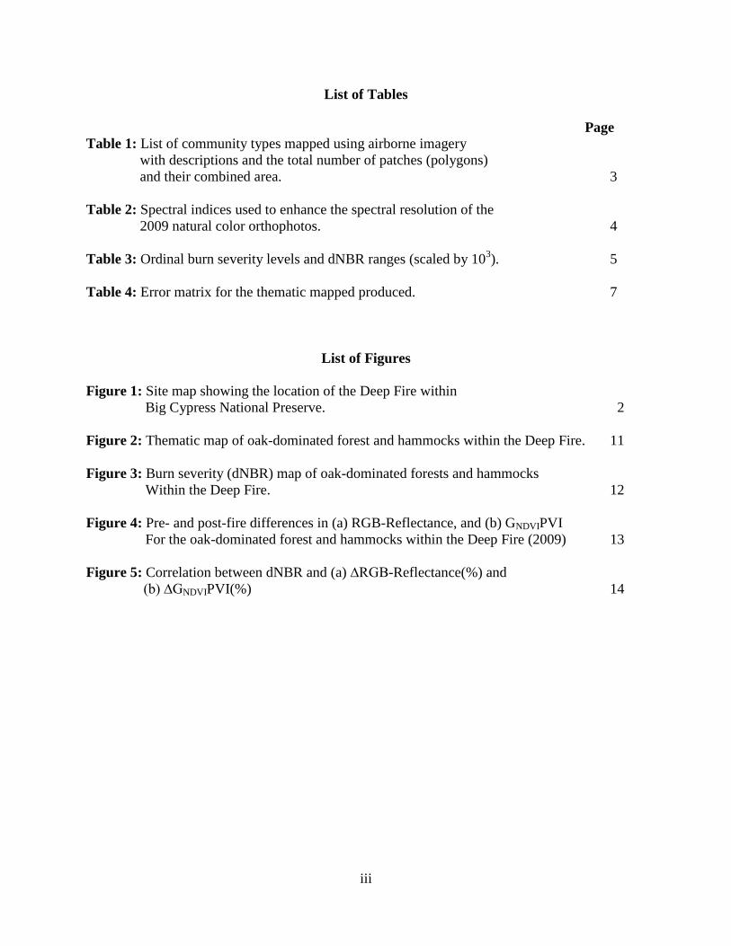
List of Tables
Page
Table 1: List of community types mapped using airborne imagery
with descriptions and the total number of patches (polygons)
and their combined area. 3
Table 2: Spectral indices used to enhance the spectral resolution of the
2009 natural color orthophotos. 4
Table 3: Ordinal burn severity levels and dNBR ranges (scaled by 103). 5
Table 4: Error matrix for the thematic mapped produced. 7
List of Figures
Figure 1: Site map showing the location of the Deep Fire within
Big Cypress National Preserve. 2
Figure 2: Thematic map of oak-dominated forest and hammocks within the Deep Fire. 11
Figure 3: Burn severity (dNBR) map of oak-dominated forests and hammocks
Within the Deep Fire. 12
Figure 4: Pre- and post-fire differences in (a) RGB-Reflectance, and (b) GNDVIPVI
For the oak-dominated forest and hammocks within the Deep Fire (2009) 13
Figure 5: Correlation between dNBR and (a) ∆RGB-Reflectance(%) and
(b) ∆GNDVIPVI(%) 14
1
1. Introduction
Within Big Cypress National Preserve (BICY), oak-dominated forests and woodlands as well as
tropical and temperate hardwood hammocks are integral components of the landscape and are
biodiversity hotpots for both flora and fauna. These broadleaved forest communities serve as
refugia for many of the Preserve’s wildlife species during prolonged flooding and fires.
However, both prolonged flooding and severe fires, which are important and necessary
disturbance vectors within this landscape, can have deleterious effects on these forested
communities. This is particularly true in the case of fires, which under extreme conditions
associated with drought and elevated fuel loads, can burn through these forested communities
consuming litter and understory vegetation and top killing most, if not all, of the trees present.
In South Florida, lightning fires, which usually occur in the wet season as a result of
thunderstorms, tend to be generally small and rarely severe (Wade et al. 1980; Snyder 1991).
However, fires at the start of the rainy season under drought conditions can spread quickly
through the landscape and burn for several weeks, consuming thousands of hectares (ha) before
being controlled and suppressed. These early season fires are typically associated with high
ambient temperatures and low humidity (Slocum et al. 2007), and thus tend to burn relatively hot
and pose the greatest risk to all biological resources within BICY. One such fire, the Deep Fire,
burned 12,000 ha within BICY between April 22 and May 11, 2009, and caused widespread
canopy damage, including tree mortality, on many of the oak-dominated forests and hammock
communities present within the Deep Fire incident boundary (Figure 1). Another source of fire
within this landscape is anthropogenic fires. These fires, which typically occur in winter and
early spring, tend to be relatively small in size and just like early season lightning fires can burn
extremely hot and cause severe damage to these forested communities.
Due to the high incidence of both natural and anthropogenic fires within BICY, it is important
for ecologists and resource managers working within BICY to 1) document and understand how
fire interacts with these forested communities, and 2) understand how biodiversity and
successional processes within these forested communities are affected by fire. Among the first
steps in accomplishing these tasks is to have a spatially and thematically accurate map of these
forested communities and a geodatabase that includes information regarding their structure and
composition as well as their fire history. This information would then be used to document and
monitor fire effects and post-fire recovery and succession over time.
With a major goal of understating the role of fire in shaping the landscape within BICY, the
primary objective of our research was to quantify the effects of the Deep Fire on the broadleaved
forest communities present within the fire incident boundary (Figure 1). Our approach was
twofold: first, we developed a pre-fire base map of all oak-dominated communities and
hammocks within the Deep Fire boundary using airborne imagery taken three months prior to the
fire, and then assessed broad-scale fire effects within these communities through the use of
spectral indices (SI) deceived from Landsat TM multispectral resolution imagery acquired three
months pre-fire (Jan 2009) and eight months post-fire (Jan 2010).

2
2. Methods
2.1 Study Area
This study was conducted within the perimeter of the Deep Fire in Big Cypress National
Preserve, Florida, USA (Figure 1). The Deep Fire, which burned for 20 days between April and
May 2009, was a lightning-ignited fire resulting from the onset of the rainy season in southwest
Florida. Aerial surveys during the fire suppression phase and immediately thereafter, indicated
that many of the oak-dominated forests and woodlands present within the fire boundary had been
significantly damaged with large numbers of oaks and other hardwood tree species having been
topkilled.

3
2.2 Vegetation Mapping
All oak-dominated forest and woodlands as well as broadleaved hammocks ≥ 400 m2 within the
Deep Fire boundary were identified, screen-digitized, and populated into an ESRI® ArcMap TM
9.3 geoadatabase. The basemap used to create the vegetation map was derived from 60-cm
spatial resolution natural color (Red, Green, Blue) compressed (30:1) Mrsid/MG3 orthophotos
acquired in January 2009 by SURDEX Corporation. However, because of the spatial complexity
of the landscape, the spectral similarity associated with the communities being mapped, and the
compression algorithm (i.e., Mrsid/MG3) used by SURDEX Corporation, the natural color
orthophotos proved to be inadequate for discriminating among target communities (Table 1).
Consequently, we enhanced the spectral resolution of the original orthophotos, by calculating six
spectral indices (Table 2) derived from the three original orthophoto spectral bands (Red, Green,
Blue). These six spectral indices were then stacked, a process of combining multiple images or
rasters into a single image, onto the original orthophotos. The resulting 9-band stacked mosaic
image (Red, Green, Blue, Pan, GRPVI, PVR, PPR, SI01, SI02) was resampled to a 1-m spatial
resolution to reduce image size and improve computer processing time.
Table 1: List of community types mapped using airborne imagery with descriptions and the total number of patches
(polygons) and their combined area.
Community
Type Description
No. of
Patches
Total
Area
(ha)
Mixed-Hardwood
Hammock
Closed canopy (>60%) high density forests dominated by evergreen
and semi-deciduous tropical and temperate broad-leaved trees. These
forests tend to be more hydric than similarly structured Tropical
Hardwood Hammocks.
59 175.6
Oak-Cabbage Palm
Hammock
Closed canopy (>60%) high-density stands of a co-dominant mix (40-
60%) of southern live oak (Quercus virginiana) and cabbage palm
(Sabal palmetto).
157 1,187.9
Oak Hammock
Closed canopy (>60%) stands dominated by southern live oak
(Quercus virginiana). Other canopy species may include cabbage palm
(Sabal palmetto) as well as tropical and temperate broad-leaved trees.
58 144.3
Oak-Saw Palmetto
Woodland
Open canopy (10-60%) stands of southern live oak (Quercus
virginiana) dominated by saw palmetto (Serenoa repens) in the
understory. Cabbage palm and other tree species maybe present
313 390.1
Tropical Hardwood
Hammock
Closed canopy (>60%) high density forests dominated by broad-leaved
evergreen and semi-deciduous tropical tree species. 10 10.0
4
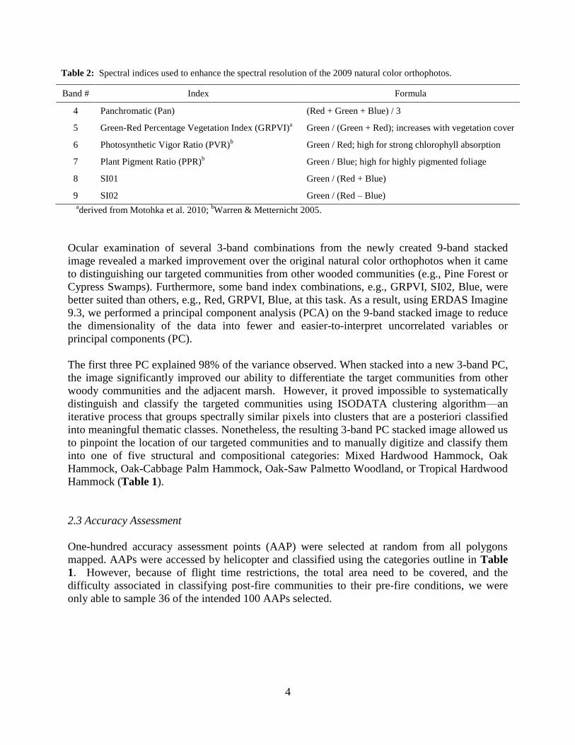
Table 2: Spectral indices used to enhance the spectral resolution of the 2009 natural color orthophotos.
Band # Index Formula
4 Panchromatic (Pan) (Red + Green + Blue) / 3
5 Green-Red Percentage Vegetation Index (GRPVI)a Green / (Green + Red); increases with vegetation cover
6 Photosynthetic Vigor Ratio (PVR)b Green / Red; high for strong chlorophyll absorption
7 Plant Pigment Ratio (PPR)b Green / Blue; high for highly pigmented foliage
8 SI01 Green / (Red + Blue)
9 SI02 Green / (Red – Blue) aderived from Motohka et al. 2010;
bWarren & Metternicht 2005.
Ocular examination of several 3-band combinations from the newly created 9-band stacked
image revealed a marked improvement over the original natural color orthophotos when it came
to distinguishing our targeted communities from other wooded communities (e.g., Pine Forest or
Cypress Swamps). Furthermore, some band index combinations, e.g., GRPVI, SI02, Blue, were
better suited than others, e.g., Red, GRPVI, Blue, at this task. As a result, using ERDAS Imagine
9.3, we performed a principal component analysis (PCA) on the 9-band stacked image to reduce
the dimensionality of the data into fewer and easier-to-interpret uncorrelated variables or
principal components (PC).
The first three PC explained 98% of the variance observed. When stacked into a new 3-band PC,
the image significantly improved our ability to differentiate the target communities from other
woody communities and the adjacent marsh. However, it proved impossible to systematically
distinguish and classify the targeted communities using ISODATA clustering algorithm—an
iterative process that groups spectrally similar pixels into clusters that are a posteriori classified
into meaningful thematic classes. Nonetheless, the resulting 3-band PC stacked image allowed us
to pinpoint the location of our targeted communities and to manually digitize and classify them
into one of five structural and compositional categories: Mixed Hardwood Hammock, Oak
Hammock, Oak-Cabbage Palm Hammock, Oak-Saw Palmetto Woodland, or Tropical Hardwood
Hammock (Table 1).
2.3 Accuracy Assessment
One-hundred accuracy assessment points (AAP) were selected at random from all polygons
mapped. AAPs were accessed by helicopter and classified using the categories outline in Table
1. However, because of flight time restrictions, the total area need to be covered, and the
difficulty associated in classifying post-fire communities to their pre-fire conditions, we were
only able to sample 36 of the intended 100 AAPs selected.

5
2.4 Burn Severity
Broad-scale post-fire burn severity within the mapped communities was assessed using
multitemporal (pre- and post-fire) medium spatial resolution (30 m pixel) Landsat TM
multispectral imagery. The two imagery were from Jan-2009, three months before fire, and Jan-
2010, eight months after fire. The raw spectral data for each Landsat TM image was corrected to
at satellite reflectance and atmospherically corrected in ENVI 5.0 to standardize each Landsat
TM image and correct for atmospheric transmittance. The Landsat TM imagery were then
resampled to a 1-meter spatial resolution to match the fine scale, 1:1,000 on screen resolution,
used to map community boundaries and clipped to encompass only the area affected by the Deep
Fire.
Following image standardization and resampling, we calculated the following spectral indices for
each polygon mapped: NBR and dNBR as well as RGB-Reflectance and GNDVIPVI. While NBR
and dNBR have been used extensively to assess burn severity by the US Forest Service and
others (e.g., Escuin et al. 2008), RGB-Reflectance and GNDVIPVI have never been used in this
capacity and are introduced as potential surrogates to dNBR.
NBR and dNBR are defined as:
NBR = 1000 * (ρ(NIR) - ρ(MIR)) / (ρ(NIR) + ρ(MIR)) (1)
dNBR = NBRpre-fire - NBRpost-fire (2)
where ρ(NIR) and ρ(MIR) represent spectral reflectance in the near-infrared and mid-infrared
portions of the electromagnetic spectrum for each Landsat TM image, respectively, and dNBR is
the difference between the pre- and post-fire NBR values. dNBR has a theoretical range between
-2,000 to +2,000, when scaled by 103, but values < -500 and > +1,300 are not typical and usually
the result of image anomalies not related to temporal bio-physical differences in land cover
resulting from fire (Eq. 2; Key and Benson 2006). Values < +100 generally represent unburned
or enhanced regrowth following a fire while values ≥ +100 indicate increasing burn severity
(Table 3; Key and Benson 2006).
Table 3: Ordinal burn severity levels and dNBR
ranges (scaled by 103).
Burn Severity Level dNBR Range
Enhance Regrowth, High -500 to -251
Enhance Regrowth, Low -250 to -101
Unburned -100 to +99
Low Severity +100 to +269
Moderate/Low Severity +270 to +439
Moderate/High Severity +440 to +659
High Severity +660 to +1300

6
RGB-Reflectance is defined as:
RGB-Reflectance = ρ(red) + ρ(green) + ρ(blue) (3)
where ρ(red), ρ(green), and ρ(blue) represent spectral reflectance in the visible spectral portion of
the electromagnetic spectrum. We expected to see an increase in the overall RGB-Reflectance
between the pre- and post-fire Landsat TM images for the plant communities mapped.
Furthermore, we expect that high RGB-Reflectance values in the 2010 Landsat TM imagery will
be indicative of areas with high burn severity and should be positively correlated to dNBR; that
is, as dNBR increases, RGB-Reflectance should also increase in response to a decrease in live
biomass and absorption of blue and red wavelengths by palisade mesophyll (e.g., chlorophyll a
and b, and β-carotene).
The Green-NDVI Percentage Vegetation Index (GNDVIPVI) is a derivative of Green-NDVI
(Gitleson et al. 1996) and is defined as:
GNDVIPVI = ρ(NIR) / (ρ(NIR) + ρ(green)) (4)
where ρ(NIR) and ρ(green) represent spectral reflectance in the near-infrared and green portions
of the electromagnetic spectrum, respectively. The values for this index range from 0 to +1 and
increase as a function of increasing vegetation cover and photosynthetic vigor. As a result, we
expect to see an overall decrease in the GNDVIPVI between pre- and post-fire Landsat TM images
for those plant communities mapped that burned during the fire, particularly in areas where the
fire was most severe. Furthermore, we expect that low GNDVIPVI values in the 2010 Landsat TM
imagery will be indicative of fire damage and should be negatively correlated to dNBR; that is,
as dNBR increases, indicating high burn severity, the GNDVIPVI values should decrease to reflect
a decrease in live biomass and reflectance in the green wavelength.
Lastly, a zonal mean function was used to calculate the mean pre- and post-fire RGB-
Reflectance, GNDVIPVI and dNBR for each community mapped. Using the zonal mean of each
community mapped, we calculated the pre- and post-fire percent change ∆(%) in RGB-
Reflectance and GNDVIPVI for each polygon mapped as followed:
∆(%) = ((t2 - t1) / t1) * 100 (5)
where t1 and t2 represent the pre- and post-fire zonal mean spectral index values, respectively, for
each polygon. Between-year difference in RGB-Reflectance and GNDVIPVI were tested using
Student’s t-test. Univariate regression analysis was then used to relate ∆RGB-Reflectance(%)
and ∆GNDVIPVI(%) between 2009 and 2010 to dNBR. All statistical analyses were done in
Statistica 7.0 (StatSoft Inc. 2005).

7
3. Results
3.1 Vegetation Map
The vegetation map produced contains a total of 597 forested patches encompassing 1,908 ha
(Figure 2). The most numerous community type mapped within the fire boundary was Oak-Saw
Palmetto Woodland with 313 patches (Table 1). However, Oak-Cabbage Palm Hammocks had
the greatest overall coverage with nearly 1,200 ha mapped and an average patch size of
approximately 7.5 ha. Tropical Hardwood Hammocks, on the other hand, were the least
common community types found and mapped with only ten patches encompassing no more than
10 ha in total.
Overall map accuracy was 78% with a Khat statistic (i.e., a measure of accuracy between the
thematic map and the reference data) of 70%. Producer accuracy (i.e., the percentage of a given
class that is correctly identified on the map) was very good for Mixed Hardwood Hammock, Oak
Hammocks, and Oak-Cabbage Palm Hammock, but poor for Oak-Saw Palmetto Woodland and
Tropical Hardwood Hammock (Table 4). In contrast, the user's accuracy (i.e., the probability that
a given pixel will appear on the ground as it is classed) was very low, < 80%, for Mixed Hardwood
Hammock, Oak Hammocks, and Oak-Cabbage Palm Hammock but high, 100%, for Oak-Saw
Palmetto Woodland and Tropical Hardwood Hammock (Table 4).
Table 4: Error matrix for the thematic mapped produced.
Mapped
Observed
Mixed
Hardwood
Hammock
Oak
Hammock
Oak-Cabbage
Palm Hammock
Oak-Saw
Palmetto
Woodland
Tropical
Hardwood
Hammock
Row
Total
User's
Accuracy
(%)
Mixed Hardwood
Hammock 2 1 2 5 40
Oak Hammock 7 1 1 9 78
Oak-Cabbage Palm
Hammock 5 2 1 8 63
Oak-Saw Palmetto
Woodland 12 12 100
Tropical Hardwood
Hammock 2 2 100
Column Total 2 7 6 17 4 36 0.78
Producer's
Accuracy (%) 100 100 83 71 50 Khat = 0.70
3.2 Burn Severity
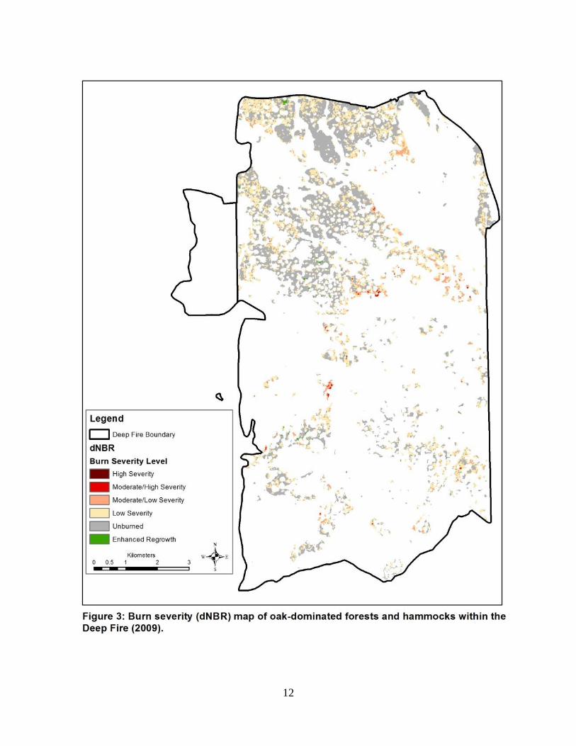
Post-fire assessment of burn severity, through dNBR, revealed a patch-mosaic of fire damage
and recovery for the oak-dominated communities and hammocks within the Deep Fire (Figure
3). Even eight months after the fire, 43.5% of these communities still showed evidence of low to
8
moderate burn severity, while 56.1% showed no signs of having burned. Enhanced regrowth was
observed in some areas but accounted for only 0.4% (Figure 3).
As expected, the RGB-Reflectance for the communities mapped increased while GNDVIPVI
decreased following the fire (Figure 4). Pre- and post-fire differences in community RGB-
Reflectance and GNDVIPVI were significant (t(594) = -29.2 and 35.8, respectively; P < 0.001). On
average, RGB-Reflectance values were 0.017 higher while GNDVIPVI values were 3.3% lower
eight months following the fire (Figure 4).
Percent change in both the RGB-Reflectance and GNDVIPVI indices were significantly correlated
(P < 0.001) to dNBR and increasing burn severity (Figure 5). As expected, ∆RGB-
Reflectance(%) was positively correlated to dNBR while ∆GNDVIPVI(%) was negatively
correlated (Figure 5). However, ∆GNDVIPVI(%) showed a stronger correlation with dNBR than
did ∆RGB-Reflectance(%) (r= -0.862 vs r = 0.390, respectively).
4. Discussion:
The accuracy of the map produced, 78%, and khat statistic, 70%, was good but not within the
standard of >80% set by the USGS/NPS Vegetation Mapping Program protocols (TNC and
ESRI 1994). Yet, for individual thematic classes the producer's and user's accuracy of >80% was
met (Table 4). The low number of AAPs sampled (36 out of the intended 100) and the post-fire
determination of pre-fire communities during the accuracy assessment phase very likely
contributed to the lower than expect map accuracy and low Khat statistic. Furthermore, the
accuracy of the thematic classes was limited by the spatial and spectral resolution of the imagery
and its delivered format (i.e., Mrsid/MG3), which impeded our ability to accurately identify and
map the targeted communities. Nonetheless, when compared to previous mapping efforts for the
same area within BICY (see Welch et al. 1999), we find that this map did a much better job at
identifying and mapping the oak-dominated forest and woodlands as well as tropical and
temperate hardwood hammocks within the Deep Fire boundary. Consequently, as a management,
monitoring, and inventory tool, this map of the Deep Fire should help managers and researchers
identify the locations of these communities within the Deep Fire and to monitor their post-fire
recovery and successional processes.
The dNBR burn severity map made eight months after the fire (Figure 3) indicates that the
majority of the communities burned during the Deep Fire were well into recovery by then. Burn
severity for the mapped communities ranged between low and moderate/high burn severity, with
few if any of the mapped communities experiencing high burn severity (Figure 3). This is
somewhat surprising considering the intensity of the fire and the ground based observations
made during fire suppression (see Watts et al. 2012). However, in southern neo-tropical
peninsular Florida, plant communities are known to recover quite quickly after a fire.
Consequently, an eight month gap between fire suppression and the burn severity assessment is
rather substantial and might have lead to an underestimate of burn severity for the communities
mapped within the Deep Fire. This suggests that dNBR may not be a good estimator of burn
severity if a significant temporal gap exists between fire suppression and when the burn severity

9
assessment is conducted for communities whose species are well adapted to fire and demonstrate
a propensity to recover quickly following fire.
Both the RGB-Reflectance and GNDVIPVI indices responded as expected and appear to be good
predictors of post-fire community photosynthetic capacity reduction and burn severity (Figure
5). RGB-Reflectance increased between 2009 and 2010 in response to a significant decrease in
palisade mesophyll absorption of the blue and red wavelength while GNDVIPVI decreased as a
result of a significant reduction in live biomass and reflectance in the green wavelength (Figure
4). Overall, ∆GNDVIPVI(%) showed the highest correlation to dNBR and, as such, could be used,
after further evaluation, to act a surrogate to dNBR when the available imagery lacks a mid-
infrared band.

10
References:
Escuin,, E., R. Navarro, and P. Fernandez. 2008. Fire severity assessment by using NBR (Normalized
Burned Ratio) and NDVI (Normalized Difference Vegetation Index) derived from LANDSAT
TM/ETM images. International Journal of Remote Sensing. 29(4):1053-1073.
Gitelson, A.C., Y.J. Kaufman, M.N. Merzlyak. 1996. Use of a green channel in remote sensing of global
vegetation from EOS-MODIS. Remote Sensing of Environment 58:289-298.
Key C.H, and N.C. Benson. 2006. Landscape assessment: sampling and analysis methods. In D.C. Lutes,
R.E. Keane, J.F. Caratti, C.H. Key, N.C .Benson, S. Sutherland, L.J. Gangi (Eds.). FIREMON: Fire
Effects Monitoring and Inventory System. General Technical Report RMRSGTR-164-CD. USDA
Forest Service, Rocky Mountain Research Station, Fort Collins, CO.
http://frames.nbii.gov/projects/firemon/FIREMON_LandscapeAssessment.pdf
Motohka, T. K. N. Nasahara, H. Oguma, and s. Tsuchida. 2010. Application of green-red vegetation
index for remote sensing of vegetation phenology. Remote Sensing 2: 2369-2387; DOI:
10.3390/rs2102369.
Slocum, M.G., W.J. Platt, B. Beckage, B. Panko, and J.B. Lushine. 2007. Decoupling natural and
anthropogenic fire regimes: a case study in Everglades National Park, Florida. Natural Areas Journal
27: 41-55.
StatSoft Inc. 2005. Statistica for Windows. StatSoft Inc., Tulsa, OK, USA.
Snyder, J.R. 1991. Fire regimes in subtropical South Florida. In ‘Proceedings of the Tall Timbers Fire
Ecology Conference No. 17 – High intensity fire in wildlands: management challenges and options.
18–21 May 1989. pp. 303–319. (Tall Timbers Research Station: Tallahassee, FL)
The Nature Conservancy and Environmental Systems Research Institute. 1994. NBS/NPS Vegetation
Mapping Program: Standardized National Vegetation Classification System. 112 pp. Report to the
United States Department of Interior United States Geological Survey and National Park Service.
Wade D, J. Ewel, and R. Hofstetter. 1980. Fire in south Florida ecosystems. USDA Forest Service,
Southeastern Forest Experiment Station General Technical Report SE-17. (Asheville, NC)
Warren, G. and G. Metternicht. 2005. Agricultural applications of high-resolution digital multispectral
imagery: evaluating within-field spatial variability of canola (Brassica napus) in Western
Australia. Photogrammetric Engineering & Remote Sensing 71(5): 595-602.
Watts, A.C., L.N. Kobziar, and J.R. Snyder. 2012. Fire reinforces structure of pondcypress (Taxodium
distichum var. imbricarium) domes in a wetland landscape. Wetlands 32(3): 439-448 DOI:
10.1007/s13157-012-0277-9.
Welch, R., M. Madden, and R.F. Doren. 1999. Mapping the Everglades. Photogrammetric Engineering
and Remote Sensing. 65(2): 163-170.

11
12

13

14
Related Documents