www.ssoar.info Mappae Mundi: humans and their habitats in a long- term socio-ecological perspective ; myths, maps and models Vries, Bert de (Ed.); Goudsblom, Johan (Ed.) Veröffentlichungsversion / Published Version Sammelwerk / collection Zur Verfügung gestellt in Kooperation mit / provided in cooperation with: OAPEN (Open Access Publishing in European Networks) Empfohlene Zitierung / Suggested Citation: Vries, B. d., & Goudsblom, J. (Eds.). (2002). Mappae Mundi: humans and their habitats in a long-term socio- ecological perspective ; myths, maps and models. Amsterdam: Amsterdam Univ. Press. https://nbn-resolving.org/ urn:nbn:de:0168-ssoar-316282 Nutzungsbedingungen: Dieser Text wird unter einer CC BY-NC-ND Lizenz (Namensnennung-Nicht-kommerziell-Keine Bearbeitung) zur Verfügung gestellt. Nähere Auskünfte zu den CC-Lizenzen finden Sie hier: https://creativecommons.org/licenses/by-nc-nd/4.0/deed.de Terms of use: This document is made available under a CC BY-NC-ND Licence (Attribution-Non Comercial-NoDerivatives). For more Information see: https://creativecommons.org/licenses/by-nc-nd/4.0

Welcome message from author
This document is posted to help you gain knowledge. Please leave a comment to let me know what you think about it! Share it to your friends and learn new things together.
Transcript
www.ssoar.info
Mappae Mundi: humans and their habitats in a long-term socio-ecological perspective ; myths, mapsand modelsVries, Bert de (Ed.); Goudsblom, Johan (Ed.)
Veröffentlichungsversion / Published VersionSammelwerk / collection
Zur Verfügung gestellt in Kooperation mit / provided in cooperation with:OAPEN (Open Access Publishing in European Networks)
Empfohlene Zitierung / Suggested Citation:Vries, B. d., & Goudsblom, J. (Eds.). (2002). Mappae Mundi: humans and their habitats in a long-term socio-ecological perspective ; myths, maps and models. Amsterdam: Amsterdam Univ. Press. https://nbn-resolving.org/urn:nbn:de:0168-ssoar-316282
Nutzungsbedingungen:Dieser Text wird unter einer CC BY-NC-ND Lizenz(Namensnennung-Nicht-kommerziell-Keine Bearbeitung) zurVerfügung gestellt. Nähere Auskünfte zu den CC-Lizenzen findenSie hier:https://creativecommons.org/licenses/by-nc-nd/4.0/deed.de
Terms of use:This document is made available under a CC BY-NC-ND Licence(Attribution-Non Comercial-NoDerivatives). For more Informationsee:https://creativecommons.org/licenses/by-nc-nd/4.0
Humans and their Habitats in a Long-Term Socio-Ecological Perspective
Myths, Maps and Models
MAPPAE MUNDI
MAPPAE MUNDI
B . D E V R I E S A N D J . G O U D S B L O M ( E D S . )
A M S T E R D A M U N I V E R S I T Y P R E S SA M S T E R D A M U N I V E R S I T Y P R E S S
Never before in history was the interaction between
people and their natural environment as complex
and problematic as it is today. A proliferation of
scientific research has yielded valuable insights
into various aspects of this interaction from the
angle of many disciplines – the natural sciences,
the social sciences, archaeology and history,
ecological studies. The diversity of approaches has
created a need for synthesis, for a study that trans-
cends the boundaries of traditional fields of study.
In this volume, authors from various academic
backgrounds discuss the relations between human
society and its physical environment in the course
of history, highlighting a number of significant
periods, throughout the world. The last chapter
assesses our present situation and prospects for
the future in the light of theoretical reflections
based on the evidence from the past.
Bert de Vries is senior researcher at the National Institute
for Public Health and the Environment.
Johan Goudsblom is emeritus professor of Sociology at
the University of Amsterdam.
De Vries
Goudsblom
(eds.)
MAPPAEMUNDI
isbn 90 5356 535 3
W W W . A U P . N L
MM omslag DEF 08-04-2004 16:40 Pagina 1

Mappae Mundi bw zw/w 08-04-2004 15:24 Pagina 1

Mappae Mundi bw zw/w 08-04-2004 15:24 Pagina 2
Mappae Mundi
Humans and their Habitats in a Long-Term Socio-Ecological Perspective
Myths, Maps and Models
second updated printing
Bert de Vries and Johan Goudsblom(eds.)
amsterdam university press
Mappae Mundi bw zw/w 08-04-2004 15:24 Pagina 3
First published (hardback) 2002Second updated printing (paperback) 2003
Cover design: Magenta Ontwerpers, AmsterdamLay-out: Magenta Ontwerpers, Amsterdam
ISBN 90 5356 655 4NUR 740
© Amsterdam University Press, Amsterdam, 2003
All rights reserved. Without limiting the rights under copyright reserved above, no part of this book
may be reproduced, stored in or introduced into a retrieval system, or transmitted, in any form or by
any means (electronic, mechanical, photocopying, recording or otherwise) without the written permis-
sion of both the copyright owner and the author of the book.
Mappae Mundi bw zw/w 08-04-2004 15:24 Pagina 4
Contents
Preface 11
Editors’ Acknowledgement 13
1. Introduction: Towards a Historical View of Humanity and the BiosphereGoudsblom and De Vries
1.1. A new sense of change 151.2. The static character of ancient world views 171.3. Myths, maps, and models 18
2. Introductory Overview: the Expanding AnthroposphereGoudsblom
2.1. Life before humans 212.1.1. The first environmental crisis in the biosphere 212.1.2. Continental drift 222.2. Early humans and their first big impact: fire 232.2.1. Human origins and extensive growth 232.2.2. Intensive growth: technology, organization and civilization 272.2.3. The original domestication of fire 282.2.4. Long-term consequences 302.2.5. Regimes 332.3. Intensified human impact: agrarianization 342.3.1. Emergence 352.3.2. Continuities 362.3.3. Sequences 372.3.4. Hypertrophy and atrophy 392.4. Industrialization: the rise of the third regime 42
5
Mappae Mundi bw zw/w 08-04-2004 15:24 Pagina 5
3. The Holocene: Global Change and Local ResponseMarchant and De Vries
3.1. Introduction 473.2. Holocene climate and climate change 503.3. Climate change and human populations: Equatorial Africa 573.3.1. From the Late Glacial towards the middle-Holocene climatic
‘optimum’ 583.3.2. Environmental drying about 4000 yr BP and increasing vegetation
degradation: the transition to the present 603.4. Early human-environment interactions: the Americas 623.4.1. Environmental and cultural change in western Peru 623.4.2. Late-Holocene environmental and Mayan cultures 643.5. The Vera Basin in Spain: 10,000 years of environmental history 653.6. Conclusions 70
4. Environment and the Great Transition: AgrarianizationDe Vries and Marchant
4.1. Introduction 714.2. Environment and human habitat 734.2.1. Mountains, hills and plains 754.2.2. Rivers, lakes and coasts – and the sea 774.2.3. Steppe and savannah lands 804.2.4. Forest peoples 814.3. The agricultural transition: some narratives from science 844.3.1. The Iranian Plateau and the surrounding plains 844.3.2. Europe 884.3.3. East and South Asia 924.3.4. North America: the Anasazi and the Hohokam people 934.4. The agricultural transition: how and why? 964.4.1. The origins and spread of agriculture and pastoralism 974.4.2. Causes and consequences of agricultural expansion 1004.5. Mapping the past: Europe in the Late Neolithic 1074.6. Conclusions 108
6
Mappae Mundi bw zw/w 08-04-2004 15:24 Pagina 6
5. Exploring the Past: on Methods and ConceptsDe Vries, Marchant and De Greef
5.1. Introduction 1115.2. Concepts and categories to organize the knowledge of the past 1125.2.1. An epistemological note 1135.2.2. Models: population-environment interactions 1155.3. Time, space and resources 1195.3.1. Orientation in time 1205.3.2. Orientation in space 1245.3.3. Resources 1285.4. Complexity 1295.5. Methods of acquiring knowledge about the past: setting the clock 1345.5.1. Absolute dating 1365.5.2. Relative estimates of age 1385.6. The potential for human habitation and stages of agricultural
development 1395.7. Conclusions 146
6. Increasing Social ComplexityDe Vries
6.1. Introduction 1496.2. Manifestations of increasing social complexity 1506.2.1. Megaliths 1516.2.2. Non-agricultural resources 1546.2.3. Interactions: trade 1776.2.4. Interactions: diffusion and migration 1796.3. Early state and empire formation 1816.3.1. Early urban centres in Mesopotamia 1816.3.2. South Asia: Indus-Sarasvati 1846.3.3. State formation in the Aegean 1876.3.4. Meso-America 1896.4. From states to empires 1926.4.1. Egypt 1926.4.2. China 1956.5. What happened in the fringes of empires? 1986.6. The decline and fall of social complexity 2036.7. Conclusions 207
7
Mappae Mundi bw zw/w 08-04-2004 15:24 Pagina 7
7. Empire: the Romans in the MediterraneanVan der Leeuw and De Vries
7.1. Introduction: Why the Roman Empire as a case study and from which perspective? 209
7.2. Critical social and environmental phenomena accompanying Roman expansion 211
7.2.1. An increase in surface and population 2117.2.2. Urbanisation 2147.2.3. Transport and commerce 2177.3. The human environment in Roman times 2237.3.1. Geography and climate 2247.3.2. Colonization 2267.3.3. Introducing industrialization of agriculture and commercial exploitation of
the land 2317.3.4. A different perception of space and the landscape 2347.4. The Roman Empire as a self-organizing system 2387.4.1. Self-organization 2387.4.2. An example: newly colonized environments 2437.4.3. Stagnation is decay: changing settlement patterns in the Rhône Valley
100 BC to 600 AD 2447.4.4. What consequences does this have on the level of the Empire – how did it
become a ‘global crisis’? 2487.5. The decline and end of the Empire 2487.5.1. The disintegration process 2487.5.2. Causes and effects: on the centre-periphery information gradient 2517.6. Conclusions 255
8. Understanding: Fragments of a Unifying PerspectiveDe Vries, Thompson and Wirtz
8.1. Introduction 2578.2. Modelling the Neolithic transition: a global dynamic model 2588.2.1. Spatial dimension: recovering effective projections of the environment 2588.2.2. Time dimension: socio-economic and technological evolution 2598.2.3. Integrating space and time: agrarianization, migration and climate
change 2628.2.4. The computerized emergence of spatio-temporal patterns 2648.3. Humans and their environment: a few more modelling exercises 2668.3.1. Lakeland: fishing and mining strategies 266
8
Mappae Mundi bw zw/w 08-04-2004 15:24 Pagina 8
8.3.2. Population growth among the !Kung San 2698.3.3. What happened to the North American Pueblo Indians in the period
900-1300 AD? 2718.4. Social science perspectives on state formation and environment 2738.5. Perspectives on states and environment: insights into system dynamics 2778.5.1. About processes, mechanisms and pathologies 2778.5.2. The importance of interactions 2808.5.3. Humans and their environment as complex adaptive systems 2828.6. Change and complexity in socio-natural systems 2838.6.1. Cultural Theory and ecocycles 2838.6.2. Complexity in socio-natural systems: the need for requisite variety 2898.6.3. Cultural dynamics and environmental (mis)management: always learning,
never getting it right 2908.6.4. Complexity and the importance of being clumsy 2928.6.5. Theories of change that make change permanent 2968.7. Conclusions 299
9. Population and Environment in Asia since 1600 ADRevi, Dronin and De Vries
9.1. Introduction 3019.2. South Asia: population and environment in a geopolitical context 3049.2.1. Population dynamics 3229.2.2. Agriculture and food 3269.2.3. Famines 3329.3. Population and environment in South-East Asia – a historical view with
particular reference to Sulawesi (Indonesia) 3369.4. Russian expansion: eastward bound 3449.4.1. Medieval Russia and the trade in forest products 3449.4.2. Muscovy Russia and the Russian Empire: extensive, not intensive growth 3469.4.3. Land scarcity and rural overpopulation as the motor for expansion 3489.5. Conclusions 351
10. The Past 250 Years: Industrialization and GlobalizationGoudsblom
10.1. Early industrialization 35310.1.1. The meaning of industrialization 35410.1.2. Connections and continuities with the earlier regimes 35510.1.3. Origins and antecedents 355
9
Mappae Mundi bw zw/w 08-04-2004 15:24 Pagina 9
10.1.4. The early industrial archipelago 35610.1.5. Coal exploitation as intensified land use 35710.2. Globalization and European expansion 36010.2.1. European expansion as an episode in human history 36010.2.2. A theoretical interlude: figurational dynamics 36110.2.3. Agrarian expansion: sugar 36210.3. Accelerating expansion 36410.3.1. Extension and intensification of agrarian regimes 36410.3.2. Extension and intensification of industrial regimes 369
11. Back to Nature? The Punctuated History of a Natural MonumentWestbroek
11.1. Introduction 37911.2. On a rowing boat 38011.3. Natural causes 38311.4. The impact of culture 38611.5. Uneasy compromise 39011.6. Nature 392
12. Conclusions: Retrospect and ProspectsGoudsblom and De Vries
12.1. The discovery of the biosphere 39512.2. Historical and theoretical reflections 40212.3. Prospects 40512.3.1. Paradoxes of prediction 40512.3.2. Scenarios 40712.3.3. Towards a fourth regime? 411
Notes 415
Bibliography 423
About the Authors 445
Index of Subjects 447Index of Names 461Index of Geographic Names 465
10
Mappae Mundi bw zw/w 08-04-2004 15:24 Pagina 10
Preface
This book is published on the occasion of the celebration of the 250th anniversary of theHolland Society of Arts and Sciences. The founders of our Institution were – as could beexpected in the middle of the 18th century – deeply convinced that science, and perhapsalso to some extent the arts, should play a significant role in the prosperous developmentof the town of Haarlem and its surroundings in Holland. Several comparable ‘LearnedSocieties’ already existed in Europe and America, but our Society was the first to beestablished in the Netherlands.
Since the foundation of the Holland Society the enlightened optimism about theimpact of scientific work has changed to a more prudent vision. Nevertheless, we under-took this project following the traditional aim of our Institution to advance science forthe benefit of society, by selecting as its subject the interaction between humanity andthe biosphere. This subject is of course not new. Through the last decades many differentand richly faceted studies have been undertaken and articles and books that shed newlight on this interaction are published almost daily. However, many questions remainunanswered and it seems that the number of issues and questions increases rather thandiminishes.
It is obviously beyond the scope of one limited project – limited in time, manpowerand budget – to give satisfactory answers to many of these questions. But we think thatthis book will give a new and deeper understanding by means of the approach taken andthe inclusion of recent and innovative points of view. As the title of the book suggests,the authors have made extensive use of maps, both historical and contemporary, whileexploring less known or unknown territory. These maps and many local and regionalnarratives do not only illustrate this study, they also facilitate our view of the complexinteraction between humans and the environment.
In this book sustainable development is not dealt with as a rather static desirabletrack between the present and the future, but as part of a long-term, dynamic and evolu-tionary process of the co-existence of humanity and its environment that started manymillennia ago. A fundamental opinion of the authors is that we need a thorough under-standing of the past in order to be able to say something sensible about the future. Andeven then we will have to be prepared to encounter surprises and disappointments, as wedid in the past. Another important element of the book is that we have tried, contrary tomost studies on humans and the biosphere, to approach the subject not only from a nat-ural science angle, but also integrate views from the historical and social sciences. Theattempt to present a truly interdisciplinary synthesis of many different points of view
11
Mappae Mundi bw zw/w 08-04-2004 15:24 Pagina 11
was a major motivation to embark on this project.We hope to have delivered a contribution to constructive thinking about the future
challenges that mankind is facing in its quest for sustainable development. We shouldlearn from the mistakes we have made, which often stem from our tendency to think interms of simple relationships of cause and effect and to rely too much on implicitlydeterministic models. We should recognize that we probably have less coherent knowl-edge than we thought. We hope that this study will stimulate further research into theterra incognita that we have entered and we are convinced that a better understanding ofthese complex issues is the best guarantee against future errors.
We would like to thank the authors for their important contributions and in particu-lar Dr Bert de Vries and Professor Johan Goudsblom for their highly valuable work inediting and for writing a large part of this book. We thank Professor Frans Saris for hishelp in finding and keeping this work on the right track. We acknowledge with gratitudethe substantial support and scientific input from the Dutch National Institute of PublicHealth and the Environment (RIVM). Finally, we gratefully acknowledge the support ofthe Energy Centre Netherlands (ECN) and the substantial financial contribution fromthe Jan Brouwer Foundation.
Ir Maarten van VeenChairman Holland Society of Arts and Sciences
12
Mappae Mundi bw zw/w 08-04-2004 15:24 Pagina 12
Editors’ Acknowledgements
We wish to thank first of all the Hollandsche Maatschappij der Wetenschappen for itsinitiative to launch this project and for its invitation to us to carry it out. We havereceived valuable suggestions and comments in meetings with directors and members ofthe Maatschappij. We are particularly grateful to Maarten van Veen and Frans Saris whohave shown a strong personal interest in our work throughout its progress. Evidently,this interdisciplinary attempt at synthesis would not have reached its present stage with-out important contributions from other people, foremost our co-authors who haveaccepted the challenge to contribute to such an ambitious and multi-faceted adventure.
One of us (BdV) wishes to thank the members of the Balaton Group which in diverseways contributed to the initial idea and who were instrumental in getting the muchappreciated contribution from Emma Romanova of the Department of the PhysicalGeography of the World, Lomonosov Moscow State University. We also wish to thankparticipants of two workshops, in Santa Fe and Abisko, on complexity in socio-naturalsystems who were a great source of inspiration and information. In particular, the con-tributions on multi-agent simulations from Tim Kohler of the Department of Anthro-pology of Washington State University, from Dwight Read of the Department of Anthro-pology and the Department of Statistics of the University of California Los Angeles andfrom Lena Sanders of the team Géographie-cités of CNRS-Université Paris 1 are appre-ciated.
We are grateful to David Henley of the KITLV (Royal Institute of Linguistics andAnthropology) in Leiden for sharing his insights on the environmental history ofIndonesia and to the scholars who contributed textboxes on some themes – Jan Boerse-ma, Pieter Bol, Paul Erdkamp and Frans Wiggermann. We also wish to thank HugoBurger of ECN, David Christian, Stephen Mennell and Jan Luiten van Zanden for theirinquisitive, helpful and encouraging comments. Last but not least, invaluable assistancein making the maps has been given by Kees Klein Goldewijk of the the Dutch NationalInstitute of Public Health and the Environment (RIVM) – his expertise and patient per-sistence made it possible to communicate not only by words but also by maps andgraphs.
13
Mappae Mundi bw zw/w 08-04-2004 15:24 Pagina 13

Mappae Mundi bw zw/w 08-04-2004 15:24 Pagina 14
1
Introduction: Towards a Historical View ofHumanity and the Biosphere
1.1. A new sense of change
We live in a world that is changing, and we know we do. When we compare the condi-tions in which we find ourselves today with those prevailing around 1750, a mere tengenerations ago, we can draw up an almost endless list of differences. There are, tomention just one of the most striking facts, far more of us. In 1750 humankind num-bered around 771 million people; that is about 25% less than the population of Indiatoday (see Table 1.1). Most people were younger, with an average life expectancy of27 years across the world, about half of today’s global average. Mass-produced con-sumer goods did not exist at all; most of the technical and hygienic amenities that wetend to take for granted today were either unknown or available only to small privilegedgroups.
. , , -
10,000 BC 0 1750 1970 1990
Population (millions) 6 252 771 2530 5292
Annual growth (%) 0.008 0.037 0.064 0.596 1.8452q
Doubling time in years 8369 1854 1083 116 38
Life expectancy at birth 20 22 27 35 55
Source: Livi-Bacci 1992: 31
At the time, the conditions of a basically rural world dominated by scarcity must haveseemed timeless to most people. And yet, on closer inspection, the world of 1750 waschanging, as indeed the world had been doing since time immemorial. Moreover, as we
15
Mappae Mundi bw zw/w 08-04-2004 15:24 Pagina 15
now know, around 1750 humanity was approaching a cascade of radical and rapidlyaccelerating transformations. Among some people of that era, an awareness of ubiqui-tous and pervasive change was already dawning.
This sense of change was brilliantly expressed and elaborated in two lectures deliv-ered in the summer of the year 1750 at the Sorbonne by the then 23-year-old futurestatesman Turgot. He pointed out the contrast between physical nature, which he saw assubject to constant laws, and the human world, which is continuously changing. Innature, he said, the same cycles repeat themselves endlessly: day and night, full moonand new moon, summer and winter. There is, however, one exception to all these pat-terns of never ending recurrence, and that is human society. While the rest of the uni-verse keeps going through the same motions eternally, human beings are able to conceivenew ideas, put these ideas into practice and transmit their innovations to the generationsthat come after them (see Manuel 1962: 11-52).
Turgot’s view itself was something new, confirming his own thesis. Perhaps that thesiswas not entirely original, and he gave voice only to certain ideas that were already circu-lating in intellectual circles. But he did so with great sagacity, and he is still rememberedas one of the first to see that human societies are involved in long-term processes ofchange. He tried to bring home to his audience that humankind had come a long waybefore arriving at the conditions with which the people of his day and age were familiar.
The picture of nature as fundamentally unchanging – emphasized by Turgot as arhetorical contrast to his own dynamic view of human society – corresponded with thetheories of physics of Newton and, later, Laplace, as well as Linnaeus’ botanical andanatomical theories. These theories seemed to imply that all changes were essentiallyephemeral – variations on a basic pattern which remained constant. In a rural societyattuned to the regular cycles of the always recurring seasons such an idea of natural stasis was highly plausible.
France around 1750 was an agrarian society. The ancient mode of subsistence bymeans of foraging had long become economically insignificant, and industrializationhad not yet fully begun. In agrarian societies all over the world there has always been astrong tendency to see the past, the present and the future as essentially similar. Ofcourse, stories were told about great and cataclysmic events that occurred in a distantpast: acts of creation; struggles between gods, between gods and men, between men; dis-asters such as earthquakes and floods. All those stories suggested, however, that theevents had taken place against a background that did not change. The books of the OldTestament offer a good example: they are full of drama and disaster. But while men comeand go, while terrible battles are waged and cities are destroyed to the last stone, the set-ting in which the events occur remains in essence unchanged. Landscape and climateappear as a fixed décor; it seems that ever since Adam and Eve were driven out of para-dise, humanity has lived in the same natural environment of hills and valleys, coveredwith similar fields and pastures. When, in the European Middle Ages, painters made pic-
16
Mappae Mundi bw zw/w 08-04-2004 15:24 Pagina 16
tures of biblical stories, they used as a background the sort of scenery with which theythemselves were familiar, as if the landscape had never changed.
The biblical accounts certainly contain several references to environmental up-heavals; the great flood is the best known and most dramatic. All these events aredescribed as unique, as singular acts of God to punish men. They are not treated asepisodes in what we today might regard as a long-term transformation of the relation-ships between human groups and their habitats.
1.2. The static character of ancient world views
In trying to understand the present and anticipate the future, people have always con-structed images of the past. For a long time, their accounts were, by our current stan-dards, imprecise, vague, and hampered by an inevitably narrow view of the world. Noone could help being ethnocentric: their range of action and information was necessari-ly limited, and they lacked the means to extend their vision in a realistic manner beyondthe region with which they were familiar. For explanations reaching further than theirown experience, their best bet was often to rely on generally accepted lore about super-natural forces, to which they ascribed similar motives and powers as they were wont toobserve in human beings and animals.
In Turgot’s time, intellectuals considered such lore with contempt. They were in thevanguard of a change in mentality which the sociologist Max Weber called a ‘disenchant-ment of the world’. Enlightened citizens increasingly came to entertain a world view inwhich spirits and gods no longer played a prominent part. Deliberate attempts weremade to diminish the element of fantasy and to broaden the range and scope of reliableobservations on which the world view was founded. With the decreasing interest in gods,the question of origins also receded and was replaced by a search for the fundamentalmechanisms operating in the universe – a long-term change in mental orientation thathas been described by the Dutch historian of science, E.J. Dijksterhuis (1969), as the‘mechanization’ of the worldview.
The ‘mechanization’ of the world view did not really disturb the essentially staticimage of nature. Its effect was rather to render that image even more solidly static than ithad been before. Newtonian physics could be interpreted as being in perfect harmonywith the biblical version of cosmology: the divine act of creation of the world includedthe creation of the eternal laws that governed all motion in the universe. In the well-known epigram of the poet Alexander Pope:
Nature and Nature’s laws lay hid in night:
God said: let Newton be! and all was light.1
17
Mappae Mundi bw zw/w 08-04-2004 15:24 Pagina 17
At the same time in 18th century Europe that the ‘mechanization’ of the world view wasreaching its apex, a more dynamic, historical orientation was also emerging. Turgot’sidea of the cumulative progression of human society is an example. Turgot failed toacknowledge, however, that a similar reorientation in the direction of ‘historization’ wasalso occurring in some of the natural sciences, notably in geology and biology. Buffon’sconcept of ‘natural history’ for the study of life bears witness to this reorientation. Geol-ogists in particular produced a lot of empirical evidence – and speculation – supportingthe idea of irreversible secular change. In the 19th century, biology followed suit withDarwin’s theory of evolution. With that theory, biology provided the missing linkbetween geology and sociology in the construction of an encompassing dynamic world-view. The process of ‘historization’ gained still more momentum when, in the secondhalf of the 20th century, the time dimension and the concept of ‘deep time’ becameincorporated in the theories of astronomy and physics.2
The general shift toward a dynamic world view has also led to new ways of conceivingthe relationship between human beings and their habitats. That relationship is no longerseen as inherently stable, but rather as marked by tendencies toward change on bothsides. On the one hand, there are continuous processes of ‘spontaneous’ natural changein landscape and climate, sometimes bursting forth dramatically in such events as hurri-canes, earthquakes, and volcanic eruptions which interfere relentlessly with humanaffairs. On the other hand, human society generates processes of change which, in turn,affect landscape and climate. An increasing portion of the land surface of our planet hasbeen transformed for agrarian and industrial production, for urban living, and for traf-fic and trade by rail, by road, on water, and through the air. In a process extending overcountless generations, the anthroposphere has been expanding within the planetarybiosphere. The dynamic two-way interaction between these two spheres is the subject ofthis book.
1.3. Myths, maps, and models
It has often been observed that humanity is a unique species – just like every otherspecies. In this book we are mainly concerned with the most recent stages in humandevelopment, after humanity had established a position that made it ‘uniquely unique’in the animal kingdom: a position of dominance in which the balance of power betweenhuman groups and all other large animals is tilted strongly in favour of humans. Thisposition of dominance has obviously not put an end to human dependence on the forcesof nature, but it has certainly increased the possibilities for the growth of human soci-eties. It has led, particularly in our own time, to an enormous increase in sheer humannumbers (‘extensive growth’) as well as a staggering rise in the standard of living (‘inten-sive growth’) among the rich part of humanity.
18
Mappae Mundi bw zw/w 08-04-2004 15:24 Pagina 18
In the inquiries that follow we hope to make the general trend of the expansion of theanthroposphere more visible, more understandable and, ideally, more explainable. Weshall do this by looking at human history not as a continuous success story, but rather asa bundle of divergent, and often discontinuous, episodes, many of which have ended ininconspicuous transitions, and quite a few in downright disaster. In our view, the trendtoward increasing dominance has been matched by a trend toward greater complexity ofhuman societies; we shall argue that, in spite of discontinuities, the latter trend has untilnow proved irresistible. The greater complexity of the relationships between humansand the biosphere has made these relationships in many ways less transparent and morethreatening. That very same process has also entailed greater concern for and scientificinterest in those relationships.
Clearly, the subject of our book is vast. It can be approached from a variety of angles:from the humanities, the social sciences and the natural sciences. Many impressivecontributions have been made in all of these fields, and we have consulted them eagerly– not in order to give an encyclopaedic survey but in search of some provisional com-mon ground. We present our results under three alliterating headings: myths, maps andmodels.
The word myth is the least satisfactory of these, and the most likely to cause confu-sion since it carries a strong association of fiction and falsehood. This negative associa-tion prevailed for the sociologist Norbert Elias (1978: 50-70) when he declared that aprimary task of sociologists, and scientists in general, is to destroy myths. The world his-torian William McNeill (1986: 1-22) has taken a more lenient attitude toward the termin his advocacy of ‘mythistory’. Underlying McNeill’s argument is the idea of myth as anarrative account intended to make sense of the present by explaining it in terms ofevents and developments in the past. After some hesitation, we have decided to followMcNeill’s interpretation. It has the advantage of not drawing a sharp dividing linebetween ‘true’ and ‘untrue’ images of the past. Rather, it leaves open the possibility thatmany meaningful images are composed of a mixture of hard evidence and imaginativereasoning, of fact and fantasy. The standards by which we measure the validity of ourmyths evolve; but this applies to our maps and models as well.
Maps are a pictorial means of orientation and communication. They are primarilydesigned to represent relations in physical space: proximity and distance in the firstplace, but numerous other dimensions as well, ranging from altitude or soil condition toproperty rights and political authority. The standards by which the quality of maps ismeasured obviously depend on the purpose for which we wish to use the maps. Over thepast few centuries, those standards have become progressively stricter with regard toempirical precision, while aesthetically they tend to have become less demanding.
The sequence of the terms myths, maps and models suggests an ascending order ofscientific rigour. Loosely speaking, any scheme representing associations between eventsmay be called a model. Such schemes can be formalized into mathematical models. In
19
Mappae Mundi bw zw/w 08-04-2004 15:24 Pagina 19

the process, the complex forces actually at work are interpreted and simplified. Evenrudimentary and relatively simple models can serve important heuristic purposes bypointing to significant problems for further research. Formalization of models helps tomake observations more systematic, and to apply strict rules of inference in formulatingand testing hypotheses.
A good rhetorical effect might perhaps be achieved by speaking of the integration ofmyths, maps and models; at the present level of knowledge, however, complete integra-tion or synthesis is an illusion. Myths, maps and models represent three modes of dis-course, that is, of thinking and communicating, which are, respectively, mainly narrative,descriptive or explanatory. These modes of discourse are distributed unevenly over thescientific and scholarly communities. Some disciplines exhibit a clear preference for thenarrative mode, others for the descriptive or the explanatory mode.
In this study we have tried if not to integrate, at least to incorporate each of thesemodes. This is reflected in the typography. The main body of the book consists of plaintext, supplemented with tables, graphs, and diagrams. The text is also interspersed with‘boxes’, some of which contain brief summaries of historical processes or theoreticalexpositions, while others are intended to enliven the main argument with an illustrativestory. Finally, a large and important section of the book consists of maps.
The authors of this volume come from different disciplines. This is reflected in thestyle and format of their contributions. They all share a commitment to the scientificstudy of the co-evolution of socio-natural systems; but different theoretical orientationsand different vocabularies are strongly built into each discipline’s traditions, attitudesand conceptual frameworks. We found that, in trying to overcome the differences and toweave the various threads into a common fabric, we had to engage in long discussionsand in serious attempts to understand and respect one another’s points of view. Evenwhen we were able to find common ground, it often still proved difficult to arrive at aformulation that would meet the requirements of each perspective. What constitutes a ‘sociological generalization’ to one author may be regarded by the other as a ‘socialscience narrative’ or a ‘good homology of certain system dynamics representations’. Indiscussing such issues, we found ourselves confronted with the stubborn fact that scien-tific research is a social process in which the history of each discipline and the influenceof current peer groups make themselves felt constantly. Apart from our substantive find-ings we also consider this experience, with its frustrations and moments of relief, to beinteresting and enlightening. We hope that others may also benefit from it.
20
Mappae Mundi bw zw/w 08-04-2004 15:24 Pagina 20
2
Introductory Overview: the ExpandingAnthroposphere
2.1. Life before humans
Human life, like all life, consists of matter and energy structured and directed by infor-mation. All life is part of an ecosystem; all ecosystems together constitute the biosphere –the total configuration of living things interacting with each other and with non-livingthings. Every form of life continuously affects, and is affected by, its ecosystem.
2.1.1. The first environmental crisis in the biosphere1
The origins of life remain a mystery, but it seems safe to assume that interactionsbetween living and non-living matter are as old as life itself. According to current in-sights, life probably began around 3.8 billion years ago, deep beneath the earth’s surfacenear volcanic vents, feeding on chemicals such as sulphur. These earliest forms of lifeconsisted solely of bacteria – unicellular organisms, some of which gradually ‘migrated’and reached the surface of the seas where they made contact with air and sunlight, andwhere they acquired the ability to absorb solar energy by means of photosynthesis.
Originally all microbes were anaerobic, that is, unable to digest oxygen. Any oxygencontained in the compounds they used as nutrients was rejected by their metabolismand released into the atmosphere. Eventually this made the atmosphere so rich in oxygenas to be lethal to the anaerobic bacteria. By that time, however, some varieties hadevolved a metabolism capable of coping with such high levels of oxygen. While the oldervarieties could survive only in anaerobic niches, these new varieties were able to thriveand reproduce in an atmosphere that had been filled with free oxygen by anaerobic lifeitself.
The dynamics of the biosphere thus brought about a drastic transformation of thenon-living planetary atmosphere. From their earliest beginnings, organisms did not
21
Mappae Mundi bw zw/w 08-04-2004 15:24 Pagina 21
merely adapt to the environment in which they lived: by the very act of living they alsomodified their environment. The impact exerted by each single organism during its life-time could only be minute; but the cumulative effect of countless generations has beenenormous. The early environmental crisis also shows that in the long run a species maydestroy the very conditions for its survival. However, while the majority of the anaerobicorganisms perished in their own emissions, their very destruction created space for newforms of life. As the biogeologist Peter Westbroek observes:
This event must have been the greatest environmental disaster ever. Oxygen, a calamitous pol-
lutant, made the atmosphere reactive to organic matter and poisonous to most life then in
existence. Virtually all the existing biota were forced into sediments, stagnant waters, and other
environments where this poisonous gas had no access. Some organisms, however, managed to
survive the reactivity of oxygen, and others even ‘learned’ to exploit it for energy. They trans-
formed the peril of oxygen into a driving force of life on earth (Westbroek 1991: 202).
The crucial factor in the further evolution of life was the potential for individual cells tocombine and to enter into increasingly more complex forms of specialization and col-laboration such as fungi, plants, and animals. The great bulk of living biomass is stillmade up of bacteria, even today (see Gould 1996). All the bacteria that live within theintestines of humans and other large animals are still anaerobic.
We may well find the tenacity of the most ancient unicellar life forms, which havepersisted over billions of years, spectacular. No less spectacular has been the capacity ofcertain cells to combine, to form larger structures, and to continue life collectively, in theform of ‘higher’ organisms – organized in particular individual physical structures suchas trees or bodies, as well as in swarms, flocks or societies comprising many distinctphysical structures.
All such swarms, flocks, and societies consist of separate organisms in which myriadcells are competing and collaborating. Each organism is a distinct structure of matterand energy, feeding on its environment, and engaged in a continuous exchange of infor-mation with other members of the flock. Humans, latecomers in the evolutionaryprocess, are no exception.
2.1.2. Continental drift
Globes often contain a small lamp, enabling us to see two very different aspects of theearth’s surface. As long as the light is switched off, the globe shows the political divisionof the world, with for example China and India as clearly distinct big countries. Whenthe light is switched on, the political boundaries become invisible and the natural differ-ences in altitude are displayed. Instead of China and India we now see the Himalayas.
22
Mappae Mundi bw zw/w 08-04-2004 15:24 Pagina 22
While it is generally known that political boundaries are subject to change, the natu-ral contours of the earth’s surface appear to be fixed. But that is, of course, a misleadingimpression: the natural condition of the soil, including the partition of water and land, isalso subject to continuous changes. From a geological perspective, the very soil on whichwe live is a transient cover to the planetary surface, half way between the stages of solidmountain rock and submerged ocean mineral.
At one time India and China were separated by an ocean. As a result of convectionstreams in the mantle of the earth, the subcontinent which we know as India broke loosefrom the southern supercontinent in which it had been locked together with SouthAmerica, Africa, Antarctica and Australia, and started moving in a northerly directionuntil, about fifty million years ago, it hit the Asian continent; in that collision, theHimalayas arose – and they have not yet ceased to rise.
The continents continue to move. South America and Africa, connected with eachother until fifty million years ago, are drifting apart at an average speed of 10 centimetresa year. The plate tectonics causing this drift are geological processes which have untilnow gone on independently of any human interference.
About fifteen million years ago similar processes caused a rupture from south tonorth in East Africa, splitting the continent from Mozambique to the Red Sea into twoparts divided by a deep canyon and a mountain ridge. According to a theory first pro-posed by the Dutch ethologist, Adriaan Kortlandt (1972), the first hominids evolved outof primates that found themselves isolated on the eastern side of this grand divide, in aregion where progressive desiccation gradually turned the forests, their original habitat,into savannah.
2.2. Early humans and their first big impact: fire
2.2.1. Human origins and extensive growth
The first stage in human evolution is still in many respects shrouded in uncertainties(see Lewin 1999). Most experts agree, however, that climate changes most likely gavestrong impulses to the process of hominization – in line with the current view thatchanges in temperature and precipitation have generally played a major part in the for-mation of new species (‘speciation’) as well as in their extinction (see Vrba 1995). Newevidence for Kortlandt’s original idea about the connection between geological eventsand the origins of the human species, has been put forward by the Belgian palaeontolo-gist Yves Coppens (1994) under the heading ‘East Side Story’ – a felicitous allusion tohumanity’s supposed East African roots.
After they made their first appearance, humans gradually strengthened their positionin the biosphere – at first slowly and almost imperceptibly, later at an increasingly more
:
23
Mappae Mundi bw zw/w 08-04-2004 15:24 Pagina 23
rapid pace with ever more striking consequences.2 In the process, they expanded theirdomain extensively as well as intensively. They appropriated increasingly more terrainand incorporated more and more non-human resources into their groups: first fire,then, much later, certain selected plants and animals and, later again, fossil fuels. As they incorporated more energy and matter into their societies, these societies grew in size, strength and productivity, while at the same time becoming more complex, morevulnerable and more destructive. Throughout this entire process of transformation,humans shared the same natural environment with other species, including microbes,plants and animals; this fundamental fact continues to be part of the human condition.
The first stage in human history and ‘prehistory’ is known in archaeology as thePalaeolithic or Old Stone Age. During this stage, which lasted for thousands of millen-nia, the overall pace of social and cultural development was slow in comparison withlater stages. Yet some momentous changes took place, with great consequences for therelationships between humans and the natural environment. Humans began not only touse but also to make tools of their own, and they learned to control fire. The combina-tion of tools and fire enabled groups of humans to leave their original habitat, the savan-nah of East Africa, and to migrate into other parts of the world, penetrating first intoremote corners of Eurasia and then also into Australia and the Americas. The Palaeolith-ic can thus be seen as a long run up, which was later followed by an enormously acceler-ating sprint of which our present age is the latest episode. It was the scene of incipient‘extensive’ and ‘intensive’ growth of the anthroposphere.
Extensive growth in the Palaeolithic had two related aspects: humans increased innumbers, and came to occupy more and more territorial space. According to the hypoth-esis that is currently considered most plausible, there were at least two big movements‘out of Africa’: first, groups belonging to the species Homo erectus migrated into AsiaMinor, from where they dispersed over large sections of the Eurasian continent; much
24
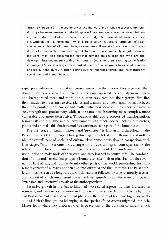
‘Man’ or ‘people’? It is customary to use the word ‘man’ when discussing the rela-
tionships between humans and the biosphere. There are several reasons for not follow-
ing this custom. First of all we have to acknowledge that humankind consists of men
and women; the male form ‘man’, which is matched by the personal pronoun ‘he’, actu-
ally leaves out half of all human beings – even more, if we take into account that it also
does not immediately evoke an image of children. The grammatically singular form of
the word ‘man’ also obscures the fact that humans are social beings, who live and
develop in interdependence with other humans. So, rather than resorting to the famil-
iar image of ‘man’ as a single, male, and adult individual we prefer to speak of humans
or people, in the plural, in order to bring out the inherent diversity and the thoroughly
social nature of human beings.
Mappae Mundi bw zw/w 08-04-2004 15:24 Pagina 24
later (between 250,000 and 150,000 years ago) members of the Homo sapiens species fol-lowed similar routes. Australia was reached around 60,000 years ago (although someAustralian archaeologists now claim a much earlier arrival of the first human inhabi-tants), the Americas not later than 12,000 years ago (and probably a great deal earlier).
The great waves of migration have never come to a halt, and continue to this very day.The Pacific islands were among the last regions to be reached; human settlement therewas completed by circa 500 CE3. Only for the migrations of the past few centuries do wehave sufficient evidence to establish their size and trajectories. Because of the generalgrowth of human numbers and big advances in the means of transportation, these mostrecent migrations were probably the largest of all time both in terms of human numbersand the distances covered. In addition, more and more animals and plant seeds travelledalong with these movements of humankind, causing major changes in the earth’s floraand fauna (see Crosby 1986).
For humanity’s early demographic development we have to rely on informed guesses.As for any other species, the total number of humans at any given moment is a function
:
25
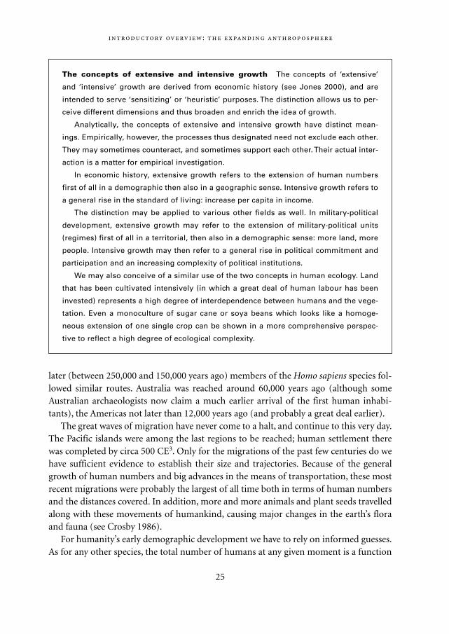
The concepts of extensive and intensive growth The concepts of ‘extensive’
and ‘intensive’ growth are derived from economic history (see Jones 2000), and are
intended to serve ‘sensitizing’ or ‘heuristic’ purposes. The distinction allows us to per-
ceive different dimensions and thus broaden and enrich the idea of growth.
Analytically, the concepts of extensive and intensive growth have distinct mean-
ings. Empirically, however, the processes thus designated need not exclude each other.
They may sometimes counteract, and sometimes support each other. Their actual inter-
action is a matter for empirical investigation.
In economic history, extensive growth refers to the extension of human numbers
first of all in a demographic then also in a geographic sense. Intensive growth refers to
a general rise in the standard of living: increase per capita in income.
The distinction may be applied to various other fields as well. In military-political
development, extensive growth may refer to the extension of military-political units
(regimes) first of all in a territorial, then also in a demographic sense: more land, more
people. Intensive growth may then refer to a general rise in political commitment and
participation and an increasing complexity of political institutions.
We may also conceive of a similar use of the two concepts in human ecology. Land
that has been cultivated intensively (in which a great deal of human labour has been
invested) represents a high degree of interdependence between humans and the vege-
tation. Even a monoculture of sugar cane or soya beans which looks like a homoge-
neous extension of one single crop can be shown in a more comprehensive perspec-
tive to reflect a high degree of ecological complexity.
Mappae Mundi bw zw/w 08-04-2004 15:24 Pagina 25
of two variables: birth and death, fertility and mortality. The available evidence suggeststhat, during the Palaeolithic, both were relatively high (although not as high as in the fol-lowing agrarian phase), with a slight excess of births over deaths. The nomadic way oflife tended to act as a constraint limiting the number of children; it may also have madeexposure to lethal microparasites less frequent among foragers than among sedentaryfarmers (Harris and Ross 1987: 21-36). The net result of these factors was a slow overallrate of extensive growth, as explained at greater length in Chapter 4.
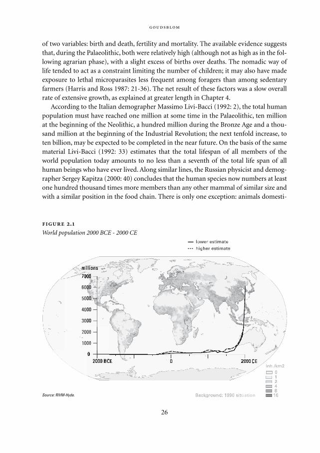
According to the Italian demographer Massimo Livi-Bacci (1992: 2), the total humanpopulation must have reached one million at some time in the Palaeolithic, ten millionat the beginning of the Neolithic, a hundred million during the Bronze Age and a thou-sand million at the beginning of the Industrial Revolution; the next tenfold increase, toten billion, may be expected to be completed in the near future. On the basis of the samematerial Livi-Bacci (1992: 33) estimates that the total lifespan of all members of theworld population today amounts to no less than a seventh of the total life span of allhuman beings who have ever lived. Along similar lines, the Russian physicist and demog-rapher Sergey Kapitza (2000: 40) concludes that the human species now numbers at leastone hundred thousand times more members than any other mammal of similar size andwith a similar position in the food chain. There is only one exception: animals domesti-
26
.
World population 2000 BCE - 2000 CE
Source: RIVM-Hyde.
Mappae Mundi bw zw/w 08-04-2004 15:24 Pagina 26

cated by humans. Their numbers include more than two billion cattle and sheep whichconsume more food than all humans together (see also Grübler 1998: 133-4; McNeill2000: 264).
2.2.2. Intensive growth: technology, organization and civilization
Intensive growth is harder to define and measure than extensive growth, but its impacton the biosphere is at least as important. In the process of intensive growth, things andforces which were previously completely beyond human control have been broughtwithin the human domain and subjected to a certain measure of human control. Inten-sive growth always implies innovations in behaviour, which usually lead to a shift (how-ever slight) in existing balances of power as well as to changes (again, however slight) inmentality or habitus. Extensive and intensive growth are not mutually exclusive. Theycan either support and reinforce or obstruct each other.
A basic trend in all human history, and certainly during its earliest phases (often des-ignated ‘prehistory’), has been the increasing differentiation between humans and allclosely related animals in terms of their behaviour, their power, and their general dispo-sition or attitude – their habitus. Thanks to the flexibility acquired in the course of evo-lution, humans were able to learn a large repertory of new forms of behaviour. Thoseinnovations in behaviour that added to human power vis-à-vis other large animals, bothpredators and competitors, were particularly successful. Transmitted by learning fromgeneration to generation, these innovations entered into the human habitus and became‘second nature’.
The primary condition for the process of differentiation in behaviour, power andhabitus has been, and continues to be, the innate human capacity for culture as mani-fested in technology, organization and civilization – each of which represents the resultsof social learning. Social learning is the crux of culture: gathering information and pass-ing it on to others – at first in direct interaction, at a later stage in history through writ-ten texts and today also by other audio-visual means. The stores of cumulated informa-tion (or ‘cultural capital’) have enabled people to tap increasingly larger and more variedflows of matter and energy and to integrate those flows into their societies.
The term ‘technology’ primarily refers to the means of harnessing various forms ofmatter and energy for human purposes. With the aid of technology, extra-somatic forcesare used to supplement human strength and compensate for human weakness and slow-ness.
Technology could not have developed without ‘social organization’: the variousmeans by which people are able to exchange information, co-ordinate their activities andtake into consideration the intentions and interests of others. Less obvious perhaps, butequally important, is the part played by ‘civilization’: the social process in the course of
:
27
Mappae Mundi bw zw/w 08-04-2004 15:24 Pagina 27
which individuals learn to handle their own drives and emotions. Simple though thisdefinition may sound, it refers to an area of human life that is still relatively unexplored,especially if we consider the historical dimension to the way human personalities areshaped in social processes (see Elias 2000: 363-447). The controversies that continue torage about such issues as ‘nature and nurture’ reveal the wide margin of uncertainty andthe lack of clarity in this area (see Rose and Rose 2000; Segerstråle 2000). Still, the themeis highly relevant to this book, since it touches on the problem of how individuals learnto cope with the outside world in both its social and its natural aspects and to whatextent they are prepared to take into consideration the effects that their own actions mayhave on other people and on the natural environment. Both technology and socialorganization require civilization; neither can function without it.
Technology, social organization and civilization are closely interwoven. They corre-spond to what the sociologist Norbert Elias (1978: 156-7) calls the ‘triad of controls’ overextra-human, inter-human, and intra-human processes, respectively. Each of the threeforms of control can only exist and evolve in connection with the other two. It is ofcourse possible to describe the history of technology as a mere succession of new toolsand appliances; while this might look like a very ‘concrete’ description, it would actuallyrepresent a great abstraction from reality. Even the seemingly simplest objects from thePalaeolithic could only be manufactured by virtue of socially transmitted knowledge andmotivation.
With the expansion of the anthroposphere, increasingly more natural forces that wereoriginally beyond human control came to be incorporated in the human domain. Newecological regimes were formed in which humans participated, along with the forcesthey tried to control. This is clearly illustrated by the domestication of fire. We discuss itsearly history at some length because, as the first manifestation of human mastery over astrong and potentially destructive force of nature, control over fire was a basic conditionfor the subsequent emergence of agriculture and industry that are highlighted in thechapters that follow.
2.2.3. The original domestication of fire
The domestication of fire was the first great act of human interference with naturalprocesses. It had numerous far-reaching implications, stretching from the first hesitantbeginnings to our contemporary fuel-driven economy. It therefore demands our atten-tion, even though it took place long before the period in human history with which thisbook is mainly concerned.
In more than one way, the original fire regime may be seen as a paradigm for thesocio-ecological regimes that were developed later. It presents a paradigm in two senses.First of all, in practice, the regime by which humans learned to extend their care for and
28
Mappae Mundi bw zw/w 08-04-2004 15:24 Pagina 28
control over fire could serve as a model for subsequent forms of care for and controlover other forces in non-human nature such as plants and animals. Secondly, we mayregard the domestication of fire as a model case in a more theoretical fashion, since itbrings out the strong link between such apparently contradictory tendencies as increasesin control and dependency, in robustness and vulnerability, in the potential for produc-tion and for destruction.
Fire, like all natural forces, has a history. Chemically fire is a process of highly acceler-ated oxidation of matter (fuel) induced by heat (ignition). Three conditions are there-fore necessary for it to occur: oxygen, fuel and heat. During the earliest history of theearth, at least two of these – oxygen and fuel – were absent. Oxygen did not becomeavailable until life emerged after at least a billion years. And it was only less than half abillion years ago, during the Devonian geological age, that life assumed the form ofplants, providing matter suitable for burning. From then on, most places on earth withseasonally dry vegetation were regularly visited by fire, ignited on rare occasions byfalling rocks, volcanic discharges or extraterrestrial impacts, but most often by lightning(cf. Pyne 2001: 3-23).
Its domestication by humans opened an entirely new episode in the history of fire.Humans altered the frequency and intensity of fires. They brought fire to regions of theplanet where it seldom or never burned spontaneously. And they tried to banish it fromplaces where without human interference it would have burned repeatedly. As a result,‘natural’ fire receded increasingly and made way for ‘human’ or, more precisely, anthro-pogenic fire.
Wherever humans migrated, they took their fire along. Areas such as rain forests,deserts, and the polar regions, which were not receptive to fire proved to be hard to pen-etrate for humans too. Everywhere else, the presence of humans-with-fire deeply alteredthe landscape, including flora and fauna. The human impact is amply documented(though still controversial) for a continent that was colonized by humans rather late:Australia (see Pyne 1991; Flannery 1995).
Humans are the only species that have learned to manipulate fire. Control over fire hasbecome a ‘species monopoly’, with an enormous impact on other species, both animalsand plants. It provides us with an excellent example of how new forms of behaviour maychange the balance of power – in this case between humans and all other animals, rang-ing from primates to insects – and how shifts in the balance of power could engenderchanges in habitus, both among the humans who gained greater self-confidence fromthe presence of fire in their groups and among animals that might be bigger and strongerthan humans but had learned to respect and fear their agility with fire.
Control over fire, in addition to having become exclusively human, has also becomeuniversally human. We know of no human society of the past 100,000 years that haslacked the skills needed to control fire.
The original domestication of fire was a dramatic transition. Palaeo-anthropologists
:
29
Mappae Mundi bw zw/w 08-04-2004 15:24 Pagina 29
are still debating when exactly it took place. The estimates range from as much as 1.5million to a mere 150,000 years ago. Whether the first steps to control over fire coincidedwith other changes in early human development is still an open and fascinating ques-tion.
In retrospect, the initial domestication of fire was an event of momentous import. Awild force of nature – blind, capricious, hazardous – was now tended, cared for, protect-ed from rain and supplied with fuel. Our early ancestors went to all this trouble, not outof ‘altruism’ but because it served them well. They put the potentially destructive andessentially purposeless force of fire to work for their own productive purposes. Theymanaged to make fire regularly available. They no longer had to ‘hunt’ for it, hoping tofind the smouldering remains of a natural blaze somewhere; they made it part (and eventhe centre) of their own group and they revered it as a symbol of eternal life.
The domestication of fire made humans less directly dependent on natural forces thatcontinued to be beyond their control such as the alternation of day and night or thecycle of the seasons. It made the contrast between dark and light, between warm andcold or between wet and dry more amenable to manipulation, and thus gave humans agreater margin of freedom from the grip of nature. It increased their power – defined asthe capacity to influence the outcome of an interaction. Armed with fire, humans wereable to open up impenetrable tracts of bush, and to drive away animals much fiercer andstronger than themselves. The gain in power made their lives more comfortable andsecure. The possibilities of heating, lighting and cooking all contributed to what wewould now call a higher standard of living.
2.2.4. Long-term consequences
‘Wherever primitive man had the opportunity to turn fire loose on a land, he seems tohave done so from time immemorial.’ This statement by the American geographer CarlSauer (1981: 340) may sound like an exaggeration; but it still fails to convey the fullimpact that the domestication of fire has had, both on the larger biosphere and, withinthe biosphere, on human society itself.
The most immediate effect of the domestication of fire on the biosphere in generalwas an increase in the frequency with which fires occurred. Prior to its human mastery,fire had mostly been ignited by lightning. From now on another source was added: evenbefore they learnt to make fire themselves humans were able to preserve it in theirhearths and to use it wherever they saw fit. Consequently, as the number of anthro-pogenic fires increased, the proportion of natural fires diminished. It has been suggested,admittedly in a speculative manner, that the earliest human fire use may have affectedthe planetary atmosphere and caused some of the major climate changes in the Pleis-tocene (Westbroek et al. 1993). More substantive evidence indicating modification of the
30
Mappae Mundi bw zw/w 08-04-2004 15:24 Pagina 30
landscape by human foragers equipped with fire has been put forward for Australia,where most of the indigenous forests were burnt down in the millennia following thearrival of the first Aborigines (Flannery 1995; Pyne 2001).
From the very beginning humans used fire in two basic forms: the hearth and thetorch. The hearth was the original site at which a fire was kept, usually a cave entrancewhere it could be protected against the rain and still receive some air circulation. Since ithad to be tended and fuel had to be brought to it, it served almost naturally as a centrefor group life, providing heat, light and a common focus. From the hearth developed,with time, a variety of fire containers such as crucibles, stoves, kilns and furnaces and, inour day, the mobile engines of motorcars and aeroplanes.
The hearth-like uses of fire have always had two kinds of environmental side effects.First of all, fuel had to be supplied. As long as human communities were small and living
:
31
The human impact on the environment raises problems similar to those in a thriller.
When a murder has been committed, the coroner establishes the effects of the interac-
tion and the detective examines the causes: the motives and the means of the perpe-
trator. What made him do it, how was he able to do it?
When we consider the issue of anthropogenic fire (and most fire on our planet
today is anthropogenic), the natural sciences deal with the consequences or the effects;
the social sciences deal with the conditions, the causes, the motives and the means of
the perpetrators.
This is, of course, only an analogy. Instead of a single suspect, an individualized,
masculine ‘he’, we have to look at ‘we’, humans, in the plural: including men, women
and children, and including our earliest ancestors as well as those of us alive today.
(We are links in a chain of generations. Our current interactions with fire should be
seen in that context.)
In dealing with the distant human past, it may be more appropriate not to speak of
‘we’ but ‘they’. Our early ancestors who were the first to domesticate fire were akin to
us, but they must also in many ways have been very different. In fact, in learning to
control fire, they became more like us and less like our closest relatives among the
mammals.
If indeed the basic long-term trend in human history (underlying most other devel-
opments and events) has been the very process of increasing differentiation in behav-
iour, power and habitus between humans and all related species, the domestication of
fire was an important step in this trend – not the single cause but an integral part of it.
Since control of fire became a species monopoly, exclusively human and shared equal-
ly by all human societies, it made humans everywhere more alike among themselves
and more different from all other creatures.
Mappae Mundi bw zw/w 08-04-2004 15:24 Pagina 31
in areas with abundant wood, this did not cause much of a problem. When greater num-bers of people started living in large urban concentrations, however, the need for fuelbecame a strong contributing factor to deforestation over large areas and, in our ownage, to the depletion of fossil resources. The second side-effect of hearth-like fire consistsof its waste products: ashes and smoke. Although smoke might be useful for drivingaway insects and other insidious creatures, it has generally been considered to be a nui-sance to be got rid of. As long as people lived in isolated caves or huts, this was relativelyeasy. Urbanization and industrialization have seriously aggravated the problem.
While the original functions of the hearth were primarily turned inwards (‘cen-tripetal’), the torch was a more outwardly directed (‘centrifugal’) implement. It was usednot only to provide light at night, but also to set fire to shrubs and grasses by day – aneffective way to destroy obstacles for foraging and to rout animals, both predators andprey. The torch undoubtedly contributed to deforestation: wood was burned wholesale,regardless of its possible value as timber or fuel. In the age of agriculture, the torch wasused for slash-and-burn and other land-clearing techniques and it served as the modelfor a whole array of fire weapons culminating in our own time in rocket-propelled mis-siles.
Surveying the entire trajectory of the human use of fire from its earliest beginnings,we can distinguish three stages. During the first stage, there were no groups possessingfire; there were only groups without fire. There must then have been a second stage whenthere were both groups with fire and groups without fire. We do not know how long thatstage lasted – nor how often it may have recurred. All we know is that it came to an end.It was a transitional stage, leading up to the stage in which humankind has now lived forthousands of generations: the stage when there are no longer any groups without fire. Allhuman groups are groups with fire.
Although we lack empirical evidence for the first two stages, this very lack leaves usno choice but to accept an unavoidable conclusion: societies with fire were in the longrun obviously more ‘fit to survive’ than societies without fire. If we then ask why it wasthat societies without fire disappeared, there seems to be only one plausible answer:because they had to co-exist with societies with fire – and apparently in the long runsuch co-existence proved impossible.
This may sound like a dismal conclusion suggesting fierce contests ending in theelimination of the losers. If such contests did indeed take place, they have left no trace ofempirical evidence; we only have the highly imaginative evocations of what might havehappened in books and films such as The Quest for Fire, directed by Jean-JacquesAnnaud. However, we can also view the fact that possession of fire has become a univer-sal attribute of all human societies as an important example of the general rule thatchanges in one human group lead to changes in related other groups. If group A had fireand neighbouring group B did not, group B ‘had a problem’. It could either try to mini-mize contact with group A and perhaps move away or do as group A had done and
32
Mappae Mundi bw zw/w 08-04-2004 15:24 Pagina 32
adopt a regime with fire – this should not pose insurmountable problems given a suffi-cient capacity to learn from the others. In the latter case, instead of a ‘zero-sum’ elimina-tion struggle there would have been what the American freelance author and scientistRobert Wright (2000) calls a ‘nonzero’ situation, with an outcome in which neither partywas the loser.
The rule that changes in one human group lead to changes in other related groupsmay sound like a rather tautological explanation for social change, but it is not. It is ahighly generalized empirical observation, similar to an observation we can make aboutfire: fire generates fire – in a similar, more general, fashion change generates change andsocial change generates social change.
Such is the nature of the dynamics of human society and culture. After the originaldomestication of fire, it was never humans alone who interacted with other humangroups and with non-human nature. It was always humans-with-fire, equipped with fireand with the products of pyrotechnology: cooked food, pointed spears and arrows,earthenware and metal objects. Their presence put an end to humans-without-fire.
Another general conclusion to be drawn from these observations is the following:changes in climate and precipitation have never ceased to be important reasons forhumans to change their way of life. Humans are no different from other species in thatthey will always have to accommodate the basic conditions of earthly nature, such as thealteration of day and night or of monsoons and seasons. In the course of human history,however, in addition to these overriding extra-human conditions, conditions broughtabout by humans themselves have become increasingly more important – to the extentthat, in our contemporary world, humanity has become a major agent of ecologicalchange.
2.2.5. Regimes
The domestication of fire meant that people tamed a strong and potentially destructivenatural force, and made it into a regularly available source of energy. In so doing theyinitiated changes in the natural environment, in their social arrangements, and in theirpersonal lives. These three aspects (ecological, sociological, psychological) are all part ofthe changing human relationships with fire.
In its ecological aspects, the domestication of fire affected the relationships betweenhumans and the non-human world so deeply that we can call it the first great ecologicaltransformation brought about by humans, which was followed much later by the secondand third of such transformations – generally known as the agricultural and industrialrevolutions, and better characterized in terms of the long term processes of agrarianiza-tion and industrialization.
Each of the three transformations spelled the formation of a new socio-ecological
:
33
Mappae Mundi bw zw/w 08-04-2004 15:24 Pagina 33
regime: the fire regime, the agrarian regime and the industrial regime, marked by theutilization of fire and elementary tools, the rise and spread of agriculture and animalhusbandry and the rise and spread of large-scale modern industry, respectively. The laterregimes have not made the earlier regimes obsolete; rather, they have absorbed themand, in the process, transformed them. Each new regime brought an expansion of theanthroposphere within the biosphere.
Defining the three regimes jointly in similar terms is helpful in order to better under-stand each of them separately as well as in their interrelations. A common conceptualmodel invites and facilitates comparison. The comparison allows us to explain thesequence in the emergence of the regimes, and to perceive not only their similarities anddifferences but also their interlocking.
2.3. Intensified human impact: agrarianization
The history of the past ten thousand years can be read as a series of events accompanyingthe process of the agrarianization of humankind – a process in the course of whichhumanity has extended the domain of agriculture and animal husbandry all over theworld, and in so doing made itself increasingly more dependent upon this very mode ofproduction.
In terms of geology, the era of agrarianization coincides with the Holocene – the rela-tively brief and climatologically relatively stable era following the much longer and, in itsoverall effects, much more turbulent era of the Pleistocene.4 The Pleistocene period last-ed approximately 0.8 million years and saw at least nine oscillations between extremelycold and somewhat milder global climates known as the glacial and interglacial periods.The last of these ice ages, between 130,000 and 10,000 BP, reached a peak between 22,000and 16,000 BP and was succeeded by the Holocene period, our contemporary epoch,which may well turn out to be one more interglacial age (cf. Chapter 3).
The transition from Pleistocene to Holocene was marked by great environmentalchanges. As the ice melted and the glaciers receded, the sea level rose world-wide by atleast 100 metres, terminating the land bridge between Siberia and Alaska and turninglarge sections of the Eurasian continent into islands, including the British Isles andIndonesia. As the temperature rose, the tree line shifted away from the equator, turningtundra and savannah into woodland and forest.
During the Holocene period, the climate continued to change, but in a less drasticfashion. The most extreme fluctuation was a prolonged increase in precipitation innorthern Africa, which allowed savannah vegetation to flourish in the Sahara area forseveral millennia (9000-5000 yr BP). This period is discussed more fully in Chapter 3.
34
Mappae Mundi bw zw/w 08-04-2004 15:24 Pagina 34
2.3.1. Emergence
As the reference to the Sahara implies, once we have reached the era of agriculture andanimal husbandry, we find ourselves on firmer empirical ground than in discussing theearliest domestication of fire. For this stage in socio-ecological development there is farmore archaeological evidence to rely on when probing into such problems as when itbegan, where it began and how and why it began. Nevertheless, we should not pitch ourexpectations too high. The problem of tracing and explaining first origins in socio-cul-tural development remains tricky. Even if it were possible to determine the time and theplace of the first occurrence of particular agricultural practices, the question of whythose innovations first began then and there would be far more difficult to answer thanthe question of why some innovations, once they had been accomplished, became suc-cessful and spread far beyond their original location.
As a result, we have to accept the fact that some of the most intriguing problemsregarding the emergence of agriculture and animal husbandry remain unsolved, at leastfor the time being. According to current insights, there appear to have been several ori-gins: the transition to agrarian production probably took place independently in differ-ent periods in different parts of the world, including Mesopotamia, the East Asian main-land, New Guinea, Meso-America, and the Andes region. The reasons why the transitionoccurred are most likely to be found in a combination of necessity and opportunity or,in other words, motives and means (cf. Chapter 4).
Fortunately some important points regarding the transition and its consequences arebeyond dispute. Until recently, established scholarly opinion held that the ‘agriculturalrevolution’ meant the first big human impact on the biosphere. As shown in the preced-ing section, humans had already initiated far-reaching changes in the biosphere at amuch earlier stage with the domestication of fire.
Contrary to common usage, we have decided to avoid the term ‘agricultural revolu-tion’ altogether, and to speak consistently of ‘agrarianization’. An obvious advantage ofthe latter concept is that it draws attention to the close parallel with the subsequentprocess of industrialization. It also conveys clearly that, like industrialization, agrarian-ization is not to be seen as a one-time event but as an ongoing process. Having started ona relatively small scale, the agrarian mode of production and way of life have neverceased expanding. Nor did agrarianization stop at the advent of industrialization; on thecontrary, the rise of modern industry has given it strong new impetus towards furtherdevelopment.
So far the era of agrarianization has been marked by a steadily increasing rate ofchange. Between the original domestication of fire and the first appearance of agricul-ture came a period of at least 100,000 years. In contrast, only 10,000 years passedbetween the rise of agriculture and the rise of modern industry. And while industrializa-tion began to gain momentum no more than 250 years ago, we may well currently be
:
35
Mappae Mundi bw zw/w 08-04-2004 15:24 Pagina 35
witnessing the onset of another great socio-ecological transformation.The most plausible explanation for this acceleration is probably implied by the prin-
ciple expounded above to the effect that once social and cultural development get start-ed, they have a tendency to become self-propelling and self-accelerating. For a very longperiod in early human history (comprising the era known as ‘prehistory’), changes in thenon-human environment posed the greatest challenge to human adaptability. As will bediscussed in Chapter 4, it was perhaps still this kind of ‘external’ change, and especiallythe great rise in temperature at the end of the last Ice Age, which triggered the first emer-gence of agriculture in Mesopotamia and possibly also in other areas.
The argument is indeed persuasive. As the sea flooded fertile coastal land and theadvancing forest encroached upon more and more savannah, there were many areaswhere both humans and the large herbivores upon which they hunted found their natu-ral habitats under severe stress. It hardly seems to be a coincidence that precisely duringthis period at the end of the Pleistocene many large mammals became extinct, includingherbivores such as the woolly mammoth as well as their predators such as the sabre-tooth tiger (see Livingston 1994: 49-51). As living conditions for the freely roaming her-bivores deteriorated, and the competition for the resources of food and fresh water grewmore intense, humans may have used their technical and organizational superiority todestroy a number of their rivals forever, thereby depriving themselves of the chance ofany future benefit from those species. The areas that were most vulnerable to the risingwater levels were coastal zones where humans had been able to prosper on plentiful sup-plies of food both from the land and in the sea. It stands to reason that especially in thoseregions which were hardest hit, with relatively great numbers of people being confrontedwith gravely deteriorating environmental conditions, more active cultivation of edibleplants was adopted as a substitute for the diminishing chance of obtaining food by fish-ing, gathering and hunting. Again, Chapter 4 reports some impressive recent evidenceon these issues.
2.3.2. Continuities
The initial transition from gathering and hunting to agriculture and animal husbandrywas not necessarily abrupt. A group that started to cultivate a few crops would not haveto give up its older ways altogether. There would have been very few, if any, agrarian soci-eties from which gathering and hunting disappeared completely at once. However, theproportion of products acquired in the older way inevitably diminished as agricultureand animal husbandry advanced.
From the very beginning, the process of agrarianization was linked closely to thedomestication of fire. It is hard to imagine how people could have begun to cultivateplants and to domesticate animals had the art of handling fire not already been familiar
36
Mappae Mundi bw zw/w 08-04-2004 15:24 Pagina 36
to them. If nothing else, they needed a hearth fire to cook on. The first crops cultivatedon any large scale were cereal grains such as wheat, rice and maize which, owing to theirhigh nutritional value and their capacity to withstand storage for long periods, formed ahighly appropriate staple food for a human community; to serve this purpose, however,they had to be made more easily digestible with the help of fire.
A second and very different reason why the control of fire formed a precondition foragrarianization was the human predominance over all other mammals, which wasgrounded partly in the use of fire. The human species’ monopoly over fire was so solidlyestablished by the time agriculture began, and is today so easily taken for granted, that itis seldom given separate attention in this context. Yet it deserves mention. Their hege-mony in the animal kingdom enabled people not only to bring certain species, such asgoats and sheep, under direct control, but also – at least as important – to keep most ofthe remaining ‘wild’ animals at a distance from their crops and herds.
Thirdly, experience in controlling fire may have furthered plant and animal domesti-cation in another, even more intangible way, which our distance in time makes it diffi-cult to assess precisely but which we are also, for that very reason, likely to underesti-mate. The time-honoured practice of handling fire could not have failed to preparehumans for the many tasks involved in agriculture and animal husbandry. It taughtthem that expending care upon something non-human could be well worth the troubleand thus made it more acceptable to them to accommodate the strains of an agrarianlife, full of self-imposed renunciation for the sake of a possible future yield.
The most immediately visible link between early agriculture and the ancient use offire lay in the custom of burning off land with an eye to food production. Of old, forag-ing peoples were wont to apply their torches in order to keep the land open for gatheringand hunting. Even in recent times those firing practices were continued in some parts ofthe world, as in Australia where the Aborigines’ judicious use of fire in keeping their landopen for kangaroos and humans has become known as ‘firestick farming’ (cf. Flannery1995; Pyne 2001) – a term suggesting a form of ‘proto-agrarianization’.
2.3.3. Sequences
The rise of agriculture was in many respects remarkably similar to the domestication offire. Again, humans added new sources of energy to their own, this time by adoptingcertain plants and animals and integrating them into their societies. Plants that wereformerly ‘wild’ now began to be cultivated, ‘wild’ animals were tamed and used for food or other purposes such as traction, and all these species were made part of thehuman domain – of the anthroposphere which correspondingly increased in size andcomplexity.
The transition from foraging to agriculture did not automatically make people hap-
:
37
Mappae Mundi bw zw/w 08-04-2004 15:24 Pagina 37

pier and healthier. Agrarian life brought new hardships. Diets became more monoto-nous. Sedentary life in villages, in close company with domesticated animals, increasedthe susceptibility to disease. It allowed for a rise in fertility but also caused highermortality. The result was large numbers of children, many of whom did not reach adult-hood. Not surprisingly, research on skeletons reveals that, after agrarianization, humanlives tended to become briefer and bodies shorter. It is equally understandable that thetexts of the great religions of Eurasia all exhibit nostalgia for the lost paradise of a pre-agrarian era.
The nature of agrarian life prevented a return to foraging, however. There are a fewknown cases of such a return, but these are exceptions (see Diamond 1997: 55, 109). Al-most everywhere, with so many people, and so little land, the only option for the survivalof an agrarian population was cultivation. ‘Work’ was writ large over the agrarian world.
If, at a very early stage, the domestication of fire had made human groups more pro-ductive but also more vulnerable (as from now on they had to rely on fire), the rise ofagriculture had the same twofold effect. Being able to grow more food, human groupsgrew more populous and became more dependent on their crops, and thus more vulner-able to the failure or loss of their harvests. As the expansion of agriculture and pastoral-ism left increasingly less land available for foraging, the opportunity to escape from thisvicious circle dwindled.
The first stage in the process of agrarianization necessarily involved clearing the landand removing any existing vegetation that would compete with the planted crops. Inmany cases, the most efficient way to accomplish this was by means of fire. As long asland remained plentiful, continued recourse was often taken to fire in a system practisedthroughout the world, and known under various regional names that are usually sub-sumed in the standard literature under the label ‘shifting cultivation’. Shifting cultivationimplies that an area of primary forest is first cleared by slash-and-burn and is then usedfor one or more harvests of crops. When, after a while, crop nutrients in the soil becomeexhausted and undesirable plants (‘weeds’) begin to dominate, the farmers temporarilyabandon the land, turn to an adjacent lot, burn the vegetation down and bring it undercultivation until they again find harvesting unrewarding. Eventually they return to theirfirst plot, which by then has become ‘secondary forest’ or ‘secondary bush’, and resumetheir activities of burning, planting and harvesting there. The duration of the entire cyclemay vary as to time and place, but the principle remains the same. This is discussed inmore detail in Section 9.3 on population dynamics in Indonesia.
In many parts of the world, over time, burning the land and letting it lie fallow for anumber of years or seasons ceased to be a regular practice and was replaced by moreintensive methods of working the soil, requiring greater investments of labour but yield-ing a larger output per acre and thus making it possible to feed more mouths. The mostcommon means of accomplishing higher yields by harder work were irrigation andploughing.
38
Mappae Mundi bw zw/w 08-04-2004 15:24 Pagina 38
The actual practices of agriculture varied greatly according to differences in climateand soil. Yet wherever cultivation was intensified this led to structurally similar results.There was a recurrent sequence which almost reads like a series of simple equations:more food meant more people, living in increasingly large concentrations in permanentsettlements, with the possibility for some of the people to specialize in pursuits otherthan tilling the land. The process of specialization was in turn accompanied by theincreasing organization of people in larger economic, religious and political units (suchas markets, churches, and states), and by increasing social stratification or the division ofpeople into upper and lower tiers with greater or lesser access to power, property andprestige. This complex of interrelated processes unfolded in different epochs in differentparts of the world. Because of the distances in place and time, these trends led to thedevelopment of apparently highly divergent cultures, marked by very specific traditionsin such aspects of life as preparing food, religious worship and the building of housesand palaces. The remarkable results of cultural divergence in those fields can easily blindus to the convergence of some underlying social trends, notably the process of socialstratification.
2.3.4. Hypertrophy and atrophy
Social stratification as a long-term process led to the formation of tiered agrarian soci-eties in which some groups managed to attain a ‘higher’ position with great power andprivilege, while others (the ‘lower’ majority, consisting mostly of peasants) were deprivedof such power and privilege. This process occurred in every part of the world, from theBritish Isles to Japan and from Peru to Mexico. Wherever more intensive forms of workmade land more productive, new social regimes developed – often in a sequence of reli-gious-agrarian regimes, dominated by priestly elite groups, followed by military-agrari-an regimes, in which warrior elite groups attained equally or even more powerful posi-tions than the priestly.
Religious-agrarian regimes have played an important part in shaping the relationsbetween humans and the biosphere in agrarian societies. Humans are not equipped bybirth with a natural aptitude for agrarian life. They have no innate calendar telling themwhen the time has come for preparing the soil, for planting the seeds, for removingweeds, for harvesting. The only calendar available to them is a socio-cultural one, rough-ly geared to the alteration of the seasons but regulated with greater precision by humanconvention, as a part of an agrarian regime.
Agrarian regimes provide people with the competence and the motivation needed tolive in an agrarian community so that they are capable and willing to work hard in orderto produce food crops, prepared to store stocks of those crops as food and seed for futureuse, and respectful of ownership rights to the land and its produce.
:
39
Mappae Mundi bw zw/w 08-04-2004 15:24 Pagina 39
A typical set of such instructions can be found in the teachings of the Old Testament.An important function of the priests who propagated those teachings consisted ofupholding the agrarian regime. Recognizing this function may give us a clue to a betterunderstanding of the prominent position of priests, not only in ancient Israel but also inmany other agrarian societies. Priestly authority helped to stabilize relations both be-tween the people themselves and towards the non-human elements they had integratedinto their societies. Arguably, at a particular stage of social development, societies withpriests were better equipped for survival than societies without priests.5
Wherever religious-agrarian regimes were established, they found themselves in thecourse of time in competition with, and having to make room for, military-agrarianregimes, led by warriors. Originally, in tribal agrarian societies, the warriors would in-clude virtually all adult men, who would assemble for war on special occasions. Theymight go on a raid after an unsuccessful harvest, or defend their own community againstinvaders. In the wake of extensive and intensive growth, warring activities became morespecialized – a process with an inextricable momentum that is well characterized by theterm ‘arms race’ (cf. Wright 2000: 270). The result was that most agrarian societies even-tually found themselves ruled by warriors whose primary function was to fight – againstother warriors (cf. Section 4.6).
While this may sound like a tautology, it actually refers to a situation in which manyagrarian societies were trapped. The majority of the people lived a farming life that wasproductive but also left them extremely vulnerable. The warriors formed a robust min-ority specializing in destructive violence. This simple formulation captures the basicmechanism of military-agrarian society. The peasants’ productivity and vulnerabilityand the warriors’ powers of destruction were drawn together like the opposite poles of amagnet. Once a warrior class was formed, the warriors needed the peasants to supplyfood, and the peasants needed the warriors for protection. This unplanned – and in aprofound sense fatal – combination formed the backdrop for a great variety of mixturesof military protection and economic exploitation that generally mark the history ofadvanced agrarian societies.
New inventions added to the force of warriors and helped to widen the gap betweenthem and the rest of the population. In this way, the development of metallurgy did notonly create, during the Bronze and Iron Ages, ‘a whole range of valuable objects worthhoarding in quantity’ (Renfrew 1972: 339) but it also supplied the weapons with whichthese objects might be appropriated. It reinforced the trend, present in most settledagrarian societies, toward accumulation of property, and it also turned this trend in thedirection of a highly uneven distribution of the accumulated property. The possession ofweapons, which had tended for a long time already to be the monopoly of adult and fullyinitiated men, to the exclusion of women and children, now came to be monopolized bythe warriors as a specific class of ‘noblemen’ or ‘aristocrats’. Increasingly, as the Americansociologist Gerhard Lenski notes, ‘the energies of this powerful and influential class were
40
Mappae Mundi bw zw/w 08-04-2004 15:24 Pagina 40
... turned from the conquest of nature to the conquest of people’ (Lenski 1987: 174).The trend indicated by Lenski had antecedents stretching a long way back. As human
dominance over many other species increased, relations between and within humangroups became increasingly important in the dynamics between humans and the bio-sphere. Challenges posed by other people often took precedence over challenges posedby nature.
With the intensification of agriculture, more and more land was transformed intofields, terraces, and meadows, yielding an increasing amount of food and other productsupon which society at large grew increasingly dependent. Those who owned the landwere inclined to regard it mainly as an economic and political asset – a source of revenueand prestige. Since they managed to appropriate a sizeable portion of the total wealthproduced and accumulated in their societies, increases in wealth did not result in eitherclear-cut extensive or intensive growth, but in a lopsided increment of luxury posses-sions that may be typified as hypertrophy. The material remains from episodes of suchhypertrophy in the past are numerous; they range from the Egyptian pyramids to the TajMahal, from the triumphal arches of Rome to the Aztec solar temples.
Hypertrophy had a reverse side: increasing poverty on the part of the peasants and thelandless poor, resulting as already noted in briefer lives and shorter bodies (cf. Harris andRoss 1987: 76; Tilly 1998: 1-4). Using the same metaphor we may call this a tendencytoward atrophy. Similar insights have been formulated by archaeologists (cf. Section 8.4).
The combined trends toward hypertrophy and atrophy led to a social degradation ofecological regimes. Members of the ruling elite tended to take a greater interest in thevicissitudes of military and political affairs than in the day-to-day management of theirrural estates. The peasants and slaves, for their part, lived in destitute circumstances thatwere only likely to add to their masters’ contempt for such matters.
Altogether the process of stratification in advanced agrarian societies amounted to aform of differentiation, resembling the primal differentiation in behaviour, power andhabitus between humans and related species in the animal world. The crucial differencewas that differentiation now took place between and within human groups themselves.
One result of social stratification was the relative decline in the esteem of ecologicalregimes. As elite groups became further divorced from the work of tilling the land, theaspects of social life directly related to the control of the natural environment were rele-gated to peasants and slaves and their overseers – in other words, to the lower orders.Working the land tended to be regarded as dirty and degrading to a person of rank.
The degree to which the leading elite became divorced from direct ecological pres-sures made itself felt in the way the relationships between humans and the biospheredeveloped in various societies. In general, Lenski’s rule, that control over people pre-vailed over control over nature, applied if only because the latter was exercised by meansof the former. As the American sociologist Randall Collins (1984: 107) observes, themost ancient monuments of advanced agrarian societies, the megaliths, testify to the
:
41
Mappae Mundi bw zw/w 08-04-2004 15:24 Pagina 41
ability of those societies to employ ‘massed human energy’. Constructions such as theEgyptian pyramids embodied a combination of technology and social organization, asdid the irrigation works in ‘hydraulic societies’ in river deltas from China andMesopotamia to Mexico (see Wittfogel 1957).
In many cases, hypertrophy ended in catastrophe, in the collapse of established hier-archies and their cultural trappings. However, the long-term trend toward extensivegrowth persisted, in time leading to continuing pressures toward ever more intensive useof the available land. More and more people came to live in villages and towns, and inthe cities that emerged as the centres of accumulated power and wealth. Those whoflocked to the towns and cities needed large supplies of food and fuel, while at the sametime creating great problems of waste disposal and pollution. Among them were special-ists such as tanners and dyers whose work produced noxious side-effects. Altogether anumber of environmental impacts were so obtrusive that the ruling urban groups con-sidered them hardly bearable and had statutes drawn up to eliminate the worst excessesof pollution of water and air.
Outside the urban centres, elite groups do not seem to have shared such great con-cern for environmental issues. In advanced agrarian societies such as medieval Europe orlate imperial China various dominant groups competed and contended for power andprivilege: priests, warriors, courtiers, entrepreneurs and bureaucrats. With a variation onMax Weber’s concept of the ‘economic ethos’, we can investigate the ‘ecological ethos’ ofthese groups and examine how it changed over time. Empirical findings and theoreticalideas combine to suggest that the ecological ethos of the elite groups has been waning fora long time. This became even more manifest during the early stages of industrialization.
2.4. Industrialization: the rise of the third regime
Historians nowadays tend to avoid the once popular term ‘Industrial Revolution’. Mostof them do so not because they wish to diminish the importance of industrialization,but in order to stress that industrialization is a long-term process that was not confinedto a relatively brief ‘revolutionary’ period in one particular country but is still continu-ing, and making its impact felt all over the world.
In our view, industrialization means the rise and spread of a third socio-ecologicalregime – the industrial regime, following the fire regime and the agrarian regime. It didnot put an end to the older regimes. On the contrary, new applications of fire lay at thevery heart of industrialization: using fossil fuel to generate steam power and to smelt andrefine iron. The smokestacks of the coal and iron industries became the icons of earlyindustrialization.
There were also close connections with agriculture. Agrarian production had to pro-vide a subsistence base for all workers employed in the mines and factories. Moreover, as
42
Mappae Mundi bw zw/w 08-04-2004 15:24 Pagina 42
soon as industrialization came to include the production of textiles and foodstuffs, theraw materials had to be supplied by agriculture. And before long, factories started gener-ating means of production for agriculture: first simple iron tools, then more complexnew mechanized implements, and then, in the 20th century, various types of combus-tion-driven machines, fertilizers and pesticides. By the end of that century, agricultureand industry in many parts of the world had become inseparable and often even barelydistinguishable.
Since the beginnings of industrialization are so much closer to us in time than thebeginnings of agrarianization, they are much better documented. There is a fairly gener-al consensus about the question where and when the transition first occurred: in Britain,in the eighteenth century. On the other hand, the question of why this was so is stillmuch disputed. A number of conditions and causes have been listed; we return to thiscontroversy in Chapter 10 (see also Goldstone 2000; O’Brien 2001).
Industrialization ultimately constitutes a unique historical process, which is part ofthe even more widely encompassing and equally unique process of the expansion of theanthroposphere. It will never be possible to repeat the beginnings of industrializationunder experimental conditions. Attempts at ‘modelling’ the incipient stages under artifi-cial circumstances can be no more than approximations, at best helping to sharpen ourimagination. As with biological evolution, it is far more difficult to explain why a suc-cessful mutation or innovation arose at all than why, once it existed, it survived andbecame successful.
This pertains equally to the staying power of the control of fire, of agriculture and offossil-fuel-based industry. The words that the sociologist David Riesman (1961: xxix)used for modernization apply to industrialization as well: it ‘appears to proceed with analmost irreversible impact, and no tribe or nation has found a place to hide’. Like theearlier socio-ecological regimes, the industrial regime has kept expanding; the explana-tion for this fact must be sought in some of its effects – its functions.6
This is not to say that all effects of industrialization were beneficial in every respect.Far from it; but the point is that industrialization maintained its momentum because itapparently had certain effects or ‘functions’ which were valued positively by sufficientnumbers of people with sufficient means to keep the process going. It is the task of thehuman sciences (anthropology, sociology, psychology, economics and history) to tracethose functions and understand the valuations.
The primary effect of industrialization was that immense supplies of fossil fuel energywere made available which had lain virtually unused by any living species. In the 18th cen-tury, a series of inventions made it possible for humans to start tapping these supplies andto use them to generate heat and mechanical motion. No longer were people completelydependent on the flows of energy which reach the earth from the sun and which arepartly converted into vegetation by means of photosynthesis. Just as at one time humanshad been able to strengthen their position in the biosphere by learning to control fire,
:
43
Mappae Mundi bw zw/w 08-04-2004 15:24 Pagina 43
they now learned the art of using fire to exploit the energy contained in coal, oil and gas.With this extra energy they also developed means of technology and organization thatenabled them to make much more extensive and intensive use of materials such as tinand copper and, subsequently, to develop a range of new ‘synthetic’ chemical substances.
Seen from a wide perspective, all of these developments concerned humanity at large.At closer quarters, however, it was only a tiny section of humanity that took the lead andwas the first to profit. A small entrepreneurial class in Britain had the advantage of beingthe pioneers of industrialization.
While industrialization began on a modestly local scale, it was enveloped in a contextof much wider range. Industrialization was preceded by European expansion, and thatgave strong impetus to it from the very start. British society in the 18th century was con-nected in many ways to a larger world: not just to the European continent but also toother continents. It had a strong navy and a large commercial fleet; trade with other con-tinents (including the slave trade) brought in substantial wealth; emigration across theAtlantic helped to relieve population pressures. The ensemble of these military, political,and economic relationships provided a robust infrastructure for the burgeoning indus-tries, guaranteeing protected access to a worldwide array of resources and markets (cf.Section 9.2 for a South-Asian perspective).
The combined thrust of industrialization and globalization has produced an enor-mously accelerating rate of intensive and extensive growth all over the world. Growthdid not continue evenly. There were ‘peak’ periods of economic development such as1870-1913 and 1950-73 which were later dubbed ‘golden ages’, whereas the world econo-my grew much more slowly in other periods such as 1913-50 (Maddison 2001: 22). Nordid growth affect the entire world in the same way. On the contrary, up to now it hasproceeded in a very uneven fashion, leading to such extremes that the per capita incomein the United States of America today exceeds that in Ethiopia by a factor 70 (Maddison2001: 224, 276; Figures 9.1 and 9.2).
However, while economic growth has hardly raised the living standards of billions ofpeople, it has affected the economy and the forms of land use in practically every coun-try on earth. It has also resulted in an enormous increase in population. In the 18th and19th centuries, most nations in Western Europe went through the first phase of the so-called demographic transition, marked by a combination of rapidly declining death ratesand continuing high birth rates. The resulting population pressure was considerablyrelieved by massive emigration overseas, especially to North America, while millions ofRussians migrated eastwards into Siberia (cf. Section 9.4). In the 20th century, the annualsurplus of births over deaths came to an end in Europe, but by that time the conditionsprevailing in the first phase of the demographic transition were becoming characteristicof the poorer parts of the world where the majority of humans live.
The reduction of the death rates in the industrializing world was clearly connectedwith advances in public hygiene. These, in turn, were predicated to a general rise in soci-
44
Mappae Mundi bw zw/w 08-04-2004 15:24 Pagina 44
etal affluence allowing the construction of public waterworks and sewers, as well as con-comitant developments in technology and science and in standards of individual behav-iour. The same set of factors conditioned the next phase in the demographic transition,the decrease in fertility: new techniques of birth control, based on scientific research, andnew attitudes towards family size.
The demographic structure of contemporary societies has thus become clearly influ-enced by a steadily developing corpus of information by which individuals let them-selves be directed in their behaviour. The information as such is a form of cultural capi-tal: the collective result of the efforts of a great many researchers. How it is applied at thelevel of personal conduct depends on the way the individuals perceive their own situa-tion and prospects – which is yet another kind of information.
The entire state of affairs is in many ways paradigmatic for contemporary society.Flows of highly complex information are widely available in a standardized and easilyunderstandable form. Many of them are hardly recognized as information because theycome to people in the shape of material objects, delivered with a manual. Owners are aptto forget that the instructions are an integral part of the appliance. If a machine is aban-doned in the absence of anyone prepared to carry out the instructions, the dead andrusting object is testimony to the vital importance of information in an age of advancedtechnology.
Information is the decisive principle in the organization of matter and energy. Itholds global society together: the networks of long-distance transportation and commu-nication, the worldwide division of labour and land use. Its exponential growth in theera of industrialization has enabled people to mobilize energy and matter in unprece-dented quantities and over distances spanning the entire globe, often with consequencesthat turned out to be detrimental to the biosphere.
Assessing the physical consequences, and establishing human responsibilities is also amatter of information. In this context people sometimes speak of a paradox because oneand the same factor appears as both cause and remedy (see Grübler 1998: 341). As sooften, underlying the apparent paradox is a real tension, inherent in all evolutionaryprocesses: every successful strategy of growth is bound to reach limits where furthergrowth becomes too costly. Here the primeval ‘oxygen crisis’ mentioned at the beginningof this chapter can serve as a parable.
The parable fails in one respect: although there must have been some exchange ofinformation, there is no trace of consciousness in the bacteria of two billion years ago.This is in stark contrast to the anthroposphere today in which continuous efforts arebeing made to collect information and use it intelligently. Science and technology havenot only been instrumental in designing machinery that has inadvertently contributedto the depletion of natural resources and the pollution of air, water and soil – they alsoprovide the means for monitoring and, possibly, solving environmental problems causedby human action.
:
45
Mappae Mundi bw zw/w 08-04-2004 15:24 Pagina 45
Public alarm over those problems reached a first climax around 1970. The report tothe Club of Rome and similar publications aroused the concern of large audiences andprompted politicians and businessmen to action. An awareness dawned that humanitymight be squandering natural energy and matter in an ill-informed and irresponsiblemanner, creating unmanageable quantities of waste and thus jeopardizing its ownfuture.
The same concern is directly reflected in one of the central issues addressed in thisbook – in what sense are today’s environmental problems really new, and to what extent?Is it mainly a matter of quantity or scale? Or do recent developments also have distinctqualitative features that make them fundamentally different from anything that has hap-pened before?
46
Mappae Mundi bw zw/w 08-04-2004 15:24 Pagina 46
3
The Holocene: Global Change and LocalResponse
Climatic and environmental catastrophes are only catastrophes because human
beings and activities are involved. For nature alone, climate changes, floods, earth-
quakes, volcanic eruptions, etc. are a self-evident part of its dynamic processes.
Messerli, 2000: 477
3.1. Introduction
Nature is change. Geological forces of change are a mixture of slow, constant processesand sudden pulsed events such as earthquakes; such forces have been in operation eversince planet Earth came into being. Their domain, the lithosphere, interacts with thehydrosphere and the atmosphere, each having its own suite of processes. How theseprocesses interact, particularly with human populations, is the focus of this chapter. Letus start at the beginning. As life evolved over the course of time, large parts of the earth’scrust became covered with vegetation. The biosphere was born. Animals appeared,which in turn modified the vegetation cover. Natural landscapes developed from theinterplay of geological, physico-chemical and biological processes. Then, only recentlyon the geological clock, the genus Homo entered the scene – another step in the unfold-ing complexity of the earth. With the emergence of cognition, language and culture, thenotion of an environment-for-humans got its meaning. The anthroposphere had comeinto existence. The ‘natural’ landscape became, as an environment-for-humans, dottedwith ‘human’ imprints, the material remains of which now help us to construct the puz-zle of past changes. In addition to these artefacts, numerous symbolic and religiousstructures were built, some of which are present, others are lost but all are harder toreconstruct than material remains.
There is little doubt that the physical, biological and climatic environment has influ-enced human populations as civilizations emerged, rose and declined. Transformation
47
Mappae Mundi bw zw/w 08-04-2004 15:24 Pagina 47
processes, increasingly leading to completely human-dominated landscapes, can be col-lectively referred to as ‘environmental change’.1 This is the subject of recent scientificdisciplines such as historical ecology, environmental history or human ecology. Thischapter then is about nature and the environment as experienced, and possibly actedupon by human groups during the last 10,000 years. This length of time, forming themost recent geological period of the Holocene, follows the Last Glacial period andencompasses the development of hunter-gatherers, early agriculturists and increasinglysedentary life. These topics can be investigated from many different stances that havedeveloped into rather specialized disciplines with their own empirical concepts, facts,hypotheses and theories. Each of these disciplines – anthropology, archaeology, biology,climatology, ecology, geology, medical and social sciences – contribute pieces to the puz-zle of humanity’s past and its dynamic interaction with the environment.
Historical analyses have often omitted or played down the role of the variability ofthe natural environmental, focusing on ‘Great Men’ and ‘Great Events’. This may partlystem from authors being confronted with a lack of data on environmental change. Theopposite extreme has invoked ‘Great Catastrophes’, among them climate change, toexplain the discrepancy between the present and an often romanticized glorious past.Such a view of environmental determinism cannot be maintained.
In this book we will be cautious with regard to the early – and some modern – ‘cause-and-effect’ linkages in whatever guise. They are usually rather an oversimplification.
48
Fashion in science Digging into the history of science reveals how prevailing
worldviews and biased valuations led to ‘fashions’ in facts, theories and explanations
dominating the discourse. ‘While today [in the 1970s] it is considered that no lasting
climatic changes of any importance have taken place since the last sub-Pluvial
(2000–3000 BC), earlier this century it was a common axiom that the Graeco-Roman-
Byzantine period, characterized by agricultural expansion into marginal lands and by
great economic prosperity, was ‘blessed’ by bountiful rainfall, a copious water supply
and oases in what is now a desert… This hypothesis was chiefly advanced by historians
and archaeologists… [many scholars] advancing the view that the desiccation of Eura-
sia and the decline of civilization were the result of climatic change independent of
human agency, and Arab scholars were later to hold the same belief. In fact, these
ideas were not new. Classical man had himself looked back to a more humid and floris-
tically richer heroic age… Writings that are more recent adopt the view that aridity has
been caused by man. Present-day Mediterranean land managers believe that the land-
scape decay and general desiccation of the Mediterranean region is not the conse-
quence of adverse climatic changes but a result of man’s misuse of the land.’ (Thirgood
1981: 21-25)
Mappae Mundi bw zw/w 08-04-2004 15:24 Pagina 48
Apart from the palaeo-environmental evidence of change, the way in which individualsand cultures have perceived and interpreted people’s behaviour and environmentalchange is an essential component of their response and its interpretation (Hassan 2000).As long-term climatic changes are likely to be beyond the reach of social memories,short-term cycles of humidity/aridity – especially dry episodes that lead to food short-ages – are more likely to influence societal perception and hence be impressed upon thememories of several generations (Togola 2000). Furthermore, cultural response may beimmediate or delayed depending on the technology, the social organization, the ideologyand the nature of the link between those likely to detect environmental change and thoselikely to take action (Hassan 2000).
Correlating environment and culture by invoking adaptation does not tell us how orwhy a particular cultural manifestation took place. The argument for environmentalcausation of cultural changes runs roughly as follows: vegetation changes indicated byclimatic changes led to a reduction in the abundance or availability of the resource. Thisin turn resulted in a shifting attention to other resources, or migration, changes in tech-nology, subsistence strategy, settlement pattern and social and political structuralchange. Reversing this argument leads us to think that for any adaptive shift there musthave been an environmental change to precipitate it – this verges on environmentaldeterminism and fails to take into account other non-environmental variables.
Notwithstanding well-founded doubts over unidirectional ‘cause-and-effect’ relation-ships between a dynamic environment and human population, in many examples, somepresented within this chapter, there is strong synchronicity between archaeo-historicaland palaeo-environmental data. In fact, some cultural and socio-economic changes mayhave been motivated by environmental changes that impacted in a very realistic manner,such as climatic variations leading to shortages, or changes in natural resources. In thesearch for explanations, one should accept the full complexity of the constraints andopportunities of the physical environment in shaping people’s activities, the resultingchanges in the physical environment and the subsequent sequences of interactions.Social purpose and cultural concerns may steer a cultural system along a particular pathamong the many paths which environmental, ecological, demographic, historical andother variables might make available. We will come back to this in subsequent chapters.
In the past few decades, an enormous amount of new data about how the environ-ment and associated phenomena such as vegetation have changed over the Holoceneperiod have been collected. These recent findings are based on a combination of estab-lished, new and still expanding methods (cf. Chapter 5) applied to locations throughoutthe world, although with a bias towards Europe and North America. Much of these datanow available that have been obtained from sites are summarized as maps of past envi-ronments and lost worlds (www.pages-igbp.org).2 Given this present wealth of data itmay be time to take a fresh, new look at our planet’s environment, and how this hasevolved over the Holocene period.
:
49
Mappae Mundi bw zw/w 08-04-2004 15:24 Pagina 49
3.2. Holocene climate and climate change
There is growing awareness, in both the scientific and public domain, of the processes ofenvironmental change and their impact on our planet and its human population. With-in the all-encompassing environmental change, climate is possibly the dominant factor.Climate is a word used to describe the longer-term characteristics (averages andextremes) of variables such as temperature and precipitation. Until recently, the climate
50
Volcano eruptions and the course of history An interesting – and not necessari-
ly false – example of environmental determinism, or rather environmental triggering, is
the theory of a huge volcanic eruption in 535 AD that separated Java from Sumatra
according to old Javanese scriptures. It is evocatively advocated by Keys in his recent
book Catastrophe (Keys 1999). Tree rings across the American and Eurasian landmass
testify to severe climate change. The eruption caused one or two years of reduced sun-
light, leading to a drop in temperature in large parts of the Northern Hemisphere. In its
aftermath, history may have experienced crucial political effects. The Eastern Roman
Empire and its capital Constantinople suffered from a severe pest epidemic, possibly
brought in with the ivory trade from the East African highlands – where a temperature
drop could have increased the survival chances of the pest Bacillus. The Avars, invinci-
ble warriors on horseback in the Mongolian plains, were rather enigmatically beaten by
the Turks – was it due to the different responses of horses and cows to severe drought?
Those who fled westwards reached the Caucasian and Hungarian steppes where they
inflicted great havoc on the Eastern Roman Empire, extracting more than one billion
(present-day) dollars equivalent in gold – a second blow to the crumbling empire. The
population of the largest city in the Mexican plain, Teotihuacan, with over 125,000
inhabitants, shows a severe decline in health after 540 AD – and recent dating has shift-
ed its decline from the 8th century AD to the second half of the 6th century. A long peri-
od of drought in this water-poor region caused famine with subsequent political tur-
moil. Another lasting effect may have been the breakdown of the large Marib dam in
the then mighty state of Jemen. As the productive agriculture declined, the population
may have been forced to move northwards – as the plague killed many here, too –
which in turn enhanced the importance of Medina and Mecca. Here, Mohammed’s fam-
ily took care of the hungry, which made his message easier to spread – the prelude to
the Arab/Islamic outburst? Similarly, could it be that the Celts in western Britain, who
still traded with the Romans, were decimated by the plague, which in turn allowed the
Anglo-Saxon and Scandinavian peoples to move in? Of course, with so much going on
culturally and politically, it is difficult to indicate the role of climate change.
Mappae Mundi bw zw/w 08-04-2004 15:24 Pagina 50
over the Holocene period was considered to have been relatively stable. When comparedto those of glacial and interglacial cycles of the Quaternary period, Holocene fluctua-tions are of relatively low amplitude and ‘complicated’ by human impacts. Yet the envi-ronment was nevertheless variable (Figure 3.1). A comprehensive review of globalHolocene climate variability is beyond the scope of this chapter. Furthermore, an in-depth explanation of climate variability during the Holocene period is difficult as thecauses of climate change are not completely understood despite recent good progress(Perry 2000). We will therefore provide a general overview and focus in more detail on aseries of case studies where estimates of important environmental parameters, such astemperature, precipitation, seasonal variation etc., are available over a range of time-scales. One particularly good archive that has become available recently comes from icecores; these can be used to reconstruct past climate/environment variations in excess of400,000 years (Petit 1999). By accessing these ice cores, and analysing the composition ofthe ice and of air bubbles that form a time capsule of the atmospheric composition atthe time of deposition, an excellent record of environmental change over long periods oftime can be produced (Figure 3.1).
Reconstructions of climate and environmental change are based on indirect or ‘proxy’records that have several methodological and interpretative limitations, these being bestexplored within the scientific literature. Although some fragmentary direct records, suchas from the Nilometer3 at Roda, and ancient texts, often associated with monuments,date back several thousands of years, continuous, reliable climate measurements haveonly recently become available. Over the past century, a host of techniques has beendeveloped to estimate climate variability beyond the reach of these direct measurements.One important suite of commonly applied techniques concentrates on sediments accu-mulating within ocean, lake, swamp and ice basins (cf. Chapter 5).
However, before we can hope to understand past climate variability we first need tounderstand the present climate system and some of the spatial variability in this. Climatesystems are ultimately driven by the sun’s energy, with this being principally redistrib-uted by ocean currents (Figure 3.2; see p. 161) that convey weather to the land. Theimportant forces behind climate change are: inherent and forced variability in oceanicprocesses; solar output and character; volcanic aerosol loading; variations in the earth’sorbit; and changes in atmospheric trace gas concentrations, including greenhouse gases.One of the surprising outcomes of the earth’s past environmental history has been thegrowing band of evidence to indicate that the climate changes quickly (Adams 1999): aseries of pulses from one steady state to another. This can be exemplified by Figure 3.1,the periods of change being shorter than the periods of relatively stability. One of thelargest shifts in climate is described by the twenty or so glacial and interglacial cycles thatcharacterize the Quaternary period4 (Figure 3.1A). These major pulses of climate changeare ultimately driven by the orbital relationship between the earth and the sun that
:
51
Mappae Mundi bw zw/w 08-04-2004 15:24 Pagina 51
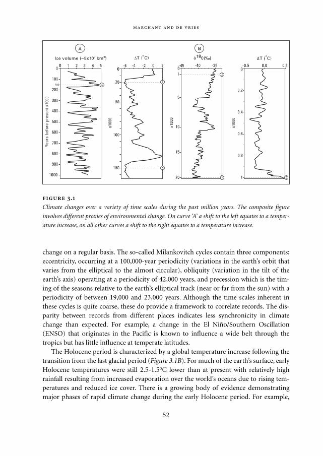
change on a regular basis. The so-called Milankovitch cycles contain three components:eccentricity, occurring at a 100,000-year periodicity (variations in the earth’s orbit thatvaries from the elliptical to the almost circular), obliquity (variation in the tilt of theearth’s axis) operating at a periodicity of 42,000 years, and precession which is the tim-ing of the seasons relative to the earth’s elliptical track (near or far from the sun) with aperiodicity of between 19,000 and 23,000 years. Although the time scales inherent inthese cycles is quite coarse, these do provide a framework to correlate records. The dis-parity between records from different places indicates less synchronicity in climatechange than expected. For example, a change in the El Niño/Southern Oscillation(ENSO) that originates in the Pacific is known to influence a wide belt through thetropics but has little influence at temperate latitudes.
The Holocene period is characterized by a global temperature increase following thetransition from the last glacial period (Figure 3.1B). For much of the earth’s surface, earlyHolocene temperatures were still 2.5-1.5oC lower than at present with relatively highrainfall resulting from increased evaporation over the world’s oceans due to rising tem-peratures and reduced ice cover. There is a growing body of evidence demonstratingmajor phases of rapid climate change during the early Holocene period. For example,
52
.
Climate changes over a variety of time scales during the past million years. The composite figure
involves different proxies of environmental change. On curve ‘A’ a shift to the left equates to a temper-
ature increase, on all other curves a shift to the right equates to a temperature increase.
Mappae Mundi bw zw/w 08-04-2004 15:24 Pagina 52
across the Atlantic Ocean, in terms of global landmass and climate the most influentialof the world’s oceans (Menocal 2000), the terminal collapse of the main northern icemass (Laurentide ice sheet) near Hudson Bay led to a rapid release of cool, fresh water tothe Atlantic and a corresponding sea surface temperature cooling. The maximum rate ofcooling occurred about 8000 yr BP5, in what is termed the 8200-year event. This coolwater influx influenced circulation of the Atlantic Ocean and therefore the climatesystems that arise from this ocean (Figure 3.2). The North Atlantic thermohaline cir-culation6 may be from a cycle paced according to a 1500±500-year rhythm with a tem-perature variation for each oscillation (Broecker 2000). A change in this thermohalinecirculation around 8200 yr BP due to freshwater input from the melting Laurentide icesheet may have been an important trigger for climate, leading to some parts of theAfrican climate to switch abruptly between wet and dry conditions.
These climate changes would, with time delays and spatial differentiation, manifestthemselves in changes in vegetation, geomorphological processes, soil formation and allthe associated biogeochemical cycles that constitute world ecosystems, i.e. an environ-mental response. Of all these dynamics, changes in vegetation are possibly the bestunderstood – and one of the most relevant from the point of view of human habitats.The BIOME 6000 initiative has been a recent research project that has produced globalbiome reconstructions, biomes being large vegetation units such as tropical rainforest,temperate deciduous forest, and tundra, etc. They are based on in excess of 1500 individ-ual sites where radiocarbon-dated pollen data are available (Prentice 1998).
Another way to produce maps of vegetation that reflect past environments is basedon vegetation modelling, a procedure in which the potential vegetation in a given area isinferred from climate (notably temperature, precipitation and seasonality), soils andatmospheric data (cf. Chapter 4). These environmental parameters are combined byequations that constrain plant growth. The vegetation reconstructions produced by thismodelling approach can be confronted with the vegetation maps produced from pollendata. The combination of these two approaches is an important input for the calibra-tion, verification and improvement of global climate models that can be used to pene-trate the future. The resulting discrepancies are often found to arise from local condi-tions of soil, rainfall patterns and how these are parameterized within the model forplant growth.
These investigations of past biomes show dramatic changes in the composition and dis-tribution of the vegetation. The melting of large ice sheets in Europe made the largeEurasian steppes and the northern lands of Europe and Canada available for habitation.For example, it is thought that migration into North America, from Siberia, was not pos-sible until the Bering land bridge was free of ice. This climatic amelioration allowed thedevelopment of vegetation in eastern North America vegetation belts spreading north-
:
53
Mappae Mundi bw zw/w 08-04-2004 15:24 Pagina 53
wards as boreal forests were able to colonize areas previously covered in tundra (see e.g.www.nceas.vcsb.edu and www.soton.ac.uk). In Europe, following the maximum periodof temperature reduction of the last glacial period, forests were able to migrate north-wards, coniferous forest replacing tundra, broadleaf forest replacing coniferous forest.Broadleaf woodlands were present in the Mediterranean during the last glacial periodand, as the climate warmed, these penetrated northwards as the Mediterranean flora thatis present today became established (Figure 3.3; see p. 162).
The last glacial period, from 22,000 to 13,000 yr BP, was very cold and dry through-
54
Biomization of pollen: the BIOME 6000 project A good example for pollen data
investigation has developed as part of the Global Palaeo-vegetation Mapping Project
(BIOME 6000) (Prentice 1998). This aims to understand changes in the distribution of
biomes over recent geological time, and how these changes reflect global climate
change. A community-wide collaboration started in 1994 as part of the International
Geosphere-Biosphere Program (IGBP). The aims of BIOME 6000 are to create pollen
and plant macrofossil data sets for 6000 and 18,000 years ago and construct global
maps of biomes for these periods. The technique is based on the sequential calculation
of data contained within three matrices that are assigned a priori. These could be used
to evaluate climate models and quantify the importance of changes in global plant dis-
tribution on the climate system.
The biomization of pollen data has greater utility than just providing a benchmark to
validate [climate] model output. Of particular interest, from a vegetation dynamics per-
spective, is how climate system-biosphere interactions have developed under the rap-
idly changing environment characteristics of the earth since the last glacial maximum.
Biomized pollen data can be used to investigate vegetation dynamics in a range of spa-
tial and temporal scales and to investigate the feedback loops between atmosphere,
biosphere and oceanic systems under different conditions of solar activity, human
activity, etc.
A good example comes from Colombia. Pollen data were analysed at ten ‘time win-
dows’ from the present day to 6000 yr BP. At 6000 yr BP the biomes were mainly char-
acteristic of warmer environmental conditions relative to those of the present day. This
trend continued until between 4000 and 3000 yr BP when there was a shift to more
mesic vegetation that is thought to equate to an increase in precipitation levels. The
period between 2500 and 1000 yr BP represents little or no change in biome assign-
ment and is interpreted as a period of environmental stability. The influence attributed
to human-induced impact on the vegetation is recorded from 5000 yr BP, but is particu-
larly important from 2000 yr BP. The extent of this impact increases over the late
Holocene period and is recorded at increasingly high altitudes.
Mappae Mundi bw zw/w 08-04-2004 15:24 Pagina 54
out Europe. In addition to the Arctic ice sheet, large ice caps covered the Alps and thePyrenees. Forest and woodland would have been almost non-existent, except for isolatedpockets of woody vegetation in locally damp locations, such as along watercourses andclose to the mountain ranges of southern Europe. The majority of the area was charac-terized by a sparse grassland or semi-desert coverage. Following initial warming, as theice mass started to melt, some open woodland cover appeared quite rapidly. Within a fewhundred years, the steppe vegetation of the area around the Levant Valley was replacedby woodlands, with relatively ‘boreal’ species such as birch and willow. Typical ‘Mediter-ranean’ tree species such as evergreen oaks and pistachio were not common untilapproximately 8000 yr BP. Following a transition period of gradual tree recolonization,the most heavily wooded conditions of the Holocene occurred between 9000 and 6000yr BP when the Levant had open woodlands rich in pistachio. These changes in climateand vegetation also provided important opportunities for human settlements. One areawhere there is a particularly long history of human development is in the Levant Valleywhere there is considerable evidence for the onset of farming and domestication of earlywheat varieties. (Figure 3.4; see p. 163). Given the long history of these records, extend-ing beyond 10,000 yr BP, it is almost certain that the environmental response to awarmer and wetter climate would have impacted on the development of plant domesti-cation. In most parts of Europe, however, agriculture was probably still not significant asa modifier of landscape other than on a local scale.
It should be stressed that the beautiful maps shown should be viewed with a scepticaleye and not blind us to the fact that large uncertainties still remain regarding past cli-mate change and the environmental responses. For example, vegetation change was mostlikely influenced by climate change but increased levels of atmospheric CO2 are alsoshown to have been important (Marchant 2002).
The causes and consequences of climate changes are also linked to the local or regionalgeography, tectonic shifts, rises in sea level and volcanic eruptions. For example, thenorthward movement of the Indian subcontinent has greatly influenced the dynamics oflarge rivers over the past 10,000 years in northern India and Pakistan. Although usuallymore local in origin, these may spread their influence and in this case possibly cause fur-ther aridization of north-western China. Another example comes from the alluvial plainof the Euphrates and Tigris river basins (Pollock 2001). This was formed by sedimentswhile the Arabian shield slowly pushed against the Asiatic landmass. The sediments laiddown in the plains made the Gulf shoreline shifted south-eastwards, possibly some150–200 kilometres since 6000 yr BP – so the ancient city of Uruk might have been aport. However, it has been argued that the sedimentation process was balanced by thesimultaneous subsidence of the Mesopotamian trough and change in sea level. Ataround 18,000 yr BP the level of the Gulf Sea was approximately 100 metres below thepresent-day level and 20 metres below this at 8000 yr BP – but about 2 metres above at
:
55
Mappae Mundi bw zw/w 08-04-2004 15:24 Pagina 55
6000 yr BP. Thus, the environmental history of one of these cradles of civilization is stillunresolved.
Increasing human impact on the environment during the Holocene period is an-other complication in palaeo-environmental reconstructions. Signals originating fromhuman- and climate-induced change on the environment can be difficult to separate outfrom poorly resolved proxy records. As with the synthesis of the information derivedfrom the accumulated sediments, a range of techniques combine to construct a pictureof how cultures have changed in their composition and distribution over the Holoceneperiod. In addition, standard archaeological investigations of past occupation layers andthe associated artefacts, such as pottery, and recent innovations provide information onpast cultures and their relationship with the environment. For instance, starch grainsidentifiable as manioc (Manihot esculentia), yams (Dioscorea sp.) and arrowroot(Maranta arundinacea) found on milling stones date between 7000 and 5000 yr BP fromPanama, indicating ancient and independent emergence of plant domestication in thelowland Neotropical forest (Piperno 2000). Other information on past human activity
56
The earliest settlements New measurements and interpretations indicate that the
Holocene period has experienced climatic instabilities, the effects of which were locally
specific and sufficiently abrupt, severe and unanticipated to seriously disrupt early
human societies. One of the earliest documented examples of societal collapse and
adaptation is that of the Natufian communities in southwest Asia about 12,000 yr BP
(Weiss 2001). In the process, these populations abandoned low labour–intensive hunt-
ing and gathering activities for more labour-intensive plant cultivation and animal hus-
bandry strategies. Recent palaeo-climatic data show that this transition coincided with
changes in climate and vegetation from open woodlands and wild cereals to cooler and
dryer conditions. As the harvests of wild resources dwindled, the human populations
were probably forced to migrate and start intentional cultivation. Population and social
complexity may have induced another migration and settlement in the Tigris-Euphrates
alluvial plain and delta up to a pulsed climate change.
A similar story can be told for the region west of the Nile Valley (Sandweiss 1999). In
this area, now desert, cattle herders occupied villages as early as 9000 yr BP when
stronger monsoons resulted in relatively wet conditions. These villages were aban-
doned as aridity increased around 6300 yr BP. At the same time peoples in the Nile
Valley began to worship cattle and create monuments. Cause or coincidence? Megaliths
(2–3 m) forming stone circles and aligned to the sun are found embedded in sedimen-
tary deposits from a former lake in western Central Sahara. The location of the mega-
liths suggests a spatial awareness and symbolic geometry that integrated death, water
and the sun that predates most of the megalithic features of Europe (Malville 1998).
Mappae Mundi bw zw/w 08-04-2004 15:24 Pagina 56
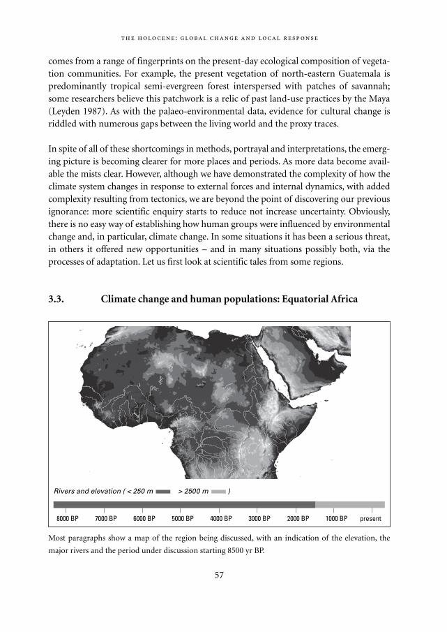
comes from a range of fingerprints on the present-day ecological composition of vegeta-tion communities. For example, the present vegetation of north-eastern Guatemala ispredominantly tropical semi-evergreen forest interspersed with patches of savannah;some researchers believe this patchwork is a relic of past land-use practices by the Maya (Leyden 1987). As with the palaeo-environmental data, evidence for cultural change isriddled with numerous gaps between the living world and the proxy traces.
In spite of all of these shortcomings in methods, portrayal and interpretations, the emerg-ing picture is becoming clearer for more places and periods. As more data become avail-able the mists clear. However, although we have demonstrated the complexity of how theclimate system changes in response to external forces and internal dynamics, with addedcomplexity resulting from tectonics, we are beyond the point of discovering our previousignorance: more scientific enquiry starts to reduce not increase uncertainty. Obviously,there is no easy way of establishing how human groups were influenced by environmentalchange and, in particular, climate change. In some situations it has been a serious threat,in others it offered new opportunities – and in many situations possibly both, via theprocesses of adaptation. Let us first look at scientific tales from some regions.
3.3. Climate change and human populations: Equatorial Africa
:
57
8000 BP 7000 BP 6000 BP 5000 BP 4000 BP 3000 BP 2000 BP 1000 BP present
Rivers and elevation ( < 250 m > 2500 m )
Most paragraphs show a map of the region being discussed, with an indication of the elevation, the
major rivers and the period under discussion starting 8500 yr BP.
Mappae Mundi bw zw/w 08-04-2004 15:24 Pagina 57
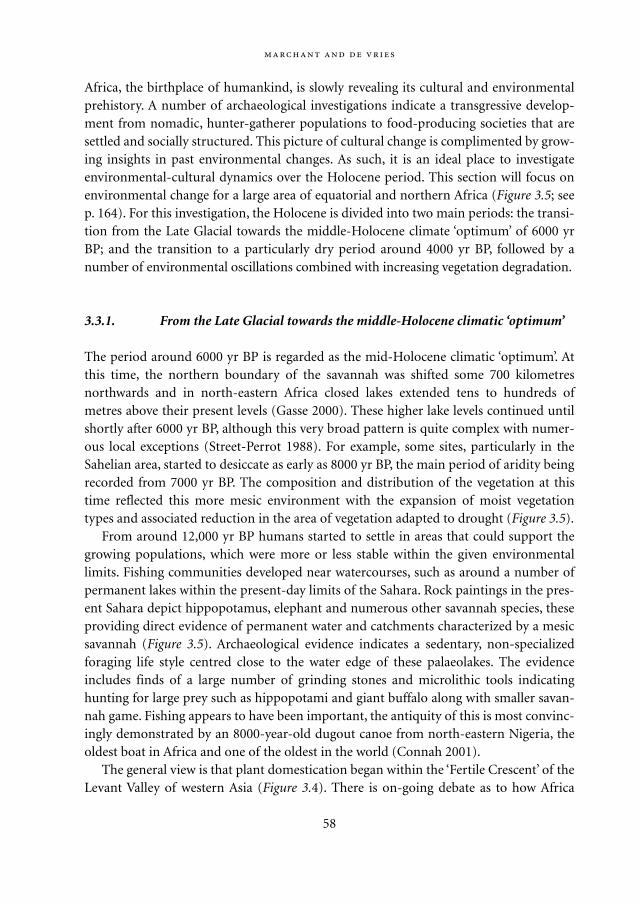
Africa, the birthplace of humankind, is slowly revealing its cultural and environmentalprehistory. A number of archaeological investigations indicate a transgressive develop-ment from nomadic, hunter-gatherer populations to food-producing societies that aresettled and socially structured. This picture of cultural change is complimented by grow-ing insights in past environmental changes. As such, it is an ideal place to investigateenvironmental-cultural dynamics over the Holocene period. This section will focus onenvironmental change for a large area of equatorial and northern Africa (Figure 3.5; seep. 164). For this investigation, the Holocene is divided into two main periods: the transi-tion from the Late Glacial towards the middle-Holocene climate ‘optimum’ of 6000 yrBP; and the transition to a particularly dry period around 4000 yr BP, followed by anumber of environmental oscillations combined with increasing vegetation degradation.
3.3.1. From the Late Glacial towards the middle-Holocene climatic ‘optimum’
The period around 6000 yr BP is regarded as the mid-Holocene climatic ‘optimum’. Atthis time, the northern boundary of the savannah was shifted some 700 kilometresnorthwards and in north-eastern Africa closed lakes extended tens to hundreds ofmetres above their present levels (Gasse 2000). These higher lake levels continued untilshortly after 6000 yr BP, although this very broad pattern is quite complex with numer-ous local exceptions (Street-Perrot 1988). For example, some sites, particularly in theSahelian area, started to desiccate as early as 8000 yr BP, the main period of aridity beingrecorded from 7000 yr BP. The composition and distribution of the vegetation at thistime reflected this more mesic environment with the expansion of moist vegetationtypes and associated reduction in the area of vegetation adapted to drought (Figure 3.5).
From around 12,000 yr BP humans started to settle in areas that could support thegrowing populations, which were more or less stable within the given environmentallimits. Fishing communities developed near watercourses, such as around a number ofpermanent lakes within the present-day limits of the Sahara. Rock paintings in the pres-ent Sahara depict hippopotamus, elephant and numerous other savannah species, theseproviding direct evidence of permanent water and catchments characterized by a mesicsavannah (Figure 3.5). Archaeological evidence indicates a sedentary, non-specializedforaging life style centred close to the water edge of these palaeolakes. The evidenceincludes finds of a large number of grinding stones and microlithic tools indicatinghunting for large prey such as hippopotami and giant buffalo along with smaller savan-nah game. Fishing appears to have been important, the antiquity of this is most convinc-ingly demonstrated by an 8000-year-old dugout canoe from north-eastern Nigeria, theoldest boat in Africa and one of the oldest in the world (Connah 2001).
The general view is that plant domestication began within the ‘Fertile Crescent’ of theLevant Valley of western Asia (Figure 3.4). There is on-going debate as to how Africa
58
Mappae Mundi bw zw/w 08-04-2004 15:24 Pagina 58
relates to this domestication. Was there a migration of food production technology ordid independent domestication occur? Cattle herding and crop production were presentin the Nile Valley, reaching the central Sahara around 9000 yr BP. Archaeological investi-gations from the Egyptian Sahara have unearthed settled houses with hearths and cook-ing holes that were occupied about 8000 yr BP. Associated with these are the remains ofsome 40 plant species (Wendorf 1992). These indicate that the North African plant-foodcomplex developed independently from the Levantine wheat and barley complex. Nev-ertheless, wheat cultivation was introduced from western Asia, being recorded firstaround the Nile delta. In the Sudanese lowlands and the Ethiopian Highlands severalcrops were brought under local domestication, notably sorghum, millet, the banana-likeEnsete and the oil-yielding noog. Independent agricultural origins in equatorial WestAfrica appeared much later. The combination of yams and oil palm into an effective sys-tem of food production were a prerequisite for life in the humid forest areas; expansionof oil palms is not recorded until after 4000 yr BP. Thus early agriculture has differentinception times at different locations, with the domesticated plant types depending onthe local environment, which was quite different from the present day at this time. Earlyin the Holocene period, settlements were established and sedentary populations grew asrestrictions on fertility imposed by a mobile life were lifted. Population densitiesremained low during this period with the associated impact on the extant vegetationbeing localized and relatively negligible.
:
59
Social adaptation among the Mande people (McIntosh 2000a; McIntosh 1988)
Nomadic populations have lived in the western part of the Sahara for thousands of
years. During the large modal shifts in climate over the last 10,000 years hunters have
evolved, according to McIntosh, an elaborate system of myths and symbols to cope
with these changes. This allowed them to maintain a kind of heterarchy that provided
flexible, responsive adaptations to a mosaic and changing environment. Authority was
conveyed to hunters – the Weather Machine – as they gathered secret knowledge about
the climate and the rapidly changing environment. The landscape became a grid of
nodes of sacrality and information; the important concept was nyama: ’the malign if
improperly controlled energy that flows through all animate and inanimate things‘
(McIntosh, 2000a: 161). Droughts and other unpleasant surprises were seen as signs of
perturbations in the flow and nature of nyama. Later, this information and the authority
it wielded were transferred to the ironsmiths and, later still, to secular dynasts. It has
always remained part of the Mande social memory. In later chapters we will come back
to the relationship between the natural environment and the socio-cultural practices
and organization of populations.
Mappae Mundi bw zw/w 08-04-2004 15:24 Pagina 59
3.3.2. Environmental drying about 4000 yr BP and increasing vegetation degradation: the transition to the present
The mid-Holocene period in much of equatorial of Africa is marked by a relativelyabrupt shift toward a drier, more seasonal environment. Lake levels fell sharply (Gasse2000) and there was an increase of drought-adapted taxa (Elenga 2000). Although thisstarted as early as 8000 yr BP, a particularly strong pulse of aridity is recorded after 4000yr BP. Several lakes registered minima or completely dried up between 3800 and 1300 yrBP in West Africa (Vincens 1998). In North-west Sudan, reduced precipitation and/or anincreased evaporation initiated a shallowing of a lake that continued until approximate-ly 4500 yr BP, at which time the basin was dry (Ritchie 1985). The influx of desert-dustinto sedimentary deposits began to increase at other sites in this area about 4700 yr BP,with a permanent rainfall decline after about 4100 yr BP (Street-Perrot 2000). In CentralAfrica taxa more tolerant of drought appear to have increased in abundance within trop-ical montane forest after 3800 yr BP (Jolly 1998).
This change in macro-climatic conditions would have impacted on other environ-mental constraints on the vegetation. For example, it increased the incidence of fire, asdetected by an increase in charcoal coinciding with this arid period after 4000 yr BP. Thevegetation at this time is shown in Figure 3.5. Although the last 4000 years appear to haveexhibited much greater climatic variability than the previous period, this may stem froman artefact of sampling resolution and the availability of a wider range of data sourcesover the most recent geological period (Bonnefille 2000). In northern Nigeria, the rela-tively arid conditions discussed above were followed by a subsequent wet phase atapproximately 1200 yr BP (Holmes 1998). Expansion of moist around Lakes Kitina,Ossa and in the Ngamakala depression at 900, 700 and 500 yr BP all indicate the re-establishment of more humid conditions in western Equatorial Africa during the lastmillennium (Vincens 1999). Time series records of Nile River discharge, from the Rodagauge near Cairo, identify two distinct epochs of relatively low minima of Nile River lev-els from 1400 to 1000 and from 650 to 350 yr BP (Fraedrich 1997). In Central Africa,Lake Malawi was at a high level between 1100 and 900 yr BP, and 700 to 500 yr BP, theintervening low stands occurring at 800 and 300 yr BP (Owen 1990). A third phase ofincreased aridity began around 500 yr BP when there was a major decline in the level ofLake Malawi. Webster (1979) has suggested that these episodes are tied in with famineand drought, although the understanding of the paleological data, chronology and overallinterpretations has been questioned. Within the more recent past, within the memory ofmost people, climatic variations have influenced food production in large parts of Africa.
This period also witnessed a major change in agriculture, organization of settlementsand population migration, widely recorded by archaeological sites. The transformationto a pastoral and agricultural economy is thought to be associated with the arrival ofpeople from elsewhere, rather than independent domestication. It is likely that this is
60
Mappae Mundi bw zw/w 08-04-2004 15:24 Pagina 60
part of a general southwards movement of pastoralists from northern and western Africaafter 4500 yr BP. This migration may have been facilitated by the expansion of grazingland on the edges of draining lakes and river floodplains as these adjusted to a drying cli-mate. In the area of Africa under review here, one of the main transformations is associ-ated with the migration of populations. One such notable migration is associated withthe Bantu from their origin in the grasslands of western Cameroon and Nigeria (Figure3.6; see p. 165). Although there was a general diffusion of Bantu influence, this may havebeen concentrated along a number of ‘migratory pathways’ – there is continuing debateas to the timing and direction of these migrations. One appears to follow the Atlanticcoastal margins and inland ridges that border the Congolese Basin and through theequatorial forest. A second route traverses the southern limit of the southerly expandingSahara, then goes south down the Nile Valley. Whatever the timing and direction of thismigration, passage was rapid. The Bantu probably followed river courses, dry ridgeswithin the intervening forest, these not being so dense during this period. From 4400 to2500 yr BP yam and oil palm spread south and east with the first Bantu migrants, whoeither replaced, or encompassed, earlier established populations.
On reaching the highlands areas of Central Africa, an interesting focus for settlementof these early populations appear on high ground, as recorded in the Rukiga Highlands(Taylor 1995). Higher altitude sites may have been favoured initially for agriculturebecause: (a) the land would have been easier to prepare as forest growing on ridge-toplocations is less dense than at lower altitudes; (b) the incidence of disease, such as malar-ia is much less; and (c) the hilltop locations would have offered protection from poten-tially hostile neighbouring clans or indigenous populations. The interlacustrine region istherefore a contact zone between diverse agricultural traditions as demonstrated by thepresent diversity of cultivated crops that include millet, bananas, yams and sweet pota-toes. These arose from four distinct origin centres: the Sahel, trans-Indian and the lattertwo on the fringes of the West African forest, respectively. As the population quicklygrew during this period, the associated impact on the vegetation was localized, althoughit would have increased rapidly as livestock levels rose.
A major change that occurred in the Holocene period was the rise in metalworkingthat has allowed the developing agricultural population to become much more effectivein land clearance and subsequent transformation to agricultural land. The spread of irontechnology was most likely due to the Bantu, arriving from north-western Africa,although this is under continuing debate. Due to the complexity of the artefacts, Meroealong the upper Nubian Nile is a possible centre of origin for the spread of iron technol-ogy throughout sub-Saharan Africa; this was a major centre of iron working with anextensive trade hinterland. Whatever the direction of this import, interlacustrine popu-lations had a sophisticated iron smelting technology by 2500 to 2000 yr BP that hasundergone a series of developmental stages. These transitions in metallurgy and potterystyle appear to be coeval with a plethora of social, political and economic changes.
:
61
Mappae Mundi bw zw/w 08-04-2004 15:24 Pagina 61
3.4. Early human-environment interactions: the Americas
In Latin America, as in Africa, the Holocene period is marked by significant phases ofenvironmental change, these being documented by a developed network of archaeologi-cal and palaeo-environmental records. However, these changes differ in direction andmagnitude as the area is under the influence of different climate systems (Figure 3.2). Wewill now investigate cultural and environmental changes in two regions: coastal Peru andthe Maya lowlands.
3.4.1. Environmental and cultural change in western Peru
Our first focus is on Peru in the northern part of the Andes (Figure 3.7; see p. 166).Although radiocarbon dating of past occupation layers from the western flanks of thePeruvian Andes indicate inhabitation in excess of 20,000 years ago, these are highly con-troversial. A more reliable set of dates indicates human occupation back to 12,000 yr BPwith several of these sites concentrated in the lowlands. For example, the archaeologicalsite of Quebrada Tacahuay (Peru) dates to 10,770 yr BP and contains some of the oldestevidence of maritime-based economic activity in the New World concentrating prima-rily on seabirds and fish (Aldenderfer 1999). Rising sea levels recorded through theHolocene would have had direct implications for the use of marine resources. While it
62
Iron and culture The cultural assimilation of iron technology and agricultural prac-
tice should be viewed as more than just simple resource development; there were
important socio-economic connections between the iron smelters/smiths and the
levers of political power (Schoenbrun 1993). Maintenance of power by certain seg-
ments of the population may have been the precursor for the development of organ-
ized states such as the major settlement at Ntusi, Uganda, with increased ownership,
stock and defence of pastures with increasing social, political, military and competition
implications (Sutton 1993). The establishment, and maintenance of such sites must
have required the use of organized labour and a transition to a system of governance –
in short a political hierarchy with diversified economies, trade and stronger political
control. However, several of these states declined around 500 yr BP. There is no con-
sensus to explain the abandonment of the earthworks and the rise of the later pre-colo-
nial kingdoms that emerged, such as that of Bunyoro, which were encountered by early
European visitors, although environmental change, disease, slaving, war and famine to
name but a few may have been contributory factors. We will come back to the forces
behind state formation in Chapter 6.
Mappae Mundi bw zw/w 08-04-2004 15:24 Pagina 62
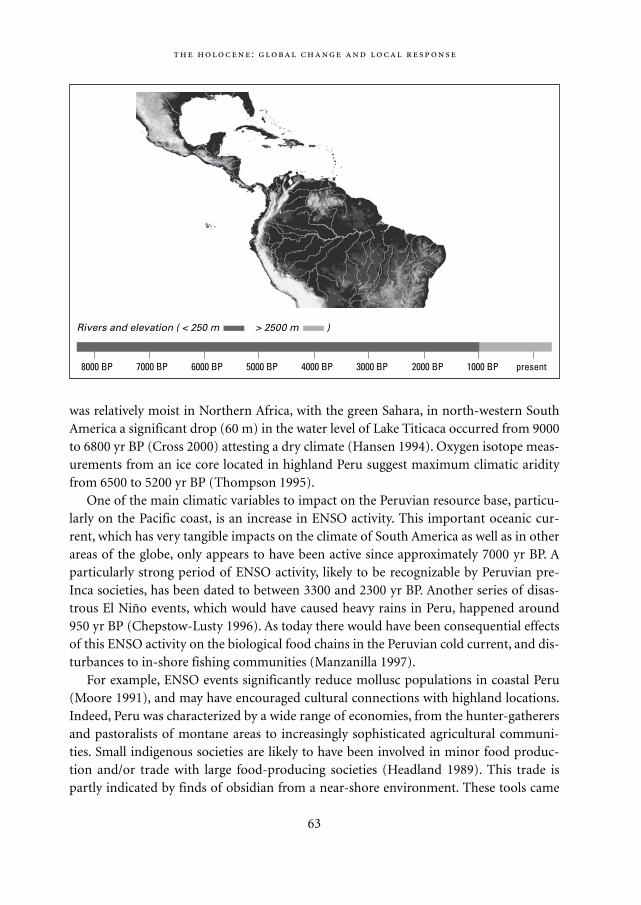
was relatively moist in Northern Africa, with the green Sahara, in north-western SouthAmerica a significant drop (60 m) in the water level of Lake Titicaca occurred from 9000to 6800 yr BP (Cross 2000) attesting a dry climate (Hansen 1994). Oxygen isotope meas-urements from an ice core located in highland Peru suggest maximum climatic aridityfrom 6500 to 5200 yr BP (Thompson 1995).
One of the main climatic variables to impact on the Peruvian resource base, particu-larly on the Pacific coast, is an increase in ENSO activity. This important oceanic cur-rent, which has very tangible impacts on the climate of South America as well as in otherareas of the globe, only appears to have been active since approximately 7000 yr BP. Aparticularly strong period of ENSO activity, likely to be recognizable by Peruvian pre-Inca societies, has been dated to between 3300 and 2300 yr BP. Another series of disas-trous El Niño events, which would have caused heavy rains in Peru, happened around950 yr BP (Chepstow-Lusty 1996). As today there would have been consequential effectsof this ENSO activity on the biological food chains in the Peruvian cold current, and dis-turbances to in-shore fishing communities (Manzanilla 1997).
For example, ENSO events significantly reduce mollusc populations in coastal Peru(Moore 1991), and may have encouraged cultural connections with highland locations.Indeed, Peru was characterized by a wide range of economies, from the hunter-gatherersand pastoralists of montane areas to increasingly sophisticated agricultural communi-ties. Small indigenous societies are likely to have been involved in minor food produc-tion and/or trade with large food-producing societies (Headland 1989). This trade ispartly indicated by finds of obsidian from a near-shore environment. These tools came
:
63
8000 BP 7000 BP 6000 BP 5000 BP 4000 BP 3000 BP 2000 BP 1000 BP present
Rivers and elevation ( < 250 m > 2500 m )
Mappae Mundi bw zw/w 08-04-2004 15:24 Pagina 63
from highland sources some 130 kilometres inland indicating that people either trav-elled to the highlands themselves or traded with people who did (Sandweiss 1999). Apossible stimulus for the growth of trade between maritime hunting and gathering com-munities to those operating inland and vice versa may have been a sudden disruption ofthe population/resource balance. Such a perturbation is suggested for coastal Peru wherethe Humbolt Current yields an extremely resource-rich coastline except during El Niñoevents (Yesner 1980). The people taking advantage of such a rich resource would have todevelop some kind of device to get over a decline in food availability.
As such a variable environment places a premium on the mobility and diversity ofresources, and the development of secondary subsistence modes such as connectionsbetween Andean and coastal dwellers are likely to have a long history. However, connec-tions cannot just be confined to times of food shortage and it is likely that an exchangeof goods developed, including food and locally available goods such as obsidian. Forexample, Camelid meat from pastoral communities living at high altitude was trans-portable following preservation by drying into strips called Ch’arki (Stahl 1999). Therelationship between these two groups is unlikely to have been solely concerned withfood; it is likely there was a myriad of connections at the material, social and spirituallevel (cf. Section 3.5). Thus, between 8000 and 3600 yr BP arid conditions prevailed andhumans occupied ‘ecological refuges’ where resources and especially flowing water werelocally available in a generally very hostile environment. Thereafter, more complex soci-eties emerged with a diverse lithic industry, domestication (from 4800 yr BP), semi-sedentary agriculture with terracing and channel irrigation (from 3100 yr BP). Althoughthe rate of technological innovation seems rather high during this time of environmen-tal stress, the extent to which the prevailing environmental conditions constituted a trig-ger for domestication remains debatable. The nature of these connections can only beinferred as these aspects of former cultures are not readily preserved within the archaeo-logical record and modern analogues are not present.
3.4.2. Late-Holocene environmental and Mayan cultures
One of the most startling connections, or coincidences, between a changing environ-ment and culture comes from the Guatemalan lowlands of the Yucatán peninsular, thearea of Mayan settlement (Figure 3.8; see p. 167). The Mayan occupation stems fromabout 2000 yr BP with the Classical period lasting from 1750 to 1150 yr BP culminatingin a large and highly developed culture that collapsed in a relatively short time, spanningsome 50 to 100 years (Leyden, 1987). Throughout the Classical period, slow but expo-nential growth led to large settlements that then underwent expansion into the lessfertile Yucatán Peninsula (Hsu 2000; Figure 3.8). Associated with this growth was wide-spread anthropogenic deforestation occurring between about 2000 and 950 yr BP.
64
Mappae Mundi bw zw/w 08-04-2004 15:24 Pagina 64
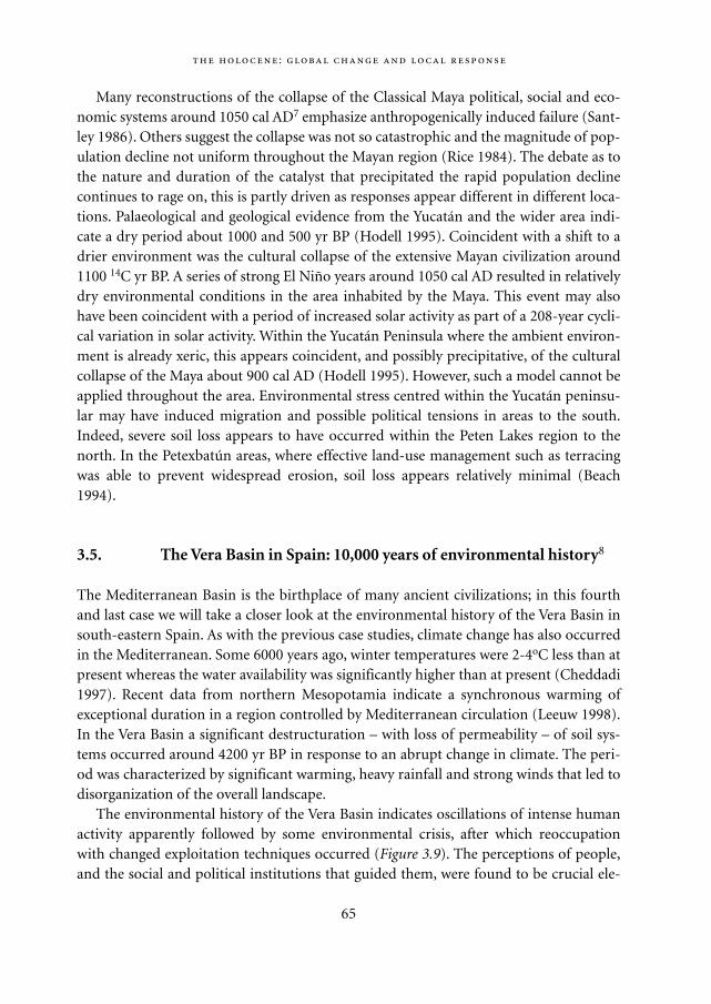
Many reconstructions of the collapse of the Classical Maya political, social and eco-nomic systems around 1050 cal AD7 emphasize anthropogenically induced failure (Sant-ley 1986). Others suggest the collapse was not so catastrophic and the magnitude of pop-ulation decline not uniform throughout the Mayan region (Rice 1984). The debate as tothe nature and duration of the catalyst that precipitated the rapid population declinecontinues to rage on, this is partly driven as responses appear different in different loca-tions. Palaeological and geological evidence from the Yucatán and the wider area indi-cate a dry period about 1000 and 500 yr BP (Hodell 1995). Coincident with a shift to adrier environment was the cultural collapse of the extensive Mayan civilization around1100 14C yr BP. A series of strong El Niño years around 1050 cal AD resulted in relativelydry environmental conditions in the area inhabited by the Maya. This event may alsohave been coincident with a period of increased solar activity as part of a 208-year cycli-cal variation in solar activity. Within the Yucatán Peninsula where the ambient environ-ment is already xeric, this appears coincident, and possibly precipitative, of the culturalcollapse of the Maya about 900 cal AD (Hodell 1995). However, such a model cannot beapplied throughout the area. Environmental stress centred within the Yucatán peninsu-lar may have induced migration and possible political tensions in areas to the south.Indeed, severe soil loss appears to have occurred within the Peten Lakes region to thenorth. In the Petexbatún areas, where effective land-use management such as terracingwas able to prevent widespread erosion, soil loss appears relatively minimal (Beach1994).
3.5. The Vera Basin in Spain: 10,000 years of environmental history8
The Mediterranean Basin is the birthplace of many ancient civilizations; in this fourthand last case we will take a closer look at the environmental history of the Vera Basin insouth-eastern Spain. As with the previous case studies, climate change has also occurredin the Mediterranean. Some 6000 years ago, winter temperatures were 2-4oC less than atpresent whereas the water availability was significantly higher than at present (Cheddadi1997). Recent data from northern Mesopotamia indicate a synchronous warming ofexceptional duration in a region controlled by Mediterranean circulation (Leeuw 1998).In the Vera Basin a significant destructuration – with loss of permeability – of soil sys-tems occurred around 4200 yr BP in response to an abrupt change in climate. The peri-od was characterized by significant warming, heavy rainfall and strong winds that led todisorganization of the overall landscape.
The environmental history of the Vera Basin indicates oscillations of intense humanactivity apparently followed by some environmental crisis, after which reoccupationwith changed exploitation techniques occurred (Figure 3.9). The perceptions of people,and the social and political institutions that guided them, were found to be crucial ele-
:
65
Mappae Mundi bw zw/w 08-04-2004 15:24 Pagina 65
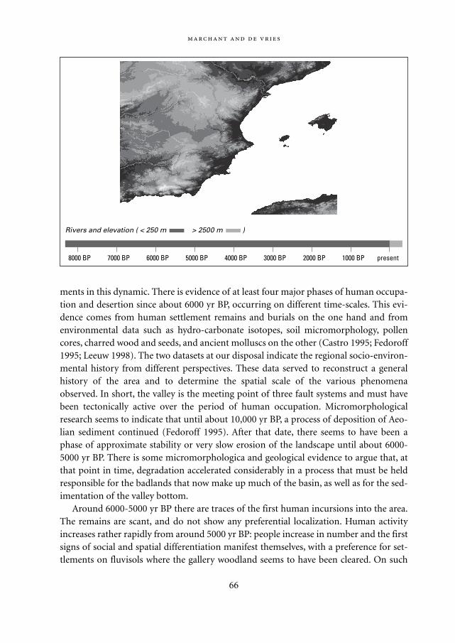
ments in this dynamic. There is evidence of at least four major phases of human occupa-tion and desertion since about 6000 yr BP, occurring on different time-scales. This evi-dence comes from human settlement remains and burials on the one hand and fromenvironmental data such as hydro-carbonate isotopes, soil micromorphology, pollencores, charred wood and seeds, and ancient molluscs on the other (Castro 1995; Fedoroff1995; Leeuw 1998). The two datasets at our disposal indicate the regional socio-environ-mental history from different perspectives. These data served to reconstruct a generalhistory of the area and to determine the spatial scale of the various phenomenaobserved. In short, the valley is the meeting point of three fault systems and must havebeen tectonically active over the period of human occupation. Micromorphologicalresearch seems to indicate that until about 10,000 yr BP, a process of deposition of Aeo-lian sediment continued (Fedoroff 1995). After that date, there seems to have been aphase of approximate stability or very slow erosion of the landscape until about 6000-5000 yr BP. There is some micromorphologica and geological evidence to argue that, atthat point in time, degradation accelerated considerably in a process that must be heldresponsible for the badlands that now make up much of the basin, as well as for the sed-imentation of the valley bottom.
Around 6000-5000 yr BP there are traces of the first human incursions into the area.The remains are scant, and do not show any preferential localization. Human activityincreases rather rapidly from around 5000 yr BP: people increase in number and the firstsigns of social and spatial differentiation manifest themselves, with a preference for set-tlements on fluvisols where the gallery woodland seems to have been cleared. On such
66
8000 BP 7000 BP 6000 BP 5000 BP 4000 BP 3000 BP 2000 BP 1000 BP present
Rivers and elevation ( < 250 m > 2500 m )
Mappae Mundi bw zw/w 08-04-2004 15:24 Pagina 66
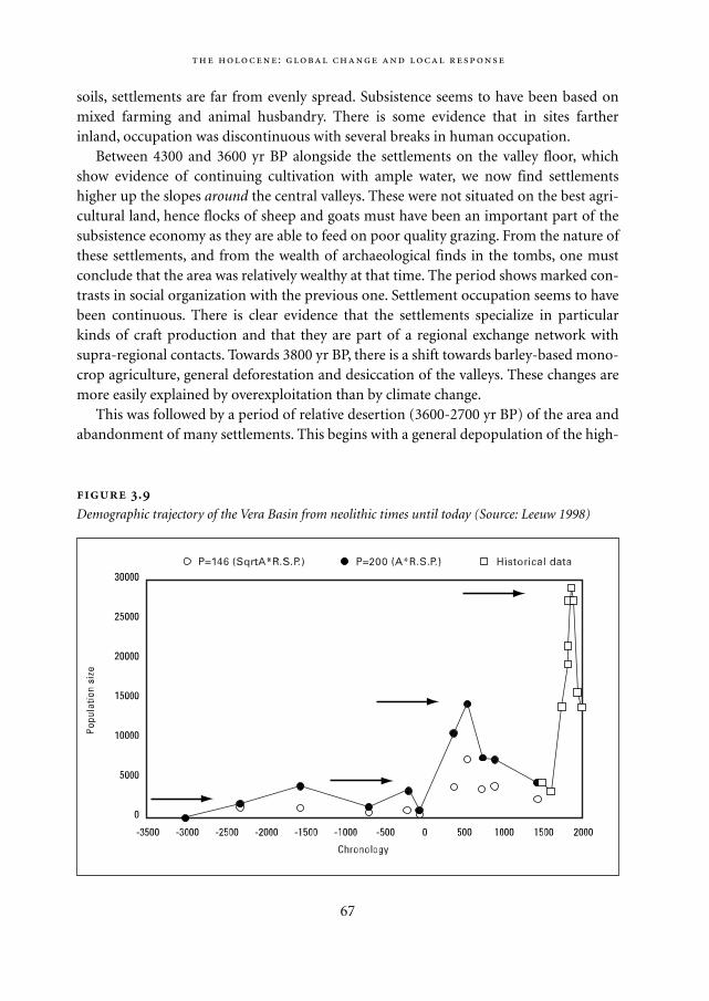
soils, settlements are far from evenly spread. Subsistence seems to have been based onmixed farming and animal husbandry. There is some evidence that in sites fartherinland, occupation was discontinuous with several breaks in human occupation.
Between 4300 and 3600 yr BP alongside the settlements on the valley floor, whichshow evidence of continuing cultivation with ample water, we now find settlementshigher up the slopes around the central valleys. These were not situated on the best agri-cultural land, hence flocks of sheep and goats must have been an important part of thesubsistence economy as they are able to feed on poor quality grazing. From the nature ofthese settlements, and from the wealth of archaeological finds in the tombs, one mustconclude that the area was relatively wealthy at that time. The period shows marked con-trasts in social organization with the previous one. Settlement occupation seems to havebeen continuous. There is clear evidence that the settlements specialize in particularkinds of craft production and that they are part of a regional exchange network withsupra-regional contacts. Towards 3800 yr BP, there is a shift towards barley-based mono-crop agriculture, general deforestation and desiccation of the valleys. These changes aremore easily explained by overexploitation than by climate change.
This was followed by a period of relative desertion (3600-2700 yr BP) of the area andabandonment of many settlements. This begins with a general depopulation of the high-
:
67
.
Demographic trajectory of the Vera Basin from neolithic times until today (Source: Leeuw 1998)
Mappae Mundi bw zw/w 08-04-2004 15:25 Pagina 67
lands that is virtually complete by 3200 yr BP. At that time, only small, dispersed settle-ments remain in the lowlands. Although the evidence is scarce, it seems that there alsowas a reduction in the level of socio-economic differentiation and structure, with fewpeople remaining in the highland settlements building the first terraces. The populationrelies increasingly on a diversity of cultivation strategies and crops. It is at this time –much later than elsewhere – that olive and vine are introduced. Deciduous forest, pres-ent in the last period, disappears completely. From 3400 yr BP we observe an increase inshrubs and weeds being used for fuel, which also points to a general scarcity of wood.
In the period 2700 to 2200 yr BP the move is again towards (rapid) populationincrease and population concentration in larger settlements (at the foothills). By about2400 yr BP the population concentration is at its peak and is notably located near thecoast. The intensity of occupation in these areas surpasses anything the region had pre-viously seen. Social complexity increases, as evidenced by the level of individual inhabi-tants in cemeteries and settlement differentiation. The economic base also changes, withconsiderable mining; very quickly, this causes fuel shortages. Dependency on exchangeincreases and also the export of raw materials. In the charcoal remains, riverine woodspecies are absent and palms are present. Erosion seems to have been considerable.
After 200 BC a short period of depopulation is observed, followed by the introduc-tion of a spatially and technically different exploitation system by the Romans. We nowsee many isolated, continuously and intensively occupied farms in the lowlands, whichdevelop into centres for large landholdings exploiting the area for export and applyingnew technology. The intensity of human occupation exceeds, again, that of earlier peri-ods. Irrigation was probably widespread. Towards 400 AD, this socio-economic fabriccollapses; some people move back into the hills. Mining is on the rise, but subsistenceproduction shifts back into a local mode, with diversified dry-land agriculture. The sameis true for pottery production. There is some evidence in the coastal settlements forimportation of wheat, possibly indicating local overexploitation.
By 750 AD the Arabic conquests introduce another clear change in occupation pat-tern, introducing the widespread use of irrigated terracing as part of a move of the pop-ulation land inwards onto the slopes. These are better managed, which improves thebalance of the whole region. In the historical evidence there is little sign of a differentiat-ed population: the landholdings are all of about the same (small) size. The local climateseems to be drier, as judged from the vegetation, but surface water management muchbetter. Cultivation is multi-crop, with horticulture alongside cereals and considerableacreages of tree plantations, notably mulberry for silk production. The area as a wholemay be said to be heavily, but stably exploited (Leeuw 1998).
Expulsion of the Muslim population by the Christians at the end of the 15th century –and showing up in the first population count since, around 1550 AD – resulted in arapid decline of the population, with the loss of more than one third in 40 years. Never-theless, we have evidence of repeated clamour for more land to be released by the state
68
Mappae Mundi bw zw/w 08-04-2004 15:25 Pagina 68
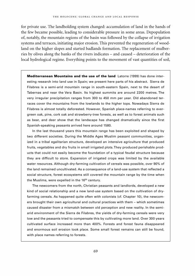
for private use. The landholding system changed: accumulation of land in the hands ofthe few became possible, leading to considerable pressure in some areas. Depopulationof, notably, the mountain regions of the basin was followed by the collapse of irrigationsystems and terraces, initiating major erosion. This prevented the regeneration of wood-land on the higher slopes and started badlands formation. The replacement of mulber-ries by olives along the banks of the rivers indicates – and caused – deterioration of thelocal hydrological regime. Everything points to the movement of vast quantities of soil,
:
69
Mediterranean Mountains and the use of the land Latorre (1999) has done inter-
esting research into land use in Spain; we present here parts of his abstract. Sierra de
Filabres is a semi-arid mountain range in south-eastern Spain, next to the desert of
Tabernas and near the Vera Basin. Its highest summits are around 2200 metres. The
very irregular precipitation ranges from 300 to 450 mm per year. Old abandoned ter-
races cover the mountains from the lowlands to the higher tops. Nowadays Sierra de
Filabres is almost totally deforested. However, Spanish place-names referring to ever-
green oak, pine, cork oak and strawberry-tree forests, as well as to forest animals such
as bear, and deer show that the landscape has changed dramatically since the first
Spanish-speaking peasants arrived here around 1580.
In the last thousand years this mountain range has been exploited and shaped by
two different societies. During the Middle Ages Muslim peasant communities, organ-
ized in a tribal egalitarian structure, developed an intensive agriculture that produced
fruits, vegetables and dry fruits in small irrigated plots. They produced perishable prod-
ucts that could not easily become the foundation of a typical feudal structure because
they are difficult to store. Expansion of irrigated crops was limited by the available
water resources. Although dry-farming cultivation of cereals was possible, over 90% of
the land remained uncultivated. As a consequence of a land-use system that reflected a
social structure, forest ecosystems still covered the mountain range by the time when
the Muslims, were expelled in the 16th century.
The newcomers from the north, Christian peasants and landlords, developed a new
kind of social relationship and a new land-use system based on the cultivation of dry-
farming cereals. As happened quite often with colonists (cf. Chapter 10), the newcom-
ers brought their own agricultural and cultural practices with them – which sometimes
caused disaster from a mismatch between old perception and new reality. In the semi-
arid environment of the Sierra de Filabres, the yields of dry-farming cereals were very
low and the peasants tried to compensate this by cultivating more land. Over 300 years
cultivated surface increased more than 400%. Forests and forest fauna disappeared
and enormous soil erosion took place. Some small forest remains can still be found,
with place names referring to forests.
Mappae Mundi bw zw/w 08-04-2004 15:25 Pagina 69
causing the coast to extend and depositing, according to one estimate, as much soil inthe last 500 years as in the whole of the Holocene period. At the same time, the hydrolog-ical research indicates a considerable increase in evapotranspiration from about 400years ago, possibly pointing to the loss of vegetation cover that is concomitant with sucherosion (Leeuw, 1998).
A mining boom in the 19th century caused a brief interruption, by forcing reoccupa-tion of much of the area in order to provide the means to maintain the miners. A newdispersed agricultural settlement pattern sprang up over the whole basin, with terracingand irrigation in the highlands. The difference with the Arabic period is, of course, thatthis time the investment needed for such terracing was only viable in view of the mining,rather than the agricultural production. The main consequence for the lowlands wasincreased salinization, and for the highlands total and complete deforestation. As theboom ended, emigration towards the towns initiated erosion once more.
3.6. Conclusions
Changes in human population and their activities in synchrony with environmentalchange should not be interpreted in terms of single, unilateral cause-and -effect rela-tions. The interactions were already more complex at an early stage. On closer inspectionand with recent insights, the Holocene environment was less stable than had beenthought. We should not be surprised to discover influences from climate and vegetationchange upon human populations throughout the Holocene period, including theirresponses and adaptations. In Africa there once was a green Sahara with large animalsand hunters. Later, large migrations took place that may have been triggered by environ-mental change. In South America the variable environment, partly due to the specificENSO event, stimulated mobility and resource diversity. The environmental history ofthe Maya in Yucatán and of the Vera Basin in Spain shows clear evidence of environmen-tal feedback loops upon human populations and their organization and wealth – but notin a simple way and with different dynamics at work in different places and at differenttimes.
70
Mappae Mundi bw zw/w 08-04-2004 15:25 Pagina 70
4
Environment and the Great Transition:Agrarianization
The next step is to come together in larger numbers, which will increase the size of
the communities, and turn to agriculture. This will be at first practiced in the skirts
of the hill country; dry fences of a kind will be contrived as walls for defense
against savage beasts, and a new and larger single homestead thus erected for the
community.
Plato’s Laws Third Book
4.1. Introduction
Human-induced modification of the environment started with the use of fire, much ear-lier than any form of agriculture. Fire opened up the land for hunting and early forms ofhorticulture and agriculture and pastoralism. The subsequent process of agrarianizationhas already been described in Chapter 2. The agrarian regime saw a series of tools andpractices, including the adaptation of new crops and the domestication of animals. Ani-mal domestication and a more sedentary existence influenced population growth. Partsof the natural environment – good soil, sources of water and wood, mineral deposits –became a ‘resource’. New forms of social organization came into existence. Pockets ofnatural landscapes became dominated by humans as control over the natural environ-ment increased. With populations growing in size, other human groups became thelargest adversary and hunting tools and domesticated animals became increasingly alsoweapons of war, conquest and suppression. More peaceful ways of exchange intensifiedtoo: trade.
One of the most immediate and important aspects of the natural environment is theprovision of food. Food is the human-environment interaction par excellence. As theenvironment with its geography, climate, water, soils and vegetation is the key factor inthe supply of food, the focus on the emergence and forms of agriculture is natural in the
71
Mappae Mundi bw zw/w 08-04-2004 15:25 Pagina 71
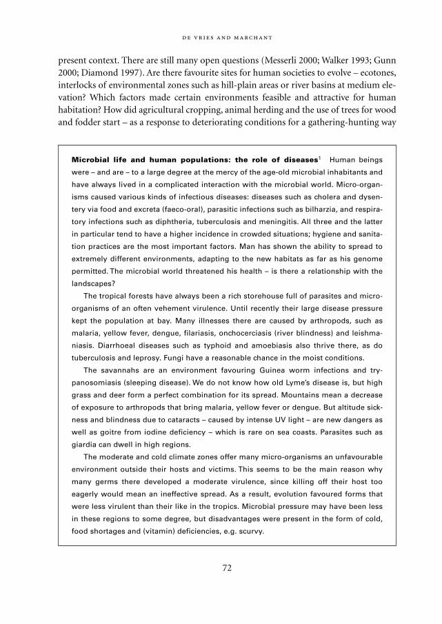
present context. There are still many open questions (Messerli 2000; Walker 1993; Gunn2000; Diamond 1997). Are there favourite sites for human societies to evolve – ecotones,interlocks of environmental zones such as hill-plain areas or river basins at medium ele-vation? Which factors made certain environments feasible and attractive for humanhabitation? How did agricultural cropping, animal herding and the use of trees for woodand fodder start – as a response to deteriorating conditions for a gathering-hunting way
72
Microbial life and human populations: the role of diseases1 Human beings
were – and are – to a large degree at the mercy of the age-old microbial inhabitants and
have always lived in a complicated interaction with the microbial world. Micro-organ-
isms caused various kinds of infectious diseases: diseases such as cholera and dysen-
tery via food and excreta (faeco-oral), parasitic infections such as bilharzia, and respira-
tory infections such as diphtheria, tuberculosis and meningitis. All three and the latter
in particular tend to have a higher incidence in crowded situations; hygiene and sanita-
tion practices are the most important factors. Man has shown the ability to spread to
extremely different environments, adapting to the new habitats as far as his genome
permitted. The microbial world threatened his health – is there a relationship with the
landscapes?
The tropical forests have always been a rich storehouse full of parasites and micro-
organisms of an often vehement virulence. Until recently their large disease pressure
kept the population at bay. Many illnesses there are caused by arthropods, such as
malaria, yellow fever, dengue, filariasis, onchocerciasis (river blindness) and leishma-
niasis. Diarrhoeal diseases such as typhoid and amoebiasis also thrive there, as do
tuberculosis and leprosy. Fungi have a reasonable chance in the moist conditions.
The savannahs are an environment favouring Guinea worm infections and try-
panosomiasis (sleeping disease). We do not know how old Lyme’s disease is, but high
grass and deer form a perfect combination for its spread. Mountains mean a decrease
of exposure to arthropods that bring malaria, yellow fever or dengue. But altitude sick-
ness and blindness due to cataracts – caused by intense UV light – are new dangers as
well as goitre from iodine deficiency – which is rare on sea coasts. Parasites such as
giardia can dwell in high regions.
The moderate and cold climate zones offer many micro-organisms an unfavourable
environment outside their hosts and victims. This seems to be the main reason why
many germs there developed a moderate virulence, since killing off their host too
eagerly would mean an ineffective spread. As a result, evolution favoured forms that
were less virulent than their like in the tropics. Microbial pressure may have been less
in these regions to some degree, but disadvantages were present in the form of cold,
food shortages and (vitamin) deficiencies, e.g. scurvy.
Mappae Mundi bw zw/w 08-04-2004 15:25 Pagina 72
of life or simply, in some locations, as a more rewarding alternative strategy, or evenboth? Did the first farmers clearing ‘pristine’ forests, for crops, wood and fodder, result inmore widespread environmental change? Are there traces of environmental feedback asa consequence of these forms of human interference with natural processes? In the pre-vious chapter, the various stories have already indicated parts of the answer. In this chap-ter we take a more general approach to these questions. We do not claim our treatmentto be complete. It merely probes deeper into facts and forces behind the second majortransition process after the control of fire: agrarianization.
4.2. Environment and human habitat
In the 1960s and 1970s the British anthropologist John Reader travelled widely among avariety of cultures and habitats in the world. His amazing account Man on Earth: ACelebration of Mankind (1988) is intended to show the fundamentals of human ecology.It describes peoples who have each found their own way of living in their particularenvironment: islanders, slash-and-burn agriculturists, pastoralists, nomads, fishermen,hunter gatherers and modern-day farmers. He concluded:
All mankind shares a unique ability to adapt to circumstances and resolve the problems of sur-
vival. It was this talent that carried successive generations of people into many niches of envi-
ronmental opportunity that the world has to offer – from forest, to grassland, desert, seashore
and icecap. And in each case, people developed ways of life appropriate to the particular habi-
tats and circumstances they encountered… Farming, fishing, hunting, herding and technology
are all expressions of the adaptive talent that has sustained mankind thusfar. (Reader 1988: 7-8)
This perspective on human ingenuity in the face of environmental change may beincomplete: it is a synchronic view of small-scale, only partially isolated systems. There isvivid evidence of the inability of larger human groups to sustain more complex arrange-ments amongst each other and with their environment, although this may have had asmuch to do with social as environmental constraints (cf. Chapter 6). Yet it is amazinghow the species Homo sapiens has succeeded in using and stretching the opportunities ofa huge variety of natural environments.
As indicated in the previous chapter one problem in palaeo-research on vegetation isdistinguishing between natural and human-induced situations. There is ample evidencethat human groups have changed the natural landscape from the Early Holocene on andeven before (cf. Chapters 2 and 3). However, the human habitat was still largely deter-mined by climate, vegetation and geography in these first stages. Obviously, whereverpeoples moved in, the environment – its mountains, hills, valleys and rivers, forests and
:
73
Mappae Mundi bw zw/w 08-04-2004 15:25 Pagina 73
coasts – has forced them in certain directions. A recurring theme in this research is theimportance of gradients in the landscape: in elevation, climate variables, vegetation –and population density. Another element, proposed with great persuasion by Diamond(1997), is the existence of natural corridors along which peoples and their cultural traitscould move. Trading routes are one of the important crystallizations of such interactions(cf. Chapter 6). On the other hand, we have to be wary of environmental determinism.As discussed in the previous chapter, scientific evidence in no way always supportsexplanations of human group dynamics on the basis of environmental change – such asclimate change and tectonic activity. Even if the event and the change in the environ-ment have correctly been inferred, dynamic mechanisms proposed on the basis of corre-
74
Human habitats: the Ethiopian Highlands In his book African Civilizations, Con-
nah gives a description of the Ethiopian Highlands that illustrates the many aspects
that affect the potential for human habitation (Connah 2001). The heartland of old
Ethiopia is a huge area of mountains which compared with the surrounding dry, hot
plains, offer a range of relatively attractive environments. Altitude is a major determi-
nant of climate and vegetation: a temperate climate above 2400 metres, a subtropical
climate between 1800 and 2400 metres, and a tropical climate with average tempera-
tures of 26 °C and over below 1800 metres. Seasonality is mainly determined by rainfall
variation with altering wet and dry seasons. The large variation in climate, even across
short distances, is in turn responsible for a large variation in vegetation.
The combination of environmental diversity and fertile soils allowed multi-cropping
and a wide range of crops. The large seasonal and altitudinal variation provided good
opportunities for pastoralists and agriculturists. A variety of livestock emerged: cattle,
sheep, goats, oxen, horses, asses and mules. Their prospects even improved due to
deforestation by humans, causing much of the high plateaus to be covered with short
grass which provides excellent grazing. Other resources were the variety of animals,
minerals such as gold and iron ore, good building stone and, until a few centuries ago,
abundant timber. With the nearby Red Sea at its narrowest, this resource abundance
gave good trading opportunities with southern Arabia.
There were also obstacles. The plateau was inhabited by many other species that
could make life for humans quite unhealthy and risky. Several infectious diseases were
present and occasional epidemics swept the region with great severity. Swarms of
mice, troops of monkeys, massive locust invasions or extremes of high rainfall or tem-
perature, or both at once, caused a periodic recurrence of famine. The high and open
plateau is exposed to wind, making it prone to erosion, and large parts are rocky and
obstructed by gorges, hampering communication. Such was the environment in which
one of the early African states, Aksum, came to flourish some 2000 years ago.
Mappae Mundi bw zw/w 08-04-2004 15:25 Pagina 74
lation should be considered with caution. A similar caveat holds for straightforwardexplanations of socio-political complexity from biogeographical features such as hills,rivers, soils or vegetation.
In the first stages of agricultural development, the geography of a habitat has surelybeen an important determinant – ‘geography is destiny’ – but not in simple ways. Herewe confine ourselves to rather general associations that have been made between land-scapes and cultures. A more in-depth study would have to delve into the insights fromeconomic and cultural anthropology; while the latter are touched upon in subsequentchapters, the former are briefly considered in this chapter.
Vegetation, as a reflection of climate and geography, is a good indicator of the humanhabitat because it is an important intermediate variable in the provision of food. Usingenvironmental, mostly climate, parameters, ‘potential vegetation’ maps have been con-structed which give a first, crude impression of the human habitat.2 Figure 4.1 (see p.168) shows such a vegetation map for the climate in the early 1990s. It is largely based onsatellite data; for agricultural land cover a conversion to potential vegetation has beenmade on the basis of the BIOME model. This map shows present vegetation and as suchis of limited use for insights into mid-Holocene and earlier vegetation. Yet it gives anindication of the potential human habitat.
4.2.1. Mountains, hills and plains
More than 46% of the earth’s landmass is elevated 600 metres or more above the presentsea level. In the early development stages higher altitude sites have advantages for agri-
:
75
Landscape and symbol Le symbolisme de la montagne est multiple: il tient de la
hauteur et du centre. [Elle] est ainsi rencontre du ciel et de la terre. La colline est la pre-
mière manifestation de la création du monde… elle marque le début d’une émergence
et de la différenciation. La plaine est le symbole de l’espace, de l’illimité terrestre. Le
symbolisme du fleuve, de l’écoulement des eaux, est à la fois celui de la possibilité uni-
verselle et celui de l’écoulement des formes, celui de la fertilité, de la mort et du renou-
vellement. [La mer est] le symbole de la dynamique de la vie – tout sort de la mer et
tout y retourne: lieu des naissances, des transformations et des renaissances. En
diverses régions, notamment chez les Celtes, la forêt constituait un véritable sanctuaire
à l’état de nature; en Inde, les sannyâsâ se retirent dans la forêt, de même que les
ascètes bouddhiques.
Jean Chevalier et Alain Gheerbrant, Dictionnaire des symboles (1997)
Mappae Mundi bw zw/w 08-04-2004 15:25 Pagina 75
culture: the land would have been easier to prepare as forest growing on ridge-top loca-tions is less dense than at lower altitudes; the incidence of disease, such as malaria ismuch lower; and the hill-top locations would have offered protection from potentiallyhostile neighbouring clans. In fact, most if not all of the early forms of agriculture devel-oped in the hills and valleys around the large mountain ridges. Outstanding examplesare the Iranian Plateau and its edges with traces of farming 6000-12,000 yr BP and thehilly regions in northern China and Central America. In the discussion on the origins ofagriculture, the Russian biologist Vavilov argued as early as 1926 that the centres of vari-etal diversity, and origin, of cultivated plants were to be found in mountainous regions(Harris 1996). His theory has been modified and refined since, distinguishing forinstance between centres of crop origin and regions of crop diversity – but the associa-tion with mountainous regions still holds.
Coming down from the mountains and hills, the human habitat expanded: hunting thewild animals, clearing the forests, filling up the swamps, learning to use the river fortransport and successfully fighting the disease-bringing insects – many steps had to be
76
The hills and the plains A possible account of the Sumerian civilization reminds us
of biblical Cain and Abel: ’The creation of an artificial landscape in the southern plain,
with the elaborate irrigation systems needed to sustain city civilization, made the Su-
merians particularly vulnerable to outside attack. This has been one of the key factors in
their history… Hill peoples against peoples of the plain; nomads against sedentary
farmers: these are two of the more ancient confrontations in human history.’ (Wood
1999: 14)
Braudel has suggested a similar antagonism between the mountains and the plains:
‘… if social archaisms persisted, it was above all for the simple reason that mountains
are mountains: that is, primarily an obstacle, and therefore also a refuge, a land of the
free. For there men can live out of reach of the pressures and tyrannies of civilisation:
its social and political order, its monetary economy… In fact, no Mediterranean region
is without large numbers of mountain dwellers who are indispensable to the life of
towns and plains… mountain life seems to have been the first kind of life in the
Mediterranean whose civilisation …barely disguises its pastoral origins… Why was
this? Perhaps because of the varied distribution of mountain resources, and also
because the plains were originally a land of stagnant waters and malaria, or zones
through which the unstable river beds passed.’ (Braudel 1947: 51-52) Of course, equally
often symbiosis may have existed – as in the case of preferential trade relations
between inhabitants of the mountains with particular families in the plains in the
Philippines and Arabia.
Mappae Mundi bw zw/w 08-04-2004 15:25 Pagina 76
taken. Water often turned out to be an attractor. Rivers and lakes on earth occupy an areaof about 1.8% of the surface of the landmass; the area of their drainage basins is at leastten times as large.
4.2.2. Rivers, lakes and coasts – and the sea
Rivers and lakes in the landscape have many functions: as a source of water and food, amedium for transport and trade, a natural boundary for either unity or separation. ‘Allfour great civilizations of the Old World arose on rivers, all of them in a narrow bandaround 30 degrees latitude in the temperate zone of the northern hemisphere… In theircharacter they may have differed widely. But in the material basis of their development,they shared very similar conditions and similar concerns.’ (Wood 1999: 15). The obser-vation that the large, ancient civilizations originated in the great river plains of the worldhas led some authors to posit universal theories. Wittfogel called them ‘hydraulic civi-lizations’ in his book Oriental Despotism (1957); Mezhenev suggested that civilizationsmove from river-oriented (Egypt, Indus) to sea coast-oriented (Greek) to ocean-orient-ed (Portuguese, British). Such sweeping generalizations may be unwarranted and sug-gest a false causality and simplicity. For instance, irrigation systems in early Mesopota-mian times were rather small, weakening the hypothesis that the large-scale irrigationworks with their centralized management requirements gave ‘oriental despots’ theirlegitimacy. The mechanism may have been more subtle: irrigation may, by means ofprocesses of differential control and wealth accumulation, have induced the social strati-fication that led to centralized state-level power and controls (Pollock 2001).
Yet the role of water as an environmental determinant is undeniable. As soon as thebarriers of dense forests and diseases could be overcome, the river valleys and deltas pro-vided the fertile soils and access to water, which made more intensive farming possible.The majority of civilizations with greatly increased population densities emerged in thealluvial plains near the rivers and in the coastal deltas (cf. Table 4.1). Some were small,some were large, depending on several other factors, but there was always a ‘Great River’:Mesopotamia with its Euphrates and Tigris; Egypt and the Nile; South Asia and theIndus-Sarasvati and later the Ganga; China with the Huang He and the Yangtze He;Europe with the Danube and the Rhône; North America with the Mississippi. All theserivers are in the temperate zone that made them a relatively easy environment to settle.In most tropical river basins, with much larger water flows, high-density occupationnever developed. Disease-causing micropredators and poor soils are thought to be twoof the major reasons. The exception are rivers in tropical regions in Asia, such as theMekong, which became the locus of high-density occupation and civilization, probablydue to a combination of irrigated rice cultivation and dietary habits (Gourou 1947).
:
77
Mappae Mundi bw zw/w 08-04-2004 15:25 Pagina 77
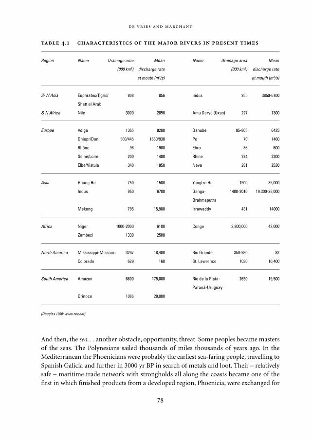
And then, the sea… another obstacle, opportunity, threat. Some peoples became mastersof the seas. The Polynesians sailed thousands of miles thousands of years ago. In theMediterranean the Phoenicians were probably the earliest sea-faring people, travelling toSpanish Galicia and further in 3000 yr BP in search of metals and loot. Their – relativelysafe – maritime trade network with strongholds all along the coasts became one of thefirst in which finished products from a developed region, Phoenicia, were exchanged for
78
.
Region Name Drainage area Mean Name Drainage area Mean
(000 km2) discharge rate (000 km2) discharge rate
at mouth (m3/s) at mouth (m3/s)
S-W Asia Euphrates/Tigris/ 808 856 Indus 955 3850-6700
Shatt el Arab
& N Africa Nile 3000 2850 Amu Darya (Oxus) 227 1300
Europe Volga 1365 8200 Danube 85-805 6425
Dniepr/Don 500/445 1660/930 Po 70 1460
Rhône 98 1900 Ebro 86 600
Seine/Loire 200 1400 Rhine 224 2200
Elbe/Vistula 340 1850 Neva 281 2530
Asia Huang He 750 1500 Yangtze He 1900 35,000
Indus 950 6700 Ganga- 1480-2010 19.300-35,000
Brahmaputra
Mekong 795 15,900 Irrawaddy 431 14000
Africa Niger 1000-2000 6100 Congo 3,800,000 42,000
Zambezi 1330 2500
North America Mississippi-Missouri 3267 18,400 Rio Grande 350-930 82
Colorado 629 168 St. Lawrence 1030 10,400
South America Amazon 6600 175,000 Rio de la Plata- 2650 19,500
Paraná-Uruguay
Orinoco 1086 28,000
(Douglas 1990; www.rev.net)
Mappae Mundi bw zw/w 08-04-2004 15:25 Pagina 78
raw materials. The Minoans and Mycenaeans already had trading posts in the Aegean.Possibly as a consequence of their downfall leading to many refugees, the Greek citystates started colonizing large parts of the eastern and, later, western Mediterranean. Inaddition to the search for raw materials and trade, adventurism and population pressureplayed a role in this maritime expansion. Surpassing the Phoenicians, they sailed all theway up to the Shetlands or even further. The Irish Book of Invasions – Leabhar Gabhala inIrish-Gaelic and based on orally transmitted myths written down by Christian monks –tells of peoples coming from overseas.
:
79
Sea resources In exploring early human-environment interactions, the focus is
largely on land. However, the seas have also been exploited since many thousands of
years and here too humans have used and impacted upon the natural dynamics (Jack-
son 2001). A recent detailed survey of archaeological and historical records has been
made of human exploitation of coastal resources for food and materials. In some key
marine ecosystems the long-term human impact has been investigated. Although these
impacts have accelerated enormously in the past few centuries, there are clear signs of
early overexploitation that led to changes in food webs with long-term and irreversible
impacts. Aboriginal fishing in coral reef environments began at least 35,000-40,000
years ago in the western Pacific, with apparently minor ecological impact until the
recent dramatic intensification of human disturbances. Aboriginal fishing in Aleutian
Islands in the northern Pacific greatly diminished sea otters as early as 2500 yr BP. This
led to a concomitant increase in sea urchins. When the otters were hunted to extinction
by the fur traders in the 1800s, the urchins grazed away the kelp forests to collapse.
Coastal connections The Greeks, a littoral culture, provide a good example of how
geographical features interact with an orientation on commerce and technology.
McEvedy applied a simple geographical rule to understand the spread of settlements in
ancient Greece. Dividing the area in rectangular cells, he assumed that a straight, flat
coastline as in many river valleys would strengthen the relationships between coast
and inland, whereas sea-shore communities along irregular coast with many indents
would tend to have weak relationships with inland areas and instead sustain relation-
ships with other sea-shore communities. Applying this rule to the colonization of the
Mediterranean and Black Sea regions by the Greeks in the 1st millennium BC gives a
reasonably good reproduction of the actual location of Greek colonies (McEvedy 1967).
Of course, every community needed a hinterland as well as a connection to the sea so
this procedure mainly points to existing differences in emphasis.
Mappae Mundi bw zw/w 08-04-2004 15:25 Pagina 79
The coastal seas connecting the Indus and the Euphrates-Tigris plains were sailed asearly as 4000 yr BP. In an attempt to explain the rapid expansion of people throughoutthe Americas and the maritime nature of many early Latin American culture, it has beenhypothesized that the earliest colonizers of Latin America arrived by sea routes from theNorth. A well-known outburst of sea-faring peoples was the Viking period in the 8th to10th centuries of the Christian era. According to some the Viking expansion was a con-tinuation of earlier outward migrations from Scandinavia, notably of Germanic andGothic tribes about 1900 to 1800 yr BP and probably motivated by both internal popula-tion pressure – and such customs as primogeniture: the eldest son is the only inheritor,the others have to make it for themselves – and the attractiveness of the civilizations tothe south. Trade and desire for profit were no doubt an important driving force behindthe Viking expansions along the northern European and Russian rivers – and maritimeinnovations played a pivotal role (Bell-Fialkoff 2000). More than land peoples, it seems,were the sea peoples oriented towards commerce and trade. Water – rivers, seas – thusbecame a crucial element in another aspect of human development through ecologicalregimes: exchange, in the form of trade, raid and conquest.
4.2.3. Steppe and savannah lands
An important category of peoples with a lasting impact on history has been the nomads.Nomads are people who live at the end of the continuum of pastoral nomadism that hasbeen defined as a distinct form of food-producing economy in which extensive mobilepastoralism is the predominant activity, and in which the majority of the population isdrawn into periodic pastoral migrations (Khazanov, in Bell-Fialkoff 2000: 181).3 Suchnomadism, which has existed in many regions of the world, leaves little room for special-ization and complex economic development. It originated in areas where cattle breedingoffered comparative advantages over agriculture. Such areas – steppe and savannah –comprise an estimated 35%4 of the landmass surface of the earth. The nomads werehighly mobile, their habitats extending over distances of 50-1500 kilometres. They oftenappeared as, in a sense, natural predators with respect to adjacent forest tribes andsedentary civilizations. It would be more correct to view the close development betweenpastoralist, agriculturist and hunter-gatherer as mutualistic, their resource bases notoverlapping too much and therefore possibly promoting inter-cultural trade.
Probably the best known nomads are those of the Eurasian steppes: the Huns and theMongols. Their history goes back a very long way. The renaissance of Mesopotamiasome 4200 yr BP was preceded by a conquest by archers coming from the Arabiansteppes. Millennia later, the outburst of nomadic tribes from Arabia in the 7th centuryled to a great empire – probably initially fed by the need to find an outlet for the martialenergies of the Bedouin warriors and less an expression of religious zeal than of the pres-
80
Mappae Mundi bw zw/w 08-04-2004 15:25 Pagina 80
sures of hunger and want from the barren desert lands (Mansfield 1976).Nomadic existence has also dominated the savannah lands, Africa’s most dominant
single ecosystem and stretching across the continent from the Atlantic Ocean to the Gulfof Aden. These savannah lands offer a floral and faunal richness that allows cereal agri-culture and livestock rearing. In West Africa they consist along a north-south stretch ofonly 1500 kilometres encompassing a series of different environmental zones of greatcomplexity and rich in resources. Resources were abundant: 2-3 millennia ago, the WestAfrican environment could offer cereals, oils, nuts; meat and milk, hides and skins; wildplants and animals; also ivory, iron ore, alluvial gold, rocks and clays (Connah 2001: 3.3).Moreover, the large ecological gradients provided resilience as inherent or incidentalshortages could be alleviated by the exchange of raw materials and products: ‘…thecomplexity of [this] environment, as a whole, provided conditions conducive to thedevelopment of a complex network of regional trade... (Connah 2001: 112). Why, then,did nomadism persist? One explanation is that in most areas many of the resources wereseasonal and available at a low density.5 It was not until the arrival of crops suited togrowing in lowland tropical environments, such as banana/plantain from Asia, that asedentary existence was possible. Furthermore, the very nature of the trade routes mayhave supported nomadism, with trade integrated into the pattern of seasonal migra-tion.
A related ecozone inhabited by nomadic peoples is the large basin of the Mississippi,Missouri and Illinois rivers in North America, with a prairie-forest continuum (Nelson1998). In the pre-colonial period before 1700 AD, the bottomlands near the rivers andthe highlands each had their specific ecosystems and their dominant disturbance ‘main-tenance’: fire in the highlands, from lightning strikes and annual fires set by nativeAmericans, and floods in the bottomlands. Although relatively high biomass-densityallowed for rather large settlements, the inhabitants of these plains lived an essentially(semi)nomadic life.
4.2.4. Forest peoples
About 39% of the land mass is covered with forests and woodlands, of which some 16%in tropical regions.6 Peoples of the mountains and the plains, peoples of the sand and thesteppes distinguished themselves – how about the forest peoples? A large diversity ofpopulations have lived in and from the forests, both in the temperate and boreal forestsof northern Eurasia and the Americas and in the tropical forests of South Asia, Africaand the Americas. The forests had diverse functions and connotations: places of huntingand danger, of food and medicinal plants, of shelter and defence. The Celtic tribes inEurope, probably related to the Kurgan culture near the Caspian Sea from where theymigrated westward some 4000 years ago, may have been characteristic of early temperate
:
81
Mappae Mundi bw zw/w 08-04-2004 15:25 Pagina 81
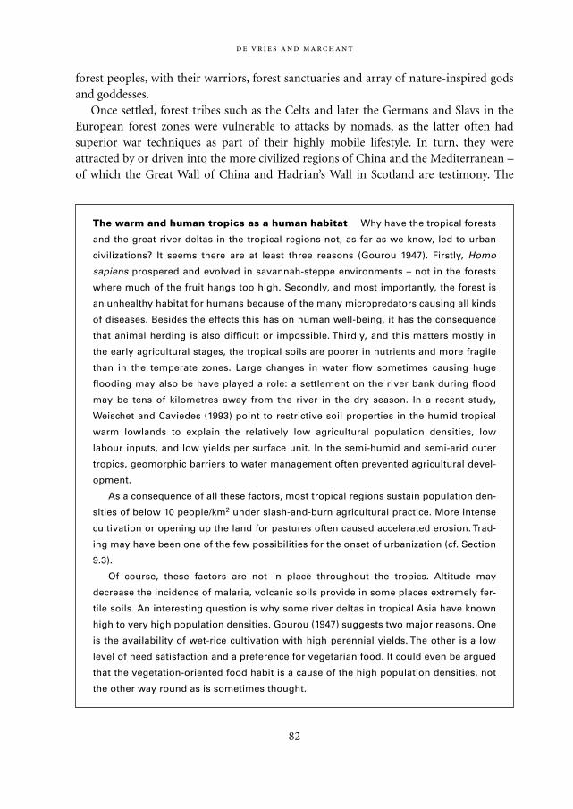
forest peoples, with their warriors, forest sanctuaries and array of nature-inspired godsand goddesses.
Once settled, forest tribes such as the Celts and later the Germans and Slavs in theEuropean forest zones were vulnerable to attacks by nomads, as the latter often hadsuperior war techniques as part of their highly mobile lifestyle. In turn, they wereattracted by or driven into the more civilized regions of China and the Mediterranean –of which the Great Wall of China and Hadrian’s Wall in Scotland are testimony. The
82
The warm and human tropics as a human habitat Why have the tropical forests
and the great river deltas in the tropical regions not, as far as we know, led to urban
civilizations? It seems there are at least three reasons (Gourou 1947). Firstly, Homo
sapiens prospered and evolved in savannah-steppe environments – not in the forests
where much of the fruit hangs too high. Secondly, and most importantly, the forest is
an unhealthy habitat for humans because of the many micropredators causing all kinds
of diseases. Besides the effects this has on human well-being, it has the consequence
that animal herding is also difficult or impossible. Thirdly, and this matters mostly in
the early agricultural stages, the tropical soils are poorer in nutrients and more fragile
than in the temperate zones. Large changes in water flow sometimes causing huge
flooding may also be have played a role: a settlement on the river bank during flood
may be tens of kilometres away from the river in the dry season. In a recent study,
Weischet and Caviedes (1993) point to restrictive soil properties in the humid tropical
warm lowlands to explain the relatively low agricultural population densities, low
labour inputs, and low yields per surface unit. In the semi-humid and semi-arid outer
tropics, geomorphic barriers to water management often prevented agricultural devel-
opment.
As a consequence of all these factors, most tropical regions sustain population den-
sities of below 10 people/km2 under slash-and-burn agricultural practice. More intense
cultivation or opening up the land for pastures often caused accelerated erosion. Trad-
ing may have been one of the few possibilities for the onset of urbanization (cf. Section
9.3).
Of course, these factors are not in place throughout the tropics. Altitude may
decrease the incidence of malaria, volcanic soils provide in some places extremely fer-
tile soils. An interesting question is why some river deltas in tropical Asia have known
high to very high population densities. Gourou (1947) suggests two major reasons. One
is the availability of wet-rice cultivation with high perennial yields. The other is a low
level of need satisfaction and a preference for vegetarian food. It could even be argued
that the vegetation-oriented food habit is a cause of the high population densities, not
the other way round as is sometimes thought.
Mappae Mundi bw zw/w 08-04-2004 15:25 Pagina 82
dynamic interactions between these peoples and the more organized states may havebeen an important force in history, as Bell-Fialkoff suggests:
[The] model of the triangular relationship among sedentary empires, nomads, and the forest
tribes works better in the Far East… In the West, although the interactions among the three
were also a constant factor, they lacked the almost mechanical synchronicity evident in the Far
East… The configuration was largely determined by geography… I cannot escape the conclu-
sion that if the core European areas bordered on a wide expanse of the steppe or if China faced
a densely forested zone in the north, their histories might have been very different… If the
migration confirms the central role played by geography, it also deflates the role of climate as a
decisive factor. (Bell-Fialkoff 2000: 276)
This is an interesting complement to other interpretations, for instance, of Keys (1999)who argues that climate change due to a large volcanic eruption triggered the westwardAvar migration because the Turkic cattle-based economy was less vulnerable to subse-quent severe droughts than the Avar horse-based economy.
What about the tropical forests – can the forest peoples living in the recent past and,though in small amounts, the present tell us about the peoples who inhabited the largeforested areas of the Gangetic Plain and the Deccan Plateau in present-day India or thehuge tropical forests in the Amazon and Congo basins? Forest peoples in the tropics didnot have to migrate across larger areas in response to changing seasons. As the forestprovided them with all the basic necessities of life, they could sustain themselves for longperiods: it is estimated that the Mbuti pygmies of the Ituri forest in the Congo Basin andthe BaTwa pygmies of south-west Uganda have occupied their habitats for 30,000 years(Cunningham 1992; Turnbill 1961). Forest people have become horticulturists and agri-culturists in later times when the appropriate tools became available. As Agrawal sug-gests for northern India:
… in the Ganga Valley the urbanisation processes had to wait till the middle of the first millen-
nium BC. The monsoonal forests, mentioned in the epics as mahavana, which were dark even
in the day, could be cleared only after the mass production of iron artefacts which alone made
it possible to drain the swamps and clear the dense forests to produce the requisite agricultur-
al surplus which alone could sustain towns and cities. (Agrawal 2001: 28-29)
Similarly, in the West African forests peoples living in and on the fringes could morepractically exploit the forest once iron tools could be used – although the tropical soilswould often only allow forms of slash-and-burn cultivation (Knapen 2001).
:
83
Mappae Mundi bw zw/w 08-04-2004 15:25 Pagina 83
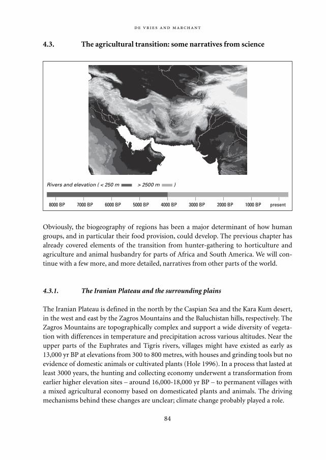
4.3. The agricultural transition: some narratives from science
Obviously, the biogeography of regions has been a major determinant of how humangroups, and in particular their food provision, could develop. The previous chapter hasalready covered elements of the transition from hunter-gathering to horticulture andagriculture and animal husbandry for parts of Africa and South America. We will con-tinue with a few more, and more detailed, narratives from other parts of the world.
4.3.1. The Iranian Plateau and the surrounding plains
The Iranian Plateau is defined in the north by the Caspian Sea and the Kara Kum desert,in the west and east by the Zagros Mountains and the Baluchistan hills, respectively. TheZagros Mountains are topographically complex and support a wide diversity of vegeta-tion with differences in temperature and precipitation across various altitudes. Near theupper parts of the Euphrates and Tigris rivers, villages might have existed as early as13,000 yr BP at elevations from 300 to 800 metres, with houses and grinding tools but noevidence of domestic animals or cultivated plants (Hole 1996). In a process that lasted atleast 3000 years, the hunting and collecting economy underwent a transformation fromearlier higher elevation sites – around 16,000-18,000 yr BP – to permanent villages witha mixed agricultural economy based on domesticated plants and animals. The drivingmechanisms behind these changes are unclear; climate change probably played a role.
84
8000 BP 7000 BP 6000 BP 5000 BP 4000 BP 3000 BP 2000 BP 1000 BP present
Rivers and elevation ( < 250 m > 2500 m )
Mappae Mundi bw zw/w 08-04-2004 15:25 Pagina 84
South and west of the Zagros Mountains is the Mesopotamian plain, the basin of theEuphrates and Tigris rivers. These alluvial lowlands are characterized by long and hotsummers and little rain. ‘Rain comes in unpredictable amounts; neither today nor at anytime since the end of the Pleistocene has the average annual precipitation in the areaapproached the minimum necessary (200 mm per year) for the reliable cultivation ofcrops without irrigation. On average, there is more than 200 mm of rainfall approxi-mately one out of four years…’ (Pollock 2001: 30-31). Another characteristic is the gen-tle slope, which makes the rivers split into multiple, shifting channels. The unpredictableriver movements had a great impact on settlements. Strong annual floods just before orafter the harvest made flood control a greater preoccupation than water procurement, orat least an additional one. As the water velocity decreased on the low-gradient plain, lev-ees were formed by the coarsest particles sedimenting; this raised the river water levelabove the surrounding land, which facilitated channel irrigation. The Mesopotamianlowlands therefore offered an environment with opportunities as well as hardships.
Not surprisingly, irrigation, from the simplest forms of flood irrigation to large-scalecanals and dams, has always been an important agricultural practice in Mesopotamia(Christensen 1993). On Alexander’s conquest of Mesopotamia in 331 BC, the Macedo-nians were dazzled by the immense system of dikes and reservoirs of Babylon which pro-tected the city against natural disasters. Irrigation may have started with small dammedwadis: sites from Syria indicate an essentially pastoral economy around 5100-3400 cal yrBP in what is now an arid area (Wilcox 1999). Larger-scale irrigation in the Euphrates-Tigris floodplain began in the early days of agrarian colonization around 7000 yr BP andwas mainly based on parallel diversions from the Euphrates channels. The early technicallyuncomplicated inundation irrigation gradually became more sophisticated and intensive.The earliest canals along the Euphrates date from 5000 BP; later on, the focus has shiftedtowards the Tigris region and some canals connected the two river basins. As has previous-ly been pointed out, unlike the lands of the Nile, the Mesopotamian floodplain is predis-posed to salinization because of its soil structure and the gentle slope of the land. Anotherconsequence of irrigation was that, between the 4th and the 3rd millennium BP, theEuphrates began to move westwards due to the sedimentation that was greatly increasedby irrigation. It led to the construction of eastward-flowing canals (Christensen 1993).
It has been speculated that progressive salinization of the low-lying southern plainsultimately caused the shift of the political and demographic centre from the south to thenorth. According to Christensen (1993) the evidence is not convincing: it is likely thatsalinization had not reached disastrous levels and the move northwards may well beexplained by the bitter wars between enclaves for control over the Euphrates, with thenorth reducing or interrupting the water supply to the south. The resource disparitybetween the lowland plains and the highland mountains is often assumed to have been aprincipal driving force in Mesopotamian history. This explanation should not be exagger-ated either, according to Pollock (2001). Besides fertile soils and forested areas providing
:
85
Mappae Mundi bw zw/w 08-04-2004 15:25 Pagina 85
pastures and firewood, the lowlands mostly relied on clay, reeds, bitumen and palm andpoplar wood. However, the inhabitants of the plain made extensive and highly creativeuse of these limited available resources before more intense contact evolved with thepopulation of the Zagros and Taurus foothills and mountains with their more abundantrain, trees, metal ores, stone and limestone. This suggests that relative resource scarcitycan be relieved in an extensive – ‘expansion’ – but also in an intensive – ‘efficiency’ – way.
In the relatively narrow zone between the northern edge of the Iranian Plateau and theKara Kum desert, the first agro-pastoral settlements in the foothills probably date from8000 yr BP. ‘This major physiographical boundary between mountainous highland andalluvial lowland is comparable in scale, and perhaps also in prehistoric significance, to
Resource overexploitation may have been around from the earliest times. There is
evidence that early 9th millennium BP villages collapsed around 8500 BP, while new set-
tlements were founded in quite variable landscapes in the same period. One of the
largest, over 12 ha in size, was Ain Ghazal in southern Jordan (Rollefson 1992; Redman
1999: 107-110). There is evidence that this permanent farming village rose and then was
abandoned between the 10th and the 6th millennium BP. Climate change, in the form of
less precipitation, may have been one of the factors. However, it has been suggested
that a combination of three factors might have caused disruption to varying degrees:
plaster technology, animal husbandry and topographic variation. In particular the use
of plaster – mud, gypsum, and lime – for housing and the associated use of timber for
fuel in combination with goats, may have contributed to the gradual abandonment of
the villages. The preparation of lime plaster required an estimated four tons of wood as
fuel per ton – and apparently the inhabitants of Ain Ghazal chose to plaster their hous-
es with lime frequently. This might have led to several km2 of deforested area, of which
regeneration was retarded or prevented by grazing animals, particularly goats. Erosion
would degrade the already fragile soils. Several villages in the region succumbed to
the consequences of this environmental deterioration – Ain Ghazal could sustain its
role as a major population centre for a longer period because it was located at a major
ecotone of biological resources.
Figure 4.2 gives a causal loop diagram about these interactions. The main, negative
feedback loop is from increasing food supply through population growth to deforesta-
tion from increased wood for fuel use for plaster which in turn affected soil fertility.
Animal grazing, itself contributing to food provision, aggravated this negative loop by
disturbing the forest regrowth. This could be one of the early examples in which
resource exploitation caused long-term unintended consequences from short-term
behaviour – possibly in a process of competitive emulation (cf. Chapter 6).
86
Mappae Mundi bw zw/w 08-04-2004 15:25 Pagina 86
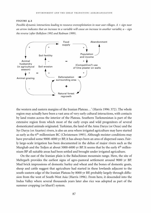
the western and eastern margins of the Iranian Plateau…’ (Harris 1996: 372). The wholeregion may actually have been a vast area of very early cultural interactions, with contactsby land routes across the interior of the Plateau. Southern Turkmenistan is part of theextensive region from which most of the early crops and wild progenitors of severaldomesticated animals originated. Turkistan, the land of the Amu Darya (or Oxus) and theSyr Darya (or Axartes) rivers, is also an area where irrigated agriculture may have startedas early as the 6th millennium BC (Christensen 1995). Although moister conditions mayhave prevailed some 9000-4000 yr BP, it has always been an area of dispersed oases. Fair-ly large-scale irrigation has been documented in the deltas of major rivers such as theMurghab and the Tedjen at about 5000-6000 yr BP. It seems that by the early 4th millen-nium BP all suitable areas had been settled and brought under irrigated agriculture.
On the east of the Iranian plain is the Baluchistan mountain range. Here, the site ofMehrgarh provides the earliest signs of agro-pastoral settlement around 9000 yr BP.Mud brick impressions of domestic barley and wheat and the bones of domestic goats,sheep and cattle suggest that agriculture had started in these lowlands adjacent to thesouth-eastern edge of the Iranian Plateau by 8000 yr BP, probably largely through diffu-sion from the west of South-West Asia (Harris 1996). From here, it descended into theIndus Valley where several thousands years later also rice was adopted as part of thesummer cropping (or kharif) system.
:
87
.
Possible dynamic interactions leading to resource overexploitation in near east villages. A + sign near
an arrow indicates that an increase in a variable will cause an increase in another variable; a – sign
the reverse (after Rollefson 1992 and Redman 1999).
Foodsupply
(Competitive?) use of lime plaster on walls
Populationand income
Abandonment
Deforestationsurrounding area
Natural forestregrowth
Animal grazing
Animalhusbandry
(in agriculturalseason)
Soil fertility
Soil erosion
–
+
–
+
+
+
+
+–
+
–
+
Mappae Mundi bw zw/w 08-04-2004 15:25 Pagina 87
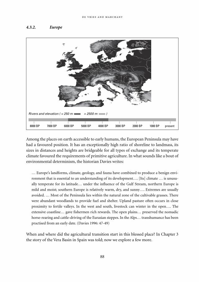
4.3.2. Europe
Among the places on earth accessible to early humans, the European Peninsula may havehad a favoured position. It has an exceptionally high ratio of shoreline to landmass, itssizes in distances and heights are bridgeable for all types of exchange and its temperateclimate favoured the requirements of primitive agriculture. In what sounds like a bout ofenvironmental determinism, the historian Davies writes:
… Europe’s landforms, climate, geology, and fauna have combined to produce a benign envi-
ronment that is essential to an understanding of its development…. [Its] climate … is unusu-
ally temperate for its latitude… under the influence of the Gulf Stream, northern Europe is
mild and moist; southern Europe is relatively warm, dry, and sunny…. Extremes are usually
avoided. … Most of the Peninsula lies within the natural zone of the cultivable grasses. There
were abundant woodlands to provide fuel and shelter. Upland pasture often occurs in close
proximity to fertile valleys. In the west and south, livestock can winter in the open…. The
extensive coastline… gave fishermen rich rewards. The open plains… preserved the nomadic
horse-rearing and cattle-driving of the Eurasian steppes. In the Alps… transhumance has been
practised from an early date. (Davies 1996: 47-49)
When and where did the agricultural transition start in this blessed place? In Chapter 3the story of the Vera Basin in Spain was told; now we explore a few more.
88
8000 BP 7000 BP 6000 BP 5000 BP 4000 BP 3000 BP 2000 BP 1000 BP present
Rivers and elevation ( < 250 m > 2500 m )
Mappae Mundi bw zw/w 08-04-2004 15:25 Pagina 88
Greece: early farmers and the risks of lifeThe southern Argolid, the Argive Plain and the Larissa Basin in Greece are alluvial areasthat formed the cradle of later Greek civilization and show clear signs of early agri-culture. It is thought that the early agriculturists entered the Argive Plain in southernGreece, settling on the edges of valleys near the best soil and water supplies (Andel 1990;Runnels 1995). Numerous finds of artefacts such as pottery, grinding stones and obsidi-an tools have been made. The hazards of rainless winters, late frosts and so on may haveled early Neolithic farmers to adopt subsistence strategies involving a range of crops withdifferent growth requirements and tolerances and an emphasis on sheep as a low-risk‘meat’ strategy. Early farming may actually have resembled intensive horticulture ratherthan agriculture, with human labour as a critical constraint on survival. In combinationwith the climatic vagaries, this may have induced food overproduction and storage andcultivation of social relationships as responses (Halstead 1996). It is believed, fromarchaeological and palynological evidence, that grazing and farming were the principalactivities on the valley slopes in the 6th millennium BP and that they resulted in one ormore episodes of catastrophic soil erosion.
Was there more environmental degradation to come and what were its causes? Asmuch as 2500 years ago, Aristotle claimed that the land had undergone considerablealterations in the millennia preceding the classical Greek civilization of his time. Evi-dently, the semi-arid valleys and hills of Greece were vulnerable to soil erosion. Researchin the southern Argolid Plain and the Larissa Basin has shown the occurrence of ratherbrief and widely scattered erosional episodes that cannot be explained primarily by cli-matic changes (Redman 1999). Apparently, people farmed these lands for long periodsusing labour-intensive soil conservation practices such as terracing. However, in times ofheavy rains population concentration and the abandonment of highland farms triggeredcycles of depopulation and slow, natural regeneration. As part of the downturn, poorersoils were left to animal grazing, damage from animals was not repaired, farms and ter-races broke down, and gully erosion would deposit large amounts of soil on the valleybottoms. Early agriculture in Greece is also one of the examples of how investments forcontrol could actually make peoples dependent on the means to sustain control or, inother words, decrease resilience: ‘Once the Greek landscape had been controlled by soilconservation measures, its equilibrium became precarious, the price of maintaining theequilibrium was high, and economic perturbations were only too likely to disturb it.’(Andel 1990: 383)
Erosion in the MediterraneanAs agriculture intensified from the 4th and 3rd millennia BP onwards into the extensivecereal cropping, specialization into olives and vines and transhumant pastoralism,impacts upon the environment increased in many parts of the eastern Mediterranean.Widespread human-environment interactions have been identified not only in ancient
:
89
Mappae Mundi bw zw/w 08-04-2004 15:25 Pagina 89
Greece but also in Italy and Spain (Redman 1999). The history of the Mediterraneancontains many stories about the struggle of farmers against the forces of erosion whichwere sometimes natural, sometimes human-induced, often both. As in Greece, anincrease in erosion from a combination of intensifying human population and agricul-tural pressures and climate changes would set in motion an environmental crisis fromwhich a region would recover only slowly. No doubt the frequency and intensity of thesecycles of expansion and contraction were also influenced by ‘history’ in its well-knownappearance of wars and invasions, coastal piracy and foreign occupation, slavery andmigration, urbanization and overexploitation for export markets.
The vulnerability of Mediterranean slopes for erosion, especially when denuded byfire, has deeply altered the mountain landscapes in such widely different regions as thesouthern Taurus in Turkey, the Pindus in western Greece, the Lucanian Apennines insouthern Italy, the Sierra Nevada and Alpujarra ranges in southern Spain and the Rif inMorocco – as narrated beautifully in McNeill’s book on the Mediterranean mountains(McNeill 1992). Despite the local differences, the impact of humans and their animalshave inflicted great damage on these ecologically fragile environments and reduced theircarrying capacity for humans. The expansion and contraction rhythms in the popula-tion size reflect this fragility as well as the roles of the mountains as a refuge in times ofdisease and war.
Early agriculture in north-western EuropeA large amount of research has been done on the emergence of agriculture in north-western Europe – Neolithic agro-pastoral farming (Harris 1996). The process has been acomplex one, with intense interaction between foraging groups. In most places agricul-ture appeared first in resource-abundant areas, its spread being mainly through themovement of ideas and products rather than people. Cattle pastoralism with plant gath-ering has probably been a – rather short – intermediate stage in the transition fromhunting-gathering to stable agriculture. The spreading in space may have been driven byan ‘agricultural frontier zone’ in which agriculture could diffuse in a series of co-opera-tive and competitive processes (Zvelebil 1996).
One of the controversial issues is the ‘forest-farming’ debate that started in the 1940swith Iversen’s landnam (Old Norse: land take) model (Walker 1993): what was the na-ture of the interaction between the early farmers and the natural vegetation? There arefour different models, based on palynological research and differing in their emphasis onthe role of fire in clearing primeval forest, the extent of pastures, the way in which treeswere used for fodder (leaf-foddering, girdling and coppicing) and the rates of abandon-ment and regrowth. At stake are questions such as whether the observed decline in theelm tree population was human-induced and whether the forest was seen as a malevo-lent obstacle or as a shelter and resource (Edwards 1993).
Berglund and co-workers (Berglund 1991) have done an extensive study of the land-
90
Mappae Mundi bw zw/w 08-04-2004 15:25 Pagina 90
scape changes in the Ysted region in south Sweden. Drastic opening of the landscape andrecession of broad-leaved tree forest occurred between 5000 and 4600 yr BP, with thedominant underlying causes believed to be sudden climatic/hydrological changes alongwith other factors such as elm disease. Early agriculture, with rotation cycles of 30-50years, was indirectly favoured by these changes. Settlements became more concentrated;megalithic graves were erected. In the subsequent millennium, woodland graduallyregenerated; coast-concentrated coppice agriculture developed; and houses became big-ger. Around 3800 yr BP a new wave of deforestation occurred and the first signs of soilerosion and lake eutrophication emerged. In the period 2750-1250 yr BP, agriculturedeveloped into permanent fields in a grassland landscape. A great deal of deforestation,much through burning, to meet the demand for pastures and wood, larger houses andco-operation to store fodder in winter, and systematic manuring were among the associ-
:
91
Early population-environment interactions Usually, archaeologists lack the em-
pirical evidence to make robust reconstructions of population-environment interac-
tions in early human groups. Yet illustrative stories can be told – for instance, the out-
come of archaeological research in some of the best preserved settlement sites of
European prehistory, in the north-eastern part of France (Pétrequin 1998). Excavations
of the lake dwellings dated to the period of the Neolithic and Bronze Ages, about 5000
yr BP, indicate distinct changes in the population density during a 300-year period. Tool
and pottery analyses suggest a rapid demographic growth as a consequence of the
arrival of successive human groups around 3050 BC. There is evidence of a recession
and degradation of the local forest. This was, according to the authors, caused by total
clearance of the young forest due to shifting agriculture through sequences of 30-70
years. Cultivated land expanded into the primary forest as a result of changing cultiva-
tion habits; livestock grazing led to degradation of the woodlands as it hindered regen-
eration of secondary forest.
Another response to the subsistence problems connected to a growing population
was to increase hunting strategies rather than animal husbandry. With the advent of a
second wave of immigrants from the south around 2980 BC, products of hunting
abruptly diminish, together with evidence of livestock feeding on forest products. Hus-
bandry is now predominant. The consumption of meat, however, is reduced (Pétrequin
1998: 189). It seems that when the limits of the traditional pattern of shifting agriculture
and hunting and husbandry based on forest products had been reached, permanent
fields and husbandry based on grazing fields were established. After 2970 BC the num-
ber of villages decreased and local groups were strongly affected by the climate degra-
dation at the end of the 29th century BC.
Mappae Mundi bw zw/w 08-04-2004 15:25 Pagina 91
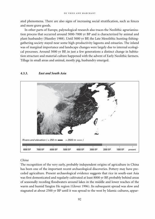
ated phenomena. There are also signs of increasing social stratification, such as fencesand more grave goods.
In other parts of Europe, palynological research also traces the Neolithic agrarianiza-tion process that occurred around 5000-7000 yr BP and is characterized by animal andplant husbandry (Huntley 1988). Until 5000 yr BP, the Late Mesolithic hunting-fishing-gathering society stayed near some high-productivity lagoons and estuaries. The inlandwas of marginal importance and landscape changes were largely due to internal ecologi-cal processes. Around 5000 yr BP, in just a few generations a distinct change in habita-tion structure and material culture happened with the advent of Early Neolithic farmers.Tillage in small areas and animal, mostly pig, husbandry emerged.
4.3.3. East and South Asia
ChinaThe recognition of the very early, probably independent origins of agriculture in Chinahas been one of the important recent archaeological discoveries. Pottery may have pre-ceded agriculture. Present archaeological evidence suggests that rice in south-east Asiawas first domesticated and regularly cultivated at least 8000 yr BP, probably behind areasof seasonally receding floodwaters around lakes in the middle and lower reaches of thewarm and humid Yangtze He region (Glover 1996). Its subsequent spread was slow andstagnated at about 2500 yr BP until it was spread to the west by Islamic cultures, appar-
92
8000 BP 7000 BP 6000 BP 5000 BP 4000 BP 3000 BP 2000 BP 1000 BP present
Rivers and elevation ( < 250 m > 2500 m )
Mappae Mundi bw zw/w 08-04-2004 15:25 Pagina 92
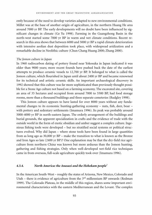
ently because of the need to develop varieties adapted to new environmental conditions.Millet was at the base of another origin of agriculture, in the northern Huang He areaaround 7000 yr BP. The early developments will no doubt have been influenced by sig-nificant changes in climate (Ge Yu 1998). Farming in the Guangzhong Basin in thenorth-west started some 7000 yr BP in warm and wet climate conditions. Recent re-search in this area shows that between 6000 and 5000 yr BP a rapid climate deteriorationwith intensive aeolian dust deposition took place, with widespread aridization and aremarkable decline in Neolithic culture (Chun Chang Huang 2000; Zhang 2000).
The Jomon culture in JapanIn 1960 radiocarbon dating of pottery found near Yokosuka in Japan indicated it wasolder than 9000 years; more recent founds have pushed back the date of the earliestattempts to produce ceramic vessels to 12,700 yr BP. It belonged to what is called theJomon culture, which flourished in Japan until about 2400 yr BP and became renownedfor its technical and artistic ceramic skills. An important archaeological discovery in1992 showed that this culture was far more sophisticated than previously thought possi-ble for a Stone Age culture not based on a farming economy. The excavated site, coveringan area of 35 hectares and occupied from around 7000 to 5500 BP, had food storagerooms, more than a thousand buildings and three separate cemeteries (Rudgley 1998).
This Jomon culture appears to have lasted for over 8000 years without any funda-mental changes to its economic hunting-gathering economy – nuts, fish, deer, boar –with pottery and sedentary settlements (Imamura 1996). Its peak was probably around5000-4000 yr BP in north-eastern Japan. The orderly arrangement of the buildings andburial grounds, the apparent specialization in crafts and the evidence of trade with theoutside world in the form of exotic obsidian and amber suggest a complex culture. Inge-nious fishing tools were developed – but no stratified social systems or political struc-tures evolved. Why did Japan – where stone tools have been found in large quantitiesfrom as long ago as 30,000 yr BP – make the transition to what is known as the Bronzeand Iron Ages so late (2400 yr BP)? One explanation may be that the dry-field rice agri-culture from northern China was known but more arduous than the Jomon hunting,gathering and fishing strategies. Only when well-developed wet-field rice techniquescame in from overseas, full-scale agriculture quickly took over (Imamura 1996).
4.3.4. North America: the Anasazi and the Hohokam people7
In the American South-West – roughly the states of Arizona, New Mexico, Colorado andUtah – there is evidence of agriculture from the 3rd millennium BP onwards (Redman1999). The Colorado Plateau, in the middle of this region, shares some important envi-ronmental characteristics with the eastern Mediterranean and the Levant. The complex
:
93
Mappae Mundi bw zw/w 08-04-2004 15:25 Pagina 93
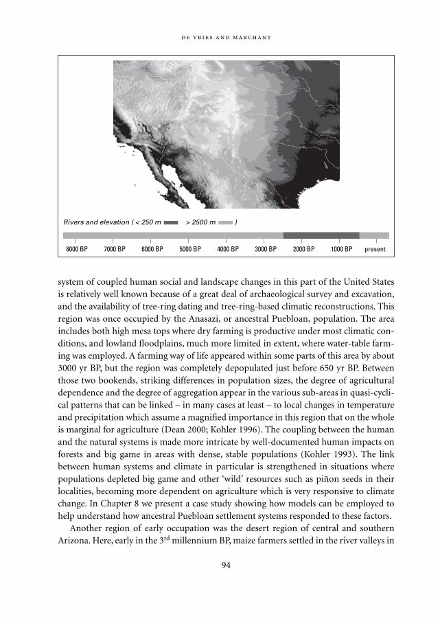
system of coupled human social and landscape changes in this part of the United Statesis relatively well known because of a great deal of archaeological survey and excavation,and the availability of tree-ring dating and tree-ring-based climatic reconstructions. Thisregion was once occupied by the Anasazi, or ancestral Puebloan, population. The areaincludes both high mesa tops where dry farming is productive under most climatic con-ditions, and lowland floodplains, much more limited in extent, where water-table farm-ing was employed. A farming way of life appeared within some parts of this area by about3000 yr BP, but the region was completely depopulated just before 650 yr BP. Betweenthose two bookends, striking differences in population sizes, the degree of agriculturaldependence and the degree of aggregation appear in the various sub-areas in quasi-cycli-cal patterns that can be linked – in many cases at least – to local changes in temperatureand precipitation which assume a magnified importance in this region that on the wholeis marginal for agriculture (Dean 2000; Kohler 1996). The coupling between the humanand the natural systems is made more intricate by well-documented human impacts onforests and big game in areas with dense, stable populations (Kohler 1993). The linkbetween human systems and climate in particular is strengthened in situations wherepopulations depleted big game and other ‘wild’ resources such as piñon seeds in theirlocalities, becoming more dependent on agriculture which is very responsive to climatechange. In Chapter 8 we present a case study showing how models can be employed tohelp understand how ancestral Puebloan settlement systems responded to these factors.
Another region of early occupation was the desert region of central and southernArizona. Here, early in the 3rd millennium BP, maize farmers settled in the river valleys in
94
8000 BP 7000 BP 6000 BP 5000 BP 4000 BP 3000 BP 2000 BP 1000 BP present
Rivers and elevation ( < 250 m > 2500 m )
Mappae Mundi bw zw/w 08-04-2004 15:25 Pagina 94
places suitable for floodwater farming. Some of the settlements lasted for more than athousand years. Around 700 AD this Hohokam culture had developed irrigation agricul-ture which tied households together into community networks, and a regional ritual andbelief system that included distinctive red-on-buff pottery, iconography and ball courts.By 1150 AD, larger villages with platform mounds were beginning to appear and canalsystems were expanding, linking communities into larger networks. These and a varietyof other cultural changes mark the beginning of the ‘Classic’ period. These changesappear to be linked to downcutting and widening of the river valleys which destabilizedthe existing irrigation systems and everything else that was based on them, and precipi-tated the construction of new canal systems, and new ceremonial and political organiza-tions. By around 1400 AD the Hohokam culture had disappeared.
The Hohokam depended on the nutrients brought down in flood periods by the tworivers traversing the Phoenix lowland basin. Hundreds of canals led the water and sedi-ments to the fields, thus regenerating soil fertility.8 The localized nature of accessiblesurface water and farmland, in combination with the need for labour investments incanals and rising population, made it disadvantageous to move around and forced themto take care of the productive potential of their immediate surroundings: ‘The fact thatintensive agriculture results in reduced mobility options for human groups is key tounderstanding the human-environmental interactions of the Hohokam and many othergroups around the world.’ (Redman 1999: 151). The large empty surroundings provideda sustainable flow of wild food and material resources. Social institutions and communi-ty networks were instrumental in providing labour for canal construction and mainte-nance and in spreading the risks of food shortages.
It appears that Hohokam life was based on principles of sustainability. What, then,caused their disappearance? The Hohokam lived in an unrewarding environment andtheir way of life – no domesticated animals, modest use of wood – tended to spare thevegetation. Nevertheless and despite their conservation practices, archaeological evi-dence suggests that the increase in population led to a scarcity of protein-rich food suchas fish and rabbits. According to Redman this degradation was probably not the maincause of abandonment. Some older theories accounted for the disappearance of theClassic Hohokam as a result of channel cutting or flooding, but recent research points togeneral stability of most floodplains in that period. The history of explanations suggestsa mystery: ‘Each age, it seems, reads something different into the demise of the Hoho-kam. Not only does each age have an explanation, but each pushes into the shade expla-nations that had seemed reasonable to their adherents.’ (Krech 2000: 71). Yet the out-come of recent research allows a plausible reconstruction, as Redman (1999)convincingly shows. Three factors were at work: environmental change, irrigation strate-gies and social responses. Tree ring analyses indicate a rather high climate predictabilityin the period 1250 to 900 yr BP with modest variations in wetness – hence withoutextreme floods or droughts. Communities developed along the feeder canals that
:
95
Mappae Mundi bw zw/w 08-04-2004 15:25 Pagina 95
brought the water downstream to the distribution channels; population, organizationand trade all increased. When in subsequent centuries flood variability became larger –as the tree ring evidence suggests – these communities were resilient enough to handledroughts and floods through storage, repair and trading. However, after 700 yr BP
the climatic situation appears to have become even more erratic, with floods or droughts com-
ing at least once every 10 years. This put tremendous pressure on the survival of the entire sys-
tem. Crop production in the valleys was seriously diminished, and labour required to maintain
the irrigation works dramatically increased… it is likely that the valley farmers overplanted in
their good fields, extended planting to marginal fields, and cut back on fallow periods. All of
these strategies would lead to decreases in soil fertility and subsequent productivity. (Redman
1999: 154)
Because the Hohokam remained in the same location, their activities unavoidablycaused environmental changes such as increased runoff volume and velocity and subse-quent soil erosion and canal silting. Although they maintained soil fertility through var-ious conservation methods and by supplementing local food with goods brought in byexchange systems, ‘when the climate entered a long period of greater variability, includ-ing disastrous flooding, it put an additional pressure on the Hohokam system that couldnot be easily sustained. Their response was to invest more labour in extracting the maxi-mum from the land, but that made the system even more vulnerable to climaticextremes.’ (Redman 1999: 155). Socio-political changes towards more centralized con-trol and ceremonial activities may have further weakened the system’s resilience. Theirdisappearance, it seems, was due to a dynamic interplay of environmental and socialforces working on different time-scales.
4.4. The agricultural transition: how and why?
The Iranian Plateau was surrounded by semi-arid regions where among the first agro-pastoral economies existed as long ago as 10,000 yr BP.9 Some four to five millennia BP,the first expansion and contraction cycles of agricultural activity and population densitytook place in the fragile Mediterranean environments of Europe. Meanwhile, in the restof Europe the transition process from hunter-gathering to various forms of agricultureand horticulture and livestock raising was well underway. Similar transition processestook place in other parts of Asia and in the Americas – sometimes successful and endur-ing, sometimes broken off in complex interplays of environmental change and socialresponse processes. Sometimes – as with the Jomon peoples in Japan – the transitionnever took place or occurred much later because the known forms of agriculture werenot an attractive enough alternative. Although our brief overview is incomplete and each
96
Mappae Mundi bw zw/w 08-04-2004 15:25 Pagina 96
place and time surely had its specific characteristics, it appears there were universalforces at work to push the agrarianization process forward. The first main route wasplant-food production, from wild plant-food procurement to crop production. The sec-ond main route was animal domestication, from predation to taming and protectiveherding to livestock raising and pastoralism. In the process, the dependence on wildplants and animals continuously decreased.10 Can we get a deeper understanding of thistransition process and its environmental ramifications?
4.4.1. The origins and spread of agriculture and pastoralism
The origins and spread of agriculture and pastoralism – in the sense of plant and animaldomestication – has been the subject of intense investigations, as is evident from the pre-vious narratives. The prevailing view nowadays is that agriculture probably originatedsome 12,000 yr BP in the so-called Levantine Corridor near the Jordan Valley lakes in theform of the domestication of cereals and pulses. Within a millennium animal domesti-cation took place: dogs, then sheep and goats11. It is hypothesized that preceding hunter-gatherer populations lived in small refuges and that by this time the steppe vegetationstarted to become richer across the Fertile Crescent as a consequence of climatechange.12 The invasion of annual grasses was followed by oak-dominated park-wood-land and
increased dramatically the gross yields of plant-foods per unit area, particularly starch-protein
staples, that correspondingly led to increased carrying capacity. It is suggested that these
increases prompted significant extensions both in the storage of plant-foods and in sedentism,
and that the ensuing increases in birth rate eventually produced stresses on carrying capacity,
which, in certain locations, led to the cultivation of cereals. (Hillman 1996: 195)13
This process of cereal cultivation started spreading to the south and east, accelerated bythe increasing climatic seasonality and unpredictability coupled with the dry conditions.The spread of forest reduced the open range that encouraged territoriality and pre-domestication of animals by the protection and propagation of local herds (Hole 1996).It is evident from these facts and explanations that ‘climatic and other environmentalchanges were powerful forces in the spread of agriculture and possibly in the inceptionof animal domestication.’ (Hole 1996: 264)
In any case ‘the’ agricultural revolution has not been one momentous event – one of thereasons why we prefer to talk about the process of agrarianization (cf. Chapter 2).Instead, it may have been a gradual intensification of the relationship between groups ofhumans, their environment and each other (Harris 1996). Clearing plots of land, usually
:
97
Mappae Mundi bw zw/w 08-04-2004 15:25 Pagina 97
by fire; having animals around, becoming part of their habitat; gathering roots andtubers, gardens emerging. These could have been the slow changes in various places thatled to ‘agriculture’ and its associated phenomena such as sedentarization, domesticationand urbanization.
Insidious complementary (sub)mechanisms have been proposed, for instance aboutthe role of micropredators. When the temperature started to rise in the early Holocene,not only wild cereals spread but also parasites:
The climatic amelioration during the terminal Pleistocene was a bonanza for many tempera-
ture- and humidity-sensitive micropredators and their vectors. Coastal changes, particularly
swamp formation with the rising sea levels, created ideal conditions for anophelene mosqui-
98
Climate, foraging and agriculture: the role of the steppe Climatic change
affected human groups mainly through changes in vegetation: ‘The effects of climatic
change on the plant-based components of the subsistence economy were mediated
principally by changes in the distribution and composition of vegetation, and by con-
comitant changes in the plant-food resource base.’ (Hillman 1996: 159) Climatic change
brought increased soil moisture in the Late Pleistocene leading to woodland expansion
in the northern Fertile Crescent. Many pollen diagrams testify to this. The same condi-
tions also ‘allowed the spread of wild cereals and other herbaceous annuals, which
hitherto probably achieved their highest concentrations in the broad woodland-steppe
ecotones.’ (Hillman 1996: 187) Agriculture became possible as an alternative strategy
because, overall, the dry, cool steppe were places of low mean energy yield per unit of
area – lower than in the later moister steppe, the woodland steppe with their grasses
and the wetlands.
Prior to ca. 15,000 yr BP almost all of the interior of South-West Asia was dominated
by steppe and desert-steppe, dominated in part by grasses such as perennial feather
grass. A huge number of these steppe plants produce edible seeds or fruits, ’roots‘,
leaves, shoots or flowers that have been used as food by recent hunter-gatherers, pas-
toralists or cultivators. Some of the starch-rich lowish-fibre ‘root’ foods have relatively
low energy costs of processing, making them prime targets. They also have a high
digestible ‘net’ caloric value for humans. ‘During even the most arid and cold episodes
of the Pleniglacial (before 15,000 yr BP), therefore, the steppe vegetation is likely to
have offered local foragers a diverse array of wild plant-foods that could have provided
not only carbohydrates, oil and proteins, but also vitamins, minerals and those miriad
’secondary compounds’ that are coming to be recognized as essential to complete
human health.’ (Hillman 1996: 178) The life of early hunter-gatherers may not have been
so bad!
Mappae Mundi bw zw/w 08-04-2004 15:25 Pagina 98
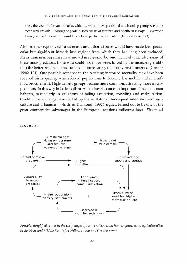
toes, the vector of vivax malaria, which… would have punished any hunting group wavering
near zero growth… Along the protein-rich coasts of western and northern Europe… everyone
living near saline swamps would have been particularly at risk… (Groube 1996: 123)
Also in other regions, schistosomiasis and other diseases would have made less specta-cular but significant inroads into regions from which they had long been excluded.Many human groups may have moved in response ‘beyond the newly extended range ofthese micropredators; those who could not move were, forced by the increasing aridityinto the better-watered areas, trapped in increasingly unhealthy environments.’ (Groube1996: 124). One possible response to the resulting increased mortality may have beenreduced birth spacing, which forced populations to become less mobile and intensifyfood procurement. High-density groups became more common, attracting more micro-predators. In this way infectious diseases may have become an important force in humanhabitats, particularly in situations of failing sanitation, crowding and malnutrition.Could climate change have started up the escalator of food-quest intensification, agri-culture and urbanism – which, as Diamond (1997) argues, turned out to be one of thegreat comparative advantages in the European invasions millennia later? Figure 4.3
:
99
.
Possible, simplified routes in the early stages of the transition from hunter-gatherers to agriculturalists
in the Near and Middle East (after Hillman 1996 and Groube 1996).
Invasion ofwild cereals
Improved foodsupply and storage
(Possibility of / need for) higher reproduction rate
Decrease inmobility: sedentism
Highermortality
Food-questintensification:
(cereal) cultivation
Higher populationdensity: settlements
Vulnerabilityto micro-predators
Spread of micro-predators
Climate change:rising temperature
and sea-level,vegetation change
+
Mappae Mundi bw zw/w 08-04-2004 15:25 Pagina 99
schematically indicates some possible mechanisms in the transition from hunter-gatherers to sedentary agriculturists the Near and Middle East (Hillman 1996; Groube1996). Climate and vegetation change may have improved the prospects for food extrac-tion which in turn led to a process of food intensification through higher net growthrates, sedentism and settlements. The combination of climate change related shifts inmicropredator occurrence and heightened vulnerability of dense populations to diseasesmay have functioned as a second set of intermediate factors influencing populationdynamics. The suggestion of a monocausal positive feedback loop is surely a simplifi-cation.
4.4.2. Causes and consequences of agricultural expansion
Why peoples made steps in the agrarianization process is, at least partly, a questionabout motives and means and as such in the domain of economic anthropology.14 Thetransition probably resulted from many, site-specific forces at work, with various options– food gathering, hunting, horticulture, pastoralism, agriculture – making up a locallyspecific mix of competing or complementary alternative strategies. As it turned out,this process was irreversible (cf. Chapter 2). Several interrelated trends can be seen: anincrease and spatial concentration in food production and people, increasing specializa-tion and the growth of organizational systems dealing with the food system – produc-tion, distribution, storage, consumption – and increasing differentiation of power (strat-ification) (Goudsblom 1996). Tools, rules and markets accompanied this process.
Many questions can be asked about why and how. Did people develop tools bychance, out of boredom and surplus labour or out of necessity? Did customs and rulesand the associated institutional frameworks regarding, for instance, land access and con-trol reflect survival strategies or mental attitudes or both? Was food produced for direct,own consumption or for (market) exchange in the later stages? Food shortages led tohunger and starvation, in turn, often threatened social organization – as the numerouspeasant revolts testify. As a result, the explanation of why peoples shifted to agriculturehas wider ramifications.
Virtues and vices of foraging lifeOne element in the discussion is the interpretation of the pre-agricultural stage: how didhunter-gatherers live? Until the mid-20th century the view prevailed that ‘Stone Age’ peo-ple lived in ‘a mere subsistence economy’, were incessantly searching for food in a meagreand unreliable environment, and had limited leisure and no economic surplus. In hisbook Stone Age Economics (1972), Sahlins refuted or at least complemented this viewwith a different assessment. Data on several contemporaneous hunter-gatherer groups –Australian Aborigines, the South African !Kung Bushmen and the South American
100
Mappae Mundi bw zw/w 08-04-2004 15:25 Pagina 100
Yamana – indicate that their members spent on average between two and five hours ofwork per day per person on the appropriation and preparation of food. It also showedthat they had a fairly varied diet, often underused their economic potential and did notcare much for material possessions or foresight. Sahlins suggests several sources of thediscrepancy between the prevailing (European) view and these observations. Firstly, theethnographic records suffer from the naïveté with which European travellers perceivedwhat to them were exotic environments. Moreover, they met mostly hunter-gatherertribes who had already been forced into a marginal existence by expanding colonialism.The second reason for a distorted view was the European economic context in whichthese tribes were judged:
Modern capitalist societies, however richly endowed, dedicate themselves to the proposition of
scarcity. Inadequacy of economic means is the first principle of the world’s wealthiest peo-
ples… The market-industrial system institutes scarcity, in a manner completely unparalleled
and to a degree nowhere else approximated… insufficiency of material means becomes the
explicit, calculable starting point of all economic activity… it is precisely from this anxious
:
101
The roots of economic behaviour In search of the foundations of economic theo-
ry, great debate has been ranging about the material and social roots of human behav-
iour. In an attempt to structure somewhat the diversity of (anthropological) thought,
several schools can be distinguished, as done by for instance Dupuy (2001) in his book
Anthropologie économique. One school are the formalists, who claim universality for
the Homo economicus, ‘cet être générique guidé par le seul goût du profit personnel et
pour qui “la fin justifie les moyens”. ’ (Dupuy 2001: 14) It is in the nature of human
beings, according to this view, to maximize the use of scarce means in a process of
(market) competition.
A second school, the substantivist, is rooted in the work of Polanyi and emphasizes
the role of social relationships in economic processes. Reciprocal and redistributive
mechanisms did and do co-exist with more or less institutionalized market processes,
the latter being cut off from social relation based upon kinship, religion or political
power. A third, and related, school is (neo)Marxist, with Sahlins as one of its adherents.
Following Marx’s analysis of pre-capitalist societies, the emphasis is not so much on
the distribution and circulation of goods distribution as on their production. What mat-
ters most in economic processes is the mode of production in the sense of productive
forces and their organization and of the associated political and ideological relation-
ships. It seems the past two centuries of (European) thinking in the social sciences
vividly demonstrate how open our past was, is and possibly always will be to divergent
and value-laden interpretations.
Mappae Mundi bw zw/w 08-04-2004 15:25 Pagina 101
vantage that we look back upon hunters… Having equipped the hunter with bourgeois
impulses and palaeolithic tools, we judge his situation hopeless in advance. (Sahlins 1972: 3-4)
Yet scarcity is a relationship between means and ends constructed by people. It can beargued that many hunter-gatherer peoples lived a life of material plenty, highly mobileand therefore without ‘big things’ that would have to be carried around. They did notstore food because it may have given rise to distributional and transportation problems.Besides, why store food and care for the day of tomorrow if nature is experienced asabundant – a view interpreted by Europeans as a lack of foresight and prodigality. Otherconsequences of such a mobile life were shared property and harsh demographic con-trols. They probably enjoyed a great deal of leisure time, which was filled with all kindsof ceremonies and rituals. For this reason, they may often have declined agriculturebecause it required more work. In fact, the most important economic impediment is, inSahlins’ words, the imminence of diminishing returns which forced them into movingaround with all the above consequences.
Why, then, did the transition to agriculture occur in so many instances? Apart fromconsiderations such as the quest for more protection from animals, invaders and dis-eases, one reason may be that in quite some regions life was or became much harder thanthe life of the hunter-gatherers Sahlins talks about – because of climate change, resourcelimitations and depletion, population pressure or all of these at once. Listen to thelament of an Eskimo hunter (Rothenberg 1969: 242):
My biggest worry is this: that the whole winter long I have been sick and helpless as a child.
Ay me.
Now with me sick there is no blubber in the house to fill the lamp with.
Spring has come and the good days for hunting are passing by, one by one.
When shall I get well?
My wife has to go begging skins for clothes and meat to eat that I can’t provide –
O when shall I be well again?’
The idea that people started farming because they enjoyed leisure time seems erroneous– so is the idea that people were farmers ‘by nature’ or ‘stumbled’ upon technologicalinnovations. In her book Population and Technological Change (1981), Boserup arguedthat the transition to agriculture was largely born out of necessity: increasing populationpressure forced peoples to produce more food by putting in more labour at a generallydecreasing labour productivity rate (cf. Section 5.6). As such it was a response to scarci-ty: ‘progress’ born out of necessity (Wilkinson 1973). Without such a response to popu-lation growth nor growth-reducing measures or outmigration, a (neo)Malthusian col-lapse would occur – no doubt this happened occasionally.
What were the most important ‘causal’ factors? Population – both size and density –
102
Mappae Mundi bw zw/w 08-04-2004 15:25 Pagina 102
is often mentioned. So is technology – the use of increasingly advanced tools and prac-tices, in response to the rising need for more food. The nature and dynamics of socialrelationships is a third factor. Trade is proven to be of enormous importance in someregions as a means to reduce vulnerability for droughts and other natural disasters. Vio-lent forms of interactions such as conquest and piracy, and exploitation in the form oftribute and taxes have been other forces in the agrarian regime. Evidently, understandingsocio-cultural organization is crucial in understanding human-environment interac-tions.
Peasants, priests and warriorsSedentation and agrarianization changed the relationship between humans and theirenvironment. With increasing population density, interactions within and betweenhuman groups became more important and lower mobility intensified the exploitationof the surrounding environment. Cultivation practices developed in a sequence of inten-sification measures – shorter fallow periods, irrigation, multi-cropping (cf. Section 5.6).As people started to invest more of their labour in harvesting and feeding animals, inirrigation channels and – often indirectly – in soil amelioration, the land became ‘value-added’. Accumulation of material possessions became possible and important. Notionsof collective – tribal and familial – and individual property became elements of theemerging social fabric (cf. Chapter 2).
Agrarian populations were more productive than foragers – in food per unit landrather than in food per unit labour effort. However, they were also more vulnerable.Along the lines of the ‘triad of basic controls’ proposed by Norbert Elias, Joop Gouds-blom (1996) distinguishes between dangers coming from the extra-human world –droughts and floods, wild beasts and pests, earthquakes and volcanic eruptions; frominter-human relationships – hostile neighbours, invading warriors; and from misman-agement due to intra-human nature – negligence, ignorance, lack of self-restraint or dis-cipline. In a meticulous sociological investigation Goudsblom relates the rise of socialorganization to the risks early agrarian communities faced. Priests fulfilled a mediatingrole between ordinary people and the extra-human world but, Goudsblom argues, theyalso played a pivotal role in inducing the self-restraint required for a farming life of hardwork and for the exigencies of food storage and distribution: ‘…rites conducted bypriests helped to strengthen the self-restraint which could keep people from too readilydrawing upon their reserves.’ (Goudsblom 1996: 42). Harvest feasts and sacrifices aresocial institutions to manage the pressures of frugality. Priests are resource-managersavant-la-lettre – not a strange idea when one knows about the rules in Christian andBuddhist monasteries.
A second observation is that the priest-led – religious-agrarian – regimes were proba-bly first but came almost everywhere in competition with warrior-led – military-agrari-an – regimes. The latter usually won, a dominant but not universal trend. The emergence
:
103
Mappae Mundi bw zw/w 08-04-2004 15:25 Pagina 103
of a warrior class, that is, of professional killers and pillagers, should be seen as one stagein the monopolization of violence and cannot be explained solely in terms of their disci-pline, equipment and organizational skills. It can be argued that the most crucial forcebehind it was the bonding of warriors and peasants (cf. Chapter 6):
The warriors needed the peasants for food, the peasants needed the warriors for protection.
This unplanned – and, in a profound sense fatal – combination formed the context for the
great variety of mixtures of military protection and economic exploitation that mark the his-
tory of the great majority of advanced agrarian societies…. wherever in agrarian societies
rural settlements developed into city-states which were subsequently engulfed by larger
empires, the priests became subservient to the warriors. (Goudsblom 1996: 59)
Increasing population densityTheories about agricultural development and carrying capacity suggest an intimate rela-tionship between the possibilities of the natural environment and the human populationdensity (cf. Chapter 5). Most hunter-gatherer groups have a population density below0.1 people/km2, which is representative for the onset of agriculture (Sieferle 1997). Pop-ulation densities in grasslands and shrublands had similar values; in most tropicalregions they seldom exceeded 2 people/km2 (Gourou 1947). The increased productivityof agrarian communities had major direct and indirect demographic consequences (cf.Figure 4.3). For instance, women could have more children as birth spacing becameshorter for settled life compared to nomadic life and epidemic diseases may have spreadmore easily because of the higher population densities and the proximity to domesticat-ed animals.15 Whatever the details, the opportunity to feed people beyond subsistenceneeds and the corresponding increase in population density surely added new dynamicsto human groups and their natural environment. Besides the socio-cultural dynamicsdiscussed above, there are two other related facets: environmental degradation andurbanization.
More intense exploitation of the local resource base also intensified environmentalchange. In some cases it was rather direct and visible, for instance erosion from over-grazing or salinization from irrigation. Sometimes, it operated over longer time-scales,such as a change in regional climate as a result of deforestation. In the process popula-tions may have come to be in a better position to manage short-term risks related to fre-quent events, such as those related to variations in rainfall. Food storage and trade werealso key in this respect. However, the associated techniques and practices sometimes hada new, unknown impact on the longer-term future. Learning to cope with such longer-term and less frequent or more erratic events is more difficult. Risk may also haveincreased because the ‘escape space’ had become smaller in a broad sense – unexploitedresources, the existence of survival skills and the like. Another risk element arose because
104
Mappae Mundi bw zw/w 08-04-2004 15:25 Pagina 104
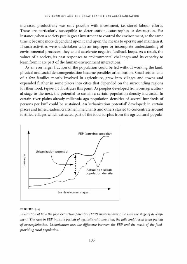
increased productivity was only possible with investment, i.e. stored labour efforts.These are particularly susceptible to deterioration, catastrophes or destruction. Forinstance, when a society put in great investment to control the environment, at the sametime it became more dependent upon it and upon the means to operate and maintain it.If such activities were undertaken with an improper or incomplete understanding ofenvironmental processes, they could accelerate negative feedback loops. As a result, thevalues of a society, its past responses to environmental challenges and its capacity tolearn from it are part of the human-environment interactions.
As an ever larger fraction of the population could be fed without working the land,physical and social dehomogenization became possible: urbanization. Small settlementsof a few families mostly involved in agriculture, grew into villages and towns andexpanded further in some places into cities that depended on the surrounding regionsfor their food. Figure 4.4 illustrates this point. As peoples developed from one agricultur-al stage to the next, the potential to sustain a certain population density increased. Incertain river plains already millennia ago population densities of several hundreds ofpersons per km2 could be sustained. An ‘urbanization potential’ developed: in certainplaces and times, leaders, craftsmen, merchants and others started to concentrate aroundfortified villages which extracted part of the food surplus from the agricultural popula-
:
105
FEP (carrying capacity)
Urbanization potential
Actual non-urbanpopulation density
Pers
on/h
a
Era (development stages)
.
Illustration of how the food extraction potential (FEP) increases over time with the stage of develop-
ment. The rises in FEP indicate periods of agricultural innovation, the falls could result from periods
of overexploitation. Urbanization uses the difference between the FEP and the needs of the food-
providing rural population.
Mappae Mundi bw zw/w 08-04-2004 15:25 Pagina 105
106
How (un)healthy was settled life?16 It is argued that sedentarization exposed
humans to many new pathologic germs, mainly from cattle – a large disadvantage of
sedentary life and a cradle for the large pestilences (Diamond, 1997). However, such a
view neglects the enormous pressure from pathologic micro-organisms on nomadic
groups, among which fellow people and a large animal and aquatic reservoir provided
all sorts of germs besides domestic animals. In fact, cattle breeding coincided with
improving life expectancy of humans.
In prehistoric – and even 20th century – nomadic societies, the median age at death
was only a few (1-5) years. Major causes of death were ‘natural’: heat and cold, floods
and drought, fires, hurricanes, volcanic eruptions and earthquakes. Lack of food was
always a major cause of death; predators and homicide were not negligible either.
Infectious diseases were then, too, the predominant cause of morbidity and mortality,
often from the individual’s own microflora or contagion from tribe members. Early in
life, mothers and others handed down potentially dangerous micro-organisms to the
infants, sometimes even before their birth. For instance, bacterial meningitis, which
until recently killed 1 out of 10 nomadic children before the age of five, is caused by
symbiotic bugs from the direct family.
Early cities provided an enormous advantage to their inhabitants in terms of
longevity and comfort. They gave protection against armies and brigands; their central-
ized food storage was some guarantee against famine; and labour differentiation and
specialization may have stimulated proper housing and clothing. These advantages
were only partly offset by the hazards of infectious diseases due to high population
numbers and crowding. The early cities were islands embedded in their countryside, so
their populations were not – yet – easily massacred by bugs arriving from far away.
Trade routes provided a way through every now and then for the micro-organisms of
smallpox, pestilence and cholera and caused waves of mortality. But this was a haphaz-
ard process since long distance transport was scant and quite a few contagions ‘on
their way’ to a city died out before reaching it. The median age of death was well over
20 years in some Sumerian cities. The well-known infectious diseases were still the
main cause of death, while other causes were kept at bay to a degree.
However, some cities grew to populations of hundreds of thousands or more inhab-
itants (cf. Figure 4.5) and travel and trade intensified. This made the urban population
vulnerable to contagious diseases, as there was a toing and froing of pathogenic
tion, either by trade, tax or take. Figure 4.5 (see p. 169) gives an indication of the popula-tion and area of a few ancient towns and cities – most estimates are surrounded withlarge uncertainties. The urban populations – to which the ruling classes usually belonged– were more vulnerable for food shortages and their response to such events often madethe difference between societal collapse and continuity.
Mappae Mundi bw zw/w 08-04-2004 15:25 Pagina 106
4.5. Mapping the past: Europe in the Late Neolithic17
Is it possible to map the anthroposphere in the early days? Because of a paucity of reli-able data, such an attempt will be difficult and at best give an incomplete picture full ofuncertainties and white spots. Figure 4.6 (see p. 170) shows such a map of Europe in theNeolithic to Early Bronze Age (7000-4000 yr BP). It was compiled on the basis of theoriginal map ‘Landscapes of Europe’ using a scale of 1: 5,000,000. Boundaries on themaps are those of natural landscapes identified according to the common lithogenicbase (relief and geology), climatic (types of local climate) and biogenic (soils and vegeta-tion) components. The components are closely interrelated, and their spatial variationsresult in the change of landscapes in the space. Each landscape includes a number ofsmaller natural geosystems that could not be shown on the map; they determine theinner spatial, or chorological, structure of the landscape. By compiling a series of mapsfor different periods of landscape evolution, the chronological structure has been stud-ied. The mapping is based on the following principles:– a map of cultural and economic types for the whole territory of Europe or its regions
is compiled using the archaeological, cartographic or published data for the chosenperiod. The focus is on those economic branches or types of resource utilization thatresult in the most obvious transformation of landscapes, such as land cultivation,forest cutting, mining, urbanization, etc. Economic objects and systems are repre-sented on the maps.
– analysis of this described map makes it possible to evaluate different types of impactof economic objects on the natural geosystems and the consequences of this impact.Of particular importance are the scope of landscape transformation and the degreeand duration of the resulting changes. For example, forest cutting for timber or fuelproduction may not cause deep destructive processes in the landscape, particularly ifit is practiced only once and then natural reforestation takes place. The resultinglandscapes are referred to as derivative ones. But in case the forest is cut down andthe land is cultivated, such anthropogenic processes as accelerated erosion, deflation
:
107
micro-organisms in the large centres. Rome, a spider in a vast web of land and sea
transport, is a good example of this turning point in city history. Contemporary writers
such as Juvenal were amazed by the unhygienic streets, the stench and the enormous
risk of acquiring diseases. In Rome one lived much shorter than in the rest of Italy: the
median age of death was about 5 years. These conditions would persist for many cen-
turies to come in the large cities, which absorbed rural poverty and overpopulation: the
median age of death in 17th century London and contemporary Dutch towns was
between 5 and 10 years.
Mappae Mundi bw zw/w 08-04-2004 15:25 Pagina 107
and decrease of soil fertility, become characteristic of the affected natural geosystemand the natural landscape turns into its anthropogenic modification. When all of thenatural components are transformed, for example through mining or construction,the term technogenic is applied to such landscapes.
The economic and cultural stage in European landscapes in the Neolithic to EarlyBronze Age shown in Figure 4.6 is a stage characterized by the formation of primevalsocieties in Europe. Active domestication of animals took place in the south-easternregions within the forest-steppe landscapes of the Danube plains (Shnirelman 1989), socattle-raising was the dominant occupation of people there. The most significant eventof this stage was the start of the agrarianization process in the Neolithic that took placeduring the climatic optimum when the climate became more humid and warm. The firstareas of cultivation were formed in the south-eastern subtropical parts of Europe, i.e. inGreece, Crete and Cyprus, and then extended over the southern regions of the Apennineand Iberian peninsulas (Shnirelman 1989; Andrianov 1986; Pounds 1973). Cultivationof shifting and slash-and-burn types required extensive forest cutting. Even underfavourable agro-climatic conditions, the cultivation of more diverse landscapes wasrather slow and usually combined with cattle-raising. But within developed areas therate of anthropogenic processes was greater than that for natural ones. It is at aroundthis time that the areas of modal landscapes appeared in Europe, i.e. natural geosystemswith minor anthropogenic modifications. The most developed economic structureswere typical of the eastern Mediterranean (Crete and Mycenae). Within other regions ofEurope, cultivation was hampered by the cooler climate and the wide occurrence of wet-lands and boggy plains. The cultivation of temperate landscapes in Europe took about2000-3000 years (Pierre 1987; Maksakovsky 1997).
In the Bronze to Iron Age (4000-2300 yr BP), new forms of interactions between manand nature appeared. Production of metals and iron tools, particularly the plough,development of the wheel and sail transport means, irrigation, separation of land culti-vation from cattle-raising, etc. – all this had made the anthropogenic impact on land-scapes more sophisticated and contributed to the expansion of developed areas. Forestswere cut for ploughed arable lands, grazing lands increased in area, towns and rural set-tlements came into existence. Limited areas of derivative landscapes and even anthro-pogenic modifications appeared.
4.6. Conclusions
Early human-environment interactions were dominated by the search for food. Biogeo-graphical factors and their – direct or indirect – changes have been a dominant force inshaping the first human habitats and, later, the agrarianization process – although one
108
Mappae Mundi bw zw/w 08-04-2004 15:25 Pagina 108
should be wary of simple environmental determinism. Vegetation in particular has beenan important intermediate variable in food provision. Other related determinants werewater availability, disease occurrence, soil erodability and ecological diversity. Relativeresource abundance will also have determined cultural traits: fragile environments mayhave induced prudent practices whereas resource-rich environments might have led toprodigality.
In exploring and exploiting the environment for food and shelter, humans encoun-tered opportunities and threats. Agro-pastoralism caused erosion, irrigation salinization,investments in terraces could be destroyed: each action induced changes that requiredfurther action, usually combinations of adaptation and intensification, if collapse orabandonment were to be avoided. On a larger scale this showed up as cycles of expansionand contraction, as is evident in Mediterranean (pre)history. One set of forces in thisdynamic was external, particularly climate change but also for most peasants raids byoutsiders or invasions. Other forces were internal, in the sense of being a reflection ofpeople’s perception of their environment and themselves and of their value and beliefsystems. The nature and balance of these forces largely determined the fate of many ofthe early populations.
The prevailing view nowadays is that agriculture originated around 12,000 yr BP inthe so-called Levantine Corridor. In any case ‘the’ agricultural revolution has not beenone momentous event. Instead, it was more of a gradual intensification of the relation-ship between groups of humans, their environment and each other – which is why weuse the word agrarianization. It was in its particulars quite local and there were no sim-ple cause-and-effect relationships. A series of concurrent factors may have induced peo-ple to make this transition: climate change, subsequent changes in food opportunitiesand vulnerability to diseases, population pressure and the limitations and depletion ofeasily available resources.
Agrarianization had far-reaching, irreversible consequences: it replaced a life of highmobility, modest effort and material ascetism by a sedentary existence with more work-ing hours, goods accumulation, food storage, trade and urban concentrations. The grad-ual shift from religious-agrarian to military-agrarian regimes was probably a response tointer- and intra-human as well as extra-human risks.
The nature of human-environment interactions became more intense and complex.As the growth in populations and investments in rural and urban areas increased, con-trol increased – but so did vulnerability for environmental change. A proper under-standing of and learning opportunities about environmental processes became moreimportant. Resource exploitation intensified in an attempt to deal with short-term risksrelated to frequent events, such as those related to variations in rainfall. It caused envi-ronmental change, often unanticipated and unintended. It sometimes manifested itselfrather directly and visibly but also more globally and later. Coping with the latter, whichoccurred less frequent and/or more erratic, often turned out to be the more difficult one.
:
109
Mappae Mundi bw zw/w 08-04-2004 15:25 Pagina 109

In the early stages of agrarianization, deforestation and filling vital functions for humangroups also contributed to the diversification of the landscape. In summary: with agrar-ianization the anthroposphere was expanding and the human footprint could increas-ingly be spotted by a lunar observer.
110
Mappae Mundi bw zw/w 08-04-2004 15:25 Pagina 110
5
Exploring the Past: on Methods and Concepts
,
Time present and time past
Are both perhaps present in time future,
And time future contained in time past.
T.S. Eliot
We are changing Earth more rapidly than we are understanding it.
Vitousek et al. in Science 277 (1997)
5.1. Introduction
Our perception of the past has changed enormously over the course of time. Early trav-ellers – geographers avant la lettre – have contributed to our knowledge by givingdescriptions and conceptualizing what they encountered (Lacoste 1996). Much of thisknowledge disappeared for long periods. With the ‘Golden Age’ discoveries of the 15th
and 16th centuries and, in its wake, the reinterpretation or outright rejection of religiousdogmas – for instance, the claim that the Earth was created in the year 4004 BC – Europeushered herself, and the world, into the ‘scientification’ of the past. This process of mak-ing empirical observations, interpretations and experiments, i.e. the scientific method,led to the mechanization, then historization of the ‘European’ worldview, as expoundedin Chapter 1. It has led to more efficient use of and increased control over the environ-ment in the form of technology. It has also been applied to understanding and recon-structing the puzzle of our own past. The old sciences – history and geography –regained new vigour, new branches of science emerged – archaeology, palaeo-ecologyand palaeo-climatology.
Using available methods and inference techniques, one can attempt to reconstruct‘scientific facts’ about the past from what remains of it in the present. In this chapter, we
111
Mappae Mundi bw zw/w 08-04-2004 15:25 Pagina 111
focus on some of the methods to collect such empirical ‘facts’. The methods to look intothe distant past are still evolving. We see more and realize that what was ‘seen’ in the pastwas itself part of that past – as is also true for the present. Our knowledge, both in theform of data and concepts, always came – and comes – through filters and ‘scientific’data and theories are biased accordingly. The larger part of historic and palaeo-climaticresearch, for instance, has been done by European and North American researchers, andultimately set by their research agendas. This has resulted in relatively more knowledgebeing available for certain places – and time periods – and in predominantly ‘Eurocen-tric’ interpretations. In addition, information about the past may have been or be dis-torted or withheld for (geo)political reasons. The more advanced societies have left con-spicuous and lasting material remains which naturally became the main focus ofarchaeology. The available methods and the fragmentary evidence are another obstaclein reconstructing past – environmental – changes. For instance, there are fewer traces leftfrom plant foods than from animal foods, hence a bias towards meat-eating habitsappears in such reconstructions. In the arid and tropical regions people usually builttheir houses with materials – mud, wood – that do not last for more than a few genera-tions; this makes inferences about their settlements and society more difficult. Changesin sea-level affect the use of marine resources and the ensuing archaeological records –numerous sites are likely to be below the present sea-level. Indeed, it is not a coincidencethat the earliest coastal sites date from 6000 yr BP, precisely the time of the Holocenetransgression. In this chapter we discuss these issues in somewhat more detail. As Dia-mond remarks:
If it’s hard to determine the function of things happening today under our eyes, how much
harder must it be to determine functions in the vanished past! Interpretation of our past runs
the constant risk of degenerating into mere ’paleopoetry’: stories that we spin today, stimulat-
ed by a few bits of fossil bone, and expressing like Rorschach tests our own prejudices, but
devoid of any claim to validity about the past. (Diamond 1992: 82-83)
Our knowledge of human-environment interactions in the past is the outcome of expe-riences and notions deeply rooted in that same past. In that sense any narrative, theoryor model about the past is itself a myth in the sense of a collectively negotiated, broadlyaccepted and shared view – as indicated in Chapter 1. As such, it is constantly being re-negotiated – this book is itself part of such a process.
5.2. Concepts and categories to organize the knowledge of the past
To acquire knowledge we need an apparatus of concepts to classify and organize our sen-sory experiences – the more so as the latter become, through all kinds of measuring
,
112
Mappae Mundi bw zw/w 08-04-2004 15:25 Pagina 112
equipment, elaborate extensions of those experiences. Investigating past societies inrecent (pre)history starts by examining patchy observations on material artefacts, foodremains, vegetational traces and orally and written transmitted records. These have to becontextualized to become more than an incoherent sequence of material and mentalobjects. This process involves making associations and inferences to glue the patchestogether. In this book, the construction of such a fabric is largely undertaken accordingto the rules of the reductionist-empiricist science. This is by no means the only way:many people did, and do, contextualize the world around them on the basis of differentrules. To clarify what we wish to communicate, we will briefly discuss the nature and ori-gin of some concepts that are crucial in this process of scientific contextualization. Weexplore the concepts of time and space and introduce a few thoughts on the concepts ofcomplexity and resources. But first a note on epistemology and models.
5.2.1. An epistemological note
It may sound trivial but: you can only see what you can see. Yet even in the realm of sen-sory perceptions philosophical questions may immediately arise about the relationshipbetween those perceptions and the associated experiences, information and knowledge.There is always a lot of filtering and selection going on, followed by complex cognitiveprocesses which add ‘meaning’ to the perceptions – or simply ignore them.
Human beings have gradually expanded the spectrum of sensory perceptions. Aftercenturies of developing natural science, we are now aware of the narrowness of our ‘nat-ural’ sensory apparatus. The human eye only sees a tiny part of the frequency spectrumof light – many animals see more or different parts. The same holds for sounds andsmells – elephants can communicate across miles by stamping their feet, some fish areable to catch a prey using the smell of a mere few molecules. By now, humans have out-performed most animals in collecting and interpreting signals, by using tools such as tel-escopes and microscopes to extend their sensory limits. Beyond our immediate sensoryexperiences, with or without artificial extensions, we use inferences, hypotheses, specula-tions, conjectures and refutations as part of our genetic and acquired configuration.Concerning these – more subtle – thought processes, we are possibly only at the start ofour potentialities and of our awareness of them. To understand and interpret pastevents, we have to delve into this a little deeper.
Our observations of the real world are derived from a huge array of simultaneoussequences of events or processes. To make it tractable, we delimit them by establishingsystem boundaries, for example of two systems A and B (Figure 5.1). The observationsare filtered in a variety of ways, for example by one of the methods discussed below andin association with some kind of ‘gauge’. Such a gauge can be as simple as a thermometeror as complicated as in extracting the age of a piece of pottery from thermo-luminis-
:
113
Mappae Mundi bw zw/w 08-04-2004 15:25 Pagina 113
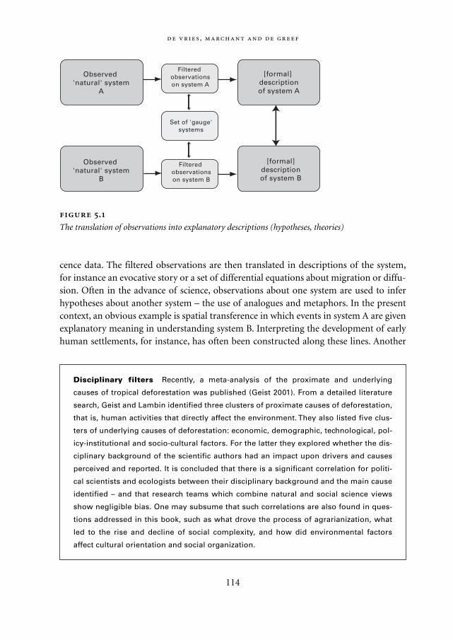
cence data. The filtered observations are then translated in descriptions of the system,for instance an evocative story or a set of differential equations about migration or diffu-sion. Often in the advance of science, observations about one system are used to inferhypotheses about another system – the use of analogues and metaphors. In the presentcontext, an obvious example is spatial transference in which events in system A are givenexplanatory meaning in understanding system B. Interpreting the development of earlyhuman settlements, for instance, has often been constructed along these lines. Another
,
114
Observed 'natural' system
A
Observed 'natural' system
B
[formal] descriptionof system A
[formal]descriptionof system B
Filtered observationson system A
Set of 'gauge'systems
Filtered observationson system B
.
The translation of observations into explanatory descriptions (hypotheses, theories)
Disciplinary filters Recently, a meta-analysis of the proximate and underlying
causes of tropical deforestation was published (Geist 2001). From a detailed literature
search, Geist and Lambin identified three clusters of proximate causes of deforestation,
that is, human activities that directly affect the environment. They also listed five clus-
ters of underlying causes of deforestation: economic, demographic, technological, pol-
icy-institutional and socio-cultural factors. For the latter they explored whether the dis-
ciplinary background of the scientific authors had an impact upon drivers and causes
perceived and reported. It is concluded that there is a significant correlation for politi-
cal scientists and ecologists between their disciplinary background and the main cause
identified – and that research teams which combine natural and social science views
show negligible bias. One may subsume that such correlations are also found in ques-
tions addressed in this book, such as what drove the process of agrarianization, what
led to the rise and decline of social complexity, and how did environmental factors
affect cultural orientation and social organization.
Mappae Mundi bw zw/w 08-04-2004 15:25 Pagina 114
one is time transference in which events in system B at some stage of its evolution areunderstood in terms of observations about system A in a supposedly similar stage.Learning about the old hunter-gatherer populations based on the few hunter-gathererpeoples existing today is an example of this. Such synchronic and diachronic compara-tive analyses can provide fruitful hypotheses, but they usually are also misleading – whichis precisely why they are sometimes fruitful in the formation of more solid knowledge.
5.2.2. Models: population-environment interactions
In the previous chapters and the chapters to follow, we present ‘stories’ told by climatol-ogists, archaeologists and scholars from other disciplines. The stories themselves as wellas their sequence often suggest a kind of trajectory or path. This tells of the rise and fallof human settlements in the early phase of transition to settled agriculture and on tostates and empires. However, there is much uncertainty and controversy about how tointerpret the empirical evidence squeezed out of scattered bones and pottery, dug-upseeds and the like. Scientific ‘stories’ appear and attempts have been made to tell suchstories in a more formalized way by making a mathematical model. Let us briefly look atthe notion of a model and how models are being used to deepen our understanding ofpast developments, not as a substitute for stories but as a complement.
To understand our ancestral past, scientists put forward qualitative hypotheses andquantitative models – our models. Loosely speaking, we may call any mental map repre-senting associations between events a model. Such mental maps in the human mind canbe formalized into mathematical models. In the process, the complex forces at work areinterpreted and simplified. A part of the experienced reality is delineated as the systemunder consideration and described in terms of state variables and how it changes as aconsequence of forces operating in time and across space.
Scientifically speaking models are more or less formal representations – or encodings– of observations, applying certain rules of inference, and deducing and testing subse-quent hypotheses (Rosen 1985). Such models about human-animal-resource-vegetationinteractions emerged, possibly for the first time, with European science. Some of them,however rudimentary and simple, have been very influential: the logistic populationgrowth model (Verhulst), the prey-predator ecosystem dynamics (Lotka-Volterra), themining life cycle of a resource (Harris), the Central Place theorem in geography (Loschand Christaller) and others.1 Many such ‘mental maps’ about how humans and theirenvironment have co-evolved still have a limited relation with everyday reality. Despitetheir sometimes high mathematical sophistication, they are stylized representations ofcertain observations, often based on metaphors or analogues.
The most important ‘system’ variable in (mathematical) population-resource-envi-ronment models is the population size; modelling population density spatially explicitly
:
115
Mappae Mundi bw zw/w 08-04-2004 15:25 Pagina 115
is still the exception. A general framework about population growth and resource limitswould have to consider the elementary notions of population growth, resources, andtechnology mediated by organization and culture. More specifically, the dynamic inter-play between fertility – regulated through cultural practices such as the postponement ofmarriage or infanticide – and mortality – with determinants such as diseases, famineand war – is part of this scheme. The population size is the result of fertility, mortalityand migration processes. A subsequent extension is to incorporate a resource – fish, soil,trees, copper – and simulate possible pathways: overexploitation followed by famine andpopulation decline, cultural and technical responses to overcome the resource crisis, andthe like. Simple ‘archetypical’ mathematical population-resource models suggest fourtypical population trajectories, as shown in Figure 5.2. Exponential growth without anupper bound can continue indefinitely – and hence does not exist. If there is a limit –and hence a finite carrying capacity – the approach to it can be smooth or with over-shoot-and-collapse. However, the limit may also be lifted due to technical ingenuity orbehavioural changes. It may also brought down by natural processes or mismanagement.Human actions and the nature of the limits are in continuous interaction.
Science proceeds towards ever more explicit mental map (re)construction. It is impor-tant, then, to distinguish ‘our’ ‘scientific’ models and the associated perspective from themental maps of the peoples of the past. In ‘our’ models there has been, in the last fewdecades, a tendency towards integration of scientific (sub)disciplines and the use ofactor-oriented ‘bottom-up’ simulation models. However, this demands an explicit for-mulation of how humans behaved in the past – that is, ‘their’ models. In such ‘agent-based modelling’ – agents being the name used for any effective actor in the model, suchas individual humans, households or mountain goats – it is found that one cannot easilydiscern specific causes for specific changes. Changes, maybe even random variability, inactors’ behaviour, or in some aspect of the boundary conditions for the model such asthe climatic context, may precipitate small but growing avalanches of changes in the sys-tem’s evolution over time. This is particularly true when agents are modelled in such away as to be able to alter their sets of behaviours and communication flows, instead ofmerely reacting to a stimulus with a predetermined, rule-based response. A ‘cause-and-effect’ approach and explanations in terms of ‘variables’ abstracted from the model arenot very satisfying. The true locus for change in such systems may reside in changes inthe network of relationships linking agents to each other and to the boundary condi-tions of their world. Another trend has been to make more integrated models in anattempt to incorporate crucial – and often ill-understood – interactions between varioussubsystems.2
The deeper understanding which models can give us consists of more general insightsat a higher level of abstraction. It is tempting to aspire towards universal laws and theo-ries. Of course, even if our models become more elaborate, they still face serious prob-
,
116
Mappae Mundi bw zw/w 08-04-2004 15:25 Pagina 116
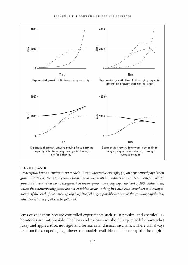
lems of validation because controlled experiments such as in physical and chemical la-boratories are not possible. The laws and theories we should expect will be somewhatfuzzy and appreciative, not rigid and formal as in classical mechanics. There will alwaysbe room for competing hypotheses and models available and able to explain the empiri-
:
117
4000
2000
0
Size
Time
Exponential growth, infinite carrying capacity
4000
2000
0
Size
Time
Exponential growth, fixed finit carrying capacity:saturation or overshoot-and-collapse
4000
2000
0
Size
Time
Exponential growth, upward moving finite carryingcapacity: adaptation e.g. through technology
and/or behaviour
4000
2000
0
Size
Time
Exponential growth, downward moving finite carrying capacity: erosion e.g. through
overexploitation
.-
Archetypical human-environment models. In this illustrative example, (1) an exponential population
growth (0.2%/yr) leads to a growth from 100 to over 4000 individuals within 150 timesteps. Logistic
growth (2) would slow down the growth at the exogenous carrying-capacity level of 2000 individuals,
unless the countervailing forces are not or with a delay working in which case ‘overshoot and collapse’
occurs. If the level of the carrying-capacity itself changes, possibly because of the growing population,
other trajectories (3, 4) will be followed.
Mappae Mundi bw zw/w 08-04-2004 15:25 Pagina 117
,
118
The mathematical basis To give a flavour of some ‘archetypal’ population-environ-
ment models, let us assume a system of a hunter-gatherer population in interaction
with its main food resource, for instance a fish population. It is based on a human pop-
ulation with births, deaths, and a requirement of food which is satisfied by exploiting a
local resource. If there are no resource constraints, such a [human] population will
grow exponentially (Figure 5.2a). Its growth rate will depend mainly on the number of
children per woman during her fertile period and on the life expectancy at birth. In its
simplest form, the mathematical equation is:
where P is population, b is birthrate and L is average life expectancy. Obviously, in the
real world a local resource will always have a limited resource provision capacity. For
instance, the resource may be a lake where fish are caught, the fish feeding on shrimps
– or another ecosystem that can be exploited by a hunter-fisher community. It may also
be an area with fertile soils to grow food crops and pastures to keep animals. The math-
ematical description consists of one additional equation for the renewable resource:
in which R is the resource size, α is its recovery rate, K is the carrying capacity of the
particular area under consideration and β is the resource extraction per person. If ini-
tially the resource system is in dynamic equilibrium (R = K), a stable population (β = 1 /
L) with a finite extraction rate will drive the resource to extinction unless its extraction
βP is below some level (Figure 5.2b). This happens for instance at R = K / 2 and βP = αR
/ 4. Interesting questions to explore are:
– how will the declining resource size R constrain the extraction rate, for instance
through less animals per area, soil erosion and the like;
– how will this in turn effect the population dynamics, for instance through increased
mortality and subsequent starvation or violent deaths from mutual competition;
and
– how will the human population respond to such an effect on population dynamics,
for instance by outmigration, concentration in certain places where chances for sur-
vival are highest, infanticide, postponement of marriage or other adjustments of
the number of births.
Some of these responses have been discussed qualitatively in previous chapters.
Numerous models have been developed to introduce them in mathematical models;
some of them is presented summarily in Chapter 8.
dP / dt = bP – P / L
dR / dt = αR (1 – R / K) – βP
Mappae Mundi bw zw/w 08-04-2004 15:25 Pagina 118
cal data. A large part of humanity’s past – and future – will always be told in the form ofstories. In Chapter 8 we discuss a few attempts to apply these novel approaches in thequest for a more in-depth understanding of socio-natural systems.
5.3. Time, space and resources
In the local space and the short time-span of everyday life, individuals learn to orientthemselves in their environment in a continuous process of interaction. A mental map isbuilt and adjusted on which to base one’s actions in known environments and, at least inthe first instance, in new environments. How peoples in the past oriented themselves intheir world may at first glance be incomprehensible and chaotic in modern eyes – aswould be the reverse.3 Events were organized and recorded according to some external‘clock’ such as the moon or the sun. Location was related to landscape features in combi-nation with travel time and means. Although there is still a wide variety of measures inuse, ‘globalization’ has advanced rapidly in the last century and there is an almost uni-form use now of the Système Internationale (SI) units of measurement: the metre, gramand second. With the expansion of science and technology, the unit domain is expanding– nm for one millionths of a millimetre, Myr for one million years – and new units orcontexts appear, such as Mb and GHz for computers.
Two remarks. First, similar to knowledge, space and time manifest themselves as dis-tinctly ‘personal’ – or subjective – in our everyday experience but at the same time as evi-dently ‘impersonal’ – or objective – in the processes in the world. Time, the ‘fourthdimension’, clearly exemplifies this apparently unbridgeable gap. Goudsblom (1996)
:
119
Perceptions and the environment How perception affects the interaction of peo-
ples with their environment is illustrated with the example of certain tribes in the
Western Highlands of Papua New Guinea (Leeuw 2000: 372). The tendency among
these tribes is to view change as degradation and the stable past as ideal – a tendency
present in parts of any population. To correct problems, they believe, one should cere-
monially go back to the point in time where the root of the problem lies and sort it out.
In one well-recorded case, this led to a spiral of environmental degradation. When
change was observed, people held ceremonies requiring freshly killed pigs. This, in
turn, required deforestation to expand horticulture to provide pig feed. This caused ero-
sion on the steep slopes where the settlements were located and ‘slowly, the popula-
tion cuts away the means of subsistence that surround it and is forced to move down-
hill.’ (Leeuw 2000: 372) They end up in the valley marshes which are partly formed by
the washed down soil on which it all started.
Mappae Mundi bw zw/w 08-04-2004 15:25 Pagina 119
suggests that a sociological approach can bridge it, by emphasizing that time is ‘a socio-cultural construction which aids people in their efforts to collectively orient themselvesin the world and to co-ordinate their actions.’ (Goudsblom 1996: 20). Secondly, develop-ing quantified measures for orientation and communication has been only successful forrelatively simple (sub)systems. More complex (sub)systems can usually not easily becharacterized by quantified measures derived from a unique and unambiguous gauge.For example, (past) climate and vegetation changes, the nature of economic transactionsor a society’s organizational form are most often expressed as relative changes or posi-tions. The climate was ‘drier’, transactions took place in a ‘subsistence economy’ and astate was ‘more centralized’ than another one.4
5.3.1. Orientation in time
The perception of time has always been an important aspect of all cultures and is reflect-ed in environmental and social experiences in various ways. In all cultures the notion oftime has been used to point to what cannot be experienced by the senses, grasped by thehuman intellect or said in human words. Often, this is expressed in metaphors, as in thewriting of the Persian poet and mystic Rumi:
The world of time5
Every instant thou are dying and returning. ‘This world is but a moment,’ said the Prophet.
Our thought is an arrow shot by Him: how should it stay in the air? It flies back to God.
Every instant the world in being renewed, and we unaware of its perpetual change.
Life is ever pouring in afresh, though in the body it has the semblance of continuity.
From its swiftness it appears continuous, like the spark thou whirlest with thy hand.
Time and duration are phenomena produced by the rapidity of Divine Action,
As a firebrand dexterously whirled presents the appearance of a long line of fire.
Time is not measured as such but is a constructed relationship, a duration between rele-vant events (Elias 1985). One may assume that there was no abstract notion of ‘time’among ancient peoples. Instead, their sense of time was determined directly by theireveryday needs. The group, often mediated by a priest, interprets the changes in the envi-ronment in order to know the moments and sequences of actions. Only later did moreabstract notions of simultaneity and a sequence of past, present and future emerge.
In the modern scientific sense time is measured ‘exactly’ by relating it to highly regu-lar gauge processes. This exactness became an important step in conceptualizing the pastas an ordered, coherent narrative according to the scientific rules of the game. It is a rel-atively recent development in the history of the concept of time. The ‘scientification’ of
,
120
Mappae Mundi bw zw/w 08-04-2004 15:25 Pagina 120
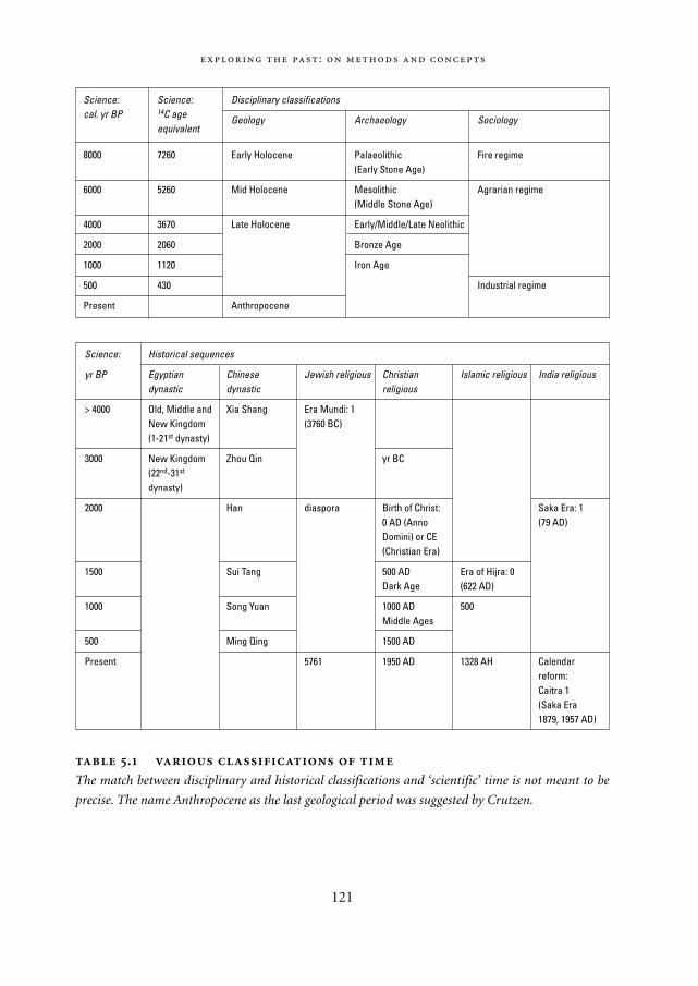
:
121
Science: Science: Disciplinary classificationscal. yr BP 14C age Geology Archaeology Sociology
equivalent
8000 7260 Early Holocene Palaeolithic Fire regime(Early Stone Age)
6000 5260 Mid Holocene Mesolithic Agrarian regime(Middle Stone Age)
4000 3670 Late Holocene Early/Middle/Late Neolithic
2000 2060 Bronze Age
1000 1120 Iron Age
500 430 Industrial regime
Present Anthropocene
Science: Historical sequences
yr BP Egyptian Chinese Jewish religious Christian Islamic religious India religiousdynastic dynastic religious
> 4000 Old, Middle and Xia Shang Era Mundi: 1 New Kingdom (3760 BC)(1-21st dynasty)
3000 New Kingdom Zhou Qin yr BC(22nd-31st
dynasty)
2000 Han diaspora Birth of Christ: Saka Era: 1 0 AD (Anno (79 AD)Domini) or CE (Christian Era)
1500 Sui Tang 500 AD Era of Hijra: 0 Dark Age (622 AD)
1000 Song Yuan 1000 AD 500Middle Ages
500 Ming Qing 1500 AD
Present 5761 1950 AD 1328 AH Calendarreform: Caitra 1(Saka Era 1879, 1957 AD)
.
The match between disciplinary and historical classifications and ‘scientific’ time is not meant to be
precise. The name Anthropocene as the last geological period was suggested by Crutzen.
Mappae Mundi bw zw/w 08-04-2004 15:25 Pagina 121
time is a process of narrowing down the older, broader notion – as such it is a mirror aswell as a tool of the forces of modernity. More recently, the natural sciences have alsorecovered more subtle aspects of time – this is beyond the scope of the present discus-sion.
As explained previously, orientation in time needs some form of gauging system. Inancient times these always originated in the observation of ‘natural’ recurrent phenome-na, such as the cycles of the sun and the moon and using instruments such as a sundial.Gradually, more elaborate time-measuring devices emerged such as the water clock, thehourglass and the mechanical clock. The latest one is the atomic clock, using radioactive
,
122
Perceptions of time In many early agricultural civilizations, time was intricately
related to the seasonal cycles (McIntosh 2000b). As an English medieval verse goes
(Sisam 1970: 485):
The Months
Januar: By this fire I warme my hands,
Februar: And with my spade I delfe my landes.
Marche: Here I sette my thinge to springe,
Aprile: And here I heer the fowles singe.
Maii: I am as light as birde in bow,
Junii: And I weede my corne well ynow.
Julii: With my sithe my mede I mowe,
Auguste: And here I shere my corne full lowe.
September: With my flail I erne my bred,
October: And here I sowe my whete so red.
November: At Martinesmasse I kille my swine,
December: And at Christesmasse I drinke red wine.
In other societies, low-frequency or other events such as periodic fluctuations in ocean
currents as with El Niño may have been more important (Marchant 2002). In traditional
African life the linear concept of time is absent: time is a composition of events with a
long past, a present and virtually no future – it is actual time and moves ‘backwards’
rather than ‘forwards’ (Mbiti 1969). What has not taken place or is highly improbable to
take place is part of no-time; what falls within the inevitable rhythm of natural phenom-
ena or is certain to occur is potential time. Time has to be experienced in order to make
sense or become real. This shows up in East African languages: they have no concrete
words or expressions to convey the idea of a distant future – at most two years. As with
many peoples past and present, history and prehistory are dominated by myths that
defy any attempt to be described on a mathematical time-scale. Space orientation is
Mappae Mundi bw zw/w 08-04-2004 15:25 Pagina 122
decay processes as the gauge. In this process of social construction, time is imagined as alinear continuum that can be divided in equal parts and is used to synchronize timemeasurements anywhere in the world: the ‘Global Time Regime’ (Goudsblom 2001).
As scientific inquiry proceeds from the simple mechanical systems of early scienceinto the more complex ones of biology, ecology and the social sciences, time as a reflec-tion of a system’s characteristic dynamics or ‘Eigendynamik’ (Bossel 1989) becomesimportant. Such systems have growth and decay cycles and response times reflectingcomplex, nested dynamics, and they are not easily linked in a quantifiable way to a gaug-ing system. Whole ranges of phenomena occur interdependently across a wide spectrumof time-scales and spatial scales. Within such a context, time is usually experienced as asequence of events – for instance in an individual life, an organization or a civilization.Usually some structure is imposed in the form of ‘natural’ phases of development: thephysical and psychical growing up and maturing of human beings, the rise and fall ofbusinesses, states and empires. In most cultural traditions, events and transitions fromone characteristic period to another order the dimension of time.
:
123
similar to time orientation and both are essential in understanding (African) religions
and philosophy.
Time is intimately related to the attempt to come to terms with death, a vast topic
and beyond the scope of this book. Pre-capitalist Europe was largely ‘timeless’ – or, in
historian Le Goff’s words, ‘free of haste and careless of exactitude’. As capitalism raised
the ‘price’ of time, people began to think of time as a scarce resource and metaphors
emerged such as saving or wasting time. Time and money began to substitute for each
other – time itself had become a commodity. More than 150 years ago, Alexis de
Tocqueville, the French commentator on life in the colonies, observed that Americans
were always in a hurry. Time is intricately related to environmental change through the
notion of productivity: large tropical trees in Australia could not be felled before 1910, it
took several weeks by 1920 – and only a few hours by 1940.
It would be possible to fill a whole book with thoughtful reflections on time, as it is
such an existential aspect of human life. To give just two examples:
‘But time is life itself, and life resides in the human heart. And the more time
people saved, the less they had,’ writes Michael Ende in his book Momo.
‘Of time you would make a stream upon whose bank you would sit and watch
its flowing. Yet, the timeless in you is aware of life’s timelessness, and knows
that yesterday is but today’s memory and tomorrow is today’s dream,’ the
prophet is saying in Kahlil Gibran’s book The Prophet.
Mappae Mundi bw zw/w 08-04-2004 15:25 Pagina 123
Whereas each scientific discipline has developed its own time classification, based onthe phenomena of interest (Table 5.1a), most cultures have developed their ‘historical’time, (re)constructed from oral or written records (Table 5.1b6). In the present contextwhere we deal with complex socio-natural systems, we ‘date’ events based on scientificmethods – a chronology – and at the same time position events through associationwith ecological regimes – a phaseology.7 The fire regime, the agrarian regime with plant and animal domestication, urbanization, and the industrial regime are each theoutcome of human-induced transformations and each has their characteristic events,behaviours and processes, although they cannot be sharply demarcated (Goudsblom1996: Chapter 2-4).
5.3.2. Orientation in space
Interactions between humans and their environment have an important, if not essential,spatial aspect. Space is the mediator between the human needs for food, exchange andmeaning on the one hand and the physical landscape on the other. When consideringmigration, conquest etc., physical geography, climate, vegetation, encounters with largeanimals, as prey and competitors, and with other groups of humans all incorporate spa-tial aspects in the co-evolutionary processes. Transport processes and speed relate spaceto time. An increase in the speed of travel, slow for millennia and accelerating rapidly inthe last century, has totally transformed ‘physical’ or ‘Euclidean’ space. Until a few cen-turies ago, physically experienced space was for most people confined to an area of a fewhours’ travel on foot – an area of, say, 100 km2. With ships, horses and carriages, latertrains and planes it has expanded to the whole globe for a significant fraction of theworld’s population. Mentally experienced space has expanded even more with advancesin communication technology. Like knowledge and time, space has both a subjective andan objective side, as is evidenced in apparently closely related astronomical enquiries onthe one hand and metaphorical poems on the other: one measures the distance betweenstarts in light-years, and the other expresses the infiniteness of inner space.
The first attempts of the human mind to bring orientation in space from an individ-ual to a shared, collective understanding were maps. If one understands the word ‘map’in a wider sense, maps are all around us: animal drawings and statues, town plans, ahoroscope and Tarot are all ‘maps’ in the sense of simplified, static, symbolic yet materialrepresentations of a complex reality. They all tell a story for those who can read them.For instance, some interpretations believe the Giza pyramids to be a map of the constel-lation Orion; the interpretation of megalith circles, such as Stonehenge and Seahenge, asrelated to ritual maps is more widely accepted. Maps in a narrower, geographical sensemay have started many millennia ago as simple drawings in the sand or on rocks, trans-mitted in oral traditions and serving as mental maps. These were, one can assume, mem-
,
124
Mappae Mundi bw zw/w 08-04-2004 15:25 Pagina 124
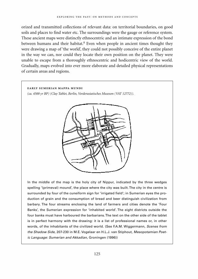
orized and transmitted collections of relevant data: on territorial boundaries, on goodsoils and places to find water etc. The surroundings were the gauge or reference system.These ancient maps were distinctly ethnocentric and an intimate expression of the bondbetween humans and their habitat.8 Even when people in ancient times thought theywere drawing a map of ‘the world’, they could not possibly conceive of the entire planetin the way we can, nor could they locate their own position on the planet. They wereunable to escape from a thoroughly ethnocentric and hodicentric view of the world.Gradually, maps evolved into ever more elaborate and detailed physical representationsof certain areas and regions.
:
125
In the middle of the map is the holy city of Nippur, indicated by the three wedges
spelling ‘(primeval) mound’, the place where the city was built. The city in the centre is
surrounded by four of the cuneiform sign for ‘irrigated field’; in Sumerian eyes the pro-
duction of grain and the consumption of bread and beer distinguish civilization from
barbary. The four streams enclosing the land of farmers and cities denote the ’Four
Banks’, the Sumerian expression for ‘inhabited world’. The eight districts outside the
four banks must have harboured the barbarians. The text on the other side of the tablet
is in perfect harmony with the drawing: it is a list of professional names or, in other
words, of the inhabitants of the civilized world. (See F.A.M. Wiggermann, Scenes from
the Shadow Side, 207-230 in M.E. Vogelaar en H.L.J. van Stiphout, Mesopotamian Poet-
ic Language: Sumerian and Akkadian, Groningen (1996))
(ca. 4500 yr BP) (Clay Tablet, Berlin, Vorderasiatisches Museum (VAT 12772)).
Mappae Mundi bw zw/w 08-04-2004 15:25 Pagina 125
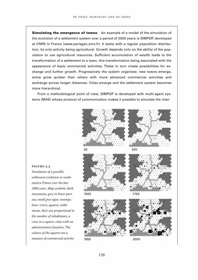
,
126
Simulating the emergence of towns An example of a model of the simulation of
the evolution of a settlement system over a period of 2000 years is SIMPOP, developed
at CNRS in France (www.parisgeo.cnrs.fr). It starts with a regular population distribu-
tion, its only activity being agricultural. Growth depends only on the ability of the pop-
ulation to use agricultural resources. Sufficient accumulation of wealth leads to the
transformation of a settlement to a town, this transformation being associated with the
appearance of basic commercial activities. These in turn create possibilities for ex-
change and further growth. Progressively the system organizes: new towns emerge,
some grow quicker than others with more advanced commercial activities and
exchange across longer distances. Cities emerge and the settlement system becomes
more hierarchical.
From a methodological point of view, SIMPOP is developed with multi-agent sys-
tems (MAS) whose protocol of communication makes it possible to simulate the inter-
.
Simulation of a possible
settlement evolution in south-
eastern France over the last
2000 years. Map symbols: dark:
mountains; grey in lower part:
sea; small grey signs: swamps;
lines: rivers; squares: settle-
ments, their size proportional to
the number of inhabitants; a
cross in a square: cities with an
administrative function. The
colours of the squares are a
measure of commercial activity.
50 500
1000 1700
1850 2000
Mappae Mundi bw zw/w 08-04-2004 15:25 Pagina 126
Geographical maps as we know them were known around 2000 yr BP. In ancient times,the image of the Earth was intertwined with mythological belief systems. The first mapsof the world were probably made in Sumer at around 5000 yr BP. The eastern image ofthe Earth as a corpus floating on water was gradually replaced in the Greek civilizationby the notion of a rotating free-floating ball. Chin emperor Shi Huangdi had an enor-mous tomb built, around 2150 yr BP, on the floor of which was a stone map of the worldwith the hundred rivers of the Empire flowing mechanically with mercury (Wood 1999:106). The Arab cartographer Al Idrisi, after whom the geographical software packageIdrisi is named, was the first to use co-ordinates. By means of a long process of map-making, the most recent development are the computerized maps using GeographicalInformation Systems (GIS) techniques. Vast amounts of data can be stored, processedand represented in a spatially explicit form: maps. Space, too, has been ‘scientificated’. Anexample is the research in the framework of the Land Use History of North America(LUHNA) project, yielding for instance maps of population density in the Washington-Baltimore region in the USA over the last 200 years illustrating the transformation froman agricultural to an industrial region (www.luhna.gov). An example in which dynamicsimulation models generate spatial maps to mimic and understand dynamic settlementprocesses is the SIMPOP application for Southern France (Figure 5.3). In practicalterms, space will show up in this book in two forms: geographical maps with indicatorssuch as population density and land cover/land use, and maps representing the outcomeof spatially explicit dynamic models of spatial interactions between humans and theirenvironment.
:
127
actions between places in an interesting way (Sanders 1997; Bura 1996). Without inter-
actions the system stagnates: the total population remains stable and no hierarchy
evolves between settlements.
Figure 5.3 shows simulation results for the Rhône Valley in south-eastern France,
with Valence in the north, and the initial population sizes are fictitious. The key point of
interest is the spatial and hierarchical organization as growth and interactions evolve.
The urbanization process has a slow, unstable start. As soon as some hierarchical
organization appears, it tends to be reinforced with time. Although the overall structure
is somewhat independent of the initialization, bifurcations may appear when small dif-
ferences are reinforced: ‘the butterfly creating a storm’. The aim of the model is not to
reproduce the exact location of the cities and towns in 2000, it is to produce a plausible
structure of the urban network in terms of hierarchical organization, city sizes and spac-
ings.
Mappae Mundi bw zw/w 08-04-2004 15:25 Pagina 127
5.3.3. Resources
Ecology teaches us that individual living beings are always part of a larger system withwhich they interact in a variety of ways. Such a system is called an ecosystem and its evo-lution over time is the result of numerous and complex dynamical processes, amongthem material exchange processes with the physical environment.9 The easily observableinteractions between humans and their environment take place at the physical level –breathing, gathering food, hunting and eating, diverting water flows and building settle-ments. The parts of the environment that are ‘used’ in this way are referred to as life-support systems or environmental resources. Some call the associated fluxes the – agri-cultural, industrial – metabolism. Agriculture, in this context, is human interferencewith natural succession in ecosystems.
Resource shortages have often been invoked to explain the decline of civilizations (cf.Chapter 6). As we will see, this is often an overly simple explanation. What is experiencedand exploited as a resource is a reflection of the prevailing values and opportunities, theavailable technical skills and the organizational capabilities. They tend to develop in adynamic interplay – as shown by the modern example of uranium which only became aresource once the discovery and control of fission technology had developed. Forhunter-gatherers and early farmers, resources were – and are – largely associated withtheir value on the individual level such as a desire for crops or cattle. At later develop-ment stages, desires of more advanced farming communities and of urban elites added awhole array of new resources.
Regarding resources and their exploitation and degradation, it appears to be useful tomention some general aspects of the interference of humans with the material world:– every transformation of material and non-material fluxes has a ‘value-added’ charac-
ter;– most – but not all – transformations have a ‘capital formation’ character in the sense
that the action may result in a permanent accumulation of effects;– many transformations have a ‘value redistribution’ character which is the outcome of
social exchange processes.
The first two points express the fact that the essence of a ‘resource’ is that some part ofthe natural environment can be changed (transformed, concentrated, transported) insuch a way that value is added. If the resultant effect has an enduring capacity to satisfycertain needs, it is a form of ‘capital formation’. It incorporates not only materials butalso the technical knowledge and skills to actually perform the transformation. At thesame time a process of ‘capital destruction’ takes place as both natural and non-naturalcapital stocks inevitably degrade at a rate which depends on its composition and man-agement. This aspect of environmental change is associated with resource depletion and
,
128
Mappae Mundi bw zw/w 08-04-2004 15:25 Pagina 128
environmental degradation. The third point is about whose values and needs areinvolved. This depends on the ways in which societies (re)distribute the surplus. In earlydevelopment stages most ‘capital’ was in the form of individual possessions such as hous-es, tools and ornaments and collective undertakings such as roads and defence works. Inhierarchical societies, the capital often reflected the values and desires of a king-priestelite – as is evident from the palaces, temples and irrigation works in ancient empires. Incoastal trading communities, important capital assets were the ships, the harbours andthe stocks of goods – goods which often had a high added value per unit of mass or vol-ume because that is what made it worth to transport them across large distances.
5.4. Complexity
The world is constantly threatened by two things: order and disorder.
Paul Valéry
As humans adapted to a variety of environmental stresses during the evolutionaryprocess, their society became more complex. In this book we use the words social com-plexity, socio-cultural and socio-political complexity and complex socio-natural systemssomewhat interchangeably. But what is complexity and what exactly has become morecomplex? In the first instance and in the present context it is associated with the familiaritems listed in Table 5.2: an – incomplete and unsystematic – list of activities that trackspeoples’ interaction with their environment.
The notion of complexity is a difficult one; an extensive discussion is beyond the scopeof this text (see e.g. Allen 1993; Dean 2000; Leeuw 1998). Recent insights in ecosystemand human-environment dynamics have led to the awareness that many concepts andmodels from the physical sciences are inadequate to understand more complex systems –for instance, the concept of change as a series of equilibria (Prigogine 1980). Refinednotions of stability, predictability and resilience are emerging. More emphasis is given tothe simultaneous existence of multilevel dynamics in space and time. These scientificdevelopments are of great importance for the topic under consideration. Often, com-plexity is the buzzword that unites them.
We will not try to supply a strict definition, merely provide some reflections which serveour purpose in later parts of the book. Let a complex system be any set of elements,material and non-material, interrelationships and procedures. It can be hypothesizedthat complexity emerges in open systems in which the elements have many and varieddegrees of freedom to act and of interactions. However, it is tempting to say ‘complexityis in the eye of the beholder’. In other words: saying that something is complex gives it a
:
129
Mappae Mundi bw zw/w 08-04-2004 15:25 Pagina 129
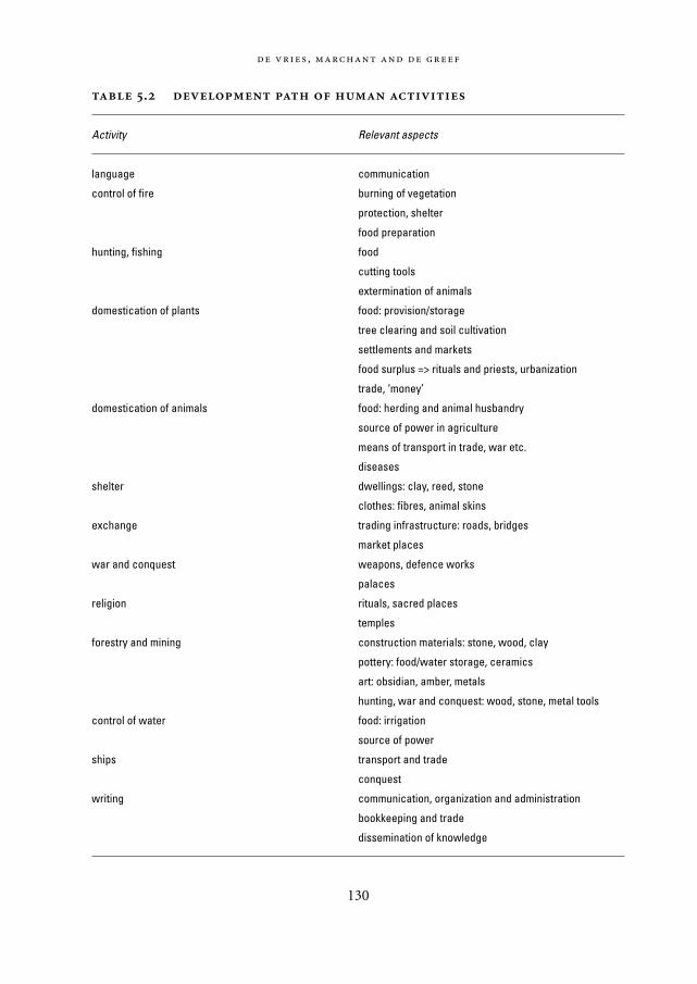
,
130
.
Activity Relevant aspects
language communication
control of fire burning of vegetation
protection, shelter
food preparation
hunting, fishing food
cutting tools
extermination of animals
domestication of plants food: provision/storage
tree clearing and soil cultivation
settlements and markets
food surplus => rituals and priests, urbanization
trade, ‘money’
domestication of animals food: herding and animal husbandry
source of power in agriculture
means of transport in trade, war etc.
diseases
shelter dwellings: clay, reed, stone
clothes: fibres, animal skins
exchange trading infrastructure: roads, bridges
market places
war and conquest weapons, defence works
palaces
religion rituals, sacred places
temples
forestry and mining construction materials: stone, wood, clay
pottery: food/water storage, ceramics
art: obsidian, amber, metals
hunting, war and conquest: wood, stone, metal tools
control of water food: irrigation
source of power
ships transport and trade
conquest
writing communication, organization and administration
bookkeeping and trade
dissemination of knowledge
Mappae Mundi bw zw/w 08-04-2004 15:25 Pagina 130
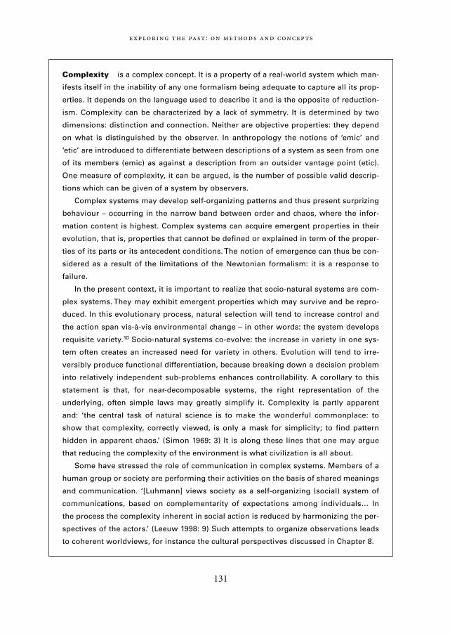
:
131
Complexity is a complex concept. It is a property of a real-world system which man-
ifests itself in the inability of any one formalism being adequate to capture all its prop-
erties. It depends on the language used to describe it and is the opposite of reduction-
ism. Complexity can be characterized by a lack of symmetry. It is determined by two
dimensions: distinction and connection. Neither are objective properties: they depend
on what is distinguished by the observer. In anthropology the notions of ‘emic’ and
‘etic’ are introduced to differentiate between descriptions of a system as seen from one
of its members (emic) as against a description from an outsider vantage point (etic).
One measure of complexity, it can be argued, is the number of possible valid descrip-
tions which can be given of a system by observers.
Complex systems may develop self-organizing patterns and thus present surprizing
behaviour – occurring in the narrow band between order and chaos, where the infor-
mation content is highest. Complex systems can acquire emergent properties in their
evolution, that is, properties that cannot be defined or explained in term of the proper-
ties of its parts or its antecedent conditions. The notion of emergence can thus be con-
sidered as a result of the limitations of the Newtonian formalism: it is a response to
failure.
In the present context, it is important to realize that socio-natural systems are com-
plex systems. They may exhibit emergent properties which may survive and be repro-
duced. In this evolutionary process, natural selection will tend to increase control and
the action span vis-à-vis environmental change – in other words: the system develops
requisite variety.10 Socio-natural systems co-evolve: the increase in variety in one sys-
tem often creates an increased need for variety in others. Evolution will tend to irre-
versibly produce functional differentiation, because breaking down a decision problem
into relatively independent sub-problems enhances controllability. A corollary to this
statement is that, for near-decomposable systems, the right representation of the
underlying, often simple laws may greatly simplify it. Complexity is partly apparent
and: ‘the central task of natural science is to make the wonderful commonplace: to
show that complexity, correctly viewed, is only a mask for simplicity; to find pattern
hidden in apparent chaos.’ (Simon 1969: 3) It is along these lines that one may argue
that reducing the complexity of the environment is what civilization is all about.
Some have stressed the role of communication in complex systems. Members of a
human group or society are performing their activities on the basis of shared meanings
and communication. ‘[Luhmann] views society as a self-organizing (social) system of
communications, based on complementarity of expectations among individuals… In
the process the complexity inherent in social action is reduced by harmonizing the per-
spectives of the actors.’ (Leeuw 1998: 9) Such attempts to organize observations leads
to coherent worldviews, for instance the cultural perspectives discussed in Chapter 8.
Mappae Mundi bw zw/w 08-04-2004 15:25 Pagina 131
contextual characteristic. Here, another factor is to be introduced: the (human) observ-er. There is an increasing awareness of the various ways in which an observer filtersinformation, for instance in decision-making processes (Morecroft 1992). Experiencesare organized by several subsequent layers: first, tradition, culture and the like; next,organizational and geographical structure; next, information, measurement and com-munication systems; then operating goals, rewards and incentives; and, finally, people’scognitive limitations. Complexity is in the interplay between system and observer, thelatter operating within the limited domain of possible observations – that is, within‘bounded rationality’.11 One consequence is that a complex system can be described inmany different ways. At each level a complex system is only intelligible in terms of itsown ordering principle, that is, from a top-down orientation. Systems theory attempts togenerate statements from a higher, ‘etic’ level, as opposed to the statements generated at alower, ‘emic’, level.
In the present context, we use complexity to indicate that a system apparently exhibitscomplex behaviour that is not easily understood, handled or (re)constructed by (most)observers. Change in such – evolutionary socio-natural – systems consists of a combina-tion of changes: in actions, in characteristics, and in relationships.12 Relatively low-com-plexity events, behaviour and structures are those of controlled experiments in physicsand chemistry. Of higher complexity are biological systems and their building blocks.Still higher complexity is exhibited by an ecosystem with its inhabitants and their genet-ic codes and intricate web of connections, which gives rise to overall behaviour to beunderstood only at the system level. Humans, they themselves usually suppose, are at thehighest level of complexity in terms of individual diversity, genetic and cultural codesand interconnections. At the same time, humans – as individuals and as groups – areintricately connected to the lower-complexity systems.
In a somewhat different vein, levels of complexity can be seen as representing anascending order of intentional consciousness (Vries 1996). Whether this is read as anunfolding, or is pushed from below – as in the materialist-empiricist orientation – or asa teleological drift towards above – as in the metaphysical-spiritual orientation – is as yetan open question, for each individual human as well as for human society at large. It isimportant to realize that our observations, if not part of an analytical-reductionistexperiment, are constructions across all levels – the essence of the systems perspective.At each level also all scales of time and space exist. Figure 5.4 is an attempt to sketch sucha framework; arrows indicate relationships between the material flows, the behaviourand information flows and the value and belief systems.
In the present context, it is possible to interpret a description of a human group inbiogeographical terms at the lower plane, for instance a semi-arid steppe or a dense for-est. In interacting with local and global causal dynamic and contingencies, such groupsdevelop mutual relationships between its members and with other groups. These can bemapped as representations of information flows and actor rules at the middle plane. To
,
132
Mappae Mundi bw zw/w 08-04-2004 15:25 Pagina 132
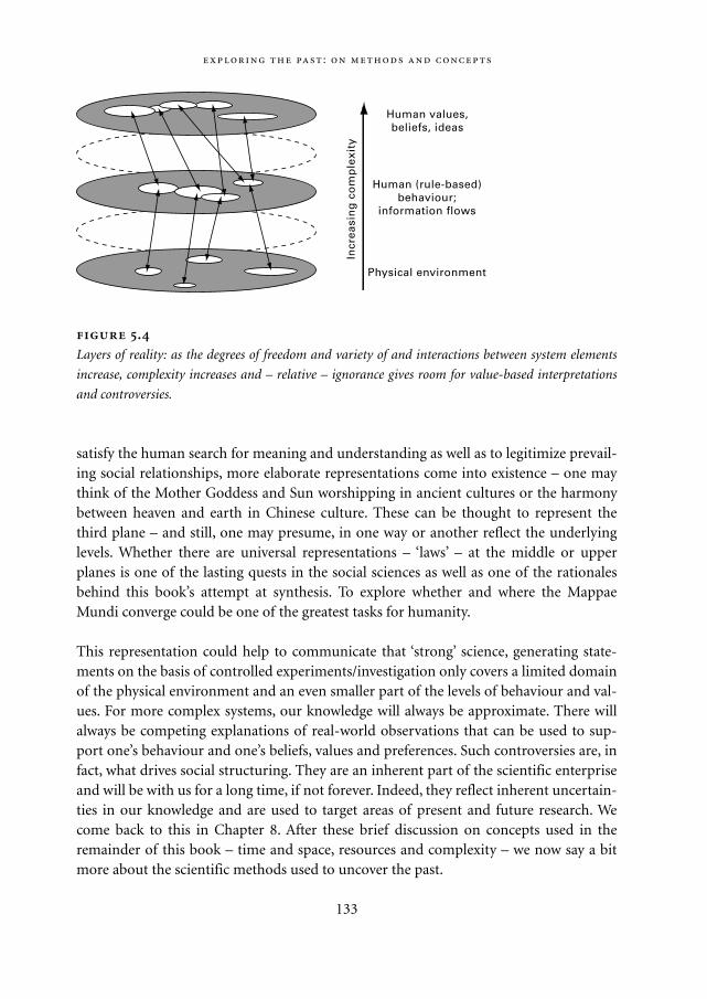
satisfy the human search for meaning and understanding as well as to legitimize prevail-ing social relationships, more elaborate representations come into existence – one maythink of the Mother Goddess and Sun worshipping in ancient cultures or the harmonybetween heaven and earth in Chinese culture. These can be thought to represent thethird plane – and still, one may presume, in one way or another reflect the underlyinglevels. Whether there are universal representations – ‘laws’ – at the middle or upperplanes is one of the lasting quests in the social sciences as well as one of the rationalesbehind this book’s attempt at synthesis. To explore whether and where the MappaeMundi converge could be one of the greatest tasks for humanity.
This representation could help to communicate that ‘strong’ science, generating state-ments on the basis of controlled experiments/investigation only covers a limited domainof the physical environment and an even smaller part of the levels of behaviour and val-ues. For more complex systems, our knowledge will always be approximate. There willalways be competing explanations of real-world observations that can be used to sup-port one’s behaviour and one’s beliefs, values and preferences. Such controversies are, infact, what drives social structuring. They are an inherent part of the scientific enterpriseand will be with us for a long time, if not forever. Indeed, they reflect inherent uncertain-ties in our knowledge and are used to target areas of present and future research. Wecome back to this in Chapter 8. After these brief discussion on concepts used in theremainder of this book – time and space, resources and complexity – we now say a bitmore about the scientific methods used to uncover the past.
:
133
.
Layers of reality: as the degrees of freedom and variety of and interactions between system elements
increase, complexity increases and – relative – ignorance gives room for value-based interpretations
and controversies.
Human values,beliefs, ideas
Human (rule-based)behaviour;
information flows
Physical environment
Incr
easi
ng
co
mp
lexi
ty
Mappae Mundi bw zw/w 08-04-2004 15:25 Pagina 133
5.5. Methods of acquiring knowledge about the past: setting the clock
As part of the scientific endeavour, many methods of scientific enquiry have been devel-oped and refined which are used to investigate past environments and societies. For thepresent purpose, we will only give a brief description of the various methods that have
,
134
A ‘third’ dimension A kind of ‘complexity axis’ has often been proposed. Maybe it
is in the nature of humans to think in terms of hierarchies. Teilhard de Chardin (1963)
advances complexity and interiorization as a third dimension alongside the infinitely
large and the infinitesimally small; his concept of the noösphere is part of the process
of its unfolding. Schumacher introduces it, with reference to Thomas of Aquino, in his
book A Guide for the Perplexed (Schumacher 1977). Shri Aurobindo perceives an evolu-
tion towards an ever higher consciousness (Aurobindo 1998). The Eastern chakra doc-
trine expresses a similar experience. Jantsch puts forward the same vision but in more
recent, scientific terminology in his book The Self-organizing Universe (Jantsch 1980).
Many authors suggest a similar hierarchy from a more worldly orientation. Besides
Marx’s distinction between an infrastructure and a superstructure, one may think of the
spectrum from ‘low’ to ‘high’ human needs proposed by the psychologist Maslow. Daly
used a hierarchist spectrum of values, ranging from worldly means to ultimate spiritual
goals (Daly 1973); Harman founded the Center for Noetic Sciences to explore the fusing
of values and self-image (Harman 1993); recent life-science research points at the exis-
tence of three cerebral layers (Vroon 1989).
All religious teachings point at a value hierarchy, often in association with Good and
Evil, God and the Devil. As Baudelaire expressed it: ‘Il y a dans tout homme, à toute
heure, deux postulations simultanées, l’une vers Dieu, l’autre vers Satan. L’invocation à
Dieu, ou spiritualité, est un désir de monter en rade; celle de Satan, ou animalité, est
une joie de descendre.’ In the Bhagavad Gita Krishna talks about the three qualities of
prakritri, the sanskrit word for nature or the basic energy from which the mental and
physical worlds take shape (Easwaran 1985: 177-178):
Sattva – pure, luminous, and free from sorrow – binds us with attachment
To happiness and wisdom.
Rajas is passion, arising from selfish desire and attachment…
Tamas, born of ignorance, deludes all creatures
through heedlessness, indolence and sleep…
Those who live in sattva go upwards;
Those in rajas remain where they are.
But those immersed in tamas sink downwards.
Mappae Mundi bw zw/w 08-04-2004 15:25 Pagina 134
been developed to make inferences about the past. There are many excellent texts avail-able on the subject (Roberts 1989; Renfrew 1973; Berglund 1986; Lowe 1999; Bradley1998; Cohen 1999). Each of these methods explores part of the many ‘environmental sig-natures’ to be found on earth – and has it particular limitations. By combining a set ofenvironmental proxies the limitations of the individual techniques can be assessed. Forexample, information on hydrological variation is available from reconstructed lake-level dynamics, direct discharge records and the remains of aquatic organisms such asdiatoms or fish bones. Through indirect and direct combination and inference a varietyof information can be extracted from material samples, among which age and climate-parameters and vegetation characteristics are the more important ones. Of course, in theeveryday world of the scientists involved in such explorations, life is much more difficultthan might be deduced from a dry classification of the various methods. In this briefoverview we confine ourselves to a consideration of dating methods.
One of the biggest problems facing the study of past environments, in any sphere, is theestablishment of a robust chronology, determining when the changes we observe in theproxy indicators took place. Placing past environmental change in a temporal contextcan be divided into a series of methodological approaches – those that provide anabsolute date (radiometric and incremental methods) and those that provide a relativechronology. A comprehensive review of these is outside the scope of this chapter;although we do provide a discussion of some of the more common techniques.
:
135
Pollen analyses of sediments The study of past environments often starts by
accessing archives of sediments, such as lakes, ice-caps, mires or oceans. These sedi-
ments are sumps for a range of environmental information on climatic, biotic and
human dynamics. To obtain this information, a core of sediment must be recovered and
a suite of increasingly sophisticated analytical techniques applied to the sediments.
These techniques concentrate on either the physical/chemical character of or on the
biological material incorporated within the sedimentary matrix as it is deposited.
One of the most established techniques to reconstruct past environmental change
comes from plant material, and in particular pollen. Pollen retained in sediments is par-
ticularly suited to unraveling environmental dynamics as they reflect the local and
regional vegetation and are readily preserved. By analyzing fossil pollen, combined
with a dating chronology, it is possible to reconstruct past plant communities at specif-
ic times in the past. When this is carried out from a number of samples, at a number of
different sites, a regional picture of vegetation dynamics through time can be con-
structed. This animation reflects the environmental controls, both climate and cultural,
operating within the area under investigation.
Mappae Mundi bw zw/w 08-04-2004 15:25 Pagina 135
5.5.1. Absolute dating
There are two suites of methods that allow the age of the material under investigation tobe established in years before the present (yr BP): radiometric dating and incrementaldating.
Radiometric dating (using isotopes of carbon, oxygen and other elements)These dating techniques rely on analyzing the difference in decay rates of different iso-topes of the same element. Different techniques and different elements offer a diverseage range, methodology, precision and associated restrictions. Oxygen isotope stratigra-phy measures variation in 18O due to seasonal cooling and can be used to provide a cor-relative chronological framework for many sedimentary records, particularly those frommarine environments that stretch back several million years. Lead (210Pb) and caesium(137Cs) dating are concerned with dating isotopes with a relatively short half-life, but canbe very useful techniques for determining environmental changes over tens to hundredsof years.
One of the most commonly used techniques is that of radiocarbon dating.13 Traces ofradiocarbon 14C are present in all carbon containing materials – wood, charcoal, peat,seeds, bone, ancient pigments, honey and milk, metal casting ores, cloth, eggshell andgroundwater to name but a few. Initially the half-life, i.e. the time it takes for half thesample to disappear, of radiocarbon (14C) was estimated to be 5568 years. The amountof 14C in a sample can be counted to give the so-called 14C age in years before present(14C yr BP). The present is defined by convention as the year 1950 AD because this iswhen a large number of nuclear bombs were exploded resulting in creation of artificialradiocarbon. For example, if only 25% of the original amount of 14C is present in a sam-ple, a date of 11,136 14C yr BP is produced. One of the assumptions behind radiocarbondating method was the constancy of the atmospheric 14C concentration; this has provedto be false with slight variations in the amount of 14C production through time due tochanges in solar activity. Indeed, in addition to being able to provide a chronology, 14Cvariations also provide information on past changes in the cosmic rays, solar activity, theEarth’s magnetic field and the global carbon cycle (Geel 1996).
One of the most exciting developments in radiocarbon dating has been the accelera-tor mass spectrometry (AMS) technique that has allowed for the counting of the actualnumber of 14C atoms rather than an estimation of the percentage present within a gas.The advantages of AMS are the smaller sample sizes required, shorter measuring timesand greater precision afforded (Grove 1992). For example, dates on individual seeds candetermine spatial patterning of the spread of agriculture. The method has significantlyinfluenced archaeological and historical insights. It also provides a good example of howhuman action – in this case, the emission of CO2 from fossil fuel burning and the testingof atomic bombs – can complicate our efforts to uncover the past. These emissions have
,
136
Mappae Mundi bw zw/w 08-04-2004 15:25 Pagina 136
altered the atmospheric ratio of 14C to 12C so that the radiocarbon dating method is oflittle use for samples less than 150 years old. The radiocarbon dating method cannotdate anything older than about 70,000 years and gives interpretative limitations on datesin excess of 20,000 years.
Incremental datingThis suite of techniques relies on the regular accumulation of biological or lithologicalmaterial through natural processes. These are quite diverse, from sedimentary basinsthat accumulate a layer of sediment following every summer, trees and stalagmites andcorals with annual accumulations of carbonate, and lichens with a known growth ratefrom a central point. By either counting and/or measuring these accumulations one candevelop a chronology. One of the best known techniques is dendrochronology or tree-ring counting. This method is based on the natural growth process of trees; by countingthe number of growth rings between the bark and the centre of a living tree, the age ofthe tree can be determined. How far back one can go depends on the tree age. Some trees
:
137
Age equivalence dating A group of methods are used to determine age equiva-
lence: they are concerned with the recognition of simultaneity of processes. Such
‘marker horizons’ are quite diverse and can be found under a range of environments.
Most systems that involve fluid dynamics result in marker horizons that can provide an
insight into past environments and a relative date for an event. Where there is either a
well-established chronology or a distinctive stratigraphic marker, these can be used to
infer a date or to identify an event across a spatial range. One good example of such an
application comes from volcanic ash or tephra. These form around a volcanic source
and can be quite extensive for large eruptions. Where these are identified by their com-
position (Fe-Ti oxide, glass, ferromagnesian, mineralogy) and dated by a radiometric
method, tephra layers can provide clearly defined time markers that allow for correla-
tion across broad geological areas. However, multiple dates on a single tephra show
considerable intra-sample variation and indicate that obtaining dates for tephra is not a
simple process (Newton 1999). If not associated with independent age estimates they
can still be a good marker horizon.
These include desert dune systems, river terraces, former coastlines, old shoreline
knick points and littoral deposits resulting from Holocene period lake fluctuations. In
areas that were subjected to glacial action in the past, such as high latitudes or alti-
tudes, the past action of the ice will leave sediment behind, usually in linear accumula-
tions called moraines. For example evidence from montane glaciation has been suc-
cessfully used to reconstruct environmental change in tropical Africa, these being
placed within a robust chronology (Osmaston 1989).
Mappae Mundi bw zw/w 08-04-2004 15:25 Pagina 137
are very long lived – for example, the North American bristlecone pine lives to 4000 years.The technique can be extended back in time by accessing trees that have died and
become preserved in accumulated sediments or in buildings. Tree ring chronologiesfrom different sources can be matched together like the pieces of a jigsaw to positionwood of an unknown date. By cross-dating sequences of tree rings from dead trees orwood, it is possible to push dendrochronological records back far beyond the age of liv-ing trees. For example, ancient conifer logs in western Tasmania have provided a 11,600-year span of precise dating at annual resolution. Such records also provide a master cali-bration curve, which is associated with radiocarbon dates to correct for pastatmospheric fluctuations in 14C concentrations and give ages in calendar years. In thisway, they give a basic reference for radiocarbon laboratories worldwide. These are usedthroughout this book. This technique of dating has the added value of providing infor-mation on past environmental change. The width, character and chemical compositionof the individual rings is an indicator of climatic (temperature, rainfall, seasonality, etc.)and environmental (CO2 concentration, nutrient status, fire incidence, etc.) circum-stances. Stalagmites and coral also develop seasonal incremental growth bands and alsocontain high-resolution late Holocene palaeo-environmental information for construct-ing past chronologies and information on past environments.
5.5.2. Relative estimates of age
This suite of techniques is used to establish the relative order of antiquity – it is similarto the previously mentioned phaseology. The relative age of a landform or sedimentaryunit can be derived from the degree of transformation resulting from a physical orchemical degradation process operating through time. One of the main areas wherethese techniques are applied, usually in combination, are cultural development stages.One technique is the direct analysis of past occupation layers and the associated artefactssuch as pottery, metal work, clothing and tools. Some of the oldest cultural reconstruc-tions are carried out on skeleton types with the hominid finds being placed into recog-nizable species groups on skull morphology. Following these developments a chronolo-gy of the use of tools has been produced – early pebble cultures were replaced by workedstone, and became more refined and specialized as tool manufacture developed. Morerecently in human prehistory, artefact styles such as pottery type are often used to tracethe transitions for one cultural group, particularly as there is a well-documented tempo-ral succession of pottery styles. Another well-established chronological framework with-in which to place temporal constraints is derived from characterizing the metallurgypractised. This is well established in Europe with its transition from copper to tin tobronze to iron. Additional sources of information come from the modern compositionand distribution of ethnic groups, historical evidence and linguistic analysis. For exam-
,
138
Mappae Mundi bw zw/w 08-04-2004 15:25 Pagina 138
ple, the Bornu chronicles contain information about the Lake Chad region from wellbefore 500 yr BP and can be an excellent source of information on droughts, faminesand prosperous periods. Egyptian hieroglyphs, ancient texts of the Maya amongst otherprehistoric ‘texts’ are slowly being recyphered to reveal the information they retainregarding the culture of the time. However, care must be taken to incorporate theserecords in the light of other available information, as propaganda may have been rife inhistorical times. More cryptic are the monuments and building structures which them-selves are in the process of continual re-interpretation.
The range of archaeological investigations indicates not only the growing tendency toremain in one place but also the growth in ritual, an important factor in social cohesion.Similarly to the record of environmental change, the Holocene period is characterized byrecognizable cultural developmental stages; these allow the transition to a centralized,socially structured society observable today to be reconstructed. However, as with thepalaeo-environmental information, the amount of information is skewed towards cer-tain locations and time periods. In common with the data from sedimentary sequences,these temporal divisions should be viewed as plastic: the reality is a transgressive devel-opment from nomadic, hunter-gatherer populations to a food producing society that issettled and socially structured (cf. Chapter 4). These transitions are riddled with numer-ous gaps between the living world and the proxy traces, and it is these gaps that fuelongoing research. As new techniques become available and established techniques devel-op, new insights into the ‘established’ reconstruction of the past and the relationship ofthe present are developing.
5.6. The potential for human habitation and stages ofagricultural development
We end this chapter with an attempt to give a quantitative impression of the density ofhuman populations in the past, using the ideas of carrying capacity and agriculturalstages. Carrying capacity is a well-known concept in ecology, defined as the maximumpopulation of a given organism that a particular environment can sustain. It implies acontinuing yield without environmental damage or degradation. The concept is not asclear as it may seem: both the organism and the environment, including all other organ-isms, are usually in a continuous process of mutual change and adjustment. Notablyhuman interventions may change the carrying capacity by controlling other species,influencing soil and river streams. As a result, the carrying capacity for human popula-tions can only be defined in a dynamic context, using a proxy for the ‘development stage’to include the appropriate interventions and consequences. Figure 5.5 is a way of visual-izing the dynamic character of the carrying capacity. At a given site a human group mayevolve to a situation in which they reach the carrying capacity for a given environment
:
139
Mappae Mundi bw zw/w 08-04-2004 15:25 Pagina 139
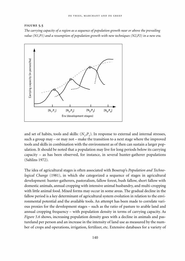
and set of habits, tools and skills: (N1,P1). In response to external and internal stresses,such a group may – or may not – make the transition to a next stage where the improvedtools and skills in combination with the environment as of then can sustain a larger pop-ulation. It should be noted that a population may live for long periods below its carryingcapacity – as has been observed, for instance, in several hunter-gatherer populations(Sahlins 1972).
The idea of agricultural stages is often associated with Boserup’s Population and Techno-logical Change (1981), in which she categorized a sequence of stages in agriculturaldevelopment: hunter-gatherers, pastoralism, fallow forest, bush fallow, short fallow withdomestic animals, annual cropping with intensive animal husbandry, and multi-croppingwith little animal food. Mixed forms may occur in some areas. The gradual decline in thefallow period is a key determinant of agricultural system evolution in relation to the envi-ronmental potential and the available tools. An attempt has been made to correlate vari-ous proxies for the development stages – such as the ratio of pasture to arable land andannual cropping frequency – with population density in terms of carrying capacity. AsFigure 5.6 shows, increasing population density goes with a decline in animals and pas-tureland per person and an increase in the intensity of land use as measured by the num-ber of crops and operations, irrigation, fertilizer, etc. Extensive databases for a variety of
,
140
Carr
ying
cap
acity
(in
pers
on/h
a)
Era (development stages)
[N1,P1] [N2,P2] [N3,P3] [N4,P4]
.
The carrying capacity of a region as a sequence of population growth near or above the prevailing
value (N1,P1) and a resumption of population growth with new techniques (N2,P2) in a new era.
Mappae Mundi bw zw/w 08-04-2004 15:25 Pagina 140
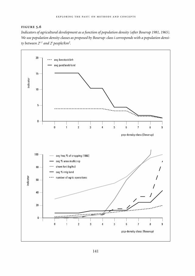
:
141
.
Indicators of agricultural development as a function of population density (after Boserup 1981, 1965).
We use population density classes as proposed by Boserup: class i corresponds with a population densi-
ty between 2i-1 and 2i people/km2.
Mappae Mundi bw zw/w 08-04-2004 15:25 Pagina 141
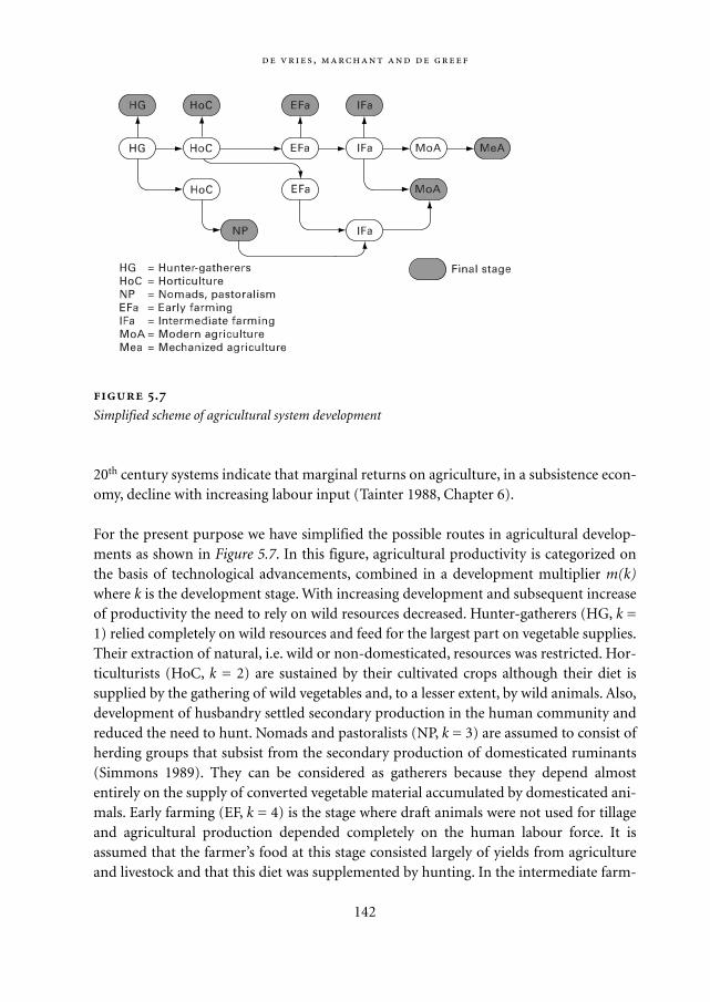
20th century systems indicate that marginal returns on agriculture, in a subsistence econ-omy, decline with increasing labour input (Tainter 1988, Chapter 6).
For the present purpose we have simplified the possible routes in agricultural develop-ments as shown in Figure 5.7. In this figure, agricultural productivity is categorized onthe basis of technological advancements, combined in a development multiplier m(k)where k is the development stage. With increasing development and subsequent increaseof productivity the need to rely on wild resources decreased. Hunter-gatherers (HG, k =1) relied completely on wild resources and feed for the largest part on vegetable supplies.Their extraction of natural, i.e. wild or non-domesticated, resources was restricted. Hor-ticulturists (HoC, k = 2) are sustained by their cultivated crops although their diet issupplied by the gathering of wild vegetables and, to a lesser extent, by wild animals. Also,development of husbandry settled secondary production in the human community andreduced the need to hunt. Nomads and pastoralists (NP, k = 3) are assumed to consist ofherding groups that subsist from the secondary production of domesticated ruminants(Simmons 1989). They can be considered as gatherers because they depend almostentirely on the supply of converted vegetable material accumulated by domesticated ani-mals. Early farming (EF, k = 4) is the stage where draft animals were not used for tillageand agricultural production depended completely on the human labour force. It isassumed that the farmer’s food at this stage consisted largely of yields from agricultureand livestock and that this diet was supplemented by hunting. In the intermediate farm-
,
142
.
Simplified scheme of agricultural system development
Mappae Mundi bw zw/w 08-04-2004 15:25 Pagina 142
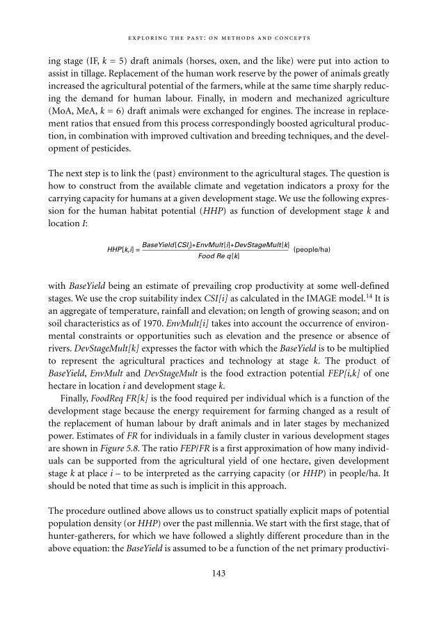
ing stage (IF, k = 5) draft animals (horses, oxen, and the like) were put into action toassist in tillage. Replacement of the human work reserve by the power of animals greatlyincreased the agricultural potential of the farmers, while at the same time sharply reduc-ing the demand for human labour. Finally, in modern and mechanized agriculture(MoA, MeA, k = 6) draft animals were exchanged for engines. The increase in replace-ment ratios that ensued from this process correspondingly boosted agricultural produc-tion, in combination with improved cultivation and breeding techniques, and the devel-opment of pesticides.
The next step is to link the (past) environment to the agricultural stages. The question ishow to construct from the available climate and vegetation indicators a proxy for thecarrying capacity for humans at a given development stage. We use the following expres-sion for the human habitat potential (HHP) as function of development stage k andlocation I:
with BaseYield being an estimate of prevailing crop productivity at some well-definedstages. We use the crop suitability index CSI[i] as calculated in the IMAGE model.14 It isan aggregate of temperature, rainfall and elevation; on length of growing season; and onsoil characteristics as of 1970. EnvMult[i] takes into account the occurrence of environ-mental constraints or opportunities such as elevation and the presence or absence ofrivers. DevStageMult[k] expresses the factor with which the BaseYield is to be multipliedto represent the agricultural practices and technology at stage k. The product ofBaseYield, EnvMult and DevStageMult is the food extraction potential FEP[i,k] of onehectare in location i and development stage k.
Finally, FoodReq FR[k] is the food required per individual which is a function of thedevelopment stage because the energy requirement for farming changed as a result ofthe replacement of human labour by draft animals and in later stages by mechanizedpower. Estimates of FR for individuals in a family cluster in various development stagesare shown in Figure 5.8. The ratio FEP/FR is a first approximation of how many individ-uals can be supported from the agricultural yield of one hectare, given developmentstage k at place i – to be interpreted as the carrying capacity (or HHP) in people/ha. Itshould be noted that time as such is implicit in this approach.
The procedure outlined above allows us to construct spatially explicit maps of potentialpopulation density (or HHP) over the past millennia. We start with the first stage, that ofhunter-gatherers, for which we have followed a slightly different procedure than in theabove equation: the BaseYield is assumed to be a function of the net primary productivi-
:
143
HHP [k,i] =BaseYield [CSIi]*EnvMult [i]*DevStageMult [k]
(people/ha)Food Re q [k]
Mappae Mundi bw zw/w 08-04-2004 15:25 Pagina 143
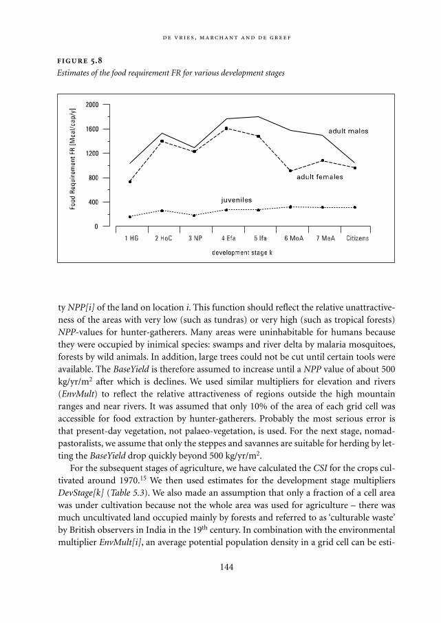
ty NPP[i] of the land on location i. This function should reflect the relative unattractive-ness of the areas with very low (such as tundras) or very high (such as tropical forests)NPP-values for hunter-gatherers. Many areas were uninhabitable for humans becausethey were occupied by inimical species: swamps and river delta by malaria mosquitoes,forests by wild animals. In addition, large trees could not be cut until certain tools wereavailable. The BaseYield is therefore assumed to increase until a NPP value of about 500kg/yr/m2 after which is declines. We used similar multipliers for elevation and rivers(EnvMult) to reflect the relative attractiveness of regions outside the high mountainranges and near rivers. It was assumed that only 10% of the area of each grid cell wasaccessible for food extraction by hunter-gatherers. Probably the most serious error isthat present-day vegetation, not palaeo-vegetation, is used. For the next stage, nomad-pastoralists, we assume that only the steppes and savannes are suitable for herding by let-ting the BaseYield drop quickly beyond 500 kg/yr/m2.
For the subsequent stages of agriculture, we have calculated the CSI for the crops cul-tivated around 1970.15 We then used estimates for the development stage multipliersDevStage[k] (Table 5.3). We also made an assumption that only a fraction of a cell areawas under cultivation because not the whole area was used for agriculture – there wasmuch uncultivated land occupied mainly by forests and referred to as ‘culturable waste’by British observers in India in the 19th century. In combination with the environmentalmultiplier EnvMult[i], an average potential population density in a grid cell can be esti-
,
144
.
Estimates of the food requirement FR for various development stages
Mappae Mundi bw zw/w 08-04-2004 15:25 Pagina 144
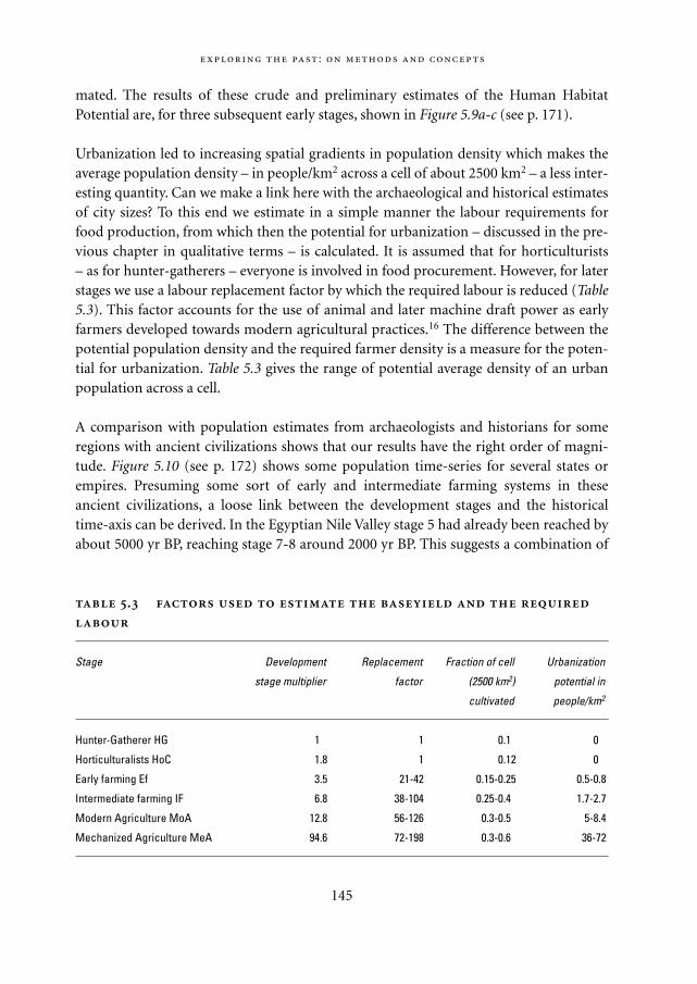
mated. The results of these crude and preliminary estimates of the Human HabitatPotential are, for three subsequent early stages, shown in Figure 5.9a-c (see p. 171).
Urbanization led to increasing spatial gradients in population density which makes theaverage population density – in people/km2 across a cell of about 2500 km2 – a less inter-esting quantity. Can we make a link here with the archaeological and historical estimatesof city sizes? To this end we estimate in a simple manner the labour requirements forfood production, from which then the potential for urbanization – discussed in the pre-vious chapter in qualitative terms – is calculated. It is assumed that for horticulturists– as for hunter-gatherers – everyone is involved in food procurement. However, for laterstages we use a labour replacement factor by which the required labour is reduced (Table5.3). This factor accounts for the use of animal and later machine draft power as earlyfarmers developed towards modern agricultural practices.16 The difference between thepotential population density and the required farmer density is a measure for the poten-tial for urbanization. Table 5.3 gives the range of potential average density of an urbanpopulation across a cell.
A comparison with population estimates from archaeologists and historians for someregions with ancient civilizations shows that our results have the right order of magni-tude. Figure 5.10 (see p. 172) shows some population time-series for several states orempires. Presuming some sort of early and intermediate farming systems in theseancient civilizations, a loose link between the development stages and the historicaltime-axis can be derived. In the Egyptian Nile Valley stage 5 had already been reached byabout 5000 yr BP, reaching stage 7-8 around 2000 yr BP. This suggests a combination of
:
145
.
Stage Development Replacement Fraction of cell Urbanization
stage multiplier factor (2500 km2) potential in
cultivated people/km2
Hunter-Gatherer HG 1.0 1 0.10 0.0
Horticulturalists HoC 1.8 1 0.12 0.0
Early farming Ef 3.5 21-42 0.15-0.25 0.5-0.8
Intermediate farming IF 6.8 38-104 0.25-0.40 1.7-2.7
Modern Agriculture MoA 12.8 56-126 0.3-0.50 5-8.4
Mechanized Agriculture MeA 94.6 72-198 0.3-0.60 36-72
Mappae Mundi bw zw/w 08-04-2004 15:25 Pagina 145
higher fertility and more advanced practices than in almost any other world region atthe time – the other civilizations were at stages 1-2 and 3-5 respectively in those years.
One serious error in our estimates of population densities at higher developmentstages is the omission of transport and trade. Whereas in subsistence economies the areafor food provision had to be within a few hours walk, the advanced means of transporthave increased this to much larger distances (cf. Chapter 6). River valleys and deltas andcoastal areas provided opportunities for transport and trade; this often stimulated habi-tation and settlement formation far beyond the potential for local food extraction.17 Theavailability of resources such as wood or metal ores often had similar consequences. Insuch situations a much higher population density could be sustained and the urbaniza-tion was much higher than estimates from the potential for local food extraction wouldindicate (cf. Section 4.4.2). This situation certainly prevailed in such centres as ancientEgypt, Mesopotamia, Greece and Mexico. It was even more obvious in later metropoli-tan areas such as Rome, Xi’an, Istanbul and Bagdad. One can get an impression of thiseffect by associating each development stage with a distance across which bulk transportof food was economic.
5.7. Conclusions
To acquire knowledge about past human-environment interactions, we need concepts toclassify and organize ‘the facts’ derived from observations using increasingly sophisticat-ed techniques. These scientific facts have to be contextualized to become more than anincoherent sequence of material and mental objects. The analysis undertaken in thisbook is largely according to the rules of the reductionist-empiricist science and biasesare unavoidable. Models in the sense of more or less formal representations of observa-tions – ‘mental maps’ – are a necessary tool in this process. Some ‘archetypical’ modelsabout human-environment interactions, such as logistic growth against hard or soft lim-its, can be helpful in communicating basic ideas. However, they are simplifications andtheir use may be misleading, like the use of analogues and metaphors.
Two essential concepts in this book are time and space. Both have been and are usedby humans to orient themselves. It should be realized that as such they are socially con-structed and hence have been experienced differently by peoples in different times andplaces. As a social construct they bridge the personal, subjective and ‘scientific’ objectivenature of experience of time and space. Another key concept is complexity – socio-natu-ral systems are complex systems. The notion of complexity appears to be at the centre ofan attempt to go beyond the limitations of classical Newtonian science. There is not yet awell-defined ‘theory of complexity’ and knowledge of complex systems will probablyalways remain approximate. Yet, the inclusion of individual agents with rules and infor-mation exchanges into simulation models, possible thanks to huge increases in comput-
,
146
Mappae Mundi bw zw/w 08-04-2004 15:25 Pagina 146

ing power, give a deeper understanding in complex socio-natural systems. Relating com-plexity to an ascending order of intentional consciousness may diminish the mutualmisunderstanding and misappreciation of ‘strong’ natural science on the one hand and‘soft’ social sciences on the other – an issue at the heart of this book.
Many of the stories presented in this book are based on scientific evidence. It is there-fore important to understand the techniques and methods used, in particular for dating,and their strong and weak points. Only in such a way one can appreciate their relevancein the construction of – sometimes quite divergent – stories and models. A first, tentativesketch of the potential human habitat is given and can possibly serve as an experiment insynthesizing various approaches, insights and data into a broad time-space framework.
:
147
Mappae Mundi bw zw/w 08-04-2004 15:25 Pagina 147

Mappae Mundi bw zw/w 08-04-2004 15:25 Pagina 148
6
Increasing Social Complexity
… des populations denses sont généralement douées d’une civilisation supérieure:
elles ont en effet su résoudre les problèmes économiques, techniques, sociaux et
politiques posés par les fortes densités.
Gourou 1947: 3
6.1. Introduction
One of the great questions about human societies is how they emerged and transformed– and sometimes decayed – in the face of environmental change. With increased capabil-ities to use animals, store food and manage water supplies came a surplus of foodexceeding the needs for bare survival. This allowed the rise of warriors and priests,administrations, palaces and temples – at least so the story goes. It has been related inprevious chapters as the process of agrarianization, with many linked driving forces spe-cific to given cultures and ecological regimes. Within each group of humans there wouldhave been individuals with different skills and traits. Each group was confronted withdifferent environmental opportunities and threats – and neighbours – and evolved in acontinuous process of response and adaptation. Among some, the dominant trend mayhave been to live ‘the good life’. Among many, the increase in social complexity occurredin response to the need and wish to bring forth food, water and shelter from an exactingand unpredictable natural environment. In the process, some groups settled down anddeveloped forms of agro-pastoralism that developed into large-scale land clearing andirrigation efforts; others never settled down remaining mobile nomads with large animalherds. Often neighbouring groups of humans became an ever greater enemy and warand migrations – as well as trade – intensified.
In previous chapters the natural environment has been described as a backgroundagainst which the first steps into the second, agricultural regime were set. We now focus
149
Mappae Mundi bw zw/w 08-04-2004 15:25 Pagina 149
on the further unfolding of social complexity because it is an essential component of anymeaningful understanding and interpretation of the human-environment relationship.1
Both extensive and intensive growth of human populations and their activities led tomore intense and widespread interference with the environment and to the spreadingand spatial concentrations of populations. The natural environment was the setting thatprovided the means for such an increase in complexity – or failed to do so. What was the role of the natural environment as a formative resource and as a constraining force? What were the effects of environmental change? And what was the role of themajor transmission mechanisms: trade, conquest and migration? Social organizationhas partly evolved in response to opportunities for new and improved ways of life and tonatural disasters. Can variation in the environment explain the nature of social organi-zation and symbolic complexity and the associated social stratifications? And to whatextent was the perception of environmental resources and risks a major determinant ofhow social complexity took shape? Our approach here is to first present a set of narra-tives.
6.2. Manifestations of increasing social complexity
As human groups increased in size, they learned to store food to overcome natural lim-itations; with it came tools, transport devices and storage rooms. Specialization in cer-tain skills began – fishing, hunting, stone quarrying, house building, pottery, metal-and tool making, boat construction. Trading along trade corridors evolved, market-places became nodes in an emerging transport infrastructure. It was often one of the
150
Mysteries – science’s atrium? Could it be that, as a convergence of research re-
sults from geology, astronomy, palaeo-climatology and archaeology suggests to some,
that there have been grand civilizations as long ago as 12,000 yr BP? At present we are
largely ignorant, it seems, about their interaction with the natural environment. One
hypothesis is that the large climate changes coincident with the end of the last glacial
period have largely wiped out such civilizations. Antarctica may have been involved
and some of their achievements may have been transmitted to the better known
ancient civilizations – Atlantis, after all (Hancock 1995). Another hypothesis is that some
9500 years ago the rapid rise in sea level caused the Mediterranean Sea to overflow
into the Black Sea which by then may have shrunk to the size of a rather small lake
(Ryan 1998). Although controversial, it might explain recent insights into the early cul-
tures in the Balkans and the waves of immigration into Europe. Enough riddles remain
to keep future generations of curious scientists at work, if only to refute modern myths.
Mappae Mundi bw zw/w 08-04-2004 15:25 Pagina 150
more feasible and successful strategies to reduce risks – of famine, for instance, and ofwar. In the process, individual households and villages became more dependent uponeach other – an unintended but inevitable consequence of increasing interaction (cf.Table 5.2). A concurrent process was social stratification (cf. Section 4.4.2). In the ascentto complexity, bands with familial bonds and common residence evolved into commu-nities with land- or property-holding social units and elaborate ceremonies and rituals.Social ranks with differentiation in ownership and access to resources appeared: thechief was born with acclaimed noble birth, a special relationship with the gods and theright to community support and tribute. These chiefdoms often already had large pop-ulations with thousands living in villages. It was only one more step towards the state.At this point came the classes of soldiers, priests and kings, of merchants and adminis-trators, who were given part of the food surplus as a reward for real or imaginary tal-ents: physical superiority for good (protection) or bad (extortion), sacred knowledgenecessary for rituals, divine ancestry, goods and means of transport for exchange, pro-cedural or informational power. An urban-rural divide started to develop, with largervariations in population density. Complexity manifested itself in increasing spatialinteraction, social stratification and demographic and cultural heterogeneity. Let ustake a closer look at these developments and follow some of the traces left: the mega-liths, the mines and the deforested lands, and the trading and migration routes, beforewe engage into a more in-depth exploration of the early states and their relationshipwith the environment.
6.2.1. Megaliths
An early sign of humans emerging above mere survival are forms of ritual and art. Con-structions of large stones – megaliths – have existed in Africa and the Mediterranean. Asrecounted in Chapter 3, large megaliths embedded in the Late Neolithic period formingstone circles and aligned to the sun have been found in the western Central Sahara pre-dating most of the megalithic features of Europe. Megalithic cultures were widespread inlarge parts of Europe, with large mounds and graves built around 5000-7000 yr BP.Many of them are on the island of Sardinia, which must have been densely populated bythen – perhaps 200,000-300,000 inhabitants, 10% of its present value (Cavalli-Sforza1995). The megalith constructions on the island of Malta are well known. The archaeol-ogist Evans suggested that ‘no more peaceable society seems ever to have existed’ thanthese Neolithic cultures of Malta, but this peaceful and bountiful life came to an abruptend around 4500 yr BP.
The reasons why this flourishing and vibrant civilization disappeared are as obscure and
mysterious as those that resulted in the end of Catal Huyuk [in Anatolia]. Evans… sought
151
Mappae Mundi bw zw/w 08-04-2004 15:25 Pagina 151
to explain this by an invasion of war-like people. Gimbutas has suggested that perhaps the
natural resources of the island could no longer sustain its inhabitants and deforestation or
crop failure may have brought famine, disease and other disasters in its wake. (Rudgley
1998: 23-24)
The Megalithic cultures do suggest a rather independent development in Europe. Thiscould also be the case for the Balkans, where recent excavations suggest civilizationaldevelopments possibly independent of the Mycenaean-Aegean cultures (Bailey 2000;Renfrew 1973). Numerous Neolithic sites have been found in the Danube Basin withartefacts with an estimated age of 8000 years. Remains of large shrines have been uncov-ered. The site of Lepenski Vir near Belgrade is, according to its excavator Srejovic, ‘proofthat the Mesolithic is not the ‘dark age’ of European prehistory but only a prolongedperiod of gestation… and that Europe did not have to borrow from the Near East inorder to rise above the past.’ (quoted in Rudgley 1998: 26). There has been a long debateabout the origin of the Megalithic monuments along Europe’s Atlantic Coast. Beforeradiocarbon and dendrological dating methods, it was hypothesized that these largeburial monuments had their origin in the Eastern Mediterranean. It became apparentthat they are older than the Cretan and Mycenaean cultures of the 4th millennium BP(Renfrew 1973). It may well be that these monuments originated from Mesolithic peoplewho developed a more elaborate burial ritual in consequence of the evolution of farm-ing communities and the associated increasing population densities.
Whatever the precise origins and meaning, these monuments dated between 7000and 3000 yr BP stand as durable examples of human artefacts. It seems that thecolonists settling on islands such as Malta and Corsica were able to create a surplus suf-ficient to erect huge temple and grave buildings. In all of these situations, it is theorganization of people that is a reflection as well as a determinant of their relationshipwith the natural environment. The megaliths may be an expression of some sort ofmore intense – peaceful – competition between neighbouring groups, leading to moreelaborate celebrations, gift exchanges and memorials and itself a possible consequenceof rising population densities. There are similar peaceful competition examples in his-tory: the medieval towers of San Gimignano in Tuscany or the huge skyscraper officebuildings in today’s megacities, for instance. Comparison with more recent populationsin the Pacific, for instance on Tahiti and Easter Island, and with present-day farmingcommunities in Asia also suggests such social dynamics. It is tempting to compare theorganization of the small communities in the Orkney Islands who constructed theMegalithic burial mounds some 5000-6000 years ago with what has been created muchlater on Easter Island (Renfrew 1973). The scarce historical evidence also suggests thathere, too, competition may have been at the root of collapse from environmental over-exploitation.
152
Mappae Mundi bw zw/w 08-04-2004 15:25 Pagina 152
153
The story of Easter Island A famous example of how a finite island environment
posed limits to human expansion and how people responded to the resulting feedback
loop is Easter Island, the small island in the Pacific Ocean which was ‘discovered’ by
the Dutch admiral Roggeveen on Easter Sunday 1722 (Ponting 1991; Redman 1999;
Renfrew 1973). When he set foot on this small (400 km2) island in the Pacific Ocean, it
had a primitive society ‘with about 3000 people living in squalid reed huts or caves,
engaged in almost perpetual warfare and resorting to cannibalism in a desperate
attempt to supplement the meagre food supplies on the island.’ (Ponting 1991: 1) Scat-
tered across the island were over 600 massive stone statues that were on average
some 6 metres high. Upon the arrival of the Europeans, the inhabitants of the island
seemed incapable of carving and moving statues and indicated they had no knowledge
of how to do so. A widely accepted explanation of this ‘mystery’ is that deforestation
for ceremonial purposes led to the collapse of this at one time possibly most advanced
Polynesian society with some 7000 inhabitants around 1550.
Ponting (1991) tells the story in a nice, evocative way. Polynesian settlers arrived at
around 1500 yr BP. The island had few resources and the inhabitants mainly lived on a
diet of sweet potatoes and chickens, which was nutritionally adequate and not demand-
ing in terms of labour. In Ponting’s account, it was the combination of plenty of free
time for ceremonial activities and enduring competition and conflict between the tribal
clan centres and chiefs that led to the achievements and subsequent fall of Easter
Island society. Ceremonial activities and the construction of stone statues absorbed
enormous amounts of peasant labour – obsidian stone axes were the only tools. To
transport these huge statues, wood was required as there were no suitable animals.
‘… at the time of the initial settlement Easter Island had a dense vegetation… As the
population slowly increased, trees would have been cut down to provide clearings for
agriculture, fuel for heating and cooking, construction material for household goods,
pole and thatch houses and canoes for fishing. The most demanding requirement of all
was the need to move the large number of enormously heavy statues… The only way
this could have been done was by large numbers of people guiding and sliding them
along a form of flexible tracking made up of tree trunks… Prodigious quantities of tim-
ber would have been required… As a result by 1600 the island was almost completely
deforested.’ (Ponting 1991: 5) Social and ceremonial life came to a standstill, wood for
houses and canoes became scarce and the soil deteriorated. Fish and crops became
more scarce. As chickens became more important, defensive chicken houses were
erected. No more statues were built, belief systems fell apart and with them the legiti-
macy of social organization. Slavery, war and cannibalism followed suit. ‘Against great
odds the islanders… sustained a way of life in accordance with an elaborate set of
social and religious customs that enabled them not only to survive but to flourish… But
Mappae Mundi bw zw/w 08-04-2004 15:25 Pagina 153
6.2.2. Non-agricultural resources
Peoples will consider only those parts of their natural environment as a ‘resource’ if itsomehow fulfils individual or collective needs. Obviously, the existence of availableresources in a certain space-time domain has always been a paramount factor in the evo-lution of human groups. As shown in Chapter 4, location – near a river or a coast, in ahilly area – may be one of the great resources, depending on the context. Obviously, agri-cultural resources such as good soils and water availability, wild plants and animals andgood grazing grounds also make a region attractive. Good places to shelter or materialsto build dwellings and make clothes are other necessary ‘resources’. Organic resourcessuch as reeds for dwellings, fibres such as cotton and hemp for textiles, and animal skinsand bones for various purposes are usually closely related to the agricultural and pas-toral activities. The use of forests as sources of food but also of wood for fuel and con-struction and of medicinal plants applies to all times and places.
The environment provided an initially highly localized but gradually expanding arrayof inorganic resources: rock and clay for construction, salt, mineral ores (gold, silver,copper, iron) for tools and weapons. All of these have ancient origins. All emergingtribes, states and empires had to produce or procure them in one way or another. Indoing so, the natural environment was affected, sometimes in minor and transient ways,sometimes in large and irreversible ways. An increasing number of historical atlases mapsuch resources: limestone, alabaster and granite quarries of the Old and the Nubian goldmines of the Middle and New Kingdom in Egypt (Manley 1996); the bewildering spec-
154
in the end the increasing numbers and cultural ambitions of the islanders proved too
great for the limited resources available to them.’ (Ponting 1991: 6-7)
Several attempts have been made to enhance the understanding of Easter Island
events with help of a mathematical model (Anderies 2000). After all, there are some
intriguing questions here. Why did other Polynesian groups who almost always altered
their environments equally dramatically not collapse? And, even more importantly,
why did the Easter Islanders not respond to the impending catastrophe? Was some
form of institutional adaptation prevented by insufficient ecological understanding or
conflicts between competing groups, or did the decline occur too quickly for such adap-
tation? One interesting suggestion from such model explorations is that the very ability
of the population to increase its work effort and maintain its material well-being was
hiding the feedback loops from the forest resource base so that, when change finally
did occur, it was so thoroughly degraded that the change was too rapid and dramatic
for effective (institutional) response. Such an explanation is consistent with the archae-
ological findings.
Mappae Mundi bw zw/w 08-04-2004 15:25 Pagina 154
trum of raw materials mined and processes in the Harappan culture in the Indus Valley(Lahiri 1992); the timber, wool, ivory and metal resources which were the basis of thePhoenician and Greek trading cultures (McEvedy 1967) to mention only a few of theearliest ones. However, most information on the environmental impact of the resource-using activities, such as forest thinning and cutting and stone quarrying, is qualitativeand circumstantial. Let us have a brief, closer look at some of these resources and thetrading routes that grew up around them.
MiningMineral resources have been an important incentive for trade, as they represented goodswith an added value either because they came from faraway, because they were processedor both. Mining has a long prehistory. Near Norfolk, in Britain, a Mesolithic miningcomplex has been found comprising some 200 shafts approximately 20 metres deep andexcavated with antler picks and bone spades. Flint of very high quality was exported overa well-developed trade network, some as far as southern Europe. Much earlier even,large flintstone ‘blades’ were exported from Grand Pressigny and other sites in the‘Bassin Parisien’ at different times to large parts of continental north-western Europe.Extensive mining took place in ancient Mediterranean civilizations. Gold, silver, copperand tin mines existed throughout the Near and Middle East, East Africa and South Asiaat least as early as 4000 yr BP. There has probably been silver mining in Greece since 3500yr BP. In the mines of Laureion between 10,000 and 30,000 miners were at work in the5th century and there is evidence of a transition from surface to underground mining asmining went on (Sonnabend 1999). Other mining areas of known importance were thePtolemaean gold mines in Nubia, the Spanish mines from Carthaginian times onwardsand the tin mines of Cornwall and Devon. These were large undertakings:
Allein in den Silbergruben von Cartagena sollen zur Zeit der Polybios im 2. Jahrhundert v.
Chr. bis zu 40.000 Arbeiter beschäftigt gewesen sein… Die [im Tagebau] angewandten
Abbaumethoden… waren technologisch ebenso spektakulär, wie sie sich für die Landschaft
und die Umwelt als problematisch erwiesen. Um in Nordwesten Spaniens Alluvialgold, d.h.
von Flüssen im Boden Gold zu gewinnen, nutzten die Römer die Kraft von Wasser. Über kilo-
meterlange Leitungen führten sie dazu das Wasser von Flüssen und Bächen der Umgebung …
Nicht nur durch … rabiate Eingriffe in die Umwelt, sondern auch durch seine räumliche
Konzentration gehörte der antike Bergbau – und mit ihm die Verhüttung der Erze – zu den
neben Wasser- und Städtebau am meisten die Landschaft beeinflussenden und verändernden
Technologien der Antike. (Sonnabend 1999)
The environmental impact often resulted from the large fuel requirements needed forupgrading the primary ore.
155
Mappae Mundi bw zw/w 08-04-2004 15:25 Pagina 155
Salt – sodium chloride – has always been an important resource for humans: the bodyneeds it and it is a food preservative (Sonnabend 1999; Laszlo 1998). Salt was recoveredfrom salt water by evaporation, but there is evidence of underground mining as early as4500 yr BP. In Halstatt near Salzburg in Austria great salt mines – as well as copper mines– were exploited in the pre-Roman Bronze and Iron Ages. Major salt deposits existed inChina and India; it is said that during the Han dynasty there were over 90,000 salt minesin Szechuan. Since ancient times salt has been an important trade item because of itsuneven distribution. For centuries, the Berbers exchanged gold for salt with Africansacross the Saharan desert on a 1-to-1 kg basis: salt was a necessity of life and not locallyavailable. Places where salt was produced used to become settlement centres of trade andtransport. Sometimes salt was the currency of exchange – it is the root of the word‘salary’. The importance of salt led many states to the establishment of salt monopoliesChina in 2650 yr BP, Rome in 2500 yr BP; taxing salt became an important source of staterevenues. Salt mining appears to have been very important in East Africa with some ofthe first initial trade route developing to distribute this resource. Its development allowedfor the preservation of food and thus the ability of populations to buffer against risk.
Mining and mineral processing had all kinds of impacts on the environment. Coppersmelting kilns dating from 3000 yr BP have been found in the Negev desert, producingcopper for the Egyptian Pharaohs. As 1 kg of copper required an estimated 10 kg ofcharcoal to be burnt, huge quantities of wood were needed and these sites may have beenabandoned because of lack of fuel. Later, much larger iron mines and smelters some-times had an equally devastating effect on forests. In some cases the impacts have beentraced through measurements of isotopic composition. An interesting case study is theinvestigation of lead concentrations in dozens of Swedish lakes revealing the history oflead pollution (Renberg 2000). Before 4000 yr BP there are no signs of man-madeatmospheric lead pollution – the lead found came from natural catchment sources. Inthe period 4000-3500 yr BP the first signs of atmospheric lead pollution could be seen insouthern Sweden, rising to a peak during the Roman period (2150-1550 yr BP). TheRoman pollution peak has also been found in lake sediments on the Kola Peninsula inRussia, indicating the wide area impacted. After the Roman period lead concentrationsdeclined to a low level until the end of the 10th century, after which they started risingagain to levels up to ten times the Roman peak in the 20th century. A strong similarity isfound between the pollution records of the sediments and the history of metal produc-tion in Europe. From at most a few tonnes of lead production around 5000 yr BP, itincreased to about 300 tonnes/yr in 2700 yr BP and further to an estimated 80,000tonnes/yr around 1950 yr BP. Smelting released large amounts all over the northernhemisphere. Lead emissions increased partly due to the growing use of silver coins, as sil-ver production from sulphide ores also releases large amounts of lead into the atmos-phere.
156
Mappae Mundi bw zw/w 08-04-2004 15:25 Pagina 156
DeforestationLarge-scale burning of forests and felling of trees may have been one of the earliest andmost intense impacts of humans on the natural landscape. There were two main reasons:land clearing and wood. Land clearing as part of agro-pastoral farming, usually with thehelp of fire, was an intrinsic part of the transition from the fire to the agricultural regime– the term ‘slash-and-burn’ is quite evocative (cf. Chapter 4). Animals also played theirpart, eating leaves and young shoots. Equally important was the felling of trees for thatmagnificent material: wood. Wood for fuel and charcoal, timber for houses, tools, fences,defensive structures and ships. As with so many natural resources, its use had many dele-terious and usually unintended consequences – such as accelerating soil erosion andunsettling local hydrology.
Concern about Mediterranean forest destruction has a long history. Plato’s lamentabout the huge deforestation in Attica, where ‘originally the mountains were heavilyforested’ but which had now – 2500 yr BP – become ‘the skeleton of a body emaciated bydisease’ is well known. As the forests near the population centres disappeared and/ordegraded under the pressures of agriculture, pastoralism and felling, the forests further
157
Deforestation for ceramic ovens in the Roman era, southern France In spite
of high large fuel requirements of most mining and processing, the environmental
impacts need not necessarily be devastating. Nature’s own adaptive capacity and
responsive forest management could limit the damage. Near Béziers, along the Medi-
terranean coast in southern France, the remains have been found of at least 17 fur-
naces that were used to fire pottery kilns during the first three centuries of the Christian
era. Detailed investigations of the charcoal remains (Chabal 2001) allow a rather de-
tailed reconstruction of environmental change during this period. It started around the
year 10 AD in one of the abundantly forested Languedoc plains. Within a few decades
the cutting down of nearby forests led to a vegetation change, reflected in the composi-
tion of the ashes which changed from almost exclusively elm and ash to oak trees, the
latter coming from forests regrown in the deforested areas. Using a simple model and
assumptions about kiln use, type of wood and regrowth rate, it is estimated that maxi-
mum wood use occurred around 40 AD (1900 m3/yr) with some 220 ha exploited. Sub-
sequently, use fell to about 640 m3/yr around 180 AD with 523 ha exploited, the much
lower m3/ha ratio being explained by the increasing use of ‘taillis’. The village got its
wood from within a circle of at most 2.6 kilometres in diameter and the model suggests
that the decline of the ceramic oven works – all kilns were abandoned by 320 AD – had
nothing or not much to do with depletion of the local forest – or at least that its role
was more insidious. Changing economic circumstances, possibly in olive and wine
export, may have played a role.
Mappae Mundi bw zw/w 08-04-2004 15:25 Pagina 157
away came under threat, making some places into major harbours. When Aegean forestsbecame depleted, timber was drawn from the Caucasian and Black Sea coasts. Pressurefurther increased during Roman times.
In China forest clearing for agriculture and tree felling for wood and timber has along and complex history (Elvin 1993). At around 6000 yr BP the climate in most partsof China was warmer and more humid, with forests extending further north and intohigher altitude and less taiga and tundra (Ge Yu 1998). A colder period that lasted withfluctuations until the present began around 3000 yr BP. Consequently, changes in forestcover reflect natural as well as anthropogenic processes. During the 1st millennium BCthe first signs of erosion appeared in the northern and north-western parts of the coun-try, probably related to forest clearing for agriculture and timber for the cities. This mayhave led to more irregular and extreme river flows: the Huang He started to rise abovethe surrounding plain as the first man-made embankments appeared – partly for mili-tary reasons. People started to occupy the fertile sediment areas within these levees,necessitating two enduring hardships of Chinese life: flood risk and repair work.
The Japanese have seriously depleted their forests over the last 2500 years (Totman1989). In the earliest period, around 2250 yr BP, rice culture was well established andcaused the first dramatic modifications of woodlands. Bronze and iron products at firstcame from the continent, but by 1750 yr BP smelting was carried out locally and thedemand for high-quality charcoal increased the pressure on the forests. As metallurgyled to new, more powerful tools, the assault on the woodlands expanded in a positivefeedback loop. A warrior caste emerged with the need for weapons (charcoal), woodenstockade headquarters, large residences, coffins buried in huge mounds – rivalling theEgyptian pyramids – and pottery (wood for firing). In 759 AD 393 seagoing vessels werebuilt to fight the Koreans. Kings and emperors often had to move, possibly because localwood supplies dwindled. Owing to termites and rot, most elaborate wooden buildingshad to be rebuilt every 20 years and so wood demand remained high. Another area ofhigh demand was monasteries, shrines and temples, mostly near Nara and Heian (pres-ent-day Kyoto).
Deforestation had all kinds of consequences, such as wildfire, flooding and erosion,often forcing people to move. Farmers also needed wood for fuel, but also for fodderand, most importantly, for green fertilizer material which sometimes relieved cuttingpressure. The decline of powerful rulers also eased the pressure on forests as there was nowill or capacity to build monumental structures. There were occasional attempts to con-trol the use of woodland on the part of governments and monasteries. Ruling warriorstightened control to assure themselves of resources for military use. It was a history ofoutright exploitation without concern for preservation or reforestation.
When political struggles subsided in the 17th century, population and constructionrose rapidly and the demand for timber soared (Figure 6.1). The demands of the peasantfamilies led to widespread but less intensive use than the more concentrated demands
158
Mappae Mundi bw zw/w 08-04-2004 15:25 Pagina 158
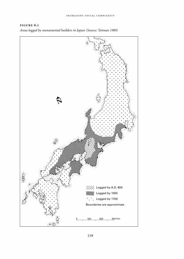
159
.
Areas logged by monumental builders in Japan (Source: Totman 1989)
0 100 200 300 Km
Logged by A.D. 800
Logged by 1550
Logged by 1700
Boundaries are approximate
Mappae Mundi bw zw/w 08-04-2004 15:25 Pagina 159
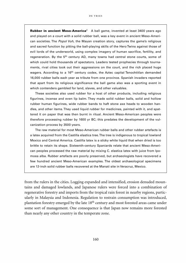
from the rulers in the cities. Logging expanded and intensified, erosion denuded moun-tains and damaged lowlands, and Japanese rulers were forced into a combination ofregenerative forestry and imports from the tropical rain forest in nearby regions, partic-ularly in Malaysia and Indonesia. Regulation to restrain consumption was introduced,plantation forestry emerged by the late 18th century and most forested areas came undersome sort of management. One consequence is that Japan now remains more forestedthan nearly any other country in the temperate zone.
160
Rubber in ancient Meso-America2 A ball game, invented at least 3400 years ago
and played on a court with a solid rubber ball, was a key event in ancient Meso-Ameri-
can societies. The Popol Vuh, the Mayan creation story, captures the game’s religious
and sacred function by pitting the ball-playing skills of the Hero Twins against those of
evil lords of the underworld, using complex imagery of human sacrifice, fertility, and
regeneration. By the 5th century AD, many towns had central stone courts, some of
which could hold thousands of spectators. Leaders tested prophecies through tourna-
ments, rival cities took out their aggressions on the court, and the rich placed huge
wagers. According to a 16th century codex, the Aztec capital Tenochtitlan demanded
16,000 rubber balls each year as tribute from one province. Spanish invaders reported
that apart from its religious significance the ball game also was a sporting event in
which contenders gambled for land, slaves, and other valuables.
These societies also used rubber for a host of other products, including religious
figurines, incense and even lip balm. They made solid rubber balls, solid and hollow
rubber human figurines, wide rubber bands to haft stone axe heads to wooden han-
dles, and other items. They used liquid rubber for medicines, painted with it, and spat-
tered it on paper that was then burnt in ritual. Ancient Meso-American peoples were
therefore processing rubber by 1600 yr BC; this predates the development of the vul-
canization process by 3500 years.
The raw material for most Meso-American rubber balls and other rubber artefacts is
a latex acquired from the Castilla elastica tree. The tree is indigenous to tropical lowland
Mexico and Central America. Castilla latex is a sticky white liquid that when dried is too
brittle to retain its shape. Sixteenth-century Spaniards relate that ancient Meso-Ameri-
can peoples processed the raw material by mixing C. elastica latex with juice from Ipo-
moea alba. Rubber artefacts are poorly preserved, but archaeologists have recovered a
few hundred ancient Meso-American examples. The oldest archaeological specimens
are 12-inch solid rubber balls recovered at the Manatí site in Veracruz, Mexico.
Mappae Mundi bw zw/w 08-04-2004 15:25 Pagina 160
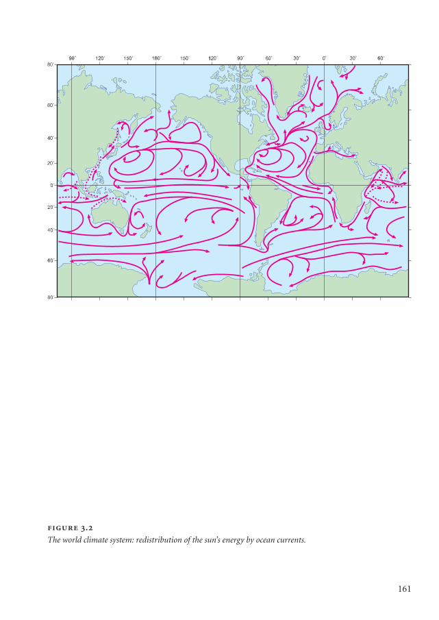
161
.
The world climate system: redistribution of the sun’s energy by ocean currents.
Mappae Mundi kleurk 1 DEF 08-04-2004 15:46 Pagina 161
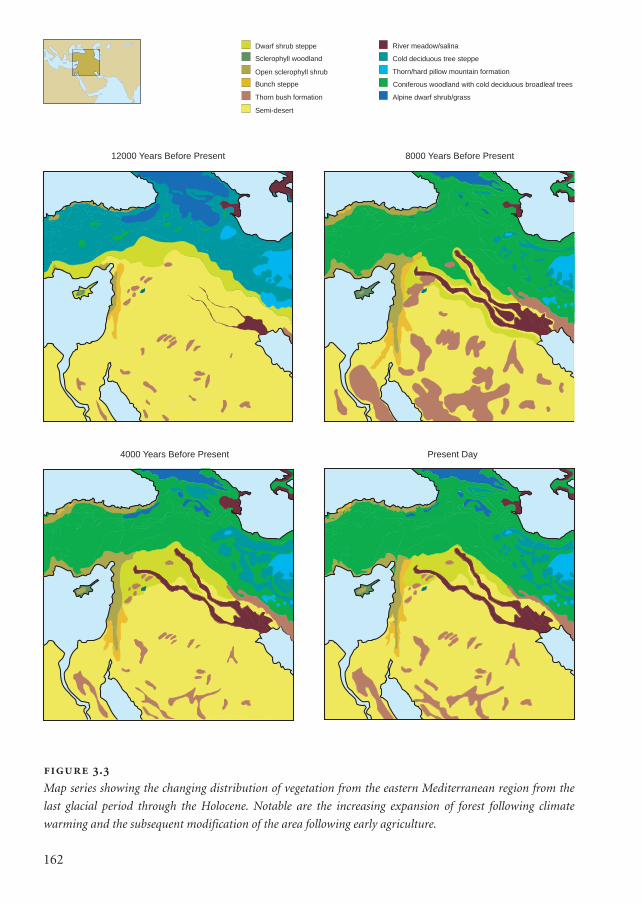
162
12000 Years Before Present 8000 Years Before Present
4000 Years Before Present Present Day
Dwarf shrub steppe
Sclerophyll woodland
Open sclerophyll shrub
Bunch steppe
Thorn bush formation
Semi-desert
River meadow/salina
Cold deciduous tree steppe
Thorn/hard pillow mountain formation
Coniferous woodland with cold deciduous broadleaf trees
Alpine dwarf shrub/grass
.
Map series showing the changing distribution of vegetation from the eastern Mediterranean region from the
last glacial period through the Holocene. Notable are the increasing expansion of forest following climate
warming and the subsequent modification of the area following early agriculture.
Mappae Mundi kleurk 1 DEF 08-04-2004 15:46 Pagina 162
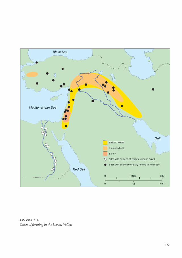
163
.
Onset of farming in the Levant Valley.
Black Sea
Mediterranean Sea
Gulf
Red Sea
Einkorn wheat
Emmer wheat
Barley
Sites with evidece of early farming in Egypt
Sites with evidence of early farmng in Near East
Miles
Km
0
0
500
800
Mappae Mundi kleurk 1 DEF 08-04-2004 15:46 Pagina 163
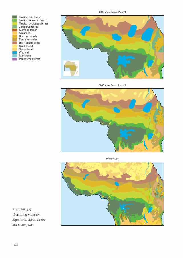
164
.
Vegetation maps for
Equatorial Africa in the
last 6,000 years.
Tropical rain forestTropical seasonal forestTropical deciduous forestJuniperus forestMontane forestSavannahOpen savannahScrub formationOpen desert scrubSand desertStone desertWetlandMangrovePodocarpus forest
Mappae Mundi kleurk 1 DEF 08-04-2004 15:46 Pagina 164
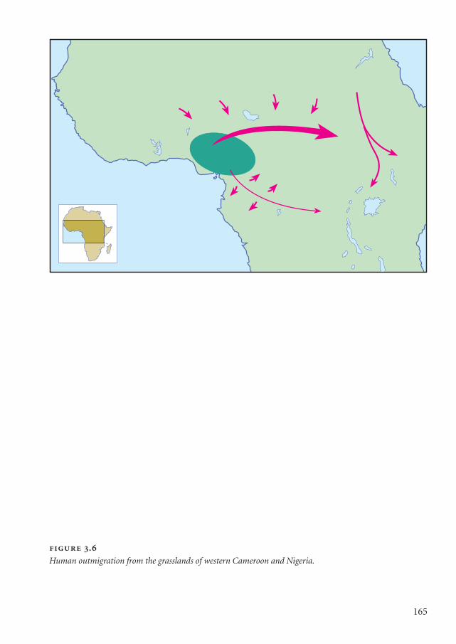
165
.
Human outmigration from the grasslands of western Cameroon and Nigeria.
Mappae Mundi kleurk 1 DEF 08-04-2004 15:46 Pagina 165
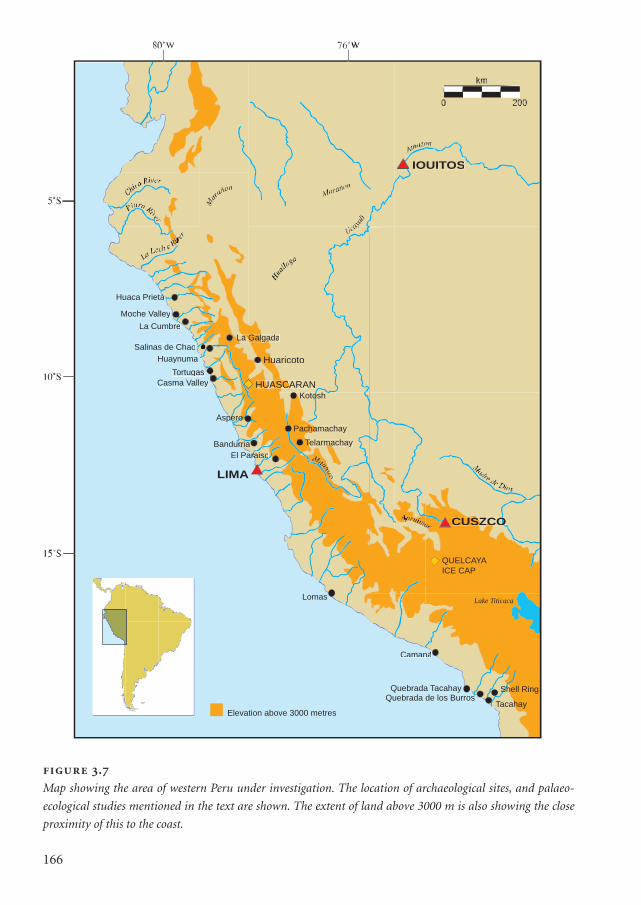
166
IQUITOS
LIMA
SZCOCUSZCSZCO
Huaca Prietaa
Moche Valley
La Cumbre
Salinas de Chao
Huaynuma
Tortugas
Casma Valley
Aspero
Bandurria
El Pararaisoarara o
Kotosh
chamachayPachacha
TelarmachaymamaTeTe
Lomas
Camana
Quebrada TacahayQuebrada de los Burros
Shell Ring
TacahayElevation above 3000 metres
La GalgadaLa GalgaLa Galga
QUELCAYA
ICE CAP
Lake Titicaca
uaricotoHuu
UASCARANHUASCAUASCA
.
Map showing the area of western Peru under investigation. The location of archaeological sites, and palaeo-
ecological studies mentioned in the text are shown. The extent of land above 3000 m is also showing the close
proximity of this to the coast.
Mappae Mundi kleurk 1 DEF 08-04-2004 15:46 Pagina 166
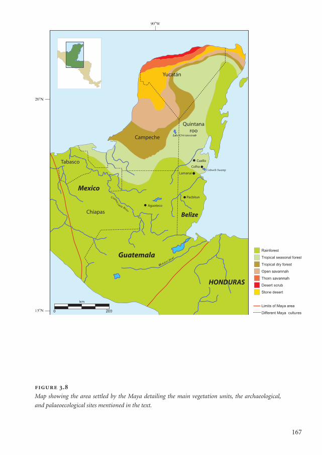
167
.
Map showing the area settled by the Maya detailing the main vegetation units, the archaeological,
and palaeoecological sites mentioned in the text.
HONDURAS
Guatemala
Chiapas
Tabasco
Campeche
Quintanaroo
Yucatán
Belize
MexicoPacbitun
Aguoteco
Lamanai
Colha
Cuello
Cobweb Swamp
Usumoc
imta River
Mappae Mundi kleurk 1 DEF 08-04-2004 15:46 Pagina 167
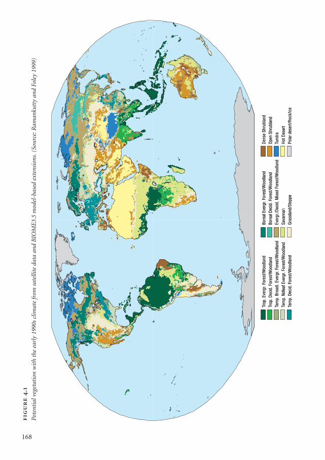
Trop
. Eve
rgr.
Fore
st/W
oodl
and
Trop
. Dec
id. F
ores
t/Woo
dlan
dTe
mp.
Bro
adl.
Ever
gr. F
ores
t/Woo
dlan
dTe
mp.
Ndl
eaf E
verg
r. Fo
rest
/Woo
dlan
dTe
mp.
Dec
id. F
ores
t/Woo
dlan
d
Bore
al E
verg
r. Fo
rest
/Woo
dlan
dBo
real
Dec
id. F
ores
t/Woo
dlan
dEv
ergr
./Dec
id. M
ixed
For
est/W
oodl
and
Sava
nna
Gras
slan
d/St
eppe
Dens
e Sh
rubl
and
Open
Shr
ubla
ndTu
ndra
Hot D
eser
tPo
lar d
eser
t/Roc
k/Ic
e
Trop
. Eve
rgr.
Fore
st/W
oodl
and
Trop
. Dec
id. F
ores
t/Woo
dlan
dTe
mp.
Bro
adl.
Ever
gr. F
ores
t/Woo
dlan
dTe
mp.
Ndl
eaf E
verg
r. Fo
rest
/Woo
dlan
dTe
mp.
Dec
id. F
ores
t/Woo
dlan
d
Bore
al E
verg
r. Fo
rest
/Woo
dlan
dBo
real
Dec
id. F
ores
t/Woo
dlan
dEv
ergr
./Dec
id. M
ixed
For
est/W
oodl
and
Sava
nnah
Gras
slan
d/St
eppe
Dens
e Sh
rubl
and
Open
Shr
ubla
ndTu
ndra
Hot D
eser
tPo
lar d
eser
t/Roc
k/Ic
e
.
Pote
ntia
l veg
etat
ion
wit
h th
e ea
rly
1990
s cl
imat
e fr
om s
atel
lite
data
and
BIO
ME
3.5
mod
el-b
ased
ext
ensi
ons.
(Sou
rce:
Ram
anku
tty
and
Fole
y 19
99)
168
Mappae Mundi kleurk 1 DEF 08-04-2004 15:46 Pagina 168
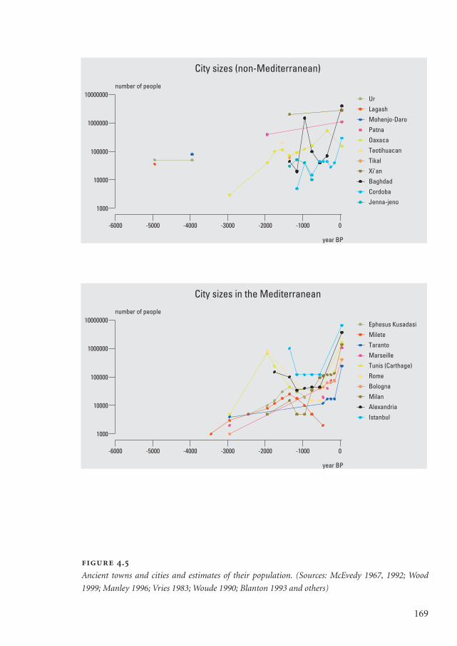
169
.
Ancient towns and cities and estimates of their population. (Sources: McEvedy 1967, 1992; Wood
1999; Manley 1996; Vries 1983; Woude 1990; Blanton 1993 and others)
-6000 -5000 -4000 -3000 -2000 -1000 0
year BP
1000
10000
100000
1000000
10000000number of people
Ur
Lagash
Mohenjo-Daro
Patna
Oaxaca
Teotihuacan
Tikal
Xi'an
Baghdad
Cordoba
Jenna-jeno
City sizes (non-Mediterranean)
-6000 -5000 -4000 -3000 -2000 -1000 0
year BP
1000
10000
100000
1000000
10000000number of people
Ephesus Kusadasi
Milete
Taranto
Marseille
Tunis (Carthage)
Rome
Bologna
Milan
Alexandria
Istanbul
City sizes in the Mediterranean
Mappae Mundi kleurk 1 DEF 08-04-2004 15:46 Pagina 169
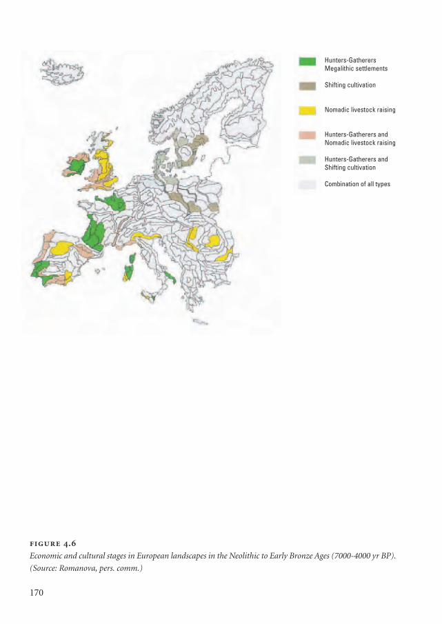
170
.
Economic and cultural stages in European landscapes in the Neolithic to Early Bronze Ages (7000-4000 yr BP).
(Source: Romanova, pers. comm.)
Hunters-GatherersMegalithic settlements
Shifting cultivation
Nomadic livestock raising
Hunters-Gatherers andNomadic livestock raising
Hunters-Gatherers andShifting cultivation
Combination of all types
Mappae Mundi kleurk 1 DEF 08-04-2004 15:46 Pagina 170
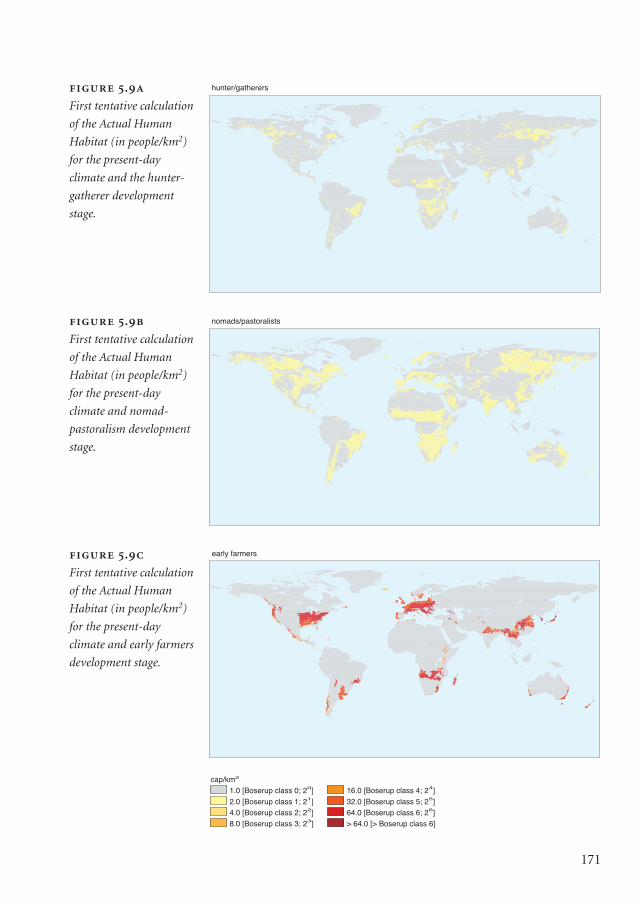
171
hunter/gatherers
nomads/pastoralists
l f
early farmers
1.0 [Boserup class 0; 20]
2.0 [Boserup class 1; 21]4.0 [Boserup class 2; 22]8.0 [Boserup class 3; 23]
16.0 [Boserup class 4; 24]
32.0 [Boserup class 5; 25]64.0 [Boserup class 6; 26]> 64.0 [> Boserup class 6]
cap/km2
.
First tentative calculation
of the Actual Human
Habitat (in people/km2)
for the present-day
climate and the hunter-
gatherer development
stage.
.
First tentative calculation
of the Actual Human
Habitat (in people/km2)
for the present-day
climate and nomad-
pastoralism development
stage.
.
First tentative calculation
of the Actual Human
Habitat (in people/km2)
for the present-day
climate and early farmers
development stage.
Mappae Mundi kleurk 1 DEF 08-04-2004 15:46 Pagina 171
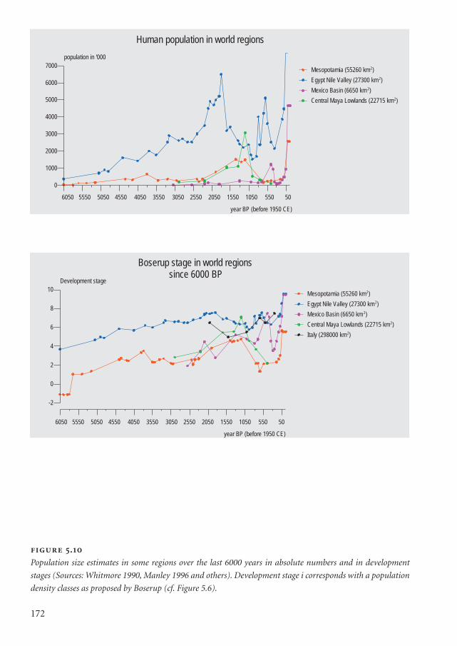
172
.
Population size estimates in some regions over the last 6000 years in absolute numbers and in development
stages (Sources: Whitmore 1990, Manley 1996 and others). Development stage i corresponds with a population
density classes as proposed by Boserup (cf. Figure 5.6).
year BP (before 1950 CE)
-2
0
2
4
6
8
10
Development stage
Mesopotamia (55260 km2)
Egypt Nile Valley (27300 km2)
Mexico Basin (6650 km 2)
Central Maya Lowlands (22715 km2)
Italy (298000 km2)
Boserup stage in world regions since 6000 BP
6050 5550 5050 4550 4050 3550 3050 2550 2050 1550 1050 550 50
0
1000
2000
3000
4000
5000
6000
7000
population in '000
Mesopotamia (55260 km2)
Egypt Nile Valley (27300 km2)
Mexico Basin (6650 km 2)
Central Maya Lowlands (22715 km2)
Human population in world regions
year BP (before 1950 CE)
6050 5550 5050 4550 4050 3550 3050 2550 2050 1550 1050 550 50
Mappae Mundi kleurk 1 DEF 08-04-2004 15:46 Pagina 172
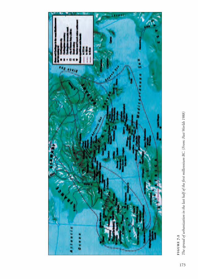
.
The
spr
ead
ofur
bani
zati
on in
the
last
hal
foft
he fi
rst m
illen
nium
BC
.(Fr
om: P
ast W
orld
s 19
88)
173
Mappae Mundi kleurk 1 DEF 08-04-2004 15:46 Pagina 173
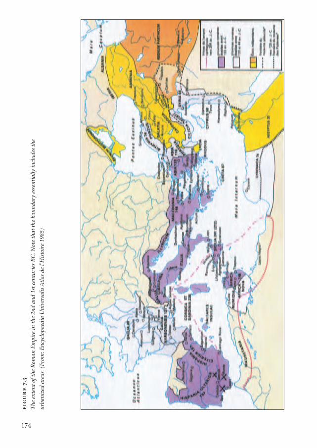
174
.
The
ext
ent o
fthe
Rom
an E
mpi
re in
the
2nd
and
1st c
entu
ries
BC
.Not
e th
at th
e bo
unda
ry e
ssen
tial
ly in
clud
es th
e
urba
nize
d ar
eas.
(Fro
m: E
ncyc
lopa
edia
Uni
vers
alis
Atl
as d
e l’H
isto
ire
1985
)
Mappae Mundi kleurk 1 DEF 08-04-2004 15:46 Pagina 174
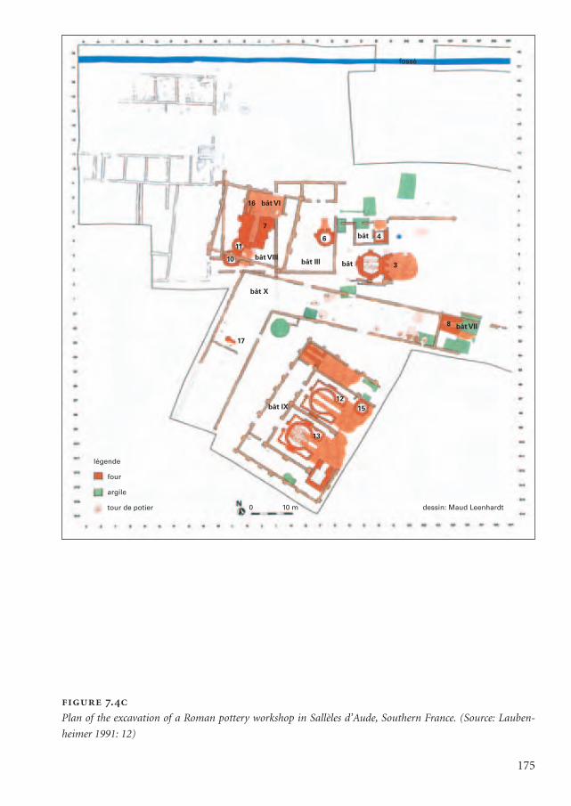
175
.
Plan of the excavation of a Roman pottery workshop in Sallèles d’Aude, Southern France. (Source: Lauben-
heimer 1991: 12)
fossé
16 bât VI
7
11
10
17
6 4
3
8
15
13
12
bât
bât
bât VIII
bât X
bât IX
0 10 m dessin: Maud Leenhardt
légende
four
argile
tour de potier
bât III
bât VII
Mappae Mundi kleurk 1 DEF 08-04-2004 15:46 Pagina 175
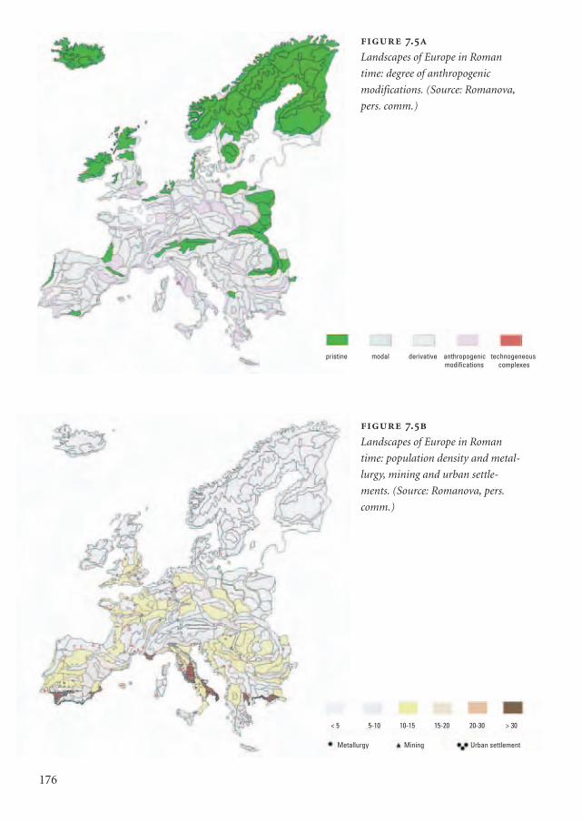
176
.
Landscapes of Europe in Roman
time: population density and metal-
lurgy, mining and urban settle-
ments. (Source: Romanova, pers.
comm.)
.
Landscapes of Europe in Roman
time: degree of anthropogenic
modifications. (Source: Romanova,
pers. comm.)
< 5 5-10 10-15 15-20 20-30 > 30
Metallurgy Mining Urban settlement
pristine modal derivative anthropogenic technogeneousmodifications complexes
Mappae Mundi kleurk 1 DEF 08-04-2004 15:46 Pagina 176
6.2.3. Interactions: trade
An important element in the development of human groups, once they increased innumber and size, has been their mutual interactions. Initially, many human groups mayhave been self-confined within a wide availability of space, mountain ridges, swampsand rivers barring communication and exchange. It can even be surmised that relativeisolation was a precondition for the first stages of development – latecomers may nothave been given a chance. Yet interactions of all kinds have probably been an essentialcomponent of the extensive and intensive growth process of human populations.
Trade has ancient origins dating back long before the Holocene period. In the earliestagro-pastoral settlements the exchange of ideas and goods was an important dynamic(cf. Chapter 4). Scarce and therefore precious materials have been traded over large dis-tances since at least 8000 years ago. In the Near East obsidian was already being procuredover distances of hundreds of kilometres by 9000 yr BP; products from the Mesolithicflint mines in Britain spread throughout Europe via a well-developed trade network. Aslong ago as 5000 yr BP lapis lazuli was imported from northern Afghanistan into theIndus Valley; major trade routes, over land as well as along the coast, connected theHarappan civilization and Mesopotamia as early as 4000 yr BP (Lahiri 1992). The Paler-mo Stone on which the annals of the ancient Egyptian kings up to the 5th Dynasty (4500yr BP) are inscribed testifies to trade routes between Egypt and Syria (turquoise) andEthiopia (oils, ebony, ivory, animal skins and gold). Amber from the Baltic Sea regiondating back to 3600 yr BP has been found in Greece (Renfrew 1973). The silk route con-nected the Roman Empire and China – silk was a luxury in Rome as it was free of lice.The salt/gold trade linked the northern and southern fringes of the Saharan desert andwas probably part of a larger chain: an abandoned caravan-load halfway through thedesert contained cowry shells of a species found in the Maldive Islands 9000 kilometresaway. Colombian peoples formed a complex mosaic of societies linked by networks ofcommunication, trade, alliance and probably warfare. Beginning 3000 to 5000 years ago,these cultures erected thousands of linear kilometres of artificial earthen causeways andcanals, large urban settlements and intensive farming systems.3
There can be no doubt that trade routes both reflected and affected the natural envi-ronment. In western Africa, many savannah urban centres sprang up at environmentalinterfaces where transportation systems connected: in Timbuktu goods were transferredfrom camel to canoe, in Kano from camel to donkey, and at forest-savannah junctionsthe tsetse fly necessitated the transfer from donkey back to human head (Connah 2001:141). Rivers, coastal hamlets and mountain passes stimulated the growth of trading cen-tres. In these various ways, trade was instrumental in disseminating skills and ideasacross the continents – it can even be argued that this gave Eurasia, with its large east-west corridors, its competitive edge in population and economic growth (Diamond1997).
177
Mappae Mundi bw zw/w 08-04-2004 15:25 Pagina 177
Trade may have started primarily for its survival value by diminishing the risk offamine and in the procurement of all kinds of resources. Plants, animals, food productsand the associated practices will have dominated early, largely short-distance trade. Itallowed small communities to spread the risk, as may have occurred along the Mediter-ranean coasts in early times. Obviously, there were other motives – such as the desireto accumulate items to which personal or social value was assigned. There is wide-spread evidence of this role of rare materials and exotic goods in ancient cultures. Forinstance, the Meso-American cultures were formed around an elite prestige system:small, lightweight items made of rare materials used as rewards was a key aspect of aruler’s power. In this way, obsidian, jade and feathers acquired their value. Anothermotive was profit. The expansion of the Phoenicians and the Greeks along the Mediter-ranean coast may have been inspired largely by the search for metals and other resourcesas well as for adventurism, curiosity and conquest. The same holds for the ancient traderoutes along the Iranian Makran and Arabian coasts. The fact that the importance of‘market value’ has been acknowledged in these times and places can be surmised. Tradewas sometimes the only pathway to development for resource-poor regions – thePhoenicians traded cedar wood and wheat for papyrus and gold with Egypt as early as3000 yr BP.
Trade has an intricate and complex relationship with societal stratification, structur-ing as well as reflecting social class and power differences via trade monopolies andtaxes, for instance. The trading network that sustained a continuous flow of metal, tim-ber, stone, oils and rare items in Mesopotamia was probably a precondition for theemergence and survival of the ruling class (Redman 1999). In Meso-America the Teoti-huacan monopoly control of the obsidian trade, mined only in the northern basin of
178
Value and trade For several millennia people have valued items that became pre-
cious because they were from far away or satisfied an urgent need or both – and hence
became ‘value added’. This is in contrast with most bulk goods. Transporting maize in
the Meso-American highlands between two large centres over a distance of 400 kilo-
metres, an 18-day journey, would leave only 20% of the food value as the human carri-
er would have eaten the equivalent of 80% (Blanton 1993). The use of ‘beasts of bur-
den’ such as the lama and the donkey could improve this ratio somewhat, adding to
the feasible transport distances. The earlier story about Easter Island is a suggestive
tale about the possible role of bulk transport in exhausting a society. Large empires
could mobilize enough labour to move bulk goods around: Roman Gaul got most of its
enormous demand for construction stone from three quarries in France – in the
Alpilles, the Pyrenees and the Elzas region – which implied vast amounts of labour and
transport.
Mappae Mundi bw zw/w 08-04-2004 15:25 Pagina 178
Mexico and highland Guatemala, seems to have been one of its major economic sup-ports – as was the salt monopoly in China. As social complexity increased, the tradingnetworks became indicators of political (in)stability and of a system’s resilience. Main-taining trading routes required investments in and maintenance of roads, bridges, trad-ing posts and security, which were all vulnerable to political instability and conflict.Trading activities across the Eurasian continent have been related directly to the stabilityand prosperity in the Mongolian Empire around 1000 yr BP; they played a similarimportant role in the Roman Empire (cf. Chapter 7).
6.2.4. Interactions: diffusion and migration
The movement of human groups – fleeing natural catastrophes, in search of better soilor water, expelled or invaded by other groups – have been another integral part of thehuman adventure. Such movements not only dispersed or diffused peoples, they alsospread skills, crops, habits, tools, beliefs and diseases. As such they had all kinds ofimpacts on the environment, depending on how the new inhabitants – whetherhumans or animals and plants – exploited their new environments. For the present dis-course, we will only briefly touch on questions such as: which role did environmentaland/or climate change play in large-scale migrations; whether and how practices andtools to exploit the environment spread from one population to the next; and to whatextent the (mis)interpretation of the migrants’ new environment led to environmentalchange.
The answers are part of long-standing and broader issues in archaeology and history.For instance, a major controversy in archaeology is about the origins of prehistoric cul-tures – not unlike that about the origins of agriculture and pastoralism as discussed inChapter 4. Were they mainly the result of one or a few older cultures, the diffusion ofpeople, ideas and goods being the transmission mechanism, or were there many moreindependent ones? Until the 1960s the conventional view supported one version oranother of the diffusionist theory. Later on, the existence of independent origins gainedimportance in archaeological interpretations (Renfrew 1973; Bell-Fialkoff 2000).Processes of diffusion were seen as parallel to processes of differentiation in which theenvironment, population growth and internal social dynamics were seen as majorexplanatory factors. As so often, the richness of our past defies simple cause-effect expla-nations.
A variety of explanations have been suggested for the large migrations – a book on itsown. In Chapter 4 some possible mechanisms have been indicated, for instance thenomads oscillating between the Chinese civilization in the east and the Near East andsouth-western and western civilization and western forest tribes of Europe. The dynam-ic causes were probably occasional disturbances of the balance between humankind and
179
Mappae Mundi bw zw/w 08-04-2004 15:25 Pagina 179
nature. Overpopulation may have stimulated the outmigration waves of peoples of theEurasian steppes – but this so-called ‘Pulse of Asia’ (McEvedy 1992: 76) can also beexplained by desiccation cycles on the grasslands. Other triggering mechanisms havebeen suggested: climate change leading to periods with snow cover too thick to allow thenomads to get food may have forced them to move elsewhere; the emergence of a strongleader, such as Genghis Khan, every now and then united peoples which resulted in larg-er population growth because their normal mechanism of population control by inter-nal strife slowed down – and hence their occasional outward thrust; the differences indrought resistance between cattle and horses. Yet another suggestion has been put for-ward to explain peoples’ move from the steppe to the forest: the discovery and subse-quent desire for iron. Ironworks needed charcoal and core analysis of peat bogs in Russiasuggests that some 1500 years ago people started burning primary forest, which showedup as a rise in cadmium concentrations in the soil.
180
Genetic gradients and migration A variety of factors may have triggered migrato-
ry waves. Genetic research appears to provide an empirical basis that could clarify at
least some of the complex underlying processes (Cavalli-Sforza 1993; Cavalli-Sforza
1995; Harris 1996). One of the major forces leading to outmigration is population
growth – or so a widespread conviction holds. If the migration pressure increases in a
relatively isolated group and they start migrating outwards, genetic drift among small
populations is important and genetic variation can be expected over long distances.
Recent genetic research has been applied to establish genetic gradients across the
earth’s continents and test this hypothesis. The various migrations into Europe can be
resolved into its constituent components. In this way, the agrarianization process can
be followed in the form of waves of inward migrations, ‘impounding’ the original Me-
solithic peoples: Neolithic farmers from the Near East; a – probably single large-scale –
migration of Uralic language people from northern Europe and western Asia; Indo-
European language-speaking nomadic herders from the Euro-Asiatic steppes (4500-
6000 yr BP) who were probably descendants of the first cultivators migrating to the
Steppes north of the area in which agriculture originated, with horse-rearing as a local
adaptation; and the Greek expansion of the 2nd and 1st millennia BC. Cavalli-Sforza con-
tends that migration of peoples has been at least as important as exchange via tools
and artefacts in the cultural dispersion process (Cavalli-Sforza 1993). Could it be that
one of these waves is related to a catastrophic event such as the flooding of the Black
Sea region by the Mediterranean waters? (Ryan 1998)
Mappae Mundi bw zw/w 08-04-2004 15:25 Pagina 180
6.3. Early state and empire formation
… one might raise the question whether the growing contrast between urban and
rural lifestyles and perceptions, as well as the growing impact of the former on the
environment, is not at the root of much degradation.
Leeuw 2000
From the earliest stages on, human groups have shown signs of self-organization. Thisprocess gradually intensified with processes such as stratification between the rulers andthe ruled, differentiation into castes and guilds, and the emergence of towns and trademarkets. Tribal chiefdoms evolved into one dominant authority in larger regions, thestate:
a type of very strong, usually highly centralised government, with a professional ruling class,
largely divorced from the bonds of kinship… highly stratified and extremely diversified inter-
nally, with residential patterns often based on occupational specialisation rather than blood or
affinal relationship. The state attempts to maintain a monopoly of force… while individual
citizens must forgo violence, the state can wage a war; it can also draft soldiers, levy taxes, and
exact tribute. (Flannery 1972: 404)
As a social institution, the state is said to exist in societies that have two or more socialstrata, an administrative apparatus and revenues from tribute and taxes. Mythical andlegendary charters and war and terrorism are among the methods in which statesenforced legitimacy, displayed power and exerted control (cf. Section 4.4). These ‘tra-ditional’ states emerged all over the world, under a variety of environmental condi-tions: in Mesopotamia, in the eastern part of the Mediterranean, in South Asia in theIndus Valley, in China in the Huang He Basin and in Meso-America and, to a lesserextent, in parts of South-East Asia and Africa. They were of limited size and had rela-tively modest administrations and transport and communication channels. The fol-lowing gives a ‘capita selecta’ impression of the human-environment interactions inthis process.
6.3.1. Early urban centres in Mesopotamia
The earliest urban centres probably developed in the plains of southern Mesopotamia.As early as the 6th millennium BP the city of Uruk extended over more than 100 ha. Theearly towns facilitated all kinds of exchange; indeed, it may have been their natural rai-son d’être and function. The economy of the Ubaid and Early Uruk culture was a ‘tribu-tary economy – one that was dependent to a significant degree on the mobilization of
181
Mappae Mundi bw zw/w 08-04-2004 15:25 Pagina 181
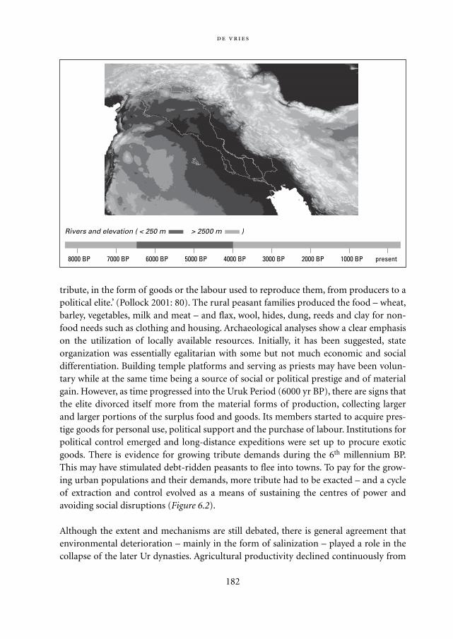
tribute, in the form of goods or the labour used to reproduce them, from producers to apolitical elite.’ (Pollock 2001: 80). The rural peasant families produced the food – wheat,barley, vegetables, milk and meat – and flax, wool, hides, dung, reeds and clay for non-food needs such as clothing and housing. Archaeological analyses show a clear emphasison the utilization of locally available resources. Initially, it has been suggested, stateorganization was essentially egalitarian with some but not much economic and socialdifferentiation. Building temple platforms and serving as priests may have been volun-tary while at the same time being a source of social or political prestige and of materialgain. However, as time progressed into the Uruk Period (6000 yr BP), there are signs thatthe elite divorced itself more from the material forms of production, collecting largerand larger portions of the surplus food and goods. Its members started to acquire pres-tige goods for personal use, political support and the purchase of labour. Institutions forpolitical control emerged and long-distance expeditions were set up to procure exoticgoods. There is evidence for growing tribute demands during the 6th millennium BP.This may have stimulated debt-ridden peasants to flee into towns. To pay for the grow-ing urban populations and their demands, more tribute had to be exacted – and a cycleof extraction and control evolved as a means of sustaining the centres of power andavoiding social disruptions (Figure 6.2).
Although the extent and mechanisms are still debated, there is general agreement thatenvironmental deterioration – mainly in the form of salinization – played a role in thecollapse of the later Ur dynasties. Agricultural productivity declined continuously from
182
8000 BP 7000 BP 6000 BP 5000 BP 4000 BP 3000 BP 2000 BP 1000 BP present
Rivers and elevation ( < 250 m > 2500 m )
Mappae Mundi bw zw/w 08-04-2004 15:25 Pagina 182
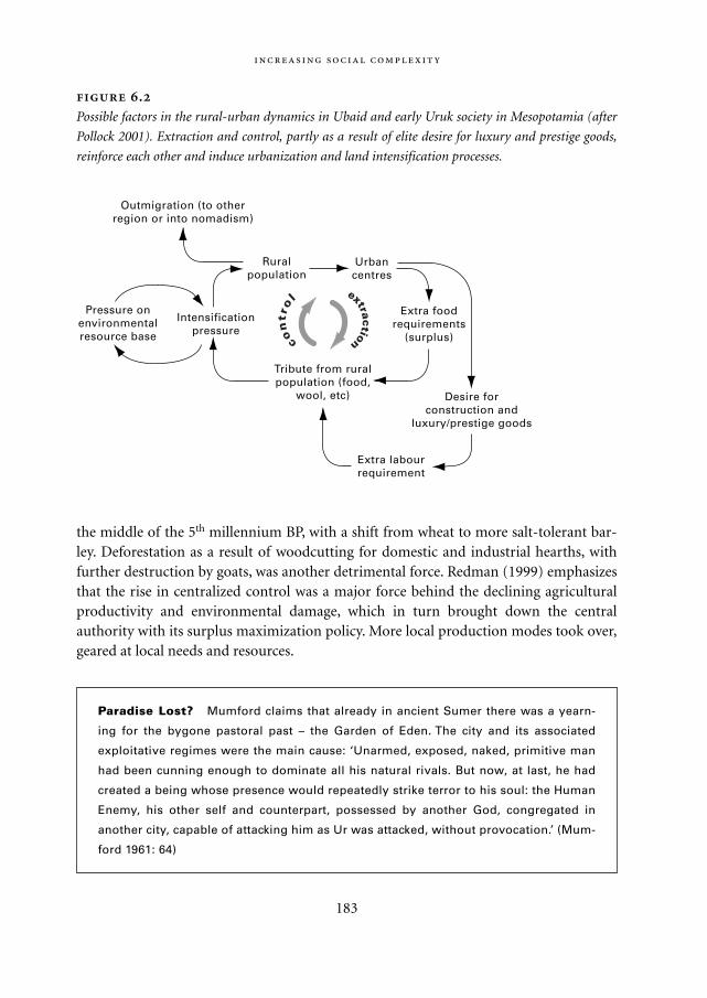
the middle of the 5th millennium BP, with a shift from wheat to more salt-tolerant bar-ley. Deforestation as a result of woodcutting for domestic and industrial hearths, withfurther destruction by goats, was another detrimental force. Redman (1999) emphasizesthat the rise in centralized control was a major force behind the declining agriculturalproductivity and environmental damage, which in turn brought down the centralauthority with its surplus maximization policy. More local production modes took over,geared at local needs and resources.
183
.
Possible factors in the rural-urban dynamics in Ubaid and early Uruk society in Mesopotamia (after
Pollock 2001). Extraction and control, partly as a result of elite desire for luxury and prestige goods,
reinforce each other and induce urbanization and land intensification processes.
Urbancentres
Extra foodrequirements
(surplus)
Desire forconstruction and
luxury/prestige goods
Extra labourrequirement
Tribute from ruralpopulation (food,
wool, etc)
Intensificationpressure
Pressure onenvironmentalresource base
Ruralpopulation
Outmigration (to otherregion or into nomadism)
con
tro l
extraction
Paradise Lost? Mumford claims that already in ancient Sumer there was a yearn-
ing for the bygone pastoral past – the Garden of Eden. The city and its associated
exploitative regimes were the main cause: ‘Unarmed, exposed, naked, primitive man
had been cunning enough to dominate all his natural rivals. But now, at last, he had
created a being whose presence would repeatedly strike terror to his soul: the Human
Enemy, his other self and counterpart, possessed by another God, congregated in
another city, capable of attacking him as Ur was attacked, without provocation.’ (Mum-
ford 1961: 64)
Mappae Mundi bw zw/w 08-04-2004 15:25 Pagina 183
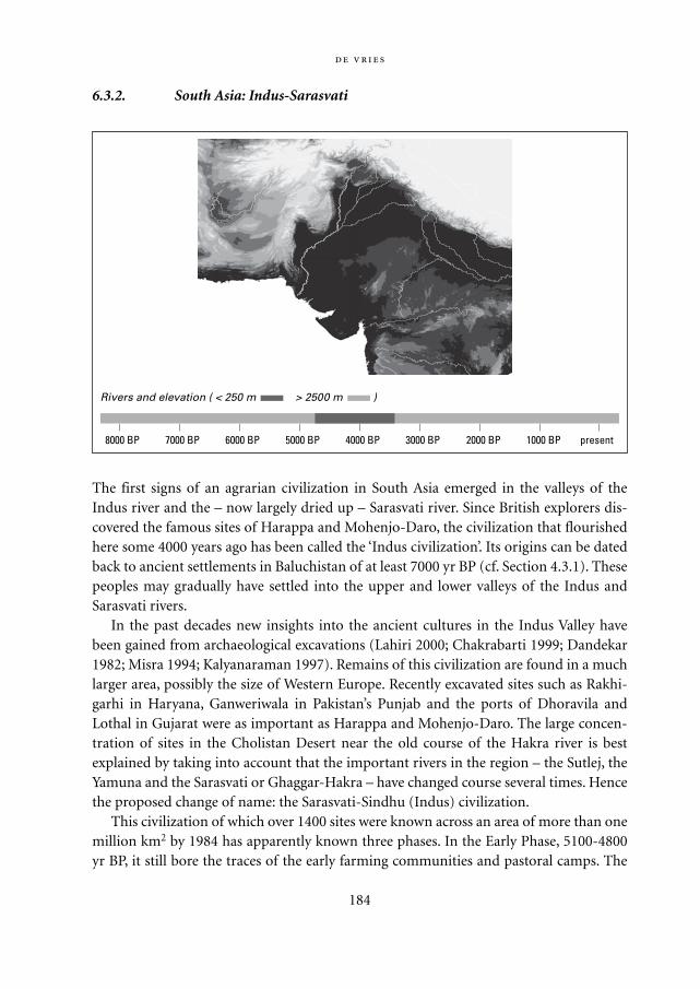
6.3.2. South Asia: Indus-Sarasvati
The first signs of an agrarian civilization in South Asia emerged in the valleys of theIndus river and the – now largely dried up – Sarasvati river. Since British explorers dis-covered the famous sites of Harappa and Mohenjo-Daro, the civilization that flourishedhere some 4000 years ago has been called the ‘Indus civilization’. Its origins can be datedback to ancient settlements in Baluchistan of at least 7000 yr BP (cf. Section 4.3.1). Thesepeoples may gradually have settled into the upper and lower valleys of the Indus andSarasvati rivers.
In the past decades new insights into the ancient cultures in the Indus Valley havebeen gained from archaeological excavations (Lahiri 2000; Chakrabarti 1999; Dandekar1982; Misra 1994; Kalyanaraman 1997). Remains of this civilization are found in a muchlarger area, possibly the size of Western Europe. Recently excavated sites such as Rakhi-garhi in Haryana, Ganweriwala in Pakistan’s Punjab and the ports of Dhoravila andLothal in Gujarat were as important as Harappa and Mohenjo-Daro. The large concen-tration of sites in the Cholistan Desert near the old course of the Hakra river is bestexplained by taking into account that the important rivers in the region – the Sutlej, theYamuna and the Sarasvati or Ghaggar-Hakra – have changed course several times. Hencethe proposed change of name: the Sarasvati-Sindhu (Indus) civilization.
This civilization of which over 1400 sites were known across an area of more than onemillion km2 by 1984 has apparently known three phases. In the Early Phase, 5100-4800yr BP, it still bore the traces of the early farming communities and pastoral camps. The
184
8000 BP 7000 BP 6000 BP 5000 BP 4000 BP 3000 BP 2000 BP 1000 BP present
Rivers and elevation ( < 250 m > 2500 m )
Mappae Mundi bw zw/w 08-04-2004 15:25 Pagina 184
Mature Phase, 4800-3900 yr BP, is the period of at least a dozen large cities; of interac-tion with culture-complexes in Rajasthan, Central India and Maharashtra; of farming avariety of crops including rice and cotton; of extensive metal mining and smelting activ-ities; and of extensive trade with Mesopotamia through ports such as Lothal. The culturewas characterized by sophisticated architecture, a distinctive own writing style, the wor-ship of fire and an absence of personality or ruler cults such as they emerged in contem-porary Mesopotamia, Egypt and China. Its sudden rise, within a few centuries at most, israther mysterious – if Mesopotamia was not the source, was it a jump after centuries ofgermination?
The Late Phase was around 3900-3400 yr BP. The story of the emergence and flour-ishing of the Harappa civilization is told in different ways; this is equally true for the taleof its mysterious decline (Chakrabarti 1997: 124; Lahiri 2000). Until the recent finds inthe south, it was thought that the Indus civilization came to a rather abrupt end – thecauses are still controversial: climate change with increasing droughts and changes in theSaraswati river bed, more or less gradual invasion by northern Aryan nomads or internalerosion. New evidence suggests that a combination of adverse changes in rainfall pat-terns, a massive earthquake causing river courses to change and a decline in trade due tothe downfall of the Euphrates-Tigris civilization led to an eastward migration. Slowlybut inexorably the Sarasvati-Ghaggar-Hakra channel dried up. The cities were left:
And like a dying candle, [the civilization] shone brilliantly again but briefly before being
snuffed out… There was a breakdown in sanitation and cities like their modern-day counter-
parts in India simply ran themselves aground. They were replaced by massive squatter colonies
and an explosion of rural sites as people, disillusioned with cities, went back to farming com-
munities. A giant step backward. (Chengappa www.itihaas.com/ancient)
Another explanatory factor may be that the Harappan civilization had overstretcheditself in thinly spreading itself out over a large number of hunter-gatherer villages. It isalso possible that a violent invasion of, but more probably an ordered interaction with,the northern Aryans also played a role.
Some 3500-4000 years ago, the descendants of the Harappan civilization probably dif-fused eastwards into the Gangetic plain across the Doab and Gangetic Valley and south-wards into Maharashtra and Malwa. Their interaction with the hunter-gatherers led tomany Neolithic-Chalcolithic cultures and their transition to agriculture. Yet, this post-Harappan period is the start of siècles obscurs: although traces of metallurgy and tradehave been found and a rather dense pattern of settlements existed, one can only specu-late about the period that precedes the kingdoms and scriptures of the 3rd millenniumBP. These early Mesolithic cultures of inner India were familiar with the domesticationof cattle, sheep and goats and the utilization of plants – why had they not already made
185
Mappae Mundi bw zw/w 08-04-2004 15:25 Pagina 185
the transition to agriculture? One hypothesis is similar to what might have happened inthe Japanese Jomon culture: there was no attractive alternative and hence no need. Eth-nobotanical/anthropological studies of the Indian forests, among them those on theDeccan plateau which is less rich in vegetation than other parts of India, suggests thatthere was a wealth of edible forest products known to the local inhabitants – fruit,berries, leaves and mushrooms, but not wild game, honey and the like, nor coconuts.The past is, in this respect, not so far out of sight:
Till recent years there was a marked dependence on wild plant resources in Indian villages and
when the grain bins are empty for the poor for two or three months in a year, it is the availabil-
186
Unresolved questions There is controversy about whether the ancient Vedic scrip-
tures originated among the invading Aryan nomadic tribes or in the Indus civilization.
Recent investigations suggest that an early civilization may have existed in northern
Maharashtra and Gujarat, near Dwarka, which confirms parts of the Mahabharata epos
– remnants of ‘a large city sunk into the sea when Lord Krishna left’. Its Harappan origin
is however controversial. The issue has a political context: ‘By the time the British came
as rulers, the ancient Aryan civilization of India was degraded, and its rejuvenation
could take place only under British rule which in fact was a modern Aryan rule… it
offered a kind of legitimacy to the British rule… and the premise could also satisfy the
Indian upper castes because through their ancient Aryan affiliation they could claim
kinship with their rulers. ‘ (Chakrabarti,1999: 11)
There are also – and will be – different interpretations of the Harappan settlements’
social complexity. It is clear that in the mature stage these settlements were part of a
larger political and administrative framework. Some have speculated about priest-
kings not unlike those in Sumer and Akkad – but Chakrabarti writes that ‘An Egyptian or
Mesopotamian kind of kingship need not be envisaged in the Indus context. In later
Indian history, the king… was a much more humble figure… he does not strut around
in sculptural reliefs towering above ordinary mortals and cutting the heads of his ene-
mies… he functioned within the well-formulated concept of the royal duty of looking
after the well-being of his subjects…. It is futile to look for the remains of a royal
palace… for the simple reason that there will not be any way of identifying it, going by
the later Indian examples. Priesthood is far more sharply visible… The concept of a
yogin, one who sits in meditation, is writ large… Remains… unmistakably imply the
services of priests – priests of a type that a practising Hindu would engage for perform-
ing his household rituals even today.’ (Chakrabarti 1997: 123) Such a view suggests
much more continuity between this mysterious past and the Indian present – and more
diversity in the behaviour of early priest-kings – than previously thought.
Mappae Mundi bw zw/w 08-04-2004 15:25 Pagina 186
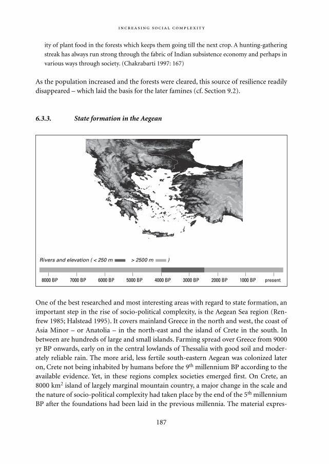
ity of plant food in the forests which keeps them going till the next crop. A hunting-gathering
streak has always run strong through the fabric of Indian subsistence economy and perhaps in
various ways through society. (Chakrabarti 1997: 167)
As the population increased and the forests were cleared, this source of resilience readilydisappeared – which laid the basis for the later famines (cf. Section 9.2).
6.3.3. State formation in the Aegean
One of the best researched and most interesting areas with regard to state formation, animportant step in the rise of socio-political complexity, is the Aegean Sea region (Ren-frew 1985; Halstead 1995). It covers mainland Greece in the north and west, the coast ofAsia Minor – or Anatolia – in the north-east and the island of Crete in the south. Inbetween are hundreds of large and small islands. Farming spread over Greece from 9000yr BP onwards, early on in the central lowlands of Thessalia with good soil and moder-ately reliable rain. The more arid, less fertile south-eastern Aegean was colonized lateron, Crete not being inhabited by humans before the 9th millennium BP according to theavailable evidence. Yet, in these regions complex societies emerged first. On Crete, an8000 km2 island of largely marginal mountain country, a major change in the scale andthe nature of socio-political complexity had taken place by the end of the 5th millenniumBP after the foundations had been laid in the previous millennia. The material expres-
187
8000 BP 7000 BP 6000 BP 5000 BP 4000 BP 3000 BP 2000 BP 1000 BP present
Rivers and elevation ( < 250 m > 2500 m )
Mappae Mundi bw zw/w 08-04-2004 15:25 Pagina 187
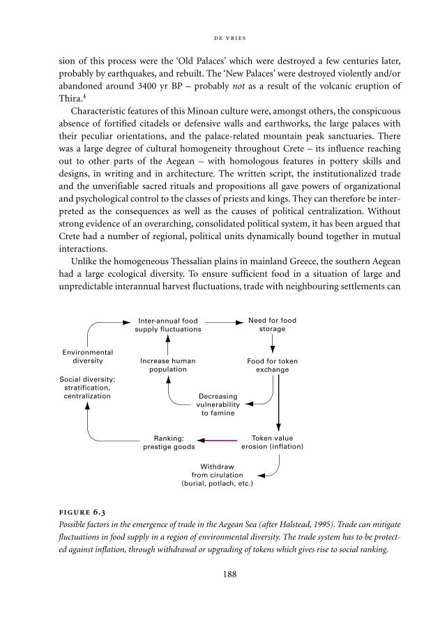
sion of this process were the ‘Old Palaces’ which were destroyed a few centuries later,probably by earthquakes, and rebuilt. The ‘New Palaces’ were destroyed violently and/orabandoned around 3400 yr BP – probably not as a result of the volcanic eruption ofThira.4
Characteristic features of this Minoan culture were, amongst others, the conspicuousabsence of fortified citadels or defensive walls and earthworks, the large palaces withtheir peculiar orientations, and the palace-related mountain peak sanctuaries. Therewas a large degree of cultural homogeneity throughout Crete – its influence reachingout to other parts of the Aegean – with homologous features in pottery skills anddesigns, in writing and in architecture. The written script, the institutionalized tradeand the unverifiable sacred rituals and propositions all gave powers of organizationaland psychological control to the classes of priests and kings. They can therefore be inter-preted as the consequences as well as the causes of political centralization. Withoutstrong evidence of an overarching, consolidated political system, it has been argued thatCrete had a number of regional, political units dynamically bound together in mutualinteractions.
Unlike the homogeneous Thessalian plains in mainland Greece, the southern Aegeanhad a large ecological diversity. To ensure sufficient food in a situation of large andunpredictable interannual harvest fluctuations, trade with neighbouring settlements can
188
.
Possible factors in the emergence of trade in the Aegean Sea (after Halstead, 1995). Trade can mitigate
fluctuations in food supply in a region of environmental diversity. The trade system has to be protect-
ed against inflation, through withdrawal or upgrading of tokens which gives rise to social ranking.
Need for foodstorage
Food for tokenexchange
Token valueerosion (inflation)
Decreasingvulnerability
to famine
Ranking:prestige goods
Withdrawfrom cirulation
(burial, potlach, etc.)
Increase humanpopulation
Inter-annual foodsupply fluctuations
Environmentaldiversity
Social diversity:stratification,centralization
Mappae Mundi bw zw/w 08-04-2004 15:25 Pagina 188
provide an important buffer as such events tend to be asynchronous in high-diversityregions. As a result, an important stimulus existed for the exchange of food for tokens.To avoid inflation, the tokens have to disappear every now and then – burying them withfunerals or destroying them as in the potlach system, for example.5 Alternatively, they aremade into a ranking system of less and more valuable tokens. In this way, ecologicaldiversity may have contributed to the emergence of social ranking, with a prominentrole for merchants (Figure 6.3). Whatever the details of these explanations, it is temptingto relate this early landscape-inspired evolution to the well-known features of the laterGreek city-states: political autonomy and economic autarchy.
6.3.4. Meso-America
The ancient civilizations of Meso-America are among the best researched in the world(Blanton 1993). One of the larger, centralized cultures, the Maya, and the close correla-tion and synergistic links between climate change, vegetation response, and culturaldevelopment have been discussed in a previous chapter (cf. Section 3.4.2). In otherplaces, too, past human activity has left its trace on the present-day landscape and theecological composition of vegetation communities. For example, the present vegetationof north-eastern Guatemala is predominantely tropical semi-evergreen forest inter-spersed with patches of savannah; some researchers believe these are the relicts of Mayanland-use practices (Leyden 1987). A cooling climate may have allowed the Mayan civi-lization to prosper as it would have forced the malaria-carrying mosquito to migrate fur-ther to the south, allowing extensive farming and the construction of cities (Perry 2000).When the world climate warmed again, the Maya abandoned their fields and moved intothe less fertile Yucatán Peninsula (Hsu 2000).
An investigation into social organization in the south-western Mayan lowlandspoints at the importance of the local geography and resource base (Gunn 2000). Southof the Yucatán Peninsula, three river basins with different characteristics have played amajor role in the Mayan civilization from 4000 yr BP (Early Pre-Classical) to 500 BP(Late Post-Classical). The three rivers, Usumacinta, Candeliaria and Champoton,formed three different biocultures which together have determined the human-environ-ment interaction in this part of Central America. It has been possible to identify how theriver basins responded to changes in important climate parameters (rainfall, tempera-ture) and derived variables (monthly river discharge). The Candeliaria River was of cru-cial importance as an ecotone between the two relatively stable upland and lowland eco-zones of the other two rivers.6 Such an ecotonal river is a generator and reservoir ofcultural diversity. The conditions under which Mayan culture could develop can beestablished, following the various stages of activity. Three interesting patterns emerge:changes in climate parameters have led to population shifts between the three river
189
Mappae Mundi bw zw/w 08-04-2004 15:25 Pagina 189
basins in the Early and Middle Pre-Classical periods; elevated cities were abandoned in aperiod of great drought (1050-1250 yr BP); and the Champoton river basin was the onlyone where human activity – deforestation with river discharge volume change – had aserious impact. Mayan cosmology may have provided them with a superior ability toprognosticate patterns of cyclical environmental changes. The investigations of human-environment interactions in this part of Central America confirm, as much otherresearch, that a meaningful interpretation is only possible at a sufficiently disaggregatedspatial level.
A comparative analysis of the highland valleys – of Oaxaca and Mexico – and theeastern lowlands is quite revealing with regard to the relationship between the environ-ment and social organization (Blanton 1993). The highland valleys have natural barriers,the mountains, which obstruct communication and have limited potential for agricul-ture. Their agricultural systems tend to aim at the ‘replication of uniformity’: ‘a continu-al preoccupation with comparatively little horizontal complexity – the vast majority ofparts are alike, and they tend to stay that way. The replication of uniformity is usuallyaccomplished by means of a strong vertical differentiation – a powerful hierarchy man-ages most affairs.’ (Blanton 1993: 163). The lowlands, on the other hand, are much morevast and unbounded. It can be hypothesized that people in these circumstances employ awide and diverse spectrum of production techniques. The diversity entailed co-ordina-tion in matters such as access to resources, allocation of time and labour and exchange of
190
Environmental degradation as a cause of collapse A good piece of Maya envi-
ronmental history is based on the pioneering Central Petén Historical Ecology Project
(Redman 1999: 141-145). In this region in lowland Guatemala a swidden – or milpa –
agricultural system with a 3-5 year fallow period can support population densities in
the order of 25 people/km2. How did the Maya manage to sustain in some places and
times up to 250 people/km2, and can the environmental impacts of the required effi-
cient and centralized agriculture be traced back? Examining sediment core from lake
bottoms, the researchers found a significant increase in phosphorus and silica deposi-
tion during the Maya occupation. Accelerated phosphorus deposition points at more
phosphorus in the soil due to human activity (waste, food, disintegration of bodies and
stoneworks) and to more soil erosion (Figure 6.4). Similarly, silica deposition increased
severalfold during the period which archaeologists think had the highest population –
another indicator of increased erosion rates. Apparently, the Maya appreciated the
tropical forest ecosystem well enough to thrive for centuries by managing land clear-
ance, control water flows and transport food to cope with localized shortages.
However, the lake sediment data indicate that ‘the high forest that prevailed in
much of [the] region was largely removed by the farming and settlement building activ-
ities of the Mayas as early as 3000 to 4000 years ago. This resulted in a shift toward
Mappae Mundi bw zw/w 08-04-2004 15:25 Pagina 190
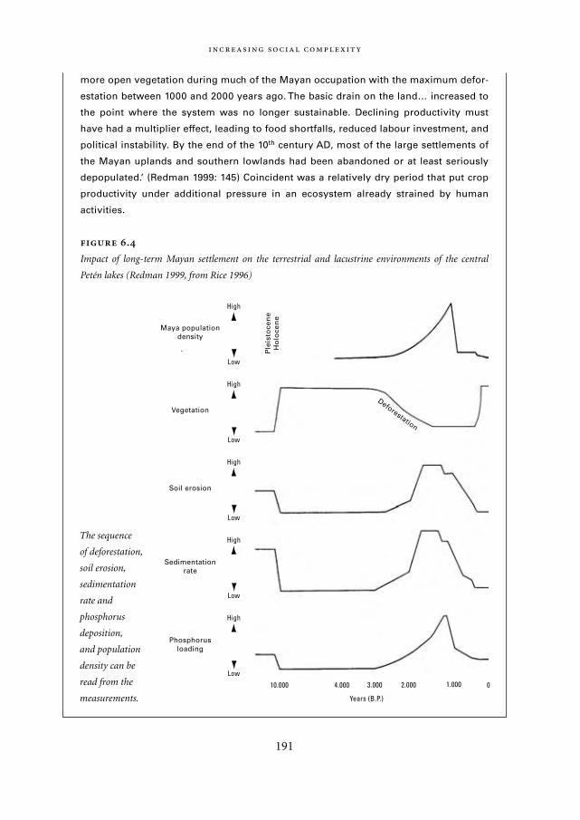
more open vegetation during much of the Mayan occupation with the maximum defor-
estation between 1000 and 2000 years ago. The basic drain on the land… increased to
the point where the system was no longer sustainable. Declining productivity must
have had a multiplier effect, leading to food shortfalls, reduced labour investment, and
political instability. By the end of the 10th century AD, most of the large settlements of
the Mayan uplands and southern lowlands had been abandoned or at least seriously
depopulated.’ (Redman 1999: 145) Coincident was a relatively dry period that put crop
productivity under additional pressure in an ecosystem already strained by human
activities.
.
Impact of long-term Mayan settlement on the terrestrial and lacustrine environments of the central
Petén lakes (Redman 1999, from Rice 1996)
191
10.000 4.000 3.000 2.000 1.000 0
Years (B.P.)
Low
High
Low
High
Low
High
Low
High
Low
High
Deforestation
Maya populationdensity
Vegetation
Soil erosion
Sedimentationrate
Phosphorusloading
Ple
isto
cen
eH
olo
cen
e
The sequence
of deforestation,
soil erosion,
sedimentation
rate and
phosphorus
deposition,
and population
density can be
read from the
measurements.
Mappae Mundi bw zw/w 08-04-2004 15:25 Pagina 191
products. Economic institutions developed early and consistently provided the basis forsurvival. The evolutionary problem here is the ‘organization of diversity’: how to keepthe components in these horizontally complex systems doing their jobs even thoughthey have very different roles and interests. In the eastern lowlands, there were manyinteracting socio-political units with permeable boundaries or large efforts to regulateflows of things and people across the boundaries. From this perspective, these lowlandsresembled more the ancient civilizations in the Near East or Asia than the nearby high-land valleys.
6.4. From states to empires
To read what the ‘ecologists’ write, one would often think that civilised peoples
only ate, excreted, and reproduced; to read what the humanists write, one would
think civilisations were above all three, and devoted all their energy to the arts.
Flannery 1972: 400
In the previous narratives, we have seen how increasing social complexity manifesteditself in the form of hierarchically organized urban conglomerates and exchange orient-ed trade networks. There is a good deal of evidence that such patterns reflected local andregional biogeography, in the sense of landscapes, soils, rain patterns and corridors. Associal complexity further increased, the most impressive and conspicuous developmenthas been the process in which some of the early states expanded their territory anddeveloped more elaborate systems of governance: they became empires. Their adminis-trative bureaucracies became larger, state-controlled trading networks expanded andlarge urbanized regions with a core-periphery dependence emerged. Of course, there areno sharp boundary lines. These ancient civilizations manifested, as part of their evolu-tion into more urbanized and stratified societies, a further intensification of agricultureand manufacturing. The resulting larger productive surplus was invested into large-scaleinvestments, temples and palaces as well as roads, dams and canals, ships and harbours.Let us look at a few more narratives.
6.4.1. Egypt
The Nile and Egypt are synonymous. The river is Egypt’s life vein – and at the root of itseconomic fragility. Nile water levels mirrored climatic events throughout the region, as isbecoming clear from East African lake levels and Indian monsoon patterns (Yasuda2001, Section 3.3.2). During the 7th and 6th millennia BP episodes of severe drought,dwellers of the desert drifted towards the Nile Valley in search of water, food and fodder.
192
Mappae Mundi bw zw/w 08-04-2004 15:25 Pagina 192
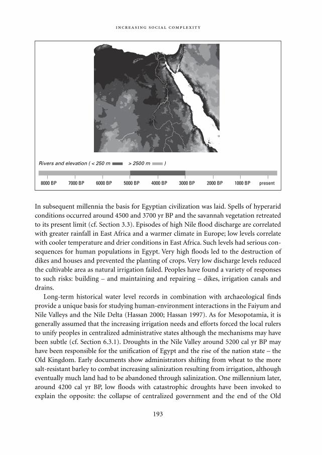
In subsequent millennia the basis for Egyptian civilization was laid. Spells of hyperaridconditions occurred around 4500 and 3700 yr BP and the savannah vegetation retreatedto its present limit (cf. Section 3.3). Episodes of high Nile flood discharge are correlatedwith greater rainfall in East Africa and a warmer climate in Europe; low levels correlatewith cooler temperature and drier conditions in East Africa. Such levels had serious con-sequences for human populations in Egypt. Very high floods led to the destruction ofdikes and houses and prevented the planting of crops. Very low discharge levels reducedthe cultivable area as natural irrigation failed. Peoples have found a variety of responsesto such risks: building – and maintaining and repairing – dikes, irrigation canals anddrains.
Long-term historical water level records in combination with archaeological findsprovide a unique basis for studying human-environment interactions in the Faiyum andNile Valleys and the Nile Delta (Hassan 2000; Hassan 1997). As for Mesopotamia, it isgenerally assumed that the increasing irrigation needs and efforts forced the local rulersto unify peoples in centralized administrative states although the mechanisms may havebeen subtle (cf. Section 6.3.1). Droughts in the Nile Valley around 5200 cal yr BP mayhave been responsible for the unification of Egypt and the rise of the nation state – theOld Kingdom. Early documents show administrators shifting from wheat to the moresalt-resistant barley to combat increasing salinization resulting from irrigation, althougheventually much land had to be abandoned through salinization. One millennium later,around 4200 cal yr BP, low floods with catastrophic droughts have been invoked toexplain the opposite: the collapse of centralized government and the end of the Old
193
8000 BP 7000 BP 6000 BP 5000 BP 4000 BP 3000 BP 2000 BP 1000 BP present
Rivers and elevation ( < 250 m > 2500 m )
Mappae Mundi bw zw/w 08-04-2004 15:25 Pagina 193
Kingdom (Hassan 1997; Fairbridge 1984). The low Nile River levels may have triggered aseries of civil uprisings widely recorded during this time and the rule from Memphisbroke down at the end of the 5th Dynasty, about 4180 yr BP.
The Old Kingdom (ca. 4750-4150 yr BP) [in Egypt] was a time of tremendous royal power…
and it saw a big increase in population… This placed great reliance on maximising the use of
the land flooded and fertilised each year by the inundations. Around 4250-4150 yr BP the
same prolonged dry period which caused such problems for the Ur III kings in Iraq brought a
series of consistently low floods and precipitated half a century of famine. This helped pull a
declining order. The monarchy was overthrown… (Wood 1999: 141-142)
Unlike in other parts of the Middle East, social order was regained by the end of the 9th
Dynasty, about 4000 yr BP, with the administrative centre now at Thebes. Wood (1999)states that it was because the norms and values of Egyptian civilization were so deeplyrooted and enduring – which begs the question why they were. During the New King-dom the population of Egypt as a whole increased again, possibly to as many as 5 millionduring the 18th to 19th Dynasties (1539-1186 BC). Up to half of the population may havelived in cities such as Memphis and Heliopolis, the former perhaps being the world’s firstcity of over 1 million people (Manley 1996).
What happened to society during these episodes of natural disaster of which the Bibleaccounts so vividly? As ruling elites were dependent on the tax revenues from farmers, aseries of low Nile floods was critical for governance. Farmers were confronted with star-vation, urban craftsmen and artisans died in massive numbers – it is reported that lessthan 10% of the weavers in Cairo survived the 1200-1201 AD famines – and the king sawhis income shrink rapidly. In such periods of economic distress, rivals would emergedenouncing royal excesses such as the construction of large monuments with an appealto ancient, fundamental religious beliefs. The legitimacy of the ruling class was ques-tioned and centralized government weakened. The situation worsened as urban admin-istrators, functionaries, merchants and other non-food producers would try to stick totheir ‘good life’ habits. Because of declining revenues the king could no longer pay foradequate military and political support – nor for large agricultural projects that wouldredistribute food and secure against future droughts. The ‘power range’ – an estimated400 km with the available transport capacities – decreased and the state would disinte-grate in smaller, provincial units. At this stage, some people would flee the region whileothers might invade it. Figure 6.5 is a schematic representation of some aspects of such aspiral, as one possible intrusion on the positive loops of growth and control. It is quiteprobable that such a course of events happened during the periods of low Nile dischargearound 4200, 3100 and 2700 yr BP.
Let us continue our travel, side-stepping another ‘rise and fall of empire’ region – theNear and Middle East – and jump towards the Far East: China. Here, too, peoples and
194
Mappae Mundi bw zw/w 08-04-2004 15:25 Pagina 194
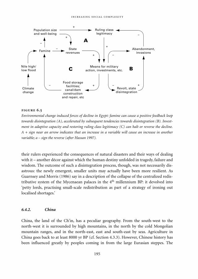
their rulers experienced the consequences of natural disasters and their ways of dealingwith it – another décor against which the human destiny unfolded in tragedy, failure andwisdom. The outcome of such a disintegration process, though, was not necessarily dis-astrous: the newly emergent, smaller units may actually have been more resilient. AsGuarnsey and Morris (1986) say in a description of the collapse of the centralized redis-tributive system of the Mycenaean palaces in the 4th millennium BP: it devolved into‘petty lords, practising small-scale redistribution as part of a strategy of ironing outlocalised shortages.’
6.4.2. China
China, the land of the Ch’in, has a peculiar geography. From the south-west to thenorth-west it is surrounded by high mountains, in the north by the cold Mongolianmountain ranges, and in the north-east, east and south-east by seas. Agriculture inChina goes back to at least 8000 yr BP (cf. Section 4.3.3). However, Chinese history hasbeen influenced greatly by peoples coming in from the large Eurasian steppes. The
195
Ruling classlegitimacy
Abandonment,invasions
Means for militaryaction, investments, etc.
Revolt, statedisintegration
StaterevenuesFamine
Population sizeand well-being
Nile high/low flood
Climatechange
Food storagefacilities;
canal/damconstruction
and repair, etc
A
+
–
C B
+
+–
+
–+
–
+
–
–
.
Environmental change induced forces of decline in Egypt: famine can cause a positive feedback loop
towards disintegration (A), accelerated by subsequent tendencies towards disintegration (B). Invest-
ment in adaptive capacity and restoring ruling class legitimacy (C) can halt or reverse the decline.
A + sign near an arrow indicates that an increase in a variable will cause an increase in another
variable; a – sign the reverse (after Hassan 1997).
Mappae Mundi bw zw/w 08-04-2004 15:25 Pagina 195
Guangzhong Basin of the Wei He between the Qinling Shan in the south and the lössplateau in the north, in particular, has been a corridor in and from which the earliest – atleast recorded – states have come into being: the Xia and Shang dynasties (4200-3100 yrBP) and subsequently the Zhou, Ch’in and Han dynasties. These peoples had a naturaloutlet into the large Huang-Huai-Hai Plain, covering some 350,000 km2 and largely builtup from 400-500 metre-thick sediment layers from the Huang He.7
The natural environment here has always made an impact on humans: ‘Frequentmajor and minor river shifts have affected the geomorphology of the plain; it is recordedthat during the past 3000 to 4000 years, the Huang He has broken its banks 1593 times.The general pattern of undulating relief characterized by hills, slopes, and depressions isliable to waterlogging due to irregular drainage.’ (Zuo Dakang 1990: 473). Human activ-ities started to add to these natural vagaries but probably not earlier than 2000 yr BP. Thearea has hot summers and cold winters and the distribution of settlements up to 2000 yrBP – mostly in the hilly areas between the mountains and the plain – suggest the inhos-pitable nature of the plain as a human habitat. Yet it was here in these northern valleysand plains that, around 1900 yr BP, state development started – much earlier than insouth China.
Yates (1990) gives a nice overview of the early developments in China from the per-spective of food and famine. From the early Xia period onwards, war has been a mostprominent feature of life. Together with the weather fluctuations, it was a major causeof famine. The Shang people practiced a mix of hunting and slash-and-burn farming –the word for hunting and agriculture was the same, t’ien – and they had elaborate ritu-als related to droughts. There was a close connection between sacrifice, war and agricul-ture: the king sent out farmer-soldiers to colonize and hunting was a military activity.The state’s interest in the welfare of the people goes back to these early peoples. Theking had unique divine powers and divined personally about war and agriculture, andthe legitimacy of his power depended on his success in manipulating the weather andwar spirits.
Much more is known about the later Zhou dynasty and the subsequent Spring andAutumn and Warring States periods and the unification of these parts of China underthe Ch’in dynasty. One possibly key aspect is the advent of a colder period around 3000yr BP which will have been experienced as a traumatic shift. Elvin (1993), in his detailedaccount of the environmental history of China based upon ancient texts, maintains thatthe social structure of power was the most important single factor controlling whathappened to the environment. In his view the most intriguing aspect of these ancientcivilizations was their ‘powerless wisdom’: a political philosophy which put conserva-tion of a well-ordered nature at its centre and at the same time a political reality whichled to warfare in the ruthless pursuit of economic development. Disturbance of the nat-ural order was thought to bring catastrophe and seen as a sign of moral decline – yet:
196
Mappae Mundi bw zw/w 08-04-2004 15:25 Pagina 196
in order to mobilize resources and build up populations to man the armies that were engaged
in warfare that was rapidly shifting from a ritualized combat to merciless destruction… states-
men turned to economic development… [which became] both the consequence and the cause
of intensified warfare. (Elvin 1993: 17-18)
In practice, this meant limiting access for commoners to non-agricultural land, creatingan advantageous state monopoly and forcing people to settle down and become a sourceof taxes and soldiers. Taxes on mountains, marshes, dams and reservoirs were under thecontrol and to the benefit of the Imperial Court. Nature conservation regulations wereviolated and the guardians were the most effective destroyers of the natural environ-ment. Yates makes another interesting statement in view of China’s later history: ‘Briefly,the Ch’in state only valued agriculture and war, and all secondary occupations, such astrade, were discouraged. Peasants could gain aristocratic rank by cutting off heads inbattle: one head gained one rank, two heads two ranks…’ – not unlike the contempora-neous Celts in Europe (Yates 1990: 156).
Environmental degradation, rather modest and mostly local, became an importantelement in the perennial struggle between landlords and peasants (Chang-Qun 1998).Initially, ‘migratory farming’ with relocalization of centres of civilization, already hap-pening during Xia and Shang times, increased. The introduction of iron farming imple-ments and animal husbandry made agriculture more productive and pressures werereduced. Yet, famines became a recurrent phenomenon due to a variety of factors, manyof them linked to the endemic warfare: field abandonment due to corruption and war,physical destruction of the farming population and of harvests in military campaigns(Yates 1990). Another set of factors, most probably often cause and consequence of thewars, were environmental. Higher yields led to higher population growth. In northernChina, where the larger part of the estimated 60 million inhabitants of China lived, mostcultivable land was used and millions of people were forced or sent away to cultivategrasslands and forests. The surging construction of military and civil works – such as theGreat Wall – required massive amounts of timber and brick and led to large-scale defor-estation and subsequent desertification and increased flooding. A final and inseparablecomponent was the increasing social stratification and the resulting more complex hier-archy and the accompanying processes of urbanization and commercialization. Thesecreated large differentials in access to food supplies – as well as wealthy bureaucrats andtraders. In the official response to the famines and disasters one recognizes again the‘powerless wisdom’: the rulers were morally obliged to put the people’s welfare first andmany administrative rules and techniques were introduced, but often only revolt or thefear for it would bring practical relief. Of course, the tension between a society’s ideologyon the one hand and the reality of greed and power on the other hand are foundthroughout civilizations. Any judgment is also partly focus and interpretation: whereasElvin summarizes Chinese reality as ‘fine sentiments, dosed action’, Yates finds it hard to
197
Mappae Mundi bw zw/w 08-04-2004 15:25 Pagina 197
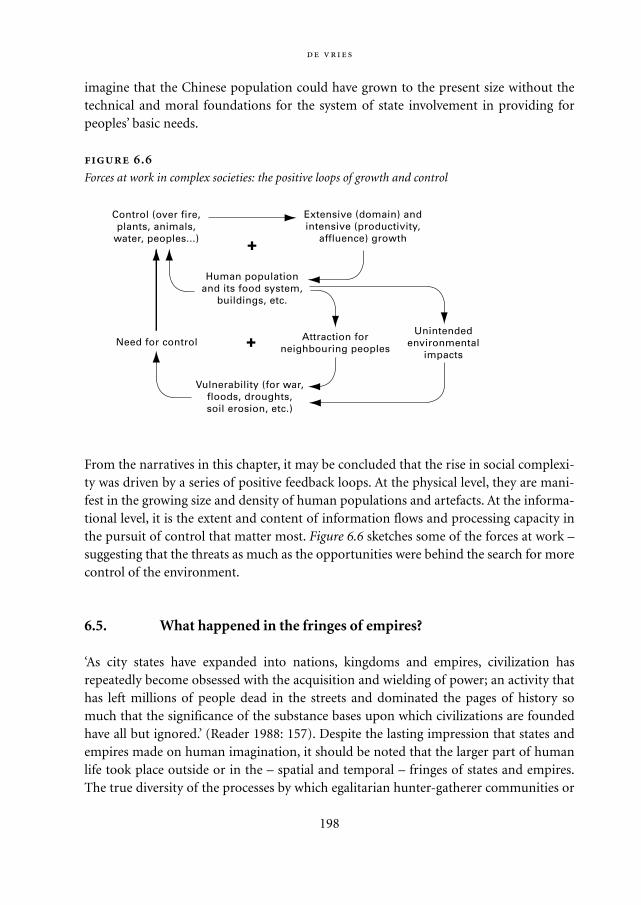
imagine that the Chinese population could have grown to the present size without thetechnical and moral foundations for the system of state involvement in providing forpeoples’ basic needs.
From the narratives in this chapter, it may be concluded that the rise in social complexi-ty was driven by a series of positive feedback loops. At the physical level, they are mani-fest in the growing size and density of human populations and artefacts. At the informa-tional level, it is the extent and content of information flows and processing capacity inthe pursuit of control that matter most. Figure 6.6 sketches some of the forces at work –suggesting that the threats as much as the opportunities were behind the search for morecontrol of the environment.
6.5. What happened in the fringes of empires?
‘As city states have expanded into nations, kingdoms and empires, civilization hasrepeatedly become obsessed with the acquisition and wielding of power; an activity thathas left millions of people dead in the streets and dominated the pages of history somuch that the significance of the substance bases upon which civilizations are foundedhave all but ignored.’ (Reader 1988: 157). Despite the lasting impression that states andempires made on human imagination, it should be noted that the larger part of humanlife took place outside or in the – spatial and temporal – fringes of states and empires.The true diversity of the processes by which egalitarian hunter-gatherer communities or
198
Extensive (domain) andintensive (productivity,
affluence) growth
Control (over fire,plants, animals,
water, peoples...)
Human populationand its food system,
buildings, etc.
Unintendedenvironmental
impacts
Attraction forneighbouring peoples
Need for control
Vulnerability (for war,floods, droughts,soil erosion, etc.)
+
+
.
Forces at work in complex societies: the positive loops of growth and control
Mappae Mundi bw zw/w 08-04-2004 15:25 Pagina 198
199
Life in the outposts of a declining Empire8 At the close of the Late Bronze Age
(ca. 3200 yr BP), the whole of northern Mesopotamia had been brought under Assyrian
rule. Centuries of warfare had eroded the urban basis of Assyrian royal power; the old
provincial centres were abandoned and large tracts of agricultural land had reverted to
nomadism. The coastal areas of the Near East were ravaged by the Sea Peoples and an
aggressive new tribal federation, the Aramaeans, raided the countryside. Assyria was
surrounded by foes, chaos was on the move. The Assyrian King Tukulti-Ninurta I (1233-
1197 BC) expressed his worries in a prayer to the state’s main god, Assur: ‘All the evil-
doers await a dark day without sunshine, their threatening fingers are stretched out to
scatter the armies of Assur, vilely plot against their benefactor.’
Some 400 kilometres west of the capital Assur lies the Balikh Valley, which was gov-
erned by members of the royal family. Provincial governors in this period were not
funded by the crown, but covered their expenses by raising taxes on the settled popu-
lation and by producing a grain surplus on the state farms in their territory. Such state
farms were founded in abandoned and marginal territories and thus served the econo-
my as well as a resettlement programme.
Tell Sabi Abyad (the modern name) lies halfway down the Balikh in a broad and
well-watered part of the valley. Impressive fortifications enclosed an area of some 3600
m2, the location of the owner’s residence, a jail, stores and administrative facilities. The
domestic and industrial buildings outside the walls were enclosed by a defensive ditch
several metres deep. The written sources, 319 clay tablets with cuneiform writing, indi-
cate a dependent population of around 1000, partly Assyrians brought down from the
Assyrian heartlands, partly deported foreigners and prisoners of war. Their tents and
mud brick houses must have been scattered around the countryside. About 36 km2 of
land was available for grain, pasture, fallow, and gardens. With a seed corn/yield ratio
of 1 to 7, the returns of agriculture could be called fair.
The day-to-day affairs of the state farm were directed by the ‘steward’, who had full
executive powers and interacted not only with the owner but also with the civil and
military administration of the region. Regional communication was by mail, slow and
dependable. Thus, a regional functionary wrote to the steward: ‘What is this, that what-
ever I tell you to do, you don’t do it as I said? Why did you not make a potter available
to the brewer in [the town] Dunni-Assur? Now your brewer in [the town] Sakhlalu must
be instructed to supply me with both beer and drinking vessels for my banquet with
[the representatives of] the Sutû tribe. From whom [else] could I request these sup-
plies? Respond promptly.’
In theory the Assyrian state treats its citizens and dependents according to public
law; in practice, however, the administration of justice is unpredictable. Consequently
the practice of bribing civil servants to further one’s cause is officially frowned upon
but in fact condoned. The quid pro quo implied by a ‘gift’ – as it is called – can even be
Mappae Mundi bw zw/w 08-04-2004 15:25 Pagina 199
the survivors of collapsing states and empires developed more complex relationshipsbetween its members and with their environment and their neighbours may be severelyunderestimated (McIntosh 1988; Renfrew 1973). In more heterogeneous landscapes,peoples had motives to develop other forms of organization, reflecting amongst othersthe (lack of) opportunities for migration, conquest, defence and taxation.
In this periphery of Great History, some populations stuck to or fell back onto earlierforms of organization: bands, tribes, with or without local despots. In some places andtimes peoples attained and sustained a degree of social complexity different from thesocial stratification characteristic of states and empires with centralized authority or oftrade-oriented city-states with competitive merchant elite.9 The process of accumula-tion of (access to) resources into fewer and fewer hands may have been halted by thecombination of a precarious environment on the one hand and egalitarian distributionschemes on the other. Anthropological explanations tend to give an important role tothe local/regional biogeography. The Chimbu tribe in highland New Guinea has hardlyany social stratification, yet population densities are up to 250 people/km2 – a reflectionof the ruptured landscape which restricts aggregation into larger units. Their exchange isnearly all reciprocal and interpersonal relationships are regulated by an elaborate ritualsystem as an alternative to political power and institutions (Flannery 1972). An examplefrom Africa is the Mande people who populated the Middle Niger region in West Africasome 4000-8000 yr BP (McIntosh 1988; McIntosh 2000b). Close seasonal adaptationand high seasonal mobility in combination and articulated specialization may have beenat the basis of this heterarchist society:
200
recorded in a sealed and witnessed contract: ‘Damqat-Tashmetu, daughter of Sin-
shuma-usur, wife of Sigelda, son of Irrigi, from [the town] Shuadikanni, owes one un-
castrated male adult to [the governor] Assur-iddin, son of Qibi-Assur. This male is his
gift; he [Assur-iddin] will receive his gift, when he [Assur-iddin] has treated her [Dam-
qat-Tashmetu’s] case which concerns her [deceased] husband’s serfs that must not be
given to Adad-shuma-iddina.’
Caravans from the Levant passed through Syria and left Hittite territory at Karkem-
ish where they crossed the Euphrates. On the route to Assur 90 kilometres to the west
lies Sabi Abyad, which functioned as border town and customs office. A regional office
wrote to the steward: ‘Formerly I instructed you as follows: ‘caravans that come to me
from Karkemish must not pass without your consent, and you must [check and] seal all
wares.’ Now I have heard that caravans in fact are on their way [and I repeat]: ‘any car-
avan that comes my way, be it of [the governor] Ili-pada, of princesses, or of nobles –
seal everything! I have also heard that they carry balsam; if any balsam is missing, you
will be executed.’ The import tax raised in Assur on luxury items such as balsam was an
important source of revenue for the state. It all has a distinctly modern ring.
Mappae Mundi bw zw/w 08-04-2004 15:25 Pagina 200
The salient characteristics of today’s climate and flood regime are high interannual variability
and the difficulty of prediction from year to year (much less at longer perspectives). Those
characteristics can, with some confidence, be extrapolated back into prehistoric time… The
lesson for the prehistorian and historian working within these long-term perspectives is that
environmental stress, surprise, and unpredictability were constant realities for the inhabitants
of the Middle Niger. Do differences in tool assemblages, faunal remains and settlement loca-
tion reflect a precocious development of specialists linked together by habits of regional
exchange? If so, we will have evidence for one quite successful adaptation to climate surprise. If
so, and if the emergence of specialists does not entail the emergence of elites, we have the
beginnings of a long-successful Middle Niger brand of heterarchy. (McIntosh 1998: 79-80)
East of the river Niger in Nigeria live the Ibo people who in spite of a high populationdensity have apparently developed neither cities nor states and had a dispersed not aconcentrated authority – ‘as late as the 1930s the Ibo could still boast that ‘there is no onewho owns us’ (that is to say: we have no rulers) and their society remained characterizedby [this].’ (Connah 2001: 164). On the island of Bali there is an intricate relationshipbetween rice cultivation and social organization (Reader 1988). Wet rice cultivation islabour-intensive, mechanization being difficult. It also has a high and lasting productivi-ty, mainly due to the benefits of controlled flooding on the nitrogen balance. In this situ-ation a form of social complexity has arisen with a strict caste-related hierarchy and animportant role for priests – who derive authority from high standards of behaviour.10 Yetit also has distinctly egalitarian features – as one would imagine to have existed in theearly religious-agrarian regimes:
The Balinese tend to dislike and distrust people who project themselves above the group as a
whole, and where power has to be exercised they tend to disperse it very thinly… For the Bali-
nese there is no difference between a person’s spiritual and secular life…The devils and
demons [in religion]… provide forceful reminders of the obligation to restrain selfish
instincts for the benefit of social harmony… Rice cultivation is the ultimate expression of the
Balinese readiness to follow the edicts of some greater authority. (Reader 1988: 61)
The complex religion of the Balinese – and other Asian populations – is an excellentexample of the functional significance of religion in human ecology, but beyond thescope of this book to deal with in more depth. One is also reminded of the role whichmonks and monasteries have played in the periphery of large civilizations.11
Despite the controversial nature of some of the interpretations of these examples –some speak of a ‘heterarchist gang’ – these examples highlight that social complexity hasevolved in more directions than just secular state and trade regimes. There is anothercollection of stories that are of particular relevance in the present context and also sug-gest that state control and trade regimes were not the only organizational forms of
201
Mappae Mundi bw zw/w 08-04-2004 15:25 Pagina 201
human-environment interactions. Ostrom (1990) refers to them as common propertyregimes. Written accounts show that peoples all over the world have developed institu-tions which have lasted over 1000 years in some cases and have survived droughts,floods, diseases and economic and political turmoil. Most of these regimes were in high-ly variable and uncertain environments and resource systems. The appropriators, that is,the individuals who use the common pool resource, have ‘designed basic operationalrules, created organizations to undertake the operational management of their commonproperty regimes, and modified their rules over time in light of past experience accord-ing to their own collective-choice and constitutional-choice rules.’ (Ostrom 1990: 58).These self-organizing groups solved the problem of commitment and mutual monitor-ing – among them the avoidance of free-riders and effective sanctioning – withoutresorting to centralized power exercised by external agents or to competitive marketinstitutions. According to Ostrom, these regimes were the outcome of a deliberatechoice:
The villagers have chosen to retain the institution of communal property as the foundation for
land use and similar aspects of village economies. The economic survival of these villagers has
been dependent on the skill with which they have used their limited resources. One cannot
view communal property in these settings as primordial remains of earlier institutions evolved
in a land of plenty. If the transactions costs involved in managing communal property had
been excessive, compared with private-property institutions, the villagers would have had
many opportunities to devise different land-tenure arrangements for the mountain commons.
(Ostrom 1990: 61)
Who were these villagers? One such a place is the Swiss village of Törbel for which a legaldocument on the rules for communally owned property dates back to 1224 AD (Ostrom1990; Reader 1988). Another famous example is the co-management schemes of waterresources for irrigation in south-eastern Spain (Ostrom 1990; Guillet 1999). The huertairrigation systems of Valencia, in operation since at least the 15th century, have been sin-gled out as unusually long-lived and successful, locally managed, common propertyregimes. Spain also has a rich history of local management for other resources such asforests, land and pastures, possibly related to the practices of Islamic nomads fromNorth Africa (see Section 3.5). However, such systems did not develop in isolation – theyworked in conjunction with guidelines and regulations contained in a famous seven vol-ume legal code, Las siete partidas, completed in the second half of the 13th century andthe epitome of a centralizing state. Other examples are the zanjera irrigation communi-ties in the Philippines, with a central role for the small-scale communities of the localirrigators and rules tailored to its own specific history, and management of over 12 mil-lion hectares of common lands in Tokugawa in 17th to 19th century Japan (Ostrom1990).
202
Mappae Mundi bw zw/w 08-04-2004 15:25 Pagina 202
6.6. The decline and fall of social complexity
As can be seen at a glance from Figure 6.6, the forces behind a rise in social complexityare interwoven with the forces of decline. What endures are the fringes – but the destruc-tion and collapse narratives usually receive most attention:
The last heyday of an independent [Sumer] took place between 4150 and 4050 yr BP under the
leadership of the city of Ur…. That [the massive and costly administrative reforms and the
animal sacrifices] contributed to the dynasty’s economic troubles seems likely. The climate of
the plain seems now to have been going through a long, dry spell; much agricultural land had
gone out of use, and economic documents show administrators shifting from wheat to the
more salt-resistant barley to combat salinization. Worse, the perennial raids on the plain from
nomadic outsiders grew more and more threatening…. There is evidence that much land by
now had been abandoned through salinization. The population could not be fed: prices hit the
ceiling with a sixtyfold increase in grain. International trade…broke down… and soon gov-
ernment communications started to fail…. Gloomy oracles prophesied the worst, and the
worst duly arrived. (Wood 1999: 33)
This is only one of the many evocative descriptions of what has always been a fascinatingsubject: the decline and fall of empires and civilizations. Flooding and drought havedestroyed empires in a complex process of famines, revolts and migrations. The end ofthe Harappan civilization in the Indus-Sarasvati Valley is associated with tectonic activi-ty:
Saraswati emerged as a mighty river during the warm spell that succeeded the Pleistocene
glaciation some 10,000 years ago… Flowing down the Himalayan slopes, it had coursed
through northwestern India and drained into the ancient Arabian Sea… great civilizations
had flourished on its banks during the river’s heydays. After glorious existence for some 4000
years, the river declined and gradually vanished… spells of intermittent tectonic activities
associated with the rise of the Himalayas, neotectonism in the Cutch region, climatic changes
and desertification induced by variations in earth’s orbit and tilt, diminishing supply of water
due to river piracy, all appear to have had vital roles in the downfall of Saraswati river.
(Sankaran 1999)
Table 6.1 gives an overview of some of the more well-known ‘decline and collapse’ sto-ries.
As with explanations of the large Eurasian migrations, many cause-and-effect schemeshave been proposed to explain the ‘rise and fall of empires’. Most spectacular are the BigCatastrophes, dismissing the possibility that ‘… the world ends, Not with a bang but a
203
Mappae Mundi bw zw/w 08-04-2004 15:25 Pagina 203
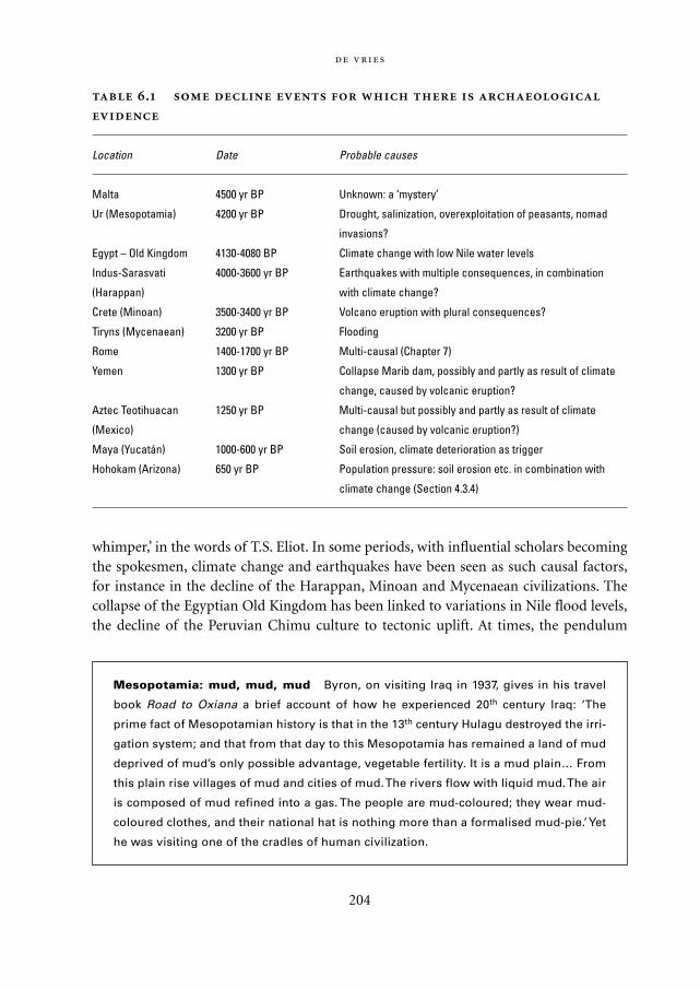
whimper,’ in the words of T.S. Eliot. In some periods, with influential scholars becomingthe spokesmen, climate change and earthquakes have been seen as such causal factors,for instance in the decline of the Harappan, Minoan and Mycenaean civilizations. Thecollapse of the Egyptian Old Kingdom has been linked to variations in Nile flood levels,the decline of the Peruvian Chimu culture to tectonic uplift. At times, the pendulum
204
.
Location Date Probable causes
Malta 4500 yr BP Unknown: a ‘mystery’
Ur (Mesopotamia) 4200 yr BP Drought, salinization, overexploitation of peasants, nomad
invasions?
Egypt – Old Kingdom 4130-4080 BP Climate change with low Nile water levels
Indus-Sarasvati 4000-3600 yr BP Earthquakes with multiple consequences, in combination
(Harappan) with climate change?
Crete (Minoan) 3500-3400 yr BP Volcano eruption with plural consequences?
Tiryns (Mycenaean) 3200 yr BP Flooding
Rome 1400-1700 yr BP Multi-causal (Chapter 7)
Yemen 1300 yr BP Collapse Marib dam, possibly and partly as result of climate
change, caused by volcanic eruption?
Aztec Teotihuacan 1250 yr BP Multi-causal but possibly and partly as result of climate
(Mexico) change (caused by volcanic eruption?)
Maya (Yucatán) 1000-600 yr BP Soil erosion, climate deterioration as trigger
Hohokam (Arizona) 650 yr BP Population pressure: soil erosion etc. in combination with
climate change (Section 4.3.4)
Mesopotamia: mud, mud, mud Byron, on visiting Iraq in 1937, gives in his travel
book Road to Oxiana a brief account of how he experienced 20th century Iraq: ‘The
prime fact of Mesopotamian history is that in the 13th century Hulagu destroyed the irri-
gation system; and that from that day to this Mesopotamia has remained a land of mud
deprived of mud’s only possible advantage, vegetable fertility. It is a mud plain… From
this plain rise villages of mud and cities of mud. The rivers flow with liquid mud. The air
is composed of mud refined into a gas. The people are mud-coloured; they wear mud-
coloured clothes, and their national hat is nothing more than a formalised mud-pie.’ Yet
he was visiting one of the cradles of human civilization.
Mappae Mundi bw zw/w 08-04-2004 15:25 Pagina 204
switched to the other side, giving hardly any consideration to climate and environmentalchange (Meyer, in Bell-Fialkoff 2000). Other ‘collapse theories’ have suffered similar upsand downs. Population pressure – often incorrectly equated to high population densityor growth – has figured prominently in many explanatory theories, although it is at bestan indirect association. Resource overexploitation and mismanagement, bringingfamine and diseases in their wake, are said to have caused the collapse of ancientMesopotamian and Meso-American civilizations, the former possibly and the latterprobably during periods of environmental change as has been recounted in this and aprevious chapter. Human-induced environmental degradation in the form of soil ero-sion and salinization feature as co-determinants. Interactions with other peoples in theform of wars and invasions have been invoked. A last important group focuses on inter-nal political processes: over-stretch in material and cultural terms, erosion or lack ofspiritual values. As the British historian Toynbee states in his last book Mankind andMother Earth:
Man is a psychosomatic being, acting within a world that is material and finite… But Man’s
other home, the spiritual world, is also an integral part of total reality; it differs from the bios-
phere in being both non-material and infinite; and, in his life in the spiritual world, Man finds
that his mission is to seek, not for a material mastery over his non-human environment, but
for a spiritual mastery over himself. (Toynbee 1976: 18)
It seems prudent to be aware of the degree to which theories big and small are a reflec-tion of dominant scientific fashions, schools, disciplines and individuals.
The evidence for decline and collapse is sometimes vivid and clear, in other casesindirect and obscure. Using all kinds of information, tentative population estimates havebeen constructed which reflect such momentous transition periods: populations inMesopotamia, the Nile Valley and the Mexico Basin have experienced precipitous decline(Figure 5.10). In most cases, the population density had risen to levels far above thosethat could be sustained with early agricultural techniques. As a result, there was a contin-uous pressure in these societies to extract surplus and to increase the workload and pushfor innovations among the rural populations. This struggle to lift the carrying capacityto satisfy growing demand has probably been the background to dynamic innovationsand expansions as well as to decline and collapse. Which way it would go will havedepended on a variety of factors, which can be summarized under the headings of eco-logical resilience – topography, resource endowments and dynamics, existence of traderoutes, etc. – and socio-political resilience – legitimacy of leadership, availability andaccessibility of tools and skills, military capacity, etc.
As usual, more investigations make the explanation more subtle and multi-faceted thanpreviously thought. In his book The Collapse of Complex Societies Tainter (1988) lists elev-
205
Mappae Mundi bw zw/w 08-04-2004 15:25 Pagina 205
en major themes in the explanation of collapse. They can be categorized into three groups:– Resource- and environment-related changes, fully exogenous or partly endogenous in
the sense of human-induced;– Interaction-related changes in the form of conquest or other, less penetrating forms
of invasion; and– Internal changes in socio-political, cultural and religious organization and world-
view, diminishing the adequacy of response to external events.
If decline happens, if collapse threatens, societies have had a variety of responses. Settingup or expanding trade, technical and social innovations, a change in environmentalmanagement practices, migration and conquest and a mix of all these have sometimespostponed, sometimes reverted and sometimes accelerated the processes of decline andcollapse. If disintegration occurred, new shoots on the tree of human civilizations got achance.
206
What can more intensely convey the grief and desperation in such episodes of dramat-
ic decline than this lamentation of an Egyptian king, as quoted by Hassan (2000)?
I was mourning on my throne
Those of the palace were in grief,
My heart was in great affliction,
Because Hapy had failed to come in time
In a period of seven years.
Grains was scant,
Kernels dried up,
Scarce was every kind of food.
Every man robbed his twin,
Those who entered did not go.
Children cried,
Youngsters fell,
The hearts of the old were grieving;
Legs drawn up, they hug the ground,
Their arms clasped about them. Courtiers were needy,
Temples were shut,
Shrines covered with dust,
Everyone was in distress.
I directed my heart to the past
I consulted on the staff of the Ibis.
Mappae Mundi bw zw/w 08-04-2004 15:25 Pagina 206
Understandably, the kind of explanation given for the collapse of complex societies isoften related to the explanation given for the emergence of complexity – as we have seenin the narrative above on floods in Egypt. One can also often recognize at once the disci-plinary background or prevailing value orientation behind the explanations. It is onlylogical, for instance, that Toynbee assigns great value to the erosion of moral and spiritu-al values in explaining the decline of the Roman Empire and that epidemiologists readgreat epidemics and geologists read tectonic movements into past collapse. Tainter(1988) in his analysis finds nearly all explanations unsatisfactory: they are either cyclicalor superficial or both. Most scholars would now agree that the decline and fall of com-plex societies can never be explained by a single cause-and-effect chain. Instead, as is thecase with explanations of the emergence of complexity, such systems will be in constantstructural transformation during which thresholds, non-linear behaviour and feedbackloops make their trajectory in time and space a unique series of interconnected, irre-versible events. Whether it is nevertheless possible to distil some general features forsuch processes is the topic of Chapter 8. First, we take an empirical look at one of themost intensely researched complex systems: the Roman Empire.
6.7. Conclusions
A new stage in the agrarianization process involved extensive and intensive growth ofhuman populations and their activities. It led to more intense and widespread interfer-ence with the environment and to spread and spatial concentrations of populations.Resources were used for ritual and art, sometimes causing environmental havoc. Miningand deforestation occurred on ever larger scales, with environmental changes in theirwake. Interactions, in the form of trade and migration, intensified and reflected in traderoutes and market towns. States emerged, with increasing social complexity in the formof craft specialization and social stratification. Some early states expanded their territoryand developed more elaborate systems of governance with large, centralized administra-tive bureaucracies and state-controlled trading networks.
Although environmental determinism in the form of single cause-effect schemes hasto be dismissed, the roads towards increasing social complexity were at least partly areflection of the local environment. Mesopotamian urban centres depended on an extrac-tion and control mechanism, which ultimately destroyed Mesopotamia’s agriculturalbasis and therefore itself. Egyptian civilization proved to be more resilient under suchforces, due in part to the lower long-term vulnerability of the Nile Valley to environmen-tal disturbances. The Indus-Sarasvati and Aegean civilizations may have had more trade-oriented features, with ecological diversity of their landscapes as one of the determinants.Meso-American civilizations such as the Maya apparently followed also a developmentpath in which environmental resource features and use patterns played a prominent role.
207
Mappae Mundi bw zw/w 08-04-2004 15:25 Pagina 207
With increasing social complexity came an extension of control over both the naturaland the human-inhabited space, in loops of actions with the subsequent need for greatercontrol. Sustaining the more complex physical and institutional arrangements requiredmore extensive information gathering and processing. In this sense, the rise in socialcomplexity can best be seen as a response to as well as a mediating factor in human-envi-ronment dynamics. Vulnerability for disturbances increased as existent and new risks forthe larger populations with their higher densities and larger fraction of non-food pro-ducers emerged. Unintended and probably only partly understood social and environ-mental consequences tended to undermine response capabilities to respond to its mani-festations in the form of increased taxation, famine, social uprisings and wars. Moreover,as the interaction with the environment became more intense and human society itselfbecame more complex, it became more difficult to develop an adequate representationof what was going on – enhancing the possibility of mismanagement.
Historically, most attention has been paid to the more conspicuous form of socialorganization: the hierarchically structured empires that evolved from military-agrarianregimes and were mainly based on extraction and control with an associated ideology.Trade-based states, formed around competitive markets, have also left clear marks inhuman history. Both reflected important aspects of their natural environment. In thespatial and temporal fringes of such states and empires, other forms of social complexityhave existed with resource management regimes based on local circumstances, co-oper-ation and community control. These various forms of social organization had mutuallyantagonistic yet complementary relationships. They all have experienced periods ofdecline or collapse, often as a combination of mutually related external and internalstresses. Internal factors reflect a social rigidity which blocks structural transformationin the face of social disruption. External factors are usually a combination of natural andhuman-induced changes in the environment as well as attack from groups of outsiders.
Parts of the process towards greater social complexity may be universal, that is, of allplaces and times, but the particulars of the natural resource base had a great bearing onits actual evolution: similarities everywhere, sameness nowhere. The proximate causes ofenvironmental change came from a combination of population pressure and agricultur-al intensification, with salinization, deforestation and erosion as secondary events. Theultimate causes were rooted in and became the roots of the quest for power, profits andpossessions and all the associated pleasures and pain.
208
Mappae Mundi bw zw/w 08-04-2004 15:25 Pagina 208
7
Empire: the Romans in the Mediterranean
What else, Ophelia dear, happened in the Roman Empire besides Ben Hur, Sparta-
cus and Gladiators?
Anonymous
7.1. Introduction: Why the Roman Empire as a case study and fromwhich perspective?
In the previous chapter we focused on what can be said about the interactions betweenpeoples and their natural environment as social complexity increased. In a sense, theRoman Empire can be seen as the culmination of the development towards states andempires in antiquity. But can we add anything to the entire libraries of studies on theRoman Republic and the Empire that followed in its footsteps? Thousands of books havebeen written on all aspect of Roman society, culture, economics, military strategy andorganization, measurements, infrastructures, political history – probably nothing can beadded that has not already been said. But let us reverse the argument: because so much isknown about the Roman period, it is a good one to present as an example of more gen-eral insights into complex socio-natural systems. There is a wealth of data, both writtenand archaeological, about the course of history – events as well as processes, politics aswell as economics, but also commerce, literature, agronomy and almost any subject nec-essary to gain a thorough insight into what happened. These data have been known for along time, and much time and effort has been expended in interpreting them. Moreover,it is quite exceptional to be able to study the full cycle of genesis, expansion, contractionand disappearance of such a major historical phenomenon that has dominated a largearea of the world for over a thousand years. It allows an uninterrupted perspective on thedynamics concerned at all temporal scales – from the longest to the shortest. Andbecause the Mediterranean Basin and its surroundings have been investigated for so long
209
Mappae Mundi bw zw/w 08-04-2004 15:25 Pagina 209
and in such detail, our perspective can also be developed for all spatial scales – from thecity of Rome to the entire known world and beyond.
In the study of socio-natural relationships, this possibility of taking all scales intoaccount is of particular importance. Firstly, among the many processes that play a role inthe relations between society and the environment some are very long-term, and oftencumulative. Among these are the ‘unintended consequences’ of human interventions inthe environment, which often come to light many years after the interventions them-selves. If one is to assess their true importance, a very long-term perspective is essential.Secondly, the Romans are of particular interest to us because their way of dealing with‘their’ world in many ways resembles our own in the 16th to 19th century. Many traits ofmodern society were in effect already part of Roman society some two millennia ago: therapid colonization of most or all of the known world, an elaborate military and civilorganization that managed to control the Empire, an urban base, as well as major invest-ments in infrastructure such as roads, aqueducts, ports and large-scale semi-industrialagriculture organized in latifundia. Indeed, one of the most striking parallels betweenthe Roman exploitation of much of Western Europe and the comparatively recentexploitation of North America is the checkerboard of roads and drainage ditches thatdivides both landscapes into square miles. Last but not least, the scientific analysis ofarchaeological data from a natural and life sciences perspective has recently provided amuch better insight into the ways in which people explored, organized and exploitedtheir environment in the Roman period (Leeuw 1998; Greene 1986; Favory 1998). It istherefore possible to go into considerable detail on the effect they had on their environ-ment and vice versa.
Having decided to look at the Roman Republic and Empire as an example of the evo-lution of the relationship between a society and its environment, we must also justifyhow we will look at that Empire. What will we try to show and, more importantly, whatwill we not try to show? To begin with the latter, any complete overview of the 1000 yearsof Roman history (500 BC to 500 AD) is neither possible nor the purpose. It will even beimpossible to even-handedly present some of the debates that are raging about many ofthe issues we will deal with. We will be unashamedly biased and partisan, telling thestory from the perspective of the long-term dynamics of socio-natural evolution – in allof the 1000 years and in all of the Mediterranean Basin and the adjacent areas that cameto be included in the Empire. Thus, the focus is on the coherence of the large-scaleprocesses of the emergence and decay of Roman society and the role of and its relation-ship with the natural environment within that evolution.
It should be noted that we do not distinguish between a ‘natural’ and a ‘cultural’ or‘societal’ realm but treat all socio-natural interactions as part of an indivisible whole.The core hypothesis is that, in order to grow to the size it did and to persist as long as itdid, the Roman state and the Roman ‘way of doing things’ had to be highly resilient.1
Roman organization had to be able to deal coherently with very complex dynamics. It
210
Mappae Mundi bw zw/w 08-04-2004 15:25 Pagina 210
had to be stable yet flexible enough to deal with many profound internal and externalchanges without losing its identity. What made this possible? And what changed towardsthe end of the ‘Roman millennium’ to cause the Empire to disintegrate? What was therole of the natural environment in that process, if any? Could it have been society’simpact on the natural environment that in the end sapped the Empire’s strength? Oneway to get at ‘what it takes’ for a society to be so resilient is to reverse our perspective fora moment, and to look out from inside the society rather than towards the society fromthe outside. How do we individually respond to problems, to changes in our social ornatural environment? Generally, we learn to deal with such ‘problems’ by means of amixture of changing our behaviour and changing the dynamics of the environment.Provided that we can do both efficiently enough, and in due time, then we will surviveintact – and so will our society. A critical element here is the capacity to collect andprocess information. If we cannot process the necessary information quickly and effi-ciently enough, we run the risk of seeing our ‘way of life’ forced out. We may lose contactwith our society, it may disintegrate, we may be forced to try our luck elsewhere or wemay simply ‘disappear’.
Our working hypothesis here is that the key factor limiting resilience in socio-naturalsystems is the capacity to process information. What constitutes this capacity? Is it aquestion of brainpower, of know-how? Is it a question of learning, of communication?How about invention and innovation? What about reactivity? Or, looking at it from theopposite side, was there anything particular to the Mediterranean Basin or to the Romanperiod that enhanced the resilience of the system concerned? The short but unsatisfacto-ry answer is ‘a little of all of them’. We will attempt to determine, using broad brush-strokes, how and to what extent each of these factors was implicated. Many of the ques-tions raised by our perspective on these matters are not answerable for the moment orthe answers are only partial. More complete and satisfactory answers are some yearsdown the line.
7.2. Critical social and environmental phenomena accompanying Roman expansion
7.2.1. An increase in surface and population
The first striking aspect of the Roman expansion in Western Europe is that both the sur-face area and the population increased extremely rapidly over the few centuries con-cerned, from the 3rd century BC to the 1st century AD. After that, the expansion stalled.Table 7.1 summarizes the Republic’s surface in square kilometres at various crucialpoints in its earlier history; Figure 7.1 gives an impression of the trends in populationand area. Trying to assess the size of the population is at best a desperate task, only to be
:
211
Mappae Mundi bw zw/w 08-04-2004 15:25 Pagina 211
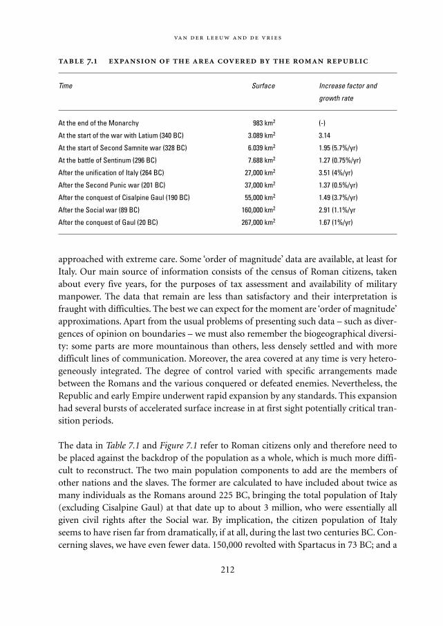
approached with extreme care. Some ‘order of magnitude’ data are available, at least forItaly. Our main source of information consists of the census of Roman citizens, takenabout every five years, for the purposes of tax assessment and availability of militarymanpower. The data that remain are less than satisfactory and their interpretation isfraught with difficulties. The best we can expect for the moment are ‘order of magnitude’approximations. Apart from the usual problems of presenting such data – such as diver-gences of opinion on boundaries – we must also remember the biogeographical diversi-ty: some parts are more mountainous than others, less densely settled and with moredifficult lines of communication. Moreover, the area covered at any time is very hetero-geneously integrated. The degree of control varied with specific arrangements madebetween the Romans and the various conquered or defeated enemies. Nevertheless, theRepublic and early Empire underwent rapid expansion by any standards. This expansionhad several bursts of accelerated surface increase in at first sight potentially critical tran-sition periods.
The data in Table 7.1 and Figure 7.1 refer to Roman citizens only and therefore need tobe placed against the backdrop of the population as a whole, which is much more diffi-cult to reconstruct. The two main population components to add are the members ofother nations and the slaves. The former are calculated to have included about twice asmany individuals as the Romans around 225 BC, bringing the total population of Italy(excluding Cisalpine Gaul) at that date up to about 3 million, who were essentially allgiven civil rights after the Social war. By implication, the citizen population of Italyseems to have risen far from dramatically, if at all, during the last two centuries BC. Con-cerning slaves, we have even fewer data. 150,000 revolted with Spartacus in 73 BC; and a
212
.
Time Surface Increase factor and
growth rate
At the end of the Monarchy 983 km2 (-)
At the start of the war with Latium (340 BC) 3.089 km2 3.14
At the start of Second Samnite war (328 BC) 6.039 km2 1.95 (5.7%/yr)
At the battle of Sentinum (296 BC) 7.688 km2 1.27 (0.75%/yr)
After the unification of Italy (264 BC) 27,000 km2 3.51 (4%/yr)
After the Second Punic war (201 BC) 37,000 km2 1.37 (0.5%/yr)
After the conquest of Cisalpine Gaul (190 BC) 55,000 km2 1.49 (3.7%/yr)
After the Social war (89 BC) 160,000 km2 2.91 (1.1%/yr
After the conquest of Gaul (20 BC) 267,000 km2 1.67 (1%/yr)
Mappae Mundi bw zw/w 08-04-2004 15:25 Pagina 212
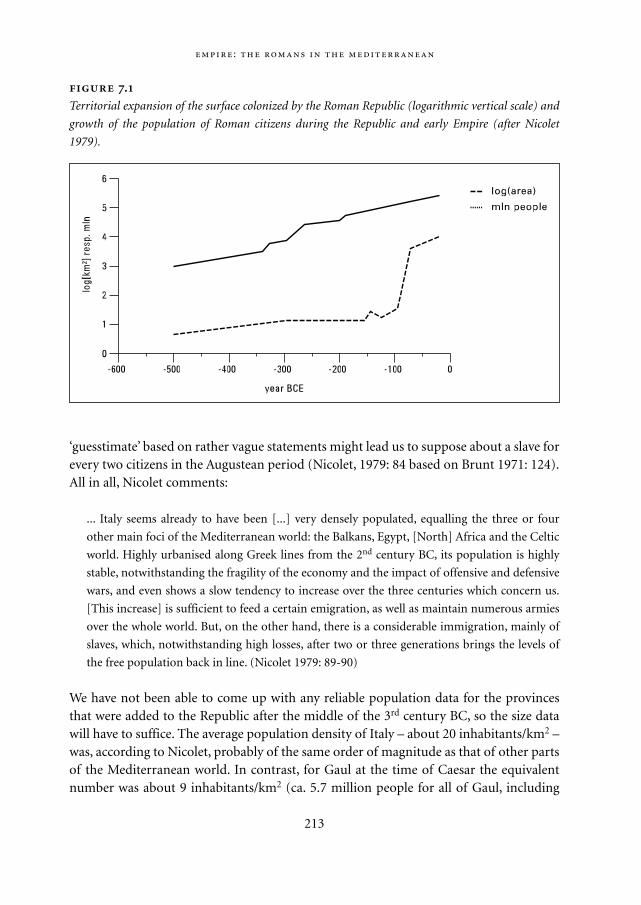
‘guesstimate’ based on rather vague statements might lead us to suppose about a slave forevery two citizens in the Augustean period (Nicolet, 1979: 84 based on Brunt 1971: 124).All in all, Nicolet comments:
... Italy seems already to have been [...] very densely populated, equalling the three or four
other main foci of the Mediterranean world: the Balkans, Egypt, [North] Africa and the Celtic
world. Highly urbanised along Greek lines from the 2nd century BC, its population is highly
stable, notwithstanding the fragility of the economy and the impact of offensive and defensive
wars, and even shows a slow tendency to increase over the three centuries which concern us.
[This increase] is sufficient to feed a certain emigration, as well as maintain numerous armies
over the whole world. But, on the other hand, there is a considerable immigration, mainly of
slaves, which, notwithstanding high losses, after two or three generations brings the levels of
the free population back in line. (Nicolet 1979: 89-90)
We have not been able to come up with any reliable population data for the provincesthat were added to the Republic after the middle of the 3rd century BC, so the size datawill have to suffice. The average population density of Italy – about 20 inhabitants/km2 –was, according to Nicolet, probably of the same order of magnitude as that of other partsof the Mediterranean world. In contrast, for Gaul at the time of Caesar the equivalentnumber was about 9 inhabitants/km2 (ca. 5.7 million people for all of Gaul, including
:
213
.
Territorial expansion of the surface colonized by the Roman Republic (logarithmic vertical scale) and
growth of the population of Roman citizens during the Republic and early Empire (after Nicolet
1979).
Mappae Mundi bw zw/w 08-04-2004 15:25 Pagina 213
Gallia Narbonensis). If these estimates are accepted, the conclusion must be that therapid conquest of Gaul by Caesar doubled the population of the Roman Republic justbefore it became an Empire in the formal sense. The conquests that occurred in the Easta few years later, around the beginning of our era, must have more than doubled it again.Such expansion is, of course, unheard of until that moment in history and has notdurably occurred at any other time in the history of the West. It could not fail to havemajor consequences for its internal structure and functioning, as it increased the flows ofenergy, matter and information a number of orders of magnitude.
7.2.2. Urbanization
What enabled this rapid expansion? In order for such large areas to be conquered all atonce, and durably so, the conquerors must have been able to establish or control anappropriate infrastructure. That infrastructure depended on the spread of towns. In theNear East and Egypt, the first cities occured in the 4th millennium BC. By the 1st millen-nium BC they had spread to the Levant and the coastal areas of the eastern Mediter-ranean, and by the 5th century BC to many coastal areas of the western Mediterranean.The last half of the 1st millennium BC sees them spread inland from the coast, notably inSpain and Gaul (Figure 7.2; see p.173). The Roman conquest of the western Mediter-
214
Population in the Roman Empire and the Umayyad Empire Issawi (1981) is
among the authors presenting an overview of population estimates for the Roman
Empire in the 1st and 2nd century and the Arab Empire in the 8th century AD. As with all
estimates of past populations, they have to be used with caution. The core of the
Roman Empire – Italy, Spain, Greece, Egypt, Narbonensis and the islands – had an esti-
mated surface of 1,294,000 km2 and 22 to 37 million inhabitants. Including more
peripheral regions – North Africa outside Egypt, the Danubian and Near Eastern
provinces and the Three Gauls – the numbers increase to 3,790,000 km2 and 54 to 75
million inhabitants. Population densities in 14 AD ranged in Western Europe from an
estimated 1.3 (Britain) to 24 people/km2 (Italy), whereas in parts of the Eastern Mediter-
ranean it reached much higher values. For the Balkans, Egypt and North Africa Nicolet
(1979) accords a population of density of some 20/km2 each. However, in the subse-
quent 150 years they have more than doubled in the western part while increasing
much less in the eastern part of the Mediterranean. Interestingly, the density distribu-
tion in the later Ummayad Arab Empire of the 8th century seems not to have been dif-
ferent although its population was much more heavily concentrated in the southern
and eastern parts of the Mediterranean.
Mappae Mundi bw zw/w 08-04-2004 15:25 Pagina 214
ranean closely follows the spread of urbanism, which precedes it by at least two centuries(Figure 7.3; see p. 174).
We have ample indication that Rome preferably integrated territories that had reached aspecific degree of urbanization. They were easier to control, by means of garrisons, etc.,but also had in place a mode of administration and commerce that could be connecteddirectly to Rome’s own. In fact, urbanization was the groundswell on the back of whichRoman colonization rode all over Western Europe.
But control over the towns and other centres should not be assumed to be central-ized. The Romans developed a number of different modes of association with theirneighbours, based on leaving existing local institutions intact to varying degrees and onallowing some members of such other groups – tightly controlled – access to their owninstitutions. This provided them with the means to expand by conquest, and to controlthe territory thus acquired from the ‘bottom up’, using local administrative and controlstructures to integrate these enormous new territories and their inhabitants. As a result,the degree of Roman impact on the various components of its territory was highly vari-able:
What we see appearing is not a civilian administration which extends its bureaucratic ramifi-
cations over all the Roman possessions, but multiple solutions, each born of circumstance,
which range from assimilation to exploitation pure and simple. (Rougé 1969: 56)
ItalyUp to around 500 BC Rome was merely a leader among equals (the Latin cities), but alllater ‘adhesions’ to the Republic were directly structured as individual treaties of anothercity with Rome. This led to what was essentially an exploitative pattern of administra-tion, based on links with the centre of different form and intensity. The centre of Italywas ‘allied territory’ peopled with individuals who, in a treaty with Rome, had submittedto it rather as ‘clients’ to a ‘patron’. The inhabitants of these cities were ‘strangers’ (non-citizens) who had a degree of independence (at least de iure). Their exact status depend-ed on whether it was the result of a negotiated treaty (socii) or a submission (fœderati).They had the right to marry Romans and trade with Rome but not with others; theircomponents of the army were directed by Romans and they had to follow the Senate inquestions of foreign policy. Internally, they usually ruled themselves.
Both coasts, on the other hand, were quickly made into ‘Roman territory’ (agerRomanus). Within that territory, distinctions were made on the basis of citizenship. Theclosest ties existed between Rome and the ‘colonies’ (coloniae), founded by groups ofRoman citizens (up to 300 BC) in Roman territory. The members of colonies retainedfull citizenship and were seen as ‘a projection of the City’ (Rougé 1969: 59). The colonies’administration was originally organized from Rome, but these communities later
:
215
Mappae Mundi bw zw/w 08-04-2004 15:25 Pagina 215
formed their own administration, modelled on that of Rome, with the same assembliesand magistrates.
Next in line came the ‘municipia’, the cities with obligations vis-à-vis Rome. Thesehad their own administrative institutions, even though their inhabitants had full citizen-ship, including the right to vote when in Rome. These cities often had experienced aphase in which their inhabitants had no full citizenship (civitates sine suffragio). In theearly days, the municipal form of association originated in a treaty with Rome in whichboth cities were legally each other’s equals. Later, however, the status of municipium wasunilaterally designated by Rome itself. The institutions of such a city were left intact, andthe city governed itself internally. Its inhabitants had the right to marry and trade withRomans, if not that to vote. The main advantage of this status from the organizationalpoint of view was, that it left local channels of communication intact and directed thecities in question towards Rome’s aims without burdening the latter’s administrationexcessively.2
After the revolt and the defeat of the Latin cities (338 BC), these were not givenRoman citizenship, but Latin citizenship was given special status vis-à-vis that of Rome.The cities retained their own institutions. Latin citizens had the right to trade with andmarry Romans but also with other Latins, the right to move to Rome, and the right tovote in certain Roman councils of government – but in such a way that their vote washardly effective – when they were in the city. But they could not become magistrates,other than after obtaining full Roman citizenship on an individual basis. Large numbersof new colonies were founded with Latin rights, each with up to 6000 inhabitants.
In conclusion, the Romans controlled Italy in the true sense of the word, politically,economically and judicially, but to varying degrees that essentially depended on the eco-nomic importance (coast versus inland), power, degree and efficiency of internal organi-zation and the ‘nuisance value’ of the different territories. This enabled them to remainon top of a power pyramid with a relatively wide basis, as it limited the amount of ener-gy involved in control while optimising its communication channels by providing incen-tives for the locally dominant classes to toe the Roman line.
The provincesThe Roman provinces essentially consisted of the territories outside Italy conquered byRome. They were governed by Roman magistrates, whose efforts were in general single-mindedly aimed at creating optimal (i.e. peaceful) circumstances for draining the areasin their care of as much of their wealth as was possible. The administration put in placeto do so was generally based on, as well as limited to, the cities. There was no standingRoman administrative apparatus on which the consuls or praetors entrusted with themcould count. Instead, they had to depend on their wits, on a small entourage, on someadministrative assistants and on about 12,000 soldiers. The magistrates made their ownrules at the beginning of their term of office and supported the members of the knightly
216
Mappae Mundi bw zw/w 08-04-2004 15:25 Pagina 216
order who had formed companies to extract taxes from these territories.As in Italy, the legal status of the cities in the provinces was decided on a case by case
basis. Three types of status existed: ‘federated’, ‘immune’ and ‘submitted’. The former hada separate negotiated treaty with Rome; they were autonomous – not submitted to theprovincial administration – and did not pay tax but had to contribute to the army andprovide it with food. The immune cities had submitted to Rome but, at Rome’s discre-tion, were accorded the – immediately revocable – status of federated cities rather thanthat of ‘submitted cities’. The latter formed the third and least enviable category. Theywere the property of Rome and were allowed to use their lands only in return for a pay-ment. In so far as they kept their own institutions, these were under the control of theRoman provincial administration, which had extensive powers over them, including lifeand death, and the power to use the army to ‘pacify’ both within the province and at itsborders.
In practice, there were immense differences in the degree of control exerted over andwithin the provinces. These were largely due to differences in the degree of urbanization.Where that was not sufficient, the Romans found it very difficult to exert any control atall. Thus, Caesar complains that in Belgium ‘there is nothing to control – no cities, noforts, no installations’ (Roymans 1990).
7.2.3. Transport and commerce
In order to hold together an Empire the size of the Mediterranean Basin, dependable andefficient means of transportation for goods and people are essential. The fact that theRomans managed to create such a system is due to the particular geography of theregion, as well as to their organizational talent and technology. We briefly discuss threeaspects: location, the road system and commerce.
LocationThe location of Rome, at the centre of the Mediterranean Basin, almost as far from thecoast of Spain as from the Levant and as far from North Africa as from the southernFrench and Dalmatian coasts, was a major advantage. By facilitating maritime contacts,it allowed the centre to deal efficiently with the outlying parts of the Empire. No one partof the coastal core of the Empire was much further away from the centre than any other.All were within easy reach of Rome. That provided a solid physical-geographical basisfor the expansion of the Empire away from its coasts. Moreover, the MediterraneanBasin’s particular geographical structure – the only one of its kind and size in theworld – also provided a relatively homogeneous climate and, therefore, vegetation overthe whole of the area. That, of course, facilitated the adaptation of people and the bor-rowing of techniques across the region. Finally, the geographical structure of the entire
:
217
Mappae Mundi bw zw/w 08-04-2004 15:25 Pagina 217
Empire, around a sea, also contributed in important ways to its cultural coherence. Bythe time Rome conquered the Mediterranean Basin, intensive contacts between allMediterranean coasts had existed for thousands of years. These contacts contributed tothe – relative – cultural homogeneity of the Basin. Not only had people from all parts ofthe Mediterranean previously been in contact, but they had exchanged goods and inven-tions in all areas of human endeavour. As a result, they were highly similar with respectto their economic basis, their socio-political organization and, in general, in their ‘waysof doing things’ – in short, their culture.
The road systemIn many ways, the road system was the pride of the Empire. As the principal means ofcommunication overland, this system formed the backbone of the expansion during theRepublic and the Empire. The trajectory of all the major Roman roads across Europeand the Mediterranean Basin is well-known. The extensive secondary road systems thatwere linked by the major highways have not been particularly well researched, and it isoften extremely difficult to date these roads. Comparing the following two examples maybe illustrative. Dowdle (1987: 279), in his study of the roads in Burgundy in France,argues very cogently that a major part of the regional road system in this Gaulish state ofthe Aedui was in place well before the Romans had absorbed the area into their Empire(Figure 7.4a-b). After Caesar had broken the back of Gaulish resistance, he moved thecapital of the area from Bibracte to Augustodunum (Autun). As a consequence, we see anumber of new sections of road connecting the new capital to the existing road system.Moreover, many of the roads were paved, the network was completed here and there andwas extended to include changes in the relative importance of the settlement network,but it was not fundamentally changed. There were, however, major reconstructions of,and additions to, the inter-regional system of major roads connecting the territory of theAedui to other parts of Gaul and beyond (Crumley 1987).
Such road-building activities should in essence be seen as ‘streamlining’ the positionof the territory within a newly created larger context. One of the results was that newconurbations came into existence at junctions or crossing points of the new roads witheach other, with old roads and with rivers. Equally, Roman activity greatly enlarged thesub-regional road network, which came to include connections between the many ‘villas’that exploited the fertile countryside for the Roman Empire.
The primary raison d’être of the road system was, of course, that it provided adependable and efficient means to move people around all of the area concerned andthus to exchange information and ensure administrative and military control. But itsimpact was also felt in other ways. Firstly, the trajectory of these roads deliberately brokethrough the unity of the tribal territories that they crossed. In doing so, they fundamen-tally changed the patterns of spatial interaction between the indigenous populations.Secondly, from an environmental point of view their most durable impact was probably
218
Mappae Mundi bw zw/w 08-04-2004 15:25 Pagina 218
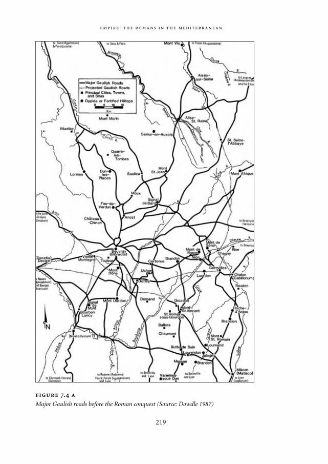
:
219
.
Major Gaulish roads before the Roman conquest (Source: Dowdle 1987)
Mappae Mundi bw zw/w 08-04-2004 15:25 Pagina 219
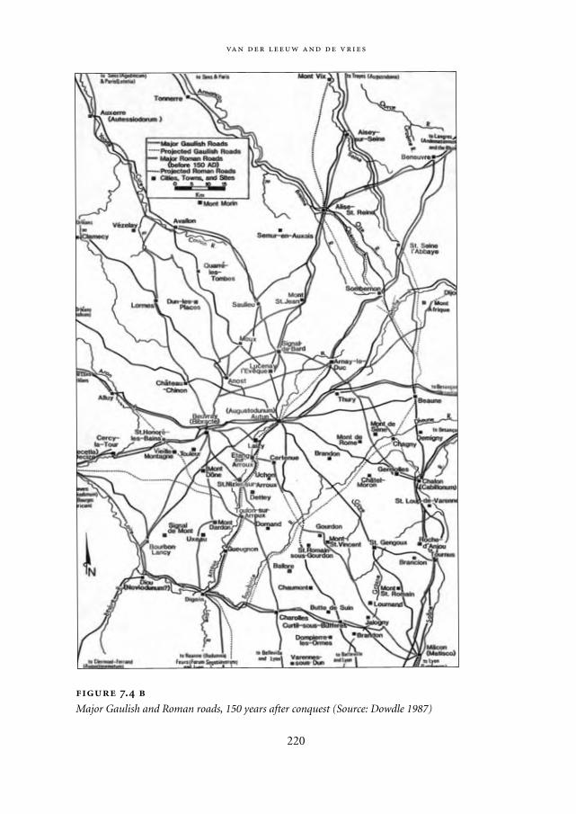
220
.
Major Gaulish and Roman roads, 150 years after conquest (Source: Dowdle 1987)
Mappae Mundi bw zw/w 08-04-2004 15:25 Pagina 220
that they facilitated the implantation of a dense network of farms that produced forexport. They therefore brought many areas that had thus far led a relatively autarchic lifeinto the mainstream of the then ‘world system’.
CommerceTrade itself is, of course, nothing new – people have traded ever since they producedartefacts and food, and we find traces of such trade from the Palaeolithic periodonwards. Moreover, in the two millennia leading up to the Roman expansion, trade inall conceivable commodities had spread to all parts of the Mediterranean Basin.According to literary and archaeological evidence, it must have included cereals, oliveoil, wine, (dried) fruit, slaves, marble and other kinds of stone, copper, iron silver andgold, etc.
But the scale of trade changed several orders of magnitude. In the Roman period, weobserve several new phenomena linked to trade. First of all, we commonly find evidenceof the industrial production of trade goods. We know of the existence of pottery andglass factories, for example, that produced tens of thousands of objects a year, principal-ly for export (Figure 7.4c; see p. 175). Many of these goods were containers used in con-nection with the trade in agricultural products such as wine, olive oil and cereals. Theseexports were found all over the Empire. But that is not all. The Romans also linked intothe spice trade with the Middle East and East Asia. Recent archaeological research in theIndian Ocean confirms that Roman goods were traded as far afield as present-day India,Indonesia and East Africa. Throughout the Empire, archaeologists have uncovered theexistence of a large number of trading emporia where we find remains of masses of tradegoods. Some of these emporia were established before the advent of the Romans, butmany new ones were founded during the Roman period, and they can be found literallyeverywhere. They are located on the coasts, particularly at the mouth of large rivers,along rivers at points where they connected with other rivers or with roads, and at thepoint where these rivers became unnavigable and goods had to be loaded on to carts oranimals.
Another major indicator of the importance of commerce is the widespread use ofcoins of all kinds of denominations. High-denomination gold and silver coins from thepre-Roman period have been found in limited quantities in parts of Gaul and Britain.But the sheer numbers of coins found in a Roman context overshadow any such evi-dence from earlier periods. Moreover, the fact that lower denomination coins aboundeven in rural areas shows the extent to which the monetary system has penetrated thoseparts of commercial life that were traditionally the preserve of in natura exchanges.
Altogether, then, we have clear indications that trade is one of the major economicactivities in the Roman world. It can be concluded that the transformations that areexpressed in the material culture of the Roman period seem to point in the directionexpressed by Dowdle:
:
221
Mappae Mundi bw zw/w 08-04-2004 15:25 Pagina 221
It is commonly believed (and rightly so) that Gaul underwent a massive agricultural, industri-
al, and cultural expansion after its conquest by Rome, to become the most productive, most
industrialised, and indeed most civilised province in the Empire [...]. But it is also true that
such growth could not have happened had not the indigenous people been capable of it and
ready for it. Indeed, we would argue that they were well on their way toward rapid economic
growth and diversification by the time of the conquest. (Dowdle 1987: 291-2)
This seems to apply to the majority of the territories eventually drawn into the Romansphere (cf. Rodwell 1976: 310-11). Where it does not apply, the Romans found conquestdifficult, if not impossible, and preferred not to intervene militarily. The territory thatthey eventually conquered was prepared for them by the history of the areas concerned,and in particular by their prior economic relationship with the Mediterranean. TheRomans merely realized a potential that was generated beyond their own control. Theywere able to do so for a number of reasons. Firstly the location of Rome in the centre ofthe Mediterranean Basin is important – the whole of the basin was within reach in a rea-sonable time. This in turn facilitated the existence of an Empire that was to an importantextent built on trade in raw materials and agricultural products between geographicallyhighly variable regions, yielding different commodities. The sea provided the Romans,once they had control over shipping and seafaring and had defeated their principal com-mercial enemies the Carthaginians, with the means to transport goods efficientlythroughout the centre of the whole region they controlled. All around the Mediter-ranean Basin, coastal cities, particularly at the mouth of navigable rivers, provided theinfrastructure to control and facilitate further transport inland, by boat or over land. Butwhilst shipping is an effective way to transport bulk goods, it is much less effective as ameans of communication or the displacement of power. The administrative structure ofthe Empire was therefore based on decentralization and overland communication.
In most of the areas the Romans colonized, they were able to take over an existinginfrastructure of power and commerce that was centred on towns. Their success in doingso was to a large extent due to the very adaptable socio-economic and political frame-work into which they linked each local unit. Moreover, their technical prowess in survey-ing enabled them to build a long-distance road network that linked the different region-al and local infrastructures, providing a dependable means to move information andmilitary power, even when weather conditions made seafaring difficult. A third reasonwas that the Roman expansion occurred in an era of demographic growth, whichallowed the Romans to harness labour on a large scale all over the Empire. Slaves andserfs effectively ran the Roman economy from relatively early on, serving as clerks, edu-cators, stevedores, builders, factory workers and almost everything else. Without anample population to draw upon, both inside the Empire and in the areas into which itexpanded, the Empire would never have been able to harness sufficient energy to keepgoing.
222
Mappae Mundi bw zw/w 08-04-2004 15:25 Pagina 222
7.3. The human environment in Roman times
The central questions of this book concern the relationship between society and its envi-ronment. How did the Mediterranean environment change under the impact of Romancolonization? In which ways did the Romans have to change their way of dealing withdifferent environments in order to accommodate these changes? In order to gain a good
:
223
Mapping the European landscape during the Roman Empire (Romanova
1997)3 At the beginning of historic time, the Ancient period (3rd century BC to 5th
century AD), the differentiation of the anthropogenic subsystems within European
landscapes became more pronounced. Five categories of landscapes are shown in
Figure 7.5a (see p. 176); estimated population densities, urban settlements and the
important mining and metallurgy centres are shown in Figure 7.5b (see p. 176). Densely
populated areas with developed social, economic and cultural structures were concen-
trated in the Mediterranean regions of Europe (Pounds 1973). On the eve of the new
era, about 29 million people inhabited the European territory (Maksakovsky 1997), of
which an estimated 8 million lived in Italy, 7 million within the Iberian Peninsula and
3 million in Greece. It is in these times that the forests, mainly cedar stands, were cut
down to satisfy the needs of shipbuilding. Drainage, irrigation and fertilization were
practiced within agricultural landscapes, with increasing grain yields (Barash 1989;
Samarkin 1976; Pounds 1973). Intensively cultivated landscapes underwent irreversible
anthropogenic transformation. Major impacts were associated with settlements (partic-
ularly large and very large towns and villages), agriculture (ploughing and hydraulic
amelioration), forestry (forest cutting, expansion of maquis and garrigue) and mining
and metal processing (Pounds 1973). Radical changes of natural geosystems resulted in
the formation of modal landscapes in remote mountainous areas, while the remainder
of Southern Europe was dominated by derivative landscapes, maquis and garrigue, or
anthropogenic modifications of natural geosystems, mainly agricultural and pastoral
(Figure 7.5b). Central and Eastern Europe were much more sparsely populated (English
Landscapes 1985). There were about 5 million people in Gallia and 1 million on the
British isles, while the population of the northern regions, Scandinavia and Ireland, was
extremely low. The economy of the Celts, Slavs and Germans was poorly developed;
crop yields were low and cultivated areas were concentrated around a few settlements
linked with trade and migration routes. Forest-steppe landscapes of the Danube plains
were mainly used for settled or nomadic cattle-raising (Shnirelman 1989). However,
both cultivation and grazing had only a slight and local impact on natural geosystems,
so natural landscapes with minor anthropogenic changes dominated the territory.
Mappae Mundi bw zw/w 08-04-2004 15:25 Pagina 223
understanding of these matters, we should first look at the Mediterranean environmentbefore the advent of the Romans. Next, we will look at the changes wrought by Romancolonization, and finally we will look at how these influenced the process of colonizationitself.
7.3.1. Geography and climate
The original territory of the Roman Republic was relatively homogeneous from a geo-graphic point of view – the hills and valleys of Latium, Etruria and the other landscapesof central Italy. The diversity of exploited landscapes increased with the conquest ofother Mediterranean provinces. Many coastal valleys were added all around the Mediter-ranean. Some of these were very large, such as the valleys of the Po, Nile and Rhône, butothers were small and enclosed by high mountains, such as in southern Greece. Otherareas were completely different, for example as the highlands of central Spain andTurkey and the rolling hills and plains of northern Gaul and Belgica. In yet furtherregions, the climate was the principal difference to the Italian heartland, such as indrought-ridden North Africa and the Near East, not to mention cold and wet Britain.Altogether, it is impossible to generalize about the environment, environmental change,resilience and adaptation of the Roman colonization to these different environments. Allthat can be said is that the basic environmental differences between the various regionsmust have triggered many different forms of local adaptation.
At the same time, these geographic differences constituted one of the major assets ofthe Empire, as they provided a variety of crops under a variety of different conditions,thus spreading risks (cf. Section 6.3.3). It is typical of most Mediterranean landscapesthat they are very fragmented – small valleys alternate with hills and mountains to createa spatially discontinuous environment. As a result, the conditions are generally differentin closely neighbouring areas. Therefore, these landscapes as a whole lend themselves tothe small-scale cultivation of different crops, together with herding, rather than to thelarge-scale farming of homogeneous crops. For the latter, one has to move away from theMediterranean rim, and into the large river valleys of the Po, the Rhône, and the Nile.These discontinuities created good conditions for a very wide range of plant and animalproducts (see below). Maybe even more importantly, due to the variety of environments,most of these products were available most of the time; a poor harvest in one area couldoften be compensated by a better harvest in another area.
Most suitable Mediterranean landscapes were ‘disturbance-dependent’ by the timethe Romans colonized the region, in the sense that the landscape had become entirelydependent on interruptions of the natural cycli by humans. Seven-and-a-half thousandyears of co-evolution between human societies and their natural environment hadcaused the latter to be so modified as to depend on human dynamics to maintain its
224
Mappae Mundi bw zw/w 08-04-2004 15:25 Pagina 224
condition. Interruption of human activity would have caused profound changes in thelandscape – erosion, growth of garrigue, recolonization by forest – and would immedi-ately have made these landscapes unsuitable for the human activities that had shaped it.The central position of a large surface of water in the region did to an important extentattenuate differences in temperature and precipitation around its edges, as it does today.Unlike other regions, such as the Andes and California, there are no north-south moun-tain chains to impede the winter’s wet winds from north Atlantic high-pressure zones;they penetrate thousands of kilometres into the basin. Relatively mild winters, hot sum-mers, and precipitation in spring and autumn – between 100 and 400 mm/year – are thedominant characteristics of the climate in the basin itself. Many of the sub-regional dif-ferences within it are linked to variations in altitude, or in distance from the coast, ratherthan to the regional climate dynamics themselves. The one major exception is the prox-imity of the Sahara making Northern Africa a drier and warmer place than the northernrim of the Mediterranean.
The evidence for climate change is for the moment still fragmentary, based on a widerange of data relative to different spatio-temporal scales, but it is rapidly getting better(cf. Chapters 3 and 4). The evolution of the water level in circum-alpine lakes, the vol-ume of water flowing through the Rhône, oxygen isotope measurements in the atmos-phere, and measures of erosion on the slopes of some of the Rhône’s tributaries all seemto point to the same conclusion. In areas where these data can be compared – principal-ly in south-eastern France – there are no indications of major changes in climate duringthe period we are considering, from about 400 BC to about 600 AD. But it is possible
:
225
Did human-induced changes in land cover affect the climate? Present-day cli-
mate models make it possible to simulate the extent to which past human actions have
led to climate change. Although such endeavours are still full of uncertainties, they can
give an impression of when and how human interaction with the environment started
to result in larger-scale feedback loops. In a recent paper, Reale and Shukla (2000) have
presented the results of an attempt to simulate the impact of humans in the Mediter-
ranean area during the Roman Classical period, around 2000 yr BP. They have organ-
ised all available archaeological and historical information into a coherent history of
climate and vegetation. It was found that North Africa was wetter than today and that
the Mediterranean had experienced a continuous trend towards a ‘drier’ kind of vegeta-
tion. A general circulation model was run to explore the impact of human-induced
change in land cover – mainly deforestation – on the climate (a vegetation change
experiment). The result suggests that the action of land clearing might have con-
tributed to a positive feedback loop affecting climate and resulting in a drift towards
drier conditions.
Mappae Mundi bw zw/w 08-04-2004 15:25 Pagina 225
that at the time of the Roman expansion, in the last two centuries BC and the first twocenturies AD, precipitation may have been slightly lower and average temperaturessomewhat higher than either before or after that period. This may have facilitated thecolonization of otherwise relatively humid areas, such as ancient endorrheic marshesand the flood plains of major rivers (Magny 1992). We will return to the question ofwhat part such an oscillation may have played in the overall history of the Empire.
7.3.2. Colonization
Archaeological research undertaken in the last thirty years has provided us for the firsttime with independent means to corroborate the literary evidence concerning thechanges in the countryside that occurred during Roman colonization. The archaeologi-cal evidence points to the fact that major changes had affected the Mediterranean coun-tryside for a long time before the advent of the Romans – a definite change in perspec-tive on the Roman period (Greene 1986). A large number of systematic regional surveysin many parts of the Mediterranean have unearthed numerous archaeological remainsof all periods. In many places, the evidence points to dense agricultural settlement evenbefore the Roman period. In the Molise Valley on the Eastern flank of the Apennines,for example, the number of farming settlements increased from about 4000 BC until,around 1000 BC; even the least ‘attractive’ land was settled and exploited (Barker 1981).From that point in time onwards, a complete change in the settlement pattern isobserved, apparently closely related to fundamental changes in agricultural exploita-tion.
The most important of these is the introduction of the Mediterranean system ofpolyculture. This combines the cultivation of cereals with that of olives and vines.Because the latter two grow on different soils to cereals, this system brings differentparts of the landscape under cultivation. And because olives and vines are harvestedlater in the year, it possible for the farmers to harvest three kinds of crops. But polycul-ture was not used in isolation. The results of palaeo-botanical analyses seem to indicatethat a range of new crops was cultivated and a range of new techniques introduced inthe first half of the last millennium BC. Although some of the best evidence for newcrops comes from Western Europe (Roymans 1990; Jones 1981), the idea that agricul-tural innovations occurred is systematically corroborated in the Mediterranean wher-ever the quality of the evidence is sufficient. Among the new crops are new species ofpulses, cucumbers, grapes, dates and figs and many kinds of medicinal herbs. In thearea of animal husbandry, one of the main innovations is a larger breed of cattle. Figure7.6 shows the approximate chronology of a number of new inventions in agriculturaltechniques documented in Britain during the 1st millennium BC and the 1st millenni-um AD.
226
Mappae Mundi bw zw/w 08-04-2004 15:25 Pagina 226
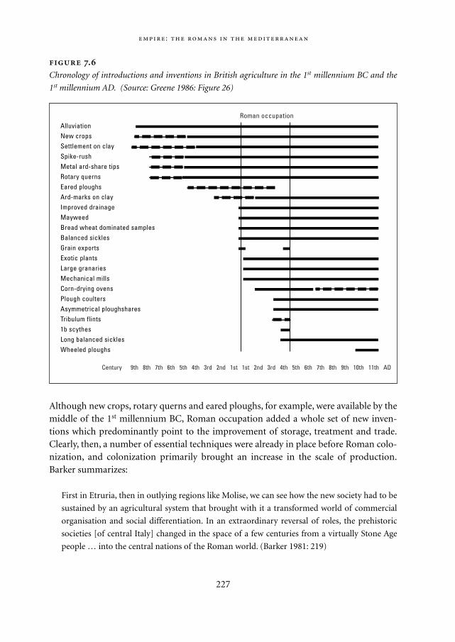
Although new crops, rotary querns and eared ploughs, for example, were available by themiddle of the 1st millennium BC, Roman occupation added a whole set of new inven-tions which predominantly point to the improvement of storage, treatment and trade.Clearly, then, a number of essential techniques were already in place before Roman colo-nization, and colonization primarily brought an increase in the scale of production.Barker summarizes:
First in Etruria, then in outlying regions like Molise, we can see how the new society had to be
sustained by an agricultural system that brought with it a transformed world of commercial
organisation and social differentiation. In an extraordinary reversal of roles, the prehistoric
societies [of central Italy] changed in the space of a few centuries from a virtually Stone Age
people … into the central nations of the Roman world. (Barker 1981: 219)
:
227
.
Chronology of introductions and inventions in British agriculture in the 1st millennium BC and the
1st millennium AD. (Source: Greene 1986: Figure 26)
AlluviationNew cropsSettlement on claySpike-rushMetal ard-share tipsRotary quernsEared ploughsArd-marks on clayImproved drainageMayweedBread wheat dominated samplesBalanced sicklesGrain exportsExotic plantsLarge granariesMechanical millsCorn-drying ovensPlough coultersAsymmetrical ploughsharesTribulum flints1b scythesLong balanced sicklesWheeled ploughs
Roman occupation
Century 9th 8th 7th 6th 5th 4th 3rd 2nd 1st 1st 2nd 3rd 4th 5th 6th 7th 8th 9th 10th 11th AD
Mappae Mundi bw zw/w 08-04-2004 15:25 Pagina 227
For the Roman period itself, the intensive surveys of the last thirty years highlight twomajor differences between the literary and the archaeological evidence (Greene 1986):– large parts of the Mediterranean Basin were much more densely dotted with farm-
228
Vindolanda: daily life in an outpost of the Roman Empire4 During the reign of
Trajan (98-117 AD), northern England was a recently conquered, remote part of the
Roman Empire. Vast distances and the limited capacity of wind- and animal-powered
means of transportation separated this outpost of the empire from the Mediterranean
world. However, numerous wooden writing tablets that have been found at the site of
the fort of Vindolanda show that the troops stationed there were not isolated. The fort at
Vindolanda was first built about 80 AD. Most of the writing tablets date to the early
years of Trajan’s reign (98-105 AD) and therefore predate the construction of Hadrian’s
Wall. A cavalry unit of Roman allies, the Ninth Cohort of Batavians, occupied the fort.
The thousands of wooden tablets provide at least two important insights. Firstly,
the tablets, which contain official and private letters and documents – and even a writ-
ing exercise from Virgil – reflect the scale and range of written communication on a
remote outpost of the Roman world. Secondly, they provide valuable insight into the
workings of the Roman Empire, which had to provide for the day-to-day sustenance of
a Roman army unit in a barren and unproductive environment. The provisions that
arrived at Vindolanda reflect the unit’s contact with three different zones: the immediate
hinterland of the fort, the rest of the province of Britain, and the other provinces of the
Empire, foremost Gaul and Spain.
The unit exploited the resources from the immediate hinterland: the native popula-
tion cultivated barley, which was used to make beer, which was part of this unit’s offi-
cial rations. The unit had its own herd of swine – pork was an important item of the
Roman soldiers’ diet. The region also provided fodder and grazing for the horses,
mules and oxen. In order to supplement their official rations, officers and common sol-
diers bought chickens, apples, eggs and other items from the local farmers. However,
the most important part of the Roman soldier’s diet – wheat to make bread – had to
come from the southern parts of the province of Britannia, where it was acquired large-
ly through taxation-in-kind. Other goods also arrived from the South, such as ceramics
and textiles that were sent from Londinium. Lists of food include imported goods, for
example fish sauce, spices, olives and olive oil. The officers were particularly eager to
continue their accustomed way of life. Items of clothing came from Gaul, while taxation
in the Spanish provinces provided olive oil to Roman army units throughout the north-
ern provinces. The regular supply of this typically Mediterranean product shows that
even a barbarian unit on a remote outpost was not forgotten as part of the Roman
Empire.
Mappae Mundi bw zw/w 08-04-2004 15:25 Pagina 228
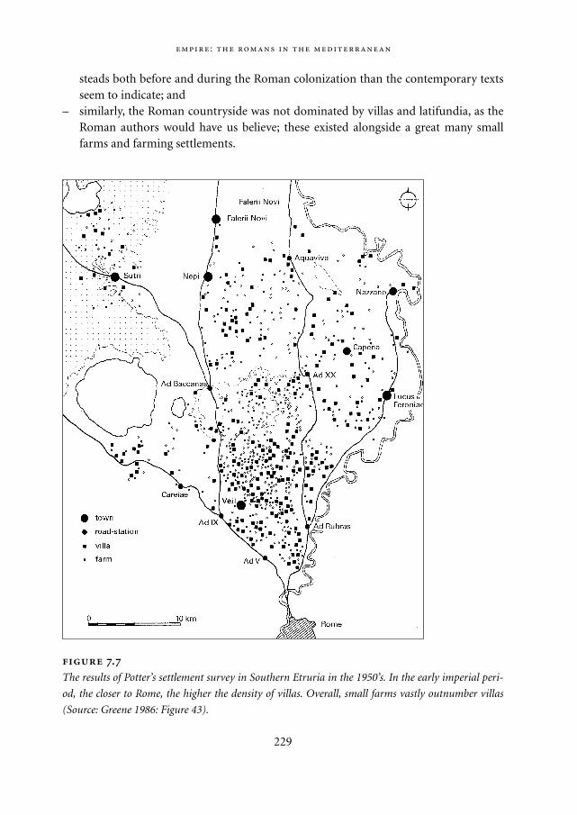
steads both before and during the Roman colonization than the contemporary textsseem to indicate; and
– similarly, the Roman countryside was not dominated by villas and latifundia, as theRoman authors would have us believe; these existed alongside a great many smallfarms and farming settlements.
:
229
.
The results of Potter’s settlement survey in Southern Etruria in the 1950’s. In the early imperial peri-
od, the closer to Rome, the higher the density of villas. Overall, small farms vastly outnumber villas
(Source: Greene 1986: Figure 43).
Mappae Mundi bw zw/w 08-04-2004 15:25 Pagina 229
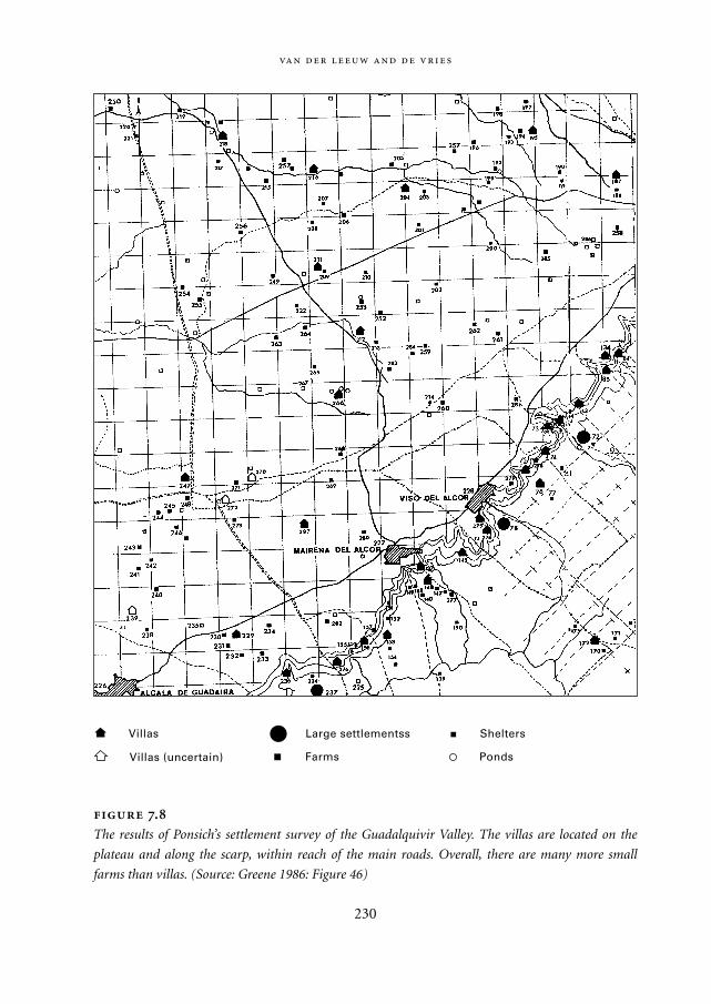
230
.
The results of Ponsich’s settlement survey of the Guadalquivir Valley. The villas are located on the
plateau and along the scarp, within reach of the main roads. Overall, there are many more small
farms than villas. (Source: Greene 1986: Figure 46)
Farms
Large settlementss Shelters
Ponds
Villas
Villas (uncertain)
Mappae Mundi bw zw/w 08-04-2004 15:25 Pagina 230
The simplest way to corroborate both points is to look at some of the many maps thatsynthesize the data from surveys in different parts of the Roman world. Results fromSouthern Etruria (Potter 1979; Figure 7.7) and the river valley of the Guadalquivir (Pon-sich 1974; Figure 7.8) show very clearly that relatively small farms vastly outnumber vil-las, let alone latifundia.
For the more northern parts of the Empire this is less easy to prove, as the nature ofthe remains of simple farms is more ephemeral. In those areas, most of these would havebeen built in wood, wattle-and-daub or similar perishable materials rather than in brickor stone as is frequently the case in the Mediterranean area. Wherever settlement datahave been collected systematically, a major increase in the number of such settlementsjust before, during and after Roman colonization is manifest, as in the Somme (Agache1978), the Lower Rhine (Willems 1981-1984) and the Berry.
7.3.3. Introducing industrialization of agriculture and commercial exploitation of the land
In all the areas that have been fully colonized, i.e. the areas in which new settlers exploit-ed the land, exploitation was initially organized in one of three forms:– a very dense pattern of farms which covered the area before the advent of the
Romans; these farms were of variable size;– villas and the large, highly efficient latifundia introduced by the Romans; these were
larger than the farms and to a great extent dependent on slave labour and producedmainly for export;
– in some areas, Rome gave smaller plots of land to its veterans, who were put to gooduse in pacifying potentially rebellious areas and bringing new areas under exploita-tion.
As time went on, these different exploitation systems became more and more dependentupon each other and had an increasingly large impact on the landscape, as we see in theRhône Valley between about 100 BC and 300 AD. Here, successive waves of colonization(Figure 7.9) created many new farms in the 1st century BC, over and above the existingones. In the 1st century AD, the wave of new farms stops, and by the end of the 2nd centu-ry most of them – the smaller ones – had been deserted (Figure 7.10). At that point, arationalization seems to have intervened, which restructures the agricultural landscapeprofoundly under the influence of the increasing importance of mass-production for theexport of agricultural products. Many smaller farms were either abandoned or becamepart of the larger ones that had grown out of the first established Roman farms in theregion, located on the best land and with the most direct access to the markets (Favory2002).
:
231
Mappae Mundi bw zw/w 08-04-2004 15:25 Pagina 231
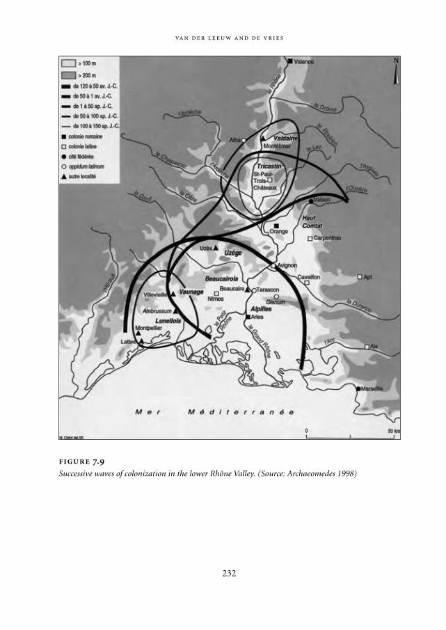
232
.
Successive waves of colonization in the lower Rhône Valley. (Source: Archaeomedes 1998)
Mappae Mundi bw zw/w 08-04-2004 15:25 Pagina 232
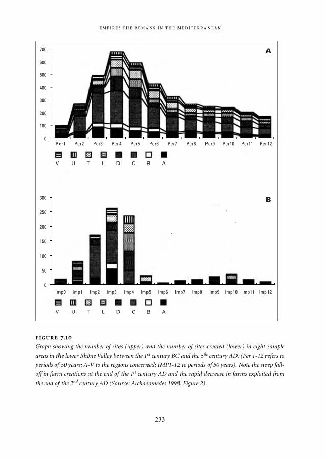
:
233
.
Graph showing the number of sites (upper) and the number of sites created (lower) in eight sample
areas in the lower Rhône Valley between the 1st century BC and the 5th century AD. (Per 1-12 refers to
periods of 50 years; A-V to the regions concerned; IMP1-12 to periods of 50 years). Note the steep fall-
off in farm creations at the end of the 1st century AD and the rapid decrease in farms exploited from
the end of the 2nd century AD (Source: Archaeomedes 1998: Figure 2).
700
600
500
400
300
200
100
0
300
250
200
150
100
50
0
Per1 Per2 Per3 Per4 Per5 Per6 Per7 Per8 Per9 Per10 Per11 Per12
Imp0 Imp1 Imp2 Imp3 Imp4 Imp5 Imp6 Imp7 Imp8 Imp9 Imp10 Imp11 Imp12
V U T L D C B A
V U T L D C B A
B
A
Mappae Mundi bw zw/w 08-04-2004 15:25 Pagina 233
But this model is not directly applicable elsewhere: the local circumstances played apredominant role in shaping the dynamics in each colonized region. For example innorthern Gaul, the proportion of villas in the total settlement pattern is considerablyhigher than in areas densely settled before the Roman conquest. On the one hand, thelocal circumstances were absolutely ideal for a villa-based exploitation system: plenty ofrainfall, fertile soils and gently rolling terrain. On the other, the degree of organization ofthe tribal societies conquered by Caesar in these parts was much lower than that of thesocieties further south in Italy or in Southern Gaul. Hence, the Romans relied more ontheir own infrastructure than they would have done in situations where such an infra-structure already existed before they arrived.
Another case altogether is the hinterland of Benghazi in present-day Libya (Barker1983). On the maps of the shifts in settlement pattern and exploitation strategy in theHellenistic and Roman periods, the increase of trade in agricultural and other productsthrough the port of Benghazi is seen to link it to an ever growing hinterland, in whichmore and more simple Roman farmsteads emerge between the 1st and 3rd centuries AD(Figure 7.11). This pushed the desert pastoralists further and further away from the coastand reduced the grazing land available to them. Eventually, that forced them to beginherding camels instead of sheep and goats. The increasing contrast in wealth led toincreasingly frequent raids on the wealthy Roman settlements, so that eventually thesewere fortified to protect the colonists. The pre-Roman mode of subsistence is pushedout of the territory occupied by the Romans. These examples reflect the fact that in duetime, and with a varying degree of success, the Romans imposed a commercial exploita-tion system on the existing, highly varied ways in which the local populations exploitedtheir lands. Two major factors accompanied these developments and made them possi-ble: land mapping and rationalization and increasing scale of production.
7.3.4. A different perception of space and the landscape
One of the major hallmarks of Roman control over the countryside is that rural areaswere effectively administered for tax and commercial purposes. Such administrationdepended on an effective way to map the land. All over Western Europe, there are tracesof this administration in the fact that the Romans organized the land in a system ofsquare-mile blocks (called centuriations) which were laid out and mapped by a profes-sional class of surveyors (the agrimensores). In the case of the Tricastin, we even havefragments of the resultant map, carved in marble, with the names of some of thelandowners and the rate of land tax they paid to the state. It is particularly noteworthyfrom our point of view that the land was divided into square blocks measuring one byone mile.5 The boundaries of these blocks were marked by means of roads and drainageditches. In this respect, the Roman perception of the landscape was very different from
234
Mappae Mundi bw zw/w 08-04-2004 15:25 Pagina 234
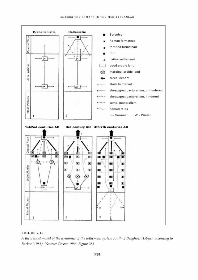
:
235
Prehellenistic Hellenistic
1st/2nd centuries AD 3rd century AD 4th/7th centuries AD
Berenice
Roman farmstead
fortified farmstead
fort
native settlement
good arable land
marginal arable land
cereal export
stock to market
sheep/goat pastoralism, unhindered
sheep/goat pastoralism, hindered
camel pastoralism
nomad raids
S = Summer W = Winter
Inla
nd P
late
auCo
asta
l Pla
inJe
bel A
khda
rIn
land
Pla
teau
Coas
tal P
lain
Jebe
l Akh
dar
S S
W W
1 2
3 4 5
S
W
S
W
W W
W
S
? ??
?
.
A theoretical model of the dynamics of the settlement system south of Benghazi (Libya), according to
Barker (1983). (Source: Greene 1986: Figure 28)
Mappae Mundi bw zw/w 08-04-2004 15:26 Pagina 235
the pre-existing ones, and because this ‘square’ administrative point of view often pre-vailed over any practical considerations, the resulting organization of the landscape wasregularly at odds with the natural dynamics of an area. In the Tricastin, a large drainagescheme was laid out in the late 1st century BC, in order to provide land for soldiers of theRoman legions when they reached retirement age. The roads and ditches were all laidout in north-south and east-west directions, whereas the natural drainage of the areagenerally went from north-east to south-west. Unfortunately for the scheme, peacebroke out a couple of decades after the scheme was initiated. The first peace dividendwas a drastic reduction in the number of soldiers, and thus (somewhat later) in thenumber of veterans. As soon as there was insufficient manpower to keep the ditchesopen, the drainage scheme fell apart, and the land became neglected and ultimately itbegan eroding (Leeuw 1998).
There were advantages of scale and rationalization. As we have seen in the case of Beng-hazi, as exports became more and more important, other considerations gave way in theface of rationalization and other means of increasing yield. In large parts of north-west-ern Europe, the Romans introduced other races of bovines, which were considerablylarger than the pre-Roman ones. But this drive towards ‘bigger is better’ is also found inthe size of agricultural installations. In Southern France, Roman wine and oil cellarshave been found that are several orders of magnitude larger than was the case in pre-Roman times. In the Donzère, one of these has a capacity of 2800 hl (400,000 modern-day bottles!). Another sign of the changes occurring in agriculture is found in the pro-duction of amphorae for the transportation of grain and liquids (again, olive oil andwine). Both the number of such vessels and that of the pottery workshops making them,increase very rapidly during the 1st and 2nd centuries AD.
Of course most of the data on the exploitation of such domains is found in texts,rather than in the ground. We have detailed descriptions of the best ways to run largeestates, including many hints of an agronomic as well as a management nature, fromseveral Roman authors, such as Columella and Pliny the elder. For a long time, it wasimpossible to decide whether their precepts were only applied to large estates in Italy andSouthern France, or whether the recommendations in them found a wider audience.Increasingly, the excavation of villas, the reconstruction of their fields and of the cropscultivated upon them, as well as the way these were planted, begins to confirm that thewritten data may have been applied quite widely. Such research shows clearly that theRomans preferred relatively light, well-drained soil, and that wherever possible, theychose to settle on low slopes facing anywhere but north (Favory 2002). Thus, we findlarge cultivated areas on the rolling plateaux of northern Gaul, as well as in the foothillsof the Haut Comtat, Vaunage and Beaucairois.6
When no such land was available, they would go so far as to drain large alluvial areasto bring them into exploitation, such as the Tricastin plain. In this context, it is impor-
236
Mappae Mundi bw zw/w 08-04-2004 15:26 Pagina 236
tant to mention that many such hilly slopes were originally covered with forest. As theforest was cut down to make place for agricultural crops, these slopes had to be terracedor otherwise protected against erosion. As long as those terraces remained and the land
:
237
Views of nature in European Antiquity7 How nature was seen depended in antiq-
uity – and in many places still – on its actual or potential threat to humans. Nature was
in no way always a friend, with her unpredictability and threats. It was therefore per-
mitted and even a duty to fight her, as can be seen in a variety of cultural motives. The
disappearance of forests was seen as a sign of civilization, at least in the dominant
view.
The forests Clearing land for agriculture, wood, firewood and animal grazing have
been the main processes in changing the vegetation. Thirgood (1981), quoting Strabo,
mentions the mountains in south-eastern Spain ‘covered with thick woods and gigantic
trees’ being cut for shipbuilding. North Africa was an important timber-producing
region for the Romans, leading to temporary depletion of Moroccan forests. Wars had a
devastating effects as it accelerated the felling of trees to be used for the warships and
because the people fled into the mountains and abandoned the land. Mismanagement
may have added to the problems, but variations in aridity make it difficult to distin-
guish between human and natural factors.
Extinction of wild animals The cultural hero or king had a special role in the civi-
lizing process: Heracles battled with near-invincible mythical wild animals, becoming a
symbol of courage. Whereas this view had limited consequences in Mesopotamian and
Egyptian times, this changed with the advent of the Roman Emperors. Not only slaves
but also wild animals were taken from the conquered lands, to show total dominance
over man and animal. More intense hunting brought some species to extinction. The
enormous demand for animals skins, from as far as the Baltic and northern Russia, fur-
ther increased the pressure.
The Pax Romana acquired a specific connotation through the mass killing of wild
animals. Thousands of wild animals were slaughtered in the venationes during the
games or ludi. These took place in every garrison town but Rome had by far the largest:
with the inauguration of the Colosseum in 70 AD some 5000 animals were ‘used’ over a
few days (Auguet 1994). It must have given rise to huge transport problems. Only
recently it has been acknowledged that the grand scale of these huge killings may have
led to the extinction of some of these species. It has been hypothesized that the games
indirectly contributed to the expansion of agriculture in the Mediterranean by strongly
reducing the threat from wild animals – a view that fits into the view that humans
should ‘civilize’ the world and was therefore approvingly supported by scholars until
recently.
Mappae Mundi bw zw/w 08-04-2004 15:26 Pagina 237
was cared for, this did not cause any immediate problems. It did, however, make theselandscapes extremely dependent on human intervention and vulnerable to erosion in itsabsence.
To facilitate the marketing of their products, as well as support from the army, the villasand latifundia concerned were linked into the road system and/or the navigable rivers ofWestern Europe. That this was essential to their survival is clearly shown by the fact thatthere is a highly significant statistical relationship between the fact that a site is linkedinto three or more roads and its survival beyond the end of the 2nd century AD. But ininterpreting this relationship we must delve beyond the obvious. The sites that survivedwere indeed those with direct road access, but these sites were also the earliest among thesites founded by the Romans, and they had the most, and the best, land at their disposal.That in itself should not surprise us, as the first of the new colonists founded their farmsin those locations which seemed best to them, and which therefore gave them the bestchances of survival. At the same time, these first colonists shaped the landscape, includ-ing its spatial structure. They therefore profited from a number of positive feedbackloops that did not benefit those who came later. That, in turn, allowed them to overcomethe major difficulties involved in any kind of colonization of new lands. What kinds ofdifficulties were involved? Their exact nature differed from region to region, but a moregeneral description in system dynamics terms may be derived from a study of such ‘pio-neer’ colonization fronts elsewhere.
7.4. The Roman Empire as a self-organizing system
7.4.1. Self-organization
How does all of this relate to the dynamics of the Roman Empire? To penetrate below thesurface of what is happening hence and thus to transform our description into an expla-nation, we must develop a way to conceive of the core dynamics of Roman colonization.One fruitful approach is the theory of self-organizing, complex adaptive systems (cf.Section 8.5). The whole of the Empire is seen as a dynamic dissipative structure, existingby virtue of the fact that it slowly structures an increasing area and a growing number ofpeople into a coherent whole. In return, it draws energy (human and animal) and rawmaterials (foods, minerals and water) from the area thus colonized. The spatial exten-sion of control manifests itself as longer and longer communication chains in new terri-tory, such as the roads that link all parts of the Empire, the contacts and visits that linkpeople across the whole of the territory, and the exchange of goods between distantcommunities. But the process of structuration is also evident in many other forms: thespread throughout the Empire of a common language and writing system for the domi-
238
Mappae Mundi bw zw/w 08-04-2004 15:26 Pagina 238
nant classes, of imperial coinage, of an administrative and judicial apparatus, of citizen-ship, and so forth. In a different domain, it also includes the spread of compatible agri-cultural and industrial technologies and of similar settlement systems (villas, latifundiaand towns). Let us look at the developments in more detail from this perspective.
The spread of all the manifestations of integration structures the channels throughwhich raw energy and matter are drawn into the core of the system. Matter and energyare subject to the laws of conservation. Information is not; it can in effect spread and beshared. In this sense, societies can be said to be held together by the information flowsand the information processing channels which are created by negotiating shared mean-ings, ideas and customs. That spread is in practice a question of acculturation, and there-fore of collective and individual learning. As such, it has its own, bottom-up dynamic,which can be helped by creating the correct circumstances but cannot be imposed fromthe top. The resilience of the system as a whole depends on that process of acculturation.If certain sectors of society, or certain areas, do not manage to keep pace with theremainder of the population, they will become isolated and will eventually cause prob-lems. Similarly, if certain groups learn too fast, this will create resistance around them.
How do the dynamics of structuration of the Empire relate to the processes of coloniza-tion and exploitation of the countryside? The process of dynamic structuration did, of
:
239
Conceptual framework: self-organizing open systems Ecosystems may useful-
ly be considered as dynamic, hierarchically organized sets of relations between differ-
ent individuals, species and communities. These relations are multi-temporal and con-
stitute a web in space-time. Thus defined, the systems are open and dissipative: their
continued existence depends on the dissipation of both their energy and their entropy.
All living beings use (solar) energy to transform a limited number of material compo-
nents into different organic components constituting organisms, and then to disinte-
grate these different forms of matter into their constituent components. To extents that
vary from species to species, and from community to community, the self-organising
mechanisms that shape them inform substance (matter and energy) and substantiate
form. In doing so, they create organization.
Human beings are an integral part of such systems (McGlade 1995). Due to their
capacity to learn, and to learn how to learn (Bateson 1972), they are very efficient at
dissipating entropy. In situations where long-term co-evolution occurs between human
and non-human species, human beings tend with time to take over more and more of
the structuration of the system as a whole. Human groups do so by expanding the
scope, depth and reach of their own network of relationships, involving more and more
people, bringing them ever closer together – in a physical, social and cultural sense –
Mappae Mundi bw zw/w 08-04-2004 15:26 Pagina 239
course, occur at all levels of the society simultaneously, in – partly overlapping – groupsof different sizes, with different roles and functions: families, extended kinship systems,trade networks and associations, armies and towns. Of all these different levels, the onethat concerns us here most directly is the interaction of individual farms, farming com-munities and ultimately all farmers in the Empire with their natural and social environ-ment. What kinds of dynamics were involved? To what extent were these constrained bythe immediate natural environment or by the social environment in which agriculture
240
and using the emerging structure to enhance their control over their environment. In
short, they impose themselves by means of a positive feedback loop between the size
and efficiency of their information-processing capacity and the amount of information
they process. As a result, they can extend their control over what surrounds them on
condition that their efforts to do so do not hit a snag for very long. If that happens, the
positive feedback loop turns negative, and the society begins to lose coherence and it
may disintegrate, if no remedy is found.
If such a co-evolutionary system is to survive, a dynamic balance needs to be main-
tained between exploration and/or innovation (enhancing the information-processing
capacity to anticipate change) on the one hand, and routine exploitation (dissipating
noise or entropy and thereby causing change) on the other. The latter is necessary to
maintain the necessary level of energy flow throughout the system, and the former is
required to ensure that new forms of exploitable energy are found before the presently
available forms are exhausted. Without such a balance, i.e. when the society innovates
either too rapidly or too slowly, it is not able to dissipate sufficient entropy and loses
coherence. That jeopardizes the equilibrium between adaptedness to the present and
adaptability to future circumstances, and the chances increase that when the positive
feedback loop hits a snag, no remedy can be found in time to restore the growth
dynamic.
A system that maintains such a balance is called resilient. It is able to ‘[…] absorb
and utilize or even benefit from perturbations and changes that attain it, and so to per-
sist without a qualitative change in the system’s structure.’ (Holling 1973) Whether it is
able to do so, depends on the nature and size of the perturbations as well as on its own
capacity to deal with them. Thus a perturbation of considerable magnitude is necess-
ary to trigger a qualitative change in a highly resilient system. Resilience is not stabili-
ty. Stability indicates a system’s capacity to return to equilibrium upon perturbation
whereas a resilient system does not lose its internal structure in a period of perturba-
tion. A system can be highly resilient and yet fluctuate widely, i.e. have low stability.
There does indeed seem to be a relationship between the two. The wider the range of
fluctuations, the more frequently the system is called upon to adapt and the more prac-
tice it gets in doing so.
Mappae Mundi bw zw/w 08-04-2004 15:26 Pagina 240
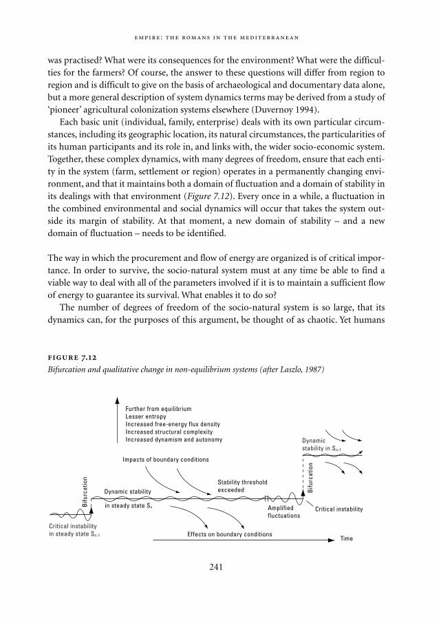
was practised? What were its consequences for the environment? What were the difficul-ties for the farmers? Of course, the answer to these questions will differ from region toregion and is difficult to give on the basis of archaeological and documentary data alone,but a more general description of system dynamics terms may be derived from a study of‘pioneer’ agricultural colonization systems elsewhere (Duvernoy 1994).
Each basic unit (individual, family, enterprise) deals with its own particular circum-stances, including its geographic location, its natural circumstances, the particularities ofits human participants and its role in, and links with, the wider socio-economic system.Together, these complex dynamics, with many degrees of freedom, ensure that each enti-ty in the system (farm, settlement or region) operates in a permanently changing envi-ronment, and that it maintains both a domain of fluctuation and a domain of stability inits dealings with that environment (Figure 7.12). Every once in a while, a fluctuation inthe combined environmental and social dynamics will occur that takes the system out-side its margin of stability. At that moment, a new domain of stability – and a newdomain of fluctuation – needs to be identified.
The way in which the procurement and flow of energy are organized is of critical impor-tance. In order to survive, the socio-natural system must at any time be able to find aviable way to deal with all of the parameters involved if it is to maintain a sufficient flowof energy to guarantee its survival. What enables it to do so?
The number of degrees of freedom of the socio-natural system is so large, that itsdynamics can, for the purposes of this argument, be thought of as chaotic. Yet humans
:
241
.
Bifurcation and qualitative change in non-equilibrium systems (after Laszlo, 1987)
Further from equilibriumLesser entropyIncreased free-energy flux densityIncreased structural complexityIncreased dynamism and autonomy
Critical instabilityin steady state Sn-1
Bifu
rcat
ion
Dynamic stability
in steady state Sn
Dynamicstability in Sn-1
Bifu
rcat
ion
Stability thresholdexceeded
Amplifiedfluctuations
Critical instability
Effects on boundary conditions
Impacts of boundary conditions
Time
Mappae Mundi bw zw/w 08-04-2004 15:26 Pagina 241
and human societies have generally been able to deal with such dynamics sufficientlywell to survive, and eventually to take control of the socio-natural system. Their interac-tion with the other components of the system must therefore be very efficient and effec-tive. Atlan (1992) argues cogently that all human theories are necessarily underdeter-mined by the observations on which we think that they are based. Our capacity toconceptualize is therefore a necessity, but not a sufficient condition to explain our effec-tiveness in dealing with our environment. Our efficiency in doing so may go a long wayto explaining our resilience as a species, as it enables us to rethink our concept of whatwe observe as it changes. As a result, we can – and do – individually adapt rapidly to anychange in conditions.
However, there are limits to both our efficiency and our effectiveness in dealing withthe environment. Our efficiency is constrained by both our means of communicationand our diversity. As the number of people involved in a system grows linearly, the num-ber of messages required to keep all of them in touch grows exponentially, and so doesthe time involved to reach everyone concerned. As the number of people involved grows,so does their diversity, and with it the time it takes to ‘negotiate’ collaboration betweenthem. But if size has such important disadvantages, why have socio-natural systems ingeneral, and the Roman one in particular, grown so spectacularly in the course of theirexistence? The answer lies in the fact that the Roman Empire was dependent on contin-ued expansion for its survival. More and more resources – including raw energy in theform of slaves – were brought from an increasingly distant periphery to the centre andtransformed into a growing range of artefacts and other objects. That ‘inflation’ kept thewhole system going. As soon as the difficulties in the sphere of information processingcame to weigh more heavily than the need to keep the flows of energy and matter going,the Empire found itself stagnating and eventually in decline.
More generally, the answer is related to the asymmetric relationship between soci-eties and their environments. Not only do they have fundamentally different dynamics,but also society’s perception of the environment and its impact on it is governed by thefilter of human perception – and not vice versa: the relationship is asymmetric.8 Thisperception and subsequent interpretation of the environment is always simplified andincomplete; it is often underdetermined by observations and overdetermined by thecognitive structure that determines our definition of problems. Conquerors’ andcolonists’ experiences are sometimes a vivid illustration of this point (cf. Chapter 10).When deriving a conception from our observations, we simplify the phenomenaobserved and retain that simplified form in our memory. Our interventions in the envi-ronment are therefore based on these simplifications. But as we intervene in the envi-ronment, we change it – modifying its dimensionality as well as its qualitative and quan-titative dynamics. Our cognitive capacities to observe environmental change may beadequate as long as change is within the variations confronted before, through socialmemory. For change outside these variations – many environmental processes operate
242
Mappae Mundi bw zw/w 08-04-2004 15:26 Pagina 242
on centennial or millennial scales – the capacity for adequate response is less. This limi-tation to our effectiveness has important consequences for the way we deal with long-term change in the environment.
7.4.2. An example: newly colonized environments
The colonists begin their adventure with inappropriate ideas about their new environ-ment and the way to deal with it, mainly because their perception of what constitutes thenatural environment is determined by the area they come from rather than the one theygo to. But they learn quickly, dealing with undesirable events and processes as and whenthey observe them. They will therefore first mitigate the most frequently occurringevents that they do not like. As they do, they shift the ‘risk spectrum’ of their dealingswith the local environment, eliminating frequent, minor risks and introducing risks withunknown periodicities. Even if we assume that the latter are normally distributed, thenet effect of this interaction over the long-term is a build-up of less frequent but moreimportant risks – ‘time-bombs’ or ‘unintended consequences’. Once their density is suffi-ciently high, major crises are bound to occur. Such crises have the impact of forcing thecolonists either to heavily restructure their exploitation system under pressure or aban-don their investment. In general, the ensuing reorganization will spread risks by differ-entiating the soils exploited and the crops produced, as well as the stages of exploitation,for example exploiting a range of soils from freshly cut forest soils to soils that have beenexploited for some time. This is generally achieved by expansion of the exploitation, byinducing more people to exploit it together and, where possible, by introducing techni-cal innovations. It entails the reorganization of the spatio-temporal dynamics ofexploitation, the differentiation of the tasks fulfilled by the people working on theexploitation, and investment in installations and equipment. In many cases, the oppor-tunity to achieve economies of scale will also lead to intensification in order to achievean increase in the volume of goods produced.
On the other hand, the reorganization will generally reduce the system’s diversity ofspecies and the complexity of its natural dynamics, while the complexity of the socialdynamics increases. As a system’s natural resilience in effect depends on the extent towhich its dynamics are open to change (Leeuw 2001) and thus on its dimensionality, anyhuman efforts to ‘focus’ any part of it on a specific function reduces its inherentresilience (Leeuw 1998). As a result, the burden of maintaining the system is increasinglyshifted onto the social dynamics: the system becomes truly dependent on human distur-bance (Naveh 1984). Moreover, the narrower range of products into which the system isdriven by human action will, to a greater or lesser extent, shift the balance between itsexploitative and its innovative dynamics in favour of the former. Ultimately, this willoften lead to a reduction of the productivity of the system due to resource exhaustion. At
:
243
Mappae Mundi bw zw/w 08-04-2004 15:26 Pagina 243
any one time, the continued existence of the system will depend on the balance betweenthe risks involved in the dynamics of its natural and social components. Increasing thediversity of the uses of resources, production techniques and products reduces the natu-ral risks but enhances the complexity of management and therefore the risks due to thesocial dynamics.
Time is of the essence in the ensuing balancing act. Once a crisis looms, the time-span available to find a solution is limited, and the outcome is dependent both on thenature of the solution found, and the efficiency with which it is introduced. Too little isas useless as too late. Very often, whether the system survives or goes under depends onminute differences in external conditions or in the nature of the dynamics involved. Inthis respect, differences in perception may be just as important as slight differences inprecipitation, soil fertility, management efficiency or the price of the products on theworld market at any particular time.
7.4.3. Stagnation is decay: changing settlement patterns in the Rhône Valley100 BC to 600 AD
To explain some of the changes wrought by the Roman colonization of the Mediter-ranean Basin and Western Europe, and to lay the groundwork for our understanding ofthe decay of both the environment and the Empire itself, we will look at events in theMiddle and Lower Rhône Valley. The present perspective there has been brought to bearon a relatively large data-set, comprising more than 2000 settlements dated between 500BC and the present, some 1000 of which date to the period 100 BC to AD 600 (Leeuw1998; Favory 2002). It can clearly be demonstrated that the implantation of new Romancolonies in the area increased rapidly between 100 BC and AD 100 but came to a suddenhalt after 150 AD. Of course, that did not mean that the number of settlements in activeuse declined as dramatically after that date, but it is incontrovertible that the settlementdynamics fundamentally changed in the 2nd century AD. Figure 7.13 sheds an interestinglight on why this happened. It shows that by far the largest proportion of the newlyfounded settlements did not survive more than the first two centuries of colonization,regardless of the environment in which the settlements are located. As these environ-ments are very different, representative of all the natural environments of south-easternFrance, this graph suggests that it is highly improbable that the desertion of these settle-ments was due to changes in the climate or in the natural environment. Such changeswould have affected different landscapes differently and would therefore have had a dif-ferential effect on the process of abandonment. It seems much more likely that the aban-donment of many of the smaller sites was due to socio-economic changes of some kind.This is corroborated by the fact that the deserted settlements were in general those thatwere among the last to be established. They are located in the least favourable areas and
244
Mappae Mundi bw zw/w 08-04-2004 15:26 Pagina 244
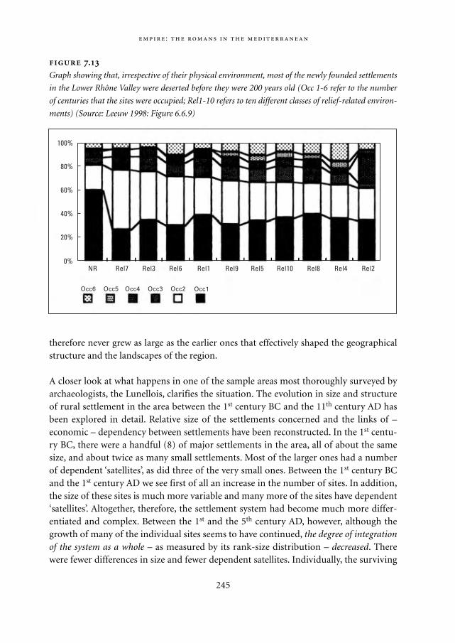
therefore never grew as large as the earlier ones that effectively shaped the geographicalstructure and the landscapes of the region.
A closer look at what happens in one of the sample areas most thoroughly surveyed byarchaeologists, the Lunellois, clarifies the situation. The evolution in size and structureof rural settlement in the area between the 1st century BC and the 11th century AD hasbeen explored in detail. Relative size of the settlements concerned and the links of –economic – dependency between settlements have been reconstructed. In the 1st centu-ry BC, there were a handful (8) of major settlements in the area, all of about the samesize, and about twice as many small settlements. Most of the larger ones had a numberof dependent ‘satellites’, as did three of the very small ones. Between the 1st century BCand the 1st century AD we see first of all an increase in the number of sites. In addition,the size of these sites is much more variable and many more of the sites have dependent‘satellites’. Altogether, therefore, the settlement system had become much more differ-entiated and complex. Between the 1st and the 5th century AD, however, although thegrowth of many of the individual sites seems to have continued, the degree of integrationof the system as a whole – as measured by its rank-size distribution – decreased. Therewere fewer differences in size and fewer dependent satellites. Individually, the surviving
:
245
.
Graph showing that, irrespective of their physical environment, most of the newly founded settlements
in the Lower Rhône Valley were deserted before they were 200 years old (Occ 1-6 refer to the number
of centuries that the sites were occupied; Rel1-10 refers to ten different classes of relief-related environ-
ments) (Source: Leeuw 1998: Figure 6.6.9)
0%NR Rel7 Rel3 Rel6 Rel1 Rel9 Rel5 Rel8Rel10 Rel4 Rel2
Occ6 Occ5 Occ4 Occ3 Occ2 Occ1
20%
40%
60%
80%
100%
Mappae Mundi bw zw/w 08-04-2004 15:26 Pagina 245
settlements had grown by absorbing some of the activities of their satellites and in theprocess a large number of smaller sites had been sacrificed. The process is driven by theneed to reorganize the economic activities in the area as a whole in such a way as toreduce the exposure of individual settlements to particular risks. The surviving sites arethose which have been able to do so by differentiating their raisons d’être. Notwith-standing the foundation of a limited number of new settlements in the 5th and 6th cen-turies AD, by the end of the latter century much of the expansionary drive has probablygone out of the system. It is therefore not surprising that by the 11th century AD therewere more, but generally smaller, settlements and even fewer satellites. Whereas thebeginning of our era witnessed the transformation of a decentralized, rural system intoa much more coherent, partially urbanized one, the 5th and 6th centuries saw the earlyphases of a return to a rural way of life, an evolution that was complete by the 11th cen-tury.
What could have been the increased risks that triggered this reorganization? The firstfactor that springs to mind is the fact that after two centuries of exploitation of the rel-atively light soil that the Romans preferred, the soil probably showed some signs ofexhaustion. Yields per hectare must have gone down and competition with morerecently colonized areas, or richer soil, must have become stiffer. A second contributoryfactor may have been the slight deterioration of the climate that seems to have occurredfrom the end of the 2nd century AD onwards. Annual average temperatures decreasedby around two degrees, and precipitation also increased somewhat. That may haveaffected the lowland soils in particular. But we should not exclude another very impor-tant, anthropogenic, factor that had a different effect. We have seen that in the 1st centu-ry AD the producers in the area significantly increased production and focused moreand more on exports to the other parts of the Roman world. As a result, they alsobecame more and more dependent on the economic conditions in faraway regions overwhich they had no control whatsoever. Together, these factors not only reduced thelocal system’s resilience – reduced yield, worsening climate – but they also increased itssocio-economic instability and enhanced the risks to which every exploitation wasexposed. In order to avoid high local risks the system had to keep on expanding, but theexpansion itself in turn increased the external risks by tying the local system more andmore closely into the world system. And in order to compete on that level, the local sys-tem had to become more and more efficient, raising its production levels. Of coursethat had consequences both for the local socio-economic and the environmentaldynamics, stretching these to their limits. Once they were thus stretched, further expan-sion became more and more difficult and eventually impossible unless a major techni-cal or management innovation could be triggered. In the absence of such an event, localstagnation was the result.
246
Mappae Mundi bw zw/w 08-04-2004 15:26 Pagina 246
:
247
Polluted water in the Roman Empire: an environmental challenge9 Among the
factors contributing to the decline of the Roman Empire, it has been argued, some
were related to sanitation and diseases. The possible role of lead poisoning is well
known. Local air and water pollution would have been serious in Rome, not unlike
metropolis such as 17th and 18th century London and Paris and present-day urban con-
glomerates in less developed regions.
Cities need systems for water disposal as rain is not easily absorbed and water from
sewage and other sources needs to be discharged. Rome already had a large main un-
derground sewage canal, the Cloaca Maxima, with many tributaries in the 4th century
BC. In the 2nd century BC this canal was coated with lava blocks and it served the city
well into the 20th century. Venus Cloacina was the goddess of the poor slaves employed
in maintaining this underworld.
There is a myth about toilets in the Roman Empire. Quite often the number of public
conveniences is exaggarated and the number of house facilities underestimated. Towns
such as Pompeii and Herculanaeum in the year of their apocalypse (79 AD) had many
private toilets and even the upper stories of the houses occasionally had toilets. These
were not always connected with a sewer and the cesspits had to be emptied in the
same unhygienic way as can be seen in present-day third world countries.
Public toilets did exist and can still be admired in cities as far apart as Ostia, Aleppo
and Efese. Often they comprised two opposite rows and sometimes the excrement was
carried away by flowing water, such as the overflow of an adjacent bath house. In front
of one was a gutter with streaming water. Sponges on sticks were submerged in these
and one could clean one’s bottom through a hole in the front of the toilet seat. The
sponge was rinsed and left in the gutter for its next user. Water vessels served for
washing hands.
Archeologists, historians and classicists are engaged in a fierce debate as to
whether the Romans aimed at comfort and relieve of hinder or whether they already
had deeper hygienic insights. Whereas archaeology provides evidence of good hygiene
practices, contemporary authors such as Juvenal and Martial complained bitterly about
the difficulties of life in the overcrowded city of Rome and mention dead bodies, dirt,
and animal excreta in the streets. The use of flushing by means of water jars, the slope
of the floor towards the drain, the coating with tiles and walls plastered with water
resistant coating (opus signinum) and the occasional cesspits situated in sites that
guarantees cleaning without polluting the house are signs of good hygiene. On the
other hand, many sewers were not covered but open waste canals and the sponges for
communal use and open connection to sewers or cesspits were not. Compared to the
second – and hopefully lasting – rise of sanitation in the 19th century, ancient Rome did
not have a clear idea of the link between waste water and disease.
Mappae Mundi bw zw/w 08-04-2004 15:26 Pagina 247
7.4.4. What consequences does this have on the level of the Empire – how did itbecome a ‘global crisis’?
Each different region will, of course, meet its own fate, which depends on its particularnatural and social circumstances. But they all will suffer from the fact that their dynam-ics are more and more dependent on those of other regions. In the end, many of themwill hit an invisible barrier, the point at which innovation can no longer keep up with thestress to which the system is subjected. It will manifest itself as a sense of ‘crisis’, in whichthings go wrong on all fronts: climate change, soil depletion, price collapse, importantsocial imbalances, etc. Such a sense of stress is clearly present in the Roman world fromthe 3rd century AD onwards. It is referred to by many of the Roman authors, who appor-tion blame to very different causes, ranging from bad government to invasions, to wide-spread lead poisoning, soil exhaustion, famine and possibly climate change (Provost1982).
In practical terms, regional and local stagnation ultimately affected so many areasthat the Empire as a whole could expand no further. Rather than blame this sense of ‘cri-sis’ on any particular one of these putative causes, let us turn reverse the issue. The exactdomain in which the stagnation – climate, soil exhaustion, social or economic difficul-ties or invasions – first manifested itself is less relevant than the inability to cope with it.The sentiment that ‘the sky is falling in’ – which is inherent in any major crisis – is due tothe fact that the social system as a whole lacks the information processing capacity need-ed to deal simultaneously with all these issues effectively. The salient point is that thatcould have been avoided by innovation, i.e. by an increase in overall information pro-cessing capacity. But that argument leaves us with the need to explain why all thesethings ‘hit’ at the same time. We argue that is due to the accumulation of long-term risksresulting from the frequent intervention of people in their environment, leading to ashift in the ‘risk spectrum’ discussed earlier. In each area, that shift occurred in its ownway – and the dynamics affected by it therefore differed from region to region. It is, how-ever, significant that their temporal occurrence coincided – it reflects the fact that, irre-spective of the local circumstances, a similar amount of time lapsed between the earlycolonization of the provinces and the crisis.
7.5. The decline and end of the Empire
7.5.1. The disintegration process
The last part of this paper is devoted to an outline of the decay of the Empire and thedynamics responsible for it. Our starting point is the fact that, from the late 3rd centuryonwards, there are a number of important changes to be seen in the interaction between
248
Mappae Mundi bw zw/w 08-04-2004 15:26 Pagina 248
the Empire and its environment, as well as in the Empire itself. Let us begin with a veryschematic description of the history of those two or three centuries (300-600 AD). The‘growth crisis’ which announced itself in the 2nd century had its full impact in the 3rd.The Roman authors usually blamed invasions, several epidemics, a weak and overstaffedadministrative infrastructure, incompetent Emperors and the heavy burdens of main-taining a government and an army over such a wide territory. Most of these factors werereal and did contribute to the difficulties. One plague epidemic lasted from 165 AD toabout 180 AD, with the loss of up to a third of the population in certain areas. The 3rd
century saw a rapid succession of emperors lasting between a few months and threeyears – 28 of them were anointed in the 75 years between Septimius Severus and Dioclet-ian. In that period, there were always one or more provinces in revolt, independent orout of control – for instance, the Rhine-Danube area in the 230s and 260s, Dacia in the260s and 270s, Moesia in the 270s, Gaul, Britain and Spain from 260 to 274, Syria in theperiod 267-273. But it should also be noted that since the early 1st century AD, therewere no new territories to be conquered. The significance of this fact becomes clear if wetry to quantify the importance of the financial contribution of the different conquests.Tainter gives an interesting set of figures:
In 167 BC the Romans seized the treasury of the King of Macedonia, a feat that allowed them
to eliminate taxation of themselves. After the Kingdom of Pergamon was annexed in 130 BC,
the state budget doubled, from 100 million to 200 million sesterces. Pompey raised it further
to 340 million sesterces after the conquest of Syria in 63 BC. Julius Caesar’s conquest of Gaul
acquired so much gold that this metal dropped 36% in value. (Tainter 1988: 129)
He concludes: ‘By the last two centuries BC, Rome’s victories may have become nearlyfree of cost, in an economic sense, as conquered nations footed the bill for furtherexpansion.’
The fact that after Augustus there were no longer any rich territories to be conqueredin the periphery of the Empire therefore amputated the income of the State. Most of theEmperors between Augustus and Diocletian complained of fiscal shortages and/or hadto resort to new kinds of taxes. Although the annual non-conquest income of the Statesince Augustus regularly increased from about 500 million to 1500 million sestercesunder Vespasian, seventy years later this was not sufficient to deal with any crises. All ofthat sum went towards the maintenance of the administration and the army, the dole (toabout 200,000 Roman citizens) and the maintenance of the physical infrastructure(roads, wharves, etc.). Yet, overall, the first two centuries of our era were a period ofpeace and security in which the population and the economy flourished. But that econo-my could not easily generate added value. 90% of the Empire’s economy was agricultur-al and therefore provided a stable, but not very flexible source of income. Trade andindustry were small in scale. Notwithstanding the good roads, the means of transporta-
:
249
Mappae Mundi bw zw/w 08-04-2004 15:26 Pagina 249
tion – beasts of burden, carts and small ships – remained relatively small and did notfavour bulk trade. Transport overland was particularly expensive: a wagonload of wheatwould double in value over 500 km, and it was cheaper to cross the Mediterranean byship than to haul a load over 120 km overland. Bulk trade was therefore confined toessentials, mainly cereals, to coastal regions and to the shortest possible distances.Almost the only long-distance trade was in high-value, small items: precious stones andgold, perfumes and jewellery. All in all, the economy was low-margin, highly decentral-ized and locally based. Emperors faced with crises or ambitious to leave their mark onhistory resorted to the debasement of the currency. Between Nero (54-68 AD) and Septi-mius Severus (193-211 AD) the silver content of the denarius (four sesterces) droppedfrom 91.8 to 58.3% (Bolin 1958: 211, cited in Tainter 1988: 135). Inflation must havedemanded a heavy toll.
Diocletian (AD 284-305) was the first to restore a semblance of order. His reign initi-ated half a century of relatively stable government and a century of relative wealth. Theadministration was completely reformed into a larger, more complex and more powerfulapparatus. In doing so, Diocletian broke with the tradition of minimalist administrationthat went back to the Republic. He divided the Empire in two parts: East and West, witha separate administration, different languages – Greek and Latin respectively – and dif-ferent cultures. The provinces were subdivided into smaller ones, breaking the power ofthe provincial governors and imposing an Imperial administration. The army wasreformed and doubled in size; taxes were augmented and people conscripted to performduties in the maintenance of infrastructure and many other activities. Diocletian alsoattempted to reform the coinage.
In spite of this, the structure of the Roman Empire collapsed in 395 AD. Of the twoparts the West was by far the most vulnerable as it did not have the same degree of cul-tural and linguistic homogeneity as the East. The latter was essentially co-terminouswith the Greek-speaking world and had shared a common destiny for about a millenni-um, whereas the Western Empire consisted of a hodgepodge of semi-integrated nationsand cultures with a lower overall level of structuration. The West therefore collapsedvery rapidly, in less than a century, while the Eastern Empire was able to maintain itselffor another millennium.
The written documents of the period give the impression that the structure of taxa-tion – in essence tax-farming – is to blame, as well as the increasing independence oflarge latifundia, and the loss of administrative control over the countryside. This is cor-roborated by archaeological evidence. An analysis of the deposits of scale on the inside ofthe Nîmes aqueduct, for example, proves that from the 4th century the town no longercleaned the aqueduct regularly, so that all kinds of small plant remains are embedded inthe calcium deposits from that century. At the same time, large landowners illegallydiverted part of the flow by making holes in the sides of the channel – indicating that thetown no longer had control over its hinterland.
250
Mappae Mundi bw zw/w 08-04-2004 15:26 Pagina 250
On the scale of the Western Empire, we see that the periphery increased in independ-ence as the core began to lack the means to impose itself. The areas around Soissons andTrier, for example, became highly active regions that developed their own independentidentities around the urban centres. Other such areas sprang up in southern Britain andsouthern Spain. Everywhere else, the cities retracted within their walls, and the flow oftrade goods and people to areas farther from Rome began to dry up. Once that hap-pened, peoples outside the Empire who were attracted by its relative wealth and its fame,and who did not find any armies standing between themselves and the core of the West-ern Empire, increasingly raided the areas where wealth could be found.
7.5.2. Causes and effects: on the centre-periphery information gradient
What was cause, what was effect, what contributed to this disintegration and what wasthe underlying dynamic (cf. Section 6.6)? By far the most cogent explanation for these –and many other, simultaneous – phenomena comes from the work of Tainter (1988). Heis one of the very few archaeologists who has seriously studied the collapse of complexsocieties from a systemic point of view. Although particularly interested in the WesternRoman empire, he has studied it in a comparative perspective that takes many othercomplex societies into account, such as the Maya, China and Japan, the prehistoric com-plex societies of the South-Western USA and others. The core of Tainter’s argument isakin to that developed here and hinges on two observations:– socio-political systems require energy to maintain the investment in infrastructure
that keeps the members of the society acting together,– increasing socio-political complexity as a problem-solving and risk-spreading
response in a variable environment often reaches a point of declining marginalreturns.
In the case of the Roman Empire, the infrastructure costs of integrating Spain, Gaul andother territories were relatively low, because that integration was deliberately based onincorporating existing infrastructures of local origin. Spreading risk over a wider rangeof environments and circumstances therefore initially provided the required stabilityand control over the destiny of the population that was sought. Nevertheless, at most acouple of centuries after the beginning of our era, the total costs reached a point ofdeclining marginal returns, so that further expansion – and the tapping of new sourcesof energy – became unprofitable. Once expansion had halted, the Empire lacked suffi-cient reserves of energy to maintain the existing infrastructure when it came under pres-sure. At the same time, further increases in complexity became less attractive, so thatorganizationally simpler solutions were favoured. As such solutions are all those thatinvolve fewer people and fewer organizational links, this shifted the balance in favour of
:
251
Mappae Mundi bw zw/w 08-04-2004 15:26 Pagina 251
local solutions, and resulted in loss of coherence at the level of the Empire as a whole.Eventually, the sheer variety of local solutions so increased the diversity of spatio-tempo-ral rhythms in the societal and socio-natural dynamics that the system fell apart andsociety approached a chaotic state.
We differ from Tainter only in one fundamental aspect. In our opinion, the lack ofsources of energy cannot explain the disintegration of a social structure because, as longas such a structure is viable, it will always find ways to tap the energy that it needs inorder to remain resilient. The reasons for the disintegration have to be sought in thedomain responsible for the integration in the first place: they are linked to insufficienciesin the capacity to share and negotiate information between the members of the society.
On the most global scale, world systems are based on the creation of structure, on theinformation of matter and energy. Raw matter and energy are taken out of the environ-ment – both social and natural – and transformed into structures that further facilitatethe extraction of raw matter and energy. Such structures are nothing more than organ-ized forms of matter and energy, forms that have a meaning for the actors concerned andcan be manipulated with respect to that meaning. In this way, the world system of thetime – and all subsequent ones – was dependent on whether or not the Empire managedto keep creating sufficient structure of the appropriate kind to drain enough energy andmatter from its environment – whether inside or outside its boundaries – to keep itselfrunning. Moreover, to contribute to the survival of the Empire, such matter and energyas it extracted had to be of the right sort, to help the existing structures to survive oreven flourish. That meant they had to be of a form that the structure that extracted themcould also ‘deal’ with, so that they could (be made to) contribute to the growth of thestructure. As a result, it was not the energetic and/or material nature of the substrate thatwas important, but the information it carried and its suitability for processing by thestructure concerned. Energy and matter are everywhere, in all conceivable forms. How-ever in order to be able to harness them, structures must be put in place that can dealwith them. From the 3rd century onwards, these structures seemed to be less effective, sothat the cost of feeding the necessary energy and matter into the system became too highrelative to their yield.
In the first part of this chapter, we saw how in many ways the Romans transformedthe Mediterranean Basin. How they managed to enhance its integration and reduce localrisks by setting up a road network, controlling local elite groups and integrating theminto the Empire, organising a bureaucracy and a monetary system and regular flows ofgoods to all parts of the Empire. All these innovations were directed towards facilitatingthe flow of goods, energy and information throughout the system, but notably from theperiphery to the centre and vice versa. They were crucial elements in the republic’s strat-egy of conquest and integration, serving to facilitate control over a large number oflocally organized socio-political entities by enabling the Roman authorities to rapidlyconvey messengers or armies from one part of the Empire to another. But they also facil-
252
Mappae Mundi bw zw/w 08-04-2004 15:26 Pagina 252
itated the spread of Roman ideals, techniques, goods, attitudes and concepts to theperiphery.
Around the beginning of the 1st century, the early Empire linked a highly organizedcentre to a completely unstructured periphery. In the two centuries that followed, thatsituation dramatically changed as the Romans themselves ‘organized’ many provincesnot only physically, but also culturally and socially according to their ideas. Hence, thecentre became more and more dependent on interaction with the periphery and viceversa. At the same time, as others learned Roman ways and means, Rome no longer hadthe same advantage over the periphery in terms of information processing that it oncedid and the periphery came to be more difficult to control. In more abstract terms, the‘information gradient’ across the Empire, from the centre to the periphery, levelled out.As that happened, the periphery became more difficult to control. In other words, thefragmentation of the 3rd century was inevitable as the different political and culturalentities within the Empire came to deal with Rome on a more and more ‘equal’ basis.
Towards the end of that period, this levelling of the ‘information gradient’ finallyforced Diocletian and his successors to abandon the original underlying philosophy ofRoman control, based on minimal interference in local matters and reliance on the supe-rior ‘ways of doing things’ of the Romans. They diminished the difficulties inherent incontrolling the huge geographical space concerned by cutting the Empire into two – andlater four – parts each of which had its own system of control. They reinforced theadministration and the army by doubling the personnel involved in each, and in doingso doubled the ‘overheads’ needed to ensure the pax romana. That staved disintegrationoff for another century or so but based on effective administrative control, rather thanon the earlier, relatively light-handed, exploitative approach. With the level of overheadnow involved, the economy’s reliance on agriculture and its lack of capacity to generateadded value became major constraints, themselves due to the nature of Roman technol-ogy. Moreover, taxing an agricultural system demands spatial and temporal flexibilityfrom region to region and from year to year, adapting rates to the ways in which localcircumstances influence yields. Diocletian’s reforms had to reduce flexibility to reassertcontrol, but in the process eroded the population’s capacity to pay tax by pushing thesystem permanently too close to its carrying capacity.
It is therefore not surprising that incontrovertible evidence for an important increasein erosion in the 4th and 5th centuries has recently been brought to light in the South ofFrance by one of the members of the ARCHAEOMEDES team, Berger. This peak is theonly one in the Holocene history of the area that does not coincide with one of the ‘nor-mal’ cycles of the global and/or the western Mediterranean climate, as documented inglacier dynamics, oxygen isotopes in the polar ice-cap and water levels in circum-alpinelakes. As a result, it can not be attributed to any external dynamics and requires anotherexplanation. This element in the debate is too recent to be assessed on its merits, butBerger argues (2001, personal communication) that it is a clear instance of anthro-
:
253
Mappae Mundi bw zw/w 08-04-2004 15:26 Pagina 253
pogenic degradation of the regional climate, as was predicted by the models presentedalmost two years earlier by Reale and Shukla (2000). If that is correct, the ‘crisis of the 3rd
century’ is in essence a societal crisis, which rapidly triggered local overexploitation, asindicated by, for example, Groenman-van Waateringe (1983). But in other areas, thereverse is the case. The changes we see at the same time in southern France, for example,are corollaries of the fact that the agricultural system became industrialized andincreased its efficiency. It took a much longer time, and different societal circumstances,for environmental degradation to become so general in the core of the Empire as toseverely hamper the resilience of the Empire as a whole.
Why was the Empire unable to adapt by innovation and structural transformation?Tainter observes several times that the validity of his explanation is dependent on theabsence of innovations (e.g. Tainter 1988: 122). Yet he does not explain this absence.Instead he argues (Tainter 1988: 105) that:
As Elster has pointed out, ‘Innovation and technical change are not universal phenomena, but
are restricted in time and space to a very small subset of historical societies’. In this light the
question ‘Why didn’t Rome develop economically?’ can be rephrased ‘Why wasn’t Rome eco-
nomically abnormal?’ Viewed thus, the question of Rome’s economic development becomes
substantially less problematical. (Tainter 1988: 152)
It seems to us that even if Elster’s remark may be true for historical societies as a whole, itis not for Empires and other very complex societies. Indeed, all major states and empireshave invented such things as writing, commerce, coinage and laws (cf. e.g. Claessen 1978;Wesson 1967; Leeuw 1981). Innovation is recognized as the main driver behind the long-term existence of all urban systems (Guérin-Pace 1993).
254
Science and technology in the ancient Mediterranean As a matter of fact,
steam power was known to scientists such as Hero of Alexandria (around 60 AD) and
used to construct ‘toys’, in this case a ‘fountain’. Similarly, Plutarch recounts how
Archimedes invented a system of pulleys to launch a huge ship that could carry 3000
tons of freight. Whereas the scientist himself regarded such efforts as ‘geometric
games, that he had played to amuse himself’, king Hiero II of Syracuse, for whom it was
constructed, gave it away to one of the Ptolemaic kings of Egypt. From geography to
algebra, from astronomy to architecture, innovations were many and in all areas of life,
as is clear from the works of Van der Waerden (1954), Clagett (1955) and other histori-
ans of classical science. It is tempting to speculate what would have happened if the
Empire, for example, had adopted steam engines.
Mappae Mundi bw zw/w 08-04-2004 15:26 Pagina 254
Adapting the structures could have saved the day if it had happened in time – and weneed to explain why it did not. Interestingly enough, the Mediterranean Basin was abreeding ground for innovation throughout most of its history, from the earliest Egyptto the end of the Greek period. What if the Empire had been able to exploit new sourcesof energy and power? But such ‘what if ’ questions are not what this is all about. The corequestions are the ones Tainter asks, but does not answer: ‘Why did not Rome developeconomically (by innovating)?’ (Tainter 1988: 152), ‘Why did not the system as a wholeengage in ‘scanning behaviour’, seeking alternatives that might provide a preferableadaptation?’ (Tainter 1988: 122). Why did it not implement the enormous advancesmade by the scientists of the classical world? In our opinion the collapse of the Empirewas not due to the declining marginal returns on further investment, but to the fact thatthe structure itself weighed too heavily on the Empire’s capacity ‘to think the unthink-able and do the undoable’ when that was required. Declining marginal returns were inour opinion an effect and not a cause. The economist’s view is incomplete in this respect,and it would be interesting to be able to devote a study to these questions from a moreanthropological and sociological perspective.
7.6. Conclusions
Being well-documented and covering many spatial and temporal scales, the RomanEmpire is a good case to study the evolution of socio-natural systems. The rapid expan-sion of its territory and population was possible due to adequate control and infrastruc-ture. Only regions with some infrastructure were conquered and their local institutionswere used in governing them. Italy’s central position and the Roman engineering skills –as evidenced in the road system – were important aspects, as were commerce and trade.The ‘readiness’ for development of regions such as Gaul played a role too.
The Roman Empire was characterized by a large geographical, ecological and culturaldiversity, with local adaptation and global resilience. After several millennia of humanactivities the landscape had become highly dependent on human interference with thenatural cycli. Colonization, polyculture and new crops and techniques intensified thisdependence. Small farms, efficient latifundia and lands for veterans made up an interde-pendent mix. Pre-Roman subsistence modes were pushed out and rural lands were effec-tively administered for tax and commercial purposes, aided by good landmapping andeconomies of scale and rationalization. The large estates were sited near roads and riversin order to be protected by the army and to have good access to markets; the local land-scape was often severely altered.
Viewed as a self-organizing system, the Roman Empire showed a capacity for concep-tualization and information processing that was at the essence of its resilience. However,it had to expand for its survival and increasingly suffered from the inherent limitations
:
255
Mappae Mundi bw zw/w 08-04-2004 15:26 Pagina 255
in correctly observing and interpreting environmental change and the exponentiallyincreasing demands on handling complex networks. Several narratives illustrate this.Decline set in, apparently because many things went ‘wrong’ simultaneously: climatechange, soil depletion, price collapse and important social imbalances. A sense of stressis clearly present in the Roman world from the 3rd century AD onwards. One reason whyall of these problems may all have hit at the same time is the accumulation of long-termrisks resulting from the frequent intervention of people in their environment. Anotherelement was the declining marginal return in problem solving and risk-spreadingresponses which may have showed up not so much in the scarcity of resources as in aninsufficient capacity to share and negotiate information between the members of thesociety. In particular, the levelling out of the earlier ‘information gradient’ betweenrulers and ruled, core and periphery may have contributed to the final fragmentationand disintegration: a societal crisis which then triggered local overexploitation in thealready highly human disturbance dependent Mediterranean Basin. Bluntly stated, then,the lesson from this story is that the resilience of social structures is determined by theircapacity to innovate in response to the changes in circumstances that they themselvesgenerate.
256
Mappae Mundi bw zw/w 08-04-2004 15:26 Pagina 256
8
Understanding: Fragments of a UnifyingPerspective1
,
Concepts of past cultures have probably changed as much in the last thirty years as
have ideas of the earth system. The two massive data sets await reconciliation.
Gunn 2000: 227
The normal sense of a satisfying explanation in archaeology is that it makes a set of
facts in some sense intelligible by demonstrating that they seem ‘natural’ when
viewed from the perspective of a certain framework of thought.
Cherry 1985: 44
8.1. Introduction
The previous chapters have given various illustrations of how socio-natural systemsevolved within their environment as they developed collective and individual habits,techniques, rituals and more elaborate ways of communication and organization. Thesedevelopments are sequences of processes of exploitation and adaptation. Simmons(1989) lists elements and stages of these multi-faceted interaction processes: domestica-tion, simplification, diversification and conservation. Goudsblom (1996) stresses the dif-ferentiation in behaviour and power between people and animals and between people;increasing numbers and concentrations of people; and the specialization, organizationand stratification with its interdependencies. In investigating aspects higher on the scaleof complexity, there is kind of a trade-off: the distant past is badly observable but fairlysimple, the near past is better communicated through writing and art but – if only forthat very reason – more complex. As Roberts remarks: ‘Because information shrinks rap-idly backwards through time, historical myopia is created…’(Roberts 1989: 193) Thescientific evidence, particularly regarding human-environment interactions, is alsobiased in other ways as explained in Chapter 5.
257
Mappae Mundi bw zw/w 08-04-2004 15:26 Pagina 257
From all the pieces of the puzzle, hypotheses and theories have emerged to put thearchaeological and historical findings and facts about past societies into a more univer-sal, abstract perspective. They are buildings blocks towards a more comprehensive andsatisfactory theory of socio-natural systems – this has not been constructed yet and pos-sibly never will. It is worthwhile inspecting the building blocks, some of which comefrom the natural sciences and some from the social sciences. The hypotheses and theo-ries often start off in a qualitative, descriptive form. In a next stage, attempts appear tomould them into the language of the natural sciences, mathematics. A system boundaryis defined, relevant system elements are identified and models are constructed to exploredynamic interactions between these elements. The models, in turn, can serve as heuristictools in further investigations. In this chapter and following up on what was said inChapter 5, we first illustrate how models may help us to ask the right questions, sharpencontroversial issues and deepen understanding. Next, we explore several theories aboutsocial complexity and human interaction with the – increasingly human-shaped – envi-ronment. We end with an attempt at integration from two recent contributions fromsocial and ecological science: Cultural Theory and ecocycles.
8.2. Modelling the Neolithic transition: a global dynamic model
In Chapters 3 and 4 we gave an overview of scientific narratives about how earlyHolocene human populations may have made the transition from hunter-gatherers toagriculturalists in the face of environmental opportunities, threats and changes. In arecent paper, Wirtz and Lemmen (2002) describe the building of a dynamic model sim-ulating this transition for populations around the globe. It is highly instructive to have acloser look at this model as it attempts to put many of the pieces of the puzzle into a the-oretical frame with great heuristic value. In this sense it tries to mediate between themany descriptions selectively unfolded in this book – and often dedicated to individualcommunities – and the more general theories. The next section gives an account of howthis modelling attempt structures and couples the space and time dimensions of human-environment interaction.
8.2.1. Spatial dimension: recovering effective projections of the environment
The model starts with the construction of a world map of 196 land units or regions, con-stituted from 0.5 x 0.5 degree grid cells and each comprising about 105 to 106 km2. Foreach of them, the potential to provide hunting-gathering and agricultural subsistence isestimated from environmental conditions that are supposed to be inherent to the mid-Holocene distribution of vegetation types. The latter are to that end projected onto two
,
258
Mappae Mundi bw zw/w 08-04-2004 15:26 Pagina 258

quantitative biogeographic characteristics: the net primary productivity (NPP, see Chap-ter 5) and a temperature limitation index that is zero at permafrost conditions and unityin warm climates. Their values should not be taken literally since they serve as a bridgeto two other indicators acting much more directly on the Neolithic transformation.First, the local natural food extraction potential (FEP, see Chapter 5) becomes a linearfunction of the temperature limitation index and a parabolic function of NPP, reflectingthe low caloric return achievable in marginal ecozones as well as the notion that theamount of unusable biomass increases when going from temperate zones to the tropics.Secondly and akin to the Boserup stages discussed in Chapters 4 and 5, each regionalNPP is transformed to the number of locally available agricultural strategies. This quan-tified agricultural potential represents the natural occurrence of domesticable plant andanimal species in a habitat and, thus, peaks in open woodlands while approaching zeroat either marginal (low NPP) or too densely forested (high NPP) ecozones. In order toobtain a more realistic estimate, the calculated diversity in domesticables/agricultures,however, has to be further processed to account for faunal and floral differences betweencontinents: if the local agricultural potential weighted by the region area is integratedover each landmass separately, a set of continent-specific overall potentials emerges.Each of these overall values is then multiplied by the regional numbers of agriculturaldiversity on that same continent. The outcome of the projection of vegetation types andsubsequent transformations is represented in Figure 8.1 (see p. 305).
It is intriguing to inspect the distribution of agricultural potential since it carriessome essential spatial gradients visible in world prehistory and even modern times.Except for the Yangtze He river basin in China, all Neolithic hot spots are already rough-ly confined. As these can be connected to later early civilizations, subtle links betweenbiogeography and state formation emerge. Regarding the prevalence of centres, weobserve a subdivision in three distinct suitability classes: the huge Eurasian landmass,the Americas and sub-Saharan Africa and a group of large islands and small continents.
8.2.2. Time dimension: socio-economic and technological evolution
Using the maps of NPP, FEP and agricultural strategies, a dynamic model is constructedto simulate the evolution and spread of population characteristics. The kernel of thisdynamic model part is constituted by an array of four state variables covering mainaspects of human exploitation of natural resources in prehistory. These are: (i) the rela-tive effort put into agricultural food production with respect to foraging; (ii) the fractionof realized agricultural strategies relative to the habitat-specific potential; (iii) the degreeof subsistence effectiveness reflecting the application of technological and organization-al innovations; and (iv) the population density. Population growth is supposed to be alinear function of the FEP and the temperature limitation index and also depends on all
:
259
Mappae Mundi bw zw/w 08-04-2004 15:26 Pagina 259
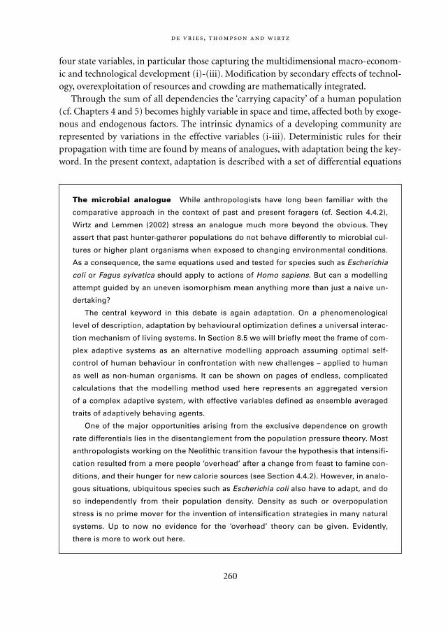
four state variables, in particular those capturing the multidimensional macro-econom-ic and technological development (i)-(iii). Modification by secondary effects of technol-ogy, overexploitation of resources and crowding are mathematically integrated.
Through the sum of all dependencies the ‘carrying capacity’ of a human population(cf. Chapters 4 and 5) becomes highly variable in space and time, affected both by exoge-nous and endogenous factors. The intrinsic dynamics of a developing community arerepresented by variations in the effective variables (i-iii). Deterministic rules for theirpropagation with time are found by means of analogues, with adaptation being the key-word. In the present context, adaptation is described with a set of differential equations
,
260
The microbial analogue While anthropologists have long been familiar with the
comparative approach in the context of past and present foragers (cf. Section 4.4.2),
Wirtz and Lemmen (2002) stress an analogue much more beyond the obvious. They
assert that past hunter-gatherer populations do not behave differently to microbial cul-
tures or higher plant organisms when exposed to changing environmental conditions.
As a consequence, the same equations used and tested for species such as Escherichia
coli or Fagus sylvatica should apply to actions of Homo sapiens. But can a modelling
attempt guided by an uneven isomorphism mean anything more than just a naive un-
dertaking?
The central keyword in this debate is again adaptation. On a phenomenological
level of description, adaptation by behavioural optimization defines a universal interac-
tion mechanism of living systems. In Section 8.5 we will briefly meet the frame of com-
plex adaptive systems as an alternative modelling approach assuming optimal self-
control of human behaviour in confrontation with new challenges – applied to human
as well as non-human organisms. It can be shown on pages of endless, complicated
calculations that the modelling method used here represents an aggregated version
of a complex adaptive system, with effective variables defined as ensemble averaged
traits of adaptively behaving agents.
One of the major opportunities arising from the exclusive dependence on growth
rate differentials lies in the disentanglement from the population pressure theory. Most
anthropologists working on the Neolithic transition favour the hypothesis that intensifi-
cation resulted from a mere people ‘overhead’ after a change from feast to famine con-
ditions, and their hunger for new calorie sources (see Section 4.4.2). However, in analo-
gous situations, ubiquitous species such as Escherichia coli also have to adapt, and do
so independently from their population density. Density as such or overpopulation
stress is no prime mover for the invention of intensification strategies in many natural
systems. Up to now no evidence for the ‘overhead’ theory can be given. Evidently,
there is more to work out here.
Mappae Mundi bw zw/w 08-04-2004 15:26 Pagina 260
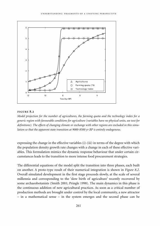
expressing the change in the effective variables (i)-(iii) in terms of the degree with whichthe population density growth rate changes with a change in each of these effective vari-ables. This formulation mimics the dynamic response behaviour that under certain cir-cumstances leads to the transition to more intense food procurement strategies.
The differential equations of the model split the transition into three phases, each builton another. A proto-type result of their numerical integration is shown in Figure 8.2.Overall simulated development in the first stage proceeds slowly, at the scale of severalmillennia and corresponding to the ‘slow birth of agriculture’ recently recovered bysome archaeobotanists (Smith 2001; Pringle 1998). The main dynamics in this phase isthe continuous addition of new agricultural practices. As soon as a critical number ofproduction methods are brought under control by the local community, a new attractor– in a mathematical sense – in the system emerges and the second phase can be
:
261
.
Model projection for the number of agricultures, the farming quota and the technology index for a
generic region with favourable conditions for agriculture (variables have no physical units, see text for
definitions). The effects of changing climate or exchange with other regions are excluded in this simu-
lation so that the apparent state transition at 9000-8500 yr BP is entirely endogenous.
Mappae Mundi bw zw/w 08-04-2004 15:26 Pagina 261
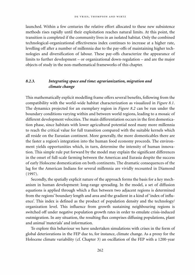
launched. Within a few centuries the relative effort allocated to these new subsistencemethods rises rapidly until their exploitation reaches natural limits. At this point, thetransition is completed if the community lives in an isolated habitat. Only the combinedtechnological-organizational effectiveness index continues to increase at a higher rate,levelling off after a number of millennia due to the pay-offs of maintaining higher tech-nologies and diversification of labour. These pay-offs characterize the appearance oflimits to further development – or organizational down-regulation – and are the majorobjects of study in the non-mathematical frameworks of this chapter.
8.2.3. Integrating space and time: agrarianization, migration and climate change
This mathematically explicit modelling frame offers several benefits, following from thecompatibility with the world-wide habitat characterization as visualized in Figure 8.1.The dynamics projected for an exemplary region in Figure 8.2 can be run under theboundary conditions varying within and between world regions, leading to a mosaic ofdifferent development velocities. The main differentiation occurs in the first domestica-tion phase, since habitats with lower agricultural potential need many more millenniato reach the critical value for full transition compared with the suitable kernels whichall reside on the Eurasian continent. More generally, the more domesticables there arethe faster a region’s integration into the human food economy proceeds. The environ-ment yields opportunities which, in turn, determine the intensity of human innova-tion. This simple rule put forward by the model may explain the significant differencesin the onset of full-scale farming between the Americas and Eurasia despite the successof early Holocene domestication on both continents. The dramatic consequences of thelag for the American Indians for several millennia are vividly recounted in Diamond(1997).
Secondly, the spatially explicit nature of the approach forms the basis for a key mech-anism in human development: long-range spreading. In the model, a set of diffusionequations is applied through which a flux between two adjacent regions is determinedfrom the regions’ boundary length and area and the gradient in a kind of ‘index of influ-ence’. This index is defined as the product of population density and the technology/organization level. This influence from growth sustaining neighbouring regions isswitched off under negative population growth rates in order to emulate crisis-inducedoutmigration. In any situation, the resulting flux comprises diffusing populations, plantand animal ‘materials’ and information.
To explore this behaviour we have undertaken simulations with crises in the form ofglobal deteriorations in the FEP due to, for instance, climate change. As a proxy for theHolocene climate variability (cf. Chapter 3) an oscillation of the FEP with a 1200-year
,
262
Mappae Mundi bw zw/w 08-04-2004 15:26 Pagina 262
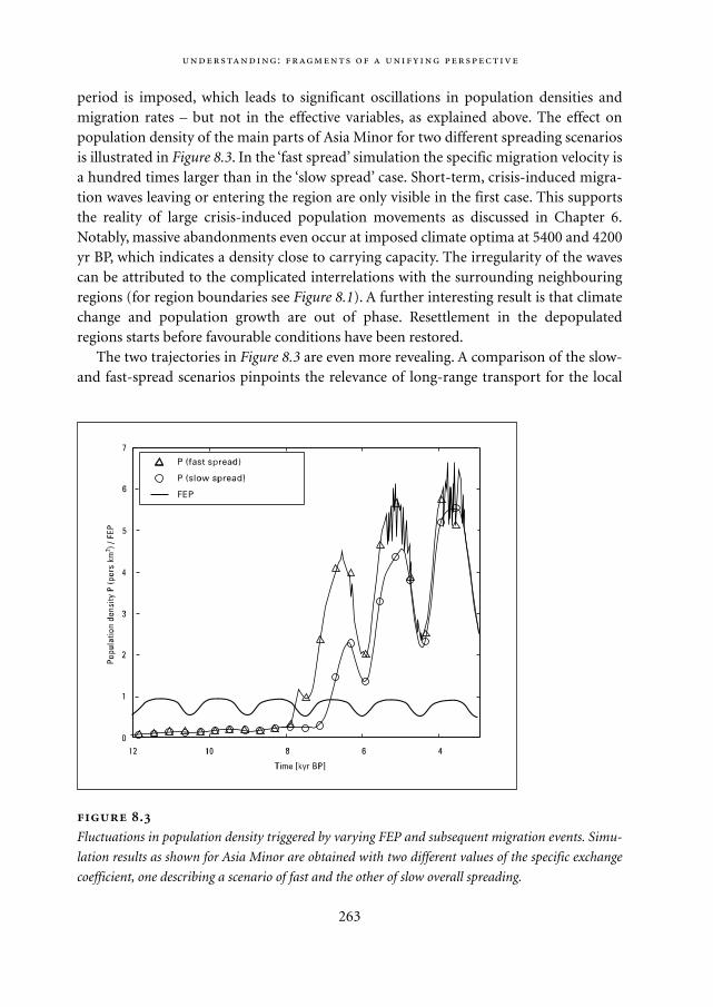
period is imposed, which leads to significant oscillations in population densities andmigration rates – but not in the effective variables, as explained above. The effect onpopulation density of the main parts of Asia Minor for two different spreading scenariosis illustrated in Figure 8.3. In the ‘fast spread’ simulation the specific migration velocity isa hundred times larger than in the ‘slow spread’ case. Short-term, crisis-induced migra-tion waves leaving or entering the region are only visible in the first case. This supportsthe reality of large crisis-induced population movements as discussed in Chapter 6.Notably, massive abandonments even occur at imposed climate optima at 5400 and 4200yr BP, which indicates a density close to carrying capacity. The irregularity of the wavescan be attributed to the complicated interrelations with the surrounding neighbouringregions (for region boundaries see Figure 8.1). A further interesting result is that climatechange and population growth are out of phase. Resettlement in the depopulatedregions starts before favourable conditions have been restored.
The two trajectories in Figure 8.3 are even more revealing. A comparison of the slow-and fast-spread scenarios pinpoints the relevance of long-range transport for the local
:
263
.
Fluctuations in population density triggered by varying FEP and subsequent migration events. Simu-
lation results as shown for Asia Minor are obtained with two different values of the specific exchange
coefficient, one describing a scenario of fast and the other of slow overall spreading.
Mappae Mundi bw zw/w 08-04-2004 15:26 Pagina 263
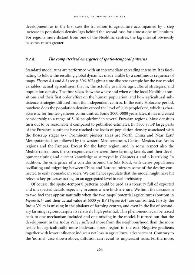
development, as in the first case the transition to agriculture accompanied by a stepincrease in population density lags behind the second case for almost one millennium.For regions more distant from one of the Neolithic centres, the lag interval obviouslybecomes much greater.
8.2.4. The computerized emergence of spatio-temporal patterns
Standard model runs are performed with an intermediate spreading intensity. It is fasci-nating to follow the resulting global dynamics made visible by a continuous sequence ofmaps. Figures 8.4 and 8.5 (see p. 306-307) give a time discrete example for the two modelvariables: actual agricultures, that is, the actually available agricultural strategies, andpopulation density. The time slices show the where and when of the local Neolithic tran-sitions and their first order effect on the human population, and how agricultural sub-sistence strategies diffused from the independent centres. In the early Holocene period,nowhere does the population density exceed the level of 0.08 people/km2, which is char-acteristic for hunter-gatherer communities. Some 2000-3000 years later, it has increasedconsiderably to a range of 5-10 people/km2 in several Eurasian regions. Most densitiesturn out to be reasonable if compared to published estimates. By 3500 yr BP large partsof the Eurasian continent have reached the levels of population density associated withthe Boserup stages 4-7. Prominent pioneer areas are North China and Near East/Mesopotamia, later followed by the western Mediterranean, Central Mexico, two Andesregions and the Pampas. Except for the latter region, and in some respect also theMediterranean one, the correspondence between these farming kernels and their devel-opment timing and current knowledge as surveyed in Chapters 4 and 6 is striking. Inaddition, the emergence of a corridor around the Silk Road, with dense populationsoscillating and migrating between China and Europe, mirrors some of the destiny con-nected to early nomadic invaders. We can hence speculate that the model might have hitrelevant key processes acting on an aggregated level in real prehistory.
Of course, the spatio-temporal patterns could be used as a treasury full of expectedand unexpected details, especially in zones where finds are rare. We limit the discussionto two foci that appear naturally when the two maps’ potential agricultures (bottom inFigure 8.1) and their actual value at 6000 yr BP (Figure 8.4) are confronted. Firstly, theIndus Valley is missing in the phalanx of farming centres, and even in the list of second-ary farming regions, despite its relatively high potential. This phenomenon can be tracedback to one mechanism included and one missing in the model. It turned out that thedevelopment in the Indus Valley suffered more from the neighbourhood than the morefertile but agriculturally more backward forest region to the east. Negative gradientstogether with lower influence induce a net loss in agricultural advancement. Contrary tothe ‘normal’ case shown above, diffusion can reveal its unpleasant sides. Furthermore,
,
264
Mappae Mundi bw zw/w 08-04-2004 15:26 Pagina 264
the situation to the west is equally uneven for the valley region as the desert zone acts asa border for agricultural technology and livestock of the Near East. Generally, regionswith a low NPP do not sustain significant populations and therefore impede exchangepassages. The second part of the explanation is that the mechanism presumably correct-ing for geographical/demographic land barriers, i.e. seafaring along the coast, is neglect-ed in the model. The second region whose development is restricted by contact with aforest neighbour is the eastern edge of Brazil. The projected absence of Neolithic farm-ing there is in agreement with the lack of archaeological evidence of early domesticates.No overseas transport seems to have existed which could have brought domesticatedspecies or related skills from Meso- and South-American centres, as was the case in theIndus Valley.
Obviously many questions need to be raised about this complex model, for instanceabout model initialization and parameterization. There are still a number of difficultieswith the biogeographical maps (Figure 8.1) arising from, for instance, the compilation ofinput maps and the many local uncertainties therein. Nevertheless, filling the gaps ofterra incognita brings the advantage that many world regions that are sparsely investigat-ed by scientists or for other reasons offer a small amount of finds are now treated thesame as prominent zones such as the Mediterranean or the south-west of North Ameri-ca. The outcomes of the model have to be interpreted in the light of the spatio-temporalscales for which it has been constructed. Short-term outbreaks of non-adaptive strate-gies such as the maintenance of a large urban and associated negative feedback loops onwealth and development are clearly filtered out.
The global dimension of the simulation study should be understood as an extremelyhard test of the model’s generic nature. Parameters, initial values and evolution equa-tions do not carry site-specific modifications. One question arising from these simula-tions is whether commonly attested world-wide patterns of human-environment inter-action during the Holocene period can be reproduced by means of a deterministic rulesystem and whether they lose their ‘contingency’. No clear answer to both questions ispresently ready for presentation, However, the model provides a clear context for raisingthese questions and reflects the growing possibility of linking theories of the macro-evo-lution of humanity to models which in turn can be more easily subjected to a critical val-idation using the increasing amount of archaeological and archaeobotanical fragments.It should be clear that the applicability of global simulation studies as instruments forhypothesis testing is not confined to the model presented here, as the latter may soonopen the way to alternative formulations, input data sets or employed mathematicalmethods.
Finally, these analyses may foster a slight change in our perception: explanations forthe spatio-temporal outlook of the Neolithic transition must not rely on externalchange-triggering factors or contingency arguments. The concluding but still prelimi-nary hypothesis, then, is that the globe offers a highly diverse potential for agricultural
:
265
Mappae Mundi bw zw/w 08-04-2004 15:26 Pagina 265
practices in the different regions that was exploited by culture-bearing humans in aprocess of steady innovation and competition between different ways of life.
8.3. Humans and their environment: a few more modelling exercises
As we hope to have shown in Chapter 5 and the previous section, dynamic models candeepen our insights into how socio-natural systems have evolved. In this section webriefly discuss a few models with the emphasis on the role of human values, habits andrituals, that is, on local micro-dynamics. The first model, Lakeland, illustrates the impor-tance of modelling explicitly human behaviour.2 The second model investigates popula-tion growth dynamics among the !Kung San people in South Africa. The third modeldiscussed is an elaborate simulation of the social organization of the Hohokam peoplesin the south-western part of the United States. Evidently, it is only one particular choicefrom the many modelling efforts currently underway.
8.3.1. Lakeland: fishing and mining strategies
In most models, behaviour is simulated in the form of one aggregate actor described byone or a few differential equations for e.g. resource use. To give a more realistic picture, amore comprehensive actor representation can be used in which people engage in cogni-tive processes such as social comparison, imitation and repetitive behaviour (habits)(Jager 2000). A small group (16) of individuals – or consumats – is placed in a micro-world, Lakeland, consisting of a lake and a gold mine. Lakeland gives access to two natu-ral resources: a fish stock in the lake and a gold mine. The lake is being modelled as asimple ecological system of fish and their food: shrimps. Exploiting the gold mine causeswater pollution in the lake, which in turn reduces the lake’s carrying capacity for fish.The money earnt from gold mining can be spent on fish imports and/or non-fish con-sumption ‘luxury’ goods.
The consumats determine how they allocate their time to leisure, fishing and mining.They are equipped with certain abilities for fishing and mining and want to satisfy theirfour needs: leisure, identity, subsistence and freedom. These needs, which are supposedto play an important role in this case, are selected out of a larger set of needs as describedby Max-Neef (1991). The satisfaction of the need for leisure is related to the share of thetime spent on leisure. The need for identity is satisfied by the relative amount of moneythe consumat owns in comparison to consumats with similar abilities. The need for sub-sistence relates to the consumption of food, i.e. fish. The need for freedom is assumed tobe related to the absolute amount of money the consumat owns, which can be spent onwhatever assets the consumat prefers. A multi-agent simulation program has been devel-
,
266
Mappae Mundi bw zw/w 08-04-2004 15:26 Pagina 266
oped to study how the micro-level processes affect macro-level outcomes.All consumats have to satisfy their personal needs by fishing and/or mining, whereby
they find themselves in a common dilemma facing the risk of resource depletion. Theycan choose different strategies which have been identified on the basis of psychologicaltheory. Depending on the desired level of need satisfaction and behavioural control –which is linked to (un)certainty – of the consumats, they follow different cognitiveprocesses: deliberation (reasoned, individual), social comparison (reasoned, sociallydetermined), repetition (automated, individual) and imitation (automated, sociallydetermined). If their performance falls below expectation – as recorded in a mental mapwith memory – agents will switch strategy. Two archetypical consumats have been creat-ed: Homo economicus and Homo psychologicus, to study the effects of various assump-tions. The former tends to favour deliberation as he or she operates with high levels ofneed satisfaction and uncertainty reduction, whereas the latter tends to be quickly satis-fied and uncertain which induces imitative behaviour.
One finding is that Homo psychologicus makes a very different transition from a fish-ing society to a mining society than Homo economicus, who could engage only in the‘standard’ mode of rational deliberation. The introduction of mining means less timespent on fishing. Because Homo psychologicus spends less time fishing than Homo eco-nomicus, the latter depletes the fish stock to a greater extent. Yet Homo psychologicusdepletes the fish stock at a higher rate than before the mining option was there. A majorreason for this is that the slow but persistent move towards mining causes water pollu-tion, which in turn negatively affects the fish stock by causing it to decrease (Figure 8.6).This further accelerates the transition to mining as the fish catch per hour keep decreas-ing. This in turn leads to a different resource exploitation pattern (fish population, golddepletion, water pollution). A second finding is that the population and resource use tra-jectory over time depends on the diversity in agents’ abilities: for Homo economicus itleads on average to a decrease in time spent working, as opposed to an increase for Homopsychologicus. This result suggests the importance of a sophisticated understanding ofpeoples’ motives and habits in exploiting environmental resources. In another experi-ment, it is assumed that deliberation leads to fish-catching innovations and that miningis not possible. Not surprisingly, the fish resource is more rapidly overexploited. Howev-er, the lower level of satisfaction and the more rapid diffusion through social compari-son processes in a Homo economicus population causes a much faster collapse than in aHomo psychologicus community, where people are basically content and stuck in repeti-tive behaviour for a while without noticing the innovation (Figure 8.7). This underlinesthe ambivalence of technological progress in issues of (un)sustainable patterns ofresource use; it also suggests a possible dynamic in the confrontation of relativelyadvanced societies with traditional ones: living a satisfied life and having a low-riskalertness makes populations easy prey for more capable groups.
A more general conclusion is that the incorporation of a micro-level perspective on
:
267
Mappae Mundi bw zw/w 08-04-2004 15:26 Pagina 267
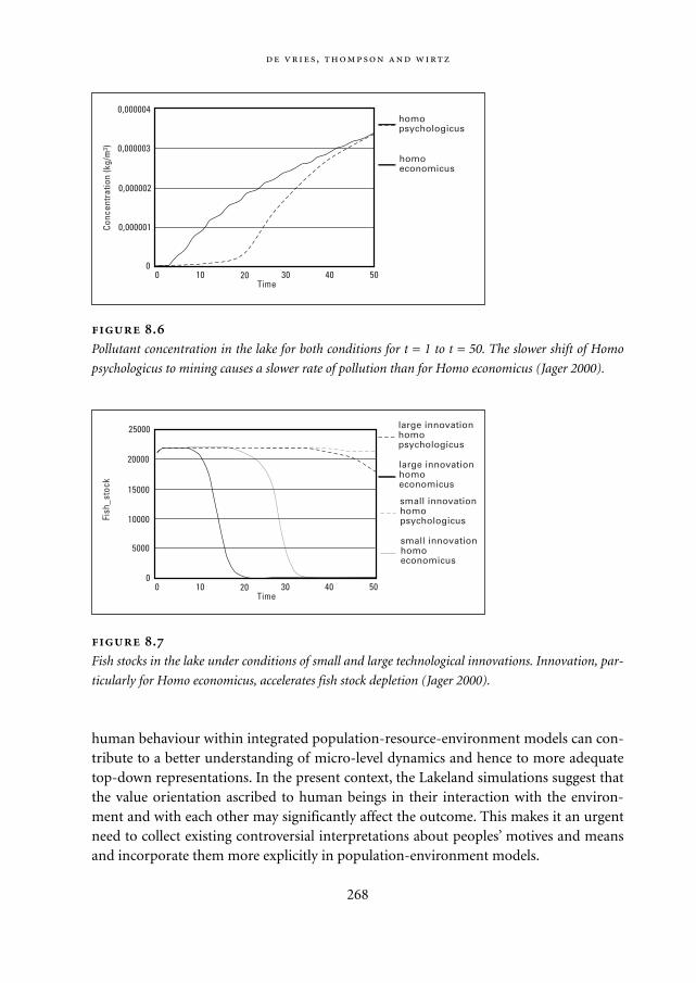
human behaviour within integrated population-resource-environment models can con-tribute to a better understanding of micro-level dynamics and hence to more adequatetop-down representations. In the present context, the Lakeland simulations suggest thatthe value orientation ascribed to human beings in their interaction with the environ-ment and with each other may significantly affect the outcome. This makes it an urgentneed to collect existing controversial interpretations about peoples’ motives and meansand incorporate them more explicitly in population-environment models.
,
268
.
Pollutant concentration in the lake for both conditions for t = 1 to t = 50. The slower shift of Homo
psychologicus to mining causes a slower rate of pollution than for Homo economicus (Jager 2000).
large innovationhomopsychologicus
large innovationhomoeconomicus
20000
15000
10000
5000
Fish
_sto
ck
00 10 20 30 40 50
Time
small innovationhomopsychologicus
small innovationhomoeconomicus
25000
.
Fish stocks in the lake under conditions of small and large technological innovations. Innovation, par-
ticularly for Homo economicus, accelerates fish stock depletion (Jager 2000).
homopsychologicus
homoeconomicus
0,000004
0,000003
0,000002
0,000001Conc
entr
atio
n (k
g/m
3 )
00 10 20 30 40 50
Time
Mappae Mundi bw zw/w 08-04-2004 15:26 Pagina 268
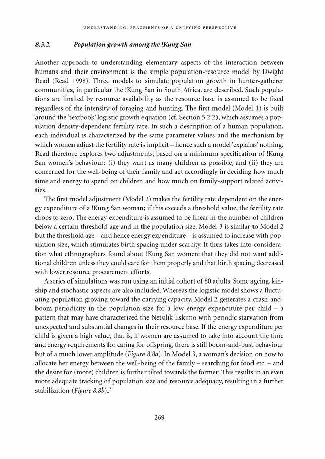
8.3.2. Population growth among the !Kung San
Another approach to understanding elementary aspects of the interaction betweenhumans and their environment is the simple population-resource model by DwightRead (Read 1998). Three models to simulate population growth in hunter-gatherercommunities, in particular the !Kung San in South Africa, are described. Such popula-tions are limited by resource availability as the resource base is assumed to be fixedregardless of the intensity of foraging and hunting. The first model (Model 1) is builtaround the ‘textbook’ logistic growth equation (cf. Section 5.2.2), which assumes a pop-ulation density-dependent fertility rate. In such a description of a human population,each individual is characterized by the same parameter values and the mechanism bywhich women adjust the fertility rate is implicit – hence such a model ‘explains’ nothing.Read therefore explores two adjustments, based on a minimum specification of !KungSan women’s behaviour: (i) they want as many children as possible, and (ii) they areconcerned for the well-being of their family and act accordingly in deciding how muchtime and energy to spend on children and how much on family-support related activi-ties.
The first model adjustment (Model 2) makes the fertility rate dependent on the ener-gy expenditure of a !Kung San woman; if this exceeds a threshold value, the fertility ratedrops to zero. The energy expenditure is assumed to be linear in the number of childrenbelow a certain threshold age and in the population size. Model 3 is similar to Model 2but the threshold age – and hence energy expenditure – is assumed to increase with pop-ulation size, which stimulates birth spacing under scarcity. It thus takes into considera-tion what ethnographers found about !Kung San women: that they did not want addi-tional children unless they could care for them properly and that birth spacing decreasedwith lower resource procurement efforts.
A series of simulations was run using an initial cohort of 80 adults. Some ageing, kin-ship and stochastic aspects are also included. Whereas the logistic model shows a fluctu-ating population growing toward the carrying capacity, Model 2 generates a crash-and-boom periodicity in the population size for a low energy expenditure per child – apattern that may have characterized the Netsilik Eskimo with periodic starvation fromunexpected and substantial changes in their resource base. If the energy expenditure perchild is given a high value, that is, if women are assumed to take into account the timeand energy requirements for caring for offspring, there is still boom-and-bust behaviourbut of a much lower amplitude (Figure 8.8a). In Model 3, a woman’s decision on how toallocate her energy between the well-being of the family – searching for food etc. – andthe desire for (more) children is further tilted towards the former. This results in an evenmore adequate tracking of population size and resource adequacy, resulting in a furtherstabilization (Figure 8.8b).3
:
269
Mappae Mundi bw zw/w 08-04-2004 15:26 Pagina 269
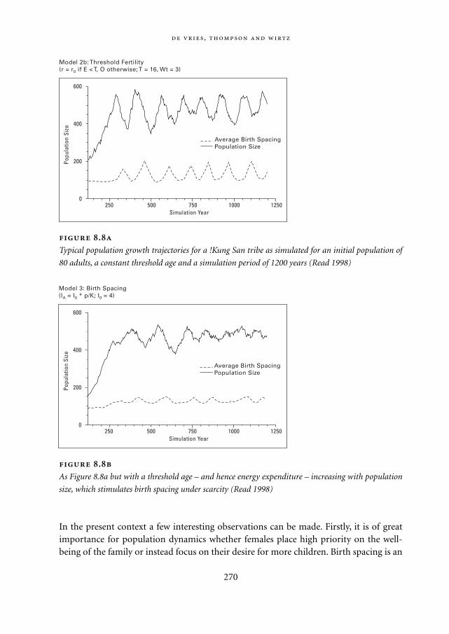
In the present context a few interesting observations can be made. Firstly, it is of greatimportance for population dynamics whether females place high priority on the well-being of the family or instead focus on their desire for more children. Birth spacing is an
,
270
Average Birth SpacingPopulation Size
250 500 750 125010000
200
400
600
Simulation Year
Popu
latio
n Si
zeModel 2b: Threshold Fertility(r = r0 if E < T, O otherwise; T = 16, Wt = 3)
Average Birth SpacingPopulation Size
250 500 750 125010000
200
400
600
Simulation Year
Popu
latio
n Si
ze
Model 3: Birth Spacing(IA = I0 * p/K; I0 = 4)
.
As Figure 8.8a but with a threshold age – and hence energy expenditure – increasing with population
size, which stimulates birth spacing under scarcity (Read 1998)
.
Typical population growth trajectories for a !Kung San tribe as simulated for an initial population of
80 adults, a constant threshold age and a simulation period of 1200 years (Read 1998)
Mappae Mundi bw zw/w 08-04-2004 15:26 Pagina 270
important control option, unlike the time spent on procuring resources. In this way, cul-turally mediated individual behaviour gives depth to a model and brings us from adescriptive model – such as logistic growth – to a model with explanatory power.
8.3.3. What happened to the North American Pueblo Indians in the period 900-1300 AD?
What were the causes and consequences of the contraction of community territoriesnoted for the Pueblo III period in the Mesa Verde region in the final 400 years of pre-Hispanic agricultural society in the Mesa Verde region? (Kohler 2000a). There are clearsigns of climate change during this period (900-1300 AD), stress showing up as less pro-tein, possibly cannibalism, receding dwellings, etc. ‘There is obviously much that we stilldon’t know about major classic questions [on the Pueblo Indians] but the possibilitiesare narrowing in tantalizing fashion.’
After a short cold period around 900 AD, the plateau climate and the potential foragricultural production improved. The site distributions suggest a rather high rate ofpopulation increase for the period 950-1050 AD (0.5%/yr). People were living in small,dispersed communities of less than 100 individuals. The 50-year period from 1130-1180
:
271
The blessings of scarcity? These modelling exercises can also assist in interpreting
archaeological finds, for instance with regard to the relationship between resource
abundance and culture. In populations in the resource-rich Murry and Darling River val-
leys in Australia, Harris lines have been found in human bones indicating food short-
ages. As these are not found in the bone remains of populations in the dry interior
lands, they indicate that populations in resource-abundant areas live closer to the car-
rying capacity than in resource-poor environments. The !Kung San model experiments
indicate that a foraging group in a low-density resource region is less at risk than one
in a high-density resource region, because women will make decisions to increase the
spacing of offspring much sooner under low-density conditions than would be predict-
ed from the change in resource density alone. Why would they do so? As the resource
density decreases, the travel and search times required per forager for resource pro-
curement increase more rapidly than would be expected from the decrease in resource
density alone. Groups in high-density resource regions will probably be much nearer
the carrying capacity – expanding their catchment region is then one possible
response. This is the substance of a myth in system dynamics terms: a population is
lucky enough to be borne in Paradise, erodes its sources of wealth and, as a conse-
quence, has to expand and develop the tools and tactics of war – Paradise Lost.
Mappae Mundi bw zw/w 08-04-2004 15:26 Pagina 271
AD was very unfavourable for agriculture, and local expressions of the ‘Chacoan Phe-nomenon’ – which itself is to the south of this area – disappeared. By the end of the 11th
century, the climate became colder again – the potential for maize production was lowand population growth was slow – about 0.3%/yr following negative growth in the mid-12th century. With the exception of a few decades in the late 12th century, potential agri-cultural productivity on the plateau was low and became worse. The region graduallybecame depopulated and an increasing fraction of the people lived in larger settlementsof up to 400 individuals. It is possible that people’s farming methods became less effi-cient because of reduced fallows, greater distances to fields, larger investments in water-harvesting technologies or all three. Hunting increasingly yielded lower-ranked game,suggesting protein shortages.
By 1250 AD a period with changing precipitation patterns set in which added to thealready existing uncertainties in food supply. Ever more people lived in large sites, manyof them now being in canyon environments. The scarcity of big game may explain thelarge role of turkey in the diet – although it may also reflect the high value of feathers forrituals. The deteriorating quality of life shows up in low survival rates (41-57% abovethe age of 20), high incidences of infant mortality and disease and a decline in the statusof women and children. The men were probably better fed because they went on long-distance hunts necessitated by local depletion; the hunts were increasingly associatedwith ritual even as they became decreasingly successful. The people increasingly becameinwardly focused in this last stage and may have filtered out real-world data signals inorder to retain social coherence. The social logic may have become out-of-step withenvironmental opportunity – maladaptation. Alternatively, or simultaneously, the threatsfrom other Puebloan or non-Puebloan peoples may have led to increased warfare.
These patterns are all reconstructed from archaeological excavation and survey datafor this region. Recently, however, there has been an attempt to see the extent to which itis possible to construct an agent-based model – in which households are the agents –that generates these same patterns working from the first principles of human adapta-tion in conjunction with the climatic conditions reconstructed for this period and thesubsistence technology that was available. Such first principles of human adaptation are:minimization of energy expenditure, population growth responsive to resource condi-tions, and the possibility of subsistence intensification. An agent-based model has beenconstructed, with simulations showing how the settlement configurations changedthrough time in one instantiation of the model.4 The problem facing households in thissimulation ‘film’ is simply where to live in order to maintain an acceptable standard ofliving as farmers when climate conditions are changing, in the ways we believe they didbetween 900 and 1300 AD (Figure 8.9; see p. 308). We can draw tentative conclusionsabout how well this model works by comparing the site distributions it generates withthose known from the archaeological record.
Of the many observations drawn from this preliminary work, one of the most
,
272
Mappae Mundi bw zw/w 08-04-2004 15:26 Pagina 272
remarkable is the tendency, known from archaeological records, for the latest occupa-tions to be concentrated in a small portion of the apparently farmable area – based onthe simulation. Although this could be due to an error or omission in reconstructingpotential maize productivity from tree-ring data,5 it is also possible that some othercause not included in the model, such as widespread violence, was responsible for thisdramatic contraction.
In general, there appear to be three very important and related roles for models in suchsituations. The first is to suggest hypotheses that can be tested by other means. Each runof the simulation can be viewed as generating a series of testable implications – in thiscase for settlement size, location and duration – this should be true if the model under-lying the simulation is correct. The second is to examine the effects of varying agentbehaviours, such as the exchange of maize, that are difficult or impossible to view direct-ly in the archaeological record but which ought to have measurable effects on settlementbehaviours that can be seen in the records. The next phase of this simulation work, forexample, will examine whether the patterns of aggregation (village formation) seen inthe record can be explained, at least in part, by changes in the amount of maize exchangeamong households – which itself should change in response to climatic conditions.
Finally, there is the sense that we get much closer to an explanation of phenomenasuch as settlement behaviour when we can generate or ‘grow’ it, working from a small setof rules and boundary conditions and acting through low-level agents, than when wederive statistical, system-level correlations between, for example, agricultural productiv-ity and the density of households. One reason for this could be that we have been tunedby evolution to understand processes that are presented to us as agents in a disaggregateform. From this perspective these simulations provide a ‘crutch for our imagination’ andhelp us to predict the long-term consequences of processes that operate over long peri-ods of time, large areas and have complicated boundary conditions – such as changingclimates.
8.4. Social science perspectives on state formation and environment
Complex societies, it must be emphasized again, are recent in human history. Col-
lapse then is not a fall to some primordial chaos, but a return to the normal human
condition.
Tainter 1988: 198
After this discussion on simulation models of socio-natural systems, it is time to have alook at some more qualitative ‘pre-modelling’ notions and approaches of complex socio-natural systems. In previous chapters it has been argued that the increase of social com-plexity in various places and times was both a consequence of and a reason for a more
:
273
Mappae Mundi bw zw/w 08-04-2004 15:26 Pagina 273
intricate relationship between human populations and their environment. Populationsand in their wake the use of resources expanded and intensified. Resource procurementand management strategies became more elaborate as reflected in more stratified andspecialized societies and more sophisticated worldviews and rituals. The emergence ofstates and empires as well as other forms has been extensively studied as an importantand conspicuous phenomenon on this evolutionary path.
Within the social sciences, several theories have been proposed to gain a fuller under-standing of the rise and fall of complex societies and, in particular, states. According toTainter (1988) there are two main schools of thought about state emergence. The first isthe conflict school, which asserts that the state emerged out of the needs and desires ofindividuals and subgroups of a society. Governing institutions are essentially coercivemechanisms to resolve intra-societal conflicts arising out of economic stratification.They exist to maintain the privileged position of a ruling class. Historically, this interpre-tation is associated with the Marxist view, amongst others. The second school – integra-tionist or functionalist – argues that complexity in all its manifestations of intensifica-tion, specialization and stratification arose out of the needs of society. Governinginstitutions, in this view, came into existence to centralize, co-ordinate and direct dis-parate parts of complex societies in response to stresses.
Is the evolution from simple, tribal to complex societies a one-way evolution or arethe cycles of rise and fall most characteristic? Surely complex societies were preceded bytribal societies in which
Leadership … tends to be minimal. It is personal and charismatic … Hierarchical control is not
institutionalised … Equality … lies in direct, individual access to the resources that sustain life,
in mobility and the option to simply withdraw from an untenable social situation, and in con-
ventions that prevent economic accumulation and impose sharing … Personal ambition is
either restrained from expression, or channelled to fulfil a public good … (Tainter 1988: 24-25)
Evidently, tribal society imbues the low-level enclaves with egalitarian tendencies. Theconflict school interpretation is recognized as an often pejorative description of howthese human groups lost their innocence – Paradise Lost – to either the rationalizedauthority of priests and kings or the greed of and exploitation by a merchant class (cf.Section 4.4.2). The institutionalist school, on the other hand, tends to see the move tohierarchy as an inevitable event collateral to the increasingly complex challenges andachievements of populations – an irreversible, one-way process. Most large-scale ‘suc-cessful’ civilizations did indeed follow the path towards integration into larger systems,but many of them fell apart into smaller clusters – the ‘fringes of empire’ discussed inSection 6.5.
In the decline of the larger, more integrated systems, the characteristics of andchanges in the natural environment played an important role – but equally important
,
274
Mappae Mundi bw zw/w 08-04-2004 15:26 Pagina 274
was the societal response. How much information was available on the environment,how much could it process, how was it interpreted and valued and how much capacityfor novel, adaptive responses and structural transformation was at its disposal? It isinteresting to look at the ideas of environmental historians such as Blanton (1993) and
:
275
Complexity, risk and social memory Some environmental archaeologists and his-
torians assign an important role for the features of the local landscape, focusing on
ecological diversity and the management of risk (cf. Section 4.4). As populations occu-
pied larger territories and did so more intensely, they became more vulnerable to
large-scale environmental change. It became more difficult to develop an adequate rep-
resentation of what was going on – enhancing the possibility of mismanagement.
Long-term large risks replaced short-term risks, the latter being more easily memo-
rized, controlled and/or adjusted because of their higher frequency and locality.
Examples have been given in previous chapters. Another telling example is from a
well-researched situation in southern France (cf. Section 7.4): ‘The central focus of the
Roman history of the Tricastin plain seems to have been water management. The system
which the Romans conceived and implemented… relied heavily on artificial drainage…
But before settlement of the whole area could be completed… the changes in natural
circumstances increased pressure on manpower and investments, so as to maintain
control over the land. At that point, the colonization ran out of steam, so that there
were not enough colonists to keep the drains open over the whole area.’ (Leeuw 1998:
10) Similar events happened in later periods of colonization (cf. Chapters 9 and 10).
An interesting question in this context is what role social – or collective – memory
plays. Having a large ‘social memory’ is not always good for being adaptive because it
may obstruct the acquisition of new, better fitting interpretations. There is a trade-off
between adaptative capability to, for instance, new climates/habitat conditions on the
one hand and culturally imprinted response options on the other. In addition to the
above example, other examples are given in this chapter. The Anasazi exodus out of
the Long House Valley mentioned in the previous section was triggered by severe
droughts, but ultimately seems to have been motivated by endogenous, cultural deter-
minants – as it appears that occupation of the valley at lower densities remained as a
realistic alternative option. The Christian symbolic – and organizational – system creat-
ed fatal barriers for a more adapted foraging strategy among the mediaeval Norse set-
tlers on Greenland, a story narrated in the next section. Such ‘stiffness’ of human adap-
tation might be incorporated in models with a cost function accounting for the energy
required to re-establish and inherit knowledge from one generation to the other. Such
cost take the form of (attachment to) sunk-cost investments, vested interests of urban
administrations and the like.
Mappae Mundi bw zw/w 08-04-2004 15:26 Pagina 275
Renfrew (1985) for whom the natural environment plays a prominent role in thedescription and explanation of societal evolution. The state is said to exist in societieswhich are territorially organized, have two or more social strata, an administrative appa-ratus and revenues from tribute and taxes. Mythical and legendary charters and war andterrorism were among the methods by which states enforced legitimacy, displayed powerand exerted control. As we saw in Chapter 6, these ‘traditional’ states emerged all over theworld under a variety of environmental conditions, in some cases to become empires.They were of limited size, had relatively modest bureaucracies and rather weak transportand communication channels. Which factors prevented their further expansion or led totheir decline? One, for sure, was negative economies of scale: upon expansion states areconfronted with the increasing size and complexity of their institutions. This, in combi-nation with the environmental features such as the existence or absence of natural barri-ers, may explain why in certain periods and places larger states did not evolve or declined.
Many other theories have been put forward to explain the decline and collapse ofhierarchist states and empire, as Chapters 6 and 7 have shown. After a careful investiga-tion of a series of historical cases and explanatory theories, Tainter concludes in his bookThe Collapse of Complex Societies (1988) that, with the exception of mystical explana-tions, none of the explanations of collapse fails entirely. Cessation or change in access tovital resources, natural catastrophes, social conflicts or malfunctioning, confrontationwith other societies or intruders, economic factors have all happened and contributed tocollapse. In Tainter’s opinion, the economically oriented notion of declining rate ofreturn on increasing complexity is the most general and satisfactory framework. Hisanalysis of the collapse of the Roman Empire, the Mayan civilization and the Chacoansociety in north-western New Mexico gives a novel and enlightening perspective.6
Human societies, it is argued, are problem solvers requiring energy for their mainte-nance and therefore need increasing investments for information processing and socio-political control. Such investments in ‘complexity’ have initially positive returns: eco-nomic productivity rises, administrations become more efficient and knowledge levelsincrease. However, beyond a certain point investments face declining or even negativereturns, as the empirical data and Boserup’s development theory indicate for farming:less and less output per additional hour of labour – although not per hectare. As rulershave to legitimize their power and urban mobs have to be appeased with ‘bread and cir-cuses’, a larger part of society’s resource base goes into maintaining the status quo. Atsome point, a further increase in complexity not only becomes less effective but also lessattractive as a problem-solving strategy. Resilience declines and ‘ultimately, the societyeither disintegrates as localized entities break away, or is so weakened that it is toppledmilitarily, often with very little resistance. In either case, socio-political organization isreduced to the level that can be sustained by local resources.’ (Tainter 1988: 122). Col-lapse is not a necessity – technological or social innovations or new energy resourcesmay prolong a society’s survival.
,
276
Mappae Mundi bw zw/w 08-04-2004 15:26 Pagina 276
Whenever centralized state power faded away or became ineffective, competing orga-nizational forms could evolve, such as market institutions and communal regimes. Well-developed exchange systems, markets being one of them, can supply a broad range ofgoods and services at a variety of locations, volumes and prices. Markets tend to be hor-izontally integrated; their territories overlap and suppliers and consumers easily crossboundaries. In contrast, state territories and administrative districts are non-overlap-ping and exclusive. Strong states will exert vertical control by installing trade monopo-lies, employing or outlawing guilds and the like. The interaction between these twoforms of societal organization, for instance when state decay leads to innovations andrevitalization of market institutions, is an important aspect of the human-environmentdynamics (Blanton 1993). Market institutions are also vulnerable: the basic rules have tobe enforced by an overarching agreement or power and their institutionalized greed maycause everlasting struggle and conflict. In periods of decline and disorder, neither statenor market institutions were viable. Politically or religiously inspired leaders, tribalism,anarchic banditry or a combination of all these took over in the scattered remains.Sometimes, in the midst of it, peoples successfully designed and sustained their ownlocal institutions (cf. Section 6.5).
8.5. Perspectives on states and environment: insights into system dynamics
… if in a society dominant trends can be observed tending in a certain direction,
we are always well advised to look for countervailing trends as well, pulling people
in other directions, and to inquire why the countervailing trends were outweighed
by the trends that turned out to be dominant.
Goudsblom 1996: 54
As the previous section shows, a variety of explanations for the emergence and decline ofsocio-cultural complexity have been given. In some the role of and effect upon the natu-ral environment is thought to have been important. However, in-depth thinking from asystem dynamics perspective about these issues is less abundant. In this section webriefly inspect some explorations from such a systems perspective. Doing justice to therich and expanding literature on the subject is beyond the scope of this book.
8.5.1. About processes, mechanisms and pathologies
Since the advent of systems theory, there have been attempts to understand the emer-gence of socio-political and cultural complexity in terms of system dynamics. An early
:
277
Mappae Mundi bw zw/w 08-04-2004 15:26 Pagina 277
and influential contribution has been made by Flannery (1972). In discussing the vari-ous ‘prime movers’ proposed to explain the evolution towards states – irrigation, war-fare, population growth/pressure, trade – he advocates the view that rather than a ‘primemover’ there is a series of system variables with complex inter-relationships and feed-back loops. The important role of information exchange and processing is emphasized:‘One of the main trends in the evolution of bands into tribes, chiefdoms, and states mustbe a gradual increase in capacity for information processing, storage, and analysis.’(Flannery 1972: 411). In his rudimentary theory, he suggests two processes, two evolu-tionary mechanisms and three pathologies that could qualify as universal. The drivingprocesses are increasing differentiation and specialization of subsystems (segregation)and increasing linkages between the subsystems and the highest-order controls (central-ization). The mechanisms are:– promotion: a special-purpose institution rises in the hierarchy to a higher level,
becoming a general-purpose institution. For instance, military institutions oftenseized power in this way; and
– linearization: lower-order controls in the system are repeatedly or permanentlybypassed by higher-order controls. An example is when local irrigation is increasing-ly regulated by a higher-level institution in order to facilitate information exchangeand reduce the risk of harvest failure.
Both mechanisms cause transformations in response to socio-environmental stress –and it is not difficult to recognize them from the previous narratives. Institutions mayonly serve their own interests rather than those of society and bypassing lower-ordercontrols may destroy the resilience of a system – both features well known to hierarchicalsystems. As a result, there are always pathologies associated with the emergence of civi-lization, causing further stress which in turn often accelerates the disintegration process:– usurpation occurs when a subsystem’s purpose starts to dominate the objectives of
the larger system. This is a corollary to the promotion of the military class and is evi-dent, for instance, in periods of the Roman Empire;
– meddling is the other way around: higher-level controls take over what ordinarily isbest regulated locally. Stifling controls on trade have been proposed as an explanationfor the inertia of the Sumerian and Chinese empires;
– too great a degree of subsystem coherence leads to hypercoherence which may, in Rap-paport’s words, be as lethal as too little coherence. Nepotism resulting from marriagealliances between ancient Akkad and Classical Mayan urban centres may have causedsuch hypercoherence.
This list is not exclusive. The phenomena of hypertrophy and atrophy (Chapter 2) andthe difference in pathologies in land-based versus sea-based empires may deserve atten-tion in this respect.
,
278
Mappae Mundi bw zw/w 08-04-2004 15:26 Pagina 278

:
279
Colonists, Inuit and the church Danish colonization of Greenland started in 1721
(Marquardt 1999). However, a Norse colony in west Greenland had already been an
outpost of Europeans throughout the period 985-1500 AD and the scene of contact
between North American hunters and European farmers (McGovern 1981). Excellent
conditions for organic preservation and high-quality archaeological research make for
an intriguing story about the early Norse settlers and their interaction with the Thule-
Inugsuk Inuit peoples. It seems that the Norse community managed quite well for the
first 150 years, with a maritime-terrestrial economy with small animal herds, seasonal
hunting of walrus, polar bear and seals and occasional trading with Iceland. However,
they were living on a knife edge, with great skills being required to survive the long
cold winters. There is ample evidence that the Little Ice Age fluctuations in temperature,
sea ice conditions and faunal resources put the communities under stress from 1270
AD onwards. Moreover, the southward migration of the Inuit – in response to climate
change – and the decline in trading relations with Europe further complicated their sub-
sistence strategies. The western settlements seem to have collapsed rather suddenly
around 1350 AD.
In this story, as McGovern convincingly argues, one should not treat the human
response to climatic stress as a minor and dependent variable. The Inuit peoples sur-
vived these harsh times. The Norse farmers had several options to adapt, for instance
orienting themselves more towards the oceanic resources and de-emphasizing pasture
and cattle-rearing. They also would have benefited from Inuit practices and technology
related to boats, fishing gear and clothing. ‘Rather than exploring the possibilities of
new technology and searching out alternative resources, Norse society in Greenland
seems to have resolutely stuck to its established pattern, elaborating its churches
rather than its hunting skills.’ (McGovern, 1981: 425) Whence this conservatism and loss
of adaptive resilience in the face of rising economic costs and declining returns?
Under the influence of Iceland, the mediaeval church in the Norse communities in
Greenland had become more powerful spiritually as well as materially in the 12th cen-
tury. Between 1125 and 1300 AD, spectacular church construction had taken place,
small communities building among the largest stone structures in the Atlantic Islands.
Economic, political, religious and ideological authority appear to have come into the
hands of a lay and clerical elite. If a society such as this is confronted with increasing
fluctuations in resource abundance and use, it has to invest in additional data collec-
tion and improve its interpretation of these data in order to survive. This constitutes an
overhead cost which is often resisted by the population and has to be enforced by mili-
tary force or by ideology.
The elite-sponsored expensive elaboration of ceremonial architecture and ritual
paraphernalia in Norse Greenland may indicate the successful ideological conditioning
of the population. Administrators may not only have declined Inuit superior technology
Mappae Mundi bw zw/w 08-04-2004 15:26 Pagina 279
8.5.2. The importance of interactions
Autonomous political units do not generally exist in isolation, an observation that hasled to increasing attention for the role of dynamic interaction among similar and moreor less equal units:
The process of [structural] transformation is frequently brought about not simply as a result
of internal processes tending towards intensification, nor in repeated and analogous responses
to a single outside stimulus, but as a result of interaction between the [autonomous socio-
political units or] peer polities. (Renfrew 1985: 8)
Starting from a given ecological diversity, such structural transformations coincidedwith the means to increase production beyond the subsistence level and with a large rolefor exchange systems and, in particular, information exchange. Peer-polity interactionshave been proposed as a compromise between pure exogenous and pure endogenousexplanations, and there are a number of them to be considered (Renfrew 1985: 8):– warfare, which may intensify both resource use and social stratification – unless cata-
strophic warfare results in total collapse;– competitive emulation, a process in which polities compete by means of displaying
wealth and power, using ‘Great Buildings’, symbols of deterrence and the like;– symbolic entrainment, not unlike the previous two but now in the realm of symbolic
systems where the more-developed one absorbs or influences the less-developed one;– transmission of innovation, during which a specific invention becomes accepted and is
henceforth imbued with social or religious status;– exchange of goods which are part of the more general process of economic growth with
concomitant phenomena such as the rise of a merchant class and specialized skills.
In the present context, the relevance of these socio-political processes that they often
,
280
but also have sustained erroneous beliefs – for example that lighting candles had more
impact on the spring seal hunt than more and better boats. As stresses mounted, elite
groups may have pushed up the necessary overheads in their obsession with conform-
ity and the suppression of dissenters and detached themselves further and further from
the phenomenal world, adding Flannery’s pathology of hypercoherence to the patholo-
gy of auto-mystification. This sounds like the Easter Island narrative. Whether or not
this explanation is accepted, the failure of the rulers in the Norse communities in
Greenland clearly shows how important the institutions and belief systems of a society
are in the face of environmental stress.
Mappae Mundi bw zw/w 08-04-2004 15:26 Pagina 280
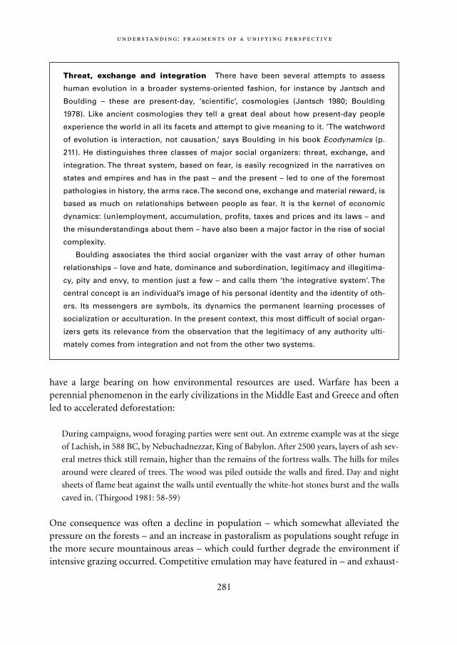
have a large bearing on how environmental resources are used. Warfare has been aperennial phenomenon in the early civilizations in the Middle East and Greece and oftenled to accelerated deforestation:
During campaigns, wood foraging parties were sent out. An extreme example was at the siege
of Lachish, in 588 BC, by Nebuchadnezzar, King of Babylon. After 2500 years, layers of ash sev-
eral metres thick still remain, higher than the remains of the fortress walls. The hills for miles
around were cleared of trees. The wood was piled outside the walls and fired. Day and night
sheets of flame beat against the walls until eventually the white-hot stones burst and the walls
caved in. (Thirgood 1981: 58-59)
One consequence was often a decline in population – which somewhat alleviated thepressure on the forests – and an increase in pastoralism as populations sought refuge inthe more secure mountainous areas – which could further degrade the environment ifintensive grazing occurred. Competitive emulation may have featured in – and exhaust-
:
281
Threat, exchange and integration There have been several attempts to assess
human evolution in a broader systems-oriented fashion, for instance by Jantsch and
Boulding – these are present-day, ‘scientific’, cosmologies (Jantsch 1980; Boulding
1978). Like ancient cosmologies they tell a great deal about how present-day people
experience the world in all its facets and attempt to give meaning to it. ‘The watchword
of evolution is interaction, not causation,’ says Boulding in his book Ecodynamics (p.
211). He distinguishes three classes of major social organizers: threat, exchange, and
integration. The threat system, based on fear, is easily recognized in the narratives on
states and empires and has in the past – and the present – led to one of the foremost
pathologies in history, the arms race. The second one, exchange and material reward, is
based as much on relationships between people as fear. It is the kernel of economic
dynamics: (un)employment, accumulation, profits, taxes and prices and its laws – and
the misunderstandings about them – have also been a major factor in the rise of social
complexity.
Boulding associates the third social organizer with the vast array of other human
relationships – love and hate, dominance and subordination, legitimacy and illegitima-
cy, pity and envy, to mention just a few – and calls them ‘the integrative system’. The
central concept is an individual’s image of his personal identity and the identity of oth-
ers. Its messengers are symbols, its dynamics the permanent learning processes of
socialization or acculturation. In the present context, this most difficult of social organ-
izers gets its relevance from the observation that the legitimacy of any authority ulti-
mately comes from integration and not from the other two systems.
Mappae Mundi bw zw/w 08-04-2004 15:26 Pagina 281
ed – Megalithic and Meso-American cultures, with Easter Island probably as the exam-ple par excellence. Cultural, technological and economic diffusion, exchange and inva-sion processes have affected almost every civilization in its incipient stages.
8.5.3. Humans and their environment as complex adaptive systems
More recently, the systems approach has gained importance with the availability of theo-retical and computer simulation advances leading to the theory of complex adaptive sys-tems. This approach sees behavioural and structural transformations as emerging fromthe rules of individual system entities – individuals or groups of individuals. Chapter 7shows how this approach can be applied to understanding the rise and fall of the RomanEmpire. Its proponents argue that there has been a tendency in the past to explain thedevelopment processes of human societies from an evolutionary framework based onthe ‘organic analogy’ and that this view of a society as a large organism in equilibriumwith its environment stemmed from a top-down ‘centralized mindset’ approach (Lehner2000). Dissatisfaction with such approaches also originated in the use of analogues fromphysics and chemistry, positing equilibrium and homogeneity:
By way of contrast to conventional, equilibrium-based analyses, many [complex systems
approaches] emphasize the fact that ecological and human systems are often in transient
states, are inherently non-linear, and are metastable; i.e. there are two or more domains of
attraction to which the system may converge. Moreover, within these stable domains, the sys-
tem may fluctuate wildly, but so long as it remains within the boundaries of the domain, it is
resilient; it is thus able to persist despite a high degree of disturbance… Importantly, the sta-
bility domains themselves may expand, contract or disappear in response to both internal
structuring processes or external perturbations. (Leeuw 1998: 11)
Equally important in the study of complex socio-natural systems is to take into accountthat causes and effects operate at various time- and spatial-scales, each with their owndynamical characteristics. The availability of powerful simulation tools has stimulated abottom-up approach in which the focus is on individuals with their motives, habits,rules and forms of co-operation and conflict. Such models – also called multi-agentmodels – are interpreted as ‘worlds’ that can deepen our understanding of past and pres-ent ‘real’ worlds because they supposedly resemble them in useful respects. They areaccording to some the best tools we have to study co-evolutionary systems, that is, sys-tems for which traditional one-way cause-and-effect analyses fail. The models based oncomplex adaptive systems theory were originally conceived as groups of agents engagedin a process in which adaptive moves by individuals have consequences for the group.Under certain circumstances they may exhibit remarkable abilities for self-organization.
,
282
Mappae Mundi bw zw/w 08-04-2004 15:26 Pagina 282

Whether these should be interpreted, in the case of human beings, as macro-behaviourwithout internal hierarchy or as an implicit class structure remains an open question.
One interesting element in socio-natural systems is the role of surprise. If externalevents occur or internal dynamics operate which escape the observation of the agent,there is surprise. These are the periods of environmental and social crises to whichagents can respond in a variety of ways: decline, outmigration and concentration inplaces better suited for survival. In the process, the (group of) agents develop a newmental representation of their environment – a social or collective memory. To learn andevolve a new, more adequate representation of the (same) environment is an importantingredient of a group’s resilience and adaptability. We will come back to this in Section8.6 on cultural dynamics. Another important ingredient is to make the environment morecontrollable by acting upon it. Such action will be associated with as yet unintended con-sequences that lead to the necessity for subsequent adaptations – which is what makeshuman history contingent. From these reflections one can posit a sequence of co-evolu-tionary processes between humans and their environment. Human representationsbecome more complex and the environment becomes at least locally and temporarilymore manageable. One may posit the higher fitness of certain representations over oth-ers as an evolutionary mechanism (social/individual, genes/memes). What matters here,too, is the mechanisms and rate of dissipation of the more fit representations. Oneimportant element of resilience can now be identified as the ability to sustain – main-tain, uphold – and adjust the mental representations and the physical structures uphold-ing its associated regime. As the study of complex adaptive systems is in its infancy, thereis a variety of approaches. We will not go into any detail here (Kohler 2000b). We hopethe previous chapters and sections have given a flavour of how this approach can comeup with new interpretation of the evolution of the socio-natural systems that are thetopic of this book. Let us now try to go one step further in the search for synthesis.
8.6. Change and complexity in socio-natural systems
8.6.1. Cultural Theory and ecocycles
The 1980s saw an acceleration in interdisciplinary thinking about the relationshipbetween human groups and their natural environment, culminating in books such asSustainable Development of the Biosphere (Clark 1986) and The Earth as Transformed byHuman Action – Global and Regional Changes in the Biosphere over the Past 300 Years(Turner 1990). One of the interesting results has been the merger of ecological theoryand cultural anthropology, leading to the Cultural Theory (Thompson 1989). Can thesetheories from ecology and anthropology be used in our quest for a better understandingof complex societies and their relationship with the environment?
:
283
Mappae Mundi bw zw/w 08-04-2004 15:26 Pagina 283
The Cultural Theory distinguishes four cultural perspectives, based on the degree towhich individuals behave and feel themselves part of a larger group of individuals withwhom they share values and beliefs – the ‘group’ axis – and the extent to which individu-als are subjected to role prescriptions within a larger structural entity – the ‘grid’ axis(Figure 8.10). The interpretation of past events and the response to present events areboth filtered through the diverse rationalities of each of the four myths – hierarchist,individualist, egalitarian and fatalist – to make their lives liveable. This is illustrated inFigure 8.10 with a metaphorical landscape in which the position of the ball and the land-scape represent the mental map according to which a person interprets and behaves. Forthe individualist (lower left) the ball rolls in a world of inherent stability and whatcounts is individual skill and courage. The world is seen as full of opportunities, chal-lenges, and profit; problems are ‘challenges’, fear paralyses; and humans have enormouscapacity for adaptation. For the hierarchist (upper right) the ball may roll over the limitsof what is considered to be acceptable, thus threatening social stability which is usuallyperceived in terms of the status quo. Information and regulation are needed; state lawsare enforced by state power. The prevailing rationality is not one of maximizing person-al gain, as with the individualist, but administrative and procedural. In Cultural Theorytwo perspectives on how the world functions are added. One is the egalitarian (lowerright) for whom the situation is always precarious: any move of the ball can lead to
,
284
Cultural Theory It is proposed that human beings can be classified according to four
worldviews, each associated with a certain way of structuring the relationship between
man and nature and between fellow men. According to the societies and individuals
involved, this is expressed in quite different judgements about technology, environ-
mental risks and the distribution of prosperity between now and the future and
between here and elsewhere.7 Together these four ‘myths’ of the world form multiple
rationalities. The two axes differentiating the four worldviews are the group axis and
the grid axis.
The group axis is associated with the (non)existence of a collective, shared set of
values. The grid axis represents the degree of ranking and stratification in a society. The
resulting four perspectives are related to their position along these two axes: hierar-
chist (high on both), individualist (low on both), egalitarian (high in ‘group’, low in
‘grid’) and fatalist (low in ‘group’, high in ‘grid’).
Needless to say, it should be borne in mind that people seldom express these
paradigms in their extreme form – nor should one give in to the temptation to make
caricatures. A more controversial question is whether the four worldviews are a mere
classification of individuals/groups or, as its proponents claim, archetypical mental
reconstructions of how the world functions and hence should be acted upon.
Mappae Mundi bw zw/w 08-04-2004 15:26 Pagina 284
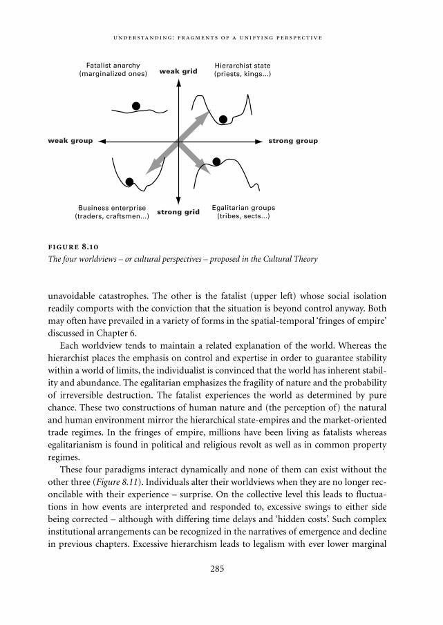
unavoidable catastrophes. The other is the fatalist (upper left) whose social isolationreadily comports with the conviction that the situation is beyond control anyway. Bothmay often have prevailed in a variety of forms in the spatial-temporal ‘fringes of empire’discussed in Chapter 6.
Each worldview tends to maintain a related explanation of the world. Whereas thehierarchist places the emphasis on control and expertise in order to guarantee stabilitywithin a world of limits, the individualist is convinced that the world has inherent stabil-ity and abundance. The egalitarian emphasizes the fragility of nature and the probabilityof irreversible destruction. The fatalist experiences the world as determined by purechance. These two constructions of human nature and (the perception of) the naturaland human environment mirror the hierarchical state-empires and the market-orientedtrade regimes. In the fringes of empire, millions have been living as fatalists whereasegalitarianism is found in political and religious revolt as well as in common propertyregimes.
These four paradigms interact dynamically and none of them can exist without theother three (Figure 8.11). Individuals alter their worldviews when they are no longer rec-oncilable with their experience – surprise. On the collective level this leads to fluctua-tions in how events are interpreted and responded to, excessive swings to either sidebeing corrected – although with differing time delays and ‘hidden costs’. Such complexinstitutional arrangements can be recognized in the narratives of emergence and declinein previous chapters. Excessive hierarchism leads to legalism with ever lower marginal
:
285
Egalitarian groups(tribes, sects...)
Business enterprise(traders, craftsmen...)
Hierarchist state(priests, kings...)
Fatalist anarchy(marginalized ones) weak grid
strong groupweak group
strong grid
.
The four worldviews – or cultural perspectives – proposed in the Cultural Theory
Mappae Mundi bw zw/w 08-04-2004 15:26 Pagina 285

returns, containing the seed of decline and eventual disintegration. Extreme individual-ism ends in perpetuating conflict and marginalization, which feeds the desire for socialstability and justice. Egalitarianism, arising from the desire to purify society from extor-tion and greed, destroys itself in sectarian self-righteousness and religious wars if pur-
,
286
.
Transitions between solidarities and their associated transactional realms. Individuals are able to
move without causing change. It is when some transactions are shifted from one realm to another that
we get change.
EgalitarianismIndividualism
HierarchyFatalism
Mr. López the entrepreneur There is a story about an entrepreneur that nicely
illustrates the interaction in terms of worldviews. One way to sustain an egalitarian
regime is with ceremonies in which those who accumulate inordinate amounts of land
or other property are compelled to give it away. However, a smart individual can
always bypass such a system and create structural change.
In the 1890s Mr. Lopez subverted the old mechanism of wealth levelling in the Mex-
ican village of San Juan Guelavía. Traditionally, only rich people would be designated
as major-domo, that is, the one who has to sponsor for the village fiestas and festivals
and gains prestige from it. However, with help of the clergy Mr. López forced the village
council to designate less wealthy people – who then could not refuse – and offered the
insolvent sponsors a loan with their land put up for collateral. By the eve of the Mexi-
can revolution, Mr. López owned most of the community’s best land: by 1915 his Big
Family owned 92.2% of the arable land and an even larger part of the irrigated land
and, with the support of the church, strongly opposed any censure. Thus, equal access
to strategic resources had disappeared by the perversion of a ritual regulatory mecha-
nism – an example of the vulnerability of egalitarian co-operative regimes to individu-
alist interference.
Mappae Mundi bw zw/w 08-04-2004 15:26 Pagina 286
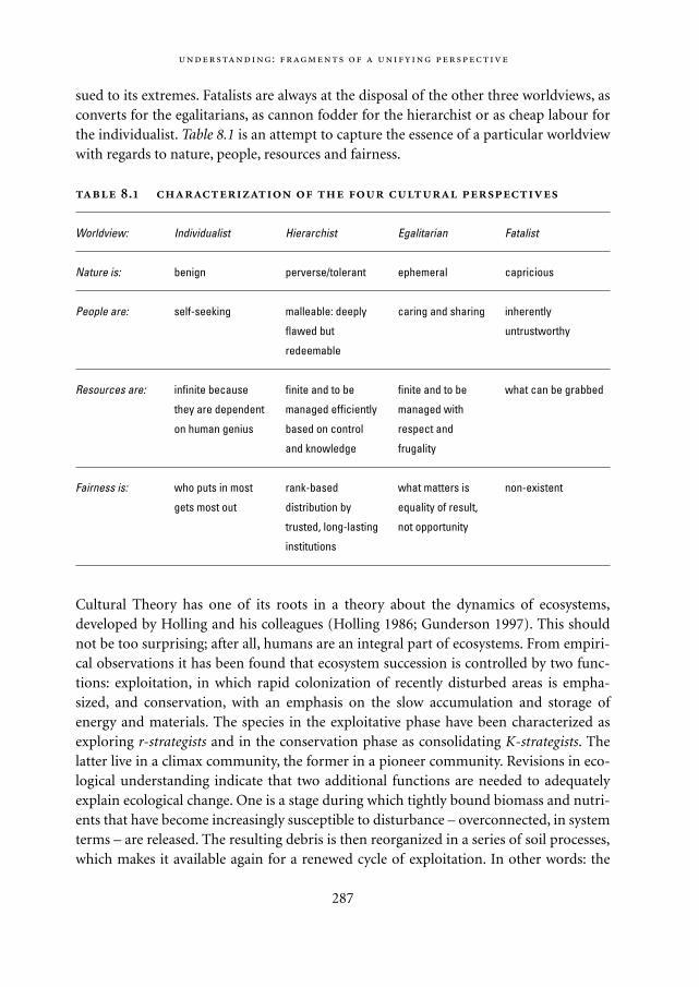
sued to its extremes. Fatalists are always at the disposal of the other three worldviews, asconverts for the egalitarians, as cannon fodder for the hierarchist or as cheap labour forthe individualist. Table 8.1 is an attempt to capture the essence of a particular worldviewwith regards to nature, people, resources and fairness.
.
Worldview: Individualist Hierarchist Egalitarian Fatalist
Nature is: benign perverse/tolerant ephemeral capricious
People are: self-seeking malleable: deeply caring and sharing inherently
flawed but untrustworthy
redeemable
Resources are: infinite because finite and to be finite and to be what can be grabbed
they are dependent managed efficiently managed with
on human genius based on control respect and
and knowledge frugality
Fairness is: who puts in most rank-based what matters is non-existent
gets most out distribution by equality of result,
trusted, long-lasting not opportunity
institutions
Cultural Theory has one of its roots in a theory about the dynamics of ecosystems,developed by Holling and his colleagues (Holling 1986; Gunderson 1997). This shouldnot be too surprising; after all, humans are an integral part of ecosystems. From empiri-cal observations it has been found that ecosystem succession is controlled by two func-tions: exploitation, in which rapid colonization of recently disturbed areas is empha-sized, and conservation, with an emphasis on the slow accumulation and storage ofenergy and materials. The species in the exploitative phase have been characterized asexploring r-strategists and in the conservation phase as consolidating K-strategists. Thelatter live in a climax community, the former in a pioneer community. Revisions in eco-logical understanding indicate that two additional functions are needed to adequatelyexplain ecological change. One is a stage during which tightly bound biomass and nutri-ents that have become increasingly susceptible to disturbance – overconnected, in systemterms – are released. The resulting debris is then reorganized in a series of soil processes,which makes it available again for a renewed cycle of exploitation. In other words: the
:
287
Mappae Mundi bw zw/w 08-04-2004 15:26 Pagina 287
complex system becomes compost, which in turn undergoes renewal into low-level ener-gy enclaves, which are the seeds for the rapidly expanding pioneer communities.
Although this ‘ecocycle theory’ is a simplification of the complex processes in real-world ecosystems, it provides a helpful scheme for thinking about complex systemdynamics. For instance, the parallel with economic and political systems is an interestingone. The entrepreneurial market represents the exploitation phase, with innovations,conquests and rapid expansion – on horseback, ship or whatever. Nature is seen as essen-tially boundless, not unlike some early hunter-gatherer tribes (cf. Chapter 4). With risingexpansion, specialization and stratification, an administrative and bureaucratic hierar-chy emerges: this is the conservation phase during which states and empires are mould-ed. Nature or, more adequately, the socially constructed environment has now becomepart of the conscious worldview and is something to be managed within the confines ofpast experiences and the resulting insights. The release phase is one of ‘creative destruc-tion’ – a term borrowed from the economist Schumpeter – and of decline and fall in a
,
288
Rural-urban landscape dynamics Another fragment of theory suggests an ongo-
ing unification of thinking about complex socio-natural systems. In the ARCHAEOME-
DES project (Leeuw 1998) a detailed investigation of land degradation has been con-
ducted in several parts of the Mediterranean. Building on the insights from systems
theory, an innovation-communication (or reaction-diffusion) dynamic process is pro-
posed to interpret the changes in rural and urban landscapes. The human component
has a few rhythms and a capacity for change through learning. The environmental – or
natural – component is a complex composite with links throughout the food webs. In
rural situations the relatively fast human processes are tied in to the relatively slow
environmental processes: people have adapted to nature and stability is provided by
natural diversity. In urban areas all processes have been accelerated and the relation is
reversed: the pace is set by the fast processes of human life and stability is linked to
value differentiation – or cultural diversity.
These differences are reflected in the corresponding communication structures:
hierarchical in small settlements, more distributed heterarchical in towns. The latter
have a relatively high connectedness and energy flows and adapt more easily to struc-
tural change which in turn accelerates change. In this way multi-nodal adaptive heterar-
chies can quickly spread along the natural corridors such as valleys, roads and coastal
waters. To enhance their stability, they will differentiate along the lines of task and role
specialization and local hierarchies emerge in the search for a balance between effi-
ciency and adaptability. If rural areas with a traditional lifestyle are penetrated by urban
ideas and ways of life, they can either isolate themselves by barring communication or
become urbanized.
Mappae Mundi bw zw/w 08-04-2004 15:26 Pagina 288
historical context. In the subsequent phase of reorganization and restructuring, complexsocieties decompose into small bands some of whom are absorbed in coping with theirown situation – the fatalists – while others start a new cycle by grasping the opportuni-ties that always go along with the threats – the egalitarians and individualists. Thedynamics is highly non-linear, consisting of nested cycles, each occurring over its ownrange of scales and resulting in an ecosystem hierarchy in which each level has its owndistinct spatial and temporal attributes. There is also a remarkable similarity betweenthe theory of collapse as induced by the rising marginal cost of complexity as proposedby Tainter (1988) and the ecological and economic notions of increasing instability andsubsequent creative destruction of complex hierarchical systems.
8.6.2. Complexity in socio-natural systems: the need for requisite variety
One of the questions posed in this book is whether the pathways towards increasingsocial complexity are a long progressive march forwards, fluctuate between two alterna-tives, are essentially cyclical or are even more complex. Cultural Theory and ecocycle-theory encourage us to have an open eye towards ‘requisite variety’ in human action per-spectives. It suggests that peoples did not choose a single trajectory or were forced ontoone, but rather have always operated throughout the cycles of rise and fall from multipleworldviews and management strategies. The analogue or metaphor of the ecocycles sug-gests a ‘natural’ sequence of state emergence from tribal egalitarian communities, fol-lowed by pioneer expansion into a consolidated hierarchist society, and dissolution intoshattered remnants either because of external disruptions or internal dysfunctioning orboth. At the root of all this is an evolving paradigm about complex non-linear systemswhich may be essential for a more in-depth understanding of past – and present –human-environment interactions.
The classic assumption, in both ecology and social science, is that there is a one-waytransition from state A to state B – say, from a simple (tribal) to a complex (state) socie-ty. In ecology, the process of succession (Clements 1916; Odum 1969) ensures that aninitially unstructured state of affairs – one huge niche filled with anarchic, opportunisticand competitive organisms (the r-strategists) – is steadily transformed into a climaxcommunity: a structured and stratified arrangement of diversified niches, with clearlydefined inter-relationships between the species (the K-strategists) that occupy them. Insocial science, this predictable, linear and equilibrium-seeking model of change is paral-leled by a number of ‘grand theories’ in which some inexorable logic moves us all frommechanical to organic solidarity (Durkheim 1893); from community to society(Gemeinschaft to Gesellschaft, Tönnies 1887); from traditional to modern (Weber1958); from status to contract (Maine 1963); from capitalism to communism (Marx1859/1967); or, as modern theorists of institutions put it, from markets to hierarchies
:
289
Mappae Mundi bw zw/w 08-04-2004 15:26 Pagina 289
(Lindblom 1977; Williamson 1975). Different ‘masters’ may define their As and their Bsdifferently, but all subscribe to a twofold scheme and to some driving force – such asrationalization (Weber), internal contradiction (Marx), or spiralling transaction costs(Williamson) – that carries the totality from A to B.
These transitions, whether ecological or socio-cultural, are all in the direction ofmore orderliness, more differentiation, more connectedness and more consistency and,once they have gone as far as they can go in that direction, that is that. In other words,these models of change end up making change impossible. Of course, something on theoutside may intervene and mess things up, thereby setting the whole thing in motiononce more but, left to themselves, these models get ecosystems and socio-cultural sys-tems from A to B and then stop. Change, these models tell us, is a temporary phenome-non.
There is clearly something less than satisfactory about these models – they explainchange by getting rid of it, and they are increasingly incapable of making sense of what isgoing on – but how can we do better? By understanding Man and Nature as a single butcomplex system, is our concise but rather opaque answer: an answer we will now try toclarify by looking at the – social and ecological – transactions that sustain a Himalayanvillage.
8.6.3. Cultural dynamics and environmental (mis)management: always learning, never getting it right
Himalayan villagers parcel out their transactions with their physical environment to fourdistinct solidarities – which we will explain in a moment – each of which is characterizedby a distinct management style. Agricultural land, for instance, is privately owned whilstgrazing land and forests are communally owned. But grazing land and forests do notsuffer the ‘tragedy of the commons’ (Hardin 1968) because transactions in their prod-ucts are under the control of a commons managing institution. Villagers appoint forestguardians, erect a ‘social fence’ – a declared boundary, not a physical construction – andinstitute a system of fines for those who allow their animals into the forest when access isforbidden or take structural timber without first obtaining permission. If the offender isalso a forest guardian the fine is doubled; if children break the rules their parents have topay up. There is fragmentary evidence that such regimes have occurred at least since 600yr BP.
Informal though they may seem, and lacking any legal status, these commons manag-ing arrangements work well in the face-to-face setting of a village and its physicalresources. Drawing on their ‘home-made’ conceptions of the natural processes that areat work – their ethnoecology – the forest guardians regulate the use of these commonproperty resources by assessing their state of health, year by year or season by season. In
,
290
Mappae Mundi bw zw/w 08-04-2004 15:26 Pagina 290
other words, these transactions are regulated within a framework that assumes firstlythat you can take only so much from the commons and secondly that you can assesswhere the line between so much and too much should be drawn. The social constructioninherent to this transactional realm is that nature is bountiful within knowable limits.This, to make a link with the ecological theories of Holling (1986), is the myth of NaturePerverse/Tolerant (Table 8.1 and Figure 8.11).
With agricultural land, however, decisions are entirely in the hands of individualowners and fields, unlike communally owned resources, can quite easily end up belong-ing to the money lenders. In recent years, when forests and grazing lands have suffereddegradation for a variety of reasons, not the ‘tragedy of the commons’, villagers haveresponded by shifting some of their transactions from one realm to the other. Forinstance, they have allowed trees to grow on the banks between their terraced fields,thereby reducing the pressure on the village forest, and they have switched to the stall-feeding of their animals, thereby making more efficient use of the forest and grazingland and receiving copious amounts of manure which they can then carry to their fields.In other words, transactions are parcelled out to the management styles that seemappropriate and, if circumstances change, some of those transactions can be switchedfrom one style to another.
Since they are subsistence farmers, whose aim is to remain viable over generations –rather than to make a ‘killing’ in any one year and then retire to Florida – their transac-tions within their local environment can be characterized as low risk, low reward. Howev-er, during those times of the year when there is little farm work to be done, many villagersengage in trading expeditions, or in migrant labour in India. Trading expeditions arefamily-based and family-financed, and highly speculative: high risk, high reward. So afarmer’s individualized transactions, when added together over a full year, constitute anicely spread risk portfolio. The attitude here – and particularly at the high-risk end ofthe portfolio – is that ‘Fortune favours the brave,’ ‘Who dares wins,’ ‘There are plenty morefish in the sea’. Opportunities, in other words, are there for the taking. The idea of naturehere is optimistic, expansive and non-punitive: Nature Benign (Table 8.1 and Figure 8.11).
Social scientists in general, and institutional economists in particular, would see thesetwo realms as corresponding to their classic distinction between hierarchies and markets.They would have no difficulty in explaining the processes by which some transactionsare switched this way or that – although they would be surprised to find that the hierar-chy was a village level commons managing institution and not the state. But, and this isthe essence of the answer we are trying to explain, hierarchies and markets do notexhaust the transactional repertoire of the Himalayan villager. Some collectivized trans-actions do not involve formal status distinctions – such as those between forestguardians and ordinary villagers – that characterize the hierarchical solidarity and someindividualized transactions are marked by the absence of bidding and bargaining – anessential characteristic of the markets that are generated by the individualist solidarity.
:
291
Mappae Mundi bw zw/w 08-04-2004 15:26 Pagina 291
The plurality, in other words, is fourfold, not twofold (Thompson 1989). Let us observeevents in the Himalayas from this perspective.
In many parts of the Himalayas, especially the Indian Himalayas, village autonomy isalways under threat because powerful external actors also lay claim to the forestresources that are so vital to Himalayan farming systems. One highly effective responseto this external threat is the Chipko movement. This is a grassroots and highly egalitariansocial movement in which women – who are largely responsible both for fodder gather-ing and fuel wood collection – predominate. Chipko means ‘to stick’, and the Gandhianstrategy is to physically hug the trees, thereby preventing them from being appropriated.Those villagers of a slightly less non-violent disposition actually chase the logging con-tractors – and the government forestry officers who have been corrupted by the contrac-tors – out of the forest with their kukris (long curved knives).8 So far as these threateningexternal transactions are concerned, it is certainly not a case of ‘plenty more fish in thesea’, nor is there even a ‘safe limit’ within which the commercial extraction of timberwould be sustainable. All external predation is seen as catastrophic in its consequences.Hence the spectacularly uncompromising collectivist response of the tree-huggers,whose idea of nature is one in which any perturbation of the present low-key regime islikely to result in irreversible and dramatic collapse: Nature Ephemeral (Table 8.1 andFigure 8.11).
But there is more. In every village, we can be sure that there will always be some peo-ple who sneak produce from the forest when no one is looking, or who can never quiteget together the capital, the contacts and the oomph to go off on trading expeditions,and manage somehow not to be around when it is all hands to the tree-hugging. Theseare the fatalists: people whose transactions are somehow dictated by the organizationalefforts of those who are not themselves fatalists. Theirs is a life in which the world isalways doing things to them – sometimes pleasant, sometimes unpleasant – and inwhich nothing that they do seems to make much difference. ‘Why bother?’ is their notunreasonable response. If that is how the world is, then learning is not possible and evenif it were, there would be no way of benefiting from it. The idea of nature here is one inwhich things operate without rhyme or reason: a flatland in which everywhere is thesame as everywhere else: Nature Capricious (Table 8.1 and Figure 8.11). Completing thetypology with these two solidarities – egalitarianism and fatalism – makes some impor-tant differences for a theory on socio-natural systems.
8.6.4. Complexity and the importance of being clumsy
Change, in the conventional theory, is deterministic. If you’re knocked out of hierarchyyou’ll end up in the market and vice versa. But add in the other two solidarities andchange becomes indeterministic: leave A and you can end up at B, C or D, and when you
,
292
Mappae Mundi bw zw/w 08-04-2004 15:26 Pagina 292
leave whichever one of these you have arrived at there are three possibilities, and so on.Conventional theory treats human systems as simple (linear, deterministic, insensitive toinitial conditions, equilibrium seeking and predictable); ours treats them as complex(non-linear, indeterministic, sensitive to initial conditions, far-from-equilibrium, andunpredictable). Using the example of the Himalayan village, we argued that the interac-tion of human and natural systems is complex: ordered – in that the four forms of socialsolidarity, and their associated styles of management, spring eternal – but unpredictable– in that, though the failure of any one of these styles inevitably results in the success ofone of the other three, there is no way of knowing which of those three it will be. Simplesystems are manageable in the sense that, once we understand enough about them, wecan define some desirable state of affairs – ‘sustainable development’ is the currentfavourite – and then steer the totality towards it. If the system was simple a clever mathe-matician could write the relevant differential equations and solve them for equilibriumconditions – which is what conventional modelling does.9 But this cannot be done withcomplex systems because there are no equilibria in them.
Treating what is in fact a complex system as a simple system – by ignoring at least twoof the solidarities, and then using that model as a management guide – is therefore arecipe for disaster or, at the very least, for surprises that could have been avoided. But,just because conventional modelling is not the way to go – is the way not to go – it doesnot follow that there is nothing useful we can do. We can make ourselves clumsy, and wewill now try to explain, with the help of an additional example – a Swiss village – whatclumsiness is, and what is entailed in achieving it.
Moving from the Himalayas to the Swiss village of Davos in the Alps, we find muchthe same fourfold allocation of transactions, with agricultural land being privatelyowned and grazing land – and sometimes the forests – being communally owned (cf.Section 6.5; Ostrom 1990). But the Swiss forests, unlike those of the Himalayan villagers,are physically sandwiched between the high pastures (communally owned) and the val-ley floor (privately owned fields, houses and hotels). Over the centuries that the Davosvalley has been settled, both the fields and the grazing land have expanded at the expenseof the forest, but the trees on the steeper slopes have stayed in place, acting both as asource of timber and as a barrier against avalanches. However, it is difficult, impossibleperhaps, to achieve both these functions simultaneously and, in managing the forest fortimber production, the Davosers have often set in train changes in the forest’s age struc-ture which, decades later, have resulted in exceptional avalanches reaching the valleyfloor and threatening the destruction of the entire community.
Every time this unpleasant surprise has befallen them the Davosers have responded –through a discordant, noisy and inevitably messy process of deliberation – by switchingtheir forest management onto the all-in-the-same-boat, egalitarian style. Later, it hassometimes shifted, again thanks to the discordant voices and their constructive engage-ment, to the hierarchist style, often to the individualist style – with farmers owning long
:
293
Mappae Mundi bw zw/w 08-04-2004 15:26 Pagina 293
thin strips of forest running all the way from valley floor to alpine pasture, and some-times to the fatalist style – as happened, for instance, when the avalanche danger wasclearly perceived yet extraction continued in response to the demands of various miningbooms and, in more recent years, the demand for ski-runs.
Surely, you might think, they would have got it right by now. But to think that is toassume that there is one right way, and that, as our fourfold scheme shows us, is not thecase. There is no way of ever getting it right, because managing one way inevitablychanges the forest, eventually to the point where that way of managing it is no longerappropriate. This would happen even if there were no exogenous changes – such as themining and tourist booms – which of course there always are, even in seemingly remoteplaces such as the Himalayas. Viability can only be achieved, therefore, by ‘covering allthe bases’: by the villagers ensuring that they have the full fourfold repertoire of manage-ment styles, and by their being prepared to try a different one whenever the one they arerelying on shows signs of no longer being appropriate. The Davosers, like theirHimalayan counterparts, have now been in their valley for more than 700 years withoutdestroying either themselves or their valley in the process: an achievement that wouldnot have been possible if they had opted for just one management style, or even for thetwo that the prevalent orthodoxy allows.10
Himalayan and Alpine villages, with their transactions parcelled out in these fourvery different ways, are impressively multi-vocal. More than that, as is evident from theexamples of stall-feeding and trees on private land (in the Himalayas) and of alterna-tive forest management styles (in the Alps), they have the ability to switch transactionsfrom one method to another whenever it seems likely that this might be more appro-priate. Since the behaviour of the villagers continually alters the resource base on whichthey depend, their villages would not be viable if they did not have this in-built – andmessy, noisy and argumentative – mechanism. Schapiro (1988) has dubbed this sort ofset-up, in which each conviction as to how the world is – each myth of nature – is givensome recognition, a clumsy institution. This is in contrast to those more elegant, andmore familiar, arrangements – tidy, quiet and suavely consensual – in which just oneconviction holds sway. The terminology is deliberately counter-intuitive, clumsy insti-tutions having some remarkable properties that are not shared by their unclumsy alter-natives.
To understand just how remarkable clumsy institutions are, imagine for a momentthat you are a God-like experimenter, able to reach out and change this is or that variablein a Himalayan village’s environment, or to move it bodily east or west, north or south,across the convoluted landscape. As you bring in the logging contractors, or take it 100kilometres eastwards or 1000 metres higher, the village will shift its transactions this wayor that between its four options until it has adapted itself to its changed circumstances.In other words, it will maintain its viability thanks to the very practical learning systemthat is part-and-parcel of its fourfold plurality. If the village did not have this plurality,
,
294
Mappae Mundi bw zw/w 08-04-2004 15:26 Pagina 294
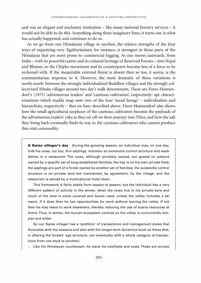
and was an elegant and unclumsy institution – like many national forestry services – itwould not be able to do this. Something along these imaginary lines, it turns out, is whathas actually happened, and continues to do so.
As we go from one Himalayan village to another, the relative strengths of the fourways of organizing vary. Egalitarianism, for instance, is strongest in those parts of theHimalayas that are most prone to commercial logging. As one moves eastwards, fromIndia – with its powerful centre and its colonial heritage of Reserved Forests – into Nepaland Bhutan, so the Chipko movement and its counterparts become less of a force to bereckoned with. If the inequitable external threat is absent then so too, it seems, is thecommunitarian response to it. However, the most dramatic of these variations is north-south: between the strongly individualized Buddhist villages and the strongly col-lectivized Hindu villages around two day’s walk downstream. These are Fürer-Haimen-dorf ’s (1975) ‘adventurous traders’ and ‘cautious cultivators’, respectively: apt charact-erizations which readily map onto two of the four ‘social beings’ – individualists andhierarchists, respectively – that we have described above. Fürer-Haimendorf also showshow the small agricultural surpluses of the cautious cultivators become the payloads ofthe adventurous traders’ yaks as they set off on their journey into Tibet, and how the saltthey bring back eventually finds its way to the cautious cultivators who cannot producethis vital commodity.
:
295
A Swiss villager’s day During the growing season, an individual may, on one day,
milk his cows, cut hay, thin saplings, maintain an avalanche control structure and wash
dishes in a restaurant. The cows, although privately owned, are grazed on pasture
owned by a specific set of long-established families; the hay is on his own private field;
the saplings are part of a forest owned by another set of families; the avalanche control
structure is on private land but maintained, by agreement, by the village; and the
restaurant is owned by a multinational hotel chain.
This framework is fairly stable from season to season, but the individual has a very
different pattern of activity in the winter, when the cows live in his private byre and
much of the land is snow covered and barely used, unless the valley includes a ski
resort. If it does then he has opportunities for work without leaving the valley. If not
then he may leave to work elsewhere, thereby reducing the use of scarce resources at
home. Thus, in winter, the human ecosystem centred on the valley is concurrently sim-
pler and wider.
So our Swiss villager has a ‘portfolio’ of transactions and management styles that
fluctuates with the seasons and also with the longer-term dynamics (such as those that,
in altering the forests’ age structure, can eventually shift a whole category of transac-
tions from one style to another).
– Like his Himalayan counterpart, he owns his hayfields and cows. These are private
Mappae Mundi bw zw/w 08-04-2004 15:26 Pagina 295
8.6.5. Theories of change that make change permanent
The examples above illustrate how ‘social beings’ in complex socio-natural systems inter-fere with the environment and each other according to one of the four managementstyles which belong each to a particular solidarity. The term ‘social being’ is used here todescribe the behaviour to which an individual must conform, and the convictions thathe or she must espouse, to help maintain the form of social solidarity to which he or shebelongs. The ‘prime mover’, therefore, is not the individual – the psycho-physiologicalentity – but the form of social solidarity. Therefore, the terms hierarchist, individualist,egalitarian and fatalist denote available roles – or management strategies – that individu-als step into, or out of, as their daily lives, or the changing seasons, take them from onetransactional realm to another (Figure 8.12). The distinctive strategy of each makes theothers viable, and in this way each village, in adjusting to its circumstances – whichinclude the other villages – creates and takes its place in a social and cultural ‘ecosystem’,in which the marked divergence of the parts sustains the whole.
296
property; he can buy or sell them, acting as an individualist and subscribing to the
myth of Nature Benign.
– Coming from a long-established family, he is a member of a forest co-operative
(Waldgenossenschaft) that gives him specific rights to cut trees and imposes a duty
to maintain the forest. He is also a member of a pasture co-operative (Alpgenossen-
schaft) which annually decides the grazing season and the number of animals he
may graze, and requires him to contribute to the cowherd’s upkeep. These are
small-scale hierarchical institutions that have developed over the generations
(between the periods when the forests were privatized and their associated transac-
tions transferred to the more exploitative individualist management style) in
response to the limitations, as well as the opportunities, imposed by the natural
environment: Nature Perverse/Tolerant.
– As a voting member of the commune, he also has a duty to maintain resources that
contribute to its survival, such as the avalanche control structures that protect
houses, fields and roads from damage. This tends to be an egalitarian involvement
which recognizes that, when it comes to these sorts of hazards, all the members of
the community are in the same boat and that each should contribute his equal
share: Nature Ephemeral.
– Lastly, as a dishwasher in a multinationally owned restaurant, he is effectively a
replaceable fatalist. His involvement is necessary if the enterprise is to continue but
he has no interest in its future, nor it in his, and he can be paid off at any time (he
will almost certainly lose his job at the end of the summer season).
,
Mappae Mundi bw zw/w 08-04-2004 15:26 Pagina 296
We have argued that change occurs because the four forms of social solidarity are notimpervious to the real world. Just because people insist that the world is as their myth ofnature tells them it is, it does not follow that the world really is so. If it is, that is fine, butif it is not, they have an uphill struggle. Surprise – the outcome of the ever-widening dis-crepancy between the expected and the actual – is of central importance in dislodgingpeople and their transactions from their form of social solidarity. And it is these variousmismatches between what a way of life promises and what it delivers that continually tippeople – and transactions – out of one form of social solidarity and into another. Ofcourse, this hypothesis does require the world, at times and in places, to be each of thesepossible ways – otherwise we would all eventually end up surprised into the single trueway. And it would help the surprises to continue indefinitely if the world itself keptchanging the way it was.
Neither of these suggestions, some ecologists would argue, is particularly far-fetched.Holling (1986; Gunderson 1997) for instance has elaborated the notion of requisite vari-ety into a powerful critique of the conventional idea that the climax community – theecosystem in which each specialized species has its stable and ordered niche – is the endof the organizational road. This critique exactly parallels our dissatisfaction with theconventional hierarchies-and-markets account of things, in that it argues that theremust be four, rather than just two, destinations. Holling’s critique is that the climax com-munity eventually makes itself so complex that it undermines its own stability: aninevitable collapse which has been proved mathematically by May (1972) and resemblesTainter’s argument about state collapse (cf. Sections 7.4 and 8.4). This does not meanthat an entire climax community – the Amazonian rain forest, for instance – will sud-denly disappear, but it does require any climax community to be ‘patchy’: to alwaysinclude some localized areas in collapse – as happens, for instance, when a mature treecrashes to the ground. At this catastrophic moment, all the energy that is tied up in allthe niches and interdependencies of the climax community is released. Holling, wellaware of the parallel with Schumpeter’s (1950) theory of economic maturity, collapseand renewal, calls this transition from the climax community to compost ‘creativedestruction’.
Nor, he argues, is this the end of the road. With the whole place suddenly awash with‘capital’ – loose energy – the challenge is to fix it before it all disappears, by soil leachingfor instance. This, of course, is where the unspecialized and co-operative fence-builders– mostly micro-organisms– come into their own, gathering up the loose energy intosmall bundles that have no connections with one another as yet. But even this is not theend of the road, because the stage is now set for the appearance of yet more differentecological actors. These are the unspecialized but opportunistic, fast-breeding and high-ly competitive ‘r-selected’ species. These generalized exploiters – weeds, rodents and soon – are able to harness all the ‘energy gradients’ that are now in place between all theseunconnected bundles of energy. But these r-selected species, as they exploit and colonize
:
297
Mappae Mundi bw zw/w 08-04-2004 15:26 Pagina 297
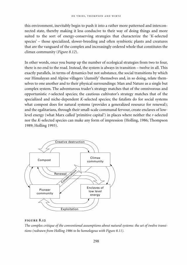
this environment, inevitably begin to push it into a rather more patterned and intercon-nected state, thereby making it less conducive to their way of doing things and moresuited to the sort of energy-conserving strategies that characterize the ‘K-selectedspecies’ – those specialized, slower-breeding and often symbiotic plants and creaturesthat are the vanguard of the complex and increasingly ordered whole that constitutes theclimax community (Figure 8.12).
In other words, once you bump up the number of ecological strategies from two to four,there is no end to the road. Instead, the system is always in transition – twelve in all. Thisexactly parallels, in terms of dynamics but not substance, the social transitions by whichour Himalayan and Alpine villagers ‘clumsify’ themselves and, in so doing, relate them-selves to one another and to their physical surroundings: Man and Nature as a single butcomplex system. The adventurous trader’s strategy matches that of the omnivorous andopportunistic r-selected species; the cautious cultivator’s strategy matches that of thespecialized and niche-dependent K-selected species; the fatalists do for social systemswhat compost does for natural systems (provides a generalized resource for renewal);and the egalitarians, through their small-scale communal fervour, create enclaves of low-level energy (what Marx called ‘primitive capital’) in places where neither the r-selectednor the K-selected species can make any form of impression (Holling, 1986; Thompson1989; Holling 1993).
,
298
.
The complex critique of the conventional assumptions about natural systems: the set of twelve transi-
tions (redrawn from Holling 1986 to be homologous with Figure 8.11).
Enclaves oflow levelenergy
Pioneercommunity
ClimaxcommunityCompost
Conserv
ation
Exploitation
Creative destruction
Renewal
Mappae Mundi bw zw/w 08-04-2004 15:26 Pagina 298
The ambitious hypothesis being sketched here is very different to the way people usu-ally think about the interactions of social and natural systems. There is, from this pointof view, no way of ever getting it ‘right’: of bringing the social into long-term harmonywith the natural, which, of course, is the whole idea behind ‘sustainable development’.Instead, each is a fourfold and plurally responsive system, and their time-lagged interac-tions ensure that there can be no steady-state outcome. The whole system is in a perpet-ual unsteady state: changes at each level – the social and the natural – adapt to the otherand change it in the process, thereby setting in motion another set of changes. And soon. Order without predictability – as opposed to transition from A to B or oscillationbetween A and B – is the crucial idea behind our Himalayan and Alpine stories.
8.7. Conclusions
Understanding of complex socio-natural systems is, and may always be, incomplete.However, empirical observations from various disciplines, each using its own apparatusof methods and concepts, have given rise to fragments of theory.
Going from observations to qualitative theories to quantifications in ‘formal’ modelsis not an easy path. Yet it provides important heuristics – ‘ask the right questions’, falsifyhypotheses and the like – and also deepens our insights. The Neolithic Transition modelshows that biogeographical factors such as agricultural potential and diffusion corridorsare an integral part of the evolution of the population-environment-technology-culturesystem. It also underlines the importance of spatial explicitness in modelling such sys-tems. The Lakeland model and the simulation models on the Anasazi and !Kung Sanpopulations indicate the importance of introducing variety at the micro-level of humanbehaviour if one is to get a deeper insight into ‘emergent’ macro-behaviour in thesecomplex systems. Behavioural rules and habits, information collection and exchangeprocesses are, after all, the essence of humans.
Social science perspectives of a less formal nature offer a variety of explanations ofthe rise and fall of social complexity. Tainter’s ‘law’ of diminishing returns and enhanc-ing complexity suggests an economically oriented cause of state collapse. In Meso-Amer-ica Blanton and colleagues found ecological diversity to be a key element in understand-ing state-market interactions. Flannery listed the processes of segregation andcentralization of the subsystems and mechanisms of institutional control to explain thecreation of order and hierarchy – and added the pathologies that bring them down. Ren-frew focused on peer-polity interactions as a crucial element in understanding thespread of populations and the associated transformation processes.
Most of these endeavours are on the edge of a new paradigm with regard to the inves-tigation of complex (socio-natural) systems. The theory of complex adaptive systemsappears to be most explicit in this respect. Cultural Theory and ecocycle theory also put
:
299
Mappae Mundi bw zw/w 08-04-2004 15:26 Pagina 299

forward insights verging on a new paradigm. They propose that the dynamic interplaybetween four different perspectives on how the world functions and, accordingly, shouldbe acted upon is essential. It transforms the idea of smooth transitions from or oscilla-tions between two states – hierarchies and markets – into one of a complex socio-naturalsystem with order without predictability and never-ending transitions in a continuousprocess of learning, adaptation and responses. Clumsy institutions, in which each con-viction about how the world is is given recognition, are identified as a key element ofenduring resource management schemes.
,
300
Mappae Mundi bw zw/w 08-04-2004 15:26 Pagina 300
9
Population and Environment in Asia since 1600 AD
,
9.1. Introduction
Given the limited time and the clearly overly large ambition to sketch Mappae Mundi forall places and times in human history and pre-history, we now take a big leap and focuson the last 400 years. Around the year 1000 AD about two out of every three humanbeings lived in Asia and some 70% of economic activity took place there (Maddison2001). The larger part lived in the densely populated plains of China and India. By theyear 2000 AD still about 60% of the world population lived in Asia but its share in eco-nomic activity had declined to 37% – at least when measured as the gross domesticproduct (GDP). Probably the dominant phenomenon of the intervening millenniumhas been the expansion of European peoples and their activities to most of the ‘empty’regions of the world. This is the topic of Chapter 10. In this chapter we attempt to givean impression of how the two-thirds of the human population in Asia was doing, withan emphasis on population-environment interactions.
There are two reasons why the population-environment dynamics in Asia are impor-tant. Firstly, as the anthroposphere is expanding extensively and intensively, the popula-tion in Asia – and its socio-economical and cultural patterns – will have an enormousimpact on how the world population will move to the next ecological regime because ofits sheer momentum and its relatively low level of economic activity. Secondly, the pop-ulation in several parts of Asia was confronted in this period with the limits of the carry-ing capacity of the environment. This manifested itself in famines and revolts wheneverand wherever the socio-economic and institutional mechanisms used to sustain therather large population densities were inadequate. As such they provide valuable insightsin the various ways people coped – or failed to cope – with such pressures in theseregions and probably in similar situations earlier and elsewhere.1 Our accounts will beabout India, Indonesia and Siberia; we failed to receive one about China. We are fullyaware that this eclectic approach with regard to this important part of our Mappae
301
Mappae Mundi bw zw/w 08-04-2004 15:26 Pagina 301
Mundi is far from satisfactory. However, even finding these tiny pieces of demographicand environmental history turned out to be a tedious task.
In both South Asia and China, multiple episodes of considerable population declinehave been reported since the 18th century. Although short-term fluctuations due toarmed conflict, migration, famine and epidemics have had an impact on the population,in the long run population growth was exponential as it was dominated by the internaldynamics of trends in fertility and mortality. Figure 9.1a (see p. 309) shows populationestimates for some of the major regions of the world; the earlier ones in particular are
,
302
Population in Asia in ancient times The first evidence of Chinese culture goes
back some 4000-5000 years in the upper Huang He (Yellow River) region. Some 2000-
2500 years ago present-day China emerged as more or less a unity in the sense that
also the southern regions became part of the Chinese Empire (cf. Section 6.4.2). At
about 1000 yr BP the Wei He and the city of Xi’an were the centre of Chinese culture.
Later, the population increased and shifted to more southern and eastern regions. Fig-
ure 9.2 (see p. 310) shows the population density as estimated and made available by
Dr. Man Zhimin of the Institute of Historical Geography of Fudan University in Shang-
hai. In combination with a series of maps of population density for other periods in the
last 2000 years, one can get an impression of the gradual shift in population concentra-
tion from the northern to other parts of China.
In Indian history there is a gap in historical knowledge between the decline of the
Indus-Valley civilization around 3500-4000 BP and 2500 BP (cf. Section 6.3.2). Several
invasions from the west and the north changed Indian civilization but most of them
were assimilated. The invasions from the north-west around 800 yr BP eventually led to
the Mogul Empire. India’s population estimates are highly uncertain. For the first mil-
lennium Maddison (2001) gives ranges of 34 to 112 million people; it varies between
100 and 150 million for the year 1600 AD. Despite this large number – almost twice as
much as in Western Europe – Lord Cornwallis, Governor-General of India, could still
state in 1789 ‘… without hesitation that a third of the [East India] Company’s lands in
Hindustan are now a jungle, inhabited only by wild beasts.’ (Braudel 1975: 239-240)
Indonesia also had a long development process for indigenous tribes who were
confronted with foreign peoples, initially from India and later from Europe. Its popula-
tion is estimated to have grown from 10 to 40 million people in the period 1600-1900. In
Russia, the process of eastward expansion in the last centuries was the equivalent of
Western Europe’s expansion into the Americas and Australia. Its growth from 7 to 136
million people in the period 1600-1900 was more of an extensive than an intensive
nature.
Mappae Mundi bw zw/w 08-04-2004 15:26 Pagina 302
contentious. The populations of India and China were roughly on a par at the beginningof the 17th century. Both were then about twice the population size of Western Europe.Japan experienced explosive growth over the 17th century and then evidently settled to astable population for nearly 150 years during the later years of the Tokagawa Shogunate.Russia similarly saw a rapid population expansion over the 18th and 19th centuries due toa mix of both natural growth and the assimilation of vast new territories. The begin-nings of the demographic transition in Europe were laid at this time. The ‘New World’experienced explosive growth rates as the European expansion gained momentum: thepopulation of the United States of America (USA) kept growing with an estimated Euro-pean immigration of some 23 million people between 1600 and 1913; Brazil and Aus-tralia absorbed some 5 million immigrants in this period; and an estimated 9.4 millionAfricans were brought to the Americas as slaves in the period 1500-1870 (Maddison2001).
Trends in economic activity over the last few centuries have also been estimated by Mad-dison (2001) and are shown in Figure 9.1b (see p. 309). With the onset of the ‘IndustrialRevolution’, Europe and its colonial offshoots experienced a large and lasting economicgrowth – as is described in the next chapter. The most dramatic economic growth hap-pened in the USA. However, at the beginning of the 18th century, China was still thelargest economy in the world by far; the size of the Indian economy was about two-thirds that of the European one. The rapid economic growth of the UK, continentalEurope and the USA resulted in the emergence of a new world order that played itselfout during the two World Wars of the 20th century. The USA emerged as the largest eco-nomic power by 1913 and then proceeded to become the dominant economic power ofthe 20th century. The Soviet Union more than trebled its economic output over the latterpart of the 20th century before descending into economic turmoil in the 1990s; Japanincreased its economic output by a factor of almost 50, China by almost 18 and India byabout 10 in the period 1900-1990. The trends in population and economic activity arereflected in the increase in GDP per capita, a widely used measure to express welfare andone component of well-being (Figure 9.1c, see p. 309).
The trends of economic and population growth within the industrial regime appearto indicate that primary driving forces are able to dampen other shorter-term fluctua-tions which are consequences of traditional constraining factors such as epidemics,famine, wars and economic cycles. The regional realities are far more complex than thesesimple trends indicate, but on a general level, the heightened ‘metabolic’ activity of theindustrial age along with its greater economic and material efficiency have enabled aquantum leap from the regime of the pre-industrial world.
303
Mappae Mundi bw zw/w 08-04-2004 15:26 Pagina 303
9.2. South Asia: population and environment in a geopolitical context2
There is a great deal of evidence that environmental conditions and changes have beenan important driving factor in the long-term population-resource-environment dynam-ics and the economy of South Asia. This interaction was accentuated by a number of fac-tors in the post-Mogul colonial period (ca. 1750-1950). Eventhough objective historicaldata are too weak to establish proximate causal links between environmental factors andquality of life, a strong causal linkage via the drought-famine-disease-linked mortalitycycle has been reported by contemporary observers since the 18th century. Recent analy-sis hypothesizes that the decline in the total South Asian population of the late 18th cen-tury was closely linked to an interaction between factors such as colonial wars of con-quest, disruption in regional agricultural production, trade and finance simultaneouslywith severe episodes of drought, famine and disease (Guha 2001). Most of these factorswere anthropogenic or potentially within the span of human control: colonial security,fiscal and trade policy, infrastructure investment, land use, water and forest resource reg-ulation and management practices. Many of these ‘driving forces’ were operational dur-ing the Mogul era, but their combined ‘entrainment’ to meet the economic objectives ofcolonial India led to a number of perverse structural changes in the landscape and theeconomy. As a result they occurred in a lethal combination, decimating the capacity ofthe peasantry and communities to reinvest local surpluses and cope with the stressinduced by recurrent events such as drought.
It is our contention that it is difficult to attribute these events simplistically either toforce majeure, overshooting beyond carrying capacity or poor ‘native’ technology, insti-tutions or management practices (see e.g. Myrdal 1977). Rather a wider geo-politicalcanvas may be required to examine the relative impact of the process of imperial expan-sion in facilitating the colonization of both peoples and nature, and indirectly financingthe industrialization and developing large markets and raw material reserves in the pre-industrial colonial economies. The environmental sciences have traditionally tended toplay down the importance of historical and political factors in what are seen as ratherconcrete processes. Unfortunately, for this worldview, geo-political factors have beencrucial in determining the long-term dynamics of population and natural resources incolonial South Asia. Changes in the trade regime and political boundaries were not newto the subcontinent before the colonial period. Local cultures adopted successfully tomore or less changing fortunes of trade with the Romans, Arabs and Chinese and earlyEuropean traders with the development of new trading partners and routes and thediversification of products. Territorial boundaries changed constantly in the mediaevalperiod during the interregnum between large imperial powers. Warfare between con-tending Muslim and Hindu states was relatively common and yet a radical restructuringof agrarian relationships or the economy is not reported, although the volume of tribute
,
304
Mappae Mundi bw zw/w 08-04-2004 15:26 Pagina 304
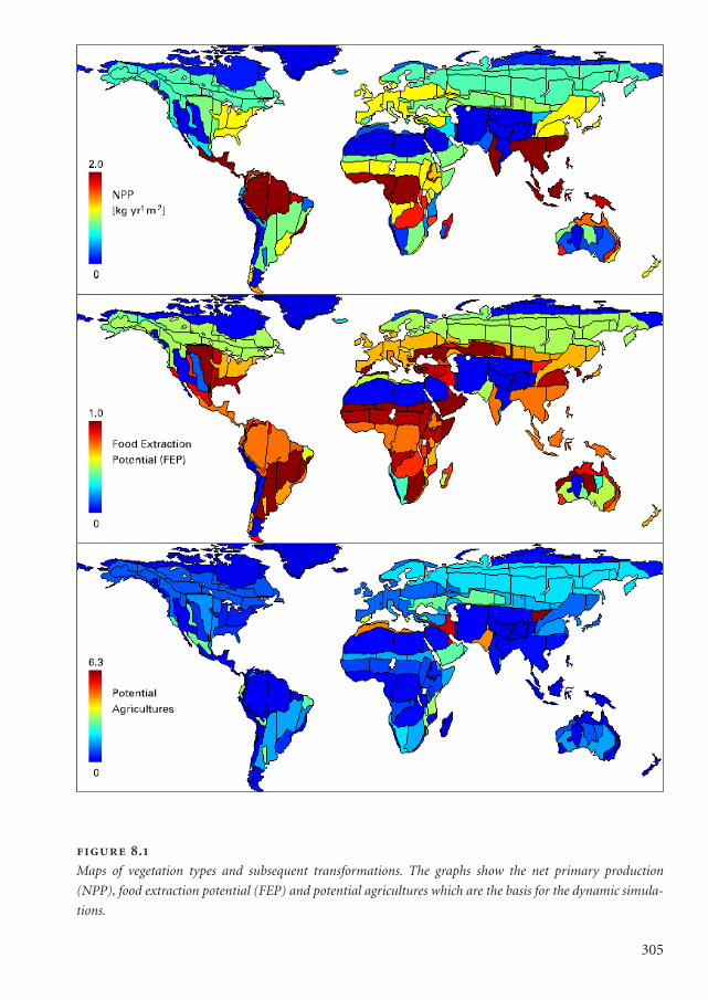
305
.
Maps of vegetation types and subsequent transformations. The graphs show the net primary production
(NPP), food extraction potential (FEP) and potential agricultures which are the basis for the dynamic simula-
tions.
Mappae Mundi kleurk 2 DEF 08-04-2004 15:58 Pagina 305
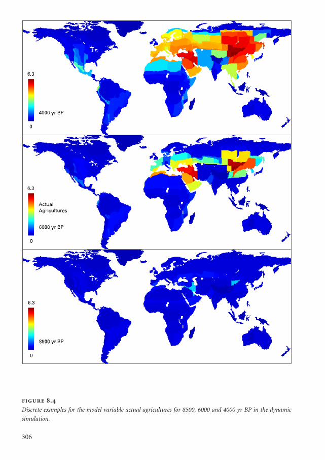
306
.
Discrete examples for the model variable actual agricultures for 8500, 6000 and 4000 yr BP in the dynamic
simulation.
Mappae Mundi kleurk 2 DEF 08-04-2004 15:58 Pagina 306
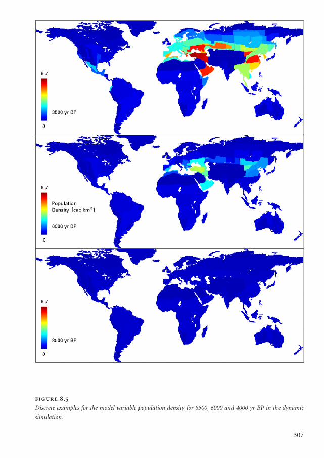
307
.
Discrete examples for the model variable population density for 8500, 6000 and 4000 yr BP in the dynamic
simulation.
Mappae Mundi kleurk 2 DEF 08-04-2004 15:58 Pagina 307
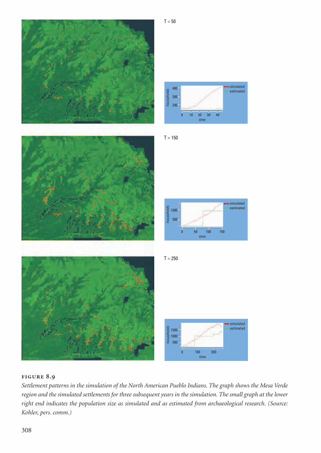
308
.
Settlement patterns in the simulation of the North American Pueblo Indians. The graph shows the Mesa Verde
region and the simulated settlements for three subsequent years in the simulation. The small graph at the lower
right end indicates the population size as simulated and as estimated from archaeological research. (Source:
Kohler, pers. comm.)
T = 50
T = 150
T = 250
0 10 20 30 40time
simulatedestimated
400
300
200hous
ehol
ds
0 50 100 150time
simulatedestimated1000
500
hous
ehol
ds
0 100 200time
simulatedestimated1500
1000
500hous
ehol
ds
Mappae Mundi kleurk 2 DEF 08-04-2004 15:58 Pagina 308
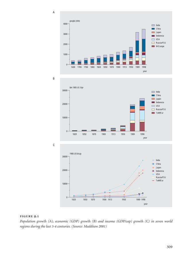
1600 1700 1760 1800 1820 1850 1870 1900 1913 1950 1989 1998
year
0
1000
2000
3000
4000
people (mln)
India
China
Japan
Indonesia
USA
Russia/FSU
W-Europe
1820 1850 1870 1900 1913 1950 1989 1998
year
0
10000
20000
30000
bln 1985 US $/yr
India
China
Japan
Indonesia
USA
Russia/FSU
TotWEur
year
0
10000
20000
30000
1985 US$/cap
TotWEur
Russia/FSU
USA
Indonesia
Japan
China
India
1870 1913 19891820 1850 1900 1950 1998
.
Population growth (A), economic (GDP) growth (B) and income (GDP/cap) growth (C) in seven world
regions during the last 3-4 centuries. (Source: Maddison 2001)
309
A
B
C
Mappae Mundi kleurk 2 DEF 08-04-2004 15:58 Pagina 309
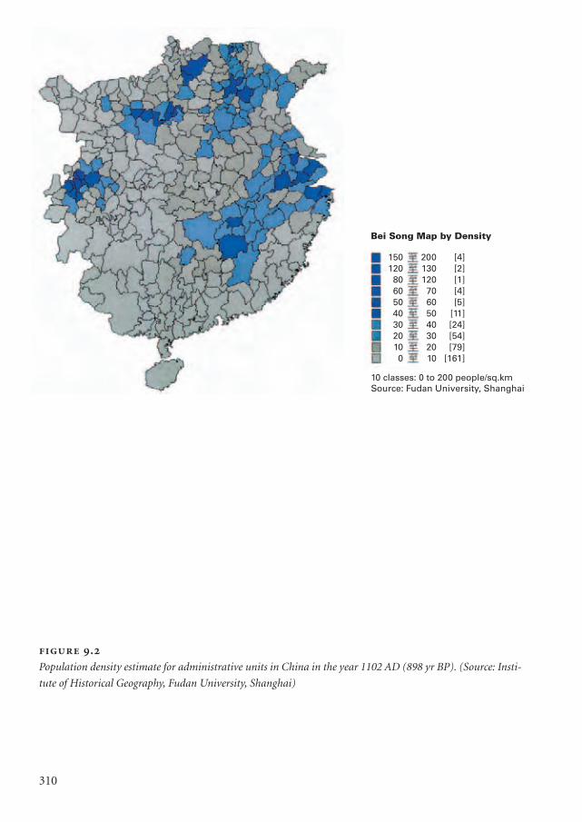
310
.
Population density estimate for administrative units in China in the year 1102 AD (898 yr BP). (Source: Insti-
tute of Historical Geography, Fudan University, Shanghai)
Bei Song Map by Density
150 200 [4]120 130 [2]80 120 [1]60 70 [4]50 60 [5]40 50 [11]30 40 [24]20 30 [54]10 20 [79]0 10 [161]
10 classes: 0 to 200 people/sq.kmSource: Fudan University, Shanghai
Mappae Mundi kleurk 2 DEF 08-04-2004 15:58 Pagina 310
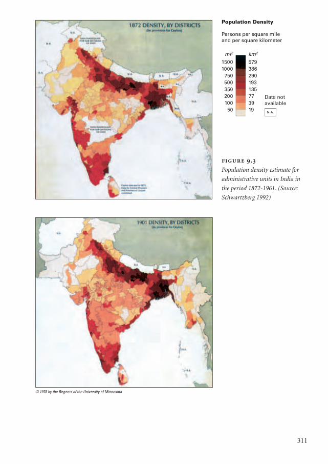
311
.
Population density estimate for
administrative units in India in
the period 1872-1961. (Source:
Schwartzberg 1992)
Population Density
Persons per square mileand per square kilometer
ml2
15001000
75050035020010050
km2
579386290193135773919 N.A.
Data notavailable
© 1978 by the Regents of the University of Minnesota
Mappae Mundi kleurk 2 DEF 08-04-2004 15:58 Pagina 311
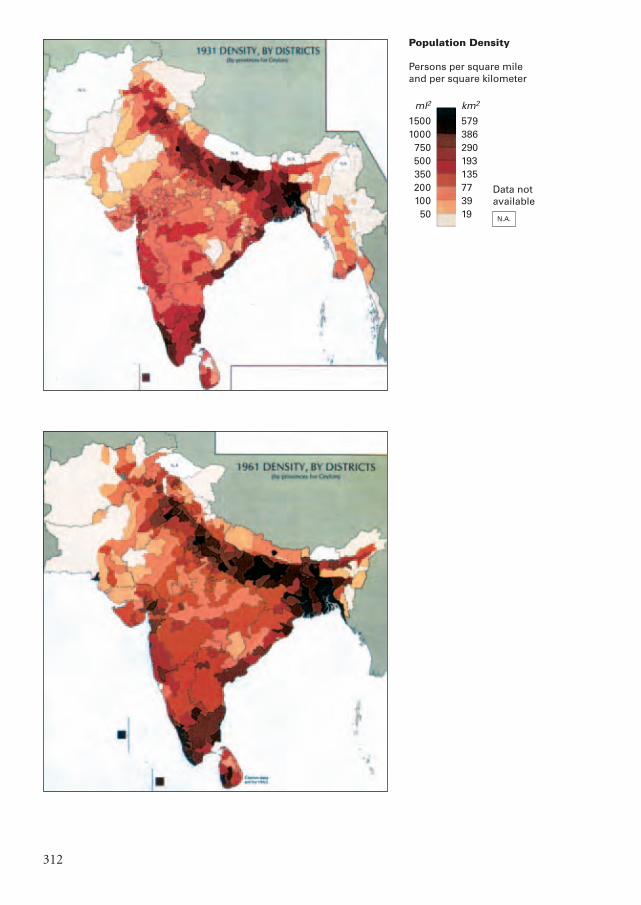
312
Population Density
Persons per square mileand per square kilometer
ml2
15001000
75050035020010050
km2
579386290193135773919 N.A.
Data notavailable
Mappae Mundi kleurk 2 DEF 08-04-2004 15:58 Pagina 312
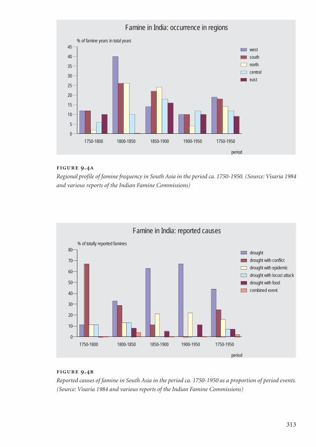
313
.
Regional profile of famine frequency in South Asia in the period ca. 1750-1950. (Source: Visaria 1984
and various reports of the Indian Famine Commissions)
.
Reported causes of famine in South Asia in the period ca. 1750-1950 as a proportion of period events.
(Source: Visaria 1984 and various reports of the Indian Famine Commissions)
1750-1800 1800-1850 1850-1900 1900-1950 1750-1950
period
0
5
10
15
20
25
30
35
40
45
% of famine years in total years
west
south
north
central
east
Famine in India: occurrence in regions
1750-1800 1800-1850 1850-1900 1900-1950 1750-1950
period
0
10
20
30
40
50
60
70
80
% of totally reported famines
drought
drought with conflict
drought with epidemic
drought with locust attack
drought with food
combined event
Famine in India: reported causes
Mappae Mundi kleurk 2 DEF 08-04-2004 15:58 Pagina 313
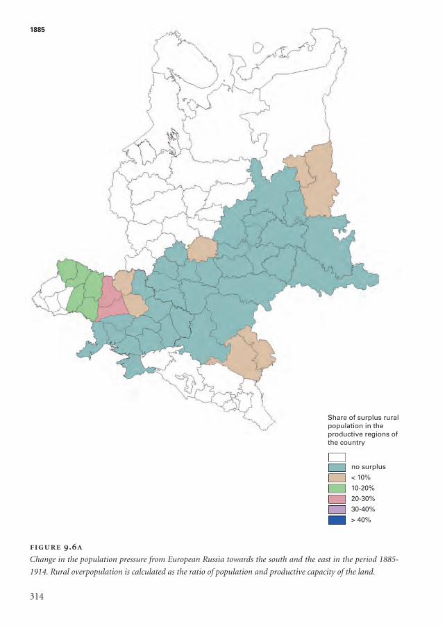
314
.
Change in the population pressure from European Russia towards the south and the east in the period 1885-
1914. Rural overpopulation is calculated as the ratio of population and productive capacity of the land.
Share of surplus ruralpopulation in theproductive regions ofthe country
no surplus
< 10%
10-20%
20-30%
30-40%
> 40%
1885
Mappae Mundi kleurk 2 DEF 08-04-2004 15:58 Pagina 314
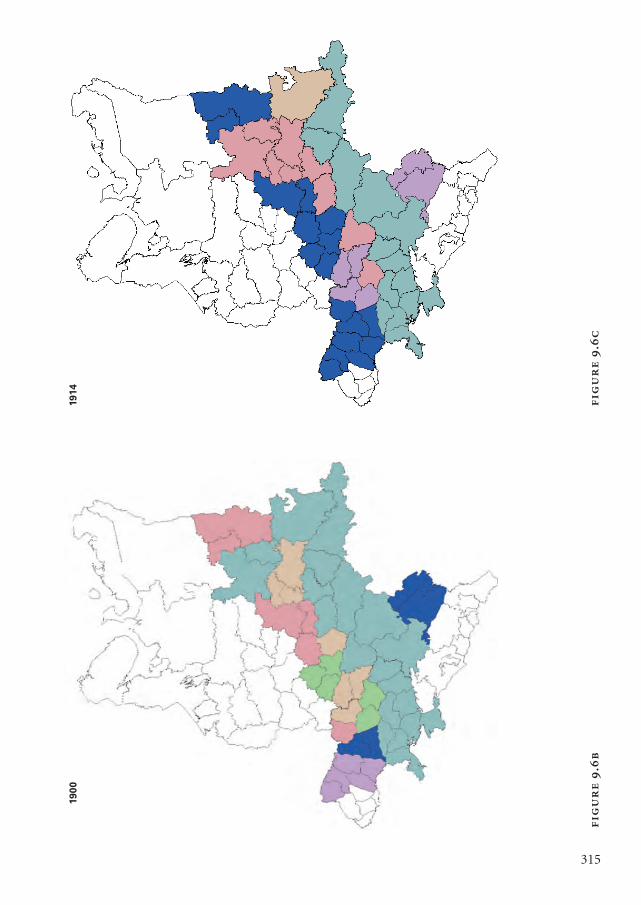
315
.
.
1914
190
0
Mappae Mundi kleurk 2 DEF 08-04-2004 15:58 Pagina 315
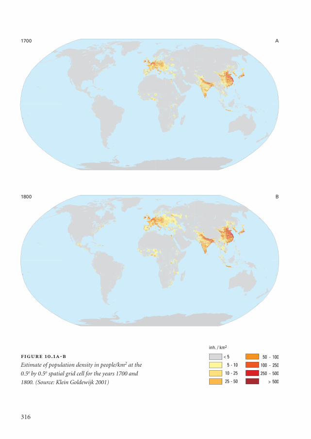
.-
Estimate of population density in people/km2 at the
0.5o by 0.5o spatial grid cell for the years 1700 and
1800. (Source: Klein Goldewijk 2001)
316
1700 A
B1800
Mappae Mundi kleurk 2 DEF 08-04-2004 15:58 Pagina 316
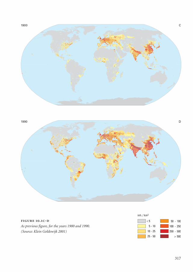
317
.-
As previous figure, for the years 1900 and 1990.
(Source: Klein Goldewijk 2001)
1900
1990
C
D
Mappae Mundi kleurk 2 DEF 08-04-2004 15:58 Pagina 317
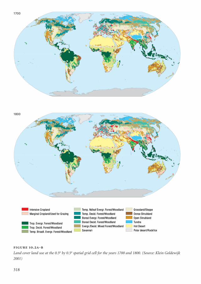
Intensive CroplandMarginal Cropland/Used for Grazing
Trop. Evergr. Forest/WoodlandTrop. Decid. Forest/WoodlandTemp. Broadl. Evergr. Forest/Woodland
Temp. Ndleaf Evergr. Forest/WoodlandTemp. Decid. Forest/WoodlandBoreal Evergr. Forest/WoodlandBoreal Decid. Forest/WoodlandEvergr./Decid. Mixed Forest/WoodlandSavanna
Grassland/SteppeDense ShrublandOpen ShrublandTundraHot DesertPolar desert/Rock/Ice
Intensive CroplandMarginal Cropland/Used for Grazing
Trop. Evergr. Forest/WoodlandTrop. Decid. Forest/WoodlandTemp. Broadl. Evergr. Forest/Woodland
Temp. Ndleaf Evergr. Forest/WoodlandTemp. Decid. Forest/WoodlandBoreal Evergr. Forest/WoodlandBoreal Decid. Forest/WoodlandEvergr./Decid. Mixed Forest/WoodlandSavannah
Grassland/SteppeDense ShrublandOpen ShrublandTundraHot DesertPolar desert/Rock/Ice
1800
1700
318
1700
1800
.-
Land cover land use at the 0.5o by 0.5o spatial grid cell for the years 1700 and 1800. (Source: Klein Goldewijk
2001)
Mappae Mundi kleurk 2 DEF 08-04-2004 15:58 Pagina 318
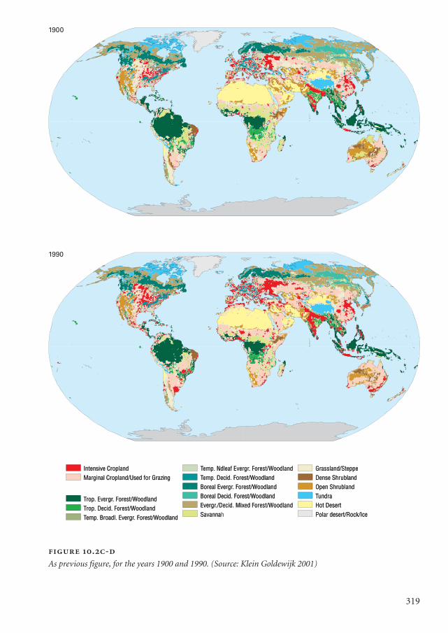
319
Intensive CroplandMarginal Cropland/Used for Grazing
Trop. Evergr. Forest/WoodlandTrop. Decid. Forest/WoodlandTemp. Broadl. Evergr. Forest/Woodland
Temp. Ndleaf Evergr. Forest/WoodlandTemp. Decid. Forest/WoodlandBoreal Evergr. Forest/WoodlandBoreal Decid. Forest/WoodlandEvergr./Decid. Mixed Forest/WoodlandSavanna
Grassland/SteppeDense ShrublandOpen ShrublandTundraHot DesertPolar desert/Rock/Ice
Intensive CroplandMarginal Cropland/Used for Grazing
Trop. Evergr. Forest/WoodlandTrop. Decid. Forest/WoodlandTemp. Broadl. Evergr. Forest/Woodland
Temp. Ndleaf Evergr. Forest/WoodlandTemp. Decid. Forest/WoodlandBoreal Evergr. Forest/WoodlandBoreal Decid. Forest/WoodlandEvergr./Decid. Mixed Forest/WoodlandSavannah
Grassland/SteppeDense ShrublandOpen ShrublandTundraHot DesertPolar desert/Rock/Ice
1990
19001900
1990
.-
As previous figure, for the years 1900 and 1990. (Source: Klein Goldewijk 2001)
Mappae Mundi kleurk 2 DEF 08-04-2004 15:58 Pagina 319

320
.
Jan Hendrik Weissenbruch: View of Noorden.
Mappae Mundi kleurk 2 DEF 08-04-2004 15:58 Pagina 320
extraction and exploitation fluctuated from regime to regime.The colonial period represented a clear discontinuity with the past. The fundamental
change was that the ruling elite was located abroad and was largely answerable to anoverseas constituency highly focused on tangible economic gain via rent extraction,trade and resource exploitation. This resulted in the millennia old South Asian strategyof the assimilation of invading elite groups failing. The battle for control over local and
321
Political periods in India The four-and-a-half centuries from 1500 to 1947 saw four
broad ‘periods’ of geo-political hegemony in South Asia (Schwartzberg 1992):
1. the period 1504-1757 where the Moguls emerged as a pan-India power only in the
late 16th century after a seesaw battle for supremacy in north India. They subse-
quently provided a strong-handed but relatively stable administration, that expand-
ed by the turn of the 17th century to the bulk of the South Asian landmass. The
empire then went into rapid decline as peripheral provinces asserted their inde-
pendence and overextended the centre;
2. an interregnum from 1758 to the early part of the 19th century, when regional pow-
ers: the Marathas, French, Nizam of Hyderabad, Mysore and Sikhs vied for political
control over the rapidly expanding territory of the British East India Company (EIC).
Even although only six decades (1710-40 and 1770-1800) were marked by the lack
of a pan-Indian power (Schwartzberg 1992) the transition between the Moguls to
the Marathas and the British was more disorderly than often reported, severely
affecting both economic activity and well-being, especially in the form of popula-
tion decline (Guha 2001). This culminated with the closely fought First War of Inde-
pendence (1857-58) – or the Indian Mutiny, depending on one’s frame of reference –
between the EIC and a coalition of regional interests in north India led by the figure-
head last Mogul emperor of Delhi;
3. the patchwork of the crown-administered British Raj (1858-1947) and its 565 sub-
servient princely states that terminated in the Transfer of Power and Partition of
India and Pakistan in 1947, following almost 50 years of political struggle for self-
determination; and
4. contemporary South Asia made up of India, Pakistan, Bangladesh, Nepal and other
smaller nations, faced with endemic cross-border conflict partially due to the ethic
and religious nature of the Partition, contending geo-political alignments and the
immense pressure of a poor and rapidly growing population on limited land-based
resources.
Despite the importance of understanding the geo-political context for the present dis-
cussion, we refer to other literature for more details.
Mappae Mundi bw zw/w 08-04-2004 15:26 Pagina 321
regional natural resources, economic and social networks of production and exchangewas therefore a key factor in the struggle for colonial independence. Against this back-ground, we first explore the population dynamics in India, to be followed by a biogeo-graphical sketch. Next, we discuss the role of some environmental factors for populationsize and well-being within this broader political and biogeographical context.
9.2.1. Population dynamics
India’s population dynamics have been regulated by a number of unique factors, apartfrom traditional demographic variables. In essence, population growth results from thedifference between average fertility and mortality rates (cf. Chapter 5). Demographershave found that in India fertility had been rather stable and then slowly declined; hencethe mortality rate appears to be the more important explanatory variable (Guha 2001).Unfortunately, quantitative estimates of the population in India are scarce. Only sincethe beginning of 10-yearly censuses by the British Government in 1881 have consistenttime-series been available. Despite the difficulty of scientific analysis, events over the last200 years provide insights in the population-resource dynamics that are most relevant inthe context of this book. Let us first have a glance at population densities in India, whichare presented in Figure 9.3 (see p. 311-312) for four years in the period 1872-1961(Schwartzberg 1992). The densest regions in the late 19th century were the Gangeticplain, particularly Bengal, parts of Gujarat, Malabar in Kerala and areas around Madrasin Tamilnadu. By the turn of the century, Kerala and parts of the eastern and westerncoastal plains experienced increasing populations that were connected by both road andrail links. Significant density increases occurred by 1931 throughout the Indo-Gangeticplains, especially in East Bengal, irrigated areas in the United Provinces and Punjab. Analmost continuous ribbon of dense settlement had developed along the eastern seaboardwith the expansion of irrigated delta agriculture. The southern tip of India includingmost of Tamilnadu and Kerala experienced considerable growth.
The impact of Partition3, regional development and infrastructure investment areevident in the density map of 1961. A much larger area within Central India, Assam andformer East Pakistan – now Bangladesh – shows significant densification. The expansionof irrigation projects, roads and industrial development contributed significantly to apatchwork of new centres of growth. The differential distribution of the populationacross the Indian landmass is a reflection not only of the food extraction potential invarious regions but also in the level of investment in infrastructure. The Partition ofIndia is an important example of how geo-political changes can influence the redistribu-tion of the population and food extraction. The bulk of the irrigated areas in pre-Parti-tion India went to Pakistan leading to a massive programme of dam building in Indiawith both positive and negative impacts.
,
322
Mappae Mundi bw zw/w 08-04-2004 15:26 Pagina 322
A number of factors are mentioned in the literature as having been important deter-minants of the (changes in) mortality rate that was probably less amenable to directhuman control than the fertility rate. Mortality rates are estimated at between 45 and 50per year per thousand people over the period 1750-1850 (Visaria 1984). During the 18th
and early 19th century in the run-up to the consolidation of the British Raj, war casual-ties, widespread famines and epidemics especially in contended territories were key fac-tors behind these high values (Visaria 1984). In the 19th century and the 1st quarter ofthe 20th century the population was still regularly ravaged by famines and epidemics.The semi-arid region of Rajasthan was notoriously famine-prone, with a dramaticallypopulation fluctuation as a result. Four southern states may have lost up to 40% of theirpopulation during the famines of the 1890s. Travellers were witness to villages filled withthe dead and the dying in the Madras (Chennai) region during the famine of 1833. Mor-tality increases due to famine may have mainly hit the lower classes coping with povertyand economic stress. Consumption of rotten grain during and after a famine andincreased exposure to disease vectors from large infected migrant populations in searchof employment and food were a subsidiary cause of mortality.
The role of infectious diseases has been central to the population dynamics of SouthAsia. The subcontinent was well-established as the seat of a number of epidemic andendemic diseases. The most important among them include plague, smallpox, choleraand malaria. Exposure to foreign contact, limited preventive medical assistance andchanging ecological circumstances – which altered disease mobility – are reported to bekey factors that led to high mortality during the colonial era. A major cholera pandemicaccompanied British troop movements in 1817-20. Low levels of nutrition, especially ofwomen and children, are expected to have been important factors in their vulnerabilityto infectious disease, which was clearly heightened during periods of drought andfamine. Although some of the most serious epidemic outbreaks – for example thecholera pandemic of 1817 and the plague epidemics of 1904 and 1907, which killed 2million people – did not coincide with famine, rather a number of famine events werefollowed by serious outbreaks of plague, cholera and smallpox. Cholera following thesevere famine of 1833 in Guntur district led to the death of half the population (Visaria1984). Smallpox was also a great killer, especially of children. The great Bengal famine of1770 was followed by a massive smallpox outbreak, which killed nearly one third of thepopulation. The famine of 1896 was also followed by outbreaks of smallpox and cholera.Vaccination was confined to small areas and populations, in spite of having been redis-covered in 1796. Appreciable progress in controlling smallpox in South Asia was onlymade in the 20th century, not far behind some European countries such as Spain andItaly (Guha 2001).
The link between malaria and the mosquito was not established by that time, but san-itation engineers had established the empirical relationship between canal, road and rail-way expansion and poor drainage with the disease (Visaria 1984). It was reported across
323
Mappae Mundi bw zw/w 08-04-2004 15:26 Pagina 323
Bengal, Uttar Pradesh and Punjab. Endemic malaria increased the death rate anddepressed the fertility rate, as it differentially affected pregnant mothers already experi-encing haemoglobin deficiency. Malaria was estimated to have caused over 20 milliondeaths over the period 1895-1920 alone. Typhoid, diarrhoea, tuberculosis and respirato-ry infections worked steadily in the background, but only emerged as great killers fol-lowing the decline of plague, smallpox and, to a lesser extent, cholera and malaria in thepost-Independence period.
In the background, there was a trend of declining mortality rates that graduallybecame more important and for which economic development on the one hand andthe advent of modern medical services on the other are seen as causative factors.According to Guha (2001) the mortality rate was more strongly linked to nutrition andpersonal hygiene levels than to advances in medical practice. The former had to dolargely with improvements in agriculture, such as irrigation, roads and railways etc. Thelatter consisted of a multitude of factors, from improved water supply and sanitary con-ditions to the growth of biological immunities. Nevertheless, diseases remained a majorcause of death until well into the 20th century. The first outbreak of the deadly falci-parum malaria was in 1924 in Jessore. Cholera deaths reached a peak around 1900 andagain in 1906-1907 after which decline set in. Plague was spread all over the country.The reason why India was the home of great epidemics in these times may have been‘that she was being exposed to foreign contact for the first time on such a great scale…India’s medieval stagnation was broken down later than that of Europe, so that herperiod of virulent epidemic disease occurred much later.’ (Guha 2001: 70). In thecourse of the 20th century, a further rapid drop in death rates occurred due to betternutrition, water, public health and access to medical services. This was only appreciatedslowly, which is one of the reasons for the rapid population growth in the second partof the 20th century.
A careful analysis supports a link between mortality and climate in the late 19th tomid-20th century (Guha 2001). The period 1900-1924 in India was characterized bylarge fluctuations in rainfall patterns and consequently in harvests, whereas before andafter this period production of food grains was on average not higher but more stable.Most experts agree that inadequate diets tend to increase the vulnerability to infectiousdisease. More particularly, a weather-induced harvest would hit the poorer classesthrough a general reduction in employment and earnings. One way for them to adaptwas to reduce food intake, which in turn would make them more vulnerable to infection.On the other hand, food stability could have the reverse effect of lowering mortality.Thus, after the terrible 1st quarter of the 20th century
as the causes of mortality were inoperative, the population resumed the upward course that it
had maintained through much of the 19th century… the Indian population in the 2nd quarter
of the 20th century lived longer because the weather gods enabled it to maintain a stable level
,
324
Mappae Mundi bw zw/w 08-04-2004 15:26 Pagina 324
of malnutrition rather than alternatively plunge between adequate nutrition and severe mal-
nutrition as it was doing earlier. This basic improvement was supplemented by the withdrawal
of the plague, the non-recurrence of the lethal influenza, and perhaps by public health meas-
ures… but climate change was the most important source of improvement in mortality. (Guha
2001: 83-86)
If this statement survives closer scrutiny, it is a modern example of how environmentalfactors have a large-scale bearing upon human events.
The other component of population growth was the fertility rate. Near-universalmarriage, joint and extended families with a strong preference for sons combined withthe early age of marriage and linked high infant mortality have historically maintainedfertility and birth rates at a relatively high level. Nevertheless, fertility levels in India didnot approach potential biological maxima in sizeable populations until the 20th century.This was largely because of a number of fertility control measures, some of them differ-ent from those enabling the demographic transition in western Europe. These includepermanent celibacy and strong restrictions on the remarriage of widows in an environ-ment where the mean age of marriage was low and the mean life expectancy at birth wasunder 30 (Visaria 1984). One factor in the rather high and stable birth rate has been thepoor status of women and their limited access to education – this declined further withthe collapse of traditional systems in the early 19th century. It maintained largemale/female differentials and kept both reproductive and productive decisions outsidethe control of women in the colonial period – a situation that is changing only slowly incontemporary India.
At times of famine, population regulation mechanisms such as female infanticide,fraternal celibacy and the control of marriage were applied among the higher classes,where and how depending on the social structures and values. The regulation of popula-tion growth by controlled migration was a widespread practice that persists in parts ofmodern India (Dasgupta 1995). The migration flows were sometimes a response todrought, famine and starvation, making some arid areas primary sources for the outmi-gration of indentured labour. This happened first within India to support the expansionof commercial crops such as opium, tea, coffee and cotton. Over 1.2 million peoplemoved permanently to Sri Lanka (tea and coffee), Malaysia (rubber), South Africa, theWest Indies and other locations in 1896-1928. Most were from agriculturally distressedand drought-prone regions in Tamilnadu, Gujarat, Sindh, Bengal, Orissa and UttarPradesh. This brief account reveals a complex pattern of interdependent factors behindchanges in the rates of mortality and fertility. Some of them, such as famines, have anobvious environmental side; others such as people’s response to famine and the colonialregime are socio-cultural and political in nature. Food and famine are looked at moreclosely in the following section.
325
Mappae Mundi bw zw/w 08-04-2004 15:26 Pagina 325
9.2.2. Agriculture and food
Geographical land barriersThe Indian subcontinent has powerful geographical and ecological barriers that havebeen an important ‘defence’ against the mass migration of people, biological materialand ‘external’ powers into South Asia. The arid highlands of Afghanistan, the Himalayanmountain arc and the Great Indian (Thar) desert provide an impressive set of land bar-riers from the north-west to the north-east, with the exception of a few strategic passes
,
326
The rise of foreign maritime powers India was no stranger to maritime trade and
even regional conquest with a long history of engagement with European, Middle East-
ern, Chinese and South-East Asian powers dating to before the Christian era. The sig-
nificant difference during the colonial era, however, was the dominance of maritime
rather than just land-based powers. The British, French, Portuguese and Dutch colonial
powers were miniscule in number compared to the estimated South Asian population
of 180 to 200 million in the late 18th century. Even in 1947, the British were less than
0.5% of a total population of roughly 350 million, who were subservient to their interest
(Schwartzberg 1992).
The British were the first ‘coastal’ power to achieve pan-Indian hegemony and
unlike previous migrants and invaders were not assimilated into the dominant subcon-
tinental culture in nearly two centuries of contact. They achieved this through a number
of ‘comparative advantages’ including: superior military and industrial technology,
trade monopolies, ‘superior’ organization, aggressive statecraft and the systematic co-
opting of local interests. All these factors rendered many of the historic geographical
and ecological constraints to conquest and control in South Asia redundant. Part of this
was derived from the ideological basis of European imperialism, the strong mercantile
and economic rationale for British India and the effectiveness of colonial policies to
control and reduce a previously prosperous and viable region into a peripheral
dependency and source for cheap raw materials.
This transition from imperial Mogul feudalism to a protectorate of the Queen
Empress Victoria had a profound impact on the population-resource interface. Part of
this was linked to the process of maximizing land revenue extraction from EIC-con-
trolled areas and throttling Indian manufacturing exports. Among its consequences
were breaking into the lucrative Chinese trade via opium cultivated in India and break-
ing the American South’s stranglehold on commercial cotton production with Indian
substitutes, which led to a short-run cotton boom in the mid-19th century. The jute in-
dustries of Bengal also flourished under colonial patronage.
Mappae Mundi bw zw/w 08-04-2004 15:26 Pagina 326
and entry points which have been the traditional locus for trade routes, migrants andinvading forces. The Arabian sea, Bay of Bengal and the Indian Ocean with their mon-soon winds have also been – except for the colonial powers – a rather effective barrieragainst invasion, and yet permeable enough to permit lucrative trade and cultural con-tacts and the import of exotic species.
The primary historical movement of masses of people into the subcontinent has beenacross its north-western and western boundaries (e.g. Mongols, Afghans, Iranians, andTurks) and to a limited extent on its north-eastern borders (e.g. the Ahom and othertribal groups). But in the pre-colonial period most of these populations tended to beintegrated into the cultural mainstream of the regions that they chose to rule or residein, even though some form of independent religious and community identity wassought to be maintained. In addition, intra-regional population movements continuedas a refuge from war, famine and change of power centres, on top of migration in searchof livelihood opportunities and land for cultivation. Some castes and communitiesbecame particularly mobile during the Mogul era with land-based trading and commer-cial networks extending from Central Asia, Tibet and China to locations across the sub-continent.
Rainfall, soil and temperatureLarge areas of South Asia appear to be conducive to extensive agricultural developmentand hence human settlement. However, the variation in mean precipitation is extremeranging at one end from the hot desert of Sindh and Rajasthan to the high altitudeHimalayan desert of Ladakh, with an annual rainfall of less than 10 centimetres, to thehigh monsoon rainfall areas of the Western ghats and the Shillong plateau where annualprecipitation can exceed 300 centimetres. Soil types vary considerably across the subcon-tinent, from the fertile deep alluvium of the Indo-Gangetic, Brahmaputra and coastalplains, the rich black soils of the Deccan to the desert soils of Rajasthan and Sindh andthe fragile Himalayan soils. Local communities and peasants have attempted to adapt tothe soil, but poor management practices often led to extensive soil loss, gradual desertifi-cation and irreversible changes in fragile hill and mid-slope environments. The pace ofthese changes accelerated with the population expansion and agricultural extensificationassociated with the later colonial and post-Independence periods.
Temperature variations are considerable across South Asia. Long-term temperaturechanges, as observed from changes in Himalayan glaciation, have also been significantbut their impact on the rest of the region is unclear. It is possible that such changes havehad an impact on critical insect vectors such as mosquitoes, thereby opening or closingcertain areas to settlement (Guha 2001). The length of growing period (LGP), an impor-tant factor in the net primary productivity (NPP, cf. Section 5.6), is in South Asia onaverage longer that in regions such as Europe. However, LGP variations within SouthAsia are high and change with latitude, altitude and local climatic conditions to provide
327
Mappae Mundi bw zw/w 08-04-2004 15:26 Pagina 327
a wide range of potential habitats and biological niches. Added to these are local soil andecological and cultural practices that create a huge diversity in land-based communitylivelihood strategies that persist to the current day.
Landscape changeThe Indian subcontinent witnessed large-scale anthropogenic landscape change duringthe colonial era, with most rapid changes being reported from the mid-19th century. Pre-vious to that, populations of various origins, ethnicities and persuasions had both creat-ed and responded to ‘environmental’ changes in a slowly changing social and economiclandscape. Nevertheless, simultaneous long-term ecological, social and economic sus-tainability eluded even the ‘high’ agricultural practice of the river deltas, especially asthroughput demands increased cyclically with an increasing population being associatedwith periods of relative peace and prosperity.
Reports from the Mogul era indicate a slowly changing but complex mix of agrarian,pastoral, forest and aquatic cultures and survival strategies. The land-use mix typicallydepended on the regional climatic conditions, resource base and local response to thepromotion of agricultural extensification by the dominant states of the time, eitherHindu (e.g. Vijaynagar empire) or Muslim-led (e.g. the core Mogul state). The ideologyof the colonial expansion, mixed with the need for the commercial success of state-spon-sored enterprises, the immense resource demands of the Industrial Revolution and anexpanding population united to ensure rapid irreversible changes in the Indian land-scape, at a rate never experienced before. Population densities rose from around 35 peo-ple/km2 in 1650 to over 300 at the end of the 20th century ‘accompanied by agriculturalclearance and settlement, that would significantly modify the landscape over large areasof the subcontinent’ (Guha 2001). Forests, grassland and aquatic and marine habitatsacross a wide range of ecological conditions rapidly gave way to ‘managed’ environmentscentred around subsistence and sometimes commercial agriculture. Fire, clear cutting,irrigation, poor drainage and overexploitation of soil and habitat were the most com-mon instruments of environmental change. Other influences ranged from land manage-ment practices such as the flood irrigation of rice, the use of preferred biological stocksuch as the introduction of melons by the Moguls and chillies by the colonials, and themass hunting of wildlife – a Mongol tradition that was practised by the royalty well intothe 1950s – to perceived ‘fair’ levels of land revenue.
AgricultureIndia had not witnessed agricultural modernization until well into the 19th century and
…her technology – in agriculture as well as manufactures – had by and large been stagnant for
centuries. For a country so advanced in civilization, technology was rather primitive… in the
long run the manual skill of the Indian artisan could be no substitute for technological
,
328
Mappae Mundi bw zw/w 08-04-2004 15:26 Pagina 328
progress… No scientific or geographical revolution formed part of eighteenth-century Indi-
an’s historical experience… it appears to have stabilized for centuries, fluctuating within nar-
row limits in response to non-economic factors like the level of peace and security and adjust-
ing with ease to limited expansion in demand. (Raychaudhuri 1984)
Five generic cultures of food production strategies have dominated the historical Indianlandscape:1. dry land rain-fed agriculture practiced by peasant farmers was the most common
across most of central, northern and north-western India; followed by2. irrigated agriculture in many areas of the Indo-Gangetic and coastal plains using dug
wells, tanks and the occasional canal;3. slash-and-burn agriculture across most of the hill areas of central, eastern and north-
eastern India;4. pastoralism in high mountain and arid desert terrains which overlapped in range
with the other land-based systems; and 5. fishing communities that survived by managing aquatic and marine resources.
Until colonial expansion and the introduction of large-scale plantation ‘cash’ crops suchas tea and coffee, opium and indigo along with exotic cultivars such as maize, tobaccoand potatoes, the total range of traditional agricultural crops had been diverse but ratherstable for over a millennium. Traditional staples of rice, wheat, millet, cotton and varioustree fruits were well-established before the Mogul period. The Moguls introduced cropsfrom the Afghan and Central Asian highlands, but these were not subsistence crops.Agricultural productivity could be high in spite of ‘primitive’ technology and sensitive tolocal factors, because of irrigation, the reinvestment of surplus – after taxes and war – inprimary production and an enabling land-tenure regime with a peasantry which was –in spite of endemic disease – able and skilful enough (Raychaudhuri 1984). In this ‘low-level equilibrium’ situation, a few factors determined the difference between prosperity,
329
Rainfall variability and famine in India One of the most important factors that
has historically influenced species choice and food security in rain-fed areas is the
coefficient of variability of precipitation. Most of the subcontinent was rain-fed before
the development of large-scale irrigation systems since the 19th century and electric
power driven groundwater extraction of the 20th century. There have been at least two
periods of aridity (cf. Chapter 3). Analysis of more recent rainfall data is more conten-
tious, with the bulk of reports showing little or no secular trends of changes in precipi-
tation. High variation in mean precipitation led to recurrent cycles of drought, moisture
stress and decline in food production in many rain-fed areas.
Mappae Mundi bw zw/w 08-04-2004 15:26 Pagina 329
starvation and migration – which still holds to a limited extent to the present day. Themost important among them were the variability of rainfall, the size of land holdings,and taxes and prices.
The pressure on land has been historically high in most of South Asia (cf. Chapter 4). Astrong preference for sons and a patriarchal system of inheritance ensured a continualfractionation of holdings, with few traditional mechanisms of consolidation other thanconquest, migration, death and abandonment. Changes in crop mix and irrigation werethe primary historical defences against uneconomic holding sizes. The dominant cropmix in most long cultivated areas changed slowly until the expansion of canal irrigationand the introduction of exotic and commercial crops by the British in the 19th century.Irrigation made a significant difference in ‘drought-proofing’ small and marginal hold-ings and increasing their surplus value. However, the forced cultivation of certain crops– such as indigo and opium by the British East India Company (EIC) – in the 19th centu-ry adversely affected this balance, often making prosperous areas unfit for cultivation.
The prosperity of both the medieval-feudal and colonial economies was closely tiedto the monsoon – a material fact that the 21st century Indian economy has still not bro-ken free of. Precipitation and its variation closely influenced the crop-mix and its pro-ductivity and irrigation was primarily a defence against drought and moisture stress,rather than a means to multiple cropping. Nevertheless, drought was a recurrent annualreality in one region or another of British India. The rehabilitation and expansion ofcanal irrigation networks in northern India was an adaptive response to declining rev-enue realization in the region by the EIC in the early 19th century. The commercial suc-cess of these canals led to the development of a number of others in coastal and otherareas. The canals brought with them the potential of protective irrigation and increasedproductivity, but also the promise of a shift of crop regime.
A critical factor in the late Mogul and colonial periods was the rate of land revenuethrough taxation – the ‘income tax’ on net surplus produced by agriculturists. Duringthe Mogul period taxation levels ranged from 25-33% depending on land capability andirrigation. During the British rule, Indian farmers were among the highest taxed in theworld, with the floor on taxation at 50% and rising as high as 78% when all surchargeswere counted. This hugely exploitative rate of taxation undermined the basis of much oftraditional agriculture as reinvestment in maintenance – e.g. of tank systems – andinputs – e.g. regular manuring and seed stock – was no longer possible. Land of farmersunable to pay taxes was often repossessed by the colonial state, leading to large-scalepauperization. This was derived not only from the mercantilist revenue maximizationpolicy of the EIC but also from a misapplication of mind to the pre-existing Mogul sys-tem of land revenue that was formalized during the time of Mogul Emperor Akbar (16th
century). The EIC and later the Government of British India introduced a system ofperiodic and in some cases permanent land settlement to determine the local levels of
,
330
Mappae Mundi bw zw/w 08-04-2004 15:26 Pagina 330
taxation and index them to inflation and revenue requirements. British India was run onthe principles of a commercial enterprise, and as such had not only to pay for itself butalso for the services of Pax Britannica and investor interests in Britain. As a result, landrevenue was a crucial element in the struggle for the control of India between the BritishParliament and the EIC. The fiscal deficit of British India due to poor land revenue wasoften one of the subtle forces that tilted the balance in favour of further territorialexpansion to balance the books – apart from the reigning imperialist doctrine of themid-19th century. This is an independent area of historical research but has had consid-erable impact on the natural resource-environment dynamics.
Other elements were food prices and trade. India had a long history of food graintrade and movements between regions organized by traditional mercantile communi-ties via large land-based caravans. Movement of food between surplus and deficitregions of the Mogul Empire is well documented, as is tax relief in times of distress anddrought. Manipulation of food prices and stockpiling by traders and speculators wasnot unknown. As Mogul market, transport and credit systems went into decline, foodprices soared during India’s famines, including that of coarse grain consumed by thepoor. EIC policy favoured a laissez faire approach to the price regulation, importationand interregional movement of food at times of famine and drought. This is reportedto be the cause of a great deal of suffering, migration, death and the depopulation ofmany districts. Famine mortality was very high in the 18th century. Grain movementsand public ‘relief ’ measures were constrained because organized regional marketsdeveloped only later with the expansion of road and rail systems. An intense debate onState responsibility for intervention continued over the 19th century and became a crit-ical concern of British administrators. In order to reduce the burden of famines on statefinances, considerable energy was expended on increasing the efficiency of relief opera-tions.
331
Famine ‘There were no ripening fields to be seen anywhere. On the march from
Deeg to Agra five or ten villages showed a few fields of wheat and barley among the
wilderness. The rest was wilderness covered with grass…The local administration was
already oppressive – on top of that came the failure of the rains and the peasants died
en masse, so that entire villages were left uninhabited. Entire households of ten to
twenty persons all died! No one remained to dispose of the corpses! Heaps of bones
lay in the houses! This is the condition of the country from the Chambal River to the
borders of Kashmir and Lahore in the west; in the east to Lucknow... Many have per-
ished. The survivors are those who abandoned their homes early and emigrated to
other provinces.’ (Report of a Maratha official on the famine of 1784, Itihasa Samgraha,
Vol 6, nos 1-3 (1914) quoted in Guha, 2001: 36)
Mappae Mundi bw zw/w 08-04-2004 15:26 Pagina 331
9.2.3. Famines
Drought and famine were no strangers to Mogul India, even in the relative prosperity ofthe reign of Akbar (1556-1605). Few records of the extent of mortality and loss survive.Besides the monsoon, war and speculation in food grains were reported as critical fac-tors. Disastrous events include famine in Gujarat and the Deccan (1629) that causedwidespread depopulation and cattle death – so much so that taxes were remitted for twoyears and cattle imported to make up the loss. During the reign of Aurangzeb (1673-1767) a great famine in 1659 ravaged much of the country; another in 1685 forced himto raise the siege of Golconda. Resident populations both created and adapted to thechanges, sometimes unsuccessfully – as the oral and recorded history of famines in Indiaindicates. They also exposed themselves to a range of health risks ranging from malariato cholera that came with expansion into particular environments. Before the advent ofmodern roads, railways, medicine and the widespread deforestation of the 19th century,the forest and hill borders of India probably were invisible lines of inaccessibility andendemic disease that effectively constrained large-scale population expansion in manyareas in the Himalayan belt, parts of the Deccan and western and eastern Ghat regions(Schwartzberg 1992).
Nevertheless, a combination of war, rack rent extraction by local and colonial elites,increasing population pressure on moisture-stressed marginal lands and less conduciveregions – with high health risks – are reported to have increased the frequency of faminefrom 1 in 5 years in the 18th century to 1 in 3 years during the 19th century. This was inspite of the fact that considerable energy on the part of local landlords, British overlordsof the EIC – greatly concerned about declining returns in London – and Indian CivilService bureaucrats was expended on addressing the ‘Indian famine problem’. Frequentpopulation fluctuations linked to periods of famine, epidemic and natural disasters andpolitical unrest are reported locally or regionally, especially in arid and semi-arid ter-rains. The human toll of these may add up to over 30 million people over the 18th and19th centuries, quite apart from the population ‘missing’ due to fertility depressioncaused by malnutrition and disease.
In the pre-colonial period the most long-lasting changes centred around the locus ofpolitical power, religious ascendancy and control over surplus and trade within a largelyfeudal community and caste-dominated framework of governance. The decline of Bud-dhism and Jainism in the face of Islam and a Hindu revival – starting in the 9th century –were among the most important secular trends. Hindu kingdoms across the Indo-Gangetic plain and Central India were slowly displaced by a succession of Islamic dynas-ties. The backbone to this was a relatively stable agrarian culture, integrated within ahighly stratified social and economic structure and tied in to a mature network of urbancentres and trade and credit systems to absorb and distribute surplus.
The transition between Mogul and British supremacy in the late 18th century, howev-
,
332
Mappae Mundi bw zw/w 08-04-2004 15:26 Pagina 332
er, was a major discontinuity. It was marked by a series of catastrophic famines, in whichup to 30% of the population of some regions perished. Drought, disruption of trade andcredit due to a changing political environment, military confiscation of food stocks andthe depredation of EIC traders are important factors behind these catastrophes (Guha2001). The wars (1779-83 and 1791-92) between the British alliance and Haider Ali andTipu Sultan, the battle between the British and the Marathas (1782-84) for the suprema-cy of parts of northern India and internecine conflict within the Maratha confederationall contributed to this discontinuity. This left many regions depopulated and lands fal-lowed, and led to the return of agricultural land to forest, shrubs and grassland.
Famine has traditionally – and officially – been attributed to monsoon ‘failure’ orvariability in precipitation which led to reduced or no harvests depending on its intensi-ty. Often, hungry peasants consumed the seed stock and cattle death was very high, lead-ing to a shortage of draught power – the primary energy source of the rural agrarianeconomy – and affecting subsequent agricultural seasons. The reality is more complex,as reflected in a vast strategic armoury of the Indian peasant: from mixed cropping, pro-tective irrigation, the use of a diversity of drought- and pest-tolerant species and a rangeof food and employment sources to migration as the last resort. A complex pattern ofcausally linked factors is behind the devastating series of famines across colonial India:the colonial regime, insufficient maintenance, high taxation, wars, malnutrition and dis-eases. The imperatives of the colonial state appear to have had a strong influence on thecycle of drought-famine-epidemic. Part of this was due to the unsustainable ‘ecologicalfootprint’ of the dominant modes of agricultural production: the colonial pressure tocultivate cash crops such as opium and tea to meet export and balance of trade deficits.Another key factor was the inability of the peasantry to maintain their land. The reinvest-ment of surpluses in land development activities, of which water conservation – viatanks and small- and medium-scale irrigation systems – was critically important, isreported to have broken down. This was a result of the excessive rents imposed by thevarious forms of Land Settlement introduced by the colonial administration, changingthe nature of property relations between various communities, castes and classes in anirretrievable manner.
Further causes of famine were war and territorial expansion, which were unavoidableelements of the South Asian landscape, particularly from the 1750s to the 1860s. Some ofthe worst famines can be directly traced to such conflicts in combination with multi-yeardrought. The combination of horrendous famines in eastern, southern and westernIndia, the depredations of the Maratha confederacy’s struggle for pan-South Asian dom-inance and the rapid and bloody expansion of British power led to a drop in South Asia’spopulation to about 160 million in 1800. This was close to the 1700 AD population esti-mate and considerably below the estimated 187-200 million in the mid-18th century(Guha 2001). This ‘loss’ of between 25 and 40 million people was more than twice theBritish population at the time and had a considerable demographic impact. Over a
333
Mappae Mundi bw zw/w 08-04-2004 15:26 Pagina 333
decade of conflict in eastern India, rack rents and a severe food shortage combined witha smallpox epidemic led to extensive depopulation and the beginning of the economicdecline of one of the most prosperous regions of Asia. The great Bengal famine of 1770alone carried off one-third of the region’s population, an estimated 10 million people.The extraction of surplus for many generations from the treasuries of Indian kingdoms,together with punitive taxes, charges for good governance and the systematic destructionof a relatively large pre-industrial manufacturing sector – particularly in textiles – hadthe collapse of secondary industry as one its side effects. This is well-documented for thelate 18th and early 19th centuries and created large landless service castes.
Growth reasserted itself through the early 19th century as the frequency of seriousconflicts declined and the EIC emerged as the single largest pan-Indian power. The onlyother major demographic discontinuity was around the period 1857-1861 after the FirstWar of Independence, when a combination of armed conflict in northern India andfamine caused over 2 million deaths. This was reported to be partially mitigated by therecommissioning of large-scale irrigation systems between the rivers Yamuna and Gangaat that time. The typical colonial state response to the need for famine mitigation meas-ures was to promote commercial canal irrigation schemes – that also provided hand-some returns – and the extension of railways – which were promoted by private capitalwith guaranteed returns of 5% at state expense. Canal and railway expansion unfortu-nately introduced malaria to new regions, through a significant change in the drainageregime and local habitat.
Other related causes are deficient nutrition and infectious diseases, in part conse-quences of economic forces. The impact of reduced nutrition due to recurrent droughtand under-nourishment is well recognized, especially among children and women. Set-tlement of marginal forest, wetland or tarai lands and the expansion of roads and rail-ways, which altered the drainage regimes in these areas, led to increased incidence ofmalaria, diarrhoea and gastro-intestinal diseases. Epidemics contributed to an increasingfraction of famine events over the colonial period, providing some degree of justificationto the reports of the negative environmental and health impacts of colonial road, railwayand plantation development. The population expansion into these areas during thecolonial period coincided with the rapid growth of tea, coffee, cotton and opium planta-tions under the influence of market forces. Indentured labourers were often transportedin great numbers and over vast distances to cultivate these new crops. They sufferedgreatly due to the poor living and working conditions, apart from the new endemichealth risks. Simultaneously, the immense requirement of timber for railways, mines andnew industries led to extensive deforestation of vast areas in the Himalayas and central,eastern and southern India. These fragile areas then became the basis for marginal agri-culture for immigration populations.
Population kept growing steadily in the late 19th and early 20th centuries. Despitepeace and rapid growth of irrigation and road, rail and communication infrastructures
,
334
Mappae Mundi bw zw/w 08-04-2004 15:26 Pagina 334
in the British Empire, the scourge of famine continued. The two most devastating werethose of 1876-1878 with 37 million affected and 4.3 million deaths and the years 1896and 1899 with a combined mortality of 6.65 million people. The combined impact ofimproved economic conditions and food production, better governance and publichealth lead to a sharp decline in famine frequency from the early parts of the 20th centu-ry. The closing days of the British Raj would have been ‘famine-free’ were it not for theinfamous Bengal famine of 1943 which affected 60 million people of whom about 3.5million died. This was in spite of the high-level of mobilization of the war economy, anoverall food surplus in South Asia and over 150 years of experience of ‘managing famine’in the same region of the world. Economic forces, disentitlement of the poor, hoardingspiralling food prices and a complete breakdown of the community support and publicrationing systems signalled the beginning of a new era of ‘development’ and ‘food aid’.
The great ‘success’ of Independent India has been its ‘famine-free’ history with astrong emphasis on national food security and productivity at the cost of other priori-ties. It happened in spite of long-term drought and large-scale refugee influx. This in nomeans implies that malnourishment and hunger have disappeared from the land, butthe widespread loss of millions of lives appears to be an occurrence of the past. Impor-tant factors were the abolition of Land Revenue, land reforms and the abolition of land-lords and intermediate tax collectors, irrigation, the development of an effective publicdistribution system, new highly productive crop species and the input of fertilizer andnew farming techniques.
Causes of famineThe occurrence of famine and the extent and nature of its consequences is a multi-causalphenomenon and defies any simple explanations. Figure 9.4 (see p. 313) shows some ofthe quantitative data available: the number of regional famine trends in India and thereported causes of famines in the period 1750-1950. There may have been under-report-ing in non-British controlled areas in the 18th century. As regards the regional faminetrends, the highest famine frequency over this 200-year period is reported from westernIndia with its large desert and arid areas, followed closely by southern India with its highproportion of rain shadow and semi-arid rain-fed areas (Figure 9.4a). Northern Indiawith its mix of semi-arid to moderate rainfall areas and central India with its recurrentdrought had a similar frequency of famine. Eastern India with its heavy monsoon, vastrivers and fertile soils reported the lowest frequency – roughly one in ten years – in keep-ing with its history of better rainfall distribution and lower meteorological drought.
The higher relative famine frequency reported during the early years of colonial terri-torial expansion and the consolidation of administration and land revenue in each ofthese regions stands out. Eastern India experienced a devastating famine in 1770 withintwo decades of the assumption of EIC management of the province of Bengal. The high-est famine frequency – one in two-and-a-half years – was reported from western India
335
Mappae Mundi bw zw/w 08-04-2004 15:26 Pagina 335
during the final years of the power struggle between the EIC and the Maratha Confeder-acy, and also during the expansion and consolidation of the Land (Revenue) Settlementsin southern and northern India.
A decline in famine frequency should have been expected in northern and southernIndia during the latter part of the 19th century with considerable investments in irriga-tion projects, roads and the first colonial railway systems. Unfortunately, the collapse ofthe traditional systems of water management, such as tank irrigation in Tamilnadu andMysore in southern India, rack rents and increased mortality due to both epidemic(smallpox, cholera and typhoid) and endemic (malaria and diarrhoea) disease appear tohave constrained this improvement. Improvements in public health (e.g. vaccination),better nutrition derived from improved entitlement and a more effective public distribu-tion and relief system resulted in a sharp decline in the incidence of famine during theearly part of the 20th century. In fact, the famine of 1907 was reported to have affectedover 50 million people but mortality was very low due to a ‘great success’ in decentral-ized relief and the curtailment of the impact of disease (Visaria 1984).
Regarding the reported causes of famine: about 45% were primarily caused by droughtover this 200-year period; about one-quarter were caused by a mix of conflict anddrought conditions, and slightly more than one-sixth by a mixture of drought, foodscarcity and linked epidemics (Figure 9.4b). A combination of drought and locust attackor flooding made up 7% each. Extensive flash flooding, especially in arid areas, is oftencaused by a mixture of exceptional meteorological conditions combined with environ-mental degradation – especially deforestation, change in vegetative cover and soil ero-sion – due to poor management. This could be traced to insufficient ability to invest bydebt-ridden peasant farmers. Locust attacks were reported as an important cause offamine in northern and western India up to the middle of the 19th century. The timetrends are remarkable: the importance of drought as the sole cause increased significant-ly, the other causes having a lower occurrence. This can be related to the decline of seri-ous conflict in South Asia with the establishment of British hegemony by the mid-19th
century. It is notable, however, that the famine frequency increased considerably syn-chronously with the expansion of British administrative boundaries and growth in landrevenue collection across the subcontinent.
9.3. Population and environment in South-East Asia – a historicalview with particular reference to Sulawesi (Indonesia)4
Causes of low population densityThe central problem in the environmental history of South-East Asia is that of whatAnthony Reid (1987) has called ‘low population growth and its causes’ in this region inpre-colonial times. In the era before modern plantation agriculture or mechanized log-
,
336
Mappae Mundi bw zw/w 08-04-2004 15:26 Pagina 336
ging, the human impact on the natural environment was in the first place a matter of theamount of food that had to be grown to feed local populations. The total human popu-lation of South-East Asia in the year 1600, Reid calculates, was about 22 million, and theaverage population density little more than 5 people/km2. While these are crude andhighly questionable estimates, it is clear that South-East Asia at that time was sparselypopulated compared with China, India or Europe, and the scale of agricultural defor-estation was correspondingly smaller. Equally certain is that very rapid demographicgrowth during the colonial and postcolonial periods has now brought South-East Asia’stotal population to over 500 million, a number perhaps 20 times that which it supportedfour centuries ago and as great as the current population of Europe.
These observations have led many writers to conclude that pre-colonial South-EastAsia was for the most part an ‘open frontier’ (Reid 1988-93 I: 26) in which populationdensities ’remained far below the carrying capacity of the environment’ (Knapen 2001:390-91). Demographic trends, in other words, bore no relation either to economic con-straints or economic opportunities. Explanations for low pre-colonial populationgrowth have often been sought in essentially non-economic factors such as epidemic dis-ease (Knapen 1998: 87; Wylie 1993: 276), internecine warfare (Metzner 1982: 90-91; Reid1987: 17-18), or cultural idiosyncrasies affecting the age at which people married, thenumber of children they wanted and the frequency with which they resorted to abortionand other types of pre-modern birth control (Knapen 2001: 391-6; Shepherd 1995). Themodern population boom, in these analyses, is interpreted respectively as a consequenceof public health measures, military pacification or foreign cultural influences – interpre-tastions consistent with pessimistic early post-colonial theories of underdevelopmentwhich saw demographic growth as a more or less uncontrollable force acting to cancelout aggregate economic gains and impoverish the population (May 1978: 395; Myrdal1977: 277).
There are problems, however, with any model of South-East Asian population historyin which demographic processes operate independently of their ecological and economicsettings. The most obvious is that the distribution of the region’s population has alwaysbeen a rather close reflection of its economic geography, which in turn has reflected vari-ations in the natural environment. Take, for instance, the population geography of thelargest South-East Asian country, Indonesia, around 1930. The first and best-known envi-ronmental association here is that between population density and volcanic activity,which enriches the soils of densely populated Java and Bali with fertile ash. The colonialsoil scientist Mohr (1938: 493) once famously went so far as to state that ‘in the Nether-lands Indies the population density is a function of the nature of the soil, and this is afunction of the presence of active volcanoes.’ A second correspondence, classicallydescribed by the geographer Robequain (1946: 107-8), is with dryness. South Sulawesiand the Lesser Sunda islands, such as East Java and Bali, have an average of at least five drymonths – in which potential evapotranspiration exceeds precipitation – each year (Huke
337
Mappae Mundi bw zw/w 08-04-2004 15:26 Pagina 337
1982), and this enables them to support moderate densities of population. The benefits ofa pronounced dry season for tropical farmers include the reduction of soil degradationby nutrient leaching and mechanical erosion (Dobby 1956: 349) and the facilitation ofvegetation clearance by burning during the opening of new swidden fields (Reid 1997:78-9). The lowest population densities, in contrast, have always been found in those areasthat lack either seasonal aridity or volcanic soils, such as Borneo or eastern Sumatra.
If demographic patterns in space have been initially determined in the first place bythe economic potential of the land, demographic patterns in time seem to have beendetermined in the first place by the volume of external trade. A recent historical study(Henley, in press) of the relationship between population, economy and environment invarious parts of northern Sulawesi (Figure 9.5) between 1600 and 1930 indicates thatlocal demographic changes were associated above all with changes in the extent ofimport and export commerce. Episodes of economic expansion, stimulated by demandfor export products such as coconut oil, rice, coffee and copra, were usually accompa-nied by rising population totals, while economic dislocation, often resulting fromchanges in overseas demand, was associated with low or negative population growth.Although migration from poorer to richer areas was sometimes an important factorhere, demographic change usually also seems to have involved in situ processes affectingfertility and mortality. These processes operated despite very low levels of occupationalspecialization, and despite the universal persistence of a subsistence-focused economicsystem. They also predated colonial intervention: medical and hygiene improvementsunder colonial rule, although sometimes effective and in one case (vaccination againstsmallpox) extremely so, were not necessary preconditions for demographic growth.
Evidence from other parts of South-East Asia supports the idea that commerce andpopulation growth were linked even in apparently unlikely settings. The population ofSouth-East Kalimantan, for example, appears to have doubled during a period ofexpanding rattan exports and general commercialization of the economy between 1840and 1900 (Knapen 2001: 135). The population of Java, according to Ricklefs (1986: 30),‘was almost certainly growing at a rate in excess of 1% per annum, and perhaps substan-tially in excess of that rate, already in the third quarter of the eighteenth century’. In thePhilippines, too, there is evidence that sustained growth set in at the end of the 18th cen-tury rather than during the intensification of colonial government in the 19th (Cullinaneand Xenos 1998: 94; Vandermeer 1967: 334). Commodity export statistics recentlyassembled from a wide range of sources by Bulbeck and others (1998: 15), correspond-ingly, show that the period from 1780 to 1820 was one of very rapid commercial growthin most parts of South-East Asia. Fragmentary evidence from the Philippines, theMoluccas, and Java, conversely, suggests a widespread decline in population between1600 and 1700; this demographic crisis coincided not only with the global climatic per-turbation which produced the ‘Little Ice Age’ in Europe, but also with a marked down-turn in the volume of maritime trade (Reid 1990: 649-51; 1988-93 II: 286-91).
,
338
Mappae Mundi bw zw/w 08-04-2004 15:26 Pagina 338
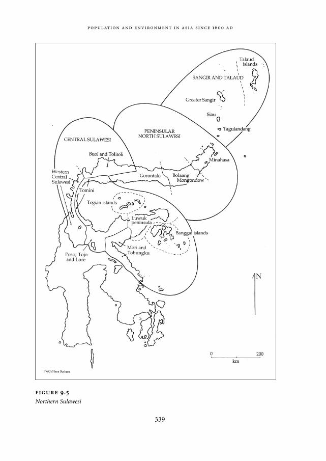
339
.
Northern Sulawesi
Mappae Mundi bw zw/w 08-04-2004 15:26 Pagina 339
Mortality and fertilityThe articulation between economic and demographic conditions seems to have workedvia effects on both mortality and fertility. On the mortality side, one positive effect wasthat of improved nutrition. In 19th century Minahasa (peninsular North Sulawesi), amarked drop in the background death rate after 1860 coincided with an increase in percapita food production stimulated by the growth of an internal market for rice andmaize (Henley 1997: 117-20). Those writers who dismiss the possibility of an articula-tion between population and the resource base via the food supply often do so becauseas far as some sparse populations in ever-wet rainforest areas are concerned, they fail tofind much evidence in the oral or historical records for actual famine or starvation(Levang 1997: 105-6; Schefold 1988: 68-9). But this is a naive interpretation of theMalthusian ‘positive check’ which, under most circumstances, as Malthus himself noted(1976: 36), ‘is not so obvious to common view’ as the ‘preventive check’ of fertility con-trol. The demographic impact of malnutrition works mainly via enhanced infant mor-tality, and in the more remote communities of Borneo it has been observed that the nor-mal situation is one in which ‘few persons go hungry but poor nutrition reduces thestrength of adults and has more serious effects on the very young and very old’ (Alexan-der 1993: 258). Medical research on Madura in the 1980s confirmed that even where ‘realhunger’ was never evident, infant death rates still reflected variations in the availabilityof food (Kusin 1994).
That subsistence-oriented communities sometimes suffer from food shortages due toinadequate production incentives, so that participation in commerce may improverather than jeopardize levels of food consumption and nutrition (Pinstrup-Andersen1985: 56-7), is well documented both in Indonesia (Seavoy 1986: 9-27) and elsewhere(Sahlins 1972: 51-74). This is one reason why the potential ‘carrying capacity’ of unin-habited or sparsely populated frontier areas in pre-colonial South-East Asia was effec-tively much lower in the past than we now tend to assume; another is that subsistenceeconomies were particularly vulnerable to the El Niño-related climatic fluctuations towhich we now know the region is subject (Grove 2000; Harger 1995). Even in the 20th
century efforts at frontier colonization often failed, and where they succeeded it was typ-ically thanks to fundamental changes in the economic environment: either the transfor-mation of existing landscapes by means of labour- and capital-intensive irrigation,drainage and terracing or, more often, the cultivation of new commercial crops for pre-viously inaccessible or non-existent markets (Levang 1997; Uhlig 1984). Particularlycrucial in facilitating the settlement of formerly empty areas has been the spread ofindustrial tree crops such as copra (coconuts), rubber and palm oil which, unlike foodgrains or tubers, allow farmers to profit from the biomass-generating heat and humidityof the wet equatorial environment without making unsustainable demands on infertilerainforest soils (Scholz 1984: 366; 1988: 213). Above all, successful colonization hasoccurred in the context of a general expansion of commercial exchange, which reduces
,
340
Mappae Mundi bw zw/w 08-04-2004 15:26 Pagina 340
the impact of harvest failures and frees producers to a greater or lesser extent from thegeographical and social constraints to which they are subjected when they have to pro-duce a full range of food and other subsistence goods themselves.
As well as lowering the death rate, economic growth also tended to boost the birthrate. Low birth rates in affluent post-industrial countries, and rapid population growthin the developing world, have accustomed us to associate reproductive fertility withpoverty rather than wealth. In the past, however, the reverse was more often true, partlybecause both the actual and the opportunity costs of childrearing were lower (Lee 1997:1074). That fertility was low in many traditional South-East Asian societies is certainlywell established (Reid 1987: 40-41). Historical research suggests that in 19th century Java,rising fertility was often associated with economic improvement via increases in nup-tuality (Boomgaard 1989: 197; Elson 1994: 289-90). Evidence from Minahasa confirmsthat as in Europe, delayed marriage, the classical form of the Malthusian ‘preventivecheck’, formed one link between low population growth and limited economic resourcesunder traditional conditions. Up to the mid 19th century Minahasan women seldommarried before the age of 20; during the period of commercial expansion after 1850, incontrast, marriage at a younger age became more common. One reason for this was thecolonization of previously uninhabited marginal land which was unsuitable for rice ormaize cultivation but could be planted with coconuts yielding a new industrial exportproduct, copra; another reason was the increased availability of cash and trade goodswith which to make brideprice payments (Henley, in press). Rates of deliberate anddirect birth control by means of abortion and infanticide were also affected by economicconditions. Abortions, notes a reconstruction of the pre-colonial Philippines from earlySpanish sources, ‘were a common form of family planning, practiced by ranking ladies tolimit their lineage and preserve their heritage, or by others because of poverty or poorprospects for their children.’(Scott 1994: 118)
Labour burden and slaveryAdam Smith (1976: 98) declared that ‘the demand for men, like that for any other com-modity, necessarily regulates the production of men’. Indonesianists, noting that thepopulation boom in 19th century Java coincided with a period in which Javanese house-holds were subject to a greatly increased labour burden as a result of compulsory agri-cultural and road-building work, have played an important role in linking demographicgrowth with the demand for labour (Alexander 1979; White 1973). Evidence from Mina-hasa, where the population was likewise subjected during the 19th century to corvéelabour in connection with the cultivation of coffee under a state monopoly system, pro-vides strong support for the labour-demand theory of population growth. When theaverage number of children born into each household is compared with the size of thecompulsory labour burden for a number of Minahasan districts in the 1870s, a clearpositive correlation emerges (Henley, in press). It is not clear whether this resulted
341
Mappae Mundi bw zw/w 08-04-2004 15:26 Pagina 341
directly from an increased demand for children to share the burden or whether, as PaulAlexander (1984, 1986) has suggested for Java, it was the unintended consequence ofreduced lactational amenorrhoea – the temporary infecundity associated with breast-feeding – among hard-worked women with little time to attend to their children.
One very widespread pre-colonial South-East Asian social institution that seems tohave had a negative effect on the birth rate is slavery. Missionaries working in remoteparts of Central Sulawesi before the colonial conquest reported that the incentives topractice birth control by means of abstention, abortion or infanticide were strongest inthose communities that contained the most slaves. One reason for this was that childrenwere less economically important to slave owners than to free couples without access toslave labour (Adriani 1915: 458). Since slave children were often taken away from theirparents at a young age and put to work for their masters, conversely, many slave womenhad ‘no desire to bear and raise children for other people’ (Kruyt 1903: 201). Theseobservations accord with, and partly inspire, recent interpretations of Indonesian histor-ical demography that proceed from the assumption that slavery and childbearing can beregarded as economic alternatives (Boomgaard 1997: 8; Knapen 2001: 394-5). While thequantitative evidence for the relative infertility of slaves in Sulawesi is somewhat ambiva-lent, the association between slavery and low fertility is commonplace in the literatureon traditional slavery in Africa (Meillassoux 1986: 79-85; Robertson 1983) and is alsoattested to in the Indonesian context by early Dutch sources from Ambon (Knaap 1987:132) and Batavia (Raben 1996: 128).
Analyses of South-East Asian slavery tend to focus on the demand for slaves ratherthan their supply and to view slavery primarily, in the tradition of H.J. Nieboer’s Slaveryas an industrial system (1900), as a means of forcibly extracting surplus labour in aresource-rich but people-poor environment that ruled out territorial control in the formof tenancy or serfdom (Reid 1983: 8, 22-3; Warren 1998: 39-40). In most cases, however,traditional slavery in South-East Asia was in fact a more or less voluntarily accepted obli-gation based on debt. Often it originated in subsistence crises which forced the poor toborrow food from the wealthy, and both in Sulawesi (Henley, in press) and in the Philip-pines (Barton 1969: 28) there is evidence that geographical variations in the prevalenceof slavery were related to differences in levels of economic security – that is, that slaveswere more numerous in poorer than in richer communities. In this light slavery, likedelayed marriage, can be seen as a negative feedback mechanism that automaticallytended to adjust population levels to economic conditions. To put it crudely, the fewerthe resources the greater the debt, dependency and slavery, and consequently the fewerchildren born. The disappearance of slavery from South-East Asia in the 19th and 20th
centuries, correspondingly, was very likely brought about partly by increases in wealthand economic security – an interpretation consistent with the ease with which it oftenseems to have occurred – and the accompanying rise in the birth rate can be viewed as anindirect consequence of commercialization and economic growth.
,
342
Mappae Mundi bw zw/w 08-04-2004 15:26 Pagina 342
ConclusionPartly because population densities adjusted themselves to local economic conditions,agricultural practices were typically sustainable in the sense that average yields did notdecline over time – although bush-fallow slash-and-burn, probably the most widespreadfarming system, was nevertheless highly destructive of natural forest. Episodes of sus-tained population growth, powered by increases in commerce, mostly took place in rela-tively favourable agricultural environments and were accompanied by capital and labourinvestments which made possible higher – and often no less sustainable – yields perhectare of farmland. In Minahasa, episodes of population growth in the 18th and late19th centuries were respectively associated with a transition from dibbling to hand-tillage and broadcast sowing in swidden farming, and with a dramatic expansion of wet-rice cultivation, an ecologically very stable agricultural system (Geertz 1963: 29) whichmay well have increased labour efficiency as well as yields (Hunt 2000). The positiverelationship between population growth, per capita income and sustainable use of theenvironment that emerges under favourable conditions has been described in an Africancontext by Tiffen, Mortimore and Gichuki in More people, less erosion (1994). FurtherSouth-East Asian parallels are suggested by the work of Metzner (1982) and Nibbering(1991, 1997). Unsustainable or expansionary shifting cultivation, in so far as it occurred,was associated with the exploitation of poor soils by sparse populations practicing slash-and-burn farming in combination with livestock grazing (Terra 1958: 170-75). Thegreatest risk of land degradation may well have come not in times of economic anddemographic growth, but rather in periods of disengagement from commerce, whenpopulations which had previously imported some of their food were thrown back onlocal resources.
Historically speaking, in conclusion, both the size and the distribution of South-EastAsia’s human population have been determined mainly by economic factors. The bestanswer to the question of why the South-East Asian countries are now so much morepopulous than in the past is ultimately that given by Malthus (1976: 31) when he posedthe same question in relation to the Western European nations two centuries ago: ‘thatthe industry of the inhabitants has made these countries produce a greater quantity ofhuman subsistence’. The sparseness of settlement in most parts of South-East Asia up torecent times resulted not from warfare, an exceptionally hostile disease environment orcultural idiosyncrasies affecting reproductive fertility, but rather from a combination ofnatural conditions relatively unfavourable to agriculture, and economic conditionsunfavourable to exchange, export and investment. These conditions limited the supplyof food and the demand for labour, the two variables that controlled long-term changesin the birth and death rates, albeit often via complex intermediate processes. When theeconomic situation improved sufficiently to overcome the existing environmental obsta-cles, for instance by creating a market for tropical tree crops or by causing the productiv-ity of the land to be raised by investments of surplus labour and capital, population
343
Mappae Mundi bw zw/w 08-04-2004 15:26 Pagina 343
growth and the progressive destruction of South-East Asia’s natural vegetation were theinevitable results. The wet rice fields and tree plantations that replaced the rainforest, onthe other hand, were typically rather stable man-made ecosystems which preserved soilquality and provided sustainable yields of food and export products.
9.4. Russian expansion: eastward bound
European expansion has dominated the last 500 years of world history. Usually, the focusis on the large outward migrations from Western Europe – the topic of the next chapter.However, there was also a huge eastward expansion that was largely dictated by the natu-ral resources abundance and scarcity. During the last millennium, the population ofRussia as a political unit increased significantly (Figure 9.1a). Statistical data on the pop-ulation of Kievan Russia are scarce; the size of the Kievan Russian population may havebeen some 1.9 million in 1000 AD and had grown to 3.3 million by 1300 AD (Populationof Russia 2000) – thinly populated in comparison with medieval European countriessuch as France and Germany (Vernadsky 2001). Using the fraction of the urban popula-tion as an indicator of well-being because it shows how many people could afford to befree from subsistence farming, Kievan Russia was rather affluent: its 13% urban popula-tion on the eve of the Mongol invasion (1236 AD) was only reached again in Russia atthe end of the 19th century. The many treasure-troves with Byzantine silver coins foundby archaeologists is another sign of prosperity in the trade capitalism of Kievan Russia(Vernadsky 2001).
9.4.1. Medieval Russia and the trade in forest products
Kievan Russia was situated in two geographical zones: forest steppes and forest (taiga).In the 8th to 10th century most Russians settled in the area of rich black soil in the middleof the Dniepr Basin. The Kievan economy depended on trade, in particular furs. Fromthe 9th century the Viking traders (the ‘Rus’) at Kiev developed an extensive trappingnetwork for furs, particularly sable, black fox, ermine, beaver and squirrel. They used thenomadic tribes to do the collecting, just as the Europeans were to do later in NorthAmerica. The furs were sent southwards to the Byzantine Empire and by the 10th centurythe Dniepr river was the main trade artery. Although they also tried to control the routeto the Caspian Sea, access to the Black Sea was most important. Since the first Crusader’sinvasion into the Byzantine Empire (1096-1099 AD), the trade situation in the basin ofthe Black Sea had been deteriorating and weakened Kiev’s position. After the breakdownof trade with the south, trade activity switched to Central Europe where the Baltic regionwas becoming an important trading area under the German Hansa merchants – about
,
344
Mappae Mundi bw zw/w 08-04-2004 15:26 Pagina 344
three-quarters of the Hansa trade was in fur. Kievan Russia exported mainly raw materi-als to Europe whereas processed materials and metals were imported. Novgorod concen-trated on the flourishing squirrel trade, which became its economic foundation. Thevalue of land was reckoned in thousands of pelts and rents were paid in furs. Until the14th century all taxes were also paid in fur (Economic History of Russia 2000). AsPonting notes:
The size of the Russian medieval fur trade and the extent of the corresponding slaughter of
animals was huge, as a few surviving documents reveal. The best estimate is that at the height
345
Political periods in Russia Russian history can be divided in four periods:
1. Kievan Russia, from the Viking invasions to the rule of the Rus and the subsequent
Mongol invasion from the 9th to the 13th century. It culminated as a unified state in
the 11th century, with the city of Kiev located in the forest zone in the basin of the
Dniepr River as its main centre. During succession struggles, the city of Novgorod
entered into its golden age and received the right to elect its own archbishop
through the veche or popular assembly from Kiev in 1156 AD. While the remainder
of Russia suffered from the Tartar-Mongol conquest, Novgorod’s willingness to buy
off the invaders with tribute, its distance from the main body of the horde and its
marshy surroundings all contributed to its autonomy, which continued until it sur-
rendered to Moscow in 1478 AD – which was the start of
2. Muscovy Russia from the 14th to the 17th century. After a refusal to pay tribute to the
Mongol Golden Horde and failed attempts of the Mongols to invade the Muscovy
lands, Russia became the ideological successor to the Byzantine Empire. The city of
Moscow claimed all Russian lands should be under its power. Independent Nov-
gorod remained one of its main political adversaries, until it was defeated in 1478
AD and the merchants from the German Hansa cities were expelled and their goods
expropriated. In 1493 AD Ivan III was named ‘Tsar’ and the next Tsar, Ivan IV and
also called Ivan the Terrible, completed integration of the Russian lands under the
superiority of Moscow.
3. The epoch of the Russian Empire started in 1721 with an act of the Russian
Supreme Council (Senat) revoking the title ‘Tsar’ and awarding Peter the Great the
title of Emperor of Russia. This act marked two decades of radical political and
administrative reforms initiated by Peter the Great, in an attempt to transform Rus-
sia into a western-style secular state as soon as possible. Since the 18th century, the
Russian Empire has seen itself as a state that belonged culturally and politically to
Europe, with a rapidly growing military power and great geo-political ambitions.
4. The Soviet Union, a period of transformation of the traditional Russian economy.
Mappae Mundi bw zw/w 08-04-2004 15:26 Pagina 345
of the squirrel trade Novgorod was exporting about 400-500,000 skins a year… Hundreds of
millions of animals were killed at an unsustainable rate both in Russia and western Europe. As
early as 1240 AD in the Dniepr Basin around Kiev, the original centre of the trade, no fur-bear-
ing animals were left and Novgorod merchants were already trading 1000 miles away beyond
the Urals in an attempt to find adequate supplies. From the early 15th century imports into
London were waning and Russian prices started to rise as the animal population declined. By
the 1460s London merchants were complaining about inadequate supplies and the volume of
exports from Novgorod had fallen by about a half, though they were still at the substantial
level of some 200,000 skins a year. (Ponting 1991: 179)
This decline in economic activity of Novgorod marked the beginning of Muscovy Rus-sia.
9.4.2. Muscovy Russia and the Russian Empire: extensive not intensive growth
Muscovy Russia saw a rapid expansion of its territory to the south-east: it increased 5.5times between 1460 and the end of the 17th century. The Khanates of Kazan andAstrakhan on the Volga were conquered in 1552 and 1554, opening up the regions to thesouth and east of Moscow to settlement. In 1582 a small troop of Cossacks led by Ermakinvaded West Siberia, a military action dictated largely by economic reasons in contrastto the campaigns against Kazan and Astrakhan. Ermak was engaged by rich Russianmerchants to protect their fur business in western Siberia, because their trapping net-work was periodically threatened by the people of a khan named Kuchum (Gumilev1992). By 1585 the vast territory of the West Siberia was annexed by Russians. In 1676Ukraine joined Russia, which brought in another 2 million km2 of new land with therich soils of the Dniepr Basin. Expansion into the Baltic region brought Russia access tothe sea; in 1703 Saint-Petersburg was established at the Finland bay. The most impressivebut easiest expansion was to the East. Peaceful annexation of central and eastern Siberiatook place in 1689, a period during which the border with China was also established. By1707 Kamchatka was conquered and thirty years later settlements in Alaska were estab-lished. According to Ponting (1991), ‘This process was nominally under state control butin practice, especially outside the towns, Russia was as much a frontier society as theUnited States.’
Initially the Russian population grew only modestly: in 1645 there were 6.7 millionpeople living in Russia according to the first census. Only 4% lived in urban areas by theend of the 17th century, a sign that Muscovy Russia was poorer than Kievan Russia (Pop-ulation of Russia 2000). Early 18th century, the Russian Plain was inhabited by 17 millionpeople of whom 15 million lived in the territory of the Russian state – the largest popu-lation within Europe but at a density of only 3-4 people/km2. The areas most densely set-
,
346
Mappae Mundi bw zw/w 08-04-2004 15:26 Pagina 346
tled were the centre around Moscow and the zone of mixed and broad-leaved forests (12people/km2), where population was distributed across the area. In the taiga, the popula-tion was concentrated around a few settlements. As the inroads of nomadic tribes andother enemies diminished, the steppe was colonized and the centre of gravity started toshift. Not unlike the situation in Western Europe, the major push factor was economic incombination with the desire of the government to settle thinly populated lands. In thelate 17th and the 18th century, more than 2 million serfs moved south while 0.4 millionpeople went east to Siberia and the Urals. From 1724 to 1859, the number of Slavs in theNew South – roughly corresponding to the Pontic steppe – increased from 1.6 million to14.5 million, while the number in Siberia went up from 0.4 to 3.4 million (Bell-Fialkoff2000). Russians from the north and Ukrainians from the west moved into this woodedsteppe area and by the early 18th century a quarter of the Russian population was livingin these regions. By the end of the 18th century the defeat of the Turks opened up thegrass steppes around the Black Sea for settlement. In the first half of the 19th century anarea the size of Czechoslovakia and Hungary combined (50 million acres) was broughtinto cultivation by farmers in the Ukraine and Volga areas.
The fur trade kept its significance for the economy of Russia. By the 16th century the onlyremaining area untrapped was Siberia and the continuing demand for furs from WesternEurope drove the Russian merchants further east into this largely unexplored area, usingnative and Russian trappers. As in the mediaeval period in western Russia, furs rapidlybecame the main trade in Siberia and the main currency. By the mid-17th century, over athird of the income of the Russian state came from the fur trade (Ponting 1991). In the
347
The ‘pacification’ of the steppe While it was expanding east, Russia was also
engaged in a continuous struggle against the Crimean khanate to the south. Originally
part of the Golden Horde, it was an independent entity for a generation until it became
a vassal of the Ottoman Empire in 1475. The khanate proved to be a persistent and dan-
gerous foe. The Crimean Tartars burned Moscow at least twice, in 1382 and 1571. Even
worse were the incessant slave raids deep into Russian territory. Trade in slaves was
the cornerstone of the Crimean economy. The last raid into Russia took place in 1769.
Ultimately, only the conquest of the Crimea could eliminate this constant drain on
Russian human resources. Azov, a key fortress at the mouth of the Don, was captured
in 1637, lost again, and finally captured for good in 1696. Towards the end of the 17th
century, an insecure ‘Belgorod line’ near the present Russian-Ukrainian frontier was
established. The incorporation of the Crimea in 1774-83 finally eliminated the menace
and the pacification of the remaining nomadic tribes opened vast stretches of the
Eurasian steppe to Russian settlement.
Mappae Mundi bw zw/w 08-04-2004 15:26 Pagina 347
early 18th century the total population of Siberia was about 250,000, with the Europeansettlers already outnumbering the natives. Expansion towards the Pacific coast was dic-tated by economic reasons: fur-bearing animals were virtually exhausted and
by the end of the eighteenth century the fur-bearing animals of even such a vast area as Siberia
were virtually exhausted and the Russian traders were turning their attention to the sea otters.
Between 1750 and 1790 about 250,000 otters were killed before the trade collapsed because of
overhunting. This industry soon showed the same characteristics as the fur trade – rapid
exploitation of an area until the seals were either extinct or so reduced in number that it was
no longer economic to hunt them, followed by a move to a new area. By the 19th century the
heyday of the Russian fur trade was almost over. (Ponting 1991: 180)
Although the early years of the Russian Empire saw the first signs of industrialization,agriculture still dominated the economy: in 1725-27 90% of national income still camefrom peasants as agriculture kept growing and wheat became an import export productafter the 1780s (Chronology of Russian History 1994). In 1700 there were 253 settle-ments with the status of a town on the Russian Plain, but all of them other than Moscowwere small and their 600,000 inhabitants represented no more than 4% of the total pop-ulation. The peasantry heavily relied on subsistence farming. In 1719 a law allowingeverybody to search and extract metals and fossil fuels was adopted. The first coal minescame into operation in 1722 and by the end of the 18th century the Russian Empire hadbecome a leader in the production of iron, cast iron and copper.
9.4.3. Land scarcity and rural overpopulation as the motor for expansion
By the 15th century the upper Volga river region with poor forest soils became the mostpopulated and Russian people started to plough these lands intensively – a somewhatparadoxical course of events (Vernadsky 2001). Some natural factors were limiting effec-tive agricultural development in this Russian forest zone. The poor podzolic soils couldproduce high harvests if they were well-fertilized with manure. Unfortunately, the num-ber of cattle needed for this never reached the critical amount for several reasons. First ofall, supporting a big herd in the severe climatic conditions of Russia required the storageof a large amount of fodder during the winter season that lasted 200 days, as against 160days for the European steppes. Russian peasants were physically not able to produceenough straw and hay to support a large number of cattle (Getrell 2000). It was a viciouscircle. Any additional acreage of arable land demanded producing more and more fod-der for cattle feed and at some moment in time the expenses for keeping cattle as a‘manure-producing machine’ made the whole venture unprofitable. Secondly, Russianpeasants only had relatively small plots to rely on and, although in good years it might
,
348
Mappae Mundi bw zw/w 08-04-2004 15:26 Pagina 348
give enough food for a peasant’s family, there was no potential for expansion and pro-duction for the market. Perhaps, this explains the modest growth of the Russian popula-tion during this period because having a big family was a risk, not an advantage. Someresearchers believe that the two periods of economic growth in Russia –1718-22 and the1780s – both took place when the vast uncultivated territories of the southern steppesbecame accessible for cattle breeding for Russian peasants (Getrell 2000).
Agriculture expanded but productivity remained very low: 0.5 to 0.7 tonnes perhectare. One indicator of slow development is energy use: this increased only by an esti-mated 40% between the 17th and mid-19th centuries (Getrell 2000). Growth of cultivatedarea went along with population growth: food shortages had been solved by cultivatingnew land and not by increasing productivity. In the newly colonized areas of EuropeanRussia – or ‘Central Russia’ – it seems that large families had a bigger income than smallones (Population of Russia 2000). In the second half of the 19th century the populationof European Russia had increased considerably and the birth rate approached its biolog-ical maximum. In the productive zones, the highest growth rate (2.4%/yr) in the historyof the Russian Empire was reached and the population increased from 49.6 million in1885 to 67.3 million in 1900. The next 15 years there was still an average growth rate of2%/yr and in many regions of European Russia scarcity of cultivable land reached dra-matic proportions. It caused serious social and economical problems for the wholecountry.
The main agricultural product of the Russian Empire was cereal, occupying 89% ofthe total agricultural land. In the last quarter of the 19th century the cereal market deter-mined the agricultural activities of millions of Russian peasants. In 1912-1913, one-quarter of the cereal production was produced for export to the world market. Only6.5% of cereal production was consumed in the domestic market (Popov 1925). If apeasant had a large enough area to get a decent income and cover his family’s needs fromthe production and sales of cereal crops, there was no reason to change the direction ofthe farming development. The family would be fully employed, at least during springand summer, due to the large area of arable land under cereal crops. For peasants withonly a small plot of land, cultivation of cereal crops did not give sufficient income evento meet the family’s demand. Millions of Russian peasants were forced to leave their vil-lages out of poverty and to search for seasonal work in towns or other regions of thecountry. The seasonal employment of peasants in towns can be regarded as an indicatorof the deep crisis. On the one hand, the peasants failed to change their unprofitable wayof farming; on the other, they did not have the resources to migrate to new regions.Instead, they tried to solve their problem by searching for temporary jobs in the townsand soon became used to their poor standard of living (Report of the Imperial RussianGeographical Society 1882).
Seasonal employment of peasants in urban areas is also one measure of rural over-population (Figure 9.6a-c; see p. 314-315). In early 1890s the number of peasants look-
349
Mappae Mundi bw zw/w 08-04-2004 15:26 Pagina 349
ing for seasonal job in towns and other regions of the country reached 6 million a year;by the end of the 1890s this number had reached 9 million (Vilensky 1980). A specialcommission under the government of the Russian Empire estimated the rural overpopu-lation to be 23 million in 1901, i.e. 16% of the population – it is hardly surprising that670 peasants’ riots in the European part of Russia were observed in the years 1902-1904.
One way to alleviate overpopulation was to resettle Russian peasants from the Euro-pean part of the country to the southern areas of Siberia and Central Asia. By the end ofthe 19th century, these vast territories were still barely populated. By the end of the 20th
century, 5.8 million Russians were already living in the four Siberian provinces and inthe four provinces of the Far East, according to the census of 1897. During the years1896-1913, 5.2 million people resettled from European Russia to Siberia, the Far Eastand Central Asia (Figure 9.5; Population of Russia 2000). This trend peaked in the period1906-1914 when 4 million peasants were resettled into the Siberian provinces. Many ofthem returned, though, because of the physical and economic hardship: between 1907and 1914 about 1 million Russian peasants returned to European Russia (Vert 1995).Despite the large migration flows, the problem of rural overpopulation in EuropeanRussia was not solved: the total number of migrants from European Russia reachedapproximately 5% of the population, while overpopulation was an estimated 16%. TheFirst World War practically put an end to peasant outmigration.
The resettling of peasants in Central Asia was associated with numerous problems.Unlike Western Siberia or the Far East, Central Asia was already densely populated andresettlement happened at the expense of the local people who were nomads and alreadyfaced a shortage of pastureland. Nomadism is a land-extensive way-of-life: a Kirghizfamily needed between 200 to 500 hectares while a peasant family was given 45 hectaresin the same region. Immigration of Russian peasants was one of the main factors of thetransition of Kirghiz peoples in northern Kazakhstan from nomadism to agriculture(Report of the Imperial Russian Geographical Society 1907).
During the World War, the Socialist revolution and the civil war the country lostmore than 12 million of the employable population (Population of Russia 2000). Thesowing area decreased, reaching the 1913-level again only in 1925. Redistribution ofarable land among the poor peasants after the Socialist revolution undermined agricul-ture’s productivity. Markets declined, there were severe droughts (1921-22, 1924-25)causing mass famine and ravaging many farms. Yet, even after these social and naturalcatastrophes, the problem of the rural overpopulation and the shortage of arable land inmany regions of the European Russia still existed. Before the First World War, 5 millionRussian peasants left their farms for towns looking for seasonable jobs. In 1923-24 thisnumber was still 1.7 million, and in subsequent years it increased to 3.2 million in 1926-27. According to the State Planning Committee of the USSR, the total rural unemploy-ment of the country reached 8-9 million people in 1928; in Central Asia and Kazakhstanoverpopulation reached 2-2.5 million people. This rural overpopulation manifested
,
350
Mappae Mundi bw zw/w 08-04-2004 15:26 Pagina 350
itself in periodically emerging food problems and even famine. Peasants owning smallplots of lands were worst hit. Other signs of overpopulation were general instability inagricultural production and uncontrolled seasonal migration of peasants. Because theSoviet economy was totally dependent on cereal production in the 1920s, at least two ofthe four governmental crises were associated with failures in cereal production (Eco-nomic History of Russia 2000). The Soviet authority was forced to break down the tradi-tional economy and the way of life of millions of Russian peasants. Collectivization ofthe peasants’ farms started in 1928 and was completed by 1932. This collectivizationended ever further fragmentation of peasant land, but it also forced millions of peasantsto leave their villages for new industrial centres and towns forever. More than 16 millionpeasants are estimated to have migrated into towns on the period 1926-37, which ismore than any estimation of the size of rural population excess in the 1920s. In 1932 theSoviet authority had to adopt a special resolution forbidding Soviet peasants to leavetheir villages and collective farms. The urban population rose from 18% in 1932 to 34%by 1940. Thus, in combination with an ambitious programme of industrialization, theSoviet Union had been transformed from a largely rural economy with severe overpopu-lation into an industrialized power that started to rapidly exploit its huge fossil fuel andforest resources. This transformation happened in a short period, had many victims andwas one of the largest population resettlements ever.
9.5. Conclusions
In the last millennium about two-thirds of the world’s population lived in Asia, notablyChina and India. Their share in the world economy has declined, however, from roughlytwo-thirds to one-third. To investigate their environmental history is important becausein several places these large human populations were living close to the carrying capacityand it may give comparative insights into developments earlier and elsewhere.
The last four centuries of Indian history indicate that environmental history has to beunderstood in a larger geo-political context. Until the 17th to 18th centuries the ratherlarge population lived in a rather low-level equilibrium, with high pressure on the landdue to a variety of socio-cultural factors. Variation in rainfall – sometimes as part oflarger climate/monsoon changes – occasionally triggered a cycle of bad harvests, famineand disease. With the advent of the East India Company and British colonialism, thesecycles appear to have been negatively influenced by high land taxes due to far-away pres-sure for profit, lack of re-investment for land maintenance and wars, to mention themost important ones. Famine incidence increased, disease epidemics often followed.Only by the late 19th/early 20th century did better nutrition and hygiene and more effec-tive relief measures lead to a decline in mortality.
Indonesia had a relatively sparse population around 1700 AD. This is often interpret-
351
Mappae Mundi bw zw/w 08-04-2004 15:26 Pagina 351
ed in socio-cultural terms, but there have also been important geographical and eco-nomic constraints. Early spatial patterns were related to (the absence of) seasonal aridityand volcanic soils; temporal patterns show a clear link with (opportunities for) trade andcommerce. Relatively sparse population density in most parts of South-East Asia up torecent times, then, resulted not so much from warfare, disease environments or culturalidiosyncrasies, but rather from natural conditions relatively unfavourable to agricultureand economic conditions unfavourable to exchange, export and investment. These con-ditions largely controlled via complex intermediate processes long-term changes in thebirth and death rates.
Finally, the narrative on Russia indicates how a combination of political and environ-mental factors caused an increasing outmigration from the Russian heartland, firsttowards the south-eastern steppes, subsequently into Siberia. This, one may presume,was the Eastern part of the European expansion in the last three to four centuries – thetopic of the next chapter.
,
352
Mappae Mundi bw zw/w 08-04-2004 15:26 Pagina 352
10
The Past 250 Years: Industrialization and Globalization
A quick look at maps 10.1a-d and 10.2a-d in the colour section of this book shows someremarkable changes. Maps 10.1a-d show changes in population density all over theworld. Around 1700, there were only four large areas with a density of over 8 people/km2
(East Asia, South-East Asia, India, and Western Europe), and none with a density of over16 people/km2. There had been some growth by around 1800, but it was of an incremen-tal nature: the high-density areas had expanded somewhat, but hardly any other largeareas had been added to the list. The map of 1900 shows a very different picture: spots ofdensity of over 16 people/km2 become visible in the original high-density areas, whilenew areas with a density of over 8 people/km2 appear in the Americas and Africa, espe-cially along the coasts. Around 1990 areas with a density of over 16 people/km2 werefound in several parts of Eurasia, and the interiors of the Americas and Africa werebeginning to fill up with densities of over 8 people/km2.
Maps 10.2a-d show comparable changes in land cover or vegetation. Around 1700and 1800, intensively cultivated cropland was mainly restricted to areas of concentrationin Asia and Europe. By 1900, great changes had occurred and intensively used croplandnow also covered large parts of North America. Marginal cropland and land used forgrazing were also expanding, especially in South America and Australia. These processesof change continued through the 20th century, as shown in map 10.2d, which representsthe situation in 1990. By that time, the areas covered by forests and woodlands had alsodiminished considerably.1
The picture emerging from these maps is one of an anthroposphere that is expandingat an increasingly rapid pace. The earth has become more densely populated by humansand this is reflected in land cover. In this chapter we point to some of the processesbehind the changes that have been made visible in the maps. Some of these processeshave already been noted in Chapter 9, on Asia. Here the focus will be on industrializa-tion and globalization.
353
Mappae Mundi bw zw/w 08-04-2004 15:26 Pagina 353
10.1. Early industrialization2
10.1.1. The meaning of industrialization
As already suggested by the maps, the time span of the past 250 years for this chapter wasnot arbitrarily chosen. Around 1750, a new ecological regime was formed: the industrialregime, based on fossil fuel as its main source of energy. Its beginnings were small andhardly noticeable to most contemporaries, but in retrospect we can recognize how con-sequential they were. Humanity and the biosphere would never be the same again.
While human history over the past 10,000 years has been the history of the agrarian-ization of the world, the history over the past 250 years has been the history of industri-alization. In the process, the anthroposphere has become one global constellationextending all over the planet, and its impact on the biosphere has become more andmore intense.
In line with the approach to the domestication of fire and agrarianization outlined inChapter 2, we define industrialization as the formation of a socio-ecological regimestructured around a new source of energy: fossil fuel – first in the form of coal and lateralso oil and gas. The nature of this new energy source has made the industrial regimedifferent in a basic way from the earlier socio-ecological regimes. Unlike plants and ani-mals, and even wood, fossil fuels are not directly connected to the continuous flow ofsolar energy. They are a residue of solar energy from a remote past, contained in geolog-ical formations. The energy stocks are not diffuse like sunlight but concentrated in par-ticular locations from which they can be extracted through concerted human effort.They have two seemingly contradictory properties: they are abundant and finite.
The abundance is indeed great. Coal, oil and gas represent the remains of unoxidizedbiomass – in other words, unburned fuel – from many hundreds million years. Whenpeople began exploiting those enormous reserves they entered, in the words of the envi-ronmental historian Rolf Peter Sieferle (2001), a subterranean forest of inconceivablylarge dimensions which, moreover, in the course of 250 years of exploitation and explo-ration proved to contain far more riches than was originally expected.
Yet no matter how large, the hidden stocks are also finite. In contrast to plants, whichare the direct ‘autotrophic’ products of the photosynthetic conversion of solar energy,and to animals, which are the ‘heterotrophic’ consumers of plant and animal food, geo-logical stocks of fossil fuel do not partake in any living metabolic processes. They areincapable of growth or reproduction, are irreplaceable and non-renewable, and, as isbecoming more and more evident, their use generates combustion products that enterthe biosphere.
354
Mappae Mundi bw zw/w 08-04-2004 15:26 Pagina 354
10.1.2. Connections and continuities with the earlier regimes
The beginning of industrialization heralded a new era in human history. Yet it was clear-ly a continuation of the fire regime, as every industrial process rested on the controlleduse of fire in burning fossil fuel. Industrialization also presupposed agrarianization: itcould never have started without a strong agrarian basis that was able to feed numerouspeople who were not engaged in agriculture themselves and who could therefore berecruited for work in industry. Once the industrial regime was established, new forms offire control as well as new forms of food production were created; while the two olderregimes were thus modified, they continued to bolster the industrial regime. From thevery beginning, the industrial world has co-existed and co-evolved with the agrarianworld, in close interdependence and symbiosis, culminating in our time in forms ofindustrial farming or agro-industry that lean as heavily on the use of fossil fuel as anyother form of industrial production.
10.1.3. Origins and antecedents
Like the original domestication of fire and the initial emergence of agriculture, the gene-sis of industrialization raises a whole array of intriguing questions, concerning its pre-conditions and its immediate causes as well as such issues as why it started at all, andwhy in Britain around 1750 in particular. These are in principle the same questions thatcan be raised about the control of fire and agriculture. Because industrialization beganonly recently we have the benefit of far more and far more precise empirical evidence;nevertheless, the problems remain puzzling. Any answer that comes to mind can only betentative and subject to caveats.
One thing at least is certain: industrialization was not triggered by a major change inclimate. At most, its beginnings more or less coincided with the end of the most recentsecular dip in temperature in Europe, from 1550 to after 1700, known as the ‘little IceAge’; but no relationship with this climatological episode was evident. Industrializationwas a completely anthropogenic transformation, brought about by humans in societieswhich were fully equipped with fire and agriculture.
Industrialization, like agrarianization, is probably best understood as having sprungfrom a combination of scarcity and opportunity. Again, as with the beginnings of agri-culture, the scarcity factor may – seemingly paradoxically – have had something to dowith the fact that, through a preceding period of extensive and intensive growth, thepopulation had increased in certain privileged areas and had even attained a measure ofaffluence and prosperity. By the mid 18th century, Britain and the Netherlands were rela-tively rich and densely populated countries – the Netherlands mainly as a result of itscommercial and military successes during the ‘Golden Age’ of the previous century,
:
355
Mappae Mundi bw zw/w 08-04-2004 15:26 Pagina 355
while Britain was currently the scene of accelerating growth. Among the effects of exten-sive and intensive growth in both countries was an increasing need for, and scarcity of,wood for fuel or timber. In the Netherlands timber was imported from Scandinavia andfuel was provided through the exploitation of peat – a relatively young fossil fuel thatwas cut in rural regions and carried to the cities by boat. In Britain, where no compara-ble system of inland waterways yet existed, the solution for the fuel problem was foundin coal.
Coal had long been known as a fuel in several parts of the world, from early dynasticChina to ancient Rome. It was considered inferior to wood, however, because of its foulsmoke; moreover, it was much less easy to obtain in most places. Under the pressure ofwood shortage in 18th century Britain, means were sought to overcome these difficulties.On the one hand, chimneys were improved, enabling the consumers of coal to relieve therooms in which they burned their fires from the worst immediate effects of smoke. Farmore important were new techniques on the production side, in the digging and pro-cessing of raw coal. Greater quantities could be made available, meeting higher standardsof quality.
The story has often been told of how the steam engine was initially developed prima-rily as a device for pumping water from the coal mine shafts. The coal that was mademore easily accessible with the aid of steam engines was used to power other steamengines which came to be deployed for a variety of purposes, some of which were againsomehow ‘self-serving’: to propel steam ships and locomotives for the transport of prac-tically any commodity, including coal. A primary element in the production of coal wasiron, needed to build the engines, locomotives, railways and, in due course, ships thatformed the material basis of the early fossil fuel economy. The coal and iron industriesthus developed ‘separately and jointly’, ‘in an upward-spiralling, symbiotic process’(McClellan and Dorn 1999: 285).
10.1.4. The early industrial archipelago
Just as agrarianization must often have begun in small farming enclaves, carved out in anenvironment that continued to be the domain of foragers, industrialization started withsingle steam-powered factories – often called ‘mills’ as if they still were driven by wind orwater – standing apart in the agrarian landscape. In order to indicate their initially semi-isolated position, the image of industrial archipelagos is appropriate (see Sieferle 1997:162-3).
From the very start, however, even as ‘islands’ in an agrarian landscape the factorieshad an ecological impact stretching beyond the land on which they stood. To begin with,considerable amounts of energy and materials went into building them. The usual con-struction material was partly timber and, to a greater extent, brick, the manufacturing of
356
Mappae Mundi bw zw/w 08-04-2004 15:26 Pagina 356
which involved huge quantities of fuel. The engines were made largely of metal, also in ahighly fuel-intensive fashion. Then, brick and timber were needed for the houses toaccommodate the workers. Thus, even before the factories began to operate, their ‘tenta-cles’ were already reaching into the environment.
Once in operation, the factories had to be supplied with a continuous stream ofmaterials, such as iron and cotton to be processed, and of fuel to keep the engines going.The need for fuel explains the location of the early industrial plants: close to coal-minesand, in the case of heavy industry, sites of iron ore deposits. Of course, a nearby sea orriver port facilitated transportation; failing that, canals were built and, later, railways,connecting the islands of industrial production with the areas where the raw materialswere found and with the markets where the products were sold. In 19th century Britain,an ever more extensive and intricate network of canals and railways was formed throughwhich the industrial regime spread its reach over the entire country.
The effects on the local landscape were soon noted by travellers from abroad – some-times with great appreciation (see box). In retrospect, we may find the emphasis on thebeauty of early industry somewhat surprising and showing a lack of concern, not onlyfor the miserable conditions in which the workers and their families had to live, but alsofor the ecological damage caused by the industrial operations. The interest expressed bythese travellers referred only to the pictorial aspects of the scenery.
The entrepreneurs who ran the factories probably shared this indifference to ecologi-cal consequences. Their attitude could only be primarily commercial, conforming to aprocess characterized by the Dutch sociologist Kees Schmidt (1995) as ‘economization’.As Schmidt cogently shows, the social pressures to think in purely economic terms werevery strong, leaving little room for environmental considerations.
Even contemporary observers who were to become deservedly celebrated and influ-ential, from Adam Smith and David Ricardo to Karl Marx and Friedrich Engels, did notalways fully grasp the ecological impact of the introduction of steam engines. Their acu-men was focused on human relations, on the division and exploitation of labour, ratherthan on the physical environment.3 Since all the direct impressions that have reached uscame from a literate elite, we can only guess how the early industrial workers and thefarmers perceived the changes in the landscape. A sense of pride in the successful con-quest of nature prevailed among the entrepreneurial classes in Britain, with occasionalmisgivings about the damage done to the countryside.
10.1.5. Coal exploitation as intensified land use
Our earliest human ancestors treated the land they lived in as essentially all of the samenature – a territory for both collecting and hunting, for foraging food as well as fuel. Inagrarian societies, most of the land was parcelled up into three distinct parts with dis-
:
357
Mappae Mundi bw zw/w 08-04-2004 15:26 Pagina 357
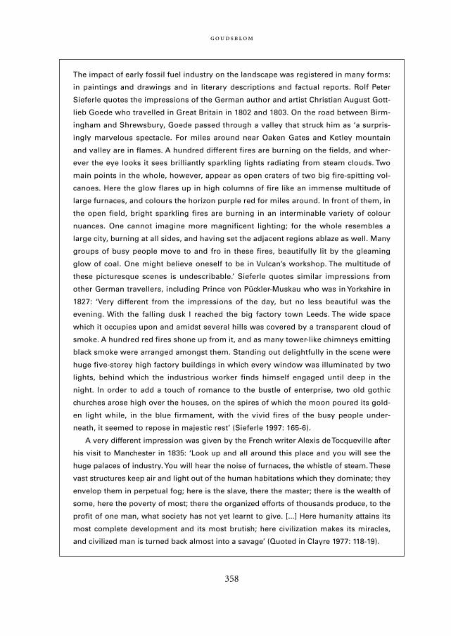
358
The impact of early fossil fuel industry on the landscape was registered in many forms:
in paintings and drawings and in literary descriptions and factual reports. Rolf Peter
Sieferle quotes the impressions of the German author and artist Christian August Gott-
lieb Goede who travelled in Great Britain in 1802 and 1803. On the road between Birm-
ingham and Shrewsbury, Goede passed through a valley that struck him as ‘a surpris-
ingly marvelous spectacle. For miles around near Oaken Gates and Ketley mountain
and valley are in flames. A hundred different fires are burning on the fields, and wher-
ever the eye looks it sees brilliantly sparkling lights radiating from steam clouds. Two
main points in the whole, however, appear as open craters of two big fire-spitting vol-
canoes. Here the glow flares up in high columns of fire like an immense multitude of
large furnaces, and colours the horizon purple red for miles around. In front of them, in
the open field, bright sparkling fires are burning in an interminable variety of colour
nuances. One cannot imagine more magnificent lighting; for the whole resembles a
large city, burning at all sides, and having set the adjacent regions ablaze as well. Many
groups of busy people move to and fro in these fires, beautifully lit by the gleaming
glow of coal. One might believe oneself to be in Vulcan’s workshop. The multitude of
these picturesque scenes is undescribable.’ Sieferle quotes similar impressions from
other German travellers, including Prince von Pückler-Muskau who was in Yorkshire in
1827: ‘Very different from the impressions of the day, but no less beautiful was the
evening. With the falling dusk I reached the big factory town Leeds. The wide space
which it occupies upon and amidst several hills was covered by a transparent cloud of
smoke. A hundred red fires shone up from it, and as many tower-like chimneys emitting
black smoke were arranged amongst them. Standing out delightfully in the scene were
huge five-storey high factory buildings in which every window was illuminated by two
lights, behind which the industrious worker finds himself engaged until deep in the
night. In order to add a touch of romance to the bustle of enterprise, two old gothic
churches arose high over the houses, on the spires of which the moon poured its gold-
en light while, in the blue firmament, with the vivid fires of the busy people under-
neath, it seemed to repose in majestic rest’ (Sieferle 1997: 165-6).
A very different impression was given by the French writer Alexis de Tocqueville after
his visit to Manchester in 1835: ‘Look up and all around this place and you will see the
huge palaces of industry. You will hear the noise of furnaces, the whistle of steam. These
vast structures keep air and light out of the human habitations which they dominate; they
envelop them in perpetual fog; here is the slave, there the master; there is the wealth of
some, here the poverty of most; there the organized efforts of thousands produce, to the
profit of one man, what society has not yet learnt to give. [...] Here humanity attains its
most complete development and its most brutish; here civilization makes its miracles,
and civilized man is turned back almost into a savage’ (Quoted in Clayre 1977: 118-19).
Mappae Mundi bw zw/w 08-04-2004 15:26 Pagina 358
tinct functions: fields or arable planted with crops; pastures or meadows where cattleand horses grazed; and heath and wood land providing fodder for pigs and sheep and,even more importantly, fuel and timber. All three areas were controlled by humans, whowere able to make the land thus divided up more productive for their own specific pur-poses, but who also found themselves in a predicament:
… a fundamental problem existed here: more arable and more forest products were needed in
proportion to population growth, in other words the demand for wood grew at the same rate
as forests decreased. If this process is considered more closely, it is essential to view arable, pas-
ture and wood land as alternative forms of land use that were in principle substitutable to
some degree without one form displacing the other entirely. It was important to create a sensi-
ble balance between them (Sieferle 2001: 52).
Maintaining this balance generally put a constraint on the tendency to growth in agrari-an societies – although the examples of wet-rice agriculture in South-East Asia discussedin Chapter 4 show that it did not always bar high population densities. However, indus-trialization offered an opportunity to lessen the constraint. The exploitation of coal wasa highly intensified form of land use that relieved the pressure to use large areas exten-sively for growing wood for fuel. Reckoned in this way, ‘already in the 1820s, British coalproduction freed an area equivalent to the total surface of Britain’ (Sieferle 2001: 103).
Between the late 14th century and the mid 18th century the population of Englandand Wales steadily increased, from 2.5 to 6 million. Then, in the second half of the 18th
century, growth accelerated rapidly, owing to a drastic decline in mortality. Relief for therising pressure on the land was found in a variety of ways: emigration, more intensivemethods of cultivation, food imports from abroad and, to a large degree, the conversionof woodland formerly used as a source of fuel into arable and pastures.
Table 10.1 shows the increased use of land for agrarian purposes between 1700 and1850 and, by implication, the decrease in land use for fuel (for a similar trend in Japan,see Chapter 6, Figure 6.1). This shift occurred during a period when the total populationalmost trebled from about 6 to 18 million, and demand for firewood would haveincreased proportionally had there not been the substitute supply of coal.
The virtual land gains attained through the use of coal help to explain the unstop-pable advance of industrialization, once it was underway. Like the agrarian regime, theindustrial regime made ‘offers’ that were disagreeable in many ways to a great many peo-ple, but in the long run for all of them impossible to ignore or to refuse. The huge gainsin energy could be transformed into economic, political, and military advantages thatproved to be irresistible. All over the world, societies without fossil fuel industry madeway for societies with fossil fuel industry – a process that could not fail to have profoundconsequences for the biosphere.
:
359
Mappae Mundi bw zw/w 08-04-2004 15:26 Pagina 359
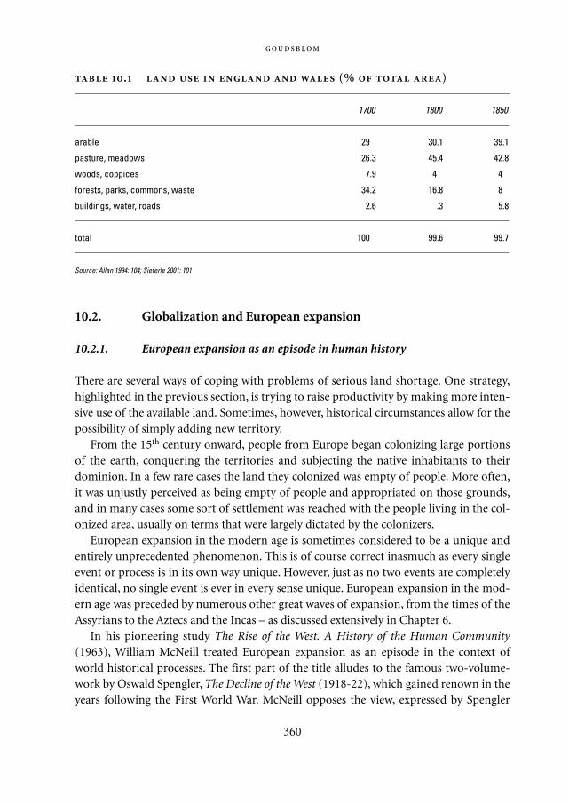
10.2. Globalization and European expansion
10.2.1. European expansion as an episode in human history
There are several ways of coping with problems of serious land shortage. One strategy,highlighted in the previous section, is trying to raise productivity by making more inten-sive use of the available land. Sometimes, however, historical circumstances allow for thepossibility of simply adding new territory.
From the 15th century onward, people from Europe began colonizing large portionsof the earth, conquering the territories and subjecting the native inhabitants to theirdominion. In a few rare cases the land they colonized was empty of people. More often,it was unjustly perceived as being empty of people and appropriated on those grounds,and in many cases some sort of settlement was reached with the people living in the col-onized area, usually on terms that were largely dictated by the colonizers.
European expansion in the modern age is sometimes considered to be a unique andentirely unprecedented phenomenon. This is of course correct inasmuch as every singleevent or process is in its own way unique. However, just as no two events are completelyidentical, no single event is ever in every sense unique. European expansion in the mod-ern age was preceded by numerous other great waves of expansion, from the times of theAssyrians to the Aztecs and the Incas – as discussed extensively in Chapter 6.
In his pioneering study The Rise of the West. A History of the Human Community(1963), William McNeill treated European expansion as an episode in the context ofworld historical processes. The first part of the title alludes to the famous two-volume-work by Oswald Spengler, The Decline of the West (1918-22), which gained renown in theyears following the First World War. McNeill opposes the view, expressed by Spengler
360
. (% )
1700 1800 1850
arable 29.0 30.1 39.1
pasture, meadows 26.3 45.4 42.8
woods, coppices 7.9 4.0 4.0
forests, parks, commons, waste 34.2 16.8 8.0
buildings, water, roads 2.6 .3 5.8
total 100.0 99.6 99.7
Source: Allan 1994: 104; Sieferle 2001: 101
Mappae Mundi bw zw/w 08-04-2004 15:26 Pagina 360
and by Arnold Toynbee, that human history consists of a mere succession of independ-ent civilizations that emerge and decline, in a cyclical movement. According to McNeill,that view underestimates the continuity in human history – a continuity that is based onpeople’s ability to communicate with and learn from each other. Thus, even while greatempires may collapse and their cultures disintegrate, many ideas and skills are not lostand enter into the repertory of later societies (as shown in Chapters 6 and 8). New cen-tres of political power and cultural efflorescence arise, not as completely self-containedhistorical entities, but taking over the heritage of predecessors – casting that heritage in anew shape, and adding new elements. In this ‘ecumenical’ perspective, Europe’s recentglobal dominion was ‘simply the most recent example of a recurrent phenomenon,’(McNeill 1986: 63) and should be seen in the same light as the dominance of earlier cen-tres, from Mesopotamia (3000-1800 BCE) to China (1000-1500 CE). What made themodern ‘West’ exceptional was not so much its rise as its reach: for the first time, the cen-tre exerted its influence into almost every inhabited corner of the earth.
10.2.2. A theoretical interlude: figurational dynamics
The issue of why globalization began in Europe is interesting and intriguing. It figuresprominently in the scholarly literature – but it can easily lead us into endless discussionsabout allegedly unique features inherent in Europe, ranging from its special geographiclocation, shape and climate to its history, religion, economy, political structure, technol-ogy, scientific tradition and military force. All these features contributed to Europe’s riseto temporary hegemony, to ‘the rise of the West’. But they were shaped, in turn, by thepart played by Europeans in the wider social figurations that they formed with others.
The ‘figurational’ argument works in two ways. First of all, the features inherent in anysocial group are, and always have been, shaped by its interactions with other social groups.This has been made brilliantly clear by Arnold Toynbee (1972: 41-2) in his ‘encompassingcomparison’ (Tilly 1984; Pomeranz 2000) of Sparta and Athens, and illustrated in anentirely different setting by the anthropologist Eric Wolf (1982: 158-94) in his historicalstudy of the encounters between American Indians and Europeans. As these and numer-ous other examples show, when social groups come into contact, they can emulate eachother and become increasingly similar, resembling each other more and more; or they canfurther cultivate initial differences. In either case, interdependence plays a part in whatmay seem, when viewed from the inside, to be a purely ‘intrinsic’ development. Once twogroups are connected by ties of interdependence, the way group A develops cannot beunderstood in isolation from group B – and vice versa (cf. Section 8.5.2).
Secondly, as an implication of the previous point, it should be noted that from themoment groups A and B enter into relations with each other, the dynamics of the newfiguration they form together are strongly influenced by the conditions prevailing when
:
361
Mappae Mundi bw zw/w 08-04-2004 15:26 Pagina 361
they first established contact. Initial differences in power are particularly liable toendure, and even become magnified, in the process of increasing interdependence.
In all such cases, we are dealing not with fixed ‘laws’ but with general tendencies thatcan be observed again and again, and that can be made understandable.
The basic principle is extremely simple, and yet it tends to be overlooked in discus-sions about social and cultural development. Cultural features in particular are oftenregarded as if they are somehow ‘given’, immune to change. This is, of course, in line withthe dogmatic interpretation of any ‘revealed’ religion; but it does not correspond to thereality of social and cultural dynamics.
Change generates change. This includes growth. When two groups are, or become,interconnected, growth in group A can either stimulate growth in group B or stifle it. Ineither case, however, it will not leave group B unaffected. This principle of ‘figurationaldynamics’ applies to the relationships between different biological species as well as tothose between different social groups within humankind.
Discussions about social and cultural development are too often dominated by asearch for first ‘origins’ – which, in turn, is often inspired by an implicit yearning forfixed features that may prove the inherent superiority of specific groups vis-à-vis othersand justify either their claims to privileges or their right to revolt against the holders ofthose privileges.
From the perspective of human history, the question when and where somethingstarted is interesting, but usually it is not the most important and by no means the onlypertinent question. The most fruitful questions relate to impact rather than origins.How did an innovation, once it was introduced somewhere, spread and affect people’sbehaviour, power, mentality? How can we account for its appeal? These questions arepatently relevant to the many innovations that have modified the relations betweenhumans and the biosphere.
10.2.3. Agrarian expansion: sugar
European expansion preceded industrialization. From the end of the 15th centuryonwards, encounters between Europeans and people in other parts of the world becamemore frequent and more intensive, often with fatal consequences for the others. Themost extreme consequence was the virtual extinction of entire societies and cultures, asin great parts of the Americas and Australia – in Tasmania eventually none of the nativepopulation survived; the same fate befell many Amerindian groups. Another fatal conse-quence was the transatlantic deportation of millions of slaves from Africa to the Americ-as. Even where such extremes did not occur, the encounters with Europeans left no peo-ple – and therefore no region – on earth unaffected, including European society itself.
With European expansion, more and more regions all over the world were trans-
362
Mappae Mundi bw zw/w 08-04-2004 15:26 Pagina 362
formed and incorporated into the ‘modern world system’ (Wallerstein 1974). Tropicalcrops such as cotton, tobacco, coffee and tea became staple products grown on a hugescale for the international market dominated by Europeans and their ‘Neo-European’(Crosby 1986) descendants in North America. Forests were turned into plantations.
Like any sweeping long-term process, the growth of the global economy began in asmall way. On a few occasions, European ships arrived at the shores of lands withoutprevious human habitation. This happened in the early stages of globalization whenPortuguese sailors set foot on the island of Madeira. Soon after the arrival of these pio-neers the indigenous forests were all burnt down, and the settlers introduced Europeandomesticated crops and animals, followed by sugar-cane. By the end of the 15th century,Madeira had a population of approximately 20,000 people, almost all of whom wereengaged in the production of sugar. ‘Madeirans had plumped solidly for monoculture,had chosen to devote themselves utterly to pandering to Europe’s sweet tooth’ (Crosby1982: 77).
Sugar is not generally regarded as a major factor in human society and history. Yet itscultivation and consumption has had enormous demographic, ecological and socialconsequences over the past four centuries. The monograph Sweetness and Power (1985)by the American anthropologist Sidney Mintz gives a vivid account of the crucial rolethis particular crop has played in modern history.
Sugar-cane originated as an indigenous plant in East Asia. Its human-processed prod-uct, refined sugar, reached Europe via India and the Arab world in the 10th century.‘Sugar,’ as Mintz notes, ‘followed the Koran’, but then also entered the Christian world. Itremained a precious luxury item for several centuries, used only by the rich in minutequantities as a spice or a medicine, or to decorate, sweeten or preserve food. As a tropicalplant, it did not thrive well in the Mediterranean area; consequently, sugar continued tobe a rare and expensive commodity.
This ceased to be the case, when, from the 15th century onwards, Europeans foundnew trade routes across the Atlantic and were able to colonize new lands with climateshighly favourable to sugar-cane. Madeira and the Canary Islands were the first regionswhere the indigenous vegetation was cleared away and replaced by sugar plantations;soon much larger islands in the Caribbean and coastal areas on the South Americanmainland were to follow suit. Sugar became the single most important export productfrom these areas, linking them with Western Europe and Africa in a triangle of trade inwhich European ships carried finished goods from Europe to Africa, slaves from Africato America, and sugar from America to Europe. Throughout the next four centuries,sugar imports into England rose almost uninterruptedly. One of the first manifestationsof ‘intensive growth’ in the sense of a general rise in the standard of living in WesternEurope was the spread to all social classes, from the aristocrats to the workers, of thehabit of using sugar in substantial quantities; ‘a rarity in 1650, a luxury in 1750, sugarhad been transformed into a virtual necessity by 1850’ (Mintz 1985: 148).
:
363
Mappae Mundi bw zw/w 08-04-2004 15:26 Pagina 363
In the 17th and 18th centuries, sugar ranked first among the crops grown in tropicaland semi-tropical climates for export to Europe, exceeding the monetary value of allcomparable products such as tobacco, coffee, tea, cacao or spices. The division of labourat the plantations and the technology used in the refinery process were already ‘proto-industrial’, but the setting was still agrarian. That remained typical of the entire firststage of European expansion, during which land in tropical and semi-tropical regionswas converted for cultivation of crops grown for overseas trade. Production took placewithin a commercial network, backed by military and political support. As localeconomies were thus made part of the emerging ‘modern world system’, landscapes wereadjusted to the needs of the larger economy, even if in the eyes of Europeans theyremained ‘exotic’.
The environmental impact was often great, but should be assessed in comparisonwith the phases preceding and following it. Except for islands such as Madeira which hadnot been inhabited by humans before, the lands where European colonists settled werenever ‘pristine’ or ‘virgin territory’. The ‘old world’ of Africa and Asia had long beenexposed to human interference, especially along the coasts and riverbanks first visited byEuropeans. Australia and the Americas were ‘new’ continents; but there, too, the Euro-peans did not bring the first but rather, at the very least, the second wave of invasions byhuman groups.
Nor was the influx from late agrarian Europe during the 16th, 17th and 18th centuriesthe last wave. It merged into the next surge of emigration from an industrializingEurope, starting in the 19th century, encompassing far greater numbers of people, andeverywhere making much further reaching inroads on the environment.
10.3. Accelerating expansion4
The history of the interactions between humans and the biosphere in the 19th and 20th
centuries is marked by the accelerating expansion of the anthroposphere. In this process,extensive and intensive growth have become more and more interconnected. The sameholds true for the factors that may be distinguished as the major conditions for growth –technology, organization and civilization. These factors too have increasingly come toform intricately complex nexuses in the expanding anthroposphere.
10.3.1. Extension and intensification of agrarian regimes
Nitrogen and European agriculture: cloverThe history of agriculture in Europe since the early Middle Ages has been one of pro-gressive intensification, interrupted by periods of economic recession and imminent
364
Mappae Mundi bw zw/w 08-04-2004 15:26 Pagina 364
ecological crisis (see Slicher van Bath 1963). Attempts to raise the yields of crops anddairy products made heavy demands on soil nutrients such as nitrogen and phospho-rous. Through the 17th and 18th centuries, agriculture in many parts of Western Europebecame trapped in a process of diminishing returns: reduction of soil nutrients in cropfields led to a growing need for manure and hence for grazing areas (see Sieferle 1997:135-6). An ecological crisis was looming which, according to the Danish agrarian histo-rian Thorkild Kjaergaard, was averted by the successful cultivation of a small new crop –clover.
Clover was first cultivated in Europe in Moorish Andalusia in southern Spain, at theturn of the first millennium a great centre of agricultural innovation. Domesticatedclover offered two great advantages: it had a high nitrogen-assimilating capacity and itscultivation required relatively little labour. Thanks to these qualities, the diffusion ofclover helped ecological crisis to revert into ecological recovery. It changed agriculture:the amount of fallow land decreased as clover was incorporated in the rotation cycle; thebalance between arable and grazing land was restored; and more forage production per-mitted more cattle and thus more milk and butter. Altogether it is difficult to overesti-mate the importance of the introduction of clover:
… to forget about the nitrogen factor when discussing agriculture is like forgetting about coal
when dealing with the industrial revolution. Indeed, nitrogen and coal were the two driving
forces between the agricultural and industrial developments of the 18th century (Kjaergaard
1995: 11).
The northerly diffusion of clover from Andalusia was at first slow, reaching Lombardyand Flanders in the 16th, Britain in the 17th, and Denmark in the early 18th century.According to some agronomists, it was only thanks to the nitrogen-enriching qualities ofclover that potatoes could be grown in large quantities on European soil and could con-sequently become Europe’s most popular staple food. Clover fields had the additionaleffect of attracting bees, and therefore of boosting the production of honey. In Kjaer-gaard’s view, its overall impact on North-western Europe was wholly beneficial, withhigh yields, no pollution, and a pleasing visual appearance:
The white and the red clover fields gave new colours, just as they gave new smells. In June,
when clover blossomed, the countryside was transformed into a flower garden. The fertile
Romantic nineteenth century landscape with red, white and green fields, with humming bees
and endless herds of cattle was created by clover and the measures connected with the intro-
duction of clover (Kjaergaard 1995: 13).
In the early 20th century, techniques were developed for the industrial production ofnitrogen through ammonia synthesis. Figures cited by John McNeill in his environmen-
:
365
Mappae Mundi bw zw/w 08-04-2004 15:26 Pagina 365
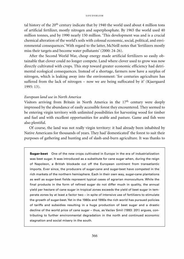
tal history of the 20th century indicate that by 1940 the world used about 4 million tonsof artificial fertilizer, mostly nitrogen and superphosphate. By 1965 the world used 40million tonnes, and by 1990 nearly 150 million. ‘This development was and is a crucialchemical alteration of the world’s soils with colossal economic, social, political, and envi-ronmental consequences.’ With regard to the latter, McNeill notes that ‘fertilizers mostlymiss their targets and become water pollutants’ (2000: 24-26).
After the Second World War, cheap energy made artificial fertilizers so easily ob-tainable that clover could no longer compete. Land where clover used to grow was nowdirectly cultivated with crops. This step toward greater economic efficiency had detri-mental ecological consequences. Instead of a shortage, farmers now have a surplus ofnitrogen, which is leaking away into the environment: ‘for centuries agriculture hassuffered from the lack of nitrogen – now we are being suffocated by it’ (Kjaergaard1995: 13).
European land use in North AmericaVisitors arriving from Britain in North America in the 17th century were deeplyimpressed by the abundance of easily accessible forest they encountered. They seemed tobe entering virgin territory with unlimited possibilities for harvesting wood for timberand fuel and with excellent opportunities for arable and pasture. Game and fish werealso plentiful.
Of course, the land was not really virgin territory: it had already been inhabited byNative Americans for thousands of years. They had ‘domesticated’ the forest to suit theirpurposes of gathering and hunting and of slash-and-burn agriculture. It was thanks to
366
Sugar-beet One of the new crops cultivated in Europe in the era of industrialization
was beet sugar. It was introduced as a substitute for cane sugar when, during the reign
of Napoleon, a British blockade cut off the European continent from transatlantic
imports. Ever since, the producers of sugar-cane and sugar-beet have competed in the
rich markets of the northern hemisphere. Each in their own way, sugar-cane plantations
as well as sugar-beet fields represent typical cases of agrarian monoculture. While the
final products in the form of refined sugar do not differ much in quality, the annual
yield per hectare of cane sugar in tropical zones exceeds the yield of beet sugar in tem-
perate zones by at least a factor two – in spite of intensive use of fertilizers to stimulate
the growth of sugar-beet. Yet in the 1980s and 1990s the rich world has pursued policies
of tariffs and subsidies resulting in a huge production of beet sugar and a drastic
decline of the world price of cane sugar – thus, as Vaclav Smil (1993: 201) argues, con-
tributing to further environmental degradation in the north and continued economic
stagnation and social misery in the south.
Mappae Mundi bw zw/w 08-04-2004 15:26 Pagina 366

their time-honoured burning practices that the forests in southern New England wereclear of undergrowth and easily accessible. ‘Here was the reason that the southern forestswere so open and park-like; not because the trees naturally grew thus, but because theIndians preferred them so.’ (Cronon 1983: 49)
Most of the British settlers were oblivious to the fact that the Indians were activelymanaging the land. According to their European understanding, they were the first occu-pants to really work the land and on that account felt themselves entitled to own it. Aftera protracted series of struggles the Indians were forced to give up their claims. Forestswere cleared altogether, and the land was parcelled up in lots for sedentary cultivation,mostly of crops grown for the market. The result was a thoroughly transformed land-scape, ‘a world of fields and fences’ populated by the colonists and their livestock(Cronon 1983: 127-41).
Once New England was fully settled, European colonists slowly began migrating fur-ther west. This movement received new stimulus in the 19th century, when steamshipsbrought a growing influx of immigrants, and railways greatly facilitated transportationover the continent. From the beginning, the railways linked the pioneers to the industri-alizing hinterland back East from where they were provided with tinned food and allsorts of amenities such as barbed wire and pistols. In this way, ‘the West’, where Ameri-can Indians had only recently established new modes of subsistence with horses of Euro-pean origin, was ‘won’. Prairies were converted into grassland for fully domesticated cat-tle and into cropland for wheat and maize. These conversions were entirelymarket-driven. They led to one of the great environmental crises of the early 20th centu-ry when erosion and economic depression coincided during the 1930s, and large parts ofthe American Midwest were turned into a dismal ‘Dust Bowl’ from which farmers fled indespair. Astonishingly, ‘wheat cultivation rebounded quickly after the 1930s as wardemand took effect’ (Riebsame 1990: 564).
Disasters of large-scale commercial farming such as the Dust Bowl episode could givecredence to the idea that, in contrast to the shortsighted ‘Western’ methods of exploita-tion, ancient Indian land management was guided by the ideal of sustainability. In orderto test this idea, the anthropologist Shepard Krech III has subjected the available empiri-cal evidence to careful scrutiny. His conclusion is that the Indians did not leave natureundisturbed, and their reputed conservationist attitude is largely an artefact of Westernideology. The moving speech of Chief Seattle, which is often quoted as testimony to thatattitude, has been exposed as a fabrication written in 1970 by a freelance speechwriterfor the American Baptist Convention. Such disclosures do not detract from the fact,however, that in our day, as a result of extensive and intensive growth, the land in what isnow the United States of America is put under far stronger ecological strain than it everwas before the arrival of the European colonists. Moreover, the same applies for severalIndian territories today as in other parts of the world: the land of the poor is often usedas a sink for the wastes of the rich (see Krech 1999: 211-15).
:
367
Mappae Mundi bw zw/w 08-04-2004 15:26 Pagina 367
Further European expansion: SiberiaMore or less synchronously with the westward overseas expansion into North America,an eastward expansion took place from Eastern Europe into Northern Asia, reaching inthe 18th century across the Bering Sea as far as Alaska and Northern California. Chapter9 deals at greater length with this episode. Under the Russian Soviet regime, agrarianexpansion in Siberia was carried on in direct connection with industrialization, causingsome of the most infamous environmental calamities of the 20th century such as thenear-destruction of the Aral Sea and Lake Baikal (see Lincoln 1994: 406-7). The chemi-cals applied to the cotton fields around the Aral Sea turned the entire region into desert,while diversion of its tributary rivers made the sea itself shrink to a fraction of its formersize. Lake Baikal was sacrificed to wood pulp-processing industries.
Tropical forestsIn the second half of the 20th century, great inroads were made into the tropical rain-forests of Africa, South-East Asia, and South America. In The Primary Source, the Britishconservationist Norman Myers gave a survey of the damage that is annually being inflict-ed. One of the causes is the need for fuel in the Third World; in many densely populatedareas, fuel for the fire to cook on has become as proverbially scarce as the food to becooked. In addition, there is a rising demand for timber and pulp from the most highlyindustrialized countries. The greatest threat to the continued existence of the rain forestsdoes not lie in felling the trees, however, but in the indiscriminate burning down of entiretracts in order to clear the ground for raising crops and cattle for commerce. As WarrenDean noted in his book on the destruction of the Brazilian Atlantic forest, ‘there is no toolreadier to hand than the matchbox for establishing a coffee plantation’ (Dean 1995: 190).
Around 1980, according to Norman Myers’s conservative estimate, about 20,000 km2
of forest (mostly in South America) were sacrificed to cattle-raising each year, and over80,000 km2 worldwide to agriculture, while another 80,000 km2 were seriously damaged.Most of the fires that collectively destroyed the forests were started individually by smalldrifting farmers – whose numbers were estimated at 800 million in 1980 – who sawthemselves forced to leave their homesteads and move into the forest. Myers calls them‘shifted cultivators’; he finds that today’s typical forest farmer is to be regarded as
… an unwitting instrument, rather than a deliberate agent, of forest destruction. He is no
more to be blamed for what happens to the forest than a soldier is to be blamed for starting a
war. The root causes of his lifestyle lie in a set of circumstances often many horizons away
from the forest zones. Far from being an enthusiastic pioneer of forest settlement, he finds
himself pushed into the forest by forces beyond his control (Myers 1984: 150).
The circumstances indicated by Myers are primarily economic and demographic. Theworld economy generates a rising demand for products of tropical agriculture. In order
368
Mappae Mundi bw zw/w 08-04-2004 15:26 Pagina 368
to meet this demand, garden plots are converted into plantations and the small farmershave to leave. At the same time, the population continues to grow, so that pressure onland becomes even greater. As a result, the contradictory situation arises that in a worldsuffering from a severe shortage of wood, many tens of thousands of hectares of forestare set on fire each year.
In contrast, anthropogenic fire has greatly diminished in Australia since the establish-ment of a European colonial regime. From the time of their first arrival, the British had asensation of the Aborigines going about ‘burning, burning, ever burning’, as if they ‘livedon fire instead of water’ (Flannery 1995: 217). The British took every measure they couldto repress these burning practices – with such success that, exceptionally, rainforest hasbeen regaining ground again in Australia over the last 200 years. Another effect was theincreasing incidence of large wildfires during dry seasons, for, as Tim Flannery (1995:236) observes, ‘by lighting many small, low-intensity fires the Aborigines prevented theestablishment of the vast fires that stripped soil and nutrients most dramatically’, andthat now, when they are raging, constitute a serious threat to the suburbs of Sydney, Mel-bourne and Brisbane.
10.3.2. Extension and intensification of industrial regimes
Something new under the sunIt has sometimes been suggested that in the late 20th century some of the technologicallymost advanced societies entered a ‘post-industrial’ era. The main reason for using thislabel is a change in occupational structure: the proportion of people engaged inmechanical industry has fallen, following the earlier decline in numbers of peopleengaged in agriculture. This trend is real and important; but it does not imply that anycontemporary society is really ‘post-agrarian’ or ‘post-industrial’.
The global production and consumption of both agrarian and industrial goods arecontinuing to grow annually. In this respect, the past decades appear to have merely con-tinued the same trends that have become dominant since 1750. However, as JohnMcNeill (2000) suggests in the title of his impressive environmental history of the 20th
century, that century also produced ‘something new under the sun’. There are two rea-sons, in particular, to agree with his assessment. The first reason is that the sheer quanti-tative increases in certain areas are so staggering as to make the very idea of furthergrowth questionable – humanity may be approaching thresholds beyond which growthwill no longer be possible, or where it will produce results that are considered unaccept-able. Awareness of this fact has led to a second reason why the contemporary world mayrepresent something really new: proposals and attempts are being increasingly made togive deliberate direction to processes that, until now, have by and large proceeded moreor less automatically.
:
369
Mappae Mundi bw zw/w 08-04-2004 15:26 Pagina 369
In this section we discuss some relevant aspects of these contemporary develop-ments, under the headings of ‘means’ and ‘motives’. We concentrate on the social forcesbehind continuing extensive and intensive growth. We shall turn to the emerging count-er-trends in Chapter 12.
Our main thesis is that, until recently, ecological regimes have been losing ground vis-à-vis some other regimes in human society. We shall argue this thesis with regard to tworegimes in particular: the money regime and the time regime. Both have, each in theirown way, turned people’s attention away from the natural environment, and from eco-logical issues, toward more purely social aspects of the anthroposphere. If the reader ispuzzled by the tenuous link between money and time and the biosphere that is preciselythe point we wish to make.
Means of exchange: the money regimeAn obvious and fundamental condition for economic growth in the era of industrializa-tion has been the availability of cheap energy, cheap water, and free air (see McNeill2000). The major variable of the three was cheap energy, which was gained through theexploitation of fossil fuels with the aid of rapidly developed new techniques and vastnetworks of transport and distribution. Cheap energy also made it possible to provideentire cities, industrial plants, and isolated farmsteads with seemingly unlimited quanti-ties of clean water. For the first time in history, cities could become places where mortal-ity did not exceed fertility. The spectacular rise in life expectancy that was part of thefirst stage of the demographic revolution would have been well-nigh impossible withoutimprovements in public hygiene – improvements that were sustained by an infrastruc-ture of industrially produced pipes for the waterworks and drainage systems.
Urban history is littered with complaints about stench, soot, and smoke and withattempts to do something about it. While in the 19th century the demolition of city wallsand the construction of sewers brought relief, the emissions caused by factories and byhouseholds using coal for heating were new sources of air pollution. It became increas-ingly evident that the air could be kept clean only at a cost in densely populated and con-gested areas.
When we speak of energy as being ‘cheap’, or say in the same vein that air is ‘free’, weare referring to the fact that in affluent societies today fuel can be bought at a relativelylow price, and that there is no financial charge for air. The self-evident criterion for‘cheap’ and ‘free’ is money.
During the period of the Cold War, the world was divided into a ‘capitalist’ and a‘communist’ bloc. The distinction was predicated on basic differences in the organiza-tion of economic relations. Yet the two types of economy still had one thing in common:they both relied on money as the primary means of exchange.
In highly industrialized societies, whether of a ‘capitalist’ or ‘communist’ persuasion,people rarely produce themselves what they eat, wear, or use – they buy it, for money.
370
Mappae Mundi bw zw/w 08-04-2004 15:26 Pagina 370
Even if they still cook their own food, they will have bought most of the ingredients.Adam Smith was already explaining the benefits of trade and commerce in the late
18th century: trade enables people to profit from the inventiveness and the labour ofunknown thousands. According to a more recent formulation, ‘the development of mar-kets and money set people free from the need to be self-sufficient, enabling them to ben-efit from division of labour and specialization’ (Grübler 1998: 38).
There is also another side to these advantages. Many a critic has pointed to drawbacksin the market mechanism (for example, Sahlins 1972). The ‘invisible hand’ may be per-forming a sleight-of-hand. Trade is predicated on a balance between abundance andscarcity. One party lacks what the other party has in a surplus. We need only to visualizea big super market in an affluent society to see the point: there is an abundance of goodsfor sale – to be bought by customers who are incapable of producing those goods them-selves and who are therefore wholly dependent both on the existence of well suppliedshops and markets and on their own financial means without which they could only ful-fil their needs by begging or stealing.
Markets thus create scarcity as well as abundance; ideally they keep the two in bal-ance. The balance is maintained and measured by means of money.
Money, in another metaphor, is the grease that keeps industrial society going. It issometimes said that money brings out the worst in people. But it may well be the otherway round. In the first instance, money consists of small objects (coins, notes) that are ofno use to anybody but that everybody likes to have. And the only reason why everybodylikes to have them is the simple fact that everybody else likes to have them. As soon asthis collective desire stops, money loses its value. This value is purely social: every mone-tary transaction is based on trust – the mutual expectation that the chain of desire willnot be broken.
Like most objects that people handle nowadays, money itself in its concrete form ofcoins and banknotes is an industrial product. In its more abstract form of credit cardsand bank accounts, too, it is completely enveloped in the system of the industrial pro-duction of electricity, computers, silicon and plastics. Technology, organization, and civ-ilization have become equally important components of one pervasive figuration inwhich money circulates as the most general means of exchange and, perhaps surprising-ly, a symbol of common trust.
That figuration now spans the globe. All currencies are connected; there is no escapefrom the transnational monetary system. This system, with its variety of national andsuper-national currencies, belongs to a part of the anthroposphere which seems to existindependently of the natural environment, and which has become highly ‘de-ecologized’.
Means of orientation: the time regimeGlobalization manifests itself not only in the glaring commercial guises of Coca Colaand McDonald’s. It operates less conspicuously but all the more pervasively in such
:
371
Mappae Mundi bw zw/w 08-04-2004 15:26 Pagina 371
international arrangements as postal services or air traffic regulations. And in what isperhaps an easily overlooked, but for that very reason most interesting aspect of globalsociety: the international regime of time, to which everybody who consults a clock or acalendar submits (see Elias 1992; Goudsblom 2001).
The time regime exists only in the anthroposphere. It is a completely socio-culturalconstruction, based on human inventions, as discussed in Chapter 5. Like all humaninventions, it originated in natural processes that occur independently of human pur-pose – in the case of clocks, the alternation of day and night caused by the rotation of theplanet around its axis. On the basis of this natural ‘given’, people have developed thenotion of ‘hours’ into which the day (and night) can be divided, and of minutes and sec-onds to make increasingly finer measurements. In 1884 an international agreement wasmade by 25 national states to co-ordinate their time schedules. Since then, all states inthe world have joined this agreement, so that now hours everywhere have exactly thesame length and begin synchronously at exactly the same moment (except for a fewcountries that deviate by exactly 30 minutes). The system functions smoothly, and fewpeople know or care that the division of the day into 24 hours is based on the duodeci-mal counting system used in ancient Mesopotamia, present-day Iraq.
The technology of time measurement is seeping into human organizations across theworld, and causing people more and more to orient themselves toward the socio-techni-cal division of the day rather than to the natural ‘movement of the sun’.
Time and money are social institutions. They both exemplify how the symbolicdimensions of the anthroposphere can become as it were emancipated from the con-straints of local environments. In Alaska as well as in Ecuador, an hour is an hour and adollar is a dollar; the symbols retain their significance and value, regardless of climate andlatitude – unless the entire network of social interdependencies happens to break down.
The current time regime transgresses not only geographic distances but also the dis-tinction between day and night. In temperate zones, hours are equally long in summerand winter, even though the actual daylight time may be twice as long in summer as it isin winter. With electricity, enclaves of light can be created everywhere.
While the colonization of the night represents one more aspect of the sheer extensionof the anthroposphere, it is at the same time a function of intensive growth. It is madepossible by the increasing complexity of the socio-ecological regime, enabling people topenetrate into the darkness and to treat ‘the whole world’ as a ‘hominid cave’ (Pyne 2001:25).
Means of energy useThe same homogenizing effect that the time regime has in our age of globalization, isevident in the field of energy use. Wherever electricity is available, it is the favouritemeans of generating light and combustion engines are, along with electricity, thefavourite means of generating motion.
372
Mappae Mundi bw zw/w 08-04-2004 15:26 Pagina 372
The shift from steam engines to electricity and internal combustion is reflected in thechanged industrial landscape, which in the Western world is no longer dominated byendless rows of factory chimney stacks. Yet the methods of production in modern indus-try, and in agriculture as well, continue to be highly fuel-intensive. Most of the energyconsumed – including most electricity – is derived from the fossil fuels coal, oil and gas.Combustion processes still play a central role, but they are relegated to special containersso that most people are not directly confronted with them. Soot, smoke and the risk offire are reduced to a minimum. The furnaces and combustion chambers in which enor-mous heat is concentrated remain cool on the outside.
Typical products of modern fuel-intensive industry are motor cars, with enginesdesigned to be propelled by finely tuned and minutely controllable combustion process-es. Indeed, the motor car may almost serve as a symbol of the highly complex and differ-entiated ways in which, in our day, thermal energy is being used. Cars are set in motionby burning fossil fuel. They are made of steel, plastic and glass – materials that are pro-duced and processed at high temperatures. Yet no one who gets into his or her vehicleand turns on the electrical ignition to start the engine needs be consciously aware ofusing fire and products of fire. When driving, people do not perceive the processes ofcombustion that keep their car going; they do not see the petrol gas burning under thebonnet, nor have most of them even remotely sensed the fire in the factories and powerplants without which their cars would never have been produced at all.
A very different example to the same effect is farming. In the early 19th century, whenBritain was already beginning to industrialize, practically all the energy consumed onthe farm was still produced within the confines of the farm and its fields, in the form ofhuman and animal labour; the open fire that was burning in the hearth was fuelled withwood from the immediate surroundings. By the turn of the 21st century, the situationhas become very different, with practically all the energy used now brought in from out-side the farm, in the form of fertilizer, oil, petrol and electricity (see Simmons 1996: 250-55).
A major advantage of the new sources of energy is their flexibility. The fuels are easierto transport and to distribute than wood or coal and combustion can be regulated moreprecisely. Given the technical facilities, gas, oil and electricity provide for very even andaccurately controllable flows of energy. Electricity has the additional advantage of beingtotally ‘clean’ at the place of destination. Domestically, a few simple actions and a negligi-ble risk suffice to provide people with an immense array of services: some substitutingfor old chores such as cleaning the floor and washing dishes, others based on entirelynew appliances such as television sets and computers. Industrially, the same advantagesapply at a much larger scale, permitting a far more diversified use of power than waspossible with steam power (see Grübler 1998: 220-3).
The impact of electricity and internal combustion engines makes itself felt in everysector of social life: in agriculture, industry, traffic and transportation, domestic work
:
373
Mappae Mundi bw zw/w 08-04-2004 15:26 Pagina 373
and leisure. Wherever these means are available it is possible to mobilize large quantitiesof energy with very little physical effort. The result is to make life more comfortable inmany respects, enhancing the sense that physical processes can be mastered and also, attimes, fostering the illusion of independence.
An illusion it clearly is. Regardless of whether people can avail themselves of energyin the form of a petrol engine, a battery, or a connection to an electric circuit or a gasmain, in each case they are able to do so only because they are part of a complex and farreaching network of social interdependencies, connecting them eventually to the energystored in fossil fuels. As long as the supply lines are functioning, and as long as people areable to meet their financial obligations, they do not need to bother much about theentire constellation. They are immediately confronted with it, however, the momentsomething goes wrong with any of the conditions.
In this way the exploitation of the new sources of energy clearly continues a trendthat first began with the domestication of fire. Dependence on the forces of nature hasbecome less direct (which is not to say less important), and by the same token depend-ence on cultural and social resources has increased. A complicated technical and organi-zational apparatus is needed in order to continuously maintain the supply of energy.Most of this apparatus is located ‘behind the scenes’ of industrial society, invisible to theordinary consumer.5 Energy is made available in such a convenient fashion that it is easyto forget the social effort required to produce it.
That social effort is spent, first of all, at the drilling wells and in the mines where theenergy is won and, next, during the operations of processing it into consumable gas, oil,or electricity, and of transporting and distributing it. And while the many provisionsneeded for the undisturbed flow of energy are often taken for granted, they cannot fail toexert permanent pressures on those who benefit from it as customers. The bills have tobe paid – financially and otherwise.
The permanent availability of electricity, at all hours, in many parts of the world, hasled to a diminution of the contrast between day and night (see Melbin 1987). By themiddle of the 19th century, the large investments made in their factories impelled manyowners to let the engines run day and night. Gaslight illuminated the work place. In the20th century, nightlife has steadily extended, especially in the cities. Water mains, sewage,gas, electricity, telephone, fax, internet, radio, police, fire brigade, hospitals – all suchservices are generally expected to operate day and night. International interdependenciesnever come to a halt. This is one of the reasons why many people turn on the news assoon as they wake up in the morning: before resuming their daily activities they wish tolearn what has happened while they were asleep – in their own country, where it wasnight, and elsewhere, where it was day time.
Once in a while there is a hitch. Sometimes the local supply of electricity breaksdown, as happened for a number of hours in the ‘blackout’ in New York on July 13, 1977,and for a longer period on a regional scale in California in 2001. In New York the failure
374
Mappae Mundi bw zw/w 08-04-2004 15:26 Pagina 374
was due to technical causes, in California its primary causes lay in disturbances in thefinancial sector. A combination of economic and political complications brought aboutthe international oil crisis of 1973, when the majority of oil producing countries jointlymanaged to enforce a drastic increase in the world price of crude oil (Yergin 1991: 588-652).
Disturbances are remarkably rare in view of the prodigious growth of energy con-sumption since 1950. The industrial economy is a fuel economy, revolving around theregular supply of fuel that can be easily converted into energy. The increase in productiv-ity has led to intensive growth, concentrated in the centres of industrial production andconsumption, and to extensive growth that at present is mostly confined to the poorerparts of the world. Even more than extensive growth, intensive growth today has all thecharacteristics of a largely autonomous, self-propelling force. Light, warmth, motion,and even coolness are produced with fuel. The rising supply of all these fuel-intensiveamenities in turn constantly stimulates demand from customers, who are eager toenhance both their physical comfort and their social status.
In a large part of the world access to the benefits of modern technology is stillrestricted to a small upper crust of society. Moreover, while in the western world andJapan effective measures have been taken to reduce the polluting effects of industrial anddomestic fuel use in densely populated areas, the quality of the air has only deterioratedin the rapidly growing megacities of Africa, Asia and Latin America. As a consequence,according to an estimate of the World Health Organization in 1997, air pollution killedabout 400,000 people annually worldwide (McNeill 2000: 103).
Still, extensive growth has continued in the poor parts of the world, and this is boundto affect the rich countries as well. Wealth attracts poverty; history abounds with exam-ples of this general rule. When the opportunity offers itself, many people from poorerregions will try to migrate to regions with a higher standard of material comfort.
Meanwhile, the combined pressures of intensive and extensive growth continue topush up global fuel consumption. In rich countries, advanced technologies permit cus-tomers to enjoy the use of their appliances and vehicles without any physical inconven-ience caused by the combustion processes. Poorer people generally are prepared to putup with noise and smell to profit from fossil fuel energy. Nevertheless, there are somesigns that the upward trend in energy use is slowing down, and even reverting in somebranches of industrial production. We shall turn to those signs in Chapter 12.
Means of violenceWith growing interdependence among people, dependence on natural forces hasbecome more indirect: longer and more ramified social chains are formed between theproduction of things and their use. Even the threat of violent destruction of lives andproperty comes far less often from natural forces than from forces unleashed by onehuman group against another. The most powerful groups are those that command the
:
375
Mappae Mundi bw zw/w 08-04-2004 15:26 Pagina 375
organizational and technical means to mobilize huge amounts of energy and matteragainst their enemies.
In our day, the search for the most effective means of violence has led to the exploita-tion of a new source of energy: nuclear fission. For the first time in human history, a newsource of energy was first applied at a large scale in war, with the sole intent of massivedestruction. If anything deserves to be called ‘something new under the sun’, it is theability to generate nuclear energy. It was the result of an enormously concentrated accu-mulation of technical, scientific, and economic capital, invested in a single one-purposeenterprise: the production of an atomic bomb.
But no matter how single-minded the effort, the invention of the atomic bomb fol-lowed a general rule in the history of technology, and produced unintended side-effects.One of these was that the development of the bomb by the United States became the firststep in a process of escalation and proliferation, which has engendered a global ‘armsrace’. Another unintended consequence has been the rising level of risk of fatal conse-quences in case of a breakdown in any of the nuclear plants that were built in the secondhalf of the 20th century.
War has always been an important factor in the relations between humans and theirphysical environment. In most cases, it was directed at destruction of a part of theanthroposphere: especially that part in which the organizational basis of the enemy wassupposed to be most vulnerable (see Collins 1990). The more investments a group madein controlling its environment, the more susceptible it became to losses through vio-lence. Advanced agrarian communities could suffer a severe setback in case their ricefields, vineyards or terraces were destroyed. Many cities in agrarian societies underwentdrastic reduction or were even totally annihilated after military surrender: the greaterthe concentration of physical wealth, the more irreparable the destruction – a theme thatis also dealt with in Chapter 6.
In industrial society, enormous means of destruction were developed even before theinvention of the atomic bomb. During the Second World War air raids brought devasta-tion to a great many cities. Global industrial society proved to be sufficiently resilientand affluent, however, so that after the war every bombed city was rebuilt at its originalsite.
An important segment of industrial production is the arms industry, manufacturingnot just weapons but also military vehicles, ships, and aeroplanes. Many other branchesof industry, and agriculture, are engaged in supplying the armed forces with equipment,clothing, and food. For this reason the historian John McNeill (2000: xxi) reckons mili-tary security to be one of the driving forces behind contemporary economic growth.
MotivesWith ‘driving forces’ we have reached the realm of human motives. What motivationscan be discerned behind processes of extensive and intensive growth, behind the forma-
376
Mappae Mundi bw zw/w 08-04-2004 15:26 Pagina 376
tion of agrarian and industrial regimes? In response to this highly general question wesubmit that the answer is to be found in the interaction of human nature and figura-tional dynamics.
It is in the nature of every human individual to take care of himself or herself and toseek a way of surviving. The only way of surviving is by somehow being social and stay-ing within the flock represented by a human group. The relations between people in a
:
377
The spiral of desire Desire is usually experienced as a purely individual impulse,
but it contains a strong social component. The French philosopher-anthropologist René
Girard (1977) has spoken in this context of mimetic or emulating desire. He points out
that things in themselves are not especially desirable once people are able to meet
their fundamental vital needs. A thing then becomes desirable only when another per-
son has it – in Girard’s view, by having that very thing we believe that we can be like
that other person.
We need not follow Girard’s profound anthropology into every detail to recognize
the mechanism of mimetic desire and to acknowledge its importance. We see it demon-
strated every day on billboards and in TV commercials displaying goods and services
in the expectation that ‘seeing is buying’. The mechanism to which an appeal is made
here appears to be deeply rooted in the human psyche; we can already observe it
among young children in a playground. A toy may be lying unnoticed in a corner for
hours, until one child picks it up and starts playing with it. Now suddenly all of the chil-
dren only want to play with this particular toy.
The mechanism can be explained not just psychologically but also sociologically. As
long as something is present somewhere and nobody is paying any attention to it, it is
in principle freely available to everybody. As soon as one person starts showing an
interest, there is a reason for all others around to be alarmed. Their desire is aroused,
and for good reasons: for by letting this chance pass they would put themselves at a
disadvantage. The opportunity not only ‘makes the thief’, it also stirs the desire.
This simple mechanism helps us to comprehend the social psychology of economic
growth. It brings us nearer to understanding the collective game people play that
results in a continuous increase and differentiation of goods and services. ‘Why do they
work so hard?’ the sociologists Robert and Helen Lynd asked about the citizens of a
town in the American Midwest that they studied in 1928. Their answer was as simple as
it was intriguing: everybody was working so hard to make money only because every-
body else was also working so hard (Lynd and Lynd 1929: 73-89). ‘Keeping up with the
Joneses’ it is sometimes called; but that phrase fails to express clearly that the Joneses
themselves find themselves caught in exactly the same spiral movement as all those
who wish to keep up with them. Mimetic emulation is mutual (see also Frank 1999).
Mappae Mundi bw zw/w 08-04-2004 15:26 Pagina 377
group, and even more so interactions between groups, can lead to situations that no onein particular ever intended nor desired – this is where figurational dynamics enter.
In the complex structures of advanced agrarian and industrial societies, every sooften situations arise in which people find themselves faced with a social challenge: toconform or not to conform, to compete or not to compete. The challenges may be subtleand need hardly be perceived consciously; but they are unavoidable, and in the long runthey shape, and change, attitudes and behaviour.
Some social relations take place, of course, in a setting that is explicitly competitive.Sports are the best example, but many relationships in the fields of economics and poli-tics come close. In all these areas – sports, economics and politics – competition betweenindividuals can become engrossed in competition between larger collective units: clubs,firms, parties.
Neither individuals nor clubs, neither firms nor parties are supposed to settle theircompetitive contests by force of arms. That, in most contemporary societies, is a prerog-ative of one particular type of organizations – states, which officially and legally hold themonopoly of organized violence. Groups defying this system and employing large-scaleviolence against particular states without a state organization of their own are known asterrorists; since their violence is directed against states, they become part of the state fig-uration and affect its dynamics – as happened after the terrorist attack on the Twin Tow-ers in New York on September 11, 2001.
This is not the place for a substantive analysis of the political and economic situationof the world today. Evidently, that situation is highly relevant for the relationshipsbetween humanity and the biosphere. We need only to think of access to, and use of,energy resources, to see how strong the link is. Political and economic developments willcontinue to affect people’s relations to the biosphere, and they will continue to be affect-ed by them. We shall return to this point in our final chapter, on the future.
Here we wish to point only to a peculiar mechanism in the interaction betweenhuman nature and figurational dynamics: the ‘spiral of desire’ (see box).
Competition and co-operation – the key processes in inter-species relationships atthe time of the original domestication of fire – continue to be key processes in intra-species relationships in the contemporary world.
378
Mappae Mundi bw zw/w 08-04-2004 15:26 Pagina 378
11
Back to Nature?The Punctuated History of a NaturalMonument
A painting by Mauve, or Maris, or Israëls is more telling than nature itself.
Vincent van Gogh
If anybody taught me to see nature, it was our old masters. But I learned most from
nature itself.
J.H. Weissenbruch
11.1. Introduction
Jan Hendrik Weissenbruch (1824-1903) was one of the most distinguished Dutchpainters in the 19th century. Skies, shores and landscapes were his passion, in particularthe wide, wet ‘polders’ – stretches of land reclaimed from the ravaging waters in Holland.He never had to travel far because all this beauty was abundantly available around TheHague, the town where he had lived all his life. From his home he could walk to thefamous collection of Dutch paintings at the Mauritshuis Museum in five minutes, and asa young man he spent many hours there contemplating and even copying the works ofhis 17th century idols, Johannes Vermeer and Jacob Ruisdael. But although he remainedfaithful to these great examples until the end of his days, his unrestrained abandonmentto nature forced him to develop his own look at the world. ‘At times, nature gives me areal blow,’ he used to say. At such moments drawing and painting was easy. He jotteddown his impressions in charcoal so that later, at home, he could work on them in paint.Over the years, his style changed from more meticulous rendering to a highly personalimpressionism. What strikes the eye is the subtle balance between joyful and sponta-neous virtuosity and compositional grandeur. In particular his monumental skies areunforgettable, with their infinite variety of blues and greys. He brought the polders tolife and taught us to feel at home in this flat, green land of mud and water.
379
Mappae Mundi bw zw/w 08-04-2004 15:26 Pagina 379
Although public recognition only came towards the end of his life, Weissenbruchwas one of the most prominent members of the ‘The Hague School,’ a rather loose asso-ciation of painters, which had its heyday in the years 1870-1900. Jozef Israëls, JacobMaris and Anton Mauve were other well-known representatives. For many years, the17th century artistic blossoming in the Low Countries had paralysed rather than stimu-lated painting in this country, but the The Hague School brought a revival. Inspired bythe same nationalism that held all of Europe in its grip, these people rediscovered thebeauty of the Dutch landscape and everyday life. With their characteristic approach,ranging from realism to impressionism, they gave us a nostalgic view of Holland, not asit really was but how they wanted to see it. It was a period of industrialization and bur-geoning tourism, but in those paintings chimneys or trains at the horizon, or swimmersin the water are rarely to be seen. Neither were portraits a favourite subject. People weremostly part of the landscape, together with their villages, houses, cattle and imple-ments. They were farmers or fishermen, resting in the fields or in their humbledwellings. Cities and towns were shown from a distance, or as peaceful street cornersand intimate gardens. These painters abhorred glamour and avoided the dynamics ofmodern life.
Little wonder they soon found The Hague too busy a place for inspiration. To find thepeaceful environment of their liking, they had to move out into the surrounding coun-tryside. One such a place was the township of Noorden, at lake Nieuwkoop. Towards theend of his life, Weissenbruch lived there during the spring and autumn months, and it isin Noorden that he produced his finest works. Much of that landscape is still intact. Overall these years, Weissenbruch’s paintings appear to have exerted a curious power over thisland of pastures and waters: they contributed to its preservation, although their originalpurpose was merely aesthetic (cf. Figure 11.6, p. 320).
Was it really nature that Weissenbruch looked for in Noorden? Now, after a century ofunparalleled and world-wide human intervention with the environment, millions ofpeople experience the same nostalgia that brought Weissenbruch to these peaceful sur-roundings. An excursion to the area will reveal that what we perceive to be our naturalenvironment may be something quite different. With all our longing for nature, it isgood to realize what we really ask for.
11.2. On a rowing boat
A good way to approach the area is from the south-west. A little stream, the Meije, windsthrough the meadows. One can ride a bicycle atop the bordering dike. The Meije is onthe left, and on the right, at the foot of the dike, is a long string of farmhouses, many ofwhich are beautifully preserved specimens from the 17th century. Several of them have
380
Mappae Mundi bw zw/w 08-04-2004 15:26 Pagina 380
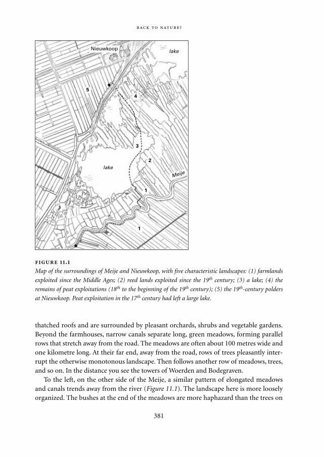
thatched roofs and are surrounded by pleasant orchards, shrubs and vegetable gardens.Beyond the farmhouses, narrow canals separate long, green meadows, forming parallelrows that stretch away from the road. The meadows are often about 100 metres wide andone kilometre long. At their far end, away from the road, rows of trees pleasantly inter-rupt the otherwise monotonous landscape. Then follows another row of meadows, trees,and so on. In the distance you see the towers of Woerden and Bodegraven.
To the left, on the other side of the Meije, a similar pattern of elongated meadowsand canals trends away from the river (Figure 11.1). The landscape here is more looselyorganized. The bushes at the end of the meadows are more haphazard than the trees on
381
.
Map of the surroundings of Meije and Nieuwkoop, with five characteristic landscapes: (1) farmlands
exploited since the Middle Ages; (2) reed lands exploited since the 19th century; (3) a lake; (4) the
remains of peat exploitations (18th to the beginning of the 19th century); (5) the 19th-century polders
at Nieuwkoop. Peat exploitation in the 17th century had left a large lake.
Nieuwkoop
1
1
2
3
4
5
lake
lake
Meije
Mappae Mundi bw zw/w 08-04-2004 15:26 Pagina 381
the other side, and the canals are not so straight. Reeds grow along the watercourse,together with patches of pollard willows and a wealth of water flowers. Cows peaceablystare at infinity.
Do not forget to drink a cup of excellent coffee with Jaap Schutter at café De HalveMaan. Rowboats can be rented everywhere, and so it comes that we continue overwater, across the Meije and along one of the canals towards the bushes and the lakebeyond. The meadows are soaked and nearly level with the water in the canal. They giveway to fields of reeds, moss and flowering plants: real bog lands. A rectangular networkof canals, ditches and rows of alder, birch and willow divide the area into a system ofregular patches. The flowers bloom and the birds sing their song – this is nature at itsbest ...
The canal now widens and ends up in open water, one of the many lakes in theregion. This one is two kilometres or so across, and about four metres deep. Reeds andclusters of trees line the shore. Across the lake we float into another new world, a com-plex labyrinth of narrow ridges of land alternating with waters up to a hundred metreswide. Again, the land ridges are covered with reeds and trees. Then comes the dike thatcuts off the bog area. And Nieuwkoop, 700 years old: dignified buildings, small houses,old and new, sailboats, restaurants and hamburger palaces. The village forms a long rib-bon along the dike and merges, several kilometres further, into Noorden, where Weis-senbruch used to stay.
Look for a spot on the dike from where you can view the polder beyond. The differ-ence in height makes you dizzy, however flat this land may be. The polder is at least fourmetres below the surface of the waters we have just crossed. It was a lake until two cen-turies ago. Blocks of rectangular meadows are separated by meticulously arranged sets ofperpendicular roads, dikes, rows of trees and large farmhouses. The scale is larger andthe planning more efficient and modern than the historic panorama where we startedour trip.
This little excursion allows one to cross five types of landscape characteristic of thewestern region of the Netherlands: farmlands exploited since the Middle Ages; reedlands that originated in the 19th century; a lake; peat exploitation (mainly 17th century);and the 19th-century polder at Nieuwkoop. It is a carefully designed system of multilevelwaterways, polders and dikes – the result of a struggle of centuries between humanityand the elements. This is Weissenbruch’s nature. Yet there is nothing purely natural here.If left unattended the whole area would soon be underwater.
An interesting paradox underlies these terrains. A thousand years ago this was the‘wilderness’, a virtually impenetrable and uninhabitable region between the sandy hillsto the east and the low sand dunes along the coast. In the 17th century, however, this veryarea provided the economic basis for a mighty empire: Holland in the ‘Golden Age’.
382
Mappae Mundi bw zw/w 08-04-2004 15:26 Pagina 382
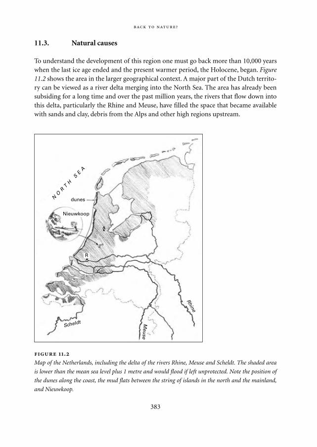
11.3. Natural causes
To understand the development of this region one must go back more than 10,000 yearswhen the last ice age ended and the present warmer period, the Holocene, began. Figure11.2 shows the area in the larger geographical context. A major part of the Dutch territo-ry can be viewed as a river delta merging into the North Sea. The area has already beensubsiding for a long time and over the past million years, the rivers that flow down intothis delta, particularly the Rhine and Meuse, have filled the space that became availablewith sands and clay, debris from the Alps and other high regions upstream.
383
.
Map of the Netherlands, including the delta of the rivers Rhine, Meuse and Scheldt. The shaded area
is lower than the mean sea level plus 1 metre and would flood if left unprotected. Note the position of
the dunes along the coast, the mud flats between the string of islands in the north and the mainland,
and Nieuwkoop.
NO
RT
H S
EA
Meu
se
Scheldt
Rhine
dunes
R
Nieuwkoop
Mappae Mundi bw zw/w 08-04-2004 15:26 Pagina 383
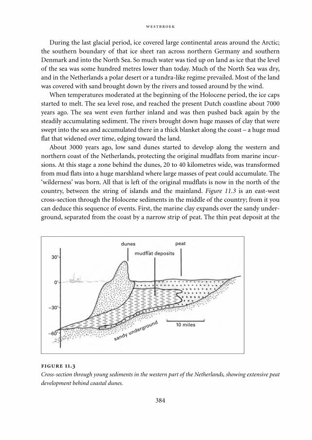
During the last glacial period, ice covered large continental areas around the Arctic;the southern boundary of that ice sheet ran across northern Germany and southernDenmark and into the North Sea. So much water was tied up on land as ice that the levelof the sea was some hundred metres lower than today. Much of the North Sea was dry,and in the Netherlands a polar desert or a tundra-like regime prevailed. Most of the landwas covered with sand brought down by the rivers and tossed around by the wind.
When temperatures moderated at the beginning of the Holocene period, the ice capsstarted to melt. The sea level rose, and reached the present Dutch coastline about 7000years ago. The sea went even further inland and was then pushed back again by thesteadily accumulating sediment. The rivers brought down huge masses of clay that wereswept into the sea and accumulated there in a thick blanket along the coast – a huge mudflat that widened over time, edging toward the land.
About 3000 years ago, low sand dunes started to develop along the western andnorthern coast of the Netherlands, protecting the original mudflats from marine incur-sions. At this stage a zone behind the dunes, 20 to 40 kilometres wide, was transformedfrom mud flats into a huge marshland where large masses of peat could accumulate. The‘wilderness’ was born. All that is left of the original mudflats is now in the north of thecountry, between the string of islands and the mainland. Figure 11.3 is an east-westcross-section through the Holocene sediments in the middle of the country; from it youcan deduce this sequence of events. First, the marine clay expands over the sandy under-ground, separated from the coast by a narrow strip of peat. The thin peat deposit at the
384
.
Cross-section through young sediments in the western part of the Netherlands, showing extensive peat
development behind coastal dunes.
10 miles
30’
0’
–30’
peat
mudflat deposits
sandy underground
dunes
–60’
Mappae Mundi bw zw/w 08-04-2004 15:26 Pagina 384
base of the Holocene sediments is the result. Then come the dunes and the peat that cov-ers the clay.
Peat is essentially a water-soaked mass of plant remains. When its production exceedsits decomposition, large deposits may form. Just underneath the plant cover, proliferat-ing bacteria and fungi attack the black sludge and convert it into carbon dioxide andwater. The oxygen required is poorly soluble in water, and so it happens that the water inthe pores becomes anaerobic, oxygen depleted. The consumers suffocate, so that theirwork has to be taken over by bacteria that thrive in this anaerobic environment. Becauseanaerobic breakdown yields less energy, it is less efficient. Organic acids and carbondioxide accumulate and then the same happens as in the production of yoghurt – thebreakdown comes to a standstill. Throughout the Holocene period, the conditions inlarge parts of Holland were highly favourable for peat accumulation. In this deltaic area,rivers and rainfall provided abundant water. Temperatures were moderate under theprevailing marine climate and drainage was poor.
In this region a lake will fill up by itself with peat and change into land. The types oflife that grow change in a well-defined sequence. In general, floating water plants andalgae form the first debris to be accumulated in the lake. When the water is less than 2metres deep, reeds can take over, and at a depth of half a metre, sedges dominate. Finally,the ground is high enough for trees to develop, leading to a type of peat full of roots andstems.
These successive plant communities all depend on groundwater for their develop-ment and cannot grow much above the surface. With enough rain, however, peat mossor sphagnum may dominate the scene. It has a very peculiar structure that allows it tohold water. In hot dry periods it uses up its water reservoir and appears brown and dead.But during a shower it soaks up large quantities of water and appears green and healthyagain. Sphagnum also recycles its food very efficiently because it can grow high above thegroundwater level, fed only by the nutrient-poor rainwater. It even stores large quantitiesof extra nutrients in its cell walls, depriving its competitors from essential foodstuff. Thispeat moss may rapidly outgrow and suffocate the trees and shrubs that were forming thewood peat. As it does it can produce mossy cushions up to seven meters high coveringhundreds of square kilometres. These are curious constructions: gigantic water mat-tresses, pervaded and kept in place by a fine network of organic remains and forged by athin veneer of living, teeming tissue on the surface.
This is what happened on a huge scale in Holland. The principle of the distributionof the different types of peat is shown in Figure 11.4. The zones bordering the rivers andstreams were regularly flooded and received a good share of nutrients and clay. Underthese conditions, wood peat dominated. Close to the river mouths, where the sea turnedthe water brackish, reed peat was laid down, while sphagnum cushions developed in thelarge areas in between. This rather astounding development of peat clearly illustrates therole that life has played in this area over the last few thousand years. There are few other
385
Mappae Mundi bw zw/w 08-04-2004 15:26 Pagina 385
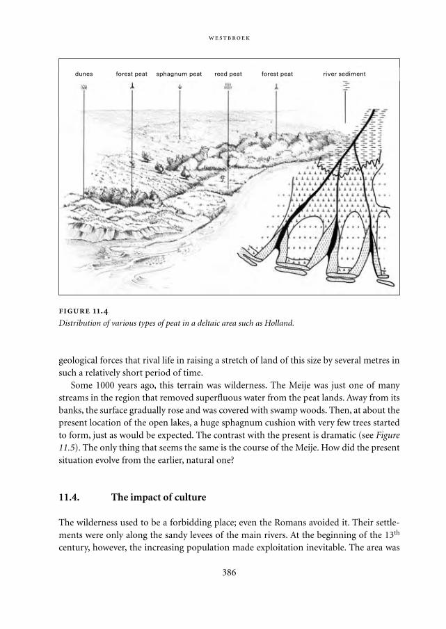
geological forces that rival life in raising a stretch of land of this size by several metres insuch a relatively short period of time.
Some 1000 years ago, this terrain was wilderness. The Meije was just one of manystreams in the region that removed superfluous water from the peat lands. Away from itsbanks, the surface gradually rose and was covered with swamp woods. Then, at about thepresent location of the open lakes, a huge sphagnum cushion with very few trees startedto form, just as would be expected. The contrast with the present is dramatic (see Figure11.5). The only thing that seems the same is the course of the Meije. How did the presentsituation evolve from the earlier, natural one?
11.4. The impact of culture
The wilderness used to be a forbidding place; even the Romans avoided it. Their settle-ments were only along the sandy levees of the main rivers. At the beginning of the 13th
century, however, the increasing population made exploitation inevitable. The area was
386
.
Distribution of various types of peat in a deltaic area such as Holland.
dunes forest peat sphagnum peat reed peat forest peat river sediment
Mappae Mundi bw zw/w 08-04-2004 15:26 Pagina 386
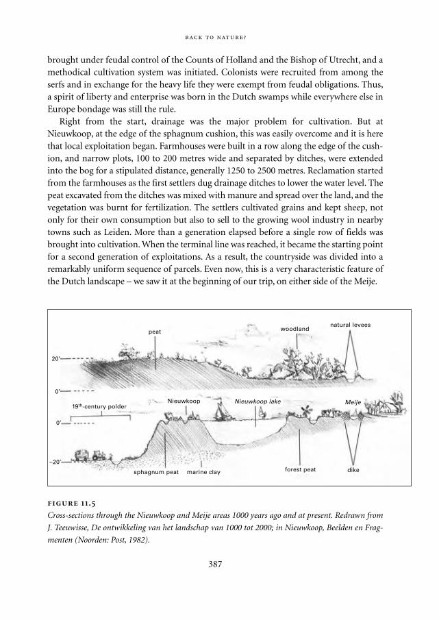
brought under feudal control of the Counts of Holland and the Bishop of Utrecht, and amethodical cultivation system was initiated. Colonists were recruited from among theserfs and in exchange for the heavy life they were exempt from feudal obligations. Thus,a spirit of liberty and enterprise was born in the Dutch swamps while everywhere else inEurope bondage was still the rule.
Right from the start, drainage was the major problem for cultivation. But atNieuwkoop, at the edge of the sphagnum cushion, this was easily overcome and it is herethat local exploitation began. Farmhouses were built in a row along the edge of the cush-ion, and narrow plots, 100 to 200 metres wide and separated by ditches, were extendedinto the bog for a stipulated distance, generally 1250 to 2500 metres. Reclamation startedfrom the farmhouses as the first settlers dug drainage ditches to lower the water level. Thepeat excavated from the ditches was mixed with manure and spread over the land, and thevegetation was burnt for fertilization. The settlers cultivated grains and kept sheep, notonly for their own consumption but also to sell to the growing wool industry in nearbytowns such as Leiden. More than a generation elapsed before a single row of fields wasbrought into cultivation. When the terminal line was reached, it became the starting pointfor a second generation of exploitations. As a result, the countryside was divided into aremarkably uniform sequence of parcels. Even now, this is a very characteristic feature ofthe Dutch landscape – we saw it at the beginning of our trip, on either side of the Meije.
387
.
Cross-sections through the Nieuwkoop and Meije areas 1000 years ago and at present. Redrawn from
J. Teeuwisse, De ontwikkeling van het landschap van 1000 tot 2000; in Nieuwkoop, Beelden en Frag-
menten (Noorden: Post, 1982).
peat
20’
0’
0’
–20’
woodlandnatural levees
19th-century polderNieuwkoop Nieuwkoop lake Meije
dikeforest peatmarine claysphagnum peat
Mappae Mundi bw zw/w 08-04-2004 15:26 Pagina 387
A large part of peat – as much as 80% in sphagnum peat – is water. Drainage causes aswamp to shrink, accelerated by the increased exposure to oxygen, which stimulates thebreakdown of plant debris. The settlers soon discovered that their activities caused theirlands to subside and be drowned to an ever greater extent. They deepened the ditchesseveral times and removed water from the surface using manual labour. A vicious cyclebegan: the improved drainage caused further collapse, forcing the peasants to take moresevere measures. The existing swamp streams, such as the Meije, could not remove all ofthe excess water. Drainage works in one area brought flooding elsewhere, which causedmany skirmishes between local landlords. But the flooding also imposed the construc-tion of an intricate system of land drainage and reclamation and, concomitantly, led tothe creation of novel technologies in water management. A complex network of newwaterways, canals, ditches and dikes appeared in the landscape and, as a result, newexploitations became feasible. By the end of the Middle Ages, the whole region aroundNieuwkoop was in cultivation.
The invention that revolutionized the development of the Dutch landscape was thewind-driven water-pumping mill. The earliest version appeared in Alkmaar in 1408. Itwas small, driving a paddle wheel or a scoop wheel, and could carry water some twometres upwards. A series of two to four such mills was needed to drain deeper water.More sophisticated and much more efficient windmills using Archimedean screwssuperseded the older types, and were a common feature by the 17th century. They madeit possible to drain large terrains that would otherwise have fallen victim to occasionalincursions of the sea. New types of polders came into being. They were surrounded by‘ring dikes’ and outside these, ring canals into which the windmills discharged their sur-plus water and from which the water could be transferred to the main rivers. Theimproved drainage allowed the polders to be used as grasslands, which made cattle farm-ing profitable. The development of Dutch cheese went hand-in-hand with the introduc-tion of the windmills.
One important element in the development of this landscape has not yet been men-tioned. The peasants lived atop a thick peat blanket of excellent fuel. Originally, they dugsome of it away to satisfy their own needs, and it was readily replenished by renewed peataccumulation. But the demand for fuel increased as the population grew. More fuel wasneeded, in particular to support the growing towns in a wide variety of industrial activi-ties: beer brewing, pottery, metal and cement industries, brickworks and so on.
In the early days, only a superficial layer of peat was dug away, but in 1530 an impor-tant innovation was introduced that would leave deep scars in the Dutch landscape. Itwas the ‘baggerbeugel’, a long-handled metal net that allowed peat to be dredged fromseveral metres below the water level. Figure 11.7 shows peat mining in operation. Largeand deep rectangular pools were excavated, and the peat was spread out as a slurry onnarrow strips of land in between, dried, and carved into blocks. The complex labyrinthof land ridges and waters near Nieuwkoop are the remains of just such an exploitation.
388
Mappae Mundi bw zw/w 08-04-2004 15:26 Pagina 388
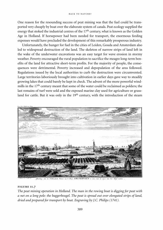
One reason for the resounding success of peat mining was that the fuel could be trans-ported very cheaply by boat over the elaborate system of canals. Peat ecology supplied theenergy that stoked the industrial centres of the 17th century, what is known as the GoldenAge in Holland. If horsepower had been needed for transport, the enormous feedingexpenses would have precluded the development of this remarkably prosperous industry.
Unfortunately, the hunger for fuel in the cities of Leiden, Gouda and Amsterdam alsoled to widespread destruction of the land. The skeleton of narrow strips of land left inthe wake of the underwater excavations was an easy target for wave erosion in stormyweather. Poverty encouraged the rural population to sacrifice the meagre long-term ben-efits of the land for attractive short-term profits. For the majority of people, the conse-quences were detrimental. Poverty increased and depopulation of the area followed.Regulations issued by the local authorities to curb the destruction were circumvented.Large territories laboriously brought into cultivation in earlier days gave way to steadilygrowing lakes that could barely be kept in check. The advent of the more powerful wind-mills in the 17th century meant that some of the water could be reclaimed as polders; thelast remains of turf were sold and the exposed marine clay used for agriculture or grass-land for cattle. But it was only in the 19th century, with the introduction of the steam
389
.
The peat mining operation in Holland. The man in the rowing boat is digging for peat witha net on a long pole: the baggerbeugel. The peat is spread out over elongated strips of land,dried and prepared for transport by boat. Engraving by J.C. Philips (1741).
Mappae Mundi bw zw/w 08-04-2004 15:26 Pagina 389
pump, that the deterioration of the landscape could be brought under control.Nowadays, the country is drained by an elaborate system of electrical pumps. Large
polders have been reclaimed in recent years, and there are only a few major works thatremain to be carried out. Some lakes, such as those between Nieuwkoop, Noorden andthe Meije, were preserved – their exploitation would not have been profitable. In the1930s, the local government decided to use the Nieuwkoop lake as a dump for the rub-bish of the towns and cities in the area. In a ‘Guide for Nieuwkoop and Noorden’ of 1935we read that no harm was done. ‘Only a little rubbish is dumped, but we cover it up withpeat so that nobody can see it. And best of all, it gives work to quite a few people.’Although this activity met with growing opposition by the nascent movement for envi-ronmental protection, dumping continued until the 1960s. Cleaning is underway now –at an estimated cost of 10 million euros.
11.5. Uneasy compromise
What Weissenbruch perceived as ‘nature’ is the remains of an extensively excavated min-ing district and, at the same time, a landscape that has for centuries been the scene ofcareful and parsimonious cultivation and water control. Nothing here was left to chance.Even the reeds nearby have been maintained over the centuries for the construction ofroofs and to supply the tulip fields near the coast with a protective covering during thewinter months.
The result of this human involvement is a pleasurable homeland where we can enjoythe interplay of water, wind, life and history. It is this compromise between nature andartifice that Van Goyen, Hobbema, Ruisdael and, later, Weissenbruch captured in theirvisionary paintings. They grasped what we now recognize as the landscape of Holland –a friendly place and a delight for the city dweller.
Today, the integrity of Nieuwkoop’s surroundings is under renewed attack. SinceWeissenbruch’s time, the population of the Netherlands has increased from 4 million to16 million inhabitants. People have not only become more numerous, but in additiontheir wealth and mobility have vastly increased. Airplanes draw their chalk stripes on thesky and you can scarcely avoid the sound of motorcars. In the west of the Netherlands,fragmented urban centres are combining to form a new, embracing construction, the‘Delta-Metropolis.’ It is a ring-shaped region of 6 million inhabitants, comprising the‘main ports’ Amsterdam and Rotterdam as well as several middle-sized cities, such asThe Hague, Utrecht, Leiden and Gouda. This urbanized ring surrounds the ‘Green Heartof Holland,’ with Nieuwkoop right in the middle. This constellation is thought to favourliving conditions in the emerging metropolis. To reach the countryside, you don’t haveto travel through endless stretches of suburbia, like in London or Paris. You can just takeyour bicycle.
390
Mappae Mundi bw zw/w 08-04-2004 15:26 Pagina 390
Clearly, further development of the Delta-Metropolis requires coherent planning andleaves little space for local initiatives. The metropolis is conceived as a major centre with-in north-western European economic networks. Large-scale amplification is foreseen forthe existing facilities for transport and communication, both between the urban centreswithin the ring and with other agglomerations. Intellectual centres of excellence have tocreate a favourable climate for international investment. To accommodate the expectedgrowth in population, innovative architecture will bring new life to expanding agglom-erations. The execution of these plans is well underway and should be completed withina few decades.
What, in all this turmoil, is to become of Nieuwkoop, Noorden and the Meije? Whenlooking around, it is noticable that the rural character of Weissenbruch’s days is alreadydisappearing. Sewage, local industries and tourism are causes of this, and encroachingurbanization undermines the comfortable peace of former times.
The present population is older and richer than in the past. While the youth escapesto the cities, retired citizens move in. They build comfortable imitation farmhouses, ortransform the old ones into cosy homes and weekend cottages. Farmers, once central tothis community, now see their position marginalized. A large part of the countrysidehas received the status of natural monument. In the past, hundreds of reed cutters usedto work around the lake. Now, only ten of them are left to supply the roof-buildingtrade and keep the landscape open. The old villages are becoming city districts and thearea is changing from a productive landscape into a consumptive commodity. It isunlikely that this land can sustain these changes for long without losing its intimatedignity.
The Green Heart of Holland is literally central to the scheme of the Delta-Metropolis.Judicious exploitation of the area’s natural amenities must boost the quality of life forthe entire population. In contrast to the urban ring, the Green Heart must bring homethe delightful peace of the Dutch landscape. And so it comes that a new balance is beingforged between human demands and the natural environment.
A 250 million euro project has been adopted to protect the remaining wetlands fromdeterioration and to reinforce its infrastructure. It has been estimated that twenty yearswill be necessary for its implementation. Extensive agricultural domains are convertedinto natural parks and recreational areas. Elsewhere, modern combinations of agrarianand natural management are implemented. The quality of environment and water areimproved, and existing natural centres combined into larger reserves, capable of sup-porting the unique vegetation and fauna. On the other hand, spontaneous associationsbetween local farmers and citizens bring the deteriorating landscape back to life by judi-ciously combining ancient and modern farming practices. The soils, meadows and cowsbecome healthy and vigorous again, pollution disappears and the waters are drinkable.Such bottom-up initiatives are essential for the future of this area and deserve to be fullysupported at the governmental level.
391
Mappae Mundi bw zw/w 08-04-2004 15:26 Pagina 391
11.6. Nature
What kind of nature did Weissenbruch look for in Noorden? The question raised at thebeginning at this chapter is timely. Society today is obsessed with nature, more so thanever before. The environment is being converted from a natural to an artificial world onan unprecedented, global scale. The outcome is highly uncertain and casts doubt on thefuture of humanity. The environmental movement thrives on a widespread awarenessthat the natural world was beneficial and that we should try and find a way back. At thisjuncture, we need some enlightenment on what we really want.
The story of Nieuwkoop with its 800 years of environmental management has widerconnotations that we should not ignore. Human society has subjected the inhospitablewilderness, once formed by the unbridled geological forces, to one of the most tellingexamples of interference with the environment. This area became an artifact, an envi-ronment adapted by human shrewdness to human demands. Change was not instanta-neous. Instead, we discern a regular pattern in the area’s history. Human interference wasdestructive as soon as it began. The earliest attempts at cultivation brought about adangerous imbalance in the natural equilibrium. Later, the ruinous effects were curbed by protective countermeasures and, in time, a new human-maintained balance wasachieved. This country has gone through a long succession of such cycles of destructionand reclamation. Its history is punctuated with alternating times of change and stability.
The environmental problem is no longer localized but affects the planet as a whole. Itis widely felt that further human interference with nature will lead to disaster, and thatthe idea of global management is a dangerous and misguided illusion. But the story ofNieuwkoop may inspire a more optimistic vision. It shows us that unbridled nature isnot tailored to human demands and can only support very few people. Unavoidably,nature must be brought under control if we wish to survive. The result can be delightful.If our ancestors could forge new alliances with nature so well, why couldn’t we do itagain? If they managed to create delightful surroundings locally, why could we not do soon a global scale? It certainly is a risky enterprise, but this has always been the case. Theidea of a cultivated earth is not illusory, it is a matter of common survival. We must notgo back but further ahead, cautiously.
Nevertheless, when we row between the flowering meadows, reeds and dikes of Noor-den and Nieuwkoop, we can enjoy the silent glory of Weissenbruch’s world. He capturedits essence and made it available to us all. His paintings give us a reference by which tovalue our impressions. The forces of art are cunning and powerful. Millions of peoplesee this country through Weissenbruch’s eyes, even if they are unaware of his work. Thisis why it could be preserved for so many years.
But times change. Inevitably, Weissenbruch’s world is a vanishing one. Even theDelta-Metropolis cannot sustain it. Something new is in the air. Let us hope for newartists of Weissenbruch’s calibre to change this new world into a homeland we like.
392
Mappae Mundi bw zw/w 08-04-2004 15:26 Pagina 392

AcknowledgementsI am greatly indebted to Dr. Siebrand Tjallingii for introducing me to the story ofNieuwkoop and to Dr. G.O. van Veldhuizen, the present Mayor of this municipality, forexplaining the newest developments. Bram van der Vlugt made me aware of inspiringinitiatives by farmers and citizens to keep the Nieuwkoop area a wonderful place. Iwould like to thank Claartje de Loor and Mariette Jitta (Gemeentemuseum, the Hague)for introducing me to Weissenbruch. Judith de Jong and Kees Pleij made highly valuedsuggestions and Edwin Jacobs, of the Museum Jan Cunen in Oss made the reproductionof Weissenbruch available. This paper is based on Chapter I of the book: P. Westbroek,1991. Life as a geological force; dynamics of the Earth. Norton, New York, London.
393
Mappae Mundi bw zw/w 08-04-2004 15:26 Pagina 393

Mappae Mundi bw zw/w 08-04-2004 15:26 Pagina 394
12
Conclusions: Retrospect and Prospects
After ten thousand years of breaking the soil, after a hundred thousand years of
setting fire to the forests and the plains, after a million years of chasing game,
human influence is woven through even what to our eyes are the most pristine
landscapes.
Budiansky 1995: 5
12.1. The discovery of the biosphere
The interaction of humans with the biosphere is as old as the human species itself. It hasacquired a new momentum over the past 250 years when, in the course of industrializa-tion, people developed new means of technology and organization which enabled themto reach further and deeper into the natural environment than ever before and to incor-porate more and more ‘nature’ into their societies.
Social trends rarely occur without eliciting counter-trends. The rise of modern indus-try in the 19th century was generally hailed as progress, but from the very beginning italso met with protest and resistance. Resistance was at first mainly directed at the socialbut from early on also to some extent at the environmental consequences. These werenoted with most alarm in two very different contexts: in the urban centres, where themassive burning of coal for industrial and domestic purposes vitiated the air and causedserious health problems, and in rural areas, where people felt that the last vestiges ofunspoilt nature were being destroyed.
Concern about the quality of air and water in cities is probably inherent in city life.The high concentration of people and domesticated animals has always created prob-lems regarding the regular supply of food and water as well as the disposal of waste. In the19th century, the situation was deemed more and more unbearable in many Europeancities – perhaps in part because objectively the level of foul emissions exceeded all earlier
395
Mappae Mundi bw zw/w 08-04-2004 15:26 Pagina 395
records, but certainly also because people were becoming more sensitive to health hazardsand began to see the possibility of amelioration. Motivated by a combination of observedfacts, plausible theories and sentiments of alarm, the Public Health Movement set out toreform the sanitary conditions in cities. Scientists and scientific ideas have played animportant role in the movement from the beginning (see Porter 1997: 397-427).
The rural conservationists were at first more romantically inclined. What they per-ceived as nature was, almost without exception, a landscape that already bore theimprint of long-established human interference but was still free from the scars ofindustrialization. Like modern industry, conservationism started as an archipelago ofmodest local initiatives, which soon assumed regional and national proportions. As themovement grew, it attracted support from scientists, particularly from biologists andgeologists. An impressive intellectual manifestation of the new outlook was Man andNature; or Physical Geography as Modified by Human Action by the American naturalistGeorge Perkins Marsh (1864); this book is generally recognized today as the first com-prehensive study viewing the relationships between humanity and the natural environ-ment from a truly global perspective.
In 1875 the Austrian geologist Eduard Suess coined the term biosphere, in passing, inorder to refer to the geographical region of the earth where life is found. It was taken upin the early 20thcentury by the versatile Russian biologist and geochemist Vladimir I.Vernadsky, who published a book in French entitled La biosphère in 1926. He made theterm biosphere into a central technical concept referring to ‘the area of the Earth’s crustoccupied by transformers which convert cosmic radiations into effective terrestrial ener-gy: electrical, chemical, mechanical, thermal, etc.’ (quoted by Lovelock 2000: 10). Formany years, the work of Vernadsky and like-minded ‘holistic’ theorists remained largelyunnoticed in the scientific community, but their reputation rose rapidly in the secondhalf of the 20th century, when a general awareness dawned that all forms of life on earthpartake in one great ecological system and that people are perhaps tinkering with thissystem in a manner that may prove fatal.
In the years after the Second World War, an increasing number of individual scientistsaddressed the public with warnings about the unbalanced relation between humanityand the natural environment. Concern about this issue became so widespread that, in1968, a group of influential industrialists, scientists, and politicians (the ‘Club of Rome’)commissioned an international research team to draw up an authoritative report. Theteam, led by Donella and Dennis Meadows, published in 1972 the report The Limits toGrowth which presented global trends in five areas: population, food production, indus-trialization, exploitation of non-renewable resources and pollution. On the basis of theevidence then available, the report concluded that if growth in each area were to contin-ue at current rates, the world’s population would experience ‘overshoot and collapse’within a few generations, owing to a combination of resource depletion, soil degradationand environmental pollution.
396
Mappae Mundi bw zw/w 08-04-2004 15:26 Pagina 396
Many events following publication of The Limits to Growth seemed to be in line with thebleak prospects it sketched (see box). Within a year, the Organization of PetroleumExporting Countries (OPEC) implemented price increases and boycotts. The resultinginternational crisis reminded people all over the world, and especially in the richer coun-tries, of their strong dependence on the limited and regionally concentrated stocks offossil fuels. Throughout the rest of the century, the world’s population continued togrow, mostly in the poorer countries. And while agriculture penetrated into forest areas,industrial and commercial activities caused some enormous disasters that made severalnames ignominious for decades – such as Bhopal (the town in India where a factory of
:
397
Limits to Growth? A comparison of the computer simulation results of the World3-
model in the report The Limits to Growth with the historical trends since 1971 indicates
that population and economic production trends roughly followed the model projec-
tions. However, natural resource degradation and the associated environmental pollu-
tion are significantly below the levels predicted. This is for several reasons. Firstly, the
estimate of metal and energy resources was too low and the technological potential to
reduce their costs was equally underestimated. Secondly, the oil crises in the 1970s
induced large efforts in the industrialized world regions to bring down the energy –
and material – intensity, that is, the amount of energy or material used per unit of eco-
nomic output. As a result, demand increased much more slowly than before despite
continuing economic growth – although this effect has become weaker since the oil
price dropped in the mid-1980s. A third factor is that, owing to the pressure of citizens
who wanted clean air and water to be part of their emerging affluence, governments
and industries in the industrialized regions of the world have introduced numerous
measures to reduce environmental pollution. It is hypothesized that presently less
industrialized regions will undergo a similar ‘transition’ once their income levels rise. A
fourth, overarching reason why the calculations in Limits to Growth turn out to be at
least partly wrong is that the report itself was among the factors that caused response
action – the ‘self-denying prophecy’.
This is not to say that mankind will not experience anything like the catastrophes of
some model forecasts. However, it will require a far better understanding of the world
system than the World3 -model if they are to be anticipated and averted. An attempt at
constructing a more complex model and using it in a broader context of divergent
worldviews and management styles is the TARGETS -model of RIVM (Rotmans and De
Vries 1997, De Vries 2001). It is shown that the most widely published result of the Lim-
its to Growth report – catastrophe – is in fact one of the many possible outcomes: the
one in which egalitarian environmentalists are right about the fragility of the natural
system and the power is in the hands of those who act upon the opposite assumption.
Mappae Mundi bw zw/w 08-04-2004 15:26 Pagina 397
Union Carbide exploded in 1984), Chernobyl (the site of a nuclear plant breakdown in1986), and Exxon Valdez (the oil tanker that was wrecked at Blight Reef in Alaska in1989).
Environmental history since 1972 does not, however, amount to a mere succession ofcatastrophes confirming the report’s predictions of exponential growth and imminentcollapse. Several trends of environmental deterioration were in fact reversed. This waspartly thanks to the report itself and to a swelling avalanche of publications with a simi-lar tenor, including the equally well-known report Our Common Future (1987) by theBrundtland Commission. Their combined impact was to serve as a ‘self-denying prophe-cy’ (Merton 1957: 421-36). As most futurologists are well aware, the primary function ofpredictions based on the extrapolation of current social trends is not so much to give aprophecy of what is bound to happen inevitably, but rather to serve as a warning of whatis likely to happen unless attempts are made to curb the trends and to prevent the ‘pre-dicted’ events from happening. Any scenario of future developments in human society,no matter how strongly it is based on empirical evidence, is partly a forecast and partly acautionary tale.
Once the message has got through that certain human activities seriously impair thebiosphere, there is a chance that people will change those activities. Since the early 1970shistory abounds with examples of deliberate attempts to redress damage wroughtthrough careless human intervention in natural processes. In a number of cases, meas-ures were taken after considerable damage had already been done and registered.Impressive results were obtained in purifying the water of some rivers such as the Rhineand the Thames, which had been used for years as ‘open sewers’ and were devoid of fishlife. Fish are once again plentiful. In other cases, early warnings were taken seriously. Forexample, after a near-disaster in the nuclear plant at Three Mile Island in Pennsylvaniain 1979, the United States government introduced stringent safety measures that madethe cost of building new reactors practically prohibitive.
A turning point was also reached in the industrial production of CFCs (chlorofluoro-carbons), which were built into a variety of appliances, from refrigerators to fire extin-guishers. In 1974, a paper appeared in the prestigious journal Nature that argued thatCFCs were critically reducing stratospheric ozone concentrations. This was a highlytechnical thesis about which not all experts immediately agreed, although it was laterunequivocally confirmed by ground-based and satellite measurements. In 1987 an inter-national agreement was signed in Montreal to reduce the production of CFCs drastical-ly. A combination of factors facilitated its speedy implementation: (a) the causal chainswere demonstrated in due course: there was proof of the impact of CFCs on the strato-sphere; (b) some detrimental effects were evident to scientists and laypeople alike (skincancer in Australia, blind penguins in Antarctica); and (c) technology provided alterna-tives for CFCs which for most practical purposes were satisfactory to all parties con-cerned – producers as well as consumers. The only negative footnote to this story of the
398
Mappae Mundi bw zw/w 08-04-2004 15:26 Pagina 398
successful formation of a human ‘ozone regime’ appears to be the fact that ‘past emis-sions have left an environmental legacy that will remain in the stratosphere for manydecades to come’ (Grübler 1998: 218; see also Lovelock 2000: 154-61).
A far more complex issue than ‘the hole in the ozone layer’ is the problem that wasfirst known as ‘global warming’ or ‘the greenhouse effect’ (see Gore 1992) and is nowmostly referred to under the general heading of ‘climate change’. Although scientists havediscussed this problem for several decades, it is relatively recently that it has become acause for public concern. Between 1945 and 1975, global temperatures were declining,and some experts held that humanity was accelerating the coming of the next Ice Age byemitting aerosols into the atmosphere which would hinder the radiation of the sun (seeSchneider 1976). Since 1975, however, empirical measurements have shown a steady risein temperature. Although it is difficult to establish exactly to what extent this trend iscaused by human action, there is strong evidence that gases emitted by the large-scaleuse of fossil fuels are contributing to it heavily. Even according to the ‘skeptical environ-mentalist’ Bjorn Lomborg, ‘some sort of anthropogenic greenhouse effect is fairlyuncontroversial’ (Lomborg 2001: 260).
In the last quarter of the 20th century, the use of fire in rich industrial societies hasbeen made less perceptible than it ever was before: most of it now takes place in wellinsulated containers ranging from the furnaces in power stations to the almost silentinternal combustion engines in motor cars. Yet to a far greater extent than any precedingsocio-ecological regime, the industrial regime is dependent on fire; it has an extremelyfuel-intensive infrastructure. The issue of climate change has strengthened public aware-ness of this fact and fostered the recognition that, while fossil fuel burning is concentrat-ed in specific areas, its effects constitute a truly global problem.
The industrializing world of the 19thcentury created many environmental troubles.These were perceived as concrete local issues. The atmosphere was regarded as a free sinkinto which waste vapours could be emitted. If smoke could be sent up high enough, itwas believed to have been got rid of. In the course of the 20thcentury, an awareness hasgrown that the emissions spill out far beyond their original locality and their full impactcan only be grasped by highly technical scientific monitoring on a global level. Thisawareness is supported by facts, theories, and sentiments. These three elements arefused: the facts become significant in the light of theories, the theories gain credibility on the basis of facts, the sentiments are aroused by the information implied in the factsand the theories, and their arousal stimulates further research, generating new facts andtheories.
The diagnosis of climate change involves a plethora of confounding problems in thehuman realm: economic, political, moral. Because industrial societies are so profoundlycommitted to the use of fossil fuels, their very texture is impregnated with it. Attempts toreduce the emission of greenhouse gases therefore take many different forms. They rangefrom international treaties culminating in the 1997 Kyoto Protocol signed by the govern-
:
399
Mappae Mundi bw zw/w 08-04-2004 15:26 Pagina 399
ments of 177 countries to changes in individual consumers’ attitudes and, less noticeably,behaviour (Aarts et al. 1995). The history of the Kyoto Protocol testifies to the difficultiessurrounding the issue. Although its terms reflect protracted negotiations, with attemptsto satisfy many diverse ideals and interests, it still has not yet received the minimum rati-fication of 55 co-signers which is needed for it to become officially operative.
While climate change ranks high in the international agenda of environmentalresearch and policy, it is far from being the only issue that is causing concern. In TheLimits to Growth the depletion of resources was given priority; the report stated that theearth’s stocks not only of fossil fuels but also of metals such as copper and aluminiumwere limited, and that humankind was heading toward the depletion of many of theseresources in the near future. Developments since 1972 have in many respects been reas-suring: huge new deposits of gas, oil and coal have been discovered and even accordingto conservative estimates today, the supplies are sufficient to provide for human needs inthe next four or five centuries (see United Nations 2001). The earth has also been foundto contain far greater supplies of most metals than were known in 1972, while syntheticoil-based alternatives have been invented for some other materials. Moreover, by the1990s, in the richer countries more than 50% of industrial production involving copper,lead and steel has come to be based on recycled materials (Grübler 1998: 245). At theturn of the millennium, the major environmental problem seemed to lie less in scarcityof resources than in the scarcity of ‘sinks’ (see box).
Another good that is perceived as becoming increasingly scarce is unspoiled nature.One of the foci of discussion in this context is biodiversity (see Wilson 2002). This is arecently coined concept; the facts to which it refers, however, were among the first signsof environmental decay to be observed and cause alarm. When certain species of plantsor animals disappear from a particular site, that is directly visible to expert naturalistsand easily understood by laypeople. Loss of vegetation was already observed andbemoaned in antiquity, by Plato as well as by ancient Chinese writers who complained
400
A recent outlook on the future: the IPCC scenarios In 1992, the Intergovernmen-
tal Panel on Climate Change (IPCC) published six alternative emissions trajectories for
the main direct and indirect greenhouse gases (CO2, CH4, N2O, CFCs, SO2, NOx, VOCs,
CO). In 1997 the IPCC planned the development of a Special Report on Emissions Sce-
narios (SRES), to review prior scenarios from the literature and to develop a new set of
IPCC reference emissions scenarios. The new scenarios should not only cover the full
range of emissions but also allow regional desaggregation and span a wide spectrum of
alternative futures, structural changes and uncertainties. The new set of scenarios, pub-
lished in 2000 (IPCC 2000), uses divergent assumptions on population, economic activi-
ty and technology, and measures and policies with regard to the North-South income
gap, poverty and trade issues, and environmental problems such as acid rain.
Mappae Mundi bw zw/w 08-04-2004 15:26 Pagina 400
:
401
The starting point for each of the scenarios was a thoroughly discussed qualitative
‘storyline’, subsequently quantified by several modelling groups. They were grouped
into four scenario families that differ in their outlook on globalization and international
governance and on societal values about equity and environment issues. Globalization
was loosely defined as a trend towards intensified trade, traffic and communication
and as such both a cause and a consequence of processes referred to as ‘moderniza-
tion’. It can be interpreted as a continuation of the industrialization process described in
Chapter 10, with a continuation of the trends towards markets and trade liberalization,
consumerism, dissemination of technical innovations and expansion of capital flows.
Values show up in the degree of social and environmental awareness as they express
themselves in widespread support for, for example, solidarity between the rich and the
poor, ‘green’ lifestyles and technologies and community-oriented experiments towards
a more sustainable future.
Four scenarios can be distinguished on the basis of these criteria. The two ‘globaliz-
ing’ scenarios differ in the degree of social and environmental awareness, and hence in
the corresponding policy actions. In both scenarios population increases to 9-10 billion
people by 2050 after which it declines to 7-8 billion by 2100. A future oriented towards
markets, materialist values and high-tech consumerism is expected to have the highest
economic growth: Gross Domestic Product (GDP) increases at the average 20th century
growth rate. Most ‘official’ scenarios by government agencies belong to this ‘reference’
– or ‘conventional world’ or ‘business-as-usual’ – category. In a more equity and envi-
ronment oriented scenario, economic growth is also high but less energy- and materi-
al-intensive. In both scenarios the emissions of greenhouse-gases increase, fourfold in
the first and twofold in the latter. In both cases the atmospheric greenhouse gas con-
centration will continue to rise to levels well above double the pre-industrial value of
280 ppmv.
In the ‘non-globalizing’ futures, the world population is assumed to increase to 10 à
14 billion people by 2100. Trade protectionism and limited technology transfer and co-
operation hamper economic growth and the modernization process is slowed down.
This, it is argued, will in turn retard the demographic transition. How would such a
more fragmented world with a focus on regional economic issues and on cultural iden-
tity look like? Its very diversity, with cultural and economic pluralism, defies global
description. If a materialist outlook and traditional practices prevail, a large and rather
poor world population may be confronted by cultural clashes and conflicts because of
increasing disparities and scarcities in crucial resources such as clean water, affordable
energy and productive land. With a – regional – focus on equity and sustainability, the
world population may be smaller and its basic needs better satisfied – but even then,
the negative impacts of for instance climate change may exceed the present adaptive
capacity of quite a few regions.
Mappae Mundi bw zw/w 08-04-2004 15:26 Pagina 401
about the deforestation wrought by human action (see Elvin 1993: 17-21). Still, theirperceptions differed in at least two respects from present observations. They were limit-ed to a particular region and did not refer to anything like global extinctions. Moreover,they reflected innocence on the part of the observers: Plato held others responsible forthe destruction of the forests in Attica and did not feel himself to be implicated.
In our era of industrialization and globalization we know of many species which havenot only disappeared from certain sites, but have become extinct, either through humankilling or because their habitats were destroyed by humans or invaded by competitors orpredators who came in the wake of humans. Some of the most famous examples of totalextinction in modern times concern bird species, such as the dodo and the passengerpigeon (see Ponting 1991: 168-70). Their losses were rightly seen as irreparable, andwhen a similar fate threatened large mammals, from whales and seals to tigers and ele-phants, world-wide campaigns were initiated to protect these animals. Among the senti-ments to which the campaigns appealed was a sense of responsibility for other creaturesthat share the same biosphere. Thanks to these campaigns, the anthroposphere nowextends over nature reserves in which several species of wild mammals find refuge.
12.2. Historical and theoretical reflections
No matter how far the anthroposphere may expand, it always will be, as it always hasbeen, part of the biosphere. As such, it is dependent on the conditions of climate and onthe composition of the air, water and soil. The rhythms of human life are embedded inthe motions of the earth, and the resulting cycles of days, seasons and years. Cosmicevents such as the impact of a meteorite can disrupt human life, as can terrestial eventssuch as a volcanic eruption, a hurricane, an earthquake, a flood or a drought. The bios-phere itself can generate such disruptions, when crowds of visible or invisible parasitesinvade a human domain and cause a ‘plague’.
Like all other animals, humans have to adapt to the circumstances in which they findthemselves. Every society in the past developed stable patterns of behaviour (‘traditions’)that helped its members adapt to recurrent conditions, as well as more flexible proce-dures for dealing with sudden challenges. For a long time, the most immediate concernsof humans in their interactions with the biosphere must have been finding food forthemselves and not becoming food for other creatures (see McNeill 1976: 5-6).
Humans are also similar to all other animals in that they feed directly or indirectly onplants. Plants tap small quantities of solar energy which they assimilate in combinationwith other substances into organic matter through the process of photosynthesis. In thisbook we have come across several examples of how changes in vegetation, triggered bychanges in climate, forced human groups to change their ways. As described in Chapter3, there was once a green Sahara with large animals and human hunters. When the cli-
402
Mappae Mundi bw zw/w 08-04-2004 15:26 Pagina 402
mate became dryer and hotter, the habitat ceased to be hospitable to these populations.Other examples, relating to South and Central America and to the Vera Basin in Spainalso show human responses to disturbed environmental conditions.
In spite of many such setbacks, there has been a general trend of expansion of theanthroposphere. Starting with the domestication of fire and continuing, at an accelerat-ing pace, with agrarianization and industrialization, more and more human groupscame to avail themselves of means of technology and organization which helped them tobuild ‘buffers’ or ‘dikes’ to shield them from at least some of the vicissitudes of the natu-ral environment. If we take a very long-term global view, expansion appears to be a con-tinuous process; if we look more closely, we see that it occurred in leaps and bounds, atdifferent times in different regions.
We have distinguished between extensive and intensive growth as two general aspectsof the expansion of the anthroposphere. Roughly speaking, the key words for extensivegrowth are ‘more and more’ and ‘further and further’. The key term for intensive growthis ‘greater complexity’, structured by more information. Perhaps extensive growth maybe conceived of as a sheer extension of human biomass, physically and geographically.Intensive growth may then be regarded as an increasing capacity to collect and to processinformation and, thus, to mobilize energy and matter.
In theories about economic history, where the terms originated, extensive and inten-sive growth are usually seen as contrasts: as mutually exclusive and even opposing trends(see Jones 2000). In this project we have come to the conclusion that, more often thannot, the two trends have been mutually supportive and reinforcing. We even suggest as ageneral hypothesis, ensuing from our inquiries, that intensive growth has always been acondition for, and even the driving force of, extensive growth.
The expansion of the anthroposphere has been marked by three major ‘leaps’, inwhich distinct socio-ecological regimes were successively formed: the fire regime, theagrarian regime and the industrial regime. With each new regime, humans gainedgreater control over energy and matter, and thus strengthened their position in the bios-phere. Control over the non-human environment may appear primarily in the guise oftechnology. However, technology cannot exist in a social and cultural void: it can onlyfunction in a context of social organization and civilization. Each advance in technologytherefore involved changes in organization and civilization.
Throughout this entire process, human life has remained dependent on the resourcesprovided by the natural environment, notably food, water and air. Climate and soil havecontinued to be the major natural conditions determining access to these primaryresources. While the major variable in the provision of food has always been vegetation,the presence of other species has been a crucial intervening variable. Those other speciesinclude large animals – in their capacity as potential food or as predators or competitors– as well as insects and microbes. The relationships to other animals and to microbeshave largely determined human access to vegetation. This is why the domestication of
:
403
Mappae Mundi bw zw/w 08-04-2004 15:26 Pagina 403
fire has been so vitally important: it has helped human groups to clear bushes, ward offother animals and kill microparasites in food.
The transition to agriculture implied deliberate manipulation of vegetation. It alteredthe environment, to suit human purposes. In many cases, it also led to an increasinghuman population (‘extensive growth’). This in turn elicited intensification of agricul-ture, often leading to unintended changes in the environment such as erosion or salin-ization and inevitably always involving greater vulnerability to destruction – throughnatural causes, human negligence or violence or any combination of these factors. It cre-ated a landscape of fields and meadows that belonged visibly to the human realm, theanthroposphere.
In the agrarian regime people created an ecological niche under human surveillance,in which certain selected plants and animals received special protection because theywere valued as contributing to human survival and comfort. In early agrarian society theconstraints of this ecological regime were omnipresent and everybody could feel andappreciate their force. These constraints are clearly reflected in the entire structure ofagrarian and pastoral societies: in their technology, organization and civilization.
With further intensification, social organization became more complex, and the newsocial and cultural structures left a strong mark on the human condition. An individual’schances in life came to depend more and more on his or her position in networks ofsocial stratification. Although vegetation continued to be the prime material basis ofsociety, as food and fodder, the ruling elite became primarily concerned with other inter-ests than raising crops or tending domesticated animals.
The great agrarian empires such as ancient Rome and China experienced long peri-ods of both extensive and intensive growth (see above, p. 209-56 and 301-3). The culti-vated areas were expanded and used more intensively to feed a growing population. Theorganization of the production and distribution of food grew more complex, leading tothe formation of increasingly larger and more robust inter- and super-regional net-works. If, in some cases, these networks had been preceded by networks primarily ori-ented to the pursuit of exchange and trade, in the great empires those economic net-works were superseded and absorbed by military and political organizations.
Much of the evidence collected in this book suggests that environmental pressures in agrarian empires continued to weigh heavily on the majority of the population whoselives were, in Thomas Hobbes’s famous words, ‘nasty, brutish and short’. The elite groupswere only one step removed from these pressures. If a climatic disaster struck, as is likely to have happened to the Maya around 700 CE, this could lead to the collapse of theempire (see p. 65). In such cases, even if the elite groups were primarily concerned with inter-human relationships rather than with relationships with the non-humanenvironment, the ultimate downfall of the overarching social and cultural structures was precipitated by the failings of an insufficiently resilient socio-ecological infrastruc-ture.
404
Mappae Mundi bw zw/w 08-04-2004 15:26 Pagina 404
These examples support what seems to be a general rule: societies that stretched theircontrol over energy and matter further also became more dependent on both theresources that were thus being controlled and on the entire socio-cultural apparatusinvolved in their control. We have encountered this unintended side-effect throughoutthe book and need not elaborate it again here.
The same gains in control that gave humans more power vis-à-vis the non-humanenvironment also influenced inter-human relationships, giving groups with superiortechnology and organization an advantage in confrontations with other groups as well.Here a flywheel effect would often occur so that, in a process of ‘figurational dynamics’(see above, p. 361-2), initially small differences would lead to major social inequalitiesbetween the mighty and the weak, colonizers and colonized, rich and poor, masters andslaves, each having their own peculiar relationships with the natural environment.
In the modern era, two developments have changed the constraints of the agrarianregime: industrialization and globalization. In the process of industrialization, hugedeposits of fossil fuel have been opened up for human exploitation and, with the aid ofrapidly developing new forms of technology and organization, are now being used forthe provision of food, the extraction of metals and minerals and the production ofcountless goods and services. Globalization is fostered by, and fosters, the circulation ofthe products of industrial enterprise across the world. As a result, the very notion ofhuman habitat potential at local or regional or even national levels has become ques-tionable, because the exchange of energy, matter and information is able to sustain highpopulation densitities at sites such as Brasilia or Phoenix, Arizona, that would be barelycapable of sustaining any human life at all without imports of energy and matter. Withthe emerging global division of labour, the only realistic unit for measuring humanhabitat potential is therefore the earth.
12.3. Prospects
12.3.1. Paradoxes of prediction
Images of futures have always been part of the present, in every period of human history.Anticipation belongs to the very essence of life; it is a feature of life in general and is aparticularly strong feature of human life. The farmer who plants seeds in the ground, thewarrior who sets out for a campaign, the trader who stocks goods, they all gear theirbehaviour toward goals that fit into a pattern of expectations. The expectations are basedon past experience and learning: lessons from the past shape the images of the future.
Members of a society with little social and cultural change could entertain an imageof the future that would be largely a replica of the present (see Heilbroner 1995). Theyknew that they themselves would grow older and would die one day; but their children
:
405
Mappae Mundi bw zw/w 08-04-2004 15:26 Pagina 405
would follow in their footsteps and carry on the same sort of lives. Although the detailsof an individual’s fate were uncertain, the future in general was somehow predictable: itwould unfold in the familiar setting of monsoons or seasons, interrupted from time totime by unforeseen events: a hurricane, a drought, an epidemic or an invasion by foreignraiders.
As societies became more dynamic and more susceptible to change, the patterns ofexpectations also changed. Foresight and planning became more important and, by thesame token, more difficult. This is our present predicament, alerting us to our complexand, in some respects profoundly paradoxical, relationship with the future.
The most basic paradox about the future as we perceive it today can be stated as fol-lows: we are unable to predict the future and we always will be. On first sight this state-ment seems self-contradictory; but it is not. It merely points to the fact that our relation-ship with the future is diverse and heterogeneous. There are some things about it that weknow with reasonable certainty and other things that we do not and, in many cases can-not know at all. If we conceive of ‘the future’ in a holistic sense as the totality of all eventsthat lie in store for us and for posterity, we are clearly not in a position to predict it. Onthe other hand, there are a great many things that can be predicted with a high degree ofcertainty: that the sun will rise again tomorrow, that next winter will be colder than nextsummer, that the tides will come and go, that water from the sea will be salty.
We can safely make these predictions because they concern regularities that existindependently of human interference. Here we encounter yet another paradox. On theone hand, by exerting control over nature people try to make natural processes morepredictable. However, the very processes over which they can exert most control mayalso be the most difficult to predict – precisely because people are able to influence theseprocesses. The movement of prices at the stock exchange is a good example: this move-ment is through and through a function of human actions and yet it is essentially unpre-dictable: its rationale is its unpredictability.
Not only are human beings as individuals in some important ways unpredictable,certain mechanisms in their social interactions add to this unpredictability. We havealready referred to the principle of self-fulfilling and self-denying prophecies. A self-ful-filling prophecy occurs when, for example, word gets around that a bank is insolvent.This may prompt people to withdraw their accounts, leading to actual bankruptcy. Incontrast, rumours of insolvency may also be taken as a warning and a reason for wealthyinvestors to support the bank. In that case the prophecy is self-denying.
A related issue is known as the dilemma of collective action (see De Swaan 2001: 91-98). Its relevance to environmental problems has been made famous in the parable ofthe ‘tragedy of the commons’ and in the concept of the ‘free rider’. The image of ‘thecommons’ refers to a pasture used by herders who each have the right to let their ownanimals graze on the communal ground. If no limits are set, each herder will be motivat-ed to add more and more animals, especially if his fellow-herders do the same. The
406
Mappae Mundi bw zw/w 08-04-2004 15:26 Pagina 406
inevitable result is overgrazing. An obvious parallel is overfishing; we came across thesame mechanism in the ‘spiral of desire’ discussed in Chapter 10 and in the resourcemanagement regimes discussed in Chapters 6 and 8 (see also Ostrom 1990).
In all such cases, the tendencies toward the depletion of resources are undisputedlypresent. The outcome, however, is not necessarily predictable disaster. For a realistic pre-diction, we need to know more about the social context in which the dilemma of collec-tive action is set, including political and economic relations as well as the prevailing atti-tudes and mentalities.
There seems to be no end to the paradoxes of prediction. The discovery of the bio-sphere has made us aware of the problem of sustainability. Once again we seem to beconfronted with paradoxes. To begin with, the need for sustainability has arisen in aworld that is perceived to be inherently dynamic and continuously changing; sustain-ability is predicated on change. But applying the notion of sustainability to a rapidlychanging world is almost like adding insult to injury, as it compels us to consider theneed for introducing yet another new element in the dynamic relationships betweenhumans and the biosphere. As John McNeill points out in his environmental history ofthe 20th century, one reason why the environment changed so much is that prevailingideas and politics changed so little (McNeill 2000: 325). The dilemma was summed upneatly by Giuseppe Tomasi di Lampedusa when he had the main character in his greatnovel The Leopard remark: ‘if we want things to stay as they are, things will have tochange’ (Lampedusa 1960: 21).
12.3.2. Scenarios
To orient ourselves to an unknown future, the simplest procedure seems to be to observecurrent trends and examine how they are likely to develop further in mutual interaction.Computer models greatly facilitate such exercises and make it possible to construct sce-narios in which variable weight is given to many diverse trends. Numerous complica-tions and uncertainties remain, however, especially concerning the future of intensivegrowth.
With regard to extensive growth there are already signs of deceleration, and in someparts of the world stagnation – or even, as in many regions of the former Soviet Union,regression. Demographers now generally assume that global population growth willcontinue to slow down and will reach a turning point around 2050, when the total num-ber of people will be somewhere between seven and fourteen billion, most probablyclose to ten billion (see box). It is conceivable that, in geographical terms, large numbersof people may one day migrate into territories such as the Sahara or Antarctica that areas yet largely uninhabited. This may become possible as a consequence either of changesin the climate or of human inventions. The latter case would be one more example of
:
407
Mappae Mundi bw zw/w 08-04-2004 15:26 Pagina 407
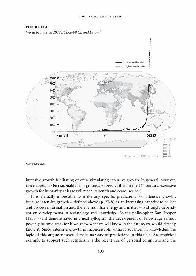
intensive growth facilitating or even stimulating extensive growth. In general, however,there appear to be reasonably firm grounds to predict that, in the 21st century, extensivegrowth for humanity at large will reach its zenith and cease (see box).
It is virtually impossible to make any specific predictions for intensive growth,because intensive growth – defined above (p. 27-8) as an increasing capacity to collectand process information and thereby mobilize energy and matter – is strongly depend-ent on developments in technology and knowledge. As the philosopher Karl Popper(1957: v-vii) demonstrated in a neat syllogism, the development of knowledge cannotpossibly be predicted, for if we knew what we will know in the future, we would alreadyknow it. Since intensive growth is inconceivable without advances in knowledge, thelogic of this argument should make us wary of predictions in this field. An empiricalexample to support such scepticism is the recent rise of personal computers and the
408
Source: RIVM-Hyde.
.
World population 2000 BCE-2000 CE and beyond
Mappae Mundi bw zw/w 08-04-2004 15:26 Pagina 408
:
409
Anything new under the sun? During a slow, steady and irreversible process of
agrarianization, human groups have developed ways to cope with their natural envi-
ronment both in terms of opportunity and constraints, abundance and scarcity. Forms
of societal complexity tended to reflect biogeographical factors – such as climate and
vegetation – in combination with rather universal mechanisms of social organization.
The social memory built up from generations of past experiences provided a repertoire
of responses to the vagaries of nature. With the increase of human control, societies
became more dependent on the skills they developed and sustained, on the ways they
organized themselves, and on how they managed information flows. This is most obvi-
ous in the hierarchically structured empires evolved from military-agrarian regimes
and the trade-based states formed around competitive markets.
The loop of control and dependency led to the need for more control and more
understanding of the surrounding natural systems. The resulting socio-natural systems
mastered the better-known short-term and local risks at the cost of leaving at the time
less well-known, longer -term and wider risks to future generations. With the European-
led industrialization and globalization process of the last three or four centuries, the
control loops have expanded and intensified to the extent that most of the planet is
now under some form of management. At the same time, the capability to acquire and
process information has grown enormously – providing the conditions for the ‘discov-
ery of the biosphere’ as a necessary complement to globalization and complexification.
In the 1990s the annual increment of the human population amounted to some 90
million individuals. Most demographers anticipate a gradual slowdown in population
growth, stabilizing somewhere in the 21st century at levels between 7 and 14 billion
people (Figure 12.1). Intensive growth continues unabated and will lead to future situa-
tions as yet difficult or impossible to anticipate. Hierarchies and markets are still the
dominant ways in which societies, now on an ever larger geographical scale, organize
themselves. The capacity to process the necessary information flows to sustain this lat-
est phase in the human adventure has increased enormously – will it be enough? As in
other historical times and places, limits have been – and are – announced: limits to
available resources and to the necessary transition periods and efforts, limits to the
absorption capacity of the natural environment, limits to institutions and governance –
even to happiness.
One lesson from this book is that the limits posed will be a mixture of natural and
social limits – nature has become an integral part of the socio-natural system Planet
Earth. Undoubtedly, great challenges are ahead because the human race will experi-
ence the end to continuing extensive growth. Will it be a process in which such limits
make themselves felt in unpleasant and abrupt ways, or will the coming structural
transformation be a smooth one helped by corrective anticipation? In any event, it
seems wise to be well-prepared by an adequate understanding based on scientific
Mappae Mundi bw zw/w 08-04-2004 15:26 Pagina 409
internet – a form of intensive growth that had not been predicted in advance (see Mar-golis 2000).
The future of both extensive and intensive growth is further complicated by the cur-rent distribution of wealth and poverty in the world. Access to resources, and to meansof exchange and means of violence, is very unequally divided among, and within, na-tions. At the turn of the millennium, the gross domestic product per capita in the rich‘Neo-European’ states (the United States, Canada, Australia and New Zealand) exceededthat in Africa by a factor twenty and that in Asia (excluding Japan) by a factor eight(Maddison 2001: 28). Intensive growth is continuing in the richer part of the world, andalthough several important poorer regions, including China and India, are beginning tocatch up, the general gap between rich and poor is widening. This inequality is the cause,and legitimization, of tensions that can easily erupt into war, as they actually did manytimes, in many regions.
While wars are, in their own way, also highly unpredictable, they rarely fail to have animpact on the natural environment. Certainly in our day and age, wars cause severe dis-turbances. In the years between 1950 and 2000 there were numerous oil spills, causinggreat ecological damage. By far the greatest in this series was due to the destruction inthe Gulf War of 1991 (see www/scilib.ucsd.edu/sio/guide/zgulfwar.html). The plantingof landmines in many regions is also an environmental disaster. We have no neat syl-logism from which we can infer why both the outbreak and the outcome of war areunpredictable; but we do know on empirical grounds that once started, wars are hard tocontain and not only destructive of human lives but also highly detrimental to the phys-ical environment – especially those parts of the environment that people cherish most.
Even apart from war, political and economic developments may defy our expecta-tions. Few observers foresaw the collapse of the Soviet Union from 1989 onwards; nordid many futurist scenarios include the terrorist attacks on the United States on 11 Sep-tember, 2001. Against the backdrop of these various uncertainties, related to the natureof the development of knowledge as well as to political vicissitudes and the risks of war,scenarios can be no more than explorations of possible futures. As the President of theWorld Watch Institute and the Executive Director of the United Nations Environment
410
investigations. It may be equally wise to engage in socio-cultural experiments, so as to
sustain not only biodiversity but also access to the wealth of human experience in var-
ious local settings. For instance, the less conspicuous but probably numerous resource
management regimes based on local circumstances, co-operation and community con-
trol deserve full attention, as complements to the prevailing forms of hierarchies and
markets. It may widen our view on a sustainable future for all of humankind, maybe in
the form of clumsy institutions, in which a variety of convictions about how the world
functions is given recognition.
Mappae Mundi bw zw/w 08-04-2004 15:26 Pagina 410
Programme state in their foreword to Vital Signs 2001-2202. The Trends That Are ShapingOur Future:
If there is one lesson of this extraordinary half-century [1950-2000], it is that most trends defy
prediction by experts. The most important changes have generally come abruptly, with little
warning. We never seem to know where the latest economic crisis or ecological catastrophe
will come from, but we do know that the projections of smooth, gradual change that comput-
er models churn out are almost always wrong. (World Watch Institute 2001: 12)
These are the words of professionals experienced in the art of social forecasting. Howev-er, as the authors themselves realize, we all are hostages of the future – our own futureand that of later generations. There is no escape from our position in historical time. Inthat position, we can either relinquish all claims to know anything at all about what liesahead and enter the future with a blank mind; or we can admit that such an attitude oftotal agnosticism is also only a pretence. We do anticipate; the question is how far we cango in our anticipation without losing touch with reality.
12.3.3. Towards a fourth regime?
We find ourselves today in a unique historical situation. Amidst all uncertainties aboutthe future one fact stands undisputed: the age of fossil fuel energy in which we are livingwill come to an end. The stocks are rich, but limited and not renewable. For this reasonthe environmental historian Rolf Peter Sieferle (1997, 2001) calls the era of industrializa-tion an age of transition.
Does it also spell the end of industrial production? That is highly unlikely – just as therise of agriculture did not spell the end of the domestication of fire and industrializationdid not put an end to agriculture. It is far more probable that a new socio-ecologicalregime will emerge (and may already be emerging) which will absorb the earlier fire,agrarian and industrial regimes.
The realization that the stocks of fossil fuel are exhaustible has occasioned somesevere shocks, such as the international oil crises of 1973 and 1979. These crises haveadded to the sense of alarm about the strong reliance on fossil fuels in contemporarysociety. This reliance feeds not only environmental trends such as global warming butalso social and political unrest. It engenders very uneven economic dependence andextreme differences in wealth, in turn leading to strained political relations and escalat-ing military tensions.
The urgency of economic and political problems easily turns public attention awayfrom ecological issues. The major regimes in the world today are formed around politi-cal and economic centres. This may be a reason why the fourth socio-ecological regime,
:
411
Mappae Mundi bw zw/w 08-04-2004 15:26 Pagina 411
if indeed it is already in the making, is still largely unrecognized and nameless.In the meantime, the population is still increasing in most poor countries. Industrial-
ization and the intensification of agriculture combine to confront those countries withthe same two environmental problems experienced, albeit on a much smaller scale, inthe industrializing regions of Europe in the 19th century: urban congestion and decay oftraditional agrarian communities. Deforestation and the growth of megacities are twoaspects of the same overall process. Extensive growth is a driving force; it thereforestands to reason that a lowering of the birth rate would be a prime factor in reducingenvironmental stress. Although fertility is not an independent variable, as the Canadiangeographer Vaclav Smil notes, ‘vigorous population control measures are in the bestinterest of the worst affected countries’ (Smil 1994: 215).
If in earlier periods intensive growth was indeed the prime mover of extensivegrowth, then today and in the near future it will have to be the prime brake. A higherstandard of living, better economic prospects and a stronger position for women areaspects of intensive growth that may be expected to contribute to the slackening ofextensive growth. Technologically, convenient means of birth control are now available;the obstacles impeding their use lie mainly in the spheres of organization and civiliza-tion.
412
Biotechnology An important aspect of technological change derives from molecular
biology and involves the techniques known as genetic engineering or genetic modifica-
tion (GM). Human exploitation of plants and animals is rapidly becoming more and
more intensified and diversified. As the sociologist Joanna Swabe (1992: 192-205)
notes, these developments represent the continuation of 10,000 years of ‘biotechnolo-
gy’ under agrarian and pastoral regimes; on the other hand, they bring about ‘brand
new’ circumstances. The prospects of genetic modification include the possibility of
bacterial production of meat-like tissues. According to the sociologist Steve Quilley,
‘such an in vitro, industrial (rather than agricultural) closed-system, GM trajectory
would effectively constitute the greatest ecological and evolutionary transformation
since the Neolithic revolution. It might offer a real possibility for a more ‘wild’ or
unmanaged nature to emerge from under the stifling grip of agriculture. For the first
time, humanity might be able to allow trees and forests to start winning succession
struggles with grasses. Vast tracts of agricultural land could be returned to ‘a state of
nature’. Such wild nature would no doubt be just as artificial in the broader scheme of
things. However, it might allow the planetary mechanism to resume a series of func-
tions that have been temporarily disrupted or usurped by humanity and its allies: soil
formation, carbon fixation and climate regulation amongst others’ (Quilley, forthcom-
ing: 20).
Mappae Mundi bw zw/w 08-04-2004 15:26 Pagina 412
Technology, organization and civilization are the major factors shaping the relation-ships between humans and the biosphere and determining whether intensive growthwill continue, and in which direction it will veer. They reflect the ‘triad of human con-trols’ over nature, society and self (see above, p. 28), and as such are intricately intercon-nected.
Technology is most clearly directed to physical nature. Aided by technology, humansmade their position in the biosphere from early on more secure and more comfortableand, in doing so, sometimes wrought havoc with other species. But they have also alwaysused technology when they tried to repair the damage and to stabilize their relationshipwith the environment. In the same vein, modern methods of recycling and ‘waste min-ing’ and more efficient uses of energy and materials have been introduced. There is acontinuing search for alternative energy sources: wind, water, biomass, solar power,nuclear fission and fusion, each with their own promises, costs and risks.
The importance of social organization has come to the fore many times in this book;it underpins the very notion of socio-ecological regimes. As John McNeill wiselyobserves, ‘of course, well organized societies always enjoy an edge over the badly organ-ized.’ (McNeill 2000: 200) Defining what ‘well organized’ would mean in the world todayeasily leads to a catalogue of hackneyed epithets: resilient, flexible, sustainable, groundedon the local level and in touch with the global level. Indeed, the nature of our environ-mental problems calls on the one hand for a global orientation and the possibility ofintegrating and co-ordinating activities worldwide. On the other hand, differentiationinto a great variety of finely textured webs is also needed. On each level, people have tobe prepared for the possibility of unintended and unforeseen developments. An integralpart of a ‘fourth regime’ will be the continuous monitoring of its own impacts.
An index of civilization can be found in manuals for good behaviour, in the form ofeither ethics or etiquette (see Elias 2000). Until recently, these manuals paid only scantattention to environmental issues. What mattered was how humans treated otherhumans, not how they treated plants and animals, water and air, the soil and the sea.Those matters were relegated to separate technical treatises. In the 20th century, a newgenre emerged, of moral-ecological discourse, as exemplified in Rachel Carson’s well-known book Silent Spring (1962). The message in this genre is an appeal to people’sresponsibility as citizens of the earth. They should be aware of ecological chains andcycles and think of the long-term effects of present actions. Both personal behaviour andpolitical decision-making must be guided by foresight. The best strategies on both levelsare ‘no-regret strategies’, inspired even in the context of uncertainty by a willingness tosubordinate short-term gains to longer-term interests.
These strategies are in line with the general conclusions that emerge from this book.A pervasive theme is the trend toward the increasing scale of the interactions betweenhumans and the natural environment. The scale has increased in space and time, fromlocal to global and from short-term to very long-term. The extension in scale has been
:
413
Mappae Mundi bw zw/w 08-04-2004 15:26 Pagina 413
accompanied and, we suggest, propelled, by a concomitant trend toward greater interde-pendence and complexity.
Information has played a pivotal part in the process of increasing interdependenceand complexity. In the past, a major handicap of the regimes in agrarian states andempires was their limited capacity to recognize and understand the dynamics of socio-ecological relations. Attention tended to focus on restricted, short-term issues, especiallyin times of crisis. A better understanding of the predicaments of the past may enable usto deal in a more enlightened manner with the problems facing us today. In the absenceof reliable long-term forecasts flexibility is continuously needed. But short-term alert-ness should not blind us to the recognition that resilience is best served by recognizingthe entire vital network of interdependencies in which human lives evolve – in otherwords, the dynamics of the anthroposphere within the biosphere.
414
Mappae Mundi bw zw/w 08-04-2004 15:26 Pagina 414
Notes
Notes to Chapter 1
1 Alexander Pope, ‘Proposed Epitaph for Isaac Newton’. Quoted by Prigogine and Stengers 1984: 27.
2 It remains to be seen to what extent the change in world view was an autonomous ‘mental’ trans-
formation. Much is to be said for the idea that it reflected more general changes in culture and soci-
ety at large. From the seventeenth century onward, the urban elites in Europe increasingly found
themselves living in conditions that were different from those of their parents and ancestors. This
created a sense of perpetuating social and cultural change. When, in the nineteenth century, the
process of industrialization gained momentum, this only added to the overwhelming experience of
contemporary witnesses that they were living in a protean age.
Notes to Chapter 2
1 This section is based on Margulis and Sagan 1997: 99-114 and Westbroek 1991: 170-2 and 183-203.
2 For an account of research into early human development with references to recent findings and
ideas see McBrearty and Brooks 2000.
3 CE stands for Contemporary Era, BCE for Before Contemporary Era. These notations are equiva-
lent to the traditional Christian notations of AD (Anno Domini) and BC (Before Christ) which are
used in some chapters of this book.
4 This section is largely based on MacDougall 1996 and Roberts 1998.
5 This and the following paragraphs are based on Goudsblom 1996: 31-62.
6 The term functions is used here along the lines of Elias 1978 and Goudsblom 1977.
Notes to Chapter 3
1 There has also been a great deal of ‘environmental change’ for other species and for less dominant
offspring of the species Homo sapiens, as touched upon in Chapter 2. We will probably never hear
their story as they would have told it.
2 For research and discussions see Bradley 1995; Lamb 1988, 1995; Jones 1996; Roberts 1989; Prentice
1998; Houghton 2001; Dunbar 2000.
3 The Nilometer is a stone gauge at Roda near Cairo where the level of the Nile is recorded. Superim-
posed on the annual high flows that follow rains in the East and Central African highlands are sus-
tained periods of high or low flows that correlate with wet or dry periods, respectively.
4 The Quaternary is the period of geological time that forms the last 2 million years. It is character-
415
Mappae Mundi bw zw/w 08-04-2004 15:26 Pagina 415
ized by a series of large swings in temperature that form glacial periods (Figure 3.1).
5 All chronological indications in this chapter are in years before present (yr BP), i.e. the year 1950
AD, unless otherwise indicated. See also Table 5.1.
6 The thermohaline circulation refers to the ocean water fluxes resulting from the input of cold water
from the Poles into the Atlantic; the cold, relatively fresh water is denser than the water within the
Atlantic and therefore sinks; this movement then sets up a circum-polar gyre.
7 We use cal AD to indicate that the radiocarbon dates have been ‘calibrated’ to take into account
changes in the amount of radioactive carbon present in the atmosphere over time. Calibrated dates
are equivalent to calendar years and often accompany the notation AD or BC. See also Table 5.1.
8 This contribution was written by Sander van der Leeuw and is based on research within the
ARCHAEOMEDES project, a large-scale effort to investigate the human-environment interaction
in regions in France, Spain and Greece (Leeuw 1998).
Notes to Chapter 4
1 This textbox is a contribution from Pieter Bol.
2 The IMAGE model developed at the Dutch National Institute of Public Health and the Environ-
ment (RIVM) is one of the models in which such maps are used to explore climate change impacts
and policy options (Klein Goldewijk 1997, 2001; IMAGE team 2001). It uses the BIOME approach
discussed in Chapter 3. See also Ramankutty and Foley 1999 and Section 3.2.
3 A special form of seasonal migration in which full use is made of variations in opportunities for
food supply is transhumance, which is widely practiced in the Mediterranean and Alpine countries
in Europe.
4 Based on Ramankutty and Foley (1999) (Figure 4.1), representing present areas of the categories
Savannah, Grassland/Steppe and Dense and Open Shrubland. Numbers such as these are rather
dependent on biome definitions. In the Early-to-Mid Holocene period (8000 yr BP) the steppe and
savannahs would have been larger (Adams, 1997).
5 McIntosh (2000, 1988) gives an account of the climatic fluctuations in the Middle Niger floodplain
during the Holocene period and indicates how the very old social construction of reality of the
Mande people is a reflection of thousands of years of human existence in a highly unpredictable
and changing natural environment (cf. Section 3.3).
6 In the Early Holocene period (8000 yr BP) the forested area may have been 10-20% larger than at
present (Adams, 1997).
7 This section is largely based on a contribution from Professor Tim Kohler and on Redman’s clear
account in his book Human Impact on Ancient Environments (1999).
8 The relationship of Hohokam cultural change and their irrigation system has been investigated in
detail by Waters (2001) and Huckleberry (1999).
9 Agrarian settlements also spread over the entire Plateau itself, near places with accessible surface
water (Christensen 1993).
10 See Mazoyer 1997 and Harris 1996 for elaborate evolutionary classifications of plant and animal
exploitation by human groups.
11 There is evidence that dogs were domesticated much earlier.
416
Mappae Mundi bw zw/w 08-04-2004 15:26 Pagina 416
12 See Figure 3.5 for the palaeo-vegetation in the Levantine Corridor and probable places of origin of
agriculture.
13 Climatically, the Near East is a highly complex region, conditions were continually changing in the
early Holocene period and none of those conditions exist today anywhere in South-West Asia.
14 Contributions about the underlying processes can also be expected from the emerging field of evo-
lutionary economics, but this is beyond the scope of the present discussion.
15 It has been argued that this has also led to an increased immunity of Eurasian populations which
caused the large-scale death of native Americans upon the arrival of the Europeans (Diamond
1997).
16 This textbox is a contribution from Pieter Bol.
17 This section is a contribution from Emma Romanova and colleagues at the Department of the
Physical Geography of the World of the Lomonosov Moscow State University in Moscow
(Romanova 1997).
Notes to Chapter 5
1 The Russian physicist Kapitza suggests that hyperbolic growth for the human population, of the
form P = a/(b-t) where P is population and t is time, is the more meaningful because the growth
rate then depends on the square of the number of people. As the square is related to the number of
connections, it emphasizes the role of interaction and co-operation in the growth process (person-
al communication; cf. Chapter 2).
2 An early example of an integrated system dynamics model is World3 used in the report Limits to
Growth to the Club of Rome (Meadows 1972, 1991). A more sophisticated approach along these
lines is the TARGETS model (Rotmans and De Vries 1997). The relationship between models, sce-
narios and stories is dealt with in detail in the recent Special Report on Emissions Scenarios (SRES)
for the Intergovernmental Panel on Climate Change (IPCC) (Nakicenovic et al. 2000).
3 The origin of measures constructed for orientation and communication is quite revealing. Distance
measures were often related to some part of the body or the local environment: the Roman mile
equals a thousand double steps. The unit of 847 grams used by the Harappan peoples in the Indus
Valley for weight may have a similar origin. A more in-depth treatment is beyond the scope of this
study.
4 One may also think here of the plethora of indicators that are being proposed to adequately charac-
terize ‘sustainable development’.
5 Quoted from Rumi, Poet and Mystic (1207-1275), Translated from the Persian by R. Nicholson,
Allen and Unwin Ltd., London 6th impression 1973 p. 117.
6 This overview is in no way complete; for instance, the elaborate calendar used by the Maya is miss-
ing. See http: //astro.nmsu.edu for a discussion of calendars in various cultures.
7 As a matter of convenience, we will use in this book the notation of years before present (yr BP) in
a scientific context. In specific historical contexts we also use other time notations. See Roberts
1989 for the conversion and its background.
8 The ethnocentricity is not specific to the past. Chinese people call their land the ‘Middle Kingdom’
and the eastern Mediterranean is almost always referred to as the Near East.
417
Mappae Mundi bw zw/w 08-04-2004 15:26 Pagina 417
9 Simmons uses the ecosystem as a conceptual tool and quotes Odum’s definition: ‘Any unit that
includes all of the organisms in a given area interacting with the physical environment so that a
flow of energy leads to … exchange of materials between living and non-living parts within the
ecosystem … is an ecosystem.’ (Simmons 1989)
10 Ashby’s Law of Requisite Variety states that ‘in order to achieve complete control, the variety of
actions a control system should be able to execute must be at least as great as the variety of environ-
mental perturbations that need to be compensated.’
11 Complexity is often also value-loaded. For instance, in constructing an apparatus or a set of proce-
dural rules, low-complexity is often appreciated and associated with elegance and effectiveness if it
satisfies the objectives for which it is designed. The word ‘complicated’ has acquired a pejorative
connotation precisely for these reasons. The other way around, perceived complexity might give a
structure or a person a much-appreciated depth.
12 For more detailed discussions see the Journal of Artificial Societies and Social Simulation (http:
//jasss.soc.surrey.ac.uk).
13 See Mook and Van de Plassche (1986) for an excellent overview of this important technique in
terms of inherent and incidental problems and uncertainties.
14 Place j is within the IMAGE framework one of the 66,000 gridcells of 0.5˚ by 0.5˚ and a longitude-
dependent area size S of the order of 2500 km2.
15 For crops j=1...n, CSI is calculated as the … mean: CSI = [CSI1*CSI2*…*CSIn]**(1/n).
16 This is a crude representation of the process in which declining yield per labour-hour was counter-
acted by substituting human labour for animal and later mechanical power. As such the freeing up
of farmers’ labour was a direct consequence of using other energy sources with a net energy gain.
17 Trade matters also in a different sense: even in ancient times long-distance transportation of food
has in some instances been important, the best known example being the Mediterranean trade dur-
ing the Roman Empire. Food storage techniques have been a crucial aspect in this respect. In the
last few hundred years there has been a general rise in long-distance food transport.
Notes to Chapter 6
1 See Section 5.4 for the notion of complexity. We use the words social complexity, socio-political
complexity and socio-cultural complexity interchangeably.
2 This textbox is a contribution from Rob Marchant.
3 For reasons that are still not completely understood, the whole social network unravelled about the
time of Columbus or soon after. Smallpox may well have visited the area – many researchers think
that an epidemic of the disease greatly weakened the nearby Inca empire in about 1525 AD.
4 At least, according to Cherry (1986). Recent investigations support, according to some, the theory
that the huge volcano eruption on Thira – modern Santorini – wiped out the Minoan civilization
on Crete in a complex interplay of factors each operating on different time-scales: flood waves,
interruption of trade, climate change and erosion of dominant belief systems and invasions.
5 The potlach system is an exchange system to achieve and maintain rank; the word ‘potlach’ means
‘gift’ in the language of the Chinook Indian people in North West America (Reader 1988).
6 An ecotone is a narrow and rather sharp defined transition zone between two ecological communi-
418
Mappae Mundi bw zw/w 08-04-2004 15:26 Pagina 418
ties; they are usually species-rich and may have come into existence either from natural or anthro-
pogenic processes.
7 Yellow River.
8 A state farm owned and operated by the governing family is presently being excavated by a Dutch
team funded by the National Museaum of Antiquities Leiden and the Free University of Amster-
dam. This textbox is written by Frans Wiggermann.
9 The fringes of the European colonial empires have been extensively discussed by Wallerstein in his
book The Modern World System (1974), among others.
10 The process in which a culture turns inward and weaves ever more complex patterns of rituals and
social interactions has been called ‘cultural involution’ by the anthropologist Geertz (1963), with
particular reference to Asian island cultures. Such a form of increasing social complexity is one of
the – less easily recognized and appreciated – forms of intensive growth (cf. Chapter 2).
11 A telling example are the Cistercienser monks who started convents in medieval France.
Notes to Chapter 7
1 Resilience is the capacity of a system to respond to perturbations with structural transformation.
See further on and Chapters 5 and 8 for a more in-depth discussion.
2 It is tempting to draw a comparison with the later Spanish and British Empire, the latter being so
similar and the former so different in its governance and control structure to the Roman Empire.
3 This textbox is a contribution from Emma Romanova and her colleagues at the Department of the
Physical Geography of the World of the Lomonosov Moscow State University in Moscow – see Sec-
tion 4.6. See also http: //darkwing.uoregon.edu/~atlas/europe for similar maps.
4 This textbox is a contribution from Paul Erdkamp.
5 Mile comes from milia, thousand – one mile being a thousand steps with a Roman step being two
of our steps: left-right.
6 All three are regions in the Rhône Valley.
7 This textbox is largely based upon a contribution from Dr. Jan Boersema.
8 This is expressed in the two words for environment in French, milieu and environnement. The
asymmetry implies that what is degradation of the ‘environnement’ from an environmental per-
spective can be a socialization of the ‘milieu’.
9 This textbox is a contribution from Pieter Bol.
Notes to Chapter 8
1 We gratefully acknowledge the discussions with and contributions from Timothy Kohler, Dwight
Read and Sander van der Leeuw in parts of this chapter.
2 See also the modelling approach to the events on Easter Island (Chapter 6; Anderies 2000).
3 The complex kinship relationships among !Kung San have been explored by Read (1998) and para-
meterized for operation within the model to test hypotheses about the role of incest rules. It is
found that strict rules actually imply that women – or men – have to find a partner outside their
419
Mappae Mundi bw zw/w 08-04-2004 15:26 Pagina 419
camp group, thus mitigating resource issues. However, it is also found that the model correctly
explains the camp size distribution, which suggests that no other explanation – e.g. leadership con-
flicts – is needed.
4 A preliminary report on this project was issued in 2000 Kohler (2000a) and the project will be final-
ized in 2003. The CD-ROM accompanying this volume has a film drawn from the work reported in
Kohler (2000b).
5 The authors are currently investigating whether including the role of temperature change improves
the fit more explicitly.
6 See Chapter 7 for an evaluation of this theory with regard to the Roman Empire.
7 The basis of Cultural Theory in anthropology is work done by Douglas (1978) in which peoples’
belief systems are interpreted as reflections of social relationships; in ecology by Holling’s work
(1986) on the stability of ecosystems and the cycles within them. A fifth worldview, that of the her-
mit, is postulated outside the plane of the grid-group axes and not considered here despite its possi-
ble historical relevance. Interpretations of complex phenomena such as discussed in this book can
often be traced at least partly to a prevailing worldview and an associated scientific discipline (see
e.g. Keyfitz 1993 and Section 5.2).
8 In the Narmada Valley further to the south, where a vast ‘development’ project is under way, they
have now done the same to the representatives of the World Bank. In fact, the World Bank pulled
out in 1993, but the project is still being promoted, by Indian state governments and market bor-
rowings.
9 Unlike ‘agent-based’ (or ‘bottom-up’ or ‘a-life’) modelling which is not predictive (cf. Section 8.3).
Such unconventional modelling is of great value, precisely because it is not predictive, when we set
about making ourselves clumsy.
10 Such an explanation also appears valid for the common property regimes discussed in Section 6.5.
Notes to Chapter 9
1 In an analysis of fertility behaviour in Punjab, India, Dasgupta (1995) notes that her findings ‘…
bring out the commonalities of peasant life and demographic behaviour between this less-devel-
oped country [India] and those of historical Europe. Secondly, it throws light on which aspects of
developmental interventions are most crucial for enabling people to reduce their fertility.’ (Dasgup-
ta 1995: 498)
2 As this section deals largely with the period before 1950, we refer rather loosely to India and South
Asia as the entity under consideration.
3 Partition refers to the 1947 division of the South Asian subcontinent into India and West and East
Pakistan; East Pakistan later became the independent state Bangladesh in 1971.
4 This section is a contribution from David Henley who works as a researcher at the Royal Institute
for Linguistics and Anthropology (KITLV) in Leiden. He has a background in geography and is
author of several books on the historical geography of Indonesia.
420
Mappae Mundi bw zw/w 08-04-2004 15:26 Pagina 420
Notes to Chapter 10
1 The population map is part of the Historical Database of the Global Environment - HYDE (Klein
Goldewijk 2001). Starting point for a global georeferenced historical population map is the 0.5* x
0.5* degree longitude / latitude population density map of 1994 from the National Center for Geo-
graphic Information and Analysis (NCGIA; see Tobler et al. 1995). The NCGIA data set was over-
layed with country borders from HYDE, and population numbers in grid cells of the NCGIA data-
base belonging to countries as defined by HYDE were aggregated to country totals. The HYDE
country totals for 1994 were adjusted in order to equal the country totals of the United Nations
population database (United Nations 1997). Finally, the current population densities were scaled
down to a same population distribution as in the NCGIA database, under the assumption that high
population density areas remain in the same place over time.
Please note that the average population densities in the map are valid for whole grid cells, which
have roughly an area of 2500 km2 (at the equator). The unit given is a logarithmic scale, in order to
facilitate comparison with the Boserup classification scheme discussed in Chapters 4-5.
2 There is a huge literature on the early stages of industrialization. For this section we have drawn
especially on concepts and data from Simmons (1996), Sieferle (1997; 2001) and Grübler (1998).
3 An interesting parallel can be noted between the interests of the early economic theorists in the
generation of Adam Smith and the early political theorists Plato and Aristotle. Plato and Aristotle
lived at a time when the ancient city states were absorbed by larger political units, such as the king-
dom of Macedonia. Their theories pass over this crucial fact, and form brilliant epitaphs to the
ancient city state, just as the theories of Smith and his contemporaries and immediate successors
are brilliant analyses of a passing pre-industrial and proto-industrial economy. Fossil energy and
industrialization are also hardly mentioned in the excellent recent re-interpretation of these early
economic theories by Emma Rothschild (2001).
4 Some parts of this section are based upon Goudsblom 1992: 164-83.
5 On the general sociological significance of the ‘behind the scenes’ metaphor, see Elias 2000: 103.
421
Mappae Mundi bw zw/w 08-04-2004 15:26 Pagina 421

Mappae Mundi bw zw/w 08-04-2004 15:26 Pagina 422
Bibliography
Aarts, W., J. Goudsblom, K. Schmidt, and F. Spier (1995). Towards a Morality of Moderation. Amster-
dam, Amsterdam School of Social Science Research
Adams, J. M. (1997). Global land environments since the last interglacial. Oak Ridge National Laboratory,
TN, USA
Adriani, N. (1915). ‘Maatschappelijke, speciaal economische verandering der bevolking van Midden-
Celebes, sedert de invoering van het Nederlandsch gezag aldaar’, in: Tijdschrift van het Koninklijk
Nederlandsch Aardrijkskundig Genootschap (2nd series) 32, p. 457-75
Agache, R. (1978). La Somme pré-romaine et romaine, Amiens, Société des Antiquaires de Picardie
Agrawal, D. P. (2001). Holocene Climate and Man in India: Monsoon and civilization, Pune, January
2001, Roli Books
Aldenderfer, M. (1999). ‘The Pleistocene/Holocene transition in Peru and its effects upon human use of
the landscape’ in: Quaternary International 54, p. 11-19
Alexander, P. (1984). ‘Women, labour and fertility: population growth in nineteenth century Java’, in:
Mankind 14, p. 361-71
Alexander, P. (1986). ‘Labour expropriation and fertility: population growth in nineteenth-century
Java’, in: Mankind 14, p. 361-71
Alexander, J. and P. (1979). ‘Labour demands and the “involution” of Javanese agriculture’, in: Social
Analysis 3, p. 22-44
Alexander, J. and P. (1993), ‘Economic change and public health in a remote Sarawak community’, in:
Sojourn 8, p. 250-74
Allen, P. M. (1993). Evolutionary complex systems: models of technology change. Amsterdam Conference
on Developments in Technology Studies, Evolutionary Economics and Chaos Theory, Amsterdam
Andel, T. van, E. Zangger and A. Demitrack (1990). ‘Land Use and Soil Erosion in Prehistoric and His-
torical Greece’, in: Journal of Field Archeology 17, p. 379-396
Anderies, J. (2000). ‘On modeling human behavior and institutions in simple ecological economic sys-
tems’, in: Ecological Economics 35 (3), p. 393-412
Andrianov, B.W. (1986). The World of the first farmers. Moscow, Science (in Russian)
Archaeomedes (1998). Des Oppida aux métropoles. Paris, Anthropos/Economica (collection ‘Villes’)
Atlan, H. (1992). ‘Self-organising networks: weak, strong and intentional. The Role of their Underdeter-
mination’, in: La Nuova Critica N.S. 19-20 (1/2), p. 51-70
Atlas van Tropisch Nederland (1938). Batavia: Koninklijk Nederlandsch Aardrijkskundig Genootschap/
Topografischen Dienst in Nederlandsch-Indië
Auguet, R. (1994). Cruelty and Civilization: the Roman Games. London, Routledge
Aurobindo, S. (1998). Le Cycle humain. Pondicherry, Sri Aurobindo Ashram
Bailey, D. (2000). Balkan Prehistory. London, Routledge
423
Mappae Mundi bw zw/w 08-04-2004 15:26 Pagina 423
Barash S.I. (1989). History of the crop-failures and weather in Europe. Leningrad (in Russian)
Barker, G. (1981). Landscape and Society: Prehistoric Central Italy. London: Academic Press
Barker, G. (1983). ‘Economic Life at Berenice: the animal and fish bones, marine molluscs and plant
remains’, in: J. Lloyd (ed.), Excavations at Sidi Krebish, Benghazi (Berenice) 2. Libya Antiqua suppl. 5.
Tripoli, p. 1-49
Barton, R.F. (1969/1919). Ifugao law. Berkeley, University of California Press
Bateson, G. (1972). Steps to an Ecology of Mind. New York, Ballantine Books
Beach, T., and N. Dunning (1994). ‘Ancient Maya terracing and modern conservation in the Peten rain-
forest of Guatemala’, in: Journal of Soil and Water Conservation 50, p. 138-145
Bell-Fialkoff, A. (ed.) (2000). The role of migration in the history of the Eurasian steppe: Sedentary civi-
lization vs. ‘Barbarian’ and Nomad. London, MacMillan Press Ltd.
Berger, J.-F. (1995). ‘Facteurs anthropiques et naturels de l’évolution des paysages romains et pro-
tomédiévaux du bassin valdainais (Drôme)’, in: L’Homme et la dégradation de l’environnement. Actes
des XVe rencontres internationales d’histoire et d’archéologie d’Antibes (S.E. van der Leeuw, ed.), p.
79-115. Juan les Pins, APDCA
Berglund, B.E. (1986). Handbook of Palaeoecology and Palaeohydrology. Chichester (U.K.), Wiley and
Sons
Berglund, B.E. (1991). The cultural landscape during 6000 years in southern Sweden: the Ystad project.
Copenhagen, Munskgaard International Booksellers and Publishers
Blanton, R., S. Kowalewski, G. Feiman and L. Finsten (1993). Ancient Mesoamerica. Cambridge, Cam-
bridge University Press
Bolin, S. (1958). State and Currency in the Roman Empire to 300 AD. Stockholm, Almquist and Wiksell
Bonnefille, R., and Chalié, F. (2000). ‘Pollen-inferred precipitation time-series from equatorial moun-
tains, Africa, the last 40kyr BP’, in: Global and Planetary Change 26, p. 25-50
Boomgaard, P. (1989). Children of the colonial state: Population growth and economic development in
Java, 1795-1880. Amsterdam, Free University Press [CASA Monograph 1]
Boomgaard, P. (1997). ‘Introducing environmental histories of Indonesia’, in: Boomgaard, P., F. Colom-
bijn and D. Henley (eds.), Paper landscapes: explorations in the environmental history of Indonesia.
Leiden, KITLV Press, p. 1-26 [VKI 178]
Boomgaard, P., F. Colombijn and D. Henley (eds.) (1989), Paper landscapes: explorations in the environ-
mental history of Indonesia. Leiden, KITLV Press, p. 92-120 [VKI 178]
Boserup, E. (1965). The Conditions of Agricultural Growth: The Economics of Agrarian Change under
Population Pressure. London, G. Allen and Unwin
Boserup, E. (1981). Population and Technological Change: A Study of Long-term Trends. Chicago, Univer-
sity of Chicago Press (Population and Technology. Oxford, Basic Blackwell)
Bossel, H. (1989). Simulation dynamischer Systeme. Braunschweig/Wiesbaden, Vieweg
Boulding, K. (1978). Ecodynamics: A new theory of societal evolution. Beverly Hills, SAGE Publications
Bradley, R., and P. Jones (ed.) (1995). Climate since AD 1500. London, Routledge
Bramwell, A. (1989). Ecology in the Twentieth Century. New Haven, Yale University Press
Braudel, F. (1947). The Mediterranean and the mediterranean world in the age of Philip II. Glasgow,
Fontana/Collins
Braudel, F. (1975). A History of Civilisations. London, Penguin
424
Mappae Mundi bw zw/w 08-04-2004 15:26 Pagina 424
Broecker, W.S. (2000). ‘Abrupt climatic change: causal constraints provided by the palaeoclimate
record’, in: Earth Science Reviews 51, p. 137-154
Brunt, P. (1971). Italian Manpower 225 BC-14 AD. Oxford, Oxford University Press
Budiansky, S. (1995). Nature’s Keepers: The New Science of Nature Management. London, Weidenfeld &
Nicolson
Bulbeck, David, Anthony Reid, Lay Cheng Tan and Yiqi Wu (1998). Southeast Asian exports since the 14th
century: Cloves, pepper, coffee, and sugar. Leiden, KITLV Press [Sources for the Economic History of
Southeast Asia, Data Paper Series 4]
Bura, S., F. Guérin-Pace, H. Mathian, D. Pumain and L. Sanders (1996). ‘Multi-agents system and the
dynamics of a settlement system’, in: Geographical Analysis 28 (2), p. 161-178
Carson, R. (1962). Silent Spring. Boston, Houghton Mifflin
Castro, P.V., E. Colomer, T. Escoriza et al. (1995). ‘Terrritoires économiques et sociaux dans le bassin de
Véra (Almeria, Espagne) depuis c. 4000 cal. B.P. jusqu’à nos jours’, in: S.E. van der Leeuw (ed.),
L’Homme et la dégradation de l’environnement. Actes des XVe rencontres internationales d’histoire et
d’archéologie d’Antibes, p. 299-314. Juan les Pins: APDCA
Cavalli-Sforza, L.L., P. Menozzi and A. Piazza (1993). ‘Demic Expansions and Human Evolution’, in:
Science 259 (29 january), p. 639-646
Cavalli-Sforza, L.L., and F. Cavalli-Sforza (1995). The Great Human Diasporas. Reading, Mass., Addi-
son-Wesley
Chabal, L. (2001). ‘Les potiers, le bois et la foret à l’époque romaine à Sallèles d’Aude (Ier-IIIe s. ap.
J.-C.)’, in: 20 ans de recherches à Sallèles d’Aude, p. 93-110
Chakrabarti, D.K. (1997). The Archaeology of Ancient Indian Cities. Delhi
Chakrabarti, D.K. (1999). India: An Archaological History: Palaeolithic Beginnings to Early Historic Foun-
dations. Oxford, Oxford University Press
Chang-Qun, D., Gan Xue-Chun, J. Wang and P. Chien (1998). ‘Relocation of Civiization Centers in
Ancient China: Environmental Factors’, in: Ambio 27 (7), p. 572-575
Cheddadi, R., G. Yu, J. Guiot, S. Harrison and I. Colin Prentice (1997). ‘The climate of Europe 6000
years ago’, in: Climate Dynamics 13, p. 1-9
Chepstow-Lusty, A.J., K.D. Bennett, V.R. Switsur and A. Kendall (1996). ‘4000 years of human impact
and vegetation change in the central Peruvian Andes: events paralleling the Maya record’, in: Antiq-
uity 70, p. 824-833
Cherry, J.F. (1986). ‘Polities and Palaces: some problems in Minoan state formation’, in: A.C. Renfrew
and J.F. Cherry (eds.) (1986)
Christensen, P. (1993). The Decline of Iranshahr. Copenhagen, Museum Tusculanum Press, University
of Copenhagen
Christensen, P. (1995). Technology transfer and sustainable agriculture: Third World Irrigation in Histoir-
cal and Environmental Perspective. Copenhagen, Draft Report, Institut for Historik, University of
Kobenhavn
Chronology of Russian History (1994). Moscow (in Russian)
Chun Chang Huang, J.Z., Jiangli Pang, Yuping Han and Chunhong Hou (2000). ‘A regional aridity
phase and its possible cultural impact during the Holocene Megathermal in the Guanzhong Basin,
China’, in: The Holocene 10 (1), p. 135-142
425
Mappae Mundi bw zw/w 08-04-2004 15:26 Pagina 425
Claessen, H.J.M., and Skalnik, P. (1978). The Early State. The Hague, Mouton
Clagett, M. (1955). Greek Science in Antiquity. Freeport, Books for Libraries Press
Clark, W., and R. Munn (eds.) (1986). Sustainable development of the biosphere. Cambridge University
Press, Cambridge/International Institute for Applied Systems Analysis (IIASA), Laxenburg, Austria
Clayre, A. (ed.) (1977). Nature and Industrialization. Oxford, Oxford University Press
Clements, F.E. (1916). Plant succession, an analysis of the development of vegetation. Carnegie Institution
of Washington Publication 242 (1916), p. 1-512
Cohen, A.S., M.R. Talbot, S.M. Awramik, D.L. Dettman and P. Abell (1997). ‘Lake level and palaeoenvi-
ronmental history of Lake Tanganyika, Africa, as inferred from late Holocene and modern stroma-
tolites’, in: Geological Society of America Bulletin 109, p. 444-460
Collins, R. (1986). Weberian Sociological Theory. New York, Cambridge University Press
Collins, R. (1990). ‘Violent Conflict and Social Organization’, in: Amsterdams Sociologisch Tijdschrift 16
Connah, G. (2001). African Civilizations: An archaeological perspective. Cambridge, Cambridge Univer-
sity Press
Coppens, Y. (1994). ‘East Side Story: the Origins of Humankind’, in: Scientific American 270, p.
88-95
Cronon, W. (1983). Changes in the Land. Indians, Colonists, and the Ecology of New England. New York,
Hill and Wang
Crosby, A.W. (1986). Ecological Imperialism. The Biological Expansion of Europe, 900-1900. Cambridge,
Cambridge University Press
Cross, S.L., P.A. Baker, G.O. Seltzer, S.C. Fritz and R.B. Dunbar (2000). ‘A new estimate of the Holocene
low-stand level of Lake Titicaca, central Andes, and implications for tropical palaeohydrology’, in:
The Holocene 10, p. 21-32
Crumley, C., and W. Marquandt (ed.) (1987). Regional Dynamics: Burgundian Landscapes in Historical
Perspective. San Diego, Academic Press
Cullinane, M., and P. Xenos (1998). ‘The growth of population in Cebu during the Spanish era: con-
structing a regional demography from local sources’, in: Daniel F. Doeppers and Peter Xenos (eds.),
Population and history: The demographic origins of the modern Philippines (Madison, University of
Wisconsin Center for Southeast Asian Studies), p. 71-138 [CSEAS Monograph 16]
Cunningham, T. (1992). People, Park and Plant Use research and recommendations for Multiple Use
Zones and development alternatives around Bwindi-Impenetrable National Park, Uganda. Report
prepared for CARE-International, Kampala, Uganda
Daly, H. (1973). Toward a steady-state economy. San Fransisco, Freeman and Company
Dandekar, R.N. (1982). Harappan Bibiography. Pune, Bhandarkar Oriental Institute
Dasgupta, M. (1995). ‘Fertility Decline in Punjab, India: Parallels with Historical Europe’, in: Population
Studies 49, p. 481-500
Davies, N. (1996). A History of Europe. Oxford, Oxford University Press
De Swaan, A. (2001). Human Societies. An Introduction. Cambridge, Polity Press
Dean, J., G. Gumerman, J. Epstein, R. Axtell, A. Swedlund, M. Parker and S. McCarroll (2000). ‘Under-
standing Anasazi Culture Change Through Agent-Based Modeling’, in: T. Kohler and G. Gumerman
(eds.), p. 179-206
426
Mappae Mundi bw zw/w 08-04-2004 15:26 Pagina 426
Dean, W. (1995). With Broadax and Firebrand. The Destruction of the Brazilian Atlantic Forest. Berkeley,
Univ. of Cal. Press
Diamond, J. (1992). The third chimpanzee: The evolution and future of the human animal. New York,
HarperPerennial
Dijksterhuis, E.J. (1969). The Mechanization of the World Picture. London, Oxford University Press
Dobby, E.H.G. (1956). Southeast Asia. London, University of London Press [3rd edition]
Douglas, M. (1978). Cultural Bias. London, Royal Anthropological Institute, Occasional Paper No. 35.
Reprinted in Douglas, M. (1982). In The Active Voice. London, Routledge and Kegan Paul
Douglas, I. (1990). ‘Sediment transfer and siltation’, in: Turner, B.L., W.C. Clark, R.W. Kates, J.F.
Richards, J.T. Mathews and W.B. Meyer (eds.) (1990)
Dowdle, J.E. (1987). ‘Road networks and Exchange Systems in the Aeduan Civitas, 300 B.C.-A.D. 300’,
in: Crumley, C.L. and Marquardt, W.H. (eds.) 1987, p. 265-294
Dunbar, R. (2000). ‘Climate Variability During the Holocene: An Update’, in: McIntosh, R., J. Tainter
and S. Keech McIntosh (eds.) (2000b) 413
Dupuy, F. (2001). Anthropologie économique. Paris, Armand Colin/VUEF
Duvernoy, I. (1994). Diagnostic de la pérennisation de l’activité agricole dans la frontière agraire de
Misiones (Argentine): une méthode de généralisation spatiale. Toulouse, Institut National de la Re-
cherche Agronomique, unpublished Ph.D. Thesis
Easwaran, E. (1985). The Bhagavad Gita. London, Arkana Penguin Books
Economic History of Russia (XIX-XX) (2000). Modern View, Moscow (in Russian)
Edwards, K. (1993). ‘Models of mid-Holocene forest farming for north-west Europe’, in: F.M. Cham-
bers, Climate Change and Human Impact on the Landscape. London, Chapman & Hall
Elenga, H., O. Peryon, R. Bonnefille, I.C. Prentice, D. Jolly, R. Cheddadi, J. Guiot, V. Andrieu, S. Bottema,
G. Buchet, J.L. De Beaulieu, A.C. Hamilton, J. Maley, R. Marchant, R. Perez-Obiol, M. Reille, G.
Riollet, L. Scott, H. Straka, D. Taylor, E. Van Campo, A. Vincens, F. Laarif and H. Jonson (2000).
‘Pollen-based reconstruction for Southern Europe and Africa 18,000 years ago’, in: Journal of Bio-
geography 27, p. 621-634
Elias, N. (1978). What Is Sociology? London, Hutchinson
Elias, N. (2000). The Civilizing Process. Sociogenetic and Psychogenetic Investigations. Oxford, Blackwell
[Rev. ed.]
Elias, N. (1992). Time: An Essay. Oxford, Blackwell
Ellenberg, H. (1978). Vegetation Mitteleuropas mit den Alpen. Stuttgart
Elson, R.E. (1994). Village Java under the Cultivation System, 1830-1870. Sydney: Allen and Unwin
[Asian Studies Association of Australia Southeast Asia Publications Series 25]
Elster, J. (1983). Explaining Technical Change. Cambridge, Cambridge University Press
Elvin, M. (1993). ‘Three thousand years of unsustainable growth: China’s environment from archaic
times to the present’, in: East Asian History 6, p. 7-46
Encyclopaedia Universalis Atlas de l’Histoire (1985). Paris
English Landscapes: Past, present, future (1985). Oxford
Fairbridge, R.W. (1984). ‘The Nile floods as a global climatic/solar proxy’, in: Morner, N.A., Karlen, W.
(eds.), Climatic changes on a yearly to millennial basis, p. 181-190. Dordrect, Reidel
427
Mappae Mundi bw zw/w 08-04-2004 15:26 Pagina 427
Favory, F., and J.-L. Fiches (eds.) (2002). Les campagnes de la France méditerranéenne dans l’Antiquité et
le haut Moyen Age, Études microrégionales. Paris, Maison des Sciences de l’Homme [Documents
d’Archéologie Française 42]
Favory, F., and S.E. van der Leeuw (1998). ‘Archaeomedes, une recherche collective sur la dynamique
spatio-temporelle de l’habitat antique dans la vallée du Rhône: bilan et perspectives’, in: Revue
Archéologique de Narbonnaise 17, p. 33-56
Fedoroff, N., and M.-A. Courty (1995). ‘Le rôle respectif des facteurs anthropiques et naturels dans la
dynamique actuelle et passée des paysages méditerranéens. Cas du Bassin de Véra, sud-est de l’Es-
pagne’, in: S.E. van der Leeuw (ed.) L’Homme et la dégradation de l’environnement. Actes des XVe
rencontres internationales d’histoire et d’archéologie d’Antibes, p. 115-142. Juan les Pins, APDCA
Flannery, K.V. (1972). ‘The cultural evolution of civilizations’, in: Annual Review of Ecology and System-
atics 3, p. 399-426
Flannery, T. (1995). The Future Eaters. An Ecological History of the Australasian Lands and People. New
York, George Braziller
Fraedrich, K., J. Jiang, F-W. Gerstengarbe and P.C. Werner (1997). ‘Multiscale detection of abrupt cli-
mate change: applications to River Nile flood levels’, in: International Journal of Climatology 17, p.
1301-1315
Frank, R.H. (1999). Luxury Fever. Why Money Fails to Satisfy in an Era of Excess. New York, Free Press
Fürer-Haimendorf, C. Von (1975). Himalayan traders: life in highland Nepal. London, John Murray
Gasse F. (2000). ‘Hydrological changes in the African tropics since the Last Glacial Maximum’, in: Qua-
ternary Science Reviews 19, p. 189-211
Ge Yu, I.C.P., S. Harrison and Xiangjun Sun (1998). ‘Pollen-based biome reconstructions for China at 0
and 6000 years’, in: Journal of Biogeography 25, p. 1055-1069
Geel B. van, J. Buurman and H.T. Waterbolk (1996). ‘Archaeological and palaeoecological indications of
an abrupt climate change in The Netherlands, and evidence for climatological teleconnections
around 2650 BP’, in: Journal of Quaternary Science 11, p. 451-460
Geertz, C. (1963). Agricultural involution: The process of ecological change in Indonesia. Berkeley, Univer-
sity of California Press
Geist, H.J., and E.F. Lambin (2001). What Drives Tropical Deforestation? Louvain-la-Neuve, CIACO
Girard, R. (1977). Violence and the Sacred. Baltimore, Johns Hopkins University Press
Glover, I., and C. Higham (1996). ‘Early rice cultivation in south, southeast and east Asia’, in: Harris, D.
(ed.) (1996), 600
Goldstone, J.A. (2000). ‘The Rise of the West - or not? A Revision to Socio-Economic History’, in: Socio-
logical Theory 18, p. 157-194
Gore, Senator A. (1992). Earth in the Balance. Ecology and the Human Spirit. Boston, Houghton Mifflin
Goudsblom, J. (1977). Sociology in the Balance. Oxford, Basil Blackwell
Goudsblom, J. (1992). Fire and Civilization. London, Allen Lane
Goudsblom, J. (2001). ‘The Worm and the Clock: On the Genesis of a Global Time Regime’, in: W. van
Schendel and H. Schulte Nordholt (eds.), Time Matters: Global and Local Time in Asian Societies.
Amsterdam, VU University Press, p. 19-36
Goudsblom, J., E. Jones and S. Mennell (1996). The Course of Human History. Economic Growth, Social
Process, and Civilization. Armonk, NY, M.E. Sharpe
428
Mappae Mundi bw zw/w 08-04-2004 15:26 Pagina 428
Gould, S.J. (1996). Full House. The Spread of Excellence from Plato to Darwin. New York, Harmony
Books
Gourou, P. (1947). Les pays tropicaux. Paris, Presses Universitaires de France
Greene, K. (1986). The Archaeology of the Roman Economy. London, Batsford
Groenman-van Waateringe, W., ‘The disastrous effects of the Roman Occupation’, in: R.W. Brandt and
J. Slofstra (eds.), Roman and Native in the Low Countries: Spheres of Interaction, Oxford, British
Archaeological Reports S 184, p. 147-157
Groube, L. (1996). ‘The impact of diseases upon the emergence of agriculture’, in: Harris, D. (ed.)
(1996)
Grove, H.E. (1992). ‘The history of AMS’, in: Taylor, R.E., Long, A. and Kra, R.S. (eds.), Radiocarbon
After Four Decades: an Interdisciplinary Perspective. New York, Springer-Verlag
Grove, R. H., and J. Chappell (2000) (eds.). El Niño: history and crisis. Cambridge, The White Horse
Press
Grübler, A. (1998). Technology and Global Change. Cambridge, Cambridge University Press
Gruyter, J. de (1968). De Haagse School, deel 1. Rotterdam, Lemniscaat
Guérin-Pace, F. (1993). Deux siècles de croissance urbaine. Paris, Anthropos
Guha, S. (2001). Health and Population in South Asia from earliest times to the present. London, Hurst &
Company
Guillet, J.-P. (1999). ‘Co-management of Natural Resources: the Long View from northwestern Spain’,
in: Nature, Society, History: Long Term Dynamics of Social Metabolism, September 30-October 2.
Vienna, Austria, Department of Social Ecology of the Institute of Interdisciplinary Studies of Aus-
trian Universities (IFF)
Gumilev, L.N. (1992). From Rus to Russia. Moscow (in Russian)
Gunderson, L., C. Holling, L. Pritchard and G. Peterson (1997). Resilience in Ecosystems, Institutions,
and Societies. Stockholm, Beijer International Institute of Ecological Economics/Royal Swedish
Academy of Sciences
Gunn, J., and W. Folan (2000). ‘Three Rivers: Subregional Variations in Earth System Impacts in the
Southwestern Maya lowlands (Candeliaria, Usumacinta, and Champoton Watersheds)’, in: McIn-
tosh, R., J. Tainter and S. Keech McIntosh (ed.) (2000b)
Halstead, P. (1996).’ The development of agriculture and pastoralism in Greece: when, how, who and
what?’, in: Harris, D. (ed.) (1996)
Halstead, P., and J. O’Shea (1995). ‘A friend in need is a friend indeed: social storage and the origins of
social ranking’, in: C. Renfrew and S. Shennan (eds.), Ranking, resource and exchange: Aspects of the
archaeology of early european society. Cambridge, Cambridge University Press
Halstead, P., and J. O’Shea (eds.) (1996). Bad year economics: Reponses to risk and uncertainty. Cam-
bridge, Cambridge University Press
Hancock, G. (1995). Fingerprints of the Gods. London, Mandarin
Hansen, B.C.S., G.O. Seltzer and H.E. Wright Jr. (1994). ‘Late Quaternary vegetational change in the
central Peruvian Andes’, in: Palaeogeography, Palaeoclimatology, Palaeoecology 109, p. 263-285
Hardin, G. (1968). ‘The tragedy of the commons’, in: Science 162, p. 1243-1248
Harger, J.R.E. (1995). ‘ENSO variations and drought occurrence in Indonesia and the Philippines’, in:
Atmospheric Environment 29, p. 1943-55
429
Mappae Mundi bw zw/w 08-04-2004 15:26 Pagina 429
Harman, W. (1993). Global Mind Change: The promise of the last years of the twentieth century. San
Fransisco, Knowledge Systems Inc./Institute of Noetic Sciences
Harris, D. (ed.) (1996). The origins and spread of agriculture and pastoralism in Eurasia. London/New
York, UCL Press
Harris, M., and E.B. Ross (1987). Death, Sex, and Fertility. Population Regulation in Preindustrial and
Developing Societies. New York, Columbia University Press
Hassan, F. (1997). Nile Floods and Political Disorder in Early Egypt. Third Millennium BC Climate
Change and Old World Collapse, NATO ASI Series I: Global Environmental Change
Hassan, F. (2000). ‘Environmental Perception and Human Responses in History and Prehistory’, in:
McIntosh, R., J. Tainter and S. Keech McIntosh (eds.) (2000b)
Headland, T.N., and L. Reid (1989). ‘Hunter-gatherers and their neighbours from prehistory to the
present’, in: Current Anthropology 30, p. 43-66
Heilbroner, R. (1995). Visions of the Future: The Distant Past, Yesterday, Today, Tomorrow. New York,
Oxford University Press
Henley, D. (1997). ‘Carrying capacity, climatic variation, and the problem of low population growth
among Indonesian swidden farmers: evidence from North Sulawesi’, in: Boomgaard, P., F. Colom-
bijn and D. Henley (eds.) (1997)
Henley, D. (in press). Population, economy and environment in North and Central Sulawesi, c. 1600-1930.
Leiden, KITLV Press
Hillman, G. (1996). ‘Late Pleitocene changes in wild plant-foods available to hunter-gatheres of the
northern Fertile Crescent: possible preludes to cereal cultivation’, in: Harris, D. (ed.) (1996)
Hirschman, C. (1994). ‘Population and society in twentieth-century Southeast Asia’, Journal of South-
east Asian Studies 25, p. 381-416
Hodell, D.A., J.H. Curtis and M. Brenner (1995). ‘Possible role of climate in the collapse of Classic Maya
civilisation’, in: Nature 375, p. 391-394
Hole, F. (1996). ‘The context of caprine domestication in the Zagros region’, in: Harris, D. (ed.) (1996)
Holling, C.S. (1973). ‘Resilience and stability of ecological systems’, Annual Review of Ecology and Sys-
temstics 4, p. 1-23
Holling, C.S. (1986). ‘The resilience of terrestrial ecosystems: local surprise and global change’, in:
Clark, W. and R. Munn (eds.) (1986)
Holling, C.S., I. Gunderson and G. Peterson (1993). Comparing ecological and social systems. Stockholm,
Beijer International Institute of Ecological Economics [Beijer Discussion Paper Series No. 36]
Holmes, G., H. Berke and F. Laarif (1998). Civilization and Climate. New Haven, Yale University Press
Houghton, J., et al. (ed.) (2001). Climate Change 2001: The Scientific Basis. Cambridge, Cambridge Uni-
versity Press [Working Group 1, IPCCThird Assessment Report]
Hsu, K.J. (2000). Climate and Peoples: A Theory of History. Zürich, Orell Fussli
Huckleberry, G.A. (1999). ‘Prehistoric Flooding and its effect on indigenous agriculture in the North-
ern Sonoran Desert’, in: Journal of Arid land Studies 9, p. 277-284
Huke, R.E. (1982). Agroclimatic and dry-season maps of South, Southeast, and East Asia. Los Baños,
International Rice Research Institute
Hunt, R.C. (2000). ‘Labour productivity and agricultural development: Boserup revisited’, in: Human
Ecology 28, p. 251-77
430
Mappae Mundi bw zw/w 08-04-2004 15:26 Pagina 430
Huntley, B. (1988). ‘Europe’, in: B. Huntley and T. Webb III (eds.), Vegetation History, p. 341-383. Dor-
drecht, Kluwer Academic Publishers
HYDE Website: http: //www.rivm.nl/env/int/hyde
IMAGE-team (2001). The IMAGE 2.2 implementation of the SRES scenarios. Bilthoven, The Nether-
lands, National Institute of Public Health and the Environment (RIVM)
Imamura, K. (1996). ‘Jomon and Yagoi: the transition to agriculture in Japanese prehistory’, in: Harris,
D. (ed.) (1996)
Issawi, C. (1981). ‘The Area and Population of the Arab Empire: An Essay in Speculation’, in: L.A.
Udovitch (ed.), The Islamic Middle East 700-1900: Studies in Economic and Social History. Princeton
University Press, Princeton, p. 375-396
Jackson, J., M. Kirby, W. Berger et al. (2001). ‘Historical Overfishing and the Recent Collapse of Coastal
Ecosystems’, in: Science 293, p. 629-637
Jacobs, E., H. Janssen and M. van Heteren (eds.) (1999). J.H. Weissenbruch, 1824-1903. Waanders Uit-
gevers
Jager, W., M. Janssen, B. de Vries, J. de Greef and C. Vlek (2000). ‘Behaviour in commons dilemmas:
Homo Economnicus and Homo Psychologicus in an ecological-econimic model’, in: Ecological Eco-
nomics 35 (3), p. 357-379
Jansen, G.C.M. (2000). ‘Studying Roman hygiene: the battle between the “optimists” and the “pes-
simists’”, in: G.C.M. Jansen (ed.), Cura aquarum in Sicilia, p. 37-49. Leiden, Stichting Babesch
Jantsch, E. (1980). The self-organizing universe: Scientific and human implications of the emerging para-
digm of evolution. Oxford, Pergamon Press
Jolly, D., S.P. Harrison, B. Damnati and R. Bonnefille (1998). ‘Simulated climate and biomes of Africa
during the Late Quaternary: comparisons with pollen and lake status data’, in: Quaternary Science
Reviews 17, p. 629-657
Jones, E.L. (2000). Growth Recurring: Economic Change in World History. Ann Arbor, University of
Michigan Press [2nd ed.]
Jones, M. (1981). ‘The development of crop husbandry’, in: M. Jones and G. Dimbleby (eds.), The envi-
ronment of man: the Iron Age to the Anglo-Saxon period, p. 95-127. Oxford, British Archaeological
Reports 87
Jones, P., R. Bradley and J. Jouzel (eds.) (1996). Climatic Variations and Forcing Mechanisms of the Last
2000 Years. Heidelberg, Springer Verlag
Kalyanaranam (1997). Sarasvati river. Chennai, Sarasvati Sindhu Research Centre, www.investindia.com
Kapitza, S.P. (2000). Information Society and the Demographic Revolution. The Nonlinear Theory of
Growth of Humankind. Moscow, Institute for Physical Problems
Keyfitz, N. (1993). Are there ecological limits to population? Laxenburg, Austria, International Institute
for Applied Systems Analysis (IIASA) IIASA Working Paper WP-93-16
Keys, D. (1999). Catastrophe. London, Arrow
Kjaergaard, T. (1995). ‘Agricultural Development and Nitrogen Supply from an Historical Point of
View’, in: Journal (A B Academic Publishers)
Klein Goldewijk, K., and K. Battjes (1997). A Hundred Year Database (1890-1990). Data Base for Inte-
431
Mappae Mundi bw zw/w 08-04-2004 15:26 Pagina 431
grated Environmental Assessments (HYDE, version 1.1, www.rivm.nl/env/int/hyde). Bilthoven,
RIVM
Klein Goldewijk, K. (2001). ‘Estimating Global Land Use Change over the Past 300 Years: The HYDE
Database’. Global Biogeochemical Cycles 15, p. 417-33
Knaap, G.J. (1987). Kruidnagelen en Christenen: De Verenigde Oost-Indische Compagnie en de bevolking
van Ambon 1656-1696. Dordrecht: Foris [VKI 125]
Knapen, H. (1998). ‘Lethal diseases in the history of Borneo; mortality and the interplay between dis-
ease environment and human geography’, in: V.T. King (ed.), Environmental challenges in South-
East Asia, p. 69-94. Richmond, Surrey, Curzon
Knapen, H. (2001). Forests of fortune; The environmental history of Southeast Borneo, 1600-1800. Leiden,
KITLV Press [VKI 189]
Kohler, T.A. (1993). ‘News from the Northern American Southwest: Prehistory on the edge of Chaos’,
in: Journal of Archaeological Research 1, p. 267-321
Kohler, T.A., and C.R. Van West (eds.) (1996). The Calculus of Self-Interest in the Development of Cooper-
ation: Sociopolitical Development and Risk among the Northern Anasazi. Evolving Complexity and
Environmental Risk in the Prehistoric Southwest. Reading, Mass., Santa Fe, Institute Studies in the
Sciences of Complexity Proceedings/Addison-Wesley
Kohler, T.A., J. Kresl, C. Van West, E. Carr, and R.H. Wilshusen (2000a). ‘Be There Then: A Modeling
Approach to Settlement Determinants and Spatial Efficiency among Late Ancestral Pueblo Popula-
tions of the Mesa Verde Region, U.S. Southwest’, in: Kohler, T., and G. Gumerman (eds.) (2000)
Kohler, T., and G. Gumerman (eds.) (2000b). Dynamics in Human and Primate Societies: Agent-based
modeling of social and spatial processes. The Santa Fe Institute Studies in the Sciences of Complexity.
Oxford, Oxford University Press
Kortlandt, A. (1972). New Perspectives on Ape and Human Evolution. Amsterdam, Stichting voor Psy-
chobiologie
Krech III, S. (1999). The Ecological Indian. Myth and History. New York, W.W. Norton
Kruyt, A.C. (1903). ‘Gegevens voor het bevolkingsvraagstuk van een gedeelte van Midden-Celebes’,
Tijdschrift van het Koninklijk Nederlandsch Aardrijkskundig Genootschap (2nd series), 20, p. 190-205
Kusin, J.A., and Sri Kardjati (1994). ‘Summary and overview of main findings’, in: idem (eds.), Maternal
health and nutrition in Madura, Indonesia, p. 23-36. Amsterdam, Royal Tropical Institute
Lacoste, Y. (1996). La légende de la terre. Flammarion, Paris
Lahiri, N. (1992). The Archaology of Indian Trade Routes upto c. 200 BC: Resource use, Resource access and
Lines of communication. Oxford, Oxford University Press
Lahiri, N. (ed.) (2000). The decline and fall of the Indus Civilization. New Delhi, Permanent Black
Lamb, H.H. (1988). Weather, Climate and Human Affairs. London, Routledge
Lamb, H. (1995). Climate, history and the modern world. London/New York, Routledge
Lambert, A.M. (1971). The making of the Dutch landscape: an historical geography of the Netherlands.
London, Seminar Press
Lampedusa, G.T. di (1960). The Leopard: with a memory and two stories. London, Collins Harvill
Laszlo, E. (1987). Evolution: the grand synthesis. Shambala, New Science
Laszlo, P. (1998). Chemins et savoirs du sel. Paris, Pluriel/Hachette Littérature
Latorre, J.G. (1999). ‘Muslims and Christians in a Mediterranean Mountain: Two ways of using and
432
Mappae Mundi bw zw/w 08-04-2004 15:26 Pagina 432
shaping the land’, in: Nature, Society, History: Long Term Dynamics of Social Metabolism, September
30-October 2. Vienna, Austria, Department of Social Ecology of the Institute of Interdisciplinary
Studies of Austrian Universities (IFF)
Laubenheimer, F. (1991). ‘L’atelier de Sallèles d’Aude et son évolution dans le temps’, in: F. Lauben-
heimer (ed.) (1991)
Laubenheimer, F. (ed.) (1991). 20 ans de recherches à Sallèles d’Aude. Besançon, Presses Universitaires
Franc-Comtoises
Lee, Ronald D. (1997). ‘Population dynamics: equilibrium, disequilibrium, and consequences of fluctu-
ations’, in: Mark R. Rosenzweig and Oded Stark (eds.), Handbook of population and family econom-
ics, Vol. 1B, p. 1063-1115. Amsterdam, Elsevier
Leeuw, R. de, J. Sillevis and C. Dumas (eds.) (1983). De Haagse School. Hollandse meesters van de 19de
eeuw. Parijs, Grand Palais/London, Royal Academy of Art/Den Haag, Haags Gemeentemuseum
Leeuw, S.E. van der (1981). ‘Information flows, flow structures and the explanation of change in human
institutions’, in: S.E. van der Leeuw (ed.), Archaeological Approaches to the Study of Complexity, p.
230-329. Amsterdam, University of Amsterdam Press, IPP [CINGVLA VI]
Leeuw, S. E. van der (ed.) (1998). The Archaeomedes Project: Understanding the natural and anthro-
pogenic causes of land degradation and desertification in the Mediterranean Basin. Luxemburg, Office
of Official Publications of the European Union, Commission Report EUR 18181 EN
Leeuw, S. E. van der, and the Archaeomedes Research Team (2000). ‘Land Degradation as a Socionatur-
al Process’, in: McIntosh, R., J. Tainter and S. Keech McIntosh (eds.) (2000b)
Leeuw, S.E. van der, and C. Aschan-Leygonie (2001). ‘A long-term perspective on resilience in socio-
natural systems’, in: Working Papers of the Santa Fe Institute, n° 01-08-042 (www.santafe.edu/sfi/
publications/01wplist.html)
Lehner, M. (2000). ‘Fractal House of Pharaoh: Ancient Egypt as a Complex Adaptive System, a Trial
Formulation’, in: T. Kohler and J. Gumerman (eds.) (2000)
Lenski, G., and J. Lenski (1987). Human Societies: An Introduction to Macrosociology. New York,
McGraw Hill [5th ed.]
Levang, P. (1997). La terre d’en face; La transmigration en Indonésie. Paris, Éditions de l’Orstom
Lewin, R. (1999). Human Evolution. In Illustrated Introduction. Malden, MA, Blackwell Science
Leyden, B.W. (1987). ‘Man and climate in Maya lowlands’, in: Quaternary Research 28, p. 407-414
Lincoln, W.B. (1994). The Conquest of a Continent: Siberia and the Russians. New York, Random House
Lindblom, C. (1977). Politics and markets: the world’s political-economic system. New York, Basic Books
Livi-Bacci, M. (1992). A Concise History of World Population. Oxford, Basil Blackwell
Livingston, J.A. (1994). Rogue Primate: An Exploiration of Human Domestication. Toronto, Key Porter
Books
Lomborg, B. (2001). The Skeptical Environmentalist. Measuring the Real State of the World. Cambridge,
Cambridge UP
Lovelock, J. (2000). The Ages of Gaia. A Biography of our Living Earth. Oxford, Oxford University Press
[2nd ed.]
Lowe, J.J., and M.J.C. Walker (1999). Reconstructing Quaternary Eviornments. Longman, London and
New York
Lynd, R.S., and H.M. Lynd (1929). Middletown. New York, Harcourt, Brace and World
433
Mappae Mundi bw zw/w 08-04-2004 15:26 Pagina 433
MacDougal, J.D. (1996). A Short History of Planet Earth: Mountains, Mammals, Fire, Ice. New York,
Wiley
Maddison, A. (2001). The World Economy: A Millennial Perspective. Paris, OECD
Magny, M. and H. Richard (1992). ‘Les fluctuations des lacs jurassiens et subalpins’, in: Les nouvelles de
l’Archéologie, 50, p. 32-36
Maine, H. (1861/1963). Ancient law. Boston, Beacon Press
Maksakovsky, V.P. (1997). Historical geography of the World. Moscow (in Russian)
Malthus, T.R., (1798/1976). An essay on the principle of population (P. Appleman, ed.). New York, W.W.
Norton
Malville, R. (1998). ‘Early megalith sites in the Eastern Sahara’, in: Nature 342, p. 675-677
Manley, B. (1996). The Penguin Historical Atlas of Ancient Egypt. London, Penguin Books Ltd.
Mansfield, P. (1976). The Arabs. London, Penguin Books
Manuel, F.E. (1962). The Philosophers of Paris: Turgot, Condorcet, Saint-Simon, Fourier and Comte. Cam-
bridge, MA, Harvard University Press
Manzanilla, L. (1997). ‘The impact of climate change on past civilisations. A revisionist agenda for fur-
ther investigation’, in: Quaternary International 43, p. 153-159
Marchant, R.A., Boom, A. and H. Hooghiemstra (2002). ‘Pollen-based biome reconstructions for the
past 450,000 yr from the Funza-2 core, Colombia: comparisons with model-based vegetation
reconstructions’, in: Palaeogeography, Palaeoclimatology Palaeoecology 177, p. 29-45
Margolis, J. (2000). A Brief History of Tomorrow. The Future Past and Present. London, Bloomsbury
Publishing
Margulis, L., and D. Sagan (1997). Microcosmos: Four Billion Years of Microbial Evolution. Berkeley, Uni-
versity of California Press [2nd ed.]
Marquardt, O. (1999). ‘Demographic consequences of cultural change: Demographic profile of the
indigenous population in Greenland from the early contact phase and until the present’, in: Nature,
Society, History: Long Term Dynamics of Social Metabolism, September 30-October 2, Vienna, Aus-
tria, Department of Social Ecology of the Institute of Interdisciplinary Studies of Austrian Univer-
sities (IFF)
Marx, K. (1859/1967). Capital. New York, International Publishers
Mauné, S. (1991). ‘Les ateliers de potier d’Aspiran dans l’Antiquité (Ier-IIIe s. ap. J.-C.): Bilan et per-
spectives’, in: F. Laubenheimer (ed.) (1991)
Max-Neef, M. (1991). Human scale development: Conception, application and further reflections. New
York and London, The Apex Press
May, B. (1978). The Indonesian tragedy. London, Routledge and Kegan Paul
May, R. (1972). ‘Will a large complex system be stable?’ Nature 238 (413), 14
Mazoyer, M., and L. Roudart (1997). Histoire des agricultures du monde. Paris, Éditions du Seuil
Mbiti, J. (1969). African Religions and Philosophy. New York, Anchor Books
McBrearty, S., and A.S. Brooks (2000). ‘The Revolution That Wasn’t: A New Interpretation of the Ori-
gin of Modern Human Behaviour’, in: Journal of Human Evolution 39, p. 453-563
McClellan, J.E. III, and H. Dorn (1999). Science and Technology in World History. Baltimore, Johns Hop-
kins University Press
McEvedy, C. (1967). The Penguin Atlas of Ancient History. London, Penguin Books
McEvedy, C. (1992). The New Penguin Atlas of Medieval History. London, Penguin Books
434
Mappae Mundi bw zw/w 08-04-2004 15:26 Pagina 434
McGlade, J. (1995). ‘An Integrative Multiscalar Modelling Framework for human ecodynamic research
in the Vera Basin, south-east Spain’, in: S.E. van der Leeuw (ed.), L’Homme et la dégradation de l’en-
vironnement. Actes des XVe rencontres internationales d’histoire et d’archéologie d’Antibes, p. 357-386.
Juan les Pins, APDCA
McGovern, T. (1981). ‘The economics of extinction in Norse Greenland’, in: T. Wigley, M. Ingram and
G. Farmer, Climate and History: Studies in past climates and their potential impact on Man. Cam-
bridge, Cambridge University Press
McIntosh, R. (1988). The Peoples of the Middle Niger: The Island of Gold. Oxford, Blackwell Publishers
Ltd.
McIntosh, R. (2000a). ‘Social Memory in Mande’, in: McIntosh, R., J. Tainter and S. Keech McIntosh
(eds.) (2000b), 413
McIntosh, R., J. Tainter and S. Keech McIntosh (eds.) (2000b). The way the wind blows: Climate, History,
and Human Action. New York, Columbia University Press [The Historical Ecology Series]
McNeill, J.R. (1992). The Mountains of the Mediterranean World: An Environmental History. Cambridge,
Cambridge University Press
McNeill, J. (2000). Something New Under the Sun. An Environmental History of The Twentieth Century.
New York, W.W. Norton
McNeill, W.H. (1963). The Rise of the West. A History of the Human Community. Chicago, University of
Chicago Press
McNeill, W.H. (1976). Plagues and Peoples. Garden City, NY, Anchor Press/Doubleday
McNeill, W.H. (1986). Mythistory and Other Essays. Chicago, University of Chicago Press
Meadows, D. and D., and others (1972). The Limits to Growth. A Report to the Club of Rome’s Project on
the Predicament of Mankind. New York, Signet Books
Meadows, D., D. Meadows and J. Randers (1991). Beyond the Limits. London, Earthscan Publications
Meillassoux, C. (1986). Anthropologie de l’esclavage; Le ventre de fer et d’argent. Paris, Presses Universi-
taires de France
Melbin, M. (1987). Night as Frontier. Colonizing the World After Dark. New York, Free Press
Menocal, P.B. de (2000). ‘Cultural responses to climate change during the Holocene’, in: Science 292
(2001), p. 667-673
Merton, R.K. (1957). Social Theory and Social Structure. Glencoe, Ill., The Free Press [2nd ed.]
Messerli, B., M. Grosjean, T. Hofer, L. Nunez and C. Pfister (2000). ‘From nature-dominated to human-
dominated environmental changes’, in: Quaternary Science Review 19, p. 459-479
Metzner, J.K. (1982). Agriculture and population pressure in Sikka, Isle of Flores; A contribution to the
study of agricultural systems in the wet and dry tropics. Canberra, The Australian National University
[Development Studies Centre Monograph 28]
Misra, V.N. (1994). ‘Indus Civilization and the Rgvedic Sarasvati (Gharrar-Hakra River)’, in: South
Asian Archeology. Proceedings of the 12th International Conference of the European Association of
Archeologist. Helsinky July 1993. Helsinky, Asko + Koskikallio II
Mohr, E.C.J. (1938). ‘The relationship between soil and population density in the Netherlands East
Indies’, in: Comptes Rendus du Congrès International de Géographie Amsterdam 1938, Vol. 2, Géogra-
phie Coloniale. Leiden, E.J. Brill, p. 478-93
Morecroft, J. and J. Sterman (1992). ‘Modelling for Learning (Special Issue)’, in: European Journal of
Operations Research, 59-1
435
Mappae Mundi bw zw/w 08-04-2004 15:26 Pagina 435
Mumford, L. (1961). The city in history: Its origins, its transformations and its prospects. London, Pen-
guin Books
Myers, N. (1984). The Primary Resource: Tropical Forests and Our Future. New York, Norton
Myrdal, G. (1977) [1971]. Asian drama; An inquiry into the poverty of nations. London, Penguin Books
Nakicenovic, N., et al. (2000). Special Report on Emissions Scenarios (SRES). Cambridge, Cambridge
University Press
Naveh, Z. and Lieberman, A.S. (1984). Landscape Ecology: theory and applications, New York, Springer
Verlag
Nelson, J., L. DeHaan, L. Sparks and L. Robinson (1998). Presettlement and Contemporary Vegetation
Patterns Along Two Navigation Reaches of the Upper Mississippi River. http://biology.usgs.gov/luhna/
chap7.html
Newton, M. (1999). ‘Relationship between century scale Holocene arid intervals in tropical and tem-
perate zones’, in: Ecological Monographs 39, p. 121-176
Nibbering, J.-W. (1991). ‘Crisis and resilience in upland land use in Java’, in: Joan Hardjono (ed.),
Indonesia: Resources, ecology, and environment, p. 104-31. Singapore, Oxford University Press
Nibbering, J.-W. (1997). ‘Upland cultivation and soil conservation in limestone regions on Java’s south
coast; three historical case studies’, in: Boomgaard, P., F. Colombijn and D. Henley (eds.) (1997)
Nicolet, C. (1979). Rome et la conquête du monde méditerranéen. Vol. I: Les structures de l’Italie romaine.
Paris, Presses Universitaires de France [3rd ed.]
Nieboer, H.J. (1900). Slavery as an industrial system; Ethnological researches. ’s-Gravenhage, Nijhoff
O’Brien, P.K. (2000). ‘The Reconstruction, Rehabilitation and Reconfiguration of the British Industrial
Revolution as a Conjuncture in Global History’, in: Itinerario 14, p. 117-34
Odum, P. (1969). ‘The strategy of ecosystem development’, in: Science 164, p. 262-270
Osadin, B.A. (1995). ‘Energy Crusader Campaign’, in: Energia 4, p. 20-27 (in Russian)
Osmaston, H.A. (1989). ‘Glaciers, glaciation and equilibrium line altitudes on Kilimanjaro’, in: W.C.
Mahaney (ed.), Quaternary and Environmental Research on East African Mountains, p. 7-30. Rotter-
dam, AA Balkema
Ostrom, E. (1990). Governing the commons. The Evolution of Institutions for Collective Action. Cam-
bridge, Cambridge University Press
Owen, R., R. Crossley, T. Johnson, D. Weddle, I. Kornfiled, S. Davison, D. Eccles and D. Engstrom
(1990). ‘Major low levels of Lake Malawi and their implications for speciation rates in Chiclid fish’,
in: Proceedings of the Royal Society of London, p. 519-553
Past Worlds: The Times Atlas of Archaeology (1988). Times Books, London
Perry, M. and K.J. Hsu (2000). Climate and Peoples: A Theory of History. Zürich, Orell Fussli
Petit, J.R., Jouzel, J., Raynaud, D., Barkov, N.I., Barnola, J-M., Basile, I., Bender, M., Chappellaz, J. and
Davis, M. (1999). ‘Climate and atmospheric history of the past 420,000 years from the Vostok ice
core, Antarctica’, in: Nature 399, p. 429-436
436
Mappae Mundi bw zw/w 08-04-2004 15:26 Pagina 436
Pétrequin, P., R.-M. Arbogast, C. Bourquin-Mignot, C. Lavier and A. Viellet (1998). ‘Demographic
growth, environmental changes and technical adaptations: responses of an agricultural community
from the 32nd to the 30th centuries BC’, in: World Archaeology (Special Issue on Population and
Demography) 30 (2), p. 181-192
Pierre A. (1987). Le climat en Europe au moyen âge. Paris
Pinstrup-Andersen, P. (1985). ‘The impact of export crop production on human nutrition’, in: M.
Biswas and P. Pinstrup-Andersen (eds.), Nutrition and development. Oxford, Oxford University
Press, p. 43-59
Piperno, D.R., A.J. Ranere, I. Holst and P. Hansell (2000). ‘Starch grains reveal early root crop horticul-
ture in the Panamanian tropical forest’, in: Nature 407, p. 894-897
Plan van Aanpak en Convenant De Venen. Nota voor Statencommissie (1998), SCGW 98-137, verg. 13-
11-1998, agendapunt 10
Pollock, S. (2001). Ancient Mesopotamia. Cambridge, Cambridge University Press
Pomeranz, K. (2000). The Great Divergence. Europe, China, and the Making of the Modern World Econo-
my. Princeton, NJ, Princeton University Press
Ponsich, M. (1974-79) Implantation rurale sur le Bas-Guadalquivir, I (1974) et II (1979). Madrid, Labo-
ratoire d’archéologie de la Casa de Velasquez
Ponting, C. (1991). A green history of the world. London, Penguin Books
Popov P. (1925). Balance of Cereals Production and Consumption (1840-1924). The Agriculture on the
road of its recovering. Moscow (in Russian)
Popper, K.R. (1957). The Poverty of Historicism. London, Routledge & Kegan Paul
Population of Russia in XX century, vol. 1 (1900-1939) (2000). Moscow (in Russian)
Porter, R.(1997). The Greatest Benefit to Mankind. A Medical History of Humanity from Antiquity to the
Present. London, Harper Collins
Potter, T.W. (1979). The Changing Landscape of South Etruria. London, Paul Elek
Pounds N.J.J. (1973). An historical geography of Europe 450 B.C.-1330. Cambridge vol. I-III
Prentice, C., and T. Webb (1998). ‘BIOME 6000: reconstructing global mid-Holocene vegetation pater-
ns from palaeoecological records’, in: Journal of Biogeography 25, p. 997-1005
Prigogine, I. (1980). From being to becoming: Time and complexity in the physical sciences. San Francisco,
W.H. Freemand and Company
Prigonine, I., and E. Stengers (1984). Order out of Chaos: Man’s New Dialogue with Nature. New York,
Bantam Books
Pringle, H. (1998). ‘The slow birth of agriculture’, in: Science 282, 1446
Provost, M. (1982). ‘L’Homme et les fluctuations climatiques en Gaule dans la deuxième moitié du IIe
siècle après J.-C.’, in: Revue Archéologique, 1
Pyne, S.J. (1991). Burning Bush. A Fire History of Australia. New York, Henry Holt and Company
Pyne, S.J. (2001). Fire. A Brief History. Seattle, University of Washington Press
Quilley, S. GM versus Organic: Civilising Processes, ‘Great Transformations’ and Path-dependency in Con-
temporary Regulatory Debates over Food and Farming. University College Dublin, Sociology Depart-
ment. Forthcoming
437
Mappae Mundi bw zw/w 08-04-2004 15:26 Pagina 437
Raben, R. (1996). Batavia and Colombo: The ethnic and spatial order of two colonial cities 1600-1800
[PhD thesis, Rijksuniversiteit Leiden]
Ramankutty, N., and J. Foley (1999). ‘Estimating historical changes in global land cover: Croplands
from 1700 to 1992’, in: Global Biogeochemical Cycles 13 (4), p. 997-1027
Raychaudhri, T. (1984), in: D. Kumar and T. Raychaudhuri, The Cambridge Economic History of India,
Volume II c. 1750-c. 1970. Cambridge
Read, D.W. (1998). ‘Kinship based demographic simulation of societal processes’, in: Journal of Artificial
Societies and Social Simulation 1 (1)
Reader, J. (1988). Man on earth. New York, Perennial Library
Reale, O., and J. Shukla (2000). ‘Modeling the effects of vegetation on Mediterranean climate during the
Roman Classical Period Part II: Model simulation’, in: Global and Planetary Change 25, p. 185-214
Redman, C.L. (1999). Human impact on ancient environments. Tucson, University of Arizona
Reid, A. (1983). ‘Introduction’, in: idem (ed.) Slavery, bondage and dependency in Southeast Asia, p. 1-43.
St. Lucia, University of Queensland Press
Reid, A. (1987). ‘Low population growth and its causes in pre-colonial Southeast Asia’, in: N.G. Owen
(ed.), Death and disease in Southeast Asia, p. 33-47. St. Lucia, University of Queensland Press
Reid, A. (1988-93). Southeast Asia in the age of commerce, 1450-1680. New Haven, Yale University Press
[2 vols.]
Reid, A. (1990). ‘The seventeenth-century crisis in Southeast Asia’, Modern Asian Studies 24, p. 639-59
Reid, A. (1997). ‘Inside out; the colonial displacement of Sumatra’s population’, in: Boomgaard, P., F.
Colombijn and D. Henley (eds.) (1997)
Renberg, I., M.-L. Branvall, R. Bindler and O. Emteryd (2000). ‘Atmospheric Lead Pollution History
during Four Millennia (2000 BC to 2000 AD) in Sweden’, in: Ambio 29 (3), p. 150-156
Renfrew, C. (1972). The Emergence of Civilization. London, Methuen
Renfrew, C. (1973). Before civilization: the radiocarbon revolution and prehistoric Europe. London, Pen-
guin Books
Renfrew, C., and J. Cherry (eds.) (1985). Peer polity interaction and socio-political change. Cambridge,
Cambridge University Press
Report of the Imperial Russian Geographical Society for 1905 (1907). C.-Petersburg (in Russian)
Rice, D.S. and P.M. Rice (1984). ‘Collapse intact. Postclassical archaeology of the Peten Maya’, in:
Archaeology 37, p. 46-51
Rice, D.S. (1996). ‘Paleolimnological Analysis in Central Petén, Guatemala’, in: S.L. Fedick (ed.) (1996),
The Managed Mosaic: Ancient Maya Agricultural and Resource Use. Salt Lake City, University of
Utah Press
Ricklefs, M.C. (1986). ‘Some statistical evidence on Javanese social, economic and demographic history
in the later seventeenth and eighteenth centuries’, in: Modern Asian Studies 20, p. 1-32
Ridley A. (1971). Living in cities. London, Heinemann
Riebsame, W.E. (1990). ‘The United States Great Plains’, in: Turner et al. (eds.) 1990, p. 561-575
Riesman, D. (1961). The Lonely Crowd. Studies in the Changing American Character. New Haven, Yale
University Press [2nd ed.]
Ritchie, J.C., C.H. Eyles and C.V. Haynes (1985). ‘Sediment and pollen evidence for an early to Mid-
Holocene humid phase in the eastern Sahara’, in: Nature 314, p. 352-254
438
Mappae Mundi bw zw/w 08-04-2004 15:26 Pagina 438
Robequain, C. (1946). Le Monde Malais: Péninsule malaise, Sumatra, Java, Bornéo, Célèbes, Bali et les
Petites Iles de la Sonde, Moluques, Philippines. Paris, Payot
Roberts, N. (1989). The Holocene: An Environmental History. Oxford, Blackwell Publishers
Robertson, C.C., and M.A. Klein (eds.) (1983). Women and slavery in Africa. Madison, The University
of Wisconsin Press
Rodwell, W. (1975). The small towns of Roman Britain. Oxford, British Archaeological Reports
Rollefson, G., and I. Kohler-Rollefson (1992). ‘Early Neolithic Exploitation Patterns in the Levant: Cul-
tural Impact on the Environment’, Population and Environment: A Journal of Interdisciplinary Stud-
ies 13 (4), p. 243-254
Romanova, E. (1997). Landscapes of Europe. Moscow, Moscow State University (in Russian)
Rose, H., and S. Rose (eds.) (2000). Alas, Poor Darwin. Arguments Against Evolutionary Psychology. New
York, Random House
Rosen, R. (1985). Anticipatory systems: Philosophical, Mathematical and Methodlogical Foundations.
New York, Pergamon Press
Rothenberg, T. (ed.) (1969). Technicians of the Sacred. Anchor Books, New York
Rothschild, E. (2001). Economic Sentiments. Adam Smith, Condorcet, and the Enlightenment. Cam-
bridge, MA, Harvard University Press
Rotmans, J., and B. de Vries (eds.) (1997). Perspectives on global futures: the TARGETS approach. Cam-
bridge, Cambridge University Press
Rougé, J. (1969). Les Institutions romaines. Paris, Arman Colin
Roymans, N. (1990). Tribal Societies in Northern Gaul: an anthropological perspective. Amsterdam, Uni-
versity of Amsterdam Press, IPP [CINGVLA XII]
Rudgley, R. (1998). Lost civilizations of the Stone Age. London, Arrow Books Ltd.
‘Ruimte maken, ruimte delen’. Vijfde nota over de Ruimtelijke Ordening 2000/2020 (2001). Den Haag,
Ministerie van Volkshuisvesting,Ruimtelijke Ordening en Milieubeheer
Runnels, C.N. (1995). ‘Environmental Degradation in Ancient Greece’, Scientific American (March), p.
72-75
Ryan, W., and W. Pitman (1998). Noah’s flood: The new scientific discoveries about the event that changed
history. London, Simon & Schuster
Sahlins, M. (1972). Stone Age Economics. London, Tavistock Publications, Chicago, Aldine
Samarkin, V.V. (1976). Historical geography of the Western Europe in the Middle Ages. Moscow (in Russ-
ian)
Serebryany, L.R. (1980). The Netherlands; traditions and modernity. Moscow (in Russian)
Sanders, L., D. Pumain, H. Mathian, F. Guérin-Pace and S. Bura (1997). ‘SIMPOP: a multi-agents sys-
tem for the study of urbanism’, in: Environment and Planning 24, p. 287-305
Sandweiss, D., K. Maasch and D. Anderson (1999). ‘Transitions in the Mid-Holocene’, in: Science 283
(22 january), p. 499-500
Sankaran, A.V. (1999). ‘Saraswati: the ancient river lost in the desert’, in: Current Science 77 (8), p. 1054-
1060
Santley, R.S., T.W. Killion and M.T. Lycett (1986). ‘On the Maya collapse’, in: Journal of Anthropological
Research 42, p. 123-159
Sauer, C. (1981). Selected Essays 1963-1975. Berkeley, Turtle Island Foundation
439
Mappae Mundi bw zw/w 08-04-2004 15:26 Pagina 439
Schapiro, M. (1988). ‘Judicial selection and the design of clumsy institutions’, in: Southern California
Law Rev. 61, p. 1555-1569
Schefold, R. (1988). Lia: Das große Ritual auf den Mentawai-Inseln (Indonesien). Berlin, Dietrich Reimer
Schneider, S.H. (1976). The Genesis Strategy. Climate and Global Survival. New York, Plenum Press
Schoenbrun, D.L. (1993). ‘We are what we eat: ancient agriculture between the Great Lakes’, in: Journal
of African History 34, p. 1-31
Scholz, U. (1984). ‘Ist die Agrarproduktion der Tropen ökologisch benachteiligt? Überlegungen am
Beispiel der dauerfeuchten Tropen Asiens’, in: Geographische Rundschau 36, p. 360-66
Scholz, U. (1988). Agrargeographie von Sumatra: Eine Analyse der räumlichen Differenzierung der land-
wirtschaftlichen Produktion. Giessen: Selbstverlag des Geographischen Instituts der Justus Liebig-
Universität Giessen. [Giessener Geographische Schriften 63]
Schumacher, E. F. (1977). A Guide for the Perplexed. London, Jonathan Cape Ltd.
Schumpeter, J.A. (1950). Capitalism, socialism and democracy. Harper and Row, New York
Schwartzberg, J. (1992). A historical atlas of South Asia. Oxford University Press, New York/Oxford [sec-
ond impression; first impression 1978, University of Chicago]
Shnirelman, V.A. (1989). Beginning of the productive economy. Moscow (in Russian)
Scott, W.H. (1994). Barangay: Sixteenth-century Philippine culture and society. Quezon City, Ateneo de
Manila University Press
Seavoy, R.E. (1986). Famine in peasant societies. New York, Greenwood Press [Contributions in Eco-
nomics and Economic History 66]
Segerstråle, U. (2000). Defenders of the Truth: The Battle for Science in the Sociobiology Debate and
Beyond. Oxford, Oxford University Press
Shepherd, J.R. (1995). Marriage and mandatory abortion among the 17th-century Siraya. Arlington, Vir-
ginia, American Anthropological Association [American Ethnological Society Monograph Series 6]
Sieferle, R.P. (1997). Rückblick auf die Natur. Eine Geschichte des Menschen und seiner Umwelt.
München, Luchterhand
Sieferle, R.P. (2001). The Subterranean Forest. Energy Systems and the Industrial Revolution. Cambridge,
The White Horse Press
Simmons, I. G. (1989). Changing the Face of the Earth: Culture, Environment, History. Oxford, Blackwell
Publishers
Simon, H.A. (1969). The Sciences of the Artificial. Cambridge, Mass., The MIT Press
Sisam, C. and K. (eds.) (1970). The Oxford Book of Medieval English Verse. Oxford, Clarendon Press
Slicher van Bath, B.H. van (1963). Agrarian History of Western Europe, 1500-1850. London, XXX
Smil, V. (1993). Global Ecology: Environmental Change and Social Flexibility. London, Routledge
Smil, V. (1997). Cycles of Life: Civilization and the Biosphere. New York, Scientific American Library
Smith, A., (1776/1976). An inquiry into the nature and causes of the wealth of nations (R.H. Campbell
and A.S. Skinner, eds.). Oxford, Oxford University Press
Smith, E.D. (2001). ‘Low Level Food Production’, in: J. Archaeol. Res. 9, p. 1-43
Sonnabend, H. (eds.) (1999). Mensch und Landschaft in der Antike: Lexikon der Historischen Geographie.
Stuttgart-Weimar, Verlag J.B. Metzler
Stahl, P.W. (1999). ‘Structural density of domesticated South American camelid skeletal elements and
the archaeological investigation of prehistoric Andean Ch’arki’, in: Journal of Archaeological Science
26, p. 1347-1368
440
Mappae Mundi bw zw/w 08-04-2004 15:26 Pagina 440
Street-Perrot, A.F. and Perrot, R.A. (1988). ‘Holocene vegetation, lake levels and climate of Africa’, in:
Wright, H.E., Kutzbach, J.E., Thomson Webb III, Ruddiman, W.F., Street-Perrot, F.A. and Bartlein,
P.J. (eds.), Global climates since the last glacial maximum, University of Minnesota Press
Street-Perrot, A.F., Holmes, J.F., Waller, M., Allen, M.J., Barber, N.G.H., Fothergill, P.A., Herkness, D.D.,
Ivanovich, M., Kroon, D., and Perrot, R.A. (2000). ‘Drought and dust deposition in the West African
Sahel: a 5500-year record from Kajemarum Oasis, northeastern Nigeria’, in: The Holocene 10, p.
293-302
Sutton, J.E.G. (1993). ‘The antecedents of the Interlacustrine Kingdoms’, in: Journal of Africa History 24,
p. 33-64
Swabe, J. (1999). Animals, Disease and Human Society: Human-Animal Relations and the Rise of Veteri-
nary Medicine. London, Routledge
Tainter, J.A. (1988). The Collapse of Complex Societies. Cambridge, Cambridge University Press
Taylor, D., and R. Marchant (1995). ‘Human-impact in south-west Uganda: long term records from the
Rukiga Highlands, Kigezi’, in: Azania 30, p. 283-295
Terra, G.J.A. (1958). ‘Farm systems in South-East Asia’, in: Netherlands Journal of Agricultural Science 6,
p. 157-82
Thirgood, J.V. (1981). Man and the Mediterranean Forest: A History of Resource Depletion. Academic
Press, New York
Thompson, M., R. Ellis and A. Wildawsky (1989). Cultural theory. Boulder, Westview Press
Thompson, L.G., E. Mosely-Thompson, M.E. Davis, P.E. Lin, K.A. Henderson, B. Cole-Dai, J.F. Bolzan
and K. Liu (1995). ‘Late glacial stage and Holocene tropical ice core records from Huascarán, Peru’,
in: Science 269, p. 46-50
Tiffen, M., M. Mortimore and F. Gichuki (1994). More people, less erosion: Environmental recovery in
Kenya. Chichester, John Wiley
Tilly, C. (1984). Big Structures, Large Processes, Huge Comparisons. New York, Russell Sage Foundation
Togola, T. (2000). ‘Memories, Abstractions, and Conceptualization of Ecological Crisis in the Mande
World’, in: McIntosh, R., J. Tainter and S. Keech McIntosh (ed.) (2000b)
Totman, C. (1989). The Green Archipelago: Forestry in Pre-Industrial Japan. Berkeley, University of Cali-
fornia Press
Toynbee, A. (1972). A Study of History. New edition, revised and abridged by the author and Jane
Caplan. Oxford, Oxford University Press
Toynbee, A. (1976). Mankind and Mother Earth: A narrative history of the world. Oxford, Oxford Uni-
versity Press
Turnbill, C. (1961). The Forest People. Academic Press, New York
Turner, B.L., W.C. Clark, R.W. Kates, J.F. Richards, J.T. Mathews and W.B. Meyer (eds.) (1990). The
Earth as transformed by human action: Global and regional changes in the biosphere over the past 300
years. Cambridge, Cambridge University Press
Uhlig, H. (ed.) (1984). Spontaneous and planned settlement in Southeast Asia: forest clearing and recent
pioneer colonization in the ASEAN countries and two case-studies on Thailand. Hamburg, Institute of
Asian Affairs [Giessener Geographische Schriften 58]
441
Mappae Mundi bw zw/w 08-04-2004 15:26 Pagina 441
United Nations (2001). Human Development Report 2001: Making New Technologies Work for Human
Development. New York, Oxford University Press
Vandermeer, C. (1967). ‘Population patterns on the island of Cebu, The Philippines: 1500 to 1900’, in:
Annals of the Association of American Geographers 57, p. 315-37
Vernadsky, V.G. (2001). The Kievan Rus. (in Russian)
Vert, N. (1995). The History of the Soviet Union. Moscow (in Russian)
Vilensky, E.L. (1980). Liquidation of unemployment and agrarian overpopulation in Central Asia and
Kazakshtan (1917-1932). Alma-Aty (in Russian)
Vincens, A., D. Schwartz, J. Bertaux, H. Elenga and C. Namur (1998). ‘Late Holocene climatic changes
in West Equatorial Africa inferred from pollen from Lake Sinnda, Southern Congo’, in: Quaternary
Research 50, p. 34-45
Vincens, A., D. Schwartz, H. Elenga, I. Ferrera, A. Alexandre, J. Bertaux, A. Mariotti, L. Martin, J.D.
Meunier, N. Nguetsop, M. Servant, S. Servant-Vildary and D. Wirrman (1999). ‘Forest response to
climate changes in Atlantic Equatorial Africa during the last 4000 years BP and inheritance on the
modern landscapes’, in: Journal of Biogeography 26, p. 879-885
Visaria, L., and P. Visaria (1984). ‘Population (1757-1947)’, in: D. Kumar and T. Raychaudhuri, The
Cambridge Economic History of India, Volume II
Volkstelling 1930, 1933-36 (8 vols). Batavia, Departement van Economische Zaken
Vrba, E.S., a.o. (1995). Paleoclimate and Evolution with Emphasis on Human Origins. New Haven, Yale
University Press
Vries, B. de (1996). ‘Contouren van een duurzame toekomst’, in: R. Weiler en D. H. Gimeno, Ontwikkel-
ing Duurzaamheid, p. 31-73. Brussel, VUBPress (in Dutch)
Vries, J. de (1983). European urbanization 1500-1800. Methuen and Co. Ltd., London
Vroon, P. (1989). Tranen van de krokodil. Ambo, Baarn (in Dutch)
Waerden, B.L. van der (1954). Science Awakening. Groningen, Noordhoff
Wagar, W.W. (1992). The Next Three Futures. Paradigms of Things to Come. London, Adamantine Press
Walker, D., and G. Singh (1993). ‘Earliest palynological records of human impact on the world’s vegeta-
tion’, in: F.M. Chambers, Climate Change and Human Impact on the Landscape. London, Chapman
& Hall
Wallerstein, I. (1974). The Modern World System. Vol. 1.Capitalist Agriculture and the Origins of the
European World-Economy in the Sixteenth Century. New York, Academic Press
Warren, J.F. (1998) The Sulu Zone: The world capitalist economy and the historical imagination. Amster-
dam, VU University Press [Comparative Asian Studies 20]
Waters, M.R., and J.C. Ravesloot (2001). ‘Landscape Change and the Cultural Evolution of the
Hohokam along the Middle Gila River and other River Valleys of South-central Arizona’, in: Ameri-
can Antiquity 66, p. 285-299
Weber, M. (1922/1958). The Protestant ethic and the spirit of capitalism. New York, Scribner’s
Weischet, W. and C.N. Caviedes (1993). The Persisting Ecological Constraints of Tropical Agriculture.
Longman Scientific & Technical, New York
Weisz, H., M. Fischer-Kolawski, C.M. Grünbühel, H. Haberl, F. Krausmann and V. Winiwarter (2001).
‘Global Environmental Change and Historical Transitions’, in: Innovation 14, p. 117-42
442
Mappae Mundi bw zw/w 08-04-2004 15:26 Pagina 442
Wendorf, F., A.E. Close, R. Schild, K. Wasylikowa, R.A. Housley, J.R. Harlan and H. Krolik (1992). ‘Saha-
ran exploitation of plants from 8,000 yr. B.P.’, in: Nature 359, p. 721-724
Werkgroep Natuur in het kader van het Stimuleringsproject Kerngebied De Venen (1994). ‘Natuur in
De Venen. Rapport van de Werkgroep Natuur in het kader van het Stimuleringsproject Kerngebied
De Venen’, in: H. van Arkel (ed.), Prov. Utrecht Dienst Ruimte en Groen
Wesson, R.G. (1967). The Imperial Order. Berkeley, University of California Press
Westbroek, P. (1991). Life as a Geological Force. Dynamics of the Earth. New York, W.W. Norton and
Company
Westbroek, P., M.J. Collins, J.H.F. Jansen and L.M. Talbot (1993). ‘World Archaeology and Global
Change: Did our Ancestors Ignite the Ice Age?, in: Biomolecular Archaeology 25, p. 122-33
White, B. (1973). ‘Demand for labour and population growth in colonial Java’, in: Human Ecology 1, p.
217-36
Whitmore, T., B. Turner, D. Johnson, R. Kates and T. Gottschang (eds.) (1990). ‘Long-Term Population
Change’, in: Turner, B. L., W.C. Clark, R.W. Kates, J.F. Richards, J.T. Mathews and W.B. Meyer (eds.)
(1990)
Wiggermann, F.A.M. (2000). ‘Agriculture in the Northern Balikh Valley: The Case of Middle Assyrian
Tell Sabi Abyad’, in: R.M.Jas, Rainfall and Agriculture in Northern Mesopotamia, p. 171-231. Istanbul
Wilkinson, R. (1973). Poverty and progress: an ecological model of economic development. London,
Methuen & Co.
Willcox, G. (1999). ‘Charcoal analysis and Holocene vegetation history in southern Syria’, in: Quater-
nary Science Reviews 18, p. 711-716
Willems, W.J.H. (1986). Romans and Batavians: A regional study on the Dutch Eastern River Area.
Amersfoort, Rijksdienst voor het Oudheidkundig Bodemonderzoek
Williamson, O. (1975). Markets and hierarchies, analysis and antitrust implications: a study in the eco-
nomics of internal organization. Free Press, New York
Wilson, E.O. (2002). The Future of Life. New York, Alfred A. Knopf
Wirtz, K.W., and C. Lemmen (2002). A Global Dynamic Model for the Neolithic Transition. Climatic
Change (in press)
Wittfogel, K.A. (1957). Oriental Despotism: A Comparative Study of Total Power. New Haven, Yale Uni-
versity Press
Wolf, E.R. (1982). Europe and the People Without History. Berkeley, University of California Press
Wood, M. (1999). Legacy: A Search for the Origins of Civilization. London, BBC Worldwide Ltd.
World Watch Institute (2001). State of the World 2001. A Worldwatch Institute Report on Progress Toward
a Sustainable Society. New York, W.W. Norton & Company
Woude, A. van der, A. Hayami and J. de Vries (eds.) (1990). Urbanization in History: A Process of
Dynamic Interactions. Oxford, Clarendon Press
Wright, R. (2000). Nonzero. The Logic of Human Destiny. New York, Pantheon Books
Wylie, E.M. (1993). Economic change and disease in Malaya c. 1820-1920: a study in human ecology. Grif-
fith University, PhD thesis
Yasuda, Y., and V. Shinde (2001). Monsoon and civilization. 2nd International Workshop of the Asian
Lake Drilling Programme, Pune, Roli Books
443
Mappae Mundi bw zw/w 08-04-2004 15:26 Pagina 443
Yates, R. (1990). ‘War, Food Shortages, and Relief Measures in Early China’, in: L. Newman, Hunger in
history: Food Shortage, Poverty, and Deprivation, p. 147-177. London, Basil Blackwell
Yergin, D. (1991). The Prize: The Epic Quest for Oil, Money and Power. New York, Simon and Schuster
Yesner, D.R. (1980). ‘Maritime hunter-gatherers: ecology and prehistory’, Current Anthropology 21, p.
727-750
Zhang, H.C., Y.Z. Ma, B. Wünnemann and H.-J. Pachur (2000). ‘A Holocene climatic record from arid
northwestern China’, in: Palaeogeography, Palaeoclimatology, Palaeoecology 162, p. 389-401
Zuo Dakang, and Z.P. (1990). ‘The Huang-Huai-Hai Plain’, in: Turner, B.L., W.C. Clark, R.W. Kates, J.F.
Richards, J.T. Mathews and W.B. Meyer (eds.) (1990)
Zvelebil, M. (1996). ‘The agricultural frontier and the transition to farming in the circum-Baltic region’,
in: Harris, D. (ed.) (1996)
444
Mappae Mundi bw zw/w 08-04-2004 15:26 Pagina 444
About the authors
Nikolai M. Dronin is a senior researcher of Chair of World Physical Geography and Environment of the
faculty of Geography of the Moscow State University, Russia. He received his diploma (1979) in Geo-
graphy and his Ph.D. (1999) in Geography from the Moscow State University. His long-term research
interest is a history of geography and his current research interest is a history of environmental policy
of the USSR.
Johan Goudsblom is emeritus professor of Sociology at the University of Amsterdam. His publications
in English include Dutch Society (1967), Sociology in the Balance (1977), Nihilism and Culture (1980),
Fire and Civilization (1992) and The Course of Human History (with Eric Jones and Stephen Mennell
(1996).
Jodi de Greef has a background in physics and chemistry and long-term experience in environmental
systems modelling.
Sander van der Leeuw is an archaeologist and historian by training. After teaching appointments at
Leiden, Amsterdam and Cambridge (UK), he presently holds the Chair of the History and Archaeology
of Techniques at the Sorbonne in Paris. His main research interests are in archaeological and complex
systems theory and man-land relationships and modelling. He has been involved in several research
projects financed by the European Union, amongst others as coordinator of the ARCHAEOMEDES
project on understanding and modelling the natural and anthropogenic causes of desertification, land
degradation and land abandonment.
Robert Marchant has a background in biology and is presently working as a researcher at the Institute
for Biodiversity and Ecosystem Dynamics of the University van Amsterdam. He is actively involved in
the BIOME 6000 project with a special research interest in South American and African palaeo-vegeta-
tion dynamics.
Aromar Revi has a background in technology, management, finance and law and is currently the Direc-
tor of TARU, New Delhi. He is a consultant and researcher with extensive interdisciplinary experience in
the development, public policy, technology and sustainability areas with special reference to South Asia.
Michael Thompson is a social anthropologist. He is director of the Musgrave Institute, London, an
adjunct professor in the Department of Comparative Politics at the University of Bergen, Norway, and a
senior researcher at the Rokkan Centre, also at the University of Bergen. His current interest is in the
democratisation of processes in areas (such as risk management, environment and development in the
Himalaya, technology, and climate change) that have tended to be treated as merely technical.
445
Mappae Mundi bw zw/w 08-04-2004 15:26 Pagina 445
Bert de Vries is senior researcher at the International Department of the Environmental Forecasting
Bureau of the Dutch National Institute of Public Health and the Environment (RIVM) in Bilthoven,
the Netherlands. He has a background in physics and chemistry and has over 20 year educational and
research experience in energy- and environment-related issues. His main research interests are at pres-
ent in energy and climate change and sustainable development strategies.
Peter Westbroek is emeritus professor in Geophysiology of Leiden University and has a background in
Earth System Science and biogeochemistry. He wrote the book Life as a Geological Force and occupied
in 1996-7 the Chaire Européenne of the Collège de France.
Kai Wirtz is mathematical modeller at the Institute for Chemistry and Biology of the Marine Environ-
ment, University of Oldenburg. His research fields comprise microbiology, marine ecosystems and tree
physiology.
446
Mappae Mundi bw zw/w 08-04-2004 15:26 Pagina 446

Aborigines 31, 37, 79, 100, 369
absolute dating see dating
abundance 49, 74, 109, 271, 279, 285, 344, 354,
366, 371, 409
acceleration 36, 283
acculturation 239, 281
acid rain 400
adaptation 49, 57-59, 70-71, 73, 109, 149, 154,
180, 200-201, 224
age equivalence dating 137
aggregation 94, 200, 273
agrarianization 33-38, 43, 71, 73, 92, 97, 100,
103, 108-110, 114, 149, 180, 207, 262, 354-
356, 403, 409
Agricultural Revolution 33, 35, 97, 109
agricultural transition see transition
agriculture (see also agrarianization) 28, 32,
34-37, 39, 41-43, 55, 59-61, 64, 67, 71, 75-
76, 80-85, 87-100, 102, 104-105, 109, 115,
128, 136, 142-145, 153, 157-158, 162, 179-
180, 185-186, 190, 192, 195-197, 199, 210,
223, 227, 231, 236-237, 240, 253, 259, 261,
264, 272, 305-306, 322, 324, 326, 328-330,
334, 336, 343, 348-349, 352, 355, 359, 364-
366, 368, 373, 376, 389, 397, 404, 411-412,
417n
air pollution see pollution
alluvial 55-56, 77, 81, 85-86, 89, 155, 236
alternative energy see energy
anaerobic life 21-22, 385
Anasazi 93-94, 275, 299
animal
– domestication 26-27, 37, 71, 84, 87, 95,
97, 108, 124, 130, 185
– husbandry 34-37, 56, 67, 84, 86-87, 91,
130, 140, 197, 226
Anthropocene 121
anthropology 41, 43, 48, 131, 283, 377, 420n
cultural – 75, 283
economical – 75, 100-101
anthroposphere 18-19, 21, 24, 28, 34, 37, 43,
45, 47, 107, 110, 301, 353-354, 364, 371-372,
376, 402-404, 414
Aramaeans 199
archaeology 111-112, 115, 150, 160, 179, 193,
257, 344
aridity 48-49, 56, 58, 60, 63, 99, 237, 329, 338,
352
aridization 55, 93
arms race 40, 281, 376
assimilation 62, 215, 303, 321
Assyrians 199, 360
astronomy 18, 124, 150, 254
atmosphere 21-22, 30, 47, 54, 156, 225, 399,
416n
atrophy 39, 41, 278
autarchy 189, 221
auto-mystification 280
Avars 50, 83
bacteria 21-22, 45, 385, 412
Bantu 61
BaTwa 81
Bedouin(s) 80
behaviour 27, 29, 31, 41, 45, 49, 86, 101, 116-
117, 124, 131-133, 186, 201, 207, 211, 255,
257, 260-262, 266-269, 271, 273, 282-283,
294, 296, 299, 362, 378, 400, 402, 405, 413,
420n
Berbers 156
bifurcation 127, 241
447
Index of Subjects
Mappae Mundi bw zw/w 08-04-2004 15:26 Pagina 447
biology 18, 43, 47-48, 63, 123, 137, 349, 412
BIOME 53-54, 75, 416n
biosphere 11, 15, 18-19, 21, 23-24, 27, 30, 34-
35, 39, 41, 43, 45, 47, 54, 205, 283, 354, 359,
362, 364, 370, 378, 395-396, 398, 402-403,
407, 409, 413-414
biotechnology 412
birth
– control 45, 337, 341-342, 412
– rate 44, 97, 118, 325, 341-344, 349, 412
Bronze Age 26, 40, 91, 93, 107-108, 121, 156,
199
Brundtland Commission 398
calendar 39, 121, 138, 372, 416-417n
canals 85, 95-96, 117, 192-193, 195, 247, 323,
329-330, 334, 357, 381-382, 388-389
cannibalism 153, 271
capitalism 101, 123, 289, 344, 370
carrying capacity 90, 97, 104-105, 116-118,
139-140, 143, 205, 253, 260, 263, 266, 269,
271, 301, 304, 337, 340, 351
Celts 50, 81-82, 197, 223
centralization 188, 278, 299
centre-periphery 251
ceramics 93, 130, 157, 228
cereal 37, 56, 68-69, 81, 89, 97-99, 221, 226,
235, 250, 349, 351
CFCs 398, 400
Chalcolithic 185
charcoal 60, 68, 136, 156-158, 180, 379
chiefdom 151, 181, 278
Chief Seattle 367
Chimbu 200
Chipko movement 292, 295
civilization 27-28, 47-48, 56, 65, 74, 76-77, 80,
82, 89, 122-123, 125, 127-128, 131, 145-146,
149-151, 155, 177, 179, 184-186, 189, 192-
194, 196-198, 201, 203-207, 237, 259, 274,
276, 278, 281-282, 302, 328, 358, 361, 364,
371, 403-404, 412-413, 418n
climate
– change 18, 23, 30, 33-34, 47-57, 59, 65,
67, 70, 74, 83-84, 86, 89-91, 93-94, 97-
100, 102, 109, 120, 150, 179-180, 185, 189,
195, 203-205, 225, 244, 248, 256, 261-263,
271, 273, 279, 325, 351, 355, 399-402, 407,
416n, 418n
– variability 51, 60, 96, 116, 201, 262
climatology 48, 115
clover 364-366
Club of Rome 46, 396, 417n
clumsy institutions 294-295, 300, 410
coal 42, 44, 348, 354, 356-359, 365, 370, 373,
395, 400
coastal connections 79
co-evolution 20, 124, 224, 239-240, 282-283
collapse 42, 53, 56, 64-65, 68-69, 79, 86, 102,
106, 109, 116-117, 152-154, 182, 190, 193,
195, 203-208, 248, 250-251, 255-256, 267,
273, 276, 279-280, 289, 292, 297, 299, 325,
334, 336, 348, 361, 388, 396, 398, 404, 410
colonialism 101, 351
colonists 69, 152, 234, 238, 242-243, 275, 279,
364, 367, 387
colonization 29, 54, 79-80, 85, 187, 196, 210,
213, 215, 222-224, 226-227, 229, 231-232,
234, 238-239, 241, 243-244, 248, 255, 275,
279, 287, 297, 304, 340-341, 347, 349, 360,
363, 372, 405
combustion 43, 354, 372-373, 375, 399
commerce 79-80, 209, 215, 217, 221-222, 254-
255, 338, 340, 343, 352, 368, 371
commercialization 197, 338, 342
communism 289, 370
community
climax – 287, 289, 297-298
pioneer – 287, 298
competition 36, 38, 40, 62, 101, 103, 118, 152-
153, 246, 266, 378
competitive emulation 86, 280-281, 377
448
Mappae Mundi bw zw/w 08-04-2004 15:26 Pagina 448
complexity 19, 25, 37, 47, 49, 56-57, 61, 68, 75,
81, 113-114, 129, 131-134, 146-147, 149-
151, 179, 186-187, 190, 192, 198, 200-201,
203, 207-209, 241, 243-244, 251, 257-258,
273-277, 281, 283, 289, 292, 299, 372, 403,
405-406, 409-410, 414, 418-419n
conservationism 367-368, 396
consumats 266-267
consumerism 401
consumption 91, 100, 125, 160, 266, 323, 340,
349, 363, 369, 375, 387
contextualization 113, 146
continental drift 22
control 24, 27-31, 37, 41, 43, 62, 71, 73, 77, 85,
89, 96, 100, 102, 105, 109, 111, 128, 130-131,
139, 158, 178, 180-183, 188, 190, 194, 197-
198, 201, 208, 210, 212, 214-218, 222, 234,
238, 240, 242, 246, 249-253, 255, 261, 267,
271, 274-278, 285, 287, 290,, 295-296, 299,
304, 321, 323, 325-326, 331-332, 335, 337,
340, 342, 344, 346, 355, 359, 368, 376, 387,
390, 392, 403, 405-406, 409-410, 413, 418-
419n
co-operation 91, 208, 282, 378, 410, 417n
corals 79, 137-138
cosmology 17, 190, 281
counter-trends 370, 395
creative destruction see destruction
cultural capital 27, 45
cultural change 49, 57-58, 62, 95, 405, 415-
416n
cultural dynamics 58, 104, 283, 290, 362
cultural involution 419n
cultural perspective 131, 284-285
Cultural Theory 258, 283-285, 287, 289, 299,
420n
dating
age equivalence – 137
incremental – 135-137
radiocarbon/radiometric – 62, 93, 135-
137, 152
relative – 135
death rate 44, 324, 340-341, 343, 352
decay 48, 123, 136, 149, 210, 244, 248, 277, 400,
412
decentralization 222
deforestation 32, 64, 67, 69-70, 74, 86-87, 91,
104, 110, 114, 119, 151-153, 157-158, 183,
190-191, 197, 207-208, 225, 281, 332, 334,
336-337, 402, 412
demographic transition see transition
dendrochronology 137-138, 152
depopulation 67-69, 89, 94, 191, 263, 272, 331-
334, 389
desertification 197, 203, 327
desiccation 23, 48, 58, 67, 180
destruction 22, 29, 40, 105, 128, 157, 183, 193,
197, 203, 285, 288-289, 293, 297-298, 334,
344, 368, 375-376, 389, 392, 402, 404, 410
creative – 288-289, 297-298
development stage 75, 105, 128-129, 138-140,
142-146
differentiation 27, 31, 41, 53, 66, 68, 75, 100,
106, 131, 151, 179, 181-182, 190, 223, 227,
243, 257, 262, 278, 288, 290, 377, 413
diffusion 61, 87, 114, 179, 262, 264, 267, 282,
288, 299, 365
dilemma of collective action 406-407
disease 38, 61-62, 72, 74, 76-77, 82, 90-91, 99-
100, 102, 104, 106-107, 109, 116, 130, 152,
157, 179, 202, 205, 247, 272, 304, 323-324,
329, 332-334, 336-337, 343, 351-352
infectious – 72, 74, 99, 106, 323-324, 334
disenchantment of the world 17
disintegration 190, 195, 206, 248, 251-253, 256,
278, 286
domestication of fire see fire
drainage 77-78, 196, 210, 223, 227, 234, 236,
275, 323, 328, 334, 340, 370, 385, 387-388
drought 50, 58-60, 83, 95-96, 103, 106, 139,
180, 185, 190, 192-194, 196, 198, 202-204,
224, 275, 304, 313, 323, 325, 329-336, 350,
402, 406
Dust Bowl 367
449
Mappae Mundi bw zw/w 08-04-2004 15:26 Pagina 449
earthquakes 16, 18, 47, 103, 106, 185, 188, 204,
402
ecocycles 258, 283, 288-289, 299
ecology 25, 33, 41-42, 48-49, 64, 73, 79, 81, 90,
92, 109, 123, 128, 139, 154, 188-189, 192,
201, 205, 207, 255, 258, 275, 280, 282-283,
287, 289-291, 297-299, 323, 326, 328, 333,
337, 343, 356-357, 363, 365-367, 389, 404,
410-413, 418n, 420n
economics 43, 100, 209, 378, 417n
economization 357
economy 28, 44, 60, 67, 76, 80, 83-85, 93, 98,
100, 120, 142, 181, 187, 199, 213, 222-223,
249-250, 253, 262, 279, 303-304, 330, 333,
335, 338, 344-345, 347-348, 351, 356, 361,
363-364, 368, 370, 375, 421n
ecosystem 21, 53, 69, 79, 81, 115, 118, 128-129,
132, 190-191, 239, 266, 287-290, 295-297,
344, 396, 418n, 420n
ecotone 72, 86, 98, 189, 418n
ecozones 81, 189, 259
Eigendynamik 123
electricity 371-374
elevation 57, 63, 66, 72, 74, 84, 88, 92, 94, 143-
144, 182, 184, 187, 193
elimination struggles 33
elites 39, 41-42, 128-129, 178, 182-183, 194,
200-201, 252, 279-280, 321, 332, 357, 404,
415n
emigration 44, 70, 213, 331, 359, 364
Empire
British – 335, 419n
Byzantine – 344-345
Chinese – 302
Inca – 418n
Mogul – 302, 321, 328, 331
Mongolian – 179
Ottoman – 347
Roman – 50, 177, 179, 207, 209-256, 276,
278, 282, 418-420n
Russian – 345-346, 348-350
Sumerian – 278
Umayyad – 214
employment 281, 323-324, 333, 349
endogenous 206, 260-261, 275, 280
energy 21-22, 24, 27, 33, 37, 40, 43-46, 51, 59,
80, 98, 134, 143, 161, 192, 214, 216, 222,
238-242, 251-252, 255, 269-270, 272, 275-
276, 287-288, 297-298, 331-333, 349, 354,
356, 359, 366, 370, 373-376, 378, 385, 389,
396-397, 401-403, 405, 408, 411, 413, 418n,
421n
alternative – 413
energy use, means of 372
ENSO (see also El Niño) 52, 63, 70
entrepreneurs 42, 44, 286, 288, 357
entropy 239-241
environmental change 34, 48-52, 57-59, 62, 70,
73-74, 95-97, 104, 109, 112, 120, 123, 128,
131, 135-139, 149-150, 157, 179, 190, 195,
205-208, 224, 242, 256, 258, 260, 275, 304,
328, 415n
environmental crisis 21-22, 65, 90, 283, 367
environmental degradation 36, 86, 89, 104,
119, 129, 139, 182, 190, 197, 205, 254, 281,
336, 366, 398
environmental determinism 48-50, 74, 88, 109,
207, 292
environmental history 48, 51, 56, 65-66, 70,
190, 196, 302, 336, 351, 365-366, 369, 398,
407
epistemology 113
equilibrium 89, 118, 240-241, 282, 289, 293,
329, 351, 392
erosion 65-66, 68-70, 74, 82, 86-87, 89-91, 96,
104, 107, 109, 117-119, 157-158, 160, 185,
188, 190-191, 198-199, 204-205, 208, 225,
236-238, 253, 336, 338, 343, 367, 389, 404,
418n
ethnocentricity 17, 125, 417n
ethnography 101
Eurocentricism 112
European expansion 44, 303, 344, 352, 360,
362, 364, 368
450
Mappae Mundi bw zw/w 08-04-2004 15:26 Pagina 450
evolution 18, 22-23, 27, 43, 72, 107, 115-116,
126, 128, 131, 134, 140, 152, 154, 189, 192,
208, 210, 225, 245, 255, 259, 265, 273-274,
276, 278, 281, 283, 299
excavations 91, 93-94, 152, 155, 175, 184, 236,
272, 387-390, 419n
exchange 22, 27, 45, 64, 67-68, 71, 80-81, 88,
96, 100, 124, 126, 128, 130, 151, 156, 177,
180-181, 188-190, 192, 200-201, 218, 238,
261, 263, 265, 273, 277-278, 280-282, 299,
322, 340, 343, 352, 387, 404-406, 418n
means of – 370-371, 410
exogenous 117, 206, 260, 280, 294
exploitation 40, 65, 68, 79, 86, 103-104, 109,
128, 158, 210, 215, 226, 231, 234, 236-237,
239-240, 243, 246, 257, 259, 262, 267, 274,
287-288, 297-298, 321, 343, 348, 354, 356-
357, 359, 367, 370, 374, 376, 381-382, 386-
388, 390-391, 396, 405, 412, 416n
extensive growth see growth
extermination 130
extinctions 23, 36, 79, 118, 237, 348, 362, 402
factories 42-43, 221, 356-358, 370, 373-374,
397
famine 50, 60, 62, 74, 106, 116, 139, 151-152,
178, 187-188, 194-197, 203, 205, 208, 248,
260, 301-304, 313, 323, 325, 327, 329, 331-
336, 340, 350-351
farming 37, 40, 55, 67, 69, 73, 76-77, 86, 89-90,
93-95, 102-103, 128, 142-143, 145, 152, 157,
177, 184-185, 187, 189-190, 196-197, 224,
226, 229, 240, 250, 261-262, 264-265, 272,
276, 292, 335, 343-344, 348-349, 355-356,
367, 373, 388, 391
fauna 25, 29, 69, 81, 88, 201, 259, 279, 391
fertility 26, 38, 45, 59, 75, 116, 118, 146, 160,
204, 269-270, 302, 322-325, 332, 338, 340-
343, 370, 412, 420n
fertilizers 43, 140, 158, 194, 223, 335, 348, 366,
373, 387
feudalism 69, 326, 330, 332, 387
figurational dynamics 361-362, 377-378, 405
fire 23-24, 29-34, 36-38, 42-44, 60, 71, 73, 81,
90, 98, 106, 120, 130, 185, 198, 328, 355,
358, 369, 373, 395, 399, 411
anthropogenic – 29-31, 369
domestication of – 28-31, 33, 35-38, 354,
374, 378, 403-404, 411
natural – 29-30
fish 62, 93, 95, 113, 116, 118, 135, 153, 228,
291-292, 366, 398
fishing 36, 58, 63, 73, 79, 92-93, 130, 150, 153,
266-267, 279, 329, 407
floods 16-17, 47, 81-82, 85, 92, 95-96, 103, 106,
158, 180, 193-195, 197-198, 201-204, 207,
328, 336, 383, 385, 388, 402, 418n
flora 25, 29, 54, 81, 106, 259
Food Extraction Potential (FEP) 105, 143, 259,
262-263
food
– price 331, 335
– storage 93, 103-104, 106, 109, 188, 195,
418n
– supply 86, 188, 272, 340, 416n
foraging (see also gathering and hunting) 16,
26, 31-32, 37-38, 58, 90, 98, 100, 103, 259-
260, 269, 271, 275, 281, 356-357, 365
forests 23, 29, 31, 34, 36, 38, 53-55, 57, 60-61,
68-69, 72-73, 75-77, 79-83, 85, 87, 90-91, 94,
97, 107-108, 140, 144, 154-157, 160, 162,
164, 167-168, 180, 186-187, 189-190, 197,
202, 223, 225, 237, 243, 281, 291-297, 304,
328, 332-334, 340, 343-345, 347-348, 353-
354, 359-360, 366-369, 395, 397, 402, 412
tropical – 53, 56, 72, 81-83, 144, 190, 368-
369 (see also rainforest)
rain – 53, 340, 344, 368-369
forest people 81-83
forest products 91, 186, 344, 359
fossil fuel 24, 42-43, 136, 348, 351, 354-359,
370, 373-375, 397, 399-400, 405, 411
fur 79, 345-348
future 11-12, 16-17, 26, 36-37, 39, 46, 53, 104,
111, 119-120, 122, 133, 150, 194, 240, 284,
296, 378, 391-392, 398, 400-401, 405-412
451
Mappae Mundi bw zw/w 08-04-2004 15:26 Pagina 451
gas 22, 44, 51, 136, 204, 354, 373-374, 399-400
gathering and hunting (see also foraging) 36-
37, 56, 58, 63-64, 72-73, 80, 84, 90, 92-93,
96-102, 104, 115, 118, 128, 139-140, 142-
145, 170, 185, 187, 198, 258, 269, 280, 366
genetic modification 412
Geographical Information System (GIS) 127
geography 25, 55, 71, 73, 75, 83, 111, 115, 124,
189, 195, 217, 224, 254, 337
geology 18, 23, 34, 47-48, 54, 60, 65-66, 88,
107, 121, 135, 150, 392, 415n
geosystems 107-108, 223
Germans 80, 82, 223
glacial see ice ages
global crisis 248
globalization 44, 119, 353, 360-361, 363, 371-
372, 401-402, 405, 409
global warming 399, 411
goats 37, 67, 74, 86-87, 97, 116, 183, 185, 234
Goths 80
gradient
genetic – 180
information – 251, 253, 256
Great Transition, the see transition
Greeks 79, 178
greenhouse gas 51, 399-401
Gross Domestic Product (GDP) 301, 303, 401
growth
exponential – 45, 64116-117, 398
extensive – 18, 23-27, 40-42, 44, 150, 177,
198, 207, 302, 346, 355-356, 364, 367, 370,
375, 403-404, 407-410, 412
intensive – 18, 24-25, 27, 40, 44, 150, 177,
198, 207, 302, 346, 355-356, 363-364, 367,
370, 372, 375-376, 403-404, 407-410, 412-
413, 419n
logistic – 117, 146, 269, 271
habitat see human habitat
habitus 27, 29, 31, 41
health 38, 50, 72, 74, 82, 98-99, 106, 290, 324-
325, 332, 334-337, 395-396
heterarchy 59, 200-201, 288
hierarchy 42, 62, 126-127, 129, 134, 190, 192,
197, 201, 208, 274, 276, 278, 283, 285-286,
288-289, 291-292, 297, 299-300, 409-410
historization 18, 111
history
environmental – see environmental history
human – see human history
Hohokam 93, 95-96, 204, 266
Holocene 34, 47-70, 73, 75, 98, 112, 121, 137-
139, 162, 177, 191, 253, 258, 262, 264-265,
383-385, 416-417n
hominization 23
Homo economicus 101, 267-268
Homo erectus 24
Homo psychologicus 267-268
Homo sapiens 25, 73, 82, 260, 415n
horticulture 68, 71, 83-84, 89, 96, 100, 119,
142, 145
human habitat 23-24, 36, 72-76, 80, 82, 98-99,
108, 125, 147, 196, 262, 275, 328, 334, 403
Human Habitat Potential (HHP) 143, 145, 405
human history 19, 24, 27-28, 31, 33, 36, 76,
208, 273, 283, 301, 354-355, 360-362, 376,
405
humanities 19
human sciences 43
humidity 49, 98, 340
Huns 80
hydraulic societies 42, 77
hydrosphere 47
hypercoherence 278, 280
hypertrophy 39, 41-42, 278
Ibo 201
ice ages 34, 48, 51-52, 54, 58, 137, 150, 384,
399, 416n
Last Ice Age 36, 383
Little Ice Age 279, 338, 355
imperialism 326, 331
impressionism 379-380
incremental dating see dating
industrial archipelago 356
Industrial Revolution 26, 33, 42, 303, 328, 365
452
Mappae Mundi bw zw/w 08-04-2004 15:26 Pagina 452
industrialization 16, 32-33, 35, 42-45, 59, 231,
254, 304, 348, 351, 353-356, 359, 362, 364,
366-368, 370, 373, 380, 395-396, 399, 401-
403, 405, 409, 411-412, 415n, 421n
information 17, 21-22, 27, 45, 56, 59, 112-113,
131-133, 135-136, 138-139, 146, 155, 198,
205, 208, 211-212, 214, 218, 222, 225, 239-
240, 242, 248, 251-253, 255-257, 262, 275-
276, 278, 280, 284, 299, 399, 403, 405, 408-
409, 414
infrastructure 44, 130, 134, 150, 209-210, 214,
222, 234, 249-251, 255, 304, 322, 334, 370,
391, 399, 404
innovations 16, 27, 35, 43, 56, 64, 80, 102, 105,
205-206, 211, 226, 240, 243, 246, 248, 252,
254-255, 259, 262, 266-268, 276-277, 280,
288, 362, 365, 388, 401
integration 20, 116, 239, 245, 251-252, 258,
261-262, 274, 281, 345
intensive growth see growth
interaction 18, 21, 25, 27, 30-31, 48-49, 54, 62,
70-72, 74, 79, 83, 86-87, 89, 90-91, 95, 103,
105, 108-109, 112, 115-116, 118-119, 124,
127-129, 133, 146, 150-151, 177, 179, 181,
185, 188-190, 193, 202, 205-210, 218, 225,
240, 242-243, 248, 253, 257-258, 260, 265,
268-269, 277, 279-281, 286, 289, 293, 299,
301, 304, 361, 364, 377-378, 395, 402, 406-
407, 413, 416-417n, 419n
interdependence 24-25, 123, 255, 257, 297,
325, 355, 361-362, 372, 374-375, 414
Inuit 279
inundations 85, 194
inventions 40, 43, 211, 218, 226-227, 260, 280,
372, 376, 388, 407
IPCC 400, 417n
immigration 150, 213, 303, 334, 350, 367
iron 42-43, 61-62, 74, 81, 83, 108, 138, 154,
158, 180, 197, 221, 348, 356-357
Iron Age 40, 93, 108, 121, 156
irrigation 38, 42, 64, 68-70, 76-77, 85, 87, 95-
96, 103-104, 108-109, 125, 129-130, 140-
141, 149, 193, 202, 204, 223, 278, 286, 322,
324, 328-330, 333-336, 340, 416n
isomorphism 260
isotopes 63, 66, 136, 156, 225, 253
Jomon 93, 96, 186
K-strategist 287, 289
!Kung San 100, 266, 269-271, 299, 419n
labour 25, 38, 45, 56, 62, 82, 89, 95-96, 100,
102-103, 105-106, 142-143, 145, 153, 178,
182-183, 190-191, 201, 222, 231, 262, 276,
287, 291, 325, 334, 340-343, 357, 364-365,
371, 373, 388, 405, 418n
landlords 69, 197, 332, 335, 388
landscape 16-18, 29, 31, 47-48, 55, 59, 65-66,
69, 71-77, 86, 89-92, 94, 107-108, 110, 119,
124, 155, 157, 170, 176, 189, 192, 200, 207,
210, 223-226, 231, 234, 236, 238, 244-245,
255, 275, 284, 288, 294, 304, 328-329, 333,
340, 356-358, 364-365, 367, 373, 379-382,
387-388, 390-391, 395-396, 404
land use 42, 44-45, 57, 65, 69, 127, 189, 194,
202, 304, 318-319, 328, 357, 359-360, 366
Last Glacial period see ice ages
Last Ice Age see ice ages
latifundia 210, 229, 231, 238-239, 250, 255
Length of Growing Period (LGP) 327
life expectancy 15, 106, 118, 325, 370
Limits to Growth 396-397, 400, 417n
linearization 278
lithosphere 47
little Ice Age see ice ages
Malthusianism 102, 340-341
Mande 59, 200, 416n
Mappae Mundi 133, 301-302
453
Mappae Mundi bw zw/w 08-04-2004 15:26 Pagina 453
maps 18-20, 49, 53-55, 57, 75, 107, 115, 119,
124-127, 143, 146, 162, 166-167, 231, 234,
258, 264-265, 267, 284, 302, 305, 353-354,
421n
markets 44, 100-101, 130, 150, 178, 181, 202,
207-208, 231, 235, 244, 255, 285, 288-289,
291-292, 297, 299-300, 304, 331, 334, 340,
343, 349-350, 357, 363, 366-367, 371, 401,
409-410, 420n
Marxism 101, 274
Mayas 57, 64-65, 70, 139, 167, 189-191, 207,
251, 404,417n
Mbuti 83
means of exchange see exchange
means of orientation see orientation
means of violence see violence
mechanization 17-18, 111, 201
meddling 278
Megalithic 282
megaliths 41, 56, 91, 124, 151-152
Mesolithic 92, 121, 152, 155, 177, 180, 185
metabolism 21, 128, 303, 354
metallurgy 40, 61, 138, 158, 176, 185, 223
microbes 21, 403
micro-organisms 72, 106-107, 297
Middle Ages 16, 69, 121, 364, 381-382, 388
migration 25, 49, 53, 56, 59-61, 65, 70, 80-81,
83, 90, 102, 114, 116, 118, 124, 149-151, 165,
179-180, 183, 185, 200, 203, 206-207, 223,
262-263, 279, 283, 302, 325-327, 330-331,
333, 338, 344, 350-351, 375, 416n
mineralogy 137
minerals 23, 71, 74, 98, 154-156, 238, 405
mining 68, 70, 107-108, 115, 130, 155-157, 176,
185, 207, 223, 266-268, 294, 388-390, 413
Minoans 79
models 18-20, 32, 53-54, 83, 90, 94, 112-113,
115-117, 126-127, 143, 146-147, 154, 157,
225, 254, 262, 264-266, 268-269, 271-273,
275, 282, 289-290, 293, 306-307, 407, 411,
417n, 420n
modernity 122
modernization 43, 328, 401
money 123, 130, 266, 291, 370-372, 377
Mongols 80
monoculture 25, 363, 366
monsoons 33, 56, 83, 192, 327, 330, 332-333,
335, 351, 406
moraines 137
mortality 26, 38, 99, 106, 116, 118, 272, 302,
304, 322-325, 331-332, 335-336, 338, 340,
351, 359, 370
motor cars 31, 373, 399
mountains 23, 55, 69, 72-76, 81, 84-87, 90, 126,
144, 157, 160, 177, 187-188, 190, 195-197,
202, 212, 223-225, 237, 281, 326, 329, 358
multi-agent
– models 282
– simulation 13, 266
– systems (MAS) 126
multi-cropping 68, 74, 103, 140-141, 330
Mycenaeans 79
myths 18-20, 59, 79, 112, 122, 150, 247, 271,
284, 291, 294, 296-297
nationalism 380
natural sciences 18-19, 31, 113-114, 122, 131,
147, 258
natural selection 131
Neolithic 26, 67, 89-90, 91-93, 107-108, 121,
151-152, 170, 180, 258-260, 265, 299, 412
– transition see transition
neotectonism 203
Net Primary Production (NPP) 144, 259, 265,
327
Newtonian formalism 131
Niño, El (see also ENSO) 52, 63-65, 122, 340
nitrogen 201, 364-366
nomadism/nomads 26, 58-59, 76, 80-83, 88,
104, 106, 139, 142, 144, 149, 170-171, 179-
180, 183, 185-186, 199, 202-204, 235, 264,
344, 347, 350
noösphere 134
nuclear fission 376, 413
nyama 59
454
Mappae Mundi bw zw/w 08-04-2004 15:26 Pagina 454
ocean currents 51, 122
oil 44, 81, 178, 354, 373-375, 397-398, 400,
410-411
OPEC 397
organization 27, 36, 39, 44-45, 59-60, 70, 95-
96, 101, 116, 123, 127, 130, 152, 182, 192,
200, 202, 206, 209-210, 216, 234, 236, 239,
257, 262, 326, 364, 370-372, 378, 395, 403-
405, 412-413
orientation, means of 19, 73
overexploitation 67-69, 79, 86-87, 90, 105, 116-
117, 152, 204-205, 254, 256, 260, 267, 328
overgrazing 104, 407
overpopulation 107, 180, 260, 314, 348-351
overproduction 89
oxygen 21-22, 29, 45, 63, 136, 225, 253, 385,
388
ozone 398-399
palaeo-climate 56, 111-112, 150
palaeoclimatology 111, 150
palaeo-environment 49, 56-57, 62, 138-139
Palaeolithic 24, 26, 28, 102, 121, 221
parameterization 53, 265, 419n
parasites 72, 98, 402, 404
pastoralism 38, 61, 63, 71, 73-74, 80, 89-90, 97-
98, 100, 109, 140, 142, 144, 149, 157, 171,
179, 234-235, 281, 329
pauperization 330
Pax Britannica 331
Pax Romana 237, 253
peasants 39-41, 69, 100, 103-104, 109, 153, 158,
182, 197, 204, 304, 327, 329, 331, 333, 336,
348-351, 388, 420n
peat 136, 180, 356, 381-382, 384-390
perceptions 49, 65, 69, 109, 111, 113, 119-120,
122, 150, 181, 234, 242-244, 265, 285, 402
periodicity 52, 243, 269
permafrost 259
permeability 65
philosophy 113, 123, 196, 253
Phoenicians 78-79, 178
phosphorus 190-191, 365
photosynthesis 21, 43, 402
physics 16, 18, 132, 282
plantation forestry 160
plant domestication 55-56, 58-59, 84, 97, 130
plate tectonics 23
Pleistocene 30, 34, 36, 85, 98, 191, 203
Pleniglacial 98
pollen analysis 53-54, 66, 98, 135
pollution 42, 45, 156, 247, 266-268, 365-366,
370, 375, 391, 396-397
air – 247, 370, 375
water – 247, 266-267
polyculture 226, 255
Polynesians 78, 153-154
population 15, 26, 38, 40, 44, 49-50, 56-57, 59-
61, 63-65, 67-68, 70, 80-81, 86-87, 90-91,
94-97, 99-100, 102-106, 109, 115-117, 119,
124, 126-127, 139-140, 145, 150-151, 153-
154, 156-158, 168, 172, 177, 179, 182-183,
187-190, 193-195, 197-201, 203, 205, 208,
211-214, 218, 222-223, 228, 234, 239, 249,
253, 258, 260, 262-265, 267-271, 274-275,
279, 281, 299, 301-304, 308, 314, 321-324,
326-328, 332-333, 336-338, 340-344, 346-
351, 359, 362-363, 369, 386, 388-389, 391,
396-397, 401, 403-404, 408, 412, 417n, 421n
– concentration 68, 89, 150, 207, 302
– density 59, 74, 77, 82, 91, 96, 99-100,
102-105, 115, 127, 139-141, 143, 145-146,
151-152, 172, 176, 190-191, 198, 200-201,
205, 208, 213-214, 223, 251, 259-264, 269,
301-302, 307, 310-312, 316-317, 322, 328,
336-338, 343, 346, 350, 352-353, 368, 370,
375, 412, 421n
– dynamics 38, 100, 118, 270, 322-323
– growth 68, 71, 86, 95, 109, 116-117, 126,
140, 179-180, 197, 211, 259, 262-263, 266,
269-270, 272, 278, 302, 309, 321, 324-325,
338, 341, 343, 349, 359, 388, 404, 407
– pressure 44, 79-80, 102, 109, 204-205,
208, 260, 278, 314, 332
– size 90, 94, 106, 115-116, 127, 195, 211,
269-270, 303, 322
455
Mappae Mundi bw zw/w 08-04-2004 15:26 Pagina 455
post-industrial 341, 369
pottery 56, 61, 68, 89, 91-93, 95, 113, 115, 130,
138, 150, 157-158, 175, 188, 221, 236, 388
power 18, 27, 29-31, 39, 40-43, 62, 77, 100-101,
130, 143, 145, 147, 151, 178, 181, 188, 196-
202, 208, 216-217, 222, 250, 254-255, 271,
276-278, 280, 284, 303-304, 321, 326-327,
329, 333, 336, 345, 351, 356, 361-362, 373,
380, 397, 405
pre-agrarian 38
precipitation 23, 33-34, 50-51, 53-54, 60, 69,
84-86, 94, 225-226, 244, 246, 272, 327, 329-
330, 333, 337
prediction 405
prehistory 27, 36, 58, 91, 109, 113, 122, 138,
152, 155, 201, 259, 264, 301
priests 39-40, 42, 103-104, 120, 130, 149, 151,
182, 186, 188, 201, 274, 285
primates 23, 29
primogeniture 80
production 18, 24, 29, 34-35, 37, 40, 42-43, 60,
63, 68, 70, 83, 92, 96-97, 100-102, 104-105,
107, 123, 125, 142-143, 145, 156, 182-183,
190-191, 198, 201, 221, 227, 231, 234, 236,
243, 246, 259, 261, 271-273, 276, 280, 304-
305, 322, 324, 326-327, 329-330, 333, 335,
340-341, 343, 348-351, 355-357, 359-360,
363-365, 369, 371, 373, 375-376, 385, 396-
398, 411
promotion 278, 328
proto-agrarianization 37
proto-industrialization 421n
psychology 33, 43, 188, 267, 377
Pulse of Asia 180
pyrotechnology 33
Quaternary 51, 415n
radiocarbon dating see dating
rainfall variability 329-330
rationalization 231, 234, 236, 255, 274, 290
recolonization 55, 225
reductionism 113, 131-132, 146
reforestation 107, 158
regime(s) 25, 28, 33, 39, 42-43, 69, 183, 201-
202, 277, 283, 285-286, 290, 292, 303, 321,
329-330, 334, 354-355, 368, 370, 403, 411,
414
agrarian – 34, 39-40, 42, 71, 103, 121, 124,
149, 359, 365, 377, 403-405, 411-412
colonial – 325, 333, 369
common property – 285, 420n
ecological – 41, 80, 124, 149, 301, 354, 370,
404
fire – 28, 33-34, 42, 121, 124, 157, 355, 403,
411
fourth – 411, 413
Global Time – 123
industrial – 34, 42-43, 121, 124, 303, 354-
355, 357, 359, 369, 377, 399, 403, 411
military-agrarian – 39-40, 103, 109, 208,
409
money – 370
ozone – 399
religious-agrarian – 39-40, 103, 109, 201
resource management – 410
socio-ecological – 28, 33-34, 42, 354, 372,
399, 403, 411-413
time – 370-372
trade – 285, 304
relative chronology see dating
requisite variety 131, 289, 297, 418n
resilience 81, 89, 96, 129, 179, 187, 1195, 205,
207, 210-211, 224, 239-240, 242-243, 246,
252, 254-256, 276, 278-279, 282-283, 376,
404, 413-414, 419n
resource depletion 32, 45, 102, 109, 128, 267,
396, 407, 409-410
resources 36, 44, 49, 56, 62, 64, 71, 74, 76, 79,
81, 86, 94-95, 104, 107, 112-113, 115, 118,
123, 126, 128, 133, 142, 146, 150-155, 178,
182-183, 189, 197, 200, 202, 205-208, 228,
244, 256, 259-260, 266-269, 271-272, 274,
276, 279-281, 286-287, 290-291, 294-296,
456
Mappae Mundi bw zw/w 08-04-2004 15:26 Pagina 456
298, 300, 304, 321-322, 326, 328-329, 331,
340, 342-344, 347, 351, 378, 396-397, 401-
402, 420n
revolts 100, 195, 197, 203, 212, 216, 249, 285,
301, 362
rice 82, 87, 92-93, 158, 185, 201, 328-329, 338,
340-341, 344, 359, 376
risk 74, 89, 95, 99, 103-104, 107, 109, 112, 150-
151, 156, 158, 178, 193, 208, 211, 224, 243-
244, 246, 248, 251-252, 256, 267, 271, 275,
278, 284, 291, 332, 334, 343, 349, 373, 376,
392, 409-410, 413
rivers 42, 55, 57, 60-61, 63, 66, 69, 72-73, 75-
77, 79-82, 84-85, 87-88, 92, 94-95, 105, 114,
137, 139, 144, 146, 154, 158, 184-185, 189-
190, 192, 194, 196, 201, 203, 224, 231, 259,
271, 302, 328, 331, 344-345, 348, 357, 381,
383, 385-386, 419n
Romans 50, 68, 209-256, 275, 304, 386
r-strategy 287, 289
rubber 1160, 325, 340
salinization 70, 85, 104, 109, 182, 193, 203-205,
208, 404
salt 154, 156, 177, 179, 183, 193, 203, 295
saturation 117
savannah 23-24, 34, 36, 57-58, 72, 80-82, 144,
164, 168, 177, 189, 193, 318-319, 416n
scarcity 15, 68, 86, 95, 101, 102, 256, 269-272,
295, 336, 344, 348-349, 355-356, 371, 400-
401, 409
scenarios 263, 398, 400-401, 407, 410, 417n
science 133, 147
scientification 111, 120, 127
sedentarization 97-100, 103, 106
sediments 66, 135, 137, 158, 190, 196, 384, 386
sedimentation 55, 66, 85, 191
self-denying prophecy 397-398, 406
self-fulfilling prophecy 406
self-organization 131, 134, 181, 202, 238-239,
255, 282
settlement 25, 39, 49, 55-56, 59-62, 64, 66-68,
70, 79, 81-82, 85-87, 91, 93-95, 99-100, 104-
105, 112, 114-115, 126-128, 130, 146, 153,
156, 177, 184-186, 188, 190-191, 196, 199,
201, 218, 223, 226-227, 229-231, 234-235,
239, 241, 244-246, 263, 272-273, 275, 279,
288, 322, 327-328, 330, 333-334, 336, 340,
343, 346-348, 350-351, 360, 368, 386, 416n
sheep 27, 37, 67, 74, 87, 89, 97, 185, 234-235,
359, 387
shifting cultivation 38, 91, 108, 343
silver 154-156, 221, 250, 344
slash-and-burn 32, 38, 73, 82-83, 108, 157, 196,
329, 343, 366
slavery 44, 62, 90, 212, 222, 341-342
Slavs 82, 223
smoke 32, 42, 356, 358, 370, 373, 399
social cohesion 139
social complexity 56, 68, 114, 129, 149-160,
177-209, 258, 273, 281, 289, 299, 418-419n
social dehomogenization 105
social disruptions 182, 208
social figurations 361
social institutions 65, 95, 103, 181, 342, 372
socialization 281, 419n
social memory 49, 59, 242, 275, 283, 409
social organization 27-28, 42, 49, 67, 71, 100,
103, 114, 150, 153, 189-190, 201, 208, 218,
266, 276-277, 281, 403-404, 409, 413
social sciences 19-20, 31, 48, 101, 114, 123, 133,
147, 258, 273-274, 289, 299
social stratification 39, 41, 77, 92-93, 150-151,
178, 181, 188, 192, 197, 200, 207, 257, 274,
276, 280, 284, 288, 332, 404
social trends 39, 395, 398
sociology 18, 20, 33, 43, 120
soil
– condition 19, 23, 53
– erosion see erosion
– fertility 36, 64, 74, 77, 82, 96, 108, 118,
158, 187, 189, 204, 218, 234, 244, 264,
327, 335, 337, 365
spatio-temporal patterns 264
457
Mappae Mundi bw zw/w 08-04-2004 15:26 Pagina 457
specialization 39, 80, 89, 93, 100, 106, 150, 181,
200, 207, 257, 274, 288, 338, 371
speciation 23
species monopoly 29, 31, 37
spiral of desire 377-378, 407
stability 51, 54, 56, 66, 95, 129, 179, 191, 240-
241, 246, 251, 282, 284-286, 288-289, 297,
324, 351, 392, 420n
stagnation 244, 246, 248, 324, 366, 407
stalagmites 137-138
state formation 62, 181, 187, 259, 273
steam engine 254, 356-357, 373
steppe 50, 53, 55, 80-83, 88, 97-98, 108, 132,
144, 162, 168, 180, 195, 223, 318-319, 344,
347-349, 352, 416n
Stone Age 24, 93, 100, 121, 227
stratosphere 398-399
sub-Pluvial 48
sugar 362-364, 366
sugar 363, 366
Sumerians 76
superstructure 134
survival 32, 38, 40, 50, 73, 89, 96, 100, 104, 118,
149, 151, 178, 192, 202, 238, 241-242, 252,
255, 272, 283, 296, 328, 377, 392, 404
sustainability 95, 328, 367, 401, 407
Sutû 199
symbiosis 76, 106, 298, 355-356
symbols 30, 59, 75, 126, 237, 280-281, 371-373
systems
complex adaptive – (CAS) 238, 260, 282-
283, 299
– dynamics 20, 115, 238, 241, 271, 277,
288, 417n
open – 129, 239
socio-natural – 20, 119, 124, 129, 131, 146-
147, 209, 211, 241-242, 255, 257-258, 266,
273, 282-283, 288-289, 292, 296, 299-300,
409
– theory 132
taiga 158, 344, 347
taxation 200, 208, 228, 249-250, 330-331, 333
technology 27-28, 42, 44-45, 49, 59, 61-62, 64,
68, 73, 79, 86, 102-103, 111, 116-117, 119,
128, 140, 143, 155, 217, 239, 253-254, 260-
262, 265, 279, 284, 299, 304, 326, 328-329,
361, 364, 371-372, 375-376, 388, 395, 397-
398, 400-401, 404-405, 408, 413
tectonic activity 55, 57, 66, 74, 203-204, 207
temperature 34, 36, 50-54, 65, 74, 84, 98-99,
138, 143, 189, 193, 225-226, 246, 259, 279,
327, 355, 373, 384-385, 399, 416n
– change 23, 34, 36, 50, 52, 94, 98-99, 279,
327, 399, 416n, 420n
terracing 41, 64-65, 68-70, 89, 109, 137, 237,
291, 340, 376
timber 32, 74, 86, 107, 153, 155, 157-158, 178,
197, 237, 290, 292-293, 334, 356-357, 359,
366, 368
tourism 294, 380, 391
trade 18, 44, 50, 61-64, 71, 76-81, 93, 96, 103-
104, 106, 109, 130, 146, 149-151, 155-156,
177-179, 181, 185, 188, 192, 197, 200, 203,
205-207, 215-216, 221-223, 227, 234, 240,
249-251, 255, 277-278, 304, 321, 326-327,
331-333, 338, 341, 344-345, 347-348, 352,
363-364, 371, 391, 400-401, 404, 409, 418n
tragedy of the commons 290-291, 406
transition 19, 29, 34-37, 43-45, 52, 55-56, 58,
60-62, 71, 73, 84, 88, 90, 93, 96-97, 99-100,
102, 109, 115, 123, 138-140, 155, 157, 185-
186, 205, 212, 258, 260-262, 264-265, 267,
286, 289-290, 297-300, 303, 321, 325-326,
332, 343, 350, 397, 401, 404, 409, 411, 418
agricultural – 34-37, 73, 84, 88, 90, 96, 99-
100, 102, 115, 157, 185-186, 258, 264, 404
demographic – 44-45, 303, 325, 401
Great – 71
Neolithic – 258, 260, 264-265, 299
transport 25, 45, 64, 76-77, 102, 106-108, 124,
128-130, 146, 150-151, 153, 156, 177-178,
181, 190, 194, 217, 222, 228, 236-237, 249-
250, 263, 265, 276, 331, 334, 356-357, 367,
370, 373-374, 389, 391, 418n
triad of basic controls 28, 103, 413 277
458
Mappae Mundi bw zw/w 08-04-2004 15:26 Pagina 458
tribute 103, 151, 160, 181-183, 276, 304, 345
tundra 34, 53-54, 144, 158, 168, 318-319, 384
Turks 50, 327, 347
unemployment 281, 350
urbanism 99, 215
urbanization 32, 82-83, 90, 98, 104-105, 107,
124, 127, 130, 145-146, 173, 183, 192, 197,
213-215, 217, 246, 288, 391
usurpation 278
vaccination 323, 336, 338
value 32, 98, 101, 109, 128-129, 132-134, 138,
140, 144, 151, 155, 178, 188, 207, 216, 249-
250, 253, 258, 262, 264, 268-269, 272, 288,
330, 345, 364, 371-372, 392, 401, 418n, 420n
vegetation 25, 29, 34, 38, 43, 47, 49, 53-61, 68,
70-71, 73-75, 82, 84, 90, 95, 97-99, 107, 109,
115, 120, 124, 130, 135, 143-144, 153, 157,
162, 164, 167-168, 186, 189, 191-193, 217,
225, 237, 259, 305, 338, 344, 353, 363, 387,
391, 400, 402-404, 409, 417n
Vikings 80, 344-345
violence 40, 104, 181, 273, 378, 404
means of – 375-376, 410
volcanic eruptions 18, 47, 50, 55, 83, 103, 106,
137, 188, 204, 402, 418n
vulnerability 24, 29, 36, 38, 40, 76, 82-83, 89-
90, 96, 99-100, 103, 106, 109, 179, 188, 198,
207-208, 238, 250, 275, 277, 286, 323-324,
340, 376, 404
war 40, 62, 71, 82, 85, 90, 116, 130, 149, 151-
153, 177, 181, 196-199, 208, 212-213, 237,
271-272, 276, 278, 280, 286, 303-304, 321,
323, 327, 329, 332-335, 337, 343, 350, 352,
360, 366-368, 370, 376, 396, 410
warriors 39, 42, 80, 82, 103-104, 149, 158, 405
waste disposal 42, 395
water pollution see pollution
wealth 41-42, 44, 67, 70, 77, 126, 186, 209, 216,
234, 250-251, 265, 271, 280, 286, 341-342,
358, 375-376, 382, 390, 410-411
windmills 388-389
wood 32, 66, 68, 71-73, 76-77, 86, 91, 95, 112,
130, 136, 138, 146, 153-154, 156-158, 178,
231, 237, 281, 292, 354, 356, 359, 366, 368-
369, 373, 385
World Health Organization 375
World Watch Institute 410-411
Yamana 101
459
Mappae Mundi bw zw/w 08-04-2004 15:26 Pagina 459

Mappae Mundi bw zw/w 08-04-2004 15:26 Pagina 460
Agrawal, D.P. 83
Akbar 330, 332
Alexander, Paul 342
Alexander the Great 85
Al Idrisi 127
Allen, P.M. 129
Annaud, Jean-Jacques 32
Archimedes 254
Aristotle 89, 421n
Ashby 418n
Atlan, H. 242
Augustus 249
Aurangzeb 332
Aurobindo, Shri 134
Bailey, D. 152
Barker, Graeme 227, 235
Baudelaire, Charles 134
Bell-Fialkoff, A. 83
Ben Hur 209
Berger, J.F. 253
Berglund, B.E. 90
Blanton, R. 275, 299
Boersema, Jan 13
Bol, Pieter 13
Boserup, Ester 102, 140-141, 172, 276
Bossel, H. 123
Boulding, Kenneth 281
Braudel, Fernand 76
Budiansky, S. 395
Buffon 18
Bulbeck, David 338
Burger, Hugo 13
Byron, Lord 204
Caesar, C. Julius 213-214, 217-218, 234, 249
Carson, Rachel 413
Cavalli-Sforza, Luigi Luca 180
Caviedes, C.N. 82
Chakrabarti, D.K. 186
Cherry, J.F. 257, 418n
Chevalier, Jean 75
Chief Seattle 367
Christensen, P. 85
Christian, David 13
Clagett, M. 254
Collins, Randall 41
Columbus 418n
Columella 236
Connah, G. 74
Coppens, Yves 23
Crutzen, Paul 121
Daly, H. 134
Darwin, Charles 18
Dasgupta, M. 420n
Davies, N. 88
Dean, J.G. 129
Dean, Warren 368
Diamond, Jared 74, 99, 112, 262
Dijksterhuis, E.J. 17
Diocletian 249-250, 253
Douglas, Mary 420n
Dowdle, J.E. 218-222
Dupuy, F. 101
Durkheim, Emile 289
Elias, Norbert 19, 28, 103
Eliot, T.S. 111, 204
Elster, John 254
Elvin, Mark 196-197
Ende, Michael 123
461
Index of Names
Mappae Mundi bw zw/w 08-04-2004 15:26 Pagina 461
Engels, Friedrich 357
Erdkamp, Paul 13
Ermak 346
Evans, John D. 151
Flannery, K.V. 192, 278, 280, 299
Flannery, Tim 369
Fürer-Haimendorf, C. von 295
Geertz, Clifford 419n
Geist, H.J. 114
Genghis Khan 180
Gheerbrant, Alain 75
Gibran, Kahlil 123
Gichuki, F. 343
Gimbutas, Marija 152
Girard, René 377
Goede, Christian August Gottlieb 358
Gogh, Vincent van 379
Goyen, Jan van 390
Goudsblom, J, 12, 103-104, 119-120, 257, 277
Gourou, P. 82, 149
Groenman-van Waateringe, W. 254
Guha, S. 321-325
Gunderson, L. 287
Gunn, J. 257
Haider Ali 333
Hassan, F. 206
Henley, David 13
Heracles 237
Hero of Alexandria 254
Hiero II of Syracuse 254
Hobbema, Meindert 390
Hobbes, Thomas 404
Holling, C.S. 287, 291, 297, 420n
Huckleberry, G.A. 416n
Hulagu 204
Israëls, Jozef 379-380
Issawi, C. 214
Ivan III 345
Ivan IV (Ivan the Terrible) 345
Iversen, J. 90
Jantsch, E. 134, 281
Juvenal 107, 247
Kapitza, Sergey 26, 417n
Keys, D. 50, 83
Kjaergaard, Thorkild 365-366
Klein Goldewijk, Kees 13
Kohler, T.A. 13, 420n
Kortlandt, Adriaan 23
Krech III, Shepard 367
Krishna 134, 186
Lambin, E.F. 114
Lampedusa, Giuseppe Tomasi di 407
Laplace, Pierre-Simon de 16
Latorre, J.G. 69
Leeuw, S.E. van der 129, 181
Le Goff, Jacques 123
Lemmen, C. 258, 260
Lenski, Gerhard 40-41
Linnaeus 16
Livi-Bacci, Massimo 26
Lomborg, Bjorn 399
Lord Cornwallis 302
Lynd, Helen Merrell 377
Lynd, Robert S. 377
Maddison, Angus 302-303
Malthus, Thomas Robert 340, 343
Man Zhimin 302
Marchant, Robert A. 122
Maris, Jacob 379-380
Marsh, George Perkins 396
Martial 247
Marx, Karl 101, 134, 289-290, 298, 357
Maslow, A.H. 134
Mauve, Anton 379-380
Max-Neef, M. 266
May, R. 297
Mbiti, J. 122
McEvedy, Colin 79
462
Mappae Mundi bw zw/w 08-04-2004 15:26 Pagina 462
McGovern, T. 279
McIntosh, R. 59, 122, 416n
McNeill, John 90, 365-366, 369-370, 375-376,
407, 413
McNeill, William H. 19, 360-361
Meadows, Dennis 396
Meadows, Donella 396
Mennell, Stephen 13
Messerli, B. 47
Metzner, J.K. 435
Mezhenev 77
Mintz, Sidney 363
Mohr, E.C.J. 337
Mortimore, M. 343
Mumford, L. 183
Myers, Norman 368
Napoleon 366
Nebuchadnezzar 281
Nero 250
Newton, Isaac 16-17, 415n
Nibbering, J.-W. 343
Nicolet, C. 213-214
Nieboer, H.J. 342
Odum, P. 418n
Ophelia 209
Ostrom, E. 202
Peter the Great 345
Philips, J.C. 389
Plato 71, 157, 400, 402, 421n
Pliny the elder 236
Plutarch 254
Pompey 249
Ponting, Clive 153-154, 345-348
Pope, Alexander 17, 415n
Popper, Karl 408
Pückler-Muskau, Prince von 358
Quilley, Steve 412
Rappaport 278
Read, Dwight W. 13, 269, 419n
Reader, John 73
Reale, O. 225, 254
Redman, Charles L. 95-96, 183, 416n
Reid, Anthony 336-337
Renfrew, Colin 152, 276, 299
Ricardo, David 357
Ricklefs, M.C. 338
Riesman, David 43
Robequain, C. 337
Roberts, Neil 257
Roggeveen, Jacob 153
Romanova, Emma 13, 417n
Ruisdael, Jacob 379, 390
Rumi 120, 417n
Sahlins, Marshall 100-102
Saris, Frans 12-13
Sanders, Lena 13
Sauer, Carl 30
Schapiro, M. 294
Schmidt, Kees 357
Schumacher, E.F. 134
Schumpeter, Joseph 288, 297
Schutter, Jaap 382
Septimius Severus 249-250
Shi Huangdi 127
Shukla, J. 225, 254
Sieferle, Rolf Peter 354, 358-359, 411
Simmons, I.G. 257, 418n
Smil, Vaclav 366, 412
Smith, Adam 341, 357, 371, 421n
Spartacus 209, 212
Spengler, Oswald 360
Srejovic 152
Strabo 237
Suess, Eduard 396
Swabe, Joanna 412
Tainter, Joseph A. 205, 207, 249-252, 254-255,
273-274, 276, 289, 297, 299
Teilhard de Chardin, Pierre 134
Thirgood, J.V. 237
463
Mappae Mundi bw zw/w 08-04-2004 15:26 Pagina 463
Thomas of Aquino 134
Tiffen, M. 343
Tipu Sultan 333
Tocqueville, Alexis de 123, 358
Toynbee, Arnold 205, 207, 361
Trajan 228
Tukulti-Ninurta I 199
Turgot 16-18
Valéry, Paul 129
Vavilov, 76
Veen, Maarten van 12-13
Vermeer, Johannes 379
Vernadsky, Vladimir I. 396
Vespasian 249
Victoria 326
Virgil 228
Vitousek, Peter M. 111
Vries, Bert de 12
Waerden, B.L. van der 254
Wallerstein, Immanuel 419n
Waters, M.R. 416n
Weber, Max 17, 42, 289-290
Weischet, W. 82
Weissenbruch, Jan Hendrik 320, 379-380, 382,
390-393
Westbroek, Peter 22
Wiggerman, Frans 13
Williamson, O. 290
Wirtz, Kai W. 258, 260
Wittfogel, Karl 77
Wolf, Eric 361
Wood, M. 76-77, 194
Wright, Robert 33
Yates, R. 196-197
Zanden, Jan Luiten van 13
464
Mappae Mundi bw zw/w 08-04-2004 15:26 Pagina 464
Aegean 187-188
Afghanistan 177, 326
Africa 34, 57-63, 70, 78, 81, 84, 151, 156, 164,
173, 177, 181, 193, 200, 202, 213-214, 217,
221, 224-225, 236, 259, 269, 342, 353, 362-
364, 368, 375, 410
Agra 331
Ain Ghazal 86
Akkad 186
Aksum 74l
Alaska 34, 346, 368, 372
Aleppo 247
Alexandria 169
Alkmaar 388
Alpilles 178
Alps 55, 293, 383
Alpujarra 90
Amazon 78, 83
Ambon 342
Amsterdam 388-390, 419n
Amu Darya 78, 87
Anatolia 151, 187
Andalusia 365
Andes 62, 225, 264
Antarctica 150, 407
Apennines 90, 226
Arabia 74, 76, 80
Arabian Sea 203
Aral Sea 368
Argive Plain 89
Argolid Plain 89
Arizona 93-94, 204
Asia 56, 58, 77-78, 81, 96, 98, 152, 155, 180-
181, 184, 192, 221, 301-304, 313, 321-353,
359, 363-364, 368, 375, 410, 417n, 420n
Asia Minor 187, 263
Assam 322
Assur 199-200
Assyria 199, 360
Athens 361
Atlantic Ocean 53, 81, 363
Attica 157, 402
Australia 31, 37, 123, 271, 302-303, 353, 362,
364, 369, 410
Austria 156
Autun 218
Azov 347
Babylon 85, 281
Baghdad 169
Bali 201, 337
Balikh valley 199
Balkans 150, 152, 173, 213-214
Baltimore 127
Baluchistan 184
Bangladesh 321-322, 420n
Batavia 342
Beaucairois 236
Belgium 217, 224
Belgrade 152
Bengal 322, 324-325, 334-335
Benghazi 234-236
Bering Sea 368
Berry 231
Béziers 157
Bhopal 397
Bhutan 295
Birmingham 358
Black Sea 79, 150, 158, 163, 344, 347
Bodegraven 381
Bologna 169
Borneo 338, 340
465
Index of Geographic Names
Mappae Mundi bw zw/w 08-04-2004 15:26 Pagina 465
Brahmaputra 78, 327
Brazil 303
Brisbane 369
Britain 44, 50, 155, 177, 214, 221, 223-224, 226,
228, 249, 251, 331, 355-359, 365-366, 373
Bunyoro 62
Burgundy 218
Cairo 60, 194, 415n
California 225, 368, 374-375
Cameroon 61, 165
Canada 53, 410
Canary Islands 363
Candeliaria 189
Caribbean 363
Carthage 171, 173
Caspian Sea 81, 344
Central Africa 60-61, 415n
Central America 76, 189-190, 403
Chambal River 331
Champoton 189-190
Chernobyl 398
China 42, 55, 76-77, 82-83, 92-93, 156, 158,
177, 179, 181, 185, 194-198, 251, 259, 264,
301-303, 309-310, 327, 337, 346, 351, 356,
361, 404, 410
Colombia 54
Colorado (river) 78
Colorado (state) 93
Congo 78, 83
Constantinople 50
Cordoba 169
Cornwall 155
Corsica 152
Crete 108, 187-188, 204, 418n
Cyprus 108
Czechoslovakia 347
Dacia 249
Danube 77-78, 108, 152, 249
Davos 293
Deeg 331
Denmark 365, 384
Devon 155
Dhoravila 184
Dniepr 78, 344-346
Don 78, 347
Donzère 236
Dwarka 186
East Asia 92
Easter Island 152-154, 178, 282, 419n
Ebro 78
Ecuador 372
Efese 247
Elbe 78
Elzas 178
Egypt 77, 154, 163, 172-173, 177-178, 185,
192-195, 204, 207, 213-214
England 228, 359-360, 363
Ephesus Kusadasi 169
Ethiopia 44, 177
Etruria 224, 227, 229
Euphrates 55-56, 77-78, 80, 84-85, 185, 200
Eurasia 34, 38, 48, 81, 177, 262, 353
Europe 44, 49, 53, 55-56, 77-78, 81, 88, 90, 92,
96, 99, 107-108, 123, 138, 150-152, 155-156,
170, 176-177, 179-180, 184, 197, 210-211,
215, 218, 223, 226, 234, 236, 238, 244, 264,
279, 302-303, 309, 324-325, 327, 337, 341,
344-347, 353, 355, 360-361, 363-366, 368,
387, 412, 415-416n, 420n
Faiyum 193
Far East 83, 194, 350
Fertile Crescent 97-98
Flanders 365
Florida 291
France 91, 126-127, 157, 173, 175, 178, 218,
225, 236, 244, 253-254, 275, 344, 416n, 419n
Galicia 78
Ganga 77-78, 334
Ganga Valley 83, 185, 322, 327, 329, 332
Ganweriwala 184
466
Mappae Mundi bw zw/w 08-04-2004 15:26 Pagina 466
Gaul 212-214, 218, 221-224, 228, 234, 236, 249,
255
Germany 173, 344, 384
Golconda 332
Gouda 389-390
Grand Pressigny 155
Greece 89-90, 108, 155, 173, 177, 187-188, 214,
223-224, 281, 416n
Greenland 279-280
Guadalquivir 230-231
Guangzhong Basin 93, 196
Guatemala 57, 167, 179, 189-190
Gujarat 184, 186, 322, 325, 332
Gulf of Aden 81
Gulf Sea 55
The Hague 379-380, 390
Hakra 184-185
Halstatt 156
Harappa 184-185
Haryana 184
Haut Comtat 236
Heliopolis 194
Herculanaeum 247
Himalayas 203, 292-295, 334
Hindustan 302
Holland 379-380, 382, 385-387, 389-391
Honduras 167
Huang He (Yellow River) 77-78, 93, 158, 181,
196, 302
Huang-Huai-Hai Plain 196
Hudson Bay 53
Hungary 347
Iceland 279
Illinois 81
India 15, 55, 83, 156, 185-186, 203, 221, 291,
295, 301-303, 309, 311-313, 321-322, 325-
326, 328-337, 351, 353, 363, 397, 410, 420n
Indian Ocean 221
Indonesia 34, 160, 221, 301-302, 309, 336-342,
351, 420n
Indus Valley 87, 155, 177, 181, 203, 264-265,
302, 417n
Indus 78, 80, 184
Indus-Sarasvati 77, 184, 204
Iranian Plateau 76, 84, 86-87, 96
Iraq 194, 372
Ireland 223
Irrawaddy 78
Istanbul 169
Italy 90, 172-173, 212-215, 217, 223-224, 227,
234, 236, 255, 323
Japan 39, 93, 96, 159-160, 202, 251, 303, 309,
359, 410
Java 50, 337-338, 341-342
Jemen 50
Jenna-jeno 169
Jordan 86
Kalimantan 338
Kamchatka 346
Kano 177
Kara Kum desert 84, 86
Karkemish 200
Kashmir 331
Kazakhstan 350
Kerala 322
Ketley 358
Kiev 344-345
Kola Peninsula 156
Kyoto 158
Ladakh 327
Lagash 169
Lahore 331
Lake Baikal 368
Languedoc 157
Larissa Basin 89
Latin America 62, 80, 375
Latium 224
Laureion 155
Leiden 387, 389-390, 419-420n
Lepenski Vir 152
467
Mappae Mundi bw zw/w 08-04-2004 15:26 Pagina 467
Levant 59, 93, 97, 109, 200, 214, 217, 417n
Levant Valley 55, 58, 163
Libya 234-235
Loire 78
Lombardy 365
London 107, 247, 332, 346, 390
Lothal 184-185
Lucknow 331
Lunellois 245
Macedonia 249, 421n
Madeira 363-364
Madras 322-323
Madura 340
Maharashtra 185-186
Malabar 322
Malaysia 160, 325
Maldive Islands 177
Malta 151-152, 204
Malwa 185
Manchester 358
Marseille 169
Mecca 50
Medina 50
Mediterranean 48, 54, 65, 78-79, 81, 89-90, 93,
96, 108, 150-152, 157, 162-163, 169, 178,
181, 209, 214, 217-218, 222, 225, 244, 252,
254-256, 264, 363
Mehrgahr 87
Meije 380-381, 386-388, 390-391
Mekong 77-78
Melbourne 369
Mesa Verde region 271, 308
Meso-America 35, 160, 178, 181, 189
Middle East 99, 194
Memphis 194
Meroe 61
Mesopotamia 35-36, 42, 65, 77, 80, 85, 172,
177-178, 181, 183, 185, 193, 199, 204-205,
207, 264, 361, 372
Meuse 383
Mexico 39, 42, 160, 167, 179, 190, 204, 264
Mexico Basin 172, 205
Middle East 155, 281
Milan 169
Milete 169
Minahasa 340-341, 343
Mississippi 77, 81
Missouri 78, 81
Moesia 249
Mohenjo-Daro 169, 184
Molise valley 226-227
Moluccas 338
Montreal 398
Morocco 90
Moscow 345-348, 417n, 419n
Mycenae 108
Mysore 336
Narmada Valley 420n
Near East 99, 152, 155, 163, 179-180, 192, 194,
199, 214, 224, 264-265, 417n
Negev desert 156
Nepal 295, 321
Netherlands 355-356, 382-384, 390
Neva 78
New England 367
New Guinea 35, 200
New Mexico 93, 276
New York 374, 378
New Zealand 410
Nieuwkoop 380-383, 387-388, 390-393
Niger 78, 201
Nigeria 58, 60-61, 165, 201
Nile 60, 77-78, 85, 192, 194-195, 204, 224, 415n
Nile Valley 56, 58, 61, 172, 192-193, 205, 207
Nîmes 250
Nippur 125
Noorden 320, 380, 382-383, 390-392
Norfolk 155
North America 44, 49, 53, 77, 81, 93, 210, 265,
344, 353, 363, 366, 368
North Sea 383-384
Novgorod 345
Ntusi 62
Nubia 155
468
Mappae Mundi bw zw/w 08-04-2004 15:26 Pagina 468
Oaken Gates 358
Oaxaca 169, 190
Orinoco 78
Orissa 325
Orkney Islands 152
Ostia 247
Pacific Ocean 52, 79, 152-153
Pakistan 55, 184, 321-322, 420n
Pampas 264
Panama 56
Paraná 78
Paris 247, 390
Patna 169
Pennsylvania 398
Peru 39, 62-63, 166
Petén 65, 190-191
Philippines 76, 202, 338, 341-342
Phoenicia 78
Pindus 90
Po 78, 224
Pompeii 247
Punjab 322, 324, 420n
Pyrenees 55, 178
Qinling Shan 196
Quebrada Tacahuay 62
Rajasthan 185, 323, 327
Rakhigarhi 184
Red Sea 74, 163
Rhine 78, 231, 383, 398
Rhône 77-78, 224-225,
Rhône Valley 127, 231-233, 244-245, 419n
Rif 90
Rio Grande 78
Rio de la Plata 78
Roda 51, 60, 415n
Rome 41, 107, 169, 173-174, 177, 204, 210,
215-218, 222-223, 229, 237, 247, 249, 251,
254-255, 356, 404
Rotterdam 390
Russia 156, 180, 237, 302-303, 309, 314-315,
344-350, 352
Sahara 34, 56, 58-59, 61, 70, 151, 156, 177, 225,
402, 407
Sahel 61
Sakhlalu 199
Salzburg 156
San Gimignano 152
San Juan Guelavía 286
Sankt-Petersburg 346
Santorini 418n
Sarasvati 184-185, 203
Sardinia 151
Scandinavia 80, 223
Scheldt 383
Scotland 82
Seahenge 124
Seine 78
Shanghai 302
Shatt el Arab 78
Shetlands 79
Shrewsbury 358
Siberia 34, 44, 53, 301, 346-348, 350, 352, 368
Sierra de Filabres 69
Sierra Nevada 90
Sindh 325
Soissons 251
Somme 231
South America 63, 70, 84, 353, 368, 403
South Asia 92
Soviet Union 303, 309, 345, 351, 407, 410
Spain 65, 69-70, 88, 90, 155, 202, 214, 217, 224,
228, 237, 249, 251, 323, 403, 416n
Sparta 361
Sri Lanka 325
St. Lawrence 78
Stonehenge 124
Sudan 59-60
Sulawesi 336-339, 342
Sumatra 50, 338
Sumer 127, 183, 186
Sutlej 184
469
Mappae Mundi bw zw/w 08-04-2004 15:26 Pagina 469
Sweden 91
Sydney 369
Syr Darya 87
Syria 85, 177, 200, 249
Szechuan 156
Tabernas 69
Tahiti 152
Tamilnadu 322, 325, 336
Taranto 169
Tasmania 138, 362
Taurus 90
Tell Sabi Abyad 199-200
Tenochtitlan 160
Teotihuacan 50, 169
Thames 398
Thebes 194
Thessalia 187-188
Thira 187, 418n
Three Mile Island 398
Tibet 295, 327
Tigris 55-56, 77-78, 80, 84-85, 185
Tikal 169
Timbuktu 177
Tiryns 204
Tokugawa 202
Törbel 202
Tricastin 234, 236-237, 275
Trier 251
Tunis 169
Turkey 90, 224
Turkistan 87
Turkmenistan 87
Tuscany 152
Ubaid 181, 183
Uganda 62, 83
Ukraine 346-347
Ur 169, 183, 203-204
Uruguay 78
Uruk 55, 181, 183
United States of America 44, 94, 127, 251, 266,
303, 309, 367, 376, 398, 410
Urals 346-347
Usumacinta 189
Utah 93
Utrecht 387, 390
Uttar Pradesh 324-325
Valence 127
Valencia 202
Vaunage 236
Vera Basin 65, 67, 69-70, 88, 403
Veracruz 160
Vindolanda 228
Vistula 78
Volga 78, 346-348
Wales 359-360
Wei He 196
Western Europe 44
West Indies 325
Woerden 381
Xi’an 169, 302
Yamuna 334
Yangtze He 77-78, 92, 259
Yellow River see Huang He
Yemen 204
Yokosuka 93
Yorkshire 358
Yucatán 64-65, 70, 189, 204
Zagros Mountains 84, 86
Zambezi 78
470
Mappae Mundi bw zw/w 08-04-2004 15:26 Pagina 470
Related Documents