Map901: Building Rich Interior Hazard Maps for First Responders Lan Wang (PI), Eddie Jacobs (Co-PI) University of Memphis In collaboration with City of Memphis PSCR, 7/9/2019

Welcome message from author
This document is posted to help you gain knowledge. Please leave a comment to let me know what you think about it! Share it to your friends and learn new things together.
Transcript

Map901: Building Rich Interior Hazard Maps for First Responders
Lan Wang (PI), Eddie Jacobs (Co-PI)University of Memphis
In collaboration with City of MemphisPSCR, 7/9/2019

2
DISCLAIMER
This presentation was produced by guest speaker(s) and presented at the National Institute of Standards
and Technology’s 2019 Public Safety Broadband Stakeholder Meeting. The contents of this
presentation do not necessarily reflect the views or policies of the National Institute of Standards and
Technology or the U.S. Government.
Posted with permission

Map901• Collaboration between City of Memphis and U. Memphis• Survey 7 facilities, 172,800 square meter• 3D point cloud, 360-degree camera images, other sensor data• Annotate data with objects of interest to public safety agencies
3

Survey Equipment
• By mounting the camera to the LiBackpack, we collect both LiDAR and 360-degree image data sets simultaneously to assign RGB info to LiDAR data later.
• GPS locations of external points are used to geo-reference 3D LiDAR point cloud data.
• Temperature, humidity and sound information are collected separately by two other sensors.
VelodyneLiDAR sensor
GVI LiBackpack 50
Insta360 Pro 2 camera
Reach RS+ GPS(RTK GNSS Receiver)
Digi-Sense 20250-29 Sound Meter
Digi-Sense Temperature /RH Recorder
Integrated System4

Data Format
• ASPR LAS format 7 allows integration of color and user-defined classes to facilitate labeling of objects.
Data Format
point cloud ASPR LAS 1.4-R13 with point data format 7
360 degree video 4K 30fps encoded in H.264 stored in MP4
GPS data NMEA format
5

Best Practices in LiDAR Survey• Open all the doors before the survey• Avoid capturing moving objects during the survey• Avoid exiting and entering interior spaces through the same
threshold when the doorway is narrow• Do not repeat a route already traveled• Scan one or two floors at a time and stitch the data together
Videos of a student surveying the Pink Palace 6

• Challenge: difficult to survey small rooms• Lidar vertical field of view only 30 degrees• Captures top part of small rooms; cannot see floor• Wearer does not have room to move and capture more detailed
result
• Developed a custom solution Signac for surveying small rooms.
• Dual cameras provide pose (top) and depth (bottom)• Intel® RealSense™ T265• Intel® RealSense™ D435
• Raw camera data recorded to attached laptop and processed into PLY result
7

Signac Result
8

Data Processing Workflow
9
LiDAR data
Annotated Images
SLAM Algorithm
Images
Machine Learning Annotation Algorithm
Annotated 3D point cloud with RGP information

Image Annotation
• Goal: annotate image data with public safety objects, e.g., fireextinguishers, building control panels, utility shutoff, exits (49 labels)
• Use Mask R-CNN [1] and Inception-ResNet-v2 [2] to label objects• Mask R-CNN provides pixel level segmentation with bounding boxes.• Inception-ResNet-v2 classifies objects and refines bounding boxes.
• Store bounding boxes and class labels in a JSON format (forannotating the corresponding point cloud)
Equirectangular Images Annotated imagesMask R-CNN
[1] K. He, G. Gkioxari, P. Dollr, R. Girshick, Mask R-CNN. ICCV 2017[2] Inception-ResNet-v2, https://github.com/tensorflow/models/tree/master/research/object-detection
10

Fusing Lidar and 360 Degree Images
Memphis Central Library Hickory Hill Community Center11
• Project Lidar points before SLAM onto equirectangular image• align lidar and video time and angle, then the points are colored
automatically• Use SLAM on colored points to create final result

Data Sharing and Facility Access
• Data sharing• Provided preliminary data to OGC pilot members• Use existing ArcGIS platform for first responders in
the city and county to access the data• Public data platform (data.memphistn.gov)
• Future facility access• two years beyond the end date of the grant for
testing and evaluating alternative technologies• 2 facilities: Memphis Central Library and FedEx
Institute of Technology
12

Functionality� Navigation
� Pan/Zoom/Rotate� Bookmarked Views
� Floor by Floor Display� LIDAR symbology
� Color� Elevation� Intensity
� Change Underlying basemap� Measure Distance Hazards
PlatformESRI ArcGIS Online� Web Based GIS Platform� Able to host large amounts of
data� Simple Easy to use interface
Map901 GIS Web App

Team and Collaboration• City: Mike Rodriguez, Wendy Harris, Gertrude Moeller,
Joseph Roberts• U Memphis: Lan Wang, Eddie Jacobs, Junaid Khan,
Mazhar Hossain, Tianxing Ma, Thomas Watson, Brandon Simmers, Meg Homeyer, Abigail Jacobs
14
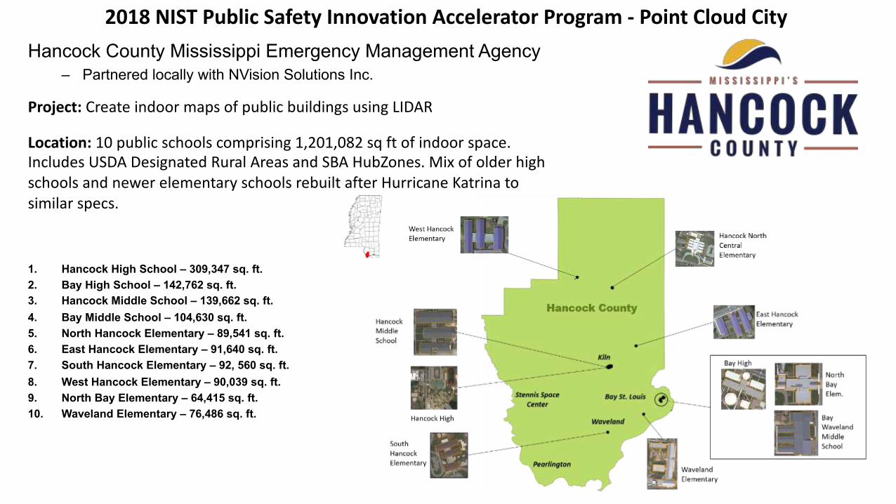
2018 NIST Public Safety Innovation Accelerator Program - Point Cloud CityHancock County Mississippi Emergency Management Agency
– Partnered locally with NVision Solutions Inc.
1. Hancock High School – 309,347 sq. ft.2. Bay High School – 142,762 sq. ft.3. Hancock Middle School – 139,662 sq. ft.4. Bay Middle School – 104,630 sq. ft.5. North Hancock Elementary – 89,541 sq. ft.6. East Hancock Elementary – 91,640 sq. ft.7. South Hancock Elementary – 92, 560 sq. ft.8. West Hancock Elementary – 90,039 sq. ft.9. North Bay Elementary – 64,415 sq. ft.10. Waveland Elementary – 76,486 sq. ft.
Location: 10 public schools comprising 1,201,082 sq ft of indoor space. Includes USDA Designated Rural Areas and SBA HubZones. Mix of older high schools and newer elementary schools rebuilt after Hurricane Katrina to similar specs.
Project: Create indoor maps of public buildings using LIDAR

2018 NIST Public Safety Innovation Accelerator Program - Point Cloud City
Public Safety Applications: EMA coordinates with fire and law enforcement for any significant crisis and takes the lead for natural disasters.

2018 NIST Public Safety Innovation Accelerator Program - Point Cloud City
Key Deliverables• 10 attributed, lidar data sets for 10 public schools• Vector data set for relevant public safety indoor features• Mississippi Automated Resource
Information System (MARIS) data download page
• Any open-source software tools developed“Reach” Goals
• Automated feature recognition and annotation• Immersive VR Headset display• Lightweight, open-source classification software
Potential Impacts• New and improved approaches in public safety tactics• Common standards and best practices for indoor maps• Increased public/private research into indoor mapping due to
high-quality, widely available reference datasets• Increase in derivative technology research• Open-source tools to make processing indoor data and
creating maps easier• Recognition of US as a global leader in Indoor Mapping
technology

2018 NIST Public Safety Innovation Accelerator Program - Point Cloud City
Zeb-Revo RT

2018 NIST Public Safety Innovation Accelerator Program - Point Cloud City
Manual Lidar Annotation
LATTE
2018 NIST Public Safety Innovation Accelerator Program - Point Cloud City
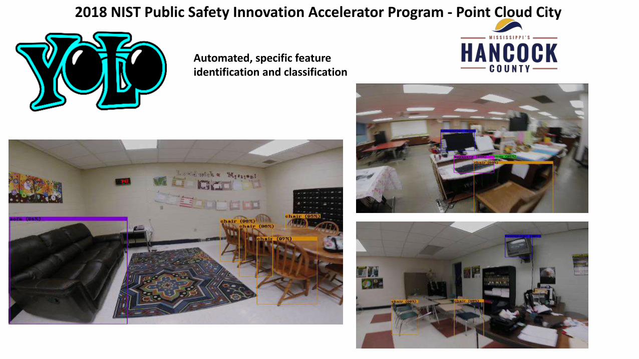
Automated, specific feature identification and classification

2018 NIST Public Safety Innovation Accelerator Program - Point Cloud City
Scalable Lidar Classification??

2018 NIST Public Safety Innovation Accelerator Program - Point Cloud City

23
Indoor Mapping with Handheld LiDAR in Enfield and Storrs, CT
Paul JanuszewskiMatt Mucci
Michael Carifa
Jason Parent James HurdTom Meyer
Enfield Fire

The need for indoor navigation systems
• Disorientation is a major hazard for first responders.
• Thermal cameras are only part of the solution.
• Indoor navigation systems are the missing part of the solution.24
What Hollywood firefighters see
What real firefighters seeWhat a thermal
camera sees
https://www.dhs.gov/publication/precision-outdoor-and-indoor-navigation-and-tracking-emergency-responders-pointer
Indoor tracking and navigation (POINTER)
What we would like to see!

Mapping for indoor navigation
• Indoor navigation requires accurate maps.
• Light detection and ranging (LiDAR) can be used to map buildings “as built” accurately and efficiently.
25

Project objectives
• Create database of point clouds annotated with items-of-interest.
26
• Create floor plans showing items-of-interest.

Items-of-interest• Exits, windows, fire alarm and
suppression system components, utility shut-offs, etc.
• Useful for pre-plans, incident management, and building inspections.
27

Project buildings
• 12 buildings in Connecticut.• 1.4 million square feet.• Schools, administrative, industrial, academic.• Built or renovated 1960 to 2016.
28

LiDAR scanner – Paracosm’s PX-80• 300 pts/sec; range of 80m.
• Simultaneous RGB image collection with integrated spherical camera.
• Scan durations up to 30 minutes.
• Data collection by EFD personnel.
29

30
PX-80 data outputs
Colorized point cloud Spherical RGB (true color) imagery

Point cloud processing
• Python scripts divide point clouds into subsets:• Smaller size improves graphics rendering for manual classification.• Separate ceiling from walls for easier classification.
31

Point cloud classification - auto
• Scripts created to classify small hard-to-see features.32

Point cloud classification - manual
• Manual classification with Lasview (LAS Tools)
• Classify remaining items.• Quality check.
33
• Reference imagery viewed in Paracosm’s Retrace• Helps identify items in point
cloud.

Geo-referencing point clouds
• Scans stitch together and georeferenced using Cloud Compare.
34
• Aerial imagery provides ground control points for georeferencing.

From point clouds to maps
• Floor plans digitized from georeferenced point clouds using ArcGIS.
35
• Scripts will be created to automatically map locations of items-of-interest.

Conclusions and lessons learned
• Certain hard-to-see features were reliably classified by scripts using feature sizes and shapes.
• Lasview was low-cost and easy to use for manual classification.
• Developing scripts to subset and help classify point clouds greatly improved efficiency.
36
• PX-80 scanner can be used effectively with little training or technical proficiency.
• Colors in the point cloud tend to be distorted.
• RGB images (viewed in Retrace) helped to locate features in the point cloud.

37
Indoor Mapping with Handheld LiDAR in Enfield and Storrs, CT
Paul [email protected]
Jason Parent [email protected]
Enfield Fire
Questions?

Come back for the
Next Session
2:25 PM
38
#PSCR2019
Related Documents