Ship Creek, NCI-02 Nuka Research & Planning Group, LLC. This is not intended for navigational use. Center of map at 61˚ 13.38’ N Lat., 149˚ 54.03’ W Lon. Legend Map Photo & Soundings in fathoms Geographic Response Strategies for Northern Cook Inlet Subarea NCI-02 Ship Creek looking southeast. Exclusion Booming Diversion Booming Deflection Booming Open-water Boom Calm-water Boom Snare Line Tidal-seal Boom Shoreside Recovery Staging Area Anchor Railway Tracks DV DF MUD FLATS MUD FLATS ALASKA RAILROAD DEPOT SHORELINE S S 02 EX 01 DV 01 DF SR direction of current direction of current SORBENT BOOM-UPSTREAM SIDE OF CULVERT EBB TIDE - Moderate and High Weather/TIDES - Set at high slack - Establish near high slack - High tidal ranges - Opposing wind/tide - Use in more severe conditions FLOOD TIDE - Moderate and High Weather/TIDES - Change direction of cascade legs prior to low slack - Set straight legs during times that skiff can work K N I K A R M 02 EX MUD FLATS MUD FLATS ALASKA RAILROAD DEPOT SHORELINE NOT TO SCALE NOT TO SCALE S S SORBENT BOOM-UPSTREAM SIDE OF CULVERT SR 01 DV 01 DF K N I K A R M DEPLOYMENT 1 DEPLOYMENT 2 NCI-02 Ship Creek looking southeast. June 2008 SR S EX

Welcome message from author
This document is posted to help you gain knowledge. Please leave a comment to let me know what you think about it! Share it to your friends and learn new things together.
Transcript
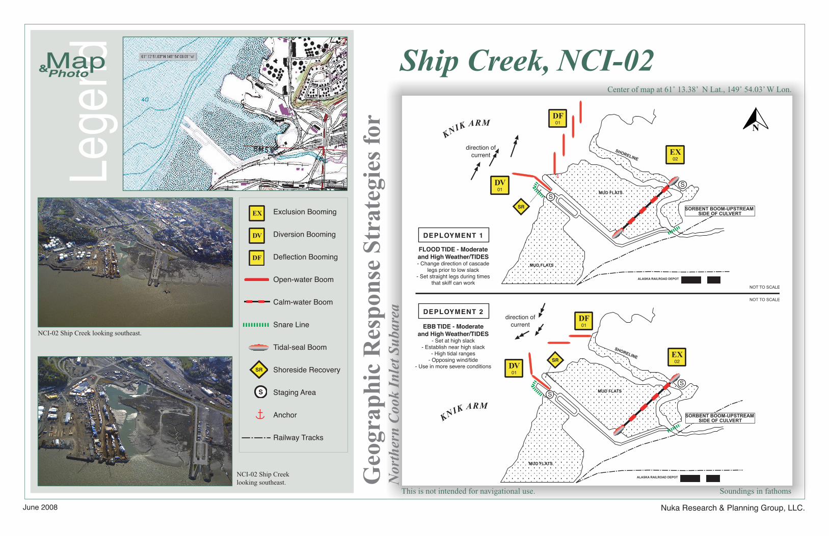
Ship Creek, NCI-02
Nuka Research & Planning Group, LLC.
This is not intended for navigational use.
Center of map at 61˚ 13.38’ N Lat., 149˚ 54.03’ W Lon.
Lege
ndMap Photo&
Soundings in fathoms
Geo
grap
hic
Res
pons
e St
rate
gies
for
Nor
ther
n C
ook
Inle
t Su
bare
a
NCI-02 Ship Creek looking southeast.
Exclusion Booming
Diversion Booming
Deflection Booming
Open-water Boom
Calm-water Boom
Snare Line
Tidal-seal Boom
Shoreside Recovery
Staging Area
Anchor
Railway Tracks
DV
DF
MUD FLATS
MUD FLATS
ALASKA RAILROAD DEPOT
SHORELINE
S
S
02EX
01DV
01DF
SR
direction of current
direction of current
SORBENT BOOM-UPSTREAM SIDE OF CULVERT
EBB TIDE - Moderate and High Weather/TIDES
- Set at high slack- Establish near high slack
- High tidal ranges- Opposing wind/tide
- Use in more severe conditions
FLOOD TIDE - Moderate and High Weather/TIDES- Change direction of cascade
legs prior to low slack- Set straight legs during times
that skiff can work
KNIK ARM
02EX
MUD FLATS
MUD FLATS
ALASKA RAILROAD DEPOT
SHORELINE
NOT TO SCALE
NOT TO SCALE
S
S
SORBENT BOOM-UPSTREAM SIDE OF CULVERT
SR
01DV
01DF
KNIK ARM
DEPLOYMENT 1
DEPLOYMENT 2
NCI-02 Ship Creek looking southeast.
June 2008
SR
S
EX
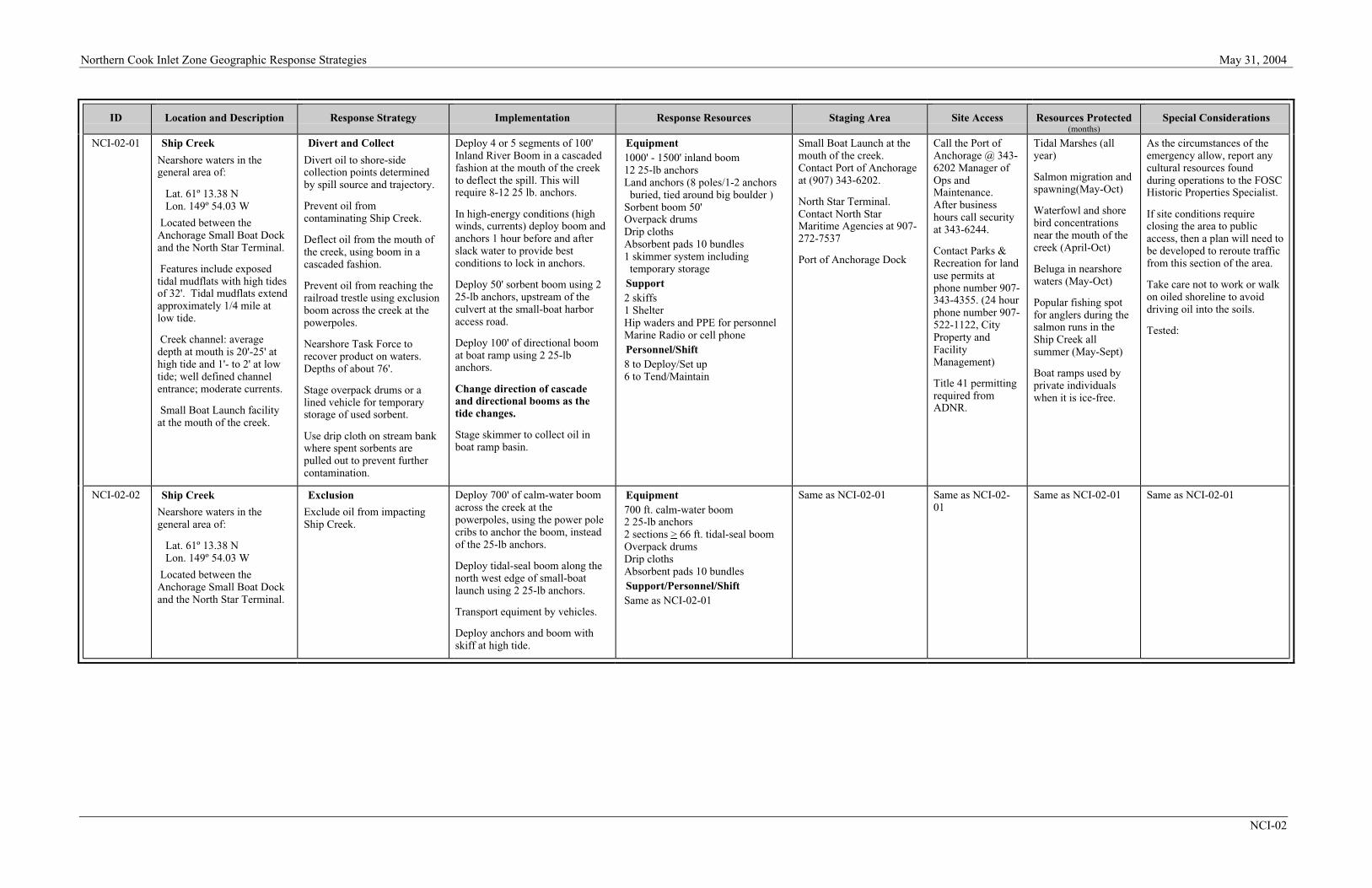
Northern Cook Inlet Zone Geographic Response Strategies May 31, 2004
NCI-02
ID Location and Description Response Strategy Implementation Response Resources Staging Area Site Access Resources Protected(months)
Special Considerations
NCI-02-01 Ship Creek
Nearshore waters in thegeneral area of:
Lat. 61º 13.38 NLon. 149º 54.03 W
Located between theAnchorage Small Boat Dockand the North Star Terminal.
Features include exposedtidal mudflats with high tidesof 32'. Tidal mudflats extendapproximately 1/4 mile atlow tide.
Creek channel: averagedepth at mouth is 20'-25' athigh tide and 1'- to 2' at lowtide; well defined channelentrance; moderate currents.
Small Boat Launch facilityat the mouth of the creek.
Divert and Collect
Divert oil to shore-sidecollection points determinedby spill source and trajectory.
Prevent oil fromcontaminating Ship Creek.
Deflect oil from the mouth ofthe creek, using boom in acascaded fashion.
Prevent oil from reaching therailroad trestle using exclusionboom across the creek at thepowerpoles.
Nearshore Task Force torecover product on waters.Depths of about 76'.
Stage overpack drums or alined vehicle for temporarystorage of used sorbent.
Use drip cloth on stream bankwhere spent sorbents arepulled out to prevent furthercontamination.
Deploy 4 or 5 segments of 100'Inland River Boom in a cascadedfashion at the mouth of the creekto deflect the spill. This willrequire 8-12 25 lb. anchors.
In high-energy conditions (highwinds, currents) deploy boom andanchors 1 hour before and afterslack water to provide bestconditions to lock in anchors.
Deploy 50' sorbent boom using 225-lb anchors, upstream of theculvert at the small-boat harboraccess road.
Deploy 100' of directional boomat boat ramp using 2 25-lbanchors.
Change direction of cascadeand directional booms as thetide changes.
Stage skimmer to collect oil inboat ramp basin.
Equipment1000' - 1500' inland boom12 25-lb anchorsLand anchors (8 poles/1-2 anchors
buried, tied around big boulder )Sorbent boom 50'Overpack drumsDrip clothsAbsorbent pads 10 bundles1 skimmer system including
temporary storageSupport2 skiffs1 ShelterHip waders and PPE for personnelMarine Radio or cell phonePersonnel/Shift8 to Deploy/Set up6 to Tend/Maintain
Small Boat Launch at themouth of the creek.Contact Port of Anchorageat (907) 343-6202.
North Star Terminal.Contact North StarMaritime Agencies at 907-272-7537
Port of Anchorage Dock
Call the Port ofAnchorage @ 343-6202 Manager ofOps andMaintenance.After businesshours call securityat 343-6244.
Contact Parks &Recreation for landuse permits atphone number 907-343-4355. (24 hourphone number 907-522-1122, CityProperty andFacilityManagement)
Title 41 permittingrequired fromADNR.
Tidal Marshes (allyear)
Salmon migration andspawning(May-Oct)
Waterfowl and shorebird concentrationsnear the mouth of thecreek (April-Oct)
Beluga in nearshorewaters (May-Oct)
Popular fishing spotfor anglers during thesalmon runs in theShip Creek allsummer (May-Sept)
Boat ramps used byprivate individualswhen it is ice-free.
As the circumstances of theemergency allow, report anycultural resources foundduring operations to the FOSCHistoric Properties Specialist.
If site conditions requireclosing the area to publicaccess, then a plan will need tobe developed to reroute trafficfrom this section of the area.
Take care not to work or walkon oiled shoreline to avoiddriving oil into the soils.
Tested:
NCI-02-02 Ship Creek
Nearshore waters in thegeneral area of:
Lat. 61º 13.38 NLon. 149º 54.03 W
Located between theAnchorage Small Boat Dockand the North Star Terminal.
Exclusion
Exclude oil from impactingShip Creek.
Deploy 700' of calm-water boomacross the creek at thepowerpoles, using the power polecribs to anchor the boom, insteadof the 25-lb anchors.
Deploy tidal-seal boom along thenorth west edge of small-boatlaunch using 2 25-lb anchors.
Transport equiment by vehicles.
Deploy anchors and boom withskiff at high tide.
Equipment700 ft. calm-water boom2 25-lb anchors2 sections > 66 ft. tidal-seal boomOverpack drumsDrip clothsAbsorbent pads 10 bundlesSupport/Personnel/ShiftSame as NCI-02-01
Same as NCI-02-01 Same as NCI-02-01
Same as NCI-02-01 Same as NCI-02-01
Related Documents