LOOSENING KONY’S GRIP | 8 DR CONGO Map: LRA attacks, January 2010 – June 2013 SOUTH SUDAN CAR Legend International boundary Administrative boundary Community LRA attack 2010 LRA attack 2011 LRA attack 2012 LRA attack 2013 SUDAN N 100km 200km

Welcome message from author
This document is posted to help you gain knowledge. Please leave a comment to let me know what you think about it! Share it to your friends and learn new things together.
Transcript
LOOSENING KONY’S GRIP | 8
DR CONGO
Map: LRA attacks, January 2010 – June 2013
SOUTH SUDAN
CAR
LegendInternational boundaryAdministrative boundaryCommunityLRA attack 2010LRA attack 2011LRA attack 2012LRA attack 2013
SUDAN
N 100km 200km
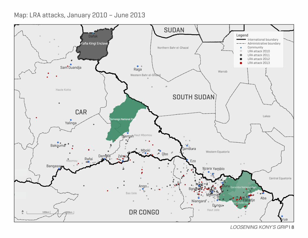
LOOSENING KONY’S GRIP | 13
Map: Estimated location of LRA groups
DR CONGO
CAR
LegendInternational boundaryAdministrative boundaryCommunity
Estimated location of LRA group
Estimated location of LRA groups as of April 2013, denoted by group commander
DR Congo1) Major Thomas Okello “Odano” 2) Major Denis Obol “the one-eyed”3) Second Lieutenant Okello Ray
CAR 4) Major Michael Odooki “Gwee” 5) Jon Bosco Kibwola6) Second Lieutenant Richard7) Major Massimiliano Watmon8) Second Lieutenant Oloo 9) Second Lieutenant Okwera10) Captain Bosco Oroko Loriada11) Otto Ladeere
Kafia Kingi12) Joseph Kony*
Unidentified locationMajor Okot LuwilaMajor Kidega Murefu “Min Tigi Tigi”Okot OdhiamboCaptain Otim Larwedo
*Kony’s group may be operating in northeastern CAR
SOUTH SUDAN
SUDAN
N 100km 200km
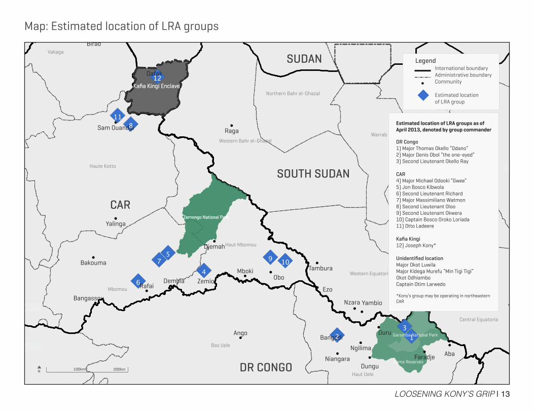
LOOSENING KONY’S GRIP | 20
Map: Defection of long-term members of the LRA, January 2012 – June 2013
DR CONGO
CAR
LegendInternational boundaryAdministrative boundaryCommunityDefection of long-term member(s) of the LRA, including UgandansDefection of long-term member(s) of the LRA, not including Ugandans
Note: Long-term defectors are defined by six months or more of LRA captivity
SOUTH SUDANOn November 28, 2012, two male Ugandan combatants and three girls defected in Mboki, CAR, one of the first successful cases of LRA members utilizing a Safe Reporting Site.
On March 21, 2013, four LRA combatants released 28 women and children near Digba, DR Congo, the largest single return of long-term LRA members since January 2012. The group consisted of seven boys, 13 girls, and eight women.
Western Bahr el-Ghazal
Mbomou
N 100km 200km
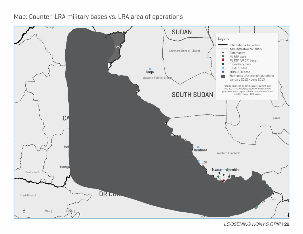
LOOSENING KONY’S GRIP | 28
Map: Counter-LRA military bases vs. LRA area of operations
DR CONGO
CAR
SOUTH SUDAN
SUDANLegend
International boundaryAdministrative boundaryCommunityAU RTF baseAU RTF (UPDF) baseUS military baseUNMISS baseMONUSCO baseEstimated LRA area of operations January 2012 - June 2013
Note: Locations of military bases are current as of June 2013. The map does not show all military de-
ployments in the region, only the most notable bases used by counter-LRA forces.
N 100km 200km
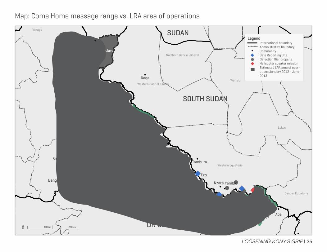
LOOSENING KONY’S GRIP | 35
Map: Come Home message range vs. LRA area of operations
DR CONGO
CAR
LegendInternational boundaryAdministrative boundaryCommunitySafe Reporting SiteDefection flier dropsiteHelicopter speaker missionEstimated LRA area of oper-ations January 2012 - June 2013
SOUTH SUDAN
SUDAN
N 100km 200km
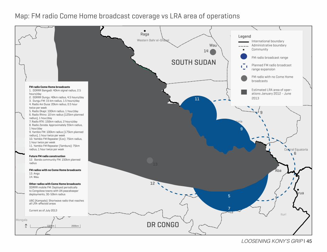
LOOSENING KONY’S GRIP | 45
DR CONGO
CAR
SOUTH SUDAN
LegendInternational boundaryAdministrative boundaryCommunity
FM radio broadcast range
Planned FM radio broadcast range expansion
FM radio with no Come Home broadcasts
Estimated LRA area of oper-ations January 2012 - June 2013
1
23
4
5
6
7
8 9
10
11
12
9
6
Map: FM radio Come Home broadcast coverage vs LRA area of operations
Wau
FM radio Come Home broadcasts1. DDRRR Bangadi: 40km signal radius, 2.5 hours/day2. DDRRR Dungu: 40km radius, 4.5 hours/day3. Dungu FM: 15 km radius, 1.5 hours/day4. Radio Ani Dusa: 20km radius, 0.5 hour twice per week5. Radio Okapi: 100km radius, 1 hour/day6. Radio Rhino: 10 km radius (125km planned radius), 1 hour/day7. Radio RTK: 150km radius, 2 hours/day8. Radio Zereda: Approximately 55km radius, 1 hour/day9. Yambio FM: 100km radius (175km planned radius), 1 hour twice per week10. Yambio FM Repeater (Ezo): 75km radius, 1 hour twice per week11. Yambio FM Repeater (Tambura): 75km radius, 1 hour twice per week
Future FM radio construction12. Banda community FM: 150km planned radius
FM radios with no Come Home broadcasts13. Ango14. Wau
Other radios with Come Home broadcastsDDRRR mobile FM: Deployed periodically to Congolese towns with UN peacekeeper deployments, 30-50km radius
UBC (Kampala): Shortwave radio that reaches all LRA-affected areas
Current as of July 2013
N 100km 200km
13
14
Related Documents