“Map Design and Layout” Jim Besley & Kurt Snider US Fish & Wildlife Service … at your service. USFWS Region 4 GIS Conference Cookeville, Tennessee May 19, 2005

“Map Design and Layout” Jim Besley & Kurt Snider US Fish & Wildlife Service … at your service. Jim Besley & Kurt Snider US Fish & Wildlife Service … at.
Dec 15, 2015
Welcome message from author
This document is posted to help you gain knowledge. Please leave a comment to let me know what you think about it! Share it to your friends and learn new things together.
Transcript

“Map Design and Layout”
“Map Design and Layout”
Jim Besley & Kurt SniderUS Fish & Wildlife Service
… at your service.
Jim Besley & Kurt SniderUS Fish & Wildlife Service
… at your service.
USFWS Region 4 GIS ConferenceCookeville, Tennessee
May 19, 2005
USFWS Region 4 GIS ConferenceCookeville, Tennessee
May 19, 2005

“Map Design and Layout”
USFWS Region 4 GIS Conference
Remember:Cartography is “The art & science
of maps and mapping”so . . .
Portions of this class may be more like an ART class
influenced by the likes, dislikes, and abilities of the teacher!
Disclaimer

What we’ll cover today• Types of Maps• The Basics of Map Projections• The Map Design Process
– Map Size, Scale, Content, Symbology and Typographics.
• Map Layout using ArcView 3.2– Title, Legend, Scale Bar, Inset
Map, Date, Informational Note, and Company Identifier.
“Map Design and Layout”
USFWS Region 4 GIS Conference

• General-Purpose Maps
• Thematic Maps
Types of Maps
“Map Design and Layout”
USFWS Region 4 GIS Conference

• Also called Reference Maps
• Emphasis on location
• All data is at the same level of importance
• Examples of General Purpose Maps– Topographic, Street, Atlas
General Purpose Maps
“Map Design and Layout”
USFWS Region 4 GIS Conference

Topographic Map
“Map Design and Layout”
USFWS Region 4 GIS Conference

Street Map
“Map Design and Layout”
USFWS Region 4 GIS Conference

Atlas Map
“Map Design and Layout”
USFWS Region 4 GIS Conference

• Special-purpose, Single topic, and Statistical maps
• Two or more levels of importance
• Data over a base map
• Examples of Thematic Maps– Choropleth, dot, graduated
symbol, isoline, flow, and value-by-area maps.
Thematic Maps
“Map Design and Layout”
USFWS Region 4 GIS Conference

Choropleth Map
“Map Design and Layout”
USFWS Region 4 GIS Conference

Dot Maps
“Map Design and Layout”
USFWS Region 4 GIS Conference

Graduated Symbol Maps
“Map Design and Layout”
USFWS Region 4 GIS Conference

Isoline Maps
“Map Design and Layout”
USFWS Region 4 GIS Conference

Flow Maps
“Map Design and Layout”
USFWS Region 4 GIS Conference

Two-Way Flow Maps
“Map Design and Layout”
USFWS Region 4 GIS Conference

Value-by-Area Maps
“Map Design and Layout”
USFWS Region 4 GIS Conference

UTM - Universal Transverse Mercator
Albers - Albers Equal Area Conic
Lambert - Lambert Conformal Conic
State Plane Coordinate System
Datums - NAD27, NAD83, WGS84
Spheroids - Clarke 1866, GRS80
The Basics of Map Projections
“Map Design and Layout”
USFWS Region 4 GIS Conference
All you really need to know …

• Cylindrical (transverse)
• Conformal
• Scale is true along Central Meridian
• Used extensively for quadrangle maps at scales of 24,000 from 250,000
• 60 zones, 6 degrees each.
UTM – Universal Transverse Mercator
“Map Design and Layout”
USFWS Region 4 GIS Conference

UTM Zones of the Lower 48
“Map Design and Layout”
USFWS Region 4 GIS Conference

• Conic
• Equal Area
• Used for equal-area maps of regions with predominant east-west expanse, especially the United States.
Albers – Albers Equal Area Conic
“Map Design and Layout”
USFWS Region 4 GIS Conference

Albers – Albers Equal Area Conic
“Map Design and Layout”
USFWS Region 4 GIS Conference

• Conic
• Conformal
• Used for maps of countries and regions with predominant east-west expanse.
Lambert – Lambert Conformal Conic
“Map Design and Layout”
USFWS Region 4 GIS Conference

Lambert – Lambert Conformal Conic
“Map Design and Layout”
USFWS Region 4 GIS Conference

• Grid system developed for surveyors and engineers.
• Three projections used - Transverse Mercator, Lambert Conformal Conic, and Oblique Mercator.
• Originally, units in feet with NAD 27 datum, new work done in meters with NAD 83 datum.
State Plane Coordinate System
“Map Design and Layout”
USFWS Region 4 GIS Conference

State Plane Coordinate System
“Map Design and Layout”
USFWS Region 4 GIS Conference

A datum is a set of parameters and control points used to accurately define the three dimensional shape of
the earth.
Datums
“Map Design and Layout”
USFWS Region 4 GIS Conference

• NAD27 - North American Datum 1927 - based on Clarke 1866 spheroid - Initial starting point was the triangulation station, Meades Ranch, Kansas.
• NAD83 - North American Datum 1983 - based on Geodetic Reference System (GRS) 80 - Initial starting point in a sense is the center of the earth.
• WGS84 – Used by most GPS systems. Very much like NAD83 but also uses a gravity model of the earth for improved accuracy.
Datums – NAD27, NAD83, WGS84
“Map Design and Layout”
USFWS Region 4 GIS Conference
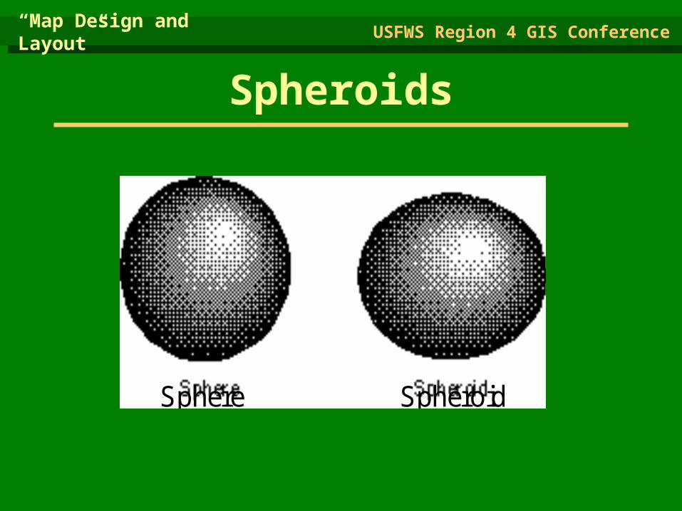
Spheroids
“Map Design and Layout”
USFWS Region 4 GIS Conference
Sphere Spheroid

• Clarke 1866 - Ellipsoid used in establishing a datum (NAD27) for horizontal control in large-scale mapping until 1927.
• Geodetic Reference System (GRS) 80 - Ellipsoid created with satellite information using the earth’s center of mass for calculations. No single origin used. Used for establishing North American Datum 1983 (NAD83).
Spheroids – Clark 1866, GRS80
“Map Design and Layout”
USFWS Region 4 GIS Conference

False Easting - The x coordinate value assigned relative to the origin point of the projection.
False Northing - The y coordinate value assigned relative to the origin point of the projection.
Eastings & Northings
“Map Design and Layout”
USFWS Region 4 GIS Conference

Cool World Projection
“Map Design and Layout”
USFWS Region 4 GIS Conference

• Choosing a Map Size
• Elements of a map composition
• The Design Filter
• Planar Organization of Visual Elements
The Map Design Process
“Map Design and Layout”
USFWS Region 4 GIS Conference

Choosing a Map Size
• What does the end user want or need?
• Can you physically produce the desired size? (i.e. output limitations?)
• Are there publishing, framing, or laminating restrictions or limitations?
• Will the data be legible or useful at the desired size?
“Map Design and Layout”
USFWS Region 4 GIS Conference
First ask yourself these questions:

Map Size Rule of Thumb
If left to you to determine map
size, produce it at the smallest size
feasible.
“Map Design and Layout”
USFWS Region 4 GIS Conference

Common Mapping Sizes
Letter . . . . . . . . . . 8.5” x 11”Legal . . . . . . . . . . . 8.5” x 14”Ledger . . . . . . . . . . 11” x 17”USGS Quad . . . . . . . 24” x 30”“2x3” . . . . . . . . . . . 24” x 36”“3x4” . . . . . . . . . . . 36” x 48”
“Map Design and Layout”
USFWS Region 4 GIS Conference

Standard Media Sizes
ANSI Media
A = 8.1” x 9.66”B = 10.6” x 15.7”C = 15.7” x 20.6”D = 21.6” x 32.7”E = 33.6” x 42.7”
“Map Design and Layout”
USFWS Region 4 GIS Conference

Elements of a Map Composition
“Map Design and Layout”
USFWS Region 4 GIS Conference

Title and Subtitle
Legend
Scale Bar
Inset Map
Credit Note
Date
Logo
North Arrow
Elements of a Map Composition
“Map Design and Layout”
USFWS Region 4 GIS Conference
Mapped and Unmapped Areas
Borders and Neatlines
Graticules and Grids
Map Symbols
Place Names and Labeling


Title - Usually draws attention by virtue of its dominant size; serves to focus attention on the primary content of the map; may be omitted where captions are provided but are not part of the map itself.

Legend - The principal symbol-referent description on the map; subordinate to the title, but a key element in map reading; serves to describe all unknown symbols used.

Map legend - The principal symbol-referent description on the map; subordinate to the title, but a key element in map reading; serves to describe all unknown symbols used.

Map Scale - Usually included on a thematic map; it provides the reader with important information regarding linear relations on the map; can be graphic, verbal, or expressed as an RF.

More on Map Scale
Map scale is a unit of measurement on the map related to the appropriate number of same units on the Earth’s surface and is usually stated as a representative fraction.
“Map Design and Layout”
USFWS Region 4 GIS Conference
For example: 1/24,000 or 1:24,000 scale One (1) unit on the map represents 24,000 units on the ground (1 inch = 24,000 inches which equates to 1 inch = 2000 feet).

“M
ap
Desig
n a
nd
Layou
t”
US
FW
S R
eg
ion
4 G
IS
Con
fere
nce

Map Scale Rule of Thumb
If at all possible,
SCALE YOUR MAP !!!A GIS makes it easy.
“Map Design and Layout”
USFWS Region 4 GIS Conference

Map Scale - Usually included on a thematic map; it provides the reader with important information regarding linear relations on the map; can be graphic, verbal, or expressed as an RF.

Inset Map or Location Diagram – This informs the map user of the context of the map, i.e. the big picture. This will keep the user from having to guess the location of the map.

Informational or Credit Note -Can Include the map’s data source, an indication of their reliability, dates, and other explanatory material.

Date – Use if the time of a map’s publication is a factor. This may also work well as part of the Sub-title.

Company Identifier or Logo – Take credit where credit’s due. Make sure to use a high quality logo, especially for partnering agencies.

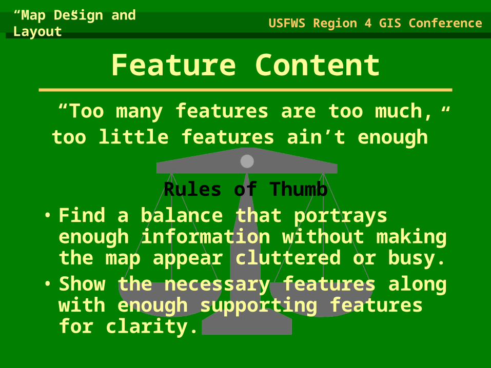
Feature Content“Too many features are too much,too little features ain’t enough”
Rules of Thumb• Find a balance that portrays
enough information without making the map appear cluttered or busy.
• Show the necessary features along with enough supporting features for clarity.
“Map Design and Layout”
USFWS Region 4 GIS Conference

“Map Design and Layout”
USFWS Region 4 GIS Conference

Map Symbols - Wide variety of forms and functions; the most important elements of the map, along with the geographical areas rendered, designer has little control over the their location because geography must be accurate.
Place names and labeling - The chief means of communicating with maps; serve to orient the reader on the map and provide important information regarding its purpose.
“Map Design and Layout”
USFWS Region 4 GIS Conference
Elements of a Map Composition

Map Symbols
• Symbols represent objects that can not be depicted in their true shape or size.
“Map Design and Layout”
USFWS Region 4 GIS Conference

Map Symbols
• Varying sizes and colors help to distinguish the qualitative or quantitative differences among like symbols.
“Map Design and Layout”
USFWS Region 4 GIS Conference

“Map Design and Layout”
USFWS Region 4 GIS Conference

“Map Design and Layout”
USFWS Region 4 GIS Conference

Text Styles Rules of Thumb
• Do not use too many typefaces on a map.
• Avoid ornate text styles (difficult to read).
• Don’t use too thin of text because it may not reproduce well.
• Use different type sizes to show varying levels of importance of features, but no more than 4 to 6 different sizes per map.
“Map Design and Layout”
USFWS Region 4 GIS Conference

Mapped and Unmapped Areas - Objects, land, water, and other geographical features important to the purpose of the map; make the composition a map rather than simply a chart or diagram.
Graticules and Grids - Often omitted from thematic maps today; should be included if their locational information is crucial to the map’s purpose; usually treated as background or secondary information. Grids show the same information, but display it across the body of the map and not just along the neatline.
“Map Design and Layout”
USFWS Region 4 GIS Conference
Elements of a Map Composition
“Map Design and Layout”
USFWS Region 4 GIS Conference
Borders and Neatlines - Both optional; borders can serve to restrain eye movement; neatlines are finer lines than borders, drawn inside them and often rendered as part of the graticule; used mostly for decoration.
Elements of a Map Composition

Platte River
Missouri
River
Iowa
N E B R A S K A
“Map Design and Layout”
USFWS Region 4 GIS Conference

Break here for class to make a map

The Design Filter
“Map Design and Layout”
USFWS Region 4 GIS Conference

• Balance
• Focus of Attention• Internal Organization –
“Intraparallelism”
• Figure and Ground Organization
• Contrast and Design
• Line Contrast
Planar Organization of the Visual Elements
“Map Design and Layout”
USFWS Region 4 GIS Conference

Balance
“Map Design and Layout”
USFWS Region 4 GIS Conference
The two centers
of an image
space.
Optical Center
Geometric center
The designer should arrange the map’s elements around the natural (optical) center, rather than the geometric center.

• Visual balance results from two major factors: weight and direction.
• Visual weight depends on location.
• Elements at the center of a composition pull less weight than those lying of the tracks of the structural net.
• An object in the upper part of a composition is heavier than one in the lower part.
• Objects on the right of a composition appear heavier than those on the left.
• The weight of an object increases in proportion to its distance from the center of the composition.
Visual Balance
“Map Design and Layout”
USFWS Region 4 GIS Conference

Visual Balance
“Map Design and Layout”
USFWS Region 4 GIS Conference

• Readers eye normally follows a path from upper left through the optical center to lower right.
• Point of greatest natural emphasis is where a line of space division intersects either the focus or field circles of attention.
Focus of Attention
“Map Design and Layout”
USFWS Region 4 GIS Conference

Focus of Attention
“Map Design and Layout”
USFWS Region 4 GIS Conference

• “Intraparallelism”
• Technique for giving structure to the graphic elements at the planar level.
• Reduces tension in perception.
Internal Organization
“Map Design and Layout”
USFWS Region 4 GIS Conference

Internal Organization
“Map Design and Layout”
USFWS Region 4 GIS Conference

• Most important perceptual tendency to cartography.
• Figures become the object of attention in perception, standing out from the background.
• Objects that are intellectually important to a map should be rendered so as to make them appear as figures.
Figure & Ground Organization
“Map Design and Layout”
USFWS Region 4 GIS Conference

Internal Organization
“Map Design and Layout”
USFWS Region 4 GIS Conference

• Contrast is fundamental in developing Figure - Ground.
• Visual contrast provides the ability of the eye to discern differences.
• Map elements that have little contrast are easily lost in the total visual package.
• Contrast must be a major goal of the designer.
Contrast & Design
“Map Design and Layout”
USFWS Region 4 GIS Conference

Line Contrast
“Map Design and Layout”
USFWS Region 4 GIS Conference

Texture Contrast
“Map Design and Layout”
USFWS Region 4 GIS Conference
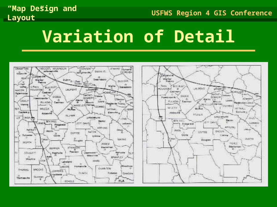
Variation of Detail
“Map Design and Layout”
USFWS Region 4 GIS Conference

Value Contrast
“Map Design and Layout”
USFWS Region 4 GIS Conference

Value Contrast
“Map Design and Layout”
USFWS Region 4 GIS Conference

Value Contrast
“Map Design and Layout”
USFWS Region 4 GIS Conference

• The visual hierarchy is the intellectual plan for the map and the eventual graphic solution that satisfies the plan.
• Objects that are important intellectually are rendered so that they are visually dominant within the map frame.
Visual Hierarchy
“Map Design and Layout”
USFWS Region 4 GIS Conference


Making the Map Readable through Intelligent Use of
Typographics.Map lettering is an integral part of the total design effort and should not be relegated to a minor role. Lettering on the map functions to bring the cartographer and map reader closer together and makes communication possible.
Typographics
“Map Design and Layout”
USFWS Region 4 GIS Conference

Type Elements
“Map Design and Layout”
USFWS Region 4 GIS Conference

• The legibility of individual letters is of paramount importance, especially in smaller type sizes. Choose a typeface in which there is little chance of confusion between c and e or i and j.
• Select a typeface with a relatively large x-height relative to lettering width.
• Avoid extremely bold forms.
Selecting Type
“Map Design and Layout”
USFWS Region 4 GIS Conference

Do not use decorative typefaces on the map; they are difficult to read.
Selecting Type
“Map Design and Layout”
USFWS Region 4 GIS Conference

• The system of specifying type size in the United States and Britain is based on division of the inch into 72 parts called points. A point equals .0138 in (.351 mm). Thus 72 points equals .9962 inches.
• Specify a type size that is large enough to be easily read.
• Professional cartographers rarely use type smaller than 4 or 5 points usually setting a lower limit of 6.
Type Size
“Map Design and Layout”
USFWS Region 4 GIS Conference

Letter Spacing
“Map Design and Layout”
USFWS Region 4 GIS Conference
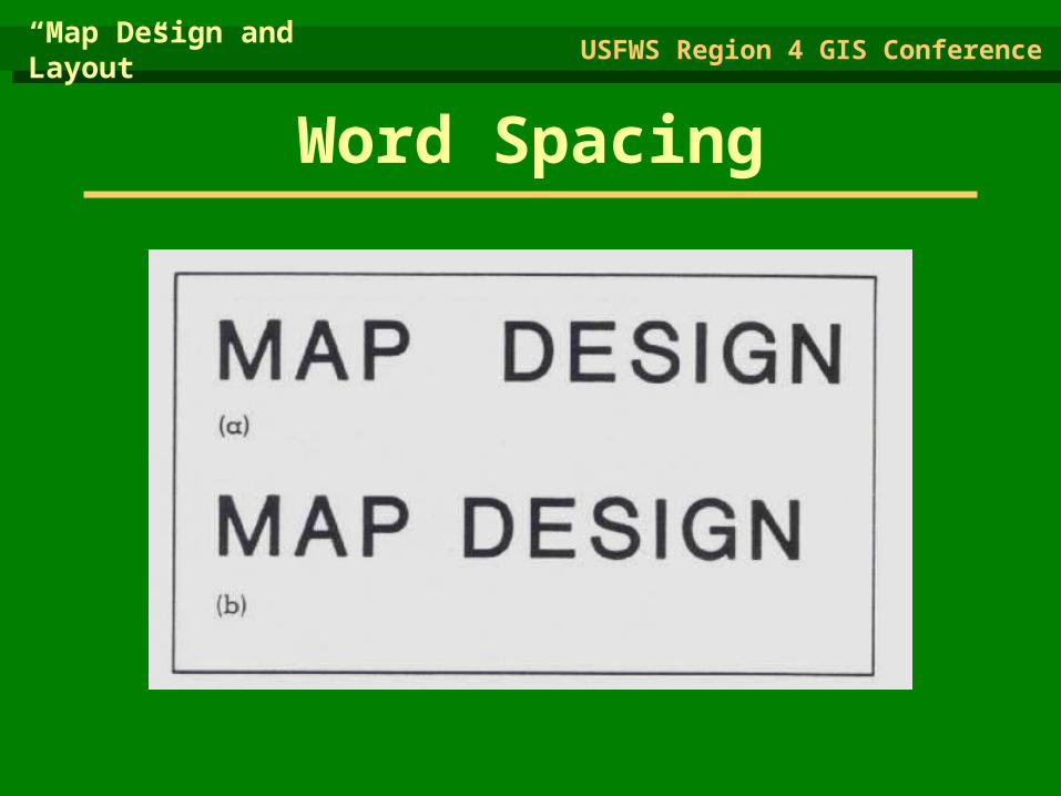
Word Spacing
“Map Design and Layout”
USFWS Region 4 GIS Conference

• Legibility
• Harmony
• Suitability of reproduction
• Economy and ease of execution
Lettering
“Map Design and Layout”
USFWS Region 4 GIS Conference
Four major goals

General Rule: Inside the feature, capitals; outside, lower case with
initial capital.
Lettering
“Map Design and Layout”
USFWS Region 4 GIS Conference
The Use of CAPITALS and lowercase

Labeling Point Features
“Map Design and Layout”
USFWS Region 4 GIS Conference

Labeling Point Features
“Map Design and Layout”
USFWS Region 4 GIS Conference

• General rule is that labels should be set solid and repeated as many times along the feature as necessary to facilitate identification.
• Ideal location of a label for a linear feature is above it, along a horizontal stretch if possible.
• Labels for rivers should slant in the direction of the river’s flow (assuming the label is italic, which is preferred.)
Labeling Linear Features
“Map Design and Layout”
USFWS Region 4 GIS Conference

Labeling Linear Features
“Map Design and Layout”
USFWS Region 4 GIS Conference

• Curved lines of letters should be gentle and smooth , and the curve should be constant for the entire word
• Do not hyphenate names and labels.
• If a line of lettering is not horizontal, make certain it deviates significantly from the horizontal so that its placement will not look like a mistake.
Labeling Areal Features
“Map Design and Layout”
USFWS Region 4 GIS Conference
• Do not locate names and labels in a way that the beginning and ending letters are too close to the feature’s borders.
• Choose a plan for lettering placement of the entire map in accordance with the normal left-to-right reading pattern.
• Never position names so that parts of them are upside down.
Labeling Areal Features
“Map Design and Layout”
USFWS Region 4 GIS Conference

Placement of Titles & Legends
“Map Design and Layout”
USFWS Region 4 GIS Conference

Placement of Titles & Legends
“Map Design and Layout”
USFWS Region 4 GIS Conference
“Map Design and Layout”
USFWS Region 4 GIS Conference
The Road Ahead
• A Great Responsibility…

“Map Design and Layout”
USFWS Region 4 GIS Conference
The Road Ahead
• Suggested Reading:

Jim BesleyUS Fish & Wildlife Service
1500 Museum Rd, Suite 105Conway, Arkansas 72032
(501) 513-4476
Jim BesleyUS Fish & Wildlife Service
1500 Museum Rd, Suite 105Conway, Arkansas 72032
(501) 513-4476
Kurt SniderUS Fish & Wildlife Service
446 Neal StreetCookeville, Tennessee 38501
(931) 528-6481
Kurt SniderUS Fish & Wildlife Service
446 Neal StreetCookeville, Tennessee 38501
(931) 528-6481
Contact Information:Contact Information:
Related Documents