The Unesco L II I) COURIER JUNE 1991 ï M 1205- 9106 -18,00 F

Welcome message from author
This document is posted to help you gain knowledge. Please leave a comment to let me know what you think about it! Share it to your friends and learn new things together.
Transcript

TheUnescoL II I)
COURIERJUNE 1991
ï
M 1205- 9106 -18,00 F

Jencounters
We invite readers to send us photographs to be consideredfor publication in this feature. Your photo should showa painting, a sculpture, piece of architecture or any othersubject which seems to be an example of cross-fertilization
between cultures. Alternatively, you could send us picturesof two works from different cultural backgrounds in whichyou see some striking connection or resemblance.
Please add a short caption to all photographs.
SORTIE AU JOUR
1988, mixed technique on canvas (2.30 x 2.30 m)The last triptych in a series of sevenby Sophie Golvin
The French artist Sophie Golvin has spent several years at Karnakin Egypt, painting among the ruins of ancient Thebes. "Bygetting to know the natural cycles and physical features of thisdistrict," she writes, "and living with them over a period of time,I have tried to assimilate the spirit of the forms and collective
imagination of an ancient civilization and sought to express itspresence."
r

JUNE 1991 CONTENTS
4Interview with
JORGE LAVELLI
The
TÏÏÏÏÏ
Unesco^courier
44th YEAR
Published monthly lr 35 languages and in Braille
"The Governments of the States
parties to this Constitution on behalf
of their peoples declare,
"that since wars begin in the minds
of men, it Is in the minds of men
that the defences of peace must beconstructed...
"that a peace based exclusively
upon the political and economic
arrangements of governments
would not be a peace which could
secure the unanimous, lasting and
sincere support of the peoples of
the world, and that the peace must
therefore be founded, if It is not to
fail, upon the intellectual and moral
solidarity of mankind.
"For these reasons, the States
parties ... are agreed and
determined to develop and toincrease the means of
communication between their
peoples and to employ these means
for the purposes of mutual
understanding and a truer
and more perfect knowledge of
each other's lives..."
Extract from the Preamble to the
Constitution of UNESCO,
London, 16 November 1945
45USESCO IN ACTIOS
Ä* ft-. r-"
THE EARTH
FROM EVERY ANGLE
by Lydwined'Andigné de Asis
UNESCO IN ACTIOS
COPYRIGHT
<^^ '^** IS EVERYBODY'SW^'Vfc- * BUSINESS
<J^J
rtL%9
MAPS AND MAP-MAKERS
THE NEW HISTORY OF CARTOGRAPHY
hyJ.B.Harley 10
IMAGINING THE WORLD
by Catherine Delano-Smith 16
ATLASES, WAYS AND PROVINCESby Sobhi Abdel Hakim 20
THE TREASURES OF MONTEZUMA
by Miguel León-Portilla 24
ZHENG HE'S SAILING CHART
by Mei-Ling Hsu 27
THE PATHFINDERS
by Alfredo Pinheiro Marques 28
WHEN MAPPING BECAME A SCIENCE
by Norman], Thrower 31
THE PERSPECTIVE FROM SPACE
by Jean-Philippe Grelot 35
A BIT OFF THE MAP
by Aleksandr S. Sudakov 39
CELESTIAL CARTOGRAPHY
by Werner Merkli
Interview with
Milagros del Corral
50UNESCO IS ACTIOS
THE UNIVERSAL
COPYRIGHT
CONVENTION
by André Kéréver
Cover: Detail of a sealskin
and plywood map of islandsoff Greenland, made by anEskimo hunter in 1925.
Yellow represents swampland,black indicates lichens, anduncoloured wood the area
covered by tides.
Back cover: The Ark on
Mount Ararat and the
division of the world between
the 3 sons of Noah: Shem in
Asia, Ham in Africa, and
Japheth in Europe. Scenefrom a 15th-centurymanuscript of Jean Mansel'sLa fleur des histoires.
The Editors wish to thank
Prof. J.B. Harleyof the University of Wisconsin-
Milwaukee and
Mme Jasmine Desclaux,cartographer, for their help inthe preparation of this issue.
41
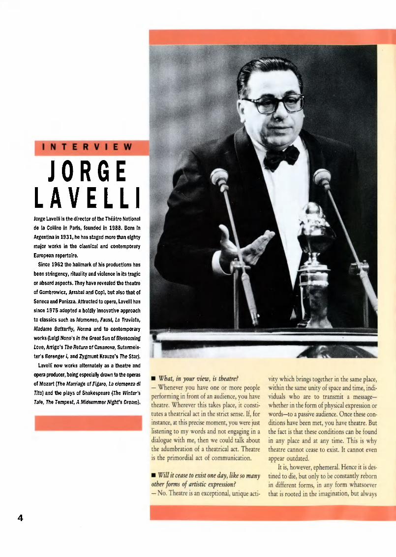
INTERVIEW
JORGELAVELLIJorge Lavelli is the director of the Théâtre National
de la Colline in Paris, founded in 1988. Born In
Argentina in 1931, he has staged more than eighty
major works in the classical and contemporary
European repertoire.
Since 1962 the hallmark of his productions has
been stringency, rituality and violence in its tragic
or absurd aspects. They have revealed the theatre
of Gombrowicz, Arrabal and Copi, but also that of
Seneca and Panizza. Attracted to opera, Lavelli has
since 1975 adopted a boldly innovative approach
to classics such as Idomeneo, Faust, La Traviata,
Madame Butterfly, Norma and to contemporary
works (Luigi Nono's In the Great Sun of Blossoming
love, Arrigo's The Return of Casanova, Sutermels-
ter's Berenger I, and Zygmunt Krauze's The Star).
Lavelli now works alternately as a theatre and
opera producer, being especially drawn to the operas
of Mozart (The Marriage of Figaro, La clemenza di
Tito) and the plays of Shakespeare {The Winter's
Tale, The Tempest, A Midsummer Night's Dream).
What, in your view, is theatre?
Whenever you have one or more peopleperforming in front of an audience, you havetheatre. Wherever this takes place, it consti¬tutes a theatrical act in the strict sense. If, for
instance, at this precise moment, you were justlistening to my words and not engaging in adialogue with me, then we could talk aboutthe adumbration of a theatrical act. Theatre
is the primordial act of communication.
Will it cease to exist one day, like so manyother forms of artistic expression?
No. Theatre is an exceptional, unique acti
vity which brings together in the same place,within the same unity of space and time, indi¬viduals who are to transmit a messagewhether in the form of physical expression orwordsto a passive audience. Once these con¬ditions have been met, you have theatre. Butthe fact is that these conditions can be found
in any place and at any time. This is whytheatre cannot cease to exist. It cannot even
appear outdated.It is, however, ephemeral. Hence it is des¬
tined to die, but only to be constantly rebornin different forms, in any form whatsoeverthat is rooted in the imagination, but always

Jorge Lavelli receives an
award for his production ofSteven Berkoff's Greek at the
Théâtre de la Colline, Paris.
observing the unity of these two basic ele¬ments: space and time. Even though, in atheatrical performance, time is artificialweknow that between eight and half-past ninethis evening it will be theatre timetheaudience and the actors or singers, those whoare going to pass on the message, live in thesame space and time during the performance.It is an ephemeral act, but it can be repeatedad infinitum.
Considering that, even though it isrepeated, this ephemeral act is unique, canit not be said to take on an absolute value?
Indeed it can. A performance lives only inthe memories of those who were there, whowitnessed the theatrical act, and this is some¬
thing which is very specific to it. The onlyplace where it can live again is in their minds.There is no other artistic activity about whichthis can be said.
What's more, the time of the performancedoes not coincide with the artificial time
created on stage. The action may unfold at avery remote time or in the immediate present,but the time created on stage is not real timeas it is experienced in everyday life.
Does a man ofthe theatre like yourselfgeta specific pleasurefrom working in this essen¬tially ephemeral medium?
Definitely, because each performance is atthe same time a form of expression in which,as though to raise this ephemeral moment tothe highest pitch of intensity, a large numberof elements play a part: the actors, the per¬formers; objects which take on a different sig¬nificance according to how they are placed onstage; the architecture, the lighting; all theseare factors that shape and determine the wayin which the performance is perceived.
You didn't mention words.
Of course, words play an essential part. Butyou can have theatre without using words. Agesture can be just as eloquent as a speech.There's also dance, mime, the theatre of
silence. But words are part and parcel of thedramatic art.
Do you try to put on a play that will bethe same every day or do you accept the factthat no two performances can be identical?
Every evening there will be some change,which may be perceptible only to me.Unforeseen events are bound to occur, just asI'm sure they do when you're preparing yourmagazine. Doesn't a page sometimes turn outto be badly printed or a photo to be of poorquality? It's the same in the theatre. Accidentsmay happen that are outside your control. Apower cut or a storm if you're performing inthe open air will alter the climate of the per¬formance. The mood or state of health of the
actors will also have an effect. These are acci¬
dents in so far as human beings are not thesame every day, even though they are readyingthemselves to enact a ritual that has long beenstudied, worked at and rehearsed over and
over again. They will also be influenced bythe size and behaviour of the audience. As for
the members of the audience, they will havetheir own individual interpretation of theplay, which will depend on their own partic¬ular sensibility, on their intelligence, on howconcerned they feel about what they are beingshown, and even on where they are sitting inthe theatre.
Let's talk about yourpersonal sensibility,your identity. Would you say that in Argen¬tina theatre is based on European theatre ordoes Argentine theatre exist in its own right?
Argentina is a country of immigration, apatchwork of peoples, in which Europeanshave a special place. Needless to say, Argen¬tines of Spanish, French or Italian originbrought with them their culture and hencetheir theatre. But since the mid-nineteenth cen¬
tury there has also existed a specifically Argen¬tine theatre with its own characteristics. Why?Because every society finds in theatre a meansof analysing, studying and expressing itself.Argentine theatre is the reflection of a culture,an attitude to life, a way of responding to thethings around us. In Argentina, the French,English and German classics are well known,Goethe, Shakespeare and Molière are regularlystaged, but plays by Argentine writers are alsoperformed. In its form, however, Argentinetheatre is similar to European theatre, just likeAmerican theatre as a' whole. It would in anycase be rather surprising if, in Argentina, thatfarflung corner of Europe, the prevailingtheatrical influence were Kabuki, No orChinese theatre.
Who are your favourite playwrights?At the Theatre de la Colline I have deliber¬
ately chosen to give precedence to contem¬porary playwrights, to reveal present-dayauthors to the public. But before being madedirector, I staged a large number of produc¬tions, in Paris, in the rest of France and in var¬
ious other European countries. Where thechoice of authors is concerned, I have alwaysfollowed my own inclination, for there is avery close relationship between a producer'ssensibility, temperament and intellectual out¬look and the plays he chooses to put on. Thosethat I have chosen represent so to speak thesuccessive chapters of a novel that will cometo an end when I myself leave the theatre. Anovel that can be said to exist only for me, that

A monument to the Spanish
playwright Jacinto Benavente
(1866-1954) In Madrid.
I alone can read from end to end. And one
that has a secret unity, a secret consistency.For example, between the classical and
modern authors whose works I've put onthere are points of similarity. With hindsightI would say that they share a freedom ofexpression that enables them to go beyondnaturalism and to penetrate into the world ofthe imagination, both in the patterns of lan¬guage and in their musical organization. Theyall show human beings in the round, in theirpsychological and social dimensions, but alsowith their inner lives and dreams. They tran¬scend reality in the interests of lyricism,expressing the inexpressible by virtue of adifferent kind of stagecraft, a different idea ofthe expressive value of gesture, a more effec¬tive way of occupying space than would bepossible with a purely naturalistic approach.
This seems particularly relevant to yourproduction ofShakespeare's A MidsummerNight's Dream...
Yes, a play dealing with love's taboos, withthe difficulty of being happy. I have, I think,in my career in the theatre, remained faithfulto this theme of the aspiration to happiness.
I have put on other classical works, likeLife Is a Dream and The Wonder-WorkingMagician by Calderón de la Barca, or The Tri¬umph of Sensibility, a rarely performed playby Goethe. Among modern authors, there isWitold Gombrowicz, whom I introduced into
France with The Marriage, Yvonne, Princess ofBurgundy and Operetta, or Eugène Ionesco,with whom I staged the first production ofKilling Game and put on The Picture and Exitthe King. There's also Fernando Arrabal,Steven Berkoff, Carlos Fuentes, Thomas Bern-
hard, Mikhail Bulgakov, Copi of course, andmany others... This choice of contemporaryauthors follows an inner logic, and of courseit's the same logic that's behind my work atthe Theatre National de la Collinewhere
there's no competition between classical and

modern, but an exclusive concern with the
theatre of today.Contemporary theatre follows on directly
from classical theatre and can be just asexciting, interesting and controversial. It canalso, by exploring new directions, applyingnew approaches and providing a reflection ofthe sensibility of our time, shed light on thesociety in which we live and guide our polit¬ical, cultural, spiritual and intellectual choices.
But don't you think that Shakespeare,Corneille andMozart achieved such a degreeof perfection in their art that no one canmatch them today?
No, this is the effect of distance, of all the
years that have come between. The contribu¬tion of the twentieth-century playwrights isconsiderable. Take someone like EugeneO'Neill: the inventiveness of his theatre and
the vast range of his characters are staggering.In his work, as in that of Shakespeare, themainsprings are ambition and the thirst forpower. But at the same time he creates, inplays like Strange Interlude, a dreamliketheatre, unconfined by realism, focusing onextreme situations and emotional and phys¬ical relationships of a rare violence. He openedup vast possibilities for those who came afterhim.
I'm also thinking of Pirandello, one of thepillars of contemporary theatre. Without himwe wouldn't have had Ionesco, nor evenBeckett. This whole dialectic between form
and content, this duality of man at grips withhimself, of the individual face to face with his
own inwardness, these are extraordinaryinsights granted to us by the contemporarystage. Unsuspected horizons have thus beenrevealed, bringing into the theatre the findingsof both science and psychoanalysiswhichwas unknown in Shakespeare's day. It is quitepossible that in three or four hundred years'time these authors will have the same stature
as their Greek predecessors.
Take the case of Mozart, around whom
a cult has sprung up in our time and whoseems to be in the process of being redisco¬vered. In the nineteenth century his music washardly ever performed. He was regarded as acomposer of genius but one who dealt intrivialities. This point of view is no longer heldtoday. People have looked closely into whathe wrote, wondered why he chose particulartexts, and come to realize that there were thesame relations between certain of his
characters in many of his works and that thisrecurrence of the same themes in different
guises was a way of developing a particularworld-view, of putting across a message; andthat this blend of seriousness and lightnesswhich runs through all his work had nothingtrivial about it. That on the contrary, therewas perhaps no view of life more profound.So it happens that time corrects the impres¬sion that a writer, a composer or an artist hasmade upon his contemporaries.
How do you see the role of the producer?His role is to recreate the play in his imagi
nation, to situate it in his own space and time'in order to put it across more effectively andto imprint upon it the colour of his own sen¬sibility. When you are producing a play youare not simply piecing it together, reducingit to its bare bones or attempting a historicalreconstruction; you are taking a fresh look ata piece of writing, reinterpreting it, minglingyour dreams with the author's.
You don't find this too restrictive?No, certainly not. It's all part of the
ephemeral nature of the performance, of thisunique, fleeting moment which is theatre.There is always an author and a text, and thetext is always open to new interpretations.Actually, a theatre producer enjoys the samefreedom as a novelist: he can tamper withtime, set his own pace.
An act of theatre is an act of love, a work
of creation. If I put on a play, it is of coursebecause I like the play. So I bring somethingto it, the feelings and emotions that it triggersin me, my own way of seeing life, my ownresponse to words. When all is said and done,it is an expression of absolute fidelity and, forthat very reason, demands the utmostfreedom.

'_ V L mtmmn
L¿ : ^.A *W A
Tixiwr m
, ^
la-

A
1CgaV
EDITORIAL
Men doubtless tried in very early times to make a
mental picture of their spatial horizons and of the
principal natural features they came across when they
journeyed by land, sea or river. Not that a need for
landmarks is an exclusively human characteristic.
When herds of wild animals make their annual trek
across the vast distances that separate their winter
quarters from their summer pastures, what do they
do but follow a map of their territory mysteriously
engraved in their memory?
Man, however, has made it his business to depict
the world around him in durable form. Using rudimen¬
tary instruments he began to reveal a kind of map¬
ping impulse by scratching symbolic representations
of his environment on cave walls and the bark of
trees. This impulse may have sprung from a need to
record for later generations the location of hunting
grounds and springs, hazards and havens. Perhaps
it was also part of an innate human desire to achieve
intellectual mastery over a world where unknown
lands stretched far beyond familiar landscapes.
As the centuries went by, human knowledge and
productive capacity increased, instruments for meas¬
uring distance were invented and improved, travellers
covered ever greater distances. The need to record
space visually according to increasingly formal rules
was extended to continents and then to the Earth in
its entirety. Methods and techniques of map-making
gradually became more sophisticated and accurate
thanks to the dedicated work of pioneering scientific
map-makers engaged on projects which in some
cases lasted for many years.
The story of cartography has been an epic of human
perseverance in the face of natural obstacles-
deserts, mountains, oceans. The longest and most
arduous task of map-makers, however, has been that
of overcoming the distorted visions and cultural
prejudices inherited from a past in which each people
naturally saw itself at the centre of the universe. This
issue of the UNESCO Courier shows how cartographers
have grappled with these and other problems and
presents some of their remarkable achievements.
The Miller Atlas (1515-1519), a Portuguese nautical chart
of the Indian Ocean. %.'.=,
¿r^
2s^
rÄ\'

The new history of cartographyhy IB, Harley
Long portrayed as essentially
European, cartography
is now seen as a much more
universal visual language
10
A world map dating from
1109. It belongs to a
tradition of rectangular mapsthat can be traced back to a
now-lost prototype In the
Commentary on the
Apocalypse of Saint John by
the Spanish monk Beatus
of Llebana.

IN the beginning there were maps. There hasalways been a mapping impulse in individualconsciousness. The sensing of space and thedevelopment of cognitive structures to under¬stand it can be traced from the earliest societies
to the present. It was, however, only with thefirst visible act of cartographic representationthe drawing of a map on whatever medium wasto handthat a documented step in abstractthinking initiated the history of cartography.
By substituting an analogical space for a realspace in the process of mapping, human beingsacquired intellectual mastery over their world. Inmany societies maps preceded both writing andmathematical notation. Only much later in the
nineteenth century were they associated with themodern disciplines we now call cartography. Yetmaps produced before then penetrate to thedeepest roots of our culture.
What may be regarded as the oldest authen¬ticated map in the world, dated to approximately6000 BC, was unearthed in an archaeological exca¬vation at Çatal Hüyük in west-central Turkey in1963. Its subject was the neolithic town of thatname. Painted on a wall, it showed the streets and
houses in plan form, lying beneath the profile ofthe mountain of Hasan Dag with its volcanoerupting. But though this map, which shows alayout corresponding to that of the excavatedtown, bears some resemblance to a modern plan,its purpose was very different. The site fromwhich it was excavated was a shrine or holyroom, and the image was created as part of a ritualact, as a "product of the moment", and notintended to last beyond that event.
A Eurocentric vision
Only in recent years have maps such as that ofÇatal Hüyükand comparable engravings andpaintings in the rock art of Africa, the Americas,Asia, and Europebeen studied as a distinctivecategory of prehistoric cartography. That thisshould be so is not merely a reflection ofproblems of identifying maps in these early cul¬tures. It is also an expression of a more deep-seated tendency in the history of cartography thathas restricted the canon of "acceptable" maps.
From the nineteenth century the history ofcartography has been portrayed largely as that of
Western tradition, originating in the ancientNear East, Egypt, arid in the Greco-Roman era,and reaching its culmination via a Europeanpedigree in the developed world of today. Thoughinterrupted in the Middle Ages, and exhibitingboth minor reversions and major revolutions,that cartographic history was seen as proceedingdevelopmentally from simple forms toward amore advanced level of numerical application.
Maps were assigned a position in the evolu¬tionary sequence. The corollary was to excludefrom serious study those maps judged to showno signs of progress toward the goal of objec¬tivity. Even some of the earlier maps of Euro¬pean culture, like the great world maps of theChristian Middle Ages, were once dismissed asbeing unworthy of study. Thus, at the beginningof the present century, Charles Raymond Beazleycould describe two of the most celebrated world
maps of the later Middle Ages, the Hereford andEbstorf maps as "non-scientific. ..monstrosities",and write of their "complete futility".
Maps in non-European cultures were consi¬dered even further alienated from the epicentreof cartography. Traditional approaches to the his¬tory of Islamic cartography, for example, reflectthis tendency of European scholars to see theworld in their own image. The maps of Islamwere explained largely as a Greek heritage,ignoring the extent to which translations intoArabic of works such as Ptolemy's Almagest andGeographia had been ingeniously appropriatedand adapted to the specific purposes of Islamic 11

culture and religion. Arab maps such as those ofthe Balkhi School of geographers in the tenth cen¬tury were assessed by a Ptolemaic yardstick ratherthan being understood as a fusion of mapping tra¬ditions, even though they embodied Persian aswell as Greek elements.
The maps of non-European cultures wereonly allocated more space in Western historieswhen they revealed features similar to those deve¬loped on European maps. The focus was on car¬tographic similarities in these distant culturesrather than on their differences. Thus the rich his¬
tory of Chinese cartographywith datableartefacts surviving from the fourth century BCwas recognized by one leading scholar as "thesame science" that had earlier developed on theEuropean scene. Much emphasis in this compara¬tive cartographic history was placed on the iden¬tification of mathematical aspects of mapmaking,on the codification of methodological principlesfor cartography (such as those of Pei Xiu[223-271], the "father of scientific cartography"in China), and on the appearance of technical
innovations such as grids, regular scales, abstractconventional signs, and even contoursall aspectsthat fitted the Western model of cartographicexcellence. Thus the maps from the Han dynastyfound in a tomb near Chansha in Hunan
province were seized upon by both Chinese andWestern scholars as confirmation of an earlyscientific development of cartography. Theybecame the lineal ancestors of the modern map.
The "scientific" traditions of mapping inChinaand their diffusion into Japan andKoreareceived an attention that was not
accorded to cultures that had no analogy withWestern mapping practices. Thus the indigenousmaps drawn in India before the British occupa¬tion, with their unfamiliar signs and pictorialstyle, have found no place until recently in con¬ventional accounts of cartographic history. Theywere either not recognized as maps at all or dis¬missed as quaint curiosities, to be collected withother ethnographic specimens. Lowest of all onthe ladder of rational progress were the "primi¬tive" maps of preliterate non-Western cultures.
Detail from the mosaic map of
Madaba, which formed the
floor of a 6th-century church
In Madaba (Jordan). It shows
the estuary of the riverJordan.
12

Ranging from paintings produced by theAboriginal peoples of Australia to maps of theNative Americans, and from the stick-charts of the
Marshall Islanders to the battle plans drawn onthe ground by Maori warriors in New Zealand,they were widely regarded as an inchoate stagein the cognitive history of cartography. To theextent that they lacked orientation, regular scales,and the Euclidean geometry of modern maps, orwere drawn on unfamiliar media, little effort wasmade to crack their codes of representation. Theyremained on the periphery of Western carto¬graphic achievement.
In such ways, the history of mapping becamea prisoner of the categories and definitions ofscholars. The rich variety of ways in which spacehas been represented in the global mosaic ofhuman culture still had to be recorded. It was to
remedy this Eurocentric perspective that in 1987,in the first volume of a new History of Cartog¬raphy, we adopted a definition of maps that wouldallow a measure of relativism into the study ofthe history of maps.
A universal languageIn the belief that each society has, and has had,its own natural ways of seeing and producingimages of space, we came to define maps simplyas "graphic representations that facilitate a spa¬tial understanding of things, concepts, conditions,processes or events in the human world." Therationale of such a broad definition was that it
applies to maps in all cultures at all times, andnot only to those of the modern age. Moreover,it allows the writing of a more contextual history,by treating maps as a form of "knowledge" asa whole and not solely as the products of long-term technological diffusion from a Europeanhearth.
So, a new shape is starting to emerge for thehistory of cartography, one in which culturesspeak for themselves. It has two main strengths.First of all, there is now a growing awareness thatcartography is not only much older but also,despite the many gaps in the artefactual record,a much more universal visual language than wasformerly supposed. By accepting some of the pit¬falls of cross-cultural comparison and byexpanding the definition of what a "map" canbeso that it now embraces, for example, cos-mological and celestial representations as well asthose of the Earthwe are beginning to inscribemapping traditions that were previously blankspaces in the history of cartography. The develop¬ment of mapping in India serves as an illustra¬tion of these changes in the writing of the his¬tory of maps.
Despite India's major contribution to thedevelopment of the mathematical sciences, rela¬tively few geographical maps have survived fromthe pre-European period. What fills the carto¬graphic archives are largely cosmographical maps.All three of the main ancient religions of India-
Buddhism, Hinduism, and Jainismhave left acomplex legacy of cosmographical representation.In some maps, the Earth and the universe areoften centred on the axis of Mount Meru
(Sumeru) around the base of which the continentsare arranged. On other maps, the universe is ver¬tically stratified, with graphic representations ofnumerous heavens and nether worlds throughwhich the soul could travel.
Natural features might be given fabulous sizesand shapes: in Buddhist cosmography, forexample, the world containing India was knownand portrayed as Jambudvipa, the Rose-appleIsland, after the jambu tree which grew at itscentre. To judge India's cartographic history inthe light of the European tradition of terrestrialmapping is to misunderstand fundamentally theWeltanschauung of Indian culture and to fail tograsp concepts of space and time that areunfamiliar to Western eyes.
Not only are traditional histories of cartog¬raphy dramatically enlarged by embracing this"new" corpus of cosmological mapsand estab¬lished concepts vastly enriched by the Asian mapexperiencebut we learn also a new respect formaps from other regions. As we extend our car¬tographic encounter into Southeast Asia and intoTibet, into pre-nineteenth-century Africa, or into
Sumerlan terra-cotta tablet
(c. 2100 BC) showing plots of
cultivated land belonging to
the city of Umma (today Tell
Jokha, southern Iraq).
J. B. HARLEY,
of the United States, is
professor of geography at the
University of Wisconsin-Milwaukee and director of the
Office for Map History in the
American Geographical Society
Collection of the University's
Golda Meir Library. He is co-editor, with Prof. David
Woodward, of a multi-volume
History of Cartography of
which vol. 1, Cartography inPrehistoric, Ancient, and
Medieval Europe and the
Mediterranean was published
in 1987 by the University of
Chicago Press. Furthervolumes are scheduled for
publication from 1991
onwards. The History of
Cartography project is
supported by the NationalEndowment for the Humanities
of the United States
Government and by several
private foundations. 13

pre-Columbian America and the Pacific realmbefore Cook, we meet other map traditions thatbear no resemblance to modern European mapsbut that are no less valid cartographies. The oldpreconceptions about the scope of maps inhuman history have been challenged and the oldhistories of cartography are in continuousrevision.
Jain mándala (Gujarat,
18th-19th century).The 7 oceans and the
divisions of time are disposed
around Mount Meru, the pivotof the world.
Thus the second strength of the new historyof cartography is a greatly enlarged understandingof the purpose to which maps have been put.There are few aspects of human action andthought that have not been mapped at one timeor another. The more we explore the terrain ofmaps across the major cultures of the world, thelonger the list becomes of different activities towhich they may have "made a difference". Uses
range from the prosaically practical to the seem¬ingly speculative.
In ancient China, for instance, the utility ofmaps as instruments of political power asboundary and cadastral maps, as bureaucraticrecord, as diplomatic protocol, as plans for waterconservancy, as a means of assessing taxes, as stra¬tegic documents in military logisticsare all welldocumented. Equally, Chinese maps enter intoother cultural dialogues. Far from being just ascience of measurement, maps have been closelylinked to literature and painting. They have beenintegrated into historical scholarship; they havebeen used to reconstruct geographies of the pastand have been carved on stone in public placesas witnesses to cultural continuity. They havebeen used in ritual, as is confirmed by their
14

presence in tombs; they became tools of divina¬tion or were used as talismans to mediate between
unseen forces. They have been used in the astro¬logical prediction of celestial events.
Mental images
China was by no means unique in the range ofuses it developed for maps. In Western as muchas Eastern societies, maps have resulted in a car¬tography that invariably combines the objectivewith the subjective, fact with value, myth withdocumented event, and locational silence with
coordinated place. If in traditional Eurocentrichistories we have neglected the mythic, the psy¬chological, and the symbolic uses of maps infavour of the practical, it is our obsession withscientific models rather than with the actual his¬
tory of cartographic practice that is to blame.The insights thus gained from the study of
non-Western mapping traditions and practicescan be applied to the history of maps throughoutthe world. As we identify many more local tra¬ditions of mapping, cartographic history can nolonger be seen as part of a one-way process bywhich cultural hegemony was exercised by Euro¬peans over colonized peoples. In the Americas,for example, evidence is mounting of the extentto which maps of colonial territories publishedin Europe from the sixteenth to the nineteenthcenturies were underpinned by geographicalknowledge contributed by indigenous peoples.Even in situations of conflict, maps in many partsof the world were a means of cultural exchangethat reached over the barriers of language. And inother cases, maps were also a means of resistanceby which colonized peoples sought to oppose theappropriation of their culture and territory.
In order to explore these new directions, maphistorians are embracing theories derived fromthe humanities and social sciences at large. Thewell-worn story of the achievements of a numer¬ical technology in the way the world isrepresented is being challenged. No longer are wecontent to accept that even our modern maps,though generated by Landsat satellite and com¬puter graphics, are above the machinations ofpower. No less than a map of an Indian cosmog¬raphy or an Aztec map of the universe, thesesatellite-based maps are socially constructed. Car¬tography, we now begin to realize, is the productof wider discourses, a form of power-knowledgecaught up with the major transformations ofworld history, created and received by humanagents, exploited by elites, to materialize as aworld seen through a veil of ideology.
From the beginning maps have been a mentalimage. Today they are still recognized as a wayof seeing, but we begin to understand what"seeing" is. Rather than thinking of maps as themirror of the world, we now see them as a
simulacrum: sometimes preceding the territory;constantly redescribing the world in all its cul¬tural diversity.
Redrawing the Earth
In 1973, a German cartographer, Arno Peters, unveiled a new map projection which
he had devised In an attempt to give a true representation of the relative sizes
of the Earth's land masses. One of the avowed alms of the Peters projection is
to eliminate the "geographical superiority" enjoyed by countries of the northern
hemisphere In a number of other projection systems, Including that established
by the Flemish cartographer Gerard Mercator In 1569 and described In the text
below. However, it Is impossible to reproduce the spherical Earth on a flat sur¬
face without some kind of distortion, and the Peters projection has stirred up
vigorous controversy In many quarters, including within the United Nations system.
The Mercator projection
The Mercator projection (Map 1) provided European seafarers with the
fidelity of angle they needed to line up their compass bearings with points
on the map. But to achieve this Mercator had to place the lines of latitude
progressively further apart as they moved away from the equator. This
makes Greenland and all northern hemisphere countries grossly exagger¬
ated in size, and Europe appears to be at the centre of the world.
The distortions of Mercator's map did not seem strange to Europeans
in the sixteenth century, an era of expanding colonial empires. Yet today,
although European colonialism belongs largely to the past, Mercator's
sixteenth-century map still retains much of its grip.
Many attempts have been made to improve on Mercator, for example
by using a rounded grid as in the Winkelsche projection (Map 2). But thismeans that north-south and east-west directions are lost. Also the coun¬
tries on the edges of the map are distorted in shape.
Things would be simpler if we could replace these various versions with
just one projection reflecting what most people actually want from a world
map. This is precisely what Arno Peters has tried to do.
Fidelity of area and direction
Peters fixed on two things which a world map must have to be interna¬
tionally acceptable: fidelity of area and true north-south and east-west direc¬
tions. Beyond these two fixed principles, the compromises have to start.
As no map can give any country exactly the same shape it has on the globe,the ideal is to minimize distortion.
The Peters map
On the Peters map (Map 3) the maximum shape distortion occurs in the
polar region where countries like Iceland tend to be flattened, and along
the equator, where Zaire and Sumatra look longer than we are used to.
But maximum shape distortion on the Peters map is never more than 2:1,
compared with a 4:1 distortion of Europe on the Mercator map.
This new, equal-area map is the first fruit of what Peters sees as "a
new cartography", free of the historical perceptions that have shaped
earlier world maps.
Source: United Nations Development Programme (UNDP)
15

by Catherine Delano-SmithThe maps of yesteryear
often recorded myths
and legends as well as
hard facts. How far have
things changed today?
I
16
MAGINATION has played a key role in the his¬tory of cartography. Long before the fifth cen¬tury BC, when Greek scholars found the Earthto be a globe, and in far corners of the Earth nevertouched by their learning, people imagined theshape of the Earth they lived on. The Aztecs sawtheir world as five squares; ancient Peruvians asa box; ancient Egyptians as egg-shaped. Someearly Chinese also believed the Earth to be likean egg or like a ball, and derided those whothought of it as flat and square within circularheavens. In Japan, before Christian missionariesarrived at the turn of the seventeenth centurybringing with them the notion that the world isround, there seems to have been at least one
theory of the Earth as a cube.Such ideas have been expressed in map form
from prehistoric times onwards all over theworld. In rock art, circles and squares, thoughtto represent the world, are common motifs incave paintings or on carved rocks from Scan¬dinavia to India and from Asia to the Americas.
The Korean Ch'iian Chin's image of a cubicEarth is found in a manuscript of 1547. The fivesquares of the Aztec "world" were painted onthe opening page of the Fejérváry Screenfold, aritual book of the pre-conquest period.
To some early societies, symmetry wasimportant. In pre-classical Greece, at the time ofHomer, the circle of the world was divided byan equator, roughly along the line of the Mediter¬ranean Sea. The ancient philosopher-geographersof classical Greece drew lines around the spheredividing the Earth into parallel zones or climata,all places within one zone having roughly thesame length of day. Some of the global symmetrywas lost when Pliny divided the part of the Earthbest known to the Greeks and Romans into seven
zones, all north of the equator, in order to allowthree for the "wilderness" of the far north.
In Hindu India, some authorities depicted theworld with four continents, corresponding to thefour cardinal points, although they had as yet no"knowledge" of the Americas. Geographers inthe Roman period illustrated their textbooks withdiagrams of a spherical Earth subdivided into thethree continents they knew about (Asia, Africa,Europe). Some, like Strabo in the first centuryAD, suspected the existence of other land masses,perhaps even a fourth continent, and a few earlyhistoric maps from Europe seem to suggest this.
It was not, however, until after the last decadeof the fifteenth century that Europeans couldstart to put the Americas onto their maps of the
world because some of them had seen the "new
lands" for themselves. Even so, it was not alwayseasy to know just what to draw. One map of 1502(the Camino map) shows the two Americaswidely separated; another (1528, by P. Coppo)shows North America as a group of small islands;yet another (1548, by G. Gastaldi) depicts NorthAmerica as a continuation of Asia.
Several sixteenth-century maps showed aMare Indicum or Sea of Verrazano, almostbisecting the northern continent. This was theresult of one voyager's too-hasty identification ofa stretch of inland water along the eastern sea¬board of North America with the Pacific. Yet
other geographical myths concerned the penin¬sulas of Florida and Yucatan, discovered by Euro¬peans in 1513 and 1518-1519 respectively but firstcharted as islands. Then there was the problemof California, first correctly charted as a penin¬sula after a Spanish fleet sent by Cortes had suc¬cessfully navigated to the head of the Gulf in1540, but nevertheless shown as an island on

-I r
i'^-n
S*
y
! ¡Jt Jtigiii
I, 'p RAt%
Ixdilirici no1;l'illi Tl' nil'll
î»iliV.tVirfoli \
%; I
j(! I SA' iy k . - --
"p»rc>uwuiw«jgi" , ',]
î
'
î
M TAA^
! ufe J I[j.Vlv.rCJTCPnpiv.iiott>fiiilO>> i , -r J" K PT»/v n ^ ' «I» * U 'toniniioqiUivn-Ui.l.lhWo f LKKTÄlO ,hoorn.\ro^coiccluiicriot«f /t = 5*,,,.-,J;,i, . .Icqiulricvmnfllulcri-iiucV -7 . «& -ja
£lnc!>o crccllcnflmio cVotvtifl'mio ijw.itor cl qn-ilf; . lUIlflU
*
»
many seventeenth- and eighteenth-century maps.A similar misconception was a belief in a con¬tinuous northwestern sea passage across NorthAmerica, providing a northern route to China.Ortelius showed it clearly on a map of 1564. In1592 a Greek sailor reported he had reached itswestern end. Thereafter, for three centuries,Europeans vied with each other to find thismythical passage, driven by the hope of gainthrough the trading advantage the way throughto the Pacific was thought to bring them.
The location of legends
Many maps depict famous events. These eventsmay be historically testifiable ones such as thesites of recent battles. Others show where a
historic event was thought to have taken place.Some Indian maps from the eighteenth andnineteenth centuries show not only Vraj (thebirthplace of Krishna) but also a host of placessacred to Hindus as part of the Krishna legend.
Still others showwithout any annotation orstylistic differentiationthe location of whollyimagined events. Atlantis and a host of otherlegendary islands were shown on maps of theAtlantic in the fifteenth and sixteenth centuries
especially.Long-lived legends about famous personages
such as Alexander of Macedonia are other
examples of the historical imagination whichwere depicted on maps. The "Alexander myth"is seen on Ptolemy's maps of Asia in the Columnsof Alexander (representing the Caspian Gatesthrough which Alexander was said to havepassed). It is found too on a late eighteenth-century Indian map of the world on which Alex¬ander is seen with the men who allegedly askedfor his help against the mythical giants Gog andMagog and with the wall he was said to have builtto imprison the accursed ones. A Christian map-pamundi of the thirteenth century depicts justsuch a Wall of Gog and Magog in northeast Asia,probably an echo of the real Great Wall of China.
- ' öUiuiciratrrc
Detail of the Fra Mauro world
map of 1459. The map Is a
compendium of geographical
sources, Including Portuguese
expeditions to Africa,
Ptolemy's Geography, the
Marco Polo narratives, and
portulan charts.
17

18
Asia was also supposed to be the home of thepriest-king Préster John, an early medieval Euro¬pean legendary hero who would, it was said, helpthe Christian world against the Muslims in theHoly Land. By the mid-fifteenth century, though,Préster John's kingdom was believed to be inEthiopia, part of an India which extended overmuch of Africa as well as Asia. After 1488, bywhich time the Portuguese had opened a newseaway to India round the southern tip of Africaand past Abyssinia, maps of Africa showed anenthroned Préster John, his palace, or the royalmountain, Mount Amaro, in which his sons were
supposed to have been incarcerated until theorder of succession called each to the throne in
turn.
Fictional as well as philosophical literaturehas spawned a different category of imaginedhistorical places, where the entire country orregion depicted on the map is mythical. An earlyexample is the woodcut map produced by HansHolbein in 1518 for the second edition of Thomas
More's Utopia. The tradition continues today.
Imagination and power
Maps have also carried graphic messages aboutthe imagined political supremacy of nations orsocieties. They may have been drawn to back ter¬ritorial claims or support chauvinistic notionsabout status (such as maps drawn by Naziarchaeologists to show the distribution ofNeolithic "Germans" in Greece and Bronze Age"Germans" in Scandinavia).
One traditional conception of China placedthe heartland of the royal domains in the centreof four concentric zones, the outermost of whichrepresented the zones of "allied barbarians" and,most distant of all, of "cultureless savagery". TheChinese were thus less than impressed when theJesuit missionary Matteo Ricci arrived andshowed them maps of the world in which Europeand the Atlantic occupied the central positions.Tactfully, Ricci drew another map centred on thePacific Ocean.
Maps may reflect the economic competitionthat so often underlies political concerns. Mapsfrom the period of European discoveryrepresented the often fabulous mineral wealth ofthe "new" lands to justify the discoverers'exploits and to encourage further investment intheir voyages.
From the Americas came the legend of thealluring Kingdom of Gold and the even moreattractive El Dorado. The latter was the legen¬dary city of the king of "Manoa", situated on theshores of an equally mythical "Lake Parima",which the Spaniards heard about in 1530 andwhich they supposed to lie in the basin of theOrinoco river. The legend gave rise to numerousexpeditions to the highlands of Guiana, one ofwhich was dispatched from England by SirWalter Raleigh. Part of Raleigh's manuscript map(1595) survives, showing "that mighty, rich andbeautiful Empire of Guinea, and. ..that great andgolden city which the Spaniards call El Dorado
keep out the "barbarians".
Detail from the 13th-century and the naturals [call] Manoa". The Frenchman
^:rshMoawp;Partthoefrsh t- ^7 -s^ * «weg** map -m ^legendary wall built by on which the elusive Lake Parima was promi-Aiexander the Great around nently shown, with equally fabulous creaturesthe kingdom of Magog to n£arby) such as headless men and fears0mely
armed womenthe Amazonians of another
ancient myth.
A new world
seen in terms of the old
Similar reasons of self-interest led European map-makers to represent the landscapes of what wasto them a new world in terms of the old. To
avoid alarming prospective colonists, maps por¬trayed the landscape as gentle: open parkland,dotted with round trees like the familiar oaks and
elms of the undulating plains of southern Englandor lowland France. Colonial settlements were
ranked in terms of the European social order;native settlements were discreetly marked. In fact,the existence of natives was altogether betterignored, according to this view. The myth of aEuropean, not an Indian, country was thus earlyperpetrated by maps. It is still there, in the Euro¬pean place-names which dispossessed the Indianones.
Even in their own countries, European map-makers could be equally selective in what theyput on or (just as significant) omitted from theirmaps. In the seventeenth century, the neat, ord¬erly and wholly bland appearance of the earlyatlases portrayed an imaginary landscape thatpushed the social and economic contrasts andpolitical disorders of real life out of mind. By thelate eighteenth century, standardized shading had
CATHERINE DELANO-SMITH,
of the United Kingdom, has
taught historical geography ata number of British universities
and is currently Visiting Reader
in London University's
Department of Mediterranean
Studies. Her special interests
in the history of cartography
include prehistoric maps, the
history of map signs before
1800, and maps in bibles.

reduced the entire urban scene, with the housesand workplaces of the great and the poor, to amythical uniformity, another landscape of themind.
In search of an earthly Paradise
Finally, but fundamentally, maps have been usedfrom the beginning to portray the imaginedworlds of religious man. Like the question of theshape of the geographical world, the structure ofthe cosmos has varied according to the sacredmyths and the teaching of the gods in eachsociety.
Cosmological maps tend to be schematic instyle and often symmetrical. Common to manycosmologies, especially in Asia, dominated by theheights of the Himalayas, is the concept of a cen¬tral mountain, the vertical axis of the cosmos, likethe Mount Sumeru of the Buddhists and the
Mount Meru of the Hindus. Muslim cosmolog¬ical maps placed Mecca at the centre of the Earthbecause of its position opposite the centre of thesky.
Of vital concern to every believer is thejourney from this world to the next. Maps havebeen made to guide the newly dead. In the NewHebrides early in the twentieth century, thelabyrinth design was still being sketched out inthe sand to teach initiates The Way. The routehad to be memorized. From Australia to Siberia,
complex designs painted on shamans' drumsserved as aide-mémoires. In ancient Egypt, mapswere painted on the outside of coffins togetherwith relevant extracts from The Book of the
Dead. Here word and image were inscribedtogether to ensure the individual's safe journeythrough the underworld.
Maps of the geographical world have alsobeen richly, sometimes excessively, invested withreligious myth and symbolism. Christians cameto identify each of the three continents of the OldWorld with one of Noah's sons (Shem for Asia,Ham for Africa, and Japheth for Europe). Fromthe eighth century AD onwards, their figures ornames were sometimes included in diagramsdrawn to illustrate, in the Roman tradition, newcopies of older written geographical descriptionsof the world (the so-called T-O maps).
Another feature imposed on Europeanregional and world maps by the Christian theo¬logical imagination has been the terrestrial para¬dise or Garden of Eden. In the fifth century ADan Irish monk, St. Brendan, sailed westwards tofind what he believed were the Isles of Paradise.
St. Brendan's islands remained on maps for manycenturies, even when, as on the Hereford map-pamundi, Eden was marked in the east. St.Brendan's islands (sometimes marked as the For¬tunate Isles) were often confused with realAtlantic islands. Usually, though, in accordancewith the description in Genesis chapter 2, Edenwas placed in the east. On medieval maps it wasplaced prominently at the edge of the map.
With the emergence of Protestantism in thesixteenth century, and especially John Calvin's
insistence on a literal interpretation of the bib¬lical text, Eden had to be shown close by the Tigrisand Euphrates, two of the four rivers said to waterit. The religious drive to find an earthly Edencould be strong. Despite increasingly detailedknowledge of real world geography, the searchcontinued to recent times. In 1666, M. Carver
published a map in his book showing Paradisein Armenia, and in 1882 General Gordon put for¬ward his idea that, before the Flood (yet anotherof the world's "great myths") Paradise had beensituated on Praslin in the Seychelles.
Perhaps we should not dismiss the topic ofimagined worlds too lightly, as if it illustratedmerely some of the quainter sides of humannature or human history. We still often prefer toimagine the world or to lead others to see it ina preferred way. National maps may present a"scientific" face but it is not difficult to deduce
omissions, such as military installations, airfields,or politically sensitive targets such as biologicalresearch centres. Nor is it difficult to discern the
way modern geographical "myths" are createdthrough, for example, the removal from the mapof settlements after rumours of certain types ofman-made disaster, or the translation of sea orcity names on the map as a cartographic substi¬tute for political aggression less easily achievedovertly. In modern as in ancient maps, myth andlegend remain ingrained.
Above, a map of the world
embellishes an Initial capital
letter In a 1417 manuscript
of the De Chorographia,
a treatise by the Latin
geographer Pomponius Mela
(1st century AD).
Detail from an atlas by the
French sailor and
cartographer Guillaume Le
Testu (1556).
19

20
Atlases, ways andprovincesby Sobhi Abdel HakimBuilding on the heritage of Antiquity, the Arabs made their own original
contributions to cartography, ushering in a golden age
It is very difficult to form a value judgementof the Arab maps produced in the Middle Agessince, despite all the searches made, only a verysmall number of originals have been found.The maps constructed by al-Khwarizmi (theplanisphere drawn at the request of Caliph al-Ma'mun), al-Balkhi, al-Istakhri, Ibn Haukal, al-Maqdisi and the anonymous author of the Limitsof the Universe, have been lost. Even al-Idrisi'sfamous map is only a copy dating from thefifteenth century.
The history of cartography among the Arabs,as among all other peoples, is closely bound upwith the development of geography and its manyrelated fields. From ancient times the Arabs too
needed precise bearings to regulate the course oftheir lives and their activities. The advent of Islam
made this all the more necessary. In order to fulfilthe obligations of prayer, fasting and ritual pil¬grimage, they had to be able to decipher thecosmic clock and know which way to turn to faceMecca.
Heirs and successors
However, it was not until Arabic translations
were made of ancient books, especially those ofthe Greeks and of Claudius Ptolemaeus (Ptolemy)in particular, that Arab cartography became amajor field of scientific study. These translationswere made possible by the generous patronageof the caliphs, who understood the value of theknowledge built up by the ancients. Wishing toincorporate that knowledge into Muslim culture,they provided a variety of rewards for those whotranslated the scientific works of Antiquity intoArabic. Caliph al-Mam'un, for instance, paidtranslators an amount of gold coins and barsequivalent in weight to the works translated.
The Arabs were careful to preserve thisheritage and throughout the Middle Ages cons¬tantly added to it, both with contributions of
-*c
SOBHI ABDEL HAKIM,
of Egypt, is professor of
human geography at Cairo
University, of which he was
formerly Vice-President.
their own and drawing on the work of Indianscholars. In the period extending from theseventh to the twelfth centuries, the pole ofgeographical learning thus shifted. From Europeit moved to the great centres of scientific studyand investigation of Baghdad, Cordoba andDamascus. It can therefore be said without risk
of error and despite the lack of direct contactbetween Arab and European cartographers, thatthe resurgence of mathematics and astronomy inRome, Oxford and Paris in the thirteenth cen¬
tury was simply the direct result of the advancesmade by the Arabs in cartography. The Arabskept the torch burning and paved the way forthe great blossoming of science that occurred inthe West during the Renaissance.
The Arabs were right to regard the work ofPtolemy as the peak of the achievements of theGreeks and Romans. Yet they did not followblindly the teachings of the great Greekastronomer, mathematician and geographer. The
t

Arab travellers disputed a fair number of his ideas.The Arab astronomers for their part calculatedanew the distance represented by a degree andarrived at very precise results. They were notmerely links in the transmission of learning.Eager to build on what was already known, theynaturally started out from where theirpredecessors had left off.
These efforts culminated in the writings ofal-Battani and al-Mas'udi in the tenth century.Al-Battani questioned many of the hypothesesput forward by Ptolemy. Unlike Ptolemy, whothought that Africa and Asia were joined near theMalaysian peninsula, he believed that the IndianOcean was an open sea. Al-Biruni's writings onthe East and those of al-Idrisi on the West
rounded off the Arabs' knowledge of the world.Several factors, which it would take too long
to list here, contributed to the development ofthe geographic and cartographic sciences amongthe Arabs. Islam, which had become their religion,
encouraged them to pursue knowledge to thefour corners of the Earth. Huge expanses of landhad been won through conquest, and theresources they contained needed to be assessedin order for the most suitable tax system to beintroduced. In addition, three of these territories
(Mesopotamia, Persia and Egypt) were cradles ofcivilization. If the Arabs were to govern them,they had to know about them.
Travellers and cartographers
So big did the empire become that a postal serviceand a road system became necessary. These intheir turn were instrumental in developing trade,fostered by the unification of language andreligion. Increasing numbers of books described"the ways and provinces". The pilgrimage toMecca also played a great part in developing theArabs' taste for travel and for geography. The pil¬grim would converse in the same language with
Detail of a map by the Arab
geographer Ibn Haukal
showing part of central Asia
and Transoxlana, the landbetween the Oxus and the
Jaxartes rivers. Samarkand,
the chief city of Transoxlana,
Is shown at centre of map.
21

22
other Muslims from different places and fromdifferent social backgrounds. These pilgrimages,which took up a considerable amount of time,often afforded invaluable opportunities for study,exploration and trade. Upon their return, thetravellers-cum-pilgrims-cum-traders wroteaccounts of their experiences that were mines ofgeographical information. There were many car¬tographers among their number, including IbnHaukal, al-Mas'udi and al-Idrisi.
More than one Arab geographer was markedby the teachings of Ptolemy, which served as thestarting-point for the mapping of the heavens andthe Earth alike.
Mohammed Ibn Musa al-Khwarizmi laid the
foundations for Arab geography. His Book oftheConfiguration of the Earth (Kitab surat al-ard),written in the early half of the ninth century,incorporates and amends the findings of Ptolemy.He is believed to have designed his work, togetherwith his celebrated planisphere, in collaborationwith other scholars, at the request of Caliph al-Ma'mun. Unfortunately, most of the maps thatal-Khwarizmi helped to construct have been lost.Only four of them have come down to us. Theyare the oldest Arab maps known to exist.
In the tenth century the most famous Arabcartographer was Abul Hassan Ali al-Mas'udi.Born in Baghdad, he spent his early years travel¬ling, visiting in turn India, Ceylon, the China Sea,Asia Minor, Syria, Palestine, Zanzibar,Madagascar and Oman. Towards the end of hislife he went to Egypt where he met his death,at al-Fustat. Al-Mas'udi must have read a largepart of the geographic literature then available.He mentions a large number of works whichhave since disappeared. His major work, TheMeadows of Gold and Mines of Gems (Muruj adh-dhahab wa ma'adin al-jawahir), is a conspectus ofhis experiences. Al-Mas'udi wrote several otherworks. His planisphere of the then known worldis one of the most accurate Arab maps of thetime. He believed that the Earth was a sphere.He added two continents to the known world,one in the South Seas and, for the sake of balance,
another on the opposite side of the globe.A new kind of map, more like a cartogram,
then made an appearance with Ibn Haukal's mapof the world, which was a treasure house of eco¬
nomic information. This was an expanded ver¬sion of al-Istakhri's Atlas consisting of a simpli¬fied outline in which shores are shown as curves
or straight lines, and islands and inland seas, suchas the Caspian Sea and the Aral Sea, as circles.
The Golden Age
The golden age of Arab cartography, which hadstarted to develop a century earlier, was the tenthcentury (fourth century of the Hegira). It was sig¬nalled by the publication of a series of mapsÚte Atlas of Islam-which were inseparable partsof a large number of works on "the ways andprovinces". The method employed to describe
the Muslim world, introduced by a man hailingfrom Balkh (al-Balkhi), was taken up and deve¬loped by a Persian scholar from Iran (al-Istakhri)whose work served in turn as a starting-point fora great traveller and geographer born in Baghdad(Ibn Haukal) who revised, corrected and consider¬ably expanded it.
There was no longer anything in commonbetween these maps and the Ptolemaic models.The Atlas of Islam still contained twenty-onemaps, in an order laid down once and for all, withthe first showing a spherical world in its entirety.This was followed by six maps representingArabia, the Persian Sea, the Maghreb, Egypt,Syria and the Mediterranean. The last fourteenmaps represented the central and eastern parts ofthe Muslim world. The aim was to show exclu¬
sively the Muslim world as understood by al-Istakhri and, especially, Ibn Haukal: "I have con¬sidered in detail the lands of Islam, province byprovince, region by region, district by district..."
All this cartographic activity focused mainlyon the eastern part of the Muslim world, but thewestern part was not forgotten. The finalflowering of Arab cartography, represented bythe work of al-Idrisi (twelfth century), occurredin the Muslim west.
After studying in Cordoba, al-Idrisi settled inSicily, where the Norman king Roger II commis¬sioned him to prepare a giant planisphere and towrite a detailed commentary on it. The-planisphere showed the entire globe including,in the geographer's own words, "the regionstogether with their countries and cities, rivers,lands and seas and roads, with an indication ofdistances and all that was to be seen there". It
has been lost, but al-Idrisi's commentary hascome down to us in a work entitled The Pleasure
Excursion of One Who is Eager to Traverse theRegions ofthe World {Kitab nuzhat al-mushtaqfiikhtiraq al afaq), better known by the name ofThe Book of Roger {Kitab Rudjar).
This work helped Western geographers towiden their field of knowledge, and also helpedthe Portuguese explorers to find their way aroundunknown regions in the fifteenth century. For
Al-lstakhrl's world map
(12th century). According to aconvention of Islamic
cartography, the south Is at
top of map.

al-Idrisi, the Earth was "as round as a ball; water
adhered to it naturally and did not fall off; andland and water were suspended in the cosmos likethe yolk of an egg in its shell". Al-Idrisi appendedan atlas of the world to his commentary, withsome maps in colour.
The work of al-Idrisi, which is the crowningglory of Arab cartography, also marks the begin¬ning of its decline. The concepts of latitude andlongitude are missing. The Ptolemaic "climates"are shown, but in bands of equal breadth, withno regard for astronomical data. Details are notas clearly identifiable as on al-Khwarizimi's maps.There are also certain errors of calculation in the
distances and contour lines. But we must be indul¬
gent towards the cartographer: King Roger'sdeath and the ensuing unrest prevented him frommaking the necessary corrections to his atlas. Al-Idrisi stands at the meeting-point of two worlds,the Christian and the Muslim. Small wonder then
that he was known as the "Arab Strabo". His
atlas, which is regarded as the major work ofArab cartography, is also the one that enjoyedthe greatest success in the West throughout theMiddle Ages.
So far, but no further
Despite all these efforts, Arab contributions tocartography are few to the amazement of allthose who study its history. Why should this beso? The Arabs were familiar with the whole of
Europe (except for the northernmost part), thesouthern part of Asia, North Africa as far as lati¬tude ten degrees north, and the east coast ofAfrica. Their geographic knowledge was not
confined to the Islamic countries. It extended far
beyond that of the Greeks, who were veryroughly acquainted with the regions beyond theCaspian Sea and were completely ignorant of theeast coast of Asia north of Indochina. The Arabs
for their part were familiar with both the landroute leading all the way to the sources of theYang-Tse and the east coast of Asia, as far asKorea. It is true that their knowledge of Japanwas uncertain. The Japanese archipelago wasalready shown on eleventh-century maps, butthere can be no question that the Arabs everreached it by sea. Their image of Japan wasperhaps based on the information they hadpicked up in Central Africa, a region they knewwell. As for Africa, the Arabs were the first to
describe it in detail and their description was toserve as a bench mark until the arrival of the
European explorers in the nineteenth century.These fabulous journeys, which could not
have been undertaken by any of their Europeancontemporaries, should have been a matchlesssource of information for cartographers. But suchwas not the case. Arab cartography, which hadmanaged to produce the wonderfully accurateAtlas ofIslam, did not prove able to produce itsequivalent, even in the form of loose maps, forthe other parts of the world, highly knowledge¬able about them though it was. It no longerbenefited from the accumulated stock of
geographical knowledge; instead of breaking newground, the most recent maps did no more thancopy earlier ones. It is true that at that time Euro¬pean cartography did not show much originalityeither and was just as much out of touch withthe latest advances in geography.
World map by the Arab
cartographer al-Idrisi
(12th century).
23
The rich and little-
known cartographic
heritage of the Aztecs
and Maya of Mexico
The treasures of Montezuma
24
MIGUEL LEÓN-PORTILLA
of Mexico, is currently servingas his country's ambassador
and permanent delegate toUNESCO. Professor emeritus at
the Autonomous National
University of Mexico, he is the
author of a number of books,
articles and papers on pre-Columbian cultures, which
have been translated into
several languages.
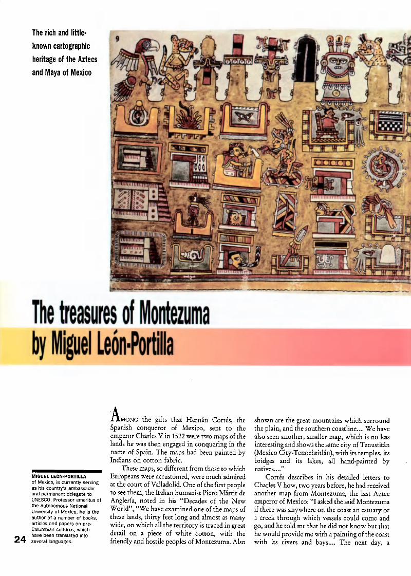
¿AMONG the gifts that Hernán Cortés, theSpanish conqueror of Mexico, sent to theemperor Charles V in 1522 were two maps of thelands he was then engaged in conquering in thename of Spain. The maps had been painted byIndians on cotton fabric.
These maps, so different from those to whichEuropeans were accustomed, were much admiredat the court of Valladolid. One of the first peopleto see them, the Italian humanist Piero Mártir de
Anglería, noted in his "Decades of the NewWorld", "We have examined one of the maps ofthese lands, thirty feet long and almost as manywide, on which all the territory is traced in greatdetail on a piece of white cotton, with thefriendly and hostile peoples of Montezuma. Also
shown are the great mountains which surroundthe plain, and the southern coastline.... We havealso seen another, smaller map, which is no lessinteresting and shows the same city of Tenustitán(Mexico City-Tenochtitlán), with its temples, itsbridges and its lakes, all hand-painted bynatives...."
Cortés describes in his detailed letters to
Charles V how, two years before, he had receivedanother map from Montezuma, the last Aztecemperor of Mexico: "I asked the said Montezumaif there was anywhere on the coast an estuary ora creek through which vessels could come andgo, and he told me that he did not know but thathe would provide me with a painting of the coastwith its rivers and bays.... The next day, a

^p^fsÄ
;--)
j-
KT^V-
©!
representation of the whole coast was broughtto me on a piece of material, showing the estuaryof a river which seemed much wider than the
others."
The speed with which Montezuma producedthis map for Cortés shows that the Aztecs keptoriginal manuscripts in accessible places in whichthey could quickly be copied. Perhaps the storageplace in this case was the "house of books" {amox-colli in Aztec) which contained what Bernai Díazdel Castillo described in his Historia verdadera de
la conquista de la Nueva España ("True Historyof the Conquest of New Spain", 1568) as "themany collections of paper folded like Castilianlinen".
Equally striking is the copyist's scrupulousattention to detail, which was remarked on byBernai Díaz del Castillo who wrote of this mapthat "All the estuaries and creeks of the northern
coast could be seen painted and indicated natur¬ally, from the río Panuco to Tabasco, a distanceof 140 leagues" (some 600 km).
What has become of the painted manuscriptsand maps which the Indians preserved in theirarchives? Only fifteen or so survived the con¬quest. Two of them, the Fejérváry-Mayer and Tro-Cortesianus codices, seem to be symbolicrepresentations of the world as it was envisionedby the peoples of pre-Columbian Mexico.
At the centre of these maps which show in
symbolic form the cemanáhuac (the land mass sur¬rounded by water), the gods preside over thecosmic division of the world into regions directedtowards the four cardinal points of the compass.Each region has its own specific attributes,colours, flora and fauna. Glyphs designating thenorth, east, west and south show that the Maya,the Aztecs and other Mexican indigenous peoplesused signs to indicate the cardinal points.
Manuscripts of great historical and genealog¬ical interest produced by the Mixtee people ofOaxaca have also survived. Two of them, the Nut-
tall and Vindobonensis codices, contain manysymbolic depictions of places where importantevents took place, while towns, villages, moun¬tains, rivers, lakes, roads and coastlines are named
and their location shown by patches of colour.
An aerial view
of the valley of Mexico
The colonized Indians of Mexico continued to
produce documents which were to some extentcartographical in the sixteenth and seventeenthcenturies. Some were made at the instigation ofthe Spanish authorities and of missionaries.Others were drawn to define the boundaries of
estates.
Some maps showed entire regions, complete
1 2
53 4
5 6
7 8
Detail of the Codex
Vindobonensis, a historic
manuscript of the Mixtee
people (1200-1500). Above,
symbols designating towns
(1), small settlements (2, 3,
4), and the cardinal points (5,
6, 7 and 8).
25

Fragment of a painting on
vegetable fibre shows part of
the city of Mexico-
Tenochtitlán. The manuscriptIs probably pre-Hispanic, with
post-conquest additions.
with towns, forests, roads and rivers. Others, such
as that which the lords of Xicalango provided forCortés before he set out on his expedition toHonduras, as he describes in his "Letters", were
route-maps. Yet others were cadastral mapswhich were also valid as title deeds for pieces ofland. When these maps are compared with theirpre-Columbian models, a definite Europeaninfluence can often be seen.
One particularly interesting document is theXólotl codex, an early copy of a pre-Columbianmanuscript. Named for an indigenous chief men¬tioned in it, this document preserved in the Bib¬liothèque Nationale in Paris consists of eight fullpages and two fragments, each of which consti¬tutes a kind of aerial view, as if taken from a satel¬
lite, of the valley of Mexico at various momentsin its history.
Equally interesting is the Teozacualco Map,which represents a part of the Mixtee country ofOaxaca and was sent as part of a report to PhilipII of Spain. It includes genealogies which aredepicted in the form of figures associated withtheir respective villages or fiefs. It is accompaniedby a Spanish text which is the key to the hiero¬glyphics denoting the names of members of thedifferent lineages. The Teozacualco Map is thus theRosetta Stone of the pre-Hispanic manuscriptsfrom this region.
The notion of scale seems absent from the
maps mentioned so far. In them exaggeration isused to show the importance of features such asrugged terrain or settlements.
However, some chroniclers claim to have
seen maps or plans in which scale was used toshow the limits of seigneurial jurisdiction orestate boundaries, with signs indicating theperimeter of each plot. All settlements of a cer¬tain size had archives in which these plans weredeposited for consultation or modification as theneed arose.
In the National Anthropological Museum ofMexico there is a fragment of a large map (2.38m x 1.68 m) on locally produced paper. It is ascale representation of Mexico city before thearrival of the Spaniards, with its system of canals,street layout and property boundaries. Althoughthe notes scribbled in the margin date from afterthe conquest, the style and appearance of thedocument show that it is of indigenous origin.
In the archives, libraries and museums ofMexico and elsewhere an abundance of still
unstudied documents testify to the cartographicalactivity of the Amerindians of Mexico. Even ifmost of them date from the sixteenth century,and thus from the colonial period, they arelargely inspired by pre-Columbian concepts andrepresentational techniques.
Study of these documents would shed morelight on an ancient cartographic tradition whichwas independent of that of Europe. It would bean opportunity to analyse the form of culturalintermingling between Hispanic and Indian tra¬ditions which took place in cartography as aspecific example of the encounter between twoworlds.
26

Zheng He's sailing chartby Mei-Ling HsuA nautical guide
which retraces the
last epic voyage
of a Chinese
Admiral in the
fifteenth century
Above right, detail of the
chart portraying Chinese
Admiral Zheng He's last
voyage (1431-1433) showsthe coast of India (above left),
Africa (below) and Sri Lanka
(right). It Is taken from Wu
Bel Zhl ("Treatise on
Armament Technology",
1628).
MEI-LING HSU
is professor of geography at
the University of Minnesota,
Minneapolis (USA). Of Chineseorigin, she is a specialist in the
geography of China, computer-
assisted cartography,
cartographic design andcommunication, and the
history of cartography. Shehas published a number ofstudies and articles in
specialized journals.
X HE earliest surviving Chinese sea map is thecelebrated sailing chart of Admiral Zheng He,which was made in the mid-fifteenth century. Ascript map measuring 20.5 cm by 560 cm, it por¬trays the voyage between the Chinese city ofNanking and Jazireh ye Hormuz, in the Straitof Hormuz, and ports on the east African coasts.
At the request of emperor Yongle, Zheng He(1371-1435), undertook seven expeditions between1405 and 1433 and travelled as far as the Strait of
Hormuz and the coasts of east Africa. The expe¬ditions were on a grand scale. The first compriseda fleet of 317 ships, including 62 large "treasureships", the largest of which was about 100 m longand 50 m broad, and displaced 3,100 tons.
The sailing chart mainly portrays Zheng He'slast voyage in 1431-1433, but it also includes infor¬mation accumulated on his earlier voyages andfrom voyages by other sailors in and prior to thefifteenth century. Originally a strip map thatcould be rolled up, it was later divided to fit intoforty pages to be printed in a book, Wu Bei Zhi("Treatise on Armament Technology", publishedin 1628).
From right to left, the chart portrays the12,000-km voyage between China and ports alongthe Arabian and African coasts. It reaches the
western extremities at Khorramshahr and Jiddahin Asia and Kilwa Kisiwani Island in Africa. It
is most detailed along the coasts of China andsoutheast Asia.
Using diagrammatic and side-view symbols,the chart shows, besides sea routes, several othertypes of features, including shore lines, bays, estu¬aries, capes and islands; ports and mountainsalong the coasts; important landmarks such aspagodas, temples, official buildings, flagpoles andbridges; and other information useful to sailorssuch as havens, shoals and half-tide rocks. Manyother features and places are not symbolized butare named at their respective locations on thechart. Enclosed in rectangles are the names ofmany places such as provincial capitals, defencesites, and foreign countries along the coastline.In sum, the chart contains over 500 place namesand over 40 names of landmarks. About 300 of
the named places are outside China.
/ f§k Mít*MtraJÖhV.% US ] 'U im
L
n
^11 /*k*\L Jg$5Ê^\ IlsThe most valuable contents of the chart are
the sea routes, which are shown by dotted lines.Sailing instructions are also given. From themouth of the Yangzi river to Sri Lanka whereships sailed mostly near the intricate coastlinesand in shallow waters around islands and reefs,
detailed sailing instructions are noted along thesea routes. These instructions are given in a con¬cise form: "from A, steer X degrees, after Ytime/distance, the ship reaches B." Sometimesdepth soundings are also provided.
The steering instructions are mostly accurate,and expressed in terms of the Chinese zhen lu(compass direction) system. They are theproducts of a wealth of knowledge of navigationand the use of the magnetic compass. Thecompass rose consists of 24 divisions of 15-degreeincrements, and a supplement of 24 subdivisions.Thus one can read 48 directions with 7.5-degreeincrements.
The final section of the chart covers a largearea, which extends from the tip of India to theArabian and African coasts, where ships sailed onthe open seas. Instead of information on land fea- >tures and on compass directions between shortdistances, fifty notes on stellar altitudes are givenalong the sea routes from which the latitude loca¬tion and orientation of the ship can be calculated.
Like other pre-modern charts, Zheng He'schart is less detailed in depicting areas far awayfrom China but is remarkable for the accuracywith which it depicts the coasts of China andnearby regions of Asia. 27
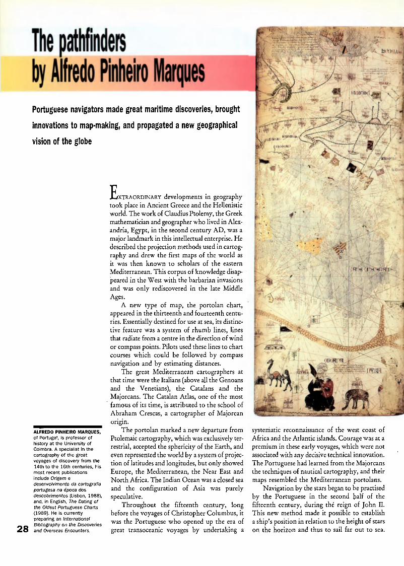
Portuguese navigators made great maritime discoveries, brought
innovations to map-making, and propagated a new geographical
vision of the globe
28
ALFREDO PINHEIRO MARQUES,
of Portugal, is professor of
history at the University of
Coimbra. A specialist in the
cartography of the great
voyages of discovery from the
14th to the 16th centuries, his
most recent publications
include Or/gem e
desenvolvimento da cartografía
portugesa na época dos
descobrimentos (Lisbon, 1988),
and, in English, The Dating of
the Oldest Portuguese Charts
(1989). He is currently
preparing an International
Bibliography on the Discoveriesand Overseas Encounters.
jL/XTRAORDINARY developments in geographytook place in Ancient Greece and the Hellenisticworld. The work of Claudius Ptolemy, the Greekmathematician and geographer who lived in Alex¬andria, Egypt, in the second century AD, was amajor landmark in this intellectual enterprise. Hedescribed the projection methods used in cartog¬raphy and drew the first maps of the world asit was then known to scholars of the eastern
Mediterranean. This corpus of knowledge disap¬peared in the West with the barbarian invasionsand was only rediscovered in the late MiddleAges.
A new type of map, the portolan chart,appeared in the thirteenth and fourteenth centu¬ries. Essentially destined for use at sea, its distinc¬tive feature was a system of rhumb lines, linesthat radiate from a centre in the direction of wind
or compass points. Pilots used these lines to chartcourses which could be followed by compassnavigation and by estimating distances.
The great Mediterranean cartographers atthat time were the Italians (above all the Genoansand the Venetians), the Catalans and theMajorcans. The Catalan Atlas, one of the mostfamous of its time, is attributed to the school of
Abraham Crescas, a cartographer of Majorcanorigin.
The portolan marked a new departure fromPtolemaic cartography, which was exclusively ter¬restrial, accepted the sphericity of the Earth, andeven represented the world by a system of projec¬tion of latitudes and longitudes, but only showedEurope, the Mediterranean, the Near East andNorth Africa. The Indian Ocean was a closed sea
and the configuration of Asia was purelyspeculative.
Throughout the fifteenth century, longbefore the voyages of Christopher Columbus, itwas the Portuguese who opened up the era ofgreat transoceanic voyages by undertaking a
D
-\ h r * *CH\\>
*
systematic reconnaissance of the west coast ofAfrica and the Atlantic islands. Courage was at apremium in these early voyages, which were notassociated with any decisive technical innovation.The Portuguese had learned from the Majorcansthe techniques of nautical cartography, and theirmaps resembled the Mediterranean portolans.
Navigation by the stars began to be practisedby the Portuguese in the second half of thefifteenth century, during thé reign of John II.This new method made it possible to establisha ship's position in relation to the height of starson the horizon and thus to sail far out to sea.

% q«*' 'Jfm
i
i bilDilh..!/
The Catalan Atlas of 1375 Is
attributed to the school of the
Majorcan scholar Abraham
Crescas. Drawn on leaves of
parchment glued to wooden
boards, It Is the oldest
surviving European map to
show the world extending as
far eastwards as China.
Cartographically speaking, it led to the introduc¬tion into the portolan of a graduated meridianwhich gave the latitude. This was a major con¬tribution by the Portuguese to the techniques ofnavigation and cartography.
The scale of latitudes found on Ptolemaic
maps was unusable at sea. In the Mediterraneansailors did not stray far from the shoreline. ThePortuguese navigators found new solutions to thenew problems posed by ocean navigation. Theytook aboard and adapted to nautical use, astro¬nomical instruments, notably the astrolabe,which were already known to the Arabs.
By opening up the way to the great maritimediscoveries at the beginning of the fifteenth cen¬tury, the Portuguese inventors of astronomicalnavigation propagated a new geographical visionof the globe which was taken up by the otherEuropean cartographic schools.
Many Portuguese cartographers worked inother lands and spies were common in Lisbon.The findings of Bartolomeu Dias, the Portuguesenavigator who had become the first man to sailaround Africa, can be seen in a map drawn inItaly in 1489only a year after Dias' exploit-by the German cartographer Henricus Martellus.Later, an Italian agent named Camino took intohis pay a Portuguese royal cartographer, whopassed on to him an anonymous map which wassent to Italy. Known as the "Camino Map", itis still preserved at Modena.
The Cantino Map is possibly the most impor¬tant map in the history of cartography. The firstknown planisphere, it gives an almost completeimage of the world. It presents in recognizableform the New World, Africa, India and a rough
Ptolemy's world map fromthe Latin edition of his
Geographla published In Ulm,1482.
29

Martin Waldseemüller's world
map of 1507. This was the
first map on which the New
World was named "America",
in honour of the Italian
navigator Amerigo Vespucci,
who Is shown (top right) with
Ptolemy.
outline of the Far East. The only map which canbe compared to it is the Spanish map ofChristopher Columbus's pilot, Juan de La Cosa,which depicts the islands and coasts of centralAmericaalthough Africa is very roughly drawnand Asia is quite imaginary.
The geographical discoveries of the Por¬tuguese and the Spaniards made a decisive con¬tribution to the renewal of Ptolemaic cartography,which was itself revolutionary in comparison withthe maps produced in medieval monasteries. Butinformation derived from the voyages of dis¬covery had to be incorporated into Ptolemaic car¬tography and this took time. The humanists whowere reviving Ptolemaic geography through thespread of printing and the navigators who wereactually making the discoveries were separated bydifferent traditions of thoughtthe former scho¬larly, the latter empiricalwhich did not facili¬tate communication.
After 1490, there was a long gap beforethe publication of new editions of Ptolemy'sGeographia. The reasons are not hard to find. In1488, Dias sailed round the southern Cape ofAfrica, in 1492 Columbus sailed to America, andin 1498 Vasco da Gama arrived in India.
Ptolemy's work was not republished until 1507,with new "modern" maps which take accountof the Portuguese and Spanish voyages.
In the early sixteenth century, the Spaniardsoccupied central America, but the Portuguesewere present in many parts of the world: in India(1498), Newfoundland and South America (1500),in Persia, at Hormuz (1507), in Indonesia and
China (1513), and in Japan (around 1542). Mostof the maps printed in Europe in the sixteenthcentury were based on surveys made by Por¬tuguese navigators, the age's leading suppliers ofgeographical information.
This knowledge was propagated by thehumanists, aided by the development of printing,and paradoxically it was in Italy and northernEurope that the new cartography inspired by thePortuguese emerged. The map showing the NewWorld which appeared in 1507 in the expandededition of Ptolemy's Geographia was by JohanRuysch. Another edition of the same workproduced at Strasbourg in 1513 with maps byMartin Waldseemüller circulated widely. In 1507Waldseemüller published a map on which theword "America" appeared for the first time, andin 1516 an important planisphere, Carta MarinaNavigatoria Portugallensium. . ,
Dominated in the fourteenth and fifteenth "
centuries by the Italians and the Catalans, cartog¬raphy thus had its golden age at the Renaissanceunder the impulsion of the Portuguese. Thencame the turn of the Dutch, who systematizedthe use of printing and introduced such innova¬tions as Mercator's projection, the basis ofmodern cartography.
But the Dutch cartographers developed theirwork throughout the sixteenth century throughcontact with the Portuguese. The projectiondevised by Gerard Mercator is an application ofthe theoretical principles set forth much earlierby the Portuguese mathematician and astronomerPedro Nunes.
30
-yylir. ->v>i

When mapping became a scienceby Norman J, Thrower
Modern scientific
cartography was
born in eighteenth-
century Europe
D,
Above, frontispiece of the 4th
edition (Amsterdam, 1619) ofthe Atlas of Gerard Mercator
(Gerard de Cremer). MercatorIs shown at left and the
geographer Jodocus Hondius
at right.
'URING the eighteenth century, Francebecame the leader in topographic or general map¬ping. The foundations of this achievement werelaid in the preceding century when theastronomer Giovanni Domenico Cassini
(1625-1712) came from Bologna to the newly-founded Paris Observatory. Through Cassini andhis successors France became the first country toproduce a detailed and accurate map of its nationalterritory in multiple sheets, based on triangula¬tion, and using uniform symbols for roads, set¬tlements, forests, rivers, and other features. A first
step was the accurate measurement of the lengthof a degreeof latitude near Paris where mappingwas begun.
After the death of his father, the survey ofFrance was continued by Jacques Cassini(1677-1756) under whose direction the triangu¬lation network was greatly extended. In this workthe second Cassini was assisted by his son, CésarFrançois (1714-1784) who carried thetopographical mapping of France to virtual com¬pletion following his father's death. A few sheetsnot finished by the third Cassini before his deathwere completed by his son Jacques-Dominique,comte de Cassini (1748-1845). Thus it took the
dedicated work of four generations of the Cas¬sini family over more than a century to producethe 182 map sheets on the large scale of 1:86,400which constituted the first true, topographic mapof a country.
A topographic survey of Britain (OrdnanceSurvey) was begun in 1783 under the directionof General William Roy (1726-1790). The Frenchand British triangulation networks, which arefundamental to this type of mapping, were con¬nected across the Channel in 1789. The value of
topographic mapping was quickly appreciated bymany rulers and administrators who introducedthe new survey in their realms. For example,topographical mapping on the European modelwas shortly initiated in Bengal, which led to theGreat Trigonometrical Survey of India.
Geodesyand thematic maps
If more accurate maps of world or continentalareas were to be made, knowledge of the shapeof the Earth was necessary. As a result of theFrench topographic survey doubts had beenraised about this. Isaac Newton (1642-1727) had 31

Measuring longitude. Detall of
an Illuminated manuscript of
the French mariner Jacques
de Vaulx's treatise on
hydrography (1583). The
Illustration shows the Sun,
Moon, and stars useful to
navigators.
32
postulated from the behaviour of the pendulumat different latitudes that the Earth was a spheroidflattened at the poles. Measurements taken on theequator and in the high northern latitudes byFrench scientists during the 1740s affirmed thegeneral correctness of Newton's hypothesis.
In his great work the Principia, Newton exa¬mined many fundamental problems of physicalscience and numerous mappable phenomena.This work was promoted by Newton's youngercontemporary, Edmond Halley (1656-1742), whomade signal contributions to cartography,including thematic or special-purpose maps.
During a year spent on St. Helena, Halleyprepared, and soon published, a southernhemisphere star chart, and a terrestrial map whichhas been called "the first meteorological [reallyclimatological] chart"of the trade and monsoonwinds. After two years at sea in the Atlantic ona scientific voyage Halley also published in 1701the first printed, isogonic map, i.e. a chart of mag¬netic variation. Shortly after this he published amap of the variable heights of tides in the EnglishChannel. Later, in 1715, Halley made a map ofthe shadow of the eclipse over England in thatyear, before the event it depicted. Halley becameAstronomer Royal at Greenwich Observatory in1720, in which capacity he conducted investiga¬tions into the problem of finding longitude at sea,on the nature of the core of the Earth and other
geophysical phenomena.
Nautical charts,longitude and the chronometer
As in the case of topographic mapping, theFrench were the early leaders in scientific coastalcharting. The accurate mapping of the shorelinesof France led to the establishment of an official
hydrographie office in the country in 1720. InBritain, much coastal surveying was at firstunofficial or quasi-official, with the East IndiaCompany playing a prominent role in producingnautical charts of overseas areas before the
founding of the British Hydrographie Office in1795. During the eighteenth century, the maritime
nations of the world charted many coastal areasof special interest to them.
Determination of latitude both on land and
at sea could be accomplished with considerableaccuracy from a fairly early date. This was madepossible by the use of a variety of instrumentssuch as quadrants and sextants which wereimproved after telescopic sights were fitted tothem. Longitude measurement on land wasfeasible by astronomical means provided theobserver had appropriate tables and referred toa specific prime meridian. There is a natural
Chart of magnetic variation
was drawn by the English
astronomer Edmond Halley In1700 and corrected In 1756
by William Mountalne andJames Dodson.

starting-point for latitude: 0° latitude equals theequatorequidistant from the poles. By contrast,the origin of a system of longitude is quitearbitrary.
Through the centuries a number of primemeridians have been used and in the eighteenthcentury a line running through the Observatoryin Paris or Greenwich Observatory was gener¬ally employed. The problem of finding the lon¬gitude of a place is basically simple since 15° oflongitude equals one hour of time. Therefore, oneneeds only to know the time at a chosen primemeridian and the local time, wherever theobserver might be. But at sea the unstable deckof a ship made impossible the necessary observa¬tion, or the use of a pendulum clock. Theproblem was solved only after the invention ofthe marine chronometer by John Harrison(1693-1776), an English artisan, in the second halfof the eighteenth century.
Captain James Cook (1728-1779), a trainedmarine surveyor who charted much of theworld's unexplored coastline, took two chronom¬eters on his second Pacific voyage (1772-1775).One of these was set for Greenwich time and one
adjusted to local time with which he was able to
determine longitude at sea with great accuracy.Cook's and other voyages also disproved the age-old idea of balancing continents, with equal landmasses in the northern and southern hemispheres.They revealed that the southern hemisphere ispredominantly water-covered, and that most ofthe land is in the northern hemisphere.
Except in relatively shallow waters, the con¬figuration of the ocean floor remained unknown.However, Nicholas Cruquius (1678-1758) pub¬lished an isobathic (depth) chart of a distributaryof the Rhine in 1729 and Philippe Buache(1700-1773) one of the Channel in 1732.
Other developments in the eighteenth cen¬tury included the invention of several ingeniousmap projections. The Swiss/German mathema¬tician Johann H. Lambert (1728-1777) con¬tributed more than any other individual in this
\m;ii
Cadastral map showing land
use in the village of Banhars,
Aveyron (France, 1807).
Detail of an Isobathic chart of
the river Meuse by Nicholas
Cruquius (1729).
fieldthe conic equal area, conic conformai,cylindrical equal area, azimuthal equal area, andthe transverse Mercator projections all beingattributed to him. A tradition of globe makingestablished by the Venetian, Vincenzo Coronelli(1650-1718), continued during the eighteenth cen¬tury with celestial and terrestrial globes ofdifferent sizes and for different purposes beingproduced in a number of centres.
The nineteenth century:expansion, consolidation and diversity
The story of mapping in the nineteenth centurybegins when Alexander von Humboldt(1769-1859) landed in South America. Early in theyear 1800 Humboldt made a reconnaissance map,based on his own explorations, of the drainagebetween the Orinoco and Amazon river basins.
He then travelled in the Andes before arrivingin New Spain (Mexico) in 1803. During a yearspent in the area he compiled a map of that largecolony which served as a model for similar mapsof other continental interiorsAfrica, Asia,North and South America and Australiaas
explorers from many countries provided thenecessary data. It would be many years beforethese surveys were superseded.
Meanwhile, the coastlines of the continents
and islands continued to be charted, as, forexample, in Matthew Flinders' (1774-1814) map¬ping of the Australian coasts. Occasionally a greatbreakthrough was made, as with the work of theAmerican, Matthew Fontaine Maury (1806-1873).Following his appointment in 1842 as Superin¬tendent of the Depot of Charts (later dividedbetween the United States National Observatoryand the Hydrographie Office) in Washington,Maury devised maps showing the quickest pas¬sages for sailing ships between specific ports based 33

on winds, currents, etc. These routes were not
normally great circles (the shortest distancebetween two points on the globe). Many liveswere saved by Maury's work before steamshipssuperseded sailing vessels in the second half of thenineteenth century.
Climatic maps became more common as offi¬cial weather stations were established. A wind
scale which bears his name was devised by FrancisBeaufort (1774-1857), head of the British Hydro-graphic Office, and is still in use. For a short time,Washington, D.C. was used as a prime meridianon maps of the United States. But as the resultof an international conference held in
Washington in 1884, the problem of a universallyrecognized prime meridian (0° longitude) wasresolved when Greenwich (UK), was selected. Agreat advantage of this is that the antipodal inter¬national date line (180° longitude) runs essentiallythrough oceanic areas.
Cadastral and geological mapping
An extremely ancient genre in cartography is thecadastral map, which is concerned with landownership and taxation. Over most of the worldunsystematic land subdivision by metes andbounds has been used. In a few areas, notably inthe western two-thirds of the United States,
cardinally-oriented, systematic, rectilinear surveyswere required. This resulted in a great flurry ofsurveying and mapping activity as settlersclamoured for land in the nineteenth century.Similar rectilinear surveys were undertaken inwestern Canada and some other more recentlysettled, primarily agricultural areas of the world.
Economic exploitation of the land in thenineteenth century also led to the developmentof geological mapping. The father of geologicalmapping is William Smith (1769-1839), who pub¬lished his map "The Strata of England" in 1815after nearly a quarter of a century of research.Soon European scientists not only mapped theirown countries geologically, but were employedin this work in Russia and elsewhere. In the
United States, geological mapping began in theeastern states but it was in the west, in the second
half of the nineteenth century, that it came intoits own. So important was this activity consideredto be that when the United States established its
primary topographic mapping agency in 1879, itwas designated the United States GeologicalSurvey (USGS). This is in contrast to earliertopographical surveys which had a geographicalor military foundation.
Censuses and thematic mapping
The holding of regular censuses as we know thembegan in Sweden in 1749, in the United States in1790, and in Britain in 1801. Other countries soon
followed so that in the nineteenth century a greatmass of statistical data became available for map-
34 ping. This included not only population but
education, crime, disease and other phenomena.Henry Drury Harness, a pioneer in this fieldemployed by the Irish Railway Commission,published in 1837 a series of highly originalthematic maps in which several quantitative tech¬niques now employed in small-scale mappingwere used to show population density and trafficflow. In 1855, Dr. John Snow (1813-1858) useduniform symbols to show deaths from cholerain London and thus identified a lethal water
pump in that city.
Atlases, globes and projections
Much of the geographical knowledge of theperiod was disseminated and popularized throughatlases, which were produced in increasingnumbers in the nineteenth century. The inven¬tion of lithography, which gradually replaced theearlier copperplate and even earlier woodengraving, facilitated the production of atlases.Approximately 4,000 county cadastral atlaseswere produced in the United States in thenineteenth century. Some state and provincialatlases were published and the first true nationalatlasthat of Finland in 1899. Globes of manysizes continued to be produced, including giantspheres which were a feature of the expositionsthat characterized the nineteenth century.Among the new projections which were devisedin this period were the Albers conic, Molleweide(homolographic) named for their inventors, andthe Polyconic invented by Ferdinand Hassler.These projections remain popular today.
II
M
.»
Terrestrial and celestial globemade In 1786 for Louis XVI of
France by Edme Mantelle.
NORMAN J.W. THROWER,
of the United States, is
professor of geography at the
University of California, Los
Angeles, and has been
appointed director of the
University's 1992 Columbus
Quincentenary Programs.
Trained in geography and the
history of science, he is the
author of many scholarlyarticles and books. He has
recently edited a series of
essays, On the Shoulders of
Giants: Newton and Halley,
1686-1986 (1990), and is co¬author of A Buccaneers Sea
Atlas: The 1 680 Waggoner of
Basil Ringrose, which will be
published later this year.

MNÍ
The perspective from spaceby Jean-Philippe Grelot
.?#<
Advances in computer
science and the mass
of data transmitted
from remote-sensing
satellites are taking
cartography into a
new era
Aerial photography is used
systematically In map
production. Partly overlapping
photos are assembled in a
mosaic (above).
VMRTOGRAPHY is a very ancient art. As longago as the time of the Pharaohs, surveyors weredrawing up plans of plots of cultivated land inorder to re-establish property boundaries orreplace cornerstones buried under the silt broughtdown by the floodwaters of the Nile.
The great voyages of discovery of the fifteenthcentury led to the transformation of world maps.Returning from their voyages, the great navi¬gators of those days recounted their experiences,which cartographers working quietly in theirhomes incorporated into more accurate maps.
The emergence of modern cartography,however, dates from the eighteenth century,when scientific expeditions such as the Frenchexpeditions to Lapland and Peru finally con¬firmed Newton's hypothesis that the world wasshaped like a sphere slightly flattened at the poles.
It was through these expeditions that cartog¬raphy acquired the mathematical basis it neededto become the instrument for the accurate,graphic, scale representation of our knowledgeof the Earth that it is today.
The starting-point of all cartography is thescience of geodesythe determination of the size
and shape of the Earth and the exact position ofa series of reference points on its surface. Bymeans of successive readings taken in turn fromeach of these points, the co-ordinates of thesepoints on the surface of the Earth are determinedand then transposed to a flat surface.
Today, methods and instruments have com¬pletely changed. Using a small calculator linkedto an aerial, geodesists "listen" to the specializedsatellites of the Global Positioning System, whichgive them their precise position immediately.During the previous three centuries, however,they would have had to take readings with the¬odolites of the various topographical featuresaround them. On the basis of these reference
points, topographers would have made a detailedexamination of the terrain so as to locate the
roads, houses, forests, rivers, etc., that they hadobserved.
From about 1930, aerial photography, a tech¬nique which had been perfected during WorldWar I, radically modified this painstaking workand signalled the end of direct accumulation ofdata by observation on the ground. Aeroplanes areflown in a series of straight lines and photographs 35

36
are taken at fairly close intervals. Each sectionof terrain flown over is photographed twice, fromdifferent angles. In this way the aerial photo¬graphs provide the binocular effect of humanvision, which makes possible the appreciation ofdistance and relief.
The cartographer makes use of thisstereoscopic effect which, used in conjunctionwith extremely precise measurement techniques,gave rise to the science of photogrammetry (themeasurement of photographs applied to sur¬veying and mapping, as well as for engineeringand other purposes). Through the twin eyepiecesof their photogrammetrical reconstitution equip¬ment, each of which is focused on one of the two
successive aerial photographs, the stereo-operatorsget a true picture of the terrain in relief, with itsheights, its valleys, houses and trees. All that thenhas to be done is to trace the relief with a cursor,
whilst operating certain controls, for the co¬ordinates of the various features to be recorded.
However, a certain amount of fieldwork
remains necessary to check the correct identifi¬cation of detail, to fill in details not visible in areas
in shadow, or to add information such as place-names or administrative boundaries that aerial
photographs cannot supply.The documentation thus produced is cor¬
rected by the map editor and then printed. Theprocess calls for great care and precision and isquite lengthy. About two years should be allowedfrom the taking of the aerial photographs to thepublication of the map.
The computer invasion
Computers came upon the cartographical scenein the late 1950s. They were first used in geodeticcalculations. Some ten years later experimentswere begun with computer-assisted design,although this did not go beyond the laboratorystage. Then, in the 1970s, the data on maps wererecorded in numerical form, which greatly easedtheir use and updating.
Geodetic surveying afloat.
Below, members of a
scientific expedition climb
Mount Pelvoux, France's
highest geodetic point (1910).
In the 1980s computers invaded every sphereof cartography, including photogrammetry. Likethe micro-computer, equipment for computer-assisted design became smaller and smaller andat the same time more and more powerful. Par¬ticularly spectacular progress was made in thedevelopment of conceptual models and databanks and in numerical data-handling capacity.Computerized cartography has developed into afull-scale "Geographic Information System" withits own data banks and its own equipment andapplication programs.
With their powerful analytical capacity, com¬puters have considerably reduced the timerequired to produce a map; but the demand is stillfor faster results. To meet it, cartography isturning towards a new toolremote sensing bymeans of Earth observation satellites.
Remote sensing satellites
What are the broad principles of this new andrevolutionary technique? Remote sensing satel¬lites capture by means of scanning sensors thevarying electromagnetic radiations emitted by thepoints the satellites observe on the Earth's surface.

Top, the site of the 1992
Winter Olympics at Albertville
(France) as viewed from theSPOT satellite. Altlmetrlc data
are used to make a numeric
model of the site In which the
relief Is depicted In grid form
(middle photo). The model Isthen combined with the SPOT
Image to obtain a perspective
view (bottom).
The nature of the electromagnetic radiationemitted by a given point on the Earth's surfacedepends upon the characteristics of the Earth'ssurface at that pointfactors such as temperature,humidity, the presence or absence of vegetation,and the nature of rock formations.
The satellite then transmits the data it has
obtained to a ground station, either in photo¬graphic or numerical form. Analysis of this dataenables the characteristics of the points observedto be deduced. Thus, like aerial photographs,satellite images require interpretation by aspecialist, but with the aid of a computer.
Broadly speaking, satellites may be classifiedinto three groups according to the orbits theyfollow:
Low-orbit satellites, like the American spaceshuttle and like most military observation satel
lites, circle the Earth at an altitude of between
200 and 300 kilometres. Subject to the brakingdrag of the atmosphere, they have an effective lifespan which varies from a few days to a few weeks.The photographs they take are of a scale of theorder of 1:100,000, which means that objects ofa metre or more can be distinguished. The pho¬tographs are transmitted during the satellite'sreturn to Earth or when a capsule fitted with aparachute is ejected.
Satellites in heliosynchronous orbit circle theEarth at ,an altitude of 800 to 900 kilometres.
Those in the American Landsat (or ERTS) series(five satellites since 1972) or the French SPOTseries (two satellites, one in 1986 and one in 1990)have a life span of a few years and record numer¬ical images each of which covers an area of from3,500 to 35,000 square kilometres. Their resolu¬tion varies from about fifty metres for Landsatto about ten metres for SPOT, which, usingstereoscopic methods, is the first system of Earthobservation to "see" in relief. They pass over thesame point of the Earth at the same time in rela¬tion to the Sun (hence the term heliosyn¬chronous) approximately every twenty days. Byorienting the mirrors of its sensors, SPOT canrecord details of a given zone every three days,meteorological conditions permitting (SPOTsatellites cannot pierce cloud cover). The wholeof the Earth's surface is covered in a period oftwo to three weeks.
Geostationary satellites, like Meteosat, are placedin an equatorial orbit at an altitude of 36,000kilometres. They record numerical imagescovering a quarter of the globe with a resolutionof about five kilometres. Since their position inrelation to the Earth is fixed they are within cons¬tant view of a ground reception station to whichthey transmit images every half hour. They are,however, unable to scan the polar ice caps.
Satellite images make possible the continuousupdating of maps, with a reduction in the marginof error and in the time span. A satellite likeSPOT makes possible the updating of the car¬tographical cover of a country in a matter ofmonths, as compared with ten years or so usingclassic methods.
Today evolving computer technology hascombined remote sensing and cartography andtaken advantage of their complementarity. As aresult, now that we can handle both cartographicdata and the images on which they are based,whether these be numerical or graphic, we talknowadays in terms of "integrated" geographicalinformation systems
Practical applications
The first field of application for geographicalinformation systems is resource management inboth urban and rural areas. Now that it can pro¬vide the most accurate information about the con¬
dition of a given area and furnish a visual anddata-based synthesis of it, cartography is in a 37

38
position to optimize the efficiency and cost-effectiveness of that area's management.
The supply and waste utility networks of anurban area (water, electricity, telephone and tel¬evision cables, waste water conduits, household
waste collection and road networks) are all inter¬twined within a restricted space. As they becomeolder they have to be renovated and adapted tomeet new needs. Work of this kind has to be care¬
fully planned to cause the least possible distur¬bance to users, to reduce the risk of accidents and
to keep costs to a minimum. Cartography alsohas a part to play in other sectors, such as publictransport and the siting of medical and educa¬tional facilities. In fact, all aspects of the life ofthe community are involved. Three-quarters ofthe data handled by urban authorities are local¬ized data and thus come within the sphere ofgeographical information systems.
In agriculture, the main application of car¬tography is in the study of land-use and cultiva¬tion methods, monitoring plant cover, harvestforecasting and the assessment of the conse¬quences of such climatic hazards as drought orfloods and of the incidence of such events as epi¬demics or fires.
Coupled with management is development,on which the whole aspect of an area depends.This includes town planning, the construction ofthe road infrastructure and agricultural improve¬ment. Here, project mapping, which is limitedin both space and time according to the natureand scope of the project envisaged, is used as wellas overall, basic cartography. This is a specific
type of cartography based on a specific range ofdata. It is dependent upon precision, constant up¬dating and a permanent observation system. Inthis domain, aerial photography and satelliteimagery play a decisive role because of the speedwith which they can furnish information.
Lastly, understanding and control of theenvironmenta more recent concern directlyconnected with developmentcall for broad car¬tographical involvement, for here too thinkingmust be in terms of spatial analysis. The factorsthat have to be borne in mind are multiple andcomplex yet they require simple formulation.The areas involved are becoming larger and largerso that the interactions and spread of phenomenacan be taken into account. Satellites that roam
in space unhampered by national boundaries arethe ideal tool for the acquisition of the necessaryglobal information. This is even more true nowthat computer science is beginning to provide themeans (vast storage capacity thanks to the newoptical disks, rapid data handling by means ofparallel processors, transmission by local net¬works and integrated service networks) for rapidand efficient handling of the vast mass of datathese satellites transmit.
Cartography still retains its essential didacticfunction. A synthetic science that reveals the linesof force of global phenomena by demonstratingtheir spatial relationships, it also pioneers the wayto new horizons of knowledge. And, feeding backto us as it does the image that we are giving toour land, it has become a prime witness to ourcultural development.
A satellite Image forms the
basis of this map of Bamako
(Mali).
JEAN-PHILIPPE GRELOT,
French geographer, is sales
director of his country's
National Geographical Institute.
He teaches cartography atFrance's School of
Geographical Sciences, and is
vice-president of the
International Cartographic
Association. He has published
many articles on cartography
in French and other journals.

A bit off the map
For years the excellent
maps produced in
the Soviet Union were
not accessible to the
general public
%
Below, a Soviet tourist map
dating from 1963. The scaleIs not Indicated.
Laps and plans that are a secret for the the counter. New maps of regions and cities arecountry's population are an absurdity, a torch being produced and published which are morekept extinguished," wrote the Soviet geologist informative than those published ten or twentyA.P. Gerasimov seventy years ago. Unfortunately years ago.this was the case for years in the USSR, where Paradoxically, Soviet cartography has been athe achievements of Soviet cartography were not victim of its own success in making extremelygenerally accessible to the public. To take one accurate and informative maps. In pre-example among many, people often used a Revolutionary times, detailed maps only existeddetailed up-to-date Hungarian plan to find their for the European part of the Russian empire. Sur-way around Moscow, rather than the official veying the hitherto unstudied regions in the yearsSoviet tourist guide which showed only the main after the Revolution was a great scientific feat,thoroughfares. Work went on over a vast area and had to
Today, however, the notion that Soviet maps be done in harsh climatic conditions in suchare primitive and distorted is becoming a thing regions as Siberia, the deserts of Central Asia andof the past. One result of current changes in the the mountains of the Caucasus. Geodetic workUSSR is that some of the detailed maps which had to cover 22.4 million square kilometres towere once unavailable can now be bought over provide a single system of co-ordinates and
39

ALEKSANDR SERGEEVICH
SUDAKOV,
of the USSR, is the editor-in-
chief of the Central
Department of Geodesy and
Cartography, which is
responsible to the USSRCouncil of Ministers. He is a
member of the editorial boards
of a number of major
cartographic publications and
the Soviet Union's permanent
representative on the ScientificCommittee on Antarctic
Research (SCAR) working
group on geodesy and
geological information.
Below left, a detailed plan of
central Moscow, available
since 1989. Previous plans
(right) were vague andsometimes Inaccurate.
heights for the entire area of the Soviet Union.Heights and co-ordinates throughout the countryhad to be determined with great accuracy in rela¬tion to the Baltic Sea and the reference point atPulkovo near Leningrad. This in turn requiredastronomic and gravimetric work throughout thecountry, the development of triangulation andlevelling grids, and the construction of tens ofthousands of geodetic signs, some of them over40 metres high.
The late 1930s and the eve of the Second
World War were a time of universal suspicion,mistrust and spy mania in our country. Measureswere taken to protect information, includinginformation about topography. Detailed large-scale maps that had had limited circulation weremade secret. But the objective formulated forRussian cartography over 150 years ago, "the col¬lection and distribution in Russia and beyond ofas full and reliable data about our native land as
possible", was never abandoned. In 1947, theChief Department of Geodesy and Cartographywas awarded the Gold Medal of the GeographicSociety for having completed the state map of theUSSR to a scale of 1:1,000,000.
This success made it possible to start workon a new 1:2,500,000 (1 cm = 25 km) map, whichin the 1950s served as the basis of a series of
detailed regional maps. These years also saw thestart of planning for a project unheard-of in any
'
£*rnrt * -.»
" ft
C i
Samojëcnflj"TIT
Cvelnoj bul'var
-13-2-
Al /vv
»
"»jacStihafevKolh-wnaja jj
KolHoinaja'oj "3/a °Jh02-~«¡Pankral>\4 j"
P"
P..
Su**'. _r>.
,; ;t*«
le-dn.j P"Ontovln P"
Him'fvi
" V Bol S»i*IW««l *'
tax p £
Of«*'j ki^Triib,11;] PWalnUnv
ft' ^
5 a?
«oideslvenskij fySSrefení= ^Sretenskih g hul\-
Vorot¿ -,... /^«^.fcskil,
p *
isk/j
W
toaeonaai
other country: large-scale (1:25,000, i.e. 1 cm =250 m) surveys of the entire territory of the SovietUnion. The effort took some forty years and over250,000 maps were produced.
In the early 1960s, certain maps began to dis¬appear from the shops. The small-scale maps thatwere produced to replace them inherited old mis¬takes and distortions and incorporated new ones.The location of sites in relation to the carto¬
graphic grid was changed. Geographical co¬ordinates were no longer shown on maps thatwere transformed into schematic representationsof low, information value. This practice wasrendered meaningless by the development ofspace imagery, but we continued to publish mapsof the Aral Sea coast as it was traditionally seen,for instance, while maps produced in other coun¬tries using space technology showed its actualstate.
Although some restrictions have now beenlifted, there are still many problems. The mili¬tary think that circulation of detailedtopographical maps is premature, especially thoseon the 1:100,000 and the 1:25,000 scales. Buttourists are attracted above all to little-known
forests and mountains, the parks near Leningrad,the towns and countryside of old Russia. Peoplewant to get to know their own country, and tobe able to explore it on foot. For this they needreliable large-scale maps.
SoMnM>smi
MO)'
-- Turgcncvshuia-
* Ml." Kiruvskaja '-,
A»,
<N
&f
^\\
S"**,
C.ítnoi Bui «ar®
KolhMMu) «
^ Bol S»tjn»Hii| P*'
«
,11t"1"' Bui»"'a..,
"Pul',.
X
O
o
O)**«.
Turginftikifi-
*£? \
*
3 KutnccMJ Most '
c¿
VorovskogofI"*
<K,\<
PI
Svrrdlom
?n*b pi a. *»" L tV-rt tDier/.inskogo
Ç1 f"a ^¿DifrilnsVaja
P¡. Sverdlov/ *j$ 1&frpi. Revoljucii
ar
»r. X
<?
TMoiii
n=> ® KuMckii Mod
. .
jetijalbrin 5
PI. Krfoljiuii' Q
PokrovslVorol
(»S«/}.Srffdlcva
'x®m
f.
%
4.pn1
fcPI. Nogina »On.
Art
®,
®
® °<farUau '
®

Celestial cartography
Astronomical map-making from the star
catalogues of Antiquity to the electronic
images of today
X ROM very early times, the stars in the firma¬ment have held a strong fascination for man. Inthe movements of the stars the Ancients saw the
operation of supernatural forces which couldinfluence human destiny. Believing that therewere portents to be read in the stars, our distantancestors began to observe and make precisedescriptions of the heavens.
Thus astronomy has a very long history. Ves¬tiges of astronomical observatories and instru¬ments dating back to 3000 BC have been foundin Sumer, Babylon, China, Egypt, Mexico, Peruand the United Kingdom.
The earliest known star catalogues were thework of Babylonian astronomers and date backto about 1700 BC, during the reign of the greatBabylonian monarch Hammurabi. Calculationsconcerning the movements of the Moon and ofthe planets, especially of Venus, were almost cer¬tainly made for astrological purposes. For theEgyptians, Sirius, the Dog star, to which theyaccorded divine attributes as "Sothis", or the"Star of Isis", was "the bringer of the new yearand of the floodwaters of the Nile". In fact, the
day of the year on which Sirius was first visibleon the horizon, just before sunrise, usually coin¬cided more or less with the rising of the Nilewaters, on which subsequent sowing and thenharvesting of crops depended.
It was not long before the Ancients becameaware of the slow progression of the Sun, theMoon and the five great planets of the solarsystem (Venus, Mercury, Mars, Jupiter andSaturn) along a regular path across the heavens.This belt around the sky, first observed by theBabylonians and later by the Greeks, is dividedinto twelve segments, or astrological signs, whichcorrespond to the constellations which occupiedthese segments some 2,000 years ago (Taurus thebull, Cancer the crab, Leo the lion, etc.). TheZodiacal belt corresponds to what modernastronomers call the "ecliptic", the apparentannual path followed by the Sun.
The Greek astronomer Hipparchus (161 to127 BC) was the first to draw up a star catalogueworthy of the name. He indicated the positionof about a thousand stars, attributing to each ofthem a magnitude based on its luminosity, orbrightness.
Star cataloguesAn accurate listing of the stars was essential fornavigation on the open sea and for making large-scale land measurements. Until the end of the
Middle Ages the Almagest, an astronomical andmathematical encyclopaedia compiled byPtolemy around 160 AD, remained the authorita¬tive reference book for astronomers. The
Almagest, which survived in an Arabic transla¬tion, is a digest of the mathematical knowledgeof Antiquity. It contains a catalogue of forty-eightconstellations and 1,022 stars with their eclipticco-ordinates and magnitudes.
The first really usable astronomical atlas,however, was the German astronomer JohannBayer's Uranometria, which was drawn up in1603. It consisted of fifty-one maps and listed1,277 stars, with the stars in each constellation
being designated in decreasing order of brightnessby the letters of the Greek alphabet. When fur¬ther letters were needed, the Latin alphabet wasused.
With the aid of the telescope at the Green¬wich Royal Observatory, the English astronomerJohn Flamsteed added considerably to thenumber of stars listed. His Historia Coelestis
In this Illuminated design from
the psalter of Blanche of
Castile (1230), an astronomer
makes observations with an
astrolabe. He Is assisted by a
clerk and a computlst.
WERNER MERKLI,
Swiss printer and publisher, is
editor of the German-languageedition of the UNESCO Couner.
He has produced astronomical
maps of the stars, the planets
and the Moon. 41

42
Britannica, published in 1725, designated some3,000 stars by number and exceeded all earliercatalogues both in accuracy and in the numberof stars listed.
For a long time observation was limited tothe northern skies. The explorers and navigatorsof the sixteenth century were the first Europeansto see the southern skies and constellations in
their totality. The first catalogue of the stars ofthe southern skies, complete with the positionsof 341 of them, determined by telescope, wasdrawn up in 1676 by the English astronomerEdmond Halley from the south Atlantic islandof St. Helena.
During an expedition (1750 to 1754) to theCape of Good Hope, the French astronomerNicolas Louis de la Caille listed some 10,000 stars
grouped in fourteen constellations, as well asseveral new nebulae. His star catalogue was pub¬lished in 1756.
The Bonner Durchmusterung, established inthe middle of the nineteenth century under thedirection of the German astronomer Friedrich
Argelander, is still today a basic reference workfor the stellar astronomy of the northern skies.Based on observations made at the Bonn obser¬
vatory, it gives the position and characteristicsof some 350,000 stars. After Argelander's death,the "BD" catalogue was extended to cover thesouthern hemisphere, with a listing of some
500,000 stars being added by observatories in Cor¬doba (Argentina) and Cape Town.
During the last century visual observation ofthe stars was largely replaced by the use of pho¬tographic plates. Objects whose luminosity is toofaint to be registered by the human eye can bephotographed, and the introduction of this formof observation led to the discovery of millionsof previously unknown stars. For practical pur¬poses, rather than referring to star mapsastronomers tend to make use of star cataloguesand listings of stellar co-ordinates, whether thesebe exhaustive catalogues or what are called fun¬damental catalogues which furnish extremelyaccurate details of the positions and motions ofa reduced number of selected stars well dis¬
tributed over the sky.
Flattening the sky
It is impossible to produce a projectiona sys¬tematic representation on a flat surface of thefeatures of a curved surface, such as that of the
Earth which is both complete and whollyaccurate. Even using Mercator's famous cylin¬drical projection, which presents the globe asthough it were an unrolled cylinder, there isinevitably a degree of distortion of angles, dis¬tances and surfaces. Similar problems arise inmapping the sky.
Above, the world-system
devised by the Portuguese
cosmographer BartolomeuVelho In 1568 reflects the
close links between
cosmography and cartography
at the Renaissance.
Above right, detail of one of
the "Original drawings of the
patches of the Moon" made
after observations by GiovanniDomenico Cassini between
1675 and 1677. The date and
hour are Indicated byannotations In Cassinl's own
hand.
Right, component of anastrolabe made at Louvain In
1565 In the workshops of
Gauthier Arsenius, geographer
of the emperor Charles V.

ï' ' -
TSR ? ' jÄfei
r l
L
. Hj
S
The planets, air, fire, sky
and water are disposed
around the Earth In
concentric circles In an
Illuminated design from a
manuscript (1245) of
L'Image du Monde
("The Mirror of the
World"), a treatise
about the universe byGossuin de Metz.
ipiiauousfmctnöic o»^j«. cftot'if.quctcuouàûtMr
que Uuu fair lautn
To draw up a map of the celestial sphere, thepositions of the stars are established in relationto two arcs which are perpendicular to each otherand which are analagous to terrestrial longitudeand latitude. Individual heavenly bodies, such asthe Sun, the Moon or the planets, are usuallyrepresented in the form of a sphere in perspec¬tive, as though the observer were situated some¬where in space, like a camera aboard a spaceship.The hidden or the visible face of the star is shown,
as, for example, in the case of the Moon, or elsethe sphere is shown cut up into three segments,with two additional segments for the poles. Pointsor surfaces at the eastern and western extremi¬
ties, or at the top and bottom of the sphere, willbe seen in extremely foreshortened perspective.For scientific purposes a Mercator projection isused with the addition of separate representationsof the poles.
The inconceivably huge distances that areinvolved in stellar systems, like those that separatethe planets of our solar system, with their ringsand moons, cannot be reproduced without greatdistortions. However, mathematically calculatedreduction scales enable us to have some idea of
the positions, trajectories and revolution phasesof these bodies.
Movement in the Universe
Though we speak of "fixed" stars which rise eachnight above the horizon, the universe is in per¬petual movement. The Sun, the Moon and theplanets, comets and shooting stars soar throughspace but leave no trace of their passing. Howcan such movement be mapped? In ancient timesastronomers constructed armillary spheres, com¬plex assemblages of moving rings whichrepresented the movement of the planets, andastrolabes, which furnished a picture of the skyat a given moment. These instruments remainedin use until the seventeenth century.
For centuries the Earth was depicted as a flatdisc, situated in the centre of the universe, abovewhich moved the majestic span of the celestialvault with its fixed stars. Yet, in ancient times,
Greek sages such as the Pythagoreans Hipparchusand Erastosthenes had observed the curvature of 43
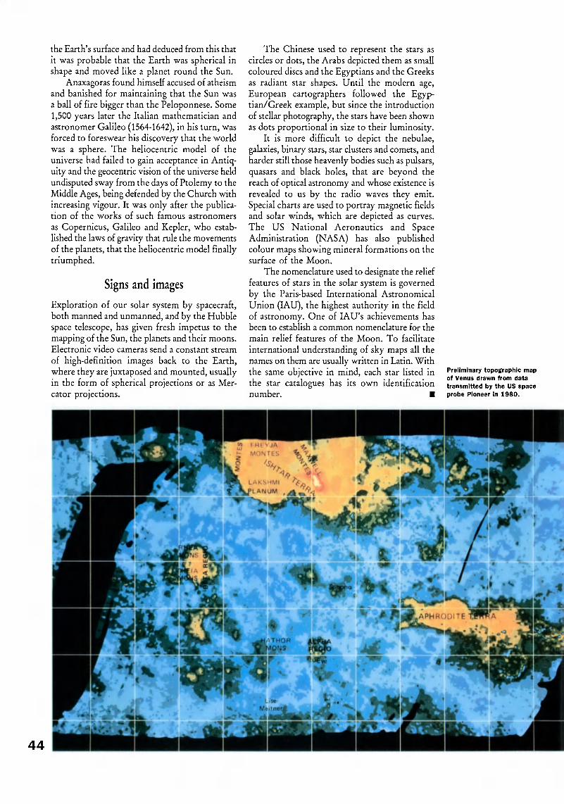
the Earth's surface and had deduced from this that
it was probable that the Earth was spherical inshape and moved like a planet round the Sun.
Anaxagoras found himself accused of atheismand banished for maintaining that the Sun wasa ball of fire bigger than the Péloponnèse. Some1,500 years later the Italian mathematician andastronomer Galileo (1564-1642), in his turn, wasforced to foreswear his discovery that the worldwas a sphere. The heliocentric model of theuniverse had failed to gain acceptance in Antiq¬uity and the geocentric vision of the universe heldundisputed sway from the days of Ptolemy to theMiddle Ages, being defended by the Church withincreasing vigour. It was only after the publica¬tion of the works of such famous astronomers
as Copernicus, Galileo and Kepler, who estab¬lished the laws of gravity that rule the movementsof the planets, that the heliocentric model finallytriumphed.
Signs and images
Exploration of our solar system by spacecraft,both manned and unmanned, and by the Hubblespace telescope, has given fresh impetus to themapping of the Sun, the planets and their moons.Electronic video cameras send a constant stream
of high-definition images back to the Earth,where they are juxtaposed and mounted, usuallyin the form of spherical projections or as Mer¬cator projections.
The Chinese used to represent the stars ascircles or dots, the Arabs depicted them as smallcoloured discs and the Egyptians and the Greeksas radiant star shapes. Until the modern age,European cartographers followed the Egyp¬tian/Greek example, but since the introductionof stellar photography, the stars have been shownas dots proportional in size to their luminosity.
It is more difficult to depict the nebulae,galaxies, binary stars, star clusters and comets, andharder still those heavenly bodies such as pulsars,quasars and black holes, that are beyond thereach of optical astronomy and whose existence isrevealed to us by the radio waves they emit.Special charts are used to portray magnetic fieldsand solar winds, which are depicted as curves.The US National Aeronautics and SpaceAdministration (NASA) has also publishedcolour maps showing mineral formations on thesurface of the Moon.
The nomenclature used to designate the relieffeatures of stars in the solar system is governedby the Paris-based International AstronomicalUnion (IAU), the highest authority in the fieldof astronomy. One of IAU's achievements hasbeen to establish a common nomenclature for the
main relief features of the Moon. To facilitate
international understanding of sky maps all thenames on them are usually written in Latin. Withthe same objective in mind, each star listed inthe star catalogues has its own identificationnumber.
Preliminary topographic mapof Venus drawn from data
transmitted by the US space
probe Pioneer in 1980.
^¡r 'jmsssi
£*>¿L
44

So//, mineral deposits, tectonic
structure, vegetation, climate...
many chapters in the story of the
planet recorded in scientific maps
and atlases produced by UNESCO
IN the earth sciences, the maps produced byUNESCO are mainly geological, tectonic,metallogenic or metamorphic. These mapsgenerally show a continent in its entirety,hence their small scaleusually 1:5,000,000 or1:2,500,000.
GEOLOGICAL MAPS
The first map in this series is of Europe. Theinnovations it contains paved the way for anew generation of geological maps. Forexample, the Pleistocene cover (major part ofthe Quaternary), which is relatively thin inthe area of the Baltic Shield and the British
Isles, is not shown. In areas where this cover
is thicker, however, it is shown either by trans¬parent signs or by full colour, if strong tec¬tonic activity played a decisive role in theprocess of sedimentation.
In addition, intrusive magmatic rocks(rocks produced by molten matter beingforced up from the Earth's interior into pre¬existing formations) and volcanic magmaticrocks have been subdivided according to age,chemical composition and relation to orogeny(process of mountain formation). Generallyspeaking, age is shown by colour and thenature of the rocks or lithology by over¬
printed signs.The map of Africa was the first to show
LYDWINE D'ANDIGNE DE ASÍS
is a programme specialist with UNESCO's Divisionof Earth Sciences.
The Earth from every anglety Lydáe iM$é de Asís
45

the geology of the continental shelf and theseafloor. Along with depth measurements(bathymetry), it shows the age of the crust,magnetic lineation, fracture zones, isopachs(sediment thickness), the siting' of drillings, thelimits of volcanism and thrust sheets and the
epicentres of earthquakes.Besides the geological map of Africa on
a scale of 1:5,000,000, UNESCO has recentlypublished a map of South and East Asia ona scale of 1:5,000,000 and a geological map ofthe world on a scale of 1:25,000,000.
TECTONIC MAPS
The tectonic map of Africa which, as its namesuggests, shows distortions in the earth's crust,also contains some decisive innovations. For
the first time in the history of cartography,the signs and symbols of the Precambrian areentirely based on geochronology, i.e. on"absolute ages" (expressed in thousands ormillions of years) determined radiometricallyon the basis of certain properties of isotopes.
The various orogenies are shown byspecific colours while overprinted conven¬tional signs represent the ancient structures.The depth of the basins and the thickness ofthe surface cover are indicated by gradualshading rather than by isobathic curves.
Tectonic maps provide a considerable
^1 V
^3tj- - * ' _ '
« P.;%¿ HjT¡'s V^7¿TO? "í,7iff? ; ,
Eis- .-. ' ^mH'L
^1^%X, A «V
An I
fènèfiye i
Detall of »haet 9 of the International tectonic r
of Africa (ÍS.OOO 0001
amount of data not given by geological maps.Dynamic geology serves as a means ofexplaining structures and is a source of insightsinto the laws governing the evolution of theEarth's crust. This knowledge is useful in par¬ticular for a more practical approach toprospecting.
METAMORPHIC MAPS
These maps show the metamorphic belts,which are rock masses altered by heat andpressure, highlighting mineral associations andfaciès (sediment characteristics, consideredfrom the point of view of their development).The spatial distribution of these faciès is asource of significant information concerningthe thermal history of the Earth. In somecases, on account of the scale used, various
types of faciès corresponding to a given tem¬perature have had to be grouped together,irrespective of the pressure undergone.Pressure-induced facies are also considered
together, in terms of temperature and pressuregradients.
METALLOGENIC MAPS
These maps represent a big step forward inmetallogenic studies and the methodology ofprospecting. They show the principal litho-logical, tectonic, magmatic and palaeogeo-
Detatt of «heel 2 of th« Metallogenic map of EuropeI12.SOO.OOOI
of ah*el 9 of th* International Quaternary mapof Euro». 11 2.500,0001

Vj-
UNESCO IN ACTION
graphie features contributing to strata forma¬tion and indicate the limits and specific charac¬teristics of mineral provinces.
They also show other important features,namely, age of orogeny and the various sur¬face irregularities, age of contours andlithology of platform cover, mineralizationswith the mineral content and its importance,and age of the mineralization along with itsgenetic type.
Work is in progress towards the publica¬tion of a map of the mineralizations of Africa,the first sheet of which is in press, and themineral atlas of the world, for which the signsand symbols have been defined.
THE SOIL MAP
OF THE WORLD
This original map in eighteen sheets is accom¬panied by a volume of explanatory text foreach continent: the legend covers no less than5,000 physico-chemical soil types or pedolog-ical units. It provides a means of arriving atan initial estimate of world soil resources and
opens the way for more extensive studies.Since its publication, other projects have beenlaunched, in particular a world desertificationmap and a world map of soil degradation.
THE QUATERNARY MAP
In this series only the map of Europe has sofar been published. The information presentedis not limited to glacial phenomena butincludes fluvial, lacustrine, marine and aeolian
deposits, whether of detrital or chemicalorigin, and volcanic rocks. Certain geomor-phological features are also shown on thesemaps, together with the limits of marine trans¬gressions and ice movement.
Designed for specialists, but also forteachers, to whom they should be of invalu¬able assistance, UNESCO maps provide astate-of-the-art overview of our knowledge ofthe Earth while opening the way for evermore precise local investigations on an increas¬ingly large scale. One of their aims is to trans¬late a maximum of scientific data into an inter¬
national language understandable to all earthscientists.
The international
language of maps
Situated at the interface of art and science,
cartography offers an irreplaceable syn¬
thesis of information scattered throughnumerous books, articles and documents.
It therefore calls for the co-operation of
specialists in a variety of fields from all over
the world. The unique position occupied by
UNESCO among scientific institutions
enables it to take an active part in this type
of activity.
UNESCO plays a major role in the publi¬
cation of continental maps and world maps
covering such scientific fields as the earth
sciences (see article page 45), the water and
environmental sciences and seafloor geology.
These maps are based on national docu¬
ments prepared by UNESCO member states
themselves and then compiled and assem¬
bled by international drafting committees.
In the water sciences, UNESCO is con¬
tinuing to prepare hydrogeological maps of
the European and African continents and of
Latin America and the Caribbean.
The maps published by UNESCO make
use of the most modern techniques of satel¬
lite imaging, data processing and scanning.
The trend as regards traditional maps
printed on paper is towards the preparation
of supplementary or derived maps, prepared
to order on the basis of computerized data.
UNESCO's vast cartographic programme
is being carried out in close co-operationwith such bodies as the Commission for the
Geological Map of the World (CGMW),
UNESCO's main partner for thematic earth
science maps, the FAO (the Food and
Agriculture Organization of the United
Nations) and the International Association
for Quaternary Research (INQUA), which co-
publish soil and Quaternary maps with
UNESCO, the International Association of
Hydrologlcal Sciences and the International
Hydrographie Organization.
UNESCO maps can be ordered from
the Office of the UNESCO Press,
1 rue Miollis, 75015 Paris (France)
and the Organization's sales
agents worldwide.
A small brochure in English, Scientific Maps ":?:':-; '& ]^§and Atlases, UNESCO Catalogue, contains j j j j ;"{a detailed, illustrated inventory of UNESCO
maps and atlases. Copies may be obtained
from the UNESCO Press, Sales Division, Bjjjji*^*^1 rue Miollis, 75015 Paris (France). .:.::..:..
Detail of sheet D2 of the International hydrologeologicalmap of Europe (1:1,500.000).

Copyright is everybody's businessFor almost forty years UNESCO has been working to promote a universal copyright system which protects the rights of creators,facilitates the diffusion of their work and contributes to international understanding. In this interview Ms Milagros del Corral,
director of UNESCO'S Book and Copyright Division, describes what is at stake.
48
Why is UNESCO concerned withcopyright?
Copyright, the legal framework for the pro¬tection of literary, artistic and scientific works,is a human right and as such is recognized inArticle 27 (2) of the Universal Declaration ofHuman Rights, which states that "Everyonehas the right to the protection of the moraland material interests resulting from any scien¬tific, literary or artistic production of whichhe is the author". The right of creators to theprotection of their works is an aspect of theright to culture. A delicate balance existsbetween copyright protection and access toculture, education, information and scientific
research. Copyright protection and access toculture are also crucial to the development ofany country. In view of UNESCO's constitu¬tional concerns in these fields and with the
defence of human rights, one might well askhow UNESCO could fail to be closelyinvolved with copyright.
Could you tell us more about the role ofcopyright in today's world} Who is affectedby it?
Everybody is affected, whether they realizeit or not. The copyright chain is a very com¬plex one. In the first place, of course, there
are writers, musicians, creators of the plasticarts, software authors, photographers, andtranslators. Their work is made available to
the public by a large number of "mediators"who acquire copyright by contractor licenceand assume the risk of producing and dis¬tributing their work. Traditional mediatorsinclude the publishers of books, periodicalsand newspapers, radio and television broad¬casters, programme producers, cinema andvideo corporations, theatres, and the adver¬tising and show-business industries. Relativenewcomers to the field are distributors of
programmes by cable television, satellite trans¬mission and the software industry.
In short, there is a very wide range of cul¬tural industries that use protected works as theraw material of their commercial activities. In
the industrially developed countries, industriesworking on the basis of copyright contributebetween 3 and 6 per cent to the GrossDomestic Product (GDP). Last in thecopyright chain comes the general public.When we read a book, a magazine or anewspaper, listen to the radio, watch televi¬sion, use a personal computer, or attend a con¬cert or theatre performance, we are "con¬suming" copyright materials.
The role of copyright is to ensure thatauthors are recognized by society andremunerated for the use of their works. The
law should also prevent any distortion thatmay prejudice an author's reputation. In anincreasing number of countries the rights ofperforming artists are also protected.
So the sale of every single copy of awork should provide remuneration forthe author and in some cases for theperformer?
Exactly. Unfortunately, however, copyrightis very vulnerable and the development of newreproduction and communication technologiesrepresents a challenge to it. Unauthorizedcopies can be produced very cheaply and cancompete illegally in the market, representingimmense losses for authors, copyright andother intellectual rights holders throughoutthe world.
Piracy represents a clear violation ofauthors' rights and is causing enormousdamage. Free private copying authorized bynational laws has also attained dangerous levelsin many countries as it has gone far beyondthe original intentions of legislators. It isimpossible for authors to control theincreasing number of uses of their work, andcollective administration of rights by authors'and performers' societies is the only reasonableway of coping with the problem. At the inter¬national level much work has already beendone to solve these problems, but they remainon the agenda because of the speed of techno¬logical change. It is not always easy to adapt

legal notions to these changing scenarios andwe have to proceed with caution.
What you have said relates to protectionat the national level. How can copyright pro¬tection be ensured internationally?
This is a very important point, since thecirculation of protected works knows nofrontiers. The use of protected works in for¬eign countries is governed by two major inter¬national conventions, the BerneConventionthe International Convention
for the Protection of Literary and ArtisticWorks, which is administered by the WorldIntellectual Property Organization (WIPO);and the Universal Copyright Convention(UCC), which was adopted under the auspicesof UNESCO.
The Berne Convention seeks more exten¬
sive and stronger protection. To take one
UNESCO IN ACTION
The French mime
Marcel Marceau
uses gestures to explain
copyright.
copyright are discussed by experts fromdifferent regions. A data base on copyrightlegislation, including a detailed analysis ofnational legislations and international conven¬tions, is being compiled for CD-ROM publi¬cation in 1994-1995. We also intend to include
a compendium of selected case law along witha bibliography in the copyright field. Thisambitious project has been made possiblethrough voluntary contributions from theUSA, the UK and, we expect, from Spain andFrance. It is a huge task but we are confidentthat this data base, once completed, will provean irreplaceable tool for governments,decision-makers, lawyers, and users ofcopyright works all over the world.
example, it requires recognition of moralrights and a fifty-year term of protection fol¬lowing the author's death. The UCC is moresensitive to the needs of developing countries,many of which are net "copyright importers"and seek easier access to copyright materialsfor educational purposes. The UCC is lessextensive in its recognition of rights, allowsmore exceptions from protection, and theterm of protection is twenty-five years afterthe author's death.
What are UNESCO's activities in the
copyright field?UNESCO's copyright programme is
divided into three principal areas. First,encouraging accession to international conven¬tions. UNESCO also encourages its memberstates to adopt legal measures in conformitywith certain recommendations adopted by
UNESCO's General Conference, with regardto the protection of translators, thesafeguarding of folklore, the status of the artistand the safeguarding of works in the publicdomain.
Second, UNESCO has recently embarkedon a major effort to introduce the teaching ofcopyright into university studies. A syllabus,a textbook and a basic bibliography have beenprepared, and universities in Latin America,the Arab countries (and soon Africa and Asia)are being encouraged to use them. Thetraining programme also includes seminars forjudges and magistrates, who play a key rolein law enforcement, and for journalists andlibrarians, who can do much to increase social
awareness of copyright matters.UNESCO's third concern is to inform
specialists and the general public. We publisha quarterly Copyright Bulletin in English,French, Spanish and Russian, in which themain principles and problems of international
We are also trying to heighten publicawareness of copyright through video cassettesthat make the principal copyright notions easyto understand. The first one is a remarkable
twelve-minute performance by the Frenchmime Marcel Marceau, who explains withhumour and sensitivity what copyright is andwhy it needs to be protected and respected.
Finally, UNESCO is making preparationsfor an international debate on the role of
copyright in the societies of today andtomorrow, on an interdisciplinary basis. Allthe international organizations involved, aswell as a number of famous authors,producers, publishers, television stations,copyright experts, sociologists and economists,will be invited to discuss how copyright couldhelp to foster sound cultural and economicdevelopment and to establish an open dialoguefor better eo-operation between developed anddeveloping countries. We feel this could alsobe the best way to commemorate the fortiethanniversary of the Universal Copyright Con¬vention in 1992. 49

50
1 he Universal Copyright Convention (UCC) isan international instrument which was drawn up in1952 under the auspices of UNESCO. If it were tobe as universal as its title claims, the Convention not
only had to recognize copyright as a human rightbut also to act as a kind of bridge between theworld's different legal and social systems. As anattempt to devise a legal common denominatorwhich would foster respect for the rights of creatorsand also encourage the international circulation ofliterary, scientific and artistic works, the UCC hada dual thrust.
Before the Second World War, steps had alreadybeen taken to remedy the paradoxical situationwhereby the United States was cut off, legallyspeaking, from the countries of Europe and Asiawhich since 1886 had become signatories to theBerne Conventionthe International Convention
for the Protection of Literary and Artistic Works.Under United States law authors could only be
protected if they carried out certain administrativeformalities such as registering their work with theUS Copyright Office. This legislation had affinitieswith that relating to industrial property, which onlyrecognized an inventor's rights if his or her inven¬tion had been registered. This requirement stood inthe way of the United States' accession to the BerneConvention, which enshrines the principle that awork is protected purely by virtue of its creation.
There was thus no legal mechanism whereby awork originating in the United States could be pro¬tected in Japan or in the countries of WesternEurope, or whereby a work originating in the lattercountries could be protected in the United Statesexcept when the requirements of American law wereobserved.
The Universal Copyright Convention of 1952provides a simple and ingenious solution to thisproblem. It prescribes that the formalities requiredby the national law of a contracting state shall beconsidered to be satisfied if all the copies of a workoriginating in another contracting state carry thesymbol ©, accompanied by the name of thecopyright owner and the year of first publication.
Ratified by the United States and by almost allthe states parties to the Berne Convention, the UCChas successfully served its purpose as a pathway of
UNESCO IN ACTION
communication between different legal systems,while also improving the international protectionof intellectual works.
The creators of the UCC set themselves another
goal in relation to the universality asserted by itstitle. They wished to anticipate and provide for theprospect following the Second World War of a con¬siderable increase in the number of sovereign statesas a consequence of decolonization. Legal norms forthe protection of authors should be sufficiently flex¬ible and open to accommodate states at differentstages of development, or states belonging todifferent economic and social systems. These normscould thus not be as precise and restrictive as thoseof the Berne Convention, while nevertheless
providing sufficient recognition of authors' rights.The 1952 Convention satisfies these two condi¬
tions. Its protective norms are expressed in the formof general principles which can be given differentshades of interpretation depending on the specificidentity of each state. The Convention limits theterm of protection of copyright to twenty-five yearsafter an author's death, thus permitting the acces¬sion of the USSR. But correlatively the Conventionprovides for the works of the citizens of each con¬tracting state the same protection in other con¬tracting states as it does for the works of authorsbelonging to those states. The prohibition of anydiscrimination in a given state between authors whoare nationals of that state and foreign authors whomay invoke the Convention is evidence of auniversal concept of the protection of intellectualworks.
The 1952 Convention created a legal structurewhich could accommodate the United States, the
USSR, the industrially developed countries and thedeveloping countries. It also influenced itspredecessor, the Berne Convention. Fruitful co¬operation led to the closer alignment of the twoConventions, which were revised in 1971. This revi¬
sion gave concrete form to the twofold movementinitiated in 1952 by the UCC: furtherance of thelegal rights of creators and acknowledgement of thespecific needs of developing countries.
ANDRÉ KÉREVER ¡s a former member of the Conseil
d'Etat (France).
ACKNOWLEDGEMENTS
Cover, page 3 (right): © Explorer
Archives. Library of Congress,
Washington, D.C. Back cover:
© Bibliothèque Royale Albert I,
Brussels. Page 2: © Sophie
Golvin, Paris. Pages 3, 7: All
rights reserved. Page 4:
© Bernand, Paris/Théâtre
National de la Colline. Page 6:
© Muños de Pablos, Paris. Pages
8-9: © Edimedia, Paris. Pages
10-11, 18: © British Library,
London. Page 12: Erich Lessing
© Magnum, Paris. Page 13: Erich
Lessing © Magnum, Paris/Louvre
Museum. Page 14: © Jean-Loup
Charmet, Paris. Page 15:
©UNDP, Geneva. Pages 16-17:
© Dagli-Orti/Marciana Library,
Venice. Page 19 (above):
© Explorer Archives/Rheims
Library, France. Page 19 (below):
© Service Historique de l'Armée
de Terre, Vincennes, France.
Pages 20-21: © R. and S.
Michaud/Suleymanie Library,
Istanbul. Page 22: © R. and S.
Michaud/University Library,
Leyden. Pages 22-23: Oronoz
© Artephot/lnstituto de
cooperación con el mundo árabe,
Madrid. Pages 24-25:
© Osterreichische
Nationalbibliothek, Vienna. Page
26: © Instituto Nacional de
Antropología e Historia, Mexico
City. Pages 27, 30, 32 (above),
42: © Bibliothèque Nationale,
Paris. Pages 28-29: © Explorer
Archives, Paris. Page 29: © Jean-
Loup Charmet, Paris/Bibliothèque
Nationale, Paris. Page 31:
© Jean-Loup Charmet, Paris/
Bibliothèque Mazarine, Paris.
Pages 32 (below), 33 (below):
©Norman J.W. Thrower, from
Maps and Man: An Examination
of Cartography in Relation to
Science and Civilization,
Englewood Cliffs, New Jersey,
1972. Page 33 (above):
© Musée de l'Histoire de France,
Archives Nationales, Paris. Page
34: © Dagli-Orti/Chêteau de
Versailles. Pages 35 to 38, 43
(below): © I.G.N., Paris. Pages
39, 40: UNESCO Courier,
Moscow. Pages 41, 43 (above
right): © Edimedia/Bibliothèque
Nationale, Paris. Page 43 (above
left): © Paris Observatoire. Page
44: © DITE/NASA, Paris. Pages
45 to 49: © UNESCO, Paris.

The IJnesoo^COURIER
44th YEAR
Published monthly in 35 languages and In brailleby UNESCO, The United Nations Educational,
Scientific and Cultural Organization.
31, rue François Bonvin, 75015 Paris, France.
Director: Bahgat ElnadiEditor-in-chief: Adel Rifaat
EDITORIAL STAFF (Paris)
Managing Editor: Gillian WhitcombEnglish edition: Roy Malkin, Caroline LawrenceFrench edition: Alain Lévêque, Neda El Khazen
Spanish edition: Miguel Labarca. Araceli Ortiz de UrbinaStudies and research: Fernando Ainsa
Art Unit/Production: Georges Servat
Illustrations: Ariane Bailey. Carole Pajot-Font(Tel.: 45.68.46.90)
Documentation: Violette Ringelstein (Tel.: 45.68.46.85)Liaison with non-Headquarters editions and press:
Solange Belin (Tel.: 45.68.46.87)Secretariat: Annie Brächet (Tel.: 45.68.47.15),
Mouna Chatta
Administrative assistant: Pnthi Perera
Selection in Braille in English, French,
Spanish and Korean: Marie-Dominique Bourgeais
NON-HEADQUARTERS EDITIONS
Russian: Alexander Melnikov (Moscow)German: Werner Merkli (Berne)
Arabic: El-Said Mahmoud E!-Shenit¡ (Cairo)Italian: Mario Guidotti (Rome)
Hindi: Ganga Prasad Vimal (Delhi)Tamil: M. Mohammed Mustafa (Madras)
Persian: H. Sadough Vanini (Teheran)Dutch: Paul Morren (Antwerp)
Portuguese: Benedicto Silva (Rio de Janeiro)Turkish: Mefra llgazer (Istanbul)
Urdu: Wali Mohammad Zaki (Islamabad)
Catalan: Joan Carreras i Marti (Barcelona)Malaysian: Azizah Hamzah (Kuala Lumpur)
Korean: Yi Tong-ok (Seoul)Swahili: Domino Rutayebesibwa (Dares Salaam)
Croato-Serb, Macedonian, Serbo-Croat,
Slovene: Blazo Krstajic (Belgrade)Chinese: Shen Guofen (Beijing)Bulgarian: Goran Gotev (Sofia)
Greek: Nicolas Papageorgiou (Athens)Sinhafa: S.J. Sumanasekera Banda (Colombo)
Finnish: Marjatta Oksanen (Helsinki)Swedish: Manni Kössler (Stockholm)
Basque: Gurutz Larrañaga (San Sebastian)Vietnamese: Do Phuong (Hanoi)Pashto: Zmarai Mohaqiq (Kabul)Hausa: Habib Alnassan (Sokoto)
Bangla: Abdullah A. M. Sharafuddin (Dhaka)Ukrainian: Victor Stelmakh (Kiev)
Czech and Slovak: Milan Syrucek (Prague)
SALES AND PROMOTION
Manager: Henry Knobil (45.68 45.88),Assistant: Marie- Noëlle Branet (45.68.45.89).
Subscriptions: Marie-Thérèse Hardy (45.68.45.65).Jocelyne Despouy, Alpha Diakité, Jacqueline Louise-
Julie, Manichan Ngonekeo, Michel Ravassard.Michelle Robillard. Mohamed Salan El Dm,
Sylvie Van Rijsewijk, Ricardo Zamora-PerezCustomer service: Ginette Motreff (45.68.45.64),
Accounts: (45.68.45.65),
Mall: Martial Amegee (45.68.45.70)Shipping: Hector Garcia Sandoval (45.68.47.50)
SUBSCRIPTIONS
Tel.: 45.68. 4565
1 year: 139 French francs. 2 years: 259 FF.Binder for one year's issues: 72 FF.
Developing countries
1 year: 108 Frerch francs. 2 years: 194 FF.Payment can be made with any convertible currency
to the order of UNESCO
Individual articles and photographs not copyrighted may be reprinted
providing the credit line reads "Reprinted from the UNESCO Courier".plus date of issue, arid three voucher copies are sent to the editor
Signed articles reprinted must bear author's name. Non-copyrightPhotos will be supplied on request Unsolicited manuscripts cannotes returned unless accompanied by ar international reply coupon
covering postage. Signed a-.icles express the opinions of the authorsa-icJ do not necessarily represent the opinions of UNESCO or thoseof the editors of the UNESCO Courier Photo captions and headlines
arc written by the UNESCO Courier staff The boundaries on mapspublished in the magazine do not Imply oficial endorsement oracceptance by UNESCO or :hc United Nations T-ie UNESCO Courieris produced in microform (microfilm andior microfiche} oy: (1) UNESCO.? P'iice de Fontenoy, 75700 Pans; (2) University Microfilms (Xerox).Ann Arbor, Michigan 48100 U.S.A. (3) NCR Micocard Fdition. IndianHead, inc . Ill West 40th Street, New York. J S A ; (4) Bell and HowellCo.. Ole Mansfield Road, Wooste'. Ohio 44691, U.S A
IMPRIMÉ EN FRANCE
¡Printed in France) - DEPOT LEGAL CI JUIN 1991.COMMISSION PARITAIRE NO 71844 - DIFFUSE PA^ LES NMPP
Photocomposition: The UNESCO CourierPhotogravure-impression: Maury impnmeu- S.A..
Z.l. route d'Etampes, 45330 Malesherbes
NATURE &
RESSOURCES
NATURE &
RESOURCES
UNESCO's quarterly review of research for
sustainable development, has been relaunched
in a well-illustrated format, with a carefully
focused editorial policy.
It provides in-depth reviews of environmental
issues from an international perspective, thanks
to its reliance on both established and new
authors from around the world.
Annual subscriptions
£25 individuals
£50 institutions
for the English, French and Spanish editions:
Parthenon Publishing
Casterton Hall,
Carnforth, Lanes.
LA6 2LA United Kingdom
For details on special rates for readers in less
developed countries and on the Arabic, Chinese
and Russian editions:
Editor
Nature & Resources
UNESCO
7, Place de Fontenoy,
75700 Paris, France
Qualité et disponibilité de l'eau
la NATURALEZA
v sus RECURSOS
Problemas de \a investigación oceánkj y costera
NATURE &
RESOURCES
ISSN 0041-5278 NO 6- 1991 OPl -91-3 493 A

-->->..,=*.!
\g
-
L
V
MtfM
;> ^
y
>*Ty»'- >
4
»M"- .'
Ü^K^^pL*? m*Mi& ^üfotí r*/»£ ^ ow 1°;|>^ÎB$|vvÎ f»t««í 5*fr ¿fit »mo&^ug -V
pAtticù- ttcftoxort aie Sunfccß CtftM
Related Documents