Map Analysis with Raster Datasets Francisco Olivera, Ph.D., P.E. Department of Civil Engineering Texas A&M University

Map Analysis with Raster Datasets
Jan 02, 2016
Map Analysis with Raster Datasets. Francisco Olivera, Ph.D., P.E. Department of Civil Engineering Texas A&M University. Map Query. Map Query is a local function that creates a grid with cell values 1 (true), 0 (false) or NODATA depending on the outcome of a condition. - PowerPoint PPT Presentation
Welcome message from author
This document is posted to help you gain knowledge. Please leave a comment to let me know what you think about it! Share it to your friends and learn new things together.
Transcript
Map Analysis with Raster Datasets
Francisco Olivera, Ph.D., P.E.Department of Civil Engineering
Texas A&M University
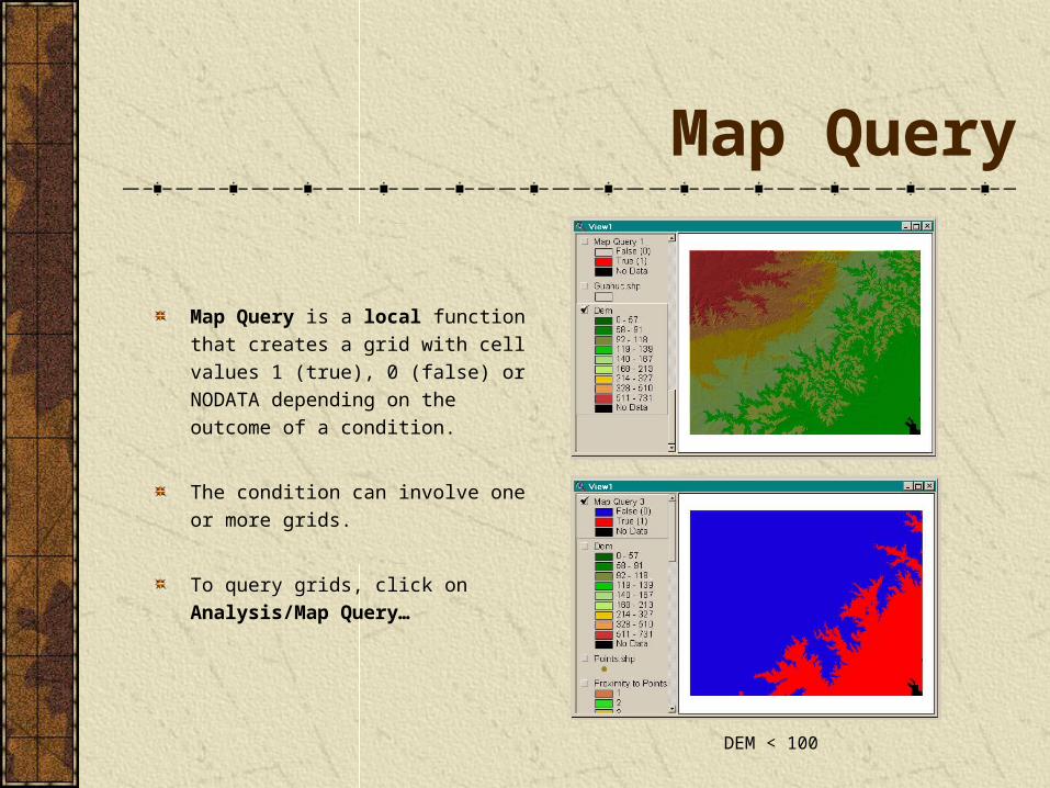
Map Query
Map Query is a local function that creates a grid with cell values 1 (true), 0 (false) or NODATA depending on the outcome of a condition.
The condition can involve one or more grids.
To query grids, click on Analysis/Map Query…
DEM < 100
Cell Statistics
Cell Statistics is a local function that creates a grid with cell values equal to a statistic of the corresponding cell values of the input grids.
The statistic can be: majority, maximum, mean, median, minimum, minority, range, standard deviation, sum and variety.
To calculate the statistics of a set of cells, make the themes active, and click on Analysis/Cell Statistics…
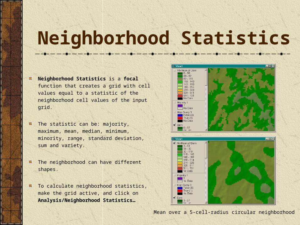
Neighborhood Statistics
Neighborhood Statistics is a focal function that creates a grid with cell values equal to a statistic of the neighborhood cell values of the input grid.
The statistic can be: majority, maximum, mean, median, minimum, minority, range, standard deviation, sum and variety.
The neighborhood can have different shapes.
To calculate neighborhood statistics, make the grid active, and click on Analysis/Neighborhood Statistics…
Mean over a 5-cell-radius circular neighborhood
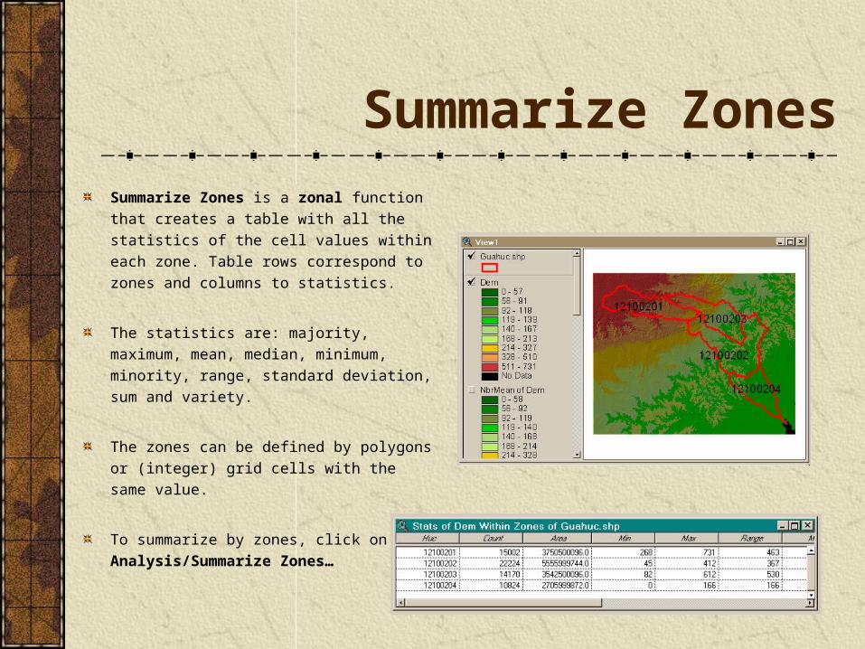
Summarize ZonesSummarize Zones is a zonal function that creates a table with all the statistics of the cell values within each zone. Table rows correspond to zones and columns to statistics.
The statistics are: majority, maximum, mean, median, minimum, minority, range, standard deviation, sum and variety.
The zones can be defined by polygons or (integer) grid cells with the same value.
To summarize by zones, click on Analysis/Summarize Zones…
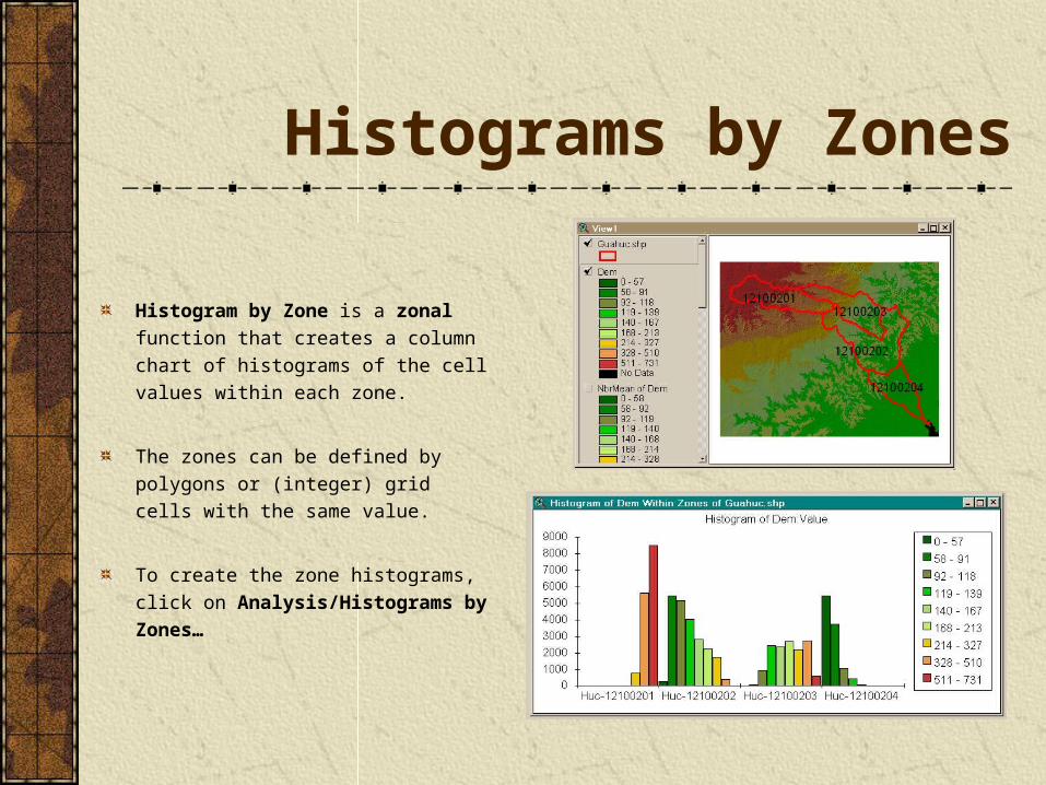
Histograms by Zones
Histogram by Zone is a zonal function that creates a column chart of histograms of the cell values within each zone.
The zones can be defined by polygons or (integer) grid cells with the same value.
To create the zone histograms, click on Analysis/Histograms by Zones…
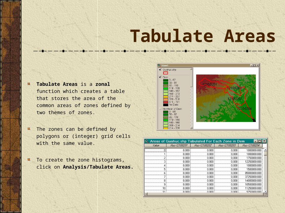
Tabulate Areas
Tabulate Areas is a zonal function which creates a table that stores the area of the common areas of zones defined by two themes of zones.
The zones can be defined by polygons or (integer) grid cells with the same value.
To create the zone histograms, click on Analysis/Tabulate Areas.
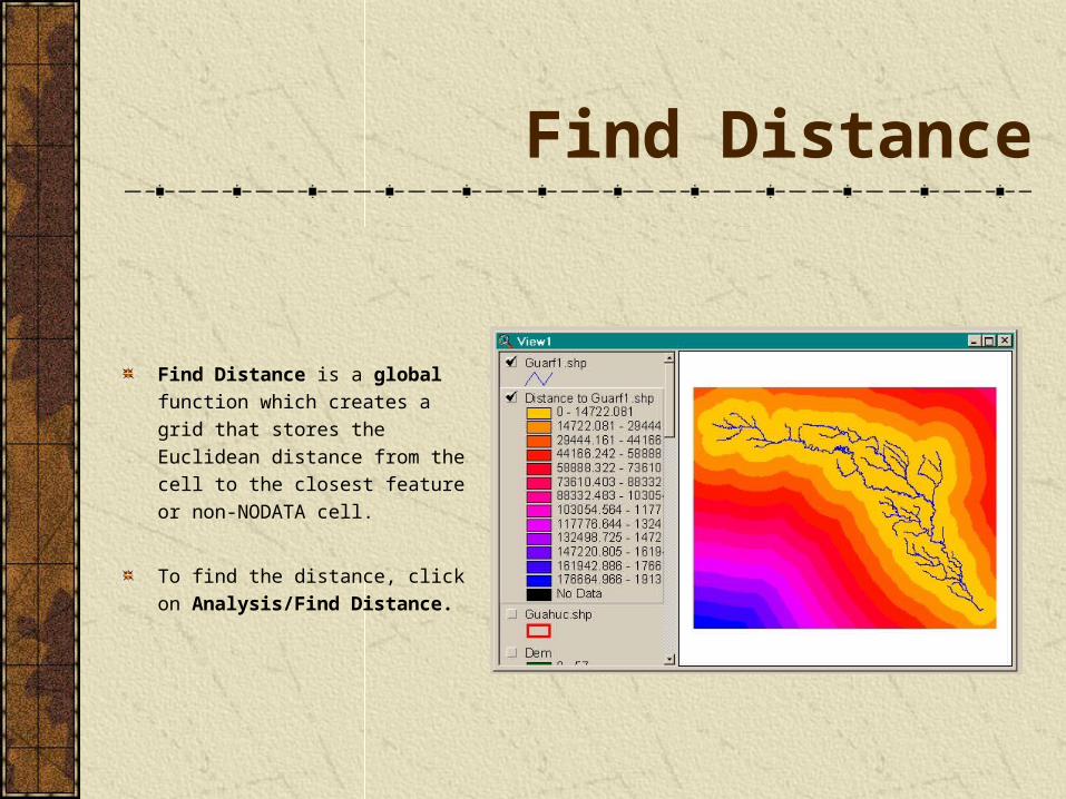
Find Distance
Find Distance is a global function which creates a grid that stores the Euclidean distance from the cell to the closest feature or non-NODATA cell.
To find the distance, click on Analysis/Find Distance.
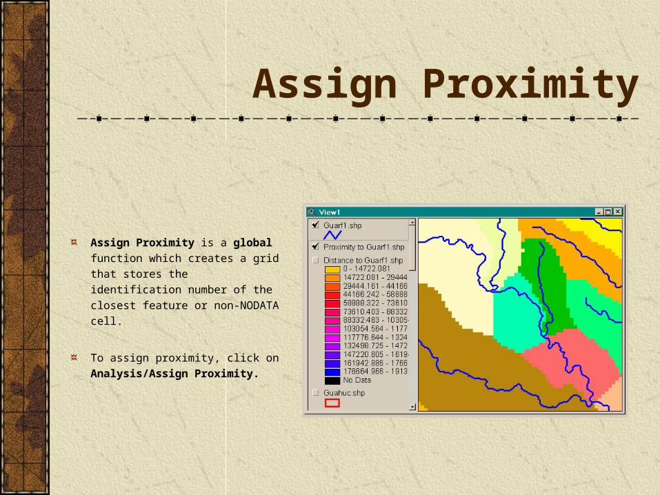
Assign Proximity
Assign Proximity is a global function which creates a grid that stores the identification number of the closest feature or non-NODATA cell.
To assign proximity, click on Analysis/Assign Proximity.
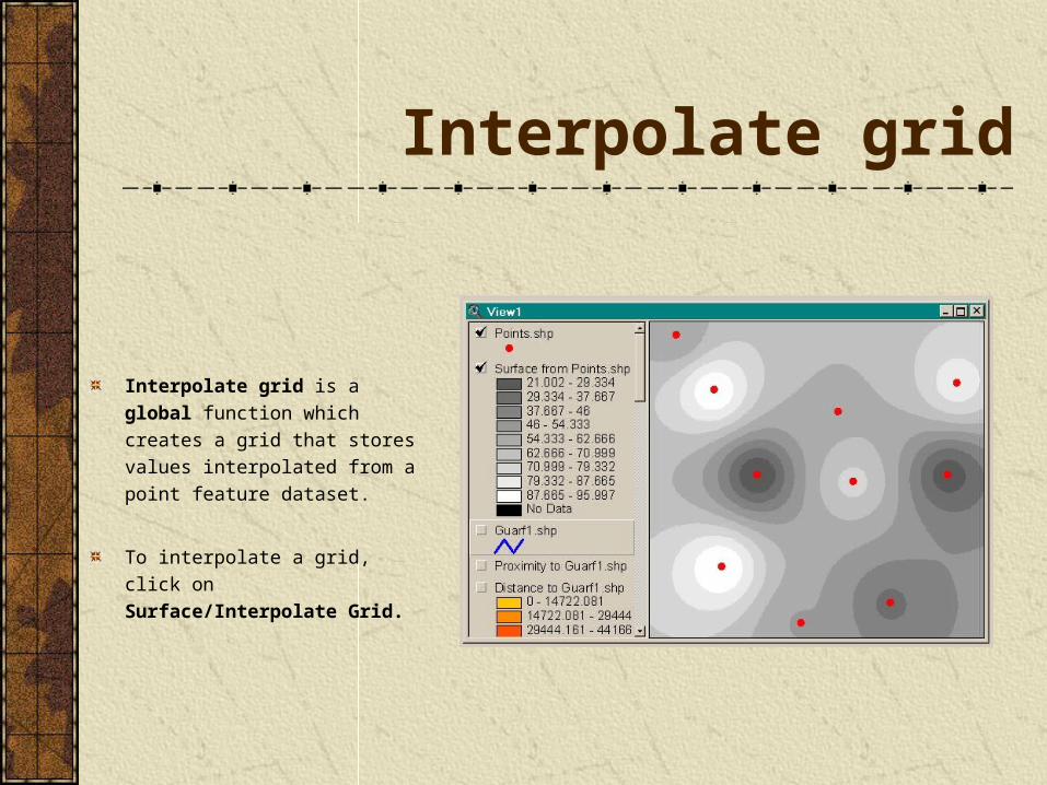
Interpolate grid
Interpolate grid is a global function which creates a grid that stores values interpolated from a point feature dataset.
To interpolate a grid, click on Surface/Interpolate Grid.
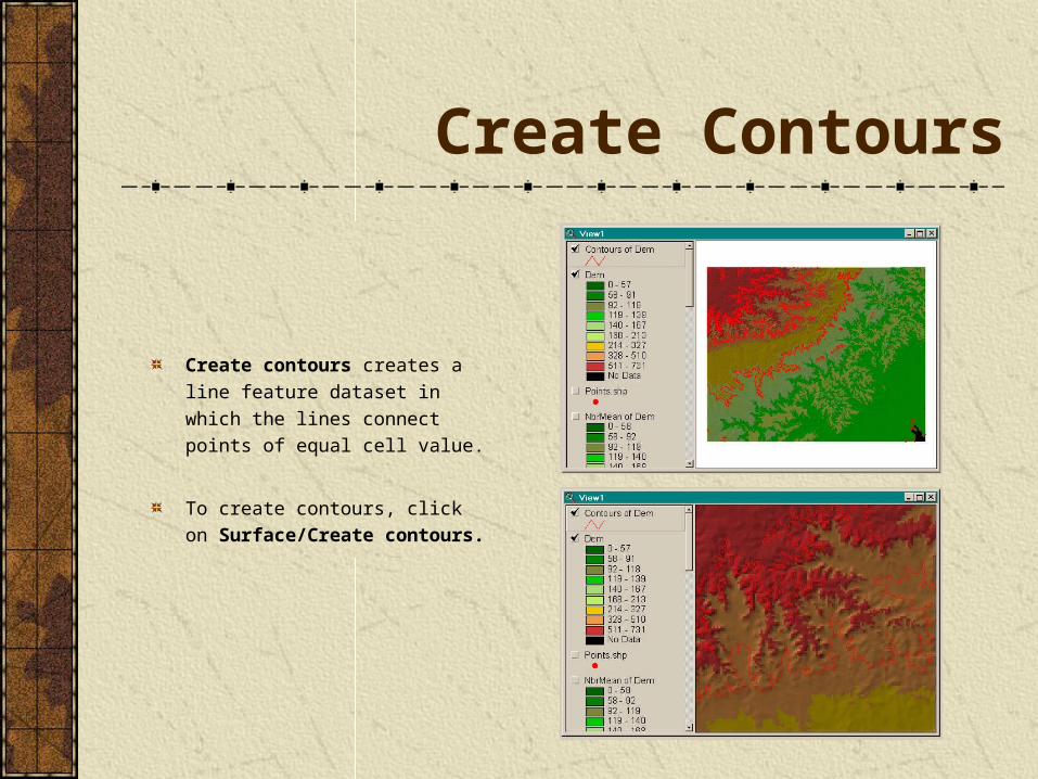
Create Contours
Create contours creates a line feature dataset in which the lines connect points of equal cell value.
To create contours, click on Surface/Create contours.
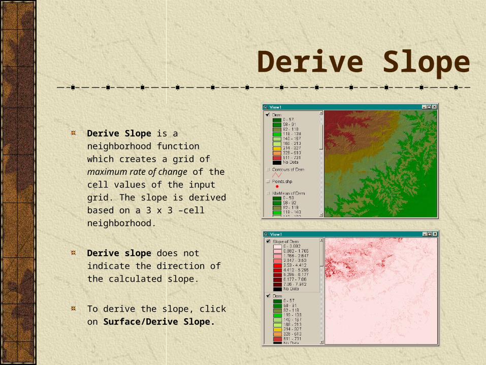
Derive Slope
Derive Slope is a neighborhood function which creates a grid of maximum rate of change of the cell values of the input grid. The slope is derived based on a 3 x 3 –cell neighborhood.
Derive slope does not indicate the direction of the calculated slope.
To derive the slope, click on Surface/Derive Slope.
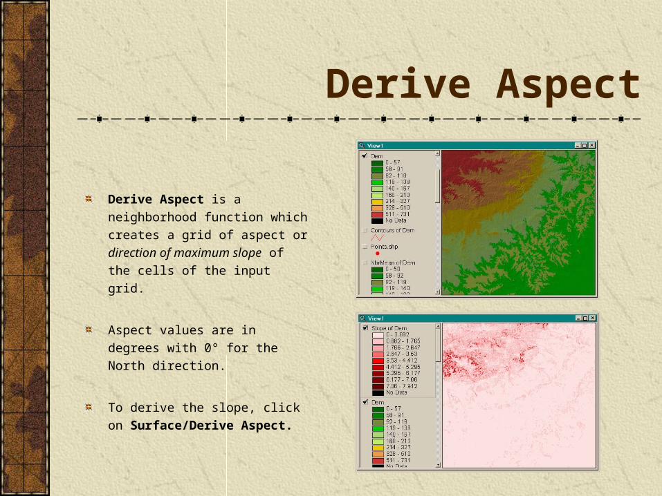
Derive Aspect
Derive Aspect is a neighborhood function which creates a grid of aspect or direction of maximum slope of the cells of the input grid.
Aspect values are in degrees with 0° for the North direction.
To derive the slope, click on Surface/Derive Aspect.
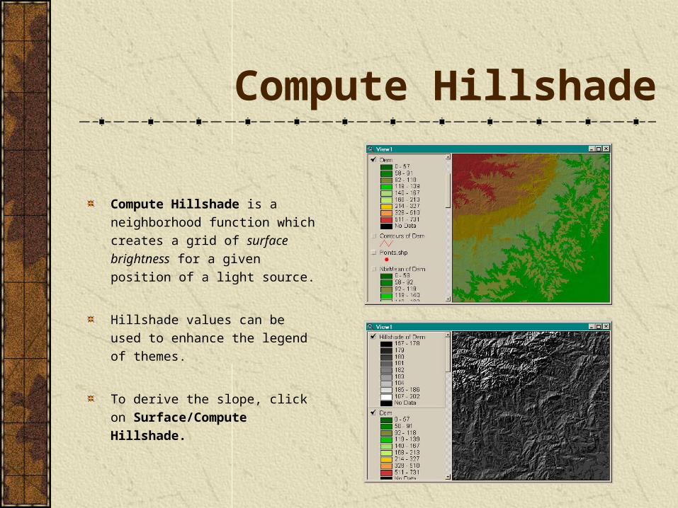
Compute Hillshade
Compute Hillshade is a neighborhood function which creates a grid of surface brightness for a given position of a light source.
Hillshade values can be used to enhance the legend of themes.
To derive the slope, click on Surface/Compute Hillshade.
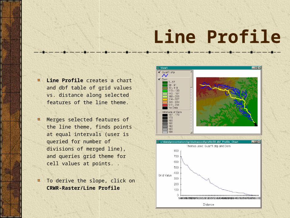
Line Profile
Line Profile creates a chart and dbf table of grid values vs. distance along selected features of the line theme.
Merges selected features of the line theme, finds points at equal intervals (user is queried for number of divisions of merged line), and queries grid theme for cell values at points. .
To derive the slope, click on CRWR-Raster/Line Profile
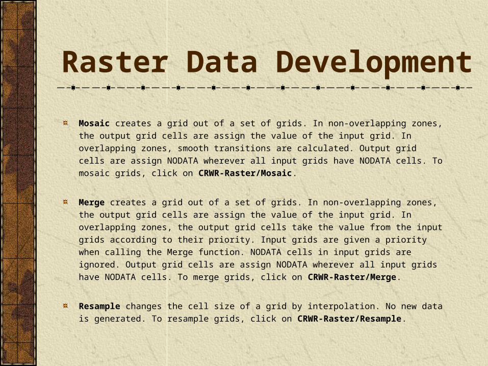
Raster Data Development
Mosaic creates a grid out of a set of grids. In non-overlapping zones, the output grid cells are assign the value of the input grid. In overlapping zones, smooth transitions are calculated. Output grid cells are assign NODATA wherever all input grids have NODATA cells. To mosaic grids, click on CRWR-Raster/Mosaic.
Merge creates a grid out of a set of grids. In non-overlapping zones, the output grid cells are assign the value of the input grid. In overlapping zones, the output grid cells take the value from the input grids according to their priority. Input grids are given a priority when calling the Merge function. NODATA cells in input grids are ignored. Output grid cells are assign NODATA wherever all input grids have NODATA cells. To merge grids, click on CRWR-Raster/Merge.
Resample changes the cell size of a grid by interpolation. No new data is generated. To resample grids, click on CRWR-Raster/Resample.
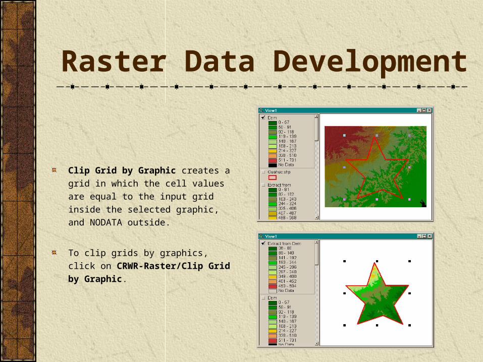
Raster Data Development
Clip Grid by Graphic creates a grid in which the cell values are equal to the input grid inside the selected graphic, and NODATA outside.
To clip grids by graphics, click on CRWR-Raster/Clip Grid by Graphic.
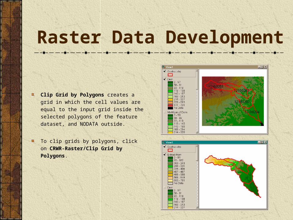
Raster Data Development
Clip Grid by Polygons creates a grid in which the cell values are equal to the input grid inside the selected polygons of the feature dataset, and NODATA outside.
To clip grids by polygons, click on CRWR-Raster/Clip Grid by Polygons.
Related Documents


