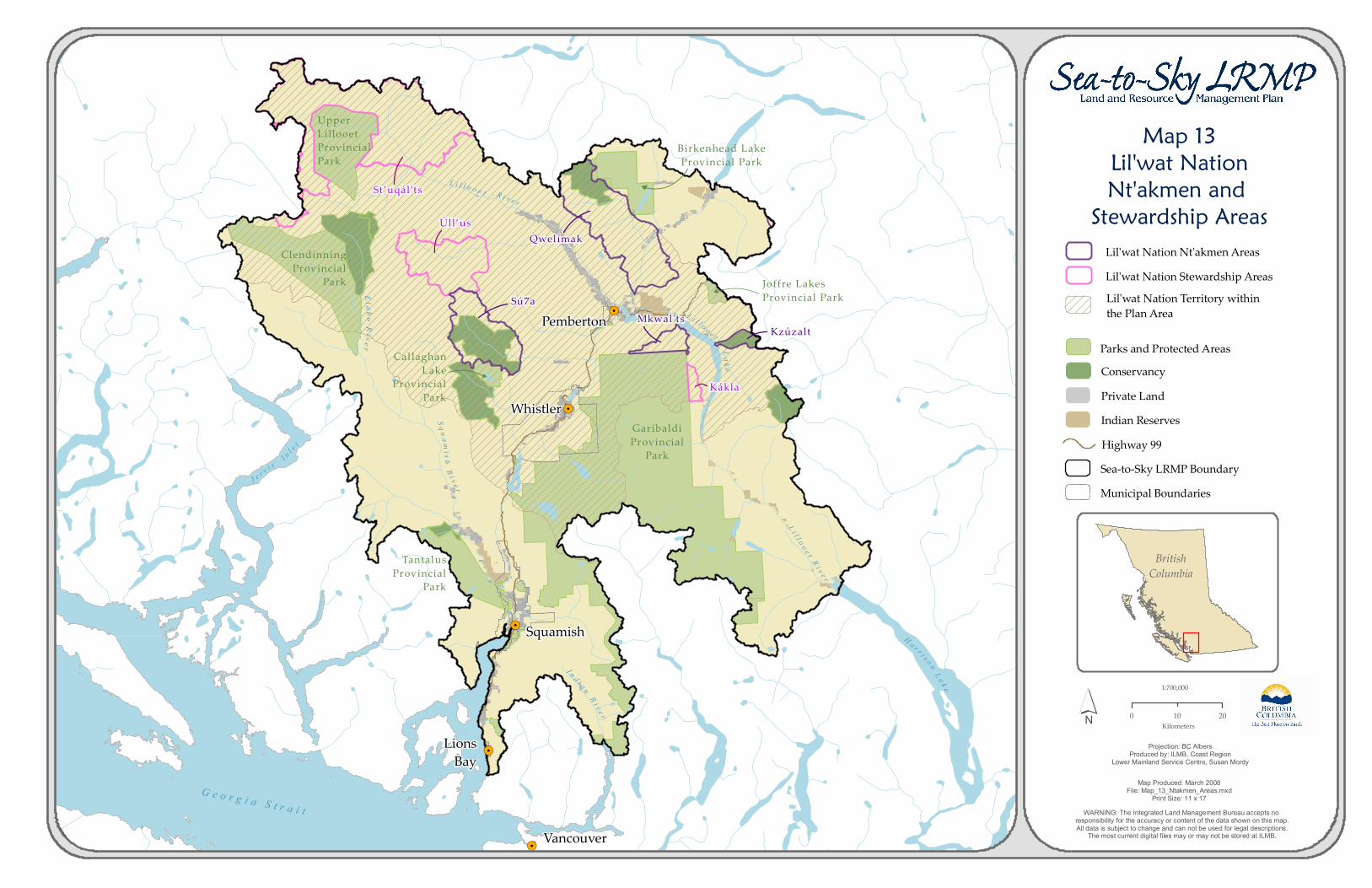
! . ! . ! . ! . ! . Map 13 Lil'wat Nation Nt'akmen and Stewardship Areas British Columbia 1:700,000 WARNING: The Integrated Land Management Bureau accepts no responsibility for the accuracy or content of the data shown on this map. All data is subject to change and can not be used for legal descriptions. The most current digital files may or may not be stored at ILMB. Projection: BC Albers Produced by: ILMB, Coast Region Lower Mainland Service Centre, Susan Mordy Map Produced: March 2008 File: Map_13_Ntakmen_Areas.mxd Print Size: 11 x 17 ´ 0 20 10 Kilometers Conservancy Upper Lillooet Provincial Park L il l ooe t Lil lo oet Ri ver L a k e Clendinning Provincial Park Tantalus Provincial Park Birkenhead Lake Provincial Park Lill o oe t R i v e r Garibaldi Provincial Park R i v e r S q u a m i s h I n d i an R iv e r Ha r r i s o n La k e J er v i s I nl e t Callaghan Lake Provincial Park E l a h o R i v e r Joffre Lakes Provincial Park Lil'wat Nation Territory within the Plan Area Lil'wat Nation Nt'akmen Areas Lil'wat Nation Stewardship Areas Georgia Strait Qwelímak Sú7a Úll’us St’uqál’ts Mkwal'ts Kzúzalt Kákla Highway 99 Sea-to-Sky LRMP Boundary Private Land Indian Reserves Municipal Boundaries Parks and Protected Areas Pemberton Whistler Squamish Lions Bay Vancouver

Welcome message from author
This document is posted to help you gain knowledge. Please leave a comment to let me know what you think about it! Share it to your friends and learn new things together.
Transcript
!.
!.
!.
!.
!.
Map 13Lil'wat NationNt'akmen and Stewardship Areas
BritishColumbia
1:700,000
WARNING: The Integrated Land Management Bureau accepts no responsibility for the accuracy or content of the data shown on this map.All data is subject to change and can not be used for legal descriptions.
The most current digital files may or may not be stored at ILMB.
Projection: BC AlbersProduced by: ILMB, Coast Region
Lower Mainland Service Centre, Susan Mordy
Map Produced: March 2008File: Map_13_Ntakmen_Areas.mxd
Print Size: 11 x 17
´ 0 2010Kilometers
Conservancy
UpperLillooetProvincialPark
L i l l o o e t
L i l l o o e t R i v e r
L ak e
ClendinningProvincial
Park
TantalusProvincial
Park
Birkenhead LakeProvincial Park
L i l l o o e t
R i v e r
GaribaldiProvincial
Park
R i v e rS q u a m
i s h
I n d i a nR i v e r
H a r r i s o n L a k e
J e r v i s I n l e t
CallaghanLake
ProvincialPark
El a h o River
Joffre LakesProvincial Park Lil'wat Nation Territory within
the Plan Area
Lil'wat Nation Nt'akmen AreasLil'wat Nation Stewardship Areas
G e o r g i a S t r a i t
Qwelímak
Sú7a
Úll’us
St’uqál’ts
Mkwal'tsKzúzalt
Kákla
Highway 99Sea-to-Sky LRMP Boundary
Private LandIndian Reserves
Municipal Boundaries
Parks and Protected AreasPemberton
Whistler
Squamish
LionsBay
Vancouver
Related Documents