1 SECTION: Cover red Manual on the WMO Integrated Global Observing System Annex VIII to the WMO Technical Regulations SECTION: TitlePage Manual on the WMO Integrated Global Observing System Annex VIII to the WMO Technical Regulations SECTION: ISBN-Long_with_URLs SECTION: Revision_table PUBLICATION REVISION TRACK RECORD TABLE: Revision table Date Part/chapter/ section Purpose of amendment Proposed by Approved by Section 2, Appendix 2.4 Further development of the WIGOS Metadata Standard and OSCAR/Surface ICG-WIGOS (CBS-16) Section 8 Modifications of the CryoNet station/site concept, of minimum requirements for stations/sites and of the procedure for testing stations/sites EC-PHORS (CBS-16)

Welcome message from author
This document is posted to help you gain knowledge. Please leave a comment to let me know what you think about it! Share it to your friends and learn new things together.
Transcript

1
SECTION: Cover red
Manual on the WMO Integrated Global Observing SystemAnnex VIII to the WMO Technical Regulations
SECTION: TitlePage
Manual on the WMO Integrated Global Observing SystemAnnex VIII to the WMO Technical Regulations
SECTION: ISBN-Long_with_URLs
SECTION: Revision_table
PUBLICATION REVISION TRACK RECORD
TABLE: Revision table
Date Part/chapter/section Purpose of amendment Proposed by Approved by
Section 2, Appendix 2.4
Further development of the WIGOS Metadata Standard and OSCAR/Surface
ICG-WIGOS (CBS-16)
Section 8 Modifications of the CryoNet station/site concept, of minimum requirements for stations/sites and
of the procedure for testing stations/sites
EC-PHORS (CBS-16)

2
SECTION: Table_of_contents
SECTION: Pr-Preliminary_pages
Chapter title in running head: INTRODUCTION
INTRODUCTION
General
1. This is the first edition of the Manual on the WMO Integrated Global Observing System (WMO-No. 1160), developed following the decision of the Sixteenth World Meteorological Congress to proceed with the implementation of that System (WIGOS). It was approved by the Seventeenth World Meteorological Congress.
2. The Manual was developed by the Executive Council through its Inter-Commission Coordination Group on WIGOS, specifically its Task Team on WIGOS Regulatory Material. It is the result of a collaborative approach involving all interested technical commissions under the leadership of the Commission for Basic Systems (CBS) and the Commission for Instruments and Methods of Observation (CIMO).
Purpose and scope
3. The Manual is designed:
(a) To specify the obligations of Members in the implementation and operation of WIGOS;
(b) To facilitate cooperation in observations between Members;
(c) To ensure adequate uniformity and standardization in the practices and procedures employed in achieving (a) and (b) above.
4. The Manual is Annex VIII to the Technical Regulations (WMO-No. 49) and should be read in conjunction with the four volumes and the set of annexes which together make up the Technical Regulations. In particular, the Manual on the Global Observing System (WMO-No. 544) will be for some time a companion to the present Manual, but it will eventually disappear as its content is progressively moved into the Manual on the WMO Integrated Global Observing System. Gradually, all technical regulations for all WMO component observing systems will be included under the identity of WIGOS.
3
5. Members will implement and operate their observing systems in accordance with decisions of Congress, the Executive Council, the technical commissions and regional associations. Where those decisions are technical and regulatory in nature, they will in due course be documented in the Technical Regulations.
6. In essence, the Manual specifies what is to be observed, and what practices and procedures are to be followed in order to meet the relevant observational requirements of Members. These requirements may arise directly at a national level or collectively through WMO Programmes at global or regional levels, and are expressed through the application areas of the Rolling Review of Requirements. A number of other Manuals and Guides provide more practices and procedures on the operation of observing systems including stations and platforms, instruments and methods of observation, and on reporting and management of observations and observational metadata.
7. In the case of hydrological observations, there is not a widely implemented base of global exchange and global standard practices and procedures. Technical Regulations (WMO-No. 49), Volume III: Hydrology, provides Members with predominantly recommended practices and procedures. In order to help ensure the quality and comparability of observations within WIGOS, Members making their hydrological observations available through the WMO Hydrological Observing System (WHOS) are requested to comply with the provisions specified within the present Manual. For this reason, a number of provisions that are recommended practices and procedures for hydrology in Technical Regulations, Volume III, are listed as standard practices and procedures in the present Manual. It is recognized that it might not be easy for some of the WIGOS standard practices and procedures to be widely and quickly implemented by all Members for their hydrological observations. Nonetheless, Members are urged to make their best efforts to implement the WIGOS standard practices and procedures in the collection and exchange of hydrological observations and to make such observations available through WHOS.
Appendices
8. Appendices are used where a set of provisions on a single topic might, due to their detailed nature and length, otherwise interrupt the flow of the relevant section of the present Manual. Moreover, appendices are used to facilitate the ongoing review and update process by identifying subsections that fall under the responsibility of a particular group.
SECTION: Pr-Preliminary_pages
Chapter title in running head: GENERAL PROVISIONS
GENERAL PROVISIONS
1. The Technical Regulations (WMO-No. 49) of the World Meteorological Organization are presented in four volumes:
Volume I – General meteorological standards and recommended practices
Volume II – Meteorological service for international air navigation
Volume III – Hydrology
Volume IV – Quality management
Purpose of the Technical Regulations
2. The Technical Regulations are determined by the World Meteorological Congress in accordance with Article 8 (d) of the Convention.

4
3. These Regulations are designed:
(a) To facilitate cooperation in meteorology and hydrology among Members;
(b) To meet, in the most effective manner, specific needs in the various fields of application of meteorology and operational hydrology in the international sphere;
(c) To ensure adequate uniformity and standardization in the practices and procedures employed in achieving (a) and (b) above.
Types of Regulations
4. The Technical Regulations comprise standard practices and procedures and recommended practices and procedures.
5. The definitions of these two types of Regulations are as follows:
The standard practices and procedures:
(a) Shall be the practices and procedures that Members are required to follow or implement;
(b) Shall have the status of requirements in a technical resolution in respect of which Article 9 (b) of the Convention is applicable;
(c) Shall invariably be distinguished by the use of the term shall in the English text, and by suitable equivalent terms in the Arabic, Chinese, French, Russian and Spanish texts.
The recommended practices and procedures:
(a) Shall be the practices and procedures with which Members are urged to comply;
(b) Shall have the status of recommendations to Members, to which Article 9 (b) of the Convention shall not be applied;
(c) Shall be distinguished by the use of the term should in the English text (except where otherwise provided by decision of Congress) and by suitable equivalent terms in the Arabic, Chinese, French, Russian and Spanish texts.
6. In accordance with the above definitions, Members shall do their utmost to implement the standard practices and procedures. In accordance with Article 9 (b) of the Convention and in conformity with Regulation 128 of the General Regulations, Members shall formally notify the Secretary-General, in writing, of their intention to apply the standard practices and procedures of the Technical Regulations, except those for which they have lodged a specific deviation. Members shall also inform the Secretary-General, at least three months in advance, of any change in the degree of their implementation of a standard practice or procedure as previously notified and the effective date of the change.
7. Members are urged to comply with recommended practices and procedures, but it is not necessary to notify the Secretary-General of non-observance except with regard to practices and procedures contained in Volume II.
8. In order to clarify the status of the various Regulations, the standard practices and procedures are distinguished from the recommended practices and procedures by a difference in typographical practice, as indicated in the editorial note.
Status of annexes and appendices
9. The following annexes to the Technical Regulations (Volumes I to IV), also called Manuals, are published separately and contain regulatory material having the status of standard and/or recommended practices and procedures:

5
I International Cloud Atlas (WMO-No. 407), Volume I – Manual on the Observation of Clouds and Other Meteors, Part I; Part II: paragraphs II.1.1, II.1.4, II.1.5 and II.2.3; subparagraphs 1, 2, 3 and 4 of each paragraph from II.3.1 to II.3.10; paragraphs II.8.2 and II.8.4; Part III: paragraph III.1 and the definitions (in italics) of paragraph III.2;
II Manual on Codes (WMO-No. 306), Volume I;III Manual on the Global Telecommunication System (WMO-No. 386);IV Manual on the Global Data-processing and Forecasting System (WMO-No.485), Volume I;V Manual on the Global Observing System (WMO-No. 544), Volume I;VI Manual on Marine Meteorological Services (WMO-No. 558), Volume I;VII Manual on the WMO Information System (WMO-No. 1060);VIII Manual on the WMO Integrated Global Observing System (WMO-No. 1160).
These annexes (Manuals) are established by decision of Congress and are intended to facilitate the application of Technical Regulations to specific fields. Annexes may contain both standard and recommended practices and procedures.
10. Texts called appendices, appearing in the Technical Regulations or in an annex to the Technical Regulations, have the same status as the Regulations to which they refer.
Status of notes and attachments
11. Certain notes (preceded by the indication “Note”) are included in the Technical Regulations for explanatory purposes; they may, for instance, refer to relevant WMO Guides and publications. These notes do not have the status of Technical Regulations.
12. The Technical Regulations may also include attachments, which usually contain detailed guidelines related to standard and recommended practices and procedures. Attachments, however, do not have regulatory status.
Updating of the Technical Regulations and their annexes (Manuals)
13. The Technical Regulations are updated, as necessary, in the light of developments in meteorology and hydrology and related techniques, and in the application of meteorology and operational hydrology. Certain principles previously agreed upon by Congress and applied in the selection of material for inclusion in the Technical Regulations are reproduced below. These principles provide guidance for constituent bodies, in particular technical commissions, when dealing with matters pertaining to the Technical Regulations:
(a) Technical commissions should not recommend that a Regulation be a standard practice unless it is supported by a strong majority;
(b) Technical Regulations should contain appropriate instructions to Members regarding implementation of the provision in question;
(c) No major changes should be made to the Technical Regulations without consulting the appropriate technical commissions;
(d) Any amendments to the Technical Regulations submitted by Members or by constituent bodies should be communicated to all Members at least three months before they are submitted to Congress.
14. Amendments to the Technical Regulations – as a rule – are approved by Congress.
15. If a recommendation for an amendment is made by a session of the appropriate technical commission and if the new regulation needs to be implemented before the next session of Congress, the Executive Council may, on behalf of the Organization, approve the amendment in accordance with Article 14 (c) of the Convention. Amendments to annexes to the Technical Regulations proposed by the appropriate technical commissions are normally approved by the Executive Council.

6
16. If a recommendation for an amendment is made by the appropriate technical commission and the implementation of the new regulation is urgent, the President of the Organization may, on behalf of the Executive Council, take action as provided by Regulation 9 (5) of the General Regulations.
Note: A fast-track procedure can be applied for additions to certain codes and associated code tables contained in Annex II (Manual on Codes (WMO-No. 306)). Application of the fast-track procedure is described in detail in Annex II.
17. After each session of Congress (every four years), a new edition of the Technical Regulations, including the amendments approved by Congress, is issued. With regard to the amendments between sessions of Congress, Volumes I, III and IV of the Technical Regulations are updated, as necessary, upon approval of changes thereto by the Executive Council. The Technical Regulations updated as a result of an approved amendment by the Executive Council are considered a new update of the current edition. The material in Volume II is prepared by the World Meteorological Organization and the International Civil Aviation Organization working in close cooperation, in accordance with the Working Arrangements agreed by these Organizations. In order to ensure consistency between Volume II and Annex 3 to the Convention on International Civil Aviation – Meteorological Service for International Air Navigation, the issuance of amendments to Volume II is synchronized with the respective amendments to Annex 3 by the International Civil Aviation Organization.
Note: Editions are identified by the year of the respective session of Congress whereas updates are identified by the year of approval by the Executive Council, for example “Updated in 2012”.
WMO Guides
18. In addition to the Technical Regulations, appropriate Guides are published by the Organization. They describe practices, procedures and specifications which Members are invited to follow or implement in establishing and conducting their arrangements for compliance with the Technical Regulations, and in otherwise developing meteorological and hydrological services in their respective countries. The Guides are updated, as necessary, in the light of scientific and technological developments in hydrometeorology, climatology and their applications. The technical commissions are responsible for the selection of material to be included in the Guides. These Guides and their subsequent amendments shall be considered by the Executive Council.
SECTION: Pr-Preliminary_pages
Chapter title in running head: DEFINITIONS
DEFINITIONS
Notes:
1. Other definitions related to observing systems may be found in the Technical Regulations (WMO-No. 49), Volume I and the Manual on the Global Observing System (WMO-No. 544), Volume I. Definitions are not duplicated between Manuals, hence the importance of consulting all publications.
2. Further definitions may be found in the Manual on Codes (WMO-No. 306), the Manual on the Global Data-processing and Forecasting System (WMO-No. 485), Volume I, the Manual on the Global Telecommunication System (WMO-No. 386) and other WMO publications.
3. Definitions, terminology, vocabulary and abbreviations used in relation to quality management are those of the International Organization for Standardization (ISO) 9000 family of standards for quality management systems, in particular those identified within ISO 9000:2005, Quality management systems – Fundamentals and vocabulary.
The following terms, when used in the present Manual, have the meanings given below.
Accuracy. The extent to which the results of the readings of an instrument approach the true value of the calculated or measured quantities, supposing that all possible corrections are applied.

7
Acoustic Doppler current profiler (ADCP). Hydroacoustic device to measure the velocity of water over a range of depths in a column using the Doppler effect, with the overall depth of water usually being measured simultaneously.
Acoustic velocity meter. System that uses the difference in travel time of acoustic (ultrasonic) pulses between transducers in a stream to determine the mean velocity on the signal path.
Adaptive maintenance. Modification of an instrument, software or other product, performed after installation to keep it usable in a changed or changing environment.
Bank. (1) Rising land bordering a river, usually to contain the stream within the wetted perimeter of the channel; (2) Margin of a channel on the left-hand (right-hand) side when facing downstream.
Cableway. Cable stretched above and across a stream, from which a current meter or other measuring or sampling device is suspended, and moved from one bank to the other, at predetermined depths below the water surface.
Calibration (rating) tank (Straight open tank). Tank containing still water through which a current meter is moved at a known velocity in order to calibrate the meter.
Catchment area. Area having a common outlet for its surface runoff.
Certification. The provision by an independent body of written assurance (a certificate) that the product, service or system in question meets specific requirements.
Compliance. Adherence to an internal code of conduct where employees follow the principles of one of the Quality Management Standards series (such as the ISO standards) or other internationally recognized practices and procedures. It could also be an external stamp of approval by an accreditation firm when customers or partners request documented proof of compliance.
Confidence level. Probability that the confidence interval includes the true value.
Control. Physical properties of a channel which determine the relationship between stage and discharge at a location in the channel.
Control structures. Artificial structures placed in a stream such as a low weir or flume to stabilize the stage-discharge relation, particularly in the low flow range, where such structures are calibrated by stage and discharge measurements taken in the field.
Co-sponsored observing system. An observing system from which some but not all observations are WMO observations.
Cross-section. Section perpendicular to the main direction of flow bounded by the free surface and wetted perimeter of the stream or channel.
Current meter. Instrument for measuring water velocity.
Current meter, propeller type. A current meter the rotor of which is a propeller rotating around an axis parallel to the flow.
Data archiving. Storage of data on a set of catalogued files which are held in some backup storage medium and not necessarily permanently online.
Data compatibility. The capacity for two systems to exchange data without having to be altered to do so and without any need for changes in data formats.
Data processing. Treatment of observational data until they are in a form ready to be used for a specific purpose.

8
Data quality objectives. Definition of the type, quality and quantity of primary data and derived parameters required to yield information that can be used to support decisions.
Discharge. Volume of water flowing through a river (or channel) cross-section per unit time.
Drainage basin. See catchment area
Elevation. Vertical distance of a point or level, on or affixed to the surface of the ground, measured from mean sea level.
Estuary. Broad portion of a stream near its outlet to a sea, lake or sabkha.
Flood. (1) Rise, usually brief, in the water level of a stream or water body to a peak from which the water level recedes at a slower rate; (2) Relatively high flow as measured by stage height or discharge.
Flood-proofing. Techniques for preventing flood damage in a flood-prone area.
Gauge boards (staff gauge). Graduated vertical scale, fixed to a staff or structure, on which the water level may be read.
Gauge datum. Vertical distance between the zero of a gauge and a certain datum level.
Gauging station. Location on a stream where measurements of water level and/or discharge are made systematically.
GAW Station Information System (GAWSIS). The official catalogue for monitoring sites, platforms or stations operating within the Global Atmosphere Watch (GAW) and related programmes, providing station metadata and serving as the clearing house for unique station identifiers. The GAW Station Information System represents the metadata source for OSCAR for GAW observations.
Hydrograph. Graph showing the variation in time of some hydrological data, such as stage, discharge, velocity and sediment load.
Hydrological forecast. Estimation of the magnitude and time of occurrence of future hydrological events for a specified period and for a specified locality.
Hydrological observation. Direct measurement or evaluation of one or more hydrological elements such as stage, discharge and water temperature.
Hydrological observing station. Place where hydrological observations or climatological observations for hydrological purposes are made.
Hydrological warning. Emergency information on an expected hydrological event that is considered to be dangerous.
Hydrometric station. Station gathering data on one or more parameters of water in rivers, lakes or reservoirs, such as stage, streamflow, sediment transport and deposition, water temperature and other physical or chemical properties of water, and characteristics of ice cover.
Intercomparison. A formalized process to assess the relative performance of two or more systems (observing, forecasting, etc.).
Moving-boat method. Method of measuring discharge which uses a boat to traverse the stream along the measuring section and continuously measure velocity, depth and distance travelled.
Quality. The degree to which a set of inherent characteristics fulfils requirements.
Quality assurance. That part of quality management focused on providing confidence that quality requirements will be fulfilled.

9
Quality control. That part of quality management focused on fulfilling quality requirements.
Quality management. The coordinated activities that direct and manage an organization with respect to quality.
Rating curve. Curve showing the relation between stage and discharge of a stream at a hydrometric station.
Recession. Period of decreasing discharge as indicated by the falling limb of a hydrograph starting from the peak.
Registration. Certification is very often referred to as registration in North America.
Reservoir. Body of water, either natural or man-made, used for storage, regulation and control of water resources.
River. Large stream that serves as the natural drainage for a basin.
Stage. See water level.
Stage-discharge relation. Relationship between water level and discharge for a river cross-section, which may be expressed as a curve, a table or an equation.
Streamflow. General term for water flowing in a watercourse.
Uncertainty. Estimate of the range of values within which the true value of a variable lies.
Upstream. Direction from which a fluid is moving.
Verification. The process of establishing the truth, accuracy or validity of something.
Water level. Elevation of the free water surface of a water body relative to a datum level.
SECTION: Chapter First
Chapter title in running head: 1. INTRODUCTION TO WIGOS
1. INTRODUCTION TO WIGOS
1.1 PURPOSE AND SCOPE OF WIGOS
1.1.1 The WMO Integrated Global Observing System shall be a framework for all WMO observing systems and for WMO contributions to co-sponsored observing systems in support of all WMO Programmes and activities.
Note: The co-sponsored observing systems are the Global Climate Observing System (GCOS), the Global Ocean Observing System (GOOS) and the Global Terrestrial Observing System (GTOS), all joint undertakings of WMO and the Intergovernmental Oceanographic Commission (IOC) of the United Nations Educational, Scientific and Cultural Organization (UNESCO), the United Nations Environment Programme (UNEP) and the International Council for Science (ICSU).
1.1.2 The WMO Integrated Global Observing System shall facilitate the use by WMO Members of observations from systems that are owned, managed and operated by a diverse array of organizations and programmes.

10
1.1.3 The principal purpose of WIGOS shall be to meet the evolving requirements of Members for observations.
1.1.4 The interoperability (including data compatibility) of WIGOS component observing systems shall be achieved through their common utilization and application of internationally accepted standards and recommended practices and procedures. Data compatibility shall also be supported through the use of data representation standards.
1.2 WIGOS COMPONENT OBSERVING SYSTEMS
The component observing systems of WIGOS shall comprise the Global Observing System (GOS) of the World Weather Watch (WWW) Programme, the observing component of the Global Atmosphere Watch (GAW) Programme, the WMO Hydrological Observing System (WHOS) of the Hydrology and Water Resources Programme (HWRP) and the observing component of the Global Cryosphere Watch (GCW), including their surface-based and space-based elements.
Note: The above component systems include all WMO contributions to the co-sponsored systems, as well as to the Global Framework for Climate Services (GFCS) and the Global Earth Observation System of Systems (GEOSS).
1.2.1 The Global Observing System of the World Weather Watch
1.2.1.1 The Global Observing System shall be a coordinated system of observing networks, methods, techniques, facilities and arrangements for making observations on a worldwide scale and shall be one of the main components of the World Weather Watch.
1.2.1.2 The purpose of GOS shall be to provide the meteorological observations from all parts of the globe that are required by Member countries for operational and research purposes through all WMO and co-sponsored programmes.
1.2.1.3 The Global Observing System shall consist of: (a) a surface-based subsystem composed of regional basic and other networks of stations and platforms; and (b) a space-based subsystem composed of: (i) an Earth observation space segment; (ii) an associated ground system for data reception, dissemination and stewardship; and (iii) a user segment.
1.2.1.4 The Global Observing System shall comply with the provisions specified in sections 1, 2, 3, 4 and 5.
1.2.2 The Global Atmosphere Watch (observing component)
1.2.2.1 The Global Atmosphere Watch shall be a coordinated system of observing networks, methods, techniques, facilities and arrangements encompassing the many monitoring activities and scientific assessments devoted to the investigation of the chemical composition and related physical characteristics of the atmosphere.
Note: The GAW Programme has six focal areas: ozone, greenhouse gases, reactive gases, aerosols, ultraviolet (UV) radiation and total atmospheric deposition. The GAW stations in addition to measuring one or more of the parameters related to these areas may also measure ancillary variables such as radiation, radio nuclides and persistent organic pollutants.
1.2.2.2 The purpose of GAW shall be to provide data and other information on the chemical composition and related physical characteristics of the background, unpolluted atmosphere, as defined

11
in section 6, from all parts of the globe, in order to reduce environmental risks to society and meet the requirements of environmental conventions, strengthen capabilities to predict the state of climate, weather and air quality, and contribute to scientific assessments in support of environmental policy.
1.2.2.3 The observing component of GAW shall consist of a surface-based system composed of networks for observation of specified variables, complemented by space-based observations.
1.2.2.4 The observing component of the GAW Programme shall be operated in accordance with the provisions specified in sections 1, 2, 3, 4 and 6.
1.2.3 The WMO Hydrological Observing System
1.2.3.1 The WMO Hydrological Observing System shall comprise hydrological observations, initially focusing on water level and discharge.
Note: The composition of WHOS is provided in Technical Regulations (WMO-No. 49), Volume III: Hydrology, Chapter D.1.2.
1.2.3.2 The WMO Hydrological Observing System shall expand to include other elements identified through the Rolling Review of Requirements (RRR) (described in section 2.2.4 and Appendix 2.3) at the national, regional and global levels.
1.2.3.3 The purpose of WHOS shall be to provide real-time stream data (both water level and discharge) from participating Members.
1.2.3.4 Members making their hydrological observations available through the WHOS shall comply with the provisions specified in sections 1, 2, 3, 4 and 7.
Note: The Technical Regulations (WMO-No. 49), Volume III: Hydrology, the Guide to Hydrological Practices (WMO-No. 168), the Manual on Stream Gauging (WMO-No. 1044) and the Manual on Flood Forecasting and Warning (WMO-No. 1072) provide the necessary information to operate hydrological stations to the prescribed standards.
1.2.4 The Global Cryosphere Watch (observing component)
1.2.4.1 The Global Cryosphere Watch shall be a coordinated system of observing networks, methods, techniques, facilities and arrangements encompassing monitoring and related scientific assessment activities devoted to the investigation of the cryosphere.
1.2.4.2 The purpose of the GCW shall be to provide data and other information on the cryosphere, from the local to the global scale, to improve understanding of its behaviour, interactions with other components of the climate system and impacts on society.
1.2.4.3 The GCW observing network and its standardized core network (CryoNet) shall build on existing observing programmes and promote the addition of standardized cryospheric observations to existing facilities.
1.2.4.4 The observing component of the GCW shall comply with the provisions specified in sections 1, 2, 3, 4 and 8.

12
1.3 GOVERNANCE AND MANAGEMENT
1.3.1 Implementation and operation of WIGOS
1.3.1.1 Members shall be responsible for all activities connected with the implementation and operation of WIGOS on the territory of their respective countries.
1.3.1.2 Members should, as far as possible, use national resources for the implementation and operation of WIGOS, but, where necessary and if so requested, assistance may be provided in part through:
(a) The WMO Voluntary Cooperation Programme (VCP);
(b) Other bilateral or multilateral arrangements/facilities including the United Nations Development Programme (UNDP), which should be used to the maximum extent possible.
1.3.1.3 Members should participate voluntarily in the implementation and operation of WIGOS outside the territories of individual countries (for example, outer space, oceans and the Antarctic), if they wish and are able to contribute by providing facilities and services, either individually or jointly.
1.3.2 WIGOS quality management
Notes:
1. Within the WMO Quality Management Framework (QMF), WIGOS provides the procedures and practices regarding to the quality of observations and observational metadata that should be adopted by Members in establishing their quality management system for the provision of meteorological, hydrological, climatological and other related environmental observations.
2. Section 2.6 contains detailed provisions for WIGOS quality management.
1.3.3 WIGOS high-level processes
Members should adopt a process-based approach to the management of WIGOS observing systems as described in Attachment 1.1.
SECTION: Chapter
Chapter title in running head: ATTACHMENT 1.1. WIGOS HIGH-LEVEL PROCES…
ATTACHMENT 1.1. WIGOS HIGH-LEVEL PROCESSES
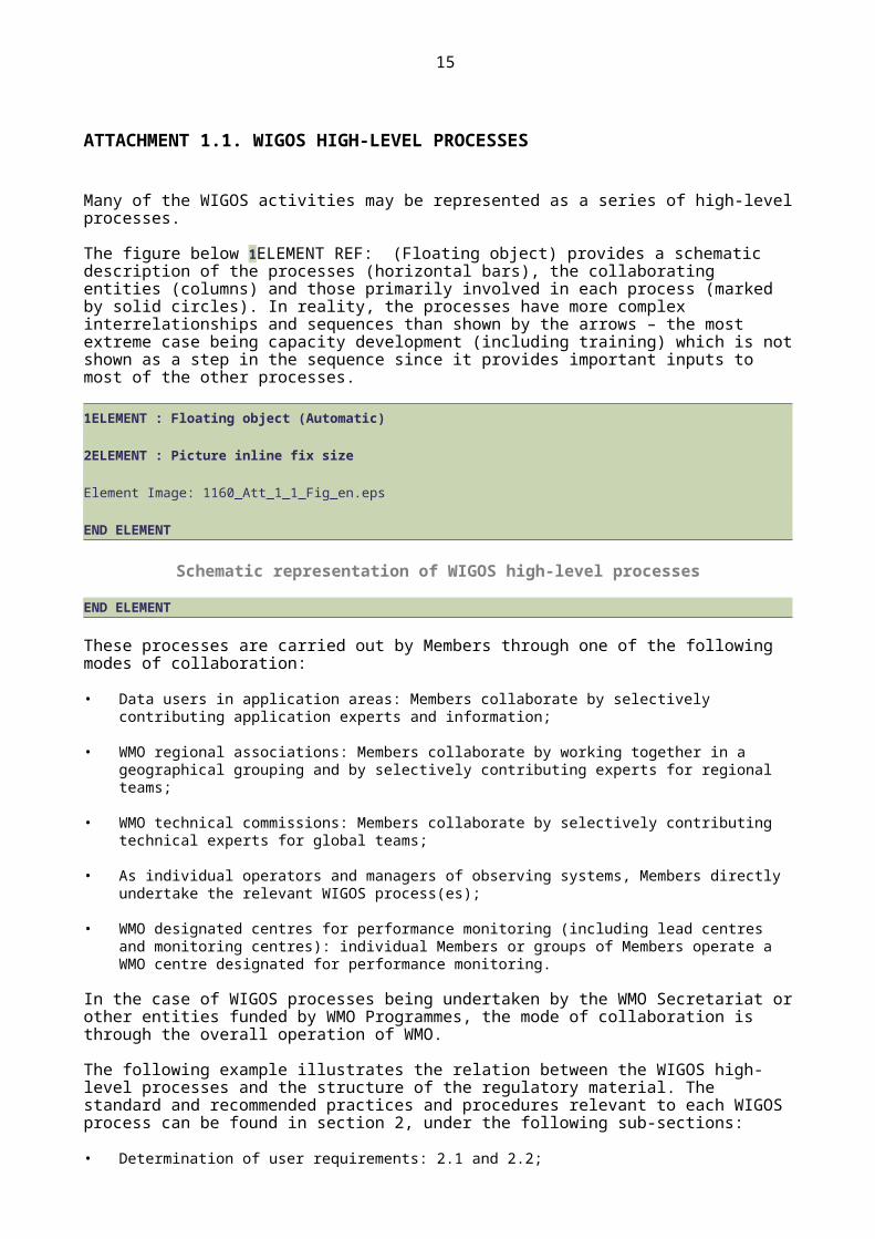
Many of the WIGOS activities may be represented as a series of high-level processes.
The figure below 1ELEMENT REF: (Floating object) provides a schematic description of the processes (horizontal bars), the collaborating entities (columns) and those primarily involved in each process (marked by solid circles). In reality, the processes have more complex interrelationships and sequences than shown by the arrows – the most extreme case being capacity development (including training) which is not shown as a step in the sequence since it provides important inputs to most of the other processes.
1ELEMENT : Floating object (Automatic)
2ELEMENT : Picture inline fix size
Element Image: 1160_Att_1_1_Fig_en.eps
END ELEMENT

13
Schematic representation of WIGOS high-level processes
END ELEMENT
These processes are carried out by Members through one of the following modes of collaboration:
• Data users in application areas: Members collaborate by selectively contributing application experts and information;
• WMO regional associations: Members collaborate by working together in a geographical grouping and by selectively contributing experts for regional teams;
• WMO technical commissions: Members collaborate by selectively contributing technical experts for global teams;
• As individual operators and managers of observing systems, Members directly undertake the relevant WIGOS process(es);
• WMO designated centres for performance monitoring (including lead centres and monitoring centres): individual Members or groups of Members operate a WMO centre designated for performance monitoring.
In the case of WIGOS processes being undertaken by the WMO Secretariat or other entities funded by WMO Programmes, the mode of collaboration is through the overall operation of WMO.
The following example illustrates the relation between the WIGOS high-level processes and the structure of the regulatory material. The standard and recommended practices and procedures relevant to each WIGOS process can be found in section 2, under the following sub-sections:
• Determination of user requirements: 2.1 and 2.2;
• Design, planning and evolution of WIGOS: 2.2;
• Development and documentation of standard and recommended practices and procedures for observing systems: 2.3;
• Implementation of an observing system by owners and operators: 2.3 and 2.4;
• Observing system operation and maintenance including fault management and audit: 2.4;
• Observation quality control: 2.4 and 2.6;
• Observations and observational metadata delivery: 2.4 and 2.5;
• Performance monitoring: 2.4 and 2.6;
• User feedback and review of requirements: 2.2 and 2.6;
• Capacity development (including training): 2.7.
SECTION: Chapter
Chapter title in running head: 2. COMMON ATTRIBUTES OF WIGOS COMPONENT…

14
2. COMMON ATTRIBUTES OF WIGOS COMPONENT SYSTEMS
2.1 REQUIREMENTS
2.1.1 Members shall take steps to collect, record, review, update and make available their user requirements for observation.
2.1.2 Members shall convey their user observational requirements, for each of the WMO application areas, to the RRR process described under section 2.2.4 and Appendix 2.3.
2.2 DESIGN, PLANNING AND EVOLUTION
2.2.1 General
2.2.1.1 The WMO Integrated Global Observing System shall be designed as a flexible and evolving system capable of continuous improvement.
Note: Factors that drive the evolution of WIGOS component observing systems include technological and scientific progress and cost-effectiveness; changes in the needs and requirements of WMO, WMO co-sponsored programmes and international partner organizations at national, regional and global levels; and changes in the capacity of Members to implement observing systems. It is important to identify the impact on all users before a change is made.
2.2.1.2 Members shall plan and operate their networks in a sustainable and reliable manner utilizing WIGOS standard and recommended practices and procedures, and tools.
Note: Sustainability over at least a ten-year period is recommended; however, this depends on paying sufficient attention to maintenance and operations following the establishment of the network.
2.2.2 Principles for observing network design and planning
2.2.2.1 Observing network design principles
2.2.2.1.1 Members should follow the principles specified in Appendix 2.1 when designing and developing their observing networks.
2.2.2.1.2 Members should conduct network design studies that address national, regional and global scale questions about the optimum affordable mix of components to best satisfy the requirements for observations.
2.2.2.2 Climate monitoring principles of the Global Climate Observing System
Members designing and operating observing systems for monitoring climate should adhere to the principles specified in Appendix 2.2.
Note: Fifty Essential Climate Variables have been identified for GCOS. These are required to support the work of the United Nations Framework Convention on Climate Change (UNFCCC) and the Intergovernmental Panel on Climate Change (IPCC). The Essential Climate Variables cover the atmospheric, oceanic and terrestrial domains, and all are technically and economically feasible for systematic observation. Further information about the Essential Climate Variables can be found in the Implementation Plan for the Global Observing System for Climate in Support of the UNFCCC (2010 Update), GCOS-138 (also identified as WMO-TD/No. 1523).
2.2.3 Vision for WIGOS observing systems
Members shall take into account the Vision for the Global Observing System in 2025 when planning the evolution of their observing networks.
15
Notes:
1. The Vision for the Global Observing System in 2025 provides high-level goals to guide the evolution of the WMO Integrated Global Observing System in the coming decades. The Vision is updated on a multi-year time scale (typically decadal).
2. The Vision for the Global Observing System in 2025 is available at http://www.wmo.int/pages/prog/www/OSY/Publications/Vision-2025/Vision-for-GOS-in-2025_en.pdf.
2.2.4 The Rolling Review of Requirements
Members, both directly and through the participation of their experts in the activities of regional associations and technical commissions, shall contribute to the RRR process and assist the designated Points of Contact for each application area in performing their roles in the RRR.
Note: Appendix 2.3 provides further details on the RRR process.
2.2.5 Observation impact studies
2.2.5.1 Members, or groups of Members within regions, should conduct and/or participate in observation impact studies and related scientific evaluations to address WIGOS network design questions.
2.2.5.2 Members should provide expertise for synthesizing the results of impact studies and making recommendations on the best mix of observing systems to address the gaps identified by the RRR process.
Note: Impact studies involving Observing System Experiments, Observing System Simulation Experiments, Forecast Sensitivity to Observation studies and other assessment tools are used to assess the impact of the various observing systems on Numerical Weather Prediction model analyses and predictions, hence their value and relative priority for addition or retention for these application areas.
2.2.6 Evolution of WIGOS observing systems
2.2.6.1 Members should follow the plans published by WMO for the evolution of WIGOS component observing systems when planning and managing their WIGOS observing systems.
Notes:
1. The planning and coordination of the evolution of WIGOS observing systems is steered by the Executive Council and undertaken by Members individually and through regional associations, technical commissions and relevant steering bodies of WMO co-sponsored observing systems.
2. The current WMO plan for the evolution of WIGOS observing systems was published as the Implementation Plan for the Evolution of Global Observing Systems (EGOS-IP) (WIGOS Technical Report No. 2013-4). It contains guidelines and recommended actions to be undertaken by Members, technical commissions, regional associations, satellite operators and other relevant parties in order to stimulate cost-effective evolution of the WMO observing systems and address in an integrated way the requirements of WMO Programmes and co-sponsored programmes.
3. The WMO plan for the evolution of WIGOS observing systems is regularly updated and new versions are published on a multi-year time scale (typically decadal), taking into account the vision for the WIGOS observing systems, the advice of the technical commissions and regional associations concerned, relevant WMO co-sponsored observing systems and international experts in all application areas.
2.2.6.2 Members shall coordinate the activities of organizations within their country, including National Meteorological and Hydrological Services (NMHSs) and other agencies, in addressing relevant actions of the WMO plans for the evolution of WIGOS observing systems.
2.2.6.3 Where Member countries cover small areas and are geographically close or have already established multilateral working relationships, Members should consider a subregional or transboundary river basin approach, in addition to a national one, in WIGOS observing systems planning.

16
2.2.6.4 In this case, the Members concerned should work in close cooperation to prepare subregional or transboundary river basin reviews of requirements to be used as a basis for detailed planning at that scale.
2.2.7 Monitoring the evolution of WIGOS observing systems
Members should contribute to the monitoring of the evolution of WIGOS observing systems by providing their national progress reports on a yearly basis through nominated national focal points.
Note: The Commission for Basic Systems, in collaboration with other technical commissions, regional associations, and co-sponsored programmes, regularly reviews progress in the evolution of WIGOS observing systems and provides updated guidance to Members thereon.
2.3 INSTRUMENTATION AND METHODS OF OBSERVATION
2.3.1 General requirements
Note: Details are provided in the Technical Regulations (WMO-No. 49), Volume III: Hydrology, the Guide to Meteorological Instruments and Methods of Observation (WMO-No. 8), Weather Reporting (WMO-No. 9), Volume D: Information for Shipping, and the Guide to Hydrological Practices (WMO-No. 168), Volume I: Hydrology – From Measurement to Hydrological Information.
2.3.1.1 Members should ensure that observations and observational metadata are traceable to the International System of Units (SI) standards, where these exist.
Note: Traceability to the International System of Units (SI) standards is an area where concerted effort is required to increase or improve compliance.
2.3.1.2 Members should employ properly calibrated instruments and sensors that provide observations satisfying at least measurement uncertainties that meet the specified requirements.
Notes:
1. Achievable measurement uncertainty is specified in the Guide to Meteorological Instruments and Methods of Observation (WMO-No. 8), Part I, Chapter 1, 1.6.5.2, Annex 1.D.
2. A number of operational, financial, environmental and instrumental issues may cause the system to not always satisfy the specified requirements. Annex 1.D (see the column ”Achievable measurement uncertainty“) provides a list of the achievable and affordable measurement uncertainties which in some cases might not satisfy specified requirements.
2.3.1.3 Members should describe uncertainty of observations and observational metadata as specified in the Guide to Meteorological Instruments and Methods of Observation (WMO-No. 8), Part I, Chapter 1, 1.6
Notes:
1. The corresponding text from the Guide to Meteorological Instruments and Methods of Observation (WMO-No. 8), Part I, Chapter 1, 1.6, will be included as an appendix in a future edition.
2. The definition of uncertainty in the Guide to Meteorological Instruments and Methods of Observation (WMO-No. 8), Part I, Chapter 1, 1.6, is consistent with international standards approved by the International Committee for Weights and Measures (Comité international des poids et mesures (CIPM)).
2.3.1.4 Members should follow the definitions and specifications for the calculation of derived observations given in the WMO Technical Regulations.
Notes:
1. Further methods provided or referenced by the Guide to Meteorological Instruments and Methods of Observation (WMO-No. 8) and the Guide to Hydrological Practices (WMO-No. 168), Volume I: Hydrology – From Measurement to Hydrological Information, could also be considered.

17
2. Such derivations can take many forms, for example, statistical processing of average or smooth values, or multivariate algorithm to determine streamflow discharge.
3. The corresponding text from the Guide to Meteorological Instruments and Methods of Observation (WMO-No. 8) will be included as an appendix in a future edition of the present Manual.
2.4 OPERATIONS
2.4.1 General requirements
Note: Provision 2.4.1.1 of the Technical Regulations (WMO-No. 49), Volume I, Part I, applies.
2.4.1.1 WMO observing stations and platforms shall be uniquely identified by a WIGOS station identifier.
Note: The structure of WIGOS station identifiers is specified in Attachment 2.1.
2.4.1.2 Members shall issue WIGOS station identifiers for observing stations and platforms within their geographic area of responsibility that contribute to a WMO or co-sponsored programme and shall ensure that no WIGOS station identifier is issued to more than one station.
Note: Members may issue WIGOS station identifiers for observing stations and platforms within their geographic area of responsibility that do not contribute to a WMO or co-sponsored programme, provided that the operator has committed to providing and maintaining WIGOS metadata.
2.4.1.3 Before issuing a station identifier, Members should ensure that the operator of a station or platform has committed to providing and maintaining WIGOS metadata for that station or platform.
Notes:
1. In circumstances when a WIGOS identifier is required for a station or platform to support a WMO or co-sponsored programme and no Member is in a position to issue one (for example, in Antarctica), the Secretary-General may issue a WIGOS station identifier for that station or platform, provided that its operator has committed to:
(a) Providing WIGOS metadata;
(b) Conforming to relevant Technical Regulations.
2. In circumstances where a WIGOS identifier is required for a station or platform to support a WMO or co-sponsored programme and a Member is not able to issue one, the Secretary-General will work with the Member concerned to issue a WIGOS station identifier for that station or platform, provided that its operator has committed to:
(a) Providing WIGOS metadata;
(b) Conforming to relevant Technical Regulations.
2.4.1.4 Members shall make available to WMO the updated metadata each time a new station identifier is issued.
2.4.1.5 Members shall operate their observing systems with properly calibrated instruments and adequate observing and measuring techniques.
Notes:
1. Detailed guidance on observing practices of meteorological observing systems and instruments is given in the Guide to Meteorological Instruments and Methods of Observation (WMO-No. 8).
2. Detailed guidance on observing practices of hydrological observing systems and instruments is given in the Guide to Hydrological Practices (WMO-No. 168), the Manual on Flood Forecasting and Warning (WMO-No. 1072) and the Manual on Stream Gauging (WMO-No. 1044).

18
3. Detailed guidance on observing practices of GAW observing systems and instruments is given in the Guide to Meteorological Instruments and Methods of Observation (WMO-No. 8).
2.4.1.6 Members should address the requirements for uncertainty, timeliness, temporal resolution, spatial resolution and coverage which result from the RRR process specified in section 2.2.4 and in accordance with the details provided by other sections as appropriate.
2.4.1.7 Members shall ensure that proper safety procedures are specified, documented and utilized in all their operations.
Note: Safety practices and procedures are concerned with ensuring the welfare of staff while promoting overall efficiency and effectiveness of the NMHS and respond to national laws, regulations and requirements for occupational health and safety.
2.4.2 Observing practices
Members should ensure that their observing practices are adequate to comply with user observational requirements.
Note: Observing practices include station operation, data processing practices and procedures, applied calculation rules, documentation on calibration practices and associated metadata.
2.4.3 Quality control
2.4.3.1 Members shall ensure that observations provided through their WIGOS component observing systems are quality controlled.
2.4.3.2 Members shall implement real-time quality control prior to exchange of observations via the WMO Information System.
Notes:
1. Quality control of observations consists in examination of observations at stations and data centres to detect errors so that observations may be either corrected or flagged. A quality control system should include procedures for returning to the source of observations to verify them and to prevent recurrence of errors. Quality control is applied in real-time, but it also operates in non-real-time, as delayed quality control. The quality of observations depends on the quality control procedures applied during acquisition and processing of observations and during preparation of messages, in order to eliminate the main sources of errors and ensure the highest possible standard of accuracy for the optimum use of those observations by all possible users.
2. Quality control in real time also takes place in the Global Data-processing and Forecasting System, prior to the use of meteorological and climatological observations in data processing (i.e. objective analysis and forecasting).
3. Recommended minimum standards of quality control of meteorological and climatological observations at the level of the National Meteorological Centre are given in the Manual on the Global Data-processing and Forecasting System (WMO-No. 485), Volume I: Global Aspects, Appendix II-1, Table I. The Guide on the Global Data-processing System (WMO-No. 305) should be consulted for more detailed guidance.
4. Recommended practices and procedures for quality control of hydrological observations are given in the Manual on Flood Forecasting and Warning (WMO-No. 1072), Chapter 6, and in the Guide to Hydrological Practices (WMO-No. 168).
5. Recommended practices and procedures regarding the quality of observations for GAW requirements are formulated in Measurement Guidelines through Data Quality Objectives (see GAW reports at http://www.wmo.int/pages/prog/arep/gaw/gaw-reports.html).
2.4.3.3 Members not capable of implementing these standards should establish agreements with an appropriate Regional Meteorological Centre or World Meteorological Centre to perform the necessary quality control.
2.4.3.4 Members shall also perform quality control of observations on a non-real-time basis, prior to forwarding the observations for archiving.
19
2.4.3.5 Members should develop and implement adequate quality control processes.
Notes:
1. Quality control processes include (but are not necessarily limited to): (a) validation; (b) cleaning; and (c) monitoring.
2. Further guidance is available in the Guide to Meteorological Instruments and Methods of Observation (WMO-No. 8), the Guide to Climatological Practices (WMO-No. 100), the Guide to Hydrological Practices (WMO-No. 168), Volume I: Hydrology – From Measurement to Hydrological Information, and the Guide to the Global Observing System (WMO-No. 488).
2.4.4 Data and metadata reporting
2.4.4.1 Members shall report and make available observations in the standard formats specified by the Manual on Codes (WMO-No. 306).
2.4.4.2 In the case of GAW observations, Members shall report and make available observations in standard formats as advised by GAW data centres, in accordance with the provisions in chapter 6.
Note: Members are to report and make available up-to-date WIGOS metadata as specified in section 2.5.2.
2.4.5 Incident management
2.4.5.1 Members should implement incident management to detect, identify, record, analyse and respond to any incident, in order to restore normal operation of the observing system as quickly as possible, minimizing the negative impact and preventing recurrence.
2.4.5.2 Members shall implement procedures to detect, analyse and respond to system faults and human errors at the earliest stage possible.
2.4.5.3 Members should record and analyse incidents as appropriate.
2.4.6 Change management
2.4.6.1 Members should carefully plan and manage changes to ensure continuity and consistency of observations and record any modification related to the observing system.
Note: This requirement relates to any change in the observing system, including an observing station, observing programme, instruments, methods of observation, and so on.
2.4.6.2 In the event of significant changes in instruments or methods of observation used or the location in which observations are made, Members should ensure a sufficiently long period (to capture all expected climatic conditions) of overlap, with dual operation of old and new systems to identify biases, inconsistencies and inhomogeneities.
2.4.7 Maintenance
2.4.7.1 Members shall ensure that each observing system is rigorously maintained.
2.4.7.2 Members shall perform regular preventive maintenance of their observing systems including their instruments.
Note: Carefully organized preventive maintenance of all system components is recommended to minimize corrective action and to increase the operational reliability of an observing system.

20
2.4.7.3 Members shall determine the frequency and timing (schedule) of the preventive maintenance taking into account the type of observing system, environmental and climate conditions of the observing site and platform, and the instrumentation installed.
2.4.7.4 Members shall perform corrective maintenance in case of failure of an observing system component as soon as practically possible once the problem has been detected.
2.4.7.5 Members shall employ adaptive maintenance that satisfies the requirements for stability, continuity and consistency of observations through time.
Note: Detailed guidance on maintenance of observing systems and instruments is given in the Guide to Meteorological Instruments and Methods of Observation (WMO-No. 8), including technical papers on GAW measurements referenced in Part I, Chapter 16; the Guide to Hydrological Practices (WMO-No. 168) and the Manual on Stream Gauging (WMO-No. 1044).
2.4.8 Inspection
Members shall arrange periodic inspection of their observing systems.
Note: Such inspection could be undertaken directly or remotely, as necessary, to monitor the correct functioning of observing platforms and instruments.
2.4.9 Calibration procedures
2.4.9.1 Members shall ensure that measurement systems and instruments are calibrated regularly in accordance with adequate procedures for each type of system and instrument, as described in the relevant sections of the present Manual.
Notes:
1. Where international or national standards are not available, the basis for calibration is defined or supplied by the manufacturer or by the Scientific Advisory Groups for GAW observations.
2. Detailed guidance on calibration procedures is given in the Guide to Meteorological Instruments and Methods of Observation (WMO-No. 8), the Guide to Hydrological Practices (WMO-No. 168) and the Manual on Stream Gauging (WMO-No. 1044).
3. In the GAW Programme, World Calibration Centres perform the audit of the stations and require that every laboratory is traceable to the single network standard.
2.4.9.2 Members shall ensure that the measuring devices they use are:
(a) Calibrated or verified at specified intervals, or prior to use, against measurement standards traceable to international or national standards. Where no such standards exist, the basis used for calibration or verification shall be recorded;
(b) Adjusted or readjusted as necessary, but at the same time safeguarded from adjustments that would invalidate the measurements;
(c) Identified, enabling the calibration status to be determined;
(d) Protected from damage and deterioration during handling, maintenance and storage.
Note: Details regarding hydrological observations are given in Technical Regulations (WMO-No. 49), Volume III: Hydrology; guidance is available in the Guide to Meteorological Instruments and Methods of Observation (WMO-No. 8), the Guide to Hydrological Practices (WMO-No. 168) and the Manual on Stream Gauging (WMO-No. 1044).

21
2.4.9.3 When the equipment is found not to conform to requirements, the Member shall assess and record the validity of previous measuring results and take appropriate action on the equipment and the products affected.
2.4.9.4 Members shall record and maintain the results of calibration and verification.
2.5. OBSERVATIONAL METADATA
2.5.1 Purpose and scope
Notes:
1. Observational metadata are essential as they enable users of observations to assess their suitability for the intended application, and managers of observing systems to monitor and control their systems and networks. Members benefit from sharing observational metadata which describe quality of observations and provide information about stations and networks used to collect those observations.
2. Discovery metadata, defined in the Manual on the WMO Information System (WMO-No. 1060), are concerned with discovering and accessing information, including observations and their observational metadata. Requirements for discovery metadata are specified in the Manual on the WMO Information System and are not considered further here.
2.5.1.1 For all WIGOS observations they make available internationally, Members shall record and retain the observational metadata specified as mandatory in the WIGOS Metadata Standard defined in Appendix 2.4.
Notes:
1. The WIGOS Metadata Standard defines a common set of requirements for observational metadata. It includes a detailed list of mandatory, conditional and optional metadata.
2. “Not available”, “unknown” or “not applicable” are valid values for many elements of the WIGOS Metadata Standard. These terms assist Members in achieving compliance with the standard, particularly while developing the capability to report actual values.
2.5.1.2 For all WIGOS observations they make available internationally, Members shall record and retain the observational metadata specified as conditional in the WIGOS Metadata Standard (Appendix 2.4) whenever the related condition is met.
2.5.1.3 For all WIGOS observations they make available internationally, Members should record and retain the observational metadata specified as optional in the WIGOS Metadata Standard (Appendix 2.4).
Notes:
1. Further requirements for observational metadata beyond the WIGOS Metadata Standard are stated in the following sections. In the case of GOS, as noted in chapter 5, the Manual on the Global Observing System (WMO-No. 544) contains further provisions for GOS metadata.
2. Further guidance on metadata and sound metadata practices, is provided in Guides and specific documentation associated with the individual observing system components.
2.5.2 Exchanging and archiving observational metadata
2.5.2.1 Members shall make available internationally, without restriction, those mandatory and conditional (whenever the condition is met) observational metadata that support observations made available internationally.

22
2.5.2.2 Members making observations available internationally shall retain and make available, without restriction, observational metadata for at least as long as they retain the observations described by the observational metadata.
2.5.2.3 Members making available internationally archived observations shall ensure that all WIGOS metadata describing the observations remain available, without restriction, for at least as long as the observations are retained.
2.5.2.4 Members making available internationally archived observations should ensure that any additional observational metadata describing the observations remain available, without restriction, for at least as long as the observations are retained.
2.5.3 Global compilation of observational metadata
2.5.3.1 Members shall make available to WMO for global compilation those components of the WIGOS metadata that are specified as mandatory or conditional (whenever the condition is met).
Note: Global compilations of WIGOS metadata are held in several databases. The database of the Observing Systems Capability Analysis and Review tool (OSCAR) of the WIGOS Information Resource (WIR) is the key source of information for WIGOS metadata. Other global compilations of specific components of WIGOS metadata include elements of the GAW Station Information System (GAWSIS), the database of the JCOMM In Situ Observations Programme Support Centre (JCOMMOPS) and others. Purpose and management of WIR and OSCAR are described in Attachment 2.2.
2.5.3.2 For all WIGOS component observing systems they operate, Members shall keep the relevant databases of WMO observational metadata up to date with the required WIGOS metadata.
2.5.3.3 Members shall routinely monitor the content of WIGOS metadata databases and provide feedback to WMO Secretariat on identified discrepancies, possible errors and required changes with respect to the WIGOS component observing systems they operate.
2.5.3.4 Members shall designate their national focal points responsible for making available metadata and monitoring content of WMO observational metadata databases, and inform the Secretariat accordingly.
2.5.3.5 Members delegating to a global or regional entity the responsibility of the national focal point for all or part of the observing networks they operate shall inform the Secretariat accordingly.
2.6 QUALITY MANAGEMENT
Notes:
1. Detailed guidance on how to develop and implement a quality management system (QMS) to ensure and enhance the quality of products and services of NMHSs is provided in the Guide to the Implementation of a Quality Management System for National Meteorological and Hydrological Services (WMO-No. 1100).
2. Definitions, terminology, vocabulary and abbreviations used in relation to quality management are those of the ISO 9000 family of standards for quality management systems, in particular ISO 9000:2005, Quality Management Systems – Fundamentals and vocabulary.
3. A QMS can be implemented only by the body that has the resources and the mandate to manage the observing system. According to the WMO QMF, Members are urged to follow the standard and recommended practices and procedures associated with implementation of a QMS. In practice, however, it is one or more organizations within the Member country that own and operate observing systems and provide observations and observational metadata, most notably the NMHSs. Therefore, implementation of the WMO QMF relies on the Member making arrangements for such organizations to implement a QMS.
23
4. In this section, the term “observations” includes also observational metadata.
2.6.1 Scope and purpose of WIGOS quality management
Note: The practices and procedures of WIGOS enable Members to comply with the WMO QMF in relation to the quality of observations.
2.6.2 WIGOS component of the WMO Quality Management Framework
2.6.2.1 Quality policy
2.6.2.1.1 In the establishment and maintenance of WIGOS observing systems, Members should ensure optimum affordable quality for all observations.
2.6.2.1.2 Members should, through a process of continual improvement, pursue effective and efficient management and governance of observing systems.
2.6.2.2 Application of the eight principles of quality management
Members should apply the eight principles of quality management to the implementation of WIGOS, as specified in Appendix 2.5.
2.6.3 WIGOS quality management processes
Note: The processes and roles of various entities are described in Attachment 1.1.
2.6.3.1 Determination and maintenance of user requirements
Note: The WMO RRR process for compiling observation user requirements is described in section 2.2.4 and Appendix 2.3.
2.6.3.2 Development and documentation of observing system standards and recommendations
Through involvement in the work of technical commissions, Members should participate in the development of observing system standard and recommended practices and procedures.
2.6.3.3 Training of personnel and capacity development
Members should ensure appropriate planning and implementation of training and capacity development activities.
2.6.3.4 Performance monitoring
Members should use and respond to the results, advice and reports of designated monitoring centres and any subsequent advice of expert groups.
2.6.3.5 Feedback, change management and improvement
2.6.3.5.1 Members should ensure that inconsistencies and other problems identified by WIGOS Lead and Monitoring Centres are rectified in a timely manner and that a process for their documentation and rectification is implemented and maintained.
2.6.3.5.2 Upon identification or notification of inconsistencies or other problems related to quality of observations, Members should analyse the problem detected and make the necessary improvements to operational practices and procedures so as to minimize the adverse impacts of those problems and prevent their recurrence.
2.6.3.5.3 Members should ensure that changes to operational practices and procedures are accordingly documented.
24
2.6.4 WIGOS aspects of development and implementation of the quality management system of Members
Note: This section specifies requirements for the integration of WIGOS practices and procedures into the QMS of Members. The requirements are based on the eight clauses of the ISO 9001 Standard. The Guide to the Implementation of a Quality Management System for National Meteorological and Hydrological Services (WMO-No. 1100) provides extensive explanatory notes about the eight clauses. The five subsections that follow correspond to the last five of those clauses, providing further details about the elements required in a QMS.
2.6.4.1 General requirements for the content of a quality management system
Members should identify their high-level processes and interactions that lead to the provision of observations.
Note: In addition to WIGOS specific provisions, there are many other general requirements for the content of a QMS that are not unique to WIGOS observations, hence are not repeated here.
2.6.4.2 Requirements related to management and planning
2.6.4.2.1 Members should clearly demonstrate and document their commitment to the integration of WIGOS quality management practices within their QMS.
2.6.4.2.2 Members should carefully identify and routinely review user requirements for observations prior to attempting to meet user needs.
2.6.4.2.3 Members should ensure that their published quality policy is consistent with the WIGOS quality policy.
2.6.4.2.4 Members should establish and indicate the objectives for the observations they intend to provide in the future so as to guide stakeholders, users and clients on the expected evolution of and changes to the observing systems they operate as a contribution to WIGOS.
Note: The objectives referred to in this provision constitute the WIGOS quality objectives.
2.6.4.2.5 Members should appoint a quality manager.
2.6.4.3 Requirements related to resource management
2.6.4.3.1 Members should determine and provide the resources needed to maintain and continuously improve the effectiveness and efficiency of their processes and procedures.
2.6.4.3.2 Members should define the competencies required for staff involved in the provision of observations.
2.6.4.3.3 Members should take steps to rectify any competency shortcomings identified for new or existing employees.
2.6.4.3.4 Members should implement policies and procedures to maintain the infrastructure required for the provision of observations.
2.6.4.4 Requirements related to the provision of observations
2.6.4.4.1 Members should undertake sound planning for the provision of observations.
Note: Such planning includes the following:
(a) Determination and continuous review of user and client requirements;
(b) Translation of user and client requirements into objectives and targets for observations and observing system design;

25
(c) Initial and ongoing allocation of adequate resources for all aspects of the design, implementation and maintenance processes of observing systems;
(d) Implementation of design processes and activities, including communication strategies and risk management, that will ensure and confirm the development and implementation of observing systems capable of meeting the design objectives and user and client requirements;
(e) Appropriate and ongoing documentation of planning processes and their results.
2.6.4.4.2 Members should identify the users of their observing systems and establish and document users' requirements for observations.
Note: The means for doing this include:
(a) The WMO RRR process, described in section 2.2.4 and Appendix 2.3;
(b) Other processes to establish user requirements within WMO Programmes through the activities of WMO technical commissions;
(c) Regional processes through the activities of WMO regional associations and other multilateral groupings of Members;
(d) National processes.
2.6.4.4.3 Members should have a clear description of the requirements that are agreed upon.
Note: It is important to note the difference between aspirational requirements and agreed requirements. The establishment of requirements provides essential information for the monitoring and measurement of conformance.
2.6.4.4.4 Members should identify and adhere to any statutory or regulatory requirements in relation to the provision of observations.
2.6.4.4.5 Members should design and develop, or otherwise implement, observing systems to satisfy the agreed user requirements.
2.6.4.4.6 Members should use a formal change management process to ensure that all changes are assessed, approved, implemented and reviewed in a controlled manner.
2.6.4.4.7 Members should conduct purchasing in a controlled manner.
Note: Observing systems are highly specialized and often require major expenditure. Staff responsible for purchasing orders or for providing information to suppliers must, therefore, ensure that the information and specifications provided are clear, unambiguous and based on the design objectives and system requirements to enable the delivery of the appropriate products and services. Purchasing in a controlled manner entails the following:
(a) Written specification of all performance requirements for equipment and/or services;
(b) Ensuring that purchasing is subject to a competitive process of more than one candidate for supply of equipment or services;
(c) Assessment of candidates for supply of equipment or services based on merit and suitability for purpose, which can be discerned from:
(i) Written tendering or quotation of candidates;
(ii) Experience or reliable anecdotal evidence of past performance;
(iii) Recommendation of Member or recognized organization or agency;
(d) Documentation of the purchasing process and outcomes.
2.6.4.4.8 Members should include in their QMS the WIGOS provisions covering methods of observation, calibration and traceability, operational practices, maintenance and observational metadata.

26
2.6.4.4.9 Members should implement practices and procedures which ensure that observations remain accurate.
Note: Observations need to be checked as they must meet the agreed requirements. The methods include automated algorithms, manual inspection and oversight.
2.6.4.5 Requirements for monitoring, performance measurement, analysis and improvement
2.6.4.5.1 Members should use the agreed user requirements for observations (see 2.6.4.4) as a basis for defining and implementing appropriate measures of performance and success.
Note: It is important to gain a clear understanding of how satisfied users are with observations. This requires the monitoring of information on users’ perception and on whether their expectations have been met. Surveys are commonly used for this purpose.
2.6.4.5.2 Members should implement activities to gain information on the satisfaction of users of observations.
2.6.4.5.3 Members should ensure that staff are made aware of the methods employed for determining users’ perceptions and expectations, and that those methods are applied consistently.
2.6.4.5.4 Members should regularly conduct internal audits of WIGOS processes and procedures and analyse their results as part of the management processes of the observing system.
Note: A detailed explanation of the requirements of the internal audit is provided in the Guide to the Implementation of a Quality Management System for National Meteorological and Hydrological Services (WMO-No. 1100), chapter 4, section 4.3, clause 8, requirement 8.2.2.
2.6.4.5.5 Members should monitor the degree of adherence to the defined processes and requirements for producing observations.
Note: Ideally, performance monitoring will be conducted against specific key performance indicators and target levels of performance.
2.6.4.5.6 Members should monitor and measure the suitability and the quality of their observations as they are produced, in order to compare their characteristics with the agreed requirements.
Note: The means to do this include:
(a) The devising, implementation and routine analysis of manually or automatically generated key performance indicators and their associated targets;
(b) Manual inspection and oversight of observational data produced.
2.6.4.5.7 Members should record instances of non-conformity with requirements, and endeavour to rectify problems in a timely manner.
2.6.4.5.8 Members should maintain a documented corrective action procedure relevant to observations.
2.6.4.5.9 Members should specify and implement procedures that describe how non-conforming observations or observational metadata are identified, how they are dealt with, who is responsible for deciding what to do, what action should be taken and what records are to be kept.
Note: A detailed explanation of the requirements for corrective action is provided in the Guide to the Implementation of a Quality Management System for National Meteorological and Hydrological Services (WMO-No. 1100), Chapter 4, section 4.3, clause 8, requirements 8.2.3 and 8.2.4.
2.6.4.5.10 Members should analyse monitoring results to detect any performance-related changes, trends and deficiencies and use the results and analyses as input for continual improvement.
Note: Analysing trends and taking action prior to the occurrence of a case of non-conformity helps to prevent problems.

27
2.6.4.5.11 Members should maintain documented preventive action procedures relevant to observing systems and ensure that staff are aware of and, if necessary, trained in their routine application.
Note: Due consideration might be given to combining the preventive and the corrective action procedures for efficiency, and to simplify the process.
2.6.5 Compliance, certification and accreditation
Note: While WMO encourages the certification of Members’ quality management systems by accredited agencies, unless otherwise required of a particular WIGOS component system or subsystem, there is no general regulated requirement for certification of QMS for WIGOS observing systems.
2.6.6 Documentation
2.6.6.1 Members should include the WIGOS quality policy (2.6.2.1) and objectives (2.6.4.2) in their QMS quality manual.
2.6.6.2 Members should include in their QMS documentation those documents that describe the procedures related to WIGOS, including, in particular, those relating to control of non-conforming observations, and corrective and preventive actions.
2.6.6.3 Members should include in their QMS documentation those documents that describe the procedures required to ensure the effective planning, operation and control of their WIGOS processes.
2.6.6.4 Members should include in their QMS documentation those records required by the ISO 9001 standard.
Note: More detailed information on documentation requirements is provided in the Guide to the implementation of a Quality Management System for National Meteorological and Hydrological Services (WMO-No. 1100), Chapter 4, section 4.3, clause 4, requirement 4.2.
2.7 CAPACITY DEVELOPMENT
2.7.1 General
2.7.1.1 Members should identify their needs for capacity development in all activity areas of WIGOS.
2.7.1.2 Members should develop plans to meet their capacity development needs.
Note: In addition to national resources allocated to NMHSs, support may be available from other domestic agencies, the WMO regional association concerned, other Members through bilateral or multilateral arrangements, and WMO Programmes (including appropriate technical commissions).
2.7.1.3 Members should establish bilateral and multilateral collaboration (within and beyond their Region) where necessary to address significant capacity development needs.
2.7.1.4 When planning capacity development activities, Members should take a holistic approach considering institutional, infrastructural, procedural and human resource requirements to support both current and continuing needs for installation, operation, maintenance, inspection and training. For this purpose, Members should prepare specific capacity development plans with measurable objectives to enable effective implementation, monitoring and assessment.
Note: Funds to meet these requirements should be planned well ahead, subject to national policies of Members, to assure long-term sustainable networks.
2.7.2 Training
2.7.2.1 Members shall provide adequate training for their staff or take other appropriate actions to ensure that all staff are suitably qualified and competent for the work assigned to them.

28
Note: This requirement is applied both to initial recruitment or introductory training and to continuing professional development.
2.7.2.2 Each Member should ensure that the qualifications, competencies, skills (and thus training) and numbers of their personnel or other contractors match the range of tasks to be performed.
2.7.2.3 Each Member should inform the staff of their role and how they contribute to the achievement of the quality objectives.
2.7.3 Infrastructural capacity development
Members should regularly review their infrastructure for collecting and making available observations and observational metadata and, as necessary, develop prioritized plans and priorities for capacity development.
SECTION: Chapter
Chapter title in running head: APPENDIX 2.1. OBSERVING NETWORK DESIGN …
APPENDIX 2.1. OBSERVING NETWORK DESIGN PRINCIPLES
1. Serving many application areas
Observing networks should be designed to meet the requirements of multiple application areas within WMO and WMO co-sponsored programmes.
2. Responding to user requirements
Observing networks should be designed to address stated user requirements, in terms of the geophysical variables to be observed and the space-time resolution, uncertainty, timeliness and stability needed.
3. Meeting national, regional and global requirements
Observing networks designed to meet national needs should also take into account the needs of WMO at the regional and global levels.
4. Designing appropriately spaced networks
Where high-level user requirements imply a need for spatial and temporal uniformity of observations, network design should also take account of other user requirements, such as the representativeness and usefulness of the observations.
5. Designing cost-effective networks
Observing networks should be designed to make the most cost-effective use of available resources. This will include the use of composite observing networks.
6. Achieving homogeneity in observational data
Observing networks should be designed so that the level of homogeneity of the delivered observational data meets the needs of the intended applications.

29
7. Designing through a tiered approach
Observing network design should use a tiered structure, through which information from reference observations of high quality can be transferred to other observations and used to improve their quality and utility.
8. Designing reliable and stable networks
Observing networks should be designed to be reliable and stable.
9. Making observational data available
Observing networks should be designed and should evolve in such a way as to ensure that the observations are made available to other WMO Members, at space-time resolutions and with a timeliness that meet the needs of regional and global applications.
10. Providing information so that the observations can be interpreted
Observing networks should be designed and operated in such a way that the details and history of instruments, their environments and operating conditions, their data processing procedures and other factors pertinent to the understanding and interpretation of the observational data (i.e. metadata) are documented and treated with the same care as the data themselves.
11. Achieving sustainable networks
Improvements in sustained availability of observations should be promoted through the design and funding of networks that are sustainable in the long-term including, where appropriate, through the transition of research systems to operational status.
12. Managing change
The design of new observing networks and changes to existing networks should ensure adequate consistency, quality and continuity of observations during the transition from the old system to the new.
SECTION: Chapter
Chapter title in running head: APPENDIX 2.2. CLIMATE MONITORING PRINCI…
APPENDIX 2.2. CLIMATE MONITORING PRINCIPLES OF THE GLOBAL CLIMATE OBSERVING SYSTEM
2.2.1 Effective monitoring systems for climate should adhere to the following principles:
(a) The impact of new systems or changes to existing ones should be assessed prior to implementation;
(b) A suitable period of overlap between new and old observing systems is required. This would be a period of dual operation, under the same climatic conditions, of the current and new observing systems, to identify and record any impact of the change;
(c) The details and history of local conditions, instruments, operating procedures, data processing algorithms and other factors pertinent to interpreting data (i.e. metadata) should be documented and treated with the same care as the data themselves;
(d) The quality and homogeneity of data should be regularly assessed as part of routine operations;

30
(e) Consideration of the need for environmental and climate-monitoring products and assessments, such as the Intergovernmental Panel on Climate Change (IPCC) assessments, should be integrated into national, regional and global observing priorities;
(f) Operation of historically uninterrupted stations and observing systems should be maintained;
(g) Data-poor regions, poorly observed parameters, regions sensitive to change, and key measurements with inadequate temporal resolution should be high-priority areas for additional observations;
(h) Long-term requirements, including appropriate sampling frequencies, should be specified to network designers, operators and instrument engineers at the outset of system design and implementation;
(i) A carefully planned conversion of research observing systems to long-term operations should be promoted;
(j) Data management systems that facilitate access, use and interpretation of data and products should be included as essential elements of climate monitoring systems.
Furthermore, operators of satellite systems for monitoring climate need to:
- Take steps to make radiance calibration, calibration-monitoring and satellite-to-satellite cross-calibration of the full operational constellation a part of the operational satellite system; and
- Take steps to sample the Earth system in such a way that climate-relevant (diurnal, seasonal, and long-term interannual) changes can be determined.
2.2.2 Satellite systems for climate monitoring should adhere to the following specific principles:
(a) Constant sampling within the diurnal cycle (minimizing the effects of orbital decay and orbit drift) should be maintained;
(b) A period of overlap for new and old satellite systems should be ensured that is long enough to determine inter-satellite biases and maintain the homogeneity and consistency of time-series observations;
(c) Continuity of satellite measurements (i.e. elimination of gaps in the long-term record) through appropriate launch and orbital strategies should be ensured;
(d) Rigorous pre-launch instrument characterization and calibration, including radiance confirmation against an international radiance scale provided by a national metrology institute, should be ensured;
(e) On-board calibration adequate for climate system observations should be ensured and associated instrument characteristics should be monitored;
(f) Operational provision of priority climate products should be sustained, and peer-reviewed new products should be introduced as appropriate;
(g) Data systems needed to facilitate user access to climate products, metadata and raw data, including key data for delayed-mode analysis, should be established and maintained;
(h) Use of functioning baseline instruments that meet the calibration and stability requirements stated above should be maintained for as long as possible, even when such instruments exist on decommissioned satellites;

31
(i) Complementary in situ baseline observations for satellite measurements should be maintained through appropriate activities and cooperation between space agencies and owners of in situ networks;
(j) Random errors and time-dependent biases in satellite observations and derived products should be identified.
SECTION: Chapter
Chapter title in running head: APPENDIX 2.3. THE WMO ROLLING REVIEW OF…
APPENDIX 2.3. THE WMO ROLLING REVIEW OF REQUIREMENTS
1. GENERAL
The Rolling Review of Requirements (RRR) compiles information on Members’ evolving requirements for observations in the application areas that directly use observations; the extent to which current and planned WIGOS observing systems satisfy those requirements; guidance from experts in each application area on gaps and priorities, in order to tackle the deficiencies and opportunities in WMO observing systems; and plans for the future evolution of WIGOS observing systems.
The application areas are:
(a) Global numerical weather prediction (GNWP);
(b) High-resolution numerical weather prediction (HRNWP);
(c) Nowcasting and very short-range forecasting (NVSRF);
(d) Seasonal and interannual forecasting (SIAF);
(e) Aeronautical meteorology;
(f) Atmospheric chemistry;
(g) Ocean applications;
(h) Agricultural meteorology;
(i) Hydrology;
(j) Climate monitoring (as undertaken through the Global Climate Observing System (GCOS));
(k) Climate applications;
(l) Space weather.
Note: A detailed and up-to-date description of the RRR process is available on the WMO website at http://www.wmo.int/pages/prog/www/OSY/GOS-RRR.html.
Observational requirements for WMO polar activities and the Global Framework for Climate Services (GFCS) are also being considered.
An expert is identified for each application area to be the Point of Contact. This expert has a very important role as the conduit to the RRR for input to and feedback from the entire stakeholder community for that application area.

32
The nominated Points of Contact should coordinate with their application area community (technical commission and WMO Programme or co-sponsored programme, as appropriate) as needed in order to perform the following tasks:
(a) Investigate whether it is appropriate to represent the application area in several sub-applications;
(b) Submit the quantitative user observational requirements to the OSCAR/Requirements database (see http://www.wmo-sat.info/oscar/observingrequirements), review and keep up to date these requirements, and make changes as needed (the Points of Contact are provided with the required access rights);
(c) Produce, review and revise the Statement of Guidance for their application area;
(d) Review how cross-cutting activities (for example, those related to the cryosphere and climate services) are taken into account in the user requirement database and in the Statement of Guidance for the application area.
Note: The user requirements for observations, compiled through the RRR process, are stored and made available by the WIGOS Information Resource (WIR, which includes the OSCAR/Requirement database) as described in detail in Attachment 2.2.
The RRR process consists of four stages, as illustrated in the figure below3ELEMENT REF: (Floating object):
1. A review of technology-free (that is, not constrained by any particular type of observing technology) user requirements for observations, within each of the WMO application areas (see section 2.1);
2. A review of the observing capabilities of existing and planned observing systems, both surface- and space-based;
3. A critical review, that is a comparison of requirements with the observing system capabilities;
4. A Statement of Guidance providing a gap analysis with recommendations on how to address the gaps for each application area.
3ELEMENT : Floating object (Automatic)
4ELEMENT : Picture inline
Element Image: 1160_Att_2-3_Fig_en.eps
END ELEMENT
Schematic representation of the steps included in the RRR process
END ELEMENT
2. REVIEW OF USER REQUIREMENTS FOR OBSERVATIONS
Notes:
1. This stage of the RRR is described briefly in section 2.1.
2. Regional associations examine and provide Points of Contact with additional details for the compiled user requirements, taking into account the particular requirements of the Region and transboundary river basin authorities.

33
3. REVIEW OF CURRENT AND PLANNED OBSERVING SYSTEM CAPABILITIES
Members shall take steps for collecting, reviewing, recording and making available information on current and planned capabilities of observing systems.
Note: Information on observing system capabilities is in the form of metadata and is to be made available for global compilation according to the provisions of section 2.5.
4. THE CRITICAL REVIEW
Note: This WMO Programme activity proceeds with assistance from the Points of Contact of the application areas. It compares the quantitative user observational requirements of each application area with the observing system capabilities.
5. STATEMENTS OF GUIDANCE
Notes:
1. The Statement of Guidance interprets the output of the critical review as a gap analysis and identifies priorities for action: the most feasible, beneficial and affordable initiatives to deal with the identified gaps or shortcomings in WMO observing systems for an application area. This draws on the subjective judgement and experience of the Points of Contact, the experts and other stakeholders they consult within their application area.
2. This stage of the RRR requires the Points of Contact to coordinate with their application area community and stakeholders, as needed, in order to produce, review and revise the Statement of Guidance for the application area.
SECTION: Chapter
Chapter title in running head: APPENDIX 2.4. THE WIGOS METADATA STANDA…
APPENDIX 2.4. THE WIGOS METADATA STANDARD
1. GENERAL
This appendix refers to the WIGOS Metadata Standard, which consists of the set of observational metadata elements to be made available internationally, for the effective interpretation by all observational data users of observations from all WIGOS component observing systems. In this way, metadata users can access important information about why, where and how an observation was made. Metadata also provide information on the processing of the raw data and data quality. Note that WIGOS metadata, which is required from specific components or subsystems, is detailed in sections 3–8.
The table below presents categories (or groups) of metadata, each containing one or more elements. Each element is classified (using the same terminology as ISO) as mandatory (M), conditional (C) or optional (O). In the table, the mandatory elements are shown in bold and the conditional elements in italics.
The definition of each metadata element, together with notes and examples, as well as the explanation of the conditions that apply to the conditional elements are specified in the WIGOS Metadata Standard, contained in the attachment to this appendix.
2. MEMBERS’ OBLIGATIONS
Mandatory metadata elements shall always be made available. The content of the corresponding fields shall never be empty: either the metadata “value” or the reason for no-value, shall be made available.
34
Conditional metadata elements shall be made available when the specified condition or conditions are met, in which case the content of the corresponding fields shall never be empty: either the metadata “value” or the reason for no-value, shall be made available.
Optional metadata elements should be made available, as they provide useful information that can help to better understand an observation. These elements are likely to be important for a particular community, but less so for others.
3. ADOPTION THROUGH A PHASED APPROACH
Making available WIGOS metadata will generate substantial benefits for Members, but developing the capacity to make available these metadata requires a substantial effort on the part of (meta)data providers. To help Members comply with reporting obligations, guidance material will be developed and provided.
Moreover, reporting obligations will be enforced in phases, in order to allow Members sufficient time to develop the capacity to comply. Balancing the effort required to generate and make available individual elements and the need to have this information to make adequate use of observations, implementation will proceed in three phases as shown in the table below. Importantly, the elements required by the end of Phase I are either the mandatory elements contained in Weather Reporting (WMO-No. 9), Vol. A, or those of critical importance for the Observing Systems Capability Analysis and Review (OSCAR) tool of the WIGOS Information Resource (WIR), and are considered of benefit for all WMO application areas. Phase II adds elements recognized to be more challenging for Members, but the knowledge of which is still necessary for the adequate use of observations, in particular for assessing quality of observations. Phase III adds the remaining elements specified in this version of the standard.
Elements emerging as being important for specific application areas or observing programmes will be added to the standard as it evolves.
List of elements specified in the WIGOS Metadata Standard, and implementation phases for Members
TABLE: Table shaded header with lines
CategoryPhase I Phase II Phase III
2016 2017–2018 2019–2020
1. Observed variable 1-01 Observed variable – measurand (M)
1-05 Representativeness (O)
1-02 Measurement unit (C)
1-03 Temporal extent (M)
1-04 Spatial extent (M)
2. Purpose of observation
2-01 Application area(s) (M)
2-02 Programmes/network affiliation (M)
3. Station/ platform 3-01 Region of origin of data (C)
3-04 Station/platform type (M) 3-05 Station/platform model (M)
3-02 Territory of origin of data (C)
3-08 Data communication method (O)
3-03 Station/platform name (M)
3-06 Station/platform unique

35
identifier (M)
3-07 Geospatial location (M)
3-09 Station operating status (M)
4. Environment 4-04 Events at station/platform (O)
4-05 Site information (O)
4-01 Surface cover (C)
4-02 Surface cover classification scheme (C)
4-03 Topography or bathymetry (C)
4-06 Surface roughness (O)
4-07 Climate zone (O)
5. Instruments and methods of observation
5-01 Source of observation (M)
5-11 Maintenance party (O) 5-04 Instrument operating status (O)
5-02 Measurement/observing method (M)
5-12 Geospatial location (C) 5-06 Configuration of instrumentation (C)
5-03 Instrument specifications (M C )
5-15 Exposure of instrument (C) 5-07 Instrument control schedule (C)
5-05 Vertical distance of sensor (C)
5-08 Instrument control result (C)
5-09 Instrument model and serial number (C)
5-10 Instrument routine maintenance (C)
5-13 Maintenance activity (O)
5-14 Status of observation (O)
6. Sampling 6-03 Sampling strategy (O) 6-05 Spatial sampling resolution (M) 6-01 Sampling procedures (O)
6-07 Diurnal base time (M C ) 6-02 Sample treatment (O)
6-08 Schedule of observation (M)
6-04 Sampling time period (M)
6-06 Temporal sampling interval (M)
7. Data processing and reporting
7-03 Temporal reporting period (M)
7-02 Processing/analysis centre (O) 7-01 Data processing methods and algorithms (O)
7-04 Spatial reporting interval (C)
7-06 Level of data (O) 7-05 Software/processor and version (O)
7-11 Reference datum (C) 7-09 Aggregation period (M) 7-07 Data format (M)
7-10 Reference time (M) 7-08 Version of data format (M)
7-12 Numerical resolution (O)
7-13 Latency (of reporting) (M)
8. Data Quality 8-01 Uncertainty of measurement (C)

36
8-02 Procedure used to estimate uncertainty (C)
8-03 Quality flag (M)
8-04 Quality flagging system (M)
8-05 Traceability (C)
9. Ownership and Data Policy
9-02 Data policy/use constraints (M)
9-01 Supervising organization (M)
10. Contact 10-01 Contact (nominated focal point) (M)
SECTION: Chapter
Chapter title in running head: APPENDIX 2.4. THE WIGOS METADATA STANDA…
Attachment to Appendix 2.4. WIGOS Metadata Standard
I. PURPOSE AND SCOPE OF WIGOS METADATA
An important aspect of WIGOS (WMO Integrated Global Observing System) implementation is ensuring maximum usefulness of WIGOS observations. Observations without metadata are of very limited use: it is only when accompanied by adequate metadata (data describing the data) that the full potential of the observations can be utilized.
Two complementary types of metadata are required: discovery metadata and interpretation/ description or observational metadata. Discovery metadata facilitate data discovery, access and retrieval. They are WIS metadata and are specified and handled as part of WIS. Interpretation/description or observational metadata enable data values to be interpreted in context. They constitute WIGOS metadata and are the subject of this WIGOS standard for the interpretation metadata required for the effective utilization of observations from all WIGOS component observing systems by all users. The WMO Integrated Global Observing System metadata should describe the observed variable, the conditions under which it was observed, how it was measured, and how the data have been processed, in order to provide users with confidence that the data are appropriate for their application. The Global Climate Observing System(GCOS) Climate Monitoring Principle 2.2.1(c) (see Appendix 2.2) describes the relevance of metadata as follows: “The details and history of local conditions, instruments, operating procedures, data processing algorithms and other factors pertinent to interpreting data (i.e. metadata) should be documented and treated with the same care as the data themselves.”
The WMO Integrated Global Observing System observations consist of an exceedingly wide range of data from manual observations to complex combinations of satellite hyper-spectral frequency bands, measured in situ or remotely, from single dimension to multiple dimensions, and those involving processing. A comprehensive metadata standard covering all types of observation is by nature complex to define. A user should be able to use the WIGOS metadata to identify the conditions under which the observation (or measurement) was made, and any aspects that may affect its use or understanding, that is to determine whether the observations are fit for the purpose.

37
II. WIGOS METADATA CATEGORIES
Ten categories of WIGOS metadata have been identified. These are listed in Table 1 below. They define the WIGOS metadata standard, each category consisting of one or more metadata elements. All of the categories listed are considered to be important for the documentation and interpretation of observations made, and even for their use in the distant future. Hence, the standard currently declares many elements that are clearly not needed for applications focusing on more immediate use of observations. For these applications, such as numerical weather prediction, aeronautical or other transport sector applications and advisories, profiles of the standard may be developed. The categories are in no particular order but reflect the need to specify the observed variable; to answer why, where and how the observation was made; how the raw data were processed; and what the quality of the observation is.
A schematic composition of all categories, containing the individual elements is shown in Figure 1. Note that some of these elements will most likely be implemented using several individual entities (for example, geospatial location will consist of the a combination of elements, such as latitude, longitude, elevation or a set of polar coordinates, as well as a reference to the geo-positioning methods used). Chapter VII contains a set of tables detailing all the elements, including definition, notes and examples, obligations and implementation phase. Code tables enabling users to select from predefined vocabularies to facilitate the application of the WIGOS metadata standard and the exchange of metadata are presented in the Manual on Codes (WMO-No. 306).
Table 1: WIGOS metadata categories
TABLE: Table shaded header with lines
# Category Description
1 Observed variable Specifies the basic characteristics of the observed variable and the resulting datasets.
2 Purpose of observation Specifies the main application area(s) of the observation and the observing programme(s) and networks the observation is affiliated to.
3 Station/platform Specifies the environmental monitoring observing facility, including fixed station, moving equipment or remote sensing platform, at which the observation is made.
4 Environment Describes the geographical environment within which the observation is made. It also provides an unstructured element for additional meta-information that is considered relevant for adequate use of the data and that is not captured anywhere else in this standard.
5 Instruments and methods of observation Specifies the method of observation and describes characteristics of the instrument(s) used to make the observation. If multiple instruments are used to generate the observation, then this category should be repeated.
6 Sampling Specifies how sampling and/or analysis are used to derive the reported observation or how a specimen is collected.
7 Data processing and reporting Specifies how raw data are transferred into the observed variable and reported to the users.
8 Data quality Specifies the data quality and traceability of the observation.
9 Ownership and data policy Specifies who is responsible for the observation and owns it.
10 Contact Specifies where information about the observation or dataset can be obtained.

38
For example, an observation/dataset may have the following metadata categories associated with it:
• One or several purpose(s) of observation;
• Data processing procedures associated with the instruments;
• Instruments which have been used to make the observation;
• A station/platform to which the instrument(s) belong(s);
• Ownership and data policy restriction;
• Contact.
An instrument output may contribute to observations of one or more variables. For example:
• A four wire humidity probe can produce temperature and humidity, as well as dew point;
• A sonic anemometer does report wind speed, wind direction and can report air temperature;
• A spectrometer can report absorption due to many different chemical species.
An instrument typically will be associated with the categories:
• Instruments and methods of observation;
• Sampling (e.g. 10 Hz samples of air temperature);
• Data processing and reporting (e.g. ceilometer reporting of 10 min statistics of cloud height following processing through sky condition algorithm).
An observed variable may be influenced or characterized by the environment, for example:
• Wind speed (observed variable) on top of a hill (environment);
• River yield (observed variable) characterized by the upstream catchment and land use.
39
SECTION: Landscape page with header
Chapter title in running head: APPENDIX 2.4. THE WIGOS METADATA STANDA…
5ELEMENT : Floating object landscape (Automatic)
6ELEMENT : Picture inline landscape (4 lines caption)
Element Image: 1160_App_ 2-4_Fig_1_en.eps
END ELEMENT

40

41
Figure 1. UML diagram specifying the WIGOS Metadata Standard (**: code tables expected; [0..1*]: optional or conditional elements. Conditional elements become mandatory if a given condition is met. Conditions are referenced in parentheses. Optional elements may be declared mandatory as part of profiling the standard for specific application areas; [1..*]: mandatory elements. These elements must be reported, and if no value is available, a nilReason must be reported, which indicates
that the metadata is “unknown”, or “not available”).
END ELEMENT
SECTION: Landscape page with header
Chapter title in running head: APPENDIX 2.4. THE WIGOS METADATA STANDA…
Table 2. Names and definition of elements
An asterisk (*) denotes the element is required for the WIGOS WMO Rolling Review of Requirements (RRR) process. A hash sign (#) denotes that it is acceptable to record a "mandatory" element with a value of nilReason (that indicates that the metadata is either “unknown”, or “not applicable”, or “not available”).
TABLE: Table shaded header with lines
Category Id Name Definition MCO Phase
Observed variable
1-01 Observed variable – measurand Variable intended to be measured or observed or derived, including the biogeophysical context M* 1
1-02 Measurement unit Real scalar quantity, defined and adopted by convention, with which any other quantity of the same kind can be compared to express the ratio of the two quantities as a number [VIM3, 1.9]
C* 1
1-03 Temporal extent Time period covered by a series of observations inclusive of the specified date-time indications (measurement history)
M* 1
1-04 Spatial extent Typical georeferenced volume covered by the observations M* 1
1-05 Representativeness Spatial extent of the region around the observation for which it is representative O 2

42
Purpose of observation
2-01 Application area(s) Context within, or intended application(s) for which the observation is primarily made or which has/have the most stringent requirements
M* 1
2-02 Programme/Network affiliation The global, regional or national Programmes/network(s) that the station/platform is associated with M 1
Station/platform
3-01 Region of origin of data WMO Region C* 1
3-02 Territory of origin of data Country or territory name of the location of the observation C* 1
3-03 Station/platform name Official name of the station/platform M 1
3-04 Station/platform type A categorization of the type of environmental monitoring observing facility at which an observed variable is measured observation is made
M* 2
3-05 Station/platform model The model of the monitoring equipment used at the station/platform M*# 3
3-06 Station/platform unique identifier A unique and persistent identifier for an environmental monitoring observing facility (station/platform), which may be used as an external point of reference
M* 1
3-07 Geospatial location Position in space defining the location of the environmental monitoring observing station/platform at the time of observation
M* 1
3-08 Data communication method Data communication method between the station/platform and some central facility O 2
3-09 Station operating Status Declared reporting status of the station M 1
Environment 4-01 Surface cover The observed (bio)physical cover on the earth’s surface in the vicinity of the observation C 3
4-02 Surface cover classification scheme Name and reference or link to document describing the classification scheme C 3
4-03 Topography or bathymetry The shape or configuration of a geographical feature, represented on a map by contour lines C 3

43
4-04 Events at station/platform Description of human action or natural event at the station or at the vicinity that may influence the observation
O 2
4-05 Site information Non-formalized information about the location and its surroundings at which an observation is made and that may influence it
O 2
4-06 Surface roughness Terrain Classification in terms of effective surface roughness length O 3
4-07 Climate zone The Köppen-Geiger climate classification scheme divides climates into five main groups (A, B, C, D, E), each having several types and subtypes
O 3
Instruments and methods of observation
5-01 Source of observation The source of the dataset described by the metadata M 1
5-02 Measurement/observing method The method of measurement/observation used M# 1
5-03 Instrument specifications Intrinsic capability of the measurement/observing method to measure the designated element, including range, stability, precision, etc.
M C *# 1
5-04 Instrument operating status The status of an instrument with respect to its operation O 3
5-05 Vertical distance of sensor Vertical distance of the sensor from a (specified) reference level such as local ground, or deck of a marine platform at the point where the sensor is located; or sea surface
C* 1
5-06 Configuration of instrumentation Description of any shielding or configuration/setup of the instrumentation or auxiliary equipment needed to make the observation or to reduce the impact of extraneous influences on the observation
C# 3
5-07 Instrument control schedule Description of schedule for calibrations or verification of instrument C 3
5-08 Instrument control result The result of an instrument control check, including date, time, location, standard type and period of validity
C# 3
5-09 Instrument model and serial number Details of manufacturer, model number, serial number and firmware version if applicable C# 3
44
5-10 Instrument routine maintenance A description of maintenance that is routinely performed on an instrument C# 3
5-11 Maintenance party Identifier of the organization or individual who performed the maintenance activity O 2
5-12 Geospatial location Geospatial location of instrument/sensor C* 2
5-13 Maintenance Activity Description of maintenance performed on instrument O 3
5-14 Status of observation Official status of observation O 3
5-15 Exposure of instruments The degree to which an instrument is affected by external influences and reflects the value of the observed variable
C 2
Sampling
6-01 Sampling procedures Procedures involved in obtaining a sample O 3
6-02 Sample treatment Chemical or physical treatment of sample prior to analysis O 3
6-03 Sampling strategy The strategy used to generate the observed variable O* 1
6-04 Sampling time period The period of time over which a measurement is taken M# 3
6-05 Spatial sampling resolution Spatial resolution refers to the size of the smallest observable object. The intrinsic resolution of an imaging system is determined primarily by the instantaneous field of view of the sensor, which is a measure of the ground area viewed by a single detector element in a given instance in time
M# 2
6-06 Temporal sampling interval Time period between the beginning of consecutive sampling periods M 3
6-07 Diurnal base time Time to which diurnal statistics are referenced MC 1
6-08 Schedule of observation Schedule of observation M 1

45
Data processing and reporting
7-01 Data processing methods and algorithms A description of the processing used to generate the observation and list of algorithms utilized to derive the resultant value
O 3
7-02 Processing/analysis center Center at which the observation is processed O 2
7-03 Temporal reporting period Time period over which the observable variable is reported M* 1
7-04 Spatial reporting interval Spatial interval at which the observed variable is reported C* 1
7-05 Software/processor and version Name and version of the software or processor utilized to derive the element value O 3
7-06 Level of data Level of data processing O 2
7-07 Data format Description of the format in which the observed variable is being provided M 3
7-08 Version of data format Version of the data format in which the observed variable is being provided M 3
7-09 Aggregation period Time period over which individual samples/observations are aggregated M 2
7-10 Reference time Time base to which date and time stamps refer M 2
7-11 Reference datum Reference datum used to convert observed quantity to reported quantity C 1
7-12 Numerical resolution Measure of the detail in which a numerical quantity is expressed O 3
7-13 Latency (of reporting) The typical time between completion of the observation or collection of the datum and when the datum is reported
M 3
Data quality 8-01 Uncertainty of measurement Non-negative parameter, associated with the result of a measurement, that characterizes the dispersion of the values that could reasonably be attributed to the observation/measurand
C*# 2
8-02 Procedure used to estimate uncertainty A reference or link pointing to a document describing the procedures/algorithms used to derive the uncertainty statement
C*# 2
46
8-03 Quality flag An ordered list of qualifiers indicating the result of a quality control process applied to the observation M# 2
8-04 Quality flagging system Reference to the system used to flag the quality of the observation M# 2
8-05 Traceability Statement defining traceability to a standard, including sequence of measurement standards and calibrations that is used to relate a measurement result to a reference [VIM 3, 2.42]
C*# 2
Ownership and data policy
9-01 Supervising organization Name of organization who owns the observation M 2
9-02 Data policy/use constraints Details relating to the use and limitations surrounding data imposed by the supervising organization M* 1
Contact 10-01 Contact (Nominated Focal Point) Principal contact (Nominated Focal Point, FP) for resource M 1

47
SECTION: Ignore
Chapter title in running head: APPENDIX 2.4. THE WIGOS METADATA STANDA…
III. A NOTE ON SPACE AND TIME
It is important to understand that WIGOS metadata are intended to describe an individual observation or a dataset, i.e. one or several observations, including the where, when, how, and even why the observations were made. As a consequence, references to space and time are made in several places throughout the standard.
Figure 2 illustrates the concepts and terms used to describe the temporal aspects of an observation or dataset, including sampling strategy, analysis, data processing and reporting.
The concepts and terms used to describe spatial aspects (i.e., geospatial location) of observations are even more complex (cf. Figure 3). For example, for ground-based in-situ observations, the spatial extent of the observation coincides with the geospatial location of the sensor, which in most cases will be time-invariant and is normally close to the geospatial location of the station/platform where the observation was made. For a satellite-based lidar system, the situation is quite different. Depending on the granularity of metadata desired, the spatial extent of the individual observation may be an individual pixel in space, the straight line probed during an individual laser pulse, or perhaps an entire swath. In any case, the spatial extent of the observation will not coincide with the location of the sensor. The WIGOS metadata standard therefore needs to take into account such elements as:
1. The spatial extent of the observed variable (e.g. atmospheric column above a Dobson Spectrophotometer) (cf. 1-04);
7ELEMENT REF: (Floating object)2. The geospatial location of the station/platform (e.g. radar transmitter/receiver or aircraft position/route) (cf. 3-07);
3. The geospatial location of the instrument (e.g. the anemometer is adjacent to a runway) (cf. 5-05 Vertical Distance and 5-12 geospatial location);
4. The spatial representativeness of the observation (cf. 1-05).
9ELEMENT REF: (Floating object)All these are expressed in terms of geospatial location, specifying either a zero-dimensional geographic extent (a point), a one-dimensional geographic extent (a line, either straight or curved), a two-dimensional geographic extent (a plane or other surface), or a three-dimensional geographic extent (a volume).
A station/platform can be:
1. Collocated with the observed quantity as for in situ surface observing station (e.g. an Automatic Weather Station - AWS);
2. Collocated with the instrument but remote to the observed quantity (e.g. radar);
3. Remote from where the instrument may transmit data to the station (e.g. airport surface station where instruments are located across the airport, or a balloon atmosphere profiling station);
4. In motion and travelling through the observed medium (e.g. AMDAR - Aircraft Meteorological Data Relay - equipped aircraft);
5. In motion and remote to the observed medium (e.g. satellite platform).
An instrument can be:

48
1. Collocated with the observed variable (e.g. surface temperature sensor);
2. Remote to the observed variable (e.g. radar transmitter/receiver);
3. In motion but located in the observed medium (e.g. radiosonde);
4. In motion and remote from the observed quantity (e.g. satellite based radiometer);
5. Located within a standardized enclosure (e.g. a temperature sensor within a Stevenson screen).
7ELEMENT : Floating object (Automatic)
8ELEMENT : Picture inline
Element Image: 1160_App_ 2-4_Fig_2_en.eps
END ELEMENT
Figure 2. Graphical representation of temporal elements referenced in WIGOS Metadata categories
END ELEMENT
9ELEMENT : Floating object (Automatic)
10ELEMENT : Picture inline fix size
Element Image: 1160_App_ 2-4_Fig_3_en.eps
END ELEMENT
Figure 3. Graphical representation of spatial elements referenced in WIGOS Metadata categories
END ELEMENT
IV. REPORTING OBLIGATIONS FOR WIGOS METADATA
According with the International Organization for Standardization (ISO), the metadata elements are classified as either mandatory (M), conditional (C), or optional (O).
Mandatory metadata elements shall always be made available. The content of the corresponding fields shall never be empty, either the metadata “value” or the reason for no-value, shall be made available.
Most of the elements in this standard are considered mandatory in view of enabling adequate future use of observations by all WMO Application Areas. Metadata providers are expected to report mandatory metadata elements, and a formal validation of a metadata record will fail if mandatory elements are not reported. If Members cannot provide all the Mandatory elements the reason for that shall be reported as “not applicable” or “unknown” or “not available”. The motivation for this is that knowledge of the reason why a mandatory metadata element is not available provides more information than not reporting a mandatory element at all. In the tables of chapter VII, these cases are indicated with M#.
Conditional metadata elements shall be made available when the specified condition or conditions are met, in which case the content of the corresponding fields shall never be empty, either the metadata “value” or the reason for no-value, shall be made available. For example, the element “Spatial reporting interval” is classified as conditional, because it only applies to remote sensing observations and mobile platforms. Therefore, the elements in this category should be considered mandatory for remote sensing and mobile observing systems but not so for e.g., surface land stations.

49
Optional metadata elements should also be made available. They provide useful information that can help to better understand an observation. In this version of the standard, very few elements are considered optional. Optional elements are likely to be important for a particular community, but less so for others.
V. TECHNICAL IMPLEMENTATION AND USE OF THE STANDARD
This document is a semantic standard that specifies the elements that exist and that can be recorded and reported. It does not specify how the information shall be encoded or exchanged. However, the following are likely scenarios and important aspects that may help the reader appreciate what lies ahead.
1. The most likely implementation will be in XML (Extensible Markup Language), in line with the specifications for WIS metadata and common interoperability standards. Regardless of the final implementation, the full metadata record describing a dataset can be envisioned as a tree with the categories as branches off the stem, and the individual elements as leaves on these branches. Some branches may occur more than once, e.g., a dataset may have been generated using more than one instrument at once, in which case two branches for ‘instrument’ may be required.
2. Not all of the elements specified in this document need to be updated at the same frequency. Some elements, such as position of a land-based station are more or less time-invariant, while others, such as a specific sensor, may change regularly every year. Still other elements, such as environment, may change gradually or rarely, but perhaps abruptly. Finally, elements restricting the application of an observation, e.g., to road condition forecasting, may have to be transmitted with every observation. The implementation of the WIGOS metadata needs to be able to deal with this.
3. Not all applications of observations require the full suite of metadata as specified in this standard at any given time. The amount of metadata that needs to be provided to be able to make adequate use of an observation, for example for the purpose of issuing a heavy precipitation warning, is much less than for the adequate use of even the same observation for a climatological analysis. On the other hand, the metadata needed for near-real-time applications may also need to be provided in near-real-time. This is important to realize, as it makes the task of providing WIGOS metadata much more tractable. The implementation of WIGOS metadata needs to be able to cope with vastly different update intervals, and incremental submission of additional metadata to allow the creation of ‘complete’ metadata records.
11ELEMENT : Floating object (Automatic)
12ELEMENT : Picture inline fix size
Element Image: 1160_App_ 2-4_Fig_4_en.eps
END ELEMENT
Figure 4. Schematic of the relationship of WIS and WIGOS metadata and the scope of the ISO19115 standard (ISO, 2003). The WMO Core is a profile of ISO19115. WIGOS metadata exceed the scope of
ISO19115 standard. A possible profile (subset) of WIGOS metadata elements for some specific near-real-time application is also shown.
END ELEMENT
4. Users will want to obtain and filter datasets according to certain criteria/properties as described within each WIGOS metadata record. This functionality requires either a central repository for WIGOS metadata or full interoperability of the archives collecting WIGOS metadata.
How, then can these requirements be met? In the case where observations are clearly only used for some near-real-time application and there is clearly no long-term use or re-analysis application to be expected, a

50
profile of the WIGOS metadata standard may be specified that declares a specific subset of metadata elements as mandatory. This is depicted schematically in Figure 4.
Importantly, all WIGOS metadata elements (or group of elements) will have to be time-stamped with the time of validity and associated to a unique identifier for a dataset during transmission and for archiving. The specification of time stamps should also include a statement on the use of daylight savings time. Using this approach, increments of a ‘full’ WIGOS metadata record can be transmitted anytime changes occur and updates are deemed necessary. At the archive, the increments can be added to the existing metadata record for that dataset, establishing the full history of a particular observation with time.
VI. ADOPTION THROUGH A PHASED APPROACH
Making available WIGOS metadata will generate substantial benefits for Members, but developing the capacity to make available these metadata also requires a substantial effort on the part of (meta)data providers. To help Members comply with obligations, guidance material will be developed and provided.
Moreover, obligations will be enforced in phases in order to allow Members sufficient time to develop the capacity to comply. Balancing the effort required to generate and make available the metadata elements, and the need to have this information to make adequate use of observations, implementation will proceed through three phases as shown in Table 3. Importantly, elements required by the end of Phase I are either listed as mandatory elements in WMO-No. 9, Vol. A or are of critical importance for the Observing Systems Capability Analysis and Review (OSCAR) tool of the WIR (WIGOS Information Resource), and are considered of benefit for all application areas. Phase II adds elements recognized to be more challenging for Members, but the knowledge of which is still of rather immediate need for the adequate use of observations, in particular for assessing quality of observations. Phase III adds the remaining elements specified in this version of the standard.
Elements emerging as being important for specific application areas or observing programmes will be added to the standard as it evolves.
Table 3. List of elements specified in the WIGOS Metadata Standard, and implementation phases for Members
TABLE: Table shaded header with lines
Category
Phase I Phase II Phase III
2016 2017–2018 2019–2020
1. Observed variable 1-01 Observed variable – measurand (M)
1-05 Representativeness (O)
1-02 Measurement unit (C)
1-03 Temporal extent (M)
1-04 Spatial extent (M)
2. Purpose of observation
2-01 Application area(s) (M)
2-02 Programmes/network affiliation (M)
3. Station/ platform 3-01 Region of origin of data (C) 3-04 Station/platform type (M) 3-05 Station/platform model (M)

51
3-02 Territory of origin of data (C) 3-08 Data communication method (O)
3-03 Station/platform name (M)
3-06 Station/platform unique identifier (M)
3-07 Geospatial location (M)
3-09 Station operating status (M)
4. Environment 4-04 Events at station/platform (O) 4-01 Surface cover (C)
4-05 Site information (O) 4-02 Surface cover classification scheme (C)
4-03 Topography or bathymetry (C)
4-06 Surface roughness (O)
4-07 Climate zone (O)
5. Instruments and methods of observation
5-01 Source of observation (M) 5-11 Maintenance party (O) 5-04 Instrument operating status (O)
5-02 Measurement/observing method (M)
5-12 Geospatial location (C) 5-06 Configuration of instrumentation (C)
5-03 Instrument specifications (C M )
5-15 Exposure of instrument (C) 5-07 Instrument control schedule (C)
5-05 Vertical distance of sensor (C)
5-08 Instrument control result (C)
5-09 Instrument model and serial number (C)
5-10 Instrument routine maintenance (C)
5-13 Maintenance activity (O)
5-14 Status of observation (O)
6. Sampling 6-03 Sampling strategy (O) 6-05 Spatial sampling resolution (M) 6-01 Sampling procedures (O)
6-07 Diurnal base time (M C ) 6-02 Sample treatment (O)
6-08 Schedule of observation (M) 6-04 Sampling time period (M)
6-06 Temporal sampling interval (M)
7. Data processing 7-03 Temporal reporting period 7-02 Processing/analysis centre (O) 7-01 Data processing methods and

52
and reporting (M) algorithms (O)
7-04 Spatial reporting interval (C) 7-06 Level of data (O) 7-05 Software/processor and version (O)
7-11 Reference datum (C) 7-09 Aggregation period (M) 7-07 Data format (M)
7-10 Reference time (M) 7-08 Version of data format (M)
7-12 Numerical resolution (O)
7-13 Latency (of reporting) (M)
8. Data Quality 8-01 Uncertainty of measurement (C)
8-02 Procedure used to estimate uncertainty (C)
8-03 Quality flag (M)
8-04 Quality flagging system (M)
8-05 Traceability (C)
9. Ownership and Data Policy
9-02 Data policy/use constraints (M)
9-01 Supervising organization (M)
10. Contact 10-01 Contact (nominated focal point) (M)

53
SECTION: Landscape page with header
Chapter title in running head: APPENDIX 2.4. THE WIGOS METADATA STANDA…
VII. DETAILED SPECIFICATION OF WIGOS METADATA ELEMENTS
An asterisk (*) denotes the element is required for the WMO IGOS Rolling Review of Requirements (RRR) process. A hash sign (#) denotes that it is acceptable to record a "mandatory" element with a value of nilReason (that indicates that the metadata is either “unknown”, or “not applicable”, or “not available”). M = Mandatory, C = Conditional, O = Optional.
CATEGORY 1: OBSERVED VARIABLE
Specifies the basic characteristics of the observed variable and the resulting datasets. It includes an element describing the spatial representativeness of the observation as well as the biogeophysical compartment the observation describe.
TABLE: Table shaded header with lines
Id Name Definition Note or example Code Table ItemMCO
1-01 Observed variable (measurand)
Variable intended to be measured or observed or derived, including the biogeophysical context
[ISO19156:2011] NOTE 1:
In conventional measurement theory the term “measurement” is used. However, a distinction between measurement and category-observation has been adopted in more recent work so the term “observation” is used for the general concept. “Measurement” may be reserved for cases where the result is a numeric quantity.
NOTE 2:
The biogeophysical context is expressed in terms of Domain, Subdomain/Matrix, and Layer, and variables are organized hierarchically using these dimensions. Relevant domains, matrices and layers include atmosphere, aerosol, lake, river, ocean, soil, cloud water, aerosol particulate phase, land surface, troposphere, upper troposphere/lower stratosphere, space, etc.
EXAMPLES:
In hydrology, this would typically be stage or discharge.
1-01 M* (Phase 1)
54
Id Name Definition Note or example Code Table ItemMCO
Present weather;
Air temperature near the surface;
CO2 mixing ratio in the atmosphere
1-02 Measurement unit Real scalar quantity, defined and adopted by convention, with which any other quantity of the same kind can be compared to express the ratio of the two quantities as a number [VIM 3, 1.9]
[VIM 3, 1.9] NOTE 1:
Measurement units are designated by conventionally assigned names and symbols.
[VIM 3, 1.9] NOTE 2:
Measurement units of quantities of the same quantity dimension may be designated by the same name and symbol even when the quantities are not of the same kind. For example, joule per kelvin and J/K are respectively the name and symbol of both a measurement unit of heat capacity and a measurement unit of entropy, which are generally not considered to be quantities of the same kind. However, in some cases special measurement unit names are restricted to be used with quantities of a specific kind only. For example, the measurement unit ‘second to the power minus one’ (1/s) is called hertz (Hz) when used for frequencies and becquerel (Bq) when used for activities of radionuclides.
[VIM 3, 1.9] NOTE 3:
Measurement units of quantities of dimension one are numbers. In some cases these measurement units are given special names, e.g. radian, steradian, and decibel, or are expressed by quotients such as millimole per mole equal to 10–3 and microgram per kilogram equal to 10–9.
[VIM 3, 1.9] NOTE 4:
For a given quantity, the short term “unit” is often combined with the quantity name, such as “mass unit” or “unit of mass”.
EXAMPLE:
In hydrology, this would typically be m for stage or m3/s for discharge.
1-02 C* (Phase 1)
1-03 Temporal extent Time period covered by a series of observations inclusive of the
NOTE 1: M* (Phase 1)

55
Id Name Definition Note or example Code Table ItemMCO
specified date-time indications (measurement history)
The Temporal Extent is defined through the begin and end dates of observations.
NOTE 2:
If the data are still being added to, omit the End date (but specify a Begin date).
NOTE 3:
If there are gaps in the data collection (e.g. 1950-1955 then collection resumes 1960-present) then the first date recorded should be the earliest date and the last the most recent, ignoring the gap.
EXAMPLES:
Surface temperature at the station Säntis has been observed since 1 September 1882. The CO2 record at Mauna Loa extends from 1958 to today. Continuous, 1-hourly aggregates are available from the World Data Centre for Greenhouse Gases for the period 1974-01-01 to 2011-12-31.
56
Id Name Definition Note or example Code Table ItemMCO
1-04 Spatial extent Typical spatial georeferenced volume covered by the observations
NOTE 1:
The spatial extent of an observed quantity can be a zero-, one-, two-, or three-dimensional feature and will be expressed in terms of a series of geospatial locations describing a geometric shape. In the case of space-based observations the spatial coverage should be stated in terms of global (e.g. for LEO, characteristics like swathe width and repeat cycle), disk (GEO), vertical (soundings), etc.
NOTE 2:
A zero-dimensional geospatial location of an observation implies either an in-situ (point) observation or, by convention, a column-averaged quantity above the specified geospatial location in nadir. One-dimensional geospatial location of an observation implies a distribution/profile of a quantity along a trajectory (e.g., a straight line from the ground up with a given zenith angle). A two-dimensional geospatial location of an observation implies an area or hyper-surface (e.g., a radar image, or a satellite pixel of a property near the surface). A three-dimensional geospatial location of an observation implies a volume-averaged quantity (e.g., a radar pixel in 3D-space).
EXAMPLES:
(i) Air temperature at a surface observing site: Sydney Airport NSW: Lat. -33.9465 N; Lon. 151.1731 E, Alt: 6.0 m above msl;
(ii) The projected area or volume of the cone around a particular weather radar with a maximum range of 370 km (radar reflectivity) and 150 km (Doppler); to be expressed as a geometric shape;
(iii) 3-dimensional grid of radar pixels;
(iv) For Iinfrared and visible imagery by meteorological satellite (sun-synchronous): VIRR (FY-3) : , Global coverage twice/day (IR) or once/day (VIS) ;
(v) For nadir sounding: atmospheric column above ocean;
(vi) NASA Aura satellite (705 km altitude) has a 16-day (233 orbit) repeat cycle;
(vii) River discharge by gauge: size and geometric shape of a river Catchment.
Free text, that could be complemented by one or more URLs
M* (Phase 1)
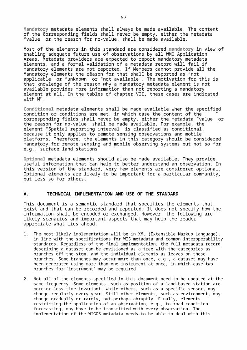
57
Id Name Definition Note or example Code Table ItemMCO
1-05 Representativeness Spatial extent of the region around the observation for which it is representative
NOTE:
The representativeness of an observation is the degree to which it describes the value of the variable needed for a specific purpose. Therefore, it is not a fixed quality of any observation, but results from joint appraisal of instrumentation, measurement interval and exposure against the requirements of some particular application (WMO-No. 8, 2008). Representativeness of an observed value describes the concept that the result of an observation made at a given geospatial location would be compatible with the result of other observations of the same quantity at other geospatial locations. In statistics, the term describes the notion that a sample of a population allows an adequate description of the whole population. Assessing representativeness can only be accomplished in the context of the question the data [or observations] are supposed to address. In the simplest terms, if the data [or observations] can answer the question, it is representative (Ramsey and Hewitt, 2005). The representativeness of an environmental observation depends on the spatio-temporal dynamics of the observed quantity (Henne et al., 2010). Representativeness of an observation can sometimes be specified quantitatively, in most cases qualitatively, based on experience or heuristic arguments.
1-05 O (Phase 2)
Condition:
{1-02} variables that are measured, rather than classified

58
CATEGORY 2: PURPOSE OF OBSERVATION
Specifies the main application area(s) of the observation and the observing programme(s) and networks the observation is affiliated to.
TABLE: Table shaded header with lines
Id Name Definition Note or example Code Table ItemMCO
2-01 Application area(s) Context within, or intended application(s) for which the observation is primarily made or which has/have the most stringent requirements
NOTE:
Many observations serve more than one purpose, meeting the requirements of various applications areas. In such cases, the application area for which the station or platform was originally established should be listed first.
2-01 M* (Phase 1)
2-02 Program/Network affiliation
The global, regional or national program/network(s) that the station/platform is associated with
EXAMPLES:
GUAN, AMDAR, GAW, RBSN, WHOS, etc. (full names to be referenced in code table)
2-02 M (Phase 1)
CATEGORY 3: STATION/PLATFORM
Specifies the environmental monitoring observing facility, including fixed station, moving equipment or remote sensing platform at which the observation is made.
TABLE: Table shaded header with lines
Id Name Definition Note or example Code Table ItemMCO
3-01 Region of origin of data
WMO Region NOTE:
WMO divides Member countries into six Regional Associations responsible for coordination of meteorological, hydrological and related activities within their respective Regions.
3-01 C* (Phase 1)

59
Id Name Definition Note or example Code Table ItemMCO
3-02 Territory of origin of data
Country or territory name of the location of the observation
NOTE:
Mandatory for fixed stations, optional for mobile stations
EXAMPLE:
Australia
3-02 C* (Phase 1)
3-03 Station/platform name
Official name of the station/platform
EXAMPLES:
Mauna Loa, South Pole
M (Phase 1)
3-04 Station/platform type
A categorization of the type of environmental monitoring observing facility at which an observation ed variable is madeasured
NOTE:
Code table according to See [INSPIRE D2.8.III.7, 2013]
3-04 M* (Phase 2)
3-05 Station/platform model
The model of the monitoring equipment used at the station/platform
EXAMPLES:
‘Landsat 8’ is a platform/station model of ‘satellite’; ‘Almos Automatic Weather Station (AWS)’ is a model of a ‘land station’; ’Airbus A340-600’ is a model of an ‘aircraft’.
M*# (Phase 3)
3-06 Station/platform unique identifier
A unique and persistent identifier for an environmental monitoring observing facility (station/platform), which may be used as an external point of reference
NOTE:
A globally unique identifier assigned by WMO for a station. Where a station has multiple identifiers, there must be a way of recording that they are synonyms. To be defined according to WMO guidelines.
EXAMPLE:
Ship: Call sign
M* (Phase 1)
3-07 Geospatial location Position in space defining the location of the environmental monitoring station/platform at the time of observation
NOTE 1:
Required for fixed stations; for stations following pre-determined trajectory (e.g. satellites).
11-01
11-02
M* (Phase 1)

60
Id Name Definition Note or example Code Table ItemMCO
NOTE 2:
The elevation of a fixed terrestrial station is defined as the height above sea level of the ground on which the station stands (“Hha” in WMO Pub. 9 Vol A).
NOTE 3:
The geospatial location can be a zero-, one-, two-, or three-dimensional feature.
NOTE 4:
Geographical coordinates can be specified in decimal degrees. Latitudes are specified with reference to the equator, with positive sign for latitudes north of the equator, and negative sign for latitudes south of the equator. Longitudes are specified with reference to the Greenwich meridian, with positive sign for longitudes east of Greenwich, and negative sign for meridians west of Greenwich. Elevation is a signed number specified in some distance measure (e.g., meters) relative to a reference elevation, with positive sign in the direction away from the Earth centre.
NOTE 5:
The latitudinal and longitudinal positions of a station referred to in the World Geodetic System 1984 (WGS-84) Earth Geodetic Model 1996 (EGM96) must be recorded to a resolution of at least 0.001 decimal degrees (WMO-No. 8, 2008, Part I, Chapter 1, 1.3.3.2).
NOTE 6:
This element comprises 3 entities, the coordinates (Lat/Long/Alt), the "geopositioning method" (code table 11-01) which produced the coordinates, as well as the "geospatial reference system" (code table 11-02) used.
EXAMPLES:
(i) The station Jungfraujoch is located at 46.54749°N 7.98509°E (3580.00 m a.m.s.l.). The reference system is WGS-84;
(ii) Voluntary Observing Ship Route: WMO Regional Association 5, Sub Area 6 (R56);
(iii) [geostationary satellite] Meteosat-8 (MSG-1) 3.6°E;
11-01
11-02
M* (Phase 1)
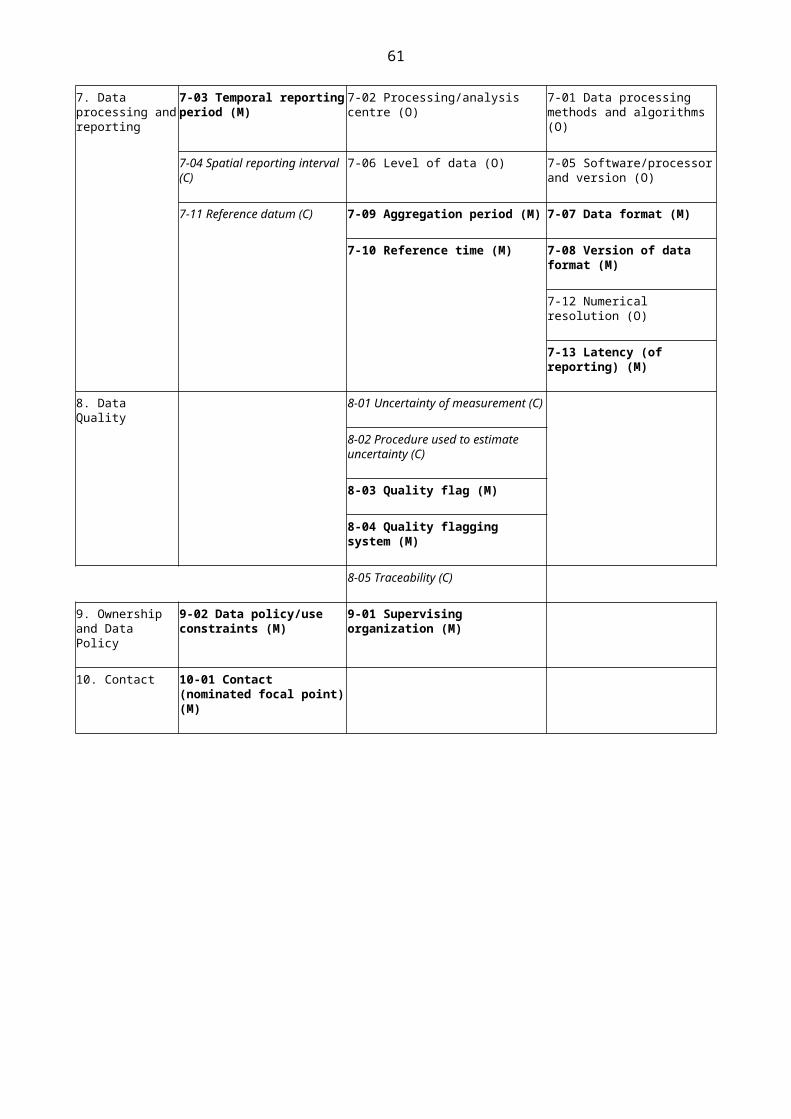
61
Id Name Definition Note or example Code Table ItemMCO
(iv) [sun-synchronous satellite] NOAA-19 Height 870 km; Local Solar Time (LST) 13:39;
(v) Weather Watch Radar: Warruwi NT -11.6485° N, 133.3800 E, Height 19.1 m amsl;
(vi) River discharge gauge: Warrego River at Cunnamulla Weir 28.1000 S, 145.6833 E, Height: 180 m amsl.
3-08 Data communication method
Data communication method between the station/platform and some central facility
EXAMPLES:
Inmarsat-C, ARGOS, Cellular, Globalstar, GMS(DCP), Iridium, Orbcomm, VSat, landline telephone, mail
3-08 O (Phase 2)
3-09 Station operating status
Declared reporting status of the station
NOTE:
Refer to the code table.
3-09 M (Phase 1)
Conditions:
{3-01, 3-02}: Mandatory for fixed land-based stations, optional for mobile stations

62
CATEGORY 4: ENVIRONMENT
Describes the geographical environment within which the observation is made. It also provides an unstructured element for additional meta-information that is considered relevant for adequate use of the observations and that is not captured anywhere else in the standard.
TABLE: Table shaded header with lines
Id Name Definition Note or example Code table ItemMCO
4-01 Surface cover The observed (bio)physical cover on the Earth’s surface in the vicinity of the observation
NOTE 1:
To be applied to 3 different geographic scales of the vicinity of the observation, namely horizontal radii of <100 m, of 100 m to 3 km, and of 3 km to 100 km.
NOTE 2:
Surface cover or land cover is distinct from land use despite the two terms often being used interchangeably. Land use is a description of how people utilize the land and socio-economic activity – urban and agricultural land uses are two of the most commonly known land use classes. At any one point or place, there may be multiple and alternate land uses, the specification of which may have a political dimension (Wikipedia, 2013) .
NOTE 3:
There are various classification methods for ‘land cover’. The MODIS product MCD12Q1 provides 5 different classifications on 500 m resolution grid (https://lpdaac.usgs.gov/dataset_discovery/modis/modis_products_table/mcd12q1). These include the IGBP, UMD, LAI/fPAR, NPP and PFT classifications.
NOTE 4:
An alternative approach is the Land Cover Classification System (LCCS) (Di Gregorio, 2005) adopted by the Food and Agriculture Organization of the United Nations. Translation of other systems to LCCS has been explored by Herold et al. (2009). Eight major land cover types are identified during the first, dichotomous classification phase. These are refined in a subsequent so-called Modular-Hierarchical Phase, in which land surface cover classes are created by the combination of sets of pre-defined classifiers. These classifiers are tailored to each of the eight major land surface cover types. This process can be supported by software (http://www.glcn.org/sof_7_en.jsp) or manually using a field
4-01 C (Phase 3)

63
Id Name Definition Note or example Code table ItemMCO
log sheet (http://commons.wikimedia.org/wiki/File:LCCS_field_protokoll.png).
4-02 Surface cover classification scheme
Name and reference or link to document describing the classification scheme
IGBP, UMD, LAI/fPAR, NPP and PFT, LCCS (recommended implementation as a URI pointing to the code table)
4-02 C (Phase 3)
4-03 Topography or bathymetry
The shape or configuration of a geographical feature, represented on a map by contour lines
NOTE 1:
Topography shall be formally expressed with the four elements ‘local topography’, ‘relative elevation’, ‘topographic context’, and ‘altitude/depth’.
NOTE 2:
The term ‘altitude’ is used for elevations above mean sea level. The term ‘depth’ is used for elevations below mean sea level.
EXAMPLES (can be converted into entries of the code table):
“a ridge at low relative elevation within valleys of middle altitude”
“a depression within plains of very low depth”
4-03 C (Phase 3)
4-04 Events at station/platform observing facility
Description of human action or natural event at the station or in the vicinity that may influence the observation
NOTE 1:
This information may be frequently changing (for example ocean debris impacting buoys).
NOTE 2:
The start and end time/date of the event should be included
4-04 or free text or an URL
O (Phase 2)
4-05 Site information Non-formalized information about the location and its surroundings at which an observation is made and that may influence it
NOTE 1:
This information may be frequently changing (for example ocean debris impacting buoys).
NOTE 2:
In hydrology, description and dating of activities occurring in the basin that can affect the observed
Free text and/or URL(s)
O (Phase 2)

64
Id Name Definition Note or example Code table ItemMCO
discharge, e.g., construction of a regulation structure upstream of the gauging location that significantly affects the hydrological regime, inter-basin diversion of water into or from the basin upstream of the gauging location, significant change in consumptive use, land surface cover or land use.
EXAMPLES:
maps, plans, photographs, descriptions and other unique site information that is difficult to express in words or that cannot easily be quantified.
4-06 Surface roughness The Terrain classification in terms of aerodynamic roughness length z0
NOTE:
The Terrain classification (Davenport and Wieringa) as mentioned in WMO-No. 8, 2008, Updated 2010, Annex to Chapter 5
4-06 O (Phase 3)
4-07 Climate zone The K ö ppen climate classification of the region where the observing facility is located
The Köppen-Geiger climate classification scheme divides climates into five main groups (A, B, C, D, E), each having several types and subtypes.
4-07 O (Phase 3)
Conditions:
Either {4-01 and 4-02 and 4-03} or a nilReason=”not applicable” must be reported. For hydrology and satellite observations, specifying nilReason is appropriate.

65
CATEGORY 5: INSTRUMENTS AND METHODS OF OBSERVATION
Specifies the method of observation and describes characteristics of the instrument(s) used to make the observation. If multiple instruments are used to generate the observation, then this category should be repeated.
TABLE: Table shaded header with lines
Id Name Definition Note or example Code Table ItemMCO
5-01 Source of observation The source of the dataset described by the metadata
NOTE:
Refer to the Code table
5-01 M (Phase 1)
5-02 Measurement/observing method
The method of measurement/ observation used
EXAMPLES:
Temperature can be determined using different principles: liquid in glass; mechanical; electrical resistance; thermistor; thermocouple. Likewise, humidity is determined in AMDAR as a mass mixing ratio.
Several chemical variables can be determined using infrared absorption spectroscopy.
In hydrology, stage would be observed using a staff gauge, electric tape, pressure transducer, gas bubbler, or acoustics.
Examples of satellite observation principles: Cross-nadir scanning IR sounder; MW imaging/sounding radiometer, conical scanning, etc.
Visual observation of weather, cloud type, etc.
5-02 M# (Phase 1)
5-03 Instrument specifications
Intrinsic capability of the measurement/observing method to measure the designated element, including range, stability, precision, etc.
NOTE 1:
The metadata record can be "not available".
NOTE 2:
Includes the Upper limit of operational range and the Lower limit of operational range. For space-based observations, the channels and their frequencies should be included.
An URL is acceptable in case of space-based observations
M C *# (Phase 1)

66
Id Name Definition Note or example Code Table ItemMCO
EXAMPLES:
(i) Barometer measurement range 800–1100 hPa (i.e. unsuitable for some mountain ranges, Mt Everest ~300hPa);
(ii) Maximum distance a human observer can observe given the topography.
5-04 Instrument operating status
The status of an instrument with respect to its operation
NOTE:
To be recorded by data providers for each individual observation.
5-04 O (Phase 3)
5-05 Vertical distance of sensor
Vertical distance of the sensor from a (specified) reference level such as local ground, or deck of a marine platform at the point where the sensor is located; or sea surface
NOTE 1:
The reference surface (generally a surface which will strongly influence the observation) must be specified.
NOTE 2:
Away from center of earth, positive. Negative values indicate position below reference surface.
EXAMPLES:
(i) Air temperature: height of the temperature sensor is 1.50 m above ground surface (station level);
(ii) Surface wind: 10.0 m above ground surface (station level);
(iii) Soil temperature: 0.50 m below soil surface;
(iv) Ship: Visual Obs Height: 22.0 m a.s.l.;
(v) Weather Watch Radar: Warruwi AU 24.3 m above ground surface (see 7-07);
(vi) Transmissometer 2.55 above runway surface;
(vii)Depth of buoy relative to lowest astronomical tide;
(viii)Pressure sensor: vertical distance above mean sea level. ;
C* (Phase 1)
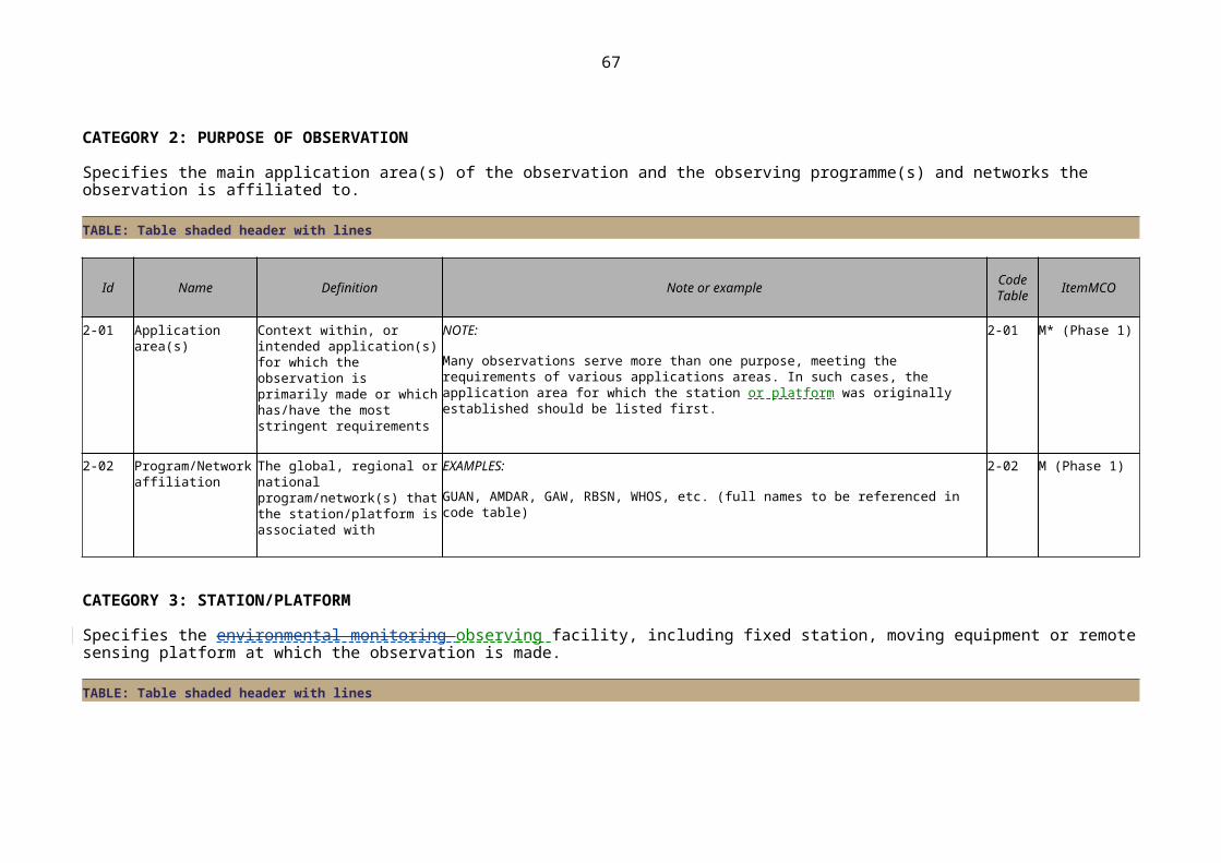
67
Id Name Definition Note or example Code Table ItemMCO
(ix) For satellites, e.g., geostationary orbit at 36000 km above geoid, or LEO at 800 km above geoid.
5-06 Configuration of instrumentation
Description of any shielding or configuration/setup of the instrumentation or auxiliary equipment needed to make the observation or to reduce the impact of extraneous influences on the observation
NOTE:
An URL could be provided in case of space-based observations.
EXAMPLES (for surface-based observations):
Shelter, temperature control, etc.
Internal volume: [m3]
Aspirated: [Natural/forced/na]
Aspiration rate: m3s-1
Shielding from: [radiation/precipitation/ wind/etc.]
C# (Phase 3)
5-07 Instrument control schedule
Description of schedule for calibrations or verification of instrument
NOTE:
For space-based observations, it applies only to major changes; For very frequent changes on parameters, a specific link to external source should be provided.
EXAMPLE:
Every year on first week of February
C (Phase 3)
5-08 Instrument control result
The result of an instrument control check, including date, time, location, standard type and period of validity
NOTE 1:
For the result of control check code table 5-08 is to be used.
NOTE 2:
record even if "not available"
NOTE 3:
5-08 C# (Phase 3)

68
Id Name Definition Note or example Code Table ItemMCO
Information should contain at least the following elements:
Standard type: [International, Primary, Secondary, Reference, Working, Transfer, Travelling, collective]
Standard name: [free text]
Standard reference: [serial number or equivalent]
Within verification limit [Y/N]
NOTE 4:
Can be implemented with a URI pointing to a document containing this information.
NOTE 5:
For space-based observations, it applies only to major changes; for very frequent changes on parameters, a specific link to external source should be provided.
EXAMPLE:
20140207 15:30 UTC, travelling standard, <name>, <S/N>, field calibration, result: in calibration, validity: 4 years
5-09 Instrument model and serial number
Details of manufacturer, model number, serial number and firmware version if applicable
NOTE 1:
Record "not available"
NOTE 2:
Use the following formats:
Instrument manufacturer: [free text]
Instrument model: [free text]
Instrument serial number: [free text]
C# (Phase 3)

69
Id Name Definition Note or example Code Table ItemMCO
Firmware version: [free text]
EXAMPLE:
Vaisala PTB330B G2120006
5-10 Instrument routine maintenance
A description of schedule maintenance that is performed on an instrument
EXAMPLE:
Daily cleaning of a radiation sensor
C# (Phase 3)
5-11 Maintenance party Identifier of the organization or individual who performed the maintenance activity
O (Phase 2)
5-12 Geospatial location Geospatial location of instrument/sensor
NOTE 1:
Geographic location of instrument such as airfield anemometer or transmissometer.
NOTE 2:
This element comprises 3 entities, the coordinates (Lat/Long/Alt), the "geopositioning method" (code table 11-01) which produced the coordinates, as well as the "geospatial reference system" (code table 11-02) used.
EXAMPLES:
(i) Melbourne Airport AU (East anemometer) –37.6602 N, 144.8443 E, 122.00 m amsl.;
(ii) Relative position of wind sensor aboard ship;
(iii) 30 km upstream of river mouth.
11-01
11-02
C* (Phase 2)
5-13 Maintenance Activity Description of maintenance performed on instrument
NOTE:
A log of actual maintenance activity, both planned and corrective
O (Phase 3)
5-14 Status of observation Official status of observation NOTE: 5-14 O (Phase 3)

70
Id Name Definition Note or example Code Table ItemMCO
A binary flag
5-15 Exposure of instruments
The degree to which an instrument is affected by external influences and reflects the value of the observed variable
NOTE:
The exposure of an instrument results from joint appraisal of the environment, measurement interval and exposure against the requirements of some particular application. Expressed in terms of code table.
5-15 C (Phase 2)
Conditions:
{5-07, 5-08, 5-09, 5-10, 5-15} mandatory for instrumental observations
{5-05} mandatory for instrumental observations and if proximity of reference surface impacts on observation
{5-06} mandatory for instrumental observations and if prescribed by “best practice”.
{5-12} mandatory for instrumental observations and if different from station/platform
{5-05, 5-06, 5-10, 5-12, 5-15} A nil Reason = ”not applicable” is acceptable for space-based observations.

71
CATEGORY 6: SAMPLING
Specifies how sampling and/or analysis are used to derive the reported observation or how a specimen is collected.
TABLE: Table shaded header with lines
Id Name Definition Note or example Code Table ItemMCO
6-01 Sampling procedures
Procedures involved in obtaining a sample
EXAMPLES:
Temperature measurements are made using a XYZ thermometer and reported results are an average of 10 measurements made in a given hour.
Aerosols may be sampled with an inlet with size-cutoff at 2.5 µm and be deposited on a teflon filter.
Manual reading of a liquid-in-glass thermometer every three hours.
As an exception, an observer may observe the state of the sky from home rather than at the station during night.
Rain fall is accumulated during the whole week-end and distributed evenly over these 2 days.
An URL in case of space-based observations
O (Phase 3)
6-02 Sample treatment Chemical or physical treatment of sample prior to analysis
EXAMPLES:
Homogenization, milling, mixing, drying, sieving, heating, melting, freezing, evaporation.
O (Phase 3)
6-03 Sampling strategy The strategy used to generate the observed variable
EXAMPLES:
Continuous: global radiation, atmospheric pressure, or continuous ozone monitoring with a UV monitor;
Discrete: gas chromatographic analysis of carbon monoxide, radar rainfall;
Event: grab water samples, flask sampling of air, etc.
6-03 or an URL in case of space-based observations
O* (Phase 1)
6-04 Sampling time period
The period of time over which a measurement is taken
NOTE: 11-03 M# (Phase 3)

72
Id Name Definition Note or example Code Table ItemMCO
Includes the sampling time period, plus the meaning of time stamp (11–03).
EXAMPLES :
surface winds sampled every 0.25 s (frequency 4 Hz) (WMO, 2008); surface winds measured once per hour; Barometric pressure measured once every 6 minutes; water column height measured every 15 seconds; water temperature measured once per hour (NOAA, 2009);
For each example, Time stamp indicates “end of period”.
6-05 Spatial sampling resolution
Spatial resolution refers to the size of the smallest observable object. The intrinsic resolution of an imaging system is determined primarily by the instantaneous field of view of the sensor, which is a measure of the ground area viewed by a single detector element in a given instance in time.
NOTE:
A representative value (L × L × L), where “L” is a length, is expected, according to the dimension (1-D, 2-D or 3-D), but free text is allowed for the characteristics to be explained.
EXAMPLES:
AVHRR: 1.1 km IFOV s.s.p.
The sample is a point in space or a very small volume resembling a point, e.g., a temperature sampled by a thermocouple element: No size to be reported;
The sample is a line, either straight (e.g., a line of sight of a DOAS instrument) or curved (e.g., the humidity sampled by an aircraft in flight). The ‘length’ of the line is to be reported;
The sample is an area, either rectangular or of any other shape, e.g., the pixel of a satellite or the reach of a radar image. The ‘length x length’ of the area is to be reported;
The sample is a volume, e.g. a water sample or a well-mixed volume of air sampled by flask. The ‘length x length x length’ of the volume is to be reported.
M# (Phase 2)
6-06 Temporal sampling interval
Time period between the beginning of consecutive sampling periods
EXAMPLES :
Surface winds sampled every 0.25 s (frequency 4 Hz) (WMO, 2008); surface winds measured once per hour; Barometric pressure measured once every 6 minutes; water column height measured every 15 seconds; water temperature measured once per hour;
For each example, Time stamp indicates “end of period”.
M (Phase 3)

73
Id Name Definition Note or example Code Table ItemMCO
6-07 Diurnal base time Time to which diurnal statistics are referenced
EXAMPLES:
Rain fall observation is accumulated for 24 hours up until 0700z, the diurnal base time here is 0700z.
Daily temperature maxima refer to the period 0600 local time, the diurnal base time here is 0600z.
M C (Phase 1)
6-08 Schedule of observation
Schedule of observation EXAMPLES:
AMDAR profiling observations are available from Zurich airport between 0600 and 1200 local time;
Radio-sondes are collected at a particular station from January to August on weekdays at 0000z and 1200z.
Free text M (Phase 1)
{6-05, 6-06, 6-07, 6-08} A nil Reason = ”not applicable” is acceptable for space-based observations.

74
CATEGORY 7: DATA PROCESSING AND REPORTING
Specifies how raw data are transferred into the observed variables and reported to the users.
TABLE: Table shaded header with lines
Id Name Definition Note or example Code table ItemMCO
7-01 Data processing methods and algorithms
A description of the processing used to generate the observation and list of algorithms utilized to derive the resultant value
NOTE:
In hydrology, this would be the equation(s) defining the rating curve and any shifts or corrections applied to the data or the curve.
EXAMPLE:
Radiation correction and calculation of geo-potential height for upper-air soundings.
Free text or an URL
O (Phase 3)
7-02 Processing/analysis center
Center at which the observation is processed.
EXAMPLES:
Chemical analysis, AMDAR processing center, National Hydrological Service office.
O (Phase 2)
7-03 Temporal reporting period
Time period over which the observed variable is reported
NOTE:
Includes the temporal reporting interval, plus the meaning of time stamp.
EXAMPLES:
Hourly, daily, monthly, seasonal, event-based, 80 seconds interval during the day, etc. In each case, the meaning, “beginning, “middle”, or “end” of period is indicated.
11-03 M* (Phase 1)
7-04 Spatial reporting interval
Spatial interval at which the observed variable is reported
NOTE:
This is applicable only to remote sensing observations and mobile platforms in general. For most remote-sensing observations, this will be redundant with element 6-05 6 .
EXAMPLES:
C* (Phase 1)
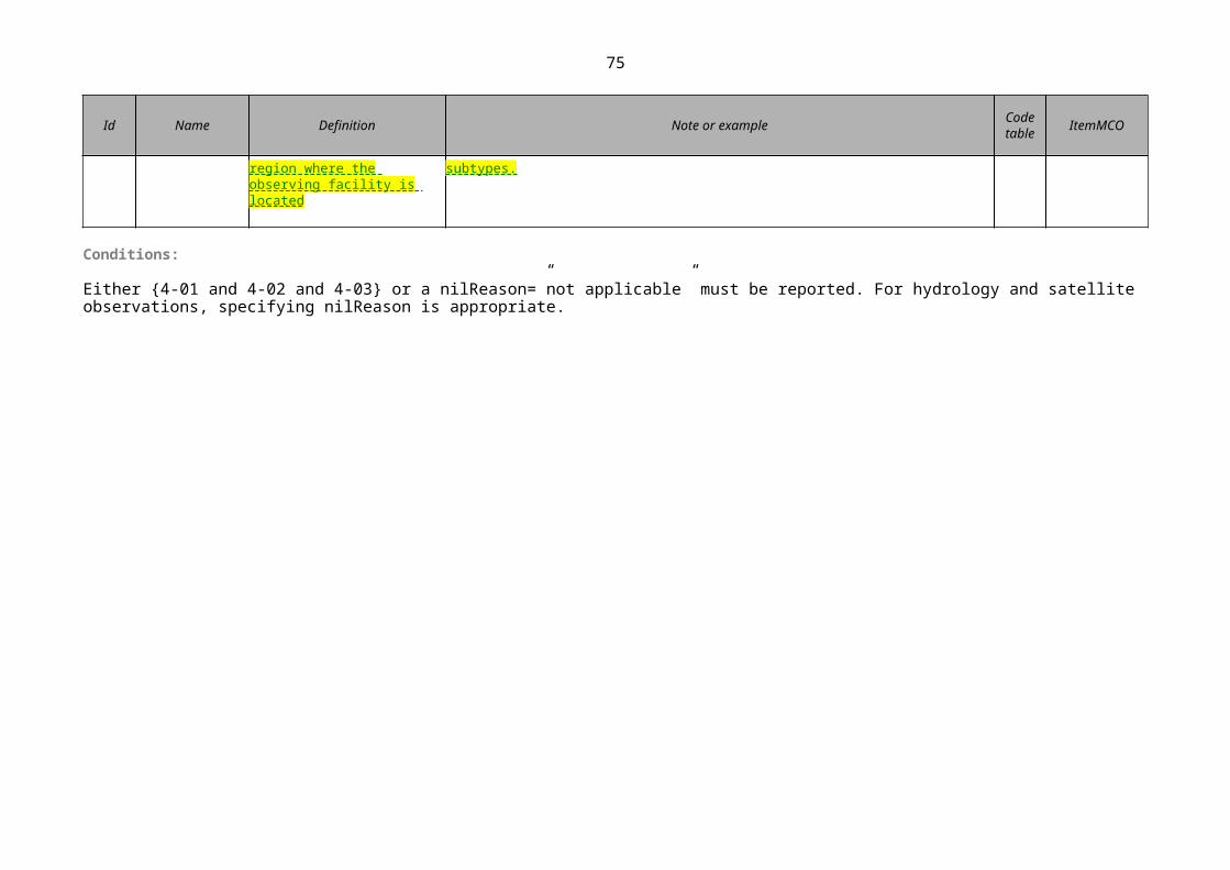
75
Id Name Definition Note or example Code table ItemMCO
(i) An observation from a satellite may be reported with a spatial resolution of 10 km x 20 km;
(ii) An aircraft may sample every 1 km along its trajectory (cf. 6-05 6 ), but may report at a spatial interval of 10 km.
7-05 Software/processor and version
Name and version of the software or processor utilized to derive the element value
EXAMPLES:
Avionics version, retrieval algorithm version; MCH Database Management System version 25/10/2013.
O (Phase 3)
7-06 Level of data Level of data processing NOTE:
Pre- or post-processing.
7-06 O (Phase 2)
7-07 Data format1 Description of the format in which the observed variable is being provided.
EXAMPLES:
ASCII, BUFR, NASA AMES, HDF, XML, AMDAR, comma-separated (CSV), tab-separated (.txt), MCH (for interchange)
7-07 M (Phase 3)
7-08 Version of data format1
Version of the data format in which the observed variable is being provided.
EXAMPLES:
FM 12–XIV Ext. SYNOP; FM 42-XI Ext. AMDAR, FM 94-XIV BUFR Version 20.0.0, Radar: ODIM_H5
M (Phase 3)
7-09 Aggregation periodTime period over which individual samples/observations are aggregated
NOTE:
Includes the aggregation interval, plus the meaning of time stamp.
EXAMPLES:
5 minute mean, meaning of time stamp is “middle of period”;
daily maximum, meaning of time stamp is “end of period”;
event based, meaning of time stamp is “beginning of period”.
11-03 M (Phase 2)
7-10 Reference time Time base to which date and time NOTE: 7-10 M (Phase 2)

76
Id Name Definition Note or example Code table ItemMCO
stamps refer The reference time must not be confused with the time zone (which is part of the representation of the time stamp), but indicates what the source of the time stamp is, i.e., to which reference time the time stamps of the observation are aligned.
EXAMPLES:
NIST time server
NTP pool project
7-11 Reference datum Reference datum used to convert observed quantity to reported quantity
NOTE 1:
Atmospheric pressure can be reported as (i) Field elevation Pressure (QFE), where the reference datum is the elevation corresponding to the official elevation of the aerodrome; (ii) Atmospheric pressure at nautical height (QNH), where the reference datum is mean sea level and the pressure altitude relationship of the ICAO standard atmosphere is used. Where observed atmospheric pressure cannot be reduced to mean sea level, a station should, by regional agreement, report either the geopotential of an agreed ‘constant pressure level’ or the pressure reduced to an agreed datum for the station. The level chosen for the station should be reported in this field. (Ref: WMO-No. 8 3.11.1).
NOTE 2:
Hydrology may report a gauge zero which is the gauge height of zero flow.
C (Phase 1)
7-12 Numerical resolution
Measure of the detail in which a numerical quantity is expressed
NOTE 1:
The resolution of a numerical quantity is a measure of the detail in which the quantity is expressed. It can be expressed as the smallest possible difference between two numbers. It can also be expressed as the number of significant figures of a number, which are those digits that carry meaning contributing to its resolution.
EXAMPLE:
If a measurement resolution to four decimal places (0.0001) is given as 12.23 then it might be understood that only two decimal places of resolution are available. Stating the result as 12.2300 makes clear that it is precise to four decimal places (in this case, six significant figures).
O (Phase 3)

77
Id Name Definition Note or example Code table ItemMCO
NOTE 2:
The notion of measurement resolution is related but must not be confounded with the uncertainty of an observation.
EXAMPLES:
(i) An anemometer may measure wind speed with a measurement resolution of 0.1 ms–1 with a 1 Hz scan rate. Observations may be aggregated to 1-minute values and may be rounded and reported with a (reduced) measurement resolution of 1 ms–1;
(ii) A barometer may be capable of measuring atmospheric pressure with a readout resolution of 1 hPa and an uncertainty of 5 hPa (k=2). The data can be reported to the nearest hPa, however, the measurement resolution should be stated as “5 hPa” or “3 significant digits”;
(iii) An ocean thermometer measures temperature to 0.0001 °C;
(iv) Seawater salinity measured to 0.001 salinity units (derived from conductivity measurements with a resolution of 0.01 Sm–1).
O (Phase 3)
7-13 Latency (of reporting)
The typical time between completion of the observation or collection of the datum and when the datum is reported
(i) For satellite data, the “observation” (e.g. a complete image) can take 20 minutes to generate. Hence the latency would be the time between the completion of the image collection, and when it is available. Typically this can be 2–3 minutes. Some satellite products such as SST can take about 10 minutes of processing until it is available;
(ii) A radar volumetric scan can take 6–10 minutes (in Australia), so the latency would be the time between the completion of the scan and when the data is locally available. In Australia, this varies between a few seconds to several minutes depending on delays in data communications;
(iii) AWS data may have a latency of 1–20 seconds (or considerably more in some places) between the completion of the observation and arrival of the data at a central archive.
M (Phase 3)
1 Provided as part of the WIS metadata records
Conditions:
{7-04}: mandatory for remote sensing observations and mobile platforms in general
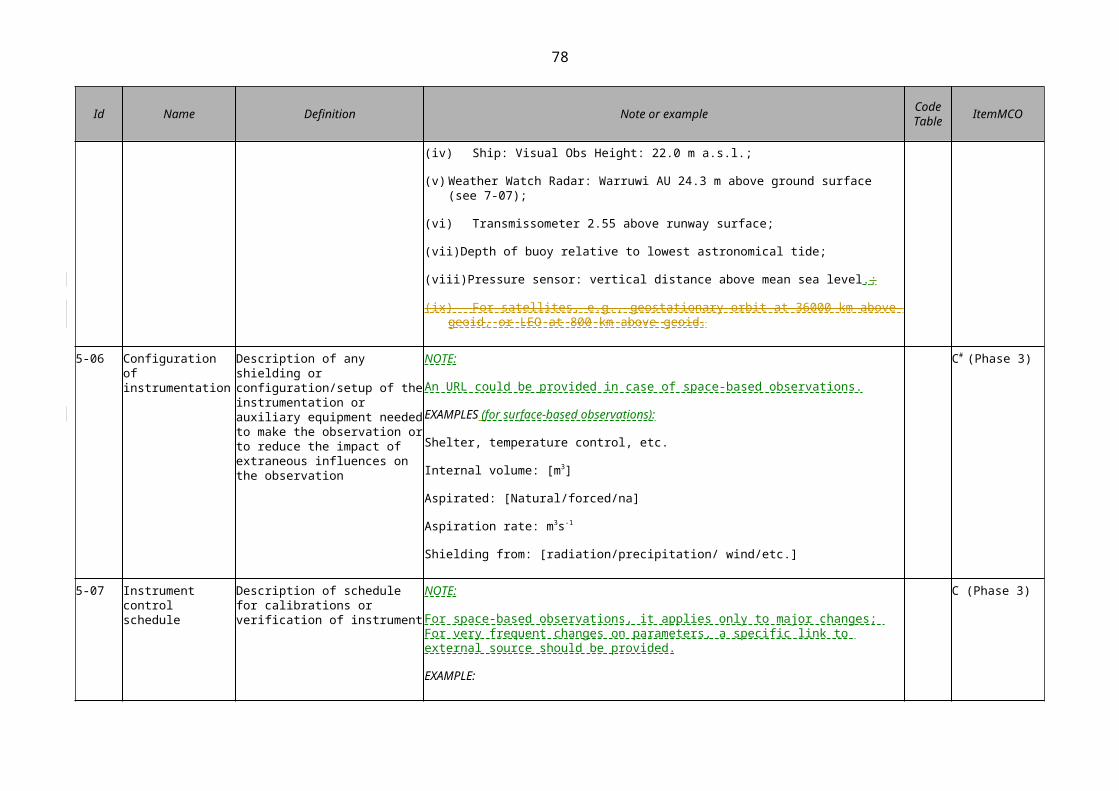
78
{7-11}: mandatory for stations/platforms that report a derived observation value that depends on a local datum
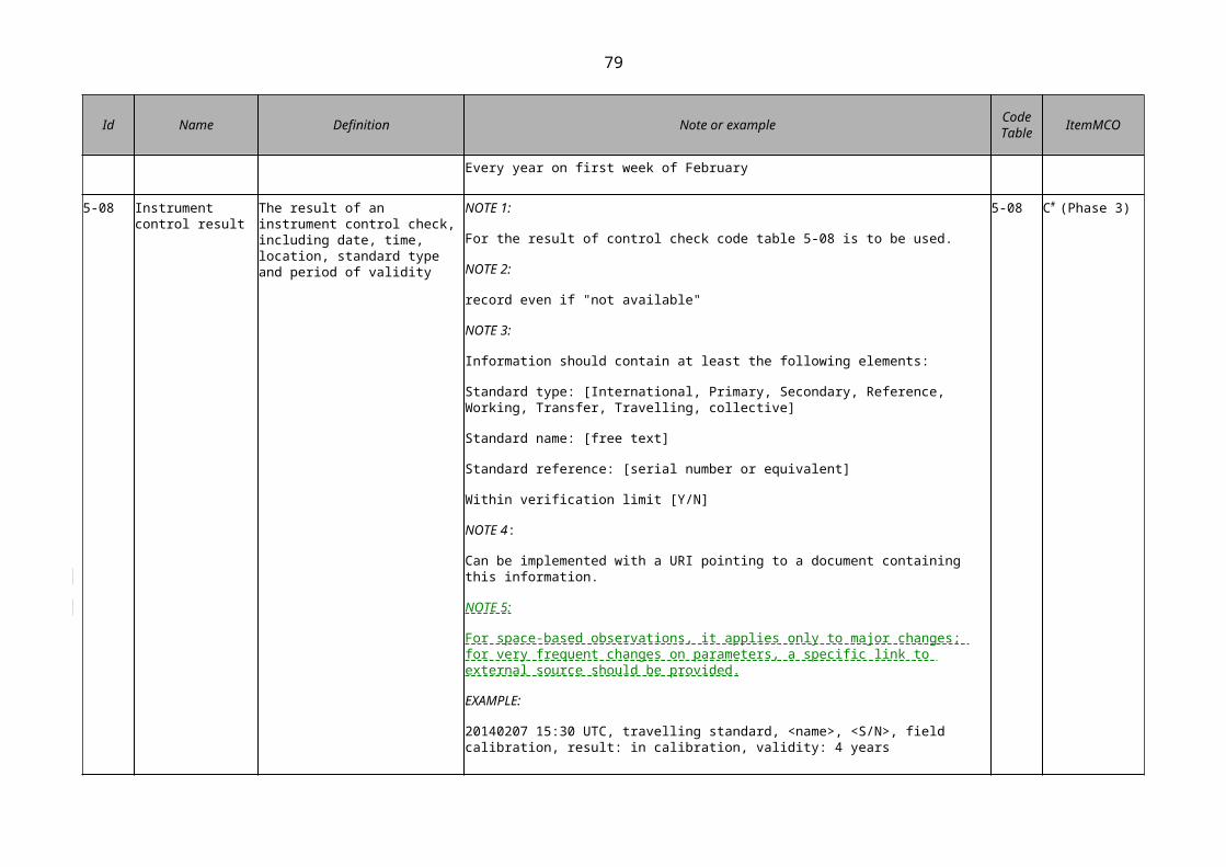
79
CATEGORY 8: DATA QUALITY
Specifies the data quality and traceability of the observation
TABLE: Table shaded header with lines
Id Name Definition Note or example Code Table ItemMCO
8-01 Uncertainty of measurement
Non-negative parameter, associated with the result of a measurement, that characterizes the dispersion of the values that could reasonably be attributed to the observation/ measurand
NOTE 1:
In principle, an uncertainty statement needs to be reported for each observation, as it can change from observation to observation. If the uncertainty of observations remains virtually constant over time, it is sufficient to report the uncertainty at the beginning of the period and then again when substantial changes of the uncertainty occur. The actual uncertainty statements should be reported with the observations.
NOTE 2:
Complex observations such as gridded satellite imagery may contain large error covariance matrices that are not useful for the purpose of this standard. Such information must be kept with the data, and it is sufficient to report an aggregate (e.g., mean or median) uncertainty in the metadata.
NOTE 3:
Uncertainty may be expressed, for example, as a standard deviation (or a given multiple of it), or the half-width of an interval having a stated level of confidence.
NOTE 4:
Uncertainty of measurement comprises, in general, many components. Some of these components may be evaluated from the statistical distribution of the results of series of measurements and can be characterized by experimental standard deviations. The other components, which also can be characterized by standard deviations, are evaluated from assumed probability distributions based on experience or other information.
NOTE 5:
It is understood that the result of the measurement is the best estimate of the value of the measurand,
C*# (Phase 2)

80
Id Name Definition Note or example Code Table ItemMCO
and that all components of uncertainty, including those arising from systematic effects, such as components associated with corrections and reference standards, contribute to the dispersion.
NOTE 6:
For space-based observations, the implementation should be taken in a simple way.
EXAMPLE:
A thermometer reading may yield a value of 13.7 °C. A quality assessment of that observation may indicate that it has an expanded uncertainty of +/– 0.3 °C (k=2), where k=2 is a coverage factor corresponding approximately to a confidence interval of 95%.
8-02 Procedure used to estimate uncertainty
A reference or link pointing to a document describing the procedures/algorithms used to derive the uncertainty statement
NOTE:
Uncertainty is a well-defined term, and guidance material exists to assist in the assessment of the uncertainty of observations and a formulation of adequate uncertainty statements. The authoritative source is the “Guide for the Expression of Uncertainty in Measurement” (JCGM 100:2008).
8-03 Quality flag An ordered list of qualifiers indicating the result of a quality control process applied to the observation
NOTE 1:
BUFR code table series 0-33 contains data quality flags/definitions.
NOTE 2:
To be recorded by data providers for each individual observation.
8-03 M# (Phase 2)
8-04 Quality flagging system
Reference to the system used to flag the quality of the observation
NOTE 1:
At present, there is no single, globally accepted flagging system. The purpose of this element is to make reference to the flagging system used. This reference should either be a URL to a document explaining the meaning of the quality flag, or a link to a code table where this information can be found.
NOTE 2:
The use of the BUFR quality codes listed above is recommended (WMO, 2013a)
8-04
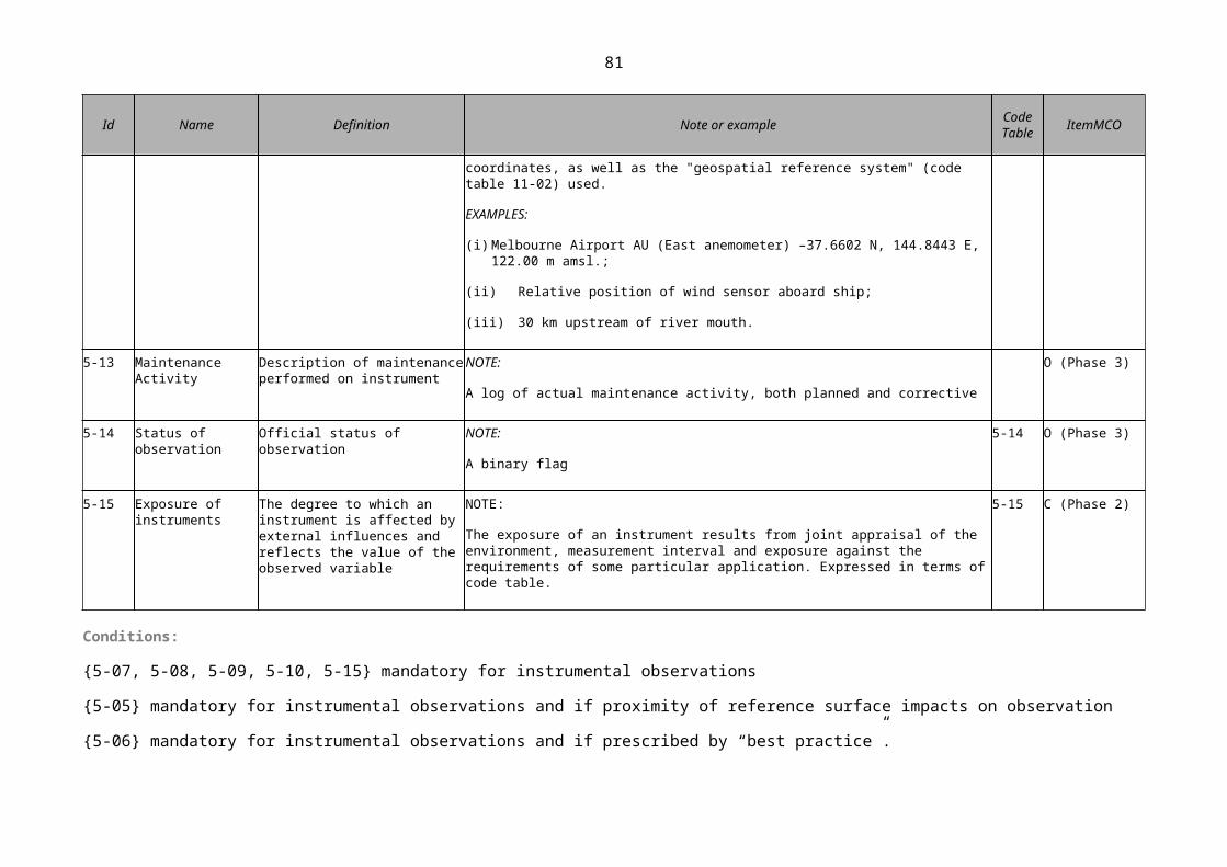
81
Id Name Definition Note or example Code Table ItemMCO
8-05 Traceability Statement defining traceability to a standard, including sequence of measurement standards and calibrations that is used to relate a measurement result to a reference [VIM 3, 2.42]
NOTE 1:
A metrological traceability chain is defined through a calibration hierarchy [VIM 3, 2.42].
NOTE 2:
A metrological traceability chain is used to establish metrological traceability of a measurement result [VIM 3, 2.42].
NOTE 3:
A comparison between two measurement standards may be viewed as a calibration if the comparison is used to check and, if necessary, correct the quantity value and measurement uncertainty attributed to one of the measurement standards [VIM 3, 2.42].
NOTE 4:
For the statement on traceability, code table 8-05 is to be used.
NOTE 5:
For space-based observations, the implementation should be taken in a simple way.
8-05 C*# (Phase 2)
Conditions:
{8-01, 8-02 and 8-05} variables that are measured, rather than classified

82
CATEGORY 9: OWNERSHIP AND DATA POLICY
Specifies who is responsible for the observation and owns it.
TABLE: Table shaded header with lines
Id Name Definition Note or example Code Table ItemMCO
9-01 Supervising organization
Name of organization who owns the observation
EXAMPLES:
for satellite operators
EUMETSAT, ESA, NOAA, NASA, CMA, RapidEye, ISRO
M (Phase 2)
9-02 Data policy/use constraints
Details relating to the use and limitations surrounding data imposed by the supervising organization
NOTE:
Only one single use constraint with a value taken from WMO_DataLicenseCode is allowed to ensure unambiguity (WMO, 2013b, p. 515)
9-02 M* (Phase 1)
CATEGORY 10: CONTACT
Specifies where information about an observation or dataset can be obtained.
TABLE: Table shaded header with lines
Id Name Definition Note or example Code Table ItemMCO
10-01 Contact (Nominated Focal Point)
Principal contact (Nominated Focal Point, FP) for resource
NOTE:
The FP would be able to provide data users with information regarding individual observing platforms and their observations.
M (Phase 1)

83
EXAMPLES:
Programme or Network Manager, e.g. E-AMDAR Technical Coordinator (TC) has responsibility for data quality of several airlines’ fleets, has information on aircraft type/software/known errors etc.

85
SECTION: Ignore
Chapter title in running head: APPENDIX 2.4. THE WIGOS METADATA STANDA…
VIII REFERENCES
Di Gregorio, A., 2005: Land Cover Classification System. Classification concepts and user manual. Software version 2, Food and Agriculture Organization of the United Nations, ISBN 92-5-105327-8, 212 pp., http://www.glcn.org/downs/pub/docs/manuals/lccs/LCCS2-manual_en.pdf.
Hammond, E.H., 1954: Small-scale continental landform maps. Annals of the Association of American Geographers, 44(1):33-42, doi:10.1080/00045605409352120.
Henne, S., D. Brunner, D. Folini, S. Solberg, J. Klausen and B. Buchmann, 2010: Assessment of parameters describing representativeness of air quality in-situ measurement sites. Atmos. Chem. Phys., 10:3561–3581.
Herold, M., R. Hubald and A. Di Gregorio, 2009: Translating and evaluating land cover legends using the UN Land Cover Classification system (LCCS), GOFC-GOLD Report No. 43, Jena, Germany, http://nofc.cfs.nrcan.gc.ca/gofc-gold/Report%20Series/GOLD_43.pdf.
INSPIRE - D2.8.III.7, 2013 Data Specification on Environmental Monitoring Facilities – Draft Technical Guidelines, http://inspire.ec.europa.eu/documents/Data_Specifications/INSPIRE_DataSpecification_EF_v3.0rc3.pdf. SpecialisedEMFTypeValue, p. 33.
ISO/TC 211, 2003: ISO 19115:2003, Geographic information – Metadata. Oslo, International Organization for Standardization.
ISO/TC 211, 2011: ISO19156:2011, Geographic Information – Observations and Measurements. Geneva, International Organization for Standardization.
JCGM 100:2008, Evaluation of measurement data – Guide to the Expression of Uncertainty in Measurement, http://www.bipm.org/utils/common/documents/jcgm/JCGM_100_2008_E.pdf.
JCGM 200:2012, International vocabulary of metrology – Basic and general concepts and associated terms (VIM). Third edition, http://www.bipm.org/utils/common/documents/jcgm/JCGM_200_2012.pdf.
MODIS Land Cover Type Product, https://lpdaac.usgs.gov/dataset_discovery/modis/modis_products_table/mcd12q1.
Ramsey, C.A. and A.D. Hewitt, 2005: A Methodology for Assessing Sample Representativeness. Environmental Forensics, 6:1, 71—75, doi: 10.1080/15275920590913877.
Speight, J.G., 2009: Landform. In: Australian Soil and Land Survey Field Handbook. Third edition, National Committee on Soil and Terrain. Melbourne, CSIRO Publishing, http://www.publish.csiro.au/nid/22/ pid/5230.htm, http://books.google.com.au/books?id=zywc39z4LgAC.
World Meteorological Organization, 2008: Guide to Meteorological Instruments and Methods of Observation (WMO-No. 8, updated in 2010). Geneva.
———, 2013a: Manual on Codes (WMO-No. 306), Volume I.2, Part B – Binary Codes. Geneva http://library.wmo.int/pmb_ged/wmo_306-I2_en.pdf.
———, 2013b: Manual on the WMO Information System (WMO-No. 1060), http://wis.wmo.int/WIS-Manual , Part C1: WMO Core Metadata Profile version 1.3, Specification: Conformance Requirements. Geneva, http://www.wmo.int/pages/prog/www/WIS/wiswiki/tiki-index.php?page=ManualWIS
———, 2013c: Weather Reporting (WMO-No. 9), Volume A: Observing Stations. Geneva, http://www.wmo.int/pages/prog/www/ois/ois-home.html.

87
SECTION: Landscape page with header
Chapter title in running head: APPENDIX 2.4. THE WIGOS METADATA STANDA…
SECTION: Chapter
Chapter title in running head: APPENDIX 2.5. THE EIGHT PRINCIPLES OF Q…
APPENDIX 2.5. THE EIGHT PRINCIPLES OF QUALITY MANAGEMENT OF THE WMO QUALITY MANAGEMENT FRAMEWORK APPLIED TO WIGOS
1. User and client focus
Members should identify, document and understand the current and future needs of their users and clients for meteorological, climatological, hydrological, marine and related environmental observations.
Note: The means to achieve this includes participation in and application of the WMO Rolling Review of Requirements (RRR) (see section 2.2.4 and Appendix 2.3).
2. Leadership
Members should clearly define the goals and directions of their observing systems, and create an environment in which staff are encouraged to work towards those goals.
Note: The relevant WMO technical commissions provide technical guidance and leadership for the implementation of WIGOS. They provide information on WIGOS goals and directions, and stimulate the active involvement of technical experts from Member countries.
3. Involvement of experts
Experts from Member countries should be fully involved in the implementation of regulations pertaining to WIGOS quality management.
4. Process approach
Members should adopt a process-based approach to management of observing systems.
5. System approach to management
Members should identify, understand and manage WIGOS observing systems as sets of processes that may be operational, scientific or administrative, with the overall objective of producing the required observation outputs.
6. Continual improvement
Members should ensure that continual improvement is an integral and permanent component of WIGOS observing systems and is implemented through a range of processes and activities that include active participation in the WMO RRR; auditing of observing systems and sites; data quality monitoring and evaluation; and routine consultation with, and review of feedback from, WIGOS users and application areas, primarily through the WMO RRR.
Note: The outcome is the improvement of either the quality of observations or the efficiency of observing systems.
7. Factual approach to decision-making
Members should ensure that decisions, requirements and regulations associated with the design, development, implementation, operation, maintenance and evolution of WIGOS observing systems are based on scientifically, factually and analytically derived information.

88
Note: The above-mentioned information is available to Members through tools such as the WMO RRR, the WIGOS Information Resource (WIR), the Observing Systems Capability Analysis and Review (OSCAR) tool, and through WMO endorsed planning documents such as the Implementation Plan for the Evolution of Global Observing Systems (WIGOS Technical Report No. 2013-4). For further information see section 2.2.4, Appendix 2.1 and Attachment 2.2.
8. Mutually beneficial supplier relationships
Members should participate in, and share with each other and with suppliers, information and results of tests, trials and intercomparisons of instruments and systems, for the mutual benefit of both WIGOS and suppliers.
Note: Suppliers of instruments, systems and related products should be evaluated and selected on the basis of their ability to meet requirements and on the past performance of their products and services.
SECTION: Chapter
Chapter title in running head: ATTACHMENT 2.1. WIGOS STATION IDENTIFIE…
ATTACHMENT 2.1. WIGOS STATION IDENTIFIERS
1. STRUCTURE OF WIGOS STATION IDENTIFIERS
Figure 1 shows the structure of the WIGOS station identifier. The description of each component is given in the table below.
TABLE: Table with lines
WIGOS identifier series Issuer of identifier Issue number Local identifier
Figure 1. Structure of the WIGOS station identifier
Component parts of the WIGOS station identifier
TABLE: Table horizontal lines
Component Description Initial range – series 0 (stations)
WIGOS identifier series This is used to distinguish between different systems for allocating identifiers. It allows future expansion of the system so that entities do not have to be issued with new identifiers if the structure of the WIGOS identifiers proves unable to meet future requirements. Different values of the WIGOS identifier series may correspond to different structures of the WIGOS identifier. Initial permitted range: 0-14.
0
Issuer of identifier A number that is used to distinguish between identifiers issued by different organizations. It is allocated by WMO to ensure that only one organization can create a given WIGOS station identifier.
0-65534
Issue number A number that an organization responsible for issuing an identifier may use to ensure global uniqueness of its identifiers. For example, allocating one issue number for hydrological stations and another for voluntary climate observing stations would enable the managers of the two
0-65534

89
networks to issue local identifiers independently without needing to check with each other that they were not duplicating identifiers.
Local identifier This is the individual identifier issued for each entity. An organization issuing identifiers must ensure that the combination of issue number and local identifier is unique; in that way global uniqueness is guaranteed.
16 characters
Notes:
1. The structure of WIGOS station identifiers has been designed to be general enough to identify other entities, such as individual instruments; however, this has not yet been implemented.
2. Although the table proposes initial ranges of permitted values of the components that make up a WIGOS identifier, future changes in requirements may result in these ranges being increased. Information technology systems must, therefore, be designed to process identifiers whose components are of arbitrary length. BUFR encodings will need to be prepared for WIGOS identifiers to allow efficient representation and these may use code lists to represent components of the identifier that are shared by many entities. Currently, station identifier = 0.
2. NOTATION FOR THE WIGOS IDENTIFIER
The convention for writing WIGOS identifiers (in the context of WIGOS) is:
<WIGOS identifier series>-<issuer of identifier>-<issue number>-<local identifier>
Here is an example of WIGOS identifier:
TABLE: Table with lines
WIGOS identifier series
0
Issuer of identifier
513
Issue number
215
Local dentifier
5678
which would be written as 0-513-215-5678.
3. REPRESENTING THE WIGOS IDENTIFIER IN CONTEXTS OUTSIDE WIGOS
The following convention should be used to represent the WIGOS identifier outside WIGOS or to show the relationship between the WIGOS identifier and an identifier that has been defined in a different context:
TABLE: Table with lines
int.wmo.wigos WIGOS identifier WIGOS supplementary identifier
Figure 2. Structure of an extended WIGOS identifier
Both the int.wmo.wigos and the WIGOS supplementary identifier elements are optional.
int.wmo.wigos
The first component of the extended WIGOS identifier (int.wmo.wigos) allows it to be recognized as a WIGOS identifier when used in contexts where it may be ambiguous as to what type of identifier is being used. This is optional and need not be represented in BUFR, because the entries for the WIGOS identifier provide this information;
WIGOS identifier

90
The second component (WIGOS identifier) is defined above. Within a WIGOS context it is the only component of the WIGOS identifier that is always required;
WIGOS supplementary identifier
The final component (WIGOS supplementary identifier) is optional and is used to associate identifiers issued using other systems with the WIGOS unique identifier. A single WIGOS identifier may be associated with many WIGOS supplementary identifiers (such as an observing site that is used for both synoptic and aviation reporting), and a WIGOS supplementary identifier may be associated with many WIGOS unique identifiers (such as a World Weather Watch drifting buoy identifier that has been issued to many drifting buoys). In BUFR, this would be indicated by a specific table entry (such as IIiii for World Weather Watch station identifier).
Note: If the above example of WIGOS identifier (0-513-215-5678) was also associated with an identifier (MYLOCATION) issued by another authority, a valid extended WIGOS identifier would be int.wmo.wigos-0-513-215-5678-MYLOCATION.
SECTION: Chapter
Chapter title in running head: ATTACHMENT 2.2. THE WIGOS INFORMATION R…
ATTACHMENT 2.2. THE WIGOS INFORMATION RESOURCE
1. PURPOSE
The WIGOS Information Resource (WIR) is a tool designed to provide WIGOS stakeholders (observing network decision-makers, managers, supervisors, implementation coordination groups and observational data users) with all relevant information on the operational status and evolution of WIGOS and its observing components, and their capabilities to meet the user observational requirements of the WMO application areas; the operational requirements of WIGOS, including standard and recommended practices and procedures; and on best practices and procedures used in the WIGOS framework. The WIR serves a number of purposes and brings the following benefits to WMO Members:
(a) General information on WIGOS, its benefits to Members and the impact on Members of addressing WIGOS requirements;
(b) An overall description of the WIGOS component observing systems that are currently in place (list of observing networks, stations, their characteristics (metadata) including information on the observational products they deliver);
(c) Monitoring of the evolution of the observing systems and compare it with the plans in order to ascertain progress;
(d) An outline of existing national and regional plans for evolution of WIGOS component observing systems;
(e) Help for Members and those in charge of designing and implementing observing networks in understanding the requirements for the relevant observing systems, including standard and recommended practices and procedures and user observational requirements, in order for them to make appropriate decisions;
(f) Assistance for Members in identifying observational gaps through critical review and in conducting network design studies, in order for them to address those gaps;
(g) Help for Members in grasping the full potential of the current observing systems, including those operated by partner organizations, with regard to the WMO application areas, in

91
order to enhance: (a) the scope and availability of observations made by specific observing stations; (b) collaboration; (c) data sharing; and (d) data exchange;
(h) Immediate access for data users to the list of WIGOS component observing systems and a basic set of observational metadata for each (specified by WMO Technical Regulations), with links to the appropriate national databases, where these exist, which contain more detailed information;
(i) Guidance for developing countries on observing network implementation, providing them with tools they can readily use to document their own observing systems (for example, by using the Observing Systems Capability Analysis and Review (OSCAR) tool of the WIR, they would not need to develop a national database);
(j) A mechanism for matching specific needs (capacity building, closing gaps, etc.) with resources (via knowledge sharing, donor contributions, etc.).
Notes:
1. The term observing station refers to any type of observing site, station or platform relevant to WIGOS, whether they are surface-based or space-based, on land, at sea, in a lake, river or in the air, fixed or mobile (including in the air), and making in-situ or remote observations.
2. Gaps are expressed in terms of required space and time resolution, observing cycle, timeliness and uncertainty for the WMO application areas.
2. THE OBSERVING SYSTEMS CAPABILITY ANALYSIS AND REVIEW TOOL
The Observing Systems Capability Analysis and Review tool of the WIR is a key source of information for WIGOS metadata. The surface- and space-based components of OSCAR are intended to record observing platform/station metadata, according to the WIGOS metadata standard described in the present Manual, and to retain a record of the current and historical WIGOS metadata.
3. MANAGEMENT OF THE OBSERVING SYSTEMS CAPABILITY ANALYSIS AND REVIEW
The management of OSCAR (for example, its functional specifications and their evolution) and its components is overseen by the WMO Secretariat in liaison with relevant expert groups and bodies, and in accordance with the WIGOS standards that have been agreed upon and recommended practices and procedures.
4. CONTENT MANAGEMENT OF THE OBSERVING SYSTEMS CAPABILITY ANALYSIS AND REVIEW
The WIGOS metadata are maintained under the authority of the Permanent Representatives with WMO.
The operator of OSCAR will collect feedback from Members on noted discrepancies, possible errors and required changes, so that the information content of OSCAR reflects the reality of the surface- and space-based capabilities of the observing platforms/stations they operate, including instrument and platform/station metadata.
The WMO Secretariat is responsible for coordinating management of the information content of OSCAR, with assistance from designated experts and focal points.
Current information can be found at http://www.wmo.int/oscar.
SECTION: Chapter
Chapter title in running head: 3. ATTRIBUTES SPECIFIC TO THE SURFACE-B…
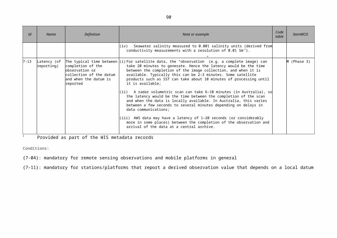
92
3. ATTRIBUTES SPECIFIC TO THE SURFACE-BASED SUBSYSTEM OF WIGOS
3.1. REQUIREMENTS
Note: The user observational requirements of WMO application areas are expressed in a technology-free manner, hence they apply to all of WIGOS, not to any specific subsystem. The provisions of section 2.1 apply across all WIGOS subsystems.
3.2. DESIGN, PLANNING AND EVOLUTION
3.2.1 Composition of the surface-based subsystem of WIGOS
3.2.1.1 The WIGOS surface-based subsystem shall be composed of surface stations within the component networks (for example, GOS, GAW, WHOS, GCW).
3.2.1.2 Members should implement elements of the WIGOS surface-based subsystem under the coordination of regional associations when appropriate.
Note: Information regarding the current capabilities of the surface-based subsystem is to be available through the OSCAR tool at http://www.wmo.int/oscar.
3.3. INSTRUMENTATION AND METHODS OF OBSERVATION
3.3.1 General requirements
3.3.1.1 Members shall classify their surface meteorological and climatological observing stations on land.
Note: The Guide to Meteorological Instruments and Methods of Observation (WMO-No. 8), Part I, Chapter 1, 1.1.2, Annex 1.B, provides guidelines on the classification of surface observing sites on land to indicate their representativeness for the measurement of different variables. The content of Annex 1.B will be included as an appendix in a future edition of the present Manual.
3.3.1.2 Members should locate each observing station at a site that permits instrument exposure against the requirements of the particular application and enables satisfactory non-instrumental observations.
Notes:
1. The Guide to Meteorological Instruments and Methods of Observation (WMO-No. 8), Part I, Chapter 1, Annexes 1.B and 1.C provides further guidelines.
2. Requirements for GAW stations are formulated in section 6.
3.3.1.3 Members shall accurately ascertain and refer the position of a station to the World Geodetic System 1984 (WGS-84) and its Earth Geodetic Model 1996 (EGM96).
Notes:
1. Guidelines are provided in the Guide to Meteorological Instruments and Methods of Observation (WMO-No. 8), Part I, Chapter 1, 1.3.3.2.
2. The WGS-84 is currently not in general use in hydrology. Its description will be included as an appendix in a future edition of the present Manual.
3.3.1.4 Members shall define the elevation of the station.

93
Note: The Guide to Meteorological Instruments and Methods of Observation (WMO-No. 8), Part I, Chapter 1, 1.3.3.2(c), provides guidelines on defining the elevation of a station. This material will be included as an appendix in a future edition of the present Manual.
3.3.1.5 If a station is located at an aerodrome, Members shall specify the official elevation of the aerodrome in accordance with the Technical Regulations (WMO-No. 49), Volume II, Part II, Appendix 3, 4.7.2.
3.3.1.6 Members operating Regional Instrument Centres should follow the guidelines concerning capabilities and corresponding functions.
Note : The Guide to Meteorological Instruments and Methods of Observation (WMO-No. 8), Part I, Annex 1.A, provides guidelines concerning capabilities and corresponding functions for Regional Instrument Centres. This material will be included as an appendix in a future edition of the present Manual.
3.3.1.7 Members operating Regional Marine Instrument Centres should follow the guidelines concerning capabilities and corresponding functions.
Note : The Guide to Meteorological Instruments and Methods of Observation (WMO-No. 8), Part II, Chapter 4, Annex 4.A, provides guidelines concerning capabilities and corresponding functions for operating Regional Marine Instrument Centres. This material will be included as an appendix in a future edition of the present Manual.
3.3.2 Requirements for sensors
3.3.2.1 Members shall avoid the use of mercury in their observing systems. Where mercury is still in use, Members shall obey the safety precautions provided.
Note: The Guide to Meteorological Instruments and Methods of Observation (WMO-No. 8), Part I, Chapter 3, 3.2.7, provides safety precautions for the use of mercury. This material will be included as an appendix in a future edition of the present Manual.
3.3.2.2 For inflation of meteorological balloons, Members should prefer helium over hydrogen. If hydrogen is used, however, Members shall obey the safety precautions provided.
Note: The Guide to Meteorological Instruments and Methods of Observation (WMO-No. 8), Part II, Chapter 10, 10.6.1, provides safety precautions for the use of hydrogen. This material will be included as an appendix in a future edition of the present Manual.
3.3.2.3 Members shall calibrate all pyrheliometers, other than absolute pyrheliometers, by comparison, using the sun as the source, with a pyrheliometer that is traceable to the World Standard Group and has a likely uncertainty of calibration equal to or better than the pyrheliometer being calibrated.
Note: The Guide to Meteorological Instruments and Methods of Observation (WMO-No. 8), Part I, Chapter 7, 7.2.1.4, provides detailed guidelines on calibration of pyrheliometers.
3.3.2.4 Members shall compare, calibrate and maintain barometers according to the guidelines.
Note: The Guide to Meteorological Instruments and Methods of Observation (WMO-No. 8), Part I, Chapter 3, 3.10, provides guidelines on the comparison, calibration and maintenance of barometers. This material will be included as an appendix in a future edition of the present Manual.
3.4. OPERATIONS
3.4.1 General requirements
Members operating surface-based observing systems shall follow the provisions of section 2.4.1.

94
3.4.2 Observing practices
3.4.2.1 Members shall ensure that the exposure, when applicable, of instruments for the same type of observation at different stations is similar so that observations may be compatible.
3.4.2.2 Members shall determine a reference height for each surface observing station or system.
Note: A reference height is defined as follows:
(a) Elevation of the station: it is the datum level to which barometric pressure reports at the station refer; such current barometric values are termed "station pressure" and are understood to refer to the given level for the purpose of maintaining continuity in the pressure records;
(b) For stations not located on aerodromes: elevation (height above mean sea level) of the ground on which the raingauge stands or, if there is no raingauge, of the ground beneath the thermometer screen. If there is neither raingauge nor screen, it is the average level of terrain in the immediate vicinity of the station, expressed in metres rounded up to two decimals;
(c) For stations located on aerodromes it is an official altitude of the aerodrome.
3.4.3 Quality control
Members operating surface-based observing systems shall follow the provisions of section 2.4.3.
3.4.4 Data and metadata reporting
Members operating surface-based observing systems shall follow the provisions of section 2.4.4.
3.4.5 Incident management
Members operating surface-based observing systems shall follow the provisions of section 2.4.5.
3.4.6 Change management
Members should compare observations from new instruments over an extended interval before the old measurement system is taken out of service or when there has been a change of site. Where this procedure is impractical at all sites, Members should carry out comparisons at selected representative sites.
Notes:
1. This does not apply to all types of station; among the exceptions are hydrological stations.
2. Further details, including the required minimum intervals for such comparison, can be found in the Guide to Climatological Practices (WMO-No. 100).
3.4.7 Maintenance
Observing sites and instruments should be maintained regularly so that the quality of observations does not deteriorate significantly between station inspections.
Note: Detailed guidance on maintenance of observing sites, observing systems and instruments is given in the Guide to Meteorological Instruments and Methods of Observation (WMO-No. 8), the Guide to Hydrological Practices (WMO-No. 168) and the Manual on Stream Gauging (WMO-No. 1044).
3.4.8 Inspection and supervision
3.4.8.1 Members shall arrange for their surface observing sites, stations and systems to be inspected at sufficiently frequent intervals to ensure that a high standard of observations is maintained, that instruments and all their indicators are functioning correctly, and that the exposure, when applicable, of the instruments has not changed significantly.

95
Notes:
1. Detailed guidance on the inspection, including frequency, is given in the Guide to Meteorological Instruments and Methods of Observation (WMO-No. 8), Part III, Chapter 1.
2. Reference is made to the Technical Regulations (WMO-No. 49), Volume II, for provisions on the inspection of aeronautical meteorological stations including its frequency.
3.4.8.2 Members shall ensure that the inspection is performed by qualified and adequately trained staff.
3.4.8.3 When performing inspections, Members should ensure that:
(a) The siting, selection and installation, as well as exposure when applicable, of instruments are known, recorded and acceptable;
(b) Instruments have approved characteristics, are in good order and regularly checked against relevant standards;
(c) There is uniformity in the methods of observation and in the procedure for reduction of observations.
Note: Detailed guidance on inspection and supervision of observing systems and sites is given in the Guide to Meteorological Instruments and Methods of Observation (WMO-No. 8), which includes guidelines on GAW measurements (see Part I, chapter 16), the Guide to Hydrological Practices (WMO-No. 168) and the Manual on Stream Gauging (WMO-No. 1044).
3.4.9 Calibration procedures
Members operating surface-based observing systems shall follow the provisions of section 2.4.9.
3.5 OBSERVATIONAL METADATA
Note: Detailed guidance regarding the establishment, maintenance and update of metadata records is given in the Guide to Meteorological Instruments and Methods of Observation (WMO-No. 8), Part I, Chapter 1, 1.3.4, and Part III, Chapter 1, 1.9; the Guide to Climatological Practices (WMO-No. 100), Chapter 3, 3.3.4; the Guide to the Global Observing System (WMO-No. 488), Appendix III.3, and the Guide to Hydrological Practices (WMO-No. 168), Volume I, Chapter 10.
Members operating surface-based observing systems shall follow the provisions of section 2.5.
Note: Further provisions specific to the WIGOS component observing systems appear in sections 5, 6, 7 and 8.
3.6. QUALITY MANAGEMENT
Members operating surface-based observing systems shall follow the provisions of section 2.6.
Note: Further provisions specific to the WIGOS space-based subsystem appear in section 4; those specific to the WIGOS component observing systems appear in sections 5, 6, 7 and 8.
3.7. CAPACITY DEVELOPMENT
Members operating surface-based observing systems shall follow the provisions of section 2.7.
Note: Further provisions specific to the WIGOS space-based subsystem appear in section 4; those specific to the WIGOS component observing systems appear in sections 5, 6, 7 and 8.

96
SECTION: Chapter
Chapter title in running head: 4. ATTRIBUTES SPECIFIC TO THE SPACE-BAS…
4. ATTRIBUTES SPECIFIC TO THE SPACE-BASED SUBSYSTEM OF WIGOS
4.1. REQUIREMENTS
4.1.1 General
Members shall strive to develop, implement and operate a space-based environmental observing system in support of WMO Programmes as described in Attachment 4.1.
Note: The space-based subsystem of WIGOS is established through dedicated satellites, remotely observing the characteristics of the atmosphere, the Earth and the oceans.
4.1.2 Observed variables
This subsystem shall provide quantitative data enabling, independently of or in conjunction with surface-based observations, the determination of variables including but not limited to:
(a) Three-dimension fields of atmospheric temperature and humidity;
(b) Temperature of sea and land surfaces;
(c) Wind fields (including ocean surface winds);
(d) Cloud properties (amount, type, top height, top temperature and water content);
(e) Radiation balance;
(f) Precipitation (liquid and frozen);
(g) Lightning;
(h) Ozone concentration (total column and vertical profile);
(i) Greenhouse gas concentration;
(j) Aerosol concentration and properties;
(k) Volcanic ash cloud occurrence and concentration;
(l) Vegetation type and status, and soil moisture;
(m) Flood and forest fire occurrence;
(n) Snow and ice properties;
(o) Ocean colour;
(p) Wave height, direction and spectra;
(q) Sea level and surface currents;
(r) Sea ice properties;

97
(s) Solar activity;
(t) Space environment (electric and magnetic field, energetic particle flux and electron density).
Note: Information regarding the current capabilities of the space-based subsystem is available through the OSCAR tool at: www.wmo.int/oscar.
4.1.3 Observing performance requirements
Satellite operators providing observational data to WIGOS shall strive to meet, to the extent possible, the uncertainty, timeliness, temporal and spatial resolution, and coverage requirements of WIGOS as defined in the WIR, based on the Rolling Review of Requirements described in section 2.
Notes:
1. In the present Manual, the term “satellite operators” refers to Members or a coordinated group of Members operating environmental satellites.
2. A coordinated group of Members operating environmental satellites acts jointly to operate one or more satellites through an international space agency such as the European Space Agency or the European Organization for the Exploitation of Meteorological Satellites (EUMETSAT).
3. These requirements are recorded and maintained in the requirements database: http://www.wmo.int/oscar.
4.1.4 Global planning
Satellite operators shall cooperate to ensure that a constellation of satellite systems is planned and implemented to guarantee the continuous provision of space-based observations in support of WMO Programmes.
Note: Collaboration is pursued within the Coordination Group for Meteorological Satellites, which includes all Members operating space-based observation systems in support of WMO Programmes.
4.1.5 Continuity
Satellite operators working together under the auspices of the Coordination Group for Meteorological Satellites or otherwise, should ensure the continuity of operation and of the data dissemination and distribution services of the operational satellites within the subsystem, through appropriate contingency arrangements and relaunch plans.
4.1.6 Overlap
Satellite operators should ensure an adequate period of overlap of new and old satellite systems in order to determine inter-satellite instrumental biases and maintain the homogeneity and consistency of time series observations, unless reliable transfer standards are available.
4.1.7 Interoperability
4.1.7.1 Satellite operators shall achieve the greatest possible interoperability of their different systems.
4.1.7.2 Satellite operators shall make available sufficient technical details about the instruments, data processing, transmissions and dissemination schedules for Members to fully exploit the data.
4.2. DESIGN, PLANNING AND EVOLUTION
Note: The space-based subsystem is composed of:

98
(a) An Earth observation space segment;
(b) An associated ground segment for data reception, processing, dissemination and stewardship;
(c) A user segment.
4.2.1 Space segment architecture
Note: The overall architecture of the space segment is described in Attachment 4.1. It is defined and evolves in consultation with the Coordination Group for Meteorological Satellites.
It includes:
(a) A constellation of geostationary satellites;
(b) A core constellation of sun-synchronous satellites distributed over three separate orbital planes;
(c) Other operational satellites operated on either sun-synchronous orbits or other appropriate low Earth orbits;
(d) Research and development satellites on appropriate orbits.
4.2.2 Space programme life cycles
Satellite operators shall consider a trade-off between the need for a long series to pay off the development cost and the user learning curve, on one hand, and the need to develop a new generation in order to benefit from state-of-the-art technology, on the other hand.
Notes:
1. The development of an operational satellite programme is conducted in several phases including: definition of user requirements, feasibility assessment at system level, preliminary design, detailed design, development and testing of the subsystems, integration of all subsystems, system testing, launch campaign and on-orbit commissioning. The overall duration of these development phases is typically of the order of 10 to 15 years.
2. The exploitation phase for an operational programme including a series of recurring satellites is typically of the order of 15 years.
4.3. INSTRUMENTS AND METHODS OF OBSERVATION
Notes:
1. Space-based observation relies on a wide range of sensor types, for example, active or passive, operating in various spectral ranges, and with various scanning or pointing modes. Information on the principles of Earth observation from space, the different types of space-based instrument and the derivation of geophysical variables from space-based measurements can be found in the Guide to Instruments and Methods of Observation (WMO-No. 8), 2014 edition, Part III, chapter 5.
2. Detailed characteristics of current and planned systems of environmental satellites are available in the satellite module of the OSCAR tool, which is available on line (http://www.wmo.int/oscar/space). It also contains an indication of the main instruments that are relevant for each specific variable observable from space, with their potential performance for the respective variables.
4.3.1 Calibration and traceability
4.3.1.1 Satellite operators shall perform a detailed instrument characterization before launch.
Note: Members must strive to follow the pre-launch instrument characterization guidelines recommended by the Global Space-based Inter-calibration System.

99
4.3.1.2 After launch, satellite operators shall calibrate all instruments on a routine basis against reference instruments or calibration targets.
Notes:
1. Advantage should be taken of satellite collocation to perform on-orbit instrument intercomparison and calibration.
2. Calibration must be done in accordance with methodologies established and documented by the Global Space-based Inter-calibration System and the Committee on Earth Observation Satellites (CEOS) Working Group on Calibration and Validation.
4.3.1.3 Satellite operators shall ensure traceability to the International System of Units (SI) standards.
Note: The Implementation Plan for the Global Observing System for Climate in Support of the UNFCCC (2010 Update), GCOS-138 (WMO/TD-No. 1523) calls for sustained measurement of key variables from space traceable to reference standards and recommends implementing and evaluating a satellite climate calibration mission.
4.3.1.4 To ensure traceability to the International System of Units (SI) standards, satellite operators shall define a range of ground-based reference targets for calibration purposes.
4.4. SPACE SEGMENT IMPLEMENTATION
4.4.1 Operational satellites on Geostationary Earth Orbit
4.4.1.1 Satellite operators should implement an operational constellation of satellites in geostationary orbit as described in Attachment 4.1.
4.4.1.2 Satellite operators shall ensure that the constellation of satellites in geostationary orbit provides full disc imagery at least every 15 minutes and achieves coverage of all longitudes, throughout a field of view between 60° S and 60° N.
Note: This implies the availability of at least six operational geostationary satellites if located at evenly distributed longitudes, with in-orbit redundancy.
4.4.1.3 Satellite operators should implement rapid-scan capabilities where feasible.
4.4.1.4 For the imagery mission in geostationary orbit, satellite operators should ensure an availability rate of rectified and calibrated data of at least 99% as a target.
4.4.1.5 To meet the essential requirement for continuity of data delivery, satellite operators shall strive to implement contingency plans, involving the use of in-orbit standby flight models and rapid call-up of replacement systems and launches.
4.4.2 Core operational constellation on sun-synchronous low Earth orbits
4.4.2.1 Operators of low Earth orbit (LEO) satellites should implement a core operational constellation of satellites in three regularly distributed sun-synchronous orbits as described in Attachment 4.1.
4.4.2.2 Operators of the core constellation of environmental LEO satellites on three sun-synchronous orbital planes, in early morning, mid-morning and afternoon orbit, shall strive to ensure a high level of robustness to permit the delivery of imagery and sounding data from at least three polar orbiting planes, on not less than 99% of occasions.
Note: This implies provisions for a ground segment, instrument and satellite redundancy, and rapid call-up of replacement launches or in-orbit spares.

100
4.4.3 Other capabilities on low Earth orbits
Operators of environmental LEO satellites should implement capabilities in appropriate orbits as described in Attachment 4.1.
4.4.4 Research and development satellites
4.4.4.1 Operators of research and development satellites shall consider providing the following observing capabilities:
(a) Advanced observation of the parameters necessary to understand and model the water cycle, the carbon cycle, the energy budget and the chemical processes of the atmosphere;
(b) Pathfinders for future operational missions.
Note: For WMO, the main benefits of research and development satellite missions are:
(a) Support of scientific investigations of atmospheric, oceanic and other environment-related processes;
(b) Testing or demonstration of new or improved sensors and satellite systems in preparation for new generations of operational capabilities to meet WMO observational requirements.
4.4.4.2 Members shall strive to maximize the usefulness of observations from research and development satellites for operational applications. In particular, operators of research and development satellites shall make provisions, where possible, to enable near-real-time data availability to promote the early use of new types of observations for operational applications.
Notes:
1. Although neither long-term continuity of service nor a reliable replacement policy are assured, research and development satellites provide, in many cases, observations of great value for operational use.
2. Although they are not operational systems, research and development satellites have proven to support operational meteorology, oceanography, hydrology and climatology substantially.
4.5 GROUND SEGMENT IMPLEMENTATION
4.5.1 General
4.5.1.1 Satellite operators shall make observational data available to Members through the WMO Information System (WIS) in accordance with the provisions in the Manual on the WMO Information System (WMO-No. 1060). Satellite operators shall inform Members of the means of obtaining these data through catalogue entries and shall provide sufficient metadata to enable meaningful use of the data.
4.5.1.2 Satellite operators shall set up facilities for the reception of remote-sensing data (and Data Collection System data when relevant) from operational satellites, and for the processing of quality-controlled environmental observation information, with a view to further near-real-time distribution.
4.5.1.3 Satellite operators shall strive to ensure that data from polar-orbiting satellites are acquired on a global basis, without temporal gaps or blind orbits, and that data latency meets WMO timeliness requirements.

101
4.5.2 Data dissemination
4.5.2.1 Satellite operators shall ensure near-real-time dissemination of the appropriate data sets, as per the requirements of Members, either by direct broadcast via an appropriately designed ground segment, or by rebroadcast via telecommunication satellites.
4.5.2.2 In particular, operators of operational sun-synchronous satellites providing the core meteorological imagery and sounding mission should ensure inclusion of a direct broadcast capability as follows:
(a) Direct broadcast frequencies, modulations and formats should allow a particular user to acquire data from the satellite with a standardized antenna and signal processing hardware. To the extent possible, the frequency bands allocated to meteorological satellites should be used;
(b) Direct broadcast shall be provided through a high data rate stream, such as the High- resolution Picture Transmission (HRPT) or its subsequent evolution, to provide meteorological centres with all the data required for numerical weather prediction (NWP), nowcasting and other real-time applications;
(c) If possible, a low data rate stream should also be provided, such as the Low-rate Picture Transmission (LRPT), to convey an essential volume of data to users with lower connectivity or low-cost receiving stations.
4.5.2.3 Satellite operators shall consider implementing rebroadcast via telecommunication satellites to complement and supplement direct broadcast services and to facilitate access to integrated data streams, including data from different satellites, to non-satellite data and to geophysical data products.
4.5.2.4 Operators of operational geostationary meteorological satellites with rapid-scan capabilities shall strive to provide meteorological centres with data in near-real time as required for nowcasting, NWP and other real-time applications.
4.5.3 Data stewardship
4.5.3.1 Satellite operators shall provide a full description of all processing steps taken in the generation of satellite data products, including algorithms, characteristics and outcomes of validation activities.
4.5.3.2 Satellite operators shall preserve long-term raw data records and ancillary data required for their calibration and reprocessing as appropriate, with the necessary traceability information to achieve consistent Fundamental Climate Data Records.
4.5.3.3 Satellite operators shall maintain Level 1B satellite data archives including all relevant metadata pertaining to the location, orbit parameters and calibration procedures used.
4.5.3.4 Satellite operators shall ensure that their archiving system is capable of providing on-line access to the archive catalogue with a browsing facility, that it provides adequate description of data formats and will allow users to download data.

102
4.5.4 Data collection systems
4.5.4.1 Satellite operators with a capability to receive data and/or products from Data Collection Platforms (DCP) shall maintain technical and operational coordination under the auspices of the Coordination Group for Meteorological Satellites (CGMS) in order to ensure compatibility.
4.5.4.2 Satellite operators shall maintain a number of “international” DCP channels, which should be identical on all geostationary satellites, to support the operation of mobile platforms moving across all individual geostationary footprints.
4.5.4.3 Satellite operators shall publish details of the technical characteristics and operational procedures of their data-collection missions, including the admission and certification procedures.
4.5.5 The user segment
4.5.5.1 Operators of research and development satellites shall implement capabilities enabling Members to access the data in one of the following ways: by downloading data from server(s) or by receiving data from a rebroadcasting service or a direct broadcast capability.
4.5.5.2 Members shall endeavour to install and maintain in their territory at least one system enabling access to digital data from both LEO and geostationary operational satellite constellations: either a receiver of rebroadcast service providing the required information in an integrated way, or a combination of dedicated direct readout stations.
4.5.5.3 Where appropriate, Members should strive to utilize fixed or moving DCP systems (for example, to cover data-sparse areas) to take advantage of the data-collection and relay capability of the environmental observation satellites.
4.6. OBSERVATIONAL METADATA
For each space-based system they operate, satellite operators shall record, retain and make available observational metadata in accordance with the provisions of section 2.5.
4.7. QUALITY MANAGEMENT
Satellite operators shall include appropriate quality indicators in the metadata for each dataset, in accordance with the provisions of section 2.5.
4.8. CAPACITY DEVELOPMENT
4.8.1 Centres of excellence
Satellite operators, and other Members having the capability to do so, shall provide support to the education and training of instructors in the use of satellite data and capabilities, at specialized Regional Training Centres or other training institutes designated as centres of excellence in satellite meteorology, in order to build up expertise and facilities at a number of regional growth points.

103
4.8.2 Training strategy
Satellite operators should focus their assistance, to the extent possible, on one or more of these centres of excellence within their service areas and contribute to the Virtual Laboratory for Education and Training in Satellite Meteorology.
Note: The aim of the education and training strategy implemented through the Virtual Laboratory is to systematically improve the use of satellite data for meteorology, operational hydrology, and climate applications, with a focus on meeting the needs of developing countries.
4.8.3 User preparation for new systems
4.8.3.1 In order to facilitate a smooth transition to new satellite capabilities, satellite operators should take steps to prepare users through training, guidance on necessary upgrades of receiving equipment and processing software, and the provision of information and tools to facilitate the development and testing of user applications.
4.8.3.2 In addition to working through the Virtual Laboratory, Members should, as appropriate, exploit partnerships with organizations providing education and training in environmental satellite applications, depending on their specific needs.
4.8.4 Collaboration between users and data providers
4.8.4.1 In order to achieve the most effective utilization of satellite data, Members should pursue close collaboration between users and data providers at a regional level.
4.8.4.2 Working with their regional association, Members should follow systematic steps to document the regional requirements for satellite data access and exchange.
SECTION: Chapter
Chapter title in running head: ATTACHMENT 4.1. CGMS BASELINE FOR THE O…
ATTACHMENT 4.1. CGMS BASELINE FOR THE OPERATIONAL CONTRIBUTION TO THE GOS
(Adopted at the thirty-ninth meeting of the Coordination Group for Meteorological Satellites (CGMS-39) on 6 October 2011)
FUTURE SATELLITE MISSIONS TO BE PERFORMED ON OPERATIONAL/ SUSTAINED BASIS
INTRODUCTION
In support of the programmes coordinated or co-sponsored by WMO for weather and climate, CGMS Members plan to maintain the operational capabilities and services described below, that constitute the “CGMS baseline for the operational contribution to the GOS”.
While this particular document focuses on missions that are decided and managed in an operational or sustained framework, with a perspective of long-term follow-on, this in no way precludes the importance of other missions undertaken e.g. on a research or demonstration basis. First of all, because today’s research and development are the foundation of tomorrow’s operational missions. Furthermore, because many missions initiated in an R&D framework for a limited duration are eventually extended well beyond their design life time and provide longstanding support to both scientific and operational activities.

104
This baseline defines a constellation of geostationary satellites, a core meteorological mission on three sun-synchronous orbits, other missions in sun-synchronous orbits, missions in other Low Earth Orbits, and contains cross-cutting considerations on contingency planning, inter-calibration, data availability and dissemination.
I. CONSTELLATION IN GEOSTATIONARY ORBIT
At least six geostationary satellites shall be operated at evenly distributed locations with in orbit redundancy, and perform the following missions:
(a) Advanced visible and infrared imagery (at least 16 spectral channels, 2km resolution) over the full disc at least every 15 minutes;
(b) Infrared sounding (hyperspectral on some positions);
(c) Lightning detection;
(d) Data collection;
(e) Space environment monitoring.
On selected positions, the following missions shall be performed:
(f) Earth Radiation Budget monitoring;
(g) High spectral resolution UV sounding;
(h) Solar activity monitoring.
II. LEO SUN-SYNCHRONOUS MISSIONS
Operational sun-synchronous satellites shall be operated around three orbital planes in mid-morning (“am”, nominally 09:30 descending, 21:30 ascending ECT), afternoon (“pm”, nominally 13:30 ascending ECT) and early morning (nominally 05:30 descending, 17:30 ascending ECT) and, as a constellation, shall perform the following missions:
1) Core meteorological mission nominally on three orbital planes:
(i) Multispectral visible and infrared imagery;
(j) Infrared hyperspectral sounding (at least am and pm);
(k) Microwave sounding;
(l) Microwave imagery.
2) Other missions on sun-synchronous orbits:
(m) Wind scatterometry over sea surfaces (at least two orbital planes);
(n) Ocean surface topography by radar altimetry (at least on am and pm orbits, supplemented by a reference mission on a high-precision, inclined orbit);
(o) Radio-occultation sounding (at least am and pm, supplemented by a constellation in specific orbits);
(p) Broadband VIS/IR radiometer for Earth Radiation balance (at least am and pm);

105
(q) Total Solar Irradiance (at least one);
(r) Contribution to atmospheric composition observations (at least am and pm);
(s) Narrow-band Vis/NIR imagers (at least one sun-synchronous, am spacecraft) for ocean colour, vegetation and aerosol monitoring;
(t) High-resolution multi-spectral Vis/IR imagers (constellation of sun-synchronous satellites, preferably in am);
(u) IR dual-angle view imagery for high-accuracy SST (at least one am spacecraft);
(v) Particle detection and/or electron density (at least am and pm);
(w) Magnetic field (at least am and pm);
(x) Solar activity (at least two missions);
(y) Data collection.
III. OTHER LEO MISSIONS
The following missions shall be performed on an operational basis by Low Earth Orbit satellites on appropriate orbits:
(z) Ocean surface topography by radar altimetry (A reference mission on high-precision, inclined orbit, complementing two instruments on sun-synchronous am and pm orbit);
(aa) Radio-occultation sounding (dedicated constellation of sensors on appropriate orbits).
IV. CONTINGENCY PLANNING
The CGMS baseline is associated with contingency plans for geostationary and polar-orbiting satellite systems, which are detailed in the CGMS Global Contingency Plan1.
V. INTER-CALIBRATION
Instruments should be inter-calibrated on a routine basis against reference instruments or calibration sites. The routine and operational inter-calibration and corrections shall be performed in accordance with standards as agreed by the Global Space-based Inter-calibration System (GSICS).
VI. DATA AVAILABILITY AND DISSEMINATION
VI.1. Data open availability with suitable timeliness
All operational environmental observation satellite systems should be designed to ensure the provision of data with suitable timeliness, as appropriate for their intended applications. Data should be preserved for the long term and documented with metadata allowing their interpretation and utilization. The satellite operators should establish dissemination contents and schedules that take into account the data requirements of users. Re-broadcast via telecommunication satellites should complement and supplement
1 The Global Contingency Plan (http://www.wmo.int/pages/prog/sat/documents/CGMS_Contingency-Plan-2007.pdf) should be updated accordingly. It should indicate that in case of potential gaps on core sun-synchronous missions, absolute priority should be given to observation from mid-morning and early afternoon orbits, in order to maintain the continuity of these datasets.

106
direct broadcast services, which allows cost-efficient access to integrated data streams including data from different satellites, non-satellite data and geophysical products. The dissemination systems should utilize all-weather resilient telecommunication means.
VI.2. Direct broadcast for core meteorological missions in LEO
The core meteorological satellite systems in LEO orbits, and other operational observation satellite systems when relevant, should ensure near real-time data dissemination of imagery, sounding, and other real-time data of interest to Members by direct broadcast. Direct broadcast frequencies, modulations, and formats for polar-orbiting satellites should allow a particular user to acquire data from either satellite by a single antenna and signal processing hardware. Direct Broadcast should use allocations in all-weather resilient frequency bands.
VII. NOTE
The present update of the CGMS baseline is adopted in the light of satellite mission plans as they are known in October 2011.
SECTION: Chapter
Chapter title in running head: 5. ATTRIBUTES SPECIFIC TO THE GLOBAL OB…
5. ATTRIBUTES SPECIFIC TO THE GLOBAL OBSERVING SYSTEM OF THE WORLD WEATHER WATCH
Notes:
1. The provisions of sections 1, 2, 3 and 4 are common to all WIGOS component observing systems including the GOS.
2. Provisions specific to the GOS are currently set out in the Manual on the Global Observing System (WMO-No. 544), Volume I.
SECTION: Chapter
Chapter title in running head: 6. ATTRIBUTES SPECIFIC TO THE OBSERVING…
6. ATTRIBUTES SPECIFIC TO THE OBSERVING COMPONENT OF THE GLOBAL ATMOSPHERE WATCH
Note: The provisions of sections 1, 2, 3 and 4 are common to all WIGOS component observing systems, including GAW. The provisions in this section are specific to GAW.
6.1. REQUIREMENTS
6.1.1 Members should perform the observations of atmospheric composition and related physical parameters using a combination of surface-based stations and platforms (fixed stations, mobile platforms and remote sensing) and space-based platforms.
6.1.2 Members should use the requirements from the RRR process, particularly in the area of atmospheric chemistry application, in developing their GAW stations.

107
Notes:
1 The user requirements are reviewed on a regular basis through the RRR process by the Scientific Advisory Groups (SAGs) for each variable, in consultation with the user community and with input from Members. The RRR process is described in section 2.2.4 and Appendix 2.1.
2. Scientific Advisory Groups exist for the six GAW focal areas and their terms of reference are defined by the Commission for Atmospheric Sciences.
6.1.3 Members should follow the Data Quality Objectives specified by the GAW Programme for the individual variables observed.
6.1.4 Members should establish and operate their GAW stations so that they satisfy the station requirements specified in Attachment 6.1.
6.1.5 Members operating GAW stations shall undertake long-term and uninterrupted operation with the stability and continuity of data collection required for the purposes outlined in 6.2.1.
6.2. DESIGN, PLANNING AND EVOLUTION
6.2.1 Members should design, plan and further develop their GAW observing network and stations to address user requirements, in particular those that concern key environmental issues and application areas, including but not limited to the following:
(a) Stratospheric ozone depletion and increase of UV radiation;
(b) Changes in the weather and climate due to human influence on atmospheric composition, particularly changes in greenhouse gases, ozone and reactive gases, and aerosols;
(c) Risk assessment of air pollution and UV on human health and the environment, and issues involving long-range transport of air pollution and its deposition.
6.2.2 Members should contribute observations through operating or supporting suitable platforms at GAW stations and/or through contributing networks.
6.2.3 When doing so, Members shall register their contribution in GAWSIS and submit their observations to the relevant GAW Data Centre.
6.2.4 Members operating a contributing network shall provide a description of the network, register the stations in GAWSIS and provide corresponding metadata.
6.2.5 Members should ensure that the frequency and spacing of the various observations is suited to the temporal and spatial requirements of the specific issues addressed in section 6.2.1.
6.3. INSTRUMENTATION AND METHODS OF OBSERVATION
6.3.1 General requirements of instruments
Members should use recommended types of instruments and methods of observation for variables observed at their stations, and follow further available guidance.
Notes:
1. Guidance is provided in the Standard Operating Procedures (SOPs) and measurement guidelines.
2. Instruments suitable for use at GAW sites are defined by the SAGs for each parameter, in terms of stability, precision and accuracy.

108
3. Standard Operating Procedures describe the standard approach to operate this kind of instrument.
4. The measurement guidelines describe the standard approach for this kind of measurement regardless of the instrument.
6.3.2 Calibration and traceability
6.3.2.1 Members shall perform calibrations and maintain traceability to the GAW primary standards, where available.
Notes:
1 The GAW primary standard is a single network standard, assigned by WMO for each individual variable. In the case of contributing networks, network observations are traceable to the network standard, which in turn is traceable to the GAW primary standard.
2. Details on calibrations are specified by the SOPs and measurement guidelines.
6.3.2.2 Members should utilize GAW central facilities to sustain the global compatibility of observations.
Note: The GAW central facilities include: Central Calibration Laboratories, World Calibration Centres, Regional Calibration Centres and Quality Assurance/Science Activity Centres.
6.4. OPERATIONS
6.4.1 Monitoring observing system implementation
6.4.1.1 Members shall monitor the operation of GAW stations for which they are responsible and ensure that they follow the relevant procedures for quality assurance and data submission. Members shall seek assistance from central facilities, SAGs and expert teams if operational problems cannot be solved locally.
Note: The procedures to be used in monitoring the operation of GAW are determined within the Commission for Atmospheric Sciences (CAS) in consultation with the participating Members.
6.4.1.2 Members should systematically monitor compliance with GAW regulations, in collaboration with relevant constituent bodies and the Secretariat, in order to identify critical cases of non-compliance (deficiencies) and undertake measures for their timely resolution.
6.4.2 Quality assurance
6.4.2.1 Members should follow specified quality assurance practices and procedures.
Note: Details are given in the GAW SOPs and measurement guidelines and in further documents provided by the SAGs and central facilities.
6.4.2.2 Members shall maintain detailed metadata records in accordance with procedures and practices specified in this Manual.
6.4.2.3 Members should participate in independent evaluations of quality of observations, including intercomparisons and system audits, as appropriate for the observed variables.
6.4.2.4 Members shall permit World Data Centres to perform an independent evaluation of the data quality of their observations.

109
6.4.3 Data and metadata representation and format
6.4.3.1 Members shall submit their observational data and associated metadata to the relevant GAW World Data Centres for the variables observed at the station within agreed time limits.
6.4.3.2 Members shall use the formats specified by the relevant World Data Centre when submitting their observational data and metadata.
6.5. OBSERVATIONAL METADATA
Note: The general provisions on observation metadata are specified in section 2.5.
6.5.1 Members shall provide metadata associated with instrumentation, site or platform, and calibration history as requested by the World Data Centre for each parameter and by GAWSIS.
6.5.2 Members shall provide such additional metadata as required by GAWSIS and any World Data Centre to which they contribute that are necessary to understand their observations.
6.6. QUALITY MANAGEMENT
Note: The general regulations on quality management are specified in section 2.6.
6.7. CAPACITY DEVELOPMENT
Note: General provisions for capacity development are provided in sections 2.7, 3.7 and 4.7.
6.7.1 Members not capable of implementing required standards should establish agreements with appropriate central facilities or establish partnership with more experienced stations in the form of stations twinning.
Note: In some regions of the world, and for some GAW variables, where there is a clear lack of capacity, Members may be requested to help support a station, or existing stations may be approached to become part of GAW. Such requests and invitations come after approval by the appropriate SAGs.
6.7.2 Members should use the GAW Training and Education Centre (GAWTEC) programme, as available, for capacity-building and staff training in measurement of the specific GAW variables.
SECTION: Chapter
Chapter title in running head: ATTACHMENT 6.1. REQUIREMENTS FOR THE GL…
ATTACHMENT 6.1. REQUIREMENTS FOR THE GLOBAL ATMOSPHERE WATCH STATIONS
1. GENERAL
Essential characteristics of the Global Atmosphere Watch (GAW) regional stations:
(a) The station location is chosen such that, for the variables measured, it is regionally representative and is normally free of the influence of significant local pollution sources;

110
(b) There are adequate power, air conditioning, communication and building facilities to sustain long-term observations with greater than 90% data capture (i.e. <10% missing data);
(c) The technical support provided is trained in the operation of the equipment;
(d) There is a commitment by the responsible agency to long-term observations of at least one of the GAW variables in the GAW focal areas (ozone, aerosols, greenhouse gases, reactive gases, UV radiation and precipitation chemistry);
(e) The GAW observations made are of known quality and linked to the GAW primary standard;
(f) The data and associated metadata are submitted to one of the GAW World Data Centres (WDCs), typically no later than one year after the observations are made. Changes in metadata, including instrumentation, traceability and observation procedures, are reported to the responsible WDC in a timely manner;
(g) If required, observations are submitted to a designated data distribution system in near-real-time;
(h) Standard meteorological in situ observations, necessary for the accurate determination and interpretation of the GAW variables, are of known quality;
(i) The station characteristics and observational programme are updated in the GAW Station Information System (GAWSIS) on a regular basis;
(j) A station logbook (a record of observations made and of activities that may affect observations) is maintained and used in the data validation process.
1.1 Additional essential characteristics of GAW global stations
In addition to the essential characteristics of regional stations, GAW global stations should fulfil the following requirements:
(a) Measurement of variables in at least three of the six GAW focal areas;
(b) A strong scientific supporting programme with appropriate data analysis and interpretation within the country and, if possible, the support of more than one agency;
(c) Provision of a facility at which intensive campaigns can augment the long-term routine GAW observations and where testing and development of new GAW methods can be undertaken.
2. GAW CONTRIBUTING NETWORKS
The GAW contributing networks provide observations from multiple stations. The stations comprising contributing networks should satisfy the criteria of either regional or global stations taking into account the contributing network regulations (within the contributing network, data submission requirements or standard used can differ from those required for regional and global stations). Where the network standards differ from those of WMO, they must have a confirmed traceability to the WMO standards, where these exist. Data submission regulations for the contributing networks must be at least as stringent as those required within GAW. A station designation as global or regional, if such designation already exists for individual stations, always takes precedence over the designation as contributing station. To be used in global assessments, data from the contributing stations must be submitted to the GAW World Data Centres.

111
SECTION: Chapter
Chapter title in running head: 7. ATTRIBUTES SPECIFIC TO THE WMO HYDRO…
7. ATTRIBUTES SPECIFIC TO THE WMO HYDROLOGICAL OBSERVING SYSTEM
Note: The provisions of sections 1, 2, 3 and 4 are common to all WIGOS component observing systems, including the WHOS. The provisions of this section are specific to the WHOS.
7.1 REQUIREMENTS
7.1.1 Members shall establish and operate a hydrological observing system according to their national requirements.
7.1.2 Members should also operate their hydrological observing systems to address the requirements of the RRR process, in particular for the hydrology application area.
Notes:
1. A hydrological observing system includes networks of hydrological observing stations, as defined in Technical Regulations (WMO-No. 49), Volume III: Hydrology, Chapter D.1.1, which should make observations of the elements described in Chapter D.1.2.
2. Information on hydrological data transmission can be found in the Technical Regulations (WMO-No. 49), Volume III: Hydrology, Chapter D.1.4, [D.1.4.]1.2, which states: “Transmission facilities should be organized for the international exchange of hydrological data, forecasts and warnings on the basis of bilateral or multilateral agreement.” Further provisions for data transmission and international exchange through the WIS are given in the Technical Regulations (WMO-No. 49), Volume I, Part II, the Manual on the WMO Information System (WMO-No. 1060) and the Manual on the Global Telecommunication System (WMO-No. 386).
7.1.3 Members shall provide on a free and unrestricted basis those hydrological data and products which are necessary for the provision of services for the protection of life and property, and the well-being of all peoples.
7.1.4 Members should also provide, where available, additional hydrological data and products that are required by WMO Programmes and by Members as specified in paragraph 7.1.2.
7.1.5 At the global level, WHOS shall give Members access to near-real time hydrological observations from all Members.
Note: Currently, many Members are making such observations publicly available on the Internet.
7.1.6 Members should provide these sources of observations to the WHOS.
Note: Hydrological observations available through WHOS will initially comprise stage (water level) and discharge. This will likely expand over time to include other elements as identified in the Rolling Review of Requirements at the national, regional and global levels.
7.2 DESIGN, PLANNING AND EVOLUTION
Note: Design, planning and evolution is common to all WIGOS component observing systems.
Members should design and plan their observing network considering the review of the current and planned WHOS capabilities, undertaken as outlined in the RRR as described in section 2.2.4.
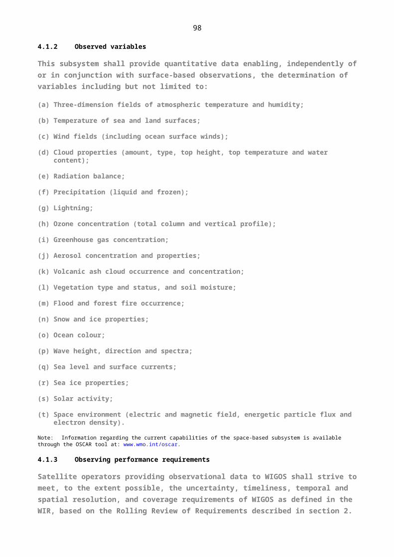
112
7.3 INSTRUMENTATION AND METHODS OF OBSERVATION
7.3.1 General requirements of instruments
7.3.1.1 Members should equip their stations with properly calibrated instruments and should arrange for these stations to follow adequate observational and measuring techniques to ensure that the measurements and observations of the various hydrological elements are accurate enough to address the needs of hydrology and other application areas.
Note: Technical Regulations (WMO-No. 49), Volume III: Hydrology, provides that Members should use instruments for measurement of stage (water level) in conformity with the specifications of its annex, section II: Water-level measuring devices.
7.3.1.2 Members should ensure that the uncertainty in the observation of the stage (water level) of rivers, estuaries, lakes and reservoirs does not exceed:
(a) In general, 10 mm at the 95% confidence level;
(b) Under difficult conditions, 20 mm at the 95% confidence level.
Note: Stage (water level) observations are used primarily as an index for computing streamflow discharge when a unique relation exists between stage (water level) and discharge.
7.3.2 Stage and discharge observations from hydrometric stations
Note: Technical Regulations (WMO-No. 49), Volume III: Hydrology, provides that Members should establish and operate hydrometric stations for measuring stage (water level), velocity and discharge in conformity with the specifications of its annex, section VI: Establishment and operation of a hydrometric station.
7.3.2.1 Members should ensure that the number of discharge measurements at a stream gauging station are adequate to define the rating curve for the station at all times.
Notes:
1. Technical Regulations (WMO-No. 49), Volume III: Hydrology, provides that Members should use the methods for determining the stage-discharge relation (rating curve) of a station as specified in its annex, section VII: Determination of the stage-discharge relation.
2. Technical Regulations (WMO-No. 49), Volume III: Hydrology, provides that Members should ensure, when undertaking moving-boat discharge measurements, that equipment and operational procedures are as specified in its annex, section XII: Discharge measurements by the moving-boat method.
7.3.2.2 Members should measure river discharges to an accuracy commensurate with flow and local conditions. Percentage uncertainty of the discharge measurement should not exceed:
(a) In general, 5% at the 95% confidence level;
(b) Under difficult conditions, 10% at the 95% confidence level.
Notes:
1. Technical Regulations (WMO-No. 49), Volume III: Hydrology, provides that Members should evaluate the uncertainty in discharge measurements in conformity with the specifications in its annex, section VIII: Estimation of uncertainty of discharge measurements.
2. Discharge measurements are taken to establish and verify the stability of a rating curve. Stage (water level) observations are converted to estimates of discharge using the rating curve on an ongoing basis.

113
7.3.3 Calibration procedures
Notes:
1. Technical Regulations (WMO-No. 49), Volume III: Hydrology, provides that Members should adhere to the specifications of facilities, equipment and procedure for the calibration of current meters as specified in its annex, section I: Calibration of current meters in straight open tanks.
2. Technical Regulations (WMO-No. 49), Volume III: Hydrology, provides that Members should ensure that operational requirements, construction, calibration and maintenance of rotating element current meters are as specified in its annex, section IV: Rotating element type current meters.
Members should recalibrate acoustic velocity meters on a routine basis to ensure stability of the calibration, using measurement standards traceable to international or national standards. Where no such standards exist, Members should record the basis used for calibration or verification.
Note: Additional information pertaining to the calibration of instruments can be found in the Guide to Hydrological Practices (WMO-No. 168), Volume I, and the Manual on Stream Gauging (WMO-No. 1044).
7.4 OPERATIONS
7.4.1 Observing practices
7.4.1.1 Members should collect and preserve their hydrological records.
7.4.1.2 Members should make the necessary arrangements to facilitate the retrieval and analysis of their hydrological observations by automatic data-processing equipment.
7.4.1.3 Where automatic registration is not available, Members should ensure that the observations of elements for hydrological purposes are made at regular intervals appropriate for the elements and their intended purposes.
7.4.1.4 Members should maintain in their archives an up-to-date inventory of their hydrological observations.
7.4.1.5 Members should generally ensure uniformity in time of observations within a catchment area.
7.4.1.6 Members should select the time units used in processing hydrological data for international exchange from the following:
(a) The Gregorian calendar year;
(b) The months of this calendar;
(c) The mean solar day, from midnight to midnight, according to the zonal time, when the data permit;
(d) Other periods by mutual agreement in the case of international drainage basins or drainage basins in the same type of region.
7.4.1.7 For hydrometric stations where data are internationally exchanged, Members should process the following characteristics for each year:
(a) Maximum instantaneous and minimum daily mean values of stages (water levels) and discharge;
(b) Mean daily stages (water levels) and/or mean daily discharges.
7.4.1.8 For rivers under flood conditions or where there are variable controls, Members should make special measurements at intervals frequent enough to define the hydrograph.

114
7.4.1.9 When sudden and dangerous increases in river levels occur, Members should make and report observations as soon as possible regardless of the usual time of observation, to meet the intended operational use.
7.4.1.10 Members should measure and store stage (water level) observations as instantaneous values rather than averaged values.
7.4.2 Quality control
7.4.2.1 Members should maintain detailed records for each station and for each parameter containing metadata related to the measurements, maintenance and calibration of equipment.
7.4.2.2 Members should perform periodic audits of their stations and collected data.
7.4.2.3 Members should ensure that recorded hydrological observations are converted to a form suitable for archiving and retrieval.
Note: Observations may be initially recorded using various media from paper to electronic digital form. As computer archiving has become a standard practice for most Members, it is advantageous to convert data to the required format early in the process.
7.4.2.4 Members should ensure that their data undergo, at various stages, a range of checks to determine their uncertainty and correctness.
7.4.2.5 With accelerating developments in technology, Members should ensure that data-processing and quality control systems are well-organized and that the relevant staff are trained to understand and use them.
Note: Data are collected and recorded in many ways, ranging from manual reading of simple gauges to a variety of automated data-collection, transmission and filing systems.
7.4.2.6 Members should consider the adoption of a quality management system, as described in section 2.6.
Note: Organizations usually employ an accredited certification agency to provide independent verification.
7.4.2.7 Members should undertake data processing and quality control as described in relevant publications.
Note: Such publications include the Guide to Hydrological Practices (WMO-No. 168), Volume I, Chapter 9, the Manual on Flood Forecasting and Warning (WMO-No. 1072), Chapter 6, and the Manual on Stream Gauging (WMO-No. 1044), Volume II, Chapter 6.
7.4.3 Observations and observational metadata reporting
7.4.3.1 Members should ensure, when providing hydrological information for international purposes, that open text or appropriate code forms are used as specified in bilateral or multilateral agreements.
7.4.3.2 Members should ensure that transmission facilities are organized for the international exchange of hydrological observations on the basis of bilateral or multilateral agreements.
7.4.3.3 In order to make data globally available for real-time exchange and discovery, access and retrieval, Members should report stage and discharge observations in compliance with WIS metadata standards.
Notes:
1. The WMO Information System may also be used for access to hydrological observations not required in real-time.
2. The regulations governing exchanges in international code forms are specified in the Manual on Codes (WMO-No. 306), Volume I.

115
3. Coded information exclusively for bilateral or multilateral exchange amongst Members may be in other forms by mutual agreement.
7.4.4 Incident management
Note: General provisions for incident management are provided in section 2.4.5.
7.4.5 Change management
Note: General provisions for change management are provided in section 2.4.6.
7.4.6 Maintenance
7.4.6.1 Members should determine the frequency and timing of visits to recording stations on the basis of the length of time that the station can be expected to function without maintenance and the uncertainty requirements of the data.
Notes:
1. There is a relation between the frequency of the visits and the resultant quality of the data collected. Too long a time between visits may result in frequent recorder malfunction and thus in loss of data, while frequent visits are both time consuming and costly.
2. Some data collection devices may suffer a drift in the relationship between the variable that is recorded and that which the recorded value represents. An example of this is a non-stable stage-discharge relationship.
3. Two visits per year are considered an absolute minimum; more frequent visits are recommended to decrease the potential loss of data and/or to avoid data being severely affected by problems such as silting, vandalism or seasonal vegetative growth.
7.4.6.2 Members should schedule periodic visits to the station to recalibrate the equipment or the measurement equations.
7.4.6.3 Members should periodically inspect stations using trained personnel to ensure the correct functioning of instruments.
7.4.6.4 Members should ensure that a formal written inspection is done routinely, preferably each year, to check overall performance of instruments and local observer, if applicable.
7.4.6.5 Members, when routinely inspecting sites, should:
(a) Measure gauge datum to check for and record any changes in levels;
(b) Check the stability of the rating curve and review the relationships between the gauges and permanent level reference points to verify that no movement of the gauges has taken place;
(c) Review the gauging frequency achieved and the rating changes identified;
(d) Undertake a number of maintenance activities as described in sections 7.4.6.8 and 7.4.6.9.
Note: It is vital, for the quality of data, that resources for gauging be allocated and prioritized using rigorous and timely analysis of the probability and frequency of rating changes.
7.4.6.6 Members should ensure that maintenance activities are conducted at data-collection sites at intervals sufficient to ensure that the quality of the data being recorded is adequate.
7.4.6.7 Members should ensure that such activities are conducted by the observer responsible for the sites, if there is one. Members should also ensure that maintenance activities are occasionally performed by an inspector.

116
7.4.6.8 Members should undertake the following maintenance activities at all collection sites:
(a) Service the instruments;
(b) Replace or upgrade instruments, as required;
(c) Retrieve or record observations;
(d) Perform the recommended checks on retrieved records;
(e) Carry out general checks of all equipment, for example, transmission lines;
(f) Check and maintain the site in accordance with the recommended specifications;
(g) Check and maintain access to the station;
(h) Record, in note form, all of the above activities;
(i) Comment on changes in land use or vegetation;
(j) Clear debris and overgrowth from all parts of the installation.
7.4.6.9 Members should undertake the following maintenance activities at discharge collection sites:
(a) Check the bank stability, as necessary;
(b) Check the level and condition of gauge boards, as necessary;
(c) Check and service the flow-measuring devices (cableways, etc.), as necessary;
(d) Check and repair control structures, as necessary;
(e) Regularly survey cross-sections and take photographs of major station changes after events or changes in vegetation or land-use;
(f) Record, in note form, all of the above activities and their results;
(g) Inspect the area around or upstream from the site, and record any significant land-use or other changes in related hydrological characteristics, such as ice.
Note: Further details are found in the Manual on Stream Gauging (WMO-No. 1044).
7.4.6.10 Members should have a well-trained technician or inspector visit stations immediately after every severe flood in order to check the stability of the river section and the gauges. If there is a local observer, Members should train this person to check for these problems and communicate them to the regional or local office.
7.4.6.11 Members should not programme flood gaugings as part of a routine inspection trip because of the unpredictable nature of floods.
7.4.6.12 Members should establish a flood action plan prior to the beginning of the storm or flood season and should specify priority sites and types of data required.
Note: If flood gaugings are required at a site, the preparations would ideally be made during the preceding dry or non-flood season so that all is ready for the annual flood season.
7.4.6.13 Members should consider undertaking the following additional measures if severe flooding is likely:
(a) Upgrade site access (helipad, if necessary);

117
(b Equip a temporary campsite with provisions;
(c) Store and check gauging equipment;
(d) Protect instrumentation, such as stage recorders, by taking flood-proofing measures.
7.4.6.14 Following the recession of floodwaters, Members should pay particular attention to ensuring the safety and security of the data-collection site and to restoring normal operation of on-site instrumentation.
Note: In some cases, redesign and reconstruction of the site may be required. Such work would ideally take into account information obtained as a result of the flood.
7.4.7 Calibration procedures
Note: Determination of a rating curve is described in section 7.3.2. Calibration procedures for current meters are described in section 7.3.3.
7.5 OBSERVATIONAL METADATA
Notes:
1. Provisions for describing observational metadata, for recording and retaining observational metadata, and for exchanging and archiving observational metadata are provided in section 2.5. These apply to all WIGOS component observing systems including the WHOS. Further provisions specific to WHOS are stated here.
2. The contents of observational metadata are detailed in Appendix 2.4, including WIGOS metadata and other metadata of specific relevance for WHOS.
3. Within an organization or country, a hydrological information system or a station registration file and a historical operation file (as indicated in the Guide to Hydrological Practices, WMO–No. 168) or similar repositories may be used as a convenient means to compile a set of metadata about a hydrological station and its observations.
7.5.1 In addition to the provisions in section 2.5, Members should record, retain and make available the WIGOS observational metadata and also the additional observational metadata specified in Appendix 2.4.
7.5.2 Members who use their own station identifiers for hydrological stations should maintain the means to match these with the WMO station identifiers, as specified in section 2.4, Attachment 2.1.
7.5.3 Members should collect and record additional detailed observational metadata identifying the purpose of the station in accordance with provisions in section 2.5.
Note: Further details are found in the Guide to Hydrological Practices (WMO-No. 168), Volume I, Chapter 10.
7.6 QUALITY MANAGEMENT
Notes:
1. Provisions for the implementation of quality management in WIGOS are provided in section 2.6. These apply to all WIGOS component observing systems including the WHOS.
2. The WMO Hydrology and Water Resources Programme has developed material on the implementation of the WMO Quality Management Framework in Hydrology and its adoption in national operations. Some Members have achieved compliance with the ISO 9001:2008 standard and examples have been documented to assist other Members.
118
7.7 CAPACITY DEVELOPMENT
Notes:
1. Provisions for the implementation of capacity development in WIGOS are provided in section 2.7.
2. Whatever the level of technical sophistication of a data-collection authority, the quality of its staff remains its most valuable resource.
7.7.1 Members should undertake careful recruitment, training and management to attain and maintain the appropriate personnel with the most appropriate skill sets.
7.7.2 Members should pursue a carefully structured training programme for all personnel engaged in field and office practices pertaining to data collection because they are in a strong position to influence the quality of the final data.
Note: Formal training ideally will aim at providing both a general course in first principles, plus training modules to teach in-house field and office procedures. All material has to be relevant and current.
7.7.3 Members should provide training classes, follow-up exercises and on-the-job training to field personnel, before they make streamflow and survey measurements using various technologies such as Acoustic Doppler Current Profiler (ADCP) and mechanical current meters.
7.7.4 Members should provide training classes, follow-up exercises, and on-the-job training on data-collection practices and processing of data to increase employee productivity and programme effectiveness.
7.7.5 Members should have appropriate technologies in place, such as hydrological information systems, to allow for streamflow data processing and facilitate the effective and efficient delivery of metadata, data and data products to users.
7.7.6 Members should have an adequate number of stations to meet priority needs and ensure sufficient resources to maintain and operate sites to attain required accuracies and reliability of data for their intended use.
SECTION: Chapter
Chapter title in running head: 8. ATTRIBUTES SPECIFIC TO THE OBSERVING…
8. ATTRIBUTES SPECIFIC TO THE OBSERVING COMPONENT OF THE GLOBAL CRYOSPHERIC WATCH
Note: The provisions of sections 1, 2, 3 and 4 are common to all WIGOS component observing systems including the GCW. The further provisions in this section are specific to the GCW.
8.1 Members should collaborate actively in, and give all possible support to, the development and implementation of the observing component of Global Cryosphere Watch.
Note: Implementation of GCW encompasses the use of surface- and space-based observations, observing standard and recommended practices and procedures, best practices for the measurement of essential cryospheric variables, and full assessment of error characteristics of in-situ and satellite products. The initial focus of CryoNet, the surface-based standardized core observing network, is to promote the addition of cryospheric observations taken in accordance with GCW standard and recommended practices and procedures, guidelines and best practices, at existing sites rather than creating new ones. The development of GCW includes the development of a CryoNet guide.
8.2 Members should encourage partnerships between organizations to coordinate observing, capacity-building and training activities relevant to cryospheric observations, and to assist with the compilation and development of manuals on standard and recommended practices and procedures for cryospheric observation.

119
8.3 CryoNet shall be structured in two different categories of observational sites: Basic Sites and Integrated Sites with the following requirements:
(a) Basic Sites shall monitor single or multiple components of the cryosphere (glaciers, ice shelves, ice sheets, snow, permafrost, sea ice, river/lake ice, and solid precipitation) and shall observe multiple variables of each component. They shall measure auxiliary meteorological variables, comply with GCW agreed practices, be currently active, have long-term financial commitment and make data freely available, whenever possible in (near) real time. Basic Sites should be suitable for the assessment of long-term changes of the cryosphere as well as for the validation of satellite data and related models;
(b) Integrated Sites shall promote, through worldwide scientific collaboration, progress in the scientific understanding of the processes that change the cryosphere. These sites shall integrate in-situ and space-based observations and create platforms of cryospheric observatories. In addition to the requirements for Basic Sites, CryoNet Integrated Sites shall monitor at least one of the other spheres (such as hydrosphere, biosphere and atmosphere), have a broader research focus, have supporting staff and training capability. Integrated Sites are particularly important for the study of feedbacks and complex interactions between the atmosphere, cryosphere, biosphere and ocean;
(c) CryoNet sites contain one or more CryoNet stations:
- Primary stations shall be intended for long-term operation and shall have a four- (4) year initial commitment;
- Baseline stations shall have long-term operational commitment and long- term (more than 10 years) records.
8.4 For inclusion of a GCW surface measurement site or station into CryoNet, Members and partners shall meet defined criteria. The minimum requirements are in Attachment 8.1.
Note: The provisions of sections 1, 2, 3 and 4 are common to all WIGOS component observing systems including the GCW. The further provisions in this section are specific to the GCW.
8.1 Members should collaborate actively in, and give all possible support to, the development and implementation of the observing component of the Global Cryosphere Watch.
Note: Implementation of GCW encompasses the use of surface- and space-based observations, observing standard and recommended practices and procedures, best practices for the measurement of essential cryospheric variables, and full assessment of error characteristics of in situ and satellite products. The initial focus of CryoNet, the surface-based standardized core observing network, is to promote the addition of cryospheric observations taken in accordance with GCW standard and recommended practices and procedures, guidelines and best practices, at existing sites rather than creating new ones. The development of GCW includes the development of a CryoNet manual and guide.
8.2 Members should encourage partnerships between organizations to coordinate observing, capacity- building and training activities relevant to cryospheric observations, and to assist with the compilation and development of manuals on standard and recommended practices and procedures for cryospheric observation.
8.3 The GCW surface observing network shall comprise a core component, called CryoNet, and contributing stations that are not part of CryoNet.
8.4 The basic component of the CryoNet shall be the CryoNet station.
8.5 A CryoNet station shall measure one or more components of the cryosphere and one or more variables of each component.
120
Note: Cryosphere components are: sea ice, freshwater ice, ice sheets, glaciers, icebergs, ice caps, ice shelves, permafrost, seasonally frozen ground, snow, and solid precipitation.
8.6 A CryoNet station shall meet a minimum set of requirements, specified in Appendix 8.1.
8.7 A CryoNet Station shall be either a primary or a reference station.
8.8 A primary CryoNet station shall have a target (intent) of long-term operation and have at least a 4-year initial commitment.
8.9 A reference CryoNet station shall have a long-term operational commitment and long-term (more than 10 years) data records.
Note: Any primary or reference CryoNet station may have one or more additional attributes:
1. A c alibration/validation (Cal/Val) station is used for calibration and/or validation of satellite products and/or (earth system) models, or it has been used for such purposes in the past and it still provides the needed facilities.
2. A research station has a broader research focus related to the cryosphere.
8.10 A GCW station that is not part of CryoNet shall be the GCW Contributing station.
8.11 A GCW Contributing station shall measure at least one variable of at least one cryosphere component.
8.12 A GCW Contributing station shall be a station that provides useful measurements of the cryosphere but does not meet minimum requirements for a CryoNet station, or in some other way does not provide the quality and/or consistency of data required by CryoNet stations.
Notes:
1. For example, where data records may be short or with large gaps. These stations may be in remote, hard to access regions where cryospheric observations are scarce or in regions where they complement other cryospheric measurements. Mobile platforms such as ships, drifting stations and buoys may also be contributing stations.
2. Contributing stations may have the reference attribute.
3. A reference contributing station has a long-term operational commitment and/or long-term (more than 10 years) data records.
8.13 CryoNet shall consist of two different categories of observing sites, Basic Sites and Integrated Sites .
8.14 Basic sites shall monitor single or multiple components of the cryosphere (glaciers, ice shelves, ice sheets, snow, permafrost, sea ice, river/lake ice, and solid precipitation) and shall observe multiple variables of each component.
8.15 Integrated sites shall monitor at least two components of the cryosphere or at least one cryosphere component and one other component of the earth system. Integrated Sites shall promote, through worldwide scientific collaboration, progress in the scientific understanding of the processes that change the cryosphere.
Note: Integrated sites are particularly important for the study of feedbacks and complex interactions between these components.
8.16 Each CryoNet site shall encompass an area larger than a conventional observing station.
8.17 Each CryoNet site shall be comprised of two or more active GCW stations with varying capabilities that shall be operated as a coordinated unit. At least one station shall be a CryoNet station.

121
8.18 Each CryoNet site shall provide a information describing the research approach and the site management (e.g. cooperation between different partners).
8.19 Each CryoNet site shall meet requirements specified in Appendix 8.1.
Note : 1. A site may encompass several micro-climatological regions or extend over larger altitudinal gradients. Thus, further ancillary meteorological
stations are part of a site. Different partners may operate the stations, but they are coordinated through one agency or institute.
2. Typically, sites have a broader research focus related to the cryosphere than stations. Whereas basic sites investigate the cryosphere only, integrated sites aim to provide a better understanding of the cryosphere and/or its linkages to other components of the Earth system, for example, the atmosphere, the hydrosphere, the biosphere, the oceans, soil, vegetation, etc.
8.20 A surface CryoNet station or CryoNet shall meet the minimum requirements specified in Appendix 8.1.
Note:Contributing stations, which are part of the GCW surface network but not part of CryoNet, do not have the same requirements.
SECTION: Chapter
Chapter title in running head: ATTRIBUTES SPECIFIC TO THE OBSERVING CO…
ATTACHMENT 8.1. MINIMUM REQUIREMENTS FOR INCLUSION OF A GLOBAL CRYOSPHERE WATCH SURFACE MEASUREMENT SITE OR STATION IN CRYONET
1. The site location is chosen so that, for the cryospheric components measured, it is representative of the surrounding region.
2. User needs have been considered in the observation design process.
3. CryoNet sites have to be active and perform sustained observations in accordance with CryoNet best practices. There shall be a commitment to continue measurements for a minimum of four years.
4. Personnel are trained in the operation and maintenance of the site.
5. The responsible agencies are committed, within reasonable limits, to sustaining long-term observations of at least one cryosphere component, including auxiliary meteorological variables.
6. The relevant CryoNet observations are of documented quality. The measurements are made and quality controlled in accordance with CryoNet best practices.
7. Associated standard meteorological in-situ observations, when necessary for the accurate determination and interpretation of the Global Cryosphere Watch (GCW) variables, are of documented quality.
8. A logbook for observations and activities that may affect observations is maintained and used in the data validation process.
9. The data and metadata including changes in instrumentation, traceability, and observation procedures are submitted in a timely manner to a data centre that is interoperable with the GCW portal.
10. The station characteristics and observational programme information are kept up to date in the GCW station information database. Station metadata are also provided to the WIGOS Information Resource (WIR) and maintained regularly.

122
I. Minimum requirements for a CryoNet station
1. Meeting Core CryoNet Measurement Requirements: The station shall measure at least one of the variables of one of the cryosphere components (i.e. snow, solid precipitation, lake and river ice, sea ice, glaciers, frozen ground and permafrost). The station location shall be chosen such that cryospheric measurements are representative of the surrounding region, and such representativeness shall be clearly described.
2. Commitment of Operational Continuity: The station shall be active. The responsible agencies shall be committed, to the extent reasonable, to sustaining long-term observations of at least one cryosphere component. There shall be a commitment to continue measurements for a minimum of four (4) years.
3. Metadata Up to Date and Availability: The station metadata, including all metadata describing the station characteristics and observing programme, shall be kept up-to-date and available in the GCW Portal as the interface to the WIGOS Information Resource (WIR).
4. Compliance with Agreed Regulatory Practice: The station observational procedures, the instruments and method of observations, quality control practices, etc., shall follow GCW endorsed regulations, manuals, guides, and, to the extent possible, the recommended best practices.
5. Data and Ancillary Data Freely Available: Data shall be made freely available, and whenever possible in near real-time. In situ ancillary meteorological observations, as required by CryoNet practices shall also be available with documented quality.
6. Competency of Staff: Personnel shall be trained in the operation and maintenance of the station.
II. Requirements for GCW CryoNet site:
1. A site shall comprise at least one CryoNet station.
2. Integrated sites shall have technical supporting staff.
3. Integrated sites shall have training capability.
4. There shall be a long-term financial commitment.
5. Data shall be made freely available, and whenever possible, in (near) real-time.
SECTION: BC-Back_cover
Related Documents


