OA East Report No: 1592 OASIS No: oxfordar3-172393 NGR: 507777, 264447 Client: Prosolia UK Ltd. Manor Farm Pertenhall Bedfordshire March 2014 Desk-Based and Heritage Impact Assessment Desk-Based Assessment

Welcome message from author
This document is posted to help you gain knowledge. Please leave a comment to let me know what you think about it! Share it to your friends and learn new things together.
Transcript
OA East Report No: 1592
OASIS No: oxfordar3-172393
NGR: 507777, 264447
Client: Prosolia UK Ltd.
Manor FarmPertenhallBedfordshire
March 2014
Desk-Based and HeritageImpact Assessment
De
sk
-Ba
se
d A
ss
es
sm
en
t
Manor Farm, Pertenhall, Bedfordshire
Desk-Based and Heritage Impact Assessment
By Louise Bush BA MA PIfA
Editor: Aileen Connor BA AIfA
Illustrator: Louise Bush BA MA PIfA
Report Date: March 2014
© Oxford Archaeology East Page 1 of 62 Report Number 1592

Report Number: 1592
Site Name: Manor Farm, Pertenhall, Bedfordshire
HER Event No: -
Date of Works: February 2014
Client Name: Prosolia UK Ltd.
Planning Ref: 13/01621/MAF
Grid Ref: 507777, 264447
Site Code: XBDMFP13
Finance Code: XBDMFP13
Receiving Body: Central Bedfordshire
Accession No: BEDFM 2014.19
Prepared by: Louise BushPosition: Project OfficerDate: March 2014
Checked by: Richard MortimerPosition: Senior Project ManagerDate: March 2014Signed:
DisclaimerThis document has been prepared for the titled project or named part thereof and should not be relied uponor used for any other project without an independent check being carried out as to its suitability and priorwritten authority of Oxford Archaeology being obtained. Oxford Archaeology accepts no responsibility orliability for the consequences of this document being used for a purpose other than the purposes for whichit was commissioned. Any person/party using or relying on the document for such other purposes agreesand will by such use or reliance be taken to confirm their agreement to indemnify Oxford Archaeology for allloss or damage resulting therefrom. Oxford Archaeology accepts no responsibility or liability for thisdocument to any party other than the person/party by whom it was commissioned.
Oxford Archaeology East,15 Trafalgar Way,Bar Hill,Cambridge,CB23 8SQ
t: 01223 850500e: [email protected]: http://thehumanjourney.net/oaeast
© Oxford Archaeology East 2011Oxford Archaeology Limited is a Registered Charity No: 285627
© Oxford Archaeology East Page 2 of 62 Report Number 1592
Table of Contents
Summary.......................................................................................................................................7
1 Introduction..............................................................................................................................9
1.1 Planning Background.................................................................................................9
1.2 Location, Geology and Topography ..........................................................................9
1.3 Aims...........................................................................................................................9
1.4 Methodology.............................................................................................................10
1.5 Acknowledgements..................................................................................................10
2 Archaeological and Historical Sources ..............................................................................11
2.1 Secondary Historical Sources .................................................................................11
2.2 The Historic Environment Record (HER).................................................................11
2.3 Cartographic Evidence.............................................................................................15
2.4 Aerial Photographs...................................................................................................16
2.5 Walkover Survey......................................................................................................17
2.6 Geophysical Survey.................................................................................................17
2.7 Previous Archaeological Investigations...................................................................17
3 Deposit Mapping ...................................................................................................................19
3.1 Introduction..............................................................................................................19
3.2 Mesolithic and Neolithic...........................................................................................19
3.3 Bronze Age...............................................................................................................19
3.4 Iron Age and Roman................................................................................................19
3.5 Anglo-Saxon.............................................................................................................20
3.6 Medieval...................................................................................................................20
3.7 Post-medieval..........................................................................................................20
3.8 Rating.......................................................................................................................21
4 Degree of Survival ................................................................................................................21
5 Impact of Development ........................................................................................................22
5.1 Proposed Development...........................................................................................22
5.2 Potential Impact to Below Ground Remains............................................................22
6 Conclusions ..........................................................................................................................23
© Oxford Archaeology East Page 3 of 62 Report Number 1592

6.1 Discussion................................................................................................................23
6.2 Potential Impact on Heritage Assets........................................................................24
7 Recommendations for Managing Archaeological Risk......................................................24
8 Impact Assessment of Designated Assets and the Historic Landscape..........................25
8.1 Introduction..............................................................................................................25
8.2 Methodology.............................................................................................................25
8.3 Landscape Viewpoint...............................................................................................27
8.4 Assessment of Effect...............................................................................................28
9 Conclusions...........................................................................................................................35
9.1 Significance of Effect...............................................................................................35
9.2 Discussion................................................................................................................35
Appendix A. HER Information..................................................................................................36
Appendix B. Aerial Photographs.............................................................................................50
Appendix C. Bibliography .......................................................................................................59
Appendix D. OASIS Report Form ...........................................................................................61
© Oxford Archaeology East Page 4 of 62 Report Number 1592
List of FiguresFig. 1 Site location map showing proposed development area and HER entries within a
1km radius
Fig. 2 Site location map showing proposed development area and designated sites within a 4km radius
Fig. 3 Thomas Jeffreys' Map of the County of Bedford, 1765
Fig. 4 Enclosure Map of Keysoe, 1806
Fig. 5 Bryant's Map of the County of Bedford, 1826
Fig. 6 Tithe Map of Keysoe, 1844
Fig. 7 Estate Map of Corpus Christi College Estates in the parishes of Pertenhall, Keysoe and Swineshead, 1869
Fig. 8 1st Edition 6 inch Ordnance Survey Map, 1879
Fig. 9 2nd Edition 6 inch Ordnance Survey Map, 1902
Fig. 10 Results of geophysical survey
Fig. 11 Plan of archaeological evaluation immediately north of Site
Fig. 12 Plan of viewpoint locations
List of PlatesPlate 1 Oblique aerial photograph NMR 27094_21, taken 30th June 2011, showing a
number of circular cropmarks close to the Middle Lodge Buildings in the field west of Site
Plate 2 Vertical aerial photograph RAF/106G/UK/635/4027, taken 10th August 1945, showing Site at the top right and circular moat HER 4474
Plate 3 Oblique aerial photograph NMR 27094_25, taken 30th June 2011, showing an Iron Age cropmark enclosure in the field immediately north of Site
Plate 4 Oblique aerial photograph NMR 23739/00A, taken 19th July 2005, showing the western part of Site
Plate 5 Oblique aerial photograph NMR 23739/08, taken 19th July 2005, showing the north-westernmost field of Site and circular moat HER 4474
Plate 6 Oblique aerial photograph NMR 23983/09, taken 19th July 2005, showing Site
Plate 7 Landscape viewpoint
Plate 8 Landscape viewpoint
Plate 9 View across Site toward moat and Middle Lodge Buildings (looking west-northwest)
Plate 10 View from centre of Site to Kimbolton Road (looking east)
Plate 11 View from Kimbolton Road across Site (looking west)
Plate 12 View across Site toward Swineshead Road, taken from south-western part of Site(looking north)
© Oxford Archaeology East Page 5 of 62 Report Number 1592

Plate 13 View to St Peter's Church spire, Pertenhall and houses at Green End, from southern part of Site (looking north)
Plate 14 View to houses at Green End, from north-eastern part of Site (looking north-east)
Plate 15 View from outside Clover Cottage, Green End across to north-western corner of Site (looking south-east)
Plate 16 View toward houses on Kimbolton Road, Brook End from south-western part of Site (looking south-east)
Plate 17 View to St Mary the Virgin Church spire, Keysoe from the the eastern part of Site (looking south)
Plate 18 View from Church Road, Keysoe toward Site (looking north)
Plate 19 View from Swineshead Road across to Site with St Mary the Virgin Church spire (looking south)
Plate 20 View to All Saints Church spire, Little Staughton from the eastern part of Site (looking east)
List of TablesTable 1 Predicted rating for archaeological remains within the Site
Table 2 Criteria for evaluating the importance of the cultural heritage resource
Table 3 Magnitude of impact on the cultural heritage resource
Table 4 Significance of environmental effects on the cultural heritage resource
Table 5 Overall significance of effect
Table 6 All heritage assets within a 1km radius of Site
Table 7 Designated heritage assets within a 4km radius of Site
Table 8 List of all oblique aerial photographs held by English Heritage's NMR for a 2km radius of Site
Table 9 List of all vertical aerial photographs held by English Heritage's NMR for a 2km radius of Site
© Oxford Archaeology East Page 6 of 62 Report Number 1592

Summary
This desk-based assessment and heritage statement appraises the potentialimpacts upon the Archaeology and Cultural Heritage resource from a proposed solarfarm on land south of Manor Farm, Pertenhall, Bedfordshire (507777, 264447).
The proposed 30.36 hectare (75 acre) Site consists of five fields occupying agenerally flat area of land at the base of a ridge, situated at around 31m OD. TheSite is located approximately 1.3km south-west of the medieval core of Pertenhall.The surrounding historic villages of Brook End, Keysoe, Little Staughton,Swineshead and Riseley are located within a 4km radius of the Site.
Evidence for archaeological remains (in the form of find spots and features) from theMesolithic through to the post-medieval period have been identified within a 1kmradius of the Site.
This report demonstrates that there is the potential for archaeological remains withinthe proposed scheme area, in particular of the Iron Age and Roman periods. Themajority of the proposed Site has been subject to little modern disturbance, and assuch archaeological deposits are likely to be in a good state of preservation,although they may have been affected by arable farming techniques from themedieval and post-medieval periods.
The construction of the proposed solar modules, associated substations, invertercabins, cable trenches and access track have the potential to have aModerate/Large effect upon archaeological deposits. A mitigation strategy,comprising intrusive works (most likely in the form of an archaeological trial tenchevaluation) would result in preservation by record.
There are no Listed Buildings, Scheduled Monuments, Conservation Areas orHistoric Parks and Gardens within the Site itself but there are seven Listed Buildingswithin a 1km radius. Therefore there may also be a Moderate/Minor effect upon thesetting of Historic Buildings close to the proposed Site and a Minor effect on theHistoric Landscape, although the proposed planting of new hedgerows will help toreduce the effect of the development on these cultural resources to Neutral/Slightfor Historic Buildings and Neutral for the historic Landscape.
© Oxford Archaeology East Page 7 of 62 Report Number 1592

© Oxford Archaeology East Page 8 of 62 Report Number 1592
1 INTRODUCTION
1.1 Planning Background1.1.1 A planning application (13/01621/MAF) has been submitted for a proposed Solar Farm
at land south of Manor Farm, Pertenhall, hereafter referred to as 'the Site'. Anarchaeological Desk-Based Assessment and Heritage Statement has been requestedby the Historic Environment Team of Bedford Borough Council (BBC HET), inaccordance with the requirements of the National Planning Policy Framework (NPPF)2012.
1.1.2 This report comes as a result of a previous pre-planning application(13/00164/PREAPP) for a 38 hectare site to the immediate north of the present Site. ADesk-Based Assessment and Heritage Statement (Clover 2013) was undertaken alongwith a trial trench evaluation (Bush 2013) which revealed archaeological features datingfrom the Late Iron Age to Early Roman period. This consisted of a large boundary ditchenclosing a series of smaller ditches along with a number of ring gullies and associatedpostholes. High levels of Saxo-Norman and medieval activity was also encountered inthe form of a potential cobbled courtyard with drainage ditch abutting to it and atrackway seen on the 1879 OS map. As an effect of these works, the proposeddevelopment has been moved to its present location.
1.1.3 The following report incorporates both the Desk-Based Assessment and the HeritageStatement. It will form part of the documentation submitted with the planningapplication. The results will enable decisions to be made by BBC HET with regards tomitigating the impact of the proposed development upon any heritage assets.
1.2 Location, Geology and Topography 1.2.1 The 30.36 hectare Site is centred on National Grid Reference 507777, 264447. It is
located approximately 15km north of Bedford and 10km north-west of St Neots. TheSite comprises four fields and part of a fifth field which are currently under arablecultivation and forms part of a larger holding at Manor Farm. The Site is segmented bytwo farm tracks and small copse of trees called Galley Oak Spinney.
1.2.2 The Site is in Bedford Borough, the District of St Neots and within the parish of Keysoeand Bolnhurst. The 1km search area around the Site includes parts of Pertenhall andSwineshead parishes.
1.2.3 The Site lies on a mostly flat area of land lying at around 38.1m OD. As the Site travelswest the land gently rises up to a height of 58.1m OD at its most north-western point.The geology on the Site consists of Oxford Clay Formation Mudstone with superficialdeposits of River Terrace sand and gravel (BGS 2014).
1.3 Aims1.3.1 The purpose of the archaeological Desk-Based Assessment is to define the character,
extent and significance of known heritage assets within and close to the Site, takinginto account any past impacts which may have affected the survival of any archaeologypresent on the Site itself. It identifies any heritage constraints on the proposeddevelopment and provides an outline assessment of any potential impacts which mayresult from the proposal.
© Oxford Archaeology East Page 9 of 62 Report Number 1592
1.4 Methodology
Data Capture1.4.1 For the assessment of the potential archaeology a 1km radius of the Site, centred on
507777, 264447 was studied (hereafter 'the search area'), in order to put the Site incontext. For historic landscapes and designated assets (Listed Buildings, ScheduledMonuments, Historic Parks and Gardens and Conservation Areas) a 4km radius wasrequested by BBC HET, in order to assess impacts to their settings (see Section 8).
1.4.2 The Desk-Based Assessment and Heritage Statement draw on secondary historicalsources, cartographic evidence, the Bedford Borough Historic Environment Record(HER), aerial photographs, a walkover survey and previous archaeological work.
1.4.3 The Desk-Based Assessment has been carried out according to standards set by theInstitute for Archaeologists (IfA) in their guidance paper Standards and Guidance forArchaeological Desk-Based Assessment (2012). The assessment of setting has beencarried out with reference to English Heritage's Guidance Document The Setting ofHeritage Assets (2010).
1.5 Acknowledgements1.5.1 The project was managed by Richard Mortimer. The walkover survey was undertaken
by the author. The visit to the Bedford and Luton Archives and Records Service wascarried out by Kate Clover. Neil Adam collected the aerial photographic data from theEnglish Heritage NMR.
1.5.2 Vanessa Clarke and Geoff Saunders of Bedford Borough Council Historic EnvironmentTeam supplied the HER data and other useful information. Thanks are extended toEnglish Heritage for allowing the reproduction of the aerial photographs.
© Oxford Archaeology East Page 10 of 62 Report Number 1592
2 ARCHAEOLOGICAL AND HISTORICAL SOURCES
2.1 Secondary Historical Sources 2.1.1 The Site lies at the northern end of the parish of Keysoe, adjacent to Pertenhall village,
both within the Stodden Hundred. Pertenhall was recorded in the Domesday Survey of1086 as Partenhale which means Pearta's healh, or nook of land. Place-nameevidence implies that this may have been a polyfocal parish as the Domesday Bookmentions two other settlements, Elvedon and Shirdon, in the parish of Pertenhall. Boththese settlements are now lost. Each Hundred has a court which met every four weeksand there is evidence to suggest that the court in Stodden Hundred met at Pertenhall(Godber 1969).
2.1.2 Chadwell End is mentioned in a Terrier of 1607 where it was called Chadwell brak. Italmost certainly derives from the Old English ceald-wielle meaning 'cold spring' (Mawer& Stenton 1969). Although not mentioned in the Domesday Book, its Old English nameindicates that the spring was in use during the Anglo-Saxon period. The greatfrequency of the word 'End' is a marked feature of Bedfordshire nomenclature denotingthe outlying districts in a parish (Mawer & Stenton 1969).
2.1.3 Keysoe is called Chaisot or Caissot in the Domesday Survey of 1086. It means 'Caeg'sspur of land' and derives from Old English hoh meaning 'hill spur' (Godber 1969).
2.1.4 The Victoria County History (VCH) of Bedfordshire Volume 3 is a useful source ofhistorical information about Pertenhall and Keysoe parishes, however it was writtenoriginally in the early 20th century and thus its content is deficient compared to moremodern VCH volumes such as the Cambridgeshire VCH series. The parish ofPertenhall is watered by the River Kym and its tributaries and various wells provide agood water supply. Pertenhall village is the centre of the parish with St Peters Church,the rectory and the old manor house at its core. There are surrounding outlyinghamlets or 'ends', such as Wood End in the north, Chadwell End in the west and GreenEnd in the south (Page 1912).
2.1.5 No entry in the Domesday Book has been identified for the manor of Pertenhall and it ispossible that the property was considered to be part of Kimbolton. The Peyvre Familywere lords of the manor from the mid 13th century to at least the mid 14th century andNicholas Peyvre was granted rights of free warren in 1253. By the time of thedissolution of the monasteries in the 1530s Pertenhall Manor was the property ofCorpus Christi College, Oxford (Page 1912).
2.2 The Historic Environment Record (HER)2.2.1 The Bedford Borough HER is the main repository of cultural heritage data for the
borough. On the 11th June an HER search was undertaken of the proposeddevelopment area and a 1km radius around it. Records of designated Heritage Assetsfrom a 4km radius were also provided. The records include monuments, findspots,historic buildings and conservation areas. The HER is not a record of all survivingelements of the historic environment and does not preclude the subsequent discoveryof further elements of the historic environment that are, at present, unknown.
2.2.2 The 1km radius search area around the Site contains 33 HER records including finds,monuments and historic buildings (Fig. 1). The 4km radius search area contains 151HER records made up of Listed Buildings, Conservation Areas and ScheduledMonuments (Fig. 2). Each record has an individual identifying HER number, which is
© Oxford Archaeology East Page 11 of 62 Report Number 1592
referred to in the text. A complete list of all the HER data can be found in Tables 6 and7 in Appendix A.
Mesolithic (c.10,000-3500BC), Neolithic (c.3500-2000BC) and Bronze Age (c.2000-700BC)
2.2.3 The earliest heritage assets within the search area are 55 struck flints found during afieldwalking survey in 2004 and 2005 in a field north of Pertenhall Brook near ChadwellEnd, Pertenhall (HER 21276-83, 21285, 21297-99, 21302-16, 21319-32, 21462-69,21470-76 and 21479). The group includes cores, flakes, microliths, scrapers, bladesand a possible arrowhead. The assemblage has been identified as being of aMesolithic to Early Bronze Age date, which confirms the presence of prehistoric activitywithin the immediate area.
2.2.4 No cropmarks of prehistoric monuments or field systems are recorded in the searcharea. The ploughed-out remains of Bronze Age barrows have, however been recordedin some of the tributary valleys in the wider locality. Further to this, a number of circularbarrow-like cropmarks can be seen on aerial photographs to the north-west of site (seeparagraph 2.4.3). These barrow monuments would have been highly visible markers inthe landscape and attest to the presence of groups of people setting in the area duringthe Bronze Age. Settlement remains are less easy to detect in the archaeologicalrecord but no doubt exist in the vicinity.
Iron Age (c.700BC-AD43)2.2.5 No finds of features of an Iron Age date have been previously recorded in the search
area. The PAS however does have a record for an Iron Age gold stater foundsomewhere within Pertenhall parish. Evidence of Iron Age activity was uncoveredduring the archaeological evaluation, carried out in June and July 2013 (EBB 827), inthe field to the immediate north of the Site during the initial pre-planning works for theproposed solar farm (see section 2.6).
Roman (AD43-410)2.2.6 By the Late Iron Age and Roman period, the landscape was extensively settled and
would have been comparatively open. Numerous enclosures of this date have beenidentified from aerial photographs, usually located on the top of the Boulder Clay ridgesor spur ends, or on the gravels in the lower reaches of the tributary valleys (Land UseConsultants 2007). No evidence of this has previously been recorded within the searcharea. The only Roman finds recorded being four Roman coins which were found by ametal detector in 2004 at Chadwell End (HER 21480-83).
2.2.7 During the 2013 archaeological works in the field to the immediate north of Site, for theoriginal location of the proposed solar farm, evidence for Roman settlement activity wasalso identified (section 2.6).
Anglo-Saxon (AD410-1066)2.2.8 As a result of post-Roman woodland regeneration, the woodland would have dominated
the ridges in the surrounding area. Settlement would have been focused on the lowervalley floors and it is likely that Pertenhall village and its scattered 'Ends' had theirorigins in this period.
2.2.9 Pertenhall Brook and Chadwell Spring would have provided much needed watersources. The name Chadwell almost certainly derives from the Old English Ceald-wielle meaning Old Spring. Chadwell Spring (first recorded in 1607) is believed to have
© Oxford Archaeology East Page 12 of 62 Report Number 1592
its origins in the Saxon period. It is still in existence today but is now set in modernbrickwork (HER 8428).
2.2.10 Evidence for early to mid Anglo-Saxon settlement is provided by a 7th century mountwhich was found by metal detecting in 1997 at Chadwell End (HER 21477). Very closeby a Saxon hanging bowl disc was found just north of Chadwell Farm (HER 16304).Further to the west an Anglo-Saxon brooch of 5th-6th century date was also foundsouth-west of Grange Farm (HER 16325).
2.2.11 During the archaeological works in the field to the immediate north, a total of 250sherds of Late Saxon pottery were collected from features (see section 2.6), furtherconfirming the presence of Saxon settlement within the area of Pertenhall.
Medieval (AD1066-c.1500)2.2.12 Woodland clearance ('assarting') in the medieval period resulted in a pattern of small
irregular fields. The medieval villages tended to be located in the valley floors,surrounded by small irregular closes, often containing the earthwork remains ofshrunken and shifting villages and hamlets. The settlement pattern is dispersed inPertenhall and Keysoe historic parishes. The open fields were not extensive,occupying the gaps between the settlements and the woodland assart areas (Land UseConsultants 2007). Moated sites punctuated the landscape e.g. Hoo Farm Pertenhall(HER 4983), College Farm Keysoe (HER DBD454) and Hall Close Riseley (HERDBD1305). Norman mottes are also common in the area e.g. Castle Hill in KimboltonPark and a motte and bailey at Yelden.
2.2.13 Medieval settlement in Pertenhall is clustered around the church of St Peter (HER 966)and also around the three outlying hamlets of Green End, Chadwell End and WoodEnd. These settlements contain evidence of medieval occupation in the form ofearthworks, medieval metal finds, documentary evidence, place-name evidence andwells. Medieval fields surviving as ridge and furrow (HER 3313) have been plotted inbetween the habitation areas. In Green End and Chadwell End there are earthworks ofmedieval house platforms and holloways now in pasture – evidence of shrinkage anddesertion of settlement in the later medieval period (HER 8438, 17086 and 17084).Interestingly, the Knights Templar are said to have held a manor in Pertenhall (VCH 3,154) but the location of their manor house is not clear.
2.2.14 A probable rabbit warren is known from place-name evidence just to the west of theSite (HER 7822). A 'cunnygrass' or 'grays' is mentioned here in 1712, the Tithe Map of1840 mentions a field called 'Coneygears' and Bryant's map of 1826 shows 'ConeygayWood' – all medieval terms meaning rabbit warren. As mentioned in paragraph 2.1.5,the Lord of the Manor in Pertenhall, Nicholas Peyvre, was granted rights of free warrenin 1253.
2.2.15 Medieval moated sites are a common feature in the landscape of this area. Theynormally enclosed manor houses and associated buildings but were sometimes built toenclose monasteries, granges and farmsteads. There is one possible moat within thesearch area, immediately west of Site. This sub-circular homestead moat which is stillextant as an earthwork (HER 4474) can be seen on Google Earth and other aerialphotos. Little information exists for the moat and it may be associated with the rabbitwarren to the west (HER 7822).
2.2.16 Despite woodland clearance in the medieval period, tracts of woodland did survive asprivate deer parks. The Site is partly situated in an area thought to have been such adeer park. An area of woodland known as Beavers Park Wood is thought to have been
© Oxford Archaeology East Page 13 of 62 Report Number 1592

associated with a deer park (HER 3041). 'Beavers' seems to be a corruption of'Peyvre', the Lords of the manor in Pertenhall, are known to have held land in Keysoe inthe medieval period, and it is possible that the wood and the other enclosed areasattached to it formed the Peyvre estate.
2.2.17 Deer parks were areas of land, usually enclosed, set aside and equipped for themanagement and hunting of deer and other animals. They were generally located inopen countryside on the edge of the parish. They varied in size between 3 hectaresand 1,600 hectares and usually comprised a combination of woodland and grasslandwhich provided a mixture of cover and grazing for deer. Pollarded trees or enclosedareas of coppice are also a feature of deer parks. Parks could contain a number offeatures, including hunting lodges (sometimes moated), a park-keeper's house, towersfrom which people could observe the hunt or use as archery firing platforms, rabbitwarrens, fishponds, dovecotes and enclosures for game. They were usuallysurrounded by a park pale – a massive fenced or hedged bank, often with an internalditch. The peak period for the laying-out of parks, between AD1200 and 1350,coincided with a time of considerable prosperity amongst the nobility (Lasdun 1991).
2.2.18 Local field and place names include Middle Lodge Buildings (HER 12034 and 7604),which may refer to earlier deer park lodge buildings. The current Middle LodgeFarmhouse is 16th century in date but may, if the Site was a deer park, have been builton the site of an earlier lodge, or there may be associated medieval deer park featuresnear it. The evidence for rabbit warrens near the Site may also lend weight to a deerpark interpretation. However the VCH which has examined all the primary historicaldocuments for the Pertenhall and Keysoe parishes does not make any mention of adeer park here. Similarly the manorial records for Keysoe do not mention a deer park(Bigmore 1979). Nor does it appear on Speed's Map of 1610, therefore it may be that itwent out of use within a century or two.
Post-medieval2.2.19 Evidence for the area around the Site from the early post-medieval period is scant.
Middle Lodge Farmhouse was built in the 16th century and is still extant (HER 7604).On 18th and 19th century maps it is shown as 'Keysoe Hill House' and the name did notchange until sometime in the early 20th century, which might be an argument against ithaving been built as a park lodge. There may be other associated structures orbuildings close to the Farmhouse which are no longer standing but which survive belowground.
2.2.20 Enclosure of the open fields took place between 1796 and 1806 in Pertenhall andKeysoe parishes. A turnpike road was constructed at this time from Kimbolton souththrough Pertenhall and Keysoe.
2.2.21 Maps show the sites of sand quarries (HER 7689) and brick kilns (HER 8420 and7692), to provide bricks for the houses and agricultural buildings being built in the 18th,19th and 20th centuries in Pertenhall and surrounding villages.
2.2.22 There are seven Listed Buildings within the 1km search area. All of these historicbuildings are post-medieval or 20th century in date and (with the exception of MiddleLodge Buildings) are located within the settlement centres of Green End and Pertenhallvillage.
© Oxford Archaeology East Page 14 of 62 Report Number 1592

2.3 Cartographic Evidence2.3.1 Historic maps covering the search area were consulted and copied at the Bedford and
Luton Archives and Records Service on the 21st June 2013. The maps covering theSite range in date from 1610 to 1902. A complete list of the maps consulted can befound in the bibliography.
2.3.2 The study of maps and associated historical sources helps to clarify the archaeologicalpotential of the site in two ways. Firstly, it suggests aspects of the medieval and laterland-use prior to any modern development. Secondly, it pinpoints areas within the sitethat may have been previously disturbed (such as by development or quarrying).
2.3.3 Speed's map of 1610 and other 17th century county maps were consulted but have notbeen included as figures as they are not detailed and do not show any landscapefeatures.
2.3.4 Jeffreys' map of 1765 (Fig. 3) is an extract of a county map. It shows some interestingfeatures however the cartography is not as accurate as the later maps. Settlement isfocussed around the lower areas of the river valleys. These villages are generally verydispersed and, particularly in the case of Pertenhall and Keysoe, are formed of variousscattered hamlets interconnected by roads and tracks. Pockets of woodland remain onthe higher ground to the south of the Site, the only one labelled on this map beingKeysoe Park.
2.3.5 The Enclosure map of Keysoe from 1806 (Fig. 4) only show part of the Site. Itdemonstrates how the Site is divided up into a number of irregular shaped fields. Theshape of which is little different to the present day layout.
2.3.6 Bryant's map of 1826 (Fig. 5) is not dissimilar in style to that of Jeffreys map. Here, theSite is seen to be bisected by an almost north-south trackway. This farm track is still inexistence today. A footpath can be seen winding its way up and across the Site, thistoo is still in existence today, although it has been rerouted slightly. Areas of woodlandcan still be seen, such as Beaver Park Wood, Coneygay Wood and Keysoe Park to thesouth and Honey Lane Wood, Tilbrook Bushes and others to the north. Scattered farmbuildings are seen to the west of the Site. It should be noted however that the mapputs Keysoe Hill Farm too far to the north. The map shows a trackway running broadlyeast to west to the north of the Site, this track runs westwards from Green End towardsSwineshead and is still a track/footpath today. It is also the parish boundary betweenKeysoe and Pertenhall.
2.3.7 The Tithe map of Keysoe from 1844 (Fig. 6) is not very detailed, however it can beseen that the field layout identified in the 1806 Enclosure map remains untouched atthis point. It also highlights that the majority of the Site was under the ownership ofTrinity College, Cambridge. The map also shows a road to the immediate south of theSite which travels to Beaver Park, this route is only in existence now as a publicfootpath.
2.3.8 The 1869 Estate map of Corpus Christi College (Fig. 7) still shows the majority of theSite to be under the control of Trinity College. At the centre of the Site, Galley OakSpinney is illustrated (although not labelled), which is still located on the Site today.Beyond the limits of the Site, few changes can be seen since the survey on the KeysoeEnclosure map of 1806.
2.3.9 The First Edition Ordnance Survey map of 1879 (Fig. 8) shows the Site to have beenfurther enclosed, with the easternmost open field now comprising four fields. Outsideof the Site, the village of Pertenhall and the surrounding landscape and footpaths
© Oxford Archaeology East Page 15 of 62 Report Number 1592

resemble that which can be seen today. The Second Edition Ordnance Survey of 1902(Fig. 9) shows exactly the same layout to Site, as the First Edition.
2.4 Aerial Photographs2.4.1 The National Monuments Record (NMR) in Swindon is English Heritage's public
archive. They hold collections of aerial photographs ranging in date from the SecondWorld War to the present day. An area of 2km around the Site was searched on the 4thJuly 2013. All the aerial photographs held were examined and these comprise 74oblique photographs dated 1984 to 2011 and 99 vertical photographs dated from 1945to 1998. Lists of all aerial photographs consulted can be found in Tables 8 and 9 inAppendix B. Aerial photographs on Google Earth have also been examined.
2.4.2 Crops growing on clayland are usually considered to be poor at indicating sub-surfacefeatures although recent photographs over Bedfordshire have shown that they can beas good as those on lighter soils if conditions are dry enough when the photographs aretaken (Palmer, 2007).
2.4.3 Several aerial photographs show a series of circular cropmarks in the field adjacent tothe Middle Lodge Buildings (Plate 1). It is possible that these are Bronze Age barrows.As stated in paragraph 2.2.4, no cropmarks of prehistoric monuments are recorded onthe HER within the search area, however this location would favour such features.
2.4.4 Plate 2 shows a 1945 aerial photograph of the Site (in the extreme north-east of theshot), Galley Oak Spinney can be seen at the top right. On the western edge of Sitethe circular moat (HER 4474), which still stands today, can be seen. On thisphotograph it is free from tree cover.
2.4.5 A 2011 aerial photograph (Plate 3) shows some of the more interesting cropmarks inthe field to the immediate north of Site. By the trackway, there can be seen a group oflinear, enclosure-type cropmarks. The linear cropmarks can clearly be seen travellingtoward the Site. During the archaeological evaluation in this field, a large number ofLate Iron Age and Roman ditches were uncovered, several of which corresponded withthese cropmarks.
2.4.6 The cropmarks seen in an aerial photograph of 2005 (Plate 4) show the removed fieldboundaries on the Site and in the adjoining larger field. A few pale linear features canbe seen in the most western field of the Site. There is also a large dark patch adjoiningthe track which is potentially some kind of natural spring. What is also noticeable, isbetween the moat and the copse of trees are various other linear cropmarks. These donot correspond with post-medieval field boundaries and seem to be on differentalignments to each other. Although this is just outside of the Site, it is possible that theywould continue into the Site. Plate 5 shows the most western field of the Site in closerdetail.
2.4.7 Plate 6 shows the Site from the west along with the adjoining large field, which wasevaluated in 2012. In the field next to the copse of trees (in the far right of thephotograph) the old field boundary can clearly be seen. Overlapping with this formerfield boundary are two sides of another cropmark. This potentially ties in with thefindings from the geophysical survey (see paragraph 2.6.9). The only other noticeablemarking on this photograph is in the centre of the large field (top right corner ofphotograph), this shaped dark area is most likely to be a change in the natural geology.
© Oxford Archaeology East Page 16 of 62 Report Number 1592
2.5 Walkover Survey2.5.1 A walkover survey was carried out on the 25th February and the 6th March 2014, at
which time the fields within the Site were supporting two crops around 0.1m high.Weather conditions were poor, with grey skies and heavy rain at times.
2.5.2 The object of the walkover survey was to view on the ground any recorded heritageassets such as demolished buildings and cropmarks as well as any heritage assets thathad so far remained unrecorded. The walkover survey also aimed to find any areas ofmodern disturbance that might have destroyed heritage assets. The whole of the Site,including its perimeter and the surrounding fields, was accessible. Photographs weretaken of the Site and of views from the Site to the surrounding villages (Plates 7 to 20).
2.5.3 No unrecorded heritage assets were visible during the walkover survey and nocropmarks were seen. No new features were seen and no areas of moderndisturbance were visible during the walkover survey.
2.5.4 The walkover also included visits to the surrounding settlements within a 4km radius ofthe Site – Pertenhall, Brook End, Keysoe, Little Staughton, Swineshead and Riseley inorder to assess the visibility of the Site from these settlements (see Section 8).
2.5.5 Due to the high levels of rain over the preceding weeks, the ground on Site wasextremely wet and soft underfoot. This meant that nothing was visible whilst scanningthe ground for possible finds. However during the evaluation works on the originalproposed Site location to the north, a fieldwalking exercise was undertaken across thefield adjacent to the farm track (the most north-western field of Site). This produced lowlevels of Roman pottery and building material, along with two Neolithic flint flakes.
2.6 Geophysical Survey2.6.1 A geophysical survey has been undertaken on the Site (Bartlett 2014). The eastern
portion of Site has revealed little of archaeological interest, however it cannot be ruledout that archaeological features or deposits could still be surviving beneath the modernoverburden.
2.6.2 The north-western field produced the most positive results (Fig. 10). The geophysicalsurvey shows distinct rectilinear enclosures with internal features orientated north-westto south-east. The initial results here give potential for this to be a Roman building.These findings tie in with the Roman pottery and ceramic building material found in thefield during fieldwalking.
2.6.3 Prior to the geophysical survey, the whole of this field was included in the proposeddevelopment area. However as a result of the findings, it was decided that the areaaround this building be subject to mitigation through preservation in situ and thus hasbeen removed from the proposed Site.
2.7 Previous Archaeological Investigations2.7.1 No previous archaeology work has been undertaken on the Site itself, however a trial
trench evaluation was carried out in the field to the immediate north for the originalproposed location of the solar farm (Fig. 11).
2.7.2 A total of 104 trenches were excavated, within which archaeological features werefound predominantly dating from the Late Iron Age to Early Roman periods. High levelsof Saxo-Norman and Medieval activity were also encountered.
© Oxford Archaeology East Page 17 of 62 Report Number 1592
2.7.3 Two main focus areas were evident on the site. An area of Late Iron Age activity wasseen in the south-east corner. Here a large boundary ditch (which corresponded withcropmarks) enclosed a number of smaller ditches, pits and drip gullies. The mostextensive area of activity was located just below the crest of the hill, mid way across thesite. Several substantial boundary ditches containing Late Iron Age and Early Romanpottery were identified as enclosing further settlement activity.
2.7.4 The south-western trenches revealed a number of small, parallel ditches running north-west to south-east. These are most likely to be the remains of Roman cultivation strips.These were situated on the south-east facing slope and followed the naturaltopography down hill. This location along with the soil conditions (in that they aresandier and chalkier just on this slope) mean these cultivation rows are perfect forviticulture.
2.7.5 Features dating from the Saxon and medieval period dominated the trenches along thecrest of the hill. A cobbled surface with a ditch bounded up to it was seen here. Highlevels of Late Saxon and medieval pottery were collected from this location. A furtherextensive area of cobbling was also uncovered to the west of this. A very large amountof unabraded medieval pottery was retrieved from this cobbled surface, implying thepotential for some sort of courtyard activity.
2.7.6 Overall, a high level of archaeological remains were identified during the archaeologicalworks, showing that this area has been settled on almost continuously since the LateIron Age period.
© Oxford Archaeology East Page 18 of 62 Report Number 1592

3 DEPOSIT MAPPING
3.1 Introduction3.1.1 In this section, based on the mapping of all surrounding monuments and events, an
attempt has been made to predict the existence of further remains, specifically withinthe Site.
3.1.2 It should be borne in mind that no archaeological investigations or development hasbeen carried out within the Site. The opportunity therefore for archaeological remainsto have come to light and be recorded within the Site is slight. This may be the reasonfor the scarcity of archaeological features, rather than an actual absence ofarchaeology.
3.2 Mesolithic and Neolithic3.2.1 Mesolithic and Neolithic remains generally appear at low levels within the local
landscape. Struck flints including cores, blades, scrapers and microliths have beenfound during fieldwalking in Chadwell Green, approximately 1km north of the Site. Thisshows that there is Mesolithic and Neolithic activity in this area. However these arelocated at such a distance that the potential for there being remains of this date is low.
3.3 Bronze Age3.3.1 Early Bronze Age activity is attested by flint implements found during the fieldwalking at
Chadwell Green. Whilst most of the flints are dated to the Mesolithic and Neolithic, twoare dated to the Early Bronze Age.
3.3.2 Cropmarks of ploughed-out barrows have not been formally identified within the searcharea. However they have been previously recorded on aerial photographs in some ofthe tributary valleys in the wider vicinity, indicating that the wider landscape was settledin this era. Possible cropmarks of such monuments can be seen on aerial photographsto the north-west of the Site. It cannot be ruled out that similar remains or remainsassociated with settlement from this period may survive undetected on the Site andtherefore the likelihood of Bronze Age remains is considered low to moderate.
3.4 Iron Age and Roman3.4.1 Evidence of field ditches and enclosures of Late Iron Age and Roman date have been
recorded nearby to the Site on areas of similar topography and geology. An Iron Agegold coin has also been found within Pertenhall parish and four Roman coins havebeen found at Chadwell Green.
3.4.2 No features of an Iron Age and Roman date have been previously recorded from theSite. However the archaeological investigations undertaken in the adjacent field in2013 revealed evidence for Late Iron Age and Early Roman settlement and associatedagricultural activity. The pottery recovered during the evaluation dates from the end ofthe Iron Age through to the 2nd century AD.
3.4.3 Fieldwalking across part of the Site collected Roman pottery and ceramic buildingmaterial. Overall the potential for there being Iron Age and Roman remains on the Siteis considered high.
© Oxford Archaeology East Page 19 of 62 Report Number 1592
3.5 Anglo-Saxon3.5.1 Known Saxon settlements are focused around lower valley floors, such as around the
Pertenhall Brook and the springs, where Pertenhall and its scattered 'Ends' grew up.Place-name evidence indicates Saxon dates for the origins of the settlements atPertenhall and Keysoe and there is certainly evidence that the well at Chadwell Greenwas in use during this period.
3.5.2 The fact that the Site lies near the parish boundary between Pertenhall and Keysoemay be significant in archaeological terms as parish boundaries are often inherited fromland holdings that date back to the middle Saxon period or earlier. The track thatappears on maps from the late 18th century onwards running westwards from GreenEnd towards Swineshead forms the parish boundary and may feasibly have been inuse as a routeway from a much earlier date.
3.5.3 The trial trench evaluation to the immediate north of the Site produced 250 sherds ofLate Saxon pottery collected from ditches and a cobbled surface. This activity wasconcentrated across four trenches (Trenches 54 and 59 to 61) just 80m north-west ofthe Site. The potential for Saxon remains on the site is therefore considered asmoderate.
3.6 Medieval3.6.1 The Site is in a location where it is surrounded by medieval activity, such as the rabbit
warren, deer park and moat to the immediate west. Middle Lodge Farmhouse(approximately 500m west of Site) is 16th century in date but may be on the site of anearlier building.
3.6.2 The evaluation north of the Site revealed a medieval cobbled courtyard, not too far fromthe Middle Lodge buildings. It is quite likely that any medieval buildings which stood onthe site would have had a cobbled courtyard, especially if they were farm buildings.
3.6.3 The likelihood of there being a medieval courtyard here are reinforced by the evidenceof a trackway being uncovered to the immediate north. This track can be seen on the1879 1st Edition Ordnance Survey Map running across site from the south-west cornerover to the north-east where it joins another east-west trackway.
3.6.4 This east-west roadway is known to have been in place since the medieval period,joining the settlement at Green End to the settlement at Swineshead, where it thencontinues all the way to Raunds (in Northamptonshire). Thus, there would mostcertainly have been a trackway running from the farm (situated where the remains ofthe Middle Lodge buildings are) to the main road during the medieval period and thetrackway seen here is the remnant of it.
3.6.5 Therefore, with all this medieval activity within 500m, the probability of encounteringmedieval remains within the Site are considered moderate to high.
3.7 Post-medieval3.7.1 Backfilled field boundary ditches dating to the late 18th or early 19th century can be
seen on aerial photographs and are thus very likely to be encountered on the Site, asindeed they have been during the archaeological trial trenching work in the adjacentfield.
© Oxford Archaeology East Page 20 of 62 Report Number 1592
3.8 Rating3.8.1 Based on the description of known finds and sites within the search area, as defined in
the previous sections, a rating of low, moderate or high can be predicted for the survivalof further remains within the Site.
Period RatingMesolithic/Neolithic Low
Bronze Age Low/moderateIron Age and Roman High
Saxon ModerateMedieval Moderate/high
Post-medieval HighTable 1: Predicted rating for archaeological remains within the Site
4 DEGREE OF SURVIVAL4.1.1 This section broadly assesses the degree of survival of archaeological remains within
the Site or in other words, what actions (either natural or man-made) may have affectedany potential remains.
4.1.2 It is not known for exactly how long the Site has been under arable cultivation, but itlikely to have been so since the post-medieval period (if not potentially even earlier).Ploughing will have truncated the tops of archaeological features, but will not havecompletely destroyed them. This type of survival is evidenced by cropmarks of filled inpost-medieval field boundary ditches on the aerial photographs of the Site. Shallowfeatures such as small pits and postholes may well have been completely destroyed,depending on the depth of ploughing.
4.1.3 Ploughing will also have disturbed artefacts within the tops of features and broughtthem to the surface. As a result, it is likely that below ground features, if present, wouldbe detected by fieldwalking the Site after harrowing.
4.1.4 Overall, any archaeological features within the Site are considered to have the potentialto be relatively well preserved. The only real factor affecting the survival of below-ground remains will be the effect of ploughing.
© Oxford Archaeology East Page 21 of 62 Report Number 1592
5 IMPACT OF DEVELOPMENT
5.1 Proposed Development5.1.1 The proposal at Manor Farm is for a commercial solar farm generating a capability of
between 15 and 20 megawatts, that will feed into the National Grid. The Site would bea maximum of 30.36 hectares (75 acres) and will be developed and operated byProsolia UK Ltd.
5.1.2 If the maximum megawatts are installed, the Site will contain 69,226 solar panels(modules) arranged in a grid pattern. The panels measure 1.6m x 0.99m and would bearranged in arrays and set out in long rows running east-west across the Site. Thepanels will be constructed of dark blue/black glass coated with a non-reflective coatingto allow the panels to absorb and not reflect irradiation, and to capture the maximumamount of light energy.
5.1.3 Where there is no evidence of significant archaeology, the arrays will be mounted on asimple metal piled framework. No concrete or foundations are required for thesesupports. An alternate mounting structure will be used where there is evidence ofsignificant archaeology. This will be a ballasted system, rather than piled, and will onlyrequire excavation of the top 100mm of soil. The modules on both types of structurewill be mounted at 30 degrees to the horizontal. The arrays will have a maximum heightof 2.2m.
5.1.4 A number of associated buildings will be constructed on the Site in order to serve it.These will consist of two substations (measuring 4.8m long, 3.8m wide and 2.7m high),twelve inverter housings (measuring 8m long, 2.2m wide and 2.3m high) and one kiosk(measuring 3.6m long, 2.7m wide and 2.5m high).
5.1.5 Small combiner boxes will be mounted to the frames below the panels. The arrays willbe connected to the inverters and then via underground electrical cables to thesubstations. From the substation the electricity will be stepped up again to 33kV fortransmission directly on to the national grid.
5.1.6 The Site will be enclosed by security fencing measuring 2m in height. Along the Siteaccess there will also be security cameras mounted on poles at a height of 3m. Asystem of hedgerow planting will also be introduced at various positions around theSite.
5.2 Potential Impact to Below Ground Remains5.2.1 The proposed development has the potential to have a direct and permanent impact
upon any archaeological remains. Based on similar schemes, these impacts can befrom the construction of the solar arrays (driving of piles or anchors) and associatedcontrol plant. The building of generator buildings and transformers will also have anadverse effect as well as the installation of underground cables in linear trenching.
5.2.2 The use of any temporary works compound during the construction phase andpermanent or temporary vehicle access ways into and within the site can involveconsiderable ground disturbance to a significant depth.
5.2.3 The archaeological trial trenching evaluation on the field to the north of the Site hasproved that archaeological remains survive here and are sealed by approximately300mm of topsoil, apart from at the bottom of the slope in the eastern part of the fieldwhere features are sealed by topsoil and subsoil deposits up to 700mm thick. If similar
© Oxford Archaeology East Page 22 of 62 Report Number 1592
cover is encountered on the present Site, most groundworks therefore will impact onthe buried remains.
6 CONCLUSIONS
6.1 Discussion6.1.1 The 1km radius search area around the Site contains 33 HER records including finds,
monuments and historic buildings. Study of historic maps has clarified the historic landuse of the Site and its wider area including locating 19th century demolished buildings,filled in post-medieval field boundary ditches and also highlighting the configuration ofearly roads and trackways. Analysis of aerial photographs has located previouslyunrecorded below ground features in the form of cropmarks, both within the Site and inthe search area.
6.1.2 There are seven Listed Buildings within the search area, all Grade II listed, but no otherdesignated heritage assets. None of the Listed Buildings are within the Site itself. Theclosest Listed Buildings are located to the north of Site in Green End, Pertenhall suchas the 17th century Green End Farmhouse and The Cottage (HER 4988 and 4989),which are approximately 250m north of the northern limits of Site.
6.1.3 Part of the Site is thought to have been within a deer park in the medieval period andthere are several medieval monuments or places nearby. These include a moated site,a rabbit warren and the medieval settlements of Pertenhall, Swineshead and Keysoe.Middle Lodge Farmhouse is a 16th century building and may be on the site of earlierdeer park buildings or structures. Anglo-Saxon settlement has been demonstrated tothe north-east of the Site at Chadwell End, Pertenhall through finds made there bymetal detecting. Flint implements, also found at Chadwell End, indicate use of an areaaround Pertenhall Brook in the Mesolithic, Neolithic and Bronze Age.
6.1.4 The assessment has made use of the archaeological trial trenching evaluation resultsundertaken on the original proposed location of the solar farm. This has confirmedsome of the findings shown from the aerial photography assessment. It revealed LateIron Age enclosure ditches and roundhouse gullies surrounded by a large enclosureditch in the south-east corner of the field (closest to the present Site location) as well aspits and ovens. Two cobbled surfaces and a trackway, all of probable medieval datehave also been exposed to the north-east of Middle Lodge buildings and a ring ditch fora possible dovecote of post-medieval date has been recorded in this vicinity.
6.1.5 The results of the geophysical survey on the Site have also been employed todetermine the potential of preserved archaeological remains. This has revealed a largeset of distinct rectilinear enclosures with internal features, giving potential for this to bea building.
6.1.6 This assessment demonstrates that there is the potential for archaeological remainswithin the proposed scheme area, in particular those of Late Iron Age, Early Roman,medieval and post-medieval date. Archaeological remains of the Neolithic and BronzeAge periods have also been recovered from the search area, but the potential forarchaeological remains from this period is lower than for later periods. The majority ofthe Site has been subject to little modern disturbance, and as such archaeologicaldeposits are likely to be in a good state of preservation.
6.1.7 Construction of the solar panels and associated buildings and cable trenches wouldhave a permanent impact on any in situ archaeological deposits. Using the criteria in
© Oxford Archaeology East Page 23 of 62 Report Number 1592
Table 2 (page 26) the rating of the importance of the potential archaeological heritageresource within Site and its 1km search area is considered Medium.
6.2 Potential Impact on Heritage Assets6.2.1 The National Planning Policy Framework (2012, 50) defines archaeological interest. It
states that 'There will be archaeological interest in a heritage asset if it holds, orpotentially may hold, evidence of past human activity worthy of expert investigation atsome point. Heritage assets with archaeological interest are the primary source ofevidence about the substance and evolution of places, and of the people and culturesthat made them'.
6.2.2 The proposed solar farm development would take the Site out of arable cultivation for25 to 30 years which would temporarily halt the damage being done by ploughing. Analternate mounting structure can be used for arrays where there is evidence ofsignificant archaeology. This would be a ballasted system, rather than piled, and wouldonly require excavation of the top 100mm of soil.
6.2.3 Taking this possibility into account, there would still be an adverse and permanenteffect on below-ground archaeological remains, namely from the foundations to thegenerator buildings and transformers, as well as the undergrounding of linear cabling.The use of any temporary works compounds during the construction phase andpermanent or temporary vehicle access ways into and within the Site can also involveconsiderable ground disturbance to a significant depth.
6.2.4 Based on current knowledge the magnitude of impact as per Table 3 (page 26) isconsidered to be of Moderate severity on below ground remains.
6.2.5 The significance of environmental effects on below ground remains as set out in Table 4(page 27) is considered to be Moderate/Large adverse.
7 RECOMMENDATIONS FOR MANAGING ARCHAEOLOGICAL RISK7.1.1 The nature of the nearby known archaeological remains and the identification of
potential archaeological remains via geophysical survey means a programme ofarchaeological investigation (almost certainly a trial trench evaluation) would berequired across the whole Site. The geophysical survey has highlighted the north-western field of the Site to contain the most profitable results. However, the lack offeatures identified across the remainder of Site cannot confirm their complete absence.
7.1.2 Dependant upon the results of these investigations further mitigation may need to beemployed. This would comprise further intrusive archaeological works in the form of atargeted open-area excavation (resulting in preservation by record), or by the retentionof archaeological deposits in situ where feasible (and where the importance of suchdeposits warrants this strategy). This could be fulfilled either by not building on certainareas of the Site or by using an alternate mounting structure for the solar panels wherea ballasted rather than piling system could be employed.
© Oxford Archaeology East Page 24 of 62 Report Number 1592

8 IMPACT ASSESSMENT OF DESIGNATED ASSETS AND THE HISTORIC LANDSCAPE
8.1 Introduction8.1.1 This section assesses the potential impacts upon the Cultural Heritage resource within
the proposed scheme area and a 4km surrounding area. This has been achieved bycombining existing information already known about the search area with newinformation gathered during the course of this study. This provides an assessment ofthe potential construction and operational impacts upon archaeological deposits andhistoric monuments. Previous archaeological work within the search area has identifiedarchaeological remains mainly dating to the late Iron Age and Roman periods, althoughevidence of archaeology from the Neolithic through to the post-medieval has also beenidentified.
8.1.2 Several pieces of legislation recognise the importance of the historic environment andprovide protection for heritage assets of particular importance. For archaeology, theAncient Monuments and Archaeological Areas Act of 1979, which covers ScheduledMonuments, is key. For the built heritage the Planning (Listed Buildings andConservation Areas) Act of 1990 provides protection mechanisms for buildings or areasof architectural or historical significance.
8.1.3 At a national level, the National Planning Policy Framework (NPPF) 2012 replaces the2010 Planning Policy Statement (PPS) 5. It covers all aspects of the historicenvironment within a common set of policies, which recognise that heritage assets area non-renewable resource and that heritage conservation has wider benefits, whileaccepting that the level of conservation should be proportionate with the significance ofthe assets concerned.
8.1.4 The following paragraph is taken from the Bedford Borough Landscape CharacterAssessment (Land Use Consultants 2007, 42). The Site lies within 'The Riseley ClayFarmland Character Area, which is a rural area with gently rolling landforms rangingfrom 30m to 90m OD...The area is dominated by arable farmland but scatteredwoodlands (some ancient) give variety. The large and medium fields are bounded byhedges and ditches, the former in mixed condition. Smaller fields and occasional horsepastures are clustered around settlements...This is a peaceful, rural area with adispersed but regular pattern of scattered farmsteads and small villages, with frequentmedieval earthworks and tall stone churches. The sections of open elevated groundare the areas of greatest visual sensitivity, offering wide views to the surroundingsettlements, in particular to the church towers'.
8.1.5 Thus, development undertaken within rural areas necessitates a number ofconsiderations to be taken into account. These include the potential impact on thelandscape, highway implications, impact on rights of way, impact on any neighbouringproperties and impact on archaeological and heritage assets.
8.2 Methodology
Assessment Methodologies8.2.1 The importance of the cultural heritage resource, identified from the existing baseline
knowledge of the search area, has been assessed using the definitions established inPart 5 (5.26-5.31) of the Design Manual for Roads and Bridges, Volume 11, Section 3,HA 208/07, 'Screening, Scoping, Simple and Detailed Assessments'.
© Oxford Archaeology East Page 25 of 62 Report Number 1592
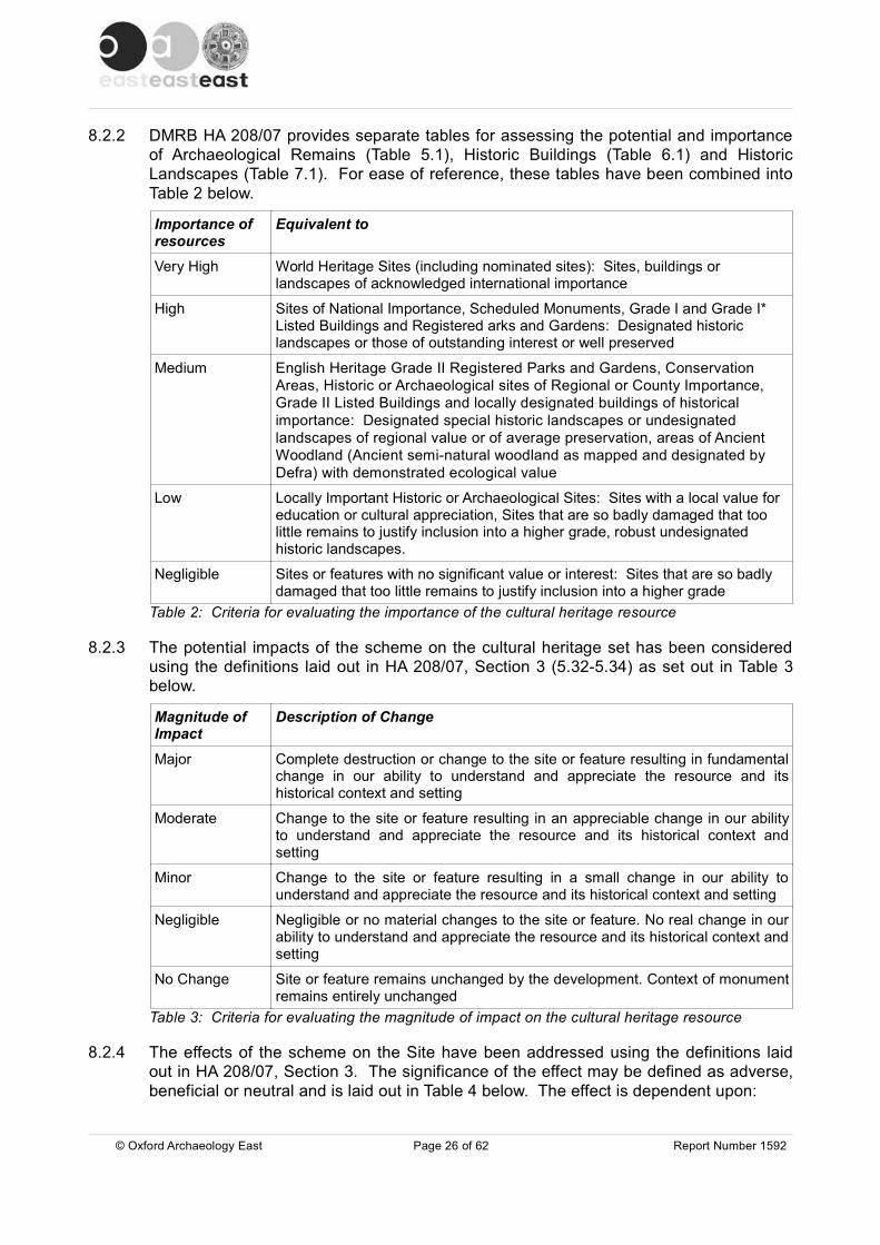
8.2.2 DMRB HA 208/07 provides separate tables for assessing the potential and importanceof Archaeological Remains (Table 5.1), Historic Buildings (Table 6.1) and HistoricLandscapes (Table 7.1). For ease of reference, these tables have been combined intoTable 2 below.
Importance of resources
Equivalent to
Very High World Heritage Sites (including nominated sites): Sites, buildings or landscapes of acknowledged international importance
High Sites of National Importance, Scheduled Monuments, Grade I and Grade I* Listed Buildings and Registered arks and Gardens: Designated historic landscapes or those of outstanding interest or well preserved
Medium English Heritage Grade II Registered Parks and Gardens, Conservation Areas, Historic or Archaeological sites of Regional or County Importance, Grade II Listed Buildings and locally designated buildings of historical importance: Designated special historic landscapes or undesignated landscapes of regional value or of average preservation, areas of Ancient Woodland (Ancient semi-natural woodland as mapped and designated by Defra) with demonstrated ecological value
Low Locally Important Historic or Archaeological Sites: Sites with a local value for education or cultural appreciation, Sites that are so badly damaged that too little remains to justify inclusion into a higher grade, robust undesignated historic landscapes.
Negligible Sites or features with no significant value or interest: Sites that are so badly damaged that too little remains to justify inclusion into a higher grade
Table 2: Criteria for evaluating the importance of the cultural heritage resource
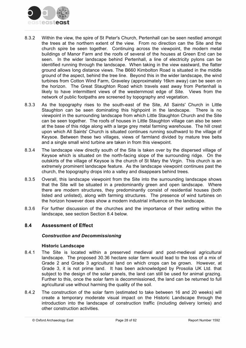
8.2.3 The potential impacts of the scheme on the cultural heritage set has been consideredusing the definitions laid out in HA 208/07, Section 3 (5.32-5.34) as set out in Table 3below.
Magnitude of Impact
Description of Change
Major Complete destruction or change to the site or feature resulting in fundamentalchange in our ability to understand and appreciate the resource and itshistorical context and setting
Moderate Change to the site or feature resulting in an appreciable change in our abilityto understand and appreciate the resource and its historical context andsetting
Minor Change to the site or feature resulting in a small change in our ability tounderstand and appreciate the resource and its historical context and setting
Negligible Negligible or no material changes to the site or feature. No real change in ourability to understand and appreciate the resource and its historical context andsetting
No Change Site or feature remains unchanged by the development. Context of monumentremains entirely unchanged
Table 3: Criteria for evaluating the magnitude of impact on the cultural heritage resource
8.2.4 The effects of the scheme on the Site have been addressed using the definitions laidout in HA 208/07, Section 3. The significance of the effect may be defined as adverse,beneficial or neutral and is laid out in Table 4 below. The effect is dependent upon:
© Oxford Archaeology East Page 26 of 62 Report Number 1592

� The importance of the cultural heritage resource
� The magnitude of the impacts
Magnitudeof Impact
Importance of Resource
Very High High Medium Low NegligibleMajor Very large Large or very
largeModerate / large
Slight / moderate
Slight
Moderate Large or very large
Moderate / large
Moderate Slight Neutral / slight
Minor Moderate / large
Moderate / slight
Slight Neutral / slight Neutral / slight
Negligible Slight Slight Neutral / slight Neutral / slight Neutral
No Change
Neutral Neutral Neutral Neutral Neutral
Table 4: Significance of environmental effects on the cultural heritage resource
8.2.5 Effects to be assessed are direct and indirect, temporary and permanent.
8.2.6 A direct impact is an impact that will occur to the physical fabric or land of an asset andits curtilage, and will include any impact upon the setting of that asset.
8.2.7 An indirect impact is an impact that might arise as a consequence of the operation orconstruction of the scheme. For example it may affect viability of land, leading tochanges in the management or land use of archaeological or historic landscapefeatures.
8.2.8 A temporary effect (primarily upon the setting of archaeological monuments or historiclandscape features) may occur during the construction and operation of the scheme.These developments may be removed following the completion of the constructionprocess or the decommissioning of the scheme and their effect upon the historicenvironment is therefore reversible.
8.2.9 A permanent effect will occur for example as a result of the construction and operationof the scheme including landscaping, land take, excavation of a reservoir andassociated drains, culverts and water control structures. A permanent effect is notreversible and will therefore include a below ground impact (upon archaeologicaldeposits) of some temporary elements of the scheme, including soil storage, contractorsite compounds and access routes and erection of other facilities.
8.2.10 Relevant aspects of the Historic Landscape and Historic Buildings will be consideredand the degree of potential impact from the development. Figure 12 illustrates thelocations from which photographic views to and from the Site were taken.
8.3 Landscape Viewpoint8.3.1 The Site is located at the base of a dominant ridge in the landscape. The result of this
being that the views to and from the proposed Site come predominantly from the southand east of the Site. Views to the north and west are taken over by the rise intopography and existing tree cover, thus no distant views toward the Site can be seenfrom these directions. Plates 7 and 8 show a panoramic view across the Site, taking inthe surrounding landscape. These photographs were taken from just beyond thewesternmost corner of Site on the public bridleway.
© Oxford Archaeology East Page 27 of 62 Report Number 1592
8.3.2 Within the view, the spire of St Peter's Church, Pertenhall can be seen nestled amongstthe trees at the northern extent of the view. From no direction can the Site and thechurch spire be seen together. Continuing across the viewpoint, the modern metalbuildings of Manor Farm and the roofs of several of the houses at Green End can beseen. In the wider landscape behind Pertenhall, a line of electricity pylons can beidentified running through the landscape. When taking in the view eastward, the flatterground allows long distance views. The B660 Kimbolton Road is situated in the middleground of the aspect, behind the tree line. Beyond this in the wider landscape, the windturbines from Cotton Wind Farm, Graveley (approximately 16km away) can be seen onthe horizon. The Great Staughton Road which travels east away from Pertenhall islikely to have intermittent views of the westernmost edge of Site. Views from thenetwork of public footpaths are screened by topography and vegetation.
8.3.3 As the topography rises to the south-east of the Site, All Saints' Church in LittleStaughton can be seen dominating this highpoint in the landscape. There is noviewpoint in the surrounding landscape from which Little Staughton Church and the Sitecan be seen together. The roofs of houses in Little Staughton village can also be seenat the base of this ridge along with a large grey metal farming warehouse. The hill crestupon which All Saints' Church is situated continues running southward to the village ofKeysoe. Between these two villages, views of farmland divided by mature tree beltsand a single small wind turbine are taken in from this viewpoint.
8.3.4 The landscape view directly south of the Site is taken over by the dispersed village ofKeysoe which is situated on the north-facing slope of the surrounding ridge. On theoutskirts of the village of Keysoe is the church of St Mary the Virgin. This church is anextremely prominent landscape feature. As the landscape viewpoint continues past thechurch, the topography drops into a valley and disappears behind trees.
8.3.5 Overall, this landscape viewpoint from the Site into the surrounding landscape showsthat the Site will be situated in a predominantly green and open landscape. Wherethere are modern structures, they predominantly consist of residential houses (bothlisted and unlisted), along with farming structures. The presence of wind turbines onthe horizon however does show a modern industrial influence on the landscape.
8.3.6 For further discussion of the churches and the importance of their setting within thelandscape, see section Section 8.4 below.
8.4 Assessment of Effect
Construction and Decommissioning
Historic Landscape8.4.1 The Site is located within a preserved medieval and post-medieval agricultural
landscape. The proposed 30.36 hectare solar farm would lead to the loss of a mix ofGrade 2 and Grade 3 agricultural land on which crops can be grown. However, atGrade 3, it is not prime land. It has been acknowledged by Prosolia UK Ltd. thatsubject to the design of the solar panels, the land can still be used for animal grazing.Further to this, once the solar farm is decommissioned, the land can be returned to fullagricultural use without harming the quality of the soil.
8.4.2 The construction of the solar farm (estimated to take between 16 and 20 weeks) willcreate a temporary moderate visual impact on the Historic Landscape through theintroduction into the landscape of construction traffic (including delivery lorries) andother construction activities.
© Oxford Archaeology East Page 28 of 62 Report Number 1592
8.4.3 Further to this, a period of roadworks in order to lay approximately 6km of cabling fromthe solar farm Site to the substation on Easton Road, North Stonely will introduce intothe landscape sections of temporarily closed off or narrowed roads using fencing, witha possible system of temporary traffic lights, as well as noise from the cutting of tarmacand associated construction traffic. Thus it is advised that a traffic managementscheme be implemented for the duration of the construction period.
8.4.4 The Site is surrounded by a network of public rights of way (footpaths and bridleways).The public footpaths can only be used by people on foot. Public bridleways howeverare used by walkers, people on horseback and cyclists. The Site is bounded to thenorth by a public bridleway (BW37). Therefore, there is a concern for the safety ofhorses and riders during the construction (and decommissioning) phase, arising fromnoise and construction traffic. It is advised that traffic management also be employedhere, through such means as the landowner considering additional permissive routesfor the duration of the works.
8.4.5 Overall this will cause a temporary Moderate visual impact on the Historic Landscape.
Historic Buildings8.4.6 The construction of the solar farm may create a (temporary) visual impact on the
Historic Buildings of the area. The effects will be limited to the 16 to 20 weekconstruction programme. Key effects will include visual impacts from the movement ofHGVs and site traffic. Further impacts will arise from an increase in noise. There is anarea wide HGV ban on the minor roads to the north of the Site, thus all heavycommercial vehicles obtaining access to the Site over the construction period will do sofrom the A421/A428 via Bedford to the B660 Kimbolton Road. Affected buildings wouldbe those situated along the main road through the village of Keysoe (such as HER5608-11, 12022, 5613, 5618-20, 5607, 7804, 12025 and 12026).
8.4.7 Effects will be temporary and of likely Minor severity (small change in the historicalcontext and setting). The overall environmental effect (using the matrix laid out in Table4) would be Slight adverse.
8.4.8 The overall effect of the scheme during the construction and decommissioningprogramme is therefore likely to be Moderate/Slight.
Operational
Historic Landscape8.4.9 The Site is located on a broadly flat area of land on the south-eastern side of a high
ridge (Plate 9). Due to its low-lying location, the Site is provided with some visualbarriers. Looking from the west, the Site is shielded by a copse of trees and the treesaround the moat (HER 4474). The land to the west and north-west rises up sharply to aheight of around 70m OD, the result of which means that the Site cannot be seen fromthe village of Swineshead. Site is not visible from Riseley either as it lies in a valleybottom, thus views are obscured by the rising ridge of land.
8.4.10 Travelling toward the Site from the north along the B660, due to topography and maturetrees/hedgerows, the Site is completely obscured from view until you are right next to it.The Site can most easily be seen from the immediate east when travelling on the B660Kimbolton Road. There are also some partial views from Green End in Pertenhall, LittleStaughton and the northern part of Keysoe.
© Oxford Archaeology East Page 29 of 62 Report Number 1592

8.4.11 In regard to the historic landscape, it is important to consider whether the developmentwould impact or alter the way in which people experience any heritage assets withinthis landscape, and whether it has the ability to reduce the positive contribution of theirexisting setting. The development by its very nature would introduce a non-agriculturalelement into a rural landscape. However, the Landscape and Visual ImpactAssessment (LVIA) identifies the Site as being located within a working landscape withviews of roads and a limited sense of tranquillity (Ludlow & Burton 2013), meaning thelandscape is reasonably tolerant to change.
8.4.12 The LVIA also states that the topography of the area creates a relatively confined visualenvelope. It has no statutory or informal designation and is not considered to be ofhigh landscape value. The development has also been specifically designed so as tominimise the impact upon the landscape. The panels, substations and inverters are alllimited in height so that there are no strong individual features intruding on thelandscape.
8.4.13 The Site already has a series of partial hedgerows along its eastern (Plate 10) andnorthern border which act as a visual barrier and a system of planting has beenproposed to further shelter the Site from public view. The proposed new planting willconsist of young and semi-mature (at least 1.5m tall) hedgelines consisting of a mix ofthorn, sloe, spindle, hazel, maple and hornbeam.
8.4.14 The walkover survey highlighted that the Site is most prominent from the B660Kimbolton Road (Plate 11) immediately adjacent to the Site. It has been agreed thatsemi-mature hedges will be planted along this eastern boundary. However, it will takeapproximately five years for this landscaping to become mature (and thus fullyeffective), therefore these mitigation measures would be limited in terms of theeffectiveness in the short term. But once mature, the hedge planting and hedgerowtrees would form a screen for both long and short distance views to the Site.
8.4.15 The walkover survey also noted that the western portion of Site could be seen from theSwineshead Road, located approximately 1.2km to the north (Plate 12). Thus it isadvised that semi-mature hedge be planted along this boundary.
8.4.16 As stated in paragraph 8.3.4, the Site is surrounded by a network of footpaths andbridleways. During the walkover survey, footpaths 26, 35 and 36 were visited alongwith bridleways 26, 37 and 40 to assess the potential impact of the development on thehistoric landscape and on walkers ability to understand/experience it. From FP26 and36 (located to the east of Site travelling from Great Staughton Road south-west toPertenhall Road) the Site cannot be seen at all. The topography falls away as it travelseastward, meaning that this footpath is between 3m and 8m lower than the Site. It isalso sheltered from the Site by mature trees and scrub situated on the banks of thePertenhall Brook tributary, which the footpath follows.
8.4.17 The footpath which will be most adversely affected is FP35 which runs through the Siteitself. The development will not cause the need for any rerouteing of the footpath.Mitigation will have hedgerows planted along both sides of the footpath so as toobscure the view of the solar panels. As stated in paragraph 8.3.14 though, it will taketime for this planting system to take hold.
8.4.18 Also highlighted in paragraph 8.3.4 is the use of bridleways by horses. BW26 and 37form the northern limits of the Site. Due to the topography, BW37 travels down hill as itmoves eastward toward Site. The result of which is that the eastern portion of the Siteis somewhat visible and as a result will impact on the riders experience of the historiclandscape. Hedges will be planted along this boundary, but it is worthy of note that as
© Oxford Archaeology East Page 30 of 62 Report Number 1592
a rider, your aspect is higher than that of walkers, so even with a hedgerow shieldingthe Site, it may still be visible to those on horseback. BW40 is located around 180maway from the south-western boundary of the Site. A slightly higher ridge in the landobscures the Site from this bridleway, however there is a possibility for the top of thepanels to be seen once in place. Again, a system of hedge planting should remove anyimpact the solar panels may have.
8.4.19 Highway implications during the operation of the solar farm are considered to benegligible. The panels will be constructed of dark blue/black glass coated with a non-reflective coating which allows the panels to absorb rather than reflect the light.Therefore the potential for passing drivers to be distracted by glare is extremelyunlikely.
8.4.20 During operation, the development will generate very little traffic and no staff will bebased on the Site. After commissioning, approximately one visit would be made permonth for maintenance purposes (with maintenance equipment being brought to theSite and taken away on completion) and the substation would be visited by a singlevehicle every three to four months.
8.4.21 Overall, the historic landscape is a robust undesignated landscape and as such, usingthe criteria laid out in Table 2 (page 26), the importance of the historic landscape isconsidered to be Medium/Low.
8.4.22 Using the criteria in Table 3 (page 26) the magnitude of impact to the historic landscapeis Minor. The overall significance of environmental effects to the historic landscape(Table 4, page 27) is considered to be Slight/Neutral.
Conservation Areas and Scheduled Monuments8.4.23 The conservation areas for Swineshead and Riseley villages would not be directly
affected by the proposed Site and thus their setting would not be altered.
8.4.24 There are three Scheduled Monuments within the 4km radius of the Site, namelyCastle Hill motte in Kimbolton, College Farm moated site in Keysoe (DBD 454) and HallClose moated site in Riseley (DBD 1305). Due to topography and existing tree cover,there is no inter-visibility between these Scheduled Monuments and the Site, thus theirsetting would not be altered in any way by the development.
8.4.25 Using the criteria laid out in Table 2, the importance of the Conservation Areas andScheduled Monuments is High, but the magnitude of impact from the development(Table 3) is No Change. Thus making the significance of the effect, as laid out in Table4, Neutral.
Historic Buildings8.4.26 The NPPF (2012, 56) defines setting as, 'The surroundings in which a heritage asset is
experienced. Its extent is not fixed and may change as the asset and its surroundingsevolve. Elements of a setting may make a positive or negative contribution to thesignificance of an asset, and may affect the ability to appreciate that significance ormay be neutral'. Thus, the potential impact which this development may have on thesetting in which historic buildings sit must be assessed, and whether their visualdominance in the landscape contributes positively to their significance in illustrating thehistoric status of the buildings.
© Oxford Archaeology East Page 31 of 62 Report Number 1592

8.4.27 In assessing the significance of the asset and how it will be affected by the proposeddevelopment we need to consider the heritage values of the asset itself. These can bebroken down into four categories:
� Evidential – does (or might) the asset contain evidence which could contribute toresearch and understanding about the past
� Historical – does the asset and what we know about it tell or illustrate a historicalnarrative, or an aspect of history or life in the past. Or is it associated with a well-known person from the past
� Aesthetic – does the asset define the historic character of a place or triggeremotional responses, through its beauty, its impressive character or otheraesthetic characteristics
� Communal – the asset may be associated with a past event or communal activitywhich may continue to the present day. There needs to be a real communalassociation with the place or assets history, not just a fortuitous use
8.4.28 There are a total of 147 Listed Buildings within a 4km radius of the Site. The majorityof these are located within the settlements of Pertenhall, Brook End, Keysoe, LittleStaughton, Riseley and Swineshead. As stated previously (in paragraph 8.3.9) viewsfrom the the villages of Riseley and Swineshead toward the Site were obscured by theterrain and woodland.
8.4.29 Pertenhall is the closest settlement to the Site containing 23 Listed Buildings, mainlyclustered around Green End, Chadwell End and Wood End. The Grade I listedmedieval Church of St Peter (HER 966), constructed from coursed limestone rubblewith ashlar dressings, has its origins in the 12th century but is mainly of a 15th centurydate, is located 1.2km north-east of Site and its spire is visible from the south-westernside of Site (Plate 13). The church, which has an historical and communal significancewithin the historic landscape, is set within a churchyard which is bordered by trees onits north-west and south-east sides.
8.4.30 To the south-west of the churchyard is the 16th century with 19th century modifications,Grade II Listed Manor House (HER 480). This provides a visual shield in the generaldirection of Site. Due to the low lying location of the Site, there would be no impact onviews close to and out of the churchyard and grounds of St Peter's Church or TheManor. There are no locations where the Site and the church spire can be seen inconjunction with one another. Therefore in the wider view of St Peter's Church, therewould be a negligible impact in our ability to understand this asset within the historicsetting.
8.4.31 The historic buildings at Green End (approximately 190m away from the north-easternboundary of Site), which have an aesthetic significance to the area, have the potentialto be minorly impacted by the development. Plate 14 shows the view from within thenorth-eastern boundary of the Site looking toward the cross roads. The upper floors ofthree properties can be seen, and thus, in turn can see the Site. These properties areThe Old Forge, College Cottages and the Grade II Listed Quinbrells (HER 4990).
8.4.32 Further along Green End is a cluster of Grade II Listed Buildings. Yew Tree Cottage(HER 9592), Ridge Cottage (HER 12192), Green End Farm House (HER 4988) all havethe potential of partial views of the Site. The undesignated properties of Clover Cottage(Plate 15), The Green and The Elms also have possible partial views. The varyingdegrees of enclosure via the matures trees and hedges surrounding these properties
© Oxford Archaeology East Page 32 of 62 Report Number 1592
will however afford some visual shield. The Site is not visible from any further historicbuildings within Pertenhall village.
8.4.33 The undesignated assets within the area, although not listed, have the potential to beimpacted by the development and therefore deserve consideration. These buildingsstill provide value to the aesthetic significance of the historic landscape in the area andcontribute positively to their setting.
8.4.34 It is worthy of note at this point that the views from these historic buildings will alterthroughout the year. All the photographs illustrated within this assessment were takenin late winter, thus tree and hedge cover is minimal. This means that as the yearprogresses and the foliage blossoms, impacts on views will be reduced.
8.4.35 To the south-east of the Site, properties along the Kimbolton Road in Brook End on theoutskirts of Keysoe have the potential to be moderately impacted by the development.Pentland House is situated just 70m beyond the south-eastern corner of Site. Althoughnot listed, its upper floor will have clear views of the development. Grange Court andGrange Court Barn (next door) will also have partial views. Neighbouring property TheGrange, is a large aesthetically significant undesignated property approximately 190msouth of Site. It is set back from the road and thus the first storey has an unrestrictedview across the Site (Plate 16). The two Grade II Listed Buildings, The Manor (HER5608) and the tithe barn to the rear of The Manor (HER 3212) cannot see the Site asthey are shielded by mature trees and hedgelines.
8.4.36 In Keysoe, which is to the south of the Site, there are 52 Listed Buildings, most ofwhich are spread along the main streets. The topography rises from c.40m OD up toc.66m OD as you travel southward through the village along the B660. The result ofthis is there is an extremely minor chance of being able to see glimpses of the Site.
8.4.37 The Church of St Mary the Virgin (HER 1083) on the south-western outskirts of Keysoeis a Grade I Listed Building. It is constructed from coursed limestone rubble with ashlardressings and has its origins in the Late 12th to 15th century. This church is situated ata height of around 73m OD and dominates the landscape. It has historical, aestheticand communal significance in the historic landscape. Because it is located in such aprominent position, it can be seen from all areas of the Site (Plate 17). Due to thechurch and churchyard being enclosed by tall mature trees, the Site cannot be seenfrom the church itself, although there is minor potential for it to be seen from a sectionof Church Road, c.150m away from the church back toward Keysoe village where thetrees thin out (Plate 18).
8.4.38 In terms of the wider view of the Church of St Mary the Virgin, there is the potential fora moderate impact in our ability to understand this asset within this historical landscapesetting. Plate 19 is taken from the Swineshead Road (c.3.4km directly north). In thecentre of the photograph the north-western corner of Site and the copse of treesadjacent to it can just be seen, and the Church of St Mary the Virgin is shown in thedistance. Planting of mature hedges along this north-eastern Site boundary has thepotential to reduce this moderate impact to negligible. The presence of these churchspires in the the landscape makes a particular contribution to their significance and thusit is importance to ensure that the development does not have a harmful impact on this.
8.4.39 The village of Little Staughton is located 3.4km east-southeast of the Site. All SaintsChurch (HER 1128) is a Grade I Listed Building constructed out of coursed limestonerubble and brown cobbles with ashlar dressing. The structure predominantly dates tothe 15th century but has 13th and 14th century details remaining. The church is visiblefrom the Site (Plate 20). From the church and churchyard there is minor potential to
© Oxford Archaeology East Page 33 of 62 Report Number 1592
see the Site. This church does visually dominate the landscape and has an historical,aesthetic and communal significance, but as the Site is not particularly visible from thechurch itself, the way in which one would experience this asset is not adverselyimpacted. It is worthy of note that the wind farm at Chelveston airfield (to the south-west) can be seen from this church. There are eight other Listed Buildings in thisvillage, none of which can see the Site.
8.4.40 Overall, using the criteria laid out in Table 2 (page 26), the importance of the ListedBuildings for all Grade I and Grade II* Listed Buildings is High. The importance ofother Listed Buildings (which are all Grade II) is Medium.
8.4.41 Using the criteria laid out in Table 3 (page 26), the magnitude of impacts upon thesetting of Listed Buildings is Moderate/Minor for those with views to the Site.
8.4.42 Thus the overall significance of environmental effects upon the historic landscape(Table 4, page 27) is considered to be Moderate for Grade I Listed Buildings with aview of Site, such as St Mary the Virgin Church, Keysoe. For all other heritage assets,the environmental effects are believed to be Slight.
© Oxford Archaeology East Page 34 of 62 Report Number 1592
9 CONCLUSIONS
9.1 Significance of Effect9.1.1 When all the potential construction and operational impacts are assessed, the
proposed development is considered to have the following magnitude of impact andsignificance of effect as defined by Tables 2, 3 and 4:
Resource Importance Magnitude of Impact Significance of Effectwithout Mitigation
Archaeology Medium Moderate Moderate/Large
Historic Landscape Medium/Low Minor Slight/Neutral
Historic Buildings Medium Moderate/Minor SlightTable 5: Overall significance of effect
9.1.2 Table 5 above shows that the archaeological resource has a Medium importance due tothe identified remains present in close proximity to the Site and the good potential forremains within the Site. The magnitude of impact will be Moderate due to the total andpermanent removal of the resource. The significance will therefore be Moderate/Large.
9.1.3 The Site is located within an area of partially preserved robust medieval and post-medieval agricultural landscape. The site contains a number of historic hedgerows.The coherence and integrity of the Historic Landscape has already been affected by thearea having no statutory or informal designation, meaning it is not considered to be ofhigh landscape value. The landscape around the Site is also considered to be aworking landscape with views of roads and a limited sense of tranquillity. This meansthat the landscape is reasonably tolerant to change.
9.1.4 The operation of a solar farm will introduce a Minor visual impact on the HistoricLandscape. This Minor effect upon a landscape of Medium/Low importance will resultin an overall effect of Slight/Neutral significance.
9.1.5 The proposed development Site contains no Historic Buildings although thesurrounding area contains a number of Listed historic buildings. The Site will have avisual effect of varying significance upon these buildings. It will have a Moderateadverse effect upon the Grade I listed Churches of St Mary the Virgin at Keysoe and AllSaints at Little Staughton, a Moderate adverse effect upon the undesignated assets atBrook End, a Moderate/Minor adverse effect upon the Listed Buildings andundesignated assets at Green End Pertenhall, a Minor/Negligible affect upon the GradeI Listed St Peter's Church, Pertenhall and no effect upon the Listed Buildings atChadwell End or Wood End, Pertenhall.
9.2 Discussion9.2.1 This assessment has demonstrated that there is the potential for the proposed solar
farm to have a Slight impact on the Historic Landscape and on Historic Buildings ofPertenhall and the surrounding villages. The provision of new landscaping in the formof hedgerows will help to reduce this impact particularly from closer vantage pointssuch as adjacent rights of way, nearby roads and closely located Historic Buildings.
9.2.2 The ultimate aim of this development is to introduce a non-agricultural elementharmoniously into the Historic Landscape so as not to affect the way in which it, or theassets within it are experienced and understood.
© Oxford Archaeology East Page 35 of 62 Report Number 1592

APPENDIX A. HER INFORMATION
Table 6: All heritage assets within a 1km radius of Site
HER ID Type Name Period Easting Northing
21308 Findspot Flint implement, Pertenhall Mesolithic - 10000 BC to 6500 BC 508100 265600
21320 Findspot Flint implement, Pertenhall Mesolithic - 10000 BC to 6500 BC 508100 265500
21311 Findspot Flint implement, Pertenhall Mesolithic - 8300 BC to 4500 BC 508100 265600
21325 Findspot Flint implement, Pertenhall Mesolithic - 8300 BC to 4500 BC 508100 265500
21326 Findspot Flint implement, Pertenhall Mesolithic - 8300 BC to 4500 BC 508100 265500
21327 Findspot Flint implement, Pertenhall Mesolithic - 8300 BC to 4500 BC 508100 265500
21465 Findspot Flint implement, Pertenhall Mesolithic - 8300 BC to 4500 BC 507900 265500
21466 Findspot Flint implement, Pertenhall Mesolithic - 8300 BC to 4500 BC 507900 265500
21467 Findspot Flint implement, Pertenhall Mesolithic - 8300 BC to 4500 BC 507900 265500
21468 Findspot Flint implement, Pertenhall Mesolithic - 8300 BC to 4500 BC 507900 265400
21469 Findspot Flint implement, Pertenhall Mesolithic - 8300 BC to 4500 BC 507900 265400
21474 Findspot Flint implement, Pertenhall Mesolithic - 8300 BC to 4500 BC 508000 265500
21475 Findspot Flint implement, Pertenhall Mesolithic - 8300 BC to 4500 BC 508000 265500
21476 Findspot Flint implement, Pertenhall Mesolithic - 8300 BC to 4500 BC 508000 265500
21307 Findspot Flint implement, Pertenhall Mesolithic - 8300 BC to 6500 BC 508100 265600
21316 Findspot Flint implement, Pertenhall Mesolithic - 8300 BC to 6500 BC 507900 265500
21321 Findspot Flint implement, Pertenhall Mesolithic - 8300 BC to 6500 BC 508100 265500
21322 Findspot Flint implement, Pertenhall Mesolithic - 8300 BC to 6500 BC 508100 265500
21309 Findspot Flint implement, Pertenhall Mesolithic – 8300 BC to 6500 BC 508100 265600
21463 Findspot Flint implement, Pertenhall Mesolithic - 8300 BC to 4500 BC 507900 265400
21464 Findspot Flint implement, Pertenhall Mesolithic - 8300 BC to 4500 BC 507900 265400
© Oxford Archaeology Page 36 of 62 Report 1592
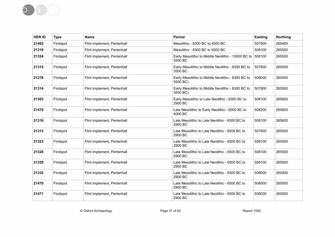
HER ID Type Name Period Easting Northing
21462 Findspot Flint implement, Pertenhall Mesolithic - 8300 BC to 4500 BC 507900 265400
21319 Findspot Flint implement, Pertenhall Mesolithic - 8300 BC to 6500 BC 508100 265500
21324 Findspot Flint implement, Pertenhall Early Mesolithic to Middle Neolithic - 10000 BC to3500 BC
508100 265500
21315 Findspot Flint implement, Pertenhall Early Mesolithic to Middle Neolithic - 8300 BC to 3500 BC
507900 265500
21276 Findspot Flint implement, Pertenhall Early Mesolithic to Middle Neolithic - 8300 BC to 3500 BC)
508000 265400
21314 Findspot Flint implement, Pertenhall Early Mesolithic to Middle Neolithic - 8300 BC to 3500 BC)
507900 265500
21303 Findspot Flint implement, Pertenhall Early Mesolithic to Late Neolithic - 8300 BC to 2900 BC
508100 265600
21479 Findspot Flint implement, Pertenhall Late Mesolithic to Early Neolithic - 6000 BC to 4000 BC
508200 265600
21310 Findspot Flint implement, Pertenhall Late Mesolithic to Late Neolithic - 6500 BC to 2900 BC
508100 265600
21313 Findspot Flint implement, Pertenhall Late Mesolithic to Late Neolithic - 6500 BC to 2900 BC
507900 265500
21323 Findspot Flint implement, Pertenhall Late Mesolithic to Late Neolithic - 6500 BC to 2900 BC
508100 265500
21328 Findspot Flint implement, Pertenhall Late Mesolithic to Late Neolithic - 6500 BC to 2900 BC
508100 265500
21329 Findspot Flint implement, Pertenhall Late Mesolithic to Late Neolithic - 6500 BC to 2900 BC
508100 265500
21332 Findspot Flint implement, Pertenhall Late Mesolithic to Late Neolithic - 6500 BC to 2900 BC
508000 265400
21470 Findspot Flint implement, Pertenhall Late Mesolithic to Late Neolithic - 6500 BC to 2900 BC
508000 265500
21471 Findspot Flint implement, Pertenhall Late Mesolithic to Late Neolithic - 6500 BC to 2900 BC
508000 265500
© Oxford Archaeology Page 37 of 62 Report 1592

HER ID Type Name Period Easting Northing
21472 Findspot Flint implement, Pertenhall Late Mesolithic to Late Neolithic - 6500 BC to 2900 BC
508000 265500
21280 Findspot Flint implement, Pertenhall Early Mesolithic to Early Bronze Age - 8300 BC to 2100 BC
508000 265500
21283 Findspot Flint implement, Pertenhall Early Mesolithic to Early Bronze Age - 8300 BC to 2100 BC
508000 265500
21473 Findspot Flint implement, Pertenhall Early Mesolithic to Early Bronze Age - 8300 BC to 2100 BC
508000 265500
21277 Findspot Flint implement, Pertenhall Late Mesolithic to Early Bronze Age - 6500 BC to 2100 BC
508000 265400
21279 Findspot Flint implement, Pertenhall Late Mesolithic to Early Bronze Age - 6500 BC to 2100 BC
508000 265400
21331 Findspot Flint implement, Pertenhall Late Mesolithic to Early Bronze Age - 6500 BC to 2100 BC
508000 265400
21281 Findspot Flint implement, Pertenhall Middle Neolithic to Early Bronze Age - 3500 BC to 2100 BC
508000 265500
21282 Findspot Flint implement, Pertenhall Middle Neolithic to Early Bronze Age - 3500 BC to 2100 BC
508000 265500
21304 Findspot Flint implement, Pertenhall Middle Neolithic to Early Bronze Age - 3500 BC to 2100 BC
508100 265600
21282 Findspot Flint implement, Pertenhall Middle Neolithic to Early Bronze Age - 3500 BC to 2100 BC
508000 265500
21304 Findspot Flint implement, Pertenhall Middle Neolithic to Early Bronze Age - 3500 BC to 2100 BC
508100 265600
21306 Findspot Flint implement, Pertenhall Middle Neolithic to Late Neolithic - 3500 BC to 2900 BC
508100 265600
21306 Findspot Flint implement, Pertenhall Middle Neolithic to Late Neolithic - 3500 BC to 2900 BC
508100 265600
21305 Findspot Flint implement, Pertenhall Late Neolithic to Early Bronze Age - 2500 BC to 2000 BC
508100 265600
© Oxford Archaeology Page 38 of 62 Report 1592
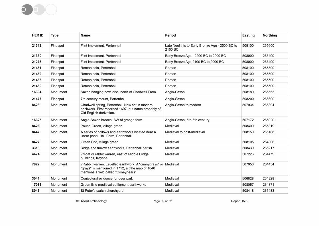
HER ID Type Name Period Easting Northing
21312 Findspot Flint implement, Pertenhall Late Neolithic to Early Bronze Age - 2500 BC to 2100 BC
508100 265600
21330 Findspot Flint implement, Pertenhall Early Bronze Age - 2200 BC to 2000 BC 508000 265400
21278 Findspot Flint implement, Pertenhall Early Bronze Age 2100 BC to 2000 BC 508000 265400
21481 Findspot Roman coin, Pertenhall Roman 508100 265500
21482 Findspot Roman coin, Pertenhall Roman 508100 265500
21483 Findspot Roman coin, Pertenhall Roman 508100 265500
21480 Findspot Roman coin, Pertenhall Roman 508100 265500
16304 Monument Saxon hanging bowl disc, north of Chadwell Farm Anglo-Saxon 508189 265553
21477 Findspot 7th century mount, Pertenhall Anglo-Saxon 508200 265600
8428 Monument Chadwell spring, Pertenhall. Now set in modern brickwork. First recorded 1607, but name probably of Old English derivation.
Anglo-Saxon to modern 507934 265394
16325 Monument Anglo-Saxon brooch, SW of grange farm Anglo-Saxon, 5th-6th century 507172 265920
8426 Monument Pound Green, village green Medieval 508400 265319
8447 Monument A series of hollows and earthworks located near a linear pond. Hall Farm, Pertenhall
Medieval to post-medieval 508150 265188
8427 Monument Green End, village green Medieval 508105 264806
3313 Monument Ridge and furrow earthworks, Pertenhall parish Medieval 508439 265217
4474 Monument ?Moat or rabbit warren, east of Middle Lodge buildings, Keysoe
Medieval 507226 264479
7822 Monument ?Rabbit warren. Levelled earthwork. A "cunnygrass" or"grays" is mentioned in 1712, a tithe map of 1840 mentions a field called "Coneygears"
Medieval 507053 264454
3041 Monument Conjectural evidence for deer park Medieval 506828 264328
17086 Monument Green End medieval settlement earthworks Medieval 508057 264871
8946 Monument St Peter's parish churchyard Medieval 508418 265433
© Oxford Archaeology Page 39 of 62 Report 1592

HER ID Type Name Period Easting Northing
17083 Monument Church End deserted settlement Medieval 508459 265404
17084 Monument Chadwell End deserted settlement. Earthworks Medieval 508234 265514
8438 Monument Earthworks, Green End, Pertenhall.House platform, road, ridge and furrow
Medieval 508140 264692
21478 Findspot 14th century key, Pertenhall Medieval 508200 265500
21285 Findspot Pottery vessel, Pertenhall Medieval 508000 265400
346 Monument 23 skeletons found in the grounds of Pertenhall ManorHouse. Others had also been found in common land nearby in 1797. These were thought to be evidence ofa Civil War skirmish, but they may be either plagueburials, or other medieval burials which had to be made in unconsecrated ground.
Medieval or post-medieval 508370 265380
8409 Monument Well, Nuns Well Close. Place-name evidence for a well
Medieval, post-medieval 508432 265066
8424 Monument Trackway - old access road showing on enclosure map of 1796. Earthwork
Post-medieval 508155 265264
7689 Monument Site of old sand pit Post-medieval 507150 264635
7620 Monument Site of demolished buildings. Showing on 1806 map Post-Medieval 507004 264743
7038 Monument Landscaped grounds Pertenhall Manor. Showing on Bryant's map of Bedfordshire 1826
Post-medieval 508434 265338
8420 Monument Brick kiln field, site of demolished brickworks Post-medieval 507127 266036
12034 Monument Farm buildings Middle Lodge farm Keysoe Post-Medieval 506720 264560
8436 Monument Building (site of) Town Close, Pertenhall Post-Medieval 508182 265297
12197 Monument Rosemary Cottage Green End, Pertenhall Post-Medieval 507830 265042
8437 Monument Building (site of), Pertenhall Post-Medieval 507980 265060
12196 Monument Farm buildings Manor Farm, Green End, Pertenhall Post-Medieval 507900 264900
© Oxford Archaeology Page 40 of 62 Report 1592
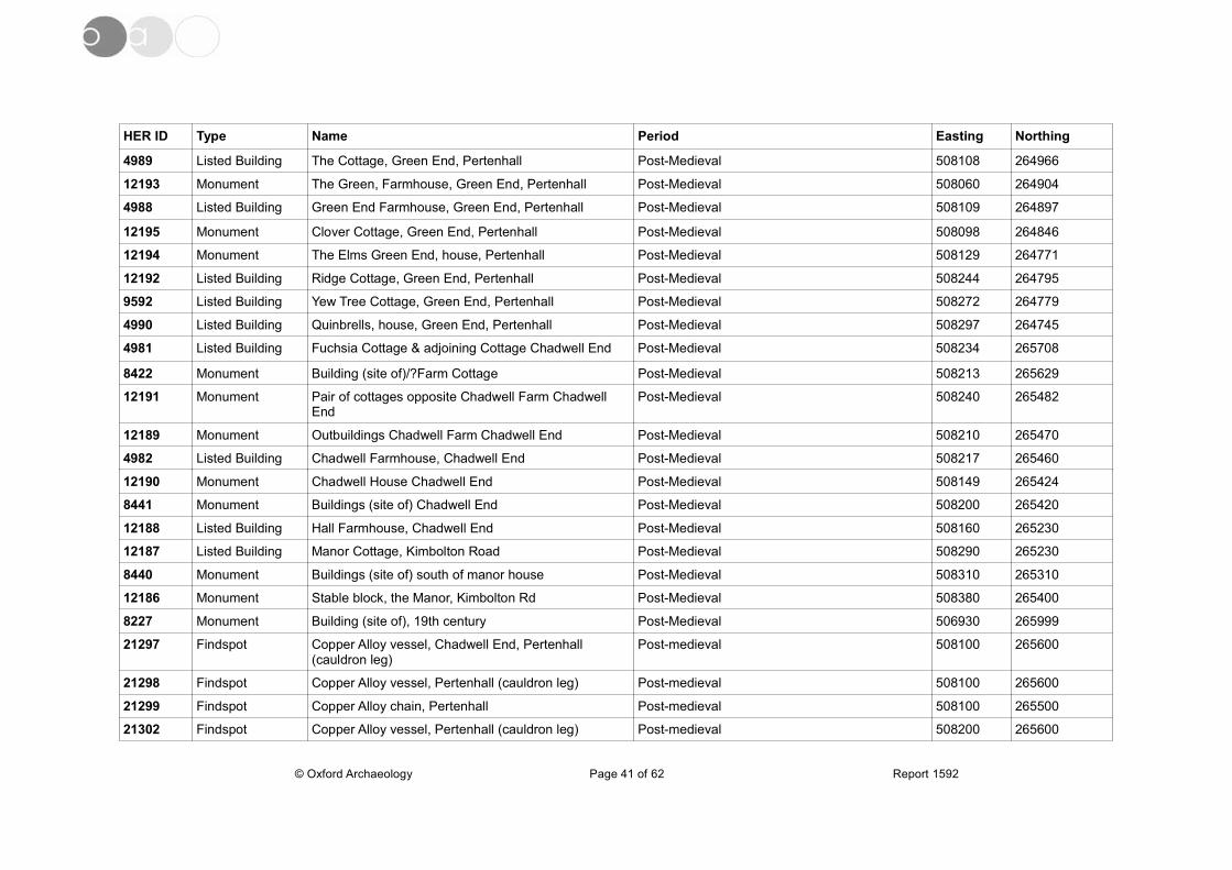
HER ID Type Name Period Easting Northing
4989 Listed Building The Cottage, Green End, Pertenhall Post-Medieval 508108 264966
12193 Monument The Green, Farmhouse, Green End, Pertenhall Post-Medieval 508060 264904
4988 Listed Building Green End Farmhouse, Green End, Pertenhall Post-Medieval 508109 264897
12195 Monument Clover Cottage, Green End, Pertenhall Post-Medieval 508098 264846
12194 Monument The Elms Green End, house, Pertenhall Post-Medieval 508129 264771
12192 Listed Building Ridge Cottage, Green End, Pertenhall Post-Medieval 508244 264795
9592 Listed Building Yew Tree Cottage, Green End, Pertenhall Post-Medieval 508272 264779
4990 Listed Building Quinbrells, house, Green End, Pertenhall Post-Medieval 508297 264745
4981 Listed Building Fuchsia Cottage & adjoining Cottage Chadwell End Post-Medieval 508234 265708
8422 Monument Building (site of)/?Farm Cottage Post-Medieval 508213 265629
12191 Monument Pair of cottages opposite Chadwell Farm Chadwell End
Post-Medieval 508240 265482
12189 Monument Outbuildings Chadwell Farm Chadwell End Post-Medieval 508210 265470
4982 Listed Building Chadwell Farmhouse, Chadwell End Post-Medieval 508217 265460
12190 Monument Chadwell House Chadwell End Post-Medieval 508149 265424
8441 Monument Buildings (site of) Chadwell End Post-Medieval 508200 265420
12188 Listed Building Hall Farmhouse, Chadwell End Post-Medieval 508160 265230
12187 Listed Building Manor Cottage, Kimbolton Road Post-Medieval 508290 265230
8440 Monument Buildings (site of) south of manor house Post-Medieval 508310 265310
12186 Monument Stable block, the Manor, Kimbolton Rd Post-Medieval 508380 265400
8227 Monument Building (site of), 19th century Post-Medieval 506930 265999
21297 Findspot Copper Alloy vessel, Chadwell End, Pertenhall (cauldron leg)
Post-medieval 508100 265600
21298 Findspot Copper Alloy vessel, Pertenhall (cauldron leg) Post-medieval 508100 265600
21299 Findspot Copper Alloy chain, Pertenhall Post-medieval 508100 265500
21302 Findspot Copper Alloy vessel, Pertenhall (cauldron leg) Post-medieval 508200 265600
© Oxford Archaeology Page 41 of 62 Report 1592
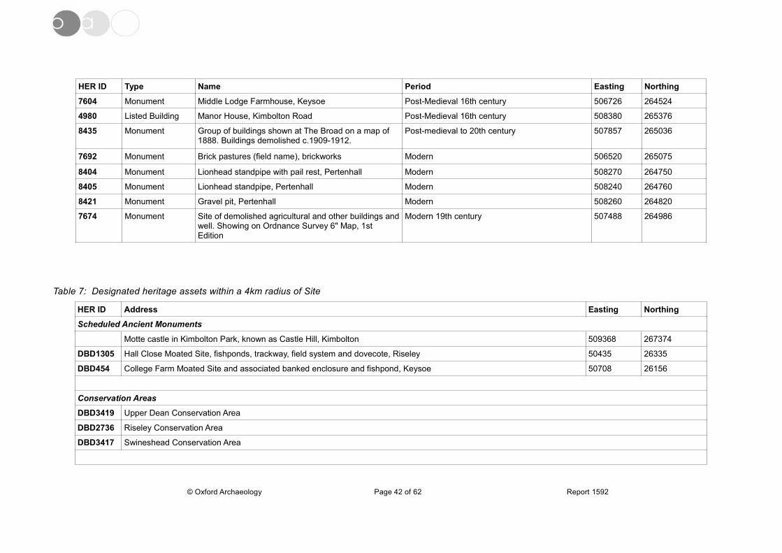
HER ID Type Name Period Easting Northing
7604 Monument Middle Lodge Farmhouse, Keysoe Post-Medieval 16th century 506726 264524
4980 Listed Building Manor House, Kimbolton Road Post-Medieval 16th century 508380 265376
8435 Monument Group of buildings shown at The Broad on a map of 1888. Buildings demolished c.1909-1912.
Post-medieval to 20th century 507857 265036
7692 Monument Brick pastures (field name), brickworks Modern 506520 265075
8404 Monument Lionhead standpipe with pail rest, Pertenhall Modern 508270 264750
8405 Monument Lionhead standpipe, Pertenhall Modern 508240 264760
8421 Monument Gravel pit, Pertenhall Modern 508260 264820
7674 Monument Site of demolished agricultural and other buildings andwell. Showing on Ordnance Survey 6" Map, 1st Edition
Modern 19th century 507488 264986
Table 7: Designated heritage assets within a 4km radius of Site
HER ID Address Easting Northing
Scheduled Ancient Monuments
Motte castle in Kimbolton Park, known as Castle Hill, Kimbolton 509368 267374
DBD1305 Hall Close Moated Site, fishponds, trackway, field system and dovecote, Riseley 50435 26335
DBD454 College Farm Moated Site and associated banked enclosure and fishpond, Keysoe 50708 26156
Conservation Areas
DBD3419 Upper Dean Conservation Area
DBD2736 Riseley Conservation Area
DBD3417 Swineshead Conservation Area
© Oxford Archaeology Page 42 of 62 Report 1592
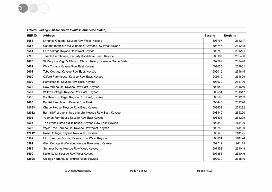
Listed Buildings (all are Grade II unless otherwise stated)
HER ID Address Easting Northing
5586 Kynance Cottage, Keysoe Row West, Keysoe 506767 261247
5585 Cottage (opposite the Windrush) Keysoe Row West Keysoe 506745 261238
5584 Fern cottage Keysoe Row West Keysoe 506758 261271
7708 Temple Farmhouse, formerly Doddshole Farm, Keysoe 508107 262486
1083 St Mary the Virgin's Church, Church Road, Keysoe – Grade I listed 507389 262490
5602 Weir Cottage Keysoe Row East Keysoe 509025 261851
5601 Toby Cottage, Keysoe Row East, Keysoe 509015 261814
5600 Oxford Farmhouse, Keysoe Row East, Keysoe 509119 261809
5599 Homesteads, Keysoe Row East, Keysoe 508970 261720
5598 Row farmhouse, Keysoe Row East, Keysoe 508950 261650
5597 Willow Cottage, Keysoe Row East, Keysoe 508581 261317
5596 Southview Cottage, Keysoe Row East, Keysoe 508509 261263
1085 Baptist free church, Keysoe Row East 508448 261226
12033 Chapel House, Keysoe Row East, Keysoe 508432 261232
12032 Barn (SW of baptist free church), Keysoe Row East, Keysoe 508440 261220
5595 Yeoman Farmhouse Keysoe Row East Keysoe 508395 261209
5594 The White Horse public house, Keysoe Row East, Keysoe 508340 261120
5593 Wych Tree Farmhouse, Keysoe Row West, Keysoe 508250 261100
12012 Rose Cottage, Keysoe Row West, Keysoe 508178 261125
5592 Elm Tree Farmhouse, Keysoe Row West, Keysoe 508061 261124
5591 Glen Cottage & Wayside, Keysoe Row West, Keysoe 507712 261119
5589 Summer Song, Keysoe Row West, Keysoe 507353 261048
5590 Kaltenkeller Keysoe Row West Keysoe 507366 261046
12028 College Farmhouse, church Road, Keysoe 507070 261540
© Oxford Archaeology Page 43 of 62 Report 1592

HER ID Address Easting Northing
12024 Corner Cottage, Wybridge, Keysoe Row West, Keysoe 507000 261360
5587 Cottage (W of Fox Inn) Keysoe Row, Keysoe 506823 261271
12026 Cottage (opposite Church Road), Mill Hill, Keysoe 507640 262690
7804 Village schoolroom, Mill Hill, Keysoe 507647 262687
12025 Glebe Cottage, Wybridge, Keysoe 507620 262640
2471 Cottage (approx 250 metres SW of the Elms, Riseley Road), Brook End, Keysoe 506986 262900
12027 The Elms, Riseley Road, Keysoe Brook End 507180 263030
5614 Cottage W of baptist chapel, adjoining 6/9 Brook End, Keysoe 507291 263111
5615 Meeting Cottage, Riseley Road, Brook End, Keysoe 507327 263124
1084 The Old Chapel House, Riseley Road, Keysoe Brook End 507346 263105
8477 Baptist sunday school, Riseley Road, Keysoe Brook End 507362 263115
5612 Westview Cottage Riseley Road Brook End Keysoe 507465 263273
5617 Brook End Farmhouse, Brook End, Keysoe 507510 263170
5618 Corner house, Riseley Road, Brook End, Keysoe 507573 263155
5619 Brook Farmhouse Brook End Keysoe 507610 263160
12023 Barns bordering Road at Brook End Farm, Riseley Road, Keysoe Brook End 507539 263167
5620 Circus Farmhouse Mill Hill Keysoe 507620 263050
5613 Old Brook House, Pertenhall Road, Brook End Keysoe 507614 263228
12022 The Little Pyghtle, Pertenhall Road, Keysoe Brook End 507688 263338
5609 Cottage (N of Last Straw Cottage, approx 50 metres N of Lavender Cottage), Keysoe 507730 263473
5610 Last straw Cottage Pertenhall Road Brook End Keysoe 507728 263439
5611 Lavender Cottage, Pertenhall Road, Brook End Keysoe 507721 263411
3212 (Tithe) barn to rear of Manor,Grange Farm, Pertenhall Road, Brook End, Keysoe 507778 263696
5608 The Manor, Pertenhall Road, Brook End, Keysoe 507813 263685
7983 Keysoe Park Farm Cottages (now Kylemore Cottage), Hardwick End, Keysoe 506170 262369
© Oxford Archaeology Page 44 of 62 Report 1592
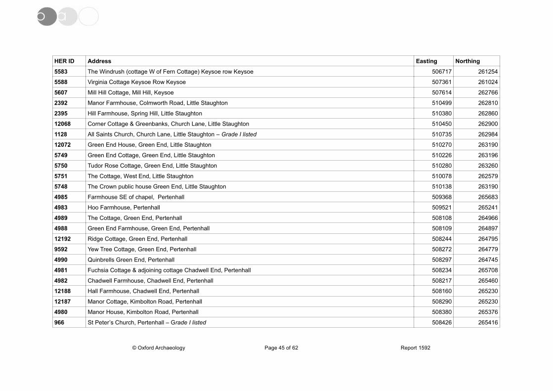
HER ID Address Easting Northing
5583 The Windrush (cottage W of Fern Cottage) Keysoe row Keysoe 506717 261254
5588 Virginia Cottage Keysoe Row Keysoe 507361 261024
5607 Mill Hill Cottage, Mill Hill, Keysoe 507614 262766
2392 Manor Farmhouse, Colmworth Road, Little Staughton 510499 262810
2395 Hill Farmhouse, Spring Hill, Little Staughton 510380 262860
12068 Corner Cottage & Greenbanks, Church Lane, Little Staughton 510450 262900
1128 All Saints Church, Church Lane, Little Staughton – Grade I listed 510735 262984
12072 Green End House, Green End, Little Staughton 510270 263190
5749 Green End Cottage, Green End, Little Staughton 510226 263196
5750 Tudor Rose Cottage, Green End, Little Staughton 510280 263260
5751 The Cottage, West End, Little Staughton 510078 262579
5748 The Crown public house Green End, Little Staughton 510138 263190
4985 Farmhouse SE of chapel, Pertenhall 509368 265683
4983 Hoo Farmhouse, Pertenhall 509521 265241
4989 The Cottage, Green End, Pertenhall 508108 264966
4988 Green End Farmhouse, Green End, Pertenhall 508109 264897
12192 Ridge Cottage, Green End, Pertenhall 508244 264795
9592 Yew Tree Cottage, Green End, Pertenhall 508272 264779
4990 Quinbrells Green End, Pertenhall 508297 264745
4981 Fuchsia Cottage & adjoining cottage Chadwell End, Pertenhall 508234 265708
4982 Chadwell Farmhouse, Chadwell End, Pertenhall 508217 265460
12188 Hall Farmhouse, Chadwell End, Pertenhall 508160 265230
12187 Manor Cottage, Kimbolton Road, Pertenhall 508290 265230
4980 Manor House, Kimbolton Road, Pertenhall 508380 265376
966 St Peter’s Church, Pertenhall – Grade I listed 508426 265416
© Oxford Archaeology Page 45 of 62 Report 1592

HER ID Address Easting Northing
4986 The Lodge Cottage (old rectory), Kimbolton Road, Pertenhall 508613 265380
12208 Barn N of lodge Cottage (old rectory), Kimbolton Road, Pertenhall 508608 265409
8439 Dovecote NW of lodge Cottage (old rectory), Kimbolton Road, Pertenhall 508592 265409
12204 1 Wood End, Pertenhall 508870 265890
12200 Lodge to Wood End House, Kimbolton Road, Wood End, Pertenhall 509020 266060
12201 Garden House at Wood End House, Kimbolton Road, Wood End, Pertenhall 509000 266070
4987 Wood End House Kimbolton Rd, Wood End, Pertenhall 509000 266100
1097 The Old Rectory, Kimbolton Road, Pertenhall. Grade II* Listed 508471 265422
12203 Wood End Farmhouse Wood End, Pertenhall 508791 265923
12222 Brook Farmhouse, Riseley Road, Pertenhall 506020 265750
5371 Lower Farmhouse, High Street, Swineshead 505950 265720
2822 Pear tree Farmhouse, High Street, Swineshead 505960 265780
5369 The three horseshoes Cottage High St, Swineshead 505920 265790
5372 Shepherds Cottage High Street, Swineshead 505890 265780
15134 K6 telephone kiosk, N of the old post office - High Street, Swineshead 505870 265790
5373 The Old Post Office (formerly listed as post office), High Street, Swineshead 505850 265780
5367 School house (formerly listed as Cottage opposite five bells), High Street, Swineshead 505820 265820
1139 St Nicholas' Church, High Street, Swineshead. Grade I listed 505790 265850
12224 Cottage N of parish church, Sandye Lane, Swineshead 505793 265874
5374 Close Cottage 1 & 2 High St, Swineshead 505739 265829
8645 Lilac Cottage, High Street, Swineshead 505773 265817
12219 Barn SE of Farmhouse, Moat Farm, Sandye Lane, Swineshead 505728 265859
12220 Barn E of Farmhouse, Moat Farm, Sandye Lane, Swineshead 505755 265861
5365 Moat Farmhouse Sandye Lane, Swineshead 505724 265876
5364 Manor Farmhouse, High Street, Swineshead 505660 265860
© Oxford Archaeology Page 46 of 62 Report 1592
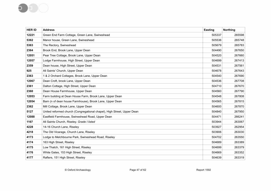
HER ID Address Easting Northing
12221 Green End Farm Cottage, Green Lane, Swineshead 505337 265598
5362 Manor house, Green Lane, Swineshead 505536 265748
5363 The Rectory, Swineshead 505679 265783
2364 Brook End, Brook Lane, Upper Dean 504490 267650
12051 Pear Tree Cottage, Brook Lane, Upper Dean 504520 267660
12057 Lodge Farmhouse, High Street, Upper Dean 504699 267413
2359 Dean house, High Street, Upper Dean 504531 267561
925 All Saints' Church, Upper Dean 504678 267643
2363 1 & 2 Orchard Cottages, Brook Lane, Upper Dean 504540 267690
12067 Dean Croft, brook Lane, Upper Dean 504536 267708
2361 Dalton Cottage, High Street, Upper Dean 504710 267670
2360 Dean House Farmhouse, Upper Dean 504560 267790
12053 Farm building at Dean House Farm, Brook Lane, Upper Dean 504548 267808
12054 Barn (n of dean house Farmhouse), Brook Lane, Upper Dean 504565 267815
2362 Mill Cottage, Brook Lane, Upper Dean 504600 267870
5127 United reformed church (Congregational chapel), High Street, Upper Dean 504840 267950
12088 Eastfield Farmhouse, Swineshead Road, Upper Dean 504471 266241
1167 All Saints Church, Riseley. Grade I listed 503944 263067
4228 14-16 Church Lane, Riseley 503927 262954
4218 The Old Vicarage, Church Lane, Riseley 503906 263030
4173 Lodge to Melchbourne Park, Swineshead Road, Riseley 504702 263550
4174 163 High Street, Riseley 504689 263389
4175 Low Thatch, 161 High Street, Riseley 504699 263379
4176 White Gates, 153 High Street, Riseley 504669 263352
4177 Rafters, 151 High Street, Riseley 504639 263319
© Oxford Archaeology Page 47 of 62 Report 1592
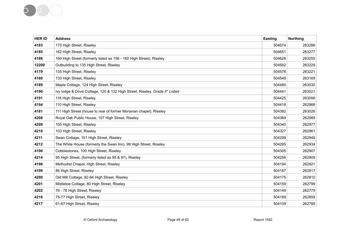
HER ID Address Easting Northing
4183 170 High Street, Riseley 504674 263286
4185 162 High Street, Riseley 504651 263277
4186 160 High Street (formerly listed as 156 - 160 High Street), Riseley 504628 263255
12209 Outbuilding to 135 High Street, Riseley 504582 263229
4179 135 High Street, Riseley 504578 263221
4180 133 High Street, Riseley 504549 263169
4189 Maple Cottage, 124 High Street, Riseley 504480 263030
4190 Ivy lodge & Dove Cottage, 120 & 122 High Street, Riseley. Grade II* Listed 504441 263021
4191 118 High Street, Riseley 504425 263006
4194 110 High Street, Riseley 504418 262968
4181 111 High Street (house to rear of former Moravian chapel), Riseley 504382 263026
4208 Royal Oak Public House, 107 High Street, Riseley 504369 262989
4209 105 High Street, Riseley 504340 262977
4210 103 High Street, Riseley 504327 262961
4211 Swan Cottage, 101 High Street, Riseley 504299 262949
4212 The White House (formerly the Swan Inn), 99 High Street, Riseley 504295 262934
4196 Cobblestones, 100 High Street, Riseley 504305 262907
4214 95 High Street, (formerly listed as 95 & 97), Riseley 504256 262909
4198 Methodist Chapel, High Street, Riseley 504194 262821
4199 86 High Street, Riseley 504187 262817
4200 Old Mill Cottage, 82-84 High Street, Riseley 504175 262810
4201 Mistletoe Cottage, 80 High Street, Riseley 504159 262799
4202 76 - 78 High Street, Riseley 504149 262779
4216 75-77 High Street, Riseley 504189 262859
4217 61-67 High Street, Riseley 504109 262789
© Oxford Archaeology Page 48 of 62 Report 1592
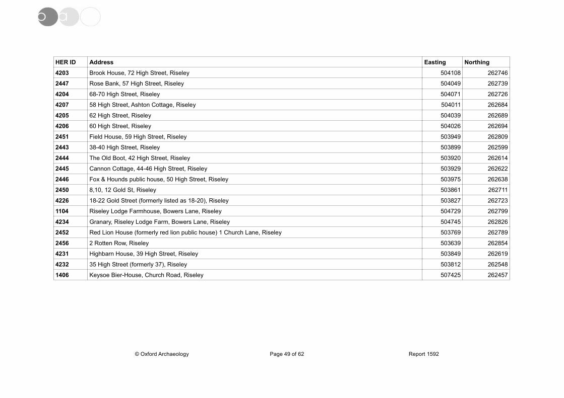
HER ID Address Easting Northing
4203 Brook House, 72 High Street, Riseley 504108 262746
2447 Rose Bank, 57 High Street, Riseley 504049 262739
4204 68-70 High Street, Riseley 504071 262726
4207 58 High Street, Ashton Cottage, Riseley 504011 262684
4205 62 High Street, Riseley 504039 262689
4206 60 High Street, Riseley 504026 262694
2451 Field House, 59 High Street, Riseley 503949 262809
2443 38-40 High Street, Riseley 503899 262599
2444 The Old Boot, 42 High Street, Riseley 503920 262614
2445 Cannon Cottage, 44-46 High Street, Riseley 503929 262622
2446 Fox & Hounds public house, 50 High Street, Riseley 503975 262638
2450 8,10, 12 Gold St, Riseley 503861 262711
4226 18-22 Gold Street (formerly listed as 18-20), Riseley 503827 262723
1104 Riseley Lodge Farmhouse, Bowers Lane, Riseley 504729 262799
4234 Granary, Riseley Lodge Farm, Bowers Lane, Riseley 504745 262826
2452 Red Lion House (formerly red lion public house) 1 Church Lane, Riseley 503769 262789
2456 2 Rotten Row, Riseley 503639 262854
4231 Highbarn House, 39 High Street, Riseley 503849 262619
4232 35 High Street (formerly 37), Riseley 503812 262548
1406 Keysoe Bier-House, Church Road, Riseley 507425 262457
© Oxford Archaeology Page 49 of 62 Report 1592
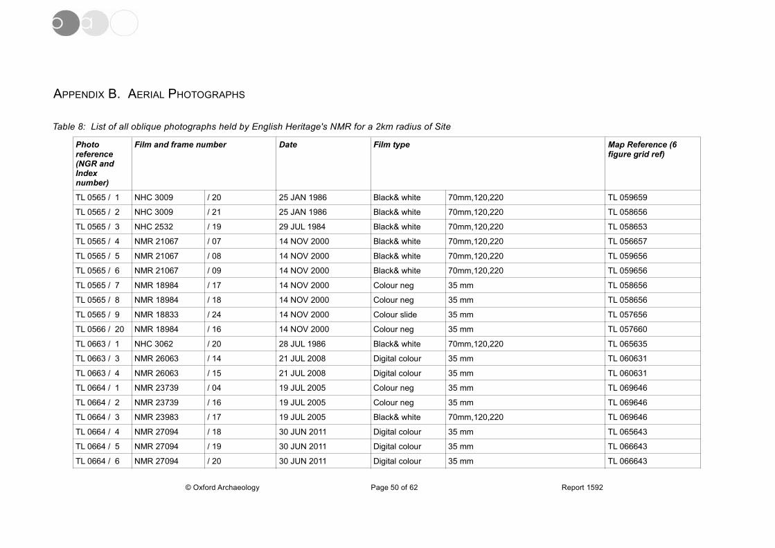
APPENDIX B. AERIAL PHOTOGRAPHS
Table 8: List of all oblique photographs held by English Heritage's NMR for a 2km radius of Site
Photo reference (NGR and Index number)
Film and frame number Date Film type Map Reference (6 figure grid ref)
TL 0565 / 1 NHC 3009 / 20 25 JAN 1986 Black& white 70mm,120,220 TL 059659
TL 0565 / 2 NHC 3009 / 21 25 JAN 1986 Black& white 70mm,120,220 TL 058656
TL 0565 / 3 NHC 2532 / 19 29 JUL 1984 Black& white 70mm,120,220 TL 058653
TL 0565 / 4 NMR 21067 / 07 14 NOV 2000 Black& white 70mm,120,220 TL 056657
TL 0565 / 5 NMR 21067 / 08 14 NOV 2000 Black& white 70mm,120,220 TL 059656
TL 0565 / 6 NMR 21067 / 09 14 NOV 2000 Black& white 70mm,120,220 TL 059656
TL 0565 / 7 NMR 18984 / 17 14 NOV 2000 Colour neg 35 mm TL 058656
TL 0565 / 8 NMR 18984 / 18 14 NOV 2000 Colour neg 35 mm TL 058656
TL 0565 / 9 NMR 18833 / 24 14 NOV 2000 Colour slide 35 mm TL 057656
TL 0566 / 20 NMR 18984 / 16 14 NOV 2000 Colour neg 35 mm TL 057660
TL 0663 / 1 NHC 3062 / 20 28 JUL 1986 Black& white 70mm,120,220 TL 065635
TL 0663 / 3 NMR 26063 / 14 21 JUL 2008 Digital colour 35 mm TL 060631
TL 0663 / 4 NMR 26063 / 15 21 JUL 2008 Digital colour 35 mm TL 060631
TL 0664 / 1 NMR 23739 / 04 19 JUL 2005 Colour neg 35 mm TL 069646
TL 0664 / 2 NMR 23739 / 16 19 JUL 2005 Colour neg 35 mm TL 069646
TL 0664 / 3 NMR 23983 / 17 19 JUL 2005 Black& white 70mm,120,220 TL 069646
TL 0664 / 4 NMR 27094 / 18 30 JUN 2011 Digital colour 35 mm TL 065643
TL 0664 / 5 NMR 27094 / 19 30 JUN 2011 Digital colour 35 mm TL 066643
TL 0664 / 6 NMR 27094 / 20 30 JUN 2011 Digital colour 35 mm TL 066643
© Oxford Archaeology Page 50 of 62 Report 1592
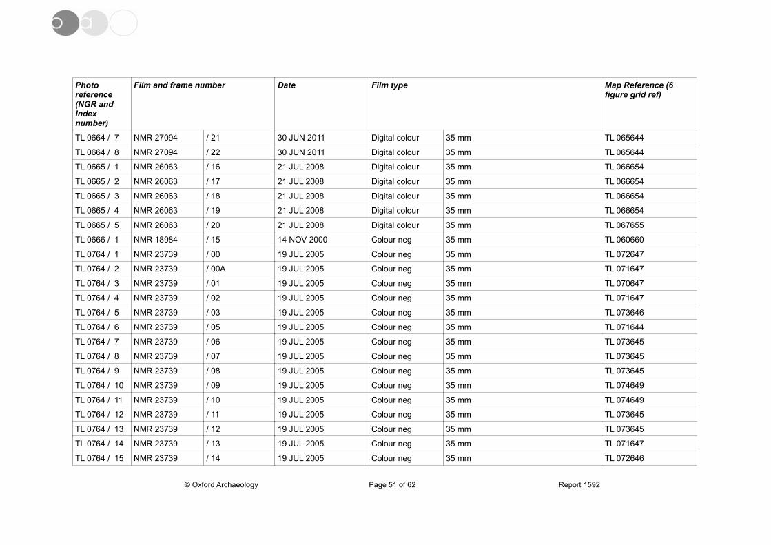
Photo reference (NGR and Index number)
Film and frame number Date Film type Map Reference (6 figure grid ref)
TL 0664 / 7 NMR 27094 / 21 30 JUN 2011 Digital colour 35 mm TL 065644
TL 0664 / 8 NMR 27094 / 22 30 JUN 2011 Digital colour 35 mm TL 065644
TL 0665 / 1 NMR 26063 / 16 21 JUL 2008 Digital colour 35 mm TL 066654
TL 0665 / 2 NMR 26063 / 17 21 JUL 2008 Digital colour 35 mm TL 066654
TL 0665 / 3 NMR 26063 / 18 21 JUL 2008 Digital colour 35 mm TL 066654
TL 0665 / 4 NMR 26063 / 19 21 JUL 2008 Digital colour 35 mm TL 066654
TL 0665 / 5 NMR 26063 / 20 21 JUL 2008 Digital colour 35 mm TL 067655
TL 0666 / 1 NMR 18984 / 15 14 NOV 2000 Colour neg 35 mm TL 060660
TL 0764 / 1 NMR 23739 / 00 19 JUL 2005 Colour neg 35 mm TL 072647
TL 0764 / 2 NMR 23739 / 00A 19 JUL 2005 Colour neg 35 mm TL 071647
TL 0764 / 3 NMR 23739 / 01 19 JUL 2005 Colour neg 35 mm TL 070647
TL 0764 / 4 NMR 23739 / 02 19 JUL 2005 Colour neg 35 mm TL 071647
TL 0764 / 5 NMR 23739 / 03 19 JUL 2005 Colour neg 35 mm TL 073646
TL 0764 / 6 NMR 23739 / 05 19 JUL 2005 Colour neg 35 mm TL 071644
TL 0764 / 7 NMR 23739 / 06 19 JUL 2005 Colour neg 35 mm TL 073645
TL 0764 / 8 NMR 23739 / 07 19 JUL 2005 Colour neg 35 mm TL 073645
TL 0764 / 9 NMR 23739 / 08 19 JUL 2005 Colour neg 35 mm TL 073645
TL 0764 / 10 NMR 23739 / 09 19 JUL 2005 Colour neg 35 mm TL 074649
TL 0764 / 11 NMR 23739 / 10 19 JUL 2005 Colour neg 35 mm TL 074649
TL 0764 / 12 NMR 23739 / 11 19 JUL 2005 Colour neg 35 mm TL 073645
TL 0764 / 13 NMR 23739 / 12 19 JUL 2005 Colour neg 35 mm TL 073645
TL 0764 / 14 NMR 23739 / 13 19 JUL 2005 Colour neg 35 mm TL 071647
TL 0764 / 15 NMR 23739 / 14 19 JUL 2005 Colour neg 35 mm TL 072646
© Oxford Archaeology Page 51 of 62 Report 1592

Photo reference (NGR and Index number)
Film and frame number Date Film type Map Reference (6 figure grid ref)
TL 0764 / 16 NMR 23739 / 15 19 JUL 2005 Colour neg 35 mm TL 070646
TL 0764 / 17 NMR 23983 / 09 19 JUL 2005 Black& white 70mm,120,220 TL 073647
TL 0764 / 18 NMR 23983 / 10 19 JUL 2005 Black& white 70mm,120,220 TL 075648
TL 0764 / 19 NMR 23983 / 11 19 JUL 2005 Black& white 70mm,120,220 TL 076648
TL 0764 / 20 NMR 23983 / 12 19 JUL 2005 Black& white 70mm,120,220 TL 076647
TL 0764 / 21 NMR 23983 / 13 19 JUL 2005 Black& white 70mm,120,220 TL 076647
TL 0764 / 22 NMR 23983 / 14 19 JUL 2005 Black& white 70mm,120,220 TL 074647
TL 0764 / 23 NMR 23983 / 15 19 JUL 2005 Black& white 70mm,120,220 TL 074647
TL 0764 / 24 NMR 23983 / 16 19 JUL 2005 Black& white 70mm,120,220 TL 071646
TL 0764 / 25 NMR 23983 / 18 19 JUL 2005 Black& white 70mm,120,220 TL 070645
TL 0764 / 26 NMR 27094 / 23 30 JUN 2011 Digital colour 35 mm TL 075647
TL 0764 / 27 NMR 27094 / 24 30 JUN 2011 Digital colour 35 mm TL 075647
TL 0764 / 28 NMR 27094 / 26 30 JUN 2011 Digital colour 35 mm TL 075647
TL 0764 / 29 NMR 27094 / 25 30 JUN 2011 Digital colour 35 mm TL 075647
TL 0764 / 30 NMR 27094 / 27 30 JUN 2011 Digital colour 35 mm TL 075647
TL 0764 / 31 NMR 27094 / 28 30 JUN 2011 Digital colour 35 mm TL 074649
TL 0764 / 32 NMR 27094 / 29 30 JUN 2011 Digital colour 35 mm TL 074648
TL 0764 / 33 NMR 27094 / 30 30 JUN 2011 Digital colour 35 mm TL 074648
TL 0764 / 34 NMR 27094 / 31 30 JUN 2011 Digital colour 35 mm TL 074648
TL 0764 / 35 NMR 27094 / 32 30 JUN 2011 Digital colour 35 mm TL 074648
TL 0764 / 36 NMR 27094 / 33 30 JUN 2011 Digital colour 35 mm TL 075648
TL 0764 / 37 NMR 27094 / 34 30 JUN 2011 Digital colour 35 mm TL 075648
TL 0764 / 38 NMR 27094 / 35 30 JUN 2011 Digital colour 35 mm TL 075647
© Oxford Archaeology Page 52 of 62 Report 1592
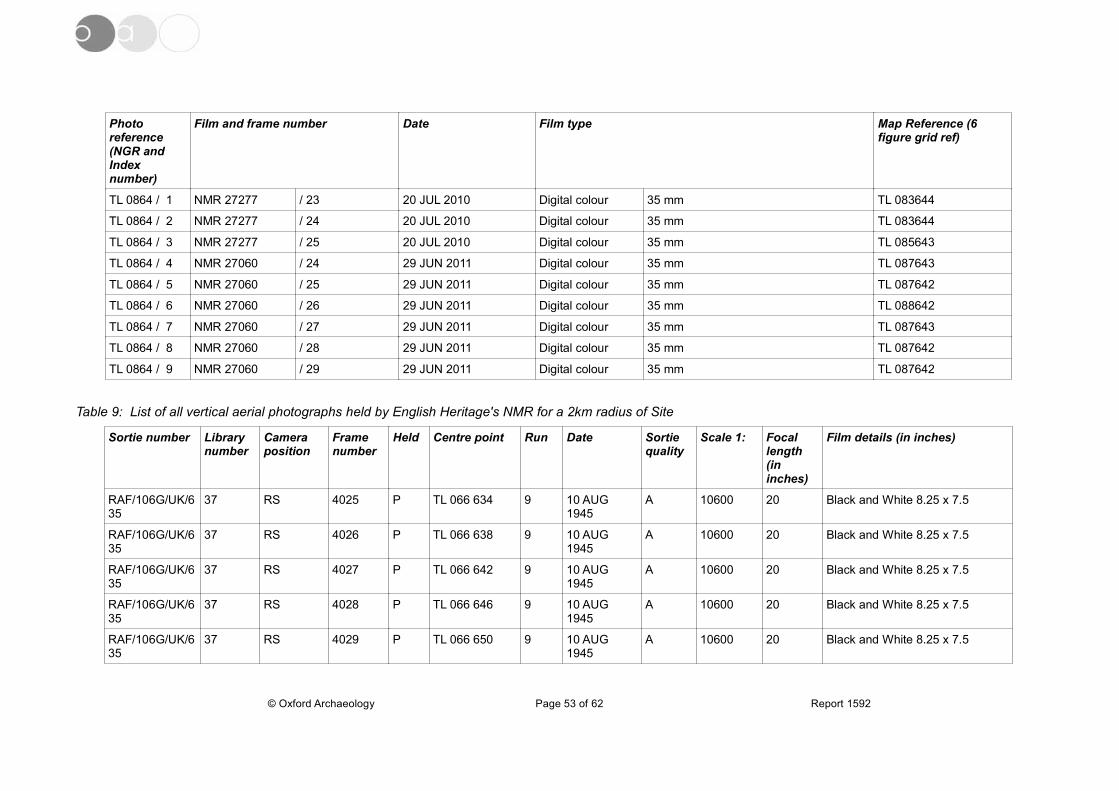
Photo reference (NGR and Index number)
Film and frame number Date Film type Map Reference (6 figure grid ref)
TL 0864 / 1 NMR 27277 / 23 20 JUL 2010 Digital colour 35 mm TL 083644
TL 0864 / 2 NMR 27277 / 24 20 JUL 2010 Digital colour 35 mm TL 083644
TL 0864 / 3 NMR 27277 / 25 20 JUL 2010 Digital colour 35 mm TL 085643
TL 0864 / 4 NMR 27060 / 24 29 JUN 2011 Digital colour 35 mm TL 087643
TL 0864 / 5 NMR 27060 / 25 29 JUN 2011 Digital colour 35 mm TL 087642
TL 0864 / 6 NMR 27060 / 26 29 JUN 2011 Digital colour 35 mm TL 088642
TL 0864 / 7 NMR 27060 / 27 29 JUN 2011 Digital colour 35 mm TL 087643
TL 0864 / 8 NMR 27060 / 28 29 JUN 2011 Digital colour 35 mm TL 087642
TL 0864 / 9 NMR 27060 / 29 29 JUN 2011 Digital colour 35 mm TL 087642
Table 9: List of all vertical aerial photographs held by English Heritage's NMR for a 2km radius of Site
Sortie number Library number
Camera position
Frame number
Held Centre point Run Date Sortie quality
Scale 1: Focal length (in inches)
Film details (in inches)
RAF/106G/UK/635
37 RS 4025 P TL 066 634 9 10 AUG 1945
A 10600 20 Black and White 8.25 x 7.5
RAF/106G/UK/635
37 RS 4026 P TL 066 638 9 10 AUG 1945
A 10600 20 Black and White 8.25 x 7.5
RAF/106G/UK/635
37 RS 4027 P TL 066 642 9 10 AUG 1945
A 10600 20 Black and White 8.25 x 7.5
RAF/106G/UK/635
37 RS 4028 P TL 066 646 9 10 AUG 1945
A 10600 20 Black and White 8.25 x 7.5
RAF/106G/UK/635
37 RS 4029 P TL 066 650 9 10 AUG 1945
A 10600 20 Black and White 8.25 x 7.5
© Oxford Archaeology Page 53 of 62 Report 1592

Sortie number Library number
Camera position
Frame number
Held Centre point Run Date Sortie quality
Scale 1: Focal length (in inches)
Film details (in inches)
RAF/106G/UK/635
37 RS 4030 P TL 066 654 9 10 AUG 1945
A 10600 20 Black and White 8.25 x 7.5
RAF/106G/UK/635
37 RS 4031 P TL 067 657 9 10 AUG 1945
A 10600 20 Black and White 8.25 x 7.5
RAF/106G/UK/635
37 RS 4032 P TL 067 661 9 10 AUG 1945
A 10600 20 Black and White 8.25 x 7.5
RAF/106G/UK/635
37 RS 4148 P TL 070 663 11 10 AUG 1945
A 10600 20 Black and White 8.25 x 7.5
RAF/106G/UK/635
37 RS 4149 P TL 071 657 11 10 AUG 1945
A 10600 20 Black and White 8.25 x 7.5
RAF/106G/UK/635
37 RS 4150 P TL 072 652 11 10 AUG 1945
A 10600 20 Black and White 8.25 x 7.5
RAF/106G/UK/635
37 RS 4151 P TL 072 647 11 10 AUG 1945
A 10600 20 Black and White 8.25 x 7.5
RAF/106G/UK/635
37 RS 4152 P TL 073 642 11 10 AUG 1945
A 10600 20 Black and White 8.25 x 7.5
RAF/106G/UK/635
37 RS 4153 P TL 073 637 11 10 AUG 1945
A 10600 20 Black and White 8.25 x 7.5
RAF/CPE/UK/1925
549 RS 4275 P TL 068 670 30 16 JAN 1947 A 9840 20 Black and White 8.25 x 7.5
RAF/CPE/UK/1925
549 RS 4276 P TL 074 669 30 16 JAN 1947 A 9840 20 Black and White 8.25 x 7.5
RAF/CPE/UK/1925
549 RS 4277 P TL 080 668 30 16 JAN 1947 A 9840 20 Black and White 8.25 x 7.5
RAF/541/483 1062 RP 3351 P TL 084 639 10 07 APR 1950 A 10100 20 Black and White 8.25 x 7.5
RAF/541/483 1062 RP 3352 P TL 078 640 10 07 APR 1950 A 10100 20 Black and White 8.25 x 7.5
RAF/541/483 1062 RP 3353 P TL 072 640 10 07 APR 1950 A 10100 20 Black and White 8.25 x 7.5
© Oxford Archaeology Page 54 of 62 Report 1592

Sortie number Library number
Camera position
Frame number
Held Centre point Run Date Sortie quality
Scale 1: Focal length (in inches)
Film details (in inches)
RAF/541/483 1062 RP 3354 P TL 067 640 10 07 APR 1950 A 10100 20 Black and White 8.25 x 7.5
RAF/541/483 1062 RP 3355 P TL 062 640 10 07 APR 1950 A 10100 20 Black and White 8.25 x 7.5
RAF/541/483 1062 RS 4204 P TL 082 642 21 07 APR 1950 A 10100 20 Black and White 8.25 x 7.5
RAF/541/483 1062 RS 4205 P TL 076 642 21 07 APR 1950 A 10100 20 Black and White 8.25 x 7.5
RAF/541/483 1062 RS 4206 P TL 070 643 21 07 APR 1950 A 10100 20 Black and White 8.25 x 7.5
RAF/541/483 1062 RS 4207 P TL 064 643 21 07 APR 1950 A 10100 20 Black and White 8.25 x 7.5
RAF/541/483 1062 RS 4208 P TL 058 643 21 07 APR 1950 A 10100 20 Black and White 8.25 x 7.5
RAF/541/483 1062 RS 4352 P TL 079 657 24 07 APR 1950 A 10100 20 Black and White 8.25 x 7.5
RAF/541/483 1062 RS 4353 P TL 074 658 24 07 APR 1950 A 10100 20 Black and White 8.25 x 7.5
RAF/541/483 1062 RS 4354 P TL 068 658 24 07 APR 1950 A 10100 20 Black and White 8.25 x 7.5
RAF/541/483 1062 RS 4355 P TL 063 658 24 07 APR 1950 A 10100 20 Black and White 8.25 x 7.5
OS/73316 10429 V 350 N TL 085 639 1 16 JUN 1973 A 7500 12 Black and White 9 x 9
OS/73316 10429 V 351 N TL 077 639 1 16 JUN 1973 A 7500 12 Black and White 9 x 9
OS/73316 10429 V 352 N TL 069 639 1 16 JUN 1973 A 7500 12 Black and White 9 x 9
OS/73316 10429 V 353 N TL 060 639 1 16 JUN 1973 A 7500 12 Black and White 9 x 9
OS/73316 10429 V 370 N TL 055 653 2 16 JUN 1973 A 7500 12 Black and White 9 x 9
OS/73316 10429 V 371 N TL 063 653 2 16 JUN 1973 A 7500 12 Black and White 9 x 9
OS/73316 10429 V 372 N TL 071 652 2 16 JUN 1973 A 7500 12 Black and White 9 x 9
OS/73316 10429 V 373 N TL 079 652 2 16 JUN 1973 A 7500 12 Black and White 9 x 9
OS/73316 10429 V 374 N TL 087 652 2 16 JUN 1973 A 7500 12 Black and White 9 x 9
OS/73316 10429 V 458 N TL 081 665 3 16 JUN 1973 A 7500 12 Black and White 9 x 9
OS/73316 10429 V 459 N TL 074 665 3 16 JUN 1973 A 7500 12 Black and White 9 x 9
OS/73316 10429 V 460 N TL 066 665 3 16 JUN 1973 A 7500 12 Black and White 9 x 9
© Oxford Archaeology Page 55 of 62 Report 1592
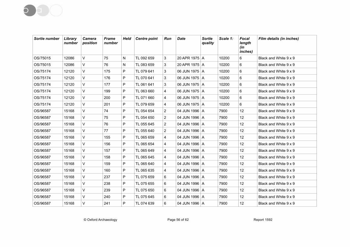
Sortie number Library number
Camera position
Frame number
Held Centre point Run Date Sortie quality
Scale 1: Focal length (in inches)
Film details (in inches)
OS/75015 12086 V 75 N TL 092 659 3 20 APR 1975 A 10200 6 Black and White 9 x 9
OS/75015 12086 V 76 N TL 083 659 3 20 APR 1975 A 10200 6 Black and White 9 x 9
OS/75174 12120 V 175 P TL 079 641 3 06 JUN 1975 A 10200 6 Black and White 9 x 9
OS/75174 12120 V 176 P TL 070 641 3 06 JUN 1975 A 10200 6 Black and White 9 x 9
OS/75174 12120 V 177 P TL 061 641 3 06 JUN 1975 A 10200 6 Black and White 9 x 9
OS/75174 12120 V 199 P TL 063 660 4 06 JUN 1975 A 10200 6 Black and White 9 x 9
OS/75174 12120 V 200 P TL 071 660 4 06 JUN 1975 A 10200 6 Black and White 9 x 9
OS/75174 12120 V 201 P TL 079 659 4 06 JUN 1975 A 10200 6 Black and White 9 x 9
OS/96587 15168 V 74 P TL 054 654 2 04 JUN 1996 A 7900 12 Black and White 9 x 9
OS/96587 15168 V 75 P TL 054 650 2 04 JUN 1996 A 7900 12 Black and White 9 x 9
OS/96587 15168 V 76 P TL 055 645 2 04 JUN 1996 A 7900 12 Black and White 9 x 9
OS/96587 15168 V 77 P TL 055 640 2 04 JUN 1996 A 7900 12 Black and White 9 x 9
OS/96587 15168 V 155 P TL 065 659 4 04 JUN 1996 A 7900 12 Black and White 9 x 9
OS/96587 15168 V 156 P TL 065 654 4 04 JUN 1996 A 7900 12 Black and White 9 x 9
OS/96587 15168 V 157 P TL 065 649 4 04 JUN 1996 A 7900 12 Black and White 9 x 9
OS/96587 15168 V 158 P TL 065 645 4 04 JUN 1996 A 7900 12 Black and White 9 x 9
OS/96587 15168 V 159 P TL 065 640 4 04 JUN 1996 A 7900 12 Black and White 9 x 9
OS/96587 15168 V 160 P TL 065 635 4 04 JUN 1996 A 7900 12 Black and White 9 x 9
OS/96587 15168 V 237 P TL 075 659 6 04 JUN 1996 A 7900 12 Black and White 9 x 9
OS/96587 15168 V 238 P TL 075 655 6 04 JUN 1996 A 7900 12 Black and White 9 x 9
OS/96587 15168 V 239 P TL 075 650 6 04 JUN 1996 A 7900 12 Black and White 9 x 9
OS/96587 15168 V 240 P TL 075 645 6 04 JUN 1996 A 7900 12 Black and White 9 x 9
OS/96587 15168 V 241 P TL 074 639 6 04 JUN 1996 A 7900 12 Black and White 9 x 9
© Oxford Archaeology Page 56 of 62 Report 1592

Sortie number Library number
Camera position
Frame number
Held Centre point Run Date Sortie quality
Scale 1: Focal length (in inches)
Film details (in inches)
OS/96587 15168 V 242 P TL 074 634 6 04 JUN 1996 A 7900 12 Black and White 9 x 9
OS/96588 15169 V 53 P TL 084 635 2 04 JUN 1996 A 7900 12 Black and White 9 x 9
OS/96588 15169 V 54 P TL 084 640 2 04 JUN 1996 A 7900 12 Black and White 9 x 9
OS/96588 15169 V 55 P TL 084 645 2 04 JUN 1996 A 7900 12 Black and White 9 x 9
OS/96588 15169 V 56 P TL 084 650 2 04 JUN 1996 A 7900 12 Black and White 9 x 9
OS/96588 15169 V 57 P TL 084 655 2 04 JUN 1996 A 7900 12 Black and White 9 x 9
OS/96588 15169 V 58 P TL 084 660 2 04 JUN 1996 A 7900 12 Black and White 9 x 9
OS/98634 22757 V 48 N TL 084 654 3 20 JUL 1998 A 7600 12 Black and White 9 x 9
OS/98634 22757 V 49 N TL 079 654 3 20 JUL 1998 A 7600 12 Black and White 9 x 9
OS/98634 22757 V 50 N TL 074 654 3 20 JUL 1998 A 7600 12 Black and White 9 x 9
OS/98634 22757 V 51 N TL 069 654 3 20 JUL 1998 A 7600 12 Black and White 9 x 9
OS/98634 22757 V 52 N TL 064 654 3 20 JUL 1998 A 7600 12 Black and White 9 x 9
OS/98634 22757 V 53 N TL 059 654 3 20 JUL 1998 A 7600 12 Black and White 9 x 9
OS/98634 22757 V 54 N TL 054 654 3 20 JUL 1998 A 7600 12 Black and White 9 x 9
ADA/084 26123 V 15 N TL 049 628 1 27 APR 1982 A 15000 6 Black and White 9 x 9
ADA/084 26123 V 16 N TL 050 642 1 27 APR 1982 A 15000 6 Black and White 9 x 9
ADA/084 26123 V 17 N TL 050 655 1 27 APR 1982 A 15000 6 Black and White 9 x 9
ADA/131 26197 V 12 N TL 050 660 1 13 JUN 1983 A 14000 6 Black and White 9 x 9
ADA/131 26197 V 13 N TL 049 646 1 13 JUN 1983 A 14000 6 Black and White 9 x 9
ADA/131 26197 V 14 N TL 050 634 1 13 JUN 1983 A 14000 6 Black and White 9 x 9
ADA/220Z 26341 V 12 N TL 050 660 1 29 JUL 1984 A 15000 6 Black and White 9 x 9
ADA/220Z 26341 V 13 N TL 049 646 1 29 JUL 1984 A 15000 6 Black and White 9 x 9
ADA/220Z 26341 V 14 N TL 049 634 1 29 JUL 1984 A 15000 6 Black and White 9 x 9
© Oxford Archaeology Page 57 of 62 Report 1592
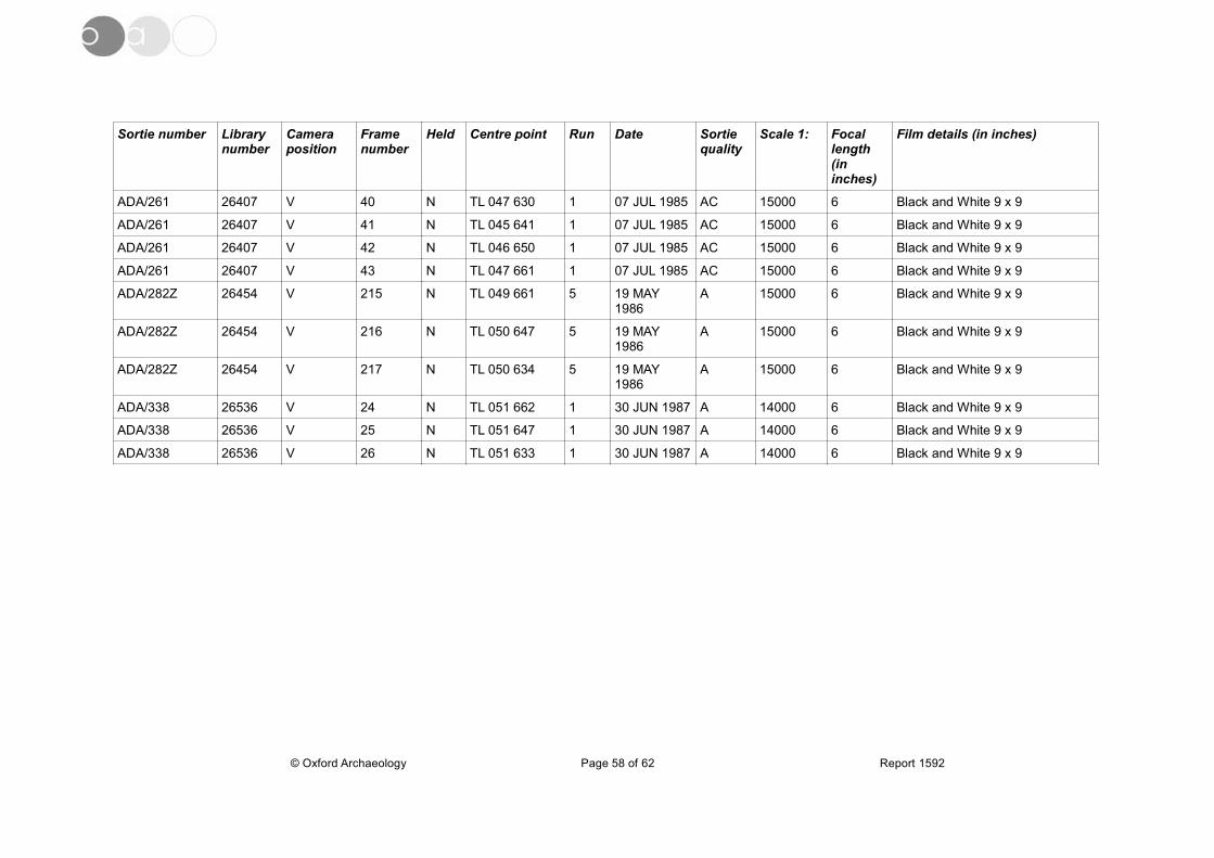
Sortie number Library number
Camera position
Frame number
Held Centre point Run Date Sortie quality
Scale 1: Focal length (in inches)
Film details (in inches)
ADA/261 26407 V 40 N TL 047 630 1 07 JUL 1985 AC 15000 6 Black and White 9 x 9
ADA/261 26407 V 41 N TL 045 641 1 07 JUL 1985 AC 15000 6 Black and White 9 x 9
ADA/261 26407 V 42 N TL 046 650 1 07 JUL 1985 AC 15000 6 Black and White 9 x 9
ADA/261 26407 V 43 N TL 047 661 1 07 JUL 1985 AC 15000 6 Black and White 9 x 9
ADA/282Z 26454 V 215 N TL 049 661 5 19 MAY 1986
A 15000 6 Black and White 9 x 9
ADA/282Z 26454 V 216 N TL 050 647 5 19 MAY 1986
A 15000 6 Black and White 9 x 9
ADA/282Z 26454 V 217 N TL 050 634 5 19 MAY 1986
A 15000 6 Black and White 9 x 9
ADA/338 26536 V 24 N TL 051 662 1 30 JUN 1987 A 14000 6 Black and White 9 x 9
ADA/338 26536 V 25 N TL 051 647 1 30 JUN 1987 A 14000 6 Black and White 9 x 9
ADA/338 26536 V 26 N TL 051 633 1 30 JUN 1987 A 14000 6 Black and White 9 x 9
© Oxford Archaeology Page 58 of 62 Report 1592
APPENDIX C. BIBLIOGRAPHY
PublicationsBush, L. 2012 Late Iron Age to Early Roman and Medieval Activity at Manor Farm,
Pertenhall, Bedfordshire: Archaeological Evaluation Report. OA East Report no. 1493. Unpublished
Bigmore, P. 1979 The Bedfordshire And Huntingdonshire Landscape. Hodder & Stoughton
Clover, K. 2012 Manor Farm, Green End, Pertenhall, Bedfordshire: Desk-Based Heritage Assessment. OA East Report no. 1487. Unpublished
Godber, J. 1969 History of Bedfordshire 1066-1888. Bedfordshire County Council
Land Use Consultants 2007 Bedford Borough Landscape Character Assessment. Bedfordshire County Council
Ludlow, H. & Burton, A. 2013 Proposed Solar Farm, Manor Farm, Pertenhall, Bedfordshire: Landscape and Visual Impact Assessment, Revised Layout.Greenwillows Associates Ltd. Report no. G57.13. Unpublished
Lasdun, S. 1991 The English Park: Royal, Private and Public. Andre Deutsch Ltd
Mawer, A. & Stenton, F.M. 1969 The Place-names of Bedfordshire and Huntingdonshire. Cambridge University Press
Palmer, R. 2007 'Aerial Photographic Assessment' in Atkins, R. Stow Longa to Tilbrook (Huntingdonshire), Anglian Water Pipeline: Desktop assessment and Air Photo Report. OA East Report no. 964. Unpublished
Online SourcesBritish Geological Survey Available: http://mapapps.bgs.ac.uk/geologyofbritain/home.html
Accessed 26 February 2014
Dept. for Communities and Local Government 2012 National Planning Policy Framework. Accessed 3 March 2014. Available:
https://www.gov.uk/government/uploads/ystem/uploads/attachment_data/file/6077/2116950.pdf
English Heritage 2010 'The Setting of Heritage Assets'. Accessed 24 February 2014. Available: http://www.english-heritage.org.uk/publications/setting-heritage-assets/setting-heritage-assets.pdf
Heritage Gateway Available: http://www.heritagegateway.org.uk/gateway/ Accessed 24 February 2014
Highways Agency 2007 'Design Manual for Roads and Bridges, Volume 11, Section 3, HA208/07'. Accessed 26 February 2014. Available:
http://www.dft.gov.uk/ha/standards/dmrb/vol11/section3/ha20807.pdf
Institute for Archaeologists 2012 'Standards and Guidance for Archaeological Desk-Based Assessment'. Accessed 24 February 2014. Available:
http://www.archaeologists.net/sites/default/files/node-files/DBA2012-Working-draft.pdf
Page, W. 1912 'Parishes: Pertenhall', A History of the County of Bedford: Volume 3 (1912), pp. 153-157. Available: http://www.british-history.ac.uk/report.aspx?compid=42404 Accessed 24 February 2014
© Oxford Archaeology East Page 59 of 62 Report Number 1592
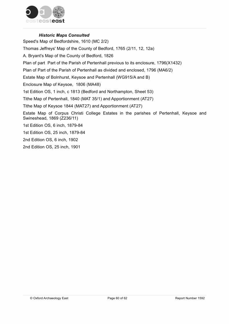
Historic Maps ConsultedSpeed's Map of Bedfordshire, 1610 (MC 2/2)
Thomas Jeffreys' Map of the County of Bedford, 1765 (2/11, 12, 12a)
A. Bryant's Map of the County of Bedford, 1826
Plan of part Part of the Parish of Pertenhall previous to its enclosure, 1796(X1432)
Plan of Part of the Parish of Pertenhall as divided and enclosed, 1796 (MA6/2)
Estate Map of Bolnhurst, Keysoe and Pertenhall (WG915/A and B)
Enclosure Map of Keysoe, 1806 (MA48)
1st Edition OS, 1 inch, c 1813 (Bedford and Northampton, Sheet 53)
Tithe Map of Pertenhall, 1840 (MAT 35/1) and Apportionment (AT27)
Tithe Map of Keysoe 1844 (MAT27) and Apportionment (AT27)
Estate Map of Corpus Christi College Estates in the parishes of Pertenhall, Keysoe andSwineshead, 1869 (Z236/11)
1st Edition OS, 6 inch, 1879-84
1st Edition OS, 25 inch, 1879-84
2nd Edition OS, 6 inch, 1902
2nd Edition OS, 25 inch, 1901
© Oxford Archaeology East Page 60 of 62 Report Number 1592

APPENDIX D. OASIS REPORT FORMAll fields are required unless they are not applicable.
Project DetailsOASIS Number
Project Name
Project Dates (fieldwork) Start Finish
Previous Work (by OA East) Future Work
Project Reference CodesSite Code Planning App. No.
HER No. Related HER/OASIS No.
Type of Project/Techniques UsedPrompt
Development Type
Please select all techniques used:DBA
Monument Types & Period List feature types using the NMR Monument Type Thesaurus together with their respective periods. If no features were found, please state “none”.
Monument Period
Project Location
County Site Address (including postcode if possible)
District
Parish
HER
Study Area National Grid Reference
© Oxford Archaeology East Page 61 of 62 Report Number 1592
XBDMFP13 13/01621/MAF
BEDFM 2014.19
Yes Unknown
oxfordar3-172393
Manor Farm, Pertenhall, Bedfordshire
Direction from Local Planning Authority - PPG16
Rural Commercial
oxfordar3-145226
Aerial Photography - interpretation
Aerial Photography - new
Documentary Search
Visual Inspection (Site Visit)
Moated Manor
Manor FarmGreen EndPertenhall MK44
Bedfordshire
St. Neots
Pertenhall
Central Bedfordshire
4km 510786, 264596
Medieval (1066 to 1540)
Cropmarks Uncertain
Historic Building Post Medieval (1540 to 1901)
Select period...

Project Originators
Organisation
Project Brief Originator
Project Design Originator
Project Manager
Supervisor
Project Archives
Physical Archive Digital Archive Paper Archive
Archive Contents/MediaPhysicalContents
DigitalContents
PaperContents
Digital Media Paper Media
Animal Bones
Ceramics
Environmental
Glass
Human Bones
Industrial
Leather
Metal
Stratigraphic
Survey
Textiles
Wood
Worked Bone
Worked Stone/Lithic
None
Other
Notes:
© Oxford Archaeology East Page 62 of 62 Report Number 1592
OA EAST
Richard Mortimer
Richard Mortimer
Louise Bush
Bedford Museum OA East Bedford Museum
XBDMFP13 XBDMFP13 XBDMFP13
Database
GIS
Geophysics
Images
Illustrations
Moving Image
Spreadsheets
Survey
Text
Virtual Reality
Aerial Photos
Context Sheet
Correspondence
Diary
Drawing
Manuscript
Map
Matrices
Microfilm
Misc.
Research/Notes
Photos
Plans
Report
Sections
Survey
Vanessa Clarke
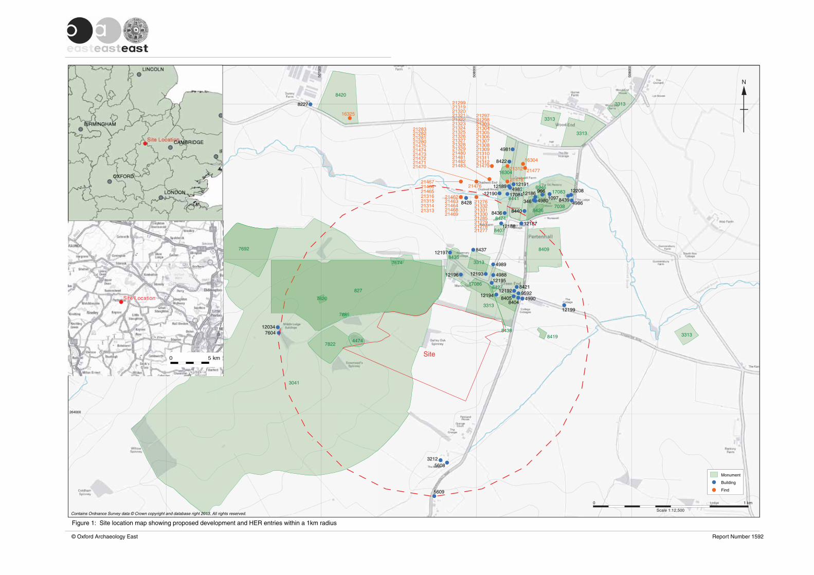
5060
00
5070
00
5080
00
5090
00
266000
265000
264000
7692
7822
3041
4474
7674
7620
7689
120347604
121978435
12196
8437
49893313
8407
8409
3313
12193 4988
170868421
12192 95924990
84048405
3313
12194
842712195
3313
3313
3313
8420
16325
8227
4981
8422
16304
1218712188
84248436 8440 8426
894612186
7038
17083
49803468428 21276
21479
21478
21312
12191121894982
844112190 17084
2146721476
,lSca e 1:12 500
0 1 km
Monument
Building
Find
Contains Ordnance Survey data © Crown copyright and database right 2013. All rights reserved.
8438
N
21469
49868439
16304
21477
81
12
4417084
© Oxford Archaeology East Report Number 1592
Figure 1: Site location map showing proposed development and HER entries within a 1km radius
8419
12199
5609
212772127821279
21280212812128221283
21285
2129721298
21299
21303213042130521306213072130821309213102131121312
21313213142131521316
213192131921320213212132221323213242132521326213272132821329
213302133121332
214622146321464
2146521466
21468
214702147121472214732147421475
214802148121482
32125608
122089661097
21483
74767467674
0620076776
76897668668
827
Site

Contains Ordnance Survey data © Crown copyright and database right 2013. All rights reserved.
5060
00
5050
00
5040
00
5030
00
5020
00
5070
00
5080
00
5090
00
5100
00
5110
00
5120
00
266000
267000
268000
265000
264000
263000
262000
261000Scale 1:30,000
0 2 km
12088
12221
5362 5363 537112222
5364
536512119
5374
12220122241139
8645
5367
537315134
5372
53692822
DBD3417
12057
512723621205412053 2360
DBD3419
12067 23632361
2359
120512364 925
4987
12201 12200
12203 12204
4981 4985
4983
4982
1218712188
4980 4986
49894988
12192 95924990
3212 5608
560956105611
1202256125613
7983
2471
1083 1406 7708
5607
12025780412026
12027 5620
12023
5617 5619
5618
5615
84771084
5614
57505748
574912072
1206823952392
5751
56025601 5600
55995598
12033
108512032
559555915592
12012
55945593
12024
12028
559055895588
5585 55865583 5587
5584
42341104
4173
417441754176DBD2736
4177 41834185
4186
12209
4179
4180
11674218DBD2736
42282456
24522451
4226
4232
24432444
4231
244524464207 4205
4206
2450
DBD2736
4204
2447
42034202
4217
42014200
41994198
4216
4196
4214421242114210
4194
42094208
4191
4190
4181
4189
Castle Hill
Hall CloseDBD1305
College Farm moated siteDBD454
Conservation area
Listed building
Scheduled monument
© Oxford Archaeology East Report Number 1487
Figure 2: Site location map showing proposed development and designated sites within a 4km radius
N
5597
5596
Riseley
Melchbourne
Upper Dean
Swineshead
Pertenhall
Kimbolton
Little Staughton
Keysoe
Hatch End
Brook End
Keysoe Row
1097 843912208
966
1128
SiteSite
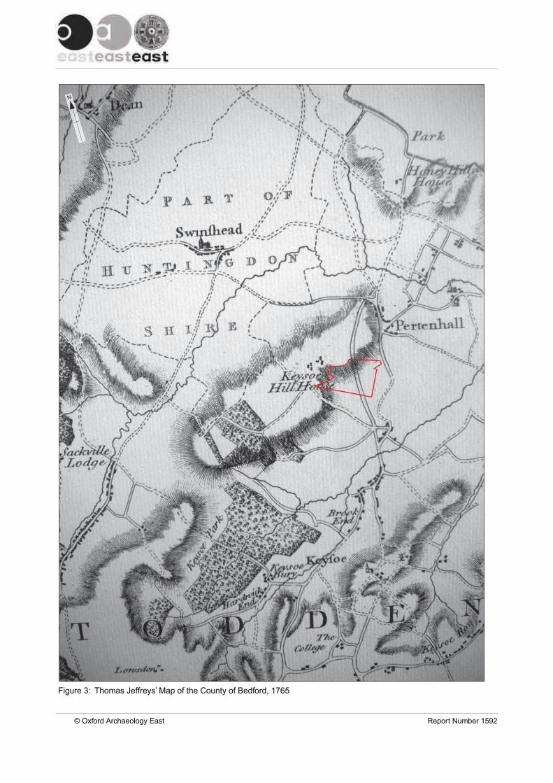
Figure 3: Thomas Jeffreys’ Map of the County of Bedford, 1765
© Oxford Archaeology East Report Number 1592
N

Figure 4: Enclosure Map of Keysoe, 1806
© Oxford Archaeology East Report Number 1592
N
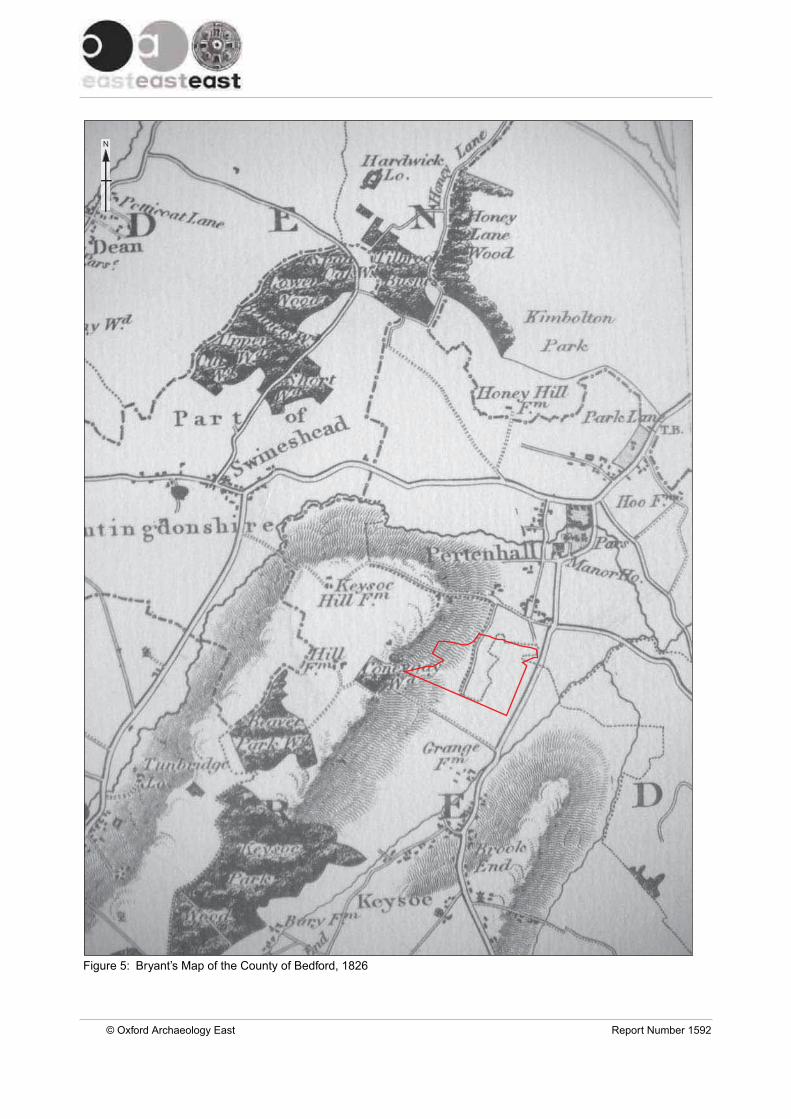
Figure 5: Bryant’s Map of the County of Bedford, 1826
© Oxford Archaeology East Report Number 1592
N
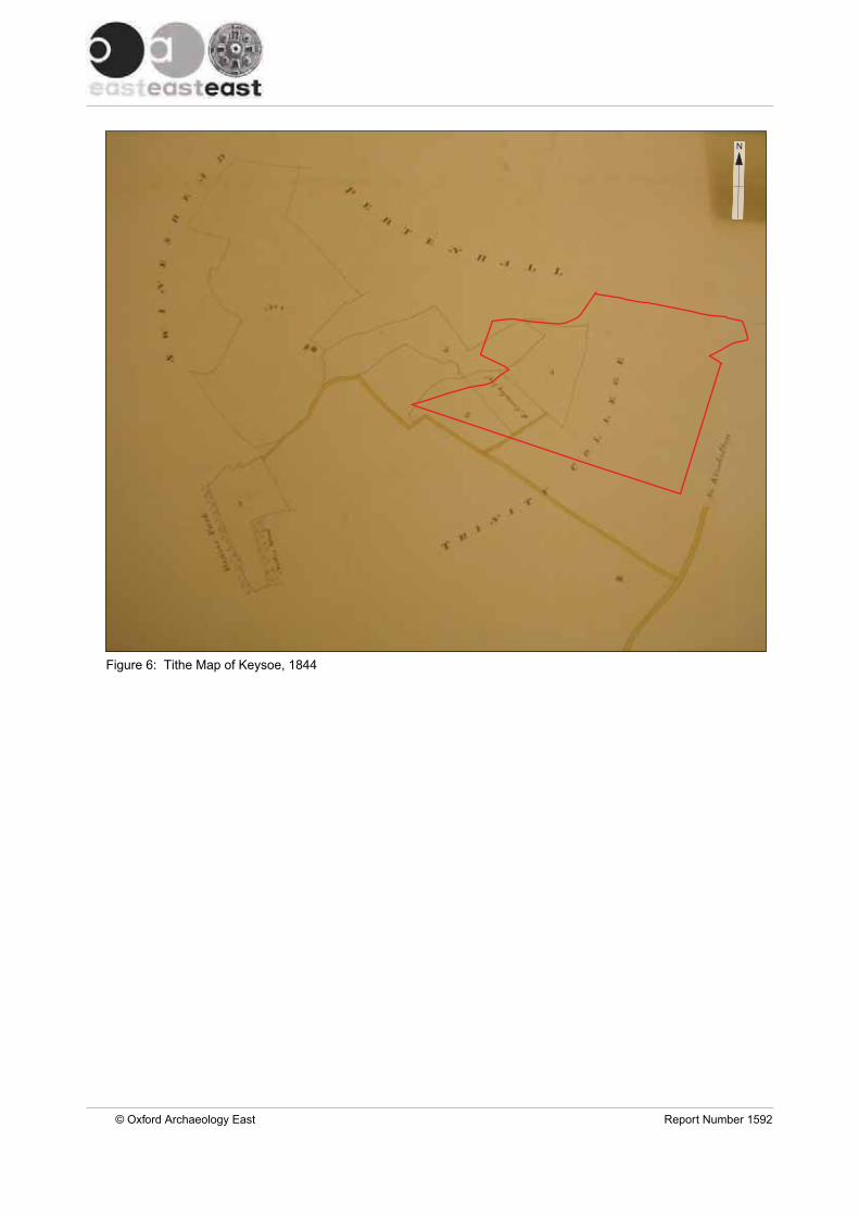
Figure 6: Tithe Map of Keysoe, 1844
© Oxford Archaeology East Report Number 1592
N
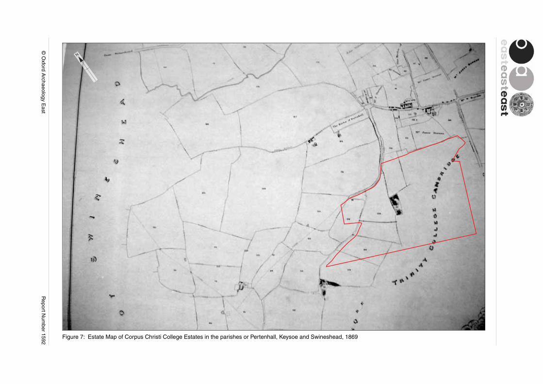
Figure 7: Estate Map of Corpus Christi College Estates in the parishes or Pertenhall, Keysoe and Swineshead, 1869
© O
xford Archaeology E
astR
eport Num
ber 1592
N

Figure 8: 1st edition 6 inch Ordnance Survey Map, 1879
© O
xford Archaeology E
astR
eport Num
ber 1592
N

Figure 9: 2nd Edition 6 inch Ordnance Survey Map, 1902
© Oxford Archaeology East Report Number 1592
N

N
Figure 10: Geophysics results
© O
xford Archaeology E
astR
eport Num
ber 1487
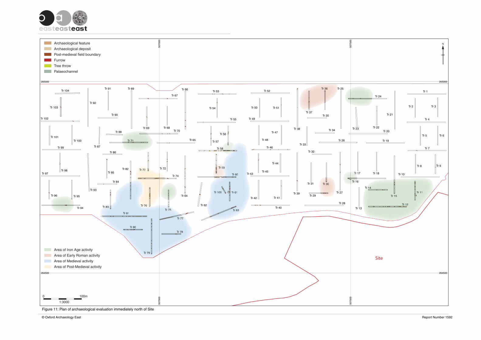
Tr 1
Tr 2 Tr 3
Tr 4
Tr 5 Tr 6
Tr 7
Tr 8 Tr 9
Tr 10
Tr 11
Tr 12
Tr 15
Tr 14
Tr 13
Tr 16
Tr 17 Tr 18
Tr 19
Tr 20
Tr 21
Tr 22Tr 23
Tr 24
Tr 25
Tr 34
Tr 26
Tr 27
Tr 28
Tr 29
Tr 30Tr 31
Tr 39
Tr 40
Tr 41
Tr 43
Tr 44
Tr 32
Tr 33
Tr 35
Tr 36
Tr 37
Tr 38
Tr 52
Tr 50 Tr 51
Tr 49
Tr 48
Tr 47
Tr 46
Tr 45
Tr 53
Tr 54
Tr 55
Tr 57
Tr 56
Tr 58
Tr 59
Tr 60
Tr 61Tr 105
Tr 62
Tr 63
Tr 77
Tr 78
Tr 79
Tr 80
Tr 81
Tr 76
Tr 75
Tr 64
Tr 74
Tr 72Tr 73
Tr 65
Tr 70
Tr 71
Tr 66
Tr 67
Tr 68Tr 69
Tr 89Tr 91
Tr 90
Tr 88
Tr 87
Tr 86
Tr 85
Tr 84
Tr 83
Tr 93
Tr 92
Tr 104
Tr 103
Tr 102
Tr 101Tr 100
Tr 99
Tr 98Tr 97
Tr 96 Tr 95
Tr 94
Tr 42
Tr 82
264500 264500
265000 265000
5070
0050
7000
5075
0050
7500
Archaeological feature
Archaeological deposit
Post-medieval field boundary
Furrow
Tree throw
Palaeochannel
1:3000
0 100m
N
Site
Tr 11
Tr 12
Tr 15
TTrr 1414
TrTr 11
TrTr
TTr 36
Tr 30
Area of Iron Age activity
Area of Early Roman activity
Area of Medieval activity
Area of Post-Medieval activity
TTT
5599
Tr 60
Tr 61Tr 105
Tr 633
Tr 77777
Tr 78
Tr 79
Tr 80
Tr 81
TT
Tr 75755Tr Tr 838383
Tr T 5555
TTr 71
88
TrTrTr 767676
TrrTrT 7373373
TT
© Oxford Archaeology East Report Number 1592
Figure 11: Plan of archaeological evaluation immediately north of Site

Site
Plate 9
Plate 10
Plate 11
Plate 12
Plate 13
Plate 14
Plate 15
Plate 16
Plate 17Plates 7 and 8
0 500m
NPlate 19
Plate 18
Plate 20
Figure 12: Plan of viewpoint locations
© Oxford Archaeology East Report Number 1592
Contains O
rdnance Survey data ©
Crow
n copyright and database right 2013. All rights reserved.

Site
Circularcropmarks
HER 4474
N
N
© English Heritage
© English Heritage
Plate 2: Vertical aerial photograph RAF/106G/UK/635/4027, taken 10th August 1945, showing Site at the top right and circular moat (HER 4474)
Plate 1: Oblique aerial photograph NMR 27094_21, taken 30th June 2011, showing a number of circular cropmarks close to the Middle Lodge Buildings in the field west of Site
© Oxford Archaeology East Report Number 1592
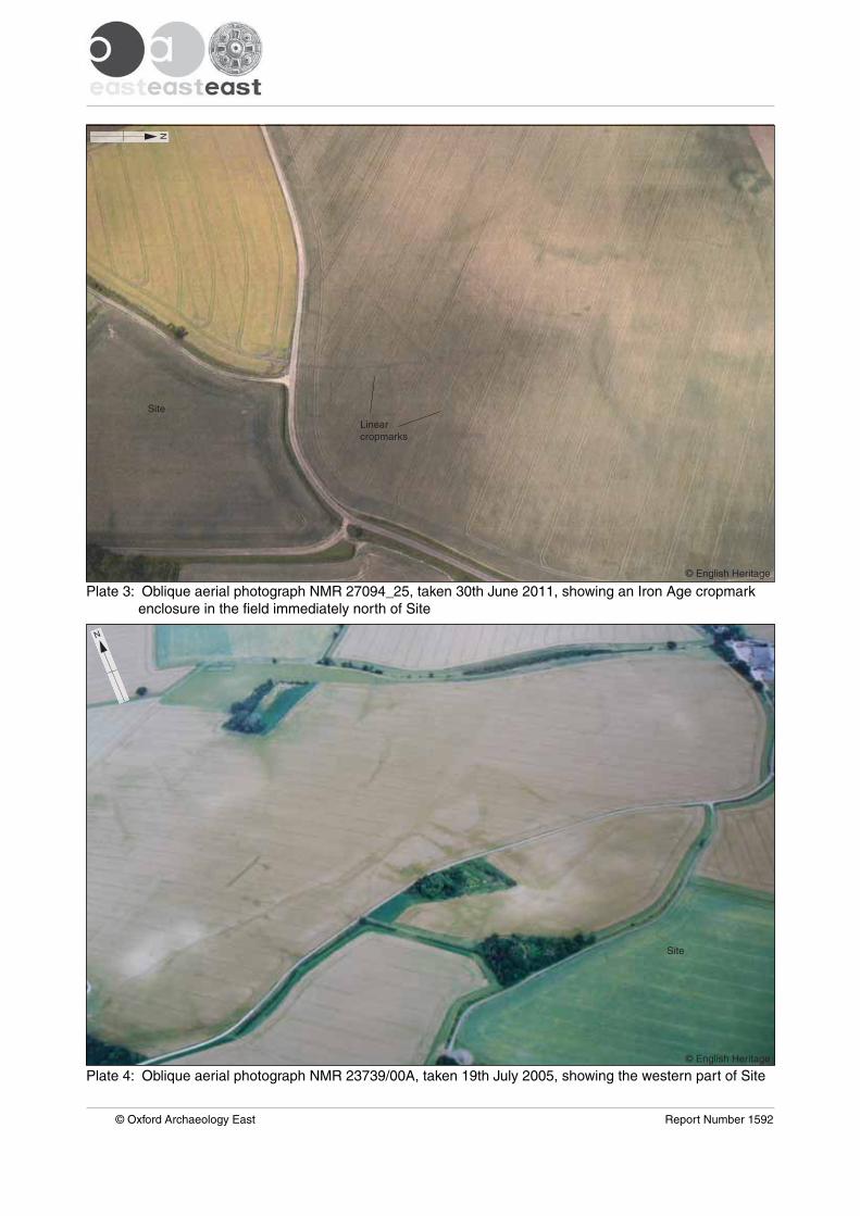
Site
Linearcropmarks
Site
N
N
Plate 4: Oblique aerial photograph NMR 23739/00A, taken 19th July 2005, showing the western part of Site
Plate 3: Oblique aerial photograph NMR 27094_25, taken 30th June 2011, showing an Iron Age cropmark enclosure in the field immediately north of Site
© Oxford Archaeology East Report Number 1592
© English Heritage
© English Heritage
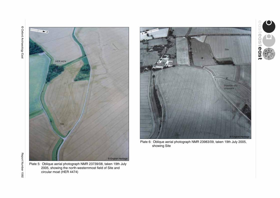
Site
Site
HER 4474
Plate 5: Oblique aerial photograph NMR 23739/08, taken 19th July 2005, showing the north-westernmost field of Site and circular moat (HER 4474)
Plate 6: Oblique aerial photograph NMR 23983/09, taken 19th July 2005, showing Site
© English Heritage
© English Heritage
N
N
Possible villacropmark
© O
xford Archaeology E
astR
eport Num
ber 1592

St Peter’s Church All Saints’ Church
Site
SiteSite
All Saints’ ChurchWind farm
Church of St Mary the Virgin
© Oxford Archaeology East Report Number 1592
Plate 7: Landscape viewpoint
Plate 8: Landscape viewpoint
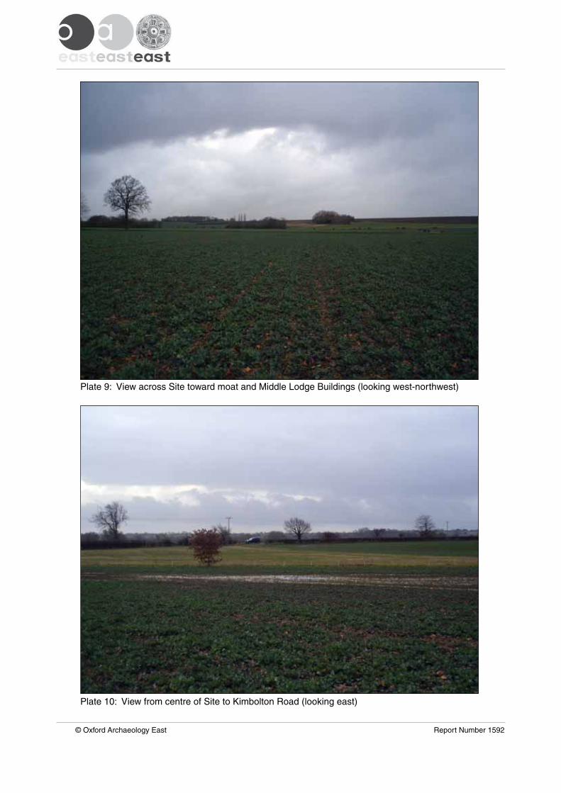
Plate 10: View from centre of Site to Kimbolton Road (looking east)
Plate 9: View across Site toward moat and Middle Lodge Buildings (looking west-northwest)
© Oxford Archaeology East Report Number 1592
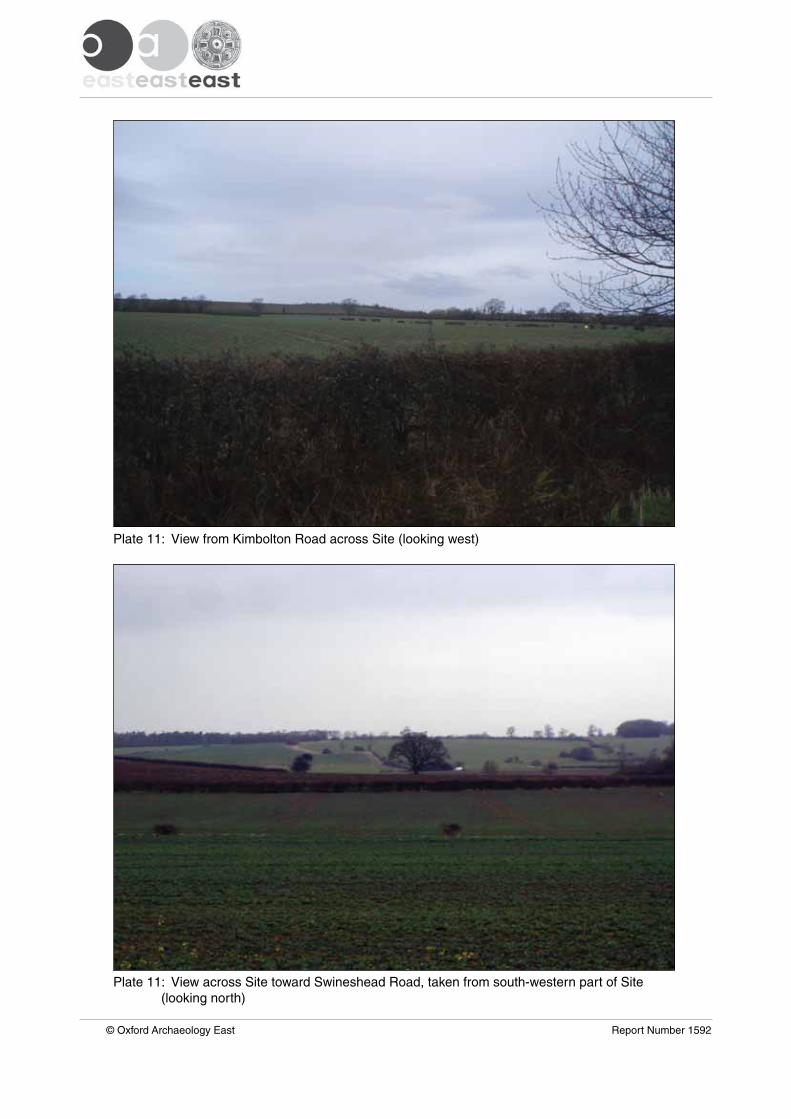
Plate 11: View across Site toward Swineshead Road, taken from south-western part of Site (looking north)
Plate 11: View from Kimbolton Road across Site (looking west)
© Oxford Archaeology East Report Number 1592
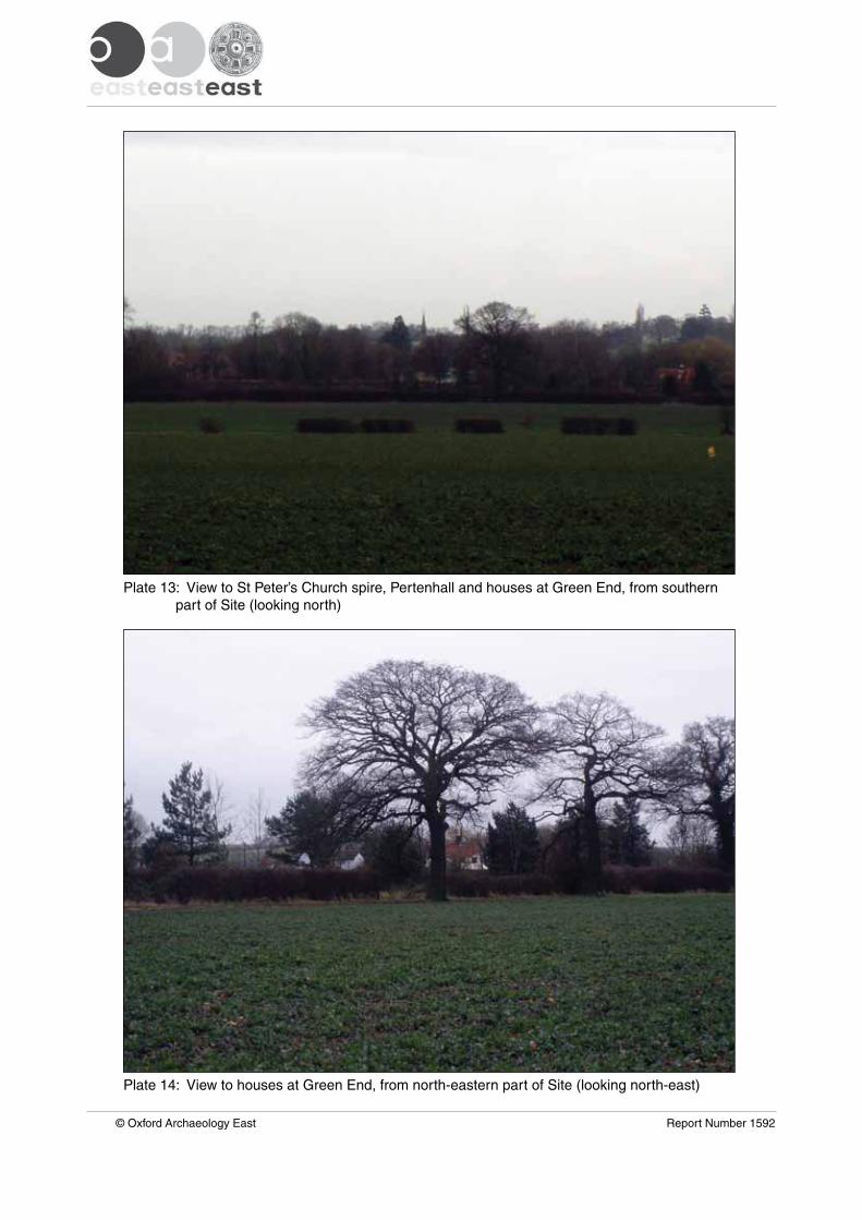
Plate 14: View to houses at Green End, from north-eastern part of Site (looking north-east)
Plate 13: View to St Peter’s Church spire, Pertenhall and houses at Green End, from southern part of Site (looking north)
© Oxford Archaeology East Report Number 1592
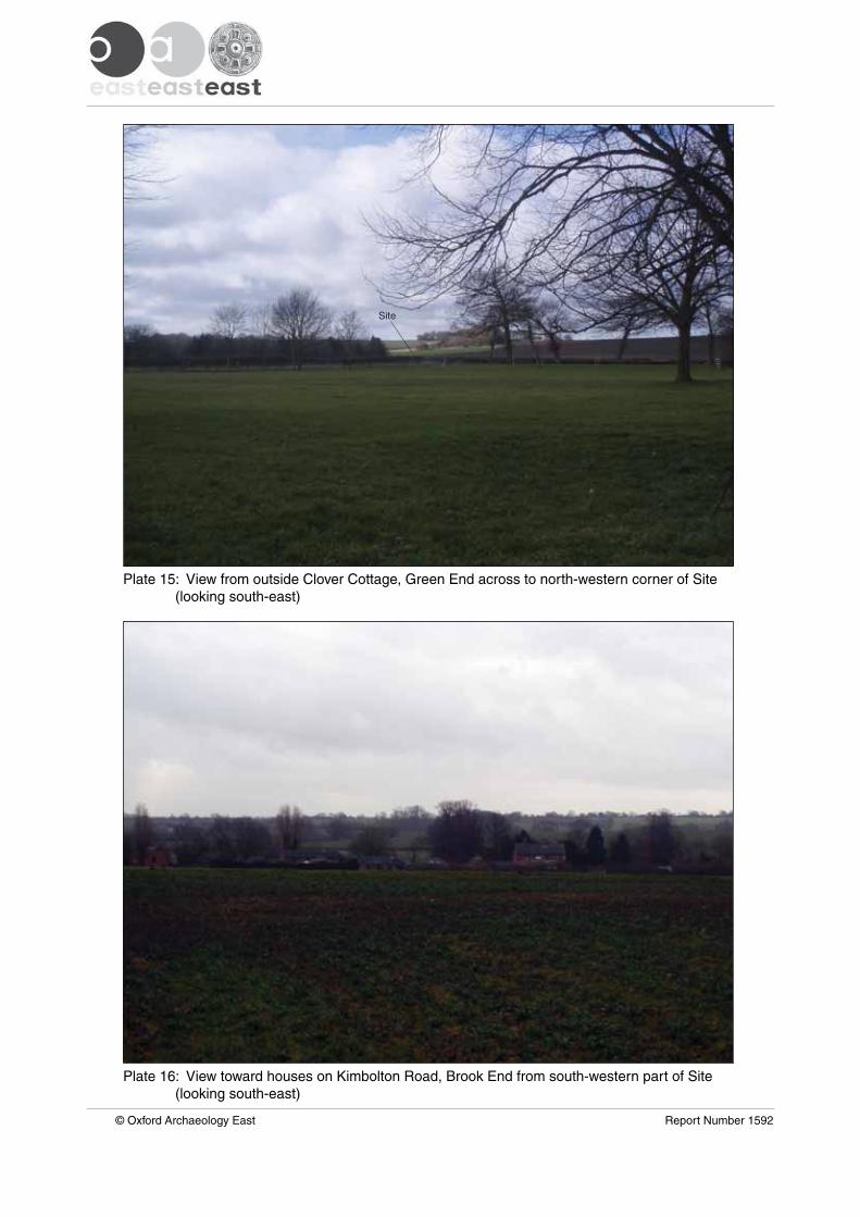
Site
Plate 16: View toward houses on Kimbolton Road, Brook End from south-western part of Site (looking south-east)
Plate 15: View from outside Clover Cottage, Green End across to north-western corner of Site (looking south-east)
© Oxford Archaeology East Report Number 1592
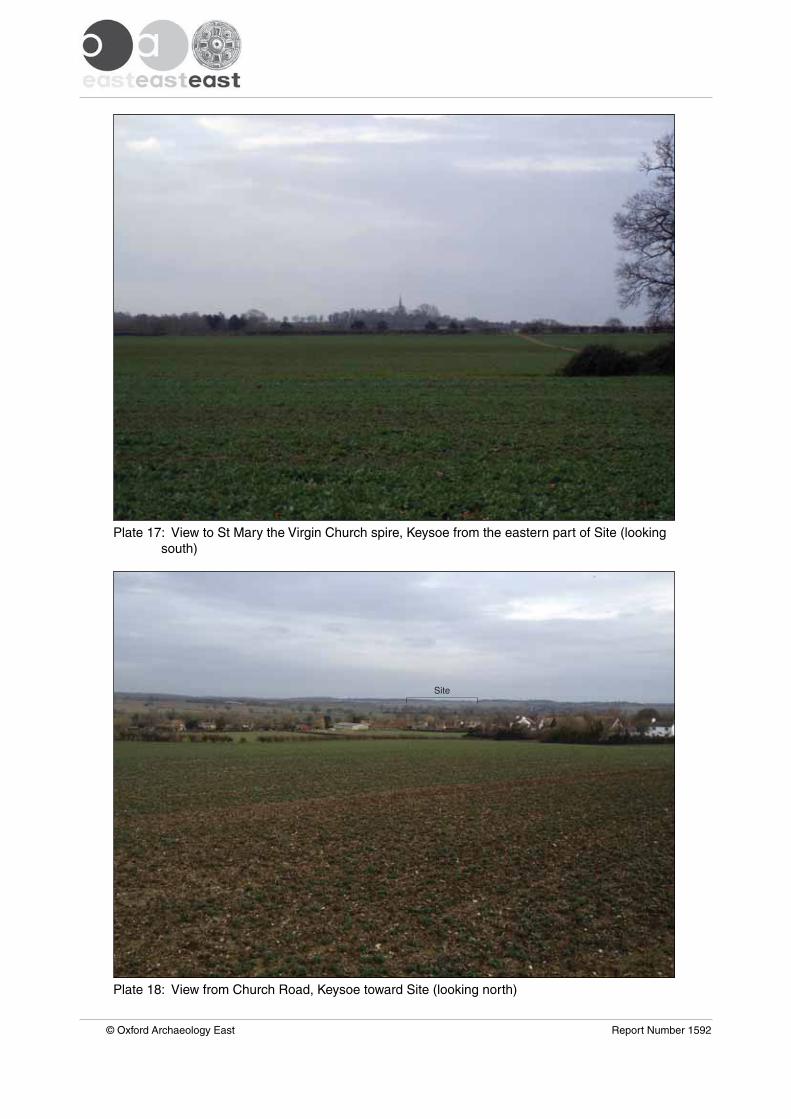
Plate 18: View from Church Road, Keysoe toward Site (looking north)
Plate 17: View to St Mary the Virgin Church spire, Keysoe from the eastern part of Site (looking south)
© Oxford Archaeology East Report Number 1592
Site
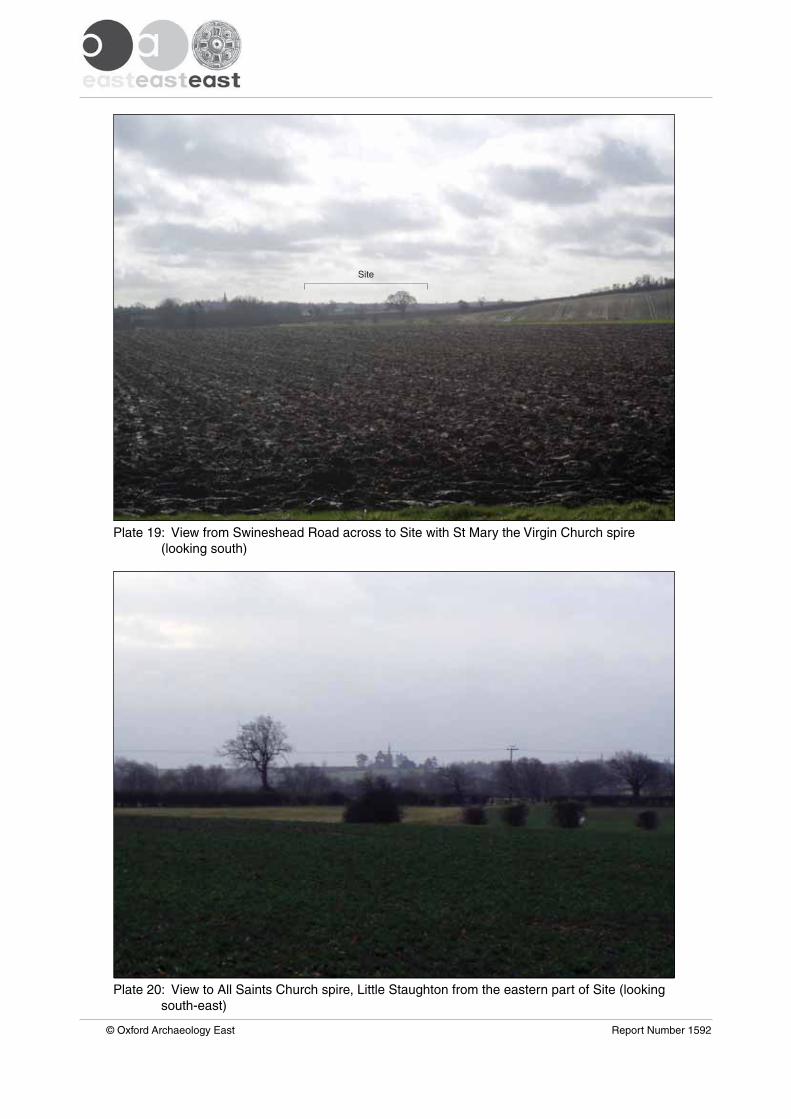
Site
Plate 20: View to All Saints Church spire, Little Staughton from the eastern part of Site (looking south-east)
Plate 19: View from Swineshead Road across to Site with St Mary the Virgin Church spire (looking south)
© Oxford Archaeology East Report Number 1592
Di rec to r : G i l l H e y , B A P h D F S A M I F A
Oxfo rd A rchaeo logy L td i s a
P r i va te L im i ted Company , N o : 1618597
and a Reg i s te red Char i t y , N o : 285627
OA Nor thMi l l 3Moor LaneLancas te r LA1 1GF
t : +44 ( 0 ) 1524 541 000f : +44 ( 0 ) 1524 848 606e : oanor th@ox fo rda rchaeo logy .comw:h t tp : / /ox fo rda rchaeo logy .com
Head Of f ice/Reg i s te red O f f ice/OA Sou th
Janus HouseOsney MeadOxfo rd OX2 0ES
t : +44 ( 0 ) 1865 263 800f : +44 ( 0 )1865 793 496e : i n fo@ox fo rda rchaeo logy .comw:h t tp : / /ox fo rda rchaeo logy .com
OA Eas t
15 Tra fa lga r WayBar H i l lCambr idgesh i reCB23 8SQ
t : +44 (0 )1223 850500e : oaeas t@ox fo rda rchaeo logy .comw:h t tp : / /ox fo rda rchaeo logy .com
Related Documents