Delta Levees, Islands, and Tracts LEVEES IN THE SACRAMENTO-SAN JOAQUIN DELTA (Delta) and Suisun Marsh help protect people, property, natural resources, and infrastructure of statewide importance. There are 176 islands and tracts in the Delta and Suisun Marsh. Six of the islands or tracts are currently flooded (e.g., Franks Tract), two are designated floodways (Yolo Bypass and Paradise Cut), 141 are protected by one or more levees, and 27 have no levee protection. People live on 117 of the 176 islands and tracts in the Delta. Some islands are home to only a few residents, but other islands have more than 50,000 residents. There are 150 islands and tracts with important physical assets, crops, or infrastructure. People and property on these islands and tracts are at risk should the levees fail. The Delta Stewardship Council (Council) is tasked with developing and recommending priorities for State investments in the Delta levees to reduce flood risk to people, property, and State interests. State interests in the Delta include advancing the coequal goals of water supply reliability and restoring the Delta habitat in a manner that protects and enhances the Delta as an evolving place. The Council is developing a Delta Levees Investment Strategy (DLIS) to evaluate and guide future State investments to reduce both the likelihood and consequences of levee failures. This comprehensive, long-term strategy is based on a decision-making process that is fully transparent to stakeholders and the public. At the core of the DLIS is an analysis of flood risks in the Delta. This fact sheet explains how flood risks are determined and how flood risk will be used to guide investment decisions. October 2015 Managing Flood Risk with a Delta Levees Investment Strategy Key Resources to Protect Delta as a Place Water Supply Ecosystem Lives & Property Delta Islands and Tracts

Welcome message from author
This document is posted to help you gain knowledge. Please leave a comment to let me know what you think about it! Share it to your friends and learn new things together.
Transcript
Delta Levees, Islands, and TractsLEVEES IN THE SACRAMENTO-SAN JOAQUIN DELTA (Delta) and Suisun Marsh help protect people, property, natural resources, and infrastructure of statewide importance.
There are 176 islands and tracts in the Delta and Suisun Marsh. Six of the islands or tracts are currently flooded (e.g., Franks Tract), two are designated floodways (Yolo Bypass and Paradise Cut), 141 are protected by one or more levees, and 27 have no levee protection.
People live on 117 of the 176 islands and tracts in the Delta. Some islands are home to only a few residents, but other islands have more than 50,000 residents. There are 150 islands and tracts with important physical assets, crops, or infrastructure. People and property on these islands and tracts are at risk should the levees fail.
The Delta Stewardship Council (Council) is tasked with developing and recommending priorities for State investments in the Delta levees to reduce flood risk to people, property, and State interests. State interests in the Delta include advancing the coequal goals of water supply reliability and restoring the Delta habitat in a manner that protects and enhances the Delta as an evolving place.
The Council is developing a Delta Levees Investment Strategy (DLIS) to evaluate and guide future State investments to reduce both the likelihood and consequences of levee failures. This comprehensive, long-term strategy is based on a decision-making process that is fully transparent to stakeholders and the public.
At the core of the DLIS is an analysis of flood risks in the Delta. This fact sheet explains how flood risks are determined and how flood risk will be used to guide investment decisions.
October 2015
Managing Flood Risk with a Delta Levees Investment Strategy
Key Resources to Protect
Delta as a Place
Water Supply Ecosystem
Lives & Property
Delta Islands and Tracts
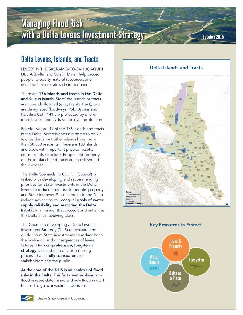
Flood risk analysis includes identifying threats to the levees; understanding levee vulnerabilities and the mechanisms of levee failure; and estimating the consequences of levee failure to people, property, infrastructure, water supply and water quality, ecosystem, and Delta as an evolving place.
Flood Risk Analysis
NATURAL HAZARDS· High floodwater flows
into the Delta· Earthquakes· Seasonal high tides (King tides)· Sea level rise· Wind-generated waves· Animal burrows· Vegetation
MAN-MADE HAZARDS· Encroachments· Channel dredging· Deferred maintenance
LEVEE FAILURE MODES· Slope failure· Settlement· Cracking· Overtopping
CAUSES OF LEVEE FAILURES· Levee subsidence/sinking· Levee erosion· Seepage through levee· Sliding· Liquefaction
LIVES & PROPERTY· Fatalities and injuries· Damage to buildings & contents· Damage to infrastructure· Damage to crops & livestock
WATER SUPPLY· Interruption of supply· Changes in quality· Damage to supply infrastructure
ECOSYSTEM· Loss of habitat· Habitat improvements
DELTA AS AN EVOLVING PLACE· Damage to legacy towns · Loss of prime agricultural lands
HAZARDS
What Threatens Levees?The Council is assessing the hazards that could damage Delta levees.
Currently, the most significant hazards are floods and earth-quakes that can cause levee embankments to break. In the future, hazards associated with land subsidence, sea-level rise, and extreme storms may become more significant.
VULNERABILITIES
How Do Levees Fail?The Council is evaluating the vulnerability of each levee to help determine the probability that it will fail.
How vulnerable a levee may be depends on its design, construction, foundation soils, maintenance history, and hazard level.
CONSEQUENCES
What Happens if Levees Fail? The Council is using quantitative and qualitative measures to identify the potential conse-quences of levee failure.
Levee failure will affect communi-ties, and can change day to day lives.
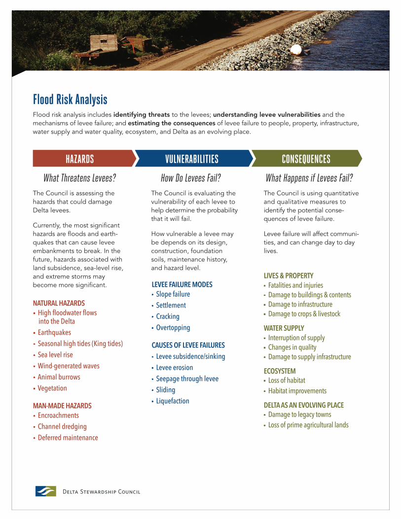
How Safe is Safe Enough?SIMPLY PUT, RISK IS THE POTENTIAL for an unwanted outcome. More specifically, risk is the probability that an adverse event (like a flood) will occur multiplied by the consequences if the event does occur.
PROBABILITY x CONSEQUENCE = RISKBecause it is impossible to completely eliminate flood risk, the Council is developing a strategy to help local flood managers and levee owners reduce flood risk. Consequently, the Council needs to determine which risks are not acceptable and which risks are tolerable.
A “tolerable risk” is a risk that people are generally willing to live with in order to secure certain benefits. Using risk analysis combined with information gathered at stakeholder meetings and public meetings, the Council is identifying the level of flood risk that is tolerable to Delta residents, the State of California, and to others who benefit from the Delta levees. The Council is deliberating on the question, “How safe is safe enough?”
The Council has developed ways to measure and analyze risks for the key resources—lives and property, water supply, habitat, and Delta as an evolving place—to identify areas where levee improvements are crucial.
The Council is using a computer-based, interactive planning tool to help summarize and visualize current risks without additional levee investments, as well as the risk reduction achieved by potential future levee projects.
Using a risk-informed analysis of potential State investments for the Delta levee system, the Council will develop and recom-mend a portfolio of projects and programs that can reduce the flood risks in the Delta and Suisun Marsh.
What are the Odds?
Probability is a measure of the likelihood that an event will occur.
In our daily lives, we often use probability to make decisions, like:
· When planning an outdoor activity, people check the probability of rain.
· When patients are advised to have surgery, they want to know the success rate (or the proba-bility of success) of the operation.
· When people buy a ‘mega millions’ lottery ticket, they should know they only have a 1 in 258,890,850 chance of winning.
· When people stay outside during a thunderstorm, they are banking on the odds of being struck by lightning as 1 in a million.
· When the referee tosses a coin to decide which team gets the ball, each team has an equal probability.
What are the Units of Risk?
PROBABILITY is expressed as an annual likelihood that an event will occur.
RISK is expressed in units of consequence/yr. For example, if the CONSEQUENCE is measured in dollars, risk is measured as dollars/year.
1
2
3
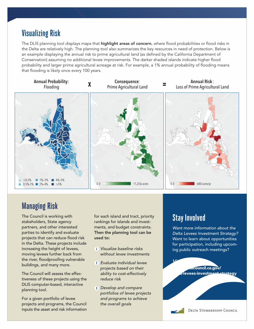
Visualizing RiskThe DLIS planning tool displays maps that highlight areas of concern, where flood probabilities or flood risks in the Delta are relatively high. The planning tool also summarizes the key resources in need of protection. Below is an example displaying the annual risk to prime agricultural land (as defined by the California Department of Conservation) assuming no additional levee improvements. The darker shaded islands indicate higher flood probability and larger prime agricultural acreage at risk. For example, a 1% annual probability of flooding means that flooding is likely once every 100 years.
Managing RiskThe Council is working with stakeholders, State agency partners, and other interested parties to identify and evaluate projects that can reduce flood risk in the Delta. These projects include increasing the height of levees, moving levees further back from the river, floodproofing vulnerable buildings, and many more.
The Council will assess the effec-tiveness of these projects using the DLIS computer-based, interactive planning tool.
For a given portfolio of levee projects and programs, the Council inputs the asset and risk information
Consequence: Prime Agricultural Land
Annual Risk :Loss of Prime Agricultural Land
Annual Probability:Flooding
Stay InvolvedWant more information about the Delta Levees Investment Strategy? Want to learn about opportunities for participation, including upcom-ing public outreach meetings?
Visit: www.deltacouncil.ca.gov/delta-levees-investment-strategy
for each island and tract, priority rankings for islands and invest-ments, and budget constraints. Then the planning tool can be used to:
Visualize baseline risks without levee investments
Evaluate individual levee projects based on their ability to cost-effectively reduce risk
Develop and compare portfolios of levee projects and programs to achieve the overall goals
<0.5%0.5%–1% 0.0 11,256 acres 0.0 680 acres/yr
1%–2%2%–4%
4%–5%>5%
x =
Related Documents