MANAGING FLOOD DISASTERS UNDER A CHANGING CLIMATE: LESSONS FROM NIGERIA AND SOUTH AFRICA Olorunfemi, F.B Social and Governance Policy Research Department Nigerian Institute of Social and Economic Research (NISER), P. M. B. 5, U. I. Post Office, Ibadan, Nigeria. E-Mail: [email protected] NISER DISCUSSION PAPER NO. 1, 2011 Paper presented at NISER Research Seminar Series, NISER, Ibadan 3 rd May, 2011

Welcome message from author
This document is posted to help you gain knowledge. Please leave a comment to let me know what you think about it! Share it to your friends and learn new things together.
Transcript
MANAGING FLOOD DISASTERS UNDER A
CHANGING CLIMATE: LESSONS FROM
NIGERIA AND SOUTH AFRICA
Olorunfemi, F.B
Social and Governance Policy Research Department
Nigerian Institute of Social and Economic Research (NISER),
P. M. B. 5, U. I. Post Office, Ibadan, Nigeria.
E-Mail: [email protected]
NISER DISCUSSION PAPER NO. 1, 2011
Paper presented at NISER Research Seminar Series, NISER, Ibadan 3
rd May, 2011
2
MANAGING FLOOD DISASTERS UNDER A CHANGING CLIMATE:
LESSONS FROM NIGERIA AND SOUTH AFRICA
Olorunfemi, F.B (PhD)
Social and Governance Policy Research Department, Nigerian Institute of Social and
Economic Research (NISER), PMB 05, U.I P.O, Ibadan, Nigeria
E-Mail: [email protected]
Abstract
There is a growing need to address vulnerabilities to climate change through
adaptation efforts, complementing mitigation efforts aimed at reducing the rate and
magnitude of climate change. At present, this development has taken place largely in
parallel to the increasing shift from disaster management to disaster risk management.
Disasters are associated with extreme weather events. Climate change directly
interacts with the exposure to climatic extremes. The challenge in the context of
adaptation is to move from the understanding that climate change is occurring to
concrete measures that reduce existing vulnerabilities of human and natural systems.
This study focussed on impacts and responses to flood risk among the urban poor
living in the highly vulnerable informal settlements in the Cape Flats of the City of
Cape Town, South Africa and those living along the Asa River channel in the city of
Ilorin, Nigeria. It explores the underlying vulnerabilities of the two areas and the
challenging problem of how to effectively shape human institutional responses to the
risk of natural disasters with a special focus on floods. The social risk management
(SRM) and asset-based approaches on which the study is based provide a conceptual
framework for understanding the sequential links between risks; human exposure and
sensitivity; the impacts of risky events; and risk management (or adaptation)
strategies. The study utilised primary and secondary data. The outcome of the study
shows marked differences in the vulnerability factors and the management of flood
related disasters in the two study areas. Furthermore, it was revealed that the
indigenous coping mechanisms employed by the poor may become less effective as
increasingly fragile livelihood systems struggle to withstand disaster shocks.
Strategies to reduce vulnerability should be rooted in vulnerability analysis and
greater understanding of both household-level and macro-response options that are
available to decrease the poor‟s exposure to climate risk.
Keywords: Climate change adaptation, Vulnerability, Disasters, Flood risk,
Informal settlements, Cape Town
3
1. Introduction
Thabo watched the young man as he carried another sheet of corrugated iron down towards the river.
Almost everyday now, someone new was building a house in New Situ. He could still remember when
there were only a few houses there. Things had been better then: there was more space, and people
built their houses away from the river. Now, more and more people seemed to be arriving from the
Eastern Cape, hoping to find jobs. There was no more space, but the New Situ was close to the
factories and other work opportunities in the towns nearby, and people kept coming in.
The new ones didn‟t want to listen when told that it was unsafe to build by the river. They told him that
such a small river would not cause trouble. They told him he just wanted to prevent them joining the
settlement. But they would see he was right in winter, when the river swelled with rain water. Every
year, the houses built by the river got flooded – sometimes they even got washed away. The people
never stayed long after that, but always there were new people coming in to take their place. He
wondered as he watched his little granddaughter chasing a chicken: how many more people would
suffer this winter? (Holloway & Roomaney, 2008, p.11)
Disaster risk and climate change are two threats to human well-being that reinforce
each other. Hence, they represent some of the greatest challenges to humankind in this
century. Disaster risk is an intrinsic characteristic of human society, arising from the
combination of natural and human factors and subject to exacerbation or reduction by
human agency. While the adverse impacts of climate change on society may increase
disaster risk, disasters themselves erode environmental and social resilience, and thus
increase vulnerability to climate change (O‟Brien et al, 2008). Climate change – and
the likely increase in disasters – threatens to block pathways out of poverty in
developing countries especially those in Africa (Lemons and Tompkins, 2008) Any
increase in disasters, whether large or small, will threaten development gains and
hinder the implementation of the Millennium Development Goals (ISDR, 2008).
In the coming decades, climate change is expected to exacerbate the risks of disasters,
not only from more frequent and intense hazard events but also through greater
vulnerability to the existing hazards (ISDR, 2008). Approaches toward the
management of climate change impacts have to consider the reduction of human
vulnerability under changing levels of risk. A key challenge and opportunity therefore
lies in building a bridge between current disaster risk management efforts aimed at
reducing vulnerabilities to extreme events and efforts to promote climate change
adaptation (Olorunfemi, 2008, Few et al. 2006)
The long term horizon of climate change and current scientific uncertainties pose
special challenges. Strategies that address challenges recognise that there is no best
solution. In this sense, climate change provides new incentives for the need to plan
ahead and to anticipate extreme events and trends (Zevenbergen, et al, 2008). Within
the context of extreme weather events especially flooding, this means that
management strategies must meet the present needs while providing a path of
adjustment for the future (Pahl-Wosll, 2006; Ashley et al., 2007; Miller, M., 2007).
Cities in developing countries are particularly vulnerable to climate change impacts,
especially changes in rainfall (Vogel 2000), because of the exposure to extreme
weather events and dependence on natural resources (Vogel, 2002). The vulnerability
situation, the present and predicted impact of climate change on urban areas is
particularly worrisome. According to Satterthwaite et al (2007), the scale of the
4
devastation to urban populations and economies caused by extreme weather events in
recent years highlights their vulnerabilities. Worldwide, there has been a rapid growth
in the number of people killed or seriously impacted by storms and floods and also in
the amount of economic damage caused; a large and growing proportion of these
impacts are in urban areas in low- and middle-income nations. For instance, in
Nigeria, flooding affected more than three million people in selected urban areas
between 1983 and 2009 (EMDAT disaster database). Climate change is likely to have
been a factor in much of this, but even if it was not, it is proof of the vulnerability of
urban populations to floods and storms whose frequency and intensity climate change
is likely to increase in most places.
Henderson (2004) revealed that the level of risk and vulnerability in urban areas of
developing countries is attributable to socio-economic stress, aging and inadequate
physical infrastructure. Indeed, according to Satterthwaite et al (2007), hundreds of
millions of urban dwellers have no all-weather roads, no piped water supplies, no
drains and no electricity supplies; they live in poor-quality homes on illegally
occupied or sub-divided land, which inhibits any investment in more resilient
buildings and often prevents infrastructure and service provision. A high proportion of
this are tenants, with very limited capacities to pay for housing – and their landlords
have no incentive to invest in better-quality buildings. Most low-income urban
dwellers face serious constraints in any possibility of moving to less dangerous sites,
because of their need to be close to income-earning opportunities and because of the
lack of alternative, well-located, safer sites. Nigerian urban areas are typical examples
of this high level of risk and vulnerability (Olorunfemi, 2008; Olorunfemi and
Raheem, 2007).
Successful national economies depend on well-functioning and resilient urban centres.
Urgent action is needed now both to address urban centres‟ current vulnerabilities to
extreme weather and to build into expanding urban centres protection from likely
future changes (Satterthwaite et al, 2007). For most prosperous and well-governed
cities, adaptation to the likely risks from climate change for the next few decades does
not appear problematic. This centres on adapting buildings and infrastructure to the
increasing risks; working with population groups and settlements most at risk to find
solutions that serve them; and good disaster preparedness. But in developing
countries, you cannot adapt infrastructure that is not there. The vulnerability of low-
income urban dwellers to climate change is often ascribed to their poverty – but it is
far more the result of failures or limitations in local government that ensure needed
infrastructure is in place.
To date, the challenge of addressing urban floods and reducing urban flood
vulnerability has received little attention (Zevenbergen, 2008). This is partly because
in the traditional flood management approach, responses to mitigate urban fluvial and
coastal flood risks have often been set outside the realm of the urban system (i.e.
where confined to the catchment level), but also because responses at the city level
were predominantly passive, using robust solutions such as urban defences and
increasing the capacity of major culverts. The following major bottlenecks have been
identified, which hamper the adoption and effective implementation of flood-risk
management in urban planning practices (Sz¨Oll¨Osi-Nagy and Zevenbergen, 2005):
(i) Lack of understanding of current and future risks and implications at the city scale.
(ii) Lack of long-term planning, poorly integrated and comprehensive planning.

5
(iii) Inadequate controlling roles of local and regional authorities, and the
conservative nature of the building sector.
This study, therefore, focuses on the impacts and adaptation to floods in the two
cities. The specific focus is on the people living in the poor, marginal areas. The study
is driven by the underlying assumption that human vulnerability to natural disaster
and, particularly, those expected to be amplified by climate change, illustrates the
inter-relatedness of governance and environment related issues. Central questions are
what generates vulnerabilities and what improves resilience in people‟s livelihoods,
and how can we build on people‟s own responses, providing a range of institutional
support, and promoting resilience and adaptive capacity among vulnerable people in
the affected areas.
Aside from physical location and exposure to flood hazards, vulnerability to floods
arises out of the social, economic and ecological circumstances of everyday living
that result form social power relations. Social relations, structures and processes can
influence the vulnerability of households and communities to floods through several
pathways. On the other hand, social, economic, political, cultural and historical
processes influence how flood hazards affect people in varying degrees and differing
intensities. The study supports the emerging view that places adaptation to shocks
associated with climate change as a subset of disaster risk reduction.
The paper is divided into nine sections. The aim and objectives of the study are stated
in section 2 while section three briefly examines the vulnerability of Nigeria and
South Africa to climate change. In section four, the conceptual framework that guided
the conduct of the study as well as literature review are presented. Section five
discusses the methodology used for the study while section six describes the study
areas. The seventh section discusses the findings of the study while the eighth section
examines governance issues in disaster risk and climate change as currently obtained
in the two cities studied. The conclusions of the paper and the suggested way forward
are discussed in the last section.
2 Aim and Objectives of the study
The aim of this study is to analyse the impacts and vulnerability to flood risk in the
City of Cape Town and Ilorin and the institutional responses to reducing the existing
disaster risks in the affected communities. The specific objectives are to;
1. examine the dimensions and drivers of vulnerability to flood risk in the study
areas
2. examine the current and potential impacts of flooding in the affected
communities
3. examine the role of cities authorities in the management of flood risk
4. examine the existing and future adaptation options with respect to flooding
impacts at the city level
3 Country Vulnerability to Climate Change
3.1 Nigeria
Nigeria is vulnerable to climate change impacts due to its geography, climate,
vegetation, soils, economic structure, population and settlement, energy demands and
agricultural activities. The location and size of, and the characteristic relief in Nigeria
give rise to a variety of climates ranging from tropical maritime climate characterized
6
by the rainforest along the coastal and southern section to the tropical hinterland
climate associated with the Sahel in the north eastern section of the country. Nigeria
has a population of about 140 million impacting on the physical environment through
their various activities within an area of 923,000 square kilometres. According to
Gwary (2008), sixty per cent of the people live directly on the natural resource base as
farmers, cattle rearers and fishermen while the informal sector constitutes the bulk of
the urban population‟s economic activities. The technology adopted is rudimentary
leading to low output and high levels of poverty.
Decadal changes in the climatological period (30 years) provide changes that have
taken place in rainfall over the country since 1951. Total annual rainfall across the
country was about 1,445.6mm in 1951-1980 climatological period. This amount
dropped to 1,386.7mm in 1961-1990 and then slightly increased by 4.3mm in 1971-
2000 (Afiesimama, 2008). In recent years, the total rainfall amount over the country
increased again to 1,410.6mm. However, it is important to note that these increases
are associated with floods in some areas while drought still prevails in other areas.
These changes in the spatial distribution in rainfall amount and consequent impacts on
agriculture, water resources, human settlements, among others, are indicators
determining the vulnerability of the country to climate change and the socio-economic
implications associated with such changes (Afiesimama, 2008).
Ilorin is a typical traditional African city whose urban history predates colonialism in
Nigeria. The city therefore falls into the category of third world cities described as
reputed for their dualistic internal structure (Mabogunje, 1968). The physical
development of Ilorin also translates into significant change in the population of the
city. For instance, from 36,300 inhabitants in 1911, Ilorin has a population of about
208,546 in 1963, 532,088 people in 1991 and a projected population of about 765,791
by the year 2006 at the rate of 2.84% annually. The facts of urbanization,
development of the modern commercial/industrial economy and the multiplier effects
of these factors on natural increase had combined to produce the changes in
population described above
3.2 South Africa
A South African Country Study on Climate Change (2004) has identified the Northern
and Western Cape provinces as being at greatest risk from projected climate change
induced warming and rainfall change (Midgley et al, 2005). The future climate of the
Western Cape is likely to be warmer and drier than at present. Three key groups have
been identified to be the most vulnerable to climate change impacts in the Western
Cape. These are people living along the coast, people living in informal settlements,
and marginal groups living in rural areas.
On a local scale, Cape Town is found to be vulnerable to climate change (Mukheibir
and Ziervogel, 2007). Using the regional downscaled projections from the Climate
Systems Analysis Group, the most relevant change in atmospheric circulation
observed for the Western Cape has been a decrease in the frequency of low pressures,
typically associated with winter storms, during early winter. These trends have
resulted in spatially varying trends in precipitation. Furthermore, the trend of fewer
low pressure systems during early winter can lead to weaker synoptic forcing and
7
conditions conducive to brown haze and smog in the Cape Town area (Mukheibir and
Ziervogel, 2007).
With respect to risks from these predicted changes in the overall climate in the City of
Cape Town, Mukheibir and Ziervogel (2006) revealed that a significant number of
previous disasters and events have been associated with weather conditions. These
include the Cape Flats floods (1994 and 2001), the Manenberg wind storms (1999 and
2002), South Peninsula fires (2000), cut-off low severe storms (2003, 2004, 2005) and
recurrent severe drought (2002-2005). Nearly all these occurred in the poor, informal
settlements.
The poor, informal settlements in Cape Town has become increasingly disaster prone
because large contingent of low-income migrants have settled on the poorest, most
vulnerable land in cheap, dilapidated and over-crowded houses constructed on land
subject to floods (City of Cape Town, 2006, 2009). The combination of physical
development on unsuitable lands such as wetlands, slopes, flood plains and other
environmentally sensitive areas, and over-crowding, all exacerbate environmental
degradation and vulnerability to environmental and anthropogenic hazards. Blocked
drainage channels in urban areas worsen the externalities associated with flooding.
Little wonder then the rampant incidences of flooding and in the poor
neighbourhoods.
Poor housing quality in informal settlements exacerbates this vulnerability, because
these structures are easily destroyed during a flood event. In most cases, poor access
to services leads to an inability to cope and recover from such an event. The lack of
tarred roads increases flood vulnerability in informal settlements. Unpaved roads
wash away, hindering access (City of Cape Town, 2006, 2009). Other related
vulnerabilities include inadequate sewage and storm-water infrastructure, creating
stagnant pools of foul water that are a source of disease.
Despite the efforts of the Cape Town City administration such as the formulation its
City Development Strategy, which will help to address the challenges, and enable the
city to seize global opportunities and minimise the risk of the external environment
for Cape Town (City of Cape Town, 2009), the countless impacts of flooding in the
informal settlements are still very much apparent. The flooding has left many areas of
the informal settlements uninhabitable for various reasons including health risks and
physical dangers. Previous efforts have not been entirely successful in minimising the
impact of flooding at the household and community levels (Wood, 2007). These
recent events have prompted an emphasis that has moved away from physical control
and engineering construction (structural measures) towards reducing human
vulnerability through non-structural approaches (Smith, 1992, City of Cape Town,
2005, 2006).
It follows from the above that traditional flood-risk management approaches omit
important ways of dealing with floods pro-actively at the city level and of building in
bottom-up responses that reduce their impact and enhance recovery (Tippett and
Griffiths, 2007). Dealing with these gaps should change the paradigm of the
traditional approach to flood risk management.
4 Conceptual Framework and Literature Review
8
4.1 Conceptual Framework
Urban environments are complex - socially, economically and physically. This
complexity multiplies the risk which comes from increasing poverty and inequality
and failures in governance, high population density, crowded living conditions and
the siting of residential areas close to hazardous industry or in places exposed to
natural hazard (including the modification of environments which generates new
hazard, e.g. through the loss of protective mangroves to urban development, or
subsidence following ground water extraction) (Pelling, 2008). This, combined with
the cumulative nature of many environmental problems, makes it difficult to identify
causal relationships when considering risk and vulnerability (Oelofse, 2002). Urban
risk and vulnerability need to be understood in terms of the nature of risk, the causal
mechanisms that shape people‟s response to them and the contingent conditions that
provide the context within which they occur. Many risk problems sit at the interface
of the natural and social environment, such as flooding, which occurs as the result of
the inadequate provision and maintenance of drainage systems, the location of people
on marginal sites, and the physical characteristics of an area (Olorunfemi, 2008;
Oelofse, 2002).
Galvanised in part by questions of societal adaptation to climate change impacts, there
has been much recent theoretical work on hazard risk and related concepts of
vulnerability and resilience (e.g. Wisner et al., 2004). Flood risk is defined here in
terms of risk to humans and human society, and is seen as a product of the severity
and probability of occurrence of flood hazard and the vulnerability of the
population/system (Brooks, 2003). Vulnerability is shaped by a combination of
physical, social, economic and environmental factors - the attributes of the
person/system that condition the impacts resulting from flooding. In the past, physical
aspects of vulnerability - the spatial distribution of populations and infrastructure in
relation to flood hazard - tended to receive more attention in hazards research
(Hilhorst, and Bankof, 2004)). But there is now increasing recognition given to the
social aspects of vulnerability. For individuals, susceptibility to hazards depends
largely on behaviour, wellbeing and the resources people have to enable them to avoid
and recover from harm. These, in turn, are largely determined by wider social,
economic and political patterns and processes that differentiate how flooding impacts
on people and human systems (Cannon, 2000, Wisner et al., 2004). Analyses of
vulnerability increasingly highlight its socially constructed nature (Cutter, 1996),
underlining the importance of understanding how socio-political processes can create
vulnerability and thereby create „disaster‟ (Hilhorst, and Bankof, 2004; Pelling, 1999).
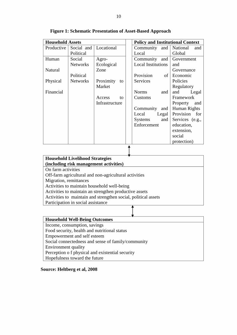
This study adopts the framework developed by Heltberg et al., (2008). The
framework presents and applies the social risk management and asset-based
approaches to the context of climate change. The social risk management (SRM) and
asset-based approaches provide a conceptual framework for understanding the
sequential links between risks; human exposure and sensitivity; the impacts of risky
events; and risk management (or adaptation) strategies. This provides a unifying
conceptual framework to examine the characteristics of the risks faced by households;
how adaptation responses at multiple levels depend on livelihoods, policies, and
institutions; and household vulnerability outcomes. It highlights the importance of a
multidimensional and equitable approach to adaptation policy and the need to include
higher level (national and international) risk management interventions. This includes
social policy and social protection interventions to build resilience at the household
9
level through improved human and physical capital and access to risk management
instruments such as safety nets and insurance.
This analytical framework helps focus on the sequential links between climate risks,
human vulnerability, and interventions to help manage vulnerability to climate
change. The framework is consistent with IPCC (2001) definitions of vulnerability
and adaptation and highlights that:
1) All households and individuals face risks associated with climate change, but not
all are vulnerable. Vulnerability is a function of risks, exposure and sensitivity and
adaptive capacity, and depends on the relationship between losses and some
benchmark indicator of household well-being (e.g., poverty line).
2) The exposure and sensitivity of household assets and livelihoods to climate change
and their adaptive capacity are to a large extent shaped by policies and investments
outside of their direct control.
3) Risks related to climate change can impact household assets, livelihoods and well-
being directly and indirectly, so a multi-dimensional approach to risk management is
required.
4) Ex-ante management of climate related risks, especially those that lower exposure
and sensitivity of assets and livelihoods, can strengthen household assets and increase
returns on assets, thereby contributing to improved livelihoods and well-being.
5) Climate risk management (or adaptation) has to be multidimensional and span
interventions at household, community, national, and (increasingly) international
level.
6) Institutions and good governance are keys to a multidimensional and multisectoral
approach to improved adaptation to climate change.
Thus, household livelihoods and well-being depend on the interface between assets
(broadly defined), the policy and institutional context, and risks (Figure 1). Risk
affects the expected returns and variance of returns on assets and livelihood strategies,
and therefore household well-being and future asset accumulation. Households are
poor because they have limited quantity and quality of assets; and their assets have
low expected returns and high variance of returns. The combination and flexibility of
assets also matters: Poor and vulnerable households tend to lack key assets and
whatever assets they have are not mobile and of poor quality and location. Many poor
rural households are also landless and depend on selling their labour, which is
typically of low quality in terms of education, skills, and health and nutritional status.
Furthermore, because of gender, class, or caste, some individuals and households can
have limited access to markets and livelihood opportunities, including migration.
This, in turn, limits labour productivity and returns to human assets.
10
Figure 1: Schematic Presentation of Asset-Based Approach
Household Assets Policy and Institutional Context
Productive Social and
Political
Locational Community and
Local
National and
Global
Human
Natural
Physical
Financial
Social
Networks
Political
Networks
Agro-
Ecological
Zone
Proximity to
Market
Access to
Infrastructure
Community and
Local Institutions
Provision of
Services
Norms and
Customs
Community and
Local Legal
Systems and
Enforcement
Government
and
Governance
Economic
Policies
Regulatory
and Legal
Framework
Property and
Human Rights
Provision for
Services (e.g.,
education,
extension,
social
protection)
Household Livelihood Strategies
(including risk management activities)
On farm activities
Off-farm agricultural and non-agricultural activities
Migration, remittances
Activities to maintain household well-being
Activities to maintain an strengthen productive assets
Activities to maintain and strengthen social, political assets
Participation in social assistance
Household Well-Being Outcomes
Income, consumption, savings
Food security, health and nutritional status
Empowerment and self esteem
Social connectedness and sense of family/community
Environment quality
Perception o f physical and existential security
Hopefulness toward the future
Source: Heltberg et al, 2008
11
4.2 Literature Review
4.2.1 Climate Change Impacts on Flooding
Though information on recent flood trends is inconclusive, global trends in sea level
and temperature now provide strong evidence of a climate change signature (Few et
al, 2004). The weight of international scientific opinion has swung decisively toward
the perspective that a process of anthropogenically-forced global climate change is
now under way, over and above normal background climatic variability. The Third
Assessment Report (TAR) of the Intergovernmental Panel on Climate Change (IPCC)
draws on a series of modelling approaches to estimate how climatic parameters might
change in future and set out a range of potential impacts resulting from these changes.
The magnitude of change depends partly on whether society succeeds in reducing
greenhouse gas emissions. Yet, even with strenuous efforts in climate change
mitigation, some climate impacts are inevitable. Over the next 100 years, yearly
average near-surface temperatures across the globe are predicted to rise by between
1.4°C and 5.8°C, causing an increase in flood hazard in some areas because of sea
level rise, changes in seasonal precipitation or the pattern of wind storms (Houghton
et al. 2001; McCarthy et al., 2001).
Climate change is making weather less predictable, rains more uncertain and heavy
storm rainfalls more likely. The unpredictability of rainfall is shown both by
observations, such as the large fluctuations in the levels of Lake Victoria in Africa
since 1980, and by the experiences of long-term urban slum residents, who report
much more frequent storms producing floods since 1990 (ActionAid International,
2006). Climate models predict that winter rainfall will increase by 20-30% by the
2080s. Such an increase could lead to a much larger (up to 200%) increase in flood
risk (POST, 2007).
Flooding, as one of the most frequent and widespread of all environmental hazards
and of various types and magnitudes, occur in most terrestrial portions of the globe,
causing huge annual losses in terms of damage and disruption to economic
livelihoods, businesses, infrastructure, services and public health. Long term data on
natural disasters suggest that floods and wind storms (which frequently lead to
flooding) have been by far the most common causes of natural disaster worldwide
over the past 100 years (Few et al, 2004). According to the International Federation of
Red Cross and Red Crescent Societies, in the 10 years from 1993 to 2002 flood
disasters „affected more people across the globe (140 million per year on average)
than all the other natural or technological disasters put together‟ (IFRC, 2003).
Climate change works in an indirect way to aggravate urban flooding in especially in
the African continent. Droughts and floods in rural areas, such as the African Sahel
droughts and major floods in Mozambique, have forced many rural people to migrate
to towns and cities, adding large new populations to existing slum communities
(ActionAid International, 2006). These rural refugees further add to the urban
activities that increase the flow of rainwater to rivers and thus the intensity of local
flooding.
With an increasingly urbanizing world, flood disasters are reportedly increasing in
urban areas and particularly negatively impacting on poor people (Alam et al, 2008)
12
and urban development in general. However urban flood risk research was strongly
influenced by the concept of floods within the natural, rural environment (also see
Zevenbergen, 2007). Consequently there is a growing need to revisit urban flood risk
knowledge with a focus on understanding the interaction between urban development
and urban flood risk (Benjamin, 2007). In this way urban flood risk should also be
informed by focusing on the physical, technological, social, economic and political
parameters. Such an understanding should ideally contribute to appropriate urban
flood risk management strategies and policies.
4.2.2 Urban Vulnerability to Flooding in Africa
A review of climate change impacts on urbanization by the international institute of
environment and development (Huq et al, 2007) found that the floods are already
having severe impacts on cities, smaller urban centres and rural areas in many African
Nations. Examples cited include floods in Mozambique in 2000, which displaced
around 4000 people in Maputo alone and crippled transport networks, breaking
market links (Christie and Hanlon, 2001); heavy rains in East Africa in 2002 that
brought floods and mudslides and forced tens of thousands to leave their homes in
Rwanda, Kenya, Burundi, Tanzania and Uganda (Huq et al, 2007). More common,
but less often reported, such as the many small floods that affect neighbourhoods in
cities and small towns such as the 2 June storm that led to flooding in the western
region of the Gambia destroying houses in Darsilameh village and affecting 300
people (IFRC, 2008).
With an increasingly urbanizing world, flood disasters are reportedly increasing in
urban areas and particularly negatively impacting on poor people (Alam et al, 2008)
and urban development in general. However urban flood risk research was strongly
influenced by the concept of floods within the natural, rural environment (also see
Zevenbergen, 2007). Consequently there is a growing need to revisit urban flood risk
knowledge with a focus on understanding the interaction between urban development
and urban flood risk. In this way urban flood risk should also be informed by focusing
on the physical, technological, social, economic and political parameters. Such an
understanding should ideally contribute to appropriate urban flood risk management
strategies and policies.
Climate change puts African slum dwellers at increased risk (ActionAid International,
2006). „Environmental refugees‟ from climate-related droughts and floods are already
swelling the tide of rural-to-urban migration across Africa, and the trend is expected
to intensify as drought increases its grip over large swathes of the continent. By 2030,
the majority of Africa‟s population will live in urban areas (ActionAid International,
2006). Unfortunately, however, global warming is also bringing chronic flooding to
the cities, which can be just as disastrous for poor urbanites as droughts are for
farmers. Urban floods spread disease, interrupt schooling, and destroy houses, assets
and income.
According to Manuta and Lebel (2005), climate change compounds the existing
challenges of managing floods. Firstly, the anticipated sea level rises could have a
major impact on flood risks in the coastal cities. Secondly, but less certainly, increases
13
in the frequency or intensity of extreme precipitation events exacerbate risks of
disastrous flooding in parts of the world. Thirdly, climate change may alter flood
regimes in some basins in other more complex ways, for example, through impacts on
melting of glaciers in the uppermost reaches or reduced precipitation in inland
continental areas. Reductions in duration or changes in timing of onset of seasonal
floods may have as large an impact on livelihoods and production systems as more
discrete high water events although the former is rarely recognized as a disaster.
Finally, concurrent changes in land- and water-use may exacerbate or reduce effects
of changes in climate on disaster risks. (IPCC, 2001).
Majority of flood research in South Africa has adopted a hazards approach that is
concerned with hydrological modelling of floods. These typically employ
deterministic or rainfall-runoff methods; statistical methods, that are either site-
specific or regional; and empirical and pseudo-statistical or empirical-probabilistic
methods. Very limited research has employed an integrated hazards and vulnerability
paradigm to flood risk. Consequently the majority of risk reduction research and
practice in the country is orientated towards structural measures or the technical,
hydrological component of the non-structural early warning systems. Limited
emphasis has been placed on community-based approaches to flood risk reduction
practices (Benjamin, 2007).
With Specific Reference to South Africa, the majority of the published flood research
is commissioned by the Water Research Commission (WRC) (Benjamin, 2007). The
WRC operates in terms of the Water Research Act (Act 34 of 1971) whose mandate it
is to support water research and development as well as building a sustainable water
capacity in South Africa (see http://www.wrc.org.za). The floods of 1988 and the
revision of the National Flood Management Policy in South Africa resulted in ex ante
(risk reduction/mitigation) flood damage research in South Africa (Viljoen et al,
2001). The aim of ex ante research (that comprised 3 phases) was to develop flood
damage management aids (loss functions, computer programmes, and questionnaires)
to assist planners and authorities involved in flood damage assessment and
management (ibid). Flood risk estimation models were also viewed as essential for
developing such flood damage management aids, especially in determining potential
flood-prone areas. Consequently the majority of flood risk-related research in South
Africa has historically focused on the physical parameters of the flood hazard that
drew heavily from hydrological modelling. Only a limited number of predominantly
unpublished studies in South Africa focused on the vulnerability of those at risk to
flood hazards or extreme weather events.
However recent research, particularly in poor urban environments, and adopting a
more socially-oriented lens, has indicated that traditional physical science models are
not adequate for defining flood risk in all environments (Benjamin, 2007). As the
nature and form of flooding in poor urban environments does not qualify as
“flooding” according to conventional physical science models, this has resulted in
poor urban settlements exposed to flooding not being considered as being vulnerable
to flood risk. Furthermore, flood risk reduction measures or flood adjustments in such
poor urban environments cannot be solved through adopting the technical and
physical structural measures typically associated with a physical science approach to
flood risk.
14
Past development of flood management policies consisted predominantly of a process
of incremental change, while reactive responses to flood disasters or narrow escapes
have acted as catalysts for accelerating this process. An important notion is that
current flood protection measures are based on the accumulated knowledge of past
weather events (Zevenbergen, 2008). Major flood disasters have created the need to
shift from flood protection to a more integrated approach. In the last decade, however,
climate change has become recognised as a potential trend breaker in the way that
hydrological variables and existing statistical distributions of flood probabilities are
affected (e.g. Kabat et al., 2005). The present challenge seems to be that we must
recognise the future as being inherently uncertain and that science will not necessarily
reduce that uncertainty.
The present challenge seems to be that we must recognise the future as being
inherently uncertain and that science will not necessarily reduce that uncertainty. The
long-term horizon of climate change and current scientific uncertainties pose special
challenges. Strategies that address these challenges recognise that there is no best
solution. That they embrace future scenarios that fit a range of distributions of events
will not come as a surprise (Pahl-Wostl, 2006). In this sense, climate change provides
new incentives for the need to plan ahead and to anticipate extreme events and trends
(Zevenbergen, 2008). A large number of studies show that we should start to adapt to
climate change now, to prevent costly „emergency‟ interventions in the future. This
means that flood risk management strategies must meet present needs, while
providing a path for adjustment for the future (Pahl-Wostl, 2006; Miller, 2007).
4.2.3 Governance of Climate Change and Disaster Risk
Climate change is a global problem that requires global solutions. But since it is also a
local phenomenon, interventions to cope with climate change impacts require the
engagement of stakeholders at national and local levels (Madzwamuse, 2010).
Adaptation requires the active involvement of different actors and responses at
multiple levels. The impacts of climate change will be felt at a local level and
therefore renders the active participation of stakeholders at local, national and
regional levels critical for the advancement of adaptation decisions reached through
UNFCCC negotiations. This reality raises the question of governance within the
climate change adaptation agenda.
Climate change governance is consequently also about the extent to which developing
countries can bring developed states and global companies and corporations to
account. These are all critical questions for climate change governance and decisions
about climate change adaptation. So far, states and government agencies have played
a dominant role in shaping adaptation policy responses and decision-making, with
inadequate space for non-state actors and local communities. This has resulted in
significant shortcomings in the formulation of adaptation policies and strategies.
Climate change adaptation governance falls short of reflecting internationally agreed
principles for good governance explained (Madzwamuse, 2010).
At the national level, governments need to implement strategies that enhance the
resilience of national economies to help them cope with the impacts of climate
change. Local communities on the other hand must build their resilience by adopting
appropriate technologies while making the most of traditional knowledge and
15
diversifying their livelihoods to cope with current and future climate stress. Success in
adaptation must be measured in terms of impacts on the ground at the local level as
much as in regional and international responses.
Similarly, the governance frameworks required for disaster risk reduction give
governments a key role through coordination and participation mechanisms. This
requires the definition of policy, establishment of robust institutions, local authority
capacity-building, and partnerships between numerous stakeholders, including civil
society, NGOs and private sector. In short it requires participatory management of
disaster risk reduction (Diagne and Ndiaye, 2009).
The nature of governance is a major determinant of the success of an adaptation
process to climate extremes (Finan and Nelson, 2009). Successful adaptation to
climate change will require the active participation of local communities in the
process of and that institutional adjustments will inevitably focus on community
reorganisation and initiative (Adger, 2003, IPCC, 2007). Lebel and Sinh, (2005)
further elaborate this approach and identify participation, deliberation, decision-
making diversity, justice and accountability as key attributes of an „adaptive‟
governance system.
Where forms of governance preclude effective community participation and
discourage co-management practices, local resilience tends to be low and adaptive
capacity limited (Finan and Nelson, 2009). On the other hand, a more resilient socio-
ecological system operates in a multi-nodal, well articulated decision-making context
where knowledge production and learning are dynamic and stocks of social capital
generate bonds of trust (Gaventa, 2002). Given this key relationship between
governance and successful adaptive management, it appears logical that the support of
appropriate governance institutions would constitute a priority element in an overall
adaptation strategy.
5 Methodology
The study relied on the use of primary and secondary data. In Cape Town, primary
data were obtained mainly from the result of interviews with key informants at the
community level and also visual observations were used to determine the physical
vulnerability of the selected community. The secondary data were sourced from
literature on communities from the City of Cape Town relevant department especially
those related to flooding. Relevant officials of the City authorities were interviewed as
part of the primary data collection process. Officials that were interviewed were from
the Informal Settlements Unit in the Department of Housing of the City of Cape Town
office. This is the department charged with the responsibility of managing risks in the
informal settlements. Interview was also conducted with some members of the
Disaster Mitigation for Sustainable Livelihood Programme (DiMP). Also data and
literature were sourced from relevant bodies, including DiMP and African Centre for
Cities (ACC), both of the University of Cape Town.
In Ilorin, the study utilized both primary and secondary data. The secondary data were
collected mainly from the National Emergency Management Agency, Kwara State
office. The data collected include the details of various disaster incidents in the State

16
between 2002 and 2007. Aside this, data were collected form households that
occupied the properties destroyed by rainstorms and floods during the period under
review.
For the primary data, the focus was on the disaster victims within the city. According
to the Kwara State office of the National Emergency Management Agency
(KWEMA), between 2002 and 2007, a total of 30 episodes of flood and/or rainstorm
events occurred that affected different parts of Ilorin metropolis. These effects
included collapsed buildings and damage to properties. About 4,012 households were
reported to have been affected by the incidents (KWEMA, 2007). Out of these, the
researchers were able to trace only 2100 households during the reconnaissance survey
for the purpose of this study. The inability to reach all affected households was due to
the displacement that followed rainstorm and flood events. This led to some
households changing their residents more than once within a period of five years.
Thus, a total of 110 households were sampled, representing 5% of the total number of
households that were located during the preliminary survey.
A structured questionnaire was administered to them in addition to oral interviews and
on the spot assessment of the victims‟ houses to determine the extent of damage to
properties. The questionnaire elicited information on the socio-economic
characteristics of the victims, their opinion of government handing of the situation,
their coping mechanisms with the disaster incidents as well as their adaptation
measures. The questionnaire also elicits information on how the disaster affected their
livelihood systems. Furthermore, the victims were asked about their perception of the
causes of frequent rainstorms and flooding incidents, and their understanding of
climate changes issues. Data were collected on the characteristics of the victims‟
houses and neighbourhood characteristics.
6 The study areas
6.1 Cape Town, South Africa
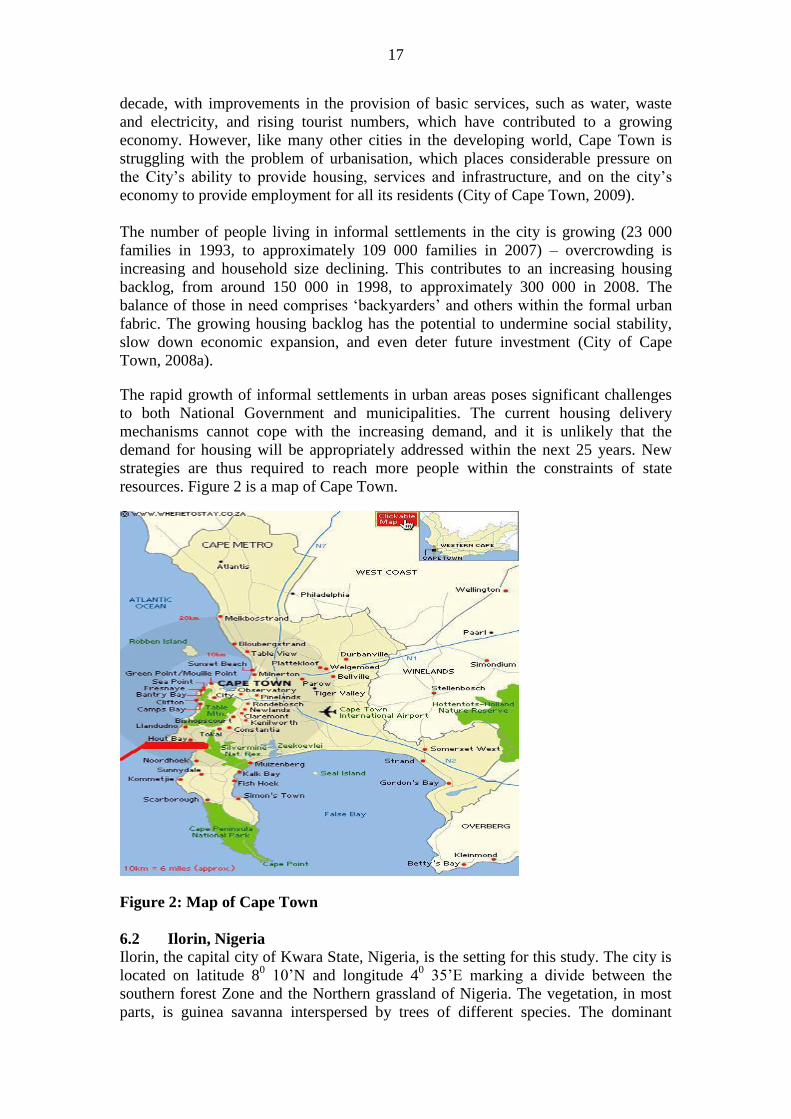
Cape Town lies in the Western Cape, the second most urbanised of South Africa‟s
nine provinces, where urbanisation levels are estimated at 90 percent (City of Cape
Town, 2005, 2007). It is home to an estimated 3.27 million people and has seen
among the highest urban growth rates of any city outside of Guateng province, South
Africa‟s economic and administrative heartland.
It is a city of sharp contrasts. Wealthy, lush surburbs nestle around the mountains
surrounding the city bowl, while the majority of the city‟s poorer residents live on the
Cape Flats, an inhospitable, spatially and topographically disadvantaged plain on the
eastern outskirts of the city, far from commercial and residential centres (Pharaoh,
2009). This development is rooted in both apartheid planning and the continued
„peripheralization‟ of informal settlements and low-income housing in the post-
apartheid era (Mahin, cited in Pharaoh, 2009). Under apartheid, segregation allowed
non-whites only restricted access to the urban areas. Thousands of people were either
forcibly removed or restricted access to living in the poorly serviced socially excluded
black and coloured townships of the Cape Flats and other designated non-white area-
initially in housing projects, but overtime increasingly in informal settlements.
Cape Town has had it own fair share of the problem of urbanisation just like any other
South African city. The city has experienced significant economic growth in the past
17
decade, with improvements in the provision of basic services, such as water, waste
and electricity, and rising tourist numbers, which have contributed to a growing
economy. However, like many other cities in the developing world, Cape Town is
struggling with the problem of urbanisation, which places considerable pressure on
the City‟s ability to provide housing, services and infrastructure, and on the city‟s
economy to provide employment for all its residents (City of Cape Town, 2009).
The number of people living in informal settlements in the city is growing (23 000
families in 1993, to approximately 109 000 families in 2007) – overcrowding is
increasing and household size declining. This contributes to an increasing housing
backlog, from around 150 000 in 1998, to approximately 300 000 in 2008. The
balance of those in need comprises „backyarders‟ and others within the formal urban
fabric. The growing housing backlog has the potential to undermine social stability,
slow down economic expansion, and even deter future investment (City of Cape
Town, 2008a).
The rapid growth of informal settlements in urban areas poses significant challenges
to both National Government and municipalities. The current housing delivery
mechanisms cannot cope with the increasing demand, and it is unlikely that the
demand for housing will be appropriately addressed within the next 25 years. New
strategies are thus required to reach more people within the constraints of state
resources. Figure 2 is a map of Cape Town.
Figure 2: Map of Cape Town
6.2 Ilorin, Nigeria
Ilorin, the capital city of Kwara State, Nigeria, is the setting for this study. The city is
located on latitude 80 10‟N and longitude 4
0 35‟E marking a divide between the
southern forest Zone and the Northern grassland of Nigeria. The vegetation, in most
parts, is guinea savanna interspersed by trees of different species. The dominant
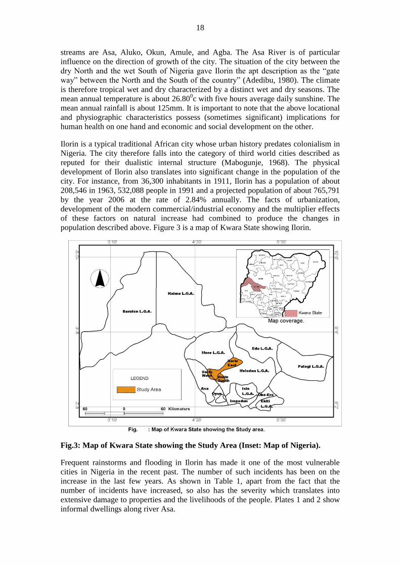
18
streams are Asa, Aluko, Okun, Amule, and Agba. The Asa River is of particular
influence on the direction of growth of the city. The situation of the city between the
dry North and the wet South of Nigeria gave Ilorin the apt description as the “gate
way” between the North and the South of the country” (Adedibu, 1980). The climate
is therefore tropical wet and dry characterized by a distinct wet and dry seasons. The
mean annual temperature is about 26.800c with five hours average daily sunshine. The
mean annual rainfall is about 125mm. It is important to note that the above locational
and physiographic characteristics possess (sometimes significant) implications for
human health on one hand and economic and social development on the other.
Ilorin is a typical traditional African city whose urban history predates colonialism in
Nigeria. The city therefore falls into the category of third world cities described as
reputed for their dualistic internal structure (Mabogunje, 1968). The physical
development of Ilorin also translates into significant change in the population of the
city. For instance, from 36,300 inhabitants in 1911, Ilorin has a population of about
208,546 in 1963, 532,088 people in 1991 and a projected population of about 765,791
by the year 2006 at the rate of 2.84% annually. The facts of urbanization,
development of the modern commercial/industrial economy and the multiplier effects
of these factors on natural increase had combined to produce the changes in
population described above. Figure 3 is a map of Kwara State showing Ilorin.
Fig.3: Map of Kwara State showing the Study Area (Inset: Map of Nigeria).
Frequent rainstorms and flooding in Ilorin has made it one of the most vulnerable
cities in Nigeria in the recent past. The number of such incidents has been on the
increase in the last few years. As shown in Table 1, apart from the fact that the
number of incidents have increased, so also has the severity which translates into
extensive damage to properties and the livelihoods of the people. Plates 1 and 2 show
informal dwellings along river Asa.
19
Table 1: Rainstorm and Flooding Incidents in Ilorin, 2002-2007
Year Rainstorm/Flooding Incidents Severity*
2002
2003
2004
2005
2006
2007
2008
4
2
4
6
6
8
7
High
Moderate
Moderate
High
High
High
High
* Severity in terms of number of people affected and economic losses
Source: Kwara State Emergency Management Agency‟s records
7 Discussion of Findings
7.1 Summary of Findings from Ilorin Study
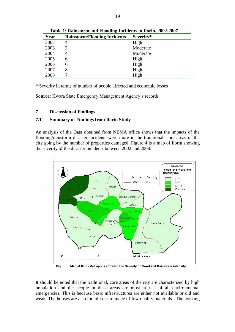
An analysis of the Data obtained from NEMA office shows that the impacts of the
flooding/rainstorm disaster incidents were more in the traditional, core areas of the
city going by the number of properties damaged. Figure 4 is a map of Ilorin showing
the severity of the disaster incidents between 2002 and 2008.
It should be noted that the traditional, core areas of the city are characterised by high
population and the people in these areas are most at risk of all environmental
emergencies. This is because basic infrastructures are either not available or old and
weak. The houses are also too old or are made of low quality materials. The existing
20
situation has increased the anxiety on the part of the people that future incidents will
continue to have higher impacts. The next section which discusses the characteristics
of the affected buildings from data collected from the field further confirm the fact
that most of the buildings in most parts of the city especially the core, indigenous
areas cannot withstands rainstorm or severe flooding whenever they occur.
7.1.2 Impact of Flooding on Livelihood Systems
Flooding and rainstorm, apart from causing destruction to lives and properties often
cause significant damage to livelihood systems of the victims. When asked the
various ways by which the flooding and rainstorm disasters have eroded their
livelihood systems, pauperisation and health problems appear to be the major
dimension. For instance, as lamented by some respondents, the incidents generally
caused disruption of electricity in some areas for months affecting trading and crops
washed away on farms, especially among those in the suburban. It should be noted
that when electricity supply is unavailable for some time, it slows down economic
activities among the traders and the artisans which, incidentally, constituted the
highest proportions of those affected. Furthermore, the disasters are associated with a
number of health problems including bodily injuries as well as the attendant
psychological trauma. According to one of the victims, “when one‟s health is affected
by disaster incidents, it becomes difficult, if not impossible, to continue with one‟s
means of livelihood”. According to him, this is the singular most worrisome aspect of
disaster impact”. The post disaster adjustment would have been easier if relief comes
from government and non-governmental organisations on time.
A number of women in the inner city and Frontier Native areas depend on irrigated
vegetable farming around the flood plains of Asa, Aluko and Amule- the three
dominant streams that flow in most parts of the metropolis. During flood events,
vegetable farms are washed away and the land remain flooded for a long time after.
Women are rendered unemployed for upwards of three months when they can start all
over. To worsen this situation, poor urban women‟s economy is not diversified and
thus entrenching the regime of poverty.
7.1.3 Coping Mechanisms Employed by Victims
In terms of coping and adjustment, findings show that by and large, support from
friends and relatives and personal savings accounted for the way large proportion of
the victims cope with the immediate impacts of the disaster. Even though government
support came for most of them, many of the victims said the support did not come on
time and it did not measure any closer to the degree of loss suffered. This calls to
question the level of disaster response in Nigeria. It is a fact that the agency charged
with disaster management in Nigeria (NEMA) has demonstrated some low level of
capability in managing the various disasters that has occurred in Nigeria in recent
years. A major problem has been in the areas of funding and lack of modern
equipment to respond to disasters in the country. According to some of the victims,
many of them did not get relief materials until after six months especially those that
have to do with materials to repair or rebuild damaged properties. The coping
mechanisms employed by victims as presented in Table 1.
21
Table 1: Coping mechanisms employed by flood victims
*Frequency Percent
Personal savings
Support from friends and relatives
Borrowing from local money lenders
Borrowing from banks
Government donations
29
50
11
6
26
23.7
41.0
9.0
4.9
21.3
* multiple sources of coping mentioned by respondents
Source: Author‟s Analysis
At present the structure of disaster risk management in the City does not give room
for particular emphasis to be placed on flooding and related extreme weather events
like rainstorm. As obtained in all the states of the federation, the agency charged with
disaster management, the National Emergency Management Agency (NEMA) and the
counterparts at the state level are burdened with so many responsibilities. The Kwara
State Emergency Management Agency is not an exception. No specific programmes
or trained personnel are on ground to prepare for or deal with flood disasters
whenever the incidents occur.
7.2 Vulnerability of Cape Town’s Informal Settlements to Flood Risk
Informal settlements exhibit complexity in other ways. Smit (2006) identified some of
the issues that contribute to the complexity of informal settlements in Cape Town:
“the physical form of the settlement, poverty and vulnerability, social problems within
the settlement and rural-urban linkages”. The physical layout of informal settlements
is closely linked to social networks as well as economic activity and this contributes
to the apparently chaotic layout of such settlements. This informality is magnified by
the impermanent structure of dwellings and the low level of service provision. A great
degree of social differentiation can also be identified within informal settlements,
although the majority of inhabitants are unemployed or have very low household
incomes. Community schisms have also been identified by Smit (2006) and these
factions may be delineated according to politics or the length of time of occupation.
Poverty, a key component of the flooding problem in Cape Town is perhaps one of
the most important underlying factors of vulnerability. The economic situation of the
residents is perhaps even more debilitating than the geographic situation of the Cape
Flats. Their poverty can be attributed to the remnants of apartheid, which was in place
from the late 1940s until the early 1990s and was designed to repress black South
Africans through segregation. This segregation forced black South Africans to live in
designated areas, which eventually evolved into the informal settlements of the
present day. While the formal system of apartheid no longer exists in South Africa, its
legacy is very much alive.
The City suffers from relatively heavy rainfall every year during the wet months of
winter. While most of the City has established sophisticated and fully functional
stormwater infrastructure, the poorer areas located in the Cape Flats, such as
Khayelitsha and Philippi, lack sufficient modern stormwater infrastructure
While most of these townships do not have formal catchment systems, there is a basic
level of service provided by the City, which includes retention ponds around the area,
22
drains around paved roadways, and formal trenches. However, in many cases, these
basic services are ineffective due to consistent blockages. There are three main types
of blockages which are common to these systems: silt accumulation, man-made
blockages, and rubbish build up (Bourchard et al, 2007). Silt accumulation can be
attributed to the grey water, which accrues within the trenches. Residents dispose of
wash water and latrine contents in these areas, resulting in large amounts of grey
water. Man-made blockages are also frequent within settlement areas. The City places
pipes through locations in the area to transport the water to retention ponds, and many
times residents block these pipes with various materials so that they can settle in those
areas. This results in the pooling of water and consequent flooding during the winter
months. Rubbish blockages are perhaps the most debilitating to the catchment system.
The lack of skips or improper location of skips (rubbish collection bins) within these
areas results in residents disposing of their rubbish in retention ponds, trenches, and
streets. This trash subsequently ends up in the drains and causes blockages.
Another aspect which contributes to flooding is the fact that flood risk management is
often not a priority at household and community levels (Bourchard et al, 2007).
Though this is not the case for all residents, many are primarily concerned with being
relocated or being provided housing. There is little motivation for residents to
properly protect their homes from flooding because often they believe that if they are
the worst affected, they will be the first ones to be relocated. While some do have the
means to prevent flooding within their homes, others lack the means and knowledge
of how to do so. The location of townships also plays a large part in increasing the
risk of flooding. The informal settlements are situated in the Cape Flats, an area of
lower elevation in comparison to the surrounding mountainous terrain, making them
susceptible to the accumulation of water. Though the area is unsuitable for living due
to this risk, there continues to be a great influx of residents, primarily from the
Eastern Cape. These new residents move to the Cape Flats during the summer months
when there is no flooding, find an open location, and unknowingly settle in an area of
high flood risk. There is little to no control over how many people move into an area
or where they settle in that area.
A notable danger associated with the flooding in the informal settlements is the
detriment to the health of the residents. The floods create large bodies of stagnant
water that pose several health concerns. When the rainfall occurs on a steep gradient
(e.g. mountainous terrain), the duration of the flooding is relatively brief. However,
when the terrain is flat, the duration is extended because the water drains far more
slowly (Miller, 2007). There are many times when the Flats experience multiple
storms over the course of a week, which can prolong the period of time it takes for the
water level to lower. The period of the flooding is dependent upon both the amount of
water and the gradient of the flooded stream.
During a flood, this runoff combines with human wastes from sewers, drains, and
latrines and spreads throughout the homes and streets of the settlements. These wastes
carry bacteria, viruses, and parasites that are responsible for a wide number of gastro-
intestinal infections, including diarrhoea (which kills over three million children
around the world per annum), typhoid, cholera, and intestinal worm infections
(Kolsky, 1998).
23
Unfortunately, the City is limited in their ability to resolve the problem due to a lack
of manpower, inadequate land availability and potential political conflicts that may
arise between the government officials and settlement groups. However, the City
cannot overlook the importance or necessity of action in the affected areas to provide
a better living environment for the people in the settlements. Table 2 shows the broad
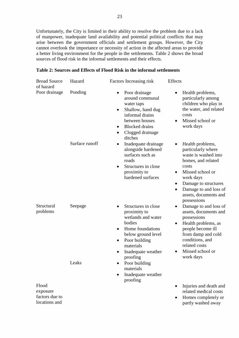
sources of flood risk in the informal settlements and their effects.
Table 2: Sources and Effects of Flood Risk in the informal settlements
Broad Source
of hazard
Hazard Factors Increasing risk Effects
Poor drainage Ponding Poor drainage
around communal
water taps
Shallow, hand dug
informal drains
between houses
Blocked drains
Clogged drainage
ditches
Health problems,
particularly among
children who play in
the water, and related
costs
Missed school or
work days
Surface runoff Inadequate drainage
alongside hardened
surfaces such as
roads
Structures in close
proximity to
hardened surfaces
Health problems,
particularly where
waste is washed into
homes, and related
costs
Missed school or
work days
Damage to structures
Damage to and loss of
assets, documents and
possessions
Structural
problems
Seepage Structures in close
proximity to
wetlands and water
bodies
Home foundations
below ground level
Poor building
materials
Inadequate weather
proofing
Damage to and loss of
assets, documents and
possessions
Health problems, as
people become ill
from damp and cold
conditions, and
related costs
Missed school or
work days
Leaks Poor building
materials
Inadequate weather
proofing
Flood
exposure
factors due to
locations and
Injuries and death and
related medical costs
Homes completely or
partly washed away
24
surroundings Damage to and loss of
assets, documents and
possessions
Damage to and loss of
infrastructure
Negative effects on
businesses and
industries,
particularly in the
tourism sector
Riverine/estuarine
flooding Structures in close
proximity to water
bodies
Structures built in
dry water courses
Disturbance of
natural water
drainage and flow
patterns
Isolation of
communities as
bridges and roads are
damaged or washed
away
Injuries and deaths
and related costs
Homes completely or
partly washed away
Damage to and loss of
infrastructure
Damage to and loss of
assets, documents and
possessions
Negative effects on
businesses and
industries
Source: Holloway & Roomaney, 2008
7.3 Flood Risk Management in the Informal Settlements
“It is important to understand that for reasons of resources and practicality, it is not
feasible to completely eliminate flood risk in the City. It can however be managed to
acceptable levels through appropriate planning, design, construction, operation and
maintenance of stormwater infrastructure as well as proactive development
management and disaster planning in collaboration with all stakeholders”. “The
solution to the informal settlements flooding problems is a simple one, technically:
Move the people out of their present locations and do some upgrading to reshape the
land. But this has never happened. And it may never happen” (Interview with city
officials Johan Gerber and Barry Wood on 05/10/09). This sums up the complicated
nature of flood risk management in the informal settlements of Cape Town, especially
those located in the Cape Flats. This is because it is practically impossible to move
people out of their present locations. The germane questions are; where do you move
the people to? Are the people themselves willing to move? What are the rational
alternatives? “The people are not willing to risk leaving their present camp for fear
that it may become impossible for some of them to come back. For now the emphasis
is providing social services to informal settlements located on government lands.
What of those that are not living in government lands?”
25
Flood risk management plan are primarily focused on relocating the residents and
restricting migration into these dangerous areas (Bourchard et al, 2007). Nonetheless,
the city recognises people with limited means will continue to live for some time in
flood-prone areas, and that the emphasis in international flood management ―has
moved away from [relying only on] physical control and engineering construction
(structural measures) towards reducing human vulnerability through non-structural
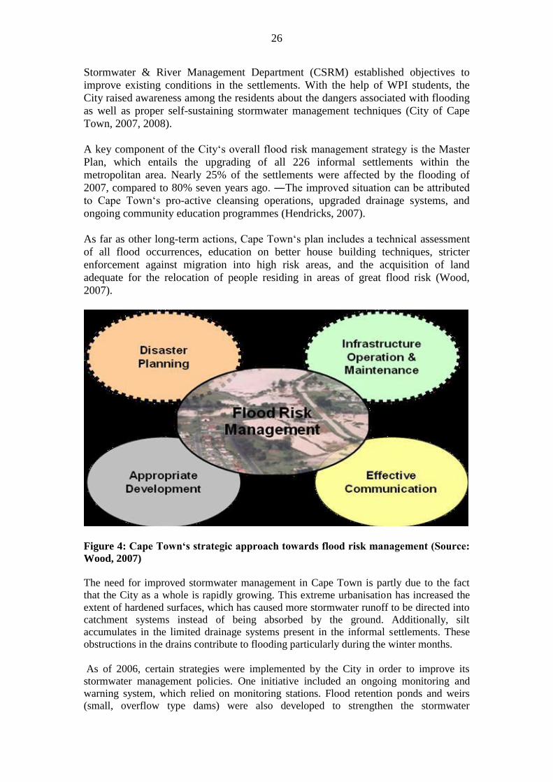
approaches (Smith, 1992). The city„s flood risk management plan thus addresses four
broad domains (Figure 4) to address a range of issues inhibiting faster progress,
among which are ineffective communication between various stakeholders, the lack
of available City resources, the absence of community involvement in the City„s flood
risk management scheme, and the nonexistence of a method to prioritise the areas
most devastated by flooding (Bourchard et al, 2007).
Despite the efforts of the City, the countless impacts of flooding in the informal
settlements are still very much apparent (Bourchard et al, 2007). The existing
stormwater infrastructure in these affected areas is often ill-maintained, which
exacerbates the problem. The flooding has left many areas of the informal settlements
uninhabitable for various reasons including health risks and physical dangers. There
has not yet been a thorough assessment of the habitability of the affected areas.
Although many of them are hazardous, many residents continue to live there, not only
because they lack the economic means to move elsewhere but also because they are
largely unaware of the dangers associated with flooding. Previous efforts have not
been entirely successful in minimising the impact of flooding at the household and
community levels (Wood, 2007). In other words, there was a lack of involvement by
and collaboration with the residents of the informal settlements about flood risk
management.
According to the City officials interviewed, “the informal settlements have become
increasingly difficult to manage even with some level of upgrading and service
provision as it becomes difficult to control the influx of people. So any meagre
achievements in these two areas are soon wiped off by overpopulation”. Two major
factors aggravating flood disasters, as explained by the City officials include building
too low to the ground and leaking roof. These are the lingering physical dimensions of
vulnerability in the informal settlements. Infact some residents through their actions
encourage flooding to attract government attention and sympathy. This now makes
the situation both social and political. In other words, flood risk in the informal
settlements in the City has now gone beyond engineering and service provision to a
complex web of social and political issue. There is need for communities, therefore, to
take initiatives to reduce the risk of flooding. These can be done in several ways;
1. There are general works that people can do to improve building structures:
again, the issue of having resources to do this comes in.
2. Sometimes people have resources to do some simple things but they prefer to
wait for government believing that government is there to solve all their
problems.
All the recent flooding events have prompted an ―emphasis [that] has moved away
from physical control and engineering construction (structural measures) towards
reducing human vulnerability through non-structural approaches (Smith, 1992). In
accordance with this movement, the City of Cape Town is now moving from a
reactive to proactive approach for handling the flooding. In May 2007, the Catchment,
26
Stormwater & River Management Department (CSRM) established objectives to
improve existing conditions in the settlements. With the help of WPI students, the
City raised awareness among the residents about the dangers associated with flooding
as well as proper self-sustaining stormwater management techniques (City of Cape
Town, 2007, 2008).
A key component of the City„s overall flood risk management strategy is the Master
Plan, which entails the upgrading of all 226 informal settlements within the
metropolitan area. Nearly 25% of the settlements were affected by the flooding of
2007, compared to 80% seven years ago. ―The improved situation can be attributed
to Cape Town„s pro-active cleansing operations, upgraded drainage systems, and
ongoing community education programmes (Hendricks, 2007).
As far as other long-term actions, Cape Town„s plan includes a technical assessment
of all flood occurrences, education on better house building techniques, stricter
enforcement against migration into high risk areas, and the acquisition of land
adequate for the relocation of people residing in areas of great flood risk (Wood,
2007).
Figure 4: Cape Town‘s strategic approach towards flood risk management (Source:
Wood, 2007)
The need for improved stormwater management in Cape Town is partly due to the fact
that the City as a whole is rapidly growing. This extreme urbanisation has increased the
extent of hardened surfaces, which has caused more stormwater runoff to be directed into
catchment systems instead of being absorbed by the ground. Additionally, silt
accumulates in the limited drainage systems present in the informal settlements. These
obstructions in the drains contribute to flooding particularly during the winter months.
As of 2006, certain strategies were implemented by the City in order to improve its
stormwater management policies. One initiative included an ongoing monitoring and
warning system, which relied on monitoring stations. Flood retention ponds and weirs
(small, overflow type dams) were also developed to strengthen the stormwater

27
infrastructure in place. The City also looked to increase the flood event return period (the
time interval between flood events) for which the infrastructure was designed. Also, there
was an effort to maintain the infrastructure by relieving the drainage systems of built-up
sand and debris. And lastly, mostly pertaining to the informal settlements of Cape Town,
the City looked towards ―the development of resilient infrastructure to include
appropriately designed and constructed low-income homes, storm-water drainage and
sewage treatment installations to cope with flash-floods (Mukheibir, 2006).
In accordance with the City„s 2007 Winter Readiness Programme, an additional series of
measures was taken relating to stormwater and river cleaning. These measures included a
metro-wide proactive stormwater piping cleaning programme, a solid waste area cleaning,
and regular inspection and monitoring of critical catchment systems. The solid waste area
cleaning is the main task outlined by the readiness programme, as it is an ongoing process
for the City that aims to prevent the ingress of litter and other solids into stormwater
systems.
The City of Cape Town„s approach to spreading awareness of the consequences of
flooding is the execution of their communication and awareness programme. The aim of
the programme is to educate the residents in the Cape Flats as to the actions they should
be taking so as to lessen the effects of flooding. The key activities of this programme
include: a community capacity building programme, media briefings, information
collation and reporting, and regular media releases and public advisories (Wood, 2007).
A community capacity building programme involves brochures, tips, workshops, and
flood risk education, including notification to informal communities within flood prone
areas. As far as collation and information reporting, the City broadcasts weather warnings
as well as regular flood incident reports. The City has also undertaken a number of
initiatives to assist the community in their response to flooding. One of the ongoing
measures is the use of public call centres, which ensure that complaints and requests for
assistance are dispatched to the appropriate department(s). Furthermore, the City aims to
better coordinate the reporting of flood incidents within the informal settlements.
Regarding public wellbeing, the health directorate is responsible for providing primary
and secondary healthcare service and education to the public.
The City has constituted a disaster risk management team
(http://www.capetown.gov.za/en/MediaReleases/Pages/CityDisasterRiskManagement
TeamReadyForStorms.aspx). The team is a joint effort between the City of Cape
Town, Provincial Government and Non-Governmental Organisations (NGOs). The
Major Flooding and Storms Plan includes the unblocking of stormwater drains, the
upgrading of stormwater systems, regular inspections of retention ponds, a public
education programme and an emergency plan to handle possible disasters. The City
has also signed an agreement with the Trauma Centre to assist victims of storms or
floods with psychological assessment and support. “The City has pro-actively
identified and mapped high flood risk areas. We have introduced special flood risk
reduction measures, such as improved drainage and preventative maintenance of
existing stormwater systems by Roads and Stormwater teams,” says Councillor
Dumisani Ximbi, Mayoral Committee Member for Safety and Security. “Our ongoing
public education programme in partnership with environmental training provides
residents with practical tips on how to raise floor levels, channel flood waters, as well
as reduce health hazards associated with standing water,” he says.
The City‟s emergency plan is co-ordinated at a Joint Operations Centre (JOC) where a
28
multi-disciplinary rapid response team manages and executes contingency plans. It
also acts as a central information point to inform the public on the situation at hand
through fast and effective communication during emergencies. One of the best
practices in flood disaster preparedness and vulnerability risk assessment as
demonstrated in the case of the informal settlements are presented in Appendices I
and II
According to Wood and Gerba, “Once the SA Weather Service issues a severe
weather warning, the City will immediately communicate the news directly to the
areas at risk. “We have also identified various emergency shelters to help minimise
disruption of lives and community activities. People will be encouraged to first try
and find alternative accommodation with neighbours, friends or families before being
housed in community facilities. The City‟s emergency plan provides for the response
team to, together with identified NGOs, disseminate blankets, food and basic
necessities to alleviate the trauma usually experienced by flood victims and to provide
for the immediate, basic needs of affected communities. It also provides specific
information with regard to health issues, the registration of victims and emergency
shelters.
There are some challenges in the City‟s efforts to manage flood risk in the City. There is
no flood warning for specific communities except the general weather forecast from
the South African Weather Services. Therefore it is difficult to predict area that
flooding is to occur at a particular time. When there is dumping on drainage channels
the City council may not know on time because of accessibility problems in many
informal settlements. Also, debris do come down from mountains to block the
drainage channels especially those settlements very close to table mountain. These
situations have become a big challenge for disaster management in the area of early
warnings.
The percentage of flooded settlements has remained fairly stable in the past few years.
As part of the City strategy to combat flood risk and other hazards in the informal
settlements, there is now a decentralised management system whereby different
departments are now charged with different aspects of managing flood risks in the
informal settlements. Some of the departments in charge of flood risk management in
the informal settlements include department of housing, sanitation, stormwater, basic
services department etc
8 Governance of Disaster Risk and Climate Change in the two Cities: A
Comparison
Climate change is a global problem that requires global solutions, but the nature of the
problem and its impacts require the active involvement of multiple national and local-
level stakeholders in shaping and implementing the solutions. Adaptive capacity is
dependent on policies and strategies that are put in place to respond to the needs as
well as enhance the resilience of the most vulnerable systems and groups in society. A
lack of appropriate policies and legislative frameworks may present barriers to the
implementation of adaptation responses, and possibly increase the vulnerabilities of
certain groups such as women and the poor. Inadequate institutional support and
inappropriate policies can act as a constraint to adaptation and limit access to much
29
needed natural resources by communities dependent on such resources for both
survival and adaptation to environmental change and climate variability.
Reducing the vulnerability of people to floods and enhancing their adaptive capacity
to deal with floods are crucial governance issues. Any assessment of vulnerability to
floods requires not only at potential changing bio-physical changes, but also at the
social, political and economic factors that create vulnerability among different social
groups. It requires looking at the interplay among different perspectives, power
structures and lobbies, which influence the politics and discourses on vulnerability to
floods and risk reduction interventions. Moreover, it requires the effectiveness and
fairness of institutions and processes by which the interests of various stakeholders,
especially the poor, are incorporated in policies and programmes to manage flood
risks. Stakeholder participation may be explored to strengthen and widen the range of
adaptive strategies accessible to the poor.
It seems increasingly accepted (although not consistently implemented) that disasters
shouldn‟t be dealt with through humanitarian relief interventions alone. There is some
evidence to support the argument that disaster management response in the city of
Ilorin, just like in other areas in Nigeria, should shift away from this traditional
response approach to focus increasingly on addressing the causes of vulnerability in
order to mitigate the effects of disaster. However, the approach tends to address only
the visible signs of vulnerability, such as poor access to services, and generally fails to
make a deeper analysis based on the maintenance of sustainable livelihoods by
vulnerable people. Vulnerability is seen as a physical problem which can be addressed
mainly through technical solutions such as infrastructure development which may not
even be provided at the appropriate time. However, this approach generally fails to
take into account the views, capacities, knowledge and priorities of local people and is
thus limited in effectiveness in truly reducing vulnerability. For all practical purposes,
there are many lapses in the management of flooding in the city. Governance is not an
issue yet. A summary account of flood risk management and governance issues in the
two cities is presented in Table 4.
On the other hand, a major achievement of the City of Cape Town administration in
the management of flood risk is that the percentage of flooded settlements has
remained fairly stable in the past few years. As part of the City strategy to combat
flood risk and other hazards in the informal settlements, there is now a decentralised
management system whereby different departments are now charged with different
aspects of managing flood risks in the informal settlements. Some of the departments
in charge of flood risk management in the informal settlements include department of
housing, sanitation, stormwater, basic services department etc.
Given the fact that many risks in the physically vulnerable settlements are strongly
rooted in social and economic vulnerability, along with unstable sources of livelihood,
closer cooperation and confidence between settlement residents and local authority
representatives as well as other stakeholders can improve municipal service delivery,
infrastructure development as well as strengthen local responsibility for recurrent
risks. The City is currently addressing many of these issues within the context of
governance of disaster risk and long term climate risk posed by climate change.
30
Table 4: Managing Flood Risk and long term Governance of Disaster Risk and
Climate Change: A Comparison
Cape Town Ilorin
Weather Information Cape Town weather data,
CSAG
None at the city level
Response timing Before and after vents
response,
After event response
Response type Preparedness, early
warning, relief
Post disaster relief
Management structure Disaster management Unit
of the Department of
Housing (informal
settlements)
Kwara State Emergency
Management Agency
Long term plan Upgrading/relocation None
Governance of disaster
Risk (flooding)
Multiple sectors of
administration at various
levels, horizontal and
vertical, stakeholders
involvement
No evidence on ground
Long term climate risk
governance
Multiple sectors of
administration at various
levels, horizontal and
vertical, stakeholders
involvement
No evidence on ground
Source: Author’s analysis
9 Summary and Conclusion
The major problems promoting the vulnerability to flooding in the two cities as
revealed in this study are physical vulnerability and socio-economic vulnerability. For
example, some of the issues identified that contribute to the complexity of informal
settlements in Cape Town include the physical form of the settlement, poverty and
vulnerability, social problems within the settlement and rural-urban linkages. The
physical layout of informal settlements is closely linked to social networks as well as
economic activity and this contributes to the apparently chaotic layout of such
settlements. This informality is magnified by the impermanent structure of dwellings
and the low level of service provision. A great degree of social differentiation can also
be identified within informal settlements, although the majority of inhabitants are
unemployed or have very low household incomes.
The Ilorin study brings out the important issue of vulnerability, coping and adaptation
to disasters caused by extreme weather events among the urban poor. It examined in
some detail the strategies adopted by poor neighbourhoods as disasters impact on their
livelihood systems and the sequence of responses which they employ over time as
they struggle to cope. The study revealed that the indigenous coping mechanisms
employed by the poor may become less effective as increasingly fragile livelihood
systems struggle to withstand disaster shocks. Also, many of these long-term trends
31
are rendering indigenous coping strategies less and less effective and thus are
increasing the vulnerability of the poor.
The Nigerian urban areas exhibit many characteristics associated with urban decay
which makes them some of the most highly vulnerable cities in the world with
frequent negative impacts of environmental emergencies and extreme weather events.
Without major changes in the ways that governments at various levels work in urban
areas these impacts will rise. Three initial lessons which were summarized in the
study by Mehrotra, Claudia, Natenzon, Omojola, Folorunsho, Rosenzweig and
Rosenzweig (2009) that included Lagos are very relevant for the Nigerian situation.
First, a multidimensional approach to risk assessment is a prerequisite to effective
urban development programmes that incorporate climate change responses. Second,
mismatches between needs and responses are occurring with regard to who should
mitigate, how much to adapt, and why. Cities need climate change risk assessments in
order to decide for themselves what the right mix between mitigation and adaptation
measures will be. Third, the vertically and horizontally fragmented structure of urban
governance is as much an opportunity as an obstacle for introducing responses to
climate change.
The lessons learnt from the South African study is expected to be useful in designing
appropriate institutional interventions capable of transiting victims from being painful
victims to developing adaptive capacity to live with recurring floods in Nigeria. Most
studies indicate, with sufficient evidence, that climate will continue to change with far
reaching implications on the environment and human livelihood (Olorunfemi, 2010).
Strategies to reduce vulnerability should be rooted in vulnerability analysis and
greater understanding of both household-level and macro response options that are
available to decrease the poor‟s exposure to climate risk. Increasing the response-
capability of Nigeria will require information on seasonal forecast to enable the
preparedness to climate variability as well as longer term climate prediction data to
ensure that strategies to reduce vulnerability also reflect the underlying longer-term
climate trends.
The rationale for integrating adaptation into development strategies and practices into
urban management in Nigeria is stressed by the fact that many interventions required
to increase resilience to climatic changes generally benefit development objectives.
Adaptation requires the development of human capital, strengthening of institutional
systems, and sound management of public finances and natural resources. Such
processes build the resilience of countries, communities, and households to all shocks
and stresses, including climate variability and change, and are good development
practices in them. Adaptations are successful if they reduce the vulnerability of poor
communities and poor people to existing climate variability, while also building in the
potential to anticipate and react to further changes in climate in the future. Adaptation
to climate change requires local knowledge, competence and capacity within local
governments. It needs households and community organizations with the knowledge
and capacity to act. It also requires a willingness among local governments to work
with lower-income groups. All things considered, the long-term effects of disasters
seriously affect the country‟s prospects for development. This calls into question at
least two aspects related to a country‟s development strategy: first, an understanding
that resources earmarked for preventing and mitigating the impact of natural
32
phenomena are a very high-yield investment, both in economic, social and political
terms in line with long-term growth.
Acknowledgement:
The Nigerian case study derives from an earlier study conducted by the author in conjuction
with Mr. Raheem, U.A of the Department of Geography, University of Ilorin, Ilorin. The
South African study benefited from funding provided by the International START Secretariat,
Washington DC, USA under the African Climate Change Fellowship Programme, a
programme of Climate Change Adaptation in Africa (CCAA) jointly funded by DFID and
IDRC. This financial assistance is greatly acknowledged. I thank the Climate Systems
Analysis Group (CSAG), University of Cape Town, South Africa under which the fellowship
was executed and for facilitating the study. I also acknowledge the contributions of my host
and home supervisors, Dr. Jane Lennard-Battersby of the University of Cape Town and Prof.
Femi Olokesusi of the Nigerian Institute of Social and Economic Research respectively.
33
References
ActionAid International (2006) “Climate change, urban flooding and the rights of the
urban poor in Africa: Key findings from six African cities”. (Available on
http://www.actionaid.org/docs/urban%20flooding%20africa%20report.pdf
Accessed 12/03/2008)
Adedibu, A.A (1980) “Spatial Pattern of Housing Modernisation in the Traditional
Area of Ilorin”. Nig. Geog. Jour. 23(1-2) 147-161
Adger, W. Neil (2003) Social Capital, Collective Action, and Adaptation to Climate
Change. Economic Geography 79, No. 4 (Oct. 2003): p. 387-404.
Adger, W. Neil, S. Huq, K. Brown, D. Conwaya, and M. Hulmea, (2003) “Adaptation
to climate change in the developing world” Progress in Development Studies
3,3 pp. 179–195
Alam, K., Herson, M., O‟Donnel, I. (2008) Flood Disasters: Learning from Previous
Relief and Recovery Operations. Provention Consortium and ALNAP
Ashley R.M., Blanksby J., Chapman J. & Zhou J (2007) “Towards integrated
approaches to increase resilience and robustness for the prevention and
mitigation of flood risk in urban areas”. In: R. Ashley, S. Garvin, E. Pasche,
A. Vassilopoulos & C. Zevenbergen, eds. Advances in urban flood
management. London: Taylor and Francis, 2007, ISBN: 978 0 415 43662 5.
Benjamin, M.A (2007) “Analysing Urban Flood Risk in Low-Cost Settlements of
George, Western Cape, South Africa: Investigating Physical and Social
Dimensions” A thesis submitted to the University of Cape Town in fulfilment
of the requirements for the degree of Masters in Social Science Department of
Environmental and Geographical Science University of Cape Town.
Bouchard Betany., Ashley Goncalo. , Michael Susienka and Kevin Wisner (2007)
“Improving Flood Risk Management in the Informal Settlements of Cape
Town” An Interactive Qualifying Project submitted to the Faculty of
Worcester Polytechnic Institute in partial fulfilment of the for the Degree of
Bachelor of Science
Brooks, Nick (2003) “Vulnerability, risk and adaptation: A conceptual framework”
Tyndal Center for Climate Change Research working Paper 38. pp20
Brooks, Nick, W. Neil Adger, and P. Mick Kelly. 2005. The determinants of
vulnerability and adaptive capacity at the national level and the implications
for adaptation. Global Environmental Change 15 (2):151-163.
34
Cannon, T. (2000). Vulnerability analysis and disasters. In Floods (ed D.J. Parker),
pp. 45-55. Routledge, London.
Chiang Mai. Christie, F. & Hanlon, J. (2001). Mozambique & the great flood of 2000
The International African Institute, Oxford.
City of Cape Town (2006), Information and Knowledge Management Department,
Informal Dwelling Count (1993-2005) for Cape Town, Elvira Rodriques,
Janet Gie and Craig Haskins, 15 pages.
City of Cape Town (2009). State of Cape Town 2008: Development issues in Cape
Town.
City of Cape Town Strategic Development Information and GIS Department (2007)
Planning Districts Socio-economic Analysis 2007 (14-23). Cape Town, South
Africa.
City of Cape Town, (2005), City of Cape Town study on the social profile of residents
of three selected informal settlements in Cape Town, Executive summary
reports: Survey results and study findings. City of Cape Town. Accessed at: http://www.capetown.gov.za/en/stats/CityReports/Documents/Informal%20Settlemen
ts/Informal_Settlements_Executive_Summary_272200611403_359.pdf
City of Cape Town. (2006). State of Cape Town Report 2006: Development Issues in
Cape Town
City of Cape Town. (2007a). Five Year Plan for Cape Town – Integrated
Development Plan 2007/8–2011/12 (2008/09 Review). IDP & Performance
Management Department: Cape Town.
City of Cape Town. (2007b). Draft CCT Densification Policy. Spatial Planning
Department.
City of Cape Town. (2008). 2006 General Household Survey Analysis for Cape Town.
Strategic Development Information & GIS Department.
Colleta, N. J., 2004: Human-Driven Disasters: Violent Conflict, Terrorism and
Technology. Inter-American Development Bank, Sustainable Development
Department, Technical Paper Series (Washington, D.C.: Inter-American
Development Bank).
Cutter, S.L. (1996) „Vulnerability to Environmental Hazards‟, Prog. Human Geog.
20, 529-539.
Department of Environmental Affairs and Tourism (DEAT) (2004), “A National
Climate Change Response Strategy for South Africa”. Department of
Environmental Affairs and Tourism
Diagne, K. and Ndiaye, A (2009) “History, governance and the millennium
development goals: Flood risk reduction in Saint-Louis, Senegal” In: Pelling
M and Wisner, B.(Eds) Disaster Risk Reduction: cases from Urban Africa.
Dilley, M., Chen, R.S., Deichmann, U., Lerner-Lam, A., Arnold, M. (2005) “Natural
35
Disaster Hotspots. A Global Risk Analysis”. The World Bank, Hazard
Management Unit, Washington, DC.
Few, R., H. Osbahr, L.M. Bouwer, D. Viner and F. Sperling (2006) “Linking climate
change adaptation and disaster management for sustainable poverty
reduction”. Synthesis Report for Vulnerability and Adaptation Resource
Group (VARG). Available at:
ec.europa.eu/development/icenter/.../env_cc_varg_adaptation_en.pdf
Few, R., M. Ahern, F. Matthies, and S. Kovats (2004) “Floods, Health and Climate
Change: A Strategic Review”. Working Paper No. 63. Tyndall Centre for
Climate Change Research.
Gaventa J. (2002) “Exploring Citizenship, Participation and Accountability” IDS
Bulletin Vol 33 No 2
Gwary, Daniel, (2008) “Climate Change, Food Security and Nigerian Agriculture:
Challenges of Climate Changes for Nigeria”. In: Akande, Samuel, Tunji.;
Kumuyi, Ajibola, James. (Eds.) Challenges of Climate Change for Nigeria: A
Multi-Disciplinary Perspective. (Ibadan, Nigeria: Nigerian Institute of Social
and Economic Research [NISER]): 179-205
Heltberg, R., Lau Jorgensen, S.L and Paul Bennett Siegel (2008) “Climate Change,
Human Vulnerability, and Social Risk Management” paper was prepared for
the Workshop on Social Aspects Of Climate Change, March 5-6, 2008 at the
World Bank headquarters in Washington D.C.
Henderson, L.J (2004) “Emergency and Disaster: Pervasive Risk and Public
Bureaucracy in Developing Nations”. Public Organization Review: A Global
Journal Vol. 4 pp 103-119
Hilhorst, D. and Bankof, G. (2004) Introduction: Mapping Vulnerability. In Mapping
Vulnerability: Disasters, Development and People (eds G. Bankoff, G. Frerks
& D. Hilhorst), pp. 1-9. Earthscan, Sterling, VA.
Holloway, A and Roomaney, R. (2008) Weathering the Storm: Participatory risk
assessment for informal settlements. PeriPeri Publications, Rondebsoch.
Houghton, J.N, Ding, Y., Griggs, D., Nouger, M., van der Linden, P., Dai, X.,
Maskell, K., and Johnson, C. (eds) (2001) “Climate Change 2001: Scientific
Basis. Cambridge University Press, Cambridge
Huq, S., Kovats, S., Reid, H. and Satterthwaitte, D. (2007). Editorial: “Reducing
Risks to Cities from Disasters and Climate Change”, Environment and
Urbanization, 19 (1): 3-15
IFRC, 2003: World Disaster Report 2003 (Geneva: IFRCRCS); at: <www.ifrc.org>..
pp 11.
36
Intergovernmental Panel on Climate Change (IPCC) (2001) Climate Change 2001:
Impacts, Adaptation, and Vulnerability, summary issue in rural development.
Development Policy Review, 19 (4): 507-519.
International Strategy for Disaster Reduction (ISDR), (2008) “Disaster Risk
Reduction Strategies and Risk Management Practices: Critical Elements for
Adaptation to Climate Change” Submission to the UNFCCC Adhoc Working
Group on Long Term Cooperative Action. Accessed at:
www.unisdr.org/.../risk-reduction/climate-change/.../IASC-
ISDR_paper_cc_and_DDR.pdf -
Kabat P., Vierssen W. van, Veraart J.A., Vellinga P., Aerts J. Climate proofing the
Netherlands. Nature 2005, 438, 283–284.
Kolsky, P. (1998) Storm Drainage: An Engineering Guide to the Low-cost Evaluation
of System Performance. London, UK: International Technology Publications.
Kwara Emergency Management Agency (KWEMA) Annual Report, 2007
Lebel, L., and Bach Tan Sinh. (2005) Too Much of a Good Thing: How Better
Governance could Reduce Vulnerability to Floods in the Mekong Region.
USER Working Paper WP-2005-01. Unit for Social and Environmental
Lemos, Maria Carmen and Emma L Tompkins (2008) “Responding to the risks from
climate related Disasters” i d 2 1 h i g h l i g h t s climate Change (UK: IDS),
p3.
Mabogunje, A.L. (1968) Urbanisation in Nigeria. University of London Press.
Madzwamuse, M. (2010) “Climate Governance in Africa: Adaptation Strategy and
Institutions”. A synthesis report submitted to Heinrich Böll Stiftung
Manuta, J. and Lebel, L (2005) “Climate change and the risks of flood disasters in
Asia: crafting adaptive and just institutions” Human Security and Climate
Change. An International Workshop organised by Global Environment and
Security project (GECHS), near Oslo, 21–23 June 2005
Mark Davies, Katy Oswald, Tom Mitchell and Thomas Tanner (2008) “Climate
Change Adaptation, Disaster Risk Reduction and Social Protection” Briefing
Note (UK: Institute of Development studies). Accesses at:
http://www.preventionweb.net/files/7848_IDS20Adaptive20Social20Protectio
n20Briefing20Note201120December2020081.pdf
McCarthy, J.J., O.F. Canziani, N.A. Leary, D.J. Dokken and K.S. White (eds.) (2001)
Climate Change 2001: Impacts, Adaptation and Vulnerability. Contribution of
Working Group II to the Third Assessment Report of the Intergovernmental
Panel on Climate Change, Cambridge University Press, Cambridge, UK, 1032
pp.
Mehrotra, S., Claudia E. Natenzon; A. Omojola, R. Folorunsho, J. Gilbride and
Cynthia Rosenzweig, 2009. “Framework for City Climate Risk Assessment:
Buenos Aires, Delhi, Lagos, and New York” World Bank Commissioned
37
Research Fifth Urban Research Symposium Cities and Climate Change:
Responding to an Urgent Agenda Marseille, France June 2009. pp84
Midgley, G F, R A Chapman, B Hewitson, P Johnston, M De Wit, G Ziervogel, P
Mukheibir, L Van Niekerk, M Tadross, B W Van Wilgen, B Kgope, P Morant,
A Theron, R J Scholes and G G Forsyth (2005), “A status quo, vulnerability
and adaptation assessment of the physical and socioeconomic effects of
climate change in the Western Cape”, Report No ENV-S-C 2005-073 to the
Western Cape Government, Cape Town, CSIR, Stellenbosch.
Miller, M. (2007) “Adapting to Climate Change: Water Management for Urban
Resilience” Environ Urban, 19, 99-113
Mukheibir Pierre and Ziervogel Gina (2006) “Framework for Adaptation in the City
of Cape Town” Submitted to City of Cape Town: Environment Resource
Management.
Mukheibir Pierre and Ziervogel Gina (2007) “Developing a Municipal Adaptation
Plan (MAP) for climate change: the city of Cape Town Environment &
Urbanization Vol. 19, No. 1
Nelson, D. R. and Finan, T. J. (2009), Praying for Drought: Persistent Vulnerability
and the Politics of Patronage in Ceará, Northeast Brazil. American
Anthropologist, 111: 302–316. doi: 10.1111/j.1548-1433.2009.01134.x
O‟Brien Karen, Linda Sygna, Robin Leichenko, W. N. Adger, Jon Barnett, Tom
Mitchell, Lisa Schipper, Thomas Tanner, Coleen Vogel and Colette Mortreux
(2008) Disaster Risk Reduction, Climate Change Adaptation and Human
Security. Report prepared for the Royal Norwegian Ministry of Foreign
Affairs by the Global Environmental Change and Human Security (GECHS)
Project, GECHS Report 2008:3.
Oelofse, C. (2002) “Dimensions of Urban Environmental risk” In: Nomdo, C. and
Coatzee (Eds): Urban Vulnerability: Perspectives from Southern Africa.
Published by Peri Peri Publications. Pp. 28-53.
Olorunfemi F.B (2008) “Disaster Incidence and Management in Nigeria”. Research
Review. Vol.24 No. 2, pp 1-23
Olorunfemi, F.B (2010) “Climate Change and Flood Risk in the Informal Settlements
of Cape Town: Understanding Vulnerability and Adaptation Options” Final
Technical Report of The African Climate Change Fellowship Programme,
Submitted to Global Change SysTems for Analysis, Research and Training
(START), Washington DC, USA.
Olorunfemi, F.B and Raheem U.A (2007) “Urban Development and Environmental
Implications: The Challenge of Urban Sustainability in Nigeria”. Ibadan
Journal of the Social Sciences. Vol. 6 No 1 (March) pp. 69-78
Pahl-Wostl C. (2006) Framework for adaptive water management regimes and for the
transition between regimes. NeWater project, Report Series No. 12, 2006.
38
Pelling, M. (1999). The political ecology of flood hazard in urban Guyana. Geoforum,
30, 249-261.
Pelling, M. (2003) The Vulnerability of Cities: Natural Disasters and Social
Resilience. London and Sterling, VA: Earthscan.
Pelling, M. (2008) “The vulnerability of cities to disaster and climate change: A
conceptual introduction”, in H.G Brauch (ed) Coping with Global
Environmental Change, Disasters and Social Security, Springer-Verlag,
London.
Pharaoh, R. (2009) “Fire Risk in Informal settlements in Cape Town, South Africa”
In: Pelling, M. and Wisner, B. (eds) Disaster Risk Reduction: Cases from
Urban Africa” Earthscan. Pp 105-125.
Satterthwaite David, Saleemul Huq, Mark Pelling, Hannah Reid and Patricia Romero
Lankao (2007) “Adapting to Climate Change in Urban Areas The possibilities
and constraints in low- and middle-income nations” Human Settlements
Discussion Paper Series.
Smit, B., O. Pilifosova, I. Burton, B. Challenger, S. Huq, R. Klein, G. Yohe. (2001)
„Adaptation to climate change in the context of sustainable development and
equity.‟ In J. McCarthy, O. Canziani, N. Leary, D. Dokken, and K. White
(eds), Climate Change 2001: Impacts, Adaptation and Vulnerability,
Contribution of Working Group II to the Third Assessment Report of the
Intergovernmental Panel on Climate Change, Cambridge University Press,
Cambridge, UK and New York, USA.
Smit, W. (2006), 'Understanding the complexities of informal settlements: Insights
from Cape Town', in M Huchzermeyer and A Karam (eds), Informal
Settlements: A perpetual challenge? UCT press, Cape Town.
Smith, D., Mackenzie, J., & Broom, A. (1993) Preliminary Report of Australia
Encephalitis in Western Australia and the Northern Territory, 1993.
Communicable Disease Intelligence, 17, 209-210.
Sz¨oll¨osi-Nagy A. & Zevenbergen C., (2005) Urban Flood Management. Rotterdam:
A.A. Balkema Publishers, 2005.
Thomas David, Henny Osbahr, Chasca Twyman, Neil Adger and Bruce Hewitson
(2005) “ADAPTIVE: Adaptations to climate change amongst natural
resource-dependant societies in the developing world: across the Southern
African climate gradient”. Tyndall Centre for Climate Change Research
Technical Report 3
Tippet J. & Griffiths E.J. (2007) New Approaches to Flood Risk Management –
Implications for Capacity-Building. In: R. Ashley, S. Garvin, E. Pasche, A.
Vassilopoulos & C. Zevenbergen, eds. Advances in Urban Flood
Management. London: Taylor and Francis, 383-413.
Viljoen, M.F., du Plessis, L.A., Booysen, H.J., Weepener, H.L., Braune, M., van
Bladeren, D., Butler, M. (2001) Flood Damage Management Aids for
39
Integrated Sustainable Development Planning in South Africa. Report to the
Water Research Commission. WRC Report No. 889/1/01.
Vogel, C. (2002) A preliminary assessment of environmental vulnerability in
Southern Africa. Save the Children UK, South Africa scenario planning paper.
29pp.
Vogel, C., (2000) Usable science: an assessment of long-term seasonal forecasts
amongst farmers in rural areas of South Africa, South African Geographical
Journal, 82, 107-116.
Wisner, B., Blaikie, P., Cannon, T. and Davis, I., 2004. At Risk: Natural Hazards,
People‟s Vulnerability and Disasters. Routledge, London, UK.
Zevenbergen, C. (2007) Adapting To Change: Towards Flood Resilient Cities.
Inaugral Address by Chris Zevenbergen in Delft, The Netherlands, December
14, 2007. UNESCO-IHE (Institute for Water Education)
Zevenbergen, C., W. Veerbeek, B. Gersonius and S. van Herk (2008) “Challenges in
urban flood management: traveling across spatial and temporal scales”
Journal of Flood Risk Management, Vol. 1, Issue 2, pp 81-88
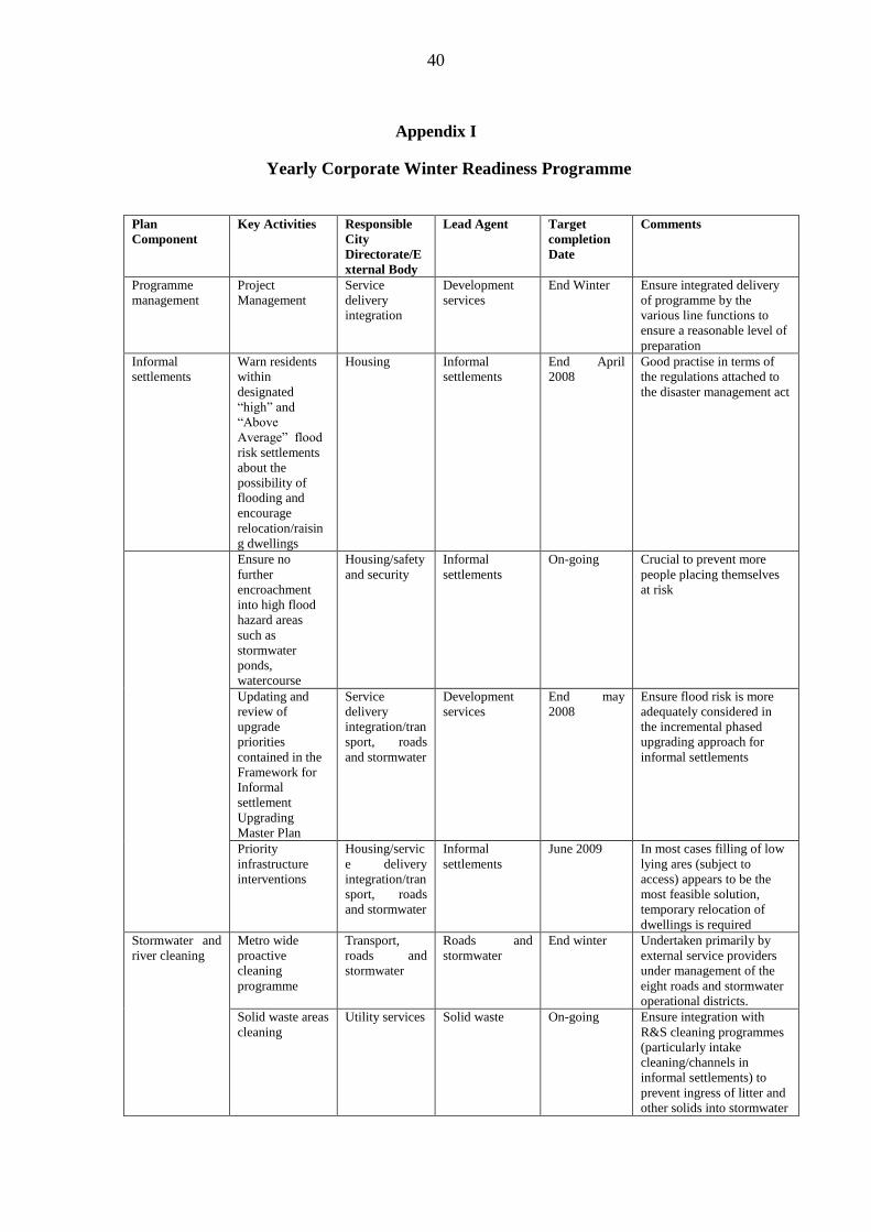
40
Appendix I
Yearly Corporate Winter Readiness Programme
Plan
Component
Key Activities Responsible
City
Directorate/E
xternal Body
Lead Agent Target
completion
Date
Comments
Programme
management
Project
Management
Service
delivery
integration
Development
services
End Winter Ensure integrated delivery
of programme by the
various line functions to
ensure a reasonable level of
preparation
Informal
settlements
Warn residents
within
designated
“high” and
“Above
Average” flood
risk settlements
about the
possibility of
flooding and
encourage
relocation/raisin
g dwellings
Housing Informal
settlements
End April
2008
Good practise in terms of
the regulations attached to
the disaster management act
Ensure no
further
encroachment
into high flood
hazard areas
such as
stormwater
ponds,
watercourse
Housing/safety
and security
Informal
settlements
On-going Crucial to prevent more
people placing themselves
at risk
Updating and
review of
upgrade
priorities
contained in the
Framework for
Informal
settlement
Upgrading
Master Plan
Service
delivery
integration/tran
sport, roads
and stormwater
Development
services
End may
2008
Ensure flood risk is more
adequately considered in
the incremental phased
upgrading approach for
informal settlements
Priority
infrastructure
interventions
Housing/servic
e delivery
integration/tran
sport, roads
and stormwater
Informal
settlements
June 2009 In most cases filling of low
lying ares (subject to
access) appears to be the
most feasible solution,
temporary relocation of
dwellings is required
Stormwater and
river cleaning
Metro wide
proactive
cleaning
programme
Transport,
roads and
stormwater
Roads and
stormwater
End winter Undertaken primarily by
external service providers
under management of the
eight roads and stormwater
operational districts.
Solid waste areas
cleaning
Utility services Solid waste On-going Ensure integration with
R&S cleaning programmes
(particularly intake
cleaning/channels in
informal settlements) to
prevent ingress of litter and
other solids into stormwater
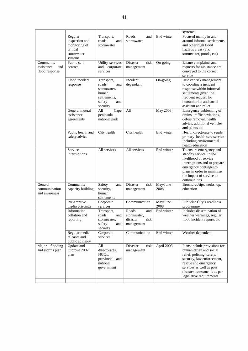
41
systems
Regular
inspection and
monitoring of
critical
stormwater
systems
Transport,
roads and
stormwater
Roads and
stormwater
End winter Focused mainly in and
around informal settlements
and other high flood
hazards areas (viz.
stormwater, ponds, etc)
Community
assistance and
flood response
Public call
centres
Utility services
and corporate
services
Disaster risk
management
On-going Ensure complaints and
requests for assistance are
conveyed to the correct
service
Flood incident
response
Transport,
roads and
stormwater,
human
settlements,
safety and
security
Incident
dependant
On-going Disaster risk management
to coordinate incident
response within informal
settlements given the
frequent request for
humanitarian and social
assistant and relief
General mutual
assistance
agreements
All Cape
peninsula
national park
All May 2008 Emergency unblocking of
drains, traffic deviations,
debris removal, health
advice, additional vehicles
and plants etc
Public health and
safety advice
City health City health End winter Health directorate to render
primary health care service
including environmental
health education
Services
interruptions
All services All services End winter To ensure emergency and
standby service, in the
likelihood of service
interruptions and to prepare
emergency contingency
plans in order to minimise
the impact of service to
communities
General
communication
and awareness
Community
capacity building
Safety and
security,
human
settlements
Disaster risk
management
May/June
2008
Brochures/tips/workshop,
education
Pre-emptive
media briefings
Corporate
services
Communication May/June
2008
Publicise City‟s readiness
programme
Information
collation and
reporting
Transport,
roads and
stormwater,
safety and
security
Roads and
stormwater,
disaster risk
management
End winter Includes dissemination of
weather warnings, regular
flood incident reports etc
Regular media
releases and
public advisory
Corporate
services
Communication End winter Weather dependent
Major flooding
and storms plan
Update and
improve 2007
plan
All
directorates,
NGOs,
provincial and
national
government
Disaster risk
management
April 2008 Plans include provisions for
humanitarian and social
relief, policing, safety,
security, law enforcement,
rescue and emergency
services as well as post
disaster assessments as per
legislative requirements
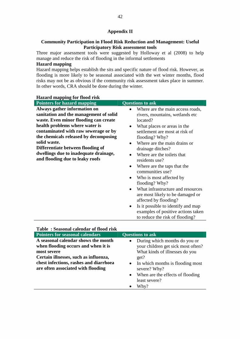
42
Appendix II
Community Participation in Flood Risk Reduction and Management: Useful
Participatory Risk assessment tools
Three major assessment tools were suggested by Holloway et al (2008) to help
manage and reduce the risk of flooding in the informal settlements
Hazard mapping
Hazard mapping helps establish the sits and specific nature of flood risk. However, as
flooding is more likely to be seasonal associated with the wet winter months, flood
risks may not be as obvious if the community risk assessment takes place in summer.
In other words, CRA should be done during the winter.
Hazard mapping for flood risk
Pointers for hazard mapping Questions to ask
Always gather information on
sanitation and the management of solid
waste. Even minor flooding can create
health problems where water is
contaminated with raw sewerage or by
the chemicals released by decomposing
solid waste.
Differentiate between flooding of
dwellings due to inadequate drainage,
and flooding due to leaky roofs
Where are the main access roads,
rivers, mountains, wetlands etc
located?
What places or areas in the
settlement are most at risk of
flooding? Why?
Where are the main drains or
drainage ditches?
Where are the toilets that
residents use?
Where are the taps that the
communities use?
Who is most affected by
flooding? Why?
What infrastructure and resources
are most likely to be damaged or
affected by flooding?
Is it possible to identify and map
examples of positive actions taken
to reduce the risk of flooding?
Table : Seasonal calendar of flood risk
Pointers for seasonal calendars Questions to ask
A seasonal calendar shows the month
when flooding occurs and when it is
most severe
Certain illnesses, such as influenza,
chest infections, rashes and diarrhoea
are often associated with flooding
During which months do you or
your children get sick most often?
What kinds of illnesses do you
get?
In which months is flooding most
severe? Why?
When are the effects of flooding
least severe?
Why?
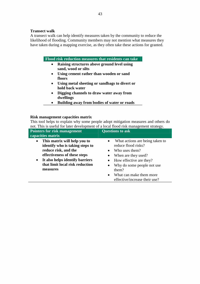
43
Transect walk
A transect walk can help identify measures taken by the community to reduce the
likelihood of flooding. Community members may not mention what measures they
have taken during a mapping exercise, as they often take these actions for granted.
Flood risk reduction measures that residents can take
Raising structures above ground level using
sand, wood or silts
Using cement rather than wooden or sand
floors
Using metal sheeting or sandbags to divert or
hold back water
Digging channels to draw water away from
dwellings
Building away from bodies of water or roads
Risk management capacities matrix
This tool helps to explain why some people adopt mitigation measures and others do
not. This is useful for later development of a local flood risk management strategy.
Pointers for risk management
capacities matrix
Questions to ask
This matrix will help you to
identify who is taking steps to
reduce risk, and the
effectiveness of these steps
It also helps identify barriers
that limit local risk reduction
measures
What actions are being taken to
reduce flood risks?
Who uses them?
When are they used?
How effective are they?
Why do some people not use
them?
What can make them more
effective/increase their use?

44
Related Documents