Image: Peter Marshall Makara Peak Mountain Bike Park Master Plan Prepared for Wellington City Council by Trails by Dafydd Davis and Morphum Environmental Ltd – June 2017

Welcome message from author
This document is posted to help you gain knowledge. Please leave a comment to let me know what you think about it! Share it to your friends and learn new things together.
Transcript

Imag
e: P
eter
Mar
shal
l
Makara Peak Mountain Bike Park Master PlanPrepared for Wellington City Council by Trails by Dafydd Davis and Morphum Environmental Ltd – June 2017

Makara Peak Mountain Bike Park Master Plan
J003
270

3Makara Peak Mountain Bike Park Master Plan
Contents
1. Executive Summary .................................................. 4
2. Introduction .............................................................. 5
2.1 Master Plan context .................................................. 6
3. Frame of reference .................................................... 8
4. Sustainability framework ........................................ 11
4.1 Community benefits ................................................ 11
4.2 Landscape benefits .................................................. 11
4.3 Ecological Restoration and Biodiversity ................... 12
4.4 Tangata Whenua ..................................................... 13
4.5 Management .......................................................... 14
5. Existing site assessment ......................................... 15
5.1 Site Assessment ....................................................... 15
6. Makara Peak master plan ........................................ 17
6.1 Status of Makara Peak ............................................. 17
6.2 Governance of the Park ........................................... 17
6.3 Track Model ........................................................... 20
6.3.1 Track Layout .......................................................... 23
6.3.2 Makara Peak Track Itineraries ................................ 23
6.3.3 Track Developments ............................................... 27
6.4 Infrastructure and Facilities ................................... 27
6.4.1 Car parking and access ........................................... 27
6.4.2 Signage and wayfinding ......................................... 27
6.4.3 Rest areas and information nodes ........................... 29
6.4.4 Shelters in isolated areas of the park ....................... 29
6.4.5 Provision of water at the summit ............................ 29
6.5 Conservation and Biodiversity ............................... 29
6.5.1 Regional role/context ............................................. 30
6.5.2 Vegetation and pest control .....................................30
6.5.3 Maintenance and operations .................................. 30
6.5.4 Waterways and receiving environments ................. 32
6.5.5 Track development................................................. 32
7. Key recommendations ............................................ 34
7.1 Governance and Resourcing ................................... 34
7.2 Access, Parking and Facilities ................................. 34
7.3 Trail development .................................................. 34
7.4 Conservation .......................................................... 35
7.5 Land Acquisition/Zoning ........................................ 35
7.6 Regional Strategic Framework ................................ 35
7.7 Community and iwi Engagement ........................... 36
Appendix A – Makara Peak mapping ................................ 37
Appendix B – Key track works .......................................... 49
Appendix C – Implementation Plan ...................................78

4 Makara Peak Mountain Bike Park Master Plan
1. Executive summary
Trails by Dafydd Davis Limited and Morphum Environmental Limited were engaged by Wellington City Council to develop a master plan for the Makara Peak Mountain Bike Park in Karori, Wellington. The park was established in 1998 and has developed over the past 18 years through a collaborative management approach by Wellington City Council and the Makara Peak Supporters Group (the Supporters). This has included an initial establishment phase (with contracted professional staff engaged to manage early planning and development) followed by ongoing development supported by a memorandum of understanding by the Council and the Supporters. This historical development has been funded through a mix of Council support (in terms of capital and resources), public donations, contested grants and corporate sponsorship with a substantial amount of physical and logistical work provided by a highly committed group of volunteers. This has included extensive track construction, maintenance, revegetation and pest (plant and animal) control, which has been instrumental in creating the network of over 35 kilometres of mountain bike priority tracks in a regenerating native forest landscape.
This master plan is intended to establish formalised objectives and principles to inform the management of the park over the next 10 years, including further development of the track network to ensure that the facility is able to support and promote the current growth in recreational mountain biking in the region. Any growth must align with the conservation and ecological restoration aspirations that have defined the park to date, which are consistent with the Council’s Outer Green Belt Management Plan and Biodiversity Plan (Our Natural Capital).
The master plan has been informed by engagement with a range of stakeholders. Seven workshops with Council personnel, the Supporters, mountain bike groups and other general users have been supported by user surveys (undertaken by the Supporters prior to this process) and strava data (an app that tracks runs and rides using GPS) to provide an understanding of the existing user profile and status of the park. Focussed discussions on existing constraints, issues and aspirations for future improvements have provided a basis for recommendations relating to further development and management frameworks required to facilitate implementation of these. This includes extensive new track development, modification to existing tracks and redevelopment of the main car park area to address existing access issues. Formal consultation took place between 7 November and 12 December 2016. 128 submissions were received. The final plan was completed in April 2017.
Implementation of the plan will help Makara Peak maintain its status as a facility of regional significance, and provide a world-class experience for riders of different technical skill levels and experience. As the majority of visitors are intermediate users (Grades 3 and 4), the Master Plan will make sure new tracks and increased itineraries or loops are available in this grade range. In addition, it is concluded that significant parts of the track network and overall site (ie Southwest and Northern Tracks) are currently underused and offer opportunities to increase scope and scale. The Master Plan therefore proposes extensive new track development (and redevelopment of some existing tracks) to expand into these areas with the added benefit of improved access for conservation restoration.
5Makara Peak Mountain Bike Park Master Plan
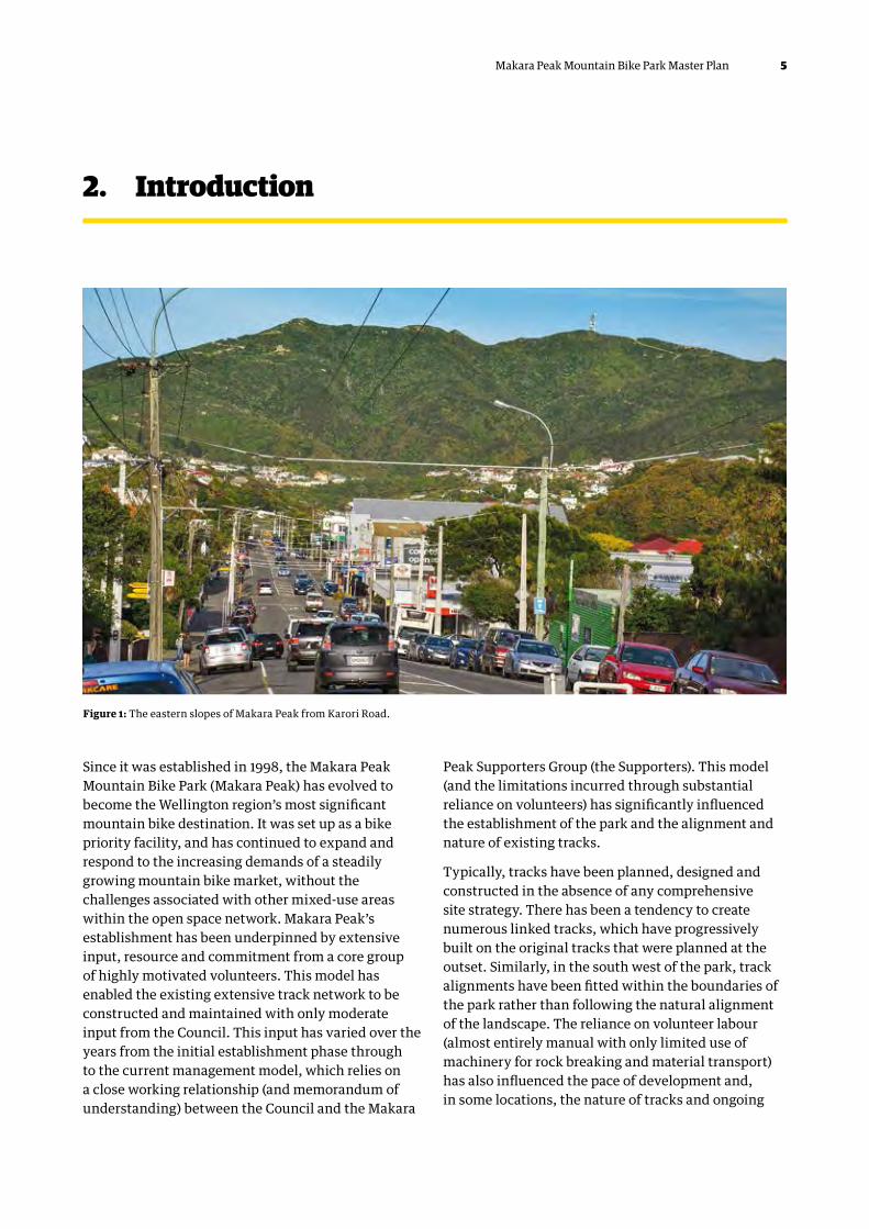
2. Introduction
Since it was established in 1998, the Makara Peak Mountain Bike Park (Makara Peak) has evolved to become the Wellington region’s most significant mountain bike destination. It was set up as a bike priority facility, and has continued to expand and respond to the increasing demands of a steadily growing mountain bike market, without the challenges associated with other mixed-use areas within the open space network. Makara Peak’s establishment has been underpinned by extensive input, resource and commitment from a core group of highly motivated volunteers. This model has enabled the existing extensive track network to be constructed and maintained with only moderate input from the Council. This input has varied over the years from the initial establishment phase through to the current management model, which relies on a close working relationship (and memorandum of understanding) between the Council and the Makara
Peak Supporters Group (the Supporters). This model (and the limitations incurred through substantial reliance on volunteers) has significantly influenced the establishment of the park and the alignment and nature of existing tracks.
Typically, tracks have been planned, designed and constructed in the absence of any comprehensive site strategy. There has been a tendency to create numerous linked tracks, which have progressively built on the original tracks that were planned at the outset. Similarly, in the south west of the park, track alignments have been fitted within the boundaries of the park rather than following the natural alignment of the landscape. The reliance on volunteer labour (almost entirely manual with only limited use of machinery for rock breaking and material transport) has also influenced the pace of development and, in some locations, the nature of tracks and ongoing
Figure 1: The eastern slopes of Makara Peak from Karori Road.

6 Makara Peak Mountain Bike Park Master Plan
maintenance to preserve the intended standards. Whilst the recent increased input from the Council is intended to alleviate these challenges it is evident that a strategic approach is required.
Additional to the track network itself, a strong commitment to ecological restoration has guided Makara Peak from the outset. With a clear vision to establish the park within a regenerating native forest, the control of pests (both flora and fauna) and revegetation with locally eco-sourced native plants has added considerable value to the site since its inception. Again reliant on committed volunteers, conservation work has proven to be particularly effective and has visibly transformed Makara Peak as it transitions from degraded farmland to established native bush. This aspect of Makara Peak (where ecological restoration is regarded as being equally important as track development) is uncommon in mountain biking and provides significant environmental, social and cultural benefits beyond the mountain biking community.
The growth in recreational mountain biking has also led to the establishment and development of numerous other recognised mountain bike destinations across the city and region. These include other bike priority sites (such as Wainuiomata Trail Park) and other locations where public track networks have been developed to create formal and informal riding destinations that are now used by mountain bikers and walkers alike. These locations and facilities collectively form the basis for Wellington’s aspirations for increased national status as a high-quality mountain bike destination. The combination of topography, compact urban form, extensive forested public land (including Wellington Town Belt and outer green belt) and a large number of highly committed and hardworking volunteers has enabled this growth to take place in an organic manner.
1.1 Master Plan contextMakara Peak has evolved over the past 20 years largely through the dedicated efforts of the Makara Peak Supporters Group (the Supporters). With the ongoing support of the Council, the Supporters have been able to progressively develop new trails whilst maintaining a strong focus on the habitat restoration/protection, ongoing trail maintenance and advocacy. The Supporters have built the existing network of trails almost entirely by hand. Whilst this approach to trail development is admirable it is also recognised that it results in limitations in terms of the pace of trail development, the scale of new trail builds and the consistency of trails across the network. Similarly, the challenges with maintaining the increasing length of trails puts added pressures on resources with a resultant risk of gradual trail degradation, inability to maintain original trail categories (grading) and increasing pressures on volunteer inputs for new builds and conservation work. In recent years, the Council has increased funding support for Makara Peak to help alleviate these challenges through facilitating contractors to undertake core trail maintenance (surfacing and vegetation management) and in part funding new trail builds (Peak Flow). Whilst this funding has assisted in supporting the ‘upkeep’ of existing tracks, it is insufficient to address a number of ongoing issues with sections of existing tracks or to fund any further track development. Any further development of Makara Peak (and potential increase in Council resourcing) must be informed by a robust and holistic plan for the park to ensure that it can evolve and develop in a manner that optimises its potential for existing and future users.
This master plan is therefore intended to provide a framework around which the future management and development of Makara Peak Mountain Bike Park can take place. It has been put together within a frame of

7Makara Peak Mountain Bike Park Master Plan
reference that establishes some of the fundamental aims and objectives of the park and this master plan. The frame of reference was developed in consultation with the Supporters and the Council. In tandem with the frame of reference, a sustainability framework has been developed to articulate the principles that have guided the master plan to deliver sustainable outcomes (both environmental and infrastructure) for Makara Peak over the coming years.
The frame of reference has guided an assessment of the Makara Peak Mountain Bike Park site. This assessment included formal and informal consultation with partners and stakeholders and both accompanied and unaccompanied field visits.
The assessment of the site, within the frame of reference, has enabled the site itself, its constraints and opportunities to be identified and evaluated. This has then informed the development of the master plan.
Figure 2: Regenerating forest in gullies. Looking west from Missing Link.

8 Makara Peak Mountain Bike Park Master Plan
The frame of reference has been developed in consultation with the Supporters and the Council and sets the agenda for the master plan. This establishes some of the fundamental aims and objectives of the park and this master plan.
3.1 What should the status of the park be?1. Makara Peak should continue to be developed as
a mountain bike resource of regional importance.
2. This status should be maintained for the life of the 10-year master plan.
3. Makara Peak should continue to be an important recreational resource for the region and the local community.
4. Makara Peak should form a key part of a regional mountain biking tourism offer or product and link with a wider track network.
5. Makara Peak should continue to support active conservation/restoration to complement wider regional biodiversity aspirations.
3.2 What are the key aims and objectives for the master plan?
1. Recognise and promote Makara Peak’s status and value as a mountain bike facility for Wellington City and the Greater Wellington Region.
2. Lead to more people engaging with the habitat, landscape and cultural heritage of Makara Peak and the surrounding areas in positive and sustainable ways.
3. Continue to develop a sense of place at Makara Peak.
4. Enable more members of the wider and local communities to engage in track development, management and maintenance and in habitat restoration in effective ways.
5. Facilitate the creation of a wide sense of ownership of Makara Peak among users and the wider community.
6. Develop mechanisms for making management and maintenance of existing and future tracks more sustainable and effective in the long term.
7. Look at mechanisms for ensuring that any future track developments are sustainable within the context of the landscape, habitat and amenity value of the park.
8. Look at ways of ensuring that the volunteer resource for track maintenance and development is sustainable and effective and has the greatest long-term positive impacts.
9. Enable the effective use of resources, such as capital funding, revenue or direct labour, in targeted and strategic ways that have the most positive long-term impacts.
10. Maintain and enhance Makara Peak’s status as a key habitat, landscape and natural capital resource.
11. Provide opportunities for as wide a range of mountain bikers as possible to access the park, but in a sustainable and manageable way that does not compromise its landscape or natural capital value.
3. Frame of reference

9Makara Peak Mountain Bike Park Master Plan
3.3 What should the scope and scale of the park be?
1. The track network must have the capacity to sustainably accommodate both existing and future levels of use.
2. Access should be supported with suitable formal parking to serve current and future users in addition to wider cycle connections and public transport (not part of this plan).
3. Visitor facilities must include toilets, drinking water and bike washing.
4. The facilities and track network should have the capacity to sustainably accommodate a maximum of 1000 people per day (pending appropriate access and facilities).
3.4 Who are the intended users of the park?1. Local, regional and to a lesser extent national
recreational mountain bikers including:
a. novice riders
b. intermediate riders
c. advanced riders
d. expert riders.
2. Event-based mountain bikers including the following:
a. local and regional cross-country racers
b. local and regional enduro riders
c. local and regional riders associated with introductory and coaching events.
3. Makara Peak should not make special provision for gravity-focussed rides.
4. Local and to a lesser extent regional track runners and walkers.
3.5 What should the track model be?1. The track network should be focussed on one main
access, where track and other information can be provided effectively to users and where access to the track network can be facilitated and promoted.
2. There should be a number of secondary accesses to the track network that allow more flexible, lower volume access both by bike and by car and which allow effective connectivity to the community.
3. The track model should enable first-time users to interpret and use the track network in a way that is easy and accessible.
4. It should allow for more flexible and variable use of the network.
5. The track network should continue to be attractive to long-term users.
6. All tracks should reflect and take into account the topography, landforms, ground conditions, vegetation cover and landscape of Makara Peak.
7. The majority of tracks should continue to be shared use but maintained as bike priority.
With these considerations in mind, the track model should focus on a series of named and graded track sections with directions of travel highlighted and a series of prescribed waymarked loops of varying lengths and difficulties. Based on visitor surveys, analysis of Strava data and stakeholder discussions it is considered that the development of new Grade 5 tracks should be carefully considered, particularly in terms of their locations, alignments and configurations relative to the key access points. There should be a clear hierarchy of tracks ranging from Grade 2 to Grade 5 with an emphasis on Grades 3 and 4 in terms of track volume.

10 Makara Peak Mountain Bike Park Master Plan
3.6 What should the management model be?1. Ownership of Makara Peak and all supporting
infrastructure will remain with the Council.
2. The management and maintenance of support infrastructure (car parks, signage, waymarking, toilets etc) will be the responsibility of the Council.
3. The management and maintenance of tracks and associated structures will be supported by ongoing agreement between the Council and the Supporters.
4. Clearly defined roles, responsibilities, guidelines and/or standards will provide an agreed framework within which track maintenance can take place.
5. All track maintenance will need to be carried out in ways that are compatible with the aims and objective and the intended track model.
6. The Supporters, with support from the Council and Greater Wellington Regional Council, will continue to undertake habitat restoration and pest management work within the park on an ongoing basis and this should be closely tied into track management, maintenance and development.
7. New tracks will be funded by the Council, supported by the Supporters with the delivery facilitated by the ongoing agreement between the Supporters and the Council.
Image: Dan Sharpe
11Makara Peak Mountain Bike Park Master Plan
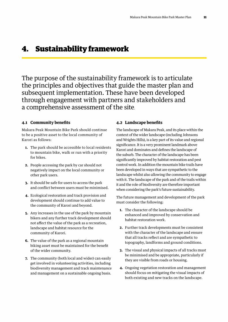
4. Sustainability framework
The purpose of the sustainability framework is to articulate the principles and objectives that guide the master plan and subsequent implementation. These have been developed through engagement with partners and stakeholders and a comprehensive assessment of the site.
4.1 Community benefitsMakara Peak Mountain Bike Park should continue to be a positive asset to the local community of Karori as follows:
1. The park should be accessible to local residents to mountain bike, walk or run with a priority for bikes.
2. People accessing the park by car should not negatively impact on the local community or other park users.
3. It should be safe for users to access the park and conflict between users must be minimised.
4. Ecological restoration and track provision and development should continue to add value to the community of Karori and beyond.
5. Any increases in the use of the park by mountain bikers and any further track development should not affect the value of the park as a recreation, landscape and habitat resource for the community of Karori.
6. The value of the park as a regional mountain biking asset must be maintained for the benefit of the wider community.
7. The community (both local and wider) can easily get involved in volunteering activities, including biodiversity management and track maintenance and management on a sustainable ongoing basis.
4.2 Landscape benefitsThe landscape of Makara Peak, and its place within the context of the wider landscape (including Johnsons and Wrights Hills), is a key part of its value and regional significance. It is a very prominent landmark above Karori and dominates and defines the landscape of the suburb. The character of the landscape has been significantly improved by habitat restoration and pest control work. In addition the mountain bike trails have been developed in ways that are sympathetic to the landscape whilst also allowing the community to engage with it. The landscape of the park and of the trails within it and the role of biodiversity are therefore important when considering the park’s future sustainability.
The future management and development of the park must consider the following:
1. The character of the landscape should be enhanced and improved by conservation and habitat restoration work.
2. Further track developments must be consistent with the character of the landscape and ensure that all tracks reflect and are sympathetic to topography, landforms and ground conditions.
3. The visual and physical impacts of all tracks must be minimised and be appropriate, particularly if they are visible from roads or housing.
4. Ongoing vegetation restoration and management should focus on mitigating the visual impacts of both existing and new tracks on the landscape.

12 Makara Peak Mountain Bike Park Master Plan
5. Track planning, design, construction and maintenance must adopt methodologies that mitigate landscape impacts and ensure effective implementation.
6. Supporting infrastructure must minimise physical and visual impacts and be appropriate within the landscape.
7. Tracks should be managed and maintained to reduce visual and physical impacts.
4.3 Ecological restoration and biodiversityMakara Peak is a large area of regenerating native bush typical of many areas of the hills surrounding Wellington. Across the site are areas displaying variable levels of succession from extensive exotic weed cover (primarily gorse and Darwin’s barberry) through to semi-mature remnant areas dominated
by hīnau, rewarewa and tawa. Large areas of Makara Peak display a transition between the two states with dominance of primary successional species such as māhoe, mānuka, numerous coprosma species and tree ferns. Almost no areas of open grassland (former pasture) remain, with initial revegetation planting focussed on these areas. The active restoration of the Makara Peak habitat is wholly consistent with the Council’s objectives and the aspirations articulated in Biodiversity Strategy and Action Plan 2015 Our Natural Capital.
Revegetation across the site has been substantially supported by the long-term inputs of volunteers as a core tenant of the park development. This has included systematic and co-ordinated pest control (trapping, shooting and bait) and replanting over 35,000 native seedlings. The success of these efforts has contributed significantly to the progression of revegetation and is increasingly recognised as a defining aspect of the
Figure 4: Entry from main car park via Koru track through replanted indigenous plantings.

13Makara Peak Mountain Bike Park Master Plan
park. Early and continued plantings of key native species have been well thought out and are now getting close to a level of maturity where self-seeding will become an accelerator for spread throughout the park. The proximity of Makara Peak in relation to other high value biodiversity areas (in particular Zealandia, Otari-Wilton’s Bush, Wrights Hill and Johnston Hill) increases the value of the site in terms of contributing to a network of actively managed vegetated open spaces. This provides viable habitat for increasing numbers of indigenous bird species, which are expanding their range beyond the Zealandia fence line.
The size of the park and the scale of the restoration, coupled with the fact the recreational users can engage with the habitat sustainably, makes it of considerable value. The habitat (regenerating indigenous forest) contributes to the quality and uniqueness of the recreational experience, whilst also creating a particular sense of place. The nature and character of the habitat, along with that of the trails, must therefore be considered when looking at sustainability and must play a key role in the management and development of the park as follows:
1. Track development, management and maintenance programmes and processes must be compatible with ecological restoration and the Makara Peak Ecological Management Plan.
2. Track development, management and maintenance should facilitate and not hinder ecological restoration and pest control.
3. Track construction must minimise impacts on native vegetation.
4. Track maintenance and restoration planting should centre on allowing the development of a closed tree canopy wherever practical.
5. New track construction should lead to tree planting programmes of similar scope and scale.
6. Past and ongoing conservation efforts should be better promoted to encourage increased involvement and engagement by users in these.
4.4 Tangata whenuaMakara Peak and the surrounding landscape provide a unique perspective into the cultural landscape of the Wellington region, including views of Te Whanganui-a-Tara (Wellington Harbour), Raukawa Moana (Cook Strait), Te Waipounamu (South Island), north to Kāpiti and Mana islands and large tracts of land and coast between. The view from the summit encompasses the lands of both Taranaki Whānui and Ngāti Toa as well as the lands and waters of tribal groups who preceded them. This includes Kupe, the explorer credited with discovering Aotearoa, and Tara after whom the harbour is named.
The connection of iwi with the landscape, and the indigenous flora and fauna it supports, should be considered in the future management and development of the park as follows:
1. Historical connections of current and past Māori iwi and their rohe (territorial land) should be celebrated and communicated through interpretive signage to provide education on historical land use, coastal trade routes and early explorers.
2. Connections with local iwi should encourage active participation and empowerment through involvement in habitat restoration, pest control and trail development.
3. Consultation with iwi should contribute to naming of new trails to reflect the cultural connection.
4. Consultation with iwi should inform the design of an appropriate key entry feature in recognition of the historical connections with the landscape and the stories that result.
5. Ecological health of all waterways and sites of significance must be protected to respect cultural connections through clear guidelines to inform design of trails in proximity to streams and gullies.

14 Makara Peak Mountain Bike Park Master Plan
4.5 Management Ongoing management and operation of the park has considerable impact on the outcomes for both users and the wider community/environment and must consider the following:
1. Track maintenance must be guided by robust guidelines related to minimising impacts on to landscape, ecological health and biodiversity.
2. Track maintenance and management must take into account issues that relate to each section of track and ensure that works consider spatial variability with soils, vegetation, exposure and rider usage.
3. Maintenance and management must be guided by effective standards relating to track grading, design and construction.
4. Maintenance and management of Makara Peak must be founded on the vision of a regenerating native forest and consider the objectives of ecological restoration and pest control in all decisions.
Figure 5: Ongoing wear and scour on upper sections of Ridge Line track.
15Makara Peak Mountain Bike Park Master Plan
5. Existing site assessment
As part of the master plan, a comprehensive site assessment was undertaken. The full assessment is summarised below. The assessment considered how Makara Peak has evolved, how it is currently used as a recreation asset and how the future management of the park can ensure that any developments are consistent with the intent of the sustainability framework.
5.1 Site assessmentThe site assessment has raised the following key points:
1. Makara Peak is a recreation facility on the urban fringe of considerable value to the Wellington region and the local community
2. It is important in its own right and as part of a wider Wellington mountain biking network
3. Habitat restoration and conservation work have added considerable value to the park as a biodiversity, habitat and landscape resource
4. The landscape context of the park is of local significance
5. The nature, appearance, design and construction of existing tracks within the park have added value to it and helped create a sense of place that defines the park.
6. The track model is largely effective but the following key issues should be addressed:
a. ongoing governance, management and maintenance including the development of operational guidelines
b. the scope and scale of the track network in relation to its status and importance
c. the accessibility, flexibility and longevity of the track model as a regional facility
d. the capacity of some parts of the track model given its status
e. the quality and value of some parts of the track model given the value of the facility as a whole
f. the importance with links to other regional tracks in the wider outer green belt.
7. The future development of the track model is constrained by:
a. existing property boundaries
b. topography
c. ecological significance of the site
d. landscape sensitivities
e. track configuration
f. the nature and distribution of access points.
8. Parking is a significant issue and opportunities for its development are constrained by:
a. Council property boundaries
b. topographical and other physical constraints
c. the distribution and nature of existing access points
d. the alignment of the track system
e. its location on the urban fringe and adjacent residential properties.

16 Makara Peak Mountain Bike Park Master Plan
9. Ensuring effective connectivity to both the wider Wellington mountain bike track network and to local communities is important in enabling the park to operate as a local recreation facility.
10. The park could be of greater value and significance as both a recreation facility for Wellington city and as a recreation and tourism asset for the region.
The assessment concludes that whilst there are constraints and sensitivities there are also opportunities to develop the facility further, add value to it and increase its significance.
For further development to be successful, planning will need to be guided by our strategic priorities, sustainability values and agreed aims.
This approach is particularly important at this site due to its significance as a recreation resource, but also because of its importance as a landscape and biodiversity asset. Ensuring sustainability in the wider sense is also important in maintaining the volunteer input. This has been crucial to the development and growth of Makara Peak and it must be an ongoing and important factor in its future development and management. This includes its position within the regional track network and opportunities for new track development such as the proposed Sky to Sea route, which would incorporate parts of Makara Peak.
Figure 6: Existing bike wash and maintenance facilities at main car park.

17Makara Peak Mountain Bike Park Master Plan
6. Makara Peak Master Plan
6.1 Status of Makara PeakMakara Peak (and the community of users) aspire to be a world-class regional mountain bike facility. It should be of sufficient scope and scale to draw visitors from considerable distances within the region, nationally and even beyond. It should be a regional tourism resource in its own right with flow-on economic benefits to the city. It should be extensive enough to encourage repeat visits with numerous itineraries possible and it should be a coherent and identifiable product.
The site assessment found that Makara Peak has a regional role as a mountain biking facility, but this is due in part to the nature of other mountain bike provision in the region. In recent years other regions throughout New Zealand have invested heavily in the development of strong mountain biking products with corresponding increases in visitation (such as in Rotorua). New developments in the Wellington region, such as Wainuiomata (Hutt) and Rangituhi (Porirua), are already drawing attention within the mountain biking community. These alternate sites provide an impetus for increased development at Makara Peak to ensure that its value can continue to fully capitalise on the growth in recreational mountain biking, and to complement these other attractions.
The scope and scale of the existing Makara Peak track system is considered limited for a facility of regional status. Its status should be formalised and the facility developed to the required level subject to development and resourcing over the next 10 years.
The following objectives and principles should inform development of Makara Peak to realise this potential:
1. Makara Peak should be a mountain bike facility of regional significance.
2. The scope, scale and nature of the track model and support facilities should be compatible with this regional status.
3. Makara Peak should be developed as a key component of a wider regional track network.
4. Development and ongoing operation of the facility must be adequately resourced and funded.
5. Signage and track development should tell the story of the ecological context and conservation efforts.
6.2 Governance of the parkThe successful operation and ongoing development of such a park requires adherence to a clear governance structure and adequate resourcing to support this. Whilst the park has historically evolved under a number of reactive governance approaches, the ongoing management of the park should be supported by a well-detailed and stable governance structure.
The governance of the facility within the 10-year master plan should continue to be a partnership between the Council and Supporters (with similar terms of reference as the existing MOU). However, more clarity is required in certain areas to ensure that key objectives are reached and that effective management can take place in the long term.
Frameworks for governance should look to clarify and formalise the following:
1. Clear sustainability criteria related to landscape, habitat and biodiversity, which can be applied to both track maintenance, and management and the design and construction of new tracks.
2. Clear, unambiguous and prescriptive track grading systems to inform track planning, design, construction and maintenance.
3. Protocols and processes for track planning, design and construction built around the sustainability criteria and transparency to support accurate pricing for CAPEX/OPEX contracts.

18 Makara Peak Mountain Bike Park Master Plan
4. Clear unambiguous management plans for each section of track that are also related to sustainability criteria in addition to individual track requirement/conditions. The allocation of sections of tracks must reflect the physical attributes that impact its management including topography, soils, aspect and canopy coverage.
Governance frameworks should be developed in partnership between the Council and the Supporters, taking into account national and international best practice and existing management plans and objectives.
All of the above should form a cohesive management plan for the park. It should be reviewed at regular intervals (4 to 5 years) and informed by the 10-year master plan, which will form part of the Outer Green Belt Management Plan.
The overall management plan should be implemented by a dedicated Council resource (referred to herein as a park manager) within the context of the 10-year master plan. It is noted that whilst this section refers to a park manager it may be that the roles and responsibilities are covered by more than one person.
The park manager’s core role should be as follows:
1. To ensure good governance of the park
2. To ensure an effective working partnership between the Supporters and the Council
3. To ensure a partnership with local iwi as a treaty partner consistent with the outcomes of section 4.4 Tangata Whenua.
4. To ensure the effective management and maintenance of the tracks (including new builds)
5. To co-ordinate and facilitate effective habitat restoration and conservation work and efficient and effective use of volunteer resources
6. To implement 4/5-year management plans
7. To ensure the regional significance of the park is recognised and promoted.
The park manager’s key responsibilities should focus on the following:
1. Co-ordinating track audits and management:
a. Developing track inspection protocols and standards (in partnership with the Supporters and others), based on a platform using GIS, which references clear, well-defined attributes to ensure consistency and support prioritisation of any required remedial works
b. Carrying out formal (scheduled) track inspections with appointed individuals (either the Supporters or the Council) within clear inspection programmes, a formalised track grading structure and individual track management plans based on GIS platform
c. Maintaining the fault reporting system for track users
d. Keeping consistent digital records of all inspections and reported faults
e. Annually auditing track inspections and rectification works
f. Providing contractor induction and supervision to ensure all work is consistent with the objectives and principles encapsulated in the sustainability framework
2. Co-ordinating and resourcing track maintenance:
a. Developing a system that enables maintenance work to be prioritised through effective inspection processes
b. Developing annual maintenance schedules and programmes
c. Implementing construction and maintenance standards
d. Developing and implementing specifications for all maintenance work

19Makara Peak Mountain Bike Park Master Plan

20 Makara Peak Mountain Bike Park Master Plan
e. Keeping records of all maintenance work that is done on all tracks
f. Auditing all maintenance work annually
3. Co-ordinating conservation and habitat restoration work:
a. Documenting long-term restoration objectives and actions (similar to current process)
b. Working closely with relevant Council/GWRC officers to ensure conservation work aligns with regional strategies and other conservation initiatives (such as R&D in weed management)
c. Assisting the Supporters with conservation advocacy and as arranging/facilitating working parties etc
d. Monitoring contractor/Supporters’ maintenance and/or new build works to ensure consistent with sustainability framework intent
4. Co-ordinating and resourcing the inspection and maintenance of all signage and infrastructure
5. Implementing the 10-year master plan:
a. Working within clearly established priorities
b. Implementing a track planning, design and construction protocol/process
c. Overseeing and co-ordinating track planning and design and consultation
d. Overseeing and monitoring all track construction or upgrading works
e. Implementing track construction standards
f. Applying agreed sustainability criteria to all areas of work
6. Co-ordinating and facilitating events within the park
7. Co-ordaining and facilitating community engagement and volunteer management/working parties
8. Marketing, promotion and advocacy.
Whilst the park manager’s priorities should be set in partnership between the Council and the Supporters, it is considered to be most workable if the role were to be an employee of the Council.
Crucial in all this would be the relationship between the park manager and the Supporters. The MOU would need to be amended to clarify this relationship, but it is clear that a key part of this person’s role would be effective co-ordination with the Supporters and other volunteer organisations.
A large part of this role should be making effective, sustainable and targeted use of the skills, experience and expertise that exists within the Supporters related to track design, construction, management and maintenance. Developing and implementing the frameworks related to these areas should allow the Supporters’ skills to be effectively used to ensure a sustainable future for Makara Peak. The Supporters, and any associated volunteer groups, need to be an integral part of the ongoing development and management of the park, but their inputs should be targeted and co-ordinated in strategic ways by the park manager to ensure that their expertise and passion is most effectively utilised.
6.3 Track modelIt is considered that the current track model functions more as a local than regional facility. In particular there are a limited number of itineraries or loops available to the majority of visitors (intermediate riders) and significant parts of the track network (ie southwest and northern tracks) are currently underused and do not add sufficient value to the system.

21Makara Peak Mountain Bike Park Master Plan
This relatively limited flexibility and scope in the existing track system means that its appeal outside of the Wellington region is limited. It is recognised that there are growing aspirations for Wellington to be viewed as a ‘mountain bike destination’ and therefore the development of a keystone regional facility (to complement the increasing number of discrete trail networks) should be a priority.
To further develop the position and importance of Makara Peak some key developments related to the track model should take place as follows:
1. The track model should be focussed upon the central hub of the main car park but be accessible from other locations.
2. The track model should provide an authentic, largely cross-country style mountain biking experience, which is relatively accessible to a range of users.
3. The scope and scale of the track system as a whole should be increased within the constraints of the site.
4. The track system should be easier to interpret by users through improved wayfinding.
5. The core track “offer” should mainly cater for novice, intermediate and advanced riders with a proportional emphasis on intermediate to advanced.
6. Provision for expert riders should continue at its current proportion to support progression whilst being mindful of the core users of the park.
7. Existing large areas of land to the southwest shall be developed to provide a number of iconic descents that are better linked back into the core area to create workable loops.
8. Access from the north should be enhanced.
9. Links between Makara Peak, Skyline, Karori Park, Wrights Hill and the south coast should be strengthened and developed.
10. New tracks in the northern area should be developed to better integrate the area into the system as a whole and link into Skyline/Karori Park.
11. A safe at grade crossing of Makara Road should be developed to facilitate this.
12. The track system should allow for a greater number of itineraries or loops.
13. The configuration of new tracks should enable two-way sections of track to be eliminated.
To support these developments, long-term planning must be guided by the following:
1. Establishing a number of itineraries or loops of differing lengths and grades with as little overlap or repetition between or on loops as possible.
2. These loops should be clearly and independently waymarked and highlighted on the ground and at the main car park to transition away from the current reliance on multiple individually named trail sections.
To achieve this, the following key developments are proposed:
1. A more coherent and attractive system of tracks in the southwest area that is linked to the summit and key nodes on the existing track network.
2. New tracks that enable an independent Grade 4 descent to be established from the summit to the main car park.
3. The consolidation of key existing tracks to create a coherent and consistent Grade 3 descent from the summit to the main car park.
4. A new independent Grade 4 outward leg from the main car park to ease conflict and pressure on Koru.
22 Makara Peak Mountain Bike Park Master Plan
Figu
re 7
: Lay
out o
f pro
pose
d tr
ack
netw
ork.
0N
400

23Makara Peak Mountain Bike Park Master Plan
5. Workable Grade 3/4 loops in the Northern Area that are linked to a safe crossing of Makara Road and key nodes within the core system.
6. A full and comprehensive audit of all existing tracks related to their role in potential itineraries and condition in terms of maintenance and operations.
7. Undertaking appropriate work on existing tracks where required to bring to appropriate levels (grading) and support increased resilience and target operations.
8. A wider regional track network.
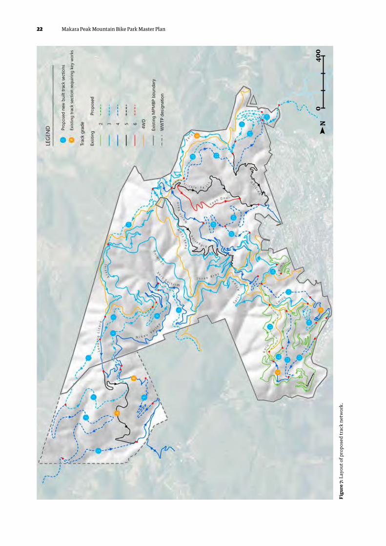
6.3.1 Track layoutIn support of the intent to develop Makara Peak as a key mountain biking destination of regional significance, changes are proposed to both the existing track network and extensive new tracks constructed to utilise the full extent of the site and align with user aspirations. These will build on the existing track network with a focus on removing the potential for conflict on dual direction tracks, creating significant continuous descents (grades 3 and 4) and catering for a range of waymarked loops.
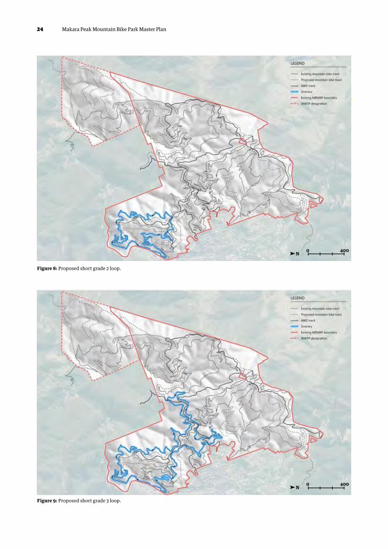
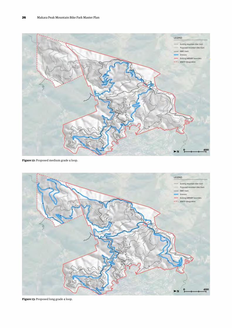
The proposed track layout is shown in Figure 7. Further comprehensive mapping of the proposed track network is provided in Appendix A and detail on respective sections of new and upgraded tracks is included in Appendix B. The proposed track layout enables a number of key itineraries to be waymarked and promoted as follows:
1. A short Grade 2 loop as is currently highlighted
2. A short Grade 3 loop (the current middle loop)
3. A medium length Grade 3 loop that climbs to the summit and descends at a continuous Grade 3 to the main car park
4. A long Grade 3 loop that is concentrated in the southwest area and has an optional loop to
the summit and a shorter loop built into the southwest area
5. A medium length Grade 4 loop with a semi-independent outward leg and an independent Grade 4 descent from the summit to the main car park
6. A long Grade 4 loop centred on the southwest area that takes in the summit.
Figure 7 to Figure 13 show the proposed track itineraries that underpin the master plan. These are reproduced as Maps 7 to 12 in Appendix A, which should be referred to for further detail.
6.3.2 Makara Peak track itinerariesThe proposed itineraries or loops are intended to make the track system function as a prescribed loop system, which is focussed on the core and southwest area.
The proposed loops are configured to minimise overlaps on individual loops so that no one section of track is ridden twice on any loop. This will make the track system more coherent, easier to interpret and accessible and add to the value of the facility as a whole.
The proposed northern area tracks would function in a less prescribed way for riders accessing the system from the main car park, but could be part of a prescribed loop system centred on Karori Park (road crossing and connecting track developments).
The proposed developments would also enable the track system to function better as a social track system, ie one that is used in an non-prescribed and flexible way, which is an important aspect of its ongoing value as a regional recreation facility.
To enable these semi-independent itineraries to be developed, some key track developments must take place. Detail about these is provided in Appendix B. As outlined above, these are focussed on enabling more coherent extensive and flexible track system to be put in place, which will encourage more repeat visits and visits from further afield.
24 Makara Peak Mountain Bike Park Master Plan
Figure 8: Proposed short grade 2 loop.
0
0
N
N
400
400
Figure 9: Proposed short grade 3 loop.

25Makara Peak Mountain Bike Park Master Plan
Figure 10: Proposed medium grade 3 loop.
Figure 11: Proposed long grade 3 loop.
0
0
N
N
400
400
26 Makara Peak Mountain Bike Park Master Plan
Figure 12: Proposed medium grade 4 loop.
Figure 13: Proposed long grade 4 loop.
0
0
N
N
400
400

27Makara Peak Mountain Bike Park Master Plan
6.3.3 Track developmentsThe proposed track developments focus on 24 new track sections of varying lengths. The approximate alignments of each are detailed on Maps 2 to 6 in Appendix A and described in detail in Appendix B. Each section performs a particular function in the future development and operation of the facility and each has particular requirements, which are also outlined in the trail works summary in Appendix B.
In addition, sections of existing track require key works to make them function more effectively as part of the proposed track model. These centre on establishing more consistent track grades on key itineraries by addressing issues at particular locations and changing the grades of existing tracks to align with connecting sections of new track. These works are also summarised in the trail works summary in Appendix B.
To deliver the track developments outlined above and in Appendix A and B within the bounds of the sustainability framework, a robust and effective track planning and design protocol will need to be developed and implemented. This protocol should be developed by the Supporters and Council (possibly co-ordinated by a park manager) and should be focussed on enabling the development of detailed prescriptive construction plans. These should relate to definitive track lines and be focussed on achieving outcomes in accordance with the sustainability framework.
6.4 Infrastructure and facilities
6.4.1 Car parking and accessIssues related to the nature and distribution of access, the configuration of the existing tracks, topography, property boundaries and other constraints mean that the main car park should continue to be the focus for access to Makara Peak. However, the track system must continue to be accessible from other locations via the secondary accesses, and connectivity should be improved where possible.
Parking at the main car park should be expanded, improved and reconfigured to enable this location to function as more of a hub for visitors to Makara Peak.
Developing additional parking at the main car park should enable more effective visitor flow. It should also put more of an emphasis on this location as the focal point for the park, which supports a facility of a more regional stature and importance.
Any safe crossing of Makara Road, coupled with key track developments, could have a significant effect on how the track network is accessed and used. Developing the tracks in isolation in the northern area of the mountain bike park could lead to road safety issues on Makara Road as a result of higher levels of use caused by making it a more attractive option. Developing a crossing, in conjunction with tracks in the northern area, has the potential to increase visitor usage in this area, which could lead to increased use of Karori Park as an access and parking area.
The other accesses into the park should continue to be managed and maintained at their current level. This is very important in enabling the park to continue to work as a recreation resource for the local community. No additional parking should be developed at these locations and track alignments should continue to be largely focussed on the main car park.
6.4.2 Signage and wayfindingWhilst the recent design and installation of signage has significantly improved the wayfinding across the park it is still focussed largely on the convention of naming multiple (often short) track sections with no consistent signage around loops and itineraries. These itineraries are presented on the main sign boards (and online) but riders are then required to either remember or make a record of the individual tracks to follow. This approach can be challenging for first-time users in particular. In line with the proposed new itineraries and extended linked tracks, the signage way-marking should be revisited to develop a cohesive

28 Makara Peak Mountain Bike Park Master Plan
Figure 14: Aerial of proposed parking development at the main entrance off South Karori Road.

29Makara Peak Mountain Bike Park Master Plan
and clear approach that enables users to follow the pre-determined loops or select non-prescribed itineraries. This could involve the renaming of some tracks to enable long continuous rides (such as descents from top to bottom) to have a single name.
In addition to track-marking signage, distributed information panels should be provided to raise awareness of issues such as history (both of the site and the park itself), cultural connections/stories, conservation/biodiversity and role of the Supporters in the development and restoration of the site.
6.4.3 Rest areas and information nodesFurther development of the park should include improved provision for dedicated rest/picnic areas that enable riders to take a break within the Makara Peak landscape and appreciate the sense of place that the park offers. These should consider the range of users and cater for beginner riders (and young kids) who may be challenged on uphill sections and benefit from a break, intermediate riders (who may benefit from formalised facilities at trail nodes where they can wait/meet other group members) and advanced riders who will access remote parts of the park with unique views and solitude.
Selection of suitable locations for rest areas should consider the strategic potential of the location and how best to enhance the users experience within the park. Any rest areas must themselves be well signposted.
Rest areas/trail nodes also provide an opportune moment for passive exposure to information nodes. Any such presentation of ‘information’ must be graphically engaging and be focussed on improving the riders’ understanding of the site, its stories and how these contribute to its unique sense of place.
6.4.4 Shelters in isolated areas of the parkMakara Peak is particularly exposed, with changeable weather and potentially harsh conditions. This is worsened in the upper sections and the extremities where riders can be isolated with a genuine risk to wellbeing. Emergency shelters can provide valuable refuge in such inclement conditions and improve the rider’s experience.
Site selection for shelters should obviously consider the prevailing conditions, vulnerability of riders and ideally the aesthetics of the vantage point so they can also be used as rest areas. Shelter should at the least be provided at the summit, at the far southwest extremity and at the base of the Nikau Valley.
6.4.5 Provision of water at the summit
A lack of water by unprepared riders presents a clear risk, particularly during summer months. Provision of a reliable water supply at the summit (and potentially at other shelter locations) should be further investigated. This would require pumping with considerable elevation from the crest of Makara Road to the summit. Options to rely solely on harvest of roof water from shelter structures is unlikely to provide a reliable supply through the summer months without very large storage. An unreliable supply needs to be avoided to reduce the risk of riders planning for provision of water refill and finding the supply exhausted.
6.5 Conservation and biodiversityThe historical development of Makara Peak has been firmly grounded on a shared vision of ongoing conservation alongside track development. This partnership of dedicated restoration alongside
30 Makara Peak Mountain Bike Park Master Plan
development for recreational mountain biking (by the same core group) is considered rare and adds value to the site in terms of both the rider experience and the role of the park in a broader conservation context. The conservation efforts have significantly assisted in the regeneration process, which has transformed the site from a dominance of exotic weeds and pasture to what is now increasingly dominated by almost pure indigenous vegetation at various stages of succession. This has been achieved through focus and well-considered actions around weed management, planting of locally sourced natives and active pest control as documented in the Makara Peak Ecological Restoration Plan. The continuation of this ethic and action is considered fundamental to the future of Makara Peak.
6.5.1 Regional role/contextAs an integral part of Wellington’s Outer Green Belt, Makara Peak is well positioned to complement and benefit from the ongoing restoration of the region’s forest cover and indigenous fauna. In particular, Makara Peak is connected with other high profile locations such as Zealandia and Otari-Wilton’s Bush through continuous ‘green corridors’, which are increasingly managed for pests such as possums, rats, stoats and hedgehogs. The longevity and scale of pest control at Makara Peak is considered to provide the most significant positive impact on biodiversity and is fundamental to realising the benefits from the extensive planting programmes.
The legacy and continuation of the Supporters’ conservation efforts are therefore considered to be of regional significance with clear validation through occurrence of once rare species such as kererū, kākā, kākāriki, saddleback and falcon. It is noted that the active use of the park by mountain bikers, runners and walkers does impose limitations on the potential for some species to establish and may cause stress in bird species, particularly during nesting. Whilst this may limit its value in relation to other sites such as Zealandia and Otari-Wilton’s Bush it is clear that
the value in terms of biodiversity and education are significant and the continuation of conservation as a key pillar of the park must be retained.
6.5.2 Vegetation and pest controlHistorical trail alignments have been planned and developed with a clear ethos around protecting native vegetation wherever possible and using the access gained through track building to increase the scale of pest control, planting and weed management. Track corridors have been planted following construction (typically with hardy primary succession species) with more targeted planting of key tree species away from immediate track edges in locations selected for soils, moisture, aspect and representative forest types. Areas such as the mature remnant to the west of Koru have been protected from track development and maintained as intact forest, which provides undisturbed habitat (especially important given proximity to stream) and a seed source for natural distribution and propagation.
Overall it is considered that the current vegetation management and pest control is highly commendable with high levels of awareness around species suitability, learning from experience and long-term vision. The exception to this is with some recent vegetation clearance along tracks that has removed a number of well-established trees, which were providing canopy cover. It will also be critical that any new build of tracks includes provision for increased revegetation planting to stabilise cut batters and maintain adherence to the ideal of planting a tree for every metre of track (as a minimum). It is important that trees are not planted too close to the tracks where they can grow to become obstruction.
6.5.3 Maintenance and operationsMaintenance of the existing (and future) tracks and infrastructure has the potential to negatively impact on conservation and biodiversity values. In particular,

31Makara Peak Mountain Bike Park Master Plan
32 Makara Peak Mountain Bike Park Master Plan
unnecessary vegetation clearing and smothering of previously planted trees are considered to be both avoidable and to negatively impact on the park as they ultimately reduce the canopy cover (or potential for), which provides significant protection to the track surfaces and reduce the wear and tear and consequent maintenance burden.
Guidance provided in the sustainability framework should be incorporated into all planning and delivery of maintenance and operation tasks.
6.5.4 Waterways and receiving environmentsWaterways within Makara Peak are considered to be very well connected, with almost no existing fish barriers and undeveloped upper tributaries with stable bed substrates and structure. Whilst Karori Stream is regarded as highly degraded as a result of urban impacts (including impervious runoff, wastewater overflows and elevated temperatures) the tributaries provide excellent natural habitat features and must be protected. It is considered that the existing track network will be having negligible negative impact on waterways apart from a small number of unbridged crossings of perennial and intermittent streams. The following specific steps are required to provide ongoing protection:
1. Maintain current track design approach with regards to minimising drainage lengths through cross-fall where possible and regular side-cast drains
2. Where tracks are within 10 metres of permanent waterways (perennial or intermittent) avoid discarding excavated material on downhill side of track. Where sidecast of soil is required, disturbed ground shall be planted with grasses/sedges in addition to trees/shrubs
3. Use clear span bridges across all perennial streams as shown on Map 15 in Appendix A
4. Use pipe crossings (or clear span) across all intermittent streams and seepages as shown on Map 15 in Appendix A
5. Where entry into a stream crossing (with bridge) is steeper than 5 percent include stone pitching (or similar) for a minimum of 5 metres either side to reduce sediment mobilisation
6. Establish names for currently un-named streams and include name signs on all crossings
7. Include information/education at one crossing point at least (preferably accessible to a range of riders)
8. Investigate planting suitable aquatic plants in and along stream sections where appropriate –many such species would have been heavily grazed during farming years
9. Include management/treatment of runoff from all new or upgraded car park facilities.
6.5.5 Track developmentThe development of new tracks and upgrading of the existing network has the potential to significantly impact on the landscape and ecological values of Makara Peak. Therefore all new track developments must adhere strictly to the intent of the sustainability framework and be informed by the following steps:
1. All new tracks shall be planned and designed in advance of pricing construction works to ensure that contactors are fully aware of all location-specific attributes of each track section and how these must be addressed in the new track.
2. Design of all new tracks must be based on a comprehensive understanding of the full track alignment with design elements reflecting changes in topography, soils, aspect, vegetation and overall track grade. Therefore track corridor shall initially be provisionally cleared with the final alignment based on detailed assessment by designer.

33Makara Peak Mountain Bike Park Master Plan
3. All new tracks must be supported by a comprehensive construction specification and schedule that identifies the required methodology and track finish based on documented linear chainage and transition points. Specification must cover detail relating to vegetation clearance/protection, disposal of excavated material and material properties for any imported materials.
4. New tracks shall be designed and constructed based on the clear intent for the track character (single-track in forest canopy with flow and technical features) rather than pre-conceived
construction methodology. Opportunities to use mechanical construction (small tracked excavators) should be encouraged as a means of delivering new tracks in a timely and cost-effective manner. Larger excavators (with resultant wide corridors of disturbance) should be avoided.
5. All construction of new tracks shall be supported with corresponding revegetation to remediate disturbed soils and enhance biodiversity values.
6. All construction of new tracks shall minimise the clearance of indigenous vegetation.

34 Makara Peak Mountain Bike Park Master Plan
7. Key recommendations
In the context of the frame of reference, the site assessment and the sustainability framework a number of key steps and measures are recommended to support development of Makara Peak over the next 10 years.
7.1 Governance and resourcing1. Appoint a person with primary responsibility
for park management
2. Develop detailed implementation plans for the park that clearly identify priorities and programmes in a holistic way in support of the overall master plan vision. Implementation plans should consider short (1–3 year), medium (3–5 year) and long (5–10 year) work programmes and align with Council planning timeframes for funding
3. Allocate sufficient funding and resources to implement management plans
4. Adjust the MOU to reflect and facilitate the role of the park manager and any other changes to the long term governance
5. Develop a robust track grading system set against key measurable criteria
6. Develop track management plans for each individual section of track
7. Develop track construction and maintenance standards to inform future works
8. Develop an effective and robust track planning, design and construction protocol/process, which is guided by the sustainability framework and considers both handmade tracks and machine-built tracks.
7.2 Access, parking and facilities1. Expand the existing parking area on South
Karori Road to better support safe usage and related activities
2. Improve and expand the overspill parking at the southern end
3. Re-develop the main car park area to increase capacity, and provide safer usage. Revise carpark layout with alternative exits when required. Create new entry hub to park between north and south carparks at trail head.
4. Reconfigure access and egress to/from the track system and trailhead area by realigning or rebuilding bridges
5. Effectively connect the overspill parking to the trailhead area
6. Create a well-defined threshold to the track system
7. Continue to facilitate and grow cycle access from all secondary and tertiary access points
8. Look at the feasibility of creating a safe crossing of Makara Road to link Karori Park into the Northern Area of Makara Peak
9. At the same time look into the feasibility of developing safe and sustainable linking tracks between Makara Peak and Karori Park.
10. Consider adding a warm up track at the southern end adjacent to the overspill car park area.
7.3 Trail development1. Enhance and consolidate the existing track
model, which is focussed on the main car park
2. Develop a range of looped rides centred on the main car park, which are waymarked on the ground
3. Develop a number of key new track sections to facilitate the development and implementation of the looped rides (using a robust track planning, design and construction protocol and construction standards)

35Makara Peak Mountain Bike Park Master Plan
4. Consolidate and/or modify key existing tracks to make them more effective as part of the waymarked loops (using a track planning, design and construction protocol and construction standards)
5. Develop entry level pump/skills track as part of trailhead/car park development
6. Carry out a full audit of all of the existing tracks and identify repair/maintenance requirements and priorities
7. Carry out a full and comprehensive review of signage in the context of the proposed track model
8. Identify priorities for track development as part of long-term implementation plans.
7.4 Conservation1. Embed the principals of the sustainability
framework and conservation ethic of the Supporters into the track planning, design and construction protocol and construction standards
2. Ensure all waterways are protected from negative impacts through appropriate bridging and earthworks management
3. Utilise new track alignments to increase pest control coverage in areas currently excluded
4. Utilise new track alignments to increase extent and scale of revegetation planting
5. Continue to resource weed management to reduce the risk of outbreaks
6. Maintain monitoring of trap/bait lines to ensure ongoing low predator rates across the site
7. Work with the Council, GWRC, DoC and others to align Makara Peak with other regional conservation initiatives
8. Increase awareness and education around past and ongoing efforts by the Supporters in relation to conservation.
7.5 Land acquisition/zoning 1. Investigate the potential for expanding the
mountain bike park by acquiring adjacent land
2. In particular, lands to the southwest and the south to ultimately provide linkage to the south coast
3. Re-visit track layouts and strategic priorities in relation to any land acquisitions
4. Ensure that land acquisitions enhance and consolidate the track model and management plan
5. Ensure that land acquisition or negotiated access is sustainable within management and maintenance resources.
7.6 Regional strategic trails framework 1. Develop a regional strategic trails framework
within a clear frame of reference with an emphasis on the following:
a. Aims and objectives
b. Scope and scale
c. Markets and users
d. Track models and types
e. Governance and status
f. Management models
g. Delivery
2. This should be informed by Makara Peak’s status as a regional facility and its place in any future Wellington regional product
3. The regional strategic framework should be developed within clear sustainability criteria, and robust track planning, design, construction and management frameworks
4. The development of a regional strategic framework should seek to identify the most effective ways of developing, managing and promoting a cohesive and coherent Wellington mountain biking product, with Makara Peak as a key high profile and high value component.

36 Makara Peak Mountain Bike Park Master Plan
7.7 Community and iwi engagement 1. Facilitate and co-ordinate events that are
compatible with the nature of the site and the sustainability framework
2. Facilitate and co-ordinate programmes that encourage participation in mountain biking, within the park by the community, particularly for minority groups
3. Facilitate and co-ordinate community participation in conservation and habitat restoration work
4. Facilitate and co-ordinate participation in track maintenance and construction work
5. Develop formal training programmes related to track design, construction and maintenance
6. Community engagement should be co-ordinated and facilitated by the park manager
in partnership with the Supporters and other partners such as clubs etc.
7. Consult with local iwi over major park development and opportunities for collaboration.
Frameworks for governance should look to clarify and formalise the following:
1. Clear sustainability criteria related to landscape, habitat and biodiversity, which can be applied to both track maintenance, and management and the design and construction of new tracks.
2. Clear, unambiguous and prescriptive track grading systems to inform track planning, design, construction and maintenance.
3. Protocols and processes for track planning, design and construction built around the sustainability criteria and transparency to support accurate pricing for CAPEX/OPEX contracts.
Figure 14: 'Sense of place', descending Peak Flow overlooking Karori Stream valley.

37Makara Peak Mountain Bike Park Master Plan
Appendix A – Makara Peak Mapping
Map
1: O
verv
iew
of t
rack
are
as
0N
400

38 Makara Peak Mountain Bike Park Master Plan
Map
2: P
ropo
sed
trai
l sec
tion
s
0N
400

39Makara Peak Mountain Bike Park Master Plan
Map
3: P
ropo
sed
trai
l map
– co
ntex
t
0N
400

40 Makara Peak Mountain Bike Park Master Plan
Map 4: Proposed trail map – southwest
Map 5: Proposed trail map – main car park
0
0
N
N
400
400

41Makara Peak Mountain Bike Park Master Plan
Map 6: Proposed trail map – Summit Road
Map 7: Short grade 2 loop
0
0
N
N
400
400

42 Makara Peak Mountain Bike Park Master Plan
Map 8: Short grade 3 loop
Map 9: Medium grade 3 loop
0
0
N
N
400
400

43Makara Peak Mountain Bike Park Master Plan
Map 10: Long grade 3 loop
Map 11: Medium grade 4 loop
0
0
N
N
400
400

44 Makara Peak Mountain Bike Park Master Plan
Map 12: Long grade 4 loop
Map 13: Trail access map
0
0
N
N
400
400

45Makara Peak Mountain Bike Park Master Plan
Map
14:
Key
vege
tati
on ty
pes
0N
400

46 Makara Peak Mountain Bike Park Master Plan
Map 15: Existing site waterways
0N
400
Map 16: Terrain slope
0N
400

47Makara Peak Mountain Bike Park Master Plan
Map 17: Pest control – bait station locations
0N
400
Map 18: Pest control – trap locations
0N
400
48 Makara Peak Mountain Bike Park Master Plan
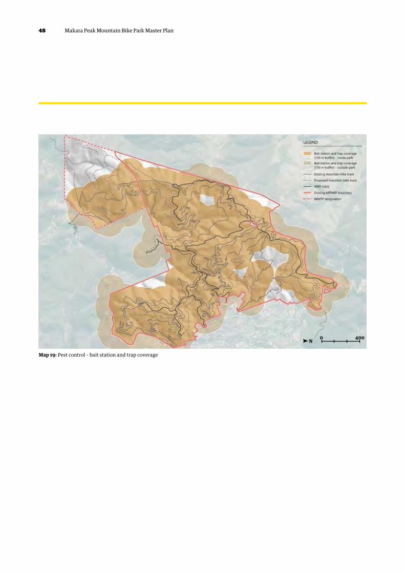
Map 19: Pest control – bait station and trap coverage
0N
400
49Makara Peak Mountain Bike Park Master Plan
Appendix B – Key track works
1.1 Proposed new build tracks
Twenty-four new track sections are proposed as part of the master plan. The following is a broad assessment of the proposed corridors and is intended to provide sufficient information to allow for effective consultation with stakeholders and partners on the potential alignments. The “New build” section numbers relate to proposed new trail sections (requiring full design development and construction). The “Upgraded track” section letters refer to lengths of existing track that require significant re-working to change overall grade (to integrate with proposed itineraries) or to improve the overall trail model. Map 2 should be referred to for the spatial layout of all new trail sections.
It is noted that the following summary and recommendations are solely based on the high-level site assessment and master planning exercise. Before any detailed design work can be carried out, significant, more detailed work will be required to evaluate each corridor and properly investigate any issues that may influence, constrain or affect the design and construction of the proposed tracks.
50 Makara Peak Mountain Bike Park Master Plan
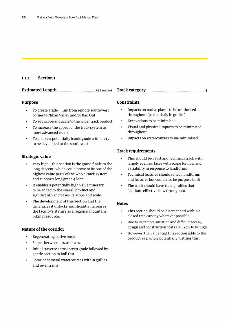
1.1.1 Section 1
Estimated Length ....................................... 632 metres Track category ............................................................ 4
Purpose
• To create grade 4 link from remote south-west corner to Nikau Valley and/or Bail Out
• To add scope and scale to the wider track product• To increase the appeal of the track system to
more advanced riders • To enable a potentially iconic grade 4 itinerary
to be developed to the south-west.
Strategic value• Very high – this section is the grand finale to the
long descent, which could prove to be one of the highest value parts of the whole track system and supports long grade 4 loop
• It enables a potentially high value itinerary to be added to the overall product and significantly increases its scope and scale
• The development of this section and the itineraries it unlocks significantly increases the facility’s stature as a regional mountain biking resource.
Nature of the corridor• Regenerating native bush• Slopes between 15% and 70% • Initial traverse across steep grade followed by
gentle section to Bail Out• Some ephemeral watercourses within gullies
and re-entrants.
Constraints• Impacts on native plants to be minimised
throughout (particularly in gullies)• Excavations to be minimised • Visual and physical impacts to be minimised
throughout • Impacts on watercourses to me minimised.
Track requirements• This should be a fast and technical track with
largely even surfaces with scope for flow and variability in response to landforms
• Technical features should reflect landforms and features but could also be purpose built
• The track should have tread profiles that facilitate effective flow throughout.
Notes• This section should be discreet and within a
closed tree canopy wherever possible• Due to its remote situation and difficult access,
design and construction costs are likely to be high• However, the value that this section adds to the
product as a whole potentially justifies this.

51Makara Peak Mountain Bike Park Master Plan
Purpose• To create long and potentially signature grade 4
descent in the south-west area • To add scope and scale to the wider track product • To increase the appeal of the track system to
more advanced riders • To enable a potentially iconic grade 4 itinerary
to be developed.
Strategic value• High – this section is very important to the
development of a coherent track product built around the provision of waymarked loops
• It enables a potentially high-value itinerary to be added to the overall product and significantly increases its scope and scale
• The development of this section and the itineraries it unlocks significantly increases the facility’s stature as a regional mountain biking resource
• Opens access to connect with potential link track to south coast.
Nature of the corridor• Regenerating native bush• Slopes between 15% and 70% • Numerous large re-entrants and spurs,
particularly at lower elevations • Numerous small landforms such as shallow
re-entrants, gullies and low spurs at higher elevations
• Some ephemeral watercourses within gullies and re-entrants.
Constraints• Impacts on native plants to be minimised
throughout (particularly in gullies)• Excavations to be minimised • Visual and physical impacts to be minimised
throughout • Impacts on watercourses to be minimised.
Track requirements• This should be a fast, twisting and technical
track with largely even surfaces but also numerous technical features
• Technical features should reflect landforms and features but could also be purpose built
• The track should have tread profiles that facilitate effective flow throughout.
Notes• This section should be discreet and within a
closed tree canopy wherever possible• Due to its remote situation and difficult access,
design and construction costs are likely to be high • However, the value that this section adds to the
product as a whole potentially justifies this. • Note that walkers and runners are likely to
go up this once access to the South Coast is through. Therefore, need to keep the gradient (and speeds) to a moderate level and have good sight-lines.
1.1.2 Section 2
Estimated Length ...................................... 1682 metres Track category ............................................................ 4
52 Makara Peak Mountain Bike Park Master Plan
1.1.3 Section 3
Estimated Length ....................................... 952 metres Track category ............................................................. 3
Purpose
• To create a high quality grade 3 loop in the south-west area that avoids going to the bottom of the hill and climbing back up.
Strategic value• High – this section is important in building
flexibility and longevity into the track network by increasing its scope and scale, particularly for grade 3 riders
• Provides a return to main tracks from junction with grade 4 (section 2) for unconfident riders.
Nature of the corridor• Regenerating native bush• Slopes between 15% and 30% • Numerous re-entrants, small spurs, knolls
and flat shoulders.
Constraints• Impacts on native plants and trees to be minimised • Visual and physical impacts to be minimised
throughout.
Track requirements• This should be a fast, fun and flowing descent
that reflects the landforms throughout• It should twist and turn around in situ trees • It should have an even consistent surface and
tread profiles that facilitate effective flow• Broadly follows contour supporting flow and
fun without need to climb out of valley.
Notes• This section should be discreet and within a
closed tree canopy wherever possible• Final section enables opt out from grade 5
descent (section A) for riders who are out of their depth.
53Makara Peak Mountain Bike Park Master Plan
Purpose
• To create a grade 4 climb that enables the south-west tracks to be linked back into the Core Area
• Replaces sections of existing Possum Bait to support climb.
Strategic value• Very high – this section is very important in
integrating the south-west area into the Core Area and the wider track network
• Developing an accessible climb is crucial in making the south-west area attractive to riders accessing the system from the main car park
• Making this section low gradient, accessible and fun should limit the numbers of riders using Bail Out after doing the long descent.
Nature of the corridor• Regenerating native bush• Slopes between 25% and 50% • Numerous small re-entrants, gullies and spurs• Occasional small rock outcrops and crags• Occasional ephemeral watercourses
Constraints• Impacts on native plants to be minimised
throughout• Excavations to be minimised, particularly
at switchbacks• Visual and physical impacts to be minimised
throughout• Impacts on watercourses to be minimised.
Track requirements• This must be an accessible grade 4 climb with
average gradient not in excess of 8% (Maximum gradient up to 10%)
• Turns should be relatively easy to negotiate with rider safety consider due to remoteness
• The tread should be relatively wide with profiles facilitating effective flow and rider control.
Notes• This section should be discreet and within a
closed tree canopy throughout • All switchbacks should be carefully sited
and landscaped to minimise visual and physical impacts
• Existing tight sections of Possum Bait (downhill switchbacks) can be retained for walkers/runners and conservation access.
1.1.4 Section 4
Estimated Length ....................................... 720 metres Track category ............................................................ 4

54 Makara Peak Mountain Bike Park Master Plan
1.1.5 Section 5
Estimated Length ....................................... 808 metres Track category ............................................................. 3
Purpose
• To create connection from Leaping Lizard to access new south-west area of park
• To add scope and scale to the wider track product • To increase the appeal of the track system to
more advanced riders • To enable a potentially iconic grade 4 and grade
3 itineraries to be developed.
Strategic value• High – this section is very important to the
development of a coherent track product built around the provision of waymarked loops
• It enables two high value itineraries to be added to the overall product and significantly increases its scope and scale
• The development of this section and the itineraries it unlocks significantly increases the facility’s stature as a regional mountain biking resource.
Nature of the corridor• Regenerating native bush• Slopes between 15% and 70% • Numerous large re-entrants and spurs,
particularly at lower elevations • Relatively gentle grades in upper elevations
with good stands of mature mānuka.
Possible other tracks in SW sector• Review opportunities for grade 5 technical trail
once long-term access is secured out to South Karori Road.
Constraints• Impacts on native plants to be minimised
throughout (particularly in gullies and mānuka)• Excavations to be minimised • Visual and physical impacts to be minimised
throughout • Impacts on watercourses to be minimised.
Track requirements• This should be a fast and fun section with flow
and numerous technical features• Technical features should reflect landforms and
features but could also be purpose built • The track should have tread profiles that
facilitate effective flow throughout • Extends character of Leaping Lizard through
more vegetated terrain.
Notes• This section should be discreet and within a
closed tree canopy wherever possible.
55Makara Peak Mountain Bike Park Master Plan
Purpose
• Connects with iconic grade 3 descent (section 3) to provide moderate climb back to Core Area and Aratihi
• This section creates an important link and supports an opt out option for riders descending the grade 4 Leaping Lizard.
Strategic value• Very high – this section is crucial in enabling
the south-west area to be accessed and effectively used as part of the track system by grade 3 riders
• This section unlocks the potential of the south-west area enabling it to add value to the track system as a whole.
Nature of the corridor• Regenerating native bush• Slopes between 25% and 50% • Numerous re-entrants, gullies and small spurs• Occasional small rock outcrops and crags• Occasional ephemeral watercourses.
Constraints• Impacts on native plants to be minimised
throughout• Excavations to be minimised• Visual and physical impacts to be minimised • Impacts on watercourses to me minimised.
Track requirements• This should be a relatively gentle and accessible
climb to encourage grade 3 riders to utilise the south-west
• The trail tread should be slightly wider to ensure safe and enjoyable ascent by grade 3 riders who may be fatigued.
Notes• This section should be discreet and within a
closed tree canopy wherever possible.
1.1.6 Section 6
Estimated Length ....................................... 724 metres Track category ............................................................ 3

56 Makara Peak Mountain Bike Park Master Plan
1.1.7 Section 7
Estimated Length ........................................ 651 metres Track category ............................................................. 3
Purpose
• Climbing section parallel to 4WD track to connect back with Leaping Lizard and south-west loops
• Provides an alternative to Aratihi to enable riders to repeat south-west loops without need to climb to high elevations
• Connection for grade 4 riders from Missing Link towards south-west loop.
Strategic value• High – this section unlocks the potential of the
south-west area for grade 4 riders without need to climb high via Aratihi
• Provides a good link for grade 3 and 4 riders to support repeat loops.
Nature of the corridor• Regenerating native bush• Slopes between 25% and 50% • Generally follows 4WD track and downslope
landform.
Constraints• Impacts on native plants to be minimised
throughout• Excavations to be minimised• Visual and physical impacts to be minimised.
Track requirements• This should be a relatively gentle and accessible
climb to encourage grade 3 riders to utilise the south-west area more as well as the access for grade 4 riders
• The trail tread should be slightly wider to ensure safe and enjoyable ascent by grade 3 riders who may be fatigued.
Notes• This section should be discreet and within a
closed tree canopy wherever possible.
57Makara Peak Mountain Bike Park Master Plan
Purpose
• Short descent to enable return to core area for riders from south-west grade 3 loop
• Links to pylon at bottom of Aratihi to avoid two-way conflict on Missing Link.
Strategic value• Very high – this section unlocks the potential
of the south-west area for grade 3 riders without need to climb high via Aratihi
• Enables grade 4 riders to complete short loop out from Missing Link.
Nature of the corridor• Regenerating native bush• Slopes between 25% and 50% • Exposed slopes.
Constraints• Impacts on native plants to be minimised
throughout• Excavations to be minimised• Visual and physical impacts to be minimised.
Track requirements• This should be a relatively gentle and accessible
climb to encourage grade 3 riders to utilise the south-west area more as well as the access for grade 4 riders
• The trail tread should be slightly wider to ensure safe and enjoyable ascent by grade 3 riders who may be fatigued.
Notes• This section should be discreet and within a
closed tree canopy wherever possible.
1.1.8 Section 8
Estimated Length ....................................... 589 metres Track category ............................................................ 3

58 Makara Peak Mountain Bike Park Master Plan
1.1.9 Section 9
Estimated Length ........................................ 815 metres Track category ............................................................. 3
Purpose
• Climbing section as continuation of Section 8 to enable riders to access Core Area from south-west loops
• Avoids two-way conflict on Missing Link• Provides connection to 4WD track at pylon for
short continuation up to top of Missing Link and Easy Up.
Strategic value• Very high – this section unlocks the potential
of the south-west area for grade 3 riders without need to climb high via Aratihi
• Enables grade 4 riders to complete short loop out from Missing Link.
Nature of the corridor• Regenerating native bush• Slopes between 25% and 50% • Areas of difficult terrain requiring careful
design considerations.
Constraints• Impacts on native plants to be minimised
throughout • Excavations to be minimised• Visual and physical impacts to be minimised • Impacts on watercourses to be avoided.
Track requirements• This should be a relatively gentle and accessible
climb to encourage grade 3 riders to utilise the south-west area more as well as the access for grade 4 riders
• The trail tread should be slightly wider to ensure safe and enjoyable ascent by Grade 3 riders who may be fatigued.
Notes• This section should be discreet and within a
closed tree canopy wherever possible • This section crosses private property to link
with pylon 4WD access.
59Makara Peak Mountain Bike Park Master Plan
Purpose
• To create an effective, high-quality and attractive link between the Summit and the tracks in the south-west area.
Strategic value• Very high – this section very important in
effectively connecting the core area to the south-west area
• This in turn increases the scope and scale of the track system as a whole, making it more effective and giving it greater longevity
• This section also enables a key itinerary to be developed in the south-west area.
Nature of the corridor• Degraded land with barbary, gorse and some
native vegetation • Slopes between 15% and 40%• Numerous shallow re-entrants• Some small spurs and flat shoulders • Some small rock outcrops.
Constraints• This is in an exposed position and visual and
physical impacts must be kept to a minimum • Minimal removal of native vegetation and shrubs• Minimal excavations.
Track requirements• This should be a fun section and slightly wider
because it is exposed to high winds• Surfaces should be even and compacted • Tread profiles should facilitate effective flow.
Notes• This is the first part of a potentially iconic
descent in the south-west area and should be fast and flowing whilst still carefully landscaped
• This section potentially adds considerable value to the system as a whole but particularly the tracks in the south-west.
1.1.10 Section 10
Estimated Length ....................................... 645 metres Track category ............................................................. 3

60 Makara Peak Mountain Bike Park Master Plan
1.1.11 Section 11
Estimated Length ........................................ 153 metres Track category ............................................................. 2
Purpose
• Short climbing section linking Magic Carpet with the skills area to avoid existing steep 4WD section
• Increased appeal of skills area to grade 2 riders.
Strategic value• Moderate – this section supports better access
to the skills area and enhances the overall Magic Carpet ride.
Nature of the corridor• Regenerating native bush• Slopes between 15% and 25%.
Constraints• Impacts on native plants to be minimised
throughout • Excavations to be minimised• Visual and physical impacts to be minimised.
Track requirements• This should be a relatively gentle and
accessible climb to encourage grade 2 riders to utilise the skills area and connect with upper section of Koru
• The trail tread should be slightly wider to ensure safe and enjoyable accent by grade 2 riders.
Notes• This section should be discreet and within a
closed tree canopy wherever possible.
61Makara Peak Mountain Bike Park Master Plan
Purpose
• To create an alternative outward (climb) leg from the main car park for intermediate and above riders
• To alleviate pressure on the adjacent Koru and increase the capacity of the track system within the Core Area
• To build more independence into the system and enable more separate loops to be developed.
Strategic value• Very high – conflict with Koru was identified
through consultation making this section important in enabling the proposed track model to be developed and support the future management of the network as a whole.
Nature of the corridor• Partly an existing track (Livewires) and partly
un-cleared regenerating bush • Slopes between 20% and 60%, numerous large
re-entrants and gullies at lower elevations.
Constraints• Trail gradient should average 8% with a
maximum of 14% for short periods• Minimal removal of native vegetation and trees• Minimal excavations • Minimal impacts on watercourses and springs.
Track requirements• This should be a narrow twisting grade 4
singletrack with an even consistent surface and few if any technical features
• Attractive for grade 4–5 riders, or grade 3 riders looking for a challenge.
Notes• In part this section is within the track corridor
currently occupied by Livewires• This section is likely to use some parts of the
existing track but the majority of it will need to be put beyond use, remediated and landscaped to make this section work effectively.
1.1.12 Section 12
Estimated Length ..................................... 1044 metres Track category .............................................................4

62 Makara Peak Mountain Bike Park Master Plan
1.1.13 Section 13
Estimated Length ....................................... 443 metres Track category ............................................................. 2
Purpose
• This will be part two of a Magic Carpet loop (which riders will start from the end of Koru)
• To alleviate pressure on the adjacent Koru and increase the capacity of the track system within the Core Area for grade 2 riders
• To build more independence into the system and enable more separate loops to be developed.
Strategic value• Very high – this section is important in
enabling the proposed track model to be developed and in the future management of the network as a whole.
Nature of the corridor• Regenerating native bush• Slopes between 15% and 30%• Numerous small knolls, re-entrants and gullies
(highly featured throughout).
Constraints• Minimal removal of native vegetation and trees• Minimal excavations • Minimal impacts on watercourses and springs.
Track requirements• This should be a fun undulating section with
good flow and a smooth, even surface • It should twist and turn and track profiles
should encourage effective flow throughout.
Notes• Very careful track design will be required to
make this section work in the right way • It should have a discreet, intimate feel and be
where practicable within a closed tree canopy.

63Makara Peak Mountain Bike Park Master Plan
Purpose
• To provide a continuous grade 3 downhill connection from SWIGG to the main car park (based on Starfish being modified to grade 4)
• Connects from existing SWIGG to lower section of Lazy Fern
• Part of continuous grade 3 descent from summit to car park.
Strategic value• Very high – this section is important in
enabling the proposed track model to be developed and in the future management of the network as a whole.
Nature of the corridor• Advanced regenerating native bush in full canopy• Slopes between 15% and 30%• Numerous small knolls, re-entrants and gullies
(highly featured throughout).
Constraints• Minimal removal of native vegetation and trees• Minimal excavations • Minimal impacts on watercourses and springs.
Track requirements• This should be a continuation of SWIGG
with maximum flow and features within the forest canopy
• It should twist and turn in response to trees and track profiles should encourage effective flow throughout.
Notes• Very careful track design will be required to
make this section work in the right way without impacting existing vegetation
• It should have a discreet, intimate feel and be within a closed tree canopy throughout.
1.1.14 Section 14
Estimated Length ....................................... 500 metres Track category ............................................................. 3

64 Makara Peak Mountain Bike Park Master Plan
1.1.15 Section 15
Estimated Length ....................................... 708 metres Track category .............................................................4
Purpose
• To create the final link in a proposed grade 4 descent between the summit and the main car park
• To alleviate pressure on the existing tracks that descend to the car park
• To build more independence into the system and enable a number of semi-independent itineraries to be developed.
Strategic value• Very high – this section is crucial in enabling an
effective grade 4 descent to be developed and this descent is very important in making the proposed track model function effectively.
Nature of the corridor• Regenerating native bush• Slopes between 20% and 50% • Numerous deep-re-entrants with steep sides• Numerous small spurs• Some deep gullies• Some ephemeral watercourses.
Constraints• Minimal removal of native vegetation and trees• Minimal excavations • Minimal impacts on watercourses and springs • Visual impacts and visibility from adjacent road
and housing must be minimised• The siting, configuration, design and
construction of switchbacks in particular must centre on minimising impacts.
Track requirements• This section should be narrow and fast with
numerous technical features that reflect the ground conditions
• Should include the occasional grade 5 alternate line, to offset loss of LiveWires.
Notes• It is very important that this section include
technical features but that these be rollable throughout
• It must provide an attractive grade 4 alternative to the adjacent grade 3 tracks and should be consistent with the rest of the proposed descent
• It should have a discreet, intimate feel and be entirely within a closed tree canopy.

65Makara Peak Mountain Bike Park Master Plan
Purpose
• To provide a grade 2 climbing connection between Rimu and Big Tom’s Wheelie
• Supports improved grade 2 access from Allington Road secondary access and avoids reliance on 4WD road for climb
• Provides more interesting connection for more advanced riders entering from Allington Road to Core Area of summit.
Strategic value• Moderate – this section supports improved
uphill connection for grade 2 riders.
Nature of the corridor• Advanced regenerating native bush in full canopy• Slopes between 15% and 30%.
Constraints• Minimal removal of native vegetation and trees• Minimal excavations • Minimal impacts on watercourses and springs.
Track requirements• This should be a gentle track suitable for a
range of grade 2 riders• It should twist and turn in response to trees,
and track profiles should encourage effective flow throughout.
Notes• It should have a discreet, intimate feel and be
within a closed tree canopy throughout.
1.1.16 Section 16
Estimated Length ....................................... 218 metres Track category ............................................................. 2

66 Makara Peak Mountain Bike Park Master Plan
1.1.17 Section 17
Estimated Length ....................................... 240 metres Track category .............................................................4
Purpose
• To provide new grade 4 connection with descent off North Face back into JFK towards Main Car Park
• Opens up new, potentially iconic grade 4 sections into northeast valley with options to Trickle Falls or car park.
Strategic value• High – this section supports the inclusion of
the new grade 4 descent off North Face without requiring exit via Trickle Falls.
Nature of the corridor• Advanced regenerating native bush• Slopes between 15% and 30%
• Exposed north facing slopes.
Constraints• Minimal removal of native vegetation and trees• Minimal excavations • Minimal impacts on watercourses and springs.
Track requirements• This section should be narrow and fast with
numerous technical features that reflect the ground conditions and extend riders
• Tread profiles should allow effective flow throughout and provide potential progression for grade 3 riders deviating from North Face. Progression will be for grade 4 riders – a stepping stone on the way to grade 5.
Notes• It should have a discreet, intimate feel and be
within a closed tree canopy throughout.

67Makara Peak Mountain Bike Park Master Plan
Purpose
• To provide new grade 4 connection with descent off North Face into northeast valley with options back into JFK towards Main Car Park
• Opens up potentially iconic new grade 4 sections into northeast valley to increase grade 4 extents and support progression of grade 3 riders.
Strategic value• High – this section supports the inclusion of
the new grade 4 descent off North Face with two exit options.
Nature of the corridor• Advanced regenerating native bush• Slopes between 15% and 30%• Exposed north facing slopes.
Constraints• Minimal removal of native vegetation and trees• Minimal excavations • Minimal impacts on watercourses and springs.
Track requirements• This section should be narrow and fast with
numerous technical features that reflect the ground conditions and extend riders
• Tread profiles should allow effective flow throughout and provide potential progression for grade 3 riders deviating from North Face. Progression will be for grade 4 riders – a stepping stone on the way to grade 5.
Notes• It should have a discreet, intimate feel and be
within a closed tree canopy long term.
1.1.18 Section 18
Estimated Length ........................................ 531 metres Track category .............................................................4

68 Makara Peak Mountain Bike Park Master Plan
1.1.19 Section 19
Estimated Length ....................................... 665 metres Track category .............................................................4
Purpose
• To provide new grade 4 connection with descent off North Face back into Trickle Falls towards Allington Road access
• Opens up new, potentially iconic grade 4 sections into northeast valley with options to Trickle Falls or car park.
Strategic value• High – this section supports the inclusion of
the new grade 4 descent off North Face and exit via Trickle Falls.
Nature of the corridor• Advanced regenerating native bush• Slopes between 15% and 30%
• Exposed north facing slopes.
Constraints• Minimal removal of native vegetation and trees• Minimal excavations • Minimal impacts on watercourses and springs.
Track requirements• This should be a fast and technical track with
largely even surfaces with scope for flow and variability in response to landforms
• Technical features should reflect landforms and features but could also be purpose built
• The track should have tread profiles that facilitate effective flow throughout.
Notes• It should have a discreet, intimate feel and
be within a closed tree canopy throughout.

69Makara Peak Mountain Bike Park Master Plan
Purpose
• To provide new grade 3 climb from Makara Road saddle towards summit to support either Summit Road loops or alternative access
• Supports enhanced use of north of park.
Strategic value• Very high – this section supports the
reconfiguration of the Summit Road area to enable improved loops or connections with Makara Road and adjacent tracks to Karori Park and/or Skyline.
Nature of the corridor• Regenerating native bush• Slopes between 15% and 30%• Includes reconfiguration of existing T3 in places
and new build sections as required.
Constraints• Minimal removal of native vegetation and trees• Minimal excavations.
Track requirements• This section should provide a gentle and
achievable climb for all grade 3 riders • The trail tread should be slightly wider to ensure
safe and enjoyable accent by grade 3 riders who may be fatigued or have extended themselves.
Notes• It should have a discreet, intimate feel and be
within a closed tree canopy long term.
1.1.20 Section 20
Estimated Length ....................................... 567 metres Track category ............................................................ 3

70 Makara Peak Mountain Bike Park Master Plan
1.1.21 Section 21
Estimated Length ...................................... 1339 metres Track category .............................................................4
Purpose
• To provide new extended grade 4 descent from the summit to Makara Road access
• Potentially iconic track due to length of uninterrupted run
• Supports enhanced use of north of park.
Strategic value• Very high – this section supports the
reconfiguration of the Summit Road area to enable improved loops or connections with Makara Road and adjacent tracks to Karori Park and/or Skyline.
Nature of the corridor• Regenerating native bush• Slopes between 15% and 30%• Numerous large re-entrants and spurs,
particularly at higher elevations.
Constraints• Minimal removal of native vegetation and trees• Minimal excavations • Visual impacts and visibility from adjacent road
and housing must be minimised• The siting, configuration, design and
construction of switchbacks in particular must centre on minimising impacts.
Track requirements• This should be a fast and technical track with
largely even surfaces with scope for flow and variability in response to landforms
• Technical features should reflect landforms and features but could also be purpose built
• The track should have tread profiles that facilitate effective flow throughout.
Notes• It should have a discreet, intimate feel and be
within a closed tree canopy long term.
71Makara Peak Mountain Bike Park Master Plan
Purpose
• To provide continuation of reconfigured grade 3 descent (section E) to continue on to Makara Road saddle
• Supports enhanced use of north of park and improves descent from existing Varley’s.
Strategic value• Very high – this section supports the
reconfiguration of the Summit Road area to enable improved loops or connections with Makara Road and adjacent tracks to Karori Park and/or Skyline.
Nature of the corridor• Regenerating native bush• Slopes between 15% and 30%• Very exposed.
Constraints• Minimal removal of native vegetation and trees• Minimal excavations • Requires integration with sections of Varley’s
to improve switchbacks• Visual impacts and visibility from adjacent road
must be minimised• The siting, configuration, design and
construction of switchbacks in particular must centre on minimising impacts and ensuring longevity.
Track requirements• This section should provide a fun and fast
descent for all grade 3 riders.
1.1.22 Section 22
Estimated Length ....................................... 523 metres Track category ............................................................ 3

72 Makara Peak Mountain Bike Park Master Plan
1.1.23 Section 23
Estimated Length ....................................... 752 metres Track category ............................................................ 3
Purpose
• To provide new grade 3 climb from Makara Road saddle towards summit (section 20) to support either Summit Road loops or alternative access
• Supports enhanced use of north of park and improved use of existing Varley’s.
Strategic value• Very high – this section supports the
reconfiguration of the Summit Road area to enable improved loops or connections with Makara Road and adjacent tracks to Karori Park and/or Skyline.
Nature of the corridor• Regenerating native bush• Slopes between 15% and 30%
• Very exposed.
Constraints• Minimal removal of native vegetation and trees• Minimal excavations.
Track requirements• This section should provide a gentle and
achievable climb for all grade 3 riders • The trail tread should be slightly wider to ensure
safe and enjoyable accent by grade 3 riders who may be fatigued or have extended themselves.
73Makara Peak Mountain Bike Park Master Plan
Purpose
• Final two-way section as link to Makara Road saddle
• Supports enhanced use of north of park and improved use of existing Varley’s.
Strategic value• Very high – this section supports the
reconfiguration of the Summit Road area to enable improved loops or connections with Makara Road and adjacent tracks to Karori Park and/or Skyline.
Nature of the corridor• Regenerating native bush• Slopes between 15% and 30%• Very exposed.
Constraints• Minimal removal of native vegetation and trees• Minimal excavations.
Track requirements• This section will require specific design
to reduce downhill speeds and provide appropriate sight lines to reduce rider conflict.
1.1.24 Section 24
Estimated Length ....................................... 385 metres Track category ............................................................ 3

74 Makara Peak Mountain Bike Park Master Plan
1.2.1 Section A – Leaping Lizard
Purpose
• To upgrade this section to create new iconic grade 5 descent into south-west and Nikau Valley
• To provide variation in the south-west and support progression in this area.
Strategic value• High – important to ensure track network caters
for range of rider abilities and enables more advanced riders to utilise full scope of park.
Track requirements• This should be a highly technical but fast track
with multiple features and opt-in/out points to foster progression and rider interest.
Proposed works• Moderate works to improve existing grade 4
track and add well-designed features.
Notes• Due to the nature of the vegetation cover and
the need to prevent damage to the existing track, it is likely that any works will need to be carried out by hand.
1.2 Existing tracks To implement the proposed track model and alignments, some key works relating to existing tracks are proposed. These are very broadly outlined below, but much more detailed work is required to develop prescriptive construction specifications related to each section.
75Makara Peak Mountain Bike Park Master Plan
1.2.1 Section B – Possum Bait
1.2.1 Section C - Livewires
Purpose
• To improve link between signature south-west descents and support long grade 4 loop
• Minor improvements to existing track to improve experience and encourage more use of south-west area.
Strategic value• Moderate – whilst not essential, these
works would contribute significantly to the development of the proposed track system in the south-west area.
Track requirements• This should remain a narrow twisting singletrack
with limited clearance around in situ trees• However, its flow should be more effective
to make it an integral part of the proposed grade 4 loop.
Proposed works• Re-profiling tread to improve flow• Minor revetments where required.
Purpose
• To realign this section away from the lower part of the proposed new outward leg and link it into the upper section
• To prevent riders from using the proposed new outward leg as a descent.
Strategic value• Moderate – this work is not essential in
establishing the proposed track model, but it is important in managing the way people use this area in the future
• It may be more effective to decommission this section completely.
Track requirements• This should be a short technical grade 4 track
that retains its current character and style.
Proposed works• Minor realignments to link into proposed new
outward leg• Decommissioning remainder of section • Blocking off with earthworks• Planting and landscaping.
Notes• Due to the nature of the vegetation cover and
the need to prevent damage to the existing track, it is likely that any works will need to be carried out by hand
• It may be more effective to carry out this work at the same time as construction works on the new outward leg is under way. Section 15 should be built first to provide a similar experience. Then review the future of Livewires. could be retained as an event/shuttle day track.
76 Makara Peak Mountain Bike Park Master Plan
1.2.1 Section D - Starfish
Purpose
• To provide a more consistent grade 4 descent from top to bottom
• To make this descent more accessible and therefore of greater value to the track system as a whole. Consider addition of some grade 5 features.
Strategic value• High – whilst not essential, this work is important
in developing a consistent grade 4 descent.
Track requirements• This track should be a consistently fast,
flowing and twisting track that weaves around in situ trees
• It should have a surface consistent with a grade 4 track.
Proposed works• Replacing timber step-down with a stone
pitched rollable step-down• Develop a realignment to provide a flowing
grade 4 alternative to a stone built roll-in.
Notes• All works on this section (including new build)
will need to be carried out by hand to prevent damage to the existing track
77Makara Peak Mountain Bike Park Master Plan
1.2.1 Section E – Zac’s Track
Purpose• To create a fun and fast relatively easy one-
way grade 3 single direction descent that links Makara Road and the summit.
Strategic value• High – improving this section to create
an attractive one-way track is key in the development of the tracks in the northern area
• It enables the northern area to be linked to the summit and thereby the rest of the track network
• Making this a one-way section also enables the development of a coherent loop in the northern area, which significantly increases its value to the system as a whole.
Track requirements• This should be designed with maximum flow and
features to provide an enjoyable grade 3 descent
• It should twist and turn in response to trees, and track profiles should encourage effective flow throughout
• It should have even, consistent surfaces, low levels of technical difficulty, relatively open turns and effective flow.
Proposed works• Eliminating rocky steps with stone revetments
and fill • Re-profiling tread at key locations • Re-surfacing where required• Realigning key turns with either stone or timber
revetments and fill.
Notes• The drawing in of materials should be done
using mechanised equipment • Proximity to the four-wheel drive road
potentially facilitate the works.

78 Makara Peak Mountain Bike Park Master Plan
Makara Peak Master Plan – Implementation priorities 2016–2019
Track proposal Description
Upswing and Yeah Gnar Complete these tracks
Carpark development
Section15 Create final link in a proposed grade 4 between the summit and main entrance.
Section 14 Continuous grade 3 downhill connection from SWIGG to the main entrance.
Section 6 Traverse from Nikau to Aratihi
Section 16 Grade 2 climbing connection between Rimu and Big Tom’s Wheelie
Section 20 New grade 3 climb from Makara Road saddle towards the summit. Will allow Zacs to be downhill only.
Section 21 New extended grade 4 descent from the summit to Makara Road access.
Section 13 Alternative grade 2 outward leg from the main entrance parallel with Magic Carpet.
Section 12 Alternative grade 4 climb from main entrance
Section 24 Two way section linking to Makara Road saddle (Tank track?)
Appendix C – Implementation priorities

79Makara Peak Mountain Bike Park Master Plan

80 Makara Peak Mountain Bike Park Master Plan
Related Documents