TEXAS WATER DEVELOPMENT BOARD Report 189 COpy I DO NOT RcM'JVE FIlOM REPORTS DIV!SION FILES, I MAJOR AND HIST,ORICAL SPRINGS OF TEXAS March 1975

Welcome message from author
This document is posted to help you gain knowledge. Please leave a comment to let me know what you think about it! Share it to your friends and learn new things together.
Transcript
TEXASWATERDEVELOPMENTBOARD
Report 189
r~ mV1SI~ri F!~E COpyI DO NOT RcM'JVE FIlOM REPORTS DIV!SION FILES,
I
MAJOR AND HIST,ORICAL
SPRINGS OF TEXAS
March 1975

TEXAS WATER DEVELOPMENT BOARD
REPORT 189
MAJOR AND HISTORICAL SPRINGS OF TEXAS
By
Gunnar Brune
March 1975
TEXAS WATER DEVELOPMENT BOARD
John H. McCoy, ChairmanW. E. TinsleyCarl Illig
Robert B. Gilmore, Vice ChairmanMilton PottsA. L. Black
Harry P. Burleigh, Executive Director
Authorization for use or reproduction of any original material contained inthis publication, i.e., not obtained from other sources, is freely granted. The Boardwould appreciate acknowledgement.
Published and distributedby the
Texas Water Development BoardPost Office Box 13087Austin, Texas 78711
ii
TABLE OF CONTENTS
ABSTRACT
INTRODUCTION
Purpose of Study.
Saline Springs. .
Method of Study .
Spring Numbering System.
Acknowledgements. .
Classification of Springs
IMPORTANCE OF TEXAS SPRINGS.
Historical Significance
Size of Springs
GEOLOGIC SETTING .
Spring Aquifers .
Typical Geologic Settings of Springs
QUALITY OF SPRING WATERS
DECLINE OF SPRINGS
Prehistoric Setting
Causes of Spring Decline
Some Examples . . .
Texas Water Law as Relating to Springs
DETAILED INFORMATION ON INDIVIDUAL SPRINGS.
Bandera County
Bastrop County
iii
Page
3
3
3
3
4
5
5
5
5
9
11
11
12
15
22
22
22
25
28
30
30
31
Baylor County
Bell County
Bexar County .
Blanco County
Bosque County
Bowie County.
Brewster County .
Briscoe County
Burleson County .
Burnet County
Cass County
Cherokee County
Clay County . .
Collingsworth County
Comal County
Crockett County
Crosby County
Culberson County
Dallam County
Dallas County.
Dimmit County
Donley County
Eastland Count~'
Edwards County
Ellis County
Fayette County
TABLE OF CONTENTS (Cont'd.)
iv
Page
31
31
32
34
34
34
35
35
35
35
36
36
37
37
37
40
40
40
40
40
41
41
41
41
42
42
Galveston County
Gillespie County
Grimes County
Guadalupe County
Harrison County
Hartley County
Hays County
Hood County
Hopkins County
Houston County
Howard County
Hudspeth County
Irion County . .
Jeff Davis County
Johnson County
Kendall County
Kerr County .
Kimble County
Kinney County
Lampasas County
Limestone County
Llano County. .
Lubbock County .
Martin County
Mason County
McCulloch County
TABLE OF CONTENTS (Cont'd.)
v
Page
43
43
43
43
43
44
44
45
45
45
46
46
46
47
49
49
49
50
51
52
53
53
53
53
54
54

McLennan County
Medina County
Menard Cou nty
Milam County
Montague County
Motley County
Nacogdoches County
Oldham County
Parker County
Pecos County .
Potter County .
Reagan County
Real County
Reeves County
San Jacinto County
San Saba County .
Schleicher County
Scurry County
Smith County .
Sutton County
Tarrant County
Terrell County
Tom Green County
Travis County.
Tyler County .
Uvalde County
TABLE OF CONTENTS (Cant'd.)
vi
Page
54
54
55
55
55
55
56
56
56
56
59
60
60
60
63
63
68
69
69
70
70
70
71
72
73
73
TABLE OF CONTENTS (Cont'd.)
Val Verde County
Van Zandt County
Wheeler County
Wichita County
Wilbarger County
Williamson County
Wilson County
Winkler County
REFERENCES CITED.
TABLES
Page
76
82
83
84
84
84
84
84
85
1. Source and Significance of Dissolved-Mineral Constituents andProperties of Water . . . . . . .. ..... 20
2. Selected Chemical Analyses of Spring Waters
FIGURES
89
1. Grid System Used for Spring Numbering. . . . . 4
2. Map Showing Old Trails and Roads and the Springs Which Served Thl~m 7
3.
4.
Old Mill Dam at Hueco Springs in Comal County . . . . . . . .
Old Store and Bath House at Boquillas Warm Springs in Brewster County
9
10
5. San Marcos Springs and Recreational Park
6. One of the San Felip Springs .
7. Map Showing Major Aquifers.
8. Map Showing Minor Aquifers
10
11
12
13
9.
10.
Map Showing Distribution of Springs According to Rock Type
Edwards Limestone Showing Fissures and Cavities Through Which RechargeCan Enter the Underground Reservoir . . . . . . . . .
14
15
11. Lens of Gravel in Alluvium
vii
16
12.
TABLE OF CONTENTS (Cont'd.)
Sand Creek Springs, in Collingsworth County, Showing InterbeddedSiltstone and Gypsum . . . . . . . . . . . .
Page
16
13. Example of Cavernous Gypsum 17
14.
15.
Geologic Settings of Texas Springs
Geologic Settings of Texas Springs
17
18
16. Seven Springs, Irion County, Emerging From Jointed Limestone
17. Barnet: Spri ngs and Travertine Deposits . . . . .
18. Maps Showing Comparison of Springs, 1500 and 1973
19
19
23
19.
20.
21.
22.
Large Well Flowing From the Edwards (Balcones Fault Zone) Aquifer atFort Sam Houston in San Antonio. . . . . . . . . .
Phantom Lake Spring, Jeff Davis County, Issuing From a Cavern inComanc:hean Limestone .
Hydrographs of Phantom Lake and Saragosa Springs
Hydrographs of Barton and San Antonio Springs .
25
26
26
27
23. Barton Springs Supplies a Swimming Pool in Austin
24. Hydrographs of San Saba, Dove Creek, and Roaring Springs
25. Site of Former Comanche Springs .
26. Big Boiling Spring, One of the Salado Springs
27. Mormon Mill Falls Below Holland Springs
28. Some of the Carnal Springs
29. Fish Pond and Pump House at Bitter Creek Springs
30. Site of the Original XIT Spring, Now Dry
28
29
30
32
39
40
41
44
31.
32.
Site of Former Big Spring
Dove Creek Springs
47
48
33. Las Moras Springs
34. Bravo Springs Reservoir and Former XIT Ranch Division Headquarters
35. Cavern From Which Santa Rosa Spring Formerly Flowed
viii
52
57
58

TABLE OF CONTENTS (Cant'd.)
36. Restored Stagecoach Station at Tunas Spring
Page
59
37.
38.
39.
Saragosa Springs. . .
One of the Giffin Springs
Swimming Pool in Balmorhea State Park Into Which San SolomonSpring Flows . . . . . . . . . . . . . . . . .
61
63
63
40. Baker Springs Issuing From Ellenburger Limestone 64
41. Fleming Lower Spring 65
42. Hart Spring
43. Deep Creek Springs Reservoir
65
66
44.
45.
Remains of Old Mill Dam at San Saba Springs
Jennings Springs . . . . . . . . . .
67
68
46. Heck Springs Emerging From the Ellenburger Limestone Into aSwimming Pool
47. Anson Springs. .
69
71
48.
49.
50.
Remains of Old Mill at Manchaca Springs.
Santa Monica Springs in 1890, Looking South
Site of Former Pecan Springs.
74
74
77
51. Hudspeth Springs 78
52.
53.
54.
55.
56.
57.
58.
Finegan Springs .
Dam and Weir on Dolan South Spring
Main Gillis Spring, in Devil's River
One of the Slaughter Bend Springs
McKee Spring and Gaging Station
Cantu Spring and Gaging Station
Map Showing Spring Locations .
ix
78
79
80
80
81
83
95

MAJOR AND HISTORICAL SPRINGS OF TEXAS
ABSTRACT
i
J'I;i1,I
II
Springs have been very important to Texas fromthe time of its first inhabitants. Many battles werefought between the pioneers and Indians for possessionof springs. Many springs afforded important stops onstagecoach routes, power for mills, water for medicinaltreatment, municipal water supplies, and recreationalparks.
Texas originally had 281 major and historicallysignificant springs, other than saline springs. Of these,four were originally very large springs (over 100 cubicfeet per second flow); however, only two, Comal andSan Marcos, remain in that class today. Sixty-threesprings, many with important historical backgrounds,have completely failed. Of the 281 springs studied, 139issue from 2 underground reservoirs, the Edwards(Balcones Fault Zone) and the Edwards-Trinity (Plateau)aquifers. San Saba County, with 19 major and significantsprings, leads all other counties in the State. Val Verdeand Kerr Counties follow closely.
Although total flow of the springs included in thisreport has declined, it still amounts to about 1,150,000acre-feet per year, and if all the smaller springs areincluded, the total annual flow probably exceeds3,000,000 acre-feet.
The underground reservoirs from which springsarise may be cavernous limestone or gypsum, sand,gravel, or other permeable formations. Often faults have
played an important role in the location of springs bydamming up an underground reservoir, blocking lateralflow so that the water under hydrostatic pressure canonly move upward to overflow as springs. In other casesarching, dominl~, and cracking of rock strata have causedthe formation of springs.
Although a large number of water analyses wereobtained and studied, no progressive trend towardcontamination of spring waters could be found. At manysprings, higher discharges are accompanied by decidedlylower concentrations of dissolved solids.
The decline of spring flows probably began soonafter the first colonization of Texas by Spain. Clearingof forest land and heavy grazing of pastures probablyreduced recharge. In the middle 1800's the drilling ofmany flowing wells, some of which spouted 84 feetabove the land surface, greatly reduced the artesianpressure on springs. The natural "fountains," as thesprings were dl~scribed by early explorers, were soon athing of the past. Heavy well pumping of undergroundwaters for irrigation, municipal, and industrial purposeshas continued the decline and disappearance of Texassprings. Surfacl~ reservoirs have inundated some springsbut have increased the flow of others.
Detailed information is given separately for eachspring, including the location, geologic setting, historicalbackground, and discharge.
MAJOR AND HISTORICAL SPRINGS OF TEXAS
INTRODUCTION
Purpose of Study
The study of springs is a borderline discipline,because springs are the transition from ground water tosurface water. Hence they have been studied to someextent by ground-water specialists and to some extentby surface-water specialists. Overall, however, they havebeen neglected. The purpose of this publication is to pulltogether information on major and historicallysignificant springs in Texas, from ground-water reports,surface-water reports, historical documents, and fieldinvestigations.
Saline Springs
Included in this report are fresh-water springs (lessthan 1,000 milligrams per liter of dissolved solids) andslightly saline springs (1,000 to 3,000 milligrams perliter). Saline springs, containing more than 3,000 mgll(milligrams per liter) of dissolved solids, are notincluded. The more important saline springs include anumber in Childress, Cottle, Hall, King, and StonewallCounties in northwest Texas, which issue from theWhitehorse Group and Blaine Gypsum. In south Texas,saline springs arise from sands of the Gulf Coast aquiferin Starr and Webb Counties. In Lampasas County isHannah Saline Spring, formerly a well-known medicinalspring, issuing from the Marble Falls Limestone. Some ofthese springs are exceedingly saline, such as the LittleRed Springs in Hall County, which contain 220,000 mgllof dissolved solids, primarily sodium chloride. Effortsare under way to dam up the more saline springs and toallow the water to evaporate, thus preventing the saltfrom damaging downstream surface-water supplies.
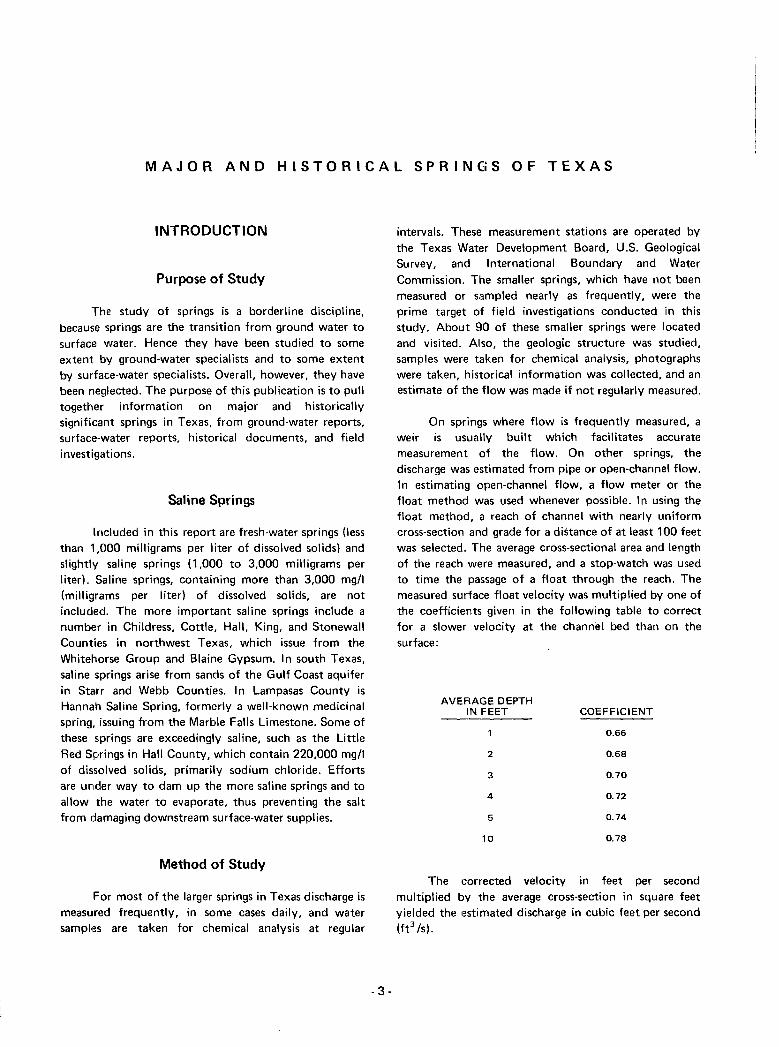
Method of Study
For most of the larger springs in Texas discharge ismeasured frequently, in some cases daily, and watersamples are taken for chemical analysis at regular
-3-
intervals. These measurement stations are operated bythe Texas Water Development Board, U.S. GeologicalSurvey, and International Boundary and WaterCommission. The smaller springs, which have not beenmeasured or sampled nearly as frequently, were theprime target of field investigations conducted in thisstudy. About BO of these smaller springs were locatedand visited. Aliso, the geologic structure was studied,samples were taken for chemical analysis, photographswere taken, historical information was collected, and anestimate of the flow was made if not regularly measured.
On springs where flow is frequently measured, aweir is usually built which facilitates accuratemeasurement of the flow. On other springs, thedischarge was estimated from pipe or open-channel flow.In estimating open-channel flow, a flow meter or thefloat method was used whenever possible. In using thefloat method, a reach of channel with nearly uniformcross-section and grade for a distance of at least 100 feetwas selected. The average cross-sectional area and lengthof the reach were measured, and a stop-watch was usedto time the passage of a float through the reach. Themeasured surface float velocity was multiplied by one ofthe coefficients given in the following table to correctfor a slower velocity at the channel bed than on thesurface:
AVERAGE DEPTHIN FEET COEFFICIENT
0.66
2 0.68
3 0.70
4 0.72
5 0.74
10 0.78
The corrected velocity in feet per secondmultiplied by the average cross-section in square feetyielded the estimated discharge in cubic feet per second(ft3 Is).
6
100°37° 37°DALHART PERRYTON
A S-36° 36°
TUCUMCARI AMARILLO
35°Q E 98°
CLOVIS PLAINVIEW LAWTON35°
G H '--''--..34 96° 94°
BROW~FIELD WICHITASHERMAN.... TE'XARKANA
34°LUBBOCK
FALLSJ K L M N33°33°
HOBBS BIG SPRING ABILENE DALLAS TYLERr 106° 0 P Q R 5 92°EL PASO, 'VAN HORN 3
PECOS SAN ANGELO BROWNWOOD ALEXANDRIAT ~ UWACO PALESTINE
8° V W X y Z \AA~ARFA 3
FORTSONORA BEAUMONT I LAKE
SS STOCKTON LLANO AUSTIN CHARLES
30 CC DD EE FF GG I HHPRjST
O, EMORY PEAK -DEL RIO .6 LL SEGUIN
HONN~PORT ARTHUR
29° ,-JJ KK MM 00106° SAN ANTONIO
104° 9EAGLE PASS CRYSTAL CITY
BEE~~T~ BAY CITY
28° pp" QQ 55 28°/02°
\TTO CORPUS 94°
Example: Spring LL6 CHRISTI
- San Antonio Sheet. Army Map Service 27°,UU
27°Topogrophic Mop MC ALLEN 'j ) 96°
-Spring number assigned on mop LL VV_ ~W26 0
1000 ~W0a::
25c m25°'---
I32
LL
gao 97 0
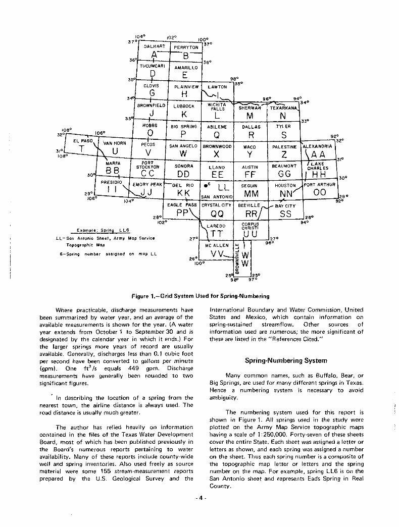
Figure 1.-Grid System Used for Spring-Numbering
Where practicable, discharge measurements havebeen summarized by water year, and an average of theavailable measurements is shown for the year. (A wateryear extends from October 1 to September 30 and isdesignated by the calendar year in which it ends.) Forthe larger springs more years of record are usuallyavailable. Generally, discharges less than 0.1 cubic footper second have been converted to gallons per minute(gpm). One ft3 /s equals 449 gpm. Dischargemeasurements have generally been rounded to twosignificant figures.
In describing the location of a spring from thenearest town, the airline distance is always used. Theroad distance is usually much greater.
The author has relied heavily on informationcontained in the files of the Texas Water DevelopmentBoard, most of which has been published previously inthe Board's numerous reports pertaining to wateravailability. Many of these reports include county-widewell and spring inventories. Also used freely as sourcematerial were some 155 stream-measurement reportsprepared by the U.S. Geological Survey and the
International Boundary and Water Commission, UnitedStates and Mexico, which contain information onspring-sustained streamflow. Other sources ofinformation used are numerous; the more significant ofthese are listed in the "References Cited."
Spring-Numbering System
Many common names, such as Buffalo, Bear, orBig Springs, are used for many different springs in Texas.Hence a numbering system is necessary to avoidambiguity.
The numbering system used for this report isshown in Figure 1. All springs used in the study wereplotted on the Army Map Service topographic mapshaving a scale of 1:250,000. Forty-seven of these sheetscover the entire State. Eac:h sheet was assigned a letter orletters as shown, and each spring was assigned a numberon the sheet. Thus each spring number is a composite ofthe topographic map letter or letters and the springnumber on the map. For example, spring LL6 is on theSan Antonio sheet and rHpresents Eads Spring in RealCounty.
-4 -

Acknowledgements
Special thanks are given to the U.S. GeologicalSurvey and to the International Boundary and WaterCommission, United States and Mexico. These agenciesfurnished numerous records of spring dischargemeasurements and chemical analyses of spring waterswhich have been included in this report. Others whofurnished valuable records include the Reeves CountyWater Control and Improvement District and numerouscity water departments. The Texas Historical SurveyCommittee provided important historical information onmany springs.
Classification of Springs
The springs of Texas may be classified by size asfollows:
AVERAGE DISCHARGEFT3/S (CUBIC FEET GPM (GALLONS
MAGNITUDE PER SECOND) PER MINUTE)
IMPORTANCE OF TEXAS SPRINGS
Historical Significance
Springs were vital to the survival of Texas' earliestinhabitants, over 30,000 years ago. At an archeologicalsite near Lewisville in Denton County, radiocarbonanalysis has dated the remains of these early new-world
men at 37,000+ years old, including crude sculptures,
spears, and sp4~ar throwers (Newcomb, 1961). These
early Americans always made their campgrounds near
water, whether it was a spring, spring-fed stream, a river,
or a lake. They preferred clear and pure water just as we
do today.
Bedrock mortars or rock mills were worn into the
rock by the Indians as they ground sotol, acorns and
other nuts, mesquite beans, and grain. These mortars can
still be seen at many Texas springs.
Very large
Large
Moderately large
Medium
Small
Very small
Seeps
Over 100
10to100
1 to 10
0.1 to 1 45 to 449
4.5 to 45
0.5 to 4.5
Less than 0.5
It is also noteworthy that the Pueblo Indians of
west Texas used spring water for irrigation of crops long
before the arrival of the Europeans (Taylor, 1902, andHutson, 1898).
When European explorers entered the picture,Indians guided them over well-worn trails from onespring to another. The large number of springs on theseold exploratory routes stands out plainly in Figure 2.
This is similar to the classification used by Meinzer(1927), except that he used eight magnitudes, dividingthe smaller springs and seeps into more classes.
Major springs as discussed in this report includesprings which have or at some previous time did have 1ft3/S or more average flow, and also those smaller springsto which significant history is attached. In many casesthe total discharge of a group of closely associatedsprings was used. In such cases the number of activesprings in the group usually varies with the discharge.During high discharges they all flow, but at lowerdischarges only the lower ones flow.
Some springs which have been very infrequentlymeasured are difficult to classify as to size. If the fewmeasurements were made in periods of abundantrainfall, the flow would be higher and the spring mightbe classified as a larger spring than it really is. Thereverse holds true if the measurement was made duringa very dry period. Hence considerable jUdgement enteredinto the size classification of some springs.
- 5-
Because the springs were so vital to the life of boththe Indians and the white men, it is not surprising thatmany battles were fought over their possession. In 1650when Spanish explorers first visited Big Spring (P4) inHoward County, they found the Comanche and PawneeIndians fighting for its possession. When a network offorts was strung across Texas, they were, in nearly allcases, located near springs in order to have a rei iablesupply of pure water. Later the covered-wagon andstagecoach routes came to rely heavily upon the springs.For example, the "Camino Real" or King's Highway,completed bV the Spanish colonists about 1697 fromNatchitoches, Louisiana, to San Antonio and Mexico,passed 13 major Texas springs (F igure 2) and many moreminor ones. Most of the springs in far west Texas arevery small in comparison with those in central and eastTexas, because of the very low rainfall and recharge.Nevertheless, they often meant the difference betweenlife and death to the early pioneers.
Nearly all of the larger springs were used for waterpower by the early settlers (Figure 3). At least 61 were

-
Figure 3.-OId Mill Dam at Hueco Springs inCarnal County
used in this way. Gristmills, flour mills, sawmills, cottongins, and later electric generating plants were poweredby the flow of spring water.
In the late 1800's, many medicinal or health spassprang up around the more mineralized springs(Figure 4). At least 25 springs, chiefly in east Texas,were believed to be beneficial in curing various ailments.Most of these waters are high in sulfate, chloride, iron,and manganese.
Many of the early settlements relied entirely onspring water. At least 200 towns were named for thesprings at which they were located. About 40 still areshown on the official Texas State Highway Map, butmany of the springs have dried up.
Many springs in Texas have acquired highrecreational value (Figure 5). Among these are SanMarcos (Hays County), Comal (Comal County) andBarton Springs (Travis County). Some recreationalsprings which have essentially ceased flowing much ofthe time, such as Gamel Spring (Mason County), BigSpring (Howard County!. and San Antonio Springs(Bexar County!. are now maintained by pumping waterto the springs. The artificial spring water, however,usually lacks the cool clarity of natural spring water, and
- 9·
may be considered by some as an example of thedecreasing quality of modern life.
Size of Springs
All known springs of over 1 fe /s average dischargeare included in this report. Springs with less flow areincluded only if their unusual history warrants it.
Of the 281 major and historically significantsprings described, only two springs at present ComaI(Comal County) and San Marcos (Hays County), areclassified as v1ery large. Of the remain ing springs studied,17 are classified as large, 79 as moderately large, 64 asmedium, 31 as small, 21 as very small, 2 as seeps, and 65as no longer existing (or inundated).
The area that is now Texas, when first explored bywhite men, had four very large springs. In order of sizethese were Coma I, San Marcos, Goodenough (Val VerdeCounty), and San Felipe (Val Verde County) Springs.Goodenough Spring is under 150 feet of water whenInternational Amistad Reservoir is at conservation poollevel. This hHad of water has probably greatly reduced oreven stopped the flow of this spring. San Felipe Springs(Figure 6) have fallen below 100 ft3 /s discharge in
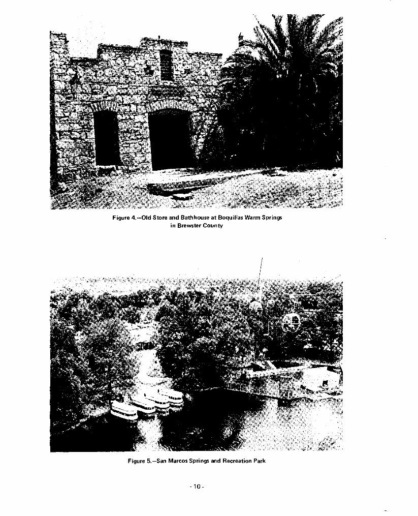
Figure 4.-0Id Store and Bathhouse at BoquiJlas Warm Springsin Brewster County
!II
Figure 5.-San Marcos Springs and Recreation Park
- 10-

Figure G.-One of the San Felipe Springs
recent years because of well pumping in the area.However, they may again become very large springsbecause of the recharge effects of the upstreamInternational Amistad Reservoir.
Although the total flow of springs included in thisreport has declined considerably over the years, it stillamounts to about 1,600 fe Is or 1,150,000 acre-feet peryear. However, if the vast number of smaller springs areincluded, the total annual spring flow in Texas isprobably in excess of 3 million acre-feet.
GEOLOGIC SETTING
Spring Aquifers
Figures 7 and 8 show the seven major and sevenminor ground-water aquifers of Texas, and the numberof springs described in this report which issue from each.It is noteworthy that 139 of the 281 springs issue fromthe Edwards-Trinity (Plateau) and Edwards (BalconesFault Zone) aquifers. Note also that 49 springs issuefrom miscellaneous aquifers which are not shown inthese figures. These include various rocks such asvolcanic tuff, basalt, breccia, gypsum, and sandstone.
- 11 -
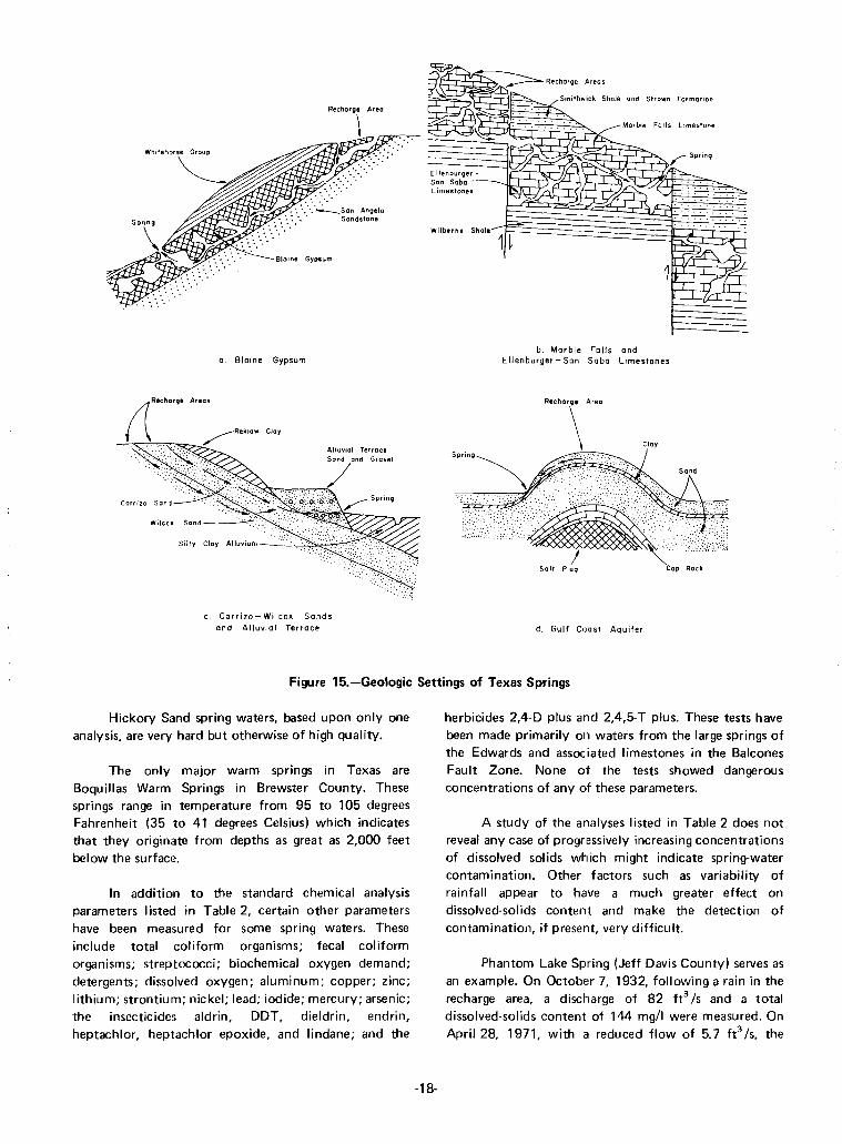
Figure 9 shows the distribution of the majorsprings by the type of rock from which they arise. Thesprings issuing from Comanchean limestones are by farthe most common. These Lower Cretaceous limestones,including the Glen Rose, Edwards and associatedlimestones, Georgetown, and their equivalents, are foundin the Edwards-Trinity (Plateau). Edwards (BalconesFault Zone). Trinity Group, and Edwards-Trinity (HighPlains) aquif1ers. A typical Edwards Limestone outcrop isshown in Figure 10. Certain parts of these limestones arefilled with large interconnected caverns which form atremendous underground reservoir. Recharge fromstreams and surface runoff enters the undergroundcaverns through sinkholes, faults, and fissures in thesurface rock. The flow of springs from cavernous rockundergroundl reservoirs tends to fluctuate considerably,depending upon the amount of rainfall, recharge, andwater in storage. As water levels decline, the spring flowsfall off, but when recharge fills the reservoirs the springsbegin flowing again.
The springs issuing from other Comancheanlimestones arise primarily from the Ellenburger and SanSaba Limestones aquifers which surround the upliftedCentral MiOilral Region.
Most of the springs issuing from sands and gravelsflow under artesian pressure, from aquifers such as the
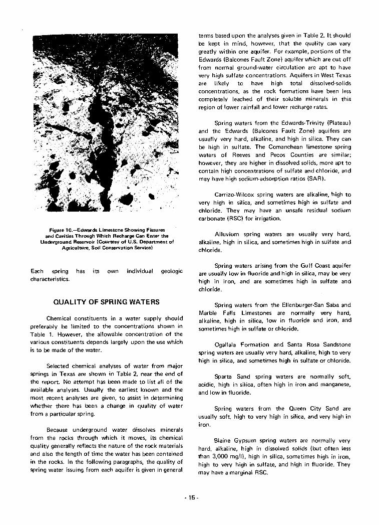
Figure 10.-Edwards Limestone Showing Fissuresand Cavities Through Which Recharge Can Enter the
Underground Reservoir (Courtesy of U.S. Department ofAgriculture. Soil Conservation Service)
Each spring has its own individual geologiccharacteristics.
QUALITY OF SPRING WATERS
Chemical constituents in a water supply shouldpreferably be limited to the concentrations shown inTable 1. However. the allowable concentration of thevarious constituents depends largely upon the use whichis to be made of the water.
Selected chemical analyses of water from majorsprings in Texas are shown in Table 2. near the end ofthe report. No attempt has been made to list all of theavailable analyses. Usually the earliest known and themost recent analyses are given, to assist in determiningwhether there has been a change in quality of waterfrom a particular spring.
Because underground water dissolves mineralsfrom the rocks through which it moves, its chemicalquality generally reflects the nature of the rock materialsand also the length of time the water has been containedin the rocks. In the following paragraphs, the quality ofspring water issuing from each aquifer is given in general
terms based upon the analyses given in Table 2. It shouldbe kept in mind, however, that the quality can varygreatly within one aquifer. For example, portions of theEdwards (Balcones Fault Zone) aquifer which are cut offfrom normal ground-water circulation are apt to havevery high sulfate concentrations. Aquifers in West Texasare likely to have high total dissolved-solidsconcentrations, as the rock formations have been lesscompletely leached of their soluble minerals in thisregion of lower rainfall and lower recharge rates.
Spring waters from the Edwards-Trinity (Plateau)and the Edwards (Balcones Fault Zone) aquifers areusually very hard, alkaline, and high in silica. They canbe high in sulfate. The Comanchean limestone springwaters of Reeves and Pecos Counties are similar;however, they are higher in dissolved solids, more apt tocontain high concentrations of sulfate and chloride, andmay have high sodium-adsorption ratios (SAR).
Carrizo-Wilcox spring waters are alkaline, high tovery high in silica, and sometimes high in sulfate andchloride. They may have an unsafe residual sodiumcarbonate (RSC) for irrigation.
Alluvium spring waters are usually very hard,alkaline, high in silica, and sometimes high in sulfate andchloride.
Spring waters arising from the Gulf Coast aquiferare usually low in fluoride and high in silica, may be veryhigh in iron, and are sometimes high in sulfate andchloride.
Spring waters from the Ellenburger-San Saba andMarble Falls Limestones are normally very hard,alkaline, high in silica, low in fluoride and iron, andsometimes high in sulfate or chloride.
Ogallala Formation and Santa Rosa Sandstonespring waters are usually very hard, alkaline, high to veryhigh in silica, and sometimes high in sulfate or chloride.
Sparta Sand spring waters are normally soft,acidic, high in silica, often high in iron and manganese,and low in fluoride.
Spring waters from the Queen City Sand areusually soft, high to very high in silica, and very high iniron.
Blaine Gypsum spring waters are normally veryhard, alkaline, high in dissolved solids (but often lessthan 3,000 mg/Il, high in silica, sometimes high in iron,high to very high in sulfate, and high in fluoride. Theymay have a marginal RSC.
- 15-

Figure 11.-Lens of Gravel in Alluvium
Figure 12.-Sand Creek Springs, in Collingsworth County, ShowingInterbedded Siltstone and Gypsum
- 16-
I

Associated Limestones
Area
Figure 13.-Example of Cavernous Gypsum
Ogallala Formation
a. Edwards (Balcanes Fault Zone)
c Trinity Group
b. Edwards -Trinity (Plateau)
Ogallala - Santa Rasa
Figure 14.-Geologic Settings of Texas Springs
- 17 -
~.".,..."..§ . .SmIthwICk Shale and Strawn Format'an
~~. . . . . . . Ma,bl. Falls L,mes'one
.--:r=.ff:J.iJ'V$·7-';' ~
Cloy
a. Blaine Gypsum
c. Carrizo-Wilcox Sandsand Alluvial Terrace
b. Marble Falls andEllenburger - San Saba limestones
.".\ '"
'''~''''''.' ....~....
. .... :-:
! ~.,>,(,>
Salt PluQ Cap Rock
d. Gulf Coast Aquifer
Figure 15.-Geologic Settings of Texas Springs
Hickory Sand spring waters, based upon only oneanalysis, are very hard but otherwise of high qual ity.
The only major warm springs in Texas areBoquillas Warm Springs in Brewster County. Thesesprings range in temperature from 95 to 105 degreesFahrenheit (35 to 41 degrees Celsius) which indicatesthat they originate from depths as great as 2,000 feetbelow the surface.
In addition to the standard chemical analysisparameters listed in Table 2, certain other parametershave been measured for some spring waters. Theseinclude total c:oliform organisms; fecal coliformorganisms; streptococci; biochemical oxygen demand;detergents; dissolved oxygen; aluminum; copper; zinc;lithium; strontium; nickel; lead; iodide; mercury; arsenic;the insecticides aldrin, DDT, dieldrin, endrin,heptachlor, heptachlor epoxide, and lindane; and the
-18-
herbicides 2,4-0 plus and 2,4,5-T plus. These tests havebeen made primarily on waters from the large springs ofthe Edwards and associated limestones in the BalconesFault Zone. None of the tests showed dangerousconcentrations of any of these parameters.
A study of the analyses listed in Table 2 does notreveal any case of progr,essively increasing concentrationsof dissolved solids which might indicate spring-watercontamination. Other factors such as variability ofrainfall appear to have a much greater effect ondissolved-solids content and make the detection ofcontamination, if present, very difficult.
Phantom Lake Spring (Jeff Davis County) serves asan example. On October 7, 1932, following a rain in therecharge area, a discharge of 82 ft3 /s and a totaldissolved-solids content of 144 mgll were measured. OnApril 28, 1971, with at reduced flow of 5.7 ft3 Is, the

Figure 16.-Seven Springs, Irion County, Emerging From Jointed Limestone
Figure 17.-Bamett Springs and Travertine Deposits
-19-

Table1.-Source and Significance of Dissolved-Mineral Constituents and Properties of Water(From Doll and Others, 1963)
CONSTITUENTOR
PROPERTY
Silica (Si02)
Iron (Fe)
Calcium (Ca) andmagnesium (Mg)
Sodium (Na) andpotassium (K)
Bicarbonate (HC03)and carbonate (C03)
Chloride (el)
Fluoride (F)
SOURCE OR CAUSE
Dissolved from practically allrocks and soils, commonly lessth an 30 mgt!. Highconcentrations, as much as100 mgtl, generally occu I' inhighly alkaline waters.
Dissolved from practically allrocks and soils. May also bederived from iron pipes,pumps, and other equipment.
Dissolved from practically allsoils and rocks, bu t especiallyfrom limestone, dolomite, andgypsum. Calcium andmagnesium are found in largequantities in some brimes.Magnesium is present in largequantities in sea water.
Dissolved from practically allrocks and soils. Found inancient brimes, sea water,industrial brimes, and sewage.
Action of carbon dioxide inwater on carbonate rocks suchas limestone and dolomite.
Dissolved from rocks and soilscontaining gypsum, ironsulfides, and other sulfurcompounds. Commonlypresent in mine waters and insome industrial wastes.
Dissolved from rocks and soils.Present in sewage and found inlarge amounts in ancientbrines, sea water, andindustrial brines.
Dissolved in small to minutequantities from most rocksand soils. Added to manywaters by flu oridation ofmunicipal supplies.
-20-
SIGN IFICANCE
Forms hard scale in pipes and boilers. Carried over insteam of high pressure boilers. to form deposits on bladesof turbines. Inhibits deterioration of zeolite-type watersofteners. In this report over 10 mg/I is considered high,and over 40 very high.
On exposure to air, iron in ground water oxidizes to areddish-brown precipitate. More than about 0.3 mg/Istains laundry and utensils reddish-brown. Objectionablefor food processing, textile processing, beverages, icemanufacture, brewin'9, and other processes. U.S. PublicHealth Service (1962) drinking-water standards state thatiron should not exceed 0.3 mgt!. Larger quantities causeunpleasant taste and favor growth of iron bacteria. In thisreport 0.3 mgtl is considered high, and 3 mgtl very high.
Cause most of the hardness and scale-forming propertiesof water; soap consuming (see hardness!. Waters low incalcium and magne,sium are desired in electroplating,tanning, dyeing, and in textile manufacturing.
Large amounts, in combination with chloride, give a saltytaste. Moderate quantities have little effect on theusefulness of water for most purposes. Sodium salts maycause foaming in steam boilers, and a high sodium contentmay limit the use of water for irrigation.
Bicarbonate and carbonate produce alkalinity.Bicarbonates of calcium and magnesium decompose insteam boilers and hot water facilities to form scale andrelease corrosive carbon dioxide gas. In combination withcalcium and magnesium, cause carbonate hardness.
Sulfate in water containing calcium forms hard scale insteam boilers. In large amounts, sulfate in combinationwith other ions gives; bitter taste to water. Some calciumsulfate is considered beneficial in the brewing process.U.S. Public Health Service (1962) drinking-waterstandards recommend that the sulfate content should notexceed 250 mgt!.
In large amounts in combination with sodium, gives saltytaste to drinking water. In large quantities, increases thecorrosiveness of water. U.S. Public Health Service (1962)drinking-water standards recommend that the chloridecontent should not exceed 250 mgt!.
Fluoride in drinking water reduces the incidence of toothdecay when the water is consumed during the period ofenamel calcification. However, it may cause mottling ofthe teeth, depending; on the concentration of fluoride, theage of the child, amount of drinking water consumed, andsusceptibility of the individual (Maier, 1950!.

Table 1.-Source and Significance of Dissolved-Mineral Constituentsand Properties of Water-Continued
Dissolved solids
Hardness as CaC03
Hydrogen ionconcentration (pH)
Boron (B)
Phosphorus (P)
Sodiu m-adso rp ti onratio (SAR)
Residual sodiumcarbonate (RSC)
Temperature
Decaying organic matter,sewage, fertilizers, and nitratesin soil.
Chiefly mineral constituentsdissolved from rocks and soils.
In most waters nearly all thehardness is due to calcium andmagnesium. All the metalliccati ons other than the al kalimetals also cause hardness.
Acids, acid-generating salts,and free carbon dioxide lowerthe pH. Carbonates,bicarbonates, hydroxides,phosphates, silicates, andborates raise the pH.
Dissolved in small quantItiesfrom rocks and soils.
Dissolved from most soils androcks, and present in manydetergents.
Sodium is dissolved frompractically all soils and rocks,and may be derived fromoil-field wastes.
Sodium is derived from allsoils and rocks, and may stemfrom oil-field wastes.
Ground-water temperature ata depth of 30 to 60 feetgenerally exceeds the meanannual air temperature at agiven location by 2.5 degreesFahrenheit. Below thesedepths the temperatureincreases about 1.8 degrees foreach 100 feet of depth.
-21-
Concentration much greater than the local average maysuggest pollution. U.S. Public Health Service (1962)drinking-water standards suggest a limit of 45 mg/1.Waters of hi£lh nitrate content have been reported to bethe cause of methemoglobinemia (an often fatal disease ininfants) and therefore shou Id not be used in infantfeeding (Maxcy, 19501. Nitrate has been shown to behelpful in re,ducing inter-crystalline cracking of boilersteel. It encourages growth of algae and other organismswhich produce undesirable tastes and odors.
U.S. Public Health Service (1962) drinking-waterstandards recommend that waters containing more than500 mg/I dissolved solids not be used if other lessmineralized supplies are available. Waters containing morethan 1,000 mg/I dissolved solids are unsuitable for manypurposes.
Consumes soap before a lather will form. Deposits soapcurd on bathtubs. Hard water forms scale in boilers, waterheaters, and pipes. Hardness equivalent to the bicarbonateand carbonate is called carbonate hardness. Any hardnessin excess of this is called non-carbonate hardness. Watersof hardness as much as 60 mg/I are considered soft; 61 to120 mg/I, moderately hard; 121 to 180 mg/l, hard; morethan 180 mg/I, very hard.
A pH of 7.0 indicates neutrality of a solution. Valueshigher than 7.0 denote increasing al kalinity; values lowerthan 7.0 indicate increasing acidity. pH is a measure ofthe activity of the hydrogen ions. Corrosiveness of watergenerally increases with decreasing pH. However,excessively al kal ine waters may also attack metals. In th isreport a pH of less than 5.5 is considered very acid, 5.5 to6.5 acid, 6.5 to 7.5 neutral, 7.5 to 8.5 alkaline, and over8.5 very alkaline.
An essential plant micronutrient up to 0.5 mg/1.Concentrations between 0.5 and 4.0 mg/I can cause cropdamage, depending upon the sensitivity of the particularcrop.
Concentration:s of more than 0.2 mg/I can causeunpleasant algae and other plant growth in streams andlakes.
Irrigation watElr with a high sodium-adsorption ratio cancause a breakdown of soils, making them impermeable.An SAR of 0 to 10 is considered low, 10 to 18 medium,18 to 26 high, and over 26 very high.
Another method of measuring an irrigation water'ssodium hazard to soils. An RSC of 1.25 is considered safe,1.25 to 2.50 marginal, and over 2.50 unsafe.
For public wat,er supply a temperature above 85 degrees isconsidered undesirable.

total dissolved solids increased to 2,250 mg/1.Higher discharges tend to be associated with lowerdissolved-solids concentration and highersuspended-solids or sediment concentration. This isespecially true in limestone aquifers where sedimentcan easily enter the aquifer through sink holesalong with recharge water.
Texas spring water, except for salt springs, hastypically been noted for its purity. Available dataindicate it has remained essentially as pure as itever was. Where recharge water must percolatethrough sand beds for a considerable distance toreach an underground reservoir, many impuritiessuch as bacteria and insecticides are naturallyfiltered out. In springs that issue from cavernouslimestone or gypsum underground reservoirs,however, there is an increasing danger of pollution.These reservoirs receive recharge from surface waterthrough open crevices and sink holes withoutfiltering action. All types of pollutants can readilyenter a limestone or gypsum underground reservoir.Therefore, it is especially important to protect therecharge areas of limestone and gypsum undergroundreservoirs and springs from pollution hazards.
DECLINE OF SPRINGS
Prehistoric Setting
Throughout the long period during whichvarious Indian tribes occupied Texas, spring flowremained unchanged except as affected by wet anddry climatic cycles. At the time of Columbus' epicvoyages Texas abounded with springs which acted asnatural spillways to release the excess storage ofunderground reservoirs. Early explorers describedthem as gushing forth in great volume and numbers.The very early accounts usually describe not springsbut "fountains." This is an indication of thetremendous force with which these springs spoutedforth before they were altered by modern man. Asan example, less than 100 years ago Big BoilingSpring, one of the Salado Springs (Bell County) wasstill described as a fountain rising 5 feet high. Suchnatural fountains ceased to exist in Texas manyyears ago. Probably in the year 1500, there weremany times as many springs of all sizes in Texas asexist now.
- 22-
Causes of Spring DeGiine
This was the situation which prevailed untilColumbus' discoveries set off the widespreadmigration to the New World Figure 18 is acomparison of probable sizes and locations ofknown springs existing in the year 1500 with thosein 1973. Admittedly much judgement entered intothe preparation of this figure, as accurate springflowmeasurements have been available only during thelast 100 years or so.
Probably the first effect upon ground-watertables and spring flow was the result ofdeforestation by the early wh ite settlers. Deforestedland was placed in cultivation or pasture. The deepopen structure of the forest soils was altered as theorganic matter was consumed and the soils becamemore impervious. Heavy grazing by introduced stockanimals was probably especially harmful. Soon thesoils were so compacted that they could take inonly a small fraction of the recharge which theyformerly conveyed to the underground reservoir.
This reduction of recharge affected larger areasas more and mOn! land was placed in pasture.However, the effect upon water tables and springflow was probably relatively small in comparisonwith later developments. In the middle 1800's deepwells began to be drilled. It was found that flowingwells could be brought in nearly everywhere. The"Lunatic Asylum" well in Austin, drilled to thebasal Trinity Sands, threw water 40 feet high.Water from a well south of San Antonio reachingthe Edwards Limestone rose 84 feet above thesurface of the ground (Hill and Vaughn, 1898).Nothing could have had a more disastrous effectu po n spring flows, than the release of thesetremendous artesian pressures through flowing wells.Most of these wells were allowed to flowcontinuously, wasting great quantities of water, untilthe piezometric heads were exhausted and the wellsstopped flowing. A few still flow to this day, asshown in Figure 19.
Although the effects of flowing wells uponspring flow were severe, there was more to come.When the wells ceased flowing, pumping began.Ground-water levels were systematically drawn down,
as much as 700 feet in some areas. At first
pumping for municipal and industrial use wasprimarily responsible. In recent years tremendousquantities of ground water have been withdrawn forirrigation, amounting to about 80 percent of the
totEl1 ground water used in Texas. As a result,some streams which were formerly "gaining"streams, receIving additional water from streambedseeps and springs, are now "losing," and manystreams have ceased flowing. Thousands of smallsprings have dried up, and the larger springs havegenerally suffered a decrease in flow.
Other factors have also affected spring flow.Paving of urban areas has reduced the amount ofrecharge to some spring aquifers. Many springs havebeen inundated by man-made reservoirs. Theadditional head of water is often sufficient to stopor greatly reduce the spring flow beneath it.However, in some instances man-made reservoirshave also increased the flow of springs locateddownstream through increased recharge. Sinceclosure of the International Amistad Reservoir in1968, there is evidence that San Felipe Springs,which supply municipal water to Del Riodownstream, are increasing in flow.
Some Examples
Texas has a very wide range in precipitation,averaging 8 inches annually in the west and 55
inches in the east. This also means thatground-water reservoirs receive much less naturalrecharge in the west than in the east. The westernground-water reservoirs are highly vulnerable todrawdown by heavy well pumping, because there islittle natural recharge to replace the water that hasbeen withdrawn. Figure 18 shows that nearly all ofthe spring:, which formerly existed in Pecos CountYare now 91one. Heavy pumping for irrigation in thisarea lowelred the water table so much that thesprings ceased flowing.
A similar situation is now developing at thefive springs in the Balmorhea area of Jeff Davis andReeves Counties. These are Phantom Lake, shownon Figure 20, San Solomon, Giffin, Saragosa, andSandia. Hydrographs for two of these springs areshown on Figure 21. The water for these springscomes from a reservoir in Comanchean limestones.Impervious upper Cretaceous rocks have beenfaulted down against the reservoir, forming anunderground dam and causing the springs to flow.This is very similar to the situation in the BalconesFault Zone of central Texas. Saragosa and SandiaSprings flow from gravel alluvium, but the waterprobably comes originally from Comancheanlimestones.
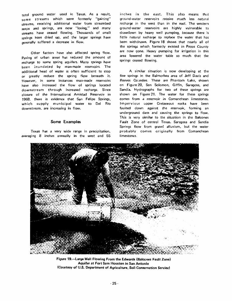
Figure 19.-large Well Flowing From the Edwards (Balcones Fault Zone)Aquifer at Fort Sam Houston in San Antonio
(Courtesy of U.S. Department of Agriculture, Soil Conservation Service)
- 25-

Figure 23.-Barton Springs Supplies aSwimming Pool in Austin
An example of stream underflow might bethat along the east Nueces River near Montell. Herethe river intermiUently sinks into gravel beds andreappears as springs. This spring flow wouldprobably be classed as originating from streamunderflow and there'fore subject to appropriation.
Natural spring waters if taken at their sourceare considered to be ground water and no permit isrequired for their use. Once they issue forth andflow in a watercourse, however, they becomepublic surface waters. As such, a permit fromthe Texas Water Rights Commission is requiredfor their use.
A spring is normally a spillway for anunderground re!.ervoir. This reservoir may beoverlain by land belonging to a number of owners.If the landowners other than the spring ownerchoose to pump ground water heavily, lowering thewater table and causing the spring to cease flowing,the spring owner has no recourse in the courts toprevent them.
San Saba and Dove Creek Springs are locatedin rocky areas where little cultivation is possible.Consequently there has been little irrigationpumping of ground water and the springs have notbee n grea tly affected. Roaring Springs havemaintained their flow fairly well, despite largewithdrawal of ground water for irrigation from theOgallala Sand in the recharge area. Since the springsflow by gravity from the base of the Ogallala, nolarge reduction in flow can be expected until theground water in the Ogallala aquifer is essentiallyexhausted. Some of the water for Roaring Springsmay originate as recharge on the areas of SantaRosa Sandstone outcrops in New Mexico.Ground-water pumping has been much less extensivefrom this formation than from the Ogallala.
Texas Water Law as Relatingto Springs
Texas ground-water law affirms that thesurface landowner owns the underground waterunless it can be shown that the source is asubteranean stream or stream underflow(Yarbrough, 1968). This may be difficult to prove.
- 28-
AnStockton
example is Comanche(Pecos County). These
Springs at Fortartesian springs,
reservoirs is thH primary cause of their decline, itis obvious that if in the vicinity of springs suchpumping continues or is increased, most of thesprings will gradually disappear.
DETAILED INFORMATIONON INDIVIDUAL
SPRINGS
The spring descriptions which follow aregrouped by county. The counties appearalphabetically. The descriptions include: springname; identification number; location; aquifer;historical information, where available; discharge, ifknown; and refHrences to pertinent literature.
Spring locations are shown on Figure 58.Chemical quality of water data are given for manysprings in Table 2.
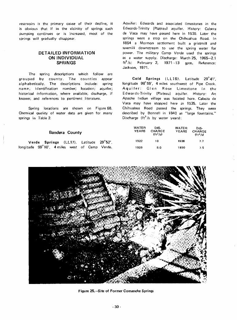
Aquifer: Edwards and associated Iimestones in theEdwards·Trinity (Plateau) aquifer. History: Cabezade Vaca may have passed here in 1535. Later thesprings were a stop on the Chihuahua Road. In1854 a Mormon settlement built a gristmill andsawmill downstream to use the spring water forpower. The military Camp Verde used the springsas a water supply. Discharge: March 25, 1965-2.1ft3 /s; February 2, 1971-13 gpm. Reference:Jackson, 1971.
Cold Springs (LL18). Latitude 29°41',longitude 98°59', 4 miles southwest of Pipe Creek.Aquifer: Glen Rose Limestone In theEdwards·Trinity (Plateau) aquifer. History: AnApache Indian village was located here. Cabeza deVaca may have stopped here in 1535. Later theChihuahua Road passed the springs. They weredescribed by Bonnell in 1840 as "large fountains."Discharge (fe /s by water years):
Bandera County
Verde Springs (LU7). Latitude 29°52',longitude 99°10', 4 miles west of Camp Verde.
WATER DIS·YEARS CHARG E
(ft3/s)
1922 10
1925 5.0
WATER DIS·YEARS CHARGE
(ft3 /s)
1926 7.7
1930 7.5
Figure 25.-Site of Former Comanche Springs
·30 -

WATER DIS- WATER DIS-YEARS CHARGE YEARS CHARGE
(ft3 !s) (ft3/S)
1933 11 1952 0.8
1935 10 1954 0.13
1948 3.5 1955 4.0
1951 2.2
Reference: Bonnell, 1840.
Bastrop County
Burleson Springs (FFll). Numerous springs.Latitude 30°05', longitude 97°21', 3 milessouthwest of Bastrop. Aquifer: Wilcox Formationof the Carrizo-Wilcox aquifer. The springs flowthrough alluvium. History: These springs were usedby the Tonkawa Indians before the Europeansettlers arrived. In 1691 the Spanish explorerDomingo Teran de los Rios is believed to havestopped here. Later the springs were a stop onthe old Camino Real, or King's Highway, fromLouisiana to Mexico. In 1840 they were describedas "fine springs of crystal water bursting from thehills." A water-powered corn mill operated here inthe 1840's. Discharge: March 1953-5 gpm;November 1964-25 gpm. Reference: Bonnell,1840.
Baylor County
Buffalo Springs (L1). About 10 springs.Latitude 33°36', longitude 99°18', 3 miles west ofSeymour. Aquifer: Contact of the Brazos Riveralluvium and Seymour Formation. History:Nomadic Indians who formerly camped here lefthearths, crude grinding tools, and stone axes. Thesprings were frequented by thousands of buffaloand became a buffalo hunting camp in the 1870's.Discharge: June 22, 1969-25 gpm. References: Britton,1955 and Malone and Briggs, 1970.
issue through a fault. History: They were knownas medicinal springs in the 1800's, and were latera stop on the Chisholm Cattle Trail. Discharge:1968-0. Reference: Atkinson, 1970.
Salado Springs (F F 1). Many springs, including,from upstream to downstream, Robertson, BigBoiling, Elm, and Anderson Springs. Latitude30° 5 7', longitude 97°32', at Salado. Aquifer:Edwards and associated limestones of the Edwards(Balcones Fault Zone) aquifer. The springs issuethrough faults. History: The Tehuacana Indiansformerly lived here, leaving many flint implements,beads, pottery sherds, and metal ornaments. BigBoiling Spring (Figure 26) was formerly a fountain5feet high. After settlement in 1851 the springswere a well-known stage stand. From 1851 to1868 there were 11 flour, grist, saw, cotton gin,and wool-carding mills using the spring water forpower, olle of which, the Davis Mill, iscommemorated by a historical marker. From 1863to 1878 one of the mill dams flooded thesprings. The dam was finally lowered by courtorder. There were several swimming holes here.Sulphur Springs, 3 miles downstream, were usedmedicinally. Discharge (ft3/s by water years):
WATER DIS- WATER DIS-YEARS CHARGE YEARS CHARGE
(ft3/s) (ft3!s)
1902 13 1960 24
1903 13 1961 37
1934 7.6 1962 25
1948 10.6 1963 14
1950 6.3 1964 11
1951 5.5 1965 29
1952 7.6 1966 33
1954 6.8 1967 14
1955 5.5 1968 25
1956 4.6 1969 28
1957 8.0 1970 23
1958 24 1971 11
1959 13 1972 12
Bell County
Leon Springs (Y6). Near latitudelongitude 97°27', 2 miles northeast ofAquifer: Edwards and associated limestonesEdwards (Balcones Fault Zone) aquifer. The
31°04',Belton.of thesprings
- 31 -
Maximum known discharge was 55 ft3/S•
References: Paddock, 1911; Atkinson, 1970; andTexas Historical Survey Committee, 1971.

Figure 26.-Big Boiling Spring, One of the Salado Springs
Childers Springs (F F17). Several springs. Latitude31 °00', longitude 97°29', 5 miles northeast of Salado.Aquifer: Edwards and associated Iimestones of theEdwards (Balcones Fault Zone) aquifer. The springs issuethrough a fault. History: Childers grist mill (also calledShanklin's mil! later) used the spring water for powerfrom 1847 to 1920. The mill race was later used forirrigation water. A historical marker is located here.Discharge: 1968-0. References: Atkinson, 1970 andTexas Historical Survey Committee, 1971.
Fort Little River Springs (FF18). Latitude31 °00', longitude 97°23', 2 miles west of Little River.Aquifer: Edwards and associated limestones of theEdwards (Balcones Fault Zone) aquifer. The springsissue through a fault in the Austin Chalk. History: In1836-37 these springs furnished water for Fort LittleRiver. Discharge: 1965-0. Referellce: Tyler, 1966.
Bexar County
Selma Spring (LL30). Latitude 29°34', longitude98°18', 1 mile south of Selma. Aquifer: Edwards andassociated limestones of the Edwards (Balcones FaultZone) aquifer. The spring issues through faults in theAustin Chalk. History: Bonnell in 1840 described thisspring as "a white sulphur spring, the most beautiful in
- 32·
the world, with a large basin 20 feet in diameter." It wasa stage stop on EI Camino Real. Discharge: March 5,1963-0; March 4, 1968-0.15 ft3 /s. Reference:Bonnell,1840.
Salado Creek Springs (LL31). Several springs.Latitude 29°30', longitude 98°26', 7 miles northeast ofSan Antonio. Aquifer: Edwards and associatedlimestones of the Edwards (Balcones Fault Zone)aquifer. Artesian water issues from a fault in theAnacacho Limestone. History: EI Camino Real passedthese springs. DischaqJe (ft3 /s by water years):
WATER DIS- WATER DlS-YEARS CHAFIGE YEARS CHARGE
(ft3 ls1 (ft3 /s1
1919 3.0 1948 a
1933 1.Ei 1951 a
1934 O.B 1952 a
1935 2.2 1970 1.2
San Antonio Springs (LL32). Many springs.Latitude 29°28', lon!litude 98°29', on the. San AntonioRiver just above East Hildebrand Street in San Antonio.Aquifer: Edwards and associated limestones of theEdwards (Balcones Fault Zone) aquifer. Artesian springsissue from a fau It in the Austin Chalk. History: These

springs were the site of an ancient Payayan Indiansettlement. Cabeza de Vaca possibly visited themin 1!)35. EI Camino Real passed them. Early Spanishmissions used the water for irrigation. Bonnell (1840)estimated that about 100 springs formed the SanAntonio River at that time. The San Jose Mission builtthe first corn grinding mill, the "Molino Blanco," in1730 to utilize the water power of the springs. Manyother mills used the site at later dates. They weretemporarily abandoned in 1896 because of low springflow, but in 1904 four hydroelectric powerplants wereusing the spring water. Discharge (fe /s by water years):
1933 54
Maximum recorded discharge was 212 ft3 /s in1920. As I!arly as 1898, Hill and Vaughn recognized thatthe spring flow had been reduced by well pumping. Theystated, "when the wells are allowed to flow the springsdiminish in volume, and the San Antonio River is greatlylowered." The springs have now essentially ceasedflowing much of the time. Water is pumped to the springsites from several wells to maintain the recreational valueof Brackenridge Park, in which the springs were located.References:: Bonnell, 1840; Taylor, 1904; Hill andVaughn, 1898; and Jackson, 1971.
1895 9 1922 9.3
1896 12 1923 7.5
1897 9 1924 13
1898 9 1925 7.6
1899 9 1926 9.5
1900 9 1927 7.2
1904 9 1928 5.6
1916 6.2 1929 4.9
1917 6.5 1930 4.1
1918 3.7 1932 7.6
1919 9.1 1933 6.8
1920 14 1934 5.6
1921 9.7 1935 20
WATER DIS-YEARS CHARGE
(ft3 /s1
WATER DIS·YEARS CHARGE
(ft3/s)
San Pedro Springs (LL33). Several springs.Latitude 29°27', longitude 98°30', in San Pedro Park,San Antonio. Aquifer: Edwards and associatedlimestones of the Edwards (Balcones Fault Zone)aquifer. Artesian springs issue through a fault in theAustin Chalk. History: These springs and their associatedlakes were originally a focal point for severalCoahuiltecan Indian bands known as Payayas.Excavations made in 1878 unearthed numerous potterysherds, spearheads, knives, and tomahawks. The springswere called Yanaguana Springs by the Payayas.Cabeza de Vaca may have visited them in 1535. In 1718the San Antonio de Valero mission (the Alamo) wasfounded nearby, and the spring water used for irrigationof corn, chilies, and beans. Numerous old roads radiatedfrom th is point. The springs were the site of an Armycamp during the Mexican War, 1846-48, and the CivilWar. The park in which the springs were located is oneof Texas' oldest recreational areas. City water is nowpiped to the !.wimming pool formerly fed by the springs.A historical marker is located here. Discharge (fe /s bywater years):
o
40
35
12
7
36
29
63
38
40
2
o5
2
75
75
67
6.2
2
o
oo
87
120
98
83
DiSCHARGE
(ft3 /s)
36
82
WATERYEARS
1934
1935
1936
1937
1938
1939
1940
1941
1942
1943
1944
1945
1946
1947
1948
1949·50
1951
1952-57
1958
1959
1960
1961
1962
1963
1970
1971
1972
1973
94
59
52
97
64
140
45
54
29
18
19
76
44
18
13
120
90
50
20
100
200
90
79
DISCHARGE
(ft3 /s)
42
29
9
7
8
1895
1896
1897
1898
1899
1900
1901
1904
1905
1906
1910
1911
1915
1916
1917
1918
1919
1920
1921
1922
1923
lfl24
925
1926
1927
1928
1929
1932
WATERYEARS
·33 -

WATER DIS- WATER DIS-YEARS CHARGE YEARS CHARGE
(ft3 tsl (ft3 tS)
1936 30 1951 0.1
1937 24 1952-57 0
1938 21 1958 7.3
1939 2 1959 8.8
1940 1960 9.3
1941 18 1961 8.6
1942 18 1962 3.5
1943 9 1963 0
1944 7 1965 1.8
1945 15 1966 2.7
1946 10 1970 0.1
1947 10 1971 0
1948-50 0 1972 3.1
The springs have now essentially ceased flowingbecause of heavy municipal and industrial pumping.References: Newcomb, 1961; Texas Historical SurveyCommittee, 1971; Sturm berg, 1920; and Paddock, 1911.
Martinez Springs (LL34). Latitude 29°27',longitude 98°10', 3 miles northeast of Saint Hedwig.Aquifer: Wilcox Sand of the Carrizo-Wilcox aquifer. Thesprings appear as base flow in the gravel streambed.Discharge: March 5, 1963-1.6ft3 /s.
Mitchell lake Springs (LL35). Latitude 29° 16'longitude 98°29', at Mitchell Lake Dam. Aquifer;Wilcox Sand of the Carrizo-Wilcox aquifer. Discharge:May 28, 1925-3.5 fe Is. The springs represent seepagefrom the reservoir.
Blanco County
Rocky Creek Spring (E E40). Latitude 30° 15',longitude 98°32', 3 miles east of Hye. Aquifer:Ellenburger Limestone of the Ellenburger-San Sabaaquifer. Discharge: May 17, 1962-1.5 ft3/S.
Koch Springs (E E41). Latitude 30°06', longitude98°25', 1 mile south of Blanco in Blanco State Park.Aquifer: Glen Rose Limestone of the Edwards-Trinity(Plateau) aquifer. History: An old Comanche Indian trialpassed these springs. Discharge: June 22, 1938-30 gpm;August 20, 1941·-15 gpm; September 8, 1952-270gpm; March 7, 1962-430 gpm.
Buffalo Spring (EE44). Source of Buffalo Creek.Latitude 30°20', longitude 98°26', 5 miles northwest of
- 34-
---,._----
Johnson City. Aquifer: Morgan Creek and Cap MountainLimestones. Discharge: July 22, 1941-1.1 cfs; flowingin 1973.
Crofts Spring (EE45). Latitude 30° 19', longitude98°23', 4 miles northeast of Johnson City. Aquifer:Ellenburger-San Saba limestones. Discharge: Reportedto have failed in 1908; August 4, 1938-0.13 ft 3 /s;May 28, 1968-3.7 ft3 Is.
Hobbs Spring (IEE46). Latitude 30° 18', longitude98°25', 2 miles north of Johnson City. Aquifer:Ellenburger-San Saba Limestones. Discharge: May 27,1969-1.0 ft 3 /s.
Bosque County
EI Flechazo or love at First Sight Springs (Yl).Latitude about 31°43', longitude about 97°20', about9 miles northeast of Valley Mills. Aquifer: Edwards andassociated limestones of the Edwards (Balcones FaultZone) aquifer. History: "Eleven abundant springs" wereused by the Tehuacana Indians, who had a village here.From 1867 to 1895 th,e Chisholm Cattle Trail passed thesprings. Reference: Molrfi, 1935.
Pierson Spring (Y5). Latitude 31°47', longitude97°46', forming Gary Creek. Aquifer: Edwards andassociated limestones of the Edwards-Trinity (Plateau)aquifer. History: Settled by Old Pierson of Norwayin 1854. Discharge: In 1854 a 2-inch-diameter pipecould not carry the flow (about 0.15 ft 3 /s). Reference:Pool, 1964.
Bowie County
DeKalb Spring (N2). Latitude 33°30', longitude94°37', in DeKalb. ,.o,quifer: Terrace Alluvium. Thespring flows from a sand on top of a clay layer.Discharge: Flowing in 1911. Reference: Gordon, 1911.
Dalby Springs (N:3). About four springs. Latitude33°22', longitude 94°41', in Dalby Springs. Aquifer:Wilcox Sand of the Carrizo-Wilcox aquifer. History:Indians used these springs as far back as 30,000 yearsago, as evidenced by projectile points, axes, scrapers, andpottery found here. In 1911 the springs were well knownfor their medicinal value. Discharge: 1892-27 gpm.References: Gordon, 1911; Peale, 1894; and TexasHistorical Survey Committee and Texas WaterDevelopment Board, 1970.
Boston ChalybeatE! Spring (N4). Latitude 33°24',longitude 94°28', at Old Boston. Aquifer: Wilcox Sand

of the Carrizo-Wilcox aquifer. History: From 1813 thespring was on Trammell's Trace, an underground slaveroute. In 1892 it was known as a mineral spring.
Reference: Gordon, 1911.
Brewster County
Burgess, Kokernot, or San Lorenzo Spring (CC9).Latitude 30°22', longitude 103°39', in northeast Alpine.Aquifer: Alluvium. History: The spring was possiblyvisited by the early Spanish explorer Cabeza de Vacain 1535. It was certainly used by Juan de Mendoza in1684. It was on the Chihuahua Road from Chihuahua,Mexico to Indianola, Texas' chief port, in 1845. Ahistorical marker is located here. Discharge: October 31,1929-0.5 ft3/S; 1957-none reported; April 28, 1971-0ft3/S. The spring is reported to have ceased flowingabout 1940. References: Texas Historical SurveyCommittee, 1971; and Williams, 1969.
Pena Colorada or Colored Rock Spring (CC10).Latitude 30° 10', longitude 103° 17', 4 miles southwestof Marathon. Aquifer: Marathon Limestone. History:This spring was a rest stop on the Old Comanche IndianTrail from New Mexico. Fort Pena Colorada used thespring water around 1880. A historical marker is locatedhere. Discharge: 1957-0.3 to 1.0 fe Is. Reference:Texas Historical Survey Committee, 1971.
Chilicotal Spring (JJ1). Latitude 29° 15', longitude103° 08', 8 miles southeast of Panther Junction, BigBend National Park. Aquifer: Alluvial sand and gravel.History: This was one of the Comanche Indiancampgrounds on their trail from New Mexico to Mexico.References: Maxwell, 1968, and William, 1969.
Glenn Springs (JJ2). Latitude 29° 11', longitude103°09', 13 miles west of Boquillas Ranger Station, BigBend National Park. Aquifer: Aguja Sandstone. History:This spring was the site of an Indian campground on theComanche Trail from Mexico to New Mexico. Manyspear and arrow points, grinding stones, and bedrockmortars have been found here. The spring was named fora Mr. Glenn who settled here in the 1870's andestabl ished a store. The settlement was raided by banditsfrom Mexico in 1916. Reference: Maxwell, 1968.
Boquillas Warm Springs (JJ3). Five artesian springson the left bank of the Rio Grande. Latitude 29°11',longitude 102°58', near Boquillas Ranger Station, BigBend National Park. Aquifer: Probably Edwards andassociated limestones, through a fault in the Boquillaslimestore. The springs range in temperature from 95 to105 degrees Fahrenheit, indicating that some of themoriginate about 2,000 feet below the su rface. History:
- 35-
Used by the Mescalero Apache Indians. The springs werelater on the Comanche Indian Trail to Mexico. Bedrockmortars ground by these people can still be seen at thesprings. In recent times (1909), a store and bath housefor medicinal bathing were built, as shown in Figure 4. Ahistorical marker is located here. Discharge (fe /s bywater years):
WATER DIS- WATER DIS-YEARS CHARGE YEARS CHARGE
(ft3/s) (ft3/sl
1936 0.82 1965 0.61
1953 1.6 1966 0.78
1964 0.61 1971 0.32
The spring formerly used for medicinal bathing isnow almost dry, but some of the others still flow.Reference: Williams, 1969.
Briscoe County
Hylsey Springs (H 1). Many springs. Latitude34°44', longitude 101°23', 9 miles northeast of VigoPark, in Palo Duro Canyon. Aquifer: Santa RosaSandstone. History: The springs were possibly visited byCoronado in 1541. Discharge: September 9, 1946-2.1ft3/s; June 23, 1971-0.22 ft3/s. Heavy pumping forirrigation to the west may have caused the reduction inflow.
Burleson County
Sour or Spring Lake Springs (FF14). Numerousopenings. Laflitude 30°33', longitude 96°45', 5 milesnorthwest of Caldwell. Aquifer: Sparta Sand. History:These springs were a stop on the old Spanish "CaminoReal" from Louisiana to Mexico. In 1892 they were wellknown as mineral springs. In 1936 they supplied waterfor a swimming pool. Discharge: 1892-0.4 ft3/S;
1936-0.4 fe Is. The flow varies considerably withprecipitation. Reference: Peale, 1894.
Burnet County
Holland, Felps, and Horseshoe Springs (EE38).Several springs forming Hamilton Creek and MormonMill Falls. Latitude 30°42', longitude 98°14', 3 milessouth of Burnet. Aquifer: Basal Hensell Sand of theTrinity Group aquifer. History: The springs were afavorite Indian watering place long before white menappeared. A Texas Ranger station was situated here from1847 to 1849. In 1849 it was replaced by Fort Croghan,3 miles north. From 1851 to 1853 a Mormon colonymaintained a grist mill and shop for furniture making at
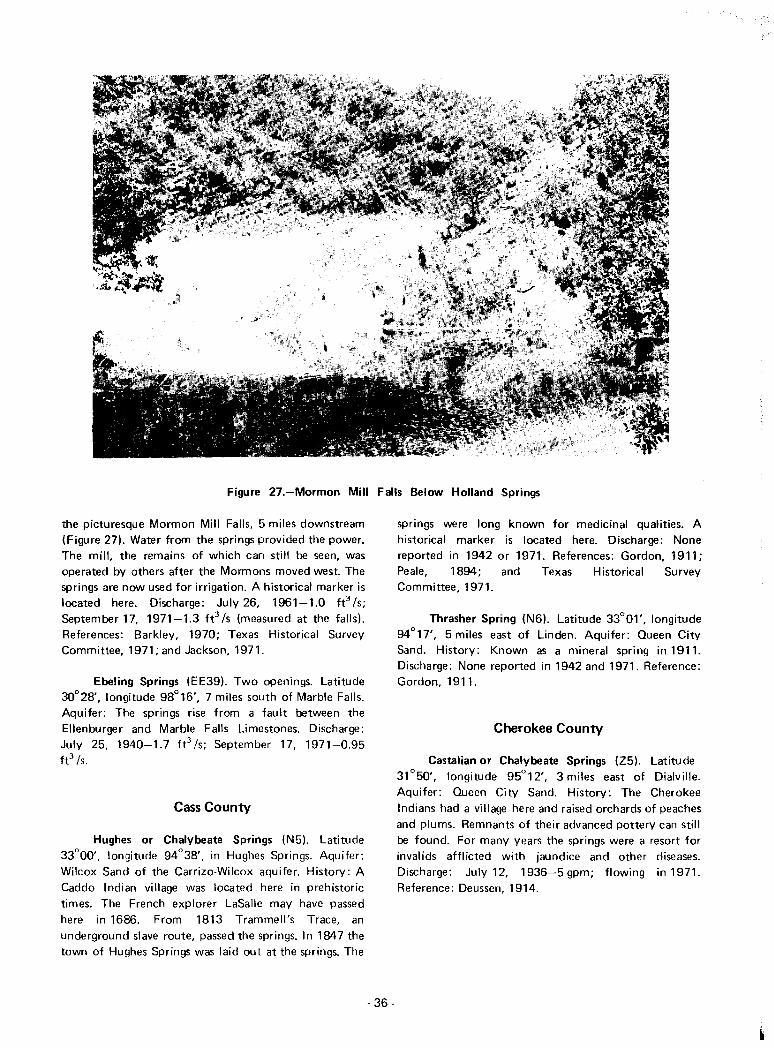
Figure 27.-Mormon Mill Falls Below Holland Springs
the picturesque Mormon Mill Falls, 5 miles downstream(Figure 27). Water from the springs provided the power.The mill, the remains of which can still be seen, wasoperated by others after the Mormons moved west. Thesprings are now used for irrigation. A historical marker islocated here. Discharge: July 26, 1961-1.0 ft3/S;September 17, 1971-1.3 fe /s (measured at the falls).References: Barkley, 1970; Texas Historical SurveyCommittee, 1971; and Jackson, 1971.
Ebeling Springs (EE39). Two openings. Latitude30°28', longitude 98°16', 7 miles south of Marble Falls.Aquifer: The springs rise from a fault between theEllenburger and Marble Falls Limestones. Discharge:July 25, 1940-1.7 ft3 /s; September 17, 1971-0.95ft3/S.
Cass County
Hughes or Chalybeate Springs (N5). Latitude33°00', longitude 94°38', in Hughes Springs. Aquifer:Wilcox Sand of the Carrizo-Wilcox aquifer. History: ACaddo Indian village was located here in prehistorictimes. The French explorer LaSalle may have passedhere in 1686. From 1813 Trammell's Trace, anunderground slave route, passed the springs. In 1847 thetown of Hughes Springs was laid out at the springs. The
- 36-
springs were long known for medicinal qualities. Ahistorical marker is located here. Discharge: Nonereported in 1942 or 1971. References: Gordon, 1911;Peale, 1894; and Texas Historical SurveyCommittee, 1971.
Thrasher Spring (N6). Latitude 33°01', longitude94°17', 5 miles east of Linden. Aquifer: Queen CitySand. History: Known as a mineral spring in 1911.Discharge: None reported in 1942 and 1971. Reference:Gordon, 1911.
Cherokee County
Castalian or Chalybeate Springs (Z5). Latitude31°50', longitude 95°12', 3 miles east of Dialville.Aquifer: Queen City Sand. History: The CherokeeIndians had a villa~le here and raised orchards of peachesand plums. Remnants of their advanced pottery can stillbe found. For many years the springs were a resort forinvalids afflicted with jaundice and other diseases.Discharge: July 12, 1936-5 gpm; flowing in 1971.Reference: Deussen, 1914.
Clay County
Buffalo Springs (L2). Latitude 33°33', longitude98°08', at Buffalo Springs. Aquifer: Cisco Grouplimestones and sandstones. History: Moscoso may havestopped here in his 1542 expedition. The springs were awatering place for buffalo hunters as early as 1849. In1857 the U.S. Cavalry camped here, finding "plenty ofwater in holes and fine grazing." An Army post wasestablished here in 1867 but was soon abandonedbecause of a lack of water. The springs were also on theCalifornia Trail. Reference: Henderson, 1958.
Collingsworth County
Elm Creek Springs (E6). The springs form ElmCreek base flow. Latitude 35°07', longitude 100°17',8 miles southeast of Shamrock. Aquifer: BlaineFormation (siltstone and gypsum). dipping northwest.The springs rise through alluvial sands. History: Indianartifacts have been found at the springs. Discharge (ft3 Isby water years):
O'Hair Springs (H4). Several springs. Latitude34°52', longitude 100°24', 3 miles south of Quail.Aquifer: Whitehorse Sandstone, dipping northwest.Discharge: October 20, 1938-0.02 ft3 Is; January 24,1967-1.3 ft:l/s; June 24,1971-0.12 fe/s. The flow isabsorbed from the channel within one mile duringsummer.
Roscoe Springs (H5). Latitude 34°51', longitude100°21', 8 miles west of Wellington. Aquifer:Whitehorse Sandstone, dipping northwest, and alluvium.History: A swamp that formerly existed here has beenchannelized and drained. Discharge: October 1, 1938-3gpm; March 26, 1968-1.7 ft 3 /s; June 24, 1971-0.10ft3 Is. Wells pump water from alluvium nearby forirrigation. The spring flow is absorbed by the alluviumone mile downstream.
Sand Creek Springs (H6). Several springs, formingSand Creek. Latitude 34°51', longitude 100°04', 8 mileseast of Wellington. Aquifer: Whitehorse Sandstone, withmuch gypsum, dipping southeast (Figure 12). Discharge:October 5, 19:~8-trace; January 12, 1967-1.4 ft3 Is;June 24,1971-0.08 ft3 Is.
Comal County
Spring Branch Springs (LL21). Two springs.Latitude 29°55', longitude 98°27', 3 miles northwest ofSpring Branch. The springs supply water to the SpringBranch community and school. Aquifer: Glen Rose andCow Creek Limestones of the Edwards-Trinity (Plateau)aquifer. Discharge (ft3 Is):
DISCHARGE
(ft3 /s1
DISCHARGE
(ft3/s1
0.5
1.0
1.4
111945
1951
1962
1955
DATE
March
March
October
January
3.5
1.5
0.9
1.0
DATE
February 1930
February 1929
August 1924
January 1928
WATER 015- WATER 015-YEARS CHARGE YEARS CHARGE
(ft3 /s) (ft3 /s1
1947 2.3 1960 1.9
1948 2.3 1961 2.7
'1949 2.8 1962 3.1
1950 2.4 1963 3.1
1951 2.7 1964 2.3
1952 1.9 1965 2.1
1953 1.6 1966 2.1
1954 1.4 1967 2.1
1955 1.7 1968 2.2
1956 1.2 1969 1.8
1957 1.6 1970 2.2
1958 1.4 1971 0.91
1959 1.4 1972 2.2
November 1936 1.8 August 1970 5.5
Wolf Creek Springs (E7). Numerous springs,forming Wolf Creek. Latitude 35°03', longitude100°08', 5 miles northeast of Lutie. Aquifer: BlaineFormation (siltstone and gypsum), a dipping northwest.History: The springs have been used for irrigation.Discharge: September 9, 1938-1.0 ft3 Is; May 1,1967-1.7 fe Is; June 24,1971-2.5 ft3 Is.
Honey Creek Spring (LL22). Latitude 29°50',longitude 98°30', 3 miles north of Honey Creek.Aquifer: Glen Rose Limestone of the Edwards-Trinity(Plateau) aquifer. The spring issues from a cavern.Discharge: .July 20, 1944-2.8 ft3 Is; August 18,1970-0.8 ft3/S.
Wischkaemper Springs (H3). Three springs.Latitude 34°59', longitude 100°21',6 miles northeast ofQuail. Aquifer: Alluvium. Discharge: May 18, 1967-1.7ft3 Is; June 24, 1971-0.25 ft3 Is.
Rebecca Springs (LL23). Latitude 29°56',longitude 98°22', 4 miles northeast of Spring Branch.
- 37-

The Springs supply water to Cypress Lake. Aquifer:Travis Peak Formation of the Edwards-Trinity (Plateau)aquifer. The springs issue from cavities in the Cow CreekLimestone. Discharge: October 1925-0.4 ft3 /s; October1943-3.9 ft 3 /s; August 1970-1.1 ft3 /s.
Wolle Springs (LL24). Five springs. Latitude29°54', longitude 98°19', 5 miles northeast of Wesson.Aquifer: Glen Rose Limestone of the Edwards-Trinity(Plateau) aquifer. Water was muddy during upriver rises,leading to the belief that the springs were fed by theGuadalupe River upstream. History: Inundated byCanyon Reservoir in 1964. Discharge: 1944-15 ft 3 /s;January 26, 1955-22 ft3 /s.
Crane's Mill Springs (LL25). Two springs. Latitude29°54', longitude 98°15', 6 miles west of Sattler.Aquifer: Lower Glen Rose Limestone of theEdwards-Trinity (Plateau) aquifer. The springs flow fromcrevices along the Tom Creek Fault. History: Inundatedby Canyon Reservoir in 1964. Discharge: September 18,1944-14 ft3 /s; January 27, 1955-8.1 ft3 /s; March 7,
1962-9.1 fe Is.
Bear Springs (LL26). Latitude 29°48', longitude98°13', 5 miles northeast of Valley View. Aquifer: GlenRose Limestone of the Edwards-Trinity (Plateau)aquifer. The springs issue through the Bear Creek Fault.Discharge: November 5, 1936-2 gpm; September 29,1943-0.4 ft 3 /s; March 28, 1945-5 ft 3 /s; September 29,1945-0.4 ft 3 Is.
Hueco Springs (LL28). Two springs. Latitude29°46', longitude 98°08', 4 miles north of NewBraunfels. Aquifer: Edwards and associated limestonesof the Edwards (Balcones Fault Zone) aquifer. Artesiansprings rise from two openings in gravel. History: Thewater was long used to run a mill. In 1950 a small waterpower plant was still in operation, but has now beenabandoned (Figure 3). Discharge (ft3 /s by water years):
WATER DIS· WATER DIS·YEARS CHAFlGE YEARS CHARGE
(ft3 /s) (it.1 Is)
1958 81 1966 72
1959 63 1967 23
1960 50 1968 82
1961 52 1969 50
1962 13 1970 48
1963 21 1971 20
1964 17 1972 72
1965 50
Maximum recorded discharge was 131 ft3 /s in1968. Temperatu re, tu rbidity, and discharge all fluctuatewith rainfall, indicating that the recharge area is smalland nearby.
Comal Springs (LL29). About six springs, formingthe Comal River. Latitude 29°42', longitude 98°08', inLanda Park, New Braunfels. Aquifer: Edwards andassociated limestones of the Edwards (Balcones FaultZone) aquifer. The springs issue through the ComalSprings Fault. The spring temperature of 74° F indicatesthat the artesian water circu late at least 500 feet belowthe surface. The water is never turbid and is believed tocome from a large recharge area (Figure 28). History:The Tehuacana Indians formerly lived here, as evidencedby the many artifacts left in the vicinity. In 1764 theFrench explorer St. Denis visited the springs. They werelater a stop on EI Camino Real. In 1845 a group ofGerman immigrants under Prince Carl Solms-Braunfelssettled here, calling the springs "Las Fontanas." Theypurchased the 1,300 acres surrounding the springsfor $1,111. Many mills and powerplants have used thewater power of the springs. In the 1870's New Braunfelsinstalled a water system, so that it was no longernecessary to carry the water from the springs. Discharge(ft3 /s by water years):
WATER DIS- WATER DIS- WATER DIS- WATER DIS-
YEARS CHARGE YEARS CHARGE YEARS CHARGE YEARS CHARGE
(1t3 /5) (1t3 /5) (ft3 /5) (ft3 /5)
1924 37 1949 46 1882 375 1904 375
1928 0 1950 27 1896 328 1905 390
1929 0 1951 0.5 1897 390 1906 386
1937 1.5 1952 10 1898 305 1910 299
1944 60 1953 43 1899 310 1911 267
1945 58 1954 2.5 1900 360 1915 407
1946 54 1955 0 1901 360 1921 320
1947 57 1956 0 1902 325 1924 370
1948 7.0 1957 43 1903 412 1925 320
- 38-
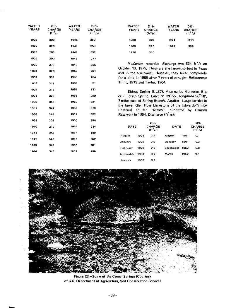
-
WATER 015- WATER 015- WATER 015- WATER 015-YEARS CHARGE YEARS CHARGE YEARS CHARGE YEARS CHARGE
(ft3/s1 (tt3 /s1 (ft3/s1 (ft3 /s1
1926 300 1945 360 1968 326 1971 313
1927 320 1946 359 1969 295 1972 358
1928 288 1947 352 1970 310
1929 290 1948 277
1930 273 1949 286 Maximum recorded discharge was 534 fe /s on
1950 261October 16, 1973. These are the largest springs in Texas
1931 320and in the southwest However, they failed completely
1932 321 1955 104 for a time in 1956 after 7 years of drought. References:
1933 311 1956 51 Tiling, 1913 and Taylor, 1904.
1934 315 1957 137Bishop Spring (LL37). Also called Gumtree, Big,
1935 326 1958 299 or Flugrath Spring. Latitude 29°55', longitude 98° 18',
1936 359 1959 321 7 miles east of Spring Branch. Aquifer: Large cavities inthe lower Glen Rose Limestone of the Edwards-Trinity
1937 347 1960 318(Plateau) aquifer. History: Inundated by Canyon
7938 343 1961 352 Reservoir in H164. Discharge (ft3 /s):
1939 301 1962 290015- 015-
1940 279 1963 224 DATE CHARGE DATE CHARGE(ft3 /s1 (ft3/s)
1941 343 1964 189August 1924 7.4 August 1951 0.1
1942 349 1965 262January 19:28 3.9 October 1951 0.3
1943 341 1966 281February 19:29 2.9 September 1952 0.8
1944 346 1967 189November 19:16 3.2 March 1962 9.1
January 19:;18 3.9
Figure 28.-Some of the Comal Springs (Courtesyof U.S. Department of Agriculture, Soil Conservation Service)
- 39-

Crockett County
live Oak Spring (DD2). Forms Live Oak Creek.Latitude 30"45', longitude 101°41', 10 miles northeastof Sheffield. Aquifer: Edwards and associated limestonesof the Edwards-Trinity (plateau) aquifer. History:Mendoza probably stopped here in 1683. The springfurnished water for Fort Lancaster in the 1880's.Discharge: July 4, 1917-5.0 ft 3 /s;January 1962-"flows"; February 6, 1968-0.
Cedar Springs (DD4). Several springs. Latitude30°30', longitude 101°41', 15miles southeast ofSheffield. Aquifer: Edwards and associated limestones ofthe Edwards-Trinity (Plateau) aquifer. History: Thesprings were settled in 1882 by W. P. Hoover. They havebeen used for irrigation. Discharge: March 6,1963-"flows"; February 6, 1968-18 fels (includingseveral other nearby springs).
Crosby County
Couch Springs (K2). Latitude 33°39', longitude101°07', 8 miles east of Crosbyton. Aquifer: OgallalaFormation. History: In .1874 General Mackenzie stoppedhere while pursuing Indians. Discharge: November 7,1938-1.9 ft3 Is. Reference: Spikes and Ellis, 1952.
Culberson County
Bone Springs (U3). Latitude 31 °53', longitude104° 53', 5 miles west of Pine Springs. Aquifer: Brushy.Canyon Formation. The springs issue at the contact withthe underlying Bone Spring Limestone. History: Thesprings were the basis for a Comanche Indiancampground. References: King, 1948 andWilliams, 1969.
Pine and Smith Springs (U4). Latitude 31°54',longitude 104°49', at Pine Springs. Aquifer: CherryCanyon Formation. The springs issue through faults.History: The springs were the basis for a stage stand onthe Butterfield Overland Mail route in 1857. A historicalmarker is located here. Discharge: 1971-68 gpm.References: King, 1948; Williams, 1969; and TexasHistorical Survey Committee, 1971.
Independence Spring (U5). Latitude 31°54',longitude 104°43', 6 miles east of Pine Springs. Aquifer:Delaware Mountain Group sandstones. The spring issuesthrough a fault and gravel alluvium. History: This springwas a Comanche Indian campground. In 1857 a stagestand on the Butterfield Overland Mail route was
- 40-
established here. Discharge. 1971-14 gpm. References:King, 1948 and Williams, 1969.
Delaware Springs (U6). Latitude 31°51', longitude104°33', 15 miles east of Pine Springs. Aquifer: BellCanyon Formation. History: The springs were used bythe U.S. Cavalry in the early 1800's. In 1857 they werethe basis for establishing a stage stop on the ButterfieldOverland Mail route. References: King, 1948, andWilliams, 1969.
Rattlesnake Spring (U8). Near latitude 31 °21 "longitude 104°51', 22 miles north of Van Horn.Aquifer: Hueco Limestone. The spring issues through afault. History: In 1880 there was a battle between U.S.Cavalry troops and Apache Indians when Apache ChiefVictorio and his band tried to get water at this spring.Reference: Utley, 1960.
Dallam County
Buffalo Springs (A 1). Several sl3rings. Latitude36°29', longitude 102°47', 16 miles northeast ofTexline. Aquifer: Purgatoire Formation, dipping east atabout 20 feet per mile. History: Originally a wateringplace for buffalo herds, and later wild mustangs. It wasan Indian settlement, as evidenced by numerous arrowand spear heads found nearby. Coronado may havedrunk from these springs in 1542. In 1878 cattleranching began, and in 1888 the XIT Ranch first divisionheadquarters was established here. The stage line fromSanta Fe to Kansas City stopped here. Presently thesprings feed several large pools surrounded bycottonwood trees. A historical marker is located here.Discharge: August 7, 1924-1.2 ft3 Is; February 23,1937-0.9 ft3 Is; July 26, 1957-1.2 fe Is; June 22,1971-0.58 ft3 Is. In recent years municipal andirrigation pumping to the west have reduced thedischarge. References: Haley, 1929; and Texas HistoricalSurvey Committee, 197'1.
Dallas County
Browder Springs {R7). Latitude 32°46', longitude96°47', in City Park in Dallas. Aquifer: Austin Chalkand terrace alluvium. Hiistory: These springs were Dallas'principal source of water before wells were drilled. Ahistorical marker is located here. Discharge: During thedrought of 1909-1910, the springs supplied 1.6 ft3/S ofwater to Dallas. No flow was reported in 1943.Reference: Texas Historiical Survey Committee, 1971.

Figure 29.-Fish Pond and Pump House at Bitter Creek Springs
Dimmit County
Carrizo Springs (QQ1). Several springs. Latitude28°30', longitude 99°52', 3 miles southwest of CarrizoSprings. Aquifer: Carrizo Sand of the Carrizo-Wilcoxaquifer. History: The Spanish explorer Ponce de Leon isbelieved to have stopped here in 1689. After 1697 thesprings were a stop on EI Camino Real. In 1865 fourhundred immigrants under Captain Levi English settledhere. Discharge: 1892-0.26 ft3 /s. The springs ceasedflowing in 1929 because of heavy well pumping anddecline of ground-water levels in the area. Reference:Peale, 1894.
Donley County
Bitter Creek Springs (H2l. Three springs. Latitude34°49', longitude 100°47',7 miles south of Lelia Lake.Aquifer: Ogallala Formation. The main spring emerges inthe bottom of a fish pond and swimming pool(Figure 29). History: Early explorers described this areaas "black with buffalo." The springs are surrounded by alarge grove of cottonwoods. Discharge: March 5,1968-1. 7 ft3/s; June 23, 1971-0.08 ft3/s. Reference:Haley, 1929.
- 41 -
Eastland County
Shinoak Springs (Ql). Latitude 32° 12', longitude98° 42', 2 miles southwest of Gorman. Aquifer: BasalTrinity Group Sands. History: The town of Old ShinoakSprings was laid out around these springs. Water washauled from thElm for home and livestock use. The townwas doomed when the railroad bypassed it in 1880. Alake was built in 1911 to catch the spring flow. Ahistorical marker is located here. Discharge: No flow wasrecorded in 1937. Reference: Texas Historical SurveyCommittee, 1971.
Edwards County
Hackberry Springs (DD 17). Many springs. Latitude30°01', longitude 100°03',8 miles east of Rocksprings.Aquifer: Edwards and associated Iimestones of theEdwards-Trinity (Plateau) aquifer. Discharge: 1939-2.5ft3Is; October 7, 1954-5.5 ft3/S.
Big Paint Springs (EE8). Latitude 30° 16',longitude 99°53', 4 miles south of Telegraph. Aquifer:Edwards and associated limestones of theEdwards-Trinity (Plateau) aquifer. History: The waterhas been used for irrigation. The springs supplied four

fish ponds in 1938. Discharge; April 22, 1939-22 ft3 Is;September 14, 1955-18 ft3 /s; March 26, 1962-31ft:J Is.
Seven Hundred Springs (EE9). Many springs.Latitude 30°16', longitude 99°55', 4 miles south ofTelegraph. Aquifer: Edwards and associated limestonesof the Edwards-Trinity (Plateau) aquifer. History:Mendoza probably stopped here in 1683. The springshave been used for irrigation. Discharge (ft3 Is by wateryears);
WATER 015- WATER DIS-YEARS CHARGE YEARS CHARGE
(ft3 Is) (ft3 lsI
1939 14 1965 16
1952 11 1966 15
1956 11 1967 17
1959 28 1968 15
1961 25 1969 15
1962 22 1970 20
1963 16 1971 18
1964 16 1972 21
Tanner Springs (EE10). Latitude 30°15', longitude99°56', 5 miles south of Telegraph. Aquifer: Edwardsand associated limestones of the Edwards-Trinity(Plateau) aquifer. History: A mill formerly used thespring water for power. The water has also been used forirrigation. Discharge; February 11, 1925-8.9 ft3 Is;February 22, 1939-9.3 fe Is.
Kickapoo Springs (KK 15). At least three springs.Latitude 29°46', longitude 100°24',21 miles southwestof Rocksprings. Aquifer; Edwards and associatedlimestones of the Edwards-Trinity (Plateau) aquifer. Thesprings probably issue through a fault. History: Theexplorer Bosque may have stopped here in 1675. In1898 Hill and Vaughn wrote, "Enormous springs breakforth, creating a wide, running stream of clear water thatcontinues for four miles, and then disappears into sinkholes," Discharge (ft3 Is by water years):
WATER DIS- WATER DIS-YEARS CHARGE YEARS CHARGE
Ift 3 /s) (ft3 lsI
1931 2.0 1954 2.5
1939 3.5 1955 1.8
1952 1.5 1962 1.8
1953 1.3
Reference: Hill and Vaughn, 1898.
- 42-
Paint Bluff Spring, ;!~. :: least 14 opening.;.Latitude 29°47'. longitude we . 10 Pli les northwestof Barksdale. Aquife:: =C1wanJS alld associatedlimestones of the Edwards-Trl rl icY (Plateau) aquifer. Thesprings issue through faults. Discharge. January 23,1939-2.2 fe Is.
Roberts Springs (KK18;. At least three springs.Latitude 29°48', longitude 100°10', 10 miles northwestof Barksdale. Aquifer; Edwards and associatedlimestones of the Edwards-Trinity (Plateau) aquifer. Thesprings issue through faults. History: The springs havebeen used for irrigation. Discharge: January 20,1939-3.3 ft3 Is; October 15, 1953-2.2 ft3 Is.
Pulliam Springs (KK19). At least 10 springs.Latitude 29°51', longitude 100°08', 8 miles northwestof Vance. Aquifer: Edwards and associated limestones ofthe Edwards-TrinitY (Plateau) aquifer. The springs issuethrough a fautt. History: The springs have been used forirrigation. Discharge: January 18, 1939-2.5 ft3 Is;October 15, 1953--2.0 ft 3 /s; February 1956-1.0 fe Is.
McCurdy Springs (KK20). Latitude 29°54',longitude 100°01', 6 miles north of Vance. Aquifer:Edwards and associated limestones of theEdwards-Trinity (Plateau) aquifer. History: The springshave been used for irrigation. Discharge: March 10,1924-11 ft3 /s; 1939-3.7 ft3 /s; August 16, 1955-14ft3 Is (after heavy rains).
Ellis County
Hawkins Spring (R5). Latitude 32°29', longitude96°59', 1/2 mile east of Midlothian. Aquifer; AustinChalk. History: The Peters Colony, including WilliamHawkins, settled here in 1848. During that summer logcabins were built from logs hauled from Dallas Countycedar brakes. The spring supplied all water for thecolony. A historical marker is located here. Discharge:None reported in 1967. Reference: Texas HistoricalSurvey Committee, 1971.
Fayette County
Mount Maria Spring (MM4). Latitude 29°53',longitude 96°53', 2 miles south of La Grange. Aquifer:Oakville Sand of the Gulf Coast aquifer. History:Described by Bonnell (1840) as a spring on top ofMount Maria with a waterfall and much limestone spar(travertine). The spring was on the old Spanish BahiaRoad from Nacogdoches to Corpus Christi. Discharge:No flow reported in 19137. Reference: Bonnell, 1840.

Galveston County
Smith Springs (NN1). Three springs. Latitude29°34', longitude 94°24', on the northwest side of HighIsland. Aquifer: Gulf Coast aquifer. History: TheKarankawa Indians had a campground at these springs.Discharge: In 1952 the flow had been reduced to"seepage in fine sand." Reference: Deussen, 1914.
Gillespie County
Lange Springs (EE18). At least two springs.Latitude 30°28', longitude 99°08', 2 miles north ofDoss. Aquifer: Hensell Sand of the Edwards-Trinity(Plateau) aquifer. History: Pictographs in a nearby caveindicate that the Indians used these springs long beforethe coming of white men. Originally the springs weredescribed as "deep, cold springs gushing from beneathshelving rock." In 1849 Lange's corn, feed, and saw millwas built here. The springs have also been used forirrigation. A historical marker is located here. Discharge:1937-0.67 ft3/S. References: Fredericksburg Chamberof Commerce, 1946, and Texas Historical SurveyCommittee, 1971.
Fall Springs (EE30). Latitude 30°10', longitude99°17', 4 miles north of Camp Scenic. Aquifer:Comanche Peak Limestone of the Edwards-Trinity(Plateau) aquifer. History: Indians of the Archaic Period(400 to 3000 years ago) left burnt rock middens,projectile points, and stone axes at these springs.Discharge: March 1965-2.2 ft3 /s. Reference:Briggs, 1971.
Guenther Spring (EE33). Near latitude 30° 16',longitude 98°56', about 4 miles west of Fredericksburg.Aquifer: Hensell Sand of the Edwards-Trinity (Plateau)aquifer. History: In 1851 the Guenther corn, feed, andsaw mill was established, making use of the spring waterpower. Discharge: None reported in 1937. Reference:Fredericksburg Chamber of Commerce, 1946.
Grimes County
Kellum Springs (FF15). Latitude 30°37',longitude 96°01', 5 miles northeast of Carlos. Aquifer:Jackson Sand. History: The springs were the basis for ahealth and pleasure resort in the 1850's. Discharge:December 11, 1942-41 gpm; 1971-25 gpm.
Piedmont Springs (FF16). Eight springs originally,including White Sulphur, Middle, and Black SulphurSprings. Latitude 30°31', longitude 96°06', at Piedmont.Aquifer: Jackson Sand. History: The springs were a stop
- 43-
on the old Bahia Road. In the 1850's three of thesesprings, varying in taste from mild to strong, were thebasis for a famous health resort. They supplied a largehotel and bath house, which were used by theConfederate Army during the Civil War. A historicalmarker is located here. Discharge: Decem ber 11,1942-36 gpm; November 9, 1970-13 gpm. Reference:Texas Historical Survey Committee, 1971.
Gibbons Spring (GG 1). Latitude 30°36', longitude95°59', 3 miles northwest of Roans Prairie. Aquifer:Jackson Sand. History: The Coushatta Indians had avillage here with well-constructed houses and gardens.Later the spring was a stage stop on the old SpanishBahia Road. In the 1850's a pleasure resort grew uparound it. Discharge: None reported in 1971.
Guadalupe County
Ewing or Geronimo Springs (MM2). Latitude29°39', longitude 97°57', 1 mile southeast of Geronimo.Aquifer: The springs flow from fissures in limestone,probably the Willis Point Formation. History: TheTehuacana Indians had a village at these springs untilthey were driven out by the white men in 1835. Thesprings were a favorite spot for barbecues and picnics inthe 1850's. Discharge: August 20, 1926-0.44 fe Is;June 6, 1936-0.67 ft3/s; June 23, 1964-0.58 ft3/S.Reference: Moellering, 1938.
Walnut Springs (MM3). They include Elm Spring.Latitude 29°34', longitude 97°57', in Seguin. Aquifer:Leona Formation" History: Tonkawa and Hueco Indianslived at these springs. In prehistoric times they were alsoa favorite haunt of buffaloes, antelopes, bears, mountainlions, and jaguars. In 1834 the town of Walnut Springswas laid out around the springs and used the water.Later the town was renamed Seguin. Discharge: June 15,1936-"flows"; 1966-No reported flow. Reference:Moellering, 1938.
Harrison County
Hynson, Marshall, Noonday Camp, and IronSprings. Over 100 springs. Latitude 32°33', longitude94°35', 4 miles north of Hallsville. Aquifer: Queen CitySand. History: The French explorer La Salle probablystopped here in 1686. The springs became very popularas a health resort about 1851. During the Civil War,water from the springs was used in a leather-tanningfactory. Discharge: In 1943 the flow was described as"seeps." In 1964 they were reported to be flowing.References: Deussen, 1914, and Hackney, 1964.
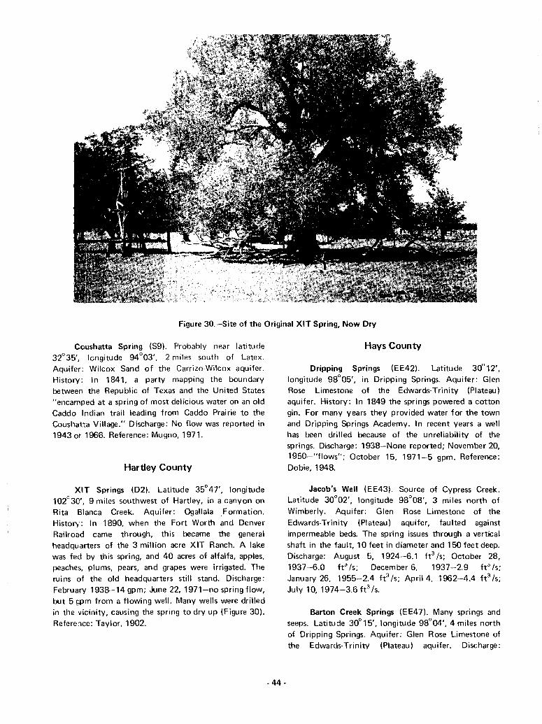
Figure 30.-Site of the Original XIT Spring, Now Dry
Coushatta Spring (S9). Probably near latitude32°35', longitude 94°03', 2 miles south of Latex.Aquifer: Wilcox Sand of the Carrizo-Wilcox aquifer.History: In 1841, a party mapping the boundarybetween the Republic of Texas and the United States"encamped at a spring of most delicious water on an oldCaddo Indian trail leading from Caddo Prairie to theCoushatta Village." Discharge: No flow was reported in1943 or 1966. Reference: Mugno, 1971.
Hartley County
XIT Springs (02). Latitude 35°47', longitude102°30', 9 miles southwest of Hartley, in a canyon onRita Blanca Creek. Aquifer: Ogallala Formation.Historv: In 1890, when the Fort Worth and DenverRailroad came through, this became the generalheadquarters of the 3 million acre XIT Ranch. A lakewas fed by this spring, and 40 acres of alfalfa, apples,peaches, plums, pears, and grapes were irrigated. Theruins of the old headquarters still stand. Discharge:February 1938-14 gpm; June 22, 1971-no spring flow,but 5 gpm from a flowing well. Many wells were drilledin the vicinity, causing the spring to dry up (Figure 30).Reference: Taylor, 1902.
- 44-
Hays County
Dripping Springs (EE42). Latitude 30°12',longitude 98°05', in Dripping Springs. Aquifer: GlenRose Limestone of the Edwards-Trinity (Plateau)aquifer. History: In 1849 the springs powered a cottongin. For many years they provided water for the townand Dripping Springs Academy. In recent years a wellhas been drilled because of the unreliability of thesprings. Discharge: 1938-None reported; November 20,1950-"flows"; October 15, 1971-5 gpm. Reference:Dobie, 1948.
Jacob's Well (EE43). Source of Cypress Creek.Latitude 30°02', longitude 98°08', 3 miles north ofWimberly. Aquifer: Glen Rose Limestone of theEdwards-Trinity (Plateau) aquifer, faulted againstimpermeable beds. The spring issues through a verticalshaft in the fault, 10 feet in diameter and 150 feet deep.Discharge: August 5, 1924-6.1 ft3 Is; October 28,1937-6.0 ft"' Is; December 6, 1937-2.9 ftJ Is;January 26, 1955-2.4 ft3 Is; April 4, 1962-4.4 ft3 Is;July 10, 1974-3.6 ft3 Is.
Barton Creek Springs (EE47). Many springs andseeps. Latitude 30° 15', longitude 98°04', 4 miles northof Dripping Springs. Aquifer: Glen Rose Limestone ofthe Edwarcls-Trinity (Plateau) aquifer. Discharge:
1938-None reported; July 6, 1970-2.9 ft3/S;
October 1, 1970-0.31 ft3/S.
WATER DIS-YEARS CHARGE
(ft3 /s)
WATER DIS-YEARS CHARGE
(ft3
/s)
These are the second largest springs in Texas. Maximumrecorded discharge was 300 ft3 /s on November 5, 1973.References: Bonnell, 1840; Hill and Vaughn, 1898;Taylor, 1904; and Texas Historical SurveyCommittee, 1971.
San Marcos Springs (MM1). Five large fissures andmany small openings. Latitude 29°54', longitude 97°56',2 miles northeast of San Marcos. Aquifer: Edwards andassociated limestones of the Edwards (Balcones FaultZone) aquifer, faulted against the Taylor Marl. Thesprings issue through the San Marcos Springs Fault.Since the chemical content varies much more than thatof Comal Springs, the recharge area is believed to besmaller, probably within the Blanco River drainage area.History: When the Spanish explorers discovered thesesprings in 1743, they estimated that there were 200springs. From 1755 to 1756 a mission was located here.The springs vvere an important stop on EI Camino Realfrom Nacogdoches to Mexico. In 1840 Bonnell describedthem as "the most pleasant and delightful situation inthe Republic." Power-plants, gins, corn mills, and an icefactory used the water power. A historical marker islocated here. The springs were a stop on the ChisholmCattle Trail from 1867 to 1895. In recent years anamusement park has developed around them (Figure 5).Discharge (ft3/S by water years):
1949
1950
1951
1952
1953
1954
1955
1956
1957
1958
1959
1960
130
110
110
100
125
140
95
70
117
215
171
178
1961
1962
1963
1964
1965
1966
1967
1968
1969
1970
1971
1972
209
134
124
92
156
164
103
194
162
190
138
158
WATER DIS- WATER DIS-
YEARS CHARGE YEARS CHARGE(ft3 /s) (ft
3 /s)
1895 150 1928 180
1896 89 1929 180
1897 186 1930 120
1898 51 1931 190
1900 150 1932 140
1903 153 1933 100
1906 145 1934 120
1910 95 1935 135
1915 280 1936 130
1916 150 1937 135
1917 108 1938 130
1918 97 1939 90
1919 127 1940 100
1920 190 1941 180
1921 170 1942 140
1922 220 1943 180
1923 150 1944 180
1924 220 1945 210
1925 160 1946 170
1926 180 1947 200
1927 130 1948 110
- 45-
Hood County
Thorp or Sulphur Springs (R1). Latitude 32°28',longitude 97°49', at Thorp Spring. Aquifer: ComanchePeak Limestone of the Edwards-Trinity (Plateau)aquifer. History: During the Civil War the Confederate20th Battalion was stationed at the spring. In 1871 ahealth resort and cotton gin opened to make use of thespring water. In 1873 Add-Ran College (TCU) beganusing the water. References: Ewell, 1895, and Paddock,1911.
Hopkins County
Sulphur Springs (N 1). Latitude 33°08', longitude95°37'. Aquifer: Wilcox Sand of the Carrizo-Wilcoxaquifer. History: This was a campground of the CaddoIndians. When first settled, there were buffalo, bear, andwild mustangs in droves here. Wolves and panthers tooka heavy toll of livestock. In 1892 the springs were wellknown for their mineral content. Discharge: Nonereported in 1943. Fleference: Peale, 1894.
Houston County
Elkhart Creek Springs (Zl l. The flow from thesesprings forms Elkhart Creek. Latitude 31°33', longitude
Irion County
Crow Spring or Ojo del Cuervo (U2). Latitude32°00', longitude 105;05', in the Salt Basin 9 milesnortheast of Dell City. l\quifer: Alluvium. History:Wagon trains stopped here for water in 1846. In 1857 itbecame a stop on the Butterfield Overland Mail route.Discharge: 1949-5gpm. Reference: Williams, 1969.
4.5
13
DiSCHARGE
(ft3 Is)
1934
1940
IS C f i rrigatioll ditches here,:do 'el s arrived. The springs
t din~ heading west in 1850.1Be'3; Taylor, 1902; and
8.0
12
Hut I)"
1925
1918
VV'lell
became c' qou 01
l"IIVJ
Wdliams,lD69.
Eagle Spring or Ojo del Aguila (BB 1). Latitude30°59', longitude 105°06', 5 miles west of Hot Wells.Aquifer: Yucca conglomerate, sandstones, andlimestones. The spring issues through the Eagle SpringFault. History: Because the Apache Indians as well asthe white men relied on this spring for water, severalskirmishes took place here. The Old Spanish Trail fromSan Antonio to EI Paso passed here. From 1854 to 1882the spring was the site of a stage stand. A historicalmarker is located here. References: Underwood, 1963,and Texas Historical Survey Committee, 1971.
Apache Spring (U71. Near latitude 31°27',longitude 104°58', at the head of Apache Canyon.Aquifer: Bone Spring Limestone. The spring issuesthrough a fau It. History: This spring was the scene of thelast Indian fight in Texas. In 1881 a band of Apacheswas annihilated here. The spring was reported to have runred with their blood. Reference: Utley, 1960.
Seven, Spring Creek, Headwater, or Good Springs(W2). Several sprin!ls. Latitude 31°14', longitude100°49', 3 mites south of Mertzon. AqUifer: Edwardsand associated limestones of the Edwards·Trinity(Plateau) aqu ifer. Springs issue from joints in thelimestone (Figure 16). History: The springs were used byMeserve man 9,000 years ago and later by TonkawaIndians, who left several bedrock mortars, used forgrinding corn and nuts, in the limestone, and many spearpoints. The Spanish explorer Mendoza passed here in1683. The springs were used by the U.S. Cavalry in thelate 1840's. This was the last fresh water spring on thisroute westward before encountering the gypseous waterof the plains. The water is presently used for irrigation.Discharge (fe /s by watE~r years):
WATER DIS- WATERYEARS CHARGE YEARS
(ft3 Is)
Caney Creek Springs (Z3). Flow from these springsforms Caney Creek. Latitude 31°27', longitude 95°30',4 miles south of Grapeland. Aquifer: Sparta Sand.History: The springs were on EI Camino Real. Discharge:September 16,1965-1.7 ft3 /s.
95°31', 2 miles southwest of Salmon. Aquifer: SpartaSand. Discharge: September 15, 1965-3.4 ft 3 /s.
Boiling Spring (Z4). Latitude 31 °29', longitude95°23',6 miles east of Grapeland. Aquifer: Sparta Sand.History: The Tejas village of the Nabedache Indians waslocated here. A Spanish mission was established at thespring in 1690, and it became a stop on EI Camino Real.The spring lIVas used medicinally for many years.Discharge: 1963-5 gpm. Reference: Brune, 1970.
Howard County
Hudspeth County
Hays Branch Springs (Z2). Flow from these springsforms Hays Branch. Latitude 31°27', longitude 95°32',5 miles southwest of Grapeland. Aquifer: Sparta Sand.History: A Kickapoo Indian village was formerly locatedat these spr:ngs. They were a stop on EI Camino Real.Discharge: September 16, 1965-1.8 ft 3 /s.
Alamo Springs or Ojos del Alamo (U1). Latitude31°32', longitude 105°43', 17 miles north of FortHancock. Aquifer: Finlay Limestone (equivalent ofEdwards Limestone). History: The Pueblo Indians were
Big Spring (P4). Originally seven springs. Latitude32°13', longitude 101°28', 2 miles south of Big Spring.Aquifer: Edwards and associated limestones of theEdwards-Trinity (Plateau) aquifer in a subsidence area.History: The spring was a favorite campground forIndians. The Spanish explorer Castillo is believed to havestopped here in 1650. When other Spaniards arrived in1768, Comanche and Pawnee Indians were fighting forpossession of the spring. Captain R. B. Marcy in 1849described it as a "fine spring flowing from deep chasmsin the limestone rock into an immense reservoir of some50 feet in depth." The spring was used by the Texas andPacific Railroad from 1881 to 1915. It was soonnecessary to drill wells to supplement the spring flow. Asa result the spring essentially dried up in 1925(Figure 31). In 1967 well water was piped to the springin an effort to restore the recreational value of the area.A historical marker is located here. Discharge:1891-0.15 fe Is; 1925-0; 1937-"weak seep"; 1971-0.References: Fan1in, 1968, and Texas Historical SurveyCommittee, 1971.
- 46-
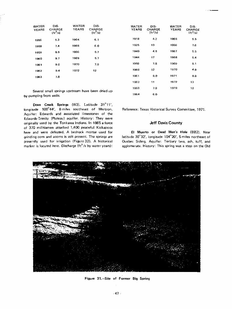
WATER DIS- WATER DIS-YEARS CHARGE YEARS CHARGE
(ft3 /sl (ft3/S)
1956 5.3 1964 6.1
1958 7.4 1965 6.0
1959 8.5 1966 5.7
1960 9.7 1969 5.7
1961 9.0 1970 7.9
1962 9.4 1972 12
1963 7.8
Several small springs upstream have been dried upby pumping from wells.
Dove Creek Springs (W3). Latitude 31 0 11',longitude 100
044', 8 miles southeast of Mertzon.
Aquifer: Edwards and associated limestones of theEdwards-Trinity (Plateau) aquifer. History: They wereoriginally used by the Tonkawa Indians. In 1865 a forceof 370 militiamen attacked 1ADO peaceful Kickapooshere and were defeated. A bedrock mortar used forgrinding corn and acorns is still present. The springs arepresently used for irrigation (Figure 32). A historicalmarker is located here. Discharge (ft3/S by water years):
WATER DIS- WATER DIS-YEARS CHARGE YEARS CHARGE
(ft3/s1 (ft3/s1
lEI18 4.2 1965 5.5
1925 13 1966 7.6
1940 4.5 1967 5.5
1944 17 1968 5.4
1959 7.8 1969 5.1
1960 12 1970 4.9
1961 9.0 1971 9.8
1962 11 1972 13
1963 7.9 1973 12
1964 6.0
Reference: Texas Historical Survey Committee, 1971.
Jeff Davis County
EI Muerto or Dead Man's Hole (882). Nearlatitude 30"32', longitude 104
020', 5 miles northeast of
Quebec Siding. Aquifer: Tertiary lava, ash, tuff, andagglomerate. History: This spring was a stop on the Old
Figure 31.-Site of Former Big Spring
- 47-
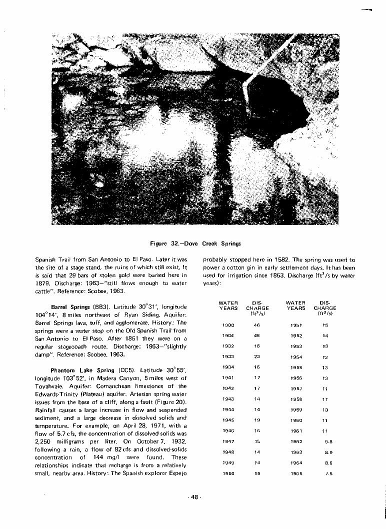
Figure 32.-Dove Creek Springs
Spanish Trail from San Antonio to EI Paso. Later it wasthe site of a stage stand, the ruins of which still exist. Itis said that 29 bars of stolen gold were buried here in1879. Discharge: 1963-"still flows enough to watercattle". Reference: Scobee, 1963.
Barrel Springs (883). Latitude 30°31', longitude104°14', 8 miles northeast of Ryan Siding. Aquifer:Barrel Springs lava, tuff, and agglomerate. History: Thesprings were a water stop on the Old Spanish Trail fromSan Antonio to EI Paso. After 1851 they were on aregular stagecoach route. Discharge: 1963-"slightlydamp". Reference: Scobee, 1963.
Phantom lake Spring (CC5). Latitude 30°55',longitude 103°52', in Madera Canyon, 5 miles west ofToyahvale. Aquifer: Comanchean limestones of theEdwards-Trinity (Plateau) aquifer. Artesian spring waterissues from the base of a cliff, along a fault (Figure 20).Rainfall causes a large increase in flow and suspendedsediment, and a large decrease in dissolved solids andtemperature. For example, on April 28, 1971, with aflow of 5.7 cfs, the concentration of dissolved solids was2,250 milligrams per liter. On October 7, 1932,following a rain, a flow of 82 cfs and dissolved-solidsconcentration of 144 mgll were found. Theserelationships indicate that recharge is from a relativelysmall, nearby area. History: The Spanish explorer Espejo
-48 -
probably stopped here in 1582. The spring was used topower a cotton gin in early settlement days. It has beenused for irrigation since 1853. Discharge (ft3 Is by wateryears):
WATER DIS- WATER DIS-YEARS CHARGE YEARS CHARGE
(ft3 Is! (ft3 Is)
1900 46 1951 15
1904 46 1952 14
1932 16 1953 13
1933 23 1954 13
1934 16 1955 13
1941 17 1956 13
1942 17 1957 11
1943 14 1958 11
1944 14 1959 13
1945 HI 1960 11
1946 16 1961 11
1947 15'1 1962 9.8
1948 14 1963 8.9
1949 14 1964 8.6
1950 15 1965 7.5

WATER DIS- WATER DIS-
YEARS CHARGE YEARS CHARGE(ft3 /s) (ft3/sl
1966 7.7 1969 8.0
1967 7.3 1970 6.1
1968 17 1971 5.7
As shown in Figure 21, the spring appears to begraduallY failing. References: Taylor, 1904, andScobee, 1963.
Barrila or Jug Spring (CC6). Latitude 30°46',longitude 103°35', close to the corner of Reeves, Pecos,and Jeff Davis Counties. Aquifer: Tertiary lava, tuff, ash,and agglomerate. History: This spring was a stop on theOld Spanish Trail from EI Paso to San Antonio. Later itbecame a stagecoach station. In 1850 it was attacked byApaches and 14 mules were stolen. The stone ruins ofthe station can still be seen. Discharge: 1877-"small butnever failing." References: Utley, 1960, andScobee, 1963.
Fort Davis Spring (CC7). Latitude 30°36',longitude 103°53', 1 mile north of the town of FortDavis. Aquifer: Alluvium. History: The well-knownPainted Comanche Camp was at this spring. The Indiansmade paintings on many trees here. The Spanishexplorer Espejo probably stopped here in 1582. The OldSpanish Trail from San Antonio to EI Paso used it as awater stop. From 1856 to 1875 Fort Davis hauled waterfrom Limpia Creek, 2 miles north. From 1875 to 1883the Fort Davis Spring was used for drinking water andirrigation of a garden at the fort, but caused muchdysentery among the troops, probably because thespring was polluted by the fort and stock upstream.After 1883 water was pumped from Limpia Creek to thefort. Reference: Utley, 1960.
Templeton Springs (CC8). Two springs. Latitude30°29', longitude 103°48', 10 miles southeast of FortDavis. Aquifer: Duff Tuff. History: The springs wereused in 1902 to irrigate fruit trees, alfalfa, and grass.Discharge: March 2, 1955-0.33 ft3 /s. Reference:Taylor, 1902.
Leoncita Springs (CC17). Latitude 30°29',longitude 103°41', 9 miles north of Alpine. Aquifer:Sheep Canyon and Cottonwood Springs Basalts. History:Juan Dominguez de Mendoza may have camped at thesesprings in 1684. They were the basis for a stage stand onthe San Antonio to EI Paso route through MusquizCanyon. An Army camel train camped here in 1859.Discharge: April 12, 1930-0.11 ft 3 /s;February 21, 1955-reported to be flowing. Reference:Texas Historical Survey Committee, 1971.
Johnson County
Cleburne Spring (R6). Latitude 32°21', longitude97°23', at 304 West Henderson Street in Cleburne.Aquifer: Washita Group limestones. History: Th isbrick-lined spring was the water supply for earlyCleburne and Confederate Camp Henderson. At a nickela bucket, boys carried water to the merchants. This wasa stopping place on the Chisholm Cattle Trail. Ahistorical marker is located here. Discharge: The poolwas often dipped dry, but the spring always refilled it.Clebu rne's first city well tapped its source and the springdried up. In 1969 no flow was reported. Reference:Texas Historical Survey Committee, 1971.
Kendall County
Edge Falls Springs (LL20). About four springs.Latitude 29° 55', longitude 98°31', 4 miles south ofKendalia. Aquifer: Glen Rose Limestone of theEdwards-Trinity (Plateau) aquifer. Discharge: April 2,1940-1.3 ft3 l s; September 8, 1952-0.4 fe Is; March 3,1962-1.4 ft3 /s; November 20, 1964-2.5 ft3 /s.
Kerr County
Ellebracht Springs (EE19). Two springs. Latitude30° 10', longitude 99°20', 2 miles east of MountainHome. Aquifer: Comanche Peak Limestone of theEdwards-Trinity (Plateau) aquifer. History: Indians ofthe Archaic period (400 to 3,000 years ago) leftburnt-rock middens, projectile points, and stone axes atthese springs. De Vaca may have passed them in 1534.Later they were on the Chihuahua Road from Mexico toIndianola. Discharge: March 16, 1965-11 ft 3 /s;March 31, 1966-6.7 ft3 /s. They supply water for a fishhatchery. Refemnce: Briggs, 1971.
Fish and Wildlife Springs (EE20). Source of theNorth Fork Guadalupe River. Latitude 30°04', longitude99°30', 10 miles west of Hunt. Aquifer: Edwards andassociated limestones of the Edwards-Trinity (Plateau)aquifer. Discharge: June 30, 1938-16 fe Is; March 15,1965-14 ft3 /s; April 13, 1967-0.33 ft 3 /s. Reference:Bonnell, 1840.
Bear Springs (EE21). Latitude 30°04', longitude99°25', 5 miles west of Hunt. Aquifer: Comanche PeakLimestone of the Edwards-Trinity (Plateau) aquifer.Discharge: March 16, 1965-3.0 fe Is; 1969-nonereported.
Honey Springs (EE22). About five springs.Latitude 30°06', longitude 99°22', 3 miles northwest of
- 49-
Hurl1 Aquifer: Glen Rose Limestone of the
Edwards- Trinity (Plateau) aquifer. Discharge: March 16,
1965-- 1-6 ft3 Is; April 11, 1967-0.62 fe Is.
Mystic Springs (EE23). Source of Cypress Creek.
Latitude 30°00', longitude 99°22', 5 miles south of
Hunt. Aquifer: Glen Rose Limestone of the
Edwards-Trinity (Plateau) aquifer. The springs issue
through cobbles and boulders. Discharge: March 16,
1965-3.6 ft3/S; 1969-none reported.
Tegener Springs (EE24). Two springs. Latitude
30°02', longitude 99° 19', 4 miles south of Hunt.
Aquifer: Glen Rose Limestone of the Edwards-Trinity
(plateau) aquifer. Discharge: March 16, 1965-1.4 ft3 /s;
May 4, 1966-0.18 ft3 /s.
Kelly Springs (EE25). Latitude 30°03', longitude
90°18', 3 miles east of Hunt. Aquifer: Glen Rose
Limestone of the Edwards-Trinity (Plateau) aquifer.
Discharge: March 16, 1965-2.0 ft3 /s; 1969-none
reported.
Colbath Springs (EE26). Source of Bear Creek.
Latitude 30°03', longitude 99° 13', 5 miles west of
Kerrville. Aquifer: Glen Rose Limestone of the
Edwards-Trinity (Plateau) aquifer. History: Cabeza de
Vaca probably stopped here in 1534. Later the springs
were a stop on the Chihuahua Road. Discharge:
March 24, 1965-1.1 ft3 /s; December 2, 1966-6gpm.
Indian Springs (EE27). Latitude 30°02', longitude
99°16', 8 miles west of Kerrville. Aquifer: Glen Rose
Limestone of the Edwards-Trinity (Plateau) aquifer.
Discharge: March 24, 1965-1.9 ft 3 /s; December 1,
1966-0.20 ft 3 /s.
Goat Springs (EE28). Latitude 30°06', longitude
99°12', 6 miles northwest of Kerrville. Aquifer: Glen
Rose Limestone of the Edwards-Trinity (plateau)
aquifer. History: De Vaca possibly stopped here in 1534.
Later the springs were a stop on the Chihuahua Road.
Discharge: March 24, 1965-1.7 fe Is.
Henderson Springs (EE29). Latitude 30°06',
longitude 99° 15', 2 miles east of Camp Scenic. Aquifer:
Glen Rose Limestone of the Edwards-Trinity (Plateau)
aquifer. History: Indians of the Archaic period (400 to
3,000 years ago) left burnt-rock middens, projectile
points, and stone axes at the springs. Cabeza de Vaca
possibly stopped here in 1534. The springs were later a
stop on the Chihuahua Road from Mexico to Indianola.
- 50-
Discharge: March 16, 1965-1.6 ft3 /s. Reference:
Briggs, 1971.
Reid Springs (EE31). About five springs, forming
Town Creek. Latitude 30°08', longitude 99°07',7 miles
north of Kerrville. Aquifer: Glen Rose Limestone of the
Edwards-Trinity (Plateau) aquifer. Discharge: March 24,
1965-2.4 fe Is; November 10, 1966-0.50 ft 3 /s.
Cypress Springs (E E32). Latitude 30°02',
longitude 99°00', 9 miles east of Kerrville. Aquifer: Glen
Rose Limestone of the Edwards-Trinity (Plateau)
aquifer. Discharge: March 15,1965-3.2 ft3 /s; June 15,
1966-2.2 ft 3 /s.
Lynx Haven Springs (LL15). About two springs.The source of the South Fork Guadalupe River.
Latitude 29°59', longitude 99°27', at Lynx Haven
Lodge. Aquifer: Edwards and associated limestone of
the Edwards-Trinity (Plateau) aquifer. Discharge:
June 30, 1938-13 ft3 /s; March 15, 1965-10 ft3 /s;
July 12, 1967-0.03 ft3 /s. Reference: Bonnell, 1840.
Buffalo Creek Springs (LL 16). Latitude 30°00',
longitude 99°23', 6 miles south of Hunt. Aquifer:
Comanche Peak Limestone of the Edwards-Trinity
(Plateau) aquifer. The springs issue 40 feet above the
channel bed. Discharge: March 16, 1965-1.3 ft3 /s;1969-none reported.
Kimble County
lona Springs (EE3). Many springs. Latitude30°42', longitude 99°41', 7 miles west of London.Aquifer: Edwards and associated limestones of theEdwards-Trinity (Plateau) aquifer. History: Thesesprings were the site of a Lipan Apache Indiancampground. When settled in the 1850's they weredescribed as "sparkling springs with 50-pound catfishand beaver." Discharge: July 13, 1966-1.3 fe Is.Reference: Fisher, 1937.
Gentry Spring (EE4). Latitude 30°39', longitude99°55', 5 miles northwest of Cleo. Aquifer: Edwardsand associated limestones of the Edwards- Trinity(Plateau) aquifer. History: Settled by Raleigh Gentry inthe late 1850's, when it was described as a "livelyspring." Discharge: September 25,1965-0.28 ft3 /s. It issaid to be affected very little by local rainfall.Reference: Fisher, 1937.
Scott Springs (EE5). Latitude 30°37', longitude99°39', 6 miles southwest of London. Aquifer: Edwards

and associated limestones of the Edwards-Trinity(Plateau) aquifer. History: A battle with the LipanApache Indians took place at these springs. Discharge:1969-none reported. Reference: Fisher, 1937.
Coleman Springs (EE6). Two springs. Latitude30°22', longitude 99°54', 4 miles north of Telegraph.Aquifer: Edwards and associated limestones of theEdwards-Trinity (Plateau) aquifer. History: De Vacapossibly drank from these springs in 1534. Discharge:March 22, 1966-1.9 ft3 /s. Flow varies with rainfall.
Christmas Canyon Springs (EE7). At least foursprings originally, including House Canyon Spring.Latitude 30°19', longitude 99°55', 1 mile south ofTelegraph. Aquifer: Edwards and associated limestonesof the Edwards-Trinity (Plateau) aquifer. Discharge:March 24, 1966-16 ft3 /s.
Headquarters Springs (EE11). At least two springs.Latitude 30°22', longitude 99°37', 5 miles southeast ofSegovia. Aquifer: Edwards and associated limestones ofthe Edwards-Trinity (Plateau) aquifer. Discharge:April 25, 1966-1.5 ft3 /s.
Rio Bonito Springs (EE12). At least three springs,including East, West, and Water Hole Springs. Latitude30°19', longitude 99°38', 8 miles south of Segovia.Aquifer: Edwards and associated limestones of theEdwards-Trinity (Plateau) aquifer. Discharge: April 21,1966-11 ft3 /s. The springs supply water to a lake.
KINNEY COUNTY
Mud Springs (KK 11). Latitude 29°27', longitude100°37',8 miles north of Standart. Aquifer: GeorgetownLimestone of the Edwards-Trinity (Plateau) aquifer.History: The Spanish explorer Bosque probably stoppedat these springs in 1675. They have been used forirrigation. Discharge (ft3 /s by water years):
WATER DIS- WATER DIS-YEARS CHARGE YEARS CHARGE
(ft3/s l (ft3/s1
1939 4.0 1966 7.0
1940 2.5 1967 5.4
1941 1.0 1968 4.5
1952 0 1969 2.7
1953 0 1970 10
1962 10 1971 5.0
1965 14 1972 24
- 51 -
Pinto Springs (KK12). Latitude 29°24', longitude100°29', 7 miles north of Brackettville. Aquifer:Georgetown Limestone of the Edwards-Trinity (Plateau)aquifer. History: The springs have been used forirrigation. Discharge (ft3 /s by water years):
WATER DIS- WATER DlS-YEARS CHARGE YEARS CHARGE
(ft3/s) (ft3 /s1
1939 4.3 1966 3.7
1940 6.6 1967 2.0
1941 3.8 1968 2.5
1952 3.6 1969 0
1953 0 1970 2.4
1962 2.0 1971 2.1
1965 8.3 1972 16
Las Moras Springs (KK13). Latitude 29°18',longitude 100°25', at Brackettville. Aquifer: Edwardsand associated limestones of the Edwards (BalconesFault Zone) aquifer. The springs issue through a fault inthe Eagle Ford and overlying fonnations. They quicklyreflect rainfall in the area (Figure 33). History: Thesprings formed the site of a favorite campground forComanche, Mescalero Apache, and other Indians. Theywere a stop on the Old Spanish Trail from EI Paso to SanAntonio, and later also on the military road runningnorth from Eagle Pass. In 1840 Colonel Tom Howard leda U.S. Cavalry unit to surprise and massacre theComanche Indian village here. Starting in 1852 thesprings were uSt!d as a water supply for Brackettville.They have been much used for irrigation, and at onetime supplied the power to run an ice manufacturingplant. Discharge (fe Is by water years):
WATER DIS- WATER DIS-YEARS CHARGE YEARS CHARGE
(ft3/s1 (ft3/s1
1896 21 1940 27
1899 60 1941 24
1900 51 1942 23
1902 11 1943 25
1904 28 1944 21
1905 14 1945 18
1906 18 1946 11
1910 14 1947 33
1912 8.4 1948 21
1925 9.3 1949 29
1928 5.8 1950 27
1939 27 1951 7.0
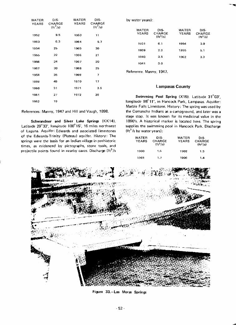
Lampasas County
Swimming Pool Spring (X15). Latitude 31°03',longitude 98° 11', in Hancock Park, Lampasas. Aquifer:Marble Falls Limestone. History: The spring was used bythe Comanche Indians as a campground, and later was astage stop. It was known for its medicinal value in the1890's. A historical marker is located here. The springsupplies the swimming pool in Hancock Park. Discharge(ft3 /s by water years):
by water years):
WATER OIS- WATER OIS-YEARS CHARGE YEARS CHARGE
(ft3/sl (ft3/sl
1931 6.1 1954 3.0
1939 2.2 1955 5.1
1940 3.5 1962 3.3
1941 3.0
Reference. Manny. 1947.
WATER OIS- WATER OIS-YEARS CHARGE YEARS CHARGE
(ft3/s) (ft3/s1
1952 9.5 1963 11
1953 6.3 1964 5.7
1954 25 1965 30
1955 22 1966 21
1956 24 1967 20
1957 30 1968 25
1958 35 1969 7
1959 49 1970 17
1960 31 1971 3.5
1961 27 1972 28
1962 19
References: Manny, 1947 and Hill and Vaugh, 1898.
Schwandner and Silver Lake Springs (KK14).Latitude 29°33', longitude 100°15', 16 miles northwestof Laguna. Aquifer: Edwards and associated limestonesof the Edwards-Trinity (Plateau) aquifer. History: Thesprings were the basis for an Indian village in prehistorictimes, as evidenced by pictographs, stone tools, andprojectile points found in nearby caves. Discharge (ft3 /s
WATER OIS-YEARS CHARGE
(ft3/s)
1900 1.6
WATER 018-YEARS CHARGE
(ft3/s)
1902 1.3
1901 1.7 1906 1.4
Figure 33.-Las Moras Springs
- 52-
WATER DIS- WATER DIS-YEARS CHARGE YEARS CHARGE
(ft3 /s) (ft3/s1
1910 1.3 1957 1.3
1924 1.7 1962 1.7
1931 0.2 1971 1.5
1942 1.1
Hancock, Gold, Rock, and many smaller springs(X22). Latitude 31°03', longitude 98°11', in HancockPark, Lampasas. Aquifer: Marble Falls Limestone.History: The first white settlers found Indians using thecurative waters of these springs. The town of Lampasasgrew up around them. In 1882 they gained wide fame asa health resort The springs still supply water to the cityof Lampasas. A historical marker is located here.Discharge (ft3 /s by water years):
WATER DIS- WATER DIS-YEARS CHARGE YEARS CHARGE
(ft3 /s) (ft3 /s)
1900 8.7 1959 7.9
1901 9.3 1960 13
1902 6.3 1961 15
1906 6.7 1962 11
1910 7.1 1963 11
1924 6.7 1964 7.4
1931 6.7 1965 12
1957 6.0 1971 7.3
1958 12
References: Peale, 1894, and Texas Historical SurveyCommittee, 1971.
Limestone County
Tehuacana Springs (Y3). Latitude 31°45',longitude 96°33', at Tehuacana. Aquifer: TehuacanaLimestone. History: In 1825 Captain Coleman repulsedthe Tehuacana Indians at these springs. In 1858 theybecame widely known as the Tehuacana Hills springs andparks. Reference: Will iams, 1969.
Springfield Spring (Y4). Latitude 31°34',longitude 96°33', at Fort Parker. Aquifer: Kincaid sandsand limestones. History: Explorers in 1833 saw the largecouncil house built at this spring by the TehuacanaIndians. Here in 1836 Cynth ia Ann Parker was captu redby Comanche Indians at the age of 9. After 26 yearswith the Comanches she was recaptured. Reference:Williams, 1969.
Llano County
Castell Spring (EE34). Latitude 30°42', longitude98°58', at Castell. Aquifer: Precambrian marble, gneiss,
and schist. History: In 1847 a band of German settlersunder the leadership of the Count of Castell laid out thetown of Castell around this spring. Reference:Fry, 1943.
Valley Spring (EE35). Latitude 30°52', longitude
98°49', at Valley Spring. Aquifer: Hickory Sandstone.History: In 1854 O. C. Phillips erected a gin, grist mill,and saw mill at this "big spring." A historical marker islocated here. Fleferences: Fry, 1943, and TexasHistorical Survey Committee, 1971.
Lubbock County
Buffalo Springs (Kl). Six springs. Latitude 33°32',longitude 101°42', 9 miles southeast of Lubbock.Aquifer: Comanchean limestones of the Edwards-Trinity(High Plains) aquifer. History: Coronado may havestopped here in 1541 while search ing for the goldtreasures of the Seven Cities of Cibolo. Discharge (ft3 /sby water years):
WATER DIS- WATER DIS-YEARS CHARGE YEARS CHARGE
(ft3 /s) (ft3/s)
1937 0.3 1969 3.4
1945 0.03 1970 3.3
1962 16
In 1945 the springs supplied a swimming pool and bathhouse.
Martin County
Soda Springs (P1). Latitude 32°27', longitude101°53', 5 miles south of Flower Grove. AqUifer:Ogallala Formation. History: These springs were on theold Comanche Indian trail from New Mexico to Mexico.Discharge: May 4, 1936-dry. Heavy well pumping forirrigation in the area probably dried up the springs.
Sulphur Springs (P2). Latitude 32°24', longitude101°52', 8 miles north of Lenorah. Aquifer:Comanc hean Limestone of the Edwards-Trin ity (H ighPlains) aquifer. History: These springs were on the oldComanche Indian trail from New Mexico to Mexico.They were probably visited by Fray Juan de Salas in1632 and Castillo in 1650. Several U.S. Army
- 53-

expeditions stopped here later. In 1891 the springs weredescribed as "several springs of pure fresh water, one ofthem slightly tinged with sulphur." Discharge: May 4,1936-10 gpm. Heavy well pumping for irrigation hasgreatly reduced the spring flow. Reference: Liles, 1953.
Mill Springs (EE16). Several springs. Latitude30°39', longitude 99°19', 10 miles southwest of Mason.Aquifer: Ellenburger Limestone. The springs probablyissue through a fault. Discharge: December 1939-nonereported; January 20, 1962-2.0 ft3 /s.
Mustang Spring or Mustang Fountain (P3).Latitude 32°08', longitude 101°56', at Mustang Pond8 miles west of Stanton. Aquifer: Comancheanlimestone of the Edwards-Trinity (High Plains) aquifer.History: When Capt. R. B. Marcy stopped here in 1849,he described the good grazing, numerous wild mustangs,and thousands of buffalo and antelope. The spring wason the Comanche Indian trail and later the Californiatrail. This was the last water on the California trail untilWillow Springs (Winkler County, spring V3) 100 mileswest. In 1879 Thrall described it as "excellent stockwater." A historical marker is located here. Discharge:April 17, 1936-"seep"; 1953-"dry for many years,"Heavy well pumping in the area undoubtedly was animportant factor in the failure of this spring. References:Thrall, 1879; Texas Historical Survey Committee, 1971;and Liles, 1953.
Mason County
Anderegg Spring (EE17). Three springs. Latitude30°31', longitude 99°08', 5 miles south of Hilda.Aquifer: Ellenburger Limestone. History: JohannAnderegg established a cheese factory at these springs in1850. It was also a stop on the old Chihuahua Road toMexico. Discharge: 1940-30 gpm. Reference: GillespieCounty Historical Society, 1960.
McCulloch County
Soldiers' Water Hole (X18). latitude 31°09',longitude 99°15', 6 miles east of Brady. Aquifer:Ellenburger and San Saba Limestones. History: This wasan ancient Comanche Indian campground. Many U.S.Army units, including General Robert E. Lee's, used thisspring. Early pioneers also camped here en route to theWest. A historical marker is located here. Discharge:None reported in 1961. Reference: Texas HistoricalSurvey Committee, 1971.
Medina County
McLennan County
Diversion Dam Springs (LL19). Latitude 29°30',longitude 98°54', just below Medina Diversion Dam,6 miles north of Rio Medina. AqUifer: Edwards andassociated limestone of the Edwards-TrinitY (Plateau)aquifer. The springs issue through the Haby CrossingFault. Discharge (ft3/s by water years):
Waco Springs (Y2). Latitude 31 °34" longitude97°08', on Main Street several blocks northeast of thesquare in Waco. Another spring was located west of theBrazos River at First Street. Aquifer: Edwards andassociated limestone of the Edwards (Balcones FaultZone) aqUifer. The springs apparently issued through afault in the Austin Chalk and through the overlyingterrace materials. History: The old Hueco Indian villagewas located here. In 1849 the town of Waco was laid outaround the springs. A historical marker is located here.Discharge: 1964·-none reported. References: Pool,1964, and Texas Historical Survey Committee, 1971.
WATER DIS-YEARS CHARGE
(ft3/s1
WATER DIS-YEARS CHARGE
Ift3 /s1
Pluenneke Springs (EE 13). Several springs.Latitude 30°46', longitude 99°25', 4 miles west ofStreater. Aquifer: Ellenburger-San Saba Limestones.History: These springs were a stop on the old ChihuahuaRoad and later on the Western Cattle Trail. Discharge:February 16, 1925-0.7 fe Is; November 1939-20 gpmreported; January 20, 1962-2.0 fe is.
Gamel Spring (EE14). Latitude 30°45', longitude99° 14', in Mason. Aquifer: Hickory Sandstone. Thespring issued through a fault. History: The spring was ata favorite campground of the Comanche Indians.Bedrock mortars for grinding corn. nuts, and mesquitebeans have been found here. In 1847 the German settlerJohn Meusebach met with Indian chiefs here preparatoryto his important treaty with the Comanches (See SloanSprings, San Saba County). The spring supplied water toFort Mason in 1851. Discharge: 1940-14 gpm; 1971-0.As recently as 1940 the spring supplied water to theMason swimming pool. Water is now pumped to thepool. Reference: Polk 1966.
Kothmann Springs (EE15). Several springs.Latitude 30°42', longitude 99°19', 7 miles southwest ofMason. Aquifer: Ellenburger Limestone. The springsissue through a fault. Discharge: August 22, 1918-7.9fe Is; December 1939-0.01 ft3 /s; January 20,1962-3.0 ft3 /s.
1921 50 1924 27
1923 25 1925 24
- 54-
WATER DIS- WATER DIS-YEARS CHARGE YEARS CHARGE
(ft3 /s) (ft3 /s)
1926 25 1953 2.9
1927 25 1954
1928 25 1955 4
1929 24 1956 0
1930 22 1957 3
1931 23 1960 36
1932 25 1962 29
1933 29 1963 26
1934 31 1964 25
1935 18 1965 20
1939 34 1966 18
1948 9 1967 18
1950 11 1968 23
1951 3 1969 20
1952 0
The flow represents leakage from MedinaDiversion Reservoir, and is related to reservoir stage.
Menard County
Wilkinson Springs (EEl). Latitude 30°56',longitude 99°53', forming Clear Creek, 6 miles west ofMenard. Aquifer: Edwards and associated limestones ofthe Edwards-Trinity (Plateau) aquifer. History: The oldSan Saba Mission was located near these springs from1756 to 1758. They were described then as "clear,sparkling, and deep." Later they provided irrigationwater for 2,000 acres. They were a stop on theChihuahua Road from the port of Indianola to Mexico.Discharge: (ft3 /s by water years):
WATER DIS- WATER DIS-YEARS CHARGE YEARS CHARGE
(ft3/s1 (ft3 /s1
1902 25 1948 15
1918 12 1949 13
1920 18 1951 10
1922 16 1952 7.6
1933 14 1955 8.2
1940 18 1956 7.3
1942 25
- 55-
References: Taylor, 1904; and Goodnight, Dubbs, andHart, 1909.
Vaughn Spring (EE2). Near latitude 30°47',longitude 99°46', source of Elm Creek, 10 miles southof Menard. Aquifer: Edwards and associated limestonesof the Edwards-Trinity (Plateau) aquifer. History: TheLipan Apaches left many mounds of burnt rock at thesesprings, where they had baked sotol bulbs. WilliamVaughn, the first settler, in 1886, irrigated 20 acres fromthe spring. Discharge: 1965-none reported. Reference:Pierce, 1946.
Milam County
Indian Springs (FF131. Several Springs. Latitude30°53', longitude 96°57',3 miles northeast of Cameron.AqUifer: Alluvium. History: In 1716 Domingo Ramonfound a village of 2,000 Mayeya Indians at these springs.Later they were used by the Tonkawa Indians. Manymiddens, burial grounds, spear points, and corn grindershave been found here. The springs were formerly used toirrigate truck crops. Discharge: 1937-none reported;June 1971-0.10 ft3 /s. Reference: Taylor, 1902.
Sharp Springs (FF20). Two openings. Latitude30°46', longitude 97°11', 1 mite northwest of Sharp.Aquifer: Probabl'l' Wolfe City Sand. History: The springswere on the old Comanche Indian Trail from Bandera toEast Texas. They were well known in early days for theirmedicinal value. Discharge: March 19, 1936-5 gpm;1971-none reported. Reference: Peale, 1894.
Montague County
Barrel Springs (M 1). Latitude 33°44', longitude97°47'. Aquifer: Wichita Sandstone. History: ATaovayas Indian village was located here. Captain R. B.Marcy, exploring for the California Trail in 1854,camped here. He found that predecessors had sunk twobarrels in the springs, and that the water was"delightfully pure and clear." Later the springs were onthe Chisholm Cattle Trail. Discharge: 1857-The U.S.Cavalry found the flow weak; 1944-none reported;1967-none reported. Reference: Henderson, 1958.
Motley County
Roaring Springs (K3). Latitude 33°51', longitude100°51', 4 miles south of Roaring Springs. Aquifer:Santa Rosa Sandstone and Ogallala Formation. History:This and other large springs in the area were used forirrigation by the Wichita Indians long before the
European settlars arrived. Bedrock Ie 11ar; \J,te! by theWichitas can still be seen in sandsto'le: "t the springs. In
1876 a buffalo hunters' camp wa, heated here. Thesprings were described at th at tillie as supportingnumerous cottonwood and walnut trees, grape vines,currants, and plums. Presently the water is used in aswimming pool and recreational area. A historicalmarker is located here. Discharge (ft3 /s by water years):
WATER 015- WATER 015-YEARS CHARGE YEARS CHARGE
(ft3/s1 (ft3/ s)
1937 1.1 1957 1.2
1938 1.1 1958 1,4
1939 1.1 1959 1,3
1943 1.1 1960 1.1
1944 1.2 1961 1.4
1945 2.0 1962 1.5
1946 2.5 1963 1.4
1947 2.0 1964 1.4
1948 1.4 1965 1,2
1949 1.4 1966 1.0
1950 1.3 1967 0.9
1951 1.3 1968 1.2
1952 1.5 1969 1.3
1953 1.4 1970 1.1
1954 1.4 1971 1.3
1955 1.4 1972 1,3
1956 1.4 1973 1.3
Discharge is also shown on Figure 24. References: Morfi,1935, and Texas Historical Survey Committee, 1971.
Nacogdoches County
Nacogdoches and Shawnee Springs (Z6). Latitude31°37', longitude 94°39', between North Street andBanita Creek in Nacogdoches. Aquifer: Sparta Sand.History: These springs were originally on an old TejasIndian trail. In 1686 Robert Sieur de La Salle became illduring his explorations and rested here for one month.Later the springs were a stop on El Camino Real. In1716 the Mission Nuestra Senora de Guadalupe wasestablished here. At that time some of the springs, onLa Nana Creek, were called "Los Ojos de Padre Margil."They were formerly used as a water supply for the cityof Nacogdoches and also as mineral springs. Discharge:In September 1936, there was essentially no flow;1970-no flow reported. Reference: Deussen, 1914.
- 56-
White and Red Springs (Z7). Latitude 31 °49',longitude 94°30', in Garrison. Aquifer: Wilcox Sand ofthe Carrizo-Wilcox aquifer. History: La Salle may havedrunk from these springs in 1686. They were formerlythe basis for a health resort. The water of Red Spring isreddish in color and is more mineralized than the waterof White Spring (Table 2). Discharge: October 1936-1gpm; 1970-no flow reported.
Oldham County
Bravo or Bold Springs or Ojos Bravos (Dl). Threesprings. Latitude 35°37', longitude 103°00',5 miles eastof Nara Visa, New Mexico. Aquifer: Ogallala Formation.The springs flow from sand in spring boxes. History: AComanche Indian settlement existed here. The explorerOnate may have passed here in 1601. Casimiro Romero,a sheep rancher, was the first settler in 1876. He wasdriven out by cattle ranchers, and XIT Ranch Division3 headquarters was established here in 1888. The oldXIT headquarters building, surrounded by largecottonwood trees, is still being used (Figure 34).Discharge: July 20, 1938-"weak"; June 22, 1971-18gpm. The flow feeds a stock tank, with no overflow inJune 1971. It reportedly overflows the tank in thewinter, when cottonwood trees and evaporation do notdraw so much water. Reference: Nordyke, 1949.
Parker County
Bear Creek Springs (R2). Latitude 32°40',longitude 97°43', 8 miles southeast of Weatherford.Aquifer: Paluxy Sand of the Trinity Group aquifer. Thesprings issue through the Goodland Limestone. History:In the 1870's three flourishing water-power mills usedthese springs. With increased grazing the springs driedup, probably bec:ause of compaction of the surface soiland reduction of natural recharge. Discharge:1971-none reported. Reference: Taylor, 1904.
Pecos County
Santa Rosa Spring (V2). Latitude 31°16',longitude 102°57', 8 miles southwest of Grandfalls.Aquifer: Comanchean limestone of the Edwards-Trinity(Plateau) aquifer. The spring flowed from a limestonecavern in a ravine (Figure 35). History: The Jumano andApache Indians who formerly frequented this spring leftnumerous artifacts. Taylor (1902) described the springas an oasis in the desert, with cottonwood trees alongthe irrigation ditches which were used to irrigate alfalfaand peach trees. Runoff water now occasionally flowsinto the cavern, but spring flow from it has ceased.
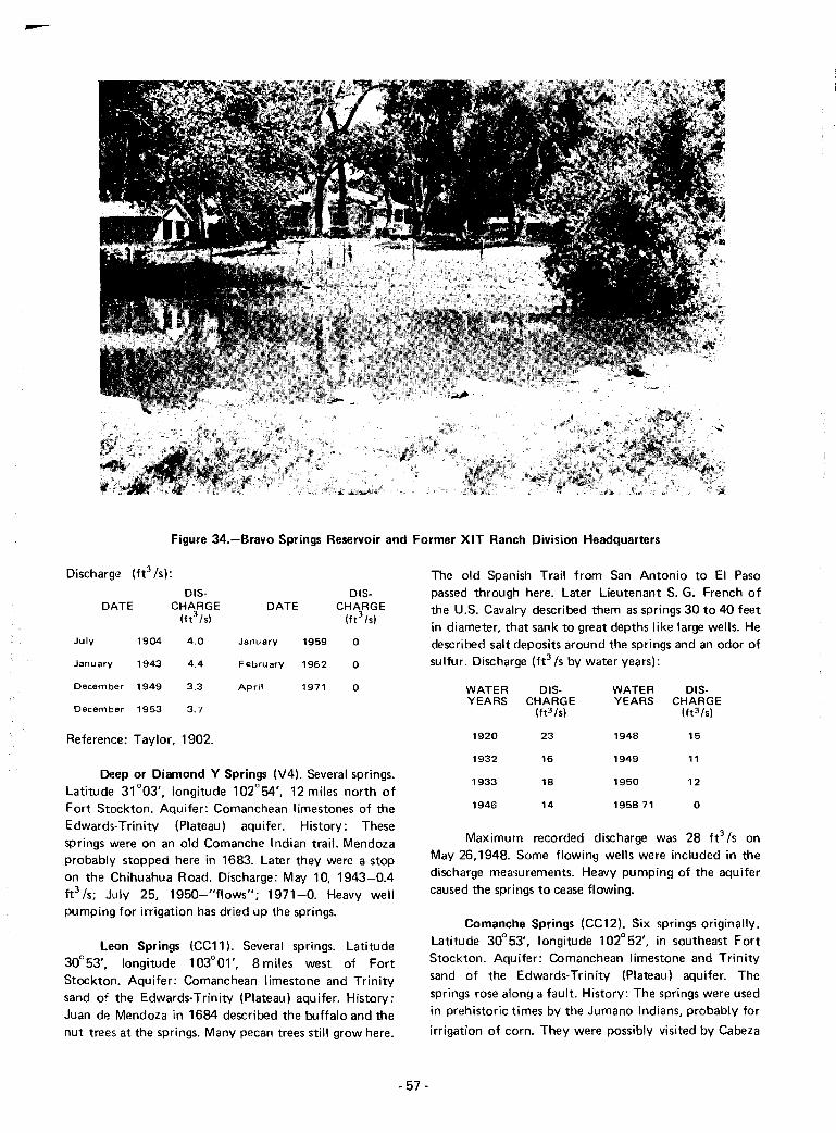
-
Figure 34.-Bravo Springs Reservoir and Former XIT Ranch Division Headquarters
Discharge (ft3 /s):
015- 015-DATE CHARGE DATE CHARGE
(ft3 Is) (ft3 Is)
July 1904 4.0 January 1959 0
January 1943 4.4 February 1962 0
December 1949 3.3 April 1971 0
December 1953 3.7
Reference: Taylor, 1902.
Deep or Diamond Y Springs (V4). Several springs.Latitude 31°03', longitude 102°54', 12 miles north ofFort Stockton. Aquifer: Comanchean limestones of theEdwards-Trinity (Plateau) aquifer. History: Thesesprings were on an old Comanche Indian trail. Mendozaprobably stopped here in 1683. Later they were a stopon the Chihuahua Road. Discharge: May 10, 1943-0.4ft3/S; July 25, 1950-"flows"; 1971-0. Heavy wellpumping for irrigation has dried up the springs.
Leon Springs (CC11). Several springs. Latitude30°53', longitude 103°01', 8 miles west of FortStockton. Aquifer: Comanchean limestone and Trinitysand of the Edwards-Trinity (Plateau) aquifer. History:Juan de Mendoza in 1684 described the buffalo and thenut trees at the springs. Many pecan trees still grow here.
- 57-
The old Spanish Trail from San Antonio to EI Pasopassed through here. Later Lieutenant S. G. French ofthe U.S. Cavalry described them as springs 30 to 40 feetin diameter, that sank to great depths like large wells. Hedescribed salt deposits around the springs and an odor ofsu lfur. Discharge (ft3 /s by water years):
WATER 015- WATER 015-YEARS CHARGE YEARS CHARGE
(ft3 Is) (ft3 /s)
1920 23 1948 15
1932 16 1949 11
1933 18 1950 12
1946 14 1958-71 0
Maximum recorded discharge was 28 ft3 /s onMay 26,1948. Some flowing wells were included in thedischarge measurements. Heavy pumping of the aquifercaused the springs to cease flowing.
Comanche Springs (CC12). Six springs originally.Latitude 30°53', longitude 102°52', in southeast FortStockton. Aquifer: Comanchean limestone and Trinitysand of the Edwards-Trinity (Plateau) aquifer. Thesprings rose along a fault. History: The springs were usedin prehistoric times by the Jumano Indians, probably for
irrigation of corn. They were possibly visited by Cabeza

Figure 35.-Cavern From Which Santa RosaSpring Formerly Flowed
WATER DIS- WATER DIS-YEARS CHARGE YEARS CHARGE
(ft3/s1 (ft3 /s1
1923 42 1946 44
1924 47 1947 42
1925 49 1948 37
1932 42 1949 38
1933 47 1950 34
1934 46 1951 27
1935 44 1952 26
1936 42 1953 20
1937 44 1954 26
1938 43 1955 17
1939 42 1956 13
1940 42 1957 4
1941 43 1958 1.8
1942 44 1959 0.83
1943 43 1961 1.5
1944 43 1962-72 0
1945 43
Maximum recorded discharge was 66 ft3/S on June23, 1899. References: Hutson, 1898; Taylor, 1904;Brune, 1969; and Texas Historical Survey Committee,1971.
de Vaca in 1536. Juan de Mendoza in 1684 describedthe 6 large beautiful springs gushing forth to formComanche Creek. The Old Spanish Trail from SanAntonio to EI Paso passed through here. In 1849Captain William Whiting of the U.S. Cavalry describedthem as "a clear gush of water which bursts from theplain, unperceived until the traveler is immediately uponit ... abounding in fish and soft-shell turtles." In thesame year many gold seekers traveling to Californiastopped here. In 1859 Camp Stockton was establishedand used the spring water as its supply. The water wasused in 1904 to power a gin. A historical marker islocated here. From 1875 on, the springs were the basisfor an irrigation district which watered 6,200 acres ofcropland. Heavy pumping of the aquifer, especially inthe Belding area southwest of the springs, lowered thewater table. The spring discharge began to fall off in May1947, and by March 1961, the flow had ceased(Figure 25). Discharge (ft3/s by water years):
WATER DIS-YEARS CHARGE
(ft3/s1
1899 66
1904 64
WATER DIS-YEARS CHARGE
(ft3/s1
1919 45
1922 46
- 58-
San Pedro Springs (CC13). Latitude 30°58',longitude 102°49', 7 miles northeast of Fort Stockton.Aquifer: Comanchean limestones of the Edwards-Trinity(Plateau) aquifer. History: The springs were on an oldComanche Indian trail. Mendoza possibly stopped herein 1683. Later they were a stop on the Chihuahua Road.The springs were used for irrigation. Discharge (ft3/S bywater years):
WATER DIS- WATER DIS-YEARS CHARGE YEARS CHARGE
(ft3/s1 (ft3/s1
1902 4.0 1952 2.7
1943 3.8 1953 2.4
1947 4.2 1954 1.8
1948 3.6 1956 1.9
1949 4.9 1957 0.7
1950 4.0 1958 0.2
1951 2.5 1959-71 0
Maximum recorded flow was 6.4 ft3/S on January18, 1949. Heavy well pumping for irrigation caused thesprings to fail.
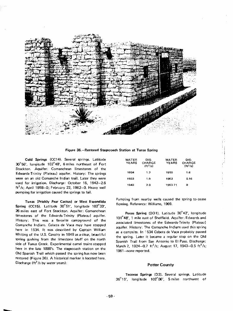
Figure 36.-Restored Stagecoach Station at Tunas Spring
Cold Springs (CC14). Several springs. Latitude30°56', longitude 102°48', 6 miles northeast of FortStockton. Aquifer: Comanchean limestones of theEdwards·Trinity (Plateau) aquifer. History: The springsvvere on an old Comanche Indian trail. Later they wereused for irrigation. Discharge: October 16, 1942-2.6ft3 Is; April 1958-0; February 22, 1962-0. Heavy wellpumping for irrigation caused the springs to fail.
Tunas (Prickly Pear Cactus) or West EscondidoSpring (CC15). Latitude 30°51', longitude 102°33',26 miles east of Fort Stockton. Aquifer: Comancheanlimestones of the Edwards-Trinity (Plateau) aquifer.History: This was a favorite campground of theComanche Indians. Cabeza de Vaca may have stoppedhere in 1534. It was described by Captain WilliamWhiting of the U.S. Cavalry in 1849 as a clear, beautifulspring gushing from the limestone bluff on the northside of Tunas Creek. Experimental camel trains stoppedhere in the late 1800's. The stagecoach station on theOld Spanish Trail which passed the spring has now beenrestored (Figure 36). A historical marker is located here.Discharge (ft3 Is by water years):
- 59-
WATER DIS· WATER DIS-YEARS CHARGE YEARS CHARGE
(ft3/s) (ft3 /s)
1924 1.2 1950 1.6
1933 1.9 1962 0.16
1943 2.0 1963·71 0
Pumping from nearby vvells caused the spring to ceaseflowing. Reference: Williams, 1969.
Pecos Spring (DO 1). Latitude 30°42', longitude101°48', 1 mile east of Sheffield. Aquifer: Edwards andassociated limestones of the Edwards-Trinity (Plateau)aquifer. History: The Comanche Indians used this springas a campsite. In 11534 Cabeza de Vaca probably passedthe spring. Later it became a regular stop on the OldSpanish Trail from San Antonio to EI Paso. Discharge:March 7, 1924-0.7 ft 3 /s; August 17, 1943-0.5 ft 3 /s;1961-none reported.
Potter County
Tecovas Springs (03). Several springs. Latitude35°15', longitude 102°06', 5 miles northwest of
Bushland. '''.Quif,'' UrFi ;, .j I(] ';.;n Flosa sandsHistory These springs supported J favorite carnpsite ofplains Indians. Later they were J meeting place of
traders, smugglers, and renegade peddlers calledComancheros. Since 1881 they have been at theheadquarters of the Frying Pan Ranch, where barbedwire was first used. A historical marker concerning thespring is located 1 mile east of Bushland. Discharge:August 13, 1924-0.1 ft3 Is; April 20, 1937-10 gpm.Reference: Texas Historical Survey Committee, 1971.
Reagan County
Grierson Springs (Wl). Latitude 31°08', longitude101°37', 6 miles south of Best. Aquifer: Edwards andassociated limestones of the Edwards-Trinity (Plateau)aquifer. History: These springs were used by theComanche Indians, who camped here. In 1683 Mendozais believed to have stopped here. In 1879 the 10th U.S.Cavalry had an outpost at these springs. Discharge:1972-none reported. Reference: Williams, 1969.
Real County
Camp Wood Spring (KK16). Latitude 29°41',longitude HXtOl', 1 mile north of Camp Wood.Aquifer: Glen Rose Limestone of the Edwards-Trinity(Plateau) aquifer. The spring issues through alluvium.History: The spring has been used for irrigation. It is alsothe water supply for Camp Wood. Discharge: April 6,1906-3 fe Is; October 6, 1954-1.1 ft3 Is; December 13,1954-1.0 ft3 /s; September 19, 1955-2.5 fels.Reference: Taylor, 1902.
Big Springs (L L4). Latitude 29°52', longitude99"39', 11 miles northeast of Leakey. Aquifer: Edwardsand associated limestones. The springs issue through afault. Much travertine has been deposited below thesprings. History: The Jumano Indians practicedagriculture here abollt 8,000 years ago. Discharge (ft
3/s
by water years):
WATER DIS- WATER DIS-YEARS CHARGE YEARS CHARGE
(ft3/s1 (ft3 /s1
1925 8.9 1956 4.5
1953 1.9 1962 2.2
1954 4.6
Reference: Hill and Vaughn, 1898.
Vander Stucken Springs (LL5). Latitude 29°49',longitude 99°55', 7 miles east of Vance. Aquifer:Edwards and associated limestones. The springs probablyissue through a fau It. History: The springs have beenused for irrigation. Discharge: July 25, 1955-1.1 ft
3/s.
Eads Springs (LL6). At least two springs. Latitude29°44', longitude 99°56', 11 miles west of Leakey.Aquifer: Edwards and associated limestones. History:The springs have been used for irrigation. Discharge:
1956-1.3 ft3 /s.
Spring Branch Springs (LL7). Latitude 29°42',longitude 99°46', 1 mile south of Leakey. Aquifer:Alluvial gravel. The springs probably represent FrioRiver flow which sinks into gravel beds upstream andreappears here. Discharge: June 27, 1925-14 ft
3/s;
January 6, 1955-4 fe Is; Ju Iy 9, 1957-11 ft3 Is.
Reeves County
Hackberry or Irving Springs (V1). Several springs.6 miles south of Pecos at latitude 31 °20', longitude103°29'. Aquifer: Alluvium. History: The CaliforniaTrail and Butterfield Overland Mail route passed thesesprings in the 1850's. Taylor (1902) described them asseveral springs, the largest 20 feet in diameter, with astrong sulfur taste, but excellent for livestock. Discharge(ft3 Is):
Morriss Spring (LL1). Latitude 29° 57', longitude99°57', 10 miles north of Vance. Aquifer: Edwards andassociated limestones. The spring issues through a fault.Mendoza may have drunk from this spring in 1683.Discharge: April 17, 1955-1.6 ft3 /s.
Chittim Springs (LL2). At least three springs.Latitude 29°57', longitude 99°45', 15 miles north ofLeakey. Aquifer: Edwards and associated limestones.The springs issue through a fault. History: The JumanoIndians practiced agriculture here about 8,000 years agoand left paintings nearby. Discharge: April 19, 1956-1.6ft3 /s. Reference: Newcomb, 1961.
DATEDIS
CHARGE(ft3/s1
DATEDIS
CHARGE(ft3/s1
Prade Springs (LL3). Three springs. Latitude29°55', longitude 99°47', 14 miles north of Leakey.Aquifer: Edwards and associated limestones. The springsprobably issue through a fault. History: The JumanoIndians practiced agriculture here about 8,000 years ago.Discharge: June 23, 1955-1.2 fe Is. Reference:Newcom b, 1961.
- 60-
July 1904 2.2
July 1924 1.0
December 1949 0.1
Reference: Taylor, 1902.
April
March
1959.
1962
1971
o
o
o

Figure 37.-Saragosa Springs
Saragosa Springs (CC1). They also include ToyahCreek Springs. Latitude 30°59', longitude 103°46',1 mile southwest of Balmorhea (Figure 37). Aquifer:Alluvium (gravel). The original source of the water isprobably Comanchean limestones which underlie thegravel. History: Espejo probably stopped here in 1582.The springs were once used to power a grain and flourmill. They are now used for irrigation in Reeves CountyWater Control and Improvement District No.1.Discharge (fe Is by water years):
WATER DIS- WATER DIS-YEARS CHARGE YEARS CHARGE
(ft3fs) (ft3 /s)
1919 4.8 1963 2.1
1922 5.9 1964 2.1
1933 14 1965 1.7
1941 5.0 1966 1.9
1947 2.5 1967 1.4
1949 1.8 1968 1.1
1950 1.6 1969 1.4
1951 1.4 1970 0.8
1952 1.5 1971 0.3
1962 1.8
- 61 -
Maximum recorded discharge was 30 ft3 /s inNovember 1932. Discharge is also shown on Figure 21.Reference: Taylor, 1904.
West and East Sandia Springs (CC2). Three springs.Latitude 30°59', longitude 103°44', at Balmorhea.Aquifer: Alluvium (gravel). Original source of the wateris probably Comanchean limestone underlying thegravel. History: Espejo may have stopped at thesesprings in 1582. In 1911 another spring existed about1 mile upstream. The springs are now used for irrigationin Reeves County Water Control and ImprovementDistrict No. 1. Discharge (fe Is by water years):
WATER DIS- WATER DIS-YEARS CHARGE YEARS CHARGE
(ft3fs) (ft3 /s)
1932 2.5 1949 1.8
1933 :1.7 1950 2.1
1942 2.3 1951 1.9
1943 :2~.2 1952 1.6
1944 2.2 1953 1.8
1945 3.2 1962 0.53
1946 2.6 1963 0.59
1947 2.6 1964 0.50
1948 1.'9 1965 0.51
San Solomon or Mescalero Spring (CC4). Latitude30°57', longitude 103°47', at Toyahvale. Aquifer:Comanchean limestone of the Edwards-Trinity (Plateau)aquifer. This artesian spring issues from caverns in the
WATER DIS- WATER DIS-YEARS CHARGE YEARS CHARGE
(ft3 !sl (ft3!sl
1966 0.51 1969 0.51
1967 0.50 1970 0.51
1968 0.51 1971 0.51
Maximum recorded discharge was 4.4 fe /s inAugust 1945.
Giffin Springs (CC3). Three springs. Latitude30°57', longitude 103°47', at Toyahvale. Aquifer:Comanchean limestone of the Edwards- Trinity (Plateau)aquifer. Artesian springs issue through gravel from afault (Figure 38). Impervious upper Cretaceous rockshave been faulted down against the lower Cretaceousunderground reservoir, causing the springs to flow.Nearby rainfall results in a large increase in flow andsuspended sediment and a large decrease in dissolvedsolids and temperature. History: The Spanish explorerEspejo possibly stopped here in 1582. The springs havebeen used for irrigation since 1853. Discharge (fe /s bywater years):
WATER DIS-YEARS CHARGE
(ft3!sl
31
32
32
32
27
31
30
32
30
32
32
29
32
29
36
30
31
30
31
1951 31
1953
1955
1954
1956
1952
1957
1959
1961
WATER DIS-YEARS CHARGE
(ft3 /s1
1958
1969
1963
1962
1960
1971 28
1966
1965
1970
1967
1968
1964
1972 29
1898; Taylor, 1902; and
bonoll I )01 (Figure 39).ImperVIOus upper (e l.· "",lave been faulteddown iJ(jJillSl 1 e Im'!2' Crt' ,lCf'·:JW; undergroundreservoir, causing tht~ sprll'9s :0 1101'1. Nearby rainfallresults ill a large ipcrease In discharge and suspendedsolids and a lar(je decrease In dissolved solids andtemperature, History: The Imes of prehistoric irrigationcanals could still (1898) be traced in this area, where theJumano Indians, and later the Mescalero Apaches,directed water to their corn and peaches. Manyarrowheads and stone implements have been foundnearby. The Spanish explorer Espejo possibly stopped atthese springs in 1582. Irrigation by white men began atthis and the other nearby springs in 1853. Fort Davissoldiers called this spring "Head Spring". The ReevesCounty Water Control and Improvement District No.1was formed in 1915, irrigating 12,200 acres. In 197111,000 acres were irrigated from the springs in the area.The town of Balmorhea also obtains its water fromthem. This spring is now in Balmorhea State Park. Ahistorical marker is located here. Discharge (fe /s bywater years):
WATER DIS-YEARS CHARGE
(ft3 /s1
1900 46
1904 46
1919 :35
1922 ,17
1923 34
1924 ::14
1925 ~:6
1932 3:5
1933 45
1934 41
1935 32
1936 30
1941 43
1942 49
1943 40
1944 3!5
1945 4"
1946 3B
1947 37
1948 32
1949 31
1950 31
References: Hutson,Williams, 1969.
3.9
5.1
3.9
4.3
3.7
3.4
4.8
4.0
4.2
3.1
3.1
3.9
4.5
4.1
4.3
3.3
3.0
4.8
4.2
WATER DIS-YEARS CHARGE
(ft3 /s1
1954
1956
1955
1957
1960
1958
1961
1962
1959
1964
1968
1967
1963
1969
1965
1972
1971
1966
1970
5.0
5.4
5.2
3.6
3.9
3.2
5.6
5.0
4.5
4.7
5.3
4.5
4.0
4.7
6.0
4.1
4.6
4.8
4.4
1922
1919
1925
1923
1933
1943
1932
1945
1942
1947
1948
1941
1944
1946
1949
1950
1952
1951
1953
- 62-

Figure 38.-0ne of the Giffin Springs
San Jacinto County
Gold Springs (GG2). Three springs. Latitude30°36', longitude 95°08', northeast of Coldspring.Aquifer: Gulf Coast aquifer. History: TheAlabama-Coushatta Indians formerly camped at thesesprings. They left'many beads and silver ornaments madefrom coins. The springs originally supplied the town ofColdspring with its water, and in 1966 they still wereused as an auxil iary source. One is a cypress-lined pit 8by 15 feet and 30 feet deep. A historical marker islocated here. Discharge: January 17, 1947-32 gpm;April 7, 1966--32 gpm. References: Hsu, 1969 andTexas Historical Survey Committee, 197.1.
San Saba County
Hall or Big Springs (X2). Several springs. Latitude31°17', longitude 99°01', 3 miles east of Hall. Aquifer:Marble Falls Limestone. Discharge: 1901-4.0 ft3 /s;October 24, 1938-2.5 ft3 /s; September 1952-0;February 7, 1957-0; March 19, 1962-0; September 14,1971-1.6 fe Is. The springs supply a 23-acre lake.
Richland Springs (X3). Three springs. Latitude31°17', longitude 98°56', at Richland Springs. Aquifer:Marble Falls Limestone. The springs rise through a fault
Figure 39.-Swimming Pool in Balmorhea State Park Into WhichSan Solomon Spring Flows
·63 -
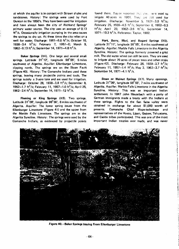
at which the aquifer is in contact with Strawn shales andsandstones. History: The springs were used by FortDuncan in' the 1850's. They have been used for irrigationand have always been the city of Richland Springs'primary water source. The city uses an average of 0.13fe Is. Occasionally irrigation pumping in the area causesthe springs to dry up. At these times the city relies on awell for water. Discharge: 1901-6.0 ft3 Is; October 10,1938-3.4 ft3 Is; February 7, 1957-0; March 9,1962-0.13 fe Is; September 14,1971-4.8 ft3Is.
Baker Springs (X4). One large and several smallsprings. Latitude 31°12', longitude 98°55', 5 milessouthwest of Algerita. Aquifer: Ellenburger Limestone,dipping north. The springs are on the Sloan Fault(Figure 40). History: The Comanche Indians used thesesprings, leaving many projectile points and tools. Thesprings supply a 3-acre lake and are used for irrigation.Discharge: October 28, 1938-3.8 fe Is; September 8,1952-1.7 tr/s; February 11, 1957-1.0ft3/s;ApriI25,1962-2.4 frls;SePtember 14,1971-12tr/s.
Fleming or King Springs (X5). Two springs.Latitude 31°08', longitude 98°56', 8 miles southwest ofAlgerita. Aquifer: The lower spring issues from theEllenburger Limestone (Figure 41) and the upper fromthe Marble Falls Limestone. The springs are in theAlgerita Syncline. History: The springs were used by theComanche Indians, as evidenced by projectile points
-found there. Taylor reported :hc:r :he" we'e uSI~d toirrigate 40 acres in 1901. Thev Eire still used forirrigation. Discharge: November 5, 1921- 3.0 'ft3 Is;February 25, 1939-4.5 ft3/S; September 8, 1952-0.3ft3 Is; April 23, 1962-·3.6 ftJ Is; September 14,1971-10.2 ft3 Is. Fleference: Taylor, 1902.
Hart, Berry, Mud, and Bogard Springs (X6).Latitude 31°11', longitude 98°55', 6 miles southwest ofA1gerita. Aquifer: Marble Falls Limestone in the AlgeritaSyncline. History: The springs formerly powered a gristmill. The old water wheel can still be seen. They are usedto irrigate about 70 acres of pecan trees and other croPs(Figure 42). Discharge: February 25, 1939-3.7 fe Is;February 11, 1957-1.4 tr Is; May 3, 1962-3.7 ft3 Is;September 14,1971-4.1 ft3 Is.
Sloan or Walnut Springs (X7). Many openings.Latitude 31°09', longitude 98°55', 7 miles southwest ofAlgerita. Aquifer: Marble Falls Limestone in the AlgeritaSyncline. History: This was an important Indiansettlement. In 184~7 John Meusebach with a party ofGerman immigrants made a treaty with the Indians atthese springs. Rights to the San Saba valley wereobtained in exchange for about $1,000 worth ofpresents. Comanche Chief Mope-tschokepe andrepresentatives of the Hueco, Lipan, Cupaw, Tehuacana,and Caddo tribes participated. This was one of the mostimportant Indian treaties ever made, and was never
Figure 40.-Baker Springs Issuing From Ellenburger Limestone
- 64-
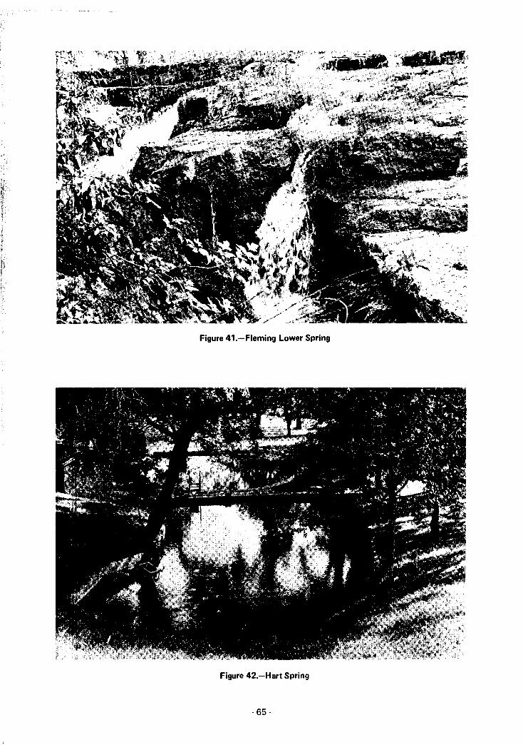
Figure 41.-Fleming Lower Spring
Figure 42.-Hart Spring
- 65-

broken. In the 1880's a grist and saw mill was erectedhere. The dam and mill race still exist. The water hasbeen used for many years to irrigate pecan trees, pasture,and crops. A historical marker is located here. Discharge:1902-9.0 fe Is; March 30, 1918-4.7 fe Is; November18, 1921-5.3 fe Is; October 28, 1938-6.2 fe Is;September 8, 1952-4.3 ft3 Is; February 7, 1957-3.1ft3 Is; April 23, 1962-4.2 fe Is; September 14,1971-9.0 fe Is.
Turkey Roost Springs (X8). Several springs.Latitude 31°08', longitude 98°56', 9 miles southwest ofAlgerita. Aquifer: Marble Falls Limestone in the AlgeritaSyncline. History: Used for a long period by theComanche Indians, as evidenced by projectile points.Discharge: June 16, 1931-2.1 ft3 /s; December 19,1938-0.33 ft3 Is; September 14, 1971-0.05 ft3 Is. Theflow is usually lost before reaching the San Saba River.
Deep Creek Springs (X9). About seven springs,including Big Spring. Latitude 31°06', longitude 98°59',12 miles south of Richland Springs. AqUifer:Ellenburger Limestone, dipping north. History: Thesprings supply a lake used for irrigation (Figure 43).Discharge: November 29, 1938-4.2 fe Is; February 25,1969-3.1 ft3 Is; February 7, 1957-0.3 ft3 Is; March 19,1962-2.5 fe Is; September 14, 1971-4.1 ft3 Is.
Sycamore, Cottonwood, and other springs (Xl0).Latitude 31°06', longitude 99°01', 13 miles south ofRichland Springs, on both sides of the San Saba River.Aquifer: Ellenburger Limestone in a small anticline.History: They are used for irrigation. Discharge:February 25, 1939-1.3 fe Is; February 7, 1957-0;September 14,1971-2.1 fe/s.
Wallace Springs (X 11). Many openings in graveland limestone. Latitude 31°06', longitude 98°51',8 miles southwest of Harkeyville. A historical marker islocated here. Aquifer: Ellenburger Limestone, dippingnorth. The springs issue at the contact of the aquifer andthe Barnett Shale, in the Wallace Creek Syncline.Discharge: November 18, 1921-2.1 fe/s; October 3,1938-3.6 ft3 Is; September 14, 1971-12 fe Is.
San Saba Springs (X12). About 18 springs.Latitude 31° 12', longitude 98°43', at the southeast edgeof San Saba. Aquifer: Marble Falls Limestone in the SanSaba Anticline. History: Paddock (1911) stated thatthese "strong springs" were used as early as 1880 topower a flour mill, saw mill, and cotton gin, to irrigate50 acres, and later to generate electric power. Remnantsof the old mill dam are still in place (Figure 44). Thesprings now supply water to the city of San Saba. Anaverage of 0.74 ft3 Is is used by the city. Discharge (ft3 Is
Figure 43.-Deep Creek Springs Reservoir
- 66-

Figure 44.-Remains of Old Mill Dam at San Saba Springs
by water years):
WATER DIS- WATER DIS-YEARS CHARGE YEARS CHARGE
(ft3fsl (ft3fsl
1939 9.7 1965 9.0
1952 7.3 1966 8.8
1957 5.5 1967 7.5
1959 7.5 1968 11
1960 11 1969 8.9
1961 12 1970 13
1962 16 1971 7.5
1963 5.3 1972 9.7
1964 8.4 1973 10.2
Discharge is also shown on Figure 24. Reference:Paddock, 1911.
Barnett or Dalton Springs (X 13). Numeroussprings. Latitude 31°11', longitude 98°39', 5 miles eastof San Saba. Aquifer: Ellenburger Limestone, dippingnortheast. Springs are on the Simpson Creek Fault Zone.Downstream from the springs, large travertine depositshave built up where the water passes over falls (SeeFigure 17). History: Much land was irrigated as early as
- 67-
1867 from these springs. They are still used to irrigate apecan grove. Little of the spring water reaches the SanSaba River. Discharge: October 29, 1938-0.90 ft3 Is;February 12, 1957--0.5 fe Is; September 14, 1971-1.5fe Is. Reference: Paddock, 1911.
Parker or Holland Springs (X14). Includes BristerSpring one-half mil!e west Latitude 31°07', longitude98°34', 5 miles northwest of Bend. Aquifer: MarbleFalls Limestone. The springs issue through the CherokeeFault Zone. History: They are used for irrigation.Discharge: October 29, 1938-1.9 fe Is; Ju Iy 23,1940-1.3 ft3 Is; February 12, 1957-0.2 ft3 Is; April 23,1962-1.1 fe Is; September 14, 1971-2.2 ft3 /s.
Sulphur Springs (X16). Several springs, one in theColorado River. Latitude 31°05', longitude 98°28',3 miles east of Bend. Aquifer: Ellenburger Limestone,dipping northeast. History: The springs were used formedicinal bathing in the 1850's. They now supply theswimming pool at a hunting and fishing camp.Discharge: March 6, 1939-1.4 ft3 /s; September 14,1971-0.54 ft3 Is.
Gorman Springs (X 17). Several springs. Latitude31°04', longitude 98°29', 4 miles southeast of Bend.Aquifer: Ellenburger Limestone, dipping northeast.
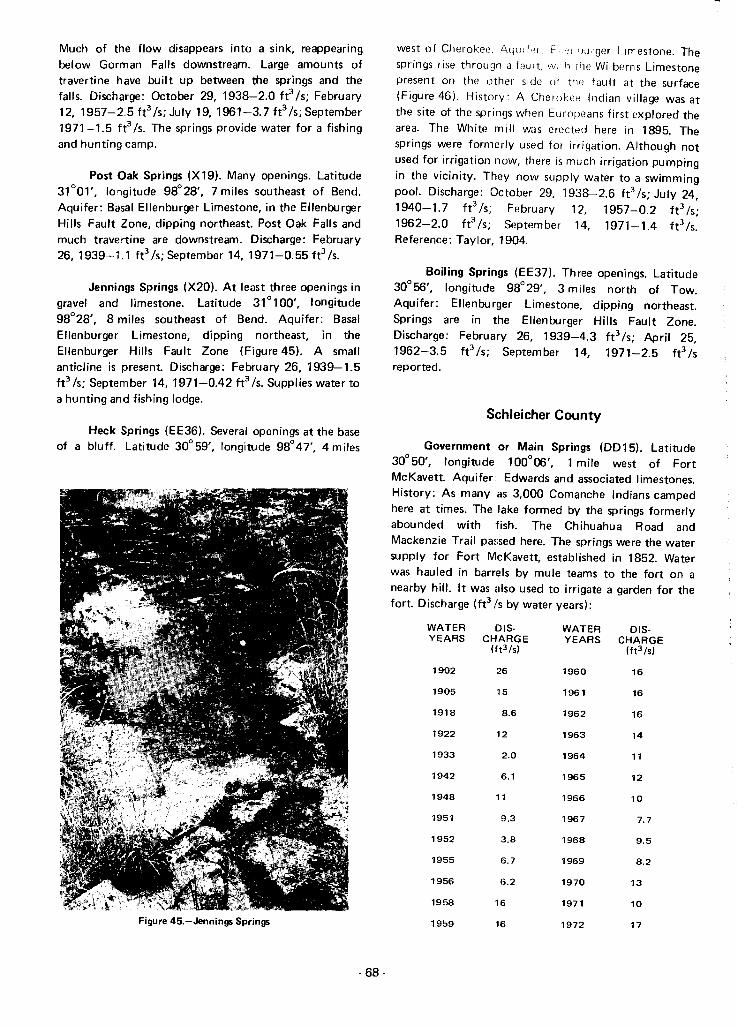
Much of the flow disappears into a sink, reappearingbelow Gorman Falls downstream. Large amounts oftravertine have built up between the springs and thefalls. Discharge: October 29, 1938-2.0 fe Is; February12, 1957-2.5ft3 /s;July 19,1961-3.7ft3 /s;September1971-1.5 fe/s. The springs provide water for a fishingand hunting camp.
Post Oak Springs (X 19). Many openings. Latitude31°01', longitude 98°28', 7 miles southeast of Bend.Aquifer: Basal Ellenburger Limestone, in the EllenburgerHills Fault Zone, dipping northeast. Post Oak Falls andmuch travertine are downstream. Discharge: February26,1939-1.1 fe/s;September 14, 1971-0.55ft3 /s.
Jennings Springs (X20). At least three openings ingravel and limestone. Latitude 31° 100', longitude98°28', 8 miles southeast of Bend. Aquifer: BasalEllenburger Limestone, dipping northeast, in theEllenburger Hills Fault Zone (Figure 45). A smallanticline is present. Discharge: February 26, 1939-1.5fe Is; September 14,1971-0.42 ft3 Is. Supplies water toa hunting and fishing lodge.
Heck Springs (EE36). Several openings at the baseof a bluff. Latitude 30° 59', longitude 98°47', 4 miles
Figure 45.-Jennings Springs
- 68-
west of Cherokee. l\qu;f"r E . "-"ger Limestone. Thesprings rise throu!Jh a fault wi h t'le Wilhems Limestonepresent on the other side of trw fault at the surface(Figure 46). History: A Cherokee Indian village was atthe site of the springs when Europeans first explored thearea. The White mill was erected here in 1895. Thesprings were formerly used for irrigation. Although notused for irrigation now, there is much irrigation pumpingin the vicinity. They now supply water to a swimmingpool. Discharge: October 29, 1938-2.6 fe Is; July 24,1940-1.7 ft3 /s, February 12, 1957-0.2 fe/s;1962-2.0 fe Is; September 14, 1971-1.4 fe Is.Reference: Taylor, 1904.
Boiling Springs (EE37). Three openings. Latitude30°56', longitude 98°29', 3 miles north of Tow.Aquifer: Ellenburger Limestone, dipping northeast.Springs are in the Ellenburger Hills Fault Zone.Discharge: February 26, 1939-4.3 fe Is; April 25,1962-3.5 ft3 Is; September 14, 1971-2.5 ft3 Isreported.
Schleicher County
Government or Main Springs (DD15). Latitude30° 50', longitude 100°06', 1 mile west of FortMcKavett. Aquifer:: Edwards and associated limestones.History: As many as 3,000 Comanche Indians campedhere at times. The lake formed by the springs formerlyabounded with fish. The Chihuahua Road andMackenzie Trail passed here. The springs were the watersupply for Fort McKavett, established in 1852. Waterwas hauled in barrels by mule teams to the fort on anearby hill. It was also used to irrigate a garden for thefort. Discharge (ft3 Is by water years):
WATER DIS- WATER DIS-YEARS CHARGE YEARS CHARGE
(ft3/s) (ft3/s)
1902 26 1960 16
1905 115 1961 16
1918 8.6 1962 16
1922 12 1963 14
1933 2.0 1964 11
1942 6.1 1965 12
1948 11 1966 10
1951 9.3 1967 7.7
1952 :3.8 1968 9.5
1955 15.7 1969 8.2
1956 6.2 1970 13
1958 lE; 1971 10
1959 1(. 1972 17
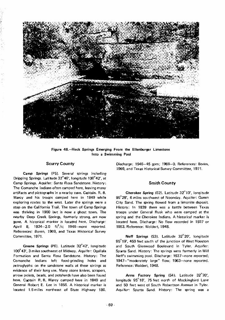
Figure 46.-Heck Springs Emerging From the Ellenburger LimestoneInto a Swimming Pool
Scurry County
Camp Springs (P5). Several springs includingDripping Springs. Latitude 32°46', longitude 100°42', atCamp Springs. Aquifer: Santa Rosa Sandstone. History:The Comanche Indians often camped here, leaving manyartifacts and pictographs in a nearby cave. Captain. R. B.Marcy and his troops camped here in 1849 whileexploring routes to the west. Later the springs were astop on the California Trail. The town of Camp Springswas thriving in 1900 but is now a ghost town. Thenearby Deep Creek Springs, formerly strong, are nowgone. A historical marker is located here. Discharge:April 8, 1924-2.0 ft3/S; 1946-none reported.References: Boren, 1969, and Texas Historical SurveyCommittee, 1971.
Greene Springs (P6). Latitude 32°42', longitude100°43',3 miles southwest of Midway. Aquifer: OgallalaFormation and Santa Rosa Sandstone. History: TheComanche Indians left food-grinding holes andpetroglyphs on the sandstone walls at these springs asevidence of their long use. Many stone knives, scrapers,arrow points, beads, and potsherds have also been foundhere. Captain R. B. Marcy camped here in 1849 andGeneral Robert E. Lee in 1856. A historical marker islocated 1.5 miles northeast of State Highway 180.
- 69-
Discharge: 1946-45 gpm; 1969-0. References: Boren,1969, and Texas Historical Survey Committee, 1971.
Smith County
Cherokee Spring (S2). Latitude 32° 10', longitude95°28', 6 miles southwest of Noonday. Aquifer: QueenCity Sand. The spring flowed from a limonite deposit.History: In 1839 there was a battle between Texastroops under General Rusk who were camped at thespring and the Cherokee Indians. A historical marker islocated here. Discharge: No flow recorded in 1937 or1963. Reference: Woldert, 1948.
Neff Springs (S3). Latitude 32°20', longitude95°19', 450 feet south of the junction of West Houstonand South Glenwood Boulevard in Tyler. Aquifer:Sparta Sand. History: The springs were formerly in WillNeff's swimming pool. Discharge: 1937-none reported;1947-u moderately large" flow; 1963-none reported.Reference: Wo/dert, 1948.
Arms Factory Spring (S4). Latitude 32°20',longitude 95° 18', 75 feet north of Mockingbird Laneand 50 feet west of South Robertson Avenue in Tyler.Aquifer: Sparta Sand. History: The spring was a

campsite for the Caddo and Tejas Indians. When firstdiscovered by white men it was a bold spring, one of thelargest in the area. Discharge: None reported in 1937,1947, or 1963. Reference: Woldert, 1948.
Tyler Springs (S5). Two springs. Latitude 32°21',longitude 95° 18', on South Spring Street, 75 feet southof East Elm Street in Tyler. Aquifer: Sparta Sand.History: In the early days the spring had a large flowwhich was curbed in a 10- by 12-foot pool. It wasfrequently used for baptizing. Discharge: July 6,1936-10 gpm; no flow recorded in 1937, 1948, or1963. Reference: Woldert, 1948.
Camp Ford Spring (S6). Latitude 32°24',longitude 95°17', 3 miles north of Tyler. Aquifer:Sparta Sand. History: During the Civil War this springsupplied water for 6,000 men at Camp Ford, aprisoner-af-war camp. It is now submerged by BurnsLake. No flow was recorded in 1937, 1948, or 1963.Reference: Wolder!, 1948.
Cousin Spring (S7). Latitude 32°23', longitude95° 15', 5 miles northeast of Tyler on the south side ofRay's Creek. Aquifer: Sparta Sand. History: It wasdescribed as one of the finest springs in the area whenthe county was first settled. Discharge: None reported in1937,1948, or 1963. Reference: Woldert, 1948.
Headache Springs (Sll). Latitude 32° 19,longitude 95°12',6 miles east of Tyler. Aquifer: QueenCity Sand. History: These springs were well known fortheir healing mineral waters. During the Civil War amedical laboratory here made medicines and whiskey forthe government. The medicines were made from themineral water and herbs such as poke root, snakeroot,mullein, jimson week, Jerusalem oak, nightshade,mistletoe, and cherry bark. Discharge: No flow reportedin 1937 or 1963. Reference: Texas Historical SurveyCommittee, 1971.
Sutton County
Fort Terrett Springs (DD16). Source of the NorthLlano River. Latitude 30°28', longitude 100° 11', 8 mileswest of Roosevelt. Aquifer: Edwards and associatedlimestones. History: A number of early explorers passedthis way, possibly including De Vaca in 1535, Bosque in1675, and Mendoza in 1683. In 1852-53 the springsfurnished water for Fort Terrett. Discharge:1918-"large flow"; 1972-"reported to flow only after arain." Reference: Fisher, 1937.
Tarrant County
Cold Sp,rings (R3). Latitude 32"44', longitude97°20', on the south side of the Trinity River 1/4 mile
east of the North Main Street bridge in Fort Worth.Aquifer: Probably the Paluxy Sand of the Trinity Groupaquifer. The springs issue through alluvium. History: TheU.S. Army Dragoons arrived and camped here in 1849.The springs were then surrounded by a grove of giantoaks and pecan trees, and were a social center until the1880's. They Wine used as a water supply for Fort Worthfrom 1849 to 1876, when artesian wells were drilled.They were on the Chisholm Cattle Trail from 1867 to1895. Discharge: 1849-"gushed clear cold water";1942-none reported; 1949-"faintly bubbling";1957-none reported. References: 'Paddock, 1911, andArlington Heights Junior Historians, 1949.
Mary Le Bone Springs (R4). Latitude 32°41',longitude 97°01', 3 miles south of Arlington. Aquifer:Woodbine Sand.. History: This was an ancient Indiansettlement, as evidenced by arrow points, bedrockmortars, and other relics. A trading post was establishedat the springs in 1845. From here the Texas Rangers setout in 1849 to locate a site for Fort Worth. Discharge:1942-none reported; 1949-"several sluggish springs";1957-none reported. References: Paddock, 1911, andArlington Heights Junior Historians, 1949.
Terrell County
Meyers Springs (CC16). Near latitude 30°09',longitude 102°01', about 9 miles northeast of Dryden.Aquifer: Edwards and associated limestones. History:These springs were an old Apache Indian watering place,as evidenced by pictographs on the cliffs. They make abeautiful 40-foot fall from a precipice into a large basin.In 1882 a military outpost was located here, the remainsof which can still be seen. Reference: Williams, 1969.
T-5 Springs (DD3). Latitude 30°28', longitude101°47', 16 miles south of Sheffield. Aquifer: Edwardsand associated limestones. Discharge: 1917-5.5 fe/s;July 25, 1929-8.4 fe Is; March 29, 1962-13 ft 3 /s;February 7, 1968--9.0 fe Is.
Richland Springs (DD5). Latitude 30°23',longitude 101°4~I', 16 miles northwest of Pandale.Aquifer: Edwards and associated limestones. Discharge:1917-3.3 fe Is; July 25, 1929-2.8 ft3 /s; March 29,1962-3.9 fe Is; FE!bruary 7,1968-1.9 ft3 /s.
Wolf Springs (DD6). Latitude 30°23', longitude101°42', 16 miles northwest of PandaIe. Aquifer:Edwards and associated limestones. Discharge:
- 70-

1917-3.3 ft3 /s; July 25, 1929-6.2 ft 3 /s; March 29,1962-6.4 ft3 /s; February 7, 1968-6.3 ft 3 /s.
Geddis Springs (007). Latitude 30° 18', longitude101°46', 15 miles northwest of Pandale. Aquifer:Edwards and associated limestones. Discharge:1917-5.5 ft3 /s; April 29, 1943-2.6 ft3 /s; February 7,1968-0.
Sweetwater Springs (0081. Latitude 30° 17',longitude 101°46', 14 miles northwest of Pandale.Aquifer: Edwards and associated limestones. Discharge:1917-4.4 ft3 /s; April 29, 1943-3.2 fe Is; 1962-2.8ft3 /s; 1968-2.4 fe Is.
Tom Green County
Mill Spring (W4). Latitude 31°11', longitude100°30', 1 mile south of Christoval. Aquifer: Edwardsand associated limestones. History: Meserve man ofabout 9,000 years ago left spear points here. JuanDominguez de Mendoza possibly stopped here in 1683.The Bismarck gin used the spring for power in the1800's. Discharge: March 12,1925-2.4 ft 3 /s; 1941 and1954-none reported; July 20, 1970-dry.
Anson Springs (W5). Several springs. Latitude31°08', longitude 10<t30', 4 miles south of Christoval.
Aquifer: Edwards and associated limestones (Figure 47).History: Bedrock mortars at the springs testify to theiruse by the Tonkawa Indians. Mendoza may have stoppedhere in 1683. 0 ischarge (ft3 Is by water years):
WATER DIS- WATER DIS-YEARS CHARGE YEARS CHARGE
(ft3/s1 lft3 /s1
1925 11 1962 15
1940 4.5 1963 12
1950 9.0 1964 8.8
1958 12 1965 7.7
1959 11 1966 6.4
1960 16 1970 7.0
1961 15 1971 6.3
At least eight upstream springs, including Pecan,Cave, and McCarthy Springs, no longer flow because ofwell pumping. Rieferences: Taylor, 1904 and Newcomb,1961.
Lipan Spring (W6). Latitude 31°15', longitude100° 15', 10 miles southeast of Wall. Aquifer: Edwardsand associated limestones. History: This spring was astop on the Chihuahua Road. Discharge (ft3 /s by wateryears) :
Figure 47.-Anson Springs
- 71 -

WATER DIS· ',''il, T iOH 015-YEARS CHARGE TAFiS CHARGE
(ft3 /s) (ft'ls)
1905 1.0 1950 0.3
1940 0.30 1952 0.1
1948 0.1 1962 0.18
Kickapoo Spring (W7). Latitude 31°10', longitude100°06', 12 miles south of Vancourt. Aquifer: Edwardsand associated limestones. History: In 1873 adetachment from Fort Concho killed Kiowa Chief LoneWolf here and recovered some stolen horses. The springwas used for irrigation in the early days of settlement.Discharge: December 20, 1904-4 fe Is; October1940-1.3 ft3 Is; May 9, 1950-1.0 ft3 Is; April 12,1962-1.4 ft3 /s; July 28,1970-0.1 ft3 /s. Pumping ofnearby wells causes the spring to stop flowing.Reference: Taylor, 1904.
Travis County
Mormon or Taylor and Mount Bonnell Springs(F F4). At least 50 springs. Latitude 30°19', longitude97°46', 1 mile north of Tom Miller Dam in Austin.Aquifer: Edwards and associated limestones, on theMount Bonnell Fault. History: A Mormon settlementused the springs to power a grist mill in 1846 and 1847.They have now nearly all been inundated by LakeAustin. Discharge: 1904-3 ft3 Is; 1918-1.0 ft3 Is; 1941and 1957-none reported; February 6, 1973-22 ft3 Is.Reference: Hill and Vaughn, 1898.
Power House or Dam Spring (FF5). Latitude30°18', longitude 97°47', at Tom Miller Dam in Austin.Aquifer: Edwards and associated limestones. The springflows through Colorado River terrace deposits. History:The spring appeared in the east abutment duringconstruction of Lake Austin Dam in 1893. The damfailed in 1900 and was later rebuilt. The spring stilldrains through several drainage pipes below thepowerhouse. Discharge: December 18, 1895-4.3 fe Is;1897-10 fe Is; 1899-8 ft3 Is; 1941 and 1957-nonereported; March 1970-0.3 ft3 Is; February 5,1973-0.05 ft 3 /s. References: Hill and Vaughn, 1898,and Taylor, 1900.
Seiders Springs (FF6). At least two springs.Latitude 30° 17', longitude 97°45', on Shoal Creekbetween 34th and 38th Streets in Austin. Aquifer:Edwards and associated limestones. The springs issuethrough a fault. History: In 1839 the springs weredescribed as "a stream of limestone water which couldbe used as a water supply for the new capital." Between1846 and 1865 many Army troops, including thoseunder the command of General Custer and General Lee,
·72-
camped at the springs. From 1871 to 1896 Ed Seidersoperated a popular resort and bath house here. Bath tubswere cut out of the rock on the hillside and filled fromthe springs. Discharge: 1898-"small"; 1941 and1957-none reported; 1971-0.32 ft3 Is; June 7,1972-30 gpm. Thl~ downstream spring has a strangecyclic action. The flow practically ceases for severalminutes and then gushes forth for a brief interval beforesubsiding again. On June 7, 1972, the range in flow wasfrom 2 to 60 gpm during a 5-minute cycle. Thephenomenon is probably caused by a siphoning action inthe rock passageways from which it issues. When the rateof flow is lower, the cyclic period is longer. References:Hill and Vaughn, 1898; Barkley, 1963; and TexasHistorical Survey Committee, 1971.
Cold and Deep Eddy Springs (FF7). At least sevensprings. Latitude 30° 16', longitude 97°46', near ValleySprings Road in Austin. Aquifer: Edwards andassociated limestones. The springs issue through a fault.History: Many Indian projectile points and tools havebeen found at the springs and in Bat Cave downstreamand Bee Cave just upstream. An old Comanche Indiantrail from Bandera to Nacogdoches passed the springs. Inthe 1870's steamboats made excursions from Austin tothese springs and the upstream Bee Springs. Only twosprings are now above the level of Town Lake.Discharge: 1898-'''large volume"; August 1917-4.2fe Is; February 8,1941-3.0 ft3 Is; 1955-none reported;May 1972-2.9 ft3 Is. References: Hill and Vaughn,1898, and Sellards" Baker, and others, 1934.
Barton Springs (FF8). At least five groups ofsprings, including Upper, Main, Upper Left Bank, LowerLeft Bank, and Old Mill or Walsh Spring; the farthestdownstream. Latitude 30° 16', longitude 97° 47', 2 milessouthwest of Austin. Aquifer: Edwards and associatedlimestones. The springs issue through a fault. History:This was a gathering place for the Caddo, Tonkawa,Apache, and Comanche Indians. An old ComancheIndian trail from Bandera County to Nacogdochespassed here. The early settlers had a trading post at thesprings. Early Spanish explorers wrote that in 1714 wildhorses were numl~rous. Three Spanish missions werelocated here from 1730 to 1731. In 1839 the fivecommissioners named to select a site for the Texas
capital described the springs as "perhaps the greatest and
most convenient water power to be found in theRepublic." BonnEll! (1840) described them as "large,
springs, many of which would afford 5 or 6 hundredbarrels of water a minute, bursting out at the. foot of themountains." This flow is equivalent to 47 to 56 fe Is.Early in the 1880's a fort was located at the springs. Anumber of saw and grist mills and ice-making machinesused the water power of the springs. This was also a stopon the Chisholm Cattle Trail from 1867 to 1895. A

historical marker is located here. The springs have alwaysbeen popular for swimming (See Figure 23). Discharge(fe Is by water years):
WATER DIS-YEARS CHARGE
(ft3/s1
1895 17
1896 25
WATER DIS-YEARS CHARGE
(ft3 /s)
1930 29
1931 64
The springs were named for Colonel Jose Menchaca ofthe Army of the Texas Republic. They were describedby Hill and Vaughn (1898) as having a large flow, butless than Barton Springs. They were on the ChisholmCattle Trail from 1867 to 1895. A mill was onceoperated by the spring waters. The remains of the millmay still be seen (Figure 48). Discharge (gpm by wateryears):
1897
1898
1899
1900
48
25
19
69
1932
1933
1934
1935
35
27
44
61
WATER 015-YEARS CHARGE
(ft3 /s1
1941 18
1955 5
WATER 015-YEARS CHARGE
(ft3/s1
1971 23
1973 200
1901
1902
1903
1904
1905
1906
1910
1916
1917
1918
1919
1920
1921
1922
1923
1924
1925
1926
1927
1928
33
23
69
43
65
24
19
30
17
18
52
95
58
36
64
36
62
37
33
1936
1937
1938
1939
1940
1941
1959
1960
1961
1962
1963
1964
1965
1966
1967
1968
1969
1970
1971
1972
44
48
53
20
30
89
63
55
95
49
44
23
58
64
41
75
85
78
43
83
Reference: Hill and Vaughn, 1898.
Santa Monica or Sulphur Springs (FF19l. Latitude30°21', longitude 97°54', 4 miles south of MarshallFord. Aquifer: Glen Rose Limestone. History: Thesesprings were once the basis for Comanche and TonkawaIndian campgrounds. In later periods the waters werebottled and highly valued for medicinal purposed. Thesprings were also a favorite resort for early Austinites(Figure 49). They are now beneath Lake Austin.References: Barkley, 1963, and Hart, 1973.
Tyler County
Enloe Spring (GG3). Latitude 30°56', longitude94°28',3 miles northwest of Colmesneil. Aquifer: JasperSand. History: The Cherokee Indian Peach Tree Villagewas formerly located here. In 1840 the Enloe gin,gristmill, and sawmill was built to use the spring waterfor power. A historical marker is located here.References: Bonnell, 1840; Taylor 1904; and TexasHistorical Survey Committee, 1971.
Uvalde County
1929 50
On February 6, 1973, the Upper Springs were notflowing, the Main Springs flowed an estimated 47 ft3 /s,the Upper Left Bank Springs flowed 5 ft3 /s, the LowerLeft Bank Springs flowed 6 fe Is, and Walsh Springsflowed 9 ft3 /s. Discharge is also given on Figure 22.References: Bonnell, 1840; Hill and Vaughn, 1898;Meinzer, 1927; and Texas Historical SurveyCommittee, 1971.
Manchaca Springs (FF10). Several springs on asmall tributary of Onion Creek. Latitude 30°06',longitude 97°49', 3 miles south of Manchaca. Aquifer:The springs rise through a fault in the Austin chalk andgravel, possibly from the Edwards Limestone. History:
Spring Creek Springs (LL8). Latitude 29°33'longitude 99° 57', 2 miles northeast of Montell. Aqu ifer;Gravel alluvium. The flow is believed to be chieflyNueces River flow which sinks into gravels and reappearshere as springs. History: The springs were the basis foran ancient Indian campground. Later a mission waslocated here. Discharge: March 22, 1924-0; August 11,1924-0; December 14, 1954-10 fe Is; February 16.1955-0; September 20. 1955-15 ft3 /s; July 10,1957-30 fe Is.
Spring Branch Springs (LL9). Latitude 29°21',longitude 99°57', 6 miles southeast of Laguna. Aquifer:Edwards and associated limestones. Discharge: March22, 1924-0; August 13. 1924-0; April 30, 1925-0;
·73 -

Figure 48.-Remains of Old Mill at Manchaca Springs
Figure 49.-Santa Monica Springs in 1890, Looking South(From the Austin-Travis County Collection, Austin Public Library)
-74 -

See also the combined discharge measurements forGroups 1 to 3 of Leona Springs below.
See also the combined discharge measurements forGroups 1 to 3 of the Leona Springs, following Group 3.
leona Springs, Groups 1 to 3 (Lll1). In recentyears the combined flow of Groups 1 through 3 ofleona Springs has been measured. These measurementsfollow (fe /s by water years):
leona Springs, Group 3 (Ll13). Latitude 29°09',longitude 99°44', 6 miles southeast of Uvalde. Aquifer:Edwards and associated limestones. The springs probablyissue through a fault beneath the leona Formation.Discharge: (fe /s by water years):
DISCHARGE
(ft3/s1
WATERYEARS
1925 5.3 1942 14
1931 4.9 1943 14
1934 7,6 1944 8
1935 5.2 1945 8
1939 6.9 1946 2.6
1940 13 1947 6.5
1941 12
WATER DIS- WATER DIS-YEARS CHARGE YEARS CHARGE
(ft3/s1 (ft3 Is)
1925 1.6 1939 6.5
1931 8.4 1946 4.7
1934 4.4 1947 7.0
1935 4.8
WATER DIS- WATER DIS-YEARS CHARGE YEARS CHARGE
(ft3 /s) (ft3 Is)
1934 14 1942 27
1935 14 1943 24
1936 33 1944 11
1937 34 1945 13
1938 :29 1946 6
1939 20 1947 10
1940 :10 1948 6.9
1941 117 1949 3.0
leona Springs, Group 2 (LL12). Latitude 29° 11',longitude 99°46', 3 miles southeast of Uvalde. Aquifer:Edwards and associated limestones. The springs issuethrough a fault and the Leona Formation. Discharge:(ft3 /s by water years):
WATER DIS-YEARS CHARGE
(ft3 /s)
WATER DIS- WATER DIS-YEARS CHARGE YEARS CHARGE
(ft3 /s1 (ft3 lsI
1885 0 1931 3.1
1893 0 1933 19
1896 11 1934 6.8
1898 0 1935 1.4
1899 0 1939 7.1
1900 5 1940 7
1904 22 1941 6
1906 13 1942 7
1910 8.4 1943 8
1912 0 1944 4
1925 3.8 1945 1.0
1928 0.9 1946 0
1930 0 1947 3.5
November 14, 1931-0; May 2, 1940-4.0 ft3 /s; July 9,1940-3.1 fr Is; August 28, 1940-3.6 ft3/S; September26, 1940-3.2 ft3 /s.
Soldiers Camp Spring (LL1 0). Latitude 29° 10',longitude 99°54', 8 miles west of Uvalde. Aquifer:Edwards and associated limestones. The spring issuesthrough Austin Chalk and gravel. History: The springwas a stop on the Old Spanish Trail. Hill and Vaughn(1898) said "Water rushes out in a stream. ofconsiderable size, and is cool. clear, and pure, andsurrounded by splendid growths of pecan trees."Discharge: November 15,1931-0; August 19, 1939-1.5ft3 /s; 1962-none reported. Reference: Hill andVaughn, 1898.
See also the combined discharge measurements forGroups 1 to 3 of the Leona Springs, following Group 3.Reference: Bonnell, 1840.
leona Springs, Group 1 (LL11). They include.Mulberry Spring. Latitude 29°12', longitude 99°47',1 mile southeast of Uvalde. Aquifer: Edwards andassociated limestones. The springs issue through a faultand the Leona Gravel. The Leona River in this area issometimes gaining and sometimes losing flow by meansof interchange with underground water. Spring flowgenerally lags behind rainfall by several months. History:The springs afforded a stop on the Old Spanish Trail. In1840 they were described as "the purest streams ofcrystal water." The Leona Springs were settled by,Reading Black in 1853. At that time they weresurrounded by large live oak, elm, pecan and hackberrytrees. Discharge (fr Is by water years):
- 75·

WATER DIS- WATER DIS-YEARS CHARGE YEARS CHA RGE
(ft3 Is) (ft3 /s1
1950 14 1962 28
1951 0.62 1963 7.1
1952 0 1964 0.11
1953 0 1965 0.07
1954 0 1966 0.3
1955 0 1967 0.5
1956 0 1968 5
1957 0 1969 9
1958 0 1970 21
1959 6.5 1971 12
1960 31 1972 25
1961 31
The maximum recorded flow was 51 ft3 /s onDecember 4, 1973. It should be noted that in years inwhich both separate and combined dischargemeasurements were made, the separate measurementsgenerally totaled a greater amount than the combinedflow. This is because some of the flow of the uppersprings (Group 1 and 2) was lost to the alluvial gravelsbefore reaching the Group 3 springs where the combinedflow was measured.
Leona Springs, Group 4 (LL14). Latitude 29°07',longitude 99°41', 9 miles southeast of Uvalde. Aquifer:Edwards and associated limestones. The springs probablyissue through a fault beneath the Leona Formation. TheLeona River in this area is sometimes losing andsometimes gaining flow. Spring flow lags behind rainfallby several months. Discharge (ft3 /s by water years):
WATER DIS- WATER DIS-YEARS CHARGE YEARS CHARGE
(ft3 /sl (ft3 /s1
1925 12 1939 6.8
1931 12 1946 3.0
1934 5.2 1947 5.5
1935 5.6
Reference: Taylor, 1902.
Val Verde County
Howard Springs (DD9). Latitude 30°09', longitude101°32', 2 miles south of Pandale. Aquifer: Edwardsand associated limestones. Discharge: May 18, 1939-2.6ft3 /s; June 20, 1943-3.4 ft3 /s; March 29, 1962-0;February 8, 1968-0; May 20, 1969-4.0 ft3 /s.
Tardy Springs (DDlO). Originally nine springs.Latitude 30°08', longitude 101°32', 4 miles south ofPandale. Aquifer: Edwards and associated limestones.Discharge: May 15,1939-2.6 ft3/s; 1962-1.1 ft3 /s'February 6, 1968-2.0 fe Is; May 29, 1969-1.9 fe Is. .
Cox Springs (DD11). About 23 springs, includingEvert Springs. Latitude 30°02', longitude 101°32',11 miles south of Pandale. Aquifer: Edwards andassociated limestones. History: The springs have beenused for irrigation. Discharge: May 15, 1939-6.7 ft3 /s;July 21, 1943-17 fe Is; May 2, 1962-1.1 ft3 /s;1968-0.89 ft3 /s.
Juno, Headwater, or Stein Springs (DD12).Originally two springs, at least. Latitude 30°09',longitude 101°07', at Juno. Aquifer: GeorgetownLimestone of the Edwards-Trinity (Plateau) aquifer.History: Many early settlers stopped here on their waywest. The Old Spanish Trail from San Antonio to EIPaso passed here. The Devil's River at this point wasdescribed in 1916 as a beautiful stream with large liveoaks. The springs, Beaver Lake upstream, and theperennial flow of the Devil's River in this area have alldisappeared. In May 1971, the first headwater springswere 15 miles downstream, at Pecan Springs. Discharge:August 8, 1925-5.8 ft3 /s; July 13,1939-0.03 ft3 /s;May 25, 1971-0. Irrigation pumping from wellsupstream probably contributed to the drying up of thesesprings. However, much of the reduction in dischargeoccurred before any pumping for irrigation took place.Bosworth (1964) believes that overgrazing compactedthe surface soils and greatly reduced recharge to theaquifer. Reference: Bosworth, 1964.
Pecan Springs (DD13). Latitude 30°03', longitude101°10', 7 miles southwest of Juno. Aquifer:Georgetown Limestone of the Edwards-Trinity (Plateau)aquifer. The springs issue through gravel on the right(west) bank of the Devil's River. History: Hill andVaughn (1898) described them as a "sparkling spring ofpure limpid water, and its taste is delicious." They aresurrounded by a large grove of pecan trees (Figure 50),
with beaver dams downstream. The Old Spanish Trailfrom San Antonio to EI Paso passed here. Originally atleast six springs were here, but in May 1971, only thefartherest downstream spring was still flowing.Discharge: 1892-0.8 ft3/s; June 13, 1939-6.6 ft3/S;May 25, 1971-0.1 fe/s. Reference: Hill andVaughn, 1898.
Hudspeth Springs (DD14). Many springs. Latitude30°01', longitude 101°10', 10 miles south of Juno.
Aquifer: Georgetown Limestone of the Edwards-Trinity(Plateau) aquifer. The springs issue through gravel on the
- 76-

Figure SQ.-Site of Former Pecan Springs
right (west) bank of the Devil's River (Figure 51). Abeaver dam is located downstream. History: The OldSpanish Trail from San Antonio to EI Paso passed here.The springs have been used for irrigation. Discharge:June 14, 1939-2.3 ft3/s; February 1969-3.6 ft3/s; May25, 1971-5.8 ft3 /s.
Dead Man Springs (KK1). Four springs. Latitude29°47', longitude 101°21', 3 miles east of Shumla.Aquifer: Georgetown Limestone of the Edwards-Trinity(Plateau) aquifer, on the left (east) bank of the PecosRiver. History: In 1892 the Southern Pacific Railroadbuilt the Pecos high bridge, 321 feet above the river. Thesouthernmost of these springs was used as a water supplyby the railroad at the bridge. The springs are underabout 55 feet of water when International AmistadReservoir is at conservation pool level. The InternationalBoundary and Water Commission has drilled a well forthe railroad, to replace the spring as a water supply.Discharge: May 25, 1939-4.2 ft3/S: May 25, 1971-3.2ft3 /s reported.
Huffstutter Springs (KK2). Two springs. Latitude29°57', longitude 101°08', 19 miles north of Comstock.Aquifer: Georgetown Limestone. History: The OldSpanish Trail from San Antonio to El Paso passed thesesprings. Fort Hudson was established near them in 1854.
·77·
Camel caravan experiments were carried out from herein 1856. Discharge: June 13, 1939-1.7 ft3 /s; May 25,1971-0.8 ft3 /s reported. The small (east) spring hasreportedly ceased flowing.
Finegan Springs (KK3). One large and eightsmaller springs. Latitude 29°54', longitude 101°00',13 miles west of Loma Alta. Aquifer: GeorgetownLimestone of the Edwards-Trinity (Plateau) aquifer. Thesprings issue from the base of a bluff on the left (east)bank of the Devil's River, about 15 feet above the river(Figure 52). History: Artifacts indicate long use by theApache Indians. Originally there were at least 25 springs.There was also a waterfall at a higher elevation duringstrong spring flows. Discharge: February 15, 1928-3.5fe Is; July 1939-27 tt3/s; September 17, 1966-4.0ft3 /s; February 4, 1969-4.0 fe Is; May 25, 1971-20ft3 /s. Reference: Bosworth, 1964.
Dolan Springs (KK5). Two main and about 20smaller springs. Latitude 29°54', longitude 100°59',12 miles west of Loma Alta. Aquifer: GeorgetownLimestone of the Edwards-Trinity (Plateau) aquifer, onDolan Creek. History: Indian middens with many stonetools indicate very ancient use of these springs. A damand measuring weir have been built below the southsprings (Figure 53). The north springs flow into a natural
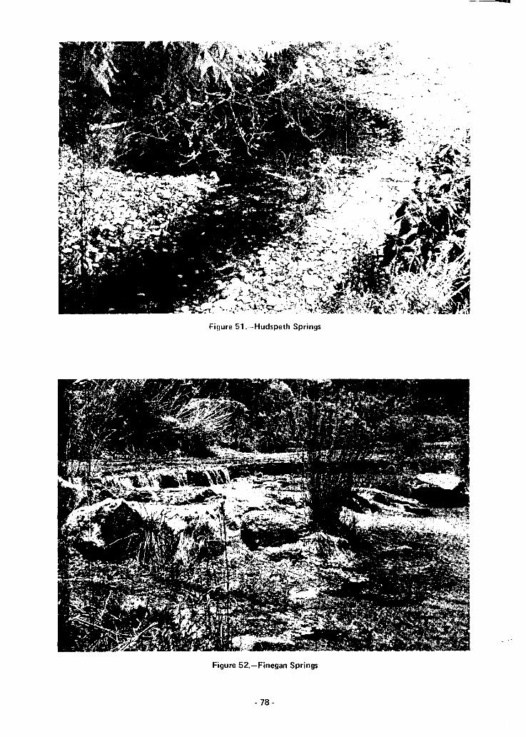
Fi9ure 51.-- Hudspeth Springs
Figure 52.-Finegan Springs
- 78-

Figure 53.-Dam and Weir on Dolan South Spring
pool in the rock. Discharge (ft3 /s by water years):
WATER DIS- WATER DIS-YEARS CHARGE YEARS CHARGE
(ft3/sl (ft3/sl
1928 2.0 1968 1.7
1939 33 1969 1.1
1966 5.6 1970 3.0
1967 2.4 1971 1.2
Gillis Springs (KK5). About 14 springs. Latitude29°43', longitude 101°02', 9 miles east of Comstock.Aquifer: Georgetown Limestone of the Edward-Trinity(Plateau) aquifer. The springs issue from limestone onthe right (west) bank of the Devil's River, some belowriver level (Figure 54). Discharge: February 14,1928-6.3 ft3 /s; July 19, 1939-0.18 ft3 /s; October 4,1967-0.22 fe Is; May 25, 1971-9.2 ft3 /s.
Slaughter Bend or Swann-Shelton Springs (KK6).About 18 springs. Latitude 29°40', longitude 100°56',21 miles north of Del Rio. Aquifer: GeorgetownLimestone of the Edwards-Trinity (Plateau) aqUifer. Thesprings issue from the limestone at the base of a cliff onthe left (east) bank of the Devil's River, about 10 feetabove the river (Figure 55). A small anticline is present.History: Indian middens with numerous stone artifacts
-79-
indicate long use of these springs. They are under about50 feet of water when International Amistad Reservoir isat conservation pool level. Discharge: January 26,1921-25 ft 3 /s; August 12, 1925-50 fe Is; February 18,1928-26 ft3 /s; May 25, 1971-11 ft3 /s.
Goodenough Spring (KK7). An artesian spring onthe left (north) bank of the Rio Grande. Latitude29°32', longitude 101° 15', 12 miles southwest ofComstock. Aquifer: Georgetown Limestone of theEdwards-Trinity (Plateau) aquifer. History: The Spanishexplorer Castano de Sosa may have stopped here in 1590during his exploration of the Rio Grande and PecosRiver. Discharge (fe Is by water years):
WATER DIS- WATER DIS-YEARS CHARGE YEARS CHARGE
Ift3 /sl (ft3/sl
1922 190 1930 117
1923 240 1931 150
1924 210 1932 159
1925 169 1933 302
1926 160 1934 188
1927 140 1935 156
1928 120 1936 144
1929 130 1937 132
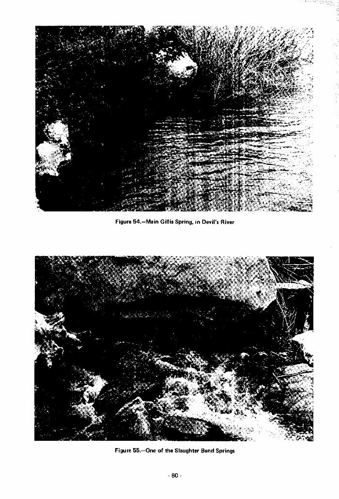
Figure 54.-Main Gillis Spring, in Devil's River
Figure 55.-0ne of the Slaughter Bend Springs
- 80-
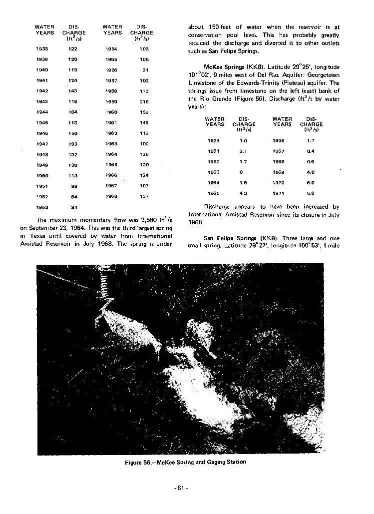
WATERYEARS
1938
1939
1940
1941
1942
1943
1944
DISCHARGE
(ft3 /s1
122
120
119
124
143
115
104
WATERYEARS
1954
1955
1956
1957
1958
1959
1960
DISCHARGE
(ft3 /s1
103
105
91
102
113
219
156
about 150 feet of water when the reservoir is atconservation pool level. This has probably greatlyreduced the discharge and diverted it to other outletssuch as San Felipe Springs.
McKee Springs (KK8). Latitude 29°25', longitude101°02', 9 miles west of Del Rio. Aquifer: GeorgetownLimestone of the Edwards-Trinity (Plateau) aquifer. Thesprings issue from limestone on the left (east) bank ofthe Rio Grande (Figure 56). Discharge (fe /s by wateryears) :
1945
1946
113
150
1961
1962
149
116
WATER 015-YEARS CHARGE
(ft3 /s1
WATER 015-YEARS CHARGE
(ft3 /s1
1947
1948
1949
1950
1951
1952
193
132
138
113
98
84
1963
1964
1965
1966
1967
1968
102
128
120
124
107
137
1939
1961
1962
1963
1964
1965
1.0
2.1
1.7
o
1.5
4.3
1966
1967
1968
1969
1970
1971
1.7
0.4
0.6
4.0
6.0
5.8
1953 84
The maximum momentary flow was 3,580 ft3 /son September 23, 1964. This was the third largest springin Texas until covered by water from InternationalAmistad Reservoir in July 1968. The spring is under
Discharge appears to have been increased byInternational Amistad Reservoir since its closure in July1968.
San Felipe Springs (KK9). Three large and onesmall spring. Latitude 29°22', longitude 100°53', 1 mile
Figure 56.-McKee Spring and Gaging Station
- 81 -

"I ,:d'" "f De Rio. F 'litHe 6 shows one of the springs.Aqu rcr Geor<Jetown Limestone" of the Edwards(Balcones Fault Zone} aquifer. The recharge area forthese and other springs in the area is believed to coverabout 6,500 square miles, extending into Pecos andSchleicher Counties. History: Bands of Apache andPueblo Indians lived at these springs in the past, raisingcorn, beans, and squash, making baskets and clothingfrom sotol and yucca fibers, and eating prickly pears.When the springs were first discovered by white men,there were seven deep clear pools with many large fish,surrounded by hackberry trees, grape vines, and cattails.In 1657 a mass was held here by Franciscan Fathers andthe springs named for the king of Spain. The old SpanishTrail from San Antonio to EI Paso passed the springs. Amission was established in 1808 but was abandoned. Thefirst settlement of San Felipe de Rio (now Del Rio)began in 1834. Irrigation dams and canals were built toirrigate grapes, plums, apples, and melons. The springswere much used by the cavalry and stage coaches in thelate 1800's. Water from the springs was hau led to townfor 5 cents a barrel. In 1882 two grist mills used thewater for power. In 1884 a water company was formed.In 1901 an electric light and ice plant was built. Thesprings, the third largest in Texas, are still the sale watersupply for the city of Del Rio. They also furnishirrigation water for the only winery in Texas. Ahistorical marker is located here. Discharge (ft3/S bywater years):
WATER 015- WATER 015-YEARS CHARGE YEARS CHARGE
(ft3 ts) . (ft3 tsl
1889 113 1929 56
1896 99 1930 47
1897 89 1931 80
1899 113 1939 122
1900 149 1952 45
1902 128 1953 22
1904 118 1954 95
1905 103 1956 45
1906 72 1957 58
1910 69 1958 112
1912 71 1959 108
1922 85 1960 102
1923 92 1961 109
1924 89 1962 82
1925 65 1963 51
1926 85 1964 56
1927 80 1965 102
1928 65 1966 88
WATER 015- WATER 015-YEARS CHARGE YEARS CHARGE
Ih3 /s) Ut3 /s1
1967 80 1970 104
1968 72 1971 82
1969 77
International Amistad Reservoir appears to be increasingthe flow of the springs by providing additional rechargeand by diverting the flow of Goodenough Springs andother inundated springs to San Felipe Springs. Maximumrecorded discharge was 150 ft3 /s in December 1901.References: Taylor, 1904; Manny, 1947; and TexasHistorical Survey Committee, 1971.
Cantu or Cienaga (Bog) Spring (KK10). Latitude29°22', longitude 100°56', 2 miles west of Del Rio.Aquifer: Georgetown Limestone of the Edwards-Trinity(Plateau) aquifer. The spring rises from a limestonecavern into a walled-up pool (Figure 57). History:Bosque and his men may have camped here in 1675. Thespring has been used for irrigation. Discharge (ft3/s bywater years):
WATER DlS- WATER DlS-YEARS CHARGE YEARS CHARGE
(ft3 tsl (ft3 ts)
1939 0.3 1966 1.8
1961 2.9 1967 1.2
1962 1.2 1968 0.3
1963 a 1969 2.7
1964 0.7 1970 4.8
1965 3.0 1971 3.5
The discharge appears to have been increased byInternational Amistad Reservoir since closure of thereservoir in July 1968.
Van Zandt County
Roher Springs (Sl). Latitude 32°21', longitude95°56', 1 mile east of Big Rock. Aquifer: Carrizo Sand.History: When the springs were settled by Europeans in1845, buffalo were common. Millions of passengerpigeons also stopped here until 1875. Roher's corn andwool-carding mill was powered by the springs.Discharge: In 1973 no flow was recorded. Reference:Taylor, 1904.
Riley Spring (S10). Latitude 32°30', longitude95°53', 4 miles south of Canton. Aquifer: Wilcox Sandof the Carrizo-Wilcox aquifer. History: The CaddoIndians formerly lived here and farmed nearby. Many oftheir arrow heads, stone scrapers, grinders, sinker stones
- 82-

Figure 57.'-Cantu Spring and Gaging Station
for fishing, mounds, pottery sherds, and old furnaces formaking pottery have been found here. Several mills werepowered by the spring water, including Riley's Mill, thefirst in the 1850's. These included a grist mill, flourmill, cotton gin, and furniture factory. An old waterwheel could still be seen in 1950. Discharge: 1973-nonereported. A flowing well was reported just northeastfrom the same aquifer. Reference: Mills, 1950.
Wheeler County
Fort Elliott Springs (E 1). Several springs formingSweetwater Creek. Latitude 35°33', longitude 100°28',2 miles wes.t of New Mobeetie. Aquifer: OgallalaFormation. History: These springs were originally awatering place for buffalo, wild turkey, antelope, bear,and javelinas. Buffalo hunters established the town ofMobeetie near the springs in 1874, From 1875 to 1889nearby Fort Elliott used the spring water to irrigatevegetables. The creek was reported originally to have hadmany more water holes and fish, perhaps because thespringflow was greater and more uniform. Discharge:July 11, 1967-140 gpm; June 24, 1971-9 gpm. Muchwell pumping for irrigation in the vicinity has reducedthe spring flow. Reference: Harris, 1968.
- 83-
Rathjen Springs (E2). Five springs. Latitude35°32', longitude 100°07', 11 miles northeast ofWheeler. Aquifer: Ogallala Formation. History: In 1879Fred Rathjen arrived from Germany to establish the firstwhite settlement here. He used the springs to irrigate 60acres, the first irrigation in the Texas Panhandle. He soldvegetables, peaches, pears, and apples to nearby FortElliott. Discharge: July 14, 1967-180 gpm; June 24,1971-110 gpm. In 1971 the springs supplied 10 stocktanks on Williams Creek. References: Taylor, 1902, andHarris,1968.
Wheeler Springs, formerly Seed Springs (E3).Several springs. Latitude 34°24', longitude 100°06',1 mile northeast of Kelton. Aquifer: Whitehorse Group(sandstone), dipping northwest. History: Used forirrigation. Discharge: July 27,1967-1.4 fe/s; June 24,1971-0.28 ft3 Is. Much well pumping has been done forirrigation in the surrounding area.
Bronco Springs (E4). Numerous small springs.Latitude 35°22', longitude 100°16', 6 miles south ofWheeler. Aquifer: Whitehorse Group (sandstone).dipping northwest. History: In the early 1900's thesesprings were a part of Shamrock's water supply. Thewater was hauled to town on wagons. Discharge:

Wilson County
Winkler County
Wilson Sprmg (FF9l_ Lat!tuoe 30" 3S', longitude97°28', 4 miles northwest of Taylor. Aquifer_ WolfeCity Sand. History: The sprinq was on an old ComancheIndian trail. From 1849 to 1887 the Gooch corn millused the spring waters. Discharge: February 8,1941-0.10ft3 /s. Reference: Norvell (nodate).
Knight Springs (F F12}. Several springs. Latitude30°40', longitude 97°45', 5 miles northwest ofGeorgetown. Aquifer: Edwards and associatedlimestones. History: Knight's mill used the water powerfrom the springs in the 1880's. They were a rest stop onthe Chisholm Cattle Trail from 1867 to 1895. Discharge:July 1940-0.89 fe Is; March 16, 1964-0.66 ft3 Is.Reference: Norvell (no date).
1} 1%1 23 't
Edvva~(h i:ind fed
through a fault. ['i',chargl' \11 a
Sutherland Springs (LL36). Many springs includingWhite Sulphur, Cold, Sour, and Alligator Springs.Latitude 29°17', longitude 98°03', 1 mile northeast ofSutherland Springs. Aquifer: Carrizo Sand. History:These springs were much used by the CoahuiltecanIndians, who left many flint projectile points, choppers,scrapers, knives, and ceramic sherds. The springs were astop on the Chihuahua Road, and the old town ofSutherland Springs was laid out around them. In the1850's and 1860's the approximately 100 warm andcold springs, reportedly with 27 flavors, were known fortheir medicinal qualities. Bathing in the spring at theresort hotel was popular. A historical marker is locatedhere. They will probably be inundated by theconservation pool waters of proposed Cibolo Reservoir.Discharge: August 18, 1936-"flows"; 1949-1.5 ft3Is;1954-0.01 fe Is; March 6, 1968-0.15 ft3Is.References: Wilson County Centenial Association, 1960;Hsu and Ralph, 1968; and Texas Historical SurveyCommittee, 1971.
China Springs (13). Several springs. Latitude34°05', longitude 98°57', 2 miles west of Haynesville.Aquifer: Wichita Formation (limestone and sandstone).Discharge: 1913-"considerable flow of slightly brackishwater"; 1969-0.24 ft3Is; 1970-0.23 ft3 Is. Reference:Gordon, 1913.
1938 -"very stroI9", Ma." 25, 1967 10 qpln; Juno, 24,19:71--27 gpm In 1971 they supplied eight stock tanksReferences Perkins, 1938, and Harvey, 1962.
Wichita County
Lehman Springs (E5). Several springs formingCrow Creek. Latitude 35°11', longitude 100°11',5 milessoutheast of Shamrock. Aquifer: Blaine Formation(siltstone and gypsum}, dipping northwest. History:These springs were a part of Shamrock's first watersupply in 1901. Water was hauled to town and sold, 6barrels for $4. Discharge: June 16, 1967-·0.56 fe Is;June 24,1971-0.60ft3 /s. Reference: Harvey, 1962.
Wilbarger County
Doans Springs (11). Several springs. Latitude34°21', longitude 99°16', 1 mile northwest of Doans.Aquifer: Base of the Seymour Formation (alluvium).History: These springs were a stop on the Western CattleTrail from 1876 on. The water is now impounded in arecreational lake. Discharge: In 1913 they weredescribed as supporting a small stream which persistedthroughout the year, sinking into sands about one milefrom its source. Discharge: February 28, 1951 andNovember 10, 1970-reported to be flowing. Reference:Gordon 1913.
Condon Springs (12). About 10 springs. Latitude34°10', longitude 99°19', 3 miles northwest of Vernon.Aquifer: Base of the Seymour Formation (alluvium).History: The springs were on the Western Cattle Trailfrom 1876 on. Discharge: In 1913 they were describedas "good water, with a good flow maintained throughthe year." October 1943-27 gpm; December 10,1969-reported to be flowing. Reference: Gordon, 1913.
Willow Springs (V3). Latitude 31°41', longitude102°55', 7 miles north of Monahans. Aquifer: Cenozoic
Williamson County alluvium (dune sand). History: This water hole was vital
Berry Springs (FF2). Latitude 30°41', longitude to the Comanche Indians and to the white travelers97°39',5 miles north of Georgetown. Aquifer: Edwards--- .-heading for the gold rush in California. In' 1901 theand associated limestones. The springs issue through a remains of a 40-wagon-party massacre were found here.fault. History: The Strange corn mill was operated at A historical monument is located 12 miles south ofthese springs for many years. Discharge: March 17, Kermit on State Highway 18 and 6.6 miles west of the1964-13 ft3Is. Reference: Taylor, 1904. springs. Discharge: None reported in 1941 or 1959.
Heavy pumping in this area has greatly drawn downManske Branch Springs (FF3). Latitude 30°38', water tables. Reference: Texas Historical Survey
longitude 97°35', 6 miles east of Georgetown. Aquifer: Committee, 1971.
-84-
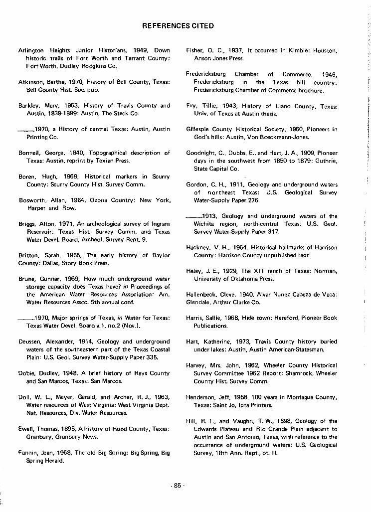
REFERENCES CITED
Arlington Heights Junior Historians, 1949, Downhistoric trails of Fort Worth and Tarrant CountY:Fort Worth, Dudley Hodgkins Co.
Atkinson, Bertha, 1970, History of Bell CountY, Texas:Bell County Hist Soc. pub.
Barkley, Mary, 1963, History of Travis CountY andAustin, 1839-1899: Austin, The Steck Co.
__1970, a History of central Texas: Austin, AustinPrinting Co.
Bonnell, George, 1840, Topographical description ofTexas: Austin, reprint by Texian Press.
Boren, Hugh, 1969, Historical markers in ScurryCountY: Scurry County Hist. Survey Comm.
Bosworth, Allan, 1964, Ozona Country: New York,Harper and Row.
Briggs, Alton, 1971, An archeological survey of IngramReservoir: Texas Hist. Survey Comm. and TexasWater Devel. Board, Archeo!' Survey Rept. 9.
Britton, Sarah, 1955, The early history of BaylorCountY: Dallas, Story Book Press.
Brune, Gunnar, 1969, How much underground waterstorage capacity does Texas have? in Proceedings ofthe American Water Resources Association: Am.Water Resources Assoc. 5th annual conf.
__1970, Major springs of Texas, in Water for Texas:Texas Water Devel. Board v.l, no.2 (Nov.).
Deussen, Alexander, 1914, Geology and undergroundwaters of the southeastern part of the Texas CoastalPlain: U.S. Geol. Survey Water-Supply Paper 335.
Dobie, Dudley, 1948, A brief history of Hays CountYand San Marcos, Texas: San Marcos.
Doll, W. L., Meyer, Gerald, and Archer, R. J., 1963,Water resources of West Virginia: West Virginia Dept.Nat. Resources, Div. Water Resources.
Ewell, Thomas, 1895, A history of Hood CountY, Texas:Granbury, Granbury News.
Fannin, Jean, 1968, The old Big Spring: Big Spring, BigSpring Herald.
- 85-
Fisher, O. C., 1937, It occurred in Kimble: Houston,Anson Jones Press.
Fredericksburg Chamber of Commerce, 1946,Fredericksburg in the Texas hill country:Fredericksburg Chamber of Commerce brochure.
Fry, Tillie, 1943, History of Llano County, Texas:Univ. of Texas at Austin thesis.
Gillespie County Historical Society, 1960, Pioneers inGod's hills: Austin, Von Boeckmann-Jones.
Goodnight, C., Dubbs, .E., and Hart, J. A., 1909, Pioneerdays in the southwest from 1850 to 1879: Guthrie,State Capital Co.
Gordon, C. H., 1911, Geology and underground watersof northeast Texas: U.S. Geological SurveyWater-Supply Paper 276.
__1913, Geology and underground waters of theWichita region, north-central Texas: U.S. Geo!.Survey Water-Supply Paper 317.
Hackney, V. H., 1964, Historical hallmarks of HarrisonCounty: Harrison CountY unpublished rept.
Haley, J. E., 1929, The XIT ranch of Texas: Norman,University of Oklahoma Press.
Hallenbeck, Cleve, 1940, Alvar Nunez Cabeza de Vaca:Glendale, Arthur Clarke Co.
Harris, Sallie, 1968, Hide town: Hereford, Pioneer BookPublications.
Hart, Katherine, 1973, Travis CountY history buriedunder lakes: Austin, Austin American-Statesman.
Harvey, Mrs. John, 1962, Wheeler CountY HistoricalSurvey Committee 1962 Report: Shamrock, WheelerCounty Hist. Survey Comm.
Henderson, Jeff, 1958, 100 years in Montague CountY,Texas: Saint Jo, Ipta Printers.
Hill, R. T., and Vaughn, T. W., 1898, Geology of theEdwards Plateau and Rio Grande Plain adjacent toAustin and San Antonio, Texas, with reference to theoccurrence of underground waters; U.S. GeologicalSurvey, 18th Ann. Rept, pt. II.

Hsu, D. P., 1969, The Arthur Patterson site, amid·nineteenth century site, San Jacinto County,Texas: Texas State Building Comm. and Texas WaterDeve/. Board, Archeo/. Survey Rept. 5.
Hsu, D. P., and Ralph, Ronald, 1968, An appraisal of thearcheological resources of Cibolo Reservoir, WilsonCounty, Texas: Texas State Building Comm. andTexas Water Deve/. Board, Archeo/. Survey Rept. 1.
Hunter, Lillie, 1969, The book of years: Hereford,Pioneer Book Publications.
Hutson, W. F., 1898, Irrigation systems in Texas: U.S.Geo/. Survey Water-Supply Paper 13.
Jackson, A. T., 1971, Mills of yesteryear: Univ. of Texasat EI Paso, Texas Western Press.
King, P. B., 1948, Geology of the southern GuadalupeMountains: U.S. Geol. Survey Prof. Paper 215.
Liles, Vernen, 1953, Pioneering on the plains, a historyof Martin County, Texas: Univ. of Texas at Austinthesis.
Maier, F. J., 1950, Fluoridation of public water supplies:Am. Water Works Assoc. Jour., v. 42, pt. 1.
Malone, James, and Briggs, Alton, 1970, Archeologicalreconnaissance in the Miller Creek Reservoir area:Texas State Hist. Comm. and Texas Water Devel.Board, An:heol. Survey Rept. 6.
Manny, H. J., 1947, Kinney County: Val Verde Countylibrary unpublished rept. Maxcy, K. F., 1950, Reporton the relation of nitrate concentrations in wellwaters to the occurrence of methemoglobinemia:Nat'l Research Council Bull. Sanitary Eng.
Maxwell, R. A., 1968, The Big Bend of the Rio Grande:Univ. of Texas at Austin, Bur. of Econ. GeologyGuidebook 7.
Meinzer, O. E., 1927, Large springs in the United States:U.S. Geo/. Survey Water-Supply Paper 557.
Mills, W. S., 1950, History of Van Zandt County: VanZandt County unpublished rept.
Moellering, Arwere, 1938, A history of GuadalupeCounty, Texas: Univ. of Texas at Austin thesis.
Morfi, F. J. A., 1935, History of Texas, 1673-1779:Albuquerque, Ouivira Society.
')lu'9 l1 <
Tex", HiljlcWd\
Newcomb, W. W. 1961, rile l!ld<ans oj 1exas /\ustll1,
University of Texas Press.
Nordyke, Lewis, 1949, Cattle empire: New York,William Morrow and Co.
Norvell, Estelle (no date), Student's history ofWilliamson County: Georgetown, Martha Emmons.
Paddock, B. B., 1911, History of central and westernTexas: New York, Lewis Publishing Co.
Peale, A. C., 1894, Natural mineral waters of the UnitedStates: U.S. Geo/. Survey 14th Ann. Rept.
Perkins, William, 1938, History of Wheeler County,Texas: Univ. of Texas at Austin thesis.
Pierce, N. H. 1946, The free state of Menard: Menard,Menard News Press.
Polk, Stella, 1966, Mason and Mason County, a history:Austin, Pemberton Press.
Pool, William, 1964 Bosque territory: Kyle, ChaparralPress.
Scobee, Barry, 1963, Fort Davis, Texas: EI Paso, HillPrinting Co.
Sellards, E. H. Baker, C. L. and others, 1934, Thegeology of Texas, Volume II, Structural andeconomic geology: Univ. of Texas at Austin, Bur.Econ. Geology Bull. 3401.
Spikes, Nellie, and Ellis, Temple, 1952, A history ofCrosby County, Texas: San Antonio, The Naylor Co.
Sturm berg, Robert, 1920, History of San Antonio andof the early days in Texas: San Antonio, StandardPrinting Co.
Taylor, T. U., 1900, The Austin Dam, in Operations atriver stations, 1899, Part IV: U.S. Geological SurveyWater-Supply Paper 38.
__1902 Irrigation systems of Texas: U.S. Geol.Survey Water-Supply and Irrigation Paper 71
__1904, The water powers of Texas: U.S. Geol.Survey Water-Supply and Irrigation Paper 105.
- 86-

Texas Historical Survt?y C(1ril'l'tt~t:!,rLI Texas WaterDevelopment Board, 1970, An arc!eological surveyof the Texarkana Reservoir enlargement area: TexasHist. Survey Comm. and Texas Water DeveL Board,Archeo!. Survey Rept. 7.
Texas Historical Survey Committee, 1971, Official guideto Texas historical markers: Austin, Texas Hist.Foundation.
Texas State Historical Maps, 1958, Pictorial historicalmap of Texas: Texas State Historical Maps,Manufacturers and Distributors, P. O. Drawer 3885,San Angelo, Texas.
Thrall, Homer, 1879, A pictorial history of Texas: St.Louis, N. D. Thomas and Co.
Tiling, Moritz, 1913, History of the German element inTexas: Houston, Moritz Tiling.
Tyler, George, 1966, The History of Bell County:Belton, Dayton Kelley.
- 87-
Underwood, J. R., Jr.,l963, Geology of Eagle Mountainsand vicinity, Hudspeth County, Texas: Univ. of Texasat Austin, Bur. of Econ. Geology, Geol. QuadrangleMap 26.
U.S. Public Health Service, 1962, Public Health Servicedrinking water standards: U.S" Public Health ServicePub. 956.
Utley, Robert, 1960, Special report on Fort Davis,Texas: U.S. National Park Service rept.
Williams, Clayton, 1969, Never again: San Antonio, TheNaylor Company, 3 vols.
Wilson County Centennial Association, 1960, WilsonCounty centennial; Floresville, Wilson CountyCentennial Association. pub.
Woldert, Albert, 1948, A history of Tyler and SmithCounty, Texas: San Antonio, The Naylor Company.
Yarbrough, D. 8., 1968, Laws and programs pertainingto water and related land resources: Texas WaterDeve!. Board Rept. 89.

Tabl@ 2. --Selected Chemical Analyses of Spring \laters
,Analyse. by the Texas State Department of Health unleu otherwise indicated. Results are in milligram.
pet" liter except pH, lIodiUltl-adllorption ratio, residual lodilJll carbonate, and temperature.
Aquifer symbols: Alluvium, A1; Gulf Coast, GC; Ogallala, 08; Sparta, SPi Que!;n City. QC;carrizo-Wilcox, CW; Trinity Group, TR.; Edwardl-TTinity (High Plains), EN; EdwardsTrinity (Plat• .lII1), l1.i'; EJlO'ards (1l.1rnnes Fault Zone), Ehi Santa Rou, SRi EllenburgerSan Saba. £S; Hidllitj", Hi; other aqutfen, eth.
Spring Name AquiferDate of
CollectionSilica(Sio.,)
calcium(ca)
Magne.ium(Mg)
Sodium I Potas·(Na) siUlt\
(K)
~~:~ I R7;~nBicarbonate(RCO,,,)
Sulfate(Sa. )
Chloride(e1)
Fluoride
(F)
Nitrate(NO:\)
Phosphate(PO. )
Totaldis
solved110 lids
totalhardnessa.
CaCo.'lpH
Sodiumadsorption
ratio(SAR)
R"id~a1 II Isodium TeI1Iper-
carbonate 8t.ure(RSe) (aF)
!! " Ruffalo oth Feb. 23, 1937June n, 1971 i9
5945
2922 * "20 <t 0.12 \ 0.2
"9265
1223
106 1., < 0.4 <0.2
285270
268212 8.0
0.4.57 ·58 70
Oi
1i D2
03
Rravo
KIT
Tec.ovas
Og
Og
Do
do.
Feb. 14, 1938
Apr 20, 1937
41 46
42
20
33
22
*"<.2 240
256
23
33
28
11
17
11
1.,
<20
<20
< .2 291
264
197
240
7.9 .97
.4
48 60
Feb. 4, 1971 39
.i
E2
E3
E4
Fort Elliott
Rathjen
Wheeler
Rronc.o
o.
o.oth
oth
july 12, 1967June 23, 1971
do.
June 23, 1971
29
14
66
16
520
32
111
i4
28
87
28
<1
<1
<1
<.2
<.2
<.2
236246
112
212
178
8.07
i6
1,610
30
5.45
59
10
.5
.5
1.0
.7
< .4
.4
8.5
< .4
< .2
<;: .2
< .2
249
153
2.540
208
192202
73
1,.760
136
7.77.4
8.9
7.1
7.9
.26
1.4
90
1.0
.03
.01
.62
.2
6363
72
49
68
Sept. 9, 1946June 24, 1971 1 12
< .2 I 2,600
< .2 I 2.250
~
E5
E6
11 E7
]I Hi
Lehman
Elm. Creek
Wolf Creek
Rylsey
oth
oth
oth
SR
do.
June 24, 1971
Sept. 9, 1946Jan. 24, 1971
12
19
so
630
520
623560
4041
71
70
81i04
2632
57
76
* 4770
* 4349 <1
.6 .5
.3
.4
115
176
220217
270306
1,710
1,370
1,6751,570
5556
60
99
4075
1515
1.0
.8
.4
.9
4.5
< .4
< .4
<2010
o1.0 < .2
2,5902,510
351399
1.870
1.580
1,8901,820
207235
7.6
7.5
7.47.8
8.0
.58
.83
5.74
1.31.4
o1.5
74
74
6544
64
Il2 R1 ttl!!r Creek 08 Mar. 5, 1968 I 27June 24, 1971 38
7575
5.87
2625 <.2
242260
2124
1721
.2
.3244.2 < .2
317324
211216
7.47.9
,8.69
o,44 70
Oct. 18, 1966 I 29Jan. 27, 1971 18
H3
H4
Wiac.hkaemper
O'Hatr
Ai
oth Jan. 26, 1971 14
113580
126
5562
IS
*13740
41
443199
560
2521,450
11
12146
.71.0
.1
3.018
< .4
9302,310
492
5101,720
389
8, i7.8
7.6
26.41
.95 1.4
6544
48
.!J H5 Roscoe oth Oct. 1, 1938June 25, 1971 I 30 142 62 99 .5
171317
1,660408
5955 1.0
<20< .4 < ,2
2.590990 610 8.0 1.7 1.5 73
11 Doans Al Nov. 10, 1970 23 72 27 44 <[ .2 350 40 28 .6 27 434 294 7.3 1.1
Al IOct. 14, 1943
Eh May' 11, 1937
SR, Og I Sept. 12, 1938
!! 12
]I .,
]I K3
Ll
Condon
Ruffalo
Roaring
Ruffalo Al June 12, 1969 21
so
84
44
39
25
56
* 58
* 57
* 95
604
366
329
487
56
41
48
57
80
48
69
40
1.3
1.5
20
29
416
465
590
284
310
340 7.8
1.5
1.4
2.3
,2
68
55
Eh f do.
Eh J Apr. 17, 1936
QC I Feb. 3, 1908 I 78
QC \ Nov. 15, 1907 1 13
56
68
5.7
0.8
2,7
.2
.6
,4
1.7
13
137.4903
263
30
286
34
90
63
244
435
314
112
839
86
230
1,917
1,607
2,330
1.0
6.9
3.0
,06
<20
25
5.2
39
5,5
14
30
285
615
148
5iO894
51
239
29
532
393
1.9
25
211
31
41
690
18
253
427
244
4i
285
238
0.50
9.1
12
12
40
38
* i6
11
13
*506
*452
* 16
4.4
53
91
8.5
21
3.8
21
16
11
63
4.9
7.i
9.8
71
24
212Dec. 14, 1949 I 27
May 21, 1940
os ! May 4, 1936
ow ISept. 9, 1907 1 78
ew Sept. 12, 1907 21
Ep
Ep
Og, SR I Dec. 10, 1943
Seven
Thrasher
Santa Rosa
Sulphur
Hynson
Soda
Greene
Dalby
Hughes
Mustang
]J .3
!! N5
]J N6
]I pi
]I p2
]I P3
]J P6
l,' 58
]J V2
]J W2
Sel!! footnotes at end of table.

Table 2. --Selected chemical Analyses of Spring Water.~-Continued
Spring Name AquiferDate of
CollectionSilica(51,,-)
Cal~
d ...(Ca)
Magne.,=(Hg)
Sodi1.ml I Potu-(Na) dum
(K)
Iron(Fe)
Boron(8)
Bicarbonate(HCo,)
Sulfate(SO.)
Chloride(Cl)
Fluoride(F)
Nitrate(NO,)
phollphate(pa.)
Totaldis
lIolvedsolid.
rotalhardness..CaC~
pH
Sodiumadsorption
ratio(SAR)
Residualsodium
carbonate(RSC)
Tem~e<'at lire(oF) I
I j; \Ii)
.'I W5
!Jove CTPpk
Anson
Ep
Ep
I Aug. 7, 1940 .Apr. 1, 1965 I 16
Aug. 20, 1940july 12, 1970 I 15
70 1477 16
60 I 1788 18
~ll
*17
* 31* 35
268293
287312
1215
<1011
1821
2766
0,40.5
.4
.3
<2010
<207.5
257316
289394
234258
220297
7.6
7.3
1.30.9
4.01.0
.2
68
.'I W6
.'I W7
.'I X2
.'I X3
Lipan
Kickapoo
..11
Richland
Ep
Ep
oth
oth
Oct. 15, 1940
Oct. 18, 1940
Oc.t. 24, 1938Sept. 13, 1971 I 13
OCt. 10, 1938May 3, 1971
80
76
104
104108
20
22
23
2021
* 13
* 23
*27* 44
<.02
<.02
,1
293
299
275405
403405
31
<10
119
1515,
28
21
1311
3957
.1
.1
.2
.7
<20
<20
<208.0
<205.5
<1.0
316
292
261376
403650
283
278
353
343337
).6
7.4
.4
1.9
.16
.61.1
68
69
7273
7373
.'I x4
I.'I X5
.'I X6
.'I
Baker
Fleming
Bogard
Hart
ES
ES
o'h
oth
Oct. S, 1938Sept. 13, 1971
Nov. 14, 1938Sept. 12, 1971
Nov, 15, 1938
'do.Sept. 14, 1971
11
11
12
III99
92
105
110
1822
37
24
22
* 3646
* 7
<'02
<.02
<.02
.02
<.1
.1
390387
426
390
427423
1210
118
15
159
6770
28
1411
.3
<.1
.1
<205.5
<207
<20
<205.5
<1.0
<1.0
<1.0
440456
375
371
393387
351339
384
360
368
7.7
7.6
7.5
.81.1
.1
,2
.2
7272
7172
71
7172
.'I X7
J X8
Sloan
Turkey Roost
oth
o,h
July 20, 1938Sept, 14, 1971 \ 11
Dec. 19, 1938Sept. 12, 1971 j 17
97
65
30
28
<,02
.13
<.1
.1
451423
336276
942
515
.1
.2
<206.0
<20< .4
<1.0
<1.0
391370
296313
365
280
7.6
7.9
,1
.2
7272
6969
Nov. 29, 1938Sept. 14, 1971 I 17
Nov. 29, 1938Sept. 12, 1971 I 12coo
.'I X9
.'I Xl0
JJ XlI
.'I X12
Deep Creek
Sycamore
Wallace Creek
San Saba
ES
ES
ES
oth
Sept. 29, 1938Sept. 13, 1971
July 19, 1938Jan. 8, 1971
15
73
6746
9489
109110
31
3232
40
3232
* 313
* 384
* 90*85
.04
.1
<.02
.10
<,1
<.1
.1
445362
329281
451448
451449
116
1914
812
1021
106
156147
<.1
.2
.1
<.1
<203.0
<201.5
<206.0
<204.5
<1.0
<1.0
<1.0
393316
297285
376386
619616
312
300246
394387
405407
7.7
7.9
).9
7.1
,1
.1
.3
1.11
2.01.8
2.8o
707J
71
70
72
.'I X13
.'I X14
-~
Barnett
Parker
Brister
ES
0,"
o,h
Oct. 7, 1938Sept. 13, 1971 I 13
July 20, 1938
Aug. 29, 1938
86
114
68
23
31
30
<.02 .1479353
476
317
12
11
10
9
10
14
.1<20
4.5
<20
<20
<1.0403326
402
279
416310
414
293
7.6 .2
.'I X15
Parker
Swillllll.ing Pool
oth
oth
Sept. 13, 1971
May 14, 1942Sept. 17, 1971
12
10
107
142124
34
5445
*447253
.1
.3
481
359351
3225
865530
.1
.2
3.0
o< .4
<1.0
<1.0
412
1,8701,170
407
576497
7,6
7,47.55.0
.!J X16 Sulfur ES Mar. 6, 1939Sept. 16, 1971 12
184158
4651
*812530 16 .04 .4
451450
2727
1,430970 .2
<20< .4
2,720<l.0 \ 1,990
649600 7,2
14 110
.'I X17
.!J X19
Gorman
Post Oak
ES
ES
Oct. 29, 1938Sept. 14, 1971 13
Jan. 6, 1939Sept. 14, 1971 13
77
8960
28
3537
* 14
<,1
<.1
366349
421350
136
<.1
<,1
<204
<202.5
<1.0
<1.0
327316
353302
307
367302
7.6
8.069
.'I X20
X22
ZI
22
z3
Jennings
Hancock
Elkhart Creek
Hays Branch
Caney Creek
ES
o,h
Sp
Sp
Sp
Feb. 26, 1939Sept. 14, 1971
Jan. 15, 1971
Sept. IS, 1965
Sept. 16, 1965
do.
10
17
15
80
25
4.2
3.0
41
15
1.8
1.1
* 48
* 12
<1
<.02
t.33
.39
<.1305423
88
20
16
196
17
4.6
3.8
176
98
16
5.2
.1
.3
.1
.1
<204.0
.4
1.0
1.8
<1.0306359
291
67
42
45
367
125
20
12
7.6
8.3
6.2
6.4
1.9
I.2
.6
76
'077
.'I Z5
.'ICastalian QC Feb. 3, 1908 I 50
Apr. 21, 19366.2 .3 32
*1546f8
50 1412
,06 18036
17 1.0 .5
See footnotes at end of table.

Table 2. --Selected Chemical Analyses of Sprins Waters--Continued
72
7879
74
6852
6452
Temperature('F)
Rea1dua!sodium
carbonate(RSC)
6.86.8
1.2
0.4
6.17.7
2.9
5.46.6
Sodiumadlorptlon
ratio(SAR)
7.3
pH
7.6
8.1
800810
700
i434
100
832870
1,100960
Totalhardne.,..CaC~
4829
2,8402,700
1,620
319
Totaldis·
solved.olida
2,215.3 2,240
2,098...:: .2 I 2,140
pho,phate(PO.. )
<0.25.02.7
1.8
2.7
< .4
Nitrate(N", )
2.2
2.1
1.9
Fluoride(F)
842760
4.513
608610
655630
443
142
Chloride(Cl)
635650
705680
15
Sulfate(SO, )
564
868840
1.5<10
85
1612
332322
284276
222281
Bicar·bonate(Heo,)
.5
.5
0.6
Boron(B)
11
23
17
19
273
*85
*584560
* 12
*437430
*463444
1.46
8188
8081
28
126 1 96
200202
272 1'02237 90
189192
28
21
64
OCt. 6, 1936
Dec. 7, 1930Apr. 28, 1971
Sept. 19, 1907
Nov. 13, 1931Apr. 28, 1971 I 25
Sept. 19, 1907Sept. 22, 1936
Dec. 6, 1930 I 19Apr. 28. 1971 18
Sp
CW
ow
Ep
Ep
Ep
Saragosa
Red
Sandia
Nacogdoches
White
Giffin11 CC3
11 CC2
11 '611
11 Z7
111/ CCI
I I I Date of Sl1ioa I Cal-I Magne-j Sodium Ip:ta'-IlrooSprinl Name Aquifer Collection (SiOp) cil.lll sium (Na) silAt\ (Fe)
I I I (Ca) (Mg) (K)
r---r-----+---r----~_+_------'f_-_i'--+--+_-I iii0.7
11 CC4 San Solomon Ep Oct. 28, 1930Apr. 28, 1971 I 19
190196
8087
*448437 19
.04
.04 .6286278
651680
61(1630 2.0
.9 2.196< .2 1 2,210
803850 7.4
146.6
7876
11 CC5 Phantom. Lake Ep Oct. 28, 1930Apr. 28, 1971
1916
191192
8691
*473467 19 .5
285278
691680
655650 2.2
.55< .4
2,309< .2 I 2,250
830850 7.4
6.96.9
7178
11 ee10 ! Pena Colorado
lJ CCll I Comanche
oth
Ep
Mar. 12, 1957 1 10
Apr. 7, 1932 I 22May 20, 1958 23
60
138144
48
5452
* 92
256252
13 .05
374
271.37 I 247
166
393420
42
358330
2.2 1.8
.86.5
606
1,3701.350
347
566514
8.1 2.1
2121
57
76
Feb. 1, 1941 I 22Dec. 16. 1949 18
11 CC15
11003
Tunas
T-5
Ep
Ep Feb. 7, 1968 16
140133
86
4853
27
183*186
B2
.05 276277
.13 I 218
342360
171
250249
111
.8
.9
2.02.2
3.2
1,1301,140
608
547550
473
7.3
7.8
1515
2.0 54
009
008
DDll
on10
7172
68
73
72
722.9
1.3
.4
.3
.2
.34
11
7.5
7.5
7.5
7.6
243154
238384
267
424
660
300
216
sso
573
252170.1
259608
274
267
502
10
<20
.4
<20
<2013
<20
6.9
8.0
.7
.3
.4
.6
.4
.3
1.4
1015
21
24
74
22206
129
166
1245
108
21
22
15
111
111
461204
216
250
127
268226
195
281172.1.06<1
52
* 59
* 12111
* 3
* 96
*13
2120
25
32
20
22
41
1316
19
93
49
79
763S
76
6081
213
153
19
18
Mar. 6. 1963 I 20
do.
Feb. 7, 1968
Aug. 21, 1918
Apr. 26, 1939
June 13, 1939Hay 27, 1971
May 18. 1939
May 15. 1939Fl!b. 6, 1968
Ep
Ep
Ep
Ep
Ep
Ep
Ep
Ep
Pecan
Sweetwater
Cox
Cedar
Tardy
Howard
Wolf
Richland
DD13
11 DDS
DD4
11 006
11
11
11
11
11
co-'
11 0014 Hudspeth Ep Aug. 20, 1934May 27, 1971 16
7S72
1315
* 98 <1 .06
.0'
.12e,270
1310
1512 .4
Tracl'!7.5 .2
268274
241243 7.5
.326 72
Jan. 12, 1965! 150015 I Government
11 0017 I Hackberry
11 EEl Wilkin.on
Ep
Ep
Ep
Feb. 9, 1939
Aug. 18, 1942 15
77
56
62
20
15
20
*13
* 19
* 9
322
232
288
11
11
21
17
27
12
.4
.2
3.8
<20
.5
315
242
278
274
199
236
7.5
7.9
1.5
2.3
.2
11 EE9 I Seven Hundred
lJ EElO Tanner
EE6 Coleman Ep
Ep
Ep
Aug. 25, 1966
Dec. 29, 1938
do.
14 72
74
73
16
15
13
* 5
*12
278
275
281
7.6
15
13
11
11
11
.2 8.7
<20
<20
304
256
267
246
244
238
7.2 .2
.1
.3 70
EE13 P1uenneke ES Jan. 20, 1962 284 36 314 272 7.6 45
11 EE14 I Gamel Hi Feb. 10, 1940 66 33 * 5 342 <10 13 <20 299 300 .1
EElS I Kathman ES Jan. 20, 1962 284 21 286 276 7.5 51
] EE18 I Lange Ep Mar. 4, 1936 270 <10 50 303
EEl9 I Elle.bracht Ep Mar. 15, 1965 268 19 265 240 7.8 73
EE20 1 Fish and Wildlife Ep do. 12 68 14 268 4.6 7.9 .2 4.2 248 235 7.2 .1 70
EE21 Bear Creek Ep Mar. 16, 1965 224 11 245 232 7.5
See footnotes at end of table.
Tabt. 2. --le1ecud Ch..tca1 ADa1y... of Spdna Waur.-.con.tin.u.d
...... 23, 1949 I 24
July 3, 1940Kar. 16, 1964
Sept. 27, 1938Sept. 16. 1971
Jan. 4. 1939
July 26, 1961 I 11Sept. lS, 1971 2
coI\.)
Spr101
EE2Z
EE23
1124
1125
E126
U27
EE28
1129
£130
E!31
EE32
11 EE36
11 EE37
EE38
EE39
U40
11 EE41
11 E"'3
118
11 U45
EE46
PP2
pp3
lF4
SFiS
"8
'!I "7
'!I "8
liP"11 pFlO
11 PPll
11 n12
N_
Honey Creek
My.tic
Telanar Cr.ak
Kelly Cr..k.
Colbath
Indian Creek
Goat Creak
Randanon Branch
Fall
RaU
Cypre.. Creek
"ok
Bellina
Holland
Ebauna
1tocky Creek.
..ok
Jacob'. Wall
Buffalo
Croft.
Hobbl
Berry
Ka_nlkaBranch
lIonw.
i'av.r Hou.a
Sa1den
Cold
Barton
wnlon
"-u.chaca
Burle.on
Kn11ht
AquHer
Ep
Ep
Ep
Ep
Ep
Ep
Ep
Ep
Ep
Ep
Ep
ES
ES
Tr
ES
ES
Ep
Ep
otb..IS
Eb
Eb
Eb
Sb
Sb
Eb
Eb
otb
otb
ow
Ep
Dau atCollection
Mar. 16, 196'
do.
do.
do_
Mar; 24, 1965
do.
do.
Mar. 16, 1965
do.
Kar. 24. 1965
Hal'. 25, 1965
Sept. 16, 19-71
Hay 17, 1962
Hay 20. 1941
Oct. 28, 1937
July 22, 1941
AUI. 4, 19:38May 28, 1969
Hay 27, 1969
Mar. 17, 1964
do.
Feb. 6, 1973
Mar. 14, 1896
Mar. 30, 1973
Mar. 21. 1896Jlme 16, 1972
Har. 14, 1896June 14, 1941Feb. 6, 1973
'eb. 8, 1941
Feb. 17, 1941Sept. 3, 1971
SlUea(Siq,>
13
13
6.2
4.2
12
107
18
Ca1
0'"(C.)
6983
94
9638
92
53
105
94
122
10588
86
73
70
\22
53
73
8082
99
8794
94
66
Mqn.01...
('->
5146
39
4341
40
34
22
17
17
4130
27
13
2.3
22
14
38
2019
11
211
8.6
17
SodlID IPotal(Ha) Ii_
(~)
* 125
* 5
*2119
15
*18
* 29
* 9
*<5
* 12
* 10
*18
* 42
* 34
* 4*\2
* 16
* 1974
* 18
*54
Iroo(P.)
.\2
.04
.04
.02
1.0
Joron(B)
0.10.1
.1
.1
.05
.2
.1
.1
.4
Biear....to('"'0.>
276
282
284
318
267
281
272
268
250
248
280
473453
464
434268.
437
240
329
329
409
470432
368
248
182
375
96
339
302298
244
256329
298
334316
Sultat(80.>
6.9
11
1528
17
64
31
11
"1219
16
24
26
48
82
45
1625
26
2289
29
12
Chloride(C1)
13
8.5
16
15
19
16
22
18
28
21
26
107
3038
27
31
56
15
28
1929
14
16
14
40
28
75
3458
221822
37
1346
23
3614
F1uo..ride
(P>
.1
.1
.2
.3
.,
.3
<20
2.5
.4
.5
.3
.7
.4
.2
.2
.7
.0
Mltrata(NO.)
<2010
<20
21.4
7.0
3.2
46
7.0
.2
11
11
";13
7.0
1.757.0
.671.55.5
59
2212
3.8
<20
Pb..•pbolta(PO.>
<1.0
<1.0
<1.0
<1.0
TotaldU
.olved
.01141.
280
250
265
290
28'
2}5
275
263
280
250
300
390392
386
504298
427
335
4"
303
399
411
278
227
456
298
330
330434
325321319
368
291510
348
366303
Totalhrdae••..CaCo.
250
241
264
292
317
268
269
252
251
261
310
381398
394
418265
39'
348
354
306
375
430380
322
268
220
396
106
191
180340
94282282
292
227282
270
236284
pH
7.8
7.8
8.0
7.8
7.8
7.8
8.0
7.8
7.9
7.5
7.7
7.4
7.38.3
7.6
7.6
7.3
8.3
7.6
7.5
7.8
8.'
7.'
7.8
7.9
8.1
7.1
SodiUlllad.orpHon
ratio(SAR)
·3.1
.1
.5
.5
.4
.5
1.2
.1
.1
.3
.3
1.5
.8
.4
.3
.1
.51.0
.5
1.5
RU1dual.odium
carbonate(R5C)
.1o
rempli'r-!~~~~. I
68
70
70
68
54
7070
68
72
72
78
6J
PF13
11 "15
11 n16
Indian
KalltD
PiadrKJn.t
1.1
otb
Jun. 8, 1971 I 22
Dee. 11, 1942
D.c. 8, 1942Nov. 5, 1970 I 89
95
45
233230
1.9
2725
* 22
*140
*213200 2' .. 05
282
92
30'124
17
179
340620
13
118
390300
.1
o.1
12 363
527
1,3531,500
258
\21
691680
7.4
6.7
.4
1.1
3.6 'I3.3 72
S.e footnote. at and of table.
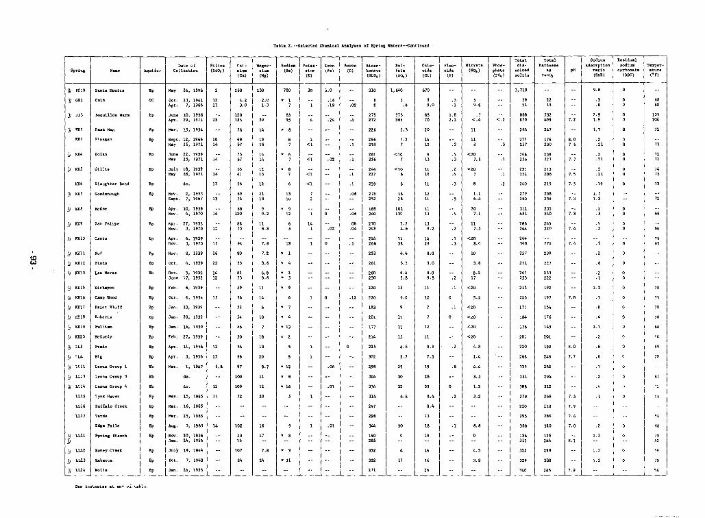
Table 2. --Selected Chemical Ana1yau of Spring Watera ... ..continued
I II I
Spring N....
I II Aqui£lili" I
Dille ",fCollectien TSiHco 'II (S10,)
r:alc1.(Ca)
Majil;ne~ I SoditDdum I (Ha)(Mg)
Pota.d',,"(K)
Iron I 'oron 1.-::- I(Fei I {B} I ~:~C:~ I
Sulfate(",,)
-I Chlo- I Flue· INitrat.ride ride (NO,)
I (Cl) I (F) 1 ITotal I Total
Pholl~ dia- hardne..phate solved .a\F~) \ solid2 I r.1lC:~
pH
Sodiumadsorption
ratio(SAR)
Residualsodium
carbonate("C)
Temperature(oF)
Jj FF19 I Santa Moniea
}J 002 Cold
260 I 130
4.2 I 2.03.0 1.3
}} JJ3
}} 10<1
10<3
Boquillall Warul
Dead Man
Finegan
Ep
GC
Ep
Ep
Ep
May 26, 1896
OCt. 23, 1941 I 12Apr. 7, 1966 17
June 10, 1936Apr. 29, 1971 I 23
Mar. 15, 1934
Sept. 12, 1966 I 10May 25, 1971 14
120135
76
6967
39
14
1315
780
• 17
8595
• 8
30
1<1
5.0
.16
.19
.24
.02
.4
.1
310
27'272
226
256259
1,640
3.4
375365
2.3
7.27
670
8•. 0
6870
20
1412
.3
.1
1.82.1
.3
59.6
.7<.4
11
118
<.2
.3
3,710
3952
868870
265
272257
2213
532499
247
176230
7.2
8.07.6
9.8
.3
.8
2 .•1.9
1.3
.2
.21
6868
105104
72
73
11 KK4 Dolan Ep June 22, 1939May 25, 1971 14
7367
1414
* 67 <1 .02 .1
281256
<107
913
.4
.3<20
7.6 .1248256
239227 1.7
.2
.217272
11 10<5 GilUs Ep July 18, 1939May 26, 1971' 14
6'61
1213 • 87 <1 .1
244227
<108
1110
.2
.4<20
7 .1231232
213206 7.'
.2
.217473
Nov. 2, 1933Sept. 7, 1967 1 13
KK6
]j KK7
Slaughter Bend
Goodenough
Ep
Ep
do. 13 66
6974
12
2113
1310
<1 .1
.06
239
278252
1626
11
1211
.3
.51.16.4
.2 240
279280
215
258238
7.5
7.3
.1.
1.71.3
73
72
Edge FaU.
LLl7 \ Verde
L116 I Buffalo CTeek
L115 \ Lynx Haven
66
70
64
68
7565
15
70
70
68
68
69
70
61
68
'"7052
10
56
6.
.2
.4
.4
.2
.6
.6
.1
.2
.8
.2
.3
.6
.2
.1
.3
.5
.2
.4
.3
.2
2.1
1.0
1.3
1.3
1.3
7.3
7.0
7.4
7.5
7.8
7.4
7.9
7.7
1.6
7.•
8.0
8.1
227
230
218
266
270
255340
265220
197
294
320
286
322
282
233222
29.
308
246
125244
192
154
246
176
14'
201
1.2
368
223
220
263253
213
271
295
27.
257
286244
220
331
244340
335
266
32.
311431
201
388
340
184
176
136313
171
322
8.8
10
8.217
117.'
4.8
1.4
'.2
3.6
4.4
207.1
3.5
3.8
3.2
1.2
4.5
<20
<20
<208.0
<20
<20
<20
.4
.8
.2
.2
.1
.2
.1
.2
.1
.3
.1
8.0•• 8
9.0
9.8
8.0
8.4
8.4
7.'
20
26
1119
12
12
18
19
33
11
16
13'.2
16
1429
19
11
13
30
6.45.8
6.0
4.4
6.3
32
7.74.6
30
4.6
17
15
11
11
15
4.6
3.7
29
1138
101130
352
177
214
298
304
334
314
247
2.6
344
352
201
270248
220
244266
253
261
220
302
225
260230
271
18.240
140285
183
.08
.04
.06
.1
.12
.06
.01
.01
.0214
1
• 8
* 11
* 2
* 4
* 912
*13
• 9
18
• 16
• 8
• 12
• 2* 5
• 1
• 7
• 9
• 4
16
20
6.89.6
3.6
99.2
7.8
7.2
•• 7
7.8
24
20
11
17
12
10
11
18
14
116.8
1356
84
85
72
66
52
8273
59
54
94
80
46
8875
56
'0
2315
102
97
100
88120
107
109do. I 12
July 19, 1944
OCt. 7J 1943
Mar. 25, 1965
Feb. 6, 1939
Jan. 20, 1939
Jan. 23, 1939
Mar. 1, 1947 1 9.8
Au.. 3, 1.6' I 14
Hov. 20, 1936Jan. 24, 1955
Mar. 15, 1965 I 11
Mar. 16, 1965
Apr. 3, 1956 I 13
Jan. 16, 1939
Feb. 27, 1939
Apr. 11, 1956 I 12
Apr. 10, 1939Nov. 4, 1970 14
Apr. 27, 1933Nov. 3, 1970 I 12
Apr. 6, 1939HO\1. 3, 1970 13
Hov. 8, 1939 16
Oct. 4, 1939 22
Oct. 3, 1939 14June 17, 1952 12
Oct. 6, 1954 I 15
Jan. 24, 1955
do.
Ep
Ep
Ep
Ep
Ep
Eb
Ep
Ep
Ep
Ep
Eb
Ep
Ep
Ep
Ep
Ep
Eb
Ep
Ep
Ep
Eb
Ep
Ep
Ep
Ep
McKee
Sao Felipe
] nlO i Cantu
}} 10<8
}} 10<9
}} 10<11 I Hud
)j"12 Pinto
}J KK13 Las Moras
] KKl5 Kickapoo
] KK16 CIIIl'IP Wood
]1 KK17 Paint Bluff
)J K!UB Roberta
]j KR19 Pulliam
]J K1{20 McCurdy
]1 LL3 Prade
)j LlA Big
11 all Leona Group 1
11 LL13 Leona Group 3
JI LLl4 Leona Group 4
JI LUl Spring Branch}}
1J LU2 Honey Craek
11 LL23 Rebecca
]j LL24 Wolle
~
See footnotes at end of table.
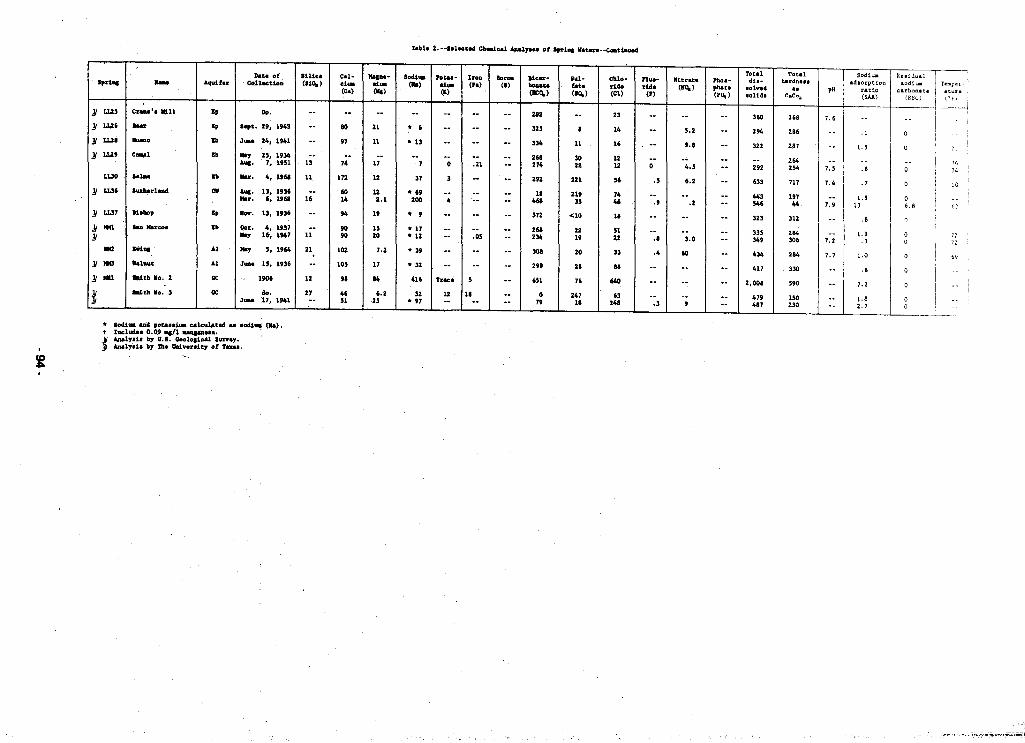
Related Documents