Maine Law Review Maine Law Review Volume 47 Number 1 Article 3 April 2018 Maine Principles of Ownership Along Water Bodies Maine Principles of Ownership Along Water Bodies Knud E. Hermansen Donald R. Richards Follow this and additional works at: https://digitalcommons.mainelaw.maine.edu/mlr Part of the Property Law and Real Estate Commons Recommended Citation Recommended Citation Knud E. Hermansen & Donald R. Richards, Maine Principles of Ownership Along Water Bodies, 47 Me. L. Rev. 35 (2018). Available at: https://digitalcommons.mainelaw.maine.edu/mlr/vol47/iss1/3 This Article is brought to you for free and open access by the Journals at University of Maine School of Law Digital Commons. It has been accepted for inclusion in Maine Law Review by an authorized editor of University of Maine School of Law Digital Commons. For more information, please contact [email protected].

Welcome message from author
This document is posted to help you gain knowledge. Please leave a comment to let me know what you think about it! Share it to your friends and learn new things together.
Transcript

Maine Law Review Maine Law Review
Volume 47 Number 1 Article 3
April 2018
Maine Principles of Ownership Along Water Bodies Maine Principles of Ownership Along Water Bodies
Knud E. Hermansen
Donald R. Richards
Follow this and additional works at: https://digitalcommons.mainelaw.maine.edu/mlr
Part of the Property Law and Real Estate Commons
Recommended Citation Recommended Citation Knud E. Hermansen & Donald R. Richards, Maine Principles of Ownership Along Water Bodies, 47 Me. L. Rev. 35 (2018). Available at: https://digitalcommons.mainelaw.maine.edu/mlr/vol47/iss1/3
This Article is brought to you for free and open access by the Journals at University of Maine School of Law Digital Commons. It has been accepted for inclusion in Maine Law Review by an authorized editor of University of Maine School of Law Digital Commons. For more information, please contact [email protected].
MAINE PRINCIPLES OF OWNERSHIPALONG WATER BODIES
Knud E. Hermansen & Donald R. Richards
I. INTRODUCTION ......................................... 36
II. BOUNDARIES IN OR ALONG WATER ..................... 39A. Boundaries along Tidal Water ....................... 39B. Boundaries along Great Ponds ...................... 40C. Boundaries along Nontidal Navigable Rivers or
Stream s ............................................. 41D. Boundaries along Nonnavigable Streams ............ 44
1R. RESTRAINTS ON OWNERSHIP OF RIPARIAN LANDs ...... 45A. Public Servitudes on Waterfront Property ............ 45B. Unintended Limitations on Conveyed Title .......... 47
1. Bank ............................................ 482. Channel ......................................... 493. Shore ........................................... 494. High Water ...................................... 505. Low Water ...................................... 51
IV. COMMON LAW RULES OF CONSTRUCTION FOR
INTERPRETING COMMON WATER BOUNDARY TERMS IN
CONVEYANCES .......................................... 51
A. Common Water-Boundary Terms Used as Words ofSeparation .......................................... 52
B. Specific Principles in Construing Separation ofUplands from Lowlands ............................ 541. Mix of Monuments Principle .................... 542. Long Uncontested Possession Principle .......... 553. Value Apart Principle ........................... 554. Separated and Brought Back Principle ........... 555. Islands Principle ................................ 56
V. THE SPECIAL PROBLEM OF BOUNDARIES THAT CROSS
UNSURVEYED RIPARIAN LANDS ........................ 56A. Competing Doctrines of Construction ............... 56
1. The Extension Method .......................... 572. The Proportionment Method .................... 583. The Colonial Method ............................ 604. The Perpendicular Method ...................... 63
B. Recommendation .................................... 64
VI. CONCLUSION ............................................ 68

MAINE LAW REVIEW
MAINE PRINCIPLES OF OWNERSHIPALONG WATER BODIES
Donald R. Richards*Knud E. Hermansen**
I. INTRODUCrION
Some of Maine's most valuable land is found along the tidal shoreand inland bodies of water. Unfortunately, however, boundaries in,along, or across the area between the high water to low water (orhigh tide to low tide) are often unmarked, have never been sur-veyed, and are not described accurately in attempted conveyances(see Figure 1).1
The reasons for such shortcomings are numerous. Unaware of thecomplexities of title, unsure of the extent of ownership, unwilling toproceed through bog when dry ground was easier to walk, or unwill-ing to claim what was worthless at the time, a surveyor often failedto survey water boundaries for land that by common law was con-veyed with upland property.2 Even when a surveyor was careful to
COPYRIGHT © 1995
* Donald R. Richards is a partner in the surveying firm of Richards & Cranston
located in Rockland, Maine.** Knud E. Hermansen is an associate professor in the College of Engineering,
University of Maine. He is also a land surveyor, civil engineer, and attorney offeringconsulting services in Old Town, Maine. The Authors would like to recognize andthank Robert Yarumian II, principal in the firm of Maine Boundary Consultants,West Buxton, Maine, for his help, review, and critique of this Article.
1. See generally State v. Brazos River Harbor Navigation Dist., 831 S.W.2d 539,542 (Tex. App. 1992) ("[A] surveyor usually cannot go into a stream to make acorner, so he makes a corner on the bank in order to identify the place where hestopped-the rule being an exception to the one which requires following the foot-steps of the surveyor." (quoting Moore v. Ashbrook, 197 S.W.2d 516, 517 (Tex. Civ.App. 1946))). See also Haight v. Hamor, 83 Me. 453, 460-61 (1891) ("A majority ofthe court is of opinion, that it is a common method of measurement in the country,where the boundary is a stream or way, to measure from the bank of the stream orthe side of the way, and that there is a reasonable presumption that the measure-ments were made in this way unless something appears affirmatively in the deed toshow that they began at the centre line of the stream or way." (quoting Dodd v.Witt, 79 N.E. 475 (Mass. 1885))).
2. Along tidal water, the ownership boundary is generally the low tide boundaryor, in cases where the low tide draws more than 1650 feet below the high tide bound-ary, a point 1650 feet seaward of the high tidal boundary. See generally Proctor v.Hinkley, 462 A.2d 465 (Me. 1983); Richardson v. Richardson, 146 Me. 145, 78 A.2d505 (1951); In re Hadlock, 142 Me. 116, 48 A.2d 628 (1946); Stuart v. Fox, 129 Me.407, 152 A. 413 (1930); Sinford v. Watts, 123 Me. 230, 122 A. 573 (1923); McLellan v.McFadden, 114 Me. 242, 95 A. 1025 (1915); Dunton v. Parker, 97 Me. 461, 54 A.1115 (1903); Emerson v. Taylor, 9 Me. 42 (1832); Lapish v. Bangor Bank, 8 Me. 85(1831). Along nontidal rivers the ownership boundary is in the center of the stream.See Richardson v. Richardson, 146 Me. 145, 78 A.2d 505 (1951); Stuart v. Fox, 129
[Vol. 47:35
1995] OWNERSHIP ALONG WATER BODIES 37
Figure 1normal high wa normal low water
Survey line and line described in description.
high watermark (tide)shoreor flts
low water mark (tdb)
This figure shows the various "lines" along water bodies. As seen in the figure, theboundary has been surveyed and marked along the shore. However, the land-owner's title beyond the high water line is not described or located. Thus, the land-owner cannot be sure what title he has along or in the water, what limitations thereare on this title, or where the boundaries cross the water.
survey the riparian boundaries, erosion, submergence, accretions, 3
the careless use of words in a description, or the simple lack of at-tentiveness by attorneys often resulted in the erroneous identifica-tion of ownership of shores or flats between the uplands and waterbodies. Consequently, much of Maine's riparian lands lack defini-tive surveys in, along, or across their water boundaries, the veryboundaries that make the uplands so valuable.4
In this regard, attorneys, surveyors, and other real estate practi-tioners will have to pay more attention to the location of the bound-aries and title rights along water as riparian land values increase,development intensifies, environmental restrictions expand, and theneed for public recreation grows. This need for increased attentionexists because the intensity of development along water bodiescauses expansion and crowding and raises the potential for trespass,
Me. 407, 152 A. 413 (1930); Coombs v. West, 115 Me. 489, 99 A. 445 (1916); Wilson& Son v. Harrisburg, 107 Me. 207,77 A. 787 (1910); Proctor v. Maine Cent. R.R., 96Me. 458, 52 A. 933 (1902); Nickerson v. Crawford, 16 Me. 245 (1839); Lowell v.Robinson, 16 Me. 357 (1839); Bradley v. Rice, 13 Me. 198 (1836); Graves v. Fisher, 5Me. 69 (1827). Along great ponds, the ownership boundary is along the normal lowwater line at the time of the original conveyance. See Flood v. Earle, 145 Me. 24,71A.2d 55 (1950); Bradley v. Rice, 13 Me. 198 (1836); Hathorne v. Stinson, 12 Me. 183(1835).
3. See King v. Young, 76 Me. 76,79 (1884) ("It seems to be settled both in Eng-land and in this country that the land of a riparian proprietor may be increased byaccretion.").
4. See generally Babson v. Thinter, 79 Me. 368, 371, 10 A. 63, 64 (1887) ("Thecolonial government of the mother commonwealth granted the great boon to land-holders without much thought or intimation about the manner of dividing the flatsamong its grantees.").
MAINE LAW REVIEW
clashing uses, confrontation, and litigation. The recent case, Bell v.Town Of Wells,5 is a good example of the intensity and magnitude ofthe confrontation that has occurred, and more than likely will con-tinue to occur, along Maine's water bodies, leading to increased de-mand for competent legal counsel. For example, clients seekinglegal counsel concerning shoreland zoning, permits, use of riparianproperty, and improvements such as docks already have increaseddramatically in number. Attorneys must be able to counsel theirclients on ownership and public or private rights associated with ri-parian lands. To do so they need to understand riparian title rightsas well as the probable location of boundaries along, within, oracross the water body involved.
The present day practitioner is likely involved with developmentand recreation, while in the past practitioners dealing with riparianrights typically faced questions of property rights arising from fish-ing weirs, clamming, logging, shipping, ice cutting, and commercialwater transport. From these historical practices and conflicts, vari-ous rules of construction regarding the extent and location of titleevolved.6
This Article provides a summary of the Maine common law ofriparian boundaries. It is geared toward practitioners who practiceor provide counsel in the area of real property law or who mustlitigate boundaries and title rights involving water bodies. This Arti-cle also includes recommendations for fixing previously undefinedboundaries across water. However, readers should be aware thatthis Article does not attempt to provide an exhaustive survey of allriparian law. In recent years state and federal legislation has furtherlimited or restricted specific landowner common law rights alongwater bodies.7
5. 557 A.2d 168 (Me. 1989) (holding that the public's right to use certain privatebeach areas in the Town of Wells does not include swimming, sunbathing, or picnick-ing, such use amounts to trespass on the private owner's property).
6. See e.g., Stuart v. Fox, 129 Me. 407,413, 152 A. 413,415-16 (1930) (discussingthe historical foundations of title along tidal water).
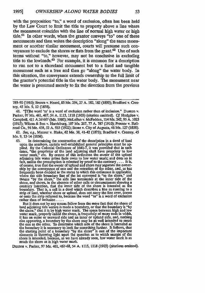
7. An example is state and federal wetlands legislation denying or limiting im.provements in wetlands. See, e.g., 33 C.F.R. § 323 (1994); ME. REv. STAT. ANN. tit.30-A, § 4401(2-A) (Pamph. 1993); ME. REv. STAT. ANN. tit. 38, § 480-B(4) (West1989); ME. REv. STAT. ANN. tit. 38, § 957-B (West 1989). Another recent exampleof state legislation affecting waterfront property is shoreland zoning. See, e.g., ME.REv. STAT. ANN. tit. 30-A, § 4404 (Pamph. 1993); ME. REv. STAT. ANN. tit. 38,§ 482(4-F) (West 1989). Other state and federal legislation restricts the constructionof docks, dams, vegetation removal, and the availability and cost of insurance in the100-year flood plain as determined by the Federal Emergency Management Agency.See e.g., ME. REv. STAT. ANN. tit. 35-A, § 2501 (West 1988); ME. REv. STAT. ANN.tit. 38, § 436-A(4) (West 1989); ME. REv. STAT. ANN. tit. 38, § 631 (West 1989).
[Vol. 47:35
OWNERSHIP ALONG WATER BODIES
II. BOUNDARIES IN OR ALONG WATER
Maine common law has recognized four categories of water bod-ies in regard to title and title rights: 1) tidal waters, 2) great ponds,3) nontidal navigable rivers or streams, and 4) nonnavigablestreams. It is necessary to understand these four categories in orderto deal with disputes concerning them.
A. Boundaries along Tidal Water
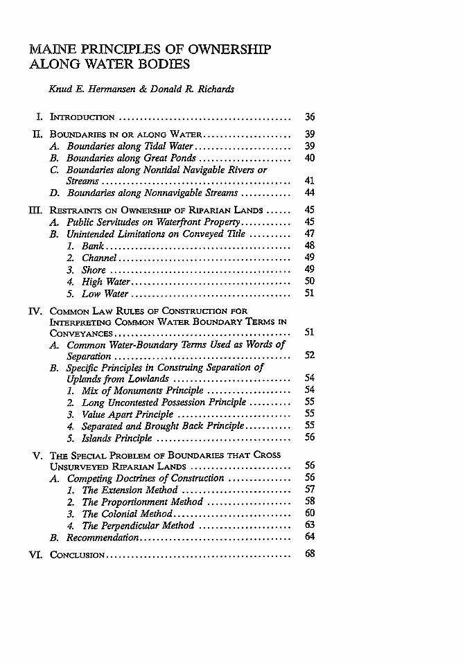
Tidal water is defined as any body of water that is naturally influ-enced by the ebb and flow of the tide.' Tidal waters include riversfrom their mouths to the point upstream where the ebb and flow ofthe tides are negligible.9 The common law presumption is that aconveyance of land bounded by tidal water will convey title to thelow tide mark or to 1650 feet (100 rods' 0), whichever is closer to thehigh tide line (see Figure 2).il This presumption of tidal waterboundary applies equally to all lands along the ocean, bays, and riv-ers affected by the tides, even though the tidal river water may con-tain fresh rather than brackish or salty water.12
The line of low tide may fluctuate because of accretions and ero-sion. An owner's lands will increase or decrease accordingly. 3 Be-yond the low tide or beyond 1650 feet, whichever is closer to hightide, the State has title. 4
8. See generally Bell v. Town of Wells, 557 A.2d 168 (Me. 1989).9. See generally Lapish v. Bangor Bank, 8 Me. 85 (1831).10. The rod, pole, or perch is an ancient surveying measurement used for land
descriptions up to the mid-twentieth century. There are 16.5 feet in a rod. For moreinformation on surveying measurements, see Knud E. Hermansen, When is a RodNot 16.5 Feet?, PROBATE AND PROPERTY, Sept.-Oct. 1992, at 8.
11. See Emerson v. Taylor, 9 Me. 42, 43 (1832) ("[]n all creeks, coves and otherplaces about and upon salt water, where the sea ebbs and flows, the proprietor of theland adjoining shall have propriety to the low-water-mark, where the sea doth notebb above a hundred rods, and not more, wheresoever it ebbs further." (quoting theMassachusetts Colonial Ordinance of 1641)). See also In re George Hadlock, 142Me. 116,119,48 A.2d 628,630 (1946); Stuart v. Fox, 129 Me. 407,412. 152 Aid 413,415 (1930); Sinford v. Watts, 123 Me. 230,232, 122 A.2d 573,574 (1923); McLellan v.McFadden, 114 Me. 242, 246, 94 A.2d 1025, 1027-28 (1915); Dunton v. Parker, 97Me. 461, 467-68, 54 A.2d 1115, 1118 (1903); Erskine v. Moulton, 84 Me. 243, 247-48,24 A.2d 841, 842 (1892); Stevens v. King, 76 Me. 197, 199 (1884); Lapish v. BangorBank, 8 Me. 85, 91 (1831).
12. Stone v. Augusta, 46 Me. 127, 137 (1858) (Stone makes it clear that the intentof the Massachusetts Colonial Ordinance is directed at the ebbing and flowing of thetide and not at whether the nature of the water is fresh, brackish, or salty.). See alsoLapish v. Bangor Bank, 8 Me. at 93 (1831).
13. Bell v. Town Of Wells, 557 A.2d at 175 n.18 (Me. 1989) (citing King v. Young,76 Me. 76 (1884)).
14. Op. Me. Att'y Gen. 82-83; Wilson & Son v. Harrisburg, 107 Me. 207,77 A.2d787 (1910); State v. Brazos River Harbor Navigation Dist., 831 S.W.2d 539,544 (Tex.1992).
1995]

MAINE LAW REVIEW
Figure 2
Low Tide
lats, marsh,
1,60 ft Ownership Line
Uplands
This figure demonstrates that the line of ownership ordinarily goes along the lowtide line unless the distance from the low tide line to the high tide line exceeds 1650feet. Where the fiats extend beyond 1650 feet from the high tide line, the ownershipline will coincide with a parallel line crossing the flats at a distance 1650 feet fromthe high tide line.
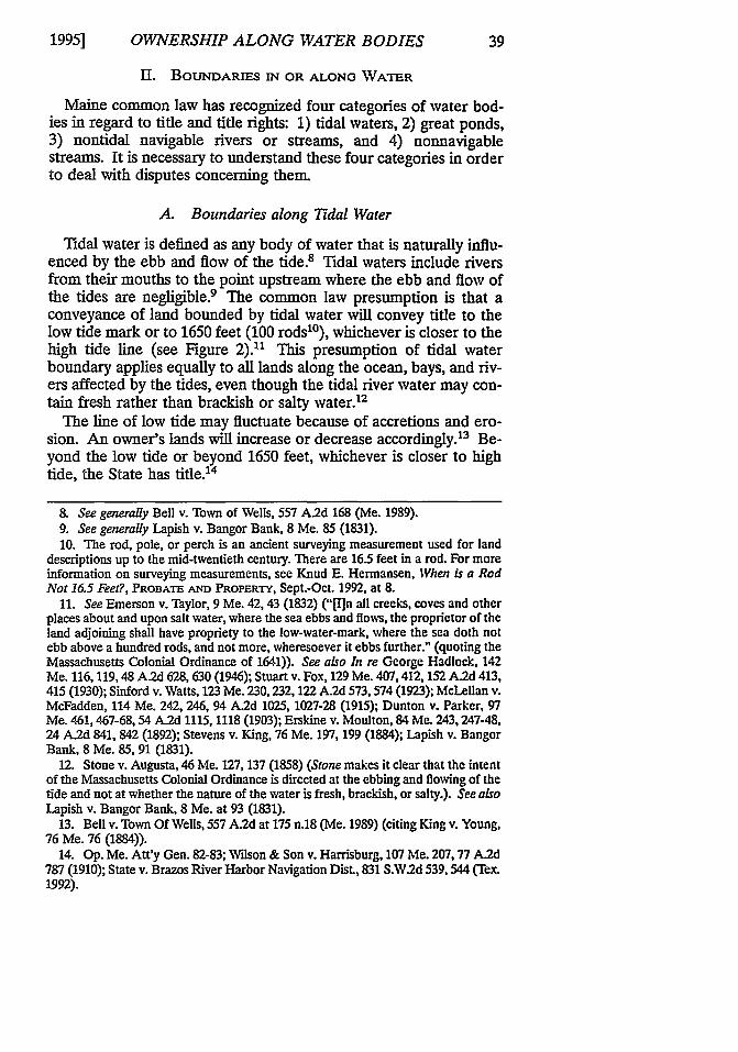
B. Boundaries along Great Ponds
A great pond is defined as any body of standing water with a sur-face area of ten acres or more.15 Title along a great pond extends tothe seasonal normal and natural low water line at the time of theoriginal conveyance. 6 Consequently, if the water of a great pondhas receded or been raised by artificial means since the time of theoriginal conveyance, the upland owner neither gains nor loses prop-erty. 7 Beyond the normal low water line as it stood at the time ofconveyance, title rests with the State (see Figure 3).18
15. Flood v. Earle, 145 Me. 24, 28, 71 A.2d 55, 57 (1950). See also ME. Rnv.STAT. ANN. tit. 38, §§ 436-A(7) and 480-B(5) (West 1989).
16. Flood v. Earle, 145 Me. 24, 71 A.2d 55 (1950); Stevens v. King, 76 Me. 197(1884); Wood v. Kelly, 30 Me. 47 (1849); Bradley v. Rice, 13 Me. 198 (1836);Hathorne v. Stinson, 12 Me. 183 (1835).
17. Lowell v. Robinson, 16 Me. 357, 361 (1839) ("In the case of Hathorne v.Stinson, 3 Fairf. 183, it was decided by this Court, that a lot of land bounded upon apond artificially raised by the flowing of a stream by a mill dam, was not limited tothe margin of the pond, but included the land thus flowed."). The same rule Is ex-pressed in the case of Waterman v. Johnson, 30 Mass. 261 (13 Pick. 1832). See alsoBradley v. Rice, 13 Me. 198 (1836); Hathorne v. Stinson, 12 Me. 183 (1835).
18. See Op. Me. Att'y Gen. supra note 14, at 2 (citing Flood v. Earle, 145 Me. 24,28, 71 A.2d 55, 57 (1950)). See also Barrett v. Rockport Ice Co., 84 Me. 155, 156, 24A. 802 (1891) (Ponds containing more than ten acres are known as public greatponds, and the State holds them, as well as the soil under them, in trust for thepublic.).
[Vol. 47:35
OWNERSHIP ALONG WATER BODIES
Figure 3
Along a great pond the landowner's title ordinarily would reach to the low water
line. Beyond the low water, title remains with the State of Maine. Between the lowand high waters, the common law establishes an easement permitting limited publicuse, as explained in Part III of this Article.
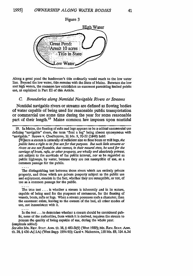
C. Boundaries along Nontidal Navigable Rivers or Streams
Nontidal navigable rivers or streams are defined as flowing bodiesof water capable of being used for reasonable public transportationor commercial use some time during the year for some reasonablepart of their length.19 Maine common law imposes upon nontidal
19. In Maine, the floating of rafts and logs appears to be a critical commercial usedefining "navigable" rivers, the term "float a log" being almost synonymous with"navigable." Brown v. Chadbourne, 31 Me. 9, 20-22 (1849) held:
[W]here a stream is naturally of sufficient size to float boats or mill logs, thepublic have a right to its free use for that purpose. But such little streams orrivers as are not floatable, that canno4 in their natural state; be used for thecarriage of boats, rafts, or other property, are wholly and absolutely private;not subject to the servitude of the public interest, nor to be regarded aspublic highways, by water, because they are not susceptible of use, as acommon passage for the public.
The distinguishing test between those rivers which are entirely privateproperty, and those which are private property subject to the public useand enjoyment, consists in the fact, whether they are susceptible, or not, ofuse as a common passage for the public.
The true test.., is whether a stream is inherently and in its nature,capable of being used for the purposes of commerce, for the floating ofvessels, boats, rafts or logs. When a stream possesses such a character, thenthe easement exists, leaving to the owners of the bed, all other modes ofuse, not inconsistent with it.
In the test.., to determine whether a stream should be considered pub-lic, none of the authorities, from which it is derived, requires the stream topossess the quality of being capable of use, during the whole year.
(emphasis added)See also ME. Rnv. STAT. ANN. tit. 38, § 480-B(9) (West 1989); Mn. REv. STAT. ANN.tit. 38, § 436-A(11A) (West Supp. 1994-95); Card v. Nickerson, 150 Me. 89, 104 A.2d
1995]
42 MAINE LAW REVIEW [Vol. 47:35
navigable streams a public easement for such reasonable transporta-tion or commercial use.2" Conveyance of land bounded by a non-tidal river or stream will convey title out to the "thread" of the mainstream (see Figure 4).21 In Maine, the thread of the stream is de-fined as a line equally distant from the banks' sidelines at the "natu-ral and ordinary" stage of the water (see Figure 4).2
427 (1954). See generally Widson & Son v. Harrisburg, 107 Me. 207, 77 A.2d 787(1910); Smart v. Lumber Co., 103 Me. 37,46,68 A. 527 (1907); Woodman v. Pitman,79 Me. 456, 1 A. 342 (1887); Parsons v. Clark, 76 Me. 476 (1884); Davis v. Winslow,51 Me. 264 (1863); Gerrish v. Brown, 51 Me. 256 (1863); Treat v. Lord, 42 Me. 552(1856).
20. See Brown v. Chadbourne, 31 Me. at 20.21. See Richardson v. Richardson, 146 Me. 145,78 A.2d 505 (1951); Stuart v. Fox,
129 Me. 407, 152 A. 113 (1930); Coombs v. West, 115 Me. 489, 99 A. 445 (1916);Charles C. Wilson & Son v. Harrisburg, 107 Me. 207, 77 A. 787 (1910); Proctor v.Maine Cent. R.R., 96 Me. 458, 52 A.2d 933 (1902); Stevens v. King, 76 Me. 197(1884); Nickerson v. Crawford, 16 Me. 245 (1839); Lowell v. Robinson, 16 Me. 357(1839); Bradley v. Rice, 13 Me. 198 (1836); Graves v. Fisher, 5 Me. 69 (1827).
In Mansur v. Blake, 62 Me. 38 (1873), the court stated:Fresh water rivers, of what kind soever, do, of common right ... belong tothe owners of the soil adjacent; so that the owners of one side have ofcommon right the propriety of the soil, and consequently the right of fish-ing, usque filum aquae; and the owners of the other side the right of soil,ownership and fishing unto the filum aquae on their side. Prima facie, theowner of each bank of a stream is the proprietor of half the land coveredby the stream. The conveyance of land bounded upon a highway or...stream, carries the grantee to the centre, unless there be decided and con-trolling or specific description showing a contrary intent.
Id. at 40 (citation omitted).22. In Warren v. Thomaston, 75 Me. 329 (1883), the court noted:
In case of fresh water streams, when such stream is the boundary, the deedpasses the fee to its centre. The words to the stream, thence up or downthe river, in a deed pass a title to the thread of the stream.... The generalrule is, that when the river is the boundary, the grantee takes usque adfilum aquae, unless the river be expressly excluded from the grant by theterms of the deed.
Id. at 331 (citations omitted).The Warren case gives a complete analysis of the difference between the thread andthe channel of a river or stream, and it gives specific definitions for each. The War-ren court stated:
The channel is the deepest part of the river. It is the navigable part-thewater road over which vessels pass and repass. It is the highway of com-merce. Had the line run to the river and down the river, the boundarywould have been the thread of the stream-the filum aquae. But, thethread of a stream is the middle line between the shores, irrespective of thedepth of the channel, taking it in the natural and ordinary stage of water.The channel and the thread of the river are entirely different. The channelmay be one side of the thread of the river or the other.
Id. at 332.
OWNERSHIP ALONG WATER BODIES
Figure 4
Line equi-distant from natural and ordinarywater lit-
Natural & Ordinary Edge of'
The cross section of a typical stream is not uniform. Consequently, a line equidistantfrom the natural and ordinary water lines cannot be expected to reside in the chan-nel or deepest part of the stream. At times the line will approach one bank or theother and sometimes even cut across a bank that is exposed during times of lowwater.
Figure 5
water line
edge of water
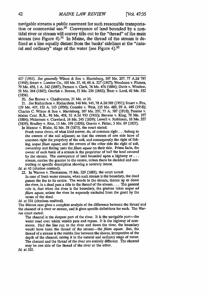
In Figure 5 the low water has exposed an island in the river, blocking an uplandowner from access to the main channel.
During times of unusually low water the owner will not have accessto the water if the ownership boundary at the thread crosses landexposed by drought and cuts off the property before the water'sedge (see Figure 5).P
23. See generally id. (holding that the channel and the thread of rivers andstreams often do not coincide; they may even vary injlocation to such an extent thatwhen the thread is the boundary, the proprietor of the upland on one side of a river
1995]
MAINE LAW REVIEW
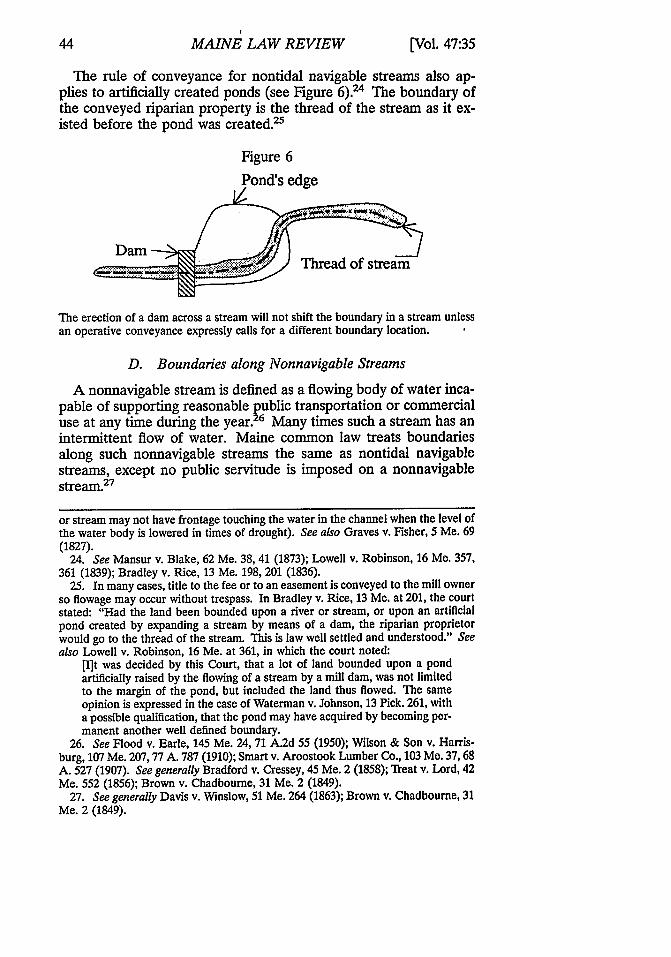
The rule of conveyance for nontidal navigable streams also ap-plies to artificially created ponds (see Figure 6).' The boundary ofthe conveyed riparian property is the thread of the stream as it ex-isted before the pond was created.25
Figure 6
Pond's edge
The erection of a dam across a stream will not shift the boundary in a stream unlessan operative conveyance expressly calls for a different boundary location.
D. Boundaries along Nonnavigable Streams
A nonnavigable stream is defined as a flowing body of water inca-pable of supporting reasonable public transportation or commercialuse at any time during the year.2 6 Many times such a stream has anintermittent flow of water. Maine common law treats boundariesalong such nonnavigable streams the same as nontidal navigablestreams, except no public servitude is imposed on a nonnavigablestream.27
or stream may not have frontage touching the water in the channel when the level ofthe water body is lowered in times of drought). See also Graves v. Fisher, 5 Me. 69(1827).
24. See Mansur v. Blake, 62 Me. 38, 41 (1873); Lowell v. Robinson, 16 Me. 357,361 (1839); Bradley v. Rice, 13 Me. 198, 201 (1836).
25. In many cases, title to the fee or to an easement is conveyed to the mill ownerso flowage may occur without trespass. In Bradley v. Rice, 13 Me. at 201, the courtstated: "Had the land been bounded upon a river or stream, or upon an artificialpond created by expanding a stream by means of a dam, the riparian proprietorwould go to the thread of the stream. This is law well settled and understood." Seealso Lowell v. Robinson, 16 Me. at 361, in which the court noted:
[I]t was decided by this Court, that a lot of land bounded upon a pondartificially raised by the flowing of a stream by a mill dam, was not limitedto the margin of the pond, but included the land thus flowed. The sameopinion is expressed in the case of Waterman v. Johnson, 13 Pick. 261, witha possible qualification, that the pond may have acquired by becoming per-manent another well defined boundary.
26. See Flood v. Earle, 145 Me. 24, 71 A.2d 55 (1950); Wilson & Son v. Harris-burg, 107 Me. 207,77 A. 787 (1910); Smart v. Aroostook Lumber Co., 103 Me. 37,68A. 527 (1907). See generally Bradford v. Cressey, 45 Me. 2 (1858); Treat v. Lord, 42Me. 552 (1856); Brown v. Chadbourne, 31 Me. 2 (1849).
27. See generally Davis v. Winslow, 51 Me. 264 (1863); Brown v. Chadbourne, 31Me. 2 (1849).
[Vol. 47:35
OWNERSHIP ALONG WATER BODIES
III. RESTRAINTS ON OWNERSHiP OF RIPARIAN LANDS
When a parcel of land adjoins a water body, the landowner doesnot necessarily have exclusive use and dominion over the area adja-cent to the water's edge. In some situations a public servitude existson part of the exposed land along the water. In other cases a con-veyance intentionally, or unintentionally, omits title to shorelands,thus denying the landowner the right to use the area immediatelyadjacent to the water in any way other than as a general member ofthe public.
A. Public Servitudes on Waterfront Property
Public servitudes are imposed on all riparian property in Mainewith the exception of land along nonnavigable streams. Along atidal water or great pond the public servitude extends from the nor-mal high tide or water to the normal low tide or water.' On naviga-ble streams the public servitude extends from normal high water onone side to normal high water on the opposite side.' Public servi-
28. See Bell v. Town of Wells, 557 A.2d 168 (Me. 1989); Flood v. Earle, 145 Me.24, 71 A.2d 55 (1950) (intertidal public easements for specific activities conferred byMassachusetts Colonial Ordinances).
29. Op. Me. Att'y Gen. supra note 14, at 3 ("The waters of the State... are heldin trust by the State for the use of its people."). There appears to have been acertain traditional de minimus privilege to trespass allowed to drivers who traveledalong stream banks to keep logs moving downstream. Note the following, however
The public are not entitled to tow on the banks of ancient navigable rivers,at common law. And where a river cannot be used without towing, or go-ing upon its banks to propel what is floating, such fact would evince itswant of capacity, in itself, for public use.
Brown v. Chadbourne, 31 Me. 2,25 (1849) (citing Ball v. Herbert, 100 Eng. Rep. 560(K.B. 1789)).
The use of stream banks was further discussed in 1856:The stream, in order to have the character of a public highway, must, inand of itself, have a capacity for floating logs. Such a stream, as well as ourlarger rivers, will, as experience has universally shown, from its windings,and the rush of its waters especially in times of freshets, cast many of thelogs which float upon its bosom, upon its shores, intervales and banks,thereby rendering it necessary to go upon such uplands for the purpose ofmaking a clean drive. Such incidental necessity neither enlarges nor dimin-ishes the natural capacity of the stream, nor in any way affects its publiccharacter. To meet such necessity, it is proved by the Revised Statutes, c.67, §§ 10 and 11, that all logs or other timber, lodged upon any lands ad-joining any waters within this State, shall, in certain contingencies, andupon certain conditions, be forfeited to the owner or occupier of suchlands; and that the owner of such timber may at any time before such for-feiture, enter on said lands and remove the same, by tendering a reason-able compensation for all damages as the statute requires. While,therefore, it is true, that persons driving logs may go upon the banks of ourpublic streams and rivers, as necessity may require, it is also true, that astream, which is so small and shoal in its bed, that no logs can be driven init, without being propelled by persons traveling on its banks, is privateproperty, and not subject to such public servitude as is claimed in this
1995]
46 MAINE LAW REVIEW [Vol. 47:35
tude on riparian property along tidal water, great ponds, or naviga-ble streams may be summarized as the public right to fish, fowl, andnavigate (and historically to cut ice).' In addition to the generalpublic right to fish, fowl, and boat on all waters other than streams,on great ponds the public has an additional, but limited, right tocross the shoreland to gain access to the pond.31 The MaineSupreme Judicial Court, sitting as the Law Court, has interpreted"fish, fowl, and navigate" to encompass skating, digging worms,clamming, floating logs, landing boats, mooring, and sleigh travel,among other activities. 32 These public servitudes, which evolved
case.... The right of the public so to use a stream or river for the purposesof commerce, rests in the intrinsic capability of its waters for such use, andis in no way dependent upon the necessity of using its banks.
Treat v. Lord, 42 Me. 552, 563-64 (1856).30. Bell v. Town of Wells, 557 A.2d 168 (Me. 1989); McFadden v. DeWitt Ice Co.,
86 Me. 319, 29 A. 1068 (1894); Warren v. Westbrook Co., 86 Me. 32, 29 A. 927(1893); Barrett v. Rockport Ice Co., 84 Me. 155,24 A. 802 (1891); Stevens v. Kelley,78 Me. 445, 6 A. 868 (1886); McPheters v. Moose River Log Driving Co., 78 Me. 329,5 A. 270 (1886); Matthews v. Treat, 75 Me. 594 (1884); Davis v. Winslow, 51 Me. 264(1863); Moulton v. Libbey, 37 Me. 472 (1854); Gerrish v. Proprietors of UnionWharf, 26 Me. 384 (1847); Low v. Knowlton, 26 Me. 128 (1846); Deering v. Proprie-tors of Long Wharf, 25 Me. 51 (1845); Parker v. The Cutler Milldam Co., 20 Me. 353(1841). These cases all deal with defining the activities included within the public'sright to fish, fowl, and navigate.
31. Ponds containing more than ten acres are known as "great ponds."They are public ponds. The state holds them and the soil under them intrust for the public. The public, in the absence of statute, have the right tofish and fowl and to cut ice upon them, by virtue of the Colonial Ordinanceof 1641, provided the citizen can reach the pond by "passing to it on footwithout trespassing upon any man's corn or meadow.'
Flood v. Earle, 145 Me. 24, 28, 71 A.2d 55, 57 (1950) (quoting Conant v. Jordan, 107Me. 227, 77 A. 938 (1910)).
It is interesting to note, however, that a person may go freely across woodland,brush, or bog to reach the pond. This right is codified at ME. REv. STAT. ANN. tit.17, § 3860 (West 1983), which states:
No person on foot shall be denied access or egress over unimproved landto a great pond except that this provision shall not apply to access or egressover the land of a water company or a water district when the water fromthe great pond is utilized as a source for public water.
The Attorney General shall, upon complaint of a person being deniedsaid access or egress, if in his judgment the public interest so requires, pros-ecute criminally or civilly any person who denies such right of access oregress.
Any person may maintain an action in the Superior Court having juris-diction where the alleged denial of access or egress occurred or is likely tooccur for declaratory and equitable relief and actual and punitive damagesagainst any person, partnership, corporation or other legal entity for anyviolations of this section.
Whoever violates this section shall be punished by a fine of not morethan $100 and by imprisonment for not more than 90 days.
32. Bell v. Town of Wells, 557 A.2d 168, 173 (Me. 1989). Bell deals most thor-oughly with the public rights permitted and not permitted in the intertidal zone. InBell the court listed the permitted uses as follows:
OWNERSHIP ALONG WATER BODIES
from commercial use, do not involve any depletion or damage tosoil or chattels33 and do not include the right of the public to wash,swim, picnic, or sunbathe. 4
B. Unintended Limitations on Conveyed Tile
Historically, title to the area immediately bordering water wasvaluable for such activities as harvesting salt grass, cutting ice,booming logs, swimming, and sunbathing.35 The right to engage inthese activities, carried on near the water, was deemed to belong tothe riparian owner and was not considered part of any public right.As a consequence, title to the land area immediately bordering awater body sometimes intentionally was separated from title to theuplands so a party could be conveyed property on which he couldexercise rights of flooding, booming logs, or cutting salt grass with-out having to acquire the uplands as well.3 6 Problems with title canarise when shorelands are intended to be separate from uplands in a
Others may sail over them, may moor their craft upon them, may allowtheir vessels to rest upon the soil when bare, may land and walk uponthem, may ride or skate over them when covered with water bearing ice,may fish in the water over them, may dig shell fish in them, may take seamanure from them, but may not take shells or mussel manure or depositscrapings of snow upon the ice over them.
Il at 174 (emphasis omitted) (quoting Marshall v. Walker, 93 Me. 532, 536, 45. A.497, 498 (1900)). See also Moulton v. Libbey, 37 Me. 472 (1854).
33. See, e.g., Woodman v. Pitman, 79 Me. 456, 10 A. 321 (1887). It was noted inKing v. Young, 76 Me. 76, 80 (1884) that:
[T]he owner of adjoining land can maintain trespass quare clausum fregitagainst one who enters upon the flats and takes and carries away mussel-bed manure and that neither the ordinance of 1641-7 nor the common law,authorizes the taking of mussel-bed manure from the flats of another per-son between high and low water mark on tide waters.
In Pearson v. Rolfe, 76 Me. 380, 386 (1884), the court held that the user of thepublic rights in navigable waters could not remove rocks or obstructions, move soilin the stream bed, remove quarried stone, or remove ice from a fresh water stream.In Moore v. Griffin, 22 Me. 350, 355-56 (1843), the court held that the taking ofsand, sea manure, and ballast are not allowed under the ordinance and that, "Thelanguage of the reservation in the ordinance cannot be extended beyond the obviousmeaning of the words fishing and fowling." In the case of Bagott v. Orr, 2 B&P. 472,it was held that although the right to take shellfish on the shore by the common lawwas admitted, the right to take shells was not. Neither the ordinance nor the com-mon law would authorize the taking of "mussel-bed manure" from the land of an-other person. Bell v. Town of Wells, 557 A.2d 168 (Me. 1989) would appear to allowthe taking of sea manure but not mussel-bed manure. See also Marshall v. Walker,93 Me. 532, 98 A. 115 (1900).
34. See, e.g., Bell v. Town of Vells, 557 A.2d at 175-76 (specifically excludingpublic bathing, sunbathing, general recreation and walking, except where incidentalto fishing, fowling, or navigation, from the rights of the public in the intertidal zone).See also Charles C. Wilson & Son v. Harrisburg, 107 Me. 207, 77 A. 787 (1910).
35. Bell v. Town of Wells, 557 A.2d at 173-76.36. Cf. Littlefield v. Littlefield, 28 Me. 180 (1848); Nickerson v. Crawford, 16 Me.
245 (1839).
1995]

MAINE LAW REVIEW
conveyance. For example, the citation, or call,37 in the deed descrip-tion for a "bank," "shore," "beach margin," or other tangiblelandmark may be used by a scrivener intending to separate thewater from the uplands. These terms provide a tempting physicallimit to mark the separation of the land from the water. Conse-quently, such terms may be employed in a deed intending to stopownership short of, or at, the high water.38 The same attributes thatmake these physical and tangible points valuable as markers, how-ever, also cause them to be used as rough points of reference by adeed drafter who has no intention at all that they serve as refinedlines of limitation or separation.39 The appearance of such terms ina deed can be confusing. An analogy could be made to a persondescribing the location of a house as being "at the intersection ofMain and Oak Streets." The intent could be only to convey enoughinformation to bring another within sight of the house, not to havehim believe the house stands literally in the intersection.
Certain monuments near water bodies, such as "bank," "chan-nel," "shore," "high-water," and "low water," have been used in thisambiguous way to such an extent that the Law Court has devotedsignificant effort to explaining the problems with these terms. It isthus essential that the practitioner understand such terms and theirpotential for confusion so they are not used loosely, with unintendedlines of limitation resulting. For example, a description that states,in part, "to the pond's shore, thence along the shore" leaves theexact location of the ownership line along the water in doubt. Thefollowing definitions may be of assistance in treating ambiguousshoreland references with appropriate specificity.
1. Bank
The term "bank" refers to the rise in topography found along theedge of water bodies, particularly freshwater." Since most bankshave a width composed of a gradual slope, starting at the water andextending uphill several feet, confusion occurs regarding where theline of ownership lies-at the top, middle, or bottom of the bank.To assign a boundary by using a term referencing such a broad widthis to invite controversy, and its use should be avoided.
37. The word "call" refers to a reference in a land survey or deed to an object,measurement, monument, or other detail describing an accompanying physical attri-bute on the land.
38. Lincoln v. Wilder, 29 Me. 169 (1848); Lapish v. Bangor Bank, 8 Me. 85(1831).
39. Lincoln v. Wilder, 29 Me. 169 (1848); Lapish v. Bangor Bank, 8 Me. 85(1831).
40. See generally Stone v. Augusta, 46 Me. 127 (1858).
[Vol. 47:35
OWNERSHIP ALONG WATER BODIES
2. Channel
The channel, or thalweg, is the deepest part of the stream, wherethe stream would flow if any water moved at all.' The channel isnot synonymous with the thread of the stream.42 The channel byhappenstance may be the thread of the stream, but that occurs onlyby chance, as when a raindrop that falls into a cup strikes the exactcenter of the cup. The practitioner who uses "channel" for a bound-ary is choosing what cannot be seen, since the line of the channel isvisible only when water barely flows.
3. Shore
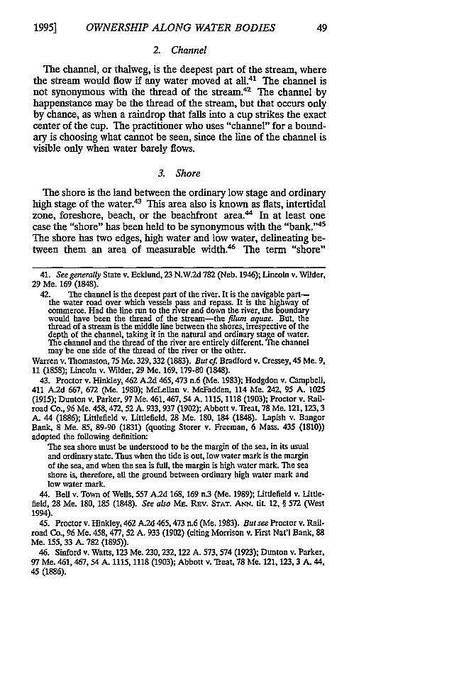
The shore is the land between the ordinary low stage and ordinaryhigh stage of the water.43 This area also is known as flats, intertidalzone, foreshore, beach, or the beachfront area." In at least onecase the "shore" has been held to be synonymous with the "bank. 45
The shore has two edges, high water and low water, delineating be-tween them an area of measurable width.' The term "shore"
41. See generally State v. Ecklund, 23 N.W.2d 782 (Neb. 1946); Lincoln v. Wilder,29 Me. 169 (1848).
42. The channel is the deepest part of the river. It is the navigable part-the water road over which vessels pass and repass. It is the highway ofcommerce. Had the line run to the river and down the river, the boundarywould have been the thread of the stream-the filum aquae. But, thethread of a stream is the middle line between the shores, irrespective of thedepth of the channel, taking it in the natural and ordinary stage of water.The channel and the thread of the river are entirely different. The channelmay be one side of the thread of the river or the other.
Warren v. Thomaston, 75 Me. 329,332 (1883). But cf. Bradford v. Cressey, 45 Me. 9,11 (1858); Lincoln v. Wilder, 29 Me. 169, 179-80 (1848).
43. Proctor v. Hinkley, 462 A2d 465,473 n.6 (Me. 1983); Hodgdon v. Campbell,411 A.2d 667, 672 (Me. 1980); McLellan v. McFadden, 114 Me. 242, 95 A. 1025(1915); Dunton v. Parker, 97 Me. 461,467,54 A. 1115, 1118 (1903); Proctor v. Rail-road Co., 96 Me. 458,472,52 A. 933, 937 (1902); Abbott v. "fteat, 78 Me. 121,123,3A. 44 (1886); Littlefield v. Littlefield, 28 Me. 180, 184 (1848). Lapish v. BangorBank, 8 Me. 85, 89-90 (1831) (quoting Storer v. Freeman, 6 Mass. 435 (1810))adopted the following definition:
The sea shore must be understood to be the margin of the sea, in its usualand ordinary state. Thus when the tide is out, low water mark is the marginof the sea, and when the sea is full, the margin is high water mark. The seashore is, therefore, all the ground between ordinary high water mark andlow water mark.
44. Bell v. Town of Wells, 557 A.2d 168, 169 n.3 (Me. 1989); Littlefield v. Little-field, 28 Me. 180, 185 (1848). See also ME. Rnv. STAT. ANN. tit. 12, § 572 (West1994).
45. Proctor v. Hinkley, 462 A.2d 465, 473 n.6 (Me. 1983). But see Proctor v. Rail-road Co., 96 Me. 458, 477, 52 A. 933 (1902) (citing Morrison v. First Nat'l Bank, 88Me. 155, 33 A. 782 (1895)).
46. Sinford v. Watts, 123 Me. 230,232, 122 A. 573, 574 (1923); Dunton v. Parker,97 Me. 461, 467, 54 A. 1115, 1118 (1903); Abbott v. Treat, 78 Me. 121, 123, 3 A. 44,45 (1886).
1995]
MAINE LAW REVIEW
should not be used to fix a boundary because the point of ownershipalong the width of land that compromises the "shore" is uncertain.
Figure 7
Permanent Vegetation
Present WaterLevel " Normal High Water
Along water bodies, normal high water is the edge of the permanent vegetation.Oftentimes the actual water level is found at some lower level.
4. High Water
High water, generally synonymous with normal high water, is theline reached by the water when the water body is ordinarily full andthe water ordinarily high.47 The line is normally marked by thescour line, which is the line between permanent vegetation and soilor rock swept clean of vegetation by the action of the water (seeFigure 7).48 High water is not the highest point touched by thewater in a storm or abnormal flooding, but the highest limit reachedwhen the water maintains its natural and usual flow.49 Because thisis not generally understood, confusion arises when the term "highwater" is employed to fix a boundary; its use should be avoided.
47. See, e.g., Gerrish v. Proprietors of Union Wharf, 26 Me. 384, 396 (1847).48. See Proctor v. Hinkley, 462 A.2d 465 (Me. 1983).49. [T]he line on the river bank reached by the water when the river is
ordinarily full and the water ordinarily high. Not the highest point touchedby the water in a freshet... but the highest limit reached when the river isunaffected by freshets and contains its natural and usual flow; the highestlimit at the ordinary state of the river .... Sometimes it may be "the linewhich the river impresses upon the soil by covering it for sufficient periodsto deprive it of vegetation and to destroy its value for agriculture," while inother cases "it can only be ascertained by careful observation."
Proctor v. Hinkley, 462 A.2d 465,470 n.4 (Me. 1983) (quoting Morrison v. First Nat'lBank, 88 Me. 155, 161,33 A. 782,784 (1895)). See also ME. REv. STAT. ANN. tit. 38,§ 436-A(9) (West 1964); ME. Rnv. STAT. ANN. tit. 38, § 480-B(6) (West 1964); Get-rish v. Proprietors of Union Wharf, 26 Me. 384 (1847).
[Vol. 47:35
OWNERSHIP ALONG WATER BODIES
5. Low Water
Low water is the level to which the tide ebbs on its out-flow. 50
The low water line along a stream or great pond is the line the waterrecedes to during summer months.51
IV. COMMON LAW RuLEs OF CONSTRUCTION FOR
TNTERPRETING COMMON WVATER BOUNDARY TERMS IN
CONVEYANCES
As a consequence of the historically careless use of water bound-ary terms by laypersons and practitioners alike, the courts haveadopted certain rules of construction governing their interpretationsin conveyances.' When the intent of the drafter is clear from thecontext of the transaction or from the instrument itself, that expressintent will control.5 When the intent is unclear and controversial,certain other rules of construction govern.-4
In general, Maine courts have been reluctant to interpret a con-veyance as separating the lowlands from the uplands.5" Uplandsand shorelands benefit each other to such an extent that separationgoes against common sense.56 The presumption therefore is againstseparation unless the conveyance expresses explicit intent other-wise.57 Words such as "by," "along," or "side" are insufficient by
50. See generally Gerrish v. Proprietors of Union Wharf, 26 Me. 384 (1847).51. Id.52. The rules of construction applicable to navigable waters are similar, and
many times the same, as rules pertaining to roads. See Warren v. Thomaston, 75 Me.329 (1883).
53. Proctor v. Hinkley, 462 A.2d 465 (Me. 1983); McLellan v. McFadden, 114 Me.242, 95 A.2d 1025 (1915); Wilson & Son v. Harrisburg, 107 Me. 207, 77 A. 787(1910); Brown v. Heard, 85 Me. 294,27 A. 182 (1893); Haight v. Hamor, 83 Me. 453,22 A. 369 (1891); Bradford v. Cressey, 45 Me. 9 (1858); Pike v. Monroe, 36 Me. 309(1853).
54. We are to consider all the words of the grant in light of the circum-stances and conditions attending the transaction. But we must considerand construe the grant according to settled rules of construction. They arerules of property. And the security of real estate titles depends upon astrict adherence to these rules of construction.
Stuart v. Fox, 129 Me. 407, 413, 152 A. 413, 415-16 (1930). See also McLellan v.McFadden, 114 Me. 242, 95 A. 1025 (1915); Bradford v. Cressey, 45 Me. 9 (1858).
55. See, eg., Stuart v. Fox, 129 Me. 407, 152 A. 413 (1930); Sinford v. Watts, 123Me. 230, 232, 122 A. 573, 574 (1923); McLellan v. McFadden, 114 Me. 242, 95 A.1025 (1915); Dunton v. Parker, 97 Me. 461, 54 A. 1115 (1903); Freeman v. Leighton,90 Me. 541,38 A. 542 (1897); Snow v. Mt. Desert Island Real Estate Co., 84 Me. 14,24 A. 429 (1891); Stevens v. King, 76 Me. 197 (1884); Nickerson v. Crawford, 16 Me.245 (1839).
56. See generally McLellan v. McFadden, 114 Me. 242,95 A. 1025 (1915); Snow v.Mt. Desert Island Real Estate Co., 84 Me. 14, 24 A. 429 (1891).
57. See Stuart v. Fox, 129 Me. 407, 152 A. 413 (1930); Sinford v. Watts, 123 Me.230, 232, 22 A. 573, 574 (1923); McLellan v. McFadden, 114 Me. 242, 95 A. 1025(1915); Dunton v. Parker, 97 Me. 461,54 A. 1115 (1903); Stevens v. King, 76 Me. 197(1884); Nickerson v. Crawford, 16 Me. 245 (1839).
1995]
MAINE LAW REVIEW
themselves to convey the uplands without the lowlands."8 This istrue even when the measurements given do not extend further to-ward the water than the edge of uplands.5 9 Furthermore, a descrip-tion that cites only the area measuring the uplands is not persuasiveas conveying only the uplands-since the custom with surveyors de-fining a complete property (both uplands and shorelands) often hasbeen to exclude from the description the area of flats and shore andto cite only the area of the uplands even though both may be in-tended to be conveyed.
A. Common Water Boundary Terms Used as Words of Separation
Terms often used as evidence of intent to separate the uplandsfrom the shore or flats include "by the bank," "along high watermark," "high tide," "by the shore," "by the head of the cove," and"along the near (or upland) shore."'60 The use of one of these terms
58. Wilson v. Harrisburg, 107 Me. 207, 213, 77 A. 787, 789 (1910) ("[A] deedwhich describes a line along a nontidal river as running 'with' or along the stream, oras running 'by' or 'on' the stream or 'up' or 'down' the stream, carries the title to thecenter of the stream, unless the contrary appears... ."). See also Dunton v. Parker,97 Me. 461, 54 A.2d 1115 (1903).
59. The general rule of construction may be thus stated; whenever land isdescribed as bounded by other land, or by a building or structure, the nameof which, according to its legal and ordinary meaning, includes the title inthe land of which it has been made a part, as a house, a mill, a wharf, or thelike, the side of the land or structure referred to as a boundary is the limitof the grant; but when the boundary line is simply by an object, whethernatural or artificial, the name of which is used in ordinary speech as defin-ing a boundary, and not as describing a title in fee, and which does not, inits description or nature include the earth as far down as the grantor owns,and yet which has width, as in case of a way, a river, a ditch, a wall, a fence,a tree, or a stake and stone, then the center of the thing so running over orstanding on the land is the boundary of the lot granted .... And it isundoubtedly true that where a grant is bounded upon a nonnavigablefresh-water [sic] stream, a highway, a ditch or a party wall, or the like, suchstream, way, ditch or wall are to be deemed monuments, located equallyupon the land granted and the adjoining land, and in all such cases, thegrant extends to the center of such monument.
Coombs v. West, 115 Me. 489, 491-92, 99 A. 445 (1916) (quoting City of Boston v.Richardson, 95 Mass. 146, 154 (1866); Bradford v. Cressey, 45 Me. 9,13 (1858)). TheLaw Court in Haight v. Hamor, 83 Me. 453, 460-61, 22 A. 369 (1891) had statedearlier:
The rule is well established when the road is the terminus ad quem, butthere is little authority when it is the terminus a quo, and there is no monu-ment at the other end of the line. A majority of the court is of opinion thatit is a common method of measurement, in the country where the boundaryis a stream or way, to measure from the bank of the stream or the side ofthe way, and that there is a reasonable presumption that the measurementswere made in this way, unless something appears affirmatively in the deedto show that they began at the center line of the stream or way.
Id. at 372 (quoting Dodd v. Witt, 139 Mass. 63, 65 (1885)). Cf. Stevens v. King, 76Me.. 197, 199-200 (1884).
60. Proctor v. Hinkley, 462 A.2d 465,467 (Me. 1983); McLellan v. McFadden, 114Me. 242, 247, 95 A. 1025, 1028 (1915); Whitmore v. Brown, 100 Me. 410, 414-15, 61A. 985, 987-88 (1905); Wilson & Son v. Harrisburg, 107 Me. 207, 212-13, 77 A. 787,
[Vol. 47:35
OWNERSHIP ALONG WATER BODIES
with the preposition "to," a word of exclusion, often has been heldby the Law Court to limit the title to property above a line wherethe monument coincides with the line of normal high water or hightide.61 In other words, when the grantor conveys "to" one of thesemonuments and then writes the description "along" the same monu-ment or another similar monument, courts will presume such con-veyances to exclude the shores or flats from the grant.6 Use of suchterms without "to," however, may not be conclusive in excludingtitle to the lowlands. 63 For example, it is common for a descriptionto run not to a shoreland monument but to a fixed and tangiblemonument such as a tree and then go "along" the water body. Inthis situation, the conveyance extends ownership to the full limit ofthe grantor's potential title in the water body. The monument nearthe water is presumed merely to fix the direction from the previous
789-90 (1910); Brown v. Heard, 85 Me. 294,27 A. 182, 182 (1893); Bradford v. Cres-sey, 45 Me. 9, 12 (1858).
61. "[T]he word 'to' is a word of exclusion rather than of inclusion." Dunton v.Parker, 97 Me. 461,467, 54 A. 1115, 1118 (1903) (citation omitted). Cf. Hodgdon v.Campbell, 411 A.2d 667 (Me. 1980); McLellan v. McFadden, 114 Me. 242,95 A. 1025(1915); Wilson & Son v. Harrisburg, 107 Me. 207,77 A. 787 (1910); Proctor v. Rail-road Co., 96 Me. 458,52 A. 933 (1902); Stone v. City of Augusta, 46 Me. 127 (1858).
62. See, e.g., Mansur v. Blake, 62 Me. 38, 41-42 (1873); Bradford v. Cressey, 45Me. 9, 13-14 (1858).
63. In determining the construction of the description in a deed of landupon the seashore, certain well-established general principles must be ap-plied. By the Colonial Ordinance of 1641-7, it was provided that in suchcases, "the proprietor of the land adjoining shall have propriety to lowwater mark," etc. By reason of this ordinance the owner of the uplandadjoining tide water prima facie owns to low water mark; and does so infact, unless the presumption is rebutted by proof to the contrary .... It is,of course, true that the owner of upland and shore may separate the owner-ship by the conveyance of one and the retention of the other, and, as hasfrequently been decided n the states to which this ordinance is applicable,where the side boundary line of the lot conveyed is "to the shore," andthence "by the shore," the side line terminates at the inner side of the
shore, an shows, in the absence of other calls or circumstances showing acontrary intention, that the inner side of the shore is intended as the
boundary. That is, a call in a deed which describes a line as running to astrip of land, whether shore or upland, does not carry the line over, acrossor onto the strip referred to, because the word "to" is a word of exclusionrather than of inclusion ....
But it does not by any means follow from the mere fact that the shore ofland adjoining tide waters is made a boundary, or that the boundary is "bythe shore," that it is by high water mark. The space between high and lowwater mark, properly called the shore, is frequently of many rods in width,it has an outer or seaward side and an inner or upland side, and, nothingelse appearing, a boundary by the shore may be as well intended to meanthe one as the other. To determine which side of the shore is intended asthe boundary it is necessary to look for something further. It follows, thatthe starting point of a boundary "by the shore" is one of the importantelements in throwing light upon the question as to which margin of theshore is intended, because, as we have already seen, low water mark is asmuch the shore as is high water mark.
Dunton v. Parker, 97 Me. 461, 467-68, 54 A. 1115, 1118 (1903) (citations omitted).
1995]
MAINE LAW REVIEW
upland monument toward the water body."a For example, if the de-scription says in part "stone; thence S830E 102 rods to a tree on thebank; thence along the pond," the tree serves to fix the boundaryfrom the stone to the tree. Implicit in such a description is the ideathat the boundary then runs down from the tree to the water (seePart V of this Article), goes along the water, and includes the shoresand flats (see Part II of this Article).
B. Specific Principles in Construing Separation of Uplandsfrom Lowlands
When the intent to include, or exclude, lowlands from a convey-ance is not clear from the deed, the Law Court has provided someguiding principles for construing such conveyances. Each principleis based on past and present actions involving the riparian land andits conveyances.
1. Mix of Monuments Principle
If one or more calls in a deed are for the "water," while other callsin the same deed are for the "shore" or "bank," the edge of theshore or bank at the low water line is held to be what is meant bythe call for the "shore" or "bank., 65 By contrast, if the "shore" or"bank" is called for in a description without mention of the water orwater's edge, it is presumed that the high water edge of the shore orbank is what is meant.66
64. It is familiar law, however, that when land is described as bounded bya monument standing on the bank ... [or] if the monument do[es] notstand exactly on the bank but a short distance back from it-the monu-ment then being referred to only as giving the direction of the line to thestream and not as restricting the boundary on the stream.
Erskine v. Moulton, 66 Me. 276, 280 (1877); Cf. Mansur v. Blake, 62 Me. 38 (1873);Bradford v. Cressey, 45 Me. 9 (1858).
65. Dunton v. Parker, 97 Me. at 468-69, 54 A. 1115, 1118 (1903); Proctor v.Maine Railroad Co., 96 Me. 458, 472-73, 52 A. 933, 937 (1902).
66. Running to a monument standing on the bank, and from thence run-ning to the river, or along the river, &c., does not restrict the grant to thebank of the stream; for the monuments, in such cases, are only referred toas giving the direction of the lines to the river, and not as restricting theboundary on the river. If the grantor, however, after giving the line to theriver, bounds his land by the bank of the river, or describes his line asrunning along the bank of the river, or bounds it upon the margin of theriver, he shows that he does not consider the whole alveus of the stream amere mathematical line, so as to carry his grant to the middle of the river.And it appears to me equally clear that the grant is restricted when it isbounded by the shore of the river, as in the present case.
Bradford v. Cressey, 45 Me. at 13-14 (quoting Child v. Starr, 4 Hill 369 at 375). Seealso Snow v. Mt. Desert Island Real Estate Co., 84 Me. 14, 17,24 A. 429,430 (1891)(holding that where the terms "the sea" or "the shore" are used in a deed to desig-nate a boundary, they include the beach to the low-water mark).
[Vol. 47:35

OWNERSHIP ALONG WATER BODIES
2. Long Uncontested Possession Principle
The intended boundary is deemed to be the high water edge ofthe shore or bank when a conveyance uses a term other than "thewater" as the call for a boundary monument and the conveyance isfollowed by a long uncontested possession of the shore or flats bysomeone not claiming title through the grantee.67 This was fre-quently the situation around mill ponds where the mill owner in-tended to retain the title to boom the logs at the shore or where thegrantor had erected fishing weirs and continued to maintain themafter the conveyance. Unfortunately for the practitioner seeking toclarify title to such riparian land, evidence affirming uncontestedhistorical possession, such as the booming of logs or the existence offishing weirs, may have disappeared over time.
3. Value Apart Principle
Whether the flats or shore are capable of being separated fromthe uplands, and whether such separation is worthwhile, may serveas evidence of an intent to separate the lowlands from the uplands.A separate conveyance of the shore or flats from the uplands maybe considered reasonable intent when activities have been carriedon along the water that have not needed the support of the uplandsto make them valuable. Examples of such activities include fishing,log booming, and salt grass cultivation.'
4. Separated and Brought Back Principle
It is possible for one part of a deed to be construed to exclude thewater, while a later part of the same deed brings the water back.69
A qualifying clause of the deed, or other documents cited in theproperty description, may be used to determine the ultimate intentof the grantor to retain the lowlands with the uplands.70
67. See, eg., McLellan v. McFadden, 114 Me. 242, 248-49, 95 A. 1025, 1028-29(1915).
68. See, eg., Stuart v. Fox, 129 Me. at 412, 152 A. at 415; McLellan v. McFadden,114 Me. at 248-49, 95 A. at 1028-29; Dunton v. Parker, 97 Me. 461,467, 54 A. 1115,1118 (1903); Clancey v. Houdlette, 39 Me. 451, 457-58 (1855).
69. Hodgdon v. Campbell, 411 A.2d 667, 672 (Me. 1980).70. Snow v. Mt. Desert Island Real Estate Co., 84 Me. at 16, 24 A. at 429. See
also Seekins v. Lougee, 152 Me. 153, 156, 125 A.2d 916, 917-18 (1956); Dunton v.Parker, 97 Me. at 468, 54 A. at 1118; Dillingham v. Roberts, 75 Me. 469, 471-72(1883); Lincoln v. Wilder, 29 Me. 169, 182 (1848); Lapish v. Bangor Bank, 8 Me. 85,91-92 (1831). In Whitmore v. Brown, 100 Me. 410, 416-17, 61 A. at 985, 988 (1905),the court stated that the words "together with all the privileges and appurtenancesthereto belonging" do not convey the shore and flats. In Snow v. Mt Desert IslandReal Estate Co., the court stated that the right in the shore is a fee ownership subjectto a public servitude, but as that is usually regarded as an appurtenance, it is owner-ship, not an easement. However, it cannot be conveyed as an appurtenance becauseland cannot be appurtenant to land, only an easement or the like can be anappurtenance.
1995]
MAINE LAW REVIEW
5. Islands Principle
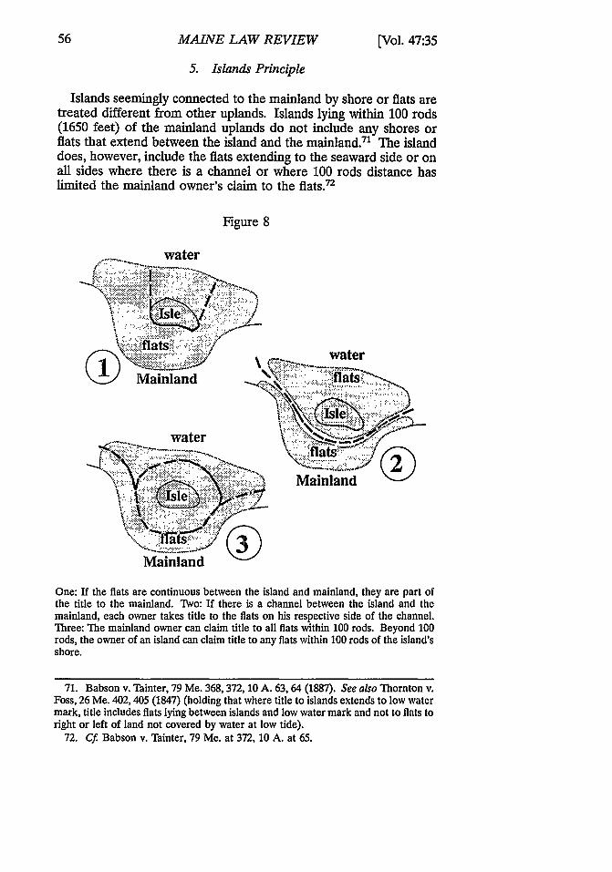
Islands seemingly connected to the mainland by shore or flats aretreated different from other uplands. Islands lying within 100 rods(1650 feet) of the mainland uplands do not include any shores orflats that extend between the island and the mainland.71 The islanddoes, however, include the flats extending to the seaward side or onall sides where there is a channel or where 100 rods distance haslimited the mainland owner's claim to the flats.72
Figure 8
water
water
water
Mainland
Mainland
©®
One: If the flats are continuous between the island and mainland, they are part ofthe title to the mainland. Two: If there is a channel between the island and themainland, each owner takes title to the flats on his respective side of the channel.Three: The mainland owner can claim title to all flats within 100 rods. Beyond 100rods, the owner of an island can claim title to any flats within 100 rods of the island'sshore.
71. Babson v. Thinter, 79 Me. 368, 372, 10 A. 63, 64 (1887). See also Thornton v.Foss, 26 Me. 402,405 (1847) (holding that where title to islands extends to low watermark, title includes flats lying between islands and low water mark and not to flats toright or left of land not covered by water at low tide).
72. Cf Babson v. Tainter, 79 Me. at 372, 10 A. at 65.
[Vol. 47:35
OWNERSHIP ALONG WATER BODIES
V. THE SPECIAL PROBLEM OF BOUNDARIES THAT CROSS
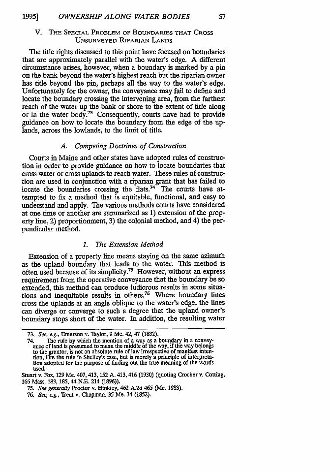
UNSURVEYED RIPARIAN LANDS
The title rights discussed to this point have focused on boundariesthat are approximately parallel with the water's edge. A differentcircumstance arises, however, when a boundary is marked by a pinon the bank beyond the water's highest reach but the riparian ownerhas title beyond the pin, perhaps all the way to the water's edge.Unfortunately for the owner, the conveyance may fail to define andlocate the boundary crossing the intervening area, from the farthestreach of the water up the bank or shore to the extent of title alongor in the water body.73 Consequently, courts have had to provideguidance on how to locate the boundary from the edge of the up-lands, across the lowlands, to the limit of title.
A. Competing Doctrines of Construction
Courts in Maine and other states have adopted rules of construc-tion in order to provide guidance on how to locate boundaries thatcross water or cross uplands to reach water. These rules of construc-tion are used in conjunction with a riparian grant that has failed tolocate the boundaries crossing the flats.74 The courts have at-tempted to fix a method that is equitable, functional, and easy tounderstand and apply. The various methods courts have consideredat one time or another are summarized as 1) extension of the prop-erty line, 2) proportionment, 3) the colonial method, and 4) the per-pendicular method.
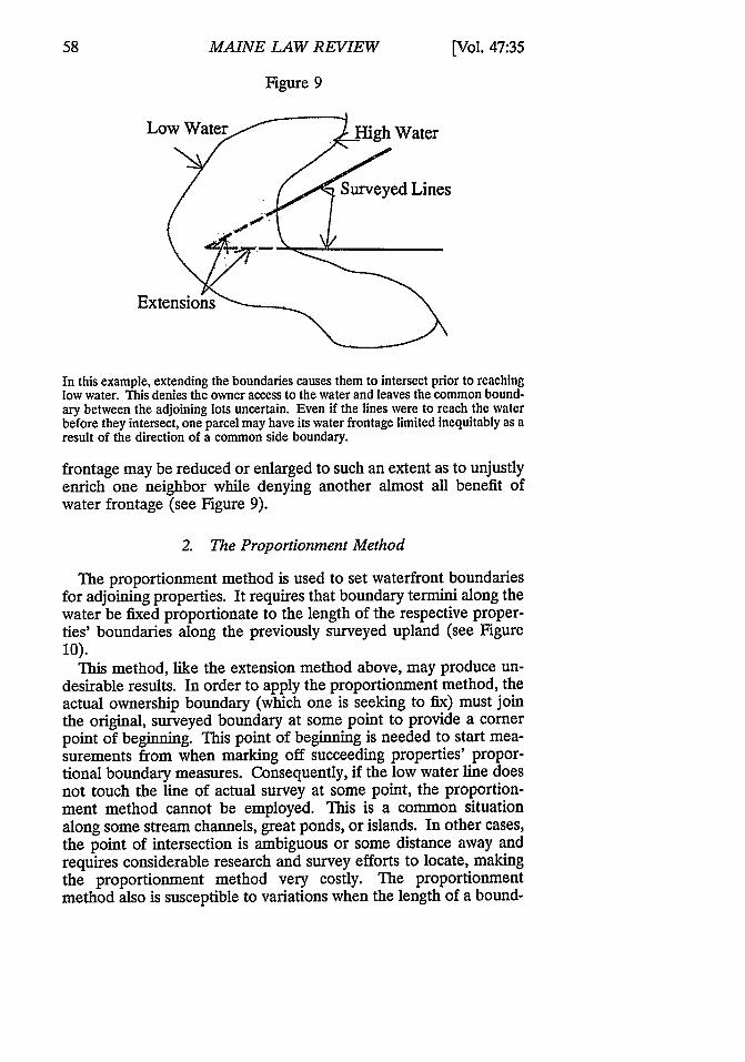
1. The Extension Method
Extension of a property line means staying on the same azimuthas the upland boundary that leads to the water. This method isoften used because of its simplicity.75 However, without an expressrequirement from the operative conveyance that the boundary be soextended, this method can produce ludicrous results in some situa-tions and inequitable results in others.7 6 Where boundary linescross the uplands at an angle oblique to the water's edge, the linescan diverge or converge to such a degree that the upland owner'sboundary stops short of the water. In addition, the resulting water
73. See, eg., Emerson v. Taylor, 9 Me. 42, 47 (1832).74. The rule by which the mention of a way as a boundary in a convey-
ance of land is presumed to mean the middle of the way, if the way belongsto the grantor, is not an absolute rule of law irrespective of manifest inten-tion, like the rule in Shelley's case, but is merely a principle of interpreta-tion adopted for the purpose of finding out the true meaning of the wordsused.
Stuart v. Fox, 129 Me. 407, 413, 152 A. 413, 416 (1930) (quoting Crocker v. Cotting,166 Mass. 183, 185, 44 N.E. 214 (1896)).
75. See generally Proctor v. IFinkley, 462 A.2d 465 (Me. 1983).76. See e.g., Treat v. Chapman, 35 Me. 34 (1852).
1995]
MAINE LAW REVIEW
Figure 9
Low ater High Water
Surveyed Lines
Extensions
In this example, extending the boundaries causes them to intersect prior to reachinglow water. This denies the owner access to the water and leaves the common bound-ary between the adjoining lots uncertain. Even if the lines were to reach the waterbefore they intersect, one parcel may have its water frontage limited inequitably as aresult of the direction of a common side boundary.
frontage may be reduced or enlarged to such an extent as to unjustlyenrich one neighbor while denying another almost all benefit ofwater frontage (see Figure 9).
2. The Proportionment Method
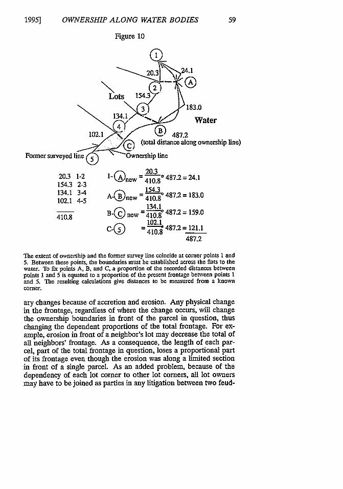
The proportionment method is used to set waterfront boundariesfor adjoining properties. It requires that boundary termini along thewater be fixed proportionate to the length of the respective proper-ties' boundaries along the previously surveyed upland (see Figure10).
This method, like the extension method above, may produce un-desirable results. In order to apply the proportionment method, theactual ownership boundary (which one is seeking to fix) must jointhe original, surveyed boundary at some point to provide a cornerpoint of beginning. This point of beginning is needed to start mea-surements from when marking off succeeding properties' propor-tional boundary measures. Consequently, if the low water line doesnot touch the line of actual survey at some point, the proportion-ment method cannot be employed. This is a common situationalong some stream channels, great ponds, or islands. In other cases,the point of intersection is ambiguous or some distance away andrequires considerable research and survey efforts to locate, makingthe proportionment method very costly. The proportionmentmethod also is susceptible to variations when the length of a bound-
[Vol. 47:35
OWNERSHIP ALONG WATER BODIES
Figure 10
20.3 24.1
2)_ ALots 154.3
134.1 Water
102.1 OB 487.2"@ (total distance along ownership line)
Former surveyed line Ownership line
/"h _20.3.20.3 1-2 1-kAnew 0. 487.2=24.1154.3 2-3 10.3
134.1 3-4 A-( )new 15 487.2 = 183.0102.1 4-5 410.8
_134.1
410.8 B-0, new 410.8' 4872 = 159.0C-@ 102.1
c= 10. 487.2 = 121.1410.8 47.487.2
The extent of ownership and the former survey line coincide at corner points I and5. Between these points, the boundaries must be established across the flats to thewater. To fix points A, B, and C, a proportion of the recorded distances betweenpoints 1 and 5 is equated to a proportion of the present frontage between points Iand 5. The resulting calculations give distances to be measured from a knowncomuer.
ary changes because of accretion and erosion. Any physical changein the frontage, regardless of where the change occurs, will changethe ownership boundaries in front of the parcel in question, thuschanging the dependent proportions of the total frontage. For ex-ample, erosion in front of a neighbor's lot may decrease the total ofall neighbors' frontage. As a consequence, the length of each par-cel, part of the total frontage in question, loses a proportional partof its frontage even though the erosion was along a limited sectionin front of a single parcel. As an added problem, because of thedependency of each lot comer to other lot comers, all lot ownersmay have to be joined as parties in any litigation between two feud-
1995]

MAINE LAW REVIEW
ing parties in order to fix mutually proportioned waterfrontboundaries.77
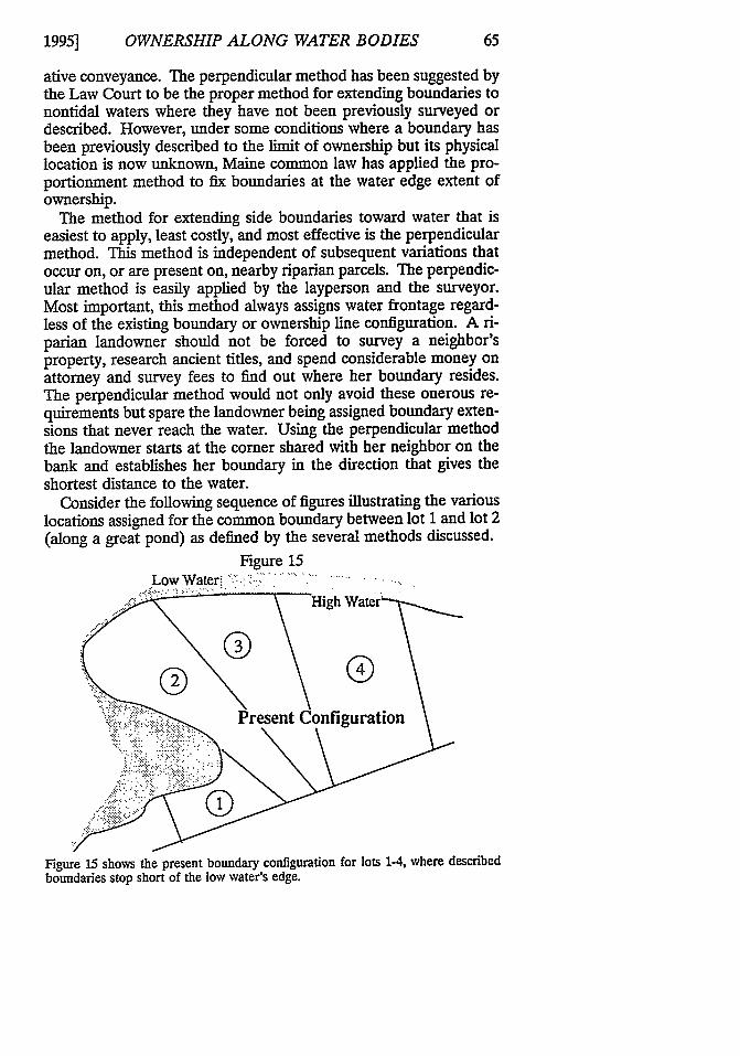
Proportioning is appropriately used to fix the termini of adjoinedboundaries when 1) the lot was created as part of a plan of lots andthe deed refers to the overall plan; 2) the plan shows the cornersterminating at the great pond, the tidal water, or the thread of theriver; 3) one or more monuments were not set or their former posi-tion can no longer be determined; and 4) there is excess or defi-ciency between the recorded distance and actual distance along thewater frontage between existing monuments or former positions(see Figure 11).78
Figure 11
As seen in Figure 11, this subdivision plan extends the boundary to the water givingno indication that the survey or description stops the boundary short of the absolutelimit of title. When old plans are retraced with modem equipment, the record mea-surements typically do not match the retracement measurements. This situation re-quires reproportioning the frontage to establish the location of the entire sideboundaries.
3. The Colonial Method
The colonial method was adopted early in Maine's history andwas limited to use in those areas governed by the Massachusetts Co-
77. See, e.g., Reitz v. Knight, 814 P.2d 1212 (Wash. Ct. App. 1991).78. Brown v. Gay, 3 Me. 126 (1824).
[Vol. 47:35
OWNERSHIP ALONG WATER BODIES
lonial Ordinance that dealt with water affected by the tides.79 Thismethod for apportioning flats among adjoining upland properties isnot appropriate in all situations.' ° The advantage of the colonialmethod over the other methods is that, once determined, the direc-tion of the boundaries remains fixed regardless of additionalshorefront accretions or erosions. Determining a common bound-ary for adjoining properties across flats or water by this method de-pends solely on existing comers of the adjoining properties.
The colonial method was first described by the court as follows:The mode of applying the principle is this. Draw a base linefrom the two corners of each lot, where they strike the shore;and from those two corners, extend parallel lines to low watermark, at right angles with the base line. If the line of the shorebe straight, as in the case before us, there will be no interfer-ence in running the parallel lines. If the flats lie in a cove, of aregular or irregular curvature, there will be an interference inrunning such lines, and the loss occasioned by it must beequally borne or gain enjoyed equally by the contiguous own-ers .... 8 1
The colonial method sees to it that loss or accretion gain is "borneequally" by adjoining property owners; it sets as the direction oftheir common boundary the average or mean bearing of the twolines drawn across the fronts of their contiguous properties (see Fig-ure 12).
79. Emerson v. Taylor, 9 Me. 42 (1832). See also Call v. Carroll, 40 Me. 31(1855).
80. Babson v. Tainter, 79 Me. 368,371, 10 A. 63,64 (1887) ("No rule can compassall cases. The Massachusetts court has adopted different rules for different classes ofcases, and has frequently had occasion to remark upon the difficulty and embarrass-ment attending a practical application of any construction of the ordinance.").
We are not aware of any cases, where, in apportioning appurtenant flatsamong contiguous owners of upland, the foregoing principles and mode ofproceeding would not be properly applicable as the rule of decision. Stillwe do not undertake to affirm that there may not be some peculiarity in theform of the upland to which flats are appurtenant, and some peculiarity ofmanner in which the upland may be divided among contiguous owners, theeffect of which we have not anticipated, which would vary the principle.Should any such cases hereafter present themselves, requiring the applica-tion of a different principle, such new principle must of course be applied.
Emerson v. Taylor, 9 Me. at 46.81. Emerson v. Taylor, 9 Me. at 44-45.
1995]
MAINE LAW REVIEW
Figure 12-Steps 1 & 2
Water Ownership line
Land S ey line
Step 1: Connect adjoining comers forming lines 1 & 2
Survey line
Step 2: Strike an average direction between lines 1 & 2
The figure illustrates the steps necessary to use the colonial method properly. Asseen from the figure, this method is dependent on being able to fix corner locationsin addition to the joint corner in question.
The colonial method has three problems. First, it may cause ad-joining property boundaries across flats to intersect before reachinga property's limit at or across water. This is the same problem thatcan occur with extension of an upland boundary, although it hap-pens less frequently with the colonial method. Second, the properapplication of this method requires that all comers on the water sideof adjoining properties be identified. The researcher, or more likelythe surveyor, may need to perform tedious research, possibly to theearliest grants dealing with the land, and may need to survey one ormore adjoining parcels in order to recover the necessary adjoiningcorners. Third, equitable application of this method requires adjoin-ing comers used in the calculation to have been created at the same
[Vol. 47:35
OWNERSHIP ALONG WATER BODIES
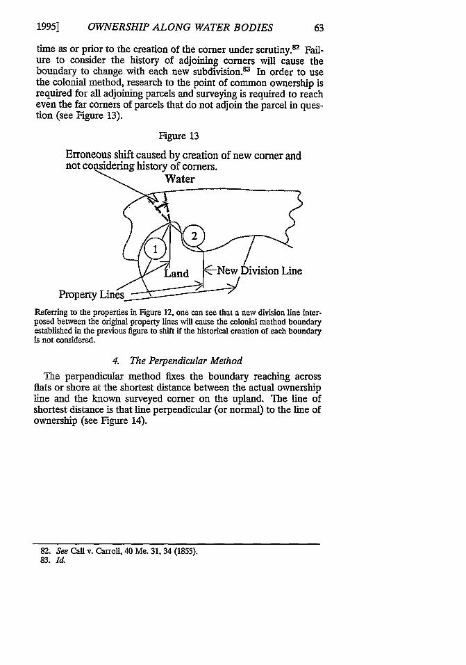
time as or prior to the creation of the corner under scrutiny.' Fail-ure to consider the history of adjoining comers will cause theboundary to change with each new subdivision.' In order to usethe colonial method, research to the point of common ownership isrequired for all adjoining parcels and surveying is required to reacheven the far comers of parcels that do not adjoin the parcel in ques-tion (see Figure 13).
Figure 13
Erroneous shift caused by creation of new comer andnot co sidering history of comers.
and New Division Line
Property Lines_____________Referring to the properties in Figure 12, one can see that a new division line inter-posed between the original property lines will cause the colonial method boundaryestablished in the previous figure to shift if the historical creation of each boundaryis not considered.
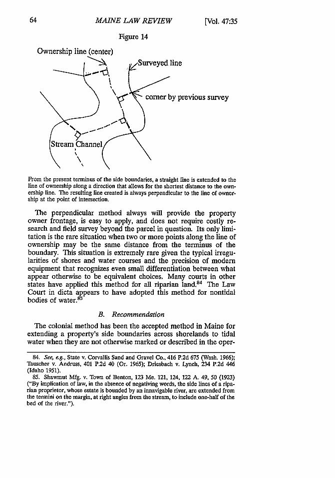
4. The Perpendicular Method
The perpendicular method fixes the boundary reaching acrossflats or shore at the shortest distance between the actual ownershipline and the known surveyed comer on the upland. The line ofshortest distance is that line perpendicular (or normal) to the line ofownership (see Figure 14).
82. See Call v. Carroll, 40 Me. 31, 34 (1855).83. Id
1995]
MAINE LAW REVIEW
Figure 14
Ownership line (center)
Surveyed line
comrer by previous survey
Stream Channel
From the present terminus of the side boundaries, a straight line is extended to theline of ownership along a direction that allows for the shortest distance to the own-ership line. The resulting line created is always perpendicular to the line of owner-ship at the point of intersection.
The perpendicular method always will provide the propertyowner frontage, is easy to apply, and does not require costly re-search and field survey beyond the parcel in question. Its only limi-tation is the rare situation when two or more points along the line ofownership may be the same distance from the terminus of theboundary. This situation is extremely rare given the typical irregu-larities of shores and water courses and the precision of modernequipment that recognizes even small differentiation between whatappear otherwise to be equivalent choices. Many courts in otherstates have applied this method for all riparian land.' The LawCourt in dicta appears to have adopted this method for nontidalbodies of water."
B. Recommendation
The colonial method has been the accepted method in Maine forextending a property's side boundaries across shorelands to tidalwater when they are not otherwise marked or described in the oper-
84. See, eg., State v. Corvallis Sand and Gravel Co., 416 P.2d 675 (Wash. 1966);Tauscher v. Andruss, 401 P.2d 40 (Or. 1965); Driesbach v. Lynch, 234 P.2d 446(Idaho 1951).
85. Shawmut Mfg. v. Town of Benton, 123 Me. 121, 124, 122 A. 49, 50 (1923)("By implication of law, in the absence of negativing words, the side lines of a ripa-rian proprietor, whose estate is bounded by an innavigable river, are extended fromthe termini on the margin, at right angles from the stream, to include one-half of thebed of the river.").
[Vol. 47:35
OWNERSHIP ALONG WATER BODIES
ative conveyance. The perpendicular method has been suggested bythe Law Court to be the proper method for extending boundaries tonontidal waters where they have not been previously surveyed ordescribed. However, under some conditions where a boundary hasbeen previously described to the limit of ownership but its physicallocation is now unknown, Maine common law has applied the pro-portionment method to fix boundaries at the water edge extent ofownership.
The method for extending side boundaries toward water that iseasiest to apply, least costly, and most effective is the perpendicularmethod. This method is independent of subsequent variations thatoccur on, or are present on, nearby riparian parcels. The perpendic-ular method is easily applied by the layperson and the surveyor.Most important, this method always assigns water frontage regard-less of the existing boundary or ownership line configuration. A ri-parian landowner should not be forced to survey a neighbor'sproperty, research ancient titles, and spend considerable money onattorney and survey fees to find out where her boundary resides.The perpendicular method would not only avoid these onerous re-quirements but spare the landowner being assigned boundary exten-sions that never reach the water. Using the perpendicular methodthe landowner starts at the corner shared with her neighbor on thebank and establishes her boundary in the direction that gives theshortest distance to the water.
Consider the following sequence of figures illustrating the variouslocations assigned for the common boundary between lot 1 and lot 2(along a great pond) as defined by the several methods discussed.
Figure 15Low W ater :.: ... .......
Present Configuration-... .:. -. :::. :;:..
Figure 15 shows the present boundary configuration for lots 1-4, where describedboundaries stop short of the low water's edge.
1995]
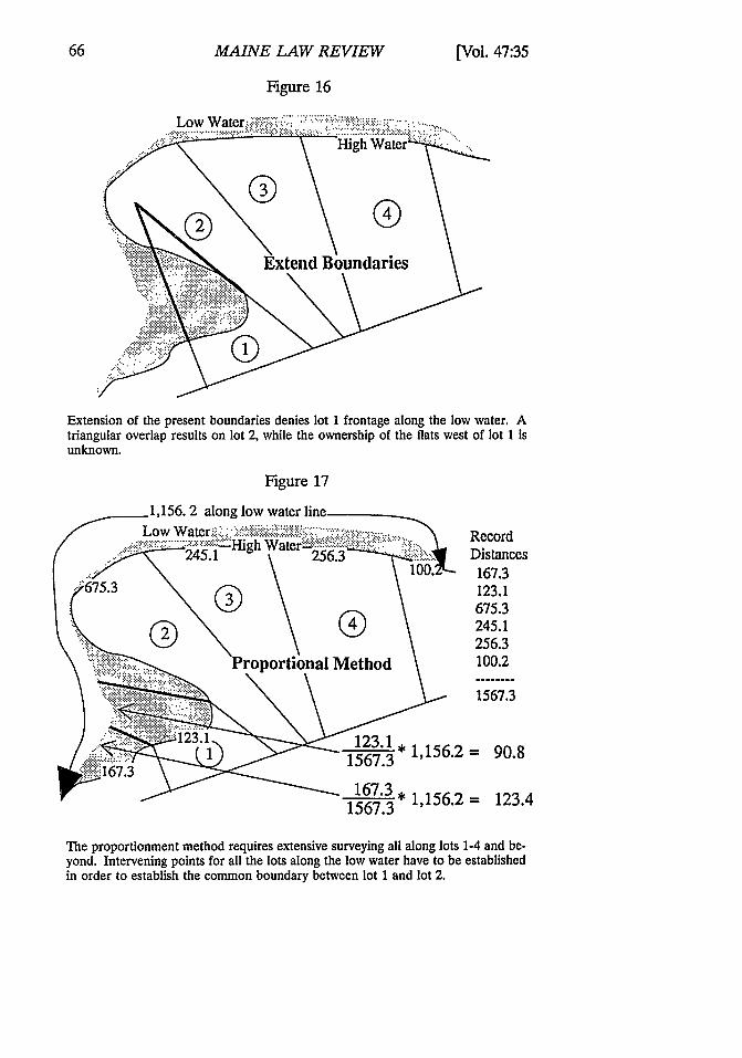
MAINE LAW REVIEW
Figure 16
Extension of the present boundaries denies lot 1 frontage along the low water. Atriangular overlap results on lot 2, while the ownership of the fiats west of lot 1 Isunknown.
Figure 17
123.1 * 1,156.21567.3
167.3* 1,156.21567.3
RecordDistances
167.3123.1675.3245.1256.3100.2
1567.3
= 90.8
= 123.4
The proportionment method requires extensive surveying all along lots 1-4 and be-yond. Intervening points for all the lots along the low water have to be establishedin order to establish the common boundary between lot 1 and lot 2.
[Vol. 47:35
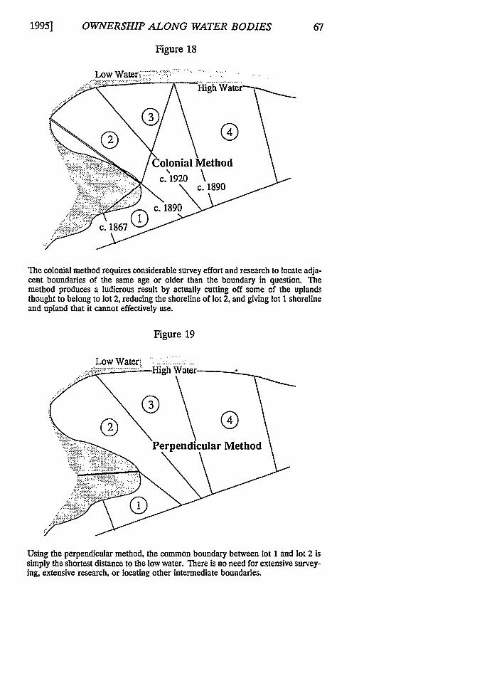
OWNERSHIP ALONG WATER BODIES
Figure 18
The colonial method requires considerable survey effort and research to locate adja-cent boundaries of the same age or older than the boundary in question. Themethod produces a ludicrous result by actually cutting off some of the uplandsthought to belong to lot 2, reducing the shoreline of lot 2, and giving lot I shorelineand upland that it cannot effectively use.
Figure 19
Using the perpendicular method, the common boundary between lot 1 and lot 2 issimply the shortest distance to the low water. There is no need for extensive survey-ing, extensive research, or locating other intermediate boundaries.
1995]

68 MAINE LAW REVIEW [Vol. 47:35
VI. CONCLUSION
The practitioner involved with a conveyance along a water bodymust understand and be able to explain the extent of title, limita-tions on the title, and how boundaries may be fixed and extended.In most cases, the owner of land bordering on a water body has titleextending across the shore beyond the normal reach of high water.Where the title does extend beyond the reach of high water, thepublic often has certain rights beyond the high water line. In somecases, persons may have extended their use of a client's shorefrontbeyond what is permitted by these public rights. It is in the client'sbest interest to know this. For parcels bordering a great pond, thepublic's right to pass over property by foot to access the great pondshould be brought to the client's attention. A great deal of confu-sion and litigation has involved riparian title and the location ofboundaries on or near water. Knowing the common law rules ofconstruction as well as boundary definition methods for waterfrontproperty can avoid such confusion.
Related Documents