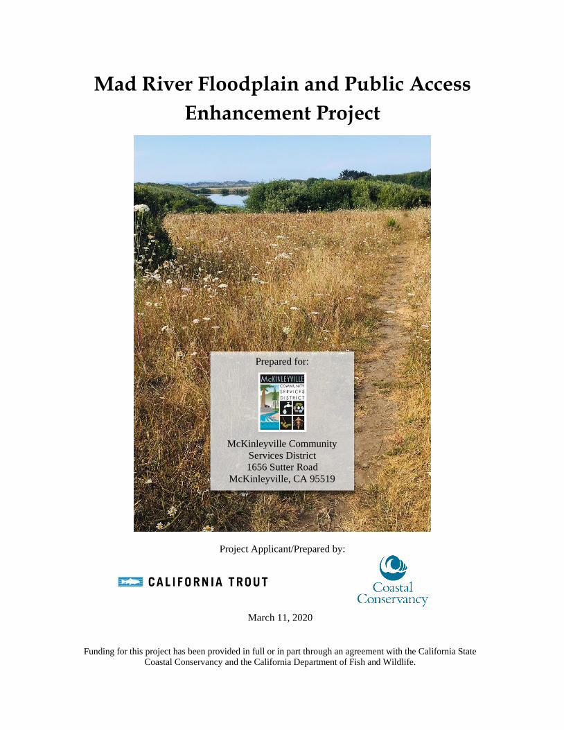
Mad River Floodplain and Public Access Enhancement Project Project Applicant/Prepared by: March 11, 2020 Funding for this project has been provided in full or in part through an agreement with the California State Coastal Conservancy and the California Department of Fish and Wildlife. Prepared for: McKinleyville Community Services District 1656 Sutter Road McKinleyville, CA 95519

Welcome message from author
This document is posted to help you gain knowledge. Please leave a comment to let me know what you think about it! Share it to your friends and learn new things together.
Transcript
Mad River Floodplain and Public Access
Enhancement Project
Project Applicant/Prepared by:
March 11, 2020
Funding for this project has been provided in full or in part through an agreement with the California State
Coastal Conservancy and the California Department of Fish and Wildlife.
Prepared for:
McKinleyville Community
Services District 1656 Sutter Road
McKinleyville, CA 95519

This page intentionally left blank.

Mad River Floodplain and California Trout
Public Access Enhancement Project 2019
Draft Page i
TABLE OF CONTENTS PAGE
List of Figures.................................................................................................................................... iii
List of Tables ............................................................................................................................... iii
List of Appendices ............................................................................................................................. iv
1 Project Information ......................................................................................................................1
2 Project Location...........................................................................................................................2
3 Project Purpose, Goals, and Objectives .......................................................................................8
3.1 Consistency with Existing Plans .........................................................................................9
3.2 Habitat Enhancement Objectives ........................................................................................9
3.3 Public Access Objectives ..................................................................................................12
4 Environmental Setting ...............................................................................................................12
4.1 Watershed ..........................................................................................................................13
4.2 Existing Land Use and Ownership ....................................................................................13
4.3 Geology .............................................................................................................................13
4.4 Hydrology and Hydraulics ................................................................................................14
4.5 Fisheries .............................................................................................................................16
4.6 Vegetation..........................................................................................................................20
5 Project Overview .......................................................................................................................21
5.1 Summary of Project Impacts by Habitat Type ..................................................................22
5.2 Summary of Excavation, Fill, and Material Spoiling ........................................................22
5.3 Utilities ..............................................................................................................................23
6 Project Actions ..........................................................................................................................24
6.1 Actions Common to the Entire Project Area .....................................................................24
6.2 Ecosystem Enhancement Project Actions .........................................................................26
6.3 Public Access Project Features ..........................................................................................27
7 Project Implementation .............................................................................................................28
8 Required Permits and Approvals ...............................................................................................28
INITIAL STUDY & MITIGATED NEGATIVE DECLARATION ................................................30
Environmental Factors Potentially Affected .....................................................................................30
Determination ....................................................................................................................................30
Checklist and Evaluation of Environmental Impacts ........................................................................31
1. Aesthetics ..................................................................................................................................32
2. Agricultural Resources ..............................................................................................................34
3. Air Quality .................................................................................................................................37
4. Biological Resources .................................................................................................................41
5. Cultural Resources.....................................................................................................................54
6. Energy........................................................................................................................................56

Mad River Floodplain and California Trout
Public Access Enhancement Project 2019
Draft Page ii
7. Geology and Soils......................................................................................................................58
8. Greenhouse Gas Emissions .......................................................................................................61
9. Hazards and Hazardous Materials .............................................................................................63
10. Hydrology and Water Quality ...............................................................................................67
11. Land Use and Planning ..........................................................................................................74
11.1 Humboldt County ..............................................................................................................74
11.2 Humboldt County Local Coastal Program, McKinleyville Area Plan (MAP), and
Humboldt County Zoning Code ....................................................................................................76
11.3 California Coastal Commission .........................................................................................77
11.4 California Department of Fish and Wildlife ......................................................................77
11.5 North Coast Regional Water Quality Control Board ........................................................78
11.6 State Lands Commission ...................................................................................................78
11.7 U.S. Army Corps of Engineers ..........................................................................................78
12. Mineral Resources .................................................................................................................80
13. Noise ......................................................................................................................................81
14. Population and Housing ........................................................................................................84
15. Public Services ......................................................................................................................85
16. Recreation ..............................................................................................................................86
17. Transportation........................................................................................................................88
18. Tribal Cultural Resources ......................................................................................................90
19. Utilities and Service Systems ................................................................................................92
20. Wildfire..................................................................................................................................94
21. Mandatory Findings of Significance .....................................................................................95
References .........................................................................................................................................98
Mad River Floodplain and California Trout
Public Access Enhancement Project 2019
Draft Page iii
LIST OF FIGURES
PAGE
Figure 1. Project location map. 4 Figure 2. Project site map of existing conditions. 5 Figure 3. View from near School Road, looking south across the upland area where the ADA trail
will be located. 6 Figure 4. The future alignment of a portion of the backwatered off-channel habitat complex. 7 Figure 5. Existing percolation ponds shown in use in March 2018. The berm (shown) between the
two ponds will be removed through project construction. 7 Figure 6. Project design overview. Activity areas total 9.3 acres. The area within the project
boundary is 96.1 acres. 8 Figure 7. Post-implementation habitat enhancement overview. 11 Figure 8. River levels near the project site and stream flow at USGS Gage Station No. 11481000.
For reference, the levees range from 15 ft on the northern end to approximately 17 ft on the
southern end. Adjacent floodplain areas range from around 10 ft in historic depressions and
existing backwater areas to 14 ft elevation. 15 Figure 9. Wetted portion of the storm water drainage ditch within the project area. 19 Figure 10. Additional wetted portion of the storm water drainage ditch within the project area. 19 Figure 11. Mouth of storm water ditch with arrow indicating dry channel. 20 Figure 12. Biological land cover types (biohabitats) field mapped on June 22, 2018. 45 Figure 13. Locations of periwinkle (Vinca major) and reed canary grass (Phalaris arundinacea)
encountered during 2018 vegetation mapping at the Mad River floodplain enhancement and
restoration project. 46 Figure 14. Project Assessor Parcels 508-021-006, 007, and project access through parcel 506-341-
017, area of state retained jurisdiction (diagonal line pattern) (HCO GIS 2019). 75
LIST OF TABLES
PAGE
Table 1. Peak Flow Estimates for Recurrence Intervals at USGS Gaging Station No. 11481000
(NHE 2017). ......................................................................................................................................14 Table 2. Fish species with respect to federally designated Critical Habitat and Essential Fish
Habitat. ..............................................................................................................................................17 Table 3. Summary of project impacts by habitat type. ......................................................................22 Table 4. Summary of project excavation and fill volumes. ...............................................................23 Table 5. Summary of materials to be imported to the site and large wood to be re-used from on-site.
...........................................................................................................................................................23 Table 6. Summary of project impacts by habitat type. ......................................................................51
Mad River Floodplain and California Trout
Public Access Enhancement Project 2019
Draft Page iv
LIST OF APPENDICES
Appendix A Project Designs and Basis of Design Report
Appendix B Preliminary Engineering Geologic Report
Appendix C Soil Testing Results
Appendix D Hydraulic Analysis Report
Appendix E Documentation of Fish Observances
Appendix F Vegetation Mapping
Appendix G Rare and Sensitive Plant Survey
Appendix H NOAA Fish Removal Guidelines and Requirements
Appendix I Biological Resource Investigation
Appendix J Cultural Resource Investigation
Appendix K Photo Documentation of Public Access Parking Area Aesthetics
Appendix L CalEEMod Table of Results

Mad River Floodplain and California Trout
Public Access Enhancement Project 2019
Draft Page v
This page intentionally left blank.

Mad River Floodplain and California Trout
Public Access Enhancement Project 2019
Draft Page 1
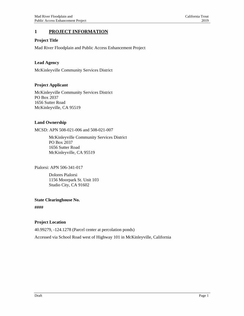
1 PROJECT INFORMATION
Project Title
Mad River Floodplain and Public Access Enhancement Project
Lead Agency
McKinleyville Community Services District
Project Applicant
McKinleyville Community Services District
PO Box 2037
1656 Sutter Road
McKinleyville, CA 95519
Land Ownership
MCSD: APN 508-021-006 and 508-021-007
McKinleyville Community Services District
PO Box 2037
1656 Sutter Road
McKinleyville, CA 95519
Pialorsi: APN 506-341-017
Dolores Pialorsi
1156 Moorpark St. Unit 103
Studio City, CA 91602
State Clearinghouse No.
####
Project Location
40.99279, -124.1278 (Parcel center at percolation ponds)
Accessed via School Road west of Highway 101 in McKinleyville, California
Mad River Floodplain and California Trout
Public Access Enhancement Project 2019
Draft Page 2
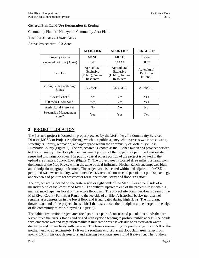
General Plan Land Use Designation & Zoning
Community Plan: McKinleyville Community Area Plan
Total Parcel Acres: 159.64 Acres
Active Project Area: 9.3 Acres
508-021-006 508-021-007 506-341-017
Property Owner MCSD MCSD Pialorsi
Assessed Lot Size (Acres) 6.44 114.63 38.57
Land Use
Agricultural
Exclusive
(Public); Natural
Resources
Agricultural
Exclusive
(Public); Natural
Resources
Agricultural
Exclusive
(Public)
Zoning with Combining
Zones AE-60/F,R AE-60/F,R AE-60/F,R
Coastal Zone? Yes Yes Yes
100-Year Flood Zone? Yes Yes Yes
Agricultural Preserve? No No No
Streamside Management
Zone? Yes Yes Yes
2 PROJECT LOCATION
The 9.3-acre project is located on property owned by the McKinleyville Community Services
District (MCSD or Project Applicant), which is a public agency who oversees water, wastewater,
streetlights, library, recreation, and open space within the community of McKinleyville in
Humboldt County (Figure 1). The project area is known as the Fischer Ranch and provides service
to the community. The floodplain enhancement portion of the project is a permitted wastewater reuse and discharge location. The public coastal access portion of the project is located in the
upland area nearest School Road (Figure 2). The project area is located three miles upstream from
the mouth of the Mad River, within the zone of tidal influence. Fischer Ranch encompasses bluff
and floodplain topographic features. The project area is located within and adjacent to MCSD’s
permitted wastewater facility, which includes 4.3 acres of constructed percolation ponds (existing),
and 95 acres of pasture for wastewater reuse operations, spray and flood irrigation.
The project site is located on the eastern side or right bank of the Mad River at the inside of a
meander bend of the lower Mad River. The southern, upstream end of the project site is within a
mature, intact riparian forest on the active floodplain. The project site continues downstream of the
Mad River County Park Boat Ramp to the lee side of a riffle. A historical backwater channel remains as a depression in the forest floor and is inundated during high flows. The northern,
downstream end of the project site is a bluff that rises above the floodplain and emerges at the edge
of the community of McKinleyville (Figure 3).
The habitat restoration project area focal point is a pair of constructed percolation ponds that are
leveed from the river’s floods and ringed with cyclone fencing to prohibit public access. The ponds
with emergent wetland vegetation maintain inundated water levels due to treated wastewater
discharge and connectivity with the river. The levees surrounding the ponds range from 15 ft on the
northern end to approximately 17 ft on the southern end. Adjacent floodplain areas range from
around 10 ft in historic depressions and existing backwater areas to 14 ft elevation. The southern
Mad River Floodplain and California Trout
Public Access Enhancement Project 2019
Draft Page 3
pond is generally 10 ft elevation with a single linear ridge on the interior that is over 13 ft high. The
northern pond ranges from around 5.5 ft elevation in dredged areas to 13 ft on elevated ridges that
serve as islands when the pond is in use. Isolated willows provide habitat diversity within the
ponds, particularly up on the elevated ridges. When the river banks overtop, water backwaters the
low areas of the floodplain and stays ponded for a period as flow waters recede and standing waters
infiltrate and evaporate.
The project area includes an existing storm water ditch that drains the large floodplain to the east
through a ditch and water control gate that remains open through the winter season and is closed
when MCSD is applying treated wastewater to their fields. The public access project features are
located to the north of the storm water ditch where the slope rises to the elevated terrace at the edge
of a residential neighborhood of McKinleyville. The project is limited to the south by a
neighboring property and to the east by the large, floodplain used seasonally for MCSD’s treated
wastewater reclamation. School Road limits the northern project boundary, and the Mad River
limits the western project boundary.
Photographs showing existing conditions of key project features are included in Figure 3 - Figure
5.
Mad River Floodplain and California Trout
Public Access Enhancement Project 2019
Draft Page 4
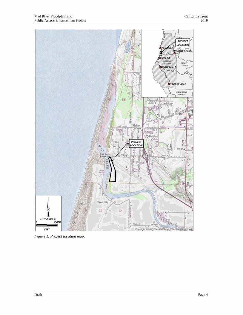
Figure 1. Project location map.

Mad River Floodplain and California Trout
Public Access Enhancement Project 2019
Draft Page 5
Figure 2. Project site map of existing conditions.
Mad River Floodplain and California Trout
Public Access Enhancement Project 2019
Draft Page 6
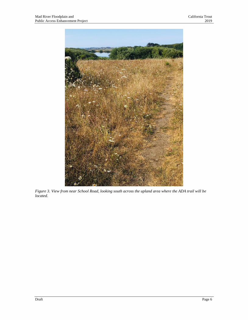
Figure 3. View from near School Road, looking south across the upland area where the ADA trail will be
located.
Mad River Floodplain and California Trout
Public Access Enhancement Project 2019
Draft Page 7
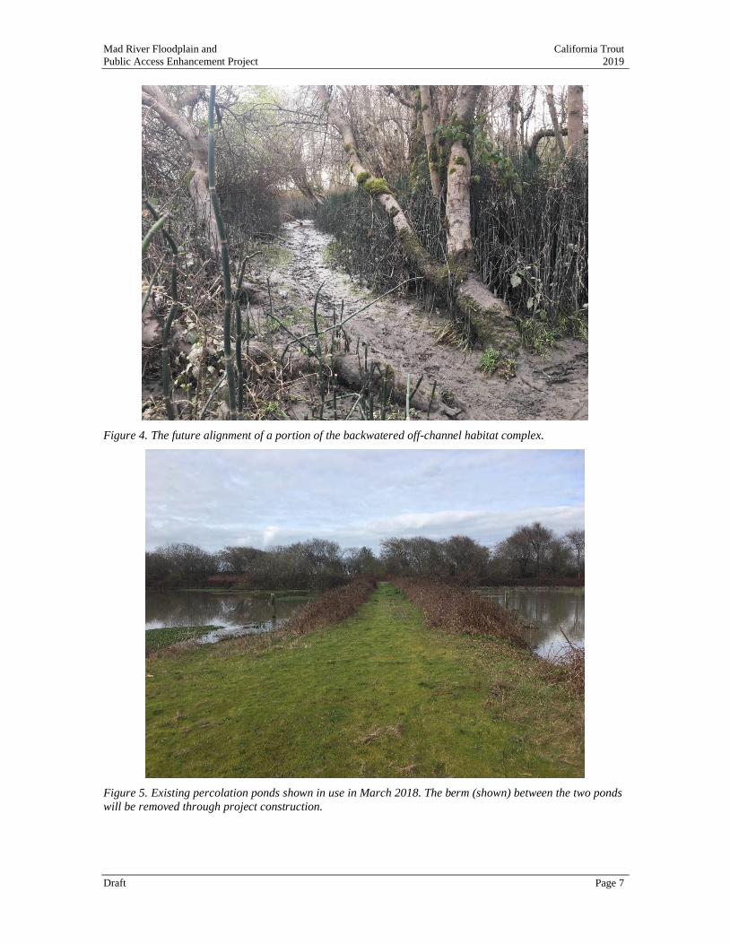
Figure 4. The future alignment of a portion of the backwatered off-channel habitat complex.
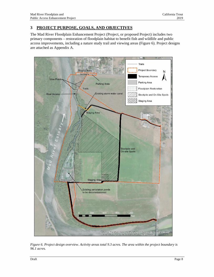
Figure 5. Existing percolation ponds shown in use in March 2018. The berm (shown) between the two ponds
will be removed through project construction.
Mad River Floodplain and California Trout
Public Access Enhancement Project 2019
Draft Page 8
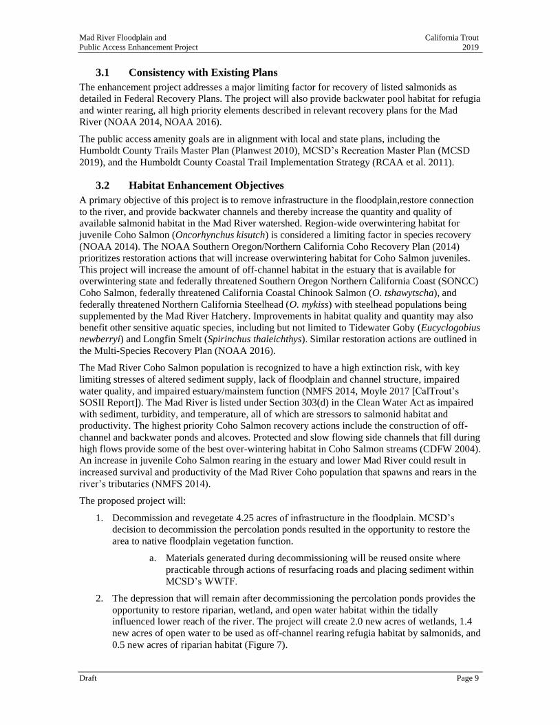
3 PROJECT PURPOSE, GOALS, AND OBJECTIVES
The Mad River Floodplain Enhancement Project (Project, or proposed Project) includes two
primary components – restoration of floodplain habitat to benefit fish and wildlife and public
access improvements, including a nature study trail and viewing areas (Figure 6). Project designs
are attached as Appendix A.
Figure 6. Project design overview. Activity areas total 9.3 acres. The area within the project boundary is
96.1 acres.
Mad River Floodplain and California Trout
Public Access Enhancement Project 2019
Draft Page 9
3.1 Consistency with Existing Plans
The enhancement project addresses a major limiting factor for recovery of listed salmonids as
detailed in Federal Recovery Plans. The project will also provide backwater pool habitat for refugia
and winter rearing, all high priority elements described in relevant recovery plans for the Mad
River (NOAA 2014, NOAA 2016).
The public access amenity goals are in alignment with local and state plans, including the
Humboldt County Trails Master Plan (Planwest 2010), MCSD’s Recreation Master Plan (MCSD
2019), and the Humboldt County Coastal Trail Implementation Strategy (RCAA et al. 2011).
3.2 Habitat Enhancement Objectives
A primary objective of this project is to remove infrastructure in the floodplain,restore connection
to the river, and provide backwater channels and thereby increase the quantity and quality of
available salmonid habitat in the Mad River watershed. Region-wide overwintering habitat for
juvenile Coho Salmon (Oncorhynchus kisutch) is considered a limiting factor in species recovery
(NOAA 2014). The NOAA Southern Oregon/Northern California Coho Recovery Plan (2014)
prioritizes restoration actions that will increase overwintering habitat for Coho Salmon juveniles.
This project will increase the amount of off-channel habitat in the estuary that is available for
overwintering state and federally threatened Southern Oregon Northern California Coast (SONCC)
Coho Salmon, federally threatened California Coastal Chinook Salmon (O. tshawytscha), and
federally threatened Northern California Steelhead (O. mykiss) with steelhead populations being
supplemented by the Mad River Hatchery. Improvements in habitat quality and quantity may also
benefit other sensitive aquatic species, including but not limited to Tidewater Goby (Eucyclogobius newberryi) and Longfin Smelt (Spirinchus thaleichthys). Similar restoration actions are outlined in
the Multi-Species Recovery Plan (NOAA 2016).
The Mad River Coho Salmon population is recognized to have a high extinction risk, with key
limiting stresses of altered sediment supply, lack of floodplain and channel structure, impaired
water quality, and impaired estuary/mainstem function (NMFS 2014, Moyle 2017 [CalTrout’s
SOSII Report]). The Mad River is listed under Section 303(d) in the Clean Water Act as impaired
with sediment, turbidity, and temperature, all of which are stressors to salmonid habitat and
productivity. The highest priority Coho Salmon recovery actions include the construction of off-
channel and backwater ponds and alcoves. Protected and slow flowing side channels that fill during
high flows provide some of the best over-wintering habitat in Coho Salmon streams (CDFW 2004).
An increase in juvenile Coho Salmon rearing in the estuary and lower Mad River could result in
increased survival and productivity of the Mad River Coho population that spawns and rears in the
river’s tributaries (NMFS 2014).
The proposed project will:
1. Decommission and revegetate 4.25 acres of infrastructure in the floodplain. MCSD’s
decision to decommission the percolation ponds resulted in the opportunity to restore the
area to native floodplain vegetation function.
a. Materials generated during decommissioning will be reused onsite where
practicable through actions of resurfacing roads and placing sediment within
MCSD’s WWTF.
2. The depression that will remain after decommissioning the percolation ponds provides the
opportunity to restore riparian, wetland, and open water habitat within the tidally
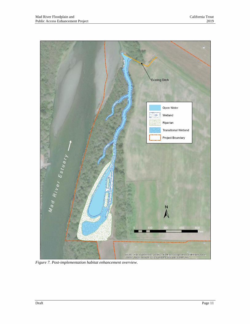
influenced lower reach of the river. The project will create 2.0 new acres of wetlands, 1.4
new acres of open water to be used as off-channel rearing refugia habitat by salmonids, and
0.5 new acres of riparian habitat (Figure 7).
Mad River Floodplain and California Trout
Public Access Enhancement Project 2019
Draft Page 10
3. In order to increase accessibility for juvenile fish and to avoid stranding in the
decommissioned pond footprint, the proposed project provides a channel (1,775 ft total
length) that will connect the river to the pond. The channel and pond features are designed
to resemble a remnant high flow channel or oxbox, features that provide high quality
riparian habitat and are expected to change with time.
4. Off-channel winter refugia will be created by reconnecting of the river to the floodplain
through the project area. Juvenile Coho and other salmonids use this shallow depth and low
velocity habitat during high flow events. Large wood features will be built from salvaged
alder or willow species that are disturbed during construction and will be used to create
habitat features in the channel. The project’s pools, backwater and high-water channels will
be located under a mature riparian canopy that in turn supports the food web and provides
better growth conditions for juvenile salmonids in preparation for outmigration. Any
riparian areas disturbed in construction will be replanted.
Mad River Floodplain and California Trout
Public Access Enhancement Project 2019
Draft Page 11
Figure 7. Post-implementation habitat enhancement overview.
Mad River Floodplain and California Trout
Public Access Enhancement Project 2019
Draft Page 12
3.3 Public Access Objectives
The project’s public access amenities will be constructed to comply with Americans with Disability
Act (ADA) access from the paved School Road Trail to a new river overlook, multiple interpretive
and bench resting sites. A trail will leave the ADA access and drop into the floodplain to allow for
river level access and a lightly developed river access feature. The existing informal trails will be
upgraded to allow for safe and well-defined access routes that accommodate ADA users, confine
use to a limited, controlled corridor to protect wildlife and riparian resources, and provide for
access to the floodplain and river.
Increase opportunities for nature study: Public access trials and viewpoint overlooks will improve
opportunities for nature study and wildlife viewing.
Create ADA coastal access: The Project will provide an improved trail network and ADA access to
river and coastal habitats and viewscapes.
Improve river access: A defined point of river access will improve recreational opportunities for
fisherman (anglers), boaters, bird watchers, lightweight non-motorized water craft boaters, and
other user groups.
Protect habitat: Improved trails and viewpoints will provide a well-defined path for users that will
reduce impacts from unplanned access routes that are currently well-used by the public within the
project area.
Install instructional and interpretative signage: A welcome kiosk will inform users of the intended
uses, a map of the area, and rules and regulations for public access on the property. Interpretive
materials will include information about the Wiyot tribal perspective on the landscape.
4 ENVIRONMENTAL SETTING
The enhancement project site is located on the eastern floodplain of the Mad River at the inside of a
meander bend. A mature, intact riparian forest has developed on the river’s right bank and active
floodplain, lee side of a long riffle downstream of the Mad River County Park Boat Ramp. A
historical backwater channel remains as a depression in the forest floor that is inundated during high
flows and is often used as an undeveloped trail during dry periods. The project is within the tidally
influenced lower reach of the Mad River.
The project focuses on a pair of constructed wastewater treatment percolation ponds that are leveed
from the river’s floods and ringed with cyclone fencing to prohibit access. The ponds with emergent
wetland vegetation maintain inundated water levels due to treated wastewater discharge and
connectivity with the river. The levees surrounding the ponds range from 15 ft on the northern end
to approximately 17 ft on the southern end. Adjacent floodplain areas range from around 10 ft in
historic depressions and existing backwater areas to 14 ft elevation. The southern pond is generally
10 ft elevation with a single linear ridge on the interior that is over 13 ft high. The northern pond
ranges from around 5.5 ft elevation in dredged areas to 13 ft on elevated ridges that serve as islands
when the pond is in use. Isolated willows provide habitat diversity within the ponds, particularly up
on the elevated ridges. When the river banks overtop, the low areas of the floodplain are inundated
and can stay ponded for a period as flow waters recede and standing waters infiltrate and evaporate.
Informal, unpaved trails and viewpoints are located north of the restoration features atop the bluff
adjacent to the terminal end of School Road Trail. The bluff-top vegetation is representative of
unmanaged pasture with grasses, shrubs, and smaller trees. The riverbanks are well vegetated with
willow and other riparian species. The edge of the bluff and a portion of the riverbank has been
stabilized by a bio-engineered vegetated rip rap project installed by Humboldt County in 2009.
Mad River Floodplain and California Trout
Public Access Enhancement Project 2019
Draft Page 13
4.1 Watershed
The Mad River drains approximately 497 square miles over a length of roughly 100 miles to the
Pacific Ocean near the town of McKinleyville, north of Humboldt Bay. Watershed elevations range
from 6,000 ft at the Coast Range headwaters in Trinity County to sea level at the mouth,
approximately 6 miles north of Humboldt Bay. Matthews Dam impounds Ruth Lake at river mile
(RM) 79, and a natural boulder falls barrier to anadromous salmonids is located on the mainstem
river near Bug Creek at approximately RM 50. The project is located at approximately RM 2,
within the Mad River estuary.
4.2 Existing Land Use and Ownership
The project area is owned by MCSD and a private landowner. The project is zoned Agricultural
Exclusive (Public) and Natural Resources. The existing percolation ponds in the restoration area
are currently used as part of MCSD’s wastewater management facility. Informal, unmanaged
unpaved trails currently exist in the riparian area along the river to the upper bluff area accessed via
the School Road Trail.
MCSD Wastewater Management Facility
MCSD is an independent, special district formed in 1970. MCSD maintains and operates a
Wastewater Management Facility (WWMF) that serves the community of McKinleyville. The
WWMF discharges directly to the surface waters of the Mad River at the Hammond Bridge during
a permitted discharge period (October 1 through May 14) regulated by a National Pollutant
Discharge Elimination System (NPDES) permit governed by the California North Coast Regional
Water Quality Control Board (RWQCB) that includes Waste Discharge Requirements (WDRs) for
effluent treatment, discharge, and reclamation. The river discharge prohibition period is May 15
through September 30, when effluent is discharged to the percolation ponds and/or to land for
reclamation. The percolation ponds were constructed on the active floodplain in 1983 and include
two separate ponds that are annually alternated in use. At the time of construction, mitigation was
implemented in a riparian zone south of the percolation ponds, which remains outside of the project
boundary and will not be impacted through restoration activities.
4.3 Geology
The project site is located on the active floodplain and the bluff overlooking the downstream-most
meander bend of the Mad River. To the south, the river bottoms, wide alluvium, and soil floodplain
transition into Humboldt Bay. From the project site, the river flows two miles north to the Pacific
Ocean between a long sand spit and marine terraces. The river mouth is transient along the sand spit;
therefore, this distance is relative to when the mouth was located just south of Vista Point on
Highway 101.
The Mad River Fault Zone (MRFZ) has been described in detail and mapped in geologic reports.
The principal faults of the MRFZ are designated as the Fickle Hill, Mad River, McKinleyville, Blue Lake, and Trinidad faults (Carver 1985). The multi-strand Mad River fault offsets marine terraces
along the coastline north of the project (Carver 1992). The remnant terrace that defines the
southernmost lower plate of the Mad River fault is buried beneath the greater river floodplain
associated with the project site (McCrory 1996, Carver et al. 1986). The public access features are
located on the bluff and along the slope to the floodplain elevation. The change in slope from the
bluff to the floodplain is the general location of the fault zone.
Mad River Floodplain and California Trout
Public Access Enhancement Project 2019
Draft Page 14
An R-2 slope stability investigation was completed (required by the Humboldt County Building
Department) of the bluff area related to public access design features and found that public access
features are feasible from a geotechnical standpoint (SHN 2019, Appendix B). Technical
recommendations from the SHN R-2 slope stability report have been incorporated into design
parameters for the public access features.
The project site is mapped in the Geology of the Cape Mendocino, Eureka, Garberville and Southwestern Part of the Hayfork 30 X 60 Minute Quadrangles and Adjacent Offshore Area,
Northern California (McLaughlin et al. 2000). The river and floodplain are mapped as
“undeformed marine shoreline and aolian deposits (Holocene and late Pleistocene), consisting of
gravel and sand deposited in marine terraces, on benches and on dunes along present shorelines.”
SHN Consulting Engineers and Geologists, Inc. prepared a Final Foundation Report for the
Hammond Trail Pedestrian Bridge Replacement, which included a geologic cross-section
interpretation of the river and floodplain subsurface in close proximity to the project site (SHN
2015). Subsurface data were collected from excavated machine borings to a depth of 80 ft on the
floodplains and approximately 200 ft in the channel. Lithology was logged and geotechnical tests
were performed on representative samples. Underlying the floodplain surface were Holocene
alluvial deposits, measured to depths of approximately 75 ft. An approximately 40-foot thick
defined silt/clay layer was mapped at a depth of approximately 30 ft below the floodplain surface
on the north bank (SHN 2015). Holocene alluvium was underlain with late Pliocene to middle
Pleistocene age Falor Formation sediments.
Soil lithology was documented when the groundwater wells were logged upon installation. Soil logs
were attached in Appendix C. MW-27 was installed north of the ponds and levee into the ground
surface at an elevation of approximately 10.5 ft. Less than a foot of sandy organic soil covered
approximately 3 ft of silty sand (down to elevation of 7 ft) that overlays 15.5 ft of well graded sand
with gravel (from elevation 7 ft down to -8.5 ft). Lean clay was observed 19 ft below ground surface
(at -8.5 ft elevation). MW-28 was installed west of the ponds and levee in the ground surface at an
elevation of approximately 13.5 ft. A thin layer of organic soil and sand covers approximately 2 ft of
silty sand (down to an elevation of 11.5 ft), layered over approximately 2.5 ft of silty sand with gravel (down to an elevation of 9 ft), and approximately 3 ft of well graded sand with silt (to an elevation
of 6 ft). Below these layered deposits is at least 12.5 ft of well graded gravel with sand (observed
from and elevation of 6 ft to -6.5 ft). The lithology logs from these two wells provides some
information about the floodplain foundation and the potential composition of native soils of in areas
of excavation. For example, the backwater channel base near MW 27 was proposed to daylight at an
elevation of 6 ft. It can be expected that the material at the base of the channel near the ponds would
be composed of well graded sand with gravel.
4.4 Hydrology and Hydraulics
Hydrology
Annual peak flow data from the USGS Mad River near Arcata gaging station (No. 11481000) were
analyzed with the USGS software PeakFQ (NHE 2017) to estimate flood recurrence intervals,
including the 1.5-, 2-, 5-, 10-, 25-, 50- and 100-year flood events (Table 1).
Table 1. Peak Flow Estimates for Recurrence Intervals at USGS Gaging Station No. 11481000 (NHE 2017).
Recurrence
Interval
PeakFQ Bulletin 17B Estimated
Peak Discharge (cfs)
1.5-year 20,550
2-year 26,410
5-year 41,560
10-year 51,670
Mad River Floodplain and California Trout
Public Access Enhancement Project 2019
Draft Page 15
25-year 64,280
50-year 73,460
100-year 82,420
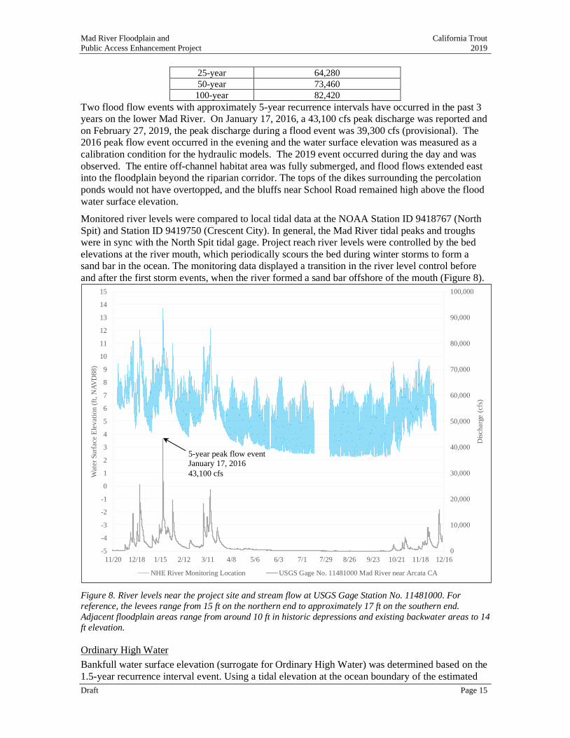
Two flood flow events with approximately 5-year recurrence intervals have occurred in the past 3
years on the lower Mad River. On January 17, 2016, a 43,100 cfs peak discharge was reported and
on February 27, 2019, the peak discharge during a flood event was 39,300 cfs (provisional). The
2016 peak flow event occurred in the evening and the water surface elevation was measured as a
calibration condition for the hydraulic models. The 2019 event occurred during the day and was
observed. The entire off-channel habitat area was fully submerged, and flood flows extended east
into the floodplain beyond the riparian corridor. The tops of the dikes surrounding the percolation
ponds would not have overtopped, and the bluffs near School Road remained high above the flood
water surface elevation.
Monitored river levels were compared to local tidal data at the NOAA Station ID 9418767 (North
Spit) and Station ID 9419750 (Crescent City). In general, the Mad River tidal peaks and troughs
were in sync with the North Spit tidal gage. Project reach river levels were controlled by the bed
elevations at the river mouth, which periodically scours the bed during winter storms to form a
sand bar in the ocean. The monitoring data displayed a transition in the river level control before
and after the first storm events, when the river formed a sand bar offshore of the mouth (Figure 8).
Figure 8. River levels near the project site and stream flow at USGS Gage Station No. 11481000. For
reference, the levees range from 15 ft on the northern end to approximately 17 ft on the southern end.
Adjacent floodplain areas range from around 10 ft in historic depressions and existing backwater areas to 14
ft elevation.
Ordinary High Water
Bankfull water surface elevation (surrogate for Ordinary High Water) was determined based on the
1.5-year recurrence interval event. Using a tidal elevation at the ocean boundary of the estimated
0
10,000
20,000
30,000
40,000
50,000
60,000
70,000
80,000
90,000
100,000
-5
-4
-3
-2
-1
0
1
2
3
4
5
6
7
8
9
10
11
12
13
14
15
11/20 12/18 1/15 2/12 3/11 4/8 5/6 6/3 7/1 7/29 8/26 9/23 10/21 11/18 12/16
Dis
ch
arg
e (
cfs
)
Wate
r S
urf
ace E
lev
ati
on
(ft
, N
AV
D8
8)
NHE River Monitoring Location USGS Gage No. 11481000 Mad River near Arcata CA
5-year peak flow event
January 17, 2016
43,100 cfs
Mad River Floodplain and California Trout
Public Access Enhancement Project 2019
Draft Page 16
Mean Higher High Water results in a water surface elevation of approximately 12.5 ft within the
project area.
Hydraulic Analyses
Existing conditions were simulated using a steady-state, sub-critical, single-dimension US Army
Corps of Engineers (USACE) Hydrologic Engineering Center River Analysis System (HEC-RAS)
version 5.0.1 modeling software (USACE 2016). The HEC-RAS model was used to estimate
existing condition water surface elevations in the river adjacent to the project reach where channel
bathymetry was well-defined and calibration data were collected. Design conditions were
simulated using the United States Bureau of Reclamation (USBOR) Technical Service Center
(TSC) two-dimensional hydraulic model SRH-2D (Version 2) with bed shear stress calculated.
The SRH-2D model was used to estimate water surface elevations, shear stress and depth-averaged
velocity through the project area. Detailed modeling information and results are available in the
project’s Hydraulic Analysis Report (Appendix D).
4.5 Fisheries
Fish Species in the Mainstem Mad River
The Mad River supports spawning populations of state and federally threatened Southern Oregon
Northern California Coast (SONCC) Coho Salmon, federally threatened California Coastal
Chinook Salmon (O. tshawytscha), and federally threatened Northern California Steelhead (O.
mykiss) with steelhead populations being supplemented by the Mad River Hatchery. In addition to
the listed salmonid species, the Mad River is home to Coastal Cutthroat Trout (O. clarki clarki), three-spined stickleback (Gasterosteus aculeatus), Sacramento Suckers (Catostomus occidentalis),
scuplin species (Cottus sp.), and lamprey. Green Sturgeon (Acipenser medirostris), adult Pink
salmon (O. gorbuscha), and federally endangered Tidewater Goby have also been observed in the
Mad River but infrequently and in low numbers. It is thought that due to the river’s small size,
Green Sturgeon are likely limited to the estuary while the Pink Salmon were mostly likely strays.
Tidewater Goby are likely limited to the estuary as well since they are exclusive to brackish
habitats for their entire life cycle and are adapted to a narrow range of salinity tolerances. Salinity
in the lower Mad River may also be affected by Humboldt Bay Municipal Water District flow
releases, which may seasonally reduce salinity below expected levels, impacting water quality and
habitat conditions for Tidewater Goby.
Designations for federally established Critical Habitat and Essential Fish Habitat are summarized
by species in Table 2. There are no juvenile or adult population surveys for Chinook Salmon in the
Mad River (NOAA 2016).
NOAA (2014) identifies a lack of floodplain and channel structure as key limiting stresses to Coho
Salmon in the Mad River and notes the highest priority recovery actions include several primary
components of the proposed project:
• Place large wood habitat features in channel,
• Construct off channel ponds, alcoves, and backwater ponds, and
• Restore natural channel form and function.
Similarly, recovery actions recommended for Chinook Salmon by NOAA (2016) with relevancy to
the proposed project include:
• Increase estuary habitat complexity,
• Increase the extent of estuarine habitat,
• Restore tidal channels,
• Rehabilitate and enhance floodplain connectivity,
Mad River Floodplain and California Trout
Public Access Enhancement Project 2019
Draft Page 17
• Create refugia habitat,
• Increase large wood frequency, and
• Eradicate Reed Canary Grass.
Historically, Mad River saw abundant runs of federally threatened Pacific Eulachon (Thaleichthys
pacificus) however, there have been no occurrences of Eulachon in the Mad River reported by
fishery biologists since at least the mid-1980s. Eulachon are anadromous, with spawning usually
occurring in the lower reaches of rivers and are an important component of the cultural legacy of
Native American fishing tribes.
Longfin Smelt (Spirinchus thaleichthys) are a state-listed anadromous smelt found in Humboldt
Bay estuaries, and nearshore coastal environments. Adult Longfin Smelt migrate into low salinity
or freshwater reaches of coastal rivers and tributary streams to spawn. Previous fish sampling
efforts in the project area did not collect Longfin Smelt and the project area has not been surveyed
specifically for Longfin Smelt.
Table 2. Fish species with respect to federally designated Critical Habitat and Essential Fish Habitat.
Species Critical Habitat Essential Fish
Habitat
Coho Salmon Yes Yes
Chinook Salmon Yes Yes
Northern California Coast Steelhead Yes No
Green Sturgeon No No
Eulachon Yes No
Pacific Lamprey No No
Longfin Smelt No No
Tidewater Goby No N/A
Fish Species and Habitat Within the Project Area
A small storm water ditch is located at the northern extent of the floodplain restoration within the
project area (Figure 6, Figure 9 - 11). Storm water runoff is received into this ditch from a culvert
at Fischer Road that flows in a storm water ditch along the northern end of the floodplain pastures.
The storm water ditch is controlled by a gate that is open during winter months to allow water to
exchange between the river and its floodplain. The flood gate is closed during the period when
MCSD applies treated wastewater to the pastures for reclamation. In addition to stormwater, the
river backwaters this ditch from seasonal fluvial and at times, tidal inundation. The storm water
ditch was visited by Mary Burke of California Trout in late June 2019 after a large tidal swing to determine if the ditch remains wetted when not in use, concurrent with the anticipated project
implementation window. Several small, disconnected puddles remained in some locations, but the
ditch was observed to be largely unwetted and was hydrologically disconnected from the Mad
River.
Existing habitat within this storm water ditch is considerably poor seasonally; however, periodic
sampling within the storm water ditch has indicated fish presence is possible in winter months.
• On February 17, 2015, the Humboldt State University (HSU) Biology of Pacific Salmon
class, led by professor Darren Ward surveyed fish species abundance in the storm water
ditch, downstream of the project site, the storm water ditch for the pastures east of the ditch
and the river backwater channel that drains the ditch. Species collected included Coho
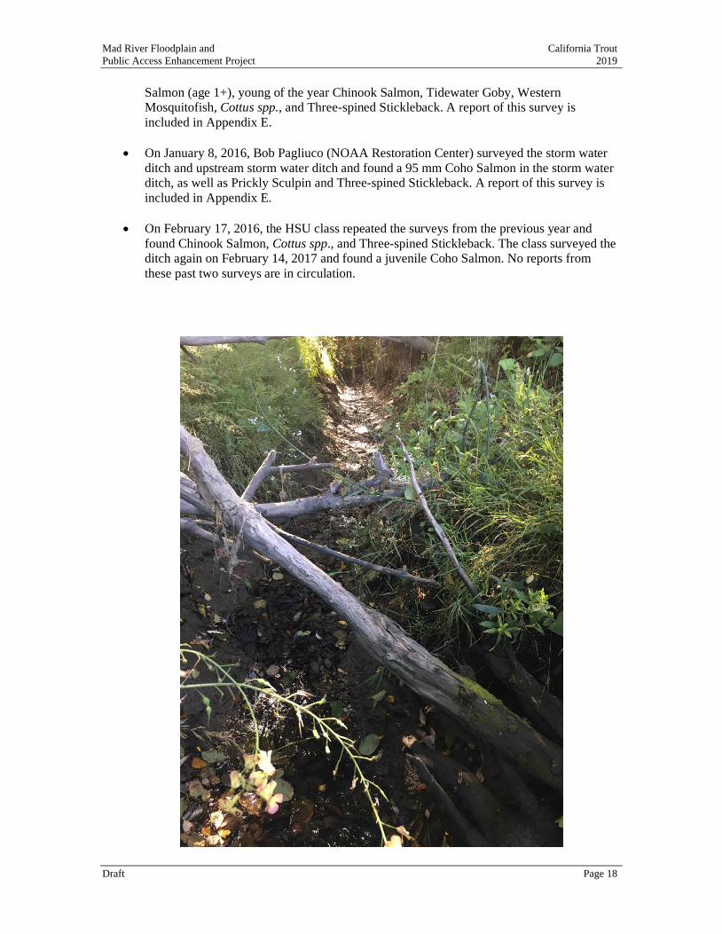
Mad River Floodplain and California Trout
Public Access Enhancement Project 2019
Draft Page 18
Salmon (age 1+), young of the year Chinook Salmon, Tidewater Goby, Western
Mosquitofish, Cottus spp., and Three-spined Stickleback. A report of this survey is
included in Appendix E.
• On January 8, 2016, Bob Pagliuco (NOAA Restoration Center) surveyed the storm water
ditch and upstream storm water ditch and found a 95 mm Coho Salmon in the storm water
ditch, as well as Prickly Sculpin and Three-spined Stickleback. A report of this survey is
included in Appendix E.
• On February 17, 2016, the HSU class repeated the surveys from the previous year and
found Chinook Salmon, Cottus spp., and Three-spined Stickleback. The class surveyed the
ditch again on February 14, 2017 and found a juvenile Coho Salmon. No reports from
these past two surveys are in circulation.
Mad River Floodplain and California Trout
Public Access Enhancement Project 2019
Draft Page 19
Figure 9. Wetted portion of the storm water drainage ditch within the project area.
Figure 10. Additional wetted portion of the storm water drainage ditch within the project area.
Mad River Floodplain and California Trout
Public Access Enhancement Project 2019
Draft Page 20
Figure 11. Mouth of storm water ditch with arrow indicating dry channel.
4.6 Vegetation
Vegetation within the project area was mapped by McBain Associates in June 2018 (McBain
Associates 2019, Appendix F). Vegetation mapping documented 21 distinct cover types. To
estimate the potential impacts of the proposed floodplain enhancement portion of the project on
existing riparian vegetation, it was initially proposed to GPS all mature riparian trees greater than
12 inches dbh within the design footprint. However, due to the extremely high density of riparian hardwood trees meeting this definition, and due to the preliminary stage of project development
(the proposed channel alignment could not be flagged due to high density of vegetation), it was
determined in the field by California Trout and McBain Associates to provide an acreage estimate of cover types based on MCV alliances within the design footprint, with emphasis on
differentiating between mature cover types (see results for description) and younger cover types.
Consequently, mapping within the project area was conducted at finer detail (i.e., to the association
level) for the red alder alliance to capture differences in stand structure, age-class distribution, and
species composition.
Mad River Floodplain and California Trout
Public Access Enhancement Project 2019
Draft Page 21
Red alder/mixed willow forest was the most abundant cover type in the surveyed portion of the
project boundary (4.8 acres), followed by Hooker’s willow (2.6 acres), velvet grass meadow (2.3
acres), and California blackberry (2.1 acres). All of the woody riparian vegetation in the project
area had a strong Hooker’s willow component. Differences in stand structure (i.e., shrub-dominated
vs. tree-dominated) and species composition could be seen depending on the underlying
geomorphic feature. For instance, the shrub-dominated Hooker’s willow and short-tree-dominated
red alder/Hooker’s willow stands occurred on the steep streambank edges and bluff faces directly
adjacent to the Mad River. When present in these stands, red alder tended to be 12–15 inches dbh.
Together, these two cover types represented younger riparian vegetation in the project area. By
contrast, the large-tree-dominated red alder/mixed willow stands occurred on floodplain surfaces
and had a more diverse tree canopy. Many of the red alder trees in this stand type were upwards of
3 ft dbh.
Biohabitats documented in the project area included: brackish marsh, coastal prairie, coastal scrub,
freshwater marsh, human disturbance, riparian forest, riparian scrub, and wet meadow. Of the
mapped biohabitats, riparian scrub and riparian forest were the largest.
5 PROJECT OVERVIEW
Project designs are attached as Appendix A, which include detailed provisions for executing
project construction in Part 3 of the design specifications. The proposed project has two main
elements:
• Habitat restoration project actions to restore existing percolation ponds to the native
floodplain elevation and provide channels and ponds for the provision of aquatic habitat
are located south of the existing storm water ditch.
• Project actions associated with public coastal access amenities, including ADA accessible
trails with resting areas and interpretive features, are located north of the existing storm
water ditch (Figure 6).
Habitat enhancement project elements will remove the existing percolation pond infrastructure
except for the eastern alignment of the percolation pond levee system. The north, south and western
percolation pond levees and infrastructure will be removed and the function of the percolation
ponds as a final point of treated wastewater discharge will be suspended. The percolation pond area
will be excavated to remove the settled material that has been derived from use as a wastewater
disposal area. This material has been tested for potential contaminants and was determined to be
suitable for spoiling within the treated wastewater reclamation fields to the east. MCSD’s current
waste discharge requirements (WDRs), effective on November 1, 2018, identifies this material with
the necessary provisions to land-apply these spoils to their reclamation fields.
The existing perimeter levees that surround the percolation ponds to the north, south, and west will
be lowered to allow connectivity with the surrounding floodplain elevation. The percolation pond
area will be restored to contain natural pond and channel features to perennially connect to the Mad
River and create off-channel winter rearing habitat for juvenile salmonids and other aquatic
species. Riparian and wetland vegetation will be planted to restore the area as native floodplain and
backwater habitat.
The public access project elements provide public access to approximately 2 acres of undeveloped
bluff and hillslope into the Mad River floodplain directly north of the terminus of the School Road
Trail. The pastures used for treated wastewater reclamation to the south of School Road and east of
the project area are fenced to exclude access for the irrigation, mowing and haying operation that
occurs seasonally. The area outside of the fenced wastewater reclamation operations is currently
accessible to the public but not maintained or improved beyond the trails that have formed from
unmanaged foot and bicycle traffic. Surface-hardened trails will be constructed to guide users to
Mad River Floodplain and California Trout
Public Access Enhancement Project 2019
Draft Page 22
benches, a coastal overlook viewpoint structure, river access, interpretive signs and a welcome
kiosk.
5.1 Summary of Project Impacts by Habitat Type
Project activities encompass 9.3 acres within the 96.1-acre project area boundary. Overall, the
project will create 0.5 acres of new riparian habitat and 2.0 acres of new wetland habitat, in
addition to 1.4 acres of new open water habitat.
Table 3. Summary of project impacts by habitat type.
Habitat Type/Feature
Existing
Area
(Acres)
Post-Project
Area
(Acres)
Change
(Acres)
Change is
Temporary or
Permanent?
Access Roads 3.4 3.4 0.0 Both1
Staging Areas 0.0 0.8 N/A Temporary
Stockpile and Spoiling 0.0 5.4 N/A Both2
Trail and View Points 0.0 0.2 0.2 Permanent
River Access 0.0 0.01 0.01 Permanent
Constructed Percolation Ponds3 4.2 0.3 -3.9 Permanent
Existing Storm Water Ditch 0.04 0.04 0.0 Permanent
Open Water 0.0 1.4 1.4 Permanent
Riparian 1.6 2.1 0.5 Permanent
Wetlands 0.0 2.0 2.0 Permanent
Upland (Non-Riparian) 0.4 0.2 -0.2 Permanent
Total 9.3 9.3 0
*Computations based on summer baseflow water surface elevations. Total acres exclude staging areas, stockpile areas,
and spoiling areas on MCSD property. 1 The north and south access roads will receive fill for resurfacing. This change will be permanent. 2 Stockpiling is temporary. Spoiling is permanent. Both activities share the same footprint. 3 Includes levees
5.2 Summary of Excavation, Fill, and Material Spoiling
To the greatest degree possible, excavated materials will remain on site through incorporation into
other project features (23,600 CY). Excavated biosolids will be disposed of within the MCSD
wastewater management facility reclamation area located in the stockpile area footprint, under the
existing WDRs (4,800 CY). The balance of material will be hauled off-site by the contractor
(13,700 CY). A portion of this material will be a mixture of gravel and sand and will be stored at
Kernan Construction gravel yard near Blue Lake, California until it can be repurposed into
unrelated projects. Project excavation and fill volumes are summarized in Table 4.

Mad River Floodplain and California Trout
Public Access Enhancement Project 2019
Draft Page 23
Table 4. Summary of project excavation and fill volumes.
Location
Total
Excavation
(CY)
On-site
Material Re-
use for
Access
Roads and
Landscaping
(CY)
Disposal at
MCSD
Wastewater
Management
Facility
(CY)
Off-site Hauling
of Reusable
Gravel/Sand
and Other
Excavated
Material
(CY)
Pond Biosolids, Screened for
Disposal 4,800 0 4,800
Pond (including Levees) below
Biosolids 11,100 5,100 6,000
Backwater Channels 7,700 0 7,700
Trail and Public Access
Features
TBD TBD
Off-site Hauling - - 13,700
Total 23,600 5,100 4,800 13,700
Table 5. Summary of materials to be imported to the site and large wood to be re-used from on-site.
Material Type Unit Purpose
Large wood 72 CY Fish habitat in off-channel features
Engineered Fill 100 CY
Trails, viewing platforms, river access,
footing for signage and benches
Class II Aggregate Base 300 TON
CalTrans Class II RSP 105 TON
Hot Mix Asphalt 35 TON
Minor Concrete 1,000 square feet
Galvanized Hand Railing 30 linear feet
Weed Barrier 6,600 square feet
Redwood split rail fencing 150 linear feet
Benches 2 benches
Sandbags 60 CY Temporary fill used to isolate the opening
of the constructed backwater channel
5.3 Utilities
Utility infrastructure within the project area will be protected in place and avoided. An existing
manhole cover and associated with Humboldt County’s storm drain system near School Road will
be avoided. Similarly, Humboldt County’s storm drain located on the upper bluff area will also be
avoided and protected in place. The ditch gate closure for the MCSD storm water ditch will be
avoided. The storm water ditch will be integrated into the off-channel backwater habitat feature
near its confluence with the Mad River. There are no power poles located in the project area.
Mad River Floodplain and California Trout
Public Access Enhancement Project 2019
Draft Page 24
6 PROJECT ACTIONS
6.1 Actions Common to the Entire Project Area
1. Establish Site Access
Existing access roads will be utilized temporarily to construct project features. No new roads will
be constructed. The total length of existing access roads is 1.44 miles (3.4 acres).
2. Establish Staging Areas and Stockpile Area
Three staging areas will be established. Staging area 1 (0.5 acres 150 ft x 150 ft) is located east of
the project area, adjacent to the stockpile area. Staging area 2 (0.2 acres, 135 ft x 100 ft) is located
near the existing storm water ditch, near the planned outlet of the off-channel complex. Staging
area 3 (0.1 acres, dimensions TBD) is located near the westernmost end of School Road and will be
used to construct public access features. Materials and equipment will be stored in the designated
stockpile area (5.4 acres, 670 ft x 400 ft) located on the eastern edge of the project.
Stockpiled materials may include trees, logs, stumps, debris, other organic matter, and excavated
project materials (soils and gravels/sands).
3. Install Erosion Control Protection Measures
Erosion control protection measures will be installed prior to breaching the off-channel habitat
complex so that it is hydrologically connected to the storm water ditch and will include
implementation of standard Best Management Practices (BMPs) appropriate to prevent erosion
control, including silt fencing and weed-free straw wattles. Sediment control fencing shall be
installed on the upstream side of the fish exclusion fencing in the existing storm water ditch.
Sediment control barriers shall be installed in accordance with the current California Best Management Practices for Construction and manufacture’s recommendations in the areas of
clearing and grubbing within areas that drain to the Mad River or the existing storm water ditch.
The sediment control barriers will be maintained until soils are stabilized and construction is
complete.
While working within and near the existing storm water ditch, BMPs shall be employed to
minimize erosion of sediment into the stormwater ditch. All material eroded into the storm water
ditch during construction will be removed prior to the removal of the sediment control and fish
exclusion fencing.
4. Install a Fish Barrier at Entrance to the Stormwater Ditch
A fish barrier will be installed at the entrance to the storm water ditch to exclude fish from a small
wetted area within the zone of construction, near the entrance of the constructed off-channel habitat
complex. The fish barrier will be fully compliant with all CDFW and NMFS requirements and
installed under the supervision of a qualified fisheries biologist.
5. Fish Removal in Storm Water Ditch, if Watered
The existing storm water ditch (383 ft, 0.04 acre) will not be in use or actively watered during construction from the storm water ditch to the east; however, the area may be inundated during
high tide from the Mad River and provide habitat for fish and other aquatic species. If the area is
not tidally connected because of the condition of the adjacent riffle and sandbar, small puddles or
localized, non-connective portions of wetted areas may remain and may provide habitat for fish and
other aquatic species. Fish removal will occur in any remaining wetted areas prior to construction.
Removal of fish and other aquatic organisms will occur in compliance with CDFW and NMFS
requirements. (Appendix H), as described in the Biological Assessment (Appendix I) and resulting
NMFS Biological Opinion for the project. Any fish or other aquatic species captured will be
released into the mainstem Mad River nearest the project site, outside of the construction area.
Mad River Floodplain and California Trout
Public Access Enhancement Project 2019
Draft Page 25
6. Establish Save Trees
Existing Save Trees and their roots will be flagged and protected with temporary fencing or other
necessary protections. Save Trees will be identified by the project engineer or their representative.
Additional Save Trees information detailing procedures for incidental damage during construction
can be found in the Design Plans and Specifications.
7. Clearing and Grubbing
Clearing and grubbing will occur in the vicinity of the off-channel habitat complex and other
project features to support grading. Clearing and grubbing may occur at different times throughout
project construction.
8. Dewatering
Excavation of the pond will likely maintain groundwater levels that deepen during high tides that
occur in the Mad River. Water collected in the pond may be used by the project contractor, as
needed. In addition, the contractor will develop a dewatering plan that complies with regulatory
requirements and:
• Diverts groundwater seepage by constructing large temporary earth berms or straw bale
barriers within the project area. Any berms or straw bales shall be removed prior to close
of construction. Ground shall be graded to final design topography.
• Dewatering may be required to remove groundwater seepage in excavation areas. The
project contractor will employ Best Management Practices for dewatering operations as
described in the current Best Management Practices Handbook for Construction. Water
shall be discharged away from areas of standing water onto open ground. Outlet protection
may be required to prevent erosion. Water will be allowed to infiltrate back into the
ground. Discharged water shall not be allowed to flow into the Mad River, drainage
ditches, any water conveyance facilities, or into disturbed areas.
9. On-site Reuse and Off-site Spoiling of Excavated Materials
Excavated materials will be re-used on site to build some project features and hauled off-site for
spoiling (Table 4). A grading permit will be obtained from Humboldt County. Soil testing was
conducted for the material to be excavated from the percolation ponds. Soil samples were collected
from the percolation ponds on May 12, 2016, prior to the start of annual use for treated wastewater
discharge to analyze for elevated levels of constituents of concern. Results indicate the material is
not contaminated (see Appendix C for testing results and documentation).
10. Resurface Access Roads
The two existing access roads will be resurfaced with 2,400 CY of silt, sand, and gravel excavated
from the percolation pond area during rehabilitation activities.
11. Remove Fish Barrier
Once the constructed off-channel habitat complex is opened and connected to the Mad River and
construction within the wetted footprint of the project area is complete, the fish barrier will be
removed in accordance with guidelines and specifications established by CDFW and NMFS
(Appendix H).
12. Revegetate and Reseed Project Area
The project will be replanted with native tree species in accordance with the riparian design
specifications established for the project (see Appendix A, Design Sheet C6). Replanting includes
1.7 acres of riparian vegetation. As there is a large patch of wetland species along the banks of the
Mad River at the mouth of the stormwater ditch, 2.0 acres of wetland and transitional wetland
Mad River Floodplain and California Trout
Public Access Enhancement Project 2019
Draft Page 26
vegetation will remain as constructed and ripped surfaces ready to accept seeds from the river via
the backwater channel, revegetating through natural recruitment in the backwatered environment.
13. Rip or Disc Temporary Access Roads and Staging Area; Implement Post-construction
Erosion Control Measures; Site Closure
Following construction, the staging area will be ripped or disked for decompaction. Access roads
will remain, consistent with their pre-project use. Post-construction erosion control measures will
be implemented, including the spreading of weed-free straw mulch on bare soils. Erosion control
materials no longer in use (e.g. silt fencing) will be removed and legally disposed of off-site, along
with other garbage and recyclable materials generated during construction.
6.2 Ecosystem Enhancement Project Actions
Sequencing of enhancement actions has been designed such that the upstream pond elements are
constructed first. The off-channel habitat complex will be excavated next and will not be breached
into the storm water ditch until the rest of the channel is constructed. This will ensure that the
excavation activities maintain independence from the flowing waters of the Mad River and
minimize and avoid any potential water quality or habitat impacts related to project
implementation. Connecting the new off-channel habitat complex to the Mad River will be the final
step.
1. Trees Harvested for Reuse
Trees within the footprint of the new off-channel habitat complex will be harvested for reuse as large
habitat elements. Trees will be flagged in the field by the project engineer or their representative.
2. Remove Levees Surrounding Constructed Percolation Ponds
The project will remove existing levee system that is the perimeter of the existing percolation
ponds (4.2 acres). With the exception of the eastern levee that will remain in place, the northern,
southern, and western levees will be removed and regraded to the native floodplain elevation.
Existing pipes and related wastewater treatment infrastructure will be removed from the
percolation ponds and recycled off-site by the project contractor.
3. Construct New Backwater Channel
The backwater off-channel habitat complex (1,775 approximate total length including side
channels) will be located within the active floodplain, continuing upstream from an existing river
backwater channel. The mouth of the backwater channel will empty at the current location of the
existing storm water ditch outlet. The downstream elevation of the backwater channel is controlled
by the topography of the storm water ditch, which is currently (as of 2016) at approximately 3.5 to
4 ft elevation, and an existing river backwater channel that the storm water ditch drains into which
grades down to approximately -4 ft elevation near Humboldt County’s existing culvert outlet (as of
2016). The proposed channel grades up from approximately 3 ft elevation to approximately 6.2 ft
elevation over a slope of 0.25% for 1,250 ft. The channel flattens to a slope of 0.11% through the
north pond reach for 325 feet and then steepens to a 2% slope up to the transitional wetland (south
pond).
To minimize potential turbidity impacts, temporary plugs may be installed within the constructed backwater channel to pool groundwater seepage for dewatering. The plugs will be removed as final
step of project implementation to ensure construction is not completed in a wetted environment.
The plugs will be removed from upstream to downstream with the downstream-most plug removed
during a rising tide. Small heavy equipment (mini-excavator) will be used to construct the
backwater channel complex to minimize riparian impacts.
Mad River Floodplain and California Trout
Public Access Enhancement Project 2019
Draft Page 27
4. Construct Off-Channel Pond, Wetland Flats, and Islands
An off-channel pond (0.8 acres) will be constructed 1,200 ft upstream of the backwater channel
confluence with the existing storm water ditch. The pond will be excavated to 0 ft elevation with a
20-ft width and 100-ft length. The pond is located off-set from the backwater channel, to reduce
sediment loading. Minimum depths of approximately 6 ft are to inhibit emergent vegetation from
colonizing in the deeper portions of the pools.
The area between the off-channel pond and the backwater channel will provide wetland flats at an
elevation of 7 to 8 ft and elevated topography as isolated islands vegetated with riparian trees at a
peak of 11 to 13 ft elevation. The wetlands will likely be emergent freshwater wetlands; however,
there is a possibility that salt-tolerant, brackish vegetation could colonize, depending on salinities.
5. Install Wood Habitat Structures
Twelve wood placements (approximately 72 CY) will be installed below finished grade into
channel and pond banks. Placed wood shall be 12-inch diameter or greater, as-is available on-site.
Large wood will be placed in the field under the supervision of the project engineer and project
biologist.
6. Create and Plant a Riparian Areas
A riparian bench, an interior peninsula and islands will support native tree species (2.1 acres) at 13
to 14 ft elevation is proposed for riparian trees along the east side of the large transitional wetland
(south pond) to increase habitat complexity and direct overtopping flow-through towards the
wetlands and backwater channel.
7. Wetland Areas
Wetland and transitional wetlands will support emergent vegetation in the graded area surrounding
the ponds at the terminus of the backwater off-channel habitat area. The northern outlet of the pond
will be planted with native emergent wetland plants to reduce the risk of the pond filling with fine
sediment, as the plants are intended to serve as a filter between the pond and the backwater
channel. Newly created wetlands and transitional wetlands will total 2.0 acres.
8. Invasive Species
Invasive species, include reed canary grass, Himalayan blackberry and periwinkle exist on the
project site but are not yet dominant. When encountered within the footprint of construction, these
species will be removed with heavy equipment.
6.3 Public Access Project Features
1. Parking Interface with Humboldt County
Humboldt County will be constructing a parking area (0.5 acres) at the west end of School Road, to
support parking for trail users. The parking area will include a handicapped space. The improved
parking will prohibit cars from blocking pedestrian, ADA, and bicycle access via the existing
School Road Trail. The parking area is bound to the east and west by power poles and the length of
the spaces approximately align with the two western-most parcels, east of Ocean Ave (on the north
side of School Road).
2. ADA Accessible Trail
A paved ADA accessible trail (approximately 315 ft long, 8 ft wide) will upgrade and connect the
existing informal trail present within the project area to the well-used Hammond Coastal Trail via
the School Road Trail. The proposed trail will reduce ecological impacts to surrounding resources
by constraining public use to the trail surface while still interfacing with nature. The temporary
grading boundary surrounding of trail construction may extend approximately 5 ft on either side for
equipment access.
Mad River Floodplain and California Trout
Public Access Enhancement Project 2019
Draft Page 28
3. Bluff Overlook
An ADA accessible bluff overlook (approximate dimensions: 44 ft x 52 ft) will support nature
study, allowing nature study and viewpoints of the Mad River, the Hammond Bridge, the Arcata
Bottoms, and the Pacific Ocean. The bluff overlook will be constructed with a concrete paved base,
redwood post footings, 1 ½” galvanized handrails, and cribbed redwood steps. Light willow
trimming and branch removal (riparian) will be conducted to broaden the viewshed for users in the
vicinity immediately surrounding the bluff overlook.
4. Wildlands Interface Trails
A wildland-interface trail network connects the bluff overlook to the river access location to the
south and slightly upstream. The trail will be 4-8 ft wide with a total length of approximately 1,200
ft. The trail will not meet ADA accessibility standard but will be paved to the river access location.
Beyond this point, the trail surface will be surfaced with gravel. The trail will emerge through the
riparian vegetation at two locations to provide west and south-facing views of the river. The
temporary grading boundary surrounding of trail construction may extend approximately five ft on
either side for equipment access.
5. River Access
A small river access will be created to support small craft boaters, anglers, and water-contact
recreation. Heavy equipment will not disturb the wetted perimeter of the Mad River to construct
this feature. Construction will include minor bank regrading and rearrangement of existing large
boulders or cutting steps into existing large boulders (previously placed along the east bank of the
river) to better support non-motorized pedestrian river access. A boat ramp or dock feature will not
be constructed. Approximately 12 linear feet of willows will be removed at the access point and
light willow trimming and branch removal (riparian) will be conducted to broaden the viewshed for
users in the vicinity immediately surrounding the river access.
6. Resting Locations
Two benches will be installed at key locations throughout the trail network. Benches will be installed
on concrete pads in locations elevated on the bluff to reduce risk of flood mobilization.
7. Instructional and Interpretive Signage
Instruction and interpretive signage, including informational kiosks, will be installed throughout the
trail network. Interpretive signage will provide information about guidelines for user conduct, the
Wiyot cultural history of the project area, and the ecological attributes of the project area and related
restoration actions. Interpretive signage will be installed on small concrete pads and will include
wood and metal components, along with aluminum or high density polyvinyl with vinyl adhesive
mounted to railings.
7 PROJECT IMPLEMENTATION
Construction will occur between 7:00 a.m. and 7:00 p.m. Monday through Saturday during the
permitted construction window.
8 REQUIRED PERMITS AND APPROVALS
The Project requires the following permits and approvals to proceed:
▪ Humboldt County – Conditional Use Permit and Grading Permit
▪ California Coastal Commission – Coastal Development Permit
▪ California Department of Fish and Wildlife - – Lake and Streambed Alteration Agreement,
Incidental Take or Consistency Determination Process, or Consistency Determination for
Mad River Floodplain and California Trout
Public Access Enhancement Project 2019
Draft Page 29
Salmonids with NMFS Biological Opinion, or CESA MOU under Fish and Game Code
2081(a)
▪ Regional Water Quality Control Board (North Coast Region) – 401 Water Quality
Certification
▪ United States Army Corps of Engineers – Clean Water Act Section 404 compliance,
including
o United States Fish and Wildlife Service and National Marine Fisheries Service –
Section 7 Consultation
▪ State Lands Commission –Determination with a potential requirement for Lease
Mad River Floodplain and California Trout
Public Access Enhancement Project 2019
Draft Page 30
9 INITIAL STUDY & MITIGATED NEGATIVE DECLARATION
ENVIRONMENTAL FACTORS POTENTIALLY AFFECTED
The environmental factors checked below would be potentially affected by this project, involving
at least one impact that is a "Potentially Significant Impact" as indicated by the checklist on the
following pages.
❑ Aesthetics ❑ Agricultural Resources
❑ Air Quality ❑ Biological Resources
❑ Cultural Resources ❑ Energy
❑ Geology/Soils ❑ Green House Gas Emissions
❑ Hazards ❑ Hydrology/Water Quality
❑ Land Use/Planning ❑ Mineral Resources
❑ Noise ❑ Population/Housing
❑ Public Services ❑ Recreation
❑ Transportation/Traffic ❑ Tribal Cultural
❑ Utilities/Service Systems ❑ Wildlfire
❑ Mandatory Findings of Significance
DETERMINATION
Based on this initial evaluation:
❑ I find that the proposed project could not have a significant effect on the environment, and a
NEGATIVE DECLARATION will be prepared.
I find that although the proposed project could have a significant effect on the environment,
there will not be a significant effect in this case because revisions in the project have been
made by or agreed to by the project proponent. A MITIGATED NEGATIVE DECLARATION will
be prepared.
❑ I find that the proposed project may have a significant effect on the environment, and an
ENVIRONMENTAL IMPACT REPORT is required.
❑ I find that the proposed project may have a “potentially significant impact” or ‘potentially
significant unless mitigated” impact on the environment, but at least one effect 1) has been
adequately analyzed in an earlier document pursuant to applicable legal standards, and 2) has
been addressed by mitigation measures based on the earlier analysis as described on attached
sheets. An Environmental Impact Report is required, but it must analyze only those effects that
remain to be addressed.
❑ I find that although the proposed project could have a significant effect on the environment,
because all potentially significant effects (a) have been analyzed adequately in an earlier EIR
or Negative Declaration pursuant to applicable standards, and (b) have been avoided or
mitigated pursuant to that earlier EIR or Negative Declaration, including revisions or
mitigation measures that are imposed upon the proposed project, nothing further is required.
##/##/2019
Greg Orsini, General Manager Date
Mad River Floodplain and California Trout
Public Access Enhancement Project 2019
Draft Page 31
CHECKLIST AND EVALUATION OF ENVIRONMENTAL IMPACTS
An explanation for all checklist responses is included, and all answers consider the whole action
involved, including off-site as well as on-site, cumulative as well as project-level, indirect as well
as direct, and construction as well as operational impacts. The explanation of each issue identifies
(a) the significance criteria or threshold, if any, used to evaluate each question; and (b) the
mitigation measure identified, if any, to reduce the impact to less than significant. In the checklist
below for each question there are four possible answers:
“Potentially Significant Impact” means there is substantial evidence that an effect may be
significant.
“Less than Significant with Mitigation Incorporated” means the incorporation of one or
more mitigation measures can reduce the effect from potentially significant to a less than
significant level.
“Less Than Significant Impact” means that the effect is less than significant, and no
mitigation is necessary to reduce the impact to a lesser level.
“No Impact” means that the effect does not apply to the proposed project, or clearly will
not impact nor be impacted by the project.
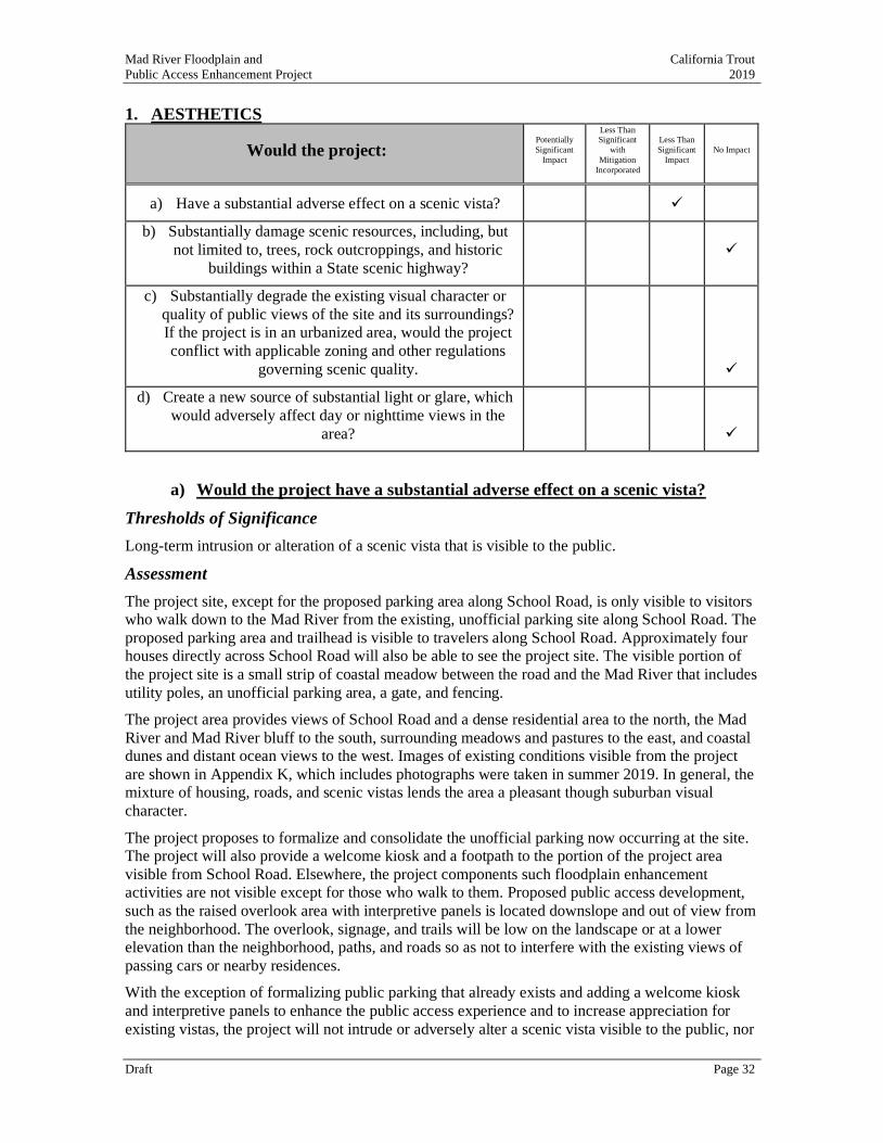
Mad River Floodplain and California Trout
Public Access Enhancement Project 2019
Draft Page 32
1. AESTHETICS
Would the project: Potentially
Significant
Impact
Less Than Significant
with
Mitigation
Incorporated
Less Than
Significant
Impact
No Impact
a) Have a substantial adverse effect on a scenic vista? ✓
b) Substantially damage scenic resources, including, but
not limited to, trees, rock outcroppings, and historic
buildings within a State scenic highway?
✓
c) Substantially degrade the existing visual character or
quality of public views of the site and its surroundings?
If the project is in an urbanized area, would the project
conflict with applicable zoning and other regulations
governing scenic quality.
✓
d) Create a new source of substantial light or glare, which
would adversely affect day or nighttime views in the
area?
✓
a) Would the project have a substantial adverse effect on a scenic vista?
Thresholds of Significance
Long-term intrusion or alteration of a scenic vista that is visible to the public.
Assessment
The project site, except for the proposed parking area along School Road, is only visible to visitors
who walk down to the Mad River from the existing, unofficial parking site along School Road. The
proposed parking area and trailhead is visible to travelers along School Road. Approximately four
houses directly across School Road will also be able to see the project site. The visible portion of
the project site is a small strip of coastal meadow between the road and the Mad River that includes
utility poles, an unofficial parking area, a gate, and fencing.
The project area provides views of School Road and a dense residential area to the north, the Mad
River and Mad River bluff to the south, surrounding meadows and pastures to the east, and coastal
dunes and distant ocean views to the west. Images of existing conditions visible from the project
are shown in Appendix K, which includes photographs were taken in summer 2019. In general, the
mixture of housing, roads, and scenic vistas lends the area a pleasant though suburban visual
character.
The project proposes to formalize and consolidate the unofficial parking now occurring at the site.
The project will also provide a welcome kiosk and a footpath to the portion of the project area
visible from School Road. Elsewhere, the project components such floodplain enhancement
activities are not visible except for those who walk to them. Proposed public access development,
such as the raised overlook area with interpretive panels is located downslope and out of view from
the neighborhood. The overlook, signage, and trails will be low on the landscape or at a lower
elevation than the neighborhood, paths, and roads so as not to interfere with the existing views of
passing cars or nearby residences.
With the exception of formalizing public parking that already exists and adding a welcome kiosk
and interpretive panels to enhance the public access experience and to increase appreciation for
existing vistas, the project will not intrude or adversely alter a scenic vista visible to the public, nor
Mad River Floodplain and California Trout
Public Access Enhancement Project 2019
Draft Page 33
alter or degrade the existing visible character and quality of the site and its surroundings. The
impact will be less than significant.
b) Would the project substantially damage scenic resources, including, but not
limited to, trees, rock outcroppings, and historic buildings within a State
scenic highway?
Thresholds of Significance
Permanent adverse change within a State scenic highway to scenic resources’ physical, vegetative,
or aesthetic elements visible to the public.
Assessment
There will be no impact. The project is not located on or within view of a state scenic highway.
c) Would the project substantially degrade the existing visual character or
quality of the public view of the site and its surroundings? If the project is
in an urbanized area, would the project conflict with applicable zoning and
other regulations governing scenic quality?
Thresholds of Significance
Long-term alteration or degradation of the existing visible character and quality of a site and its
surroundings, which is visible to the public.
Assessment
The McKinleyville Area Plan (LCP, 3.49 (E)) specifically identifies the bottomlands north of the
Mad River as a having agricultural exclusive designation worthy of specific protection for that
visual resource. As shown in Figures 3-6 and Appendix K, the project area for the public access
features is near a mixture of dense residential development and public roadway with sweeping
vistas to the south visible from the western end of School Road. The habitat enhancement features
are within the current riparian area and do not change the visual character of the site or its
surroundings. The proposed project includes no structures or other elements that will degrade the
visual character or quality of public view of the site and its surroundings. The project does not
conflict with applicable zoning and other regulations governing scenic quality.
d) Would the project create a new source of substantial light or glare, which
would adversely affect day or nighttime views in the area?
Thresholds of Significance
Long-term or permanent development that would create a new source of substantial light or glare.
Assessment
There will be no impact. The project includes no new source of light or glare that would affect day
or nighttime views in the area.
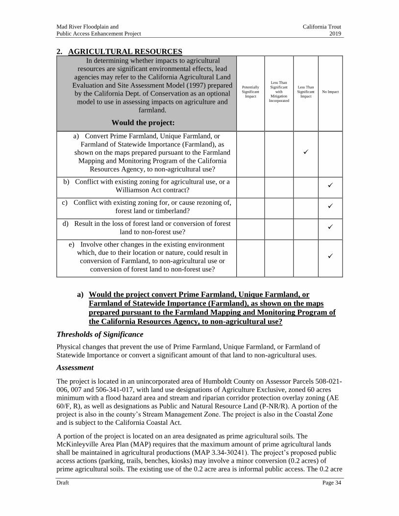
Mad River Floodplain and California Trout
Public Access Enhancement Project 2019
Draft Page 34
2. AGRICULTURAL RESOURCES
In determining whether impacts to agricultural
resources are significant environmental effects, lead
agencies may refer to the California Agricultural Land
Evaluation and Site Assessment Model (1997) prepared
by the California Dept. of Conservation as an optional
model to use in assessing impacts on agriculture and
farmland.
Would the project:
Potentially
Significant
Impact
Less Than
Significant
with Mitigation
Incorporated
Less Than
Significant
Impact
No Impact
a) Convert Prime Farmland, Unique Farmland, or
Farmland of Statewide Importance (Farmland), as
shown on the maps prepared pursuant to the Farmland
Mapping and Monitoring Program of the California
Resources Agency, to non-agricultural use?
✓
b) Conflict with existing zoning for agricultural use, or a
Williamson Act contract? ✓
c) Conflict with existing zoning for, or cause rezoning of,
forest land or timberland? ✓
d) Result in the loss of forest land or conversion of forest
land to non-forest use? ✓
e) Involve other changes in the existing environment
which, due to their location or nature, could result in
conversion of Farmland, to non-agricultural use or
conversion of forest land to non-forest use?
✓
a) Would the project convert Prime Farmland, Unique Farmland, or
Farmland of Statewide Importance (Farmland), as shown on the maps
prepared pursuant to the Farmland Mapping and Monitoring Program of
the California Resources Agency, to non-agricultural use?
Thresholds of Significance
Physical changes that prevent the use of Prime Farmland, Unique Farmland, or Farmland of
Statewide Importance or convert a significant amount of that land to non-agricultural uses.
Assessment
The project is located in an unincorporated area of Humboldt County on Assessor Parcels 508-021-
006, 007 and 506-341-017, with land use designations of Agriculture Exclusive, zoned 60 acres minimum with a flood hazard area and stream and riparian corridor protection overlay zoning (AE
60/F, R), as well as designations as Public and Natural Resource Land (P-NR/R). A portion of the
project is also in the county’s Stream Management Zone. The project is also in the Coastal Zone
and is subject to the California Coastal Act.
A portion of the project is located on an area designated as prime agricultural soils. The
McKinleyville Area Plan (MAP) requires that the maximum amount of prime agricultural lands
shall be maintained in agricultural productions (MAP 3.34-30241). The project’s proposed public
access actions (parking, trails, benches, kiosks) may involve a minor conversion (0.2 acres) of
prime agricultural soils. The existing use of the 0.2 acre area is informal public access. The 0.2 acre
Mad River Floodplain and California Trout
Public Access Enhancement Project 2019
Draft Page 35
area proposed for conversion is a narrow strip of land located between an area of dense residential
housing and the river’s edge. A significant portion of the area is currently used as an informal pull-
out along School Road which is used as an unofficial parking area for those accessing the river.
This 0.2 acre area is not presently used for agricultural purposes and has not been farmed since
MCSD acquired ownership in 2000. The 0.2 acre area is not contiguous to an existing pasture or
other area used for agricultural purposes and is generally unsuitable for agricultural use.
The dominant agricultural use in the project area is pasture or livestock grazing. At its highest
levels of production, the pastures surrounding the project area may support somewhere between 1-
2 Animal Unit Months (AUMs). Therefore, the 0.2-acre area proposed for possible conversion
would hypothetically support less than one quarter AUM, at most.
For these reasons, the proposed possible conversion of approximately one-fifth of one acre of
prime agricultural land on the upper bluff that is not productive agricultural land and has not been
used for agriculture purposes in at least twenty years. The potential impact is less than significant.
b) Would the project conflict with existing zoning for agricultural use, or a
Williamson Act contract?
Thresholds of Significance
Implement land uses that are not allowed and conflict with existing zoning for agricultural use, or a
Williamson Act contract.
Assessment
The proposed project actions on AE lands are conditionally permitted uses described as natural
resource use types: fish and wildlife management, wetland restoration, resource-related recreation,
and coastal access facilities (HCC 313-7.1). The parcels are designated NR where fish and wildlife
habitat management is a principally permitted use (HCC 313-5.4) The project is also located in a
Stream Management Zone, where the proposed project actions are allowable uses (HCC 313-33.1).
The property where the project is located is covered by two overlay zones: Flood Hazard Areas (F)
and Stream and Riparian Protection Corridor (R). The proposed habitat restoration actions with a
Special Permit are allowable uses in Flood and Tsunami Hazard Areas (HCC 313-21.4 and 5), and
in Stream and Riparian Protection Corridor (HCC 313-33.1.5). Accordingly, the project will not
conflict with existing zoning for agricultural use. The project area is not enrolled in a Williamson
Act contract, so there is no conflict with an existing Williamson Act contract. There will be no
impact.
c) Conflict with existing zoning for, or cause rezoning of, forest land (as
defined in PRC Section 12220(g)) or timberland (as defined in PRC Section
4526)?
Thresholds of Significance
Implement land uses that are not allowed and conflict with forest or timber land uses or zoning.
Assessment
There is no conflict with existing zoning, nor a need for rezoning of forest land, as none is
proposed. The proposed project does not include forest or timber resources. (Riparian habitat is
discussed in Section 4.) There will be no impact.
d) Would the project result in the loss of forest land or conversion of forest
land to non-forest use?
Thresholds of Significance
Mad River Floodplain and California Trout
Public Access Enhancement Project 2019
Draft Page 36
Physical changes resulting in the loss of forest land or conversions of forest land to non-forest uses.
Assessment
The project will not convert forest land nor non-forest use, as none is proposed. The proposed
project does not include forest or timber resources. (Riparian habitat is discussed in Section 4.)
There will be no impact.
e) Would the project involve other changes in the existing environment which,
due to their location or nature, could result in conversion of Farmland, to
non-agricultural use or conversion of forest land to non-forest use?
Thresholds of Significance
Physical changes which could convert adjacent farmlands to non-agricultural use or convert
adjacent forest lands to non-forest use.
Assessment
No proposed project elements have the potential to cause physical changes which could convert
adjacent farmlands to non-agricultural use or convert adjacent forest lands to non-forest use. There
will be no impact.
Mad River Floodplain and California Trout
Public Access Enhancement Project 2019
Draft Page 37
3. AIR QUALITY
Where available, the significance criteria established by
the applicable air quality management or air pollution
control district may be relied upon to make the
following determinations.
Would the project:
Potentially
Significant
Impact
Less Than Significant
with Mitigation
Incorporated
Less Than
Significant
Impact
No Impact
a) Conflict with or obstruct implementation of the
applicable air quality plan? ✓
b) Result in a cumulatively considerable net increase of
any criteria pollutant under an applicable Federal or
State ambient air quality standard?
✓
c) Expose sensitive receptors to substantial pollutant
concentrations? ✓
d) Result in other emissions (such as those leading to odors or dust) adversely affecting a substantial number
of people.
✓
a) Would the project conflict with or obstruct implementation of the
applicable air quality plan?
Thresholds of Significance
Project generates pollutants that would prevent attainment of the North Coast Unified Air Quality
Management District’s (NCUAQMD) long-term air quality objectives.
Assessment
This impact relates to consistency with an adopted attainment plan, and generation of a localized
criteria pollutant impact. A potential localized impact would be an exceedances of State or federal
standards for particulate matter (PM10) emissions. PM10 is of concern during construction because
of the potential to emit fugitive dust during earth-disturbing activities.
The NCUAQMD is responsible for monitoring and enforcing local, state, and federal air quality
standards. The U.S. Environmental Protection Agency (EPA) sets the National Ambient Air
Quality Standards for the following six ‘criteria’ air pollutants: ozone, particulate matter (PM10
and PM2.5), nitrogen dioxide, carbon monoxide, lead, and sulfur dioxide. The California Air
Resources Board (ARB) administers the California Ambient Air Quality Standards, which include
the six criteria pollutants listed above as well as visibility-reducing particulates, hydrogen sulfide,
sulfates, and vinyl chloride.
Humboldt County is designated ‘attainment’ for all National Ambient Air Quality Standards. With
regard to the California Ambient Air Quality Standards, Humboldt County is designated attainment
for all pollutants except PM10. Humboldt County is designated as “non-attainment” for the state’s
PM10 standard. To address non-attainment for PM10, the NCUAQMD adopted a Particulate
Matter Attainment Plan in 1995. This plan presents available information about the nature and
causes of PM10 standard exceedances and identifies cost-effective control measures to reduce
PM10 emissions to levels necessary to meet California Ambient Air Quality Standards.
PM10 refers to inhalable particulate matter with an aerodynamic diameter of less than 10 microns.
PM10 includes emission of small particles that consist of dry solid fragments, droplets of water, or
solid cores with liquid coatings. The particles vary in shape, size, and composition. PM10
Mad River Floodplain and California Trout
Public Access Enhancement Project 2019
Draft Page 38
emissions include smoke from wood stoves, construction dust, open burning of vegetation, and
airborne salts and other particulate matter naturally generated by ocean surf. Because, in part, of
the large number of wood stoves in Humboldt County and because of the generally heavy surf and
high winds common to this area, Humboldt County has exceeded the state standard for PM10
emissions. Therefore, any use or activity that generates airborne particulate matter may be of
concern to the NCUAQMD. The proposed Project would create PM10 emissions in part through
vehicles coming and going to the Project site and the construction/renovation/demolition associated
with the project.
Pursuant to Air Quality Regulation 1, Chapter IV, Rule 430 – Fugitive Dust Emissions, the
handling, transporting, or open storage of materials in such a manner, which allows or may allow
unnecessary amounts of particulate matter to become airborne, shall not be permitted. Reasonable
precautions shall be taken to prevent particulate matter from becoming airborne, including, but not
limited to: (1) covering open bodied trucks when used for transporting materials likely to give rise
to airborne dust; and (2) the use of water or chemicals for control of dust in the demolition of
existing buildings or structures, construction operations, the grading of roads or the clearing of
land. The proposed project includes grading and construction activities. In order to reduce potential
fugitive dust emission and particulate matter impacts, Mitigation Measure AIR-1 requires Project
compliance with Air Quality Regulation 1, Rule 104 (D), Fugitive Dust Emissions. With
Mitigation Measure AIR-1, the Project would not conflict with or obstruct implementation of the
applicable air quality plan and the impact would be less than significant with mitigation.
Mitigation Measures
AIR-1 Dust Control
MCSD, at all times during construction, shall comply with Air Quality Regulation 1, Rule
104 (D) to the satisfaction of the NCUAQMD. This would require, but may not be limited
to:
• Water all active construction areas regularly to limit dust; control erosion and prevent
water runoff containing silt and debris from entering the storm drain system.
• Cover trucks hauling soil, sand, and other loose material.
• Pave, water, or apply non-toxic soil stabilizers on unpaved access roads and parking areas.
• Sweep paved streets, access roads and parking areas daily if visible material is carried
onto adjacent public streets.
Mitigation Measure AIR-1 would ensure compliance with Air Quality Regulation 1, Rule 104 (D) to
control fugitive dust and reduce the impact of Project activities less than significant.
b) Result in a cumulatively considerable net increase of any criteria pollutant
under an applicable Federal or State ambient air quality standard?
Thresholds of Significance
Production of pollutants by the project that would result in a cumulatively considerable net increase
in pollutants for which the NCUAQMD is in non-attainment.
Assessment
This impact is related to regional criteria pollutant impacts. As identified in Impact Section 3.3 (a)
above, Humboldt County is designated nonattainment of the State’s PM10 standard. Humboldt
County is designated attainment for all other state and federal standards.
For construction emissions, the NCUAQMD has indicated that emissions are not considered
regionally significant for projects whose construction would be of relatively short in duration,
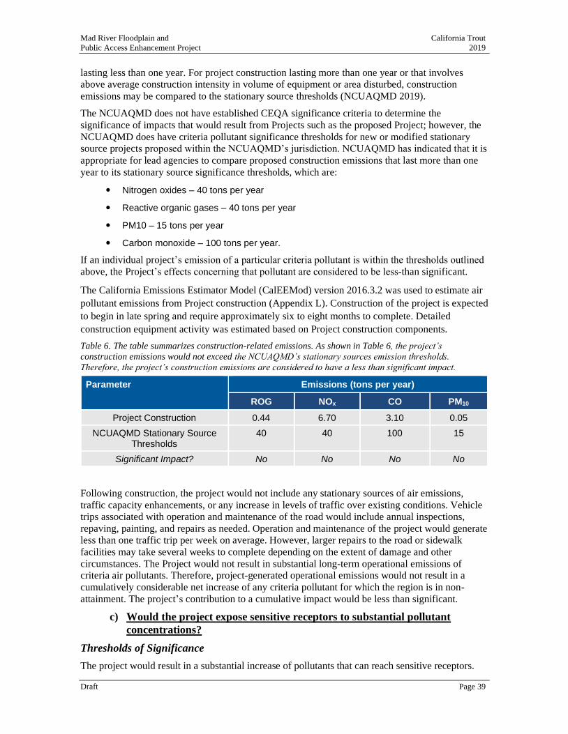
Mad River Floodplain and California Trout
Public Access Enhancement Project 2019
Draft Page 39
lasting less than one year. For project construction lasting more than one year or that involves
above average construction intensity in volume of equipment or area disturbed, construction
emissions may be compared to the stationary source thresholds (NCUAQMD 2019).
The NCUAQMD does not have established CEQA significance criteria to determine the
significance of impacts that would result from Projects such as the proposed Project; however, the
NCUAQMD does have criteria pollutant significance thresholds for new or modified stationary
source projects proposed within the NCUAQMD’s jurisdiction. NCUAQMD has indicated that it is
appropriate for lead agencies to compare proposed construction emissions that last more than one
year to its stationary source significance thresholds, which are:
Nitrogen oxides – 40 tons per year
Reactive organic gases – 40 tons per year
PM10 – 15 tons per year
Carbon monoxide – 100 tons per year.
If an individual project’s emission of a particular criteria pollutant is within the thresholds outlined
above, the Project’s effects concerning that pollutant are considered to be less-than significant.
The California Emissions Estimator Model (CalEEMod) version 2016.3.2 was used to estimate air
pollutant emissions from Project construction (Appendix L). Construction of the project is expected
to begin in late spring and require approximately six to eight months to complete. Detailed
construction equipment activity was estimated based on Project construction components.
Table 6. The table summarizes construction-related emissions. As shown in Table 6, the project’s
construction emissions would not exceed the NCUAQMD’s stationary sources emission thresholds.
Therefore, the project’s construction emissions are considered to have a less than significant impact.
Parameter Emissions (tons per year)
ROG NOx CO PM10
Project Construction 0.44 6.70 3.10 0.05
NCUAQMD Stationary Source Thresholds
40 40 100 15
Significant Impact? No No No No
Following construction, the project would not include any stationary sources of air emissions,
traffic capacity enhancements, or any increase in levels of traffic over existing conditions. Vehicle
trips associated with operation and maintenance of the road would include annual inspections,
repaving, painting, and repairs as needed. Operation and maintenance of the project would generate
less than one traffic trip per week on average. However, larger repairs to the road or sidewalk
facilities may take several weeks to complete depending on the extent of damage and other
circumstances. The Project would not result in substantial long-term operational emissions of
criteria air pollutants. Therefore, project-generated operational emissions would not result in a
cumulatively considerable net increase of any criteria pollutant for which the region is in non-
attainment. The project’s contribution to a cumulative impact would be less than significant.
c) Would the project expose sensitive receptors to substantial pollutant
concentrations?
Thresholds of Significance
The project would result in a substantial increase of pollutants that can reach sensitive receptors.
Mad River Floodplain and California Trout
Public Access Enhancement Project 2019
Draft Page 40
Assessment
Activities occurring near sensitive receptors should receive a higher level of preventative planning.
Sensitive receptors include school-aged children (schools, daycare, playgrounds), the elderly
(retirement community, nursing homes), the infirm (medical facilities/offices), and those who
exercise outdoors regularly (public and private exercise facilities, parks). Sensitive receptors
immediately adjacent to the project include residences along the westernmost extent School Road.
Idling times for trucks and equipment will be limited to five minutes, as required by the California
airborne toxics control measure Title 13, Section 2485 of California Code of Regulations [CCR],
which also ensures construction equipment is maintained in accordance with manufacturer's
specifications.
The project will include more than one staging area due to its size. The staging area for public
access enhancements would be located adjacent to School Road and nearest sensitive receptors
(residential housing). Two additional staging areas are planned to support restoration project
components and will not be located near any sensitive receptors.
Project construction activities are not expected to occur for a substantial amount of time. Due to the
relatively short length of the construction period, the distance from the majority of construction
activities, and the implementation of fugitive dust control measures, the project would not result in
the exposure of sensitive receptors to substantial pollutant concentrations. Therefore, the
construction-related impact would be less than significant.
Following construction, the project would not include any stationary sources of air emissions or
new mobile source emissions that would result in any long-term operational emissions of criteria
air pollutants. Therefore, project operation would not expose nearby sensitive receptors to
substantial levels of pollutants. The operation-related impact would be less than significant.
d) Because construction will be short-term in duration and primarily located on the
portion of the project area farthest from any residential neighborhood in the southern
floodplain enhancement area, potential impacts to sensitive receptors will be less than
significant. Result in other emissions (such as those leading to odors or dust)
adversely affecting a substantial number of people.
Thresholds of Significance
The project would result in a substantial increase of objectionable odors that are capable of
reaching substantial number of people.
Assessment
The project would not create odors that could reasonably be considered objectionable by the
general public because no aspect of project construction is anticipated to create objectionable odors
except for limited exhaust fumes from gas powered equipment. Therefore, impacts would be less
than significant.
Mad River Floodplain and California Trout
Public Access Enhancement Project 2019
Draft Page 41
4. BIOLOGICAL RESOURCES
Would the project: Potentially Significant
Impact
Less Than Significant with
Mitigation
Incorporated
Less Than Significant
Impact No Impact
a) Have a substantial adverse effect, either directly or through habitat
modifications, on any species identified as a candidate, sensitive,
or special status species in local or regional plans, policies, or
regulations, or by the California Department of Fish and Game or
U.S. Fish and Wildlife Service?
✓
b) Have a substantial adverse effect on any riparian habitat or other
sensitive natural community identified in local or regional plans,
policies, and regulations or by the California Department of Fish
and Game or U.S. Fish and Wildlife Service?
✓
c) Have a substantial adverse effect on Federally protected wetlands
(including, but not limited to, marsh, vernal pool, coastal, etc.)
through direct removal, filling, hydrological interruption, or other
means?
✓
d) Interfere substantially with the movement of any native resident or
migratory fish or wildlife species or with established native
resident or migratory wildlife corridors, or impede the use of native
wildlife nursery sites?
✓
e) Conflict with any local policies or ordinances protecting biological
resources, such as a tree preservation policy or ordinance? ✓
f) Conflict with the provisions of an adopted Habitat Conservation
Plan, Natural Community Conservation Plan, or other approved
local, regional, or State habitat conservation plan?
✓
This section relies in part on a wildlife assessment conducted for the project to identify biological
resources of conservation concern that may occur within the project area (Slauson 2019). The
assessment is available as Appendix I.
a) Would the project have a substantial adverse effect, either directly or
through habitat modifications, on any species identified as a candidate,
sensitive, or special status species in local or regional plans, policies, or
regulations, or by the California Department of Fish and Game or U.S. Fish
and Wildlife Service?
Thresholds of Significance
Direct impacts on individuals of any protected species or species of concern or substantial adverse
impacts to their habitat’s functions or values.
Assessment
The project will have a less than significant impacts on protected species or to the habitats that
support these species, with the successful implementation of Mitigation Measures BIO-1 through
BIO-9.
Project impacts to protected fish and amphibian species will be short-term and specifically a
consequence of isolating the project area, blocking access to the work area, capturing and
Mad River Floodplain and California Trout
Public Access Enhancement Project 2019
Draft Page 42
relocating individuals to suitable habitat areas upstream. Once project implementation is complete,
there will be significant benefits to special status species by increasing brackish and freshwater
habitat diversity and area (2.0 acres of new wetlands and 1.4 acres of open water habitat),
enhancing habitat functions and values. Riparian habitat will increase from 1.6 acres to 2.1 acres,
resulting in an overall net gain of 0.5 acres of critical habitat. The project area has been surveyed
and mapped for vegetation types (Appendix F) and sampling efforts to determine fish species
presence by NOAA and Humboldt State University (Appendix E). A complete list of special status
species identified during a CNDDB Rare Fine 5 and California Native Plant Society query of
records for the Arcata South USGS 7.5- minute quadrangle is available in Appendix I.
Fisheries
Mad River supports spawning populations of state and federally threatened Southern Oregon
Northern California Coast (SONCC) Coho Salmon (Oncorhynchus kisutch), federally threatened
California Coastal Chinook Salmon (O. tshawytscha), and federally threatened Northern California
Steelhead (O. mykiss) with steelhead populations being supplemented by Mad River Hatchery.
Federally endangered Tidewater Goby (Eucyclogobius newberryi) have also been observed in the
Mad River but infrequently and in low numbers. It is thought that due to the river’s small size,
Green Sturgeon are likely limited to the estuary. Tidewater Goby are likely limited to the estuary as
well since they are exclusive to brackish habitats for their entire life cycle and are adapted to a
narrow range of salinity tolerances.
On February 17, 2015, the Humboldt State University Biology of Pacific Salmon class, led by
professor Darren Ward, surveyed fish species abundance in the storm water canal, downstream of
the project site, the flood ditch for the pastures east of the canal and the river backwater channel
that drains the canal. Species collected included Coho Salmon (age 1+), young of the year Chinook
Salmon, tidewater goby, western mosquitofish (Gambusia affinis), Cottus spp., and three-spined
stickleback. On January 8, 2016, Bob Pagliuco (NOAA Restoration Center) surveyed the storm
water canal and upstream flood ditch and found a 95 mm Coho Salmon in the flood ditch, as well
as Prickly Sculpin and Three-spined Stickleback. On February 17, 2016, the Humboldt State
University class repeated the surveys and found Chinook Salmon, Cottus spp., and Three-spined
Stickleback. The class surveyed the canal again on February 14, 2017 and found a juvenile Coho
Salmon. Documentation that is available for fish observations is available in Appendix E.
Procedures consistent with CDFW and NMFS protocols and guidelines have been developed for
the project to avoid impacts to these species when isolating the project area, capturing and
relocating fish, dewatering work areas, and rewatering the new backwater channel post
construction as detailed below and in Appendix H.
• Isolate Project Area
To reduce impacts to fish and amphibians that may be present in the existing drainage ditch (canal),
the project construction of the backwater off-channel habitat complex will adhere to the seasonal
work window recommended by CDFW and NMFS (typically July 1st through October 30 or the
first significant rainfall). Construction of public access components of the project related to the
trail, kiosk, viewing platform, and benches in upland habitats may occur outside the in-water work
window.
A fish screen barrier will be installed at the downstream end of the drainage ditch nearest the Mad
River to prevent fish from moving into the work area. The supervising biologist will oversee
selecting suitable block nets and their installation. Fish will be captured moving upstream from the
Mad River, with anticipated reach lengths of 150-300 ft, before an additional block net is installed
to isolate areas that have been cleared from upstream habitats still holding fish.
Mad River Floodplain and California Trout
Public Access Enhancement Project 2019
Draft Page 43
• Fish Capture
As required by CDFW and NMFS, prior to dewatering operations, all reasonable efforts will be
made to capture and move all fish observed in the dewatering area. A qualified biologist with the
necessary permits issued by CDFW and NMFS will supervise the relocation and handling of any
protected species. Methods for safe capture and relocation of fish from the isolated work area may
include use of connecting rod snakes, seine nets, baited minnow traps, dip nets, and potentially
electrofishing. A combination of methods will be necessary. To avoid and minimize the risk of
injury to fish, attempts to flush, seine, use of minnow traps, and/or dip net fish will always precede
the use of electrofishing equipment. Visual observation techniques (e.g., snorkeling, surveying with
polarized glasses) may be used to assess the effectiveness of these methods, to identify locations
where fish are concentrating, or otherwise adjust methods for greater effectiveness. Fish relocation
activities will not occur if water temperatures exceed 21 degrees C.
In locations where habitat conditions will make seining difficult or infeasible, galvanized, baited
minnow traps may be used to capture fish from habitats where seining is impractical or inefficient.
Traps will be deployed in the ditch bottom (benthic). To prevent predation of juvenile fish, traps
will be set for periods of between 30 and 180 minutes at a time and then pulled and checked for
captured fish.
Dip nets and/or aquarium nets will be used to collect and relocate any fish that were not captured
prior to the initiation of dewatering. The supervising biologist will coordinate dip-netting
operations with dewatering plans to minimize stress and risk of injury to fish (including stranding).
While fish relocation efforts prior to dewatering will remove most fish residing in the reach, some
individual fish may remain and become prone to stranding during dewatering. Dip nets will also be
used in conjunction with other capture methods (seining, snorkeling, electrofishing) and while
flushing fish from the cover. Aquarium nets may be used as needed for capturing fish sheltered
below cover, especially in habitats such as the drainage ditch, where water depths are very shallow
and/or fish may be concentrated in very small areas. Once netted, fish will remain partially in water
until transferred to a bucket, cooler, or holding tank.
If electrofishing is deemed necessary by the supervising biologist and feasible due to potential
salinity near the entrance to the ditch, electrofishing will conform to CDFW electrofishing methods
(Flosi et al. 1998) and NOAA (2000) Electrofishing Guidelines. Backpack electrofishing will be
utilized only when other methods of fish capture have proven impracticable or ineffective. Stunned
fish retained in holding buckets will be visually monitored until they are fully recovered/freely
swimming. The supervising biologist will ensure that all captured fish will be kept in cool, shaded,
aerated water (drawn from area of capture in the Mad River) in holding containers such as 5-gallon
buckets with lids and battery powered aerators. Captured fish will be protected from excessive
noise, jostling, and overcrowding any time they are not in the stream, and fish shall not be removed
from this water except when released. Captured fish will not be anesthetized or measured. To avoid
predation while in captivity, the biologist will segregate young-of-year fish from larger age-classes
and other potential aquatic predators in holding containers. Fish will be handled with extreme care,
kept in water to the maximum extent possible, and relocated as soon as possible to suitable
upstream habitats.
Any fish or other aquatic species captured will be released into the mainstem Mad River nearest the
project site, outside of the construction area.
• Relocation
The supervising biologist will ensure that all captured fish will be kept in cool, shaded, aerated
water (drawn from area of capture in the drainage ditch) in holding containers such as 5-gallon
buckets with lids and battery powered aerators. Captured fish will be protected from excessive
noise, jostling, and overcrowding any time they are not in the stream, and fish shall not be removed
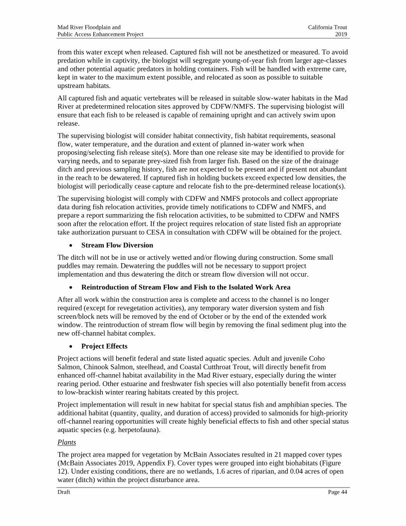
Mad River Floodplain and California Trout
Public Access Enhancement Project 2019
Draft Page 44
from this water except when released. Captured fish will not be anesthetized or measured. To avoid
predation while in captivity, the biologist will segregate young-of-year fish from larger age-classes
and other potential aquatic predators in holding containers. Fish will be handled with extreme care,
kept in water to the maximum extent possible, and relocated as soon as possible to suitable
upstream habitats.
All captured fish and aquatic vertebrates will be released in suitable slow-water habitats in the Mad
River at predetermined relocation sites approved by CDFW/NMFS. The supervising biologist will
ensure that each fish to be released is capable of remaining upright and can actively swim upon
release.
The supervising biologist will consider habitat connectivity, fish habitat requirements, seasonal
flow, water temperature, and the duration and extent of planned in-water work when
proposing/selecting fish release site(s). More than one release site may be identified to provide for
varying needs, and to separate prey-sized fish from larger fish. Based on the size of the drainage
ditch and previous sampling history, fish are not expected to be present and if present not abundant
in the reach to be dewatered. If captured fish in holding buckets exceed expected low densities, the
biologist will periodically cease capture and relocate fish to the pre-determined release location(s).
The supervising biologist will comply with CDFW and NMFS protocols and collect appropriate
data during fish relocation activities, provide timely notifications to CDFW and NMFS, and
prepare a report summarizing the fish relocation activities, to be submitted to CDFW and NMFS
soon after the relocation effort. If the project requires relocation of state listed fish an appropriate
take authorization pursuant to CESA in consultation with CDFW will be obtained for the project.
• Stream Flow Diversion
The ditch will not be in use or actively wetted and/or flowing during construction. Some small
puddles may remain. Dewatering the puddles will not be necessary to support project
implementation and thus dewatering the ditch or stream flow diversion will not occur.
• Reintroduction of Stream Flow and Fish to the Isolated Work Area
After all work within the construction area is complete and access to the channel is no longer
required (except for revegetation activities), any temporary water diversion system and fish
screen/block nets will be removed by the end of October or by the end of the extended work
window. The reintroduction of stream flow will begin by removing the final sediment plug into the
new off-channel habitat complex.
• Project Effects
Project actions will benefit federal and state listed aquatic species. Adult and juvenile Coho
Salmon, Chinook Salmon, steelhead, and Coastal Cutthroat Trout, will directly benefit from
enhanced off-channel habitat availability in the Mad River estuary, especially during the winter
rearing period. Other estuarine and freshwater fish species will also potentially benefit from access
to low-brackish winter rearing habitats created by this project.
Project implementation will result in new habitat for special status fish and amphibian species. The
additional habitat (quantity, quality, and duration of access) provided to salmonids for high-priority
off-channel rearing opportunities will create highly beneficial effects to fish and other special status
aquatic species (e.g. herpetofauna).
Plants
The project area mapped for vegetation by McBain Associates resulted in 21 mapped cover types
(McBain Associates 2019, Appendix F). Cover types were grouped into eight biohabitats (Figure
12). Under existing conditions, there are no wetlands, 1.6 acres of riparian, and 0.04 acres of open
water (ditch) within the project disturbance area.
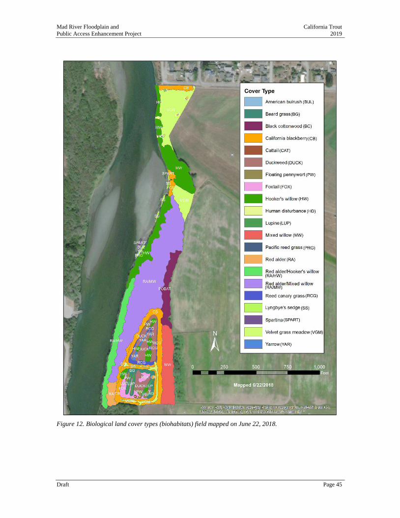
Mad River Floodplain and California Trout
Public Access Enhancement Project 2019
Draft Page 45
Figure 12. Biological land cover types (biohabitats) field mapped on June 22, 2018.
Mad River Floodplain and California Trout
Public Access Enhancement Project 2019
Draft Page 46
Red alder/mixed willow forest was the most abundant cover type (4.8 acres), followed by Hooker’s
willow (2.6 acres), velvet grass meadow (2.3 acres), and California blackberry (2.1 acres). All of
the woody riparian vegetation in the project area had a strong Hooker’s willow component.
Differences in stand structure (i.e., shrub-dominated vs. tree-dominated) and species composition
could be seen depending on the underlying geomorphic feature. For instance, the shrub-dominated
Hooker’s willow and short-tree-dominated red alder/Hooker’s willow stands occurred on the steep
streambank edges and bluff faces directly adjacent to the Mad River. When present in these stands,
red alder tended to be 12–15 inches dbh. Together, these two cover types represented younger
riparian vegetation in the project area. By contrast, the large-tree-dominated red alder/mixed
willow stands occurred on floodplain surfaces and had a more diverse tree canopy. Many of the red
alder trees in this stand type were upwards of 3 ft dbh.
During vegetation mapping, locations of two invasive plant species were mapped (Figure 13).
Periwinkle (Vinca major) is a moderately invasive non-native species that can grow rapidly in
shady, moist soil and form dense patches to the exclusion of native species. Periwinkle spreads
easily from stolons and root fragments, especially following earthwork and ground-clearing
activities (Cal-IPC 2009). Reed canary grass (Phalaris arundinacea) is a California native species
(Jepson Flora Project 2018) that also grows rapidly, especially in riparian areas.
The rare plant survey conducted for the project identified one small area (0.01 acres) of Lyngbye’s
sedge (Carex lyngbyei), which sensitive plant species associated with brackish marshes and tidally
influences sloughs and streambanks in the region and is present within and adjacent to the project
footprint along the right bank of the Mad River (Appendix G). The project is expanding wetland
habitat and function is and is thus expected to enhance habitat for this species by expanding the
floodplain and areas of tidal influence If feasible, the area of Lyngbye’s sedge will be flagged and
avoided during construction. If temporary and/or permanent impacts to Lyngbye’s sedge cannot
be avoided, the potential impact will be less than significance with the incorporation of Mitigation
Measure BIO-9. Mitigation Measures to protect botanical resources will result in a potential
impact that is less than significant.
Figure 13. Locations of periwinkle (Vinca major) and reed canary grass (Phalaris arundinacea) encountered
during 2018 vegetation mapping at the Mad River floodplain enhancement and restoration project.
Mad River Floodplain and California Trout
Public Access Enhancement Project 2019
Draft Page 47
Birds
Twenty-seven species of birds of conservation concern are considered (Slauson 2019, Appendix I),
including those with fully protected status by the CDFW. Fully protected species likely to occur in
the proposed project region, all potentially occurring species in the family Ardeidae (herons and
egrets) and birds of prey in the orders Falconiformes (diurnal raptors) and Strigiformes (owls)
(CDFG codes 3503.5 and 3505). Of the species likely to occur in the proposed project region, 2
species are listed as either threatened or endangered under the Federal ESA (Northern spotted owl,
Western snowy plover) and 3 under the California ESA (Northern spotted owl, Bank swallow,
Little willow flycatcher), and 20 are designated “Species of Special Concern” pursuant to CEQA.
With regard to federally listed species, critical habitat occurs within the project region for the
Western snowy plover (re-designated June 12, 2012; USFWS 2012a in Slauson 2019) and
Northern spotted owl (revised Dec 4, 2012b; USFWS 2008 in Slauson 2019).
Of the species listed under the Federal or State ESAs, potentially suitable habitat only occurs in or
near the proposed project area for the Little willow flycatcher. Two protocol surveys (Bombay et
al. 2003 in Slauson 2019) for this species were conducted during site visits in survey periods 2
(June 15-25th) and 3 (June 26th-July 15th) in 2018 with no detections. Several colony nesting
waterbirds forage in or adjacent to the proposed project site but none nesting colonies have been
detected in or near the proposed project site. Of the raptors species considered, most have been
detected foraging in or adjacent to the proposed project area, but nesting structures (large diameter
riparian or conifer trees) are not present to support nesting for most species with the exception of
the Cooper’s hawk and Great horned owl (Slauson 2019, Appendix I). Black-crowned night
herons were detected roosting communally along the main channel in several locations in close
proximity to the proposed project site during site visits in the non-nesting season. Three additional
birds species of conservation concern nest in or near the proposed project site, the Yellow warbler,
Yellow-breasted chat, and Black-capped chickadee and were all detected in the proposed project
area during site visits during the nesting season (Slauson 2019, Appendix I). Three pelagic species,
Fork-tailed storm-petrel, Tufted puffin, and Rhinoceros auklet were identified in the CNDDB
query but were not evaluated due to the lack of presence of pelagic habitats in or adjacent to the
proposed project site.
Mitigation Measures to protect birds will result in a potential impact that is less than significant.
Amphibians and Reptiles
Five species of amphibians and one species of reptile of conservation concern were considered
(Slauson 2019, Appendix I): Pacific tailed frog, Northern red-legged frog, Foothill yellow-legged
frog (FYLF), Southern torrent salamander (STSA), Del Norte salamander (DNSA), and Western
pond turtle (WPTU). Of these species, all five amphibians and the Western pond turtle are known
to occur or suitable habitat is known to be present in the Mad River and adjacent larger watersheds,
however suitable breeding habitat in the proposed project area is suspected only for the Northern
red-legged frog due to the salinity of the Mad River channel adjacent to the entire proposed project
site (FYLF, WPTU) and lack of suitable habitat for more upland forest associated salamanders (STSA, DNSA). The section of the Mad River channel adjacent to the proposed project site
routinely is contacted by salt water during daily high tide events when the river is at low summer
and fall flows preventing occupancy by salt water intolerant amphibians and reptiles. The extent of
the salt-water intrusion on the main channel of the Mad River is uncertain, but up-river tidal
influences appears to extend up to and potentially beyond the Hammond Bridge, up river of the
proposed project site. Several adult Northern red-legged frogs were detected in the riparian forest
just west and north of the percolation ponds in the proposed project site. It is also possible that the
percolation ponds may support breeding for this species. The Foothill yellow-legged frog is
designated by CDFW as a “Candidate Threatened Species” and the remaining four amphibians and
Mad River Floodplain and California Trout
Public Access Enhancement Project 2019
Draft Page 48
one reptile are designated as “Species of Special Concern” pursuant to CEQA (Slauson 2019,
Appendix I).
Mitigation Measures to protect amphibians and reptiles will result in a potential impact that is less
than significant.
Mammals
Seven species of mammals of conservation concern were considered in the wildlife investigation
(Slauson 2019): Townsend’s big-eared bat, Long-eared myotis, Sonoma tree vole, White-footed
vole, Humboldt mountain beaver, North American porcupine, and Pacific fisher. Of these, none
are listed as threatened or endangered pursuant to FESA or CESA, although one species, Pacific
fisher, is a candidate for both federal and state listing status. Five species are designated “Species
of Special Concern” pursuant to CEQA and none are USFWS “Species of Concern”. Of these
seven mammal species considered, only the two bat species have the potential to occur in the
project area and no suitable breeding season roosting or maternal colony structures are present in or
immediately adjacent to the proposed project site (Slauson 2019, Appendix I). Avoidance,
minimization, and mitigation measures for mammals were not recommended in the wildlife
investigation.
Invertebrates
Three species of insects and two species of mollusks were considered in the wildlife investigation
(Slauson 2019, Appendix I): Sandy beach tiger beetle, Western bumblebee, Obscure bumblebee,
Western pearshell, and California floater. Of these, only the two bumblebee species have the
potential to occur in the proposed project area. Avoidance, minimization, and mitigation measures
for invertebrates were not recommended in the wildlife investigation.
Mitigation Measures
BIO-1 Isolation of Work Area and Seasonal Window for In-Water Work
Isolation of the instream work area and construction related to the backwater off-channel
habitat complex shall only occur between July 1st and October 31st when freshwater inflow
and groundwater elevations are lowest and when the ground surface is dry and to reduce the
chance of stormwater runoff occurring during construction.
BIO-2 Preconstruction Surveys for Aquatic Species
Surveys of freshwater habitat by a qualified biologist for fish, amphibian, and reptile species
of concern shall occur two weeks prior to disturbance activities in the areas to be de-watered.
Immediately prior (1-3 days) to initiation of construction activities all dewatered channels
and adjacent habitat that will have vegetation removed or impacted by project activities
should be surveyed by a qualified biologist to detect and re-locate any amphibians that have
entered (dewatered ponds, channels) or reside (riparian vegetation) in these areas in the
proposed construction boundary. All species observed should be moved to an appropriate,
pre-determined relocation site, upstream from the footprint of the proposed construction
area.
Should construction activities cease for a period greater than two (2) days during damp
periods, when amphibians may be moving greater distances, the construction site should be
surveyed by a qualified biologist to detect and move and amphibians to an appropriate, pre-
determined relocation site, either upstream or downstream from the footprint of the proposed
construction area.
Mad River Floodplain and California Trout
Public Access Enhancement Project 2019
Draft Page 49
BIO-3 Removal of Aquatic Species Prior to Dewatering
A fish barrier will be installed at the entrance to the existing ditch to exclude fish from a
small wetted area within the zone of construction, near the entrance of the constructed off-
channel habitat complex. The fish barrier will be fully compliant with all CDFW and NMFS
requirements and installed under the supervision of a qualified fisheries biologist. Fish
capture and relocation of fish and herpetofauna will occur in accordance with CDFW and
NMFS protocols and guidelines to avoid impacts to sensitive species. Reintroduction of
stream flow will occur by removing the fish barrier and the final earth plug into the
constructed off-channel habitat complex.
BIO-4 Protection of Botanical Resources
Vegetative disturbance shall be contained within the limits of grading and kept to a
minimum area. Conduct pre-construction botanical surveys to detect and avoid or minimize
impacts by implementing suitable measures for impacting any special status plant species in
the proposed project site. If avoidance or minimization is not possible, develop mitigation
measures in cooperation with CDFW.
BIO-5 Seasonal Work Window to Protect Birds
No riparian or scrub habitats should be degraded or removed during the general breeding
period (February 1st through August 15th) for bird species likely to nest in the proposed
project area. No project activities resulting in noise disturbance should be conducted during
the general breeding period for birds (February 1st through August 15th) that may
potentially occur in or adjacent to the proposed project site. Noise disturbing activities are
defined as those resulting in volumes significantly greater than current ambient levels.
Should these seasonal restrictions to construction activities be unfeasible to the project
proponent, clearance surveys for potentially nesting birds should be conducted by a qualified
biologist to survey habitat that will be directly impacted by construction actives and within a
1,000 foot radius of said activities.
It is also recommended that should riparian vegetation removal be proposed to occur
between August 15th and August 31st, a minimum of one visit by a qualified biologist
should occur to detect any late-season active nesting birds immediately prior to vegetation
removal activities. This recommendation is based on recent evidence from elsewhere in the
proposed project region that native nesting birds, primarily residents (e.g., song sparrow)
often double brood near the coast and may have active nests beyond August 15th.
To the extent possible, minimize removal of large-diameter (≥12 inch DBH) riparian trees
and any trees with visible cavities capable of supporting breeding birds and roosting bats.
BIO-6 Protection of Willow Flycatcher
Willow flycatcher surveys, using the recommended survey protocol by CDFW (Bombay et
al. 2003 in Slauson) during the June and June-July survey periods, should be conducted by a
qualified biologist prior to the initiation of construction activities to identify occupied nesting habitat. Because Willow flycatchers are amongst the latest of the migratory species
to arrive and initiate nesting activities in Humboldt County, there is the potential that nesting
territories may remain active beyond August 15th. Should one or more occupied Willow
flycatcher nesting territories be located during these surveys, consultation with CDFW will
be necessary to evaluate appropriate mitigation measures to minimize degradation of each
nesting territory from proposed project activities that may degrade or remove riparian
habitat.
Mad River Floodplain and California Trout
Public Access Enhancement Project 2019
Draft Page 50
BIO-7 Protection of Northern Red-legged Frog
Construction activities in freshwater wetland habitat located in the percolation ponds work
should not occur during the breeding (January-May) and metamorphosis (June-August)
periods for the Northern Red-legged Frog. Should the project proponent wish to avoid
seasonal restrictions; clearance surveys for potentially breeding frogs should be conducted
by a qualified biologist in suitable habitat prior to the initiation of in-pond work (see below).
These surveys would need to be conducted within the proposed construction boundary no
more than 2 weeks prior to the start of in-stream activities. If larvae or eggs are detected, the
biologist will relocate them to a suitable location outside of the proposed construction
boundary.
In the event that a Northern red-legged frog is observed within the construction boundary
during construction activities, in-stream work should be temporarily halted until the frog has
been moved to a safe location with suitable habitat outside of the construction area footprint.
BIO-8 Fish Protection
Avoid impacting all fish species present in the main Mad River channel by conducting all
construction activities prior to connecting the northern channel of the project to the main
river channel. If avoidance of aquatic connectivity of the main river channel until the
completion of the construction of all features is not possible, utilize a fish screen approved
by CDFW to block fish from entering the backwater channel during construction.
BIO-9 Protection of Lyngby’e Sedge
If temporary and/or permanent impacts to Lyngbye’s sedge cannot be avoided, it is
recommended that a mitigation and monitoring plan be developed with input from
permitting and resource agencies.
b) Would the project have a substantial adverse effect on any riparian habitat
or other sensitive natural community identified in local or regional plans,
policies, and regulations or by the California Department of Fish and Game
or U.S. Fish and Wildlife Service?
Thresholds of Significance
A net reduction in area or ecological functions or values in riparian habitat or other sensitive
natural communities.
Assessment
Adverse impacts to riparian habitat and other sensitive natural communities will be less than
significant. Project activities encompass 9.3 acres within the 91.6-acre project area boundary.
Overall, the project will create 0.5 acres of new riparian habitat and 2.0 acres of new wetland
habitat, in addition to 1.4 acres of new open water habitat. Project actions will increase benefits to
riparian habitat and sensitive natural communities by increasing habitat extent, creating new
wetlands, and increasing wetland and riparian species diversity. Existing exotic invasive plants
such as periwinkle and reed canary grass will also be removed during project implementation.
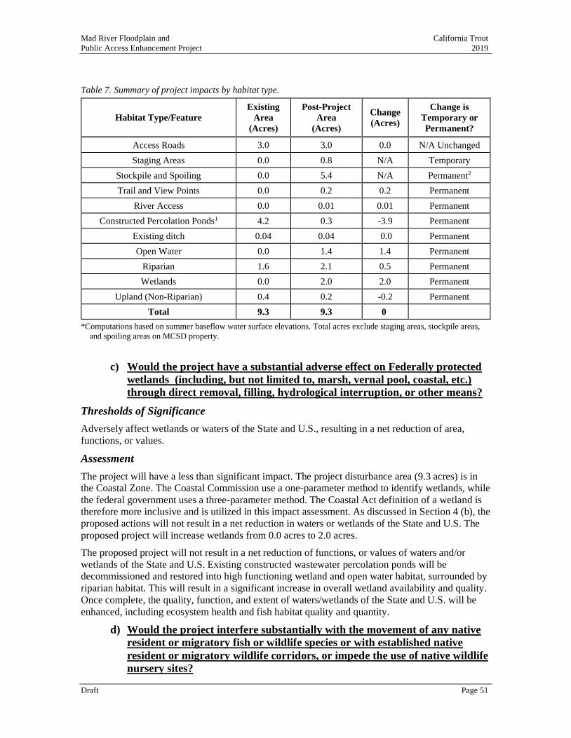
Mad River Floodplain and California Trout
Public Access Enhancement Project 2019
Draft Page 51
Table 7. Summary of project impacts by habitat type.
Habitat Type/Feature
Existing
Area
(Acres)
Post-Project
Area
(Acres)
Change
(Acres)
Change is
Temporary or
Permanent?
Access Roads 3.0 3.0 0.0 N/A Unchanged
Staging Areas 0.0 0.8 N/A Temporary
Stockpile and Spoiling 0.0 5.4 N/A Permanent2
Trail and View Points 0.0 0.2 0.2 Permanent
River Access 0.0 0.01 0.01 Permanent
Constructed Percolation Ponds1 4.2 0.3 -3.9 Permanent
Existing ditch 0.04 0.04 0.0 Permanent
Open Water 0.0 1.4 1.4 Permanent
Riparian 1.6 2.1 0.5 Permanent
Wetlands 0.0 2.0 2.0 Permanent
Upland (Non-Riparian) 0.4 0.2 -0.2 Permanent
Total 9.3 9.3 0
*Computations based on summer baseflow water surface elevations. Total acres exclude staging areas, stockpile areas,
and spoiling areas on MCSD property.
c) Would the project have a substantial adverse effect on Federally protected
wetlands (including, but not limited to, marsh, vernal pool, coastal, etc.)
through direct removal, filling, hydrological interruption, or other means?
Thresholds of Significance
Adversely affect wetlands or waters of the State and U.S., resulting in a net reduction of area,
functions, or values.
Assessment
The project will have a less than significant impact. The project disturbance area (9.3 acres) is in
the Coastal Zone. The Coastal Commission use a one-parameter method to identify wetlands, while
the federal government uses a three-parameter method. The Coastal Act definition of a wetland is
therefore more inclusive and is utilized in this impact assessment. As discussed in Section 4 (b), the
proposed actions will not result in a net reduction in waters or wetlands of the State and U.S. The
proposed project will increase wetlands from 0.0 acres to 2.0 acres.
The proposed project will not result in a net reduction of functions, or values of waters and/or
wetlands of the State and U.S. Existing constructed wastewater percolation ponds will be
decommissioned and restored into high functioning wetland and open water habitat, surrounded by
riparian habitat. This will result in a significant increase in overall wetland availability and quality.
Once complete, the quality, function, and extent of waters/wetlands of the State and U.S. will be
enhanced, including ecosystem health and fish habitat quality and quantity.
d) Would the project interfere substantially with the movement of any native
resident or migratory fish or wildlife species or with established native
resident or migratory wildlife corridors, or impede the use of native wildlife
nursery sites?
Mad River Floodplain and California Trout
Public Access Enhancement Project 2019
Draft Page 52
Thresholds of Significance
Long-term disruption of any native resident or migratory fish or wildlife species or with established
native resident or migratory wildlife corridors or impede the use of native wildlife nursery sites.
This includes physical alterations to topography, hydrology or vegetation that fragment contiguous
habitat areas.
Assessment
The project will have a less than significant impact. The project, for a short-term not, may disrupt
movement of aquatic fish and amphibians during construction in a small area that may be otherwise
be tidally inundated near the inlet of the proposed backwater channel located at the downstream
end of an existing floodplain. A fish screen will be installed at the bottom of the existing ditch to
protect fish and other aquatic species from potential construction-related impacts. The duration of
construction will be brief (a maximum of four months) and the impacted habitat (existing ditch) is
very poor. The excluded habitat is very small in size, may be dry regardless, and would provide
only marginal aquatic habitat, at best.
Exclusion of fish from this area, including dewatering activities, will require consultation with the
NMFS, including preparation of a Biological Assessment and resulting Biological Opinion for the
project to ensure compliance with the Endangered Species Act. Concurrently, consultation will also
occur with CDFW to ensure compliance with the California Endangered Species Act. Fish and
wildlife migration within the Mad River will not be impacted by project activities.
Once completed, fish migration to nursery sites will be significantly improved over existing
conditions due to the creation of the off-channel habitat and wetland complex, which will provide
new opportunities for fish rearing and refugia.
e) Would the project conflict with any local policies or ordinances protecting
biological resources, such as a tree preservation policy or ordinance?
Thresholds of Significance
Conflict with a local policy or ordinance to protect biological resources.
Assessment
The project will have no impact. The project does not conflict with any of Humboldt County’s
Local Coastal Program McKinleyville Community Area Plan (MCAP) Natural Resources
Protection Policies and Standards.
The project is located on diked former salt marsh and the property is zoned AE-P (Agricultural
Exclusive Public) and NR (Natural Resources). Land uses for AE lands are described in Section
3.30B2 of the MCAP. Agriculture is the principal use on AE lands, but watershed management,
fish and wildlife habitat, and recreational uses are also supported (Section 2722 (2) (F, G, and H)).
Allowable uses for public lands include fisheries and wildlife management, watershed
management, scientific research, interpretation/education and recreation, all of which are consistent
with project goals and objectives (Section 2762 (2)). Project activities are also consistent with development limitations in critical natural resource areas, such as streamside management zones
and wetlands (Section 3422 (4)).
The project is consistent with goals of the MCAP, including:
• To maintain the community’s rural qualities through protection of resource lands, riparian
corridors and open space areas (Section 2501).
• To identify and preserve wetlands, streams and their buffers to protect fisheries, preserve
natural habitats, and provide open space (Section 3421).
Mad River Floodplain and California Trout
Public Access Enhancement Project 2019
Draft Page 53
The project is consistent with natural resource related goals of the Humboldt County General Plan,
including:
• Section 3360: To maintain or enhance the quality of the County’s water resources and fish
and wildlife habitat utilizing those natural resources.
• Section 3362.7.A: Efforts designed to improve the anadromous fishery resources of
Humboldt County streams. Specifically, the assessment of the natural capacities of the
streams and identifications of factors limiting production of anadromous fish.
Portions of the project area located in Streamside Management Areas. As such, the project will
require a special permit from Humboldt County and planning review and approval of proposed
project activity within the Streamside Management Zones. As described in Section 3432.6.A. and
3432.6.G of the Humboldt County General Plan, allowable development activities within
Streamside Management Areas include both fishery, wildlife, and aquaculture enhancement and
restoration projects, as well as new fencing, so long as it would not impede the natural drainage or
would not adversely affect the stream environment or wildlife. The project is required to obtain a
Conditional Use Permit from Humboldt County, during which time the project will be reviewed for
consistency and approval under established requirements for Streamside Management Areas, tree
removal requirements, and related policies.
f) Would the project conflict with the provisions of an adopted Habitat
Conservation Plan, Natural Community Conservation Plan, or other
approved local, regional, or State habitat conservation plan?
Thresholds of Significance
Obstruct or prevent the recovery of any listed species covered in an adopted Habitat Conservation
Plan, Natural Community Conservation Plan, or other approved local, regional or state habitat
conservation plan
Assessment
The project will have no impact. There is not an adopted Habitat Conservation Plan or Natural
Community Conservation Plan for the project area.
Mad River Floodplain and California Trout
Public Access Enhancement Project 2019
Draft Page 54
5. CULTURAL RESOURCES
Would the project: Potentially Significant
Impact
Less Than Significant with
Mitigation
Incorporated
Less Than Significant
Impact No Impact
a) Cause a substantial adverse change in the significance of a
historical resource pursuant to §15064.5? ✓
b) Cause a substantial adverse change in the significance of an
archaeological resource pursuant to §15064.5? ✓
c) Disturb any human remains, including those interred outside of
formal cemeteries? ✓
An Archaeological Survey Report (ASR) was prepared for the project and is available in Appendix
J (Salisbury and Roscoe 2019). The analysis presented in this section is based upon the results of
the ASR.
a-b) Would the project cause a substantial adverse change in the significance of
a historical resource as defined in § 15064.5?
Thresholds of Significance
Result in physical changes in the significance of a historical or cultural resource as defined in
CEQA Guidelines Section 15064.5.
Assessment
Based on the ASR, no historical, tribal cultural, or unique archaeological resources, as defined in
14 CCR 15064.5(a), and PRC Sections 21074, and 21083.2(g), were identified in the project area
during this investigation. This supports a finding that the proposed project will not cause a
substantial adverse change in the significance of an historical resource (Public Resources Code,
Section 21084.1) (Salsibury and Roscoe 2019).
The proposed project activities could have the potential to inadvertently uncover subsurface
archaeological material. In the event that materials or remains are unearthed, Mitigation Measure
CR-1 would ensure potential project impacts on inadvertently discovered historical resources are
eliminated or reduced to less than significant levels.
Mitigation Measures
CR-1 Inadvertent Discovery of Archaeological Material The following provides means of responding to the circumstance of a significant discovery
during the cultural monitoring of the final implementation of the proposed agricultural
development within the project parcel. If cultural materials for example: chipped or ground
stone, historic debris, building foundations, or bone are discovered during ground-
disturbance activities, work shall be stopped within 20 meters (66 feet) of the discovery, per the requirements of CEQA (Title 14 CCR 15064.5 (f)). Work near the archaeological finds
shall not resume until a professional archaeologist, who meets the Secretary of the Interior’s Standards and Guidelines, has evaluated the materials and offered recommendations for
further action.
c) Would the project disturb any human remains, including those interred
outsides of formal cemeteries?
Thresholds of Significance
Disturbance of human remains.
Mad River Floodplain and California Trout
Public Access Enhancement Project 2019
Draft Page 55
Assessment
While the ASR did not identify historical, tribal cultural, or unique archaeological resources
(Salisbury and Roscoe 2019), Mitigation Measure CR-2 has been incorporated into the project in
the event activities inadvertently uncover human remains.
Mitigation Measures
CR-2 Inadvertent Discovery of Human Remains
If human remains are discovered during project construction, work will stop at the discovery
location, within 20 meters (66 feet), and any nearby area reasonably suspected to overlie
adjacent to human remains (Public Resources Code, Section 7050.5). The Humboldt County
coroner will be contacted to determine if the cause of death must be investigated. If the
coroner determines that the remains are of Native American origin, it is necessary to comply
with state laws relating to the disposition of Native American burials, which fall within the
jurisdiction of the NAHC (Public Resources Code, Section 5097). The coroner will contact
the NAHC. The descendants or most likely descendants of the deceased will be contacted,
and work will not resume until they have made a recommendation to the landowner or the
person responsible for the excavation work for means of treatment and disposition, with
appropriate dignity, of the human remains and any associated grave goods, as provided in
Public Resources Code, Section 5097.98.
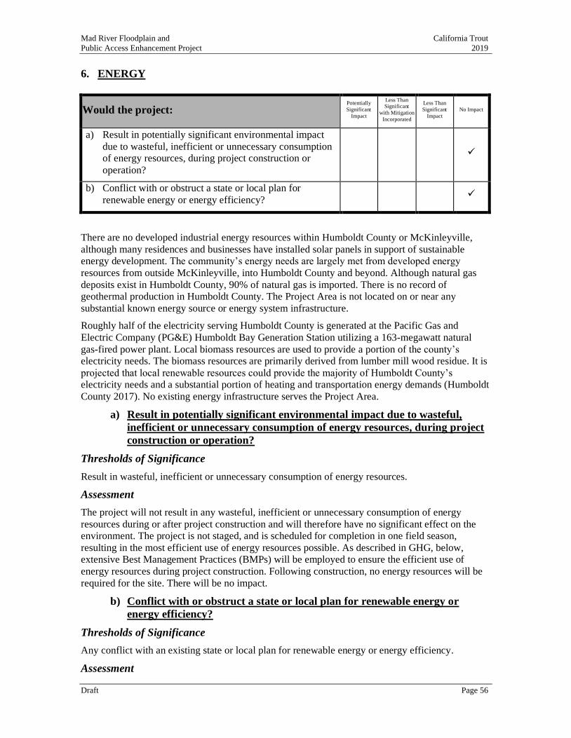
Mad River Floodplain and California Trout
Public Access Enhancement Project 2019
Draft Page 56
6. ENERGY
Would the project: Potentially
Significant
Impact
Less Than Significant
with Mitigation
Incorporated
Less Than
Significant
Impact
No Impact
a) Result in potentially significant environmental impact
due to wasteful, inefficient or unnecessary consumption
of energy resources, during project construction or
operation?
✓
b) Conflict with or obstruct a state or local plan for
renewable energy or energy efficiency? ✓
There are no developed industrial energy resources within Humboldt County or McKinleyville,
although many residences and businesses have installed solar panels in support of sustainable
energy development. The community’s energy needs are largely met from developed energy
resources from outside McKinleyville, into Humboldt County and beyond. Although natural gas
deposits exist in Humboldt County, 90% of natural gas is imported. There is no record of
geothermal production in Humboldt County. The Project Area is not located on or near any
substantial known energy source or energy system infrastructure.
Roughly half of the electricity serving Humboldt County is generated at the Pacific Gas and
Electric Company (PG&E) Humboldt Bay Generation Station utilizing a 163-megawatt natural
gas-fired power plant. Local biomass resources are used to provide a portion of the county’s
electricity needs. The biomass resources are primarily derived from lumber mill wood residue. It is
projected that local renewable resources could provide the majority of Humboldt County’s
electricity needs and a substantial portion of heating and transportation energy demands (Humboldt
County 2017). No existing energy infrastructure serves the Project Area.
a) Result in potentially significant environmental impact due to wasteful,
inefficient or unnecessary consumption of energy resources, during project
construction or operation?
Thresholds of Significance
Result in wasteful, inefficient or unnecessary consumption of energy resources.
Assessment
The project will not result in any wasteful, inefficient or unnecessary consumption of energy
resources during or after project construction and will therefore have no significant effect on the
environment. The project is not staged, and is scheduled for completion in one field season,
resulting in the most efficient use of energy resources possible. As described in GHG, below,
extensive Best Management Practices (BMPs) will be employed to ensure the efficient use of
energy resources during project construction. Following construction, no energy resources will be
required for the site. There will be no impact.
b) Conflict with or obstruct a state or local plan for renewable energy or
energy efficiency?
Thresholds of Significance
Any conflict with an existing state or local plan for renewable energy or energy efficiency.
Assessment

Mad River Floodplain and California Trout
Public Access Enhancement Project 2019
Draft Page 57
Humboldt County has not yet adopted a renewable energy plan, although such a plan is presently in
development in cooperation with the Redwood Coast Energy Authority. The project will not
conflict with any renewable energy or energy efficiency plan whatsoever. Therefore, the project
will have no impact on the environment.
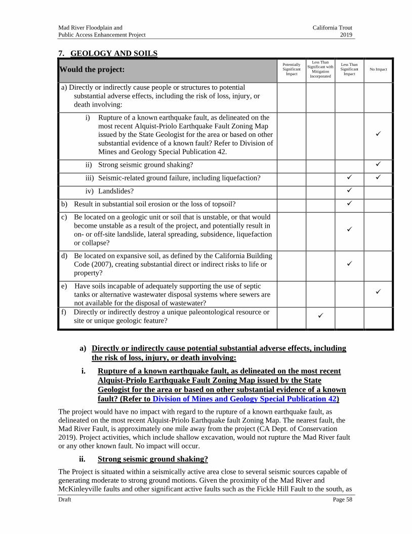
Mad River Floodplain and California Trout
Public Access Enhancement Project 2019
Draft Page 58
7. GEOLOGY AND SOILS
Would the project: Potentially Significant
Impact
Less Than Significant with
Mitigation
Incorporated
Less Than Significant
Impact No Impact
a) Directly or indirectly cause people or structures to potential
substantial adverse effects, including the risk of loss, injury, or
death involving:
i) Rupture of a known earthquake fault, as delineated on the
most recent Alquist-Priolo Earthquake Fault Zoning Map
issued by the State Geologist for the area or based on other
substantial evidence of a known fault? Refer to Division of
Mines and Geology Special Publication 42.
✓
ii) Strong seismic ground shaking? ✓
iii) Seismic-related ground failure, including liquefaction? ✓ ✓
iv) Landslides? ✓
b) Result in substantial soil erosion or the loss of topsoil? ✓
c) Be located on a geologic unit or soil that is unstable, or that would
become unstable as a result of the project, and potentially result in
on- or off-site landslide, lateral spreading, subsidence, liquefaction
or collapse?
✓
d) Be located on expansive soil, as defined by the California Building
Code (2007), creating substantial direct or indirect risks to life or
property?
✓
e) Have soils incapable of adequately supporting the use of septic
tanks or alternative wastewater disposal systems where sewers are
not available for the disposal of wastewater?
✓
f) Directly or indirectly destroy a unique paleontological resource or
site or unique geologic feature? ✓
a) Directly or indirectly cause potential substantial adverse effects, including
the risk of loss, injury, or death involving:
i. Rupture of a known earthquake fault, as delineated on the most recent
Alquist-Priolo Earthquake Fault Zoning Map issued by the State
Geologist for the area or based on other substantial evidence of a known
fault? (Refer to Division of Mines and Geology Special Publication 42)
The project would have no impact with regard to the rupture of a known earthquake fault, as
delineated on the most recent Alquist-Priolo Earthquake fault Zoning Map. The nearest fault, the
Mad River Fault, is approximately one mile away from the project (CA Dept. of Conservation
2019). Project activities, which include shallow excavation, would not rupture the Mad River fault
or any other known fault. No impact will occur.
ii. Strong seismic ground shaking?
The Project is situated within a seismically active area close to several seismic sources capable of
generating moderate to strong ground motions. Given the proximity of the Mad River and
McKinleyville faults and other significant active faults such as the Fickle Hill Fault to the south, as
Mad River Floodplain and California Trout
Public Access Enhancement Project 2019
Draft Page 59
well as other active faults within and offshore of northern California, the project site could
experience strong ground shaking during the economic life span of the proposed development.
The Mad River fault is located approximately one mile east of the project, and is the closest
recognized active fault (CA Dept. of Conservation 2019). The project site is not located within an
Alquist-Priolo earthquake fault zone, in which the State requires special studies for structures for
human occupancy. Due to the distance from the project site to the nearest recognized active fault,
and based on the information available, the potential for ground surface fault rupture to occur at the
project site is considered low. Project implementation would not increase risk of strong seismic
ground shaking or exposure to strong seismic ground shaking above existing conditions.
iii, iv, c, d Seismic-related ground failure, including liquefaction, landslides or
otherwise unstable soils?
Liquefaction is a phenomenon involving loss of soil strength and resulting in fluid mobility through
the soil. Liquefaction typically occurs when loose, uniformly-sized, saturated sands or silts are
subjected to repeated shaking in areas where the groundwater is less than 50 feet below ground
surface. In addition to the necessary soil and groundwater conditions, the ground acceleration must
be high enough, and the duration of the shaking must be sufficient, for liquefaction to occur. Given
strong ground shaking, these conditions have been met at the project site.
The potential for liquefaction-related settlement exists at the project site. Earthquake-related
liquefaction could result in sand boils and minor differential settlement on the site; however, lateral
spreading due to liquefaction is not anticipated to affect the project site given that there are no free
faces of significance nearby. Project implementation would not increase risk of liquefaction or
exposure to liquefaction above existing conditions and no impact would occur.
The project area includes gentle sloping, located in the Mad River bottomlands and also includes
the bank of the Mad River, which has previously been rip rapped by Humboldt County to prevent
erosion caused by high flows, not landslides. Steep slopes and hillslopes are not present within the
project corridor. Thus, landslides within or near the project area are unlikely to occur, and the
potential for landslide occurrence is not increased by the project. The impact would be less than
significant
b) Would the project result in substantial soil erosion or the loss of topsoil?
Thresholds of Significance
Substantial acceleration of the rate of soil erosion at the project site or the loss of top soil.
Assessment
Construction activities, including cut, fill, removal of vegetation, and operation of heavy machinery
would disturb soil and, therefore, have the potential to cause erosion. All non-upland construction
will occur between July 1 and October 31 when the ground surface is dry to reduce the chance of
stormwater runoff occurring during construction and when surface and groundwater contributions
to the project area and at their annual minimum.
These activities would be performed in compliance with the BMPs prescribed by MCSD,
NCRWQCB regulations and the California Building Code (CBC). BMPs may include: silt fences,
straw wattles, soil stabilization controls, site watering for controlling dust, and sediment detention
basins. Additionally, fill placement in the project area would not occur when the area is inundated.
If required by the NCRWCB, a SWPPP will be prepared, which would be required prior to any
grading or construction activities in excess of one acre. Therefore, no substantial soil erosion or
loss of topsoil would result from the Project, and the potential impact would be less than
significant.
e) Would the project have soils incapable of adequately supporting the use of
Mad River Floodplain and California Trout
Public Access Enhancement Project 2019
Draft Page 60
septic tanks or alternative wastewater disposal systems where sewers are
not available for the disposal of wastewater?
Thresholds of Significance
Located on underlying soils that are not capable of adequately filtering wastewater or alternative
waste water disposal systems.
Assessment
There will be no impact. Wastewater is not an included project element.
f) Directly or indirectly destroy a unique paleontological resource or site or
unique geologic feature?
Thresholds of Significance
Paleontological resources may be impacted by the project.
Assessment
Paleontological resources are the remains or traces of prehistoric animals and plants.
Paleontological resources, which include fossil remains and geologic sites with fossil-bearing strata
are non-renewable and scarce and are a sensitive resource afforded protection under environmental
legislation in California. Under California PRC Section 5097.5, unauthorized disturbance or
removal of a fossil locality or remains on public land is a misdemeanor. State law also requires
reasonable mitigation of adverse environmental impacts that result from development of public
land and affect paleontological resources (PRC Section 30244).
According to the Humboldt County General Plan (2017), the geology of the Mad-Redwood Basin
is complex and variable. The basin includes the Mad River, Redwood Creek, Eureka Plain, and
Trinidad planning watersheds which all differ in their bedrock composition. Mad River, Redwood
Creek, and Trinidad are composed primarily of Franciscan rock types, while Eureka Plain is mostly
younger sedimentary rock.
It is unlikely that project construction would impact potentially significant paleontological
resources; however, there is the possibility of discovering unique paleontological resources or
unique geologic features during construction. Mitigation Measure GEO-1 is included in event
paleontological resources are inadvertently discovered within the project area during construction,
reducing the potential impact to less than significant.
Mitigation Measures
GEO-1 Inadvertent Discovery of Paleontological Resources
If potential paleontological resources are encountered during project subsurface construction
activities or geotechnical testing, all work within 50 feet of the find shall be stopped, and a
qualified archaeologist shall be contacted to evaluate the find, determine its significance, and
identify any required mitigation. The applicant shall be responsible for implementing the
mitigation prior to construction activities being re-started at the discovery site.
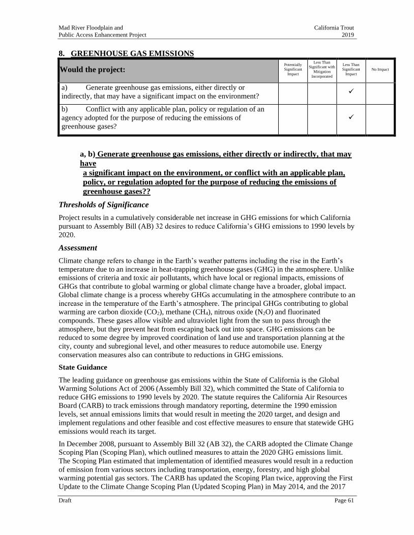
Mad River Floodplain and California Trout
Public Access Enhancement Project 2019
Draft Page 61
8. GREENHOUSE GAS EMISSIONS
Would the project: Potentially Significant
Impact
Less Than Significant with
Mitigation
Incorporated
Less Than Significant
Impact No Impact
a) Generate greenhouse gas emissions, either directly or
indirectly, that may have a significant impact on the environment? ✓
b) Conflict with any applicable plan, policy or regulation of an
agency adopted for the purpose of reducing the emissions of
greenhouse gases?
✓
a, b) Generate greenhouse gas emissions, either directly or indirectly, that may
have
a significant impact on the environment, or conflict with an applicable plan,
policy, or regulation adopted for the purpose of reducing the emissions of
greenhouse gases??
Thresholds of Significance
Project results in a cumulatively considerable net increase in GHG emissions for which California
pursuant to Assembly Bill (AB) 32 desires to reduce California’s GHG emissions to 1990 levels by
2020.
Assessment
Climate change refers to change in the Earth’s weather patterns including the rise in the Earth’s
temperature due to an increase in heat-trapping greenhouse gases (GHG) in the atmosphere. Unlike
emissions of criteria and toxic air pollutants, which have local or regional impacts, emissions of
GHGs that contribute to global warming or global climate change have a broader, global impact.
Global climate change is a process whereby GHGs accumulating in the atmosphere contribute to an
increase in the temperature of the Earth’s atmosphere. The principal GHGs contributing to global warming are carbon dioxide (CO2), methane (CH4), nitrous oxide (N2O) and fluorinated
compounds. These gases allow visible and ultraviolet light from the sun to pass through the
atmosphere, but they prevent heat from escaping back out into space. GHG emissions can be
reduced to some degree by improved coordination of land use and transportation planning at the
city, county and subregional level, and other measures to reduce automobile use. Energy
conservation measures also can contribute to reductions in GHG emissions.
State Guidance
The leading guidance on greenhouse gas emissions within the State of California is the Global
Warming Solutions Act of 2006 (Assembly Bill 32), which committed the State of California to
reduce GHG emissions to 1990 levels by 2020. The statute requires the California Air Resources
Board (CARB) to track emissions through mandatory reporting, determine the 1990 emission
levels, set annual emissions limits that would result in meeting the 2020 target, and design and
implement regulations and other feasible and cost effective measures to ensure that statewide GHG
emissions would reach its target.
In December 2008, pursuant to Assembly Bill 32 (AB 32), the CARB adopted the Climate Change
Scoping Plan (Scoping Plan), which outlined measures to attain the 2020 GHG emissions limit.
The Scoping Plan estimated that implementation of identified measures would result in a reduction
of emission from various sectors including transportation, energy, forestry, and high global
warming potential gas sectors. The CARB has updated the Scoping Plan twice, approving the First
Update to the Climate Change Scoping Plan (Updated Scoping Plan) in May 2014, and the 2017
Mad River Floodplain and California Trout
Public Access Enhancement Project 2019
Draft Page 62
Scoping Plan in December 2017. The 2017 Scoping Plan identifies progress made to meet the near-
term (2020) objectives of AB 32 and defines California’s climate change priorities and activities
for the next several years (CARB 2017). The 2017 Climate Change Scoping Plan provides
strategies for meeting the mid-term 2030 greenhouse gas reduction target of 40 percent below 1990
levels by year 2030 set by SB 32. The plan also identifies how the State can substantially advance
toward the 2050 greenhouse gas reduction target of Executive Order S-3-05, which consists of
reducing greenhouse gas emissions to 80 percent below 1990 levels.
Regional Guidance
The NCUAQMD does not have rules, regulations, or thresholds of significance for non-stationary
GHG emissions. In 2011, the NCUAQMD adopted Rule 111 - Federal Permitting Requirements for
Sources of Greenhouse Gases to establish a threshold above which New Source Review and federal
Title V permitting applies and to establish federally enforceable limits on potential to emit GHGs
for stationary sources. These are considered requirements for stationary sources, and should not be
used as a threshold of significance for non-stationary source Projects. For reference, Rule 111
Section D(1)(a) and D(1)(b) have applicability thresholds of 75,000 MTCO2e per year and 100,000
MTCO2e per year.
Humboldt County
In cooperation with Redwood Coast Energy Authority, Humboldt County is currently developing a
Climate Action Plan, which would address greenhouse gas emissions. The plan is not yet complete.
9.1..1 Project Impacts
Construction
Project construction activities would result in a temporary increase in GHG emissions, including
exhaust emissions from on-road trucks, worker commute vehicles, and off-road heavy-duty
machinery. Construction would require clearing, earthmoving, and delivery equipment, as used for
similar projects, and which have been accounted for in the State’s emission inventory and reduction
strategy for both on and off-road vehicles. Construction emissions were estimated using CalEEMod
version 2016.3.2, and are estimated to be approximately 88 MTCO2e from all construction
activities over the construction period. The project’s construction emissions equal 7,589
pounds/day of CO2e (Appendix L).
In addition, although project construction may benefit (have a reduced generation of GHG) from
implementation of some of the State-level regulations and policies, the project would not impede
the State in meeting the AB 32 greenhouse gas reduction goals. Therefore, impacts from the
project’s construction emissions would be less than significant.
Operation
Project operation would not result in a new source of GHG emissions. There would be no
operational impact.
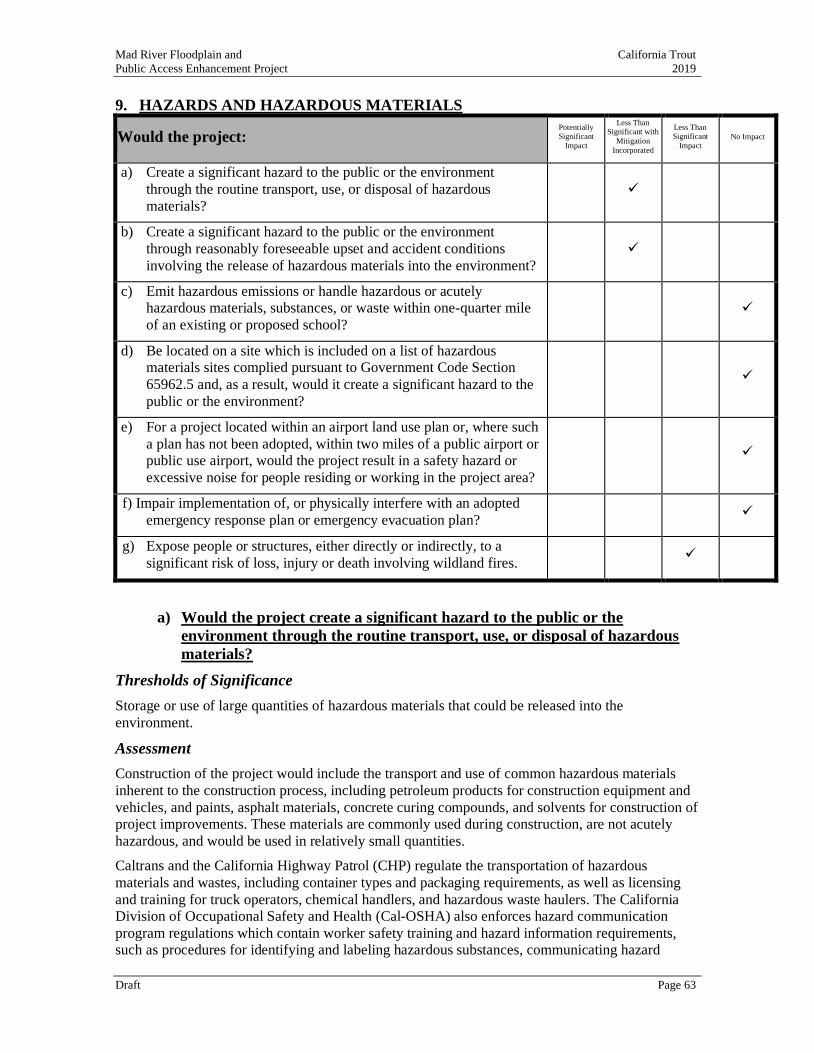
Mad River Floodplain and California Trout
Public Access Enhancement Project 2019
Draft Page 63
9. HAZARDS AND HAZARDOUS MATERIALS
Would the project: Potentially Significant
Impact
Less Than Significant with
Mitigation
Incorporated
Less Than Significant
Impact No Impact
a) Create a significant hazard to the public or the environment
through the routine transport, use, or disposal of hazardous
materials?
✓
b) Create a significant hazard to the public or the environment
through reasonably foreseeable upset and accident conditions
involving the release of hazardous materials into the environment?
✓
c) Emit hazardous emissions or handle hazardous or acutely
hazardous materials, substances, or waste within one-quarter mile
of an existing or proposed school?
✓
d) Be located on a site which is included on a list of hazardous
materials sites complied pursuant to Government Code Section
65962.5 and, as a result, would it create a significant hazard to the
public or the environment?
✓
e) For a project located within an airport land use plan or, where such
a plan has not been adopted, within two miles of a public airport or
public use airport, would the project result in a safety hazard or
excessive noise for people residing or working in the project area?
✓
f) Impair implementation of, or physically interfere with an adopted
emergency response plan or emergency evacuation plan? ✓
g) Expose people or structures, either directly or indirectly, to a
significant risk of loss, injury or death involving wildland fires. ✓
a) Would the project create a significant hazard to the public or the
environment through the routine transport, use, or disposal of hazardous
materials?
Thresholds of Significance
Storage or use of large quantities of hazardous materials that could be released into the
environment.
Assessment
Construction of the project would include the transport and use of common hazardous materials
inherent to the construction process, including petroleum products for construction equipment and
vehicles, and paints, asphalt materials, concrete curing compounds, and solvents for construction of
project improvements. These materials are commonly used during construction, are not acutely
hazardous, and would be used in relatively small quantities.
Caltrans and the California Highway Patrol (CHP) regulate the transportation of hazardous
materials and wastes, including container types and packaging requirements, as well as licensing
and training for truck operators, chemical handlers, and hazardous waste haulers. The California
Division of Occupational Safety and Health (Cal-OSHA) also enforces hazard communication
program regulations which contain worker safety training and hazard information requirements,
such as procedures for identifying and labeling hazardous substances, communicating hazard
Mad River Floodplain and California Trout
Public Access Enhancement Project 2019
Draft Page 64
information related to hazardous substances and their handling, and preparation of health and
safety plans to protect workers and employees.
Project construction would be required to implement storm water best management practices
during construction.
MCSD and its contractors would comply with existing and future hazardous materials laws and
regulations and applicable best management practices addressing the transport, storage, use, and
disposal of hazardous materials, including BMPs included in Mitigation Measure HAZ-1. With the
implementation of Mitigation Measure HAZ-1, the potential impact would be less than significant.
Following construction, operation of the Project would not result in the need for new hazardous
materials that would need to be transported, used, or disposed. No operational impact would occur.
Mitigation Measures
HAZ-1 Management of Hazardous Materials On-Site
During construction, the following BMPs will be implemented;
• Heavy equipment used in the project shall be in good condition and shall be inspected for
leakage of coolant and petroleum products and repaired, if necessary, before work is
started.
• Equipment operators shall be trained in the procedures to be taken should an accidental
spill occur.
• Prior to the onset of work, the contractor shall prepare a plan for the prompt and effective
response to any accidental spills.
• Absorbent materials designed for spill containment and cleanup shall be kept at the project
site for use in case of an accidental spill.
• Refueling of equipment shall occur within the staging area or a minimum of 150 feet away
from stream channels or perennial wetlands. All refueling will occur on a pad to capture
any drips or spills.
• If equipment must be washed, washing shall occur off-site.
• Stationary equipment shall be positioned over drip pans.
b) Would the project create a significant hazard to the public or the
environment through reasonably foreseeable upset and accident conditions
involving the release of hazardous materials into the environment?
Thresholds of Significance
Project involves the use of large quantities of hazardous materials.
Assessment
The Project would utilize heavy machinery to perform some tasks including grading, paving, and
transportation of materials. There is always the possibility when equipment is operating that an
accident could occur and fuel could be released onto the soil. Equipment on site during
construction would be required to have emergency spill cleanup kits immediately accessible in the
Mad River Floodplain and California Trout
Public Access Enhancement Project 2019
Draft Page 65
case of any fuel or oil spills. The implementation of Mitigation Measure HAZ-2 will further reduce
the potential impact to a level that is less than signification.
Mitigation Measures
HAZ-2 Spill Prevention
Equipment on site during construction shall be required to have emergency spill cleanup kits
immediately accessible in the case of any fuel or oil spills. Staging, fueling and maintenance
of equipment shall be conducted only in in staging areas or no closer than 150 ft from open
water or in any location where hazardous material spills could become entrained in flowing
water.
c) Would the project emit hazardous emissions or handle hazardous or acutely
hazardous materials, substances, or waste within one-quarter mile of an
existing or proposed school?
Thresholds of Significance
Project is located within 1/4 of mile of a school and involves the use of large quantities of
hazardous materials.
Assessment
The project is not located within ¼ mile of a school. There will be no impact.
d) Would the project be located on a site which is included on a list of
hazardous materials sites complied pursuant to Government Code Section
65962.5 and, as a result, would it create a significant hazard to the public or
the environment?
Thresholds of Significance
The project is located on a site which is included on a list of hazardous materials sites compiled
pursuant to Government Code Section 65962.5.
Assessment
The provisions in Government Code Section 65962.5 are commonly referred to as the "Cortese List." A search of the Cortese List search (CalEPA 2019) was completed to determine if any known
hazardous waste sites have been recorded on or adjacent to the Project alignment. The project is not
located on a hazardous materials site compiled pursuant to Government Code Section 65962.5.
There will be no impact.
e) If applicable, would the project be located within an airport land use plan
or, where such a plan has not been adopted, within two miles of a public
airport or public use airport, would the project result in a safety hazard or
excessive noise for people residing or working in the project area?
Thresholds of Significance
Project is located within an airport land use plan or, where such a plan has not been adopted, within
two miles of a public airport or public use airport.
Assessment
There will no impact. The project is located more than two miles from the Eureka/Arcata airport
located in northern McKinleyville.
f) Would the project impair implementation of, or physically interfere with an
Mad River Floodplain and California Trout
Public Access Enhancement Project 2019
Draft Page 66
adopted emergency response plan or emergency evacuation plan?
Thresholds of Significance
Project would prevent alerting and warning citizens, conducting evacuations, short-term feeding
and sheltering, conducting search and rescue operations or using emergency evacuation routes.
Assessment
The Humboldt County Emergency Operations Plan (Humboldt County 2015) does not designate
specific evacuation routes or emergency shelter locations, or include policies or procedures with
which the project would conflict. Therefore, the Project would not impair implementation of or
physically interfere with the plan. No impact would occur.
g) Would the project expose people or structures, either directly or indirectly,
to a significant risk of loss, injury or death involving wildland fires.
Thresholds of Significance
Project is in an area shown on a map used to identify wildland fire hazard areas. Potential exists for
a significant risk of loss, injury or death involving wildland fires.
Assessment
The California Department of Forestry and Fire Protection (CAL FIRE) is required by law to map
areas of significant fire hazards based on fuels, terrain, weather, and other relevant factors. These
Fire Hazard Severity Zones (FHSZ) influence how people construct buildings and protect property
to reduce risk associated with wildland fires. The project site is entirely located in a local
responsibility area (LRA) meaning an area where local governments have financial responsibility
for wildland fire protection (Humboldt County 2019). The project and surrounding vicinity have
not been classified with for Fire Hazard Severity (Humboldt County 2019). It is possible fire
ignition could occur during construction (e.g. related to heavy machinery usage). The project
would not otherwise increase exposure to wildlife fire above existing conditions. The impact would
be less than significant.
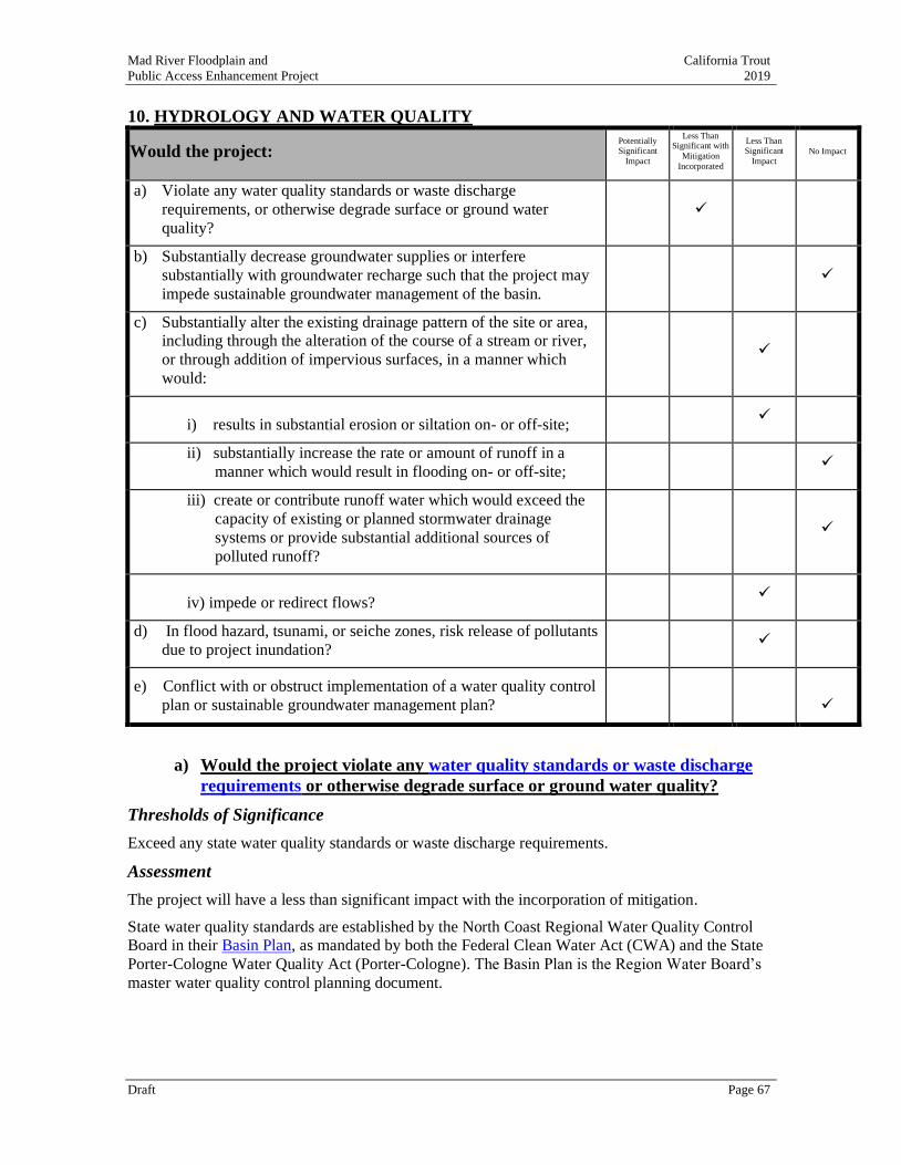
Mad River Floodplain and California Trout
Public Access Enhancement Project 2019
Draft Page 67
10. HYDROLOGY AND WATER QUALITY
Would the project: Potentially Significant
Impact
Less Than Significant with
Mitigation
Incorporated
Less Than Significant
Impact No Impact
a) Violate any water quality standards or waste discharge
requirements, or otherwise degrade surface or ground water
quality?
✓
b) Substantially decrease groundwater supplies or interfere
substantially with groundwater recharge such that the project may
impede sustainable groundwater management of the basin.
✓
c) Substantially alter the existing drainage pattern of the site or area,
including through the alteration of the course of a stream or river,
or through addition of impervious surfaces, in a manner which
would:
✓
i) results in substantial erosion or siltation on- or off-site; ✓
ii) substantially increase the rate or amount of runoff in a
manner which would result in flooding on- or off-site; ✓
iii) create or contribute runoff water which would exceed the
capacity of existing or planned stormwater drainage
systems or provide substantial additional sources of
polluted runoff?
✓
iv) impede or redirect flows? ✓
d) In flood hazard, tsunami, or seiche zones, risk release of pollutants
due to project inundation? ✓
e) Conflict with or obstruct implementation of a water quality control
plan or sustainable groundwater management plan?
✓
a) Would the project violate any water quality standards or waste discharge
requirements or otherwise degrade surface or ground water quality?
Thresholds of Significance
Exceed any state water quality standards or waste discharge requirements.
Assessment
The project will have a less than significant impact with the incorporation of mitigation.
State water quality standards are established by the North Coast Regional Water Quality Control
Board in their Basin Plan, as mandated by both the Federal Clean Water Act (CWA) and the State
Porter-Cologne Water Quality Act (Porter-Cologne). The Basin Plan is the Region Water Board’s
master water quality control planning document.
Mad River Floodplain and California Trout
Public Access Enhancement Project 2019
Draft Page 68
Sediment
Under the Basin Plan (Section 3.4.11), the suspended sediment load and suspended discharge rate
to surface waters shall not be altered in such a manner as to cause nuisance or adversely affect
beneficial uses.
Suspended Material
Under the Basin Plan (Section 3.4.13), waters shall not contain substances in concentrations that
result in deposition of material that causes nuisance or adversely affect beneficial uses.
Temperature
Temperature objectives are specified in the State Water Board’s Water Quality Control Plan for
Control of Temperature in the Coastal and Interstate Waters and Enclosed Bays of California
(Thermal Plan)’s. Further, Section 3.4.15 of the Basin plan establishes that at no time or place shall
the temperature of any COLD water be increased by more than 5 °F above natural receiving waters.
Turbidity
Under the Basin Plan (Section 3.4.17), turbidity shall not be increased more than 20% above
naturally occurring background levels. Allowable zones of dilution within which higher
percentages can be tolerated may be defined for specific discharges upon the issuance of discharge
permits or waiver thereof.
Project Activities
Primary project actions that could affect the Mad River, state water quality standards or waste
discharge requirements include excavating and grading channel features and connecting the new
off-channel habitat area to the Mad River, which will be the final step in the construction sequence.
All project construction activities will occur from July through October 30, consistent with
permitting requirements, to avoid stormwater runoff. All construction areas will be dewatered.
The project is not expected to affect water temperatures. However, the project may cause a short-
term increase in suspended materials and turbidity when the new channels are rewatered. Turbidity
pulses from watering new off-channel habitat features are not expected given the anticipated lack
of flow in both features at the end of the construction period in late summer or early fall.
A second small turbidity pulse is expected during the first rain after construction. The post-project
turbidity pulse should not exceed background turbidity present in Mad River estuary during rain
events, which is typically high. With the incorporation of Mitigation Measures HWQ-1 through
HWQ-6, these short-term increases will result in less than a significant impact.
Mitigation Measures
HWQ-1 Limit Construction Window
Construction related to the backwatered off-channel habitat complex shall only occur between July 1 and October 30 when the ground surface is dry and to reduce the chance of
stormwater runoff occurring during construction and when background freshwater inputs are
at summer baseflow thresholds. Excavated materials shall not be stockpiled overwinter. Sediment control measures shall be in place while materials are being stockpiled to minimize
sediment and pollutant transport from the project site.
HWQ-2 Placement of Fill to Protect Water Quality
Placement of fill in the project area shall occur when the area is not inundated by water.
HWQ-3 Excavation of Saturated Soils and Erosion Control
Excavation shall include handling of saturated soils. Saturated soils shall be dewatered
and/or transported saturated in a manner that prevents excess discharge or spillage of soils or
Mad River Floodplain and California Trout
Public Access Enhancement Project 2019
Draft Page 69
water within the construction access areas. A silt fence shall be installed around the
perimeter of temporary stockpiles of saturated soils to prevent runoff from leaving the site.
During construction, a silt fence shall be deployed to isolate work areas from existing
channels, and to trap suspended sediment that might leave the construction site if stormwater
runoff were to occur. If the silt fence is not adequately containing sediment, the construction
activity shall cease until remedial measures are implemented that prevent sediment from
entering the waters below.
HWQ-4 Limits to Materials Storage and Placement to Protect Waters
No construction materials, debris, or waste, shall be placed or stored where it may be
allowed to enter or be washed by rainfall into waters of the U.S./State. Soil and material
stockpiles shall be properly protected to minimize sediment and pollutant transport from the
construction site.
HWQ-5 Post-Construction Erosion Control
Following completion of excavation, placement of fill, and grading, all ground to the limits
of disturbance above the wetted water surface elevation shall be treated for erosion prior to
the onset of precipitation capable of generating run-off or the end of the yearly work period,
whichever comes first. Treated areas that are not exposed to tidal influence shall be mulched
with at least 2 to 4 inches of certified weed-free straw mulch with wheat or other straw for
riparian and wetland areas and rice straw for uplands and use of a seed mix with coverage
equivalent to 100 lbs/acre of native grass seed and appropriate riparian vegetation for
immediate erosion control. No annual (Italian) ryegrass (Lolium multiflorum) shall be used.
All temporary fill, synthetic mats and silt fences shall be removed from wetlands and waters
of the U.S./State immediately on cessation of construction. Biodegradable geotextile fabrics
shall be used, where possible.
HWQ-6 Implementation of Stormwater Best Management Practices
The following BMPs (California Storm Water Quality Association Storm Water Best
Management Practice (BMP) Handbook for Construction 2003) shall be implemented to
prevent entry of storm water runoff into the excavation site, the entrainment of excavated
contaminated materials leaving the site, and to prevent the entry of polluted storm water
runoff into the Mad River during the transportation and storage of excavated contaminated
materials:
• EC-2 Preservation of Existing Vegetation. The best way to prevent erosion is to not
disturb the land. To reduce the impacts of new development and redevelopment, projects
may be designed to avoid disturbing land in sensitive areas of the site. To the extent
feasible, and consistent with the project’s design, goals, and objectives, some existing
vegetation will be preserved on the site must be protected from mechanical and other
injury while the land is being developed. The purpose of protecting existing vegetation is
to ensure the survival of desirable vegetation for shade and erosion control.
• EC-6 Straw Mulch. Straw mulch is suitable for soil disturbed areas requiring temporary
protection until permanent stabilization is established. Where appropriate, weed-free
straw mulch will be used for erosion control on disturbed areas until soils can be
prepared for permanent vegetation. Straw mulch is also used in combination with
temporary and/or permanent seeding strategies to enhance plant establishment.
• EC-7 Geotextile and Mats. Mattings are commonly applied on short, steep slopes where
erosion hazard is high and vegetation will be slow to establish. Mattings are also used on
stream banks where moving water at velocities between 3 ft/s and 6 ft/s are likely to
Mad River Floodplain and California Trout
Public Access Enhancement Project 2019
Draft Page 70
wash out new vegetation, and in areas where the soil surface is disturbed and where
existing vegetation has been removed. Where appropriate, matting may also be used
when seeding cannot occur (e.g., late season construction and/or the arrival of an early
rain season). Erosion control matting will be considered in portions of the project area
where soils are fine grained and potentially erosive.
• EC-8 Wood Mulching. Wood mulching is suitable for disturbed soil areas requiring
temporary protection until permanent stabilization is established. The primary function
of wood mulching is to reduce erosion by protecting bare soil from rainfall impact,
increasing infiltration, and reducing runoff. Vegetation removed during construction will
be chipped on-site and reused as erosion control mulch where feasible and appropriate.
• EC-9 Earth Dikes and Drainage Swales. The temporary earth dike is a berm or ridge of
compacted soil, located in such a manner as to divert stormwater to a sediment trapping
device or a stabilized outlet, thereby reducing the potential for erosion and offsite
sedimentation. Where appropriate, earth dikes will also be used to divert runoff from off
site and from undisturbed areas away from disturbed areas and to divert sheet flows
away from unprotected slopes.
• SE-1 Silt Fences. Silt fences are suitable for perimeter control, placed below areas where
sheet flows discharge from the site. Where appropriate, they will be used as interior
controls below disturbed areas where runoff may occur in the form of sheet and rill
erosion. Silt fences are generally ineffective in locations where the flow is concentrated
and are only applicable for sheet or overland flows. Silt fences are most effective when
used in combination with erosion controls.
• NS-5 Clear Water Diversion. Clear water diversion consists of a system of structures and
measures that intercept clear surface water runoff upstream of a project, transport it
around the work area, and discharge it downstream with minimal water quality
degradation from either the project construction operations or the construction of the
diversion. Dewatering the in-channel work areas and establishing a flow bypass will
serve as the clear water diversion for the project.
• WM-3 Stockpile Management. Stockpile Management procedures and practices will be
designed to reduce or eliminate air and stormwater pollution from stockpiles of soil
excavated from in-channel and floodplain areas.
• WM-9 Sanitary/Septic Waste Management. Proper sanitary and septic waste
management prevent the discharge of pollutants to stormwater from sanitary and septic
waste will be provided via convenient, well-maintained facilities, and arranging for
regular service and disposal.
b) Substantially decrease groundwater supplies or interfere substantially with
groundwater recharge such that the project may impede sustainable
groundwater mangaement of the basin.
Thresholds of Significance
Substantially deplete groundwater supplies or interfere with groundwater recharge or lowering of
the local groundwater table.
Mad River Floodplain and California Trout
Public Access Enhancement Project 2019
Draft Page 71
Assessment
The project will have no impact. The project will have a beneficial effect on groundwater supplies
and will not negatively interfere with groundwater recharge or lower the local groundwater table.
The construction of off-channel habitat features, including surface lowering in and surrounding the
existing percolation ponds, will likely increase localized groundwater recharge within the
immediate project footprint and improve groundwater connectivity. Restoration of stream and
floodplain habitats will not deplete groundwater supplies, interfere with groundwater recharge, or
lower the local groundwater table.
c) Would the project substantially alter the existing drainage pattern of the
site or area, including through the alteration of the course of a stream or
river, or through the addition of impervious surfaces, in a manner which
would:
i. Result in substantial erosion or siltation on- or off-site?
Thresholds of Significance
Substantially alter existing drainage, increasing surface runoff and/or resulting in substantial
erosion or siltation on or off site.
Assessment
The project will have a less than significant impact.
Existing Drainage
Existing drainage infrastructure on the site includes:
• Humboldt County’s storm drain and piping.
This infrastructure will be protected in place without impact or alternative of the existing
drainage pattern.
• MCSD’s existing seasonal drainage ditch (storm water canal).
The outlet of the drainage ditch will be altered to merge with the constructed side channel at
the confluence with the mainstem Mad River. Otherwise, the drainage ditch will remain
unaffected. Its footprint and usage pattern will not be altered. Adjustments to the ditch’s
configuration will not alter the existing overall drainage pattern, alter the course of the Mad
River, or result in substantial erosion or siltation above existing contributions, which are
regulated through an existing NPDES permit associated with MCSD’s ongoing waste water
treatment operations.
• Natural drainage.
Existing non-point drainage from project area, particularly during high flow events in the Mad
River, drains directly back into the adjacent Mad River. This course of drainage will also not be altered through project activities, with the exception of the new off-channel habitat
complex, discussed below.
Alteration of the Course of a Stream or River
The project will create a new off-channel habitat complex that joins with the mainstem Mad River
to provide increased salmonid and aquatic habitat in the estuary. The off-channel habitat complex
will not alter the course of the Mad River, although minor localized modifications to the right bank
at the confluence of the new off-channel habitat complex will occur to support the new side
channel entrance (Appendix A, Design Sheet C1).
Mad River Floodplain and California Trout
Public Access Enhancement Project 2019
Draft Page 72
The new off-channel habitat complex will alter the drainage pattern of the project area, such that
waters will flow more directly between the Mad River and the off-channel ponds (both upstream
and downstream, depending on time of year, tidal cycle, and mainstem water surface elevation).
The off-channel habitat complex will also capture any waters from nearby and adjacent surfaces
during precipitation and/or flood events, more directly transporting these waters to the Mad River
through the new channel network, reducing the potential for non-point surface erosion.
Erosion or Siltation
Changes to drainage with the project area will not result in substantial changes to on-site or off-site
erosion or siltation. Short-term increases in erosion or siltation will be minimized and avoided
through standard BMPs, discussed above in Chapter 9(a), as well as through riparian and wetland
revegetation.
ii. Substantially increase the rate or amount of surface runoff in a
manner which would result in flooding on- or off-site?
Thresholds of Significance
Substantially alter surface runoff.
Assessment
The project will have a less than significant impact. Only a small amount of impervious surface
will be added to the project area to create a paved, short ADA trail and viewing platform. The
additions of paved surfaces are minor and will not increase surface run-off or contribute to flooding
on- or off-site.
iii. Substantially increase the rate or amount of surface runoff in a
manner which would result in flooding on- or off-site?
Thresholds of Significance
Increase the volume of surface runoff that potentially could cause localized flooding.
Assessment
The impact will be less than significant. Creation of the off-channel habitat complex, including the
restored wetland ponds, will lower surfaces elevations and expand the footprint of wetted habitats.
Under existing conditions, this area inundates during flood events (approximately 5-year events
and greater) and will continue to inundate in the future during similar flood events. Post-
construction, the inundation footprint is expected to expand, given the lowered surface elevations
within the off-channel alignment and the removal of the levees on three sides of the percolation
ponds to expand wetland and riparian habitats, consistent with project goals and objectives. An
increase in off-site flooding as a result of project actions will not occur.
iv. Create or contribute runoff water which would exceed the capacity of
existing or planned stormwater drainage systems or provide
substantial additional sources of polluted runnoff?
Thresholds of Significance
Runoff exceeds the capacity of existing or planned stormwater drainage systems or provides
substantial additional sources of polluted runoff.
Assessment
The impact will be less than significant. The project will not increase stormwater run-off, nor
introduce a new source of polluted runoff.
Mad River Floodplain and California Trout
Public Access Enhancement Project 2019
Draft Page 73
The project area is not paved and is a largely a flat, farmed wetland with natural infiltration into the
upland bluff area, riparian corridor adjacent to the Mad River, and agricultural fields, all of which
presently drain into the Mad River. The project will not create or contribute additional runoff, road
development, soil compaction, or any other activity that may reduce soil infiltration rates.
Minor paving (316 linear ft) associated with the ADA public access trail and viewpoints will occur
but will not be extensive enough to alter infiltration rates or create a significant source of
stormwater run-off. In addition, the paving will be off-set by increases to infiltration achieved
through removal of the levees surrounding the constructed percolation ponds, which are
significantly greater in size. Through project implementation, the stormwater capacity of the Mad
River will be improved as a result of the new off-channel habitat complex and wetland pond
features.
v. Impede or redirect flood flows?
Thresholds of Significance
Flood flows are impeded or redirected.
Assessment
The impact will be less than significant. Flood flows will not be impeded. However, the new off-
channel backwater feature will convey flood flows differently than pre-project conditions. Flood
flows in and through the new off-channel backwater feature will not increase risk of flooding or
flood-related impacts.
d) In flood hazard, tsunami, or seiche zones, risk release of pollutants due to
project inundation?
Thresholds of Significance
Pollutants will be released during floods, tsunamis, or seiches.
Assessment
The impact will be less than significant. While the project is located in flood, tsunami, and seiche
zones, there will be no pollutants to be released. The project is an environmental restoration and
enhancement project and will not include application of any hazardous materials or pollutants. If an
extreme hazard event were to occur during construction, heavy equipment could be impacted and
washed into the Mad River. Post-construction, it is possible that an extreme hazard event could
dislodge and wash away benches and other infrastructure related to public access.
e) Conflict with or obstruct implementation of a water quality control plan or
sustainable groundwater management plan?
Thresholds of Significance
Project will conflict with an existing water quality or groundwater plan.
Assessment
There will be no impact. The project will not diminish or otherwise affect groundwater resources in
conflict with the NCRQCB Basin Plan or any other plan. The project will improve water quality in
the Mad River estuary and improve groundwater recharge by expanding open water, riparian, and
wetland habitats.
Mad River Floodplain and California Trout
Public Access Enhancement Project 2019
Draft Page 74
11. LAND USE AND PLANNING
Would the project: Potentially Significant
Impact
Less Than Significant with
Mitigation
Incorporated
Less Than Significant
Impact No Impact
a) Physically divide an established community? ✓
b) Cause a significant environmental impact due to a conflict with any
land use plan, policy, or regulation adopted for the purpose of
avoiding or mitigating an environmental effect?
✓
a) Would the project physically divide an established community?
Thresholds of Significance
Physically divide an established community.
Assessment
The project, with floodplain enhancement and public access components will not physically divide
an established community. The project is located on undeveloped Agricultural Exclusive zoned
property, south of School Road. The residential community of McKinleyville is to the north of
School Road and the project.
b) Cause a significant environmental impact due to a conflict with any land
use plan, policy, or regulation adopted for the purpose of avoiding or
mitigating an environmental effect?
Thresholds of Significance
Failure to comply with any applicable land use plan, policy, or regulation of an agency with
jurisdiction over the Project adopted for avoiding or mitigating an environmental effect.
Assessment
The Mad River Floodplain and Public Access Enhancement Project includes two primary
components – restoration of aquatic habitat to benefit fish and wildlife and providing public access
improvements, including a nature study trail and viewing areas. Neither component will cause a
significant environmental impact due to a conflict with any applicable land use plan, policy, or
regulation of an agency with jurisdiction over the project.
The project’s actions comply with applicable Humboldt County Local Coastal Program and
McKinleyville Area Plan policies and zoning regulations, as well as applicable state (California
Coastal Commission, California Department of Fish and Game, and North Coast Regional Water Quality Control Board) and federal (U.S. Army Corps of Engineers, National Oceanic and
Atmospheric Agency, and U.S. Fish and Wildlife Service) regulations germane to project actions.
Authorizations from applicable local, state, and federal agencies will be acquired before project
implementation occurs.
11.1 Humboldt County
The project resides in the unincorporated area of Humboldt County on Assessor Parcels 508-021-
006, 007 and 506-341-017, with land use designations of Agriculture Exclusive, zoned 60 acres
minimum with a flood hazard area and stream and riparian corridor protection overlay zoning (AE
60/F, R), as well as designations as Public and Natural Resource Land (P-NR/R). Most of project is
in a tsunami evacuation area and 100-year Flood Zone. A 50-foot area parallel to the bluff on the
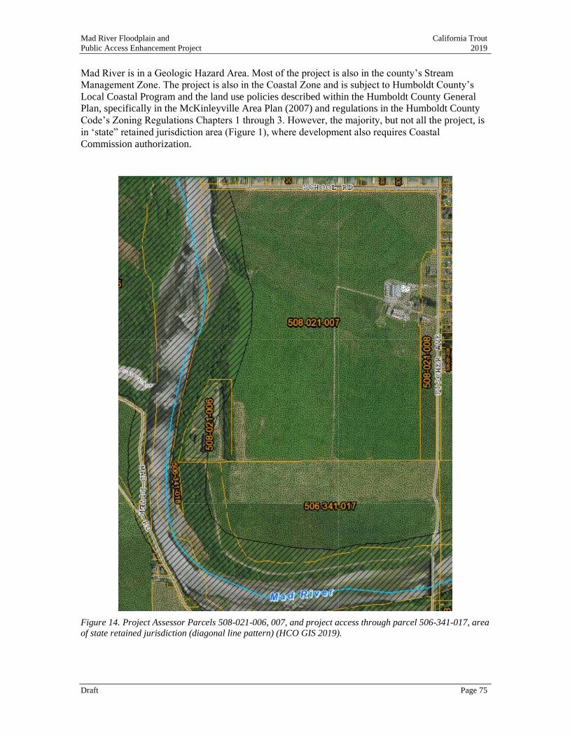
Mad River Floodplain and California Trout
Public Access Enhancement Project 2019
Draft Page 75
Mad River is in a Geologic Hazard Area. Most of the project is also in the county’s Stream
Management Zone. The project is also in the Coastal Zone and is subject to Humboldt County’s
Local Coastal Program and the land use policies described within the Humboldt County General
Plan, specifically in the McKinleyville Area Plan (2007) and regulations in the Humboldt County
Code’s Zoning Regulations Chapters 1 through 3. However, the majority, but not all the project, is
in ‘state” retained jurisdiction area (Figure 1), where development also requires Coastal
Commission authorization.
Figure 14. Project Assessor Parcels 508-021-006, 007, and project access through parcel 506-341-017, area
of state retained jurisdiction (diagonal line pattern) (HCO GIS 2019).
Mad River Floodplain and California Trout
Public Access Enhancement Project 2019
Draft Page 76
11.2 Humboldt County Local Coastal Program, McKinleyville Area Plan
(MAP), and
Humboldt County Zoning Code
Planning Department: Conditional Use, Special, and Coastal Development Permits
The proposed project actions on AE lands are conditionally permitted uses described as natural
resource use types: fish and wildlife management, wetland restoration, resource-related recreation,
and coastal access facilities (HCC 313-7.1). The parcels are designated NR where fish and wildlife
habitat management is a principally permitted use (HCC 313-5.4) The project is also located in a
Stream Management Zone, where the proposed project actions are allowable uses (HCC 313-33.1).
The property where the project is located is covered by two overlay zones: Flood Hazard Areas (F)
and Stream and Riparian Protection Corridor (R). The proposed habitat restoration actions with a
Special Permit are allowable uses in Flood and Tsunami Hazard Areas (HCC 313-21.4 and 5), and
in Stream and Riparian Protection Corridor (HCC 313-33.1.5).
The project is in the Coastal Zone therefore a Coastal Development Permit is required for any
development such as the proposed project actions (MAP 312-3.1.4). The MAP requires that new
development in hazards areas minimize risks to life and property (3.28 -30253). The floodplain
enhancement actions have been designed to not increase base flood elevations and to function with
the expected flooding that occurs in this reach of the Mad River.
A soils and geologic engineering report have been prepared, which satisfies the R-2 soils report
requirements set forth by Humboldt County Building Department for the proposed public access
activities within 50 feet of a bluff that is in excess of ten feet (HCC 313-121).
The MAP requires support facilities compatible with the character of the land and adequate for the
number of people using them prior to opening the access to public use (MAP 3.52-30210); the
project’s access amenities will be limited to maintain the existing rural-wildland setting.
The MAP requires that the maximum amount of prime agricultural lands shall be maintained in
agricultural productions (MAP 3.34-30241); the project is located on prime agricultural soils. The
project’s proposed public access actions (trails, benches, kiosks) may involve a minor conversion
(0.2 acres) of prime agricultural soils.
The MAP contains resource protection policies and standards for environmentally sensitive habitat
areas (riparian and wetlands) to protect these areas from significant habitat disruptions and are
limited to uses that dependent on these resources, and where there are no feasible less
environmentally damaging alternatives and where feasible mitigation measures have been provided
to minimize adverse environmental effects and maintain or enhance the functional capacity of
wetlands (MAP 3.40-30240, and 30233), very minor amounts of riparian habitat will be converted
for public access to the river via a gravel trail. With a Special Permit, fish and wildlife management
and wetland restoration are allowable uses in coastal wetlands, including riparian areas.
Building Department: Grading and Building Permits
Humboldt County Building regulations require that a Grading Permit be acquired before any
grading occurs (HCC 331-12. D). Grading in excess of 5,000 cubic yards shall be performed in
accordance with an approved grading plan prepared by a civil engineer (HCC 331-12. E.3).
Activities within a Flood Hazard Area will require a professional engineer certify that all grading
work will not result in any increase in flood levels during the occurrence of the base flood
discharge. Activities within 50 feet of a bluff that is in excess of ten feet will require that an
engineering report be prepared.
Mad River Floodplain and California Trout
Public Access Enhancement Project 2019
Draft Page 77
11.3 California Coastal Commission
Coastal Development Permit
The proposed project involves both Humboldt County and Coastal Commission jurisdiction
pursuant to the Coastal Act (Figure 1). The county can request that the Coastal Commission issue a
single combined CDP when a development straddles both local and state jurisdictions. The Coastal
Commission’s standard for review are the policies and regulations in Chapter 3 of the Coastal Act.
The MAP policies described above identify the corresponding applicable Coastal Act policies
(3021, 030233, 30240, 30241, and 30253). The proposed project actions do not conflict with the
following Coastal Act policies:
• 30210 Public access shall be provided for all the people consistent with public safety needs
and the need to protect public rights, rights of private property owners, and natural
resource areas from overuse.
The proposed project will improve ADA public access to the bluff and viewing areas overlooking
the Mad River estuary, as well as non-ADA access to the river and riparian area below.
• 30231 Coastal waters and wetlands where feasible shall be restored. 30233, filling and
dredging of coastal waters and wetlands shall be permitted where there is no feasible less
environmentally damaging alternative, and where feasible mitigation measures have been
provided to minimize adverse environmental effects and shall be limited to restoration
purposes and nature study or similar resource-dependent activities. Shall maintain or
enhance the functional capacity of the wetlands or estuary. 30240, Environmentally
sensitive habitat areas shall be protected against any significant disruption of habitat
values, and only uses dependent on those resources shall be allowed within those areas.
The proposed project will restore and enhance floodplain and riparian habitats along the Mad
River, a coastal water. There is no feasible less environmentally damaging design that would
achieve the project’s habitat enhancement/restoration goal. Only a minor amount of riparian habitat
may be converted to provide a public access viewing platform and public access to the river, and
the project will result in an overall net increase in riparian habitat.
• 30241 The maximum amount of prime agricultural lands shall be maintained in
agricultural productions.
The public access improvements will convert approximately 0.2 acres of prime agricultural soils,
but these areas, due to their proximity to the river’s edge, have not been used for agricultural
production.
• 30253 New development in hazards areas will minimize risks to life and property.
The stability of the bluff on the Mad River is a potential hazard to people. This hazard has been
described in a soil and geologic engineering report, see discussion under VII. Geology and Soils.
The bluff was stabilized in 2008 by a bank stabilization project constructed by the county.
11.4 California Department of Fish and Wildlife
Streambed Alteration Agreement (FGC 1600),
California Endangered Species Act MOU (FGC 2081)
A Streambed Alteration Agreement (SAA) will be required for the proposed floodplain
enhancement activities, wildlands interface trails, and river access. CDFW will review proposed
project actions to assess whether populations of species of concern will be protected that may
occupy riparian, floodplain, and open-water habitats such as Red-legged Frogs, Western Pond
Turtles, Willow Flycatcher, Coho and Chinook Salmon, Longfin Smelt, and Tidewater Goby.
Mad River Floodplain and California Trout
Public Access Enhancement Project 2019
Draft Page 78
Timing activities to avoid critical life stages of these species when they may occupy the project
area will be employed. If the project is constructed when the area is naturally dewatered then
potential take of Coho Salmon, Chinook, and Longfin Smelt that have been listed pursuant to
California’s Endangered Species Act could also be avoided. Both salmonid species occupy the
lower Mad River and potentially could be affected by the project if areas will need to be dewatered.
In this case, CDFW can enter a Memorandum of Understanding pursuant to FGC 2081a with the
MCSD to authorize take of state protected species.
11.5 North Coast Regional Water Quality Control Board
Water Quality Certification (CWA Section 401)
A Water Quality Certification is required for the excavation and fill activities that may affect
waters of the U.S. or State (Porter-Cologne Act). A project monitoring and reporting plan will be
prepared to verify achievement of project goals if required as a condition of approval. The project
will disturb more than an acre of soil; therefore, a project-specific water pollution prevention
control plan will be prepared for review and approval in-lieu of filing for coverage under the State
Water Resources Control Board Construction General permit. Excavated bio-solids, and soil not
used in the floodplain enhancement design will be placed on approximately 5.4 acres of adjacent
agricultural lands in an area currently authorized to receive fill under MCSD’s NPDES permit,
which the Corps has determined is not a jurisdictional wetland (waters of the U.S.).
11.6 State Lands Commission
Sovereign lands fee title determination
The State Lands Commission issues Leases for development of state sovereign lands, such as the
bed of the Mad River. It is generally a condition of approval in a CDP issued by the Coastal
Commission to seek a written determination from the State Lands Commission regarding whether
they claim a fee title interest based on their sovereign land’s authority in the proposed project. If
the SLC has not conducted a boundary survey near the project it may issue a waiver from the
requirement of securing a lease without prejudice, for restoration and public access activities such
as proposed in this project.
11.7 U.S. Army Corps of Engineers
NWP 14 Linear Transportation Projects include construction of trails in waters of the U.S.
NWP 27 Aquatic Habitat Restoration, Enhancement, and Establishment Activities.
U.S. Army Corps of Engineers, has regulatory jurisdiction over the project via both the River
Harbors Act-Section 10 and Clean Water Act-Section 404. The USACE can issue a series of
applicable NWPs for proposed actions in waters of the U.S. portions of the public access
development. A segment of wildland interface trail that allows for river level access and a lightly
developed river access feature, would occur in a riparian area and on the bank of the Mad River
and could be authorized with a NWP 14. The USACE could also issue an NWP 27 for the proposed
floodplain habitat enhancement project consisting of off-channel backwater, riparian, and wetland
habitat features. The placement of spoils on adjacent agricultural land was determined by the Corps
to not involve jurisdictional wetlands (waters of the U.S.).
Before the USACE can issue their NWPs, the project needs to secure authorization from the
Coastal Commission, USFWS and NOAA, as well as compliance with Section 106 of the National
Historic Preservation Act.

Mad River Floodplain and California Trout
Public Access Enhancement Project 2019
Draft Page 79
• NOAA, ESA Section 7 Consultation may require preparation of a Biological Assessment to
support a Biological Opinion and Incidental Take Agreement, see discussion under IV.a.
Biological Resources;
• U.S. Fish and Wildlife Service, ESA Section 7 Consultation may require preparation of a
Biological Assessment to support a Biological Opinion and Incidental Take Agreement, see
discussion under IV.a. Biological Resources;
• State and Tribal Historic Preservation Officers, NHPA Section 106 may require preparation of
a cultural resources survey to support consultation with Blue Lake Rancheria, Wiyot Tribe, and
Bear River Rancheria, see discussion under V. Cultural Resources.
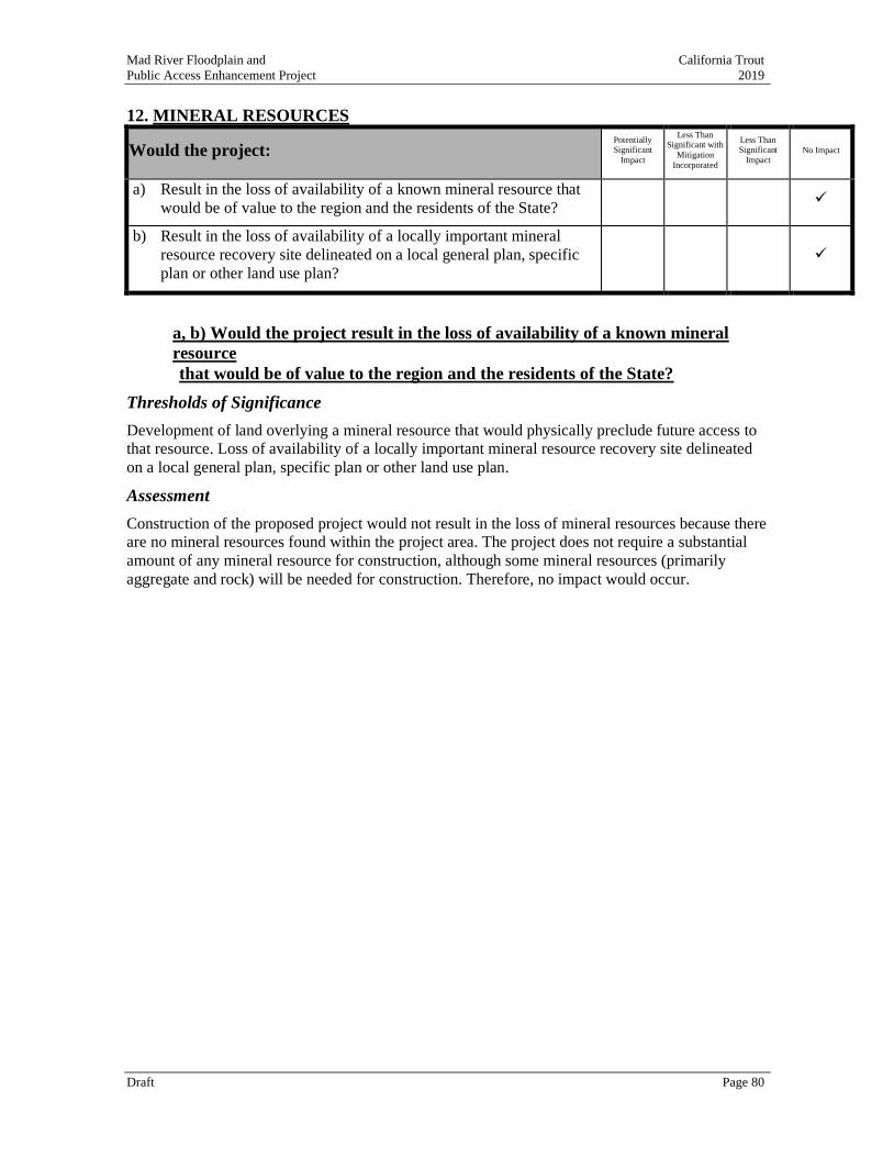
Mad River Floodplain and California Trout
Public Access Enhancement Project 2019
Draft Page 80
12. MINERAL RESOURCES
Would the project: Potentially Significant
Impact
Less Than Significant with
Mitigation
Incorporated
Less Than Significant
Impact No Impact
a) Result in the loss of availability of a known mineral resource that
would be of value to the region and the residents of the State? ✓
b) Result in the loss of availability of a locally important mineral
resource recovery site delineated on a local general plan, specific
plan or other land use plan?
✓
a, b) Would the project result in the loss of availability of a known mineral
resource
that would be of value to the region and the residents of the State?
Thresholds of Significance
Development of land overlying a mineral resource that would physically preclude future access to
that resource. Loss of availability of a locally important mineral resource recovery site delineated
on a local general plan, specific plan or other land use plan.
Assessment
Construction of the proposed project would not result in the loss of mineral resources because there
are no mineral resources found within the project area. The project does not require a substantial
amount of any mineral resource for construction, although some mineral resources (primarily
aggregate and rock) will be needed for construction. Therefore, no impact would occur.
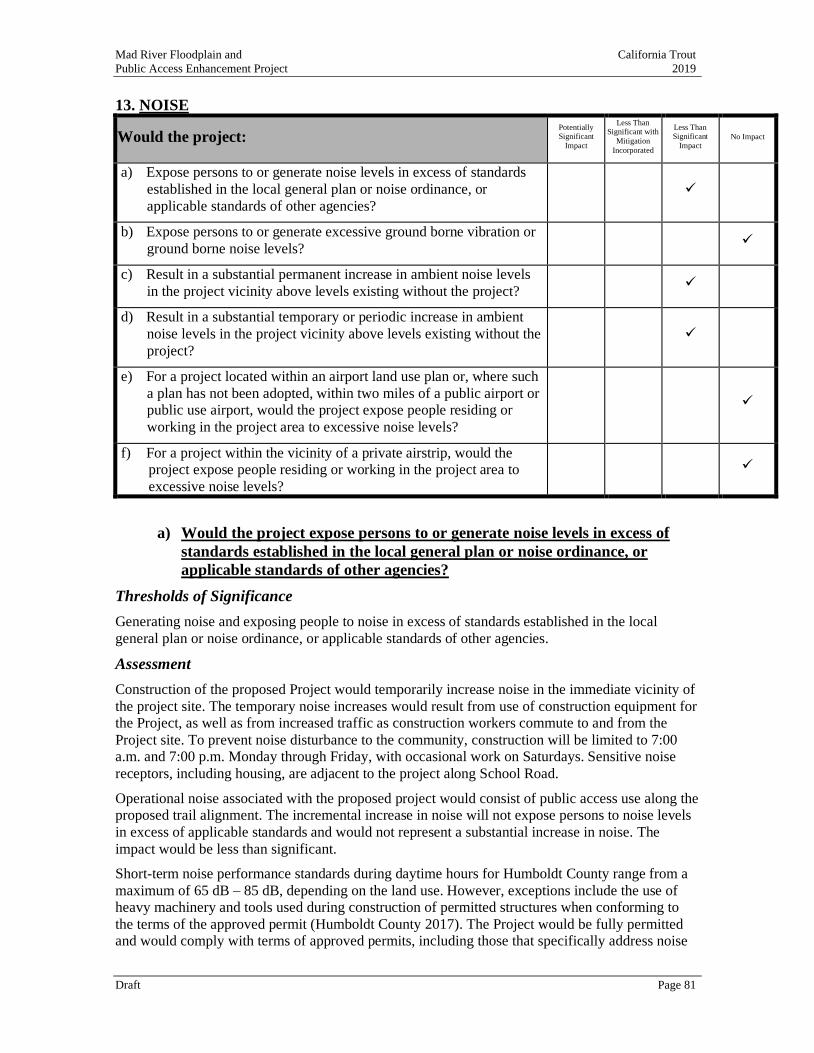
Mad River Floodplain and California Trout
Public Access Enhancement Project 2019
Draft Page 81
13. NOISE
Would the project: Potentially Significant
Impact
Less Than Significant with
Mitigation
Incorporated
Less Than Significant
Impact No Impact
a) Expose persons to or generate noise levels in excess of standards
established in the local general plan or noise ordinance, or
applicable standards of other agencies?
✓
b) Expose persons to or generate excessive ground borne vibration or
ground borne noise levels? ✓
c) Result in a substantial permanent increase in ambient noise levels
in the project vicinity above levels existing without the project? ✓
d) Result in a substantial temporary or periodic increase in ambient
noise levels in the project vicinity above levels existing without the
project?
✓
e) For a project located within an airport land use plan or, where such
a plan has not been adopted, within two miles of a public airport or
public use airport, would the project expose people residing or
working in the project area to excessive noise levels?
✓
f) For a project within the vicinity of a private airstrip, would the
project expose people residing or working in the project area to
excessive noise levels?
✓
a) Would the project expose persons to or generate noise levels in excess of
standards established in the local general plan or noise ordinance, or
applicable standards of other agencies?
Thresholds of Significance
Generating noise and exposing people to noise in excess of standards established in the local
general plan or noise ordinance, or applicable standards of other agencies.
Assessment
Construction of the proposed Project would temporarily increase noise in the immediate vicinity of
the project site. The temporary noise increases would result from use of construction equipment for
the Project, as well as from increased traffic as construction workers commute to and from the
Project site. To prevent noise disturbance to the community, construction will be limited to 7:00
a.m. and 7:00 p.m. Monday through Friday, with occasional work on Saturdays. Sensitive noise
receptors, including housing, are adjacent to the project along School Road.
Operational noise associated with the proposed project would consist of public access use along the
proposed trail alignment. The incremental increase in noise will not expose persons to noise levels
in excess of applicable standards and would not represent a substantial increase in noise. The
impact would be less than significant.
Short-term noise performance standards during daytime hours for Humboldt County range from a
maximum of 65 dB – 85 dB, depending on the land use. However, exceptions include the use of
heavy machinery and tools used during construction of permitted structures when conforming to
the terms of the approved permit (Humboldt County 2017). The Project would be fully permitted
and would comply with terms of approved permits, including those that specifically address noise

Mad River Floodplain and California Trout
Public Access Enhancement Project 2019
Draft Page 82
limitations. The Project would not conflict with Humboldt County’s Noise Element. The impact
would be less than significant.
b) Would the project expose persons to or generate excessive ground borne
vibration or ground borne noise levels?
Thresholds of Significance
Generate excessive ground borne vibration or noise levels.
Assessment
The project will have no impact. Project activities do not include construction techniques that
involve ground borne vibrations.
c) Would the project result in a substantial permanent increase in ambient
noise levels in the project vicinity above levels existing without the project?
Thresholds of Significance
Substantial permanent increase of ambient noise levels in the project vicinity.
Assessment
The project will have a less than significant impact. Installation of new recreational facilities will
result in a slight increase in passive usage of the trail, overlook and river level access, but passive
usage levels are not anticipated to result in significant increases in ambient noise levels in the
project vicinity beyond that presently occurring as a result of informal usage of the existing pull out
parking area and trail. Therefore, the impact will be less than significant.
d) Would the project result in a substantial temporary or periodic increase in
ambient noise levels in the project vicinity above levels existing without the
project?
Thresholds of Significance
Substantial temporary or periodic increase of ambient noise levels.
Assessment
The project will have a less than significant impact. As described in 13 (a), above, temporary
construction noise levels fall well within acceptable levels. Beyond construction, installation of
new recreational facilities will result in a slight increase in passive usage of the trail, overlook and
river level access, but passive usage levels are not anticipated to result in significant increases in
periodic or temporary noise levels in the project vicinity beyond that presently occurring as a result
of informal usage of the existing pull out and trail. Therefore, the impact will be less than
significant.
e) For a project located within an airport land use plan or, where such a plan
has not been adopted, within two miles of a public airport or public use
airport, would the project expose people residing or working in the project
area to excessive noise levels?
Thresholds of Significance
Expose people to excessive noise levels within the vicinity of a public airport.
Mad River Floodplain and California Trout
Public Access Enhancement Project 2019
Draft Page 83
Assessment
The Project area is not within an airport land use plan, nor less than two miles from the public
airport. Therefore, the Project will have no impact in this category.
f) For a project within the vicinity of a private airstrip, would the project
expose people residing or working in the project area to excessive noise
levels?
Thresholds of Significance
Expose people to excessive noise levels within the vicinity of a private airport.
Assessment
The project will have no impact. The project is not within the vicinity of any private airport.
Mad River Floodplain and California Trout
Public Access Enhancement Project 2019
Draft Page 84
14. POPULATION AND HOUSING
Would the project: Potentially Significant
Impact
Less Than Significant with
Mitigation
Incorporated
Less Than Significant
Impact No Impact
a) Induce substantial unplanned population growth in an area, either
directly (e.g., by proposing new homes and/or businesses) or
indirectly (e.g., through extension of roads or other infrastructure)?
✓
b) Displace substantial numbers of existing people or housing,
necessitating the construction of replacement housing elsewhere? ✓
a) Would the project induce substantial unplanned population growth in an
area, either directly (e.g., by proposing new homes and/or businesses) or
indirectly (e.g., through extension of roads or other infrastructure)?
Thresholds of Significance
Result in substantial population growth in the area.
Assessment
The project will have no impact. The project involves restoring/enhancing aquatic and riparian
habitats and improving public access. The project will not involve construction of any facility that
will directly or indirectly induce population growth. Therefore, the project will have no impact on
population growth.
b) Would the project displace substantial numbers of existing people or
housing, necessitating the construction of replacement housing elsewhere?
Thresholds of Significance
Displace significant housing units in the area.
Assessment
The project will have no impact. The project involves restoring/enhancing aquatic and riparian
habitats and improving public access. The project area is not zoned for housing and does not
presently include housing. The project will not displace any existing people or housing.
Mad River Floodplain and California Trout
Public Access Enhancement Project 2019
Draft Page 85
15. PUBLIC SERVICES
Would the project:
result in substantial adverse physical impacts associated with the
provision of new or physically altered governmental facilities, need
for new or physically altered governmental facilities, the
construction of which could cause significant environmental
impacts, in order to maintain acceptable service ratios, response
times or other performance objectives for any of the public services:
Potentially Significant
Impact
Less Than
Significant with Mitigation
Incorporated
Less Than Significant
Impact No Impact
a) Fire protection? ✓
b) Police protection? ✓
c) Schools? ✓
d) Parks? ✓
e) Other public facilities? ✓
a) Would the project result in substantial adverse physical impacts associated with
the provision of new or physically altered governmental facilities, or the need for
new or physically altered governmental facilities, the construction of which
could cause significant environmental impacts?
Thresholds of Significance
Result in the need for new governmental facilities, or necessitate newly constructed or modifed
governmental facilities, the construction of which could cause significant environmental impacts.
Assessment
The project will have no impact on fire protection, police protection, schools, parks or other public
facilities. The project involves restoring/enhancing aquatic and riparian habitats and improving
public access at an existing site.
Mad River Floodplain and California Trout
Public Access Enhancement Project 2019
Draft Page 86
16. RECREATION
Would the project: Potentially Significant
Impact
Less Than Significant with
Mitigation
Incorporated
Less Than Significant
Impact No Impact
a) Increase the use of existing neighborhood and regional parks or
other recreational facilities such that substantial physical
deterioration of the facility would occur or be accelerated?
✓
b) Include recreational facilities or require the construction or
expansion of recreational facilities which might have an adverse
physical effect on the environment?
✓
a) Would the project increase the use of existing neighborhood and regional
parks or other recreational facilities such that substantial physical
deterioration of the facility would occur or be accelerated?
Thresholds of Significance
Increased use of parks or other recreational facilities in the area resulting in substantial
deterioration of facilities.
Assessment
The Project will likely cause in increase in the use of an area currently lightly used for informal
public access. However, there are no existing, formally developed facilities for public access and
recreation. The proposed Project will result in the construction of new facilities designed to
accommodate increased visitation and use. Therefore, the Project will have no significant impact
on existing recreational facilities such that substantial deterioration of the facility would occur or
be accelerated.
b) Would the project include recreational facilities or require the construction
or expansion of recreational facilities which might have an adverse physical
effect on the environment?
Thresholds of Significance
Include or require the construction or expansion of recreational facilities in the area. Which might
have an adverse physical effect on the environment.
Assessment
The project site contains an informal pull-out along School Road, and an unofficial trail
from the pull-out to and along the river that extends via several braided trails to the former
wastewater treatment ponds. The proposed project will result in the construction of several
new recreational features: 1) A new parking area including ADA parking for one vehicle;
2) a 400’ paved, fully ADA compliant lateral path from the parking area to a new, river
overlook viewing platform; 3) A compacted path with resting points along the downslope
for ADA assistance; 4) A newly constructed viewing platform slightly below the elevation
of the top of bluff, and; 5) A river access point at the river’s edge.
The current usage at the site is approximately five to ten visitors per day during good
weather. The construction of new facilities is likely to attract as many as three times as
many visitors. The combination of newly constructed facilities and increased usage has the
potential to have an adverse physical effect on the environment.
Mad River Floodplain and California Trout
Public Access Enhancement Project 2019
Draft Page 87
Project features are, by design, intended to reduce the physical effect on the environment
already resulting from informal and unstructured use of the site. The informal pull-out will
be improved to host 6 safely parked vehicles, including one ADA site. The proposed trail
will phase out the informal network of trails in favor of one single track trail, enabling
revegetation and restoration of currently degraded areas of the project site. Potential effects
of the viewing platform are primarily visual and are discussed under Aesthetics and
Biological Resources. Interpretive panels are proposed to educate visitors about the
ecological and cultural history of the site, and to communicate rules of usage, intended to
further avoid adverse impacts to the site.
The agricultural and natural resource zoning of the Project area allow recreation as a
primary use. Therefore, the project is compatible with land use designations. However,
new facilities do require a finding by the Planning Commission. That finding would be
sought as part of the Conditional Use Permit for the Project. The Project’s recreational
components would not have an adverse physical effect on the environment; therefore, the
impact would be less than significant.
Mad River Floodplain and California Trout
Public Access Enhancement Project 2019
Draft Page 88
17. TRANSPORTATION
Would the project: Potentially Significant
Impact
Less Than Significant with
Mitigation
Incorporated
Less Than Significant
Impact No Impact
a) Conflict with a plan, ordinance or policy addressing the circulation
system, including transit, roadways, bicycle lanes, and pedestrian
paths?
✓
b) For a land use project, would the project conflict or be inconsistent
with CEQA Guidelines section 15064.3, subdivision (b)(1)? ✓
c) For a land use project, would the project conflict or be inconsistent
with CEQA Guidelines section 15064.3, subdivision (b)(2)? ✓
d) Substantially increase hazards due to geometric design features
(e.g., sharp curves or dangerous intersections) or incompatible uses
(e.g., farm equipment)?
✓
e) Result in inadequate emergency access? ✓
a) Conflict with a plan, ordinance or policy addressing the circulation system,
including transit, roadways, bicycle lanes, and pedestrian paths?
Thresholds of Significance
Any conflict with the regulated circulation system in the Project area.
Assessment
The Humboldt County General Plan (adopted October 23, 2017) contains numerous goals and policies in support of the project. Perhaps the most germane is C-P38, which recommends
“(d)evelop a Regional Trails System. Support efforts to establish and connect regional trails,
particularly in the greater Humboldt Bay and lower Mad River areas….” (Part 2, Chapter 7.
Circulation Element pg. 7-8). The project’s key feature is an improvement to the regional trail
system of the lower Mad River. Accordingly, the project is consistent with the theme of the
General Plan.
No changes are proposed to the adjacent road or Level of Service in the project area, so the project
does not conflict with the regulated circulation system in the project area. There will be no impact.
b) For a land use project, would the project conflict or be inconsistent with
CEQA Guidelines section 15064.3, subdivision (b)(1)?
Thresholds of Significance
Conflict with CEQA Guidelines section 15064.3, subdivision (b)(1).
Assessment
During construction, the proposed project has temporary and de minimas effect on vehicle miles
traveled. Most work will be performed by local contractors. Following completion of the project,
no additional vehicle miles travelled will result from the project. There will be no impact.
c) For a land use project, would the project conflict or be inconsistent with
CEQA Guidelines section 15064.3, subdivision (b)(2)?
Thresholds of Significance
Mad River Floodplain and California Trout
Public Access Enhancement Project 2019
Draft Page 89
Conflict with CEQA Guidelines section 15064.3, subdivision (b)(2).
Assessment
During construction, the proposed project has temporary and de minimas effect on vehicle miles
traveled. Most work will be performed by local contractors. Following completion of the project,
no additional vehicle miles travelled will result from the project. There will be no impact.
d) Would the project substantially increase hazards due to geometric design
features (e.g., sharp curves or dangerous intersections) or incompatible uses
(e.g., farm equipment)?
Thresholds of Significance
Substantially increase hazards due to transportation design features or incompatible uses.
Assessment
The project site currently features an informal pull out utilized for informal visitation to the project
site. The proposed project includes installation of a formal and more visible parking area that will
make entry and exit to the project site more visible and safer. No other transportation features are
anticipated. The project does not include any geometric design features or incompatible uses that
might relate in a hazard. There will be no impact.
e) Would the project result in inadequate emergency access?
Thresholds of Significance
Result in inadequate emergency access.
Assessment
The existing informal pull out is insufficient for emergency access and does not provide space for
an emergency vehicle to turn around. Access to the project site will improve following construction
of the formal pull out and parking area. Therefore, emergency access to the project site will
improve. There will be no impact.
Mad River Floodplain and California Trout
Public Access Enhancement Project 2019
Draft Page 90
18. TRIBAL CULTURAL RESOURCES
Would the project: Potentially
Significant
Impact
Less Than Significant with
Mitigation
Incorporation
Less Than
Significant
Impact No Impact
a) Cause a substantial adverse change in the significance of a tribal
cultural resource, defined in Public Resources Code section 21074
as either a site, feature, place, cultural landscape that is
geographically defined in terms of the size and scope of the
landscape, sacred place, or object with cultural value to a California
Native American tribe, and that is:
✓
i) Listed or eligible for listing in the California Register of
Historical Resources, or in a local register of historical
resources as defined in Public Resources Code section
5020.1(k), or
✓
ii) A resource determined by the lead agency, in its discretion
and supported by substantial evidence, to be significant
pursuant to criteria set forth in subdivision (c) of Public
Resources Code Section 5024.1. In applying the criteria
set forth in subdivision (c) of Public Resource Code
Section 5024.1, the lead agency shall consider the
significance of the resource to a California Native
American tribe.
✓
a) Would the project cause a substantial adverse change in the significance of
a tribal cultural resource, defined in Public Resources Code section 21074
as either a site, feature, place, cultural landscape that is geographically
defined in terms of the size and scope of the landscape, sacred place, or
object with cultural value to a California Native American tribe, and that
is:
i. Listed or eligible for listing in the California Register of Historical
Resources, or in a local register of historical resources as defined in
Public Resources Code section 5020.1(k), or
ii. A resource determined by the lead agency, in its discretion and
supported by substantial evidence, to be significant pursuant to
criteria set forth in subdivision (c) of Public Resources Code Section
5024.1. In applying the criteria set forth in subdivision (c) of Public
Resource Code Section 5024.1, the lead agency shall consider the
significance of the resource to a California Native American tribe.
Threshold of significance
Adversely alter tribal cultural resources.
Assessment
The project will have no impact. Public Resources Code section 21074 defines tribal cultural
resources and includes sites, features, places, cultural landscapes, sacred places, and object with
cultural values to a California Native American Tribes. Tribal cultural resources are cultural
Mad River Floodplain and California Trout
Public Access Enhancement Project 2019
Draft Page 91
resources that may be eligible for listing in the California Register of Historic Resources or similar
registers or is determined eligible by the lead agency.
Through ongoing consultation efforts, affected tribes will be notified of project construction dates
and arrangements can be made to accommodate tribal personnel wishing to observe project
excavation activities, and THPOs will be contacted immediately should potential cultural resources
be discovered during construction (See Section 5, Mitigation Measure CUL-1).
The project area was the subject of an archeological and cultural resources survey and no such
resources were observed or suspected of occurring at the project site, which is diked former
tidelands (Roscoe, 2019, Appendix J). With the adoption of an Inadvertent Archaeological
Discovery Protocol, this project will have no impact on cultural resources. Consultation with
California Native American tribes traditionally and culturally affiliated with the project area has
occurred pursuant to Public Resources Code section 21080.3.1.
Consultation was requested with THPOs from the following federally recognized tribes:
• Bear River Band of Rohnerville Rancheria
• Big Lagoon Rancheria
• Blue Lake Rancheria
• Cher-Ae Heights Indian Community of the Trinidad Rancheria
• Hoopa Valley Tribe
• Wiyot Tribe
Yurok Tribe
The Wiyot and Blue Lake Rancheria THPOs requested consultation and a meeting occurred on
August 1, 2019. The consultation occurred early in the CEQA process to allow tribal governments,
lead agencies, and project proponents to discuss the level of environmental review, identify and
address potential adverse impacts to tribal cultural resources, and reduce the potential for delay and
conflict in the environmental review process. (Public Resources Code section 21083.3.2.)
Information was requested from the California Native American Heritage Commission’s Sacred
Lands File per Public Resources Code section 5097.96 and the California Historical Resources
Information System administered by the California Office of Historic Preservation.
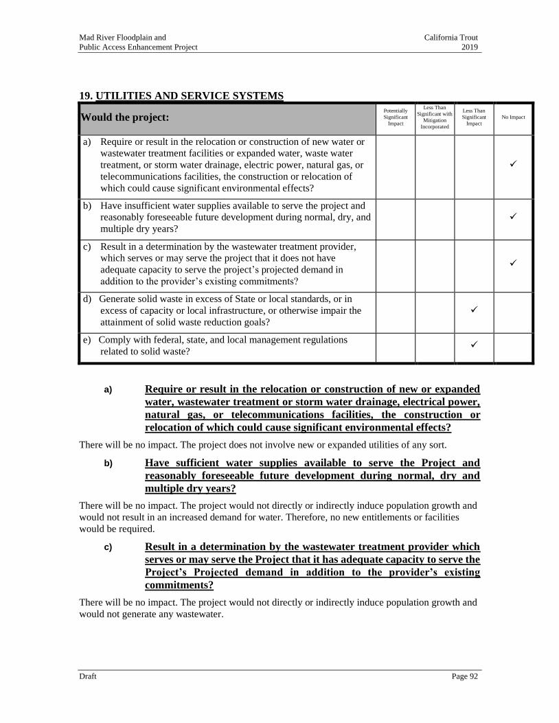
Mad River Floodplain and California Trout
Public Access Enhancement Project 2019
Draft Page 92
19. UTILITIES AND SERVICE SYSTEMS
Would the project: Potentially
Significant
Impact
Less Than
Significant with
Mitigation
Incorporated
Less Than
Significant
Impact
No Impact
a) Require or result in the relocation or construction of new water or
wastewater treatment facilities or expanded water, waste water
treatment, or storm water drainage, electric power, natural gas, or
telecommunications facilities, the construction or relocation of
which could cause significant environmental effects?
✓
b) Have insufficient water supplies available to serve the project and
reasonably foreseeable future development during normal, dry, and
multiple dry years?
✓
c) Result in a determination by the wastewater treatment provider,
which serves or may serve the project that it does not have
adequate capacity to serve the project’s projected demand in
addition to the provider’s existing commitments?
✓
d) Generate solid waste in excess of State or local standards, or in
excess of capacity or local infrastructure, or otherwise impair the
attainment of solid waste reduction goals?
✓
e) Comply with federal, state, and local management regulations
related to solid waste? ✓
a) Require or result in the relocation or construction of new or expanded
water, wastewater treatment or storm water drainage, electrical power,
natural gas, or telecommunications facilities, the construction or
relocation of which could cause significant environmental effects?
There will be no impact. The project does not involve new or expanded utilities of any sort.
b) Have sufficient water supplies available to serve the Project and
reasonably foreseeable future development during normal, dry and
multiple dry years?
There will be no impact. The project would not directly or indirectly induce population growth and
would not result in an increased demand for water. Therefore, no new entitlements or facilities
would be required.
c) Result in a determination by the wastewater treatment provider which
serves or may serve the Project that it has adequate capacity to serve the
Project’s Projected demand in addition to the provider’s existing
commitments?
There will be no impact. The project would not directly or indirectly induce population growth and
would not generate any wastewater.
Mad River Floodplain and California Trout
Public Access Enhancement Project 2019
Draft Page 93
d) Generate solid waste in excess of State or local standards, or in excess of
the capacity of local infrastructure, or otherwise impair the attainment
of solid waste reduction goals?
Construction of the project would result in a temporary increase in solid waste disposal needs
associated with demolition and construction wastes. Construction wastes would include, but not be
limited to small tree/shrub removals, erosion control materials, and excavated soils. Construction
waste with no practical reuse or that cannot be salvaged or recycled would be disposed of at a local
transfer station. Active permitted in-County transfer stations include the Humboldt Waste
Management Authority facilities in Eureka or Samoa, California and Humboldt Sanitation’s
McKinleyville, California transfer station. Solid waste generated by the project would represent a
small fraction of the daily permitted tonnage of these facilities. This would be a less than
significant impact on landfill capacity with the implementation of federal, state, and local statutes
and regulations related to solid waste. Therefore, the project’s construction-related solid waste
disposal needs would be sufficiently accommodated by existing landfills, and the impact would be
less than significant. Following construction,
Waste and recycling receptacles will be placed at the entrance to the public access area near School Road and maintained by MCSD, including legal disposal at one of the above-noted facilities. Based
on the anticipated level of use, the impact of operational solid waste and/or recycling collected at
the public access area would be less than significant.
e) Comply with federal, state, and local management and reduction statutes
and regulations related to solid waste?
No applicable federal solid waste regulations would apply to the project. At the State level, the
Integrated Waste Management Act mandates a reduction of waste being disposed and establishes
an integrated framework for program implementation, solid waste planning, and solid waste facility
and landfill compliance. The project would not conflict with or impede implementation of such
programs. Following construction, Project operation would generate modest levels of solid waste
and recycling collected at the public access area near School Road by MCSD. Therefore, the
impact would be less than significant.
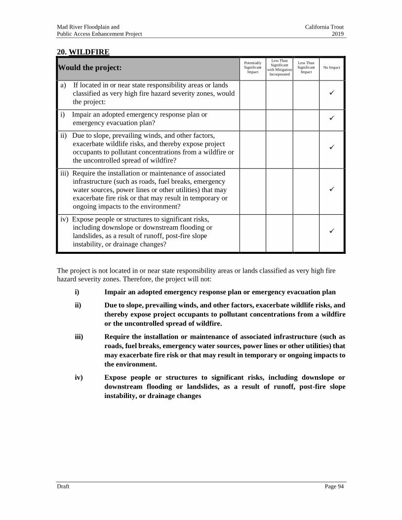
Mad River Floodplain and California Trout
Public Access Enhancement Project 2019
Draft Page 94
20. WILDFIRE
Would the project: Potentially Significant
Impact
Less Than Significant
with Mitigation
Incorporated
Less Than Significant
Impact No Impact
a) If located in or near state responsibility areas or lands
classified as very high fire hazard severity zones, would
the project:
✓
i) Impair an adopted emergency response plan or
emergency evacuation plan? ✓
ii) Due to slope, prevailing winds, and other factors,
exacerbate wildlife risks, and thereby expose project
occupants to pollutant concentrations from a wildfire or
the uncontrolled spread of wildfire?
✓
iii) Require the installation or maintenance of associated
infrastructure (such as roads, fuel breaks, emergency
water sources, power lines or other utilities) that may
exacerbate fire risk or that may result in temporary or
ongoing impacts to the environment?
✓
iv) Expose people or structures to significant risks,
including downslope or downstream flooding or
landslides, as a result of runoff, post-fire slope
instability, or drainage changes?
✓
The project is not located in or near state responsibility areas or lands classified as very high fire
hazard severity zones. Therefore, the project will not:
i) Impair an adopted emergency response plan or emergency evacuation plan
ii) Due to slope, prevailing winds, and other factors, exacerbate wildlife risks, and
thereby expose project occupants to pollutant concentrations from a wildfire
or the uncontrolled spread of wildfire.
iii) Require the installation or maintenance of associated infrastructure (such as
roads, fuel breaks, emergency water sources, power lines or other utilities) that
may exacerbate fire risk or that may result in temporary or ongoing impacts to
the environment.
iv) Expose people or structures to significant risks, including downslope or
downstream flooding or landslides, as a result of runoff, post-fire slope
instability, or drainage changes
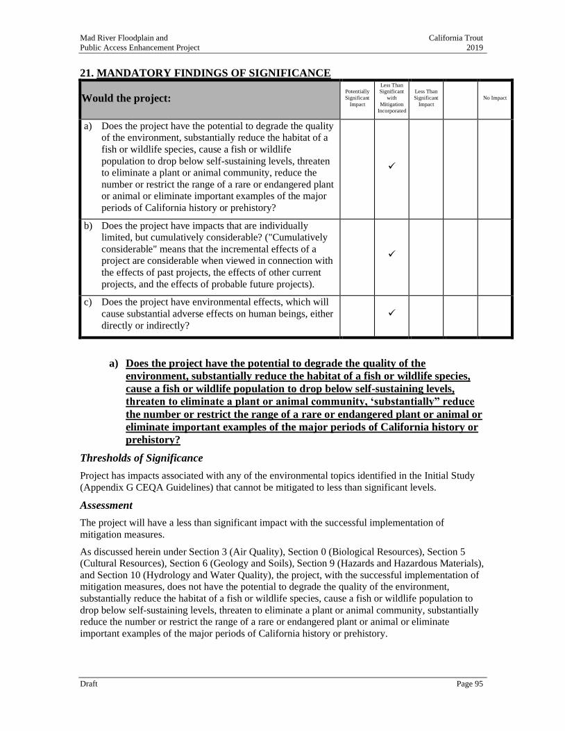
Mad River Floodplain and California Trout
Public Access Enhancement Project 2019
Draft Page 95
21. MANDATORY FINDINGS OF SIGNIFICANCE
Would the project: Potentially
Significant
Impact
Less Than Significant
with
Mitigation
Incorporated
Less Than
Significant
Impact
No Impact
a) Does the project have the potential to degrade the quality
of the environment, substantially reduce the habitat of a
fish or wildlife species, cause a fish or wildlife
population to drop below self-sustaining levels, threaten
to eliminate a plant or animal community, reduce the
number or restrict the range of a rare or endangered plant
or animal or eliminate important examples of the major
periods of California history or prehistory?
✓
b) Does the project have impacts that are individually
limited, but cumulatively considerable? ("Cumulatively
considerable" means that the incremental effects of a
project are considerable when viewed in connection with
the effects of past projects, the effects of other current
projects, and the effects of probable future projects).
✓
c) Does the project have environmental effects, which will
cause substantial adverse effects on human beings, either
directly or indirectly?
✓
a) Does the project have the potential to degrade the quality of the
environment, substantially reduce the habitat of a fish or wildlife species,
cause a fish or wildlife population to drop below self-sustaining levels,
threaten to eliminate a plant or animal community, ‘substantially” reduce
the number or restrict the range of a rare or endangered plant or animal or
eliminate important examples of the major periods of California history or
prehistory?
Thresholds of Significance
Project has impacts associated with any of the environmental topics identified in the Initial Study
(Appendix G CEQA Guidelines) that cannot be mitigated to less than significant levels.
Assessment
The project will have a less than significant impact with the successful implementation of
mitigation measures.
As discussed herein under Section 3 (Air Quality), Section 0 (Biological Resources), Section 5 (Cultural Resources), Section 6 (Geology and Soils), Section 9 (Hazards and Hazardous Materials),
and Section 10 (Hydrology and Water Quality), the project, with the successful implementation of
mitigation measures, does not have the potential to degrade the quality of the environment,
substantially reduce the habitat of a fish or wildlife species, cause a fish or wildlife population to
drop below self-sustaining levels, threaten to eliminate a plant or animal community, substantially
reduce the number or restrict the range of a rare or endangered plant or animal or eliminate
important examples of the major periods of California history or prehistory.
Mad River Floodplain and California Trout
Public Access Enhancement Project 2019
Draft Page 96
11.7..1 Degrade the quality of the environment
The project will not degrade the quality of the environment.
Please refer to previous discussions of no impact: Section 6 (Energy), Section 11 (Land Use),
Section 12 (Mineral Resources), Section 14 (Population and Housing), Section 15 (Public
Services), and Section 18 (Tribal Cultural Resources), as well as discussion of less than significant
impact including Section 1 (Aesthetics), Section 2 (Agriculture), Section 8 (Greenhouse Gas
Emissions), Section 13 (Noise), Section 16 (Recreation), Section 17 (Transportation, Section 19
(Utilities), and Section 20 (Wildfire).
Please also refer to previous discussion of less than significant impact with successful
implementation of mitigation measures in Section 3 (Air Quality), Section 0 (Biological
Resources), Section 5 (Cultural Resources), Section 6 (Geology and Soils), Section 9 (Hazards and
Hazardous Materials), and Section 10 (Hydrology and Water Quality).
11.7..2 Substantially reduce the habitat of a fish or wildlife species, cause a fish or wildlife population to drop below self-sustaining levels, threaten to eliminate a
plant or animal community
Overall this project will provide a long-term benefit to the environment, as it will enhance or create
2.0 acres of wetland habitat, 1.4 acres of aquatic habitat, and 0.5 acres of riparian habitat. The
project will provide long-term benefits to resident and migratory fish, wildlife and waterfowl.
11.7..3 Substantially reduce the number or restrict the range of a rare or endangered
plant or animal.
The project has the potential to expand the number and range of protected fish species and wetland
species of concern as discussed under Section 4(a) (Biological Resources).
11.7..4 Eliminate important examples of the major periods of California history or
prehistory
As discussed under Section 5 (Cultural Resources) and Section 17 (Tribal Cultural Resources), the
project will have no impact on any historic, cultural or tribal resources. The project will provide an
educational interpretive panel that will increase knowledge of local tribal culture.
b) Does the project have impacts that are individually limited, but
cumulatively considerable? ("Cumulatively considerable" means that the
incremental effects of a project are considerable when viewed in connection
with the effects of past projects, the effects of other current projects, and
the effects of probable future projects).
Thresholds of Significance
The incremental effects of a project are cumulatively considerable when viewed in connection with the effects of past projects, the effects of other current projects, and the effects of probable future
projects.
Assessment
The project will have a less than significant impact with the successful implementation of
mitigation measures.

Mad River Floodplain and California Trout
Public Access Enhancement Project 2019
Draft Page 97
A cumulative impact is when the incremental effects of the project, when combined with the
effects of other past, present and reasonably foreseeable future projects, are cumulatively
considerable.
As discussed in Section 10 (Land Use and Planning), the project is consistent with the development
contemplated in Humboldt County’s Local Coastal Program-McKinleyville Community Area Plan.
As reported throughout this document, Section 3 (Air Quality), Section 0 (Biological Resources),
Section 5 (Cultural Resources), Section 6 (Geology and Soils), Section 9 (Hazards and Hazardous
Materials), and Section 10 (Hydrology and Water Quality), any potential significant impacts
caused by this project will be mitigated to the less-than-significant level with the successful
implementation of mitigation measures.
The project does not have adverse impacts that are individually limited, but cumulatively
considerable. It is the goal of the project that the beneficial effects of tidal marsh restoration and
habitat enhancement will be cumulative over time.
c) Does the project have environmental effects, which will cause substantial
adverse effects on human beings, either directly or indirectly?
Thresholds of Significance
The project will have environmental impacts that cause substantial adverse effects on human
beings, either directly or indirectly.
Assessment
The project will have less than significant impacts that may directly affect people with the
successful implementation of mitigation measures.
The project’s environmental impacts that may adversely affect people have been determined to be
less than significant or mitigated to less than significant with successful implementation of
mitigation measures. As discussed herein, the project is not expected to cause any substantial
adverse environmental effects that will cause harm to human beings either directly or indirectly.
The habitat enhancement and restoration actions implemented as part of this project will be
beneficial to human beings.
Mad River Floodplain and California Trout
Public Access Enhancement Project 2019
Draft Page 98
REFERENCES
California Air Resources Board. 2017. California’s 2017 Climate Change Scoping Plan: The Strategy for Achieving California’s 2030 Greenhouse Gas Target.
https://ww3.arb.ca.gov/cc/scopingplan/scoping_plan_2017.pdf
California Department of Conservation. 2019. EQ Zapp: California Earthquake Hazards Zone
Application. Available online: https://www.conservation.ca.gov/cgs/geohazards/eq-zapp
Accessed on October 14, 2019.
California Department of Fish and Wildlife. 2004. Recovery Strategy for California Coho Salmon.
California Invasive Plant Council Symposium (Cal-IPC) 2009. California Invasive Plant Council
Symposium Proceedings
Carver, G.A. 1985. Quaternary tectonics north of the Mendocino triple junctions, in Kelsey, H.M.,
et al. eds. Redwood Country guidebook. Arcata, CA. American Geomorphological Field
Group. 1985 Field Trip, p. 155-167.
Carver, G.A. 1992. Late Cenozoic tectonics of coastal northern California, in Carver, G.A., and
Aalto, K.R., eds., Field guide to the late Cenozoic subduction tectonics and sedimentation of
northern coastal California: American Association of Petroleum Geologists, v. GB-71, p. 1-9.
Carver, G.A., Burke, R.M., and Kelsey, H.M., 1986, Quaternary deformation in the region of the
Mendocino triple junction: Technical report to U.S. Geological Survey. Reston, Virginia,
under Contract 14-08-001-22009, 25 p.
Flosi, G, Downie, S, Hopelain, J, Bird, M, Coey, B. 1998. California salmonid stream habitat
restoration manual. California Department of Fish and Game.
Humboldt County. 2015. Emergency Operations Plan, Humboldt Operational Area. Humboldt
County, CA https://humboldtgov.org/DocumentCenter/View/51861/Humboldt-County-
Emergency-Operations-Plan-2015
Humboldt County. 2017. Humboldt County General Plan. Humboldt County, CA
https://humboldtgov.org/205/General-Plan
Humboldt County. 2019. Humboldt County Community Wildfire Protection Plan. Humboldt
County, CA https://humboldtgov.org/DocumentCenter/View/70609/52-Wildfire-
Environment-Humboldt-CWPP-FINAL
McBain Associates. 2019. Vegetation Mapping for the Mad River Floodplain Enhancement
Project. Prepared for California Trout.
McCrory, P.A., 1996, Evaluation of fault hazards, northern coastal California: U.S. Geological
Survey Open-File Report 96-656, 87 p., 2 pls.
McLaughlin, R.J., Ellen, S.D., Blake, M.C., Jr., Jayko, A.S., Irwin, W.P., Aalto, K.R., Carver, G.A.
and Clarke, S. H., Jr. 2000. Geology of the Cape Mendocino, Eureka, Garberville and
Southwestern Part of the Hayfork 30 X 60 Minute Quadrangles and Adjacent Offshore Area.,
McKinleyville Community Services District, Department of Parks & Recreation. 2019. Parks &
Recreation Master Plan.
Moyle, P.B., Lusardi, RA, Samuel, PJ. 2017. State of the Salmonids: Status of California’s
Emblematic Fishes. A report commissioned by California Trout.
NOAA Fisheries. 2000. Guidelines for Electrofishing Waters Containing Salmonids Listed Under
the Endangered Species Act.
NOAA Fisheries. 2014. Southern Oregon Northern California Coho Salmon Recovery Plan.
Mad River Floodplain and California Trout
Public Access Enhancement Project 2019
Draft Page 99
NOAA Fisheries. 2016. Coastal Multispecies Recovery Plan for California Coastal Chinook
Salmon, Northern California Steelhead, and Central California Coast Steelhead.
North Coast Unified Air Quality Management District. 2019. District Rules & Regulations.
http://www.ncuaqmd.org/index.php?page=rules.regulations
Northern Hydrology and Engineering. 2017. Mad River Estuary Restoration: Off-channel Habitat
Designs, CDFW Fisheries Restoration Grant Program No. P1410511 and SCC Grant No. 14-
67. Prepared for California Trout and McKinleyville Community Services District.
Planwest Partners. 2010. Humboldt County Regional Trails Master Plan. Prepared for the
Humboldt County Association of Governments in association with Redwood Community
Action Agency and Alta Planning + Design.
Redwood Community Action Agency, Alta Planning + Design, Planwest Partners, and Streamline
Planning Consultants. 2011. Humboldt County Coastal Trail Strategy. Prepared for the State
Coastal Conservancy.
SHN Consulting Engineers & Geologists, Inc. 2015. Final Foundation Report: Hammond Trail
Pedestrian Bridge Replacement, Mad River Crossing, North of Arcata, Humboldt County,
California. Prepared for: Humboldt County Public Works Department. NR: SHN.
SHN Consulting Engineers & Geologists, Inc. 2019. Preliminary Engineering Geologic Report for
the Proposed Mad River Public Access Project, McKinleyville, CA, APN: 508-021-007.
Prepared for McKinleyville Community Services District.
U.S. Army Corps of Engineers. 2016. HEC-RAS River Analysis System Hydraulic Reference
Manual, Version 5.0 NR:ACOE.
U.S. Geological Survey. 1982. Interagency Advisory Committee on Water Data, Guidelines for
Determining Flood-Flow Frequency: Bulletin 17B. 183 p. Reston, VA: USGS, Hydrology
Subcommittee, Office of Water Data Coordination.
Related Documents