214 Chapter X MACRO DRAINAGE SYSTEM IN CMA Introduction: CMA lies along the east coast of Southern India and is traversed by three major rivers namely Kosasthalaiyar River, Cooum River and Adyar River. The climate of the region is dominated by the monsoons, which are caused by thermal contrast between land and sea. Monsoon climates are characterised by clearly marked seasons with specific types of wind and weather. The South West monsoon dominates weather patterns in Tamilnadu from July –September and is characterised by periods of sultry wet weather. Rain shadow effects limit rainfall in the east coast in Tamilnadu and it is light or intermittent during this season. This period is followed by North-East Monsoon, which brings cool cloudy weather, relatively free of rain over most of the monsoon- dominated land (India). The exception is South-East-India including Tamilnadu where about 78% of the annual rainfall occurs at this time. The start of the heavy rains usually falls in October lasting up to December. Most of the rainfall is associated with clear synoptic systems of depressions and cyclones with night time rainfall most common. In CMA between October and December most of the rainfall occurs and it is rare between January and April. 10.02 River Nagari which has a large catchment area in the Chittoor District (Andhra Pradesh) region and the Nandi River, which has catchment area in the Vellore District, join near Kanakamma Chattiram and enter Poondi Reservoir. Kosasthalaiyar River, which has its origin near Kaveripakkam and has catchment area in North Arcot District, has a branch near Kesavaram Anicut and flows to the city as Cooum River and the main Kosasthalaiyar river flows to Poondi reservoir. Poondi Regulator was constructed in 1943. From Poondi reservoir, Kosasthalaiyar River flows through the Thiruvallur District, enters CMA, and joins the Sea at Ennore. 10.03 Cooum River from the Kesavaram Anicut flows through the Kancheepuram District enters CMA and finally reaches Sea near Fort St.George. 10.04 Adyar River having its catchment area in the Kancheepuram District and originating from the Pillapakkam Tank Group and Kavanur Tank Group flows through the CMA enters the city and reaches Sea near Adyar area of the city. 10.05 Sholavaram Tank, Red Hills Tank and Chembarambakkam Tank are the major tanks in the CMA. Sholavaram Tank is the secondary storage tank receiving water from the Poondi Reservoir via Poondi Feeder Canal to supply Red Hills Tank. Red Hills Tank

Welcome message from author
This document is posted to help you gain knowledge. Please leave a comment to let me know what you think about it! Share it to your friends and learn new things together.
Transcript

214
Chapter X
MACRO DRAINAGE SYSTEM IN CMA Introduction:
CMA lies along the east coast of Southern India and is traversed by three major
rivers namely Kosasthalaiyar River, Cooum River and Adyar River. The climate of the
region is dominated by the monsoons, which are caused by thermal contrast between
land and sea. Monsoon climates are characterised by clearly marked seasons with
specific types of wind and weather. The South West monsoon dominates weather
patterns in Tamilnadu from July –September and is characterised by periods of sultry
wet weather. Rain shadow effects limit rainfall in the east coast in Tamilnadu and it is
light or intermittent during this season. This period is followed by North-East Monsoon,
which brings cool cloudy weather, relatively free of rain over most of the monsoon-
dominated land (India). The exception is South-East-India including Tamilnadu where
about 78% of the annual rainfall occurs at this time. The start of the heavy rains
usually falls in October lasting up to December. Most of the rainfall is associated with
clear synoptic systems of depressions and cyclones with night time rainfall most
common. In CMA between October and December most of the rainfall occurs and it is
rare between January and April.
10.02 River Nagari which has a large catchment area in the Chittoor District (Andhra
Pradesh) region and the Nandi River, which has catchment area in the Vellore District,
join near Kanakamma Chattiram and enter Poondi Reservoir. Kosasthalaiyar River,
which has its origin near Kaveripakkam and has catchment area in North Arcot District,
has a branch near Kesavaram Anicut and flows to the city as Cooum River and the main
Kosasthalaiyar river flows to Poondi reservoir. Poondi Regulator was constructed in
1943. From Poondi reservoir, Kosasthalaiyar River flows through the Thiruvallur
District, enters CMA, and joins the Sea at Ennore.
10.03 Cooum River from the Kesavaram Anicut flows through the Kancheepuram
District enters CMA and finally reaches Sea near Fort St.George.
10.04 Adyar River having its catchment area in the Kancheepuram District and
originating from the Pillapakkam Tank Group and Kavanur Tank Group flows through
the CMA enters the city and reaches Sea near Adyar area of the city.
10.05 Sholavaram Tank, Red Hills Tank and Chembarambakkam Tank are the major
tanks in the CMA. Sholavaram Tank is the secondary storage tank receiving water from
the Poondi Reservoir via Poondi Feeder Canal to supply Red Hills Tank. Red Hills Tank

215
is the main source of water supply to the Chennai City and during storm events water is
released to Red Hills Surplus Channel, which enters the Kosasthalaiyar River and
discharges into the sea. Its maximum storage capacity is 3285 Mft3 (93 Mm3).
10.06 Chembarambakkam Tank has recently been developed as one of the sources for
water supply to Chennai City and has maximum storage capacity of 103Mft3.
10.07 Kesavaram Anicut and regulator which is located in the uppermost catchment
of the Poondi reservoir controls the discharge from upper catchment entering Poondi
reservoir and during storm events the regulator gates can be opened to discharge into
Cooum when Poondi reservoir is full.
10.08 Korattur Anicut and regulator control the discharge in the Cooum and direct
the flow to the Chembarambakkam reservoir. When there is flow in the Cooum river and
the Chembarambakkam Lake is not at full capacity, then the regulator gates are opened
to supply water to the reservoir through the link channel.
10.09 Tamarapakkam Anicut located across Kosasthalaiyar River in the downstream
of Poondi reservoir controls excess discharge in the Kosasthalaiyar. If Sholavaram is
not at its full capacity, then the gates are opened to divert the excess water along the
supply channel to Sholavaram. Vallur Anicut is a small check dam constructed near
Minjur across the Kosasthalaiyar River to control water levels and feed irrigation
channels in the area.
10.10 Like any region in southern India with agricultural lands, CMA also has a
network of lakes, canals and channels within its boundary. There are about 320 tanks
/lakes that are earlier used as water source for irrigation and now serve as flood
accommodators. Apart from these lakes there are a large number of ponds in CMA.
10.11 Buckingham Canal is a man-made canal, which was constructed during the
year 1806. It originates at the place called Bedhakanjam in Andhra Pradesh and runs
along the area very close to the east coast, enters CMA at Athipattu village, passes
through the Chennai City and leaves CMA at Semmencheri village, and it finally
connects to Ongur River at Yedayanthittu Kaliveli near Cheyyar. Its total length is 418
km and in CMA its length is 40km. It runs in the north south direction and connects all
the major three rivers in CMA. It was dug for the purpose of navigation and transport of
goods and also to accommodate flood. But within CMA for various reasons it now
serves as flood accommodator only.
10.12 Otteri Nullah is a channel to accommodate flood, which originates from a place
called Otteri near Padi, flows through the city at Anna Nagar, Kilpauk, Purasawalkam,
and Perambur and joins Buckingham Canal near Basin Bridge.

216
10.13 Virugambakkam-Arumbakkam Drain originates near Oragadam passes through Virugambakkam-Arumbakkam area of the city and joins into Cooum River. 10.14 Mambalam Drain is also a flood accommodator, which originates from Mambalam area passes through T.Nagar, Nandanam and joins Adyar River. 10.15 Captain Cotton Canal originates from the Vyasarpadi area of the city and joins Buckingham Canal near Tondiarpet.
10.16 Velachery Drain is a flood accommodator originates from Velachery tank and joins Pallikkaranai Swamp. 10.17 The agencies responsible for management of storm water drainage in CMA are presented in Table No.10.01.
Table No. 10.01: Agencies responsible for Management of Storm Water Agency Responsibility
Chennai Metropolitan Development Authority (CMDA)
Project packaging and management, monitoring and co-ordination
Public Works Department (PWD) Plan, design and implementation of macro drainage works
Chennai Municipal Corporation (CMC) Plan, design and implementation of micro drainage works
Tamil Nadu Slum Clearance Board TNSCB
Formulation and implementation of rehabilitation and resettlement package
Source: Government Records Waterways in CMA 10.18 The length of the major waterways passing through the City and their total length in CMA is given in Table No. 10.02 and are presented in sheet No.10.05. Table No.10.02: Length of Major Waterways in CMA (Length in Km)
Waterway City CMA River Cooum 18.0 40.0 River Adyar 15.0 24.0 North Buckingham Canal 7.1 17.1 Central Buckingham Canal 7.2 7.2 South Buckingham Canal 4.2 16.1 Otteri Nullah 10.2 10.2 Captain Cotton Canal 2.9 4.0 Kosasthalaiyar - 16.0 Mambalam Drain 9.4 9.4 Kodungaiyur Drain 6.9 6.9 Virugambakkam-Arumbakkam Drain 6.9 6.9 Total Length 23.2 157.8
Source: CMDA In this background this chapter furnishes a gist of various studies made and completed and on going programs to alleviate flooding in the CMA.

217
Floodings in the past: 10.19 Chennai City and its environs are very flat with contours ranging from 2m to
10m above MSL, with very few isolated hillocks in the south west near St.Thomas
Mount, Pallavaram and Tambaram. Cooum and Adyar Rivers play a major role during
floods. River Cooum collects surplus from about 75 tanks in its catchment within CMA
and Adyar River collects surplus from about 450 tanks in its catchment, apart from
overflows from the large Chembarambakkam Tank. The flood discharge of Adyar River
is almost 3 times that of the Cooum River.
Mean Annual Rainfall in CMA is about 120 cm. The mean rainy days are about
52 days.
10.20 The siting of the Madras in the 17th Century near the confluence of the river
Cooum with the sea had influenced its expansion in the bed and the ayacut lands of
tanks in its upstream.
10.21 Mylapore tank bed and nearby tanks viz. Nungambakkam, Kodambakkam,
Taramani, Vyasarpadi, etc were converted into settlement areas to meet the housing
and other requirements of the expanding city. To make the problem more complicated
Govt. in order to provide work to people during the famine in 19th century had
constructed the ‘B’ Canal along the coast. This was mainly to provide waterway for
navigation and it had brought about major interference with the drainage courses of the
City as all the drainage courses which were otherwise falling directly into the sea, got
intercepted by this canal and rendered segments of the drainage courses beyond the
Buckingham canal obsolete and obliterated by the urban development. The impact of
the problem was not felt very much earlier, as the habitations were thin and the
development pace was slow.
10.22 The last century records have shown that there were several catastrophic
flooding in Chennai in 1943, 1976, 1985, 2002 and 2005 caused by heavy rain
associated with cyclonic activity. These events of catastrophic flooding were found to be
attributable to failure of the major rivers and other drainage systems. Flooding of less
catastrophic nature occurs regularly in low-lying areas of the city and its suburbs
because of inadequacy or inoperativeness of the local drainage infrastructure.
10.23 The floods in 1943 were historic and damaged Cooum river very badly. Based on
the Er.A.R.Venkatachary’s report the Govt. had improved the Cooum river and provided
a sand pump at the river mouth for removal of sand bar.

218
Er. Sivalingam Committee 10.24 In 1976, there was catastrophic flooding in Chennai and this time it was the
turn of the Adyar river. Er.P.Sivalingam Committee had given it’s recommendations for
prevention of further damages from floods and recommended schemes worth about
Rs.12 Crores to be implemented then under priority and schemes worth Rs.10 Crores in
the long run (at the 1970’s rates).
10.25 CMDA invited Mr.J.H.Kop, a drainage expert from World Bank who had studied
the flood problems and given recommendations in his report. He was endorsing the
remedies suggested in the above said previous reports and recommended to CMDA to
establish a Task Force (Nucleus Cell) to study the schemes of the various departments
and to draw up a programme giving the value of the component works and giving
priorities between them so that benefits could be realised within a short time.
Nucleus Cell in the CMDA : 10.26 The Govt. of Tamilnadu had ordered for constitution of Nucleus Cell in CMDA in
1979. The Nucleus Cell had submitted its report in 1980. Following are the main
recommendations of the cell:
(i) Considering the urban development already occurred, the surplus course of
the Vyasarpadi area known as Captain Cotton Canal could be improved to
carry only 2,660 cusecs with difficulty due to lack of space and drain into
North Buckingham Canal.
(ii) Some of the surplus from the higher tanks in the area should be diverted
into Cooum (i.e. Ambattur tank surplus into Cooum River via Mogappair
tank; Korattur tank diverted into Madhavaram tank; Madhavaram tank
diverted northwards into Redhills surplus course).
(iii) After the above diversions, Captain Cotton Canal designed for 2,660 cusecs
would be sufficient to take care of the flood quantity of 2,360 cusecs in all
seasons and proved to be permanent advantage for the Vyasarpadi area.
(iv) To remove the difficulty of discharge of floods a second arm across the
Manali-Tondiarpet Road through a causeway has to be constructed for the
Captain Cotton Canal to discharge 1,500 cusecs into the ‘B'canal. Even then,
the ‘B’ Canal could not be in a position to accommodate the flood and
discharge into the sea and hence to realize the benefits of the improvements
to Captain Cotton Canal a short cut canal to the sea in Thiruvottiyur area
has to be constructed.

219
(v) To prevent flooding of the Manali area and in Kosasthalaiyar river the
Kosasasthalaiyar riverbanks have to be strengthened by borrowing the
shoals inside the river as far as possible.
(vi) Otteri nullah has its southern watershed starting from Cooum river itself and
have all spills from the river enters into the nullah. The main cause for the
floods in the nullah was the absence of banks for Cooum river. If this is
taken care of, the discharge from nullah could be confined and disposed off
after effecting improvements to the nullah.
(vii) In respect of the Cooum river flow, strengthening of the banks at certain
stretches had to be made apart from repairing and strengthening of the
Bangaru Channel. Thirumangalam causeway, Naduvakkarai causeway and
Chetpet causeway, which were all obstructing the flow, should be removed.
The old arch bridges, which were causing afflexes of more than 0.37m, had
to be replaced in the first phase by a single span bridge (Aminjikarai bridge,
Andrews bridge, Law’s bridge and Wellington bridge) in the first phase and
College road bridge, C-in-C Road bridge in the second phase.
(viii) It was essential to think measures to divert a portion of Cooum flood
discharges into neighbouring Kosasthalaiyar basin (Poondi reservoir) as
already formulated by Er.A.R.Venkatachary's in 1943. Flood waters from
Eagattur area to be taken in the Northwesterly direction reaching
Thirupachur Odai and then to the Poondi reservoir by constructing a
diversion channel.
(ix) Cooum River collects surplus from 75 tanks under Cooum Tank Group. All
these tanks drain ultimately to Cooum tank from which the surplus reaches
Cooum River just above Satharai Causeway. Tanks can be made to absorb
and mitigate flood by judicious regulation. Flood outflow from large tanks
could also be brought and drain in such a manner they not only absorb the
flood but also anticipate them and deplete the tank in advance such that the
outflow is kept at moderate level over a long period. Flood absorption
capacity of the tanks may be improved by lowering the full tank level or by
converting the surplus weir into a ‘calingulah’.
(x) North Buckingham Canal had been improved and linked between Ennore
South lock and Cooum in fall for a distance of 10 miles in 1973-74. In
Thiruvottiyur region, it collects the drainages from Sathangadu tanks and
Kodungaiyur tank. In Tondiarpet region, it collects drainages from

220
Vyasarpadi group of tanks. In Vyasarpadi area it is a flood bank of Otteri
nullah. The entire city gets inflow through the ‘B’ Canal and it is a main
drain of the city during monsoon. The floodwater in the canal flows
southward into a Cooum river and northwards in Kosasthalaiyar river as
much as the gradient permits. The stretch of the canal needs to be desilted
and the floodgates of the Ennore South lock and Adyar north lock had to be
got repaired.
(xi) The vent-ways were very small at Central Station Bridge and all bridges
north of Tondiarpet and hence it took nearly 5 to 6 days for the accumulated
flood in this region for the canal to drain. From the lagoon area a additional
canal on the west of North Buckingham Canal had to be dug and also a short
cut canal taking off from the 5/0 mileage from the eastern bank of the North
Buckingham Canal and joining the sea near Thiruvottiyur had to be dug.
(xii) Earlier the Virugambakkam drain was flowing over a distance of 6.5 kms.
and falling into Nungambakkam tank from which with a surplus entered into
Cooum and Adyar rivers. Now, the entire course completely lost because of
the urban development that had occurred in the 2 km stretch and the
balance 4.5 kms. stretch was available. The course of the Koyambedu drain
was also obliterated. The entire surplus was flowing towards north enter into
narrow Arumbakkam drain and reaches Cooum river. In 1976, the
submersion went up to the rooftop of some of the buildings and breached the
causeway across Nelson Manikkam Road. Koyambedu surplus can be
diverted northward into the Cooum directly for not only reducing the
discharge into the Virugambakkam drain but also improving the chances of
damage of the Koyambedu area, which requires the assured means of quick
drainage. The Virugambakkam-Arumbakkam drain has to be improved.
(xiii) Surplus from Valasarawakkam to be intercepted by a drain proposed to be
excavated from Arcot Road such that the surplus reach Ramapuram tank,
from there it drains to Adyar river. Missing links in the drainage system to
drain floodwaters from KK Nagar, Ashok Nagar and Jaffarkhanpet area have
to be formed by acquiring lands to discharge floodwater to Adyar River.
(xiv) Two new tanks just above the Chembarambakkam tank had to be
constructed to capture 1570 Mft3 of flood.
(xv) Adyar river has two arms. The northern arm comes from Chembarambakkam
basin, joins with the southern arm coming from Guduvancheri, and joins at
Tiruneermalai. In 1976, floods in the Adyar river were the worst ever

221
experience. For containing the flood and reducing the submersion to the
minimum extent, flood banks have to be put up all along the banks of the
river. Two causeways at Kathipara and Jaffarkhanpet had to be replaced by
all weather bridge as a long-term measure.
(xvi) Masonry weir built long ago at a distance of 300m below the Maraimalai
Adigal Bridge obstructing the normal flow and causing a pond for dhobis to
wash clothes had to be removed.
(xvii) Mambalam drain is flowing at the heel of the erstwhile Mylapore tank.
Kodambakkam High Road and the Mount road between Gemini and
Nandanam were the tank bunds of the Mylapore tank. The drain starts from
Prakasa Road flows in the T.Nagar and CIT Colony area crosses the Mount
road and reaches Adyar near Teacher’s college. Improvements to these drains
had to be carried out.
(xviii) Pumps must be permanently installed in the Kotturpuram area to drain
floodwater since Adyar HFL is higher than the area.
(xix) Veeranam pipe crossing, which had been laid above the riverbed and below
the MFL, was a potential source of scour in the Adyar river and it had to be
dismantled and re-laid below the riverbed.
(xx) Kapalithottam, a slum, situated on the north of Greenways Road was a low-
lying area originally connected the Adyar Backwaters. This area needs to be
drained only by means of underground drainage system.
(xxi) It was possible to transfer 10,000-15,000 Cusecs from Adyar River into
Covelong Valley by digging diversion channel either from a pond near
Perungalathur or from a reach above Tambaram.
(xxii) Though South Buckingham Canal by itself experience high flood levels
during monsoon, rain from local precipitation, it is not a flood carrier. The
areas south of Adyar basin inside Madras City drain into the South
Buckingham Canal and hence the problems in these areas were grouped
under this basin. The flood from the developed area of Nangnallur,
Velachery and Tiruvanmiyur normally travel southwards and get into the
Pallikkaranai Lagoon, which gets drained by the river Covelong.
(xxiii) FTL of the Velachery Tank to be lowered by 1.2m and a new surplus course
had to be provided.

222
(xxiv) Adambakkam drainage scheme had to be implemented reforming the old
drains leading to the Adambakkam Tanks and cutting new drains to form the
missing links to avoid flooding in the residential area of Nangnallur,
Adambakkam, etc.
(xxv) In the Madras city, there were only major drains (Macro level) and hence the
city had necessarily got to have internal drains connecting various parts of
the City with the macro drains. Regarding the internal drains the city can be
divided into the following reaches:
a) Coastal belt draining into sea directly
b) North Madras belt draining mainly into North Buckingham Canal for
drainage relief
c) Hinterland between Cooum and Adyar river draining into Cooum and
Adyar rivers
d) Southern area draining mainly into South Buckingham Canal
(xxvi) The Macro Drains and internal drains are mutually complementary and both
are important. The master plan evolved by the Madras Corporation for
internal drainage system has to be implemented fully.
MMFR / SWD Master Plan Study 10.27 Subsequently CMDA had engaged the services of the consultant M/s Mott
MacDonald International, UK, to conduct the study titled 'Madras Metro Flood
Relief/Storm Water Drainage Master Plan Study ' in 1992-93. The main objective of the
study was to bring together the previous studies carried to assess the problem of
flooding in Chennai and to identify using modern hydrological and hydraulic modeling
techniques/measures to alleviate flooding in the North of the City.
10.28 The study area comprised two parts, (1) 90 sq.km strip north of the river Cooum
and (2) 30 sq.km area south of the City named as Pallikkaranai. Both the Macro
Drainage Systems (Rivers, Tanks, and Surplus Channels) and the micro Drainage
System (Urban Storm Water Drains) had been examined.
10.29 An extensive data collection exercise had been undertaken by the Consultant
involving acquiring and processing of data relating to meteorological, hydrological, tidal
conditions, weather, topography, land use, existing macro and micro drainage systems,
river basin control structures, floods etc. Hydrological catchment models to simulate
runoff from rainfall and computational hydraulic river models (HYDRO) to simulate the
built-up of flow and its routing to the Macro Drainage System to Sea were developed
and calibrated. With regard to urban storm water system, complete drain inventory
223
have been prepared and stored in a database. A review of the capacity of the whole
micro drainage system within the study area had been made using MIDUSS
(Microcomputer Interactive Design of Urban Storm water Systems) urban storm water
drainage analysis program.
10.30 The range of options examined included upstream storage (to be implemented
under Krishna Water supply scheme), diversion of flood flows into tanks, canals,
channel resection, structural improvements (including outfalls), provision of short cut
canal between the Buckingham canal and the sea, formalisation of flood path and
provision of flood defences (walls, banks, etc.). For the Macro System 17 principle
options had been identified with the number of variants in each of this considering
about 40 possible interventions by using a qualitative screening process. Some of these
options were eliminated and 20 options examined in depth using the models. The
following are the results of the analysis:
(i) The storage and diversion schemes in the upper catchments were generally
found to have little impact on flood levels in the downstream coastal reaches
of the system where flooding occurs. In the Kosasthalaiyar system, this was
because of the major over bank spillage to the north in the middle reaches at
Minjur: the effect of storage and diversion was found to lower the amount of
spillage at this point, but to have only a small effect on water levels further
down the system. In the Cooum system, flows from the upper catchment do
not peak at the same time as flows from the middle and lower catchments.
Thus, while the diversion of flows in the upper catchment reduces the
volume of water, it does not affect the maximum water levels. The exception
to this was an option to divert water from the middle reaches of the Cooum
to the Red Hills Tank. This was found to have a positive impact on over bank
spillage in the city, but is very expensive and will be difficult to implement
because of the intense land use along parts of the route. It would also
require an upgrading of the Red Hills Surplus Channel.
(ii) With regard to outfalls, a short cut canal from the Buckingham canal to the
sea of 100 m3/sec. capacity was tested using the models but found to have
limited impact on water levels: a larger capacity would be required to have a
significant effect. This would be very difficult to implement, given the
intensity of land use between the Buckingham Canal and the sea. It was
thus concluded that it would be better to improve the Buckingham Canal
and rely on the existing outfalls. While these outfalls are choked for much of
the year due to littoral drift, analysis showed that the bar would wash out
quickly during a major flood event and not form a significant obstacle. This
224
has been confirmed by observation. The sand bars are thus principally a
problem for public health, rather than flood relief. It is possible that, during
minor flooding, the bar may be an obstacle to flow from the urban drains,
but this is unlikely to be catastrophic.
(iii) The conclusion reached was that flood defence and re-sectioning options
would provide the cheapest and most assured way of dealing with the macro-
flooding problem. Schemes have been outlined for the Cooum, the
Kosasthalaiyar, the Red Hills Surplus Channel, the Buckingham Canal, the
Otteri Nullah and the Captain Cotton Canal, and tested in the model.
Several of these schemes are interdependent. On the Kosasthalaiyar, it is
not possible to contain the floodwaters with embankments at reasonable
cost. Protection has thus been provided on the south bank only, and a
controlled floodway is proposed for the north bank upstream of Minjur. This
will need to be designated as a flood zone and development restricted in that
area. Existing villages will require to be protected, probably using ring
banks. The Kosasthalaiyar will also spill near its confluence into the existing
wetland areas.
(iv) For the urban storm water (micro) system, existing coverage of drainage
provision within the study area boundary was found to be 50%. The design
standard currently adopted was found to be equivalent to about a 1 in 1.25
year 60 minute storms. The economic analysis indicated that a design
standard of 1 in 2 or 1 in 3 year return period was the most cost-effective for
new areas of drainage, but also showed that upgrading the existing system to
this standard was not economically worthwhile. However the drainage
system was generally found to be in a poor state, with many blockages due to
solid waste and services (water pipes, cables etc.) and repairs needed. The
principal interventions envisaged are thus repairs/rehabilitation of existing
systems and improved maintenance which is seriously under-funded. For
Manali, outline schemes and costs were prepared for pumped storm water
disposal and for flood protection.
Drainage Master Plan
(v) The Master Plan recommended by the consultant comprised a number of
components:
• Structural works for major flood alleviation and for rehabilitation of the
urban storm water system;
• Non-structural measures required to support these investments;

225
• Capacity building, with particular emphasis on system maintenance
and master plan implementation;
• Further studies required to progress the plan; and
• Monitoring and evaluation requirements.
(vi) As far as the Master Plan is concerned, the proposed scheme at Pallikkaranai
has been treated as committed expenditure, as government has already
decided it should be the priority for implementation to aid economic
development in the area.
(vii) A phased programme for implementation of the Plan has been developed,
with consideration being given to financial and economic constraints,
implementation capacity, operation and maintenance requirements, lead
times for project preparation and interdependence of projects.
(viii) The structural measures identified were given below:
Table No: 10.03: Structural Measures
Sl. No. Structural Works
Cost (Rs. in Million)
1 Pallikkaranai Scheme 160 2 Flood defences and channel improvement on the Cooum 348 3 Flood defences and channel improvement on the Buckingham Canal 96 4 Flood defences and channel improvement on the Otteri Nullah 125 5 Flood defences and channel improvement on the Captain Cotton
Canal 20
6 Flood defences and channel improvement on the Madhavaram Surplus Channel
10
7 Flood defences and channel improvement on the Red Hills Surplus Channel
215
8 Flood defences on the south side of the Kosasthalaiyar 50 9 Manali Township drainage and flood protection 40 10 Urban storm water rehabilitation and repairs 35
Note: All cost estimates are preliminary (year 1993)
(ix) Non-structural measures recommended were:
a) Designated floodways on the north side of the Kosasthalaiyar with associated
planning controls and flood warning/evacuation procedures
b) Design guidelines for drainage systems
c) Planning and regulatory controls to prevent development in old tank beds
unless adequate flood defence measures are in place
d) Planning and regulatory controls to prevent encroachment of squatter
settlements in old tank beds and watercourses

226
e) Provision of good facilities (vehicles, communications) for flood emergency
management
f) Public education (e.g. to prevent solid waste dumping in urban drains)
g) Flood risk mapping
(x) A unitary authority should be responsible for the drainage system within the
City area and it should be Chennai Municipal Corporation. The lead
agencies PWD, and Chennai Corporation are responsible for the general day-
to-day management of the system. The authority responsible for the
drainage and flood control should be required to meet a number of
management objectives, principally.
(xi) In respect of operation and maintenance regular inspection has to be carried
out and routine and periodic maintenance involving desilting, embankment
regarding, weed/bush clearing, vermin control, clearance of rubbish/debris,
etc., had to be carried out according to a regular programme. The study also
identified in outline a number of studies including environmental impact
assessment, flood risk mapping, etc.,
(xii) The drainage study for Pallikkaranai was included as part of the MMFR/SWD
master plan study. The aim of the study is to identify ways of providing
protection to an area about 30 sq.km. lying in and around Pallikkaranai.
The area was earmarked for development and the development was to be
promoted by number of government and private bodies then. For the
purpose of the study the area was referred as Pallikkaranai Drainage Area
(PDA). The aim of the project was to protect an area of approximately 30
sq.km. from flooding. It could be achieved by a diversion of substantial
portion of run off from upstream catchments along a cut off drain linking the
existing surplus channel close to a village called Karanai with the Kovalam
Backwaters. Northern boundaries of Pallikkaranai Drainage Area cuts off
the centre of the existing swamp area at Pallikkaranai. The area to the north
will continue to be subject to inundation as run-off enters the area from
north and west. East west flood protection bund protects this side of PDA. In
order to provide internal drainage to the PDA two pumping stations have to
be located in the East-west flood protection bund to lift the water over the
bund. A balancing pond is also to be located near the pumping station.
However, protection to the area is to be provided by three interceptor drains,
which carry overland flows from local catchment around the boundary of the
PDA. An arterial drain has to be constructed along the centre of the PDA,

227
which will pick up drainage flows within the area. Details of the proposal are
given in the sheets annexed.
Others
(xiii) The consultant M/s Mott MacDonald International had submitted the Storm
Water Drainage Master Plan for the Madras city and Pre feasibility Study for
the Madras Metropolitan Area in October 1994. With regard to the urban
storm water system the detailed technical and economical analysis were
carried out in a sample area in Pulianthope representing about 10% of the
urban area within the MMFR study boundary. It was used to examine
possible interventions to improve the functioning of the micro drainage
system in Chennai City. Based on this work, guidelines for the design of
future drainage provisions were prepared.
(xiv) A study was also made for the flooding and internal drainage problem at
Manali New Town. A detailed inventory of the storm water drainage was
prepared and stored in a database. The conclusion reached, was the flood
defence and resection options would provide the cheapest and most assured
way of dealing with the macro-flooding problem.
(xv) For the Central Buckingham Canal isolation from the Adyar during flood flows
offers significant advantages. The Canal will then serve as a collector of local
urban run-off, rather than a flood path within the macro system. For the
urban storm water (micro system) existing system of drainage coverage
within the study area is found to be 50% with additional areas draining
overland into the urban drainage network. The drainage system was
generally found to be in a poor state, with many blockages due to solid waste
and municipal waste and services (water pipes, cables, etc.) and repairs
needed. The principal intervention thus requires repairs /resection of the
existing system and improved maintenance which is seriously under funded.
Capital works include new works including area of drainage in particular at
Arumbakkam-Virugambakkam along with some investment in new drain or
drain enlargement within the existing system and investment of new outfall
facilities.
(xvi) Outside the City, there are currently few drainage facilities beyond the
drainage provided by the primary and secondary network of rivers and
surplus channels. Improvements to this drainage network will be essential if
development is to proceed within the CMA at the pace envisaged. A number
of strategic initiatives had been identified for the development of CMA
including flood banks on the south side of the Kosasthalaiyar, improvements

228
to the Ambattur/Korattur/Madhavaram surplus channel system, drainage
works to allow the Pallikkaranai area to be drained.
(xvii) In addition to this specific proposal there is a need to develop a strategic
planning policy within CMA, which would focus on some of the important
requirements for the continued functioning of the drainage system as
development advances. These might include retention of tanks as open
space, provision of river corridor, prevention of encroachment in tanks, the
definition of secondary drainage system and development of tertiary and
quaternary system and links between these and secondary/primary system.
(xviii) Planning the system includes preparation of contour mapping for the CMA
and identification of low-lying areas for discouraging developments.
(xix) Clear policies must be developed for the CMA to ensure the objectives of the
flood studies are met. Such policies should embrace the interlinked issues of
water supply, wastewater disposal, solid and hazardous waste disposal and
flood alleviation.
Environment Impact Assessment of the Drainage Plan: 10.31 In March 1995, CMDA engaged M/s KBN Engineering and Applied Sciences Inc.
supported by M/s Mukesh & Associates to conduct an environment impact evaluation
of the preferred drainage scheme and redevelopment in this area. The study component
comprised of an environmental impact assessment (EIA) of the drainage plan for the
study area and a land use compatibility analysis for the proposed Pallikkaranai
Drainage Area.
10.32 This EIA was conducted in co-ordination with CMDA and other agencies
concerned viz. PWD, TNPCB, CMWSSB, Central Ground Water Board, State
Government Board, Geological Survey of India, Anna University, TNSCB, Tamil Nadu
Guidance Bureau, Archeological Survey of India (Madras Circle), Central Institute of
Brackish Water Aquaculture, Chennai. The major findings of the study are given in the
Annexure IX A.
Review of Pallikaranai Development Plan : 10.33 Subsequently in 1997, government had directed CMDA to arrange for a review of
the above consultants report in respect of the Pallikkaranai Development Area (PDA)
engaging M/s NEERI. Accordingly, NEERI was engaged in June 1998, which had
studied these recommendations of the consultants and suggested two alternatives for
development of the PDA. On the preferred alternatives, PWD had stated that formation
of reservoir in Pallikkaranai in swamp as suggested by M/s NEERI (Alternative-B) either

229
for drinking water supply or for recreational purpose is not desirable due to following
facts:
i. The catchment areas of the swamp are fully habited. Hence, the runoff from
the catchment that flows into Pallikkaranai swamp is highly contaminated.
The effluent from the Perungudi STP and leachate from the solid waste dump
also flow into the swamp. So, treating the raw water with this contamination
into drinking water to the BIS standard is difficult and highly expensive.
ii. Maintaining the water quality for recreational purpose is also difficult in a
location surrounded by habitation.
10.34 In consultation with departments concerned viz. Environment & Forests, PWD,
TNPCB, Housing and Urban Development Department it was finally recommended to
Government as follows: -
i. Environment and Forest Department was processing the proposal for
protecting the swamp lying between the 200 ft. MMRD Scheme Road in the
north and Sholinganallur – Perumbakkam Road in the south. The swamp
area in the north of MMRD scheme road was mostly occupied by Chennai
Corporation, Chennai Metropolitan Water Supply and Sewerage Board &
MTP (Railways).
ii. It was reported that the study revealed that in the Pallikkaranai swamp, the
contiguous low lying areas received run-off from a catchment area of 235
sq.km. During monsoon large pools of water in the valley confluence in the
central portion of the study area. Run-off enters the valley from Velachery in
the north and also from Arsankalani and other villages in the south. Due to
the presence of network of lakes and surplus channels there is significant
degree of regulation that reduces peak flows into the valley (except in the
north-western built up areas in Velachery, Madipakkam, etc. which gets
flooded during monsoon). The storm water eventually passes thro' the
Okkiyam maduvu to reach the south 'B' Canal which flows south and enters
the Kovalam estuary. The 'B' Canal is not capable to drain storm water
effectively, mainly because of its inadequate size and slope. The peak flow
reaching the study area was estimated to be about 350 m3/sec. (according to
PWD, the discharge from the catchment area into the valley is 11542 cubic
feet). The members present agreed that the water holding capacity of the
valley should be retained to avoid flooding in the catchment areas
particularly in the northwest built up areas.

230
iii. The Government lands lying in between MMRD Scheme Road in the north
and Sholinganallur-Perumbakkam Road in the south lying in revenue
villages of Pallikkaranai, Sholinganallur, Perumbakkam, Karapakkam and
Jalladampettai may be declared as protected marshy land prohibited for any
urban development, on the lines of the Adyar Estuary if necessary.
iv. The area on the south of the Sholinganallur-Perumbakkam Road may be put
to urban development/use by reclaiming these low-lying areas as
recommended in the NEERI Report with proper central drainage
arrangements and access roads. By this, about 15 sq.Km of land would be
available for development according to NEERI Report (Government lands in
Sholinganallur and Perumbakkam account to 800 acres in this area).
v. In order to ensure that this reclaimed area does not pollute swamp and other
water-bodies, it may be developed for I.T, ITES and electronic industries.
Considering its location, accessibility and proximity to airport, road
infrastructure to be provided by the IT Corridor, it would be suitable for such
urban development.
vi. Regarding the area north of the MMRD, it could be preserved as it is
considering its necessity for flood accommodation, its eco-sensitivity.
Outline Project Report on Flood Alleviation: 10.35 CMDA in consultation with the Line agencies viz. PWD, Chennai Municipal
Corporation and TNSCB had prepared an outline project report on flood alleviation and
improvement of storm water drainage system in Chennai Metropolitan Area with a total
project outlay of Rs.300 Crores to be implemented over a span of 5 years and submitted
to government. The project cost abstract and the responsibilities of the agencies
involved in the implementation are given in the Annexure IX B.
10.36 The Government in G.O.Ms.No.321, H&UD Department dated 12/08/1998 had
given their administrative sanction for the project. The project has been taken up in
phases for execution and up to mid 2005 it has been executed including an expenditure
of about Rs.106 Cores. Under R&R Component implemented by TNSCB 3000
tenements had been constructed at Okkiam Thoraipakkam to resettle the slums in the
flood alleviation project along 'B' Canal and Adyar river. Desilting of South Buckingham
Canal, construction of retaining wall, formation of jeep track along the banks and
construction of 10 vents in North Buckingham Canal, repairs to its linings had been
completed. Construction of flood defences and resection of the rivers Kosasthalaiyar

231
had been completed. In respect of Adyar river, construction of flood defences and
resection works are nearing completion except for the desilting work east of the Thiru
Vi Ka Bridge. Works in Ambattur Tank Surplus Course, Madhavaram Tank Right Flank
Surplus Course and Pallikkaranai Drainage Works were taken up. About 70% of the
works in respect of the Red Hills Surplus Course works were completed; remaining
works in this Course and the works in Madhavaram Tank, Chembarambakkam Tank,
Korattur Tank Surplus Courses are to be completed after required lands are acquired.
Improvements to Otteri Nallah, Virugambakkam – Arumbakkam drain had been
completed. Drainage relief works to Velachery area is nearing completion except for the
court stayed short stretches. Improvement to the Cooum river from sea mouth to
Periyar bridge has been completed and from Periyar Bridge to Koyambedu will be taken
up after completion of R&R works.
Integration of Macro and Micro Drainage : 10.37 The Micro Drainage works to the tune of Rs.43 Crores have been implemented
by the Chennai Corporation for improvement of the drainage system in Chennai
Corporation area integrating with the Macro Drainage System.
Study on Waste Water Outfall into Waterways : 10.38 The study conducted by the consultant M/s Wardrop Engineering Inc.
in 1995 revealed that the waterways in Chennai convey treated and untreated sewage
and receive debris and solid waste also though they were originally natural flood
discharge channels. The addition of untreated liquid waste had led to a very high level
of pollutants and the disposal of the solid and the encroachment of slums had severely
reduced flows particularly during monsoon periods. A summary of wastewater outlets
existed in 1995 is given below:
Table No. 10.04: Waste water Outfall Details for Inner Chennai Waterways Nature of Outfall
Waterway Sewage Storm water Industrial Others Total
River Cooum 109 6 1 - 116 Adyar River 58 23 - - 81 Otteri Nullah 42 4 1 - 47 South 'B' Canal 26 1 - - 27 Central 'B' Canal 30 - - 1 31 North 'B' Canal 58 5 3 1 67 Redhills Surplus Channel - - 4 - 4 Mambalam Drain 14 8 - 1 23 Captain Cotton Canal 13 - - - 13 Kodungaiyur New Drain 2 - - - 2 Ambattur Surplus Tank 5 - 5 2 12
TOTAL 357 47 14 5 423 Source: M/s Wardrop Engineering Inc, 1995

232
Environmental Improvement of Watercourses 10.39 The consultant M/s Severn Trent International conducted the study on
environmental improvement of watercourses in Greater Madras in 1991. They have
recommended for extension of sewerage system to unsewered areas and use of low cost
sanitation wherever appropriate, purchase of jetting equipment and replacement of
smaller pumps with submersible pumps, extension of storm water drainage system,
resolution of interconnections between sewers and storm water drains, short term
improvements at sewage works, extension and long-term improvements at sewage
works, equipment to clean storm water drains, equipment for street cleaning, sanitary
waste disposal, dredging and grading of river Cooum, completion of river Adyar flood
protection scheme, desludging of Buckingham Canal, North Ennore Lock to the river
Cooum, filling up of central portion of the Buckingham Canal between the rivers Cooum
and Adyar, desludging of Buckingham Canal between the River Adyar and the City limit,
pumping of Otteri Nullah for treatment, dredging and regrading of Otteri Nullah and
construction of groyne to improve the Cooum outfall to the sea, if needed.
Chennai Waterway Conservation Programme 10.40 The sludge disposal consultancy study conducted in 1994 by the consultant M/s
MMI has revealed that contamination of water-ways and anaerobic digestion of waste
water flowing in the water-ways had led to the accumulation of sludge causing
hindrance to the hydraulic functioning of the water-ways and also causing
contamination of water-ways in the eco system. The following are the estimates of the
sludge accumulation in Chennai waterways:
Table No. 10.05 Estimates of Sludge Accumulated in Inner Chennai Waterways Typical width in dry season (m) Characteristics Sludge volume in 'ooo m
Waterways Length in Km
Water Total Durability Access Hydraulic nuisance
Envtl.* Nuisance Both
Cooum 18.00 23-40 45-120 D O 1210 350-750 1280
Adyar 15.00 15-200 90-500 E,P O,O* 1880 340-200 1960
North B' Canal 7.10 15 20 D/E,P O/N 150 40-100 200
Central 'B' Canal 7.20 5 20 E O 200 30-50 200
South 'B' Canal 4.40 9 15 D,P C 10 20-50 20
Otteri Nullah 10.20 4-5 7-20 E/D O/C 100 30-60 110
Captain Cotton canal
2.90 5-40 25-45 E,P C 20 40-60 50
Total 64.80 3570 840-250 3820

233
Source: M/s MMI, Sludge Disposal Consultancy, 1994
Note: Abbreviations for Durability D-Dewatering possible difficult and expensive I-Dewatering impracticable, floatation of pontoons, barges and small dredges
possible after dredging E-Easy to dewater with bunds and bypasses, with some pumping Abbreviations for Accessibility O-No continuous access O*-occasional access, but from private roads N-No access C-Continuous access
10.41 Earlier the consultants had estimated that the number of slum families to be
resettled and rehabilitated from the objectionable areas of waterways to do the
improvement is 22,800. But the PWD had estimated that at least 10,000 slum families
have to be resettled and rehabilitated to do the minimum required improvements to the
waterways.
10.42 The length of the major waterways passing through the City and its total length
in CMA is given below:
Table No: 10.06 Length of Major Waterways in CMA
Waterway City CMA River Cooum 18.0 40.0 River Adyar 15.0 24.0 North Buckingham Canal 7.1 17.1 Central Buckingham Canal 7.2 7.2 South Buckingham Canal 4.2 16.1 Otteri Nullah 10.2 10.2 Captain Cotton Canal 2.9 4.0 Kosasthalaiyar - 16.0 Mambalam Drain 9.4 9.4 Kodungaiyur Drain 6.9 6.9 Virugambakkam-Arumbakkam Drain 6.9 6.9
Source : PWD 10.43 The details of the catchment areas of the waterways within Chennai City are given
in the sheet annexed. Also the areas, which were affected by the flood events during
1976 and 1985 are given in the sheets annexed.
Suggestion by the National Institute of Ocean Technology : 10.44 To open the mouth of Cooum River, National Institute of Ocean Technology (NIOT)
had suggested that groynes at stages may be constructed and the suggestion is under
active consideration for implementation by PWD.

234
Chennai City River Conservation Project 10.45 As part of the Chennai City River Conservation Project (CCRCP) CMWSSB had
proposed project for prevention of sewage flow into waterways, treatment of sewage,
construction of interceptor sewers and enhancement of pumping station capacity with a
total project cost of Rs.720 Crores. But the National River Conservation Directorate
(NRCD), Government of India, had finally accepted to fund the project to the tune of
Rs491.82 Crores in the year 2000. Out of the project costing Rs.382 Crores approved
by the NRCD, CMWSSB had executed works to the tune of Rs.325 Crores.
Chennai Metropolitan Development Plan 10.46 Under Chennai Metropolitan Development Plan (CMDP), projects for macro and
micro drainage system to the tune of Rs.39 Crores has been executed during 2003-
2004, Rs.41 Crores during 2004-2005, Rs. 103 crores during 2005-06 by PWD, Chennai
Corporation, Municipalities and Other Local Bodies within CMA and also by the
Highways Department. An outlay of Rs.98.99 Crores has been proposed for the year
2006-07 under this component.
Conclusion 10.47 Flooding in the CMA has become a recurring feature. During dry season, the City
experiences acute water scarcity. Abundance of data are available on the macro
drainage system. Thanks to numerous studies conducted, Chennai City River
Conservation Project has added new dimension to the system. With the co-ordinated
efforts of Government agencies, involvement of stakeholders and with the application of
modern technology for map making and networking, it is earnestly hoped that flooding
in the CMA will become a thing of the past.
235
Annexure X A
Major findings in the Study on Environmental Impact Assessment of
the drainage and redevelopment proposal for Pallikaranai Area
(consultants: KBN Engineering and Applied Sciences, Inc., Florida and
Mukesh & Associates, Salem):
1. No significant adverse impacts will be caused by the preferred drainage scheme.
2. The preferred drainage scheme will allow for limited development in the study
area. Severe flooding including flooding from the 50 and 100-year storm events,
which now precludes development, will be reduced to acceptable levels to allow
for development. Further reduction in the effects of flooding can be achieved by
raising plinth levels of buildings onsite to approximately 2.0 m. above Survey of
India datum (m-ASoI) and the incorporation of onsite stromwater retention and
detention ponds.
3. The proposed PDA will have a significant positive benefit to the people and
economy of the region. Given proper site planning, no significant adverse effects
will occur from development of the PDA.
4. Development of the PDA in the study area is most desirable because of:
a) Protection from flooding,
b) Compatibility with existing land uses,
c) Proximity to existing transportation infrastructure,
d) Available labour force and
e) Negligible environment impacts.
5. The most compatible land uses for the PDA are a combination of medium, light
and service industries. The development of heavy industry in the PDA is not
recommended given the generally good environmental quality in the area; the
requirements for stringent pollution control, monitoring and enforcement, and
its incompatibility with existing land use.
6. The three most important future impacts to the preferred drainage scheme and
PDA development once the preferred drainage scheme is implemented are:
a) Uncontrolled flow of offsite contaminated water to the site.
b) Effects of offsite development affecting onsite water elevations and
c) Uncontrolled induced development in the PDA which may result in relocation
issues for future development.
7. Relocation to the proposed reservoir is recommended for several reasons
including
236
a) Potential water quality impacts from existing and proposed offsite
development
b) Conflicts with proposed TNHB residential development
c) The existence of better alternative locations, i.e. use of tanks adjacent to the
study area.
8. Relocation of the proposed MMRD road to the PDA is recommended because
of the potential water quality impacts it will cause north of the East-West
Flood Protection Bund. It can be located in the PDA where it can better serve
the traffic needs of future development within the PDA as well as meet the
Area’s traffic needs.
9. A relocation of the proposed TNHB development in the northern part of the
study area needs to be considered since it is planned to occur in areas
identified for portions of the drainage infrastructure. This proposed
development could be incorporated in the PDA.
10. There are major offsite developments including the Perungudi landfill and the
Pallikkaranai sewage treatment plant which significantly affect onsite water
quality including water flowing to the Oggiam Maduvu. Future expansion of
these and other development needs to be evaluated in light of impacts to the
preferred drainage scheme and the PDA.
11. A basin-wide storm water management plan is necessary to assure the
proposed drainage scheme will operate effectively as future development
occurs adjacent to the study area and PDA.
12. Restoration and enhancement of the Velacheri Marsh should be undertaken
to assure protection of surface water quality entering the study area.
237
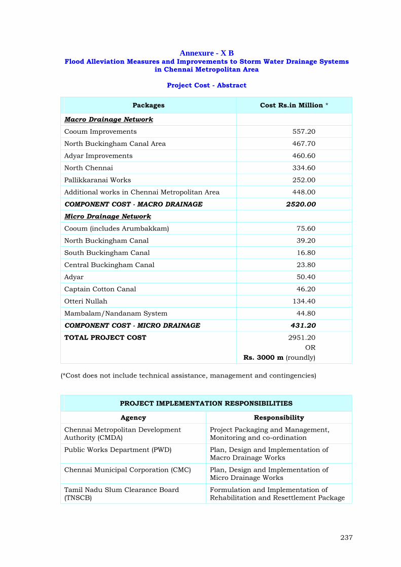
Annexure - X B Flood Alleviation Measures and Improvements to Storm Water Drainage Systems
in Chennai Metropolitan Area
Project Cost - Abstract
Packages Cost Rs.in Million *
Macro Drainage Network
Cooum Improvements 557.20
North Buckingham Canal Area 467.70
Adyar Improvements 460.60
North Chennai 334.60
Pallikkaranai Works 252.00
Additional works in Chennai Metropolitan Area 448.00
COMPONENT COST - MACRO DRAINAGE 2520.00
Micro Drainage Network
Cooum (includes Arumbakkam) 75.60
North Buckingham Canal 39.20
South Buckingham Canal 16.80
Central Buckingham Canal 23.80
Adyar 50.40
Captain Cotton Canal 46.20
Otteri Nullah 134.40
Mambalam/Nandanam System 44.80
COMPONENT COST - MICRO DRAINAGE 431.20
TOTAL PROJECT COST 2951.20 OR
Rs. 3000 m (roundly)
(*Cost does not include technical assistance, management and contingencies)
PROJECT IMPLEMENTATION RESPONSIBILITIES
Agency Responsibility
Chennai Metropolitan Development Authority (CMDA)
Project Packaging and Management, Monitoring and co-ordination
Public Works Department (PWD) Plan, Design and Implementation of Macro Drainage Works
Chennai Municipal Corporation (CMC) Plan, Design and Implementation of Micro Drainage Works
Tamil Nadu Slum Clearance Board (TNSCB)
Formulation and Implementation of Rehabilitation and Resettlement Package
Related Documents