Ludlow Park Neighborhood Traffic & Parking Study City of Yonkers September 28 , 2020 Prepared for: City of Yonkers Prepared by: BFJ Planning

Welcome message from author
This document is posted to help you gain knowledge. Please leave a comment to let me know what you think about it! Share it to your friends and learn new things together.
Transcript

Ludlow Park Neighborhood Traffic & Parking StudyCity of Yonkers
September 28, 2020
Prepared for: City of Yonkers
Prepared by: BFJ Planning

Ludlow Park Neighborhood Traffic and Parking StudyYonkers, NY
Prepared for
The City of Yonkers
Prepared by
BFJ Planning 115 Fifth Avenue New York, NY 10003
September 28, 2020

Table of Contents
Introduction .................................................................................................................................................. 1
1. Ludlow Park Commuter Parking: Are non-local Metro-North commuters parking on Ludlow Parkneighborhood streets in order to access Ludlow Station? ........................................................................... 1
Methodology ................................................................................................................................................ 1
Analysis ................................................................................................................................................. 2
Figure 1: Parking Study Area ................................................................................................................. 3
Figure 2: Parking Occupancy & Turnover Data ..................................................................................... 4
Metro North, Ludlow Station Ridership ................................................................................................ 5
Conclusion ............................................................................................................................................. 5
2. Through Traffic Analysis: Will the proposed development increase through traffic on Ludlow Parkstreets, such as Sunnyside Drive? ................................................................................................................. 6
Existing Traffic Volumes ........................................................................................................................ 6
Project-Generated Traffic Volumes (2030) ........................................................................................... 6
Figure 3: Study Area Traffic Volumes, Existing AM Peak Hour ............................................................. 7
Figure 4: Study Area Traffic Volumes, Existing PM Peak Hour ............................................................. 8
Figure 5: 2030 Project Build Traffic Assignment- AM Peak Hour ......................................................... 9
Figure 6: 2030 Project Build Traffic Assignment - PM Peak Hour ....................................................... 10
Figure 7: Intersection Level of Service, 2030 Project Build - AM Peak Hour ...................................... 11
Figure 8: Intersection Level of Service, 2030 Project Build - PM Peak Hour ...................................... 12
Conclusion ........................................................................................................................................... 13
3. Ludlow Park Overnight Parking: Do residents from adjacent areas utilize Ludlow Park streets for parking, particularly during overnight hours? (Study Forthcoming)......................................................................... 13

1 Ludlow Park Traffic and Parking Study
Introduction This study was undertaken to supplement the Ludlow TOD Plan DGEIS with the aim to address particular traffic and parking concerns raised by Ludlow Park neighborhood residents. This study adds neighborhood-specific detail to a broader analysis of existing and future traffic conditions provided in the DGEIS.
Existing and projected traffic and parking conditions within and adjacent to the Ludlow Park neighborhood have been analyzed in relation to the TOD Plan’s proposed action. The Ludlow Park neighborhood is bound by Pier Street to the north, Riverdale Avenue to the west, and Valentine Lane to the south. Three distinct neighborhood concerns reported by residents resulted in the following traffic and parking inquiries for additional study:
1. Are non-local Metro-North commuters parking on the Ludlow Park neighborhood streetsin order to access the Ludlow station?
2. Will the proposed development increase through traffic on Ludlow Park neighborhoodstreets such as Sunnyside Drive?
3. Do residents from adjacent areas utilize Ludlow Park streets for parking, particularlyduring overnight hours?
Notably, the first two inquiries have been studied to-date and are included in this supplemental report while study of the third inquiry is forthcoming.
1. Ludlow Park Commuter Parking: Are non-local Metro-North commuters parkingon Ludlow Park neighborhood streets in order to access Ludlow Station?
Residents report that there is an existing trend of non-local commuters who utilize neighborhood streets for parking in order to easily access Ludlow station. There is further perception that this pattern could be exacerbated by the proposed development. Existing conditions were analyzed in relation to the nature of the proposed TOD development and its activity.
MethodologyFigure 1 illustrates the section of Ludlow Park that was studied through the collection of parking occupancy and turnover data that were collected on Wednesday, January 29th, 2020. Street segments where data were collected were chosen based on this area having the greatest potential of commuter parking impact. Streets analyzed include:
• Sunnyside Drive between Pier Street and Beechwood Terrace• Beechwood Terrace Between Sunnyside Drive and Fairfield Road• Fairfield Road between Beechwood Terrace and Sunnyside Road• Morris Crescent
This particular “residential circle” section of Ludlow Park has the greatest potential of commuter parking based on its proximity to the Ludlow Station.
Prior to parking data collection, an inventory of the total number of parking spaces and parking regulations was compiled. It was determined that a typical Wednesday was the best day to conduct data collection as there are no street cleaning regulations on these roads during this time. Parking occupancy and turnover counts were conducted at 6 AM, 10 AM, and 2 PM utilizing a go-pro camera

2 Ludlow Park Traffic and Parking Study
that was attached to the windshield window of a car that drove around the study area in intervals. MTA ridership numbers collected for the Ludlow Station determined that analysis prior to 6 AM was not necessary as rail commuter ridership prior to this is not significant. Within the study area, parking zones were then organized to analyze the data based on walking distance from Ludlow Station. In total, eight zones were analyzed in an effort to demonstrate parking area specificities by street segments.
Analysis Figure 2 summarizes the parking occupancy and turnover conditions. Parking occupancy is highest at 6 AM with an average of 87%, which is close to practical capacity. At 10 AM and 2 PM occupancies are 53% and 51% respectively, with more than 90 spaces vacant. Collected data indicate that the peak parking demand in Ludlow Park study area streets occurs prior to 6 AM and is generated by residents living in the area.
City of YonkersLudlow Street Transit Oriented Development
ST. PETER'SSCHOOL
PICKETPARK
ST. PETER'SCHURCH
TREATMENT PLANT
HAWTHORNEPEARLSSCHOOL
HAW
THO
RN
E A
VE
FAIRFIELD PL
FER
NBR
OO
K ST
FEDERAL ST
FAIR
FIEL
D R
D
BEECHWOOD TER
FRANKLIN AVE
BELVEDERE DR
VALENTINE LN
CULVER ST
RIV
ERD
DAL
E A
VE
BRID
GE
ST
KNOWLES ST
LUDLOW ST
PIER ST
DOWNING ST
FAIRFIELD RD
FAIR
FIEL
D RD
BEECHWOOD TER
SUN
NYS
IDE
DR
MORRIS CRESCENT
MORRIS ST
SUNN
YSID
E DR
Abe Cohen Plaza
Zone 1
Zone 4
Zone 5
Zone 3
Zone 7
Zone 2
Zone 6
Zone 8
Figure 1: Parking Study Area Data collected Wednesday, January 29th, 2020

City of YonkersLudlow Street Transit Oriented Development
Parking Occupancy Counts
6 AM 10 AM 2 PM Zone Total Spaces Count % Capacity Count % Capacity Count % Capacity
1 16 15 94% 12 75% 11 69% 2 14 12 86% 8 57% 8 57% 3 36 34 94% 25 69% 23 64% 4 28 26 93% 13 46% 12 43% 5 23 18 78% 7 30% 9 39% 6 29 22 76% 17 59% 12 41% 7 23 23 100% 11 48% 12 52% 8 26 20 77% 10 38% 12 46%
Total 195 170 87% 103 53% 99 51%
Commuter and Resident Parking Turnover Indicators
Arrived after 6 AM, Left before 2 PM
Arrived after 6 AM, Stayed past 2 PM
Parked All Day
Zone Total Spaces Count % of Total Spaces Count % of Total
Spaces Count % of Total Spaces
1 16 3 19% 5 31% 4 25% 2 14 0 0% 5 36% 3 21% 3 36 4 11% 9 25% 7 19% 4 28 0 0% 2 7% 6 21% 5 23 0 0% 1 4% 5 22% 6 29 1 3% 1 3% 8 28% 7 23 0 0% 1 4% 7 30% 8 26 2 8% 0 0% 5 19%
Total 195 10 5% 24 12% 45 23%
Figure 2: Parking Occupancy & Turnover Data Data collected Wednesday, January 29th, 2020

5 Ludlow Park Traffic and Parking Study
Figure 2 also shows the results of individual car tracking in the neighborhood. Collected data at each interval accounted for how many parked cars arrived after 6 AM and left before 2 PM, how many arrived after 6 AM and stayed until after 2 PM, and how many stayed all day long. The largest proportion (23%) were parked in the neighborhood throughout the duration of the parking occupancy survey (at 6 AM, at 10 AM and at 2 PM). Presumably, the majority of these cars are resident vehicles.
The second largest proportion (12% / 24 vehicles) were vehicles that arrived after 6 AM and stayed past 2 PM, presumably persons working locally (household employees, care takers, contractors, etc.) or parking in the neighborhood to then take the train to Manhattan. The comparison of the percentages of these day parkers for the eight segments shows a clear trend for the northerly segments closest to the station versus the southerly segments. For the most southerly segments (zones 5, 6, 7 and 8) there were three day parkers (arrived after 6 AM and left before 2 PM) in an area that includes 101 spaces. It can be concluded that all three of these were working locally or were visiting one of the homes on these zone segments. Commuters are not likely to park in the southerly segments since there is ample parking available closer to the station. From this, it is concluded that 3 % of the spaces across the study area corresponds to a typical number of local day parkers.
For the northerly segments (1, 2, 3 and 4) a total of 21 day parkers, representing 22% of the 94-parking supply in that area, were recorded. Based on the 3% estimate for locally generated day parkers, we estimate that 3 of the 21 cars are locally generated and the remaining 18 cars may belong to persons parking in that area and commuting to Manhattan. Some of these parkers may also work in some of the commercial uses in the Ludlow area.
Metro North, Ludlow Station Ridership Notably, Metro North count data from 2015 demonstrates that there is an average of 176 passengers that board at Ludlow Station during AM peak service hours for inbound trains to Manhattan. Of all AM peak period passengers traveling on inbound trains from Ludlow Station, 94% commute on trains leaving at 6:28 AM or later. This schedule was taken into consideration with a parking occupancy survey start time of 6 AM.
Conclusion This analysis demonstrates that study area parking demand peaks at night when on-street parking is close to practical capacity. Parking occupancies during the day are significantly lower. Based on the conducted vehicle tracking survey, it is determined that at most 18 parked cars are related to non-resident commuters who utilize Ludlow Park streets for Ludlow Station access. This high-end estimate constitutes less than 10% of the total study area parking spaces.
Northerly street segments within the parking study area demonstrate the highest daytime parking occupancy, however, this portion of Ludlow Park also contains a greater density of apartments which shape the on-street parking demand. As the new residential developments in the TOD area will have convenient on-site parking, it is not expected that the TOD plan will affect parking occupancies in the Ludlow Park neighborhood.

6 Ludlow Park Traffic and Parking Study
2. Through Traffic Analysis: Will the proposed development increase through traffic on Ludlow Park streets, such as Sunnyside Drive? Residents report that there is an existing trend of excessive through traffic that utilizes Ludlow Park neighborhood streets in order to bypass arterial routes such as Riverdale Avenue. There is further perception that this pattern could be exacerbated by the proposed development. Existing conditions were analyzed alongside traffic generation expected from the proposed development.
Existing Traffic Volumes Refer to figures 3 and 4 for existing AM and PM peak hour traffic volumes collected around the Ludlow Park neighborhood. Based on traffic counts collected at the intersections of Ludlow Street and Bridge Street, as well as Hawthorne Avenue and Pier Street, traffic volumes along Sunnyside in Ludlow Park are 86 vehicles during the AM and PM peak hours, 1 vehicle every 42 seconds. Traffic volumes along Hawthorne are greater due to a higher number of uses and activities here such as the Hawthorne Pearls School. The portion of Riverdale from Radford Street in the south to Ludlow Street in the north experiences traffic volumes in the range of 1057 to 1319 in the AM peak hour and 950 to 1252 in the PM peak hour.
Project-Generated Traffic Volumes (2030) Residential traffic generated by the Ludlow TOD program was distributed to the roadway network based on Census data analysis that depicts local commuting patterns. Consequently, an AM travel distribution of 53% southbound and 47% northbound on Riverdale was established for residents commuting to/from the study area. These commuting patterns rely heavily on portions of Riverdale adjacent to the study area. Constituting a smaller percentage of traffic generated by the TOD Plan’s 2030 buildout, a gravity model was created to distribute commercial traffic generation. Compared to the commuting nature of residents, these commercial trips result in a higher reliance of Hawthorne Avenue and Ludlow Street as used by residents in neighboring areas of Yonkers. Specific traffic distributions to/from future project sites were calculated by utilizing travel time estimations provided by Google Maps.
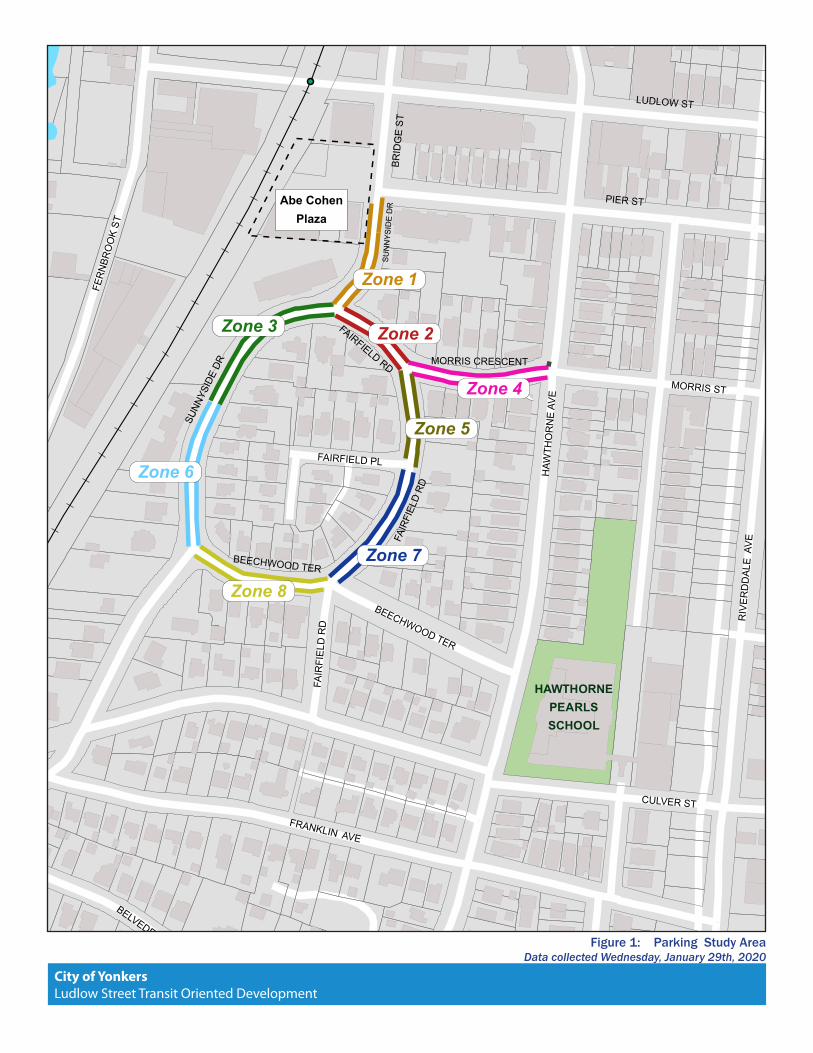
Figures 5 and 6 show the assignment of the new traffic volumes on the roadway network which includes the Ludlow Park neighborhood. Based on the traffic distribution methodologies described above, no traffic volumes have been assigned to Sunnyside Drive south of Pier Street, and relatively small volumes have been assigned to Hawthorne Avenue south of Pier Street (approximately 1 vehicle every 2 minutes during the peak hours) and to Morris Street east of Hawthorne. Notably, the fact that no project-related vehicle trips have been assigned Sunnyside Drive does not mean that there will never be any driver choosing to select this route. Rather, the longer travel time of this route is an attributing factor as to why the number of drivers making this route choice will be very low and insignificant.

City of YonkersLudlow Street Transit Oriented Development
PIER ST
HAW
THOR
NE AV
E
PURS
ER P
L
RIVE
RDAL
E AV
E
179
31
5565
43
719
487
830
697
840
479
775
285
168
122
92
DOWNING ST
KNOWLES ST
LUDLOW ST
MORRIS ST
FERN
BROO
K S
T
PIER ST
RADFORD ST
RIVE
RDAL
E AV
E
CULVER ST
POST ST
FRANKLIN AVE
VALENTINE LN
Figure 3: Study Area Traffic Volumes Existing AM Peak Hour

City of YonkersLudlow Street Transit Oriented Development
PIER ST
VALENTINE LN
PURS
ER P
L
RIVE
RDAL
E AV
E
121HA
WTH
ORNE
AVE
50
36 3637
584
543
730
675
736
516
536
414
192
71
DOWNING ST
KNOWLES ST
LUDLOW ST
MORRIS ST
FERN
BROO
K S
T
RADFORD ST
RIVE
RDAL
E AV
E
CULVER ST
POST ST
FRANKLIN AVE
PIER ST125
Figure 4: Study Area Traffic Volumes Existing PM Peak Hour
City of YonkersLudlow Street Transit Oriented Development
PURS
ER P
L
RIVE
RDAL
E AV
E
23HA
WTH
ORNE
AVE
DOWNING ST
KNOWLES ST
LUDLOW ST
MORRIS ST
FERN
BROO
K S
T
RADFORD ST
RIVE
RDAL
E AV
E
CULVER ST
POST ST
FRANKLIN AVE
SUNN
YSID
E DR
18
48
28
54
34
40
43
66
31
55
31
28
4
PIER ST 168
VALENTINE LN
Figure 5: 2030 Project Build Traffic Assignment - AM Peak Hour

City of YonkersLudlow Street Transit Oriented Development
PURS
ER P
L
RIVE
RDAL
E AV
E
19
DOWNING ST
KNOWLES ST
LUDLOW ST
MORRIS ST
FERN
BROO
K S
T
RADFORD ST
RIVE
RDAL
E AV
E
CULVER ST
POST ST
FRANKLIN AVE
16
413
23
38
66
46
46
47
63
38
63
23
4
PIER ST 13
HAW
THOR
NE AV
E
16
VALENTINE LN
SUNN
YSID
E DR
Figure 6: 2030 Project Build Traffic Assignment - PM Peak Hour

City of YonkersLudlow Street Transit Oriented Development
HAW
THOR
NE AV
EPU
RSER
PL
RIVE
RDAL
E AV
E
9
10
12
11
DOWNING ST
KNOWLES ST
LUDLOW ST
MORRIS ST
FERN
BROO
K S
T
RADFORD ST
RIVE
RDAL
E AV
E
CULVER ST
POST ST
FRANKLIN AVE
B
B
B
CC
A
B ADA
B
A
BA
B B
BC
A C
B
A
B
VALENTINE LN
SUNN
YSID
E DR
Figure 7: Intersection Level of Service 2030 Project Build - AM Peak Hour

City of YonkersLudlow Street Transit Oriented Development
HAW
THOR
NE AV
EPU
RSER
PL
RIVE
RDAL
E AV
E
9
10
12
11
DOWNING ST
KNOWLES ST
LUDLOW ST
MORRIS ST
FERN
BROO
K S
T
RADFORD ST
RIVE
RDAL
E AV
E
CULVER ST
POST ST
FRANKLIN AVE
B
B
B
C
CC
A
B ACA
B
A
B
A B
BC
A C
B
A
AB
VALENTINE LN
SUNN
YSID
E DR
Figure 8: Intersection Level of Service 2030 Project Build - PM Peak Hour

13 Ludlow Park Traffic and Parking Study
Figures 7 and 8 demonstrate the traffic levels of service (LOS) for the key intersections along Riverdale that are projected for the year 2030 with the full build out of the TOD project. Note that LOS for Riverdale Avenue and Ludlow Street assumes adoption of DGEIS recommended mitigation measures and will operate at LOS B. Intersections further south at Riverdale/Morris and Riverdale Radford will also operate at LOS B after the projected full build out (2030). As an unsignalized intersection, Riverdale/Pier operates at LOS A for its southbound movements and LOS B for its eastbound and northbound movements in both the AM and PM peak hours.
One of the main traffic recommendations from the DGEIS is to make Pier Street a two way street, west of Riverdale, to mitigate the traffic conditions at Riverdale and Ludlow and to provide quick and easy access to/from Riverdale. The Pier Street to Riverdale path will be a very attractive route for vehicles driving in that direction and is expected to keep the project traffic off the Ludlow Park neighborhood streets. It will likely shift some southbound traffic from Hawthorne Avenue onto Pier Street and Riverdale Avenue.
Conclusion The above analysis has shown that 1) sound traffic distribution methodologies would not assign any traffic to Sunnyside Drive south of Pier Street, 2) traffic conditions along Riverdale Avenue south of Ludlow Street are projected to remain good and 3) a two-way Pier Street west of Riverdale Avenue will produce a convenient link between the TOD project area and the southerly portion of Riverdale Avenue. These arguments lead to the conclusion that there will not be a measurable impact on traffic flows in the Ludlow Park neighborhood. The traffic study projects a limited traffic stream generated by the TOD project along Hawthorne Avenue between Pier Street and Morris Street (one vehicle every two minutes in the peak hours) and on Morris Street east of Hawthorne Avenue.
It is recommended that once project buildings are substantially occupied, further traffic monitoring can be utilized to confirm vehicular patterns and circulation in the area.
3. Ludlow Park Overnight Parking: Do residents from adjacent areas utilize Ludlow Parkstreets for parking, particularly during overnight hours? (Study Forthcoming)
As noted, future study will be conducted to investigate whether, and to what degree, Ludlow Park neighborhood streets may be used by residents of adjacent areas for overnight parking. Ludlow Park residents express concern that residents from adjacent areas, particularly from higher-density apartment buildings off Riverdale Avenue, park overnight on Ludlow Park streets west of Hawthorne due to a reported scarcity of parking. Depending on the outcome of such study, the provision of increased parking on Riverdale Avenue could help alleviate such reported parking activity.
This study will utilize license plate identification to determine potential parking intrusion into the Ludlow Park neighborhood.
Related Documents