U.S.Department of the Interior Rio Grande Regional Water Authority Bureau of Reclamation Denver, Colorado December 2013 Executive Summary Lower Rio Grande Basin Study Under the Authority of the SECURE Water Act (Public Law 111-11) Great Plains Region, Oklahoma-Texas Area Office

Welcome message from author
This document is posted to help you gain knowledge. Please leave a comment to let me know what you think about it! Share it to your friends and learn new things together.
Transcript

U.S.Department of the Interior Rio Grande Regional Water Authority Bureau of Reclamation Denver, Colorado December 2013
Executive Summary
Lower Rio Grande Basin Study
Under the Authority of the SECURE Water Act (Public Law 111-11) Great Plains Region, Oklahoma-Texas Area Office

Mission Statements
The U.S. Department of the Interior protects America’s natural
resources and heritage, honors our cultures and tribal communities,
and supplies the energy to power our future.
The mission of the Bureau of Reclamation is to manage, develop,
and protect water and related resources in an environmentally and
economically sound manner in the interest of the American public.

U.S.Department of the Interior Rio Grande Regional Water Authority Bureau of Reclamation Denver, Colorado December 2013
Executive Summary
Lower Rio Grande Basin Study
Under the Authority of the SECURE Water Act (Public Law 111-11) Great Plains Region, Oklahoma-Texas Area Office


Acronyms
2010 Region M Plan Rio Grande Regional Water Plan, dated October 1, 2010
ac-ft/yr acre-feet per year
Basin Study Lower Rio Grande Basin Study
BGD brackish groundwater desalination
DMI domestic-municipal-industrial
GHG greenhouse gas
GNEB Good Neighbor Environmental Board
IBWC International Boundary and Water Commission
Interior U.S. Department of the Interior
M&I municipal and industrial
MGD million gallons per day
mg/L milligrams per liter
P&Gs Economic and Environmental Principles and Guidelines
for Water and Related Land Resources Implementation
Studies
P.L. Public Law
Reclamation Bureau of Reclamation
RGRWA Rio Grande Regional Water Authority
RO reverse osmosis
SB1 Senate Bill 1
SRWA Southmost Regional Water Authority
State Water Plan 2012 Statewide plan entitled Water for Texas – 2012
TCEQ Texas Commission on Environmental Quality
TDS total dissolved solids
Treaty Treaty of 1944 Utilization of Waters of the Colorado and
Tijuana Rivers and of the Rio Grande
TWDB Texas Water Development Board
USGS U.S. Geological Survey
VIC Variable Infiltration Capacity Hydrology Model
WAM Water Availability Model
WaterSMART Sustain and Manage America’s Resources for Tomorrow
WMS water management strategy
Symbols
% percent
§ section


i
Table of Contents
Page
I. Public Involvement ............................................................................... ES-3 II. Basin Study Findings ............................................................................ ES-4 III. Projected Future Water Supply and Demand........................................ ES-6
A. Pre-climate Change Supply and Demand Projections ................ ES-6 B. Climate Change Scenarios Considered ....................................... ES-9 C. Climate Change-affected Supply and Demand ......................... ES-12 D. Effect on Future Water Supply Reliability ............................... ES-14
IV. Options to Resolve Supply and Demand Imbalances ......................... ES-17 A. Development of the Planning Objective ................................... ES-17
1. Requirements .................................................................... ES-17 2. Constraints ........................................................................ ES-18 3. Planning Objective ............................................................ ES-20
B. Identification of Water Management Strategies ....................... ES-21 1. Water Management Strategies from the
Region M Plan ............................................................... ES-21 2. Water Management Strategies from the
Region M Plan that Best Meet the Planning
Objective ........................................................................ ES-21 3. Strategies Receiving Further Evaluation .......................... ES-23
V. Evaluation of Options and Strategies to Resolve Supply and
Demand Imbalances ......................................................................... ES-25
A. Seawater Desalination ............................................................... ES-25 B. Fresh Groundwater Development ............................................. ES-26 C. Comparison of Brackish Groundwater Desalination and
Non-potable Reuse ................................................................. ES-26 D. Detailed Analysis of Brackish Groundwater Desalination
Alternatives ............................................................................ ES-29 1. Single Regional BGD Facility .......................................... ES-30 2. Expansion of Existing Groundwater Desalination
Facilities ......................................................................... ES-30 3. Recommended Alternative: Three Regional
BGD Systems ................................................................. ES-31 VI. Study Limitations ................................................................................ ES-39 VII. Future Considerations and Next Steps ................................................ ES-40
A. Implications for International Cooperation ............................... ES-40 B. Implementation of the Brackish Groundwater Desalination
Alternative and Other Water Management Strategies ........... ES-41

ii
Tables Table Page
1 Projected 2010–2060 groundwater and surface water supplies ........ ES-8
2 WAM baseline and climate simulation results ............................... ES-13
3 Fresh groundwater yield by county................................................. ES-26
4 Alternatives evaluation matrix ........................................................ ES-27
5 Group 1 costs .................................................................................. ES-34
6 Group 2 costs .................................................................................. ES-36
7 Group 3 costs .................................................................................. ES-38
Figures Figure Page
1 Lower Rio Grande Basin, Texas. ...................................................... ES-1
2 Projected (pre-climate analysis) firm yield of Amistad-Falcon
Reservoirs and demand. ................................................................. ES-7
3 Projected supply imbalances without climate change factors. .......... ES-8
4 Projections for six hydroclimate indicators for the Rio Grande
below Falcon Dam. ...................................................................... ES-10
5 Simulated mean annual and mean seasonal runoff change. ............ ES-11
6 Amistad-Falcon Reservoirs U.S. firm annual yield comparison
for baseline versus climate change impacts. ................................ ES-14
7 Volume of water delivered to the United States under the
International Boundary Agreement. ............................................. ES-19
8 Region M Plan-recommended WMS potential supply
contribution. ................................................................................. ES-22
9 Group 1 facilities............................................................................. ES-33
10 Group 2 facilities............................................................................. ES-35
11 Group 3 facilities............................................................................. ES-37

ES-1
EXECUTIVE SUMMARY
The focus area for this Lower Rio Grande Basin Study (Basin Study) is comprised
of the Lower Rio Grande River Basin, which extends from Fort Quitman, Texas,
along the U.S./Mexico border, to the Gulf of Mexico (figure 1). The study
was conducted in partnership with the Rio Grande Regional Water Authority
(RGRWA) with its 53 member entities, which shares an approximate boundary
with the Region M Water Planning Group, also denoted on figure 1. The study
area also is comprised of Amistad and Falcon Reservoirs, which are operated as a
system by the International Boundary and Water Commission (IBWC) for flood
control and water supply purposes.
The Lower Rio Grande River Basin lies within the much larger Rio Grande Basin,
which extends from southern Colorado and through New Mexico and Texas.
Between El Paso, Texas, and the Gulf of Mexico, the Rio Grande forms the
International Boundary between the United States and Mexico, a straight-line
distance of 700 miles and a river mile distance of nearly 1,250 miles. Once the
river reaches Fort Quitman, Texas, just downstream from El Paso, diversions have
significantly depleted riverflows. Also, from Fort Quitman to the Gulf of Mexico,
the basin’s topography shifts dramatically as it becomes fed by watersheds
emanating from Mexico rather than the United States.
In Mexico, the Rio Conchos, Rio Salado, and Rio San Juan are the largest
tributaries of the Lower Rio Grande Basin. The Rio Conchos drains over
26,000 square miles and flows into the Rio Grande near the town of Presidio,
Texas, about 350 river miles upstream of Amistad Reservoir. The Rio Salado has
Figure 1: Lower Rio Grande Basin, Texas.

Lower Rio Grande Basin Study
ES-2
a drainage area of about 23,000 square miles and discharges directly into Falcon
Reservoir on the Rio Grande. Falcon Reservoir is located between the cities of
Laredo, Texas, and Rio Grande City, Texas, about 275 river miles upstream of
the Gulf of Mexico. The Rio San Juan has a drainage area of approximately
13,000 square miles and enters the Rio Grande about 36 river miles below Falcon
Dam near Rio Grande City, Texas. The Amistad-Falcon Reservoir System is
designated as a special water resource by the Texas Water Development Board
(TWDB).1
The Texas portion contributing to the Lower Rio Grande Basin encompasses
approximately 54,000 square miles, 8,100 square miles of which are “closed” sub-
basins that do not contribute flows to the Lower Rio Grande Basin. The Pecos
and Devils Rivers are the principal tributaries of the Lower Rio Grande Basin.
Both rivers flow into Amistad Reservoir, located upstream of the city of Del Rio,
Texas, about 600 river miles from the mouth of the Rio Grande.
The majority of surface water within the Lower Rio Grande Basin study area is
comprised of flows within the Rio Grande River. Nearly all of the dependable
surface water supply that is available to the Lower Rio Grande Basin is from
yields of Amistad and Falcon International Reservoirs. These reservoirs provide
controlled storage for over 8.0 million acre-feet of water owned by the United
States and Mexico, of which 2.25 million acre-feet are allocated for flood control
purposes and 6.05 million acre-feet are reserved for water supply.
Under the authority of the SECURE Water Act (Public Law [P.L.] 111-11), the
U.S. Department of the Interior (Interior) established the WaterSMART (Sustain
and Manage America’s Resources for Tomorrow) Program in February 2010 to
facilitate the work of Interior’s bureaus in pursuing a sustainable water supply
for the Nation. This Basin Study was selected for fiscal year 2011 funding in
July 2011. The Bureau of Reclamation (Reclamation) and the RGRWA, with
its 53 member entities, collaborated with the IBWC and Texas water and
environmental agencies to conduct this Basin Study. Although the Basin Study
area considered hydrologic inputs for the entire Lower Rio Grande Basin, an
eight-county region under the jurisdiction of the RGRWA (roughly similar to
Texas water planning Region M) was selected as the area of focus for evaluating
supply imbalances and system reliability and for formulating water management
strategies (WMSs) that consider risks associated with climate variability and
change. The overall Basin Study was conducted at a cost of $412,798 (52 percent
[%] RGWRA; 48% Federal cost share) and was completed within 24 months.
1 31 TAC 357.5(g).

Executive Summary
ES-3
I. Public Involvement
Public involvement was actively sought and achieved throughout the study
primarily through study partner and stakeholder representation at bimonthly
public meetings of the RGRWA Board of Directors. The RGRWA board consists
of 18 members representing irrigation districts, the public, municipalities,
water supply corporations, and counties. Meeting agendas always included a
presentation on Basin Study progress, and consensus was obtained following
discussion and a formal vote on major study actions, including acceptance of the
climate change-affected future conditions projections, formulation of the planning
objective, evaluation of alternatives, and recommended alternative analysis.
Stakeholders were specifically reminded by Reclamation at meetings that they are
expected to represent all of their relevant member interests. Communications
were also held on a case-by-case basis as needed to solicit input, expertise, and
data. In addition, meetings of the RGRWA board also included representatives
from the following:
Texas Water Development Board
Region M Planning Group
Texas Commission on Environmental Quality, Office of Rio Grande
Watermaster
Texas Parks and Wildlife Department
International Boundary Water Commission
U.S. Department of Agriculture Cooperative Extension Service
U.S. Geological Survey (USGS)
RGRWA’s consulting team, which performed technical analyses for the study,
regularly attended the biweekly Region M Planning Group public meetings to
stay abreast of water planning issues in the study area. Some member companies
of the Basin Study consulting team were also subcontractors to the team
contracted by the Region M Planning Group to perform the required 5-year
update of the Region M Plan, which facilitated communication and coordination
with this Basin Study. For example, proposed criteria emerging from this
Basin Study for the location of the preferred alternative brackish groundwater
desalination (BGD) plants were circulated in a Region M Plan survey on water
supply strategies.

Lower Rio Grande Basin Study
ES-4
Also, Reclamation was invited to speak and conducted presentations on the study
at two different meetings that involved both governmental and public attendees,
which included:
U.S. Army Corps of Engineers Conference on the Lower Rio Grande,
October 2011
IBWC Citizens’ Forum, October 2012
Public involvement was also achieved through the Internet, where a link on the
RGRWA Web site was maintained to provide up-to-date information on this
Basin Study.2 The following was provided on the Web link:
Summary and background information
A link to the original proposal for funding
A link to the final Plan of Study
Updates/news releases on completed milestones
Points of contact
II. Basin Study Findings
The Basin Study Program focuses on improving water conservation and
sustainability and helping water resource managers make sound decisions about
water use. It identifies strategies to ensure that this and future generations will
have sufficient supplies of clean water for drinking, economic activities,
recreation, and ecosystem health. The program also identifies adaptive measures
to address climate change and its impact on future water demands. Basin studies
include four required elements:
1. Projections of water supply and demand within the basin, including an
assessment of risks to the water supply relating to climate change as
defined in section 9503(b)(2) of the SECURE Water Act.
The study finds that climate change is likely to result in increased
temperatures, decreased precipitation, and increased evapotranspiration in
the study area. As a result, in addition to the 592,084 acre-feet per year
(ac-ft/yr) of supply shortfall (demand minus supply) predicted by the
existing regional planning process by 2060, it is projected that an
additional 86,438 ac-ft/yr will be needed due to climate change.
2 http://www.rgrwa.org/projects/lower-rio-grande-basin-study/

Executive Summary
ES-5
2. Analysis of how existing water and power infrastructure and operations
will perform in the face of changing water realities, such as population
increases and climate change, as well as other impacts identified within
section 9503(b)(3) of the SECURE Water Act as appropriate.
The supply imbalances exacerbated by climate change will greatly reduce
the reliability of deliveries to all users who are dependent on deliveries
of Rio Grande water via irrigation systems. For example, only about 40%
average volume reliability of interruptible irrigation and mining water
rights would be achieved in the middle range of our future condition
scenarios.
3. Development of appropriate adaptation and mitigation strategies to meet
future water demands.
The study developed a planning objective that would reduce dependency
on the Rio Grande in the part of the study area most susceptible to water
supply imbalances and would meet the additional shortfall projected. This
planning objective was to alleviate projected water supply imbalances in
the study area by developing one or more alternatives in Cameron,
Willacy, and Hidalgo Counties that will (1) provide a minimum of
86,438 acre-feet of water year round by 2060; (2) protect existing water
rights; (3) be compatible with regulations, policies, and environmental
law; and (4) be implementable within the reasonable control of study
sponsors.
4. A tradeoff analysis of the strategies identified and findings and
recommendations as appropriate. This includes an analysis of all
proposed alternatives in terms of their relative cost, environmental impact,
risk (probability of not accomplishing the desired/expected outcome),
stakeholder response, or other attributes common to the alternatives.
The study examined the existing WMSs proposed by the regional planning
process against the planning objective and selected four for further study
(seawater desalination, brackish groundwater desalination, reuse, and fresh
groundwater development) while emphasizing the continuing need for
conservation and the need for a portfolio approach to include all approved
elements of the regional planning process. The four strategies were
examined further, and BGD was recommended as being most suitable for
preliminary engineering and affordability analysis. This strategy was
further developed to recommend three generalized locations for future
desalination plants, which were then analyzed using the TWDB’s Unified
Costing Model, and an affordability analysis was conducted.
Lower Rio Grande Basin Study
ES-6
III. Projected Future Water Supply and Demand
This section first examines existing projections of future water supplies and
demands and then adjusts those projections based on climate change scenarios.
A. Pre-climate Change Supply and Demand Projections
Much of the pre-climate analysis in this Basin Study is based on the current plan
adopted by Region M entitled Rio Grande Regional Water Plan, dated October 1,
2010 (2010 Region M Plan).3 In 1997, the 75th Texas Legislature enacted Senate
Bill 1 (SB 1), legislation that grew out of the drought of the early to mid-1990s
and the increasing public awareness of rapidly growing water demands in the
State. SB 1 radically altered the manner in which State Water Plans are prepared,
establishing a “bottom up” approach based on Regional Water Plans that are
prepared and adopted by appointed Regional Water Planning Groups representing
11 different stakeholder interests. The planning process is coordinated by the
TWDB, which assembles the 16 Regional Water Plans into 1 comprehensive State
Water Plan. Initially designated by TWDB as “Region M,” the Rio Grande
Regional Water Planning Area (or the Rio Grande Region) consists of the eight
counties adjacent to or in proximity to the Lower Rio Grande: Cameron, Hidalgo,
Jim Hogg, Maverick, Starr, Webb, Willacy, and Zapata. The planning group is
tasked with developing a 50-year water supply plan in response to a repeat of the
record drought. In the hydrologic models used for availability, the record drought
occurred in the mid-1950s.
The findings and information provided in the 2010 Region M Plan were then
incorporated into the current Statewide Plan entitled Water for Texas – 20124
(State Water Plan 2012). There is an ongoing effort within Region M to produce
a revised 2013 plan, but the data for that later plan have not yet been available for
inclusion in this Basin Study. However, the development of this Basin Study has
been presented at the Rio Grande Regional Planning Group meetings held every
2 months, and many of this study’s findings, particularly regarding climate-
affected future outcomes and planning alternatives, will be incorporated into the
2013 Region M Plan.
The supply issues facing the Lower Rio Grande Basin in both the United States
and Mexico are extremely complex, ranging from a multinational to local scale.
Water supplies in the area are primarily from the Rio Grande, with much of the
drainage located in Mexico and regulated by releases from the Falcon and
3 http://www.twdb.state.tx.us/wrpi/rwp/3rdRound/2011_RWP/RegionM/
4 http://www.twdb.state.tx.us/wrpi/swp/swp.asp

Executive Summary
ES-7
Amistad Reservoirs, which are managed by the IBWC, in compliance with the
Treaty of 1944 Utilization of Waters of the Colorado and Tijuana Rivers and of
the Rio Grande (Treaty) between the United States and Mexico.
Figure 2 shows the projected (pre-climate analysis) firm yield of the Amistad-
Falcon Reservoirs and demand. These yield values represent the maximum
amount of water that can be withdrawn from the reservoirs on a continual basis
by the United States should conditions similar to the drought of record recur.
Figure 2: Projected (pre-climate analysis) firm yield of Amistad-Falcon Reservoirs and demand. Source: 2010 Region M Regional Water Plan.
The major aquifers within the region include the Gulf Coast aquifer, which
underlies the entire coastal region of Texas, and the Carrizo aquifer that exists in a
broad band that sweeps across the State beginning at the Rio Grande north of
Laredo and continuing northeast to Louisiana. In general, groundwater from the
various aquifers in the region has total dissolved solids (TDS) concentrations
exceeding 1,000 milligrams per liter (mg/L) (slightly saline) and often exceeds
3,000 mg/L (moderately saline). The salinity hazard for groundwater ranges from
high to very high.
A pre-climate analysis of combined surface and groundwater supplies for
Region M are shown in table 1.

Lower Rio Grande Basin Study
ES-8
Table 1: Projected 2010–2060 groundwater and surface water supplies
Region M projected water supply (ac-ft/yr)
2010 2020 2030 2040 2050 2060
Groundwater 341,692 341,692 341,692 341,692 341,692 341,692
Surface water 1,015,958 1,008,958 1,002,458 995,958 989,458 989,458
Total 1,357,650 1,350,650 1,344,150 1,337,650 1,331,150 1,331,150
Source: TWDB State Water Plan 2012.
According to the Region M Plan, the study area faces a projected shortage of
water that is going to grow by 60% over the next 50 years. The biggest changes
are in the conversion of irrigation water to municipal use due to population
growth and urbanization. There was a projected shortage of 156,257 acre-feet
in 2010 and 410,936 acre-feet of need (shortage) in 2060. This is shown on
figure 3.
Figure 3: Projected supply imbalances without climate change factors. Source: Texas State Water Plan 2012.

Executive Summary
ES-9
The State Plan does not account for any potential impacts in projections due to
climate variability. The following discussion outlines the methodology for how
changes in hydrology were simulated in evaluating climate impacts on State water
availability models for Texas.
Much of the surface water deliveries in the study area for all user groups are made
through a network of canals that are managed by 27 different irrigation districts.
As a result of severe drought conditions since 2011, several irrigation districts in
the region announced in spring 2013 that agricultural deliveries were being
curtailed, which also subsequently affected municipal supplies that depend on
agricultural conveyance systems for water deliveries.
B. Climate Change Scenarios Considered
The project team generated 112 climate change-affected outcomes based on three
different future global emission scenarios:
The A2 scenario is representative of high population growth, slow
economic development, and slow technological change. It is characterized
by a continuously increasing rate of greenhouse gas (GHG) emissions and
features the highest annual emission rates of any scenario by the end of the
21st century.
The A1B scenario features a global population that peaks mid-century and
rapid introduction of new and more efficient technologies balanced across
both fossil- and nonfossil-intensive energy sources. As a result, GHG
emissions in the A1B scenario peak around mid-century.
The B1 scenario describes a world with rapid changes in economic
structures toward a service and information economy. GHG emission rates in this scenario peak prior to mid-century and are generally the lowest of the scenarios.
The climate scenario outcomes were then run through the Variable Infiltration Capacity Hydrology Model (VIC). The VIC includes the physical characteristics
of each 12-kilometer cell within the study area to simulate runoff and other water/land/atmosphere interactions at each grid cell. The VIC uses the climate projections along with land cover, soils, and elevation information to simulate
hydrologic interactions, resulting in a prediction of runoff used in this study. The hydrologic interactions were then routed to each of the 43 natural flow
locations within the study area using a routing network derived from the topography. These 43 locations are also matched to the Texas Water Availability Model (WAM) so existing water rights and allocations in practice could be

Lower Rio Grande Basin Study
ES-10
calculated. The VIC control points are distributed in both Mexico and the United States, giving a model of climate-affected flows on all major tributaries as
affected by water rights for the entire Basin Study area. Figure 4 shows the projection for six hydroclimate indicators for the Rio Grande
below Falcon Dam: (1) annual total precipitation (top left), (2) annual mean temperature (top right), (3) April 1 snow water equivalent (middle left), (4) annual runoff (middle right), (5) December – March runoff season (bottom left), and
(6) April – July runoff season (bottom right). The heavy black line is the annual time-series of 50th percentile values (i.e., median). The shaded area is the annual time-series of 5th to 95th percentiles of the results when they are ordered from
lowest to highest. This location was chosen because it is the most downstream point of the Rio Grande before withdrawals are made to meet the demands of the study area.
Figure 4: Projections for six hydroclimate indicators for the Rio Grande below Falcon Dam.

Executive Summary
ES-11
These data are summarized for selected future years on figure 5. Changes in mean runoff (annual or seasonal) are calculated for the three future decades—
2020s, 2050s, and 2070s—from the reference 1990s decade. The results can be summarized as follows:
Precipitation is expected to increase from the 1990s level during the 2020s and 2050s but decline nominally during the 2070s.
Temperature shows a persistent increasing trend from the 1990s level.
April 1 snowpack (Upper Rio Grande Basin) shows a persistent decreasing
trend from the 1990s level.
Annual runoff shows some increase from the 1990s level to the 2020s, but
then declines to the 2050s and 2070s.
Figure 5: Simulated mean annual and mean seasonal runoff change.
Reservoir evaporation was estimated using the same approach to estimate
changes in streamflow. Using the VIC open water evaporation output, change
in monthly mean open water evaporation was estimated for each of the 112
climate projections and for each of the 25 reservoir sites used in the water
allocation modeling effort. Next, median (50th percentile) and 95th percentile
change for each month was calculated from the 112 change factors for each of the

Lower Rio Grande Basin Study
ES-12
reservoir sites. The summer season (June – August) change for the median
(50th
percentile) from the 25 reservoir sites ranged from 0.85 to 3.72% with
a median change of 2.58%. Similarly, the summer season change for the
95th
percentile from the 25 reservoir sites ranged from 6.55 to 12.55% with a
median of 9.61%. To simplify the system reliability analysis, three values
considered representative of the above VIC output trends were selected for
comparison purposes: (1) no change in reservoir evaporation, (2) a 4% change
in reservoir evaporation, and (3) a 10% change in reservoir evaporation. These
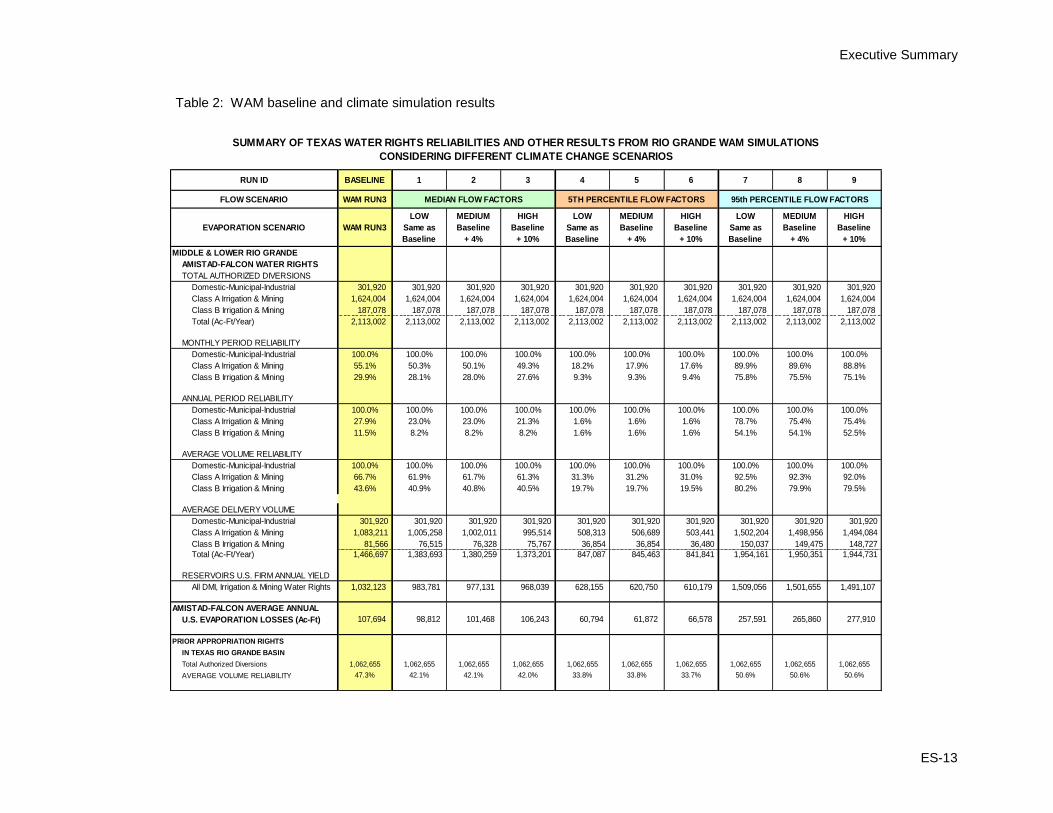
reliability comparisons are displayed in table 2.
C. Climate Change-affected Supply and Demand
The effect of potential climate change scenarios on the surface water supply
imbalances from the Rio Grande was investigated using the Rio Grande WAM
with modified naturalized flow inputs derived from the 112 climate change
scenarios analyzed by Reclamation. The results of the analysis were then ordered
from lowest to highest. Monthly median and 5th and 95th percentile flow factors
from the 112 scenarios were used at all primary control points in the WAM to
incorporate climate change effects into the monthly baseline naturalized flows for
the 1940–2000 simulation period. For example, a value in the 5th percentile
represents values of lower flow (exceeded by 95% of the other values resulting
from the analysis), while a value in the 95th percentile represents values of higher
flows (exceeded by only 5% of the others).
The evaporation rates for this period included in the WAM data input files were
also increased by 4 and 10% to provide an indication of the potential effects of
varying evaporation rates due to climate change. As with flow, evaporation rates
for nine climate change scenarios and the baseline were evaluated for surface
water availability effects.
Figure 6 compares firm yield from the Amistad-Falcon Reservoir System based
on the WAM Run 3 baseline simulation with firm yield results for the three
climate scenarios. These firm yields can be assumed to represent current
(2010) conditions and do not represent future projections due to the lack of
impact from sedimentation rates and changes in the distribution of water
demands. Firm yield for baseline conditions is 1,032,123 acre-feet; climate
change impacts would reduce this amount to 620,750 acre-feet under the
5th
percentile simulation, a 40% reduction in firm yield volume for the study
area.
Executive Summary
ES-13
Table 2: WAM baseline and climate simulation results
WAM RUN3
WAM RUN3
LOW
Same as
Baseline
MEDIUM
Baseline
+ 4%
HIGH
Baseline
+ 10%
LOW
Same as
Baseline
MEDIUM
Baseline
+ 4%
HIGH
Baseline
+ 10%
LOW
Same as
Baseline
MEDIUM
Baseline
+ 4%
HIGH
Baseline
+ 10%
MIDDLE & LOWER RIO GRANDE
AMISTAD-FALCON WATER RIGHTS
TOTAL AUTHORIZED DIVERSIONS
Domestic-Municipal-Industrial 301,920 301,920 301,920 301,920 301,920 301,920 301,920 301,920 301,920 301,920
Class A Irrigation & Mining 1,624,004 1,624,004 1,624,004 1,624,004 1,624,004 1,624,004 1,624,004 1,624,004 1,624,004 1,624,004
Class B Irrigation & Mining 187,078 187,078 187,078 187,078 187,078 187,078 187,078 187,078 187,078 187,078
Total (Ac-Ft/Year) 2,113,002 2,113,002 2,113,002 2,113,002 2,113,002 2,113,002 2,113,002 2,113,002 2,113,002 2,113,002
MONTHLY PERIOD RELIABILITY
Domestic-Municipal-Industrial 100.0% 100.0% 100.0% 100.0% 100.0% 100.0% 100.0% 100.0% 100.0% 100.0%
Class A Irrigation & Mining 55.1% 50.3% 50.1% 49.3% 18.2% 17.9% 17.6% 89.9% 89.6% 88.8%
Class B Irrigation & Mining 29.9% 28.1% 28.0% 27.6% 9.3% 9.3% 9.4% 75.8% 75.5% 75.1%
ANNUAL PERIOD RELIABILITY
Domestic-Municipal-Industrial 100.0% 100.0% 100.0% 100.0% 100.0% 100.0% 100.0% 100.0% 100.0% 100.0%
Class A Irrigation & Mining 27.9% 23.0% 23.0% 21.3% 1.6% 1.6% 1.6% 78.7% 75.4% 75.4%
Class B Irrigation & Mining 11.5% 8.2% 8.2% 8.2% 1.6% 1.6% 1.6% 54.1% 54.1% 52.5%
AVERAGE VOLUME RELIABILITY
Domestic-Municipal-Industrial 100.0% 100.0% 100.0% 100.0% 100.0% 100.0% 100.0% 100.0% 100.0% 100.0%
Class A Irrigation & Mining 66.7% 61.9% 61.7% 61.3% 31.3% 31.2% 31.0% 92.5% 92.3% 92.0%
Class B Irrigation & Mining 43.6% 40.9% 40.8% 40.5% 19.7% 19.7% 19.5% 80.2% 79.9% 79.5%
AVERAGE DELIVERY VOLUME
Domestic-Municipal-Industrial 301,920 301,920 301,920 301,920 301,920 301,920 301,920 301,920 301,920 301,920
Class A Irrigation & Mining 1,083,211 1,005,258 1,002,011 995,514 508,313 506,689 503,441 1,502,204 1,498,956 1,494,084
Class B Irrigation & Mining 81,566 76,515 76,328 75,767 36,854 36,854 36,480 150,037 149,475 148,727
Total (Ac-Ft/Year) 1,466,697 1,383,693 1,380,259 1,373,201 847,087 845,463 841,841 1,954,161 1,950,351 1,944,731
RESERVOIRS U.S. FIRM ANNUAL YIELD
All DMI, Irrigation & Mining Water Rights 1,032,123 983,781 977,131 968,039 628,155 620,750 610,179 1,509,056 1,501,655 1,491,107
AMISTAD-FALCON AVERAGE ANNUAL
107,694 98,812 101,468 106,243 60,794 61,872 66,578 257,591 265,860 277,910
PRIOR APPROPRIATION RIGHTS
IN TEXAS RIO GRANDE BASIN
Total Authorized Diversions 1,062,655 1,062,655 1,062,655 1,062,655 1,062,655 1,062,655 1,062,655 1,062,655 1,062,655 1,062,655
AVERAGE VOLUME RELIABILITY 47.3% 42.1% 42.1% 42.0% 33.8% 33.8% 33.7% 50.6% 50.6% 50.6%
SUMMARY OF TEXAS WATER RIGHTS RELIABILITIES AND OTHER RESULTS FROM RIO GRANDE WAM SIMULATIONS
CONSIDERING DIFFERENT CLIMATE CHANGE SCENARIOS
RUN ID BASELINE 1 2 3 4 5 6
EVAPORATION SCENARIO
U.S. EVAPORATION LOSSES (Ac-Ft)
7 8 9
FLOW SCENARIO MEDIAN FLOW FACTORS 5TH PERCENTILE FLOW FACTORS 95th PERCENTILE FLOW FACTORS

Lower Rio Grande Basin Study
ES-14
Figure 6: Amistad-Falcon Reservoirs U.S. firm annual yield comparison for baseline versus climate change impacts.
The effect of climate change on future evapotranspiration was also calculated
and incorporated into seasonal agricultural demand figures to show quantified
increases, further exacerbating the future supply/demand imbalance for
the study area. Agricultural demands would be expected to increase by
approximately 18% for the 95th percentile climate change scenario over
baseline demands.
D. Effect on Future Water Supply Reliability
In total, 10 different sets of WAM input data were considered, 1 reflecting the
historical baseline condition without climate change effects and 9 combinations of
the 3 future flow conditions (median and 5th and 95th percentile flow factors) and
3 future evaporation conditions (baseline and 4 and 10% increases) with climate
change effects. Table 2 describes the following scenarios in the columns from left
to right:
Baseline
Scenario 1 – Median climate-affected flow factors with evaporation same
as baseline

Executive Summary
ES-15
Scenario 2 – Median climate-affected flow factors with + 4% evaporation
Scenario 3 – Median climate-affected flow factors with + 10% evaporation
Scenario 4 – 5th
percentile climate-affected flow factors (low) with
evaporation same as baseline
Scenario 5 – 5th
percentile climate-affected flow factors (low) with + 4%
evaporation
Scenario 6 – 5th
percentile climate-affected flow factors (low) with + 10%
evaporation
Scenario 7 – 95th
percentile climate-affected flow factors (high) with
evaporation same as baseline
Scenario 8 – 95th
percentile climate-affected flow factors (high) with + 4%
evaporation
Scenario 9 – 95th
percentile climate-affected flow factors (high) with
+ 10% evaporation
With these sets of modified input data, simulations of water availability
throughout the Rio Grande Basin were made using the WAM, and the results are
shown in table 2 in a few different terms. First, the total authorized diversion
is the total volume of all water rights held for this section of the Rio Grande.
Reliabilities are assigned to classes of water rights on the Lower Rio Grande as a
way to deal with the volume of total authorized maximum diversions being larger
than the firm yield of the reservoirs. Table 2 shows both period and volume
reliabilities for all domestic-municipal-industrial (DMI) water rights and for all
Class A5 and Class B
6 irrigation and mining water rights that depend on Amistad
and Falcon Reservoirs for their supply.
For the purpose of this study, the volume reliability percentage is defined as the
average volume of water that a particular water right was able to divert during
the 1940–2000 period, as simulated with the WAM, divided by the authorized
maximum diversion amount for that water right. For example, in column 6 of
table 2, for the 5th percentile flow factor (that point in the projected future flow
5
Class A water right in the Rio Grande Basin for irrigation and mining use granted in the
Adjudication in State v. Hidalgo County Water Control & Improvement District No. 18. If
converted to a DMI water right, a Class A water right is converted to 50% of the existing water
right.
6 Class B water right in the Rio Grande Basin for irrigation and mining use granted in the
Adjudication in State v. Hidalgo County Water Control & Improvement District No. 18. If
converted to a DMI water right, a Class B water right is converted to 40% of the existing water
right.

Lower Rio Grande Basin Study
ES-16
distribution curve of which 95% of the results were higher), under the high
evaporation scenario, only 19.5% of the Class B irrigation and mining water
rights would be met due to low surface water conditions.
Period reliability is the percentage of time for which a particular diversion is
available in light of the historical observations. This applies to monthly and
annual time steps. Monthly period reliability is the percentage of time for which
all monthly authorized diversions are met. The annual period reliability is the
percentage of time for which annual authorized diversions are met. The annual
period reliability decreases dramatically over the monthly reliability due to the
larger number of data points in the monthly historical record. For the purpose of
the following discussion, the average volume reliability is used.
Firm yield is the maximum water volume a reservoir can provide each year under
the drought of record conditions and is shown for each climate scenario.
For information purposes, the average annual evaporation losses from Amistad
and Falcon Reservoirs and the minimum storage remaining in these reservoirs as
simulated with the WAM for the 1940–2000 period are presented for the baseline
case and for each of the nine climate change scenarios.
As shown in table 2, the water supply from Amistad and Falcon Reservoirs for the
DMI water rights is 100% reliable because of the high priority assigned to these
rights under the structure of the Texas Commission on Environmental Quality’s
(TCEQ) water rights administration rules for the Middle and Lower Rio Grande
(the model predicts that adequate supply will exist under all climate scenarios to
satisfy these rights). The Class A and Class B irrigation and mining rights have
somewhat lower reliabilities because the available supplies of water for these
rights from Amistad and Falcon Reservoirs are subject to allocation during
periods of shortage, with the Class A rights allocated more water than the Class B
rights. The reliabilities of the prior appropriation water rights, which are rights to
Rio Grande water directly, not allocated from the reservoirs, generally fall in line
with the Class A and Class B reservoir rights, except for the 95th percentile high-
flow results (Scenarios 7, 8 and 9), where all of the Class A and Class B
reliabilities are considerably higher.
From the average volume reliabilities, another metric can be generated: average
volume diverted. Whereas firm yield was calculated as the largest volume that
can be supplied with 100% reliability, average volume diverted is calculated by
applying the average volume reliability to the total authorized diversions. This
value represents the average volume that is likely to be diverted under each
climate scenario.
The difference between the average volume diverted under the baseline condition
and the median flow, 4% increased evaporation scenario (Scenario 2), is
86,438 acre-feet. This represents the difference between the Amistad-Falcon

Executive Summary
ES-17
modeled availability that is currently used in the planning process and the
availability that is predicted under the median climate-affected availability
model. In other words, in addition to Region M’s predicted supply imbalance
of 592,084 ac-ft/yr, there will likely be another 86,438 ac-ft/yr also not
available in 2060, further affecting delivery reliabilities of all users. Even
though municipal and industrial (M&I) users have rights to 100% reliability in
theory, extreme drought conditions in 2013 have shown that reductions in
agricultural water deliveries can negatively affect the push water needed to
supply M&I users. This important figure is used in this Basin Study as
representative of the probable additional future supply imbalance that would
result from climate change and, therefore, plays a major role in forming the
planning objective.
IV. Options to Resolve Supply and Demand Imbalances
A. Development of the Planning Objective
The study’s planning objective was developed to address the 86,438 ac-ft/yr
shortfall in consideration of the following requirements and constraints:
1. Requirements
The study team’s discussions as vetted through RGRWA public meetings have
resulted in the following essential elements desired for any solution to future
supply imbalances:
Reduce dependency on the Rio Grande: The overappropriation of Rio Grande water rights, climate variability-affected Rio Grande supply projections, anticipated decreased firm yield of its reservoirs, projected worsening supply imbalance, and increasing competing demand from Mexico result in the need for supply alternatives that reduce dependency on the Rio Grande.
Preserve existing water rights: The overappropriation of current supplies and the primacy of DMI rights over agricultural rights are exacerbated by the interdependent relationship of irrigation “push water” needed to enable delivery. Furthermore, recognition of valid uses that contributes to the health and economic vitality of the study area result in a guiding principle against adoption of an alternative that would benefit one user group to the detriment of another user group.
Lower Rio Grande Basin Study
ES-18
Preserve downstream flows for irrigation/push water/environmental
reasons: While not a regulatory requirement, the preservation of downstream flows for environmental and other users is a worthwhile constraint in itself and especially valuable in an area prone to drought and possible reduced flows from climate change.
Contain actions that are within the reasonable control of study
sponsors: The strategies selected by members of this Basin Study must involve relatively low risk in terms of being within the discretion of study partners to implement. For example, although a Treaty is in place, past performance and jurisdictional barriers indicate that there is high risk in involving alternatives that call for operational changes in Mexico.
2. Constraints
The following conditions exist that would affect all solutions to future supply imbalances:
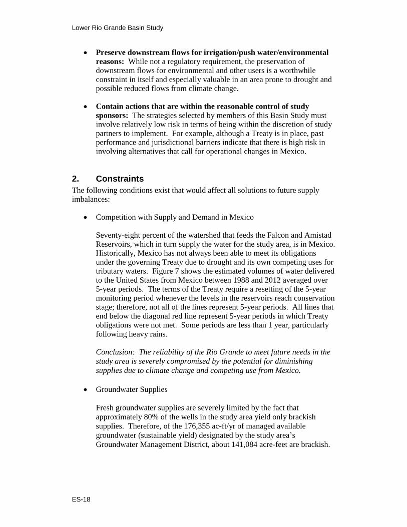
Competition with Supply and Demand in Mexico
Seventy-eight percent of the watershed that feeds the Falcon and Amistad Reservoirs, which in turn supply the water for the study area, is in Mexico. Historically, Mexico has not always been able to meet its obligations under the governing Treaty due to drought and its own competing uses for tributary waters. Figure 7 shows the estimated volumes of water delivered to the United States from Mexico between 1988 and 2012 averaged over 5-year periods. The terms of the Treaty require a resetting of the 5-year monitoring period whenever the levels in the reservoirs reach conservation stage; therefore, not all of the lines represent 5-year periods. All lines that end below the diagonal red line represent 5-year periods in which Treaty obligations were not met. Some periods are less than 1 year, particularly following heavy rains. Conclusion: The reliability of the Rio Grande to meet future needs in the
study area is severely compromised by the potential for diminishing
supplies due to climate change and competing use from Mexico.
Groundwater Supplies
Fresh groundwater supplies are severely limited by the fact that
approximately 80% of the wells in the study area yield only brackish
supplies. Therefore, of the 176,355 ac-ft/yr of managed available
groundwater (sustainable yield) designated by the study area’s
Groundwater Management District, about 141,084 acre-feet are brackish.

Executive Summary
ES-19
Figure 7: Volume of water delivered to the United States under the International Boundary Agreement. Source: International Boundary and Water Commission.
Recent indicators show that water use for mining for hydraulic fracturing
(fracking) related to oil and gas activities in the study area have increased
tenfold over current Region M plan estimates (42,000 ac-ft/yr compared to
4,200 ac-ft/yr ).7 Supplies for fracking are based on some river diversions,
but are more dependent on groundwater, primarily fresh groundwater.
Although such usage may wane by 2030 when the current oil development
boom in the northern portions of the study area may cease, groundwater
recharge in the study area is insignificant, and the demand for fracking
water is expected to affect fresh groundwater supplies throughout the
planning horizon. An assessment of the usage and long-term effects of
fracking demand is complicated by the fact that water use for oil and gas
development is exempt from Texas groundwater regulation.
Conclusion: Brackish groundwater supplies are four times (80 versus
20%) more plentiful than fresh groundwater supplies and have much
fewer competing demands.
Temporal Aspects
The study area’s warm climate provides for a year-round growing season.
In addition, M&I demand (which includes landscape watering and
residential/commercial uses) varies little year round. Because the
demands are constant, irrigation districts that serve agricultural, municipal,
7 This trend has been noted by the TCEQ Watermaster at Region M and RGRWA board
meetings.

Lower Rio Grande Basin Study
ES-20
and industrial demand report difficulty diverting water flows in order to
perform both maintenance and system improvements. Since demand for
the Rio Grande waters exceeds supply year round, there is no season when
the supply balance will not need amelioration.
The planning horizon for this Basin Study is through the year 2060. While
assessments of supply imbalance are based on the planning horizon,
imbalances already exist and are expected to worsen between now and
2060.
Conclusion: The planning objective should require a solution that
provides a year-round source of water that provides for solution(s) as
soon as they can be practically available, but with a goal of being
operational and feasible throughout the planning horizon.
Locational Aspects
The Lower Rio Grande Valley Development Council states that
solution(s) were sought that would provide from 25 to 40% of the
projected supply imbalances of 2050 demand and are located within the
three-county subarea of Cameron, Willacy, and Hidalgo.8
The largest municipal, manufacturing, and mining users are further down
river in Hidalgo and Cameron Counties and upriver in Webb County. The
majority of the demand in Webb County was from the city of Laredo,
which is not an RGRWA member, and they have opted out of this study.
There are over 100 miles and two other counties between Webb County
and the nearest of the three counties specified by the RGRWA. Demand
from these users is expected to grow rapidly during the planning horizon,
while demand from the agricultural group is expected to decline due to
projected urbanization.
Conclusion: The planning objective should require a solution that
provides water supplies in one or more of the following counties:
Cameron, Willacy, and Hidalgo.
3. Planning Objective
The planning objective presented by the study team and adopted by vote of the
RGRWA at its public meeting on September 5, 2012, incorporates the above
requirements and constraints:
8 RGRWA’s March 15, 2011, Letter of Intent.

Executive Summary
ES-21
Alleviate projected water supply imbalances in the study area by developing one or more alternatives in Cameron, Willacy, and Hidalgo Counties that will (1) provide a minimum of 86,438 acre-feet of water year round by 2060; (2) protect existing water rights; (3) be compatible with regulations, policies, and environmental law; and (4) be implementable within the reasonable control of study sponsors.
B. Identification of Water Management Strategies
1. Water Management Strategies from the Region M Plan
The relationship is strong between the Region M Plan and this Basin Study. The
Regional Plan is the product of stakeholder vetted information compiled by
subject matter experts. In addition, all chapters of this Basin Study were
transmitted and reviewed as technical memoranda through the Region M Planning
Team at their public meetings. The 2010 Region M Plan, as endorsed by the State
of Texas and incorporated into the State Water Plan, recommends a portfolio of
WMSs to ameliorate supply imbalances in the study area (figure 8). Because the
WMSs were formulated to address the future supply imbalances that are
incorporated into this Basin Study, and have been previously subjected to rigorous
analysis based on local capabilities, they represent an excellent starting point for
the development of appropriate adaptation and mitigation strategies to meet future
water demands.
This Basin Study is limited by scope and budget to investigate those strategies
that specifically address the planning objective. Using the planning objective, a
selection of WMSs that meet those specific constraints have been investigated
further in the study. Nevertheless, the most robust solution to the expected
shortages in the study area will also include the continued development of the
range of strategies recommended by Region M, many of which would increase
the efficiency of the use of Rio Grande supplies. Together, the study may
enable development of water sources independent of the Rio Grande, and the
development of the other WMSs in the State Plan may provide more efficient use
of Rio Grande supplies.
2. Water Management Strategies from the Region M Plan that Best Meet the Planning Objective
a. Evaluation Methodology
The WMSs that best meet the planning objective of the study are evaluated in the
discussion below. Each major component of the planning objective has been
matched to a major criterion of the Economic and Environmental Principles and
Guidelines for Water and Related Land Resources Implementation Studies
(P&Gs) (U.S. Water Resources Council, 1983), which govern the planning of all

Lower Rio Grande Basin Study
ES-22
Figure 8: Region M Plan-recommended WMS potential supply contribution.
Federal water projects. Although the WMSs are not Federal projects, the policies
established by these P&Gs are appropriate for use in this Basin Study. These
criteria are:
(1) Effectiveness
Effectiveness measures the extent to which an alternative reliably meets the
planning objective by alleviating a specified problem and achieving goals.
Specifically, effectiveness was measured in terms of improving reliability by
reducing dependency on the Rio Grande River. In addition, the temporal (year-
round) and locational (Cameron, Willacy, and Hidalgo Counties) aspects
described above were considered.
(2) Acceptability
Acceptability measures the workability and viability of an alternative with respect
to how compatible it is with authorities, regulations, policies, and environmental
law. Specifically, acceptability was measured in terms of protecting existing
water rights and in meeting the planning objective to preserve downstream flow.
Executive Summary
ES-23
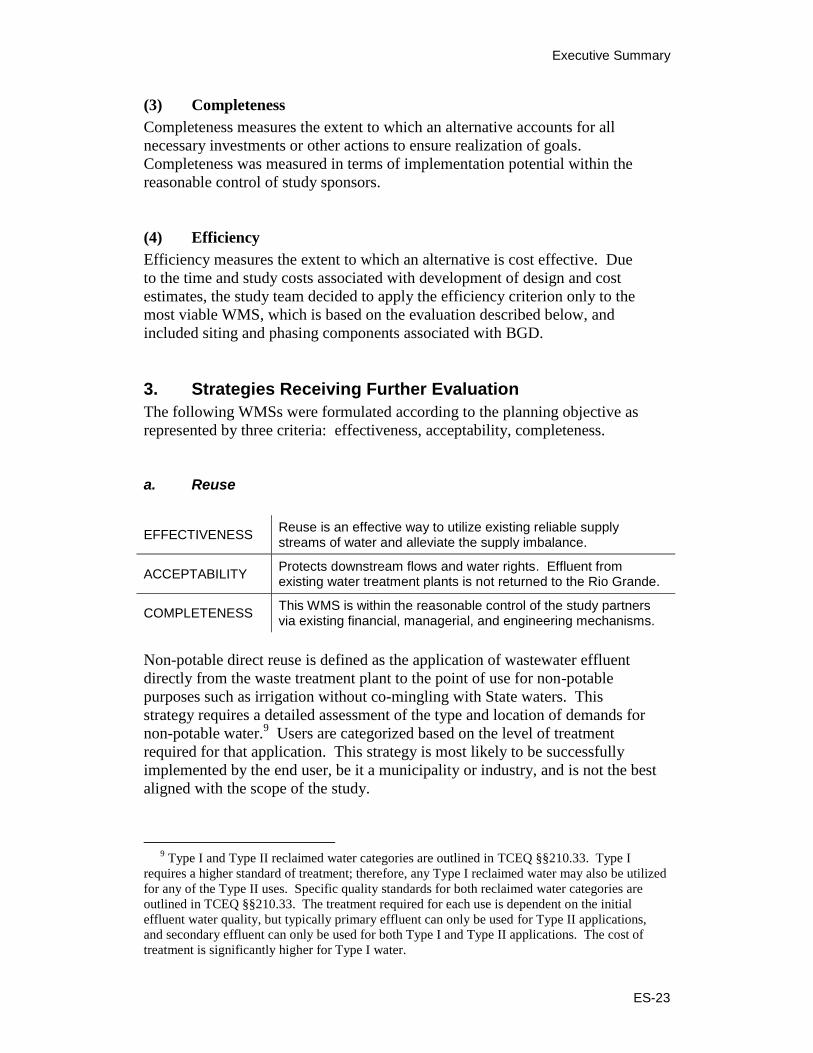
(3) Completeness
Completeness measures the extent to which an alternative accounts for all
necessary investments or other actions to ensure realization of goals.
Completeness was measured in terms of implementation potential within the
reasonable control of study sponsors.
(4) Efficiency
Efficiency measures the extent to which an alternative is cost effective. Due
to the time and study costs associated with development of design and cost
estimates, the study team decided to apply the efficiency criterion only to the
most viable WMS, which is based on the evaluation described below, and
included siting and phasing components associated with BGD.
3. Strategies Receiving Further Evaluation
The following WMSs were formulated according to the planning objective as
represented by three criteria: effectiveness, acceptability, completeness.
a. Reuse
EFFECTIVENESS Reuse is an effective way to utilize existing reliable supply streams of water and alleviate the supply imbalance.
ACCEPTABILITY Protects downstream flows and water rights. Effluent from existing water treatment plants is not returned to the Rio Grande.
COMPLETENESS This WMS is within the reasonable control of the study partners via existing financial, managerial, and engineering mechanisms.
Non-potable direct reuse is defined as the application of wastewater effluent
directly from the waste treatment plant to the point of use for non-potable
purposes such as irrigation without co-mingling with State waters. This
strategy requires a detailed assessment of the type and location of demands for
non-potable water.9 Users are categorized based on the level of treatment
required for that application. This strategy is most likely to be successfully
implemented by the end user, be it a municipality or industry, and is not the best
aligned with the scope of the study.
9 Type I and Type II reclaimed water categories are outlined in TCEQ §§210.33. Type I
requires a higher standard of treatment; therefore, any Type I reclaimed water may also be utilized
for any of the Type II uses. Specific quality standards for both reclaimed water categories are
outlined in TCEQ §§210.33. The treatment required for each use is dependent on the initial
effluent water quality, but typically primary effluent can only be used for Type II applications,
and secondary effluent can only be used for both Type I and Type II applications. The cost of
treatment is significantly higher for Type I water.

Lower Rio Grande Basin Study
ES-24
b. Brackish Groundwater Desalination
EFFECTIVENESS Reduces dependency on the Rio Grande by developing a new water source that can be located throughout the desired areas.
ACCEPTABILITY
Protects downstream flows and water rights. Existing brackish desalination plants in Texas and in the study area have demonstrated that they can be built within regulations, policies, and environmental law.
COMPLETENESS This WMS is within the reasonable control of the study partners via existing financial, managerial, and engineering mechanisms.
Desalination of brackish groundwater is most commonly accomplished through
reverse osmosis (RO). A full-scale RO system to treat brackish groundwater
would require pretreatment, which would include a cartridge filtration system
to remove minimal suspended solids. Acid and a silica scale inhibitor would
also be added to prevent scale formation. A full-scale system would be
expected to have a membrane life of approximately 5 years. Chemical
cleaning of the membrane would be required approximately one to four times
per year.
Concentrate from the RO system must be disposed of in an environmentally
acceptable manner. Most of the current or proposed systems utilize drainage
canal discharge, which ultimately will discharge into the Laguna Madre or the
Gulf of Mexico. Other options include disposal to a sewer system and deep well
injection.
c. Seawater Desalination
EFFECTIVENESS Reduces dependency on the Rio Grande by developing a new, reliable water source.
ACCEPTABILITY
Protects downstream flows and water rights. Existing seawater desalination plants in the United States, and a pilot project in Texas, have demonstrated that they can be built within regulations, policies, and environmental law.
COMPLETENESS This WMS is within the reasonable control of the study partners via existing financial, managerial, and engineering mechanisms.
There are several types of desalination methods to treat seawater. In addition to
membrane technologies, methods include thermal processes such as multistage
flash distillation, multiple-effect distillation, and vapor compression. These
energy-intensive processes are more common in the Middle East where fuels are
more abundant.

Executive Summary
ES-25
d. Fresh Groundwater Development
EFFECTIVENESS Reduces dependency on the Rio Grande by developing a new water source that can be located throughout the desired areas.
ACCEPTABILITY Protects downstream flows and water rights. Existing well technology is proven. Can be built within regulations, policies, and environmental law.
COMPLETENESS This WMS is within the reasonable control of the study partners via existing financial, managerial, and engineering mechanisms.
The Gulf Coast aquifer contains fresh and brackish groundwater. The southern
Gulf Coast Groundwater Availability Model indicates that groundwater is
available from the aquifer in this area. Well production estimates range from
0.29 to 0.86 million gallons per day (MGD) (200 to 600 gallons per minute). The
quality of the groundwater is expected to meet most standards for public water
supplies and requires minimal treatment. If required, the groundwater may be
mixed with treated surface water to improve water quality.
V. Evaluation of Options and Strategies to Resolve Supply and Demand Imbalances
As previously stated, study partners agreed that the scope and budget of this study
would best be served by identifying one alternative strategy that best meets the
planning objective and then developing preliminary engineering design and costs
of that alternative to the extent needed to meet the planning objective. The
following discussion summarizes the next phase of the evaluation.
A. Seawater Desalination
The Brownsville Public Utilities Board and Laguna Madre Water District have
already confirmed the feasibility of seawater desalination along the Texas Gulf
Coast through detailed investigations and pilot testing, and design and cost
estimates of proposed facilities have already been produced. Other counties
within the study area, including Hidalgo County, did not include seawater
desalination as a WMS in the most recent 2010 Region M Water Plan,
perhaps due to their relative farther distance from the Gulf Coast, and instead
have proposed less costly options such as water reuse and BGD. Therefore,
this alternative was eliminated from further consideration as part of this
study.

Lower Rio Grande Basin Study
ES-26
B. Fresh Groundwater Development
Fresh groundwater is an important resource that should be considered in any
water purveyor’s portfolio of water supply options in the study area. As stated in
the Task 4 Technical Memorandum, the 2010 Region M plan found that about
20% of the 822 groundwater wells in the study area yield fresh groundwater
(<1,000 mg/L TDS). Therefore, of the 176,355 ac-ft/yr of managed available
groundwater (sustainable yield) designated by the study area’s Groundwater
Management District, about 35,271 acre-feet are expected to be freshwater.10
This amount is reduced to 12,094 ac-ft/yr when totaling the estimated fresh
groundwater available in the three counties specified in the planning objective
(Cameron, Hidalgo, and Willacy) as shown in table 3.
Table 3: Fresh groundwater yield by county
County Cameron Hidalgo Jim
Hogg Maverick Starr Webb Willacy Zapata
Yield (ac-ft/yr)
2,947 9,147 65 0 4,188 7,918 0 0
Due to the limited number of production wells in the study area, the exact location
of the 12,094 ac-ft/yr of fresh groundwater remains unknown. This amount is
even less when fracking demand is accounted for and is insufficient to meet the
planning objective. Efforts to quantify use for fracking are complicated by the
fact that water use for oil and gas development is exempt from Texas groundwater
regulation.11
Therefore, this alternative was eliminated from further consideration
as part of this study.
C. Comparison of Brackish Groundwater Desalination and Non-potable Reuse
Brackish groundwater desalination and non-potable reuse appear to be viable in
terms of meeting the planning objective and, thus, were evaluated in more detail
(the results are summarized in table 4). Given the multiple locations identified in
the Region M Plan for both of these WMSs, and in order to maximize economies
of scale, they are conceptualized as regional in nature. In the case of BGD, wells
in different locations could feed into a large centralized
10 2011 Region M Plan, Chapter 4, Section 4.5.7.1 Strategy Description.
11
Under Texas Water Code §36.117, production or injection wells drilled for oil and gas are
exempted from regulation.

Executive Summary
ES-27
Table 4: Alternatives evaluation matrix
Criterion Description Regional Brackish Groundwater Desalination Score (1 to 5)* Regional Water Reuse Score (1 to 5)*
Effectiveness
Water quantity
Extent to which alternative can provide up to 86,000 acre-feet per year of
water in Cameron, Willacy or Hidalgo Counties
Dependent on availability in selected locations. Approximately 280,000 ac-ft
of available brackish groundw ater in the Three-County area. 5
Assuming that 35% of the DMI usage is recoverable return f low ,
75,700 AcFt could potentially be available for treatment and reuse in
the 3-county target area. Treated w ater TDS may be too high for
some uses. 3
Water reliability
Extent to which quantity reduces dependency on the Rio Grande, is
drought proof, secure for the planning horizon, and not subject to
reduction/loss
Independent of the Rio Grande River; considered a “new supply” that is
drought proof and not subject to reduction/loss, assuming w ater rights are
secured 5
Because most raw M&I w ater supply emanates from the Rio Grande
River, w astew ater eff luent also indirectly depends on the Rio Grande
River, and is therefore subject to potential loss and lack of reliability. 3
Constructability Challenges associated with construction
Locating ideal area for w ellf ield, potential challenges in delivery/distribution
from that location, disposal of concentrate, but it is a proven technology in
use in the area. 4
Depends on the adaptability of existing w astew ater treatment plants,
extent of treatment required, and identif ication of suitable users and
the delivery to those users. High TDS levels in w astew ater eff luent
emanating from raw w ater w ithdraw n from the Rio Grande is
expected to require advanced w ater treatment prior to reuse. 4
Servicability Challenges associated with operations and serviceability
Issues associated w ith disposal of concentrate, RO maintenance,
membrane fouling, etc, as w ell as energy requirements, may present
operations and serviceability challenges 3
Operations and serviceability challenges limited to the extent of
treatment and appurtenant infrastructure required. 4
4.25 3.5
Acceptability
Protects existing water rights
Extent to which satisfaction of existing water rights assigned to WUGs are
not harmed.
No impacts expected on existing surface w ater rights; little competition for
brackish groundw ater. 5
Not aw are of surface w ater rights in the Arroyo Colorado w hich
w ould be affected by reduced return f low s. 5
Impacts on instream flows
Extent to which flows of the Rio Grande or Arroyo Colorado Rivers would
impacted
No impact expected on the Rio Grande; Impacts could be beneficial to the
Arroyo Colorado depending on brine disposal methodology and saline
requirements of the river 5
No impact expected on the Rio Grande; Reduction in instream flow s in
the Arroyo Colorado expected due to reduced return f low s 4
Impacts on water quality
Extent to which water quality of the Rio Grande or Arroyo Colorado Rivers,
as well as bay/estuaries would be impacted
Brine could be disposed of via the Arroyo Colorado, and impacts on the
river remain unknow n, w ith potential to benefit the salinity of the costal
estuaries. 4
Likely to benefit the Arroyo Colorado by decreasing nutrient loading,
w hich has been identif ied as an issue in the river. 5
Impacts on fish & wildlife
Extent of potential impacts on fish and wildlife habitat, sensitive areas, or
T&E species
Direct impacts include construction of facilities, w ellf ields, and distribution
pipelines. Operational impacts associated w ith brine disposal unknow n. 4
TDS accumulation in irrigated soils anticipated, w ith potential to affect
ecology. Impacts of reduced instream flow s of the Arroyo Colorado
due to reduced return f low s unknow n. 4
Stakeholder acceptance Extent to which study stakeholders view an alternative as favorable TBD 5 TBD 5
4.6 4.6
Completeness
Control
Extent to which implementation potential is within the reasonable control
of study sponsors Expected to be w ithin the reasonable control of study sponsors. 4 Expected to be w ithin the reasonable control of study sponsors. 4
Coordination
Extent to which multi-organizational coordination would be needed for
construction and operation Coordination w ith TCEQ expected for pilot testing and brine disposal. 3
Coordination w ith TCEQ expected for application permits; coordination
w ith end users expected in terms of identifying users and
applications; coordination w ith irrigation districts if using canals for
conveyance, 2
Risk
The degree of engineering uncertainty and associated risk, as well as
additional investigations that are needed to reduce risk
Moderate degree of engineering uncertainty associated w ith source
quantity and location, piloting, and brine disposal. Additional investigations
required. 3
Moderate degree of engineering uncertainty associated w ith source
quantity and location, as w ell as w ith conveyance. Additional
investigations required.on advanced w ater treatment needs w here
applicable. Some regulatory uncertainty remains in terms of emerging
contaminants identif ied on EPA’s CCL3 List 3
Permitting
Extent to which facilities would require permits or clearances which entail
risk that could affect the timely or successful completion of the project
Timing of implementation through permitting associated w ith piloting,
production w ells, and bring disposal. 3
Timing of implementation through permitting associated w ith use and
application of reclaimed w ater. 4
3.25 3.25
TOTAL SCORE 12.1 TOTAL SCORE 11.35
Evaluation Criteria Alternative Concept
Extent to which an alternative reliably meets the planning objective
The workability and viability of an alternative w ith respect to how compatible it is w ith authorities, regulations, policies, and environmental law
Extent to which an alternative accounts for all necessary investments or other actions to be implemented
* 1 = Least favorable, 3 = moderate, and 5 = most favorable.


Executive Summary
ES-29
plant, located as close as possible to the water recipients, with consideration for
either pipeline or canal conveyance, or a combination of both. Co-location
with, or modification of existing raw water treatment plants, should also be
considered.
In the case of non-potable reuse, wastewater effluent in the study area emanates
from M&I facilities that depend on flows from the Rio Grande River. This
dependency may reduce the reliability of wastewater flows for reuse, especially
during critical droughts when the river may be depleted. Furthermore, wastewater
effluent is known to be high in salinity, so existing wastewater treatment plants
may need to be upgraded to address high salinity levels, which would be costly.
For these reasons, non-potable reuse was eliminated from further consideration
in this Basin Study, and BGD was selected as the preferred strategy for which
preliminary designs and costs would be developed.
D. Detailed Analysis of Brackish Groundwater Desalination Alternatives
Based on the ranking of criteria in table 4, BGD was determined to be the strategy
best suited for a more detailed investigation in this study.
The next round of evaluation established criteria for evaluating one or more BGD
facilities in the study area, including:
Population served
Short- and long-term needs/vulnerability to drought
Potential for regionalization – existing infrastructure
Productive aquifer accessible
Opportunity for co-location with powerplant
Legal and regulatory considerations, including brine disposal
Cost of service was also analyzed, which represents the overall efficiency
criterion in the aforementioned P&Gs.
Three concepts for regional BGD were developed for this study with the goal of
providing a portion of the region’s demands:
1. One 77-MGD facility serving a large portion of the three-county area
2. Expansion of existing BGD facilities
3. Regional BGD systems designed to meet a portion of the municipal
demands of area cities by 2060

Lower Rio Grande Basin Study
ES-30
1. Single Regional BGD Facility
EFFECTIVENESS Concerns of insufficient aquifer productivity to meet target production.
ACCEPTABILITY Concerns of subsidence from geographically concentrated well fields.
COMPLETENESS A single facility could be implemented by the study partners.
EFFICIENCY Decreased efficiency due to conveyance costs.
It is considered unlikely that there is an area of the aquifer that would be
sufficiently productive to supply a single regional BGD facility; therefore, a
single regional BGD facility fails the effectiveness criteria. For this reason alone,
this concept could be eliminated from further consideration. Currently, the largest
groundwater desalination facility in the United States is the Kay Bailey Hutchison
Desalination Plant in El Paso, Texas, which produces 27.5 million gallons of
fresh water daily.
In terms of acceptability, the likelihood of ground subsidence would be
much greater with BGD pumpage concentrated around one facility.12
The
cost (efficiency) would be increased at construction in order to build or
expand trunk lines to and among all of the groups of municipalities, and the
delivery costs associated with pumping would significantly increase energy
use.
2. Expansion of Existing Groundwater Desalination Facilities
EFFECTIVENESS Capacity of existing facilities may be too small to effectively expand to meet the target production volume.
ACCEPTABILITY Distributed well fields and plants could meet acceptability objectives.
COMPLETENESS The expansion necessary may not be feasibly implemented by the study partners.
EFFICIENCY The degree of expansion could be more expensive than a similarly sized new facility.
12 For information about subsidence, the USGS Web site provides an overview with specific
references to Texas and south Texas (http://ga.water.usgs.gov/edu/earthgwlandsubside.html).

Executive Summary
ES-31
This alternative is rated low in all criteria except completeness. There are a
number of wholesale water providers in the three-county region, four of
which operate BGD plants (with current average production of 10.5 or
less ac-ft/yr), to supply drinking water to municipalities and rural areas.
Many of these facilities are not running at full capacity because Rio Grande
water is sometimes available to users at a much lower cost than treated
groundwater. In other cases, the limiting factor is the capacity of existing
well fields.
While expansion of existing systems is not a viable approach to meeting the total
planning objective, expansion of viable facilities should be pursued as a cost-
effective first step toward providing reliable water to the region.
3. Recommended Alternative: Three Regional BGD Systems
EFFECTIVENESS Distributed systems could feasibly provide the target production volume to municipal groups.
ACCEPTABILITY Brine disposal may be challenging depending on the particular location, but regional precedent is set for surface water discharge.
COMPLETENESS Distributed facilities could be implemented by the study partners.
EFFICIENCY Systems may be more cost effective for some municipal groups than others, but distributed facilities appear to be most efficient in operational costs.
The analyses show that the regional BGD systems alternative would best meet the
planning objective. An appraisal-level plan formulation and evaluation process
was conducted to determine potential locations of each regional BGD system
within this alternative. The study area was divided into four major groups based
on proximity and existing interconnecting pipelines and transfer agreements.
Each group was evaluated based on vulnerability to drought (towns that have
been in danger of losing access to water within 6 months according to the TCEQ’s
180-day drought watch list13
) and projected average annual shortages as shown in
the 2012 State Water Plan. The distribution of demands among the groups was
used to distribute proposed supplies.
The resulting estimated capacities and costs were determined:
13 http://www.tceq.texas.gov/drinkingwater/trot/droughtw.html

Lower Rio Grande Basin Study
ES-32
The Group 1 system is shown on figure 9 and would serve
10 communities by constructing two BGD facilities with a capacity
of 31.4 MGD each and associated transmission pipelines and pumps.
The 70,400 ac-ft/yr project is estimated to cost $308,046,000 (2012)
(table 5).
The costs presented in this section represent capital costs required to build
and operate the proposed facilities in Phase 1 and Phase 2. Phase 1 is
intended to begin construction in 2020, and the duration of construction is
assumed to be 5 years. The Phase 1 well fields and plants are scaled to
provide a portion of the demands for each group in 2040, but the Phase 1
transmission pipelines and pump stations for all groups are sized for the
Phase 2 production, thus yielding significant cost savings when the plants
are expanded. Phase 2 would include an expansion of the well fields and
treatment facilities beginning in 2040 and increased delivery pumping but
no additional transmission piping. Because the transmission pipeline and
the right-of-way land acquisition will be completed in Phase 1, and
because the Phase 2 expansions are smaller scale, the duration of
construction for Phase 2 is predicted to be considerably shorter at
2 years.
All financing for capital expenditures are assumed to have a 20-year term,
so the costs for each phase are separate. A basic annuity payment is
assumed on the capital cost.14
Annual costs are shown with debt service
and operation and maintenance.
The Group 2 system is shown on figure 10 and would serve
10 communities. It would include one BGD facility with a capacity of
9.2 MGD and associated transmission pipelines and pumps. The cost
is estimated at $86,477,000 (2012) and would provide 10,300 ac-ft/yr
(table 6).
The Group 3 system is shown on figure 11 and would serve eight
communities. It would provide 12,300 ac-ft/yr and include an 11.8-MGD
BGD facility and associated transmission pipelines and pumps. The cost
is estimated at $99,551,000 (2012) (table 7).
14 Annuity payment = (present value x interest rate per period)/(1-(1+rate per period)^(-number
of periods)).

Executive Summary
ES-33
Figure 9: Group 1 facilities.

Lower Rio Grande Basin Study
ES-34
Table 5: Group 1 costs
Cost Estimate Summary: Group 1 Water Supply Project Option March 2012 Prices
Bureau of Reclamation Lower Rio Grande Basin Study
Cost based on ENR CCI 9268 for March 2012 and a PPI of 185.2 for March 2012
Item Estimated costs
for Phase 1 Estimated costs
for Phase 2
Transmission pump stations $10,255,000 $3,262,000
Transmission pipeline (41.9 miles at buildout) $45,919,000 $0
Well fields (wells, pumps, and piping) $79,817,000 $22,170,000
Two water treatment plants (31.4 MGD and 31.4 MGD at buildout)
$101,589,000 $45,034,000
Total cost of facilities $237,580,000 $70,466,000
x x
Engineering and feasibility studies, legal assistance, financing, bond counsel, and contingencies (30% for pipes and 35% for all other facilities)
$80,857,000 $24,663,000
Environmental and archaeology studies and mitigation
$3,607,000 $910,000
Land acquisition and surveying $2,126,000 $167,000
Interest during construction (4% for 5 years with a 3.75% return on investment
$34,444,000 $4,089,000
Total cost of project $358,614,000 $100,295,000
x x
Annual cost x x
Debt service (5.5%, 20 years) $30,009,000 $8,393,000
Operation and maintenance x x
Wells, pipelines, pump stations $1,514,000 $1,817,000
Water treatment plant $19,786,000 $25,882,000
Transmission pumping energy costs ($0.0593/kilowatthour)
$4,094,000 $6,470,000
Purchase of water (ac-ft/yr at $/acre-foot) $0 $0
Total annual cost $55,403,000 $42,562,000
x x
Available project yield (ac-ft/yr) 51,600 70,400
Annual cost of water ($ per acre-foot) $1,074 $605
Annual cost of water ($ per 1,000 gallons) $3.29 $1.86

Executive Summary
ES-35
Figure 10: Group 2 facilities.

Lower Rio Grande Basin Study
ES-36
Table 6: Group 2 costs
Cost Estimate Summary: Group 2 Water Supply Project Option March 2012 Prices
Bureau of Reclamation Lower Rio Grande Basin Study
Cost based on ENR CCI 9268 for March 2012 and a PPI of 185.2 for March 2012
Item Estimated costs
for Phase 1 Estimated costs
for Phase 2
Transmission pump stations $4,996,000 $1,190,000
Transmission pipeline (51.3 miles at buildout) $11,716,000 $0
Well fields (wells, pumps, and piping) $9,908,000 $2,175,000
Water treatment plant (9.2 MGD at buildout) $20,272,000 $5,680,000
Total cost of facilities $46,892,000 $9,045,000
x x
Engineering and feasibility studies, legal assistance, financing, bond counsel, and contingencies (30% for pipes and 35% for all other facilities)
$15,826,000 $3,166,000
Environmental and archaeology studies and mitigation
$1,747,000 $115,000
Land acquisition and surveying $2,073,000 $18,000
Interest during construction (4% for 5 years with a 3.75% return on investment
$7,070,000 $525,000
Total cost of project $73,608,000 $12,869,000
x x
Annual cost x x
Debt service (5.5%, 20 years) $6,159,000 $1,077,000
Operation and maintenance x x
Wells, pipelines, pump stations $341,000 $393,000
Water treatment plant $3,948,000 $4,779,000
Transmission pumping energy costs ($0.0593/kilowatthour)
$790,000 $1,054,000
Purchase of water (ac-ft/yr at $/acre-foot) $0 $0
Total annual cost $11,238,000 $7,303,000
x x
Available project yield (ac-ft/yr) 8,400 10,300
Annual cost of water ($ per acre-foot) $1,338 $709
Annual cost of water ($ per 1,000 gallons) $4.11 $2.18

Executive Summary
ES-37
Figure 11: Group 3 facilities.

Lower Rio Grande Basin Study
ES-38
Table 7: Group 3 costs
Cost Estimate Summary: Group 3 Water Supply Project Option March 2012 Prices
Bureau of Reclamation Lower Rio Grande Basin Study
Cost based on ENR CCI 9268 for March 2012 and a PPI of 185.2 for March 2012
Item Estimated costs
for Phase 1 Estimated costs
for Phase 2
Transmission pump stations $4,871,000 $2,319,000
Transmission pipeline (35.2 miles at buildout) $9,538,000 $0
Well fields (wells, pumps, and piping) $14,141,000 $2,175,000
Water treatment plant (11.8 MGD at buildout) $26,333,000 $5,905,000
Total cost of facilities $54,883,000 $10,399,000
x x
Engineering and feasibility studies, legal assistance, financing, bond counsel, and contingencies (30% for pipes and 35% for all other facilities)
$18,732,000 $3,639,000
Environmental and archaeology studies and mitigation $1,501,000 $116,000
Land acquisition and surveying $1,516,000 $19,000
Interest during construction (4% for 5 years with a 3.75% return on investment
$8,143,000 $603,000
Total cost of project $84,775,000 $14,776,000
x x
Annual cost x x
Debt service (5.5%, 20 years) $7,094,000 $1,236,000
Operation and maintenance x x
Well, pipeline, pump station $359,000 $438,000
Water treatment plant $5,129,000 $5,821,000
Transmission pumping energy costs ($0.0593/kilowatthour)
$741,000 $949,000
Purchase of water (ac-ft/yr at $/acre-foot) $0 $0
Total annual cost $13,323,000 $8,444,000
x x
Available project yield (ac-ft/yr) 11,100 13,200
Annual cost of water ($ per acre-foot) $1,200 $640
Annual cost of water ($ per 1,000 gallons) $3.68 $1.96

Executive Summary
ES-39
Group 4 includes Brownsville and shows the greatest projected shortage in
2060. However, since the Southmost Regional Water Authority (SRWA)
Desalination Plant is operating at full capacity and is currently undergoing
expansion, the communities that are served by this facility (and therefore
the group) are not included in this BGD alternative. It is recommended
that an expansion of the SRWA facilities be considered as a component in
any regional water supply plan.
RGRWA is actively pursuing further development of this alternative through
State funding mechanisms described in section VII of this Executive Summary.
VI. Study Limitations
The characterization of the WMSs was based on the information available in the
Region M Plan. Because of the scope of the study, the characterization is limited
and intended only as a starting point for the evaluation of the WMSs. The
limitations of the characterization process are as follows:
WMSs evaluated: The study is limited by scope and budget to
investigate those strategies that specifically address potential water deficits
related to climate change that have been identified by the study. One of
the key constraints is that the selected WMS must reduce dependency on
the Rio Grande. The growing need to develop alternative water sources
within control of the study partners was expressed by the RGRWA and
confirmed by the study analysis. Nevertheless, the most robust solution
to the expected shortages in the study area will include the continued
development of the portfolio of strategies recommended by Region M,
many of which would increase the efficiency of the use of Rio Grande
supplies.
Regional analysis: Some of the strategies could be implemented in a
wide range of locations, and the specifics of the location will affect
everything from the scale of production to the permits required.
Potential for subjectivity: The screening criteria used in the
characterization process were relatively prescriptive; however, there was
still some room for subjectivity when selecting the appropriate ratings for
each evaluated option.
Uncertainty: The characterization was performed based on limited and
high-level analyses. Therefore, knowledge of items such as costs, permit
requirements, and long-term feasibility are still highly uncertain.

Lower Rio Grande Basin Study
ES-40
VII. Future Considerations and Next Steps
A. Implications for International Cooperation
The Good Neighbor Environmental Board (GNEB) was created in 1992 by the
Enterprise for the Americas Initiative Act, P.L. 102-532. The purpose of the
board is to “advise the President and the Congress on the need for implementation
of environmental and infrastructure projects (including projects that affect
agriculture, rural development, and human nutrition) within the states of the
United States contiguous to Mexico in order to improve the quality of life of
persons residing on the United States side of the border.” In its 8th report (2005),
Water Resources Management on the U.S.-Mexico Border, the GNEB identified
numerous challenges of working in international watersheds. As the 8th report
noted, “Effective management of water resources is less than straightforward
virtually everywhere, but in the U.S.-Mexico border region, it might be said that
the task is particularly challenging. An arid climate, the presence of poverty,
rapid population growth, aging infrastructure, an international border, and laws in
both countries that were put into place in earlier times under different
circumstances are just a few of the potential roadblocks.”
Those challenges remained in 2012 when the 15th
report recommended the
U.S. Department of the Interior, the U.S. Department of Agriculture, the
U.S. section of the IBWC, and the United States Environmental Protection
Agency continue to take a cooperative binational approach to watershed level
management. This specifically includes the IBWC continuing to lead discussions
with Mexico on finding common areas for the sustainable management of shared
water resources, including protection of the quality of life and the environment in
both countries. The IBWC has been a regular attendee and participant at the
Basin Study presentations at meetings of the RGRWA Board of Directors, which
were held monthly during the first year of the study, and every other month since.
In addition, the Basin Study manager presented the project findings on supply,
demand, and predicted climate change for the study area at a meeting of the
IBWC on October 10, 2012.
As stated in Climate Vulnerability and Adaptive Strategies Along the Rio
Grande/Rio Bravo Border of Mexico and the United States,15
and also as found
by this Basin Study, decreasing runoff and streamflow in Mexico’s arid north
bordering the Rio Grande threaten not only Mexican irrigation and food
production but also Treaty-obligated deliveries to the Rio Grande. We believe
that the portfolio of solutions offered by this Basin Study are good examples of
proactive climate change adaptation strategies that also meet the international
cooperation goals established by the GNEB. Developing solutions that are not
dependent on the Rio Grande as a water source not only make sense for the study
15 Hurd, Brian. Universities Council on Water Resources, Journal of Contemporary Water
Research & Education, Issue 149, December 2012.
Executive Summary
ES-41
area in meeting the planning objective, they also alleviate future competition for
waters that are largely sourced from Mexico and are vulnerable in terms of both
climate change and increased demand from both sides of the river.
B. Implementation of the Brackish Groundwater Desalination Alternative and Other Water Management Strategies
Brackish groundwater desalination facilities have been identified at an appraisal
level of detail to meet the planning objective. There may be opportunities for
Reclamation to assist the local entities in additional analyses through cost-shared
WaterSMART Title XVI feasibility studies (P.L. 102-575) or SECURE feasibility
studies (P.L. 111-11).
Non-Federal funding may be available through the following programs
administered by the TWDB:
Drinking Water State Revolving Fund
Rural Water Assistance Fund
State Participation Program
Water Infrastructure Fund
Economically Distressed Areas Program
Regional Water Supply and Wastewater Facilities Planning Program
Future evaluation of the affordability of BGD should consider the debt obligations
held by the member cities, the range of rates that are paid for potable water in the
area, and opportunities to partner with existing operators and providers. The
existing complex network of providers and rate structures could potentially be
simplified and drinking water provided on a larger scale than has traditionally
been done in the region. There is precedent in other parts of Texas for
regionalization, and the associated benefits of shared expertise and efficiency of
scale are realized in other systems.
Solutions to the expected shortages in the study area must also include the
continued development of the range of strategies recommended by Region M and
adapted by the State Water Plan, many of which would increase the efficiency of
the use of Rio Grande supplies when implemented by the water user groups and
government entities at all levels.
Related Documents


