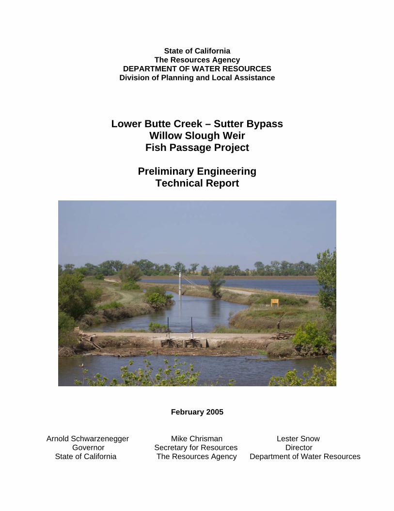
State of California The Resources Agency DEPARTMENT OF WATER RESOURCES Division of Planning and Local Assistance Lower Butte Creek – Sutter Bypass Willow Slough Weir Fish Passage Project Preliminary Engineering Technical Report February 2005 Arnold Schwarzenegger Mike Chrisman Lester Snow Governor Secretary for Resources Director State of California The Resources Agency Department of Water Resources

Welcome message from author
This document is posted to help you gain knowledge. Please leave a comment to let me know what you think about it! Share it to your friends and learn new things together.
Transcript
State of California The Resources Agency
DEPARTMENT OF WATER RESOURCES Division of Planning and Local Assistance
Lower Butte Creek – Sutter Bypass Willow Slough Weir
Fish Passage Project
Preliminary Engineering Technical Report
February 2005
Arnold Schwarzenegger Mike Chrisman Lester Snow Governor Secretary for Resources Director State of California The Resources Agency Department of Water Resources

State of California
The Resources Agency DEPARTMENT OF WATER RESOURCES
Division of Planning and Local Assistance
Lower Butte Creek – Sutter Bypass Willow Slough Weir
Fish Passage Project
Preliminary Engineering Technical Report
February 2005
Arnold Schwarzenegger Mike Chrisman Lester Snow Governor Secretary for Resources Director State of California The Resources Agency Department of Water Resources

Foreword
Declining salmon and steelhead populations have led to increased efforts to implement restoration activities to preserve and enhance their populations, while respecting the needs of the various stakeholders. More than $25 million has been invested in fish passage and screening projects in the middle reaches of Butte Creek, resulting in dramatic increases in returning adult anadromous fish populations. The continued success of those projects can be assured through completion of fish passage improvements in the lower reaches of the complex Butte Creek system. The Lower Butte Creek – Sutter Bypass, Willow Slough Weir Fish Passage Project is an integral part of the ongoing Butte Creek restoration activities. The objective of this project is to enhance Butte Creek’s anadromous fish populations by improving fish passage past Willow Slough Weir throughout a greater range of flows. This report summarizes the findings of the California Department of Water Resources (DWR) preliminary engineering investigation of fish passage solutions at Lower Butte Creek – Sutter Bypass, Willow Slough Weir near Yuba City, California. Included in this report are preliminary design drawings, cost estimate, discussion of the physical and operational characteristics of the alternatives, summary of construction issues, and final design criteria. Attached appendices include meeting notes, hydrologic data, a fish ladder modeling experiment, a preliminary geologic investigation memorandum, and a preliminary environmental evaluation summary. This study was funded by the U.S. Fish and Wildlife Service (USFWS) through the Anadromous Fish Restoration Program (AFRP) of the Central Valley Project Improvement Act (CVPIA; Title 34 of Public Law 102-575, Section 3406(b)(1)). Dwight P. Russell Chief, Northern District
iii

Table of Contents
Foreward ........................................................................................................................ iii Table of Contents..........................................................................................................iv Organization, Department of Water Resources..........................................................vi Acknowledgments........................................................................................................vii Recommendations ........................................................................................................ix Registered Engineer’s Stamps .................................................................................... x Abbreviations and Acronyms ......................................................................................xi Introduction ..................................................................................................................... 1 Project Location and Access ................................................................................. 2 Project Development ............................................................................................. 2 Purpose and Need for Project ............................................................................... 4 Project Alternatives ......................................................................................................... 7 Alternatives Considered ........................................................................................ 7 Fish Ladders Considered ...................................................................................... 8 Description of Investigation ........................................................................................... 10 Surveying and Site Information ........................................................................... 10 Hydrology ............................................................................................................ 11 Site Geology........................................................................................................ 13 Environmental Review......................................................................................... 14 Summary of Findings .................................................................................................... 15 Description of Alternatives................................................................................... 15 Advantages and Disadvantages.......................................................................... 15 Conclusion .......................................................................................................... 16 Pool and Chute Fish Ladder.......................................................................................... 17 Sizing and Configuration ..................................................................................... 17 Operation and Maintenance ................................................................................ 18 Flow Control Structure................................................................................................... 21 Sizing and Configuration ..................................................................................... 21 Operation and Maintenance ................................................................................ 21 Design and Construction Summary............................................................................... 22 Site Conditions and Assumptions........................................................................ 22 Codes and Standards.......................................................................................... 22 Final Design Instructions ..................................................................................... 22 Special Project Notes .......................................................................................... 22 Geological Exploration Recommendation ........................................................... 23 Construction Summary........................................................................................ 23
iv
Tables
Table 1: Preliminary Cost Estimate ............................................................................. 25
Figures
Figure 1: Aerial photograph of Willow Slough Weir ........................................................ 1 Figure 2: Location map................................................................................................... 3 Figure 3: Exiting culverts and fish ladder entrance......................................................... 4 Figure 4: Existing Denil fish ladder entrance submerged ............................................... 5 Figure 5: Debris problem in the EBC, Sutter Bypass...................................................... 5 Figure 6: Existing Denil fish ladder damaged by debris.................................................. 6 Figure 7: Aerial photograph of Willow Slough Weir and EBC....................................... 11 Figure 8: Existing fish ladder and culvert configuration ................................................ 12 Figure 9: Auger drilling at Willow Slough Weir ............................................................. 14 All photos in this report were taken by DWR staff.
Preliminary Engineering Drawings
Sheet 1: Title Sheet and Area Map .............................................................................. 26 Sheet 2: General Plan .................................................................................................. 27 Sheet 3: Site Plan ........................................................................................................ 28 Sheet 4: Isometric View................................................................................................ 29 Sheet 5: Pool and Chute Fish Ladder Plan and Profile ................................................ 30 Sheet 6: Pool and Chute Fish Ladder Headgate and Baffle Details............................. 31 Sheet 7: Flow Control Structure Plan ........................................................................... 32 Sheet 8: Flow Control Structure Elevation.................................................................... 33
Appendices
Meeting Notes ..............................................................................................................A-1 Hydrology .....................................................................................................................B-1 Modeling experiment ................................................................................................... C-1 Preliminary Geologic Exploration Memorandum ......................................................... D-1 Preliminary Environmental Memorandum ....................................................................E-1
v
STATE OF CALIFORNIA Arnold Schwarzenegger, Governor
THE RESOURCES AGENCY
Mike Chrisman, Secretary for Resources
DEPARTMENT OF WATER RESOURCES Lester Snow, Director
Gerold H. Johns Stephen W. Verigin Vernon T. Glover Peter Garris Deputy Director Deputy Director Deputy Director Deputy Director Brian White Susan Sims Nancy Saracino Assistant Legislative Affairs Assistant Director Public Affairs Chief Counsel
DIVISION OF PLANNING AND LOCAL ASSISTANCE Mark W. Cowin..........................................................................................................Chief
NORTHERN DISTRICT
Dwight P. Russell .......................................................................... Chief, Northern District William D. Mendenhall................................................. Chief, Water Management Branch
This report was prepared under the supervision of
Curtis K. Anderson ..................................................... Chief, Engineering Studies Section
By
Nancy C. Snodgrass ............................................................. Engineer, Water Resources
Assisted by
Kevin Dossey ...........................................................................................Senior Engineer Teresa Connor ...................................................................... Engineer, Water Resources Scott Kennedy....................................................................... Engineer, Water Resources Bill McLaughlin ...................................................................... Engineer, Water Resources John Elko .......................................................... Water Resources Engineering Associate Rowland Hickel ..................................................................................... Student Assistant
vi

Acknowledgements
Willow Slough Technical Working Group Members
Paul Ward, Associate Fishery Biologist, CDFG George Heise, Hydraulic Engineer, CDFG
Paul Raquel, Senior Biologist, CDFG Tracy McReynolds, Fishery Biologist, CDFG
Steve Thomas, Hydraulic Engineer, NOAA Fisheries Mike Tucker, Fishery Biologist, NOAA Fisheries
Olen Zirkle, Manager Conservation Program, Ducks Unlimited Curtis Anderson, Senior Engineer, DWR-ND Kevin Dossey, Senior Engineer, DWR-ND
Nancy Snodgrass, Engineer, DWR-ND Bill McLaughlin, Engineer, DWR-ND
Keith Swanson, Supervising Engineer, DWR-DFM Michelle Ng, Senior Engineer, DWR-DFM
Ken Dickerson, UC Superintendent, DWR-DFM Karen Hull, Assistant UC Superintendent, DWR-DFM
Art Winslow, Executive Office, DWR Varda Disho, Engineer, DWR-DPLA
Bill Peach, Associate Landscape Architect, DWR-DPLA Cesar Blanco, Habitat Restoration Coordinator, USFWS-AFRP
David Hu, Assistant Habitat Restoration Coordinator, USFWS-AFRP Michael Lee, Mechanical Engineer, USBR Bill Dutton, Hydrographer Engineer,USBR
Paul Russell, Sutter Extension Water District
Additional Support
Tim Talbert, Senior Engineer, DWR-DOE Ben Lasarte, Senior Cost Estimator, DWR-DOE
Bryan Reniff, Utility Craftsworker, DWR-Sutter Yard Joel Farias, Utility Craftsworker, DWR-Sutter Yard
Richard Grove, Utility Craftsworker, DWR-Sutter Yard Trudy Payne, Water Resources Technician II, DWR-Sutter Yard
Robert Goodnight, Water Resources Technician I, DWR-Sutter Yard Brent Lamkin, Senior Engineering Geologist, DWR-DOE Tim Todd, Associate Engineering Geologist, DWR-DOE
Dave Bogener, Staff Environmental Scientist Gail Kuenster, Environmental Scientist
Scott Hammelberg, Project Leader, Coleman National Fish Hatchery John Scott, Fishery Biologist, Coleman National Fish Hatchery
Pat D. Powers, Chief Engineer, Washington State FWS Axle Karlshoej, Land Owner, Nordic Industries
vii

Organizations Consulted
United States Fish and Wildlife Service
California Department of Water Resources California Department of Fish and Game
National Oceanic and Atmospheric Administration Fisheries Ducks Unlimited, Inc.
United States Bureau of Reclamation Sutter County
Sutter Extension Water District
viii
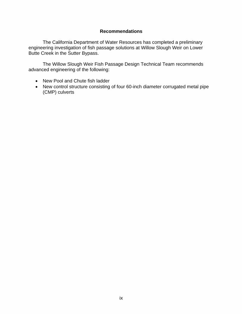
Recommendations
The California Department of Water Resources has completed a preliminary engineering investigation of fish passage solutions at Willow Slough Weir on Lower Butte Creek in the Sutter Bypass. The Willow Slough Weir Fish Passage Design Technical Team recommends advanced engineering of the following:
• New Pool and Chute fish ladder • New control structure consisting of four 60-inch diameter corrugated metal pipe
(CMP) culverts
ix

Lower Butte Creek – Sutter Bypass Willow Slough Weir
Fish Passage Project
REGISTERED ENGINEER’S STAMPS The technical information contained in this preliminary engineering technical report has been prepared by or under the direction of the following registered engineers:
Date:________________
x

Abbreviations and Acronyms
AFRP Anadromous Fish Restoration Program CDEC California Data Exchange Center cfs cubic feet per second CMP Corrugated Metal Pipe CNFH Coleman National Fish Hatchery CVPIA Central Valley Project Improvement Act DFG California Department of Fish and Game DFM Division of Flood Management DPLA Division of Planning and Local Assistance DOE Division of Engineering DU Ducks Unlimited DWR California Department of Water Resources EBC East Borrow Canal FEMA Federal Emergency Management Agency GPS Global Positioning System NAD North American Datum NAVD North American Vertical Datum ND Northern District NOAA National Oceanic and Atmospheric Administration PP1 Pumping Plant No. 1 SMY Sutter Maintenance Yard USBR U.S. Bureau of Reclamation USED U.S. Engineering Datum USFWS U.S. Fish and Wildlife Service WBC West Borrow Canal
xi

Introduction This report summarizes the findings of the California Department of Water Resources (DWR) preliminary engineering investigation of fish passage improvements at Willow Slough Weir along the East Borrow Canal (EBC) of the Sutter Bypass near Yuba City, California. This investigation is part of the Lower Butte Creek Project, a multifaceted plan to improve anadromous fish passage throughout the Lower Butte Creek system. The investigation has led to a proposed project, which involves modification of the Willow Slough Weir flow control structure and fish ladder.
Willow Slough Weir is an earthen dam with two 60-inch diameter corrugated metal pipe (CMP) culverts and one 60-inch diameter reinforced concrete culvert with slide gates that control flow from the lower end of the EBC into Willow Slough. The structure was constructed between 1924 and 1925 under the direction of the Reclamation Board to control water levels in the EBC so that irrigation water could be supplied to local farmers. A Denil fish ladder was constructed through the weir in the 1980s. The structure is owned, operated, and maintained by DWR. An aerial photograph of the project site is shown (Figure 1).
Figure 1. Aerial photograph of Willow Slough Weir.
1
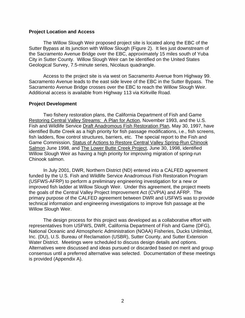
Project Location and Access The Willow Slough Weir proposed project site is located along the EBC of the Sutter Bypass at its junction with Willow Slough (Figure 2). It lies just downstream of the Sacramento Avenue Bridge over the EBC, approximately 15 miles south of Yuba City in Sutter County. Willow Slough Weir can be identified on the United States Geological Survey, 7.5-minute series, Nicolaus quadrangle. Access to the project site is via west on Sacramento Avenue from Highway 99. Sacramento Avenue leads to the east side levee of the EBC in the Sutter Bypass. The Sacramento Avenue Bridge crosses over the EBC to reach the Willow Slough Weir. Additional access is available from Highway 113 via Kirkville Road. Project Development
Two fishery restoration plans, the California Department of Fish and Game Restoring Central Valley Streams: A Plan for Action, November 1993, and the U.S. Fish and Wildlife Service Draft Anadromous Fish Restoration Plan, May 30, 1997, have identified Butte Creek as a high priority for fish passage modifications, i.e., fish screens, fish ladders, flow control structures, barriers, etc. The special report to the Fish and Game Commission, Status of Actions to Restore Central Valley Spring-Run Chinook Salmon June 1998, and The Lower Butte Creek Project, June 30, 1998, identified Willow Slough Weir as having a high priority for improving migration of spring-run Chinook salmon.
In July 2001, DWR, Northern District (ND) entered into a CALFED agreement funded by the U.S. Fish and Wildlife Service Anadromous Fish Restoration Program (USFWS-AFRP) to perform a preliminary engineering investigation for a new or improved fish ladder at Willow Slough Weir. Under this agreement, the project meets the goals of the Central Valley Project Improvement Act (CVPIA) and AFRP. The primary purpose of the CALFED agreement between DWR and USFWS was to provide technical information and engineering investigations to improve fish passage at the Willow Slough Weir.
The design process for this project was developed as a collaborative effort with representatives from USFWS, DWR, California Department of Fish and Game (DFG), National Oceanic and Atmospheric Administration (NOAA) Fisheries, Ducks Unlimited, Inc. (DU), U.S. Bureau of Reclamation (USBR), Sutter County, and Sutter Extension Water District. Meetings were scheduled to discuss design details and options. Alternatives were discussed and ideas pursued or discarded based on merit and group consensus until a preferred alternative was selected. Documentation of these meetings is provided (Appendix A).
2

OutfallGates
Tisdale Weir
Weir #1
Weir #4
Weir #5
Weir #3
East−West
DWRPumping
SunsetPumps
Plant #3
DWRPumpingPlant #2
DWRPumpingPlant #1
SloughButte
WillowSloughWeir
Weir #2
Diversion Weir
Figure 2. Location map.
3
This engineering report includes discussion of the alternative selection process, permitting requirements, operational concepts, final design criteria, design and construction preliminary cost estimate, and preliminary engineering drawings. All alternatives were analyzed considering factors such as fish passage, operation, maintenance, location, condition of existing facilities, stream characteristics, stream hydrology, biological criteria, owner liability, and economics. Purpose and Need for Project Improvements to the existing flow control structure and Denil fish ladder at the Willow Slough Weir are an integral part of the overall restoration efforts in the Butte Creek system. Willow Slough Weir is one of the last fish passage projects identified in the Lower Butte Creek report to be addressed. The many complete restoration efforts in the Lower Butte Creek system have decreased delays and loss of migrating anadromous fish. Improving migration at Willow Slough Weir is critical to the continued success of these projects.
The objective of this project is to reduce migration delays of adult and juvenile anadromous fish from the Lower Butte Creek system. Five problems have been identified.
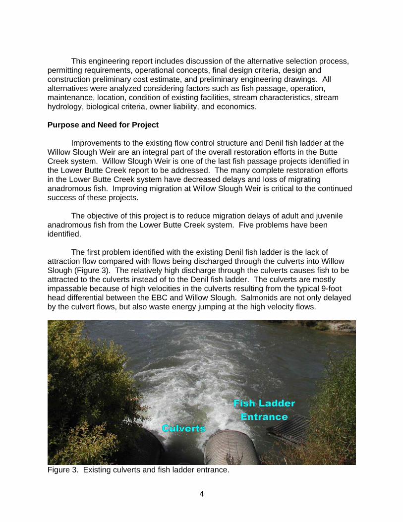
The first problem identified with the existing Denil fish ladder is the lack of
attraction flow compared with flows being discharged through the culverts into Willow Slough (Figure 3). The relatively high discharge through the culverts causes fish to be attracted to the culverts instead of to the Denil fish ladder. The culverts are mostly impassable because of high velocities in the culverts resulting from the typical 9-foot head differential between the EBC and Willow Slough. Salmonids are not only delayed by the culvert flows, but also waste energy jumping at the high velocity flows.
Figure 3. Existing culverts and fish ladder entrance.
4
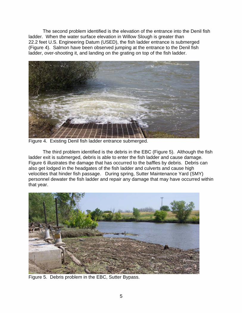
The second problem identified is the elevation of the entrance into the Denil fish ladder. When the water surface elevation in Willow Slough is greater than 22.2 feet U.S. Engineering Datum (USED), the fish ladder entrance is submerged (Figure 4). Salmon have been observed jumping at the entrance to the Denil fish ladder, over-shooting it, and landing on the grating on top of the fish ladder.
Figure 4. Existing Denil fish ladder entrance submerged.
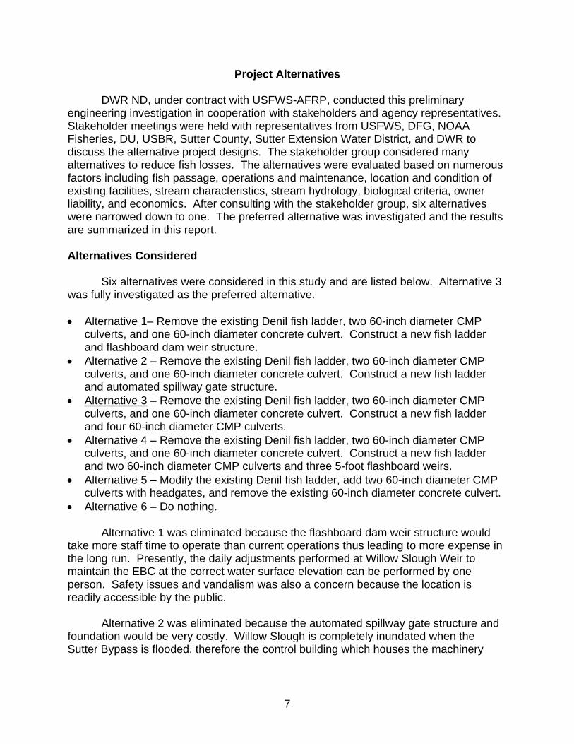
The third problem identified is the debris in the EBC (Figure 5). Although the fish
ladder exit is submerged, debris is able to enter the fish ladder and cause damage. Figure 6 illustrates the damage that has occurred to the baffles by debris. Debris can also get lodged in the headgates of the fish ladder and culverts and cause high velocities that hinder fish passage. During spring, Sutter Maintenance Yard (SMY) personnel dewater the fish ladder and repair any damage that may have occurred within that year.
Figure 5. Debris problem in the EBC, Sutter Bypass.
5

Figure 6. Existing Denil fish ladder damaged by debris.
The fourth problem identified is the amount of flow entering the fish ladder during low flow events. During periods of low flow the existing facilities may hinder upstream passage of salmon and steelhead into upper Butte Creek. Even if all the water is flowing though the fish ladder, there may not be sufficient flow for salmon and steelhead to reach the baffle openings in the ladder. Blocking or hindering upstream passage may delay fish reaching spawning grounds and expose fish to excessive stress, extended periods of potentially lethal high water temperatures, and poaching.
The fifth problem identified is poaching. Poaching is a concern because the
public easily accesses the weir and fish ladder. Fishing hooks have been found at the entrance of the fish ladder dangling from the grating on top of the fish ladder, which provides evidence that poaching is a concern.
6
Project Alternatives
DWR ND, under contract with USFWS-AFRP, conducted this preliminary engineering investigation in cooperation with stakeholders and agency representatives. Stakeholder meetings were held with representatives from USFWS, DFG, NOAA Fisheries, DU, USBR, Sutter County, Sutter Extension Water District, and DWR to discuss the alternative project designs. The stakeholder group considered many alternatives to reduce fish losses. The alternatives were evaluated based on numerous factors including fish passage, operations and maintenance, location and condition of existing facilities, stream characteristics, stream hydrology, biological criteria, owner liability, and economics. After consulting with the stakeholder group, six alternatives were narrowed down to one. The preferred alternative was investigated and the results are summarized in this report. Alternatives Considered
Six alternatives were considered in this study and are listed below. Alternative 3
was fully investigated as the preferred alternative. • Alternative 1– Remove the existing Denil fish ladder, two 60-inch diameter CMP
culverts, and one 60-inch diameter concrete culvert. Construct a new fish ladder and flashboard dam weir structure.
• Alternative 2 – Remove the existing Denil fish ladder, two 60-inch diameter CMP culverts, and one 60-inch diameter concrete culvert. Construct a new fish ladder and automated spillway gate structure.
• Alternative 3 – Remove the existing Denil fish ladder, two 60-inch diameter CMP culverts, and one 60-inch diameter concrete culvert. Construct a new fish ladder and four 60-inch diameter CMP culverts.
• Alternative 4 – Remove the existing Denil fish ladder, two 60-inch diameter CMP culverts, and one 60-inch diameter concrete culvert. Construct a new fish ladder and two 60-inch diameter CMP culverts and three 5-foot flashboard weirs.
• Alternative 5 – Modify the existing Denil fish ladder, add two 60-inch diameter CMP culverts with headgates, and remove the existing 60-inch diameter concrete culvert.
• Alternative 6 – Do nothing. Alternative 1 was eliminated because the flashboard dam weir structure would take more staff time to operate than current operations thus leading to more expense in the long run. Presently, the daily adjustments performed at Willow Slough Weir to maintain the EBC at the correct water surface elevation can be performed by one person. Safety issues and vandalism was also a concern because the location is readily accessible by the public. Alternative 2 was eliminated because the automated spillway gate structure and foundation would be very costly. Willow Slough is completely inundated when the Sutter Bypass is flooded, therefore the control building which houses the machinery
7
necessary to operate the gates would need to be built across the EBC on top of the levee. The control building would also be prone to vandalism. Alternative 3 is the alternative that was carried through the preliminary design process. This alternative was chosen for several reasons; culverts can easily be operated and maintained, culverts are economical, and during flood events culverts are less susceptible to damage than other structures. Both the Pool and Chute fish ladder and Full Ice Harbor fish ladder were considered feasible for this project site. Alternative 4 was eliminated because operation and maintenance costs associated with the flashboard weirs were considered too high. Vandalism and safety issues were also of concern.
Alternative 5 was rejected quickly by DFG and NOAA Fisheries because the existing Denil fish ladder doesn’t meet current fish passage criteria. The existing ladder is approximately 73 feet long and the current criteria for a Denil fish ladder states that for every 30 feet of run a resting pool is needed. The high maintenance associated with the existing fish ladder was also a concern. Alternative 6 was eliminated because it does not meet the goals of this restoration project. Fish Ladders Considered
Three fish ladder designs were considered for improving passage for anadromous fish. During the design process these fish ladders were discussed, analyzed, and evaluated by the stakeholder group. The fish ladders considered are listed below.
1. Pool and Chute – The Pool and Chute fish ladder is essentially a pool and weir fishway with v-shaped weirs and orifices. The basic layout consists of a center weir section, two higher sloped baffles continuing from the end of the weir, and two orifices each located at the bottom of the baffle sections. The maximum flow for the Pool and Chute fish ladder considered is approximately 270 cfs. At low flows, the fish ladder acts as a pool and weir fishway, and a cross between a pool and weir and a roughened chute at high flows. This type of fishway is good at passing debris and fish. The major advantage of a Pool and Chute fish ladder is that it operates through a wider range of stream flows without additional flow control means. Pool and Chute fishways have been designed and proven to work effectively in California for a total head differential of up to 8 feet.
2. Full Ice Harbor - The Full Ice Harbor is a type of pool and weir fishway with
orifices, flow stabilizers, and a non-overflow section in the middle of each weir. This type of fishway has multiple passage routes, two weirs and two orifices, and is able to pass many fish in a short amount of time. The maximum flow for the Full Ice Harbor fish ladder considered is approximately 80 cfs. A Full Ice Harbor
8

is recommended where good flow control is available. Good flow control can be achieved in conditions where a stable headwater pool exists or a headgate can be installed to control flow into the fish ladder over a range of headwater elevations.
3. Double Vertical Slot – The Double Vertical Slot fish ladder has distinct steps; the
hydraulic control is a narrow, full height vertical slot open at the top. The slots are 15-inches wide. This type of fishway operates with minimal mechanical adjustment through a range of tailwater or headwater surface elevations. The maximum flow for the Double Vertical Slot considered is approximately 90 cfs. The minimum operating depth required in the fish ladder is 3 feet which means a minimum of 20 cfs is needed. The Double Vertical Slot fishway maintains a fairly constant flow pattern at all operating depths and is adapted to conditions where headwater regulation is not possible.
The Pool and Chute fish ladder was chosen for further investigation by the
stakeholder group. Being able to provide more flow through the fish ladder was a major benefit. By allowing more flow through the fish ladder, the fish have a better chance of finding the fish ladder entrance and not being delayed. As mentioned previously and illustrated in Figure 5, one of the problems in the EBC is the debris load. Therefore, the ability to pass debris is also a major advantage.
The Full Ice Harbor fish ladder was also chosen by the stakeholder group as
another viable option to investigate. Most of the new fish ladder structures constructed in the Lower Butte Creek system recently have been the pool and weir type. Ice Harbor fish ladders have been proven to operate well and are known to have relatively low operation and maintenance costs. The Double Vertical Slot fish ladder was ruled out because of limited low flow capacity and general observations of increased susceptibility to plugging with debris in the ladders’ relatively narrow slot openings. The “self adjusting” fish ladder would not be able to maintain a headwater water surface elevation of 29 feet USED. The operating low flow for the fish ladder is approximately 20 cfs whereas the design low flow requirement is 6 cfs.
9

Description of Investigation
ND staff began the preliminary engineering process with site surveys and hydrologic analyses. DFG and NOAA Fisheries fish ladder design standards were referenced for determining design requirements for the alternatives investigated. DFG, DWR, and NOAA Fisheries biologists and engineers were consulted during the design process. DWR engineering geologists conducted a preliminary geologic investigation of the project site and DWR environmental scientists conducted preliminary environmental site surveys. Surveying and Site Information
Air targets were set in June 2000 and surveyed with the Global Positioning
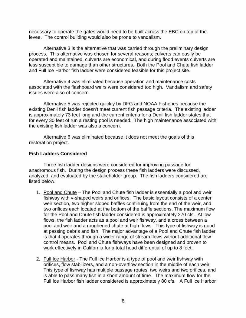
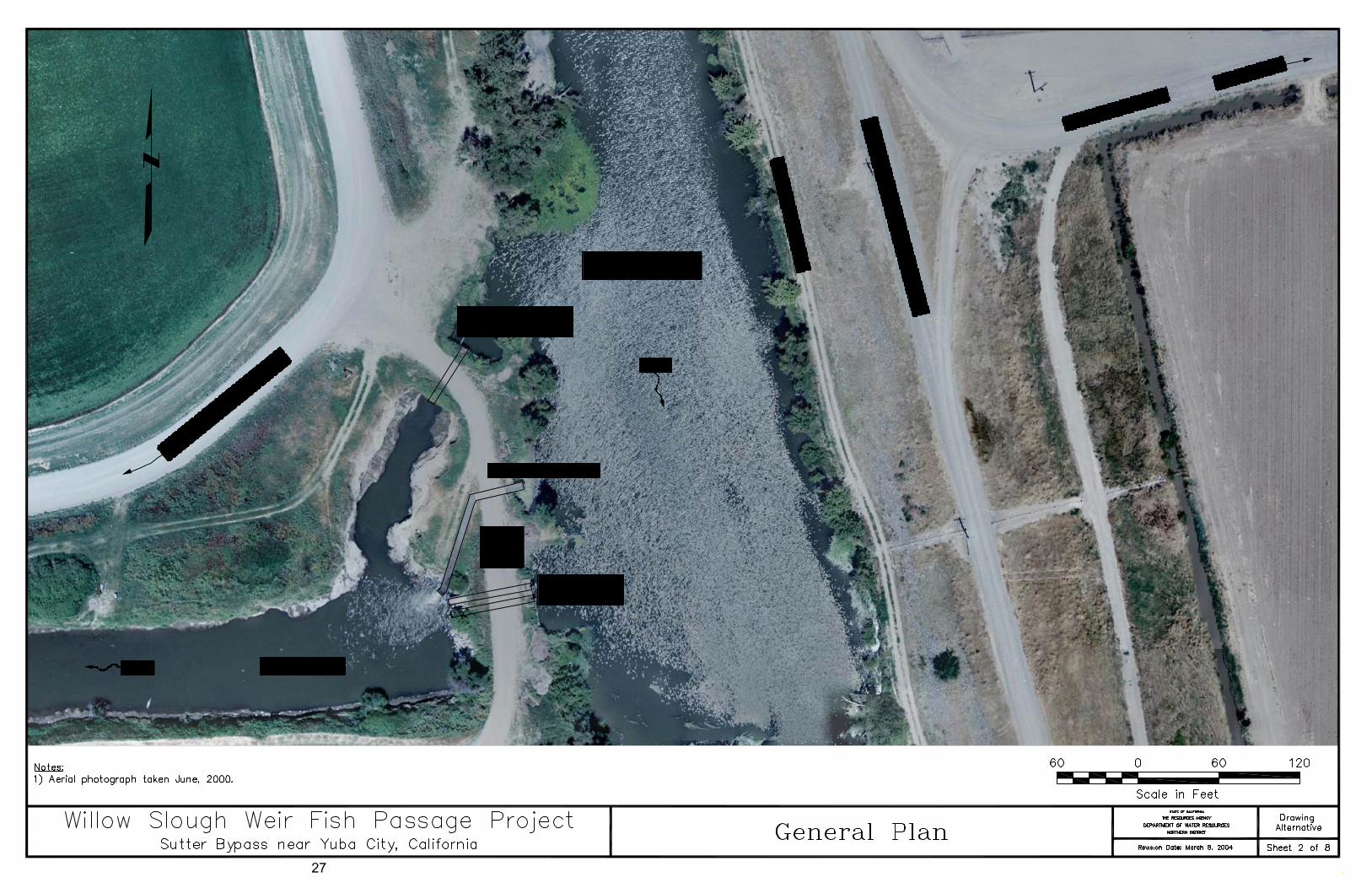
System (GPS). The basis of survey control for the aerial photography was the North American Datum of 1983 (NAD 83), California Coordinate System, Zone 2 (feet) for the horizontal datum and North American Vertical Datum of 1988 (NAVD 88, feet) for the vertical datum. Continuous series of color aerial photographs were taken of the EBC and Willow Slough. A rectified photo mosaic of the reach was produced covering an area of approximately 56 acres. Figure 7 displays a portion of that mosaic from the Sacramento Avenue Bridge on the EBC approximately 800 feet upstream of Willow Slough Weir to about 250 feet downstream of Willow Slough Weir.
In December 2002, DWR ND staff began topographic surveying at Willow Slough
Weir. A total station and automatic level were used to collect topographical data of the existing site. The topographic data included ground shots, existing structures, and cross sections in Willow Slough and the EBC. This data was used to create a 1-foot contour map. The existing staff gages used by DWR Sutter Maintenance Yard (SMY) staff are based on USED. The NAVD 88 datum used for this site is 0.6 feet lower than the USED datum.
DWR ND staff made many follow-up site visits after the initial surveys. Trips
were made to observe the flows at different stages and to determine the location for drilling auger holes for the preliminary geologic exploration. Additional trips were made to SMY for historical stage records, drawings, and operational procedures.
10
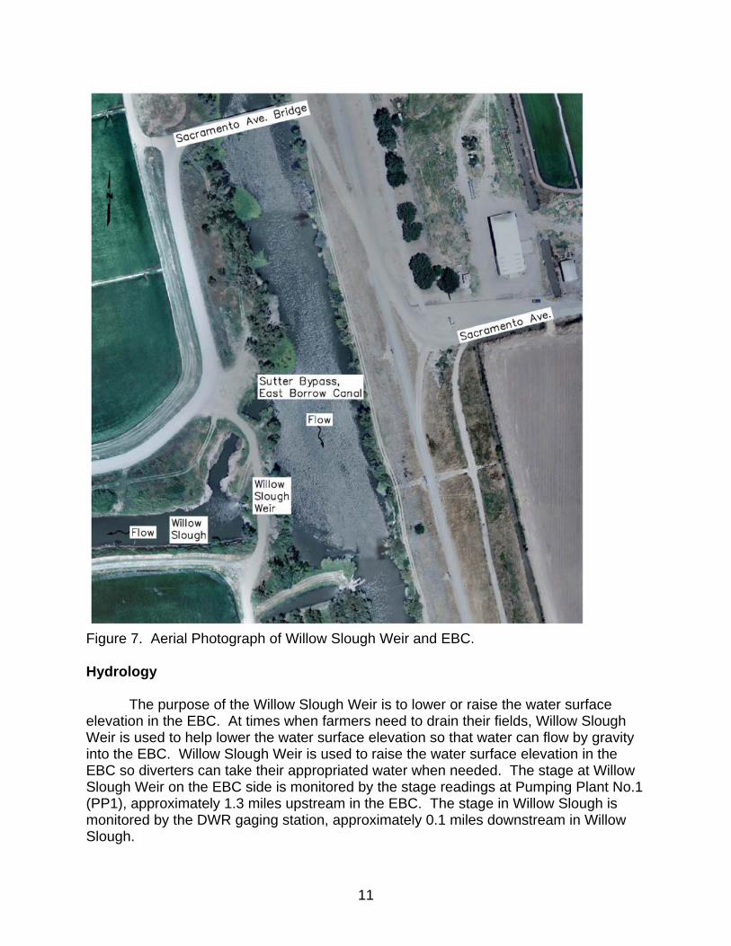
Figure 7. Aerial Photograph of Willow Slough Weir and EBC. Hydrology The purpose of the Willow Slough Weir is to lower or raise the water surface elevation in the EBC. At times when farmers need to drain their fields, Willow Slough Weir is used to help lower the water surface elevation so that water can flow by gravity into the EBC. Willow Slough Weir is used to raise the water surface elevation in the EBC so diverters can take their appropriated water when needed. The stage at Willow Slough Weir on the EBC side is monitored by the stage readings at Pumping Plant No.1 (PP1), approximately 1.3 miles upstream in the EBC. The stage in Willow Slough is monitored by the DWR gaging station, approximately 0.1 miles downstream in Willow Slough.
11
According to the draft operations manual, SMY staff maintains the normal water surface elevation in the EBC at the location of PP1 between a stage of 27.5 feet and 29.5 feet (USED). The first and last water surface elevation adjustments to be made at Willow Slough Weir are made at the existing fish ladder to maximize fish passage. With the fish ladder wide open, adjustments thereafter are made first at culverts nos. 1 and 2, then culvert no. 3. When all the gates are open and the water surface elevation in the EBC is rising, water starts spilling into Nelson Slough downstream of Willow Slough in the EBC at a stage of 29.7 feet (USED). Figure 8 identifies the existing fish ladder and culvert configuration.
Figure 8. Existing fish ladder and culvert configuration.
The hydrology data for Willow Slough was collected from the DWR stream gaging station, known as Willow Slough at SB West Borrow Pit on the California Data Exchange Center (CDEC) website, for water years 1992 through 2002. The hydrology data was used to create a modified rating table, monthly stage graph, a percent exceedance graph at the Willow Slough gage, and a percent exceedance graph for the head differential between the EBC and Willow Slough (Appendix B).
Willow Slough is subject to backwater when the West Borrow Canal, Feather
River or Sacramento River stage elevations are high and Willow Slough is unable to drain. Because of this backwater effect, flows above 400 cfs are not recorded on CDEC. For the purposes of this investigation, the existing rating table for Willow Slough was modified to include the higher flows even though backwater conditions exist.
The modified rating table was created by plotting current meter measurements
from water years 1995 through 2003 on a log-log scale and three curves were fitted to
12
best fit the data (Appendix B). The maximum flow measured in Willow Slough was 830 cfs in the 1998 water year at a stage of 24.5 feet (USED).
The monthly stage graph displays the minimum, maximum and average stage elevations in Willow Slough for each month. The minimum stage was 19.0 feet (USED) which occurred mostly during the summer months. The average stage ranged from 20.3 feet to 30.6 feet (USED) with an overall average of 23.4 feet (USED). Most high water events occur during winter and spring months.
The Willow Slough percent exceedance graph was produced to determine how
often the entire flow entering Willow Slough from the EBC is directed through the proposed fish ladder. The Pool and Chute fish ladder has a maximum capacity of approximately 270 cfs. About 55 percent of the time, the flow in Willow Slough exceeds 270 cfs. Therefore, 45 percent of the time, all the flow in Willow Slough is channeled through the Pool and Chute fish ladder and the remaining 55 percent flow is directed through both the fish ladder and culverts. The Full Ice Harbor has a maximum capacity of approximately 80 cfs. About 18 percent of the time, all the flow in Willow Slough is directed through the Full Ice Harbor fish ladder and the remaining 82 percent flow is directed through both the fish ladder and culverts.
Stage records for both PP1 and Willow Slough were analyzed and a percent exceedance curve was created. The head difference between the EBC and Willow Slough versus percent of time was plotted in order to determine the maximum head differential. The maximum head difference between the EBC and Willow Slough was about 10 feet (USED). As stated previously, Pool and Chute fishways have been designed and proven to work effectively in California for a total head differential of up to 8 feet. Based on 1400 stage records covering 7 years over an 11 year period, the head differential between PP1 and Willow Slough was greater than 8 feet approximately 40 percent of the time.
A swim through condition was determined by analyzing when the entire Sutter Bypass is flooded. Willow Slough starts spilling out of its banks when the water surface elevation is approximately 30.6 to 31.6 feet (USED). The EBC starts spilling out of the west bank at an elevation of approximately 32.0 feet (USED). It was determined that when the water surface elevation in Willow Slough is about 32.6 feet (USED), water is spilling over the banks in Willow Slough about 1 foot deep and the entire Sutter Bypass is flooded, thus a swim-through condition exists. A stage of 32.6 feet (USED) corresponds to a flow of approximately 1360 cfs, but because of the backwater effect, a swim through condition could exist at a lower flow. Site Geology DWR Division of Engineering (DOE), Project Geology staff conducted a geologic exploration of the proposed project site in June, 2003. The exploration work was needed to collect specific subsurface geological data to be used in the final design. Two auger holes drilled to a depth of approximately 50 feet within the proposed project
13
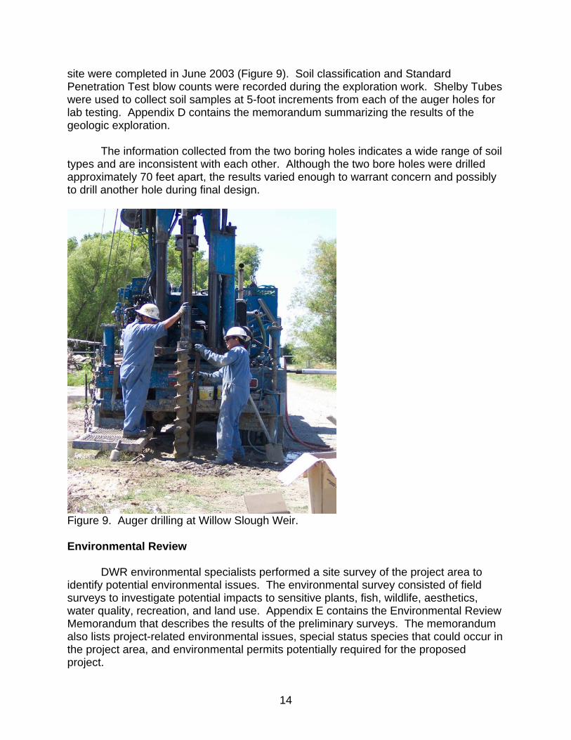
site were completed in June 2003 (Figure 9). Soil classification and Standard Penetration Test blow counts were recorded during the exploration work. Shelby Tubes were used to collect soil samples at 5-foot increments from each of the auger holes for lab testing. Appendix D contains the memorandum summarizing the results of the geologic exploration. The information collected from the two boring holes indicates a wide range of soil types and are inconsistent with each other. Although the two bore holes were drilled approximately 70 feet apart, the results varied enough to warrant concern and possibly to drill another hole during final design.
Figure 9. Auger drilling at Willow Slough Weir. Environmental Review DWR environmental specialists performed a site survey of the project area to identify potential environmental issues. The environmental survey consisted of field surveys to investigate potential impacts to sensitive plants, fish, wildlife, aesthetics, water quality, recreation, and land use. Appendix E contains the Environmental Review Memorandum that describes the results of the preliminary surveys. The memorandum also lists project-related environmental issues, special status species that could occur in the project area, and environmental permits potentially required for the proposed project.
14

Summary of Findings Description of Alternatives Alternative 3, remove the existing Denil fish ladder, remove two 60-inch diameter CMP culverts, remove one 60-inch diameter concrete culvert, construct a new fish ladder, and place four 60-inch diameter CMP culverts, is the alternative that was carried through the preliminary design process. Both Pool and Chute and Full Ice Harbor fish ladders were considered feasible for the project site. A description of each sub-alternative is as follows: Alternative 3a – Pool and Chute fish ladder and four 60-inch diameter CMP culverts.
• Remove the existing Denil fish ladder and headgate. • Remove all culverts and headgates. • Construct new Pool and Chute fish ladder with a headgate structure adjacent to
the existing CMP culverts. • Construct two 60-inch diameter CMP culverts with slide gates 4 feet north of the
new fish ladder. • Construct two 60-inch diameter CMP culverts with slide gates 4 feet south of the
new fish ladder.
Alternative 3b – Full Ice Harbor fish ladder and four 60-inch diameter CMP culverts. • Remove the existing Denil fish ladder and headgate. • Remove all culverts and headgates. • Construct new Full Ice Harbor fish ladder with trash racks adjacent to the existing
CMP culverts. • Construct two 60-inch diameter CMP culverts with slide gates 4 feet north of the
new fish ladder. • Construct two 60-inch diameter CMP culverts with slide gates 4 feet south of the
new fish ladder.
Advantages and Disadvantages The following are some advantages and disadvantages of each sub-alternative. The proposed control structure, four 60-inch diameter CMP culverts, is identical for both sub-alternatives. Therefore, the advantages and disadvantages for each fish ladder types are listed below. Alternative 3a – Pool and Chute fish ladder Advantages:
• Higher capacity fish ladder. The 270 cfs Pool and Chute fish ladder would be a big improvement for greater attraction flow compared to the existing 90 cfs Denil fish ladder.
• 45 percent of the time the entire flow in Willow Slough is directed through the 270 cfs fish ladder only.
15
• Ability to pass debris. • Capable of adequately passing fish at flows as low as 6 cfs. • Provides multiple passage routes for fish by either jumping from pool to
pool or swimming through the orifices. • Low maintenance characteristics. • Proven ability to attract and pass fish.
Disadvantages: • Lower two baffles would be submerged part of the time.
Alternative 3b – Full Ice Harbor fish ladder Advantages:
• Provides multiple routes to pass fish by either utilizing the two sets of weirs or swimming through the orifices.
• Capable of adequately passing fish at flows as low as 6 cfs. • 18 percent of the time the entire flow in Willow Slough is directed through
the 80 cfs fish ladder only.
Disadvantages: • Compared to the Pool and Chute fishway, the Full Ice Harbor has a
narrower operating range of flows from 6 cfs to 80 cfs. • Lower two baffles would be submerged part of the time. • Doesn’t handle debris well and would need to incorporate a trash rack.
Conclusion Although it was determined that a Full Ice Harbor would provide adequate fish passage, the higher flow capacity Pool and Chute fish ladder was chosen as the preferred alternative. The Pool and Chute fish ladder was chosen by the stakeholder group because of its capability to accommodate a much wider range of flows, its low-maintenance characteristics, and its proven ability to attract and pass fish. Therefore, the stakeholder group decided Alternative 3a, to construct a Pool and Chute fish ladder and four 60-inch diameter CMP culverts, as the preferred alternative.
16
Pool and Chute Fish Ladder Sizing and Configuration
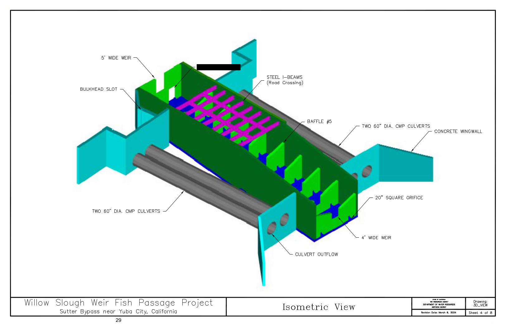
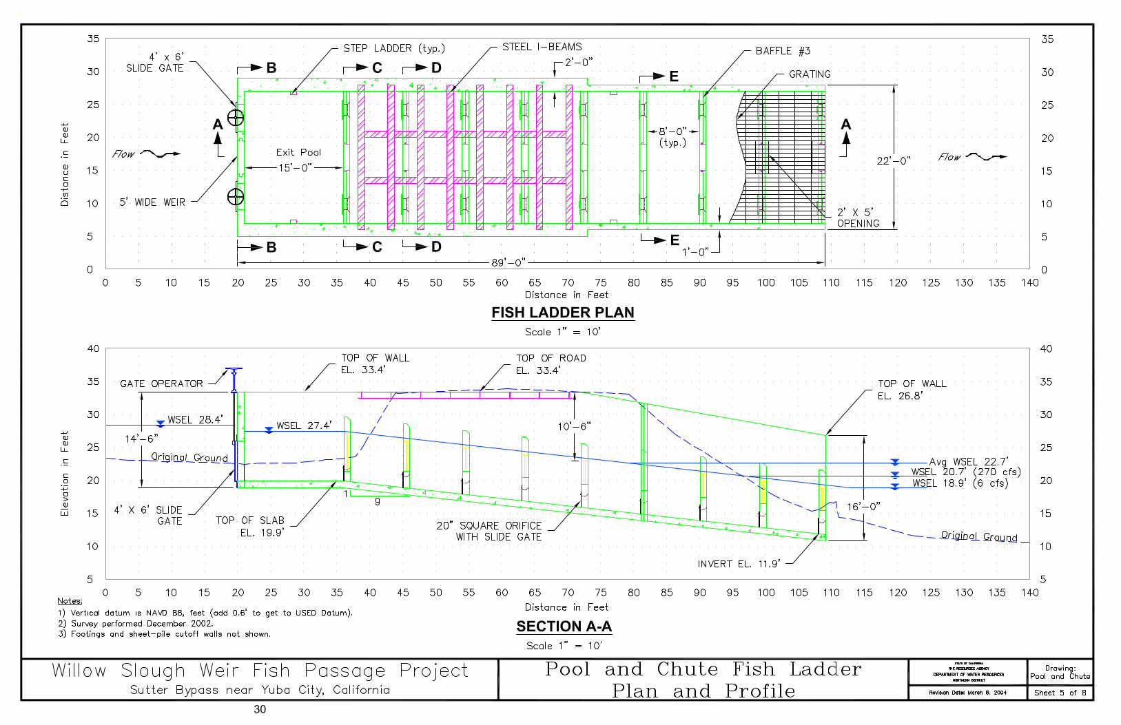
Northern District began the fish ladder design process by performing a hydrologic analysis of stage and flow records from the Willow Slough gaging station located about 680 feet downstream of Willow Slough Weir. DWR-ND also examined historical stage records from PP1 approximately 1.3 miles upstream from Willow Slough Weir in the EBC. In order to determine the fish ladder design flow, several factors were considered including cross-sectional data in Willow Slough, and water surface profiles between the EBC and WBC. Cross-sectional data was used to determine bank-full flow. At a stage of 32.6 feet (USED), water is spilling over the banks of Willow Slough about 1-foot deep, thus a swim-through condition exists. The corresponding flow using the modified rating table is approximately 1360 cfs. Water surface elevations were surveyed in Willow Slough between the EBC and WBC to calibrate a hydraulic model. This hydraulic model was used to help improve the precision of the stage-discharge relationship. Using the Manning’s equation, a bank-full flow was calculated to be approximately 1600 cfs. Because of the backwater effect and the validity of the rating table above 400 cfs, a design flow of 1600 cfs was used and considered most conservative. When determining the fish ladder design flow, it is recommended that a minimum of 10 percent of the total flow be conveyed through the fish ladder. The stakeholder group decided that the recommended 10 percent, a 160 cfs fish ladder, would not be sufficient at Willow Slough with the existing problem of attraction flow versus the high velocity flow from the culverts. The proposed Pool and Chute fish ladder design has a maximum flow capacity of about 270 cfs thus approximately 17 percent of the flow is directed through the fish ladder at the maximum design flow of 1600 cfs. The minimum flow capacity, recommended by DFG, is approximately 6 cfs. According to the pool and weir style fishway design standards the maximum head differential between any two pools or across any structure should not exceed 1-foot. Analyzing 1400 stage records over the span of 7 years from May 1991 to August 1996 and from March 2001 to September 2002, the maximum head differential between the EBC and Willow Slough was approximately 10 feet (Appendix B). Therefore, the proposed Pool and Chute fish ladder was designed for a 10 foot head differential. The proposed Pool and Chute fish ladder design features a 4-foot wide rectangular weir in the center of each baffle and two 20-inch square orifices located at the bottom of each baffle. The entire structure is 89-feet long and consists of 9 baffles (9 pools) and a headgate structure (Sheet 5). Each pool has internal dimensions of 20-feet wide by 8-feet in length with the exception of the exit pool. The exit pool is 15-feet long to help dissipate any hydraulic disturbances associated with the flow concentrated through the headgates. The headgate structure consists of two 4-foot
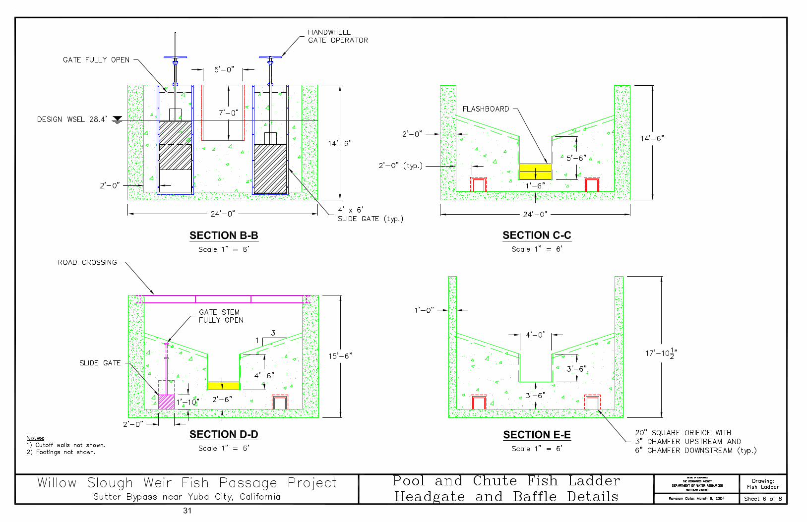
17
wide by 6-foot tall slide gates located symmetrically on each side of the headwall and one 5-foot wide by 7-foot tall weir located in the center (Sheet 6). Fish ladders are typically aligned parallel with the approaching flow. Unfortunately, Willow Slough is perpendicular to the EBC channel; thus, the recommended orientation does not comply. The proposed fish ladder alignment is perpendicular to the EBC and parallel to Willow Slough. This orientation was accepted by the stakeholder group because minimal approach velocities exist past Willow Slough Weir in the EBC. Because the water basically ponds up downstream of Willow Slough Weir in the EBC, the flow entering the fish ladder would be parallel with the fish ladder thus meeting the requirement. The proposed fish ladder will be constructed through the existing levee. Vehicle access must be provided across the levee so that landowners can access their property, thus a drivable deck spanning the fish ladder is required. The drivable deck consists of steel I-beams (Sheet 5) spanning the 20-foot wide fish ladder with cross beams for extra strength to support heavy loads such as farmland equipment. The side walls of the fish ladder where the drivable deck is located are 24 inches thick instead of the typical 12 inches to help support the steel I-beams. The grating on top of the fish ladder over the drivable deck section is heavier duty than the rest of the grating to help support heavy loads. The proposed Pool and Chute fish ladder design deviates from previous designs in California by the addition of a headgate structure and an extra baffle, instead of the generally accepted 8 baffle configuration. The headgate structure is intended to create up to a 1-foot head loss when a 10-foot head difference between the EBC and Willow Slough exists. Because of this modification and suggestion by DFG, a physical 1:12 scale model was constructed and tested at Coleman National Fish Hatchery to ensure the ladder would operate effectively. Overall, the test was successful and showed that the design will work fine. A total of 7 runs were simulated for high and low flow events. The headwater was held at the normal operating range and the tailwater was varied to achieve a 6, 8, 9, and 10-foot head differential. A summary of the testing including the procedure, results and conclusion are included in Appendix C. Operation and Maintenance Access to the site for operation and maintenance will be via the existing levee road that divides the EBC and Willow Slough. For safety reasons, the entire fish ladder will be covered with a skid-proof grating material that is designed to be removable for access to the fish ladder. Hinged openings in the grating approximately 5-feet wide by 2-feet in length directly above the weirs will be provided for quick access to make adjustments (Sheet 5).
18

The primary operations for the fish ladder will be to make sure there is a maximum of a 1-foot drop per pool by adjusting boards in the weir sections, adjusting the gate configuration and/or closing the orifices. When a 10-foot head differential exists between the EBC and Willow Slough, a 1-foot head drop across the headgates is required. The two headgates will be manually operated and adjustments made to ensure good fish passage conditions and to maintain the desired upstream water surface elevation of 29.0 feet (USED). Both gates should be operated in tandem so flow through the gates is relatively the same to minimize turbulence in the fish ladder. Operating one headgate is acceptable as the flows decrease and both headgates have been lowered to a minimum of 12 inches, as per DFG and NOAA Fisheries recommendation. When the gates are wide open, the maximum flow through the gates with a 1-foot head drop is approximately 270 cfs. As the flow decreases, both gates can be lowered to a minimum opening of 12 inches which provides a flow of approximately 45 cfs through the fish ladder. The minimum flow through one headgate open 12 inches is approximately 23 cfs. As flows are further reduced, both headgates are closed and the 5-foot wide weir will provide flow of about 17 cfs down to 6 cfs into the fish ladder. As the flow decreases through the fish ladder, adjustments to the 4-foot wide weirs in each of the 9 baffles are necessary. Flashboards are placed in the weirs as flows reduce from approximately 100 cfs down to 40 cfs in order to maintain the water surface elevation in each pool. The flashboards ensure that water spills over the sloped baffle section where some fish passage occurs and to ensure a maximum of 1-foot head drop per pool. As the flow in the fish ladder drops below 40 cfs or adequate pools depths cannot be maintained, orifices need to be closed. With the orifices closed, the fish ladder operates as a step pool style fishway instead of a Pool and Chute fishway. Under most flow conditions, most of the fish passage likely occurs in the orifices; therefore, closing the orifices should be the last adjustments made to the fish ladder. Juvenile salmon and steelhead travel downstream through the Lower Butte Creek system from mid November through June. In order to provide fish passage during this time, the 5-foot wide center weir in the headgate structure should be left open. During higher flow events, providing flow over the weir could also help with the hydraulics in the fish ladder. There is usually very little maintenance associated with a Pool and Chute fish ladder. Although this type of fish ladder is good at passing debris, the debris load in the EBC will primarily be blocked by the headgate structure. Thus, debris will be handled in the same manner as before by SMY. Debris will be removed manually from the EBC as needed. When maintenance is required, the fish ladder can be dewatered by closing the two headgates and 5-foot wide weir. Depending on the water surface elevation in
19
Willow Slough, the lower few pools might need to be pumped in order to dewater the entire structure. There are four ways to access the fish ladder. Two step ladders, one on each side, are provided at the exit pool and two step ladders, one on each side, are provided in the 5th pool (Sheet 5). When seasonal flooding occurs, the grating on top of the fish ladder should be left in place so that large woody debris and trash can be kept out thus minimizing damage in the fish ladder. Adjustments to the 4-foot wide weirs in each baffle can be made by opening the 5 foot wide by 2 foot long notch in the grating located directly above the weir. The distance from the grating to the weirs varies throughout the fish ladder. Orifices can be adjusted by maneuvering the stem that extends up the sloped baffle (Sheet 6) from the top of the grating. If adjustments cannot be made from the grating, shutting down the fish ladder temporarily is an option as long as DFG is informed and in agreement.
20
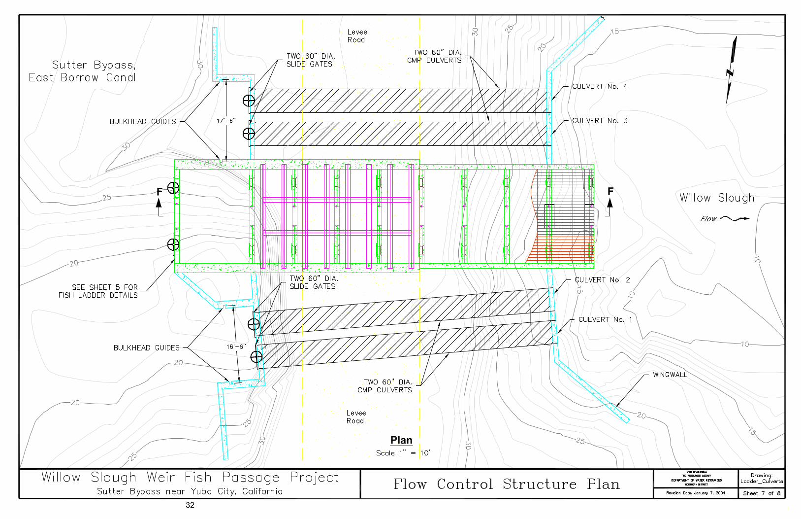
Flow Control Structure Sizing and Configuration The existing flow control structure consists of two 60-inch diameter CMP culverts and one 60-inch diameter concrete culvert. The main objective in sizing the proposed flow control structure was to double the flow capacity such that the EBC could drain faster. Doubling the capacity will reduce the amount of pumping required at the DWR owned pumping plants located along the EBC. The proposed Pool and Chute fish ladder triples the flow capacity of the existing Denil fish ladder. The addition of one 60-inch diameter culvert along with the proposed fish ladder would satisfy the objective of doubling the flow capacity in Willow Slough. The proposed flow control structure consists of four 60-inch diameter CMP culverts with slide gates (Sheet 7). The culverts are approximately 65 feet long with a slope of about 2 percent (Sheet 8). When the water surface elevation in the EBC is 29.0 feet (USED) and the exit of the culverts are not submerged, the head difference is approximately 9 feet. When this condition exists, neglecting minor losses, the maximum flow in each culvert is approximately 290 cfs for a total of 1160 cfs. Bulkhead guides are incorporated 6 feet upstream of the slide gates (Sheet 7) for dewatering. Two bulkheads, one having a dimension of 16.5-feet by 6-feet, and the other 17.5-feet by 6-feet are placed on top of each other for each pair of culverts. Thus a total of four bulkheads are needed to completely dewater all four culverts. Operation and Maintenance Access to the site for operation and maintenance of the culverts will be the same as for the fish ladder via the existing levee road that divides the EBC and Willow Slough. The primary purpose of the control structure is to maintain the upstream water surface elevation in the EBC at 29.0 feet (USED). The four 60-inch diameter culverts will be operated in a specific sequence. Because the water in the EBC essentially ponds up downstream of the confluence with Willow Slough, suspended solids settle out and have raised the ground elevation in the EBC. In order to keep the suspended solids from settling and inundating the downstream culverts, culverts nos. 1 and 2 will be the first opened then culverts nos. 3 and 4. Closing the culverts will be in reverse order; culverts nos. 4 and 3 will be closed first then culverts nos. 2 and 1. Bulkheads were incorporated so that the culverts and slide gates can be dewatered for maintenance. A boom truck or equivalent is needed to lift and lower each of the bulkheads.
21

Design and Construction Summary Site Conditions and Assumptions The preliminary drawings and layouts contained in this report will be refined during the final design process. Additional surveys and hydraulic analyses may be necessary because of changes in the site conditions since this investigation was conducted, and to gain additional information required for final design. Codes and Standards Final designs will be governed by the following criteria: • Final structural designs will comply with the latest Uniform Building Code
requirements. • Final concrete designs will comply with the latest American Concrete Institute
Building Code Requirements for Reinforced Concrete Design. • All current applicable Cal OSHA safety standards will be met. • All environmental permit conditions will be met. Final Design Instructions Final designs will adhere to the following criteria: • An operations and maintenance manual should be made available prior to project
completion. • Provide access across Willow Slough Weir during construction for landowners. • The elevations shown in drawings are based on NAVD 88 Datum. Descriptions and
elevations of control points can be obtained from ND. • Actual concrete thickness, foundation requirements, and reinforcement requirements
will be determined by the final design engineer. • The cutoff walls and footings, used for cost estimating purposes, are not shown on
the drawings. Actual dimensions will be determined by the final design engineer. • The drivable deck and grating shown on drawings are approximate and details will
be provided in final design. Special Project Notes
The preliminary cost estimates for design and construction were based on preliminary engineering drawings and current industry standard construction costs. The cost estimates are subject to review by DOE staff. The quantities and costs illustrated in Table 1 are preliminary and not intended for bidding or construction purposes as final designs may result in changes to any or all quantities and costs. The final cost estimate will ultimately be determined by the final design engineer. Final designs will be subject for approval by DFG, NOAA Fisheries, USFWS, USBR, and DWR.
The Willow Slough Weir Fish Passage Project is located within a Federal
Emergency Management Agency (FEMA) Zone A designated special flood hazard area,
22
within a low flow channel of the Sutter Bypass. The Sutter Bypass floods frequently and overtopping of Willow Slough Weir is a common occurrence. The replacement of the existing culverts and construction of a new fish ladder within the low flow channel is not expected to raise the 100 year base flood elevation within the Sutter Bypass. This must be verified in final design and the provisions of Chapter 44, Section 65.3 of the National Flood Insurance Program’s Code of Federal Regulations must be met.
Geologic Exploration Recommendation
Data from the exploratory borings indicate foundation conditions may not be
adequate at the invert of the proposed structures. According to the preliminary geologic exploration memorandum (Appendix D), there were three main recommendations that need addressing. The following recommendations were included in the cost estimate.
1. Extend footings for the fish ladder to an elevation of 6-feet or lower to provide
adequate support for the structure. 2. Foundation preparation for the culverts should include over-excavation to at
least 8-feet. Remove the excavated loose soil and replace with engineered fill.
3. Cut-off walls should be considered for the upstream and downstream edges of the weir outlet and fish ladder structure to prevent underflow and headward erosion.
Construction Summary Construction access for this site is from Highway 99 via Sacramento Avenue to the Sutter Bypass East Levee Road, across the Sacramento Avenue Bridge and then to the Willow Slough Weir. Sacramento Avenue and both levees are predominantly gravel surfaced and presently in good condition. If the existing roads are damaged during construction, they must be repaired prior to project completion. The limitations of construction, staging areas, and access roads should be marked and managed to prevent vehicular access outside the designated work zone. In addition to the designated staging area, a small storage area may need to be constructed to store equipment and fuel. Potential staging areas have been delineated and are illustrated on Sheet 3. The construction area may be dewatered prior to, and during construction activities. Adequate fish passage should be incorporated during dewatering to ensure a longer construction window. In order to accomplish adequate fish passage, leaving the existing Denil fish ladder and 60-inch diameter concrete culvert in place during construction could be beneficial. Maintaining the water surface elevation in the EBC to the desired elevation for diversions will be required during the construction project. Leaving the existing Denil fish ladder and 60-inch diameter concrete culvert in place during construction could also help maintain the upstream water surface elevation.
23

Providing access across Willow Slough Weir during construction is required. There are two landowners whose only access to their land is across Willow Slough Weir. Providing access for vehicles such as passenger vehicles and different types of farm equipment will be necessary. Excavation will be required at the proposed project site in the EBC and Willow Slough. Excavated material will either be reused at the project site or hauled off to a disposal site, which will be determined by the contractor, and will be subject to DWR approval. Removal of the existing Denil fish ladder and all three culverts are required. Excavated concrete free of steel could be broken up and placed in Willow Slough at the exit of the culverts to help dissipate energy and protect the channel bottom from scouring. If placing broken concrete back in the channel is not acceptable by the fishery agencies, then the concrete shall be hauled off to a disposal site. The remaining rebar, steel, and other miscellaneous material shall be hauled off to a disposal site or salvage yard, which will be determined by the contractor, and will be subject to DWR approval.
24
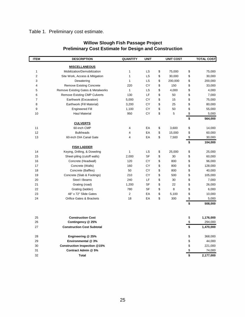
Table 1. Preliminary cost estimate.
ITEM DESCRIPTION QUANTITY UNIT UNIT COST TOTAL COST
MISCELLANEOUS1 Mobilization/Demobilization 1 LS $ 75,000 $ 75,0002 Site Work, Access & Mitigation 1 LS $ 30,000 $ 30,0003 Dewatering 1 LS $ 200,000 $ 200,0004 Remove Existing Concrete 220 CY $ 150 $ 33,0005 Remove Existing Gates & Metalworks 1 LS $ 4,000 $ 4,0006 Remove Existing CMP Culverts 130 LF $ 50 $ 7,0007 Earthwork (Excavation) 5,000 CY $ 15 $ 75,0008 Earthwork (Fill Material) 3,200 CY $ 25 $ 80,0009 Engineered Fill 1,100 CY $ 50 $ 55,00010 Haul Material 950 CY $ 5 $ 5,000
$ 564,000CULVERTS
11 60-inch CMP 4 EA $ 3,600 $ 14,00012 Bulkheads 4 EA $ 15,000 $ 60,00013 60-inch DIA Canal Gate 4 EA $ 7,500 $ 30,000
$ 104,000FISH LADDER
14 Keying, Drilling, & Doweling 1 LS $ 25,000 $ 25,00015 Sheet-piling (cutoff walls) 2,000 SF $ 30 $ 60,00016 Concrete (Headwall) 120 CY $ 800 $ 96,00017 Concrete (Walls) 160 CY $ 800 $ 128,00018 Concrete (Baffles) 50 CY $ 800 $ 40,00019 Concrete (Slab & Footings) 210 CY $ 500 $ 105,00020 Steel I Beams 240 LF $ 30 $ 7,00021 Grating (road) 1,200 SF $ 22 $ 26,00022 Grating (ladder) 780 SF $ 8 $ 6,00023 48" x 72" Slide Gates 2 EA $ 5,100 $ 10,00024 Orifice Gates & Brackets 18 EA $ 300 $ 5,000
$ 508,000
25 Construction Cost $ 1,176,00026 Contingency @ 25% $ 294,00027 Construction Cost Subtotal $ 1,470,000
28 Engineering @ 25% $ 368,00029 Environmental @ 3% $ 44,00030 Construction Inspection @15% $ 221,00031 Contract Admin @ 5% $ 74,00032 Total $ 2,177,000
Willow Slough Fish Passage ProjectPreliminary Cost Estimate for Design and Construction
25


Appendix A Table of Contents February 27, 2003 Meeting Notes................................................................................A-2 April 23, 2003 Meeting Notes .......................................................................................A-3 June 19, 2003 Meeting Notes ......................................................................................A-4 August 14, 2003 Meeting Notes ...................................................................................A-6 August 21, 2003 Meeting Notes ...................................................................................A-8 November 20, 2003 Meeting Notes............................................................................A-10
A-1
Lower Butte Creek - Sutter Bypass Willow Slough Weir Fish Passage Project
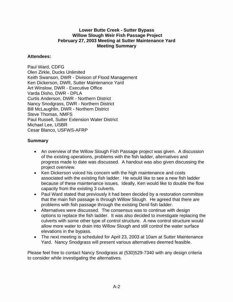
February 27, 2003 Meeting at Sutter Maintenance Yard Meeting Summary
Attendees: Paul Ward, CDFG Olen Zirkle, Ducks Unlimited Keith Swanson, DWR - Division of Flood Management Ken Dickerson, DWR, Sutter Maintenance Yard Art Winslow, DWR - Executive Office Varda Disho, DWR - DPLA Curtis Anderson, DWR - Northern District Nancy Snodgrass, DWR - Northern District Bill McLaughlin, DWR - Northern District Steve Thomas, NMFS Paul Russell, Sutter Extension Water District Michael Lee, USBR Cesar Blanco, USFWS-AFRP Summary
• An overview of the Willow Slough Fish Passage project was given. A discussion of the existing operations, problems with the fish ladder, alternatives and progress made to date was discussed. A handout was also given discussing the project overview.
• Ken Dickerson voiced his concern with the high maintenance and costs associated with the existing fish ladder. He would like to see a new fish ladder because of these maintenance issues. Ideally, Ken would like to double the flow capacity from the existing 3 culverts.
• Paul Ward stated that previously it had been decided by a restoration committee that the main fish passage is through Willow Slough. He agreed that there are problems with fish passage through the existing Denil fish ladder.
• Alternatives were discussed. The consensus was to continue with design options to replace the fish ladder. It was also decided to investigate replacing the culverts with some other type of control structure. A new control structure would allow more water to drain into Willow Slough and still control the water surface elevations in the bypass.
• The next meeting is scheduled for April 23, 2003 at 10am at Sutter Maintenance Yard. Nancy Snodgrass will present various alternatives deemed feasible.
Please feel free to contact Nancy Snodgrass at (530)529-7340 with any design criteria to consider while investigating the alternatives.
A-2
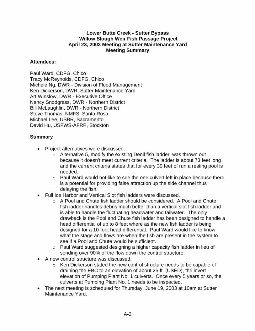
Lower Butte Creek - Sutter Bypass Willow Slough Weir Fish Passage Project
April 23, 2003 Meeting at Sutter Maintenance Yard Meeting Summary
Attendees: Paul Ward, CDFG, Chico Tracy McReynolds, CDFG, Chico Michele Ng, DWR - Division of Flood Management Ken Dickerson, DWR, Sutter Maintenance Yard Art Winslow, DWR - Executive Office Nancy Snodgrass, DWR - Northern District Bill McLaughlin, DWR - Northern District Steve Thomas, NMFS, Santa Rosa Michael Lee, USBR, Sacramento David Hu, USFWS-AFRP, Stockton Summary
• Project alternatives were discussed. o Alternative 5, modify the existing Denil fish ladder, was thrown out
because it doesn’t meet current criteria. The ladder is about 73 feet long and the current criteria states that for every 30 feet of run a resting pool is needed.
o Paul Ward would not like to see the one culvert left in place because there is a potential for providing false attraction up the side channel thus delaying the fish.
• Full Ice Harbor and Vertical Slot fish ladders were discussed. o A Pool and Chute fish ladder should be considered. A Pool and Chute
fish ladder handles debris much better than a vertical slot fish ladder and is able to handle the fluctuating headwater and tailwater. The only drawback is the Pool and Chute fish ladder has been designed to handle a head differential of up to 8 feet where as the new fish ladder is being designed for a 10-foot head differential. Paul Ward would like to know what the stage and flows are when the fish are present in the system to see if a Pool and Chute would be sufficient.
o Paul Ward suggested designing a higher capacity fish ladder in lieu of sending over 90% of the flow down the control structure.
• A new control structure was discussed. o Ken Dickerson stated the new control structure needs to be capable of
draining the EBC to an elevation of about 25 ft. (USED), the invert elevation of Pumping Plant No. 1 culverts. Once every 5 years or so, the culverts at Pumping Plant No. 1 needs to be inspected.
• The next meeting is scheduled for Thursday, June 19, 2003 at 10am at Sutter Maintenance Yard.
A-3
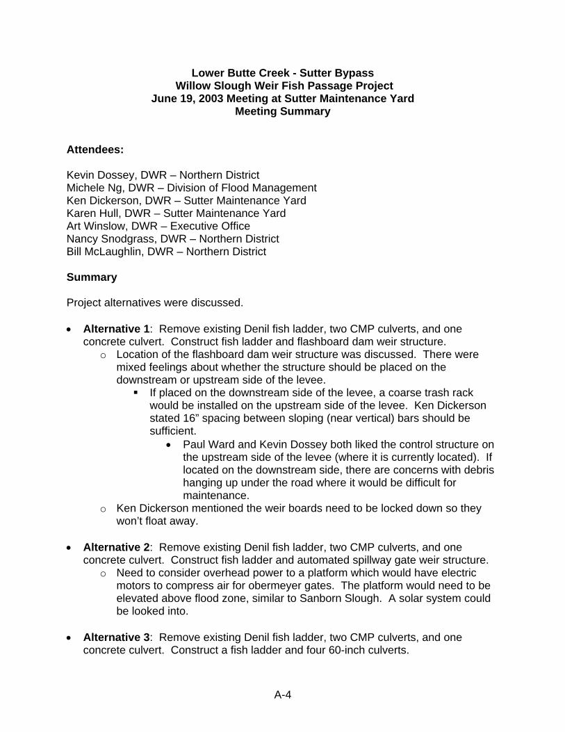
Lower Butte Creek - Sutter Bypass Willow Slough Weir Fish Passage Project
June 19, 2003 Meeting at Sutter Maintenance Yard Meeting Summary
Attendees: Kevin Dossey, DWR – Northern District Michele Ng, DWR – Division of Flood Management Ken Dickerson, DWR – Sutter Maintenance Yard Karen Hull, DWR – Sutter Maintenance Yard Art Winslow, DWR – Executive Office Nancy Snodgrass, DWR – Northern District Bill McLaughlin, DWR – Northern District Summary Project alternatives were discussed. • Alternative 1: Remove existing Denil fish ladder, two CMP culverts, and one
concrete culvert. Construct fish ladder and flashboard dam weir structure. o Location of the flashboard dam weir structure was discussed. There were
mixed feelings about whether the structure should be placed on the downstream or upstream side of the levee.
If placed on the downstream side of the levee, a coarse trash rack would be installed on the upstream side of the levee. Ken Dickerson stated 16” spacing between sloping (near vertical) bars should be sufficient.
• Paul Ward and Kevin Dossey both liked the control structure on the upstream side of the levee (where it is currently located). If located on the downstream side, there are concerns with debris hanging up under the road where it would be difficult for maintenance.
o Ken Dickerson mentioned the weir boards need to be locked down so they won’t float away.
• Alternative 2: Remove existing Denil fish ladder, two CMP culverts, and one
concrete culvert. Construct fish ladder and automated spillway gate weir structure. o Need to consider overhead power to a platform which would have electric
motors to compress air for obermeyer gates. The platform would need to be elevated above flood zone, similar to Sanborn Slough. A solar system could be looked into.
• Alternative 3: Remove existing Denil fish ladder, two CMP culverts, and one
concrete culvert. Construct a fish ladder and four 60-inch culverts.
A-4

o Ken Dickerson suggested making the culverts steeper. This might help with cleaning out the culverts.
Fish ladder types were discussed. • Pool and Chute fish ladder
o Could work if Sutter Yard maintains an 8 ft. maximum head differential between the EBC and Willow Slough. This would be accomplished by allowing more flow through the culverts/weir structure when the head differential is exceeding 8 ft.
o Paul was concerned with the operations of maintaining an 8-foot head differential.
o Art Winslow suggested putting a rock sill downstream of the fish ladder to raise the tailwater elevation and maintain a maximum head differential of 8 feet.
o Steve Thomas suggested angling the upstream training wall (headwall). o Discussed maintenance. Would incorporate access hatches in the grating at the
top of the fish ladder. o Paul Ward was concerned about the height of the fish ladder for maintenance
purposes. Suggested lowering the levee road.
• Double Vertical Slot fish ladder o The group agreed to abandon this fish ladder alternative for several reasons:
o Trouble keeping the water surface elevation above 27.5 ft. o The operating low flow for the fish ladder is approximately 20 cfs. The
design low flow is approximately 6 cfs. o Debris load in the EBC.
• Full Ice Harbor fish ladder
o Kevin Dossey suggested looking into losing one pool. • Flow control structures were discussed. • Bill McLaughlin suggested combining alternatives. Integrate culverts and a weir
structure with a fish ladder. A weir structure could be helpful with passing floating debris.
• Dewatering was discussed. Can use existing Denil fish ladder and north culvert to
provide fish passage and maintain water surface elevation during construction. • Michelle Ng suggested looking at the data and see how often maintenance would
occur and what time of year. The next meeting is scheduled for Thursday, August 21, 2003 at 10am at Sutter Maintenance Yard.
A-5
Lower Butte Creek - Sutter Bypass Willow Slough Weir Fish Passage Project
August 14, 2003 Meeting at Cottage Way in Sacramento, CA Meeting Summary
Attendees: Nancy Snodgrass, DWR – Northern District Paul Ward, DFG George Heise, DFG Steve Thomas, NMFS Paul Raquel, DFG Introduction The Pool and Chute fishway concept was first presented by Ken Bates. Bates developed preliminary design standards based on a hydraulic model study that was developed for the Town Diversion Dam Fishway on the Yakima River in Washington State. Some of the design parameters are as follows. The fishway alignment in plan view should be straight with the flow approaching from the upstream side parallel to the fishway walls. The recommended number of weirs in a series is 4 to 5. Cindy Watanabe with California Department of Fish and Game (DFG) performed a hydraulic analysis of a Pool and Chute fish ladder for Butte Creek. The Pool and Chute fish ladder built, Parrot-Phelan, has 8 weirs in a series and operates very well. Anderson-Cottonwood Irrigation District (ACID) Pool and Chute fishway, built on the Sacramento River also has 8 weirs in a series. Both fish ladders pass fish and debris fairly easily. Therefore, the recommended number of weirs in a series could be increased to at least 8. The preliminary Pool and Chute fishway design for Willow Slough would violate both of the design parameters listed above. The fish ladder would be perpendicular to the flow approaching from the upstream side, and parallel to the channel on the downstream side. There is a maximum head difference of 10-feet resulting in 9 weirs and a headgate structure. Purpose The purpose of this meeting was to get expert advice from DFG and NMFS whether or not a Pool and Chute fish ladder would work at Willow Slough. Also, if the Pool and Chute fish ladder would work, what is the preferred alternative?
A-6

Meeting Both the Pool and Chute fish ladder and Full Ice Harbor fish ladder were discussed. Although the preliminary pool and chute design doesn’t meet all of the design criteria, both DFG and NMFS representatives agreed a pool and chute would work. The approach velocity at the exit of the fish ladder is insignificant because the water is essentially at a standstill, therefore the criteria for the alignment of the fish ladder is not as stringent. The greater head differential wasn’t a concern because of the existing Pool and Chute fish ladders built in Northern California operate fine with an 8-foot head differential. Alternative 3a was the preferred alternative. Alternative 3a replaces the existing Denil fish ladder with a Pool and Chute fish ladder and replaces two existing 60-inch CMP culverts and one 60-inch concrete culvert with four new 60-inch CMP culverts. This alternative was preferred for several reasons:
1. The configuration of the fish ladder and culverts. 2. The attraction flow from the culverts will be concentrated at the entrance to the
fish ladder. 3. Fish will less likely try to enter a culvert versus trying to swim up a gently sloping
apron. 4. Culverts are generally less expensive.
The proposed Pool and Chute fish ladder would need some modifications.
• George Heise would like to see the headwork gates symmetrical along the headwall. For design purposes, the gates could close down to a maximum of 12 inches.
• The elevation of the fish ladder is such that any maintenance needed would require someone to climb down anywhere from 5 to 11 feet to make adjustments. A walkway of some sort would need to be incorporated into the design to accommodate Sutter Yard Maintenance Crew.
A-7
Lower Butte Creek - Sutter Bypass Willow Slough Weir Fish Passage Project
August 21, 2003 Meeting at Sutter Maintenance Yard Meeting Summary
Attendees: Nancy Snodgrass, DWR – Northern District Michele Ng, DWR – Division of Flood Management Ken Dickerson, DWR – Sutter Maintenance Yard Karen Hull, DWR – Sutter Maintenance Yard Art Winslow, DWR – Executive Office Bill McLaughlin, DWR – Northern District Mike Tucker, NOAA Fisheries Paul Ward, DFG Bill Peach, DWR Summary Summarized the August 14th meeting with DFG and NMFS representatives. The meeting was set up for technical expertise. Fish ladder options and alternatives were discussed. Alternative 3a was unanimously the preferred alternative. Alternative 3a replaces the existing Denil fish ladder, two CMP culverts and one concrete culvert with a new Pool and Chute fish ladder with a headgate structure and four 60-inch CMP culverts. This alternative was chosen because fish will less likely try to enter the culverts versus trying to swim up a gently sloping apron, and the attraction flow from the culverts will be concentrated at the entrance of the fish ladder instead of where the tailwater meets the apron.
• George Heise with DFG suggested changing the headwork gates to be symmetrical along the headwall, instead of having one large gate and one small gate as originally proposed.
• The elevation of the fish ladder is such that any maintenance needed would require someone to climb down anywhere from 5 to 11 feet to make adjustments. A walkway of some sort would need to be incorporated into the design to accommodate Sutter Yard Maintenance Crew.
Fish ladder types were discussed. The Pool and Chute fish ladder was the preferred fish ladder. It has a greater flow capacity resulting in better attraction for fish.
• Same concerns with maintenance issues as the August 14th meeting. • Ken Dickerson will provide input in the design of a device to help aid in
making adjustments in the weir section. • Dewatering the fish ladder for O&M was discussed. During low flows,
closing the headgates and culverts and allowing the stage in Willow Slough to drop would help in dewatering.
A-8

Alternatives were discussed. Alternative 3a was chosen by the attendees as the preferred alternative. Alternative 3a replaces the existing Denil fish ladder, two CMP culverts and one concrete culvert with a new Pool and Chute fish ladder with a headgate structure and four 60-inch CMP culverts.
• Trash racks are not necessary for either the culverts or fish ladder. • Debris and trash will be handled in the same manner as current
operations. Discussed leaving the 60-inch concrete culvert in place.
• Paul Ward had some concern if the slide gate could shut the flow off completely through the culvert so there would be no attraction flow.
• Ken Dickerson is uncertain if the slide gate could close completely and would like to see the culvert taken out. The culvert is old and would need maintenance even if rendered out of service.
Paul Ward suggested to Ken Dickerson and folks who have never seen a Pool and Chute fish ladder to come take a look at Parrott Phelan fish ladder. A field trip to see the Parrott Phelan Pool and Chute fish ladder is scheduled for September 10, 2003 at 1:00 at Paul Wards office in Chico. If you are interested in attending, please contact Nancy Snodgrass at (530)529-7340 or email to [email protected]. The next meeting is scheduled for Thursday, November 20, 2003 at 10am at Sutter Maintenance Yard. Please mark your calendars.
A-9
Lower Butte Creek - Sutter Bypass Willow Slough Weir Fish Passage Project
November 20, 2003 Meeting at Sutter Maintenance Yard Meeting Summary
Attendees: Nancy Snodgrass, DWR – Northern District Keith Swanson, DWR – Division of Flood Management Ken Dickerson, DWR – Sutter Maintenance Yard Trudy Payne, DWR – Sutter Maintenance Yard Art Winslow, DWR – Executive Office Bill McLaughlin, DWR – Northern District Curtis Anderson, DWR – Northern District Kevin Dossey, DWR – Northern District Paul Ward, DFG Tracy McReynolds, DFG Olen Zirkle, Ducks Unlimited Bill Dutton, USBR Buford Holt, USBR – Shasta Summary
• Summarized the August 21st meeting. o Selected a preferred alternative. Alternative 3a: Replace existing Denil
fish ladder, two 60-inch CMP culverts, and one 60-inch concrete culvert with a Pool and Chute fish ladder and four 60-inch CMP culverts.
• Summarized O&M discussion with Ken Dickerson o Design 2 ft. x 5 ft. slots in grating to provide access to weir. o Provide four different locations to access inside of fish ladder. o Different types of orifice gates were discussed. The orifice gates will close
downward by a long metal stem connected to the gate and mounted on the sloped baffle.
• Discussed modeling experiment. o Main objective: Determine whether a ninth baffle and headgate structure
will cause hydraulic instability. o Injected tracing dye to observe hydraulics o Performed at Coleman National Fish Hatchery on October 6th, 2003. o Observed two potential problems
1. Exit pool became more turbulent as the head difference across the headgate increased.
2. As water entered the fish ladder through the two 4ft. x 6ft. gates and came in contact with the first baffle, the water level increased causing a boiling effect over the first baffle.
A-10

o Met with DFG and NMFS on November 14th, 2003 to discuss results from modeling experiment. As a result of the potential problems, the exit pool length was extended by 3 feet.
o Handed out a draft copy of the write-up from the modeling experiment. Comments or suggestions from the write-up are appreciated.
• Presented a video of the modeling experiment. o Paul Ward suggested writing up a technical report to distribute.
A-11

Appendix B Table of Contents Modified Rating Table for Willow Slough......................................................................B-2 Monthly Stage in Willow Slough ...................................................................................B-3 Willow Slough Percent Exceedance at Willow Slough Gage........................................B-4 Percent Exceedance for the head differential between EBC and Willow Slough .........B-5
B-1

Mod
ified
Rat
ing
Tabl
e fo
r Will
ow S
loug
hPZ
F =
18.9
0
0.1
1.0
10.0
110
100
1,00
010
,000
Q (c
fs)
GH-PZF (ft)
WY
1995
cm
ms
WY
1996
cm
ms
WY
1997
cm
ms
WY
1998
cm
ms
WY
1999
cm
ms
WY
2000
cm
ms
WY
2001
cm
ms
WY
2002
cm
ms
WY
2003
cm
ms
RT
Cur
veSt
atio
n flo
oded
at G
H =
27.
0
B-2

Mon
thly
Sta
ge in
Will
ow S
loug
h(B
ased
on
reco
rds
from
5/9
1 th
roug
h 9/
02)
18.2
4
23.2
4
28.2
4
33.2
4
38.2
4
43.2
4
48.2
4
Jan
Feb
Mar
chA
pril
May
June
July
Aug
Sep
tO
ctN
ovD
ec
Mon
th
Stage (ft., NAVD 88)
Min
imum
Max
imum
Ave
rage
B-3

B-4
Will
ow S
loug
h Pe
rcen
t Exc
eeda
nce
at W
illow
Slo
ugh
Gag
e(B
ased
on
the
mod
ified
ratin
g ta
ble
and
stag
e re
cord
s fro
m 5
/91
thro
ugh
9/02
)
0
250
500
750
1000
1250
1500
1750
2000
2250
2500
010
2030
4050
6070
8090
100
Perc
ent E
xcee
danc
e
Discharge (cfs)
App
roxi
mat
ely
55%
of t
he ti
me,
flo
w in
Will
ow S
loug
h is
gre
ater
th
an 2
70 c
fs.
Thus
, 45%
of
the
time,
ALL
the
flow
is
dire
cted
into
the
270
cfs
Poo
l an
d C
hute
fish
ladd
er.
A m
inim
um o
f 10%
of
the
time,
a s
wim
-th
roug
h co
nditi
on
exis
ts.
App
roxi
mat
ely
82%
of t
he
time,
flow
in W
illow
Slo
ugh
is g
reat
er th
an 8
0 cf
s.
Thus
, 18%
of t
he ti
me,
ALL
of
the
flow
is d
irect
ed in
to
the
80 c
fs F
ull I
ce-H
arbo
r fis
h la
dder
.
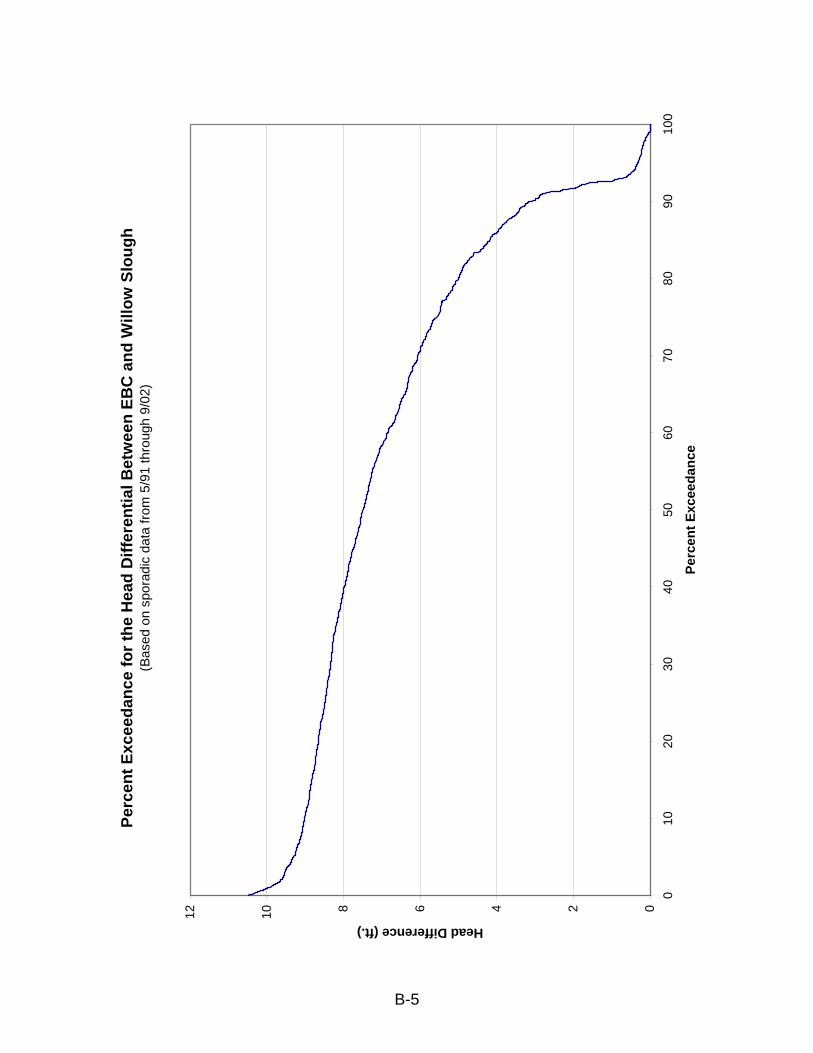
Perc
ent E
xcee
danc
e fo
r the
Hea
d D
iffer
entia
l Bet
wee
n EB
C a
nd W
illow
Slo
ugh
(Bas
ed o
n sp
orad
ic d
ata
from
5/9
1 th
roug
h 9/
02)
024681012
010
2030
4050
6070
8090
100
Perc
ent E
xcee
danc
e
Head Difference (ft.)
B-5

Appendix C Table of Contents Introduction ................................................................................................................. C-2 Objective ..................................................................................................................... C-5 Equipment .................................................................................................................. C-5 Procedure.................................................................................................................... C-5 Results ........................................................................................................................ C-7 Conclusion ................................................................................................................ C-10 References................................................................................................................ C-12
C-1
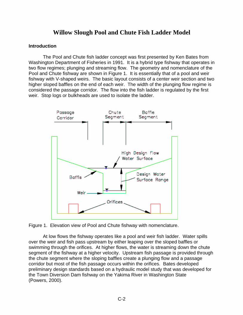
Willow Slough Pool and Chute Fish Ladder Model
Introduction The Pool and Chute fish ladder concept was first presented by Ken Bates from Washington Department of Fisheries in 1991. It is a hybrid type fishway that operates in two flow regimes; plunging and streaming flow. The geometry and nomenclature of the Pool and Chute fishway are shown in Figure 1. It is essentially that of a pool and weir fishway with V-shaped weirs. The basic layout consists of a center weir section and two higher sloped baffles on the end of each weir. The width of the plunging flow regime is considered the passage corridor. The flow into the fish ladder is regulated by the first weir. Stop logs or bulkheads are used to isolate the ladder.
Figure 1. Elevation view of Pool and Chute fishway with nomenclature. At low flows the fishway operates like a pool and weir fish ladder. Water spills over the weir and fish pass upstream by either leaping over the sloped baffles or swimming through the orifices. At higher flows, the water is streaming down the chute segment of the fishway at a higher velocity. Upstream fish passage is provided through the chute segment where the sloping baffles create a plunging flow and a passage corridor but most of the fish passage occurs within the orifices. Bates developed preliminary design standards based on a hydraulic model study that was developed for the Town Diversion Dam fishway on the Yakima River in Washington State (Powers, 2000).
C-2

The Pool and Chute design has the following benefits over the traditional pool and weir fishway:
• For small tributaries (drainage less then 5 square miles), all of the flow can often be contained in the fishway so false attraction to fish from a spillway or other flow control device is eliminated.
• There is higher flow capacity than other fish ladder types of a similar size thus minimizing false attraction flow to fish from a spillway or flow control device.
• Flood flows that are contained within the fishway often scour bed material and debris from the fishway, reducing maintenance.
• The ladder offers diverse passage routes, through both leaping and swimming, to fish moving upstream.
• Fishway pool sizes can be half as large relative to a traditional pool and weir for the same flow.
The Pool and Chute fishway has four flow regimes which vary depending on the depth over the weir; 1) weir plunging flow, 2) weir streaming flow, 3) baffle plunging flow and 4) baffle streaming flow.
Rajaratnam et al. (1988) studied plunging and streaming flow in a pool and weir fishway and observed that for shallow slopes and short pools, the streaming flow will be smooth with a constant depth over the weirs. For steeper slopes and longer pools the streaming flow will likely have a wavy appearance and in some cases contain undular jumps over a portion of the total length. Hydraulic instability occurs in the transition between the upper range of plunging flow and the lower range of streaming flow. To model a Pool and Chute fishway proposed for Parrott Phelan Diversion on Butte Creek near Chico, Cindy Watanabe and George Heise with the California Department of Fish and Game (CDFG) and Marcin Whitman with National Marine Fisheries Service (NMFS) constructed a 1:12 scaled model of a Pool and Chute fishway. The purpose of this model was to determine how steep the ladder should be by varying the pool length given a 1-foot drop per pool. They modeled 10, 8, and 6-foot pool lengths. At 10 and 8-foot lengths the flow seemed fairly stable, but at 6-feet it appeared excessively turbulent. A steady state condition was usually reached after the 2nd or 3rd weir. Ultimately, 8 weirs in a series with 8-foot long pools at a slope of 11.1percent was considered to be the best configuration. This fishway was constructed in 1996 and has been successfully passing fish throughout a range of flows. The limitation on length of passable Pool and Chute fishways is untested. The longest fishway of this style that I am aware of is on Lees Creek near Port Angeles, WA. This fishway has a total of 16 weirs in a series. Observations are that after the fourth weir the flow starts to oscillate back and forth, and the passage corridors are not consistent as the flow moves down the fishway. This particular fishway on Lees Creek was designed with no orifices. The addition of orifices may stabilize the plunging and streaming transition flow regime as well as providing fish passage (Powers, 2000).
C-3
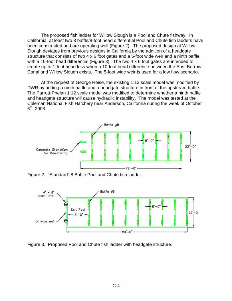
The proposed fish ladder for Willow Slough is a Pool and Chute fishway. In California, at least two 8 baffle/8-foot head differential Pool and Chute fish ladders have been constructed and are operating well (Figure 2). The proposed design at Willow Slough deviates from previous designs in California by the addition of a headgate structure that consists of two 4 x 6 foot gates and a 5-foot wide weir and a ninth baffle with a 10-foot head differential (Figure 3). The two 4 x 6 foot gates are intended to create up to 1-foot head loss when a 10-foot head difference between the East Borrow Canal and Willow Slough exists. The 5-foot wide weir is used for a low flow scenario. At the request of George Heise, the existing 1:12 scale model was modified by DWR by adding a ninth baffle and a headgate structure in front of the upstream baffle. The Parrott-Phelan 1:12 scale model was modified to determine whether a ninth baffle and headgate structure will cause hydraulic instability. The model was tested at the Coleman National Fish Hatchery near Anderson, California during the week of October 6th, 2003.
Figure 2. “Standard” 8 Baffle Pool and Chute fish ladder.
Figure 3. Proposed Pool and Chute fish ladder with headgate structure.
C-4
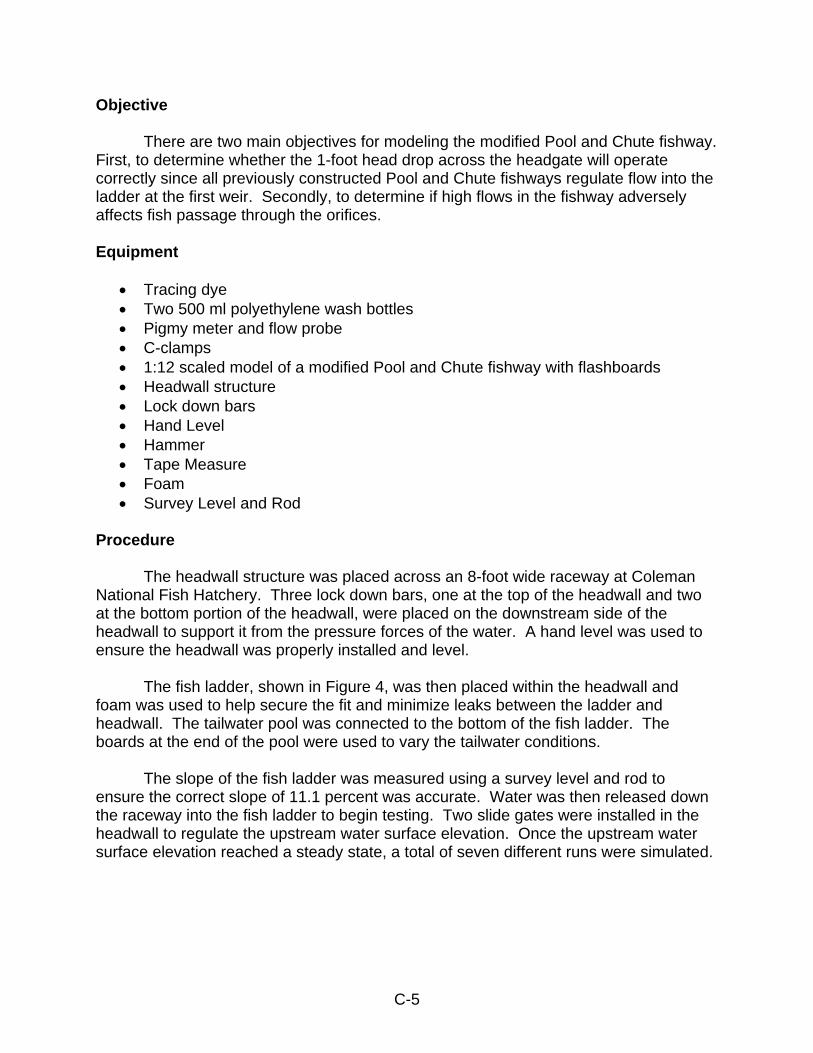
Objective There are two main objectives for modeling the modified Pool and Chute fishway. First, to determine whether the 1-foot head drop across the headgate will operate correctly since all previously constructed Pool and Chute fishways regulate flow into the ladder at the first weir. Secondly, to determine if high flows in the fishway adversely affects fish passage through the orifices. Equipment
• Tracing dye • Two 500 ml polyethylene wash bottles • Pigmy meter and flow probe • C-clamps • 1:12 scaled model of a modified Pool and Chute fishway with flashboards • Headwall structure • Lock down bars • Hand Level • Hammer • Tape Measure • Foam • Survey Level and Rod
Procedure The headwall structure was placed across an 8-foot wide raceway at Coleman National Fish Hatchery. Three lock down bars, one at the top of the headwall and two at the bottom portion of the headwall, were placed on the downstream side of the headwall to support it from the pressure forces of the water. A hand level was used to ensure the headwall was properly installed and level. The fish ladder, shown in Figure 4, was then placed within the headwall and foam was used to help secure the fit and minimize leaks between the ladder and headwall. The tailwater pool was connected to the bottom of the fish ladder. The boards at the end of the pool were used to vary the tailwater conditions.
The slope of the fish ladder was measured using a survey level and rod to ensure the correct slope of 11.1 percent was accurate. Water was then released down the raceway into the fish ladder to begin testing. Two slide gates were installed in the headwall to regulate the upstream water surface elevation. Once the upstream water surface elevation reached a steady state, a total of seven different runs were simulated.
C-5
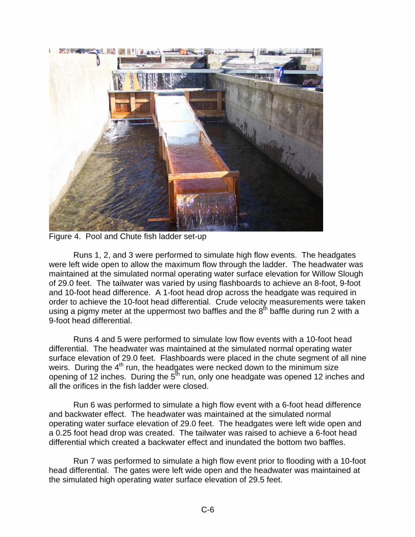
Figure 4. Pool and Chute fish ladder set-up
Runs 1, 2, and 3 were performed to simulate high flow events. The headgates were left wide open to allow the maximum flow through the ladder. The headwater was maintained at the simulated normal operating water surface elevation for Willow Slough of 29.0 feet. The tailwater was varied by using flashboards to achieve an 8-foot, 9-foot and 10-foot head difference. A 1-foot head drop across the headgate was required in order to achieve the 10-foot head differential. Crude velocity measurements were taken using a pigmy meter at the uppermost two baffles and the 8th baffle during run 2 with a 9-foot head differential. Runs 4 and 5 were performed to simulate low flow events with a 10-foot head differential. The headwater was maintained at the simulated normal operating water surface elevation of 29.0 feet. Flashboards were placed in the chute segment of all nine weirs. During the 4th run, the headgates were necked down to the minimum size opening of 12 inches. During the 5th run, only one headgate was opened 12 inches and all the orifices in the fish ladder were closed. Run 6 was performed to simulate a high flow event with a 6-foot head difference and backwater effect. The headwater was maintained at the simulated normal operating water surface elevation of 29.0 feet. The headgates were left wide open and a 0.25 foot head drop was created. The tailwater was raised to achieve a 6-foot head differential which created a backwater effect and inundated the bottom two baffles. Run 7 was performed to simulate a high flow event prior to flooding with a 10-foot head differential. The gates were left wide open and the headwater was maintained at the simulated high operating water surface elevation of 29.5 feet.
C-6
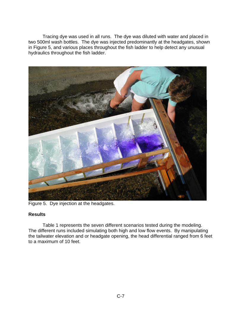
Tracing dye was used in all runs. The dye was diluted with water and placed in two 500ml wash bottles. The dye was injected predominantly at the headgates, shown in Figure 5, and various places throughout the fish ladder to help detect any unusual hydraulics throughout the fish ladder.
Figure 5. Dye injection at the headgates. Results Table 1 represents the seven different scenarios tested during the modeling. The different runs included simulating both high and low flow events. By manipulating the tailwater elevation and or headgate opening, the head differential ranged from 6 feet to a maximum of 10 feet.
C-7
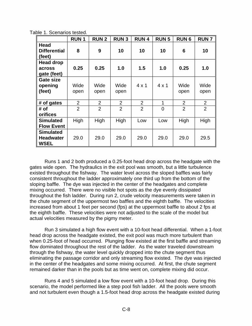
Table 1. Scenarios tested. RUN 1 RUN 2 RUN 3 RUN 4 RUN 5 RUN 6 RUN 7Head Differential (feet)
8
9
10
10
10
6
10
Head drop across gate (feet)
0.25
0.25
1.0
1.5
1.0
0.25
1.0
Gate size opening (feet)
Wide open
Wide open
Wide open
4 x 1
4 x 1
Wide open
Wide open
# of gates 2 2 2 2 1 2 2 # of orifices
2 2 2 2 0 2 2
Simulated Flow Event
High High High Low Low High High
Simulated Headwater WSEL
29.0
29.0
29.0
29.0
29.0
29.0
29.5
Runs 1 and 2 both produced a 0.25-foot head drop across the headgate with the gates wide open. The hydraulics in the exit pool was smooth, but a little turbulence existed throughout the fishway. The water level across the sloped baffles was fairly consistent throughout the ladder approximately one third up from the bottom of the sloping baffle. The dye was injected in the center of the headgates and complete mixing occurred. There were no visible hot spots as the dye evenly dissipated throughout the fish ladder. During run 2, crude velocity measurements were taken in the chute segment of the uppermost two baffles and the eighth baffle. The velocities increased from about 1 feet per second (fps) at the uppermost baffle to about 2 fps at the eighth baffle. These velocities were not adjusted to the scale of the model but actual velocities measured by the pigmy meter. Run 3 simulated a high flow event with a 10-foot head differential. When a 1-foot head drop across the headgate existed, the exit pool was much more turbulent than when 0.25-foot of head occurred. Plunging flow existed at the first baffle and streaming flow dominated throughout the rest of the ladder. As the water traveled downstream through the fishway, the water level quickly dropped into the chute segment thus eliminating the passage corridor and only streaming flow existed. The dye was injected in the center of the headgates and some mixing occurred. At first, the chute segment remained darker than in the pools but as time went on, complete mixing did occur. Runs 4 and 5 simulated a low flow event with a 10-foot head drop. During this scenario, the model performed like a step pool fish ladder. All the pools were smooth and not turbulent even though a 1.5-foot head drop across the headgate existed during
C-8
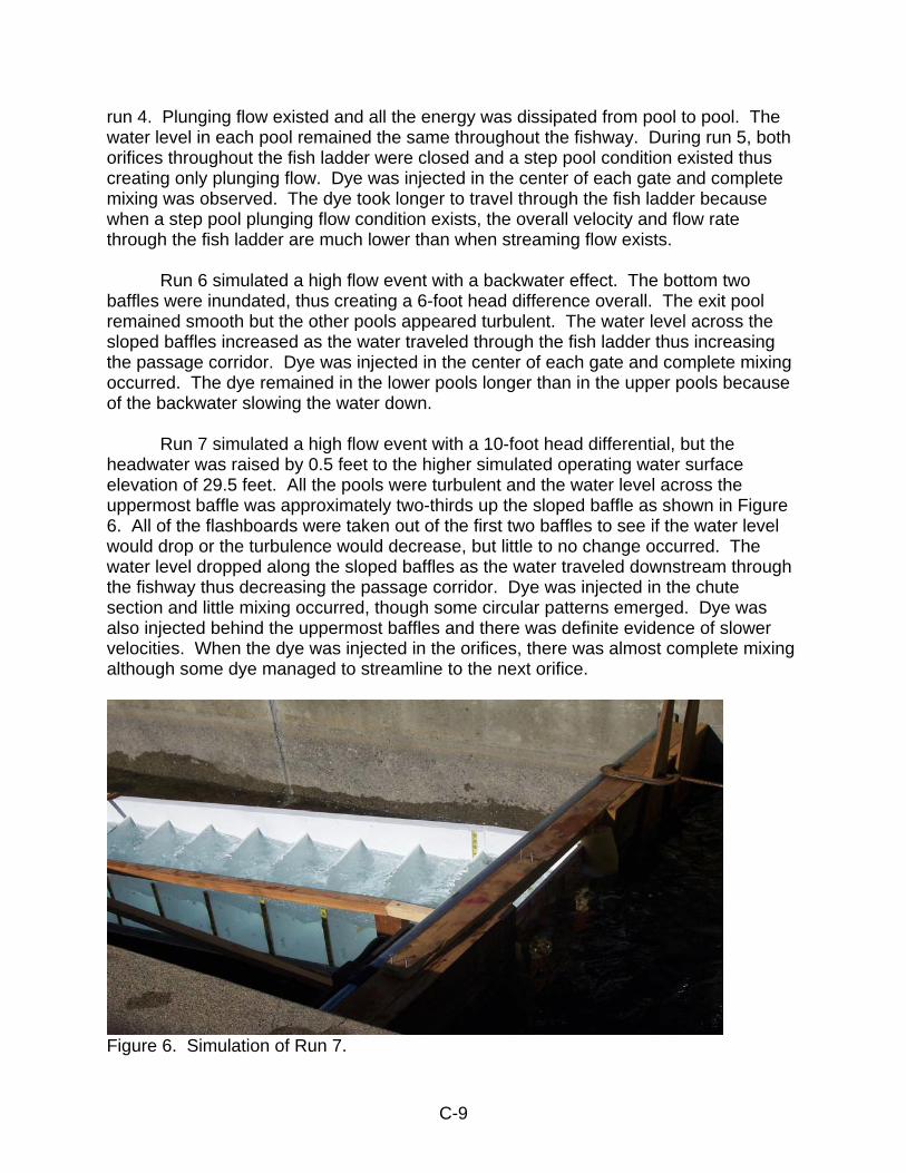
run 4. Plunging flow existed and all the energy was dissipated from pool to pool. The water level in each pool remained the same throughout the fishway. During run 5, both orifices throughout the fish ladder were closed and a step pool condition existed thus creating only plunging flow. Dye was injected in the center of each gate and complete mixing was observed. The dye took longer to travel through the fish ladder because when a step pool plunging flow condition exists, the overall velocity and flow rate through the fish ladder are much lower than when streaming flow exists. Run 6 simulated a high flow event with a backwater effect. The bottom two baffles were inundated, thus creating a 6-foot head difference overall. The exit pool remained smooth but the other pools appeared turbulent. The water level across the sloped baffles increased as the water traveled through the fish ladder thus increasing the passage corridor. Dye was injected in the center of each gate and complete mixing occurred. The dye remained in the lower pools longer than in the upper pools because of the backwater slowing the water down. Run 7 simulated a high flow event with a 10-foot head differential, but the headwater was raised by 0.5 feet to the higher simulated operating water surface elevation of 29.5 feet. All the pools were turbulent and the water level across the uppermost baffle was approximately two-thirds up the sloped baffle as shown in Figure 6. All of the flashboards were taken out of the first two baffles to see if the water level would drop or the turbulence would decrease, but little to no change occurred. The water level dropped along the sloped baffles as the water traveled downstream through the fishway thus decreasing the passage corridor. Dye was injected in the chute section and little mixing occurred, though some circular patterns emerged. Dye was also injected behind the uppermost baffles and there was definite evidence of slower velocities. When the dye was injected in the orifices, there was almost complete mixing although some dye managed to streamline to the next orifice.
Figure 6. Simulation of Run 7.
C-9
All of the runs with the exception of the simulated low flow events, runs 4 and 5, showed visible signs of water boiling over the first baffle. As water enters the fishway through the two 4 x 6 foot headgates and flows into the first baffle, the water noticeably rises up at that baffle and causes a boiling effect over the baffle. This boiling effect was noticeably worse as the flow and head difference across the headgate structure increased. Conclusion The different scenarios selected to model were determined by worst case conditions for fish passage at Willow Slough. According to the water data analyzed for Willow Slough, when a 10-foot head difference occurred, the minimum upstream water surface elevation was 29.4 feet with a maximum flow of 40 cfs. Both runs 3 and 7 were simulated for a high flow event with a 10-foot head differential. During these two scenarios, the flow through the fish ladder is approximately 200 cfs or greater. Therefore, even though runs 3 and 7 are unlikely to happen, it was modeled to ensure the fish ladder was capable of handling full flow with a 10-foot head differential. The velocities were measured during the simulation of run 2. The velocities increased as the water traveled downstream through the fish ladder. This is to be expected with a Pool and Chute fish ladder. The chute segment of a Pool and Chute is not generally used for fish passage, but for attraction flow for the fish to find the fish ladder. The increased velocities may be of concern, but as the dye was introduced, complete mixing occurred and no adverse flow patterns were observed. As stated previously, when a 10-foot head difference occurred at Willow Slough, the maximum flow was 40 cfs. Runs 4 and 5 were tested to simulate this scenario. During runs 4 and 5, the fish ladder acted like a step pool and only plunging flow existed. Although in run 4, a 1.5-foot head differential occurred across the headgates, this can be adjusted by closing the orifices. In order to provide adequate fish passage, the required minimum depth of flow over the weirs is 6 inches. When the gates are necked down to the minimum opening of 12 inches, flashboards are necessary in the chute segment of the fish ladder. When only one gate is used at the minimum opening of 12 inches, both orifices throughout the fishway need to be closed as simulated in run 5. If the orifices are not closed, the minimum requirement of 6 inches over the weir will not be maintained. When the fish ladder acts as a step pool and a 1-foot head drop across the headgate is achieved, there is no turbulence throughout the fish ladder and exit pool. Willow Slough is subject to backwater and that is why run 6 was chosen to simulate. Because of the backwater, the bottom two baffles were inundated. The backwater effect did not seem to have any negative impacts on the operations of the fish ladder.
C-10
During runs 3 and 7 the water level dropped as water traveled downstream through the fish ladder which decreased the passage corridor. During run 3 the water level dropped within the chute segment after the first baffle, thus eliminating the passage corridor. In order to raise the water level such that the passage corridor exists, flashboards need to be placed within the chute segment throughout the ladder. The dropping water level occurred as water velocity increased in the fish ladder because energy was not being completely dissipated in the pools. Although the water level drops and decreases the passage corridor, the primary fish passage route is through the orifices. As long as a 1-foot head differential is maintained from pool to pool, fish passage is not delayed. The boiling effect observed in runs 1, 2, 3, 6, and 7 is caused by high flows being concentrated through the two 4 x 6 gates. Traditionally, the flow into the Pool and Chute fishway is controlled by the first baffle and not by a headgate structure. Even though this boiling effect occurred, a 1-foot head difference across the baffle existed, thus fish passage will not be delayed. Overall, the test was successful and few problems occurred. Some of the problems with turbulence which occurred during the high flow scenarios could be reduced by releasing more water through the culverts. The primary fish passage route is through the orifices, thus when the passage corridor disappears under certain, limited circumstances the preferred passage route is still available. Based on the model, the proposed 9-baffle Pool and Chute fishway with a headgate structure will operate well.
C-11
References
Bates, Ken. 1991. Pool and Chute Fishways. American Fisheries Society Symposium. 10:268-277.
Rajaratnam, N and C. Katopodis. 1988. Plunging and streaming flows in pool and weir fishways. Journal of Hydraulics Engineering. Vol. 114, No. 8. Powers, P. D. 2000. Draft in Progress-Pool and Chute Fishways Discussion and
Design Process.
C-12

Appendix D Table of Contents
Preliminary Geologic Exploration Memorandum ......................................................... D-2 Attachment 1: Willow Slough Weir, 2003 Exploration Drill Hole Logs ...................... D-13 Attachment 2: Laboratory Soil Classification Data ................................................... D-20 Plates ........................................................................................................................ D-23
D-1
State of California The Resources Agency M e m o r a n d u m Date: May 26, 2004 Project Geology Report No. 94-00-23 To: Nancy Snodgrass Northern District, DPLA Frank L. Glick, Chief Project Geology Section From: Department of Water Resources Subject: Sutter Bypass Improvements, Willow Slough Weir; Results of Phase 1 Geologic
Exploration Program Introduction
Pursuant to your May 2003 request for a geologic foundation investigation of the
proposed Sutter Bypass Willow Slough Weir structure, and subsequent communications with Brent Lamkin of my staff, we have prepared this report of geologic conditions. The report and drawings were prepared by Mr. Lamkin, with assistance from Tim Todd, Al Laguardia, and Shelly Asbury of the Project Geology Section. Geologic exploration for the site was conducted by Project Geology on June 23 and 24, 2003, pursuant to the exploration proposal transmitted to you from Mr. Lamkin on June 9, 2003. We are calling the completed exploration work “Phase 1” of the site investigation. Our understanding is that the existing weir was constructed in the 1920s and modified with the existing fish ladder in the 1980s. Because of flow velocities in the existing weir outlets, migrating fish are attracted to the outlets rather than the fish ladder. The fish ladder gradient is too steep relative to the weir outlets which cause fish to bypass the ladder for the weir. A new weir and fish ladder are proposed with an adjusted gradient more conducive to fish passage through the proposed fish ladder. Northern District is currently preparing a preliminary design for a replacement fish ladder and modification of the existing weir structure with reconfigured and additional outlets at the same location as the existing southern weir outlets.
The Willow Slough Weir structures are located in Sutter County, approximately
15 miles south of Yuba City, and about 3 miles northwest of the town of Nicolaus (Plate 1); the weir is at the head of Willow Slough where it intersects the western levee of the East Borrow Canal, within the Sutter Bypass. The weir structure controls water flow into Willow Slough from the East Borrow Canal, while the fish ladder provides passage from Willow Slough into the East Borrow Canal.
SURNAME
DWR 155 (Rev 4/02) B. Lamkin 5/26/04
F. Glick 5/26/04
D-2
Nancy Snodgrass May 26, 2004 Page 2
2003 Phase 1 Geologic Exploration No known geologic exploration had been conducted at the Willow Slough Weir site before the “Phase 1” exploration conducted by Project Geology in 2003. On June 25 and June 26, 2003, two exploration borings (Hole WSW-1 and Hole WSW-2) were drilled at the site to characterize foundation conditions for the replacement weir structure (Plate 2). Hole WSW-1 was located about 50 feet south of the existing fish ladder and 130 feet north of the proposed fish ladder, while Hole WSW-2 was drilled approximately 80 feet south of the existing southern weir culverts, between the two proposed south weir culverts (Plate 2). At the time of exploration, the weir outlets and fish ladder configuration had not been finalized. The borings were located in a way that would characterize the northern and southern boundaries of the possible locations for the proposed structures. A third exploration hole was proposed, but was eliminated after WSW-2 was moved north to its present location.
Soils encountered in the borings were logged (Attachment 1) on site according to ASTM Standard D 2487 by Tim Todd, Engineering Geologist (Range C), from the Project Geology Section. Mr. Todd also directed the drilling and sampling activities of the drilling Contractor. Both borings were drilled by Spectrum Exploration of Stockton, California using a Central Mine Equipment (CME) 85 rubber-tired drill-rig. The borings were advanced to 50.0 feet below ground surface (bgs) using 8.25-inch O.D. hollow-stem augers. When drilling activities were completed, the auger cuttings were spread adjacent to each drill hole, and the borings were backfilled with bentonite-cement grout using a tremie line. Soil samples were collected at approximately five-foot intervals for field classification and laboratory analyses of physical properties. The sampling sequence consisted of augering to the desired sample depth where a 3.0 inch O.D. x 30 inch long Shelby tube would typically be pushed 24 inches to collect a relatively undisturbed soil sample pursuant to ASTM Standard D 1587; the Shelby tube samples were trimmed, capped, labeled, and boxed for transport to the Department of Water Resources' Bryte Soils Lab for analysis. Following the push sample, a Standard Penetration Test (SPT) sample was collected by driving a 1.35 inch I.D. by 24 inch long SPT sampler 18 inches pursuant to ASTM Standards D 1586 and D 6066. The SPT soil samples were logged by the Engineering Geologist, then bagged, labeled, and transported to the Bryte Soils Lab for testing. Driven samples were collected to a depth of 48.5 feet bgs in Hole WSW-1, and 46.0 feet bgs in Hole WSW-2.
D-3

Nancy Snodgrass May 26, 2004 Page 3
Groundwater depths were not determined in the borings, as it was necessary to add water during drilling and sampling operations. However, surface water in the adjacent East Borrow Canal was estimated at approximately six feet below the ground surface at the drill hole sites, or approximately elevation 28 feet. Data provided by Northern District confirmed that the East Borrow Canal water elevation average is 28.4 feet; while the average surface elevation for Willow Slough is 22.7 feet with a minimum elevation of 18.4 feet. Given those surface water elevations, the groundwater surface at the proposed improvements is probably in the range of elevation 23 to 28 feet, or 6 to 11 feet below ground surface at the drill hole sites, depending on proximity to the East Borrow Canal or Willow Slough. All groundwater and structure elevations are based on the North American Vertical Datum of 1988 (NAVD 88). Laboratory Testing of Soils
As mentioned above, relatively undisturbed Shelby tube samples and disturbed, driven, SPT soil samples were collected for laboratory analyses, at roughly five-foot intervals. All samples collected from the borings were transported to the Bryte Soils Lab for testing. Four samples from each boring were selected for gradational and plasticity analyses. The samples selected for testing were representative of the soils and depths to be encountered in the proposed construction and/or modification of the Willow Slough Weir structures. The results of the laboratory testing are contained in Attachment 2.
Four SPT bag samples from Hole WSW-1, and three SPT samples and one Shelby tube sample from Hole WSW-2, were submitted for gradational/mechanical analysis pursuant to ASTM Standard D 422, and Atterberg limits, or plasticity index, pursuant to ASTM Standard D 4318; samples that were determined to be non-cohesive were not analyzed for plasticity index determination. Samples selected for analyses were based on the depth of the proposed structure and occurrence of different soil types encountered in each boring. For boring WSW-1, SPT bag samples B-2 (11.5-13.0’), B-3 (17.0-18.5’), B-4 (22.0-23.5’), and B-5 (27.0-28.5’) were submitted for gradation and plasticity analysis; the same analyses were requested for Shelby Tube sample S-2 (10-12’), and SPT bag samples B-2 (17-18.5’), B-3 (22-23.5’), and B-4 (27-28.5’) from boring WSW-2. All unused SPT bag and Shelby tube samples will be stored at the soils lab for additional analyses, if needed. Laboratory analyses for gradation and Atterberg limits of the soil samples were completed in September 2003. Attachment 2 shows laboratory classification of soils ranging from a lean clay (CL) and elastic silt (MH) with a plasticity index of 21 (WSW-1, samples B-4 (22-23.5’) and B-5 (27-28.5’)) and 22 (WSW-2 sample B-3, 22.0-23.5’), to silty sand (SM) exhibiting no plasticity (WSW-2, sample B-2, 17.0-18.5’ bgs). While the
D-4
Nancy Snodgrass May 26, 2004 Page 4 field and laboratory classifications did not always agree, they were usually within one classification of each other; for example, sample B-4 from boring WSW-2 was classified in the field as lean clay (CL), whereas laboratory testing showed it to be silt with sand (ML)s. The only exceptions to this was sample B-3 from WSW-2, which was logged in the field as lean clay, but classified by laboratory testing as elastic silt (MH). The discrepancy in the field and lab classifications may be the result of heterogeneity within the sample, and/or sample preparation, along with the inherent differences between field and laboratory classification methods. Site Geologic Conditions Willow Slough Weir, and the surrounding area, is located within Quaternary Alluvium (Qal) soils of the Sacramento Valley. The alluvium at the project site can be subdivided into two distinctive units, Qal1 and Qal2, each with a dominant soil type. The drill hole logs from both borings drilled as part of this Phase 1 investigation show that shallow soils beneath and adjacent to the existing weir are predominantly lean clay (CL), with interbeds of silty sand (SM) and silt (ML) of alluvial unit Qal2,, overlying the older silty sand of alluvial unit Qal1 (Attachment 1).
Invert elevation data for the existing facilities is incomplete. However, they have been estimated from known data at the downstream end of the weir outlets, from the design gradient of the proposed weir and fish ladder, and from surface water levels in the East Levee Canal and in Willow Slough. The invert of the existing weir outlets are at about elevation 19 to 21 feet, while the existing Denil fish ladder invert is estimated to range from approximately elevation 12 to 22 feet.
While no construction information for the existing structure was available,
exploration borings show that the central portion of the existing weir and fish ladder appears to be founded on lean clay (CL), while the southern end of the weir site is underlain by lean clay (CL), sandy lean clay s(CL), silt (ML), and silty sand (SM). Fill is presumed to be present surrounding the existing weir outlets to 1 to 2 feet below the weir outlets, or about elevation 18 feet; fill may also extend across the head of Willow Slough to a possible elevation of 7 feet, but could not be discerned from alluvium in the borings, and is not depicted separately. Lean clay and silty sand generally characterize the subsurface below the foundation of the existing structures. The subsurface geology of the site is depicted in Cross Section A – A, found on Plate 3.
D-5
Nancy Snodgrass May 26, 2004 Page 5 The geologic log for boring WSW-1 (Attachment 1) shows that the soils between the existing fish ladder and the southern weir outlets consist of lean clay to a depth of 40.0 feet below ground surface (bgs), overlying silty sand 40.0 to 50.0 feet bgs. The boring was terminated at 50.0 feet bgs because of flowing sand conditions. Laboratory testing of samples collected from the approximate elevation range for the foundation of the proposed weir outlets and fish ladder confirmed that the soils in samples B-2 (11.5-13.0’ bgs), B-3 (17.0-18.5’ bgs), B-4 (22.0-23.5’ bgs), and B-5 (27.0-28.5’ bgs) were lean clay, as they had been logged in the field. The laboratory classifications for samples B-2 and B-3 were both further refined as lean clay with sand. Uncorrected SPT values for WSW-1 ranged from N=4 (47.0-48.5’ bgs) near the bottom of the boring in silty sand (immediately above flowing sands) to N=45 (42.0-43.5’ bgs) in silty sand encountered within the lower quarter of the boring; the low N value at the bottom of the hole is probably the result of flowing sand conditions in the open hole, and should be considered suspect. SPT values for the remainder of the boring, 7 to 38.5 feet bgs, appeared to be reasonable and ranged from N=8 (17.0’-18.5’ and 32.0-33.5’) to N=25 (11.5’-13.0’ bgs). The N values show a wide range of soil consistencies, from loose to dense in the silty sands (Qal1) at the bottom of the boring, and stiff to hard throughout the lean clay (Qal2) encountered in the boring. The lithologic descriptions and N values for the central portion of the weir site are depicted on Cross Section A – A (Plate 3).
The lithology of the southern portion of the weir site was logged and characterized from boring WSW-2. A combination of lean clay, silt, and silty sand units were identified beneath the southern edge of the weir site. The drill hole log for WSW-2 (Attachment 1) shows that surface and near-surface soils of alluvial unit Qal2 consist of lean clay from 0.5 to 9.0 feet bgs, underlain by sandy lean clay between 9.0 and 14.0 feet bgs, silt from 14.0 and 17.0 feet bgs, and silty sand from 17.0 to 20.0 feet bgs. Below 20 feet bgs (elevation 14 feet), the soils consist of lean clay and silty sand, while the top six inches logged in the boring were gravelly clay road base. Soils of Recent Alluvium unit Qal1 encountered in WSW-2 consisted entirely of silty sand encountered from 35 to 50 feet bgs. Laboratory analyses of samples collected from the approximate elevation of the weir outlets and fish ladder indicated some differences from the field classification. Test results for samples B-3 (22.0-23.5’ bgs) and B-4 (27.0’-28.5’ bgs) characterized them as elastic silt (MH) and silt with sand (ML), respectively; whereas B-3 was logged in the field as lean clay and B-4 was logged as lean clay and silty sand (with the contact between soil units at 28.0’ bgs). Laboratory analyses of sample B-2 showed it to be the silty sand it was logged as in the field, while S-3 was classified as lean clay with sand instead of the sandy lean clay it was identified as in the field. The
D-6
Nancy Snodgrass May 26, 2004 Page 6 contact between the lower Qal1 and the upper Qal2 units in Hole WSW-2 is at about elevation -1 foot, while in Hole WSW-1 it was near elevation -6 feet, indicating a gradual dip towards the north.
Uncorrected SPT values for WSW-2 ranged from N=1 (17.0-18.5’ and 22.0-23.5’ bgs) in silty sand and lean clay/elastic silt toward the middle of the boring, to N=84 (44.0’-45.5’ bgs) in silty sand near the bottom of the boring. The N values show a wide range of soil consistencies, from very soft to soft in the lean clays, and very loose in the silty sands, in the upper half of the boring, to dense and very dense in the Qal1 silty sand unit. The low N values found in the upper half of the boring may have been compromised by the groundwater conditions, and could be considered suspect; they may also be characteristic of possible fill material. The lithologic descriptions and N values for the southern part of the weir site are depicted on Cross Section A – A (Plate 3). New Weir and Fish Ladder Foundation Conditions In correspondence between you and Brent Lamkin you indicated that the invert of the proposed weir outlets will range between elevation 17.0 feet to 18.5 feet, while the fish ladder invert elevation will be between 11.9 and 19.9 feet. The proposed weirs consist of two sets of parallel 60-inch corregated metal pipe (CMP) passages with control gates. A concrete pool and chute fish ladder will be constructed between the two sets of CMP weir outlets; concrete footings for the fish ladder have been proposed to extend to an elevation of 8.9 feet. Although there has been no discussion regarding a new bridge at the site, we want to point out that the information obtained to date is not sufficient to design a bridge crossing of the proposed fish ladder. The proposed weir and fish ladder are located in between the two borings drilled as part of this Phase 1 geologic investigation (Plate 2). It should be noted that the borings were drilled before the fish ladder and weir structure layout was finalized. Since the lithology of the two drill holes is not consistent, we can not provide a definitive description of the subsurface conditions directly beneath all of the proposed structures. To do that, a second phase (Phase 2) of exploration would be necessary. However, as shown on Section A – A (Plate 3), data from the two borings can be projected beneath the proposed structures, with a tentative estimate of the foundation conditions provided. Therefore, at this time, we are not proposing a Phase 2 program. Given the invert elevations for the proposed structures, the south weir culverts will be founded on silt, while the fish ladder and northern weir culverts may be founded
D-7
Nancy Snodgrass May 26, 2004 Page 7 on lean clay, silt, and/or silty sand. The fish ladder, with its sloped invert, will probably be founded on all three soil types, with the upstream and middle portions possibly founded on the same silty sand and silt units, while the downstream portion and proposed footings will be founded on lean clay (Plate 3). All of these soils are within the Qal2 alluvial unit. However, because of the differences in the soils encountered in the exploratory borings that bracket the location of the proposed improvements, the northern weir outlets could be partially founded on the silty sand and/or silt units logged in WSW-2 between 14 and 20 feet bgs (elevation 20 to 12 feet), or they could be founded on the lean clay encountered in WSW-1 at the same elevation.
It should also be noted that at least one of the proposed northern weir outlets,
and the northern edge of the proposed fish ladder, will probably be located within fill surrounding the existing weir outlets (Plate 3). The entire area of the proposed structures may be in fill, which was not lithologically discernable from the alluvial soils; however, the possible fill may be distinguished from the alluvium by the relative differences in blow count values (N=1-2 versus N=23) with the possible contact between elevation 7 and 11 feet.
The primary foundation soil unit (lean clay) extends below the maximum invert of
the proposed fish ladder an additional six feet (elevation 6 feet) at WSW-2, and 18 feet (-6 feet elevation) at WSW-1. Uncorrected SPT blow counts from the lean clay foundation soil ranged from N=1 (22.0-23.5’) to N=23 in WSW-2, and N=8 (17.0’-18.5’ and 32.0-33.5’ bgs) to N=25 (11.5’-13.0’ bgs). A closer look at the blow count data from the range of weir and fish ladder foundation elevations shows that uncorrected blow count data for the weir outlets is N=1 (WSW-2) to N=8 (WSW-1), while the fish ladder foundation blow counts range from N=1 to N=2 (WSW-2) to N=8 to N=25 (WSW-1) for the minimum invert and N=1 (WSW-2) to N=19 (WSW-1) at the maximum invert. Based on uncorrected SPT blow count data, some of the foundation soils do not appear to gain adequate consistency until approximately elevation 6 to 7 feet beneath the southern weir culverts at WSW-2, or about elevation 12 feet in the vicinity of WSW-1. However, as mentioned above, the SPT values of N=1 to N=2 may be suspect, but should still be considered possible for design purposes. Conclusions and Recommendations
• The proposed weir outlet and fish ladder structures probably will be founded on lean clay, silt, and silty sand Quaternary alluvium soils, and possibly on fill. Two of the proposed weir outlets will be located at approximately the same location as existing outlets. Foundation soils at the site appear to have
D-8

Nancy Snodgrass May 26, 2004 Page 8
performed well during the life of the existing structure. However, data from exploratory borings located between the two proposed southern weir culverts (WSW-2), and 130 feet north of the proposed fish ladder (WSW-1), respectively, indicate that foundation conditions may not be adequate at the invert of the proposed structures. If the soil conditions recorded at WSW-1 are present below the proposed fish ladder and/or northern weir culverts, blow count data indicates that the lean clay foundation should adequately support the proposed weir outlet and fish ladder; however, one interval at elevation 17.0’-15.5’ exhibited a relatively low SPT value of N=8, while intervals tested above and below that elevation ranged from N=19 to N=25. The blow count data from WSW-2 for the invert elevations of the proposed southern weir culverts, and possibly the fish ladder and northern weir culverts, are very low ranging from N=1 to N=2 primarily in silt, silty sand, and lean clay; firm foundation materials are not encountered until about elevation 6 to 7 feet with an SPT value of N=23 in hard lean clay and compact silty sand soils. With the foundation conditions exhibited in WSW-2, it may be desirable to extend footings, or piles, for the fish ladder to an elevation of 6 feet or lower to provide adequate support for the structure; foundation preparation for the weir outlet culverts should include over excavation to at least elevation 18 feet, and the removal of soft or loose soils and their replacement with engineered fill. These measures should lesson the likelihood of settlement and/or liquefaction during a seismic event.
• The soils in the Qal2 alluvial unit between Holes WSW-1 and WSW-2 do not
appear to correlate well. In order to fully determine the specific soil foundation conditions for the proposed structures, and for the design of a possible bridge to span the fish ladder, a Phase 2 exploration program would be needed. Such a program would consist of additional exploratory borings being drilled and sampled at the location of the new fish ladder, or between the proposed fish ladder and existing south weir outlets, and on either end of the fish ladder. Information from the additional borings, combined with the data gathered during the Phase 1 investigation, would provide detailed information on the soils to be encountered during excavation and construction of the proposed fish ladder, weir outlets, and help in designing possible fish ladder bridge foundation support structures. Additional testing of soil samples collected from a Phase 2 boring would include compaction testing, in addition to gradation and plasticity tests, to determine the suitability of the site soils for use as backfill. However, at this time, we are not recommending proceeding with a Phase 2 exploration program. We believe that enough information is available for design of the weirs and fish ladder.
D-9

Nancy Snodgrass May 26, 2004 Page 9
• As some of the shallow soils at the site may be erosive, as indicated by low SPT
blow count data, and the presence of non-cohesive soil units at the proposed structures, a cut-off wall should be considered for the upstream and downstream edges of the weir outlet and fish ladder structures to prevent underflow and headward erosion. The cut-off wall could be constructed of either concrete or steel sheet piles.
• While groundwater elevations were not determined during this investigation, they
can be assumed to coincide with surface water levels in the adjacent East Borrow Canal (approximately elevation 28 feet), and Willow Slough (approximately elevation 23 feet). Therefore, groundwater should be anticipated in excavations at or below the higher elevation of 28 feet. Dewatering will be required in and/or around the demolition of the existing structures, and excavations and construction of the replacement weir and fish ladder. As the canal is continuously filled with water, and the clayey soils may not drain well, any dewatering for construction should be done in stages to prevent possible pore-pressure-induced slope failures. All excavation and backfilling should be performed in dry, dewatered conditions.
• The materials at the site can be excavated using common methods and
equipment. The presence of groundwater in the weir foundation soils may impact the selection of the equipment to be used. As the shallow soils were relatively soft, and exhibited relatively low N values, some support may be required to stabilize the site during demolition and foundation preparation. Sheet piles may be the best method for temporarily supporting the exposed excavation prior to and during construction of the new weir structure, and are shown on Plate 3 as Excavation Option 1. Temporary cut slopes of 2H:1V, shown on Plate 3 as Excavation Option 2, may also be stable with the implementation of some dewatering measures. While not as desirable, the excavation may also be accomplished with 1H:1V slopes, as depicted on Plate 3 as Excavation Option 3; however, the 1:1 excavation option is only possible with full dewatering measures implemented on all sides of the excavation below the invert. With the information available at this time, we recommend Excavation Option 1, installation of sheet piling and excavation, as the most economical and manageable excavation method given the site conditions, limited access, and available spoil area.
D-10

Nancy Snodgrass May 26, 2004 Page 10
• An engineering geologist from DWR should make periodic inspections during construction to record the geologic conditions encountered.
Thank you for the opportunity to assist you with this project. If you would like us to move forward with a Phase 2 geologic exploration program, or if you have any questions, or need additional information, please contact me at (916) 323-8928, or Brent Lamkin at (916) 323-8925. Attachments cc: Ron Lee BLamkin:BLamkin:Shelly Asbury E:\Users\lamkin\PG 94-00-23.doc Spell check: 05/26/04
D-11

ATTACHMENTS
D-12
ATTACHMENT 1
Willow Slough Weir, 2003 Exploration Drill Hole Logs
D-13
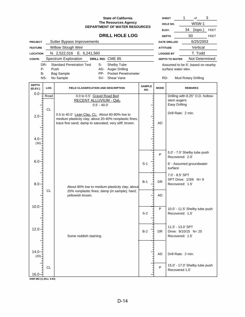
of
S-2
CL
(30)
10.0
8.0
(20)14.0
12.0
DWR 885 (1) (Rev. 9-84)
16.0
4.0
B-1
5034 (topo.)
DEPTH
PROJECT
3WSW-1
6/25/2003FEET
SHEET
HOLE NO.
ELEV. FEET
DRILL RIG
1
DATE DRILLEDSutter Bypass Improvements
State of CaliforniaThe Resources Agency
DEPARTMENT OF WATER RESOURCES
DRILL HOLE LOG
DEPTH TO WATER Not Determined
VerticalATTITUDE
N. 2,522,016 E. 6,241,560 LOGGED BY
Willow Slough WeirT. Todd
CME 85
FEATURE
LOCATION
DR-P-
0.0
2.0
LOG
CONTR.
6.0
Spectrum Exploration
Pocket Penetrometer
P
P
AD
B-2
S-1
CL
DR
P
AD
DR
Recovered: 2.0'
DEPTH(ELEV.)
Drill Rate: 2 min.
10.0' - 11.5' Shelby tube pushRecovered: 1.5'
15.0' - 17.0' Shelby tube pushRecovered 1.0'
Drive: 9/10/15 N= 25Recovered: 1.5'
Assumed to be 6', based on nearby surface water elev.
Drilling with 8.25" O.D. hollow-stem augersEasy Drilling
Drill Rate: 2 min.
AD
REMARKS
5.0' - 7.0' Shelby tube push
7.0' - 8.5' SPT SPT Drive: 1/3/6 N= 9Recovered: 1.5'
11.5' - 13.0' SPT
Shelby TubeAuger Drilling
Road
CL
PP-SV-
FIELD CLASSIFICATION AND DESCRIPTION
Shear Vane
MODE
RD- Mud Rotary DrillingB-NS-
S-AD-
Standard Penetration TestPushBag SampleNo Sample
0.5 to 40.0' Lean Clay, CL: About 60-80% low to medium plasticity clay; about 20-40% nonplastic fines; trace fine sand; damp to saturated; very stiff; brown.
0.5' - 40.0'
SAMPLENO.
About 80% low to medium plasticity clay; about 20% nonplastic fines; damp (in sample); hard; yellowish brown.
Some reddish staining.
0.0 to 0.5' Gravel Road BedRECENT ALLUVIUM - Qal2
6' - Assumed groundwater surface
D-14

of
DWR 885 (2) (Rev. 9-84)
About 80% low to medium plasticity clay; about 20% nonplastic fines; damp (in sample); stiff to very stiff; olive.
AD
State of CaliforniaThe Resources Agency
15.0 - 17.0' Shelby push cont.
Recovered: 1.5', disturbed
Sutter Bypass Improvements, Willow Slough Weir
B-30.5 to 40.0' Lean Clay, CL: cont.
Some Sandy Clay to Clayey Sand.
22.0' - 23.5' SPT Drive: 2/4/13 N= 19B-4
S-4
(10)
22.0
20.0' - 22.0' Shelby tube push
Recovered: 2.0'
Recovered: 0
27.0' - 28.5' SPT
Recovered: 1.5'
32.0' - 33.5' SPT
S-3
SAMPLENO.
26.0
28.0
20.0
36.0
16.0
18.0
PROJECT & FEATURE
LOGDEPTH(ELEV.)
CL
CL
24.0
30.0
32.0
(0)34.0
AD
P
CL
3
MODE
AD
P
FIELD CLASSIFICATION AND DESCRIPTION
RECENT ALLUVUM - Qal20.5' to 40.0''
S-6
B-6
S-5
B-5 DR
DR
35.0' - 37.0' Shelby tube push
Recovered: 1.5', disturbed
30.0' - 32.0' Shelby tube pushRecovered: 2.0'
Easy drilling
Drive: 1/3/5 N= 8
Drive: 2/4/15 N= 19
DR
Recovered: 1.0'
Easy drilling
P
DR
About 60% low to medium plasticity clay; about 40% nonplastic fines; trace fine sand; damp (in sample); very stiff to hard; olive.
P
AD
Low plasticity
25.0' - 27.0' Shelby tube push
Recovered 1.5', disturbedDrive: 2/2/6 N= 8
Recovered: 1.0'
Easy drilling
REMARKS
SHEET
HOLE NO.2
17.0' - 18.5' SPT
P
WSW-1
About 60% low to medium plasticity clay; about 40% nonplastic fines; moist (in sample); stiff; brown.
DEPARTMENT OF WATER RESOURCESDRILL HOLE LOG
D-15

of
(The SPT may have been compromised, and the N value is considered suspect.)
44.0 to 50.0' About 85% fine to medium sand, very loose to loose; about 15% nonplastic fines; moist (in sample); dark gray.
40.0 to 44.0' About 60% fine to medium sand, dense: about 25% non-plastic fines, about 15% low plasticity clay; mosit (in sample); dark gray with bluish clay.
Recovery: 1.5'
S-6
Easy Drilling
Grouted hole with bentonite-cement grout using a tremi pipe.
Drive: 9/20/23 N=45Recovery: 1.5'
Flowing sand, boring terminated.
MODESAMPLENO.
State of California
PROJECT & FEATURE
SHEET
RECENT ALLUVIUM - Qal2
DEPTH(ELEV.) LOG FIELD CLASSIFICATION AND DESCRIPTION
CL0.5 to 40.0' Lean Clay, CL: cont.
0.5 to 40.0'
36.0
40.0 to 44.0' Silty Sand , SM: About 60-85% fine to medium sand, very loose to dense; about 15-40% no to low plasticity fines (about15% low plasticity clay); moist to saturated; dark gray, trace bluish clay; trace muscovite mica.
RECENT ALLUVIUM - Qal140.0 to 50.0'
S-7
DR
CL
DWR 885 (2) (Rev. 9-84)
Drive: 1/2/2 N= 4Recovery: 1.5'
46.0
B-8
AD
P
38.0
40.0
42.0
SM
44.0
(-16)50.0
48.0
(-10) SM
Total Depth: 50.0'
SM
AD
DR
P
B-9
S-8
AD
The Resources Agency
B-7
47.0' - 48.5' SPT
Sutter Bypass ImprovementsWillow Slough Weir
DEPARTMENT OF WATER RESOURCESDRILL HOLE LOG
About 80% low to medium plasticity clay; about 20% nonplastic fines; damp (in sample); very stiff; olive.
Recovery: 2.0'
WSW-13
Recovery: 2.0'
HOLE NO.
P
3
REMARKS
35.0' - 37.0' Shelby push cont.
37.0' - 38.5' SPT Drive: 3/6/9 N=15Recovery: 1.5'
45.0' - 47.0' Shelby tube push
40.0' - 42.0' Shelby tube push
42.0' - 43.5' SPT DR
D-16
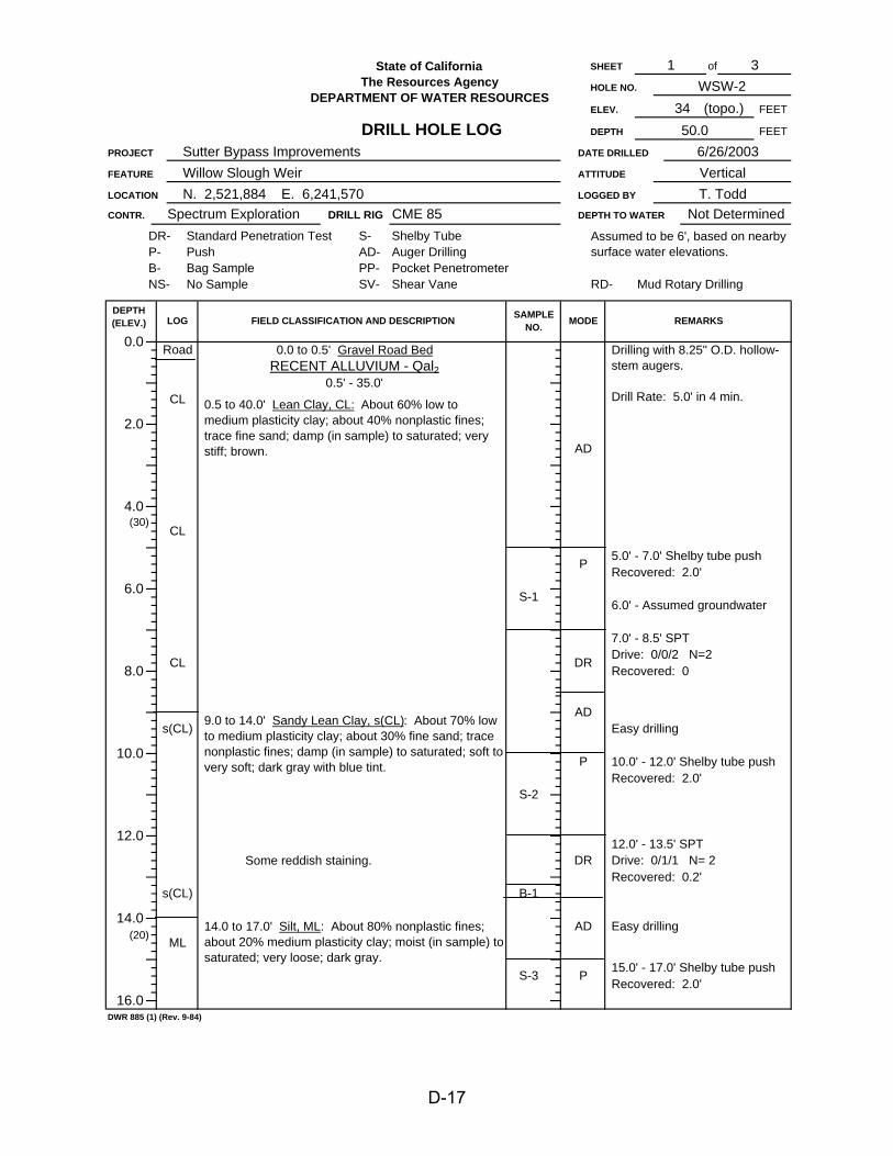
of
7.0' - 8.5' SPT
Recovered: 0.2'
Easy drilling
Easy drilling
15.0' - 17.0' Shelby tube push
Assumed to be 6', based on nearby surface water elevations.
6.0' - Assumed groundwater
5.0' - 7.0' Shelby tube pushRecovered: 2.0'
Drive: 0/0/2 N=2Recovered: 0
Recovered: 2.0'
REMARKS
Mud Rotary DrillingShear Vane
S-2
B-1
S-3
(20) ML
DWR 885 (1) (Rev. 9-84)
16.0
10.0
14.0
12.0
CME 85DR-P-
4.0(30)
DRILL RIG
3WSW-2
6/26/2003FEET
SHEET
HOLE NO.
ELEV. FEET
50.0
1
DATE DRILLEDSutter Bypass Improvements
State of CaliforniaThe Resources Agency
DEPARTMENT OF WATER RESOURCES
DRILL HOLE LOG34 (topo.)
DEPTH
PROJECT
DEPTH TO WATER Not Determined
FEATURE
LOCATION
VerticalATTITUDE
N. 2,521,884 E. 6,241,570 LOGGED BY
Willow Slough WeirT. Todd
LOG FIELD CLASSIFICATION AND DESCRIPTION SAMPLENO.
DEPTH(ELEV.)
Pocket Penetrometer
0.0
2.0
S-1
8.0
CONTR.
6.0
Spectrum Exploration
0.5' - 35.0'
0.5 to 40.0' Lean Clay, CL: About 60% low to medium plasticity clay; about 40% nonplastic fines; trace fine sand; damp (in sample) to saturated; very stiff; brown.
CL
DR
AD
P
Some reddish staining.
s(CL)
CL
s(CL)
9.0 to 14.0' Sandy Lean Clay, s(CL): About 70% low to medium plasticity clay; about 30% fine sand; trace nonplastic fines; damp (in sample) to saturated; soft to very soft; dark gray with blue tint.
14.0 to 17.0' Silt, ML: About 80% nonplastic fines; about 20% medium plasticity clay; moist (in sample) to saturated; very loose; dark gray.
P
DR
10.0' - 12.0' Shelby tube pushRecovered: 2.0'
12.0' - 13.5' SPT Drive: 0/1/1 N= 2
AD
Auger Drilling
P
AD
NS-
0.0 to 0.5' Gravel Road BedRECENT ALLUVIUM - Qal2
Road
CL
RD-
Drilling with 8.25" O.D. hollow-stem augers.
Drill Rate: 5.0' in 4 min.
Standard Penetration TestPushBag Sample
S-AD-PP-SV-
Shelby Tube
No SampleB-
MODE
D-17
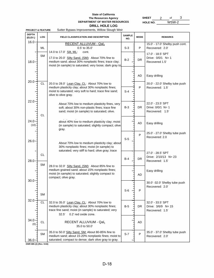
of
35.0 to 50.0'
17.0' - 18.5' SPT Drive: 0/0/1 N= 1
28.0 to 32.0' Silty Sand, (SM): About 85% fine to medium grained sand; about 15% nonplastic fines; moist (in sample) to saturated; slightly compact to compact; olive gray.
RECENT ALLUVIUM - Qal1
Easy drilling
27.0' - 28.5' SPT Drive: 2/10/13 N= 23Recovered: 1.5'
S-3
32.0 to 35.0' Lean Clay, CL: About 70% low to medium plasticity clay; about 30% nonplastic fines; trace fine sand; moist (in sample) to saturated; very
32.5' 0.2' red oxide zone.
20.0 to 28.0' Lean Clay, CL: About 70% low to medium plasticity clay; about 30% nonplastic fines; moist to saturated; very soft to hard; trace fine sand; olive to olive gray.
About 70% low to medium plasticity clay; about 30% nonplastic fines; moist (in sample) to saturated; very stiff to hard; olive gray; trace
y y y ; p ;about 40% low to medium plasticity clay; moist (in sample) to saturated; slightly compact; olive gray.
About 70% low to medium plasticity fines, very soft; about 30% non-plastic fines; trace fine sand; moist (in sample) to saturated; olive.
AD
36.0
S-735.0 to 50.0' Silty Sand, SM: About 80-85% fine to medium sand; about 15-20% nonplastic fines; moist to saturated; compact to dense; dark olive gray to gray.
35.0' - 37.0' Shelby tube push
Recovered: 2.0'
Recovered: 1.5'
32.0' - 33.5' SPT Drive: 3/6/9 N= 15
Drive: 0/0/1 N= 1
State of CaliforniaThe Resources Agency
28.0
Sutter Bypass Improvements, Willow Slough Weir
SAMPLENO.
DEPARTMENT OF WATER RESOURCESDRILL HOLE LOG
26.0
18.017.0 to 20.0' Silty Sand, (SM): About 70% fine to medium sand; about 30% nonplastic fines; trace clay; moist (in sample) to saturated; very loose; dark gray to
FIELD CLASSIFICATION AND DESCRIPTION
RECENT ALLUVUM - Qal20.5' to 35.0'
PROJECT & FEATURE
16.0
20.0
LOGDEPTH(ELEV.)
ML14.0 to 17.0' Silt, ML: cont.
22.0
32.0
SM
DWR 885 (2) (Rev. 9-84)
S-6
B-3
30.0
B-4
CL
SM
(0)34.0
24.0(10)
CL
SM
S-5
CL
SM
REMARKS
P15.0' - 17.0' Shelby push cont.Recovered: 2.0'
MODE
20.0' - 22.0' Shelby tube pushRecovered: 1.5'
Recovered: 2.025.0' - 27.0' Shelby tube push
Recovered: 1.5'
22.0' - 23.5' SPT
Easy drillingAD
DR
DRRecovered 1.5'
WSW-23
P
P
B-2
CL
S-4
P
DR
AD
DR
Easy drilling
SHEET
HOLE NO.2
30.0' -32.0' Shelby tube push
Recovered: 2.0'
P
AD
B-5
CL
D-18
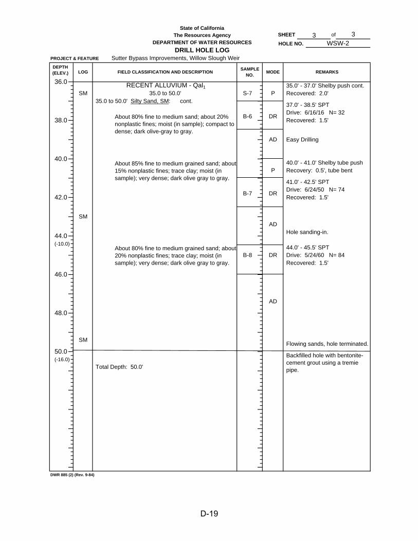
of
40.0' - 41.0' Shelby tube pushRecovery: 0.5', tube bent
Hole sanding-in.
Easy Drilling
Drive: 6/24/50 N= 74Recovered: 1.5'
41.0' - 42.5' SPT
Drive: 5/24/60 N= 84Recovered: 1.5'
Flowing sands, hole terminated.
REMARKSFIELD CLASSIFICATION AND DESCRIPTION SAMPLENO. MODE
35.0' - 37.0' Shelby push cont.
DR
Backfilled hole with bentonite-cement grout using a tremie pipe.
44.0' - 45.5' SPT
LOG
PS-735.0 to 50.0' Silty Sand, SM: cont.
RECENT ALLUVIUM - Qal1
About 80% fine to medium sand; about 20% nonplastic fines; moist (in sample); compact to dense; dark olive-gray to gray.
AD
B-6
About 85% fine to medium grained sand; about 15% nonplastic fines; trace clay; moist (in sample); very dense; dark olive gray to gray.
40.0
About 80% fine to medium grained sand; about 20% nonplastic fines; trace clay; moist (in sample); very dense; dark olive gray to gray.
DWR 885 (2) (Rev. 9-84)
AD
44.0
SM
42.0
DEPTH(ELEV.)
36.0
SM
38.0
DR
HOLE NO.
SM
B-7
P
(-16.0)
(-10.0)
46.0
48.0
Total Depth: 50.0'
50.0
35.0 to 50.0'
DR
AD
State of CaliforniaThe Resources Agency
B-8
WSW-2
37.0' - 38.5' SPT
Recovered: 2.0'
SHEET 3
Recovered: 1.5'
Sutter Bypass Improvements, Willow Slough Weir
3
Drive: 6/16/16 N= 32
PROJECT & FEATURE
DEPARTMENT OF WATER RESOURCESDRILL HOLE LOG
D-19

ATTACHMENT 2
Laboratory Soil Classification Data
D-20

STA
TE O
F C
ALI
FOR
NIA
C
LASS
IFIC
ATI
ON
TES
T SU
MM
AR
YD
IVIS
ION
OF
EN
GIN
EE
RIN
G
TH
E R
ES
OU
RC
ES
AG
EN
CY
CIV
IL E
NG
INE
ER
ING
D
EP
AR
TME
NT
OF
WA
TER
RE
SO
UR
CE
SC
AN
ALS
AN
D L
EV
EE
S S
EC
TIO
N
PRO
JEC
T:SU
TTER
BY
PASS
FIS
H P
ASS
AG
E IM
PRO
VEM
ENT
PRO
JEC
TFE
ATU
RE:
WIL
LOW
SLO
UG
H W
EIR
PE
RC
EN
T FI
NE
RM
EC
HA
NIC
AL
AN
ALY
SIS
|H
YD
RO
ME
TER
ATT
ER
BE
RG
SP
EC
.
GR
AV
EL
|S
AN
D|
SIL
T &
CLA
YLI
MIT
SG
RA
V.
CLA
SS
IFIC
ATI
ON
3.0
" 1
.5"
3/4
" 3
/8"
48
1630
5010
020
0 5
M
2M
1M
LAB
.H
OLE
F.S
.D
EP
TH75
37.5
199.
54.
752.
361.
180.
60.
30.
150.
075
0.00
50.
002
0.00
1G
RO
UP
NO
.N
O.
NO
.(fe
et)
mm
mm
mm
mm
mm
mm
mm
mm
mm
mm
mm
mm
mm
mm
L.L
. P
.I.- #
4S
YM
BO
LG
RO
UP
NA
ME
03-8
90W
SW-1
B2
11.5
- 13
.010
098
9896
9491
8335
14C
LLe
an c
lay
with
sand
03-8
91"
B3
17.0
- 18
.510
099
9693
9290
8673
3413
CL
Lean
cla
y w
ith sa
nd
03-8
92"
B4
22.0
- 23
.510
099
9642
21C
LLe
an c
lay
03-8
93"
B5
27.0
- 28
.510
099
9846
21C
LLe
an c
lay
03-9
71W
SW-1
S210
.0 -
12.0
100
9995
8474
3516
CL
Lean
cla
y w
ith sa
nd
03-9
11"
B2
17.0
- 18
.510
097
7839
28N
PSM
Silty
sand
03-9
12"
B3
22.0
- 23
.510
099
9589
5122
MH
Elas
tic si
lt
03-9
13"
B4
27.0
- 28
.510
098
8532
7M
LSi
lt w
ith sa
nd
DA
TE:
9/
15/2
003
RE
MA
RK
S:
IM -
INS
UFF
ICIE
NT
MA
TER
IAL
INIT
IAL:
rgj
NP
- N
ON
-PLA
STI
C
RE
QU
ES
T N
O.:
03-2
8N
G -
NO
GO
OD
D-21

Part
icle
Siz
e A
naly
sis
Gra
ph
SU
TTE
R B
YP
AS
SFI
SH
PA
SS
AG
E IM
PR
OV
EM
EN
T P
RO
JEC
TR
EQ
UE
ST
NO
. 03-
28W
ILLO
W S
LOU
GH
WE
IR
0102030405060708090100 0.
001
0.01
0.1
110
100
1000
Percent Finer By Weight
24 H
R.
1 H
R.
5 M
IN.
1 M
IN.
#200
#10
0#5
0#3
0#1
6#8
#43/
8"3/
4"1
1/2"
3"6"
12"
Gra
in S
ize
in M
illim
eter
s
CLA
Y O
R S
ILT
FIN
ES
SA
ND
GR
AV
EL
CO
BB
LEFi
neFi
neM
ediu
mC
oars
eC
oars
e
UN
IFIE
D S
OIL
CLA
SS
IFIC
ATI
ON
HY
DR
OM
ETE
R A
NA
LYS
ISS
IEV
E
Tim
e R
eadi
ngs
U.S
. Sta
ndar
d S
erie
sC
lear
Squ
are
D-22

PLATES
D-23
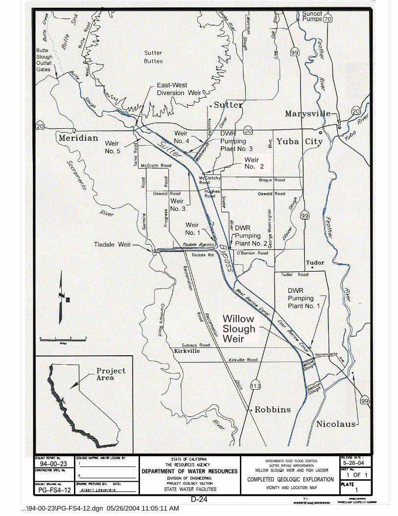
...\94-00-23\PG-FS4-12.dgn 05/26/2004 11:05:11 AMD-24
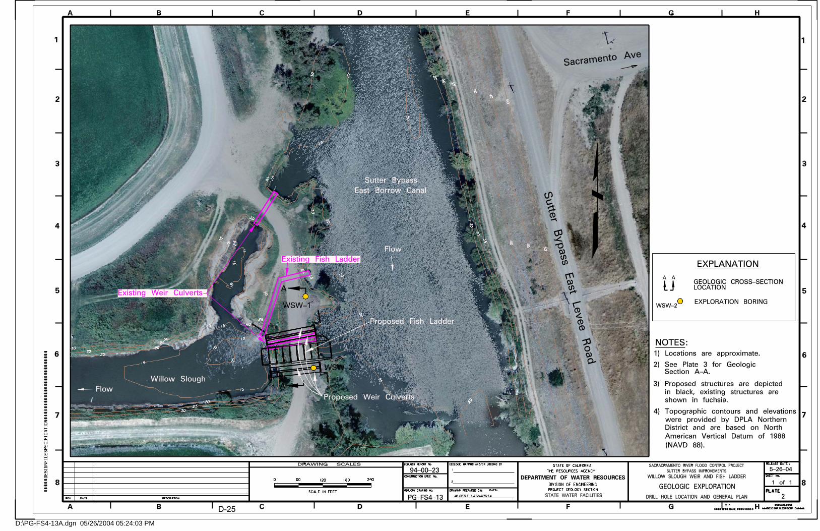
D:\PG-FS4-13A.dgn 05/26/2004 05:24:03 PM
D-25

...\94-00-23\PG-FS4-14.dgn 05/26/2004 10:45:17 AM
D-26

Appendix E
Proposed Environmental Lower Butte Creek Sutter Bypass Willow Slough Weir Fish Passage Project....................................................................E-2 Table 1. Preliminary Environmental Issues Associated with the Proposed Lower Butte Creek-Sutter Bypass Willow Slough Weir Fish Passage Project..............E-4 Table 2. State and federally “listed” species known to occur in the project vicinity .....E-5 Table 3. Environmental Permits Potentially Required for the Proposed Lower Butte Creek-Sutter Bypass Willow Slough Weir Fish Passage Project ........................E-6
E-1
January 8, 2004 Nancy Snodgrass Dave Bogener Preliminary Review of the Proposed Lower Butte Creek Sutter Bypass Willow Slough Weir Fish Passage Project
Per your request, Ms. Gail Kuenster and I conducted a preliminary environmental evaluation of the proposed fish passage project at Willow Slough Weir in the Sutter Bypass. The purpose of this project is to improve fish passage over the Willow Slough diversion structure.
A preliminary list of potential environmental impacts associated with the
proposed project is presented in Table 1. Potentially significant environmental issues related to impacts to State and federally “listed” aquatic species have been identified. I recommend that these issues be evaluated prior to initiation of final design as they may influence project design, timing, and project construction options. I further recommend that informal consultation with DFG, USF&WS, and NOAA Fisheries occur prior to final design. This informal consultation will help identify the in-channel construction period and development of project avoidance measures to minimize short-term construction related impacts to species protected under the State or federal Endangered Species acts (Table 2). Specifically, these consultations should focus on avoidance measures related to Chinook salmon, steelhead, and giant garter snake as all of these species are known to occur within the project area and have the potential to be directly affected by the proposed project.
Limited additional survey for other species including valley elderberry longhorn
beetle, rose mallow, and Swainson’s hawk, may also be required during development of the project design. Rose mallow was the only one of these species identified during initial field reconnaissance of the immediate project area. However, access improvements, staging areas, and materials stockpiles areas were not identified at the time of the initial site survey. Further, no vernal pool habitats were identified during field reconnaissance. Preliminary field evaluations indicate that the proposed project will not impact bank swallow, western yellow-billed cuckoo, or willow flycatcher habitat.
The proposed project will require a US Army Corp. of Engineers 404 Permit for
Clean Water Act compliance (Table 3). The dredge and fill quantities involved in the project may preclude use of some Nationwide Permits (streamlined permit process) and require submittal of an individual permit which may require mitigation. The 404 permit will provide the federal nexus for a Section 7 consultation under the federal ESA. A formal ESA consultation requires up to 135 days for agency review after project design, timing, and avoidance/mitigation have been identified. Consultation with both NOAA Fisheries and USF&WS will be required for project compliance. National Environmental
E-2

Protection Act compliance will be required if any federal funding is involved in the project.
A RWQCB Water Quality Certification will be required for compliance with
Section 401 of the Clean Water Act. This certification will identify project specific best management practices to minimize project impacts to beneficial uses of water. These BMPs may include criteria to reduce erosion, sedimentation, hazardous material releases. BMPs will also provide criteria for dewatering and construction methods, revegetation, and monitoring requirements. A RWQCB stormwater permit may be required if total soil disturbance exceeds 5 acres. Soil disturbance would include any access improvements, staging areas; materials stockpile areas and construction areas.
A DFG Streambed Alteration Agreement (1601) will be required to address
project related impacts to bed, bank, channel and associated vegetation. This agreement requires California Environmental Quality Act compliance at the time of the 1601 submittal. The proposed project could be considered categorically exempt under CEQA. At least three Categorical exemptions could be appropriate for this project including 15301-maintenance of an existing structure, 15302-replacement of an existing structure, and 15304-minor alteration of land. However, the ESA take issues may require preparation of an Initial Study and subsequent Mitigated Negative Declaration or EIR for project CEQA compliance.
Several species protected only under the State Endangered Species Act occur in
this portion of Sutter County including bank swallow, willow flycatcher, western yellow-billed cuckoo, and Swainson’s hawk. The project as currently designed would not result in modification of bank swallow, willow flycatcher, or western yellow-billed cuckoo habitat. However, evaluation of potential project impacts on nesting Swainson’s hawks will require pre-project survey of areas within ½ mile of the project area during the nesting season to meet the survey protocol for this migratory raptor.
The Willow Slough Weir is old enough to require evaluation of its status as a
historical structure for inclusion on the National Register of Historic Places and California Register of Historical Resources. Surface cultural features are unlikely to be present at this location due to historic sedimentation. However, buried cultural features could be uncovered during construction.
Approval of the State Reclamation Board will be required prior to working in the
floodplain at this location. Compliance with local ordinances may be required if some entity other than a
State or federal agency permits and constructs the project. If you have any questions concerning the information provided please contact me
at (530) 529-7329.
E-3
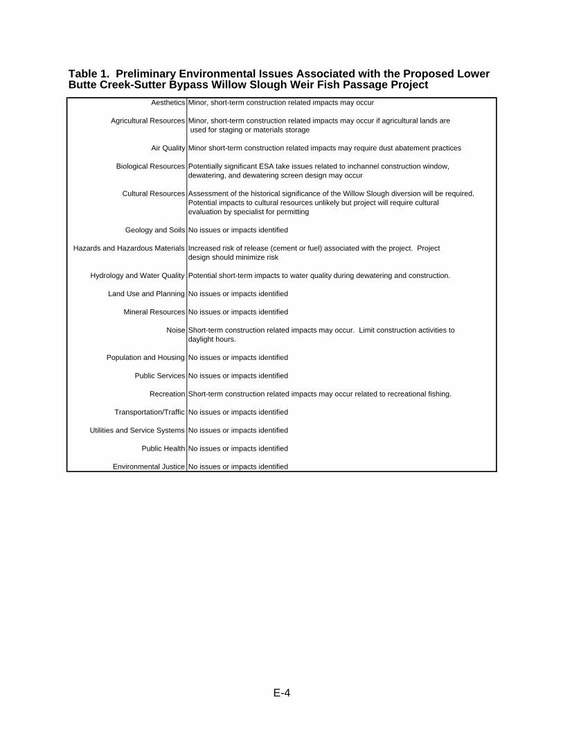
Table 1. Preliminary Environmental Issues Associated with the Proposed Lower Butte Creek-Sutter Bypass Willow Slough Weir Fish Passage Project
Aesthetics Minor, short-term construction related impacts may occur
Agricultural Resources Minor, short-term construction related impacts may occur if agricultural lands are used for staging or materials storage
Air Quality Minor short-term construction related impacts may require dust abatement practices
Biological Resources Potentially significant ESA take issues related to inchannel construction window, dewatering, and dewatering screen design may occur
Cultural Resources Assessment of the historical significance of the Willow Slough diversion will be required.Potential impacts to cultural resources unlikely but project will require cultural evaluation by specialist for permitting
Geology and Soils No issues or impacts identified
Increased risk of release (cement or fuel) associated with the project. Project Hazards and Hazardous Materialsdesign should minimize risk
Hydrology and Water Quality Potential short-term impacts to water quality during dewatering and construction.
Land Use and Planning No issues or impacts identified
Mineral Resources No issues or impacts identified
Noise Short-term construction related impacts may occur. Limit construction activities todaylight hours.
Population and Housing No issues or impacts identified
Public Services No issues or impacts identified
Recreation Short-term construction related impacts may occur related to recreational fishing.
Transportation/Traffic No issues or impacts identified
Utilities and Service Systems No issues or impacts identified
Public Health No issues or impacts identified
Environmental Justice No issues or impacts identified
E-4

Table 2. State and federally "listed" species known to occur in the project vicinity
Class Scientific name Common name StatusPlants
Hibiscus lasiocarpus Rose mallow CNPS 2
InvertebratesLepidurus packardi vernal pool tadpole shrimp FEDesmocerus californicus dimorphus valley elderberry longhorn beetle FT
FishOncoryhynchus tshawyyscha spring-run chinook salmon ST, FTOncoryhynchus tshawyyscha fall/late fall-run chinook salmon FCOncoryhynchus tshawyyscha winter-run chinook salmon FE,SEOncorhynchus mykiss steelhead -Central Valley ESU FT
ReptilesThamnophis gigas giant garter snake FT, ST
BirdsRiparia riparia bank swallow STEmpidonax traillii willow flycatcher STCoccyzus americanus occidentalis western yellow-billed cuckoo SEButeo swainsoni Swainson's hawk ST
KeyCNPS 1B-rare, threatened or endangered in California or elsewhereFE-federal endangeredFT-federal threatenedFC-federal candidateSE-State endangeredST-State threatened
E-5

Table 3. Environmental Permits Potentially Required for the Proposed Lower Butte Creek-Sutter Bypass Willow Slough Weir Fish Passage Project
FederalUSACE 404 Permit-Nationwide Permit
Project currently appear to meet the requirements for use of USACOE Nationwide Permits404 Permit can provide federal nexus for federal ESA consultation
Federal Endangered Species Act Compliance (see table 2) Federally listed species are present, will need federal nexus for Section 7 ESA consultationCALFED Funding would require preparation of an ASIP
NEPA Compliance (if federal funds or approvals are involved)
StateRWQCB 401 Water Quality Certification
RWQCB Stormwater Permit (if ground disturbance involves more than 5 acres)stormwater permit conditions can be incorporated into 401
DFG 1600 Agreement (requires CEQA compliance)
CEQA Compliance (Categorical exemptions may apply )
State Endangered Species Act Compliance (see table 2)
Reclamation Board Approvals
Local Sutter County grading and or tree ordinance
E-6
Related Documents