LOUISIANA COASTAL AREA ECOSYSTEM RESTORATION PROJECTS STUDY Volume III of IV Final Integrated Feasibility Study and Environmental Impact Statement for the Convey Atchafalaya River Water to Northern Terrebonne Marshes And Multipurpose Operation of Houma Navigation Lock Lafourche, Terrebonne, St. Mary Parish, Louisiana September, 2010 U.S Army Corps of Engineers New Orleans District Coastal Protection and Restoration Authority

Welcome message from author
This document is posted to help you gain knowledge. Please leave a comment to let me know what you think about it! Share it to your friends and learn new things together.
Transcript

LOUISIANA COASTAL AREA ECOSYSTEM RESTORATION PROJECTS STUDY
Volume III of IV
Final Integrated Feasibility Study and Environmental Impact Statement
for the
Convey Atchafalaya River Water to Northern Terrebonne Marshes
And Multipurpose Operation of Houma Navigation Lock Lafourche, Terrebonne, St. Mary Parish, Louisiana
September, 2010
U.S Army Corps of Engineers New Orleans District
Coastal Protection and Restoration Authority

This page intentionally blank
LOUISIANA COASTAL AREA ECOSYSTEM RESTORATION PROJECTS STUDY
Volume III of IV
Final Integrated Feasibility Study and Environmental Impact Statement
for the
Convey Atchafalaya River Water to Northern Terrebonne Marshes
And Multipurpose Operation of Houma Navigation Lock Lafourche, Terrebonne, St. Mary Parish, Louisiana
The responsible lead Federal agency for this study is the U. S. Army Corps of Engineers- Mississippi Valley, New Orleans District (CEMVN). The non-Federal sponsor for the study is Coastal Protection and Restoration Authority (CPRA). This report is a combined feasibility report and environmental impact statement complying with requirements of the U.S. Army Corps of Engineers (USACE) and the Council of Environmental Quality (CEQ), and is intended to reduce duplication and paperwork. An asterisk (*) in the table of contents notes paragraphs that are required for National Environmental Policy Act (NEPA) compliance.
September 2010
U.S Army Corps of Engineers New Orleans District
Coastal Protection and Restoration Authority

This report contains six volumes. You are at Volume III which is the project-specific analysis for the Convey Atchafalaya River Water to Northern Terrebonne Marshes and Multipurpose Operation of the Houma Navigation Lock. Volume III: Convey Atchafalaya River Water to Northern Terrebonne Marshes and Multipurpose Operation of the Houma Navigation Lock.

Final EIS WRDA 2007 Section 7006(e)(3) September 2010
ABSTRACT Volume III – Convey Atchafalaya River Water to Northern Terrebonne Marshes and Multipurpose Operation of Houma Navigation Lock
Final Integrated Feasibility Study and Environmental Impact Statement
for the Convey Atchafalaya River Water to Northern Terrebonne Marshes
and Multipurpose Operation of Houma Navigation Lock LEAD AGENCY: U.S. Army Corps of Engineers – Mississippi Valley Division, New Orleans District ABSTRACT: This report is an integrated feasibility study and environmental impact statement (EIS) conducted for the Convey Atchafalaya River Water to Northern Terrebonne Marshes and Multipurpose Operation of Houma Navigation Lock projects. This report fulfills the reporting requirement to Congress of Section 7006(e)(3) which directs the Secretary of the Army to submit feasibility reports on the six projects included in that section by December 31, 2008 and authorizes implementation of the projects provided a favorable Chief of Engineers’ Report is completed no later than December 31, 2010.
A -1
Final EIS WRDA 2007 Section 7006(e)(3) September 2010
This page intentionally blank

Executive Summary Volume III – Convey Atchafalaya River Water to Northern Terrebonne Marshes and Multipurpose Operation of Houma Navigation Lock
Final EIS WRDA 2007 Section 7006(e)(3) September 2010
ES-1
EXECUTIVE SUMMARY ES 1 Summary Introduction and Study Information Title VII of the Water Resources Development Act (WRDA) 2007 authorizes the Louisiana Coastal Area (LCA) ecosystem restoration program. Included within that authority are requirements for comprehensive coastal restoration planning, program governance, a Science and Technology Program, a program for the beneficial use of dredged material, feasibility studies for restoration plans, project modification investigations, and restoration project construction, in addition to other program elements. This authorization was recommended by the Chief of Engineers’ Report, dated January 31, 2005. Under the 2007 WRDA Section 7006, the LCA program has authority for feasibility-level reports of six near-term critical restoration features. In November 2008, the U.S. Army Corps of Engineers (USACE) and the State of Louisiana represented through the Coastal Protection and Restoration Authority (CPRA), executed a single Feasibility Cost-Share Agreement (FCSA) covering six Louisiana Coastal Area (LCA) near-term plan elements listed in Section 7006(e) of the Water Resources Development Act, 2007. The six features will each go through a separate feasibility analysis and environmental compliance review culminating in a single master feasibility document. The cost-share during this feasibility phase is 50% Federal and 50% Non-Federal in total. However, the individual elements have been divided so that each entity has lead responsibility for preparing three of the six report components. This means that at the end of the feasibility phase the total cost will be shared on a 50/50 basis. Yet for work on each individual element during the feasibility phase the ratio of funds expended by either the Federal or non-Federal sponsor will be higher depending upon their level of responsibility. Although three of the projects will be lead by state teams, each individual feasibility component will be conducted and written to meet USACE planning and technical standards for a feasibility level document. ES 2 Need for, and Objectives of Action * The purpose of the proposed action is to reduce the current trend of marsh degradation in the project area resulting from subsidence, sea level rise, erosion, saltwater intrusion, and lack of sediment and nutrient deposition. The project proposes to accomplish this by utilizing fresh water and nutrients from the Atchafalaya River and the Gulf Intracoastal Waterway (GIWW). The LCA-ARTM Study Area comprises approximately 1100 square miles (~700,000 acres) in Southern Louisiana in the vicinity of the City of Houma and Terrebonne Parish. The LCA-ARTM study area fits into the Louisiana Coastal Area Ecosystem Restoration Study (LCA Study) Area, which has been identified as the Louisiana coastal area from Mississippi to Texas. The proposed LCA-ARTM project is located in the Deltaic Plain within Subprovince 3, one of the four Subprovinces identified in the LCA Study Area.
Executive Summary Volume III – Convey Atchafalaya River Water to Northern Terrebonne Marshes and Multipurpose Operation of Houma Navigation Lock
Final EIS WRDA 2007 Section 7006(e)(3) September 2010
ES-2
The overall study area is bound to the west by the Lower Atchafalaya River. The study area is bound to the east by the Bayou Lafourche ridge. The study area is bound to the north by the Bayou Black ridge, from the Lower Atchafalaya River to the City of Houma, and by the Gulf Intracoastal Waterway from the City of Houma to the Bayou Lafourche ridge. The southern boundary of the project was based on a delineation conducted in 2007 of coastal Louisiana vegetation types. The natural processes of subsidence, habitat switching, and erosion, combined with human activities, have caused significant adverse impacts to the Northern Terrebonne Marshes, including accelerated wetland loss and ecosystem degradation. Wetlands in the project area are deteriorating for several reasons: 1) subsidence and sea level rise, 2) lack of sediment and nutrient deposition, 3) erosion via tidal exchange, 4) channelization, and 5) saltwater intrusion. These activities have resulted in the loss of several thousand acres of solid, vegetated marsh. Deterioration will continue unless preventative measures are taken. With continued deterioration of the marshes, the area landward will be more prone to flood during storm surges and hurricanes, as marshes serve as partial flood barriers. Additionally, the marshes of the study area represent an ecosystem of national importance from an environmental standpoint. In the absence of supplemental freshwater from the Atchafalaya River, subsidence, sea-level rise, wave erosion, and saltwater intrusion will continue to be problems. Protection and enhancement of this area are dependent on providing a hydrologic regime that minimizes the physiological stress to wetland vegetation from saltwater intrusion and tidal energy and is conducive to the retention of locally provided freshwater and sediments. Several channels have been dredged which cut through the natural ridges, increasing both drainage and tidal exchange in the project area, exposing the soil to erosive forces. Major navigation channels in the subprovince are the Atchafalaya River, Wax Lake Outlet, Houma Navigation Canal, GIWW, and Lower Atchafalaya River (south of Morgan City). Each of these navigation channels introduces and/or compounds marine influences in many of the interior coastal wetlands and water bodies within the subprovince. Without action, the freshwater, intermediate, and brackish marshes in the northern and eastern areas of Terrebonne Basin would continue to deteriorate and disappear due to the combined effects of subsidence and sea level rise, saltwater intrusion, and a lack of riverine influence. The flotant marshes within the Penchant Basin, located in northwest Terrebonne Basin, would continue to deteriorate due to excessive backwater flooding events from the Atchafalaya River. The marshes in the southern and eastern portions of the study area would continue to deteriorate due to saltwater intrusion and a lack of riverine influence. • Goals :
Reduce the current trend of degradation of the Terrebonne marshes, so as to contribute towards achieving and sustaining a coastal ecosystem that can support and
Executive Summary Volume III – Convey Atchafalaya River Water to Northern Terrebonne Marshes and Multipurpose Operation of Houma Navigation Lock
Final EIS WRDA 2007 Section 7006(e)(3) September 2010
ES-3
protect the environment, economy, and culture of southern Louisiana and thus the Nation.
• Objectives: The objective of the project is to provide additional freshwater, nutrients, and fine sediment to the area. The introduction of additional freshwater could facilitate organic sediment deposition, improve biological productivity, and prevent further deterioration of the marshes. Specific project objectives include, but are not limited to the following and are applicable to all three sub-unit areas:
• Prevent, reduce, and/or reverse future wetland loss • Achieve and maintain characteristics of sustainable marsh hydrology • Reduce salinity levels in project area • Increase sediment and nutrient load to surrounding wetlands • Increase residence time of fresh water • Sustain productive fish and wildlife habitat
ES 3 Alternatives Alternatives 2 – 8 incorporate various combinations of 61 measures. Modification of the proposed operation of the HNC (Houma Navigation Canal) Lock complex is included in all action alternatives. No Action. This alternative includes no measures from this project. The future condition will include sea level rise, subsidence, and other projects that are under construction or are likely to be constructed. This alternative includes operation of the HNC lock complex under the Morganza to the Gulf operations plan. Alternative 2 redistributes existing freshwater to benefit Terrebonne marshes using a variety of measures. To achieve this, GIWW constrictions would be eliminated. Additionally, the following measures to restrict, increase, and control water are proposed for each of the three subunits. In the West – Bayou Penchant Area, dredging, bank protection, a sediment plug, and a weir will be utilized. In the Central – Lake Boudreaux Area, culverts, levees, dredging, marsh terraces and berms, sediment plugs, modified operation of the future HNC lock complex, and a large sluice gated box culvert are proposed. In the East – Grand Bayou Area, culverts, dredging, gaps in canal spoil banks, marsh berms, sediment plugs, and removal of a weir and soil plug are proposed. Alternative 3 will increase Atchafalaya River inflows and redistribute existing and increased flows of freshwater. Alternative 3 includes all the measures in Alternative 2 and two additional. The additional measures are in the West – Bayou Penchant Area. To increase flows from the Atchafalaya River, water will be moved from Bayou Shaffer to the Avoca Island Cutoff/Bayou Chene. This will be accomplished by creating an opening through the Avoca Island levee and installing a large gated diversion structure (WS4) in the opening. The remaining measure (WO2) would place stone along the shore of Bayou Chene and Avoca Island Cutoff to protect from increased flows.
Executive Summary Volume III – Convey Atchafalaya River Water to Northern Terrebonne Marshes and Multipurpose Operation of Houma Navigation Lock
Final EIS WRDA 2007 Section 7006(e)(3) September 2010
ES-4
Alternative 4 will increase freshwater flows from east of the project area and redistribute existing and increased flows of freshwater. Alternative 4 includes all but one of the measures in Alternative 2, and has two additional measures in the East – Grand Bayou Area. In Alternative 2, a new Hwy. 24 bridge with Obermeyer gates between the piers (EC5) is proposed to connect the GIWW to Grand Bayou. In Alternative 4, this measure is replaced by a pump station (ES2). The pump station would increase freshwater delivery to the Grand Bayou watershed but not the other subunits. The second new measure is a soil plug (EP8) in Bayou L’eau Bleu. Bayou L’eau Bleu connects the canal receiving the pump station outflow to the GIWW. The pump station is pumping water from the GIWW, thus the soil plug is necessary to prevent recirculation of water. Alternative 5 will increase flows from the east and west and redistribute existing and increased flows of freshwater. This alternative is a combination of Alternatives 3 and 4. The only measure in Alternative 3 not within this alternative is the Hwy. 24 bridge with Obermeyer gates (EC5), which is replaced by a pump station (ES2), as in Alternative 4. Alternative 6 will increase Atchafalaya River inflows and improve the passage of freshwater through the GIWW while slowing water passage to the gulf through the HNC. Alternative 6 differs from Alternative 3 in that Alternative 6 only includes water management measures along the GIWW. The measures to increase Atchafalaya River inflows are the same as Alternative 3. A large gated diversion structure (WS4) would be placed in the new opening created in the Avoca Island levee. Shoreline protection would be placed (WO2) in Bayou Chene and Avoca Island Cutoff. To improve freshwater flows through the GIWW to Grand Bayou, the following measures from Alternative 2 are proposed. In East – Grand Bayou Area, dredging is proposed to connect Grand Bayou to the GIWW (ED5) and enlarge Grand Bayou (ED3). Where ED5 goes through Hwy. 24, a new bridge with Obermeyer gates between the piers (EC5) is proposed. In the Central – Lake Boudreaux Area, the GIWW is constricted as it passes under Hwy. 24. The Hwy. 24 bridge columns do not allow for channel enlargement. Therefore, dredging a new secondary channel with two culverts, one under each Hwy. 24 bridge, is proposed. Modifying the operation of the HNC Lock Complex is also included in this alternative. Alternative 7 will slow the movement of freshwater to the Gulf of Mexico and thus put additional freshwater onto northern Terrebonne marshes. The one measure in this alternative is modified operation of the proposed HNC Lock Complex (CL1). The HNC Lock Complex is part of the proposed U.S. Army Corps of Engineers Morganza to the Gulf project for flood risk management. The Lock Complex includes a set of navigable sector gates. Under normal operation, the navigable sector gates would remain open with unrestricted vehicle passage and closed during storm events and when the Atchafalaya River is low. This alternative proposes to keep the sector gates closed more frequently to hold water back thus moving freshwater onto northern marshes. When the sector gates are closed boat traffic would travel through the lock chambers. As part of this alternative, an industry traffic management plan would be developed for vessels exceeding the lock size that will require the sector gates to be opened.
Executive Summary Volume III – Convey Atchafalaya River Water to Northern Terrebonne Marshes and Multipurpose Operation of Houma Navigation Lock
Final EIS WRDA 2007 Section 7006(e)(3) September 2010
ES-5
Alternative 8 redistributes existing freshwater within the study area to benefit the eastern and central Terrebonne marshes using a variety of measures in an effort to focus freshwater distribution to the most critical areas of marsh decline in the study area. This alternative represents an increment between Alternative 7 and Alternative 2 and contains many of the features of Alternative 2. In the Central – Lake Boudreaux Area, culverts, levees, dredging, sediment plugs, modified operation of the future HNC lock complex, and a large sluice gated box culvert are proposed. In the East – Grand Bayou Area, culverts, dredging, gaps in canal spoil banks, sediment plugs, and removal of a weir and soil plug are proposed. ES 4 Affected Environment The overall study area is located mostly in Terrebonne Parish in southeast Louisiana at the northern edge of the Gulf of Mexico and encompasses approximately 1,100 square miles (700,000 acres). The study area is approximately 55 miles wide from west to east and averages 20 miles across from the north to south boundaries. The study area lies at the southern end of the Terrebonne Basin and contains a complex of habitat types, including natural levees, lakes, swamps, marshes, and bayous formed from sediments of abandoned Mississippi River deltas. Elevations in the study area vary. Near Houma, the largest city in the area, the elevation is approximately 10 feet National Geodetic Vertical Datum (NGVD). The elevation along the bayou ridges is 4-5 feet NGVD and less than 1 foot NGVD along the southern portion near the Gulf of Mexico. Degradation of emergent marsh habitat is concentrated in the southern and eastern portions of the study area. Land loss analysis conducted for the project predicted the loss of approximately 102,000 acres (18 percent) of the remaining vegetated wetlands in the study area over the 50-year period of analysis. ES 5 Environmental Consequences Implementation of the Recommended Plan would result in increased freshwater inputs and associated nutrients in the study area. Improved distribution of freshwater and nutrients would enhance vegetative productivity and optimize conditions for maintenance of all vegetative habitats, benefitting the extensive fish and wildlife resources of the area. Increased freshwater flows would result in decreased salinity levels throughout much of the project area. Construction of project features would result in 148 acres of swamp, 343 acres of fresh marsh, 248 acres of intermediate marsh, and 182 acres of brackish marsh being directly converted to open water. Alternative 2 would also result in 23 acres of swamp being converted to upland (levee). Overall, implementation of Alternative 2 would result in the generation of 3,220 Average Annual Habitat Units over the No Action Alternative and would result in a reduction in loss of emergent marsh habitat of 9,655 acres over the 50-year period of analysis. Navigation on the Houma Navigation Canal would be negatively impacted by the modified operation of the lock complex. Stage increases of up to 0.2 feet could be seen in the western portions of the study area. Stage increases of up to 0.3 feet could be seen in the central portions of the study area. Stage increases of up to 0.1 feet could be seen in the eastern portions of the study area. Stage

Executive Summary Volume III – Convey Atchafalaya River Water to Northern Terrebonne Marshes and Multipurpose Operation of Houma Navigation Lock
Final EIS WRDA 2007 Section 7006(e)(3) September 2010
ES-6
decreases of up to 0.2 feet could be seen on the GIWW at certain times of year. Implementation of Alternative 2 would require the relocation of 13 residential structures. ES 6 Public Involvement The National Environmental Policy Act provides for an early and open public process for determining the scope of issues, resources, impacts, and alternatives to be addressed in the draft environmental impact statement. A scoping meeting announcement requesting comments regarding the scope of the Convey Atchafalaya River Water to Northern Terrebonne Marshes Study was sent to Federal, state, and local agencies and interested groups and individuals on January 7, 2009. Public scoping meetings were held in Houma and Morgan City on February 3 and 4, 2009, respectively. The draft feasibility study/environmental impact statement was released to the public for a 45-day public review period from May 21, 2010 to July 5, 2010. During this public review period public meetings were held in Houma and Morgan City on June 2, 2010 and June 17, 2010, respectively. ES 7 Coordination and Compliance Coordination and planning of the ARTM project has been conducted in compliance with various environmental laws, regulations, executive orders, policies, rules, and guidance including USACE Principles and Guidelines, U.S. Fish and Wildlife Coordination Act, Clean Water Act, Rivers and Harbors Act, Coastal Zone Management Act, Endangered Species Act, Magnuson-Stevens Fishery Conservation and Management Act, Clean Air Act, National Historic Preservation Act, and others. ES 8 Areas of Controversy and Unresolved Issues A potential area of controversy is the implementation of the Houma Navigation Lock construction under a separate authority other than Louisiana Coastal Area. The recommended plan relies on the operation of the Houma Navigation Canal Lock for environmental purposes after 2025. The HNC lock complex is a feature of Morganza to the Gulf of Mexico Hurricane Protection Project. The LCA-ARTM project proposes the modification of the operational plan for the lock complex structure authorized under Morganza to the Gulf, in order to maximize potential environmental benefits, both in terms of avoiding saltwater intrusion and optimizing flow distribution. The proposed action with a constructed lock complex (which comprises the Future-Without-Project condition for the LCA project after 2025) is to operate it in such a way that freshwater from the GIWW “escaping” down the Houma Navigation Canal could be redirected into the surrounding wetlands. Coordinated adaptive management between ARTM and the Morganza to Gulf Project will be necessary and is recommended. The modified operation of the lock complex, however, may prove to be a challenge because of the effort involved in opening and closing the floodgates. The lock itself will be operated only when the floodgates are closed to reduce salinity within the channel. Once closed, the floodgates would force water down other waterways (such as Bayou
Executive Summary Volume III – Convey Atchafalaya River Water to Northern Terrebonne Marshes and Multipurpose Operation of Houma Navigation Lock
Final EIS WRDA 2007 Section 7006(e)(3) September 2010
ES-7
Grand Caillou). Saltwater intrusion would be halted at the gate, and freshwater flows would increase in other waterways. If the HNC Lock is not constructed by 2025, the benefits of its operation would be lost and other benefits from ARTM from 2025 onward could be altered. Additionally, since the operations plan for the HNC Lock Complex has not been finalized, the FWOP condition could be modified. This could also alter the benefits after the lock is constructed. However, Alternative 2 would likely remain the NER Plan regardless of the timing of implementation of the HNC Lock Complex. Relative sea level rise rates higher than the historic rate have the potential to greatly reduce or even eliminate the benefits of this project. Intermediate RSLR would reduce benefits by 66% and high RSLR would eliminate benefits. While the intent of EC1165-2-211 on sea level rise was met, at this time it is impossible to determine the risk of higher relative sea level rise rates. While this risk exists, the structures in the selected plan were designed with adaptive management and RSLR in mind. Various operational schemes may help to extend the benefits under higher RSLR scenarios. The degree to which project area marshes will respond to increased freshwater inputs associated with project features remains unresolved. Specifically, there is uncertainty in whether or not increasing the flow of fresh water and nutrients to area marshes with little associated sediment will result in the predicted level of prevention of marsh loss. It is believed that increased freshwater will benefit study area marshes, but similar projects that do not utilize sediment inputs that could be used as verification do not currently exist. Robust monitoring and adaptive management will help to ensure project success and identify outcomes that should realistically be expected for the project. Fisheries access impacts on project benefits remain unresolved for some project features. Inclusion of fisheries access impacts in the calculation of AAHUs may have resulted in negative AAHUs for all alternatives, despite net gains in wetland acreages. Project measures are designed to correct significant hydrologic alterations on man-made canals which are thought to be significant causes of wetland degradation and loss and which resulted in artificially increased fisheries access. In addition, other natural and man-made waterways exist for fisheries access. Therefore, the decision was made to eliminate this potential impact when calculating benefits associated with each alternative. Potential modifications to this methodology are being investigated by USFWS in consultation with NMFS, LDWF, and other interested natural resource agencies. There are also unresolved issues with respect to the best design and operation of some project features. Further modeling needs to be conducted during pre-construction engineering and design in order to determine ideal sizes and operational scenarios of some dredge features and water control structures that could not be fully analyzed during the planning phase due to time constraints. Specific details on dredged material disposal acreages and locations also need to be determined. Dredged material will be utilized for marsh creation to the maximum extent practicable.

Executive Summary Volume III – Convey Atchafalaya River Water to Northern Terrebonne Marshes and Multipurpose Operation of Houma Navigation Lock
Final EIS WRDA 2007 Section 7006(e)(3) September 2010
ES-8
The impacts of the Deepwater Horizon oil spill on coastal Louisiana are uncertain at this time (August 2010). The impacts of the oil spill as well as the various emergency actions taken to address oil spill impacts (e.g., use of oil dispersants, creation of sand berms, use of Hesco baskets, rip-rap, sheet piling and other actions) could potentially impact USACE water resources projects and studies within the Louisiana coastal area, including the LCA-ARTM project. Potential impacts could include factors such as changes to existing, future-without, and future-with-project conditions, as well as increased project costs and implementation delays. The USACE will continue to monitor and closely coordinate with other Federal and state resource agencies and local sponsors in determining how to best address any potential problems associated with the oil spill that may adversely impact project implementation. Supplemental planning and environmental documentation may be required as information becomes available. If at any time petroleum or crude oil is discovered on project lands, all efforts will be taken to seek clean up by the responsible parties, pursuant to the Oil Pollution Act of 1990 (33 U.S.C. 2701 et seq.). ES 9 Conclusions and Recommendations The Recommended Plan (RP) and National Ecosystem Restoration (NER) Plan, Alternative 2, would create and nourish 329 acres of various types of nationally significant wetlands, in addition to reducing the current trend of wetland degradation by 9,655 acres in the study area. Restoration of freshwater and nutrient inputs to the project area will result in the creation and nourishment of a variety of marsh types within the study area. This is accomplished without increasing flood risk. Overall, Alternative 2 would reduce land loss in the study area from 101,570 acres to 91,915 acres, thus preventing the loss of 9,655 acres of marsh habitat over the 50-year period of analysis. Alternative 2 would yield 3,220 AAHUs over the No Action Alternative.
• The RP/NER plan includes the entire study area with the most critical need of restoration.
• The RP/NER plan does not exceed the legislatively mandated cost level limit as identified in WRDA 2007. The RP/NER plan meets the intent of the plan as described in the 2004 LCA Report.
• The RP/NER plan can function as a stand-alone project with considerable benefits.
• The RP/NER plan would provide significant environmental benefits regardless of the implementation of the HNC Lock Complex.
The RP/NER is the plan that best meets the Louisiana Coastal Area goals and objectives as well as those identified for the study area in partnership with the State of Louisiana. The RP/NER is the plan that best meets the P&G’s four criteria of completeness, effectiveness, efficiency, and acceptability, as well as the Environmental Operating Principles of environmental sustainability, interdependence, balance and synergy, accountability, knowledge, respect, and assessing and mitigating cumulative impacts.
Executive Summary Volume III – Convey Atchafalaya River Water to Northern Terrebonne Marshes and Multipurpose Operation of Houma Navigation Lock
Final EIS WRDA 2007 Section 7006(e)(3) September 2010
ES-9
The RP/NER Plan meets the current scope and cost authority as per Section 7006 (e) (3) of WRDA 2007 or Section 902 of WRDA 1986. The District Commander has considered all the significant aspects of this study including the environmental, social, and economic effects, the engineering feasibility, and the comments received from other resource agencies, the Non-Federal Sponsors, and the public and has determined that the recommended plan presented in this report is in the overall public interest and a justified expenditure of Federal funds. As a comprehensive approach to restore and maintain ecological integrity, including habitats, communities, and populations of native species, and the processes that sustain them by reducing the trend of degradation and deterioration to the area between Bayou Lafourche and the Atchafalaya River, the District Commander recommends the construction of Alternative 2. The interagency team recommended Alternative Plan 2 (RP/NER) as the Recommended plan (RP). Alternative 2 (RP/NER) is also a standalone project with significant environmental benefits and meets most of the study objectives. In cooperation with the USFWS, NOAA, and the State of Louisiana, the Corps has planned and would design a project that serves the needs of the nation. The total cost for the project is $305,500,000.00 inclusive of associated investigation, environmental, engineering and design, construction, supervision and administration, and contingency costs. The operations and maintenance of this project may be assumed by the State of Louisiana as the non-Federal sponsor. The project is funded 65% by the Federal Government and 35% by the non-Federal sponsor. The recommendation contained herein reflects the information available at this time, October 2010 price levels, and current Departmental Policies governing the formulation of individual projects. They do not reflect program and budgeting priorities inherent in the formulation of a national civil works construction program, nor the perspective of higher levels of review within the Executive Branch. Consequently, the recommendation may be modified before being transmitted to the Congress as proposals for authorization and/or implementation funding.
Executive Summary Volume III – Convey Atchafalaya River Water to Northern Terrebonne Marshes and Multipurpose Operation of Houma Navigation Lock
Final EIS WRDA 2007 Section 7006(e)(3) September 2010
ES-10
This page intentionally blank

Table of Contents Volume III – Convey Atchafalaya River Water to Northern Terrebonne Marshes and Multipurpose Operation of Houma Navigation Lock
Final EIS WRDA 2007 Section 7006(e)(3) September 2010 i
TABLE OF CONTENTS
Volume III – Convey Atchafalaya River Water to Northern Terrebonne Marshes And Multipurpose Operation of Houma Navigation Lock
Integrated Feasibility and Environmental Analysis 1
Abstract A-1 Executive Summary ES-1
TABLE OF CONTENTS ................................................................................. I
FIGURES .................................................................................................. XVII
TABLES .................................................................................................... XXI
1.0 STUDY INFORMATION ................................................................. 1-1
1.1 STUDY AUTHORITY ........................................................................................... 1-1 1.2 PURPOSE AND SCOPE ........................................................................................ 1-2 1.3 STUDY AREA .................................................................................................... 1-3 1.4 HISTORY OF INVESTIGATION ............................................................................. 1-8 1.5 PRIOR REPORTS AND EXISTING PROJECTS......................................................... 1-8
1.5.1 Federal........................................................................................................ 1-11 1.5.1.1 Federal Laws and Programs ..................................................................................... 1-16
1.5.2 State............................................................................................................ 1-17 1.5.3 Local .......................................................................................................... 1-18 1.5.4 Existing and Likely Future Water Projects ................................................ 1-18
1.5.4.1 Navigation Projects .................................................................................................. 1-18 1.5.4.2 Lower Atchafalaya Basin Floodway System ........................................................... 1-19 1.5.4.3 Hurricane Storm Surge Risk Reduction Projects ..................................................... 1-19 1.5.4.4 Coastal Restoration Projects..................................................................................... 1-20
1.5.5 Deepwater Horizon Oil Spill ..................................................................... 1-30 1.6 PLANNING PROCESS AND REPORT ORGANIZATION ......................................... 1-37
1.6.1 The Six Step Planning Process .................................................................. 1-37 1.6.2 Report Organization ................................................................................... 1-39
1.7 USACE CAMPAIGN PLAN ............................................................................... 1-40
2.0 NEED FOR AND OBJECTIVES OF ACTION ............................... 2-1
2.1 NATIONAL OBJECTIVES..................................................................................... 2-1 2.2 PUBLIC CONCERNS ............................................................................................ 2-1 2.3 PROBLEMS, NEEDS, AND OPPORTUNITIES ......................................................... 2-2
2.3.1 General Problem Statement ......................................................................... 2-6 2.3.2 Study Area Opportunities ............................................................................ 2-8
1 * An asterisk notes paragraphs that are required for National Environmental Policy Act (NEPA) compliance.

Table of Contents Volume III – Convey Atchafalaya River Water to Northern Terrebonne Marshes and Multipurpose Operation of Houma Navigation Lock
Final EIS WRDA 2007 Section 7006(e)(3) September 2010 ii
2.3.3 Problems, Future Without Project Conditions, and Opportunities by Study Area Subunit ............................................................................................................ 2-8
2.4 PLANNING OBJECTIVES ................................................................................... 2-20 2.4.1 Goals .......................................................................................................... 2-20 2.4.2 Objectives .................................................................................................. 2-20
2.5 PLANNING CONSTRAINTS ................................................................................ 2-20 2.5.1 Constraints ................................................................................................. 2-20
3.0 ALTERNATIVES ............................................................................. 3-1
3.1 PLAN FORMULATION RATIONALE ..................................................................... 3-1 3.1.1 Plan Formulation Rationale ......................................................................... 3-1 3.1.2 Plan Formulation Criteria ............................................................................ 3-1
3.1.2.1 Completeness ............................................................................................................. 3-1 3.1.2.2 Effectiveness .............................................................................................................. 3-1 3.1.2.3 Efficiency ................................................................................................................... 3-1 3.1.2.4 Acceptability .............................................................................................................. 3-1
3.1.3 LCA ARTM Study Area Land Loss ............................................................ 3-2 3.2 MANAGEMENT MEASURES ............................................................................... 3-7
3.2.1 Development of Management Measures ..................................................... 3-7 3.2.2 Description of Management Measures ........................................................ 3-7 3.2.3 Screening / Evaluation of Alternative Plans ................................................ 3-9 3.2.4 Measures Not Carried Forward for Further Analysis ................................ 3-13
3.3 PRELIMINARY ALTERNATIVE PLANS ............................................................... 3-14 3.3.1 Development of Alternative Plans ............................................................. 3-14 3.3.2 Description of Alternative Plans ................................................................ 3-21
3.3.2.1 No Action (Future without Project Conditions) – Strategy: No Action. .................. 3-21 3.3.2.2 Alternative 2 - Strategy: Utilize Existing Flow and Management Measures (Figure 3.3). 3-22 3.3.2.3 Alternative 3 - Strategy: Increase Atchafalaya River Flows and Utilize Management Measures (Figure 3.4). ................................................................................................................ 3-22 3.3.2.4 Alternative 4 - Strategy: Increase Flow from East of the Study Area and Utilize Management Measures (Figure 3.5). ........................................................................................... 3-22 3.3.2.5 Alternative 5 - Strategy: Increase Flow from the East and from the Atchafalaya River and Utilize Management Measures (Figure 3.6). ........................................................................ 3-22 3.3.2.6 Alternative 6 - Strategy: Increase Atchafalaya River Flow and Utilize Management Measures (Figure 3.7). ................................................................................................................ 3-23 3.3.2.7 Alternative 7 - Strategy: Utilize Existing Flow and Management Measures (Figure 3.8). 3-23 3.3.2.8 Alternative 8 - Strategy: Utilize Existing Flow and Management Measures to Focus Fresh Water Flows on the Most Critical Areas of the East and Central Study Sub Units (Figure 3.9). 3-23
3.3.3 Screening / Evaluation of Alternative Plans .............................................. 3-33 3.3.4 Alternative Plans not Carried Forward for Further Analysis ..................... 3-33
3.4 FINAL ARRAY OF ALTERNATIVES (ALTERNATIVES STUDIED IN DETAIL) ........ 3-33 3.5 COMPARISON OF ALTERNATIVE PLANS ........................................................... 3-33
3.5.1 Incremental Cost/Cost Effectiveness Analysis Process. ............................ 3-33 3.5.2 Wetland Value Assessment (WVA) .......................................................... 3-33 3.5.3 Cost Estimates for Habitat Improvement Measures .................................. 3-37 3.5.4 Results of the CE/ICA Analysis ................................................................ 3-38

Table of Contents Volume III – Convey Atchafalaya River Water to Northern Terrebonne Marshes and Multipurpose Operation of Houma Navigation Lock
Final EIS WRDA 2007 Section 7006(e)(3) September 2010 iii
3.5.5 Other Factors .............................................................................................. 3-41 3.5.5.1 Recreational Benefits ............................................................................................... 3-41 3.5.5.2 Desired Future Condition ......................................................................................... 3-42 3.5.5.3 Adaptive Management ............................................................................................. 3-42 3.5.5.4 Acceptability, Completeness, Effectiveness, and Efficiency ................................... 3-42 3.5.5.5 Recommended Plan .................................................................................................. 3-43
3.6 NER PLAN ...................................................................................................... 3-43 3.6.1 Components of NER Plan .......................................................................... 3-43 3.6.2 Design, Environmental, and Construction Considerations of the NER Plan . 3-46 3.6.3 Real Estate Requirements of the NER Plan ............................................... 3-46 3.6.4 Operations and Maintenance Considerations of the NER Plan ................. 3-47 3.6.5 Monitoring Plan and Adaptive Management ............................................. 3-47
3.7 LOCALLY-PREFERRED PLAN ........................................................................... 3-49 3.8 ENVIRONMENTALLY PREFERABLE ALTERNATIVE ........................................... 3-49 3.9 PLAN SELECTION – RECOMMENDED PLAN ...................................................... 3-49
3.9.1 Effectiveness of Recommended Plan in Meeting Goals and Objectives ... 3-49 3.9.2 Effectiveness of Recommended Plan in Meeting Environmental Operating Principles................................................................................................................ 3-50 3.9.3 Compensatory Mitigation Measures .......................................................... 3-51 3.9.4 Planning in a Collaborative Environment .................................................. 3-51
3.10 RISK AND UNCERTAINTY ................................................................................ 3-51 3.10.1 Tropical Storm and Hurricane Damages .................................................... 3-51 3.10.2 Relative Sea Level Rise ............................................................................. 3-52 3.10.3 Real Estate ................................................................................................. 3-52 3.10.4 Combinations of Risks ............................................................................... 3-53 3.10.5 Implementation of the Houma Navigation Canal Lock Complex ............. 3-54 3.10.6 Project Benefits .......................................................................................... 3-55 3.10.7 Future Analysis .......................................................................................... 3-56
3.11 IMPLEMENTATION REQUIREMENTS ................................................................. 3-57 3.11.1 Schedule ..................................................................................................... 3-57 3.11.2 Implementation Responsibilities ................................................................ 3-58 3.11.3 Cost Sharing ............................................................................................... 3-61 3.11.4 Environmental Commitments .................................................................... 3-62 3.11.5 Financial Requirements ............................................................................. 3-63
3.11.5.1 Sponsorship Agreement ........................................................................................... 3-63 3.11.5.2 Financial Analysis .................................................................................................... 3-63 3.11.5.3 Local Cooperation .................................................................................................... 3-64 3.11.5.4 Project Management Plan ........................................................................................ 3-64 3.11.5.5 Procedures for Project Implementation .................................................................... 3-64
3.11.6 Views of Non-Federal Sponsor .................................................................. 3-66
4.0 AFFECTED ENVIRONMENT ........................................................ 4-1
4.1 ENVIRONMENTAL SETTING OF STUDY AREA .................................................... 4-1 4.1.1 Location ....................................................................................................... 4-1 4.1.2 Climate ......................................................................................................... 4-2 4.1.3 Geomorphic and Physiographic Setting....................................................... 4-6

Table of Contents Volume III – Convey Atchafalaya River Water to Northern Terrebonne Marshes and Multipurpose Operation of Houma Navigation Lock
Final EIS WRDA 2007 Section 7006(e)(3) September 2010 iv
4.2 SIGNIFICANT RESOURCES.................................................................................. 4-8 4.2.1 Soils and Waterbottoms ............................................................................... 4-8
4.2.1.1 Historic and Existing Conditions ............................................................................... 4-8 4.2.2 Hydrology .................................................................................................. 4-11
4.2.2.1 Flow and Water Levels ............................................................................................ 4-11 4.2.2.1.1 Historic and Existing Conditions ......................................................................... 4-11
4.2.2.2 Sedimentation and Erosion ...................................................................................... 4-12 4.2.2.2.1 Historic and Existing Conditions ......................................................................... 4-12
4.2.3 Water Quality and Salinity......................................................................... 4-13 4.2.3.1 Historic and Existing Conditions ............................................................................. 4-13
4.2.4 Air Quality ................................................................................................. 4-15 4.2.4.1 Historic and Existing Conditions ............................................................................. 4-15
4.2.5 Noise .......................................................................................................... 4-15 4.2.5.1 Historic and Existing Conditions ............................................................................. 4-16
4.2.6 Vegetation Resources................................................................................. 4-16 4.2.6.1 Invasive Species - Vegetation .................................................................................. 4-24
4.2.7 Wildlife and Habitat ................................................................................... 4-24 4.2.7.1 Historic and Existing Conditions ............................................................................. 4-24 4.2.7.2 Invasive Species – Wildlife ...................................................................................... 4-29
4.2.8 Aquatic Resources ..................................................................................... 4-32 4.2.8.1 Historic and Existing Conditions ............................................................................. 4-32
4.2.8.1.1 Plankton Resources ............................................................................................. 4-32 4.2.8.1.2 Benthic Resources ............................................................................................... 4-34
4.2.9 Fisheries ..................................................................................................... 4-34 4.2.9.1 Historic and Existing Conditions ............................................................................. 4-35
4.2.9.1.1 Finfish ................................................................................................................. 4-35 4.2.9.1.2 Shrimp ................................................................................................................. 4-39 4.2.9.1.3 Blue Crab............................................................................................................. 4-40 4.2.9.1.4 Oyster .................................................................................................................. 4-40
4.2.10 Essential Fish Habitat (EFH) ..................................................................... 4-43 4.2.10.1 Historic and Existing Conditions ............................................................................. 4-43
4.2.11 Threatened and Endangered Species ......................................................... 4-45 4.2.11.1 Historic and Existing Conditions ............................................................................. 4-45
4.2.12 Cultural and Historic Resources ................................................................ 4-50 4.2.12.1 Historic Conditions .................................................................................................. 4-51 4.2.12.2 Existing Conditions .................................................................................................. 4-52
4.2.13 Aesthetics ................................................................................................... 4-53 4.2.13.1 Historic and Existing Conditions ............................................................................. 4-53
4.2.14 Recreation .................................................................................................. 4-61 4.2.14.1 Historic and Existing Conditions ............................................................................. 4-61
4.2.15 Socioeconomics and Human Resources .................................................... 4-63 4.2.15.1 Population and Housing ........................................................................................... 4-63 4.2.15.2 Employment and Income ......................................................................................... 4-65 4.2.15.3 Infrastructure ............................................................................................................ 4-68
4.2.15.3.1 Business and Industry .......................................................................................... 4-68 4.2.15.3.2 Transportation ..................................................................................................... 4-68 4.2.15.3.3 Public Facilities and Services .............................................................................. 4-68 4.2.15.3.4 Tax Revenue and Property Values ...................................................................... 4-68 4.2.15.3.5 Community and Regional Growth (including Community Cohesion) ................ 4-69
4.2.15.4 Environmental Justice .............................................................................................. 4-69 4.2.15.5 Water Use and Supply .............................................................................................. 4-72
Table of Contents Volume III – Convey Atchafalaya River Water to Northern Terrebonne Marshes and Multipurpose Operation of Houma Navigation Lock
Final EIS WRDA 2007 Section 7006(e)(3) September 2010 v
4.2.15.6 Navigation ................................................................................................................ 4-74 4.2.15.7 Land Use Socioeconomics ....................................................................................... 4-76
4.2.15.7.1 Agriculture .......................................................................................................... 4-76 4.2.15.7.2 Forestry ............................................................................................................... 4-77 4.2.15.7.3 Public Lands ........................................................................................................ 4-78
4.2.15.8 Man Made Resources ............................................................................................... 4-78 4.2.15.8.1 Oil Gas and Utilities ............................................................................................ 4-78 4.2.15.8.2 Flood Control and Hurricane Protection ............................................................. 4-82
4.2.15.9 Natural Resources .................................................................................................... 4-85 4.2.15.9.1 Commercial Fisheries .......................................................................................... 4-85 4.2.15.9.2 Oyster Leases ...................................................................................................... 4-86
4.2.16 Hazardous, Toxic, and Radioactive Wastes ............................................... 4-87 4.2.16.1 Historic and Existing Conditions ............................................................................. 4-87
5.0 ENVIRONMENTAL CONSEQUENCES ........................................ 5-1
5.1 SOILS AND WATERBOTTOMS ........................................................................... 5-11 5.1.1 No Action Alternative (Future without Project Conditions)...................... 5-11 5.1.2 Alternative 2 (NER Plan and RP) .............................................................. 5-11
5.1.2.1 Direct ........................................................................................................................ 5-11 5.1.2.2 Indirect ..................................................................................................................... 5-12 5.1.2.3 Cumulative ............................................................................................................... 5-12
5.1.3 Alternative 3............................................................................................... 5-12 5.1.3.1 Direct ........................................................................................................................ 5-12 5.1.3.2 Indirect ..................................................................................................................... 5-12 5.1.3.3 Cumulative ............................................................................................................... 5-13
5.1.4 Alternative 4............................................................................................... 5-13 5.1.4.1 Direct ........................................................................................................................ 5-13 5.1.4.2 Indirect ..................................................................................................................... 5-13 5.1.4.3 Cumulative ............................................................................................................... 5-13
5.1.5 Alternative 5............................................................................................... 5-13 5.1.5.1 Direct ........................................................................................................................ 5-13 5.1.5.2 Indirect ..................................................................................................................... 5-13 5.1.5.3 Cumulative ............................................................................................................... 5-13
5.1.6 Alternative 6............................................................................................... 5-14 5.1.6.1 Direct ........................................................................................................................ 5-14 5.1.6.2 Indirect ..................................................................................................................... 5-14 5.1.6.3 Cumulative ............................................................................................................... 5-14
5.1.7 Alternative 7............................................................................................... 5-14 5.1.7.1 Direct ........................................................................................................................ 5-14 5.1.7.2 Indirect ..................................................................................................................... 5-14 5.1.7.3 Cumulative ............................................................................................................... 5-14
5.1.8 Alternative 8............................................................................................... 5-15 5.1.8.1 Direct ........................................................................................................................ 5-15 5.1.8.2 Indirect ..................................................................................................................... 5-15 5.1.8.3 Cumulative ............................................................................................................... 5-15
5.2 HYDROLOGY ................................................................................................... 5-23 5.2.1 Flow and Water Levels .............................................................................. 5-23
5.2.1.1 No Action Alternative (Future without Project Conditions) .................................... 5-23 5.2.1.2 Alternative 2 (NER Plan and RP) ............................................................................ 5-23
5.2.1.2.1 Direct ................................................................................................................... 5-23 5.2.1.2.2 Indirect ................................................................................................................ 5-24 5.2.1.2.3 Cumulative .......................................................................................................... 5-24
Table of Contents Volume III – Convey Atchafalaya River Water to Northern Terrebonne Marshes and Multipurpose Operation of Houma Navigation Lock
Final EIS WRDA 2007 Section 7006(e)(3) September 2010 vi
5.2.1.3 Alternative 3 ............................................................................................................. 5-25 5.2.1.4 Alternative 4 ............................................................................................................. 5-25 5.2.1.5 Alternative 5 ............................................................................................................. 5-26 5.2.1.6 Alternative 6 ............................................................................................................. 5-27 5.2.1.7 Alternative 7 ............................................................................................................. 5-27 5.2.1.8 Alternative 8 ............................................................................................................. 5-28
5.2.2 Sedimentation and Erosion ........................................................................ 5-29 5.2.2.1 No Action Alternative (Future without Project Conditions) .................................... 5-29 5.2.2.2 Alternative 2 (NER Plan and RP) ............................................................................ 5-29
5.2.2.2.1 Direct ................................................................................................................... 5-29 5.2.2.2.2 Indirect ................................................................................................................ 5-29 5.2.2.2.3 Cumulative .......................................................................................................... 5-30
5.2.2.3 Alternative 3 ............................................................................................................. 5-30 5.2.2.4 Alternative 4 ............................................................................................................. 5-30 5.2.2.5 Alternative 5 ............................................................................................................. 5-30 5.2.2.6 Alternative 6 ............................................................................................................. 5-30 5.2.2.7 Alternative 7 ............................................................................................................. 5-30 5.2.2.8 Alternative 8 ............................................................................................................. 5-30
5.3 WATER QUALITY AND SALINITY .................................................................... 5-31 5.3.1 No Action Alternative (Future without Project Conditions)...................... 5-31 5.3.2 Alternative 2 (NER Plan and RP) .............................................................. 5-33
5.3.2.1 Direct ........................................................................................................................ 5-33 5.3.2.2 Indirect ..................................................................................................................... 5-34 5.3.2.3 Cumulative ............................................................................................................... 5-34
5.3.3 Alternative 3............................................................................................... 5-35 5.3.4 Alternative 4............................................................................................... 5-35 5.3.5 Alternative 5............................................................................................... 5-35 5.3.6 Alternative 6............................................................................................... 5-36 5.3.7 Alternative 7............................................................................................... 5-36 5.3.8 Alternative 8............................................................................................... 5-36
5.4 AIR QUALITY .................................................................................................. 5-61 5.4.1 No Action Alternative (Future without Project Conditions)...................... 5-61 5.4.2 Alternative 2 (NER Plan and RP) .............................................................. 5-61
5.4.2.1 Direct ........................................................................................................................ 5-61 5.4.2.2 Indirect ..................................................................................................................... 5-61 5.4.2.3 Cumulative ............................................................................................................... 5-62
5.4.3 Alternative 3............................................................................................... 5-62 5.4.4 Alternative 4............................................................................................... 5-62 5.4.5 Alternative 5............................................................................................... 5-62 5.4.6 Alternative 6............................................................................................... 5-62 5.4.7 Alternative 7............................................................................................... 5-63 5.4.8 Alternative 8............................................................................................... 5-63
5.5 NOISE .............................................................................................................. 5-64 5.5.1 No Action Alternative (Future without Project Conditions)...................... 5-64 5.5.2 Alternative 2 (NER Plan and RP) .............................................................. 5-64
5.5.2.1 Direct ........................................................................................................................ 5-64 5.5.2.2 Indirect ..................................................................................................................... 5-64 5.5.2.3 Cumulative ............................................................................................................... 5-65
5.5.3 Alternative 3............................................................................................... 5-65 5.5.4 Alternative 4............................................................................................... 5-65

Table of Contents Volume III – Convey Atchafalaya River Water to Northern Terrebonne Marshes and Multipurpose Operation of Houma Navigation Lock
Final EIS WRDA 2007 Section 7006(e)(3) September 2010 vii
5.5.5 Alternative 5............................................................................................... 5-65 5.5.6 Alternative 6............................................................................................... 5-65 5.5.7 Alternative 7............................................................................................... 5-66
5.5.7.1 Direct ........................................................................................................................ 5-66 5.5.7.2 Indirect ..................................................................................................................... 5-66 5.5.7.3 Cumulative ............................................................................................................... 5-66
5.5.8 Alternative 8............................................................................................... 5-66 5.6 VEGETATION RESOURCES ............................................................................... 5-67
5.6.1 No Action Alternative (Future without Project Conditions)...................... 5-67 5.6.2 Alternative 2 (NER Plan and RP) .............................................................. 5-74
5.6.2.1 Direct ........................................................................................................................ 5-74 5.6.2.2 Indirect ..................................................................................................................... 5-74 5.6.2.3 Cumulative ............................................................................................................... 5-75
5.6.3 Alternative 3............................................................................................... 5-75 5.6.3.1 Direct ........................................................................................................................ 5-75 5.6.3.2 Indirect ..................................................................................................................... 5-75 5.6.3.3 Cumulative ............................................................................................................... 5-75
5.6.4 Alternative 4............................................................................................... 5-76 5.6.4.1 Direct ........................................................................................................................ 5-76 5.6.4.2 Indirect ..................................................................................................................... 5-76 5.6.4.3 Cumulative ............................................................................................................... 5-76
5.6.5 Alternative 5............................................................................................... 5-76 5.6.5.1 Direct ........................................................................................................................ 5-76 5.6.5.2 Indirect ..................................................................................................................... 5-76 5.6.5.3 Cumulative ............................................................................................................... 5-76
5.6.6 Alternative 6............................................................................................... 5-76 5.6.6.1 Direct ........................................................................................................................ 5-76 5.6.6.2 Indirect ..................................................................................................................... 5-77 5.6.6.3 Cumulative ............................................................................................................... 5-77
5.6.7 Alternative 7............................................................................................... 5-77 5.6.7.1 Direct ........................................................................................................................ 5-77 5.6.7.2 Indirect ..................................................................................................................... 5-77 5.6.7.3 Cumulative ............................................................................................................... 5-77
5.6.8 Alternative 8............................................................................................... 5-77 5.6.8.1 Direct ........................................................................................................................ 5-77 5.6.8.2 Indirect ..................................................................................................................... 5-77 5.6.8.3 Cumulative ............................................................................................................... 5-78
5.6.9 Invasive Species - Vegetation .................................................................... 5-80 5.6.9.1 No Action Alternative (Future without Project Conditions) .................................... 5-80 5.6.9.2 Alternative 2 (NER Plan and RP) ............................................................................ 5-80
5.6.9.2.1 Direct ................................................................................................................... 5-80 5.6.9.2.2 Indirect ................................................................................................................ 5-80 5.6.9.2.3 Cumulative .......................................................................................................... 5-81
5.6.9.3 Alternative 3 ............................................................................................................. 5-81 5.6.9.4 Alternative 4 ............................................................................................................. 5-81 5.6.9.5 Alternative 5 ............................................................................................................. 5-81 5.6.9.6 Alternative 6 ............................................................................................................. 5-81 5.6.9.7 Alternative 7 ............................................................................................................. 5-81 5.6.9.8 Alternative 8 ............................................................................................................. 5-81
5.7 WILDLIFE AND HABITAT ................................................................................. 5-82 5.7.1 No Action Alternative (Future without Project Conditions)...................... 5-82
Table of Contents Volume III – Convey Atchafalaya River Water to Northern Terrebonne Marshes and Multipurpose Operation of Houma Navigation Lock
Final EIS WRDA 2007 Section 7006(e)(3) September 2010 viii
5.7.2 Alternative 2 (NER Plan and RP) .............................................................. 5-83 5.7.2.1 Direct ........................................................................................................................ 5-83 5.7.2.2 Indirect ..................................................................................................................... 5-84 5.7.2.3 Cumulative ............................................................................................................... 5-85
5.7.3 Alternative 3............................................................................................... 5-85 5.7.3.1 Direct ........................................................................................................................ 5-85 5.7.3.2 Indirect ..................................................................................................................... 5-85 5.7.3.3 Cumulative ............................................................................................................... 5-85
5.7.4 Alternative 4............................................................................................... 5-85 5.7.4.1 Direct ........................................................................................................................ 5-85 5.7.4.2 Indirect ..................................................................................................................... 5-85 5.7.4.3 Cumulative ............................................................................................................... 5-85
5.7.5 Alternative 5............................................................................................... 5-85 5.7.5.1 Direct ........................................................................................................................ 5-85 5.7.5.2 Indirect ..................................................................................................................... 5-86 5.7.5.3 Cumulative ............................................................................................................... 5-86
5.7.6 Alternative 6............................................................................................... 5-86 5.7.6.1 Direct ........................................................................................................................ 5-86 5.7.6.2 Indirect ..................................................................................................................... 5-86 5.7.6.3 Cumulative ............................................................................................................... 5-86
5.7.7 Alternative 7............................................................................................... 5-86 5.7.7.1 Direct ........................................................................................................................ 5-86 5.7.7.2 Indirect ..................................................................................................................... 5-86 5.7.7.3 Cumulative ............................................................................................................... 5-86
5.7.8 Alternative 8............................................................................................... 5-87 5.7.8.1 Direct ........................................................................................................................ 5-87 5.7.8.2 Indirect ..................................................................................................................... 5-87 5.7.8.3 Cumulative ............................................................................................................... 5-87
5.8 AQUATIC RESOURCES ..................................................................................... 5-88 5.8.1 Plankton Resources .................................................................................... 5-88
5.8.1.1 No Action Alternative (Future without Project Conditions) .................................... 5-88 5.8.1.2 Alternative 2 (NER Plan and RP) ............................................................................ 5-88
5.8.1.2.1 Direct ................................................................................................................... 5-88 5.8.1.2.2 Indirect ................................................................................................................ 5-88 5.8.1.2.3 Cumulative .......................................................................................................... 5-88
5.8.1.3 Alternative 3 ............................................................................................................. 5-89 5.8.1.4 Alternative 4 ............................................................................................................. 5-89 5.8.1.5 Alternative 5 ............................................................................................................. 5-89 5.8.1.6 Alternative 6 ............................................................................................................. 5-89 5.8.1.7 Alternative 7 ............................................................................................................. 5-89 5.8.1.8 Alternative 8 ............................................................................................................. 5-89
5.8.2 Benthic Resources ...................................................................................... 5-90 5.8.2.1 No Action Alternative (Future without Project Conditions) .................................... 5-90 5.8.2.2 Alternative 2 (NER Plan and RP) ............................................................................ 5-90
5.8.2.2.1 Direct ................................................................................................................... 5-90 5.8.2.2.2 Indirect ................................................................................................................ 5-90 5.8.2.2.3 Cumulative .......................................................................................................... 5-90
5.8.2.3 Alternative 3 ............................................................................................................. 5-90 5.8.2.4 Alternative 4 ............................................................................................................. 5-90 5.8.2.5 Alternative 5 ............................................................................................................. 5-91 5.8.2.6 Alternative 6 ............................................................................................................. 5-91 5.8.2.7 Alternative 7 ............................................................................................................. 5-91
Table of Contents Volume III – Convey Atchafalaya River Water to Northern Terrebonne Marshes and Multipurpose Operation of Houma Navigation Lock
Final EIS WRDA 2007 Section 7006(e)(3) September 2010 ix
5.8.2.8 Alternative 8 ............................................................................................................. 5-91 5.9 FISHERIES ....................................................................................................... 5-92
5.9.1 No Action Alternative (Future without Project Conditions)...................... 5-92 5.9.2 Alternative 2 (NER Plan and RP) .............................................................. 5-93
5.9.2.1 Direct ........................................................................................................................ 5-93 5.9.2.2 Indirect ..................................................................................................................... 5-94 5.9.2.3 Cumulative ............................................................................................................... 5-95
5.9.3 Alternative 3............................................................................................. 5-101 5.9.4 Alternative 4............................................................................................. 5-101
5.9.4.1 Direct ...................................................................................................................... 5-101 5.9.4.2 Indirect ................................................................................................................... 5-101 5.9.4.3 Cumulative ............................................................................................................. 5-101
5.9.5 Alternative 5............................................................................................. 5-102 5.9.5.1 Direct ...................................................................................................................... 5-102 5.9.5.2 Indirect ................................................................................................................... 5-102 5.9.5.3 Cumulative ............................................................................................................. 5-102
5.9.6 Alternative 6............................................................................................. 5-102 5.9.6.1 Direct ...................................................................................................................... 5-102 5.9.6.2 Indirect ................................................................................................................... 5-103 5.9.6.3 Cumulative ............................................................................................................. 5-103
5.9.7 Alternative 7............................................................................................. 5-103 5.9.7.1 Direct ...................................................................................................................... 5-103 5.9.7.2 Indirect ................................................................................................................... 5-103 5.9.7.3 Cumulative ............................................................................................................. 5-103
5.9.8 Alternative 8............................................................................................. 5-103 5.9.8.1 Direct ...................................................................................................................... 5-103 5.9.8.2 Indirect ................................................................................................................... 5-104 5.9.8.3 Cumulative ............................................................................................................. 5-104
5.10 ESSENTIAL FISH HABITAT (EFH) .................................................................. 5-105 5.10.1 No Action Alternative (Future without Project Conditions).................... 5-106 5.10.2 Alternative 2 (NER Plan and RP) ............................................................ 5-106
5.10.2.1 Direct ...................................................................................................................... 5-106 5.10.2.2 Indirect ................................................................................................................... 5-107 5.10.2.3 Cumulative ............................................................................................................. 5-108
5.10.3 Alternative 3............................................................................................. 5-108 5.10.3.1 Direct ...................................................................................................................... 5-108 5.10.3.2 Indirect ................................................................................................................... 5-108 5.10.3.3 Cumulative ............................................................................................................. 5-108
5.10.4 Alternative 4............................................................................................. 5-108 5.10.4.1 Direct ...................................................................................................................... 5-108 5.10.4.2 Indirect ................................................................................................................... 5-108 5.10.4.3 Cumulative ............................................................................................................. 5-109
5.10.5 Alternative 5............................................................................................. 5-109 5.10.5.1 Direct ...................................................................................................................... 5-109 5.10.5.2 Indirect ................................................................................................................... 5-109 5.10.5.3 Cumulative ............................................................................................................. 5-109
5.10.6 Alternative 6............................................................................................. 5-109 5.10.6.1 Direct ...................................................................................................................... 5-109 5.10.6.2 Indirect ................................................................................................................... 5-109 5.10.6.3 Cumulative ............................................................................................................. 5-110
5.10.7 Alternative 7............................................................................................. 5-110

Table of Contents Volume III – Convey Atchafalaya River Water to Northern Terrebonne Marshes and Multipurpose Operation of Houma Navigation Lock
Final EIS WRDA 2007 Section 7006(e)(3) September 2010 x
5.10.7.1 Direct ...................................................................................................................... 5-110 5.10.7.2 Indirect ................................................................................................................... 5-110 5.10.7.3 Cumulative ............................................................................................................. 5-110
5.10.8 Alternative 8............................................................................................. 5-110 5.10.8.1 Direct ...................................................................................................................... 5-110 5.10.8.2 Indirect ................................................................................................................... 5-111 5.10.8.3 Cumulative ............................................................................................................. 5-111
5.11 THREATENED AND ENDANGERED SPECIES .................................................... 5-112 5.11.1 No Action Alternative (Future without Project Conditions).................... 5-112 5.11.2 Alternative 2 (NER Plan and RP) ............................................................ 5-112
5.11.2.1 Direct ...................................................................................................................... 5-112 5.11.2.2 Indirect ................................................................................................................... 5-114 5.11.2.3 Cumulative ............................................................................................................. 5-114
5.11.3 Alternative 3............................................................................................. 5-114 5.11.4 Alternative 4............................................................................................. 5-114 5.11.5 Alternative 5............................................................................................. 5-114 5.11.6 Alternative 6............................................................................................. 5-114 5.11.7 Alternative 7............................................................................................. 5-114 5.11.8 Alternative 8............................................................................................. 5-114
5.12 CULTURAL AND HISTORIC RESOURCES ......................................................... 5-115 5.12.1 No Action Alternative (Future without Project Conditions).................... 5-119
5.12.1.1 Direct ...................................................................................................................... 5-119 5.12.1.2 Indirect ................................................................................................................... 5-119 5.12.1.3 Cumulative ............................................................................................................. 5-119
5.12.2 Alternative 2 (NER Plan and RP) ............................................................ 5-119 5.12.2.1 Direct ...................................................................................................................... 5-119 5.12.2.2 Indirect ................................................................................................................... 5-119 5.12.2.3 Cumulative ............................................................................................................. 5-119
5.12.3 Alternative 3............................................................................................. 5-119 5.12.3.1 Direct ...................................................................................................................... 5-119 5.12.3.2 Indirect ................................................................................................................... 5-120 5.12.3.3 Cumulative ............................................................................................................. 5-120
5.12.4 Alternative 4............................................................................................. 5-120 5.12.4.1 Direct ...................................................................................................................... 5-120 5.12.4.2 Indirect ................................................................................................................... 5-120 5.12.4.3 Cumulative ............................................................................................................. 5-120
5.12.5 Alternative 5............................................................................................. 5-120 5.12.5.1 Direct ...................................................................................................................... 5-120 5.12.5.2 Indirect ................................................................................................................... 5-120 5.12.5.3 Cumulative ............................................................................................................. 5-121
5.12.6 Alt Alternative 6 ...................................................................................... 5-121 5.12.6.1 Direct ...................................................................................................................... 5-121 5.12.6.2 Indirect ................................................................................................................... 5-121 5.12.6.3 Cumulative ............................................................................................................. 5-121
5.12.7 Alternative 7............................................................................................. 5-121 5.12.7.1 Direct ...................................................................................................................... 5-121 5.12.7.2 Indirect ................................................................................................................... 5-121 5.12.7.3 Cumulative ............................................................................................................. 5-121
5.12.8 Alternative 8............................................................................................. 5-121 5.12.8.1 Direct ...................................................................................................................... 5-121 5.12.8.2 Indirect ................................................................................................................... 5-122
Table of Contents Volume III – Convey Atchafalaya River Water to Northern Terrebonne Marshes and Multipurpose Operation of Houma Navigation Lock
Final EIS WRDA 2007 Section 7006(e)(3) September 2010 xi
5.12.8.3 Cumulative ............................................................................................................. 5-122 5.13 AESTHETICS .................................................................................................. 5-123
5.13.1 No Action Alternative (Future without Project Conditions).................... 5-123 5.13.2 Alternative 2 (NER Plan and RP) ............................................................ 5-123
5.13.2.1 Direct ...................................................................................................................... 5-123 5.13.2.2 Indirect ................................................................................................................... 5-123 5.13.2.3 Cumulative ............................................................................................................. 5-123
5.13.3 Alternative 3............................................................................................. 5-124 5.13.4 Alternative 4............................................................................................. 5-124
5.13.4.1 Direct ...................................................................................................................... 5-124 5.13.4.2 Indirect ................................................................................................................... 5-124 5.13.4.3 Cumulative ............................................................................................................. 5-124
5.13.5 Alternative 5............................................................................................. 5-124 5.13.6 Alternative 6............................................................................................. 5-124 5.13.7 Alternative 7............................................................................................. 5-124 5.13.8 Alternative 8............................................................................................. 5-124
5.14 RECREATION ................................................................................................. 5-125 5.14.1 No Action Alternative (Future without Project Conditions).................... 5-125 5.14.2 Alternative 2 (NER Plan and RP) ............................................................ 5-126
5.14.2.1 Direct ...................................................................................................................... 5-126 5.14.2.2 Indirect ................................................................................................................... 5-126 5.14.2.3 Cumulative ............................................................................................................. 5-127
5.14.3 Alternative 3............................................................................................. 5-128 5.14.3.1 Direct ...................................................................................................................... 5-128 5.14.3.2 Indirect ................................................................................................................... 5-128 5.14.3.3 Cumulative ............................................................................................................. 5-128
5.14.4 Alternative 4............................................................................................. 5-128 5.14.4.1 Direct ...................................................................................................................... 5-128 5.14.4.2 Indirect ................................................................................................................... 5-128 5.14.4.3 Cumulative ............................................................................................................. 5-129
5.14.5 Alternative 5............................................................................................. 5-129 5.14.5.1 Direct ...................................................................................................................... 5-129 5.14.5.2 Indirect ................................................................................................................... 5-129 5.14.5.3 Cumulative ............................................................................................................. 5-129
5.14.6 Alternative 6............................................................................................. 5-129 5.14.6.1 Direct ...................................................................................................................... 5-129 5.14.6.2 Indirect ................................................................................................................... 5-129 5.14.6.3 Cumulative ............................................................................................................. 5-130
5.14.7 Alternative 7............................................................................................. 5-130 5.14.7.1 Direct ...................................................................................................................... 5-130 5.14.7.2 Indirect ................................................................................................................... 5-130 5.14.7.3 Cumulative ............................................................................................................. 5-131
5.14.8 Alternative 8............................................................................................. 5-131 5.14.8.1 Direct ...................................................................................................................... 5-131 5.14.8.2 Indirect ................................................................................................................... 5-131 5.14.8.3 Cumulative ............................................................................................................. 5-131
5.15 SOCIOECONOMICS AND HUMAN RESOURCES ................................................ 5-132 5.15.1 Displacement of Population and Housing................................................ 5-132
5.15.1.1 No Action Alternative (Future without Project Conditions) .................................. 5-132 5.15.1.2 Alternative 2 (NER Plan and RP) .......................................................................... 5-132

Table of Contents Volume III – Convey Atchafalaya River Water to Northern Terrebonne Marshes and Multipurpose Operation of Houma Navigation Lock
Final EIS WRDA 2007 Section 7006(e)(3) September 2010 xii
5.15.1.3 Alternative 3 ........................................................................................................... 5-133 5.15.1.4 Alternative 4 ........................................................................................................... 5-133 5.15.1.5 Alternative 5 ........................................................................................................... 5-133 5.15.1.6 Alternative 6 ........................................................................................................... 5-134 5.15.1.7 Alternative 7 ........................................................................................................... 5-134 5.15.1.8 Alternative 8 ........................................................................................................... 5-135
5.15.2 Employment and Income ......................................................................... 5-136 5.15.2.1 No Action Alternative (Future without Project Conditions) .................................. 5-136 5.15.2.2 Alternative 2 (NER Plan and RP) .......................................................................... 5-136 5.15.2.3 Alternative 3 ........................................................................................................... 5-136 5.15.2.4 Alternative 4 ........................................................................................................... 5-136 5.15.2.5 Alternative 5 ........................................................................................................... 5-137 5.15.2.6 Alternative 6 ........................................................................................................... 5-137 5.15.2.7 Alternative 7 ........................................................................................................... 5-137 5.15.2.8 Alternative 8 ........................................................................................................... 5-137
5.15.3 Infrastructure ............................................................................................ 5-138 5.15.3.1 Business and Industry ............................................................................................ 5-138
5.15.3.1.1 No Action Alternative (Future without Project Conditions) ............................. 5-138 5.15.3.1.2 Alternative 2 (NER Plan and RP ....................................................................... 5-138 5.15.3.1.3 Alternative 3 ...................................................................................................... 5-138 5.15.3.1.4 Alternative 4 ...................................................................................................... 5-138 5.15.3.1.5 Alternative 5 ...................................................................................................... 5-138 5.15.3.1.6 Alternative 6 ...................................................................................................... 5-139 5.15.3.1.7 Alternative 7 ...................................................................................................... 5-139 5.15.3.1.8 Alternative 8 ...................................................................................................... 5-139
5.15.3.2 Transportation ........................................................................................................ 5-140 5.15.3.2.1 No Action Alternative (Future without Project Conditions) ............................. 5-140 5.15.3.2.2 Alternative 2 (NER Plan and RP) ...................................................................... 5-140 5.15.3.2.3 Alternative 3 ...................................................................................................... 5-140 5.15.3.2.4 Alternative 4 ...................................................................................................... 5-140 5.15.3.2.5 Alternative 5 ...................................................................................................... 5-140 5.15.3.2.6 Alternative 6 ...................................................................................................... 5-141 5.15.3.2.7 Alternative 7 ...................................................................................................... 5-141 5.15.3.2.8 Alternative 8 ...................................................................................................... 5-141
5.15.3.3 Public Facilities and Services ................................................................................. 5-142 5.15.3.3.1 No Action Alternative (Future without Project Conditions) ............................. 5-142 5.15.3.3.2 Alternative 2 (NER Plan and RP)) .................................................................... 5-142 5.15.3.3.3 Alternative 3 ...................................................................................................... 5-142 5.15.3.3.4 Alternative 4 ...................................................................................................... 5-142 5.15.3.3.5 Alternative 5 ...................................................................................................... 5-142 5.15.3.3.6 Alternative 6 ...................................................................................................... 5-142 5.15.3.3.7 Alternative 7 ...................................................................................................... 5-142 5.15.3.3.8 Alternative 8 ...................................................................................................... 5-142
5.15.3.4 Tax Revenue and Property Values ......................................................................... 5-143 5.15.3.4.1 No Action Alternative (Future without Project Conditions) ............................. 5-143 5.15.3.4.2 Alternative 2 (NER Plan and RP) ...................................................................... 5-143 5.15.3.4.3 Alternative 3 ...................................................................................................... 5-143 5.15.3.4.4 Alternative 4 ...................................................................................................... 5-143 5.15.3.4.5 Alternative 5 ...................................................................................................... 5-143 5.15.3.4.6 Alternative 6 ...................................................................................................... 5-143 5.15.3.4.7 Alternative 7 ...................................................................................................... 5-144 5.15.3.4.8 Alternative 8 ...................................................................................................... 5-144
5.15.3.5 Community and Regional Growth (including Community Cohesion) ................... 5-145 5.15.3.5.1 No Action Alternative (Future without Project Conditions) ............................. 5-145

Table of Contents Volume III – Convey Atchafalaya River Water to Northern Terrebonne Marshes and Multipurpose Operation of Houma Navigation Lock
Final EIS WRDA 2007 Section 7006(e)(3) September 2010 xiii
5.15.3.5.2 Alternative 2 (NER Plan and RP) ...................................................................... 5-145 5.15.3.5.3 Alternative 3 ...................................................................................................... 5-145 5.15.3.5.4 Alternative 4 ...................................................................................................... 5-145 5.15.3.5.5 Alternative 5 ...................................................................................................... 5-146 5.15.3.5.6 Alternative 6 ...................................................................................................... 5-146 5.15.3.5.7 Alternative 7 ...................................................................................................... 5-146 5.15.3.5.8 Alternative 8 ...................................................................................................... 5-146
5.15.4 Environmental Justice .............................................................................. 5-147 5.15.4.1 No Action Alternative (Future without Project Conditions) .................................. 5-147 5.15.4.2 Alternative 2 (NER Plan and RP) .......................................................................... 5-147 5.15.4.3 Alternative 3 ........................................................................................................... 5-148 5.15.4.4 Alternative 4 ........................................................................................................... 5-148 5.15.4.5 Alternative 5 ........................................................................................................... 5-148 5.15.4.6 Alternative 6 ........................................................................................................... 5-148 5.15.4.7 Alternative 7 ........................................................................................................... 5-148 5.15.4.8 Alternative 8 ........................................................................................................... 5-148
5.15.5 Water Use and Supply ............................................................................. 5-149 5.15.5.1 No Action Alternative (Future without Project Conditions) .................................. 5-149 5.15.5.2 Alternative 2 (NER Plan and RP) .......................................................................... 5-149 5.15.5.3 Alternative 3 ........................................................................................................... 5-149 5.15.5.4 Alternative 4 ........................................................................................................... 5-150 5.15.5.5 Alternative 5 ........................................................................................................... 5-150 5.15.5.6 Alternative 6 ........................................................................................................... 5-150 5.15.5.7 Alternative 7 ........................................................................................................... 5-150 5.15.5.8 Alternative 8 ........................................................................................................... 5-150
5.15.6 Navigation ................................................................................................ 5-151 5.15.6.1 No Action Alternative (Future without Project Conditions) .................................. 5-151 5.15.6.2 Alternative 2 (NER Plan and RP) .......................................................................... 5-151 5.15.6.3 Alternative 3 ........................................................................................................... 5-152 5.15.6.4 Alternative 4 ........................................................................................................... 5-153 5.15.6.5 Alternative 5 ........................................................................................................... 5-153 5.15.6.6 Alternative 6 ........................................................................................................... 5-154 5.15.6.7 Alternative 7 ........................................................................................................... 5-154 5.15.6.8 Alternative 8 ........................................................................................................... 5-155
5.15.7 Land Use and Socioeconomics ................................................................ 5-159 5.15.7.1 Agriculture ............................................................................................................. 5-159
5.15.7.1.1 No Action Alternative (Future without Project Conditions) ............................. 5-159 5.15.7.1.2 Alternative 2 (NER Plan and RP) ...................................................................... 5-159 5.15.7.1.3 Alternative 3 ...................................................................................................... 5-159 5.15.7.1.4 Alternative 4 ...................................................................................................... 5-159 5.15.7.1.5 Alternative 5 ...................................................................................................... 5-160 5.15.7.1.6 Alternative 6 ...................................................................................................... 5-160 5.15.7.1.7 Alternative 7 ...................................................................................................... 5-160 5.15.7.1.8 Alternative 8 ...................................................................................................... 5-161
5.15.7.2 Forestry .................................................................................................................. 5-162 5.15.7.2.1 No Action Alternative (Future without Project Conditions) ............................. 5-162 5.15.7.2.2 Alternative 2 (NER Plan and RP) ...................................................................... 5-162 5.15.7.2.3 Alternative 3 ...................................................................................................... 5-162 5.15.7.2.4 Alternative 4 ...................................................................................................... 5-162 5.15.7.2.5 Alternative 5 ...................................................................................................... 5-163 5.15.7.2.6 Alternative 6 ...................................................................................................... 5-163 5.15.7.2.7 Alternative 7 ...................................................................................................... 5-163 5.15.7.2.8 Alternative 8 ...................................................................................................... 5-164

Table of Contents Volume III – Convey Atchafalaya River Water to Northern Terrebonne Marshes and Multipurpose Operation of Houma Navigation Lock
Final EIS WRDA 2007 Section 7006(e)(3) September 2010 xiv
5.15.8 Public Lands............................................................................................. 5-165 5.15.8.1 No Action Alternative (Future without Project Conditions) .................................. 5-165 5.15.8.2 Alternative 2 (NER Plan and RP) .......................................................................... 5-165 5.15.8.3 Alternative 3 ........................................................................................................... 5-165 5.15.8.4 Alternative 4 ........................................................................................................... 5-166 5.15.8.5 Alternative 5 ........................................................................................................... 5-167 5.15.8.6 Alternative 6 ........................................................................................................... 5-167 5.15.8.7 Alternative 7 ........................................................................................................... 5-168 5.15.8.8 Alternative 8 ........................................................................................................... 5-168
5.15.9 Man Made Resources ............................................................................... 5-170 5.15.9.1 Oil , Gas, and Utilities ............................................................................................ 5-170
5.15.9.1.1 No Action Alternative (Future without Project Conditions) ............................. 5-170 5.15.9.1.2 Alternative 2 (NER Plan and RP) ...................................................................... 5-171 5.15.9.1.3 Alternative 3 ...................................................................................................... 5-171 5.15.9.1.4 Alternative 4 ...................................................................................................... 5-172 5.15.9.1.5 Alternative 5 ...................................................................................................... 5-172 5.15.9.1.6 Alternative 6 ...................................................................................................... 5-173 5.15.9.1.7 Alternative 7 ...................................................................................................... 5-173 5.15.9.1.8 Alternative 8 ...................................................................................................... 5-173
5.15.9.2 Flood Control and Hurricane Protection ................................................................ 5-175 5.15.9.2.1 No Action Alternative (Future without Project Conditions) ............................. 5-175 5.15.9.2.2 Alternative 2 (NER Plan and RP) ...................................................................... 5-175 5.15.9.2.3 Alternative 3 ...................................................................................................... 5-176 5.15.9.2.4 Alternative 4 ...................................................................................................... 5-176 5.15.9.2.5 Alternative 5 ...................................................................................................... 5-177 5.15.9.2.6 Alternative 6 ...................................................................................................... 5-178 5.15.9.2.7 Alternative 7 ...................................................................................................... 5-179 5.15.9.2.8 Alternative 8 ...................................................................................................... 5-179
5.15.10 Natural Resources ................................................................................ 5-181 5.15.10.1 Commercial Fisheries ........................................................................................ 5-181
5.15.10.1.1 No Action Alternative (Future without Project Conditions) ............................. 5-181 5.15.10.1.2 Alternative 2 (NER Plan and RP) ...................................................................... 5-181 5.15.10.1.3 Alternative 3 ...................................................................................................... 5-182 5.15.10.1.4 Alternative 4 ...................................................................................................... 5-182 5.15.10.1.5 Alternative 5 ...................................................................................................... 5-182 5.15.10.1.7 Alternative 7 ...................................................................................................... 5-183 5.15.10.1.8 Alternative 8 ...................................................................................................... 5-184
5.15.10.2 Oyster Leases .................................................................................................... 5-185 5.15.10.2.1 No Action Alternative (Future without Project Conditions) ............................. 5-185 5.15.10.2.2 Alternative 2 (NER Plan and RP) ...................................................................... 5-185 5.15.10.2.3 Alternative 3 ...................................................................................................... 5-187 5.15.10.2.4 Alternative 4 ...................................................................................................... 5-187 5.15.10.2.5 Alternative 5 ...................................................................................................... 5-187 5.15.10.2.6 Alternative 6 ...................................................................................................... 5-187 5.15.10.2.7 Alternative 7 ...................................................................................................... 5-188 5.15.10.2.8 Alternative 8 ...................................................................................................... 5-189
5.16 HAZARDOUS, TOXIC, AND RADIOACTIVE WASTES........................................ 5-195 [Phase I Environmental Site Assessment Findings] .................................................................. 5-195
5.16.1 No Action Alternative (Future without Project Conditions).................... 5-195 5.16.2 Alternative 2 (NER Plan and RP) ............................................................ 5-195
5.16.2.1 Direct ...................................................................................................................... 5-195 5.16.2.2 Indirect ................................................................................................................... 5-195 5.16.2.3 Cumulative ............................................................................................................. 5-195

Table of Contents Volume III – Convey Atchafalaya River Water to Northern Terrebonne Marshes and Multipurpose Operation of Houma Navigation Lock
Final EIS WRDA 2007 Section 7006(e)(3) September 2010 xv
5.16.3 Alternative 3............................................................................................. 5-195 5.16.4 Alternative 4............................................................................................. 5-195 5.16.5 Alternative 5............................................................................................. 5-195 5.16.6 Alternative 6............................................................................................. 5-195 5.16.7 Alternative 7............................................................................................. 5-196 5.16.8 Alternative 8............................................................................................. 5-196
5.17 UNAVOIDABLE ADVERSE EFFECTS ............................................................... 5-197 5.18 RELATIONSHIP OF SHORT-TERM USES AND LONG-TERM PRODUCTIVITY ..... 5-197 5.19 IRREVERSIBLE AND IRRETRIEVABLE COMMITMENTS OF RESOURCES ............ 5-197 5.20 MITIGATION .................................................................................................. 5-198 5.21 CUMULATIVE IMPACTS SUMMARY ................................................................ 5-198
6.0 PUBLIC INVOLVEMENT ............................................................... 6-1
6.1 NEPA SCOPING ................................................................................................ 6-1 6.2 OTHER PUBLIC COMMENTS ............................................................................... 6-5
6.2.1 Federal and State Agencies .......................................................................... 6-5 6.2.2 Land Owner, Non-Governmental Organization (NGO), Parish and Other Involvement ............................................................................................................. 6-5 6.2.3 Public Comments on the Draft EIS .............................................................. 6-6
7.0 COORDINATION AND COMPLIANCE ........................................ 7-1
7.1 USACE PRINCIPLES AND GUIDELINES (P&G) .................................................. 7-1 7.2 ENVIRONMENTAL COORDINATION AND COMPLIANCE ...................................... 7-1
7.2.1 U.S. Fish and Wildlife Coordination Act..................................................... 7-3 7.2.2 Clean Water Act – Section 404(b)(1) .......................................................... 7-6 7.2.3 Section 122 of the Rivers and Harbors Act ................................................. 7-7 7.2.4 Coastal Zone Management Act of 1972 ...................................................... 7-7 7.2.5 Endangered Species Act of 1973 ................................................................. 7-7 7.2.6 Magnuson-Stevens Fishery Conservation and Management Act of 1996; and the Magnuson-Stevens Act Reauthorization of 2006 (Essential Fish Habitat) ........ 7-8 7.2.7 Clean Air Act – Air Quality Determination ................................................. 7-8 7.2.8 National Historic Preservation Act of 1966 ................................................. 7-8 7.2.9 Farmland Protection Policy Act (Prime and Unique Farmlands) ................ 7-8 7.2.10 Executive Order 13186 – Migratory Bird Habitat Protection ...................... 7-9 7.2.11 Executive Order 12898 – Environmental Justice......................................... 7-9 7.2.12 Executive Order 13112 – Invasive Species ............................................... 7-10 7.2.13 Executive Order 11990 – Floodplain Management ................................... 7-10 7.2.14 Executive Order 11988 – Protection of Wetlands ..................................... 7-10 7.2.15 Uniform Relocation Assistance and Real Property Acquisition Policies Act of 1970 ................................................................................................................... 7-11 7.2.16 Louisiana State Rare, Threatened, and Endangered Species, and Natural Communities Coordination .................................................................................... 7-11 7.2.17 Clean Water Act – Section 401 Water Quality .......................................... 7-11
8.0 CONCLUSIONS AND DETERMINATIONS ................................. 8-1

Table of Contents Volume III – Convey Atchafalaya River Water to Northern Terrebonne Marshes and Multipurpose Operation of Houma Navigation Lock
Final EIS WRDA 2007 Section 7006(e)(3) September 2010 xvi
8.1 AREAS OF CONTROVERSY AND UNRESOLVED ISSUES ....................................... 8-1 8.2 CONCLUSIONS ................................................................................................... 8-3 8.3 RECOMMENDATIONS ......................................................................................... 8-3
9.0 DISTRIBUTION LIST AND OTHER.............................................. 9-1
9.1 DISTRIBUTION LIST ........................................................................................... 9-1 9.2 LIST OF PREPARERS ........................................................................................ 9-19 9.3 LITERATURE CITED ......................................................................................... 9-21 9.4 GLOSSARY ...................................................................................................... 9-32 9.5 ACRONYMS, ABBREVIATIONS, SYMBOLS, AND INITIALISMS ........................... 9-43
ATTACHMENT ATTACHEMENT 1: NON-FEDERAL SPONSOR’S LETTER OF INTENT
Table of Contents Volume III – Convey Atchafalaya River Water to Northern Terrebonne Marshes and Multipurpose Operation of Houma Navigation Lock
Final EIS WRDA 2007 Section 7006(e)(3) September 2010 xvii
FIGURES FIGURE 1.1. STUDY AREA. .................................................................................................................. 1-4
FIGURE 1.2. SUBUNITS WITHIN STUDY AREA. ............................................................................ 1-7
FIGURE 1.3: MORGANZA TO THE GULF ...................................................................................... 1-15
FIGURE 1.4. OTHER RESTORATION PROJECTS IN THE VICINITY OF THE ARTM STUDY ......................................................................................................................................................... 1-29
FIGURE 2.1. ARTM CONCEPTUAL ECOLOGICAL MODEL ....................................................... 2-3
FIGURE 2.2. WEST - BAYOU PENCHANT SUB AREA. ................................................................ 2-12
FIGURE 2.3. LAND GAIN/LOSS RATES IN THE STUDY AREA. PERCENT PER YEAR BASED ON 1985 TO 2008 RATES AND 1985 ACREAGE. (BASED ON BARRAS ET AL 2008 AND BARRAS 2009). NEGATIVE NUMBERS INDICATE LAND LOSS. ..................................... 2-13
FIGURE 2.4. CENTRAL - LAKE BOUDREAUX SUB AREA. ........................................................ 2-16
FIGURE 2.5. EAST - GRAND BAYOU SUB AREA. ......................................................................... 2-19
FIGURE 2.6. FLOWS AND CONSTRICTIONS IN THE WESTERN STUDY AREA .................. 2-21
FIGURE 2.7. FLOWS AND CONSTRICTIONS IN THE EASTERN STUDY AREA ................... 2-22
FIGURE 3.1. CALCULATED STUDY AREA LAND LOSS RATE (1985-2008). ............................. 3-5
FIGURE 3.2. LAND GAIN/LOSS RATES IN THE STUDY AREA – PERCENT PER YEAR BASED ON 1985 TO 2008 RATES AND 1985 ACREAGE (BASED ON BARRAS ET AL. 2008 AND BARRAS 2009). NEGATIVE NUMBERS INDICATE LAND LOSS. .............................. 3-6
FIGURE 3.3 ALTERNATIVE 2. ALTERNATIVE 2 INCORPORATES 4 OF THE 8 TOTAL MEASURES IN THE WEST BAYOU PENCHANT AREA, ALL 36 IN CENTER – LAKE BOUDREAUX AND 17 OF THE 19 IN EAST – GRAND BAYOU SUBUNIT ....................... 3-25
FIGURE 3.4 ALTERNATIVE 3. ALTERNATIVE 3 INCORPORATES 6 MEASURES IN THE WEST – BAYOU PENCHANT AREA, ALL 36 IN CENTER - LAKE BOUDREAUX AND 17 IN EAST - GRAND BAYOU. IT DIFFERS FROM ALTERNATIVE 2 BY THE ADDITIONAL MEASURES IN THE WEST. ............................................................................ 3-26
FIGURE 3.5 ALTERNATIVE 4. ALTERNATIVE 4 INCORPORATES 4 MEASURES IN THE WEST – BAYOU PENCHANT AREA, ALL 36 IN CENTER - LAKE BOUDREAUX AND 18 IN EAST - GRAND BAYOU. IT DIFFERS FROM ALTERNATIVE 2 BY HAVING TWO ADDITIONAL AND ONE DIFFERENT MEASURE IN THE EAST. ..................................... 3-27
FIGURE 3.6 ALTERNATIVE 5. ALTERNATIVE 5 INCORPORATES 6 MEASURES IN THE WEST – BAYOU PENCHANT AREA, 36 IN CENTER - LAKE BOUDREAUX AND 18 IN EAST - GRAND BAYOU. THIS ALTERNATIVE IS A COMBINATION OF ALTERNATIVES 3 AND 4........................................................................................................... 3-28
FIGURE 3.7 ALTERNATIVE 6. ALTERNATIVE 6 INCORPORATES 4 MEASURES IN THE WEST – BAYOU PENCHANT AREA, 4 IN CENTER - LAKE BOUDREAUX AND 3 IN EAST - GRAND BAYOU .............................................................................................................. 3-29
FIGURE 3.8 ALTERNATIVE 7. ALTERNATIVE 7 INCORPORATES ONLY 1 MEASURE WHICH IS IN THE CENTER - LAKE BOUDREAUX SUBUNIT. THIS MEASURE PROPOSES TO CHANGE THE OPERATION OF THE PROPOSED HOUMA NAVIGATION CANAL LOCK COMPLEX. ............................................................................. 3-30

Table of Contents Volume III – Convey Atchafalaya River Water to Northern Terrebonne Marshes and Multipurpose Operation of Houma Navigation Lock
Final EIS WRDA 2007 Section 7006(e)(3) September 2010 xviii
FIGURE 3.9 ALTERNATIVE 8. ALTERNATIVE 8 INCORPORATES 22 MEASURES IN THE CENTER - LAKE BOUDREAUX AREA AND 11 IN EAST - GRAND BAYOU. THIS ALTERNATIVE IS A SUBSET OF ALTERNATIVE 2 ............................................................ 3-31
FIGURE 3.10 FEATURES LOCATED IN THE NORTH LAKE BOUDREAUX AREA FOR ALTERNATIVES 2 THROUGH 5 AND 8. ................................................................................. 3-32
FIGURE 3.11: CE/ICA OF FINAL ALTERNATIVES ...................................................................... 3-39
FIGURE 3.12: CE/ICA BEST BUY PLANS ........................................................................................ 3-41
FIGURE 4.1. PROJECT AREA. ............................................................................................................. 4-4
FIGURE 4.2. HISTORIC HURRICANE STORM TRACKS WITHIN 100 MILES OF THE PROJECT AREA. ............................................................................................................................ 4-5
FIGURE 4.3. PROJECT AREA SOILS ............................................................................................... 4-10
FIGURE 4.4. PROJECT AREA POLYGONS USED IN LAND GAIN/LOSS ANALYSIS............ 4-21
FIGURE 4.5. HABITAT CLASSIFICATIONS IN THE PROJECT AREA FROM 1956 TO 2000 (BASED ON BARRAS ET AL. 2008)........................................................................................... 4-22
FIGURE 4.6. LAND GAIN/LOSS RATES IN THE PROJECT AREA – PERCENT PER YEAR BASED ON 1985 TO 2008 RATES AND 1985 ACREAGE (BASED ON BARRAS ET AL. 2008 AND BARRAS 2009). NEGATIVE NUMBERS INDICATE LAND LOSS. ............................ 4-23
FIGURE 4.7. OYSTER SEED GROUNDS AND LEASES (AUGUST 2009 LOUISIANA DEPARTMENT OF WILDLIFE AND FISHERIES DATA). ................................................... 4-42
FIGURE 4.8. ECOREGIONS IN THE PROJECT AREA. ................................................................ 4-55
FIGURE 4.9. LANDSCAPE SIMILARITY ZONES IN THE PROJECT AREA. ............................ 4-57
FIGURE 4.10. OIL AND GAS INFRASTRUCTURE IN THE PROJECT AREA. ......................... 4-81
FIGURE 4.11. EXISTING FEDERAL AND LOCAL LEVEES IN THE VICINITY OF THE PROJECT AREA AND PROPOSED MORGANZA TO THE GULF ALIGNMENT. SOURCES: TERREBONNE PARISH CONSOLIDATED GOVERNMENT AND INTERAGENCY PERFORMANCE EVALUATION TASK FORCE ..................................... 4-84
FIGURE 5.1. FEATURE LOCATIONS. ................................................................................................ 5-6
FIGURE 5.2. AVERAGE ANNUAL HABITAT UNITS ASSOCIATED WITH IMPLEMENTATION OF ALTERNATIVE 2 AS COMPARED TO NO ACTION. .............. 5-16
FIGURE 5.3. AVERAGE ANNUAL HABITAT UNITS ASSOCIATED WITH IMPLEMENTATION OF ALTERNATIVE 3 AS COMPARED TO NO ACTION. .............. 5-17
FIGURE 5.4: AVERAGE ANNUAL HABITAT UNITS ASSOCIATED WITH IMPLEMENTATION OF ALTERNATIVE 4 AS COMPARED TO NO ACTION ............... 5-18
FIGURE 5.5. AVERAGE ANNUAL HABITAT UNITS ASSOCIATED WITH IMPLEMENTATION OF ALTERNATIVE 5 AS COMPARED TO NO ACTION. .............. 5-19
FIGURE 5.6. AVERAGE ANNUAL HABITAT UNITS ASSOCIATED WITH IMPLEMENTATION OF ALTERNATIVE 6 AS COMPARED TO NO ACTION. .............. 5-20
FIGURE 5.7. AVERAGE ANNUAL HABITAT UNITS ASSOCIATED WITH IMPLEMENTATION OF ALTERNATIVE 7 AS COMPARED TO NO ACTION. .............. 5-21
FIGURE 5.8. AVERAGE ANNUAL HABITAT UNITS ASSOCIATED WITH IMPLEMENTATION OF ALTERNATIVE 8 AS COMPARED TO NO ACTION. .............. 5-22
Table of Contents Volume III – Convey Atchafalaya River Water to Northern Terrebonne Marshes and Multipurpose Operation of Houma Navigation Lock
Final EIS WRDA 2007 Section 7006(e)(3) September 2010 xix
FIGURE 5.9. PREDICTED AVERAGE ANNUAL SALINITY VALUES (PPT) FOR THE NO ACTION ALTERNATIVE IN 2025. ............................................................................................ 5-37
FIGURE 5.10. PREDICTED CHANGES IN AVERAGE ANNUAL SALINITY VALUES (PPT) IN 2025 AS A RESULT OF IMPLEMENTATION OF ALTERNATIVE 2. NUMBERS REPRESENT CHANGES IN COMPARISON TO THE NO ACTION ALTERNATIVE. NEGATIVE VALUES REPRESENT A DECREASE IN SALINITY. ..................................... 5-38
FIGURE 5.11. PREDICTED CHANGES IN AVERAGE ANNUAL SALINITY VALUES (PPT) IN 2025 AS A RESULT OF IMPLEMENTATION OF ALTERNATIVE 3. NUMBERS REPRESENT CHANGES IN COMPARISON TO THE NO ACTION ALTERNATIVE. NEGATIVE VALUES REPRESENT A DECREASE IN SALINITY. ..................................... 5-39
FIGURE 5.12. PREDICTED CHANGES IN AVERAGE ANNUAL SALINITY VALUES (PPT) IN 2025 AS A RESULT OF IMPLEMENTATION OF ALTERNATIVE 4. NUMBERS REPRESENT CHANGES IN COMPARISON TO THE NO ACTION ALTERNATIVE. NEGATIVE VALUES REPRESENT A DECREASE IN SALINITY. ..................................... 5-40
FIGURE 5.13. PREDICTED CHANGES IN AVERAGE ANNUAL SALINITY VALUES (PPT) IN 2025 AS A RESULT OF IMPLEMENTATION OF ALTERNATIVE 5. NUMBERS REPRESENT CHANGES IN COMPARISON TO THE NO ACTION ALTERNATIVE. NEGATIVE VALUES REPRESENT A DECREASE IN SALINITY. ..................................... 5-41
FIGURE 5.14. PREDICTED CHANGES IN AVERAGE ANNUAL SALINITY VALUES (PPT) IN 2025 AS A RESULT OF IMPLEMENTATION OF ALTERNATIVE 6. NUMBERS REPRESENT CHANGES IN COMPARISON TO THE NO ACTION ALTERNATIVE. NEGATIVE VALUES REPRESENT A DECREASE IN SALINITY. ..................................... 5-42
FIGURE 5.15. PREDICTED CHANGES IN AVERAGE ANNUAL SALINITY VALUES (PPT) IN 2025 AS A RESULT OF IMPLEMENTATION OF ALTERNATIVE 7. NUMBERS REPRESENT CHANGES IN COMPARISON TO THE NO ACTION ALTERNATIVE. NEGATIVE VALUES REPRESENT A DECREASE IN SALINITY. ..................................... 5-43
FIGURE 5.16. PREDICTED CHANGES IN AVERAGE ANNUAL SALINITY VALUES (PPT) IN 2025 AS A RESULT OF IMPLEMENTATION OF ALTERNATIVE 8. NUMBERS REPRESENT CHANGES IN COMPARISON TO THE NO ACTION ALTERNATIVE. NEGATIVE VALUES REPRESENT A DECREASE IN SALINITY. ..................................... 5-44
FIGURE 5.17. PREDICTED LOCATIONS OF ISOHALINE LINES DURING LOW ATCHAFALAYA STAGES FOR THE NO ACTION ALTERNATIVE IN 2025. .................. 5-45
FIGURE 5.18. PREDICTED LOCATIONS OF ISOHALINE LINES DURING HIGH ATCHAFALAYA STAGES FOR THE NO ACTION ALTERNATIVE IN 2025. .................. 5-46
FIGURE 5.19. PREDICTED LOCATIONS OF ISOHALINE LINES DURING LOW ATCHAFALAYA STAGES IN 2025 AS A RESULT OF IMPLEMENTATION OF ALTERNATIVE 2. ........................................................................................................................ 5-47
FIGURE 5.20. PREDICTED LOCATIONS OF ISOHALINE LINES DURING HIGH ATCHAFALAYA STAGES IN 2025 AS A RESULT OF IMPLEMENTATION OF ALTERNATIVE 2. ........................................................................................................................ 5-48
FIGURE 5.21. PREDICTED LOCATIONS OF ISOHALINE LINES DURING LOW ATCHAFALAYA STAGES IN 2025 AS A RESULT OF IMPLEMENTATION OF ALTERNATIVE 3. ........................................................................................................................ 5-49
FIGURE 5.22. PREDICTED LOCATIONS OF ISOHALINE LINES DURING HIGH ATCHAFALAYA STAGES IN 2025 AS A RESULT OF IMPLEMENTATION OF ALTERNATIVE 3. ........................................................................................................................ 5-50
Table of Contents Volume III – Convey Atchafalaya River Water to Northern Terrebonne Marshes and Multipurpose Operation of Houma Navigation Lock
Final EIS WRDA 2007 Section 7006(e)(3) September 2010 xx
FIGURE 5.23. PREDICTED LOCATIONS OF ISOHALINE LINES DURING LOW ATCHAFALAYA STAGES IN 2025 AS A RESULT OF IMPLEMENTATION OF ALTERNATIVE 4. ........................................................................................................................ 5-51
FIGURE 5.24. PREDICTED LOCATIONS OF ISOHALINE LINES DURING HIGH ATCHAFALAYA STAGES IN 2025 AS A RESULT OF IMPLEMENTATION OF ALTERNATIVE 4. ........................................................................................................................ 5-52
FIGURE 5.25. PREDICTED LOCATIONS OF ISOHALINE LINES DURING LOW ATCHAFALAYA STAGES IN 2025 AS A RESULT OF IMPLEMENTATION OF ALTERNATIVE 5. ........................................................................................................................ 5-53
FIGURE 5.26. PREDICTED LOCATIONS OF ISOHALINE LINES DURING HIGH ATCHAFALAYA STAGES IN 2025 AS A RESULT OF IMPLEMENTATION OF ALTERNATIVE 5. ........................................................................................................................ 5-54
FIGURE 5.27. PREDICTED LOCATIONS OF ISOHALINE LINES DURING LOW ATCHAFALAYA STAGES IN 2025 AS A RESULT OF IMPLEMENTATION OF ALTERNATIVE 6. ........................................................................................................................ 5-55
FIGURE 5.28. PREDICTED LOCATIONS OF ISOHALINE LINES DURING HIGH ATCHAFALAYA STAGES IN 2025 AS A RESULT OF IMPLEMENTATION OF ALTERNATIVE 6. ........................................................................................................................ 5-56
FIGURE 5.29. PREDICTED LOCATIONS OF ISOHALINE LINES DURING LOW ATCHAFALAYA STAGES IN 2025 AS A RESULT OF IMPLEMENTATION OF ALTERNATIVE 7. ........................................................................................................................ 5-57
FIGURE 5.30. PREDICTED LOCATIONS OF ISOHALINE LINES DURING HIGH ATCHAFALAYA STAGES IN 2025 AS A RESULT OF IMPLEMENTATION OF ALTERNATIVE 7. ........................................................................................................................ 5-58
FIGURE 5.31. PREDICTED LOCATIONS OF ISOHALINE LINES DURING LOW ATCHAFALAYA STAGES IN 2025 AS A RESULT OF IMPLEMENTATION OF ALTERNATIVE 8. ........................................................................................................................ 5-59
FIGURE 5.32. PREDICTED LOCATIONS OF ISOHALINE LINES DURING HIGH ATCHAFALAYA STAGES IN 2025 AS A RESULT OF IMPLEMENTATION OF ALTERNATIVE 8. ........................................................................................................................ 5-60
FIGURE 5.33. LAND GAIN/LOSS RATES IN THE PROJECT AREA – PERCENT PER YEAR BASED ON 1985 TO 2008 RATES AND 1985 ACREAGE (BASED ON BARRAS ET AL. 2008 AND BARRAS 2009). NEGATIVE NUMBERS INDICATE LAND LOSS. ............................ 5-68
FIGURE 5.34. LOCATIONS OF FEATURES WITH POTENTIAL NAVIGATION IMPACTS IN THE WESTERN REGION OF THE STUDY AREA............................................................... 5-156
FIGURE 5.35. LOCATIONS OF FEATURES WITH POTENTIAL NAVIGATION IMPACTS IN THE CENTRAL REGION OF THE STUDY AREA. .............................................................. 5-157
FIGURE 5.36. LOCATIONS OF FEATURES WITH POTENTIAL NAVIGATION IMPACTS IN THE EASTERN REGION OF THE STUDY AREA. ............................................................... 5-158
FIGURE 5.37. LOCATIONS OF HYDRAULIC MODEL SALINITY POINTS WITH OVERLAY OF CURRENT (AUGUST 2009) OYSTER LEASE AND SEED GROUND LOCATIONS. 5-190
Table of Contents Volume III – Convey Atchafalaya River Water to Northern Terrebonne Marshes and Multipurpose Operation of Houma Navigation Lock
Final EIS WRDA 2007 Section 7006(e)(3) September 2010 xxi
TABLES TABLE 1.1. RELEVANCE OF PRIOR STUDIES, REPORTS, PROGRAMS, AND WATER
PROJECTS TO THE LCA-ARTM FEASIBILITY STUDY. ...................................................... 1-8
TABLE 1.2. USACE NEW ORLEANS DISTRICT REGULATORY BRANCH DEEPWATER HORIZON EMERGENCY PERMIT REQUEST ...................................................................... 1-32
TABLE 3.1. STUDY AREA LAND LOSS BASED ON USGS IMAGERY ANALYSIS. .................. 3-4
TABLE 3.2 SCREENING CRITERIA. ................................................................................................. 3-12
TABLE 3.3 STRATEGY MEASURES .................................................................................................. 3-16
TABLE 3.4 ELIMINATED MEASURES ............................................................................................. 3-18
TABLE 3.5 ALTERNATIVE MEASURES. ......................................................................................... 3-19
TABLE 3.6 LCA: ATCHAFALAYA CE/ICA: ..................................................................................... 3-38
TABLE 3.7 LCA: ATCHAFALAYA CE/ICA: STEP 2 ....................................................................... 3-39
TABLE 3.8 LCA: ATCHAFALAYA CE/ICA: STEP 3 ....................................................................... 3-40
TABLE 3.9 NET INCREASE IN INCIDENTAL RECREATION BENEFITS ............................... 3-42
TABLE 3.10 - RELATIVE SEA LEVEL RISE ANALYSIS RESULTS FOR ALTERNATIVE 3 . 3-52
TABLE 3.11. ESTIMATES OF PROJECT BENEFITS WITHOUT HNC LOCK COMPLEX IMPLEMENTATION. .................................................................................................................. 3-55
TABLE 3.12 MILESTONE SCHEDULE .............................................................................................. 3-57
TABLE 3.13: COST SHARING ............................................................................................................. 3-62
TABLE 4.1. IMPAIRED WATER BODIES WITHIN THE PROJECT AREA. .............................. 4-14
TABLE 4.2. SALINITY RANGES FOR THE FOUR COASTAL WETLAND TYPES. ................. 4-17
TABLE 4.3. HABITAT TYPES (IN ACRES) IN THE PROJECT AREA FROM 1956 TO 2008 (BASED ON BARRAS ET AL. 2008 AND BARRAS 2009). ...................................................... 4-20
TABLE 4.4. NONINDIGENOUS AQUATIC PLANT SPECIES IN THE ATCHAFALAYA AND TERREBONNE BASINS (USGS 2009; LDWF 2005). ............................................................... 4-24
TABLE 4.5. FUNCTIONS OF INTEREST, STATUS, TRENDS, AND PROJECTIONS THROUGH 2050 OF AVIFAUNA, FURBEARERS, GAME MAMMALS, AND REPTILES IN THE PROJECT AREA (LCWCRTF AND WCRA 1998). .................................................................. 4-27
TABLE 4.6. NONINDIGENOUS AQUATIC ANIMAL SPECIES IN THE ATCHAFALAYA AND TERREBONNE BASINS. ............................................................................................................. 4-30
TABLE 4.7. NUTRIA HARVESTED AND HERBIVORY DAMAGE ESTIMATES BY PARISH IN SEASONS 1 THROUGH 7 OF THE COASTWIDE NUTRIA CONTROL PROGRAM (WIEBE AND MOUTON 2009). .................................................................................................. 4-31
TABLE 4.8. TRENDS AND PROJECTIONS THROUGH 2050 OF FISH AND INVERTEBRATES IN THE PROJECT AREA (LCWCRTF AND WCRA 1998). ................................................... 4-38
TABLE 4.9. ESSENTIAL FISH HABITAT FOR VARIOUS LIFE STAGES OF BROWN SHRIMP, WHITE SHRIMP, RED DRUM, AND GULF STONE CRAB (GMFMC 2004). .................... 4-44
TABLE 4.10. THREATENED AND ENDANGERED SPECIES IN THE STUDY AREA. ............ 4-45
Table of Contents Volume III – Convey Atchafalaya River Water to Northern Terrebonne Marshes and Multipurpose Operation of Houma Navigation Lock
Final EIS WRDA 2007 Section 7006(e)(3) September 2010 xxii
TABLE 4.11. RARE, THREATENED, AND ENDANGERED SPECIES AND NATURAL COMMUNITIES OF TERREBONNE AND LAFOURCHE PARISHES – APRIL 2008 (LOUISIANA NATURAL HERITAGE PROGRAM). .............................................................. 4-49
TABLE 4.12. NR LISTED PROPERTIES WITHIN PROJECT BOUNDARY. .............................. 4-53
TABLE 4.13. FISHING LICENSES SOLD IN THE VICINITY OF PROJECT AREA- FISCAL YEAR 2008. .................................................................................................................................... 4-62
TABLE 4.14. BOAT REGISTRATIONS IN THE VICINITY OF THE PROJECT AREA - FISCAL YEAR 2008. .................................................................................................................................... 4-62
TABLE 4.15. HUNTING LICENSES SOLD IN THE VICINITY OF THE PROJECT AREA - FISCAL YEAR 2008. ..................................................................................................................... 4-62
TABLE 4.16. PARISH AND CITY POPULATION AND HOUSING UNIT ESTIMATES FOR 1940 TO 2008. .......................................................................................................................................... 4-64
TABLE 4.17. PARISH POPULATION PROJECTIONS. .................................................................. 4-65
TABLE 4.18. 2007 EMPLOYMENT CHARACTERISTICS. NUMBER OF INDIVIDUALS EMPLOYED BY INDUSTRY (PERCENT BY AREA IN PARENTHESES). ........................ 4-66
TABLE 4.19. PER CAPITA PERSONAL INCOME FROM 1970 TO 2007 (NOT ADJUSTED FOR INFLATION). ................................................................................................................................. 4-67
TABLE 4.20. DESIGNATED USES FOR STREAMS WITHIN THE PROJECT AREA (LAC TITLE 33, CHAPTER 11). ............................................................................................................ 4-73
TABLE 4.21. CARGO TRANSPORTED (IN THOUSANDS OF TONS) AND NUMBER OF VESSELS ON WATERWAYS IN THE VICINITY OF THE PROJECT AREA IN 2007. .... 4-75
TABLE 4.22. 2008 CROP AND LIVESTOCK PRODUCTION IN THE VICINITY OF THE PROJECT AREA AND IN LOUISIANA (IN MILLIONS OF DOLLARS). ........................... 4-77
TABLE 4.23. STANDING TIMBER VALUES IN THE VICINITY OF THE PROJECT AREA AND IN LOUISIANA. ............................................................................................................................ 4-77
TABLE 4.24. TOTAL LANDINGS OF FISH AND SHELLFISH (MILLIONS OF POUNDS, MILLIONS OF DOLLARS). ........................................................................................................ 4-85
TABLE 5.1 ALTERNATIVE MEASURES. ........................................................................................... 5-4
TABLE 5.2. IMPACTS ASSOCIATED WITH CONSTRUCTION OF PROJECT FEATURES. .. 5-7
TABLE 5.3. WEIGHTED (DBA) SOUND LEVELS OF CONSTRUCTION EQUIPMENT AND MODELED ATTENUATION AT VARIOUS DISTANCES1 ................................................... 5-66
TABLE 5.4. SUMMARY OF WETLAND VALUE ASSESSMENT VARIABLES ASSOCIATED WITH EACH ALTERNATIVE AND TARGET YEAR*. ......................................................... 5-69
TABLE 5.5. AVERAGE ANNUAL HABITAT UNITS BY AREA AND HABITAT TYPE. .......... 5-73
TABLE 5.6. NET ACRES CREATED, RESTORED, AND/OR PROTECTED BY OTHER FEDERAL, STATE, LOCAL, AND PRIVATE RESTORATION EFFORTS (USACE 2004). . 5-79
TABLE 5.7. PROJECT MEASURES AND ASSOCIATED POTENTIAL FISHERY ACCESS IMPACTS (REFER TO FIGURE 5.1 ABOVE OR APPENDIX L ANNEX 4 ENGINEERING DRAWINGS FOR LOCATIONS OF MEASURES). ................................................................. 5-95
TABLE 5.8. STATE OYSTER LEASES POTENTIALLY IMPACTED BY PROJECT FEATURES. ....................................................................................................................................................... 5-186

Table of Contents Volume III – Convey Atchafalaya River Water to Northern Terrebonne Marshes and Multipurpose Operation of Houma Navigation Lock
Final EIS WRDA 2007 Section 7006(e)(3) September 2010 xxiii
TABLE 5.9. MODELED AVERAGE MONTHLY SALINITY VALUES BY AREA IN 2025. .... 5-191
TABLE 5.10. SUMMARY OF CUMULATIVE IMPACTS. ............................................................ 5-199
TABLE 6.1. CATEGORIZATION OF SCOPING COMMENTS BY DRAFT EIS SUBJECT MATTER. P&N = PURPOSE AND NEED, ALT = ALTERNATIVES, AE = AFFECTED ENVIRONMENT, EC = ENVIRONMENTAL CONSEQUENCES, AND CC = CONSULTATION, COORDINATION, AND COMPLIANCE WITH REGULATIONS. ...... 6-4
TABLE 7.1. RELEVANT FEDERAL STATUTORY AUTHORITIES AND EXECUTIVE ORDERS (NOTE: THIS LIST IS NOT COMPLETE OR EXHAUSTIVE) ............................................... 7-2
TABLE 7.2. RELEVANT STATE STATUTORY AUTHORITIES (NOTE: THIS LIST IS NOT COMPLETE OR EXHAUSTIVE) ................................................................................................. 7-3
TABLE 9.1: DISTRIBUTION LIST ....................................................................................................... 9-2

This page intentionally blank
Table of Contents Volume III – Convey Atchafalaya River Water to Northern Terrebonne Marshes and Multipurpose Operation of Houma Navigation Lock
Final EIS WRDA 2007 Section 7006(e)(3) September 2010 xxiv
VOLUME III APPENDICES ENVIRONMENTAL REPORTS APPENDIX A Biological Assessment APPENDIX B U.S. Fish and Wildlife Service Coordination Letter and Report APPENDIX C NOAA Fisheries Service Coordination Letter APPENDIX D 404(b)(1) Water Quality Report APPENDIX E Louisiana Coastal Resources Program Consistency Determination APPENDIX F Cultural Resources with State Historic Preservation Officer
Coordination Letter APPENDIX G Responses to Comments FEASIBILITY REPORTS APPENDIX H Value Engineering Report APPENDIX I Adaptive Management / Monitoring Plan APPENDIX J Real Estate Plan APPENDIX K Economics APPENDIX L Engineering APPENDIX M Wetland Value Assessment (WVA) Model Report APPENDIX N Phase I Environmental Site Assessment APPENDIX O Micro-Computer Aided Cost Estimating System (MCACES)
Model Report / MCACES 2nd Generation (MII) APPENDIX P Project Costs and Schedule Risk Analysis Report APPENDIX Q Recreation Incidental Benefits

This page intentionally blank

Study Information Volume III – Convey Atchafalaya River Water to Northern Terrebonne Marshes and Multipurpose Operation of Houma Navigation Lock
1-1
Final EIS WRDA 2007 Section 7006(e)(3) September 2010
1.0 STUDY INFORMATION 1.1 Study Authority Title VII of the Water Resources Development Act (WRDA) 2007 authorizes the Louisiana Coastal Area (LCA) ecosystem restoration program. Included within that authority are requirements for comprehensive coastal restoration planning, program governance, a Science and Technology Program, a program for the beneficial use of dredged material, feasibility studies for restoration plans, project modification investigations, and restoration project construction, in addition to other program elements. This authorization was recommended by the Chief of Engineer’s Report, dated January 31, 2005. Under the 2007 WRDA Section 7006, the LCA program has authority for feasibility-level reports of six near-term critical restoration features. The excerpt below from WRDA outlines the project authority for this report for the Convey Atchafalaya River Water to Northern Terrebonne Marshes and Multipurpose Operation of Houma Navigation Lock projects:
SEC. 7003. LOUISIANA COASTAL AREA. (a) IN GENERAL.-The Secretary may carry out a program for ecosystem restoration, Louisiana Coastal Area, Louisiana, substantially in accordance with the report of the Chief of Engineers, dated January 31, 2005.
SEC. 7006. CONSTRUCTI ON.
(3) PROJECTS SUBJECT TO REPORTS.— (A) FEASIBILITY REPORTS.—Not later than December 31, 2008, the Secretary shall submit to Congress feasibility reports on the following projects referred to in the restoration plan:
(i) Multipurpose Operation of Houma Navigation Lock at a total cost of $18,100,000. (ii) Terrebonne Basin Barrier Shoreline Restoration at a total cost of $124,600,000. (iii) Small Diversion at Convent/Blind River at a Total cost of $88,000,000 (iv) Amite River Diversion Canal Modification at a total cost of $5,600,000. (v) Medium Diversion at White’s Ditch at a total cost of $86,100,000. (vi) Convey Atchafalaya River Water to Northern Terrebonne Marshes at a total cost of $221,200,000.
(B) CONSTRUCTION.—The Secretary may carry out the projects under subparagraph (A) substantially in accordance with the plans and subject to the conditions, recommended in a final report of the Chief of Engineers if a favorable report of the Chief is completed by not later than December 31, 2010. (4) CONSTRUCTION.—No appropriations shall be made to construct any project under this subsection i f the report under
Study Information Volume III – Convey Atchafalaya River Water to Northern Terrebonne Marshes and Multipurpose Operation of Houma Navigation Lock
1-2
Final EIS WRDA 2007 Section 7006(e)(3) September 2010
paragraph (2) or paragraph (3), as the case may be, has not been approved by resolutions adopted by the Committee on
This report is an integrated feasibility study and environmental impact statement (EIS) conducted for the Convey Atchafalaya River Water to Northern Terrebonne Marshes and Multipurpose Operation of Houma Navigation Lock projects. This report fulfills the reporting requirement to Congress of Section 7006(e)(3) which directs the Secretary of the Army to submit feasibility reports on the six projects included in that section by December 31, 2008 and authorizes implementation of the projects provided a favorable Chief of Engineers’ Report is completed no later than December 31, 2010. 1.2 Purpose and Scope In November 2008, the U.S. Army Corps of Engineers (USACE) and the State of Louisiana represented through the Coastal Protection and Restoration Authority (CPRA), executed a single Feasibility Cost-Share Agreement (FCSA) covering six Louisiana Coastal Area (LCA) near-term plan elements listed in Section 7006(e) of the Water Resources Development Act, 2007. The six features will each go through a separate feasibility analysis and environmental compliance review culminating in a single master feasibility document. The cost-share during this feasibility phase is 50% Federal and 50% Non-Federal in total. However, the individual elements have been divided so that each entity has lead responsibility for preparing three of the six report components. This means that at the end of the feasibility phase the total cost will be shared on a 50/50 basis, yet for work on each individual element during the feasibility phase the ratio of funds expended by either the Federal or non-Federal sponsor will be higher depending upon their level of responsibility. Although three of the studies will be lead by state teams, each individual feasibility component will be conducted and written to meet USACE planning and technical standards for a feasibility level document.
This document serves as an integrated feasibility study and environmental impact statement conducted for the Convey Atchafalaya River Water to Northern Terrebonne Marshes and Multipurpose Operation of Houma Navigation Lock projects (LCA-ARTM). This project was identified as a Near-term Critical Restoration Feature Recommended for Study and Future Congressional Authorization in the LCA Main Report dated January 21, 2005. In November 2007, WRDA passed, authorizing this and other projects from the LCA Main Report.
The purpose of the proposed action is to reduce the current trend of marsh degradation in the study area resulting from subsidence and sea level rise, erosion, saltwater intrusion, and lack of sediment and nutrient deposition. The study proposes to accomplish this by utilizing fresh water and nutrients from within the study area, the Atchafalaya River and the Gulf Intracoastal Waterway (GIWW).
Study Information Volume III – Convey Atchafalaya River Water to Northern Terrebonne Marshes and Multipurpose Operation of Houma Navigation Lock
1-3
Final EIS WRDA 2007 Section 7006(e)(3) September 2010
1.3 Study Area The LCA-ARTM Study Area (Figure 1.1) comprises approximately 1100 square miles (~700,000 acres) in Southern Louisiana in the vicinity of the City of Houma and Terrebonne Parish. The LCA-ARTM study area fits into the Louisiana Coastal Area Ecosystem Restoration Study (LCA Study) Area, which has been identified as the Louisiana coastal area from Mississippi to Texas. The proposed LCA-ARTM study area is located in the Deltaic Plain within Subprovince 3, one of the four Subprovinces identified in the LCA Study Area. The overall study area is bound to the west by the Lower Atchafalaya River. The study area is bound to the east by the Bayou Lafourche ridge. The study area is bound to the north by the Bayou Black ridge, from the Lower Atchafalaya River to the City of Houma, and by the Gulf Intracoastal Waterway from the City of Houma to the Bayou Lafourche ridge. The southern boundary of the study was based on a delineation conducted in 2007 of coastal Louisiana vegetation types. The boundary roughly follows the transition between saline and brackish marsh types identified by Sasser et al. (2008).
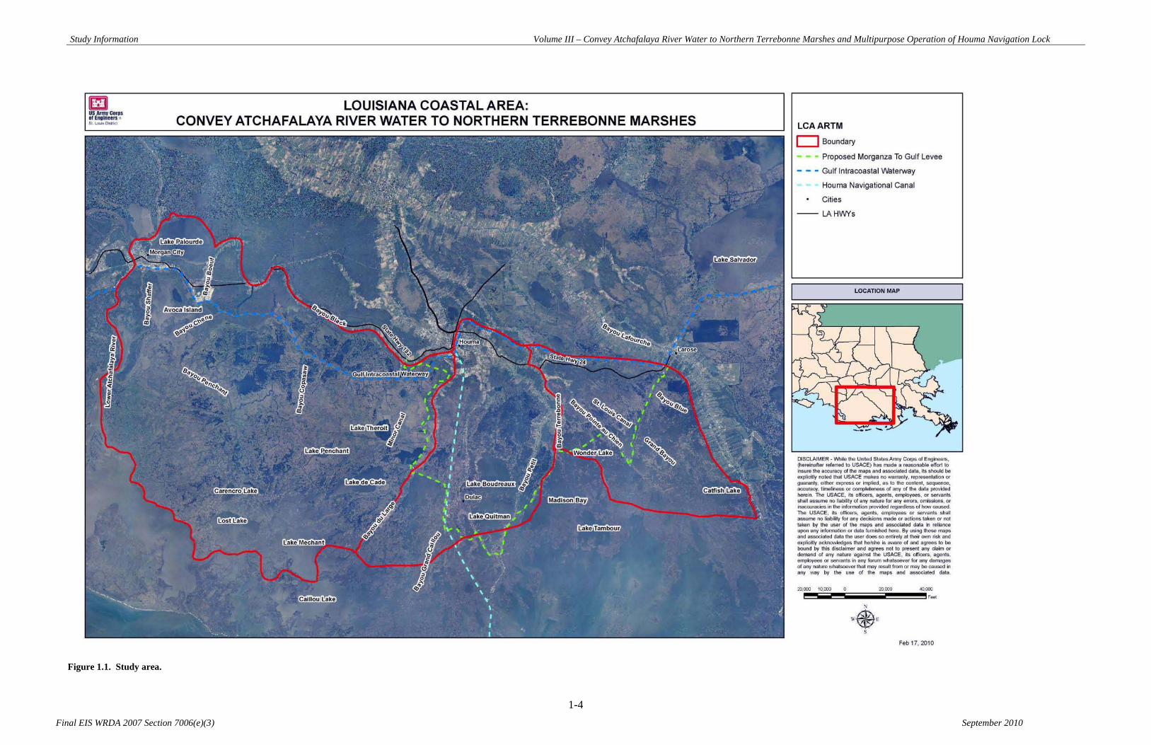
Study Information Volume III – Convey Atchafalaya River Water to Northern Terrebonne Marshes and Multipurpose Operation of Houma Navigation Lock
1-4 Final EIS WRDA 2007 Section 7006(e)(3) September 2010
Figure 1.1. Study area.

Study Information Volume III – Convey Atchafalaya River Water to Northern Terrebonne Marshes and Multipurpose Operation of Houma Navigation Lock
1-5
Final EIS WRDA 2007 Section 7006(e)(3) September 2010
Due to the magnitude of the study area, the entire LCA-ARTM study area was divided into three subunits as shown in Figure 1.2. The three subunits are labeled as West - Bayou Penchant Area, Central - Lake Boudreaux Area, and East - Grand Bayou Area. Subunits have been separated by a combination of natural, physical, and geographic features, and the limits of the subunits were developed by the project delivery team (PDT). The separation of the study area allowed the PDT to evaluate specific needs relative to each subunit. The West – Bayou Penchant Area is the largest of the three subunits identified by the LCA-ARTM PDT, measuring approximately 680 square miles in size. The area envelops sections of the GIWW that connect Morgan City, Louisiana to Houma, Louisiana. The name of the subunit lends itself to the presence of the Penchant Basin, which is one of the larger, more signature features within the subunit. The boundaries of the subunit can be characterized as the following: the northern limits of the West – Bayou Penchant Area subunit follow the northern edge of Lake Palourde and extend eastward down the Bayou Black Ridge. The eastern limits are mostly bound by Bayou du Large, and the western limits trace the Lower Atchafalaya River south of Morgan City, then cut eastward and line the edge of Four League Bay. Major freshwater delivery systems within the West – Bayou Penchant Area subunit consist of the Atchafalaya River, Bayou Shaffer, Bayou Boeuf, GIWW, Bayou Chene, Bayou Penchant, Bayou Copasaw, and Minors Canal. Other significant features located within the study subunit include portions of the proposed Morganza to the Gulf levee. The ecosystems within the West – Bayou Penchant Area can be characterized as mostly forested swamps between the GIWW and Bayou Black, floating freshwater marsh systems throughout the Penchant Basin, and intermediate marsh systems starting in the vicinity of Lake de Cade. Brackish marsh systems are also within the subunit, south of the intermediate zone. The Central – Lake Boudreaux Area subunit, measuring approximately 210 square miles, extends south of the GIWW at Houma, Louisiana and envelops the Houma Navigation Canal. The limits of the subunit adjoin the West – Bayou Penchant Area subunit at Bayou du Large. The eastern limit of the Central – Lake Boudreaux Area subunit consists of Bayou Terrebonne. Major freshwater delivery features within the Central – Lake Boudreaux Area include the GIWW, Houma Navigation Canal, Bayou du Large, Bayou Grand Caillou, Bayou Petit Caillou, and Bayou Terrebonne. Other significant features located within the study subunit include Lake Boudreaux, Lake Quitman, and the proposed Houma Navigation Canal lock complex and Morganza to the Gulf levee. The landcover within the Central – Lake Boudreaux Area can be characterized as mostly urban and agriculture along Bayou Du Large, Bayou Grand Caillou, Bayou Petit Caillou, and Bayou Terrebonne. Between the bayous, the stratification of ecosystems shifts from forested swamps in the north, to freshwater marsh systems, to intermediate systems. Brackish marshes are found around and south of Lake Boudreaux. The East – Grand Bayou Area Subunit is located south of Larose, Louisiana and measures approximately 185 square miles. The LCA-ARTM PDT identified the northern limits of this study unit to be bound by the GIWW, the western limits to be bound by
Study Information Volume III – Convey Atchafalaya River Water to Northern Terrebonne Marshes and Multipurpose Operation of Houma Navigation Lock
1-6
Final EIS WRDA 2007 Section 7006(e)(3) September 2010
Bayou Terrebonne, and the eastern limits to be bound by the Bayou Lafourche ridge. The name of the subunit lends itself to the presence of the Grand Bayou Basin, which is one of the larger, more signature features within the subunit. Major freshwater delivery features within the East – Grand Bayou Area include the GIWW, Bayou Pointe au Chien, Grand Bayou, Bayou Blue, Grand Bayou Blue, and Cutoff Canal. Other significant features that are present within the study area include St. Louis Canal, portions of the Pointe au Chien Wildlife Management Area, and portions of the proposed Morganza to the Gulf levee.
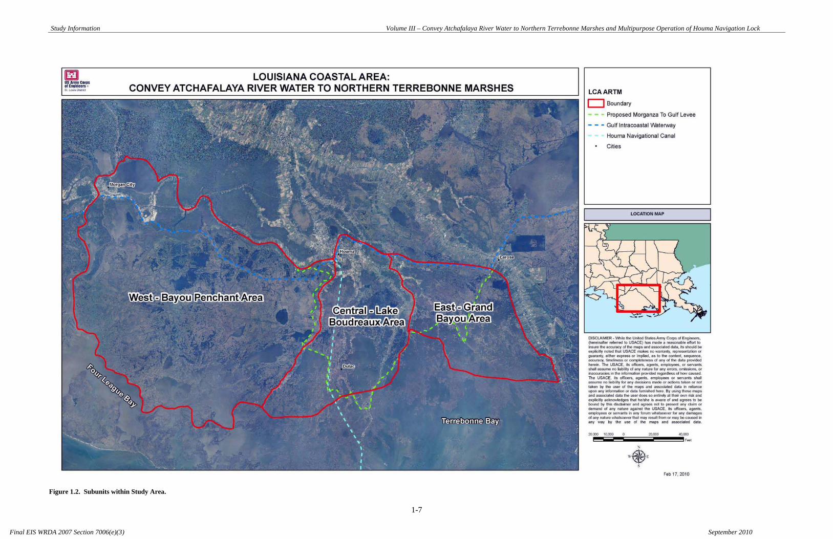
Study Information Volume III – Convey Atchafalaya River Water to Northern Terrebonne Marshes and Multipurpose Operation of Houma Navigation Lock
1-7 Final EIS WRDA 2007 Section 7006(e)(3) September 2010
Figure 1.2. Subunits within Study Area.
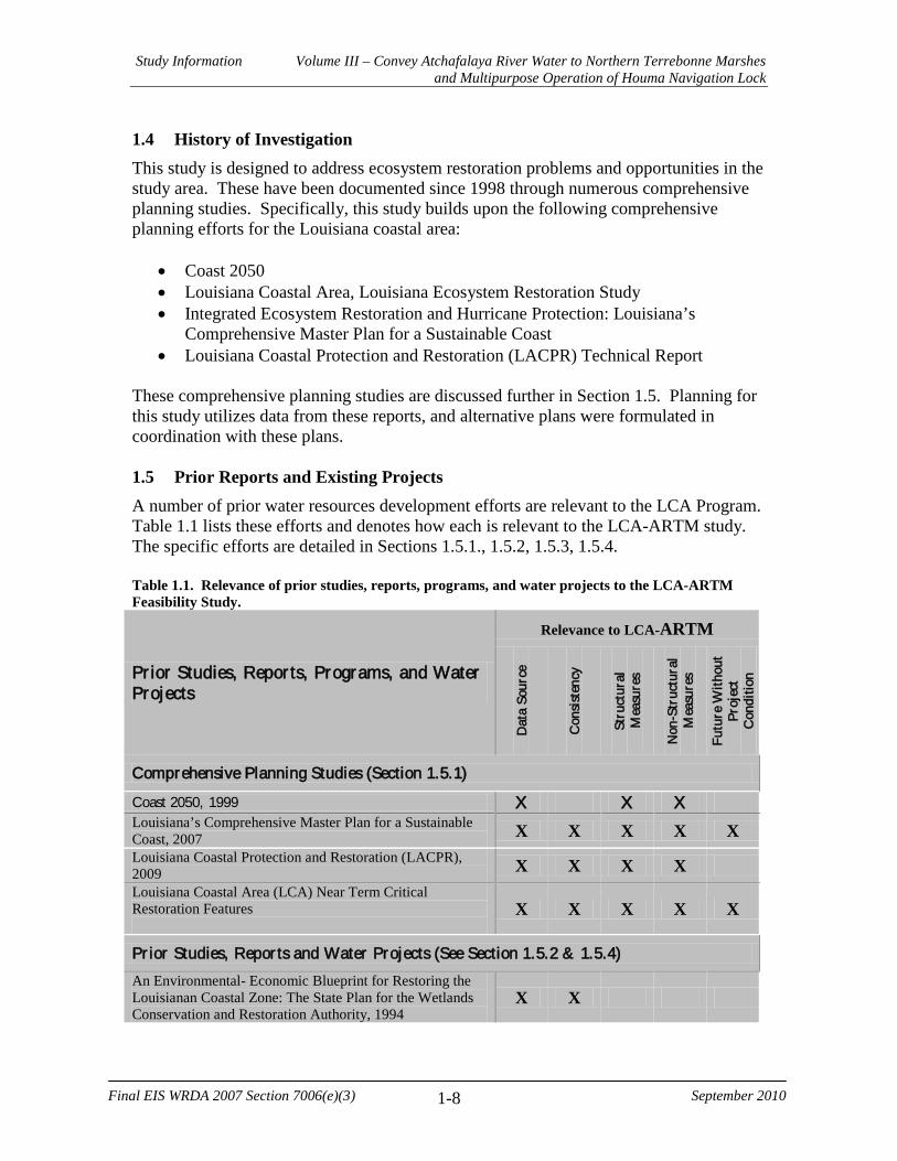
Study Information Volume III – Convey Atchafalaya River Water to Northern Terrebonne Marshes and Multipurpose Operation of Houma Navigation Lock
1-8
Final EIS WRDA 2007 Section 7006(e)(3) September 2010
1.4 History of Investigation This study is designed to address ecosystem restoration problems and opportunities in the study area. These have been documented since 1998 through numerous comprehensive planning studies. Specifically, this study builds upon the following comprehensive planning efforts for the Louisiana coastal area:
• Coast 2050 • Louisiana Coastal Area, Louisiana Ecosystem Restoration Study • Integrated Ecosystem Restoration and Hurricane Protection: Louisiana’s
Comprehensive Master Plan for a Sustainable Coast • Louisiana Coastal Protection and Restoration (LACPR) Technical Report
These comprehensive planning studies are discussed further in Section 1.5. Planning for this study utilizes data from these reports, and alternative plans were formulated in coordination with these plans. 1.5 Prior Reports and Existing Projects A number of prior water resources development efforts are relevant to the LCA Program. Table 1.1 lists these efforts and denotes how each is relevant to the LCA-ARTM study. The specific efforts are detailed in Sections 1.5.1., 1.5.2, 1.5.3, 1.5.4. Table 1.1. Relevance of prior studies, reports, programs, and water projects to the LCA-ARTM Feasibility Study.
Prior Studies, Reports, Programs, and Water Projects
Relevance to LCA-ARTM
Dat
a So
urce
Con
sist
ency
Stru
ctur
al
Mea
sure
s
Non
-Str
uctu
ral
Mea
sure
s
Futu
re W
ithou
t Pr
ojec
t C
ondi
tion
Comprehensive Planning Studies (Section 1.5.1)
Coast 2050, 1999 X X X Louisiana’s Comprehensive Master Plan for a Sustainable Coast, 2007 X X X X X Louisiana Coastal Protection and Restoration (LACPR), 2009 X X X X Louisiana Coastal Area (LCA) Near Term Critical Restoration Features
X X X X X
Pr ior Studies, Repor ts and Water Projects (See Section 1.5.2 & 1.5.4) An Environmental- Economic Blueprint for Restoring the Louisianan Coastal Zone: The State Plan for the Wetlands Conservation and Restoration Authority, 1994
X X

Study Information Volume III – Convey Atchafalaya River Water to Northern Terrebonne Marshes and Multipurpose Operation of Houma Navigation Lock
1-9
Final EIS WRDA 2007 Section 7006(e)(3) September 2010
Prior Studies, Reports, Programs, and Water Projects
Relevance to LCA-ARTM
Dat
a So
urce
Con
sist
ency
Stru
ctur
al
Mea
sure
s
Non
-Str
uctu
ral
Mea
sure
s
Futu
re W
ithou
t Pr
ojec
t C
ondi
tion
A White Paper- The State of Louisiana’s Policy for Coastal Restoration Activities, 1995 X X Section 905(b) (WRDA 1986) Analysis Louisiana Coastal Area, Louisiana—Ecosystem Restoration X Gulf Intracoastal Waterway (GIWW), 1826 and other dates X X Atchafalaya Basin X X Mississippi River and Tributaries (MR&T), 1928 X X Mississippi River Gulf Outlet, September 1956 X Morganza to the Gulf X X X X X Donaldsonville, LA to the Gulf of Mexico X X X X X Third Delta X X X X Cooperative River Basin Studies X X X X X Watershed Reports X X X Inner Harbor Navigation Canal Lock Replacement Project, 1956 X Lake Pontchartrain and Vicinity, Louisiana, Hurricane Protection Project, 1965 X Measures undertaken pursuant to the authorization provided under the heading “Operation and Maintenance” in Title I, Chapter 3 of Division B of Public Law 109-148, as modified by Section 2304 Title II, Chapter 3 of Public Law 109-234, 2006
X X X
Bonnet Carré Spillway X Mississippi and Louisiana Estuarine Areas, 1984 X X Louisiana Coastal Area Louisiana, Shore and Barrier Island Erosion, 1984 X X Mississippi River Delta Study, 1990 X X Louisiana Coastal Area, Louisiana, Water Supply, 1984 X X Louisiana Coastal Area, Hurricane Protection, 1989 X X Louisiana-Texas Intracoastal Waterway, New Orleans, Louisiana to Corpus Christi, Texas, 1942 X X X Mississippi River, Baton Rouge to the Gulf of Mexico, Louisiana, 1945 X X A Report on the Relationship of Agricultural Use of Wetlands to the Conservation of Wetlands in Cameron Parish, Louisiana, 1951
X
Relationship of Wildlife to Agricultural Drainage and Economic Development of Coastal Marshes in Cameron Parish, Louisiana, 1951
X
Survey and Report of Vermillion Corporation in Opposition to Project (Fresh Water Bayou Canal Project), 1951 X
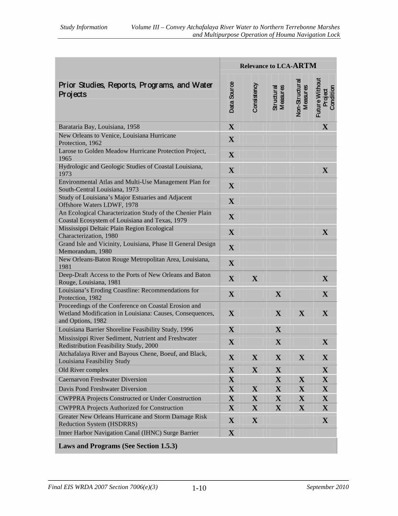
Study Information Volume III – Convey Atchafalaya River Water to Northern Terrebonne Marshes and Multipurpose Operation of Houma Navigation Lock
1-10
Final EIS WRDA 2007 Section 7006(e)(3) September 2010
Prior Studies, Reports, Programs, and Water Projects
Relevance to LCA-ARTM
Dat
a So
urce
Con
sist
ency
Stru
ctur
al
Mea
sure
s
Non
-Str
uctu
ral
Mea
sure
s
Futu
re W
ithou
t Pr
ojec
t C
ondi
tion
Barataria Bay, Louisiana, 1958 X X New Orleans to Venice, Louisiana Hurricane Protection, 1962 X Larose to Golden Meadow Hurricane Protection Project, 1965 X Hydrologic and Geologic Studies of Coastal Louisiana, 1973 X X Environmental Atlas and Multi-Use Management Plan for South-Central Louisiana, 1973 X Study of Louisiana’s Major Estuaries and Adjacent Offshore Waters LDWF, 1978 X An Ecological Characterization Study of the Chenier Plain Coastal Ecosystem of Louisiana and Texas, 1979 X Mississippi Deltaic Plain Region Ecological Characterization, 1980 X X Grand Isle and Vicinity, Louisiana, Phase II General Design Memorandum, 1980 X New Orleans-Baton Rouge Metropolitan Area, Louisiana, 1981 X Deep-Draft Access to the Ports of New Orleans and Baton Rouge, Louisiana, 1981 X X X Louisiana’s Eroding Coastline: Recommendations for Protection, 1982 X X X Proceedings of the Conference on Coastal Erosion and Wetland Modification in Louisiana: Causes, Consequences, and Options, 1982
X X X X
Louisiana Barrier Shoreline Feasibility Study, 1996 X X Mississippi River Sediment, Nutrient and Freshwater Redistribution Feasibility Study, 2000 X X X Atchafalaya River and Bayous Chene, Boeuf, and Black, Louisiana Feasibility Study X X X X X Old River complex X X X X Caernarvon Freshwater Diversion X X X X Davis Pond Freshwater Diversion X X X X X CWPPRA Projects Constructed or Under Construction X X X X X CWPPRA Projects Authorized for Construction X X X X X Greater New Orleans Hurricane and Storm Damage Risk Reduction System (HSDRRS) X X X Inner Harbor Navigation Canal (IHNC) Surge Barrier X Laws and Programs (See Section 1.5.3)

Study Information Volume III – Convey Atchafalaya River Water to Northern Terrebonne Marshes and Multipurpose Operation of Houma Navigation Lock
1-11
Final EIS WRDA 2007 Section 7006(e)(3) September 2010
Prior Studies, Reports, Programs, and Water Projects
Relevance to LCA-ARTM
Dat
a So
urce
Con
sist
ency
Stru
ctur
al
Mea
sure
s
Non
-Str
uctu
ral
Mea
sure
s
Futu
re W
ithou
t Pr
ojec
t C
ondi
tion
The Coastal Wetlands Planning, Protection and Restoration Act (CWPPRA) X X USACE Continuing Authorities Program, 1996 X Southeast Louisiana Urban Flood Control Project (SELA), 1996 X X The Coastal Impact Assistance Program (CIAP) X X X X Second Emergency Supplemental Appropriations Act to Meet the Immediate Needs Arising from the Consequences of Hurricane Katrina, 2005 (Public Law 109-062)
X X X
Department of Defense, Emergency Supplemental Appropriations to Address Hurricanes in the Gulf of Mexico, and Pandemic Influenza Act, 2006 (Public Law 109-148)
X X X X
Emergency Supplemental Appropriations Act for Defense, the Global War on Terror, and Hurricane Recovery, 2006 (Public Law 109-234)
X X X X X
Louisiana Coastal Wetlands Conservation, Restoration and Management Act, 1989 X X X X X 1.5.1 Federal
Several comprehensive planning efforts have significance to the LCA-ARTM Feasibility Study, including the Coast 2050 Plan, Louisiana’s Comprehensive Master Plan for a Sustainable Coast, and the LACPR technical report. These comprehensive planning efforts are described below in chronological order. Coast 2050 Plan, 1999 In 1998, Federal and state agencies, local governments, academia, numerous non-governmental groups, and private citizens participated in developing the Coast 2050 Plan, a conceptual plan for restoration of the Louisiana coast. The Plan was a direct outgrowth of lessons learned from implementation of restoration projects through the Coastal Wetlands Planning, Protection, and Restoration Act (CWPPRA) and other programs, and reflected a growing recognition that a more comprehensive “systemic” approach to restoring coastal wetlands was needed. The Plan formed the basis for the May 1999 905(b) reconnaissance report that preceded the LCA Ecosystem Restoration Study. Louisiana Coastal Area (LCA), 2004 In 2000, the USACE and State of Louisiana initiated the Louisiana Coastal Area Ecosystem Restoration Study to address Louisiana’s severe coastal land loss problem. The goal of LCA is to achieve and sustain a coastal ecosystem that can support and
Study Information Volume III – Convey Atchafalaya River Water to Northern Terrebonne Marshes and Multipurpose Operation of Houma Navigation Lock
1-12
Final EIS WRDA 2007 Section 7006(e)(3) September 2010
protect the environment, economy, and culture of coastal Louisiana and thus, contribute to the economy and well-being of the Nation. The LCA study focused on “lessons learned” from previous Louisiana coastal restoration efforts, the Coast 2050 restoration strategies, and the best available science and technology to develop a plan addressing the most critical coastal ecological needs. The LCA Ecosystem Restoration Study and Final Programmatic EIS were completed in 2004. Reports produced under the LCA-ARTM study will be supplements to those documents. The 2004 LCA Ecosystem Restoration Study and Final Programmatic EIS are hereby incorporated by reference into this document. Louisiana Coastal Protection and Restoration (LACPR), 2009 The Louisiana Coastal Protection and Restoration technical report includes analysis and concepts for coastal restoration and “Category 5” hurricane risk reduction, exclusive of normal policy. The USACE submitted a Preliminary Technical Report to Congress in July 2006. A Draft Final Technical Report now under review includes different alignments of structural measures, such as floodgates, floodwalls, and levees, to compare relative reduction of risk of flooding and storm surge, including the possibility of structural measures affecting the LCA-ARTM study. The Draft Final Technical Report also includes nonstructural measures such as elevating homes. In addition, the investigation reviews various wetland restoration measures and highlights the role of wetlands in coastal risk reduction. A Final Draft Technical Report was sent to MVD and HQ for review December 2008 and is currently undergoing IEPR. Morganza to the Gulf The Morganza to the Gulf Hurricane Risk Reduction Project is located in coastal Louisiana approximately 60 miles southwest of New Orleans and includes portions of Terrebonne and Lafourche Parishes (Figure 1.3). The project consists of 72 authorized miles of levees and structures; approximately 80% of the authorized alignment overlays existing hydrologic barriers. The Morganza to the Gulf project was authorized to provide 100-year level of hurricane and storm damage risk reduction based on feasibility reports and Reports of the Chief of Engineers in 2002 and 2003, prior to development and implementation of post-Katrina design criteria. The authorized hurricane protection plan consisted of approximately 72-miles of earthen levee, ten 56-ft. wide sector gate structures, three 125-ft. wide floodgates, 13 tidal exchange structures, and a lock complex consisting of a lock in the Houma Navigation Canal measuring 110 ft. wide by 800 ft. long, an adjoining floodgate measuring 250 ft. wide and a dam closure. The structural features are integrated into the levee alignment to provide flood protection, drainage, environmental benefit, and navigational passage. A Post Authorization Change (PAC) Report is currently being developed to seek reauthorization. The PAC report will evaluate benefits and costs for the authorized project alternative (post-Katrina 35-year level of risk reduction) and for the post-Katrina 100-year alternative. The alternative with the greatest net benefits will be selected as the recommended plan and then feasibility-level designs and costs will be completed for that plan.

Study Information Volume III – Convey Atchafalaya River Water to Northern Terrebonne Marshes and Multipurpose Operation of Houma Navigation Lock
1-13
Final EIS WRDA 2007 Section 7006(e)(3) September 2010
A Revised Programmatic EIS (RPEIS) will be prepared for concurrent submittal with the PAC Report. The RPEIS will document changes in existing conditions and evaluate all direct and indirect environmental impacts of increased levee footprints resulting from the post-Katrina design criteria. The RPEIS will include sufficient detail for any constructible features (i.e. HNC Lock complex) so that no additional environmental clearances will be required for those features upon signing of the Record of Decision (ROD). The Houma Navigation Canal (HNC) Lock Complex is a feature of the Morganza to the Gulf of Mexico Hurricane Protection Project. It consists of a 110-ft. x 800-ft. lock, an adjacent 250 ft.-wide sector gate, and a dam closure that tie into adjacent earthen levees to reduce the risk of storm surge traveling up the HNC. Vessel traffic will pass through the sector gate portion of the structure for the majority of conditions. However, when the sector gates are closed, the lock will be utilized. The sector gates will be closed to control chloride levels at the Houma water treatment plant and to reduce risk from storm surge. 50% Design and Specifications on the HNC Lock Complex was complete in July 2008. Design efforts on the lock will continue pending a favorable economic analysis at the MVD Commander’s review conference, selection of a recommended plan (establish design elevation), and receipt of additional funds. The Corps is not authorized to construct the HNC Lock Complex as an independent, free-standing project or as a separable element of the Morganza to the Gulf project. The Morganza to the Gulf Hurricane Protection Project is NOT part of the Southeast Louisiana Hurricane and Storm Damage Risk Reduction System (HSDRRS). The local sponsor is moving ahead with plans to build an interim risk reduction system along the authorized alignment in advance of Morganza to the Gulf. The general plan is to construct first lift levees to elevation 10 ft. and install temporary barge gate structures, all under the regular Corps permit process. The local sponsor desires to receive Work In Kind (WIK) credit for the interim work. The local sponsor has completed construction of the first lift for Reach J-1, as authorized in FY 04 Appropriations Act. The local sponsor is 80% complete in constructing the first lift for levee Reach H-3, and is 10% complete in constructing the first lift for Reach H-2. The remainder of the project is in PED. The Morganza to the Gulf project is included in the LACPR study as Planning Unit 3-a, and is part of this comprehensive system to provide higher levels of protection for the Morganza area.

Study Information Volume III – Convey Atchafalaya River Water to Northern Terrebonne Marshes and Multipurpose Operation of Houma Navigation Lock
1-14
Final EIS WRDA 2007 Section 7006(e)(3) September 2010
As of July 2010, the following provides a status of portions of the Morganza to the Gulf project:
Levee Reach J-1, First Lift, complete (WIK) Features under construction
Levee Reach H-3, First Lift, 80% complete (WIK) Levee Reach H-2, First Lift, 10% complete (WIK)
Pointe Aux Chenes Levee, First Lift, 100% P&S (WIK) Features under Design
Levee Reach J-2, First Lift, 95% P&S (WIK) Houma Navigation Canal (HNC) Lock and Floodgate, 50% P&S complete July 2008 Levee Reach F-1, 25% DDR Levee Reach G-1, 35% DDR Bayou Grand Caillou Floodgate, 35% DDR
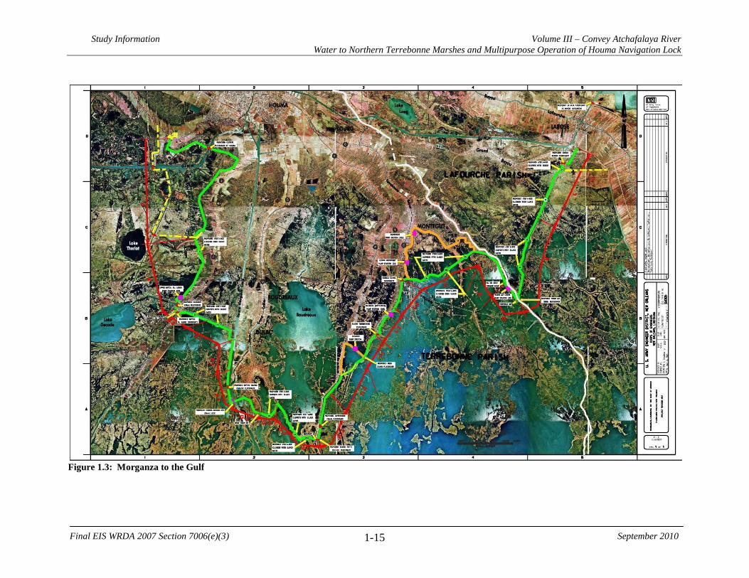
Study Information Volume III – Convey Atchafalaya River Water to Northern Terrebonne Marshes and Multipurpose Operation of Houma Navigation Lock
1-15
Final EIS WRDA 2007 Section 7006(e)(3) September 2010
Figure 1.3: Morganza to the Gulf

Study Information Volume III – Convey Atchafalaya River Water to Northern Terrebonne Marshes and Multipurpose Operation of Houma Navigation Lock
1-16
Final EIS WRDA 2007 Section 7006(e)(3) September 2010
Prior Studies, Reports, and projects In addition to the comprehensive planning efforts described above, the studies, reports, and projects listed in Table 1.1 are relevant to the LCA-ARTM Feasibility Study as noted. Related Laws and Programs Over the past three decades, both the Federal government and the State of Louisiana have established policies and programs that are intended to halt and reverse the loss of coastal wetlands and to restore and enhance ecosystem function. 1.5.1.1 Federal Laws and Programs Coastal Wetlands Planning, Protection, and Restoration Act (CWPPRA), 1990 The Coastal Wetlands Planning, Protection, and Restoration Act of 1990 was the first Federal statutory mandate for restoration of Louisiana’s coastal wetlands. The CWPPRA Task Force is composed of five Federal agencies: U.S. Environmental Protection Agency (USEPA), U.S. Fish and Wildlife Service (USFWS), U.S. Army Corps of Engineers (USACE), National Marine Fisheries Service (NMFS), and Natural Resources Conservation Service (NRCS), and the State of Louisiana. The authority required preparation of a comprehensive restoration plan that would coordinate and integrate coastal wetlands restoration projects to ensure the long-term conservation of coastal wetlands of Louisiana. The plan was adopted in 1993. The task force is also required to prepare an annual Project Priority List. CWPPRA provides funds annually for coastal restoration planning and the construction of coastal protection and restoration projects. As of July 2008, 145 active CWPPRA projects had been approved, 74 had been constructed, 17 were under construction, and 26 had been de-authorized or transferred to other programs. USACE Continuing Authorities Program, 1992 Section 204 of the WRDA 1992, as amended in WRDA 2007 Section 2037, is a "continuing authority" that authorizes the Secretary of the Army to plan, design, and implement certain ecosystem restoration measures, subject to specified cost sharing, cooperation, and positive Secretarial findings without additional project specific Congressional authorization. Section 204 as amended authorizes the beneficial use of sediments in connection with construction, operation, or maintenance dredging of an authorized Federal water resources project.

Study Information Volume III – Convey Atchafalaya River Water to Northern Terrebonne Marshes and Multipurpose Operation of Houma Navigation Lock
1-17
Final EIS WRDA 2007 Section 7006(e)(3) September 2010
Coastal Impact Assistance Program (CIAP), 2001 and 2005 The Coastal Impact Assistance Program (CIAP) was originally authorized by Congress in 2001 in the Outer Continental Shelf Lands Act, as amended (31 U.S.C. 6301-6305). Section 384 of the Energy Policy Act of 2005 (Public Law 109-58) authorized CIAP funds to be distributed to Outer Continental Shelf oil and gas producing states to mitigate the impacts of Outer Continental Shelf oil and gas activities for fiscal years 2007 through 2010. The state liaison for this program in Louisiana is the Louisiana Department of Natural Resources (LDNR). The CIAP allocations have been used to fund various state and local coastal activities and projects including: monitoring, assessment, research, and planning; habitat, water quality, and wetland restoration; coastline erosion control; and control of invasive non-native plant and animal species. Second Emergency Supplemental Appropriations Act to Meet the Immediate Needs Arising from the Consequences of Hurricane Katrina, 2005 (Public Law 109-062) The Second Emergency Supplemental Appropriations Act to Meet the Immediate Needs Arising from the Consequences of Hurricane Katrina, 2005 (Public Law 109-062) was adopted by Congress on September 2, 2005. This law provided emergency supplemental funding to repair damage to flood risk management and hurricane shore protection projects. Department of Defense, Emergency Supplemental Appropriations to Address Hurricanes in the Gulf of Mexico, and Pandemic Influenza Act, 2006 (Public Law 109-148) The “Department of Defense, Emergency Supplemental Appropriations to Address Hurricanes in the Gulf of Mexico, and Pandemic Influenza Act, 2006” (Public Law 109-148), provided funds for the LACPR efforts. 1.5.2 State
Coastal resource management in Louisiana formally evolved once Louisiana adopted and began participating in the Federal Coastal Zone Management program in 1978. Shortly thereafter, the State developed a coastal zone management plan. One of the primary objectives of this plan was to ensure that future development activities within the coastal area would be accomplished with the greatest benefit and the least amount of environmental damage. Louisiana Coastal Wetlands Conservation, Restoration and Management Act, 1989 In 1989, the constitution of the State of Louisiana was amended with enactment and voter approval of Act 6 (LA. R.S. 49:213 et seq.), also known as the Louisiana Coastal Wetlands Conservation, Restoration and Management Act. Act 6 designated the Louisiana Department of Natural Resources as the lead State agency for the development, implementation, operation, maintenance, and monitoring of coastal restoration projects. LDNR had the lead for the development and implementation of state-sponsored coastal restoration projects.

Study Information Volume III – Convey Atchafalaya River Water to Northern Terrebonne Marshes and Multipurpose Operation of Houma Navigation Lock
1-18
Final EIS WRDA 2007 Section 7006(e)(3) September 2010
Act 6 also created the Wetlands Conservation and Restoration Fund (WCRF), which dedicates a portion of the state’s revenues from severance taxes on mineral production (e.g., oil and gas) to finance coastal restoration activities and projects. Currently, the WCRF provides approximately $25 million per year to support coastal restoration activities and projects. Act 6 requires the State to prepare and annually update a “Coastal Wetlands Conservation and Restoration Plan.” This plan provides location specific authorizations for the funding of coastal restoration projects from the WCRF. Act 8 of the First Extraordinary Session of 2005 In November 2005, Act 8 of the First Extraordinary Session of 2005 created the Coastal Protection and Restoration Authority (CPRA) and charged it with coordinating the efforts of local, state, and Federal agencies to achieve long-term and comprehensive coastal protection and restoration. The CPRA created a Master Plan to integrate what had previously been discrete areas of activity: flood risk management and wetland restoration. Louisiana’s Comprehensive Master Plan for a Sustainable Coast, 2007 The Louisiana Legislature, through Act 8 of the First Extraordinary Session of the 2005 Louisiana Legislature, established the Coastal Protection and Restoration Authority (CPRA) to develop, implement, make reports on, and provide oversight for a comprehensive coastal protection master plan and annual coastal protection plans. 1.5.3 Local
Non-governmental organizations have also participated in various coastal restoration projects. Public and private parties involved in wetlands preservation or restoration activities in coastal Louisiana include Coastal America, Corporate Wetlands Restoration Partnership, Gulf Coast Joint Venture, Audubon Society, National Fish and Wildlife Foundation, The Nature Conservancy, and the National Wildlife Federation. These efforts are primarily concerned with preservation. The restoration activities of these organizations will support the overall goals of the LCA-ARTM study; however, these efforts are small in scale and will not appreciably influence plan formulation. 1.5.4 Existing and Likely Future Water Projects
Several existing and authorized navigation, river flood risk management, hurricane storm surge risk reduction, coastal restoration, and multi-purpose Operation and Maintenance (O&M) projects are related to the Convey Atchafalaya River Water to Northern Terrebonne Marshes Feasibility Study. These projects are briefly described below. 1.5.4.1 Navigation Projects
Gulf Intracoastal Waterway (GIWW) The GIWW was authorized and construction was begun in the 1920’s. The GIWW traces the U.S. coast along the Gulf of Mexico from Apalachicola Bay near Carrabelle, Florida to the Mexican border at Brownsville, Texas. From its intersection with the Mississippi

Study Information Volume III – Convey Atchafalaya River Water to Northern Terrebonne Marshes and Multipurpose Operation of Houma Navigation Lock
1-19
Final EIS WRDA 2007 Section 7006(e)(3) September 2010
River, the waterway extends eastward for approximately 376 miles and westward for approximately 690 miles. The GIWW runs contiguously through the LCA-ARTM study area from Bayou Lafourche through Houma and on to Morgan City. Houma Navigation Canal (HNC) The Houma Navigation Canal (HNC) is a 36.6-mile navigation channel that begins at the Gulf Intracoastal Waterway (GIWW) in Houma, Louisiana and extends southward to the Gulf of Mexico. Terrebonne Parish constructed the canal in 1962 to provide direct access to the nearby resources of the Gulf of Mexico. The channel was originally constructed with a usable dimension of 15 ft. by 150 ft. from the GIWW to mile 0.0 of the HNC and an 18-ft. contour to the Gulf of Mexico. The River and Harbor Act of October 23, 1962 provided for the maintenance of the HNC by the Federal government. Maintenance by the United States was initiated on November 27, 1964 In accordance with Section 5 of the River and Harbor Act, approved March 4, 1915, authority was granted on August 23, 1973 to increase the HNC project dimensions to Elevation -18 feet Mean Low Gulf (MLG) by 300 feet in bottom width, between mile 0 and the Gulf of Mexico. This enlargement of the HNC was completed in July 1974. Presently the Corps is undergoing a study to deepen this channel to either -18 feet or -20 feet NAVD88. Atchafalaya River Deep Draft Channel The project is located in south-central Louisiana in Assumption, St. Mary, and Terrebonne Parishes, in the vicinity of Morgan City, Louisiana. It includes the Atchafalaya River and adjacent areas south of Morgan City; Bayous Chene, Boeuf, and Black and adjacent areas between the Atchafalaya River and Amelia, Louisiana; and Atchafalaya Bay and the Gulf of Mexico, south of Morgan City. This project provides for a 20-ft. deep by 400-ft. wide navigation channel. 1.5.4.2 Lower Atchafalaya Basin Floodway System The entire Atchafalaya Basin is located in south-central Louisiana and extends from the confluence of the Mississippi, Red and Atchafalaya Rivers near Simmesport, Louisiana to the Gulf of Mexico south of Morgan City. The 833,000-acre Lower Atchafalaya Basin Floodway is bounded on the north by U.S. 190, on the east and west by the Atchafalaya Basin protection levees, and extends south to the Gulf of Mexico. The Lower Atchafalaya Basin Floodway System project has two mutually supporting goals: to preserve the habitat of the nation’s largest and oldest river-basin swamp and to ensure that the Lower Atchafalaya Basin can pass a floodwater of 1.5 million cubic feet per second as required by the Mississippi River and Tributaries Project (MR&T). 1.5.4.3 Hurricane Storm Surge Risk Reduction Projects Morganza to the Gulf of Mexico Risk Reduction Project In March 2002, a feasibility report and programmatic environmental impact statement

Study Information Volume III – Convey Atchafalaya River Water to Northern Terrebonne Marshes and Multipurpose Operation of Houma Navigation Lock
1-20
Final EIS WRDA 2007 Section 7006(e)(3) September 2010
(PEIS) entitled “Mississippi River & Tributaries – Morganza, Louisiana to the Gulf of Mexico Hurricane Protection” was prepared by the USACE (USACE 2002). It is noted that there is an addendum 1 to the report dated April 2003 and an addendum 2 dated March 2004. It is further noted that the Chief’s Report (which the proposed authorizing language references) is dated August 9, 2002. The Chief’s report was also supplemented in 2003. The recommended plan proposed a series of flood protection measures and included the following:
• construction of approximately 72 miles (116 kilometers) of levee south of Houma;
• construction of nine gated structures in various waterways and three floodgates in the GIWW;
• construction of a lock structure and floodgate complex for the Houma Navigation Canal (HNC); and
• construction and operation of new and replacement fish and wildlife structures in selected locations to maintain tidal exchange.
The area to be protected by the levee system is a former major delta from a previous course of the Mississippi River. As in other locations in south Louisiana, urban and agricultural development has occurred along the banks of the remnant ridges of the delta. Therefore, conveyance of freshwater via the Mississippi River through these remnant channels is not practical. However, the close proximity of the area to the Atchafalaya Basin offers other options of freshwater distribution. The GIWW is linked to the Atchafalaya Basin and conveys water eastward to the area. The HNC intercepts these flows before they reach the area of need and conveys them efficiently to the Gulf of Mexico. If authorized, and with the levee system and water control structures in place, the Atchafalaya River flows can be managed and distributed across the area. The proposed Morganza to the Gulf levees and water control structures would convey Atchafalaya River water eastward and would support the efforts proposed within the LCA Plan, thus helping solve the saltwater intrusion problem in the Houma area. This project presents a direct hydraulic relationship with the LCA-ARTM study. 1.5.4.4 Coastal Restoration Projects Other LCA Projects. An LCA Project that could affect the LCA-ARTM is the Beneficial Use of Dredged Material Program. A very promising option for restoring coastal wetlands and reducing land loss is the beneficial use of dredged material. USACE-MVN (Mississippi Valley Division - New Orleans District) has the largest annual channel Operations and Maintenance (O&M) program in the nation and dredges an average of 70 million cubic yards (mcy) of material annually during maintenance dredging of navigation channels. Not all of this material is available for beneficial placement in the coastal ecosystem; however, there is the potential to use up to 30 mcy annually to enhance coastal wetlands through marsh creation, wetland nourishment, barrier island restoration, ridge restoration, and other techniques. The ten year, $100 million LCA Beneficial Use of Dredged Material Program will provide the institutional
Study Information Volume III – Convey Atchafalaya River Water to Northern Terrebonne Marshes and Multipurpose Operation of Houma Navigation Lock
1-21
Final EIS WRDA 2007 Section 7006(e)(3) September 2010
framework to optimize the use of dredged material resulting from the maintenance of federally maintained navigational channels to attain the LCA hydrogeomorphic and ecosystem objectives. The beneficial use of dredged material could directly affect the LCA-ARTM study area (Figure 1.4) by beneficially creating/enhancing marsh habitat within the study area boundary. Small Bayou Lafourche Reintroduction (LCA) project could supply fresh water to the eastern portion of the LCA-ARTM study area. This restoration feature would reintroduce flow from the Mississippi River into Bayou Lafourche. The flow would be continuous and would increase riverine influence in the wetlands between Bayous Lafourche and Terrebonne, south of the GIWW. Several alternatives are being considered which would provide year-round flow into the bayou, including gated culverts and a pump/siphon station at Donaldsonville, and initial E&D has been initiated under CWPPRA. Additional features that would be required, regardless of the type of diversion structure built, include modification of existing infrastructure, bank stabilization, dredging, and channel improvements. The Bayou Lafourche project could have a synergistic relationship with Convey Atchafalaya River Water to Northern Terrebonne Marshes. The two projects could greatly reduce saltwater intrusion in the eastern Terrebonne Marshes. Moreover, potential measures to improve distribution of Bayou Lafourche reintroduction waters (e.g., enlargement of Bayou L’Eau Bleu and/or Grand Bayou) could facilitate efforts to move Atchafalaya waters into areas of critical need. Given this positive interrelationship, opportunities to maximize synergy between these two projects should be fully evaluated in the feasibility study for the Bayou Lafourche reintroduction. Maintain Land Bridge between Caillou Lake and Gulf of Mexico (LCA) could affect salinity levels in the LCA-ARTM study area. This restoration feature would maintain the land bridge between the Gulf of Mexico and Caillou Lake by placing shore protection in Grand Bayou du Large to minimize saltwater intrusion. This feature would involve rock armoring or marsh creation to plug/fill broken marsh areas on the west bank of lower Grand Bayou du Large, thereby preventing a new channel from breaching the bayou bank and allowing a new hydrologic connection with Caillou Lake. Some gulf shore armoring would be needed to protect the area from erosion on the gulf shoreline. Gulf shoreline armoring might be required where shoreline retreat and loss of shoreline oyster reefs has allowed increased water exchange between the gulf and the interior water bodies (between Bay Junop and Caillou Lake). Some gaps in the barrier between these two water bodies would be closed to restore historic hydrologic connections. By reducing marine influences in these interior areas, this feature would allow increased freshwater influence from Four League Bay to benefit marshes in the surrounding areas. Coastal Wetlands Planning, Protection and Restoration Act (CWPPRA) has several projects in various stages that could have relationships to the LCA-ARTM study; these projects are described below. Atchafalaya Sediment Delivery (AT-02). The project is located east of the lower Atchafalaya River navigation channel in the Atchafalaya River Delta, approximately 19

Study Information Volume III – Convey Atchafalaya River Water to Northern Terrebonne Marshes and Multipurpose Operation of Houma Navigation Lock
1-22
Final EIS WRDA 2007 Section 7006(e)(3) September 2010
miles southwest of Morgan City, Louisiana, in St. Mary Parish. Growth of the lower Atchafalaya Delta has been reduced as a result of maintenance of the Atchafalaya River navigation channel. Delta development in the shallow waters of Atchafalaya Bay is dependent on distributary flows and the diversion of sediments into over-bank areas through crevasse channels. Because of the placement of material dredged from the navigation channel and sediment accumulation within the channels that decrease flow efficiency, the open crevasse channels are frequently short-lived. As riverflow through a crevasse channel is reduced, the amount of sediment that can be deposited in the delta is likewise reduced, resulting in decreased marsh development. The purpose of this project is to promote natural delta development by reopening two silted-in channels and using those dredged sediments to create new wetlands. Approximately 720,000 cubic yards of sediment were dredged from Natal Channel and Castille Pass in 1998. Over 12,000 feet of channel were reopened, and more than 280 acres of new habitat were created by the strategic placement of the dredged channels’ sediments. By reestablishing water and sediment flow into the eastern part of the Atchafalaya Delta, an additional 1,200 acres of new habitat are expected to be naturally created over the life of the project.
Construction was completed in 1998. A pre- versus post-construction habitat analysis using aerial photography indicated that, while there was an increase in land of 78.4 acres, the majority of the habitat created was represented by forested wetland (50.1 acres), while fresh marsh and upland barren habitats accounted for 14 acres of gain each. Although many of the dominant plant species are present in both created and reference areas, the created areas contained different plant communities when compared to any time period in the development of a natural crevasse splay that served as a reference area for this project. Although the long-term effects on submerged aquatic vegetation (SAV) are unclear, habitat mapping indicated an increase in SAV habitat of 221.5 acres from 1997 to 1998, but this is very close to the increases that were reported in the project area pre-construction. Although habitat mapping has not been performed, satellite imagery indicates that there have been significant increases in emergent acreage from 1998 to 2000. This project is not likely to have a major impact on the flows or water levels in the LCA-ARTM study area. Avoca Island Diversion and Land Building (TE-49). The project is located in the Avoca Island area in St. Mary Parish, Louisiana. The Avoca Island area lost approximately 5,000 acres of marsh between 1932 and 1990. Natural overbank flooding into the area has been eliminated by channelization and construction of flood protection levees, thereby preventing the input of fresh water, sediment, and nutrients. The goal of this project is to rebuild eroded wetlands in the area through the diversion of fresh water, sediment, and nutrients. A diversion structure will be installed through the Avoca levee to allow water from Bayou Shaffer to enter Avoca Lake at a rate of 1,000 cubic feet per second. A natural bayou will be used as the primary outfall channel for the diversion. Outfall management measures will be evaluated and incorporated to increase benefits to aquatic habitats in the island system. The Louisiana Coastal Wetlands Conservation and Restoration Task Force approved funding for engineering and design at the January 2003 Task Force meeting. The project work plan for the engineering and design phase was
Study Information Volume III – Convey Atchafalaya River Water to Northern Terrebonne Marshes and Multipurpose Operation of Houma Navigation Lock
1-23
Final EIS WRDA 2007 Section 7006(e)(3) September 2010
submitted for program review in May 2003. Engineering data collection, including site surveys and a geotechnical boring, is ongoing. This project would directly impact freshwater marsh in the northwest portion of the LCA-ARTM study area and could impact hydrology in the area as well. Floating Marsh Creation Demonstration (LA-05). This project is located within the fresh and intermediate marshes of the Mandalay Wildlife Refuge in Terrebonne Basin. Tens of thousands of acres of marsh within the fresh and intermediate zones of the Barataria and Terrebonne Basins converted to open water between 1968 and 1990. Large areas of fresh and intermediate open water exist in marsh interiors, presenting opportunities for reestablishment within those basins. These types of open water areas are not well-suited for typical projects such as sediment diversions, beneficial use of dredge material, or dedicated dredging because they are generally located at long distances from natural sediment sources, frequently dredged navigation channels, or other water bodies with bottom substrates containing material suitable for marsh creation. Additionally, the substrate under these large areas of fresh and intermediate open water is often fluid organic matter which would not support the weight of added sediment. The purpose of this demonstration project is to develop and field test unique and previously untested technologies for creating floating marsh for potential use in fresh and intermediate zones.
The Louisiana Coastal Wetlands Conservation and Restoration Task Force approved funding for this demonstration project at their January 2003 meeting. The goal of this project is to develop methods for restoration of open areas within deteriorated floating marsh and other freshwater areas where establishment of maidencane (Panicum hemitomon) marsh is desired. In addition, the technology being developed is to be transferable to wider applications across the LA coastal area. The first phase of the project consisted of two components in which buoyant vegetated mats or artificial floating systems (AFS) were developed and tested in a controlled environment during the first two years of the project. Various combinations of plant species, planting methods, structure materials and substrates were tested to determine optimal buoyancy and structure design. In addition, plant response to environmental effects was evaluated in an effort to identify methods to accelerate floating marsh mat development. For the second phase of the project, the AFSs were then deployed into open water areas for field testing on Mandalay National Wildlife Refuge in 2006. Monitoring of the AFSs field performance is ongoing. This project is unlikely to affect the hydrology of the LCA-ARTM study area. GIWW Bank Restoration of Critical Areas in Terrebonne (TE-43). The project is located in the Terrebonne basin, in Terrebonne Parish, Louisiana. In the past 20 years, as the efficiency of the Lower Atchafalaya River has decreased, Verrett subbasin flooding and Atchafalaya River flows via the Gulf Intracoastal Waterway have increased. Deterioration of fresh and intermediate wetlands, particularly of the floating marshes in the upper Penchant basin, has been attributed to sustained elevated water levels. In addition, floating marshes in some areas have become directly exposed to

Study Information Volume III – Convey Atchafalaya River Water to Northern Terrebonne Marshes and Multipurpose Operation of Houma Navigation Lock
1-24
Final EIS WRDA 2007 Section 7006(e)(3) September 2010
increased circulation through unnatural connections formed where channel banks deteriorated. Conversely, losses in the central Terrebonne Parish marshes have been attributed to the elimination of riverine inflow coupled with subsidence and altered hydrology from canal dredging that facilitated saltwater intrusion. Increased flow of the GIWW and wave pulses from navigation traffic is causing additional breakup and loss of floating marshes in unprotected areas. This project is designed to restore critical lengths of deteriorated channel banks and stabilize/armor selected critical lengths of deteriorated channel banks with hard shoreline stabilization materials. This project has been largely completed under the Coastal Impact Assistance Program (CIAP). This project could impact the LCA-ARTM study area by reducing the loss rates of fresh marsh along the GIWW. Grand Bayou Hydrologic Restoration (TE-10). The project is located in Lafourche Parish, Louisiana, approximately 5 miles southwest of Cut Off and south of Larose. The project area includes part of the Pointe au Chien Wildlife Management Area. St. Louis Canal and the Island Road Borrow Canal have re-routed water exchange westward via Bayou Pointe au Chien to the Bayou Jean LaCroix watershed. Because this area has higher salinities and twice the tidal amplitude as that of the Grand Bayou watershed into which the area should drain, swamps and other salt-sensitive project-area wetlands have suffered substantial deterioration and loss. Water exchange to the west through Bayou Pointe au Chien would be halted by installing a major water control structure in Bayou Pointe au Chien. Exchange with the Grand Bayou watershed would be restored by installing new water control structures through the existing levee along the west side of the Grand Bayou/Grand Bayou Canal. In April 2002, the project was downsized based on the results of earlier engineering work. This project was deauthorized in January 2009 by the Restoration Task Force and will not be built under the CWPPRA program. Brady Canal Hydrologic Restoration (TE-28). The project is located 21 miles southwest of Houma, Louisiana, in Terrebonne Parish. The project is bounded by Turtle Bayou to the east, Bayou DeCade to the south, and Bayou Penchant to the north. The intermediate marshes in the area are highly fragmented and are the transitional areas between the fresh and brackish zones. These marshes are extremely susceptible to erosion and wetland loss. Land loss in the area has been caused by saltwater intrusion, subsidence, and increased tidal energies. The project measures include replacing and maintaining weirs, constructing a rock plug, stabilizing channel cross sections, and restoring and maintaining channel banks. These measures will maintain and enhance existing marshes in the project area by reducing the rate of tidal exchange. They will also increase the utilization of sediment and fresh water introduced from the water control structures and overbank flow along the north, east, and west sides of the project area. Along the southern boundary, bank restoration and water control structures are used to reduce tidal flow rate from channels into interior ponds, helping to improve the retention of sediment and fresh water. Construction was completed in July 2000. A monitoring plan has been developed, and the Louisiana Department of Natural Resources is currently collecting data so that the project's effectiveness can be evaluated.
Study Information Volume III – Convey Atchafalaya River Water to Northern Terrebonne Marshes and Multipurpose Operation of Houma Navigation Lock
1-25
Final EIS WRDA 2007 Section 7006(e)(3) September 2010
North Lake Boudreaux Basin Freshwater Introduction and Hydrologic Management (TE-32a). The project is located in Terrebonne Parish, approximately 5 miles southwest of Chauvin, Louisiana. The area is suffering from a lack of fresh water, increasing the negative effects of saltwater intrusion into the north Lake Boudreaux basin marshes. The purpose of the project is to reduce deterioration and loss of area marshes by seasonally introducing fresh water from the Houma Navigation Canal. This project includes the construction of a freshwater conveyance channel with water management gates and the installation of several outfall management structures to allow drainage and reduce ponding of water. The contracted Feasibility Study report has indicated that the project, as proposed, can introduce the originally projected volumes of fresh water. Prior to beginning engineering and design work, a landrights assessment is being conducted to better determine where the project’s conveyance channel can be located. Proposed features from this project were incorporated into the LCA-ARTM study. Penchant Basin Natural Resources Plan, Increment 1 (TE-34). The project is bounded on the north by the Gulf Intracoastal Waterway (GIWW), the east by a north/south line from Lake DeCade to the GIWW, the south by Lake Mechant and Lost Lake, and to the west by a north/south line from Lost Lake to Avoca Island in Terrebonne Parish, Louisiana. Area problems include major hydrologic alterations, interior marsh erosion, subsidence, saltwater intrusion, herbivory, and hurricane damage. This project will combine the long-term realignment of Penchant Basin hydrology with restoration and protection measures aimed at maintaining the physical integrity of the area during the transition toward greater riverine influence. The project includes about 6,520 feet of foreshore rock dike (shoreline protection) along the southern bank of Bayou Chene at its intersection with Bayou Penchant and approximately 35 acres of marsh creation. Two freshwater introduction structures, consisting of a) 10-48” flap gates in Superior Canal and b) steel sheetpile weir with 10’ boat bay and six 5’ x 5’ flap gated openings at Brady Canal, will be constructed to improve freshwater conveyance from Bayou Penchant into the central Terrebonne marshes. On the north bank of Bayou Decade extending from Lake Decade to Turtle Bayou (12,000 ft) an earthen embankment will be maintained and from Voss Canal to Lost Lake (14,000 ft) an earthen embankment will be constructed to 4.0 feet NAVD88 with 6:1 side slopes and rock armoring on the south face. Within the embankment, a sheetpile weir, with a 10 ft wide boat bay, will be constructed at each of two existing channels that intersect Bayou Decade. The objectives of the project are to eliminate erosion and create approximately 35 acres of emergent marsh along the southern bank of Bayou Chene at its intersection with Bayou Penchant, convey Atchafalaya River water, sediment, and nutrients to lower Penchant Basin tidal marshes to offset subsidence and saltwater intrusion and maintain the integrity of a deteriorated reach of the north bank of Bayou Decade to minimize encroachment of open water marine influence. The Louisiana Coastal Wetlands Conservation and Restoration Task Force approved this project on April 24, 1997. Planning, engineering and design of this project included extensive data collection, hydrodynamic modeling, and related investigations. This effort resulted in a change in scope to the project which was approved by the Task Force in April 2008. Final engineering and design has been completed and construction is scheduled to begin in the spring of 2010.

Study Information Volume III – Convey Atchafalaya River Water to Northern Terrebonne Marshes and Multipurpose Operation of Houma Navigation Lock
1-26
Final EIS WRDA 2007 Section 7006(e)(3) September 2010
South Lake DeCade Freshwater Introduction (TE-39). The project is located in Terrebonne Parish, approximately 15 miles southwest of Houma, Louisiana. The project area is experiencing marsh deterioration due to subsidence, rapid tidal exchange, and human-induced hydrologic changes that result in increased salinities. Saltwater intrusion has caused a shift in marsh type and a conversion of over 30 percent of emergent vegetation to open water habitat. Shoreline erosion along the south embankment of Lake De Cade threatens to breach the hydrologic barrier between the lake and interior marshes. Proposed project components include installing three control structures along the south rim of the lake and enlarging Lapeyrouse Canal to allow the controlled diversion of Atchafalaya River water, nutrients, and sediments south into project area marshes. Outfall management structures are planned in the marsh interior to provide better distribution of river water. In addition, approximately 1.6 miles of foreshore rock dike is planned to protect the critical areas of the south lake shoreline from breaching. After initial engineer investigation the project was divided into two construction units. Construction unit one will consist of the shoreline protection components. The other will be freshwater introduction components. Engineering and design on the shoreline protection component is complete and construction is pending Phase 2 approval. Data gathering and analysis is being conducted on the freshwater diversion aspects of the project. This project could synergistically increase beneficial impacts with the LCA-ARTM study if both are implemented. North Lake Mechant Landbridge Restoration (TE-44). The project is located in the Terrebonne Basin, in Terrebonne Parish, Louisiana. The project would protect and restore a critical landbridge barrier between the easily erodible fresh marshes north of Bayou De Cade and the higher saline environment of Lake Mechant. At the present shoreline erosion rate, the north Lake Mechant shore will soon fail to act as a barrier, allowing the hydrologic connection between Lake Mechant and the fresher marshes to the north. In addition, erosion and deterioration along the banks of Raccourci Bayou are threatening to enlarge and straighten this winding tidal pass into a major conduit for water exchange. These changes will accelerate the loss of the remaining interior marshes, extend lake-like conditions, and increase salinities north to Bayou De Cade. Should shoreline breaching and enlargement of tidal channels allow high tidal energy conditions to intrude into the project area, the organic interior marshes would likely experience increased loss rates. Dredged material from northern Lake Mechant will be used to create marsh. Smooth cordgrass (Spartina alterniflora) will also be planted along the shorelines of Lake Mechant, Goose Bay, and Lake Pagie. The project will also repair breeches formed by erosion and oilfield access canals which threaten the integrity of the landbridge. The Louisiana Department of Natural Resources has completed project engineering and design. The Louisiana Coastal Wetlands Conservation and Restoration Task Force granted construction approval of construction unit one on August 7, 2002, which included shoreline vegetation plantings and were installed in summer 2003. Approval of construction unit two was granted on October 2004, which includes dedicated dredging for marsh creation and several other bank stabilization measures. Problems surrounding the recently established public oyster seed grounds and several private oyster leases in Lake Mechant were resolved and construction of that unit was completed in late 2009.

Study Information Volume III – Convey Atchafalaya River Water to Northern Terrebonne Marshes and Multipurpose Operation of Houma Navigation Lock
1-27
Final EIS WRDA 2007 Section 7006(e)(3) September 2010
West Lake Boudreaux Shoreline Protection and Marsh Creation (TE-46). The project is located in the Terrebonne Basin along the western shoreline of Lake Boudreaux in Terrebonne Parish, Louisiana. The west bank of Lake Boudreaux has experienced high erosion rates due to wind-driven waves and high water. The entire historical lake rim is gone, exposing the organic soil of the interior marsh to high-energy wave action. Most of the remaining shoreline is less than 100 feet in width and has been breached in several places. If this erosion is not stopped, the interior marsh and adjacent infrastructure will be compromised. Continued shoreline loss will convert the productive shallow, open water areas behind the shoreline to a less productive, open lake habitat. The project's objectives include: reducing erosion of the west Lake Boudreaux shoreline to protect 80 acres of emergent marsh and submerged aquatic vegetation (SAV); maintaining the shallow, open water habitat, including its SAV, located west of the lake rim; and creating 284 acres of marsh along the southwestern shoreline of Lake Boudreaux and at interior marsh sites through the deposition of dredged material. Containment dikes will be used to hold the dredged material in the marsh creation areas. The borrow site, from where the dredged material will be extracted, will be located in Lake Boudreaux east of the project site. In an effort to lessen or halt shoreline erosion, 13,000 linear feet of rock dike will be constructed in three sections along the western shoreline of Lake Boudreaux, from Hog Point south to Hog Point Canal. This will include “fish dips” for the exchange of material, nutrients, and organisms between the interior marsh and the lake's main body. Elsewhere, an earthen plug will be constructed to prevent unwanted water exchange. The project also calls for construction of 4,000 linear feet of earthen dike. In addition, existing openings will be enlarged and/or new openings created in the pumping station spoil bank to facilitate the exchange of water and organisms between the project area's north and south ponds. This project was selected for Phase I (engineering and design) funding at the January 2002 CWPPRA Task Force meeting and was approved for Phase II (construction) at the February 2006 task force meeting. This project could synergistically increase beneficial impacts with the LCA-ARTM study if both are implemented. Central Terrebonne Freshwater Enhancement (TE-66). The project area is located in Terrebonne Basin in Terrebonne Parish. The Bayou Dularge Ridge historically restricted the Gulf marine influence into Central Terrebonne marshes forming a diagonal restriction extending from northeast to southwest, where the Atchafalaya influence is prominent. The Grand Pass is currently a 900 ft wide artificial cut through the Bayou Dularge Ridge south of Lake Mechant. The pass is mainly used by commercial and recreational fisherman as a shortcut to the gulf and has greatly eroded to a point of approximately 36 feet deep that well exceeds optimal utility. The expansion of the pass to its current size has allowed for a substantial alteration of historic salinity and hydrology and consequently a broad area of the Central Terrebonne marshes are currently suffering some of the highest loss rates in the state. The project will reestablish historic hydrologic and salinity conditions by reducing the artificial intrusion of Gulf marine waters via the Grand Pass into the Central Terrebonne marshes while enhancing the influence of the Atchafalaya River waters into the area. A structure consisting of rock barge bay would be constructed to reduce the size of the opening by up to 90% to 150' wide and 15' deep. The
Study Information Volume III – Convey Atchafalaya River Water to Northern Terrebonne Marshes and Multipurpose Operation of Houma Navigation Lock
1-28
Final EIS WRDA 2007 Section 7006(e)(3) September 2010
project would reestablish the historic ridge function of Bayou Dularge that separated Lake Mechant from the gulf and moderate salinities that have greatly impacted the marshes to the north of Lake Mechant. The project will also increase the Atchafalaya influence in the area by modifying the current structure located in Liners Canal north of Lake Decade to increase freshwater introduction to Lake Decade by an estimated 500 cfs and provide maintenance dredging at Minors Canal to maintain optimal freshwater conveyance from the GIWW into Lake Decade. The project is currently in the Planning and Design Phase. The project team is developing surveying, geotechnical investigations, and modeling requirements necessary to proceed to 30% design review. The project is scheduled to request Phase II funding at the January 2012 Task Force meeting. This project could synergistically increase beneficial impacts with the LCA-ARTM study if both are implemented. In early 2001, the Barataria-Terrebonne National Estuary Program (BTNEP) and the Greater Lafourche Port Commission fostered a partnership with other organizations to reestablish a chenier ridge and associated coastal marsh habitats in southeast Louisiana. This partnership was born from a desire to further the knowledge and expand the focus of habitat restoration in coastal Louisiana from purely a vision that supported marsh restoration to one that encompassed other natural landscape features. Louisiana’s unparalleled coastal wetland loss problem means dire consequences for many species of birds. But of equal importance are the distributary ridges and chenier ridges that too are being lost at an alarming rate. These ridge habitats and associated wetlands are extremely important for millions of migrating Neotropical songbirds that cross the Gulf of Mexico in the spring each year on their way back to their breeding grounds in the eastern United States and Canada. Currently, the Greater Lafourche Port Commission is in the process of reestablishing a maritime forest ridge in the vicinity of Bayous Cochon and Moreau just north of the port at Fourchon, LA. BTNEP is serving as a co-lead implementer of this project along with the Greater Lafourche Port Commission and is helping to coordinate discussions and on-the-ground planning and construction. In addition, BTNEP is providing funding for this project. This program could benefit the LCA-ARTM study area by impacting hydrology and salinities in the area, depending on the locations chosen for restoration of ridge habitat.

Study Information Volume III – Convey Atchafalaya River Water to Northern Terrebonne Marshes and Multipurpose Operation of Houma Navigation Lock
1-29
Final EIS WRDA 2007 Section 7006(e)(3) September 2010
Figure 1.4. Other Restoration Projects in the Vicinity of the ARTM Study.

Study Information Volume III – Convey Atchafalaya River Water to Northern Terrebonne Marshes and Multipurpose Operation of Houma Navigation Lock
1-30
Final EIS WRDA 2007 Section 7006(e)(3) September 2010
1.5.5 Deepwater Horizon Oil Spill
The impacts of the Deepwater Horizon oil spill on coastal Louisiana are uncertain at this time (August 2010). The impacts of the oil spill as well as the various emergency actions taken to address oil spill impacts (e.g., use of oil dispersants, creation of sand berms, use of Hesco baskets, rip-rap, sheet piling and other actions) could potentially impact USACE water resources projects and studies within the Louisiana coastal area, including the LCA-ARTM project. Potential impacts could include factors such as changes to existing, future-without, and future-with-project conditions, as well as increased project costs and implementation delays. The USACE will continue to monitor and closely coordinate with other Federal and state resource agencies and local sponsors in determining how to best address any potential problems associated with the oil spill that may adversely impact project implementation. Supplemental planning and environmental documentation may be required as information becomes available. If at any time petroleum or crude oil is discovered on project lands, all efforts will be taken to seek clean up by the responsible parties, pursuant to the Oil Pollution Act of 1990 (33 U.S.C. 2701 et seq.). Ongoing documentation of the impacts associated with the Deepwater Horizon Oil spill can be found in several governmental sources. The USFWS Situation Report for August 2, 2010 (http://www.fws.gov/home/dhoilspill/pdfs/MondayAugust22010.pdf) indicates the following environmental-related Deepwater Horizon oil spill information: 563 personnel are actively engaged in the response, working to protect wildlife and their habitats, including 36 national wildlife refuges. They are also assessing the damage from the oil spill in preparation for the work that will be needed to restore the Gulf of Mexico. Some 1,643 visibly oiled birds have been collected alive by the U.S. Fish and Wildlife Service, the states and our partners in response to the Deepwater Horizon oil spill. Of those, 594 birds have been rehabilitated and released. Another 1,451 visibly oiled birds have been collected dead. Aerial operations over Louisiana observed an oil sheen covering 300 acres in the northeastern portion of Barataria Bay. A heavily oiled coastline covering about one-half mile was found at Bayou Chalond and heavy oil and tar balls were observed on landfall east of Point-Au-Fer and along Timbalier Island. Beached bird surveys were conducted in Texas, Louisiana, Mississippi, Alabama and Florida. Aerial missions are scheduled for Southwest Pass, Chandeleur Islands, Biloxi Marsh, Barataria Bay, Terrebonne, Marsh Islands, Atchafalaya Delta, Point-Au-Fer and Timbalier Bay.
• Overall number of personnel responding: approximately 30,100 • Total vessels responding: more than 4,500 • Total boom deployed: more than 2,155 miles • Boom available: more than 856 miles • Oily water recovered: more than 34.7 million gallons • Estimated 11.14 million gallons of oil burned • Estimated total of more than 1.84 million gallons of dispersant used including:
o Estimated more than 1.07 million gallons surface dispersant used

Study Information Volume III – Convey Atchafalaya River Water to Northern Terrebonne Marshes and Multipurpose Operation of Houma Navigation Lock
1-31
Final EIS WRDA 2007 Section 7006(e)(3) September 2010
o Estimated more than 771,000 gallons of sub-sea dispersant used • Estimated approximately 632 miles of Gulf Coast shoreline is currently oiled—
approximately 365 miles in Louisiana, 111 miles in Mississippi, 68 miles in Alabama, and 88 miles in Florida.
The USACE, New Orleans District Regulatory Branch has considered and responded to approximately 55 emergency permits related to the Deepwater Horizon oil spill (Table 1.2). Emergency permits have the following clause that provides for removing, relocating or altering permitted structures if necessary and upon due notice from the Corps. The clause would pertain to future actions by the United States, such as proposed Louisiana Coastal Area restoration projects:
The permittee understands and agrees that, if future operations by the United States require the removal, relocation, or other alteration, of the structure or work herein authorized, or if, in the opinion of the Secretary of the Army or his authorized representative, said structure or work shall cause unreasonable obstruction to the free navigation of the navigable waters, the permittee shall be required upon due notice from the Corps of Engineers, to remove, relocate, or alter the structural work or obstructions caused thereby, without expense to the United States. No claim shall be made against the United States on account of any such removal or alteration.
As is evident from the numerous ongoing actions, the dynamic nature of the impacts associated with the Deepwater Horizon oil spill will likely require additional consideration in the near future for USACE Civil Works projects.
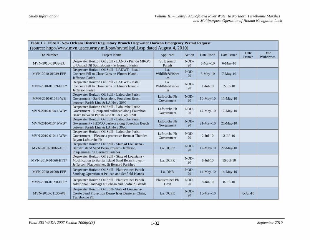
Study Information Volume III – Convey Atchafalaya River Water to Northern Terrebonne Marshes and Multipurpose Operation of Houma Navigation Lock
1-32
Final EIS WRDA 2007 Section 7006(e)(3) September 2010
Table 1.2. USACE New Orleans District Regulatory Branch Deepwater Horizon Emergency Permit Request (source: http://www.mvn.usace.army.mil/pao/mvnoilspill.asp dated August 4, 2010)
DA Number Project Name Applicant Action Date Rec'd Date Issued Date Denied
Date Withdrawn
MVN-2010-01038-EJJ Deepwater Horizon Oil Spill - LANG - Pier on MRGO to Unload Oil Spill Booms - St Bernard Parish
St. Bernard Parish
NOD-20 5-May-10 6-May-10
MVN-2010-01039-EFF Deepwater Horizon Oil Spill - LADWF - Install Concrete Fill to Close Gaps on Elmers Island - Jefferson Parish
La. Wildlife&Fisher
ies
NOD-20 6-May-10 7-May-10
MVN-2010-01039-EFF* Deepwater Horizon Oil Spill - LADWF - Install Concrete Fill to Close Gaps on Elmers Island - Jefferson Parish
La. Wildlife&Fisher
ies
NOD-20 1-Jul-10 2-Jul-10
MVN-2010-01041-WB Deepwater Horizon Oil Spill - Lafourche Parish Government - Sand bags along Fourchon Beach between Parish Line & LA Hwy 3090
Lafourche Ph Government
NOD-20 10-May-10 11-May-10
MVN-2010-01041-WB* Deepwater Horizon Oil Spill - Lafourche Parish Government - Riprap and bulkhead along Fourchon Beach between Parish Line & LA Hwy 3090
Lafourche Ph Government
NOD-20 17-May-10 17-May-10
MVN-2010-01041-WB* Deepwater Horizon Oil Spill - Lafourche Parish Government - HESCO baskets along Fourchon Beach between Parish Line & LA Hwy 3090
Lafourche Ph Government
NOD-20 21-May-10 21-May-10
MVN-2010-01041-WB* Deepwater Horizon Oil Spill - Lafourche Parish Government - Elevate a protective Berm at Thunder Bayou-Lafourche Ph
Lafourche Ph Government
NOD-20 2-Jul-10 2-Jul-10
MVN-2010-01066-ETT Deepwater Horizon Oil Spill - State of Louisiana - Barrier Island Sand Berm Project - Jefferson, Plaquemines, St Bernard Parishes
La. OCPR NOD-20 12-May-10 27-May-10
MVN-2010-01066-ETT* Deepwater Horizon Oil Spill - State of Louisiana - Modification to Barrier Island Sand Berm Project - Jefferson, Plaquemines, St Bernard Parishes
La. OCPR NOD-20 6-Jul-10 15-Jul-10
MVN-2010-01098-EFF Deepwater Horizon Oil Spill - Plaquemines Parish - Sandbag Operation at Pelican and Scofield Islands La. DNR NOD-
20 14-May-10 14-May-10
MVN-2010-01098-EFF* Deepwater Horizon Oil Spill - Plaquemines Parish - Additional Sandbags at Pelican and Scofield Islands
Plaquemines Ph Govt
NOD-20 8-Jul-10 8-Jul-10
MVN-2010-01136-WJ Deepwater Horizon Oil Spill- State of Louisiana- Create Sand Protection Berm- Isles Denieres Chain, Terrebonne Ph.
La. OCPR NOD-20 18-May-10 6-Jul-10

Study Information Volume III – Convey Atchafalaya River Water to Northern Terrebonne Marshes and Multipurpose Operation of Houma Navigation Lock
1-33
Final EIS WRDA 2007 Section 7006(e)(3) September 2010
Table 1.2. USACE New Orleans District Regulatory Branch Deepwater Horizon Emergency Permit Request (source: http://www.mvn.usace.army.mil/pao/mvnoilspill.asp dated August 4, 2010)
DA Number Project Name Applicant Action Date Rec'd Date Issued Date Denied
Date Withdrawn
MVN-2010-1143-EFF Deepwater Horizon Oil Spill- State of Louisiana- Install pilings and booms east of Biloxi Marsh Area, St. Bernard Ph
La. OCPR NOD-20 19-May-10 20-May-10
MVN-2010-01149-EJJ Deepwater Horizon Oil Spill - Tiger Dams on Grand Isle
Jefferson Ph Government
NOD-20 21-May-10 21-May-10
MVN-2010-01151-WB Deepwater Horizon Oil Spill - Terrebonne Parish Government, Trinity Island, sand bags
Terrebonne Ph Govt
NOD-20 24-May-10 4-Jun-10
MVN-2010-01152-EOO Deepwater Horizon Oil Spill - Little Lake Club - Marsh Plugs N of Turtle Bay - Jefferson Little Lake Club NOD-
20 24-May-10 26-May-10
MVN-2010-01265-EJJ Deepwater Horizon Oil Spill; sand bags at Shell Cut and Chaland Pass
Plaquemines Ph Govt
NOD-20 7-Jun-10 15-Jun-10
MVN-2010-01267-WB Deepwater Horizon Oil Spill - Terrebonne Parish Government, install sheetpile with tiebacks for Closure of Canal 19 on timbalier Island
Terrebonne Ph Govt
NOD-20 4-Jun-10 4-Jun-10
MVN-2010-01271-EOO Deepwater Horizon Oil Spill - Rock Jetties at 5 Passes, Grand Isle Area - Jefferson, Plaquemines
Jefferson Ph Government
NOD-20 8-Jun-10 3-Jul-10
MVN-2010-01291-EBB Deepwater Horizon Oil Spill - Queen Bess Island Inflatable Coffer Dams - Jefferson
Jefferson Ph Government
NOD-20 8-Jun-10 9-Jun-10
MVN-2010-01335-WB Deepwater Horizon Oil Spill - Cameron Parish Gov - Emergency authorization, HESCO Baskets/Sand Bags on Rockefeller WMA - Cameron
Cameron Ph Govt
NOD-20 11-Jun-10 11-Jun-10
MVN-2010-01337-EKK Deepwater Horizon Oil Spill - Amigo Enterprises - Emergency authorization, Breton Sound Dock Upgrade - Plaquemines
Amigo Enterprises
NOD-20 11-Jun-10 11-Jun-10
MVN-2010-01337-EKK* Deepwater Horizon Oil Spill - Amigo Enterprises - Emergency authorization, Breton Sound Dock Upgrade (new pumps and culvert) - Plaquemines
Amigo Enterprises
NOD-20 8-Jul-10 8-Jul-10
MVN-2010-01338-WJJ Deepwater Horizon Oil Spill, Terrebonne Parish, Dredge and Place Fill to Create Embankment
Terrebonne Ph Govt
NOD-20 11-Jun-10 15-Jun-10
MVN-2010-01339-EFF Deepwater Horizon Oil Spill - Plaquemines Parish - Emergency authorization. Dredging of Happy Jack Canal & Wilkinson Canal - Plaquemines
Plaquemines Ph Govt
NOD-20 11-Jun-10 24-Jun-10

Study Information Volume III – Convey Atchafalaya River Water to Northern Terrebonne Marshes and Multipurpose Operation of Houma Navigation Lock
1-34
Final EIS WRDA 2007 Section 7006(e)(3) September 2010
Table 1.2. USACE New Orleans District Regulatory Branch Deepwater Horizon Emergency Permit Request (source: http://www.mvn.usace.army.mil/pao/mvnoilspill.asp dated August 4, 2010)
DA Number Project Name Applicant Action Date Rec'd Date Issued Date Denied
Date Withdrawn
MVN-2010-01342-EOO
Deepwater Horizon Oil Spill - Jefferson Parish - Emergency Authorization, Piling and boom Installations in Caminada Pass, Barataria Pass, Pass Abel, Four Bayou Pass and Cheniere Ronquille Pass - Jefferson & Plaquemines
Jefferson Ph Government
NOD-20 11-Jun-10 14-Jun-10
MVN-2010-01342-EOO* Deepwater Horizon Oil Spill - Modification to booms in Pass Abel and Four Bayou Pass Jefferson Parish
Jefferson Ph Government
NOD-20 18-Jun-10 18-Jun-10
MVN-201001350-EJJ Deepwater Horizon Oil Spill - LA DOTD - Emergency Authorization for Temporary by-pass road & bridge on LA Hwy 624, north of Bayou La Loutre - St. Bernard
LaDOTD NOD-20 14-Jun-10 14-Jun-10
MVN-2010-01372-EKK Deepwater Horizon Oil Spill - Breton Sound Dock Expansion on Bayou La Loutre - St Bernard
Amigo Enterprises
NOD-20 16-Jun-10 16-Jun-10
MVN-2010-01442-WB Deepwater Horizon Oil Spill - Vermilion Parish - Emergency Authorization to construct 14 blkhds across breaches along coast of Vermilion Parish
Vermilion Parish Police Jury
NOD-20 21-Jun-10 25-Jun-10
MVN-2010-01473-WB Deepwater Horizon Oil Spill - BP - Emergency Authorization for Piling/Boom Installation at Raccourci Lake - Lafourche
BP America Production Co
NOD-20 22-Jun-10 24-Jun-10
MVN-2010-01478-EKK Deepwater Horizon Oil Spill - Pass Abel, Boom Installation - Jefferson & Plaquemines
BP America Production Co
NOD-20 23-Jun-10 24-Jun-10
MVN-2010-01518-EPP Deepwater Horizon Oil Spill - Amigo Enterprises - Breton Sound Dock Expansion on Bayou La Loutre & MRGO - St. Bernard Parish
Amigo Enterprises
NOD-20 25-Jun-10 25-Jun-10
MVN-2010-01521-EKK Deepwater Horizon Oil Spill - Pass Abel, West Boom Installation - Jefferson & Plaquemines
BP America Production Co
NOD-20 25-Jun-10 28-Jun-10
MVN-2010-01549-WJJ Deepwater Horizon Oil Spill - Emergency Authorization to Fill Breaks along Twin Pipeline Canal Levee - Terrebonne, Lafourche
Terrebonne Ph Levee and
Conservation District
NOD-20 29-Jun-10 7-Jul-10
MVN-2010-01550-EPP Deepwater Horizon Oil Spill - Plaquemines Parish - X-Tex Fabric Fence near Wilkinson Canal
Plaquemines Ph Govt
NOD-20 29-Jun-10 30-Jun-10

Study Information Volume III – Convey Atchafalaya River Water to Northern Terrebonne Marshes and Multipurpose Operation of Houma Navigation Lock
1-35
Final EIS WRDA 2007 Section 7006(e)(3) September 2010
Table 1.2. USACE New Orleans District Regulatory Branch Deepwater Horizon Emergency Permit Request (source: http://www.mvn.usace.army.mil/pao/mvnoilspill.asp dated August 4, 2010)
DA Number Project Name Applicant Action Date Rec'd Date Issued Date Denied
Date Withdrawn
MVN-2010-01554-WB Deepwater Horizon Oil Spill - Emergency Authorization for Pilings and Booms at Wine Island & Racoon Island in Terrebonne Ph
La. Wildlife&Fisher
ies
NOD-20 30-Jun-10 1-Jul-10
MVN-2010-01579-WB
Deepwater Horizon Oil Spill - Emergency Authorization for installation of Tiger Dams on Elmers Island; Breach 4 to Bayou Thunder Breach, GOM - Lafourche & Jefferson Parishes
Lafourche Ph Government
NOD-20 30-Jun-10 1-Jul-10
MVN-2010-01581-EKK Deepwater Horizon Oil Spill - Caminada Pass, Boom Installation - Jefferson Ph
BP America Production Co
NOD-20 30-Jun-10 1-Jul-10
MVN-2010-01588-WJJ
Deepwater Horizon Oil Spill - Terrebonne Levee & Conservation District - Emergency Authorization To Install Geotextile Fabric along Twin Pipeline Canal Levee - Terrebonne, Lafourche
Terrebonne Ph Levee and
Conservation District
NOD-20 2-Jul-10 7-Jul-10
MVN-2010-01593-EFF Deepwater Horizon Oil Spill, Clear, grade, and deposit fill to improve property for oil spill response staging
Amigo Enterprises
NOD-20 2-Jul-10 2-Jul-10
MVN-201--01635-EPP Deepwater Horizon Oil Spill - Mi SWACO - Grand Isle Beach Sand Cleaning Project Emergency Authorization - Jefferson
Mi SWACO NOD-20 8-Jul-10 9-Jul-10
MVN-2010-01700-WB Deepwater Horizon Oil Spill - Pilings along Casse-Tete and Calumet Islands for boom installation - Lafourche Ph
BP America Production Co
NOD-20 13-Jul-10 14-Jul-10
MVN-2010-01705-WB Deepwater Horizon Oil Spill - Install HESCO baskets along Fourchon Beach from Breach No. 4 to Bayou Thunder - Lafourche Ph
BP America Production Co
NOD-20 13-Jul-10 15-Jul-10
MVN-2010-01722-EBB Deepwater Horizon Oil Spill - Piles and booms in Barataria Pass to protect Mendicant Island, Queen Bess Island and B. Beauregard Island - Jefferson Ph
BP America Production Co
NOD-20 15-Jul-10 16-Jul-10
MVN-2010-01722-EBB*
Deepwater Horizon Oil Spill - Modification of Piles and booms in Barataria Pass to protect Mendicant Island, Queen Bess Island and B. Beauregard Island - Jefferson Ph. The modification includes relocating and adding more pilings.
BP America Production Co
NOD-20 22-Jul-10 22-Jul-10

Study Information Volume III – Convey Atchafalaya River Water to Northern Terrebonne Marshes and Multipurpose Operation of Houma Navigation Lock
1-36
Final EIS WRDA 2007 Section 7006(e)(3) September 2010
Table 1.2. USACE New Orleans District Regulatory Branch Deepwater Horizon Emergency Permit Request (source: http://www.mvn.usace.army.mil/pao/mvnoilspill.asp dated August 4, 2010)
DA Number Project Name Applicant Action Date Rec'd Date Issued Date Denied
Date Withdrawn
MVN-2010-01723-EPP Deepwater Horizon Oil Spill - Piles and booms in Cat Bay along Cat Bay Islands - Jefferson Ph
BP America Production Co
NOD-20 15-Jul-10 16-Jul-10
MVN-2010-01723-EPP* Deepwater Horizon Oil Spill - Modification to piles and booms in Cat Bay along Cat Bay Islands - Jefferson Ph
BP America Production Co
NOD-20 23-Jul-10 23-Jul-10
MVN-2010-1728-EPP Deepwater Horizon Oil Spill - BP America Production Co - Piles in Cat Bay along (3) Bird Islands - Plaquemines
BP America Production Co
NOD-20 16-Jul-10 16-Jul-10
MVN-2010-1728-EPP* Deepwater Horizon Oil Spill - BP America Production Co - Modification to Piles in Cat Bay along (3) Bird Islands - Plaquemines
BP America Production Co
NOD-20 23-Jul-10 23-Jul-10
MVN 2010-01753 EKK Deepwater Horizon Oil Spill - BP America Production Co - Surf washing of sand on Grand Terre - Jefferson Ph
BP America Production Co
NOD-20 19-Jul-10 27-Jul-10
MVN-2010-01780-EFF Deepwater Horizon Oil Spill - Piling and Boom Installation in Caminada Bay - Lafourche & Jefferson
BP America Production Co
NOD-20 20-Jul-10 21-Jul-10
MVN-2010-01783-ETT Deepwater Horizon Oil Spill - Marsh Barriers in Blind & Customhouse Bays - Plaquemines PH La. OCPR NOD-
20 21-Jul-10 pending
MVN-2010-01784-EOO Deepwater Horizon Oil Spill - Hesco Baskets, Point Cheniere Ronquille to Grand Bayou Pass - Plaquemines
Plaquemines Ph Govt
NOD-20 21-Jul-10 30-Jul-10
MVN-2010-01879-EFF Deepwater Horizon Oil Spill - Dredge Wilkinson Canal to access staging area at Myrtle Grove Marina - Plaquemines
Plaquemines Ph Govt
NOD-20 4-Aug-10 pending
* Indicates modification to previously issued permit
Study Information Volume III – Convey Atchafalaya River Water to Northern Terrebonne Marshes and Multipurpose Operation of Houma Navigation Lock
1-37
Final EIS WRDA 2007 Section 7006(e)(3) September 2010
1.6 Planning Process and Report Organization The Convey Atchafalaya River Water to Northern Terrebonne Marshes study follows the USACE’s six-step planning process specified in Engineering Regulation (ER) 1105-2-100. The planning process identifies and responds to problems and opportunities associated with the Federal objective and specified state and local concerns. This integrated report includes elements of both the planning process and sections specific to the NEPA review of the study. 1.6.1 The Six Step Planning Process
The USACE planning process involves six steps: 1. Identifying problems and opportunities 2. Inventorying and forecasting conditions 3. Formulating alternative plans 4. Evaluating alternative plans 5. Comparing alternative plans 6. Selecting a plan 1. Identify Problems and Opportunities: The specific problems and opportunities are
identified, and the causes of the problems discussed and documented. Planning goals are set, objectives established, and constraints identified. An initial statement of problems and opportunities was previously developed and presented in the LCA Study, and reflects the priorities and preferences of the Federal Government, the non-Federal sponsors, and other groups that participated in the LCA Study process. This problem identification step has been updated and refined to reflect the enhanced understanding of the process and problems affecting the study area since the completion of the LCA Study in 2004 (see section 2.4 below).
Resource constraints must be considered in plan formulation. Resource constraints are those associated with limits on knowledge, expertise, experience, ability, data, information, money, and time to reaffirm the recommended project or to formulate and analyze additional alternatives in the decision document. Legal and policy constraints are defined by law, including Congressional authorizations and appropriations, USACE regulations, policy and guidance. Specific legal and policy constraints that may affect plan development include the requirements to operate and maintain authorized projects in the study area and NEPA requirements for preparing the EIS.
2. Inventory and Forecast Resource Conditions: This step characterizes and assesses
conditions in the LCA-ARTM study area as they currently exist and forecasts the most probable without-project condition (no action alternative) over the period of analysis. This assessment gives the basis by which to compare various alternative plans and their impacts. The without-project condition is what the river basin and its uses are anticipated to be like over the 50-year planning period without any restoration implemented as part of the study. The with-project condition is what the

Study Information Volume III – Convey Atchafalaya River Water to Northern Terrebonne Marshes and Multipurpose Operation of Houma Navigation Lock
1-38
Final EIS WRDA 2007 Section 7006(e)(3) September 2010
study area and its uses are anticipated to be like if restoration measures, identified in each alternative, are implemented.
3. Formulate Alternative Plans: Alternative plans will be developed in a systematic
manner to ensure that reasonable alternatives were evaluated. The alternative plans considered in the 2004 LCA Study will be reevaluated to determine if they still provide a reasonable array of plans that would achieve study planning objectives within constraints, and solve the problems and realize the opportunities that were identified in Step 1 of the planning process. The alternatives previously identified at the beginning of the LCA planning process, and, as appropriate, additional alternatives, will be further screened and refined in subsequent iterations throughout the planning process utilized in this decision document. In this manner, the decision document will be used to affirm, reformulate, or modify the project goals identified in the LCA Study.
4. Evaluate Alternative Plans: The evaluation of each alternative consists of measuring
or estimating the ecosystem benefits (acres of habitat or stream miles restored, tons of sediment delivered to the system, etc.), costs, technical limitations, and risk and uncertainty of each plan, and determining the difference between the without- and with-project conditions. Project evaluation criteria will be directly linked to the overall goals and objectives of restoring coastal Louisiana and to the specific planning objectives and purposes of the critical project recommended by the Chief of Engineers on 31 January 2005.
The criteria will be used to measure project outputs (benefits) and will be based on metrics that can measure the range of potential effects that a plan may have on increasing ecosystem value and productivity. The criteria will include ecosystem restoration metrics that will provide quantifiable measures of how well an alternative plan meets defined hydrologic, water quality, water sediment transport, salinity, or other ecological goals. The criteria will be linked to the overall goals and objectives of the LCA study and to the specific planning objectives and purposes of the LCA-ARTM project as described in the study. The metrics that will form the basis of the criteria must be measurable, predictable by accepted models, supported by scientific and technical data, and be specific enough to differentiate between alternative plans and reasonable increments within those plans.
5. Compare Alternative Plans: During the alternative plan comparison, plans (including
the no action plan) are compared against each other, with emphasis on the outputs and effects that will have the most influence in the decision making process. A comparison of the outputs of the various plans may be made utilizing the Cost Effectiveness/Incremental Cost Analysis. Once the beneficial and adverse effects of each alternative plan, including project costs, have been estimated, the alternative plans will be ranked in order of increasing costs. A cost-effectiveness analysis will be performed, wherein the project evaluation criteria will be used to select the least costly plans that deliver about the same level of outputs as other plans.
Study Information Volume III – Convey Atchafalaya River Water to Northern Terrebonne Marshes and Multipurpose Operation of Houma Navigation Lock
1-39
Final EIS WRDA 2007 Section 7006(e)(3) September 2010
6. Select Recommended Plan: The culmination of the planning process is the selection
of the recommended plan, or, alternately, the decision to take no action. Decision-making for the selection of a recommended plan begins at the District level and continues at the Headquarters level through subsequent reviews and approval. For this study, the final decision-maker is the Secretary of the Army, who has delegated final approval of the study to the Assistant Secretary of the Army for Civil Works.
1.6.2 Report Organization
The chapter headings and order in this report generally follow the outline of the required NEPA documentation for an EIS. Chapters of the report relate to the six steps of the planning process in ER 1105-2-100 as follows: • Chapter 2: Need For and Objectives of Action This chapter addresses the first step in the planning process. In the first step of the planning process, the study area problems and opportunities are defined in addition to the constraints, goals, and objectives. An initial statement of problems and opportunities was developed for the 2004 LCA report which reflected the priorities and preferences of the Federal government, non-Federal sponsor, and other stakeholders. This report presents an updated problem identification that includes enhanced understanding of the process and problems of the study area. • Chapter 3: Alternatives The third chapter of this report addresses the third, fifth, and sixth steps in the planning process. Step three of the planning process is the formulation of alternative plans. During this step, the plans developed in the 2004 LCA report were reevaluated. The fifth step in the planning process addresses comparisons of the alternative plans with emphasis on the outputs and effects of each alternative. During the sixth step of the planning process, the selection of the recommended plan is made based upon the comparison of the alternative plans. • Chapter 4: Affected Environment The fourth chapter of this report addresses the second step of the planning process which requires an inventory and forecast of resources within the study area. The inventory and forecast of the study area provides the without project condition and is the basis of comparison for the alternatives. • Chapter 5: Environmental Consequences The fifth chapter of this report covers the fourth step of the planning process which evaluates the effects of the proposed alternative plans in terms of ecosystem benefits. The evaluation criteria are based on the overall goals and objectives of the LCA program
Study Information Volume III – Convey Atchafalaya River Water to Northern Terrebonne Marshes and Multipurpose Operation of Houma Navigation Lock
1-40
Final EIS WRDA 2007 Section 7006(e)(3) September 2010
and specific planning objectives and purposes of the near-term critical restoration projects recommended in the 2005 Chief of Engineers Report. 1.7 USACE Campaign Plan The USACE has developed a Campaign Plan with a mission to “provide vital public engineering services in peace and war to strengthen our Nation’s security, energize the economy, and reduce risk from disasters.” This Campaign plan is shaping USACE command priorities, focusing transformation initiatives, measuring and guiding progress, and helping the USACE adapt to the needs of the future. USACE Campaign Plan Goals and Objectives Summary
• Goal 1: Deliver USACE support to combat, stability and disaster operations through forward deployed and reach back capabilities.
o Objective 1a: USACE is ready, responsive and reliable in delivering high performance, all hazard, and contingency mission execution in a world-wide theater of operations.
o Objective 1b: Prepare Theater Engineer Commands (TEC) to support Combatant Commanders throughout the spectrum of operations.
o Objective 1c: Establish human resources and family support programs that promote readiness and quality of life.
o Objective 1d: Institutionalize USACE capabilities in interagency policy and doctrine.
• Goal 2: Deliver enduring and essential water resource solutions through
collaboration with partners and stakeholders. o Objective 2a: Deliver integrated, sustainable, water resources solutions. o Objective 2b: Implement collaborative approaches to effectively solve
water resource problems. o Objective 2c: Implement Streamlined and Transparent Regulatory
Processes to Sustain Aquatic Resources. o Objective 2d: Enable Gulf Coast recovery.
• Goal 3: Deliver innovative, resilient, sustainable solutions to the Armed Forces
and the Nation. o Objective 3a: Deliver sustainable infrastructure via consistent and
effective military construction and real estate support to customers. o Objective 3b: Improve resilience and lifecycle investment in critical
infrastructure. o Objective 3c: Deliver reliable infrastructure using a risk-informed asset
management strategy. o Objective 3d: Develop and apply innovative approaches to delivering
quality infrastructure.

Study Information Volume III – Convey Atchafalaya River Water to Northern Terrebonne Marshes and Multipurpose Operation of Houma Navigation Lock
1-41
Final EIS WRDA 2007 Section 7006(e)(3) September 2010
• Goal 4: Build and cultivate a competent, disciplined, and resilient team equipped to deliver high quality solutions.
o Objective 4a: Identify, develop, maintain, and strengthen technical competencies in selected Communities of Practice (CoP).
o Objective 4b: Communicate strategically and transparently. o Objective 4c: Standardize business processes. o Objective 4d: Establish tools and systems to get the right people in the
right jobs then develop and retain this highly skilled workforce. This study addresses two points of the USACE Campaign Plan. The second goal of the USACE Campaign Plan is addressed by this study since it is an element of the LCA ecosystem restoration plan on the Gulf Coast. This study also addresses the third goal through the application of the planning process to formulate, analyze, and evaluate alternative designs in pursuit of a sustainable, environmentally beneficial, and cost-effective ecosystem restoration design.
Study Information Volume III – Convey Atchafalaya River Water to Northern Terrebonne Marshes and Multipurpose Operation of Houma Navigation Lock
1-42
Final EIS WRDA 2007 Section 7006(e)(3) September 2010
This page intentionally blank

Purpose and Need Volume III – Convey Atchafalaya River Water to Northern Terrebonne Marshes and Multipurpose Operation of Houma Navigation Lock
2-1
Final EIS WRDA 2007 Section 7006(e)(3) September 2010
2.0 NEED FOR AND OBJECTIVES OF ACTION 2.1 National Objectives The national or Federal objective of water and related land resources planning is to contribute to national economic development consistent with protecting the nation’s environment, pursuant to national environmental statutes, applicable executive orders, and other Federal planning requirements. Contributions to national economic development (NED) are increases in the net value of the national output of goods and services, expressed in monetary units. Contributions to NED are the direct net benefits that accrue in the planning area and the rest of the nation. The Corps has added a second national objective for Ecosystem Restoration in response to legislation and administration policy. This objective is to contribute to the nation’s ecosystems through ecosystem restoration, with contributions measured by changes in the amounts and values of habitat. Ecosystem restoration is one of the primary goals of the USACE Civil Works Program. The USACE objective in ecosystem restoration planning is to contribute to national ecosystem restoration (NER). NER contributions include increases in the net quantity and/or quality of desired ecosystem resources. NER measurements are changes in ecological resource quality as a function of improvement in habitat quality and/or quantity. The units are expressed quantitatively in physical units or indexes that are not based on monetary units. Net changes are measured in the study area and in the rest of the Nation. Single-purpose ecosystem restoration plans shall be formulated and evaluated in terms of their net contributions to increases in NER output. NER contributions were considered in the alternatives analysis for this study. Under Title VII of WRDA 2007, any project or separable project element under LCA may be justified by the environmental benefits alone and economic justification is not required if the Secretary determines that the project or activity is cost-effective. This exemption does not apply for any project that is not predominately related to the protection, preservation, and restoration of the coastal Louisiana ecosystem. Louisiana contains one of the largest expanses of coastal wetlands in the contiguous United States and accounts for 90 percent of the total coastal marsh loss occurring in the Nation. The ARTM study area is an essential ecosystem since it includes wetland habitats, essential fish habitat, and has high fish and wildlife values. These ecosystems provide habitat for migratory birds, wildlife, finfish, shellfish, and other aquatic organisms including threatened or endangered species. 2.2 Public Concerns The National Environmental Policy Act (NEPA) of 1969 established a nationwide policy to include a detailed statement of the environmental impact of the proposed action in every recommendation or report on proposals for major Federal actions significantly affecting the environment. Such detailed statements are referred to as environmental impact statements (EIS).
Purpose and Need Volume III – Convey Atchafalaya River Water to Northern Terrebonne Marshes and Multipurpose Operation of Houma Navigation Lock
2-2
Final EIS WRDA 2007 Section 7006(e)(3) September 2010
A notice of intent (NOI) to prepare a draft EIS for the Louisiana Coastal Area (LCA) Convey Atchafalaya River Water to Northern Terrebonne Marshes Restoration Feasibility Study was published in the Federal Register (volume 73, number 246) on December 22, 2008. The intent of the NOI is to announce the United States Corps of Engineers’ (Corps) intention to prepare a draft EIS that addresses the Convey Atchafalaya River Water to Northern Terrebonne Marshes restoration project, which was identified in the LCA Ecosystem Restoration Plan as a near-term critical restoration project. The NEPA also provides for an early and open public process for determining the scope of issues, resources, impacts, and alternatives to be addressed in an EIS. This process is referred to as scoping. The scoping report documents scoping comments from interested parties and describes where in the EIS individual comments should be addressed. It also outlines the study background and scoping process to date, and summarizes the key issues identified by members of the public during the initial scoping period. The top five themes identified by members of the public include:
• Need for a greater influx of both freshwater and sediment to Terrebonne Parish • Use of pipelines to distribute water and sediment • Management of water flowing through the Gulf Intracoastal Waterway • Need for freshwater flow into the Terrebonne marshes • Impact to marshes from water increase and velocity
2.3 Problems, Needs, and Opportunities The first step in the planning process is the identification of problems and opportunities. Problems are undesirable, negative conditions that the study will address. Opportunities are desirable conditions that could be achieved in the future. Study area problems and opportunities were drawn from prior comprehensive planning studies and from public input and inter-agency information exchange. System-wide problems and opportunities were used to identify and define more geographically specific problems and opportunities throughout the study area. Through the NEPA public scoping process, the study team solicited input on problems and opportunities from members of the public, government resource agencies, and other stakeholders. Conceptual Ecological Model In order to better understand the problems, needs, and opportunities in the ARTM study area, the PDT developed a conceptual ecological model (CEM). The CEM helped the PDT understand drivers, stressors, and ecological effects in the study area, and, in turn, helped the PDT identify the associated problems, needs, and opportunities. A summary of the drivers, stressors, and ecological effects in the ARTM study area follows. A graphic representation of the CEM can be found in Figure 2.1.

Purpose and Need Volume III – Convey Atchafalaya River Water to Northern Terrebonne Marshes and Multipurpose Operation of Houma Navigation Lock
2-3 Final EIS WRDA 2007 Section 7006(e)(3) September 2010
Figure 2.1. ARTM Conceptual Ecological Model

Purpose and Need Volume III – Convey Atchafalaya River Water to Northern Terrebonne Marshes and Multipurpose Operation of Houma Navigation Lock
2-4
Final EIS WRDA 2007 Section 7006(e)(3) September 2010
DRIVERS Anthropogenic Alterations – Altered Hydrology The central and eastern marshes of the study area do not receive adequate amounts of fresh water or sediments from the Atchafalaya River (via the GIWW) or from the Mississippi River (via Bayou Lafourche). Anthropogenic controls regulating the volume of water entering the Atchafalaya River and Bayou Lafourche from the Mississippi River in addition to the distance of the marshes from these potential sources of fresh water and sediments limit the benefits to the central and eastern marshes. Consequently, subsidence and sea level rise are outpacing accretion in most central and eastern marshes resulting in increased submergence of marsh vegetation and eventual marsh loss. In addition, canals and associated spoil banks constructed for navigation and/or oil and gas development can be found throughout the study area. The canals serve as easy routes for fresh and saltwater movement, serving as conduits for beneficial freshwater to escape the system and for saltwater to enter the system. In addition, spoil banks compartmentalize wetlands, restricting water and animal movement between areas. Storms and Hurricanes Coastal storms, particularly tropical cyclone events, exert a stochastic but severe influence on the study area. Data obtained from the National Oceanic and Atmospheric Administration (NOAA) Coastal Services Center indicate that the storm centers of at least 19 tropical cyclones with a Saffir-Simpson Hurricane Scale of Category 2 or higher have passed within 50 miles of the study area during the interval 1851-2008, and at least 31 such tropical cyclones have passed within 100 miles of the study area during the same interval. The most recent tropical cyclones to affect the study area were Hurricanes Katrina and Rita, which occurred in August 2005 and September 2005, respectively, and Hurricanes Gustav and Ike, which occurred in September 2008. Principal impacts to the marshes in the study area as a result of tropical cyclone events are due to storm surge and associated erosion and saltwater intrusion. Storm surge exerts widespread stress upon vegetation through the introduction of storm surge waters that exhibit higher salinity concentrations than are normally present in surface waters within the study area and by direct erosion of marsh plants and soils. Hurricanes Rita and Ike resulted in measurable storm surges within the study area. Water gage data from the Houma Navigation Canal indicate storm surges from Hurricanes Rita and Ike of approximately 5.0 feet and 6.3 feet above average water levels, respectively. Relative Sea Level Rise Relative sea level rise consists of eustatic sea level rise combined with subsidence. Eustatic sea level rise is defined as the global increase in oceanic water levels primarily due to changes in the volume of major ice caps and glaciers, and expansion or contraction of seawater in response to temperature changes. Baseline (i.e. recent) eustatic sea level rise in the study area is approximately 0.75 feet/century. Subsidence is the decrease in

Purpose and Need Volume III – Convey Atchafalaya River Water to Northern Terrebonne Marshes and Multipurpose Operation of Houma Navigation Lock
2-5
Final EIS WRDA 2007 Section 7006(e)(3) September 2010
land elevations, primarily due to consolidation of sediments, faulting, groundwater depletion, and possibly oil and gas withdrawal. Subsidence in the study area is approximately 2.35 feet/century. Relative sea level rise affects study area marshes by gradually inundating marsh plants. Marsh soil surfaces must vertically accrete to keep pace with the rate of relative sea level rise or marshes eventually convert to open water due to the depth of submergence. In summary, altered hydrology, sea level rise and subsidence, and periodic storm events are the driving factors of land loss in the study area. The mechanisms of ecological stress that result from these drivers and the impacts on study area marshes are detailed below. ECOLOGICAL STRESSORS Decreased Freshwater, Sediment, Nutrients, and Residence Time The altered hydrology of the study area results in less freshwater and associated sediment and nutrients being delivered to marsh vegetation. Lack of freshwater facilitates increased saltwater intrusion and its associated effects on marsh vegetation. Vertical accumulation of wetland soils is achieved by accretion of mineral sediment inputs and/or organic accumulation resulting from above and below-ground plant productivity (DeLaune et al. 1983a; DeLaune et al. 1990a). The survival and productivity of marshes is reliant on these soil-building processes to offset submergence and sea level rise (DeLaune et al. 1978; DeLaune et al. 1979; DeLaune et al. 1990b). As the natural hydrology of the study area marshes has become short-circuited by canals, the residence time of the limited freshwater inputs has also decreased. Shorter residence times result in less settling of suspended sediments and less uptake of nutrients. Increased Saltwater Intrusion The altered hydrology of the study area facilitates increased saltwater intrusion and increased tidal exchange by providing efficient conduits for loss of freshwater and intrusion of saltwater. Wetland plant species have evolved different levels of tolerance to salinity and respond to salinity with different mechanisms. Numerous studies have demonstrated that elevated salinity can negatively affect all wetland species and can contribute to large-scale vegetation dieback (Chabreck and Linscombe 1982; McKee and Mendelssohn 1989). Storm surge can also be a mechanism for saltwater intrusion. This form of saltwater intrusion can be particularly detrimental to areas that have been hydraulically isolated, leading to extended durations of saltwater inundation. Increased Erosion Significant and immediate erosion of marsh vegetation and associated soils can occur as a result of storm surge events. Losses may be more significant in areas that are already under stress from other ecological stressors but healthy marsh systems can be significantly impacted as well.
Purpose and Need Volume III – Convey Atchafalaya River Water to Northern Terrebonne Marshes and Multipurpose Operation of Houma Navigation Lock
2-6
Final EIS WRDA 2007 Section 7006(e)(3) September 2010
In summary, decreased freshwater, sediment, nutrients and residence time, increased saltwater intrusion, and erosion are the ecological stressors that exert the greatest influence on study area marshes. The resultant ecological effects of these stressors are detailed below. ECOLOGICAL EFFECTS Increased Submergence Wetland plants employ different physical and/or metabolic mechanisms that enable them to tolerate and grow in flooded soils. However, in almost all cases plants are dependent on the maintenance of soil surface elevations to sustain the flooding regime to which they are adapted. Increases in flooding depth and duration stress plants by altering metabolic function and negatively impacting productivity, survival, and regeneration. Relative sea level rise in the study area combined with insufficient accretion results in marsh systems with reduced productivity, survival, and regeneration due to submergence. Organic matter accumulation is also reduced, further exacerbating the impacts of submergence. Decreased Wetland Health Decreased freshwater, decreased nutrients, decreased residence time, increased saltwater intrusion, and increased submergence all act to decrease the overall health of the study area marshes. As marsh plants become stressed by inundation and saltwater intrusion, their productivity, survival, and regeneration are all negatively impacted. Over time, healthy marshes gradually decline to more interspersed marshes and eventually convert to open water. Increased Wetland Loss Wetland loss in the study area can be the result of gradual decline of marsh vegetation due to inundation and saltwater intrusion eventually leading to complete loss of marsh vegetation or the result of storm surge events. As marsh vegetation is lost, underlying soils are more susceptible to erosion and are typically lost as well, leading to deeper water and precluding marsh regeneration. Significant accretion of sediments is then required in order for marsh habitat to re-establish. In summary, increased submergence of marsh plants and associated decreases in the health of emergent marsh habitat result in the conversion of emergent marsh habitat to open water. As area marshes convert to open water, vital fish and wildlife habitat, economic benefits, and flood protection are lost. 2.3.1 General Problem Statement
Study Problem Statement. The natural processes of subsidence, habitat switching, and erosion, combined with human activities, have caused significant adverse impacts to the Northern Terrebonne Marshes, including accelerated wetland loss and ecosystem degradation.

Purpose and Need Volume III – Convey Atchafalaya River Water to Northern Terrebonne Marshes and Multipurpose Operation of Houma Navigation Lock
2-7
Final EIS WRDA 2007 Section 7006(e)(3) September 2010
In habitat switching, one habitat will convert to another habitat through succession. In Louisiana, this process is frequently due to changes in salinity levels or inundation. Examples of habitat switching may be a forested system converting to a freshwater marsh or a freshwater marsh converting to a saline marsh. In the LCA-ARTM study area habitat switching generally consists of switching from marsh habitat to open water. The changes in habitat structure and/or composition result in a loss of one group of ecosystem services and may result in local rarity of a habitat type. Wetlands in the study area are deteriorating for several reasons: 1) subsidence and sea level rise, 2) lack of sediment and nutrient deposition, 3) erosion via tidal exchange, 4) channelization, and 5) saltwater intrusion. These activities have resulted in the loss of several thousand acres of solid, vegetated marsh. Deterioration will continue unless preventative measures are taken. With continued deterioration of the marshes, the area landward will be more prone to flood during storm surges and hurricanes, as marshes serve as partial flood barriers. Additionally, the marshes of the study area represent an ecosystem of national importance from an environmental standpoint. Adequate sediment exists in the Atchafalaya River to benefit marshes in the central and eastern study areas; however, the existing and potential future sediment transport capacity of the GIWW or channels and canals in the study area precludes adequate delivery of sediments to achieve project goals and objectives. In the absence of supplemental freshwater from the Atchafalaya River, subsidence, sea-level rise, wave erosion, and saltwater intrusion will continue to be problems. Protection and enhancement of this area are dependent on providing a hydrologic regime that minimizes the physiological stress to wetland vegetation from saltwater intrusion and tidal energy and is conducive to the retention of locally provided freshwater and sediments. Several channels have been dredged which cut through the natural ridges, increasing both drainage and tidal exchange in the study area, exposing the soil to erosive forces. Major navigation channels in the subprovince are the Atchafalaya River, Wax Lake Outlet, Houma Navigation Canal, GIWW, and Lower Atchafalaya River (south of Morgan City). Each of these navigation channels introduces and/or compounds marine influences in many of the interior coastal wetlands and water bodies within the subprovince. Without action, the freshwater, intermediate, and brackish marshes in the northern and eastern areas of Terrebonne Basin would continue to deteriorate and disappear due to the combined effects of subsidence, saltwater intrusion, and a lack of riverine influence. The flotant marshes within the Penchant Basin, located in northwest Terrebonne Basin, would continue to deteriorate due to excessive backwater flooding events from the Atchafalaya River. The marshes in the southern and eastern portions of the study area would continue to deteriorate due to saltwater intrusion and a lack of riverine influence.

Purpose and Need Volume III – Convey Atchafalaya River Water to Northern Terrebonne Marshes and Multipurpose Operation of Houma Navigation Lock
2-8
Final EIS WRDA 2007 Section 7006(e)(3) September 2010
A detailed analysis of Existing Conditions and Future without Project Conditions in the study area can be found in Chapters 4 and 5 of this report, respectively. Discussion of the uncertainty in future relative sea level rise is discussed in section 3.10.2. 2.3.2 Study Area Opportunities
Opportunities exist to naturalize the distribution of freshwater and deltaic forming sediments, improve hydrologic distribution of freshwater, improve topographic diversity and reduce the negative impacts of Gulf storm events. • Freshwater Supply – Re-introduction of freshwater supplies is an opportunity to
restore a degraded and impaired deltaic forming process. Further, freshwater introduction has the potential to balance the altered salinity regime, improve the viability of freshwater marsh plant life and therefore restore fish and wildlife habitats.
• Hydraulic Distribution – Human induced habitat fragmentation (canals) has resulted in a degraded condition whereby the limited existing freshwater supplies are directed through the Terrebonne Marshes and into the gulf. Opportunities exist to improve the internal distribution of freshwater to restore and improve the sustainability of freshwater marsh habitats.
• Sediment Supply and Distribution – The lack of marsh forming sediments from riverine environments has accelerated the degradation of all marsh types. Opportunities exist to re-introduce sediments from the Atchafalaya River and several bayous and to use on site sediments displaced by gulf storm events to create new marsh area.
• Sustainability – As marsh degradation has accelerated, seasonal gulf events have a magnified impact on the remaining marsh areas. Opportunities exist through freshwater supply and distribution and sediment supply and distribution to create a healthier marsh which will be more resistant to the normal range of gulf events.
2.3.3 Problems, Future Without Project Conditions, and Opportunities by Study
Area Subunit
Due to the magnitude of the 1,100 square mile study area, the entire LCA-ARTM study area was divided into three subunits, labeled as West - Bayou Penchant Area, Central - Lake Boudreaux Area, and East - Grand Bayou Area. Subunits have been separated by a combination of natural, physical, and geographic features, and the limits of the subunits were developed by the PDT. The separation of the whole study area allowed the PDT to evaluate specific needs and screen individual measures relative to each subunit. Generally, all three study subunits are experiencing similar problems; wetlands are deteriorating as a result of subsidence, lack of sediment and nutrient deposition, and saltwater intrusion and erosion.
Although the GIWW has served as a major hydrologic alteration throughout the entire study area, it also serves as a thread that connects all study units. Therefore, the GIWW is considered as one of the primary opportunities to increase the delivery of freshwater,

Purpose and Need Volume III – Convey Atchafalaya River Water to Northern Terrebonne Marshes and Multipurpose Operation of Houma Navigation Lock
2-9
Final EIS WRDA 2007 Section 7006(e)(3) September 2010
nutrients, and sediment to assist with marsh development and land building and counteract the effects of saltwater intrusion and land subsidence. When considering future without project conditions, the assumption was made that the Morganza to the Gulf Project would be completed by 2025. The operating plan for the Morganza to the Gulf HNC flood gates calls for closure of the flood gates whenever necessary to prevent saltwater intrusion up the HNC. Accordingly, for purposes of future without project hydraulic modeling, the assumption was made that the HNC flood gates would be closed for two months each year starting in 2025. Other water control structures associated with the Morganza to the Gulf Project would only be utilized under tropical storm/hurricane conditions, and, therefore, would not appreciably impact the hydrology of the study area under normal operating conditions. Therefore, these structures were not included in the hydraulic modeling for the LCA-ARTM study.
West – Bayou Penchant Area
Problems – Within the West – Bayou Penchant Area (Figure 2.2), problems include the lack of freshwater, sediment, and nutrient delivery in the southern portions of the study area, land loss, hydrologic alterations, subsidence, saltwater intrusion, constrictions in the GIWW, and marsh break up along the GIWW. The study subunit problems have been specifically identified as the following: • Lack of freshwater, sediment, and nutrient delivery – Marsh die-back from lack of
freshwater, sediment, and nutrient delivery have been mostly observed in the southern portions of the study area. The floating marshes located in the upper Penchant Basin have been identified as not needing any additional freshwater, sediment, and nutrient delivery.
• Subsidence and Land loss - In the lower Penchant Basin, significant wetland loss is appearing in the triangle formed by Lost Lake, Lake Mechant, and Lake DeCade. In this area, intermediate marshes are exposed to above normal salinity levels due to subsidence and subsequent saltwater intrusion.
• Hydrologic alterations - The development of the GIWW, canals supporting oil and gas industry, and the presence of pipelines have not only altered the delivery of riverine flows, but have also promoted the increased delivery of saltwater to the study subunit.
• Saltwater intrusion – This study subunit is currently not experiencing heavy saltwater intrusion in the northern parts of the study subunit. However, marsh dieback from increased saltwater influence has been observed and recorded in southern sections of the Penchant Basin.
• Marsh Break up on the GIWW – Along the GIWW, wakes from passing ships/boats cause the loss and breakup of floating marsh systems. Because of the breakup, the GIWW has widened beyond its originally authorized configuration in many locations. Due to the high organic content of floating marsh systems, the soils along the GIWW

Purpose and Need Volume III – Convey Atchafalaya River Water to Northern Terrebonne Marshes and Multipurpose Operation of Houma Navigation Lock
2-10
Final EIS WRDA 2007 Section 7006(e)(3) September 2010
are very soft and fluid, providing a unique and complex set of circumstances which make the implementation of hard shoreline stabilization measures difficult.
• GIWW Constrictions – Between Bayou Black and Bay Wallace, the GIWW narrows and flow is constricted. At this location, the GIWW flows through a high quality forested wetland system that is dominated by a cypress-tupelo overstory. This constriction lessens flow to the central and eastern parts of the study area.
Future Without Project Conditions Land loss/gain trends (Figure 2.3) within the West – Bayou Penchant Area are expected to continue through the period of analysis. Land loss analysis indicates that most of the flotant marshes in the northwestern portions of the sub-area are expected to remain stable or show some gains in land area. Land change projections over the period of analysis show increases in land area of approximately 12,400 acres, or roughly 5%. However, land loss analysis in this area is particularly difficult due to the presence of floating vegetation. It is believed by personnel familiar with the area that these marshes are actually deteriorating due to excessive backwater flooding events from the Atchafalaya River and will continue as such into the future. Modeled salinity values show no change over the period of analysis. The intermediate and brackish marshes in the southeastern portion of the sub-area are expected to continue to deteriorate due to saltwater intrusion, relative sea level rise, and lack of freshwater, sediment and nutrient delivery. Modeled average annual salinity values show slight increases of 0.1 to 0.4 ppt over the period of analysis. Land change projections over the period of analysis show decreases in land area of approximately 19,800 acres, or roughly 35%. Overall, the entire West – Bayou Penchant Area is projected to lose approximately 7,400 acres of land from 2015 to 2065, or approximately 2%. However, this number does not accurately reflect the true magnitude of land loss in the area due to the analysis problems mentioned above. Opportunities – Within this study area, opportunities to implement restoration measures include creating a diversion from the Atchafalaya River. The goal of the diversion would be to increase freshwater, sediment, and nutrient supply to the study area, but the results of the diversion may be more heavily relied on in study units east of the West – Bayou Penchant Area. In combination with increasing supply of riverine water into the GIWW, other methods to improve delivery and distribution of freshwater include enlarging constrictions within the GIWW and improving eastward conveyance along the GIWW. As noted in the problems, an observable constriction within this study unit is in a location where the GIWW flows through a high-quality, forested wetland system, located between Bayou Black and Bay Wallace. Opening this constriction may assist with increasing flow to the study area, as well as the other two eastern study areas. There are also many points along the GIWW where canals serve as diversion points for freshwater, thus affecting the quantity of freshwater conveyed east of Houma.

Purpose and Need Volume III – Convey Atchafalaya River Water to Northern Terrebonne Marshes and Multipurpose Operation of Houma Navigation Lock
2-11
Final EIS WRDA 2007 Section 7006(e)(3) September 2010
Another opportunity to improve eastward conveyance of riverine water and reduce marsh break up involves methods to stabilize critical lengths of deteriorated channel banks along the GIWW and Bayou Chene. Bank protection within this study unit is anticipated to diminish the effects of wave wash from vessels and reduce breakup. Bank stabilization is also an opportunity to restrict the number of openings and routes where freshwater supply is escaping to wetlands that are nutrient and sediment rich. Locations along Bayou Chene near Avoca Island and areas along the GIWW east of Bay Wallace will likely require measures of protection. Combined with bank stabilization, non-structural methods to manage navigation traffic may be appropriate. Within the southern portions of the study area, opportunities to increase freshwater delivery and sediment input are available and needed. The options of implementing additional freshwater diversions in the Lower Penchant Basin may be necessary to reduce the problem of deteriorating wetlands and land loss in locations between Lost Lake, Lake Mechant, and Lake DeCade. This area seems to be most hard hit from land subsidence, saltwater intrusion, and marsh loss. Other methods to diminish the influence of saltwater in the Lower Penchant Basin involve implementing strategic land building to create new ridges to assist with the redistribution of flow and minimize the influence of saltwater.

Purpose and Need Volume III – Convey Atchafalaya River Water to Northern Terrebonne Marshes and Multipurpose Operation of Houma Navigation Lock
2-12
Final EIS WRDA 2007 Section 7006(e)(3) September 2010
Figure 2.2. West - Bayou Penchant Sub Area.
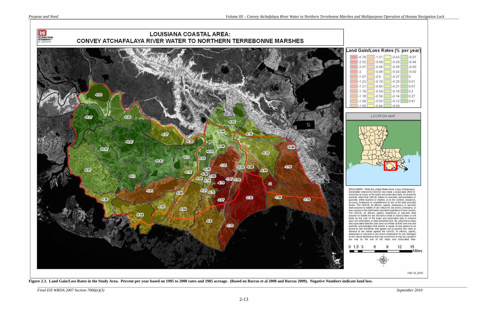
Purpose and Need Volume III – Convey Atchafalaya River Water to Northern Terrebonne Marshes and Multipurpose Operation of Houma Navigation Lock
2-13
Final EIS WRDA 2007 Section 7006(e)(3) September 2010
Figure 2.3. Land Gain/Loss Rates in the Study Area. Percent per year based on 1985 to 2008 rates and 1985 acreage. (Based on Barras et al 2008 and Barras 2009). Negative Numbers indicate land loss.

Purpose and Need Volume III – Convey Atchafalaya River Water to Northern Terrebonne Marshes and Multipurpose Operation of Houma Navigation Lock
2-14 Final EIS WRDA 2007 Section 7006(e)(3) September 2010
Central - Lake Boudreaux Area
Problems – Within the Central – Lake Boudreaux Area (Figure 2.4), problems include lack of freshwater, sediment, and nutrient delivery, land loss, hydrologic alterations, subsidence, saltwater intrusion, constrictions in the GIWW, and area infrastructure. The study subunit problems have been specifically identified as the following: • Lack of freshwater, sediment, and nutrient delivery – Marsh die-back from lack of
freshwater, sediment, and nutrient delivery has been observed in many locations within the study subunit. Freshwater delivered to the HNC bypasses adjacent wetlands and is more efficiently delivered to the Gulf of Mexico.
• Subsidence and Land loss - In this study subunit, significant land loss is appearing along both sides of the HNC, especially in areas south of Lake Boudreaux. In this area, marshes are exposed to above normal salinity levels due to subsidence and subsequent saltwater intrusion.
• Hydrologic alterations – The development of the HNC and man-made canals have not only altered the delivery of riverine flows, but have also promoted the increased delivery of saltwater to the study subunit.
• Saltwater intrusion – Due to the “short circuiting” effects produced by the construction and maintenance of the HNC, saltwater intrusion along the lengths of the canal have become increasingly problematic. The HNC provides an unrestricted route for easy transport of saltwater to move into areas that have historically been fresh and intermediate marshes.
• GIWW Constrictions - There are major hard constrictions in the GIWW within the City of Houma. These hard constrictions prevent desired conveyance through the GIWW to the eastern part of the Central – Lake Boudreaux Area subunit and to the East – Grand Bayou Subunit.
• Area infrastructure – This study subunit contains portions of the City of Houma, as well as area infrastructure associated with shipping, oil and gas industry, residential and commercial development within Houma and along Bayou Grand Caillou, Bayou Petit Caillou, and Bayou Terrebonne.
Future Without Project Conditions Land loss/gain trends (Figure 2.3) within the Central – Lake Boudreaux Area are expected to continue through the period of analysis. Areas in the northern portion of the sub-area that exhibit little land loss are largely developed or agricultural areas and are anticipated to remain as such and maintain current land areas. The fresh, intermediate, brackish, and saline marshes in the central and southern portions of the sub-area and in areas just south of the sub-area are expected to continue to deteriorate due to saltwater intrusion, relative sea level rise, and lack of freshwater, sediment and nutrient delivery. Modeled average annual salinity values show increases of 0.3 to 1.2 ppt over the period of analysis. Land change projections over the period of analysis show decreases in land

Purpose and Need Volume III – Convey Atchafalaya River Water to Northern Terrebonne Marshes and Multipurpose Operation of Houma Navigation Lock
2-15 Final EIS WRDA 2007 Section 7006(e)(3) September 2010
area of approximately 44,000 acres, or approximately 35%, from 2015 to 2065, with several areas converting completely to open water. Opportunities – Within this study area, restoration and protection measures aimed at maintaining the physical integrity of the area primarily include a transition toward a greater riverine influence to deliver freshwater, sediments, and nutrients to help promote healthier marsh system and lower salinity levels. Opportunities to implement restoration measures include increasing delivery of freshwater to the study subunit through the GIWW and into the HNC. Through the increased supply of freshwater, sediments, and nutrients, diversions may be implemented off the HNC through either gated structures or canals to nearby wetlands. Diversion locations were evaluated in areas on both the eastern and western side of the HNC. In combination with increasing freshwater supply into the GIWW, other opportunities to improve delivery and distribution to the study area may include enlarging constrictions within the GIWW. An observable constriction within this study unit is within the City of Houma, Louisiana. Opportunities to open constrictions will be difficult due to the area infrastructure. Opening this constriction may assist with increasing flow to the immediate study area through Bayou Petit Caillou and Bayou Terrebonne. However, widening the constriction will also serve the purpose of continued conveyance to the eastern study subunit. Another opportunity to improve retention of fresh water and diminish the influence of saltwater intrusion is to consider management of the proposed HNC lock complex and the proposed Morganza to the Gulf Levee. The design and management of the planned HNC Lock/Morganza to the Gulf levee may provide both environmental and flood control benefits. The lock complex and floodgate can be managed to assist with salt water intrusion and freshwater distribution. Other methods involve implementing strategic land building south of Lake Boudreaux to assist with the retention of freshwater and diminish the influence of saltwater.
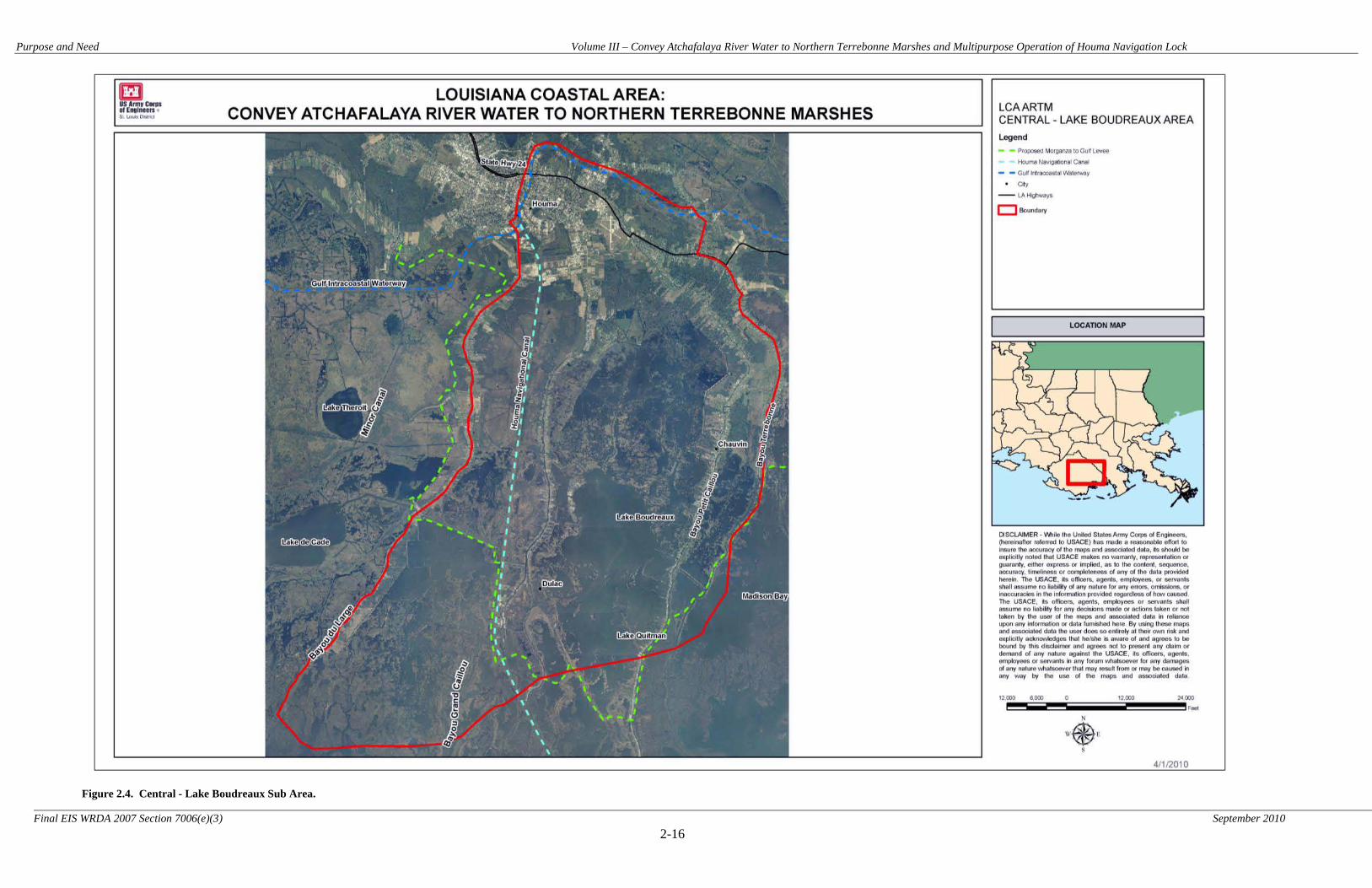
Purpose and Need Volume III – Convey Atchafalaya River Water to Northern Terrebonne Marshes and Multipurpose Operation of Houma Navigation Lock
2-16 Final EIS WRDA 2007 Section 7006(e)(3) September 2010
Figure 2.4. Central - Lake Boudreaux Sub Area.
Purpose and Need Volume III – Convey Atchafalaya River Water to Northern Terrebonne Marshes and Multipurpose Operation of Houma Navigation Lock
2-17
Final EIS WRDA 2007 Section 7006(e)(3) September 2010
East - Grand Bayou Area
Problems – Within the East – Grand Bayou Area (Figure 2.5), problems include lack of freshwater, sediment, and nutrient delivery, land loss, hydrologic alterations, subsidence, and saltwater intrusion. The study subunit problems have been specifically identified as the following: • Lack of freshwater, sediment, and nutrient delivery – Marsh die-back from lack of
freshwater, sediment, and nutrient delivery have been observed in many locations within the study subunit. Freshwater delivered to Grand Bayou Canal bypasses adjacent wetlands and is efficiently routed to the Gulf of Mexico.
• Subsidence and Land loss – Of the three study subunits, this subunit is experiencing the greatest amount of land loss. Salt sensitive wetlands have suffered substantial deterioration and loss within this watershed. Losses can be attributed to the lack of freshwater, sediment, and nutrient delivery, historic sulphur mining activities, and the construction of numerous oil and gas canals. South of Bayou Blue, freshwater wetlands quickly turn to open-water ecosystems due to extensive marsh dieback.
• Hydrologic alterations – The study subunit contains numerous hydrologic alterations. The channelizing of Grand Bayou to create Grand Bayou Canal and the dredging of Cutoff Canal provides an unrestricted channel of saltwater to the area. From Grand Bayou Canal, saltwater continues to intrude through the network of canals, pipeline routes, and abandoned mines.
• Saltwater intrusion – Due to the “short circuiting” effects produced by the construction and maintenance of Grand Bayou Canal and Cutoff Canal, saltwater intrusion seems to be the most problematic within this study subunit. Grand Bayou Canal provides an unrestricted route for easy transport of saltwater to move into areas that have historically been fresh and intermediate marshes. • Area infrastructure – This study subunit contains area infrastructure associated
with residential and commercial development, and infrastructure tied to oil and gas industries.
Future Without Project Conditions Land loss/gain trends (Figure 2.3) within the East – Grand Bayou Area are expected to continue through the period of analysis. The fresh, intermediate, brackish, and saline marshes in the central and southern portions of the sub-area and in areas just south of the sub-area are expected to continue to deteriorate due to saltwater intrusion, relative sea level rise, and lack of freshwater, sediment and nutrient delivery. Modeled average annual salinity values show increases of 0.1 to 1.7 ppt over the period of analysis. Land change projections over the period of analysis show decreases in land area of approximately 44,000 acres, or approximately 49%, from 2015 to 2065, with several areas converting completely to open water.

Purpose and Need Volume III – Convey Atchafalaya River Water to Northern Terrebonne Marshes and Multipurpose Operation of Houma Navigation Lock
2-18
Final EIS WRDA 2007 Section 7006(e)(3) September 2010
Opportunities – Within this study area, restoration and protection measures aimed at maintaining the physical integrity of the area primarily include a transition toward a greater riverine influence and creating barriers to saltwater intrusion. Opportunities to implement restoration measures include increasing freshwater, sediment, and nutrient supply and delivery to the study subunit through increasing freshwater supply from the Atchafalaya River and/or implementing other diversions that utilize the Mississippi River as a freshwater source. Additional diversions from the Mississippi River could either supplement or provide freshwater in lieu of a diversion from the Atchafalaya River. Diversions were considered from locations outside the study area, which include a diversion from the Mississippi River into Bayou Lafourche near the City of Donaldsonville, Louisiana or utilizing the increased freshwater supply planned through the LCA Davis Pond Diversion project. Once freshwater supply is increased to the study area and delivered to Grand Bayou Canal, diversions off of Grand Bayou Canal may offer solutions to increase freshwater, sediment, and nutrient delivery to wetlands located within this study subunit. Another opportunity to improve retention of fresh water and diminish the influence of saltwater intrusion is to consider planned construction of the proposed Morganza to the Gulf Levee. The design of the Morganza to the Gulf levee may provide both environmental and flood control benefits. However, this levee would not encapsulate the entire study subunit, and additional methods to minimize saltwater intrusion and help retain freshwater within the remaining portions of the study subunit would likely be necessary. Within the southern limits of the study area, other methods to assist with freshwater retention and provide a saltwater barrier involve implementing strategic ridge development and outfall management along the boundary line of the study area and near the north side of Terrebonne Bay.

Purpose and Need Volume III – Convey Atchafalaya River Water to Northern Terrebonne Marshes and Multipurpose Operation of Houma Navigation Lock
2-19 Final EIS WRDA 2007 Section 7006(e)(3) September 2010
Figure 2.5. East - Grand Bayou Sub Area.
Purpose and Need Volume III – Convey Atchafalaya River Water to Northern Terrebonne Marshes and Multipurpose Operation of Houma Navigation Lock
2-20
Final EIS WRDA 2007 Section 7006(e)(3) September 2010
2.4 Planning Objectives Study goals, objectives, and constraints were developed to comply with the study authority and to respond to study area problems and opportunities. 2.4.1 Goals
Reduce the current trend of degradation of the Terrebonne marshes, so as to contribute towards achieving and sustaining a coastal ecosystem that can support and protect the environment, economy, and culture of southern Louisiana and thus the Nation. 2.4.2 Objectives
The objective of the study is to formulate a project to provide additional freshwater, nutrients, and fine sediment to the area. The introduction of additional freshwater could facilitate organic sediment deposition, improve biological productivity, and prevent further deterioration of the marshes. Specific project objectives include, but are not limited to the following and are applicable to all three sub-unit areas:
• Prevent, reduce, and/or reverse future wetland loss • Achieve and maintain characteristics of sustainable marsh hydrology • Reduce salinity levels in project area • Increase sediment and nutrient load to surrounding wetlands • Increase residence time of fresh water • Sustain productive fish and wildlife habitat
2.5 Planning Constraints
2.5.1 Constraints
Development and evaluation of restoration alternatives for the proposed project are constrained by a number of factors. These factors are generally divided into two categories:
• Project design constraints- Limitations to the scope and functionality of specific project features because of issues regarding project effects on other projects or infrastructure in the study area; and
• Ecosystem constraints- Constraints imposed upon the project design by existing conditions within the study area’s ecosystem
These categories and their constituent constraints are discussed separately below. Project Design Constraints. Identified project design constraints for the LCA-ARTM project include the following:
• Flood Damage Protection. The LCA-ARTM project must accomplish its goals while avoiding elevating flood levels at nearby communities.

Purpose and Need Volume III – Convey Atchafalaya River Water to Northern Terrebonne Marshes and Multipurpose Operation of Houma Navigation Lock
2-21
Final EIS WRDA 2007 Section 7006(e)(3) September 2010
• The LCA-ARTM project must protect vital socioeconomic resources including cultures, community, infrastructure, business and industry, and flood protection.
• Some existing infrastructure such as navigation locks and the constrictions of the GIWW could need modification to accommodate flow regimes that support the objectives of the LCA-ARTM project. Some of these constrictions and navigation features cannot be modified due to urban development in Houma, the need to maintain the GIWW for navigation, or exorbitant costs of constriction removal.
• A substantial amount of oil and gas infrastructure exists within the study area. Adverse effects to oil and gas infrastructure would be minimized to the extent practicable, consistent with the goals of the project.
• Drainage Infrastructure. The internal arrangement of small access canals would likely need to be altered to support the goals of the project. This would have to be done in a manner that would allow reasonable access to all prospective users. Figures 2.6 and 2.7 identify the flow patterns and drainage constrictions in both the Western and Eastern Study Areas.
Figure 2.6. Flows and Constrictions in the Western Study Area

Purpose and Need Volume III – Convey Atchafalaya River Water to Northern Terrebonne Marshes and Multipurpose Operation of Houma Navigation Lock
2-22
Final EIS WRDA 2007 Section 7006(e)(3) September 2010
Figure 2.7. Flows and Constrictions in the Eastern Study Area Ecosystem Constraints. Identified ecosystem constraints for the LCA-ARTM project include the following:
• Water Quality – The introduction of water and sediments should not result in the violation of established water quality standards in the study area.
Purpose and Need Volume III – Convey Atchafalaya River Water to Northern Terrebonne Marshes and Multipurpose Operation of Houma Navigation Lock
2-23
Final EIS WRDA 2007 Section 7006(e)(3) September 2010
This page intentionally blank

Alternatives Volume III – Convey Atchafalaya River Water to Northern Terrebonne Marshes and Multipurpose Operation of Houma Navigation Lock
3-1
Final EIS WRDA 2007 Section 7006(e)(3) September 2010
3.0 ALTERNATIVES 3.1 Plan Formulation Rationale
3.1.1 Plan Formulation Rationale
Alternatives for the proposed action were formulated in consideration of study area problems and opportunities, as well as study goals, objectives and constraints. For discussion of the six-step planning process see Section 1.6 above. As specified in ER 1105-2-100, four criteria were considered during alternative plan screening: completeness, effectiveness, efficiency, and acceptability. 3.1.2 Plan Formulation Criteria
3.1.2.1 Completeness Completeness is the extent that an alternative provides and accounts for all investments and actions required to ensure the planned output is achieved. This may require that an alternative consider the relationship of the plan to other public and private plans if those plans affect the outcome of the project. Completeness also includes consideration of real estate issues, O&M, monitoring, and sponsorship factors. Adaptive management plans formulated to address project uncertainties also have to be considered. 3.1.2.2 Effectiveness Effectiveness is defined as the degree to which the plan will achieve the planning objective. The plan must make a significant contribution to the problem or opportunity being addressed. 3.1.2.3 Efficiency The project must be a cost-effective means of addressing the problem or opportunity. The plan outputs cannot be produced more cost-effectively by another institution or agency. 3.1.2.4 Acceptability A plan must be acceptable to Federal, state, and local government in terms of applicable laws, regulations, and public policy. The project should have evidence of broad-based public support and be acceptable to the non-Federal cost sharing partner. Environmental Operating Principles In 2002, the USACE formalized a set of Environmental Operating Principles applicable to decision-making in all programs. The principles are consistent with NEPA; the Army Strategy for the Environment; other environmental statutes, and the WRDAs that govern USACE activities. The Environmental Operating Principles inform the plan formulation process and are integrated into all project management processes. Alternatives were formulated for this study consistent with the Environmental Operating Principles.
Alternatives Volume III – Convey Atchafalaya River Water to Northern Terrebonne Marshes and Multipurpose Operation of Houma Navigation Lock
3-2
Final EIS WRDA 2007 Section 7006(e)(3) September 2010
The USACE Environmental Operating Principles are: • Strive to achieve environmental sustainability, and recognize that an environment
maintained in a healthy, diverse, and sustainable condition is necessary to support life;
• Recognize the interdependence of life and the physical environment, and proactively consider environmental consequences of USACE programs and act accordingly in all appropriate circumstances;
• Seek balance and synergy among human development activities and natural systems by designing economic and environmental solutions that support and reinforce one another;
• Continue to accept corporate responsibility and accountability under the law for activities and decisions under our control that impact human health and welfare and the continued viability of natural systems;
• Seek ways and means to assess and mitigate cumulative impacts to the environment and bring systems approaches to the full life cycle of our processes and work;
• Build and share an integrated scientific, economic, and social knowledge base that supports a greater understanding of the environment and impacts of our work; and
• Respect the views of individuals and groups interested in USACE activities, listen to them actively, and learn from their perspective in the search to find innovative win-win solutions to the Nation’s problems that also protect and enhance the environment.
3.1.3 LCA ARTM Study Area Land Loss
The loss of coastal marsh within the LCA-ARTM study area has been profound. In order to quantify land loss in the study area, determine existing and likely future conditions, and facilitate determination of project impacts on area marshes, habitat and land loss analyses were conducted on the study area. The area was broken up into 65 polygons, with habitat classification and land loss analysis conducted on each. In order to determine the rate of land loss or land gain within each of the polygons, imagery from 1985 to 2008 was utilized (Table 3.1). Imagery was analyzed to determine percent coverage of land and water for each year that imagery was available. These data points were then used to determine land area trend lines for each polygon and for the study area as a whole (Figure 3.1). The overall current rate of land loss in the study area was determined to be approximately 2,500 acres/year (approximately 0.3 percent per year). However, as can be seen in Figure 3.2, there is considerable variation from polygon to polygon in the rate of land loss or land gain. In general, the areas with the highest rates of land loss are the intermediate, brackish, and saline marshes in the southern and eastern sections of the study area. The swamp and fresh marsh habitats generally are exhibiting lower rates of land loss and in some cases land gain. For future without project condition determination, the current rate of land loss within each polygon was assumed to continue on a linear trend over the 50-year period of

Alternatives Volume III – Convey Atchafalaya River Water to Northern Terrebonne Marshes and Multipurpose Operation of Houma Navigation Lock
3-3
Final EIS WRDA 2007 Section 7006(e)(3) September 2010
analysis. For some polygons, this resulted in complete conversion to open water before the end of the period of analysis. Over the entire study area, approximately 100,000 acres of marsh were projected to be lost between 2015 and 2065. The future loss rate for the study area is what the PDT in partnership with the sponsor and the public set goals and objectives against and ultimately measured action alternatives against to determine relative benefits. Loss of marsh habitat in the study area is caused by a variety of one time or short term events and by the alteration of systemic marsh building processes. Contributors to marsh conversion include:
• Gas and Oil Pipeline Construction • Extreme 2005 Gulf Storm Events • Altered Deltaic Processes
o Subsidence o Diminished Sediment Inputs o Diminished Fresh Water Inputs o Diminished Nutrient Inputs
• Sea Level Rise

Alternatives Volume III – Convey Atchafalaya River Water to Northern Terrebonne Marshes and Multipurpose Operation of Houma Navigation Lock
3-4
Final EIS WRDA 2007 Section 7006(e)(3) September 2010
Table 3.1. Study Area Land Loss based on USGS imagery analysis.
1 Incomplete data in study area for 1956 and 1978 imagery. 1985 to 2008 imagery was used in calculation of land loss trend lines based on USGS recommendation for improving accuracy of projections.
2 Variations in calculated land area from year to year occur due to actual land loss and land gain, major storm events, differing tides/water elevations on the dates imagery was captured, random variation, etc. Trend lines over longer periods of time provide a more accurate picture of actual land loss trends than comparing individual years (see Figure 3.1).
Date Land Area2 (acres)
Water (acres) Total (acres) Land Area
(mi2) Water (mi2) Total (mi2) % Land % Water
19561 619,822 119,254 739,076 968.5 186.3 1154.8 83.9% 16.1% 19781 517,010 223,044 740,054 807.8 348.5 1156.3 69.9% 30.1%
1/9/1985 613,936 285,211 899,147 959.3 445.6 1404.9 68.3% 31.7% 1/28/1988 651,841 247,306 899,147 1018.5 386.4 1404.9 72.5% 27.5%
1988 649,064 250,083 899,147 1014.2 390.8 1404.9 72.2% 27.8% 11/1/1990 627,223 271,924 899,147 980.0 424.9 1404.9 69.8% 30.2% 2/24/1998 582,939 316,208 899,147 910.8 494.1 1404.9 64.8% 35.2%
11/18/1999 602,428 296,719 899,147 941.3 463.6 1404.9 67.0% 33.0% 10/1/2000 579,684 319,463 899,147 905.8 499.2 1404.9 64.5% 35.5%
10/30/2001 597,316 301,831 899,147 933.3 471.6 1404.9 66.4% 33.6% 2/27/2002 599,453 299,694 899,147 936.6 468.3 1404.9 66.7% 33.3% 11/7/2004 595,262 303,885 899,147 930.1 474.8 1404.9 66.2% 33.8%
10/25/2005 585,852 313,295 899,147 915.4 489.5 1404.9 65.2% 34.8% 10/28/2006 583,483 315,664 899,147 911.7 493.2 1404.9 64.9% 35.1%
10/1/2008 576,400 322,747 899,147 900.6 504.3 1404.9 64.1% 35.9%

Alternatives Volume III – Convey Atchafalaya River Water to Northern Terrebonne Marshes and Multipurpose Operation of Houma Navigation Lock
3-5
Final EIS WRDA 2007 Section 7006(e)(3) September 2010
Figure 3.1. Calculated study area land loss rate (1985-2008).
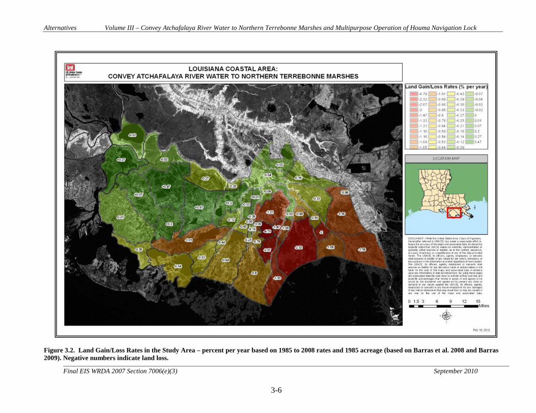
Alternatives Volume III – Convey Atchafalaya River Water to Northern Terrebonne Marshes and Multipurpose Operation of Houma Navigation Lock
3-6
Final EIS WRDA 2007 Section 7006(e)(3) September 2010
Figure 3.2. Land Gain/Loss Rates in the Study Area – percent per year based on 1985 to 2008 rates and 1985 acreage (based on Barras et al. 2008 and Barras 2009). Negative numbers indicate land loss.
Alternatives Volume III – Convey Atchafalaya River Water to Northern Terrebonne Marshes and Multipurpose Operation of Houma Navigation Lock
3-7
Final EIS WRDA 2007 Section 7006(e)(3) September 2010
3.2 Management Measures The Corps guidance defines a management measure as a feature (a structural element that requires construction or assembly on-site) or an activity (a nonstructural action) that can be implemented at a specific geographic site to address one or more planning objectives and utilize opportunities (USACE 2000). Management measures can be combined to form alternative plans. Measures can be derived from a variety of sources including prior studies, the NEPA public scoping process, and the multidisciplinary, interagency project delivery team (PDT). For this study, the PDT consisted of individuals from U.S. Fish and Wildlife Service, Natural Resources Conservation Service, National Marine Fisheries Service, U.S. Geological Survey, U.S. Environmental Protection Agency, Louisiana Coastal Protection and Restoration Authority, Louisiana Department of Wildlife and Fisheries, and the U.S. Army Corps of Engineers 3.2.1 Development of Management Measures
Before alternative plans were formulated, the first step taken was to identify potential improvements that would satisfy the goals and objectives established for the study area. From these discussions, the interagency PDT developed an array of general measures for the study area, from which specific measures would be developed. The PDT’s depth of professional experience and first-hand management knowledge was invaluable in identifying and defining general measures. The general measures were then evaluated for their ability to produce positive benefits for nine screening criteria developed by the PDT. The measures that passed the evaluation process were carried forward as possibilities for inclusion into study alternatives. Some measures included in study alternatives came directly from CWPPRA projects (see Table 3.5). Only measures from CWPPRA projects that had not been approved for construction funding, and therefore were not considered to be part of the future without project condition, were considered for inclusion in the LCA-ARTM study. Since there was no certainty that these measures would be implemented under CWPPRA, and since many of the CWPPRA measures are aimed at achieving the same objectives as the LCA-ARTM study, it was logical to utilize CWPPRA measures where appropriate in LCA-ARTM plan formulation. 3.2.2 Description of Management Measures
General measures have been loosely separated in six categories that seek to address the study goals and objectives under the current authorization. The following list of general measures was developed: Freshwater Supply and Distribution
- Due to canal construction and levee impacts, many areas of existing marsh do not receive adequate freshwater.
• Freshwater Distribution Channel - Freshwater distribution channels would improve freshwater, sediment, and nutrient delivery to selected locations. Freshwater delivery systems may be constructed as channels extending from a variety of existing freshwater sources.

Alternatives Volume III – Convey Atchafalaya River Water to Northern Terrebonne Marshes and Multipurpose Operation of Houma Navigation Lock
3-8
Final EIS WRDA 2007 Section 7006(e)(3) September 2010
• Gated Diversion Structure - Gated structures can control freshwater supply and prevent saltwater intrusion to select locations or the entire study area. The structures can be operated manually or electronically using a controlled gated system. Gated systems can pass flows ranging from 5,000 to 100,000 cubic feet per second.
• Groundwater for Freshwater - Groundwater could be used as a source of freshwater by
drilling wells and pumping water into marshes • Culverts - Culverts would be placed in strategic locations (e.g. through roadways, ridges,
or dredged material embankments locally known as spoil banks) to distribute freshwater. • Outfall and Distribution Management - Existing canals for gas, oil and utilities alter the
distribution of freshwater and increase the exposure of some marshes to saltwater intrusion and Gulf storm damage. Existing canals could be altered to redistribute flows. Alterations could include cutting spoil banks to facilitate sheet flow, filling man-made canals to reduce freshwater bypass of marshes, and placing weirs in channels to create a baffle effect to slow the intrusion of saltwater and increase freshwater residence time.
• Open Constrictions to Water Transport – Channel constrictions reduce the channel’s
flow capacity and thus slow the delivery of freshwater, sediments, and nutrients. Modifying existing constrictions can aid water delivery.
• Operation of Houma Navigation Canal Lock - The operation of the proposed Houma
Navigation Canal lock complex is primarily a function of vehicle transportation and hurricane and storm damage reduction. However, the lock complex could serve a multipurpose function to help retain and redistribute freshwater throughout the Terrebonne marshes. It could also assist with reducing saltwater intrusion.
Sediment Supply and Distribution for Mechanical Marsh Creation
• Canal Dredging and Placement - Canals that are needed to support commerce but that have filled with sediment could be dredged to improve freshwater circulation. The dredged material would be placed in pockets of open water in adjacent marshes, thereby decreasing marsh fragmentation and increasing overall marsh acreage.
• Dredging and Placement of Regional Sediments - This measure entails large scale importation of suitable riverine sediments from dredging nearby portions of the Mississippi River or Atchafalaya River. Dredging and placement could be done mechanically and/or hydraulically.
• Sediment Delivery from Distant Sources - The large quantities of sediment required for holistic marsh habitat restoration in the area could justify large scale sediment importation from areas beyond the immediate study area. Existing abandoned pipelines could be used to import sediment using pipelines and booster pumps. Alternatively, sediment could be moved from more distant sediment laden rivers (e.g. Illinois or Missouri River) using suitable transportation.

Alternatives Volume III – Convey Atchafalaya River Water to Northern Terrebonne Marshes and Multipurpose Operation of Houma Navigation Lock
3-9
Final EIS WRDA 2007 Section 7006(e)(3) September 2010
Restore/Maintain Historic Geomorphic Features
• Construct Ridges to Create Marsh - Along freshwater marsh edges, construct ridges to help prevent saltwater intrusion and slow freshwater movement. This could include flow control structures in the ridges. The slightly higher elevations of constructed ridges could provide niche habitats as well as improve the short term sustainability of existing ridges.
• Bank and Shoreline Protection - Where high quality marsh exists, bank protection could be provided to diminish wave wash effects from vessels and/or to reduce marsh degradation due to storm surge.
Invasive Species Management
- These measures would likely be combined with other measures to improve overall habitat quality.
• Eradication Program for Nutria - Nutria are large semi-aquatic rodents introduced to Louisiana from South America to enhance the fur trade industry. Since the decline of fur trading, nutria has become abundant putting pressure on marsh vegetation. Control measures proposed include incentivizing nutria removal through hunting and trapping to promote vegetation re-growth.
• Control of Water Hyacinth - This non-native floating plant competes with native vegetation for nutrients and clogs structures and channels slowing freshwater delivery. Chemical or mechanical methods could be used to remove and control water hyacinth.
Navigation Management
• Create “No Wake” Zones or Develop Speed Restrictions - Wave wash from vessels erodes bank lines and damages marsh along large channels. Vessel management programs can create “No Wake” zones or develop speed restrictions near areas of fragile marsh. These restrictions could be permanent or only during periods of higher water.
• Traffic Management through Scheduling – An operation plan to schedule vessel
movement, specifically on the Houma Navigation Canal, could assist the environmental operation of structures such as the lock.
Vegetation Management
• Reestablish Marsh in Target Areas by Planting – Marsh could be reestablished by transplanting vegetative plugs from healthy marshes in the area.
3.2.3 Screening / Evaluation of Alternative Plans
Screening of measures is a process where a measure’s ability to meet various criteria is evaluated to better characterize a specific measure and the likelihood that it can achieve cost effective restoration. The outcome of this process can result in measures being dropped from further

Alternatives Volume III – Convey Atchafalaya River Water to Northern Terrebonne Marshes and Multipurpose Operation of Houma Navigation Lock
3-10
Final EIS WRDA 2007 Section 7006(e)(3) September 2010
consideration. Nine screening criteria were agreed upon by the interagency PDT. The selected criteria were chosen based upon experience with previous and concurrent restoration efforts in the study area, knowledge of the study area, conventional scientific theory, best professional judgment, and consideration of study objectives. The PDT further separated the nine criteria into two tiers (see below) with the first tier taking priority over the second tier. The PDT then determined that the measure’s ability to meet the criteria would be evaluated for each individual subunit, West – Bayou Penchant, Central – Lake Boudreaux Area, and East – Grand Bayou Area (Fig. 2.2-2.5). For each of the nine screening criteria, the PDT 1) determined if the measure would likely produce a positive net benefit represented by a plus (+) sign, 2) determined if the measure would not likely produce a positive net benefit within the screening category, represented as a minus (-) or 3) made an unknown determination of the measure’s net benefit, represented as a zero (0). If the measure was considered as not being applicable to the study unit, a designation of N/A was applied and this measure was considered for elimination. First Tier – Screening Criteria
- If a measure received “-” marks for two of the four criteria below, then the measure was considered for elimination (Table 3.2).
• Achievement of Planning Objectives - The measure can support one or all of the ecosystem objectives for this study. The more objectives supported, the more holistic the solution.
• Synergy with other state/Federal projects – The measure works in conjunction with other state and Federal programs and projects aimed at marsh restoration. The PDT used their extensive knowledge of the project area to evaluate if the level of marsh restoration provided by a measure would be greater because of the effects of other programs and projects in the area.
• O&M Requirements – The measure is relatively simple and inexpensive to operate and maintain. Due to the remote nature of the study area, a measure that is simple and inexpensive to operate is more likely to be operated correctly. The team felt that this criterion was important because correct operation is critical to marsh restoration success.
• Efficiency of Delivery – Measures have variable timeframes for creating acreage of new habitat and positively impacting existing marsh from immediate to long term. Without the restoration, sea level rise, storm events, and marsh degradation could eventually eliminate coastal marshes in the study area. Measures that could quickly produce additional marsh or slow/prevent degradation would likely produce positive benefits (+). Measures that required a long timeframe to produce benefits would not likely produce positive benefits (-) because study area coastal marshes may no longer exist.
Second Tier – Screening Criteria
– These criteria were developed to evaluate the potential for each measure to cause consequential damages in excess of the authorized project cost and violate environmental laws. If the measure passed the first tier of screening, under the second tier, if it received two “-” marks, then the measure was considered for elimination (Table 3.2).

Alternatives Volume III – Convey Atchafalaya River Water to Northern Terrebonne Marshes and Multipurpose Operation of Houma Navigation Lock
3-11
Final EIS WRDA 2007 Section 7006(e)(3) September 2010
• Infrastructure Impacts – The study area contains a network of oil and gas infrastructure consisting of pipelines and wells, as well as local municipal infrastructure. The measures’ impacts on infrastructure were considered.
• T/E Species – Each measure was evaluated to determine whether it would have a potential negative effect on any state or Federal Listed Threatened/Endangered species.
• Wetland Impacts - Each measure was evaluated on net wetland loss during construction.
• Flooding - Measures that have the potential to induce flooding on existing developed areas were identified
• Navigation - Measures that have the potential to introduce navigational hazards or increase operations and maintenance costs were identified.

Alternatives Volume III – Convey Atchafalaya River Water to Northern Terrebonne Marshes and Multipurpose Operation of Houma Navigation Lock
3-12
Final EIS WRDA 2007 Section 7006(e)(3) September 2010
Table 3.2 Screening Criteria. The general measures developed by the PDT were evaluated for their ability to provide positive benefits (+), not provide positive benefits (-) or benefit production was unknown (0) or the measure was not applicable (n/a). Not applicable measures and measures whose “-“ criteria value are outlined were considered for elimination for: West – Bayou Penchant Area, Central – Lake Boudreaux Area, East – Grand Bayou Area
First Tier Screening Criteria Second Tier Screening Criteria
Goals & Obj. Achievement
Synergy with Other Programs
O&M Requirements Efficiency Infrastructure
Impacts T/E
Species Wetland Impacts Flooding Navigation
Measures Wes
t
Cen
tral
East
Wes
t
Cen
tral
East
Wes
t
Cen
tral
East
Wes
t
Cen
tral
East
Wes
t
Cen
tral
East
Wes
t
Cen
tral
East
Wes
t
Cen
tral
East
Wes
t
Cen
tral
East
Wes
t
Cen
tral
East
Freshwater Supply and Distribution 0 0 0 Freshwater Distribution Channels + + + + + + + + + 0 0 0 0 0 0 + + + + + + + + + 0 0 0 Gated Diversion Structures + 0 0 + 0 0 - - - + 0 0 - - - 0 0 0 + + + 0 0 0 0 0 0
Groundwater for Freshwater - - - - - - - - - - - - 0 0 0 + + + + + + + + + 0 0 0
Culverts 0 0 0 0 0 0 0 0 0 0 0 0 + + + 0 0 0 + + + + + + 0 0 0 Outfall and Distribution Management + + + + + + + + + + + + 0 0 0 + + + + + + + + + 0 0 0 Open Constrictions to Water Transport + + + + + + + + + + + + 0 0 0 + + + 0 0 0 + + + 0 0 0 Management of H.N.C. Lock 0 + + + + + - - - 0 + + + 0 + 0 0 0 + + + 0 0 0 n/a - n/a Sediment Supply and Distribution Canal Dredging and Placement + + + + + + + + + 0 0 0 + + + + + + + + + + + + + + + Dredging and Placement of Regional Sediments + + + + + + 0 0 0 - - - + + + + + + + + + + + + + + + Sediment Delivery from Distant Sources + + + 0 0 0 0 0 0 - - - 0 0 0 + + + + + + 0 0 0 0 0 0 Restore/Maintain Historic Geomorphic Features
Construct Ridges to Create Marsh + + + + + + - - - 0 0 0 0 0 0 + + + + + + 0 0 0 0 0 - Bank and Shoreline Protection + + + + + + - - - + + + 0 0 0 + + + + + + + + + 0 0 0 Invasive Species Control Eradication Program for Nutria 0 0 0 + + + - - - + + + + + + + + + + + + + + + 0 0 0
Control of Water Hyacinth n/a + + n/a + + n/a - - n/a 0 0 + + + + + + + + + + + + + + +
Navigation Management
Create “No Wake” Zones + n/a n/a + n/a n/a + n/a n/a + n/a n/a - - - + + + + + + + + + - - -
Traffic Management - Scheduling n/a + n/a n/a - n/a n/a + n/a n/a + n/a + + + + + + + + + + + + + + +
Vegetation Management Target Area Planting + + + + + + 0 0 0 0 0 0 + + + + + + + + + + + + 0 0 0

Alternatives Volume III – Convey Atchafalaya River Water to Northern Terrebonne Marshes and Multipurpose Operation of Houma Navigation Lock
3-13
Final EIS WRDA 2007 Section 7006(e)(3) September 2010
The First Tier screening process resulted in one measure being considered for removal from all subunits (Table 3.2). The Second Tier screening process also resulted in one measure being considered for removal. There were two additional measures that were determined to be not applicable to certain study units and were considered for elimination (Table 3.2). The PDT found the evaluation of measures difficult because the hydrologic modeling and WVA assessments had not been completed. However, screening was needed to assist with the reduction of the number of measures. Measures considered for elimination were further evaluated by the PDT to determine if they could provide a valuable contribution to the project separately or in combination with other measures. 3.2.4 Measures Not Carried Forward for Further Analysis
After completing the screening process, the measures considered for elimination were evaluated by the PDT. The PDT determined that these measures could not provide a valuable contribution to the project alone or in combination with other measures. Therefore, the following measures were eliminated as discussed below. The following measures were eliminated from further consideration in all subunits: Dredging and Placement of Regional Sediments – This measure entails dredging sediment from nearby sections of the Atchafalaya and Mississippi Rivers and mechanically or hydraulically moving it to the study area. The team coordinated with MVN Operations to determine the amount of material available from federal navigation projects within and adjacent to the study area. The quantities were insufficient to produce significant benefits at this time. This measure is being studied further by the Beneficial Use of Dredged Material (BUDMAT) Program authorized by WRDA 2007. The BUDMAT program encompasses the Louisiana coastal area from Mississippi to Texas. Therefore, this measure could be implemented in the study area under the BUDMAT program. Sediment Delivery through Pipeline Infrastructure – This measure involves moving sediment through existing abandoned pipelines or by other transportation methods from distant sediment laden rivers to the study area. Salt water intrusion and lack of sediment degrade Terrebonne marshes. In most cases, freshwater must be increased before marsh creation can be successful. Therefore, the focus of the project was on freshwater delivery. There is currently a no cost-effective method to move sediment long distances. Although unused pipeline infrastructure may currently exist, pumping sediment through these pipes scours the pipe and quickly creates holes. Additionally, there are significant technical, legal, and environmental issues to be overcome. Because of the need for freshwater, the cost of sediment delivery and the timeframe required to address these issues, this measure was not incorporated in this project. It may be incorporated as a medium or long term LCA goal.

Alternatives Volume III – Convey Atchafalaya River Water to Northern Terrebonne Marshes and Multipurpose Operation of Houma Navigation Lock
3-14
Final EIS WRDA 2007 Section 7006(e)(3) September 2010
Eradication Program for Nutria – This measure involves removing nutria from the study area to reduce their negative effects on the Terrebonne marshes. The Louisiana Department of Wildlife and Fisheries runs the Coastwide Nutria Control Program that is funded through the Coastal Wetlands Planning, Protection, and Restoration Act (CWPPRA). The control program typically removes 100,000 to 160,000 nutria from coastal marshes in St. Mary, Terrebonne, and Lafourche Parishes annually and is effectively reducing nutria damage in the study area. Therefore, this measure was eliminated from further consideration. Control of Water Hyacinth – This measure involves removing water hyacinth to improve water flow and reduce competition. The PDT conferred with local and regional water hyacinth experts. These experts did not believe that water hyacinth was a significant issue in the area. Therefore, this measure was not incorporated into any alternatives. Groundwater Introduction – This measure was removed as an option from all study subunits. It was removed primarily because the PDT determined that coastal groundwater may have a moderate to high salinity level. Salinity is one of the major contributors to the degradation of study area marshes. Additionally, groundwater would not contain the sediment and nutrient load of a freshwater riverine source. Future operations and maintenance costs for the pumping systems were a deterrent because of the potential for future funding constraints to influence operation. Creation of “No Wake” Zones – This measure involves restricting boat speeds to reduce the effects of wave wash on marshes. Other restoration projects in the area have addressed the problem of wave wash utilizing shoreline protection. The PDT determined that the areas affected by shoreline erosion in the study area are currently being addressed with shoreline protection by implementation under a separate authority (CIAP and CWPPRA), and therefore this measure was screened out for consideration for the ARTM study. 3.3 Preliminary Alternative Plans Alternative plans are singular or combinations of specific measures that collectively meet study goals and objectives within the defined study constraints. Alternative plans and their component measures will be assessed relative to the objective of National Ecosystem Restoration (NER). 3.3.1 Development of Alternative Plans
To focus the team’s efforts and guide alternative development, the PDT developed a list of strategies. These strategies were developed to produce a full range of alternative plans as required by the National Environmental Policy Act of 1969 (NEPA) and USACE regulations. The strategies were designed to be significantly different from one another and to represent the entire range of solutions from no action to full restoration in consideration of study goals, objectives, and constraints. From these strategies, alternatives that contained suites of general measures were developed. Specific measures were generated from the general measures. The strategies are as follows:

Alternatives Volume III – Convey Atchafalaya River Water to Northern Terrebonne Marshes and Multipurpose Operation of Houma Navigation Lock
3-15
Final EIS WRDA 2007 Section 7006(e)(3) September 2010
1. ARTM S1: No Action. Alternatives developed under this strategy will include no measures from this study.
2. ARTM S2: Utilize Existing Flow along with Management Measures to Maximize
Restoration Efforts. Alternatives developed under this strategy will focus on modifying the interior portions of the study area. They will not actively introduce additional sediment and nutrient laden freshwater from other sources, but rather will attempt to redistribute the existing inputs to more efficiently utilize fresh water.
3. ARTM S3: Utilize Increased Flow from the Atchafalaya River and Management
Measures to Maximize Restoration Efforts. Alternatives developed under this strategy will focus on increasing supply from the Atchafalaya River to introduce additional sediment and nutrient laden freshwater along with modifying existing interior flows.
4. ARTM S4: Utilize Increased Flow from Locations East of the Study Area and
Management Measures to Maximize Restoration Efforts. Alternatives developed under this strategy will focus on attempting to draw water from outside the study area to the east and modifying existing interior flows.
5. ARTM S5: Utilize Increased Flow from the Atchafalaya River and Locations East of the
Study Area and Management Measures to Maximize Restoration Efforts. Alternatives developed under this strategy will combine strategies 2 – 4, thus focusing on maximizing flow inputs from both the Atchafalaya River and locations east of the Study Area along with modifying existing interior flows.
The PDT developed alternatives by determining suites of general measures that would
achieve the five strategies (Table 3.3). The PDT developed seven groups of general measures that became the seven alternatives. Several of the general measures that were carried forward from Section 3.2.2 were determined to be not applicable or unfeasible and were not incorporated into the seven alternatives (Table 3.3). These measures and the reasons they were not incorporated are discussed below Table 3.3. A full description of the eight alternatives can be found in Section 3.3.2.
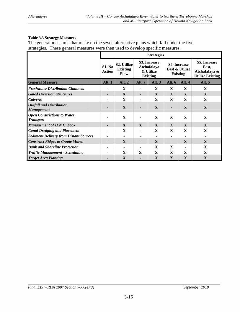
Alternatives Volume III – Convey Atchafalaya River Water to Northern Terrebonne Marshes and Multipurpose Operation of Houma Navigation Lock
3-16
Final EIS WRDA 2007 Section 7006(e)(3) September 2010
Table 3.3 Strategy Measures The general measures that make up the seven alternative plans which fall under the five strategies. These general measures were then used to develop specific measures. Strategies
S1. No Action
S2. Utilize Existing
Flow
S3. Increase Atchafalaya
& Utilize Existing
S4. Increase East & Utilize
Existing
S5. Increase East,
Atchafalaya & Utilize Existing
General Measure Alt. 1 Alt. 2 Alt. 7 Alt. 3 Alt. 6 Alt. 4 Alt. 5 Freshwater Distribution Channels - X - X X X X Gated Diversion Structures - X - X X X X Culverts - X - X X X X Outfall and Distribution Management - X - X - X X
Open Constrictions to Water Transport - X - X X X X
Management of H.N.C. Lock - X X X X X X Canal Dredging and Placement - X - X X X X Sediment Delivery from Distant Sources - - - - - - - Construct Ridges to Create Marsh - X - X - X X Bank and Shoreline Protection - - - X X - X Traffic Management - Scheduling - X X X X X X Target Area Planting - X - X X X X
Alternatives Volume III – Convey Atchafalaya River Water to Northern Terrebonne Marshes and Multipurpose Operation of Houma Navigation Lock
3-17
Final EIS WRDA 2007 Section 7006(e)(3) September 2010
From the suite of general measures, 94 specific measures were developed to form seven study alternatives. These alternatives and their specific measures were then evaluated by the interagency PDT. Many of the specific measures were developed as part of Coastal Wetlands Planning, Protection, and Restoration Act (CWPPRA) projects (Table 3.4; Table 3.5). As part of the CWPPRA planning process, the problems and needs of the area were considered. Thus many of the measures included in the study had already been evaluated for their suitability and benefits. Thirty-three of these measures were eliminated (Table 3.4).

Alternatives Volume III – Convey Atchafalaya River Water to Northern Terrebonne Marshes and Multipurpose Operation of Houma Navigation Lock
3-18
Final EIS WRDA 2007 Section 7006(e)(3) September 2010
Table 3.4 Eliminated Measures Specific measures that were not incorporated into the final alternative plans. ID1 Measure Name Description Reason for Elimination
Elim
inat
ed fr
om fu
rther
con
side
ratio
n
CD5 Central Dredge Channel #5 Dredge canal to increase water moving past GIWW2 constriction Unfeasible to dredge canal deep enough to increase flow; CD4 accomplishes the same purpose.
CM1 Central Marsh Berm #1 Slow water movement out of HNC CT1, included in the alternatives was less costly and accomplished the same purpose
CMC1- 4 Central Marsh Creation #1 - #4 Create marsh from Bayou Pelton dredging Because of the uncertainty of the quantity of dredge material and availability of placement locations in the future the team felt that these measures could be beneficial side effects of dredging measures rather than separate measures.
CT4-5 Central Terracing #4 - #5 Create marsh CT1 and CT6 - 8, retained in the alternatives duplicated the purpose of these measures and eliminated the need for CT4-5.
CX1 Central Removal #1 Remove Hwy 3040 E. Tunnel Blvd under GIWW2, top of tunnel acts as low water dam As built drawings for the tunnel could not be found thus tunnel size and height were unknown and PDT could not determine if removal would improve GIWW flow. Additionally community leaders indicated tunnel removal was unacceptable.
ED1 East Dredge Channel #1 Dredge new canal The area proposed for the new canal contains high quality wetlands and ES2 was more cost effective.
ED4 East Dredge Channel #4 Dredge portion of Bayou L’eau Blue to move water from GIWW3 to Grand Bayou Basin Replaced by ED5.
EM2 East Marsh #2 Create marsh along the shore of Catfish Lake The purpose of these measures is being replicated by measure EM3 which is part of Alternatives 2 – 5. EM3 creates more habitat at a lower cost. E01 East Shoreline Protection #1 Protect the shore of Catfish Lake
EP1 - 6 East Plug #1 - #6 Plug canals around Catfish Lake
ER1 East Gated Structure #1 Flood gates w/variable crest outfall to retain freshwater in Bayou Pointe au Chien; prevent saltwater intrusion
From previous studies, the PDT determined the amount of water flowing through Bayou Pointe au Chien required a structure larger than space would allow. This measure may already be proposed as part of a different project.
ES1 East Structure #1 Provide water control in new canal This measure was proposed to control water on the new canal created by ED1. ED1 was eliminated and thus this measure was not necessary.
EW2 – 3 East Weir #2 & #3 Slow water movement from Catfish Lake The purpose of these measures is being replicated by measure EM3 which is part of Alternatives 2 – 5. EM3 creates additional marsh habitat.
WC1 West Culvert #1 Flap-gated culverts to move lower salinity water from Lake Decade to S. marshes
No benefits could be determined for these features. There was not sufficient detail in the hydraulic model in the vicinity of these measures to determine if they would have beneficial effects on the area’s marshes. WC2 - 3 West Culvert #2 & #3 Sheet pile structure with flap-gates to move lower salinity water from Lake Decade to S.
marshes
WD1 - 4 West Dredge Channel #1 & #4 Dredge Minors Canal and other canals to improve water movement to Lake Decade
WM1 West Marsh Creation #1 Create marsh This measure would redirect flow negatively impacting Penchant marshes
WO1 West Shoreline Protection #1 Riprap bank of Bayou Chene opposite Bayou Penchant to protect Avoca Island marshes After this feature was included in this study, the Coastal Impact Assistance Program and the Coastal Wetlands Planning, Protection, and Restoration Act program received funding to construct it. Thus, it was removed.
WS1 West Diversion Structure #1 Gated box culverts to increase GIWW2 flow by moving water through Lake Palourde WS1, 2, 3, and 4 were measures to achieve the same goal. Further investigation indicated that WS4, which was retained, provided the most water while minimizing negative impacts. WS2 - 3 West Diversion Structure #2 &
- #3 Gated box culverts to increase flow from Atchafalaya River to GIWW3
1. Measure ID – Measures are identified by a unique sequence such as WC1. The first letter describes the subunit location: W = Bayou Penchant, C = Lake Boudreaux, and E = Grand Bayou. The second and third letters describe the type of measure: C = culvert, D = dredge, M & MC = marsh creation, X = removal, S = structure, L = lock, G = gap, P = plug, LV = levee, T = terracing, O = shoreline protection and W = weir. The number provides a unique ID for that particular type of measure in that subunit. 2. GIWW – Gulf Intracoastal Waterway

Alternatives Volume III – Convey Atchafalaya River Water to Northern Terrebonne Marshes and Multipurpose Operation of Houma Navigation Lock
3-19
Final EIS WRDA 2007 Section 7006(e)(3) September 2010
Table 3.5 Alternative Measures. The following measures were included in one or more of the final alternative plans. For site plans and typical sections refer to Engineering Appendix L Annex 4.
Alt ID1 Measure Name Description No. of Barrels
Size/ Width2
Invert/ Channel Bottom2
Lgth2 Purpose
All CL1 Central Lock Complex #1 Multi-purpose operation of proposed HNC4 Lock Complex N/A N/A -7 N/A Optimize operation of HNC lock for distribution of fresh water and prevention of saltwater intrusion
2, 3, 6, 8 EC5 East Culvert #5 Bridge construction with Obermeyer gates installed between
the piers N/A 80 x 20 -14 552 Convey fresh water from GIWW5 to Grand Bayou under Hwy 24, same location as ES2
Alte
rnat
ive
2 - 5
, 8
EC23 East Culvert #2 Box culvert; from TE-10 5 5x5 -4.5 26 Convey flow through existing levee from Grand Bayou to W
EC33 East Culvert #3 Flap gated box culverts w/variable crest outfall; from TE-10 10 5x5 -5 75 Convey fresh water to the W through an existing levee and prevent saltwater movement from Grand Bayou to NW
ED63 East Dredge Channel #6 Dredge a portion of Grand Bayou; from Central and East Terrebonne FW Delivery Project N/A 290 -14 16818 Allow water movement to E Grand Bayou marshes
EG13 East Spoil Gap #1 Gap in canal spoil bank; from TE-10 N/A 1.7 acres -0.5 750 Allow movement of fresh water from unnamed canal to marshes to the S/SW EG23 East Spoil Gap #2 Gap in canal spoil bank; from TE-10 N/A 0.5 acres -0.5 400 Allow movement of fresh water from unnamed canal to marshes to the E EP7 East Plug #7 Boat bay on Cutoff Canal at junction with Point au Chien N/A 20 -5 360 To retain fresh water to N; prevent saltwater from S EX13 East Removal #1 Rock weir removal; from TE-10 N/A 50 W -5 100 Increase water movement through canal - distribute fresh water from Grand Bayou EX23 East Removal #2 Soil plug removal; from TE-10 N/A 50 W -5 130 Increase water movement through canal - distribute fresh water from Grand Bayou/St. Louis Canal CC3 Central Culvert #3 Gated control structure 6 10x10 -10 175 Increase fresh water delivery from HNC4 through Bayou Provost to Bayou Grand Caillou/Lake Boudreaux CC53 Central Culvert #5 Aluminum flap-gated culvert; from TE-32a 1 4x4 -5 48 Convey fresh water from N to S into N Lake Boudreaux system CC63 Central Culvert #6 Aluminum flap-gated culvert; from TE-32a 1 4x4 -5 48 Convey fresh water from N to S into N Lake Boudreaux system CC73 Central Culvert #7 Aluminum flap-gated culvert; from TE-32a 1 4x4 -5 48 Convey fresh water from N to S into N Lake Boudreaux system CC83 Central Culvert #8 Aluminum flap-gated culvert; from TE-32a 1 4x4 -5 48 Convey fresh water from N to S into N Lake Boudreaux system CC93 Central Culvert #9 Aluminum flap-gated culvert; from TE-32a 1 4x4 -5 40 Convey fresh water from N to S into N Lake Boudreaux system CC103 Central Culvert #10 Aluminum flap-gated culvert; from TE-32a 1 4x4 -5 40 Convey fresh water from N to S into N Lake Boudreaux system CC113 Central Culvert #11 Aluminum flap-gated culvert; from TE-32a 1 4x4 -5 40 Convey fresh water from N to S into N Lake Boudreaux system CC123 Central Culvert #12 Aluminum flap-gated culvert; from TE-32a 1 4x4 -5 40 Convey fresh water from N to S into N Lake Boudreaux system CC133 Central Culvert #13 Box culverts with sluice gates under Hwy 57; from TE-32a 6 10x10 -10 175 Increase fresh water movement from HNC4/Bayou Grand Caillou to N Lake Boudreaux CC143 Central Culvert #14 Flap-gates each with a stop log bay; from TE-32a 3 4x4 -5 45 Convey fresh water from new channel to N marshes
CC153 Central Culvert #15 Timber weir placed at 90 to flow with boat openings; from TE-32a N/A 68 W -2/-3.5 N/A Prevent short circuiting of fresh water through the N/S Gulf S Pipeline canal
CD1 Central Dredge Channel #1 Dredge Bayou Provost N/A 70 W -10 5,691 Increase fresh water delivery from HNC4 through CC3 to Bayou Grand Caillou/Lake Boudreaux CD2 Central Dredge Channel #2 Dredge part of Bayou Butler N/A 45 W -10 1000 Increase fresh water movement from HNC4 through CS1 to Bayou Grand Caillou/Lake Boudreaux CD63 Central Dredge Channel #6 Dredge new water conveyance channel; from TE-32a N/A 45 W -10 7014 Convey fresh water from Bayou Pelton enlargement through CC14 to N Lake Boudreaux marshes CD73 Central Dredge Channel #7 Dredge Bayou Pelton to enlarge it; from TE-32a N/A 70 W -10 6416 Increase fresh water movement from HNC4 through CC13 to Bayou Grand Caillou/N Lake Boudreaux CP1 Central Plug #1 Soil plug in Robinson Canal N/A 175 W -10 25 Retain fresh water in Lake Boudreaux basin; prevent saltwater intrusion from Bayou Petit Caillou CP23 Central Plug #2 Soil plug in canal near Bayou Butler; from TE-32a N/A 60 W -10 25 Prevent short circuiting of fresh water through the N/S Gulf S Pipeline canal CS1 Central Diversion Structure #1 Bayou Butler sluice gated box culverts under Hwy 57 6 10x10 -10 100 Increase fresh water movement from HNC4 to Bayou Grand Caillou/Lake Boudreaux
2 - 5
EC6 East Culvert #6 Flap gated box culverts 8 8x8 -7 50 Allow water movement down St. Louis Canal under Hwy 24 EC7 East Culvert #7 Flap gated box culverts 8 8x8 -7 40 Allow water movement down St. Louis Canal under road ED2 East Dredge Channel #2 Canal dredging N/A 50 -8 56270 Allow water movement from GIWW5 through EC6 & 7 to Grand Bayou basin
ED73 East Dredge Channel #7 Canal dredging; from Central and East Terrebonne FW Delivery Project N/A 150 -14 13081 Allow water movement further down Grand Bayou
EM1 East Marsh Berm #1 A linear soil berm placed perpendicular to flow N/A 30 W N/A 13000 To slow fresh water movement to the gulf; prevent saltwater intrusion from S
Alte
rna
tives
2 -
5
EM3 East Marsh Berm #3 A linear soil berm placed perpendicular to flow N/A 30 W N/A 37000 To slow fresh water movement to the gulf; prevent saltwater intrusion from S CC4 Central Culvert #4 Gated control structure 6 10x10 -10 175 Increase fresh water movement from HNC4 to Bayou Grand Caillou/Lake Boudreaux CD3 Central Dredge Channel #3 Dredge Falgout Canal N/A 70 W -10 4426 Increase fresh water movement from HNC4 through CC4 to Bayou Grand Caillou/Lake Boudreaux
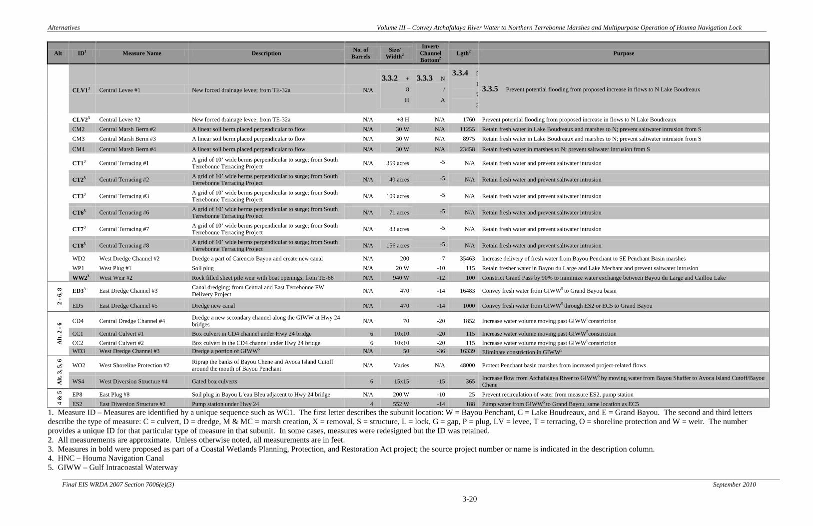
Alternatives Volume III – Convey Atchafalaya River Water to Northern Terrebonne Marshes and Multipurpose Operation of Houma Navigation Lock
3-20
Final EIS WRDA 2007 Section 7006(e)(3) September 2010
Alt ID1 Measure Name Description No. of Barrels
Size/ Width2
Invert/ Channel Bottom2
Lgth2 Purpose
CLV13 Central Levee #1 New forced drainage levee; from TE-32a N/A
3.3.2 +
8
H
3.3.3 N
/
A
3.3.4 5
1
7
3
3.3.5 Prevent potential flooding from proposed increase in flows to N Lake Boudreaux
CLV23 Central Levee #2 New forced drainage levee; from TE-32a N/A +8 H N/A 1760 Prevent potential flooding from proposed increase in flows to N Lake Boudreaux CM2 Central Marsh Berm #2 A linear soil berm placed perpendicular to flow N/A 30 W N/A 11255 Retain fresh water in Lake Boudreaux and marshes to N; prevent saltwater intrusion from S CM3 Central Marsh Berm #3 A linear soil berm placed perpendicular to flow N/A 30 W N/A 8975 Retain fresh water in Lake Boudreaux and marshes to N; prevent saltwater intrusion from S
CM4 Central Marsh Berm #4 A linear soil berm placed perpendicular to flow N/A 30 W N/A 23458 Retain fresh water in marshes to N; prevent saltwater intrusion from S
CT13 Central Terracing #1 A grid of 10’ wide berms perpendicular to surge; from South Terrebonne Terracing Project N/A 359 acres -5 N/A Retain fresh water and prevent saltwater intrusion
CT23 Central Terracing #2 A grid of 10’ wide berms perpendicular to surge; from South Terrebonne Terracing Project N/A 40 acres -5 N/A Retain fresh water and prevent saltwater intrusion
CT33 Central Terracing #3 A grid of 10’ wide berms perpendicular to surge; from South Terrebonne Terracing Project N/A 109 acres -5 N/A Retain fresh water and prevent saltwater intrusion
CT63 Central Terracing #6 A grid of 10’ wide berms perpendicular to surge; from South Terrebonne Terracing Project N/A 71 acres -5 N/A Retain fresh water and prevent saltwater intrusion
CT73 Central Terracing #7 A grid of 10’ wide berms perpendicular to surge; from South Terrebonne Terracing Project N/A 83 acres -5 N/A Retain fresh water and prevent saltwater intrusion
CT83 Central Terracing #8 A grid of 10’ wide berms perpendicular to surge; from South Terrebonne Terracing Project N/A 156 acres -5 N/A Retain fresh water and prevent saltwater intrusion
WD2 West Dredge Channel #2 Dredge a part of Carencro Bayou and create new canal N/A 200 -7 35463 Increase delivery of fresh water from Bayou Penchant to SE Penchant Basin marshes WP1 West Plug #1 Soil plug N/A 20 W -10 115 Retain fresher water in Bayou du Large and Lake Mechant and prevent saltwater intrusion WW23 West Weir #2 Rock filled sheet pile weir with boat openings; from TE-66 N/A 940 W -12 100 Constrict Grand Pass by 90% to minimize water exchange between Bayou du Large and Caillou Lake
2 - 6
, 8
ED33 East Dredge Channel #3 Canal dredging; from Central and East Terrebonne FW Delivery Project N/A 470 -14 16483 Convey fresh water from GIWW5 to Grand Bayou basin
ED5 East Dredge Channel #5 Dredge new canal N/A 470 -14 1000 Convey fresh water from GIWW5 through ES2 or EC5 to Grand Bayou
Alt.
2 -
6 CD4 Central Dredge Channel #4 Dredge a new secondary channel along the GIWW at Hwy 24 bridges N/A 70 -20 1852 Increase water volume moving past GIWW5constriction
CC1 Central Culvert #1 Box culvert in CD4 channel under Hwy 24 bridge 6 10x10 -20 115 Increase water volume moving past GIWW5constriction CC2 Central Culvert #2 Box culvert in the CD4 channel under Hwy 24 bridge 6 10x10 -20 115 Increase water volume moving past GIWW5constriction WD3 West Dredge Channel #3 Dredge a portion of GIWW5 N/A 50 -36 16339 Eliminate constriction in GIWW5
Alt.
3, 5
, 6
WO2 West Shoreline Protection #2 Riprap the banks of Bayou Chene and Avoca Island Cutoff around the mouth of Bayou Penchant N/A Varies N/A 48000 Protect Penchant basin marshes from increased project-related flows
WS4 West Diversion Structure #4 Gated box culverts 6 15x15 -15 365 Increase flow from Atchafalaya River to GIWW5 by moving water from Bayou Shaffer to Avoca Island Cutoff/Bayou Chene
4 &
5
EP8 East Plug #8 Soil plug in Bayou L’eau Bleu adjacent to Hwy 24 bridge N/A 200 W -10 25 Prevent recirculation of water from measure ES2, pump station ES2 East Diversion Structure #2 Pump station under Hwy 24 4 552 W -14 188 Pump water from GIWW5 to Grand Bayou, same location as EC5
1. Measure ID – Measures are identified by a unique sequence such as WC1. The first letter describes the subunit location: W = Bayou Penchant, C = Lake Boudreaux, and E = Grand Bayou. The second and third letters describe the type of measure: C = culvert, D = dredge, M & MC = marsh creation, X = removal, S = structure, L = lock, G = gap, P = plug, LV = levee, T = terracing, O = shoreline protection and W = weir. The number provides a unique ID for that particular type of measure in that subunit. In some cases, measures were redesigned but the ID was retained. 2. All measurements are approximate. Unless otherwise noted, all measurements are in feet. 3. Measures in bold were proposed as part of a Coastal Wetlands Planning, Protection, and Restoration Act project; the source project number or name is indicated in the description column. 4. HNC – Houma Navigation Canal 5. GIWW – Gulf Intracoastal Waterway
Alternatives Volume III – Convey Atchafalaya River Water to Northern Terrebonne Marshes and Multipurpose Operation of Houma Navigation Lock
3-21
Final EIS WRDA 2007 Section 7006(e)(3) September 2010
3.3.2 Description of Alternative Plans
The plan formulation process involved the grouping of management measures in accordance with the overall strategies discussed earlier in this chapter. The management measures, for the most part, were considered under past authorities and studies (CWPPRA and CIAP), but were combined for the ATRM study to form holistic basin wide Alternatives. The contribution to planning objectives of each alternative is discussed in Chapter 5. The information on these alternatives includes: graphs and maps showing each alternative’s effects on salinities and freshwater flows at various locations, changes in vegetation types, increases in marsh, and reduction in open water. After developing the seven alternatives (Table 3.3), the PDT realized that Alt. 2 - 5 contained a large number of measures while Alt. 6 and 7 contained a few measures. The team felt that an Alternative containing an intermediate number of measures was necessary. Thus, Alternative 8 was developed as another alternative that achieves some of the benefits of Alternative 2 with less cost. Alternatives 2 – 8 incorporate various combinations of the remaining 61 measures (Figures 3.3 – 3.9). To distinguish the features in the northern portion of the Lake Boudreaux basin for Alternatives 2 through 5 and 8, see Figure 3.10. Site plans and typical sections for these measures can be found in Engineering Appendix L Annex 4. Modification to the operation of the proposed HNC Lock complex is included in all action alternatives in accordance with guidance received from the LCA Program Management Team. This was done because the HNC Lock Operations are hydrologically linked to all alternatives developed for ARTM in a synergistic and holistic approach to the problems and opportunities of the study area, although benefits on are not necessarily dependent on the implementation on the HNC Lock complex. A description of this measure can be found under Section 3.3.9. The remaining 61 measures were incorporated into various alternatives (Table 3.5). 3.3.2.1 No Action (Future without Project Conditions) – Strategy: No Action. This alternative includes no measures from this study. The future condition will include sea level rise, subsidence, and other projects that are under construction or are likely to be constructed. This alternative includes operation of the HNC lock complex under the Morganza to the Gulf operations plan. The assumption was made that the Morganza to the Gulf Project would be completed by 2025. The operating plan for the Morganza to the Gulf HNC flood gates calls for closure of the flood gates whenever necessary to prevent saltwater intrusion up the HNC or during tropical storm/hurricane conditions. Accordingly, for purposes of future without project hydraulic modeling, the assumption was made that the HNC flood gates would be closed to prevent saltwater intrusion for two months each year starting in 2025. During these closure periods, it was assumed that the sluice gates within the HNC Lock structure would be open. Other water control structures associated with the Morganza to the Gulf Project would only be utilized under tropical storm/hurricane conditions, and, therefore, would not appreciably impact the hydrology of the study area under normal operating conditions. Therefore, these structures were not included in the hydraulic modeling for the LCA-ARTM study.

Alternatives Volume III – Convey Atchafalaya River Water to Northern Terrebonne Marshes and Multipurpose Operation of Houma Navigation Lock
3-22
Final EIS WRDA 2007 Section 7006(e)(3) September 2010
3.3.2.2 Alternative 2 - Strategy: Utilize Existing Flow and Management Measures (Figure 3.3).
This alternative redistributes existing freshwater to benefit Terrebonne marshes using a variety of measures (Table 3.5 Alternative Measures). To achieve this, GIWW constrictions would be eliminated. Additionally, the following measures to restrict increase, and control water are proposed for each of the three subunits. In the West – Bayou Penchant Area, dredging, a sediment plug, and a weir will be utilized. In the Central – Lake Boudreaux Area, culverts, levees, dredging, marsh terraces and berms, sediment plugs, modified operation of the future HNC (Houma Navigation Canal) lock complex, , as described in Alternative 7, and a large sluice gated box culvert are proposed. In the East – Grand Bayou Area, culverts, dredging, gaps in canal spoil banks, marsh berms, sediment plugs, and removal of a weir and soil plug are proposed. 3.3.2.3 Alternative 3 - Strategy: Increase Atchafalaya River Flows and Utilize Management Measures (Figure 3.4). This alternative will increase Atchafalaya River inflows and redistribute existing and increased flows of freshwater. Alternative 3 includes all the measures in Alternative 2 and two additional. The additional measures are in the West – Bayou Penchant Area. To increase flows from the Atchafalaya River, water will be moved from Bayou Shaffer to the Avoca Island Cutoff/Bayou Chene. This will be accomplished by creating an opening through the Avoca Island levee and installing a large gated diversion structure (WS4) in the opening. The remaining measure (WO2) would place stone along the shore of Bayou Chene and Avoca Island Cutoff to protect from increased flows. 3.3.2.4 Alternative 4 - Strategy: Increase Flow from East of the Study Area and Utilize Management Measures (Figure 3.5). This alternative will increase freshwater flows from east of the study area and redistribute existing and increased flows of freshwater. Alternative 4 includes all but one of the measures in Alternative 2, and has two additional measures in the East – Grand Bayou Area. In Alternative 2, a new Hwy. 24 bridge with Obermeyer gates between the piers (EC5) is proposed to connect the GIWW to Grand Bayou. In Alternative 4, this measure is replaced by a pump station (ES2). The pump station would increase freshwater delivery to the Grand Bayou watershed but not the other subunits. The second new measure is a soil plug (EP8) in Bayou L’eau Bleu. Bayou L’eau Bleu connects the canal receiving the pump station outflow to the GIWW. The pump station is pumping water from the GIWW, thus the soil plug is necessary to prevent recirculation of water. 3.3.2.5 Alternative 5 - Strategy: Increase Flow from the East and from the Atchafalaya River and Utilize Management Measures (Figure 3.6). This alternative will increase flows from the east and west and redistribute existing and increased flows of freshwater. This alternative is a combination of Alternatives 3 and 4. The only measure in Alternative 3 not within this alternative is the Hwy. 24 bridge with Obermeyer gates (EC5), which is replaced by a pump station (ES2), as in Alternative 4.

Alternatives Volume III – Convey Atchafalaya River Water to Northern Terrebonne Marshes and Multipurpose Operation of Houma Navigation Lock
3-23
Final EIS WRDA 2007 Section 7006(e)(3) September 2010
3.3.2.6 Alternative 6 - Strategy: Increase Atchafalaya River Flow and Utilize Management Measures (Figure 3.7). This alternative will increase Atchafalaya River inflows and improve the passage of freshwater through the GIWW while slowing water passage to the gulf through the HNC. Alternative 6 differs from Alternative 3 because Alternative 6 only includes water management measures along the GIWW. The measures to increase Atchafalaya River inflows are the same as Alternative 3. A large gated diversion structure (WS4) would be placed in the new opening created in the Avoca Island levee. Shoreline protection would be placed (WO2) in Bayou Chene and Avoca Island Cutoff. To improve freshwater flows through the GIWW to Grand Bayou, the following measures from Alternative 2 are proposed. In East – Grand Bayou Area, dredging is proposed to connect Grand Bayou to the GIWW (ED5) and enlarge Grand Bayou (ED3). Where ED5 goes through Hwy. 24, a new bridge with Obermeyer gates between the piers (EC5) is proposed. In Central – Lake Boudreaux Area, the GIWW is constricted as it passed under Hwy. 24. The Hwy. 24 bridge columns does not allow for channel enlargement. Therefore, dredging a new secondary channel with two culverts, one under each Hwy. 24 bridge, is proposed. Modifying the operation of the HNC Lock Complex, as described in Alternative 7, is also included in this alternative. 3.3.2.7 Alternative 7 - Strategy: Utilize Existing Flow and Management Measures (Figure 3.8). This alternative will slow the movement of freshwater to the Gulf of Mexico and thus put additional freshwater onto northern Terrebonne marshes. The one measure in this alternative is the modified operation of the proposed HNC Lock Complex (CL1). The HNC Lock Complex is part of the proposed U.S. Army Corps of Engineers Morganza to the Gulf project for coastal storm damage reduction. The assumption was made that the Morganza to the Gulf Project would be completed by 2025. The operating plan for the Morganza to the Gulf HNC lock complex calls for closure of the flood gates whenever necessary to prevent saltwater intrusion up the HNC or during tropical storm/hurricane conditions. Accordingly, for purposes of future without project hydraulic modeling, the assumption was made that the HNC flood gates would be closed to prevent saltwater intrusion for two months each year starting in 2025. Alternative 7 proposes to keep the flood gates closed year round to hold water back, thus moving freshwater onto northern marshes. When the flood gates are closed boat traffic would travel through the lock chambers. As part of this alternative, an industry traffic management plan would be developed for vessels exceeding the lock size that will require the flood gates to be opened. This alternative proposes to keep the sluice gates located in the lock structure walls open, with the exception of during tropical events. 3.3.2.8 Alternative 8 - Strategy: Utilize Existing Flow and Management Measures to Focus Fresh Water Flows on the Most Critical Areas of the East and Central Study Sub Units (Figure 3.9). This alternative redistributes existing freshwater to benefit the most critical areas of the east and central study subunits using a variety of measures (Table 3.5 Alternative Measures). This alternative represents an increment between Alternative 7 and

Alternatives Volume III – Convey Atchafalaya River Water to Northern Terrebonne Marshes and Multipurpose Operation of Houma Navigation Lock
3-24
Final EIS WRDA 2007 Section 7006(e)(3) September 2010
Alternative 2 and contains many of the features of Alternative 2. In the Central – Lake Boudreaux Area, culverts, levees, dredging, sediment plugs, modified operation of the future HNC (Houma Navigation Canal) lock complex, as described in Alternative 7, and a large sluice gated box culvert are proposed. In the East – Grand Bayou Area, culverts, dredging, gaps in canal spoil banks, sediment plugs, and removal of a weir and soil plug are proposed.

Alternatives Volume III – Convey Atchafalaya River Water to Northern Terrebonne Marshes and Multipurpose Operation of Houma Navigation Lock
3-25 Final EIS WRDA 2007 Section 7006(e)(3) September 2010
Figure 3.3 Alternative 2. Alternative 2 incorporates 4 of the 8 total measures in the West Bayou Penchant Area, all 36 in Center – Lake Boudreaux and 17 of the 19 in East – Grand Bayou Subunit
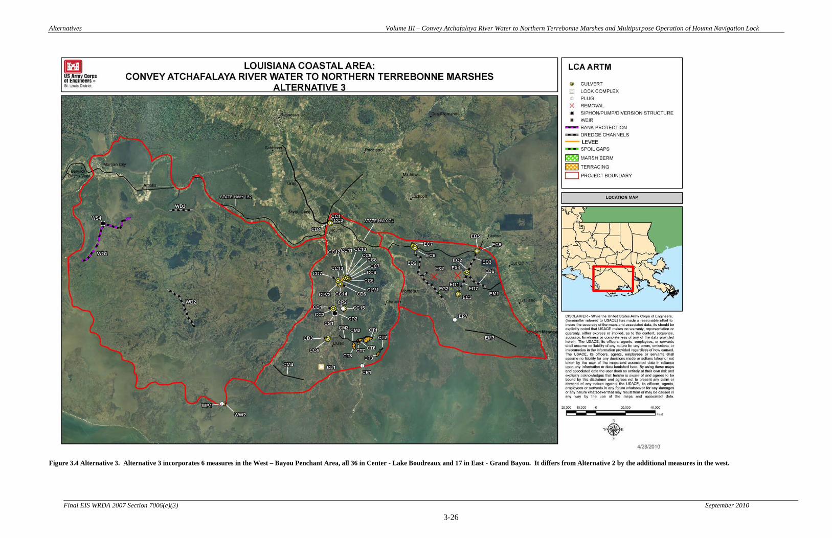
Alternatives Volume III – Convey Atchafalaya River Water to Northern Terrebonne Marshes and Multipurpose Operation of Houma Navigation Lock
3-26 Final EIS WRDA 2007 Section 7006(e)(3) September 2010
Figure 3.4 Alternative 3. Alternative 3 incorporates 6 measures in the West – Bayou Penchant Area, all 36 in Center - Lake Boudreaux and 17 in East - Grand Bayou. It differs from Alternative 2 by the additional measures in the west.

Alternatives Volume III – Convey Atchafalaya River Water to Northern Terrebonne Marshes and Multipurpose Operation of Houma Navigation Lock
3-27 Final EIS WRDA 2007 Section 7006(e)(3) September 2010
Figure 3.5 Alternative 4. Alternative 4 incorporates 4 measures in the West – Bayou Penchant Area, all 36 in Center - Lake Boudreaux and 18 in East - Grand Bayou. It differs from Alternative 2 by having two additional and one different measure in the east.

Alternatives Volume III – Convey Atchafalaya River Water to Northern Terrebonne Marshes and Multipurpose Operation of Houma Navigation Lock
3-28 Final EIS WRDA 2007 Section 7006(e)(3) September 2010
Figure 3.6 Alternative 5. Alternative 5 incorporates 6 measures in the West – Bayou Penchant Area, 36 in Center - Lake Boudreaux and 18 in East - Grand Bayou. This alternative is a combination of Alternatives 3 and 4.
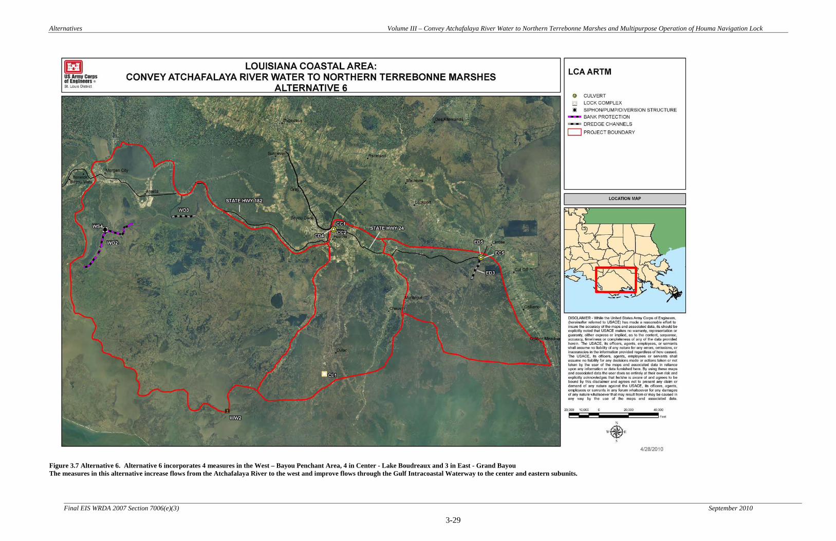
Alternatives Volume III – Convey Atchafalaya River Water to Northern Terrebonne Marshes and Multipurpose Operation of Houma Navigation Lock
3-29 Final EIS WRDA 2007 Section 7006(e)(3) September 2010
Figure 3.7 Alternative 6. Alternative 6 incorporates 4 measures in the West – Bayou Penchant Area, 4 in Center - Lake Boudreaux and 3 in East - Grand Bayou The measures in this alternative increase flows from the Atchafalaya River to the west and improve flows through the Gulf Intracoastal Waterway to the center and eastern subunits.

Alternatives Volume III – Convey Atchafalaya River Water to Northern Terrebonne Marshes and Multipurpose Operation of Houma Navigation Lock
3-30 Final EIS WRDA 2007 Section 7006(e)(3) September 2010
Figure 3.8 Alternative 7. Alternative 7 incorporates only 1 measure which is in the Center - Lake Boudreaux Subunit. This measure proposes to change the operation of the proposed Houma Navigation Canal Lock Complex.

Alternatives Volume III – Convey Atchafalaya River Water to Northern Terrebonne Marshes and Multipurpose Operation of Houma Navigation Lock
3-31 Final EIS WRDA 2007 Section 7006(e)(3) September 2010
Figure 3.9 Alternative 8. Alternative 8 incorporates 22 measures in the Center - Lake Boudreaux Area and 11 in East - Grand Bayou. This alternative is a subset of Alternative 2.

Alternatives Volume III – Convey Atchafalaya River Water to Northern Terrebonne Marshes and Multipurpose Operation of Houma Navigation Lock
3-32 Final EIS WRDA 2007 Section 7006(e)(3) September 2010
Figure 3.10 Features located in the north Lake Boudreaux area for Alternatives 2 through 5 and 8.

Alternatives Volume III – Convey Atchafalaya River Water to Northern Terrebonne Marshes and Multipurpose Operation of Houma Navigation Lock
3-33
Final EIS WRDA 2007 Section 7006(e)(3) September 2010
3.3.3 Screening / Evaluation of Alternative Plans
During the interagency PDT meetings, the team, including sister federal agencies and local sponsors, reviewed and evaluated the seven proposed alternatives against the project goals and objectives. They also assessed the alternative plans and their component measures relative to the objective of National Ecosystem Restoration (NER). 3.3.4 Alternative Plans not Carried Forward for Further Analysis
As discussed above, some specific measures were eliminated from the seven action alternatives (Table 3.4). However, all seven initial alternatives were carried forward for further analysis. 3.4 Final Array of Alternatives (Alternatives Studied in Detail) A complete description of the final array of alternatives is included in section 3.3.2. 3.5 Comparison of Alternative Plans
3.5.1 Incremental Cost/Cost Effectiveness Analysis Process.
Cost effectiveness analysis was used to determine what features should be built based on habitat benefits (outputs) that meet the goals and objectives of the study and at the same time are the most cost effective. The Corps has incorporated cost effectiveness analysis into its planning process for all ecosystem restoration planning efforts. A cost effectiveness analysis is conducted to ensure that least cost alternatives are identified for various levels of output. After the cost effectiveness of the alternatives has been established, incremental cost analysis is conducted to reveal and evaluate changes in cost for increasing levels of environmental output. Cost effectiveness and incremental analysis is a three step procedure: (1) calculate the environmental outputs of each alternative; (2) determine a cost estimate for each alternative; (3) combine the alternatives to evaluate the best overall alternative based on habitat benefits and cost. While cost and environmental outputs are necessary factors, other factors such as the ability to construct, schedule, likelihood to achieve projected results, immeasurable environmental benefits, ancillary benefits etc., are very important in deciding on the preferred alternative. Environmental outputs were calculated as Average Annual Habitat Units (AAHUs). The annualized costs were calculated by applying a 4-3/8 percent annual interest rate to the construction costs over the 50-year period of analysis. What is described below is the second step of the process introduced in Section 3.3.4 above. 3.5.2 Wetland Value Assessment (WVA)
The Wetland Value Assessment (WVA) methodology is a quantitative habitat-based assessment methodology developed for use in determining wetland benefits of project proposals submitted for funding under the Coastal Wetlands Planning, Protection, and
Alternatives Volume III – Convey Atchafalaya River Water to Northern Terrebonne Marshes and Multipurpose Operation of Houma Navigation Lock
3-34
Final EIS WRDA 2007 Section 7006(e)(3) September 2010
Restoration Act (CWPPRA). The WVA quantifies changes in fish and wildlife habitat quality and quantity that are expected to result from a proposed wetland restoration project. The results of the WVA, measured in Average Annual Habitat Units (AAHUs), can be combined with cost data to provide a measure of the effectiveness of a proposed project in terms of annualized cost per AAHU gained. In addition, the WVA methodology provides an estimate of the number of acres benefited or enhanced by the project and the net acres of habitat protected/restored. The WVA was developed by the Environmental Work Group (EnvWG) assembled under the Planning and Evaluation Subcommittee of the CWPPRA Technical Committee; the EnvWG includes members from each agency represented on the CWPPRA Task Force and members of the Academic Assistance Subcommittee. The WVA was designed to be applied, to the greatest extent possible, using only existing or readily obtainable data. The WVA has been developed strictly for use in determining the wetland benefits of proposed CWPPRA projects; it is not intended to provide a detailed, comprehensive methodology for establishing baseline conditions within a study area. Some aspects of the WVA have been defined by policy and/or functional considerations of the CWPPRA; therefore, user-specific modifications may be necessary if the WVA is used for other purposes. The WVA is a modification of the Habitat Evaluation Procedures (HEP) developed by the U.S. Fish and Wildlife Service (U.S. Fish and Wildlife Service 1980). HEP is widely used by the Fish and Wildlife Service and other Federal and state agencies in evaluating the impacts of development projects on fish and wildlife resources. A notable difference exists between the two methodologies, however, in that HEP generally uses a species-oriented approach, whereas the WVA utilizes a community approach. The WVA has been developed for application to several habitat types along the Louisiana coast and community models have been developed for fresh marsh, intermediate marsh, brackish marsh, saline marsh, fresh swamp, barrier islands, and barrier headlands. A WVA Procedural Manual has also been prepared by the EnvWG to provide guidance to project planners in the use of the various community models. Two other habitat assessment models for bottomland hardwoods and coastal chenier/ridge habitat were developed outside of the CWPPRA arena and are periodically used by the EnvWG. WVA Concept The WVA operates under the assumption that optimal conditions for fish and wildlife habitat within a given coastal wetland habitat type can be characterized, and that existing or predicted conditions can be compared to that optimum to provide an index of habitat quality. Habitat quality is estimated or expressed through the use of community models developed specifically for each habitat type. Each model consists of 1) a list of variables that are considered important in characterizing fish and wildlife habitat, 2) a Suitability Index graph for each variable, which defines the assumed relationship between habitat

Alternatives Volume III – Convey Atchafalaya River Water to Northern Terrebonne Marshes and Multipurpose Operation of Houma Navigation Lock
3-35
Final EIS WRDA 2007 Section 7006(e)(3) September 2010
quality (Suitability Index) and different variable values, and 3) a mathematical formula that combines the Suitability Index for each variable into a single value for habitat quality; that single value is referred to as the Habitat Suitability Index, or HSI. The output of each model (the HSI) is assumed to have a linear relationship with the suitability of a coastal wetland system in providing fish and wildlife habitat. The WVA models have been developed for determining the suitability of Louisiana coastal wetlands in providing resting, foraging, breeding, and nursery habitat to a diverse assemblage of fish and wildlife species. The models have been designed to function at a community level and therefore attempt to define an optimum combination of habitat conditions for common fish and wildlife species utilizing a given habitat type. Earlier attempts to capture other wetland functions and values such as storm-surge protection, flood water storage, water quality functions, and nutrient import/export were abandoned due to the difficulty in defining unified model relationships and meaningful model outputs for such a variety of wetland benefits. However, the ability of a Louisiana coastal wetland to provide those functions and values may be generally assumed to be positively correlated with fish and wildlife habitat quality as predicted through the WVA. Community Model Variable Selection Habitat variables considered appropriate for describing habitat quality in each wetland type were selected according to the following criteria:
o The condition described by the variable had to be important in characterizing fish and wildlife habitat quality in the wetland type under consideration;
o Values had to be easily estimated and predicted based on existing or readily obtainable data (e.g., aerial photography, habitat classification data, water quality monitoring stations, interviews with knowledgeable individuals, etc.); and
o The variable had to be sensitive to the types of changes expected to be brought about by typical wetland restoration projects proposed under CWPPRA.
Suitability Index Graphs A suitability index graph is a graphical representation of how fish and wildlife habitat quality or "suitability" of a given habitat type is predicted to change as values of the given variable change, and allows the model user to numerically describe, through a Suitability Index, the habitat quality of a wetland area for any variable value. Each Suitability Index ranges from 0.1 to 1.0, with 1.0 representing the optimal condition for the variable in question. Suitability Index (SI) graphs were constructed for each variable. Habitat Suitability Index Formula The final step in model development was to construct a mathematical formula that combines all Suitability Indices into a single Habitat Suitability Index value. Because the Suitability Indices range from 0.1 to 1.0, the HSI also ranges from 0.1 to 1.0, and is a

Alternatives Volume III – Convey Atchafalaya River Water to Northern Terrebonne Marshes and Multipurpose Operation of Houma Navigation Lock
3-36
Final EIS WRDA 2007 Section 7006(e)(3) September 2010
numerical representation of the overall or "composite" habitat quality of the particular wetland area being evaluated. The HSI formula defines the aggregation of Suitability Indices in a manner unique to each wetland type depending on how the formula is constructed. Within an HSI formula, any Suitability Index can be weighted by various means to increase the power or "importance" of that variable relative to the other variables in determining the HSI. Additionally, two or more variables can be grouped together into subgroups to further isolate variables for weighting. Benefit Assessment The net benefits of a proposed project are estimated by predicting future habitat conditions under two scenarios: future without-project and future with-project. Specifically, predictions are made as to how the model variables will change through time under the two scenarios. Through that process, HSIs are established for baseline (pre-project) conditions and for future without- and future with-project scenarios for selected "target years" throughout the expected life of the project. Those HSIs are then multiplied by the study area acreage at each target year to arrive at Habitat Units (HUs). Habitat Units represent a numerical combination of quality (HSI) and quantity (acres) existing at any given point in time. The HUs resulting from the future without- and future with-project scenarios are annualized, averaged over the period of analysis, to determine Average Annual Habitat Units (AAHUs). The "benefit" of a project can be quantified by comparing AAHUs between the future without- and future with-project scenarios. The difference in AAHUs between the two scenarios represents the net benefit attributable to the project in terms of habitat quantity and quality.
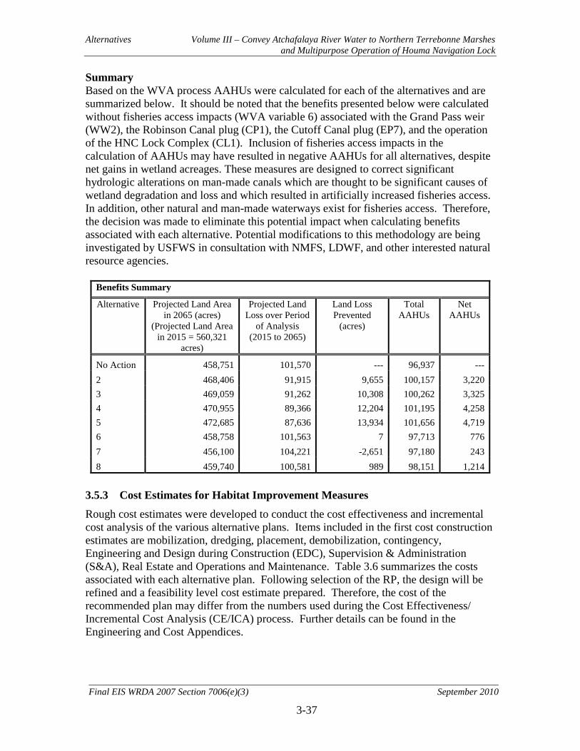
Alternatives Volume III – Convey Atchafalaya River Water to Northern Terrebonne Marshes and Multipurpose Operation of Houma Navigation Lock
3-37
Final EIS WRDA 2007 Section 7006(e)(3) September 2010
Summary Based on the WVA process AAHUs were calculated for each of the alternatives and are summarized below. It should be noted that the benefits presented below were calculated without fisheries access impacts (WVA variable 6) associated with the Grand Pass weir (WW2), the Robinson Canal plug (CP1), the Cutoff Canal plug (EP7), and the operation of the HNC Lock Complex (CL1). Inclusion of fisheries access impacts in the calculation of AAHUs may have resulted in negative AAHUs for all alternatives, despite net gains in wetland acreages. These measures are designed to correct significant hydrologic alterations on man-made canals which are thought to be significant causes of wetland degradation and loss and which resulted in artificially increased fisheries access. In addition, other natural and man-made waterways exist for fisheries access. Therefore, the decision was made to eliminate this potential impact when calculating benefits associated with each alternative. Potential modifications to this methodology are being investigated by USFWS in consultation with NMFS, LDWF, and other interested natural resource agencies.
Benefits Summary
Alternative Projected Land Area in 2065 (acres)
(Projected Land Area in 2015 = 560,321
acres)
Projected Land Loss over Period
of Analysis (2015 to 2065)
Land Loss Prevented
(acres)
Total AAHUs
Net AAHUs
No Action 458,751 101,570 --- 96,937 --- 2 468,406 91,915 9,655 100,157 3,220 3 469,059 91,262 10,308 100,262 3,325 4 470,955 89,366 12,204 101,195 4,258 5 472,685 87,636 13,934 101,656 4,719 6 458,758 101,563 7 97,713 776 7 456,100 104,221 -2,651 97,180 243 8 459,740 100,581 989 98,151 1,214
3.5.3 Cost Estimates for Habitat Improvement Measures
Rough cost estimates were developed to conduct the cost effectiveness and incremental cost analysis of the various alternative plans. Items included in the first cost construction estimates are mobilization, dredging, placement, demobilization, contingency, Engineering and Design during Construction (EDC), Supervision & Administration (S&A), Real Estate and Operations and Maintenance. Table 3.6 summarizes the costs associated with each alternative plan. Following selection of the RP, the design will be refined and a feasibility level cost estimate prepared. Therefore, the cost of the recommended plan may differ from the numbers used during the Cost Effectiveness/ Incremental Cost Analysis (CE/ICA) process. Further details can be found in the Engineering and Cost Appendices.

Alternatives Volume III – Convey Atchafalaya River Water to Northern Terrebonne Marshes and Multipurpose Operation of Houma Navigation Lock
3-38
Final EIS WRDA 2007 Section 7006(e)(3) September 2010
Table 3.6 LCA: Atchafalaya CE/ICA: Step 1 Alternative Costs
Alternative First Cost* Annualized First Cost**
Annualized Monitoring
Cost**
Annualized OMRR&R**
&***
Total Annualized Investment
Cost
Alt. 1 (No Action) N/A N/A N/A N/A N/A Alt. 2 $203,047,200 $10,066,504 $396,686 $72,514 $10,535,704 Alt. 3 $232,041,000 $11,503,935 $396,686 $75,889 $11,976,509 Alt. 4 $253,038,800 $12,544,946 $396,686 $1,656,894 $14,598,526 Alt. 5 $294,899,600 $14,620,286 $396,686 $1,660,269 $16,677,241 Alt. 6 $134,199,000 $6,653,206 $396,686 $10,175 $7,060,066 Alt. 7 $42,000 $2,082 $258,513 $0 $260,595 Alt. 8 $86,777,600 $4,302,187 $396,686 $48,684 $4,747,557
*Includes Real Estate and Cultural Resources **Discount Rate: 4-3/8% *** The operation costs for the HNC Lock Complex have not been developed under Morganza to the Gulf at this time
At this point in the analysis, Alternatives 4 and 5 were removed from consideration. At the TSP meeting, it was determined Alternatives 4 and 5 were not sustainable from an efficiency or acceptability standpoint. These alternatives required a large 4000 cfs pumping station at the confluence of the GIWW and Grand Bayou. The large pump station adversely impacted the isohalines in the Barataria basin and would have forced salt water intrusion up into Bayou Lafourche (see Section 5.3 in Environmental Consequences). The interagency team determined that these were unacceptable adverse environmental impacts and precluded the alternatives from further consideration and analysis. The effects of this pumping station do not conform to the USACE Environmental Operating Principles concerning sustainability. 3.5.4 Results of the CE/ICA Analysis
The CE/ICA analysis shows remaining Alternative plans 2, 3, 7, and 8 to be cost effective. Aside from the No Action Alternative, Alternative 7 exhibited the lowest average annual cost per Unit of all Alternatives, $1,072 per AAHU. Alternative 8 exhibited the highest average annual cost per Unit of all Alternatives, $3,910 per AAHU. However, as the Plans are linear in benefits and costs, a CE/ICA is conducted on all of the cost effective Alternatives to determine the ‘best buy” plans. “Best buy” plans are the most efficient alternatives/plans at producing the output variable AAHUs. In other words, best buy plans provide the greatest increase in the value of the output parameter variable for the least increase in the value of the cost parameter variable.

Alternatives Volume III – Convey Atchafalaya River Water to Northern Terrebonne Marshes and Multipurpose Operation of Houma Navigation Lock
3-39
Final EIS WRDA 2007 Section 7006(e)(3) September 2010
Table 3.7 LCA: Atchafalaya CE/ICA: Step 2
LCA: Atchafalaya CE/ICA: STEP 2
WVA Net AAHU
Annualized Cost Per
Unit (AAHU) Alternative
Total Annualized Investment
Cost* Alternative 7 $260,595 243 $1,072 Alternative 8 $4,747,577 1,214 $3,910 Alternative 2 $10,535,704 3,220 $3,272 Alternative 3 $11,976,509 3,325 $3,601 *Includes Real Estate and Cultural Resources **Discount Rate 4-3/8%
Figure 3.11: CE/ICA of Final Alternatives

Alternatives Volume III – Convey Atchafalaya River Water to Northern Terrebonne Marshes and Multipurpose Operation of Houma Navigation Lock
3-40
Final EIS WRDA 2007 Section 7006(e)(3) September 2010
Overall, the CE/ICA process resulted in Alternatives 7, 2 and 3 being evaluated as “best buy” plans. As shown in Table 3.8, Alternative 7 provides 243 AAHUs at an annualized incremental cost of $260,595. Alternative 2 provides 2,977 additional AAHUs, at an annualized incremental cost of $10,275,120. Alternative 3 provides 106 additional AAHUs at an annualized incremental cost of $1,440,805. The first best buy plan is the most efficient plan from an incremental cost per AAHU perspective. However, if a higher level of output (AAHUs) is desired than that provided by the first best buy plan, the second best buy plan becomes the most efficient plan for producing additional output, and so on. The recommended Best Buy Plan is Alternative 2, generating 3,220 WVA AAHUs at a total annualized investment cost of $10,535,704. Table 3.8 LCA: Atchafalaya CE/ICA: Step 3
Incremental Cost/Cost Effectiveness Analysis of Cost Effective Plans
Alternative
Total Annualized Investment
Cost WVA
AAHUs Incremental
Cost Incremental
AAHUs
Incremental Cost per AAHUs
Alternative 7 $260,595 243 $260,595 243 $1,072 Alternative 2 $10,535,704 3,220 $10,275,109 2,977 $3,452 Alternative 3 $11,976,509 3,325 $1,440,805 106 $13,650
*Includes Real Estate and Cultural Resources **Discount Rate 4-3/8%
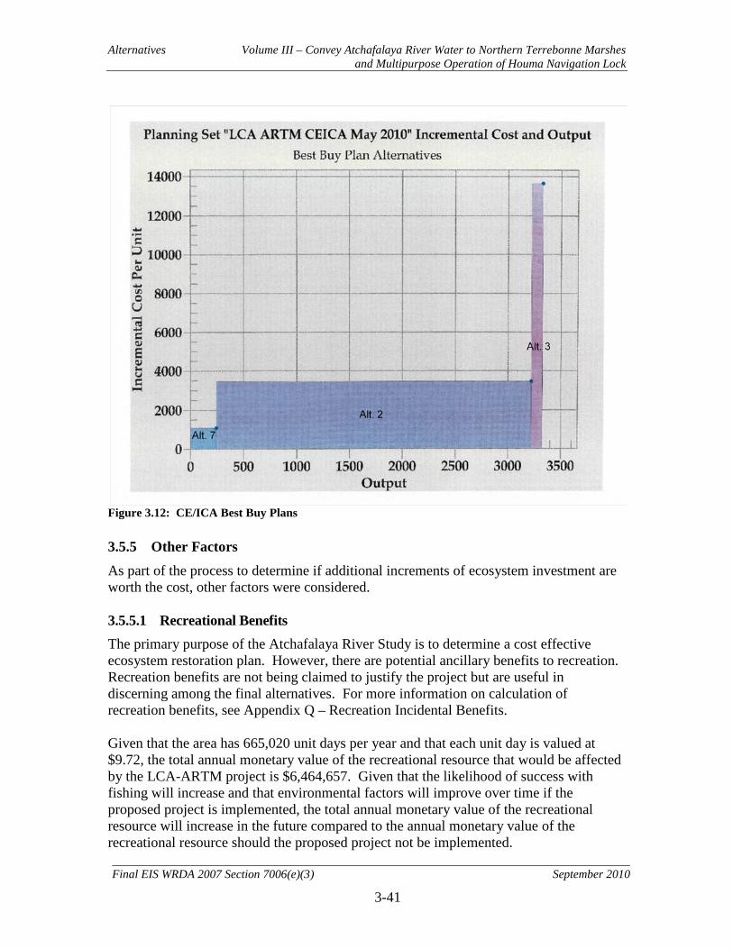
Alternatives Volume III – Convey Atchafalaya River Water to Northern Terrebonne Marshes and Multipurpose Operation of Houma Navigation Lock
3-41
Final EIS WRDA 2007 Section 7006(e)(3) September 2010
Figure 3.12: CE/ICA Best Buy Plans 3.5.5 Other Factors
As part of the process to determine if additional increments of ecosystem investment are worth the cost, other factors were considered. 3.5.5.1 Recreational Benefits The primary purpose of the Atchafalaya River Study is to determine a cost effective ecosystem restoration plan. However, there are potential ancillary benefits to recreation. Recreation benefits are not being claimed to justify the project but are useful in discerning among the final alternatives. For more information on calculation of recreation benefits, see Appendix Q – Recreation Incidental Benefits. Given that the area has 665,020 unit days per year and that each unit day is valued at $9.72, the total annual monetary value of the recreational resource that would be affected by the LCA-ARTM project is $6,464,657. Given that the likelihood of success with fishing will increase and that environmental factors will improve over time if the proposed project is implemented, the total annual monetary value of the recreational resource will increase in the future compared to the annual monetary value of the recreational resource should the proposed project not be implemented.
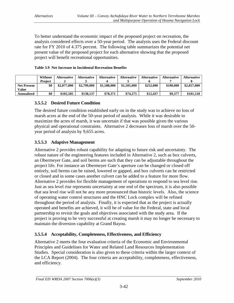
Alternatives Volume III – Convey Atchafalaya River Water to Northern Terrebonne Marshes and Multipurpose Operation of Houma Navigation Lock
3-42
Final EIS WRDA 2007 Section 7006(e)(3) September 2010
To better understand the economic impact of the proposed project on recreation, the analysis considered effects over a 50-year period. The analysis uses the Federal discount rate for FY 2010 of 4.375 percent. The following table summarizes the potential net present value of the proposed project for each alternative showing that the proposed project will benefit recreational opportunities. Table 3.9 Net Increase in Incidental Recreation Benefits
Without Project
Alternative 2
Alternative 3
Alternative 4
Alternative 5
Alternative 6
Alternative 7
Alternative 8
Net Present Value
$0 $2,077,000 $2,799,000 $1,588,000 $1,505,000 $252,000 $190,000 $2,057,000
Annualized $0 $102,505 $138,137 $78,371 $74,275 $12,437 $9,377 $101,518 3.5.5.2 Desired Future Condition The desired future condition established early on in the study was to achieve no loss of marsh acres at the end of the 50-year period of analysis. While it was desirable to maximize the acres of marsh, it was uncertain if that was possible given the various physical and operational constraints. Alternative 2 decreases loss of marsh over the 50-year period of analysis by 9,655 acres. 3.5.5.3 Adaptive Management Alternative 2 provides robust capability for adapting to future risk and uncertainty. The robust nature of the engineering features included in Alternative 2, such as box culverts, an Obermeyer Gate, and soil berms are such that they can be adjustable throughout the project life. For instance an Obermeyer Gate’s aperture can be changed or closed off entirely, soil berms can be raised, lowered or gapped, and box culverts can be restricted or closed and in some cases another culvert can be added to a feature for more flow. Alternative 2 provides for flexible management of operations to respond to sea level rise. Just as sea level rise represents uncertainty at one end of the spectrum, it is also possible that sea level rise will not be any more pronounced than historic levels. Also, the science of operating water control structures and the HNC Lock complex will be refined throughout the period of analysis. Finally, it is expected that as the project is actually operated and benefits are achieved, it will be of value for the Federal, state and local partnership to revisit the goals and objectives associated with the study area. If the project is proving to be very successful at creating marsh it may no longer be necessary to maintain the diversion capability at Grand Bayou. 3.5.5.4 Acceptability, Completeness, Effectiveness, and Efficiency Alternative 2 meets the four evaluation criteria of the Economic and Environmental Principles and Guidelines for Water and Related Land Resources Implementation Studies. Special consideration is also given to these criteria within the larger context of the LCA Report (2004). The four criteria are acceptability, completeness, effectiveness, and efficiency.

Alternatives Volume III – Convey Atchafalaya River Water to Northern Terrebonne Marshes and Multipurpose Operation of Houma Navigation Lock
3-43
Final EIS WRDA 2007 Section 7006(e)(3) September 2010
Acceptability. The plan is acceptable to Federal, state, tribal, local entities, and the public. It is compatible with existing laws, regulations, and policies. Completeness. The plan is complete. Realization of the plan does depend on implementation of actions outside the plan: the Houma Navigation Canal Lock complex is part of the Morganza to the Gulf of Mexico Hurricane Protection Project. The HNC Lock is an authorized project with an expected competition date of 2019. Effectiveness. The plan is effective. It addresses all but one of the project objectives. It improves marsh habitat by restoring deltaic process related to freshwater and nutrients, but does not address sediment input into the system. No alternatives considered would have addressed the sediment objective. Efficiency. The plan is efficient. It is a cost-effective solution to the stated problems and objectives. No other plan produces the same level of output more cost effectively. The plan is cost effective and provides the greatest increase in benefits for the least increase in costs. 3.5.5.5 Recommended Plan The interagency team recommends Alternative Plan 2 as the Recommended plan (RP). This alternative best meets the study objectives. It would result in restoration of some deltaic processes within the study area. In cooperation with the USFWS, NOAA, and the State of Louisiana the Corps has planned and would design a project that serves the needs of the nation. Per guidance received from Commander of Mississippi Valley Division, Alternative 2 fits into the framework of Section 902 cost cap limit of WRDA 1986, and as such, no further Congressional action for authorization would be required. 3.6 NER Plan The NER plan reasonably maximizes ecosystem restoration benefits compared to costs, considering the cost effectiveness and incremental cost of implementing other restoration options. Alterative 2 will utilize flow management measures to achieve sustainable environmental benefits in nationally significant aquatic ecosystem. Existing freshwater will be more efficiently distributed and flows will be increased where possible. 3.6.1 Components of NER Plan
Refer to table 3.5 for code definition of Alternative Measures. The NER Alternative (Alt 2) involves construction of 56 structures and other water management features and the opportunistic operation of the Houma Navigation Lock complex in an effort to holistically address the declining health of the Terrebonne Marshes ecosystem. There are two water diversion structures that are at critical points in the Terrebonne Marshes. The Central Diversion Structure (CS1), which involves constructing six 10' x 10' gated box culverts on Bayou Butler under Highway 57, will increase fresh water movement from the HNC to Bayou Grand Caillou/Lake Boudreaux. The Eastern Culvert #5 (EC5) is composed of a bridge with five 83-ft. spans with two
Alternatives Volume III – Convey Atchafalaya River Water to Northern Terrebonne Marshes and Multipurpose Operation of Houma Navigation Lock
3-44
Final EIS WRDA 2007 Section 7006(e)(3) September 2010
68.5-ft. spans accommodating Highway 24. Associated with this bridge are five 80-ft. Obermeyer gated openings, for a total flow opening width of 400 feet. EC5 is intended to convey fresh water from the GIWW to Grand Bayou under Highway 24. Other project measures in the western portion of the project area include 51,802 feet of dredging (WD2 and WD3), which increases delivery of fresh water from Bayou Penchant to southeast Penchant Basin marshes and eliminates a constriction in the GIWW. A soil plug (WP1) will be placed to retain fresher water in Bayou du Large and Lake Mechant and prevent saltwater intrusion. A rock filled sheet pile weir with boat openings will constrict Grand Pass by 90% to minimize water exchange between Lake Mechant and Caillou Lake. WW2 is a boat bay structure located in Grand Pass on the south side of Bayou DuLarge. A rock weir is centered on the channel with sheet pile cell walls on either side. The boat bay opening is 100 feet wide with an invert elevation of -12 ft. The entire structure has a width of 940 ft. There are several project measures in the central project area in addition to the Central Diversion Structure. A set of three measures (CC1, CC2, and CD4) will increase water volume moving past the GIWW constriction at the twin span bridge in Houma. Several project measures (CT1-8, CM2, CM3, CC3-15, CD1-2, 6, 7, CLV1, CLV2, and CP2) will work in conjunction with the Central Diversion Structure to deliver and retain fresh water and to prevent greater salt water intrusion into Lake Boudreaux. A 23,500 linear foot soil berm (CM4) will be placed perpendicular to tidal flow to retain fresh water in marshes to the north and prevent saltwater intrusion from the south in the marshes to the west of the proposed HNC Lock. A soil plug (CP2) will be placed in a canal near Bayou Butler to prevent short circuiting of fresh water through the N/S Gulf South Pipeline canal. The Central Lock Complex (CL1), which is the proposed HNC Lock, will optimize the sector gates’ operation for environmental benefits, keeping them closed year-round. This would hold water back, moving freshwater onto central Terrebonne marshes. When the sector gates are closed boat traffic would travel through the lock chamber. For vessels exceeding the lock size, an industry traffic management system will be developed to opportunistically open the sector gates to let these vessels pass. Project measures in the eastern portion of the project area associated with the Eastern Culvert #5 (EC5) include: a soil berm, culverts and dredging. East Dredge Channel #5 (ED5) is a 1000-ft. channel to connect the GIWW to EC5. East Dredge Channel #3 (ED3) is a 16,500-ft. expansion of Grand Bayou to deliver fresh water into the Grand Bayou Basin. ED 7 is a 13,000-ft. extension of ED 3 further into the Grand Bayou Basin. Along Grand Bayou at the point where ED3 becomes ED7, five 5’ x 5’ box culverts (EC2) will convey flow to the west through an existing levee along the alignment of the existing Grand Bayou which will be dredged (ED6) for a length of 16,800 feet to freshen eastern Grand Bayou marshes. Related to this is a 13,000-ft.linear soil berm (EM 1) which will be placed perpendicular to tidal flow to prevent salt water intrusion into the eastern Grand Bayou marshes. Below ED 7 on Grand Bayou, ten 5’ x 5’ flap gated box culverts with variable crest outfall (EC3) will be installed to convey fresh water, prevent saltwater intrusion, and allow control of water levels in marshes to northwest. Further to the south, another 37,000-ft. linear soil berm (EM3) will be placed perpendicular to tidal
Alternatives Volume III – Convey Atchafalaya River Water to Northern Terrebonne Marshes and Multipurpose Operation of Houma Navigation Lock
3-45
Final EIS WRDA 2007 Section 7006(e)(3) September 2010
flow to slow fresh water movement to the gulf and prevent saltwater intrusion from the south in an effort to stabilize the marshes in lower Grand Bayou basin. Additionally, in the project’s eastern area, several measures will be taken to improve fresh water conveyance from the GIWW down St. Louis Canal. Two 8' x 8' 8-barrel flap gated culverts (EC6 and EC7) will allow water under roads that are currently constricting flow into St. Louis Canal. Planned dredging of St. Louis Canal for 56,300-feet (ED2) will allow water movement from the GIWW through EC6 and EC7 to the Grand Bayou basin. Removal of a rock weir (EX1) and a soil plug (EX 2) will increase water movement through the basin to better distribute fresh water from Grand Bayou and St. Louis Canal. Excavations of two gaps (EG1 and EG2) in canal spoil banks will facilitate better fresh water movement in the respective areas. A boat bay 20' wide with an invert of -5' (EP7) will be placed in Cutoff Canal on the north bank of Bayou Pointe au Chien to retain fresh water in marshes to the north and prevent saltwater intrusion from the south. The NER Plan meets most planning objectives. The NER Plan will decrease the rate of decline of the wetlands to ensure their ability to provide geomorphic and hydrologic form and function for the 50-year period of analysis. Marsh habitat for essential fish and wildlife species will be sustained, mimicking as closely as possible conditions which occur naturally in the area. The alternatives were designed to work with the natural, fluid, soft environment of coastal Louisiana. Without this project, the Terrebonne Marshes will continue to decline over the next 50 years. Overall, the NER Plan would reduce land loss in the project area from 101,570 acres to 91,915 acres, thus preventing the loss of 9,655 acres of marsh habitat over the 50-year period of analysis. Alternative 2 would yield 3,220 AAHUs over the No Action Alternative. This plan, by increasing the fresh water and nutrient input into a freshwater-deprived system, would let the ecosystem “self-regulate,” letting natural wetland processes take over. Per ER 1105-2-100 Section E-30, “The objective of Civil Works ecosystem restoration is to restore degraded significant ecosystem structure, function, and dynamic processes to a less degraded, more natural condition. However, partial restoration may be possible, with significant and valuable improvement made to degraded ecological resources.” The Terrebonne Marshes provide important geomorphic, hydrologic, and habitat functions in the study area. Loss of these functions would have impacts beyond the project study area. The significance of the ecosystem outputs plays an important role in ecosystem restoration evaluation per section E-37 of ER 1105-2-100. The outputs are institutionally recognized. This project is listed in the Louisiana State Master Plan, and is designated as a critical near term feature in the LCA Ecosystem Restoration Study. There is public support in Louisiana for this project, with specific emphasis on beginning construction as soon as possible.
Alternatives Volume III – Convey Atchafalaya River Water to Northern Terrebonne Marshes and Multipurpose Operation of Houma Navigation Lock
3-46
Final EIS WRDA 2007 Section 7006(e)(3) September 2010
The outputs are technically recognized. Examples of technical significance are:
• Scarcity: Louisiana’s coastline represents 90% of the wetlands in the contiguous United States and is currently disappearing at an alarming rate. This unique and scarce habitat has high fish and wildlife values.
• Representativeness: The RP will greatly benefit existing coastal marshes in the project area.
• Status and Trends: The project area is declining and imperiled. While the project cannot stop the natural processes of sea level rise, subsidence, and storm-caused erosion, the project can greatly slow down the disappearance of these landforms by decreasing the rate of decline of wetland habitat in the coastal system.
• Connectivity: The Terrebonne Marshes has one of the largest expanses of critical fresh water marsh habitat in Louisiana. The Terrebonne Marshes are also a valuable stopover habitat for migratory birds. With the loss of these marshes, this valuable stopover habitat for migratory birds is lost as well.
• Limiting Habitat: NMFS has designated all marsh habitats in the project area as EFH for Brown Shrimp, White Shrimp, Gulf Stone Crab, and Red Drum.
3.6.2 Design, Environmental, and Construction Considerations of the NER Plan
Major Project Considerations: • Continued access of Louisiana Highway 24 and 57 will be maintained during
construction. • Construction of all structural measures will be done in accordance with industry
standards. • Construction of the channel conveyance systems will be done in accordance with
industry standards. • Berm construction features will make use of beneficial spoil systems and will be
done in accordance with industry standards. • Any excess spoil from the channel conveyance systems will go into marsh
creation. These marsh creation features will be built to industry standards. • Construction of features in the vicinity of the twin span bridge conducted as to not
compromise the integrity of the bridges. 3.6.3 Real Estate Requirements of the NER Plan
The NER Alternative (Alt 2) involves construction of 56 structures and other water management features and the opportunistic operation of the Houma Navigation Lock complex. A total of approximately 2,851 acres is required for this project. The total acreage required for water control structures is approximately 8.8 acres. Approximately 5.7 acres is necessary for alteration of canals through placement or removal of plugs and the placement of gaps. Approximately 1,437.7 acres are necessary for the improvement of channels through dredging, the use of culverts, and shoreline protection. Approximately 797.6 acres are required to accommodate marsh restoration efforts. The construction of a weir will require approximately 1.4 acres. Approximately 15.3 acres are necessary for the improvement of 2 levees. An additional 584.5 acres are required for
Alternatives Volume III – Convey Atchafalaya River Water to Northern Terrebonne Marshes and Multipurpose Operation of Houma Navigation Lock
3-47
Final EIS WRDA 2007 Section 7006(e)(3) September 2010
temporary work area. In addition to the estates acquired to accommodate project features, approximately 222.3 acres of oyster leases are anticipated to be directly impacted and, therefore, must be acquired. There is no acquisition of real estate interests proposed specifically to protect the benefits area of the project (approximately 1 million acres). Further information regarding real estate requirements may be found in Appendix J, Real Estate Plan. 3.6.4 Operations and Maintenance Considerations of the NER Plan
All features for the NER Plan were considered for Operational Cost and Maintenance Cost. Items that require painting, periodic inspections and debris removal were considered features that will have annual cost to them and have been priced accordingly. Features that consist of dredging or berm type work are considered as having no maintenance cost. The multipurpose utilization of the HNC Lock complex for environmental benefits operating plan will be further refined in coordination with the development of the operating plan under Morganza to the Gulf. Some of the operation and maintenance costs may be borne by the LCA ARTM non-Federal sponsor if the multipurpose operation of the lock increases these costs over the Morganza to Gulf operation and maintenance costs. Due to the uncertainties associated with the final design and costs of this feature under the Morganza to the Gulf authority, these costs could not be determined at this time. Operation of the HNC lock and sector gate will involve closure of the sector gate year round. Normal vessel traffic will pass through the lock. A few times each year, large vessels that will not fit in the lock will need to pass through the structure. These vessels will schedule openings of the sector gate portion of the structure. After the vessel passes, the sector gates will again be closed. Sluice gates located within the HNC lock structure will be open year round with the exception of storm event conditions. Requirement for modification of the operational scheme of the sluice gates will be assessed through adaptive management and monitoring. Features CLV1 and CLV2 will require maintenance until they are replaced or upgraded by planned levees built by others. All other structures included in the NER plan were assumed to be open for all conditions during the alternatives analysis. These structures were designed with adaptive management in mind and have various methods of being closed. Using the structures to prevent salinity intrusion was another designed purpose. Operational plans for these structures will be determined during PED. 3.6.5 Monitoring Plan and Adaptive Management
For the ARTM project, there are a number of uncertainties associated with ecosystem function and how the ecosystem components of interest will respond to the restoration project. For example, there is uncertainty in whether or not increasing the flow of fresh
Alternatives Volume III – Convey Atchafalaya River Water to Northern Terrebonne Marshes and Multipurpose Operation of Houma Navigation Lock
3-48
Final EIS WRDA 2007 Section 7006(e)(3) September 2010
water to area marshes with little associated sediment will result in the predicted level of benefits. It is believed that increased freshwater will benefit study area marshes, but similar projects that could be used as verification do not currently exist. In addition, there are associated uncertainties about the best design and operation for the project. Using an adaptive management approach during project planning provided a mechanism for building flexibility into project design and for providing new knowledge to better define anticipated ecological responses. This also enabled better selection of appropriate design and operating scenarios to meet the project objectives. Additionally, an adaptive management approach will help define project success and identify outcomes that should realistically be expected for the project. An Adaptive Management Program for the ARTM project is needed to ensure proper implementation of adaptive management. The Program will also facilitate coordination of projects within the LCA Program and coordination among PDTs, the LCA Science and Technology Program, and LCA Program Management. The LCA Adaptive Management Planning Team will lead all LCA project and program adaptive management recommendations and actions. This team is responsible for ensuring that monitoring data and assessments are properly used in the adaptive management decision making process. If this team determines that adaptive management actions are needed, the team will coordinate a path forward with project planners and project managers. Other PDT members may be solicited as needed; for instance, if the adaptive management measure is operational, Operations and Hydraulics representatives might be asked to participate. The LCA Adaptive Management Planning Team is also responsible for project documentation, reporting, and external communication. Coordinated adaptive management between ARTM and the Morganza to Gulf Project will be necessary and is recommended. Independent of adaptive management, an effective monitoring program will be required to determine if the project outcomes are consistent with original project goals and objectives. The power of a monitoring program developed to support adaptive management lies in the establishment of feedback between continued project monitoring and corresponding project management. A carefully designed monitoring program is a central component of the ARTM adaptive management program (see Appendix I Adaptive Management/Monitoring Plan). The ARTM monitoring plan currently calls for the following pre- and post-project monitoring:
• Annual imagery-based habitat classification to assess land: water trends and habitat distribution
• Annual vegetation monitoring at 24 stations to assess changes in vegetation communities
• Semi-annual sediment accretion and elevation sampling at 24 stations in the project area to assess elevation trends
• Utilization of 24 water gauging stations in the project area to assess salinity, temperature, discharge, stage, etc.
• Collection of suspended sediment and nutrient data at 12 gauging stations in the project area
Alternatives Volume III – Convey Atchafalaya River Water to Northern Terrebonne Marshes and Multipurpose Operation of Houma Navigation Lock
3-49
Final EIS WRDA 2007 Section 7006(e)(3) September 2010
Project monitoring is the responsibility of the CPRA and the USACE. However, because of the need to integrate monitoring for programmatic adaptive management, extensive agency coordination is required. A monitoring workgroup, lead by the LCA Science and Technology Program and the U.S. Geological Survey, will be responsible for ensuring that project-specific monitoring plans are technically competent and appropriately integrated within a system-wide assessment and monitoring plan (SWAMP).
The results of the monitoring program will be communicated to an Assessment Team (AT) that will use the information to assess system responses to management, evaluate overall project performance, construct project report cards, and recommend modifications (i.e., adaptation) of the ARTM project as appropriate. 3.7 Locally-Preferred Plan The Alternative 2 Plan is supported by the non-Federal sponsor and therefore the locally preferred plan (LPP) is identified as Alternative 2. 3.8 Environmentally Preferable Alternative Based on the evaluation conducted as part of this EIS it has been determined that Alternative 3 is the environmentally preferable alternative. This alternative focuses on increasing the fresh water supply from the GIWW to the Terrebonne marshes. Existing fresh water would be more efficiently distributed and flows would be increased where possible. Although this alternative has a greater environmental benefit over the Recommended Plan, these benefits (106 AAHU) are not justified by the increased costs ($13,650 per AAHU). Therefore Alternative 2, not 3, was determined to be the NER Plan based on the CE/ICA analysis. 3.9 Plan Selection – Recommended Plan The Recommended Plan (RP) is the NER Plan, Alternative 2. A description of the NER plan can be found in Section 3.6, above. 3.9.1 Effectiveness of Recommended Plan in Meeting Goals and Objectives
The RP/NER plan is an effective alternative at meeting most of the Goals and Objectives of the alternatives evaluated. The RP restores some of the functional deltaic processes that have been impaired resulting in a degraded condition. The RP fits within the current cost and scope of the authorization. The first objective was to prevent, reduce, and/or reverse future wetland loss in the study area. The RP reduces future wetland loss more cost effectively than any other alternative in the final array of alternatives. The second objective was to achieve and maintain characteristics of sustainable marsh hydrology. The RP reduces future wetland loss more cost effectively than any other alternative in the final array of alternatives. The third objective was to reduce salinity levels in the project area. The RP accomplishes this objective through various robust measures and in a cost effective manner. The fourth objective was to increase sediment and nutrient load to surrounding wetlands. Although the RP will deliver nutrients to the surrounding wetlands, none of the final alternatives in the final array will deliver sediment to the
Alternatives Volume III – Convey Atchafalaya River Water to Northern Terrebonne Marshes and Multipurpose Operation of Houma Navigation Lock
3-50
Final EIS WRDA 2007 Section 7006(e)(3) September 2010
surrounding wetlands. The fifth objective was to increase residence time of fresh water in the study area. The RP accomplishes this objective as effectively as any of the alternatives in the final array. The final objective was to sustain productive fish and wildlife habitat. The RP will demonstrably accomplish this objective. The overall goal of the study was to reduce the current trend of degradation of the Terrebonne marshes, so as to contribute towards achieving and sustaining a coastal ecosystem that can support and protect the environment, economy, and culture of southern Louisiana and thus the Nation. The RP accomplishes this goal by meeting all but one partial objective. 3.9.2 Effectiveness of Recommended Plan in Meeting Environmental Operating
Principles
The U.S. Army Corps of Engineers has reaffirmed its commitment to the environment by formalizing a set of "Environmental Operating Principles" applicable to all its decision-making and programs. These principles foster unity of purpose on environmental issues, reflect a new tone and direction for dialogue on environmental matters, and ensure that employees consider conservation, environmental preservation and restoration in all Corps activities. Sustainability can only be achieved by the combined efforts of federal agencies, tribal, state and local governments, and the private sector, each doing its part, backed by the citizens of the world. These principles help the Corps define its role in that endeavor. By implementing these principles, the Corps will continue its efforts to develop the scientific, economic and sociological measures to judge the effects of its projects on the environment and to seek better ways of achieving environmentally sustainable solutions. The principles are being integrated into all project management process throughout the Corps. The principles, as follows, are consistent with the National Environmental Policy Act, the Army Strategy for the Environment with its emphasis on sustainability and the triple bottom line of mission, environment and community, other environmental statutes, and the Water Resources Development Acts that govern Corps activities. 1. Strive to achieve environmental sustainability. An environment maintained in a healthy, diverse and sustainable condition is necessary to support life. 2. Recognize the interdependence of life and the physical environment. Proactively consider environmental consequences of Corps programs and act accordingly in all appropriate circumstances. 3. Seek balance and synergy among human development activities and natural systems by designing economic and environmental solutions that support and reinforce one another. 4. Continue to accept corporate responsibility and accountability under the law for activities and decisions under our control that impact human health and welfare and the continued viability of natural systems.

Alternatives Volume III – Convey Atchafalaya River Water to Northern Terrebonne Marshes and Multipurpose Operation of Houma Navigation Lock
3-51
Final EIS WRDA 2007 Section 7006(e)(3) September 2010
5. Seeks ways and means to assess and mitigate cumulative impacts to the environment; bring systems approaches to the full life cycle of our processes and work. 6. Build and share an integrated scientific, economic, and social knowledge base that supports a greater understanding of the environment and impacts of our work. 7. Respect the views of individuals and groups interested in Corps activities, listen to them actively, and learn from their perspective in the search to find innovative win-win solutions to the nation's problems that also protect and enhance the environment. The formulation of all alternatives considered for implementation met all of the principles. However, as a function of the entire LCA program, the only principle not meet fully is EOP #1 – Sustainability. Sustainability is a goal of any Corps project. This project, as a part of the comprehensive coastal ecosystem restoration project for coastal Louisiana, is just one part of many pieces that in their entirety, or cumulatively, lead to a more sustainable end result. Therefore, as a standalone project, in the context of coastal restoration, this project arguably falls short of EOP #1 because it does not address the entire coast, but when added to other near-term, long-term, and other ongoing efforts, it provides its share of reaching sustainability. 3.9.3 Compensatory Mitigation Measures
The project will provide positive ecosystem benefits. Temporary negative impacts to the marsh associated with excavation of canals and management structures will be compensated for by creation of new marsh and by reduction in the rate of marsh loss. Efforts to avoid and minimize negative impacts to marsh habitat will be evaluated during PED. No mitigation measures are needed. 3.9.4 Planning in a Collaborative Environment
EC 1105-2-409 outlines the purpose and intent of collaborative planning to address the perceived shortcomings and criticisms of the procedures for the conduct of Corps water resources planning and preparation of feasibility reports. This feasibility report, once completed, will have met purpose and intent as outlined in EC 1105-2-409. 3.10 Risk and Uncertainty
3.10.1 Tropical Storm and Hurricane Damages
As with any ecosystem restoration project in the Louisiana Coastal Area, there will be risk to features under Alternative 2. The associated risks with storm damage to features in Alternative 2 were similar to all other alternatives considered in this study. Likewise, the targeted resources of this restoration project are vulnerable to storm damage with no action as well with any of the alternative plans. Implementation of Morganza to the Gulf of Mexico Hurricane Protection Project will reduce risk of storm damage to some of the resources and features of Alternative 2, but not eliminate these risks. Storm damage risks to the ARTM project are not avoidable in the future, but may be manageable with adaptive management techniques.

Alternatives Volume III – Convey Atchafalaya River Water to Northern Terrebonne Marshes and Multipurpose Operation of Houma Navigation Lock
3-52
Final EIS WRDA 2007 Section 7006(e)(3) September 2010
3.10.2 Relative Sea Level Rise
Effectiveness of project features will be influenced by the rate of relative sea level rise (RSLR) within the project area. RSLR values were calculated according to the latest USACE guidance, EC 1165-2-211. This Engineering Circular provides curves for three different sea level rise scenarios. The first uses the eustatic sea level rise rate plus the local subsidence rate, which is determined using observed gage data. This is referred to as the low RSLR rate. The second and third curves utilize sea level rise projection curves for intermediate and high sea level rise developed by the Intergovernmental Panel on Climate Change. These values are added to local subsidence rates to determine the intermediate and high RSLR rates. For this study all alternatives were analyzed using the low RSLR. Intermediate RSLR rates were modeled for Alternative 3. This effort showed a reduced effectiveness for this alternative of 66%. Due to the similarities of alternatives, the relative reduction in effectiveness of all alternatives would be similar. While the effectiveness would be reduced, the RP/NER plan would still provide benefits under the intermediate RSLR scenario. At the high RSLR rate, marsh collapse is predicted to begin in 2017, when RSLR rate reaches 10 mm/yr. This rate represents a threshold believed to initiate rapid marsh collapse as observed by Nyman et al. (2006). After 10 years, in 2027, the collapse would be complete and the marsh would be gone. None of the alternatives would prevent marsh collapse at the high RSLR rate. The results of this analysis are presented in Table 3.10. Risk to the project due to RSLR cannot be calculated because the three RSLR rates are based on future scenarios that do not have probabilities assigned to them. Since the benefits of this project are sensitive to RSLR, the importance of adaptive management of the project is increased. All structures, with the exception of the boat bay weir WW2, will be constructed with some method of flow control to allow for adaptive management. Operating machinery for all structures within this project will be constructed to an elevation that they are all operable under the intermediate RSLR rate. This will provide added flexibility to retain benefits longer under a range of RSLR. Table 3.10 - Relative sea level rise analysis results for Alternative 3
RSLR Rate RSLR (ft) Net Acres
Net AAHU
Low 1.89 10,308 3325
Intermediate 2.23 1,913 1126 High 3.73 0 0
3.10.3 Real Estate
Although the ARTM project features may cause slight increases in water elevations at certain locations periodically, no substantial damage to private property is anticipated to occur. The majority of the areas anticipated to experience slight increases in water

Alternatives Volume III – Convey Atchafalaya River Water to Northern Terrebonne Marshes and Multipurpose Operation of Houma Navigation Lock
3-53
Final EIS WRDA 2007 Section 7006(e)(3) September 2010
elevations are marshlands. All existing viable uses of the marshlands are not expected to be detrimentally affected by the periodic change in water elevation. All developed areas within the project area are protected by levees and/or ridges. Therefore, the slight and periodic increase in water levels is not anticipated to impact any developed areas. The ARTM project features are designed to modify existing artificial flow and drainage patterns in order to better approximate the patterns that used to naturally occur. The ARTM project features are not predicted to significantly increase the magnitude or frequency of inundation that will receive increased freshwater flows. Any increase in water levels within the project area is directly related in increased water stages in the Atchafalaya River. Therefore, flowage easements are not necessary within the project area. The benefited area of the ARTM project is approximately 1,000,000 acres, the majority of which is marshlands. Any activity that may have a detrimental effect to the benefits area of the project is regulated. Therefore, the risks over time would be minimal - aside from uncontrollable forces such as nature (hurricanes, etc.). The types of activities that could be considered risks (oil/gas surface exploration, excavation and fill activities, etc.) are currently regulated by the Louisiana Department of Natural Resources, Office of Coastal Management, under Title 43, Chapter 7 of the Louisiana Administrative Code. Specifically, Subchapter C, Section 723.A.2. requires permits for dredging or filling, urban developments, energy development activity(exploration and transmission of oil/gas), mining activities(surface & subsurface), surface water control, shoreline modification, recreational developments, industrial development, drainage projects and "any other activities or projects that would require a permit or other form of consent or authorization from the U.S. Army Corps of Engineers, the Environmental Protection Agency, or the Louisiana Department or Natural Resources." Additionally, activities in the marshes (wetlands) are regulated by Section 404 of the Clean Water Act under the purview of the USACE. Certain other activities are regulated by the U.S. Fish and Wildlife Service, the National Marine Fisheries Service, the EPA, and the Louisiana Department of Environmental Quality. More detailed information regarding real estate can be found in Appendix J, Real Estate Plan. 3.10.4 Combinations of Risks
Due to risks arising from storm damages, relative sea level and anthropogenic modifications to hydrology, there is an underlying unquantifiable uncertainty to the future viability of the Terrebonne marsh system. There is a risk that the targeted ecological resources in this study may continue to decline and possibly become almost non-existent in the project area. Alternative 2 is the first step in the critical near-term to manage these risks in a systematic approach and will certainly need to be adaptively managed over the project lifespan.
Alternatives Volume III – Convey Atchafalaya River Water to Northern Terrebonne Marshes and Multipurpose Operation of Houma Navigation Lock
3-54
Final EIS WRDA 2007 Section 7006(e)(3) September 2010
3.10.5 Implementation of the Houma Navigation Canal Lock Complex
The RP/ NER plan relies on the operation of the Houma Navigation Canal Lock Complex for environmental purposes after 2025, as do all the alternatives considered with the exception of the no action plan. The HNC lock complex is a feature of the Morganza to the Gulf of Mexico Hurricane Protection Project. The lock complex ties into adjacent earthen levees to reduce the risk of hurricane storm surge traveling up the HNC; the 100-year elevation of the structure is currently estimated to be between 24’ and 26’ elevation (NAVD 88). The lock complex includes a 110’ x 800’ lock, an adjacent 250’ wide sector gate and a dam closure. For added flexibility, there are ten sluice gates in the t-wall sections of the lock complex that can be used for drainage/circulation when the sector gate is closed. Each gate is 5 ft tall by 10 ft wide, with the top of the gate opening at elevation -2.0 ft. For the purposes of this study, it was assumed that the sluice gates would be open any time the sector gates were closed, with the exception of storm conditions. This LCA study proposes the development of an operational plan for the lock complex structure authorized under Morganza to the Gulf in order to maximize potential environmental benefits, both in terms of avoiding saltwater intrusion and optimizing flow distribution. The proposed action with a constructed lock complex (which comprises the Future-Without-Project condition for the LCA study after 2025) is to operate it in such a way that freshwater from the GIWW “escaping” down the Houma Navigation Canal could be redirected into the surrounding wetlands. The modified operation of the lock complex, however, may prove to be a challenge because of the effort involved in opening and closing the floodgates. The lock itself will be operated only when the floodgates are closed to reduce salinity within the channel. Once closed, the floodgates would force water down other waterways (such as Bayou Grand Caillou). Saltwater intrusion would be halted at the gate, and freshwater flows would increase in other waterways. If the HNC Lock is not constructed by 2025, the benefits of its operation would be lost and other benefits from LCA-ARTM from 2025 onward could be altered. Additionally, since the operations plan for the HNC Lock Complex has not been finalized, the FWOP condition could be modified. This could also alter the benefits after the lock is constructed. In order to determine the potential impacts of varying completion schedules and operational plans for the HNC Lock Complex on the benefits accrued with each LCA-ARTM alternative, separate hydraulic model results and WVA model results would have to be generated for each new scenario. Given the scale of this undertaking and the compressed schedule associated with the LCA-ARTM study, additional model runs to clarify these impacts were not feasible. In lieu of additional model runs, one method of estimating the impacts on project benefits of the Morganza to the Gulf Project not being implemented would be to subtract the AAHUs associated with the modified operation of the lock complex from all of the alternatives that include it as a measure. Alternative 7 consisted of only one measure, the modified operation of the lock complex, and resulted in the generation of 243 AAHUs. Therefore, the assumption could be made that the other action alternatives, all of which included modified lock operation as a measure, would
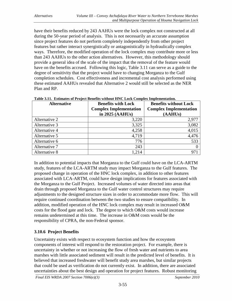
Alternatives Volume III – Convey Atchafalaya River Water to Northern Terrebonne Marshes and Multipurpose Operation of Houma Navigation Lock
3-55
Final EIS WRDA 2007 Section 7006(e)(3) September 2010
have their benefits reduced by 243 AAHUs were the lock complex not constructed at all during the 50-year period of analysis. This is not necessarily an accurate assumption since project features do not perform completely independently from other project features but rather interact synergistically or antagonistically in hydraulically complex ways. Therefore, the modified operation of the lock complex may contribute more or less than 243 AAHUs to the other action alternatives. However, this methodology should provide a general idea of the scale of the impact that the removal of the feature would have on the benefits accrued. Following this logic, Table 3.11 can serve as a guide to the degree of sensitivity that the project would have to changing Morganza to the Gulf completion schedules. Cost effectiveness and incremental cost analysis performed using these estimated AAHUs revealed that Alternative 2 would still be selected as the NER Plan and RP. Table 3.11. Estimates of Project Benefits without HNC Lock Complex Implementation.
Alternative Benefits with Lock Complex Implementation
in 2025 (AAHUs)
Benefits without Lock Complex Implementation
(AAHUs) Alternative 2 3,220 2,977 Alternative 3 3,325 3,082 Alternative 4 4,258 4,015 Alternative 5 4,719 4,476 Alternative 6 776 533 Alternative 7 243 0 Alternative 8 1,214 971 In addition to potential impacts that Morganza to the Gulf could have on the LCA-ARTM study, features of the LCA-ARTM study may impact Morganza to the Gulf features. The proposed change in operation of the HNC lock complex, in addition to other features associated with LCA-ARTM, could have design implications for features associated with the Morganza to the Gulf Project. Increased volumes of water directed into areas that drain through proposed Morganza to the Gulf water control structures may require adjustments to the designed structure sizes in order to accommodate more flow. This will require continued coordination between the two studies to ensure compatibility. In addition, modified operation of the HNC lock complex may result in increased O&M costs for the flood gate and lock. The degree to which O&M costs would increase remains undetermined at this time. The increase in O&M costs would be the responsibility of CPRA, the non-Federal sponsor. 3.10.6 Project Benefits
Uncertainty exists with respect to ecosystem function and how the ecosystem components of interest will respond to the restoration project. For example, there is uncertainty in whether or not increasing the flow of fresh water and nutrients to area marshes with little associated sediment will result in the predicted level of benefits. It is believed that increased freshwater will benefit study area marshes, but similar projects that could be used as verification do not currently exist. In addition, there are associated uncertainties about the best design and operation for project features. Robust monitoring

Alternatives Volume III – Convey Atchafalaya River Water to Northern Terrebonne Marshes and Multipurpose Operation of Houma Navigation Lock
3-56
Final EIS WRDA 2007 Section 7006(e)(3) September 2010
and adaptive management will help to ensure project success and identify outcomes that should realistically be expected for the project. There is also uncertainty as to the magnitude of benefits that will be accrued from beneficial use of dredged material. For purposes of impact analysis associated with dredge features for all alternatives, the assumption was made that the dredge channel itself and the adjacent disposal site would result in marsh impacts. In reality, dredged material will be used beneficially to create marsh habitat to the maximum extent practicable. However, the exact nature of the dredged material and its utility in marsh creation, the locations of marsh creation sites, and the acreage of created marsh habitat will not be determined until a later date, during pre-construction engineering and design. Therefore, the aforementioned assumptions were necessary in order to complete the impact analysis for project features. In light of this, the estimates of negative impacts to marsh should be viewed as maximums as they should be offset at least in part by beneficially using dredged material during construction. Further environmental analysis and documentation, including updates to the Section 404(b)(1) evaluation (see Appendix D), will be prepared during pre-construction engineering and design to address changes in disposal locations and associated benefits. Finally, there is uncertainty with regard to fisheries access impacts on project benefits associated with the Grand Pass weir (WW2), the Robinson Canal plug (CP1), the Cutoff Canal plug (EP7), and the operation of the HNC Lock Complex (CL1). Inclusion of fisheries access impacts in the calculation of AAHUs may have resulted in negative AAHUs for all alternatives, despite net gains in wetland acreages. These measures are designed to correct significant hydrologic alterations on man-made canals which are thought to be significant causes of wetland degradation and loss and which resulted in artificially increased fisheries access. In addition, other natural and man-made waterways exist for fisheries access. Therefore, the decision was made to eliminate this potential impact when calculating benefits associated with each alternative. Potential modifications to this methodology are being investigated by USFWS in consultation with NMFS, LDWF, and other interested natural resource agencies. 3.10.7 Future Analysis
In addressing the recommendations of the USFWS for further analysis and coordination during pre-construction engineering and design (see Section 7.2.1), the following will be undertaken:
• Additional hydrologic modeling, benefits analysis, and cost effectiveness analysis of various sized and designed enlargements of Grand Bayou Canal/Bayou L’Eau Bleu (measures ED3, ED5, ED6, and ED7) to avoid unnecessary construction impacts and unnecessary canal-induced saltwater intrusion impacts, to include efforts to assess project-related effects of reduced freshwater inflows to the Barataria Basin
• Additional hydrologic modeling, benefits analysis, and cost effectiveness analysis of various sized and designed enlargements of St. Louis Canal (measure ED2) to

Alternatives Volume III – Convey Atchafalaya River Water to Northern Terrebonne Marshes and Multipurpose Operation of Houma Navigation Lock
3-57
Final EIS WRDA 2007 Section 7006(e)(3) September 2010
avoid unnecessary construction impacts and unnecessary canal-induced saltwater intrusion impacts
• Additional hydrologic modeling, benefits analysis, and cost effectiveness analysis related to the multi-purpose operation of the HNC Lock Complex to include assessment of the adequacy of the existing model grid, re-examination of model results for unaccounted-for HNC flows, inclusion of the Falgout Canal structures, review of the predicted Lake Boudreaux salinity trends, and assessment of alternative sluice gate operations on the HNC Lock
• Inspection of proposed work sites for the presence of wading bird nesting colonies and bald eagles during the nesting season
• Sampling and testing of material to be dredged and determination of locations for beneficial use of dredged material
• Development of operation plans for water control structures • Coordination with Louisiana Department of Wildlife and Fisheries
In addition to the above analyses recommended by USFWS, additional hydrologic modeling will be conducted on dredge feature WD2 in order to address concerns from the public regarding saltwater intrusion and bank stability. These efforts will be coordinated with the USFWS and other interested natural resource agencies. The results of these additional analyses will be disclosed to the public and supplemental NEPA documentation will be prepared, as appropriate. 3.11 Implementation Requirements
3.11.1 Schedule
At this time the implementation schedule for the NER/RP is based on MII cost estimation durations. This implementation schedule is tentative and may change to be accelerated, especially if a larger dredge is used than is currently accounted for in the cost estimation. See Appendix L for a more detailed breakdown of the construction schedule. See Table 3.12 for the project implementation schedule. Table 3.12 Milestone Schedule
Milestones Schedule
Final Report August 2010 Division Engineer Notice August 2010 Washington Level Review August 2010 Execute Cost-Sharing Agreement for PED September 2010 State and Agency Review October 2010 Chief of Engineers Report December 2010 Begin Preconstruction Engineering and Design 2011 ASA and OMB Review 2011 ASA Report to Congress 2011 Complete Design Documentation Report 2012
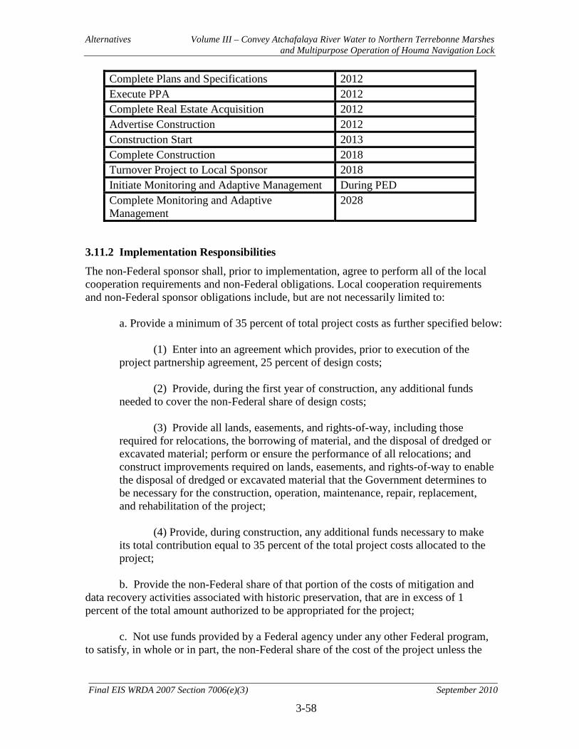
Alternatives Volume III – Convey Atchafalaya River Water to Northern Terrebonne Marshes and Multipurpose Operation of Houma Navigation Lock
3-58
Final EIS WRDA 2007 Section 7006(e)(3) September 2010
Complete Plans and Specifications 2012 Execute PPA 2012 Complete Real Estate Acquisition 2012 Advertise Construction 2012 Construction Start 2013 Complete Construction 2018 Turnover Project to Local Sponsor 2018 Initiate Monitoring and Adaptive Management During PED Complete Monitoring and Adaptive Management
2028
3.11.2 Implementation Responsibilities
The non-Federal sponsor shall, prior to implementation, agree to perform all of the local cooperation requirements and non-Federal obligations. Local cooperation requirements and non-Federal sponsor obligations include, but are not necessarily limited to:
a. Provide a minimum of 35 percent of total project costs as further specified below:
(1) Enter into an agreement which provides, prior to execution of the project partnership agreement, 25 percent of design costs;
(2) Provide, during the first year of construction, any additional funds
needed to cover the non-Federal share of design costs; (3) Provide all lands, easements, and rights-of-way, including those
required for relocations, the borrowing of material, and the disposal of dredged or excavated material; perform or ensure the performance of all relocations; and construct improvements required on lands, easements, and rights-of-way to enable the disposal of dredged or excavated material that the Government determines to be necessary for the construction, operation, maintenance, repair, replacement, and rehabilitation of the project;
(4) Provide, during construction, any additional funds necessary to make
its total contribution equal to 35 percent of the total project costs allocated to the project;
b. Provide the non-Federal share of that portion of the costs of mitigation and
data recovery activities associated with historic preservation, that are in excess of 1 percent of the total amount authorized to be appropriated for the project;
c. Not use funds provided by a Federal agency under any other Federal program,
to satisfy, in whole or in part, the non-Federal share of the cost of the project unless the
Alternatives Volume III – Convey Atchafalaya River Water to Northern Terrebonne Marshes and Multipurpose Operation of Houma Navigation Lock
3-59
Final EIS WRDA 2007 Section 7006(e)(3) September 2010
Federal agency that provides the funds determines that the funds are authorized to be used to carry out the study or project;
d. Not use project or lands, easements, and rights-of-way required for the project
as a wetlands bank or mitigation credit for any other project; e. For as long as the project remains authorized, operate, maintain, repair,
replace, and rehabilitate the project, or functional portions of the project, including mitigation, at no cost to the Federal Government, in a manner compatible with the project’s authorized purposes and in accordance with applicable Federal and state laws and regulations and any specific directions prescribed by the Federal Government;
f. Give the Federal Government a right to enter, at reasonable times and in a
reasonable manner, upon property that the non-Federal sponsor, now or hereafter, owns or controls for access to the project for the purpose of inspecting, operating, maintaining, repairing, replacing, rehabilitating, or completing the project. No completion, operation, maintenance, repair, replacement, or rehabilitation by the Federal Government shall relieve the non-Federal sponsor of responsibility to meet the non-Federal sponsor’s obligations, or to preclude the Federal Government from pursuing any other remedy at law or equity to ensure faithful performance;
g. Hold and save the United States free from all damages arising from the
construction, operation, maintenance, repair, replacement, and rehabilitation of the project and any project-related betterments, except for damages due to the fault or negligence of the United States or its contractors;
h. Perform, or cause to be performed, any investigations for hazardous substances
that are determined necessary to identify the existence and extent of any hazardous substances regulated under the Comprehensive Environmental Response, Compensation, and Liability Act (CERCLA), Public Law 96-510, as amended (42 U.S.C. 9601-9675), that may exist in, on, or under lands, easements, or rights-of-way that the Federal Government determines to be required for the initial construction, periodic nourishment, operation, and maintenance of the project. However, for lands that the Federal Government determines to be subject to the navigation servitude, only the Federal Government shall perform such investigations unless the Federal Government provides the non-Federal sponsor with prior specific written direction, in which case the non-Federal sponsor shall perform such investigations in accordance with such written direction;
i. Assume, as between the Federal Government and the non-Federal sponsor,
complete financial responsibility for all necessary cleanup and response costs of any CERCLA regulated materials located in, on, or under lands, easements, or rights-of-way that the Federal Government determines to be necessary for the initial construction, periodic nourishment, operation, or maintenance of the project;
Alternatives Volume III – Convey Atchafalaya River Water to Northern Terrebonne Marshes and Multipurpose Operation of Houma Navigation Lock
3-60
Final EIS WRDA 2007 Section 7006(e)(3) September 2010
j. Agree that, as between the Federal Government and the non-Federal sponsor, the non-Federal sponsor shall be considered the operator of the project for the purpose of CERCLA liability, and to the maximum extent practicable, operate, maintain, and repair the project in a manner that would not cause liability to arise under CERCLA;
k. Prevent obstructions of or encroachments on the project (including prescribing
and enforcing regulations to prevent such obstruction or encroachments) which might reduce ecosystem restoration benefits, hinder operation and maintenance, or interfere with the project’s proper function, such as any new developments on project lands or the addition of facilities which would degrade the benefits of the project;
l. Keep and maintain books, records, documents, and other evidence pertaining to
costs and expenses incurred pursuant to the project, for a minimum of 3 years after completion of the accounting for which such books, records, documents, and other evidence is required, to the extent and in such detail as would properly reflect total costs of construction of the project, and in accordance with the standards for financial management systems set forth in the Uniform Administrative Requirements for Grants and Cooperative Agreements to State and Local Governments at 32 Code of Federal Regulations (CFR) Section 33.20;
m. Comply with Section 221 of Public Law 91-611, Flood Control Act of 1970,
as amended (42 U.S.C. 1962d-5), and Section 103 of the Water Resources Development Act of 1986, Public Law 99-662, as amended (33 U.S.C. 2213), which provides that the Secretary of the Army shall not commence the construction of any water resources project or separable element thereof, until the non-Federal sponsor has entered into a written agreement to furnish its required cooperation for the project or separable element;
n. Comply with all applicable Federal and state laws and regulations, including,
but not limited to, Section 601 of the Civil Rights Act of 1964, Public Law 88-352 (42 U.S.C. 2000d), and Department of Defense Directive 5500.11 issued pursuant thereto, as well as Army Regulation 600-7, entitled "Nondiscrimination on the Basis of Handicap in Programs and Activities Assisted or Conducted by the Department of the Army,” and all applicable Federal labor standards and requirements, including but not limited to 40 U.S.C. 3141- 3148 and 40 U.S.C. 3701 – 3708 (revising, codifying, and enacting without substantial change the provisions of the Davis-Bacon Act (formerly 40 U.S.C. 276a et seq.), the Contract Work Hours and Safety Standards Act (formerly 40 U.S.C. 327 et seq.) and the Copeland Anti-Kickback Act (formerly 40 U.S.C. 276c et seq.); and
o. Comply with all applicable provisions of the Uniform Relocation Assistance
and Real Property Acquisition Policies Act of 1970, Public Law 91-646, as amended (42 U.S.C. 4601-4655), and the Uniform Regulations contained in 49 CFR Part 24, in acquiring lands, easements, and rights-of-way necessary for the initial construction, periodic nourishment, operation, and maintenance of the project, including those necessary for relocations, borrow materials, and dredged or excavated material disposal, and inform all affected persons of applicable benefits, policies, and procedures in connection with said Act.
Alternatives Volume III – Convey Atchafalaya River Water to Northern Terrebonne Marshes and Multipurpose Operation of Houma Navigation Lock
3-61
Final EIS WRDA 2007 Section 7006(e)(3) September 2010
3.11.3 Cost Sharing
The State of Louisiana, acting through the CPRA, will be the non-Federal sponsor for the Recommended Plan. In November 2008, the USACE and CPRA executed a single Feasibility Cost-Share Agreement covering six Louisiana Coastal Area near-term plan elements listed in Section 7006(e) of the Water Resources Development Act of 2007. The six features each underwent a separate feasibility analysis and environmental compliance analysis culminating in a single master feasibility document. The cost-share during the feasibility phase was 50% Federal and 50% non-Federal; however, the individual elements have been divided so that each entity has lead responsibility for preparing three of the six report components. At the end of the feasibility phase the total cost for all elements will have been shared on a 50/50 basis, yet for work on each individual element during the feasibility phase the ratio of funds expended by either the Federal or non-Federal sponsor will be higher depending upon their level of responsibility. The Corps has the technical planning lead for this particular LCA project element. Following the feasibility phase, the cost share for the planning, design and construction of the project will be 65% Federal and 35% non-Federal. The CPRA must provide all lands, easements, rights-of-way, utility or public facility relocations, and disposal areas (LERRDs) required for the project. The value of LERRDs would be included in the non-Federal 35% share. Operation, Maintenance, Repair, Replacement and Rehabilitation (OMRR&R) of the project would be a 100% CPRA responsibility. Additionally, project monitoring and any Adaptive Management deemed necessary will be cost shared at 65/35 for the first 10 years of the project life. Under current law, authority for the non-Federal sponsor to receive credit for construction activities is limited. Section 7007(a) of WRDA 2007 authorizes the Secretary to credit, "toward the non-Federal share of the cost of a study or project under this title the cost of work carried out in the coastal Louisiana ecosystem by the non-Federal interest for the project before the date of the execution of the partnership agreement for the study or project." In addition, section 7007(a) incorporates the requirement of section 221 of the Flood Control Act of 1970, as amended, (42 U.S.C. 1962d-5b) that the Government and non-Federal sponsor must enter into a separate agreement for any work that will be carried out prior to execution of the partnership agreement. In other words, work undertaken by the non-Federal sponsor prior to (but not after) execution of the project partnership agreement (PPA) is eligible for credit subject to execution of a separate agreement covering such work before it is undertaken. For design work that the non-Federal sponsor proposes to undertake, the Design Agreement will serve as the required separate agreement. For construction work that the non-Federal sponsor proposes to undertake, an In-Kind Memorandum of Understanding will be required. Opportunities to enter into an In-Kind MOU for construction activities will depend on the schedule for entering into the PPA for a project. Section 7007(d) provides that credit afforded under section 7007 that is in "excess" of the non-Federal cost share for a study or project authorized in Title VII of the Water Resources Development Act of 2007 may be applied toward the non-Federal cost share of any other study or project under that title. "Excess" credit will be applied only toward
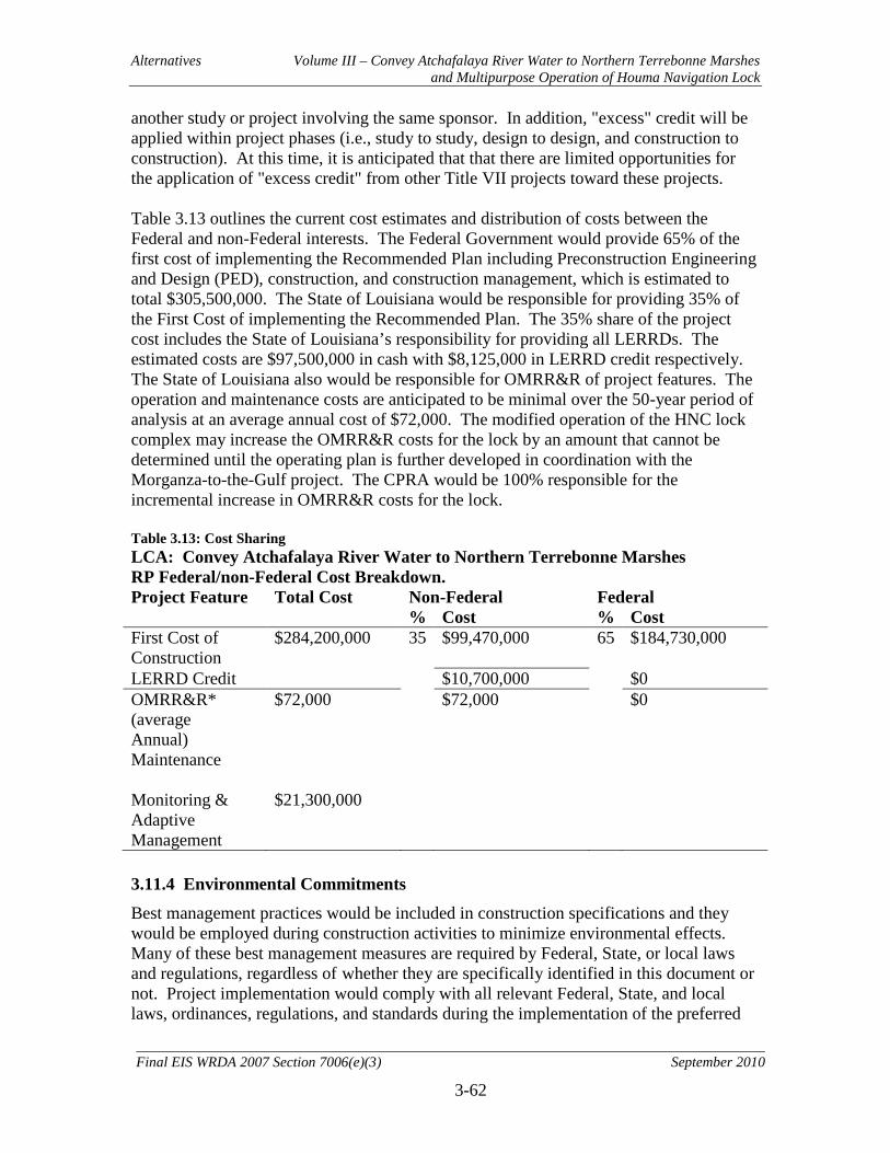
Alternatives Volume III – Convey Atchafalaya River Water to Northern Terrebonne Marshes and Multipurpose Operation of Houma Navigation Lock
3-62
Final EIS WRDA 2007 Section 7006(e)(3) September 2010
another study or project involving the same sponsor. In addition, "excess" credit will be applied within project phases (i.e., study to study, design to design, and construction to construction). At this time, it is anticipated that that there are limited opportunities for the application of "excess credit" from other Title VII projects toward these projects. Table 3.13 outlines the current cost estimates and distribution of costs between the Federal and non-Federal interests. The Federal Government would provide 65% of the first cost of implementing the Recommended Plan including Preconstruction Engineering and Design (PED), construction, and construction management, which is estimated to total $305,500,000. The State of Louisiana would be responsible for providing 35% of the First Cost of implementing the Recommended Plan. The 35% share of the project cost includes the State of Louisiana’s responsibility for providing all LERRDs. The estimated costs are $97,500,000 in cash with $8,125,000 in LERRD credit respectively. The State of Louisiana also would be responsible for OMRR&R of project features. The operation and maintenance costs are anticipated to be minimal over the 50-year period of analysis at an average annual cost of $72,000. The modified operation of the HNC lock complex may increase the OMRR&R costs for the lock by an amount that cannot be determined until the operating plan is further developed in coordination with the Morganza-to-the-Gulf project. The CPRA would be 100% responsible for the incremental increase in OMRR&R costs for the lock. Table 3.13: Cost Sharing LCA: Convey Atchafalaya River Water to Northern Terrebonne Marshes RP Federal/non-Federal Cost Breakdown. Project Feature Total Cost Non-Federal Federal % Cost % Cost First Cost of $284,200,000 35 $99,470,000 65 $184,730,000 Construction LERRD Credit $10,700,000 $0 OMRR&R* (average
$72,000 $72,000 $0
Annual) Maintenance
Monitoring & Adaptive
$21,300,000
Management 3.11.4 Environmental Commitments
Best management practices would be included in construction specifications and they would be employed during construction activities to minimize environmental effects. Many of these best management measures are required by Federal, State, or local laws and regulations, regardless of whether they are specifically identified in this document or not. Project implementation would comply with all relevant Federal, State, and local laws, ordinances, regulations, and standards during the implementation of the preferred
Alternatives Volume III – Convey Atchafalaya River Water to Northern Terrebonne Marshes and Multipurpose Operation of Houma Navigation Lock
3-63
Final EIS WRDA 2007 Section 7006(e)(3) September 2010
alternative. Implementation of the environmental commitments would be documented to track execution and completion of the environmental commitments. A summary of the environmental and related commitments made during the planning process and incorporated into the proposed project plan include the following:
• Ensure construction contractors limit ground disturbance to the smallest extent feasible.
• Use accepted erosion control measures during construction. • Conduct a search for bald eagle, other raptors and colonial nesting wading bird
active nests within three-quarter of a mile from proposed disturbance activities prior to construction. Appropriate protective measures and no-work distance restrictions would be implemented to avoid or minimize nest disturbance if active nests are identified.
• Contact pipeline and gas well companies prior to construction activities to identify and avoid existing hazards.
• Implement best management practices and measures contained in erosion control guidelines to control soil erosion from construction areas.
• Implement measures to control fugitive dust during construction. • Implement a program to compensate for losses of archaeological sites (if any) that
would occur as a result of construction and operation of the proposed project. • Implement the Monitoring and Adaptive Management Plan. • Implement the recommendations of the USFWS for further modeling and analysis
of alternatives as detailed in Section 7.2.1 and Appendix B of this report. 3.11.5 Financial Requirements
3.11.5.1 Sponsorship Agreement Prior to the start of construction, the State of Louisiana will be required to enter into a Project Partnership Agreement (PPA) with the Federal Government and satisfy state laws and all applicable regulations. In general, the items included in the PPA have been outlined in the previous paragraphs. 3.11.5.2 Financial Analysis It is expected that the CPRA will have the capacity to provide the required local cooperation for the Recommended Plan. A project schedule and cost estimate will be provided to the CPRA so that it may develop a financing plan. A standard cost share percentage of 65% Federal and 35% non-Federal would be applied to the total first cost of the project. The 35% share of the project cost includes the State of Louisiana’s responsibility for providing all LERRDs. Section 7007(b) of WRDA 2007 provides that "The non-Federal interest may use, and the Secretary shall accept, funds provided by a Federal agency under any other Federal program, to satisfy, in whole or part, the non-Federal share of the cost of the study or project if the Federal agency that provides the funds determines that the funds are

Alternatives Volume III – Convey Atchafalaya River Water to Northern Terrebonne Marshes and Multipurpose Operation of Houma Navigation Lock
3-64
Final EIS WRDA 2007 Section 7006(e)(3) September 2010
authorized to carry out the study or project." If the Mineral Management Services determines in writing that funds it provides to the non- Federal sponsor under the Energy Policy Act of 2005 (Coastal Impact Assistance Program - CIAP) and the Gulf of Mexico Energy Security Act of 2006 (GOMESA) are authorized to be used to carry out the Convey Atchafalaya River Water to Northern Terrebonne Marshes and Multipurpose Operation of the Houma Navigation Lock projects, the non-Federal sponsor can use those funds toward satisfying its local cooperation for the project, including the non-Federal sponsor's acquisition of Lands, Easements, Relocations, Rights of-way and Disposals (LERRDs) required for the project. By letters dated July 2, 2009 and December 18, 2009, the Minerals Management Service and the USACE established a process for the Minerals Management Service to provide its written determination regarding the acceptability of the use of CIAP funds for LCA studies, projects, and programs. That process provides that the Minerals Management Services' written determination for a specific study, project, or program will take the form of the grant award document for that activity. 3.11.5.3 Local Cooperation The CPRA provided a letter of intent to serve as the non-Federal sponsor for the project on August 9, 2010. A copy of the letter can be found in Appendix ??. 3.11.5.4 Project Management Plan A Project Management Plan (PMP) for implementation of the Recommended Plan will be prepared. The PMP will describe activities, responsibilities, schedules, and costs required for the Plans and Specifications phase and construction of the project. The Plans and Specifications phase will last for an estimated 24 months at a total estimated cost of $23,423,000. 3.11.5.5 Procedures for Project Implementation Future actions necessary for project approval and implementation are summarized as follows: 1. The purpose of peer review, or in this case, Independent External Peer Review
(IEPR) is to ensure the quality and credibility of the Corps scientific information. IEPR will be conducted during the official public review period of the draft integrated feasibility report and EIS. Comments must be addressed before the document can be made final.
2. The U.S. Army Corps of Engineers Mississippi Valley Division Commander will
review the final report and then issue a public notice announcing completion of the final report. This is referred to as the Division Engineer’s Notice, or DE’s Notice.
3. The report will then be submitted to Headquarters, U.S. Army Corps of Engineers
(HQUSACE), and the Office of the Assistant Secretary of the Army for Civil Works (ASA (CW)) for concurrent Washington level review.
Alternatives Volume III – Convey Atchafalaya River Water to Northern Terrebonne Marshes and Multipurpose Operation of Houma Navigation Lock
3-65
Final EIS WRDA 2007 Section 7006(e)(3) September 2010
4. The 30-day state and agency review and coordination of the EIS will be ongoing
concurrently during the HQUSACE review. 5. Concurrent Washington level review by HQUSACE and ASACW will conclude with
a HQUSACE staff assessment, the 30-day state and agency review, review input by the ASACW, HQUSACE final assessment, a field visit and meeting, if necessary, and the documentation of report review prepared by HQUSACE.
6. The Washington level decision-making process will follow the decision-making
sequence of HQUSACE and ASACW, once the documentation of report review has been completed. There will be a briefing, if necessary, for the Designated Senior Representatives of Decision-Makers to resolve any outstanding issues. The Chief of Engineers will provide his recommendations on the report to the ASACW, who will provide the report and proposed recommendations to the Office of Management and Budget (OMB) to obtain their views and comments on whether the proposed recommendations are consistent with Administrative policies. Prior to the transmittal of the report to the Congress, the Non-Federal Sponsor, the State of Louisiana, interested Federal agencies, and other parties will be advised of any significant modifications made to the recommendations and will be afforded an opportunity to comment further.
7. Authorization of the project is provided by WRDA 2007; however, authorization and
construction is contingent upon the completion and acceptance of a Chief of Engineer’s Report by December 31, 2010.
8. Funds could be provided, when appropriated in the budget, for Preconstruction
Engineering and Design (PED) upon issuance of the Division Engineer’s public notice, announcing the completion of the final report and pending project funding authorization. A Design Cooperation Agreement will need to be developed and executed between the Federal Government and the State of Louisiana, whereby the sponsor will provide 25% of the cost of PED studies.
9. The U.S. Army Corps of Engineers will complete final design and plans and
specifications for project construction. 10. Subsequent to appropriation of construction funds by Congress, formal assurances of
local cooperation in the form of a Project Partnership Agreement (PPA) will be required from the State of Louisiana.
11. The State of Louisiana will be required to provide all real estate requirements for
project implementation. 12. Bids for construction will be advertised and contracts awarded.
Alternatives Volume III – Convey Atchafalaya River Water to Northern Terrebonne Marshes and Multipurpose Operation of Houma Navigation Lock
3-66
Final EIS WRDA 2007 Section 7006(e)(3) September 2010
13. Upon completion of construction, the Corps’ acceptance from the contractor and notice of construction completion for the project (or a functional portion of the project) to the non-Federal sponsor will proceed or be concurrent with the delivery of an O&M manual and as-built drawings. The State of Louisiana will be responsible for OMRR&R of the project in accordance with guidelines provided by the U.S. Army Corps of Engineers.
3.11.6 Views of Non-Federal Sponsor
The State of Louisiana fully supports the project. The state recognizes that the USACE's position is that section 7007 does not authorize credit for work carried out after the date of a partnership agreement. However, the state disagrees with the USACE position and intends to continue to seek a change in law that would allow in-kind contribution credit for work carried out after the date of a Project Partnership Agreement and that would allow for such in-kind contributions credit to carry over between LCA Program components (i.e., “excess” credit for work undertaken after signing of the project partnership agreement for one project may be carried over for credit to another project). Nevertheless, while the state is of the opinion that its view is consistent with the authority and Congressional intent under WRDA 2007, the state fully intends to proceed with the project under the Corps’ interpretation of current law and to meet all non-Federal financial and other obligations outlined by the USACE in this report until such time as the law is changed.

Alternatives Volume III – Convey Atchafalaya River Water to Northern Terrebonne Marshes and Multipurpose Operation of Houma Navigation Lock
3-67
Final EIS WRDA 2007 Section 7006(e)(3) September 2010
This page intentionally blank

Affected Environment Volume III – Convey Atchafalaya River Water to Northern Terrebonne Marshes and Multipurpose Operation of Houma Navigation Lock
4-1 Final EIS WRDA 2007 Section 7006(e)(3) September 2010
4.0 AFFECTED ENVIRONMENT This chapter describes the climate, geomorphic and physiographic setting, and the historic and existing conditions for the following important resources: soils; coastal vegetation; wildlife; fisheries; plankton; benthos; essential fish habitat (EFH); threatened and endangered species; hydrology (including flow and water levels, and sediment); water quality; recreation; public lands; cultural and historic resources; aesthetics; air quality; socioeconomic and human resources (including population; infrastructure; employment and income; navigation; oil, gas, and utilities; pipelines; commercial fisheries; oyster leases; and flood control and hurricane protection). In addition, the characterization of noise and hazardous, toxic, and radioactive waste (HTRW) in the project area are presented. A resource is considered important if it is recognized by statutory authorities including laws, regulations, Executive Orders (EO), policies, rules, or guidance; if it is recognized as important by some segment of the general public; or if it is determined to be important based on technical or scientific criteria. The following sections discuss historic and existing conditions of each important resource occurring within the project area. 4.1 Environmental Setting of Study Area
4.1.1 Location
The overall study area is located mostly in Terrebonne Parish in southeast Louisiana at the northern edge of the Gulf of Mexico (Figure 4.1) and encompasses approximately 1,100 square miles (700,000 acres). A portion of Lafourche Parish between Bayou Lafourche and Bayou Pointe au Chien is also included in the study area. Small portions of St. Mary, St. Martin, and Assumption Parishes are also included. The study area is approximately 55 miles wide from west to east and averages 20 miles across from the north to south boundaries. The study area lies within the Barataria-Terrebonne estuary. This estuary extends from the west bank levees of the Mississippi River (north and east), to the East Guide Levee of the Atchafalaya River (west), to the Gulf of Mexico (south), and to the town of Morganza (north). The Barataria Basin covers about 1,551,800 acres while the Terrebonne Basin covers an area of about 2,063,500 acres. The study area lies within the southern end of the Terrebonne Basin and contains a complex of habitat types, including natural levees, lakes, swamps, marshes, and bayous formed from sediments of abandoned Mississippi River deltas. Elevations in the study area vary. Near Houma, the largest city in the area, the elevation is approximately 10 feet National Geodetic Vertical Datum (NGVD). The elevation along the bayou ridges is 4-5 feet NGVD and less than 1 foot NGVD along the southern portion near the Gulf of Mexico. The major streams located in the study area or that influence the study area are the Atchafalaya River, Bayou du Large, Bayou Grand Caillou, Bayou Petit Caillou, Bayou Terrebonne, Bayou Pointe au Chien, Bayou Lafourche, Bayou L’eau Blue, Grand Bayou, Grand Bayou Blue, and Bayou Black. There are no scenic streams in the study area designated under the Louisiana Natural and Scenic River System. The Houma
Affected Environment Volume III – Convey Atchafalaya River Water to Northern Terrebonne Marshes and Multipurpose Operation of Houma Navigation Lock
4-2 Final EIS WRDA 2007 Section 7006(e)(3) September 2010
Navigation Canal runs north and south from the GIWW to the Gulf of Mexico mainly between Bayou du Large and Bayou Grand Caillou. The GIWW follows an east-west path in the northern portion of the study area. These two waterways, along with the natural channels in the area, have a strong influence on surface water in the area. 4.1.2 Climate
The climate of the study area is subtropical marine with long humid summers and short moderate winters. The climate is strongly influenced by the water surface of the many sounds, bays, lakes, and the Gulf of Mexico and seasonal changes in atmospheric circulation. During the fall and winter, the study area experiences cold continental air masses which produce frontal passages with temperature drops. During the spring and summer, the study area experiences tropical air masses which produce a warm, moist airflow conducive to thunderstorm development (USACE 2008). National Oceanic and Atmospheric Administration data indicates that average annual rainfall for the area is approximately 65 inches. The study area is also subject to periods of both drought and flood, and the climate rarely seems to truly exhibit “average” conditions. The study area is susceptible to tropical waves, tropical depressions, tropical storms and hurricanes. These weather systems can cause considerable property and environmental damage and loss of human life. Data obtained from the National Oceanic and Atmospheric Administration (NOAA) Coastal Services Center indicate that the storm centers of at least 38 tropical cyclones with a Saffir-Simpson Hurricane Scale of Category 1 or higher have passed within 50 miles of the study area during the interval 1851-2008, and at least 54 such tropical cyclones have passed within 100 miles of the study area during the same interval (Figure 4.2). The most recent tropical cyclones to affect the study area were Hurricanes Katrina and Rita, which occurred in August 2005 and September 2005, respectively, and Hurricanes Gustav and Ike, which occurred in September 2008. The area of marsh lost along the Louisiana coast as a result of Hurricanes Katrina and Rita (192,000 acres) was over one third of the total wetland losses predicted to occur by the year 2050 by the Coast 2050 Report (LCWCRTF and WCRA 1998). Within the Terrebonne Basin, roughly 12,160 acres of wetlands were converted to open water between 2004 and 2005 (Barras 2006), equal to 8.4% of the losses predicted to occur by 2050. Climate Change. Engineering Circular 1165-2-211 requires consideration of impacts of sea level change on all phases of USACE Civil Works programs and provides guidance for incorporating the direct and indirect physical effects of projected future sea-level change in managing, planning, engineering, designing, constructing, operating, and maintaining USACE projects. It is important to distinguish between eustatic and relative sea level rise. Relative sea level rise consists of eustatic or regional sea level rise combined with subsidence. Eustatic sea level rise is defined as the global increase in oceanic water levels primarily due to changes in the volume of major ice caps and glaciers, and expansion or contraction of seawater in response to temperature changes. Regional sea level rise may differ slightly from eustatic sea level rise in large, semi-enclosed water bodies like the northern Gulf of Mexico. Regional sea level rise in the project area was

Affected Environment Volume III – Convey Atchafalaya River Water to Northern Terrebonne Marshes and Multipurpose Operation of Houma Navigation Lock
4-3 Final EIS WRDA 2007 Section 7006(e)(3) September 2010
determined to be approximately 0.75 feet/century. Subsidence is the decrease in land elevations, primarily due to consolidation of sediments, faulting, groundwater depletion, and possibly oil and gas withdrawal. Subsidence in the project area was calculated using the two closest long-term gauges, located at Grand Isle and Eugene Island, and was determined to be approximately 2.35 feet/century. Relative sea level rise affects project area marshes by gradually inundating marsh plants. Marsh soil surfaces must vertically accrete to keep pace with the rate of relative sea level rise or marshes eventually convert to open water due to the depth of submergence. Direct and indirect impacts of regional sea level rise and subsidence were incorporated into the planning of the ARTM project.
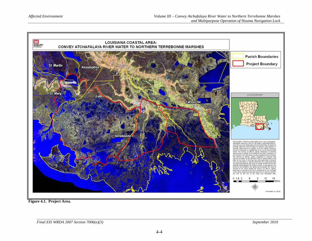
Affected Environment Volume III – Convey Atchafalaya River Water to Northern Terrebonne Marshes and Multipurpose Operation of Houma Navigation Lock
4-4
Final EIS WRDA 2007 Section 7006(e)(3) September 2010
Figure 4.1. Project Area.
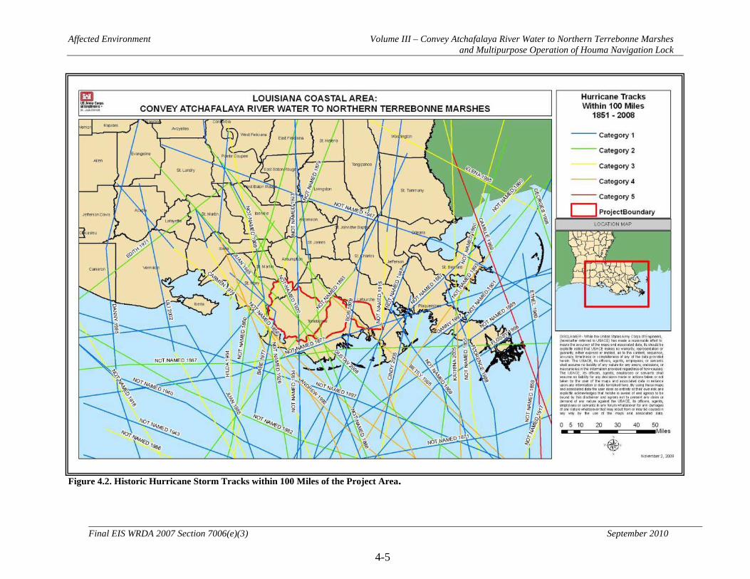
Affected Environment Volume III – Convey Atchafalaya River Water to Northern Terrebonne Marshes and Multipurpose Operation of Houma Navigation Lock
4-5
Final EIS WRDA 2007 Section 7006(e)(3) September 2010
Figure 4.2. Historic Hurricane Storm Tracks within 100 Miles of the Project Area.
Affected Environment Volume III – Convey Atchafalaya River Water to Northern Terrebonne Marshes and Multipurpose Operation of Houma Navigation Lock
4-6
Final EIS WRDA 2007 Section 7006(e)(3) September 2010
4.1.3 Geomorphic and Physiographic Setting
The geology of the area is heavily influenced by the Mississippi River and its delta plain, a complex of abandoned and active deltas of the Mississippi River. Three of four abandoned delta complexes shaped Terrebonne and Lafourche Parishes as sediments were deposited on the Pleistocene Prairie. The Mississippi River laid down sediments from 100-200 meters thick at each delta (Penland et al. 1988). The abandoned deltas were formed generally from the west to the east in chronological sequence starting about 9,000 years before present and ending less than 100 years ago (Sevier 1990). The most recent sediments of an abandoned delta were laid down as part of the Lafourche delta. After delta abandonment occurs, sediments slowly deteriorate as they subside under their own weight. In addition, sea level has been rising throughout this time by about 5 to 8 m (Mossa et al. 1990). Historically, the cycle of delta growth and destruction took about 5,000 years (Gosselink and Sasser 1991). However, because of a variety of factors (most notably human), delta destruction is taking place in a few human generations rather than thousands of years. The Lafourche delta complex in the study area, which includes Bayou Terrebonne, Bayou Black, Bayou Blue, Bayou Pointe au Chien, Bayous Grand and Petit Caillou, and Bayou du Large, began forming some 3,500 years ago. Delta development ended when the Mississippi River shifted to the east about 500 years ago to adopt its current configuration. From that time until about 100 years ago, overflows from the Mississippi River continued to maintain the Lafourche delta complex. The complex began to degrade when Bayou Lafourche was closed off early in the twentieth century (Mossa et al. 1990). The Atchafalaya River with its actively building delta is out of the study area, but its flows influence the study area. It was formed in the sixteenth century when a meander of the Mississippi River captured the Red River. It remained an insignificant river until late in the nineteenth century when an enormous logjam at its upper end was cleared (Mossa et al. 1990) and water could move unobstructed toward the Gulf of Mexico. The lower Atchafalaya delta began forming in 1952 and it continues to develop across Atchafalaya Bay. According to Turner and Rao (1990) the driving factors in landscape changes include sea level rise, geological compaction, a 50 percent reduction in sediment supply from the Mississippi River since the 1950's, and hydrologic changes. Delaune et al. (1994), Kuecher (1994), and Gagliano (1999) conclude that geological factors, such as consolidation of deltaic sediments and active faulting, appear to be the underlying cause for a majority of the land loss in coastal Louisiana. Hydrocarbon withdrawals may also be a significant factor (White and Morton 1997) by activating faults that lead to subsidence.

Affected Environment Volume III – Convey Atchafalaya River Water to Northern Terrebonne Marshes and Multipurpose Operation of Houma Navigation Lock
4-7
Final EIS WRDA 2007 Section 7006(e)(3) September 2010
Based on data from Gulf of Mexico gages, regional sea level rise is approximately 0.75 feet/century and based on gages at Grand Isle and Eugene Island, subsidence in the project area is approximately 2.35 feet/century.
Affected Environment Volume III – Convey Atchafalaya River Water to Northern Terrebonne Marshes and Multipurpose Operation of Houma Navigation Lock
4-8
Final EIS WRDA 2007 Section 7006(e)(3) September 2010
4.2 Significant Resources
4.2.1 Soils and Waterbottoms
4.2.1.1 Historic and Existing Conditions This resource is institutionally significant because of the Council on Environmental Quality (CEQ) memorandum of August 11, 1980, entitled “Analysis of Impacts on Prime or Unique Agricultural Lands in Implementing the National Environmental Policy Act (NEPA);” Executive Order 11990 – Protection of Wetlands; and Agriculture and Food Act of 1981 (Public Law 97-98) containing the Farmland Protection Policy Act (Public Law 97-98; U.S.C. 4201 et seq.). This resource is technically significant because it is a critical element of coastal habitats, and supports vegetation growth and open-water benthic productivity. This resource is publicly significant because of the high value the public places on wildlife and fisheries supported by the soils in the area. The following information is taken from the Soil Survey of Terrebonne Parish, Louisiana (McDaniel and Trahan 2007):
Terrebonne parish lies entirely within the south-central region of the Mississippi River Delta Plain. It is made up of two major land resource areas (MLRA's). MLRA 131, the Southern Mississippi Valley Alluvium, makes up about 24 percent of the area. MLRA 151, the Gulf Coast Marsh, makes up the remaining 76 percent of the parish. The soils of the natural levees formed in sediments deposited by former channels of the Mississippi River and its distributaries on the Atchafalaya and Lafourche Delta Complex. Loamy soils are dominant on the high and intermediate parts of the natural levees, and clayey soils are dominant on the lower parts of the natural levees and in backswamps. The loamy soils, and the clayey soils that rarely flood, make up about 9 percent of the total land area of the parish. They are used mainly for cropland, urban, and industrial purposes. A few areas are in pasture and woodland. The clayey soils on the lowest parts of the landscape are subject to occasional or frequent flooding and make up about 6 percent of the total land area of the parish. They are used mainly for timber production, pasture, recreation, and wildlife. Some narrow, loamy, natural levee ridges in the southeastern and east-central parts of the parish extend south into the Gulf Coast Marsh. These areas are subject to occasional flooding during tropical storms and are used mainly for camps, homesites, and activities associated with the seafood industry. The remaining 85 percent of the land area of Terrebonne Parish consists mainly of ponded, frequently flooded, and very frequently flooded, mucky and clayey, fluid soils in marshes and swamps. They are used mainly as habitat for wetland wildlife and for recreation. Some acreage of former marshes and swamps have been protected, pumped-off, and drained and are used as pasture or for urban use. Elevations range from about 14 feet above mean sea level along the natural levee of Bayou Terrebonne in the northern part of the parish, to about 5 feet below sea level in the former marshes and swamps that have been drained.

Affected Environment Volume III – Convey Atchafalaya River Water to Northern Terrebonne Marshes and Multipurpose Operation of Houma Navigation Lock
4-9
Final EIS WRDA 2007 Section 7006(e)(3) September 2010
About 75,000 acres in the survey area, or nearly 7 percent of the total acreage, meets the soil requirements for prime farmland. Scattered areas of this land are mainly in the northern parts of the survey area. All areas of this prime farmland are used for crops. The crops grown on this land, mainly common bermudagrass, improved bermudagrass, soybeans, wheat, sugarcane, bahiagrass, and corn account for a significant amount of the county's total agricultural income each year. A recent trend in land use in some parts of the survey area has been the loss of some prime farmland to industrial and urban uses. The loss of prime farmland to other uses puts pressure on marginal lands, which generally are more erodible, droughty, and less productive and cannot be easily cultivated.
The soils in the project area that fall outside of the Terrebonne Parish boundary share characteristics and formative processes very similar to those of Terrebonne Parish as described above (Figure 4.3).
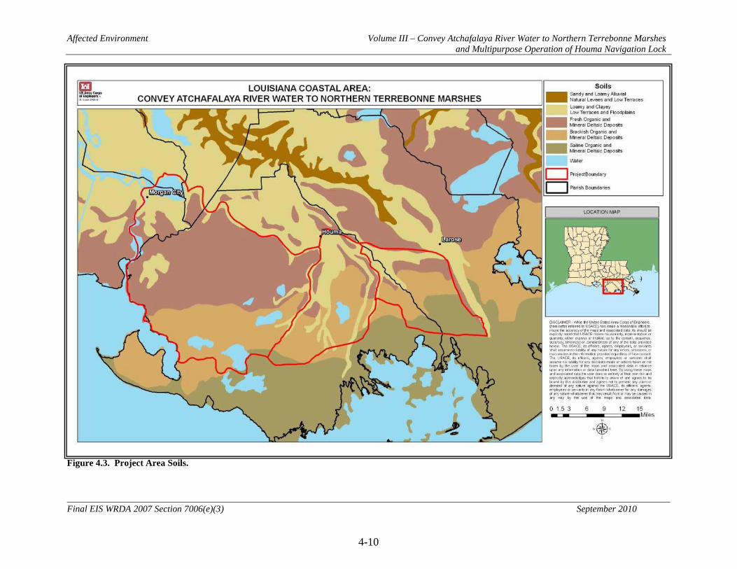
Affected Environment Volume III – Convey Atchafalaya River Water to Northern Terrebonne Marshes and Multipurpose Operation of Houma Navigation Lock
4-10
Final EIS WRDA 2007 Section 7006(e)(3) September 2010
Figure 4.3. Project Area Soils.
Affected Environment Volume III – Convey Atchafalaya River Water to Northern Terrebonne Marshes and Multipurpose Operation of Houma Navigation Lock
4-11
Final EIS WRDA 2007 Section 7006(e)(3) September 2010
4.2.2 Hydrology
This resource is institutionally significant because of the National Environmental Policy Act of 1969; Clean Water Act; Flood Control Act of 1944; Coastal Barrier Resources Act; Rivers and Harbors Act of 1899; River and Harbor and Flood Control Act of 1970; Watershed Protection and Flood Prevention Act; Submerged Land Act; Coastal Zone Management Act; Safe Drinking Water Act; Estuary Protection Act; Resource Conservation and Recovery Act (RCRA); Comprehensive Environmental Response, Compensation, and Liability Act (CERCLA); and Executive Order 11988 Floodplain Management. This resource is technically significant because Civil Works water resources development projects typically impact (positively or negatively) the interrelationships and interactions between water and its environment. This resource is publicly significant because the public demands clean water, hazard-free navigation, protection of estuaries and floodplains. 4.2.2.1 Flow and Water Levels 4.2.2.1.1 Historic and Existing Conditions Historically, flows within the project area were driven by the Atchafalaya River and Bayou Lafourche. Flows in the Atchafalaya had been increasing from 10 percent of the combined Mississippi and Red River flow in the 1850s to 30 percent before the construction of the Old River control structure. This structure maintains the split at 30 percent today. Bayou Lafourche was naturally closing before its connection with the Mississippi River was closed in the early 1900s. With the closure of Bayou Lafourche, the inflow of fresh water into the central and eastern portions of the project area was limited to local inflow. The Bayou Black ridge restricted the flow of water along the northern boundary of the project area, as it does today. Since that time, the Atchafalaya Basin Floodway; GIWW; Atchafalaya River; Bayous Chene, Boeuf, and Black Navigation Channel; Houma Navigation Canal; and Houma area levees and pump systems, drainage canals, and access canals have altered the hydrology of the project area. Today, flows within the project area are generally driven by stages in the Lower Atchafalaya River (LAR). Major flow channels within the project area are the Atchafalaya River, the Gulf Intracoastal Waterway (GIWW), and the Houma Navigation Canal (HNC). Generally, stages in the LAR force flow northeast through the Avoca Island Cutoff into the GIWW and Bayou Penchant. Additional flow enters the GIWW from the Verret Basin through Bayou Boeuf. Water travels eastward along the GIWW and through the Penchant basin. A portion of this water leaves the project area through the Penchant basin along natural and man-made channels. The remaining flow continues east along the GIWW. At Houma, the GIWW intersects the HNC. At this point, the majority of flow travels down the HNC to the Gulf of Mexico. The remaining flow continues east along the GIWW. A small amount of water enters the marshes of the Grand Bayou basin through two channels, Company Canal and Bayou L’Eau Blue.

Affected Environment Volume III – Convey Atchafalaya River Water to Northern Terrebonne Marshes and Multipurpose Operation of Houma Navigation Lock
4-12
Final EIS WRDA 2007 Section 7006(e)(3) September 2010
Finally, the flow exits the project area along the GIWW through the Bayou Lafourche ridge. Fresh water flow introduction to the Boudreaux basin is limited. The basin is hydraulically isolated by the Bayou Grand Caillou ridge on the west and the Bayou Petit Caillou ridge on the east. Bayou Chauvin and forced drainage areas supply fresh water to the northern Boudreaux basin. Bayou Dulac provides a natural connection to Bayou Grand Caillou. Boudreaux Canal and Robinson Canal provide man made connections to Bayou Petit Caillou. Any remaining fresh water inflow is provided through local drainage. The Grand Bayou basin is hydraulically isolated by the Bayou Pointe au Chien ridge to the west and Bayou Lafourche ridge and back levees to the east as well as LA highway 24 to the north along the Bayou Blue ridge. The major sources of fresh water in this basin include the connection of St. Louis Canal and Bayou L’eau Blue to the GIWW as well as forced drainage areas and local drainage. Bayou Boeuf is currently the outlet for the Verret basin. Backwater effects can slow drainage through the Bayou Black ridge, thus affecting the duration of high water levels in the Lake Verret area. Water levels throughout the project area are influenced by tides in the Gulf of Mexico. Water advances and retreats in channels and marshes with the tidal cycle. Water levels can also vary with seasonal wind direction. In the fall and winter, southern winds push water into the marshes. During other parts of the year, northern winds push water out of the marshes. 4.2.2.2 Sedimentation and Erosion 4.2.2.2.1 Historic and Existing Conditions Historically, the Atchafalaya River and Bayou Lafourche were sources of sediment to the project area. Sediment would be delivered throughout the project area during annual floods through systems of distributary channels and through overland flow. Since that time, the altered hydrology due to the construction of the Atchafalaya Basin Floodway; GIWW; Atchafalaya River; Bayous Chene, Boeuf, and Black Navigation Channel; Houma Navigation Canal; and Houma area levees and pump systems, drainage canals, and access canals have altered sediment distribution within the project area. Today, suspended sediments in the Atchafalaya River, Bayou Lafourche and Bayou Boeuf water are the sources of new sediment to the project area. Bank line erosion is a source of sediment from within the project area. Suspended sediments are readily distributed throughout the Penchant basin. The only pathway available for suspended sediments to reach the Boudreaux basin is Bayou Dulac, near the southern end of the basin. The small amounts of sediments that enter the basin are not well distributed. Grand Bayou marshes receive small amounts of suspended sediment during spring
Affected Environment Volume III – Convey Atchafalaya River Water to Northern Terrebonne Marshes and Multipurpose Operation of Houma Navigation Lock
4-13
Final EIS WRDA 2007 Section 7006(e)(3) September 2010
flooding on the Atchafalaya River, when the flows in the GIWW are highest. These sediments are limited due to the distance from the Atchafalaya River and the small size of the connection to the GIWW. Much of the sediment that enters the Grand Bayou basin is efficiently flushed from the basin through Cutoff Canal. Periodic dredging of navigation channels occurs today. The source of the sediments is bank line erosion. This erosion is the result of wave wash from both natural and manmade sources. 4.2.3 Water Quality and Salinity
This resource is institutionally significant because of the National Environmental Policy Act of 1969; the Clean Water Act; the Coastal Zone Management Act; and the Estuary Protection Act. This resource is technically significant because the water quality supports most physical, chemical, geological, and biological processes throughout the entire estuarine system. This resource is publicly significant because the public demands clean water and healthy wildlife and fishery species for recreational and commercial use. 4.2.3.1 Historic and Existing Conditions The Louisiana Department of Environmental Quality (LDEQ) is responsible for meeting the state’s obligation to comply with Sections 303(d) and 305(b) of the Clean Water Act. Sections 303(d) and 305(b) require states to assess the water quality of water bodies with respect to their ability to support recreational and fish and wildlife propagation activities (“designated uses”) and it requires states to provide a list of impaired water bodies (the “303(d) list”). Designated uses for Louisiana water bodies and associated water quality criteria are set by the State (Louisiana Administrative Code (LAC) 33:IX.1101). The most common designated uses within the study area include primary contact recreation, secondary contact recreation, fish and wildlife propagation, oyster propagation, and drinking water supply. Primary contact recreation is defined as any recreational activity that involves or requires prolonged body contact with the water, such as swimming, water skiing, tubing, snorkeling, and skin-diving. Secondary contact recreation is defined as any recreational activity that may involve incidental or accidental body contact with the water and during which the probability of ingesting appreciable quantities of water is minimal, such as fishing, wading, and recreational boating. Fish and wildlife propagation is defined as the use of water for preservation and reproduction of aquatic biota such as indigenous species of fish and invertebrates, as well as reptiles, amphibians, and other wildlife associated with the aquatic environment. This also includes the maintenance of water quality at a level that prevents contamination of aquatic biota consumed by humans. Oyster propagation is the use of water to sufficiently maintain biological systems that support economically important species of oysters, clams, mussels, or other mollusks so that their productivity is preserved and the health of human consumers of these species is protected. Table 4.1 outlines the 303(d) list of impaired water bodies in the project area (LDEQ 2008). Suspected sources of impairment for fecal coliform in the project area are

Affected Environment Volume III – Convey Atchafalaya River Water to Northern Terrebonne Marshes and Multipurpose Operation of Houma Navigation Lock
4-14
Final EIS WRDA 2007 Section 7006(e)(3) September 2010
generally sewage discharges or animal waste contamination. Suspected sources for dissolved oxygen impairment vary widely from location to location. Table 4.1. Impaired Water Bodies Within the Project Area.
Water Body Category not Meeting Designated Use*
Cause of Impairment
Atchafalaya River – from GIWW to Atchafalaya Bay
FWP Dissolved Oxygen
Bayou Black - from GIWW to Houma
PCR, FWP Fecal Coliform
Lake Palourde FWP Turbidity (sediment resuspension)
Bayou Penchant – from Bayou Chene to Lake Penchant
FWP, ONR Total Suspended Solids / Turbidity (natural sources)
GIWW - from Houma to LaRose
PCR, FWP Fecal Coliform
Bayou Grand Caillou - from Houma to Bayou Pelton
PCR, FWP Fecal Coliform
Bayou Grand Caillou - from Bayou Pelton to HNC
FWP, OYS Dissolved Oxygen
HNC - from Houma to Bayou Pelton
FWP Dissolved Oxygen
Bayou Terrebonne – from Houma to Company Canal
PCR Fecal Coliform FWP Dissolved Oxygen
Bayou Terrebonne – from Humble Canal to Lake Barre
OYS Fecal Coliform
Bayou Petite Caillou – from Boudreaux Canal to HNC
OYS Fecal Coliform
* PCR = Primary Contact Recreation FWP = Fish and Wildlife Propagation OYS = Oyster Propagation ONR = Outstanding Natural Resources The Louisiana Department of Health and Hospitals (LDHH) coordinates with LDEQ, the Louisiana Department of Wildlife and Fisheries, and the Louisiana Department of Agriculture and Forestry to issue water body advisories aimed at protecting the public’s health. These include fish and shellfish consumption advisories and swimming advisories. Fish and shellfish consumption advisories employ a risk-based method to advise the public to limit or avoid the intake of certain species of fish and shellfish that have unsafe contaminant levels in their tissues. Swimming advisories may be issued for a water body due to fecal coliform or other types of contamination. No water bodies within the project area currently have fish consumption or swimming advisories in place. However, Gulf of Mexico waters off of all coastal parishes are under a fish consumption

Affected Environment Volume III – Convey Atchafalaya River Water to Northern Terrebonne Marshes and Multipurpose Operation of Houma Navigation Lock
4-15
Final EIS WRDA 2007 Section 7006(e)(3) September 2010
advisory related to mercury contamination. This information comes from the latest publications on LDEQ’s websites in November 2009. Salinity levels throughout the project area are influenced by tides in the Gulf of Mexico. Saline waters advance and retreat in channels and marshes with the tidal cycle. As the land subsides and the marshes disappear, the limit of the saline water advances further north. Salinity levels can also vary with seasonal wind direction. In the fall and winter, southern winds push saline water into the marshes. During other parts of the year, northern winds push water out of the marshes, reducing salinity levels. Man made canals within the study area provide efficient conduits for salinity to enter portions of the study area. These canals include the Houma Navigation Canal, Cutoff Canal, Robinson Canal, unnamed oil and gas exploration canals, and pipeline canals. 4.2.4 Air Quality
This resource is institutionally significant because of the Clean Air Act of 1963, as amended (CAA), and the Louisiana Environmental Quality Act of 1983, as amended (LEQA). Air quality is technically significant because of the status of regional ambient air quality in relation to the National Ambient Air Quality Standards (NAAQS). It is publicly significant because of the desire for clean air expressed by virtually all citizens. 4.2.4.1 Historic and Existing Conditions Based upon a review of an ambient air quality three-year trend analysis (2005-2007) conducted by the Louisiana Department of Environmental Quality – Air Quality Assessment Division (LDEQ-AQD), there were no violations of state air quality standards at the monitoring stations nearest the project area (Houma and Thibodaux; LDEQ 2008). The LDEQ-AQD also indicated that there are no non-attainment areas or deviations from National Ambient Air Quality Standards in the general vicinity. These findings indicate that the air quality in the project area is generally good. Terrebonne, Lafourche, St. Martin, St. Mary, and Assumption Parishes are currently classified as attainment areas for all NAAQS (LDEQ 2008). This classification is the result of area-wide air quality modeling studies. 4.2.5 Noise
Noise is institutionally significant because of the Noise Control Act of 1972 and the Occupational Safety and Health Standards (29 CFR, part 1910) regarding protection against the effects of noise exposure. Noise is technically significant because noise can negatively affect the physiological or psychological well-being of an individual (Kryter 1994) ranging from annoyance to adverse physiological responses, including permanent or temporary loss of hearing, and other types of disturbance to humans and animals, including disruption of colonial nesting birds. Noise is publicly significant because of the public’s concern for the potential annoyance and adverse effects of noise on wildlife and humans.
Affected Environment Volume III – Convey Atchafalaya River Water to Northern Terrebonne Marshes and Multipurpose Operation of Houma Navigation Lock
4-16
Final EIS WRDA 2007 Section 7006(e)(3) September 2010
Noise levels are computed over a 24-hour period and adjusted for nighttime annoyances to produce the day-night average sound level (DNL). DNL is the community noise metric recommended by the USEPA and has been adopted by most Federal agencies (USEPA 1974). A DNL of 65 weighted decibels (dBA) is the level most commonly used for noise planning purposes and represents a compromise between community impact and the need for activities like construction. Areas exposed to a DNL above 65 dBA are generally not considered suitable for residential use. A DNL of 55 dBA was identified by the USEPA as a level below which there is no adverse impact (USEPA 1974). 4.2.5.1 Historic and Existing Conditions Noise, or unwanted sound, may be objectionable in terms of the health or nuisance effects it may have upon humans and human resources, as well as upon animals and ecological resources. The Noise Control Act of 1972 declares the policy of the United States to promote an environment for all Americans free from noise that jeopardizes their health or welfare. It is the purpose of the Act to establish a means for effective coordination of Federal activities in noise control and to provide information to the public regarding the noise emissions. Residential and commercial concentrations in the project area are subjected to noise typically associated with human activities and habitations, such as car and truck traffic, operation of commercial and recreational boats, water vessels, air boats, and other recreational vehicles; operation of machinery and motors; and human residential-related noise (air conditioners, lawn mowers, etc.). Much of the study area is a remote and uninhabited marsh. The noise from distant urban areas surrounding the uninhabited portions of the study area has little, if any, impact on the ambient sound setting of the area. 4.2.6 Vegetation Resources
Coastal vegetation resources are institutionally significant because of the Coastal Barrier Resources Act of 1982; Coastal Zone Management Act of 1972; Emergency Wetlands Resources Act of 1986; Estuary Protection Act of 1968; Fish and Wildlife Conservation Act of 1980; Fish and Wildlife Coordination Act of 1958, as amended; Migratory Bird Conservation Act; Migratory Bird Treaty Act; Endangered Species Act of 1973; Magnuson Fishery Conservation and Management Act 1990; National Environmental Policy Act of 1969; the North American Wetlands Conservation Act; the Water Resources Development Acts of 1976, 1986, 1990, and 1992; and Executive Order 13186 Migratory Bird Habitat Protection. Coastal vegetation resources are technically significant because they are a critical element of the coastal habitats. In addition, coastal vegetation resources serve as the basis of productivity, contribute to ecosystem diversity, provide various habitat types for fish and wildlife, and are an indicator of the health of coastal habitats. Coastal vegetation resources are publicly significant because of the high priority that the public places on their aesthetic, recreational, and commercial value.

Affected Environment Volume III – Convey Atchafalaya River Water to Northern Terrebonne Marshes and Multipurpose Operation of Houma Navigation Lock
4-17
Final EIS WRDA 2007 Section 7006(e)(3) September 2010
Louisiana’s coastal wetlands comprise a variety of environments formed by spatially and temporally varying conditions that continually influence and change the vegetative landscape. The environmental factors and their innumerable combinations that regulate the occurrence and distribution of plant species and associations include, but are not limited to, soil and water salinity, soil type, elevation, hydrology and flooding regime, tidal influence, and climate. Competition, especially from invasive species, herbivory pressure, and man-made disturbance, such as burning or hydrologic modification, are other forces that can impact vegetative species. Each plant species adapts to a definite range of environmental conditions, and those species that are adapted to similar conditions form communities or associations that are best able to grow and successfully compete for a particular site. Wherever the prevailing environmental conditions are similar, analogous communities with comparable species composition and dominance tend to occur. When environmental conditions change, succession can occur where plant species or whole communities are replaced by others more suited to the new conditions (O’Neil 1949; Chabreck 1972a). In habitats with restricted variation in conditions, such as those with extreme salinity, species diversity is reduced. Since the source of salinity in coastal Louisiana is the Gulf of Mexico, salinity levels exist along a gradient, which declines as the saltwater moves inland. A zonation of plant species that differ in salinity tolerance exists along that gradient, with the species diversity of those zones increasing from salt to fresh environments (see Table 4.2). Table 4.2. Salinity Ranges for the Four Coastal Wetland Types.
Wetland Type Range (ppt) Mean (ppt) Typical Range (ppt) Fresh 0.1 – 6.7 <3.0 0 – 3 Intermediate 0.4 – 9.9 3.3 2 – 5 Brackish 0.4 – 28.1 8.0 4 – 15 Saline 0.6 – 51.9 16.0 12+ (Source: Chabreck 1972b; Louisiana Coastal Wetlands Conservation and Restoration Task Force and the Wetlands Conservation and Restoration Authority 1999) There are two basic types of fresh marsh in the area, flotant emergent and attached emergent. The flotant marsh is not attached to the underlying soil although the marsh plants form a dense mat that appears to be solid. The flotant marshes contain primarily maiden-cane, coastal arrowhead, and Baldwin's spikerush (Sasser et al. 1994). Sasser et al. (1994) estimate that about 70 percent of the marshes in the Barataria-Terrebonne estuary are flotant. The attached emergent fresh marsh is attached to the underlying soil and also contains predominantly maidencane and coastal arrowhead, along with spikerush, alligatorweed, common reed, coastal water-hyssop, penny-wort, and saltmeadow cordgrass (Bahr et al. 1983; Gosselink 1984; Conner and Day 1987). Intermediate marsh habitat lies between fresh marsh and brackish marsh and the species of vegetation do not generally differ significantly from those found in fresh marsh, but

Affected Environment Volume III – Convey Atchafalaya River Water to Northern Terrebonne Marshes and Multipurpose Operation of Houma Navigation Lock
4-18
Final EIS WRDA 2007 Section 7006(e)(3) September 2010
different species may be dominant. According to Gosselink (1984) saltmeadow cordgrass is the dominant species in intermediate marsh, with coastal arrowhead, common reed, coastal water-hyssop, seashore paspalum, spikerush, and Olney's bulrush also common. The dominant brackish marsh plant is saltmeadow cordgrass, comprising about one-half of the plants (Gosselink 1984: Conner and Day 1987). By comparison, this species comprises about one-third of the plants in intermediate marsh (Gosselink 1984). Other important species include seashore saltgrass, camphorweed, and coastal water-hyssop (Conner and Day 1987). Salt marsh is dominated by saltmarsh cordgrass, comprising some 62 percent of the plants. Other important species are needlegrass rush, seashore saltgrass, and saltmeadow cordgrass (Conner and Day 1987). Saltmeadow cordgrass is prevalent only at slightly higher elevations along distributary ridges. Submerged and floating-leafed vegetation are most common in waterbodies associated with forested wetlands and fresh and intermediate marshes. Submerged aquatic vegetation consists mainly of coontail, hydrilla, elodea, pondweeds, water stargrass, wild celery, fanwort, and Eurasian milfoil. The floating leafed species include American lotus, water lettuce, water hyacinth, water spangles, and duckweeds. In brackish marshes, SAV is most often found in protected areas away from excessive wave action. Wigeon grass, southern naiad, and Eurasian milfoil are the most common species in brackish water. In order to determine existing and likely future conditions in the project area and facilitate determination of project impacts on area marshes, CEMVN contracted USGS to conduct habitat and land loss analyses on the project area based on mapping of the area from 1956 to 2008. The project was broken up into 65 polygons, with habitat classification and land loss analysis conducted on each. The results of these analyses are presented in Table 4.3 and Figures 4.4 through 4.6. In order to determine the rate of land loss or land gain within each of the polygons, data from 1985 to 2008 were utilized. The overall rate of land loss in the project area was determined to be 2,597 acres/year (approximately 0.3 percent per year). However, as can be seen in Figure 4.6, there is considerable variation from polygon to polygon in the rate of land loss or land gain. In general, the areas with the highest rates of land loss are the intermediate, brackish, and saline marshes in the southern and eastern sections of the project area. The swamp and fresh marsh habitats generally are exhibiting lower rates of land loss and in some cases land gain. In order to document the quality of the habitat in the project area in terms of its suitability for fish and wildlife use, the Wetland Value Assessment (WVA; CWPPRA 2007) methodology was utilized. WVA analysis was performed to determine existing conditions, future without project conditions and impacts of Alternatives. A description
Affected Environment Volume III – Convey Atchafalaya River Water to Northern Terrebonne Marshes and Multipurpose Operation of Houma Navigation Lock
4-19
Final EIS WRDA 2007 Section 7006(e)(3) September 2010
of the WVA analysis can be found in Appendix M. A summary of the results of the WVA analysis can be found in Table 5.3.

Affected Environment Volume III – Convey Atchafalaya River Water to Northern Terrebonne Marshes and Multipurpose Operation of Houma Navigation Lock
4-20
Final EIS WRDA 2007 Section 7006(e)(3) September 2010
Table 4.3. Habitat Types (in acres) in the Project Area from 1956 to 2008 (based on Barras et al. 2008 and Barras 2009).
1 Incomplete data in study area for 1956 and 1978 imagery. 1985 to 2008 imagery was used in calculation of land loss trend lines based on USGS 0 recommendation for improving accuracy of projections. 2 Variations in calculated land area from year to year occur due to actual land loss and land gain, major storm events, differing tides/water elevations on the dates imagery was captured, random variation, etc. Trend lines over longer periods of time provide a more accurate picture of actual land loss trends than comparing individual years (see Figure 3.1).
5
Habitat Category 1956 1978 1985 1988 1990 1998 1999 2000 2001 2002 2004 2005 2006 2008
Swamp --- 39,595 --- 96,073 --- --- --- 93,156 64,765 --- 64,765 64,759 65,101 ---
Fresh Marsh --- 168,652 --- 204,784 --- --- --- 198,516 240,241 --- 244,023 240,171 213,032 ---
Intermediate Marsh
--- 66,975 --- 54,532 --- --- --- 46,301 51,493 --- 49,210 49,028 62,591 ---
Brackish Marsh --- 100,424 --- 101,642 --- --- --- 79,285 81,996 --- 79,562 78,120 65,148 ---
Saline Marsh --- 81,905 --- 87,076 --- --- --- 64,406 68,246 --- 67,294 64,805 86,795 ---
Total Land Area 619,822 517,010 613,936 649,064 627,223 582,939 602,428 579,684 597,316 599,453 595,262 585,852 583,483 576,400
Total Water Area
119,254 223,044 285,211 250,083 271,924 316,208 296,719 319,463 301,831 299,694 303,885 313,295 315,664 322,747
Total Area1 739,076 740,054 899,147 899,147 899,147 899,147 899,147 899,147 899,147 899,147 899,147 899,147 899,147 899,147
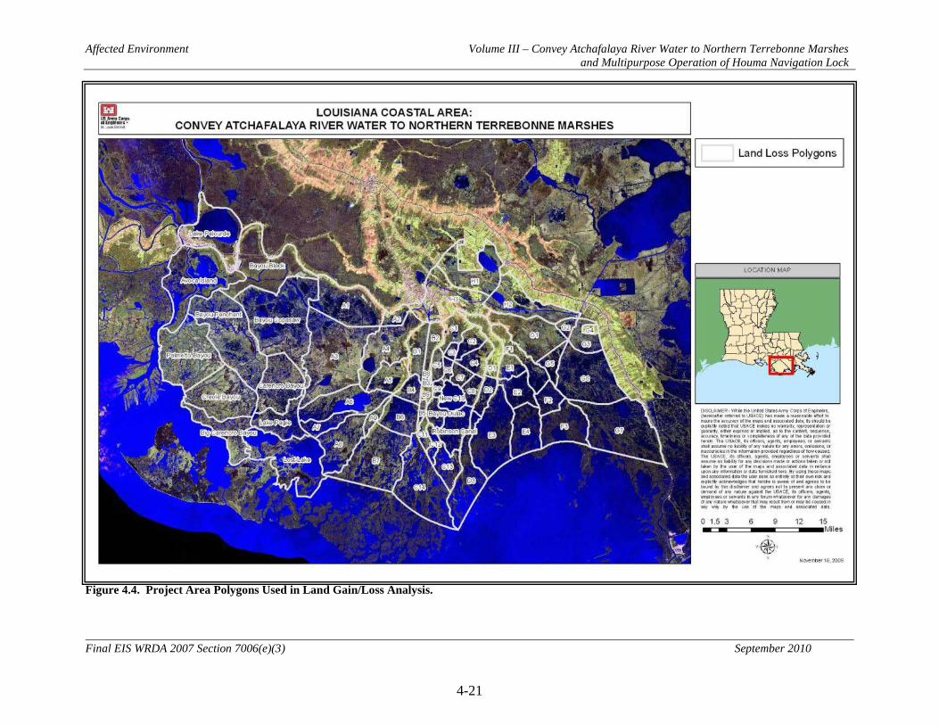
Affected Environment Volume III – Convey Atchafalaya River Water to Northern Terrebonne Marshes and Multipurpose Operation of Houma Navigation Lock
4-21
Final EIS WRDA 2007 Section 7006(e)(3) September 2010
Figure 4.4. Project Area Polygons Used in Land Gain/Loss Analysis.

Affected Environment Volume III – Convey Atchafalaya River Water to Northern Terrebonne Marshes and Multipurpose Operation of Houma Navigation Lock
4-22
Final EIS WRDA 2007 Section 7006(e)(3) September 2010
Figure 4.5. Habitat Classifications in the Project Area from 1956 to 2000 (based on Barras et al. 2008).

Affected Environment Volume III – Convey Atchafalaya River Water to Northern Terrebonne Marshes and Multipurpose Operation of Houma Navigation Lock
4-23
Final EIS WRDA 2007 Section 7006(e)(3) September 2010
Figure 4.6. Land Gain/Loss Rates in the Project Area – percent per year based on 1985 to 2008 rates and 1985 acreage (based on Barras et al. 2008 and 10 Barras 2009). Negative numbers indicate land loss.
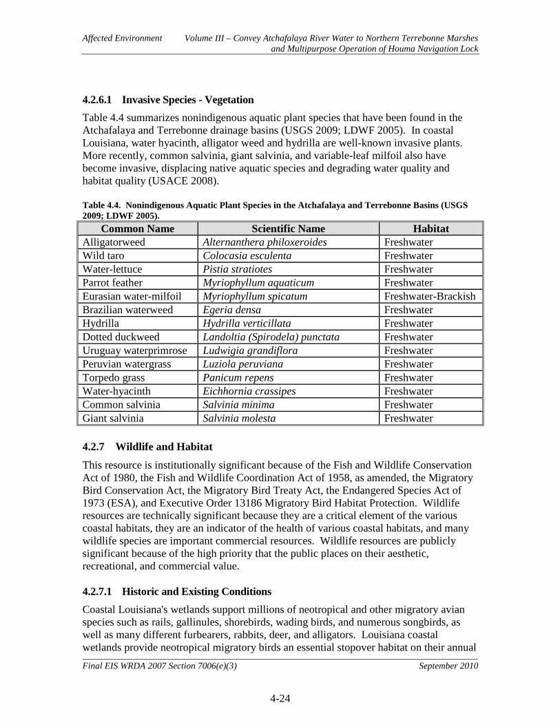
Affected Environment Volume III – Convey Atchafalaya River Water to Northern Terrebonne Marshes and Multipurpose Operation of Houma Navigation Lock
4-24
Final EIS WRDA 2007 Section 7006(e)(3) September 2010
4.2.6.1 Invasive Species - Vegetation Table 4.4 summarizes nonindigenous aquatic plant species that have been found in the Atchafalaya and Terrebonne drainage basins (USGS 2009; LDWF 2005). In coastal Louisiana, water hyacinth, alligator weed and hydrilla are well-known invasive plants. More recently, common salvinia, giant salvinia, and variable-leaf milfoil also have become invasive, displacing native aquatic species and degrading water quality and habitat quality (USACE 2008). Table 4.4. Nonindigenous Aquatic Plant Species in the Atchafalaya and Terrebonne Basins (USGS 2009; LDWF 2005).
Common Name Scientific Name Habitat Alligatorweed Alternanthera philoxeroides Freshwater Wild taro Colocasia esculenta Freshwater Water-lettuce Pistia stratiotes Freshwater Parrot feather Myriophyllum aquaticum Freshwater Eurasian water-milfoil Myriophyllum spicatum Freshwater-Brackish Brazilian waterweed Egeria densa Freshwater Hydrilla Hydrilla verticillata Freshwater Dotted duckweed Landoltia (Spirodela) punctata Freshwater Uruguay waterprimrose Ludwigia grandiflora Freshwater Peruvian watergrass Luziola peruviana Freshwater Torpedo grass Panicum repens Freshwater Water-hyacinth Eichhornia crassipes Freshwater Common salvinia Salvinia minima Freshwater Giant salvinia Salvinia molesta Freshwater 4.2.7 Wildlife and Habitat
This resource is institutionally significant because of the Fish and Wildlife Conservation Act of 1980, the Fish and Wildlife Coordination Act of 1958, as amended, the Migratory Bird Conservation Act, the Migratory Bird Treaty Act, the Endangered Species Act of 1973 (ESA), and Executive Order 13186 Migratory Bird Habitat Protection. Wildlife resources are technically significant because they are a critical element of the various coastal habitats, they are an indicator of the health of various coastal habitats, and many wildlife species are important commercial resources. Wildlife resources are publicly significant because of the high priority that the public places on their aesthetic, recreational, and commercial value. 4.2.7.1 Historic and Existing Conditions Coastal Louisiana's wetlands support millions of neotropical and other migratory avian species such as rails, gallinules, shorebirds, wading birds, and numerous songbirds, as well as many different furbearers, rabbits, deer, and alligators. Louisiana coastal wetlands provide neotropical migratory birds an essential stopover habitat on their annual

Affected Environment Volume III – Convey Atchafalaya River Water to Northern Terrebonne Marshes and Multipurpose Operation of Houma Navigation Lock
4-25
Final EIS WRDA 2007 Section 7006(e)(3) September 2010
migration route. The coastal wetlands in the study area provide important and essential fish and wildlife habitats used for shelter, nesting, feeding, roosting, cover, nursery, and other life requirements. Over 200 species of birds including 35 species of waterfowl have been reported from the Barataria-Terrebonne estuarine system (Condrey et al. 1995; Mitchell 1991). In general, wildlife species diversity is greatest in the swamp and decreases moving into salt marsh. In swamps, 25 mammalian, 32 reptilian, and 18 amphibian species occur, but only 8 species of mammals, 4 species of reptiles (not including sea turtles), and no amphibians are found in salt marsh (Gosselink 1984). This trend is reversed for colonial nesting water birds (i.e. wading birds and seabirds) that are found in greater variety in salt marshes. Songbirds such as the northern parula, prothonotary warbler, mockingbird, and Carolina chickadee nest and feed in forested wetlands and scrub-shrub areas. Numerous other bird species, including common flicker, white-eyed vireo, loggerhead shrike, redheaded woodpecker, and American woodcock also use forested areas. Alligators are abundant in fresh to brackish bayous and lakes (Joanen and McNease 1972; Platt et al. 1989). Alligators consume a wide variety of food items including insects, crawfish, crab, birds, fish, muskrat, nutria, turtles, shrimp, snails, and turtles (Chabreck 1971; Platt et al. 1990). They build nests in marshes and along levees, particularly wax myrtle thickets in fresh marshes (Gosselink 1984) where salinities are less than 10 ppt. Although listed as an endangered species in 1967, the alligator was deemed fully recovered and removed from the endangered species list in 1987. However, the Fish and Wildlife Service continues to protect the alligator under the classification of “threatened due to similarity of appearance” due to its similarity to other members of the crocodile family that remain endangered species. The Fish and Wildlife Service regulates the harvest of alligators and populations are considered secure. Waterfowl are mostly winter residents that migrate north each spring and summer and populations are highly variable. Wood duck, mottled duck, and black-bellied whistling-duck are the only species which regularly breed in the area. In salt and brackish marsh, gadwall, American coot, and blue-winged teal are the most abundant species. In fresh marsh, American coot, blue-winged teal, and mallard are the most abundant species (Sasser et al. 1982). Puddle ducks (e.g. gadwall and blue-winged teal) prefer marshes with small shallow ponds less than 0.5 meters deep. Widgeon-grass is the preferred food of puddle ducks in brackish marshes, while pondweed, naiad, and duckweed are the preferred items in fresh marsh. Diving ducks (e.g. Scaup spp.) prefer deeper water and dive to depths of over 10 meters to feed on invertebrates (Gosselink 1984). Wading birds (e.g. herons and egrets) are common year-round residents to the marshes and swamps. These birds are mostly carnivorous. They catch frogs, small fish, snakes, crawfish, worms, and insects in shallow ponds and along bayous for food. They appear to prefer brackish marshes for feeding (Gosselink 1984), but colonies tend to be located

Affected Environment Volume III – Convey Atchafalaya River Water to Northern Terrebonne Marshes and Multipurpose Operation of Houma Navigation Lock
4-26
Final EIS WRDA 2007 Section 7006(e)(3) September 2010
in wooded and shrub swamps that are isolated and flooded during the nesting season (March-August; Mitchell 1991). Seabirds (e.g. gulls and terns) nest on shell, sand, or bare soil primarily on barrier islands and bay islands that have these soil characteristics (Mitchell 1991). There are 14 known nesting colonies of wading or seabirds within or in close proximity to the study area (Martin and Lester 1990), but many are not active. Three large colonies are located north of the GIWW in subarea A1 and consist mostly of great egret, little blue heron, and glossy and white faced ibis. A medium colony of mostly great egret occurs east of Lake Theriot in subarea A4. A small colony predominantly composed of snowy egret is located in subarea C2. Small colonies of Forster's tern occur south of Lake Felicity near subarea E3. Muskrat (probably a native species) is a furbearer found mostly in brackish marshes with Olney bulrush. Reports of muskrat damage in brackish marsh are common with high populations of this rodent. There seems to be a 10- to 14-year cycle of marsh growth and collapse associated with muskrat populations (O'Neil 1949). Recovery of the vegetation following an eat-out is poor (Gosselink and Sasser 1995). Muskrat eat one-third of their weight per day (about 0.3 kg/day; O'Neil 1949) or less than 1 percent of plant production. It is actually their nest building and digging that cause most of the marsh deterioration. Nutria (introduced from South America in 1938 and about 6 times larger than muskrat) has become the predominant furbearer in fresh marsh (especially flotant) and swamp (Gosselink and Sasser 1995). Linscombe and Kinler (1994) found that vegetation damage by nutria can also be serious, particularly in fresh marsh. Recovery appears to take >1 year. White-tailed deer are most prevalent in BLH and swamp habitat with density declining with increasing marsh salinity. Deer prefer areas above standing water, such as natural levees and dredged material disposal areas and prefer newly-grown succulent vegetation (Self 1975) including alligator weed, eastern false-willow, black willow, and common reed. They are common, however, in fresh and intermediate marshes provided there are suitable cover and browse plants. Table 4.5 displays the functions of interest, status, trends, and projections through the year 2050 of avifauna, furbearers, game mammals, and reptiles found in mapping units in the project area as reported in the Coast 2050 report (LCWCRTF and WCRA 1998). Future projections of wildlife abundance in the Coast 2050 report were based almost exclusively on the projected conversion of marsh habitat to open water and subsidence of forested habitats and the anticipated impacts.

Affected Environment Volume III – Convey Atchafalaya River Water to Northern Terrebonne Marshes and Multipurpose Operation of Houma Navigation Lock
4-27
Final EIS WRDA 2007 Section 7006(e)(3) September 2010
Table 4.5. Functions of Interest, Status, Trends, and Projections through 2050 of Avifauna, Furbearers, Game Mammals, and Reptiles in the Project Area (LCWCRTF and WCRA 1998).
Type: OW = Open Water; FM = Fresh Marsh; IM = Intermediate Marsh; BM = Brackish Marsh; FS = Fresh Swamp; HF = Hardwood Forest; AU = Agriculture / Upland Function: Ne = Nesting; St = Stopover Habitat; W = Wintering; Mu = Multiple Use Status: NH = Not Historically Present; NL = No Longer Present; Lo = Low Numbers; Mo = Moderate Numbers; Hi = High Numbers Trend (since 1985)/Projection (through 2050): Sy = Steady; D = Decrease; I = Increase; U = Unknown
Mapping Unit Type
% of
Unit
Avifauna Brown Pelican Bald Eagle Seabirds Wading Birds Shorebirds Dabbling Ducks Diving Ducks Geese Raptors
Func
tion
Stat
us
Tren
d
Proj
ectio
n
Func
tion
Stat
us
Tren
d
Proj
ectio
n
Func
tion
Stat
us
Tren
d
Proj
ectio
n
Func
tion
Stat
us
Tren
d
Proj
ectio
n
Func
tion
Stat
us
Tren
d
Proj
ectio
n
Func
tion
Stat
us
Tren
d
Proj
ectio
n
Func
tion
Stat
us
Tren
d
Proj
ectio
n
Func
tion
Stat
us
Tren
d
Proj
ectio
n
Func
tion
Stat
us
Tren
d
Proj
ectio
n
Penchant OW 19 NH NH Mu Mo Sy Sy NH NH W Hi Sy D W Hi Sy D W Mo I D NH FM 67 NH NE Mo I I Mu Lo Sy D Mu Hi I Sy Mu Hi Sy D W Hi Sy D W Hi Sy D W Mo I D Mu Lo Sy D HF 9 NH NH NH NH NH W Mo Sy Sy NH NH Mu Hi I D
Mechant / de Cade
OW 46 W Hi I I NH Mu Mo Sy Sy NH NH W Mo Sy Sy W Mo Sy Sy NH NH IM 14 NH NH Mu Mo Sy D Mu Hi I Sy Mu Hi Sy D W Mo Sy Sy W Mo Sy Sy NH Mu Lo Sy D BM 29 NH NH Mu Mo Sy D Mu Hi I Sy Mu Hi Sy D W Mo Sy Sy W Mo Sy Sy NH Mu Lo Sy D FS 1 NH Ne Lo Sy Sy NH NH NH Ne Lo Sy Sy W Mo Sy Sy NH NH
North Houma Ship Canal Wetlands
OW 16 NH NH St Lo Sy Sy NH NH W Lo Sy D W Lo Sy D NH NH IM 14 NH NH Mu Lo Sy Sy Mu Mo I Sy Mu Mo Sy Sy W Lo Sy D W Lo Sy D NH Mu Lo Sy Sy FS 28 NH NH NH Ne Mo I Sy NH W Lo Sy D W Lo Sy D NH Mu Mo I Sy HF 26 NH NH NH NH NH Mu Lo Sy D NH NH Mu Hi I D AU 11 NH NH NH St Lo I Sy St Lo Sy Sy NH NH NH Mu Mo Sy Sy
Boudreaux OW 48 W Lo I I NH Mu Mo Sy Sy NH NH W Lo D D W Lo Sy D NH NH IM 13 NH NH Mu Mo Sy D Mu Hi Sy D Mu Hi Sy D W Lo D D W Lo Sy D NH Mu Lo Sy D BM 20 NH NH Mu Mo Sy D Mu Hi Sy D Mu Hi Sy D W Lo D D W Lo Sy D NH Mu Lo Sy D HF 9 NH Ne Lo Sy Sy NH NH NH Mu Lo D D W Lo Sy D NH Mu Hi Sy D
St. Louis Canal
OW NH NH Mu Mo Sy Sy NH NH W Lo Sy Sy W Lo Sy Sy NH NH FS NH Ne Lo Sy Sy NH Ne Hi I D NH Mu Lo Sy Sy W Lo Sy Sy NH Mu Mo I D IM NH NH Mu Lo Sy Sy Mu Hi I D Mu Hi Sy D W Lo Sy Sy W Lo Sy Sy NH Mu Lo Sy D BM NH NH Mu M Sy Sy Mu Hi I D Mu Hi Sy D W Lo Sy Sy W Lo Sy Sy NH Mu Lo Sy D HF NH NH NH NH NH Mu Lo Sy Sy NH NH Mu Hi Sy D
North Bully Camp
OW 50 W Lo I I NH Mu Mo Sy Sy NH NH W Lo Sy D W Lo Sy D NH FM 5 NH NH Mu Mo Sy D Mu Hi Sy D Mu Hi Sy D W Lo Sy D W Lo Sy D NH Mu Lo Sy D IM 6 NH NH Mu Mo Sy D Mu Hi Sy D Mu Hi Sy D W Lo Sy D W Lo Sy D NH Mu Lo Sy D BM 30 NH NH Mu Mo Sy D Mu Hi Sy D Mu Hi Sy D W Lo Sy D W Lo Sy D NH Mu Lo Sy D

Affected Environment Volume III – Convey Atchafalaya River Water to Northern Terrebonne Marshes and Multipurpose Operation of Houma Navigation Lock
4-28
Final EIS WRDA 2007 Section 7006(e)(3) September 2010
Mapping Unit Type
% of
Unit
Avifauna (cont.) Furbearers Game Mammals Reptiles Rails, Coots, and
Gallinules Nutria Muskrat Mink, Otter, and
Raccoon Rabbits Squirrels Deer American
Alligator Fu
nctio
n
Stat
us
Tren
d
Proj
ectio
n
Func
tion
Stat
us
Tren
d
Proj
ectio
n
Func
tion
Stat
us
Tren
d
Proj
ectio
n
Func
tion
Stat
us
Tren
d
Proj
ectio
n
Func
tion
Stat
us
Tren
d
Proj
ectio
n
Func
tion
Stat
us
Tren
d
Proj
ectio
n
Func
tion
Stat
us
Tren
d
Proj
ectio
n
Func
tion
Stat
us
Tren
d
Proj
ectio
n
Penchant OW 19 W Hi Sy Sy Mu Hi Sy Sy Mu Mo Sy Sy Mu Mo Sy Sy NH NH NH Mu Hi I I FM 67 Mu Hi Sy Sy Mu Hi Sy Sy Mu Mo Sy Sy Mu Mo Sy Sy Mu Lo Sy Sy NH Mu Lo Sy Sy Mu Hi I I HF 9 NH Mu Hi Sy Sy Mu Mo Sy Sy Mu Mo Sy Sy Mu Mo Sy Sy Mu Mo Sy Sy Mu Mo Sy Sy Mu Mo I I
Mechant / de Cade
OW 46 W Mo Sy Sy Mu Mo D D Mu Mo D D Mu Mo D D NH NH NH Mu Lo Sy D IM 14 Mu Mo Sy Sy Mu Mo D D Mu Mo D D Mu Mo D D Mu Lo Sy Sy NH Mu Lo Sy Sy Mu Hi I D BM 29 Mu Mo Sy Sy Mu Mo D D Mu Mo D D Mu Mo D D Mu Lo Sy Sy NH Mu Lo Sy Sy Mu Mo I D FS 1 NH NH NH NH Mu Lo Sy Sy Mu Lo Sy Sy Mu Lo Sy Sy NH
North Houma Ship Canal Wetlands
OW 16 W Lo Sy D NH NH NH NH NH NH Mu Mo Sy Sy IM 14 W Lo Sy D Mu Lo D Sy Mu Lo D Sy Mu Lo D Sy Mu Lo Sy D NH Mu Lo Sy D Mu Mo Sy Sy FS 28 W Lo Sy D Mu Lo D Sy Mu Lo D Sy Mu Lo D Sy Mu Lo Sy D Mu Lo Sy D Mu Lo Sy D Mu Mo Sy Sy HF 26 NH Mu Lo D Sy Mu Lo D Sy Mu Lo D Sy Mu Lo Sy D Mu Lo Sy D Mu Lo Sy D Mu Lo Sy Sy AU 11 NH Mu Lo D Sy Mu Lo D Sy Mu Lo D Sy Mu Mo Sy D NH Mu Lo Sy D Mu Lo Sy Sy
Boudreaux OW 48 W Lo Sy D NH NH NH NH NH NH Mu Lo D D IM 13 W Lo Sy D Mu Mo Sy D Mu Lo Sy Sy Mu Lo Sy Sy Mu Lo Sy D NH Mu Lo Sy D Mu Mo I Sy BM 20 W Lo Sy D Mu Lo Sy D Mu Lo Sy Sy Mu Lo Sy Sy Mu Lo Sy D NH Mu Lo Sy D Mu Lo Sy D HF 9 NH Mu Lo Sy D Mu Lo Sy Sy Mu Lo Sy Sy Mu Mo Sy D Mu Lo Sy D Mu Lo Sy D Mu Lo Sy Sy
St. Louis Canal
OW W Lo Sy Sy Mu Mo Sy Sy Mu Lo Sy Sy Mu Lo Sy Sy NH NH NH Mu Mo I Sy FS NH Mu Mo Sy Sy Mu Lo Sy Sy Mu Lo Sy Sy Mu Lo Sy Sy NH Mu Lo Sy Sy Mu Mo I Sy IM Mu Lo Sy Sy Mu Mo Sy Sy Mu Lo Sy Sy Mu Mo Sy Sy Mu Lo Sy Sy NH Mu Lo Sy Sy Mu Mo I Sy BM Mu Lo Sy Sy Mu Mo Sy Sy Mu Mo Sy Sy Mu Mo Sy Sy Mu Lo Sy Sy NH Mu Lo Sy Sy Mu Mo Sy Sy HF NH Mu Lo Sy Sy Mu Lo Sy Sy Mu Lo Sy Sy Mu Lo Sy Sy Mu Mo Sy Sy Mu Lo Sy Sy Mu Lo Sy Sy
North Bully Camp
OW 50 W Lo Sy D Mu Lo D Sy Mu Lo D Sy Mu Lo D Sy NH NH NH Mu Lo D D FM 5 W Lo Sy D Mu Mo D Sy Mu Lo D Sy Mu Lo D Sy Mu Lo Sy D NH Mu Lo Sy D Mu Lo D Sy IM 6 W Lo Sy D Mu Mo D Sy Mu Lo D Sy Mu Lo D Sy Mu Lo Sy D NH Mu Lo Sy D Mu Lo D Sy BM 30 W Lo Sy D Mu Lo D Sy Mu Lo D Sy Mu Lo D Sy Mu Lo Sy D NH Mu Lo Sy D Mu Lo D D
Type: OW = Open Water; FM = Fresh Marsh; IM = Intermediate Marsh; BM = Brackish Marsh; FS = Fresh Swamp; HF = Hardwood Forest; AU = Agriculture/Upland Function: Ne = Nesting; St = Stopover Habitat; W = Wintering; Mu = Multiple Use Status: NH = Not Historically Present; NL = No Longer Present; Lo = Low Numbers; Mo = Moderate Numbers; Hi = High Numbers Trend (since 1985)/Projection (through 2050): Sy = Steady; D = Decrease; I = Increase; U = Unknown

Affected Environment Volume III – Convey Atchafalaya River Water to Northern Terrebonne Marshes and Multipurpose Operation of Houma Navigation Lock
4-29
Final EIS WRDA 2007 Section 7006(e)(3) September 2010
The following information on the bald eagle was obtained by letter from the USFWS dated 21 January 2009. The project-area forested wetlands may provide nesting habitat for the bald eagle which was officially removed from the List of Endangered and Threatened Species on August 8, 2007. Bald eagles nest in Louisiana from October through mid-May. Eagles typically nest in mature trees (e.g., bald cypress, sycamore, willow, etc.) near fresh to intermediate marshes or open water in the southeastern parishes. Areas with high numbers of nests include the Lake Verret Basin south to Houma, the marsh/ridge complex south of Houma to Bayou Vista, the north shore of Lake Pontchartrain, and the Lake Salvador area. Eagles also winter, and infrequently nest, in mature pine trees near large lakes in central and northern Louisiana. Major threats to this species include habitat alteration, human disturbance, and environmental contaminants (i.e., organochlorine pesticides and lead). Breeding bald eagles occupy “territories” that they will typically defend against intrusion by other eagles, and that they likely return to each year. A territory may include one or more alternate nests that are built and maintained by the eagles, but which may not be used for nesting in a given year. Nest sites typically include at least one perch with a clear view of the water or area where the eagles usually forage. Shoreline trees or snags located near large waterbodies provide the visibility and accessibility needed to locate aquatic prey. Bald eagles are vulnerable to disturbance during courtship, nest building, egg laying, incubation, and brooding. Disturbance during this critical period may lead to nest abandonment, cracked and chilled eggs, and exposure of small young to the elements. Human activity near a nest late in the nesting cycle may also cause flightless birds to jump from the nest tree, thus reducing their chance of survival. Although the bald eagle has been removed from the List of Endangered and Threatened Species, it continues to be protected under the Migratory Bird Treaty Act and the Bald and Golden Eagle Protection Act. 4.2.7.2 Invasive Species – Wildlife Table 4.6 summarizes nonindigenous aquatic animal species that have been found in the Atchafalaya and Terrebonne drainage basins (USGS 2009; LDWF 2005).
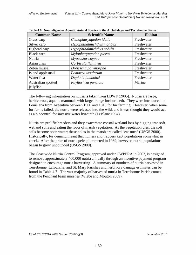
Affected Environment Volume III – Convey Atchafalaya River Water to Northern Terrebonne Marshes and Multipurpose Operation of Houma Navigation Lock
4-30
Final EIS WRDA 2007 Section 7006(e)(3) September 2010
Table 4.6. Nonindigenous Aquatic Animal Species in the Atchafalaya and Terrebonne Basins. Common Name Scientific Name Habitat
Grass carp Ctenopharyngodon idella Freshwater Silver carp Hypophthalmichthys molitrix Freshwater Bighead carp Hypophthalmichthys nobilis Freshwater Black carp Mylopharyngodon piceus Freshwater Nutria Myocastor coypus Freshwater Asian clam Corbicula fluminea Freshwater Zebra mussel Dreissena polymorpha Freshwater Island applesnail Pomacea insularum Freshwater Water flea Daphnia lumholtzi Freshwater Australian spotted jellyfish
Phyllorhiza punctata Marine
The following information on nutria is taken from LDWF (2005). Nutria are large, herbivorous, aquatic mammals with large orange incisor teeth. They were introduced to Louisiana from Argentina between 1900 and 1940 for fur farming. However, when some fur farms failed, the nutria were released into the wild, and it was thought they would act as a biocontrol for invasive water hyacinth (LeBlanc 1994). Nutria are prolific breeders and they exacerbate coastal wetland loss by digging into soft wetland soils and eating the roots of marsh vegetation. As the vegetation dies, the soft soils become open water; these holes in the marsh are called “eat-outs” (USGS 2000). Historically, fur demand meant that hunters and trappers kept populations somewhat in check. After the price of nutria pelts plummeted in 1989, however, nutria populations began to grow unbounded (USGS 2000). The Coastwide Nutria Control Program, approved under CWPPRA in 2002, is designed to remove approximately 400,000 nutria annually through an incentive payment program designed to encourage nutria harvesting. A summary of numbers of nutria harvested in Terrebonne, Lafourche, and St. Mary Parishes and herbivory damage estimates can be found in Table 4.7. The vast majority of harvested nutria in Terrebonne Parish comes from the Penchant basin marshes (Wiebe and Mouton 2009).

Affected Environment Volume III – Convey Atchafalaya River Water to Northern Terrebonne Marshes and Multipurpose Operation of Houma Navigation Lock
4-31
Final EIS WRDA 2007 Section 7006(e)(3) September 2010
Table 4.7. Nutria Harvested and Herbivory Damage Estimates by Parish in Seasons 1 through 7 of the Coastwide Nutria Control Program (Wiebe and Mouton 2009).
Parish Nutria Harvest and Herbivory Damage1 by Season
2002-2003 2003-2004 2004-2005 2005-2006 2006-2007 2007-2008 2008-2009
Harvest Acres of Damage Harvest
Acres of Damage Harvest
Acres of Damage Harvest
Acres of Damage Harvest
Acres of Damage Harvest
Acres of Damage Harvest
Acres of Damage
Lafourche 28,852 610 51,736 381 32,411 127 24,668 0 28,038 328 25,473 338 48,252 207 St. Mary 26,004 0 16,277 0 20,940 0 21,023 0 34,693 0 34,210 0 34,811 0
Terrebonne 92,831 12,521 72,846 7,679 81,135 4,541 57,756 7,340 99,433 5,915 78,934 3,768 74,587 3,162 Statewide
Total 308,160 21,888 332,596 16,906 297,535 14,260 168,843 14,868 375,683 9,244 308,212 6,471 334,038 5,422 1Acres of damage estimates represent damage along sampling transects only. Actual coastwide damage is approximately 3.75 times larger than the area estimated by the survey.

Affected Environment Volume III – Convey Atchafalaya River Water to Northern Terrebonne Marshes and Multipurpose Operation of Houma Navigation Lock
4-32
Final EIS WRDA 2007 Section 7006(e)(3) September 2010
4.2.8 Aquatic Resources
4.2.8.1 Historic and Existing Conditions 4.2.8.1.1 Plankton Resources This resource is institutionally significant because of the National Environmental Policy Act of 1969, the Coastal Zone Management Act, and the Estuary Protection Act. This resource is technically significant because plankton provide a major, direct food source for animals in the water column and in the sediments; phytoplankton are responsible for at least 40 percent of the photosynthesis occurring on the earth; plankton are important for their role in nutrient cycling; plankton productivity is a major source of primary food-energy for most estuarine systems throughout the world; and phytoplankton production is the major source of autochthonous organic matter in most estuarine ecosystems (Day et al. 1989). This resource is publicly significant because plankton form the lowest trophic food level for many larger organisms important to commercial and recreational fishing. In addition, there is a public health concern with noxious phytoplankton blooms (red and brown tides) that produce toxins, and large-scale blooms can lead to hypoxic conditions, which can result in fish kills. Plankton communities serve an important role in the coastal waters of Louisiana. The plankton are composed of three groups: bacterioplankton, phytoplankton, and zooplankton (Knox 2001). Phytoplankton are the primary producers of the water column and form the base of the estuarine food web. Zooplankton provide the trophic link between the phytoplankton and the intermediate level consumers such as aquatic invertebrates, larval fish, and smaller forage fish species (Day et al. 1989). Microzooplankton appear to be important consumers of bacterioplankton, which are typically enumerated primarily by culture and microscopic techniques. Culture techniques are selective and invariably underestimate bacterial densities (Day et al. 1989). "The Cooperative Gulf of Mexico Estuarine Inventory and Study, Louisiana," prepared by the Louisiana Wildlife and Fisheries Commission in 1971, provides a summary of plankton across the coastal estuaries of Louisiana in the late 1960s (Perret et al. 1971). The dominant member of the zooplankton community throughout that study was the copepod Acartia tonsa. The greatest concentrations of zooplankton were encountered in Breton Sound. The lowest concentrations were encountered in Chandeleur Sound and Lake Borgne east of the Mississippi River, Lakes Barre and Raccourci, and Terrebonne and Timbalier Bays. Species diversity was greatest in the Breton Sound and Mississippi River, East Bay, Garden Island Bay, and West Bay areas. Salinity appears to be the chief controlling factor in the number of species present, while temperature, competition, and predation control the number of individuals present. In addition, the abundance of certain zooplankton may be indicative of good fishing areas.
Affected Environment Volume III – Convey Atchafalaya River Water to Northern Terrebonne Marshes and Multipurpose Operation of Houma Navigation Lock
4-33
Final EIS WRDA 2007 Section 7006(e)(3) September 2010
Phytoplankton are tiny, single-cell algae that drift with the motion of water. The dominant groups are diatoms and dinoflagellates, and other important groups include cryptophytes, chlorophytes (green algae), and chrysophytes (blue-green algae). In Louisiana, eutrophic conditions can lead to noxious blooms of blue-green algae, often dominated by single species of the genus Anabaena or Microcystis. Some species produce toxins, and large scale blooms can lead to hypoxic conditions, which result in fish kills in some cases. Such blooms tend to occur in fresh or oligohaline waters, up to approximately 7 ppt salinity. Phytoplankton in more saline environments can cause a different kind of bloom; Karenia breve (formerly known as Gymnodinium breve), for example, is a dinoflagellate that has been associated with red tides. Red tides are so named because the prolific growth stains the water red. Toxins associated with red tides are capable of killing fish and shellfish. Red tide populations well below the fish kill level pose a serious problem for public health through shellfish contamination. Bivalve shellfish, especially oysters, clams, and coquinas, can accumulate so much toxin that they become toxic to humans. Public health concerns also emerge from studies that show that the presence of airborne toxins have an impact on the human respiratory system (Mote Marine Lab website: http://www.mote.org/index.php?src=news&refno=101&category=Newsroom). Freshwater diversions have been utilized in some instances to attempt to reduce the spread of red tides into coastal waters. Zooplankton are faunal components of the plankton, including small crustaceans such as copepods, ostracods, euphausiids, and amphipods; the jellyfishes and siphonophores; worms, mollusks such as pteropods and heteropods; and the egg and larval stages of the majority of benthic and nektonic animals (Rounsefell 1975). Zooplankton are weakly swimming animals comprised of two broad categories: holoplankton, which are planktonic species as adults, and meroplankton, which are organisms that occur in the plankton during early life stages before becoming benthic or nektonic (most common are immature forms of benthic invertebrates). Zooplankton serve as food for a variety of estuarine consumers, but also are important for their role in nutrient cycling. Although there are no clear general patterns of zooplankton abundance in estuaries, some regional seasonal patterns have been described (Day et al. 1989). The zooplankton of many estuarine water bodies are dominated by copepods of the genus Acartia. Cyclopoid copepods and cladocerans are often abundant in low salinity waters of Louisiana (Hawes and Perry 1978). Zoeae (a larval stage in some crustaceans) can make up a large component of the meroplankton. Zooplankton in Louisiana waters are in some cases dominated by zoeae of the mud crab Rithropanopeus harrisii. While some zooplankton are euryhaline, others have distinct salinity tolerances. Therefore, introduction of river water into estuarine systems can have dramatic short-term impacts on plankton populations in adjacent coastal waters (Hawes and Perry 1978).

Affected Environment Volume III – Convey Atchafalaya River Water to Northern Terrebonne Marshes and Multipurpose Operation of Houma Navigation Lock
4-34
Final EIS WRDA 2007 Section 7006(e)(3) September 2010
4.2.8.1.2 Benthic Resources These resources are institutionally significant because of the NEPA of 1969; the Coastal Zone Management Act; and the Estuary Protection Act. These resources are technically significant because the bottom of an estuary regulates or modifies most physical, chemical, geological, and biological processes throughout the entire estuarine system via what is called a “benthic effect.” Benthic animals are directly or indirectly involved in most physical and chemical processes that occur in estuaries (Day et al. 1989). Benthic resources are publicly significant because members of the epibenthic community (e.g., oysters, mussels, etc.) provide commercial and recreational fisheries as well as create oyster reef habitats used by many marine and estuarine organisms. Within a salt marsh, less than ten percent of the above-ground primary production of the salt marsh is grazed by aerial consumers. Most plant biomass dies and decays and its energy is processed through the detrital pathway. The major consumer groups of the benthic habitat include bacteria and fungi, microalgae, meiofauna, and microfauna (Mitsch and Gosselink 1993). Benthic community structure is not static; it provides a residence for many sessile, burrowing, crawling, and even swimming organisms. The benthic community is a storehouse of organic matter and inorganic nutrients, as well as a site for many vital chemical exchanges and physical interactions. Day et al. (1989) describe the functional groups of estuarine benthic organisms. These groups include: macrobenthic (e.g., molluscs, polychaetes, decapods); microbenthic (e.g., protozoa); meiobenthic (e.g., nematodes, harpacticoid copepods, tubillaria), epibenthic; infauna (e.g., most bivalves); interstitial fauna (e.g., beach meiofauna, tardigrades); suspension-feeders (e.g., bryozoa and many bivalves); filter-feeders (e.g., porifera, tunicates, bivalves); nonselective deposit feeders (e.g., gastropods); selective deposit feeders (e.g., nematodes, sand dollars, fiddler crabs); raporial feeders and predators (e.g., star fish and gastropod drills); and parasites and commensals (e.g., parasitic flatworms and copepods, pea crabs). According to Mitsch and Gosselink (1993), the salt marsh is a major producer of detritus for both the salt marsh system and the adjacent estuary. They point out that in some cases exported marsh detritus is more important to the estuary than the phytoplankton-based production in the estuary. Detritus export and the shelter found along marsh edges make salt marshes important nursery areas for many commercially important fish and shellfish. Salt marshes have been shown at times to be both sources and sinks of nutrients, particularly nitrogen. 4.2.9 Fisheries
Fishery resources are institutionally significant because of the Fish and Wildlife Coordination Act of 1958, as amended; the Endangered Species Act of 1973; the Magnuson-Stevens Fishery Conservation and Management Act of 1976, as amended (Magnuson-Stevens Act); the Magnuson-Stevens Act Reauthorization of 2006; the Coastal Zone Management Act; and the Estuary Protection Act. Fishery resources are

Affected Environment Volume III – Convey Atchafalaya River Water to Northern Terrebonne Marshes and Multipurpose Operation of Houma Navigation Lock
4-35
Final EIS WRDA 2007 Section 7006(e)(3) September 2010
technically significant because they are a critical element of many valuable freshwater and marine habitats, they are indicators of the health of various freshwater and marine habitats, and many species are commercially important. Fishery resources are publicly significant because of the high priority placed on their aesthetic, recreational, and commercial value. 4.2.9.1 Historic and Existing Conditions Louisiana’s coastal estuaries are the most productive in the Nation. Louisiana has historically been an important contributor to the Nation’s domestic fish and shellfish production, and one of the primary contributors to the Nation’s food supply for protein. Most of the economically important saltwater fishes and crustaceans harvested in Louisiana spawn offshore and then use estuarine areas for nursery habitat (Herke 1995). Landings in 2008 for commercial fisheries in coastal Louisiana, estimated at 918 million pounds, were the largest for any state in the contiguous U. S. and second only to Alaska (NMFS 2009). These landings represent over ten percent of the total landings in the U.S., with a value of approximately $274.9 million. Total fish and shellfish landings for ports in the vicinity of the project area (Dulac-Chauvin, Golden Meadow-Leeville, and Morgan City-Berwick) were 58 million pounds in 2008 with a dockside value of $77 million (NMFS Fisheries Statistics Division 2009 – personal communication). In a letter dated 17 February 2009, the NMFS indicated fishery resources in the project area include aquatic and tidally influenced wetland habitats that are designated as essential fish habitat (EFH) for postlarval and juvenile life stages of brown shrimp and white shrimp, red drum, and gulf stone crab (see Section 4.2.10, Essential Fish Habitat) managed by the Gulf of Mexico Fishery Management Council (GMFMC). In addition, water bodies and wetlands in the study area provide nursery and foraging habitats supportive of a variety of economically important marine fishery species, such as striped mullet, Atlantic croaker, gulf menhaden, spotted seatrout, sand seatrout, southern flounder, black drum, and blue crab. Some of these species also serve as prey for other fish species managed under the Magnuson-Stevens Fishery Conservation and Management Act by the GMFMC (e.g., mackerels, snappers, and groupers) and highly migratory species managed by NMFS (e.g., billfishes and sharks). 4.2.9.1.1 Finfish By far the top position in landings of finfish, by weight, for the State of Louisiana is held by Gulf menhaden, which contributed more than 97 percent of the total finfish landings in 2008 (NMFS Fisheries Statistics Division 2009 – personal communication). Gulf menhaden spawn up to five times in the Gulf of Mexico from October to April. The eggs hatch and larvae drift into estuaries from January to April. Juveniles then develop in shallow, lower-salinity estuarine and wetland habitats, moving in dense schools. Eventually, the menhaden migrate to deeper waters and then move offshore and become harvestable in their second year of life (Guillory et al. 1983). Immatures and adults migrate into estuarine waters from April to October (Christmas et al. 1982).

Affected Environment Volume III – Convey Atchafalaya River Water to Northern Terrebonne Marshes and Multipurpose Operation of Houma Navigation Lock
4-36
Final EIS WRDA 2007 Section 7006(e)(3) September 2010
Behind Gulf menhaden, the top finfish landings, by weight, for the State of Louisiana in 2008 were catfish and bullheads, buffalofishes, black drum, striped mullet, herrings, tuna, and sheepshead (NMFS Fisheries Statistics Division 2009 – personal communication). For ports in the immediate vicinity of the project area (Dulac-Chauvin, Golden Meadow-Leeville, and Morgan City-Berwick) total finfish landings in 2008 were approximately 4.2 million pounds with a dockside value of $6.8 million (NMFS Fisheries Statistics Division 2009 – personal communication). The top finfish landings by weight in 2008 for these ports were yellowfin tuna, black drum, blue catfish, swordfish, and herrings. Although gulf menhaden are an important resource in and around the project area, the vast majority of landings for this species are reported at other ports. Commercial landings (by weight) of fish and shellfish, including freshwater fish, at ports within or in the immediate vicinity of the project area have been on a gradually declining trend over the past 25 years (NMFS Fisheries Statistics Division 2009 – personal communication). Fluctuations in year to year landings can be caused by a variety of factors including winter freezes, drought, tropical storms, and transportation costs, and usually do not indicate long-term environmental problems. Individual organisms produce large numbers of eggs, so populations can recover quickly from short-term detrimental conditions. However, longer-term declines in landings can signify that there are ongoing environmental problems and/or over-fishing of the resource or a weakening market. An extensive database of fishery independent sampling data for fish and shellfish is maintained by the Louisiana Department of Wildlife and Fisheries. The database contains information on extensive sampling conducted in the coastal marshes, bayous, and lakes in and around the project area. USACE personnel requested fish and shellfish species information from LDWF for all sampling stations in the vicinity of the project area. Due to the size of the database and lack of any summarized information, data from 1998-2008 for 3 sampling stations located within the project area utilizing different capture techniques were chosen to characterize the fish assemblage in the project area. The most abundant finfish species from otter trawl data collected in the Lake Mechant area were bay anchovy, Atlantic croaker, spot, Gulf menhaden, and sand seatrout. White shrimp, blue crab, and brown shrimp were commonly collected as well. Gillnet samples in the Catfish Lake area showed spotted seatrout, Gulf menhaden, spot, Atlantic croaker, sea catfish, and black drum to be the most abundant species. The most abundant species collected from Lake Boudreaux by seine were bay anchovy, inland silverside, naked goby, Atlantic croaker, and Gulf killifish. Grass shrimp, brown shrimp, blue crab, and white shrimp were also common. The most abundant species found in freshwater marsh in the study area are sheepshead minnow, rainwater killifish, inland silverside, and sailfin molly (Rogers et al. 1992). These species are found along marsh edges and among SAV. The intermediate and fresh marshes also provide habitat for commercial and recreational fisheries. Species include largemouth bass, black crappie, bluegill, channel catfish, buffalo, freshwater drum, bowfin, and gar.
Affected Environment Volume III – Convey Atchafalaya River Water to Northern Terrebonne Marshes and Multipurpose Operation of Houma Navigation Lock
4-37
Final EIS WRDA 2007 Section 7006(e)(3) September 2010
Table 4.8 displays the trends and projections through the year 2050 of fish and invertebrate species found in mapping units in the project area as reported in the Coast 2050 report (LCWCRTF and WCRA 1998). Trends for fish and invertebrate species were based on fishery independent sampling data and field knowledge of area biologists. Future projections of fish and invertebrate abundance were based on the projected percent and pattern of wetland loss in each mapping unit and the anticipated resultant impacts to the fishery.

Affected Environment Volume III – Convey Atchafalaya River Water to Northern Terrebonne Marshes and Multipurpose Operation of Houma Navigation Lock
4-38
Final EIS WRDA 2007 Section 7006(e)(3) September 2010
Table 4.8. Trends and Projections through 2050 of Fish and Invertebrates in the Project Area (LCWCRTF and WCRA 1998).
Mapping Unit
Fish and Invertebrate Guilds (Species)
Red Drum Black Drum Spotted Seatrout
Gulf Menhaden
Southern Flounder
American Oyster
White Shrimp
Brown Shrimp Blue Crab
Spanish Mackerel
Largemouth Bass
Channel Catfish
Trend / Projection
Trend / Projection
Trend / Projection
Trend / Projection
Trend / Projection
Trend / Projection
Trend / Projection
Trend / Projection
Trend / Projection
Trend / Projection
Trend / Projection
Trend / Projection
Penchant I/Sy I/Sy D/D D/Sy D/D D/I D/Sy D/Sy I/Sy NA/NA D/I U/U
Mechant / de Cade I/D I/D D/D I/D D/D I/I Sy/D I/D I/D I/I D/Sy D/Sy
North Houma Ship Canal Wetlands
I/D I/D I/D I/D I/D NA/NA I/D I/D I/D NA/NA D/I D/I
Boudreaux I/D I/D D/D I/D D/D I/I Sy/D I/D I/D NA/NA D/I D/I
St. Louis Canal I/D I/D D/D I/D D/D I/Sy Sy/D I/D I/D NA/NA D/I D/I
North Bully Camp I/D I/D D/D D/D D/D D/I D/D D/D I/D I/I NA/NA NA/NA
Sy = Steady; D = Decrease; I = Increase; U = Unknown; NA = Not Applicable

Affected Environment Volume III – Convey Atchafalaya River Water to Northern Terrebonne Marshes and Multipurpose Operation of Houma Navigation Lock
4-39
Final EIS WRDA 2007 Section 7006(e)(3) September 2010
4.2.9.1.2 Shrimp Brown and white shrimp spawn in the Gulf of Mexico. Larvae drift into estuarine waters as postlarvae and inhabit coastal wetlands. After becoming juveniles, the shrimp move offshore where they become adults. There may be up to three spawns per year in Louisiana (Gaidry and White 1973) with females each producing from a half million to a million eggs. Brown shrimp wash into estuaries mainly from February to April (White and Boudreaux 1977) while white shrimp come in from late spring to autumn when temperatures are above 25°C (Baxter and Renfro 1967). White shrimp spawn in shallower Gulf water and move further into estuarine nursery areas [up to 160km (99 miles)] as postlarvae and juveniles than brown shrimp (Turner and Brody 1983). Brown shrimp leave the estuaries to the Gulf of Mexico from May through August (Lassuy 1983) whereas white shrimp leave from September to December (Muncy 1984). Recruitment of shrimp to the fishery is not dependent on parent stocks the year before because environmental conditions are the overriding factor (Muncy 1984). Recruitment of brown shrimp increased in the Gulf from 1960-1986 despite a two-fold increase in catch effort and catch. White shrimp showed similar trends, but the catch per unit effort declined slightly, indicating that recruitment cannot maintain a stable catch per unit effort as effort increases (Nance and Nichols 1988). The optimum salinity for brown shrimp survival and growth in the estuary appears to be around 19 ppt, but salinities from 15 to 20 ppt are very favorable (Barrett and Gillespie 1973). White shrimp can apparently do well in water with lower salinities than this. Both species prefer shallow, soft-bottomed estuaries (Muncy 1984; Lassuy 1983). Water temperatures over 20°C after the first week in April are also important. Production of brown shrimp in Barataria Bay and Caminada Bay is inversely related to average spring (March-May) Mississippi River discharge. The same type of relationship holds for white shrimp, but it is related to average summer Mississippi River discharge. The Atchafalaya River discharges emulate the same trends as the Mississippi River, so similar relationships would be expected between production of shrimp and discharge (Barrett and Gillespie 1973). Shrimp yields have been related to wetland habitat quantity (Turner 1992) and land-water interface. The land-water interface relationship suggests that shrimp yields will decrease when the land-water interface declines. Browder et al. (1989) predicted that brown shrimp catches in the Barataria, Timbalier, and Terrebonne Basins would peak around the year 2000 and may fall to zero within 52 to 105 years. This prediction seems to follow the catch trends observed in recent years as brown shrimp landings for Louisiana have generally been declining since 2001, with 2008 landings being less than 40% of 2001 landings (NMFS Fisheries Statistics Division 2009 – personal communication). White shrimp landings for the same period were fairly stable. Gulf region landings of shrimp in 2008 were the Nation’s largest with 178.7 million pounds and 90 percent of the national total. In Louisiana, a total of 24.9 million pounds of brown shrimp and 63.1 million pounds of white shrimp were landed in 2008, with a dockside value of $22.7 million and $107.4 million, respectively (NMFS 2009). For ports in and around the project area, a total of 10.6 million pounds of brown shrimp and

Affected Environment Volume III – Convey Atchafalaya River Water to Northern Terrebonne Marshes and Multipurpose Operation of Houma Navigation Lock
4-40
Final EIS WRDA 2007 Section 7006(e)(3) September 2010
20.4 million pounds of white shrimp were landed in 2008, with a dockside value of $9.2 million and $32.2 million, respectively (NMFS Fisheries Statistics Division 2009 – personal communication). 4.2.9.1.3 Blue Crab Blue crabs occupy all estuarine aquatic habitats at some time during their life cycle, tolerating a wide array of salinities and temperatures, but preferring lower to moderate salinity (Perry and McIlwain 1986). Temperatures above 30°C for prolonged periods are stressful. Blue crabs are benthic omnivores, feeding on various crustaceans, mollusks, fish, and detritus. Eggs are produced in two batches averaging 1,500,000 eggs in each. Larval blue crabs reach their peak during February and March (Adkins 1972). Juveniles are most abundant from November to May and occur in the northern portions of the estuaries. The juveniles prefer areas with soft, mud substrate. After 1-1.5 years, the crabs then move from shallow areas into larger bays and bayous as adults where they live for at least one more year. Mating occurs in the spring after which time the females migrate southward to higher salinity waters (Adkins 1972; Perry 1975). Louisiana is the leading blue crab producer, by weight, in the U.S., producing 26.5 percent of the nation’s total in 2008 (NMFS 2009). Statewide, a total of 41.5 million pounds of blue crab were landed in 2008, with a dockside value of $31.8 million (NMFS 2009). For ports in and around the project area, a total of 15.6 million pounds of blue crab were landed in 2008, with a dockside value of $11.9 million (NMFS Fisheries Statistics Division 2009 – personal communication). 4.2.9.1.4 Oyster The eastern oyster is indigenous to coastal Louisiana and provides a rich ecological and commercial resource. Salinity plays a key role in oyster sustainability. Adult oysters can tolerate salinities from 0 to 42 ppt, but the optimal range is 5-15 ppt. Fresher waters fail to support biological function, and more saline waters promote disease and predation. Adult oysters are more prone to impacts from changes in water quality than commercially harvested fishes and crustaceans because they are sessile and cannot relocate in response to changes in water quality parameters. The Gulf region led the U.S. in oyster production in 2008 with 20 million pounds, 89 percent of the national total (NMFS 2009). In Louisiana, a total of 12.8 million pounds of oyster were harvested in 2008, with a value of $38.8 million (NMFS 2009). The central region of Louisiana, which includes the Terrebonne estuary, supplies 26 percent of the oyster landings in Louisiana (Keithly and Roberts 1988). Production of oysters in Louisiana has been relatively stable for the last 50 years, with harvest from public beds replacing the decreasing harvest from private leases. However, increasing coastal land loss is reducing the amount of marsh that provides shelter to reefs, and saltwater intrusion is exacerbating disease and predation.

Affected Environment Volume III – Convey Atchafalaya River Water to Northern Terrebonne Marshes and Multipurpose Operation of Houma Navigation Lock
4-41
Final EIS WRDA 2007 Section 7006(e)(3) September 2010
Oyster leases are located largely outside of the study area, although a fair number exist in Lake Mechant, Lake Boudreaux, and the Grand Bayou basin within the project boundary. Oyster seed grounds within the project area are located in Lake Mechant. The seed grounds are managed by the LDWF to produce a ready supply of seed oysters that can be planted on private leases for later harvest. The locations of oyster leases and seed grounds in the vicinity of the study area are shown in figure 4.7.

Affected Environment Volume III – Convey Atchafalaya River Water to Northern Terrebonne Marshes And Multipurpose Operation of Houma Navigation Lock
4-42
Final EIS WRDA 2007 Section 7006(e)(3) September 2010
Figure 4.7. Oyster Seed Grounds and Leases (August 2009 Louisiana Department of Wildlife and Fisheries data).

Affected Environment Volume III – Convey Atchafalaya River Water to Northern Terrebonne Marshes and Multipurpose Operation of Houma Navigation Lock
4-43
Final EIS WRDA 2007 Section 7006(e)(3) September 2010
4.2.10 Essential Fish Habitat (EFH)
This resource is institutionally significant because of the Magnuson-Stevens Act of 1996 (Public Law 104-297). Essential Fish Habitat (EFH) is technically significant because, as the Act states, EFH is “those waters and substrate necessary to fish for spawning, breeding, feeding or growth to maturity." EFH is publicly significant because of the high value that the public places on the seafood and the recreational and commercial opportunities EFH provides. 4.2.10.1 Historic and Existing Conditions In a letter dated 17 February 2009, the NMFS indicated fishery resources in the project area include aquatic and tidally influenced wetland habitats that are designated as essential fish habitat for postlarval and juvenile life stages of brown shrimp and white shrimp, red drum, and gulf stone crab managed by the Gulf of Mexico Fishery Management Council (GMFMC). Essential fish habitat for various life stages of these species can be found in Table 4.9.
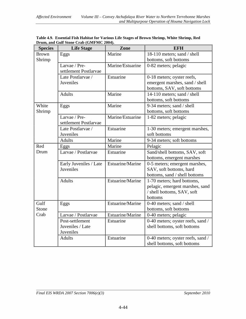
Affected Environment Volume III – Convey Atchafalaya River Water to Northern Terrebonne Marshes and Multipurpose Operation of Houma Navigation Lock
4-44
Final EIS WRDA 2007 Section 7006(e)(3) September 2010
Table 4.9. Essential Fish Habitat for Various Life Stages of Brown Shrimp, White Shrimp, Red Drum, and Gulf Stone Crab (GMFMC 2004). Species Life Stage Zone EFH
Brown Shrimp
Eggs Marine 18-110 meters; sand / shell bottoms, soft bottoms
Larvae / Pre-settlement Postlarvae
Marine/Estuarine 0-82 meters; pelagic
Late Postlarvae / Juveniles
Estuarine 0-18 meters; oyster reefs, emergent marshes, sand / shell bottoms, SAV, soft bottoms
Adults Marine 14-110 meters; sand / shell bottoms, soft bottoms
White Shrimp
Eggs Marine 9-34 meters; sand / shell bottoms, soft bottoms
Larvae / Pre-settlement Postlarvae
Marine/Estuarine 1-82 meters; pelagic
Late Postlarvae / Juveniles
Estuarine 1-30 meters; emergent marshes, soft bottoms
Adults Marine 9-34 meters; soft bottoms Red Drum
Eggs Marine Pelagic Larvae / Postlarvae Estuarine Sand/shell bottoms, SAV, soft
bottoms, emergent marshes Early Juveniles / Late Juveniles
Estuarine/Marine 0-5 meters; emergent marshes, SAV, soft bottoms, hard bottoms, sand / shell bottoms
Adults Estuarine/Marine 1-70 meters; hard bottoms, pelagic, emergent marshes, sand / shell bottoms, SAV, soft bottoms
Gulf Stone Crab
Eggs Estuarine/Marine 0-40 meters; sand / shell bottoms, soft bottoms
Larvae / Postlarvae Estuarine/Marine 0-40 meters; pelagic Post-settlement Juveniles / Late Juveniles
Estuarine 0-40 meters; oyster reefs, sand / shell bottoms, soft bottoms
Adults Estuarine 0-40 meters; oyster reefs, sand / shell bottoms, soft bottoms

Affected Environment Volume III – Convey Atchafalaya River Water to Northern Terrebonne Marshes and Multipurpose Operation of Houma Navigation Lock
4-45
Final EIS WRDA 2007 Section 7006(e)(3) September 2010
4.2.11 Threatened and Endangered Species
This resource is institutionally significant because of the Endangered Species Act of 1973, as amended, and the Marine Mammal Protection Act of 1972. Endangered (E) and threatened (T) species are technically significant because the status of such species provides an indication of the overall health of an ecosystem. These species are publicly significant because of the desire of the public to protect them and their habitats. 4.2.11.1 Historic and Existing Conditions Federal Designation. Within the study area there are several animal species (some with critical habitats) under the Federal jurisdiction of the USFWS and/or the NMFS, presently classified as endangered or threatened (Table 4.10). Table 4.10. Threatened and Endangered Species in the Study Area.
Species Critical Habitat Status Jurisdiction Federal State USFWS NMFS
West Indian Manatee (Trichechus manatus)
E E X
Brown Pelican (Pelecanus occidentalis) De-listed December 17, 2009.
Piping Plover (Charadrius melodus)
X (foraging, sheltering, and
roosting habitat of wintering populations)
T T X
Hawksbill sea turtle (Eretmochelys imbricata)
E E X X
Kemp’s Ridley sea turtle (Lepidochelys kempii)
E E X X
Leatherback sea turtle (Dermochelys coriacea)
E E X X
Green sea turtle (Chelonia mydas)
T T X X
Loggerhead sea turtle (Caretta caretta)
T T X X
Pallid Sturgeon (Scaphirhynchus albus)
E E X
Gulf Sturgeon (Acipenser oxyrinchus desotoi)
T T X X
The following information on threatened and endangered species was obtained by letter from the USFWS dated 21 January 2009. Federally listed as endangered, West Indian manatees occasionally enter Lakes Pontchartrain and Maurepas, and associated coastal waters and streams, during the summer months. Manatees have been reported in the Amite, Blind, Tchefuncte, and Tickfaw Rivers, and in canals within the adjacent coastal marshes of Louisiana. They
Affected Environment Volume III – Convey Atchafalaya River Water to Northern Terrebonne Marshes and Multipurpose Operation of Houma Navigation Lock
4-46
Final EIS WRDA 2007 Section 7006(e)(3) September 2010
have also been occasionally observed elsewhere along the Louisiana Gulf Coast. The manatee has declined in numbers due to collisions with boats and barges, entrapment in flood control structures, poaching, habitat loss, and pollution. Cold weather and outbreaks of red tide may also adversely affect these animals. Federally listed as a threatened species, the piping plover, as well as its designated critical habitat, occur along the Louisiana coast. Piping plovers winter in Louisiana, and may be present for 8 to 10 months. They arrive from the breeding grounds as early as late July and remain until late March or April. Piping plovers feed extensively on intertidal beaches, mudflats, sandflats, algal flats, and wash-over passes with no or very sparse emergent vegetation; they also require non-vegetated or sparsely vegetated areas for roosting. Roosting areas may have debris, detritus, or micro-topographic relief offering refuge to plovers from high winds and cold weather. In most areas, wintering piping plovers are dependent on a mosaic of sites distributed throughout the landscape, because the suitability of a particular site for foraging or roosting is dependent on local weather and tidal conditions. Plovers move among sites as environmental conditions change, and studies have indicated that they generally remain within a 2-mile area. On July 10, 2001, the U.S. Fish and Wildlife Service designated critical habitat for wintering piping plovers (Federal Register Volume 66, No. 132). Their designated critical habitat identifies specific areas that are essential to the conservation of the species. The primary constituent elements for piping plover wintering habitat are those habitat components that support foraging, roosting, and sheltering and the physical features necessary for maintaining the natural processes that support those habitat components. Constituent elements are found in geologically dynamic coastal areas that contain intertidal beaches and flats (between annual low tide and annual high tide), and associated dune systems and flats above annual high tide. Important components (or primary constituents elements) of intertidal flats include sand and/or mud flats with no or very sparse emergent vegetation. Adjacent non-vegetated or sparsely vegetated sand, mud, or algal flats above high tide are also important, especially for roosting plovers. Major threats to this species include the loss and degradation of habitat due to development, disturbance by humans and pets, and predation. The pallid sturgeon is an endangered fish found in both the Mississippi and Atchafalaya Rivers (with known concentrations in the vicinity of the Old River Control Structure Complex); it is possibly found in the Red River as well. The pallid sturgeon is adapted to Riverine conditions that can be described as large, free-flowing, turbid water with a diverse assemblage of physical habitats that are in a constant state of change. Detailed habitat requirements of this fish are not known, but it is believed to spawn in Louisiana. Habitat losses through river channelization and dam construction have affected this species throughout its range. The Gulf sturgeon, federally listed as a threatened species, is an anadromous fish that occurs in many rivers, streams, and estuarine waters along the northern Gulf coast between the Mississippi River and the Suwanee River, Florida. In Louisiana, the Gulf
Affected Environment Volume III – Convey Atchafalaya River Water to Northern Terrebonne Marshes and Multipurpose Operation of Houma Navigation Lock
4-47
Final EIS WRDA 2007 Section 7006(e)(3) September 2010
sturgeon has been reported at Rigolets Pass, rivers and lakes of the Lake Basin, and adjacent estuarine areas. Spawning occurs in coastal rivers between late winter and early spring (i.e., March to May). Adults and sub-adults may be found in those rivers and streams until November, and in estuarine or marine waters during the remainder of the year. Sturgeons, less than two years old, appear to remain in Riverine habitats and estuarine areas throughout the year, rather than migrate to marine waters. Habitat alterations such as those caused by water control structures that limit and prevent spawning, poor water quality, and over-fishing have negatively affected this species. On March 19, 2003, the Service and the National Marine Fisheries Service published a final rule in the Federal Register (Volume 68, No. 53) designating critical habitat for the Gulf sturgeon in Louisiana, Mississippi, Alabama, and Florida. Portions of the Pearl and Bogue Chitto Rivers, Lake Pontchartrain east of the Lake Pontchartrain Causeway, all of Little Lake, The Rigolets, Lake St. Catherine, and Lake Borgne within Louisiana were included in that designation. The primary constituent elements essential for the conservation of Gulf sturgeon are those habitat components that support feeding, resting, sheltering, reproduction, migration, and physical features necessary for maintaining the natural processes that support those habitat components. The primary constituent elements for Gulf sturgeon critical habitat include:
• abundant prey items within Riverine habitats for larval and juvenile life stages, and within estuarine and marine habitats for juvenile, sub-adult, and adult life stages;
• riverine spawning sites with substrates suitable for egg deposition and development, such as limestone outcrops and cut limestone banks, bedrock, large gravel or cobble beds, marl, soapstone, or hard clay;
• riverine aggregation areas, also referred to as resting, holding and staging areas, used by adult, sub-adult, and/or juveniles, generally, but not always, located in holes below normal riverbend depths, believed necessary for minimizing energy expenditures during freshwater residency and possibly for osmoregulatory functions;
• a flow regime (i.e., the magnitude, frequency, duration, seasonality, and rate-of-change of freshwater discharge over time) necessary for normal behavior, growth, and survival of all life stages in the riverine environment, including migration, breeding site selection, courtship, egg fertilization, resting, and staging; and necessary for maintaining spawning sites in suitable condition for egg attachment, egg sheltering, resting, and larvae staging;
• water quality, including temperature, salinity, ;pH, hardness, turbidity, oxygen content, and other chemical characteristics, necessary for normal behavior, growth, and viability of all life stages;
• sediment quality, including texture and other chemical characteristics, necessary for normal behavior, growth, and viability of all life stages; and
• safe and unobstructed migratory pathways necessary for passage within and between riverine, estuarine, and marine habitats (e.g., a river unobstructed by a permanent structure, or a dammed river that still allows for passage).

Affected Environment Volume III – Convey Atchafalaya River Water to Northern Terrebonne Marshes and Multipurpose Operation of Houma Navigation Lock
4-48
Final EIS WRDA 2007 Section 7006(e)(3) September 2010
Additionally, as discussed in the Gulf sturgeon critical habitat final rule, the jurisdiction for Section 7 consultation is shared between the Service and NMFS. The Service is responsible for consultations on the Gulf surgeon and its critical habitat in riverine units. In estuarine units, the NMFS will consult with the Corps (responsibilities are divided based upon the action agency). The NMFS is responsible for consultations in marine units. For Federal projects that extend into the jurisdiction of both Services (such as the proposed project) the Service will be the lead consulting agency and will consult internally with NMFS. Endangered and threatened sea turtles forage in the nearshore waters, bays and sounds of Louisiana. The NMFS is responsible for aquatic marine threatened or endangered species. However, the Service is responsible for endangered and threatened sea turtles when they are on land (i.e., nesting), which may occur on the Chandeleur Islands and/or other barrier islands. The brown pelican was listed as endangered when project endangered species coordination with USFWS began in early 2009. However, due to successful recovery efforts, the brown pelican was removed from the Federal list of endangered and threatened wildlife effective December 17, 2009 (Federal Register, Volume 74, Number 220). The brown pelican is still protected under the Migratory Bird Treaty Act. State Designation. The Louisiana Natural Heritage Program (LNHP) founded in 1984 through a partnership with the State of Louisiana and The Nature Conservancy, is maintained by the Louisiana Department of Wildlife and Fisheries. The Louisiana Natural Heritage Program was founded with the goal of developing and maintaining a database on rare, threatened and endangered species of plants and animals, and natural communities for Louisiana. The Louisiana Natural Heritage Program lists 50 species or communities as occurring in Terrebonne and Lafourche parishes, including federally listed species (Table 4.11).

Affected Environment Volume III – Convey Atchafalaya River Water to Northern Terrebonne Marshes and Multipurpose Operation of Houma Navigation Lock
4-49
Final EIS WRDA 2007 Section 7006(e)(3) September 2010
Table 4.11. Rare, Threatened, and Endangered Species and Natural Communities of Terrebonne and Lafourche Parishes – April 2008 (Louisiana Natural Heritage Program).
Common Name Scientific Name State Rank* Cooper’s Hawk Accipiter cooperii S2B, S3N Gregg’s Amaranth Amaranthus greggii S3 Swamp Milkweed Asclepias incarnata S2 Brackish Marsh Brackish marsh S3S4 Red Wolf Canis rufus SX Golden Canna Canna flaccida S4? Cypress-knee Sedge Carex decomposita S3 Big Sandbur Cenchrus myosuroides S1 Dune Sandbur Cenchrus tribuloides S2 Floating Antler-fern Ceratopteris pteridoides S2 Sand Dune Spurge Chamaesyce bombensis S1 Snowy Plover Charadrius alexandrinus S1B, S2N Piping Plover Charadrius melodus S2N Wilson’s Plover Charadrius wilsonia S1S3B, S3N Coastal Dune Grassland Coastal dune grassland S1S2 Coastal Dune Scrub thicket Coastal dune shrub thicket S1 Coastal Live Oak-hackberry Forest Coastal live oak-hackberry forest S1S2 Coastal Mangrove-marsh Shrubland Coastal mangrove-marsh shrubland S3 Hairy Comb Fern Ctenitis submarginalis S1 Cypress-tupelo Swamp Cypress-tupelo swamp S4 Reddish Egret Egretta rufescens S2B, S2N Creeping Spike-rush Eleocharis fallax S1? Canada Spikesedge Eleocharis geniculata S1? Rooted Spike-rush Eleocharis radicans S1? Peregrine Falcon Falco peregrinus S2N Freshwater Marsh Freshwater marsh S1S2 Gull-billed Tern Gelochelidon nilotica S2B, S2S3N Bald Eagle Haliaeetus leucocephalus S2N, S3B Caspian Tern Hydroprogne cospia S1S2B, S3N Coast Indigo Indigofera miniata S1 Common Water-willow Justicia americana S2 Diamondback Terrapin Malaclemys terrapin S2 Marine Submergent Vascular Vegetation Marine submergent vascular vegetation Eastern Glass Lizard Ophisaurus ventralis S3 Osprey Pandion haliaetus S2B, S3N Brown Pelican Pelecanus occidentalis S2 Coastal Ground Cherry Physalis angustifolia S1? Roseate Spoonbill Platalea ajaja S3 Millet Beakrush Rhynchospora miliacea S2 Sand Rose-gentian Sabatia arenicola S1 Vegetated Pioneer Emerging Delta Sagittaria latifolia-Sagittaria platyphylla-(Colocasia
esculenta) Deltaic Herbaceous Vegetation S2S3
Salt Marsh Salt marsh S3S4 Scaevola Scaevola plumieri SH Gull Bluestem Schizachyrium maritimum S1 Scrub/shrub Swamp Scrub/shrub swamp S4S5 Estuarine Submergent Vascular Vegetation Submergent vascular vegetation (estuarine) S1S2 Manatee Trichechus manatus SZN Arrow-grass Triglochin striata S1 Sea Oats Uniola paniculata S2 Waterbird Nesting Colony Waterbird nesting colony SNR * State Element Ranks: S1 = critically imperiled in Louisiana because of extreme rarity; S2 = imperiled in Louisiana because of rarity; S3 = rare and local throughout state or found locally in a restricted region; S4 = apparently secure in Louisiana; S5 = demonstrably secure in Louisiana; SH = of historical occurrence in Louisiana but no recent records verified within last 20 years; SX = believed to be extirpated from Louisiana; SZ = transient species; B = breeding occurrence; N = nonbreeding occurrence; NR = No Rank; S? = rank uncertain.
Affected Environment Volume III – Convey Atchafalaya River Water to Northern Terrebonne Marshes and Multipurpose Operation of Houma Navigation Lock
4-50
Final EIS WRDA 2007 Section 7006(e)(3) September 2010
4.2.12 Cultural and Historic Resources
The cultural resources portion of this feasibility study provides a synthesis of previous investigations in the project area that includes the locations and available information for surveys and sites reported, thus facilitating the expeditious planning and implementation of the resulting project (see report with images at Appendix F). The primary purpose of cultural resources identification is to provide recommendations that will assist project managers, engineers, and other decision-makers in the avoidance of adverse impacts. The current feasibility study is limited to literature and records review and sample survey as set forth in ER 1105-2-100 paragraph 5 (Feasibility Phase Studies). There has been no evaluation and testing, intensive survey/inventory, or mitigation. In accordance with ER 1105-2-100, Appendix C, paragraph C-4(d)(5)(d)(2), the U.S. Army Corps of Engineers (USACE) elected to fulfill its obligations under Section 106 of the National Historic Preservation Act of 1966, as amended, through the execution and implementation of a Programmatic Agreement. In consultation with the Advisory Council on Historic Preservation (ACHP), Louisiana State Historic Preservation Officer (SHPO), Indian tribes, representatives of local governments, and other consulting parties, the USACE developed a Programmatic Agreement among the USACE, Coastal Protection and Restoration Authority of Louisiana, SHPO, and ACHP, pursuant to 36 CFR § 800.14(b)(1), executed July 29, 2010 (Appendix F). The Programmatic Agreement establishes the procedures for consultation, identification of historic properties, assessment and resolution of adverse effects. A copy of the PA appears at Appendix F. Discovery of cultural resources and determinations of significance presented in this section are drawn from archaeological survey reports and site recording documents housed at the State Historic Preservation Office (SHPO) in Baton Rouge, Louisiana. Both SHPO and THPO notification was undertaken to prepare concerned parties for future project possibilities (see correspondence at Appendix F). Regular meetings with SHPO and the Louisiana State Archaeologist were supplemented by email correspondence in an effort to work in concert with the interests of the State and its citizens. Visits to potentially impacted loci within the project area were undertaken over two days on May 6, 2009 and May 7, 2009. The standard for site significance adheres to the criteria established by the National Register of Historic Places (NRHP) and outlined within 36 CFR 60.4. The standard for “significance” as it applies to archaeological sites includes 1) sites that “possess integrity of location, design, setting, materials, workmanship, feeling, and association,” 2) sites that are “associated with events that have made a significant contribution to the broad patterns of our history,” 3) sites that are “associated with the lives of persons significant in our past,” 4) sites that “embody the distinctive characteristics of a type, period, or method of construction,” or “represent the work of a master,” “possess high artistic values,” or “represent a significant and distinguishable entity whose components may lack individual distinction,” or 5) sites that “have yielded, or may be likely to yield, information important to prehistory, or history.”

Affected Environment Volume III – Convey Atchafalaya River Water to Northern Terrebonne Marshes and Multipurpose Operation of Houma Navigation Lock
4-51
Final EIS WRDA 2007 Section 7006(e)(3) September 2010
The study area comprises approximately 1100 square miles, or 700,000 acres, that includes four primary geologic regions. The full array, of 61 project features, has a total temporary right of way of approximately 3497 acres. This represents the area of direct impact. However, the intent of this project is to deliver fresh water in quantities such that the broader area of impact has yet to be determined. As such, the total area of potential effect (APE) cannot be mapped at this time. There are 290 known archaeological sites within the proposed project area. Of these, 283 are represented within the project GIS database by polygon features and seven by points. This dataset was derived from both the on-line dataset of the Louisiana Division of Archaeology and sites digitized manually after a visual examination of the legacy 7.5 minute quad maps at the Louisiana State Historic Preservation Office. One archaeological site thought to be in the area (16TR80) is not in the on-line dataset and was not located on the quad maps. The site files for the majority of these sites do not list their National Register status. 4.2.12.1 Historic Conditions The historic properties aspect of this feasibility study has the dual objective of identifying cultural resources and site variability within the diverse biomes of the coastal Louisiana marshes. The wetlands and natural levees comprise seven biotic communities that sustained over four-hundred-fifty readily identifiable plant and animal species, providing a vast resource base for human subsistence. Underlying these biotic communities are the depositional environments that comprise the geomorphic history of the Terrebonne Marshes project area. Depositional environments include fluvial features, such as the natural levees, marshes, inland swamps, and lakes that support the distinctive biotic communities previously mentioned. These features can be identified from maps and remote imagery, from their distinctive lithological composition, and via various dating techniques including radiocarbon (14C) and thermoluminescence (TL). Understanding the relationship between sites and landforms helps archaeologists to both develop probabilistic models and locate cultural resources. The effort for this study has been to develop such a model for current and future planning. Biological and environmental diversity in the coastal Louisiana marshes has supported nomadic and settled subsistence regimes for human populations dating to at least 1000 B.C. Abundant archaeological evidence indicates a settlement pattern concentrated on stable landscape features such as the natural levees flanking bayous, both active and inactive, in the study area. To date, approximately three hundred archaeological sites have been identified in the Terrebonne marshes and along the lobes of the Lafourche-Terrebonne Delta. Given the nature of the terrain it is supposed that many Native American traditional cultural properties, and or sacred sites have not been recorded. In some cases, these areas cannot be identified without the assistance of the tribes. Thus, we have requested tribal assistance in identifying such areas within the project boundaries. The recoverable settlement history for the Terrebonne marshes appears to be tied to the deposition and subsequent stabilization of the Lafourche-Terrebonne Delta between 2000

Affected Environment Volume III – Convey Atchafalaya River Water to Northern Terrebonne Marshes and Multipurpose Operation of Houma Navigation Lock
4-52
Final EIS WRDA 2007 Section 7006(e)(3) September 2010
and 0 B.C. Relict beaches and channels of the delta provided early human foragers with locations to which they returned in seasonal rounds of hunting and collecting. Repeated use of these places is attested by deposits of shells from the bivalve Rangia cuneata, a brackish-water clam. These shell deposits, or middens, contain both faunal and human remains and culturally produced artifacts including pottery, which is used to tie occupations at these sites to a relative chronology that is supported by radiocarbon (14C) assay from other archaeological sites. Lenses of sediment frequently appear interspersed within layers of shell, attesting to episodic overbanking along levees, and artifacts indicate that sites may have been abandoned for extended periods, possibly due to elevated water levels. The density of settlements associated with different periods of occupation along Bayous Boeuf, Black, Shaffer, Chene, Mauvais Bois, De Cade, Du Large, Terrebonne, and Bayou Pointe au Chien, all natural levee landforms with sites dispersed at several hundred meter intervals, may reflect a shifting settlement system in response to this variable water table. Significant sites were visited repeatedly and many habitation loci that were clearly established in prehistory continued to be utilized through the post-bellum period. Settlements in the Terrebonne marshes have been dated to major cultural periods from the pre-ceramic Poverty Point (2000-500 B.C.) through Tchula-Tchefuncte (500-0 B.C.), Marksville (A.D. 0-400), Baytown-Troyville (A.D. 400-700), Coles Creek (A.D. 700-1000), the Mississippian (or Plaquemine) (A.D. 1200-1700), and into Colonial and modern historic times. A sugar economy dominated the agrarian market from the late 1840s through the Civil War, with some thirty to forty plantations eventually constructed along Bayous Boeuf, Shaffer, Black, Du Large, and parts of the Lower Atchafalaya River. Confederate fortifications were established at the confluence of Bayous Shaffer and Chene, and on the west bank of the Atchafalaya River at its junction with Little Wax Bayou. Subsequent Union army occupation of the entire study area, as far west as Berwick Bay, produced additional fortifications along the northernmost edge of the Terrebonne marshes. Restoration period economic activity continued to focus on sugar under a share-crop system supplemented by shell fish production and to a lesser extent lumber extraction. After the early 20th century discovery of oil and gas these industries have dominated the regional economy. 4.2.12.2 Existing Conditions There are eight (8) locations listed on the National Register than are within the project boundary (Table 4.12). There are an additional six (6) locations within a one kilometer radius of the area. Of these National Register locations, only the Wesley House is located in close proximity to a potential project feature being within 100 meters of features CC2 and CD4. A private cemetery associated with the Wesley House is within the APE of CD4 (see discussion of the Gagne Cemetery at end of Appendix F).

Affected Environment Volume III – Convey Atchafalaya River Water to Northern Terrebonne Marshes and Multipurpose Operation of Houma Navigation Lock
4-53
Final EIS WRDA 2007 Section 7006(e)(3) September 2010
Table 4.12. NR listed properties within project boundary.
Name Date Published Address Location Description
Atkinson Memorial Presbyterian Church 3/19/91 214 Fourth Street Morgan City Gothic Revival Bld Brubaker House 2/29/95 1102 Second Street Morgan City Stick/Eastlake Bld Gibson Methodist Episcopal Church 5/8/86 S. Bayou Black Drive Gibson Greek Revival Bld Montegut School 10/7/93 1137 LA 55 Montegut Building Morgan City Historic District 1/9/86 N/A Morgan City District Residence Plantation House 9/8/01 8951 Park Avenue Houma Stick/Eastlake Bld U. S. Post Office 12/17/82 1st and Everett Streets Morgan City Beaux Arts Bld Wesley House 8/11/82 1210 E. Main Street Houma Greek Revival Bld
Continuous prehistoric settlement from the Poverty Point through Mississippian periods is followed by historic occupation primarily focused on natural levees and alluvial deposits. These elevated landforms are significantly more likely to contain archaeological deposits and are considered higher probability locations for cultural resources. Assuming a typical survey corridor of 100 meters, a total of 19,910 acres within the proposed project area have been recorded as having undergone an archaeological survey. This amounts to just under three percent of the total area. This number may be an underestimate as many recorded sites fall outside the recorded survey tracks. Forty-eight surveys are recorded for the study area. Earliest recorded observations of archaeological sites within the study area date to 1806 and identify what must be prominent mounds. Regular expeditions into the marshes recorded habitation sites throughout the project area since that early visit. 4.2.13 Aesthetics
This resource is institutionally important because of the laws and policies that affect visual resources, most notably the 1969 National Environmental Policy Act. Visual resources are publicly and technically important because of the high value placed on the preservation of unique natural and culture landscapes. 4.2.13.1 Historic and Existing Conditions Ecoregion information has been identified for the study area. The information was adapted from (Daigle et al. 2006). The ecoregions are described below and in Figure 4.8. The study area’s natural landscape visual characteristics are derived from its Mississippi Alluvial Plain setting. This ecoregion extends from southern Illinois, at the confluence of the Ohio River with the Mississippi River, south to the Gulf of Mexico. The Mississippi River watershed drains all or parts of thirty-one states, two Canadian provinces, and approximately 1,243,000 square miles before the river finally reaches the Gulf. The Mississippi Alluvial Plain is mostly a broad, flat alluvial plain with river terraces, swales,

Affected Environment Volume III – Convey Atchafalaya River Water to Northern Terrebonne Marshes and Multipurpose Operation of Houma Navigation Lock
4-54
Final EIS WRDA 2007 Section 7006(e)(3) September 2010
and levees providing the main elements of relief. Winters are mild and summers are hot, with temperatures and precipitation increasing from north to south. Bottomland deciduous forest covered the region before much of it was cleared for cultivation. The ecoregion contained one of the largest continuous wetland systems in North America. The widespread loss of forest and wetland habitat, however, has impacted wildlife and reduced bird populations, although it is still a major bird migration corridor. Today, constructed levees restrict the river from overflowing, opening large areas for extensive agricultural use. Almost the entire region is in cropland. In Louisiana, cotton, corn, soybeans, pasture, and rice are major crops in the northern and central parts and sugarcane, soybeans, and pasture are dominant in the southern part. Between the levees that parallel the Mississippi River is a corridor known as the “batture lands.” The batture lands are hydrologically connected to the Mississippi River, are flood-prone, and contain remnant habitat for “big river” species (e.g., pallid sturgeon) as well as river-front plant communities. The sub-ecoregions Southern Holocene Meander Belts, Inland Swamps, and the Deltaic Coastal Marshes and Barrier Islands further define the study area’s landscape visual characteristics.
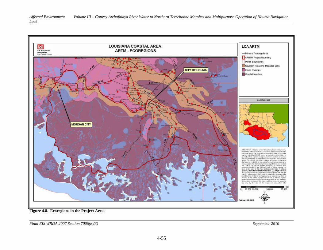
Affected Environment Volume III – Convey Atchafalaya River Water to Northern Terrebonne Marshes and Multipurpose Operation of Houma Navigation Lock
4-55
Final EIS WRDA 2007 Section 7006(e)(3) September 2010
Figure 4.8. Ecoregions in the Project Area.

Affected Environment Volume III – Convey Atchafalaya River Water to Northern Terrebonne Marshes and Multipurpose Operation of Houma Navigation Lock
4-56
Final EIS WRDA 2007 Section 7006(e)(3) September 2010
The Southern Holocene Meander Belts ecoregion stretches from just north of Natchez, Mississippi south to New Orleans, Louisiana. The ecoregion is a flat to nearly flat floodplain containing the meander belts of the present and past courses of the Mississippi River. This ecoregion has a long growing season, warmer annual temperatures and more precipitation than its northern Mississippi Alluvial Plain counterparts. The ecoregion contains minor species such as live oak, laurel oak, and Spanish moss that are generally not found in the more northerly regions. The bottomland forests have been cleared and the region has been extensively modified for agriculture, flood control, and navigation. The levee system is extensive throughout the region. Soybeans, sugarcane, cotton, corn, and pasture are the major crops, with crawfish aquaculture common. The Inland Swamps ecoregion marks a transition, ranging from the fresh waters of the Southern Backswamps at the northern extent of the intratidal basins to the fresh, brackish, and saline waters of the Deltaic Coastal Marshes and Barrier Islands ecoregion. It includes a large portion of the Atchafalaya Basin. Swamp forest communities are dominated by bald cypress and water tupelo. In areas where freshwater flooding is more prolonged, the vegetative community is dominated by grasses, sedges, and rushes. This region contains one of the largest bottomland hardwood forest swamps in North America. The levees in place on either side of the Mississippi River have diverted much of the river flow from its natural tendency to flow into the Atchafalaya Basin. Large concrete structures prevent diversion into the Atchafalaya River, and flow from the Red River is also controlled. Brackish and saline marshes dominate the Deltaic Coastal Marshes and Barrier Islands ecoregion. The region supports vegetation tolerant of brackish or saline water including saltmarsh cordgrass, marshhay cordgrass, black needlerush, and coastal saltgrass. Black mangrove occurs in a few areas, and some live oak is found on Grand Isle and along old natural levees. The wetlands and marshes act as a buffer to help moderate flooding and tidal inundation during storm events. Lack of sediment input, delta erosion, land subsidence, and rising sea levels threaten the region.

Affected Environment Volume III – Convey Atchafalaya River Water to Northern Terrebonne Marshes and Multipurpose Operation of Houma Navigation Lock
4-57
Final EIS WRDA 2007 Section 7006(e)(3) September 2010
Figure 4.9. Landscape Similarity Zones in the Project Area.

Affected Environment Volume III – Convey Atchafalaya River Water to Northern Terrebonne Marshes and Multipurpose Operation of Houma Navigation Lock
4-58
Final EIS WRDA 2007 Section 7006(e)(3) September 2010
Seven landscape similarity zones have been identified for the study area (see Figure 4.9). The zones are described below. Urban 1 This zone encompassing the city of Houma is within the Southern Holocene Meander Belts ecoregion. The area is characterized by the water resources that are the visual core of the area including Bayous Terrebonne and Black and the Intracoastal Waterway. This zone includes spaces that are prominent and contain landmarks or places of assembly that have national and regional importance including the Houma Historic District located in its downtown area. Development patterns are typical of tract-type subdivisions along with older residential areas adjacent to the urban center of multi-family complexes. The area includes commercial facilities including restaurants and retail establishments and community facilities such as neighborhood parks, schools and athletic fields. The density of development limits vegetation in some areas, and typical views are limited in the downtown areas to the nearby streetscape due to multi-story commercial, residential and municipal buildings. Visual access to adjacent areas is wider along the roads and waterways and the less densely developed areas as one transitions out of the downtown area. The Wetlands Cultural Scenic Byway provides viewsheds along LA 182 and LA 56. Urban 2 This zone primarily is within the Inland Swamps ecoregion. It includes the downtown area of Morgan City, characterized by the maritime related industry adjacent to the downtown district. This zone includes spaces that are prominent and contain landmarks or places of assembly that have national and regional importance including the Morgan City Historic District. Development patterns are typical of tract-type subdivisions along with older residential areas adjacent to the urban center of multi-family complexes. The area includes commercial facilities including restaurants and retail establishments and community facilities such as neighborhood parks, schools and athletic fields. Southern viewsheds are limited as the downtown district faces Berwick Bay behind a twenty foot seawall. The density of development limits vegetation in some areas, and typical views are limited to the nearby streetscape. Visual access to adjacent areas is wider along the roads and waterways and the less densely developed areas as one transitions out of the downtown area. Residential This zone primarily is within the Deltaic Coastal Marshes and Barrier Islands ecoregion. The area’s terrain is flat and follows the meandering bayous. The residential area is characterized by the development that was driven by its proximity to the Gulf of Mexico’s fisheries. Low-density rural development, typically limited to road frontage lots, is prevalent. Small scale commercial seafood related industry is prevalent as one travels LA 57 to Dulac and the Wetlands Cultural Scenic Byway’s LA 56 to Cocodrie. The zone includes small retail facilities including restaurants and food stores and community facilities such as neighborhood parks, schools and athletic fields. Visual

Affected Environment Volume III – Convey Atchafalaya River Water to Northern Terrebonne Marshes and Multipurpose Operation of Houma Navigation Lock
4-59
Final EIS WRDA 2007 Section 7006(e)(3) September 2010
access to the area is wider along roads and waterways and the less densely developed areas. Industrial This zone primarily is within the Southern Holocene Meander Belts ecoregion and adjacent to Morgan City’s urban area. Although residences and commercial facilities can be located within this zone, maritime industrial uses, including resources for petroleum and natural gas exploration, predominate. There is little canopy cover, but views are typically diverted to the industrial development that lines LA 182 and Bayou Cocodrie. Terrain is typically flat. Regional access to the area is from U.S. Route 90. Agricultural This zone is within the Southern Holocene Meander Belts ecoregion. This area is marked primarily by flat, mostly open land associated with various bayous sometimes with vegetation along the edges or between fields helping to define the space. Isolated small citrus orchards are found within these areas. Associated low-density, rural development along road frontages and at the various crossroads is included in this zone. The zone includes small retail facilities including restaurants and food stores and community facilities such as neighborhood parks, schools, and athletic fields. Panoramic views are possible but may be limited by the interspersed pockets of forest vegetation. The Wetlands Cultural Scenic Byway provides viewsheds along LA 182 from Houma to Gibson and along LA 56 south of Houma. Nonforested Wetlands This zone is within the Deltaic Coastal Marshes and Barrier Islands ecoregion. The terrain is mostly marsh interspersed with numerous lakes, ponds, bayous, and canals. Man made features include petroleum and natural gas wells, and the Gulf-Intracoastal Waterway. Public recreation access areas include Mandalay National Wildlife Refuge and Pointe Au Chien Wildlife Management Area. Physical access to most of the area is limited to boat travel that allows for panoramic viewsheds of the area. The Wetlands Cultural Scenic Byway provides viewsheds along its southern spurs from Houma to Cocodrie along LA 56 and then to Dulac on LA 57. Forested Wetlands This zone is within the Inland Swamps ecoregion. The terrain is mostly bottomland hardwood and Bald Cypress communities. Water resources include Lake Palourde in the area north of Morgan City and numerous canals in the area south of Houma. Man made features include petroleum and natural gas wells and the Houma Navigation Canal. Lake End Park provides visual access to Lake Palourde. LA 315 and LA 57 provide viewsheds to the area south of Houma as one travels to Theriot and Dulac. Physical access to most of the area is limited to boat travel. Viewsheds may be limited by the interspersed pockets of forest vegetation.
Affected Environment Volume III – Convey Atchafalaya River Water to Northern Terrebonne Marshes and Multipurpose Operation of Houma Navigation Lock
4-60
Final EIS WRDA 2007 Section 7006(e)(3) September 2010
Visual Resource Inventory The following visual resources’ scenic character has been recognized by national or state designations. There may be additional visual resources not identified including public parks and recreation areas. These types of resources were not acknowledged in the public scoping for the LCA study. Specific project details used for the resources’ environmental impact analysis may identify other visual resources. Houma Historic District The Houma Historic District consists of the city's central business district and two related residential areas including 118 buildings. The Houma Historic District Terrebonne Parish Courthouse Square surrounded by mature live oak trees is the historic district center. Most of the commercial buildings are located along Main Street, which parallels Bayou Terrebonne. In its central portions, Main Street has a two-story scale consisting mainly of typical early-twentieth century commercial buildings with commercial space downstairs and residential space above. Historic residences of the district are primarily shotgun houses, bungalows, or cottages (see Figure 4.9). Morgan City Historic District The Morgan City Historic District encompasses eighty-two commercial, residential, and institutional buildings set on all or part of eight blocks. The town has a grid street pattern. Most of the larger commercial buildings face the seawall along Front Street, but there are several along Railroad Avenue as well. The commercial area has a mixed one- and two-story scale. A visual focus of the town is the city hall with its twin Italianate tower cupolas which are visible for several blocks. Residences are located primarily on First and Second Streets. As in most other towns, Morgan City's residences are set back from the street while its commercial buildings are set directly behind the sidewalk (see Figure 4.9). Mandalay National Wildlife Refuge Mandalay National Wildlife Refuge is located approximately 6 miles southwest of Houma, Louisiana. Access to the interior is limited to boat travel. The 4,416-acre refuge is a stopping point for migratory birds. Recreation use includes wildlife observation and photography. The refuge also provides opportunities for environmental education and interpretation. Pointe Au Chien Wildlife Management Area Pointe Au Chien Wildlife Management Area is approximately 15 miles southeast of Houma. This area includes approximately 35,000 acres. Access to the interior is limited to boat travel. The only timber stands are located on the Point Farm Unit of the area, or areas adjacent to natural bayous and older oil and gas canals. Recreation use includes nature study, camping, and picnicking. Wetlands Cultural Scenic Byway The Wetlands Cultural Scenic Byway is 204.1 miles in length and has two interconnected loops and three spurs. The spurs are primarily contained within the study area. The
Affected Environment Volume III – Convey Atchafalaya River Water to Northern Terrebonne Marshes and Multipurpose Operation of Houma Navigation Lock
4-61
Final EIS WRDA 2007 Section 7006(e)(3) September 2010
eastern spur extends along LA 182 from between Houma and Gibson allowing access to Houma’s Downtown National Historic District and Mandalay National Wildlife Refuge. Two southern spurs descend from Houma to Cocodrie along LA 56 with a side route on LA 57 to Dulac. These route segments are shown in Figure 4.9. 4.2.14 Recreation
This resource is institutionally significant because of the Federal Water Project Recreation Act of 1965, as amended, and the Land and Water Conservation Fund Act of 1965, as amended. Recreational resources are technically significant because of the high economic value of recreational activities and their contribution to local, state, and national economies. Recreational resources are publicly significant because of the high value that the public places on fishing, hunting, and boating, as measured by the large number of fishing and hunting licenses sold in Louisiana, and the large per-capita number of recreational boat registrations in Louisiana (Tables 4.13 through 4.15). 4.2.14.1 Historic and Existing Conditions The study area is comprised of a series of narrow ridges along bayous which extend toward the Gulf of Mexico through coastal swamps and marshes. The more significant ridges along navigable bayous have historically supported development of small communities and provide key points of access to the vast coastal wetland resources of the study area. These extensive wetland resources, comprised of swamp and marsh habitat, have traditionally supported substantial consumptive and non-consumptive recreation use. Primary consumptive recreational uses have included both freshwater and saltwater based activities. Freshwater based consumptive uses include freshwater fishing, crawfishing, hunting for waterfowl, as well as hunting for deer or small game along natural ridges and in wooded swamp lands. Primary saltwater based activities have included saltwater fishing, recreational shrimping, and crabbing. Non-consumptive activities have included recreational boating, water skiing, birdwatching, hiking, and camping. Like much of coastal southeast Louisiana, the eastern and central sections of the study area have experienced substantial coastal erosion, loss of wetlands, and increasing salinity levels. These conditions are due to numerous factors, such as extensive oil and gas exploration via a maze of canals and pipelines, subsidence, and coastal storm surges. Although the study area has traditionally provided excellent saltwater fishing, in recent years, because of the increased salinity levels, anglers have been able to catch saltwater species much farther inland than in the past. As fresh and intermediate marshes, cypress trees, and submerged aquatic vegetation in the area have disappeared, waterfowl habitat has become less abundant, and, consequently, duck hunting opportunities have decreased. Unlike most of coastal Louisiana, the far western portion of the study area, due to the influence of the Atchafalaya River, has been relatively stable or experiencing some limited accretion of deltaic lands. Salinity levels are relatively stable in this area and
Affected Environment Volume III – Convey Atchafalaya River Water to Northern Terrebonne Marshes and Multipurpose Operation of Houma Navigation Lock
4-62
Final EIS WRDA 2007 Section 7006(e)(3) September 2010
freshwater fishing opportunities in the area are excellent. The floating marshes traditionally have provided quality habitat for waterfowl and waterfowl hunting. The study area includes the 4,212-acre Mandalay National Wildlife Refuge (NWR) and the 31,902-acre Pointe au Chien Wildlife Management Area (WMA). The Mandalay NWR alone is visited annually more than two thousand times. The most prominent recreational activities within the study area are: fishing and waterfowl hunting. Limited consumptive recreation uses include recreational crabbing, shrimping, and crawfishing. Natural ridges are also utilized for deer and small game hunting. Non-consumptive recreational activities attract far fewer participants and include birdwatching at both Mandalay and Pointe au Chien, hiking at Mandalay, and camping at Pointe au Chien. Recreation resources are publicly significant because of the high value that the public places on fishing, boating, and hunting as measured by the large number of fishing and hunting licenses and the large number of recreational boat registrations obtained in area Parishes. This is particularly important as many of the predominant recreational activities in the study area are only accessible by boat. Thirty seven boat launches are located in the study area and provide access to recreation opportunities. Tables 4.13, 4.14, and 4.15 below show the number of fishing licenses, hunting licenses, and boat registrations, respectively, within the study area. The fishing and hunting license and boat registration data are provided by the Louisiana Department of Wildlife and Fisheries (http://www.wlf.louisiana.gov/education/economics/). Table 4.13. Fishing Licenses Sold in the Vicinity of Project Area- Fiscal Year 2008.
Parish Resident- Freshwater
Resident - Saltwater
Non-Resident
Freshwater
Non-Resident Saltwater
Non-Resident
Temporary Terrebonne 27,820 27,834 5,523 5,403 832 Lafourche 23,422 22,979 6,155 5,993 992 St. Mary 9,634 8,432 1,195 747 122 Table 4.14. Boat Registrations in the Vicinity of the Project Area - Fiscal Year 2008. Parish Boat Registrations Terrebonne 14,437 Lafourche 11,582 St. Mary 7,667 Table 4.15. Hunting Licenses Sold in the Vicinity of the Project Area - Fiscal Year 2008.
Parish Resident Non-Resident Resident Duck Only
Non-Resident Duck Only
Terrebonne 8,720 352 2,816 261 Lafourche 8,149 73 2,235 20 St. Mary 4,484 110 827 47
Affected Environment Volume III – Convey Atchafalaya River Water to Northern Terrebonne Marshes and Multipurpose Operation of Houma Navigation Lock
4-63
Final EIS WRDA 2007 Section 7006(e)(3) September 2010
4.2.15 Socioeconomics and Human Resources
This resource is institutionally significant because of the National Environmental Policy Act of 1969; the Estuary Protection Act; the Clean Water Act; the River and Harbors Acts; the Watershed Protection and Flood Protection Act; and the Water Resources Development Acts. Of particular relevance is the degree to which the proposed action affects public health, safety, and economic well-being; and the quality of the human environment. This resource is technically significant because the social and economic welfare of the nation may be positively or adversely impacted by the proposed action. This resource is publicly significant because of the public’s concern for health, welfare, and economic and social well-being from water resources projects. 4.2.15.1 Population and Housing 4.2.15.1.1 Historic and Existing Conditions The project area encompasses parts of five parishes: Assumption, Lafourche, St. Martin, St. Mary, and Terrebonne. The total population of these five parishes in 2008 was approximately 327,000. The total population of the five parishes is projected to grow to approximately 339,000 by the year 2030. The study area itself, however, is smaller than the multi-parish area and encompasses only portions of this population. The majority of the residential population in the project area is located in Terrebonne, St. Mary, and Lafourche Parishes. The major population centers in the project area are Morgan City (St. Mary Parish) and Houma (Terrebonne Parish) whose populations in 2008 were 11,604 and 32,512, respectively (Table 4.16).
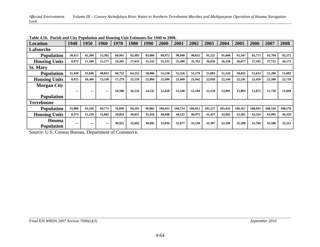
Affected Environment Volume III – Convey Atchafalaya River Water to Northern Terrebonne Marshes and Multipurpose Operation of Houma Navigation Lock
4-64
Final EIS WRDA 2007 Section 7006(e)(3) September 2010
Table 4.16. Parish and City Population and Housing Unit Estimates for 1940 to 2008. Location 1940 1950 1960 1970 1980 1990 2000 2001 2002 2003 2004 2005 2006 2007 2008 Lafourche
Population 38,615 42,209 55,381 68,941 82,483 85,860 89,972 90,040 90,652 91,221 91,608 91,347 92,775 92,704 92,572
Housing Units 8,972 11,340 15,177 19,205 27,033 31,332 35,133 35,490 35,763 36,056 36,358 36,677 37,195 37,722 38,172
St. Mary
Population 31,458 35,848 48,833 60,752 64,253 58,086 53,258 52,526 52,179 51,883 51,526 50,855 51,614 51,286 51,083
Housing Units 8,015 10,360 13,538 17,279 21,539 21,884 21,690 21,849 21,942 22,058 22,144 22,241 22,459 22,580 22,718
Morgan City
Population --- --- --- 16,586 16,114 14,531 12,620 12,340 12,184 12,150 12,001 11,802 11,872 11,726 11,604
Terrebonne
Population 35,880 43,328 60,771 76,049 94,393 96,982 104,455 104,724 104,912 105,157 105,435 106,167 108,043 108,316 108,576
Housing Units 8,573 11,239 15,862 20,854 30,831 35,416 40,048 40,525 40,975 41,427 42,092 42,581 43,354 43,995 44,320
Houma Population
--- --- --- 30,922 32,602 30,495 32,834 32,677 32,518 32,387 32,196 32,208 32,764 32,586 32,512
Source: U.S. Census Bureau, Department of Commerce.

Affected Environment Volume III – Convey Atchafalaya River Water to Northern Terrebonne Marshes and Multipurpose Operation of Houma Navigation Lock
4-65
Final EIS WRDA 2007 Section 7006(e)(3) September 2010
Table 4.17. Parish Population Projections. Location 2010 2015 2020 2025 2030 Lafourche 93,740 95,160 95,990 96,310 95,990
St. Mary 49,400 47,410 45,230 42,870 40,390
Terrebonne 118,890 122,560 124,410 125,140 125,210
Source: Blanchard, T.C. 2009. Population Projections of Louisiana Parishes through 2030. Louisiana State University. 4.2.15.2 Employment and Income 4.2.15.2.1 Historic and Existing Conditions Economic activities in the project area include the harvest of sugarcane, oil and gas production, the transport of these resources, the construction and maintenance of oil rigs, commercial fishing and markets supporting recreational fishing and hunting, and commercial activities supporting the local communities. By far the most important crop harvested has been sugarcane. The area originally developed as a market center for fish, wildlife, and agricultural production; however, with the discovery of oil and gas and the technology to extract those from surrounding wetlands and water bottoms, employment and income opportunities increased. During the 1980s, however, the maturing of oil and gas industries, and its availability at more competitive prices in other countries, caused severe unemployment and out-migration in the area. During the 1990s the continued availability of oil, water resources, fish and wildlife for both commercial and recreational purposes, and national economic trends, appear to have contributed to the area's gradual economic recovery. Table 4.18 summarizes a recent estimate of the types and amounts of employment occurring in Lafourche, St. Mary, and Terrebonne Parishes and compares it to employment categories statewide. Table 4.19 summarizes per capita personal income in the area and statewide.
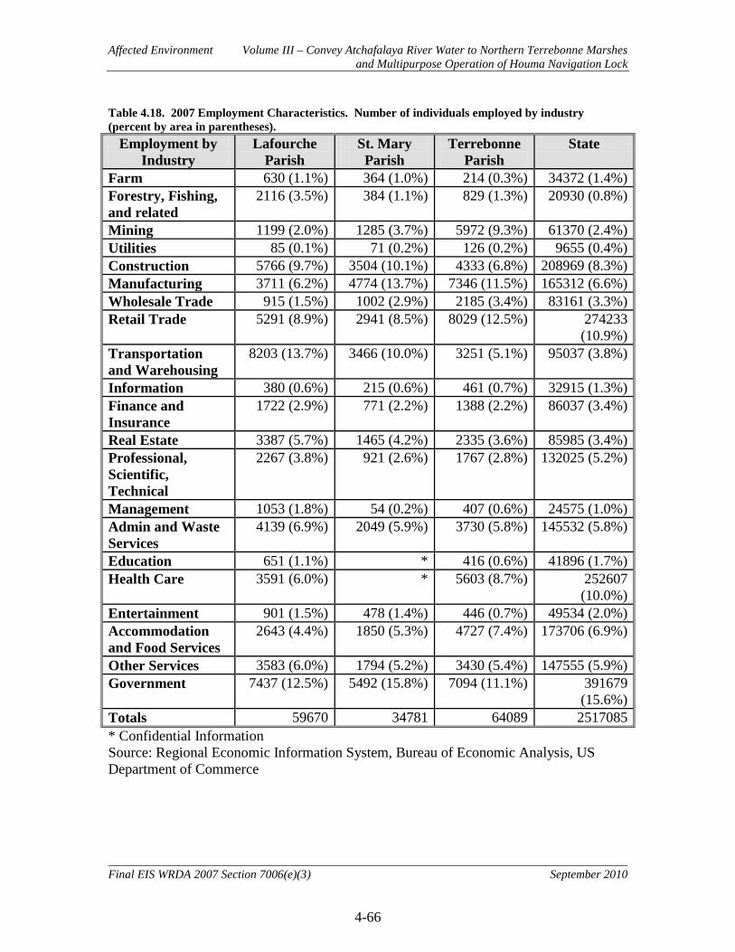
Affected Environment Volume III – Convey Atchafalaya River Water to Northern Terrebonne Marshes and Multipurpose Operation of Houma Navigation Lock
4-66
Final EIS WRDA 2007 Section 7006(e)(3) September 2010
Table 4.18. 2007 Employment Characteristics. Number of individuals employed by industry (percent by area in parentheses).
Employment by Industry
Lafourche Parish
St. Mary Parish
Terrebonne Parish
State
Farm 630 (1.1%) 364 (1.0%) 214 (0.3%) 34372 (1.4%) Forestry, Fishing, and related
2116 (3.5%) 384 (1.1%) 829 (1.3%) 20930 (0.8%)
Mining 1199 (2.0%) 1285 (3.7%) 5972 (9.3%) 61370 (2.4%) Utilities 85 (0.1%) 71 (0.2%) 126 (0.2%) 9655 (0.4%) Construction 5766 (9.7%) 3504 (10.1%) 4333 (6.8%) 208969 (8.3%) Manufacturing 3711 (6.2%) 4774 (13.7%) 7346 (11.5%) 165312 (6.6%) Wholesale Trade 915 (1.5%) 1002 (2.9%) 2185 (3.4%) 83161 (3.3%) Retail Trade 5291 (8.9%) 2941 (8.5%) 8029 (12.5%) 274233
(10.9%) Transportation and Warehousing
8203 (13.7%) 3466 (10.0%) 3251 (5.1%) 95037 (3.8%)
Information 380 (0.6%) 215 (0.6%) 461 (0.7%) 32915 (1.3%) Finance and Insurance
1722 (2.9%) 771 (2.2%) 1388 (2.2%) 86037 (3.4%)
Real Estate 3387 (5.7%) 1465 (4.2%) 2335 (3.6%) 85985 (3.4%) Professional, Scientific, Technical
2267 (3.8%) 921 (2.6%) 1767 (2.8%) 132025 (5.2%)
Management 1053 (1.8%) 54 (0.2%) 407 (0.6%) 24575 (1.0%) Admin and Waste Services
4139 (6.9%) 2049 (5.9%) 3730 (5.8%) 145532 (5.8%)
Education 651 (1.1%) * 416 (0.6%) 41896 (1.7%) Health Care 3591 (6.0%) * 5603 (8.7%) 252607
(10.0%) Entertainment 901 (1.5%) 478 (1.4%) 446 (0.7%) 49534 (2.0%) Accommodation and Food Services
2643 (4.4%) 1850 (5.3%) 4727 (7.4%) 173706 (6.9%)
Other Services 3583 (6.0%) 1794 (5.2%) 3430 (5.4%) 147555 (5.9%) Government 7437 (12.5%) 5492 (15.8%) 7094 (11.1%) 391679
(15.6%) Totals 59670 34781 64089 2517085 * Confidential Information Source: Regional Economic Information System, Bureau of Economic Analysis, US Department of Commerce

Affected Environment Volume III – Convey Atchafalaya River Water to Northern Terrebonne Marshes and Multipurpose Operation of Houma Navigation Lock
4-67
Final EIS WRDA 2007 Section 7006(e)(3) September 2010
Table 4.19. Per Capita Personal Income from 1970 to 2007 (not adjusted for inflation). Area 1970 1980 1990 2000 2001 2002 2003 2004 2005 2006 2007
Lafourche Parish
$2,792 $9,190 $13,059 $22,539 $25,210 $25,678 $26,360 $26,957 $28,340 $33,410 $37,257
St. Mary Parish
$2,888 $8,826 $12,725 $21,085 $23,543 $24,106 $25,197 $25,881 $27,455 $32,748 $35,328
Terrebonne Parish
$2,915 $9,582 $13,190 $20,781 $22,502 $23,191 $23,751 $24,814 $25,454 $31,588 $34,744
State $3,090 $8,777 $15,173 $23,082 $24,719 $25,249 $25,862 $27,262 $24,651 $32,832 $35,100 Source: Regional Economic Information System, Bureau of Economic Analysis, US Department of Commerce

Affected Environment Volume III – Convey Atchafalaya River Water to Northern Terrebonne Marshes and Multipurpose Operation of Houma Navigation Lock
4-68
Final EIS WRDA 2007 Section 7006(e)(3) September 2010
4.2.15.3 Infrastructure 4.2.15.3.1 Business and Industry 4.2.15.3.1.1 Historic and Existing Conditions
Major business and industry in and around the project area includes oil and gas exploration and production, commercial fishing and seafood processing, agriculture and sugar mills, carbon black plants, shipbuilders, fabrication firms, tourism, and salt mining. Table 4.18 contains information on employment by industry group in Lafourche, St. Mary, and Terrebonne Parishes, and statewide. 4.2.15.3.2 Transportation 4.2.15.3.2.1 Historic and Existing Conditions
The transportation infrastructure of the study area includes major roadways and navigable waterways. U.S. Route 90 passes through the project area and connects Morgan City and Houma with Lafayette to the west and New Orleans to the East. Four state highways connect Houma with the southern portions of the project area. Navigation in the vicinity includes the movement of oil and gas supply vessels, commercial fishing vessels, pleasure crafts, and other barge traffic along the Atchafalaya River, the HNC, the GIWW, Bayous Chene, Boeuf, and Black, and other lesser waterways. The GIWW extends from the Mexican border to Appalachee Bay in Florida. The HNC is maintained for approximately 40.5 miles, from Houma to Terrebonne Bay, leading to the open Gulf of Mexico. See Section 4.2.15.6 for further information on Navigation. 4.2.15.3.3 Public Facilities and Services 4.2.15.3.3.1 Historic and Existing Conditions Public and quasi-public facilities and services in the project area include schools, hospitals, police and fire protection, an extensive network of pumps and levees for flood protection, and a series of navigation canals, including the Atchafalaya River, the Houma Navigation Canal, and the Gulf Intracoastal Waterway. During the threat of hurricanes and severe flooding, public buildings are occasionally used as temporary shelter for residents who are impacted. 4.2.15.3.4 Tax Revenue and Property Values 4.2.15.3.4.1 Historic and Existing Conditions Tax revenue and property values in Terrebonne Parish and Lafourche Parish appear to be almost identical, while Morgan City in St. Mary Parish has a lower median income and home value. Parish per capita income trends can be found in Table 4.19. Terrebonne Parish median household income in 2008 was $51,023. This was up from $35,235 in 1999. The median home value in 2008 was $121,400, up from $72,200 in 2000. Lafourche Parish median household income in 2008 was $51,227, an increase from $34,910 in 1999. The median home value in 2008 was $122,800, up from $71,100 in 2000. Morgan City median household income in 2008 was $37,491. This was up from

Affected Environment Volume III – Convey Atchafalaya River Water to Northern Terrebonne Marshes and Multipurpose Operation of Houma Navigation Lock
4-69
Final EIS WRDA 2007 Section 7006(e)(3) September 2010
$28,324 in 2000. Median home value in 2008 was $125,750, an increase from $71,900 in 2000. All information from this section was obtained from city-data.com, accessed February 1, 2010. 4.2.15.3.5 Community and Regional Growth (including Community Cohesion) 4.2.15.3.5.1 Historic and Existing Conditions Community cohesion is defined as the unifying force of a group due to one or more characteristics that provide commonality. These characteristics may include such commonality as race, education, income, ethnicity, religion, language, and mutual economic and social benefits. Community cohesion is the force that keeps group members together long enough to establish meaningful interactions, common institutions, and agreed upon ways of behavior. It is a dynamic process, changing as the physical and human environment changes. The changes brought about by water resource development can impact community cohesion in different ways. For example, changing a channel location may divide a community; it may cause the dislocation of a significant number of residents or it may require the relocation of an important local institution, such as a church or community center. Loss of coastal resources traditionally utilized by local communities can similarly have a negative impact on community cohesion. Conversely, water resource development such as increasing or improving coastal marsh habitat can represent an important public works project heavily supported by the local community. Historic growth trends in the project area (Table 4.16) show steady growth in Lafourche, St. Mary, and Terrebonne Parishes from the 1940s to the 1990s. Since 1990, St. Mary Parish population has been slowly on the decline. Growth trends in Lafourche and Terrebonne parishes continued, but at a slower pace. Current population projections (Table 4.17) predict declining populations in St. Mary Parish and slowly increasing populations in Lafourche and Terrebonne Parishes (Blanchard 2009). 4.2.15.4 Environmental Justice Environmental Justice (EJ) is institutionally significant because of Executive Order 12898 of 1994 (E.O. 12898) and the Department of Defense’s Strategy on Environmental Justice of 1995, which direct Federal agencies to identify and address any disproportionately high adverse human health or environmental effects of Federal actions to minority and/or low-income populations. Minority populations are those persons who identify themselves as Black, Hispanic, Asian American, American Indian/Alaskan Native, and Pacific Islander. A minority population exists where the percentage of minorities in an affected area either exceeds 50 percent or is meaningfully greater than in the general population. Low-income populations as of 2000 are those whose income is below $22,050 for a family of four and are identified using the Census Bureau’s statistical poverty threshold. The Census Bureau defines a “poverty area” as a Census tract with 20 percent or more of its residents below the poverty threshold and an “extreme poverty area” as one with 40 percent or more below the poverty level. This is updated annually at http://aspe.hhs.gov/poverty/09poverty.shtml. This resource is technically significant because the social and economic welfare of minority and low-income

Affected Environment Volume III – Convey Atchafalaya River Water to Northern Terrebonne Marshes and Multipurpose Operation of Houma Navigation Lock
4-70
Final EIS WRDA 2007 Section 7006(e)(3) September 2010
populations may be positively or disproportionately impacted by the proposed actions. This resource is publicly significant because of public concerns about the fair and equitable treatment (fair treatment and meaningful involvement) of all people with respect to environmental and human health consequences of federal laws, regulations, policies, and actions. A potential disproportionate impact may occur when the percent minority (50 percent) and/or percent low-income (20 percent) population in an EJ study area are greater than those in the reference community. For purposes of this analysis, all Census Designated Properties (CDP), that is, cities and towns in designated census areas with small populations, in three sub areas of the project footprint are defined as the EJ study area. Terrebonne and Lafourche Parishes are considered the reference community of comparison and whose population is therefore considered the EJ reference population for comparison purposes. Parish figures were used for unincorporated areas located within one mile of the proposed project footprint. The methodology, consistent with E.O. 12898, to accomplish this Environmental Justice analysis includes identifying low-income and minority populations within the project area using up-to-date economic statistics, aerial photographs, 2000 U.S. Census records, Environmental Systems Research Institute, Inc. (ESRI) estimates, as well as conducting community outreach activities such as public meetings. Despite the 2000 U.S. Census being nine years old, it serves as a logical baseline of information and is the primary deciding variable per data accuracy and reliability for the following reasons:
• Census 2000 data is the most accurate source of data available due to the sample size of the Census decennial surveys. With one of every six households surveyed, the margin of error is negligible.
• The Census reports data at a much smaller geographic level than other survey
sources, providing a more defined and versatile option for data reporting.
• Census information sheds light upon the demographic and economic framework of the area pre-Hurricane Katrina. By accounting for the absent population, the analysis does not exclude potentially low income and minority families that wish to return home.
Due to the considerable impact of Hurricane Katrina upon the New Orleans metropolitan area, and the likely shift in demographics and income, the 2000 Census data are supplemented with more current data, including 2007 and 2008 estimates provided by ESRI. The 2007 and 2008 estimates are utilized for reference purposes only to show changing trends in population since 2000. 4.2.15.4.1 Historic and Existing Conditions The concept of “environmental justice” is rooted in Title VI of the Civil Rights Act of 1964, which prohibited discrimination based on race, color and national origin, and other
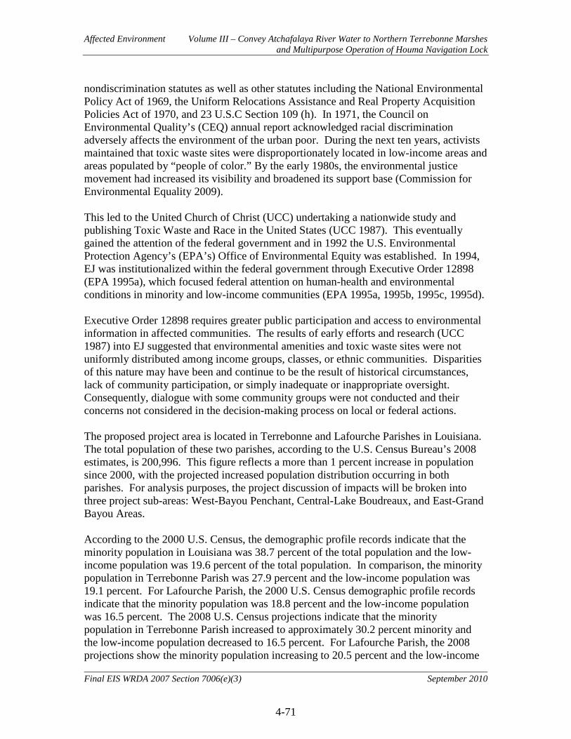
Affected Environment Volume III – Convey Atchafalaya River Water to Northern Terrebonne Marshes and Multipurpose Operation of Houma Navigation Lock
4-71
Final EIS WRDA 2007 Section 7006(e)(3) September 2010
nondiscrimination statutes as well as other statutes including the National Environmental Policy Act of 1969, the Uniform Relocations Assistance and Real Property Acquisition Policies Act of 1970, and 23 U.S.C Section 109 (h). In 1971, the Council on Environmental Quality’s (CEQ) annual report acknowledged racial discrimination adversely affects the environment of the urban poor. During the next ten years, activists maintained that toxic waste sites were disproportionately located in low-income areas and areas populated by “people of color.” By the early 1980s, the environmental justice movement had increased its visibility and broadened its support base (Commission for Environmental Equality 2009). This led to the United Church of Christ (UCC) undertaking a nationwide study and publishing Toxic Waste and Race in the United States (UCC 1987). This eventually gained the attention of the federal government and in 1992 the U.S. Environmental Protection Agency’s (EPA’s) Office of Environmental Equity was established. In 1994, EJ was institutionalized within the federal government through Executive Order 12898 (EPA 1995a), which focused federal attention on human-health and environmental conditions in minority and low-income communities (EPA 1995a, 1995b, 1995c, 1995d). Executive Order 12898 requires greater public participation and access to environmental information in affected communities. The results of early efforts and research (UCC 1987) into EJ suggested that environmental amenities and toxic waste sites were not uniformly distributed among income groups, classes, or ethnic communities. Disparities of this nature may have been and continue to be the result of historical circumstances, lack of community participation, or simply inadequate or inappropriate oversight. Consequently, dialogue with some community groups were not conducted and their concerns not considered in the decision-making process on local or federal actions. The proposed project area is located in Terrebonne and Lafourche Parishes in Louisiana. The total population of these two parishes, according to the U.S. Census Bureau’s 2008 estimates, is 200,996. This figure reflects a more than 1 percent increase in population since 2000, with the projected increased population distribution occurring in both parishes. For analysis purposes, the project discussion of impacts will be broken into three project sub-areas: West-Bayou Penchant, Central-Lake Boudreaux, and East-Grand Bayou Areas. According to the 2000 U.S. Census, the demographic profile records indicate that the minority population in Louisiana was 38.7 percent of the total population and the low-income population was 19.6 percent of the total population. In comparison, the minority population in Terrebonne Parish was 27.9 percent and the low-income population was 19.1 percent. For Lafourche Parish, the 2000 U.S. Census demographic profile records indicate that the minority population was 18.8 percent and the low-income population was 16.5 percent. The 2008 U.S. Census projections indicate that the minority population in Terrebonne Parish increased to approximately 30.2 percent minority and the low-income population decreased to 16.5 percent. For Lafourche Parish, the 2008 projections show the minority population increasing to 20.5 percent and the low-income

Affected Environment Volume III – Convey Atchafalaya River Water to Northern Terrebonne Marshes and Multipurpose Operation of Houma Navigation Lock
4-72
Final EIS WRDA 2007 Section 7006(e)(3) September 2010
population remained the same at 16.5 percent (http://censtats.census.gov., accessed December 11, 2009). Analyses of the above information show that the percentage of the population that is minority and low-income in Terrebonne and Lafourche Parishes are lower than state figures. Based on these figures it has been determined that the proposed project area is not a minority and low income population. Thus there are no potential concerns for Environmental Justice per Executive Order 12898.
The cities located within the West-Bayou Penchant Area are: Morgan City, Berwick and Amelia. As of 2000 the U.S. Census estimates that Morgan City had a 32.5 percent minority and a 20.7 percent low-income population. In 2000, Berwick had a 15 percent minority and a 14.8 percent low-income population. Amelia had a 49.7 percent minority population and a 32.5 percent low-income population (
West-Bayou Penchant Area
http://censtats.census.gov., accessed December 14, 2009).
The cities located in the Central-Lake Boudreaux area are: Montegut, Chauvin and Dulac. As of the 2000 U.S. Census, the minority population in Montegut was 14.6 percent minority and 22.9 percent low-income. In Chauvin, the minority population was 3.7 percent and 20.1 percent low-income; and in Dulac, the minority population was 48.7 percent and 30.9 percent low-income (
Central-Lake Boudreaux Area
http://censtats.census.gov., accessed December 11, 2009).
The cities located in the East-Grand Bayou area are: Larose, Cut Off and Galliano. As of the 2000 U.S. Census, the minority population in Larose was 17.3 percent minority and 15.5 percent low-income. In Cut Off, the minority population was 10.9 percent and 7.9 percent low-income; and in Galliano, the minority population was 9.7 percent and 15.9 percent low-income population (
East-Grand Bayou Area
http://censtats.census.gov., accessed December 11, 2009). These figures indicate that minority and/or low income populations exist throughout the study area. 4.2.15.5 Water Use and Supply 4.2.15.5.1 Historic and Existing Conditions The LDEQ assesses seven categories for water use under the Louisiana Environmental Regulatory Code (LAC Title 33, Chapter 11) that would apply to the project area. Primary Contact Recreation includes activities such as swimming, water skiing, tubing, snorkeling, skin diving, and other activities that involve prolonged body contact with water and probable ingestion. Secondary Contact Recreation includes fishing, wading, and recreational boating, and other activities that involve only incidental or accidental
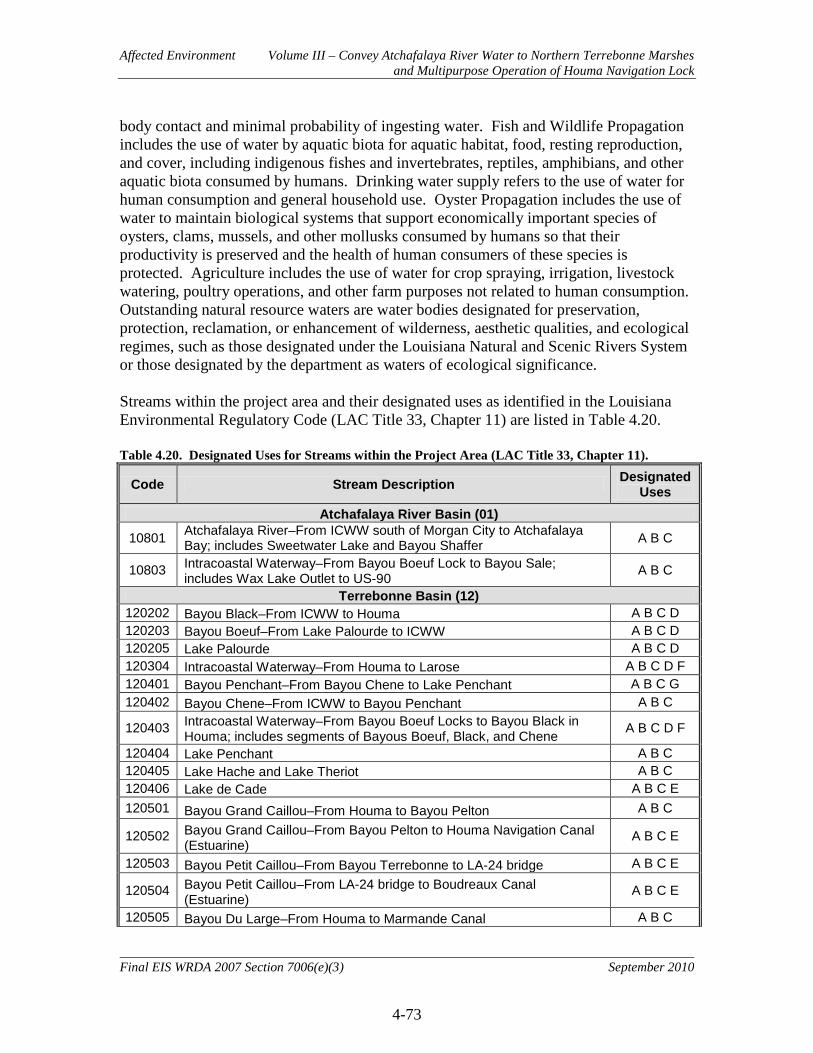
Affected Environment Volume III – Convey Atchafalaya River Water to Northern Terrebonne Marshes and Multipurpose Operation of Houma Navigation Lock
4-73
Final EIS WRDA 2007 Section 7006(e)(3) September 2010
body contact and minimal probability of ingesting water. Fish and Wildlife Propagation includes the use of water by aquatic biota for aquatic habitat, food, resting reproduction, and cover, including indigenous fishes and invertebrates, reptiles, amphibians, and other aquatic biota consumed by humans. Drinking water supply refers to the use of water for human consumption and general household use. Oyster Propagation includes the use of water to maintain biological systems that support economically important species of oysters, clams, mussels, and other mollusks consumed by humans so that their productivity is preserved and the health of human consumers of these species is protected. Agriculture includes the use of water for crop spraying, irrigation, livestock watering, poultry operations, and other farm purposes not related to human consumption. Outstanding natural resource waters are water bodies designated for preservation, protection, reclamation, or enhancement of wilderness, aesthetic qualities, and ecological regimes, such as those designated under the Louisiana Natural and Scenic Rivers System or those designated by the department as waters of ecological significance. Streams within the project area and their designated uses as identified in the Louisiana Environmental Regulatory Code (LAC Title 33, Chapter 11) are listed in Table 4.20. Table 4.20. Designated Uses for Streams within the Project Area (LAC Title 33, Chapter 11).
Code Stream Description Designated Uses
Atchafalaya River Basin (01)
10801 Atchafalaya River–From ICWW south of Morgan City to Atchafalaya Bay; includes Sweetwater Lake and Bayou Shaffer A B C
10803 Intracoastal Waterway–From Bayou Boeuf Lock to Bayou Sale; includes Wax Lake Outlet to US-90 A B C
Terrebonne Basin (12) 120202 Bayou Black–From ICWW to Houma A B C D 120203 Bayou Boeuf–From Lake Palourde to ICWW A B C D 120205 Lake Palourde A B C D 120304 Intracoastal Waterway–From Houma to Larose A B C D F 120401 Bayou Penchant–From Bayou Chene to Lake Penchant A B C G 120402 Bayou Chene–From ICWW to Bayou Penchant A B C
120403 Intracoastal Waterway–From Bayou Boeuf Locks to Bayou Black in Houma; includes segments of Bayous Boeuf, Black, and Chene A B C D F
120404 Lake Penchant A B C 120405 Lake Hache and Lake Theriot A B C 120406 Lake de Cade A B C E 120501 Bayou Grand Caillou–From Houma to Bayou Pelton A B C
120502 Bayou Grand Caillou–From Bayou Pelton to Houma Navigation Canal (Estuarine)
A B C E
120503 Bayou Petit Caillou–From Bayou Terrebonne to LA-24 bridge A B C E
120504 Bayou Petit Caillou–From LA-24 bridge to Boudreaux Canal (Estuarine)
A B C E
120505 Bayou Du Large–From Houma to Marmande Canal A B C
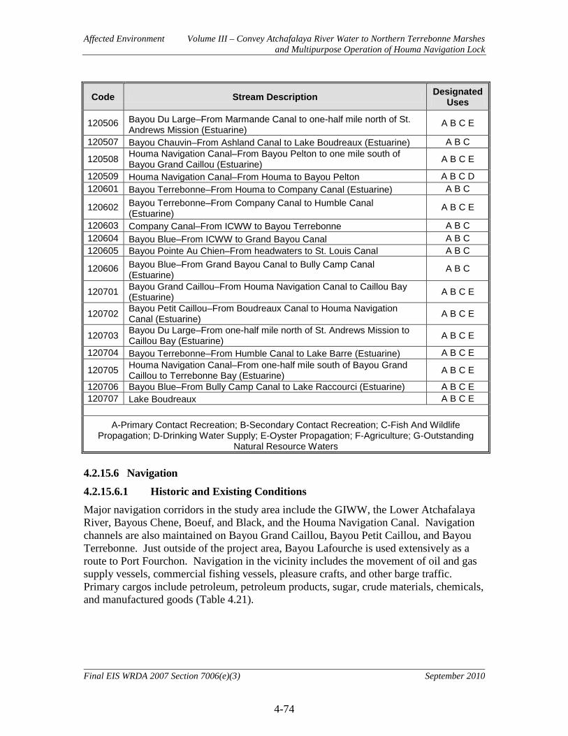
Affected Environment Volume III – Convey Atchafalaya River Water to Northern Terrebonne Marshes and Multipurpose Operation of Houma Navigation Lock
4-74
Final EIS WRDA 2007 Section 7006(e)(3) September 2010
Code Stream Description Designated Uses
120506 Bayou Du Large–From Marmande Canal to one-half mile north of St. Andrews Mission (Estuarine)
A B C E
120507 Bayou Chauvin–From Ashland Canal to Lake Boudreaux (Estuarine) A B C
120508 Houma Navigation Canal–From Bayou Pelton to one mile south of Bayou Grand Caillou (Estuarine) A B C E
120509 Houma Navigation Canal–From Houma to Bayou Pelton A B C D 120601 Bayou Terrebonne–From Houma to Company Canal (Estuarine) A B C
120602 Bayou Terrebonne–From Company Canal to Humble Canal (Estuarine)
A B C E
120603 Company Canal–From ICWW to Bayou Terrebonne A B C 120604 Bayou Blue–From ICWW to Grand Bayou Canal A B C 120605 Bayou Pointe Au Chien–From headwaters to St. Louis Canal A B C
120606 Bayou Blue–From Grand Bayou Canal to Bully Camp Canal (Estuarine)
A B C
120701 Bayou Grand Caillou–From Houma Navigation Canal to Caillou Bay (Estuarine) A B C E
120702 Bayou Petit Caillou–From Boudreaux Canal to Houma Navigation Canal (Estuarine) A B C E
120703 Bayou Du Large–From one-half mile north of St. Andrews Mission to Caillou Bay (Estuarine) A B C E
120704 Bayou Terrebonne–From Humble Canal to Lake Barre (Estuarine) A B C E
120705 Houma Navigation Canal–From one-half mile south of Bayou Grand Caillou to Terrebonne Bay (Estuarine) A B C E
120706 Bayou Blue–From Bully Camp Canal to Lake Raccourci (Estuarine) A B C E 120707 Lake Boudreaux A B C E
A-Primary Contact Recreation; B-Secondary Contact Recreation; C-Fish And Wildlife
Propagation; D-Drinking Water Supply; E-Oyster Propagation; F-Agriculture; G-Outstanding Natural Resource Waters
4.2.15.6 Navigation 4.2.15.6.1 Historic and Existing Conditions Major navigation corridors in the study area include the GIWW, the Lower Atchafalaya River, Bayous Chene, Boeuf, and Black, and the Houma Navigation Canal. Navigation channels are also maintained on Bayou Grand Caillou, Bayou Petit Caillou, and Bayou Terrebonne. Just outside of the project area, Bayou Lafourche is used extensively as a route to Port Fourchon. Navigation in the vicinity includes the movement of oil and gas supply vessels, commercial fishing vessels, pleasure crafts, and other barge traffic. Primary cargos include petroleum, petroleum products, sugar, crude materials, chemicals, and manufactured goods (Table 4.21).

Affected Environment Volume III – Convey Atchafalaya River Water to Northern Terrebonne Marshes and Multipurpose Operation of Houma Navigation Lock
4-75
Final EIS WRDA 2007 Section 7006(e)(3) September 2010
Table 4.21. Cargo Transported (in thousands of tons) and Number of Vessels on Waterways in the Vicinity of the Project Area in 2007. Commodity Lower
Atchafalaya Bayou Boeuf
Lock HNC Bayou
Lafourche Bayou Grand Caillou
Bayou Petit Caillou
Bayou Terrebonne
Coal and Coal Products
0.0 458.2 0.0 0.0 0.0 0.0 0.0
Petroleum and Petroleum Products
888.9 13,276.1 620.8 1,196.3 49.4 183.5 11.0
Chemicals 0.3 3,681.7 0.0 86.1 0.7 0.0 0.0 Crude Materials 92.1 5,317.9 205.2 654.6 14.6 38.8 193.0
Manufactured Goods
10.7 1,675.4 4.7 91.0 5.2 0.5 0.5
Food and Farm Products
237.8 536.1 0.0 371.6 0.0 0.0 0.5
Manufactured Equipment
49.7 455.1 13.6 3,469.0 3.1 1.5 10.0
Waste Material 1.5 822.8 0.0 259.9 0.0 0.0 0.0 Other Cargo 2.9 22.0 0.0 0.5 0.0 0.0 0.0 Total Cargo 1,283.9 26,245.3 844.3 6,129.0 73.0 224.3 215.1
Number of Vessels 37,294 21,372 9,338 49,270 5,079 3,339 2,167 Source: Waterborne Commerce Statistics Center; www.iwr.usace.army.mil/ndc/wcsc/wcsc.htm; accessed 11 December 2009.

Affected Environment Volume III – Convey Atchafalaya River Water to Northern Terrebonne Marshes and Multipurpose Operation of Houma Navigation Lock
4-76
Final EIS WRDA 2007 Section 7006(e)(3) September 2010
4.2.15.7 Land Use Socioeconomics 4.2.15.7.1 Agriculture 4.2.15.7.1.1 Historic and Existing Conditions Agriculture is an important component of coastal Louisiana’s economy. More than $5.3 billion of crops and livestock were produced in Coastal Louisiana in 2008. The rich deltaic soil and mild climate are conducive to the production of a wide variety of crops, including sugar cane, rice, and soybeans. Approximately 20 percent of the Nation’s rice and 37 percent of the Nation’s sugar are produced in Louisiana. Most of this production is in the coastal areas of the state and many of these areas are experiencing either direct land loss or increasing salinities of waters that are used for crop irrigation. Crop production in and around the study area is dominated by sugar cane. Significant income is also derived from livestock production, primarily cattle and horses, and from aquaculture, primarily alligators and crawfish (Table 4.22). In the sugar producing areas, production has been hampered by subsidence resulting in flooding and drainage problems. Even in areas where saltwater intrusion has not occurred, the loss of adjacent wetlands makes croplands more susceptible to storm damages.
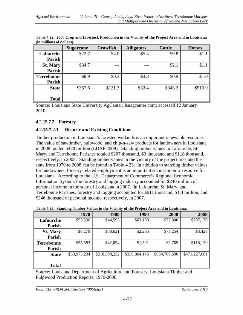
Affected Environment Volume III – Convey Atchafalaya River Water to Northern Terrebonne Marshes and Multipurpose Operation of Houma Navigation Lock
4-77
Final EIS WRDA 2007 Section 7006(e)(3) September 2010
Table 4.22. 2008 Crop and Livestock Production in the Vicinity of the Project Area and in Louisiana (in millions of dollars). Sugarcane Crawfish Alligators Cattle Horses
Lafourche Parish
$22.7 $4.0 $5.4 $9.8 $1.1
St. Mary Parish
$34.7 --- --- $2.1 $1.1
Terrebonne Parish
$8.9 $0.3 $3.3 $0.9 $1.0
State
Total
$357.6 $121.3 $33.4 $343.3 $510.9
Source: Louisiana State University AgCenter; lsuagcenter.com; accessed 12 January 2010. 4.2.15.7.2 Forestry 4.2.15.7.2.1 Historic and Existing Conditions Timber production in Louisiana’s forested wetlands is an important renewable resource. The value of sawtimber, pulpwood, and chip-n-saw products for landowners in Louisiana in 2008 totaled $470 million (LDAF 2009). Standing timber values in Lafourche, St. Mary, and Terrebonne Parishes totaled $207 thousand, $3 thousand, and $118 thousand, respectively, in 2008. Standing timber values in the vicinity of the project area and the state from 1970 to 2008 can be found in Table 4.23. In addition to standing timber values for landowners, forestry-related employment is an important socioeconomic resource for Louisiana. According to the U.S. Department of Commerce’s Regional Economic Information System, the forestry and logging industry accounted for $240 million of personal income in the state of Louisiana in 2007. In Lafourche, St. Mary, and Terrebonne Parishes, forestry and logging accounted for $611 thousand, $1.4 million, and $246 thousand of personal income, respectively, in 2007. Table 4.23. Standing Timber Values in the Vicinity of the Project Area and in Louisiana. 1970 1980 1990 2000 2008
Lafourche Parish
$55,590 $44,595 $63,180 $27,800 $207,170
St. Mary Parish
$8,279 $58,621 $2,235 $73,254 $3,428
Terrebonne Parish
$55,583 $42,854 $1,501 $3,769 $118,130
State
Total
$53,973,234 $218,398,232 $338,864,145 $654,769,596 $471,227,081
Source: Louisiana Department of Agriculture and Forestry, Louisiana Timber and Pulpwood Production Reports, 1970-2008.
Affected Environment Volume III – Convey Atchafalaya River Water to Northern Terrebonne Marshes and Multipurpose Operation of Houma Navigation Lock
4-78
Final EIS WRDA 2007 Section 7006(e)(3) September 2010
4.2.15.7.3 Public Lands This resource is institutionally significant because of the Federal Water Project Recreation Act of 1965, as amended; the Land and Water Conservation Fund Act of 1965, as amended; the National Wildlife Refuge System Administration Act of 1966; and the National Wildlife Refuge System Improvement Act of 1997. Public lands are technically significant because of the high economic value of recreational activities and their contribution to local, state, and national economies. Public lands are publicly significant because of the high value that the public places on conservation of natural resources, as well as access for fishing, hunting, and boating activities, as measured by the large number of fishing and hunting licenses sold in Louisiana, and the large per-capita number of recreational boat registrations in Louisiana. 4.2.15.7.3.1 Historic and Existing Conditions Public lands are those areas owned by the Federal or state government, which have been made available for public access. The National Wildlife Refuge System Improvement Act of 1997 authorized that no new or expanded use of a refuge may be allowed unless it is first determined to be a compatible use and the use is not inconsistent with public safety. In the eastern portion of the study area, the Louisiana Department of Wildlife and Fisheries operates the 33,488-acre Pointe au Chien Wildlife Management Area about 15 miles southeast of Houma in Terrebonne and Lafourche Parishes. The habitat of the area is mostly marsh, varying from nearly fresh to brackish interspersed with numerous ponds, bayous, and canals. Game species hunted are waterfowl, deer, rabbit, squirrels, rail, gallinule, and snipe. Inland saltwater fish species, crabs, and shrimp are available in the more brackish water. Non-consumptive forms of recreation are boating, nature study, undeveloped camping and picnicking. Management and water control has been practiced on the area since its inception in 1968. Southwest of Houma, near Lake Hatch, the USFWS manages the 4,212-acre Mandalay National Wildlife Refuge. The habitat of the Refuge is mostly fresh marsh and is only accessible by boat. The property is intersected by the GIWW. Hunting opportunities include waterfowl, white-tailed deer, and feral hogs. Fishing, wildlife observation, photography, and boating are also available on the refuge 4.2.15.8 Man Made Resources 4.2.15.8.1 Oil Gas and Utilities 4.2.15.8.1.1 Historic and Existing Conditions The petroleum industry in the state accounts for almost 25 percent of the total state revenues and employs more than 116,000 people (about 6 percent of the state’s total workforce). These workers earn almost 12 percent of the total wages paid in Louisiana. Indirect employment levels in support industries make this economic sector more important than is indicated by the direct employment figures.

Affected Environment Volume III – Convey Atchafalaya River Water to Northern Terrebonne Marshes and Multipurpose Operation of Houma Navigation Lock
4-79
Final EIS WRDA 2007 Section 7006(e)(3) September 2010
The oil and gas production industry, and the numerous associated support industries, are an important part of the socioeconomic landscape of the project area (see Employment and Income section). Oil and gas infrastructure is prevalent throughout the study area and vicinity (Figure 4.10). The impacts of the Deepwater Horizon oil spill on coastal Louisiana are uncertain at this time (August 2010). The impacts of the oil spill as well as the various emergency actions taken to address oil spill impacts (e.g., use of oil dispersants, creation of sand berms, use of Hesco baskets, rip-rap, sheet piling and other actions) could potentially impact USACE water resources projects and studies within the Louisiana coastal area, including the LCA-ARTM project. Potential impacts could include factors such as changes to existing, future-without, and future-with-project conditions, as well as increased project costs and implementation delays. The USACE will continue to monitor and closely coordinate with other Federal and state resource agencies and local sponsors in determining how to best address any potential problems associated with the oil spill that may adversely impact project implementation. Supplemental planning and environmental documentation may be required as information becomes available. If at any time petroleum or crude oil is discovered on project lands, all efforts will be taken to seek clean up by the responsible parties, pursuant to the Oil Pollution Act of 1990 (33 U.S.C. 2701 et seq.). Ongoing documentation of the impacts associated with the Deepwater Horizon Oil spill can be found in several governmental sources. The USFWS Situation Report for August 2, 2010 (http://www.fws.gov/home/dhoilspill/pdfs/MondayAugust22010.pdf) indicates the following environmental-related Deepwater Horizon oil spill information: 563 personnel are actively engaged in the response, working to protect wildlife and their habitats, including 36 national wildlife refuges. They are also assessing the damage from the oil spill in preparation for the work that will be needed to restore the Gulf of Mexico. Some 1,643 visibly oiled birds have been collected alive by the U.S. Fish and Wildlife Service, the states and our partners in response to the Deepwater Horizon oil spill. Of those, 594 birds have been rehabilitated and released. Another 1,451 visibly oiled birds have been collected dead. Aerial operations over Louisiana observed an oil sheen covering 300 acres in the northeastern portion of Barataria Bay. A heavily oiled coastline covering about one-half mile was found at Bayou Chalond and heavy oil and tar balls were observed on landfall east of Point-Au-Fer and along Timbalier Island. Beached bird surveys were conducted in Texas, Louisiana, Mississippi, Alabama and Florida. Aerial missions are scheduled for Southwest Pass, Chandeleur Islands, Biloxi Marsh, Barataria Bay, Terrebonne, Marsh Islands, Atchafalaya Delta, Point-Au-Fer and Timbalier Bay.
• Overall number of personnel responding: approximately 30,100 • Total vessels responding: more than 4,500 • Total boom deployed: more than 2,155 miles • Boom available: more than 856 miles

Affected Environment Volume III – Convey Atchafalaya River Water to Northern Terrebonne Marshes and Multipurpose Operation of Houma Navigation Lock
4-80
Final EIS WRDA 2007 Section 7006(e)(3) September 2010
• Oily water recovered: more than 34.7 million gallons • Estimated 11.14 million gallons of oil burned • Estimated total of more than 1.84 million gallons of dispersant used including:
o Estimated more than 1.07 million gallons surface dispersant used o Estimated more than 771,000 gallons of sub-sea dispersant used
• Estimated approximately 632 miles of Gulf Coast shoreline is currently oiled—approximately 365 miles in Louisiana, 111 miles in Mississippi, 68 miles in Alabama, and 88 miles in Florida.
The USACE, New Orleans District Regulatory Branch has considered and responded to approximately 55 emergency permits related to the Deepwater Horizon oil spill (see Table 1.2). Emergency permits have the following clause that provides for removing, relocating or altering permitted structures if necessary and upon due notice from the Corps. The clause would pertain to future actions by the United States, such as proposed Louisiana Coastal Area restoration projects:
The permittee understands and agrees that, if future operations by the United States require the removal, relocation, or other alteration, of the structure or work herein authorized, or if, in the opinion of the Secretary of the Army or his authorized representative, said structure or work shall cause unreasonable obstruction to the free navigation of the navigable waters, the permittee shall be required upon due notice from the Corps of Engineers, to remove, relocate, or alter the structural work or obstructions caused thereby, without expense to the United States. No claim shall be made against the United States on account of any such removal or alteration.
As is evident from the numerous ongoing actions, the dynamic nature of the impacts associated with the Deepwater Horizon oil spill will likely require additional consideration in the near future for USACE Civil Works projects.

Affected Environment Volume III – Convey Atchafalaya River Water to Northern Terrebonne Marshes and Multipurpose Operation of Houma Navigation Lock
4-81
Final EIS WRDA 2007 Section 7006(e)(3) September 2010
Figure 4.10. Oil and Gas Infrastructure in the Project Area.
Affected Environment Volume III – Convey Atchafalaya River Water to Northern Terrebonne Marshes and Multipurpose Operation of Houma Navigation Lock
4-82
Final EIS WRDA 2007 Section 7006(e)(3) September 2010
4.2.15.8.2 Flood Control and Hurricane Protection 4.2.15.8.2.1 Historic and Existing Conditions There are several Federal flood control and hurricane protection levees in and around the project area in addition to many local levees (Figure 4.11). Information on Federal flood control and hurricane protection levees follows. East Atchafalaya Basin Protection Levee (EABPL). This levee begins at the lower end of the east guide levee of the Morganza Floodway, extends southward to and through Morgan City to the Avoca Island Cutoff, and includes the Bayou Boeuf and Bayou Sorrel locks. The length of this system is 106.7 miles, including 1.3 miles of floodwall along the Morgan City front and about 0.4 miles of floodwall below Morgan City. The Atchafalaya Basin Levee District and the city of Morgan City are responsible for operation and maintenance of this feature. West Atchafalaya Basin Protection Levee (WABPL). This levee begins near the town of Hamburg, where it joins the Bayou des Glaises fuseplug levee. It extends in a south and southeasterly direction to the Wax Lake Outlet at the latitude of the East and West Calumet Floodgates and then eastward through Berwick to the Gulf Intracoastal Waterway. This levee extends 128.7 miles and connects with 3 miles of floodwall along the front of the town of Berwick. Bayou Boeuf Lock. This lock is located in the EABPL below Morgan City at a point where it crosses Bayou Boeuf and the Gulf Intracoastal Waterway. The lock has a length of 1,136 feet, a clear width of 75 feet, and a depth over sills of 13 feet at NGVD. The Bayou Boeuf Lock provides for navigation through the levee, which protects the areas and communities east of Morgan City from floodwaters from the Atchafalaya Basin. It was completed in 1955. It is operated and maintained by the U.S. Army Corps of Engineers. Larose to Golden Meadow Hurricane Protection Project. This project consists of a ring levee approximately 40 miles in length protecting the areas along the east and west banks of Bayou Lafourche, extending from Larose to just south of Golden Meadow. Floodwalls were constructed in areas where the congested nature of improvements and limited right-of-way prevented the construction of levees. The project also provides for the construction of navigable floodgates on Bayou Lafourche at the upper and lower limits of the project area. In lieu of the eight gravity drainage structures that were authorized as part of the project, the local sponsor chose to pay the additional cost for pumping stations. To date, the first and second lifts on all levee reaches have been completed and the third and final lift has been completed on all but one reach. The Larose Floodgate was completed in 1987 and the Golden Meadow Floodgate, now officially known as the Leon Theriot Floodgate, was completed in 1985. The project is approximately 97 percent complete. The Leon Theriot Lock was authorized in August 2005. The South Lafourche Levee District has initiated construction of the lock and has completed 2 of the 3 construction contracts.

Affected Environment Volume III – Convey Atchafalaya River Water to Northern Terrebonne Marshes and Multipurpose Operation of Houma Navigation Lock
4-83
Final EIS WRDA 2007 Section 7006(e)(3) September 2010
Morganza to the Gulf of Mexico Risk Reduction Project. The Morganza to the Gulf project area is bounded on the west by Bayou du Large and State Highway 311 and on the east by Bayou Lafourche with the east and west boundaries forming an apex at Thibodaux, LA. The southern boundary is the Gulf of Mexico. The project consists of approximately 72 miles of earthen levee, nine 56-ft. sector gate structures, three 125-ft. floodgates, 13-floodgate structures, 13-tidal exchange structures and a lock complex consisting of a lock in the Houma Navigation Canal measuring 110-feet by 800-feet, an adjoining floodgate measuring 250 feet, and a dam closure. The structural features are integrated into the levee alignment to provide flood protection, drainage, environmental benefits, and navigational passage. A Post-Authorization Change report is being developed for the project due to cost increases subsequent to authorization. Future Congressional authorization and appropriation will be needed before Federally-funded construction can begin. However, construction by the local sponsor has begun on two of the ten levee reaches.
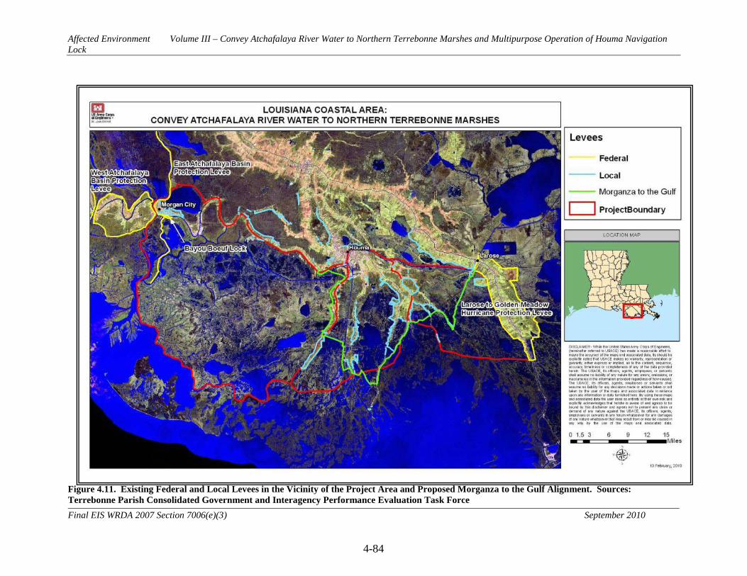
Affected Environment Volume III – Convey Atchafalaya River Water to Northern Terrebonne Marshes and Multipurpose Operation of Houma Navigation Lock
4-84
Final EIS WRDA 2007 Section 7006(e)(3) September 2010
Figure 4.11. Existing Federal and Local Levees in the Vicinity of the Project Area and Proposed Morganza to the Gulf Alignment. Sources: Terrebonne Parish Consolidated Government and Interagency Performance Evaluation Task Force
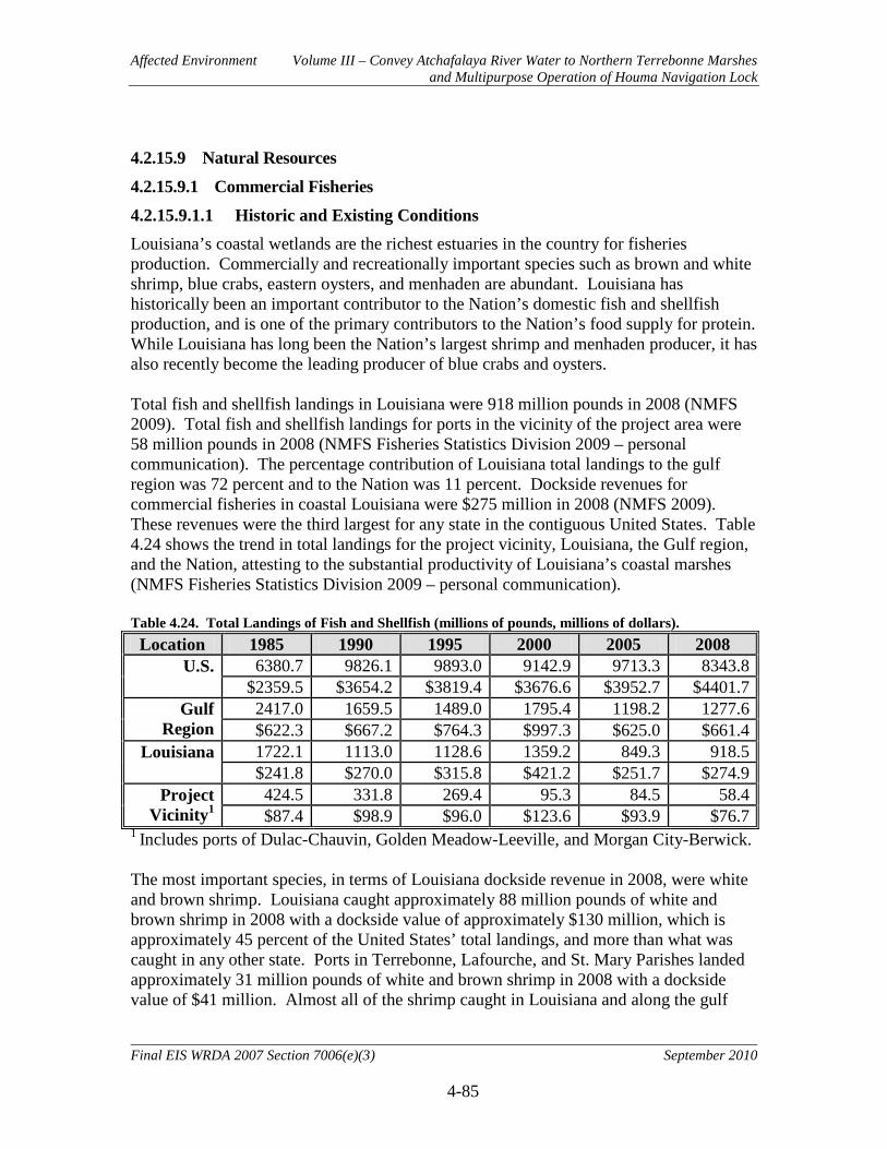
Affected Environment Volume III – Convey Atchafalaya River Water to Northern Terrebonne Marshes and Multipurpose Operation of Houma Navigation Lock
4-85
Final EIS WRDA 2007 Section 7006(e)(3) September 2010
4.2.15.9 Natural Resources 4.2.15.9.1 Commercial Fisheries 4.2.15.9.1.1 Historic and Existing Conditions Louisiana’s coastal wetlands are the richest estuaries in the country for fisheries production. Commercially and recreationally important species such as brown and white shrimp, blue crabs, eastern oysters, and menhaden are abundant. Louisiana has historically been an important contributor to the Nation’s domestic fish and shellfish production, and is one of the primary contributors to the Nation’s food supply for protein. While Louisiana has long been the Nation’s largest shrimp and menhaden producer, it has also recently become the leading producer of blue crabs and oysters. Total fish and shellfish landings in Louisiana were 918 million pounds in 2008 (NMFS 2009). Total fish and shellfish landings for ports in the vicinity of the project area were 58 million pounds in 2008 (NMFS Fisheries Statistics Division 2009 – personal communication). The percentage contribution of Louisiana total landings to the gulf region was 72 percent and to the Nation was 11 percent. Dockside revenues for commercial fisheries in coastal Louisiana were $275 million in 2008 (NMFS 2009). These revenues were the third largest for any state in the contiguous United States. Table 4.24 shows the trend in total landings for the project vicinity, Louisiana, the Gulf region, and the Nation, attesting to the substantial productivity of Louisiana’s coastal marshes (NMFS Fisheries Statistics Division 2009 – personal communication). Table 4.24. Total Landings of Fish and Shellfish (millions of pounds, millions of dollars).
Location 1985 1990 1995 2000 2005 2008 U.S. 6380.7 9826.1 9893.0 9142.9 9713.3 8343.8
$2359.5 $3654.2 $3819.4 $3676.6 $3952.7 $4401.7 Gulf
Region 2417.0 1659.5 1489.0 1795.4 1198.2 1277.6 $622.3 $667.2 $764.3 $997.3 $625.0 $661.4
Louisiana 1722.1 1113.0 1128.6 1359.2 849.3 918.5 $241.8 $270.0 $315.8 $421.2 $251.7 $274.9
Project Vicinity1
424.5 331.8 269.4 95.3 84.5 58.4 $87.4 $98.9 $96.0 $123.6 $93.9 $76.7
1 Includes ports of Dulac-Chauvin, Golden Meadow-Leeville, and Morgan City-Berwick. The most important species, in terms of Louisiana dockside revenue in 2008, were white and brown shrimp. Louisiana caught approximately 88 million pounds of white and brown shrimp in 2008 with a dockside value of approximately $130 million, which is approximately 45 percent of the United States’ total landings, and more than what was caught in any other state. Ports in Terrebonne, Lafourche, and St. Mary Parishes landed approximately 31 million pounds of white and brown shrimp in 2008 with a dockside value of $41 million. Almost all of the shrimp caught in Louisiana and along the gulf
Affected Environment Volume III – Convey Atchafalaya River Water to Northern Terrebonne Marshes and Multipurpose Operation of Houma Navigation Lock
4-86
Final EIS WRDA 2007 Section 7006(e)(3) September 2010
coast have spent an important part of their life living and growing in the Louisiana coastal marshes. Another important species harvested in the area is menhaden. Menhaden is processed to produce both fishmeal and fish oil. Fishmeal is used as a high protein animal feed. The broiler (chicken) industry is currently the largest user of menhaden meal, followed by the turkey, swine, pet food, and ruminant (cattle/livestock) industries. The Louisiana menhaden fisheries landings were the largest in the Nation in 2008 at 738 million pounds, more than twice as much as the next closest state. The percent of dockside value from Louisiana to that of the Nation was over 51 percent. Menhaden are an important species in Terrebonne, Lafourche, and St. Mary Parishes as well, but landings for this species are reported at other ports. In 2008, Louisiana had 55 percent of the Nation’s eastern oyster catch, 12.7 million pounds, with 47 percent of the value, $38.8 million. Ports in Terrebonne, Lafourche, and St. Mary parishes landed 4.3 million pounds in 2008 at a value of $11.7 million (NMFS Fisheries Statistics Division 2009 – personal communication). Louisiana also landed more blue crabs in 2008 than any other state and accounted for approximately 26 percent of the Nation’s total. Louisiana has been the largest producer of blue crabs, by weight, in the Nation since 2000, surpassing other states that were the dominant producers in the 1990s. Blue crab landings in Louisiana in 2008 were 41.5 million pounds with a dockside value of $31.8 million. Blue crab landings at ports in Terrebonne, Lafourche, and St. Mary Parishes in 2008 were 15.6 million pounds with a dockside value of $11.9 million (NMFS Fisheries Statistics Division 2009 – personal communication). 4.2.15.9.2 Oyster Leases 4.2.15.9.2.1 Historic and Existing Conditions Louisiana is the top producer of the eastern oyster in the United States, averaging approximately 13.1 million pounds per year since 2000, with an average value of $34.0 million (NMFS Fisheries Statistics Division 2009 – personal communication). The fishery has two main sources - privately leased grounds, and public seed grounds. The State of Louisiana owns the water bottoms and leases out acreage to oyster fishermen. The public grounds are open to harvesting by all licensed fishermen, but are only open during the public season, which runs from September through March. Oysters can be harvested from the private grounds throughout the year. Approximately 390,000 acres are currently under lease in Louisiana, compared to less than 250,000 acres during the mid 1970s and early 1980s (Diagne and Keithly 1988). Terrebonne and Lafourche parishes currently account for approximately 115,000 acres as compared to 57,000 in the 1970s and early 1980s. The leases have 15-year terms and are leased from the state for $2 per acre per year. See figure 4.7.

Affected Environment Volume III – Convey Atchafalaya River Water to Northern Terrebonne Marshes and Multipurpose Operation of Houma Navigation Lock
4-87
Final EIS WRDA 2007 Section 7006(e)(3) September 2010
4.2.16 Hazardous, Toxic, and Radioactive Wastes
[Phase I Environmental Site Assessment Summary] 4.2.16.1 Historic and Existing Conditions The USACE is obligated under Engineer Regulation (ER) 1165-2-132 to assume responsibility for the reasonable identification and evaluation of all HTRW contamination within the vicinity of the proposed action. ER 1165-2-132 identifies the USACE policy to avoid the use of project funds for HTRW removal and remediation activities. Costs for necessary special handling or remediation of wastes (e.g., those regulated by the RCRA), pollutants and other contaminants, which are not regulated under the CERCLA, will be treated as project costs if the requirement is the result of a validly promulgated Federal, state or local regulation. HTRW investigations facilitate early identification and consideration of HTRW problems. The Civil Works Project Plan routinely includes a phased and documented review to provide for early identification of HTRW potential at project sites. ER 1165-2-132 requires that viable options to avoid HTRW problems be determined and a procedure for resolution of HTRW concerns be established. The discharge of dredged material into waters of the U.S. is regulated under the Clean Water Act (CWA), and the Marine Protection and Sanctuaries Act governs the transportation of dredged material to ocean waters for the purpose of disposal. The RCRA hazardous waste management regulations, promulgated pursuant to RCRA (42 U.S.C. 6905) specifically exempt dredge material from the hazardous waste definition if that material is covered by: 1) a permit issued under Section 404 of the Clean Water Act, 33 U.S.C. 1344; 2) a permit issued under Section 103 of the Marine Protection, Research and Sanctuaries Act of 1972 33 U.S.C. 1413; or 3) the administrative equivalent of such permits where the work involves an Army Corps of Engineers civil works project, 40 C.F.R. 261.4(g), 63 F.R. 65874, 65921; November 30, 1998.ER1165-2-132 states, dredged material and sediments beneath navigable waters proposed for dredging qualify as HTRW only if they are within the boundaries of a site designated by the EPA or a state for a response action (either a removal or a remedial action) under CERCLA, or if they are a part of a NPL site under CERCLA. As reported in the Phase I ESA, during records research and site reconnaissance it was determined that areas adjacent to some of the project features contained Recognized Environmental Conditions (REC’s) that presented a low to moderate risk of affecting potential project features, albeit that no REC’s were noted within direct proximity of land associated with any of the potential project features.

Affected Environment Volume III – Convey Atchafalaya River Water to Northern Terrebonne Marshes and Multipurpose Operation of Houma Navigation Lock
4-88
Final EIS WRDA 2007 Section 7006(e)(3) September 2010
Should at anytime during the project HTRW concerns arise, the CEMVN would take immediate actions to investigate the concerns. Should an HTRW issue be determined and the development of a response action required, CEMVN would coordinate with the appropriate Federal and state authorities to implement an approved response action.
Affected Environment Volume III – Convey Atchafalaya River Water to Northern Terrebonne Marshes and Multipurpose Operation of Houma Navigation Lock
4-89
Final EIS WRDA 2007 Section 7006(e)(3) September 2010
This page intentionally blank

Environmental Consequences Volume III – Convey Atchafalaya River Water to Northern Terrebonne Marshes and Multipurpose Operation of Houma Navigation Lock
5-1
Final EIS WRDA 2007 Section 7006(e)(3) September 2010
5.0 ENVIRONMENTAL CONSEQUENCES This chapter describes the potential environmental consequences of implementing alternative plans considered. The following analysis compares the No Action Alternative to the seven alternatives analyzed in detail: Alternative Plans 2, 3, 4, 5, 6, 7, and 8. Alternative 2 is the Recommended Plan (RP). The development of alternatives and the plan formulation process are described in Chapter 3 Alternatives. A comparison of the direct, indirect, and cumulative impacts of alternatives is presented herein. Direct impacts are those effects that are caused by the proposed action and occur at the same time and place (Section 1508.8(a) of 40 CFR Parts 1500-1508). For example, the use of dredged material to create acres of marsh habitat would be a direct impact. Indirect impacts are those effects that are caused by the action and are later in time or further removed in distance, but are still reasonably foreseeable (Section 1508.8(b) of 40 CFR Parts 1500-1508). For example, shoreline protection features reduce the long-term rate of erosion to interior wetlands. Cumulative impacts would be the aggregate of impacts to the environment resulting from the proposed action in combination with other ongoing actions, and actions being considered within the reasonably foreseeable future. Cumulative impacts are the effects on the environment that results from the incremental impact of the action when added to other past, present, and reasonably foreseeable future actions, regardless of what agency (Federal or non-Federal) or person undertakes such actions. Cumulative impacts can result from actions that individually are minor, but collectively result in significant actions taking place over time (Section 1508.7 40 CFR Parts 1500-1508). For example, the incremental impacts of emergent wetland creation at several localized areas could significantly modify an entire basin’s habitat diversity. The cumulative impact analysis followed the 11-step process described in the 1997 report by the Council of Environmental Quality entitled “Considering Cumulative Effects Under the National Environmental Policy Act.” This environmental analysis evaluates and compares, from a qualitative and quantitative perspective, the seven alternatives carried over for detailed analysis. Impact analysis described in this chapter is based on a combination of scientific and engineering analyses, professional judgment, and previously compiled information. Description of Alternative Plans A review of Alternative Plans and associated features is presented here and in Table 5.1. Figure 5.1 depicts locations of all features. Details on the plan formulation process can be found in Chapter 3. Construction related impacts of features are presented in Table 5.2. Alternative 2 (NER Plan and RP) - Strategy: Utilize Existing Flow and Management Measures. This alternative would redistribute existing freshwater flows to benefit project area marshes. To achieve this, GIWW constrictions would be eliminated. Additionally, the following measures to restrict, increase, and control water are proposed for each of the three subunits. In the West – Bayou Penchant Area, dredging, a sediment plug, and a
Environmental Consequences Volume III – Convey Atchafalaya River Water to Northern Terrebonne Marshes and Multipurpose Operation of Houma Navigation Lock
5-2
Final EIS WRDA 2007 Section 7006(e)(3) September 2010
weir would be utilized. In the Central – Lake Boudreaux Area, culverts, levees, dredging, marsh terraces and berms, sediment plugs, modified operation of the future HNC lock complex, and a large sluice gated box culvert are proposed. In the East – Grand Bayou Area, culverts, dredging, gaps in canal spoil banks, marsh berms, sediment plugs, and removal of a weir and soil plug are proposed. Alternative 3 - Strategy: Increase Atchafalaya River Flows and Utilize Management Measures. This alternative would increase Atchafalaya River inflows and redistribute existing and increased flows of freshwater. Proposed measures to accomplish this include all measures from Alternative 2 with the addition of the opening and structure in the Avoca Island levee (WS4) and the shoreline protection in Avoca Island Cutoff/Bayou Chene (WO2). To increase flows from the Atchafalaya River, water will be moved from Bayou Shaffer to the Avoca Island Cutoff/Bayou Chene. This will be accomplished by creating an opening through the Avoca Island levee and installing a large gated diversion structure in the opening. Alternative 4 - Strategy: Increase Flow from East of the Project Area and Utilize Management Measures. This alternative would increase freshwater flows from east of the project area and redistribute existing and increased flows of freshwater. Alternative 4 includes all but one of the measures in Alternative 2, and has two additional measures in the East – Grand Bayou Area. In Alternative 2, a new Hwy. 24 bridge with Obermeyer gates between the piers (EC5) is proposed to connect the GIWW to Grand Bayou. In Alternative 4, this measure is replaced by a pump station (ES2). The pump station would increase freshwater delivery to the Grand Bayou watershed but not the other subunits. The second new measure is a soil plug (EP8) in Bayou L’eau Bleu. Bayou L’eau Bleu connects the canal receiving the pump station outflow to the GIWW. The pump station would pump water from the GIWW, thus the soil plug is necessary to prevent recirculation of water. Alternative 5 - Strategy: Increase Flow from the East and from the Atchafalaya River and Utilize Management Measures. This alternative would increase flows from the east and west and redistribute existing and increased flows of freshwater. This alternative is a combination of Alternatives 3 and 4. The only measure in Alternative 3 not within this alternative is the Hwy. 24 bridge with Obermeyer gates (EC5) which is replaced by a pump station (ES2), as in Alternative 4. Alternative 6 - Strategy: Increase Atchafalaya River Flow and Utilize Management Measures. This alternative would increase Atchafalaya River inflows and improve the passage of freshwater through the GIWW while slowing water passage to the gulf through the HNC. A large gated diversion structure (WS4) would be placed in the new opening created in the Avoca Island levee. Shoreline protection would be placed (WO2) in Bayou Chene and Avoca Island Cutoff. To improve freshwater flows through the GIWW to Grand Bayou, the following measures are proposed. In East – Grand Bayou Area, dredging is

Environmental Consequences Volume III – Convey Atchafalaya River Water to Northern Terrebonne Marshes and Multipurpose Operation of Houma Navigation Lock
5-3
Final EIS WRDA 2007 Section 7006(e)(3) September 2010
proposed to connect Grand Bayou to the GIWW (ED5) and enlarge Grand Bayou (ED3). Where ED5 goes through Hwy. 24, a new bridge with Obermeyer gates between the piers (EC5) is proposed. In Central – Lake Boudreaux Area, the GIWW is constricted as it passes under Hwy. 24. The Hwy. 24 bridge columns do not allow for channel enlargement. Therefore, dredging a new secondary channel with two culverts, one under each Hwy. 24 bridge, is proposed. Modifying the operation of the HNC Lock Complex is also included in this alternative. Alternative 7 - Strategy: Utilize Existing Flow and Management Measures. This alternative would slow the movement of freshwater to the Gulf of Mexico and thus put additional freshwater onto northern Terrebonne marshes. The one measure in this alternative is modified operation of the proposed HNC Lock Complex (CL1). The HNC Lock Complex is part of the proposed U.S. Army Corps of Engineers Morganza to the Gulf project for flood risk management. The Lock Complex includes a set of navigable sector gates. Under normal operation, the navigable sector gates would remain open with unrestricted vehicle passage and closed during storm events and when the Atchafalaya River is low. This alternative proposes to keep the sector gates closed more frequently to hold water back thus moving freshwater onto northern marshes. When the sector gates are closed boat traffic would travel through the lock chambers. As part of this alternative, an industry traffic management plan would be developed for vessels exceeding the lock size that will require the sector gates to be opened. Alternative 8 – Strategy: Utilize Existing Flow and Management Measures to Focus Fresh Water Flows on the Most Critical Areas of the East and Central Study Sub Units. This alternative would redistribute existing freshwater within the study area to benefit the eastern and central Terrebonne marshes using a variety of measures in an effort to focus freshwater distribution to the most critical areas of marsh decline in the study area. This alternative represents an increment between Alternative 7 and Alternative 2 and contains many of the features of Alternative 2. In the Central – Lake Boudreaux Area, culverts, levees, dredging, sediment plugs, modified operation of the future HNC lock complex, and a large sluice gated box culvert are proposed. In the East – Grand Bayou Area, culverts, dredging, gaps in canal spoil banks, sediment plugs, and removal of a weir and soil plug are proposed.
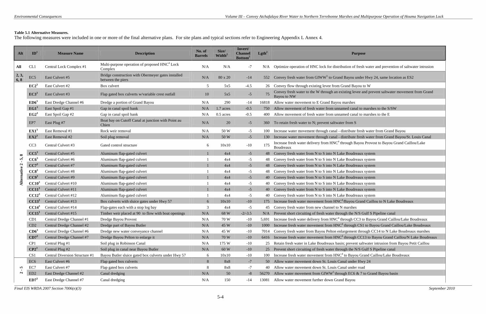
Environmental Consequences Volume III – Convey Atchafalaya River Water to Northern Terrebonne Marshes and Multipurpose Operation of Houma Navigation Lock
5-4
Final EIS WRDA 2007 Section 7006(e)(3) September 2010
Table 5.1 Alternative Measures. The following measures were included in one or more of the final alternative plans. For site plans and typical sections refer to Engineering Appendix L Annex 4.
Alt ID1 Measure Name Description No. of Barrels
Size/ Width2
Invert/ Channel Bottom2
Lgth2 Purpose
All CL1 Central Lock Complex #1 Multi-purpose operation of proposed HNC4 Lock Complex N/A N/A -7 N/A Optimize operation of HNC lock for distribution of fresh water and prevention of saltwater intrusion
2, 3, 6, 8 EC5 East Culvert #5 Bridge construction with Obermeyer gates installed
between the piers N/A 80 x 20 -14 552 Convey fresh water from GIWW5 to Grand Bayou under Hwy 24, same location as ES2
Alte
rnat
ive
2 - 5
, 8
EC23 East Culvert #2 Box culvert 5 5x5 -4.5 26 Convey flow through existing levee from Grand Bayou to W
EC33 East Culvert #3 Flap gated box culverts w/variable crest outfall 10 5x5 -5 75 Convey fresh water to the W through an existing levee and prevent saltwater movement from Grand Bayou to NW
ED63 East Dredge Channel #6 Dredge a portion of Grand Bayou N/A 290 -14 16818 Allow water movement to E Grand Bayou marshes EG13 East Spoil Gap #1 Gap in canal spoil bank N/A 1.7 acres -0.5 750 Allow movement of fresh water from unnamed canal to marshes to the S/SW EG23 East Spoil Gap #2 Gap in canal spoil bank N/A 0.5 acres -0.5 400 Allow movement of fresh water from unnamed canal to marshes to the E
EP7 East Plug #7 Boat bay on Cutoff Canal at junction with Point au Chien N/A 20 -5 360 To retain fresh water to N; prevent saltwater from S
EX13 East Removal #1 Rock weir removal N/A 50 W -5 100 Increase water movement through canal - distribute fresh water from Grand Bayou EX23 East Removal #2 Soil plug removal N/A 50 W -5 130 Increase water movement through canal - distribute fresh water from Grand Bayou/St. Louis Canal
CC3 Central Culvert #3 Gated control structure 6 10x10 -10 175 Increase fresh water delivery from HNC4 through Bayou Provost to Bayou Grand Caillou/Lake Boudreaux
CC53 Central Culvert #5 Aluminum flap-gated culvert 1 4x4 -5 48 Convey fresh water from N to S into N Lake Boudreaux system CC63 Central Culvert #6 Aluminum flap-gated culvert 1 4x4 -5 48 Convey fresh water from N to S into N Lake Boudreaux system CC73 Central Culvert #7 Aluminum flap-gated culvert 1 4x4 -5 48 Convey fresh water from N to S into N Lake Boudreaux system CC83 Central Culvert #8 Aluminum flap-gated culvert 1 4x4 -5 48 Convey fresh water from N to S into N Lake Boudreaux system CC93 Central Culvert #9 Aluminum flap-gated culvert 1 4x4 -5 40 Convey fresh water from N to S into N Lake Boudreaux system CC103 Central Culvert #10 Aluminum flap-gated culvert 1 4x4 -5 40 Convey fresh water from N to S into N Lake Boudreaux system CC113 Central Culvert #11 Aluminum flap-gated culvert 1 4x4 -5 40 Convey fresh water from N to S into N Lake Boudreaux system CC123 Central Culvert #12 Aluminum flap-gated culvert 1 4x4 -5 40 Convey fresh water from N to S into N Lake Boudreaux system CC133 Central Culvert #13 Box culverts with sluice gates under Hwy 57 6 10x10 -10 175 Increase fresh water movement from HNC4/Bayou Grand Caillou to N Lake Boudreaux CC143 Central Culvert #14 Flap-gates each with a stop log bay 3 4x4 -5 45 Convey fresh water from new channel to N marshes CC153 Central Culvert #15 Timber weir placed at 90 to flow with boat openings N/A 68 W -2/-3.5 N/A Prevent short circuiting of fresh water through the N/S Gulf S Pipeline canal CD1 Central Dredge Channel #1 Dredge Bayou Provost N/A 70 W -10 5,691 Increase fresh water delivery from HNC4 through CC3 to Bayou Grand Caillou/Lake Boudreaux CD2 Central Dredge Channel #2 Dredge part of Bayou Butler N/A 45 W -10 1000 Increase fresh water movement from HNC4 through CS1 to Bayou Grand Caillou/Lake Boudreaux CD63 Central Dredge Channel #6 Dredge new water conveyance channel N/A 45 W -10 7014 Convey fresh water from Bayou Pelton enlargement through CC14 to N Lake Boudreaux marshes CD73 Central Dredge Channel #7 Dredge Bayou Pelton to enlarge it N/A 70 W -10 6416 Increase fresh water movement from HNC4 through CC13 to Bayou Grand Caillou/N Lake Boudreaux CP1 Central Plug #1 Soil plug in Robinson Canal N/A 175 W -10 25 Retain fresh water in Lake Boudreaux basin; prevent saltwater intrusion from Bayou Petit Caillou CP23 Central Plug #2 Soil plug in canal near Bayou Butler N/A 60 W -10 25 Prevent short circuiting of fresh water through the N/S Gulf S Pipeline canal CS1 Central Diversion Structure #1 Bayou Butler sluice gated box culverts under Hwy 57 6 10x10 -10 100 Increase fresh water movement from HNC4 to Bayou Grand Caillou/Lake Boudreaux
2 - 5
EC6 East Culvert #6 Flap gated box culverts 8 8x8 -7 50 Allow water movement down St. Louis Canal under Hwy 24 EC7 East Culvert #7 Flap gated box culverts 8 8x8 -7 40 Allow water movement down St. Louis Canal under road ED2 East Dredge Channel #2 Canal dredging N/A 50 -8 56270 Allow water movement from GIWW5 through EC6 & 7 to Grand Bayou basin
ED73 East Dredge Channel #7 Canal dredging N/A 150 -14 13081 Allow water movement further down Grand Bayou
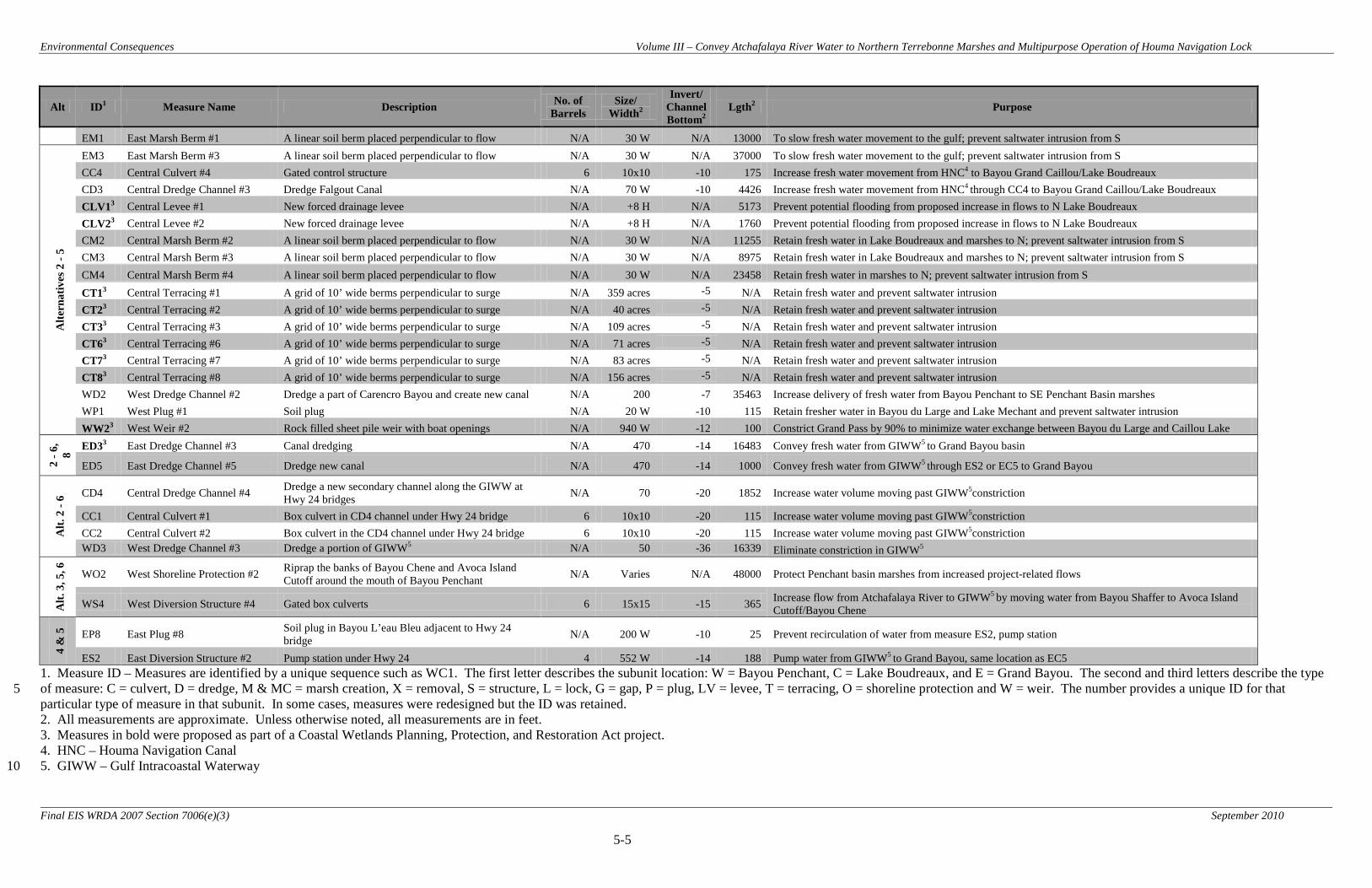
Environmental Consequences Volume III – Convey Atchafalaya River Water to Northern Terrebonne Marshes and Multipurpose Operation of Houma Navigation Lock
5-5
Final EIS WRDA 2007 Section 7006(e)(3) September 2010
Alt ID1 Measure Name Description No. of Barrels
Size/ Width2
Invert/ Channel Bottom2
Lgth2 Purpose
EM1 East Marsh Berm #1 A linear soil berm placed perpendicular to flow N/A 30 W N/A 13000 To slow fresh water movement to the gulf; prevent saltwater intrusion from S
Alte
rnat
ives
2 -
5
EM3 East Marsh Berm #3 A linear soil berm placed perpendicular to flow N/A 30 W N/A 37000 To slow fresh water movement to the gulf; prevent saltwater intrusion from S CC4 Central Culvert #4 Gated control structure 6 10x10 -10 175 Increase fresh water movement from HNC4 to Bayou Grand Caillou/Lake Boudreaux CD3 Central Dredge Channel #3 Dredge Falgout Canal N/A 70 W -10 4426 Increase fresh water movement from HNC4 through CC4 to Bayou Grand Caillou/Lake Boudreaux CLV13 Central Levee #1 New forced drainage levee N/A +8 H N/A 5173 Prevent potential flooding from proposed increase in flows to N Lake Boudreaux CLV23 Central Levee #2 New forced drainage levee N/A +8 H N/A 1760 Prevent potential flooding from proposed increase in flows to N Lake Boudreaux CM2 Central Marsh Berm #2 A linear soil berm placed perpendicular to flow N/A 30 W N/A 11255 Retain fresh water in Lake Boudreaux and marshes to N; prevent saltwater intrusion from S CM3 Central Marsh Berm #3 A linear soil berm placed perpendicular to flow N/A 30 W N/A 8975 Retain fresh water in Lake Boudreaux and marshes to N; prevent saltwater intrusion from S CM4 Central Marsh Berm #4 A linear soil berm placed perpendicular to flow N/A 30 W N/A 23458 Retain fresh water in marshes to N; prevent saltwater intrusion from S CT13 Central Terracing #1 A grid of 10’ wide berms perpendicular to surge N/A 359 acres -5 N/A Retain fresh water and prevent saltwater intrusion CT23 Central Terracing #2 A grid of 10’ wide berms perpendicular to surge N/A 40 acres -5 N/A Retain fresh water and prevent saltwater intrusion CT33 Central Terracing #3 A grid of 10’ wide berms perpendicular to surge N/A 109 acres -5 N/A Retain fresh water and prevent saltwater intrusion CT63 Central Terracing #6 A grid of 10’ wide berms perpendicular to surge N/A 71 acres -5 N/A Retain fresh water and prevent saltwater intrusion CT73 Central Terracing #7 A grid of 10’ wide berms perpendicular to surge N/A 83 acres -5 N/A Retain fresh water and prevent saltwater intrusion CT83 Central Terracing #8 A grid of 10’ wide berms perpendicular to surge N/A 156 acres -5 N/A Retain fresh water and prevent saltwater intrusion WD2 West Dredge Channel #2 Dredge a part of Carencro Bayou and create new canal N/A 200 -7 35463 Increase delivery of fresh water from Bayou Penchant to SE Penchant Basin marshes WP1 West Plug #1 Soil plug N/A 20 W -10 115 Retain fresher water in Bayou du Large and Lake Mechant and prevent saltwater intrusion WW23 West Weir #2 Rock filled sheet pile weir with boat openings N/A 940 W -12 100 Constrict Grand Pass by 90% to minimize water exchange between Bayou du Large and Caillou Lake
2 - 6
, 8
ED33 East Dredge Channel #3 Canal dredging N/A 470 -14 16483 Convey fresh water from GIWW5 to Grand Bayou basin
ED5 East Dredge Channel #5 Dredge new canal N/A 470 -14 1000 Convey fresh water from GIWW5 through ES2 or EC5 to Grand Bayou
Alt.
2 -
6 CD4 Central Dredge Channel #4 Dredge a new secondary channel along the GIWW at Hwy 24 bridges N/A 70 -20 1852 Increase water volume moving past GIWW5constriction
CC1 Central Culvert #1 Box culvert in CD4 channel under Hwy 24 bridge 6 10x10 -20 115 Increase water volume moving past GIWW5constriction CC2 Central Culvert #2 Box culvert in the CD4 channel under Hwy 24 bridge 6 10x10 -20 115 Increase water volume moving past GIWW5constriction WD3 West Dredge Channel #3 Dredge a portion of GIWW5 N/A 50 -36 16339 Eliminate constriction in GIWW5
Alt.
3, 5
, 6
WO2 West Shoreline Protection #2 Riprap the banks of Bayou Chene and Avoca Island Cutoff around the mouth of Bayou Penchant N/A Varies N/A 48000 Protect Penchant basin marshes from increased project-related flows
WS4 West Diversion Structure #4 Gated box culverts 6 15x15 -15 365 Increase flow from Atchafalaya River to GIWW5 by moving water from Bayou Shaffer to Avoca Island Cutoff/Bayou Chene
4 &
5
EP8 East Plug #8 Soil plug in Bayou L’eau Bleu adjacent to Hwy 24 bridge N/A 200 W -10 25 Prevent recirculation of water from measure ES2, pump station
ES2 East Diversion Structure #2 Pump station under Hwy 24 4 552 W -14 188 Pump water from GIWW5 to Grand Bayou, same location as EC5 1. Measure ID – Measures are identified by a unique sequence such as WC1. The first letter describes the subunit location: W = Bayou Penchant, C = Lake Boudreaux, and E = Grand Bayou. The second and third letters describe the type of measure: C = culvert, D = dredge, M & MC = marsh creation, X = removal, S = structure, L = lock, G = gap, P = plug, LV = levee, T = terracing, O = shoreline protection and W = weir. The number provides a unique ID for that 5 particular type of measure in that subunit. In some cases, measures were redesigned but the ID was retained. 2. All measurements are approximate. Unless otherwise noted, all measurements are in feet. 3. Measures in bold were proposed as part of a Coastal Wetlands Planning, Protection, and Restoration Act project. 4. HNC – Houma Navigation Canal 5. GIWW – Gulf Intracoastal Waterway 10
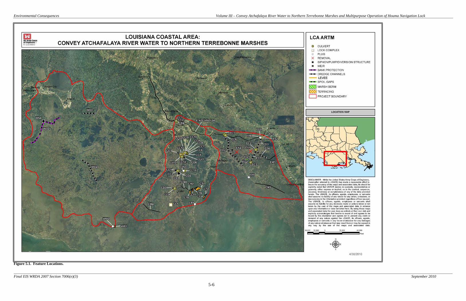
Environmental Consequences Volume III – Convey Atchafalaya River Water to Northern Terrebonne Marshes and Multipurpose Operation of Houma Navigation Lock
5-6
Final EIS WRDA 2007 Section 7006(e)(3) September 2010
Figure 5.1. Feature Locations.

Environmental Consequences Volume III – Convey Atchafalaya River Water to Northern Terrebonne Marshes and Multipurpose Operation of Houma Navigation Lock
5-7
Final EIS WRDA 2007 Section 7006(e)(3) September 2010
Table 5.2. Impacts Associated with Construction of Project Features. Feature
ID Feature Name Construction
Impacts1 (acres)
Construction Impact Habitat Type
Temporary Work Area
Impacts2 (acres)
ED2 East Dredge Channel #2
98.8 114.0 40.5 55.1
Swamp/Wetland Forest Intermediate Marsh
Brackish Marsh Open Water
1.3
ED3 East Dredge Channel #3
20.6 120.0 46.8 88.1
Swamp/Wetland Forest Intermediate Marsh
Brackish Marsh Open Water
3.4
ED5 East Dredge Channel #5
15.3 Upland/Open Water 3.4
ED6 East Dredge Channel #6
74.0 140.5
Brackish Marsh Open Water
2.5
ED7 East Dredge Channel #7
20.9 98.5
Brackish Marsh Open Water
1.8
EP7 East Plug #7 0.9 Upland/Open Water 0.6
EP8 East Plug #8 0.2 Upland/Open Water 0.1
EG1 East Spoil Gap #1
2.0 Upland/Open Water 2.0
EG2 East Spoil Gap #2
2.0 Upland/Open Water 2.0
ES2 East Diversion Structure #2
5.8 Upland/Open Water 3.9
EX1 East Removal #1 0.0 Upland/Open Water 0.4
EX2 East Removal #2 0.0 Upland/Open Water 0.4
EC2 East Culvert #2 0.1 Upland/Open Water 0.1
EC3 East Culvert #3 0.1 Upland/Open Water 0.1
EC5 East Culvert #5 5.8 Upland/Open Water 3.9
EC6 East Culvert #6 0.1 Upland/Open Water 0.1
EC7 East Culvert #7 0.1 Upland/Open Water 0.1
EM1 East Marsh Berm #1
25.0 (creation) Brackish Marsh 24.4
EM3 East Marsh Berm #3
72.0 (creation) Saline Marsh 67.3
CC1 Central Culvert #1
0.4 Upland/Open Water 0.3

Environmental Consequences Volume III – Convey Atchafalaya River Water to Northern Terrebonne Marshes and Multipurpose Operation of Houma Navigation Lock
5-8
Final EIS WRDA 2007 Section 7006(e)(3) September 2010
Feature ID
Feature Name Construction Impacts1 (acres)
Construction Impact Habitat Type
Temporary Work Area
Impacts2 (acres)
CC2 Central Culvert #2
0.4 Upland/Open Water 0.3
CC3 Central Culvert #3
0.2 Upland/Open Water 0.1
CC4 Central Culvert #4
0.1 Upland/Open Water 0.1
CC5 Central Culvert #5
0.1 Upland/Open Water 0.1
CC6 Central Culvert #6
0.1 Upland/Open Water 0.1
CC7 Central Culvert #7
0.1 Upland/Open Water 0.1
CC8 Central Culvert #8
0.1 Upland/Open Water 0.1
CC9 Central Culvert #9
0.1 Upland/Open Water 0.1
CC10 Central Culvert #10
0.1 Upland/Open Water 0.1
CC11 Central Culvert #11
0.1 Upland/Open Water 0.1
CC12 Central Culvert #12
0.1 Upland/Open Water 0.1
CC13 Central Culvert #13
1.1 Upland/Open Water 2.5
CC14 Central Culvert #14
0.1 Upland/Open Water 0.3
CC15 Central Culvert #15
0.3 Upland/Open Water 0.2
CD1 Central Dredge Channel #1
2.6 5.4 24.0
Swamp/Wetland Forest Intermediate Marsh
Open Water
1.3
CD2 Central Dredge Channel #2
3.3 Upland/Open Water 1.1
CD3 Central Dredge Channel #3
8.5 10.2
Intermediate Marsh Open Water
1.0
CD4 Central Dredge Channel #4
9.3 Upland/Open Water 1.2
CD6 Central Dredge Channel #3
17.2 23.7
Swamp/Wetland Forest Freshwater Marsh
1.3
CD7 Central Dredge Channel #7
9.2 7.4
Swamp/Wetland Forest Open Water
1.5
CL1 Central Lock Complex #1
N/A N/A N/A

Environmental Consequences Volume III – Convey Atchafalaya River Water to Northern Terrebonne Marshes and Multipurpose Operation of Houma Navigation Lock
5-9
Final EIS WRDA 2007 Section 7006(e)(3) September 2010
Feature ID
Feature Name Construction Impacts1 (acres)
Construction Impact Habitat Type
Temporary Work Area
Impacts2 (acres)
CM2 Central Marsh Berm #2
22.0 (creation) Brackish Marsh 20.7
CM3 Central Marsh Berm #3
18.0 (creation) Brackish Marsh 16.5
CM4 Central Marsh Berm #4
45.0 (creation) Brackish Marsh 42.9
CP1 Central Plug #1 0.4 Upland/Open Water 0.2
CP2 Central Plug #2 0.1 Upland/Open Water 0.1
CS1 Central Diversion Structure #1
1.1 Upland/Open Water 2.5
CT1 Central Terracing #1
60.0 (creation) Brackish Marsh 158.0
CT2 Central Terracing #2
7.0 (creation) Brackish Marsh 17.6
CT3 Central Terracing #3
20.0 (creation) Brackish Marsh 48.0
CT6 Central Terracing #6
15.0 (creation) Brackish Marsh 31.2
CT7 Central Terracing #7
15.0 (creation) Brackish Marsh 36.4
CT8 Central Terracing #8
30.0 (creation) Brackish Marsh 68.8
CLV1 Central Levee #1 18.4 Swamp/Wetland Forest 7.6
CLV2 Central Levee #2 4.4 Swamp/Wetland Forest 2.6
WD2 West Dredge Channel #2
319.1 301.0
Freshwater Marsh Open Water
2.0
WD3 West Dredge Channel #2
168.6 Open Water 3.0
WO2 West Shoreline Protection #2
149.4 Upland/Open Water 99.6
WP1 West Plug #1 0.3 Upland/Open Water 0.2
WS4 West Diversion Structure #4
2.8 Upland/Open Water 1.8
WW2 West Weir #2 1.4 Upland/Open Water 0.9 1 Construction impact acreages listed for marsh creation features (marsh berms and
terracing) are acres of marsh created.
For purposes of construction impact analysis associated with dredge features, the assumption was made that the dredge channel itself and the adjacent disposal site would
Environmental Consequences Volume III – Convey Atchafalaya River Water to Northern Terrebonne Marshes and Multipurpose Operation of Houma Navigation Lock
5-10
Final EIS WRDA 2007 Section 7006(e)(3) September 2010
result in marsh impacts. In reality, dredged material will be used beneficially to create marsh habitat to the maximum extent practicable. However, the exact nature of the dredged material and its utility in marsh creation, the locations of marsh creation sites, and the acreage of created marsh habitat will not be determined until a later date, during pre-construction engineering and design. Therefore, the aforementioned assumptions were necessary in order to complete the impact analysis for project features. In light of this, the estimates of negative impacts to marsh should be viewed as maximums as they should be offset at least in part by beneficially using dredged material during construction. For dredge feature WD3, adjacent disposal was not assumed due to the existence of high quality swamp/wetland forest adjacent to the feature. In addition, the proposed dredge channel does not extend beyond the existing channel width. Therefore, no construction impacts to swamp/wetland forest were assumed in conjunction with WD3.
2 For purposes of impact analysis, it was assumed that temporary work areas would be located in upland and/or open water habitats with no impacts to wetlands. The exact nature, extent, and duration of temporary work areas, however, would be determined during pre-construction engineering and design. Impacts would be kept to a minimum by use of proper construction techniques, temporary vegetative cover during construction, and regrading and permanent vegetation establishment at the end of construction.

Environmental Consequences Volume III – Convey Atchafalaya River Water to Northern Terrebonne Marshes and Multipurpose Operation of Houma Navigation Lock
5-11
Final EIS WRDA 2007 Section 7006(e)(3) September 2010
5.1 Soils and Waterbottoms
5.1.1 No Action Alternative (Future without Project Conditions)
Soil erosion and land loss in the project area would continue into the future. Natural and man-made levees would continue to subside and marsh soils would not be able to maintain their elevations due to subsidence, decreased plant productivity, and wave erosion. Net primary productivity within the project area would continue to decline and existing wetland vegetation would continue to diminish. The ongoing conversion of existing fragmented emergent wetlands to shallow open water would continue with associated indirect impacts on coastal vegetation, fish and wildlife resources, EFH, recreation, aesthetics, and socioeconomic resources. Waterbodies would grow larger and wave erosion would accelerate causing further land loss, thus making coastal communities more vulnerable to tropical storms. No large-scale loss of farmland would be expected from subsidence. The greatest loss of farmland would come from conversion to development. 5.1.2 Alternative 2 (NER Plan and RP)
5.1.2.1 Direct Direct impacts to soils and substrate from implementation of Alternative 2 would primarily result from project-related activities that would directly use, remove, or otherwise disturb soil resources. Direct adverse impacts to soil resources would primarily result from activities associated with construction of project features such as excavation of existing soil for water control structures, dredge channels, and temporary retention dikes. Implementation of Alternative 2 would result in 148 acres of swamp, 343 acres of fresh marsh, 248 acres of intermediate marsh, and 182 acres of brackish marsh being directly converted to open water. Alternative 2 would also result in 23 acres of swamp being converted to upland (levee). These direct impacts would be the result of dredge features WD2, CD1, CD3, CD6, CD7, ED2, ED3, ED6, and ED7 and levee features CLV1 and CLV2 (Table 5.2). It should be noted that, for purposes of impact analysis associated with dredge features for all Alternatives, the assumption was made that the dredge channel itself and the adjacent disposal site would result in marsh impacts. In reality, dredged material will be used beneficially to create marsh habitat to the maximum extent practicable. However, the exact nature of the dredged material and its utility in marsh creation, the locations of marsh creation sites, and the acreage of created marsh habitat will not be determined until a later date, during pre-construction engineering and design. Therefore, the aforementioned assumptions were necessary in order to complete the impact analysis for project features. In light of this, the estimates of negative impacts to marsh should be viewed as maximums as they should be offset at least in part by beneficially using dredged material during construction. Temporary impacts to soils and waterbottoms would also occur in temporary work areas needed for construction of project features (Table 5.2). It is estimated that 585 acres of temporary work areas will be needed for construction of Alternative 2. No additional impacts to marsh or swamp habitat are anticipated from these activities, but open water

Environmental Consequences Volume III – Convey Atchafalaya River Water to Northern Terrebonne Marshes and Multipurpose Operation of Houma Navigation Lock
5-12
Final EIS WRDA 2007 Section 7006(e)(3) September 2010
habitats and upland habitats would be disturbed. Soil compaction, rutting, rill, and gully erosion at construction sites would occur. The exact nature, extent, and duration of temporary work areas and associated impacts would be determined during pre-construction engineering and design. Impacts would be kept to a minimum by use of proper construction techniques such as silt curtains, temporary vegetative cover during construction, and regrading and permanent vegetation establishment at the end of construction. Alternative 2 would also create 257 acres of brackish marsh and 72 acres of saline marsh as a result of features CM2, CM3, CM4, CT1, CT2, CT3, CT6, CT7, CT8, EM1, and EM3 (Table 5.2). 5.1.2.2 Indirect Indirect impacts to soil resources would primarily result from long-term and far afield effects of freshwater inputs, which would nourish and protect existing wetlands over much of the project area. Vegetated wetlands would be enhanced by diversions of freshwater and nutrients which would increase plant productivity and vertical accretion of organic soils. Some areas are projected to decline at a faster rate with implementation of Alternative 2 due to a reduction in freshwater and associated nutrients (see Figure 5.2). Overall, Alternative 2 would reduce land loss in the project area from 101,570 acres to 91,915 acres, thus preventing 9,655 acres of emergent marsh soils from being converted to open water over the 50-year period of analysis. Alternative 2 would generate 3,220 AAHUs (Figure 5.2). 5.1.2.3 Cumulative Alternative 2 would have positive synergistic effects on soil resources when combined with other Federal, state, local, and private restoration efforts (Table 5.6). Implementing Alternative 2 would contribute to reducing regional rates of marsh soil loss by an estimated 9,655 net acres over the 50-year period of analysis. 5.1.3 Alternative 3
5.1.3.1 Direct Direct impacts of Alternative 3 on soils and substrate would be similar to those of Alternative 2. 5.1.3.2 Indirect Indirect impacts of Alternative 3 on soils and substrate would be similar to those of Alternative 2, but to a greater degree. Alternative 3 would reduce land loss in the project area from 101,570 acres to 91,262 acres, thus preventing 10,308 acres of emergent marsh soils from being converted to open water over the 50-year period of analysis. Alternative 3 would generate 3,325 AAHUs (Figure 5.3).

Environmental Consequences Volume III – Convey Atchafalaya River Water to Northern Terrebonne Marshes and Multipurpose Operation of Houma Navigation Lock
5-13
Final EIS WRDA 2007 Section 7006(e)(3) September 2010
5.1.3.3 Cumulative Alternative 3 would have positive synergistic effects on soil resources when combined with other Federal, state, local, and private restoration efforts (Table 5.6). Implementing Alternative 3 would contribute to reducing regional rates of marsh soil loss by an estimated 10,308 net acres over the 50-year period of analysis. 5.1.4 Alternative 4
5.1.4.1 Direct Direct impacts of Alternative 4 on soils and substrate would be similar to those of Alternative 2. 5.1.4.2 Indirect Indirect impacts of Alternative 4 on soils and substrate would be similar to those of Alternative 2, but to a greater degree. Alternative 4 would reduce land loss in the project area from 101,570 acres to 89,366 acres, thus preventing 12,204 acres of emergent marsh soils from being converted to open water over the 50-year period of analysis. Alternative 4 would generate 4,258 AAHUs (Figure 5.4). 5.1.4.3 Cumulative Alternative 4 would have positive synergistic effects on soil resources when combined with other Federal, state, local, and private restoration efforts (Table 5.6). Implementing Alternative 4 would contribute to reducing regional rates of marsh soil loss by an estimated 12,204 net acres over the 50-year period of analysis. 5.1.5 Alternative 5
5.1.5.1 Direct Direct impacts of Alternative 5 on soils and substrate would be similar to those of Alternative 2. 5.1.5.2 Indirect Indirect impacts of Alternative 5 on soils and substrate would be similar to those of Alternative 2, but to a greater degree. Alternative 5 would reduce land loss in the project area from 101,570 acres to 87,636 acres, thus preventing 13,934 acres of emergent marsh soils from being converted to open water over the 50-year period of analysis. Alternative 5 would generate 4,719 AAHUs (Figure 5.5). 5.1.5.3 Cumulative Alternative 5 would have positive synergistic effects on soil resources when combined with other Federal, state, local, and private restoration efforts (Table 5.6). Implementing Alternative 5 would contribute to reducing regional rates of marsh soil loss by an estimated 13,934 net acres over the 50-year period of analysis.

Environmental Consequences Volume III – Convey Atchafalaya River Water to Northern Terrebonne Marshes and Multipurpose Operation of Houma Navigation Lock
5-14
Final EIS WRDA 2007 Section 7006(e)(3) September 2010
5.1.6 Alternative 6
5.1.6.1 Direct Direct impacts of Alternative 6 on soils and substrate would be similar to those of Alternative 2, but to a lesser degree. Implementation of Alternative 6 would result in 141 acres of intermediate marsh and 47 acres of brackish marsh being directly converted to open water. These direct impacts would be the result of dredge feature ED3. 117 acres of temporary impacts to open water and uplands due to temporary work areas would also occur (Table 5.2). 5.1.6.2 Indirect Indirect impacts of Alternative 6 on soils and substrate would be similar to those of Alternative 2, but to a lesser degree. Alternative 6 would reduce land loss in the project area from 101,570 acres to 101,563 acres, thus preventing 7 acres of emergent marsh habitat from being converted to open water over the 50-year period of analysis. Alternative 6 would generate 776 AAHUs (Figure 5.6). The relatively large number of AAHUs in comparison to the number of acres of emergent marsh loss prevented is due to the fact that Alternative 6 would generate benefits associated with submerged aquatic vegetation and marsh edge (WVA variables V2 and V3) despite very little prevention of marsh loss. 5.1.6.3 Cumulative Alternative 6 would have positive synergistic effects on soil resources when combined with other Federal, state, local, and private restoration efforts (Table 5.6). Implementing Alternative 6 would contribute to reducing regional rates of marsh soil loss by an estimated 7 net acres over the 50-year period of analysis. 5.1.7 Alternative 7
5.1.7.1 Direct No direct impacts to soils and substrates are anticipated from implementation of Alternative 7. 5.1.7.2 Indirect Implementation of Alternative 7 would increase land loss in the project area from 101,570 acres to 104,221 acres, thus leading to a net loss of 2,651 acres of emergent marsh soils by conversion to open water over the 50-year period of analysis. However, Alternative 7 would generate 243 AAHUs (Figure 5.7). 5.1.7.3 Cumulative Despite resulting in a net loss of emergent marsh soils, Alternative 7 is still projected to have a positive impact on marsh habitat in the project area (+243 AAHUs), and, to that

Environmental Consequences Volume III – Convey Atchafalaya River Water to Northern Terrebonne Marshes and Multipurpose Operation of Houma Navigation Lock
5-15
Final EIS WRDA 2007 Section 7006(e)(3) September 2010
extent, would have positive synergistic effects on soil resources when combined with other Federal, state, local, and private restoration efforts (Table 5.6). 5.1.8 Alternative 8
5.1.8.1 Direct Direct impacts of Alternative 8 on soils and substrate would be similar to those of Alternative 2, but to a lesser degree. Implementation of Alternative 8 would result in 50 acres of swamp, 24 acres of fresh marsh, 125 acres of intermediate marsh, and 121 acres of brackish marsh being directly converted to open water. Alternative 8 would also result in 23 acres of swamp being converted to upland (levee). These direct impacts would be the result of dredge features CD1, CD6, CD7, ED3, and ED6 and levee features CLV1 and CLV2. 41 acres of temporary impacts to open water and uplands due to temporary work areas would also occur (Table 5.2). 5.1.8.2 Indirect Indirect impacts of Alternative 8 on soils and substrate would be similar to those of Alternative 2, but to a lesser degree. Alternative 8 would reduce land loss in the project area from 101,570 acres to 100,581 acres, thus preventing 989 acres of emergent marsh habitat from being converted to open water over the 50-year period of analysis. Alternative 8 would generate 1,214 AAHUs (Figure 5.8). 5.1.8.3 Cumulative Alternative 8 would have positive synergistic effects on soil resources when combined with other Federal, state, local, and private restoration efforts (Table 5.6). Implementing Alternative 8 would contribute to reducing regional rates of marsh soil loss by an estimated 989 net acres over the 50-year period of analysis.
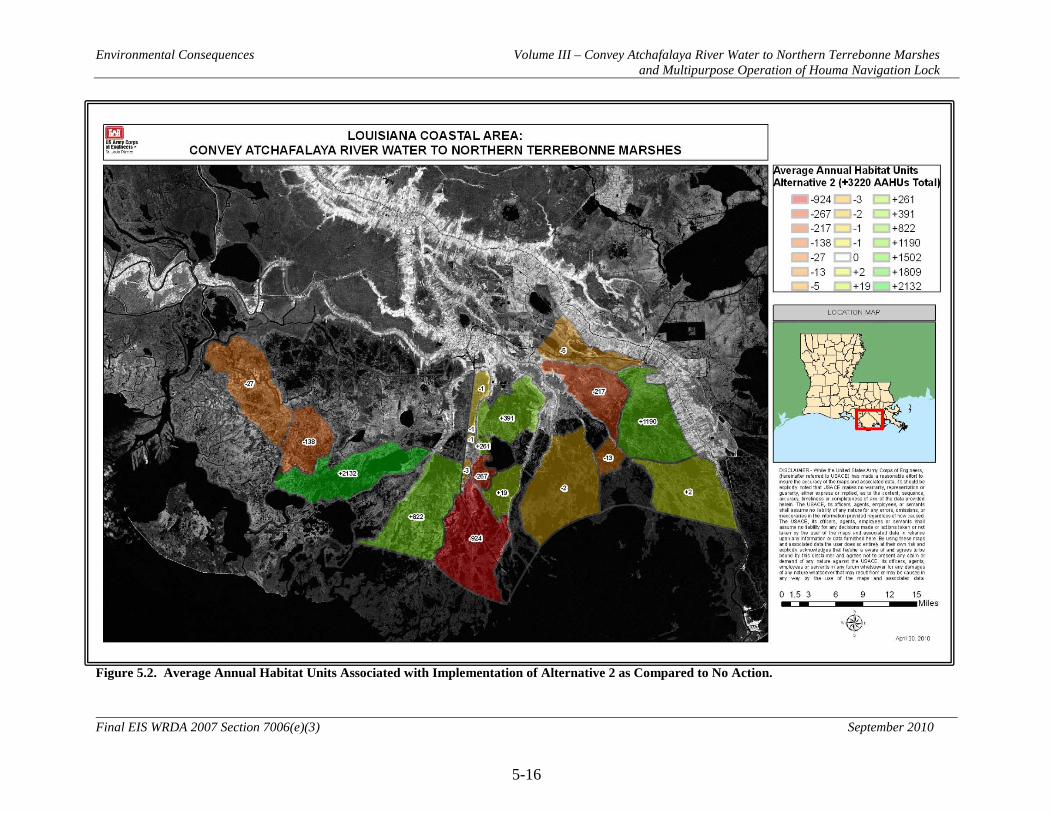
Environmental Consequences Volume III – Convey Atchafalaya River Water to Northern Terrebonne Marshes and Multipurpose Operation of Houma Navigation Lock
5-16
Final EIS WRDA 2007 Section 7006(e)(3) September 2010
Figure 5.2. Average Annual Habitat Units Associated with Implementation of Alternative 2 as Compared to No Action.

Environmental Consequences Volume III – Convey Atchafalaya River Water to Northern Terrebonne Marshes and Multipurpose Operation of Houma Navigation Lock
5-17
Final EIS WRDA 2007 Section 7006(e)(3) September 2010
Figure 5.3. Average Annual Habitat Units Associated with Implementation of Alternative 3 as Compared to No Action.

Environmental Consequences Volume III – Convey Atchafalaya River Water to Northern Terrebonne Marshes and Multipurpose Operation of Houma Navigation Lock
5-18
Final EIS WRDA 2007 Section 7006(e)(3) September 2010
Figure 5.4: Average Annual Habitat Units Associated with Implementation of Alternative 4 as Compared to No Action

Environmental Consequences Volume III – Convey Atchafalaya River Water to Northern Terrebonne Marshes and Multipurpose Operation of Houma Navigation Lock
5-19
Final EIS WRDA 2007 Section 7006(e)(3) September 2010
Figure 5.5. Average Annual Habitat Units Associated with Implementation of Alternative 5 as Compared to No Action.

Environmental Consequences Volume III – Convey Atchafalaya River Water to Northern Terrebonne Marshes and Multipurpose Operation of Houma Navigation Lock
5-20
Final EIS WRDA 2007 Section 7006(e)(3) September 2010
Figure 5.6. Average Annual Habitat Units Associated with Implementation of Alternative 6 as Compared to No Action.

Environmental Consequences Volume III – Convey Atchafalaya River Water to Northern Terrebonne Marshes and Multipurpose Operation of Houma Navigation Lock
5-21
Final EIS WRDA 2007 Section 7006(e)(3) September 2010
Figure 5.7. Average Annual Habitat Units Associated with Implementation of Alternative 7 as Compared to No Action.
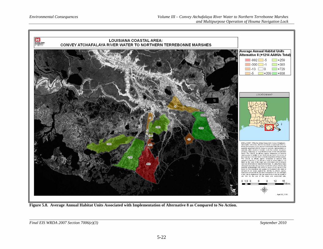
Environmental Consequences Volume III – Convey Atchafalaya River Water to Northern Terrebonne Marshes and Multipurpose Operation of Houma Navigation Lock
5-22
Final EIS WRDA 2007 Section 7006(e)(3) September 2010
Figure 5.8. Average Annual Habitat Units Associated with Implementation of Alternative 8 as Compared to No Action.

Environmental Consequences Volume III – Convey Atchafalaya River Water to Northern Terrebonne Marshes and Multipurpose Operation of Houma Navigation Lock
5-23
Final EIS WRDA 2007 Section 7006(e)(3) September 2010
5.2 Hydrology
5.2.1 Flow and Water Levels
5.2.1.1 No Action Alternative (Future without Project Conditions) Building of the Atchafalaya River delta would continue to impact stages on the Lower Atchafalaya River. As stages increase, the flow passing through the Bayou Lafourche ridge in the GIWW would increase. Areas hydraulically isolated from the GIWW would continue to be isolated. Monthly averaged flows along the GIWW would range from over 700 cfs to 28,000 cfs. These flows would generally decrease from west to east. The largest loss of flow would continue to be through the HNC, with monthly averaged flows ranging from 2,500 to 7,000 cfs. At times, flow reversals would occur throughout the project area. Flow would enter and leave the Lake Boudreaux basin through Bayou Dulac, Robinson Canal, and Boudreaux Canal. Bayou Dulac monthly averaged flows would range between 50 and 400 cfs. Robinson monthly averaged flows would be fairly steady near 1,500 cfs with higher monthly averaged flows near 1,700 cfs from March through June. Boudreaux Canal monthly averaged flows would be fairly steady around 500 cfs with higher monthly averaged flows near 700 cfs from March through June. Monthly averaged flows into Grand Bayou would range between 0 and 575 cfs. Stages within the project area would be tidally driven with effects from the Atchafalaya River. Over the project life, water surface elevations would increase by at least 0.46 feet due to sea level rise. This increase could be as much as 2.29 feet if the high rate of sea level rise occurs. 5.2.1.2 Alternative 2 (NER Plan and RP) 5.2.1.2.1 Direct Monthly averaged flows in the GIWW west of Grand Bayou would generally increase with Alternative 2. The increase would range from 0 to 20 percent west of Houma and could be as much as 50 percent east of Houma. These increases stop as the GIWW reaches Grand Bayou. The additional flow through Grand Bayou would cause the flow through Larose to reduce by as much as 50 percent. Generally, the largest changes in flow would be seen during high Atchafalaya stages and the smallest during low stages. Southeastern Penchant basin marshes would experience a monthly averaged flow increase ranging from 100 to 3,000 cubic feet per second (cfs). Operation of the HNC lock for environmental purposes would increase this flow benefit by an additional 300 to 1,000 cfs. Flow through Grand Pass would be reduced by 10 to 40 percent. High and low increases would correspond with high and low Atchafalaya River stage, respectively.
Environmental Consequences Volume III – Convey Atchafalaya River Water to Northern Terrebonne Marshes and Multipurpose Operation of Houma Navigation Lock
5-24
Final EIS WRDA 2007 Section 7006(e)(3) September 2010
Monthly averaged flow introduced to the Lake Boudreaux basin through the newly dredged channels on the west side of the basin would range from 100 to 700 cfs. With the closure of Robinson Canal and the construction of the marsh berm features within the basin, the monthly averaged flows in Boudreaux Canal would increase approximately 50 percent year round. High and low increases would correspond with high and low Atchafalaya River stage, respectively. Monthly averaged flow increases into the Grand Bayou basin would range from 0 to 2,700 cfs throughout the year. High and low increases would correspond with high and low Atchafalaya River stage, respectively. Stage impacts in the western region of the project area would be limited to the southeastern portion. Impacts of 0.1 to 0.2 feet would be seen from March to September with the highest seen in July. These impacts would be attributed to the reduced capacity of Grand Pass due to feature WW2 and from increased inflow to this area from feature WD2. In the central region of the project area stage impacts would be limited to the Lake Boudreaux basin. Stage impacts would vary between 0.1 and 0.3 feet from March to September, with the highest seen in July. These impacts would be attributed to the increased flow into the basin through the culverts and dredged channels connecting the Boudreaux basin to the HNC and from the closure of Robinson Canal. In the eastern region of the project area, impacts of up to 0.1 feet would be seen in the Grand Bayou basin. These impacts would vary in duration throughout the basin, with longer duration at the northern end, south of highway 24. Impacts ranging from March through September would be the longest in this portion of the project area. Stage reductions of up to 0.2 feet would also be seen along the GIWW in the western portion of the project area. These too would be seen from March to September with the largest reductions in July. Short duration impacts near the plug in Cutoff Canal would be as much as 0.4 feet. These impacts would be highly localized to the area north of Bayou Pointe au Chien to Grand Bayou. 5.2.1.2.2 Indirect By reducing monthly averaged flows passing to the east into the Barataria Basin there may be impacts in northern portions of the Barataria Basin. This flow deficit may be counteracted through modified operation of the Davis Pond diversion. 5.2.1.2.3 Cumulative Cumulative impacts include the construction and operation of other federal, state, local, and private projects that modify the hydrology of the project area. Changes to the operation of the Old River Control Structure and Davis Pond Diversion could both beneficially affect the hydrology within the project area. The Small Bayou Lafourche Reintroduction project (LCA) could increase flows to the Grand Bayou area. The

Environmental Consequences Volume III – Convey Atchafalaya River Water to Northern Terrebonne Marshes and Multipurpose Operation of Houma Navigation Lock
5-25
Final EIS WRDA 2007 Section 7006(e)(3) September 2010
Maintain Land Bridge between Caillou Lake and Gulf of Mexico project (LCA) could decrease saltwater flows into the western part of the LCA-ARTM study area. The Avoca Island Diversion and Land Building project (CWPPRA) could increase flows in the Penchant marshes and in the GIWW. The GIWW Bank Restoration project (CWPPRA) could increase easterly flows in the GIWW. 5.2.1.3 Alternative 3 Direct, indirect, and cumulative impacts of Alternative 3 would generally be similar to Alternative 2, with the following exceptions. With feature WS4, the diversion through the Avoca Island Levee, monthly averaged flows throughout the project area would be increased by 0 to 2 percent with the higher increases during low Atchafalaya River stage periods. Stage impacts in the western region of the project area would extend through much of the Penchant basin. Impacts of up to 0.1 feet throughout the Penchant basin and into Bayou Boeuf and Lake Palourde would be seen in July and August. Impacts of 0.1 to 0.2 feet would be seen in the southeast portion of the Penchant basin from March to September with the highest seen in July. These impacts would be attributed to the reduced capacity of Grand Pass due to feature WW2, the weir structure across Grand Pass, and from increased inflow to this area from feature WD2, dredging of Carencro Bayou. Stage impacts associated with structure WS4 would be limited to stages below the start of damages in Amelia, LA. The operation of WS4 would use the correlation curve relating the water surface elevation in Amelia to the Lower Atchafalaya River stage at Morgan City, LA developed by USACE New Orleans district. This structure would not cause any damages in addition to those that would occur with the current backwater flood damage reduction system. 5.2.1.4 Alternative 4 Direct, indirect, and cumulative impacts of Alternative 4 would generally be similar to Alternative 2, with the following exceptions. Monthly averaged flow impacts along the GIWW will increase due to feature ES2, the pump station connecting the GIWW to Grand Bayou. The magnitude of increase would be larger closer to Grand Bayou. Larger flow increases would occur during low Atchafalaya River stages. A monthly averaged flow reversal would occur on the GIWW at Larose between the months of August and January. Monthly averaged flow increases to the Lake Boudreaux basin would decrease by approximately 50 percent during low Atchafalaya stages. The increase would be maintained during higher stages. Flow into the Grand Bayou basin would be a constant 4,000 cfs throughout the year.
Environmental Consequences Volume III – Convey Atchafalaya River Water to Northern Terrebonne Marshes and Multipurpose Operation of Houma Navigation Lock
5-26
Final EIS WRDA 2007 Section 7006(e)(3) September 2010
Stage impacts in the western region of the project area would be limited to the southeastern portion. Impacts of 0.1 to 0.2 feet would be seen from March to September with the highest seen in July. These impacts would be attributed to the reduced capacity of Grand Pass due to feature WW2, the weir structure across Grand Pass, and from increased inflow to this area from feature WD2, dredging of Carencro Bayou. Stage impacts for Alternative 4 would be similar to Alternative 2 for the central portion of the project area. In the eastern portion of the project area, stage impacts would range from 0.0 to 0.3 feet in the Grand Bayou basin. As with Alternative 2, these impacts would be largest in the northern end of the Grand Bayou basin and fade to 0.0 feet in the southern portions of the basin. The largest of these impacts would be seen between September and February. Stage reductions of 0.2 feet would be seen along the GIWW from Company Canal to Larose. Additional reductions up to 0.1 feet would be seen as far away as the HNC to the west. Reductions to the east of Larose would also be likely, but were not quantified. 5.2.1.5 Alternative 5 Direct, indirect, and cumulative impacts of Alternative 5 would generally be similar to Alternative 2, with the following additions. Monthly averaged flow impacts would generally match Alternative 4. Feature WS4 would increase monthly averaged flows throughout the project area by an additional 0 to 2 percent with the higher increases during low Atchafalaya River stage periods. Stage impacts in the western region of the study area would extend through much of the Penchant basin. Impacts of up to 0.1 feet throughout the Penchant basin and into Bayou Boeuf and Lake Palourde would be seen in July and August. Impacts of 0.1 to 0.2 feet would be seen in the southeast portion of the Penchant basin from March to September with the highest seen in July. These impacts would be attributed to the reduced capacity of Grand Pass due to feature WW2 and from increased inflow to this area from feature WD2. Stage impacts associated with structure WS4, the diversion through the Avoca Island levee, would be limited to stages below the start of damages in Amelia, LA. The operation of WS4 would use the correlation curve relating the water surface elevation in Amelia to the Lower Atchafalaya River stage at Morgan City, LA developed by USACE New Orleans district. This structure would not cause any damages in addition to those that would occur with the current backwater flood damage reduction system. Stage impacts for Alternative 5 would be similar to Alternative 2 for the central portion of the project area.

Environmental Consequences Volume III – Convey Atchafalaya River Water to Northern Terrebonne Marshes and Multipurpose Operation of Houma Navigation Lock
5-27
Final EIS WRDA 2007 Section 7006(e)(3) September 2010
In the eastern portion of the study area, stage impacts would range from 0.0 to 0.3 feet in the Grand Bayou basin. As with Alternative 2, these impacts would be largest in the northern end of the Grand Bayou basin and fade to 0.0 feet in the southern portions of the basin. The largest of these impacts would be seen between September and February. Stage reductions of 0.2 feet would be seen along the GIWW from Company Canal to Larose. Additional reductions up to 0.1 feet would be seen as far away as the HNC to the west. Reductions to the east of Larose would also be likely, but were not quantified. 5.2.1.6 Alternative 6 Flow benefits for Alternative 6 would generally be seen along the GIWW corridor. This alternative would not provide flow benefits to the southeast portions of the Penchant basin. Since no new connections would be made to the Lake Boudreaux basin, there would be no flow impact. The Grand Bayou basin would benefit from monthly averaged flow increases between 0 and 1,500 cfs. Monthly averaged flow changes on the GIWW would range between increases and decreases of 5 percent, with the maximum increase during low Atchafalaya River stages. Stage impacts in the western region of the study area would extend through much of the Penchant basin. Impacts of up to 0.1 feet throughout the Penchant basin and into Bayou Boeuf and Lake Palourde would be seen in July and August. There would be no impacts to the southeastern portions of the Penchant basin. Stage impacts associated with structure WS4, the diversion through the Avoca Island levee, would be limited to stages below the start of damages in Amelia, LA. The operation of WS4 would use the correlation curve relating the water surface elevation in Amelia to the Lower Atchafalaya River stage at Morgan City, LA developed by USACE New Orleans district. This structure would not cause any damages in addition to those that would occur with the current backwater flood damage reduction system. There would be no stage impacts for Alternative 6 for the central portion of the project area. In the eastern region of the project area, impacts of up to 0.1 feet would be seen in the Grand Bayou basin. These impacts would vary in duration throughout the basin, with longer duration at the northern end, south of highway 24. Impacts ranging from March through September would be the longest in this portion of the project area. Stage reductions of up to 0.2 feet would also be seen along the GIWW in the western portion of the project area. These too would be seen from March to September with the largest reductions in July. 5.2.1.7 Alternative 7 Direct, indirect, and cumulative impacts of Alternative 7 would generally be similar to Alternative 1, with the following exceptions.
Environmental Consequences Volume III – Convey Atchafalaya River Water to Northern Terrebonne Marshes and Multipurpose Operation of Houma Navigation Lock
5-28
Final EIS WRDA 2007 Section 7006(e)(3) September 2010
Operations of the HNC lock would reduce the flow in the HNC; this would be magnified south of the lock. It would increase flow away from the HNC through Bayou Grand Caillou, Falgout Canal, and Bayou Dulac and the marshes surrounding the HNC. 5.2.1.8 Alternative 8 Direct, indirect, and cumulative impacts of Alternative 8 would generally be similar to Alternative 2, with the following exceptions. Monthly averaged flow increases into the southeastern Penchant basin would not occur. The Grand Bayou basin monthly averaged flow increase would be limited to 2300 cfs. There would be no stage impacts in the western portion of the study area.

Environmental Consequences Volume III – Convey Atchafalaya River Water to Northern Terrebonne Marshes and Multipurpose Operation of Houma Navigation Lock
5-29
Final EIS WRDA 2007 Section 7006(e)(3) September 2010
5.2.2 Sedimentation and Erosion
5.2.2.1 No Action Alternative (Future without Project Conditions) Building of the Atchafalaya River delta would continue to impact stages on the Lower Atchafalaya River. As stages increase, eastward flows along the GIWW would increase, carrying with them suspended sediments. These sediments would be distributed through the project area according to the flow patterns we see today. Southernmost portions of the Boudreaux basin would continue to be the only areas to receive suspended sediments from the GIWW. In the Grand Bayou basin, a small portion of suspended sediments that arrive through the GIWW would be distributed to the marshes to the east of Grand Bayou. Bank lines of major navigation channels would continue to erode, depositing sediments in the channels. The need for periodic maintenance dredging would continue. Land building sediments would not enter the project area naturally on a large scale. Federal, state, and local programs may beneficially use dredged materials within the project area. Construction of channels and maintenance of existing channels would be sources from within the project area. Additionally, sediment may be brought from sources outside the project area. 5.2.2.2 Alternative 2 (NER Plan and RP) 5.2.2.2.1 Direct Sediments from enlarged and newly created channels would be used beneficially within the project area. During construction, these sediments would be placed into marsh creation areas. Suspended sediment loads to receiving areas would be increased, but not enough to provide calculable benefits. The southeast portions of the Penchant basin would receive additional suspended sediment loads due to feature WD2. Northern Boudreaux Basin would receive suspended sediments brought through the GIWW to the HNC. These sediments would be distributed throughout the Boudreaux Basin. An increased amount of suspended sediment would reach the Grand Bayou basin. These sediments would be distributed to the marshes east of Grand Bayou with a much smaller portion exiting the basin through Cutoff Canal due to feature EP7. Operations of the HNC lock would increase suspended sediments to the marshes between the HNC and Bayou Du Large. There would be a decreased suspended sediment load south of the HNC lock. 5.2.2.2.2 Indirect Reduction of sediment carried into the Barataria Basin through the Bayou Lafourche Ridge may have incalculable impacts. Secondary erosion along channels receiving increased flows may occur, resulting in sedimentation and shoaling in area waterways.

Environmental Consequences Volume III – Convey Atchafalaya River Water to Northern Terrebonne Marshes and Multipurpose Operation of Houma Navigation Lock
5-30
Final EIS WRDA 2007 Section 7006(e)(3) September 2010
5.2.2.2.3 Cumulative Bank line protection constructed by other Federal, state, local and private projects would cause a reduction in bank line erosion. These projects would also help convey suspended sediments to the Boudreaux and Grand Bayou basins. 5.2.2.3 Alternative 3 Direct, indirect, and cumulative impacts of Alternative 3 would generally be similar to Alternative 2, but to a slightly greater extent. 5.2.2.4 Alternative 4 Direct, indirect, and cumulative impacts of Alternative 4 would generally be similar to Alternative 2. Impacts to the Boudreaux basin would be to a lesser extent as this alternative does not include bank line stabilization. In the Grand Bayou basin, the beneficial impacts would be greater due to the pumping of water from the GIWW year round. 5.2.2.5 Alternative 5 Direct, indirect, and cumulative impacts of Alternative 5 would generally be similar to Alternative 2, but to a greater extent due to the pumping of water from the GIWW year round. 5.2.2.6 Alternative 6 Direct, indirect, and cumulative impacts of Alternative 6 would generally be similar to Alternative 2, but to a lesser extent. 5.2.2.7 Alternative 7 Direct, indirect, and cumulative impacts of Alternative 7 would generally be similar to Alternative 2, but would affect a much smaller area. The area affected would be in the vicinity of the HNC lock. Both the Boudreaux and Grand Bayou basins would not see much, if any, change from Alternative 1. 5.2.2.8 Alternative 8 Direct, indirect, and cumulative impacts of Alternative 8 would generally be similar to Alternative 2, but would not affect the southeastern portions of the Penchant basin.

Environmental Consequences Volume III – Convey Atchafalaya River Water to Northern Terrebonne Marshes and Multipurpose Operation of Houma Navigation Lock
5-31
Final EIS WRDA 2007 Section 7006(e)(3) September 2010
5.3 Water Quality and Salinity
5.3.1 No Action Alternative (Future without Project Conditions)
Without the proposed actions of the project, the coastal plain of Louisiana would still be affected by activities, natural and man-influenced, that would have both beneficial and detrimental effects to water quality conditions. Some of these activities include other Federal, state, local, and private restoration efforts such as CWPPRA, USACE ecosystem restoration projects, various NRCS programs (e.g., Coastal Wetlands Restoration Program), and LDNR projects; state and local water quality management programs; national level programs to address hypoxia in the northern Gulf of Mexico; the continued erosion/subsidence of the coast; oil and gas development; industrial, commercial, and residential development; and Federal, state, and municipal navigation and flood-damage reduction projects. The future quality of Louisiana’s coastal waters depends on a responsible, watershed approach to managing these activities. There are a number of present and future activities that would continue to occur without the proposed actions of the project and would affect surface water quality conditions in the coastal plain of Louisiana. The cumulative impact of these activities without the project is discussed below. Passage of the Federal Water Pollution Control Act (FWPCA) in 1948 and its amendments including the CWA and the Water Quality Act of 1987 and the establishment of state and Federal environmental protection agencies resulted in water pollution control regulations, including:
• The National Pollutant Discharge Elimination System (NPDES) permit program controls water pollution. In 1997 the USEPA granted NPDES delegation to LDEQ, which is known as the Louisiana Pollutant Discharge Elimination System (LPDES).
• LDEQ’s Nonpoint Source Pollution Program is continuing to implement watershed initiatives to address nonpoint source pollution sources such as agriculture, home sewage treatment, hydromodification, urban runoff, construction activities, and resource extraction.
• LDNR’s Coastal Nonpoint Pollution Program is responsible for identifying Best Management Practices (BMPs) appropriate for all applicable pollutant source categories and carrying out initiatives of public education, technical assistance, and development of enforcement protocols.
• Total Maximum Daily Loads (TMDLs)-Section 303(d) of the CWA requires states to identify, list, and rank for development of TMDLs waters that do not meet applicable water quality standards after implementation of technology-based controls.
• Barataria-Terrebonne National Estuary Program (BTNEP) is a coalition of government, private, and commercial interests active in collecting/publishing information, as well as educating the public to protect the Barataria and Terrebonne Basins.

Environmental Consequences Volume III – Convey Atchafalaya River Water to Northern Terrebonne Marshes and Multipurpose Operation of Houma Navigation Lock
5-32
Final EIS WRDA 2007 Section 7006(e)(3) September 2010
• The USEPA-formed Hypoxia Task Force is leading a national task force to address hypoxia in the northern Gulf of Mexico, which is attributed to the excessive nutrients in the Mississippi – Atchafalaya River Basin
The programs discussed above would continue to develop or remain in place with or without the proposed project features to ensure protection of Louisiana’s public health and natural resources. Water quality conditions would likely improve with the programs in place. Other efforts that would probably improve water quality conditions would be the present and future Federal, state, local, and private ecosystem restoration projects. However, some activities that may potentially have negative effects on water quality would also continue to occur with or without the proposed project.
• Industrial, commercial, and residential development along the coast. With this activity comes increased point and nonpoint source pollution from sources such as wastewater treatment facilities and urban runoff from new development. Also, activities associated with maintaining and improving navigation along the coast would continue to occur.
• Flood–damage reduction projects would continue to be planned, designed, and constructed especially in areas highly susceptible to flood damages due to hurricanes and tropical storm events. With these activities, more alterations to the hydrology of the coast would potentially occur, leading to areas of degraded water quality. Some projects, such as the Morganza to the Gulf Hurricane Protection Project, are incorporating resource sustainable design techniques that may aid in protecting significant resources such as surface waters of the state.
• The most notable activity that would continue to occur without the proposed LCA Plan is the ongoing erosion/subsidence or land loss of the coastal areas. This would continue to unearth the expansive oil and gas infrastructure along the coast of Louisiana. This would be a precarious situation, especially during storm events and within navigable waterways. Exposed pipelines are vulnerable to navigation vessels striking them, which could lead to discharges into the Gulf of Mexico as well as other coastal water bodies. In the event of discharges, extensive ecological damage would probably occur. The owner(s) of the infrastructure could incur expensive fines and cleanup costs and vessel operators could be seriously injured. There are other forms of infrastructure that could potentially be exposed due to coastal erosion including wastewater collection systems and other commercial industry related systems.
Hydraulic modeling was utilized to project changes in hydrology and associated changes in water quality in the project area over the 50-year period of analysis. Model results were utilized in the Wetland Value Assessment model to project land loss impacts. Under Future without Project Conditions, the flotant marshes within the Penchant Basin would continue to deteriorate due to excessive backwater flooding events from the Atchafalaya River. Modeled salinity values show no change in these areas over the 50-

Environmental Consequences Volume III – Convey Atchafalaya River Water to Northern Terrebonne Marshes and Multipurpose Operation of Houma Navigation Lock
5-33
Final EIS WRDA 2007 Section 7006(e)(3) September 2010
year period of analysis. Land change projections over the period of analysis show increases in land area of approximately 5% (see Section 5.6 below for discussion on impacts to vegetation). However, land loss analysis in this area is difficult due to the presence of floating vegetation. It is believed that these marshes are actually deteriorating due to excessive backwater flooding events from the Atchafalaya River and will continue as such into the future. The intermediate and brackish marshes in the southeastern Penchant area are expected to continue to deteriorate due to saltwater intrusion, relative sea level rise, and lack of freshwater, sediment and nutrient delivery. Modeled average annual salinity values show slight increases of 0.1 to 0.4 ppt over the period of analysis. Land change projections over the period of analysis show decreases in land area of approximately 35%. The fresh, intermediate, brackish, and saline marshes in the Central – Lake Boudreaux Area are expected to continue to deteriorate due to saltwater intrusion, relative sea level rise, and lack of freshwater, sediment and nutrient delivery. Modeled average annual salinity values in this region show increases of 0.3 to 1.2 ppt over the period of analysis. Land change projections over the period of analysis show decreases in land area of approximately 35%, with several areas converting completely to open water. The fresh, intermediate, brackish, and saline marshes within the East – Grand Bayou Area are expected to continue to deteriorate due to saltwater intrusion, relative sea level rise, and lack of freshwater, sediment and nutrient delivery. Modeled average annual salinity values show increases of 0.1 to 1.7 ppt over the period of analysis. Land change projections over the period of analysis show decreases in land area of approximately 49%, with several areas converting completely to open water. 5.3.2 Alternative 2 (NER Plan and RP)
5.3.2.1 Direct Long-term direct impacts to water quality associated with implementation of Alternative 2 would primarily be associated with changes in the salinity and nutrient concentrations of receiving waters. These impacts are the primary drivers in the calculation of Average Annual Habitat Units for each Alternative. Average annual changes in salinity due to implementation of Alternative 2, as compared to the No Action Alternative, can be found in Figure 5.10. Changes in isohaline lines (lines that connect points of equal salinity) during low Atchafalaya flows, representing dry season conditions, can be found in Figure 5.19. Changes in isohaline lines during high Atchafalaya flows, representing wet season conditions, can be found in Figure 5.20. AAHUs associated with Alternative 2 can be found in Figure 5.2. The largest decreases in average annual salinity concentrations due to Alternative 2 would be expected to occur in the southeast Penchant marshes, in Lake Boudreaux, and around Grand Bayou. The largest increases in salinity would be expected along the HNC. The most notable change in isohaline lines with project implementation during low Atchafalaya flows would be a shift of the 5 ppt isohaline line from the north side of Lake Mechant and Lost Lake to the south side. During high Atchafalaya flows, however, the changes in isohaline lines are minor in the Lake Mechant/Lost Lake area, but are more noticeable in the Lake Boudreaux and Grand Bayou areas, as the 5 ppt isohaline line is pushed further into these areas. For data on
Environmental Consequences Volume III – Convey Atchafalaya River Water to Northern Terrebonne Marshes and Multipurpose Operation of Houma Navigation Lock
5-34
Final EIS WRDA 2007 Section 7006(e)(3) September 2010
salinity changes over the entire period of analysis, see Annex 2 to Engineering Appendix L. Total suspended solids concentrations, and associated trace metals, of receiving waters would at times increase with Alternative 2. However, due to the distance of the receiving waters from the Atchafalaya River, impacts from suspended sediments are expected to be minor and were not considered in the calculation of AAHUs. Short-term direct impacts to water quality could also result from construction activities associated with Alternative 2. Impacts associated with construction of features could include: increased total suspended solids and turbidity, increased dissolved nutrient levels, mobilization of existing contaminants in sediments, and decreases in dissolved oxygen levels. These impacts would be minimized, as much as practicable, through implementation of appropriate Best Management Practices. The introduction of agrochemicals into the study area from any of the restoration opportunities could be a management issue. The primary source of agrochemicals into the study area would be from the corn belt of the mid-continent United States. Currently, agricultural chemicals, primarily herbicides and fertilizers, are being introduced into the study area from the Mississippi/Atchafalaya River systems. Of particular concern is the effect on floating maidencane marshes (such as those in the Penchant Basin). River water may lead to accelerated decomposition of floating marsh root mats, making them more susceptible to erosion from tides, storms, and hurricanes (Swarzenski et al. 2008). Monitoring efforts and adaptive management actions would be key to addressing potential impacts. 5.3.2.2 Indirect In addition to directly affecting salinity patterns in the receiving waters, Alternative 2 could have indirect effects on salinity patterns in the project area. Changes in marsh health, stratification and mixing patterns, and flow patterns in the project due to project features could have a minor effect on tidal flows which could affect salinities. Secondary erosion along channels receiving increased flows may occur with implementation of Alternative 2, resulting in localized increases in turbidity, sedimentation, and shoaling in area waterways. Alternative 2 could have negative effects on plankton resources by potentially increasing noxious algal blooms associated with diversion flows and associated nutrients which, in turn, could impact the water quality of receiving waters. 5.3.2.3 Cumulative With implementation of Alternative 2, the coastal plain of Louisiana would be affected by other activities and programs that would have both cumulatively beneficial and detrimental effects on water quality conditions. Some of these past, present, and foreseeable future activities include state and local water quality management programs;

Environmental Consequences Volume III – Convey Atchafalaya River Water to Northern Terrebonne Marshes and Multipurpose Operation of Houma Navigation Lock
5-35
Final EIS WRDA 2007 Section 7006(e)(3) September 2010
national level programs to address hypoxia in the northern Gulf of Mexico; oil and gas development; industrial, commercial, and residential development; and Federal, state, and local navigation and flood-damage reduction projects. The direct and indirect impacts discussed previously would cumulatively impact water quality conditions along with other coastal activities. The proposed features would independently elevate water quality constituents such as nutrients and sediment in receiving areas. Other activities such as development would potentially increase point and nonpoint source pollution in the same water bodies, thereby causing a cumulative effect. However, continued state and Federal programs tasked with regulating water quality impacts would benefit the same water bodies. It is not possible to quantify the effects to water bodies from all coastal activities. However, after project implementation, monitoring and analysis will be conducted to better assess the effects (see Adaptive Management and Monitoring Plan, Appendix I). 5.3.3 Alternative 3
Direct, indirect, and cumulative impacts of Alternative 3 would generally be similar to Alternative 2, but to a greater degree. Average annual changes in salinity due to implementation of Alternative 3, as compared to the No Action Alternative, can be found in Figure 5.11. Projected isohaline lines can be found in Figures 5.21 and 5.22. AAHUs associated with Alternative 3 can be found in Figure 5.3. 5.3.4 Alternative 4
Direct, indirect, and cumulative impacts of Alternative 4 would generally be similar to Alternative 2, but to a greater degree. With the inclusion of the pump station at Grand Bayou, freshening of the marshes in the Grand Bayou basin would be much more pronounced. The pump station would also adversely impact isohalines in the Barataria Basin (see Figure 5.23) and would force saltwater up Bayou Lafourche. Average annual changes in salinity due to implementation of Alternative 4, as compared to the No Action Alternative, can be found in Figure 5.12. Projected isohaline lines can be found in Figures 5.23 and 5.24. AAHUs associated with Alternative 4 can be found in Figure 5.4. 5.3.5 Alternative 5
Direct, indirect, and cumulative impacts of Alternative 5 would generally be similar to Alternative 2, but to a greater degree. With the inclusion of the pump station at Grand Bayou, freshening of the marshes in the Grand Bayou basin would be much more pronounced. The pump station would also adversely impact isohalines in the Barataria Basin (see Figure 5.25) and would force saltwater up Bayou Lafourche. Average annual changes in salinity due to implementation of Alternative 5, as compared to the No Action Alternative, can be found in Figure 5.13. Projected isohaline lines can be found in Figures 5.25 and 5.26. AAHUs associated with Alternative 5 can be found in Figure 5.5.

Environmental Consequences Volume III – Convey Atchafalaya River Water to Northern Terrebonne Marshes and Multipurpose Operation of Houma Navigation Lock
5-36
Final EIS WRDA 2007 Section 7006(e)(3) September 2010
5.3.6 Alternative 6
Direct, indirect, and cumulative impacts of Alternative 6 would generally be similar to Alternative 2, but to a lesser degree. Average annual changes in salinity due to implementation of Alternative 6, as compared to the No Action Alternative, can be found in Figure 5.14. Projected isohaline lines can be found in Figures 5.27 and 5.28. AAHUs associated with Alternative 6 can be found in Figure 5.6. 5.3.7 Alternative 7
Direct, indirect, and cumulative impacts of Alternative 7 would generally be similar to Alternative 2, but to a lesser degree. Average annual changes in salinity due to implementation of Alternative 7, as compared to the No Action Alternative, can be found in Figure 5.15. Projected isohaline lines can be found in Figures 5.29 and 5.30. AAHUs associated with Alternative 7 can be found in Figure 5.7. 5.3.8 Alternative 8
Direct, indirect, and cumulative impacts of Alternative 8 would generally be similar to Alternative 2, but to a lesser degree. Average annual changes in salinity due to implementation of Alternative 8, as compared to the No Action Alternative, can be found in Figure 5.16. Projected isohaline lines can be found in Figures 5.31 and 5.32. AAHUs associated with Alternative 8 can be found in Figure 5.8.
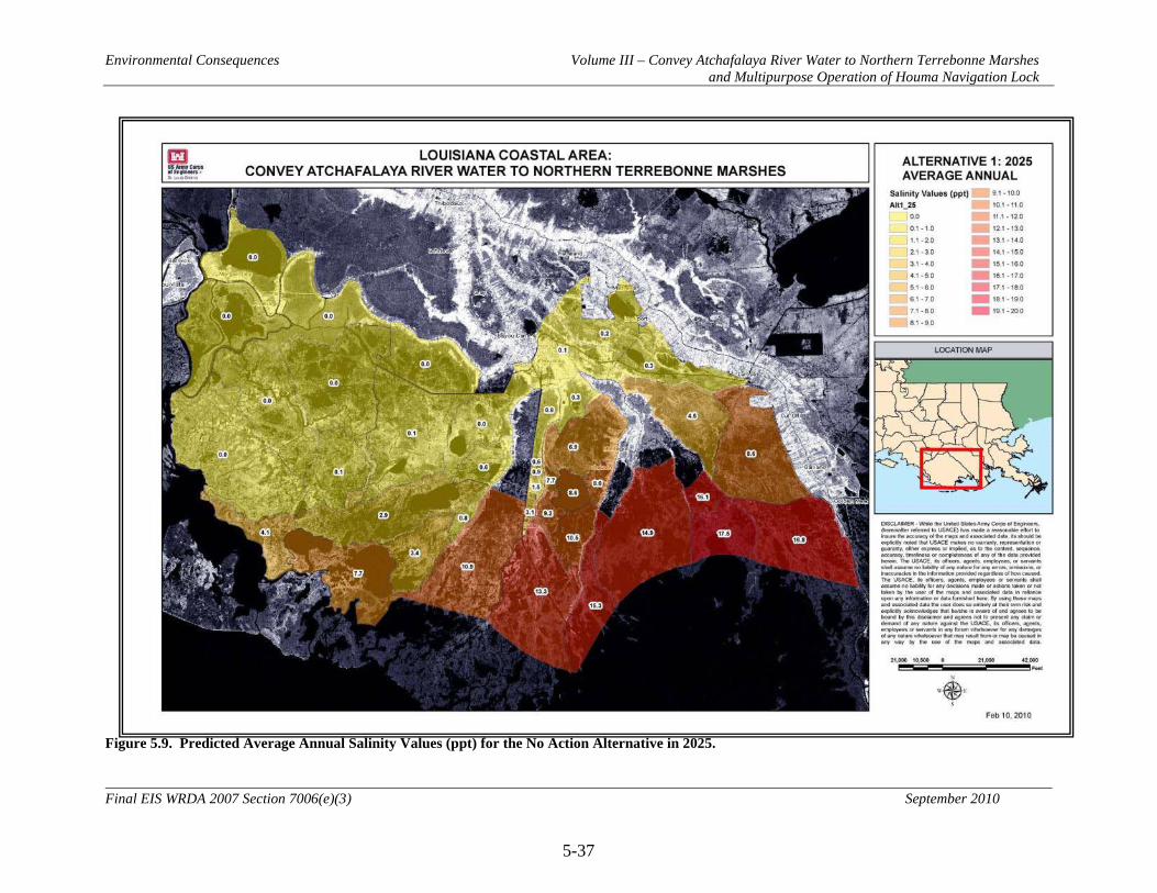
Environmental Consequences Volume III – Convey Atchafalaya River Water to Northern Terrebonne Marshes and Multipurpose Operation of Houma Navigation Lock
5-37
Final EIS WRDA 2007 Section 7006(e)(3) September 2010
Figure 5.9. Predicted Average Annual Salinity Values (ppt) for the No Action Alternative in 2025.
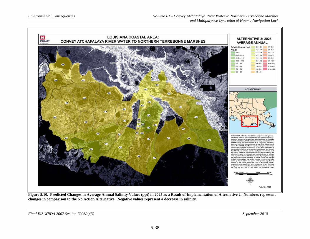
Environmental Consequences Volume III – Convey Atchafalaya River Water to Northern Terrebonne Marshes and Multipurpose Operation of Houma Navigation Lock
5-38
Final EIS WRDA 2007 Section 7006(e)(3) September 2010
Figure 5.10. Predicted Changes in Average Annual Salinity Values (ppt) in 2025 as a Result of Implementation of Alternative 2. Numbers represent changes in comparison to the No Action Alternative. Negative values represent a decrease in salinity.

Environmental Consequences Volume III – Convey Atchafalaya River Water to Northern Terrebonne Marshes and Multipurpose Operation of Houma Navigation Lock
5-39
Final EIS WRDA 2007 Section 7006(e)(3) September 2010
Figure 5.11. Predicted Changes in Average Annual Salinity Values (ppt) in 2025 as a Result of Implementation of Alternative 3. Numbers represent changes in comparison to the No Action Alternative. Negative values represent a decrease in salinity.
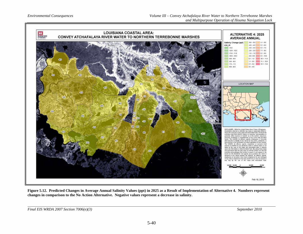
Environmental Consequences Volume III – Convey Atchafalaya River Water to Northern Terrebonne Marshes and Multipurpose Operation of Houma Navigation Lock
5-40
Final EIS WRDA 2007 Section 7006(e)(3) September 2010
Figure 5.12. Predicted Changes in Average Annual Salinity Values (ppt) in 2025 as a Result of Implementation of Alternative 4. Numbers represent changes in comparison to the No Action Alternative. Negative values represent a decrease in salinity.

Environmental Consequences Volume III – Convey Atchafalaya River Water to Northern Terrebonne Marshes and Multipurpose Operation of Houma Navigation Lock
5-41
Final EIS WRDA 2007 Section 7006(e)(3) September 2010
Figure 5.13. Predicted Changes in Average Annual Salinity Values (ppt) in 2025 as a Result of Implementation of Alternative 5. Numbers represent changes in comparison to the No Action Alternative. Negative values represent a decrease in salinity.
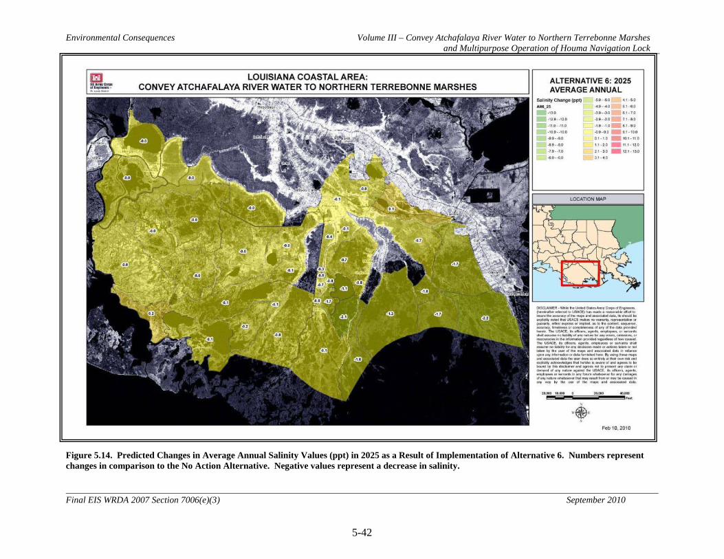
Environmental Consequences Volume III – Convey Atchafalaya River Water to Northern Terrebonne Marshes and Multipurpose Operation of Houma Navigation Lock
5-42
Final EIS WRDA 2007 Section 7006(e)(3) September 2010
Figure 5.14. Predicted Changes in Average Annual Salinity Values (ppt) in 2025 as a Result of Implementation of Alternative 6. Numbers represent changes in comparison to the No Action Alternative. Negative values represent a decrease in salinity.
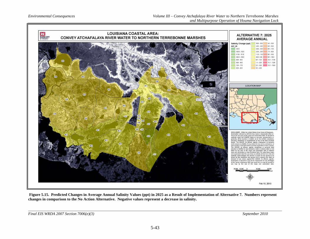
Environmental Consequences Volume III – Convey Atchafalaya River Water to Northern Terrebonne Marshes and Multipurpose Operation of Houma Navigation Lock
5-43
Final EIS WRDA 2007 Section 7006(e)(3) September 2010
Figure 5.15. Predicted Changes in Average Annual Salinity Values (ppt) in 2025 as a Result of Implementation of Alternative 7. Numbers represent changes in comparison to the No Action Alternative. Negative values represent a decrease in salinity.

Environmental Consequences Volume III – Convey Atchafalaya River Water to Northern Terrebonne Marshes and Multipurpose Operation of Houma Navigation Lock
5-44
Final EIS WRDA 2007 Section 7006(e)(3) September 2010
Figure 5.16. Predicted Changes in Average Annual Salinity Values (ppt) in 2025 as a Result of Implementation of Alternative 8. Numbers represent changes in comparison to the No Action Alternative. Negative values represent a decrease in salinity.
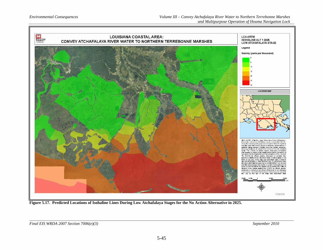
Environmental Consequences Volume III – Convey Atchafalaya River Water to Northern Terrebonne Marshes and Multipurpose Operation of Houma Navigation Lock
5-45
Final EIS WRDA 2007 Section 7006(e)(3) September 2010
Figure 5.17. Predicted Locations of Isohaline Lines During Low Atchafalaya Stages for the No Action Alternative in 2025.

Environmental Consequences Volume III – Convey Atchafalaya River Water to Northern Terrebonne Marshes and Multipurpose Operation of Houma Navigation Lock
5-46
Final EIS WRDA 2007 Section 7006(e)(3) September 2010
Figure 5.18. Predicted Locations of Isohaline Lines During High Atchafalaya Stages for the No Action Alternative in 2025.
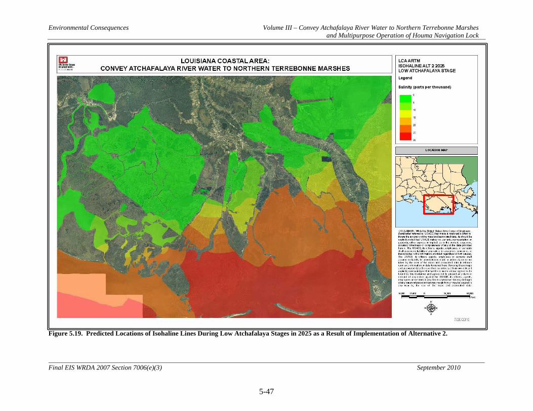
Environmental Consequences Volume III – Convey Atchafalaya River Water to Northern Terrebonne Marshes and Multipurpose Operation of Houma Navigation Lock
5-47
Final EIS WRDA 2007 Section 7006(e)(3) September 2010
Figure 5.19. Predicted Locations of Isohaline Lines During Low Atchafalaya Stages in 2025 as a Result of Implementation of Alternative 2.

Environmental Consequences Volume III – Convey Atchafalaya River Water to Northern Terrebonne Marshes and Multipurpose Operation of Houma Navigation Lock
5-48
Final EIS WRDA 2007 Section 7006(e)(3) September 2010
Figure 5.20. Predicted Locations of Isohaline Lines During High Atchafalaya Stages in 2025 as a Result of Implementation of Alternative 2.

Environmental Consequences Volume III – Convey Atchafalaya River Water to Northern Terrebonne Marshes and Multipurpose Operation of Houma Navigation Lock
5-49
Final EIS WRDA 2007 Section 7006(e)(3) September 2010
Figure 5.21. Predicted Locations of Isohaline Lines During Low Atchafalaya Stages in 2025 as a Result of Implementation of Alternative 3.

Environmental Consequences Volume III – Convey Atchafalaya River Water to Northern Terrebonne Marshes and Multipurpose Operation of Houma Navigation Lock
5-50
Final EIS WRDA 2007 Section 7006(e)(3) September 2010
Figure 5.22. Predicted Locations of Isohaline Lines During High Atchafalaya Stages in 2025 as a Result of Implementation of Alternative 3.

Environmental Consequences Volume III – Convey Atchafalaya River Water to Northern Terrebonne Marshes and Multipurpose Operation of Houma Navigation Lock
5-51
Final EIS WRDA 2007 Section 7006(e)(3) September 2010
Figure 5.23. Predicted Locations of Isohaline Lines During Low Atchafalaya Stages in 2025 as a Result of Implementation of Alternative 4.
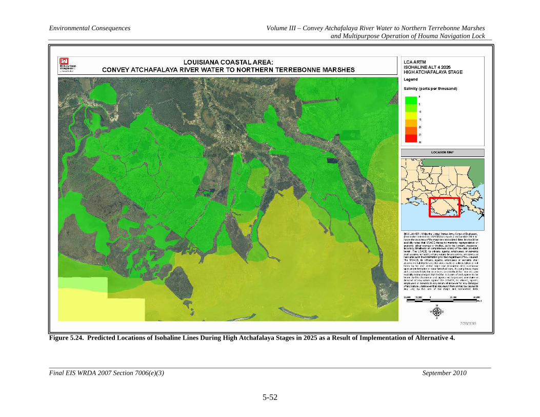
Environmental Consequences Volume III – Convey Atchafalaya River Water to Northern Terrebonne Marshes and Multipurpose Operation of Houma Navigation Lock
5-52
Final EIS WRDA 2007 Section 7006(e)(3) September 2010
Figure 5.24. Predicted Locations of Isohaline Lines During High Atchafalaya Stages in 2025 as a Result of Implementation of Alternative 4.

Environmental Consequences Volume III – Convey Atchafalaya River Water to Northern Terrebonne Marshes and Multipurpose Operation of Houma Navigation Lock
5-53
Final EIS WRDA 2007 Section 7006(e)(3) September 2010
Figure 5.25. Predicted Locations of Isohaline Lines During Low Atchafalaya Stages in 2025 as a Result of Implementation of Alternative 5.
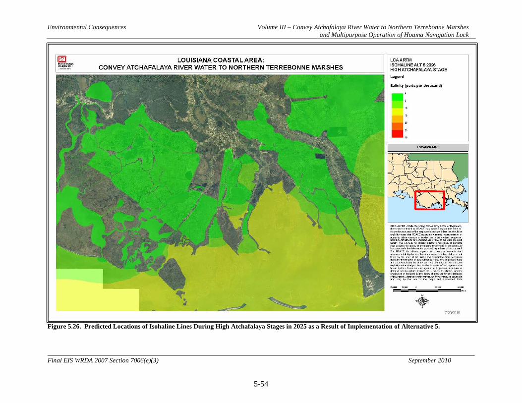
Environmental Consequences Volume III – Convey Atchafalaya River Water to Northern Terrebonne Marshes and Multipurpose Operation of Houma Navigation Lock
5-54
Final EIS WRDA 2007 Section 7006(e)(3) September 2010
Figure 5.26. Predicted Locations of Isohaline Lines During High Atchafalaya Stages in 2025 as a Result of Implementation of Alternative 5.
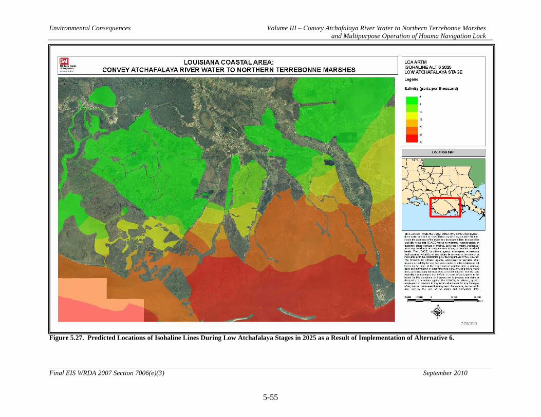
Environmental Consequences Volume III – Convey Atchafalaya River Water to Northern Terrebonne Marshes and Multipurpose Operation of Houma Navigation Lock
5-55
Final EIS WRDA 2007 Section 7006(e)(3) September 2010
Figure 5.27. Predicted Locations of Isohaline Lines During Low Atchafalaya Stages in 2025 as a Result of Implementation of Alternative 6.

Environmental Consequences Volume III – Convey Atchafalaya River Water to Northern Terrebonne Marshes and Multipurpose Operation of Houma Navigation Lock
5-56
Final EIS WRDA 2007 Section 7006(e)(3) September 2010
Figure 5.28. Predicted Locations of Isohaline Lines During High Atchafalaya Stages in 2025 as a Result of Implementation of Alternative 6.

Environmental Consequences Volume III – Convey Atchafalaya River Water to Northern Terrebonne Marshes and Multipurpose Operation of Houma Navigation Lock
5-57
Final EIS WRDA 2007 Section 7006(e)(3) September 2010
Figure 5.29. Predicted Locations of Isohaline Lines During Low Atchafalaya Stages in 2025 as a Result of Implementation of Alternative 7.
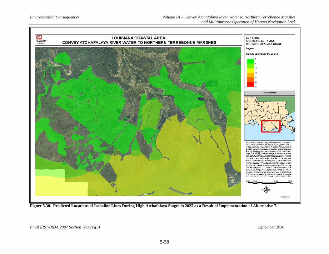
Environmental Consequences Volume III – Convey Atchafalaya River Water to Northern Terrebonne Marshes and Multipurpose Operation of Houma Navigation Lock
5-58
Final EIS WRDA 2007 Section 7006(e)(3) September 2010
Figure 5.30. Predicted Locations of Isohaline Lines During High Atchafalaya Stages in 2025 as a Result of Implementation of Alternative 7.
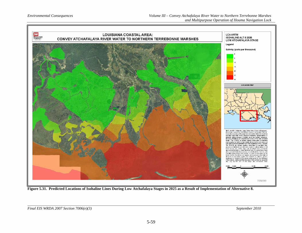
Environmental Consequences Volume III – Convey Atchafalaya River Water to Northern Terrebonne Marshes and Multipurpose Operation of Houma Navigation Lock
5-59
Final EIS WRDA 2007 Section 7006(e)(3) September 2010
Figure 5.31. Predicted Locations of Isohaline Lines During Low Atchafalaya Stages in 2025 as a Result of Implementation of Alternative 8.

Environmental Consequences Volume III – Convey Atchafalaya River Water to Northern Terrebonne Marshes and Multipurpose Operation of Houma Navigation Lock
5-60
Final EIS WRDA 2007 Section 7006(e)(3) September 2010
Figure 5.32. Predicted Locations of Isohaline Lines During High Atchafalaya Stages in 2025 as a Result of Implementation of Alternative 8.

Environmental Consequences Volume III – Convey Atchafalaya River Water to Northern Terrebonne Marshes and Multipurpose Operation of Houma Navigation Lock
5-61
Final EIS WRDA 2007 Section 7006(e)(3) September 2010
5.4 Air Quality
5.4.1 No Action Alternative (Future without Project Conditions)
Air quality would continue to be subject to institutional recognition and further regulations. However, air quality in the study area would likely decline for the following reasons: continued population growth, further commercialization and industrialization, increased numbers of motor vehicles, and increased emissions from various engines. These impacts would be coupled with the continued loss of Louisiana coastal wetland vegetation that would no longer be available to remove gaseous pollutants. There would likely be associated increases in respiratory ailments (such as asthma) in the human populations. Nevertheless, air quality degradation is not anticipated to be a significant problem in the project area under the No Action Alternative during the 50-year period of analysis. 5.4.2 Alternative 2 (NER Plan and RP)
5.4.2.1 Direct Direct impacts to ambient air quality would be temporary and localized, resulting primarily from the emissions of construction equipment within the project area. It has been the experience of the CEMVN that total emissions for each work item separately (or even when all work items are summed) generally do not exceed the threshold limit applicable to volatile organic compounds (VOC) for parishes where the most stringent requirement (50 tons per year [49.38 metric tons per year] in serious non-attainment parishes) is in effect. All five parishes in the project area are attainment areas and therefore would not be subject to this requirement. Project emissions would be classified as de minimus and no further action would be required. It is likely that indirect emissions, if they occur, would be negligible. Additionally, these effects to air quality would be temporary, and air quality would return to pre-construction conditions shortly after the completion of construction activities. 5.4.2.2 Indirect Principal indirect impacts would be related to the potential improvement in air quality that increasing vegetated wetlands would provide. Improvement of air quality would provide positive benefits for humans suffering from health problems such as asthma and other respiratory problems. Restoration of vegetated wetlands over the 50-year period of analysis would help to improve air quality by reducing particulates and gaseous air pollutants. Studies of the effects of common wetland plants on removing or reducing air pollution in the coastal Louisiana area have yet to be done. However, it is reasonable to extrapolate from the findings of researchers such as David J. Nowak (personal communication, David J. Nowak, Project Leader, USDA Forest Service, Northeastern Research Station, 5 Moon Library, SUNYCESF, Syracuse, New York) that the trees and vegetation in coastal Louisiana would improve air quality. Hence, over the 50-year period of analysis, the anticipated benefits to marshes in the project area from implementation of Alternative 2
Environmental Consequences Volume III – Convey Atchafalaya River Water to Northern Terrebonne Marshes and Multipurpose Operation of Houma Navigation Lock
5-62
Final EIS WRDA 2007 Section 7006(e)(3) September 2010
(3,220 AAHUs) should have a positive impact on air quality by removing gaseous and particulate air pollutants. 5.4.2.3 Cumulative Primary cumulative impacts would be the potential improvement of air quality due to the removal of air pollutants by vegetation. Other cumulative impacts include the additive effects of similar Federal, state, local, and private wetland restoration efforts that would also contribute to reduction of air pollution, as well as other technological efforts such as scrubbers on smoke stacks, more stringent emissions standards on motors, etc. From the cumulative impacts perspective, this potential improvement in air quality by restoration efforts would be in contrast to continued air pollution by other sources. 5.4.3 Alternative 3
Direct, indirect, and cumulative impacts of Alternative 3 would generally be similar to Alternative 2, but to a greater degree. Direct impacts from construction activities would be increased slightly due to implementation of features WO2 and WS4. Indirect impacts from benefits to marsh habitat would be slightly increased, as Alternative 3 would generate 3,325 AAHUs over the 50-year period of analysis. 5.4.4 Alternative 4
Direct, indirect, and cumulative impacts of Alternative 4 would generally be similar to Alternative 2, but to a greater degree. Direct impacts would be greater due to the construction and operation of the pump station at Grand Bayou (feature ES2). Indirect impacts from benefits to marsh habitat would be greater, as Alternative 4 would generate 4,258 AAHUs over the 50-year period of analysis. 5.4.5 Alternative 5
Direct, indirect, and cumulative impacts of Alternative 5 would generally be similar to Alternative 2, but to a greater degree. Direct impacts would be greater due to the construction of the Avoca Island diversion structure (WS4) and associated shoreline protection (WO2) and due to construction and operation of the pump station at Grand Bayou (ES2). Indirect impacts from benefits to marsh habitat would be greater, as Alternative 5 would generate 4,719 AAHUs over the 50-year period of analysis. 5.4.6 Alternative 6
Direct, indirect, and cumulative impacts of Alternative 6 would generally be similar to Alternative 2, but to a lesser degree. Direct impacts from construction of features would be greatly reduced due to the lack of flow management features with Alternative 6. Indirect impacts from benefits to marsh habitat would also be reduced, as Alternative 6 would generate 776 AAHUs over the 50-year period of analysis.

Environmental Consequences Volume III – Convey Atchafalaya River Water to Northern Terrebonne Marshes and Multipurpose Operation of Houma Navigation Lock
5-63
Final EIS WRDA 2007 Section 7006(e)(3) September 2010
5.4.7 Alternative 7
Direct impacts of Alternative 7 on air quality would be minor and short-term. Indirect impacts from benefits to marsh habitat would be reduced in comparison to Alternative 2, as Alternative 7 would generate 243 AAHUs over the 50-year period of analysis. 5.4.8 Alternative 8
Direct, indirect, and cumulative impacts of Alternative 8 would generally be similar to Alternative 2, but to a lesser degree. Direct impacts from construction of features would be greatly reduced due to the elimination of several features with Alternative 8. Indirect impacts from benefits to marsh habitat would also be reduced, as Alternative 8 would generate 1,214 AAHUs over the 50-year period of analysis.

Environmental Consequences Volume III – Convey Atchafalaya River Water to Northern Terrebonne Marshes and Multipurpose Operation of Houma Navigation Lock
5-64
Final EIS WRDA 2007 Section 7006(e)(3) September 2010
5.5 Noise
5.5.1 No Action Alternative (Future without Project Conditions)
Local and temporary noise impacts typically associated with human activities and habitations such as car and truck traffic, operation of commercial and recreational boats, water vessels, air boats, and other recreational vehicles; operation of machinery and motors; and human residential-related noise (air conditioners, lawn mowers, etc.) would likely continue to affect humans and animals in the study area. 5.5.2 Alternative 2 (NER Plan and RP)
5.5.2.1 Direct Construction activities associated with implementing Alternative 2 would temporarily increase the noise level in the project area. Because of the proximity of some of the features to developed areas, there are a number of residential and commercial properties that could be exposed to adverse impacts from construction noise. One construction activity, pile driving, would be expected to create temporary noise impacts above 65 dBA to sensitive receptors within 1,000 ft of the construction activity (see Table 5.3). Assuming the worst case scenario of 101 dBA, as would be the case during pile driving, all areas within 1,000 ft of the pile driving would experience noise levels exceeding 65 dBA. The use of pile drivers and other high level noise sources would likely be limited to daylight hours, which would reduce the adverse impact of noise on surrounding land uses. Pile driving is also limited in extent because it will only occur during construction of features WW2, CC3, CC4, CC13, CC14, CC15, CS1, EC3, and EC5. However, pile driving would occur within 100 ft of residential homes and approximately 115 residences within 1,000 ft of these areas could experience noise disturbances greater than 65 dBA. The remaining construction activities that do not include pile driving would not create noise impacts above 65 dBA outside of 500 ft from the construction areas. Approximately 230 residences would be within 500 ft of construction activities and could experience sound impacts from general construction above 65 dBA. Localized and temporary noise impacts would likely result in wildlife and fishery resources temporarily leaving construction areas during construction activities. In some instances, noise impacts may directly impact fish and wildlife species. These organisms would generally avoid the construction area. However, tolerance of unnatural disturbance varies among wildlife. Therefore identifying the key species of concern and following feasible administrative and or engineering controls, determining and implementing appropriate buffer zones, and implementing construction activity windows will address these issues. 5.5.2.2 Indirect It is anticipated that, in some instances, noise impacts may be an important issue for their potential indirect effects on wildlife, such as disruption of normal breeding patterns. Noise may temporarily cause some local fish and wildlife species to relocate during
Environmental Consequences Volume III – Convey Atchafalaya River Water to Northern Terrebonne Marshes and Multipurpose Operation of Houma Navigation Lock
5-65
Final EIS WRDA 2007 Section 7006(e)(3) September 2010
construction activities. However, indirect impacts due to noise are expected to be localized, temporary, and minor in nature. 5.5.2.3 Cumulative The cumulative impacts would principally be related to the potential short-term disruption of human communities and fish and wildlife species along with similar impacts by other Federal, state, local and private activities as well as other human-induced noise disruptions. 5.5.3 Alternative 3
Direct, indirect, and cumulative impacts of Alternative 3 would generally be similar to Alternative 2, but to a slightly greater degree due to implementation of features WO2 and WS4. Approximately 230 residences would be within 500 ft of construction activities and could experience sound impacts from general construction above 65 dBA. Approximately 115 residences within 1,000 ft of features included in Alternative 3 could experience noise disturbances greater than 65 dBA due to pile driving. 5.5.4 Alternative 4
Direct, indirect, and cumulative impacts of Alternative 4 would generally be similar to Alternative 2, but to a greater degree due to the added temporary noise impacts of construction of features EP8 and ES2. Approximately 235 residences would be within 500 ft of construction activities and could experience sound impacts from general construction above 65 dBA. ES2 would require pile driving. Approximately 120 residences within 1,000 ft of features included in Alternative 4 could experience noise disturbances greater than 65 dBA due to pile driving. ES2 would have additional long-term noise impacts due to the operation of the pump station. Four residences within 500 ft of the pump station could experience sound impacts from pump operation above 65 dBA. 5.5.5 Alternative 5
Direct, indirect, and cumulative impacts of Alternative 5 would be similar to Alternative 4, but to a slightly greater degree due to the added temporary noise impacts on fish and wildlife from construction of features WO2 and WS4. 5.5.6 Alternative 6
Direct, indirect, and cumulative impacts of Alternative 6 would generally be similar to Alternative 2, but to a much lesser degree. Approximately 105 residences would be within 500 ft of construction activities and could experience sound impacts from general construction above 65 dBA. EC5 would require pile driving. 5 residences within 1,000 ft of EC5 could experience noise disturbances greater than 65 dBA due to pile driving.

Environmental Consequences Volume III – Convey Atchafalaya River Water to Northern Terrebonne Marshes and Multipurpose Operation of Houma Navigation Lock
5-66
Final EIS WRDA 2007 Section 7006(e)(3) September 2010
Table 5.3. Weighted (dBA) Sound Levels of Construction Equipment and Modeled Attenuation at Various Distances1 Noise Source 50 ft 100 ft 200 ft 500 ft 1000 ft Crane 81 75 69 61 55 Dump Truck 76 70 64 56 50 Compactor/Roller 83 77 71 63 57 Tractor 84 78 72 64 58 Excavator 81 75 69 61 55 Front end loader 79 73 67 59 53 Concrete mixer/pump truck
79 73 67 59 53
Dozer 82 76 70 62 56 Pile driver 101 95 89 81 75 1 The dBA at 50 ft is a measured noise emission. The 100- to 1000-ft results are modeled estimates. Source: FHWA (2006), Highway Construction Noise Handbook. 5.5.7 Alternative 7
5.5.7.1 Direct Direct impacts of Alternative 7 would be limited to noise impacts from modified operation of the Houma Navigation Canal lock complex. Noise impacts of this Alternative on human communities would be minor given that the feature is located in a remote location. Noise impacts to fish and wildlife species would be intermittent, minor, and temporary. 5.5.7.2 Indirect Indirect impacts due to noise are expected to be localized, temporary, and minor in nature. 5.5.7.3 Cumulative The cumulative impacts would principally be related to the potential short-term disruption of human communities and fish and wildlife species and similar impacts by other Federal, state, local and private activities as well as other human-induced noise disruptions. 5.5.8 Alternative 8
Direct, indirect, and cumulative impacts of Alternative 8 would generally be similar to Alternative 2, but to a lesser degree. Approximately 75 residences would be within 500 ft of construction activities and could experience sound impacts from general construction above 65 dBA. Approximately 115 residences within 1,000 ft of features included in Alternative 8 could experience noise disturbances greater than 65 dBA due to pile driving.

Environmental Consequences Volume III – Convey Atchafalaya River Water to Northern Terrebonne Marshes and Multipurpose Operation of Houma Navigation Lock
5-67
Final EIS WRDA 2007 Section 7006(e)(3) September 2010
5.6 Vegetation Resources
5.6.1 No Action Alternative (Future without Project Conditions)
Under the No Action Alternative, the fresh marshes in the western portion of the study area would likely continue to receive increasing amounts of fresh water from the Atchafalaya River. As the river’s delta enlarges, high water would be more likely to escape laterally to the east and west. The acreage likely to receive the fresh water, nutrients, and sediment from the Atchafalaya River would increase. The increase in fresh water would likely encourage more submerged aquatic vegetation in open water areas. Land loss rates in this area would likely remain low as subsidence would be counteracted largely by increased freshwater flows and sediment arriving from the Atchafalaya River and stimulated marsh growth. Land loss in the Penchant basin has been highest around Jug Lake. Several CWPPRA projects in the area are being implemented to address this elevated loss rate: Penchant Basin Natural Resources Plan (TE-34), South Lake DeCade Freshwater Introduction (TE-39), and North Lake Mechant Landbridge Restoration (TE-44). However, it is anticipated that land loss near this location would continue. In the central and eastern subareas, wetlands would continue to be lost at an annual rate of about what has been measured from 1985-2008 because of subsidence, inundation of marsh plants, and subsequent erosion in brackish and saline marshes. As these marshes disappear, salt water would begin to move northward more rapidly, further stressing fresh and intermediate marshes. These marshes would likely not tolerate the increasing salinity well and would probably not convert to brackish marsh because the soils would be comprised of too much organic matter. Research by Lessmann et al. (1997), and McKee and Mendelssohn (1989) indicate these marshes would be very susceptible to the deleterious effects from the sudden influx of salt water from a tidal surge associated with a hurricane. For this study, 1985-2008 land loss data for each of the subareas was utilized to project future conditions. In a few instances, land loss rates were adjusted to account for anticipated changes due to recently completed or authorized projects or other conditions which rendered the predicted values inaccurate. The actual rates used can be found in Figure 5.33. These land loss rates were applied to project area polygons to produce annual acreages lost from each subarea. Using the annual acreage figure resulted in a linear trend of marsh loss through the 50-year period of analysis. Projections started with the acreage from 2008, the latest complete year of data available during analyses. As can be seen in Figure 5.33, areas of highest land loss are concentrated in the southeastern portion of the project area. The overall habitat value and acreage of remaining wetlands would decline with the No Action alternative. WVA analysis predicted that approximately 102,000 acres or 18 percent of remaining vegetated wetlands in the study area would be lost over the 50-year period of analysis. Several of the subareas (A7, C3, C6, C7, C8, C10, D3, E2, E3, E4, F2, G5, and G6) are predicted to lose all emergent wetlands before the end of the 50-year period of analysis.
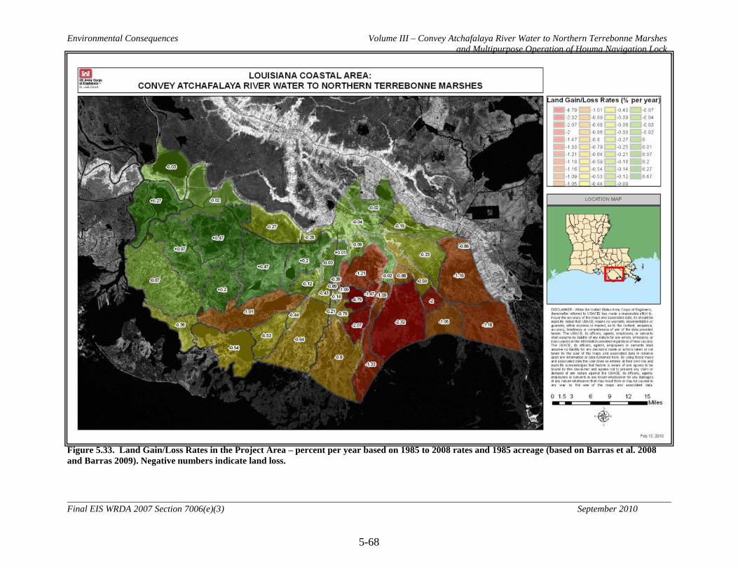
Environmental Consequences Volume III – Convey Atchafalaya River Water to Northern Terrebonne Marshes and Multipurpose Operation of Houma Navigation Lock
5-68
Final EIS WRDA 2007 Section 7006(e)(3) September 2010
Figure 5.33. Land Gain/Loss Rates in the Project Area – percent per year based on 1985 to 2008 rates and 1985 acreage (based on Barras et al. 2008 and Barras 2009). Negative numbers indicate land loss.

Environmental Consequences Volume III – Convey Atchafalaya River Water to Northern Terrebonne Marshes and Multipurpose Operation of Houma Navigation Lock
5-69
Final EIS WRDA 2007 Section 7006(e)(3) September 2010
Table 5.4. Summary of Wetland Value Assessment Variables Associated with each Alternative and Target Year*. No Action Alt 2 Alt 3 Alt 4 Alt 5 Alt 6 Alt 7 Alt 8 Var. TY0 TY1 TY10 TY50 TY1 TY10 TY50 TY1 TY10 TY50 TY1 TY10 TY50 TY1 TY10 TY50 TY1 TY10 TY50 TY1 TY10 TY50 TY1 TY10 TY50 Palmetto/Creole Bayou Area – Fresh Marsh - 57,585 acres V1 87.0 86.9 86.3 83.7 86.9 86.3 83.7 86.9 86.3 83.7 86.9 86.3 83.7 86.9 86.3 83.7 86.9 86.3 83.7 86.9 86.3 83.7 86.9 86.3 83.7 V2 70.0 70.0 70.0 70.0 70.0 70.0 70.0 70.0 70.0 70.0 70.0 70.0 70.0 70.0 70.0 70.0 70.0 70.0 70.0 70.0 70.0 70.0 70.0 70.0 70.0
V3-1 80.0 79.0 75.0 58.0 79.0 75.0 58.0 79.0 75.0 58.0 79.0 75.0 58.0 79.0 75.0 58.0 79.0 75.0 58.0 79.0 75.0 58.0 79.0 75.0 58.0 V3-2 20.0 21.0 25.0 42.0 21.0 25.0 42.0 21.0 25.0 42.0 21.0 25.0 42.0 21.0 25.0 42.0 21.0 25.0 42.0 21.0 25.0 42.0 21.0 25.0 42.0 V3-3 0.0 0.0 0.0 0.0 0.0 0.0 0.0 0.0 0.0 0.0 0.0 0.0 0.0 0.0 0.0 0.0 0.0 0.0 0.0 0.0 0.0 0.0 0.0 0.0 0.0 V3-4 0.0 0.0 0.0 0.0 0.0 0.0 0.0 0.0 0.0 0.0 0.0 0.0 0.0 0.0 0.0 0.0 0.0 0.0 0.0 0.0 0.0 0.0 0.0 0.0 0.0 V3-5 0.0 0.0 0.0 0.0 0.0 0.0 0.0 0.0 0.0 0.0 0.0 0.0 0.0 0.0 0.0 0.0 0.0 0.0 0.0 0.0 0.0 0.0 0.0 0.0 0.0 V4 40.0 40.0 40.0 40.0 40.0 40.0 40.0 40.0 40.0 40.0 40.0 40.0 40.0 40.0 40.0 40.0 40.0 40.0 40.0 40.0 40.0 40.0 40.0 40.0 40.0 V5 0.0 0.0 0.0 0.0 0.0 0.0 0.0 0.0 0.0 0.0 0.0 0.0 0.0 0.0 0.0 0.0 0.0 0.0 0.0 0.0 0.0 0.0 0.0 0.0 0.0 V6 1.0 1.0 1.0 1.0 1.0 1.0 1.0 1.0 1.0 1.0 1.0 1.0 1.0 1.0 1.0 1.0 1.0 1.0 1.0 1.0 1.0 1.0 1.0 1.0 1.0
Lake Pagie, A6, A7 Area – Brackish Marsh - 59,460 acres V1 26.5 26.1 22.6 9.6 27.7 26.0 23.9 27.7 26.0 24.2 27.7 26.0 23.8 27.7 26.0 24.0 27.5 24.0 12.1 27.5 24.0 12.1 27.5 24.0 11.8 V2 40.0 40.0 37.0 24.0 45.0 45.0 40.0 45.0 45.0 40.0 45.0 45.0 40.0 45.0 45.0 43.0 40.0 37.0 24.0 40.0 37.0 28.0 35.0 34.0 28.0
V3-1 0.0 0.0 0.0 0.0 0.0 0.0 0.0 0.0 0.0 0.0 0.0 0.0 0.0 0.0 0.0 0.0 0.0 0.0 0.0 0.0 0.0 0.0 0.0 0.0 0.0 V3-2 10.0 7.0 0.0 0.0 10.0 7.0 0.0 10.0 7.0 0.0 10.0 7.0 0.0 10.0 7.0 0.0 10.0 6.0 0.0 10.0 6.0 0.0 10.0 6.0 0.0 V3-3 13.0 17.0 15.0 0.0 15.0 17.0 25.0 15.0 17.0 25.0 15.0 17.0 25.0 15.0 17.0 25.0 15.0 14.0 0.0 15.0 14.0 0.0 15.0 14.0 0.0 V3-4 32.0 32.0 44.0 0.0 34.0 31.0 26.0 34.0 31.0 28.0 34.0 31.0 25.0 34.0 31.0 27.0 33.0 30.0 14.0 33.0 30.0 14.0 33.0 30.0 12.0 V3-5 45.0 44.0 41.0 100.0 41.0 45.0 49.0 41.0 45.0 47.0 41.0 45.0 50.0 41.0 45.0 48.0 42.0 50.0 86.0 42.0 50.0 86.0 42.0 50.0 88.0 V4 10.0 10.0 9.0 2.0 10.0 10.0 9.0 10.0 10.0 9.0 10.0 10.0 9.0 10.0 10.0 9.0 10.0 9.0 3.0 10.0 9.0 3.0 10.0 9.0 3.0 V5 2.9 2.9 2.9 2.7 2.2 1.9 1.6 2.2 1.9 1.6 2.6 2.5 1.9 2.5 2.4 1.9 2.9 2.8 2.5 2.9 2.8 2.6 3.2 3.1 2.9 V6 1.0 1.0 1.0 1.0 1.0 1.0 1.0 1.0 1.0 1.0 1.0 1.0 1.0 1.0 1.0 1.0 1.0 1.0 1.0 1.0 1.0 1.0 1.0 1.0 1.0
G2, G3, G6 Area – Brackish Marsh - 38,269 acres V1 45.6 44.8 37.5 13.6 44.4 39.2 25.7 44.4 39.2 25.9 44.9 44.6 51.6 44.9 44.6 51.6 44.4 38.1 18.6 44.8 37.5 13.6 44.4 38.9 23.9 V2 3.0 3.0 2.0 0.0 5.0 5.0 2.0 5.0 5.0 2.0 15.0 14.0 12.0 15.0 14.0 12.0 5.0 5.0 2.0 3.0 2.0 0.0 5.0 5.0 2.0
V3-1 0.0 0.0 0.0 0.0 0.0 0.0 0.0 0.0 0.0 0.0 0.0 0.0 0.0 0.0 0.0 0.0 0.0 0.0 0.0 0.0 10.0 0.0 0.0 0.0 0.0 V3-2 20.0 20.0 12.0 0.0 20.0 10.0 0.0 20.0 10.0 0.0 20.0 13.0 0.0 20.0 13.0 0.0 20.0 10.0 0.0 19.0 0.0 0.0 20.0 13.0 0.0 V3-3 42.0 39.0 34.0 0.0 40.0 39.0 15.0 40.0 39.0 15.0 40.0 40.0 38.0 40.0 40.0 38.0 40.0 34.0 0.0 42.0 30.0 0.0 38.0 36.0 17.0 V3-4 38.0 41.0 41.0 24.0 40.0 51.0 67.0 40.0 51.0 68.0 40.0 47.0 57.0 40.0 47.0 57.0 40.0 56.0 61.0 38.0 50.0 24.0 42.0 40.0 47.0 V3-5 0.0 0.0 13.0 76.0 0.0 0.0 18.0 0.0 0.0 17.0 0.0 0.0 5.0 0.0 0.0 5.0 0.0 0.0 39.0 0.0 10.0 76.0 0.0 11.0 36.0 V4 8.0 8.0 7.0 2.0 8.0 8.0 4.0 8.0 8.0 4.0 8.0 8.0 6.0 8.0 8.0 6.0 8.0 7.0 3.0 8.0 7.0 2.0 8.0 8.0 4.0 V5 8.3 8.3 8.6 10.0 6.6 6.9 8.0 6.4 6.9 7.8 1.7 1.8 2.8 1.7 1.8 2.8 6.8 6.9 8.4 8.3 8.3 9.6 6.9 6.8 7.8 V6 1.0 1.0 1.0 1.0 1.0 1.0 1.0 1.0 1.0 1.0 1.0 1.0 1.0 1.0 1.0 1.0 1.0 1.0 1.0 1.0 1.0 1.0 1.0 1.0 1.0

Environmental Consequences Volume III – Convey Atchafalaya River Water to Northern Terrebonne Marshes and Multipurpose Operation of Houma Navigation Lock
5-70
Final EIS WRDA 2007 Section 7006(e)(3) September 2010
Table 5.4 (cont.) No Action Alt 2 Alt 3 Alt 4 Alt 5 Alt 6 Alt 7 Alt 8 Var. TY0 TY1 TY10 TY50 TY1 TY10 TY50 TY1 TY10 TY50 TY1 TY10 TY50 TY1 TY10 TY50 TY1 TY10 TY50 TY1 TY10 TY50 TY1 TY10 TY50
G1 and G5 Area – Brackish Marsh - 24,863 acres V1 82.1 81.8 79.1 68.1 80.7 78.1 67.1 80.7 78.1 67.1 80.7 78.1 67.1 80.7 78.1 67.1 81.8 79.1 68.1 81.8 79.1 68.1 80.7 78.1 67.1 V2 12.0 12.0 12.0 8.0 12.0 11.0 8.0 12.0 11.0 8.0 12.0 11.0 8.0 12.0 11.0 8.0 12.0 12.0 8.0 12.0 12.0 8.0 12.0 11.0 8.0
V3-1 74.0 74.0 70.0 25.0 74.0 70.0 25.0 74.0 70.0 25.0 74.0 70.0 25.0 74.0 70.0 25.0 74.0 70.0 25.0 74.0 70.0 25.0 74.0 70.0 25.0 V3-2 18.0 17.0 17.0 45.0 15.0 15.0 44.0 15.0 15.0 44.0 15.0 15.0 44.0 15.0 15.0 44.0 17.0 17.0 45.0 17.0 17.0 45.0 15.0 15.0 44.0 V3-3 0.0 0.0 0.0 17.0 0.0 0.0 16.0 0.0 0.0 16.0 0.0 0.0 16.0 0.0 0.0 16.0 0.0 0.0 17.0 0.0 0.0 17.0 0.0 0.0 16.0 V3-4 8.0 9.0 13.0 13.0 11.0 15.0 15.0 11.0 15.0 15.0 11.0 15.0 15.0 11.0 15.0 15.0 9.0 13.0 13.0 9.0 13.0 13.0 11.0 15.0 15.0 V3-5 0.0 0.0 0.0 0.0 0.0 0.0 0.0 0.0 0.0 0.0 0.0 0.0 0.0 0.0 0.0 0.0 0.0 0.0 0.0 0.0 0.0 0.0 0.0 0.0 0.0 V4 12.0 12.0 12.0 8.0 11.0 11.0 7.0 12.0 11.0 7.0 15.0 15.0 10.0 15.0 15.0 10.0 12.0 12.0 8.0 12.0 12.0 8.0 11.0 11.0 7.0 V5 4.5 4.5 4.5 4.8 4.8 4.8 5.2 4.4 4.8 5.1 2.3 2.5 3.1 2.1 2.4 3.1 4.5 4.5 4.8 4.5 4.5 4.8 4.8 4.8 5.2 V6 1.0 1.0 1.0 1.0 1.0 1.0 1.0 1.0 1.0 1.0 1.0 1.0 1.0 1.0 1.0 1.0 1.0 1.0 1.0 1.0 1.0 1.0 1.0 1.0 1.0
F2 Area – Saline Marsh - 6,171 acres V1 23.1 22.0 11.6 0.0 21.7 9.3 0.0 21.7 9.3 0.0 21.8 9.5 0.0 21.8 9.5 0.0 22.0 12.0 0.0 22.0 11.6 0.0 21.7 9.3 0.0 V2 0.0 0.0 0.0 0.0 0.0 0.0 0.0 0.0 0.0 0.0 0.0 0.0 0.0 0.0 0.0 0.0 0.0 0.0 0.0 0.0 0.0 0.0 0.0 0.0 0.0
V3-1 0.0 0.0 0.0 0.0 0.0 0.0 0.0 0.0 0.0 0.0 0.0 0.0 0.0 0.0 0.0 0.0 0.0 0.0 0.0 0.0 0.0 0.0 0.0 0.0 0.0 V3-2 0.0 0.0 0.0 0.0 0.0 0.0 0.0 0.0 0.0 0.0 0.0 0.0 0.0 0.0 0.0 0.0 0.0 0.0 0.0 0.0 0.0 0.0 0.0 0.0 0.0 V3-3 10.0 10.0 0.0 0.0 10.0 0.0 0.0 10.0 0.0 0.0 10.0 0.0 0.0 10.0 0.0 0.0 10.0 0.0 0.0 10.0 0.0 0.0 10.0 0.0 0.0 V3-4 61.0 53.0 10.0 0.0 51.0 0.0 0.0 51.0 0.0 0.0 52.0 0.0 0.0 52.0 0.0 0.0 54.0 14.0 0.0 54.0 12.0 0.0 51.0 0.0 0.0 V3-5 29.0 37.0 90.0 100 39.0 100 100 39.0 100 100 38.0 100 100 38.0 100 100 36.0 86.0 100 36.0 88.0 100 39.0 100 100 V4 5.0 5.0 3.0 0.0 5.0 3.0 0.0 5.0 3.0 0.0 5.0 3.0 0.0 5.0 3.0 0.0 5.0 3.0 0.0 5.0 3.0 0.0 5.0 3.0 0.0 V5 16.0 16.0 16.1 16.5 16.9 16.9 17.1 15.5 16.9 17.0 14.8 15.2 16.2 14.8 15.3 16.2 14.1 14.3 15.9 16.0 15.9 16.3 16.9 16.9 17.0 V6 1.0 1.0 1.0 1.0 1.0 1.0 1.0 1.0 1.0 1.0 1.0 1.0 1.0 1.0 1.0 1.0 1.0 1.0 1.0 1.0 1.0 1.0 1.0 1.0 1.0
E2, E3, E4 Area – Saline Marsh - 48,050 acres V1 14.8 13.7 3.5 0.0 13.7 3.5 0.0 13.7 3.5 0.0 13.7 3.5 0.0 13.7 3.5 0.0 13.7 3.5 0.0 13.7 3.5 0.0 13.7 3.5 0.0 V2 0.0 0.0 0.0 0.0 0.0 0.0 0.0 0.0 0.0 0.0 0.0 0.0 0.0 0.0 0.0 0.0 0.0 0.0 0.0 0.0 0.0 0.0 0.0 0.0 0.0
V3-1 0.0 0.0 0.0 0.0 0.0 0.0 0.0 0.0 0.0 0.0 0.0 0.0 0.0 0.0 0.0 0.0 0.0 0.0 0.0 0.0 0.0 0.0 0.0 0.0 0.0 V3-2 0.0 0.0 0.0 0.0 0.0 0.0 0.0 0.0 0.0 0.0 0.0 0.0 0.0 0.0 0.0 0.0 0.0 0.0 0.0 0.0 0.0 0.0 0.0 0.0 0.0 V3-3 0.0 0.0 0.0 0.0 0.0 0.0 0.0 0.0 0.0 0.0 0.0 0.0 0.0 0.0 0.0 0.0 0.0 0.0 0.0 0.0 0.0 0.0 0.0 0.0 0.0 V3-4 32.0 25.0 0.0 0.0 25.0 0.0 0.0 25.0 0.0 0.0 25.0 0.0 0.0 25.0 0.0 0.0 25.0 0.0 0.0 25.0 0.0 0.0 25.0 0.0 0.0 V3-5 68.0 75.0 100 100 75.0 100 100 75.0 100 100 75.0 100 100 75.0 100 100 75.0 100 100 75.0 100 100 75.0 100 100 V4 0.0 0.0 0.0 0.0 0.0 0.0 0.0 0.0 0.0 0.0 0.0 0.0 0.0 0.0 0.0 0.0 0.0 0.0 0.0 0.0 0.0 0.0 0.0 0.0 0.0 V5 14.8 14.8 15.1 15.1 15.0 15.2 15.2 13.9 15.1 15.1 14.9 15.3 15.3 14.4 15.3 15.3 13.6 14.8 14.8 14.8 14.9 14.9 15.1 15.2 15.2 V6 1.0 1.0 1.0 1.0 1.0 1.0 1.0 1.0 1.0 1.0 1.0 1.0 1.0 1.0 1.0 1.0 1.0 1.0 1.0 1.0 1.0 1.0 1.0 1.0 1.0

Environmental Consequences Volume III – Convey Atchafalaya River Water to Northern Terrebonne Marshes and Multipurpose Operation of Houma Navigation Lock
5-71
Final EIS WRDA 2007 Section 7006(e)(3) September 2010
Table 5.4 (cont.) No Action Alt 2 Alt 3 Alt 4 Alt 5 Alt 6 Alt 7 Alt 8 Var. TY0 TY1 TY10 TY50 TY1 TY10 TY50 TY1 TY10 TY50 TY1 TY10 TY50 TY1 TY10 TY50 TY1 TY10 TY50 TY1 TY10 TY50 TY1 TY10 TY50
C9 Area – Brackish Marsh - 1,702 acres V1 44.7 44.0 37.5 8.6 56.2 54.8 51.8 56.3 54.9 52.2 56.2 54.4 49.7 56.2 54.5 50.1 44.0 37.5 8.6 44.0 37.5 8.6 56.2 53.9 40.2 V2 15.0 15.0 13.0 5.0 25.0 25.0 25.0 25.0 25.0 25.0 25.0 25.0 25.0 25.0 25.0 25.0 15.0 13.0 5.0 15.0 13.0 5.0 25.0 25.0 25.0
V3-1 10.0 10.0 5.0 0.0 10.0 10.0 10.0 10.0 10.0 10.0 10.0 10.0 10.0 10.0 10.0 10.0 10.0 5.0 0.0 10.0 5.0 0.0 10.0 7.0 0.0 V3-2 26.0 25.0 10.0 0.0 35.0 33.0 30.0 35.0 33.0 30.0 35.0 33.0 26.0 35.0 33.0 26.0 25.0 10.0 0.0 25.0 10.0 0.0 35.0 33.0 20.0 V3-3 0.0 0.0 23.0 0.0 29.0 27.0 21.0 29.0 27.0 22.0 29.0 26.0 20.0 29.0 26.0 22.0 0.0 23.0 0.0 0.0 23.0 0.0 29.0 31.0 30.0 V3-4 64.0 65.0 52.0 0.0 26.0 30.0 39.0 26.0 30.0 38.0 26.0 31.0 44.0 26.0 31.0 42.0 65.0 52.0 0.0 65.0 52.0 0.0 26.0 29.0 35.0 V3-5 0.0 0.0 10.0 100 0.0 0.0 0.0 0.0 0.0 0.0 0.0 0.0 0.0 0.0 0.0 0.0 0.0 10.0 100 0.0 10.0 100 0.0 0.0 15.0 V4 10.0 10.0 8.0 2.0 10.0 10.0 10.0 10.0 10.0 10.0 10.0 10.0 10.0 10.0 10.0 10.0 10.0 8.0 2.0 10.0 8.0 2.0 10.0 10.0 10.0 V5 7.7 7.7 7.7 8.1 3.5 3.1 3.7 3.5 3.1 3.7 5.4 5.3 5.1 4.8 5.2 5.0 7.7 7.7 8.1 7.7 7.7 8.1 4.0 3.5 3.9 V6 1.0 1.0 1.0 1.0 1.0 1.0 1.0 1.0 1.0 1.0 1.0 1.0 1.0 1.0 1.0 1.0 1.0 1.0 1.0 1.0 1.0 1.0 1.0 1.0 1.0
C2, C3, C4, C5, C6, and C7 Area – Brackish Marsh - 23,381 acres V1 55.6 54.6 45.1 12.5 54.4 45.7 16.2 54.4 45.8 16.3 54.4 45.7 15.9 54.4 45.7 15.9 54.6 45.1 12.5 54.6 45.1 12.5 54.4 45.7 16.1 V2 15.0 15.0 13.0 3.0 25.0 20.0 9.0 25.0 20.0 9.0 25.0 20.0 9.0 25.0 20.0 9.0 15.0 13.0 3.0 15.0 13.0 3.0 25.0 20.0 9.0
V3-1 0.0 0.0 0.0 0.0 0.0 0.0 0.0 0.0 0.0 0.0 0.0 0.0 0.0 0.0 0.0 0.0 0.0 0.0 0.0 0.0 0.0 0.0 0.0 0.0 0.0 V3-2 35.0 34.0 10.0 0.0 35.0 10.0 0.0 35.0 10.0 0.0 35.0 10.0 0.0 35.0 10.0 0.0 34.0 10.0 0.0 34.0 10.0 0.0 35.0 10.0 0.0 V3-3 52.0 50.0 60.0 0.0 48.0 63.0 0.0 48.0 63.0 0.0 48.0 62.0 0.0 48.0 62.0 0.0 50.0 60.0 0.0 50.0 60.0 0.0 48.0 63.0 0.0 V3-4 13.0 16.0 30.0 17.0 17.0 27.0 41.0 17.0 27.0 41.0 17.0 28.0 38.0 17.0 28.0 38.0 16.0 30.0 17.0 16.0 30.0 17.0 17.0 27.0 41.0 V3-5 0.0 0.0 0.0 83.0 0.0 0.0 59.0 0.0 0.0 59.0 0.0 0.0 62.0 0.0 0.0 62.0 0.0 0.0 83.0 0.0 0.0 83.0 0.0 0.0 59.0 V4 10.0 10.0 9.0 2.0 10.0 9.0 3.0 10.0 9.0 3.0 10.0 9.0 3.0 10.0 9.0 4.0 10.0 9.0 2.0 10.0 9.0 2.0 10.0 9.0 3.5 V5 6.8 6.8 6.9 7.2 4.0 4.0 4.4 3.6 3.9 4.4 5.2 5.1 5.3 5.1 5.0 5.2 6.8 6.9 7.2 6.8 6.9 7.2 4.3 4.1 4.5 V6 1.0 1.0 1.0 1.0 1.0 1.0 1.0 1.0 1.0 1.0 1.0 1.0 1.0 1.0 1.0 1.0 1.0 1.0 1.0 1.0 1.0 1.0 1.00 1.00 1.00
Bayou Dulac Area – Brackish Marsh - 5,577 acres V1 42.9 42.5 38.4 20.5 43.2 39.0 15.9 43.2 39.0 16.0 43.2 39.0 15.8 42.5 39.0 15.9 42.7 40.9 46.2 42.5 39.0 44.1 42.5 38.2 13.0 V2 5.0 5.0 5.0 2.0 5.0 5.0 2.0 5.0 5.0 2.0 5.0 5.0 2.0 5.0 5.0 4.0 5.0 5.0 5.0 5.0 5.0 5.0 5.0 5.0 2.0
V3-1 0.0 0.0 0.0 0.0 0.0 0.0 0.0 0.0 0.0 0.0 0.0 0.0 0.0 0.0 0.0 0.0 0.0 0.0 0.0 0.0 0.0 0.0 0.0 0.0 0.0 V3-2 30.0 30.0 20.0 0.0 30.0 20.0 0.0 30.0 20.0 0.0 30.0 20.0 0.0 30.0 30.0 15.0 30.0 25.0 30.0 30.0 20.0 30.0 30.0 20.0 0.0 V3-3 11.0 10.0 14.0 0.0 13.0 16.0 0.0 13.0 16.0 0.0 13.0 16.0 0.0 11.0 12.0 13.0 11.0 14.0 25.0 10.0 16.0 16.0 10.0 13.0 0.0 V3-4 59.0 60.0 66.0 70.0 57.0 64.0 39.0 57.0 64.0 40.0 57.0 64.0 40.0 59.0 58.0 72.0 59.0 61.0 45.0 60.0 64.0 54.0 60.0 67.0 20.0 V3-5 0.0 0.0 0.0 30.0 0.0 0.0 61.0 0.0 0.0 60.0 0.0 0.0 60.0 0.0 0.0 0.0 0.0 0.0 0.0 0.0 0.0 0.0 0.0 0.0 80.0 V4 10.0 10.0 9.0 4.0 10.0 9.0 4.0 10.0 9.0 4.0 10.0 9.0 4.0 10.0 10.0 8.0 10.0 10.0 10.0 10.0 9.0 10.0 10.0 9.0 10.0 V5 9.2 9.2 9.2 9.5 7.4 8.4 8.3 6.9 8.4 8.2 7.8 8.6 8.5 7.8 8.6 8.5 8.4 7.5 8.3 9.2 7.7 7.8 7.7 8.2 8.3 V6 1.0 1.0 1.0 1.0 1.0 1.0 1.0 1.0 1.0 1.0 1.0 1.0 1.0 1.0 1.0 1.0 1.0 1.0 1.0 1.0 1.0 1.0 1.00 1.00 1.00

Environmental Consequences Volume III – Convey Atchafalaya River Water to Northern Terrebonne Marshes and Multipurpose Operation of Houma Navigation Lock
5-72
Final EIS WRDA 2007 Section 7006(e)(3) September 2010
Table 5.4 (cont.) No Action Alt 2 Alt 3 Alt 4 Alt 5 Alt 6 Alt 7 Alt 8 Var. TY0 TY1 TY10 TY50 TY1 TY10 TY50 TY1 TY10 TY50 TY1 TY10 TY50 TY1 TY10 TY50 TY1 TY10 TY50 TY1 TY10 TY50 TY1 TY10 TY50
B6 and B7 Area – Brackish Marsh - 42,049 acres V1 56.9 56.5 52.4 34.5 56.5 52.3 31.2 56.6 52.5 31.5 56.6 52.4 31.2 56.6 52.5 31.4 56.6 52.4 27.8 56.6 52.4 27.8 56.5 52.6 40.0 V2 12.0 12.0 11.0 2.0 11.0 11.0 4.0 12.0 11.0 4.0 12.0 11.0 3.0 11.0 10.0 3.0 12.0 12.0 4.0 12.0 12.0 4.0 12.0 12.0 4.0
V3-1 0.0 0.0 0.0 0.0 0.0 0.0 0.0 0.0 0.0 0.0 0.0 0.0 0.0 0.0 0.0 0.0 0.0 0.0 0.0 0.0 0.0 0.0 0.0 0.0 0.0 V3-2 34.0 33.0 25.0 0.0 33.0 20.0 0.0 33.0 20.0 0.0 33.0 20.0 0.0 33.0 20.0 0.0 33.0 20.0 0.0 33.0 20.0 0.0 33.0 20.0 0.0 V3-3 59.0 60.0 60.0 38.0 60.0 70.0 64.0 60.0 70.0 65.0 60.0 70.0 64.0 60.0 70.0 64.0 60.0 70.0 59.0 60.0 70.0 59.0 60.0 70.0 60.0 V3-4 7.0 7.0 15.0 62.0 7.0 10.0 36.0 7.0 10.0 35.0 7.0 10.0 36.0 7.0 10.0 36.0 7.0 10.0 41.0 7.0 10.0 41.0 7.0 10.0 40.0 V3-5 0.0 0.0 0.0 0.0 0.0 0.0 0.0 0.0 0.0 0.0 0.0 0.0 0.0 0.0 0.0 0.0 0.0 0.0 0.0 0.0 0.0 0.0 0.0 0.0 0.0 V4 10.0 10.0 10.0 2.0 10.0 10.0 5.0 10.0 10.0 5.0 10.0 10.0 5.0 10.0 10.0 5.0 10.0 10.0 4.0 10.0 10.0 4.0 10.0 10.0 4.0 V5 10.6 10.6 10.9 11.8 11.0 10.4 11.2 10.6 10.4 11.1 11.7 11.1 11.7 11.5 11.0 11.7 10.2 10.1 11.2 10.6 10.1 11.0 11.0 10.5 11.3 V6 1.0 1.0 1.0 1.0 1.0 1.0 1.0 1.0 1.0 1.0 1.0 1.0 1.0 1.0 1.0 1.0 1.0 1.0 1.0 1.0 1.0 1.0 1.0 1.0 1.0
C11, C12, C13, and C14 – Saline Marsh - 44,030 acres V1 45.3 44.8 40.5 21.5 44.8 40.5 6.7 44.8 40.5 6.8 44.8 40.5 6.7 44.8 40.5 6.7 44.8 40.1 5.8 44.8 40.1 5.8 44.8 40.1 6.1 V2 0.0 0.0 0.0 0.0 0.0 0.0 0.0 0.0 0.0 0.0 0.0 0.0 0.0 0.0 0.0 0.0 0.0 0.0 0.0 0.0 0.0 0.0 0.0 0.0 0.0 V3-1 0.0 0.0 0.0 0.0 0.0 0.0 0.0 0.0 0.0 0.0 0.0 0.0 0.0 0.0 0.0 0.0 0.0 0.0 0.0 0.0 0.0 0.0 0.0 0.0 0.0 V3-2 0.0 0.0 0.0 0.0 0.0 0.0 0.0 0.0 0.0 0.0 0.0 0.0 0.0 0.0 0.0 0.0 0.0 0.0 0.0 0.0 0.0 0.0 0.0 0.0 0.0 V3-3 81.0 79.0 62.0 0.0 79.0 62.0 0.0 79.0 62.0 0.0 79.0 62.0 0.0 79.0 62.0 0.0 79.0 60.0 0.0 79.0 60.0 0.0 79.0 60.0 0.0 V3-4 19.0 21.0 38.0 76.0 21.0 38.0 0.0 21.0 38.0 0.0 21.0 38.0 0.0 21.0 38.0 0.0 21.0 40.0 0.0 21.0 40.0 0.0 21.0 40.0 0.0 V3-5 0.0 0.0 0.0 24.0 0.0 0.0 100 0.0 0.0 100 0.0 0.0 100 0.0 0.0 100 0.0 0.0 100 0.0 0.0 100 0.0 0.0 100 V4 8.0 8.0 7.0 1.0 8.0 7.0 0.0 8.0 7.0 0.0 8.0 7.0 0.0 8.0 7.0 0.0 8.0 7.0 0.0 8.0 7.0 0.0 8.0 7.0 0.0 V5 13.2 13.2 13.3 13.8 13.8 14.3 14.6 13.1 14.2 14.5 14.7 14.9 15.0 14.5 14.9 15.0 12.5 13.3 14.4 13.2 13.3 13.8 13.5 14.1 14.5 V6 1.0 1.0 1.0 1.0 1.0 1.0 1.0 1.0 1.0 1.0 1.0 1.0 1.0 1.0 1.0 1.0 1.0 1.0 1.0 1.0 1.0 1.0 1.0 1.0 1.0 * V1 = Percent emergent marsh V2 = Percent open water covered by aquatic vegetation V3 = Interspersion class V4 = Percent open water less than or equal to 1.5 feet deep V5 = Salinity V6 = Aquatic organism access

Table 5.5. Average Annual Habitat Units by Area and Habitat Type.
*Net benefits calculated as follows: Fresh/Intermediate Marsh Net Benefits = (2.1 x Emergent Marsh AAHUs + Open Water AAHUs) / 3.1
Brackish Marsh Net Benefits = (2.6 x Emergent Marsh AAHUs + Open Water AAHUs) / 3.6 Saline Marsh Net Benefits = (3.5 x Emergent Marsh AAHUs + Open Water AAHUs) / 4.5
Area Alt 2 AAHUs
Alt 3 AAHUs
Alt 4 AAHUs
Alt 5 AAHUs
Alt 6 AAHUs
Alt 7 AAHUs
Alt 8 AAHUs
Palmetto, Creole Bayous Emergent Marsh 0.00 0.00 0.00 0.00 0.00 0.00 0.00 Open Water 0.00 0.00 0.00 0.00 0.00 0.00 0.00 Net Benefits* 0.00 0.00 0.00 0.00 0.00 0.00 0.00
Lake Pagie, A6, A7 Emergent Marsh 2621.40 2666.44 2592.25 3012.26 591.56 589.45 544.55 Open Water 861.28 822.23 887.19 496.18 -508.54 13.76 -483.22 Net Benefits* 2132.48 2154.16 2118.62 2313.35 285.97 429.54 259.06
G2, G3, G6 Emergent Marsh 1650.39 1671.36 1416.57 1416.95 711.14 -45.29 1237.62 Open Water -7.27 -15.81 5116.51 5116.27 349.84 -29.62 159.83 Net Benefits* 1189.93 1202.70 2444.33 2444.54 610.78 -40.94 938.24
G1, G5 Emergent Marsh -328.98 -328.98 -328.98 -328.98 0.00 0.00 0.00 Open Water 75.88 76.36 97.59 97.59 0.00 0.00 0.00 Net Benefits* -216.52 -216.38 -210.49 -210.49 0.00 0.00 0.00
F2 Emergent Marsh -29.05 -29.04 -26.70 -26.70 4.68 0.07 -29.25 Open Water 44.05 44.04 40.23 40.23 -6.22 0.44 44.38 Net Benefits* -12.80 -12.80 -11.83 -11.83 2.26 0.16 -12.89
E2, E3, E4 Emergent Marsh -5.36 -5.36 -5.36 -5.36 0.03 0.00 0.00 Open Water 10.20 10.20 10.20 10.20 -0.06 0.00 0.00 Net Benefits* -1.90 -1.90 -1.90 -1.90 0.01 0.00 0.00
C9 Emergent Marsh 388.48 392.22 369.79 373.74 0.00 0.00 301.14 Open Water -71.35 -73.21 -62.43 -64.34 0.00 0.00 -29.99 Net Benefits* 260.75 262.93 249.73 252.05 0.00 0.00 209.16
C2, C3, C4, C5, C6, C7 Emergent Marsh 276.40 281.09 245.66 248.60 0.00 0.00 278.70 Open Water 689.32 686.47 704.37 709.20 0.00 0.00 691.23 Net Benefits* 391.10 393.69 373.08 376.54 0.00 0.00 393.29
Bayou Dulac Emergent Marsh -427.63 -425.50 -410.18 -0.41 144.82 98.28 -486.50 Open Water 150.61 149.65 237.86 45.66 -20.28 -5.07 186.47 Net Benefits* -267.01 -265.74 -230.17 12.39 98.96 69.57 -299.56
B6, B7 Emergent Marsh 1158.38 1213.92 950.13 987.29 1017.98 1031.61 975.35 Open Water -52.98 -17.92 -263.00 -356.50 169.99 188.04 88.21 Net Benefits* 821.89 871.74 613.15 614.02 782.43 797.29 728.92
C11, C12, C13, C14 Emergent Marsh -1647.43 -1641.64 -1660.26 -1651.20 -1807.41 -1808.12 -1767.96 Open Water 1607.79 1601.48 1620.80 1611.14 1771.68 1772.51 1725.49 Net Benefits* -924.04 -920.94 -931.14 -926.24 -1012.06 -1012.42 -991.64
Independent Measure Benefits -153.98 -142.01 -155.80 -143.84 7.42 0.00 -10.39 Total AAHUs over No Action 3219.90 3325.45 4257.59 4718.61 775.77 243.20 1214.19
Environmental Consequences Volume III – Convey Atchafalaya River Water to Northern Terrebonne Marshes and Multipurpose Operation of Houma Navigation Lock
5-74
Final EIS WRDA 2007 Section 7006(e)(3) September 2010
5.6.2 Alternative 2 (NER Plan and RP)
5.6.2.1 Direct Direct impacts to vegetation resources would primarily result from those project-related activities that would directly create, disturb, destroy, or otherwise harm existing vegetation resources. Implementation of Alternative 2 would result in 148 acres of swamp, 343 acres of fresh marsh, 248 acres of intermediate marsh, and 182 acres of brackish marsh being directly converted to open water. Alternative 2 would also result in 23 acres of swamp being converted to upland (levee). These direct impacts would be the result of dredge features WD2, CD1, CD3, CD6, CD7, ED2, ED3, ED6, and ED7 and levee features CLV1 and CLV2 (Table 5.2). It should be noted that, for purposes of impact analysis associated with dredge features for all Alternatives, the assumption was made that the dredge channel itself and the adjacent disposal site would result in marsh impacts. In reality, dredged material will be used beneficially to create marsh habitat to the maximum extent practicable. However, the exact nature of the dredged material and its utility in marsh creation, the locations of marsh creation sites, and the acreage of created marsh habitat will not be determined until a later date, during pre-construction engineering and design. Therefore, the aforementioned assumptions were necessary in order to complete the impact analysis for project features. In light of this, the estimates of negative impacts to marsh should be viewed as maximums as they should be offset at least in part by beneficially using dredged material during construction. Temporary impacts to vegetation would also occur in temporary work areas needed for construction of project features (Table 5.2). It is estimated that 585 acres of temporary work areas would be needed for construction of Alternative 2. Minimal additional impacts to aquatic vegetation are anticipated from these activities since temporary work areas would largely be located in upland and open water habitats, but some upland vegetation would be disturbed. The exact nature, extent, and duration of temporary work areas and associated impacts would be determined during pre-construction engineering and design. Impacts would be kept to a minimum by use of proper construction techniques, temporary vegetative cover during construction, and regrading and permanent vegetation establishment at the end of construction. Alternative 2 would also create 257 acres of brackish marsh and 72 acres of saline marsh as a result of features CM2, CM3, CM4, CT1, CT2, CT3, CT6, CT7, CT8, EM1, and EM3 (Table 5.2). Direct negative impacts to vegetation would be offset by the indirect benefits that Alternative 2 provides over much larger areas (see indirect benefits below). 5.6.2.2 Indirect In response to freshwater inputs and associated increased nutrient inputs, indirect impacts of Alternative 2 would include long-term reduction in losses of vegetation over much of the project area. Improved distribution of freshwater and nutrients would enhance vegetative productivity and optimize conditions for maintenance of all vegetative habitats. Most of the benefits from implementation of Alternative 2 would be seen in the
Environmental Consequences Volume III – Convey Atchafalaya River Water to Northern Terrebonne Marshes and Multipurpose Operation of Houma Navigation Lock
5-75
Final EIS WRDA 2007 Section 7006(e)(3) September 2010
Lake Pagie area, south of Falgout Canal, in the Lake Boudreaux area and in the Grand Bayou area (see Figure 5.2 and Tables 5.4 and 5.5). The majority of the benefits realized from increased freshwater flows in these areas are seen in increases in both emergent marsh and submerged aquatic vegetation (Variables 1 and 2 in Table 5.4) and improvements in marsh edge habitat (Variable 3 in Table 5.4) as compared to No Action. Some areas are projected to decline at a faster rate with implementation of Alternative 2 due to a reduction in freshwater. The area below the HNC lock complex and the southwest area of Lake Boudreaux are the main areas expected to be negatively impacted by reduction in freshwater flows (see Figure 5.2). The majority of the impacts in these areas are seen in decreases in emergent marsh habitat (Variable 1 in Table 5.4) and declines in marsh edge habitat (Variable 3 in Table 5.4). Overall, Alternative 2 would reduce land loss in the project area from 101,570 acres to 91,915 acres, thus preventing the loss of 9,655 acres of marsh habitat over the 50-year period of analysis. Alternative 2 would yield 3,220 AAHUs over the No Action Alternative (Figure 5.2 and Table 5.5). See Appendix M (WVA Appendix) for information on calculation of AAHUs. 5.6.2.3 Cumulative Over the 50-year period of analysis, a decrease in total wetland vegetative habitats would occur. However the overall rate of loss compared to Future Without-Project conditions would be reduced. Over the period of analysis, Alternative 2 would result in the generation of 3,220 AAHU’s as compared to No Action. When combined with CWPPRA and other Federal, state, local, and private restoration efforts (Table 5.6), Alternative 2 would have an even greater impact on vegetation resources, as those programs would work synergistically to improve habitat conditions across the project area and the coast. 5.6.3 Alternative 3
5.6.3.1 Direct Direct impacts of Alternative 3 on vegetation resources would be similar to Alternative 2. 5.6.3.2 Indirect Indirect impacts of Alternative 3 on vegetation resources would be similar to Alternative 2, but to a greater degree. Alternative 3 would reduce land loss in the project area from 101,570 acres to 91,262 acres, thus preventing the loss of 10,308 acres of marsh habitat over the 50-year period of analysis. Alternative 3 would yield 3,325 AAHUs (Figure 5.3 and Table 5.5) over the No Action Alternative. 5.6.3.3 Cumulative Cumulative impacts of Alternative 3 on vegetation resources would be similar to Alternative 2, but to a greater degree.
Environmental Consequences Volume III – Convey Atchafalaya River Water to Northern Terrebonne Marshes and Multipurpose Operation of Houma Navigation Lock
5-76
Final EIS WRDA 2007 Section 7006(e)(3) September 2010
5.6.4 Alternative 4
5.6.4.1 Direct Direct impacts of Alternative 4 on vegetation resources would be similar to Alternative 2. 5.6.4.2 Indirect Indirect impacts of Alternative 4 on vegetation resources would be similar to Alternative 2, but to a greater degree. Due to the installation of the pump station at Grand Bayou, Alternative 4 would have more dramatic impacts on the marshes in the Grand Bayou area than Alternative 2 (see Figure 5.4 and Tables 5.4 and 5.5). Alternative 4 would reduce land loss in the project area from 101,570 acres to 89,366 acres, thus preventing the loss of 12,204 acres of marsh habitat over the 50-year period of analysis. Alternative 4 would yield 4,258 AAHUs over the No Action Alternative. 5.6.4.3 Cumulative Cumulative impacts of Alternative 4 on vegetation resources would be similar to Alternative 2, but to a greater degree. 5.6.5 Alternative 5
5.6.5.1 Direct Direct impacts of Alternative 5 on vegetation resources would be similar to Alternative 2. 5.6.5.2 Indirect Indirect impacts of Alternative 5 on vegetation resources would be similar to Alternative 2, but to a greater degree. Due to the installation of the pump station at Grand Bayou, Alternative 5 would have more dramatic impacts on the marshes in the Grand Bayou area than Alternative 2 (see Figure 5.5 and Tables 5.4 and 5.5). Alternative 5 would reduce land loss in the project area from 101,570 acres to 87,636 acres, thus preventing the loss of 13,934 acres of marsh habitat over the 50-year period of analysis. Alternative 5 would yield 4,719 AAHUs over the No Action Alternative. 5.6.5.3 Cumulative Cumulative impacts of Alternative 5 on vegetation resources would be similar to Alternative 2, but to a greater degree. 5.6.6 Alternative 6
5.6.6.1 Direct Implementation of Alternative 6 would result in 141 acres of intermediate marsh and 47 acres of brackish marsh being directly converted to open water. These direct impacts would be the result of dredge feature ED3. 117 acres of temporary impacts to open water and uplands due to temporary work areas would also occur (Table 5.2).

Environmental Consequences Volume III – Convey Atchafalaya River Water to Northern Terrebonne Marshes and Multipurpose Operation of Houma Navigation Lock
5-77
Final EIS WRDA 2007 Section 7006(e)(3) September 2010
5.6.6.2 Indirect Indirect impacts of Alternative 6 on vegetation resources would be similar to Alternative 2, but to a lesser degree. Alternative 6 would reduce land loss in the project area from 101,570 acres to 101,563 acres, thus preventing the loss of 7 acres of marsh habitat over the 50-year period of analysis. Alternative 6 would yield 776 AAHUs (Figure 5.6 and Table 5.5) over the No Action Alternative. The relatively large number of AAHUs in comparison to the number of acres of emergent marsh loss prevented is due to the fact that Alternative 6 would generate benefits associated with submerged aquatic vegetation and marsh edge (WVA variables V2 and V3) despite very little prevention of marsh loss. 5.6.6.3 Cumulative Cumulative impacts of Alternative 6 on vegetation resources would be similar to Alternative 2, but to a lesser degree. 5.6.7 Alternative 7
5.6.7.1 Direct No direct impacts on vegetation resources are anticipated with Alternative 7. 5.6.7.2 Indirect Indirect impacts of Alternative 7 on vegetation resources would be similar to Alternative 2, but to a lesser degree. Alternative 7 would increase land loss in the project area from 101,570 acres to 104,221 acres, thus resulting in the loss of 2,651 acres of marsh habitat over the 50-year period of analysis. However, Alternative 7 would yield 243 AAHUs over the No Action Alternative. 5.6.7.3 Cumulative Cumulative impacts of Alternative 7 on vegetation resources would be similar to Alternative 2, but to a lesser degree. 5.6.8 Alternative 8
5.6.8.1 Direct Implementation of Alternative 8 would result in 50 acres of swamp, 24 acres of fresh marsh, 125 acres of intermediate marsh, and 121 acres of brackish marsh being directly converted to open water. Alternative 8 would also result in 23 acres of swamp being converted to upland (levee). These direct impacts would be the result of dredge features CD1, CD6, CD7, ED3, and ED6 and levee features CLV1 and CLV2. 41 acres of temporary impacts to open water and uplands due to temporary work areas would also occur (Table 5.2). 5.6.8.2 Indirect Indirect impacts of Alternative 8 on vegetation resources would be similar to Alternative 2, but to a lesser degree. Alternative 8 would reduce land loss in the project area from 101,570 acres to 100,581 acres, thus preventing the loss of 989 acres of marsh habitat
Environmental Consequences Volume III – Convey Atchafalaya River Water to Northern Terrebonne Marshes and Multipurpose Operation of Houma Navigation Lock
5-78
Final EIS WRDA 2007 Section 7006(e)(3) September 2010
over the 50-year period of analysis. Alternative 8 would yield 1,214 AAHUs (Figure 5.8 and Table 5.5) over the No Action Alternative. 5.6.8.3 Cumulative Cumulative impacts of Alternative 8 on vegetation resources would be similar to Alternative 2, but to a lesser degree.

Environmental Consequences Volume III – Convey Atchafalaya River Water to Northern Terrebonne Marshes and Multipurpose Operation of Houma Navigation Lock
5-79
Final EIS WRDA 2007 Section 7006(e)(3) September 2010
Table 5.6. Net Acres Created, Restored, and/or Protected by other Federal, State, Local, and Private Restoration Efforts (USACE 2004).
Subprovince 1 (acres)
Subprovince 2 (acres)
Subprovince 3 (acres)
Subprovince 4 (acres)
Totals (acres)
Breaux Act CWPPRA1 33,690 44,913 25,057 30,486 134,146
State 2,543 9,043 5,200 1,972 18,758 PCWRP2 14 41 371 31 457 Mitigation Civil Works Projects3
4,990 0 5,000 0 9,990
Mitigation Regulatory Permits1
6,411 3,199 2,635 2,983 15,228
Vegetation4 535 878 1,785 1,931 5,129 Section 204/1135, Beneficial Use
226 414 1,293 3,525 5,458
WRDA5 16,000 33,000 0 0 49,000 Other6 0 2,000 50,000 3,226 426,132 TOTALS 64,410 93,490 91,344 44,158 664,298
Source: The state, parish, FEMA, vegetation, WRDA, Sections 1135/204, and beneficial use are from Belhadjali, Robertson, and Balkum (2002), Coastal Restoration Division Annual Project Reviews: December 2002. CWPPRA (Breaux Act) acres are from the District's November 2003 Task Force book and have been furnished by USFWS. Permit mitigation is from the District's Regulatory Branch database. Civil works mitigation is from the District's files. Other is 50,000 acres (20,250 ha) of non-mitigation land bought in fee in the Atchafalaya Basin by the District. 1 - CWPPRA acreages are based upon 20-year project life; all other acreages are 50 years. 2 - PCWRP = Parish Coastal Wetlands Restoration Program (“Christmas Tree Program”). 3 - In the best-case scenario, compensatory mitigation (for civil works projects and regulatory permits) results in no net loss of wetlands. Hence, it is not the intent to imply that compensatory mitigation acreages would contribute to a net increase in wetlands as a result of the Clean Water Act Section 404 program. Rather, these figures represent an accounting of the various cumulative impacts to coastal wetlands from Federal, state, local, and private restoration efforts. 4 - Vegetation = LDNR/NRCS/Soil and Water Conservation Committee Vegetation Planting Program. 5 - WRDA = Completed Federal Water Resources Development Act projects, including the Davis Pond and Caernarvon diversions. 6 - Includes 30,558 acres (12,376 ha) restored and 340,348 (137,840 ha) acres enhanced by North American Wetlands Conservation Act (NAWCA), administered by the USFWS; unable to determine exact locations.

Environmental Consequences Volume III – Convey Atchafalaya River Water to Northern Terrebonne Marshes and Multipurpose Operation of Houma Navigation Lock
5-80
Final EIS WRDA 2007 Section 7006(e)(3) September 2010
5.6.9 Invasive Species - Vegetation
Many factors combine to influence the probability of successful establishment of invasive species. Each invasive species is uniquely regulated by a particular combination of environmental factors and an individual propensity to infiltrate an area. Also, natural vegetative communities vary in their inherent susceptibility to being invaded, which is additionally influenced by the particular level of stress impinging on an area. 5.6.9.1 No Action Alternative (Future without Project Conditions) Under the No Action Alternative, existing conditions would likely persist. Invasive species would likely continue to pose a threat to the floristic integrity of the project area as landscape disturbance and deterioration is prolonged, stressing the balance that evolved between Louisiana’s native vegetative communities and their habitat. Degrading native vegetative communities will become increasingly vulnerable to infestation and, eventually, be replaced by invasive species that out-compete native species and aggressively develop dense monocultural stands. Some benefit may be realized from establishment of invasive species. For example, the robust above and belowground production of Cogon grass may provide substrate stabilization and biomass contributions, or water hyacinth may provide potential water quality improvement through nutrient uptake and retention. However, the potential benefits are not expected to outweigh the overall impacts anticipated from the proliferation of invasive species. Expected major impacts caused by spread of invasive species are reduced vegetative biodiversity, alteration of abiotic factors and coastal ecosystem processes, and reduction of wildlife food and habitat. Existing invasive species found in the project area would likely continue to be found (see Table 4.4) and new invasive species may become established. Likewise, Federal, state, and local laws, programs, and regulations aimed at invasive species control would continue. 5.6.9.2 Alternative 2 (NER Plan and RP) 5.6.9.2.1 Direct There may be some minor direct impacts to invasive vegetation due to construction activities in areas where invasive species exist at the time of construction. Any features requiring construction activity in vegetated areas may directly impact invasive species, either temporarily by disturbance during construction or long-term by physically replacing invasive species habitat with project features. Replanting of disturbed areas would be accomplished utilizing native plant species. 5.6.9.2.2 Indirect In general, increased delivery and improved distribution of freshwater and nutrients is anticipated to nourish, enhance production of, and support diversity of natural vegetative communities as well as reduce their vulnerability to invasive species threats. Conversely, system freshening and newly created habitat may provide additional habitat where conditions are favorable for encroachment by invasive species; however, newly created areas can also provide opportunity to establish more diverse communities composed of

Environmental Consequences Volume III – Convey Atchafalaya River Water to Northern Terrebonne Marshes and Multipurpose Operation of Houma Navigation Lock
5-81
Final EIS WRDA 2007 Section 7006(e)(3) September 2010
native species. Deepening and/or widening of conveyance channels could also increase the potential for movement of invasive species into previously inaccessible areas. 5.6.9.2.3 Cumulative Primary cumulative impacts would be the potential improvement in natural vegetative communities due to nourishment and enhanced production and the resultant reduction in vulnerability to invasive species threats. Other cumulative impacts include the cumulative effects of similar Federal, state, local, and private wetland restoration efforts that would also contribute to reduction in vulnerability to invasive species threats. From the cumulative impacts perspective, this potential reduction in vulnerability to invasive species by restoration efforts would be in contrast to continued increases in vulnerability to invasive species threats due to habitat degradation and invasion by new species. 5.6.9.3 Alternative 3 Direct, indirect, and cumulative impacts of Alternative 3 would generally be similar to Alternative 2, but to a greater degree. 5.6.9.4 Alternative 4 Direct, indirect, and cumulative impacts of Alternative 4 would generally be similar to Alternative 2, but to a greater degree. 5.6.9.5 Alternative 5 Direct, indirect, and cumulative impacts of Alternative 5 would generally be similar to Alternative 2, but to a greater degree. 5.6.9.6 Alternative 6 Direct, indirect, and cumulative impacts of Alternative 6 would generally be similar to Alternative 2, but to a lesser degree. 5.6.9.7 Alternative 7 Direct, indirect, and cumulative impacts of Alternative 7 would generally be similar to Alternative 2, but to a lesser degree. 5.6.9.8 Alternative 8 Direct, indirect, and cumulative impacts of Alternative 8 would generally be similar to Alternative 2, but to a lesser degree.
Environmental Consequences Volume III – Convey Atchafalaya River Water to Northern Terrebonne Marshes and Multipurpose Operation of Houma Navigation Lock
5-82
Final EIS WRDA 2007 Section 7006(e)(3) September 2010
5.7 Wildlife and Habitat
5.7.1 No Action Alternative (Future without Project Conditions)
EO 13186, signed by the President on January 10, 2001, specifies that all Federal agencies must include protection of migratory bird habitat in their planning efforts. Louisiana coastal wetlands provide essential stopover habitat for neotropical migratory birds on their annual migration route. Without places along the way that provide an adequate food supply for the quick replenishment of fat reserves, shelter from predators, and water for rehydration, migratory birds may be negatively affected. Louisiana coastal wetlands provide critical stopover habitat during both fall and spring migration by providing essential resting and foraging habitat for transgulf neotropical migrant birds. As Louisiana continues to lose more coastal wetlands, survival of individual migrating birds may be affected, which may affect population size, and, over the long term, survival potential for the species as a whole. The fate of other species groups in coastal Louisiana will be influenced by habitat conditions. These groups include migratory birds, such as wintering waterfowl, which rely on the abundant food supply in coastal wetlands to store energy reserves for migration and nesting (LCWCRTF and WCRA 1998). The Louisiana coastal zone provides wintering habitat for approximately 3.5 million ducks and geese and nesting habitat for the resident mottled duck (Michot 1996). The importance of coastal Louisiana as wintering habitat for millions of ducks and geese cannot be overemphasized. Winter habitat conditions in the Lower Mississippi Valley and in California’s Central Valley have been shown to affect survival (Reinecke et al. 1987) and recruitment (Heitmeyer and Fredrickson 1981; Raveling and Heitmeyer 1989) of some waterfowl species. It is likely that conditions in Louisiana’s coastal zone may have the same impact on wintering waterfowl, especially in light of the fact that the area supports 19% of the U.S. winter population of 14 species of ducks and geese which are counted during winter surveys (Michot 1996). As habitat conditions along the coast continue to deteriorate, continental populations of waterfowl, and other migratory bird species utilizing the coastal zone, may be negatively impacted. Continuing losses of wintering habitat (Tiner 1984; Forsythe 1985) and a better appreciation of the interdependence of waterfowl requirements throughout the annual cycle (Anderson and Batt 1983) have led to a more balanced concern for the conservation of breeding, migration, and wintering habitats. The North American Waterfowl Management Plan (NAWMP) (Canadian Wildlife Service [CWS] and USFWS 1986), a multination agreement for the management of waterfowl, proposes to restore prairie nesting areas and protect migration and wintering habitat for waterfowl and other migratory bird populations in the lower Mississippi River and Gulf Coast regions, among others. The NAWMP identifies coastal Louisiana as part of one of the most important regions in North America for the maintenance of continental waterfowl populations. Forested wetlands of the Terrebonne Basin are expected to change to a more frequently flooded, less diverse community as a result of subsidence and increasing water levels.

Environmental Consequences Volume III – Convey Atchafalaya River Water to Northern Terrebonne Marshes and Multipurpose Operation of Houma Navigation Lock
5-83
Final EIS WRDA 2007 Section 7006(e)(3) September 2010
This habitat change is expected to cause a decrease in several bird species which utilize those habitats. However, bald eagle numbers are expected to increase as their preferred nesting habitat, cypress swamp, increases. Game mammals such as white-tailed deer, squirrels, and rabbits are expected to decline. American alligator populations within the forested wetlands of the Terrebonne Basin are expected to increase with an increase in open water, swamp, and non-forested wetland habitats. The greatest threat to fish and wildlife resources across the area is the ongoing loss of coastal wetlands in the Terrebonne Basin. In the eastern Terrebonne Basin, most wildlife populations are expected to decline due to high land loss. In the central Terrebonne Basin, waterfowl, seabirds, shorebirds, raptors, and marsh and woodland resident and migrant species are all expected to decline. Brown pelican populations are expected to increase, as are the bald eagle populations in the Penchant marshes where nesting activity is high in swamp habitat adjacent to fresh marsh. American alligator populations will likely decline in the Mechant/DeCade area, but are projected to increase in the Penchant marshes due to an increase in Atchafalaya River influence. In the extreme western portion of the Terrebonne Basin, most wildlife populations are expected to remain steady. Marshes adjacent to the Atchafalaya River will continue to receive abundant fresh water, nutrients, and sediments; hence, they will likely remain healthy and provide quality habitat for wildlife. As the Atchafalaya Delta continues to grow, habitat value for wildlife will increase; especially for waterfowl. The brown pelican is also projected to increase, but primarily as the result of nesting success projected in other areas of the coast. American alligator populations are expected to continue increasing across this basin. See Table 4.5 in Section 4.2.7 for information on the projected status of avifauna, furbearers, game mammals, and reptiles in the Project Area. 5.7.2 Alternative 2 (NER Plan and RP)
5.7.2.1 Direct Direct adverse impacts to wildlife resources would primarily result from construction activities associated with the various features of Alternative 2. Some wildlife species could be temporarily displaced from an area as disturbance from construction activities could result in unfavorable conditions for nesting, foraging, and/or other activities. However, most species would move to an area with more favorable conditions and return after construction is completed. Permanent displacement may occur with the construction of permanent project features. Any permanent displacement would be offset by the benefits associated with restoration. In order to minimize any potential impacts to nesting bald eagles that may be found in the project area, project implementation would follow the National Bald Eagle Management Guidelines. The guidelines recommend:
Environmental Consequences Volume III – Convey Atchafalaya River Water to Northern Terrebonne Marshes and Multipurpose Operation of Houma Navigation Lock
5-84
Final EIS WRDA 2007 Section 7006(e)(3) September 2010
• maintaining a specified distance between the activity and the nest (buffer area); • maintaining natural areas (preferably forested) between the activity and nest trees
(landscape buffers); and • avoiding certain activities during the breeding season.
On-site personnel would be informed of the possible presence of nesting bald eagles within the project boundary, and would identify, avoid, and immediately report any such nests to the proper authorities. If a bald eagle nest is discovered within or adjacent to the proposed project area, then an evaluation would be performed to determine whether the project is likely to disturb nesting bald eagles. In order to minimize any potential impacts to colonial nesting waterbirds that may be found in the project area, a qualified biologist would inspect the proposed work site for undocumented nesting colonies during the nesting season prior to construction. To minimize disturbance to colonial nesting waterbirds, the following restrictions on activity would be observed:
• for colonies containing nesting brown pelicans, all activity occurring within 2,000 feet of a rookery would be restricted to the non-nesting period (September 15 through March 31)
• for colonies containing nesting wading birds, anhingas, and/or cormorants, all activity occurring within 1,000 feet of a rookery would be restricted to the non-nesting period (September 16 through April 1)
On-site personnel would be informed of the need to identify colonial nesting waterbirds and their nests, and would avoid affecting them during the breeding season. 5.7.2.2 Indirect Indirect impacts to wildlife resources resulting from Alternative 2 would include the creation, restoration, and protection of wetland habitats utilized by species for nesting, rearing of young, resting, and foraging activities. Despite some areas of negative impacts (see Figure 5.2), an overall increase in wetland acreage and quality over much of the study area (compared to the Future Without-Project conditions) would provide nesting, brood-rearing, and foraging habitat for resident avian species. Migratory avian species would also benefit from Alternative 2 as important stopover habitat would be protected for neotropical migrants and wintering habitat would be created/protected for waterfowl. Game mammals and furbearers would also benefit from the protection of wetland types favored by the majority of those species. Reptiles and amphibians, which prefer fresher wetland types, would also benefit from the reduction in loss of wetland acres. The invasive nutria would also likely benefit. WVA analysis of Alternative 2 projected a net benefit of 3,220 AAHUs over the No Action Alternative.

Environmental Consequences Volume III – Convey Atchafalaya River Water to Northern Terrebonne Marshes and Multipurpose Operation of Houma Navigation Lock
5-85
Final EIS WRDA 2007 Section 7006(e)(3) September 2010
5.7.2.3 Cumulative When combined with CWPPRA and other Federal, state, local, and private restoration efforts, the net benefit of 3,220 AAHUs associated with Alternative 2 would have an even greater impact on wildlife resources, as those programs would work synergistically to improve habitat conditions for wildlife populations across the coast. Continental populations of migratory avian species, such as neotropical songbirds and waterfowl, could improve as critical migratory habitat is restored, protected, and enhanced. Although unlikely to impact their populations on a continental scale, game animals, furbearers, reptiles, amphibians, and invasive species (especially the nutria) would also benefit from the cumulative effects of Alternative 2 and other restoration programs. 5.7.3 Alternative 3
5.7.3.1 Direct Direct impacts of Alternative 3 would generally be similar to Alternative 2. 5.7.3.2 Indirect Indirect impacts of Alternative 3 would generally be similar to Alternative 2, but to a greater degree. Alternative 3 would result in the generation of 3,325 AAHUs. 5.7.3.3 Cumulative Cumulative impacts of Alternative 3 would generally be similar to Alternative 2, but to a greater degree. 5.7.4 Alternative 4
5.7.4.1 Direct Direct impacts of Alternative 4 would generally be similar to Alternative 2. 5.7.4.2 Indirect Indirect impacts of Alternative 4 would generally be similar to Alternative 2, but to a greater degree. Alternative 4 would result in the generation of 4,258 AAHUs. 5.7.4.3 Cumulative Cumulative impacts of Alternative 4 would generally be similar to Alternative 2, but to a greater degree. 5.7.5 Alternative 5
5.7.5.1 Direct Direct impacts of Alternative 5 would generally be similar to Alternative 2.
Environmental Consequences Volume III – Convey Atchafalaya River Water to Northern Terrebonne Marshes and Multipurpose Operation of Houma Navigation Lock
5-86
Final EIS WRDA 2007 Section 7006(e)(3) September 2010
5.7.5.2 Indirect Indirect impacts of Alternative 5 would generally be similar to Alternative 2, but to a greater degree. Alternative 5 would result in the generation of 4,719 AAHUs. 5.7.5.3 Cumulative Cumulative impacts of Alternative 5 would generally be similar to Alternative 2, but to a greater degree. 5.7.6 Alternative 6
5.7.6.1 Direct Direct impacts of Alternative 6 would generally be similar to Alternative 2, but to a lesser degree. Far fewer features would be constructed under Alternative 6 resulting in fewer direct impacts to wildlife. 5.7.6.2 Indirect Indirect impacts of Alternative 6 would generally be similar to Alternative 2, but to a lesser degree. Alternative 6 would result in the generation of 776 AAHUs. 5.7.6.3 Cumulative Cumulative impacts of Alternative 6 would generally be similar to Alternative 2, but to a lesser degree. 5.7.7 Alternative 7
5.7.7.1 Direct Direct impacts of Alternative 7 would be limited to impacts from modified operation of the Houma Navigation Canal lock complex. No direct construction impacts would occur due to the fact that Alternative 7 only modifies the operation of the lock complex and does not address its construction. Direct impacts to wildlife species would be localized, temporary, and minor in nature. 5.7.7.2 Indirect Indirect impacts of Alternative 7 would generally be similar to Alternative 2, but to a lesser degree. Alternative 7 would result in the generation of 243 AAHUs. 5.7.7.3 Cumulative Cumulative impacts of Alternative 7 would generally be similar to Alternative 2, but to a lesser degree.
Environmental Consequences Volume III – Convey Atchafalaya River Water to Northern Terrebonne Marshes and Multipurpose Operation of Houma Navigation Lock
5-87
Final EIS WRDA 2007 Section 7006(e)(3) September 2010
5.7.8 Alternative 8
5.7.8.1 Direct Direct impacts of Alternative 8 would generally be similar to Alternative 2, but to a lesser degree. Fewer features would be constructed under Alternative 8 resulting in fewer direct impacts to wildlife. 5.7.8.2 Indirect Indirect impacts of Alternative 8 would generally be similar to Alternative 2, but to a lesser degree. Alternative 8 would result in the generation of 1,214 AAHUs. 5.7.8.3 Cumulative Cumulative impacts of Alternative 8 would generally be similar to Alternative 2, but to a lesser degree.

Environmental Consequences Volume III – Convey Atchafalaya River Water to Northern Terrebonne Marshes and Multipurpose Operation of Houma Navigation Lock
5-88
Final EIS WRDA 2007 Section 7006(e)(3) September 2010
5.8 Aquatic Resources
5.8.1 Plankton Resources
5.8.1.1 No Action Alternative (Future without Project Conditions) The No Action Alternative would result in the persistence of existing conditions including the continued degradation and eventual loss of wetlands. This loss of wetlands would eventually result in a decrease of available nutrients and detritus, which could lead to the conversion of primarily estuarine-dependent plankton species assemblages to more marine and open water plankton species assemblages. 5.8.1.2 Alternative 2 (NER Plan and RP) 5.8.1.2.1 Direct Increases in freshwater flows and associated nutrients from proposed features would be expected to change plankton abundance and species composition. Changes in plankton species assemblages would likely be similar to what is observed along present day estuarine salinity gradients except that increased freshwater flows would shift the plankton community, displacing marine species in favor of fresher and more estuarine, euryhaline species. During actual construction activities of project features there would only be short-term minor adverse impacts to plankton populations due to increases in turbidity, low dissolved oxygen, and introduction of dredged sediments into shallow open water areas. There would be long-term loss of shallow water habitats due to dredge disposal activities. However, there is an abundance of shallow open water habitat available for use by plankton. 5.8.1.2.2 Indirect Indirect impacts to plankton resources would primarily be related to increases in the export of dissolved organic compounds and detritus from enhanced marsh habitats that would benefit local plankton populations by increasing the planktonic food web. It is unknown whether proposed diversion flows and associated nutrients would result in noxious blooms of blue-green algae, but there is likely some upper limit to the assimilation of nutrients into estuarine waters, beyond which blooms would occur. 5.8.1.2.3 Cumulative Cumulative impacts to plankton resources would primarily be related to the incremental impact of all past, present, and future actions affecting plankton resources. Alternative 2 would have positive synergistic effects on plankton resources when combined with other Federal, state, local, and private restoration efforts. Marsh restoration efforts would result in greater resources for phytoplankton and zooplankton due to export of dissolved organic compounds and detritus. Alternative 2 and other Federal, state, local, and private restoration efforts could have negative synergistic effects on plankton resources by potentially increasing noxious algal blooms associated with diversion flows and associated nutrients.

Environmental Consequences Volume III – Convey Atchafalaya River Water to Northern Terrebonne Marshes and Multipurpose Operation of Houma Navigation Lock
5-89
Final EIS WRDA 2007 Section 7006(e)(3) September 2010
5.8.1.3 Alternative 3 Direct, indirect, and cumulative impacts of Alternative 3 would generally be similar to Alternative 2, but to a greater degree. 5.8.1.4 Alternative 4 Direct, indirect, and cumulative impacts of Alternative 4 would generally be similar to Alternative 2, but to a greater degree. 5.8.1.5 Alternative 5 Direct, indirect, and cumulative impacts of Alternative 5 would generally be similar to Alternative 2, but to a greater degree. 5.8.1.6 Alternative 6 Direct, indirect, and cumulative impacts of Alternative 6 would generally be similar to Alternative 2, but to a lesser degree. 5.8.1.7 Alternative 7 Direct and indirect impacts of Alternative 7 would generally be similar to Alternative 2, but would affect a much smaller area. No direct construction impacts would occur due to the fact that Alternative 7 only modifies the operation of the lock complex and does not address its construction. Cumulative impacts would be similar to Alternative 2, but to a lesser degree. 5.8.1.8 Alternative 8 Direct, indirect, and cumulative impacts of Alternative 8 would generally be similar to Alternative 2, but to a lesser degree.
Environmental Consequences Volume III – Convey Atchafalaya River Water to Northern Terrebonne Marshes and Multipurpose Operation of Houma Navigation Lock
5-90
Final EIS WRDA 2007 Section 7006(e)(3) September 2010
5.8.2 Benthic Resources
5.8.2.1 No Action Alternative (Future without Project Conditions) The species richness (variety of organisms) of the benthic community typically declines as one progress from ocean waters upstream into lower salinities, and often reaches a minimum between 4 and 6 ppt (Day et al. 1989). Hence, it is expected that increases in benthic community species diversity would occur in the project area as land loss continues. 5.8.2.2 Alternative 2 (NER Plan and RP) 5.8.2.2.1 Direct Construction of proposed features and dredging activities would harm existing benthic communities at the proposed construction sites. In addition, introduction of additional fresh water into estuarine systems could have short-term impacts on benthic populations in receiving waters. Introduction of freshwater flows from proposed features would be expected to change benthic abundance, species composition, and species distribution. Changes in benthic species assemblages would likely be similar to what is observed along present day estuarine salinity gradients except that increased freshwater flows would shift the benthic community, displacing marine species in favor of fresher and more estuarine, euryhaline species. 5.8.2.2.2 Indirect Species richness of benthic communities is usually greater in higher salinity waters (Day et al. 1989). Decreases in salinity would likely reduce benthic species richness as greater volumes of freshwater are pushed deeper into estuarine basins. 5.8.2.2.3 Cumulative Cumulative impacts to benthic resources would primarily be related to the incremental impact of all past, present, and future actions affecting plankton resources. Alternative 2 would have synergistic effects on plankton resources when combined with other Federal, state, local, and private restoration efforts. Cumulative impacts would be the shifting of benthic abundance, species composition, and species distribution toward those adapted to fresher habitats.
5.8.2.3 Alternative 3 Direct, indirect, and cumulative impacts of Alternative 3 would generally be similar to Alternative 2, but to a greater degree. 5.8.2.4 Alternative 4 Direct, indirect, and cumulative impacts of Alternative 4 would generally be similar to Alternative 2, but to a greater degree.

Environmental Consequences Volume III – Convey Atchafalaya River Water to Northern Terrebonne Marshes and Multipurpose Operation of Houma Navigation Lock
5-91
Final EIS WRDA 2007 Section 7006(e)(3) September 2010
5.8.2.5 Alternative 5 Direct, indirect, and cumulative impacts of Alternative 5 would generally be similar to Alternative 2, but to a greater degree. 5.8.2.6 Alternative 6 Direct, indirect, and cumulative impacts of Alternative 6 would generally be similar to Alternative 2, but to a lesser degree. 5.8.2.7 Alternative 7 Direct and indirect impacts of Alternative 7 would generally be similar to Alternative 2, but would affect a much smaller area. No direct construction impacts would occur due to the fact that Alternative 7 only modifies the operation of the lock complex and does not address its construction. Cumulative impacts would be similar to Alternative 2, but to a lesser degree. 5.8.2.8 Alternative 8 Direct, indirect, and cumulative impacts of Alternative 8 would generally be similar to Alternative 2, but to a lesser degree.
Environmental Consequences Volume III – Convey Atchafalaya River Water to Northern Terrebonne Marshes and Multipurpose Operation of Houma Navigation Lock
5-92
Final EIS WRDA 2007 Section 7006(e)(3) September 2010
5.9 Fisheries
5.9.1 No Action Alternative (Future without Project Conditions)
The project area supports one of the most productive fisheries in the Nation. However, it is believed that with no action, sharp declines in fisheries productivity are likely (Minello et al. 1994; Rozas and Reed et al.1993). Direct impacts to fisheries may result from events such as hypoxia, but are expected to be smaller in comparison to indirect impacts. Indirect impacts to fisheries may result from the expected continuation of land loss and further loss of habitat supportive of estuarine and marine fishery species. In the short-term, land loss and predicted sea level changes are likely to increase open water habitats available to marine species, except in the active delta of the Atchafalaya River. In the long-term, as open water replaces wetland habitat and the extent of marsh to water interface begins to decrease, fishery productivity is likely to decline (Minello et al. 1994; Rozas and Reed 1993). This may already be happening in the Barataria and Terrebonne estuaries. Browder et al. (1989) predicted that brown shrimp catches in Barataria, Timbalier, and Terrebonne Basins would peak around the year 2000 and may fall to zero within 52 to 105 years. Other considerations on the impact to fisheries are predator/prey relationships; water quality, salinity, and temperature; harvest rates; wetland development activities (dredge/fill); habitat conversion (e.g., wetland to upland); and access blockages. Habitat suitability, diversity, population size, and harvest rates influence the future condition of fisheries. Habitat suitability for fisheries varies by species, and depends on different water quality and substrate types. Along with indirect effects of no action on fisheries, restoration efforts in the state (e.g., CWPPRA) have aided fisheries habitat, and are likely to continue. Economic interest in fisheries and interest in Louisiana as a fishery resource for the Nation has increased significantly. The increase is expected to continue, leading to changes in fishing technology, fishing pressure, and fishing regulations in order to maintain sustainable commercial fisheries. It is likely that construction of levees, water control structures, and hurricane protection features will continue and/or increase as coastal residents protect themselves and their property from hurricane damage and flooding. All of these structures alter water flow, potentially block fisheries access, and may directly convert habitat supportive of fishery species to unsupportive areas. Although fisheries productivity has remained high (e.g., Caffey & Schexnayder 2002), as Louisiana has experienced tremendous marsh loss, this level of productivity may be unsustainable. As marsh loss occurs, a maximum marsh to water interface (i.e., edge) is reached (Browder et al. 1985). A decline in this interface will follow if marsh loss continues and the overall value of the area as fisheries habitat will decrease (Minello et al. 2003). Because fishery productivity has been related to the extent of the marsh to water interface (Faller 1979; Dow et al. 1985; Zimmerman et al. 1984), it is reasonable to expect fishery productivity to decline as the amount of this interface decreases.
Environmental Consequences Volume III – Convey Atchafalaya River Water to Northern Terrebonne Marshes and Multipurpose Operation of Houma Navigation Lock
5-93
Final EIS WRDA 2007 Section 7006(e)(3) September 2010
As marsh and optimal habitat continue to erode, it is anticipated that oyster resources will experience a decline in the long-term and a shift in the area of greatest productivity. Although the conversion of marsh into open water will likely provide temporary new oyster habitat, the quality of this habitat is expected to decrease as populations become stressed by increased saltwater intrusion, predation, and lack of adequate shelter resulting from marsh erosion. Once buffered by interior and barrier wetlands, oyster reefs will be exposed directly to the gulf as surrounding marshes erode. This is likely to increase damages to reefs related to storm events. For example, following Hurricane Andrew in 1992, many oyster farmers requested Federal relief for decimated oyster beds. 5.9.2 Alternative 2 (NER Plan and RP)
5.9.2.1 Direct Direct impacts to fisheries resources from implementation of Alternative 2 would result from construction of project features. Impacts from construction of water control structures may include direct mortality due to burial or sudden salinity changes; injury or mortality due to increased turbidity (e.g. gill abrasion, clogging of feeding apparatus); modified behavior, and short-term displacement. Dredging and placement of borrow material associated with dredge features, terracing, and marsh creation would negatively impact benthic organisms and benthic feeders in dredge channels and disposal areas. Sessile and slow-moving aquatic invertebrates would be disturbed by the dredge or excavation activity or buried by the placed material. Construction activities would temporarily increase turbidity, temperatures, and biological oxygen demand (BOD), and decrease dissolved oxygen. These temporary conditions would likely displace more mobile fisheries species from the construction area. Following construction, displaced fisheries species would likely return to the project area. Smothering of non-mobile benthic organisms could occur. These impacts would be minimized, as much as practicable, through implementation of appropriate Best Management Practices. Direct impacts to fisheries resources would also result from changes in salinity levels in the project area as a result of water control structures. According to modeled salinity values, changes in average annual salinities (see Figure 5.10) in the project area, as compared to the No Action Alternative, generally range from increases of 2.0ppt (area B5) to decreases of 4.6ppt (Area C9). Areas projected to experience the greatest decreases in salinity values include the Lake Mechant area, Lake Boudreaux, and the Grand Bayou area. Areas projected to experience the greatest increases in salinity are generally in the vicinity of the future location of the Houma Navigation Canal lock complex. Another way of looking at changes in salinities due to project implementation is to compare isohaline lines for future without project conditions and future with project conditions. This can provide a measure of the degree of spatial shift in salinity that can be expected due to project features. According to modeled salinity values for low Atchafalaya flows (Figure 5.19), representing dry season salinities, the most notable change in isohaline lines with project implementation is a shift of the 5 ppt isohaline line from the north side of Lake Mechant and Lost Lake to the south side. During high Atchafalaya flows (Figure 5.20), however, the changes in isohaline lines are minor in the
Environmental Consequences Volume III – Convey Atchafalaya River Water to Northern Terrebonne Marshes and Multipurpose Operation of Houma Navigation Lock
5-94
Final EIS WRDA 2007 Section 7006(e)(3) September 2010
Lake Mechant/Lost Lake area, but are more noticeable in the Lake Boudreaux and Grand Bayou areas, as the 5 ppt isohaline line is pushed further into these areas. These changes in salinities may change the distribution of fish and shellfish species based on their salinity tolerance. In areas freshened by water control structures and/or dredge channels, species assemblages would be expected to shift toward the Gulf. Less freshwater tolerant species, such as brown shrimp and spotted seatrout, may be displaced from freshened areas. Species such as Gulf menhaden, blue crab, white shrimp, and red drum that commonly utilize low to medium salinity areas and SAV habitats would likely benefit. Freshwater fishery species, such as crawfish, catfish, largemouth bass, and other sunfish should benefit from implementation of Alternative 2. Conversely, in areas that see an increase in salinities, more saltwater-tolerant species such as brown shrimp and spotted seatrout would move further into area estuaries. For oysters, changes in salinities outside of their optimum range (5-15ppt) could increase mortality, affect reproduction, and affect spat settlement. Likewise, in areas that are currently too fresh or too saline to support healthy oyster populations, changes in salinity due to project implementation could provide new areas for oyster production (see Section 5.15.10.2 for further discussion of oyster impacts). Organism access to essential fish habitat would be impeded by some structures included in Alternative 2 and would be enhanced by others. Table 5.7 summarizes fishery access impacts by feature. Features potentially having a negative impact on large areas include WW2, CL1, CP1, and EP7. The weir at Grand Pass (WW2) would reduce the size of the channel between Lake Mechant and Caillou Lake from 900 feet wide by 65 feet deep down to 100 feet wide by 12 feet deep. The modified operation of the lock complex (CL1) would block organism movement in the HNC; however, other natural routes of movement (e.g. Bayou Grand Caillou) would remain open. The plug in Robinson Canal (CP1) would prevent organism movement between Lake Boudreaux and Bayou Petit Caillou, limiting access to Lake Boudreaux from the east to Boudreaux Canal. The weir at Cutoff Canal (EP7) would reduce the size of the canal from 350 feet wide by 12 feet deep down to 20 feet wide by 5 feet deep. 5.9.2.2 Indirect Implementation of Alternative 2 is projected to provide a net benefit of 3,220 AAHUs compared to the No Action Alternative. The vast majority of AAHUs associated with implementation of Alternative 2 (see Figure 5.2) are located near Lake Decade, below Falgout Canal, in Lake Boudreaux, and near Grand Bayou. Declines in fishery productivity are expected to be reduced in these areas through the implementation of Alternative 2, and the long-term sustainability of a productive fishery would be more likely than with No Action. Indirect benefits to fisheries should result from increased productivity, land building, and acreage of marsh and SAV habitats that are supportive of freshwater, estuarine, and marine fishery species. Subsidence and predicted sea level rise would be less likely to increase open water habitats. The ARTM project is designed to slow the loss of marsh habitat in the project area and generally improve conditions for SAV and other highly productive forms of essential fish habitat. Inflows of fresh water and nutrients are expected to create and maintain wetlands, which provide food and cover
Environmental Consequences Volume III – Convey Atchafalaya River Water to Northern Terrebonne Marshes and Multipurpose Operation of Houma Navigation Lock
5-95
Final EIS WRDA 2007 Section 7006(e)(3) September 2010
to juvenile fish, shrimp, crabs, oysters, and other biota. As a result, the project area would be expected to better maintain most of its current ability to support Council-managed species (such as white shrimp, brown shrimp, and red drum), as well as the estuarine-dependent species (such as spotted seatrout, gulf menhaden, striped mullet, and blue crab) that are preyed upon by other Council-managed species (such as mackerels, red drum, snappers, and groupers) and highly migratory species (such as billfish and sharks). Potential increases in submerged aquatic vegetation will increase the habitat required for juveniles to escape predation. Although implementation of Alternative 2 is projected to result in a net gain in AAHUs across the project area, some areas are projected to be negatively impacted. The area below the HNC lock complex and the southwest area of Lake Boudreaux are the main areas expected to be negatively impacted by reduction in freshwater flows. Declines in fishery productivity are expected to accelerate in these areas as a result of implementation of Alternative 2. 5.9.2.3 Cumulative Restoration efforts in the state (e.g., CWPPRA, the Community-based Restoration Program sponsored by the NMFS Restoration Center, various state and local efforts, and others) have aided fisheries habitat and are likely to continue to do so. Economic interest in fisheries, and interest in Louisiana as a fishery resource for the Nation, has increased significantly in the recent past. This increase is expected to continue and lead to changes in fishing technology, fishing pressure, and fishing regulations, in order to maintain sustainable commercial fisheries. It is likely that the construction of levees, water control structures and hurricane protection features, which can result in direct loss of habitat, alter water flow, and have the potential to block fisheries access to habitat, are likely to continue and/or increase, as coastal residents protect themselves and their property from hurricane damage and flooding. Implementation of Alternative 2 would contribute to an overall benefit to fisheries compared to the future with no action. Table 5.7. Project measures and associated potential fishery access impacts (refer to Figure 5.1 above or Appendix L Annex 4 Engineering Drawings for locations of measures).
Measure ID and Name
Measure Description
Existing Fishery Access
Fishery Access With Project
Implementation
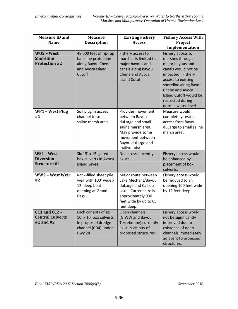
Environmental Consequences Volume III – Convey Atchafalaya River Water to Northern Terrebonne Marshes and Multipurpose Operation of Houma Navigation Lock
5-96
Final EIS WRDA 2007 Section 7006(e)(3) September 2010
Measure ID and Name
Measure Description
Existing Fishery Access
Fishery Access With Project
Implementation WO2 – West Shoreline Protection #2
48,000 feet of rip-rap bankline protection along Bayou Chene and Avoca Island Cutoff
Fishery access to marshes is limited to major bayous and canals along Bayou Chene and Avoca Island Cutoff
Fishery access to marshes through major bayous and canals would not be impacted. Fishery access to existing shoreline along Bayou Chene and Avoca Island Cutoff would be restricted during normal water levels.
WP1 – West Plug #1
Soil plug in access channel to small saline marsh area
Provides movement between Bayou duLarge and small saline marsh area. May provide some movement between Bayou duLarge and Caillou Lake.
Measure would completely restrict access from Bayou duLarge to small saline marsh area.
WS4 – West Diversion Structure #4
Six 15’ x 15’ gated box culverts in Avoca Island Levee
No access currently exists.
Fishery access would be enhanced by placement of box culverts.
WW2 – West Weir #2
Rock-filled sheet pile weir with 100’ wide x 12’ deep boat opening at Grand Pass
Major route between Lake Mechant/Bayou duLarge and Caillou Lake. Current size is approximately 900 feet wide by up to 65 feet deep.
Fishery access would be reduced to an opening 100 feet wide by 12 feet deep.
CC1 and CC2 – Central Culverts #1 and #2
Each consists of six 10’ x 10’ box culverts in proposed dredge channel (CD4) under Hwy 24
Open channels (GIWW and Bayou Terrebonne) currently exist in vicinity of proposed structures.
Fishery access would not be significantly improved due to existence of open channels immediately adjacent to proposed structures.
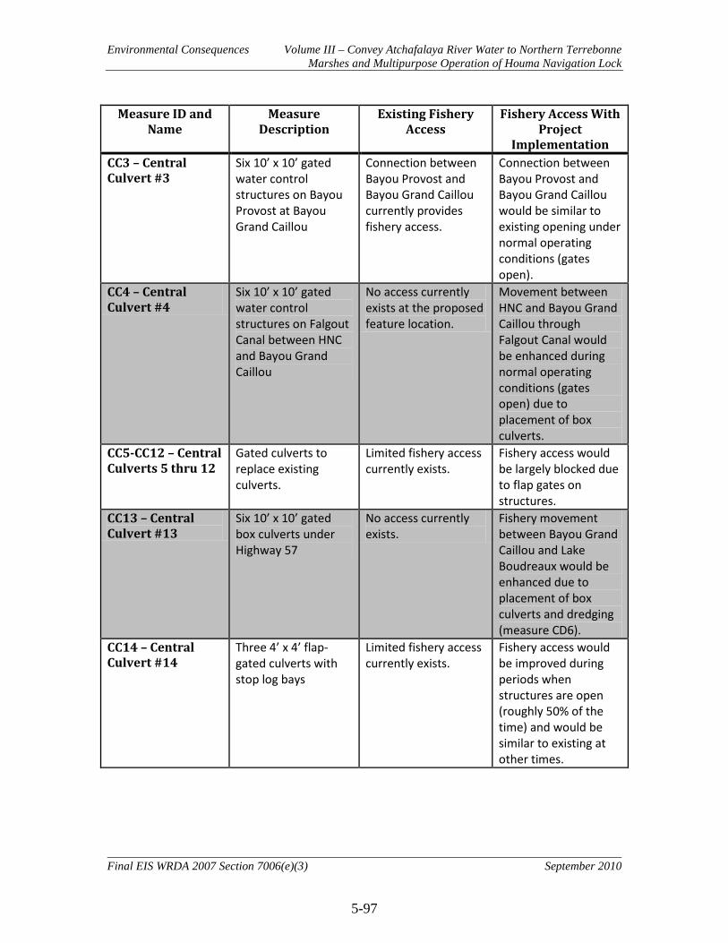
Environmental Consequences Volume III – Convey Atchafalaya River Water to Northern Terrebonne Marshes and Multipurpose Operation of Houma Navigation Lock
5-97
Final EIS WRDA 2007 Section 7006(e)(3) September 2010
Measure ID and Name
Measure Description
Existing Fishery Access
Fishery Access With Project
Implementation CC3 – Central Culvert #3
Six 10’ x 10’ gated water control structures on Bayou Provost at Bayou Grand Caillou
Connection between Bayou Provost and Bayou Grand Caillou currently provides fishery access.
Connection between Bayou Provost and Bayou Grand Caillou would be similar to existing opening under normal operating conditions (gates open).
CC4 – Central Culvert #4
Six 10’ x 10’ gated water control structures on Falgout Canal between HNC and Bayou Grand Caillou
No access currently exists at the proposed feature location.
Movement between HNC and Bayou Grand Caillou through Falgout Canal would be enhanced during normal operating conditions (gates open) due to placement of box culverts.
CC5-CC12 – Central Culverts 5 thru 12
Gated culverts to replace existing culverts.
Limited fishery access currently exists.
Fishery access would be largely blocked due to flap gates on structures.
CC13 – Central Culvert #13
Six 10’ x 10’ gated box culverts under Highway 57
No access currently exists.
Fishery movement between Bayou Grand Caillou and Lake Boudreaux would be enhanced due to placement of box culverts and dredging (measure CD6).
CC14 – Central Culvert #14
Three 4’ x 4’ flap-gated culverts with stop log bays
Limited fishery access currently exists.
Fishery access would be improved during periods when structures are open (roughly 50% of the time) and would be similar to existing at other times.
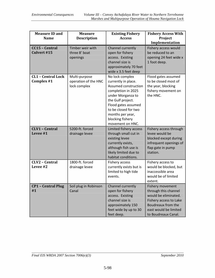
Environmental Consequences Volume III – Convey Atchafalaya River Water to Northern Terrebonne Marshes and Multipurpose Operation of Houma Navigation Lock
5-98
Final EIS WRDA 2007 Section 7006(e)(3) September 2010
Measure ID and Name
Measure Description
Existing Fishery Access
Fishery Access With Project
Implementation CC15 – Central Culvert #15
Timber weir with three 8’ boat openings
Channel currently open for fishery access. Existing channel size is approximately 70 feet wide x 3.5 feet deep
Fishery access would be reduced to an opening 24 feet wide x 1 foot deep.
CL1 – Central Lock Complex #1
Multi-purpose operation of the HNC lock complex
No lock complex currently in place. Assumed construction completion in 2025 under Morganza to the Gulf project. Flood gates assumed to be closed for two months per year, blocking fishery movement on HNC.
Flood gates assumed to be closed most of the year, blocking fishery movement on the HNC.
CLV1 – Central Levee #1
5200-ft. forced drainage levee
Limited fishery access through small cut in existing levee currently exists, although fish use is likely limited due to habitat conditions.
Fishery access through levee would be blocked except during infrequent openings of flap gate in pump station.
CLV2 – Central Levee #2
1800-ft. forced drainage levee
Fishery access currently exists but is limited to high tide events.
Fishery access to would be blocked, but inaccessible area would be of limited extent.
CP1 – Central Plug #1
Soil plug in Robinson Canal
Channel currently open for fishery access. Existing channel size is approximately 150 feet wide by up to 30 feet deep.
Fishery movement through this channel would be eliminated. Fishery access to Lake Boudreaux from the east would be limited to Boudreaux Canal.

Environmental Consequences Volume III – Convey Atchafalaya River Water to Northern Terrebonne Marshes and Multipurpose Operation of Houma Navigation Lock
5-99
Final EIS WRDA 2007 Section 7006(e)(3) September 2010
Measure ID and Name
Measure Description
Existing Fishery Access
Fishery Access With Project
Implementation CP2 – Central Plug #2
Soil plug in canal. Fishery access is currently poor due to remnant of plug at feature location. Existing channel size is approximately 50 feet wide by variable shallow depth.
Measure would completely restrict fishery movement in canal. However, access would still exist in adjacent canal (see CC15 above)
CS1 – Central Diversion Structure #1
Six 10’ x 10’ gated box culverts on Bayou Butler
Limited fishery access currently exists.
Fishery access would be enhanced under normal operating conditions (gates open).
EC2 – East Culvert #2
Five 5’ x 5’ gated box culverts in canal
Fishery access currently exists.
Fishery access would be similar to existing under normal operating conditions (gates open).
EC3 – East Culvert #3
Ten 5’ x 5’ gated box culverts with variable crest outfall
No fishery access currently exists.
Fishery access would be limited under normal operating conditions due to variable crest outfall and gates. Access would be enhanced during periods when structure is open.
EC5 – East Culvert #5
470 ft. wide by 14 foot deep gated water control structure under Hwy 24 at Grand Bayou
No fishery access currently exists.
Fishery access would be enhanced under normal operating conditions (gates open) in conjunction with dredging (ED5).
EC6 and EC7 – East Culverts #6 and #7
Each consists of eight 8’ x 8’ gated box culverts on St. Louis Canal
Limited fishery access currently exists.
Fishery access would be enhanced under normal operating conditions (gates open) in conjunction with dredging (ED2).
EG1 and EG2 – East Spoil Gap #1 and #2
Gaps in canal spoil banks.
No fishery access currently exists.
Fishery access would be enhanced.

Environmental Consequences Volume III – Convey Atchafalaya River Water to Northern Terrebonne Marshes and Multipurpose Operation of Houma Navigation Lock
5-100
Final EIS WRDA 2007 Section 7006(e)(3) September 2010
Measure ID and Name
Measure Description
Existing Fishery Access
Fishery Access With Project
Implementation EP7 – East Plug #7 Weir with 20’ wide x
5’ deep boat bay on Cutoff Canal north of Bayou Point au Chien
Channel currently open for fishery access. Existing channel size is approximately 350 feet wide x 12 feet deep.
Fishery access would be reduced to an opening 20 feet wide by 5 feet deep.
EP8 – East Plug #8 Soil plug in Bayou L’eau Bleu adjacent to Hwy 24
Channel currently open for fishery access. Existing channel size is approximately 100 feet wide x 10 feet deep.
Fishery access through Bayou L’eau Bleu would be eliminated. However, modification of the proposed feature to include a gated structure may be needed in order to accommodate local drainage, thereby providing some fishery access.
ES2 – East Diversion Structure #2
4000 cfs pump station
No fishery access currently exists.
Fishery access would be blocked during normal pump operation. Fishery access would be enhanced, in conjunction with dredging (ED5), when pump is not being operated and gates are open.
EX1– East Removal #1
Removal of rock weir across canal
Fishery access is currently limited due to weir across canal.
Fishery access would be enhanced.
EX2– East Removal #2
Removal of soil plug in canal
Fishery access is currently limited due to plug.
Fishery access would be enhanced.
Dredge Channels Dredge channels of various lengths, widths, and depths
Variable Fishery access would improve with all dredge features.

Environmental Consequences Volume III – Convey Atchafalaya River Water to Northern Terrebonne Marshes and Multipurpose Operation of Houma Navigation Lock
5-101
Final EIS WRDA 2007 Section 7006(e)(3) September 2010
Measure ID and Name
Measure Description
Existing Fishery Access
Fishery Access With Project
Implementation Marsh Berms Marsh berms of
various lengths Variable Fishery access would
be blocked in immediate vicinity of berms but fishery access in broader area is not expected to be impacted due to other routes of ingress and egress.
Marsh Terracing Marsh terraces of various sizes
Currently open water Fishery access would not be impacted.
5.9.3 Alternative 3
Direct, indirect, and cumulative impacts of Alternative 3 would be similar to Alternative 2. Alternative 3 is projected to provide a net benefit of 3,325 AAHUs compared to the No Action Alternative (see Figure 5.3). 5.9.4 Alternative 4
5.9.4.1 Direct Direct impacts of Alternative 4 on fisheries resources are expected to be similar to Alternative 2. However, reductions in salinities in the Grand Bayou basin would be much more pronounced than with Alternative 2. Average annual salinity values in the Grand Bayou basin are projected to be between 6.6ppt and 11.6ppt lower than with No Action over the period of analysis. Lower salinity water is expected to extend much further into the Grand Bayou basin during the dry and wet seasons as evidenced by projected changes in isohalines (Figures 5.23 and 5.24). These changes in salinity would cause much more dramatic shifts in the fish and shellfish communities in the area. In addition, construction of the plug in Bayou L’eau Blue and the pump station at Grand Bayou would impede organism movement between the GIWW and Grand Bayou. 5.9.4.2 Indirect Indirect impacts of Alternative 4 on fisheries resources are expected to be similar to Alternative 2, but to a greater degree. Alternative 4 is projected to provide 4,258 AAHUs compared to the No Action Alternative (see Figure 5.4). 5.9.4.3 Cumulative Cumulative impacts of Alternative 4 on fisheries resources are expected to be similar to Alternative 2, but to a greater degree.
Environmental Consequences Volume III – Convey Atchafalaya River Water to Northern Terrebonne Marshes and Multipurpose Operation of Houma Navigation Lock
5-102
Final EIS WRDA 2007 Section 7006(e)(3) September 2010
5.9.5 Alternative 5
5.9.5.1 Direct Direct impacts of Alternative 5 on fisheries resources are expected to be similar to Alternative 2. However, reductions in salinities in the Grand Bayou basin would be much more pronounced than with Alternative 2. Average annual salinity values in the Grand Bayou basin are projected to be between 6.6ppt and 11.6ppt lower than with No Action over the period of analysis. Lower salinity water is expected to extend much further into the Grand Bayou basin during the dry and wet seasons as evidenced by projected changes in isohalines (Figures 5.25 and 5.26). These changes in salinity would cause much more dramatic shifts in the fish and shellfish communities in the area. In addition, construction of the plug in Bayou L’eau Blue and the pump station at Grand Bayou would impede organism movement between the GIWW and Grand Bayou. 5.9.5.2 Indirect Indirect impacts of Alternative 5 on fisheries resources are expected to be similar to Alternative 2, but to a greater degree. Alternative 5 is projected to provide 4,719 AAHUs compared to the No Action Alternative (see Figure 5.5). 5.9.5.3 Cumulative Cumulative impacts of Alternative 5 on fisheries resources are expected to be similar to Alternative 2, but to a greater degree. 5.9.6 Alternative 6
5.9.6.1 Direct Direct impacts of Alternative 6 on fisheries resources are expected to be similar to Alternative 2, but to a lesser degree. Reductions in salinities in the Lake Mechant area, Lake Boudreaux, and the Grand Bayou area would be much less pronounced than with Alternative 2 due to the lack of implementation of flow management measures. According to modeled salinity values, changes in average annual salinities (see Figure 5.14) in the project area, as compared to the No Action Alternative, generally range from increases of 0.2ppt (areas H2 and Big Carencro Bayou) to decreases of 2.2ppt (Grand Bayou Basin). Projected isohaline lines for Alternative 6 are similar to the No Action Alternative during dry season conditions (Figure 5.27). During wet season conditions, lower salinity water extends further into the Grand Bayou basin (Figure 5.28). Organism ingress and egress impacts due to features WP1 and CP1 would be eliminated under Alternative 6. However, the modified operation of the lock complex (CL1) would still impact organism movement.

Environmental Consequences Volume III – Convey Atchafalaya River Water to Northern Terrebonne Marshes and Multipurpose Operation of Houma Navigation Lock
5-103
Final EIS WRDA 2007 Section 7006(e)(3) September 2010
5.9.6.2 Indirect Indirect impacts of Alternative 6 on fisheries resources are expected to be similar to Alternative 2, but to a lesser degree. Alternative 6 is projected to provide 776 AAHUs compared to the No Action Alternative (see Figure 5.6). 5.9.6.3 Cumulative Cumulative impacts of Alternative 6 on fisheries resources are expected to be similar to Alternative 2, but to a lesser degree. 5.9.7 Alternative 7
5.9.7.1 Direct No direct impacts to fisheries resources due to construction activities would result from implementation of Alternative 7 due to the fact that Alternative 7 only involves the modified operation of the lock complex and does not involve any construction. Direct impacts due to changes in salinity levels would still occur, but to a much lesser degree than with Alternative 2. According to modeled salinity values, changes in average annual salinities (see Figure 5.15) in the project area, as compared to the No Action Alternative, generally range from increases of 0.6ppt (areas below the lock complex) to decreases of 2.3ppt (Lake Boudreaux area). Isohaline lines associated with Alternative 7 are very similar to No Action (Figures 5.29 and 5.30). Organism ingress and egress impacts due to features WP1 and CP1 would be eliminated under Alternative 7. However, the modified operation of the lock complex (CL1) would still impact organism movement. 5.9.7.2 Indirect Indirect impacts of Alternative 7 on fisheries resources are expected to be similar to Alternative 2, but to a lesser degree. Alternative 7 is projected to provide 243 AAHUs compared to the No Action Alternative (see Figure 5.7). 5.9.7.3 Cumulative Cumulative impacts of Alternative 7 on fisheries resources are expected to be similar to Alternative 2, but to a lesser degree. 5.9.8 Alternative 8
5.9.8.1 Direct Direct impacts of Alternative 8 on fisheries resources are expected to be similar to Alternative 2, but to a lesser degree. Reductions in salinities in the Lake Mechant area would not occur due to the lack of implementation of dredge feature WD2 in the Penchant Basin. Salinity changes in the Lake Boudreaux and Grand Bayou areas would be similar to those associated with Alternative 2. According to modeled salinity values, changes in average annual salinities (see Figure 5.16) in the project area, as compared to

Environmental Consequences Volume III – Convey Atchafalaya River Water to Northern Terrebonne Marshes and Multipurpose Operation of Houma Navigation Lock
5-104
Final EIS WRDA 2007 Section 7006(e)(3) September 2010
the No Action Alternative, generally range from increases of 1.2ppt (area B5) to decreases of 2.8ppt (Lake Boudreaux area). Projected isohaline lines for Alternative 8 are similar to the No Action Alternative during dry season conditions (Figure 5.31). During wet season conditions, lower salinity water extends further into Lake Boudreaux and the Grand Bayou basin (Figure 5.32). Organism ingress and egress impacts due to feature WP1 would be eliminated under Alternative 8. However, the modified operation of the lock complex (CL1) and the Robinson Canal plug (CP1) would still impact organism movement. 5.9.8.2 Indirect Indirect impacts of Alternative 8 on fisheries resources are expected to be similar to Alternative 2, but to a lesser degree. Alternative 8 is projected to provide 1,214 AAHUs compared to the No Action Alternative (see Figure 5.8). 5.9.8.3 Cumulative Cumulative impacts of Alternative 8 on fisheries resources are expected to be similar to Alternative 2, but to a lesser degree.

Environmental Consequences Volume III – Convey Atchafalaya River Water to Northern Terrebonne Marshes and Multipurpose Operation of Houma Navigation Lock
5-105
Final EIS WRDA 2007 Section 7006(e)(3) September 2010
5.10 Essential Fish Habitat (EFH)
Per 50 CFR 600.920(e)(3), all EFH assessments must include the following information: Mandatory Contents of EFH Assessment
• Description of the action • Analysis of the potential adverse effects of the action on EFH and the managed
species • Federal agency’s conclusions regarding the effects of the action on EFH • Proposed mitigation, if applicable
Mandatory contents of the EFH assessment for the ARTM project can be found at the following locations within this document:
1. Description of the action. A description of each of the proposed Alternatives, a description of each measure included in each Alternative, and maps with locations of measures can be found in Section 3.3 of this document. A description of each of the proposed Alternatives is repeated at the beginning of Chapter 5, Environmental Consequences.
2. Analysis of the potential adverse effects of the action on EFH and the managed species. An analysis of the direct, indirect, and cumulative impacts of the Alternatives on EFH and managed species can be found below in this section. A description of historic and existing conditions of EFH in the project area can be found in Section 4.2.10 above. An analysis of the direct, indirect, and cumulative impacts of the Alternatives on fisheries in general can be found in Section 5.9 above. Wetland impact acreage estimates of each feature can be found in Table 5.2. Fishery access impacts of each feature can be found in Table 5.7.
3. Federal agency’s conclusions regarding the effects of the action on EFH. Despite some adverse impacts to EFH, the project is expected to result in a substantial net benefit to EFH when compared to the No Action Alternative. Specific conclusions regarding the effects on EFH can be found within the analysis of direct, indirect, and cumulative impacts of each Alternative below.
4. Proposed mitigation, if applicable. Alternatives were developed in accordance with Corps planning guidance at ER 1105-2-100 which directs that ecosystem restoration projects be designed to avoid the need for compensatory fish and wildlife mitigation. Formulation of project alternatives was conducted in compliance with this guidance. Only Alternative 7 would result in a net loss of emergent marsh habitat and would, therefore, require mitigation. Alternative 7 was not selected as the National Ecosystem Restoration plan or the Recommended Plan. Therefore, no discussion of proposed mitigation is presented. While compensatory mitigation is not warranted with regard to EFH, other measures in the form of impact avoidance and minimization will be undertaken during the pre-construction engineering and design phase.

Environmental Consequences Volume III – Convey Atchafalaya River Water to Northern Terrebonne Marshes and Multipurpose Operation of Houma Navigation Lock
5-106
Final EIS WRDA 2007 Section 7006(e)(3) September 2010
5.10.1 No Action Alternative (Future without Project Conditions)
Although previous restoration efforts in the LCA Study area have helped maintain some categories of EFH, the cumulative impacts of land loss, conversion of habitats, sea level change, increased storm intensity, etc., are expected to lead to a net decrease in the habitat most supportive of estuarine and marine species. The direct losses of highly productive forms of EFH would lead to losses of shallow habitat, due to the exposed nature of the shallow open water bottoms that are being formed. Shallow waters are likely to become deep waters, and salinity gradients would be less estuarine, with a sharper distinction between saline and freshwater habitat, as coastal residents further attempt to protect self and property with levees, flood gates, and other water control structures. It is believed that marsh loss that has been experienced to date has increased this land/water interface and increased fishery production. As land loss continues, it is believed that this interface would approach a maximum and begin to decline. This would, in turn, result in a decline in fishery production. In some areas, continued marsh loss is already resulting in the reduction of this interface. With no action, the conversion of categories of EFH, such as inner marsh and marsh edge, to estuarine water column and mud, sand, or shell substrates is expected to continue. Over time, the no action alternative would result in a substantial decrease in the quality of EFH in the project area, and reduce the area’s ability to support Federally managed species. Analysis of rates of wetland loss in the project area indicated that approximately 21% of the wetlands will be lost by the year 2065. The Future Without-Project condition would indirectly impact species that are linked in the food chain to directly affected species. Population reductions in directly affected species, such as brown shrimp and white shrimp, affect species dependent on shrimp for food. As marsh, barrier islands, and other EFH are directly lost, less protection would be available to remaining EFH. These areas would be more susceptible to storm, wind, and wave erosion. A decrease in species productiveness would result as populations are stressed by habitat displacement and reduction. 5.10.2 Alternative 2 (NER Plan and RP)
5.10.2.1 Direct Implementation of Alternative 2 would result in some emergent wetland EFH being directly converted to open water. These direct impacts would be the result of dredge features WD2, CD1, CD3, CD6, ED2, ED3, ED6, and ED7. These features would impact a total of 773 acres of marsh habitat. These features would also impact 614 acres of open water habitat (Table 5.2). It should be noted that, for purposes of impact analysis associated with dredge features for all Alternatives, the assumption was made that the dredge channel itself and the adjacent disposal site would result in marsh impacts. In reality, dredged material will be used beneficially to create marsh habitat to the maximum extent practicable. However, the exact nature of the dredged material and its utility in

Environmental Consequences Volume III – Convey Atchafalaya River Water to Northern Terrebonne Marshes and Multipurpose Operation of Houma Navigation Lock
5-107
Final EIS WRDA 2007 Section 7006(e)(3) September 2010
marsh creation, the locations of marsh creation sites, and the acreage of created marsh habitat will not be determined until a later date, during pre-construction engineering and design. Therefore, the aforementioned assumptions were necessary in order to complete the impact analysis for project features. In light of this, the estimates of negative impacts to marsh should be viewed as maximums as they should be offset at least in part by beneficially using dredged material during construction. Temporary impacts to EFH would also occur in temporary work areas needed for construction of project features. It is estimated that 585 acres of upland and open water habitat for temporary work areas would be needed for construction of Alternative 2. The exact nature, extent, and duration of temporary work areas and associated impacts would be determined during pre-construction engineering and design. Impacts would be kept to a minimum by use of Best Management Practices. Alternative 2 would also create 329 acres of marsh habitat as a result of features CM2, CM3, CM4, CT1, CT2, CT3, CT6, CT7, CT8, EM1, and EM3 (Table 5.2). Direct negative impacts to EFH would be offset by the indirect benefits that Alternative 2 provides to high quality EFH (i.e. emergent wetland and submerged aquatic vegetation) over much larger areas (see indirect benefits below). 5.10.2.2 Indirect Alternative 2 would reduce land loss in the project area from 101,570 acres to 91,915 acres, thus preventing the loss of 9,655 acres of emergent marsh habitat over the 50-year period of analysis when compared to the No Action Alternative. With implementation of Alternative 2, important categories of EFH such as emergent wetlands would not be converted to less productive forms of EFH (e.g., estuarine water column, and mud, sand, or shell substrates) as is expected with no action. Anticipated increases in SAVs would increase the amount of habitat available for juvenile life stages to escape predation and therefore increase the quality of habitat. Alternative 2 would benefit categories of EFH that have been designated for white shrimp, brown shrimp, red drum, and gulf stone crab. In addition, categories of EFH that are maintained in quality would be supportive of economically important estuarine-dependent species such as spotted seatrout, sand seatrout, southern flounder, black drum, gulf menhaden, striped mullet, Atlantic croaker, and blue crab. Some of these species serve as prey for other species managed under the Magnuson-Stevens Act (e.g., mackerels, snappers, and groupers) and highly migratory species managed by NMFS (e.g., billfishes and sharks). Although implementation of Alternative 2 is projected to result in a reduction in the rate of loss of emergent marsh habitat across the project area, some areas are projected to be negatively impacted. The area below the HNC lock complex and the southwest area of Lake Boudreaux are the main areas expected to be negatively impacted by reduction in freshwater flows. Emergent wetland EFH in these areas is expected to be converted to less productive forms at a faster rate than would be expected with no action.

Environmental Consequences Volume III – Convey Atchafalaya River Water to Northern Terrebonne Marshes and Multipurpose Operation of Houma Navigation Lock
5-108
Final EIS WRDA 2007 Section 7006(e)(3) September 2010
Organism access to essential fish habitat would be impeded by some structures included in Alternative 2 and would be enhanced by others. Table 5.7 summarizes fishery access impacts by feature. Features potentially having a negative impact on large areas include WW2, CL1, CP1, and EP7. The weir at Grand Pass (WW2) would reduce the size of the channel between Lake Mechant and Caillou Lake from 900 feet wide by 65 feet deep down to 100 feet wide by 12 feet deep. The modified operation of the lock complex (CL1) would block organism movement in the HNC; however, other natural routes of movement (e.g. Bayou Grand Caillou) would remain open. The plug in Robinson Canal (CP1) would prevent organism movement between Lake Boudreaux and Bayou Petit Caillou, limiting access to Lake Boudreaux from the east to Boudreaux Canal. The weir at Cutoff Canal (EP7) would reduce the size of the canal from 350 feet wide by 12 feet deep down to 20 feet wide by 5 feet deep. 5.10.2.3 Cumulative Over the period of analysis, Alternative 2 would reduce land loss in the project area by 9,655 acres. When combined with CWPPRA and other Federal, state, local, and private restoration efforts, Alternative 2 would have an even greater impact on EFH resources, as those programs would work synergistically to improve habitat conditions across the coast. 5.10.3 Alternative 3
5.10.3.1 Direct Direct impacts of Alternative 3 would be similar to Alternative 2. 5.10.3.2 Indirect Indirect impacts of Alternative 3 would be similar to Alternative 2, but would provide greater benefits. Alternative 3 would reduce land loss in the project area from 101,570 acres to 91,262 acres, thus preventing the loss of 10,308 acres of emergent marsh habitat over the 50-year period of analysis when compared to the No Action Alternative. 5.10.3.3 Cumulative Cumulative impacts of Alternative 3 would be similar to Alternative 2, but to a greater degree. 5.10.4 Alternative 4
5.10.4.1 Direct Direct impacts of Alternative 4 would be similar to Alternative 2. 5.10.4.2 Indirect Indirect impacts of Alternative 4 would be similar to Alternative 2, but would provide greater benefits. Alternative 4 would reduce land loss in the project area from 101,570
Environmental Consequences Volume III – Convey Atchafalaya River Water to Northern Terrebonne Marshes and Multipurpose Operation of Houma Navigation Lock
5-109
Final EIS WRDA 2007 Section 7006(e)(3) September 2010
acres to 89,366 acres, thus preventing the loss of 12,204 acres of emergent marsh habitat over the 50-year period of analysis when compared to the No Action Alternative. Impediments to organism access above and beyond those associated with Alternative 2 would occur due to the plug on Bayou L’Eau Bleu. This would prevent organism movement between Grand Bayou and the GIWW. 5.10.4.3 Cumulative Cumulative impacts of Alternative 4 would be similar to Alternative 2, but to a greater degree. 5.10.5 Alternative 5
5.10.5.1 Direct Direct impacts of Alternative 5 would be similar to Alternative 2. 5.10.5.2 Indirect Indirect impacts of Alternative 5 would be similar to Alternative 2, but would provide greater benefits. Alternative 5 would reduce land loss in the project area from 101,570 acres to 87,636 acres, thus preventing the loss of 13,934 acres of emergent marsh habitat over the 50-year period of analysis when compared to the No Action Alternative. Impediments to organism access above and beyond those associated with Alternative 2 would occur due to the plug on Bayou L’Eau Bleu. This would prevent organism movement between Grand Bayou and the GIWW. 5.10.5.3 Cumulative Cumulative impacts of Alternative 5 would be similar to Alternative 2, but to a greater degree. 5.10.6 Alternative 6
5.10.6.1 Direct Implementation of Alternative 6 would result in some emergent wetland EFH being directly converted to open water. These direct impacts would be the result of dredge feature ED3 (Table 5.2). This feature would impact a total of 167 acres of marsh habitat. This feature would also impact 88 acres of open water habitat. 117 acres of upland and open water habitat for temporary work areas would be needed for construction of Alternative 6. Direct negative impacts to EFH would be offset by the indirect benefits that Alternative 6 provides to high quality EFH (i.e. emergent wetland and submerged aquatic vegetation) over much larger areas (see indirect benefits below). 5.10.6.2 Indirect Indirect impacts of Alternative 6 would be similar to Alternative 2, but would provide fewer benefits. After accounting for 167 acres of direct impacts, Alternative 6 would
Environmental Consequences Volume III – Convey Atchafalaya River Water to Northern Terrebonne Marshes and Multipurpose Operation of Houma Navigation Lock
5-110
Final EIS WRDA 2007 Section 7006(e)(3) September 2010
reduce land loss in the project area from 101,570 acres to 101,563 acres, thus preventing the loss of 7 acres of emergent marsh habitat over the 50-year period of analysis when compared to the No Action Alternative. Organism access to EFH could be impeded by the modified operation of the HNC lock complex (CL1); however, other natural routes of movement (e.g. Bayou Grand Caillou) would remain open. 5.10.6.3 Cumulative Over the period of analysis, Alternative 6 would reduce land loss in the project area by 7 acres. When combined with CWPPRA and other Federal, state, local, and private restoration efforts, Alternative 6 would have an even greater impact on EFH resources, as those programs would work synergistically to improve habitat conditions across the coast. 5.10.7 Alternative 7
5.10.7.1 Direct No direct impacts to EFH are anticipated for Alternative 7. 5.10.7.2 Indirect Alternative 7 would increase land loss in the project area from 101,570 acres to 104,221 acres, thus resulting in a net loss of 2,651 acres of emergent marsh habitat over the 50-year period of analysis when compared to the No Action Alternative. Impediments to organism access would result only from the modified operation of the lock complex (CL1). 5.10.7.3 Cumulative Cumulative impacts of Alternative 7 would be similar to Alternative 2, but to a lesser degree. 5.10.8 Alternative 8 5.10.8.1 Direct Implementation of Alternative 8 would result in some emergent wetland EFH being directly converted to open water. These direct impacts would be the result of dredge features CD1, CD6, ED3, and ED6 (Table 5.2). These features would impact a total of 270 acres of marsh habitat. These features would also impact 239 acres of open water habitat. 41 acres of upland and open water habitat for temporary work areas would be needed for construction of Alternative 8. Direct negative impacts to EFH would be offset by the indirect benefits that Alternative 8 provides to high quality EFH (i.e. emergent wetland and submerged aquatic vegetation) over much larger areas (see indirect benefits below).
Environmental Consequences Volume III – Convey Atchafalaya River Water to Northern Terrebonne Marshes and Multipurpose Operation of Houma Navigation Lock
5-111
Final EIS WRDA 2007 Section 7006(e)(3) September 2010
5.10.8.2 Indirect Indirect impacts of Alternative 8 on EFH would be similar to Alternative 2, but to a lesser degree. Alternative 8 would reduce land loss in the project area from 101,570 acres to 100,581 acres, thus preventing the loss of 989 acres of marsh habitat over the 50-year period of analysis when compared to the No Action Alternative. Organism ingress and egress impacts due to feature WP1 would be eliminated under Alternative 8. However, the modified operation of the lock complex (CL1) and the Robinson Canal plug (CP1) would still impact organism movement. 5.10.8.3 Cumulative Cumulative impacts of Alternative 8 on EFH would be similar to Alternative 2, but to a lesser degree.

Environmental Consequences Volume III – Convey Atchafalaya River Water to Northern Terrebonne Marshes and Multipurpose Operation of Houma Navigation Lock
5-112
Final EIS WRDA 2007 Section 7006(e)(3) September 2010
5.11 Threatened and Endangered Species Appendix A contains a Biological Assessment of threatened and endangered species and the potential impacts of project implementation on those species. 5.11.1 No Action Alternative (Future without Project Conditions)
The No Action Alternative would result in the continued degradation and loss of important and essential fish and wildlife habitats used by many different fish and wildlife for shelter, nesting, feeding, roosting, cover, nursery, and other life requirements. The loss and deterioration of transitional wetland habitats would continue to impact, to some undetermined degree, all listed species that potentially utilize the project area including: West Indian manatee, piping plover, pallid sturgeon, Gulf sturgeon, green sea turtle, hawksbill sea turtle, Kemp’s Ridley sea turtle, leatherback sea turtle, and loggerhead sea turtle. Adverse cumulative impacts on listed species would be offset, to some degree, by the positive impacts of implementing other Federal, state, local, and private restoration projects. 5.11.2 Alternative 2 (NER Plan and RP)
5.11.2.1 Direct West Indian Manatee Any effects to the West Indian manatee from implementing Alternative 2 would be related to possible collision with service vessels during construction and maintenance activities. Should any manatees be encountered during the proposed activities, an on-board observer would notify the proper personnel, and harmful activities (e.g., dredging) would be temporarily suspended until the animal(s) moves out of the area of operations. Any disturbance to the manatee would only be temporary during construction activities, and would result in temporary displacement. The manatees would likely move and relocate to other nearby areas for foraging or resting purposes. Because the West Indian manatee may occur in the project vicinity, the Contractor shall instruct all personnel associated with the project of the potential presence of manatees in the area, and the need to avoid collisions with these animals. All construction personnel shall be advised that there are civil and criminal penalties for harming, harassing, or killing manatees, which are protected under the Marine Mammal Protection Act of 1972 and the Endangered Species Act of 1973. The Contractor shall be held responsible for any manatee harmed, harassed, or killed as a result of construction activities not conducted in accordance with these specifications. Piping Plover It is possible that piping plovers may be found utilizing exposed sand, mud, or algal flats in the southern portions of the proposed project boundaries. However, piping plovers are more likely to be foraging and roosting on barrier island and barrier headland habitats located farther south of the project boundaries. The project area is being located well north of any designated critical habitat units for the piping plover. Accordingly, the
Environmental Consequences Volume III – Convey Atchafalaya River Water to Northern Terrebonne Marshes and Multipurpose Operation of Houma Navigation Lock
5-113
Final EIS WRDA 2007 Section 7006(e)(3) September 2010
proposed activities are not likely to adversely affect the piping plover (Ronald Paille, USFWS personal communication 2010). Pallid Sturgeon While there are records of the pallid sturgeon occurring in the Atchafalaya River, there are none for the project area itself (Schramm 2008; Paul Hartfield, USFWS personal communication 2010; Jack Kilgore, ERDC personal communication 2010). The pallid sturgeon is a river species that rarely travels into the marshes of the project area. Diversion of water from the Atchafalaya River into the marshes will not appreciably change the characteristics of the river. Accordingly, the proposed activities are not likely to adversely affect the pallid sturgeon. Gulf Sturgeon The Gulf Sturgeon in the Gulf of Mexico is primarily found between Tampa Bay Florida and the Mississippi River (Wooley 1985).Very few records exist for the Gulf sturgeon occurring west of the Mississippi River (Wooley 1985; Todd Slack, ERDC personal communication 2010). There is no critical habitat located in the project area. The project is not likely to have an adverse effect on the Gulf Sturgeon due to its low probability of occurrence and lack of suitable habitat in the project area. Green Sea Turtle Due to the lack of extensive seagrass beds in coastal Louisiana and the low incidence of sightings and strandings, the proposed actions are not likely to adversely affect green sea turtle populations. Hawksbill Sea Turtle Due to its rarity along the Louisiana coast, the proposed actions are not likely to adversely impact hawksbill sea turtle populations. Kemp’s Ridley Sea Turtle Kemp’s Ridley sea turtles concentrate near the mouths of rivers and in areas of low salinity with high turbidity to forage for prey, including shrimp. The proposed actions are not likely to adversely impact Kemp’s Ridley sea turtle populations. Leatherback Sea Turtle Leatherback sea turtles occur mostly in continental shelf waters more than 164 ft (50 m) in depth. There are no known nesting records for this species reported for Louisiana. The proposed actions are not likely to adversely impact populations of leatherback sea turtles. Loggerhead Sea Turtle The only loggerhead sea turtle nesting sites historically observed in Louisiana were on the Chandeleur Islands. The proposed action would have no impacts on existing barrier island habitats. Hence, the proposed actions are not likely to adversely impact loggerhead sea turtle populations.
Environmental Consequences Volume III – Convey Atchafalaya River Water to Northern Terrebonne Marshes and Multipurpose Operation of Houma Navigation Lock
5-114
Final EIS WRDA 2007 Section 7006(e)(3) September 2010
5.11.2.2 Indirect It is unlikely that any of the features associated with implementation of Alternative 2 would present significantly adverse indirect impacts to any threatened or endangered species. On the contrary, all restoration features would likely provide a net increase of coastal wetland habitats potentially used by these species. 5.11.2.3 Cumulative There would be negligible, if any, negative impacts associated with implementation of Alternative 2. Hence, based upon the potential direct, indirect, and cumulative impacts, implementation of Alternative 2 is not likely to adversely affect threatened or endangered species or their critical habitat. 5.11.3 Alternative 3
Direct, indirect, and cumulative impacts of Alternative 3 on threatened and endangered species and their critical habitat would be similar to Alternative 2. 5.11.4 Alternative 4
Direct, indirect, and cumulative impacts of Alternative 4 on threatened and endangered species and their critical habitat would be similar to Alternative 2. 5.11.5 Alternative 5
Direct, indirect, and cumulative impacts of Alternative 5 on threatened and endangered species and their critical habitat would be similar to Alternative 2. 5.11.6 Alternative 6
Direct, indirect, and cumulative impacts of Alternative 6 on threatened and endangered species and their critical habitat would be similar to Alternative 2. 5.11.7 Alternative 7 Direct, indirect, and cumulative impacts of Alternative 7 on threatened and endangered species and their critical habitat would be similar to Alternative 2. 5.11.8 Alternative 8 Direct, indirect, and cumulative impacts of Alternative 8 on threatened and endangered species and their critical habitat would be similar to Alternative 2.

Environmental Consequences Volume III – Convey Atchafalaya River Water to Northern Terrebonne Marshes and Multipurpose Operation of Houma Navigation Lock
5-115
Final EIS WRDA 2007 Section 7006(e)(3) September 2010
5.12 Cultural and Historic Resources The complete cultural resources report can be found at Appendix F. In satisfaction of Section 106 of the NHPA, a Programmatic Agreement (PA) between USACE-MVN, SHPO, ACHP, and CPRA has been developed to address the needs of LCA projects including Convey Atchafalaya River Water to North Terrebonne Marshes. Federally recognized tribes, State tribes, and local governments have been invited to participate as consulting parties. A copy of the PA appears at Appendix F. Appendix F also describes the physiographic setting, geomorphic history and the previous research conducted within the study area. Statistical modeling was used to examine correlations between settlement and prominent landforms. A cost estimate for the archaeological surveys, monitoring, etc., necessary to address the project’s direct impact on cultural resources is provided at its conclusion. There are eight (8) locations listed on the National Register than are within the project boundary. There are an additional six (6) within a one kilometer radius of the area. Of the National Register locations, only the Wesley House is located in close proximity to a potential project feature being within 100 meters from features CC2 and CD4. A private cemetery associated with the Wesley House is within the AOE of CD4 (see discussion of the Gagne Cemetery at end of Appendix F). Assuming a typical survey corridor of 100 meters, a total of 19,910 acres within the proposed project area have been recorded as having undergone an archaeological survey. This amounts to just under three percent of the total area. This number may be an underestimate as many recorded sites fall outside the recorded survey tracks. Older surveys may not be recorded on the maps of the Louisiana State Historical Preservation Office from which this dataset was derived. The vast majority of site record forms list “natural levee” as the landform associated with the sites with no other single category representing any significant percentage. Site correlation to regional-scale landforms was also undertaken within the project GIS. Site features were spatially joined to a digitized version of a 1:500,000 scale Geologic Map of Louisiana developed by the Louisiana Geological Survey. The relatively small scale of the map led to some sites falling into obviously incorrect areas (e.g., known terrestrial sites falling into the “water” category). Moreover, the map scale only allows the broadest expression of landforms to be mapped. Natural levees, for example, are limited to major ones located along the primary bayous. The number of sites located on “alluvium” and “natural levees” is higher than what would have been expected given a random distribution of sites across the landscape. A chi-squared goodness-of-fit test was conducted to assess the statistical association between sites and the mapped landform. Based upon the total area of the various geologic categories within the project area an expected number of sites to be located within each category were generated. This expected number of sites was compared to the known number and a chi-square test used to assess the statistical significance of the difference. The results indicate that it is statistically considered extremely unlikely that the distribution would have occurred randomly. As the boundaries between “Fresh Marsh” and “Saline Marsh” categories

Environmental Consequences Volume III – Convey Atchafalaya River Water to Northern Terrebonne Marshes and Multipurpose Operation of Houma Navigation Lock
5-116
Final EIS WRDA 2007 Section 7006(e)(3) September 2010
were thought to be temporally sensitive they were combined and the analysis performed again. Again, the difference in distributions was considered significant. Given the statistics, it might be proposed that levees and areas of alluvium were preferentially selected for site location by people. Other mitigating factors, however, need to be taken into account. For example, the perceived preference of site location may be simply be a function of where archaeological surveys have historically been undertaken. Indeed, when the known geologic provenience of survey tracks are themselves queried against a random landform distribution, the difference is consistently statistically significant. The results are not dissimilar to site/geologic correlations with “alluvium” and “natural levees” being over represented. In simple terms, at least some of the apparent site location preferences are doubtless attributable to the bias for archaeological surveys to be conducted on those landforms. To account for this survey locational bias, a further couple of chi-square tests were performed using the survey geological associations rather than the total project area associations. In this way, if site associations with geologic categories are statistically different from the survey areas association with those categories, it can be asserted that the site associations are not solely attributable to the latter. Again, the two-tailed P value is considered significant. This association of sites to levee and alluvial geological areas is not unexpected and indeed, if anything, may be under-represented. An 1895 map of the region was digitized and georeferenced for comparison to the geologic map. The areas in the historic map without hatching represent natural levees and other elevated areas. The hatched areas represent marsh lands (there named “prairie”). The elevated areas correspond well with the areas designated “natural levee” on the geologic maps and to a lesser extent with those designated “alluvium.” It is interesting, however, that the historic map shows the levees extending much further south along the bayous than the geologic map. Consequently, many sites that are associated with marsh land on the geologic map are associated with natural levee land on the historic map. A clear example is the string of sites along the lower Bayou du Large. Again, the chi-square statistic indicates that the non-random correlation is highly significant. It is clear from both the micro-scale landforms listed on the State Site Record Forms and the macro-scale landform statistics presented above that the elevated landforms (i.e., natural levees and alluvium regions) are significantly more likely to contain archaeological resources. As such, they are considered in this study as “higher probability areas” while the delta marshes are considered “lower probability areas.” Both the SHPO and Tribes were contacted by the St. Louis District Engineering and Construction Division Curation and Archives Analysis Branch between mid-May and early-June of 2009. SHPO notification is dated May 19, 2009 and was sent to the attention of Mr. Scott Hutcheson, Office of Historic Preservation, Capitol Annex Building, P.O. Box 44247, Baton Rouge, Louisiana 70804. Tribal notification was sent by the district’s Native American Coordinator, Roberta L. Hayworth, to elected Tribal Leaders and appointed Tribal Representatives for the following Nations.
Environmental Consequences Volume III – Convey Atchafalaya River Water to Northern Terrebonne Marshes and Multipurpose Operation of Houma Navigation Lock
5-117
Final EIS WRDA 2007 Section 7006(e)(3) September 2010
• Alabama Coushatta Tribe of Texas • Caddo Nation of Oklahoma • Chitimacha Tribe of Louisiana • Choctaw Nation of Oklahoma • Coushatta Tribe of Louisiana • Jena Band of Choctaw • Mississippi Band of Choctaw • Quapaw Tribe of Oklahoma • Seminole Nation of Oklahoma • Seminole Tribe of Florida • Tunica-Biloxi Tribe of Louisiana
No written responses to these notifications were received by the St. Louis District Office. A notice of intent to prepare a draft EIS for this project was published in the Federal Register (Vol. 73 No. 246) on December 22, 2008. Two public scoping meetings have been held, first on February 3, 2009, and on the following day, February 4, 2009 in Houma and Morgan City respectively. More than 350 media outlets were provided with the advisory announcing these meetings. Visits to the Baton Rouge Office of Historic Preservation were undertaken by St. Louis District cultural resources POC, Susan Malin-Boyce, on February 19, 2009 and February 20, 2009 to meet with the Louisiana State Archaeologist and review survey reports for the proposed project area. Subsequent meetings with the Louisiana State Archaeologist were attended on July 1, 2009, and November 4, 2009. A draft copy of this report Appendix was submitted to the Louisiana State Archaeologist for review and comment. Disturbances to archaeological resources can result from both construction of project features and the long-term operational effects of the features in an integrated system. While construction disturbances are relatively straightforward to quantify, operational disturbances are harder to measure at this juncture. Construction Disturbances Sixty-five project features are proposed in the current (December 11, 2009) range of alternatives. These areas are expected to be disturbed by construction activity. A subtotal of the various landform acreage affected is presented in Appendix F. The numbers represent a sum for all the features from all project alternatives. Operational Disturbances While construction of individual project features has an immediate impact on their surrounding environment, as an integrated system they are designed to affect the regional environment at large. These “operational disturbances” are much more likely to affect the cultural resources within the project area as they impact a much larger area than the construction of individual features. Examples of such effects include increased erosion of riverbanks and shorelines due to changing water flow patterns and increased sedimentation or overburden. While the “burying” of archaeological resources is
Environmental Consequences Volume III – Convey Atchafalaya River Water to Northern Terrebonne Marshes and Multipurpose Operation of Houma Navigation Lock
5-118
Final EIS WRDA 2007 Section 7006(e)(3) September 2010
generally considered a benign, or even beneficial, effect, erosion shorelines or river banks is a major concern as it may result in the destruction of cultural resources. At this point in the projects feasibility study, it is not possible to model the effects of the operational disturbance to archaeological resources over the long term. Fourteen sites are located within 100 meters of a proposed project feature, as the latter are represented within the project GIS. Two of the sites are within 10 meters and three are in actual contact with a project feature. Two of the sites are described in their State Site Record files as being “eligible” for listing in the National Register of Historic Places (NRHP), five as “unknown” and seven as “not eligible.” A fifteenth site (16SMY49) was identified as being located within 100 meters of a feature during GIS analysis. The site, however, appears to be mapped incorrectly in the Louisiana State cultural resources GIS. It is visible in satellite imagery to the north of its mapped location, both protected by a breakwater and further than 100 meters from any proposed project features. Its physical location was confirmed visually during the project area reconnaissance.
• Two hundred and ninety (290) known archaeological sites are located in the project area as currently delineated.
• Many of these archaeological sites were recorded more than 20 years ago. • There is a relative paucity of previously identified archaeological sites that have
yielded datable materials. • Many sites that have reliable cultural associations were repeatedly occupied, so
for instance a site may have a Marksville (AD 1-400) occupation followed by Baytown (AD 400-700) or Coles Creek (AD 700-1200), a Mississippian occupation (AD 1200-1700), an early settler’s farm and then a modern plantation – because these were significant places in human memory, and also they were strategically located on high ground and next to distributary channels.
• Very few of the sites extend all the way back to the Poverty Point period (1000 BC to AD 1) and only a handful to the Marksville.
• Any site likely to be adversely impacted in the course of this project should be carefully considered for the contribution it may make to an understanding of the prehistory of this area.
• Sixty-seven (67) project features have been considered for adverse effect and budgetary purposes.
• Fourteen (14) known archaeological sites are located within 100 meters of a potential project feature.
• Thirteen residential structures and one recreational structure will require evaluation depending on the alternate chosen as they will need to be relocated.
• The National Register of Historic Places (NRHP) lists eight (8) locations within the project boundary.
• One (1) location listed on the NRHP (the Wesley House) is situated within 100 meters of a potential project feature.
• A small family cemetery of probably under ten (10) interments associated with the Wesley House (the Gagne cemetery) is within the APE of a project feature.

Environmental Consequences Volume III – Convey Atchafalaya River Water to Northern Terrebonne Marshes and Multipurpose Operation of Houma Navigation Lock
5-119
Final EIS WRDA 2007 Section 7006(e)(3) September 2010
• Operational effects (secondary impacts) of project features on the archaeological landscape have not been modeled for this feasibility study.
5.12.1 No Action Alternative (Future without Project Conditions)
5.12.1.1 Direct Subsidence and erosion are ongoing throughout the project area. In Future without Project Conditions site erosion processes and subsidence continue unabated. 5.12.1.2 Indirect Same as direct. 5.12.1.3 Cumulative Same as direct.
5.12.2 Alternative 2 (NER Plan and RP)
5.12.2.1 Direct Twenty-seven construction features require Phase I testing and or monitoring. There are eleven known archaeological sites within 100 m of features for which site assessments are required. One historic period cemetery is located within the impact area. Contingency must be allowed for Phase II or Phase III mitigation in the event that unknown cultural resources are encountered during survey or construction. 5.12.2.2 Indirect Long-term operational effects (secondary/indirect impacts) of project features on the archaeological landscape have not been modeled for this feasibility study. The scale of indirect impacts via erosion or site burial has not been determined because there is risk and uncertainty in the hydrologic influence that cannot be anticipated. 5.12.2.3 Cumulative Cumulative impacts cannot be predicted with the current state of available information. 5.12.3 Alternative 3
5.12.3.1 Direct Twenty-seven construction features require Phase I testing and or monitoring. There are thirteen known archaeological sites within 100 m of features for which site assessments are required. One historic period cemetery is located within the impact area. Contingency must be allowed for Phase II or Phase III mitigation in the event that unknown cultural resources are encountered during survey or construction.
Environmental Consequences Volume III – Convey Atchafalaya River Water to Northern Terrebonne Marshes and Multipurpose Operation of Houma Navigation Lock
5-120
Final EIS WRDA 2007 Section 7006(e)(3) September 2010
5.12.3.2 Indirect Long-term operational effects (secondary/indirect impacts) of project features on the archaeological landscape have not been modeled for this feasibility study. The scale of indirect impacts via erosion or site burial has not been determined because there is risk and uncertainty in the hydrologic influence that cannot be anticipated. 5.12.3.3 Cumulative Cumulative impacts cannot be predicted with the current state of available information. 5.12.4 Alternative 4
5.12.4.1 Direct Twenty-eight construction features require Phase I testing and or monitoring. There are twelve known archaeological sites within 100 m of features for which site assessments are required. One historic period cemetery is located within the impact area. Contingency must be allowed for Phase II or Phase III mitigation in the event that unknown cultural resources are encountered during survey or construction. 5.12.4.2 Indirect Long-term operational effects (secondary/indirect impacts) of project features on the archaeological landscape have not been modeled for this feasibility study. The scale of indirect impacts via erosion or site burial has not been determined because there is risk and uncertainty in the hydrologic influence that cannot be anticipated. 5.12.4.3 Cumulative Cumulative impacts cannot be predicted with the current state of available information. 5.12.5 Alternative 5
5.12.5.1 Direct Twenty-eight construction features require Phase I testing and or monitoring. There are fourteen known archaeological sites within 100 m of features for which site assessments are required. One historic period cemetery is located within the impact area. Contingency must be allowed for Phase II or Phase III mitigation in the event that unknown cultural resources are encountered during survey or construction. 5.12.5.2 Indirect Long-term operational effects (secondary/indirect impacts) of project features on the archaeological landscape have not been modeled for this feasibility study. The scale of indirect impacts via erosion or site burial has not been determined because there is risk and uncertainty in the hydrologic influence that cannot be anticipated.

Environmental Consequences Volume III – Convey Atchafalaya River Water to Northern Terrebonne Marshes and Multipurpose Operation of Houma Navigation Lock
5-121
Final EIS WRDA 2007 Section 7006(e)(3) September 2010
5.12.5.3 Cumulative Cumulative impacts cannot be predicted with the current state of available information. 5.12.6 Alt Alternative 6
5.12.6.1 Direct Six construction features require Phase I testing and or monitoring. There are nine known archaeological sites within 100 m of features for which site assessments are required. One historic period cemetery is located within the impact area. Contingency must be allowed for Phase II or Phase III mitigation in the event that unknown cultural resources are encountered during survey or construction. 5.12.6.2 Indirect Long-term operational effects (secondary/indirect impacts) of project features on the archaeological landscape have not been modeled for this feasibility study. The scale of indirect impacts via erosion or site burial has not been determined because there is risk and uncertainty in the hydrologic influence that cannot be anticipated. 5.12.6.3 Cumulative Cumulative impacts cannot be predicted with the current state of available information. 5.12.7 Alternative 7
5.12.7.1 Direct Report preparation for cultural resources literature review, and historic context and contingency allowance for testing and mitigation in the event that unknown cultural resources are encountered during construction or develop from the lock operation. 5.12.7.2 Indirect Long-term operational effects (secondary/indirect impacts) of project features on the archaeological landscape have not been modeled for this feasibility study. The scale of indirect impacts via erosion or site burial has not been determined because there is risk and uncertainty in the hydrologic influence that cannot be anticipated. 5.12.7.3 Cumulative Cumulative impacts cannot be predicted with the current state of available information. 5.12.8 Alternative 8 5.12.8.1 Direct Eighteen construction features require Phase I testing and or monitoring. There are four known archaeological sites within 100 m of features for which site assessments are

Environmental Consequences Volume III – Convey Atchafalaya River Water to Northern Terrebonne Marshes and Multipurpose Operation of Houma Navigation Lock
5-122
Final EIS WRDA 2007 Section 7006(e)(3) September 2010
required. Contingency must be allowed for Phase II or Phase III mitigation in the event that unknown cultural resources are encountered during survey or construction. 5.12.8.2 Indirect Long-term operational effects (secondary/indirect impacts) of project features on the archaeological landscape have not been modeled for this feasibility study. The scale of indirect impacts via erosion or site burial has not been determined because there is risk and uncertainty in the hydrologic influence that cannot be anticipated. 5.12.8.3 Cumulative Cumulative impacts cannot be predicted with the current state of available information.
Environmental Consequences Volume III – Convey Atchafalaya River Water to Northern Terrebonne Marshes and Multipurpose Operation of Houma Navigation Lock
5-123
Final EIS WRDA 2007 Section 7006(e)(3) September 2010
5.13 Aesthetics
5.13.1 No Action Alternative (Future without Project Conditions)
Loss of visual resources in the study area would continue under the No Action Alternative due to the incremental loss of wetlands and the natural ridges from sea level rise, subsidence and erosion. Wetland and shoreline erosion and associated wetland fragmentation’s conversion to open water may negatively affect the viewsheds within Mandalay National Wildlife Refuge and Pointe au Chiene Wildlife Management Area and along the Southern portions of the Wetlands Cultural Scenic Byway. Opportunities for visual use including wildlife observation, environmental interpretation and cultural awareness will diminish if the marsh and natural ridges erode. Cumulative impacts to visual resources under the No Action Alternative would be due to the historical and future incremental loss of wetlands and the natural ridges regionally and nationwide due to sea level rise, subsidence and erosion . Wetland and shoreline erosion and associated wetland fragmentation’s conversion to open water may negatively affect the viewsheds within significant visual resources including wildlife refuges and management areas and scenic streams and byways. Opportunities for visual use including wildlife observation, environmental interpretation and cultural awareness will diminish with the erosion of marsh and natural ridges. 5.13.2 Alternative 2 (NER Plan and RP)
5.13.2.1 Direct Direct impacts to visual resources may occur as the result of culvert construction and dredging operations at the intersection of Bayou Terrebonne and the GIWW in Houma. Public facilities including a parking area, marina, gazebos, and walking paths may allow visual access from the west side of the GIWW to the proposed project area from the North and South sides of Bayou Terrebonne; project construction details are insufficient to determine the magnitude of impacts to this visual resource. 5.13.2.2 Indirect Visual resources in the study area indirectly impacted under the proposed action would be due to enhanced and stabilized marsh and stabilized natural ridges. In particular, the enhanced and stabilized marsh and stabilized natural ridges may be beneficial to Mandalay National Wildlife Refuge and Pointe au Chien Wildlife Management Area and along the Southern portions of the Wetlands Cultural Scenic Byway. Increased opportunities for visual use including wildlife observation, environmental interpretation and cultural awareness may occur. 5.13.2.3 Cumulative Cumulative impacts to visual resources under the proposed action may be due to similar projects that enhance and stabilize marsh and stabilize natural ridges regionally and nationwide. Wetland and shoreline erosion and associated wetland fragmentation’s

Environmental Consequences Volume III – Convey Atchafalaya River Water to Northern Terrebonne Marshes and Multipurpose Operation of Houma Navigation Lock
5-124
Final EIS WRDA 2007 Section 7006(e)(3) September 2010
conversion to open water may be reversed beneficially affecting the viewsheds within significant visual resources including wildlife refuges and management areas and scenic streams and byways. Opportunities for visual use including wildlife observation, environmental interpretation and cultural awareness may increase with enhanced marsh and not diminish with stabilized marsh and natural ridges. 5.13.3 Alternative 3
Direct, indirect, and cumulative impacts of Alternative 3 on Aesthetics would generally be similar to Alternative 2. 5.13.4 Alternative 4
5.13.4.1 Direct Alternative 4 would have direct impacts similar to Alternative 2. 5.13.4.2 Indirect Alternative 4 would have indirect impacts similar to Alternative 2 on the visual resources within Mandalay Wildlife refuge and along the southern portions of the Wetlands Cultural Scenic Byway. Alternative 4 would enhance and stabilize marsh in Pointe au Chien Wildlife Management Area more than Alternative 2. 5.13.4.3 Cumulative Alternative 4 would have cumulative impacts similar to Alternative 2. 5.13.5 Alternative 5
Direct, indirect, and cumulative impacts of Alternative 5 on Aesthetics would generally be similar to Alternative 4. 5.13.6 Alternative 6
Direct, indirect, and cumulative impacts of Alternative 6 on Aesthetics would generally be similar to Alternative 2. 5.13.7 Alternative 7
Direct, indirect, and cumulative impacts of Alternative 7 on Aesthetics would generally be similar to Alternative 2. 5.13.8 Alternative 8 Direct, indirect, and cumulative impacts of Alternative 8 on Aesthetics would generally be similar to Alternative 2.
Environmental Consequences Volume III – Convey Atchafalaya River Water to Northern Terrebonne Marshes and Multipurpose Operation of Houma Navigation Lock
5-125
Final EIS WRDA 2007 Section 7006(e)(3) September 2010
5.14 Recreation
5.14.1 No Action Alternative (Future without Project Conditions)
Recreational resources in the entire region that would most likely be impacted under the No Action Alternative are those related to loss of wetlands and habitat diversity as well as substantial salinity changes. In the West region, wetlands and associated marsh habitat appear generally more stable than the Central and East regions due to freshwater and sediment provided by the Atchafalaya River, which is in close proximity. However, some portions of the West region, specifically the lower southeast portions are experiencing wetland loss and fragmentation. Under the No Action Alternative, in the West region, the floating marsh habitat, intermediate and brackish marsh habitat would continue to provide freshwater and saltwater based recreational opportunities, such as waterfowl hunting and fishing. However, over time, land and habitat loss and associated changes in salinity levels encroaching from the southeast could begin to negatively affect both freshwater and saltwater based fishing as well as waterfowl hunting. By taking no action, continued saltwater intrusion, wetland and shoreline erosion and associated wetland fragmentation and conversion to open water will likely continue in the Central and East regions with negative impacts on recreation resources. As marsh habitat decreases, areas for fish spawning decrease and ultimately the populations and diversity of fish species will diminish, which would affect recreational fishing opportunities negatively. Similarly, with less freshwater and intermediate marsh habitat, waterfowl hunting opportunities would likely decrease. Ridge habitat would also likely continue to decline, reducing opportunities for deer and other small game hunting. Long term impacts specifically in the Central and East regions may include loss of associated recreational support facilities such as marinas and bait shops that are the basis for most recreational use. This would result in a reduction in economic activity associated with recreation uses. Cumulative impacts are the impacts on the environment that will result from the incremental impact of the No Action Alternative from the other past, present, and reasonably foreseeable future actions regardless of what agency or person undertakes such other actions. Existing and planned projects in the project vicinity include those supported by various sources including, but not limited to, the Coastal Wetlands Planning, Protection and Restoration Act (CWPPRA) and the U. S. Army Corps of Engineers (USACE). However, the impacts of these other projects do not extend to the entire 1,100 square mile area that is the study area. Despite these other efforts, continued coastal erosion and increased levels of salinity would likely occur throughout much of the project area. Localized beneficial impacts may include improved habitat and protection for fish and wildlife habitat during coastal storms due to the water control structures; protection of new lands for hunting; and a walking path for hunters and sightseers on the perimeter of the Pointe Au Chien WMA associated with the USACE Morganza to the Gulf Hurricane
Environmental Consequences Volume III – Convey Atchafalaya River Water to Northern Terrebonne Marshes and Multipurpose Operation of Houma Navigation Lock
5-126
Final EIS WRDA 2007 Section 7006(e)(3) September 2010
Protection project. The CWPPRA West Lake Boudreaux Shoreline Protection and Marsh Creation project will provide additional nursery habitat for fish and improved food supply for waterfowl. Other recent projects in the area had similar purposes and would similarly benefit recreation by improving fish and wildlife habitat. The Avoca Island Diversion and Land Building Project (CWPPRA Project Number TE-49) was approved in 2003 to divert freshwater, sediment, and nutrients from Bayou Shaffer to rebuild eroded wetlands of the Avoca Lake area. The Avoca Island Marsh Restoration project funded through The North American Wetlands Conservation Act was scheduled to begin in summer 2005 to restore coastal marsh. The GIWW Bankline Restoration Project was approved for funding through the Natural Resources Conservation Service in 2003 to protect wetland habitat and protect emerging freshwater floating marsh. 5.14.2 Alternative 2 (NER Plan and RP)
5.14.2.1 Direct Closure of the gate structure at the HNC lock complex and installation of the Robinson Canal plug would result in reduced accessibility from boat launch sites to recreational resources. If recreational resources cannot be accessed, the commercial boat launches which support recreation would potentially experience a reduction in use and economic activity. The potential impact from closure of the HNC gate structure may be minimized with a system established to notify recreational users of lock and gate operations schedules. Other direct impacts would primarily be displacement of recreationists due to construction of project features. 5.14.2.2 Indirect
Alternative 2 would increase distribution of water to the southeast portion of the Penchant marshes with a dredge channel. The Penchant marshes are high quality floating marsh habitat providing prime freshwater based recreational activities including bass fishing and waterfowl hunting.
West Region
Potential positive effects of increased freshwater flows include marsh nourishment around the Penchant basin marshes and pushing freshwater further south and east to nourish and stabilize deteriorating fresh, intermediate and brackish marsh in the east and south portions of the West region. However, periods of high flow of freshwater would likely result in temporary increases in turbidity and reduced water quality, which may reduce recreational fishing and waterfowl hunting opportunities during these high flow periods.
In the Central region a system of flow management features would help alleviate GIWW constrictions and increase fresh water flow from north to south into the North Lake
Central Region
Environmental Consequences Volume III – Convey Atchafalaya River Water to Northern Terrebonne Marshes and Multipurpose Operation of Houma Navigation Lock
5-127
Final EIS WRDA 2007 Section 7006(e)(3) September 2010
Boudreaux system. The potential impacts from redistribution of freshwater and the associated features would be similar to those effects in the West region. Freshwater flows may result in some reduction in salinity levels, and help to stabilize fresh, intermediate, and brackish marsh in and around Lake Boudreaux and the Central region, stabilizing and improving habitat for waterfowl, which in turn, would enhance waterfowl hunting opportunities. Freshwater based recreational fishing should improve and current levels of recreational saltwater fishing would possibly be maintained.
As in the West and Central regions, improved freshwater flow measures would have similar effects to recreational resources as described for the Central region. In particular, bird watching, recreational fishing, and shrimping at Pointe Au Chien WMA would benefit as additional freshwater from the improved flow measures would improve habitat for all of these species.
East Region
With this alternative, no substantial change in recreational user days is anticipated through year 50. AAHUs provided by saline, brackish, intermediate and fresh marshes under this alternative are expected to rise by 3,220. Overall this alternative should help to stabilize or improve freshwater based recreational activities such as waterfowl hunting, while maintaining current saltwater based recreational opportunities. 5.14.2.3 Cumulative The cumulative impacts of Alternative 2 and other planned or ongoing measures will be stabilization and potential enhancement of wetlands and marsh habitat throughout the study area. Some reduction in overall salinity levels is also anticipated. Planned and on-going measures along with Alternative 2 project measures will likely be beneficial to the ecosystem and to recreation resources in numerous ways as habitat for various stages in the life-cycles of fish and wildlife are stabilized, protected, improved, and expanded. Improved fish habitat will increase the numbers and variety of fish, which will be beneficial to recreational fishing. Similarly, marsh and ridge restoration will improve vegetation and habitat for birds and wildlife and will enhance opportunities for birding, hunting, and hiking. Stabilization and enhancement of fresh and intermediate marsh should enhance waterfowl hunting. However, the temporary effects of planned, ongoing, and proposed measures would include turbidity and associated reductions in water quality. This may result in some short-term reduction in freshwater and saltwater based recreation opportunities. Beneficial impacts to recreational resources are expected to ultimately outweigh the negative, temporary impacts due to project construction. These projects will likely stabilize and potentially enhance recreational resources and associated economic activity well into the future.
Environmental Consequences Volume III – Convey Atchafalaya River Water to Northern Terrebonne Marshes and Multipurpose Operation of Houma Navigation Lock
5-128
Final EIS WRDA 2007 Section 7006(e)(3) September 2010
5.14.3 Alternative 3
5.14.3.1 Direct Alternative 3 direct impacts would be similar to those described for Alternative 2. 5.14.3.2 Indirect Alternative 3 indirect impacts would be similar to those described for Alternative 2. 5.14.3.3 Cumulative Alternative 3 cumulative impacts would be similar to those described for Alternative 2. 5.14.4 Alternative 4
5.14.4.1 Direct Closure of the gate structure at the HNC lock complex, installation of the Robinson Canal plug, and installation of the Bayou L’Eau Blue plug would result in reduced accessibility from boat launch sites to recreational resources. If recreational resources cannot be accessed, the commercial boat launches which support recreation would potentially experience a reduction in use and economic activity. The potential impact from closure of the HNC gate structure may be minimized with a system established to notify recreational users of lock and gate operations schedules. Other direct impacts would primarily be displacement of recreationists due to construction of project features. 5.14.4.2 Indirect Alternative 4 indirect impacts would be similar to those described for Alternative 2 for the West and Central region. However for the East region, increased inflow of freshwater via the Grand Bayou Pump feature is introduced.
Substantial increases in freshwater flows into the Grand Bayou watershed would nourish and stabilize fresh, intermediate, and brackish marsh, and enhance habitat for fish and waterfowl. During high flow periods, turbidity and associated poor water quality would potentially reduce both freshwater and saltwater recreational fishing and waterfowl hunting opportunities including similar impacts in the Pointe Au Chien WMA. Potentially positive effects to recreational fishing and hunting attributable to increased supply of freshwater would be improved additional nursery habitat for fish and improved food supply for waterfowl.
East Region
With Alternative 4, no substantial change in recreational user days is anticipated through year 50. AAHUs provided by saline, brackish, intermediate and fresh marshes under this alternative are expected to rise by 4,258, slightly higher than Alternatives 2 and 3.

Environmental Consequences Volume III – Convey Atchafalaya River Water to Northern Terrebonne Marshes and Multipurpose Operation of Houma Navigation Lock
5-129
Final EIS WRDA 2007 Section 7006(e)(3) September 2010
5.14.4.3 Cumulative Alternative 4 would have similar cumulative impacts to Alternative 2. 5.14.5 Alternative 5
5.14.5.1 Direct Alternative 5 would have similar direct impacts to Alternative 4. 5.14.5.2 Indirect Alternative 5 indirect impacts would be similar to those described in Alternative 4. With Alternative 5, no substantial change in recreational user days is anticipated through year 50. However, among the alternatives, this alternative does result in the highest potential increase in AAHUs of 4,719. 5.14.5.3 Cumulative Alternative 5 would have similar cumulative impacts to Alternative 2. However, it would provide the best opportunity to stabilize or improve freshwater based recreational activities in the project area while maintaining and possibly enhancing saltwater based recreational opportunities. 5.14.6 Alternative 6
5.14.6.1 Direct Closure of the gate structure at the HNC lock complex would result in reduced accessibility from boat launch sites to recreational resources. If recreational resources cannot be accessed while the gate is closed, the commercial boat launches, which support recreation, would potentially experience a reduction in use and economic activity. This potential impact may be minimized with a system established to notify recreational users of lock and gate operations schedules. Other direct impacts would primarily be displacement of recreationists due to construction of project features. 5.14.6.2 Indirect
Potential positive effects of increased freshwater flows include marsh nourishment and stabilization around the Penchant basin marshes. However, the ability to redistribute water to the deteriorating fresh, intermediate and brackish marsh in the east and south portions of the West region would be limited without flow management measures. In turn, habitat enhancements beneficial to recreational fishing and waterfowl hunting would be limited compared to Alternatives 2, 3, 4 and 5.
West Region
Environmental Consequences Volume III – Convey Atchafalaya River Water to Northern Terrebonne Marshes and Multipurpose Operation of Houma Navigation Lock
5-130
Final EIS WRDA 2007 Section 7006(e)(3) September 2010
However, periods of high flow of freshwater would likely result in temporary increases in turbidity and reduced water quality, which may reduce recreational fishing and waterfowl hunting opportunities during these high flow periods.
Increased freshwater flows may help to stabilize some of the fresh, intermediate and brackish marsh in and around Lake Boudreaux and the Central region. However, the ability to effectively redistribute freshwater will be limited without flow management features. In turn, overall stabilization and enhancement of fisheries and waterfowl habitat would be limited compared to Alternatives 2, 3, 4 and 5.
Central Region
Similar impacts to those described in the West and Central regions would be likely in the East region.
East Region
Overall, with Alternative 6, no substantial change in recreational user days is anticipated through year 50. However, the AAHUs provided by saline, brackish, intermediate and fresh marshes under this alternative are expected to rise by 780, considerably lower than Alternatives 2, 3, 4 and 5. 5.14.6.3 Cumulative Overall cumulative impacts under Alternative 6 are similar to those described under Alternative 2. However, even with the ecosystem restoration benefits of the other ongoing and planned projects this alternative would likely provide the least benefit to the recreational resource base due to reduced habitat stabilization and enhancement for fish and wildlife resources as compared to Alternatives 2, 3, 4, 5, and 8. 5.14.7 Alternative 7
5.14.7.1 Direct Closure of the gate structure at the HNC lock complex would result in reduced accessibility from boat launch sites to recreational resources. If recreational resources cannot be accessed while the gate is closed, the commercial boat launches, which support recreation, would potentially experience a reduction in use and economic activity. This potential impact may be minimized with a system established to notify recreational users of lock and gate operations schedules. 5.14.7.2 Indirect Overall, with Alternative 7, no substantial change in recreational user days is anticipated through year 50. However, the AAHUs provided by saline, brackish, intermediate and fresh marshes under this alternative are expected to rise by only 243, considerably lower than Alternatives 2, 3, 4, 5, 6, and 8.
Environmental Consequences Volume III – Convey Atchafalaya River Water to Northern Terrebonne Marshes and Multipurpose Operation of Houma Navigation Lock
5-131
Final EIS WRDA 2007 Section 7006(e)(3) September 2010
5.14.7.3 Cumulative Overall cumulative impacts under Alternative 7 are similar to those described under Alternative 2. However, even with the ecosystem restoration benefits of the other ongoing and planned projects this alternative would likely provide the least benefit to the recreational resource base due to reduced habitat stabilization and enhancement for fish and wildlife resources as compared to Alternatives 2, 3, 4, 5, 6, and 8. 5.14.8 Alternative 8 5.14.8.1 Direct Alternative 8 would have similar direct impacts to Alternative 2. 5.14.8.2 Indirect
Alternative 8 involves no features in the West region and no indirect impacts are anticipated.
West Region
In the Central region a system of flow management features would increase fresh water flow from north to south into the North Lake Boudreaux system. Freshwater flows may result in some reduction in salinity levels, and help to stabilize fresh, intermediate, and brackish marsh in and around Lake Boudreaux and the Central region, stabilizing and improving habitat for waterfowl, which in turn, would enhance waterfowl hunting opportunities. Freshwater based recreational fishing should improve and current levels of recreational saltwater fishing would possibly be maintained.
Central Region
Improved freshwater flow measures would have similar effects to recreational resources as described for the Central region. In particular, bird watching, recreational fishing, and shrimping at Pointe Au Chien WMA would benefit as additional freshwater from the improved flow measures would improve habitat for all of these species.
East Region
Overall, with Alternative 8, no substantial change in recreational user days is anticipated through year 50. AAHUs provided by saline, brackish, intermediate and fresh marshes under this alternative are expected to rise by 1,214, considerably lower than Alternatives 2, 3, 4 and 5. 5.14.8.3 Cumulative Overall cumulative impacts under Alternative 8 are similar to those described under Alternative 2. However, even with the ecosystem restoration benefits of the other ongoing and planned projects this alternative would likely provide the least benefit to the recreational resource base due to reduced habitat stabilization and enhancement for fish and wildlife resources as compared to Alternatives 2, 3, 4, and 5.

Environmental Consequences Volume III – Convey Atchafalaya River Water to Northern Terrebonne Marshes and Multipurpose Operation of Houma Navigation Lock
5-132
Final EIS WRDA 2007 Section 7006(e)(3) September 2010
5.15 Socioeconomics and Human Resources
5.15.1 Displacement of Population and Housing
5.15.1.1 No Action Alternative (Future without Project Conditions) As inland marshes and barrier islands erode or subside in the Future Without-Project conditions the resultant threatened population in the coastal communities is expected to shift to the more northern portions of the coastal parishes. As these populations get dispersed and absorbed into other geographic areas, their heritage and cultural way of life could also be threatened. Overall, the population of Lafourche, St. Mary, and Terrebonne Parishes increased from 105,953 to 247,685 from 1940 to 2000. This population is expected to increase to approximately 261,000 by 2030 (Blanchard 2009). It is expected that this growth rate will occur with or without the project in place. The exact location of the population growth and shift would be influenced by many factors including land availability, flood protection, and improvements to the transportation network. 5.15.1.2 Alternative 2 (NER Plan and RP) 5.15.1.2.1 Direct Implementation of Alternative 2 would require the acquisition of 2,313 acres of permanent right-of-way for placement of project features, 585 acres of temporary right-of-way for construction, and would require relocation of 13 residential structures and 1 recreational structure. The residential and recreational structure relocations are associated with features CD2, CD4, CD6, ED2, and ED5. See Appendix J, Real Estate Plan for more information on rights-of-way and relocations. 5.15.1.2.2 Indirect Shifts in coastal population patterns, as affected by deterioration of coastal habitats, could be slower than the Future without Project condition. Project implementation would change salinity levels in fisheries areas, causing some species to relocate. As a result, subsistence fishermen would potentially have to relocate to follow these resources or change to other means of subsistence. 5.15.1.2.3 Cumulative When combined with CWPPRA and other Federal, state, local, and private restoration efforts, Alternative 2 would have an even greater impact on coastal habitat, as those programs would work synergistically to improve habitat conditions across the area, potentially leading to a slower population shift away from coastal areas as compared to the No Action Alternative.
Environmental Consequences Volume III – Convey Atchafalaya River Water to Northern Terrebonne Marshes and Multipurpose Operation of Houma Navigation Lock
5-133
Final EIS WRDA 2007 Section 7006(e)(3) September 2010
5.15.1.3 Alternative 3 5.15.1.3.1 Direct Implementation of Alternative 3 would require the acquisition of 2,465 acres of permanent right-of-way for placement of project features, 686 acres of temporary right-of-way for construction, and would require relocation of 13 residential structures and 1 recreational structure. The residential and recreational structure relocations are associated with features CD2, CD4, CD6, ED2, and ED5. See Appendix J, Real Estate Plan for more information on rights-of-way and relocations. 5.15.1.3.2 Indirect Indirect impacts to population and housing would generally be similar to Alternative 2 but to a greater degree. 5.15.1.3.3 Cumulative Cumulative impacts to population and housing would generally be similar to Alternative 2 but to a greater degree. 5.15.1.4 Alternative 4 5.15.1.4.1 Direct Implementation of Alternative 4 would require the acquisition of 2,314 acres of permanent right-of-way for placement of project features, 585 acres of temporary right-of-way for construction, and would require relocation of 13 residential structures and 1 recreational structure. The residential and recreational structure relocations are associated with features CD2, CD4, CD6, ED2, and ED5. See Appendix J, Real Estate Plan for more information on rights-of-way and relocations. 5.15.1.4.2 Indirect Indirect impacts to population and housing would generally be similar to Alternative 2 but to a greater degree. 5.15.1.4.3 Cumulative Cumulative impacts to population and housing would generally be similar to Alternative 2 but to a greater degree. 5.15.1.5 Alternative 5 5.15.1.5.1 Direct Implementation of Alternative 5 would require the acquisition of 2,466 acres of permanent right-of-way for placement of project features, 686 acres of temporary right-of-way for construction, and would require relocation of 13 residential structures and 1 recreational structure. The residential and recreational structure relocations are

Environmental Consequences Volume III – Convey Atchafalaya River Water to Northern Terrebonne Marshes and Multipurpose Operation of Houma Navigation Lock
5-134
Final EIS WRDA 2007 Section 7006(e)(3) September 2010
associated with features CD2, CD4, CD6, ED2, and ED5. See Appendix J, Real Estate Plan for more information on rights-of-way and relocations. 5.15.1.5.2 Indirect Indirect impacts to population and housing would generally be similar to Alternative 2 but to a greater degree. 5.15.1.5.3 Cumulative Cumulative impacts to population and housing would generally be similar to Alternative 2 but to a greater degree. 5.15.1.6 Alternative 6 5.15.1.6.1 Direct Implementation of Alternative 6 would require the acquisition of 1,080 acres of permanent right-of-way for placement of project features, 117 acres of temporary right-of-way for construction, and would require relocation of 10 residential structures and 1 recreational structure. The residential and recreational structure relocations are associated with features CD4 and ED5. See Appendix J, Real Estate Plan for more information on rights-of-way and relocations. 5.15.1.6.2 Indirect Indirect impacts to population and housing would generally be similar to Alternative 2 but to a lesser degree. 5.15.1.6.3 Cumulative Cumulative impacts to population and housing would generally be similar to Alternative 2 but to a lesser degree. 5.15.1.7 Alternative 7 5.15.1.7.1 Direct There would be no direct impacts to population and housing with implementation of Alternative 7. 5.15.1.7.2 Indirect Indirect impacts to population and housing would generally be similar to Alternative 2 but to a lesser degree. 5.15.1.7.3 Cumulative Cumulative impacts to population and housing would generally be similar to Alternative 2 but to a lesser degree.

Environmental Consequences Volume III – Convey Atchafalaya River Water to Northern Terrebonne Marshes and Multipurpose Operation of Houma Navigation Lock
5-135
Final EIS WRDA 2007 Section 7006(e)(3) September 2010
5.15.1.8 Alternative 8 5.15.1.8.1 Direct Implementation of Alternative 8 would require the acquisition of 742 acres of permanent right-of-way for placement of project features, 41 acres of temporary right-of-way for construction, and would require relocation of 2 residential structures and 1 recreational structure. The residential and recreational structure relocations are associated with features CD2, CD6, and ED5. See Appendix J, Real Estate Plan for more information on rights-of-way and relocations. 5.15.1.8.2 Indirect Indirect impacts to population and housing would generally be similar to Alternative 2 but to a lesser degree. 5.15.1.8.3 Cumulative Cumulative impacts to population and housing would generally be similar to Alternative 2 but to a lesser degree.

Environmental Consequences Volume III – Convey Atchafalaya River Water to Northern Terrebonne Marshes and Multipurpose Operation of Houma Navigation Lock
5-136
Final EIS WRDA 2007 Section 7006(e)(3) September 2010
5.15.2 Employment and Income
5.15.2.1 No Action Alternative (Future without Project Conditions) Slow growth in employment is expected to occur as the economy improves without the proposed plan in place. The prospects of income opportunities may decline as well in the rural areas if they experience continued depletion of their natural resources. Without the implementation of the plan, residents and businesses may decide to move further inland to avoid the effects of periodic hurricanes and tropical storms. Economic activity related to wetland resources would also be adversely affected by the depletion of these resources. 5.15.2.2 Alternative 2 (NER Plan and RP) 5.15.2.2.1 Direct Some short-term positive impacts to employment and income from implementation of Alternative 2 would occur due to an increase in construction-related employment in the project area. 5.15.2.2.1 Indirect Over the 50-year period of analysis Alternative 2 would protect, create, and nourish project area marshes resulting in a net benefit of 3,220 AAHUs over the No Action Alternative. Protection of project area wetlands would benefit, to some undetermined level, local employment in wetland-dependent jobs such as commercial and recreational fisheries and ecotourism as well as provide benefits for supporting economic activities such as marinas, bait and tackle shops, and others. In addition, the vast oil and gas industry infrastructure in the project area would be better protected, benefitting local employment. 5.15.2.2.1 Cumulative When combined with CWPPRA and other Federal, state, local, and private restoration efforts, Alternative 2 would have an even greater impact on coastal habitat, as those programs would work synergistically to improve habitat conditions across the area, potentially leading to greater benefits for local employment impacted by coastal marshes. 5.15.2.3 Alternative 3 Direct, indirect, and cumulative impacts of Alternative 3 would generally be similar to Alternative 2, but to a greater degree. Over the 50-year period of analysis, Alternative 3 would result in 3,325 AAHUs over the No Action Alternative. 5.15.2.4 Alternative 4 Direct, indirect, and cumulative impacts of Alternative 4 would be generally similar to Alternative 2 but to a greater degree. Over the 50-year period of analysis, Alternative 4 would result in 4,258 AAHUs over the No Action Alternative.

Environmental Consequences Volume III – Convey Atchafalaya River Water to Northern Terrebonne Marshes and Multipurpose Operation of Houma Navigation Lock
5-137
Final EIS WRDA 2007 Section 7006(e)(3) September 2010
5.15.2.5 Alternative 5 Direct, indirect, and cumulative impacts of Alternative 5 would generally be similar to Alternative 2 but to a greater degree. Over the 50-year period of analysis, Alternative 5 would result in 4,719 AAHUs over the No Action Alternative. 5.15.2.6 Alternative 6 Direct, indirect, and cumulative impacts of Alternative 6 would generally be similar to Alternative 2 but to a lesser degree. Over the 50-year period of analysis, Alternative 6 would result in 776 AAHUs over the No Action Alternative. 5.15.2.7 Alternative 7 Direct, indirect, and cumulative impacts of Alternative 7 would generally be similar to Alternative 2 but to a lesser degree. Over the 50-year period of analysis, Alternative 7 would result in 243 AAHUs over the No Action Alternative. 5.15.2.8 Alternative 8 Direct, indirect, and cumulative impacts of Alternative 8 would generally be similar to Alternative 2 but to a lesser degree. Over the 50-year period of analysis, Alternative 8 would result in 1,214 AAHUs over the No Action Alternative.

Environmental Consequences Volume III – Convey Atchafalaya River Water to Northern Terrebonne Marshes and Multipurpose Operation of Houma Navigation Lock
5-138
Final EIS WRDA 2007 Section 7006(e)(3) September 2010
5.15.3 Infrastructure
5.15.3.1 Business and Industry 5.15.3.1.1 No Action Alternative (Future without Project Conditions) Business and industry in the project area would continue to be negatively impacted by land loss, particularly those businesses and industries with infrastructure in the coastal marshes (e.g. oil and gas) or those that depend on coastal marshes (e.g. commercial fishing). Business and industry protected by storm damage reduction structures may become more vulnerable due to the loss of protection afforded by coastal marshes. 5.15.3.1.2 Alternative 2 (NER Plan and RP 5.15.3.1.2.1 Direct Some short-term positive impacts to business and industry from implementation of Alternative 2 would occur due to an increase in construction-related employment in the project area. 5.15.3.1.2.2 Indirect Implementation of Alternative 2 would provide indirect benefits to Business and Industry by decreasing the rate of decline of coastal marshes in the project area. Damage to oil and gas infrastructure located within the coastal marshes due to undermining, anchor dragging, etc. would be reduced. Commercial fishing dependent upon project area marshes would benefit from the decreased rate of decline. Other business and industry would benefit from the added storm damage protection afforded by coastal marshes. 5.15.3.1.2.3 Cumulative When combined with CWPPRA and other Federal, state, local, and private restoration efforts, Alternative 2 would have an even greater impact on Business and Industry, as those programs would work synergistically to improve habitat conditions across the coast. 5.15.3.1.3 Alternative 3 Direct, indirect, and cumulative impacts of Alternative 3 would be generally similar to those of Alternative 2, but to a greater degree. 5.15.3.1.4 Alternative 4 Direct, indirect, and cumulative impacts of Alternative 4 would be generally similar to those of Alternative 2, but to a greater degree. 5.15.3.1.5 Alternative 5 Direct, indirect, and cumulative impacts of Alternative 5 would be generally similar to those of Alternative 2, but to a greater degree.

Environmental Consequences Volume III – Convey Atchafalaya River Water to Northern Terrebonne Marshes and Multipurpose Operation of Houma Navigation Lock
5-139
Final EIS WRDA 2007 Section 7006(e)(3) September 2010
5.15.3.1.6 Alternative 6 Direct, indirect, and cumulative impacts of Alternative 6 would be generally similar to those of Alternative 2, but to a lesser degree. 5.15.3.1.7 Alternative 7 Direct, indirect, and cumulative impacts of Alternative 7 would be generally similar to those of Alternative 2, but to a lesser degree. 5.15.3.1.8 Alternative 8 Direct, indirect, and cumulative impacts of Alternative 8 would be generally similar to those of Alternative 2, but to a lesser degree.

Environmental Consequences Volume III – Convey Atchafalaya River Water to Northern Terrebonne Marshes and Multipurpose Operation of Houma Navigation Lock
5-140
Final EIS WRDA 2007 Section 7006(e)(3) September 2010
5.15.3.2 Transportation 5.15.3.2.1 No Action Alternative (Future without Project Conditions) Major transportation routes through the project area would likely not change significantly in the Future Without Project condition. Transportation routes on distributary ridges may become more vulnerable as subsidence continues. Protection from tropical storm and hurricane damage provided by coastal marshes would continue to decrease. Navigation impacts are covered in Section 5.15.6. 5.15.3.2.2 Alternative 2 (NER Plan and RP) 5.15.3.2.2.1 Direct Direct impacts to Transportation from implementation of Alternative 2 would be relatively minor and short-term. There would be some localized increases in congestion on roadways due to construction equipment associated with the various features of Alternative 2. The installation of water control structures under LA 24 and LA 57, as well as other parish and private roads, could result in traffic delays and some disruption of normal traffic flow. However, all direct impacts would be temporary in nature. Traffic patterns would be expected to return to normal subsequent to completion of construction. 5.15.3.2.2.2 Indirect Implementation of Alternative 2 would provide indirect benefits to Transportation by decreasing the rate of decline of coastal marshes in the project area. Transportation routes susceptible to erosion from tropical storms and hurricanes would see some benefit in the additional marsh acreage provided by Alternative 2. 5.15.3.2.2.3 Cumulative When combined with CWPPRA and other Federal, state, local, and private restoration efforts, Alternative 2 would have an even greater impact on Transportation, as those programs would work synergistically to improve habitat conditions across the area. Alternative 2 would also contribute to the negative impacts on traffic congestion on area roadways when combined with other similar transportation route construction projects. 5.15.3.2.3 Alternative 3 Direct, indirect, and cumulative impacts of Alternative 3 would be generally similar to Alternative 2, but to a greater degree. 5.15.3.2.4 Alternative 4 Direct, indirect, and cumulative impacts of Alternative 4 would be generally similar to Alternative 2, but to a greater degree. 5.15.3.2.5 Alternative 5 Direct, indirect, and cumulative impacts of Alternative 5 would be generally similar to Alternative 2, but to a greater degree.
Environmental Consequences Volume III – Convey Atchafalaya River Water to Northern Terrebonne Marshes and Multipurpose Operation of Houma Navigation Lock
5-141
Final EIS WRDA 2007 Section 7006(e)(3) September 2010
5.15.3.2.6 Alternative 6 Direct, indirect, and cumulative impacts of Alternative 6 would be generally similar to Alternative 2, but to a lesser degree. 5.15.3.2.7 Alternative 7 5.15.3.2.7.1 Direct No direct impacts to Transportation are anticipated for Alternative 7. Impacts to Navigation are covered in Section 5.15.6. 5.15.3.2.7.2 Indirect Indirect impacts of Alternative 7 would generally be similar to Alternative 2, but to a lesser degree. 5.15.3.2.7.3 Cumulative When combined with CWPPRA and other Federal, state, local, and private restoration efforts, Alternative 7 would have an even greater impact on Transportation, as those programs would work synergistically to improve habitat conditions across the area. 5.15.3.2.8 Alternative 8 Direct, indirect, and cumulative impacts of Alternative 8 would be generally similar to Alternative 2, but to a lesser degree.
Environmental Consequences Volume III – Convey Atchafalaya River Water to Northern Terrebonne Marshes and Multipurpose Operation of Houma Navigation Lock
5-142
Final EIS WRDA 2007 Section 7006(e)(3) September 2010
5.15.3.3 Public Facilities and Services 5.15.3.3.1 No Action Alternative (Future without Project Conditions) Under the No Action Alternative, public facilities and services, including schools, hospitals, police and fire protection, levees and pump stations, etc. would continue to be available to residents in the project area. 5.15.3.3.2 Alternative 2 (NER Plan and RP)) No impacts on public facilities and services are anticipated with implementation of Alternative 2. 5.15.3.3.3 Alternative 3 No impacts on public facilities and services are anticipated with implementation of Alternative 3. 5.15.3.3.4 Alternative 4 No impacts on public facilities and services are anticipated with implementation of Alternative 4. 5.15.3.3.5 Alternative 5 No impacts on public facilities and services are anticipated with implementation of Alternative 5. 5.15.3.3.6 Alternative 6 No impacts on public facilities and services are anticipated with implementation of Alternative 6.
5.15.3.3.7 Alternative 7 No impacts on public facilities and services are anticipated with implementation of Alternative 7. 5.15.3.3.8 Alternative 8 No impacts on public facilities and services are anticipated with implementation of Alternative 8.
Environmental Consequences Volume III – Convey Atchafalaya River Water to Northern Terrebonne Marshes and Multipurpose Operation of Houma Navigation Lock
5-143
Final EIS WRDA 2007 Section 7006(e)(3) September 2010
5.15.3.4 Tax Revenue and Property Values 5.15.3.4.1 No Action Alternative (Future without Project Conditions) As coastal land loss continues in the future, properties would continue to become more susceptible to damage by tropical storms and hurricanes. The prospects of income opportunities may decline in the rural areas if they experience continued depletion of their natural resources. Residents and businesses may decide to move further inland to avoid the effects of periodic tropical storms and hurricanes, reducing tax revenues and property values in areas being vacated. 5.15.3.4.2 Alternative 2 (NER Plan and RP) 5.15.3.4.2.1 Direct Direct impacts to tax revenue and property values from implementation of Alternative 2 are expected to be minor. 5.15.3.4.2.2 Indirect To the extent that tax revenues and property values are impacted by coastal land loss, Alternative 2 would be expected to provide benefits. Reducing the rate of land loss in the project area would be expected to decrease the rate of businesses and residents leaving the area to avoid the effects of periodic tropical storms and hurricanes. 5.15.3.4.2.3 Cumulative When combined with CWPPRA and other Federal, state, local, and private restoration efforts, Alternative 2 would have an even greater impact on tax revenue and property values, as those programs would work synergistically to improve habitat conditions across the area. 5.15.3.4.3 Alternative 3 Direct, indirect, and cumulative impacts of Alternative 3 would generally be similar to Alternative 2, but to a greater degree. 5.15.3.4.4 Alternative 4 Direct, indirect, and cumulative impacts of Alternative 4 would generally be similar to Alternative 2, but to a greater degree. 5.15.3.4.5 Alternative 5 Direct, indirect, and cumulative impacts of Alternative 5 would generally be similar to Alternative 2, but to a greater degree. 5.15.3.4.6 Alternative 6 Direct, indirect, and cumulative impacts of Alternative 6 would generally be similar to Alternative 2, but to a lesser degree.

Environmental Consequences Volume III – Convey Atchafalaya River Water to Northern Terrebonne Marshes and Multipurpose Operation of Houma Navigation Lock
5-144
Final EIS WRDA 2007 Section 7006(e)(3) September 2010
5.15.3.4.7 Alternative 7 Direct, indirect, and cumulative impacts of Alternative 7 would generally be similar to Alternative 2, but to a lesser degree. 5.15.3.4.8 Alternative 8 Direct, indirect, and cumulative impacts of Alternative 8 would generally be similar to Alternative 2, but to a lesser degree.
Environmental Consequences Volume III – Convey Atchafalaya River Water to Northern Terrebonne Marshes and Multipurpose Operation of Houma Navigation Lock
5-145
Final EIS WRDA 2007 Section 7006(e)(3) September 2010
5.15.3.5 Community and Regional Growth (including Community Cohesion) 5.15.3.5.1 No Action Alternative (Future without Project Conditions) As inland marshes and barrier islands erode or subside in the Future Without-Project conditions the resultant threatened population in the coastal communities is expected to shift to the more northern portions of the coastal parishes. As these populations get dispersed and absorbed into other geographic areas, their heritage and cultural way of life could also be threatened. Overall, the population of Lafourche, St. Mary, and Terrebonne Parishes increased from 105,953 to 247,685 from 1940 to 2000. This population is expected to increase to approximately 261,000 by 2030 (Blanchard 2009). It is expected that this growth rate will occur with or without the project in place. The exact location of the population growth and shift would be influenced by many factors including land availability, flood protection, and improvements to the transportation network. 5.15.3.5.2 Alternative 2 (NER Plan and RP) 5.15.3.5.2.1 Direct No direct impacts to community and regional growth or community cohesion are anticipated from implementation of Alternative 2. 5.15.3.5.2.2 Indirect Shifts in coastal population patterns to more northern portions of the parishes, as affected by deterioration of coastal habitats, could be slower than with the No Action Alternative. Likewise, as the coastal marsh systems in the project area are a defining characteristic in local culture and way of life, the reduction in the rate of decline of the resource afforded by implementation of Alternative 2 would have a positive impact on community cohesion.
5.15.3.5.2.3 Cumulative When combined with CWPPRA and other Federal, state, local, and private restoration efforts, Alternative 2 would have an even greater impact on community and regional growth and community cohesion, as those programs would work synergistically to improve habitat conditions across the area. 5.15.3.5.3 Alternative 3 Direct, indirect, and cumulative impacts of Alternative 3 would generally be similar to Alternative 2, but to a greater degree. 5.15.3.5.4 Alternative 4 Direct, indirect, and cumulative impacts of Alternative 4 would generally be similar to Alternative 2, but to a greater degree.

Environmental Consequences Volume III – Convey Atchafalaya River Water to Northern Terrebonne Marshes and Multipurpose Operation of Houma Navigation Lock
5-146
Final EIS WRDA 2007 Section 7006(e)(3) September 2010
5.15.3.5.5 Alternative 5 Direct, indirect, and cumulative impacts of Alternative 5 would generally be similar to Alternative 2, but to a greater degree. 5.15.3.5.6 Alternative 6 Direct, indirect, and cumulative impacts of Alternative 6 would generally be similar to Alternative 2, but to a lesser degree. 5.15.3.5.7 Alternative 7 Direct, indirect, and cumulative impacts of Alternative 7 would generally be similar to Alternative 2, but to a lesser degree. 5.15.3.5.8 Alternative 8 Direct, indirect, and cumulative impacts of Alternative 8 would generally be similar to Alternative 2, but to a lesser degree.

Environmental Consequences Volume III – Convey Atchafalaya River Water to Northern Terrebonne Marshes and Multipurpose Operation of Houma Navigation Lock
5-147
Final EIS WRDA 2007 Section 7006(e)(3) September 2010
5.15.4 Environmental Justice
5.15.4.1 No Action Alternative (Future without Project Conditions) Minority and/or low-income communities have been identified throughout the study area. In the future without project conditions, no anticipated disproportionately high or adverse human health or environmental effects on minority or low-income populations would occur, as no property would be acquired for construction of the proposed ARTM project within the study area and no construction activities would occur. 5.15.4.2 Alternative 2 (NER Plan and RP) 5.15.4.2.1 Direct
Minority and/or low-income communities are located throughout the wider study area. There would be no anticipated disproportionately high or adverse human health or environmental effects on minority or low-income populations, as no property is expected to be acquired for construction of the proposed ARTM project within the study area.
West-Bayou Penchant Area
Low-income populations have been identified within the Central-Lake Boudreaux study area, per 2000 U.S. Census information and requirements of E.O. 12898. This area should be considered for further public outreach efforts for Environmental Justice. Impacts from construction activities such as air quality, noise, traffic, safety, etc. would be temporary in nature (no more than 12-24 months) and would have minimal, if any, disproportionately high, direct adverse human health or environmental impacts on minority and/or low income communities.
Central-Lake Boudreaux Area
The direct impacts of the proposed East-Grand Bayou study area to EJ would be similar to those described for the West-Bayou Penchant Area.
East-Grand Bayou Area
5.15.4.2.2 Indirect No disproportionately high or adverse human health or environmental indirect impacts on minority and/or low-income populations would occur.
5.15.4.2.3 Cumulative There may be synergistic cumulative impacts of implementing the proposed ARTM project on minority and/or low-income communities within the study area per 2000 U.S. Census information and requirements of E.O. 12898. These impacts would be the additive combination of impacts and benefits for overall net acres created, nourished, and protected by other Federal, state, local and private restoration efforts. The project would contribute toward achieving and sustaining a coastal ecosystem that can support and protect the environment, local economy, and culture of the region. Further public outreach efforts should be made per requirements of E.O. 12898.
Environmental Consequences Volume III – Convey Atchafalaya River Water to Northern Terrebonne Marshes and Multipurpose Operation of Houma Navigation Lock
5-148
Final EIS WRDA 2007 Section 7006(e)(3) September 2010
5.15.4.3 Alternative 3 Direct, indirect, and cumulative impacts of Alternative 3 would be similar to Alternative 2. 5.15.4.4 Alternative 4 Direct, indirect, and cumulative impacts of Alternative 4 would be similar to Alternative 2 5.15.4.5 Alternative 5 Direct, indirect, and cumulative impacts of Alternative 5 would be similar to Alternative 2. 5.15.4.6 Alternative 6 Direct, indirect, and cumulative impacts of Alternative 6 would be similar to Alternative 2. 5.15.4.7 Alternative 7 Direct, indirect, and cumulative impacts of Alternative 7 would be similar to Alternative 2. 5.15.4.8 Alternative 8 Direct, indirect, and cumulative impacts of Alternative 8 would be similar to Alternative 2.

Environmental Consequences Volume III – Convey Atchafalaya River Water to Northern Terrebonne Marshes and Multipurpose Operation of Houma Navigation Lock
5-149
Final EIS WRDA 2007 Section 7006(e)(3) September 2010
5.15.5 Water Use and Supply
5.15.5.1 No Action Alternative (Future without Project Conditions) In many coastal areas of southeastern Louisiana, fresh surface water supplies would be limited to the Mississippi River, Atchafalaya River, and many of their distributaries. Because many of these water bodies are controlled by levees and flows are maintained, it is doubtful that they would be affected by loss of surrounding wetlands. Also, because these water bodies are the major sources of freshwater in southeastern Louisiana, water use would be largely unaffected. However, Bayou Lafourche currently experiences periodic saltwater intrusion, primarily from Company Canal and the GIWW. Salinities in this bayou could increase, limiting freshwater supplies, if the surrounding area became saltier. The economic effects would be felt by industry, agriculture, and the public supply in this area. Because fresh groundwater is very limited or unavailable in most of the Bayou Lafourche area, the larger water users in this area, primarily industry and public supply, would have to treat (desalinate) the water for salinity or find new sources of freshwater. This could affect public water supply, agricultural use, and industrial use in this area, resulting in increased costs for water treatment (desalination). Businesses could be forced to relocate, thereby potentially adversely affecting jobs, income, population, and property values. 5.15.5.2 Alternative 2 (NER Plan and RP) 5.15.5.2.1 Direct Alternative 2 is not anticipated to have any direct impacts to drinking water supply or agricultural water use. 5.15.5.2.2 Indirect The additional flow into the Lake Boudreaux and Grand Bayou basins would work to slow salt water intrusion in these areas. Slowed marsh loss would delay the intrusion of salt water to populated portions of the project area. Decreased flow through the GIWW at Larose could increase the intrusion of salt water in Bayou Lafourche. This could result in the loss of agricultural water use in Bayou Lafourche south of Larose, similar to the No Action Alternative. 5.15.5.2.3 Cumulative Other hydrologic changes and marsh restoration efforts by Federal, state, local, and private projects could enhance the benefits of this alternative. Marsh loss and salt water intrusion would be slowed. Changing operations of diversions within the Barataria basin could minimize the impacts to Bayou Lafourche. 5.15.5.3 Alternative 3 Direct, indirect, and cumulative impacts of Alternative 3 would generally be similar to Alternative 2.

Environmental Consequences Volume III – Convey Atchafalaya River Water to Northern Terrebonne Marshes and Multipurpose Operation of Houma Navigation Lock
5-150
Final EIS WRDA 2007 Section 7006(e)(3) September 2010
5.15.5.4 Alternative 4 Direct, indirect, and cumulative impacts of Alternative 4 would generally be similar to Alternative 2, but with larger indirect impacts to water use in Bayou Lafourche and in the Barataria basin in areas influenced by freshwater from the GIWW. 5.15.5.5 Alternative 5 Direct, indirect, and cumulative impacts of Alternative 5 would generally be similar to Alternative 2, but with larger indirect impacts to water use in Bayou Lafourche and in the Barataria basin in areas influenced by freshwater from the GIWW. 5.15.5.6 Alternative 6 Direct, indirect, and cumulative impacts of Alternative 6 would generally be similar to Alternative 2. 5.15.5.7 Alternative 7 Direct, indirect, and cumulative impacts of Alternative 7 would generally be similar to the No Action Alternative. 5.15.5.8 Alternative 8 Direct, indirect, and cumulative impacts of Alternative 8 would generally be similar to Alternative 2.
Environmental Consequences Volume III – Convey Atchafalaya River Water to Northern Terrebonne Marshes and Multipurpose Operation of Houma Navigation Lock
5-151
Final EIS WRDA 2007 Section 7006(e)(3) September 2010
5.15.6 Navigation
5.15.6.1 No Action Alternative (Future without Project Conditions) A majority of Louisiana’s navigable waterways would be adversely impacted without action as marshes and barrier islands that protect waterborne traffic on inland waterways continue to erode. As land adjacent to and connecting these waterways disappears, waterways currently protected would be exposed to wind, weather, and waves found in open bays and the Gulf of Mexico. Additionally, navigation channels that cross open bays may silt in more rapidly or begin to shoal in less predictable ways. The potential impacts to these waterways and the vessels that use them include increased maintenance costs (e.g., dredging), the necessity for higher horsepower vessels to counteract increased currents and wave forces, and increased risk of groundings, collisions or storm damage to vessels and cargo. Moreover, shoaling causes the thousands of tows that traverse this area annually to slow down, thereby increasing both the transit time and cost of transportation. Due to increased safety concerns, alternate methods of transportation may have to be taken by hazardous commodities now utilizing the GIWW. These impacts would have a corresponding effect on cargo rates, which would affect the local and national economies. The growth rate estimate for the Louisiana portion of the GIWW is 0.78 percent annually (this is the midlevel estimate from a commodity forecast from the Calcasieu Lock Replacement Study). Average annual growth for activity associated with rig fabrication and the offshore service industry is 1.67 percent (this estimate comes from a forecast prepared for the Houma Navigation Canal Deepening Study). Any environmentally negative impacts to navigation in the study area would worsen over time with the No Action Alternative. 5.15.6.2 Alternative 2 (NER Plan and RP) 5.15.6.2.1 Direct With implementation of Alternative 2, navigation on the Houma Navigation Canal would be impacted. The flood gate on the HNC would be closed most of the time with implementation of Alternative 2, requiring vessels needing passage to use the adjacent lock. Use of the lock would increase transportation costs for upbound and downbound traffic on the HNC by increasing transportation time and associated operational costs. According to navigation modeling conducted for the Morganza to the Gulf Study, vessels required to use the lock due to flood gate closure would incur an 18-minute process time moving through the lock. According to 2007 annual usage statistics (www.iwr.usace.army.mil/ndc/wcsc/wcsc.htm; accessed 11 December 2009), the HNC was utilized by 9,338 vessels to transport 844,305 tons of cargo. Implementation of Alternative 2, increasing annual closure duration of the flood gates from two months (No Action Alternative) to twelve months, would therefore delay 10 months of HNC traffic, or 7,782 vessels. Utilizing costs from the Morganza to the Gulf navigation study, adjusted for inflation, delaying 7,782 vessels for 18 minutes translates to $240,600 in increased operating costs per year. Operation and maintenance costs associated with the

Environmental Consequences Volume III – Convey Atchafalaya River Water to Northern Terrebonne Marshes and Multipurpose Operation of Houma Navigation Lock
5-152
Final EIS WRDA 2007 Section 7006(e)(3) September 2010
lock complex would also increase; however, these costs have not yet been determined under the Morganza to the Gulf Project. Navigation of commercial and recreational vessels on other water bodies would also be impacted by features of Alternative 2 (see Figure 5.1 for general feature locations and Figures 5.34 through 5.36 for specific locations). Feature WP1 would block access to a small area of saline marsh near Lake Mechant. The extent of current use of this area is unknown. The weir at Grand Pass (WW2) would restrict movement of vessels with a draft greater than 12 feet or a width greater than 100 feet. Vessel data is not available for this area; however, the proposed structure size is expected to accommodate current vessel usage. The plug in Robinson Canal (CP1) would prevent vessel movement between Lake Boudreaux and Bayou Petit Caillou, limiting ingress and egress from the east to Boudreaux Canal; however, vessel movement through Robinson canal is already extremely limited due to the Highway 57 bridge. Feature CP2 would block a small canal near Lake Boudreaux; however the canal is currently largely blocked by the remnants of a plug. Feature CC15 would restrict movement in a canal near Lake Boudreaux, but is expected to accommodate current vessel sizes. The weir in Cutoff Canal (EP7) would restrict movement of vessels with a draft greater than 5 feet or a width greater than 20 feet. This should accommodate most current vessel sizes. Alternate routes of ingress/egress exist to the east. 5.15.6.2.2 Indirect Reducing the rate of land loss in the project area would be expected to provide indirect benefits to navigation by decreasing the exposure of navigable waterways to wind and waves, thereby reducing impacts associated with groundings, collisions, storm damage, and associated increases in transportation costs. Secondary erosion along channels receiving increased flows may occur with implementation of Alternative 2, resulting in localized increases in sedimentation and shoaling in area waterways. 5.15.6.2.3 Cumulative When combined with CWPPRA and other Federal, state, local, and private restoration efforts, Alternative 2 would have an even greater indirect impact on navigation, as those programs would work synergistically to improve habitat conditions across the area. Negative impacts to navigation are not anticipated to have any greater impact when considered cumulatively with other Federal, state, local, or private impacts to navigation in the area. 5.15.6.3 Alternative 3 5.15.6.3.1 Direct Direct impacts of Alternative 3 on navigation would be similar to those of Alternative 2.

Environmental Consequences Volume III – Convey Atchafalaya River Water to Northern Terrebonne Marshes and Multipurpose Operation of Houma Navigation Lock
5-153
Final EIS WRDA 2007 Section 7006(e)(3) September 2010
5.15.6.3.2 Indirect Indirect impacts of Alternative 3 on navigation would be similar to those of Alternative 2, but to a lesser degree. 5.15.6.3.3 Cumulative When combined with CWPPRA and other Federal, state, local, and private restoration efforts, Alternative 3 would have an even greater indirect impact on navigation, as those programs would work synergistically to improve habitat conditions across the area. Negative impacts to navigation are not anticipated to have any greater impact when considered cumulatively with other Federal, state, local, or private impacts to navigation in the area. 5.15.6.4 Alternative 4 5.15.6.4.1 Direct Direct impacts of Alternative 4 on navigation would be similar to those of Alternative 2, with the additional impact of the plug in Bayou L’eau Blue (EP8). This feature would block vessel movement between the GIWW and Grand Bayou. However, vessel movement is currently limited to small vessels due to the Highway 24 bridge. 5.15.6.4.2 Indirect Indirect impacts of Alternative 4 on navigation would be similar to those of Alternative 2, but to a greater degree. 5.15.6.4.3 Cumulative When combined with CWPPRA and other Federal, state, local, and private restoration efforts, Alternative 4 would have an even greater indirect impact on navigation, as those programs would work synergistically to improve habitat conditions across the area. Negative impacts to navigation are not anticipated to have any greater impact when considered cumulatively with other Federal, state, local, or private impacts to navigation in the area. 5.15.6.5 Alternative 5 5.15.6.5.1 Direct Direct impacts of Alternative 5 on navigation would be similar to those of Alternative 2, with the additional impact of the plug in Bayou L’eau Blue (EP8). This feature would block vessel movement between the GIWW and Grand Bayou. However, vessel movement is currently limited to small vessels due to the Highway 24 bridge. 5.15.6.5.2 Indirect Indirect impacts of Alternative 5 on navigation would be similar to those of Alternative 2, but to a greater degree.
Environmental Consequences Volume III – Convey Atchafalaya River Water to Northern Terrebonne Marshes and Multipurpose Operation of Houma Navigation Lock
5-154
Final EIS WRDA 2007 Section 7006(e)(3) September 2010
5.15.6.5.3 Cumulative When combined with CWPPRA and other Federal, state, local, and private restoration efforts, Alternative 5 would have an even greater indirect impact on navigation, as those programs would work synergistically to improve habitat conditions across the area. Negative impacts to navigation are not anticipated to have any greater impact when considered cumulatively with other Federal, state, local, or private impacts to navigation in the area. 5.15.6.6 Alternative 6 5.15.6.6.1 Direct Direct impacts of Alternative 6 on navigation would be similar to those of Alternative 2, but would be limited to the impacts associated with the modified operation of the HNC lock complex. 5.15.6.6.2 Indirect Indirect impacts of Alternative 6 on navigation would be similar to those of Alternative 2, but to a lesser degree. 5.15.6.6.3 Cumulative When combined with CWPPRA and other Federal, state, local, and private restoration efforts, Alternative 6 would have an even greater indirect impact on navigation, as those programs would work synergistically to improve habitat conditions across the area. Negative impacts to navigation are not anticipated to have any greater impact when considered cumulatively with other Federal, state, local, or private impacts to navigation in the area. 5.15.6.7 Alternative 7 5.15.6.7.1 Direct Direct impacts of Alternative 7 on navigation would be similar to those of Alternative 2, but would be limited to the impacts associated with the modified operation of the HNC lock complex. 5.15.6.7.2 Indirect Indirect impacts of Alternative 7 on navigation would be similar to those of Alternative 2, but to a lesser degree. 5.15.6.7.3 Cumulative When combined with CWPPRA and other Federal, state, local, and private restoration efforts, Alternative 7 would have an even greater indirect impact on navigation, as those programs would work synergistically to improve habitat conditions across the area.

Environmental Consequences Volume III – Convey Atchafalaya River Water to Northern Terrebonne Marshes and Multipurpose Operation of Houma Navigation Lock
5-155
Final EIS WRDA 2007 Section 7006(e)(3) September 2010
Negative impacts to navigation are not anticipated to have any greater impact when considered cumulatively with other Federal, state, local, or private impacts to navigation in the area. 5.15.6.8 Alternative 8 5.15.6.8.1 Direct Direct impacts of Alternative 8 on navigation would be similar to those of Alternative 2, with the exception of features WP1 and WW2 which would not be implemented under Alternative 8. 5.15.6.8.2 Indirect Indirect impacts of Alternative 8 on navigation would be similar to those of Alternative 2, but to a lesser degree. 5.15.6.8.3 Cumulative When combined with CWPPRA and other Federal, state, local, and private restoration efforts, Alternative 8 would have an even greater indirect impact on navigation, as those programs would work synergistically to improve habitat conditions across the area. Negative impacts to navigation are not anticipated to have any greater impact when considered cumulatively with other Federal, state, local, or private impacts to navigation in the area.
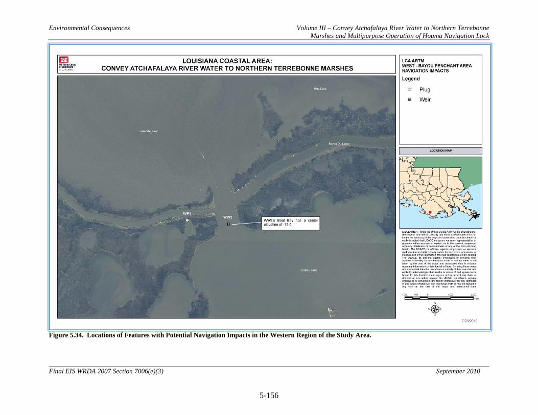
Environmental Consequences Volume III – Convey Atchafalaya River Water to Northern Terrebonne Marshes and Multipurpose Operation of Houma Navigation Lock
5-156
Final EIS WRDA 2007 Section 7006(e)(3) September 2010
Figure 5.34. Locations of Features with Potential Navigation Impacts in the Western Region of the Study Area.
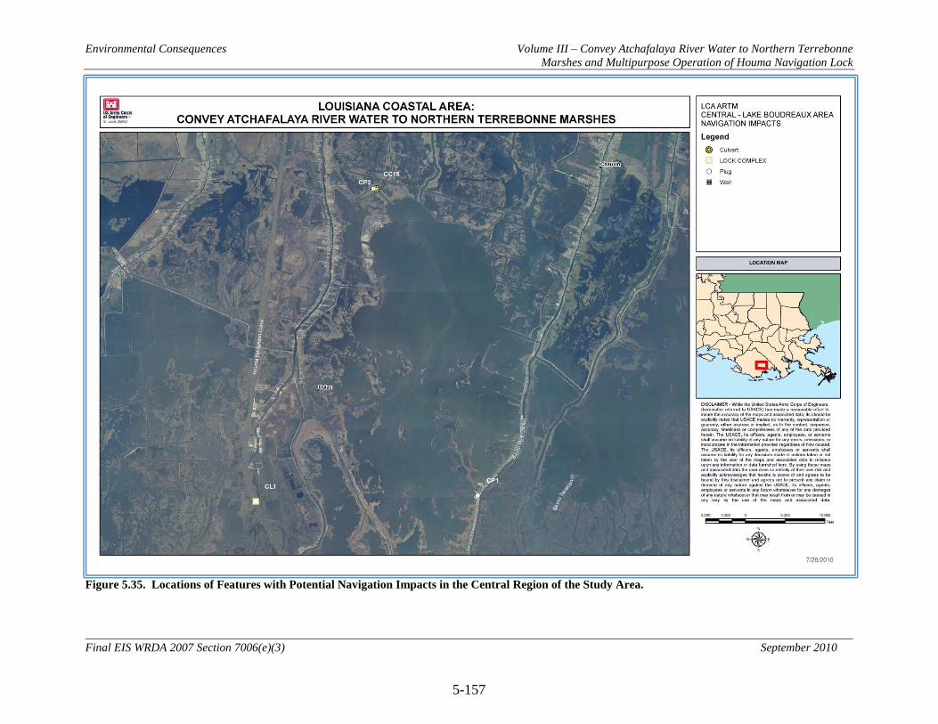
Environmental Consequences Volume III – Convey Atchafalaya River Water to Northern Terrebonne Marshes and Multipurpose Operation of Houma Navigation Lock
5-157
Final EIS WRDA 2007 Section 7006(e)(3) September 2010
Figure 5.35. Locations of Features with Potential Navigation Impacts in the Central Region of the Study Area.
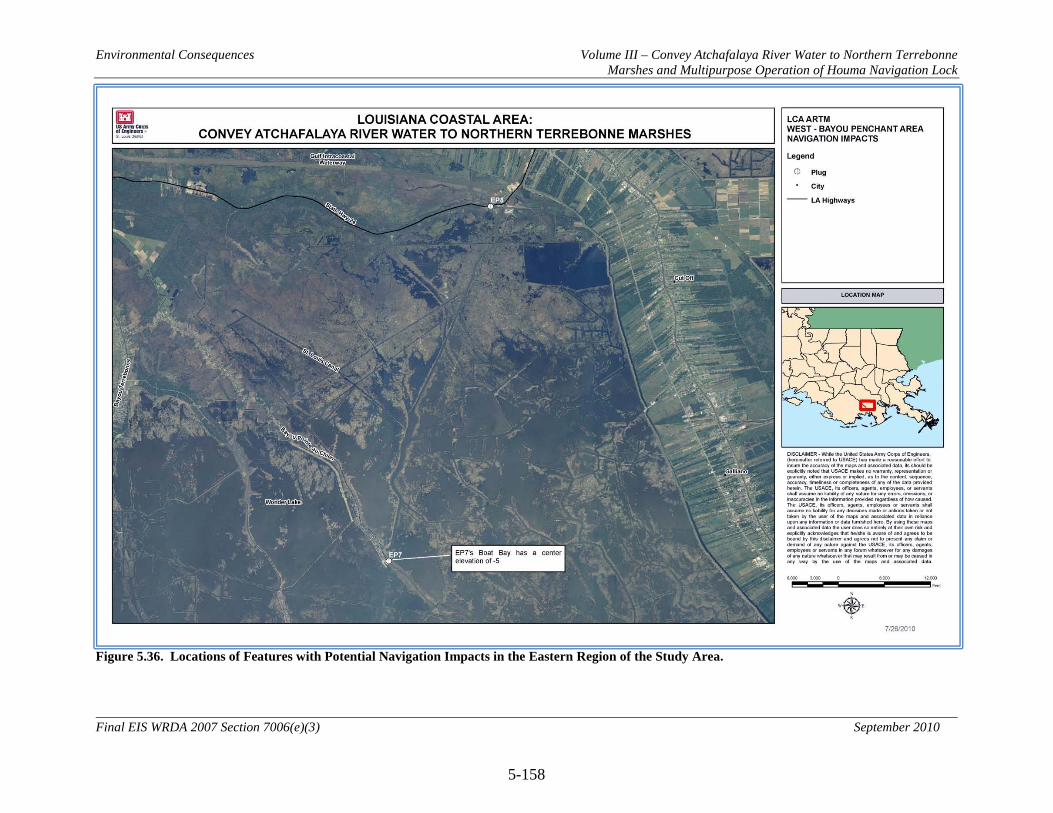
Environmental Consequences Volume III – Convey Atchafalaya River Water to Northern Terrebonne Marshes and Multipurpose Operation of Houma Navigation Lock
5-158
Final EIS WRDA 2007 Section 7006(e)(3) September 2010
Figure 5.36. Locations of Features with Potential Navigation Impacts in the Eastern Region of the Study Area.

Environmental Consequences Volume III – Convey Atchafalaya River Water to Northern Terrebonne Marshes and Multipurpose Operation of Houma Navigation Lock
5-159
Final EIS WRDA 2007 Section 7006(e)(3) September 2010
5.15.7 Land Use and Socioeconomics
5.15.7.1 Agriculture 5.15.7.1.1 No Action Alternative (Future without Project Conditions) With the implementation of the No Action Alternative, land loss in the project area would continue. Levees protecting agricultural lands situated along the distributary ridges in the project area would become increasingly vulnerable to storm damage as marshes that buffer wave impacts degrade. 5.15.7.1.2 Alternative 2 (NER Plan and RP) 5.15.7.1.2.1 Direct No direct impacts to Agriculture are anticipated from implementation of Alternative 2. 5.15.7.1.2.2 Indirect Reducing the rate of land loss in the project area would be expected to provide indirect benefits to agriculture by decreasing the exposure of levees to wave damage. 5.15.7.1.2.3 Cumulative When combined with CWPPRA and other Federal, state, local, and private restoration efforts, Alternative 2 would have an even greater indirect impact on agriculture, as those programs would work synergistically to improve habitat conditions across the area. 5.15.7.1.3 Alternative 3 5.15.7.1.3.1 Direct No direct impacts to Agriculture are anticipated from implementation of Alternative 3. 5.15.7.1.3.2 Indirect Indirect impacts of Alternative 3 on Agriculture would be similar to those of Alternative 2, but to a greater degree. 5.15.7.1.3.3 Cumulative Cumulative impacts of Alternative 3 on Agriculture would be similar to those of Alternative 2, but to a greater degree. 5.15.7.1.4 Alternative 4 5.15.7.1.4.1 Direct No direct impacts to Agriculture are anticipated from implementation of Alternative 4. 5.15.7.1.4.1 Indirect
Environmental Consequences Volume III – Convey Atchafalaya River Water to Northern Terrebonne Marshes and Multipurpose Operation of Houma Navigation Lock
5-160
Final EIS WRDA 2007 Section 7006(e)(3) September 2010
Indirect impacts of Alternative 4 on Agriculture would be similar to those of Alternative 2, but to a greater degree. 5.15.7.1.4.2 Cumulative Cumulative impacts of Alternative 4 on Agriculture would be similar to those of Alternative 2, but to a greater degree. 5.15.7.1.5 Alternative 5 5.15.7.1.5.1 Direct No direct impacts to Agriculture are anticipated from implementation of Alternative 5. 5.15.7.1.5.2 Indirect Indirect impacts of Alternative 5 on Agriculture would be similar to those of Alternative 2, but to a greater degree. 5.15.7.1.5.3 Cumulative Cumulative impacts of Alternative 5 on Agriculture would be similar to those of Alternative 2, but to a greater degree.
5.15.7.1.6 Alternative 6 5.15.7.1.6.1 Direct No direct impacts to Agriculture are anticipated from implementation of Alternative 6. 5.15.7.1.6.2 Indirect Indirect impacts of Alternative 6 on Agriculture would be similar to those of Alternative 2, but to a lesser degree. 5.15.7.1.6.3 Cumulative Cumulative impacts of Alternative 6 on Agriculture would be similar to those of Alternative 2, but to a lesser degree. 5.15.7.1.7 Alternative 7 5.15.7.1.7.1 Direct No direct impacts to Agriculture are anticipated from implementation of Alternative 7. 5.15.7.1.7.2 Indirect Indirect impacts of Alternative 7 on Agriculture would be similar to those of Alternative 2, but to a lesser degree.

Environmental Consequences Volume III – Convey Atchafalaya River Water to Northern Terrebonne Marshes and Multipurpose Operation of Houma Navigation Lock
5-161
Final EIS WRDA 2007 Section 7006(e)(3) September 2010
5.15.7.1.7.3.1 Cumulative Cumulative impacts of Alternative 7 on Agriculture would be similar to those of Alternative 2, but to a lesser degree. 5.15.7.1.8 Alternative 8 5.15.7.1.8.1 Direct No direct impacts to Agriculture are anticipated from implementation of Alternative 8. 5.15.7.1.8.2 Indirect Indirect impacts of Alternative 8 on Agriculture would be similar to those of Alternative 2, but to a lesser degree. 5.15.7.1.8.3 Cumulative Cumulative impacts of Alternative 8 on Agriculture would be similar to those of Alternative 2, but to a lesser degree.
Environmental Consequences Volume III – Convey Atchafalaya River Water to Northern Terrebonne Marshes and Multipurpose Operation of Houma Navigation Lock
5-162
Final EIS WRDA 2007 Section 7006(e)(3) September 2010
5.15.7.2 Forestry 5.15.7.2.1 No Action Alternative (Future without Project Conditions) With the implementation of the No Action Alternative, land loss in the project area would continue. Levees protecting agricultural lands used for timber production situated along the distributary ridges in the project area would become increasingly vulnerable to storm damage as marshes that buffer wave impacts degrade. 5.15.7.2.2 Alternative 2 (NER Plan and RP) 5.15.7.2.2.1 Direct No direct impacts to forestry resources are anticipated from implementation of Alternative 2. 5.15.7.2.2.2 Indirect Reducing the rate of land loss in the project area would be expected to provide indirect benefits to agricultural lands used for timber production by decreasing the exposure of levees to wave damage. 5.15.7.2.2.3 Cumulative When combined with CWPPRA and other Federal, state, local, and private restoration efforts, Alternative 2 would have an even greater indirect impact on forestry resources, as those programs would work synergistically to improve habitat conditions across the area. 5.15.7.2.3 Alternative 3 5.15.7.2.3.1 Direct No direct impacts to forestry resources are anticipated from implementation of Alternative 3. 5.15.7.2.3.2 Indirect Indirect impacts of Alternative 3 on forestry resources would be similar to those of Alternative 2, but to a greater degree. 5.15.7.2.3.3 Cumulative Cumulative impacts of Alternative 3 on forestry resources would be similar to those of Alternative 2, but to a greater degree. 5.15.7.2.4 Alternative 4 5.15.7.2.4.1 Direct No direct impacts to forestry resources are anticipated from implementation of Alternative 4.

Environmental Consequences Volume III – Convey Atchafalaya River Water to Northern Terrebonne Marshes and Multipurpose Operation of Houma Navigation Lock
5-163
Final EIS WRDA 2007 Section 7006(e)(3) September 2010
5.15.7.2.4.2 Indirect Indirect impacts of Alternative 4 on forestry resources would be similar to those of Alternative 2, but to a greater degree. 5.15.7.2.4.3 Cumulative Cumulative impacts of Alternative 4 on forestry resources would be similar to those of Alternative 2, but to a greater degree.
5.15.7.2.5 Alternative 5 5.15.7.2.5.1 Direct No direct impacts to forestry resources are anticipated from implementation of Alternative 5. 5.15.7.2.5.2 Indirect Indirect impacts of Alternative 5 on forestry resources would be similar to those of Alternative 2, but to a greater degree. 5.15.7.2.5.3 Cumulative Cumulative impacts of Alternative 5 on forestry resources would be similar to those of Alternative 2, but to a greater degree. 5.15.7.2.6 Alternative 6 5.15.7.2.6.1 Direct No direct impacts to forestry resources are anticipated from implementation of Alternative 6. 5.15.7.2.6.2 Indirect Indirect impacts of Alternative 6 on forestry resources would be similar to those of Alternative 2, but to a lesser degree. 5.15.7.2.6.3 Cumulative Cumulative impacts of Alternative 6 on forestry resources would be similar to those of Alternative 2, but to a lesser degree. 5.15.7.2.7 Alternative 7 5.15.7.2.7.1 Direct No direct impacts to forestry resources are anticipated from implementation of Alternative 7.

Environmental Consequences Volume III – Convey Atchafalaya River Water to Northern Terrebonne Marshes and Multipurpose Operation of Houma Navigation Lock
5-164
Final EIS WRDA 2007 Section 7006(e)(3) September 2010
5.15.7.2.7.2 Indirect Indirect impacts of Alternative 7 on forestry resources would be similar to those of Alternative 2, but to a lesser degree. 5.15.7.2.7.3 Cumulative Cumulative impacts of Alternative 7 on forestry resources would be similar to those of Alternative 2, but to a lesser degree. 5.15.7.2.8 Alternative 8 5.15.7.2.8.1 Direct No direct impacts to forestry resources are anticipated from implementation of Alternative 8. 5.15.7.2.8.2 Indirect Indirect impacts of Alternative 8 on forestry resources would be similar to those of Alternative 2, but to a lesser degree. 5.15.7.2.8.3 Cumulative Cumulative impacts of Alternative 8 on forestry resources would be similar to those of Alternative 2, but to a lesser degree.

Environmental Consequences Volume III – Convey Atchafalaya River Water to Northern Terrebonne Marshes and Multipurpose Operation of Houma Navigation Lock
5-165
Final EIS WRDA 2007 Section 7006(e)(3) September 2010
5.15.8 Public Lands
5.15.8.1 No Action Alternative (Future without Project Conditions) With implementation of the No Action Alternative, current land loss rates in and around the Mandalay National Wildlife Refuge and the Pointe Au Chien Wildlife Management Area would be expected to continue. The majority of Mandalay National Wildlife Refuge is located in areas that are showing a slight increase in land area. Pointe Au Chien Wildlife Management Area is located in areas that are showing loss rates of between 0.33 and 1.16 percent per year. 5.15.8.2 Alternative 2 (NER Plan and RP) 5.15.8.2.1 Direct No direct impacts to Mandalay National Wildlife Refuge are anticipated from implementation of Alternative 2. Features ED2, ED7, ED6, EM1, EX1, EX2, EC3, EG1, and EG2 are located within the boundaries of the Pointe Au Chien Wildlife Management Area. Features EC7, EC6, EC2, ED3, ED5, EC5, and EP7 are located outside the boundaries of the management area but would directly impact it. These features would change water flows into and out of the management area, thereby changing salinity levels (see Figure 5.10). Areas west of Grand Bayou are projected to see slight increases in average annual salinity values of 0.3 to 0.4 ppt. Areas to the east of Grand Bayou are projected to see decreases in average annual salinity values of between 1.7 and 2.0 ppt. 5.15.8.2.2 Indirect Changes in water flows and resultant changes in salinities and nutrient concentrations are expected to benefit the Pointe Au Chien Wildlife Management Area. Polygons in the area are projected to yield 973 AAHUs over the 50-year period of analysis as a result of implementation of Alternative 2 (see Figure 5.2). No change in AAHUs as compared to the No Action Alternative is anticipated for the Mandalay National Wildlife Refuge. 5.15.8.2.3 Cumulative When combined with CWPPRA and other Federal, state, local, and private restoration efforts, Alternative 2 would have an even greater indirect impact on public lands, as those programs would work synergistically to improve habitat conditions across the area. 5.15.8.3 Alternative 3 5.15.8.3.1 Direct No direct impacts to Mandalay National Wildlife Refuge are anticipated from implementation of Alternative 3. Features ED2, ED7, ED6, EM1, EX1, EX2, EC3, EG1, and EG2 are located within the boundaries of the Pointe Au Chien Wildlife Management Area. Features EC7, EC6, EC2, ED3, ED5, EC5, and EP7 are located outside the boundaries of the management area but would directly impact it. These features would change water flows into and out of the management area, thereby changing salinity levels (see Figure 5.11). Areas west of Grand Bayou are projected to see slight increases in
Environmental Consequences Volume III – Convey Atchafalaya River Water to Northern Terrebonne Marshes and Multipurpose Operation of Houma Navigation Lock
5-166
Final EIS WRDA 2007 Section 7006(e)(3) September 2010
average annual salinity values of 0.3 ppt. Areas to the east of Grand Bayou are projected to see decreases in average annual salinity values of between 1.7 and 2.2 ppt. 5.15.8.3.2 Indirect Changes in water flows and resultant changes in salinities and nutrient concentrations are expected to benefit the Pointe Au Chien Wildlife Management Area. Polygons in the area are projected to yield 987 AAHUs over the 50-year period of analysis as a result of implementation of Alternative 3 (see Figure 5.3). No change in AAHUs as compared to the No Action Alternative is anticipated for the Mandalay National Wildlife Refuge. 5.15.8.3.3 Cumulative When combined with CWPPRA and other Federal, state, local, and private restoration efforts, Alternative 3 would have an even greater indirect impact on public lands, as those programs would work synergistically to improve habitat conditions across the area. 5.15.8.4 Alternative 4 5.15.8.4.1 Direct No direct impacts to Mandalay National Wildlife Refuge are anticipated from implementation of Alternative 4. Features ED2, ED7, ED6, EM1, EX1, EX2, EC3, EG1, and EG2 are located within the boundaries of the Pointe Au Chien Wildlife Management Area. Features EC7, EC6, EC2, ED3, ED5, ES2, EP7, and EP8 are located outside the boundaries of the management area but would directly impact it. These features would change water flows into and out of the management area, thereby changing salinity levels (see Figure 5.12). Areas west of Grand Bayou are projected to see slight decreases in average annual salinity values ranging from 1.3 to 1.8 ppt. Areas to the east of Grand Bayou are projected to see large decreases in average annual salinity values of between 6.6 and 7.2 ppt. 5.15.8.4.2 Indirect Changes in water flows and resultant changes in salinities and nutrient concentrations are expected to benefit the Pointe Au Chien Wildlife Management Area. Polygons in the area are projected to yield 2,234 AAHUs over the 50-year period of analysis as a result of implementation of Alternative 4 (see Figure 5.4). No change in AAHUs as compared to the No Action Alternative is anticipated for the Mandalay National Wildlife Refuge.
5.15.8.4.3 Cumulative When combined with CWPPRA and other Federal, state, local, and private restoration efforts, Alternative 4 would have an even greater indirect impact on public lands, as those programs would work synergistically to improve habitat conditions across the area.
Environmental Consequences Volume III – Convey Atchafalaya River Water to Northern Terrebonne Marshes and Multipurpose Operation of Houma Navigation Lock
5-167
Final EIS WRDA 2007 Section 7006(e)(3) September 2010
5.15.8.5 Alternative 5 5.15.8.5.1 Direct No direct impacts to Mandalay National Wildlife Refuge are anticipated from implementation of Alternative 5. Features ED2, ED7, ED6, EM1, EX1, EX2, EC3, EG1, and EG2 are located within the boundaries of the Pointe Au Chien Wildlife Management Area. Features EC7, EC6, EC2, ED3, ED5, ES2, EP7, and EP8 are located outside the boundaries of the management area but would directly impact it. These features would change water flows into and out of the management area, thereby changing salinity levels (see Figure 5.13). Areas west of Grand Bayou are projected to see slight decreases in average annual salinity values ranging from 1.3 to 1.9 ppt. Areas to the east of Grand Bayou are projected to see large decreases in average annual salinity values of between 6.6 and 7.2 ppt. 5.15.8.5.2 Indirect Changes in water flows and resultant changes in salinities and nutrient concentrations are expected to benefit the Pointe Au Chien Wildlife Management Area. Polygons in the area are projected to yield 2,235 AAHUs over the 50-year period of analysis as a result of implementation of Alternative 5 (see Figure 5.5). No change in AAHUs as compared to the No Action Alternative is anticipated for the Mandalay National Wildlife Refuge. 5.15.8.5.3 Cumulative When combined with CWPPRA and other Federal, state, local, and private restoration efforts, Alternative 5 would have an even greater indirect impact on public lands, as those programs would work synergistically to improve habitat conditions across the area. 5.15.8.6 Alternative 6 5.15.8.6.1 Direct No direct impacts to Mandalay National Wildlife Refuge are anticipated from implementation of Alternative 6. Features ED3, ED5, and EC5 are located outside the boundaries of the Pointe Au Chien Wildlife Management Area but would directly impact it. These features would change water flows into and out of the management area, thereby changing salinity levels (see Figure 5.14). Areas west of Grand Bayou are projected to see slight decreases in average annual salinity values of 0.3 to 0.7 ppt. Areas to the east of Grand Bayou are projected to see decreases in average annual salinity values of between 1.5 and 1.7 ppt. 5.15.8.6.2 Indirect Changes in water flows and resultant changes in salinities and nutrient concentrations are expected to benefit the Pointe Au Chien Wildlife Management Area. Polygons in the area are projected to yield 611 AAHUs over the 50-year period of analysis as a result of implementation of Alternative 6 (see Figure 5.6). No change in AAHUs as compared to the No Action Alternative is anticipated for the Mandalay National Wildlife Refuge.

Environmental Consequences Volume III – Convey Atchafalaya River Water to Northern Terrebonne Marshes and Multipurpose Operation of Houma Navigation Lock
5-168
Final EIS WRDA 2007 Section 7006(e)(3) September 2010
5.15.8.6.3 Cumulative When combined with CWPPRA and other Federal, state, local, and private restoration efforts, Alternative 6 would have an even greater indirect impact on public lands, as those programs would work synergistically to improve habitat conditions across the area. 5.15.8.7 Alternative 7 5.15.8.7.1 Direct No direct impacts to Mandalay National Wildlife Refuge are anticipated from implementation of Alternative 7. Modified operation of the HNC lock complex is expected to change flows in the Grand Bayou basin, thereby changing salinity levels (see Figure 5.15). Areas west of Grand Bayou are projected to see slight decreases in average annual salinity values of 0.1 ppt. Areas to the east of Grand Bayou are projected to see decreases in average annual salinity values of between 0.3 and 0.4 ppt. 5.15.8.7.2 Indirect Changes in water flows and resultant changes in salinities and nutrient concentrations are expected to impact the Pointe Au Chien Wildlife Management Area. Polygons in the area are projected to yield a net loss of 41 AAHUs over the 50-year period of analysis as a result of implementation of Alternative 7 (see Figure 5.7). No change in AAHUs as compared to the No Action Alternative is anticipated for the Mandalay National Wildlife Refuge. 5.15.8.7.3 Cumulative Negative impacts to public lands from implementation of Alternative 7 are not anticipated to have any greater impact when considered cumulatively with other Federal, state, local, or private impacts to public lands in the area. 5.15.8.8 Alternative 8 5.15.8.8.1 Direct No direct impacts to Mandalay National Wildlife Refuge are anticipated from implementation of Alternative 8. Features ED6, EX1, EX2, EC3, EG1, and EG2 are located within the boundaries of the Pointe Au Chien Wildlife Management Area. Features EC2, ED3, ED5, EC5, and EP7 are located outside the boundaries of the management area but would directly impact it. These features would change water flows into and out of the management area, thereby changing salinity levels (see Figure 5.16). Areas west of Grand Bayou are projected to see slight decreases in average annual salinity values of 0.1 to 0.6 ppt. Areas to the east of Grand Bayou are projected to see decreases in average annual salinity values of between 1.5 and 2.2 ppt.
Environmental Consequences Volume III – Convey Atchafalaya River Water to Northern Terrebonne Marshes and Multipurpose Operation of Houma Navigation Lock
5-169
Final EIS WRDA 2007 Section 7006(e)(3) September 2010
5.15.8.8.2 Indirect Changes in water flows and resultant changes in salinities and nutrient concentrations are expected to benefit the Pointe Au Chien Wildlife Management Area. Polygons in the area are projected to yield 938 AAHUs over the 50-year period of analysis as a result of implementation of Alternative 8 (see Figure 5.8). No change in AAHUs as compared to the No Action Alternative is anticipated for the Mandalay National Wildlife Refuge. 5.15.8.8.3 Cumulative When combined with CWPPRA and other Federal, state, local, and private restoration efforts, Alternative 8 would have an even greater indirect impact on public lands, as those programs would work synergistically to improve habitat conditions across the area.
Environmental Consequences Volume III – Convey Atchafalaya River Water to Northern Terrebonne Marshes and Multipurpose Operation of Houma Navigation Lock
5-170
Final EIS WRDA 2007 Section 7006(e)(3) September 2010
5.15.9 Man Made Resources
5.15.9.1 Oil , Gas, and Utilities The impacts of the Deepwater Horizon oil spill on coastal Louisiana are uncertain at this time (August 2010). The impacts of the oil spill as well as the various emergency actions taken to address oil spill impacts (e.g., use of oil dispersants, creation of sand berms, use of Hesco baskets, rip-rap, sheet piling and other actions) could potentially impact USACE water resources projects and studies within the Louisiana coastal area, including the LCA-ARTM project. Potential impacts could include factors such as changes to existing, future-without, and future-with-project conditions, as well as increased project costs and implementation delays. The USACE will continue to monitor and closely coordinate with other Federal and state resource agencies and local sponsors in determining how to best address any potential problems associated with the oil spill that may adversely impact project implementation. Supplemental planning and environmental documentation may be required as information becomes available. If at any time petroleum or crude oil is discovered on project lands, all efforts will be taken to seek clean up by the responsible parties, pursuant to the Oil Pollution Act of 1990 (33 U.S.C. 2701 et seq.). 5.15.9.1.1 No Action Alternative (Future without Project Conditions) Most of Louisiana’s onshore oil and gas production occurs in the Louisiana coastal ecosystem. This area is at an elevated risk due to the land loss and ecosystem degradation. Loss of wetland, marsh, and barrier islands presents a range of threats to inshore and offshore oil and gas infrastructure. Existing inshore facilities are not designed to withstand excessive wind and wave actions, which would become more commonplace as existing marshes are lost or converted into open bays. In addition, erosion and the subsequent disappearance of barrier islands would allow gulf type swells from tropical storm events to travel farther inland. The combination of these factors would increase the risk to inshore facilities. To address this risk, the oil and gas industry will be faced with the decision to invest in improvements in order to maintain production/transmission or conversely the closure and abandonment of infrastructure. The offshore oil and gas industry in the coastal zone is an important component in meeting national energy requirements. Coastal land losses have, and will continue to have, a negative effect on the extensive pipeline network located in coastal areas. As the open water areas behind the barrier islands increase in size, the tidal exchange volumes and velocities increase in the tidal passes and channels. This action can lead to the scouring away of sediments atop buried pipelines, exposing the pipelines and increasing the risk of failure or damage due to lack of structural stability, anchor dragging, and boat collisions. Resulting production or transmission shortfalls may result in disruptions in the availability of crude oil or natural gas to a significant part of the U.S. Oil and gas infrastructure in the project area can be seen in Figure 4.10. The impact to these nationally important resources would be felt in numerous ways depending upon location (i.e., whether onshore or offshore).

Environmental Consequences Volume III – Convey Atchafalaya River Water to Northern Terrebonne Marshes and Multipurpose Operation of Houma Navigation Lock
5-171
Final EIS WRDA 2007 Section 7006(e)(3) September 2010
5.15.9.1.2 Alternative 2 (NER Plan and RP) 5.15.9.1.2.1 Direct No direct impacts to oil and gas infrastructure are anticipated from implementation of Alternative 2. Construction of features CC3, CC4, CD1, CD4, CD6, CD7, CLV2, CM4, and ED5 may require relocation of existing utility lines. 5.15.9.1.2.2 Indirect Implementation of Alternative 2 and the associated reduction in the rate of land loss in the project area would be expected to provide indirect benefits to oil, gas, and utility infrastructure by decreasing erosion and associated structural instability of infrastructure, thereby reducing the likelihood of damage and interruption of service. 5.15.9.1.2.3 Cumulative When combined with CWPPRA and other Federal, state, local, and private restoration efforts, Alternative 2 would have an even greater indirect impact on oil, gas, and utilities, as those programs would work synergistically to improve habitat conditions across the area. 5.15.9.1.3 Alternative 3 5.15.9.1.3.1 Direct No direct impacts to oil and gas infrastructure are anticipated from implementation of Alternative 3. Construction of features CC3, CC4, CD1, CD4, CD6, CD7, CLV2, CM4, and ED5 may require relocation of existing utility lines. 5.15.9.1.3.2 Indirect Implementation of Alternative 3 and the associated reduction in the rate of land loss in the project area would be expected to provide indirect benefits to oil, gas, and utility infrastructure by decreasing erosion and associated structural instability of infrastructure, thereby reducing the likelihood of damage and interruption of service. 5.15.9.1.3.3 Cumulative When combined with CWPPRA and other Federal, state, local, and private restoration efforts, Alternative 3 would have an even greater indirect impact on oil, gas, and utilities, as those programs would work synergistically to improve habitat conditions across the area.
Environmental Consequences Volume III – Convey Atchafalaya River Water to Northern Terrebonne Marshes and Multipurpose Operation of Houma Navigation Lock
5-172
Final EIS WRDA 2007 Section 7006(e)(3) September 2010
5.15.9.1.4 Alternative 4 5.15.9.1.4.1 Direct No direct impacts to oil and gas infrastructure are anticipated from implementation of Alternative 4. Construction of features CC3, CC4, CD1, CD4, CD6, CD7, CLV2, CM4, and ED5 may require relocation of existing utility lines. 5.15.9.1.4.2 Indirect Implementation of Alternative 4 and the associated reduction in the rate of land loss in the project area would be expected to provide indirect benefits to oil, gas, and utility infrastructure by decreasing erosion and associated structural instability of infrastructure, thereby reducing the likelihood of damage and interruption of service. 5.15.9.1.4.3 Cumulative When combined with CWPPRA and other Federal, state, local, and private restoration efforts, Alternative 4 would have an even greater indirect impact on oil, gas, and utilities, as those programs would work synergistically to improve habitat conditions across the area.
5.15.9.1.5 Alternative 5 5.15.9.1.5.1 Direct No direct impacts to oil and gas infrastructure are anticipated from implementation of Alternative 5. Construction of features CC3, CC4, CD1, CD4, CD6, CD7, CLV2, CM4, and ED5 may require relocation of existing utility lines. 5.15.9.1.5.2 Indirect Implementation of Alternative 5 and the associated reduction in the rate of land loss in the project area would be expected to provide indirect benefits to oil, gas, and utility infrastructure by decreasing erosion and associated structural instability of infrastructure, thereby reducing the likelihood of damage and interruption of service. 5.15.9.1.5.3 Cumulative When combined with CWPPRA and other Federal, state, local, and private restoration efforts, Alternative 5 would have an even greater indirect impact on oil, gas, and utilities, as those programs would work synergistically to improve habitat conditions across the area.
Environmental Consequences Volume III – Convey Atchafalaya River Water to Northern Terrebonne Marshes and Multipurpose Operation of Houma Navigation Lock
5-173
Final EIS WRDA 2007 Section 7006(e)(3) September 2010
5.15.9.1.6 Alternative 6 5.15.9.1.6.1 Direct No direct impacts to oil and gas infrastructure are anticipated from implementation of Alternative 6. Construction of features CD4 and ED5 may require relocation of existing utility lines. 5.15.9.1.6.2 Indirect Implementation of Alternative 6 and the associated reduction in the rate of land loss in the project area would be expected to provide indirect benefits to oil, gas, and utility infrastructure by decreasing erosion and associated structural instability of infrastructure, thereby reducing the likelihood of damage and interruption of service. 5.15.9.1.6.3 Cumulative When combined with CWPPRA and other Federal, state, local, and private restoration efforts, Alternative 6 would have an even greater indirect impact on oil, gas, and utilities, as those programs would work synergistically to improve habitat conditions across the area. 5.15.9.1.7 Alternative 7 5.15.9.1.7.1 Direct No direct impacts to oil, gas, or utility infrastructure are anticipated from implementation of Alternative 7.
5.15.9.1.7.2 Indirect Implementation of Alternative 7 and the associated reduction in the rate of land loss in the project area would be expected to provide indirect benefits to oil, gas, and utility infrastructure by decreasing erosion and associated structural instability of infrastructure, thereby reducing the likelihood of damage and interruption of service. 5.15.9.1.7.3 Cumulative When combined with CWPPRA and other Federal, state, local, and private restoration efforts, Alternative 7 would have an even greater indirect impact on oil, gas, and utilities, as those programs would work synergistically to improve habitat conditions across the area. 5.15.9.1.8 Alternative 8 5.15.9.1.8.1 Direct No direct impacts to oil and gas infrastructure are anticipated from implementation of Alternative 8. Construction of features CC3, CD1, CD6, CD7, CLV2, and ED5 may require relocation of existing utility lines.
Environmental Consequences Volume III – Convey Atchafalaya River Water to Northern Terrebonne Marshes and Multipurpose Operation of Houma Navigation Lock
5-174
Final EIS WRDA 2007 Section 7006(e)(3) September 2010
5.15.9.1.8.2 Indirect Implementation of Alternative 8 and the associated reduction in the rate of land loss in the project area would be expected to provide indirect benefits to oil, gas, and utility infrastructure by decreasing erosion and associated structural instability of infrastructure, thereby reducing the likelihood of damage and interruption of service. 5.15.9.1.8.3 Cumulative When combined with CWPPRA and other Federal, state, local, and private restoration efforts, Alternative 8 would have an even greater indirect impact on oil, gas, and utilities, as those programs would work synergistically to improve habitat conditions across the area.

Environmental Consequences Volume III – Convey Atchafalaya River Water to Northern Terrebonne Marshes and Multipurpose Operation of Houma Navigation Lock
5-175
Final EIS WRDA 2007 Section 7006(e)(3) September 2010
5.15.9.2 Flood Control and Hurricane Protection 5.15.9.2.1 No Action Alternative (Future without Project Conditions) The continuing erosion of the Louisiana coastline has increased the potential for flood damages from the surges of hurricanes and tropical storms throughout southern Louisiana. Failure to maintain coastal wetlands would result in a significant level of increases in damages from storm surges that are currently reduced by coastal wetlands. There would also be damages to the levees themselves, which would require increased expenditures to raise, repair, and replace. The Morganza to the Gulf of Mexico Risk Reduction Project was considered a likely future condition for purposes of the ARTM Feasibility Study. The proposed alignment of the project can be found in Figure 4.11. Existing federal and local levee projects in the vicinity of the project area can also be found in Figure 4.11. 5.15.9.2.2 Alternative 2 (NER Plan and RP) 5.15.9.2.2.1 Direct Modifying the operation of the proposed HNC lock complex would have an impact on water levels in the project area, but would not impact the flood control and hurricane protection capacity of the proposed system (see Section 5.2.1 and Engineering Appendix for information on changes in water levels associated with project implementation). Likewise, project features that lie within the proposed alignment of the Morganza to the Gulf of Mexico Risk Reduction Project may require modifications to the design of the levees, but would not impact the flood control and hurricane protection capacity of the proposed system. Implementation of Alternative 2 would also result in the raising of the planned elevation of features CLV1 and CLV2 to accommodate potential increases in water levels due to project features in the area. CLV1 and CLV2 are levees currently under design by Terrebonne Parish and are planned for future construction outside of the authority of the ARTM project. 5.15.9.2.2.2 Indirect Implementation of Alternative 2 and the associated benefits to marshes in the project area would be expected to provide indirect benefits to flood control and hurricane protection levees by helping to retain the wave and storm surge buffering capacity of the marshes, thereby decreasing storm surge and reducing wave damage. 5.15.9.2.2.3 Cumulative When combined with CWPPRA and other Federal, state, local, and private restoration efforts, Alternative 2 would have an even greater indirect impact on flood control and hurricane protection, as those programs would work synergistically to improve habitat conditions across the area.

Environmental Consequences Volume III – Convey Atchafalaya River Water to Northern Terrebonne Marshes and Multipurpose Operation of Houma Navigation Lock
5-176
Final EIS WRDA 2007 Section 7006(e)(3) September 2010
5.15.9.2.3 Alternative 3 5.15.9.2.3.1 Direct Modifying the operation of the proposed HNC lock complex would have an impact on water levels in the project area, but would not impact the flood control and hurricane protection capacity of the proposed system (see Section 5.2.1 and Engineering Appendix for information on changes in water levels associated with project implementation). Likewise, project features that lie within the proposed alignment of the Morganza to the Gulf of Mexico Risk Reduction Project may require modifications to the design of the levees, but would not impact the flood control and hurricane protection capacity of the proposed system. Implementation of Alternative 3 would also result in breaching the Avoca Island Levee at feature WS4. The Avoca Island Levee is part of the East Atchafalaya Basin Protection Levee (EABPL) and provides the Morgan City area with protection from Atchafalaya River backwater flooding. Feature WS4 would only be operated at low to moderate Atchafalaya River stages, and, therefore, would not increase flood heights (see Section 5.2.1 and Engineering Appendix for information on changes in water levels associated with project implementation). Alternative 3 would also result in the raising of the planned elevation of features CLV1 and CLV2 to accommodate potential increases in water levels due to project features in the area. CLV1 and CLV2 are levees currently under design by Terrebonne Parish and are planned for future construction outside of the authority of the ARTM project. 5.15.9.2.3.2 Indirect Implementation of Alternative 3 and the associated benefits to marshes in the project area would be expected to provide indirect benefits to flood control and hurricane protection levees by helping to retain the wave and storm surge buffering capacity of the marshes, thereby decreasing storm surge and reducing wave damage. 5.15.9.2.3.3 Cumulative When combined with CWPPRA and other Federal, state, local, and private restoration efforts, Alternative 3 would have an even greater indirect impact on flood control and hurricane protection, as those programs would work synergistically to improve habitat conditions across the area. 5.15.9.2.4 Alternative 4 5.15.9.2.4.1 Direct Modifying the operation of the proposed HNC lock complex would have an impact on water levels in the project area, but would not impact the flood control and hurricane protection capacity of the proposed system (see Section 5.2.1 and Engineering Appendix for information on changes in water levels associated with project implementation).
Environmental Consequences Volume III – Convey Atchafalaya River Water to Northern Terrebonne Marshes and Multipurpose Operation of Houma Navigation Lock
5-177
Final EIS WRDA 2007 Section 7006(e)(3) September 2010
Likewise, project features that lie within the proposed alignment of the Morganza to the Gulf of Mexico Risk Reduction Project may require modifications to the design of the levees, but would not impact the flood control and hurricane protection capacity of the proposed system.
Implementation of Alternative 4 would also result in the raising of the planned elevation of features CLV1 and CLV2 to accommodate potential increases in water levels due to project features in the area. CLV1 and CLV2 are levees currently under design by Terrebonne Parish and are planned for future construction outside of the authority of the ARTM project. 5.15.9.2.4.2 Indirect Implementation of Alternative 4 and the associated benefits to marshes in the project area would be expected to provide indirect benefits to flood control and hurricane protection levees by helping to retain the wave and storm surge buffering capacity of the marshes, thereby decreasing storm surge and reducing wave damage. 5.15.9.2.4.3 Cumulative When combined with CWPPRA and other Federal, state, local, and private restoration efforts, Alternative 4 would have an even greater indirect impact on flood control and hurricane protection, as those programs would work synergistically to improve habitat conditions across the area. 5.15.9.2.5 Alternative 5 5.15.14.2.5.1 Direct Modifying the operation of the proposed HNC lock complex would have an impact on water levels in the project area, but would not impact the flood control and hurricane protection capacity of the proposed system (see Section 5.2.1 and Engineering Appendix for information on changes in water levels associated with project implementation). Likewise, project features that lie within the proposed alignment of the Morganza to the Gulf of Mexico Risk Reduction Project may require modifications to the design of the levees, but would not impact the flood control and hurricane protection capacity of the proposed system. Implementation of Alternative 5 would also result in breaching the Avoca Island Levee at feature WS4. The Avoca Island Levee is part of the East Atchafalaya Basin Protection Levee (EABPL) and provides the Morgan City area with protection from Atchafalaya River backwater flooding. Feature WS4 would only be operated at low to moderate Atchafalaya River stages, and, therefore, would not increase flood heights (see Section 5.2.1 and Engineering Appendix for information on changes in water levels associated with project implementation). Alternative 5 would also result in the raising of the planned elevation of features CLV1 and CLV2 to accommodate potential increases in water levels due to project features in
Environmental Consequences Volume III – Convey Atchafalaya River Water to Northern Terrebonne Marshes and Multipurpose Operation of Houma Navigation Lock
5-178
Final EIS WRDA 2007 Section 7006(e)(3) September 2010
the area. CLV1 and CLV2 are levees currently under design by Terrebonne Parish and are planned for future construction outside of the authority of the ARTM project. 5.15.14.2.5.2 Indirect Implementation of Alternative 5 and the associated benefits to marshes in the project area would be expected to provide indirect benefits to flood control and hurricane protection levees by helping to retain the wave and storm surge buffering capacity of the marshes, thereby decreasing storm surge and reducing wave damage. 5.15.14.2.5.3 Cumulative When combined with CWPPRA and other Federal, state, local, and private restoration efforts, Alternative 5 would have an even greater indirect impact on flood control and hurricane protection, as those programs would work synergistically to improve habitat conditions across the area. 5.15.9.2.6 Alternative 6 5.15.9.2.6.1 Direct Modifying the operation of the proposed HNC lock complex would have an impact on water levels in the project area, but would not impact the flood control and hurricane protection capacity of the proposed system (see Section 5.2.1 and Engineering Appendix for information on changes in water levels associated with project implementation). Likewise, project features that lie within the proposed alignment of the Morganza to the Gulf of Mexico Risk Reduction Project may require modifications to the design of the levees, but would not impact the flood control and hurricane protection capacity of the proposed system. Implementation of Alternative 6 would also result in breaching the Avoca Island Levee at feature WS4. The Avoca Island Levee is part of the East Atchafalaya Basin Protection Levee (EABPL) and provides the Morgan City area with protection from Atchafalaya River backwater flooding. Feature WS4 would only be operated at low to moderate Atchafalaya River stages, and, therefore, would not increase flood heights (see Section 5.2.1 and Engineering Appendix for information on changes in water levels associated with project implementation). 5.15.9.2.6.2 Indirect Implementation of Alternative 6 and the associated benefits to marshes in the project area would be expected to provide indirect benefits to flood control and hurricane protection levees by helping to retain the wave and storm surge buffering capacity of the marshes, thereby decreasing storm surge and reducing wave damage. 5.15.9.2.6.3 Cumulative When combined with CWPPRA and other Federal, state, local, and private restoration efforts, Alternative 6 would have an even greater indirect impact on flood control and
Environmental Consequences Volume III – Convey Atchafalaya River Water to Northern Terrebonne Marshes and Multipurpose Operation of Houma Navigation Lock
5-179
Final EIS WRDA 2007 Section 7006(e)(3) September 2010
hurricane protection, as those programs would work synergistically to improve habitat conditions across the area. 5.15.9.2.7 Alternative 7 5.15.9.2.7.1 Direct Modifying the operation of the proposed HNC lock complex would have an impact on water levels in the project area, but would not impact the flood control and hurricane protection capacity of the proposed system (see Section 5.2.1 and Engineering Appendix for information on changes in water levels associated with project implementation). 5.15.9.2.7.2 Indirect Implementation of Alternative 7 and the associated benefits to marshes in the project area would be expected to provide indirect benefits to flood control and hurricane protection levees by helping to retain the wave and storm surge buffering capacity of the marshes, thereby decreasing storm surge and reducing wave damage. 5.15.9.2.7.3 Cumulative When combined with CWPPRA and other Federal, state, local, and private restoration efforts, Alternative 7 would have an even greater indirect impact on flood control and hurricane protection, as those programs would work synergistically to improve habitat conditions across the area. 5.15.9.2.8 Alternative 8 5.15.9.2.8.1 Direct Modifying the operation of the proposed HNC lock complex would have an impact on water levels in the project area, but would not impact the flood control and hurricane protection capacity of the proposed system (see Section 5.2.1 and Engineering Appendix for information on changes in water levels associated with project implementation). Likewise, project features that lie within the proposed alignment of the Morganza to the Gulf of Mexico Risk Reduction Project may require modifications to the design of the levees, but would not impact the flood control and hurricane protection capacity of the proposed system. Implementation of Alternative 8 would also result in the raising of the planned elevation of features CLV1 and CLV2 to accommodate potential increases in water levels due to project features in the area. CLV1 and CLV2 are levees currently under design by Terrebonne Parish and are planned for future construction outside of the authority of the ARTM project. 5.15.9.2.8.2 Indirect Implementation of Alternative 8 and the associated benefits to marshes in the project area would be expected to provide indirect benefits to flood control and hurricane protection

Environmental Consequences Volume III – Convey Atchafalaya River Water to Northern Terrebonne Marshes and Multipurpose Operation of Houma Navigation Lock
5-180
Final EIS WRDA 2007 Section 7006(e)(3) September 2010
levees by helping to retain the wave and storm surge buffering capacity of the marshes, thereby decreasing storm surge and reducing wave damage. 5.15.9.2.8.3 Cumulative When combined with CWPPRA and other Federal, state, local, and private restoration efforts, Alternative 8 would have an even greater indirect impact on flood control and hurricane protection, as those programs would work synergistically to improve habitat conditions across the area.

Environmental Consequences Volume III – Convey Atchafalaya River Water to Northern Terrebonne Marshes and Multipurpose Operation of Houma Navigation Lock
5-181
Final EIS WRDA 2007 Section 7006(e)(3) September 2010
5.15.10 Natural Resources
5.15.10.1 Commercial Fisheries 5.15.10.1.1 No Action Alternative (Future without Project Conditions) Concurrent with projected land loss in the project area would be an increase in saltwater intrusion into some of the upper areas as marshes degrade. This would result in a shift in the populations of fishes and invertebrates, with more saline-dominated species replacing freshwater species in some areas. The band of intermediate salinity necessary for oyster production would likely narrow significantly, and essential fish habitat for many commercial fishery species would likewise decline, leading to a net loss in fisheries population size and diversity. Wetland habitat losses would decrease the productivity of Louisiana’s coastal fisheries. The commercial fishing and seafood industry would likely suffer significant losses in employment as estuaries that are necessary to produce shrimp, oysters, and other valuable species erode. Job losses would occur in the areas reliant on fishing, harvesting, processing, and shipping of the seafood catch. Thus, changes in existing fisheries habitat caused by wetland loss, saltwater intrusion, and reduced salinity gradients would likely increase the risk of a decline in the supply of nationally distributed seafood products from Louisiana’s coast. 5.15.10.1.2 Alternative 2 (NER Plan and RP) 10.15.10.1.2.1 Direct Direct impacts to commercial fisheries from implementation of Alternative 2 would primarily be related to reduced or impeded access to fishing areas. See Section 5.15.6, Navigation, for descriptions of these impacts.
5.15.10.1.2.2 Indirect Implementation of Alternative 2 would have indirect impacts on commercial fisheries by affecting the location of target species. Changes in salinity levels in the project area as a result of project features (see Section 5.3 Water Quality and Section 5.9 Fisheries) would change the distribution of fish and shellfish species based on their salinity tolerance. Changes in fisheries distribution would impact commercial fishing patterns and locations. The proposed plug in Robinson Canal would eliminate tidal currents through the canal and would consequently eliminate the butterfly net shrimp fishery in that location. Implementation of Alternative 2 is expected to benefit commercial fisheries by decreasing the rate of marsh loss in the project area as compared to the No Action Alternative. Alternative 2 is projected to provide a net benefit of 3,220 AAHUs over the period of analysis, thereby benefitting the nationally important commercial fishing industry in the area.
Environmental Consequences Volume III – Convey Atchafalaya River Water to Northern Terrebonne Marshes and Multipurpose Operation of Houma Navigation Lock
5-182
Final EIS WRDA 2007 Section 7006(e)(3) September 2010
5.15.10.1.2.3 Cumulative Restoration efforts in the state (e.g., CWPPRA, the Community-based Restoration Program sponsored by the NMFS Restoration Center, various state and local efforts, and others) have aided fisheries habitat and are likely to continue to do so. Economic interest in fisheries, and interest in Louisiana as a fishery resource for the Nation, has increased significantly in the recent past. This increase is expected to continue and lead to changes in fishing technology, fishing pressure, and fishing regulations, in order to maintain sustainable commercial fisheries. It is likely that the construction of levees, water control structures and hurricane protection features, which can result in direct loss of habitat, alter water flow, and have the potential to block fisheries access to habitat, are likely to continue and/or increase, as coastal residents protect themselves and their property from hurricane damage and flooding. Implementation of Alternative 2 would contribute to an overall benefit to commercial fisheries compared to the future with no action. 5.15.10.1.3 Alternative 3 Direct, indirect, and cumulative impacts of Alternative 3 on commercial fisheries would be similar to those of Alternative 2. Alternative 3 is projected to provide a net benefit of 3,325 AAHUs compared to the No Action Alternative. 5.15.10.1.4 Alternative 4 5.15.10.1.4.1 Direct Direct impacts to commercial fisheries from implementation of Alternative 4 would primarily be related to reduced or impeded access to fishing areas. See Section 5.15.6, Navigation, for descriptions of these impacts. 5.15.10.1.4.2 Indirect Indirect impacts of Alternative 4 on commercial fisheries are expected to be similar to Alternative 2. However, reductions in salinities in the Grand Bayou basin would be much more pronounced than with Alternative 2 (see Section 5.3 Water Quality and Section 5.9 Fisheries). These changes in salinity would cause much more dramatic shifts in the fish and shellfish communities in the area. Overall, Alternative 4 is projected to provide 4,258 AAHUs compared to the No Action Alternative. 5.15.10.1.4.3 Cumulative Cumulative impacts of Alternative 4 on commercial fisheries are expected to be similar to Alternative 2, but to a greater degree. 5.15.10.1.5 Alternative 5 5.15.10.1.5.1 Direct Direct impacts to commercial fisheries from implementation of Alternative 5 would primarily be related to reduced or impeded access to fishing areas. See Section 5.15.6, Navigation, for descriptions of these impacts.
Environmental Consequences Volume III – Convey Atchafalaya River Water to Northern Terrebonne Marshes and Multipurpose Operation of Houma Navigation Lock
5-183
Final EIS WRDA 2007 Section 7006(e)(3) September 2010
5.15.10.1.5.2 Indirect Indirect impacts of Alternative 5 on fisheries resources are expected to be similar to Alternative 2. However, reductions in salinities in the Grand Bayou basin would be much more pronounced than with Alternative 2 (see Section 5.3 Water Quality and Section 5.9 Fisheries). These changes in salinity would cause much more dramatic shifts in the fish and shellfish communities in the area. Overall, Alternative 5 is projected to provide 4,719 AAHUs compared to the No Action Alternative. 5.15.10.1.5.3 Cumulative Cumulative impacts of Alternative 5 on commercial fisheries are expected to be similar to Alternative 2, but to a greater degree. 5.15.10.1.6 Alternative 6 5.15.10.1.6.1 Direct Direct impacts to commercial fisheries from implementation of Alternative 6 would primarily be related to reduced or impeded access to fishing areas. See Section 5.15.6, Navigation, for descriptions of these impacts. 5.15.10.1.6.2 Indirect Indirect impacts of Alternative 6 on commercial fisheries are expected to be similar to Alternative 2, but to a lesser degree. Alternative 6 is projected to provide a net benefit of 776 AAHUs compared to the No Action Alternative. 5.15.10.1.6.3 Cumulative Cumulative impacts of Alternative 6 on commercial fisheries are expected to be similar to Alternative 2, but to a lesser degree. 5.15.10.1.7 Alternative 7 5.15.10.1.7.1 Direct Direct impacts to commercial fisheries from implementation of Alternative 7 would primarily be related to reduced or impeded access to fishing areas. See Section 5.15.6, Navigation, for descriptions of these impacts. 5.15.10.1.7.2 Indirect Indirect impacts of Alternative 7 on commercial fisheries are expected to be similar to Alternative 2, but to a lesser degree. Alternative 7 is projected to provide a net benefit of 243 AAHUs compared to the No Action Alternative.
Environmental Consequences Volume III – Convey Atchafalaya River Water to Northern Terrebonne Marshes and Multipurpose Operation of Houma Navigation Lock
5-184
Final EIS WRDA 2007 Section 7006(e)(3) September 2010
10.15.10.1.7.3 Cumulative Cumulative impacts of Alternative 7 on commercial fisheries are expected to be similar to Alternative 2, but to a lesser degree. 5.15.10.1.8 Alternative 8 5.15.10.1.8.1 Direct Direct impacts to commercial fisheries from implementation of Alternative 8 would primarily be related to reduced or impeded access to fishing areas. See Section 5.15.6, Navigation, for descriptions of these impacts. 5.15.10.1.8.2 Indirect Indirect impacts of Alternative 8 on commercial fisheries are expected to be similar to Alternative 2, but to a lesser degree. Alternative 8 is projected to provide a net benefit of 1,214 AAHUs compared to the No Action Alternative. 5.15.10.1.8.3 Cumulative Cumulative impacts of Alternative 8 on commercial fisheries are expected to be similar to Alternative 2, but to a lesser degree.
Environmental Consequences Volume III – Convey Atchafalaya River Water to Northern Terrebonne Marshes and Multipurpose Operation of Houma Navigation Lock
5-185
Final EIS WRDA 2007 Section 7006(e)(3) September 2010
5.15.10.2 Oyster Leases 5.15.10.2.1 No Action Alternative (Future without Project Conditions) The No Action Alternative would result in the persistence of existing conditions including the continued conversion of transitional estuarine wetlands to open water habitats and associated saltwater intrusion. The continued loss of transitional estuarine wetlands would adversely affect the local detritus-based oyster food web. Organic detritus, derived mainly from vascular plants, is a major food source for estuarine consumers, including oysters (Day et al., 1989). Hence, the loss of wetlands in the project area would likely reduce the localized carrying capacity for oyster leases in the area. As oyster production from leases declines, it would likely result in lower oyster supply, higher oyster prices, and loss of income and jobs in the oyster industry. 5.15.10.2.2 Alternative 2 (NER Plan and RP) 5.15.10.2.2.1 Direct Table 5.8 displays information on oyster leases that would be directly impacted by implementation of Alternative 2. Construction-related impacts to oyster leases would include direct disturbance and/or mortality, increased turbidity and siltation, temperature changes, and decreased dissolved oxygen. Turbidity, temperature, and dissolved oxygen changes would return to normal following completion of construction activities. Project features would be designed to avoid and minimize potential adverse impacts to oyster leases and nearby Louisiana State Oyster Seed Grounds and best construction management practices would be utilized. Oyster leases expected to be directly impacted by the project would be acquired from the leaseholder through the LDNR’s oyster acquisition program. Payments would be made for just compensation in accordance with Louisiana Law. 5.15.10.2.2.2 Indirect Direct impacts to oysters from changes in salinity levels in the project area would be considered indirect impacts to oyster leases. Hydraulic model salinity points in relation to oyster leases and oyster seed grounds can be found in Figure 5.37. Average monthly salinity values at these points can be found in Table 5.9. According to these modeled salinity values, as indicated by red-shaded areas in Table 5.9, implementation of Alternative 2 would negatively impact oyster leases in some areas by causing salinities to move outside of the ideal 5-15ppt range. Oyster leases in the vicinity of points B7 Southwest, New C10, D3 North, D3 Central, G6 Central, G6 Southeast, G7 Catfish Lake, and G7 Northwest are most likely to be negatively impacted by implementation of Alternative 2. Extended periods of salinity values below 5ppt in these areas, particularly during periods of warmer water temperatures, are likely to cause increased mortality and decreased reproduction. Other areas showing changes outside of the ideal 5-15ppt range with implementation of Alternative 2, Lost Lake West, Lost Lake East, A8, and E2 Northwest, are less likely to be negatively impacted. No Action model data for these areas shows several months of salinities already below the 5ppt range, so Alternative 2
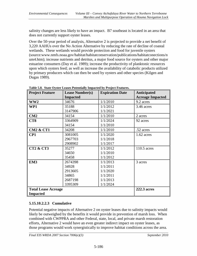
Environmental Consequences Volume III – Convey Atchafalaya River Water to Northern Terrebonne Marshes and Multipurpose Operation of Houma Navigation Lock
5-186
Final EIS WRDA 2007 Section 7006(e)(3) September 2010
salinity changes are less likely to have an impact. B7 southeast is located in an area that does not currently support oyster leases.
Over the 50-year period of analysis, Alternative 2 is projected to provide a net benefit of 3,220 AAHUs over the No Action Alternative by reducing the rate of decline of coastal wetlands. These wetlands would provide protection and food for juvenile oysters (source:www.nmfs.noaa.gov/habitat/habitatconservation/publications/habitatconections/num4.htm); increase nutrients and detritus, a major food source for oysters and other major estuarine consumers (Day et al. 1989); increase the productivity of planktonic resources upon which oysters feed; as well as increase the availability of catabolic products utilized by primary producers which can then be used by oysters and other species (Kilgen and Dugas 1989).
Table 5.8. State Oyster Leases Potentially Impacted by Project Features. Project Feature Lease Number(s)
Impacted Expiration Date Anticipated
Acreage Impacted WW2 34676 1/1/2010 9.2 acres WP1 35188
3147906 1/1/2012 1/1/2021
3.46 acres
CM2 34154 1/1/2010 2 acres CT8 3364909
34154 1/1/2024 1/1/2010
92 acres
CM2 & CT1 34208 1/1/2010 .52 acres CP1 3081005
2967703 2908902
1/1/2020 1/1/2018 1/1/2017
1.62 acres
CT2 & CT3 35277 34650 35458
1/1/2012 1/1/2010 1/1/2012
110.5 acres
EM3 2674398 34928 2913605 34865 2687198 3395309
1/1/2013 1/1/2011 1/1/2020 1/1/2011 1/1/2013 1/1/2024
3 acres
Total Lease Acreage Impacted
222.3 acres
5.15.10.2.2.3 Cumulative Potential negative impacts of Alternative 2 on oyster leases due to salinity impacts would likely be outweighed by the benefits it would provide in prevention of marsh loss. When combined with CWPPRA and other Federal, state, local, and private marsh restoration efforts, Alternative 2 would have an even greater indirect impact on oyster leases, as those programs would work synergistically to improve habitat conditions across the area.
Environmental Consequences Volume III – Convey Atchafalaya River Water to Northern Terrebonne Marshes and Multipurpose Operation of Houma Navigation Lock
5-187
Final EIS WRDA 2007 Section 7006(e)(3) September 2010
5.15.10.2.3 Alternative 3 5.15.10.2.3.1 Direct Direct, indirect, and cumulative impacts of Alternative 3 on oyster leases would be similar to those of Alternative 2. 5.15.10.2.4 Alternative 4 5.15.10.2.4.1 Direct Direct impacts of Alternative 4 on oyster leases would be similar to those of Alternative 2. 5.15.10.2.4.2 Indirect Indirect impacts of Alternative 4 on oyster leases in the western and central areas would be similar to those of Alternative 2. However, due to implementation of the pump station at Grand Bayou, salinity decreases in the Grand Bayou basin would be much more pronounced (see Table 5.9). Oyster leases in the vicinity of G6 Central and G6 Southeast would likely not support oysters with implementation of Alternative 4 due to extended periods with salinities far below the 5ppt range. Oyster leases in the vicinity of G7 Catfish Lake and G7 Northwest would likely see increased mortality and decreased reproduction. Oyster leases in the vicinity of G7 Southeast, however, would likely benefit from implementation of Alternative 4 through decreased predation and disease due to reductions in salinities into the 5-15ppt range. Overall, Alternative 4 is projected to provide a net benefit of 4,258 AAHUs over the No Action Alternative by reducing the rate of decline of coastal wetlands. 5.15.10.2.4.3 Cumulative Potential negative impacts of Alternative 4 on oyster leases due to salinity impacts would likely be outweighed by the benefits it would provide in prevention of marsh loss. When combined with CWPPRA and other Federal, state, local, and private marsh restoration efforts, Alternative 4 would have an even greater indirect impact on oyster leases, as those programs would work synergistically to improve habitat conditions across the area. 5.15.10.2.5 Alternative 5 Direct, indirect, and cumulative impacts of Alternative 5 on oyster leases would be similar to those of Alternative 4. 5.15.10.2.6 Alternative 6 5.15.10.2.6.1 Direct No direct impacts to oyster leases are anticipated from implementation of Alternative 6.
Environmental Consequences Volume III – Convey Atchafalaya River Water to Northern Terrebonne Marshes and Multipurpose Operation of Houma Navigation Lock
5-188
Final EIS WRDA 2007 Section 7006(e)(3) September 2010
5.15.10.2.6.2 Indirect According to modeled salinity values (Table 5.9), Alternative 6 would cause salinities in several areas to fall below the ideal 5-15ppt range. Most of the changes are minor, however, and only two areas are likely to see major changes in oyster production: Robinson Canal and G6 Central. Oysters in these areas would likely see increased mortality and decreased reproduction. Many areas also show improvements in salinities (Table 5.9). These areas would likely see reduced disease and predation with implementation of Alternative 6. Overall, Alternative 6 is projected to provide a net benefit of 776 AAHUs over the No Action Alternative by reducing the rate of decline of coastal wetlands. 5.15.10.2.6.3 Cumulative When combined with CWPPRA and other Federal, state, local, and private marsh restoration efforts, Alternative 6 would have an even greater indirect impact on oyster leases, as those programs would work synergistically to improve habitat conditions across the area. 5.15.10.2.7 Alternative 7 5.15.10.2.7.1 Direct No direct impacts to oyster leases are anticipated from implementation of Alternative 7. 5.15.10.2.7.2 Indirect According to modeled salinity values (Table 5.9), Alternative 7 would cause salinities in several areas to fall below the ideal 5-15ppt range. However, most of the changes are minor and only the Robinson Canal area is likely to be negatively impacted. Oysters in this area would likely see increased mortality and decreased reproduction. Several areas also show slight improvements in salinities. However, the changes are minor and would not be expected to have a major impact on oyster production. Overall, Alternative 7 is projected to provide a net benefit of 243 AAHUs over the No Action Alternative by reducing the rate of decline of coastal wetlands. 5.15.10.2.7.3 Cumulative When combined with CWPPRA and other Federal, state, local, and private marsh restoration efforts, Alternative 7 would have an even greater indirect impact on oyster leases, as those programs would work synergistically to improve habitat conditions across the area.
Environmental Consequences Volume III – Convey Atchafalaya River Water to Northern Terrebonne Marshes and Multipurpose Operation of Houma Navigation Lock
5-189
Final EIS WRDA 2007 Section 7006(e)(3) September 2010
5.15.10.2.8 Alternative 8 5.15.10.2.8.1 Direct Direct impacts of Alternative 8 on oyster leases would be similar to those of Alternative 2, but to a lesser degree. Direct impacts would occur only in association with construction of feature CP1. 5.15.10.2.8.2 Indirect According to modeled salinity values (Table 5.9), indirect impacts of Alternative 8 on oyster leases would be similar to Alternative 2. Overall, Alternative 8 is projected to provide a net benefit of 1,214 AAHUs over the No Action Alternative by reducing the rate of decline of coastal wetlands. 5.15.10.2.8.3 Cumulative When combined with CWPPRA and other Federal, state, local, and private marsh restoration efforts, Alternative 8 would have an even greater indirect impact on oyster leases, as those programs would work synergistically to improve habitat conditions across the area.

Environmental Consequences Volume III – Convey Atchafalaya River Water to Northern Terrebonne Marshes and Multipurpose Operation of Houma Navigation Lock
5-190
Final EIS WRDA 2007 Section 7006(e)(3) September 2010
Figure 5.37. Locations of Hydraulic Model Salinity Points with Overlay of Current (August 2009) Oyster Lease and Seed Ground Locations.

Environmental Consequences Volume III – Convey Atchafalaya River Water to Northern Terrebonne Marshes and Multipurpose Operation of Houma Navigation Lock
5-191
Final EIS WRDA 2007 Section 7006(e)(3) September 2010
Table 5.9. Modeled Average Monthly Salinity Values by Area in 2025. Gray shaded areas in the No Action section indicate months where the RP is predicted to cause a change into or out of the ideal oyster salinity range of 5-15 ppt. Red shaded areas indicate months where No Action salinities were in the ideal 5-15 ppt range and the Alternative caused a shift outside of the ideal range. Green shaded areas indicate months where No Action salinities were outside of the ideal range and the Alternative caused a shift into the ideal range. No Action
Month
Lost Lake West
Lost Lake East A8
B7 South West
B7 South
East C14
Central C14
South HNC South
New C10
Bayou Dulac
Robin son
Canal D3
North D3
Central D3
South E3
North E3
South
E2 North West
E2 South
East E4
North E4
South F2 F3
North F3
South G6
Central
G6 South
East
G7 Catfish
Lake
G7 North West
G7 South
East Jan 7.1 9.0 3.6 15.8 13.4 17.6 19.3 12.1 8.8 9.3 10.7 12.2 15.7 18.8 13.0 13.3 11.2 17.4 17.5 18.3 16.3 17.1 18.3 11.2 14.6 16.4 16.4 18.2 Feb 4.8 5.9 2.3 12.4 10.4 14.3 16.4 8.6 8.3 8.7 9.5 10.4 13.0 15.9 11.1 11.4 8.0 15.1 15.2 15.7 14.2 14.8 15.6 9.9 12.6 14.1 14.2 15.5 Mar 3.0 3.4 1.3 9.6 8.0 11.6 14.0 5.9 7.9 8.3 8.6 8.9 10.8 13.5 9.7 9.9 5.4 13.2 13.3 13.6 12.6 13.0 13.5 8.9 11.1 12.3 12.4 13.4 Apr 3.2 3.6 1.4 9.8 8.2 11.8 14.2 6.1 7.9 8.3 8.6 9.0 11.0 13.7 9.8 10.0 5.6 13.3 13.4 13.7 12.7 13.1 13.7 9.0 11.2 12.4 12.5 13.5 May 0.6 0.1 0.0 5.9 4.8 8.0 10.9 2.2 7.4 7.7 7.3 6.9 8.0 10.4 7.7 7.8 1.9 10.7 10.8 10.8 10.3 10.6 10.7 7.5 9.0 9.9 10.1 10.5 Jun 1.9 1.9 0.7 7.9 6.6 9.9 12.6 4.2 7.7 8.0 8.0 8.0 9.5 12.0 8.7 8.9 3.8 12.1 12.1 12.3 11.5 11.9 12.2 8.3 10.1 11.2 11.3 12.0 Jul 7.6 9.6 3.8 16.5 14.0 18.3 19.9 12.8 8.9 9.4 10.9 12.6 16.2 19.4 13.4 13.7 11.9 17.8 18.0 18.8 16.7 17.6 18.8 11.5 15.0 16.9 16.8 18.8 Aug 10.9 14.0 5.6 21.6 18.3 23.2 24.1 17.7 9.5 10.3 12.6 15.2 20.1 23.6 16.1 16.4 16.5 21.2 21.4 22.6 19.8 20.9 22.6 13.3 17.7 20.2 20.0 22.6 Sep 10.9 14.1 5.6 21.6 18.4 23.3 24.2 17.8 9.5 10.3 12.6 15.2 20.1 23.7 16.1 16.4 16.6 21.2 21.4 22.7 19.8 20.9 22.7 13.4 17.8 20.2 20.0 22.7 Oct 10.5 13.8 5.1 21.8 18.7 23.6 24.3 19.7 9.0 9.7 12.1 14.6 19.7 23.8 16.0 16.4 16.0 21.2 21.4 22.8 19.6 20.8 22.8 12.6 17.3 20.0 19.8 22.7 Nov 11.0 14.5 5.4 22.7 19.5 24.4 25.1 20.5 9.2 9.9 12.5 15.1 20.5 24.6 16.5 16.9 16.8 21.7 22.0 23.4 20.1 21.4 23.4 12.9 17.8 20.6 20.3 23.4 Dec 10.5 13.5 5.4 21.0 17.8 22.6 23.6 17.2 9.5 10.2 12.4 14.9 19.6 23.2 15.8 16.1 16.0 20.8 21.0 22.2 19.4 20.5 22.2 13.1 17.4 19.8 19.6 22.2
Alternative 2
Month
Lost Lake West
Lost Lake East A8
B7 South West
B7 South
East C14
Central C14
South HNC South
New C10
Bayou Dulac
Robin son
Canal D3
North D3
Central D3
South E3
North E3
South
E2 North West
E2 South
East E4
North E4
South F2 F3
North F3
South G6
Central
G6 South
East
G7 Catfish
Lake
G7 North West
G7 South
East Jan 4.8 5.3 2.1 15.0 12.9 18.0 19.3 13.9 6.4 8.4 11.2 10.8 14.6 18.5 13.1 13.4 10.8 17.7 17.8 18.5 17.1 17.2 18.1 8.9 11.5 13.8 13.9 16.7 Feb 3.2 3.5 1.3 11.0 8.9 14.6 16.4 10.2 4.7 7.7 11.0 8.0 10.8 15.4 11.2 11.4 7.5 15.2 15.3 15.8 14.6 14.6 15.3 6.1 8.0 10.1 10.4 13.1 Mar 1.8 2.0 0.8 7.8 5.8 12.0 14.1 7.2 3.3 7.1 10.8 5.8 7.7 13.0 9.6 9.8 4.9 13.2 13.3 13.6 12.6 12.5 13.1 3.9 5.3 7.2 7.6 10.3 Apr 1.9 2.1 0.8 8.0 6.1 12.1 14.2 7.4 3.4 7.1 10.8 5.9 7.9 13.1 9.8 10.0 5.1 13.3 13.5 13.8 12.7 12.6 13.2 4.0 5.5 7.4 7.8 10.5 May 0.1 0.0 0.0 3.5 1.6 8.4 10.9 3.2 1.4 6.3 10.6 2.8 3.5 9.6 7.6 7.7 1.3 10.5 10.6 10.7 9.9 9.7 10.0 0.9 1.6 3.2 3.8 6.5 Jun 1.0 1.1 0.4 5.8 3.9 10.3 12.6 5.3 2.4 6.7 10.7 4.4 5.8 11.4 8.7 8.9 3.2 11.9 12.1 12.3 11.4 11.2 11.6 2.5 3.5 5.3 5.8 8.6 Jul 5.2 5.7 2.2 15.8 13.6 18.6 19.9 14.7 6.8 8.6 11.2 11.4 15.4 19.2 13.5 13.8 11.4 18.2 18.4 19.0 17.6 17.8 18.7 9.4 12.2 14.6 14.6 17.4 Aug 7.6 8.4 3.3 21.6 19.3 23.5 24.1 20.1 9.3 9.7 11.5 15.5 21.0 23.6 16.4 16.6 16.2 21.8 22.0 23.0 21.2 21.6 22.8 13.5 17.2 19.9 19.6 22.5 Sep 7.6 8.4 3.3 21.6 19.4 23.5 24.2 20.2 9.4 9.7 11.5 15.5 21.1 23.7 16.4 16.6 16.2 21.8 22.0 23.0 21.3 21.6 22.8 13.5 17.3 20.0 19.7 22.6 Oct 7.7 8.6 3.3 21.9 19.6 23.7 24.4 20.4 9.5 9.7 11.5 15.7 21.3 23.9 16.5 16.8 16.4 21.9 22.2 23.2 21.4 21.8 23.0 13.7 17.5 20.2 19.9 22.8 Nov 8.1 9.0 3.5 22.8 20.5 24.5 25.1 21.3 9.9 9.9 11.6 16.4 22.2 24.6 17.0 17.2 17.2 22.5 22.8 23.8 22.0 22.4 23.7 14.3 18.3 21.1 20.7 23.6 Dec 7.3 8.1 3.1 20.9 18.6 22.9 23.7 19.5 9.0 9.6 11.5 15.0 20.3 23.1 16.0 16.3 15.6 21.3 21.6 22.5 20.8 21.1 22.3 13.0 16.7 19.3 19.0 21.9

Environmental Consequences Volume III – Convey Atchafalaya River Water to Northern Terrebonne Marshes and Multipurpose Operation of Houma Navigation Lock
5-192
Final EIS WRDA 2007 Section 7006(e)(3) September 2010
Alternative 3
Month
Lost Lake West
Lost Lake East A8
B7 South West
B7 South
East C14
Central C14
South HNC South
New C10
Bayou Dulac
Robin son
Canal D3
North D3
Central D3
South E3
North E3
South
E2 North West
E2 South
East E4
North E4
South F2 F3
North F3
South G6
Central
G6 South
East
G7 Catfish
Lake
G7 North West
G7 South
East Jan 4.8 5.3 2.1 14.9 12.8 17.9 19.3 13.9 6.4 8.4 11.2 10.8 14.6 18.5 13.2 13.4 10.7 17.6 17.8 18.5 17.1 17.2 18.1 8.8 11.4 13.7 13.8 16.6 Feb 3.2 3.5 1.3 10.9 8.8 14.6 16.4 10.1 4.7 7.6 10.9 8.0 10.7 15.4 11.2 11.4 7.4 15.1 15.3 15.8 14.6 14.6 15.3 6.0 7.9 10.0 10.2 13.0 Mar 1.8 2.0 0.8 7.8 5.8 12.0 14.1 7.2 3.3 7.1 10.8 5.8 7.7 13.0 9.7 9.9 4.9 13.2 13.3 13.6 12.6 12.5 13.1 3.9 5.3 7.2 7.6 10.3 Apr 1.9 2.1 0.8 8.0 6.0 12.1 14.2 7.4 3.4 7.1 10.8 5.9 7.9 13.1 9.8 10.0 5.0 13.3 13.5 13.8 12.7 12.6 13.2 4.0 5.5 7.4 7.8 10.5 May 0.1 0.0 0.0 3.5 1.6 8.4 10.9 3.2 1.4 6.3 10.6 2.8 3.5 9.6 7.6 7.7 1.3 10.5 10.6 10.7 9.9 9.7 10.0 0.9 1.6 3.2 3.8 6.5 Jun 1.0 1.1 0.4 5.8 3.9 10.3 12.6 5.3 2.4 6.7 10.7 4.4 5.8 11.4 8.7 8.9 3.2 11.9 12.1 12.3 11.4 11.2 11.6 2.5 3.5 5.3 5.8 8.6 Jul 5.2 5.7 2.2 15.7 13.6 18.6 19.9 14.6 6.8 8.6 11.2 11.4 15.4 19.1 13.6 13.8 11.4 18.1 18.3 19.0 17.6 17.7 18.7 9.4 12.1 14.5 14.5 17.3 Aug 7.6 8.4 3.2 21.5 19.3 23.5 24.1 20.1 9.3 9.7 11.5 15.4 21.0 23.6 16.4 16.7 16.1 21.8 22.0 23.0 21.2 21.6 22.8 13.4 17.2 19.9 19.6 22.5 Sep 7.6 8.4 3.2 21.6 19.3 23.5 24.2 20.2 9.3 9.7 11.5 15.5 21.0 23.7 16.5 16.7 16.2 21.8 22.0 23.0 21.3 21.6 22.8 13.5 17.3 19.9 19.7 22.5 Oct 7.7 8.5 3.3 21.8 19.5 23.7 24.4 20.4 9.4 9.7 11.5 15.6 21.2 23.9 16.6 16.8 16.4 21.9 22.2 23.2 21.4 21.8 23.0 13.6 17.4 20.2 19.9 22.7 Nov 8.1 9.0 3.5 22.8 20.5 24.5 25.1 21.3 9.8 9.9 11.6 16.3 22.2 24.6 17.0 17.3 17.2 22.5 22.8 23.8 22.0 22.4 23.7 14.3 18.3 21.1 20.7 23.6 Dec 7.3 8.1 3.1 20.9 18.6 22.9 23.7 19.5 9.0 9.6 11.5 15.0 20.3 23.1 16.1 16.3 15.6 21.3 21.6 22.5 20.8 21.1 22.3 13.0 16.6 19.3 19.0 21.9 Alternative 4
Month
Lost Lake West
Lost Lake East A8
B7 South West
B7 South
East C14
Central C14
South HNC South
New C10
Bayou Dulac
Robin son
Canal D3
North D3
Central D3
South E3
North E3
South
E2 North West
E2 South
East E4
North E4
South F2 F3
North F3
South G6
Central
G6 South
East
G7 Catfish
Lake
G7 North West
G7 South
East Jan 5.3 6.0 2.8 15.3 13.5 18.1 19.3 14.7 7.4 8.7 11.3 12.5 15.2 18.5 12.8 13.1 13.0 17.0 17.3 18.2 15.4 15.1 16.8 1.7 2.2 4.2 4.7 9.3 Feb 3.5 3.9 1.8 11.2 9.4 14.7 16.4 10.7 5.3 7.8 11.1 9.1 11.2 15.4 10.9 11.2 9.0 14.7 15.0 15.6 13.5 13.2 14.4 1.4 1.9 3.7 4.2 8.2 Mar 2.0 2.2 1.0 7.9 6.1 12.0 14.1 7.5 3.6 7.2 10.8 6.4 7.9 13.0 9.5 9.7 5.8 12.9 13.1 13.5 11.9 11.6 12.5 1.2 1.7 3.3 3.9 7.2 Apr 2.1 2.4 1.1 8.2 6.3 12.2 14.2 7.7 3.7 7.2 10.8 6.6 8.1 13.1 9.6 9.8 6.0 13.0 13.2 13.6 12.0 11.7 12.6 1.2 1.7 3.4 3.9 7.3 May 0.1 0.0 0.0 3.6 1.7 8.4 10.9 3.2 1.4 6.3 10.5 2.8 3.6 9.6 7.5 7.7 1.4 10.5 10.6 10.7 9.8 9.6 9.9 0.8 1.4 2.8 3.4 6.0 Jun 1.1 1.2 0.6 5.9 4.0 10.3 12.6 5.5 2.6 6.7 10.7 4.7 5.9 11.4 8.6 8.8 3.7 11.8 12.0 12.2 10.9 10.7 11.3 1.0 1.5 3.1 3.7 6.7 Jul 5.6 6.4 3.0 16.1 14.3 18.8 19.9 15.5 7.8 8.8 11.4 13.1 16.1 19.2 13.1 13.5 13.9 17.4 17.8 18.7 15.8 15.5 17.2 1.8 2.2 4.3 4.8 9.6 Aug 8.3 9.4 4.4 22.0 20.3 23.6 24.1 21.3 10.8 10.1 11.8 18.0 21.9 23.6 15.7 16.2 19.7 20.7 21.1 22.5 18.6 18.3 20.7 2.2 2.7 5.0 5.4 11.2 Sep 8.3 9.4 4.4 22.1 20.4 23.7 24.2 21.4 10.8 10.1 11.8 18.1 22.0 23.7 15.8 16.2 19.8 20.8 21.2 22.5 18.6 18.3 20.7 2.2 2.7 5.0 5.4 11.3 Oct 8.4 9.6 4.4 22.3 20.6 23.9 24.3 21.6 10.9 10.1 11.8 18.3 22.2 23.9 15.9 16.3 20.0 20.9 21.3 22.7 18.7 18.4 20.8 2.2 2.7 5.1 5.4 11.3 Nov 8.8 10.1 4.7 23.3 21.6 24.7 25.0 22.6 11.4 10.3 11.9 19.1 23.2 24.6 16.3 16.8 21.0 21.4 21.9 23.3 19.2 18.9 21.4 2.3 2.7 5.2 5.5 11.6 Dec 8.0 9.1 4.2 21.3 19.6 23.1 23.6 20.6 10.4 9.9 11.8 17.5 21.2 23.1 15.4 15.9 19.0 20.3 20.7 22.0 18.3 17.9 20.3 2.2 2.6 4.9 5.3 11.0

Environmental Consequences Volume III – Convey Atchafalaya River Water to Northern Terrebonne Marshes and Multipurpose Operation of Houma Navigation Lock
5-193
Final EIS WRDA 2007 Section 7006(e)(3) September 2010
Alternative 5
Month
Lost Lake West
Lost Lake East A8
B7 South West
B7 South
East C14
Central C14
South HNC South
New C10
Bayou Dulac
Robin son
Canal D3
North D3
Central D3
South E3
North E3
South
E2 North West
E2 South
East E4
North E4
South F2 F3
North F3
South G6
Central
G6 South
East
G7 Catfish
Lake
G7 North West
G7 South
East Jan 5.2 5.9 2.7 15.2 13.4 18.0 19.3 14.6 7.3 8.6 11.3 12.4 15.2 18.5 12.7 13.1 13.0 17.0 17.3 18.2 15.4 15.1 16.8 1.7 2.2 4.2 4.7 9.3 Feb 3.4 3.9 1.8 11.1 9.3 14.6 16.4 10.6 5.2 7.8 11.0 9.0 11.1 15.4 10.9 11.2 8.9 14.7 15.0 15.6 13.5 13.2 14.4 1.4 1.9 3.7 4.2 8.2 Mar 2.0 2.2 1.0 7.9 6.1 12.0 14.1 7.5 3.6 7.2 10.8 6.4 7.9 13.0 9.5 9.7 5.8 12.9 13.1 13.5 11.9 11.6 12.5 1.2 1.7 3.3 3.9 7.2 Apr 2.1 2.3 1.1 8.2 6.3 12.2 14.2 7.7 3.7 7.2 10.8 6.6 8.1 13.1 9.6 9.8 6.0 13.0 13.2 13.6 12.0 11.7 12.6 1.2 1.7 3.4 3.9 7.3 May 0.1 0.0 0.0 3.6 1.7 8.4 10.9 3.2 1.4 6.3 10.5 2.8 3.6 9.6 7.5 7.7 1.4 10.5 10.6 10.7 9.8 9.6 9.9 0.8 1.4 2.8 3.4 6.0 Jun 1.1 1.2 0.6 5.9 4.0 10.3 12.6 5.5 2.6 6.7 10.7 4.7 5.9 11.4 8.6 8.8 3.7 11.8 12.0 12.2 10.9 10.7 11.3 1.0 1.5 3.1 3.7 6.7 Jul 5.6 6.4 2.9 16.0 14.3 18.7 19.9 15.4 7.7 8.8 11.4 13.1 16.0 19.1 13.1 13.5 13.8 17.4 17.8 18.7 15.8 15.5 17.2 1.8 2.2 4.3 4.8 9.6 Aug 8.2 9.3 4.3 22.0 20.3 23.6 24.1 21.3 10.7 10.1 11.8 18.0 21.9 23.6 15.7 16.2 19.7 20.7 21.1 22.5 18.6 18.3 20.7 2.2 2.7 5.0 5.4 11.3 Sep 8.3 9.4 4.3 22.1 20.3 23.7 24.2 21.3 10.8 10.1 11.8 18.0 22.0 23.7 15.8 16.2 19.8 20.8 21.2 22.5 18.6 18.3 20.7 2.2 2.7 5.0 5.4 11.3 Oct 8.4 9.5 4.4 22.3 20.6 23.9 24.3 21.6 10.9 10.1 11.8 18.2 22.2 23.9 15.9 16.3 20.0 20.9 21.3 22.7 18.7 18.4 20.8 2.2 2.7 5.1 5.5 11.3 Nov 8.8 10.0 4.6 23.3 21.6 24.7 25.0 22.5 11.4 10.3 11.9 19.0 23.2 24.6 16.3 16.8 21.0 21.4 21.9 23.3 19.2 18.9 21.4 2.3 2.7 5.2 5.6 11.6 Dec 7.9 9.0 4.2 21.3 19.6 23.1 23.6 20.6 10.4 9.9 11.8 17.4 21.2 23.1 15.4 15.9 19.0 20.3 20.7 22.0 18.3 17.9 20.3 2.2 2.6 5.0 5.3 11.1 Alternative 6
Month
Lost Lake West
Lost Lake East A8
B7 South West
B7 South
East C14
Central C14
South HNC South
New C10
Bayou Dulac
Robin son
Canal D3
North D3
Central D3
South E3
North E3
South
E2 North West
E2 South
East E4
North E4
South F2 F3
North F3
South G6
Central
G6 South
East
G7 Catfish
Lake
G7 North West
G7 South
East Jan 6.9 8.7 3.2 13.5 11.8 14.5 14.9 12.2 5.9 6.4 7.9 9.3 12.3 14.6 9.8 10.1 9.9 12.9 13.1 14.0 12.1 12.9 14.0 8.5 10.9 12.2 12.4 13.9 Feb 4.5 5.6 2.1 8.8 7.7 9.5 9.7 8.0 3.9 4.1 5.1 6.0 8.0 9.5 6.4 6.5 6.5 8.4 8.6 9.1 7.9 8.4 9.1 5.5 7.1 7.9 8.1 9.1 Mar 3.0 3.3 1.2 8.6 6.3 12.1 14.0 7.2 7.2 6.0 5.0 7.2 7.9 12.8 9.3 9.6 5.2 12.5 12.8 13.3 11.4 12.1 13.2 5.0 7.3 9.5 10.1 12.2 Apr 3.1 3.5 1.3 8.8 6.5 12.2 14.2 7.4 7.2 6.1 5.1 7.3 8.1 13.0 9.4 9.7 5.4 12.7 12.9 13.5 11.5 12.2 13.3 5.1 7.5 9.7 10.3 12.4 May 0.5 0.1 0.0 4.6 2.5 8.5 10.9 3.4 6.3 4.7 2.6 4.8 4.3 9.5 7.2 7.5 1.9 9.9 10.1 10.4 8.8 9.4 10.2 2.3 4.2 6.3 7.1 9.0 Jun 1.9 1.8 0.7 6.7 4.5 10.4 12.5 5.4 6.8 5.4 3.9 6.1 6.2 11.3 8.3 8.6 3.7 11.3 11.5 12.0 10.2 10.8 11.8 3.7 5.9 8.0 8.7 10.7 Jul 7.4 9.3 3.5 14.5 12.6 15.5 15.9 13.1 6.4 6.8 8.4 9.9 13.1 15.6 10.5 10.8 10.6 13.9 14.1 15.0 13.0 13.8 15.0 9.1 11.7 13.0 13.2 14.9 Aug 10.9 13.6 5.1 21.3 18.5 22.8 23.4 19.2 9.3 10.0 12.4 14.6 19.3 23.0 15.5 15.8 15.6 20.4 20.7 22.0 19.1 20.2 22.0 13.4 17.2 19.2 19.5 22.0 Sep 10.9 13.7 5.1 21.4 18.6 22.9 23.5 19.3 9.4 10.1 12.5 14.7 19.4 23.1 15.5 15.9 15.7 20.5 20.8 22.1 19.2 20.3 22.1 13.5 17.3 19.2 19.5 22.0 Oct 11.1 13.9 5.2 21.7 18.9 23.2 23.8 19.6 9.5 10.2 12.6 14.8 19.6 23.3 15.7 16.1 15.9 20.7 21.0 22.4 19.4 20.6 22.4 13.6 17.5 19.5 19.8 22.3 Nov 11.7 14.6 5.4 22.8 19.8 24.4 25.1 20.6 10.0 10.7 13.3 15.6 20.7 24.6 16.5 16.9 16.7 21.8 22.1 23.5 20.4 21.6 23.5 14.3 18.4 20.5 20.8 23.5 Dec 10.5 13.1 4.9 20.5 17.9 22.0 22.6 18.5 9.0 9.6 11.9 14.1 18.6 22.1 14.9 15.2 15.0 19.6 19.9 21.2 18.4 19.5 21.2 12.9 16.6 18.4 18.7 21.1
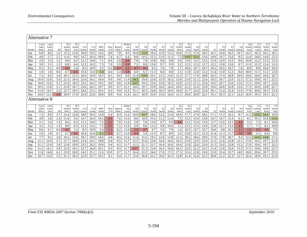
Environmental Consequences Volume III – Convey Atchafalaya River Water to Northern Terrebonne Marshes and Multipurpose Operation of Houma Navigation Lock
5-194
Final EIS WRDA 2007 Section 7006(e)(3) September 2010
Alternative 7
Month
Lost Lake West
Lost Lake East A8
B7 South West
B7 South
East C14
Central C14
South HNC South
New C10
Bayou Dulac
Robin son
Canal D3
North D3
Central D3
South E3
North E3
South
E2 North West
E2 South
East E4
North E4
South F2 F3
North F3
South G6
Central
G6 South
East
G7 Catfish
Lake
G7 North West
G7 South
East Jan 6.8 8.6 3.2 15.3 12.6 18.0 19.3 13.6 8.0 7.8 8.5 10.9 13.9 18.4 12.9 13.2 10.6 17.2 17.4 18.2 16.1 16.9 18.2 10.7 14.2 16.2 16.1 18.1 Feb 4.6 5.7 2.1 11.6 9.0 14.7 16.4 10.0 7.4 6.7 6.4 8.8 10.5 15.3 11.0 11.3 7.5 14.9 15.0 15.6 14.0 14.7 15.6 9.5 12.4 14.0 14.0 15.5 Mar 2.9 3.3 1.2 8.6 6.2 12.1 14.0 7.1 6.9 5.9 4.8 7.0 7.8 12.8 9.6 9.8 5.0 13.0 13.2 13.5 12.4 12.9 13.5 8.6 10.9 12.2 12.3 13.3 Apr 3.0 3.5 1.3 8.8 6.4 12.2 14.2 7.3 7.0 5.9 4.9 7.2 8.0 13.0 9.7 9.9 5.2 13.2 13.3 13.7 12.5 13.0 13.6 8.7 11.0 12.3 12.4 13.5 May 0.5 0.1 0.0 4.6 2.4 8.5 10.9 3.3 6.3 4.7 2.6 4.7 4.2 9.5 7.6 7.8 1.7 10.6 10.7 10.7 10.2 10.5 10.7 7.4 8.9 9.8 10.0 10.5 Jun 1.8 1.8 0.6 6.7 4.5 10.4 12.6 5.4 6.6 5.3 3.8 6.0 6.1 11.3 8.6 8.8 3.5 11.9 12.0 12.2 11.4 11.8 12.2 8.0 10.0 11.1 11.2 12.0 Jul 7.2 9.2 3.4 16.1 13.3 18.6 19.9 14.3 8.1 8.0 8.9 11.4 14.6 19.1 13.3 13.6 11.3 17.7 17.9 18.8 16.5 17.4 18.8 10.9 14.6 16.6 16.6 18.7 Aug 10.4 13.6 5.0 21.5 18.4 23.4 24.1 19.4 9.0 9.6 11.9 14.5 19.4 23.6 15.9 16.3 15.8 21.0 21.2 22.6 19.5 20.7 22.6 12.5 17.2 19.9 19.7 22.5 Sep 10.4 13.6 5.1 21.6 18.5 23.5 24.2 19.5 9.0 9.6 11.9 14.5 19.5 23.6 15.9 16.3 15.8 21.0 21.3 22.6 19.5 20.7 22.6 12.6 17.2 19.9 19.7 22.6 Oct 10.5 13.8 5.1 21.8 18.7 23.6 24.3 19.7 9.0 9.7 12.1 14.6 19.7 23.8 16.0 16.4 16.0 21.2 21.4 22.8 19.6 20.8 22.8 12.6 17.3 20.0 19.8 22.7 Nov 11.0 14.5 5.4 22.7 19.5 24.4 25.1 20.5 9.2 9.9 12.5 15.1 20.5 24.6 16.5 16.9 16.8 21.7 22.0 23.4 20.1 21.4 23.4 12.9 17.8 20.6 20.3 23.4 Dec 10.0 13.1 4.9 20.9 17.8 22.8 23.6 18.8 8.9 9.4 11.6 14.1 18.9 23.0 15.6 16.0 15.3 20.6 20.9 22.1 19.1 20.3 22.1 12.4 16.9 19.5 19.3 22.1 Alternative 8
Month
Lost Lake West
Lost Lake East A8
B7 South West
B7 South
East C14
Central C14
South HNC South
New C10
Bayou Dulac
Robin son
Canal D3
North D3
Central D3
South E3
North E3
South
E2 North West
E2 South
East E4
North E4
South F2 F3
North F3
South G6
Central
G6 South
East
G7 Catfish
Lake
G7 North West
G7 South
East Jan 7.2 8.9 3.7 15.4 12.8 18.0 19.3 13.8 6.4 8.3 11.6 10.9 14.7 18.6 13.2 13.4 10.9 17.7 17.9 18.5 17.1 17.3 18.1 8.7 11.5 13.6 14.1 16.8 Feb 4.9 5.8 2.4 11.6 9.2 14.7 16.4 10.2 4.6 7.6 11.6 8.0 10.9 15.5 11.2 11.4 7.5 15.2 15.4 15.8 14.7 14.7 15.3 6.1 8.1 10.1 10.8 13.4 Mar 3.1 3.4 1.4 8.6 6.3 12.1 14.0 7.3 3.2 7.0 11.6 5.8 7.8 13.0 9.7 9.9 4.9 13.2 13.4 13.6 12.7 12.6 13.1 4.0 5.5 7.3 8.1 10.6 Apr 3.2 3.5 1.4 8.8 6.5 12.2 14.2 7.5 3.3 7.1 11.6 6.0 8.0 13.2 9.8 10.0 5.1 13.3 13.5 13.8 12.8 12.7 13.3 4.1 5.7 7.5 8.3 10.8 May 0.6 0.1 0.0 4.5 2.4 8.5 10.9 3.4 1.3 6.2 11.6 2.8 3.7 9.7 7.6 7.8 1.4 10.5 10.7 10.7 10.0 9.8 10.1 1.1 1.9 3.5 4.5 7.0 Jun 1.9 1.8 0.7 6.7 4.5 10.4 12.6 5.5 2.3 6.7 11.6 4.4 5.9 11.5 8.7 8.9 3.3 12.0 12.1 12.3 11.4 11.3 11.7 2.6 3.8 5.5 6.4 8.9 Jul 7.7 9.5 3.9 16.2 13.6 18.7 19.9 14.6 6.8 8.5 11.6 11.4 15.5 19.2 13.6 13.8 11.5 18.2 18.4 19.0 17.6 17.8 18.7 9.3 12.2 14.4 14.8 17.5 Aug 11.1 13.9 5.7 21.7 18.8 23.4 24.1 19.8 9.4 9.5 11.7 15.5 21.0 23.6 16.4 16.6 16.3 21.8 22.0 23.0 21.2 21.6 22.8 13.1 17.0 19.5 19.7 22.4 Sep 11.1 13.9 5.8 21.8 18.9 23.5 24.2 19.9 9.4 9.5 11.7 15.5 21.1 23.7 16.4 16.6 16.4 21.8 22.0 23.0 21.3 21.6 22.8 13.2 17.0 19.6 19.7 22.5 Oct 11.2 14.1 5.8 22.0 19.1 23.7 24.4 20.1 9.5 9.5 11.7 15.7 21.3 23.9 16.5 16.8 16.5 22.0 22.2 23.2 21.4 21.8 23.0 13.3 17.2 19.8 19.9 22.7 Nov 11.8 14.8 6.1 22.9 20.0 24.5 25.1 21.0 10.0 9.7 11.7 16.4 22.2 24.6 17.0 17.2 17.3 22.6 22.8 23.8 22.0 22.4 23.7 14.0 18.0 20.6 20.7 23.5 Dec 10.7 13.4 5.5 21.1 18.2 22.9 23.7 19.2 9.1 9.4 11.7 15.0 20.4 23.1 16.0 16.3 15.8 21.4 21.6 22.5 20.8 21.2 22.3 12.7 16.4 18.9 19.1 21.9

Environmental Consequences Volume III – Convey Atchafalaya River Water to Northern Terrebonne Marshes and Multipurpose Operation of Houma Navigation Lock
5-195
Final EIS WRDA 2007 Section 7006(e)(3) September 2010
5.16 Hazardous, Toxic, and Radioactive Wastes [Phase I Environmental Site Assessment Findings]
5.16.1 No Action Alternative (Future without Project Conditions)
The condition with the No Action Alternative regarding the potential for HTRW is dependent on site-specific HTRW discovery. Based on the Phase I Environmental Site Assessment in the project action area, there is reason to believe that the potential to encounter HTRW problems would be low. 5.16.2 Alternative 2 (NER Plan and RP)
5.16.2.1 Direct Consistent with ER 1165-2-132, an HTRW investigation of the project area was conducted. Based upon findings from this investigation, the potential for direct impacts to the project area from implementation of Alternative 2 would be low and would likely continue to be low into the future. 5.16.2.2 Indirect Consistent with ER 1165-2-132, an HTRW investigation of the project area was conducted. Based upon findings from this investigation, the potential for indirect impacts to the project area from implementation of Alternative 2 would be low and would likely continue to be low into the future. 5.16.2.3 Cumulative Consistent with ER 1165-2-132, an HTRW investigation of the project area was conducted. Based upon findings from this investigation, the potential for cumulative impacts to the project area from implementation of Alternative 2 would be low and would likely continue to be low into the future. 5.16.3 Alternative 3
Direct, indirect, and cumulative impacts of Alternative 3 would be similar to Alternative 2. 5.16.4 Alternative 4
Direct, indirect, and cumulative impacts of Alternative 4 would be similar to Alternative 2. 5.16.5 Alternative 5
Direct, indirect, and cumulative impacts of Alternative 5 would be similar to Alternative 2. 5.16.6 Alternative 6
Direct, indirect, and cumulative impacts of Alternative 6 would be similar to Alternative 2.
Environmental Consequences Volume III – Convey Atchafalaya River Water to Northern Terrebonne Marshes and Multipurpose Operation of Houma Navigation Lock
5-196
Final EIS WRDA 2007 Section 7006(e)(3) September 2010
5.16.7 Alternative 7
Direct, indirect, and cumulative impacts of Alternative 7 would be similar to Alternative 2. 5.16.8 Alternative 8 Direct, indirect, and cumulative impacts of Alternative 8 would be similar to Alternative 2.

Environmental Consequences Volume III – Convey Atchafalaya River Water to Northern Terrebonne Marshes and Multipurpose Operation of Houma Navigation Lock
5-197
Final EIS WRDA 2007 Section 7006(e)(3) September 2010
5.17 Unavoidable Adverse Effects Wetland impacts were avoided and minimized to the extent possible in the preliminary design of the RP. With avoidance and minimization of wetland impacts the RP would impact approximately 171 acres of swamp/wetland forest, 343 acres of fresh marsh, 248 acres of intermediate marsh, and 182 acres of brackish marsh due to dredge features WD2, CD1, CD3, CD6, CD7, ED2, ED3, ED6, and ED7 and due to levee features CLV1 and CLV2. The creation of approximately 329 acres of emergent marsh habitat and the prevention of loss of approximately 9,655 acres of emergent marsh habitat will mitigate for the wetland impacts resulting from construction project features. There would be no other unavoidable adverse impacts as a result of the implementation of reasonable alternatives for this project. 5.18 Relationship of Short-Term Uses and Long-Term Productivity NEPA Section 102(2)(c)(iv) and 40 CFR 1502.16 requires that an EIS include a discussion of the relationship between short-term uses of the environment and the maintenance and enhancement of long-term productivity. This section describes how the Proposed Action would affect the short-term use and the long-term productivity of the environment. In reference to the Proposed Action, “short-term” refers to the temporary phase of construction of the proposed project, while “long-term” refers to the operational life of the proposed project and beyond. Section 5 of this document evaluates the direct, indirect and cumulative effects that could result from the Proposed Action. Construction of the Proposed Action would result in short-term construction-related impacts within parts of the project area and would include to some extent interference with local traffic, minor limited air emissions, increases in ambient noise levels, dust generation, disturbance of wildlife, increased storm runoff, and disturbance of recreational and other public facilities. These impacts would be temporary and would occur only during construction, and are not expected to alter the long-term productivity of the natural environment. The Proposed Action would assist in the long-term productivity of the northern Terrebonne marshes ecological community by improving the water quantity, water quality, and nutrients delivered to area marshes. This in turn would facilitate the growth and productivity of emergent marsh habitat. The Proposed Action would also result in enhancing the long-term productivity of the natural communities throughout the region. These long-term beneficial effects of the Proposed Action would outweigh the minimal and mitigable short-term impacts to the environment resulting primarily from project construction. 5.19 Irreversible and Irretrievable Commitments of Resources NEPA requires that environmental analysis include identification of “any irreversible and irretrievable commitments of resources which would be involved in the proposed action

Environmental Consequences Volume III – Convey Atchafalaya River Water to Northern Terrebonne Marshes and Multipurpose Operation of Houma Navigation Lock
5-198
Final EIS WRDA 2007 Section 7006(e)(3) September 2010
should it be implemented.” Irreversible and irretrievable resource commitments are related to the use of nonrenewable resources and the effects that the use of these resources have on future generations. Irreversible effects primarily result from use or destruction of a specific resource (e.g., energy and minerals) that cannot be replaced within a reasonable time frame. Irretrievable resource commitments involve the loss in value of an affected resource that cannot be restored as a result of the action (e.g., extinction of a threatened or endangered species or the disturbance of a cultural site). The proposed project would result in few direct and indirect commitments of resources; these would be related mainly to construction components. For the proposed alternatives, most resource commitments are neither irreversible nor irretrievable. Most impacts are short term and temporary. Others that may have a longer effect can be reduced through appropriate measures. There is no irreversible or irretrievable commitment of resources which would preclude formulation or implementation of reasonable alternatives for this project. 5.20 Mitigation Project plans and alternatives were developed in accordance with Corps planning guidance at ER 1105-2-100 which directs that ecosystem restoration projects be designed to avoid the need for compensatory fish and wildlife mitigation. Formulation of project alternatives was conducted in compliance with this guidance. Also in accordance with Corps planning guidance, net ecosystem benefits expected to accrue if the proposed project is implemented may not be used as wetland banks or mitigation credit by the non-Federal sponsor. 5.21 Cumulative Impacts Summary The impacts of the Deepwater Horizon oil spill on coastal Louisiana are uncertain at this time (August 2010). The impacts of the oil spill as well as the various emergency actions taken to address oil spill impacts (e.g., use of oil dispersants, creation of sand berms, use of Hesco baskets, rip-rap, sheet piling and other actions) could potentially impact USACE water resources projects and studies within the Louisiana coastal area, including the LCA-ARTM project. Potential impacts could include factors such as changes to existing, future-without, and future-with-project conditions, as well as increased project costs and implementation delays. The USACE will continue to monitor and closely coordinate with other Federal and state resource agencies and local sponsors in determining how to best address any potential problems associated with the oil spill that may adversely impact project implementation. Supplemental planning and environmental documentation may be required as information becomes available. If at any time petroleum or crude oil is discovered on project lands, all efforts will be taken to seek clean up by the responsible parties, pursuant to the Oil Pollution Act of 1990 (33 U.S.C. 2701 et seq.).
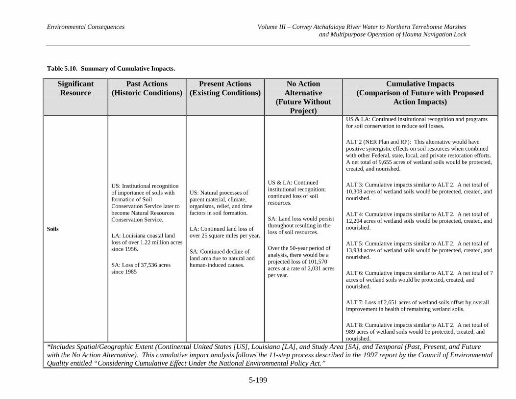
Environmental Consequences Volume III – Convey Atchafalaya River Water to Northern Terrebonne Marshes and Multipurpose Operation of Houma Navigation Lock
5-199
Table 5.10. Summary of Cumulative Impacts.
Significant Resource
Past Actions (Historic Conditions)
Present Actions (Existing Conditions)
No Action Alternative
(Future Without Project)
Cumulative Impacts (Comparison of Future with Proposed
Action Impacts)
Soils
US: Institutional recognition of importance of soils with formation of Soil Conservation Service later to become Natural Resources Conservation Service.
LA: Louisiana coastal land loss of over 1.22 million acres since 1956.
SA: Loss of 37,536 acres since 1985
US: Natural processes of parent material, climate, organisms, relief, and time factors in soil formation.
LA: Continued land loss of over 25 square miles per year.
SA: Continued decline of land area due to natural and human-induced causes.
US & LA: Continued institutional recognition; continued loss of soil resources.
SA: Land loss would persist throughout resulting in the loss of soil resources.
Over the 50-year period of analysis, there would be a projected loss of 101,570 acres at a rate of 2,031 acres per year.
US & LA: Continued institutional recognition and programs for soil conservation to reduce soil losses.
ALT 2 (NER Plan and RP): This alternative would have positive synergistic effects on soil resources when combined with other Federal, state, local, and private restoration efforts. A net total of 9,655 acres of wetland soils would be protected, created, and nourished.
ALT 3: Cumulative impacts similar to ALT 2. A net total of 10,308 acres of wetland soils would be protected, created, and nourished.
ALT 4: Cumulative impacts similar to ALT 2. A net total of 12,204 acres of wetland soils would be protected, created, and nourished.
ALT 5: Cumulative impacts similar to ALT 2. A net total of 13,934 acres of wetland soils would be protected, created, and nourished.
ALT 6: Cumulative impacts similar to ALT 2. A net total of 7 acres of wetland soils would be protected, created, and nourished.
ALT 7: Loss of 2,651 acres of wetland soils offset by overall improvement in health of remaining wetland soils.
ALT 8: Cumulative impacts similar to ALT 2. A net total of 989 acres of wetland soils would be protected, created, and nourished.
*Includes Spatial/Geographic Extent (Continental United States [US], Louisiana [LA], and Study Area [SA], and Temporal (Past, Present, and Future with the No Action Alternative). This cumulative impact analysis follows the 11-step process described in the 1997 report by the Council of Environmental Quality entitled “Considering Cumulative Effect Under the National Environmental Policy Act.”
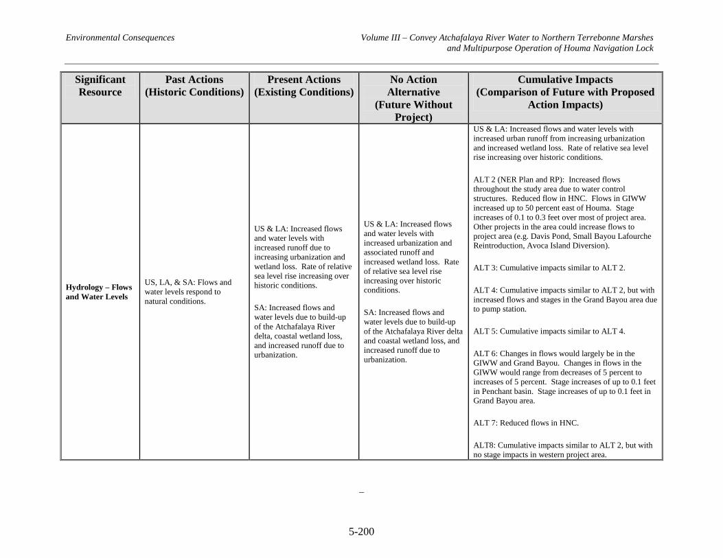
Environmental Consequences Volume III – Convey Atchafalaya River Water to Northern Terrebonne Marshes and Multipurpose Operation of Houma Navigation Lock
5-200
Significant Resource
Past Actions (Historic Conditions)
Present Actions (Existing Conditions)
No Action Alternative
(Future Without Project)
Cumulative Impacts (Comparison of Future with Proposed
Action Impacts)
Hydrology – Flows and Water Levels
US, LA, & SA: Flows and water levels respond to natural conditions.
US & LA: Increased flows and water levels with increased runoff due to increasing urbanization and wetland loss. Rate of relative sea level rise increasing over historic conditions.
SA: Increased flows and water levels due to build-up of the Atchafalaya River delta, coastal wetland loss, and increased runoff due to urbanization.
US & LA: Increased flows and water levels with increased urbanization and associated runoff and increased wetland loss. Rate of relative sea level rise increasing over historic conditions.
SA: Increased flows and water levels due to build-up of the Atchafalaya River delta and coastal wetland loss, and increased runoff due to urbanization.
US & LA: Increased flows and water levels with increased urban runoff from increasing urbanization and increased wetland loss. Rate of relative sea level rise increasing over historic conditions.
ALT 2 (NER Plan and RP): Increased flows throughout the study area due to water control structures. Reduced flow in HNC. Flows in GIWW increased up to 50 percent east of Houma. Stage increases of 0.1 to 0.3 feet over most of project area. Other projects in the area could increase flows to project area (e.g. Davis Pond, Small Bayou Lafourche Reintroduction, Avoca Island Diversion).
ALT 3: Cumulative impacts similar to ALT 2.
ALT 4: Cumulative impacts similar to ALT 2, but with increased flows and stages in the Grand Bayou area due to pump station.
ALT 5: Cumulative impacts similar to ALT 4.
ALT 6: Changes in flows would largely be in the GIWW and Grand Bayou. Changes in flows in the GIWW would range from decreases of 5 percent to increases of 5 percent. Stage increases of up to 0.1 feet in Penchant basin. Stage increases of up to 0.1 feet in Grand Bayou area.
ALT 7: Reduced flows in HNC.
ALT8: Cumulative impacts similar to ALT 2, but with no stage impacts in western project area.

Environmental Consequences Volume III – Convey Atchafalaya River Water to Northern Terrebonne Marshes and Multipurpose Operation of Houma Navigation Lock
5-201
Significant Resource
Past Actions (Historic Conditions)
Present Actions (Existing Conditions)
No Action Alternative
(Future Without Project)
Cumulative Impacts (Comparison of Future with Proposed
Action Impacts)
Hydrology – Sedimentation and Erosion
US: Decreasing sedimentation due to reduction of erosion on land, reservoirs, and bank stabilization.
LA & SA: Sediment delivery by crevasses ended after 1928 flood control act.
US: Decreasing sedimentation due to reduction of erosion on land, reservoirs and bank stabilization.
LA & SA: Inflow of suspended sediments by Mississippi River limited by construction of levees. Atchafalaya continues to supply sediment to Atchafalaya and Wax Lake Outlet deltas.
US: Continued decreasing sedimentation due to reduction of erosion on land, reservoirs and bank stabilization.
LA: Sediment supply does not offset coastal land loss.
SA: Sediment supply does not offset land loss.
US & LA: Continued decreasing sedimentation due to reduction of erosion on land, reservoirs and bank stabilization. Continued buildup of Atchafalaya and Wax Lake Outlet deltas.
All ALTs – small increases in amount of sediments delivered to Study Area due to distance from sediment sources.
Water Quality
US, LA, & SA: CWA (1977), NEPA (1969), CZMA and Estuary Protection Act provide institutional recognition to restore and protect water bodies, especially with respect to point sources. Non-point sources still unregulated.
US & LA: Continued institutional recognition. Increasing human populations and industrialization result in increased potential for water quality problems.
SA: Wastewater and polluted runoff from urban areas enters the SA through drainage and tidal action. Continued loss of emergent wetlands impacts the marshes’ ability to absorb and reduce water pollutants.
US, LA, & SA: Continued institutional recognition. Increasing human populations and industrialization result in increased potential for water quality problems.
US & LA: Continued institutional recognition. Increasing human populations and industrialization result in increased potential for water quality problems
ALT 2 (NER and RP): Increased delivery of freshwater to study area marshes would increase nutrient load in receiving waters. Increased nutrients are anticipated to improve growth of emergent marsh vegetation but could increase noxious algal blooms. Reduced loss of marsh vegetation would improve study area marshes’ ability to absorb and reduce water pollutants. Secondary erosion and associated sedimentation could occur. This alternative would have positive synergistic effects on water quality when combined with other Federal, state, local, and private restoration efforts.
ALTs 3, 4, 5, 6, 7, & 8: Cumulative impacts would be similar to ALT 2.
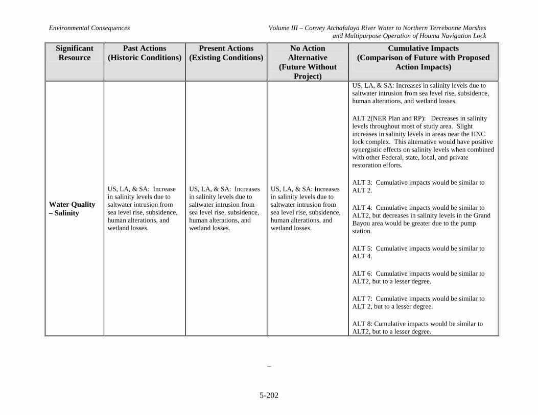
Environmental Consequences Volume III – Convey Atchafalaya River Water to Northern Terrebonne Marshes and Multipurpose Operation of Houma Navigation Lock
5-202
Significant Resource
Past Actions (Historic Conditions)
Present Actions (Existing Conditions)
No Action Alternative
(Future Without Project)
Cumulative Impacts (Comparison of Future with Proposed
Action Impacts)
Water Quality – Salinity
US, LA, & SA: Increase in salinity levels due to saltwater intrusion from sea level rise, subsidence, human alterations, and wetland losses.
US, LA, & SA: Increases in salinity levels due to saltwater intrusion from sea level rise, subsidence, human alterations, and wetland losses.
US, LA, & SA: Increases in salinity levels due to saltwater intrusion from sea level rise, subsidence, human alterations, and wetland losses.
US, LA, & SA: Increases in salinity levels due to saltwater intrusion from sea level rise, subsidence, human alterations, and wetland losses.
ALT 2(NER Plan and RP): Decreases in salinity levels throughout most of study area. Slight increases in salinity levels in areas near the HNC lock complex. This alternative would have positive synergistic effects on salinity levels when combined with other Federal, state, local, and private restoration efforts.
ALT 3: Cumulative impacts would be similar to ALT 2.
ALT 4: Cumulative impacts would be similar to ALT2, but decreases in salinity levels in the Grand Bayou area would be greater due to the pump station.
ALT 5: Cumulative impacts would be similar to ALT 4.
ALT 6: Cumulative impacts would be similar to ALT2, but to a lesser degree.
ALT 7: Cumulative impacts would be similar to ALT 2, but to a lesser degree.
ALT 8: Cumulative impacts would be similar to ALT2, but to a lesser degree.

Environmental Consequences Volume III – Convey Atchafalaya River Water to Northern Terrebonne Marshes and Multipurpose Operation of Houma Navigation Lock
5-203
Significant Resource
Past Actions (Historic Conditions)
Present Actions (Existing Conditions)
No Action Alternative
(Future Without Project)
Cumulative Impacts (Comparison of Future with Proposed
Action Impacts)
Air Quality
US, LA, & SA: Institutional recognition via Clean Air Act of 1963.
LA & SA: Institutional recognition via Louisiana Environmental Quality Act of 1983. Formation of USEPA and LDEQ.
SA: Development of surrounding areas.
US, LA, & SA: Continued institutional recognition; deterioration of air quality due to increases in human populations and industry, coupled with loss of wetlands and air filtration services they provide.
SA: Continued development of surrounding areas. Study area is in attainment.
US, LA, & SA: Continued institutional recognition; air quality would likely decline due to continued population growth and increased industrialization. Loss of LA coastal resources would reduce air filtration services provided by this resource.
US & LA: Continued institutional recognition; however, air quality would likely decline due to continued population growth and increased industrialization.
ALT 2 (NER Plan and RP): Primary cumulative impacts would be the potential improvement in air quality due to the removal of air pollutants by vegetation. This alternative would have positive synergistic effects on air quality when combined with other Federal, state, local, and private restoration efforts.
ALTs 3, 4, & 5: Cumulative impacts would be similar to ALT 2, but to a greater degree.
ALTs 6, 7, & 8: Cumulative impacts would be similar to ALT 2, but to a lesser degree.
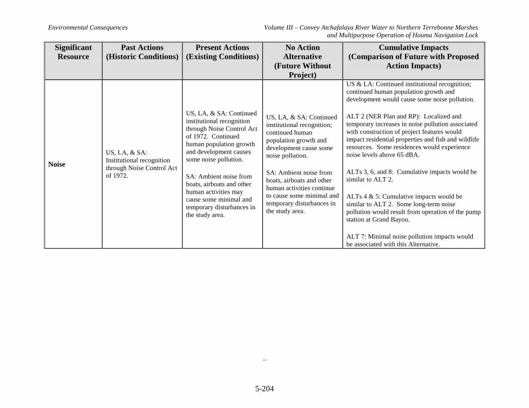
Environmental Consequences Volume III – Convey Atchafalaya River Water to Northern Terrebonne Marshes and Multipurpose Operation of Houma Navigation Lock
5-204
Significant Resource
Past Actions (Historic Conditions)
Present Actions (Existing Conditions)
No Action Alternative
(Future Without Project)
Cumulative Impacts (Comparison of Future with Proposed
Action Impacts)
Noise US, LA, & SA: Institutional recognition through Noise Control Act of 1972.
US, LA, & SA: Continued institutional recognition through Noise Control Act of 1972. Continued human population growth and development causes some noise pollution.
SA: Ambient noise from boats, airboats and other human activities may cause some minimal and temporary disturbances in the study area.
US, LA, & SA: Continued institutional recognition; continued human population growth and development cause some noise pollution.
SA: Ambient noise from boats, airboats and other human activities continue to cause some minimal and temporary disturbances in the study area.
US & LA: Continued institutional recognition; continued human population growth and development would cause some noise pollution.
ALT 2 (NER Plan and RP): Localized and temporary increases in noise pollution associated with construction of project features would impact residential properties and fish and wildlife resources. Some residences would experience noise levels above 65 dBA.
ALTs 3, 6, and 8: Cumulative impacts would be similar to ALT 2.
ALTs 4 & 5: Cumulative impacts would be similar to ALT 2. Some long-term noise pollution would result from operation of the pump station at Grand Bayou.
ALT 7: Minimal noise pollution impacts would be associated with this Alternative.

Environmental Consequences Volume III – Convey Atchafalaya River Water to Northern Terrebonne Marshes and Multipurpose Operation of Houma Navigation Lock
5-205
Significant Resource
Past Actions (Historic Conditions)
Present Actions (Existing Conditions)
No Action Alternative
(Future Without Project)
Cumulative Impacts (Comparison of Future with Proposed
Action Impacts)
Vegetation Resources
US, LA, & SA: Natural Processes form coastal vegetation resources. Invasive plant species, intentionally and unintentionally released, displace native vegetation in some habitats.
LA: Louisiana coastal land loss of over 1.22 million acres since 1956.
SA: Loss of 37,536 acres since 1985.
US & LA: Deterioration and loss of wetlands nationwide and statewide. Spread of invasive plant species.
LA: Continued land loss of over 25 square miles per year.
SA: Continued decline of land area due to natural and human-induced causes. Land loss continues to occur in the study area at a rate of approximately 2,400 acres per year.
US & LA: Continued deterioration and loss of vegetated wetland habitat acreage due to natural and human-induced processes. Continued spread of invasive plant species.
SA: Land loss would persist throughout resulting in the loss of vegetation resources.
Over the 50-year period of analysis, there would be a projected loss of 92,193 acres at a rate of 1,844 acres per year.
US & LA: Continued deterioration and loss of vegetated wetland habitat and further introduction and spread of invasive plant species. Wetland protection, creation, and restoration, as well as invasive species control, reduce these trends somewhat.
ALT 2 (NER Plan and RP): This alternative would have positive synergistic effects on vegetation resources when combined with other Federal, state, local, and private restoration efforts. A net total of 9,655 acres of wetlands would be protected, created, and nourished.
ALT 3: Cumulative impacts similar to ALT 2. A net total of 10,308 acres of wetlands would be protected, created, and nourished.
ALT 4: Cumulative impacts similar to ALT 2. A net total of 12,204 acres of wetlands would be protected, created, and nourished.
ALT 5: Cumulative impacts similar to ALT 2. A net total of 13,934 acres of wetlands would be protected, created, and nourished.
ALT 6: Cumulative impacts similar to ALT 2. A net total of 7 acres of wetlands would be protected, created, and nourished
ALT 7: Loss of 2,651 acres of wetlands offset by overall improvement in health of remaining wetlands.
ALT 8: Cumulative impacts similar to ALT 2. A net total of 989 acres of wetlands would be protected, created, and nourished.
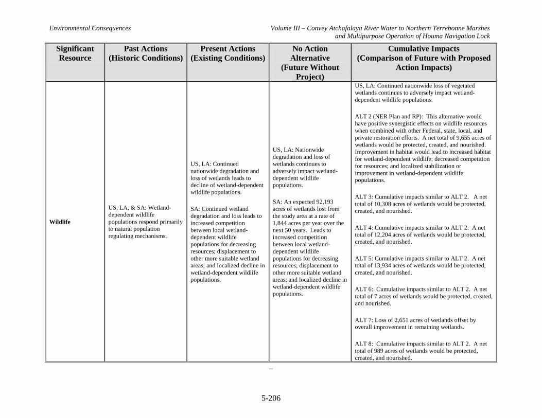
Environmental Consequences Volume III – Convey Atchafalaya River Water to Northern Terrebonne Marshes and Multipurpose Operation of Houma Navigation Lock
5-206
Significant Resource
Past Actions (Historic Conditions)
Present Actions (Existing Conditions)
No Action Alternative
(Future Without Project)
Cumulative Impacts (Comparison of Future with Proposed
Action Impacts)
Wildlife
US, LA, & SA: Wetland-dependent wildlife populations respond primarily to natural population regulating mechanisms.
US, LA: Continued nationwide degradation and loss of wetlands leads to decline of wetland-dependent wildlife populations.
SA: Continued wetland degradation and loss leads to increased competition between local wetland-dependent wildlife populations for decreasing resources; displacement to other more suitable wetland areas; and localized decline in wetland-dependent wildlife populations.
US, LA: Nationwide degradation and loss of wetlands continues to adversely impact wetland-dependent wildlife populations.
SA: An expected 92,193 acres of wetlands lost from the study area at a rate of 1,844 acres per year over the next 50 years. Leads to increased competition between local wetland-dependent wildlife populations for decreasing resources; displacement to other more suitable wetland areas; and localized decline in wetland-dependent wildlife populations.
US, LA: Continued nationwide loss of vegetated wetlands continues to adversely impact wetland-dependent wildlife populations.
ALT 2 (NER Plan and RP): This alternative would have positive synergistic effects on wildlife resources when combined with other Federal, state, local, and private restoration efforts. A net total of 9,655 acres of wetlands would be protected, created, and nourished. Improvement in habitat would lead to increased habitat for wetland-dependent wildlife; decreased competition for resources; and localized stabilization or improvement in wetland-dependent wildlife populations.
ALT 3: Cumulative impacts similar to ALT 2. A net total of 10,308 acres of wetlands would be protected, created, and nourished.
ALT 4: Cumulative impacts similar to ALT 2. A net total of 12,204 acres of wetlands would be protected, created, and nourished.
ALT 5: Cumulative impacts similar to ALT 2. A net total of 13,934 acres of wetlands would be protected, created, and nourished.
ALT 6: Cumulative impacts similar to ALT 2. A net total of 7 acres of wetlands would be protected, created, and nourished.
ALT 7: Loss of 2,651 acres of wetlands offset by overall improvement in remaining wetlands.
ALT 8: Cumulative impacts similar to ALT 2. A net total of 989 acres of wetlands would be protected, created, and nourished.
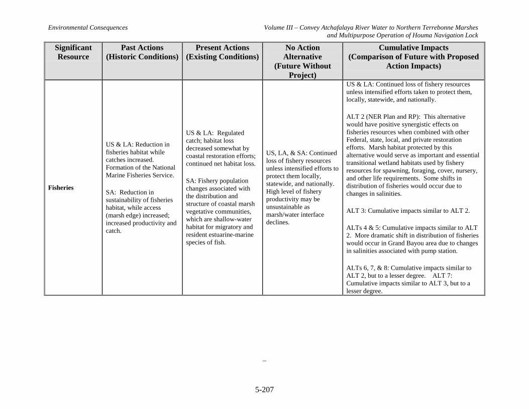
Environmental Consequences Volume III – Convey Atchafalaya River Water to Northern Terrebonne Marshes and Multipurpose Operation of Houma Navigation Lock
5-207
Significant Resource
Past Actions (Historic Conditions)
Present Actions (Existing Conditions)
No Action Alternative
(Future Without Project)
Cumulative Impacts (Comparison of Future with Proposed
Action Impacts)
Fisheries
US & LA: Reduction in fisheries habitat while catches increased. Formation of the National Marine Fisheries Service.
SA: Reduction in sustainability of fisheries habitat, while access (marsh edge) increased; increased productivity and catch.
US & LA: Regulated catch; habitat loss decreased somewhat by coastal restoration efforts; continued net habitat loss.
SA: Fishery population changes associated with the distribution and structure of coastal marsh vegetative communities, which are shallow-water habitat for migratory and resident estuarine-marine species of fish.
US, LA, & SA: Continued loss of fishery resources unless intensified efforts to protect them locally, statewide, and nationally. High level of fishery productivity may be unsustainable as marsh/water interface declines.
US & LA: Continued loss of fishery resources unless intensified efforts taken to protect them, locally, statewide, and nationally.
ALT 2 (NER Plan and RP): This alternative would have positive synergistic effects on fisheries resources when combined with other Federal, state, local, and private restoration efforts. Marsh habitat protected by this alternative would serve as important and essential transitional wetland habitats used by fishery resources for spawning, foraging, cover, nursery, and other life requirements. Some shifts in distribution of fisheries would occur due to changes in salinities.
ALT 3: Cumulative impacts similar to ALT 2.
ALTs 4 & 5: Cumulative impacts similar to ALT 2. More dramatic shift in distribution of fisheries would occur in Grand Bayou area due to changes in salinities associated with pump station.
ALTs 6, 7, & 8: Cumulative impacts similar to ALT 2, but to a lesser degree. ALT 7: Cumulative impacts similar to ALT 3, but to a lesser degree.
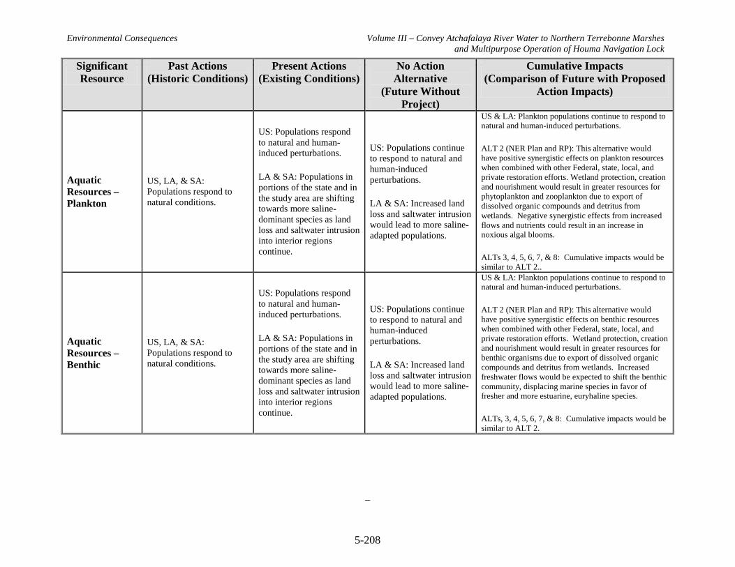
Environmental Consequences Volume III – Convey Atchafalaya River Water to Northern Terrebonne Marshes and Multipurpose Operation of Houma Navigation Lock
5-208
Significant Resource
Past Actions (Historic Conditions)
Present Actions (Existing Conditions)
No Action Alternative
(Future Without Project)
Cumulative Impacts (Comparison of Future with Proposed
Action Impacts)
Aquatic Resources – Plankton
US, LA, & SA: Populations respond to natural conditions.
US: Populations respond to natural and human-induced perturbations.
LA & SA: Populations in portions of the state and in the study area are shifting towards more saline-dominant species as land loss and saltwater intrusion into interior regions continue.
US: Populations continue to respond to natural and human-induced perturbations.
LA & SA: Increased land loss and saltwater intrusion would lead to more saline-adapted populations.
US & LA: Plankton populations continue to respond to natural and human-induced perturbations.
ALT 2 (NER Plan and RP): This alternative would have positive synergistic effects on plankton resources when combined with other Federal, state, local, and private restoration efforts. Wetland protection, creation and nourishment would result in greater resources for phytoplankton and zooplankton due to export of dissolved organic compounds and detritus from wetlands. Negative synergistic effects from increased flows and nutrients could result in an increase in noxious algal blooms.
ALTs 3, 4, 5, 6, 7, & 8: Cumulative impacts would be similar to ALT 2..
Aquatic Resources – Benthic
US, LA, & SA: Populations respond to natural conditions.
US: Populations respond to natural and human-induced perturbations.
LA & SA: Populations in portions of the state and in the study area are shifting towards more saline-dominant species as land loss and saltwater intrusion into interior regions continue.
US: Populations continue to respond to natural and human-induced perturbations.
LA & SA: Increased land loss and saltwater intrusion would lead to more saline-adapted populations.
US & LA: Plankton populations continue to respond to natural and human-induced perturbations.
ALT 2 (NER Plan and RP): This alternative would have positive synergistic effects on benthic resources when combined with other Federal, state, local, and private restoration efforts. Wetland protection, creation and nourishment would result in greater resources for benthic organisms due to export of dissolved organic compounds and detritus from wetlands. Increased freshwater flows would be expected to shift the benthic community, displacing marine species in favor of fresher and more estuarine, euryhaline species.
ALTs, 3, 4, 5, 6, 7, & 8: Cumulative impacts would be similar to ALT 2.

Environmental Consequences Volume III – Convey Atchafalaya River Water to Northern Terrebonne Marshes and Multipurpose Operation of Houma Navigation Lock
5-209
Significant Resource
Past Actions (Historic Conditions)
Present Actions (Existing Conditions)
No Action Alternative
(Future Without Project)
Cumulative Impacts (Comparison of Future with Proposed
Action Impacts)
Essential Fish Habitat
US, LA, & SA: General decrease in quality of EFH beginning in the mid 1900s. Institutional recognition of decline in EFH quality; passage of Magnuson-Stevens Fishery Conservation and Management Act.
US & LA: Continued institutional recognition; continued wetland loss and decline in quality of EFH.
SA: Continued wetland loss converts high quality EFH to lower quality categories (e.g., emergent wetlands to open water bottoms).
US & LA: Continued institutional recognition; continued wetland loss and decline in quality of EFH.
SA: Continued wetland loss converts high quality EFH to lower quality categories (e.g., emergent wetlands to open water bottoms).
US & LA: Continued institutional recognition; continued overall decline in quality of EFH making it difficult to maintain productive forms of EFH and ability of US to support Federally-managed species.
ALT 2 (NER Plan and RP): This alternative would have positive synergistic effects on EFH when combined with other Federal, state, local, and private restoration efforts. Wetland protection, creation and nourishment would prevent the conversion of transitional wetlands to open water, especially inner marsh and marsh edge, which provide EFH for brown shrimp, white shrimp, red drum, and Gulf stone crab. Organism access to EFH would be impeded by some project features.
ALTs 3, 4, & 5: Cumulative impacts would be similar to ALT 2, but to a greater degree.
ALTs 6, 7, & 8: Cumulative impacts would be similar to ALT 2, but to a lesser degree.

Environmental Consequences Volume III – Convey Atchafalaya River Water to Northern Terrebonne Marshes and Multipurpose Operation of Houma Navigation Lock
5-210
Significant Resource
Past Actions (Historic Conditions)
Present Actions (Existing Conditions)
No Action Alternative
(Future Without Project)
Cumulative Impacts (Comparison of Future with Proposed
Action Impacts)
Threatened and Endangered Species
US: Institutional recognition of decline in listed species via the Endangered Species Act.
LA & SA: Decrease in some animal and plant populations and their critical habitat including loss of wetlands.
US: Continued institutional recognition of decline in listed species; continued wetland loss.
LA & SA: Continued loss of wetlands that are critical habitat to many listed species.
US: Continued institutional recognition of decline in listed species; continued loss of wetlands.
LA & SA: Continued coastal land loss and deterioration of critical coastal habitats is anticipated to impact all listed species that utilize them.
US & LA: Continued institutional recognition of decline in listed species; continued loss of wetlands.
ALT 2 (NER Plan and RP): This alternative would have positive synergistic effects on listed species when combined with other Federal, state, local, and private restoration efforts. ALT 2 is not likely to adversely affect any threatened or endangered species in the project area.
ALTs, 3, 4, 5, 6, 7, & 8: Cumulative impacts would be similar to ALT 2.
Cultural and Historic Resources
US, LA, & SA: Institutional Recognition via National Historic Preservation Act (and others). Historic and cultural resources subjected to natural processes and manmade actions.
US, LA, & SA: Continued institutional recognition. Human activities as well as natural processes can potentially degrade or destroy historic and cultural resources.
US, LA, & SA: Continued institutional recognition. Potential loss of resources due to natural and human causes.
US & LA: Potential loss of resources due to natural and human causes.
ALT 2 (NER Plan and RP): Prevention of further land loss and erosion in the project area would help protect cultural and historical resources in the long term. Phase I testing and/or monitoring will be conducted to determine potential direct impacts of project features on cultural and historic resources.
ALTs 3, 4, 5, 6, 7, & 8: Cumulative impacts would be similar to ALT 2
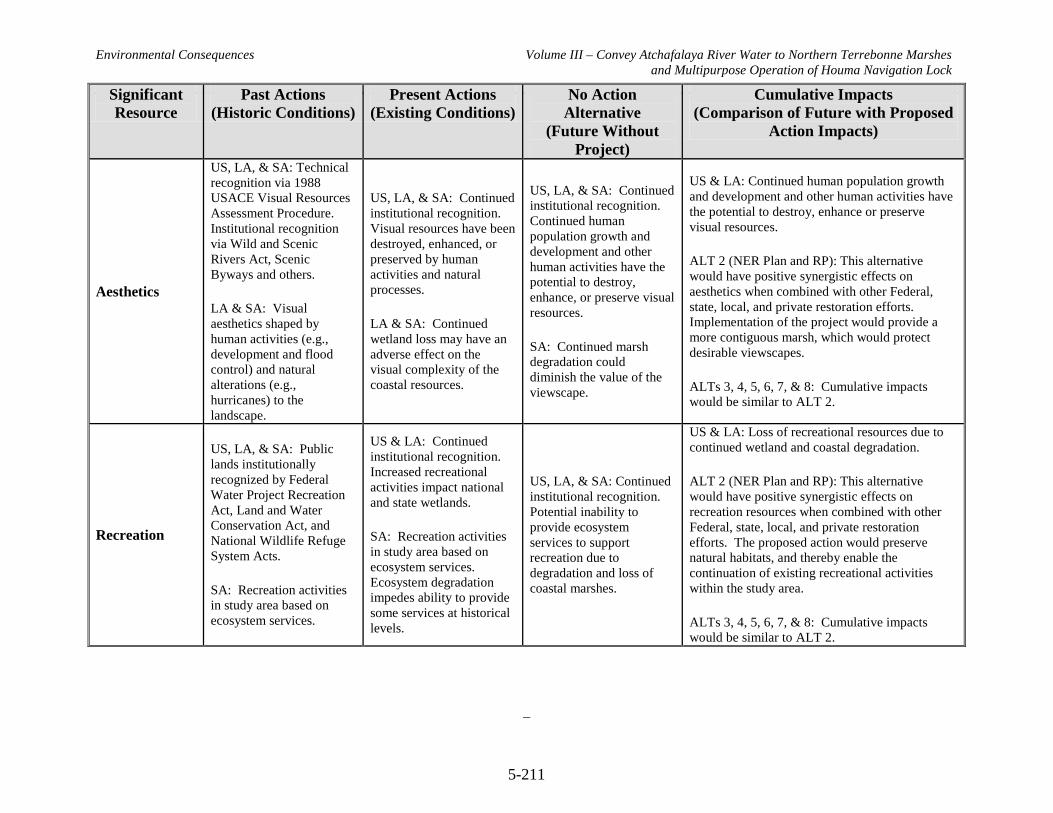
Environmental Consequences Volume III – Convey Atchafalaya River Water to Northern Terrebonne Marshes and Multipurpose Operation of Houma Navigation Lock
5-211
Significant Resource
Past Actions (Historic Conditions)
Present Actions (Existing Conditions)
No Action Alternative
(Future Without Project)
Cumulative Impacts (Comparison of Future with Proposed
Action Impacts)
Aesthetics
US, LA, & SA: Technical recognition via 1988 USACE Visual Resources Assessment Procedure. Institutional recognition via Wild and Scenic Rivers Act, Scenic Byways and others.
LA & SA: Visual aesthetics shaped by human activities (e.g., development and flood control) and natural alterations (e.g., hurricanes) to the landscape.
US, LA, & SA: Continued institutional recognition. Visual resources have been destroyed, enhanced, or preserved by human activities and natural processes.
LA & SA: Continued wetland loss may have an adverse effect on the visual complexity of the coastal resources.
US, LA, & SA: Continued institutional recognition. Continued human population growth and development and other human activities have the potential to destroy, enhance, or preserve visual resources.
SA: Continued marsh degradation could diminish the value of the viewscape.
US & LA: Continued human population growth and development and other human activities have the potential to destroy, enhance or preserve visual resources.
ALT 2 (NER Plan and RP): This alternative would have positive synergistic effects on aesthetics when combined with other Federal, state, local, and private restoration efforts. Implementation of the project would provide a more contiguous marsh, which would protect desirable viewscapes.
ALTs 3, 4, 5, 6, 7, & 8: Cumulative impacts would be similar to ALT 2.
Recreation
US, LA, & SA: Public lands institutionally recognized by Federal Water Project Recreation Act, Land and Water Conservation Act, and National Wildlife Refuge System Acts.
SA: Recreation activities in study area based on ecosystem services.
US & LA: Continued institutional recognition. Increased recreational activities impact national and state wetlands.
SA: Recreation activities in study area based on ecosystem services. Ecosystem degradation impedes ability to provide some services at historical levels.
US, LA, & SA: Continued institutional recognition. Potential inability to provide ecosystem services to support recreation due to degradation and loss of coastal marshes.
US & LA: Loss of recreational resources due to continued wetland and coastal degradation.
ALT 2 (NER Plan and RP): This alternative would have positive synergistic effects on recreation resources when combined with other Federal, state, local, and private restoration efforts. The proposed action would preserve natural habitats, and thereby enable the continuation of existing recreational activities within the study area.
ALTs 3, 4, 5, 6, 7, & 8: Cumulative impacts would be similar to ALT 2.

Environmental Consequences Volume III – Convey Atchafalaya River Water to Northern Terrebonne Marshes and Multipurpose Operation of Houma Navigation Lock
5-212
Significant Resource
Past Actions (Historic Conditions)
Present Actions (Existing Conditions)
No Action Alternative
(Future Without Project)
Cumulative Impacts (Comparison of Future with Proposed
Action Impacts)
Socioeconomic and Human Resources –
Displacement of Population and Housing
US: Population increasing in some areas and decreasing in others.
LA: Hurricanes Katrina and Rita adversely affected populations throughout state.
SA: Development along ridges and water bodies. Populations within Lafourche and Terrebonne Parishes increasing. Population in St. Mary Parish decreasing since 1980.
US: Increasing population with over 300 million people.
LA: Slight decrease (3.9%) in population from 2000-2007.
SA: Populations in Lafourche and Terrebonne Parishes increasing. Population in St. Mary Parish decreasing slowly.
US & LA: Increasing populations worldwide.
SA: Populations in Lafourche and Terrebonne Parishes projected to increase. Population in St. Mary Parish projected to decrease slowly. Populations would be adversely impacted by continued habitat degradation.
US & LA: Continued wetland and coastal degradation could lead to population shifts. Population growth expected.
ALT 2 (NER Plan and RP): Positive synergistic effects on population and housing when combined with other Federal, state, local, and private restoration efforts could be realized as improvements to coastal resources slow population shift away from coast. Acquisition of rights-of-way and relocation of residential structures would be required for construction of some project features.
ALTs 3, 4, 5, 6, & 8: Cumulative impacts would be similar to ALT 2.
ALT 7: Cumulative impacts would be similar to ALT 2. However, no rights-of-way or relocations would be required.
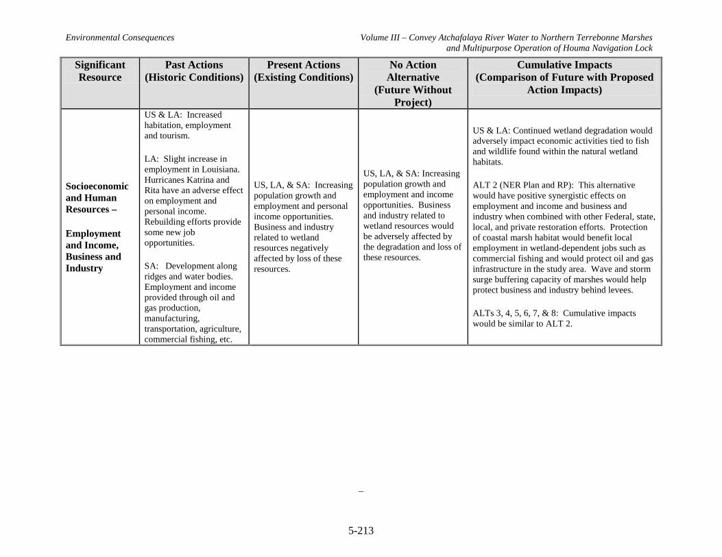
Environmental Consequences Volume III – Convey Atchafalaya River Water to Northern Terrebonne Marshes and Multipurpose Operation of Houma Navigation Lock
5-213
Significant Resource
Past Actions (Historic Conditions)
Present Actions (Existing Conditions)
No Action Alternative
(Future Without Project)
Cumulative Impacts (Comparison of Future with Proposed
Action Impacts)
Socioeconomic and Human Resources –
Employment and Income, Business and Industry
US & LA: Increased habitation, employment and tourism.
LA: Slight increase in employment in Louisiana. Hurricanes Katrina and Rita have an adverse effect on employment and personal income. Rebuilding efforts provide some new job opportunities.
SA: Development along ridges and water bodies. Employment and income provided through oil and gas production, manufacturing, transportation, agriculture, commercial fishing, etc.
US, LA, & SA: Increasing population growth and employment and personal income opportunities. Business and industry related to wetland resources negatively affected by loss of these resources.
US, LA, & SA: Increasing population growth and employment and income opportunities. Business and industry related to wetland resources would be adversely affected by the degradation and loss of these resources.
US & LA: Continued wetland degradation would adversely impact economic activities tied to fish and wildlife found within the natural wetland habitats.
ALT 2 (NER Plan and RP): This alternative would have positive synergistic effects on employment and income and business and industry when combined with other Federal, state, local, and private restoration efforts. Protection of coastal marsh habitat would benefit local employment in wetland-dependent jobs such as commercial fishing and would protect oil and gas infrastructure in the study area. Wave and storm surge buffering capacity of marshes would help protect business and industry behind levees.
ALTs 3, 4, 5, 6, 7, & 8: Cumulative impacts would be similar to ALT 2.

Environmental Consequences Volume III – Convey Atchafalaya River Water to Northern Terrebonne Marshes and Multipurpose Operation of Houma Navigation Lock
5-214
Significant Resource
Past Actions (Historic Conditions)
Present Actions (Existing Conditions)
No Action Alternative
(Future Without Project)
Cumulative Impacts (Comparison of Future with Proposed
Action Impacts)
Socioeconomic and Human Resources –
Transportation
US & LA: Increasing population growth increases demand on the transportation network.
SA: Transportation routes follow natural high ridges. US 90 and four state highways run through the project area.
US & LA: Increasing population growth increases demand on the transportation network.
SA: Transportation routes follow natural high ridges. US 90 and four state highways run through the project area.
US & LA: Continued population growth increases demand on the transportation network.
SA: Major transportation routes not likely to change. Roads on distributary ridges may become more vulnerable as subsidence and marsh loss continue.
US & LA: Continued population growth increases demand on the transportation network.
ALT 2 (NER Plan and RP): This alternative would have positive synergistic effects on transportation when combined with other Federal, state, local, and private restoration efforts. Wave and storm surge buffering capacity of marshes would provide some added protection to vulnerable transportation routes. Construction of project features would contribute to traffic congestion and delays on area roads.
ALTs 3, 4, 5, 6, & 8: Cumulative impacts would be similar to ALT 2.
ALT 7: Cumulative impacts would be similar to ALT 2. However, no construction-related traffic impacts would occur.
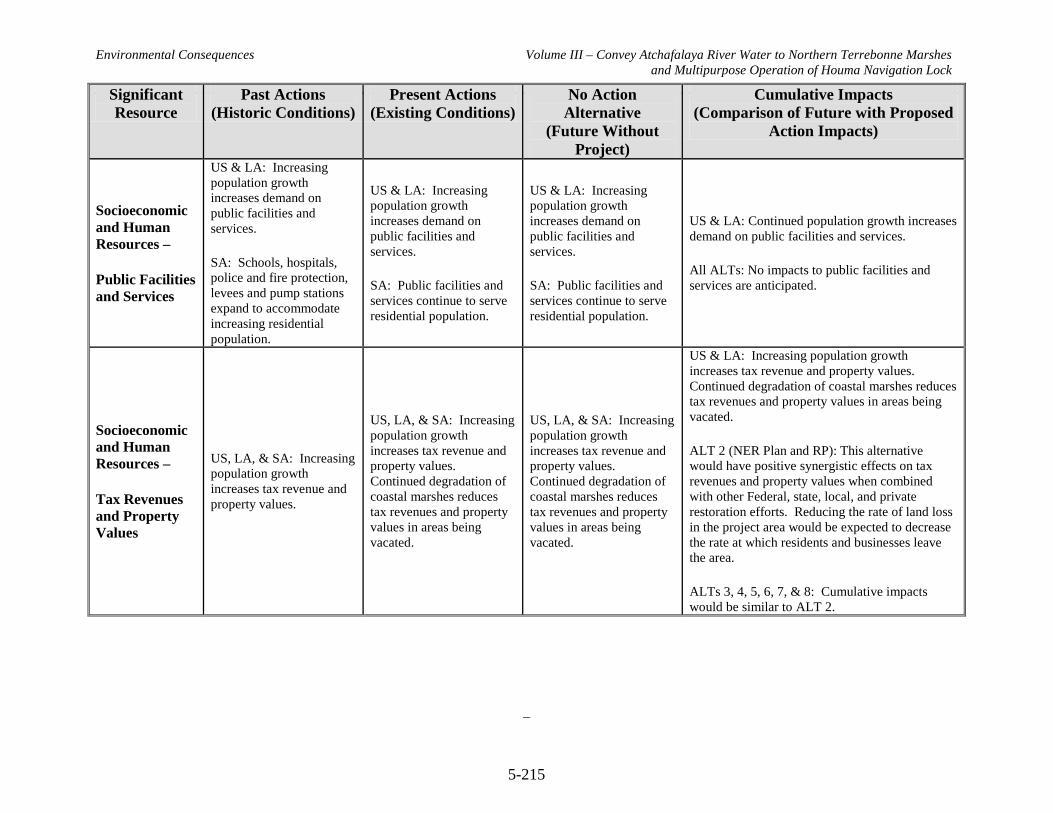
Environmental Consequences Volume III – Convey Atchafalaya River Water to Northern Terrebonne Marshes and Multipurpose Operation of Houma Navigation Lock
5-215
Significant Resource
Past Actions (Historic Conditions)
Present Actions (Existing Conditions)
No Action Alternative
(Future Without Project)
Cumulative Impacts (Comparison of Future with Proposed
Action Impacts)
Socioeconomic and Human Resources –
Public Facilities and Services
US & LA: Increasing population growth increases demand on public facilities and services.
SA: Schools, hospitals, police and fire protection, levees and pump stations expand to accommodate increasing residential population.
US & LA: Increasing population growth increases demand on public facilities and services.
SA: Public facilities and services continue to serve residential population.
US & LA: Increasing population growth increases demand on public facilities and services.
SA: Public facilities and services continue to serve residential population.
US & LA: Continued population growth increases demand on public facilities and services.
All ALTs: No impacts to public facilities and services are anticipated.
Socioeconomic and Human Resources –
Tax Revenues and Property Values
US, LA, & SA: Increasing population growth increases tax revenue and property values.
US, LA, & SA: Increasing population growth increases tax revenue and property values. Continued degradation of coastal marshes reduces tax revenues and property values in areas being vacated.
US, LA, & SA: Increasing population growth increases tax revenue and property values. Continued degradation of coastal marshes reduces tax revenues and property values in areas being vacated.
US & LA: Increasing population growth increases tax revenue and property values. Continued degradation of coastal marshes reduces tax revenues and property values in areas being vacated.
ALT 2 (NER Plan and RP): This alternative would have positive synergistic effects on tax revenues and property values when combined with other Federal, state, local, and private restoration efforts. Reducing the rate of land loss in the project area would be expected to decrease the rate at which residents and businesses leave the area.
ALTs 3, 4, 5, 6, 7, & 8: Cumulative impacts would be similar to ALT 2.
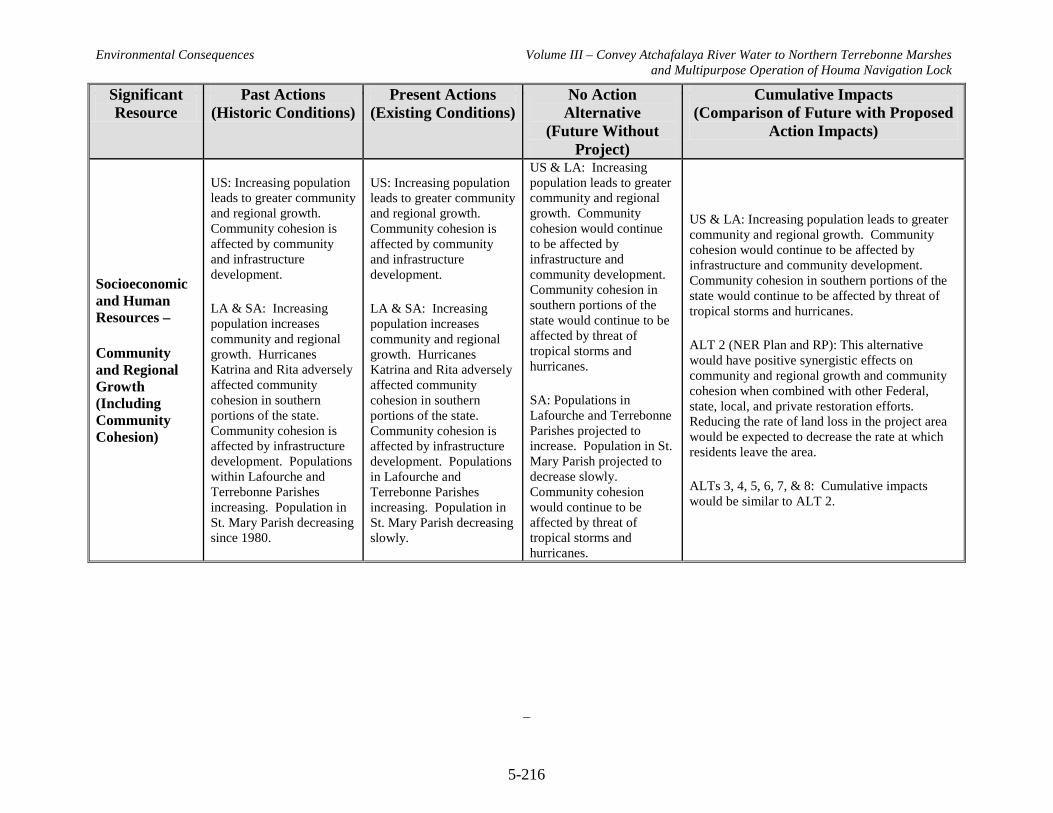
Environmental Consequences Volume III – Convey Atchafalaya River Water to Northern Terrebonne Marshes and Multipurpose Operation of Houma Navigation Lock
5-216
Significant Resource
Past Actions (Historic Conditions)
Present Actions (Existing Conditions)
No Action Alternative
(Future Without Project)
Cumulative Impacts (Comparison of Future with Proposed
Action Impacts)
Socioeconomic and Human Resources –
Community and Regional Growth (Including Community Cohesion)
US: Increasing population leads to greater community and regional growth. Community cohesion is affected by community and infrastructure development.
LA & SA: Increasing population increases community and regional growth. Hurricanes Katrina and Rita adversely affected community cohesion in southern portions of the state. Community cohesion is affected by infrastructure development. Populations within Lafourche and Terrebonne Parishes increasing. Population in St. Mary Parish decreasing since 1980.
US: Increasing population leads to greater community and regional growth. Community cohesion is affected by community and infrastructure development.
LA & SA: Increasing population increases community and regional growth. Hurricanes Katrina and Rita adversely affected community cohesion in southern portions of the state. Community cohesion is affected by infrastructure development. Populations in Lafourche and Terrebonne Parishes increasing. Population in St. Mary Parish decreasing slowly.
US & LA: Increasing population leads to greater community and regional growth. Community cohesion would continue to be affected by infrastructure and community development. Community cohesion in southern portions of the state would continue to be affected by threat of tropical storms and hurricanes.
SA: Populations in Lafourche and Terrebonne Parishes projected to increase. Population in St. Mary Parish projected to decrease slowly. Community cohesion would continue to be affected by threat of tropical storms and hurricanes.
US & LA: Increasing population leads to greater community and regional growth. Community cohesion would continue to be affected by infrastructure and community development. Community cohesion in southern portions of the state would continue to be affected by threat of tropical storms and hurricanes.
ALT 2 (NER Plan and RP): This alternative would have positive synergistic effects on community and regional growth and community cohesion when combined with other Federal, state, local, and private restoration efforts. Reducing the rate of land loss in the project area would be expected to decrease the rate at which residents leave the area.
ALTs 3, 4, 5, 6, 7, & 8: Cumulative impacts would be similar to ALT 2.
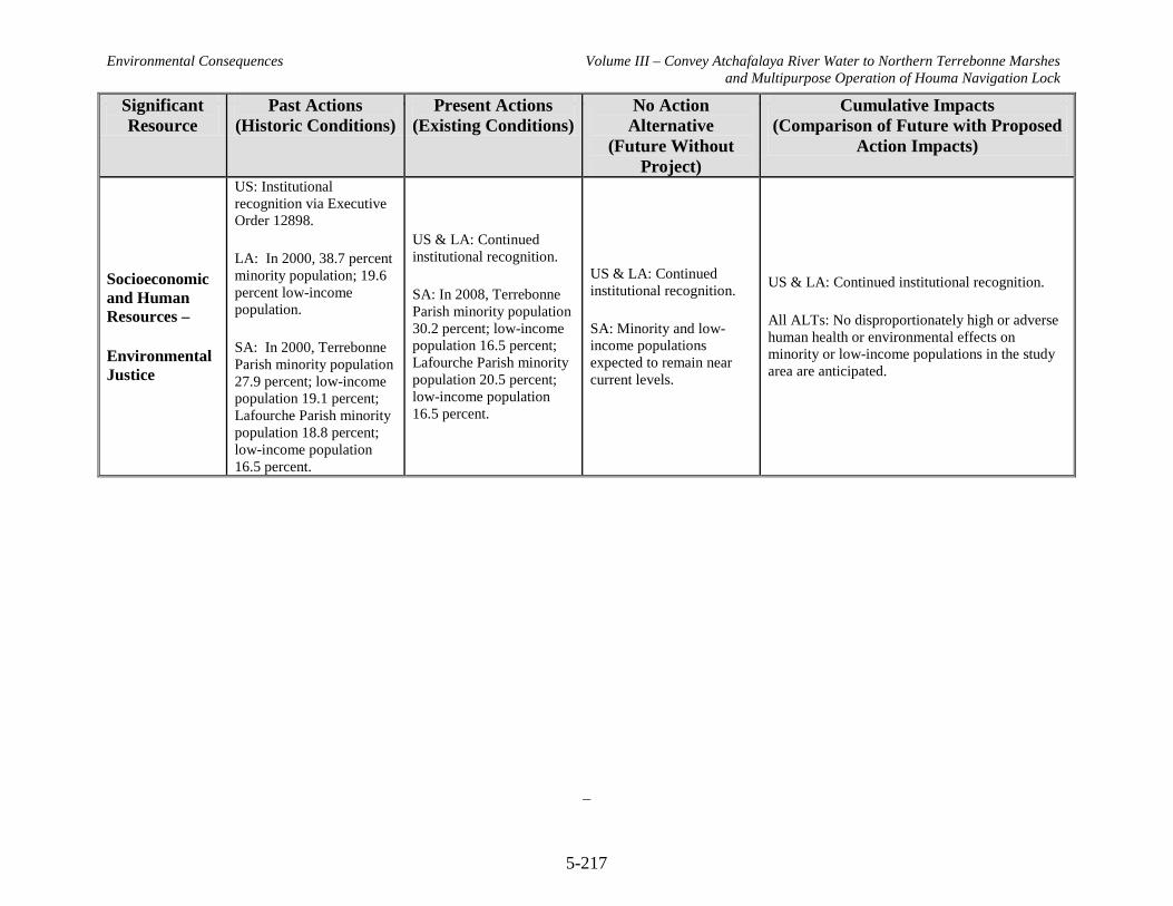
Environmental Consequences Volume III – Convey Atchafalaya River Water to Northern Terrebonne Marshes and Multipurpose Operation of Houma Navigation Lock
5-217
Significant Resource
Past Actions (Historic Conditions)
Present Actions (Existing Conditions)
No Action Alternative
(Future Without Project)
Cumulative Impacts (Comparison of Future with Proposed
Action Impacts)
Socioeconomic and Human Resources –
Environmental Justice
US: Institutional recognition via Executive Order 12898.
LA: In 2000, 38.7 percent minority population; 19.6 percent low-income population.
SA: In 2000, Terrebonne Parish minority population 27.9 percent; low-income population 19.1 percent; Lafourche Parish minority population 18.8 percent; low-income population 16.5 percent.
US & LA: Continued institutional recognition.
SA: In 2008, Terrebonne Parish minority population 30.2 percent; low-income population 16.5 percent; Lafourche Parish minority population 20.5 percent; low-income population 16.5 percent.
US & LA: Continued institutional recognition.
SA: Minority and low-income populations expected to remain near current levels.
US & LA: Continued institutional recognition.
All ALTs: No disproportionately high or adverse human health or environmental effects on minority or low-income populations in the study area are anticipated.
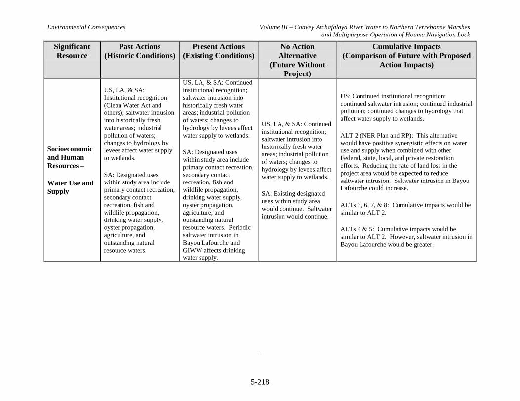
Environmental Consequences Volume III – Convey Atchafalaya River Water to Northern Terrebonne Marshes and Multipurpose Operation of Houma Navigation Lock
5-218
Significant Resource
Past Actions (Historic Conditions)
Present Actions (Existing Conditions)
No Action Alternative
(Future Without Project)
Cumulative Impacts (Comparison of Future with Proposed
Action Impacts)
Socioeconomic and Human Resources –
Water Use and Supply
US, LA, & SA: Institutional recognition (Clean Water Act and others); saltwater intrusion into historically fresh water areas; industrial pollution of waters; changes to hydrology by levees affect water supply to wetlands.
SA: Designated uses within study area include primary contact recreation, secondary contact recreation, fish and wildlife propagation, drinking water supply, oyster propagation, agriculture, and outstanding natural resource waters.
US, LA, & SA: Continued institutional recognition; saltwater intrusion into historically fresh water areas; industrial pollution of waters; changes to hydrology by levees affect water supply to wetlands.
SA: Designated uses within study area include primary contact recreation, secondary contact recreation, fish and wildlife propagation, drinking water supply, oyster propagation, agriculture, and outstanding natural resource waters. Periodic saltwater intrusion in Bayou Lafourche and GIWW affects drinking water supply.
US, LA, & SA: Continued institutional recognition; saltwater intrusion into historically fresh water areas; industrial pollution of waters; changes to hydrology by levees affect water supply to wetlands.
SA: Existing designated uses within study area would continue. Saltwater intrusion would continue.
US: Continued institutional recognition; continued saltwater intrusion; continued industrial pollution; continued changes to hydrology that affect water supply to wetlands.
ALT 2 (NER Plan and RP): This alternative would have positive synergistic effects on water use and supply when combined with other Federal, state, local, and private restoration efforts. Reducing the rate of land loss in the project area would be expected to reduce saltwater intrusion. Saltwater intrusion in Bayou Lafourche could increase.
ALTs 3, 6, 7, & 8: Cumulative impacts would be similar to ALT 2.
ALTs 4 & 5: Cumulative impacts would be similar to ALT 2. However, saltwater intrusion in Bayou Lafourche would be greater.
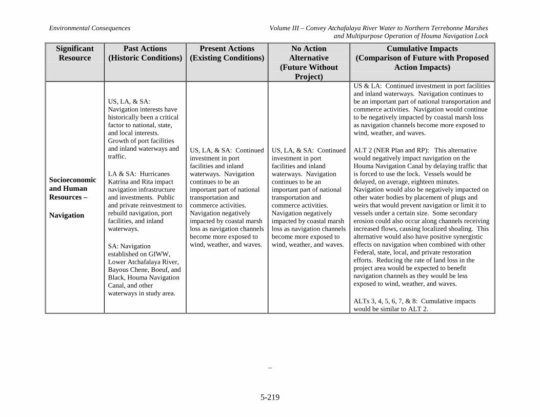
Environmental Consequences Volume III – Convey Atchafalaya River Water to Northern Terrebonne Marshes and Multipurpose Operation of Houma Navigation Lock
5-219
Significant Resource
Past Actions (Historic Conditions)
Present Actions (Existing Conditions)
No Action Alternative
(Future Without Project)
Cumulative Impacts (Comparison of Future with Proposed
Action Impacts)
Socioeconomic and Human Resources –
Navigation
US, LA, & SA: Navigation interests have historically been a critical factor to national, state, and local interests. Growth of port facilities and inland waterways and traffic.
LA & SA: Hurricanes Katrina and Rita impact navigation infrastructure and investments. Public and private reinvestment to rebuild navigation, port facilities, and inland waterways.
SA: Navigation established on GIWW, Lower Atchafalaya River, Bayous Chene, Boeuf, and Black, Houma Navigation Canal, and other waterways in study area.
US, LA, & SA: Continued investment in port facilities and inland waterways. Navigation continues to be an important part of national transportation and commerce activities. Navigation negatively impacted by coastal marsh loss as navigation channels become more exposed to wind, weather, and waves.
US, LA, & SA: Continued investment in port facilities and inland waterways. Navigation continues to be an important part of national transportation and commerce activities. Navigation negatively impacted by coastal marsh loss as navigation channels become more exposed to wind, weather, and waves.
US & LA: Continued investment in port facilities and inland waterways. Navigation continues to be an important part of national transportation and commerce activities. Navigation would continue to be negatively impacted by coastal marsh loss as navigation channels become more exposed to wind, weather, and waves.
ALT 2 (NER Plan and RP): This alternative would negatively impact navigation on the Houma Navigation Canal by delaying traffic that is forced to use the lock. Vessels would be delayed, on average, eighteen minutes. Navigation would also be negatively impacted on other water bodies by placement of plugs and weirs that would prevent navigation or limit it to vessels under a certain size. Some secondary erosion could also occur along channels receiving increased flows, causing localized shoaling. This alternative would also have positive synergistic effects on navigation when combined with other Federal, state, local, and private restoration efforts. Reducing the rate of land loss in the project area would be expected to benefit navigation channels as they would be less exposed to wind, weather, and waves.
ALTs 3, 4, 5, 6, 7, & 8: Cumulative impacts would be similar to ALT 2.

Environmental Consequences Volume III – Convey Atchafalaya River Water to Northern Terrebonne Marshes and Multipurpose Operation of Houma Navigation Lock
5-220
Significant Resource
Past Actions (Historic Conditions)
Present Actions (Existing Conditions)
No Action Alternative
(Future Without Project)
Cumulative Impacts (Comparison of Future with Proposed
Action Impacts)
Socioeconomic and Human Resources –
Agriculture
US & LA: Agriculture is important to the economy of the US and coastal Louisiana.
LA: Important crops include sugar cane, rice, and soybeans.
SA: Agriculture concentrates along distributary ridges. Major crop is sugarcane. Major livestock includes crawfish, alligators, cattle, and horses.
US & LA: Agriculture is important to the economy of the US and coastal Louisiana.
LA: Important crops include sugar cane, rice, and soybeans. Agriculture threatened by land loss and saltwater intrusion.
SA: Agriculture concentrated along distributary ridges. Major crop is sugarcane. Major livestock includes crawfish, alligators, cattle, and horses. Agriculture threatened by land loss and saltwater intrusion.
US & LA: Agriculture expected to remain important to the economy of the US and coastal Louisiana.
LA: Important crops would continue to be sugar cane, rice, and soybeans. Agriculture would continue to be threatened by land loss and saltwater intrusion.
SA: Major crop expected to remain sugarcane. Major livestock expected to remain crawfish, alligators, cattle, and horses. Agriculture would continue to be threatened by land loss and saltwater intrusion.
US & LA: Continued importance of agriculture to the economy of the US and coastal Louisiana. Agricultural lands would continue to be adversely impacted by land loss and saltwater intrusion.
ALT 2 (NER Plan and RP): This alternative would have positive synergistic effects on agriculture when combined with other Federal, state, local, and private restoration efforts. Reducing the rate of land loss in the project area would be expected to benefit levees protecting agriculture lands by reducing exposure to wave damage.
ALTs 3, 4, 5, 6, 7, & 8: Cumulative impacts would be similar to ALT 2.

Environmental Consequences Volume III – Convey Atchafalaya River Water to Northern Terrebonne Marshes and Multipurpose Operation of Houma Navigation Lock
5-221
Significant Resource
Past Actions (Historic Conditions)
Present Actions (Existing Conditions)
No Action Alternative
(Future Without Project)
Cumulative Impacts (Comparison of Future with Proposed
Action Impacts)
Socioeconomic and Human Resources –
Forestry
US & LA: Timber production is important to the economy of the US and Louisiana. Institutional recognition via regulations on forest harvest practices.
SA: Limited timber production in Lafourche, St. Mary, and Terrebonne Parishes.
US: Continued institutional recognition; however, increasing human populations result in continued loss of forested areas and reduces forestry opportunities.
LA: Continued institutional recognition. Continued coastal land loss reduces forestry opportunities.
SA: Limited timber production in Lafourche, St. Mary, and Terrebonne Parishes.
US: Continued institutional recognition; increasing human population growth and continued demand for diminishing forestry resources and reduced forestry opportunities.
LA: Continued institutional recognition. Continued coastal land loss reduces forestry opportunities.
SA: Continued limited timber production in Lafourche, St. Mary, and Terrebonne Parishes.
US & LA: Continued institutional recognition; increasing human population growth and continued demand for diminishing forestry resources and reduced forestry opportunities.
ALT 2 (NER Plan and RP): This alternative would have some positive synergistic effects on forestry when combined with other Federal, state, local, and private restoration efforts. Reducing the rate of land loss in the project area would be expected to benefit levees protecting limited forestry lands by reducing exposure to wave damage.
ALTs 3, 4, 5, 6, 7, & 8: Cumulative impacts would be similar to ALT 2.

Environmental Consequences Volume III – Convey Atchafalaya River Water to Northern Terrebonne Marshes and Multipurpose Operation of Houma Navigation Lock
5-222
Significant Resource
Past Actions (Historic Conditions)
Present Actions (Existing Conditions)
No Action Alternative
(Future Without Project)
Cumulative Impacts (Comparison of Future with Proposed
Action Impacts)
Socioeconomic and Human Resources –
Public Lands
US & LA: Institutional recognition through the Federal Water Project Recreation Act of 1965; the Land and Water Conservation Fund Act of 1965; the National Wildlife Refuge System Administration Act of 1966; the National Wildlife Refuge System Improvement Act of 1997, and others; creation of National Forest Service, National Park Service, US Fish &Wildlife Service, Bureau of Land Management, and others. Expansion of the federal public land system.
LA: Designation since 1959 of nearly 462,000 acres as state Wildlife Management Areas, managed by LDWF.
SA: 33, 488-acre Point au Chien Wildlife Management Area established by LDWF in 1968; 4,212-acre Mandalay National Wildlife Refuge established by FWS in
US & LA: Continued institutional recognition and expansion of the federal public land system.
LA: Continued management and growth of state-owned public lands. Public lands threatened by land loss.
SA: Continued management of Point au Chien WMA and Mandalay NWR. Point au Chien WMA experiencing land loss at the rate of over 1 percent per year. Mandalay NWR generally stable.
US & LA: Continued institutional recognition and expansion of the federal public land system.
LA: Continued management and growth of state-owned public lands. Public lands threatened by land loss.
SA: Continued management of Point au Chien WMA and Mandalay NWR. Point au Chien WMA expected to continue experiencing land loss at the rate of up to 2 percent per year. Mandalay NWR expected to remain stable.
US & LA: Continued institutional recognition and expansion of the federal public land system. Public lands threatened by land loss.
ALT 2 (NER Plan and RP): This alternative would have positive synergistic effects on public lands when combined with other Federal, state, local, and private restoration efforts. This alternative is expected to reduce the rate of land loss in the Point au Chien WMA. No impacts to Mandalay NWR are expected.
ALTs 3, 6, & 8: Cumulative impacts would be similar to ALT 2.
ALTs 4 & 5: Cumulative impacts would be similar to ALT 2, but to a greater degree.
ALT 7: This alternative would be expected to have a slightly negative impact on land loss rates in the Point au Chien WMA.

Environmental Consequences Volume III – Convey Atchafalaya River Water to Northern Terrebonne Marshes and Multipurpose Operation of Houma Navigation Lock
5-223
1996. Significant Resource
Past Actions (Historic Conditions)
Present Actions (Existing Conditions)
No Action Alternative
(Future Without Project)
Cumulative Impacts (Comparison of Future with Proposed
Action Impacts)
Socioeconomic and Human Resources –
Oil, Gas, and Utilities
US & SA: Increasing development of refineries, wells, pipelines, and other oil and gas infrastructure and equipment. Extensive oil and gas exploration.
US, LA, & SA: Increasing operations and maintenance costs as well as increasing investment for oil and gas production facilities and pipelines due to increasing vulnerability to widespread coastal wetland loss.
US, LA, & SA: Increasing operations and maintenance costs as well as increasing investment for oil and gas production facilities and pipelines due to increasing vulnerability to widespread coastal wetland loss.
US & LA: Increasing operations and maintenance costs as well as increasing investment for oil and gas production facilities and pipelines due to increasing vulnerability to widespread coastal wetland loss.
ALT 2 (NER Plan and RP): This alternative would have positive synergistic effects on oil, gas, and utilities when combined with other Federal, state, local, and private restoration efforts. This alternative is expected to reduce the rate of land loss in the study area, thereby reducing the vulnerability of oil, gas, and utility infrastructure.
ALTs 3, 4, & 5: Cumulative impacts would be similar to ALT 2, but to a greater degree.
ALTs 6, 7, & 8: Cumulative impacts would be similar to ALT 2, but to a lesser degree.

Environmental Consequences Volume III – Convey Atchafalaya River Water to Northern Terrebonne Marshes and Multipurpose Operation of Houma Navigation Lock
5-224
Significant Resource
Past Actions (Historic Conditions)
Present Actions (Existing Conditions)
No Action Alternative
(Future Without Project)
Cumulative Impacts (Comparison of Future with Proposed
Action Impacts)
Socioeconomic and Human Resources –
Flood Control and Hurricane Protection
US & LA: Flood of 1927 initiates national construction of hurricane and flood control levees, pump stations and control structures. Hurricanes Katrina and Rita cause significant widespread damages to existing hurricane and flood control structures.
SA: Construction of flood control and hurricane protection levees in and around the study area including the West Atchafalaya Basin Protection Levee, the East Atchafalaya Basin Protection Levee, the Larose to Golden Meadow Hurricane Protection Levee, and many local levees.
US & LA: Largest national restoration effort of hurricane and flood control in nation’s history.
SA: Maintenance of flood control and hurricane protection levees in the study area.
US & LA: As populations continue to migrate to coastal communities, increasing investment in hurricane and flood control levees, pump stations, and other flood control facilities is expected.
SA: Continued maintenance of Federal and local flood control and hurricane protection levees. Continued degradation of wetlands would result in localized storm surge and storm wave increases. The Morganza to the Gulf of Mexico Risk Reduction Project is expected to be constructed.
US & LA: Continued loss of flood control and hurricane protection due to continued coastal wetland degradation and loss.
ALT 2 (NER Plan and RP) : This alternative would have positive synergistic effects on flood control and hurricane protection when combined with other Federal, state, local, and private restoration efforts. This alternative is expected to reduce the rate of land loss in the study area, thereby reducing the vulnerability of existing flood control and hurricane protection infrastructure to storm surge and wave damage.
ALTs 3, 4, & 5: Cumulative impacts would be similar to ALT 2, but to a greater degree.
ALTs 6, 7, & 8: Cumulative impacts would be similar to ALT 2, but to a lesser degree.
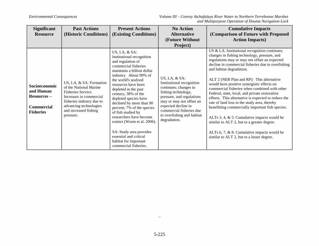
Environmental Consequences Volume III – Convey Atchafalaya River Water to Northern Terrebonne Marshes and Multipurpose Operation of Houma Navigation Lock
5-225
Significant Resource
Past Actions (Historic Conditions)
Present Actions (Existing Conditions)
No Action Alternative
(Future Without Project)
Cumulative Impacts (Comparison of Future with Proposed
Action Impacts)
Socioeconomic and Human Resources –
Commercial Fisheries
US, LA, & SA: Formation of the National Marine Fisheries Service. Increases in commercial fisheries industry due to advancing technologies and increased fishing pressure.
US, LA, & SA: Institutional recognition and regulation of commercial fisheries maintains a billion dollar industry. About 90% of the world's seafood resources have been depleted in the past century; 38% of the depleted species have declined by more than 90 percent; 7% of the species of fish studied by researchers have become extinct (Worm et al. 2006).
SA: Study area provides essential and critical habitat for important commercial fisheries.
US, LA, & SA: Institutional recognition continues; changes in fishing technology, pressure, and regulations may or may not offset an expected decline in commercial fisheries due to overfishing and habitat degradation.
US & LA: Institutional recognition continues; changes in fishing technology, pressure, and regulations may or may not offset an expected decline in commercial fisheries due to overfishing and habitat degradation.
ALT 2 (NER Plan and RP): This alternative would have positive synergistic effects on commercial fisheries when combined with other Federal, state, local, and private restoration efforts. This alternative is expected to reduce the rate of land loss in the study area, thereby benefitting commercially important fish species.
ALTs 3, 4, & 5: Cumulative impacts would be similar to ALT 2, but to a greater degree.
ALTs 6, 7, & 8: Cumulative impacts would be similar to ALT 2, but to a lesser degree.

Environmental Consequences Volume III – Convey Atchafalaya River Water to Northern Terrebonne Marshes and Multipurpose Operation of Houma Navigation Lock
5-226
Significant Resource
Past Actions (Historic Conditions)
Present Actions (Existing Conditions)
No Action Alternative
(Future Without Project)
Cumulative Impacts (Comparison of Future with Proposed
Action Impacts)
Socioeconomic and Human Resources – Oyster Leases
US, LA: General increase in acreage leased, production limited by saltwater intrusion in areas with no freshwater introduction. SA: Extensive oyster leases in the study area. Terrebonne and Lafourche Parishes account for 57,000 acres in the 1970s and early 1980s.
US, LA, & SA: Only major leasing program is in LA. Production has been stable for the last 50 years. Long-term sustainability threatened by reduction of marsh habitat. SA: Extensive oyster leases in the study area. Terrebonne and Lafourche Parishes account for approximately 115,000 acres.
US: Only major leasing program is in LA. LA & SA: Production from leases would likely decline due to loss of habitat.
US: Only major leasing program is in LA. LA: Production from leases would likely decline due to loss of habitat. ALT 2 (NER Plan and RP): This alternative would have positive synergistic effects on oyster leases when combined with other Federal, state, local, and private restoration efforts. This alternative is expected to reduce the rate of marsh loss in the study area, thereby benefitting oysters and oyster leases. Some oyster leases would be directly impacted by construction of project features. Changes in salinity gradients may affect mortality, reproduction, and spat settlement of oysters. ALTs 3, 4, & 5: Cumulative impacts would be similar to ALT 2, but to a greater degree. ALTs 6, 7, & 8: Cumulative impacts would be similar to ALT 2, but to a lesser degree.

Environmental Consequences Volume III – Convey Atchafalaya River Water to Northern Terrebonne Marshes and Multipurpose Operation of Houma Navigation Lock
5-227
Significant Resource
Past Actions (Historic Conditions)
Present Actions (Existing Conditions)
No Action Alternative
(Future Without Project)
Cumulative Impacts (Comparison of Future with Proposed
Action Impacts)
Hazardous, Toxic, and Radioactive Waste
US, LA, & SA:
Institutional recognition under ER 1165-2-132. Increasing human populations and industrialization result in increased potential for HTRW problems. Establishment of USEPA and LDEQ.
SA: Few Recognized Environmental Conditions (RECs) located near proposed project features. No RECs immediately adjacent to project features.
US, LA, & SA: Continued institutional recognition.
SA: Few RECs located near proposed project features. No RECs immediately adjacent to project features.
US, LA, & SA: Continued institutional recognition.
Continued human population growth & development, industry, and other human activities result in increased potential for HTRW issues.
US & LA: Continued institutional recognition. Continued human population growth & development, industry, and other human activities result in increased potential for HTRW issues.
All ALTs: The potential for HTRW impacts is expected to be low.

Environmental Consequences Volume III – Convey Atchafalaya River Water to Northern Terrebonne Marshes and Multipurpose Operation of Houma Navigation Lock
5-228
This page intentionally blank
Public Involvement Volume III – Convey Atchafalaya River Water to Northern Terrebonne Marshes and Multipurpose Operation of Houma Navigation Lock
6-1
Final EIS WRDA 2007 Section 7006(e)(3) September 2010
6.0 PUBLIC INVOLVEMENT 6.1 NEPA Scoping The National Environmental Policy Act (NEPA) of 1969 established a nationwide policy to include a detailed statement of the environmental impact of the proposed action in every recommendation or report on proposals for major Federal actions significantly affecting the environment. Such detailed statements are referred to as environmental impact statements (EIS). A notice of intent (NOI) to prepare a draft EIS for the Louisiana Coastal Area (LCA) Convey Atchafalaya River Water to Northern Terrebonne Marshes Restoration Feasibility Study (Convey Atchafalaya River Water to Northern Terrebonne Marshes Study) was published in the Federal Register (volume 73, number 246) on December 22, 2008. The intent of the NOI is to announce the United States Corps of Engineers’ (Corps) intention to prepare a draft EIS that addresses the Convey Atchafalaya River Water to Northern Terrebonne Marshes restoration project, which was identified in the LCA Ecosystem Restoration Plan as a near-term critical restoration project. The NEPA also provides for an early and open public process for determining the scope of issues, resources, impacts, and alternatives to be addressed in an EIS. This process is referred to as scoping. Scoping documents comments from interested parties and describes where in the EIS individual comments should be addressed. It also outlines the project background and scoping process to date, and summarizes the key issues identified by members of the public during the initial scoping period. NEPA affords all persons, organizations and government agencies the right to review and comment on proposed major Federal actions that are evaluated by a NEPA document. This is known as the “scoping process.” The scoping process is the initial step in the preparation of the EIS and will help identify (1) the range of actions (project, procedural changes) (2) alternatives (both those to be rigorously explored and evaluated and those that may be eliminated), and (3) the range of environmental resources considered in the evaluation of environmental impacts. A scoping meeting announcement requesting comments regarding the scope of the Convey Atchafalaya River Water to Northern Terrebonne Marshes Study was sent to Federal, state, and local agencies; and interested groups and individuals on January 7, 2009. The media advisory announcing the scoping meetings was provided to more than 350 media outlets. An advertisement for the public scoping meetings appeared in the following publications:
• The Times-Picayune, January 31, 2009 • The St. Bernard Voice, January 30, 2009
Public Involvement Volume III – Convey Atchafalaya River Water to Northern Terrebonne Marshes and Multipurpose Operation of Houma Navigation Lock
6-2
Final EIS WRDA 2007 Section 7006(e)(3) September 2010
• The Baton Rouge Advocate, January 31, 2009 • Morgan City Daily Review, January 29, 2009
The public scoping meetings were held on:
• Tuesday, February 3, 2009 Houma Municipal Auditorium 880 Verrett St. Houma, LA 70360
• Wednesday, February 4, 2009 Morgan City Municipal Auditorium 728 Myrtle St. Morgan City, LA 70380
The schedule for each scoping meeting was:
• 6:00 – 7:00 p.m. Open House • 7:00 – 7:30 p.m. Presentations • 7:30 – 8:00 p.m. Question and Answer Session • 8:00 – 8:50 p.m. Open Forum for Comments • 8:50 – 9:00 p.m. Wrap-up
The open house session provided attendees with an opportunity to visit a series of poster stations staffed by project team members and subject matter experts regarding the following topics: the LCA plan, the NEPA process and milestones, an overview of the study and its goals and objectives, as well as maps of the study area. Following the open house, there was a brief presentation on the LCA project planned for the area and a description of the NEPA process. During this segment, the LCA Environmental Manager and both the Corps and Coastal Protection and Restoration Authority Project Managers presented introductory remarks, including the agenda, purpose of the meeting, public involvement under NEPA, a brief history leading to the study, the scope of the analysis, and the intent to prepare a draft EIS for the Convey Atchafalaya River Water to Northern Terrebonne Marshes restoration project. The question and answer portion focused on the study process and any other general questions presented by attendees. Following this portion, the floor was opened for scoping comments. Individuals were invited to present their verbal scoping comments to be recorded without interruption. The floor remained open until no further scoping comments were given. During the wrap-up, attendees were reminded to pick up self mailing comment cards, should they wish to submit additional comments at a later date, and to drop off the meeting evaluation forms at the registration table.

Public Involvement Volume III – Convey Atchafalaya River Water to Northern Terrebonne Marshes and Multipurpose Operation of Houma Navigation Lock
6-3
Final EIS WRDA 2007 Section 7006(e)(3) September 2010
Transcripts of comments made at the scoping meetings were prepared by a court reporter. The Scoping Report presents and summarizes the scoping comments expressed at the public scoping meetings, as well as all other scoping comments received during the comment period beginning December 22, 2008, and ending February 17, 2009. The Scoping Report is being published on the Louisiana Coastal Area Ecosystem Restoration website at www.lca.gov Web site. Scoping comments document the public’s concerns about the scope of the proposed course of action as well as identify significant resources and suggested alternatives. Scoping comments shall be considered during the study process and in preparation of the draft EIS. A total of 71 participants signed in for the scoping meetings, with 49 at Houma, Louisiana, and 22 at Morgan City, Louisiana. A total of 43 multi-part comments were received during the comment period, of which six were copies of letters, two were comment forms, and one was from the Web site. Twenty individuals expressed comments at the Houma scoping meeting and 14 individuals expressed comments at the Morgan City scoping meeting. A total of nine written comments (letter, e-mail, comment form, and Web site) were received during the comment period. A scoping comment may contain several specific comments directed at multiple areas of concern. Hence, a single comment could potentially be addressed in multiple sections of the draft EIS. A total of 164 specific comments were expressed. The comments were categorized according to their applicability to the EIS. EIS categories include: Purpose and Need; Alternatives; Affected Environment; Environmental Consequences; and Consultation, Coordination, and Compliance with Regulations. Although an individual scoping comment may be categorized under more than one EIS subject matter heading, no comment was assigned to more than three categories. Table 1 displays the categorization of specific comments by EIS subject matter. The most numerous comments were expressed regarding the Alternatives followed by Environmental Consequences, Affected Environment, Compliance then Purpose and Need.
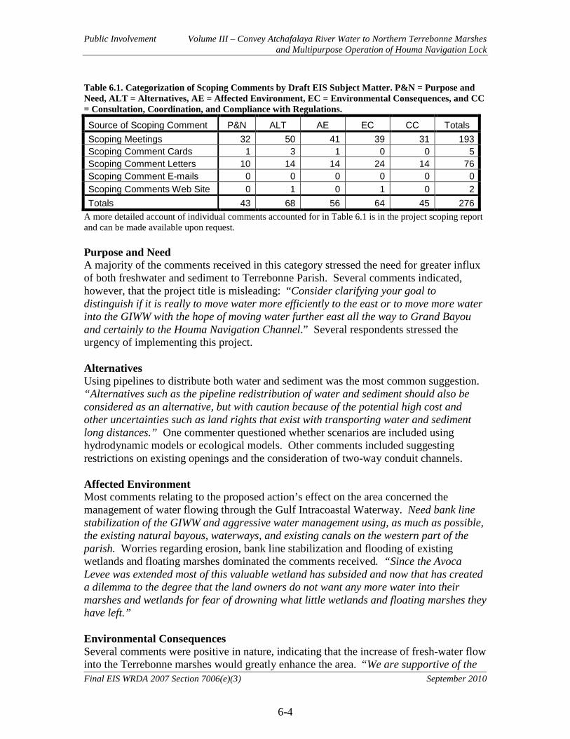
Public Involvement Volume III – Convey Atchafalaya River Water to Northern Terrebonne Marshes and Multipurpose Operation of Houma Navigation Lock
6-4
Final EIS WRDA 2007 Section 7006(e)(3) September 2010
Table 6.1. Categorization of Scoping Comments by Draft EIS Subject Matter. P&N = Purpose and Need, ALT = Alternatives, AE = Affected Environment, EC = Environmental Consequences, and CC = Consultation, Coordination, and Compliance with Regulations. Source of Scoping Comment P&N ALT AE EC CC Totals Scoping Meetings 32 50 41 39 31 193 Scoping Comment Cards 1 3 1 0 0 5 Scoping Comment Letters 10 14 14 24 14 76 Scoping Comment E-mails 0 0 0 0 0 0 Scoping Comments Web Site 0 1 0 1 0 2 Totals 43 68 56 64 45 276
A more detailed account of individual comments accounted for in Table 6.1 is in the project scoping report and can be made available upon request. Purpose and Need A majority of the comments received in this category stressed the need for greater influx of both freshwater and sediment to Terrebonne Parish. Several comments indicated, however, that the project title is misleading: “Consider clarifying your goal to distinguish if it is really to move water more efficiently to the east or to move more water into the GIWW with the hope of moving water further east all the way to Grand Bayou and certainly to the Houma Navigation Channel.” Several respondents stressed the urgency of implementing this project. Alternatives Using pipelines to distribute both water and sediment was the most common suggestion. “Alternatives such as the pipeline redistribution of water and sediment should also be considered as an alternative, but with caution because of the potential high cost and other uncertainties such as land rights that exist with transporting water and sediment long distances.” One commenter questioned whether scenarios are included using hydrodynamic models or ecological models. Other comments included suggesting restrictions on existing openings and the consideration of two-way conduit channels. Affected Environment Most comments relating to the proposed action’s effect on the area concerned the management of water flowing through the Gulf Intracoastal Waterway. Need bank line stabilization of the GIWW and aggressive water management using, as much as possible, the existing natural bayous, waterways, and existing canals on the western part of the parish. Worries regarding erosion, bank line stabilization and flooding of existing wetlands and floating marshes dominated the comments received. “Since the Avoca Levee was extended most of this valuable wetland has subsided and now that has created a dilemma to the degree that the land owners do not want any more water into their marshes and wetlands for fear of drowning what little wetlands and floating marshes they have left.” Environmental Consequences Several comments were positive in nature, indicating that the increase of fresh-water flow into the Terrebonne marshes would greatly enhance the area. “We are supportive of the

Public Involvement Volume III – Convey Atchafalaya River Water to Northern Terrebonne Marshes and Multipurpose Operation of Houma Navigation Lock
6-5
Final EIS WRDA 2007 Section 7006(e)(3) September 2010
concept of increasing Atchafalaya River influence into the starving marshes of southern and eastern portions of Terrebonne Parish.” Some concerns were raised regarding the potential increase of water velocity. The increasing water levels and velocity are the greatest enemies to these freshwater marshes, not saltwater intrusion. Consultation, Coordination, and Compliance with Regulations The majority of comments received in this area concerned this projects relation to other projects and plans. Consider combining the projects and monies in both St. Mary and Terrebonne Parishes to rebuild the coast. Do not look at them as separate projects, they should be combined. Some clarification regarding project scope and budget was also requested. Requested clarification on the $2 billion total cost for the project, specifically if the $2 billion was only for the study or if it include construction for the five to fifteen designated near-term projects. 6.2 Other Public Comments
6.2.1 Federal and State Agencies
A project kick-off meeting was held on January 13, 2009 to present the study authority, purpose, goals and objectives. Federal, State and local agencies from Louisiana participated in the discussions. Representatives of Federal and State agencies were invited to be members of the Project Delivery Team (PDT) and the Habitat Evaluation Team (HET). The PDT facilitates the interagency collaboration and coordination necessary for study execution. Agency team members provide guidance and recommendations throughout the planning process to assure the successful delivery of a quality product. The HET is part of the PDT and is composed of resource agency representatives. The HET performs planning and technical assessments consistent with their agency responsibilities and expertise. The HET has been involved at all stages of the planning process, and has assisted with the development, evaluation, and analysis of project alternatives. The HET has participated in the public information/involvement program, exchanged study information, provided recommendations, and assisted in the resolution of any interagency issues that may have surfaced in the study process. The HET was an integral part of the Wetland Values Assessment process to determine the habitat value of the alternatives. Federal and State agencies are also involved through the NEPA process, with some agencies serving as official cooperating agencies and other agencies with official coordination and consultation roles. 6.2.2 Land Owner, Non-Governmental Organization (NGO), Parish and Other
Involvement
Meetings were held to provide opportunities for landowners, NGOs, the Parish and other interested parties to see progress on the project and to solicit feedback from the attendees. Federal and state agencies frequently attended as well.
Public Involvement Volume III – Convey Atchafalaya River Water to Northern Terrebonne Marshes and Multipurpose Operation of Houma Navigation Lock
6-6
Final EIS WRDA 2007 Section 7006(e)(3) September 2010
6.2.3 Public Comments on the Draft EIS
Copies of this draft EIS will be made available to all interested parties through mailings, advertisements, media advisories, public meetings, and websites. All comments received during the 45-day public comment period on the draft EIS will be documented and responded to in Appendix G. All commenters will be sent a Notice of Availability of this Integrated Feasibility Study and EIS after its completion.

Public Involvement Volume III – Convey Atchafalaya River Water to Northern Terrebonne Marshes and Multipurpose Operation of Houma Navigation Lock
6-7
Final EIS WRDA 2007 Section 7006(e)(3) September 2010
This page intentionally blank

Coordination and Compliance Volume III – Convey Atchafalaya River Water to Northern Terrebonne Marshes and Multipurpose Operation of Houma Navigation Lock
7-1
Final EIS WRDA 2007 Section 7006(e)(3) September 2010
7.0 COORDINATION AND COMPLIANCE This chapter documents the coordination and compliance efforts for this project regarding statutory authorities including: environmental laws, regulations, executive orders, policies, rules, and guidance. Consistency of the Recommended Plan (RP) and other Louisiana coastal restoration efforts is also addressed. 7.1 USACE Principles and Guidelines (P&G) The guidance for conducting Civil Works planning studies (ER 1105-2-100) is based on the P&G adopted by the Water Resources Council. The P&G are composed of two parts: The Economic and Environmental Principles and Guidelines for Water and Related Land Implementation Studies and the Economic and Environmental Guidelines for Water and Related Land Resources Implementation Studies. The P&G require the systematic formulation of alternative plans to ensure all reasonable alternatives are evaluated. The P&G also include guidance on the development and structure of the studies and reports for projects requiring specific authorization. Under the study guidance for projects requiring specific authorization, the feasibility study requirements include documentation of the planning process and environmental compliance. The feasibility report is required to document the planning process and all assumptions made during plan formulation along with the rationale for decision making. The report should culminate in a recommended plan along with documentation of how the plan relates to the NED, NER, or a combined NED/NER plan. If the project deviates from those plans, the degree and reasons for the deviation must be documented. The feasibility study is also required to document compliance with applicable environmental laws and regulations which can be included as an EA or EIS included with the feasibility study or an integrated feasibility study document with NEPA information. Planning for this feasibility study has been conducted in accordance with the ER 1105-2-100 guidance. This report is an integrated feasibility study and EIS. Policy reviews have been conducted to ensure compliance with applicable USACE policies. 7.2 Environmental Coordination and Compliance Following completion of the final integrated report, the Assistant Secretary of the Army for Civil Works will issue a written Record of Decision (ROD) concerning the proposed action. The ROD will be issued within a framework of laws, regulations, executive orders, policies, rules, and other guidance. These authorities establish regulatory compliance standards for environmental resources pertaining directly to USACE management of water resources development projects, or provide planning guidance for the management of environmental resources. Relevant Federal statutory authorities and executive orders are listed in Table 7.1. Relevant State of Louisiana statutory authorities are listed in Table 7.2. Full compliance with statutory authorities will be accomplished upon review of the final integrated feasibility report and Supplemental Environmental Impact Statement by appropriate agencies and the public and the signing of a Record of Decision (ROD), in compliance with the Fish and Wildlife Coordination Act (1958).
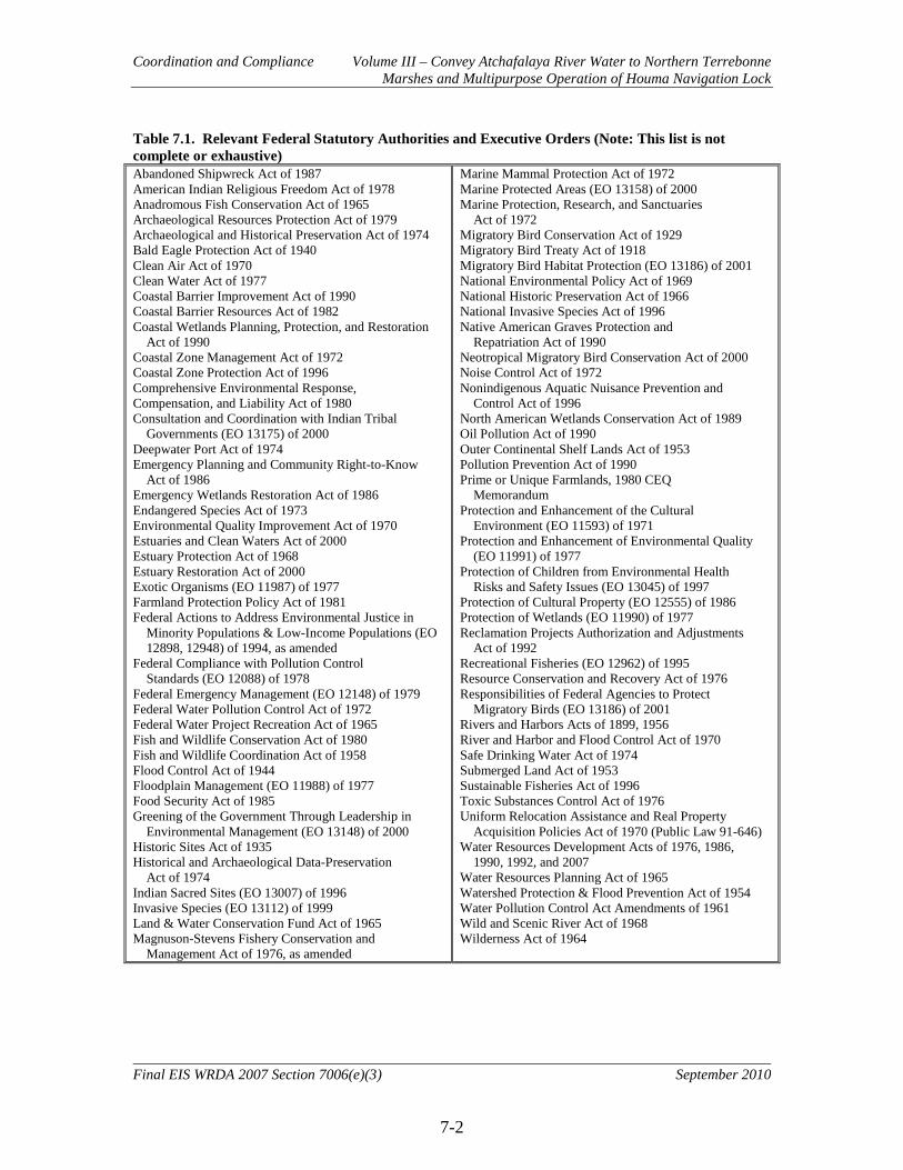
Coordination and Compliance Volume III – Convey Atchafalaya River Water to Northern Terrebonne Marshes and Multipurpose Operation of Houma Navigation Lock
7-2
Final EIS WRDA 2007 Section 7006(e)(3) September 2010
Table 7.1. Relevant Federal Statutory Authorities and Executive Orders (Note: This list is not complete or exhaustive) Abandoned Shipwreck Act of 1987 American Indian Religious Freedom Act of 1978 Anadromous Fish Conservation Act of 1965 Archaeological Resources Protection Act of 1979 Archaeological and Historical Preservation Act of 1974 Bald Eagle Protection Act of 1940 Clean Air Act of 1970 Clean Water Act of 1977 Coastal Barrier Improvement Act of 1990 Coastal Barrier Resources Act of 1982 Coastal Wetlands Planning, Protection, and Restoration Act of 1990 Coastal Zone Management Act of 1972 Coastal Zone Protection Act of 1996 Comprehensive Environmental Response, Compensation, and Liability Act of 1980 Consultation and Coordination with Indian Tribal Governments (EO 13175) of 2000 Deepwater Port Act of 1974 Emergency Planning and Community Right-to-Know Act of 1986 Emergency Wetlands Restoration Act of 1986 Endangered Species Act of 1973 Environmental Quality Improvement Act of 1970 Estuaries and Clean Waters Act of 2000 Estuary Protection Act of 1968 Estuary Restoration Act of 2000 Exotic Organisms (EO 11987) of 1977 Farmland Protection Policy Act of 1981 Federal Actions to Address Environmental Justice in Minority Populations & Low-Income Populations (EO 12898, 12948) of 1994, as amended Federal Compliance with Pollution Control Standards (EO 12088) of 1978 Federal Emergency Management (EO 12148) of 1979 Federal Water Pollution Control Act of 1972 Federal Water Project Recreation Act of 1965 Fish and Wildlife Conservation Act of 1980 Fish and Wildlife Coordination Act of 1958 Flood Control Act of 1944 Floodplain Management (EO 11988) of 1977 Food Security Act of 1985 Greening of the Government Through Leadership in Environmental Management (EO 13148) of 2000 Historic Sites Act of 1935 Historical and Archaeological Data-Preservation Act of 1974 Indian Sacred Sites (EO 13007) of 1996 Invasive Species (EO 13112) of 1999 Land & Water Conservation Fund Act of 1965 Magnuson-Stevens Fishery Conservation and Management Act of 1976, as amended
Marine Mammal Protection Act of 1972 Marine Protected Areas (EO 13158) of 2000 Marine Protection, Research, and Sanctuaries Act of 1972 Migratory Bird Conservation Act of 1929 Migratory Bird Treaty Act of 1918 Migratory Bird Habitat Protection (EO 13186) of 2001 National Environmental Policy Act of 1969 National Historic Preservation Act of 1966 National Invasive Species Act of 1996 Native American Graves Protection and Repatriation Act of 1990 Neotropical Migratory Bird Conservation Act of 2000 Noise Control Act of 1972 Nonindigenous Aquatic Nuisance Prevention and Control Act of 1996 North American Wetlands Conservation Act of 1989 Oil Pollution Act of 1990 Outer Continental Shelf Lands Act of 1953 Pollution Prevention Act of 1990 Prime or Unique Farmlands, 1980 CEQ Memorandum Protection and Enhancement of the Cultural Environment (EO 11593) of 1971 Protection and Enhancement of Environmental Quality (EO 11991) of 1977 Protection of Children from Environmental Health Risks and Safety Issues (EO 13045) of 1997 Protection of Cultural Property (EO 12555) of 1986 Protection of Wetlands (EO 11990) of 1977 Reclamation Projects Authorization and Adjustments Act of 1992 Recreational Fisheries (EO 12962) of 1995 Resource Conservation and Recovery Act of 1976 Responsibilities of Federal Agencies to Protect Migratory Birds (EO 13186) of 2001 Rivers and Harbors Acts of 1899, 1956 River and Harbor and Flood Control Act of 1970 Safe Drinking Water Act of 1974 Submerged Land Act of 1953 Sustainable Fisheries Act of 1996 Toxic Substances Control Act of 1976 Uniform Relocation Assistance and Real Property Acquisition Policies Act of 1970 (Public Law 91-646) Water Resources Development Acts of 1976, 1986, 1990, 1992, and 2007 Water Resources Planning Act of 1965 Watershed Protection & Flood Prevention Act of 1954 Water Pollution Control Act Amendments of 1961 Wild and Scenic River Act of 1968 Wilderness Act of 1964
Coordination and Compliance Volume III – Convey Atchafalaya River Water to Northern Terrebonne Marshes and Multipurpose Operation of Houma Navigation Lock
7-3
Final EIS WRDA 2007 Section 7006(e)(3) September 2010
Table 7.2. Relevant State Statutory Authorities (Note: This list is not complete or exhaustive) Air Control Act Archeological Treasury Act of 1974 Louisiana Coastal Resources Program Louisiana Natural and Scenic Rivers System Act
Louisiana Threatened and Endangered Species and Rare & Unique Habitats Protection of Cypress Trees Water Control Act
7.2.1 U.S. Fish and Wildlife Coordination Act
The USACE has coordinated with the US Fish and Wildlife Service, NMFS, and the LDWF per the Fish and Wildlife Coordination Act (48 Stat. 401, as amended; 16 U.S.C. 661 et seq.). A coordination act letter report has been received and the comments incorporated into the project plan as appropriate. The Fish and Wildlife Coordination Act authorizes the Secretaries of Agriculture and Commerce to provide assistance to and cooperate with Federal and state agencies to protect, rear, stock, and increase the supply of game and fur-bearing animals, as well as to study the effects of domestic sewage, trade wastes, and other polluting substances on wildlife. The amendments enacted in 1946 require consultation with the Fish and Wildlife Service and the fish and wildlife agencies of states where the "waters of any stream or other body of water are proposed or authorized, permitted or licensed to be impounded, diverted or otherwise controlled or modified" by any agency under a Federal permit or license. Consultation is to be undertaken for the purpose of "preventing loss of and damage to wildlife resources." US Fish and Wildlife Service Position and Recommendations and USACE Responses The following information on the US Fish and Wildlife Service’s position and recommendations for the LCA-ARTM study comes from the Draft Fish and Wildlife Coordination Act Report as detailed in Appendix B of this report. Having worked very closely with the Corps throughout the formulation and evaluation of project alternatives, we are very familiar with the study’s substantial cost and schedule-related constraints, as well as the benefits assessment errors discussed previously. Unfortunately, those constraints have precluded the consideration of truly large-scale ecosystem restoration efforts that are needed in the study area, perhaps more so than anywhere else along the Louisiana coast, due to the hydrologic complexity of the area and its rapid wetland loss rate. Consequently, the RP should be viewed as an array of short-term measures, and that the assessment of long-term and more effective alternatives remain to be undertaken. Study schedule constraints have also precluded opportunities for iterative project refinement based on earlier analysis. Because such project refinement could not be undertaken, the RP may result in unnecessary wetland impacts and reduced project cost effectiveness. The study schedule constraints have also precluded correction of many of

Coordination and Compliance Volume III – Convey Atchafalaya River Water to Northern Terrebonne Marshes and Multipurpose Operation of Houma Navigation Lock
7-4
Final EIS WRDA 2007 Section 7006(e)(3) September 2010
the known planning and evaluation errors. However, some of those errors and issues are likely of lesser magnitude than those resulting from the significant uncertainties associated with hydrologic modeling inaccuracies and those of the associated benefits assessment methodologies. When the study schedule precludes correction of known errors and assessment deficiencies, proceeding with authorization and construction of projects is far from ideal. Yet, the need to take quick action to stem rapid degradation and wetland loss may to some extent counterbalance the reasonable expectation to achieve higher-quality planning and benefits assessments. Accordingly, the Service supports implementation of the RP, provided that the following additional assessment work is continued during the remaining planning phase and completed during the preconstruction, engineering, and design phase, to address outstanding major issues that could result in substantial improvements and/or modifications to the selected plan. Failure to make significant progress on the following recommendations would result in quality of impact/benefits disclosure significantly less than that typically associated with feasibility-level planning and assessment. Furthermore, because of the schedule-driven decision to accept errors, the Service is unable to entirely fulfill our Coordination Act responsibilities until the following major issues are addressed: 1. The Corps shall pursue additional hydrologic modeling and benefit analysis of various
sized and designed enlargements of Grand Bayou Canal/Bayou L’Eau Bleu (measures ED3, ED5, ED6, and ED7) to avoid unnecessary construction impacts and unnecessary canal-induced saltwater intrusion impacts. That work should also include efforts to assess project-related effects of reduced freshwater inflows to the Barataria Basin. The Service and other interested natural resource agencies should be involved in this effort.
USACE Response: Concur. The recommended hydrologic modeling and benefit
analysis, including analysis of effects on the Barataria Basin, will be conducted during the pre-construction engineering and design phase. USACE will coordinate with the Service and other interested agencies in this effort.
2. The Corps shall pursue additional hydrologic modeling and benefits analysis of various
sized and designed enlargements of St. Louis Canal (measure ED2) to avoid unnecessary construction impacts and unnecessary canal-induced saltwater intrusion impacts. Following those additional assessments (qualitatively or quantitatively), the cost effectiveness of the Grand Bayou and St. Louis Canal enlargements should be ranked to determine whether they both should be included in the RP. The Service and other interested natural resource agencies should be involved in this effort.
USACE Response: Concur. The recommended hydrologic modeling, benefit analysis,
and cost effectiveness analysis will be conducted during the pre-construction engineering and design phase. USACE will coordinate with the Service and other interested agencies in this effort.

Coordination and Compliance Volume III – Convey Atchafalaya River Water to Northern Terrebonne Marshes and Multipurpose Operation of Houma Navigation Lock
7-5
Final EIS WRDA 2007 Section 7006(e)(3) September 2010
3. The Corps shall pursue additional hydrologic modeling and assessment of benefits and impacts resulting from the HNC Lock Multi-purpose Operations Project to more accurately assess anticipated benefits and impacts, especially that of impacts below the Lock. This revised assessment of HNC Lock Multi-purpose Operations should include the following:
a) Assess whether the existing model grid in the area south of the HNC Lock is
adequate to simulate lock-related hydrology there. If not, revisions to the model grid should be undertaken.
b) Less than half of the water rerouted from the lower HNC via HNC Lock’s MPO is currently accounted for elsewhere. Model results should be re-examined to find the unaccounted for flow and determine a benefit for that flow.
c) The Morganza Project’s Falgout Canal water control structures should be included in the hydraulic model.
d) Review and correct if necessary, the Lake Boudreaux water mixing parameters within the hydraulic model to validate/correct the predicted trends of FWP increasing salinities north of the HNC Lock.
e) The FWP increasing salinity trend north of the HNC Lock may be related to operation of the HNC Lock sluice gates. The size and operation of those sluice gates should be described.
f) If those sluice gates are determined to be the cause of increased FWP salinities north of the HNC Lock, the Service recommends that alternative sluice gate operations should be assessed to avoid FWP salinity increases. The Service and other interested natural resource agencies should be involved in this effort.
USACE Response: Concur. The recommended hydrologic modeling and assessment of
benefits and impacts related to the multi-purpose operation of the HNC Lock Complex will be conducted during the pre-construction engineering and design phase. This will include assessment of the adequacy of the existing model grid, re-examination of model results for unaccounted-for HNC flows, inclusion of the Falgout Canal structures, review of the predicted Lake Boudreaux salinity trends, and assessment of alternative sluice gate operations on the HNC Lock. USACE will coordinate with the Service and other interested natural resource agencies in these efforts.
4. The Corps shall avoid adverse impacts to bald eagle nesting locations and wading bird
colonies through careful design of project features and timing of construction. A qualified biologist should inspect the proposed work site for the presence of undocumented wading bird nesting colonies and bald eagles during the nesting season (i.e., February 16 through October 31 for wading bird nesting colonies, and October through mid-May for bald eagles).
USACE Response: Concur. USACE will avoid adverse impacts to bald eagle nesting
locations and wading bird colonies. A qualified biologist will inspect proposed work sites for the presence of wading bird nesting colonies and bald eagles during the nesting season.
Coordination and Compliance Volume III – Convey Atchafalaya River Water to Northern Terrebonne Marshes and Multipurpose Operation of Houma Navigation Lock
7-6
Final EIS WRDA 2007 Section 7006(e)(3) September 2010
5. Unless needed for construction of spoil banks, dredged material should be used to
create marsh in strategic locations (to the greatest degree possible). The Service and other interested natural resource agencies should be involved in this effort.
USACE Response: Concur. Dredged material will be used to the maximum extent
practicable to create marsh. Sampling and testing of material to be dredged will be completed during the initial phases of pre-construction engineering and design which will assist in determining the suitability of the material for marsh creation. USACE will coordinate with the Service and other interested natural resource agencies in these efforts.
6. Operation plans for project water control structures should be developed in
coordination with the Service and other interested natural resource agencies. Those operation plans should incorporate flexibility to respond to changing environmental conditions.
USACE Response: Concur. Operation plans for water control structures will be
developed during pre-construction engineering and design in coordination with the Service and other interested natural resource agencies.
7. The Corps shall establish and continue coordination with the Louisiana Department of
Wildlife and Fisheries (225/765-2360) regarding the planning of project features that will impact the Pointe-aux-Chenes Wildlife Management Area and State owned and managed oyster seed grounds. Coordination shall also be re-established prior to construction and any subsequent maintenance.
USACE Response: Concur. USACE will coordinate with the Louisiana Department of
Wildlife and Fisheries. 7.2.2 Clean Water Act – Section 404(b)(1)
The USACE is responsible for administering regulations under Section 404(b)(1) of the CWA. Potential project-related impacts subject to these regulations, such as the discharge of dredged material into wetlands to create marsh and ridge habitat, have been evaluated in compliance with Section 404(b)(1) of the CWA (Appendix D). The evaluation of potential impacts to water quality indicated that, on the basis of the guidelines, the proposed disposal sites for the discharge of dredged material comply with the requirements of these guidelines, with the inclusion of appropriate and practicable methods to minimize adverse effects to the aquatic ecosystem. The 404(b)(1) will be signed after the receipt of the 401 Water Quality Certification from the State of Louisiana. Further environmental analysis and documentation, including updates to the Section 404(b)(1) evaluation, will be prepared during pre-construction engineering and design to address potential changes in disposal locations and associated impacts.

Coordination and Compliance Volume III – Convey Atchafalaya River Water to Northern Terrebonne Marshes and Multipurpose Operation of Houma Navigation Lock
7-7
Final EIS WRDA 2007 Section 7006(e)(3) September 2010
7.2.3 Section 122 of the Rivers and Harbors Act
Section 122 of the Rivers and Harbors Act of 1970 (Public Law 91-611, 84 STAT. 1823) requires that consideration be given to possible adverse economic, social and environmental effects. It also requires that final decisions on the project be made in the best overall public interest, taking into consideration the need for flood control, navigation and associated purposes; and the associated costs of eliminating or minimizing the following adverse affects:
Air, water and noise pollution; Destruction or disruption of man-made and natural resources, esthetic values, community cohesion, and availability of public facilities and services; Adverse employment effects; Tax and property value losses; Injurious displacement of people, businesses and farms; Disruption of desirable community and regional growth.
Alternative 2 (RP) would have no significant impacts on Section 122 identified economic, social or environmental resources. 7.2.4 Coastal Zone Management Act of 1972
Section 307 of the Coastal Zone Management Act (CZM) of 1972 (16 U.S.C. 1456(c)(1)(A)) directs Federal agencies proposing activities or development projects (including civil work activities), whether within or outside the coastal zone, must assure that those activities or projects are consistent, to the maximum extent practicable, with the approved state coastal zone management program. A Consistency Determination is included with this report (Appendix E) and was submitted to Louisiana Department of Natural Resources (LDNR) for consistency review. Implementation of the RP is considered consistent, to the maximum extent practicable, with the approved Louisiana state coastal management program. Concurrence was provided by the Louisiana Department of Natural Resources by letter dated 30 July 2010 (see Appendix E). 7.2.5 Endangered Species Act of 1973
Threatened and endangered species protected under the ESA, as amended, may be present in the project area. No critical habitats for those species would be directly affected, and no indirect adverse impacts are expected to such habitats. As provided by the implementing regulations of the ESA, a biological assessment has been prepared and provided to the USFWS and NMFS to address the potential for the proposed action to affect listed species. The biological assessment concludes that threatened and endangered species that may be present in the project area are not likely to be adversely affected by the proposed action. The USACE will continue to closely coordinate and consult with the USFWS and the NMFS regarding threatened and endangered species under their jurisdiction that may be potentially impacted by the proposed action.

Coordination and Compliance Volume III – Convey Atchafalaya River Water to Northern Terrebonne Marshes and Multipurpose Operation of Houma Navigation Lock
7-8
Final EIS WRDA 2007 Section 7006(e)(3) September 2010
7.2.6 Magnuson-Stevens Fishery Conservation and Management Act of 1996; and the Magnuson-Stevens Act Reauthorization of 2006 (Essential Fish Habitat)
As directed by the Magnuson-Stevens Fishery Conservation and Management Act (Public Law 104-297), the USACE has coordinated with NMFS and that agency’s experts on various marine organisms as well as EFH. The NMFS provided a letter dated February 17, 2009, to help guide the development of the FS/EIS for the proposed action (Appendix C). The NMFS identified brown shrimp, white shrimp, red drum, and Gulf stone crab as species managed by the Gulf of Mexico Fishery Management Council that have EFH in the proposed action area. The analysis of potential impacts on EFH can be found in Section 5.10. 7.2.7 Clean Air Act – Air Quality Determination
Compliance with the Clean Air Act (42 U.S.C.A. §§7401) has been fully coordinated with the Air Quality Section of the LDEQ (see also Section 4.2.4 Air Quality). As required by Louisiana Administrative Code, Title 33 (LAC 33:III.1405 B), an air quality applicability determination was made for the RP. This included consideration of the proposed action for the category of general conformity, in accordance with the Louisiana General Conformity, State Implementation Plan (LDEQ, 1994). An air quality determination has been calculated, based upon direct and indirect air emissions (Section 5.4). Generally, since no other indirect Federal action, such as licensing or subsequent actions would likely be required or related to the restoration construction actions, it is likely that indirect emissions, if they would occur, would be negligible. 7.2.8 National Historic Preservation Act of 1966
In compliance with Section 106 of the NHPA, as amended and 36 CFR 800, Federal agencies are required to identify and consider potential effects that their undertakings might have on significant historic properties, districts, sites, buildings, structures, or objects that are included in or are eligible for inclusion in the National Register. Additionally, a Federal agency shall consult with any tribe that attaches religious and cultural significance to such properties. Agencies shall afford the State Historic Preservation Office (SHPO) and tribes a reasonable opportunity to comment before decisions are made. Accordingly, coordination of the proposed action with the SHPO and tribes has been initiated. 7.2.9 Farmland Protection Policy Act (Prime and Unique Farmlands)
The purpose of the Farmland Protection Policy Act (7 U.S.C. 658) is to minimize the extent to which Federal programs contribute to the unnecessary and irreversible conversion of farmland to non-agricultural uses. The RP would not impact any prime and unique farmland. Hence, there would be no unnecessary or irreversible conversion of farmland to non-agricultural uses.
Coordination and Compliance Volume III – Convey Atchafalaya River Water to Northern Terrebonne Marshes and Multipurpose Operation of Houma Navigation Lock
7-9
Final EIS WRDA 2007 Section 7006(e)(3) September 2010
7.2.10 Executive Order 13186 – Migratory Bird Habitat Protection
Executive Order 13186 proclaims the intent to support the conservation of previous migratory bird conventions by integrating bird conservation principles, measures, and practices into agency activities and by avoiding or minimizing, to the extent practicable, adverse impacts on migratory bird resources when conducting agency actions. This Executive Order requires environmental analyses of Federal actions required by the NEPA or other established environmental review processes evaluate the effects of actions and agency plans on migratory birds, with emphasis on species of concern. In addition, each Federal agency shall restore and enhance the habitat of migratory birds, as practicable. Implementation of the RP would result in a net increase in migratory bird habitat. 7.2.11 Executive Order 12898 – Environmental Justice
Concern with EJ issues can be traced to Title VI, Section 601 of the Civil Rights Act of 1964 (Public Law 88-352):
No person in the United States shall, on the grounds of race, color, or national origin, be excluded from participation in, be denied the benefits of, or be subjected to discrimination under any program or activity receiving Federal financial assistance.
On February 11, 1994, President Clinton issued Executive Order 12898 regarding Federal actions to address EJ issues in minority populations and low-income populations:
To the greatest extent practicable and permitted by law, and consistent with the principles set forth in the report on the National Performance Review, each Federal agency shall make achieving environmental justice part of its mission by identifying and addressing, as appropriate, disproportionately high and adverse human health or environmental effects of its programs, policies, and activities on minority populations and low-income populations in the United States and its territories and possessions, the District of Columbia, the Commonwealth of Puerto Rico, and the Commonwealth of the Mariana Islands.
Executive Order 12898 is designed to focus Federal attention on the environmental and human health conditions in minority communities and low-income communities. The order is also intended to promote non-discrimination in Federal programs substantially affecting human health and the environment, and to provide minority communities and low income communities access to public information on, and an opportunity for public participation in, matters relating to human health or environmental planning, regulations, and enforcement. Potential EJ issues have been considered throughout the entire study process, and will continue to be considered through project implementation. As part of the NEPA process, a scoping input request was provided to the public and interested parties. The scoping comments did not identify any potential EJ issues. The USACE is committed to ensuring that any potential EJ issues are addressed as the study proceeds.
Coordination and Compliance Volume III – Convey Atchafalaya River Water to Northern Terrebonne Marshes and Multipurpose Operation of Houma Navigation Lock
7-10
Final EIS WRDA 2007 Section 7006(e)(3) September 2010
The proposed ecosystem restoration measures would equally impact all potential users in the area. There would be no potential EJ issues from implementing the RP. 7.2.12 Executive Order 13112 – Invasive Species
On February 3, 1999, President Clinton issued Executive Order 13112 to prevent the introduction of invasive species and provide for their control and to minimize the economic, ecological, and human health impacts that invasive species cause by establishing the National Invasive Species Council. The RP is consistent with Executive Order 13112 to the extent practicable and permitted by law and subject to the availability of appropriations, and within Administration budgetary limits. The RP will use relevant programs and authorities to prevent the introduction of invasive species and not authorize, fund, or carry out actions likely to cause or promote the introduction or spread of invasive species in the United States or elsewhere, unless the USACE has determined and made public its determination that the benefits of such actions clearly outweigh the potential harm caused by invasive species, and that all feasible and prudent measures to minimize risk of harm will be taken in conjunction with the actions. 7.2.13 Executive Order 11990 – Floodplain Management
President Jimmy Carter issued Executive Order 11990: Protection of Wetlands on May 24, 1977 (42 FR 26961, 3 CFR, 1977 Comp., p. 121) in order to avoid, to the extent possible, the long and short term adverse impacts associated with the destruction or modification of wetlands. Executive Order 11990 directs that each Federal agency shall take action to minimize the destruction, loss or degradation of wetlands, and to preserve and enhance the natural and beneficial values of wetlands. Consistent with Executive Order 11990, the following factors have been considered as part of the alternative plan formulation process in developing the RP for ecosystem restoration and avoiding potential effects on the survival and quality of wetlands: (a) public health, safety, and welfare, including water supply, quality, recharge and discharge; pollution; flood and storm hazards; and sediment and erosion; (b) maintenance of natural systems, including conservation and long term productivity of existing flora and fauna, species and habitat diversity and stability, hydrologic utility, fish, wildlife, timber, and food and fiber resources; and (c) other uses of wetlands in the public interest, including recreational, scientific, and cultural uses. 7.2.14 Executive Order 11988 – Protection of Wetlands
Executive Order 11988 - Floodplain Management directs all Federal agencies to avoid, if possible, development and other activities in the 100-year base floodplain. Where the base floodplain cannot be avoided, special considerations and studies for new facilities and structures are needed.

Coordination and Compliance Volume III – Convey Atchafalaya River Water to Northern Terrebonne Marshes and Multipurpose Operation of Houma Navigation Lock
7-11
Final EIS WRDA 2007 Section 7006(e)(3) September 2010
Design and siting are to be based on scientific, engineering, and architectural studies; consideration of human life, natural processes, and cultural resources; and the planned lifespan of the project. Federal agencies are required to:
• Reduce the risk of flood loss • Minimize the impact of floods on human safety, health, and welfare • Restore and preserve the natural and beneficial values served by floodplains in
carrying out agency responsibility The proposed action area is located in Zone A (no base flood elevation determined) of the Special Flood Hazard Areas inundated by 100-year flood. Consistent with Executive Order 11988, implementing the RP would have no significant impacts on the risk of flood loss. Implementing the RP would have no significant flooding impacts on human safety, health and welfare. Implementing the RP would contribute to restoring and preserving the natural and beneficial values served by floodplains. 7.2.15 Uniform Relocation Assistance and Real Property Acquisition Policies Act of
1970
All real estate interests acquired for construction of the RP will be in accordance with the provisions of the Uniform Relocation Assistance and Real Property Acquisition Policies Act of 1970 (Uniform Act), as amended in 42 USC 4601-4655, and the Uniform Regulations contained in 49 C.F.R. Part 24. The Uniform Act sets forth procedures for the acquisition of private property for public use and specifically requires that the acquiring agency appraise the real property interests it wishes to acquire and provide the owner a written summary of the basis for the amount established as just compensation. 7.2.16 Louisiana State Rare, Threatened, and Endangered Species, and Natural
Communities Coordination
The USACE reviewed the database maintained by the Louisiana National Heritage Program (LNHP) that provides the most recent listing and locations for rare, threatened and endangered species of plants and animals and natural communities within the State of Louisiana. The proposed action would not adversely impact any rare, threatened or endangered species, or unique natural communities. The proposed action would benefit freshwater marsh, brackish marsh, and estuarine submergent vascular vegetation within the study area, which are identified as rare and imperiled natural communities for certain regions of the state (see also Section 5.6 Vegetation Resources). 7.2.17 Clean Water Act – Section 401 Water Quality
Under provisions of the CWA (33 U.S.C. § 1251), any project that involves placing dredged or fill material in waters of the United States or wetlands, or mechanized clearing of wetlands, would require a Water Quality Certification from the LDEQ, Office of Environmental Services. A public notice for the proposed action has been issued. Along with a copy of this final FS/EIS, an application for Water Quality Certification has

Coordination and Compliance Volume III – Convey Atchafalaya River Water to Northern Terrebonne Marshes and Multipurpose Operation of Houma Navigation Lock
7-12
Final EIS WRDA 2007 Section 7006(e)(3) September 2010
been submitted by the U.S. Army Engineer District, New Orleans, to the LDEQ, in accordance with statutory authority contained in LRS: 30:2074 A(3) and provisions of Section 401 of the CWA (P.L. 92-500, as amended), stating that the proposed placement of fill material into waters of the state will not violate established water quality standards. Issuance of an LDEQ State Water Quality Certification is anticipated on 4 October 2010, prior to the start of the 30-day review period. The Water Quality Certification will be available for review and placed on www.LCA.Gov when it is issued.

Coordination and Compliance Volume III – Convey Atchafalaya River Water to Northern Terrebonne Marshes and Multipurpose Operation of Houma Navigation Lock
7-13
Final EIS WRDA 2007 Section 7006(e)(3) September 2010
This page intentionally blank

Conclusion and Recommendation Volume III – Convey Atchafalaya River Water to Northern Terrebonne Marshes and Multipurpose Operation of Houma Navigation Lock
8-1
Final EIS WRDA 2007 Section 7006(e)(3) September 2010
8.0 CONCLUSIONS AND DETERMINATIONS 8.1 Areas of Controversy and Unresolved Issues A potential area of controversy is the implementation of the Houma Navigation Lock construction under a separate authority other than Louisiana Coastal Area. The recommended plan relies on the operation of the Houma Navigation Canal Lock for environmental purposes after 2025. The HNC lock complex is a feature of Morganza to the Gulf of Mexico Hurricane Protection Project. The lock complex ties into adjacent earthen levees to reduce the risk of hurricane storm surge traveling up the HNC; the 100-year elevation of the structure is currently estimated to be between 24’ and 26’ elevation. The lock complex includes a 110’ x 800’ lock, an adjacent 250’ wide sector gate and a dam closure. For added flexibility, there are ten sluice gates in the t-wall sections of the lock complex that can be used for drainage/circulation when the sector gate is closed. Each gate is 5 ft tall by 10 ft wide, with the top of the gate opening at elevation -2.0 ft. For the purposes of this study, it was assumed that the sluice gates would be open any time the sector gates were closed, with the exception of storm conditions. This LCA project proposes the development of an operational plan for the lock complex structure authorized under Morganza to the Gulf, in order to maximize potential environmental benefits, both in terms of avoiding saltwater intrusion and optimizing flow distribution. The proposed action with a constructed lock complex (which comprises the Future-Without-Project condition for the LCA project after 2025) is to operate it in such a way that freshwater from the GIWW “escaping” down the Houma Navigation Canal could be redirected into the surrounding wetlands. Coordinated adaptive management between ARTM and the Morganza to Gulf Project will be necessary and is recommended. The modified operation of the lock complex, however, may prove to be a challenge because of the effort involved in opening and closing the floodgates. The lock itself will be operated only when the floodgates are closed to reduce salinity within the channel. Once closed, the floodgates would force water down other waterways (such as Bayou Grand Caillou). Saltwater intrusion would be halted at the gate, and freshwater flows would increase in other waterways. If the HNC Lock is not constructed by 2025, the benefits of its operation would be lost and other benefits from ARTM from 2025 onward could be altered. Additionally, since the operations plan for the HNC Lock Complex has not been finalized, the FWOP condition could be modified. This could also alter the benefits after the lock is constructed. However, Alternative 2 would likely remain the NER Plan regardless of the timing of implementation of the HNC Lock Complex. Relative sea level rise rates higher than the historic rate have the potential to greatly reduce or even eliminate the benefits of this project. Intermediate RSLR would reduce benefits by 66% and high RSLR would eliminate benefits. While the intent of EC1165-2-211 on sea level rise was met, at this time it is impossible to determine the risk of higher relative sea level rise rates. While this risk exists, the structures in the selected
Conclusion and Recommendation Volume III – Convey Atchafalaya River Water to Northern Terrebonne Marshes and Multipurpose Operation of Houma Navigation Lock
8-2
Final EIS WRDA 2007 Section 7006(e)(3) September 2010
plan were designed with adaptive management and RSLR in mind. Various operational schemes may help to extend the benefits under higher RSLR scenarios. The degree to which project area marshes will respond to increased freshwater inputs associated with project features remains unresolved. Specifically, there is uncertainty in whether or not increasing the flow of fresh water and nutrients to area marshes with little associated sediment will result in the predicted level of prevention of marsh loss. It is believed that increased freshwater will benefit study area marshes, but similar projects that do not utilize sediment inputs that could be used as verification do not currently exist. Robust monitoring and adaptive management will help to ensure project success and identify outcomes that should realistically be expected for the project. Fisheries access impacts on project benefits remain unresolved for some project features. Inclusion of fisheries access impacts in the calculation of AAHUs may have resulted in negative AAHUs for all alternatives, despite net gains in wetland acreages. Project measures are designed to correct significant hydrologic alterations on man-made canals which are thought to be significant causes of wetland degradation and loss and which resulted in artificially increased fisheries access. In addition, other natural and man-made waterways exist for fisheries access. Therefore, the decision was made to eliminate this potential impact when calculating benefits associated with each alternative. Potential modifications to this methodology are being investigated by USFWS in consultation with NMFS, LDWF, and other interested natural resource agencies. There are also unresolved issues with respect to the best design and operation of some project features. Further modeling needs to be conducted during pre-construction engineering and design in order to determine ideal sizes and operational scenarios of some dredge features and water control structures that could not be fully analyzed during the planning phase due to time constraints. Specific details on dredged material disposal acreages and locations also need to be determined. Dredged material will be utilized for marsh creation to the maximum extent practicable. Sections 3.10.7 and 7.2.1 above contain details on proposed analyses. The impacts of the Deepwater Horizon oil spill on coastal Louisiana are uncertain at this time (August 2010). The impacts of the oil spill as well as the various emergency actions taken to address oil spill impacts (e.g., use of oil dispersants, creation of sand berms, use of Hesco baskets, rip-rap, sheet piling and other actions) could potentially impact USACE water resources projects and studies within the Louisiana coastal area, including the LCA-ARTM project. Potential impacts could include factors such as changes to existing, future-without, and future-with-project conditions, as well as increased project costs and implementation delays. The USACE will continue to monitor and closely coordinate with other Federal and state resource agencies and local sponsors in determining how to best address any potential problems associated with the oil spill that may adversely impact project implementation. Supplemental planning and environmental documentation may be required as information becomes available. If at any time petroleum or crude oil is discovered on project lands, all efforts will be taken to

Conclusion and Recommendation Volume III – Convey Atchafalaya River Water to Northern Terrebonne Marshes and Multipurpose Operation of Houma Navigation Lock
8-3
Final EIS WRDA 2007 Section 7006(e)(3) September 2010
seek clean up by the responsible parties, pursuant to the Oil Pollution Act of 1990 (33 U.S.C. 2701 et seq.). 8.2 Conclusions The Recommended Plan (RP) is also the National Ecosystem Restoration Plan (NER). The RP would create and nourish large areas of various types of nationally significant wetlands, in addition to reducing the current trend of wetland degradation in the project area. Restoration of freshwater and nutrient inputs to the project area will result in the creation and nourishment of a variety of marsh types within the study area. This is done without increasing flood risk.
• The RP/ NER plan includes the entire project area with the most critical need of restoration.
• The RP/NER plan does not exceed the legislative mandated cost level limit as identified in WRDA 2007. The RP meets the intent of the plan as described in the 2004 LCA Report.
• The RP/NER plan can function as a stand-alone project with considerable benefits.
• The RP/NER plan would provide significant environmental benefits regardless of the implementation of the HNC Lock Complex.
The RP/NER is the plan that best meets the Louisiana Coastal Area goals and objectives as well as those identified for the study area in partnership with the State of Louisiana. The RP/NER is the plan that best meets the P&G’s four criteria of completeness, effectiveness, efficiency, and acceptability, as well as the Environmental Operating Principles of environmental sustainability, interdependence, balance and synergy, accountability, knowledge, respect, and assessing and mitigating cumulative impacts. The RP/NER plan does meet the current scope and cost authority as per Section 7006 (e) (3) of WRDA 2007 or Section 902 of WRDA 1986. 8.3 Recommendations The District Commander has considered all the significant aspects of this study including the environmental, social, and economic effects, the engineering feasibility, and the comments received from other resource agencies, the Non-Federal Sponsors, and the public and has determined that the recommended plan presented in this report is in the overall public interest and a justified expenditure of Federal funds. As a comprehensive approach to restore and maintain ecological integrity, including habitats, communities, and populations of native species, and the processes that sustain them by reducing the trend of degradation and deterioration to the area between Bayou Lafourche and the Atchafalaya River, the District Commander recommends the construction of Alternative 2. Alternative 2 (RP/NER) is also a standalone project with significant environmental benefits and meets most of the study objectives. In cooperation with the USFWS, NOAA and the State of Louisiana, the Corps planned and would design a project that serves the needs of the nation.

Conclusion and Recommendation Volume III – Convey Atchafalaya River Water to Northern Terrebonne Marshes and Multipurpose Operation of Houma Navigation Lock
8-4
Final EIS WRDA 2007 Section 7006(e)(3) September 2010
The total cost for the project is $305,500,000.00 inclusive of associated investigation, environmental, engineering and design, construction, supervision and administration, and contingency costs. The operations and maintenance of this project will be assumed by the State of Louisiana as the non- Federal sponsor. The project is funded 65% by the Federal Government and 35% by the non-Federal sponsor, and subject to the implementation requirements specified in section 3.11 of this report. The recommendation contained herein reflects the information available at this time, October 2010 price levels, and current Departmental policies governing the formulation of individual projects. They do not reflect program and budgeting priorities inherent in the formulation of a national civil works construction program, nor the perspective of higher levels of review within the Executive Branch. Consequently, the recommendation may be modified before being transmitted to the Congress as proposals for authorization and/or implementation funding.

Conclusion and Recommendation Volume III – Convey Atchafalaya River Water to Northern Terrebonne Marshes and Multipurpose Operation of Houma Navigation Lock
8-5
Final EIS WRDA 2007 Section 7006(e)(3) September 2010
This page intentionally blank
Distribution and Other Volume III – Convey Atchafalaya River Water to Northern Terrebonne Marshes and Multipurpose Operation of Houma Navigation Lock
9-1
Final EIS WRDA 2007 Section 7006(e)(3) September 2010
9.0 DISTRIBUTION LIST AND OTHER 9.1 Distribution List Copies of the NOA for this Integrated Feasibility Report and draft EIS will be made available to all interested parties through mailings, advertisements, media advisories, public meetings, and websites. The complete distribution list will be kept on file at the following USACE address and made available upon request. U.S. Army Corps of Engineers New Orleans District P.O. Box 60267 New Orleans, Louisiana 70160-0267
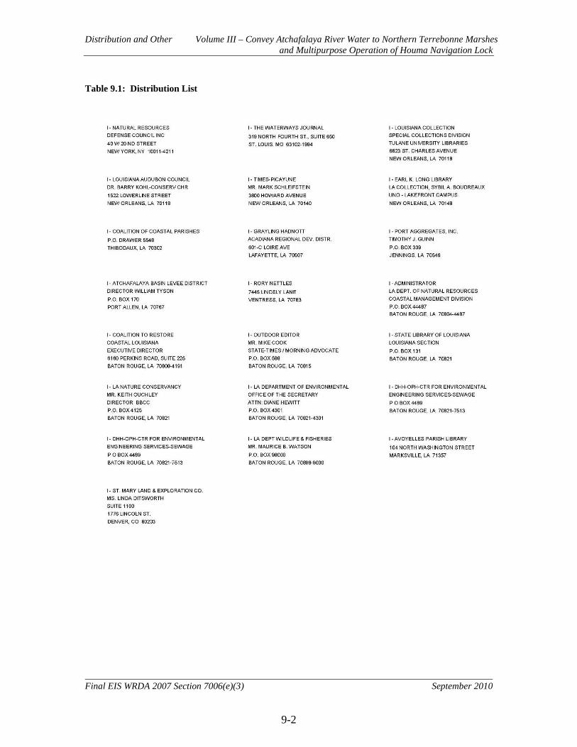
Distribution and Other Volume III – Convey Atchafalaya River Water to Northern Terrebonne Marshes and Multipurpose Operation of Houma Navigation Lock
9-2
Final EIS WRDA 2007 Section 7006(e)(3) September 2010
Table 9.1: Distribution List

Distribution and Other Volume III – Convey Atchafalaya River Water to Northern Terrebonne Marshes and Multipurpose Operation of Houma Navigation Lock
9-3
Final EIS WRDA 2007 Section 7006(e)(3) September 2010

Distribution and Other Volume III – Convey Atchafalaya River Water to Northern Terrebonne Marshes and Multipurpose Operation of Houma Navigation Lock
9-4
Final EIS WRDA 2007 Section 7006(e)(3) September 2010

Distribution and Other Volume III – Convey Atchafalaya River Water to Northern Terrebonne Marshes and Multipurpose Operation of Houma Navigation Lock
9-5
Final EIS WRDA 2007 Section 7006(e)(3) September 2010

Distribution and Other Volume III – Convey Atchafalaya River Water to Northern Terrebonne Marshes and Multipurpose Operation of Houma Navigation Lock
9-6
Final EIS WRDA 2007 Section 7006(e)(3) September 2010
Distribution and Other Volume III – Convey Atchafalaya River Water to Northern Terrebonne Marshes and Multipurpose Operation of Houma Navigation Lock
9-7
Final EIS WRDA 2007 Section 7006(e)(3) September 2010
Distribution and Other Volume III – Convey Atchafalaya River Water to Northern Terrebonne Marshes and Multipurpose Operation of Houma Navigation Lock
9-8
Final EIS WRDA 2007 Section 7006(e)(3) September 2010
Distribution and Other Volume III – Convey Atchafalaya River Water to Northern Terrebonne Marshes and Multipurpose Operation of Houma Navigation Lock
9-9
Final EIS WRDA 2007 Section 7006(e)(3) September 2010

Distribution and Other Volume III – Convey Atchafalaya River Water to Northern Terrebonne Marshes and Multipurpose Operation of Houma Navigation Lock
9-10
Final EIS WRDA 2007 Section 7006(e)(3) September 2010
Distribution and Other Volume III – Convey Atchafalaya River Water to Northern Terrebonne Marshes and Multipurpose Operation of Houma Navigation Lock
9-11
Final EIS WRDA 2007 Section 7006(e)(3) September 2010

Distribution and Other Volume III – Convey Atchafalaya River Water to Northern Terrebonne Marshes and Multipurpose Operation of Houma Navigation Lock
9-12
Final EIS WRDA 2007 Section 7006(e)(3) September 2010

Distribution and Other Volume III – Convey Atchafalaya River Water to Northern Terrebonne Marshes and Multipurpose Operation of Houma Navigation Lock
9-13
Final EIS WRDA 2007 Section 7006(e)(3) September 2010
Distribution and Other Volume III – Convey Atchafalaya River Water to Northern Terrebonne Marshes and Multipurpose Operation of Houma Navigation Lock
9-14
Final EIS WRDA 2007 Section 7006(e)(3) September 2010

Distribution and Other Volume III – Convey Atchafalaya River Water to Northern Terrebonne Marshes and Multipurpose Operation of Houma Navigation Lock
9-15
Final EIS WRDA 2007 Section 7006(e)(3) September 2010
Distribution and Other Volume III – Convey Atchafalaya River Water to Northern Terrebonne Marshes and Multipurpose Operation of Houma Navigation Lock
9-16
Final EIS WRDA 2007 Section 7006(e)(3) September 2010

Distribution and Other Volume III – Convey Atchafalaya River Water to Northern Terrebonne Marshes and Multipurpose Operation of Houma Navigation Lock
9-17
Final EIS WRDA 2007 Section 7006(e)(3) September 2010
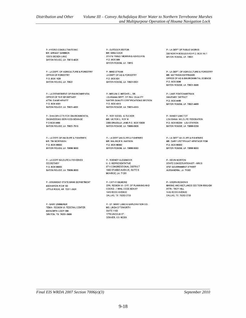
Distribution and Other Volume III – Convey Atchafalaya River Water to Northern Terrebonne Marshes and Multipurpose Operation of Houma Navigation Lock
9-18
Final EIS WRDA 2007 Section 7006(e)(3) September 2010
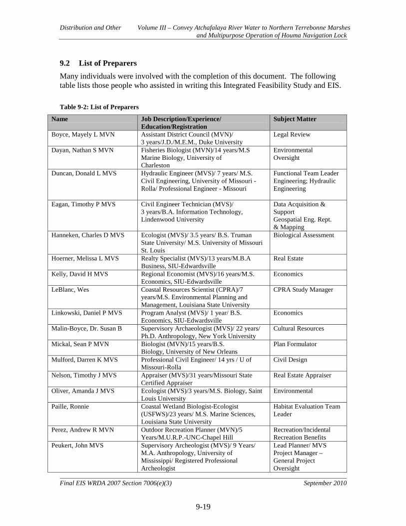
Distribution and Other Volume III – Convey Atchafalaya River Water to Northern Terrebonne Marshes and Multipurpose Operation of Houma Navigation Lock
9-19
Final EIS WRDA 2007 Section 7006(e)(3) September 2010
9.2 List of Preparers Many individuals were involved with the completion of this document. The following table lists those people who assisted in writing this Integrated Feasibility Study and EIS. Table 9-2: List of Preparers
Name Job Description/Experience/ Education/Registration
Subject Matter
Boyce, Mayely L MVN Assistant District Council (MVN)/ 3 years/J.D./M.E.M., Duke University
Legal Review
Dayan, Nathan S MVN Fisheries Biologist (MVN)/14 years/M.S Marine Biology, University of Charleston
Environmental Oversight
Duncan, Donald L MVS Hydraulic Engineer (MVS)/ 7 years/ M.S. Civil Engineering, University of Missouri - Rolla/ Professional Engineer - Missouri
Functional Team Leader Engineering; Hydraulic Engineering
Eagan, Timothy P MVS Civil Engineer Technician (MVS)/ 3 years/B.A. Information Technology, Lindenwood University
Data Acquisition & Support Geospatial Eng. Rept. & Mapping
Hanneken, Charles D MVS Ecologist (MVS)/ 3.5 years/ B.S. Truman State University/ M.S. University of Missouri St. Louis
Biological Assessment
Hoerner, Melissa L MVS Realty Specialist (MVS)/13 years/M.B.A Business, SIU-Edwardsville
Real Estate
Kelly, David H MVS Regional Economist (MVS)/16 years/M.S. Economics, SIU-Edwardsville
Economics
LeBlanc, Wes Coastal Resources Scientist (CPRA)/7 years/M.S. Environmental Planning and Management, Louisiana State University
CPRA Study Manager
Linkowski, Daniel P MVS Program Analyst (MVS)/ 1 year/ B.S. Economics, SIU-Edwardsville
Economics
Malin-Boyce, Dr. Susan B Supervisory Archaeologist (MVS)/ 22 years/ Ph.D. Anthropology, New York University
Cultural Resources
Mickal, Sean P MVN Biologist (MVN)/15 years/B.S. Biology, University of New Orleans
Plan Formulator
Mulford, Darren K MVS Professional Civil Engineer/ 14 yrs / U of Missouri-Rolla
Civil Design
Nelson, Timothy J MVS Appraiser (MVS)/31 years/Missouri State Certified Appraiser
Real Estate Appraiser
Oliver, Amanda J MVS Ecologist (MVS)/3 years/M.S. Biology, Saint Louis University
Environmental
Paille, Ronnie Coastal Wetland Biologist-Ecologist (USFWS)/23 years/ M.S. Marine Sciences, Louisiana State University
Habitat Evaluation Team Leader
Perez, Andrew R MVN Outdoor Recreation Planner (MVN)/5 Years/M.U.R.P.-UNC-Chapel Hill
Recreation/Incidental Recreation Benefits
Peukert, John MVS Supervisory Archeologist (MVS)/ 9 Years/ M.A. Anthropology, University of Mississippi/ Registered Professional Archeologist
Lead Planner/ MVS Project Manager – General Project Oversight
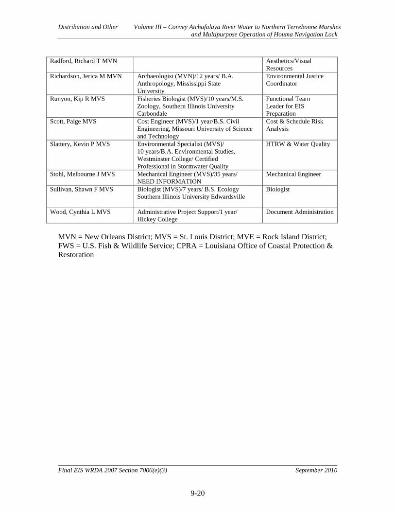
Distribution and Other Volume III – Convey Atchafalaya River Water to Northern Terrebonne Marshes and Multipurpose Operation of Houma Navigation Lock
9-20
Final EIS WRDA 2007 Section 7006(e)(3) September 2010
Radford, Richard T MVN Aesthetics/Visual Resources
Richardson, Jerica M MVN Archaeologist (MVN)/12 years/ B.A. Anthropology, Mississippi State University
Environmental Justice Coordinator
Runyon, Kip R MVS Fisheries Biologist (MVS)/10 years/M.S. Zoology, Southern Illinois University Carbondale
Functional Team Leader for EIS Preparation
Scott, Paige MVS Cost Engineer (MVS)/1 year/B.S. Civil Engineering, Missouri University of Science and Technology
Cost & Schedule Risk Analysis
Slattery, Kevin P MVS Environmental Specialist (MVS)/ 10 years/B.A. Environmental Studies, Westminster College/ Certified Professional in Stormwater Quality
HTRW & Water Quality
Stohl, Melbourne J MVS Mechanical Engineer (MVS)/35 years/ NEED INFORMATION
Mechanical Engineer
Sullivan, Shawn F MVS
Biologist (MVS)/7 years/ B.S. Ecology Southern Illinois University Edwardsville
Biologist
Wood, Cynthia L MVS Administrative Project Support/1 year/ Hickey College
Document Administration
MVN = New Orleans District; MVS = St. Louis District; MVE = Rock Island District; FWS = U.S. Fish & Wildlife Service; CPRA = Louisiana Office of Coastal Protection & Restoration
Distribution and Other Volume III – Convey Atchafalaya River Water to Northern Terrebonne Marshes and Multipurpose Operation of Houma Navigation Lock
9-21
Final EIS WRDA 2007 Section 7006(e)(3) September 2010
9.3 Literature Cited
Adkins, G. 1972. A Study of the Blue Crab Fishery in Louisiana. Technical Bulletin No. 3. Louisiana Wildlife and Fisheries Commission. New Orleans, LA.
Anderson, M.G. and B.D.J. Batt. 1983. Workshop on the ecology of wintering waterfowl.
Wildlife Society Bulletin 11:22-24. Bahr, L.M., Jr., R. Costanza, J.W. Day, Jr., S.E. Bayley, C. Neill, S.G. Leibowitz, and J.
Fruci. 1983. Ecological characterization of the Mississippi deltaic plain region: A narrative with management recommendations. FWS/OBS-82/69. U.S. Fish and Wildlife Service, Washington, DC.
Barras, J.A. 2009. Land Area Change and Overview of Major Hurricane Impacts in
Coastal Louisiana, 2004-2008. U.S. Geological Survey Scientific Investigations Map 2080, scale 1:250,000, 6 p. pamphlet.
Barras, J.A., J.C. Bernier, and R.A. Morton. 2008. Land Area Change in Coastal
Louisiana – a Multidecadal Perspective (from 1956 to 2006). U.S. Geological Survey Scientific Investigations Map 3019, scale 1:250,000, 14 p. pamphlet.
Barras, J., S. Beville, D. Hartley, S. Hawes, J. Johnston, P. Kemp, Q. Kinler, A. Martucci,
J. Porthouse, D. Reed, K. Roy, S. Sapkota, and J. Shayda, 2003. Historical and projected coastal Louisiana land changes: 1978-2050: USGS Open File Report 03-334, 39p. (revised Jan. 2004).
Barras, J. A., 2006, Land area change in coastal Louisiana after the 2005 hurricanes--a
series of three maps: U.S. Geological Survey Open-File Report 06-1247 Barras, J.A., P. E. Bourgeois, L. R. Handley. 1994. Land loss in coastal Louisiana 1956-
90: National Biological Survey, National Wetlands Research Center Open-File Report 94-01. 4 p.
Barrett, B.B. and M.C. Gillespie. 1973. Primary Factors Which Influence Commercial
Shrimp Production in Coastal Louisiana. Technical Bulletin 9. Louisiana Wildlife and Fisheries Commission. New Orleans, La.
Baxter, K.N. and W.C. Renfro. 1967. Seasonal occurrence and size distribution of
postlarval brown and white shrimp near Galveston, Texas, with notes on species information. U.S. Fish and Wildlife Service. Fisheries Bulletin 66:149-158.
Blanchard, T.C. 2009. Population Projections of Louisiana Parishes through 2030.
Louisiana State University. 23p.

Distribution and Other Volume III – Convey Atchafalaya River Water to Northern Terrebonne Marshes and Multipurpose Operation of Houma Navigation Lock
9-22
Final EIS WRDA 2007 Section 7006(e)(3) September 2010
Browder, J.A., H.A. Bartley, and K.S. Davis. 1985. A probabilistic model of the relationship between marshland-water interface and marsh disintegration. Ecological Modeling 29:245-260.
Browder, J.A., L.N. May, A. Rosenthal, J.G. Gosselink, and R.H. Baumann. 1989. Using
thematic mapper imagery and a spatial computer model to predict future trends in wetland loss and brown shrimp production in Louisiana. Remote Sensing of the Environment 28:45-59.
Caffey, R.H. and M. Schexnayder. 2002. Fisheries implications of freshwater diversions
in "An interpretive topic series on Louisiana coastal wetland restoration." Coastal Wetland Planning, Preservation, and Restoration Act Outreach Committee (eds.), National Sea Grant Library No. LSU-G-02-003, 7p.
Canadian Wildlife Service and U.S. Fish and Wildlife Service. 1986. North American
waterfowl management plan. U.S. Fish and Wildlife Service, Washington, D.C. 31 pp.
Chabreck, R.H. 1971. The foods and feeding habits of alligators from fresh and saline
environments in Louisiana. Unpublished Proceedings of the 25th Annual Conference of the Southeast Association of Game and Fish Commissioners.
Chabreck, R.H. 1972a. Vegetation, water and soil characteristics of Louisiana. Louisiana
Agricultural Experiment Station Bulletin. 664 pp. Chabreck, R.H. 1972b. Vegetation, water and soil characteristics of the Louisiana coastal
region. Louisiana State University and Agricultural and Mechanical College Agricultural Experiment Station. 72pp.
Chabreck, R.H. and G. Linscombe. 1982. Changes in vegetative types in Louisiana
coastal marshes over a ten-year period. Louisiana Academy of Sciences 45:98–102.
Christmas, J.Y., J.T. McBee, R.S. Waller, and FC. Sutter III. 1982. Habitat Suitability
Index Models: Gulf Menhaden. FWS/OBS-82/1.23. U.S. Fish and Wildlife Service. Washington, DC.
City-Data.com. 2009. http://www.city-data.com/. Accessed 1 February 2010. Condrey, R.P., P. Kemp, J. Visser, J. Gosselink, D. Lindstedt, E. Melancon, G. Pterson,
and B. Thompson. 1995. Status, Trends, and Probable Causes of Change in Living Resources in the Barataria and Terrebonne Estuarine Systems. BTNEP Publication No. 21, Barataria Terrebonne National Estuary Program, Thibodaux, LA.
Distribution and Other Volume III – Convey Atchafalaya River Water to Northern Terrebonne Marshes and Multipurpose Operation of Houma Navigation Lock
9-23
Final EIS WRDA 2007 Section 7006(e)(3) September 2010
Conner, W.H. and J.W. Day, Jr. 1987. The Ecology of Barataria Basin, Louisiana: An Estuarine Profile. Biological Report 85(7.13). U.S. Fish and Wildlife Service, Washington, DC.
CWPPRA 2007. Coastal Wetlands Planning, Protection, and Restoration Act
Environmental Work Group Wetland Value Assessment Methodology Coastal Marsh Community Models, 36 pp.
Daigle, J.J., G.E. Griffith, J.M. Omernik, P.L. Faulkner, R.P. McCulloh, L.R. Handley,
L.M. Smith, and S.S. Chapman. 2006. Ecoregions of Louisiana (color poster with map, descriptive text, summary tables, and photographs). U.S. Geological Survey (map scale 1:1,000,000), Reston, Virginia.
Day, J.W. and P.H. Templet, 1989. Consequences of Sea Level Rise: Implications from
the Mississippi Delta. Coastal Management. Vol 17:241-257. Day, J. W., Jr., C. A. S. Hall, W. M. Kemp, A. Yanez-Arancibia. 1989. Estuarine
Ecology. John Wiley and Sons, New York. 558 pp. DeLaune, R.D., J.A. Nyman, and W.H. Patrick, Jr. 1994. Peat collapse, ponding and
wetland loss in a rapidly submerging coastal marsh. J. Coast. Res. 10:1021-1030. DeLaune, R.D., S. R. Pezeshki, J. H. Pardue, J. H. Whitcomb, and W. H. Patrick, Jr.
1990. Some influences of sediment addition to a deteriorating salt marsh in the Mississippi River deltaic plain: A pilot study. Journal of Coastal Research 6:1:181-188.
DeLaune, R.D., W.H. Patrick, and N. Van Breemen. 1990b. Processes governing marsh
formation in a rapidly subsiding coastal environment. Catena 17:277-288. Cremlingen, Germany.
DeLaune, R.D., C. J. Smith, and W. H. Patrick. 1983. Relationship of marsh elevation,
redox potential, and sulfide to Spartina alterniflora productivity. Soil Sci. Soc. AM. J. 47:930-935.
DeLaune, R.D., R.J. Buresh, and W.H. Patrick, Jr. 1979. Relationship of soil properties to
standing crop biomass of Spartina alterniflora in a Louisiana marsh. Estuarine Coastal Marine Science 8: 477-487.
DeLaune, R.D., W.H. Patrick, Jr. & R.J. Buresh. 1978. Sedimentation rates determined
by 137 Cs dating in a rapidly accreting salt marsh. Nature 275:12. pp. 532-533. Diagne, A., and W. R. Keithly. 1988. The demand for relaying activities by the Louisiana
oyster industry. Proceedings of the 10th Biannual Conference of the International Institute of Fisheries Economics and Trade, 10-14 July, Corvallis, Oregon.

Distribution and Other Volume III – Convey Atchafalaya River Water to Northern Terrebonne Marshes and Multipurpose Operation of Houma Navigation Lock
9-24
Final EIS WRDA 2007 Section 7006(e)(3) September 2010
Dow, D.D., W.H. Herke, E.E. Knudsen, B.L. Marotz and E.M. Swenson. 1985. Hydrography on the Grand Bayou, Louisiana, watershed: influence of wetland-water interactions on ecosystem function. Symposium of Hydrolographic Society of America. p 52-71.
Environmental Systems Research Institute, Inc. (ESRI). 2008. Business Analyst
Program: Census 2000 Summary Profile, Census 2000 Detailed Race Profile, 2008/2013 Demographic and Income Profile.
Faller, K. H. 1979. Shoreline as a controlling factor in commercial shrimp production.
National Aeronautics and Space Administration, National Space Technology Laboratories, Bay St. Louis, Mississippi, USA, NASA TM-72-732.
Federal Highway Administration (FHWA). 2006. “Highway Construction Noise
Handbook.” Final Report. FHWA, U.S. Department of Transportation. August 2006.
Forsythe, S.W. 1985. The protection of bottomland hardwood wetlands of the lower
Mississippi Valley. Transactions of the North American Wildlife and Natural Resources Conference 50:566-572.
Gaidry, W.J. and C.J. White. 1973. Investigations of Commercially Important Penaeid
Shrimp in Louisiana Estuaries. Technical Bulletin 8. Louisiana Wildlife and Fisheries Commission. New Orleans, LA.
Gagliano, S. M. 1999. Faulting, Subsidence and Land Loss in Coastal Louisiana.
Contract No. 68-06-0067. Prepared for U.S. Environmental Protection Agency, Dallas, TX.
Gosselink, J.G. 1984. The Ecology of Delta Marshes of Coastal Louisiana: A Community
Profile. FWS/OBS-84/09. U.S. Fish and Wildlife Service, Washington, D.C. Gosselink, J.G. and C.E. Sasser. 1991. An ecological overview of the Barataria-
Terrebonne estuary: Processes, scales, and management principles. Gosselink, J.G. and C.E. Sasser. 1995. Causes of Wetland Loss. D.J. Reed (ed.) pp. 205-
236. In: Current Status and Historical Trends of Hydrological Modification, Reduction in Sediment Availability, and Habitat Loss/Modification in the Barataria-Terrebonne Estuarine System. BTNEP No. 20. Barataria Terrebonne National Estuary Program, Thibodaux, LA.
Guillory, V., J. Geaghan, and J. Roussel. 1983. Influence of Environmental Factors on
Gulf Menhaden Recruitment. Louisiana Department of Wildlife and Fisheries Technical Bulletin 37. Baton Rouge, LA.
Distribution and Other Volume III – Convey Atchafalaya River Water to Northern Terrebonne Marshes and Multipurpose Operation of Houma Navigation Lock
9-25
Final EIS WRDA 2007 Section 7006(e)(3) September 2010
Gulf of Mexico Fisheries Management Council. 2004. Final Environmental Impact Statement for the Generic Essential Fish Habitat Amendment to the following fishery management plans of the Gulf of Mexico. Gulf of Mexico Fishery Management Council. Tampa, Florida.
Hawes, S.R., and H.M. Perry. 1978. Effects of 1973 floodwaters on plankton populations
in Louisiana and Mississippi. Gulf Research Reports 6(2):109-124. Heitmeyer, M.E. and L.H. Fredrickson. 1981. Do wetland conditions in the Mississippi
Delta hardwoods influence mallard recruitment? Transactions of the North American Wildlife and Natural Resources Conference 46:44-57.
Herke, W.H. 1995. Natural fisheries, marsh management, and mariculture: complexity
and conflict in Louisiana. Estuaries 18:10-17. Joanen, T. and L. McNease. 1972. Population distribution of alligators with special
reference to the Louisiana coastal marsh zones. Unpublished Symposium of the American Alligator Council, Lake Charles, LA.
Keithly, W.R. Jr., and K. J. Roberts. 1988. The Louisiana oyster industry: economic
status and expansion prospects. Journal of shellfish research. Vol 7:515-525. Kilgen, R. H. and R. J. Dugas. 1989. The ecology of oyster reefs of the northern Gulf of
Mexico: an open file report . NWRC-open file rep. 89-02. Knox, G.A. 2001. The ecology of seashores. CRC Press LLC, Boca Rotan, Florida. 557
pp. Kryter, K. D. 1994. The Handbook of Hearing and the Effects of Noise: Physiology, and
Public Health. McGraw Hill, New York. Kuecher, G.J. 1994. Geologic Framework and consolidation Settlement Potential of the
Lafourche delta, Topstratum Valley Fill; Implications for Wetland Loss in Terrebonne and Lafourche Parishes, Louisiana. Doctor of Philosophy Dissertation. Louisiana State University, Baton Rouge, LA.
Lassuy, D.R. 1983. Species Profiles: Life Histories and Environmental Requirements
(Gulf of Mexico) Brown Shrimp. FWS/OBS-82/11.1. U.S. Fish and Wildlife Service, Washington, DC.
LeBlanc, D.J. 1994. Prevention and control of wildlife damage-Nutria. United States
Department of Agriculture’s Animal and Plant Health Inspection Service, Port Allen, Louisiana.

Distribution and Other Volume III – Convey Atchafalaya River Water to Northern Terrebonne Marshes and Multipurpose Operation of Houma Navigation Lock
9-26
Final EIS WRDA 2007 Section 7006(e)(3) September 2010
Lessmann, J.M., I.A. Mendelssohn, M.W. Hester, and K.L. McKee. 1997. Population variation in growth response to flooding of three marsh grasses. Ecological Engineering 8:31-47.
Linscombe, G. and K. Kinler. 1994. A Survey of Vegetative Damage Caused by Nutria
Herbivory in the Barataria and Terrebonne Basins. submitted to the Barataria-Terrebonne National Estuary Program. Louisiana Department of Wildlife and Fisheries, Baton Rouge, LA.
Louisiana Coastal Wetlands Conservation and Restoration Task Force and the Wetlands
Conservation and Restoration Authority. 1998. Coast 2050: Toward a Sustainable Coastal Louisiana,. Louisiana Department of Natural Resources. Baton Rouge, La.
Louisiana Department of Agriculture and Forestry. 2009. 2008 Louisiana Timber and
Pulpwood Production. Office of Forestry, Baton Rouge, LA. Louisiana Department of Environmental Quality. 2008. 2008 Louisiana Water Quality
Inventory: Integrated Report. Louisiana Department of Environmental Quality, Office of Environmental Assessment, Water Quality Assessment Division, Baton Rouge.
Louisiana Department of Environmental Quality. 2008. 2007 Louisiana Ambient Air
Monitoring Network Annual Report. Louisiana Department of Wildlife and Fisheries, Louisiana Sea Grant, Louisiana Aquatic
Invasive Species Task Force. 2005. State management plan for aquatic invasive species in Louisiana. Center for Bioenvironmental Research at Tulane and Xavier Universities. 81 pp.
Martin, R.P. and G.D. Lester. 1990. Atlas and Census of Wading Fird and Seabird
Nesting Colonies in Louisiana: 1990. Special Publication No. 3. Louisiana Department of Wildlife and Fisheries, Louisiana Natural Heritage Program, Baton Rouge, LA.
McDaniel, D.R. and G.J. Trahan. 2007. Soil Survey of Terrebonne Parish, Louisiana.
United States Department of Agriculture, Natural Resources Conservation Service, in cooperation with Louisiana Agricultural Experiment Station and Louisiana Soil and Water Conservation Committee.
McKee, K.L. and I.A. Mendelssohn. 1989. Response of a freshwater marsh plant
community to increased salinity and increased water level. Aquatic Biology. 34:301-316.
Distribution and Other Volume III – Convey Atchafalaya River Water to Northern Terrebonne Marshes and Multipurpose Operation of Houma Navigation Lock
9-27
Final EIS WRDA 2007 Section 7006(e)(3) September 2010
Michot, T.C. 1996. Marsh loss in coastal Louisiana: Implications for management of North American Anatidae. Gibier Faune Sauvage. Game Wildlife 13:941-957.
Minello, T.J., R.J. Zimmerman, and R. Medina. 1994. The importance of edge for natant
macrofauna in a created salt marsh. Wetlands 14:184-198. Mitchell, K. 1991. Wildlife Resources of the Barataria-Terrebonne Estuary. pp. 3339-
346. In: Barataria-Terrebonne National Estuary Program Scientific-Technical Committee Data Inventory Workshop Proceedings. BTNEP Publication - 5, Thibodaux, LA.
Mitsch, W.J. and J.G. Gosselink. 1993. Wetlands. 2nd Ed. Van Nostrand Reinhold, New
York, USA. 722pp. Morgan, J. P., and Larimore, P. B., 1957, Changes in the Louisiana shoreline:
Transactions of the Gulf Coast Association of Geological Societies, v. 7, p. 303-10.
Morton, R., J. Bernier, J. Barras, and N. Fernia. 2005. Rapid subsidence and historical
wetland loss in the Mississippi Delta Plain, likely causes and future implications: U.S. Geological Survey Open-File Report 2005-1216, 124 pp. http://pubs.usgs.gov/of/2005/1216/, accessed August 9, 2006.
Mossa, J. D.M. Lindstedt, D. Cahoon, and J. Barras. 1990. Environmental Characteristics
and Habitat Change for the Louisiana Coastal Zone. pp. 167-204. In: D.R. Cahoon and C.G. Groat eds., A study of Marsh Management Practice in Coastal Louisiana, Volume II, Technical Description. Final report submitted to Minerals Management Service, New Orleans, LA. OCS Study/MMS 90-0075.
Muncy, R.J. 1984. Species Profiles: Life Histories and Environmental Requirements
(Gulf of Mexico) White Shrimp. FWS/OBS-82/11.20. U.S. Fish and Wildlife Service, Washington, DC.
Nance, J.M. and S. Nichols. 1988. Stock Assessments for Brown, White and Pink Shrimp
in the U.S. Gulf of Mexico, 1960-1986. NOAA Technical Memorandum SEFC-NMFS-203. National Oceanic and Atmospheric Administration, Galveston, TX.
National Marine Fisheries Service. 2009. Fisheries Statistics Division, Silver Spring,
Maryland, personal communication. National Marine Fisheries Service. 2009. Fisheries of the United States, 2008. National
Oceanic and Atmospheric Administration. United States Department of Commerce. Silver Spring, Maryland.

Distribution and Other Volume III – Convey Atchafalaya River Water to Northern Terrebonne Marshes and Multipurpose Operation of Houma Navigation Lock
9-28
Final EIS WRDA 2007 Section 7006(e)(3) September 2010
Nowak, D.J. 2003. Personal communication, David J. Nowak, Project Leader, USDA Forest Service, Northeastern Research Station, 5 Moon Library, SUNY-CESF, Syracuse, New York.
Nyman, J.A., R.J. Walters, R.D. Delaune, and W.H. Patrick, Jr. 2006. Marsh vertical
accretion via vegetative growth. Estuarine, Coastal and Shelf Science 69: 370-380.
O’Neil, T. 1949. The muskrat in the Louisiana coastal marsh. Louisiana Department of
Wildlife and Fisheries. New Orleans, LA. Penland, S., K.E. Ramsey, R.A. McBride, J.T. Mestayer, and K.A. Westphal. 1988. Relative
Sea Level Rise and Delta-Plain Development in the Terrebonne Parish Region. Coastal Geology Technical Report No. 4. Louisiana Geological Survey, Baton Rouge, LA.
Penland, Shea, and Boyd, Ron, 1981, Shoreline changes on the Louisiana barrier coast:
Oceans, v. 81, p. 209-219. Perret, W.S., B.B. Barrett, W.R. Latapie, J.F. Pollard, W.R. Mock, G.B. Adkins, W.J.
Gaidry, and C.J. White. 1971. Cooperative Gulf of Mexico estuarine inventory and study, Louisiana. Louisiana Wildlife and Fisheries Commission, New Orleans, Louisiana.
Pierce, M.E., and J.T. Conover. 1954. A study o f the growth of oysters under different
ecological conditions in Great Pond. Biol . Bull . (Woods Hole) 107: 318. (Abstr.).
Perry, H.M. 1975. The blue crab fishery in Mississippi. Gulf Research Reports. 5:39-57. Perry, H.M. and T.D. McIlwain. 1986. Species Profiles: Life Histories and
Environmental Requirements of Coastal Fishes and Invertebrates (Gulf of Mexico) Blue Crab. FWS/OBS-82/11.55. U.S. Fish and Wildlife Service, Washington, DC.
Platt, S.G., C.G. Brantley, and R.W. Hastings. 1990. Food habits of juvenile American
alligators in the upper Lake Pontchartrain estuary. Northeast Gulf Science 11:123-130.
Platt, S.G., C.G. Brantley, and Lance W. Fontenot. 1989. Herpetofauna of the Manchac
Wildlife Management Area, St. John The Baptist Parish, Louisiana. Proc. Louisiana Acad. Sci. 52:22-28.21
Raveling, D.G. and M.E. Heitmeyer. 1989. Relationships of population size and
recruitment of pintails to habitat conditions and harvest. Journal of Wildlife Management 53(4):1088-1103.

Distribution and Other Volume III – Convey Atchafalaya River Water to Northern Terrebonne Marshes and Multipurpose Operation of Houma Navigation Lock
9-29
Final EIS WRDA 2007 Section 7006(e)(3) September 2010
Reinecke, K.J., C.W. Shaiffer, and D. Delnicki. 1987. Winter survival of female mallards
in the Lower Mississippi Valley. TNAWNR Conf 52:258-263. Rogers, D.R., B.D. Rogers, and W.H. Herke. 1992. Effects of a marsh management plan
on fishery communities in coastal Louisiana. Wetlands 12:53-62. Rozas, L.P. and D.J. Reed. 1993. Nekton use of marsh-surface habitats in Louisiana
(USA) deltaic salt marshes undergoing submergence. Mar. Ecol. Prog. Ser. 96:147-157.
Rounsefell, G.A. 1975. Ecology, utilization, and management of marine fisheries. The
C.V. Mosby Company, St. Louis, Missouri. Sasser, C.E., Visser, J.M., Mouton, Edmond, Linscombe, Jeb, and Hartley, S.B., 2008,
Vegetation types in coastal Louisiana in 2007: U.S. Geological Survey Open-File Report 2008–1224, 1 sheet, scale 1:550,000.
Sasser, C.E., E.M. Swenson, D.E. Evers, J.M. Visser, G.W. Holm, and J.G. Gosselink.
1994. Floating marshes in the Barataria and Terrebonne basins, Louisiana. Coastal Ecology Institute, Louisiana State University, Baton Rouge, LA.
Sasser, C.E., G.W. Peterson, D.A. Fuller, R.K. Abernathy, and J.G. Gosselink. 1982.
Environmental monitoring program. Louisiana off-shore oil port pipeline. Coastal Ecology Laboratory Center for Wetland Resources, Louisiana State University, Baton Rouge, LA.
Self, C.A. 1975. Marsh plants as food for captive white-tailed deer (Odocoileus
virginianus), fallow deer(Dama dama), and sika deer (Cervus nippon
). M.S. Thesis. Louisiana State University, Baton Rouge.
Sevier, M.B. 1990. Land Uses of Terrebonne Parish: An Historical Geography, Master of Arts Thesis. University of Southwestern Louisiana, Lafayette, LA.
SCORP. 2008. 2003-2008 Louisiana Statewide Comprehensive Outdoor Recreation Plan.
Department of Culture, Recreation, and Tourism. Office of State Parks, Division of Outdoor Recreation. Published by Louisiana State Library.
Shaffer, Gary P. Thais E. Perkins, Susanne Hoeppner, Susan Howell, Heath Bernard and
Carol Parsons, 2003, Ecosystem Health of the Maurepas Swamp: Feasibility and Projected Benefits of a Freshwater Diversion, Prepared for Environmental Protection Agency (EPA) Region 6.
Distribution and Other Volume III – Convey Atchafalaya River Water to Northern Terrebonne Marshes and Multipurpose Operation of Houma Navigation Lock
9-30
Final EIS WRDA 2007 Section 7006(e)(3) September 2010
Swarzenski, C.M., T.W. Doyle, B. Fry, and T.G. Hargis. 2008. Biogeochemical response of organic-rich freshwater marshes in the Louisiana delta plain to chronic river water influx. Biogeochemistry 90: 49-63.
Teal, J.M. (1986) The Ecology of Regularly-Flooded Salt Marshes of New England: A
Community Profile. US Fish and Wildlife Serv., Div. Biol. Serv., Washington DC. FWS/OBS-82-07
Tiner, R.W., Jr. 1984. Wetlands of the United States: Current status and recent trends.
U.S. Fish and Wildlife Service, Newton Corner, Massachusetts. 59 pp. Titus, J. and C. Richman. 2001. Maps of Lands Vulnerable to Sea Level Rise: Modeled
Elevations along the U.S. Atlantic and Gulf Coasts. - Climate Research, CR 18:205-228. The Coypu Foundation. http://is.cbr.tulane.edu. Center for Bioenvironmental Research, Invasive Species Initiative at Tulane and Xavier University.
Turner, R.E. 1992. Coastal Wetlands and Penaeid Shrimp Habitat. pp.97-104. In: R.E.
Stroud, Ed. Stemming the Tide of Coastal Fish Habitat Loss. National Coalition for Marine Conservation, Inc. Savannah, GA.
Turner, R.E. and M.S. Brody. 1983. Habitat Suitability Index Models: Northern Gulf of
Mexico Brown Shrimp and White Shrimp. FWS/OBS-82/10.54. U.S. Fish and Wildlife Service, Washington, DC.
Turner, R.E. and V.S. Rao. 1990. Relationships between wetland fragmentation and
recent hydrologic changes in a deltaic coast. Estuaries 13:272-281. USACE. 2004. USACE Louisiana Coastal Area (LCA) Ecosystem Restoration Study. USACE. 2008. USACE Louisiana Coastal Protection and Restoration (LACPR): Draft
Technical Report. U.S. Census Bureau (USCB). 2000 U.S. Census, Summary File 1 (SF1), Summary File 3
(SF3) and Summary File 4 (SF4). Accessed at http://factfinder.census.gov on 3-13 November 2009.
U.S. Environmental Protection Agency (USEPA). 1974. Information on Levels of
Environmental Noise Requisite to Protect Public Health and Welfare with an Adequate Margin of Safety. Report 550/9-47-004.
USGS. 2009. http://nas.er.usgs.gov/ USGS. 2006. USGS Reports Latest Land-Water Changes for Southeastern Louisiana.

Distribution and Other Volume III – Convey Atchafalaya River Water to Northern Terrebonne Marshes and Multipurpose Operation of Houma Navigation Lock
9-31
Final EIS WRDA 2007 Section 7006(e)(3) September 2010
USGS National Wetlands Research Center. 2000. Nutria-Eating Louisiana’s Coast. Fact sheet.
White, C.J. and C.J. Boudreaux. 1977. Development of an aerial management concept for
gulf penaeid shrimp. Louisiana Wildlife and Fisheries Commission Technical Bulletin 22.
White, W.A. and R.A. Morton. 1997. Wetland losses related to fault movement and
hydrocarbon production, southeastern Texas coast. Journal of Coastal Research. 13:1305-1320.
Wicker, K.M., 1980. The Mississippi Deltaic Plain habitat mapping study: U.S. Fish and
Wildlife Service, Office of Biological Services, FWS/OBS 79/07, 464 maps. Wiebe, J. and E. Mouton. 2009. Coastwide Nutria Control Program 2008-2009. Nutria
Harvest and Distribution 2008-2009 and a Survey of Nutria Herbivory Damage in Coastal Louisiana in 2009. Coastal and Nongame Resources, Louisiana Department of Wildlife and Fisheries.
Zimmerman, R.J., T.J. Minello, and G. Zamora. 1984. Selection of vegetated habitat by
brown shrimp, Penaeus aztecus, in a Galveston Bay salt marsh. Fishery Bulletin, US 82:325-336.

Distribution and Other Volume III – Convey Atchafalaya River Water to Northern Terrebonne Marshes and Multipurpose Operation of Houma Navigation Lock
9-32
Final EIS WRDA 2007 Section 7006(e)(3) September 2010
9.4 Glossary Acceptability – Adequate to satisfy a need, requirement, or standard. One of the U.S. Army Corps of Engineers requirements for a project. Adaptive management – An interdisciplinary approach acknowledging our insufficient information base for decision-making; that uncertainty and change in managed resources are inevitable; and that new uncertainties will emerge. An iterative approach that includes monitoring and involves scientists, engineers and others who provide information and recommendations that are incorporated into management actions; results are then followed with further research, recommendations and management actions, and so on. Air Quality Determination – The Louisiana Department of Environmental Quality ensures that projects do not adversely affect air quality through this determination as a requirement of the Clean Air Act. Alternative Plan – A set of one of more management measures within a subprovince functioning together to address one or more objectives. Amplitude – The maximum absolute value of a periodically varying quantity. Anadromous – Ascending rivers from the sea for breeding. Anthropogenic – Caused by human activity. Average Annual Habitat Unit (AAHU) – Represent a numerical combination of habitat quality and quantity (acres) existing at any given point in time. The habitat units resulting from the future without- and future with-project scenarios are annualized, and averaged over the period of analysis, to determine Average Annual Habitat Units (AAHUs). Aquaculture – The science and business of farming marine or freshwater food fish or shellfish, such as oysters, crawfish, shrimp and trout, under controlled conditions. Benefits – Valuation of positive performance measures. Benthic – Living on or in sea, lake, or stream bottoms. Biomass – The total mass of living matter (plant and animal) within a given unit of environmental area. Bottomland Hardwood Forest – Low-lying forested wetlands found along streams and rivers.
Distribution and Other Volume III – Convey Atchafalaya River Water to Northern Terrebonne Marshes and Multipurpose Operation of Houma Navigation Lock
9-33
Final EIS WRDA 2007 Section 7006(e)(3) September 2010
Brackish Marsh (BRM) – Intertidal plant community typically found in the area of the estuary where salinity ranges between 4–15 ppt. Chenier Plain – Western part of coastal Louisiana with little influence from Mississippi and Atchafalaya rivers. Clean Water Act Section 404 (b) (1) – There are several sections of this Act that pertain to regulating discharges into wetlands. The discharge of dredged or fill material into waters of the United States is subject to permitting specified under Title IV (Permits and Licenses) of this Act and specifically under Section 404 (Discharges of Dredge or Fill Material) of the Act. Coast-wide Plan – Combination of alternative plans assembled to address an objective of set of objectives across the entire Louisiana Coast. Completeness – The ability of a plan to address all of the objectives. One of the USACE four requirements for a project. Comprehensive Plan – Same as Coast-wide Plan. Conditional Authorization – Authorization for implementation of a project subject to approval of the project feasibility-level decision document by the Assistant Secretary of the Army for Civil Works. Congressional Authorization – Authorization for investigation to prepare necessary feasibility level report to be recommended for authorization of potential future project construction by Congress. Connectivity – Property of ecosystems that allows for exchange of resources and organisms throughout the broader ecosystem. Control Structure – A gate, lock, or weir that controls the flow of water. Crevasse – A breach or gap in the levee or embankment of a river (natural or manmade), through which floodwaters flow. Cumulative Impacts – The combined effect of all direct and indirect impacts to a resource over time. Datum – A point, line, or surface used as a reference, as in surveying, mapping, or geology. Deciduous Forest – Forest composed mostly of trees that lose their leaves in the winter. Decomposition – Breakdown or decay of organic materials.

Distribution and Other Volume III – Convey Atchafalaya River Water to Northern Terrebonne Marshes and Multipurpose Operation of Houma Navigation Lock
9-34
Final EIS WRDA 2007 Section 7006(e)(3) September 2010
Degradation Phase – The phase of the deltaic cycle when sediments are no longer delivered to a delta, and it experiences erosion, dieback, or breakup of marshes. Deltaic Cycle – Capture of the Mississippi River by a distributary that offered a shorter route to the Gulf of Mexico. After abandonment of an older delta lobe, which would cut off the primary supply of fresh water and sediment, an area would undergo compaction, subsidence, and erosion. The old delta lobe would begin to retreat as the gulf advanced, forming lakes, bays, and sounds. Concurrently, a new delta lobe would begin its advance gulfward. Deltaic Deposits – Mud and sand deposited at the mouth of a river. Deltaic Plain – The land formed and reworked as the Mississippi River switched channels in the eastern part of the Louisiana coastal area. Detritus – The remains of plant material that has been destroyed or broken up. Dewatering – The process of dredged sediments compacting while losing water after being deposited. Discharge – The volume of fluid passing a point per unit of time, commonly expressed in cubic feet per second, millions of gallons per day, or gallons per minute. Dissolved Oxygen – Oxygen dissolved in water, available for respiration by aquatic organisms. One of the most important indicators of the condition of a water body. Direct Impacts – Those effects that result from the initial construction of a measure (e.g., marsh destroyed during the dredging of a canal). Contrast with “Indirect Effects.” Diversion – A turning aside or alteration of the natural course or flow of water. In coastal restoration this usually consists of such actions as channeling water through a canal, pipe, or conduit to introduce water and water-borne resources into a receiving area. Dredged material embankments (Spoil Banks, Side-cast Banks, Excavated Material Banks) – Dredged material removed from canals and piled in a linear mound along the edge of canals. Dynamic – Characterized by continuous change and activity. Ecological – Refers to the relationship between living things and their environment. Economic – Of or relating to the production, development, and management of material wealth, as of a country, household, or business enterprise.

Distribution and Other Volume III – Convey Atchafalaya River Water to Northern Terrebonne Marshes and Multipurpose Operation of Houma Navigation Lock
9-35
Final EIS WRDA 2007 Section 7006(e)(3) September 2010
Ecosystem – An organic community of plants and animals viewed within its physical environment (habitat); the ecosystem results from the interaction between soil, climate, vegetation and animal life. Ecosystem Restoration – activities that seek to return a organic community of plants and animals and their habitat to a previously existing or improved natural condition or function. Effectiveness – Having an intended or expected effect. One of the USACE four requirements for a project. Efficiency – The quality of exhibiting a high ratio of output to input. One of the USACE four requirements for a project. Egress – A path or opening for going out; an exit. Embankment – A linear mound of earth or stone existing or built to hold back water or to support a roadway. Encroachment –Entering gradually into an area not previously occupied, such as a plant species distribution changing in response to environmental factors such as salinity. Endangered Species – Animals and plants that are threatened with extinction. Endpoints – see Objectives Engineering News Record (ENR) – A magazine that provides news needed by anyone in or from the construction industry. Enhance – To augment or increase/heighten the existing state of an area. Environmental Impact Statement (EIS) – A document that describes the positive and negative environmental effects of a proposed action and the possible alternatives to that action. The EIS is used by the federal government and addresses social issues as well as environmental ones. Estuary – A semi-enclosed body of water with freshwater input and a connection to the sea where fresh water and salt water mix. Estuarine – Related to an estuary. Evaporation – The process by which any substance is converted from a liquid state into, and carried off in, vapor; as, the evaporation of water.
Distribution and Other Volume III – Convey Atchafalaya River Water to Northern Terrebonne Marshes and Multipurpose Operation of Houma Navigation Lock
9-36
Final EIS WRDA 2007 Section 7006(e)(3) September 2010
Exotic Species – Animal and plant species not native to the area; usually undesirable (e.g., hyacinth, nutria, tallow tree, giant salvinia). Faulting – A fracture in the continuity of a rock formation caused by a shifting or dislodging of the earth's crust, in which adjacent surfaces are displaced relative to one another and parallel to the plane of fracture. Feasibility Report – A description of a proposed action previously outlined in a general fashion in a Reconnaissance Report that will satisfy the Federal interest and address the problems and needs identified for an area. It must include an assessment of impacts to the environment (either in an Environmental Assessment, or the more robust Environmental Impact Statement), an analysis of alternative methods of completion, and the selection of a Recommended Plan through the use of a cost-effectiveness analysis. Feature – A constructible increment of an alternative plan. Federal Principals Group (FPG) – A collaboration among Federal agencies at the Washington level to facilitate the flow of information, to provide guidance and recommendations to the USACE and LDNR throughout the study process, and to facilitate resolution of any interagency issues that may be identified in the conduct of the study. Final Array – The final grouping of the most effective coast-wide plans from which a final recommendation can be made. Fresh Marsh (FAM) – Intertidal herbaceous plant community typically found in that area of the estuary with salinity ranging from 0–3 ppt. Furbearer – An animal whose skin is covered with fur, especially fur that is commercially valuable, such as muskrat, nutria, and mink. Geomorphic – Related to the geological surface configuration. Goals – Statements on what to accomplish and/or what is needed to address a problem without specific detail. Gradient – A slope; a series of progressively increasing or decreasing differences in a system or organism. Habitat – The place where an organism lives; part of physical environment in which a plant or animal lives. Habitat Loss – The disappearance of places where target groups of organisms live. In coastal restoration, usually refers to the conversion of marsh or swamp to open water.

Distribution and Other Volume III – Convey Atchafalaya River Water to Northern Terrebonne Marshes and Multipurpose Operation of Houma Navigation Lock
9-37
Final EIS WRDA 2007 Section 7006(e)(3) September 2010
Habitat Units (HUs) – Represent a numerical combination of quality (HIS) and quantity (acres) existing at any given point in time. The HUs resulting from the future without- and future with project scenarios are annualized, and averaged over the period of analysis, to determine Average Annual Habitat Units (ASHUs). The “benefit” of a project can be quantified by comparing AAHUs between the future without- and future with-project scenarios. The difference is AAHUs between the two scenarios represents the net benefit attributable to the project in terms of habitat quantity and quality. Hazardous, Toxic, and Radioactive Wastes (HTRW) – Projects features must be examined to ensure that their implementation will not result in excessive exposure to pollutants possibly located in the study area. Headland – A point of land projecting into the sea or other expanse of water, still connected with the mainland. Herbaceous – A plant with no persistent woody stem above ground. Hydrodynamic – The continuous change or movement of water Hydrology – The pattern of water movement on the earth's surface, in the soil and underlying rocks, and in the atmosphere. Indirect Impacts – Those effects that are not as a direct result of project construction, but occur as secondary impacts due to changes in the environment brought about by the construction. Contrast with “Direct Impacts.” Infrastructure – The basic facilities, services, and installations needed for the functioning of a community or society, such as transportation and communications systems, water and power lines, and public institutions including schools, post offices, and prisons. Ingress – An entrance or the act of entering. Inorganic – Not derived from living organisms; mineral; matter other than plant or animal. Interdistributary Deposits – Sand and mud deposited between the river channels or between bayous. Intermediate Marsh (INM) – Intertidal herbaceous plant community typically found in that area of the estuary with salinity ranging from 2–5 ppt. Intertidal – Alternately flooded and exposed by tides.
Distribution and Other Volume III – Convey Atchafalaya River Water to Northern Terrebonne Marshes and Multipurpose Operation of Houma Navigation Lock
9-38
Final EIS WRDA 2007 Section 7006(e)(3) September 2010
Invertebrates – Animals without backbones, including shrimp, crabs, oysters, and worms. Land-water Ratio – The relative proportion or wetlands and uplands to water in an area. Larvae – The stage in some animal’s life cycles between egg and adult (most invertebrates). Levee – A linear mound of earth or stone built to prevent a river from overflowing; a long, broad, low ridge built by a stream on its flood plain along one or both banks of its channel in time of flood. Loamy – Soil composed of a mixture of sand, clay, silt, and organic matter. Locally Preferred Plan (LPP) – Alternative plan preferred by local sponsor if other than the Recommended Plan. Maintain – To keep in existing state. Measure – A programmatic restoration feature that can be assembled with other measures to produce alternative plans. See also “Project.” Methodology – A set of practices, procedures, and rules. Mineral Substrate – Soil composed predominately of mineral rather than organic materials; less than 20 percent organic material. Mudflats – Flat, non-vegetated wetlands subject to periodic flooding and minor wave action. Myatt Series – Gray terrace soil, with whitish, pebbly subsoil. National Ecosystem Restoration (NER) – USACE standard for cost-effectiveness based on ecosystem, not economic, benefits. National Environmental Policy Act (NEPA) – Ensures that Federal agencies consider the environmental impacts of their actions and decisions. NEPA requires all Federal agencies to consider the values of environmental preservation for all significant actions and prescribes procedural measures to ensure that those values are fully respected. Net Gain – The amount of cumulative land gain less land loss, when gain is greater than loss.
Distribution and Other Volume III – Convey Atchafalaya River Water to Northern Terrebonne Marshes and Multipurpose Operation of Houma Navigation Lock
9-39
Final EIS WRDA 2007 Section 7006(e)(3) September 2010
Net Loss – The amount of cumulative land gain less land loss, when gain is less than loss. No Action Alternative – The alternative in the LCA Plan which describes the ecosystem of the coastal area if no restoration efforts/projects were done. Nursery – A place for larval or juvenile animals to live, eat, and grow. Objectives – More specific statements than “Goals,” describing how to achieve the desired targets. Organic – Composed of or derived from living things. ppt – parts per thousand. The salinity of ocean water is approximately 35 ppt. Prime Farmland – Land that has the best combination of physical and chemical characteristics for producing food, feed, fiber, forage, oilseed, and other agricultural crops with minimum inputs of fuel, fertilizer, pesticides, and labor, and without intolerable soil erosion. One of the categories of concern in the EIS. Principles – Framing statements that can be used to evaluate alternatives while considering issues that affect them. Used along with targets and assessments of ecosystem needs to provide guidance in formulation of alternative plans. Productivity – Growth of plants and animals. Programmatic Environmental Impact Statement (PEIS) – and Environmental Impact Statement that supports a broad authorization for action, contingent on more specific detailing of impacts from specific measures. Project – A constructible increment of an alternative plan. Project Implementation Report (PIR) – A project-specific follow-up report that expands on the information contained in a Programmatic Feasibility Report to ensure NEPA compliance, such as conducting public meetings, preparing the appropriate environmental documentation, and preparing the engineering designs as specifications necessary to build the project. Province – A major division of the coastal zone of Louisiana. (e.g., Deltaic Plain and Chenier Plain). Pulsing – Letting a diversion flow periodically at a high rate for a short time, rather than continuously. Quantitative – Able to assign a specific number; susceptible to measurement.

Distribution and Other Volume III – Convey Atchafalaya River Water to Northern Terrebonne Marshes and Multipurpose Operation of Houma Navigation Lock
9-40
Final EIS WRDA 2007 Section 7006(e)(3) September 2010
Radiocarbon Age Determination –The use of the ratio of carbon isotopes to determine age. Rebuild – To some extent build back a structure/landform that had once existed. Reconnaissance Report – A document prepared as part of a major authorization that examines a problem or need and determines if sufficient methods and Federal interest exists to address the problem/need. If so, then a “Feasibility Report” is prepared, which details the solution and its impacts further. Reduce – To diminish the rate or speed of a process. Rehabilitate – To focus on historical or pre-existing ecosystems as models or references while emphasizing the reparation of ecosystem processes, productivity and service. Relative Sea Level Rise – The sum of the sinking of the land (subsidence) and eustatic sea level change; the change in average water level with respect to the surface. Restore – Return a wetland to a close approximation of its condition or function prior to disturbance by modifying conditions responsible for the loss or change; re-establish the function and structure of that ecosystem. Sangamonian Interglacial Period – the last interglacial period before the Holocene period (the current geological period). Saline Marsh (SAW) – Intertidal herbaceous plant community typically found in that area of the estuary with salinity ranging from 12–32 ppt. Salinity – The concentration of dissolved salts in a body of water, commonly expressed as parts per thousand. Salt Marshes – See “Saline Marsh.” Scoping – Soliciting and receiving public input to determine issues, resources, impacts, and alternatives to be addressed in the draft EIS. Sea-Level – Long-term average position of the sea surface. Sediment Plume – Caused by sediment rich rainwater runoff entering the ocean. The runoff creates a visible pattern of brown water that is rich in nutrients and suspended sediments that forms a kind of cloud in the water spreading out from the coastline. Commonly forms at river and stream mouths, near sloughs, and along coasts where a large amount of rain runoff flows directly into the ocean.

Distribution and Other Volume III – Convey Atchafalaya River Water to Northern Terrebonne Marshes and Multipurpose Operation of Houma Navigation Lock
9-41
Final EIS WRDA 2007 Section 7006(e)(3) September 2010
Sheet Flow – Flow of water, sediment, and nutrients across a flooded wetland surface, as opposed to through channels. Shoaling – The shallowing of an open-water area through deposition of sediments. Social – Relating to human society and its modes of organization. Socioeconomic – Involving both social and economic factors. Spoil Banks – Dredged material removed from canals and piled in a linear mound along the edge of canals. Stabilize – To fix the level or fluctuation of; to make stable. State Historic Preservation Office (SHPO) – The part of the Louisiana Department of Culture, Recreation, and Tourism that deals with Indian sites and other archaeological remains. Storm Surge – An abnormal and sudden rise of the sea along a shore as a result of the winds of a storm. Strategy – Ecosystem restoration concept from the Coast 2050 Plan. Stream Gaging Data – Records of water levels in streams and rivers. Submergence – Going under water. Subprovince – The divisions of the two Provinces (see “Province”) into smaller groupings: 1) east of the Mississippi River; 2) west of the Mississippi River to Bayou Lafourche; 3) Bayou Lafourche to Freshwater Bayou; 4) Freshwater Bayou to Sabine River. Subsidence – The gradual downward settling or sinking of the Earth’s surface with little or no horizontal motion. Sustain – To support and provide with nourishment to keep in existence; maintain. Tarbert Flow – Stream gage data recorded at Tarbert’s Landing on the Mississippi River. Target – A desired ecosystem state that meets and objective or set of objectives. Terrestrial Habitat – The land area or environment where an organism lives; as distinct from water or air habitats.

Distribution and Other Volume III – Convey Atchafalaya River Water to Northern Terrebonne Marshes and Multipurpose Operation of Houma Navigation Lock
9-42
Final EIS WRDA 2007 Section 7006(e)(3) September 2010
Third Delta – A proposed project that would divert up to 120,000 cubic feet of water per second from the Mississippi River near Donaldsonville, Louisiana down a conveyance channel to the marshes in southern Barataria and Terrebonne Basins. Turbidity – The level of suspended sediments in water; opposite of clarity or clearness. Unique Farmland – Land other than Prime Farmland (see “Prime Farmland”) that is used for the production of specific high-value food and fiber crops, such as citrus, tree nuts, olives, cranberries, fruits, and vegetables. Upland (UPL) – A general term for non-wetland elevated land above low areas along streams or between hills. Water Resource Units (WRU) – Stage-damage data developed as part of the Flood Damage Estimation System (FDES) in 1980 for the Mississippi River and Tributaries (MR&T) project were used to estimate the flood damages that are expected to occur in Subprovinces 1, 2, and 3. The data collected for the FDES were delineated into geographic areas with homogenous physical and hydraulic characteristics. These geographic areas were numerically coded and designated as Water Resource Units (WRUs). Within each WRU, land-use elements (structures, cropland, roads, bridges, railroads, etc.) were categorized by location, value, and corresponding depth-damage relationship. The structural damage categories included: residential, commercial, industrial, public, and farm buildings. Water Resources Development Act (WRDA) – A bill passed by Congress that provides authorization and/or appropriation for projects related to the conservation and development of water and related resources. Weir – A dam placed across a canal or river to raise, divert, regulate or measure the flow of water.
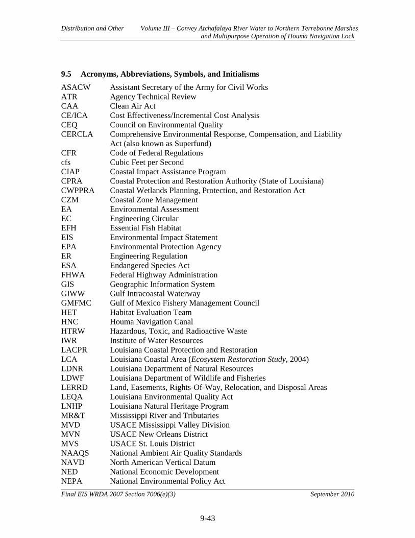
Distribution and Other Volume III – Convey Atchafalaya River Water to Northern Terrebonne Marshes and Multipurpose Operation of Houma Navigation Lock
9-43
Final EIS WRDA 2007 Section 7006(e)(3) September 2010
9.5 Acronyms, Abbreviations, Symbols, and Initialisms ASACW Assistant Secretary of the Army for Civil Works ATR Agency Technical Review CAA Clean Air Act CE/ICA Cost Effectiveness/Incremental Cost Analysis CEQ Council on Environmental Quality CERCLA Comprehensive Environmental Response, Compensation, and Liability
Act (also known as Superfund) CFR Code of Federal Regulations cfs Cubic Feet per Second CIAP Coastal Impact Assistance Program CPRA Coastal Protection and Restoration Authority (State of Louisiana) CWPPRA Coastal Wetlands Planning, Protection, and Restoration Act CZM Coastal Zone Management EA Environmental Assessment EC Engineering Circular EFH Essential Fish Habitat EIS Environmental Impact Statement EPA Environmental Protection Agency ER Engineering Regulation ESA Endangered Species Act FHWA Federal Highway Administration GIS Geographic Information System GIWW Gulf Intracoastal Waterway GMFMC Gulf of Mexico Fishery Management Council HET Habitat Evaluation Team HNC Houma Navigation Canal HTRW Hazardous, Toxic, and Radioactive Waste IWR Institute of Water Resources LACPR Louisiana Coastal Protection and Restoration LCA Louisiana Coastal Area (Ecosystem Restoration Study, 2004) LDNR Louisiana Department of Natural Resources LDWF Louisiana Department of Wildlife and Fisheries LERRD Land, Easements, Rights-Of-Way, Relocation, and Disposal Areas LEQA Louisiana Environmental Quality Act LNHP Louisiana Natural Heritage Program MR&T Mississippi River and Tributaries MVD USACE Mississippi Valley Division MVN USACE New Orleans District MVS USACE St. Louis District NAAQS National Ambient Air Quality Standards NAVD North American Vertical Datum NED National Economic Development NEPA National Environmental Policy Act

Distribution and Other Volume III – Convey Atchafalaya River Water to Northern Terrebonne Marshes and Multipurpose Operation of Houma Navigation Lock
9-44
Final EIS WRDA 2007 Section 7006(e)(3) September 2010
NER National Ecosystem Restoration NGO Non-Governmental Organization NGVD National Geodetic Vertical Datum NHPA National Historic Preservation Act NMFS National Marine Fisheries Service NOAA National Oceanic and Atmospheric Administration NOI Notice of Intent NRCS Natural Resources Conservation Service NRHP National Register of Historic Places NWRC National Wildlife Research Center O&M Operation and Maintenance OMRR&R Operation and Maintenance, Repair, Replacement and Rehabilitation PED Preconstruction Engineering and Design PEIS Programmatic Environmental Impact Statement PDT Project Delivery Team RCRA Resource Conservation and Recovery Act RP Recommended Plan RSLR Relative Sea Level Rise SLR Sea Level Rise TSP Tentatively Selected Plan USACE U.S. Army Corps of Engineers USEPA U.S. Environmental Protection Agency USFWS U.S. Fish and Wildlife Service USGS U.S. Geological Survey WCRF Wetlands Conservation and Restoration Fund WVA Wetland Value Assessment WRDA Water Resources Development Act

Distribution and Other Volume III – Convey Atchafalaya River Water to Northern Terrebonne Marshes and Multipurpose Operation of Houma Navigation Lock
9-45
Final EIS WRDA 2007 Section 7006(e)(3) September 2010
This page intentionally blank

Appendices Convey Atchafalaya River Water to Northern Terrebonne Marshes and Multipurpose Operation of Houma Navigation Lock
Final EIS WRDA 2007 Section 7006(e)(3) September 2010
Appendix-1
Volume III Appendices APPENDIX A Biological Assessment APPENDIX B U.S. Fish and Wildlife Service Coordination Letter and Report APPENDIX C NOAA Fisheries Service Coordination Letter APPENDIX D 404(b)(1) Water Quality Report APPENDIX E Louisiana Coastal Resources Program Consistency Determination APPENDIX F Cultural Resources with State Historic Preservation Officer
Coordination Letter APPENDIX G Responses to Comments FEASIBILITY REPORTS APPENDIX H Value Engineering Report APPENDIX I Adaptive Management / Monitoring Plan APPENDIX J Real Estate Plan APPENDIX K Economics APPENDIX L Engineering APPENDIX M Wetland Value Assessment (WVA) Model Report APPENDIX N Phase I Environmental Site Assessment APPENDIX O Micro-Computer Aided Cost Estimating System (MCACES)
Model Report / MCACES 2nd Generation (MII) APPENDIX P Project Costs and Schedule Risk Analysis Report APPENDIX Q Recreation Incidental Benefits
MAIN REPORT
ATTACHMENT 1
Non-Federal Sponsor’s Letter of Intent

This page intentionally left blank.

Related Documents