LOUGH RINN - LAKE LEVEL STUDY DRAWING SHEET 1 of 3 LEGEND: LOWEST SUMMER LEVEL = < 37.7m DESIGN LAKE LEVEL = 37.7m to 39.20m HIGHEST FLOOD LEVEL = 39.2m to 40.83m LANDOWNERSHIP LINE LAYOUT PLAN Scale 1:2500 Ordnance Survey Ireland Licence No.EN 0002615 2UGQDQFH 6XUYH\ ,UHODQG *RYHUQPHQW RI ,UHODQG Note: All levels are above ordnance datum Malin Head. New Survey N.C 01/15 A

Welcome message from author
This document is posted to help you gain knowledge. Please leave a comment to let me know what you think about it! Share it to your friends and learn new things together.
Transcript

LOUGH RINN -LAKE LEVEL STUDY DRAWINGSHEET 1 of 3
LEGEND:
LOWEST SUMMER LEVEL = < 37.7m
DESIGN LAKE LEVEL = 37.7m to 39.20m
HIGHEST FLOOD LEVEL = 39.2m to 40.83m
LANDOWNERSHIP LINE
LAYOUT PLAN
Scale 1:2500
Ordnance Survey Ireland Licence No.EN 0002615
© Ordnance Survey Ireland / Government of Ireland
Note: All levels are above ordnance datum Malin Head.
New Survey N.C 01/15A
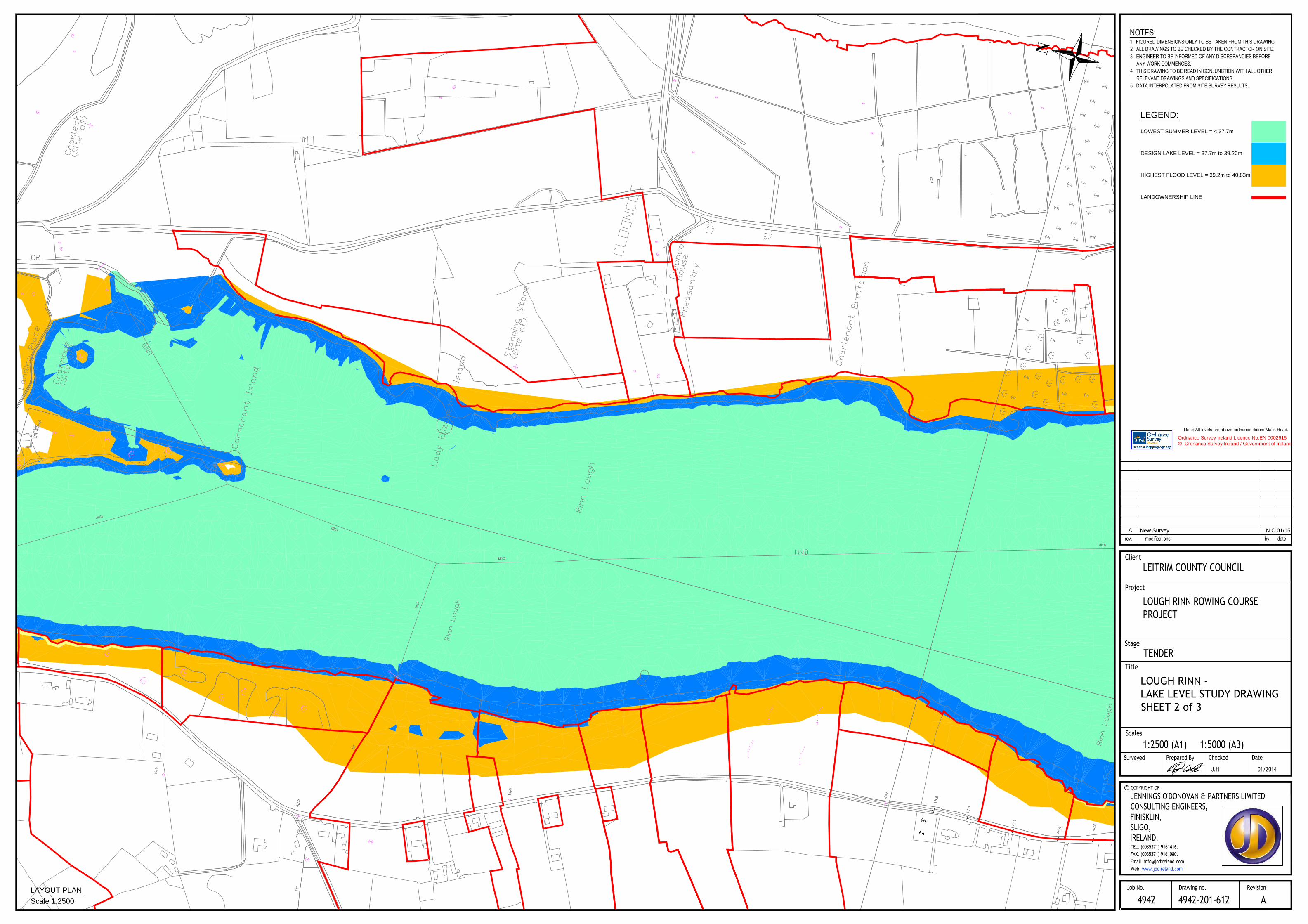
LOUGH RINN -LAKE LEVEL STUDY DRAWINGSHEET 2 of 3
LEGEND:
LOWEST SUMMER LEVEL = < 37.7m
DESIGN LAKE LEVEL = 37.7m to 39.20m
HIGHEST FLOOD LEVEL = 39.2m to 40.83m
LANDOWNERSHIP LINE
LAYOUT PLAN
Scale 1:2500
Ordnance Survey Ireland Licence No.EN 0002615
© Ordnance Survey Ireland / Government of Ireland
Note: All levels are above ordnance datum Malin Head.
New Survey N.C 01/15A
C
L
O
O
N
C
O
E
L
O
U
G
H
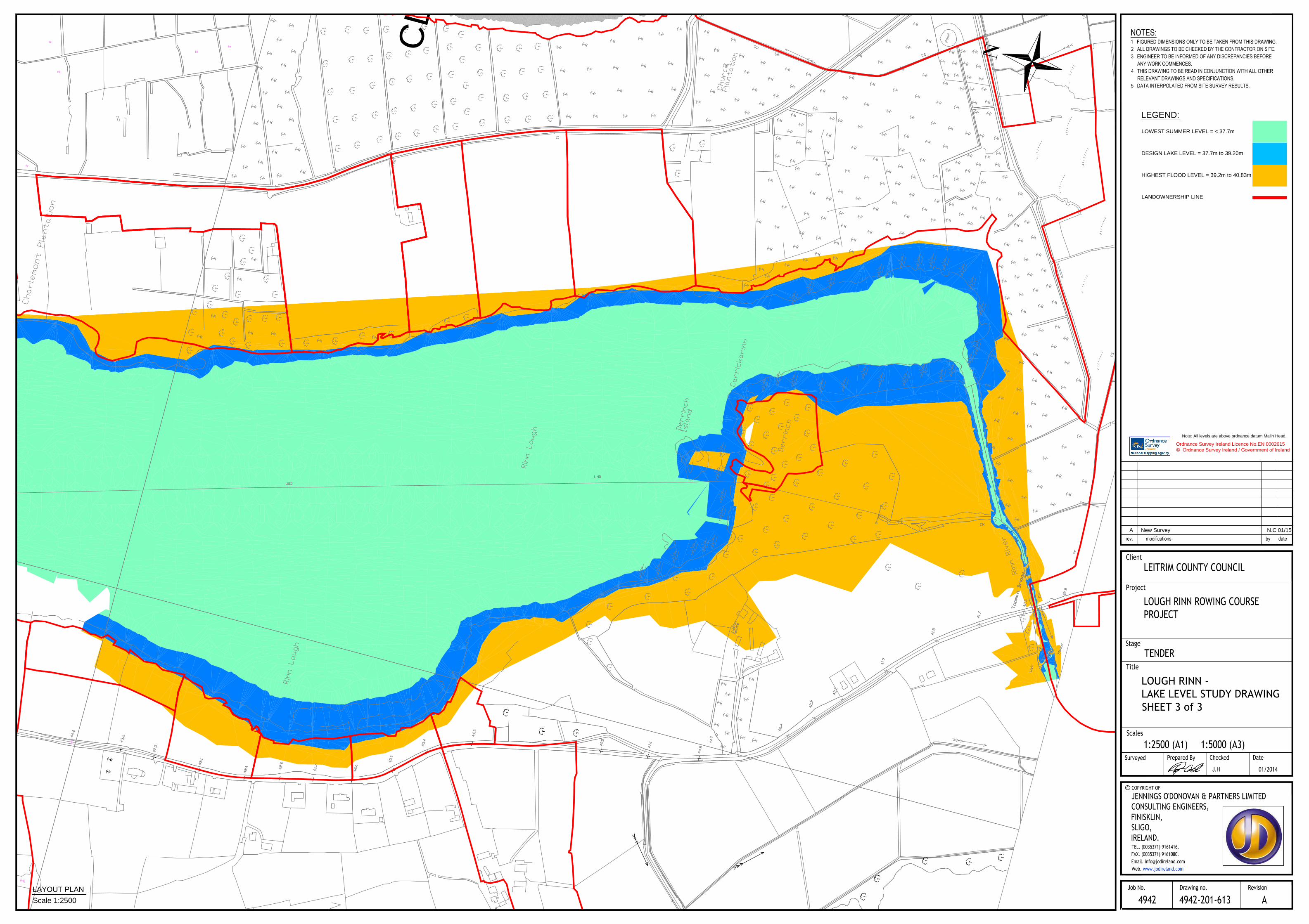
LOUGH RINN -LAKE LEVEL STUDY DRAWINGSHEET 3 of 3
LEGEND:
LOWEST SUMMER LEVEL = < 37.7m
DESIGN LAKE LEVEL = 37.7m to 39.20m
HIGHEST FLOOD LEVEL = 39.2m to 40.83m
LANDOWNERSHIP LINE
LAYOUT PLAN
Scale 1:2500
Ordnance Survey Ireland Licence No.EN 0002615
© Ordnance Survey Ireland / Government of Ireland
Note: All levels are above ordnance datum Malin Head.
New Survey N.C 01/15A
Related Documents