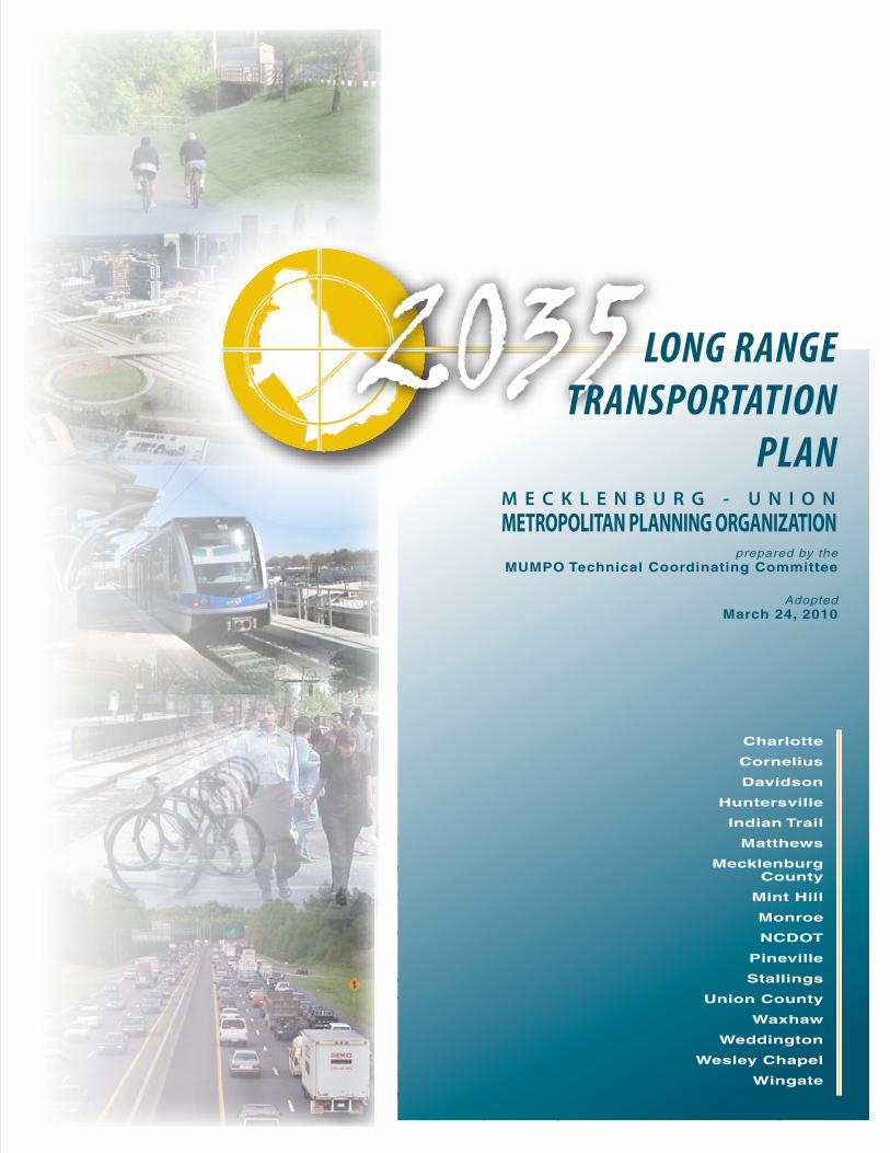
2035 prepared by the MUMPO Technical Coordinating Committee Adopted March 24, 2010 LONG RANGE TRANSPORTATION PLAN Charlotte Cornelius Davidson Huntersville Indian Trail Matthews Mecklenburg County Mint Hill Monroe NCDOT Pineville Stallings Union County Waxhaw Weddington Wesley Chapel Wingate MECKLENBURG - UNION METROPOLITAN PLANNING ORGANIZATION

Welcome message from author
This document is posted to help you gain knowledge. Please leave a comment to let me know what you think about it! Share it to your friends and learn new things together.
Transcript
#
## ## #
##
#
#
#
##
##
#
(
(
( ( (
(
§̈¦85
§̈¦85
§̈¦277
§̈¦485
§̈¦485
2035prepared by the
MUMPO Technical Coordinating Committee
AdoptedMarch 24, 2010
LONG RANGETRANSPORTATION
PLAN
Charlotte
Cornelius
Davidson
Huntersville
Indian Trail
Matthews
MecklenburgCounty
Mint Hill
Monroe
NCDOT
Pineville
Stallings
Union County
Waxhaw
Weddington
Wesley Chapel
Wingate
M E C K L E N B U R G - U N I O NMETROPOLITAN PLANNING ORGANIZATION

Mecklenburg-UnionMetropolitan Planning Organization
Prepared By
Mecklenburg-UnionTechnical Coordinating Committee
www.mumpo.org
AdoptedMarch 24, 2010
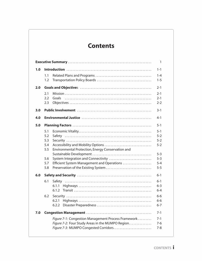
Executive Summary . . . . . . . . . . . . . . . . . . . . . . . . . . . . . . . . . . . . . . . . . . . . . . . . . . . . . . . 1
1.0 Introduction . . . . . . . . . . . . . . . . . . . . . . . . . . . . . . . . . . . . . . . . . . . . . . . . . . . . . . . . 1-1
1.1 Related Plans and Programs . . . . . . . . . . . . . . . . . . . . . . . . . . . . . . . . . . . . . 1-4 1.2 Transportation Policy Boards . . . . . . . . . . . . . . . . . . . . . . . . . . . . . . . . . . . . 1-5
2.0 Goals and Objectives . . . . . . . . . . . . . . . . . . . . . . . . . . . . . . . . . . . . . . . . . . . . . . . 2-1
2.1 Mission . . . . . . . . . . . . . . . . . . . . . . . . . . . . . . . . . . . . . . . . . . . . . . . . . . . . . . . . . 2-1 2.2 Goals . . . . . . . . . . . . . . . . . . . . . . . . . . . . . . . . . . . . . . . . . . . . . . . . . . . . . . . . . 2-1 2.3 Objectives . . . . . . . . . . . . . . . . . . . . . . . . . . . . . . . . . . . . . . . . . . . . . . . . . . . . . . 2-2
3.0 Public Involvement . . . . . . . . . . . . . . . . . . . . . . . . . . . . . . . . . . . . . . . . . . . . . . . . . 3-1
4.0 Environmental Justice . . . . . . . . . . . . . . . . . . . . . . . . . . . . . . . . . . . . . . . . . . . . . . 4-1
5.0 Planning Factors . . . . . . . . . . . . . . . . . . . . . . . . . . . . . . . . . . . . . . . . . . . . . . . . . . . . 5-1
5.1 Economic Vitality. . . . . . . . . . . . . . . . . . . . . . . . . . . . . . . . . . . . . . . . . . . . . . . . 5-1 5.2 Safety . . . . . . . . . . . . . . . . . . . . . . . . . . . . . . . . . . . . . . . . . . . . . . . . . . . . . . . . . 5-2 5.3 Security . . . . . . . . . . . . . . . . . . . . . . . . . . . . . . . . . . . . . . . . . . . . . . . . . . . . . . . . 5-2 5.4 Accessibility and Mobility Options . . . . . . . . . . . . . . . . . . . . . . . . . . . . . . . 5-2 5.5 Environmental Protection, Energy Conservation and Sustainable Development . . . . . . . . . . . . . . . . . . . . . . . . . . . . . . . . . . . . . . . 5-3 5.6 System Integration and Connectivity . . . . . . . . . . . . . . . . . . . . . . . . . . . . 5-3 5.7 Effi cient System Management and Operations . . . . . . . . . . . . . . . . . . . 5-4 5.8 Preservation of the Existing System . . . . . . . . . . . . . . . . . . . . . . . . . . . . . . 5-5
6.0 Safety and Security . . . . . . . . . . . . . . . . . . . . . . . . . . . . . . . . . . . . . . . . . . . . . . . . . 6-1
6.1 Safety . . . . . . . . . . . . . . . . . . . . . . . . . . . . . . . . . . . . . . . . . . . . . . . . . . . . . . . . . 6-1 6.1.1 Highways . . . . . . . . . . . . . . . . . . . . . . . . . . . . . . . . . . . . . . . . . . . . . . . . 6-3 6.1.2 Transit . . . . . . . . . . . . . . . . . . . . . . . . . . . . . . . . . . . . . . . . . . . . . . . . . . . 6-4
6.2 Security . . . . . . . . . . . . . . . . . . . . . . . . . . . . . . . . . . . . . . . . . . . . . . . . . . . . . . . . 6-6 6.2.1 Highways . . . . . . . . . . . . . . . . . . . . . . . . . . . . . . . . . . . . . . . . . . . . . . . . 6-6 6.2.2 Disaster Preparedness . . . . . . . . . . . . . . . . . . . . . . . . . . . . . . . . . . . . 6-7
7.0 Congestion Management . . . . . . . . . . . . . . . . . . . . . . . . . . . . . . . . . . . . . . . . . . . 7-1
Figure 7-1: Congestion Management Process Framework . . . . . . . . . 7-1 Figure 7-2: Four Study Areas in the MUMPO Region. . . . . . . . . . . . . . . 7-6 Figure 7-3: MUMPO Congested Corridors. . . . . . . . . . . . . . . . . . . . . . . . . 7-8
Contents
CONTENTS i
Page ii CONTENTS
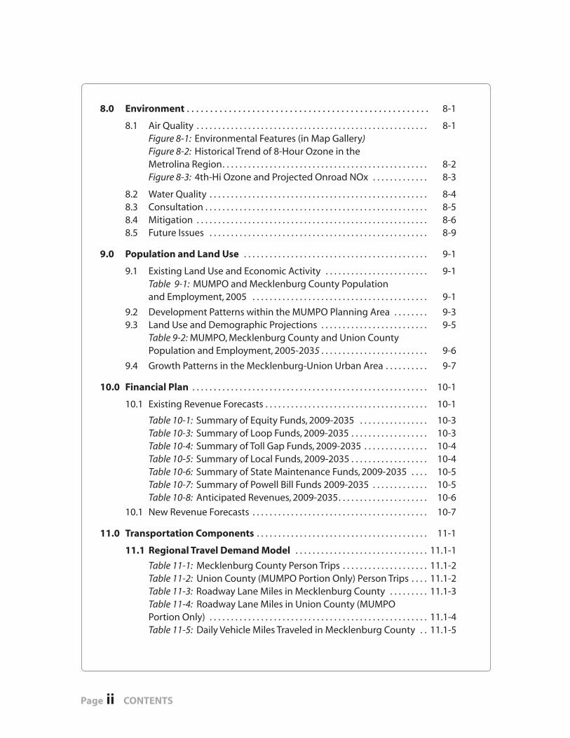
8.0 Environment . . . . . . . . . . . . . . . . . . . . . . . . . . . . . . . . . . . . . . . . . . . . . . . . . . . . 8-1
8.1 Air Quality . . . . . . . . . . . . . . . . . . . . . . . . . . . . . . . . . . . . . . . . . . . . . . . . . . . . . . 8-1 Figure 8-1: Environmental Features (in Map Gallery) Figure 8-2: Historical Trend of 8-Hour Ozone in the Metrolina Region. . . . . . . . . . . . . . . . . . . . . . . . . . . . . . . . . . . . . . . . . . . . . . . . 8-2 Figure 8-3: 4th-Hi Ozone and Projected Onroad NOx . . . . . . . . . . . . . 8-3
8.2 Water Quality . . . . . . . . . . . . . . . . . . . . . . . . . . . . . . . . . . . . . . . . . . . . . . . . . . . 8-4 8.3 Consultation . . . . . . . . . . . . . . . . . . . . . . . . . . . . . . . . . . . . . . . . . . . . . . . . . . . . 8-5 8.4 Mitigation . . . . . . . . . . . . . . . . . . . . . . . . . . . . . . . . . . . . . . . . . . . . . . . . . . . . . . 8-6 8.5 Future Issues . . . . . . . . . . . . . . . . . . . . . . . . . . . . . . . . . . . . . . . . . . . . . . . . . . . 8-9
9.0 Population and Land Use . . . . . . . . . . . . . . . . . . . . . . . . . . . . . . . . . . . . . . . . . . . 9-1
9.1 Existing Land Use and Economic Activity . . . . . . . . . . . . . . . . . . . . . . . . 9-1 Table 9-1: MUMPO and Mecklenburg County Population and Employment, 2005 . . . . . . . . . . . . . . . . . . . . . . . . . . . . . . . . . . . . . . . . . 9-1
9.2 Development Patterns within the MUMPO Planning Area . . . . . . . . 9-3 9.3 Land Use and Demographic Projections . . . . . . . . . . . . . . . . . . . . . . . . . 9-5 Table 9-2: MUMPO, Mecklenburg County and Union County Population and Employment, 2005-2035 . . . . . . . . . . . . . . . . . . . . . . . . . 9-6
9.4 Growth Patterns in the Mecklenburg-Union Urban Area . . . . . . . . . . 9-7
10.0 Financial Plan . . . . . . . . . . . . . . . . . . . . . . . . . . . . . . . . . . . . . . . . . . . . . . . . . . . . . . . 10-1
10.1 Existing Revenue Forecasts . . . . . . . . . . . . . . . . . . . . . . . . . . . . . . . . . . . . . . 10-1
Table 10-1: Summary of Equity Funds, 2009-2035 . . . . . . . . . . . . . . . . 10-3 Table 10-3: Summary of Loop Funds, 2009-2035 . . . . . . . . . . . . . . . . . . 10-3 Table 10-4: Summary of Toll Gap Funds, 2009-2035 . . . . . . . . . . . . . . . 10-4 Table 10-5: Summary of Local Funds, 2009-2035 . . . . . . . . . . . . . . . . . . 10-4 Table 10-6: Summary of State Maintenance Funds, 2009-2035 . . . . 10-5 Table 10-7: Summary of Powell Bill Funds 2009-2035 . . . . . . . . . . . . . 10-5 Table 10-8: Anticipated Revenues, 2009-2035. . . . . . . . . . . . . . . . . . . . . 10-6
10.1 New Revenue Forecasts . . . . . . . . . . . . . . . . . . . . . . . . . . . . . . . . . . . . . . . . . 10-7
11.0 Transportation Components . . . . . . . . . . . . . . . . . . . . . . . . . . . . . . . . . . . . . . . . 11-1
11.1 Regional Travel Demand Model . . . . . . . . . . . . . . . . . . . . . . . . . . . . . . . 11.1-1
Table 11-1: Mecklenburg County Person Trips . . . . . . . . . . . . . . . . . . . . 11.1-2 Table 11-2: Union County (MUMPO Portion Only) Person Trips . . . . 11.1-2 Table 11-3: Roadway Lane Miles in Mecklenburg County . . . . . . . . . 11.1-3 Table 11-4: Roadway Lane Miles in Union County (MUMPO Portion Only) . . . . . . . . . . . . . . . . . . . . . . . . . . . . . . . . . . . . . . . . . . . . . . . . . . . 11.1-4 Table 11-5: Daily Vehicle Miles Traveled in Mecklenburg County . . 11.1-5
CONTENTS iii
Table 11-6: Daily Vehicle Miles Traveled in Union County (MUMPO Portion Only) . . . . . . . . . . . . . . . . . . . . . . . . . . . . . . . . . . . . . . . . . . . . . . . . . . . 11.1-4 Table 11-7: CATS Daily Transit Vehicle Service Miles . . . . . . . . . . . . . . . 11.1-5 Table 11-8: CATS Daily Transit Rides . . . . . . . . . . . . . . . . . . . . . . . . . . . . . . 11.1-5
11.2 Streets and Highways . . . . . . . . . . . . . . . . . . . . . . . . . . . . . . . . . . . . . . . . . 11.2-1
Table 11-9: Maintenance Responsibility for Roadways . . . . . . . . . . . 11.2-1
11.2.1 Programmed Projects . . . . . . . . . . . . . . . . . . . . . . . . . . . . . . . . . . . 11.2-2 Table 11-10: Funded and Committed Roadway Projects . . . . . . . . . 11.2-3
11.2.2 Horizon Year Recommendations . . . . . . . . . . . . . . . . . . . . . . . . . 11.2-4 Table 11-11: 2015 Horizon Year Projects . . . . . . . . . . . . . . . . . . . . . . . . 11.2-7 Table 11-12: 2025 Horizon Year Projects . . . . . . . . . . . . . . . . . . . . . . . . . 11.2-7 Table 11-13: 2035 Horizon Year Projects . . . . . . . . . . . . . . . . . . . . . . . . . 11.2-7
11.3 Public Transportation . . . . . . . . . . . . . . . . . . . . . . . . . . . . . . . . . . . . . . . 11.3-1
11.3.1 Existing System . . . . . . . . . . . . . . . . . . . . . . . . . . . . . . . . . . . . . . . . 11.3-1 11.3.1.1 Mecklenburg County Public Transportation . . . . . . 11.3-1 11.3.1.2 Union County Public Transportation . . . . . . . . . . . . . 11.3-3
11.3.2 Public Transportation Plan . . . . . . . . . . . . . . . . . . . . . . . . . . . . . . 11.3-4 11.3.2.1 Programmed Projects 2009-2015 . . . . . . . . . . . . . . . . 11.3-5 11.3.2.2 Horizon Year Recommendations . . . . . . . . . . . . . . . . . 11.3-6 Table 11-14: CATS Horizon Year Budget Projections, 2010-2035 . . . . . . . . . . . . . . . . . . . . . . . . . . . . . . . . . . . . . . . . . . . . . . . 11.3-8
11.4 Bicycle . . . . . . . . . . . . . . . . . . . . . . . . . . . . . . . . . . . . . . . . . . . . . . . . . . . . . . . 11.4-1
11.4.1 Bicycle Planning . . . . . . . . . . . . . . . . . . . . . . . . . . . . . . . . . . . . . . . 11.4-1 11.4.2 Bicycle Facilities . . . . . . . . . . . . . . . . . . . . . . . . . . . . . . . . . . . . . . . . 11.4-4 11.4.3 Programmed Bicycle Projects . . . . . . . . . . . . . . . . . . . . . . . . . . . 11.4-7 Table 11-15: Programmed Roadway Projects with Bikeways. . . . . 11.4.7
11.4.4 Horizon Year Recommendations . . . . . . . . . . . . . . . . . . . . . . . . 11.4-9 Table 11-16: Proposed Miles of Bikeway Improvements . . . . . . . . . 11.4-9 Table 11-17: Summary of 2035 Programmed and Proposed Bikeway Improvements . . . . . . . . . . . . . . . . . . . . . . . . . . . . . . . . . . . . . . . 11.4-9 Table 11-18: Long-Range Transportation Plan Proposed Bicycle Facilities . . . . . . . . . . . . . . . . . . . . . . . . . . . . . . . . . . . . . . . . . . . . . . 11.4-11
11.5 Pedestrian . . . . . . . . . . . . . . . . . . . . . . . . . . . . . . . . . . . . . . . . . . . . . . . . . . 11.5-1
11.5.1 Pedestrian Policy . . . . . . . . . . . . . . . . . . . . . . . . . . . . . . . . . . . . . . . 11.5-1 Table 11-19: MUMPO Municipalities and Planning for Pedestrian Needs . . . . . . . . . . . . . . . . . . . . . . . . . . . . . . . . . . . . . . . . . . . . . 11.5-4 Table 11-20: MUMPO Municipalities and Sidewalk Standards. . . . 11.5-5 11.5.2 Current Initiatives of MUMPO Municipalities . . . . . . . . . . . . 11.5-6 11.5.3 Pedestrian Planning . . . . . . . . . . . . . . . . . . . . . . . . . . . . . . . . . . . . 11.5-13
Page iv CONTENTS
11.6 Greenways and Trails . . . . . . . . . . . . . . . . . . . . . . . . . . . . . . . . . . . . . . . . 11.6-1
11.6.1 History and Existing System . . . . . . . . . . . . . . . . . . . . . . . . . . . . 11.6-1 Table 11-21 Existing Greenway Plans in the MUMPO Study Area . . . . . . . . . . . . . . . . . . . . . . . . . . . . . . . . . . . . . . . . . . . . . . . 11.6-4 11.6.2 Programmed Greenway Projects . . . . . . . . . . . . . . . . . . . . . . . 11.6-5 11.6.3 Horizon Year Recommendations . . . . . . . . . . . . . . . . . . . . . . . . 11.6-6
11.7 Freight . . . . . . . . . . . . . . . . . . . . . . . . . . . . . . . . . . . . . . . . . . . . . . . . . . . . . . . 11.7-1
11.7.1 Existing Conditions . . . . . . . . . . . . . . . . . . . . . . . . . . . . . . . . . . . . 11.7-1 11.7.1.1 Air Cargo . . . . . . . . . . . . . . . . . . . . . . . . . . . . . . . . . . . . . 11.7-1 11.7.1.2 Rail Freight . . . . . . . . . . . . . . . . . . . . . . . . . . . . . . . . . . . 11.7-2 11.7.1.3 Intermodal Freight Traffi c . . . . . . . . . . . . . . . . . . . . . . 11.7-4 11.7.2 Trends . . . . . . . . . . . . . . . . . . . . . . . . . . . . . . . . . . . . . . . . . . . . . . . 11.7-5 11.7.3 Projections . . . . . . . . . . . . . . . . . . . . . . . . . . . . . . . . . . . . . . . . . . . . 11.7-8 Table 11-22: Shipping Projections To, From and Within North Carolina . . . . . . . . . . . . . . . . . . . . . . . . . . . . . . . . . 11.7-8 11.7.4 Policies and Recommendations . . . . . . . . . . . . . . . . . . . . . . . . 11.7-9
11.8 Other Transportation Modes. . . . . . . . . . . . . . . . . . . . . . . . . . . . . . . . . 11.8-1
11.8.1 Aviation . . . . . . . . . . . . . . . . . . . . . . . . . . . . . . . . . . . . . . . . . . . . . . . 11.8-1 11.8.2 Inter-City Rail . . . . . . . . . . . . . . . . . . . . . . . . . . . . . . . . . . . . . . . . . . 11.8-3 11.8.3 Inter-City Bus . . . . . . . . . . . . . . . . . . . . . . . . . . . . . . . . . . . . . . . . . . 11.8-5 11.8.4 Taxi Service . . . . . . . . . . . . . . . . . . . . . . . . . . . . . . . . . . . . . . . . . . . 11.8-5 11.8.5 Coordination with LRTP Development . . . . . . . . . . . . . . . . . 11.8-5
12.0 Conclusion . . . . . . . . . . . . . . . . . . . . . . . . . . . . . . . . . . . . . . . . . . . . . . . . . . . . . . . . 12-1
APPENDICES
Appendix A: Project Ranking Methodology . . . . . . . . . . . . . . . . . . . . . . . . A-1 Ranking of Candidate Projects . . . . . . . . . . . . . . . . . . . . . . . . . . . . . . . . . . . . . A-9
Appendix B: Public Involvement . . . . . . . . . . . . . . . . . . . . . . . . . . . . . . . . . . . . B-1
Appendix C: Congestion Management . . . . . . . . . . . . . . . . . . . . . . . . . . . . . C-1 Congested Corridors . . . . . . . . . . . . . . . . . . . . . . . . . . . . . . . . . . . . . . . . . . . . . . . C-2 Congested Hot Spots . . . . . . . . . . . . . . . . . . . . . . . . . . . . . . . . . . . . . . . . . . . . . . C-8 Mitigation Strategy Tool Box . . . . . . . . . . . . . . . . . . . . . . . . . . . . . . . . . . . . . . . C-10
Appendix D: Environment . . . . . . . . . . . . . . . . . . . . . . . . . . . . . . . . . . . . . . . . . . D-1 Consultation Process Procedures . . . . . . . . . . . . . . . . . . . . . . . . . . . . . . . . . . D-1 Consultation Process Documentation . . . . . . . . . . . . . . . . . . . . . . . . . . . . . D-3 Comments Received . . . . . . . . . . . . . . . . . . . . . . . . . . . . . . . . . . . . . . . . . . . . . . D-7
Appendix E: MPO Resolution Adopting Plan . . . . . . . . . . . . . . . . . . . . . . . . E-1
CONTENTS v
MAP GALLERY
Chapter 1: IntroductionCities and Towns in MUMPO . . . . . . . . . . . . . . . . . . . . . . . . . . . . . . . . . . . . . . Figure 1-1Metropolitan and Rural Planning Organizations in the Charlotte Region . . . . . . . . . . . . . . . . . . . . . . . . . . . . . . . . . . . . . . . Figure 1-2
Chapter 4: Environmental JusticeLow Income Population and Fiscally Constrained Projects . . . . . . . . . Figure 4-1Low Income Population and CATS Corridor System Plan . . . . . . . . . . . Figure 4-2Low Income Population and Bicycle & Greenway Projects . . . . . . . . . . Figure 4-3Black Population and Fiscally Constrained Projects . . . . . . . . . . . . . . . . Figure 4-4Black Population and CATS Corridor System Plan . . . . . . . . . . . . . . . . . . Figure 4-5Black Population and Bicycle & Greenway Projects . . . . . . . . . . . . . . . . . Figure 4-6Hispanic Population and Fiscally Constrained Projects. . . . . . . . . . . . . . Figure 4-7Hispanic Population and CATS Corridor System Plan . . . . . . . . . . . . . . . Figure 4-8Hispanic Population and Bicycle & Greenway Projects . . . . . . . . . . . . . Figure 4-9Asian/Pacifi c Islander Population and Fiscally Constrained Projects . . . . . . . . . . . . . . . . . . . . . . . . . . . . . . . . . . . . . . . . Figure 4-10Asian/Pacifi c Islander Population and CATS Corridor System Plan. . . . . . . . . . . . . . . . . . . . . . . . . . . . . . . . . . . . . . . . . . . . . . . . . Figure 4-11Asian/Pacifi c Islander Population and Bicycle & Greenway Projects. . . . . . . . . . . . . . . . . . . . . . . . . . . . . . . . . . . . . . . . . . . . . . . . . . . . . Figure 4-12American Indian/Alaska Native Population and Fiscally Constrained Projects . . . . . . . . . . . . . . . . . . . . . . . . . . . . . . . . Figure 4-13American Indian/Alaska Native Population and CATS Corridor System Plan . . . . . . . . . . . . . . . . . . . . . . . . . . . . . . . . . . Figure 4-14American Indian/Alaska Native Population and Bicycle & Greenway Projects . . . . . . . . . . . . . . . . . . . . . . . . . . . . . . . . Figure 4-15
Chapter 8: EnvironmentEnvironmental Features . . . . . . . . . . . . . . . . . . . . . . . . . . . . . . . . . . . . . . . . Figure 8-1
Chapter 9: Population and Land UseHousehold Density, 2005. . . . . . . . . . . . . . . . . . . . . . . . . . . . . . . . . . . . . . . . Figure 9-1Employment Density, 2005 . . . . . . . . . . . . . . . . . . . . . . . . . . . . . . . . . . . . . Figure 9-2Change in Households, 2005-2035 . . . . . . . . . . . . . . . . . . . . . . . . . . . . . . Figure 9-3Household Density, 2035 . . . . . . . . . . . . . . . . . . . . . . . . . . . . . . . . . . . . . . . Figure 9-4Employment Change, 2005-2035 . . . . . . . . . . . . . . . . . . . . . . . . . . . . . . . . Figure 9-5Employment Density, 2035 . . . . . . . . . . . . . . . . . . . . . . . . . . . . . . . . . . . . . . Figure 9-6
Chapter 11: Transportation Plan ComponentsThoroughfare Plan . . . . . . . . . . . . . . . . . . . . . . . . . . . . . . . . . . . . . . . . . . . . . Figure 11-1Funded and Committed Projects . . . . . . . . . . . . . . . . . . . . . . . . . . . . . . . . Figure 11-2continued next page
2015 Horizon Year Projects . . . . . . . . . . . . . . . . . . . . . . . . . . . . . . . . . . . . . Figure 11-32025 Horizon Year Projects . . . . . . . . . . . . . . . . . . . . . . . . . . . . . . . . . . . . . Figure 11-42035 Horizon Year Projects . . . . . . . . . . . . . . . . . . . . . . . . . . . . . . . . . . . . . Figure 11-5CATS Existing System . . . . . . . . . . . . . . . . . . . . . . . . . . . . . . . . . . . . . . . . . . . Figure 11-6CATS System Corridor Plan . . . . . . . . . . . . . . . . . . . . . . . . . . . . . . . . . . . . . . Figure 11-7MUMPO Existing and Proposed Bike Lanes . . . . . . . . . . . . . . . . . . . . . . Figure 11-8MUMPO Existing and Proposed Greenways . . . . . . . . . . . . . . . . . . . . . . Figure 11-9Carolina Thread Trail . . . . . . . . . . . . . . . . . . . . . . . . . . . . . . . . . . . . . . . . . . . . Figure 11-10Intermodal Freight Facilities . . . . . . . . . . . . . . . . . . . . . . . . . . . . . . . . . . . . Figure 11-11
Page vi CONTENTS
Executive Summary2035 Long-Range Transportation Plan
Executive Su
mm
ary
EXECUTIVE SUMMARY 1
Mecklenburg-Union MPO and the LRTP
The Mecklenburg-Union Metropolitan Planning Organization was created as a result of a 1963 U.S. Department of Transportation mandate for urbanized areas to cooperatively as-sess and prioritize their transportation needs. MUMPO has since expanded to include all of Mecklenburg County and much of Union County. MUMPO is staffed by the Charlotte-Mecklenburg Planning Department.
MUMPO is required to periodically develop a long range transportation plan (LRTP), with a planning horizon of at least 20 years. This 2035 LRTP is an update of the 2030 LRTP, which was adopted in 2005. MUMPO is required to develop an LRTP that prioritizes trans-portation projects that cumulatively do not exceed identifi ed revenues. Through 2035, MUMPO has identifi ed 64 fi scally-constrained projects, with an estimated future year cost of $4.8 billion.
The list of the 64 projects identifi ed through the year 2035 is on pages 5-7. Full detail about the 64 projects is in Chapter 11-1 (Streets and Highways).A complete list of all projects, including unfunded ones, is in Appendix A.
Global, State and Regional Perspective
MUMPO is responsible for transportation planning for nearly one million people in the center of the Charlotte region. There have been remarkable changes in the transporta-tion planning landscape in just fi ve years since the previous long-range plan. The region continues to experience growing congestion despite continued road widenings and opening of additional segments of I-485. MUMPO has considered existing and projected congestion, freight, commuting, growth, and revenue levels as it developed this plan.
Demographic Trends
As of 2005, the MUMPO area includes approximately one million people and 650,000 jobs. By 2035 MUMPO’s population will increase by 600,000, and employment will increase by 500,000. The MUMPO area will remain the economic core of an expanding region, in terms of both population and employment.
By 2035, Charlotte’s population will approach one million people, and Mecklenburg County will have over 1.3 million people. At that point Mecklenburg County will ef-fectively be built out. These dramatic growth trends are refl ected in the Travel Demand Model used by MUMPO to project future travel patterns and identify defi ciencies in the transportation network.
EXECUTIVE SUMMARY Mecklenburg-Union MPO
Page 2 EXECUTIVE SUMMARY
Economic Linkages
The MUMPO area is the heart of a major freight and manufacturing center in the south-eastern United States. The Charlotte region suffered along with the rest of the the world with the recession of 2007-2009. The downturn showed how our fi nancial, manufactur-ing, shipping, and political systems are interconnected.
The 2035 LRTP recommendations strive to strengthen the MUMPO transportation system to promote sound economic activity and develop a safe and reliable transportation net-work. This will allow workers to travel to work and shippers to move goods and services to, from, and through the region.
The global economy grew at a remarkable rate over the fi rst seven years of this decade. The 2007-2009 national recession had a signifi cant impact on economic activity for the entire globe as well as the region, which reduced construction costs, but construction costs are still roughly double what they were at the beginning of the decade.
MUMPO assumes the region is still well-positioned for continued growth over the next quarter-century but, unfortunately, construction costs are expected to exceed revenues for the foreseeable future.
Needs List
In mid-2008, MUMPO asked their members to submit candidate projects for consider-ation in development of the LRTP. This resulted in a list of 310 projects for MUMPO to consider (see Appendix A for the full list).
This list was reduced to 64 projects, which includes the Garden Parkway and the Monroe Bypass. Both of these projects are partially funded through tolls. The list also includes “loop” projects on I-485 and improvements to other highways and roads throughout the MUMPO area. The list does not specifi cally include maintenance, bridge replacement, pe-destrian, or bicycle projects, due to the uneven funding levels and need for such projects.
Financial Considerations
SAFETEA-LU, the current Federal surface transportation program that guides transpor-tation plan development, requires future projects to have costs that are calculated in “future year” costs.
In previous plans, MUMPO assumed that future revenues would have the same “buying power” in the future, but this has not proven to be true, with long-range plan project lists overly optimistic.
MUMPO assumes approximately $6 billion will be available through 2035 to spend on highway, maintenance, bicycle, pedestrian, and other projects. Of this amount, approxi-mately 20 percent, or $1.3 billion, will be spent on road and bridge maintenance. MUMPO has calculated an average annual construction cost increase from 2010-2035 to be ap-proximately six percent, with revenues increasing just two percent per year. The net result is that MUMPO’s plan assumes fewer projects can be funded each ensuing year.
EXECUTIVE SUMMARY2035 Long-Range Transportation Plan
EXECUTIVE SUMMARY 3
2035 Fiscally Constrained Project List
A fi scally-constrained project list is one that is fully-funded through a certain year—in this case, 2035. Due to the limited amount of funds available, MUMPO considered several different funding scenarios to raise additional revenue, with varying project lists that resulted from the additional revenues. The scenarios considered were:
No New Revenue (assumes no new funding sources through 2035);
Additional Quarter-Cent Sales Tax for Roads for both Mecklenburg and Union Counties;
Additional Quarter- Cent Sales Tax for Transit in Mecklenburg County; and
Additional Quarter-Cent Sales Tax Split Between Roads and Transit in Meck-lenburg County.
MUMPO decided (on November 18, 2009) to approve the “No New Revenue” scenario. In reaching this decision, MUMPO’s staff developed project lists that were evaluated for effectiveness in reducing congestion and air pollution. Due to the limited effect the ad-ditional funds under the other scenarios would have on a region of well over one million people, as well as the economic downturn still in effect in late 2009, MUMPO decided to approve the “No New Revenue” scenario.
Project Ranking Process
MUMPO approved a project ranking process in late 2007 that considers all aspects of each project considered for inclusion in the fi nancially-constrained project list. The vari-ables considered, as well as their objectives, include:
Safety: reduce or remove potential for crashes;
Utility: increase capacity to meet future travel demand;
Multi-modal transportation: promote the use of rapid transit, express bus tran-sit, and transit hubs; as well as walking and bicycling;
Environmental impact: assess the project’s impact on documented environ-mentally-sensitive areas;
Human impact: avoid adverse impacts and promote social and economic ef-fects on minority and low-income populations;
Economic development: improve access to existing and potential intermodal facilities as well as to employment centers; and
Land use: assess the project’s impact on locally-adopted land use plans and/or policies.
All 310 candidate projects were evaluated and ranked by MUMPO staff. The project rank-ings were approved by MUMPO on July 15, 2009.
The score of each of the 310 candidate projects is given in Appendix A.
The score of the 64 projects proposed for funding is also given in Chapter 11.1 (Streets and Highways).
Executive Su
mm
ary
EXECUTIVE SUMMARY Mecklenburg-Union MPO
Page 4 EXECUTIVE SUMMARY
Multi-Modal Considerations
Although the approved project list is limited to road projects, MUMPO supports the development of a multi-modal transportation network, and requires that appropriate eligible projects include bicycle and/or pedestrian accommodations. MUMPO did not include a 2035 project list of bicycle or pedestrian projects due to the uneven and unpre-dictable revenue streams available and dedicated to such projects. The bicycle, pedestrian and greenway chapters in the 2035 LRTP describe the planning and construction efforts and accomplishments within the MUMPO area.
The Charlotte Area Transit System (CATS) provided a projection (in the transit chapter of this LRTP) of when future transit corridors would open. CATS is currently re-evaluating the prioritization and schedule of future corridor construction due to reductions in rev-enues from its primary revenue source, Mecklenburg County’s half-cent sales tax. The af-fected corridors include commuter rail to northern Mecklenburg County and the light-rail extension to the northeast, through the University area of Charlotte to near the Cabarrus County line.
Land Use and Environmental Considerations
MUMPO understands that land use and transportation issues are interrelated, and pro-motes transportation projects that are strongly linked to implementing land use plans for the affected area. MUMPO also considers the negative impacts of projects, and promotes those projects with limited environmental or human impacts.
The most visible environmental impact associated with transportation planning is air quality, particularly ozone. This MUMPO 2035 Long Range Transportation Plan has been shown to not increase emissions of ozone precursors (specifi cally, oxides of Nitrogen), and in fact shows that such emissions will decrease by three-quarters through 2035, primarily due to improved vehicular emissions technology.
Emerging Issues
The coming years will necessitate a frank discussion of how to pay for transportation projects.
If MUMPO and its member governments are truly successful in reducing congestion and single-occupant vehicular travel, it will also result in less fuel consumed—with a corresponding drop in motor fuel tax receipts.
At the national level there will be an increased emphasis on fuel economy and transit usage, which will further reduce available revenues.
Finally, new vehicular technologies are coming to market that will allow users to largely eliminate their use of gasoline or diesel fuel through plug-in hybrid electric propulsion.
The MUMPO members, North Carolina, and the nation must determine a rational and sustainable strategy for funding future transportation needs.
2010-2035 Financially Constrained Projects with No New Revenue
Horizon Year 2010-2015
EXECUTIVE SUMMARY2035 Long-Range Transportation Plan
EXECUTIVE SUMMARY 5
Executive Su
mm
ary
* E+C = Existing and Committed continued next page
IndexNo.
Rank Project Name Project DescriptionProject Cost
(Infl ated Dollars)
3121 E+C* I-485/Weddington Road New interchange $ 18,250,000
na E+CI-485/Garrison RoadInterchange
New interchange 1,150,000
3159 E+C Mallard Creek RoadWidening and relocation (4 lanes) from Sugar Creek Road to Harris Bouelvard
27,924,000
3054 E+C Charles Street Widening (3 lanes), Sunset Drive to Franklin St 7,336,000
3146 E+C Indian Trail RoadWidening (4 lanes) from Old Monroe Road to Indepdendence Blvd (US 74)
5,900,000
3141 E+C Independence Blvd (US 74)Improvements (6 Ln + Managed or Bus Lanes), Sharon Amity Road to Conference Drive
152,700,000
3267 E+C Stallings RoadWidening (4 lanes) from Old Monroe Road to Independence Blvd (US 74)
14,271,000
3311 E+C West Boulevard Extension New road (2 lanes), Steele Creek Rd to I-485 1,700,000
3239 E+C Reedy Creek Road Relocation (2 lanes) north of Harrisburg Road 3,050,000
3112 E+C I-277/I-77 Add 1 lane to westbound I-277 bridge over I-77 3,550,000
3165 E+C McKee Road ExtensionNew road (2 lanes), John Street to Campus Ridge Road
3,000,000
3205 E+C NC 73 East Widening (4 lanes), US 21 to NC 115 12,109,000
502 E+CDixie River Rd/NC 160 Connector
New road (2 lanes), NC 160 to Dixie River Road 5,200,000
3003 E+C Freedom Drive (NC 27)Widening (4 lanes), Edgewood Rd to Toddville Road
20,250,000
3157 E+C Little Rock RoadRelocation (4 lanes), Flintrock Road to Freedom Drive (NC 27)
7,500,000
3238 E+C Rea Road Improvements (3 lanes), Colony Rd to NC 51 21,300,000
22 E+CFred D. Alexander Boulevard
New road (4 lanes), Freedom Drive (NC 27) to Brookshire Blvd (NC 16)
36,700,000
3067 17 City Boulevard ExtensionNew road (4 lanes), Neal Rd to Mallard Creek Road Extension
9,854,000
3000 19 Beatties Ford RoadWidening (4 lanes), Capps Hill Mine Road to Sunset Road
13,327,000
3032 37 Jim Cooke RoadNew road (2-3 lanes), Northcross Drive Exten-sion to Bailey Road
5,000,000
3214 45Northcross Drive Extension
New road (3 lanes) from end of Northcross Dr to Westmoreland Road
3,000,000
EXECUTIVE SUMMARY Mecklenburg-Union MPO
Page 6 EXECUTIVE SUMMARY
Horizon Year 2010-2015 (continued)
IndexNo.
Rank Project Name Project DescriptionProject Cost
(Infl ated Dollars)
3133 88 I-77/Westmoreland Road New interchange, SPUI 35,000,000
3132 93 I-77 Widening (North)Adding managed lanes, 1 each way (6 lanes) from Hambridge Road to Catawba Avenue
22,000,000
3289 103 Statesville Road (US 21)Widening (4 lanes), Northcross Center Court to Boat House Court
10,000,000
3317 122 Westmoreland Road Widening (4 lanes), West Catawba Ave to US 21 15,000,000
3268 130 Statesville Road Widening (4 lanes), Starita Rd to Keith Drive 21,280,000
3340 160 South Trade StreetWidening (4 lanes), Fullwood Lane to Wed-dington Road
8,775,000
3008 188 Idlewild Road Widening (4 lanes), Piney Grove to Drifter Dr 8,000,000
3316 201 Westmoreland Road Widening (4 lanes), US 21 to Washam-Potts Rd 2,149,000
3019 7 Alexanderana Road New road (4 lanes), NC 115 to Eastfi eld Road 21,456,000
3005 92 I-485 New freeway (8 lanes), NC 115 to I-85 167,500,000
3135 186 I-85/I-485 Construct new interchange 80,000,000
3169 1 Monroe Connector/BypassNew freeway (4 lanes), I-485 to US 74 (Wing-ate) (toll road)
813,500,000
3094 243 Garden ParkwayNew freeway (4 lanes), I-485 to Gaston County line (toll road)
260,000,000
Horizon Year 2016-2025
3010 2 Independence Blvd (US 74)Improvements (6 lns + HOV or Bus Lanes), Conference Drive to Village Lake Drive
$ 107,853,000
3009 3 Independence Blvd (US 74)Improvements (6 lns + HOV or Bus Lanes), Village Lake Drive to Krefeld Drive
58,974,000
3006 4 I-77/Catawba AvenueConvert interchange from simple diamond to urban diamond
115,413,000
3192 5 Old Statesville Rd (NC 115) Widening (4 lanes), Bailey Rd to Potts Street 48,306,000
3191 9 Old Statesville Rd (NC 115) Widening (2 lanes), Potts Street to county line 40,869,000
3012 11 John Street/Old Monroe Rd Widening (4 lanes), I-485 to Indian Trail Road 70,219,000
3312 15 West Boulevard Extension Widening (4 lanes), Steele Creek Rd to I-485 12,860,000
3096 18 Gilead Road Widening (4 lanes), US 21 to NC 115 13,655,000
3016 24 Airport Road Widening (4 lanes), Goldmine Road to NC 84 23,145,000
3313 16 West Boulevard RelocationNew road (4 lanes), Yorkmont Road to Steele Creek Road
29,985,000
3314 29 West Boulevard Relocation New road (4 lanes), Airport Dr to Yorkmont Rd 14,196,000
EXECUTIVE SUMMARY2035 Long-Range Transportation Plan
EXECUTIVE SUMMARY 7
Executive Su
mm
ary
Horizon Year 2016-2025 (continued)
IndexNo.
Rank Project Name Project DescriptionProject Cost
(Infl ated Dollars)
3068 50Community House Road Extension
New road (4 lanes), Endhaven Lane to southof I-485
16,678,000
3002 55 Clanton Road Extension New road (2 lanes), West Blvd to Wilkinson Blvd 29,827,000
3225 74Pavilion Boulevard Extension
New road (2 lanes) Salome Church Road to North Tryon Street (US 29)
7,204,000
3279 87Sugar Creek Road/Norfolk Southern Railroad
Grade separation with new railroad bridge 77,182.000
3217 171Northeast Parkway Extension
New road (2 lanes), NC 51 to Matthews-Mint Hill Road
9,406,000
3118 113 I-485 Widening (6 lanes), I-77 to Johnston Road 128,002,000
3120 131 I-485Widening (6 lanes), Johnston Road to Provi-dence Road
109,402,000
3116 134 I-485Widening (6 lanes), Providence Road (NC 16) to US 74
155,207,000
Horizon Year 2026-2035
3011 6Independence Blvd. (US 74)
Improvements (6 Ln + HOV or Bus Lanes) from Krefeld Drive to Hayden Way
$ 192,799,000
3142 10Independence Blvd. (US 74)
Improvements (6 Ln + HOV or Bus Lanes) from Hayden Way to NC 51
115,268,000
3013 12 NC 51Widening (4 lanes) from Matthews Township Parkway to Lawyers Road
97,253,000
3270 13 Statesville Road (US 21)Widening (4 lanes) from Harris Boulevardto Gilead Road
142,403,000
3300 20 West Catawba Avenue Widening (4 lanes) from Jetton Rd to NC 73 57,011,000
3337 28Bridgeford/Northdowns Connector
New road (2 lanes) from Bridgeford Lane to Northdowns Lane
25,335,000
3040 42Billy Graham Parkway/Morris Field Drive
New Grade Separation 8,534,000
3026 57 Arequipa Drive ExtensionNew road (2 lanes) from Margaret Wallace Rd to Sam Newell Rd
35,929,000
3108 61 Hucks Road ExtensionNew road (4 lanes) from Old Statesville Rd (NC 115) to Statesville Rd (US 21)
33,022,000
3077 90 Eastern CircumferentialNew road (4 lanes) from University City Blvd (NC 49) to Rocky River Road
146,429,000
3119 236 I-485Widening (8 lanes) from I-77 to Johnston Rd (including Johnston Road Flyover)
496,470,000
3117 253 I-485 Widening (6 lanes) from US 74 to Albemarle Rd 316,464,000
Notes:
Further detail on each of these 64 projects is found in Chapter 11-2 in the full plan at www.mumpo.orgRank is based on 310 total projects considered (of which 64 are proposed for funding). Ranking criteria and the ranking of all projects are found in Appendix A of the full plan document, at www.mumpo.org
••
Page 8 EXECUTIVE SUMMARY
OVERVIEW of the full plan document available on www.mumpo.org
2035 LONG RANGE TRANSPORTATION PLAN
Background
Chapters 1-2 give an overview of MUMPO and its goals.Chapters 3-4 describe public involvement, with special attention to underserved
population groups.Chapters 5-8 cite the planning factors considered, with special focus in Chapters 6-8
on safety and security, congestion management, and the environment.Chapter 9 gives data on population, the economy and land use patterns.
Plan
Chapter 10 summarizes funding sources and fi nancial scenarios.Chapter 11 is the heart of the plan, focusing on these major components: 11.1 Regional Travel Demand Model 11.2 Streets and Highways 11.3 Public Transportation 11.4 Bicycle 11.5 Pedestrian 11.6 Greenways and Trails 11.7 Freight 11.8 Other ModesChapter 12 gives concluding remarks.Appendix A describes the project ranking system and criteria, and gives the ranking of all 310 candidate projects.Appendix B includes material related to public involvement.Appendix C has information about congestion management.Appendix D has information about environmental review.Map Gallery contains 35 detailed maps, with links to the maps also in the text.
Where to fi nd . . .
A list of the MUMPO member governments: Inside cover of this Executive Summary
Map of the MUMPO Area: Figure 1-1 in the Map Gallery at the end of the full plan
A list of 64 projects proposed for funding: Pages 5-7 of this Executive Summary
Full description of the 64 funded projects: Beginning on page 11.2-5 of the full plan
Map showing funded projects: Center pages of this Executive Summary
Population and employment projections: Chapter 9, Page 9-6 in the full plan
Financial Plan and Scenarios: Chapter 10 in the full plan
A list of all 310 projects considered: Appendix A in the full plan
Details about the project ranking system: Appendix A in the full plan
Description of public involvement: Chapters 3 and 4, and Appendix B in the full plan
THE FULL PLAN DOCUMENT AND MAP GALLERY is online at www.mumpo.org For additional copies of this Executive Summary, contact: Robert W. Cook, MUMPO Secretary (704-336-8643) or [email protected]
This is the Long Range Transportation Plan (LRTP) for the Mecklenburg-Union Metropolitan Planning Organization (MUMPO). MUMPO is the federally designated regional transportation planning entity for all of Mecklenburg County and the western and central, urbanized portions of Union County.
MUMPO Jurisdictions
The following local governments are members of the Mecklenburg-Union MPO: Mecklenburg County; City of Charlotte; Towns of Cornelius, Davidson, Huntersville, Matthews, Mint Hill and Pineville; Union County; City of Monroe; Towns of Indian Trail, Stallings, Waxhaw, Weddington, Wesley Chapel and Wingate.
Other communities in western and central Union County (including Fairview, Hemby Bridge, Lake Park, Marvin, Mineral Springs and Unionville) are in MUMPO’s planning area, but are not voting members of MUMPO because they do not have populations of at least 5,000 persons. The boundaries of the local jurisdictions that are voting members of MUMPO are shown in Figure 1-1 in the Map Gallery at the end of this document.
The Greater Charlotte region, also referred to as the Metrolina region, encompasses an area much larger than that included within MUMPO’s planning area. The larger, urbanizing region stretches across the North Carolina-South Carolina border, encompassing about a dozen coun-ties in an area extending at least 35 miles away from downtown Charlotte. There are three other Metropolitan Planning Organizations, in addition to MUMPO, in the Greater Charlotte region. The boundaries of MUMPO and the adjacent MPOs are shown in Figure 1-2 in the Map Gallery.
The 2035 Long-Range Transportation Plan
This document—MUMPO’s 2035 Long-Range Transportation Plan (LRTP)—defi nes the policies, programs and projects to be implemented over the next twenty-plus years in order to reduce congestion, improve safety, support land use plans and provide mobility choices in MUMPO’s planning area.
The Long-Range Transportation Plan contains recommendations for the following types of surface transportation: streets and roads, transit routes, guideways, greenways and bicycle and pedestrian facilities. The LRTP also contains descriptions and assessments of conditions or factors affecting the surface transportation of persons and/or the movement of freight within MUMPO’s planning area.
1.0
INTRODUCTION Intro
du
ction
INTRODUCTION 1-1
1. INTRODUCTION Mecklenburg-Union MPO
Page 1-2 INTRODUCTION
Coordination with Federal Transportation Planning Requirements
This LRTP is intended to comply with the Statewide and Metropolitan Transportation Planning regulations issued by the United States Department of Transportation (Federal Highway Admin-istration and Federal Transit Administration) governing the development of transportation plans and programs for urbanized areas.
The LRTP was prepared in accordance with federal statute (23 CFR Part 450), which requires the development and update of transportation plans every four years in air quality maintenance or non-attainment areas. Those types of air quality designations are based on comparisons of actual pollutant emissions—not just from motor vehicles but all emissions sources—against the National Ambient Air Quality Standards. Mecklenburg County was classifi ed as a maintenance area for Ozone and Carbon Monoxide in July 1995. In April, 2004, the U.S. Environmental Protec-tion Agency (EPA) classifi ed Mecklenburg, Union and other counties in the Greater Charlotte region as being in non-attainment of the 1997 8-Hour Ozone Standard.
MUMPO’s previous LRTP was updated in 2005 and the Conformity Determination was issued on May 3, 2005. That 2030 Plan and Conformity Determination will lapse on May 3, 2010. This 2035 Long-Range Transportation Plan—based on population, employment and travel projections for the years 2015, 2025 and 2035—will replace the 2030 Long-Range Transportation Plan and will satisfy the requirements of the Clean Air Act.
This plan fulfi lls conformity requirements for Carbon Monoxide (CO) and for Ozone. The road-way and transit projects included in this LRTP were analyzed and were required to demonstrate conformity with the 8-Hour Ozone Standard and conformity with the 8-Hour CO Standard.
SAFETEA-LU Requirements
It was necessary to make changes to the 2030 Plan originally prepared for public review (at the end of March, 2005) in order for the LRTP to pass the conformity requirements. In August, 2005, passage of the Safe, Accountable, Flexible, Effi cient Transportation Equity Act: A Legacy for Users (SAFETEA-LU) established new and revised requirements for statewide and metropolitan transportation plans and programs, as well as the underlying planning processes.
Compliance with SAFETEA-LU’s new and revised planning provisions has been required for new plans since July 1, 2007. These provisions are set forth in SAFETEA-LU, and described more fully in the joint regulation issued by the Federal Highway Administration (FHWA) and Federal Transit Administration (FTA) (23 CFR Parts 450 and 500 and 49 CFR Part 613: Statewide Transportation Planning; Metropolitan Transportation Planning). These requirements include:
The statewide metropolitan planning process and the metropolitan planning process for a metropolitan planning area shall provide for consideration of projects and strategies that will increase the security of the transportation system for motorized and nonmotorized users [49 USC 5303(h)(1)(C) and 23 USC 134(h)(1)(C)].
1. INTRODUCTION2035 Long-Range Transportation Plan
INTRODUCTION 1-3
MPOs and DOTs are to include in their metropolitan and statewide transportation plans a discussion of types of potential environmental mitigation activities and potential areas to carry out these activities, including activities that may have the greatest potential to re-store and maintain the environmental functions affected by the plan. These discussions are to be developed in consultation with federal, state, and tribal wildlife, land management, and regulatory agencies [49 USC 5303(i)(2)(B), 5304(f )(4)(A)(B) and 23 USC 134(i)(2)(B)].
MPOs are to develop and utilize a participation plan. A participation plan is to be devel-oped in consultation with all interested parties and provide that all interested parties have reasonable opportunities to comment on the contents of the transportation plan [49 USC 5303(i)(5)(B)(i) & (ii) and 23 USC 134(i)(5)(B)(i) & (ii)].
MPOs and DOTs consult, as appropriate, with state and local agencies responsible for land use management, natural resources, environmental protection, conservation, and historic preservation concerning the development of an LRTP [49 USC 5303(i)(4)(A), 49 USC 5304(f )(2)(D)(i), and 23 USC 134(i)(4)(A)].
The LRTP shall be developed, as appropriate, in consultation with state, tribal, and local agencies responsible for land use management, natural resources, environmental protection, conservation, and historic preservation [49 USC 5304(f )(2)(D) and 23 USC 135(f )(2)(D)].
The Secretary of US DOT shall encourage each MPO to consult with offi cials responsible for other types of planning activities that are affected by transportation in the area (including state and local planned growth, economic development, environmental protection, airport operations, and freight movements) or to coordinate its planning process, to the maximum extent practicable, with such planning activities [49 USC 5303(g)(3) and 23 USC 134(g)(3)].
The MPO and State DOT shall, to the maximum extent practicable, employ visualiza-tion techniques to describe plans [49 USC 5303(i)(5)(C)(ii), 23 USC 134(i)(5)(C)(ii)], and 5304(f )(3)(B)(ii).
MPOs and DOTs shall, to the maximum extent practicable, make public information on the transportation plan available in electronically accessible format and means, such as the World Wide Web, as appropriate to afford reasonable opportunity for consideration of public information [49 USC 5303(i)(5)(C)(iii), 23 USC 134(i)(5)(C)(iii), and 23 USC 135(f )(8)].
Proposed projects under three FTA formula funding programs—Elderly Individuals and Individuals with Disabilities [49 USC 5310(d)(2)(B)(i) & (ii)]; Job Access and Reverse Commute [49 USC 5316 (g)(3)(A) & (B)]; and New Freedom [49 USC 5317 (f )(3)(A) & (B)]—must be derived from a locally developed and coordinated public transit-human services transportation plan. Local offi cials will determine the appropriate “lead” which may or may not be the MPO.
An annual listing of projects, including investments in pedestrian walkways and bicycle transportation facilities, for which Federal funds have been obligated in the preceding year shall be published or otherwise made available by the cooperative effort of the State, transit operator, and metropolitan planning organization for public review. The listing shall be con-sistent with the categories identifi ed in the TIP [49 USC 5303(j)(7)(B) and 23 USC 134(j)(7)(B)].
Plan
nin
g R
equ
iremen
ts
1. INTRODUCTION Mecklenburg-Union MPO
Page 1-4 INTRODUCTION
1.1 Related Plans and Programs
There are several plans and planning processes that served as precursors to this 2035 Long Range Transportation Plan. Some of the most signifi cant ones are described below.
The 2025 Integrated Transit/Land-Use Plan
This strategic plan—completed in October 1998 after an extensive public involvement process —became the basis for a county-wide referendum on enacting a local sales tax dedicated to support a greatly expanded transit system in Mecklenburg County. A 58 percent majority of the county voters supported the proposed half-cent sales tax increase. The plan calls for investment in fi ve rapid transit corridors and signifi cant expansion of complementary and supporting bus transit services. The most innovative concept in this plan is the requirement for ongoing, close coordination of land use decisions with the investments in the transit system. Major Investment Studies (MIS) have been completed for the fi ve rapid transit corridors. Those studies considered all reasonable alignments and technologies within each corridor. Light rail transit was selected for the South Corridor when that corridor’s MIS was completed in 2000, and the corridor’s Lynx Blue Line began operations in November, 2007.
The 2030 Transit System Plan
This 2030 Transit Corridor System Plan was adopted by the Metropolitan Transit Commission (MTC) in November, 2006. The plan consists of rapid transit improvements in fi ve corridors (South, Southeast, Northeast, North and West), a series of improvements in uptown Charlotte, streetcar service from I-85 and Beatties Ford Road to Eastland Mall, and bus service and facility improvements throughout the region. When completed, the plan will serve four times as many transit riders as the present system, and will include 14 miles of bus rapid transit (BRT) guide-ways, 21 miles of light rail transit (LRT), 16 miles of streetcar, 25 miles of commuter rail, and an extended network of bus service.
Unifi ed Planning Work Program (UPWP)
The UPWP is adopted annually by MUMPO and identifi es the major transportation planning activities to be undertaken for the coming year. An important element of the UPWP is the continuing update and maintenance of land use, demographic and travel data needed to apply the computer model, which projects travel demands based on the population and employment projections and the transportation facilities and services.
Transportation Improvement Program (TIP)
This program of capital projects describes the region’s and the state’s anticipated investments in transportation over a seven-year period. The State TIP is updated every two years by the North Carolina Board of Transportation and must then be endorsed by MUMPO.

1. INTRODUCTION2035 Long-Range Transportation Plan
INTRODUCTION 1-5
1.2 Transportation Policy Boards
Mecklenburg-Union Metropolitan Planning Organization (MUMPO)
Under federal law, any urbanized area (as defi ned by the Census Bureau) with a population over 50,000 must establish an MPO whose purpose is to coordinate transportation planning and pro-gramming among the member governments. MUMPO includes Mecklenburg County and most of Union County. Representatives to the MPO include :
members of the governing boards of Mecklenburg and Union counties, the cities of Charlotte and Monroe, and the towns of Davidson, Cornelius, Huntersville, Indian Trail, Matthews, Mint Hill, Pineville, Stallings, Waxhaw, Weddington, Wesley Chapel and Wingate.;
The local representative to the N.C. Board of Transportation is also a voting member of MUMPO; and
non-voting representatives from the Union County Planning Board, the Charlotte-Mecklenburg Planning Commission and the U.S. Department of Transportation also participate in MUMPO meetings.
The voting structure is based on population, with Charlotte assigned 16 votes; Mecklenburg and Union counties, two each; Huntersville, Matthews, Mint Hill and Monroe, two each; and each of the other voting members, one each—for a total of 38 votes.
The MPO is charged with the responsibility of adopting the Long-Range Transportation Plan, and the Thoroughfare Plan required in North Carolina; the Transportation Improvement Program for road, transit, bicycle, and pedestrian investments; and the Unifi ed Planning Work Program.
After appropriate planning, engineering, and public input, the MPO will adopt specifi c align-ments for proposed thoroughfares and transit guideways. Local governments will then use these alignments to require land development proposals to conform to the long-range plan by reserving or donating the land upon which the thoroughfares and transit guideways will be constructed, and by integrating the land development patterns with the transportation system. Finally, the MPO must certify that these plans will allow the local area to maintain its air quality goals.
Mecklenburg-Union Technical Coordinating Committee (TCC)
The TCC is the staff arm to MUMPO and holds regular monthly meetings. It is composed of representatives of the various municipal and county departments involved in the transportation planning process. Various state and federal staff are also members.
The TCC’s primary responsibility is to carry out the planning tasks described in the Unifi ed Plan-ning Work Program. These include the updates to the Long Range Transportation Plan, analyses of operational issues in the thoroughfare system, recommendations for various transportation investment programs, and the public involvement process for the MPO. Virtually all technical recommendations to the MPO originate at the TCC level.
Po
licy Bo
ards

1. INTRODUCTION Mecklenburg-Union MPO
Page 1-6 INTRODUCTION
Charlotte Regional Alliance for Transportation (CRAFT)
Four metropolitan planning organizations—the Cabarrus-Rowan Urban Area, the Gaston Urban Area, the Mecklenburg-Union Urban Area and the Rock Hill-Fort Mill (South Carolina) Area Transportation Study—and two Rural Planning Organizations (RPOs)—Lake Norman and Rocky River—participate in a continuing, cooperative and comprehensive transportation planning process through an entity known as the Charlotte Regional Alliance for Transportation (CRAFT). CRAFT’s role is to enhance communication between jurisdictions, promote awareness of region-al concerns, and provide a forum in the Charlotte metropolitan bi-state region for addressing signifi cant issues of common interest.
North Carolina Board of Transportation (BOT)
The Board of Transportation is charged with setting policies for state-maintained and operated transportation systems regardless of mode. The Governor of the State of North Carolina ap-points the Board, which has 19 members and the non-voting Secretary of Transportation. The Board adopts the State’s Transportation Improvement Program (TIP), the seven-year investment program determining how state and federal transportation funds will be spent statewide.
Metropolitan Transit Commission (MTC)
The Metropolitan Transit Commission was established in 1999 to help implement Mecklenburg County’s half-cent sales tax for transit purposes. Mecklenburg County and the county’s seven incorporated local jurisdictions formed the MTC to act as the policy body to review and approve transit system operations and improvements throughout the county. Two members (the mayor and manager of the governmental unit) represent each jurisdiction, but only one vote is as-signed to each of the eight participating governments.
In 2004, the Citizens Transit Advisory Group (CTAG) evaluated the original MTC Governance Agreement. The report addressed possible expansion of rapid transit service to surrounding counties and, consequently, the addition of new voting members. The MTC received CTAG’s report and directed the county and town managers to explore four issues: (a) designation of the NCDOT representative as a voting member; (b) the timing and criteria for adding jurisdictions from outside Mecklenburg County as voting members; (c) revision of provisions in the existing Interlocal Agreement that may serve as impediments to continued successful governance of the system; and (d) the future role and composition of the CTAG.
See the Map Gallery at the end of this document for the following maps:
Cities and Towns in MUMPO . . . . . . . . . . . . . . . . . . . . . . . . . . . . . Figure 1-1
Metropolitan and Rural Planning Organizations in the Charlotte Region . . . . . . . . . . . . . . . . . . . . . . . . . . . . . . . . . . Figure 1-2
2.0
GOALS AND OBJECTIVES
Go
als
GOALS AND OBJECTIVES 2-1
2.1 Mission
The mission of the Mecklenburg-Union Metropolitan Planning Organization (MUMPO) is to plan for transportation options that assure mobility, respect the natural and built environment, and strengthen the economic prosperity of MUMPO’s planning area.
Four surface transportation modes — roadway, transit, bicycle and pedestrian — comprise a sys-tem designed to foster the safe and effi cient movement of people and support the growth and development objectives of the Mecklenburg-Union MPO. Rail lines, intermodal terminals and Charlotte/Douglas International Airport provide connections for people traveling and goods shipped to and from this area.
This 2035 Long-Range Transportation Plan (LRTP) describes the programs that carry out MUMPO’s mission. To determine the projects that make up the plan, MUMPO is guided by the goals and objectives below. The plan is based on an assessment of future travel conditions and a variety of land development and environmental factors described in this document.
2.2 Goals
Provide a safe and effi cient transportation system for all modes.
Improve the quality of life for residents of the Mecklenburg-Union MPO area.
Provide a transportation system that serves the public with mobility choices, including walking, bicycling and transit options.
Provide a transportation system that is sensitive to signifi cant features of the natural and human environments.
Provide equitable transportation options for low income and minority neighborhoods.
Provide meaningful opportunities for public involvement in the transportation planning process.
2. GOALS AND OBJECTIVES Mecklenburg-Union MPO
Page 2-2 GOALS AND OBJECTIVES
2.3 Objectives
1 Streets and Highways
Develop an effi cient street and highway network capable of providing an appropriate level of service for a variety of transportation modes.
Develop streets and highways in a manner consistent with adopted land use plans.
Increase the connectivity of the existing street network and improve access to city and town centers.
Develop regionally signifi cant streets and highways in a manner which minimizes travel times and distances.
Optimize the inter-city, inter-regional and intra-regional capacities of major transpor-tation corridors.
Develop streets and highways that are accessible to or compatible with multiple modes of transportation.
Develop visually attractive corridors.
Minimize accident potential and severity.
Include sidewalks and bicycle facilities in the design of roadways to accommodate and encourage pedestrian and bicycle travel.
2 Public Transportation System
Promote a safe, effi cient and diverse public transportation system that is accessibleto various segments of the population.
Operate safe and effi cient scheduled transit services that minimize travel times and distances.
Implement land use strategies that maximize the potential for transit patronage and coverage.
Develop land use and density criteria for transit centers and corridors.
Establish programs and incentives that encourage ridesharing (or eliminate barriers to ridesharing).
Serve the elderly and transportation-disadvantaged populations with convenient transportation to needed services.
Increase transit patronage as a percentage of total trips.
Maximize transit’s coverage area to the extent feasible.
Facilitate the integration or coordination of different transportation modes by estab-lishing inter-modal facilities.
Reserve designated rail and transit corridors for future needs.
2. GOALS AND OBJECTIVES2035 Long-Range Transportation Plan
GOALS AND OBJECTIVES 2-3
3 Pedestrian and Bicycle Transportation
Develop a transportation system that integrates pedestrian and bicycle modes of transportation with motor vehicle transportation, and encourages walking and bicycling.
Enable pedestrians and bicyclists to choose a convenient and comfortable way to reach their destination, regardless of their location or their personal mobility level, age or economic status.
Increase the design sensitivity of specifi c transportation projects to the needs of pedestrians and bicyclists.
Improve the transportation system to accommodate pedestrian and bicycle access along roadways, through design and facility standards.
Increase pedestrian and bicycle safety through public awareness programs.
Provide linkages for pedestrians and/or bicyclists with neighborhoods, employment centers, services, commercial areas and other business districts, parks, and cultural facilities such as schools and churches.
4 Rail and Air Transportation
Maximize air and air travel and transportation opportunities.
Promote initiatives at Charlotte/Douglas International Airport that increase the attractiveness of the airport as a major passenger and cargo facility.
Maintain the airport’s ongoing long range planning function.
Promote future opportunities for inter-regional mobility through enhancements to inter-city rail service and the provision of high-speed rail service.
5 Freight and Goods Movement
Provide a freight transportation system supporting the movement of goods.
Develop a transportation system supporting Charlotte’s position as a major distri-bution center, improving and maintaining access for freight to other markets via a network of highways, railroads and Charlotte/Douglas International Airport.
Develop streets and highways that are accessible to and compatible with multiple modes of transportation.
Facilitate coordination among transportation modes through the establishment of Intermodal facilities
Identify opportunities to share rail corridors with transit.
continued next page
Ob
jectives

2. GOALS AND OBJECTIVES Mecklenburg-Union MPO
Page 2-4 GOALS AND OBJECTIVES
Support expansion opportunities at Charlotte/Douglas International Airport that increase the attractiveness of the airport as a major cargo facility.
Designate safe routes, with minimal urban exposure, for the transport of hazardous materials.
Designate truck routes that minimize exposure to neighborhoods and to historic and cultural resources.
6 Environment
Develop a transportation system that preserves and enhances the natural and built environments.
Develop transportation systems and programs that maintain or improve air quality.
Design transportation facilities that minimize the impact of traffi c noise on sur-rounding properties.
Design transportation systems and facilities that preserve and complement the area’s natural features.
Plan transportation facilities that protect cultural and historic resources.
Design attractive transportation systems that reinforce community standards of appearance.
Plan transportation facilities that minimize neighborhood disruption and related impacts.
Designate safe routes, with minimal urban exposure, for the transport of hazardous materials.
Designate truck routes that promote safety and minimize exposure to neighbor-hoods and to historic and cultural resources.
7 Financial
Make investment decisions for transportation modes that make the most effi cient use of limited public resources.
Minimize implementation and operation costs of transportation projects.
Develop transportation projects that enhance the local and regional economies.
Actively explore new sources of revenue.
Foster innovative fi nancing and partnership opportunities for project develop-ment and implementation.
MUMPO’s adopted Public Involvement Plan (PIP) states its commitment “to meaningful public involvement in the regional transportation planning process” — and that it “believes public par-ticipation is not a simple ‘add-on’ or ‘after thought,’ but a method that guarantees high quality transportation planning.”
This approach guided outreach efforts associated with the preparation of the 2035 Long-Range Transportation Plan (LRTP) and resulted in fi ve key areas where those efforts were focused:
1. Website2. Expansion of contact lists3. Brochure4. Survey5. Public meetings
Website
MUMPO views its website as its “face” to the community. Few people have the time to attend meetings, but the website can be accessed 24 hours a day. MUMPO began updating its website to include information about the Long-Range Transportation Plan (LRTP) in December, 2007, and updated it with relevant information as frequently as necessary. Key components of the LRTP section of the website included:
General background information was provided to give the reader basic information on what an LRTP is and why it is being updated.
A link to the 2030 LRTP was provided in the update section in order to provide greater context.
All project lists and maps were posted.
Information on upcoming meetings was posted in a timely manner.
A section entitled “Resource Agency Consultation” was created as a part of the update section and was focused on the needs of MUMPO’ Consultation process partners; however all visitors to the website could view the posted information.
Presentations given to the MPO were posted.
The LRTP brochure was posted.
The “Notify Me” feature was added so that a subscriber to this feature would receive an email when the section was updated.
3.0
Public Involvement
Pu
blic In
volvem
ent
PUBLIC INVOLVEMENT 3-1
3. PUBLIC INVOLVEMENT Mecklenburg-Union MPO
Page 3-2 PUBLIC INVOLVEMENT
In general, the goal was to provide all pertinent information so as to allow the general public to understand the issues associated with the update.
All correspondence produced to inform the community about the update included the web ad-dress and encouraged visits to the website.
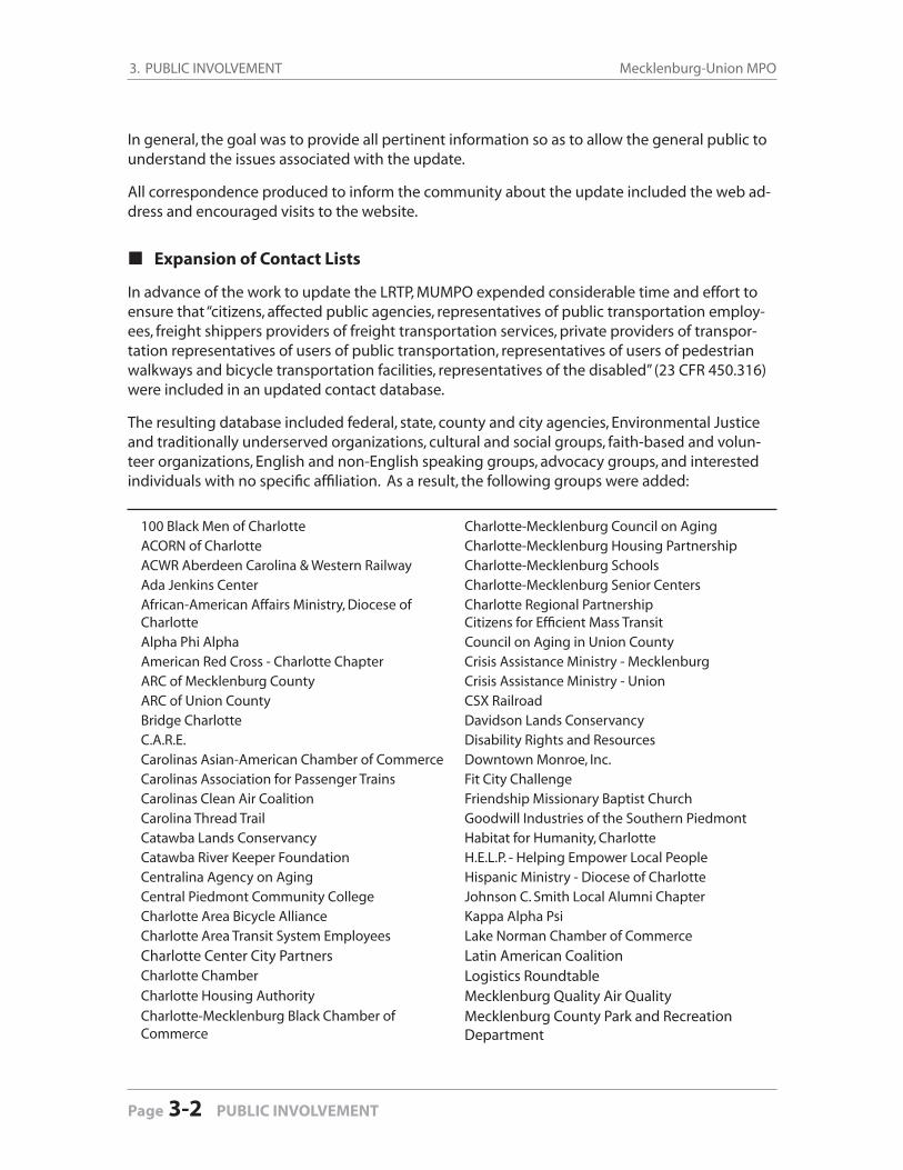
Expansion of Contact Lists
In advance of the work to update the LRTP, MUMPO expended considerable time and effort to ensure that “citizens, affected public agencies, representatives of public transportation employ-ees, freight shippers providers of freight transportation services, private providers of transpor-tation representatives of users of public transportation, representatives of users of pedestrian walkways and bicycle transportation facilities, representatives of the disabled” (23 CFR 450.316) were included in an updated contact database.
The resulting database included federal, state, county and city agencies, Environmental Justice and traditionally underserved organizations, cultural and social groups, faith-based and volun-teer organizations, English and non-English speaking groups, advocacy groups, and interested individuals with no specifi c affi liation. As a result, the following groups were added:
100 Black Men of Charlotte Charlotte-Mecklenburg Council on AgingACORN of Charlotte Charlotte-Mecklenburg Housing PartnershipACWR Aberdeen Carolina & Western Railway Charlotte-Mecklenburg SchoolsAda Jenkins Center Charlotte-Mecklenburg Senior CentersAfrican-American Affairs Ministry, Diocese of Charlotte
Charlotte Regional PartnershipCitizens for Effi cient Mass Transit
Alpha Phi Alpha Council on Aging in Union CountyAmerican Red Cross - Charlotte Chapter Crisis Assistance Ministry - MecklenburgARC of Mecklenburg County Crisis Assistance Ministry - UnionARC of Union County CSX RailroadBridge Charlotte Davidson Lands ConservancyC.A.R.E. Disability Rights and ResourcesCarolinas Asian-American Chamber of Commerce Downtown Monroe, Inc.Carolinas Association for Passenger Trains Fit City ChallengeCarolinas Clean Air Coalition Friendship Missionary Baptist ChurchCarolina Thread Trail Goodwill Industries of the Southern PiedmontCatawba Lands Conservancy Habitat for Humanity, CharlotteCatawba River Keeper Foundation H.E.L.P. - Helping Empower Local PeopleCentralina Agency on Aging Hispanic Ministry - Diocese of CharlotteCentral Piedmont Community College Johnson C. Smith Local Alumni ChapterCharlotte Area Bicycle Alliance Kappa Alpha PsiCharlotte Area Transit System Employees Lake Norman Chamber of Commerce
Charlotte Center City Partners Latin American CoalitionCharlotte Chamber Logistics RoundtableCharlotte Housing Authority Mecklenburg Quality Air QualityCharlotte-Mecklenburg Black Chamber of Commerce
Mecklenburg County Park and Recreation Department
3. PUBLIC INVOLVEMENT2035 Long-Range Transportation Plan
PUBLIC INVOLVEMENT 3-3
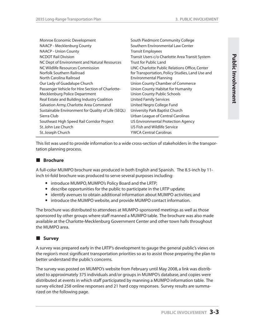
Monroe Economic Development South Piedmont Community CollegeNAACP - Mecklenburg County Southern Environmental Law CenterNAACP - Union County Transit EmployeesNCDOT Rail Division Transit Users c/o Charlotte Area Transit SystemNC Dept of Environment and Natural Resources Trust for Public Land
NC Wildlife Resources CommissionNorfolk Southern RailroadNorth Carolina Railroad
UNC-Charlotte Public Relations Offi ce, Center for Transportation, Policy Studies, Land Use and Environmental Planning
Our Lady of Guadalupe Church Union County Chamber of CommercePassenger Vehicle for Hire Section of Charlotte-Mecklenburg Police Department
Union County Habitat for HumanityUnion County Public Schools
Real Estate and Building Industry Coalition United Family ServicesSalvation Army, Charlotte Area Command United Negro College FundSustainable Environment for Quality of Life (SEQL) University Park Baptist ChurchSierra Club Urban League of Central CarolinasSoutheast High Speed Rail Corridor Project US Environmental Protection AgencySt. John Lee Church US Fish and Wildlife ServiceSt. Joseph Church YWCA Central Carolinas
This list was used to provide information to a wide cross-section of stakeholders in the transpor-tation planning process.
Brochure
A full-color MUMPO brochure was produced in both English and Spanish. The 8.5-inch by 11-inch tri-fold brochure was produced to serve several purposes including:
introduce MUMPO, MUMPO’s Policy Board and the LRTP;describe opportunities for the public to participate in the LRTP update;identify avenues to obtain additional information about MUMPO activities; andintroduce the MUMPO website, and provide MUMPO contact information.
The brochure was distributed to attendees at MUMPO-sponsored meetings as well as those sponsored by other groups where staff manned a MUMPO table. The brochure was also made available at the Charlotte-Mecklenburg Government Center and other town halls throughout the MUMPO area.
Survey
A survey was prepared early in the LRTP’s development to gauge the general public’s views on the region’s most signifi cant transportation priorities so as to assist those preparing the plan to better understand the public’s concerns.
The survey was posted on MUMPO’s website from February until May 2008, a link was distrib-uted to approximately 375 individuals and/or groups in MUMPO’s database, and copies were distributed at events in which staff participated by manning a MUMPO information table. The survey elicited 258 online responses and 21 hard copy responses. Survey results are summa-rized on the following page.
Pu
blic In
volvem
ent
3. PUBLIC INVOLVEMENT Mecklenburg-Union MPO
Page 3-4 PUBLIC INVOLVEMENT
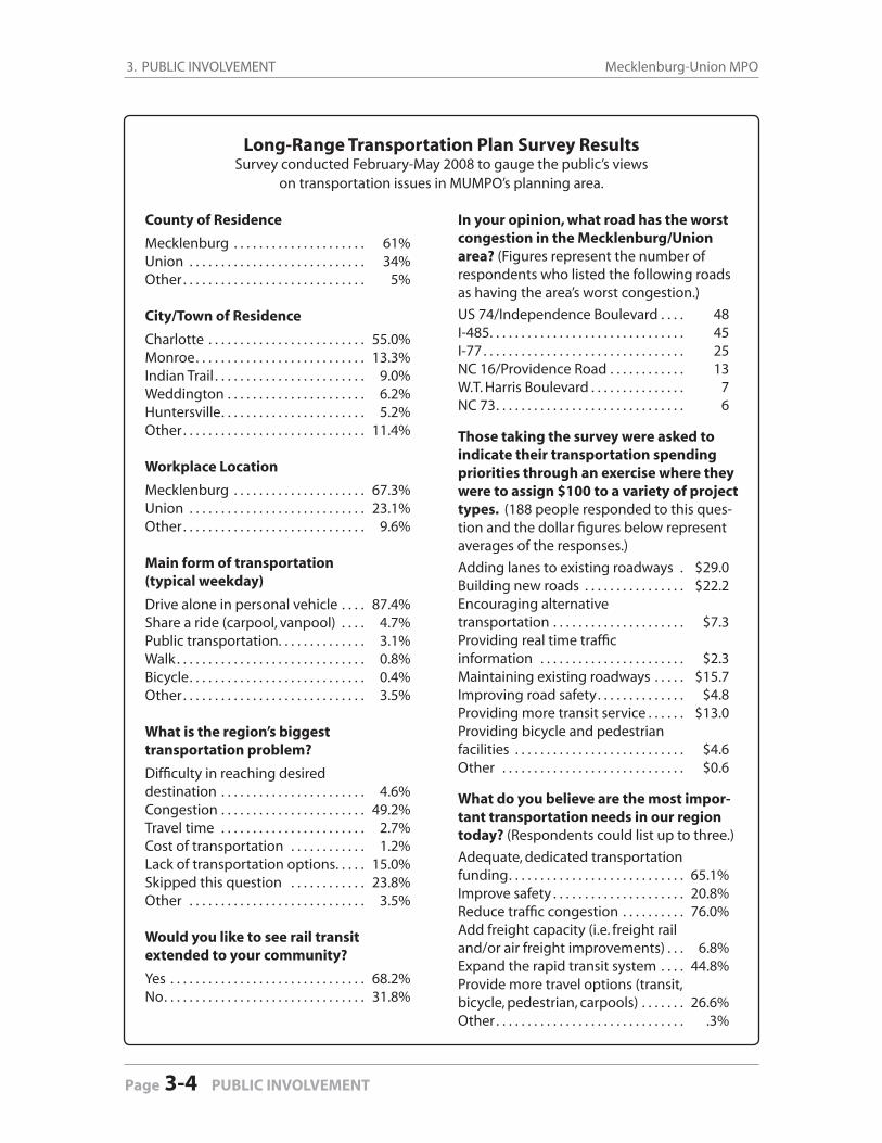
Long-Range Transportation Plan Survey ResultsSurvey conducted February-May 2008 to gauge the public’s views
on transportation issues in MUMPO’s planning area.
In your opinion, what road has the worst congestion in the Mecklenburg/Union area? (Figures represent the number of respondents who listed the following roads as having the area’s worst congestion.)
US 74/Independence Boulevard . . . . 48I-485 . . . . . . . . . . . . . . . . . . . . . . . . . . . . . . . 45I-77 . . . . . . . . . . . . . . . . . . . . . . . . . . . . . . . . 25NC 16/Providence Road . . . . . . . . . . . . 13W.T. Harris Boulevard . . . . . . . . . . . . . . . 7NC 73 . . . . . . . . . . . . . . . . . . . . . . . . . . . . . . 6
Those taking the survey were asked to indicate their transportation spending priorities through an exercise where they were to assign $100 to a variety of project types. (188 people responded to this ques-tion and the dollar fi gures below represent averages of the responses.)
Adding lanes to existing roadways . $29.0Building new roads . . . . . . . . . . . . . . . . $22.2Encouraging alternative transportation . . . . . . . . . . . . . . . . . . . . . $7.3Providing real time traffi c information . . . . . . . . . . . . . . . . . . . . . . . $2.3Maintaining existing roadways . . . . . $15.7Improving road safety . . . . . . . . . . . . . . $4.8Providing more transit service . . . . . . $13.0Providing bicycle and pedestrianfacilities . . . . . . . . . . . . . . . . . . . . . . . . . . . $4.6Other . . . . . . . . . . . . . . . . . . . . . . . . . . . . . $0.6
What do you believe are the most impor-tant transportation needs in our region today? (Respondents could list up to three.)
Adequate, dedicated transportation funding . . . . . . . . . . . . . . . . . . . . . . . . . . . . 65.1%Improve safety . . . . . . . . . . . . . . . . . . . . . 20.8%Reduce traffi c congestion . . . . . . . . . . 76.0%Add freight capacity (i.e. freight rail and/or air freight improvements) . . . 6.8%Expand the rapid transit system . . . . 44.8%Provide more travel options (transit, bicycle, pedestrian, carpools) . . . . . . . 26.6%Other . . . . . . . . . . . . . . . . . . . . . . . . . . . . . . .3%
County of Residence
Mecklenburg . . . . . . . . . . . . . . . . . . . . . 61%Union . . . . . . . . . . . . . . . . . . . . . . . . . . . . 34%Other . . . . . . . . . . . . . . . . . . . . . . . . . . . . . 5%
City/Town of Residence
Charlotte . . . . . . . . . . . . . . . . . . . . . . . . . 55.0%Monroe . . . . . . . . . . . . . . . . . . . . . . . . . . . 13.3%Indian Trail . . . . . . . . . . . . . . . . . . . . . . . . 9.0%Weddington . . . . . . . . . . . . . . . . . . . . . . 6.2%Huntersville . . . . . . . . . . . . . . . . . . . . . . . 5.2%Other . . . . . . . . . . . . . . . . . . . . . . . . . . . . . 11.4%
Workplace Location
Mecklenburg . . . . . . . . . . . . . . . . . . . . . 67.3% Union . . . . . . . . . . . . . . . . . . . . . . . . . . . . 23.1% Other . . . . . . . . . . . . . . . . . . . . . . . . . . . . . 9.6%
Main form of transportation (typical weekday)
Drive alone in personal vehicle . . . . 87.4%Share a ride (carpool, vanpool) . . . . 4.7%Public transportation . . . . . . . . . . . . . . 3.1%Walk . . . . . . . . . . . . . . . . . . . . . . . . . . . . . . 0.8%Bicycle . . . . . . . . . . . . . . . . . . . . . . . . . . . . 0.4%Other . . . . . . . . . . . . . . . . . . . . . . . . . . . . . 3.5%
What is the region’s biggesttransportation problem?
Diffi culty in reaching desired destination . . . . . . . . . . . . . . . . . . . . . . . 4.6%Congestion . . . . . . . . . . . . . . . . . . . . . . . 49.2%Travel time . . . . . . . . . . . . . . . . . . . . . . . 2.7%Cost of transportation . . . . . . . . . . . . 1.2%Lack of transportation options . . . . . 15.0%Skipped this question . . . . . . . . . . . . 23.8%Other . . . . . . . . . . . . . . . . . . . . . . . . . . . . 3.5%
Would you like to see rail transit extended to your community?
Yes . . . . . . . . . . . . . . . . . . . . . . . . . . . . . . . 68.2%No . . . . . . . . . . . . . . . . . . . . . . . . . . . . . . . . 31.8%
3. PUBLIC INVOLVEMENT2035 Long-Range Transportation Plan
PUBLIC INVOLVEMENT 3-5
Public Meetings
Providing the public with an opportunity to learn more about MUMPO’s plans and programs through staff-sponsored events is an important component of its outreach efforts because it focuses attention on the issue being presented. However, even the best publicized events can result in low turnout due to the diffi culty in engaging the public in long-range planning efforts.
For this reason MUMPO pursued participating in well-established events sponsored by others that had a history of good attendance by a broad cross-section of the general public. By doing so, information about the LRTP could be presented to greater numbers of citizens.
The following lists public meetings and events (both staff-sponsored and sponsored by others) at which the LRTP was discussed.
LRTP Open Houses
February 21, 2008 - Charlotte-Mecklenburg Government Center, CharlotteFebruary 28, 2008 - South Piedmont Community College, Monroe
The purpose of these open houses was to kick-off the public involvement process for the LRTP update by obtaining the public’s input on its transportation priorities for the region.
The open houses also served as an opportunity for MUMPO’s Consultation partners to discuss the LRTP process, and three agencies sent representatives: US Fish & Wildlife Service (Charlotte Open House); NC Division of Water Quality (Charlotte Open House); NC Wildlife Resources Com-mission (Monroe Open House). The Charlotte Open House was held jointly with the Gaston Urban Area MPO.
Publicity was generated by a media release to 21 outlets (print, television and radio), an email sent to approximately 375 individuals and groups on MUMPO’s databases, a postcard to over 1,000 recipients and an advertisement published in the Monroe Enquirer-Journal, Charlotte Ob-server, Charlotte Post, Huntersville Herald and Que Pasa.
A variety of information was displayed at the open houses, including:
Maps showing the 2030 Plan roadway networksProject lists (projects to be ranked for inclusion in the 2035 Plan)Maps providing information on Mecklenburg County’s existing greenways and its ongoing greenway planning effortsA map of CDOT’s proposed bike network for the city of CharlotteMap depicting Stallings’ proposed pedestrian plan (February 28 only)Comment sheetLRTP update surveyFast Lanes study informationMUMPO brochureMUMPO LRTP update brochureMap showing the detailed study alternatives for the Monroe Connector/Bypass
Pu
blic M
eeting
s
3. PUBLIC INVOLVEMENT Mecklenburg-Union MPO
Page 3-6 PUBLIC INVOLVEMENT
Charlotte Neighborhood SymposiumStaff participated in the City of Charlotte’s Neighborhood Symposium on Saturday, March 8, 2008 at the Charlotte Convention Center. Staff was able to discuss the LRTP update with at-tendees, maps were used to show the current plan’s priorities and the LRTP update brochure was distributed. Attendees were also provided copies of MUMPO’s LRTP update survey, or were directed to take the survey online. Approximately 600 people attended this event.
Northwest Huntersville Transportation StudyApproximately 55 people attended this event held at Huntersville Town Hall on Wednesday, April 16, 2008. Staff was able to discuss the LRTP update with attendees and the LRTP update brochure was distributed.
Earth Day 2008Staff participated in three Earth Day events in 2008:
Mecklenburg County - Saturday, April 19Cornelius - Tuesday, April 22Indian Trail - Saturday, April 26
Staff was able to discuss the LRTP update with attendees, maps were used to show the current Plan’s priorities and the LRTP update brochure was distributed.
Earth Day 2009Staff participated in Mecklenburg County’s Earth Day event at the main campus of Central Pied-mont Community College (CPCC). A booth was staff from 10:00 AM until 3:00 PM on Saturday, April 18, 2009. Staff was able to discuss the LRTP update with attendees and the LRTP update brochure was distributed.
Lake Norman Real Estate AllianceA presentation was made to the Lake Norman Real Estate Alliance on June 11, 2009 to inform the group about MUMPO’s efforts to update the LRTP.
Steele Creek Area Plan Kick-Off MeetingsThe Charlotte-Mecklenburg Planning Department kicked off its Steele Creek area plan develop-ment process at meetings held on June 23 and 25, 2009. Staff manned a table at both meetings and was able to discuss the LRTP update with attendees. Maps were used to show the current plan’s priorities and copies of the LRTP update brochure were provided.
Draft Financially-Constrained Project List Public Meetings
August 24, 2009 - Charlotte-Mecklenburg Government Center, CharlotteAugust 31, 2009 - Indian Trail Town Hall, Indian Trail
The purpose of the two meetings was to provide the public with an opportunity to review the draft project lists, discuss them with staff and comment on the draft priorities established by the MPO.
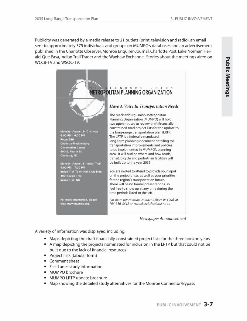
3. PUBLIC INVOLVEMENT2035 Long-Range Transportation Plan
PUBLIC INVOLVEMENT 3-7
Publicity was generated by a media release to 21 outlets (print, television and radio), an email sent to approximately 375 individuals and groups on MUMPO’s databases and an advertisement published in the Charlotte Observer, Monroe Enquirer-Journal, Charlotte Post, Lake Norman Her-ald, Que Pasa, Indian Trail Trader and the Waxhaw Exchange. Stories about the meetings aired on WCCB-TV and WSOC-TV.
A variety of information was displayed, including:
Maps depicting the draft fi nancially-constrained project lists for the three horizon yearsA map depicting the projects nominated for inclusion in the LRTP but that could not be built due to the lack of fi nancial resourcesProject lists (tabular form)Comment sheetFast Lanes study informationMUMPO brochureMUMPO LRTP update brochureMap showing the detailed study alternatives for the Monroe Connector/Bypass
Pu
blic M
eeting
s
Have A Voice In Transportation Needs
The Mecklenburg-Union Metropolitan Planning Organization (MUMPO) will hold two open houses to review draft financiallyconstrained road project lists for the update tothe long-range transportation plan (LRTP).The LRTP is a federally-mandated, long-term planning document detailing the transportation improvements and policies to be implemented in MUMPO’s planning area. It will outline where and how roads, transit, bicycle and pedestrian facilities will be built up to the year 2035.
You are invited to attend to provide your inputon the projects lists, as well as your priorities for the region’s transportation future.There will be no formal presentations, so feel free to show up at any time during the time periods listed to the left.
For more information, contact Robert W. Cook at704-336-8643 or [email protected].
Monday, August 24-Charlotte 4:00 PM - 6:00 PM Room 266Charlotte-MecklenburgGovernment Center 600 E. Fourth St. Charlotte, NC
Monday, August 31-Indian Trail 4:00 PM - 7:00 PM Indian Trail Town Hall Civic Bldg.
100 Navajo Trail
Indian Trail, NC
For more information, please visit www.mumpo.org.
Newspaper Announcement
3. PUBLIC INVOLVEMENT Mecklenburg-Union MPO
Page 3-8 PUBLIC INVOLVEMENT
Charlotte Area Bicycle AllianceStaff conducted a presentation to the Charlotte Area Bicycle Alliance on September 14, 2009 to inform the group about MUMPO’s efforts to update the LRTP.
Back Creek Church Road Improvements Public MeetingThe Charlotte Department of Transportation held a public meeting on September 17, 2009 to discuss planned improvements to Back Creek Church Road. Staff manned a table at this event and was able to discuss the LRTP update with attendees. Up-to-date maps showing the road projects on MUMPO’s draft project lists were displayed and copies of the LRTP update brochure were provided.
Elizabeth Area Plan Kick-Off MeetingThe Charlotte-Mecklenburg Planning Department kicked off its Elizabeth area plan develop-ment process at a meeting held on September 22, 2009. Staff manned a table at this meeting and was able to discuss the LRTP update with attendees. Up-to-date maps showing the road projects on MUMPO’s draft project lists were displayed and copies of the LRTP update brochure were provided.
Please see Appendix B for the following materials related to Public Involvement:
February 2008 Open House Meeting Materials August 2009 Public Meeting Materials
Background
Environmental justice (EJ) is a process through which it is assured that poor communities and communities of color do not bear more than their share of environmental burdens. Historically, residents living within communities that face disproportionate negative impacts from transpor-tation projects, regulations or activities are often minorities or people of low wealth. Further, these residents and communities have often been excluded from transportation policy-setting or decision-making processes.
The concept of environmental justice arose in the United States during the early 1980s within Black, Hispanic and indigenous communities that were disproportionately subjected to pollut-ants in their neighborhoods. The social justice approach to the movement resulted in Title VI of the 1964 Civil Rights Act which states that “no person in the United States shall, on the grounds of race, color or national origin be excluded from participation in, be denied the benefi ts or, or be subjected to discrimination under any program or activity receiving Federal fi nancial assis-tance.”
In addition, Federal Executive Order 12898, signed in 1994 to address environmental injustice in minority and low-income communities, states that “each Federal agency shall make achieving en-vironmental justice part of its mission by identifying and addressing, as appropriate, disproportion-ately high and adverse human health or environmental effects of its programs, policies, and activities on minority populations and low-income populations.” The executive order identifi es minority populations as belonging to any of the following groups:
Black – a person having origins in any of the black racial groups of Africa;
Hispanic – a person of Mexican, Puerto Rican, Cuban, Central or South American, or other Spanish culture or origin, regardless of race;
Asian-American – a person having origins in any of the original peoples of the Far East, Southeast Asia, the Indian subcontinent, or the Pacifi c Islands; and,
American Indian and Alaskan Native – a person having origins in any of the original people of North America and who maintain cultural identifi cation through tribal affi liation or community recognition.
The Executive Order defi nes low-income populations as those whose household incomes are at or below the U.S. Department of Health and Human Services poverty guidelines (e.g. $22,050 annual income for a family of four in 2009).
4.0
ENVIRONMENTAL JUSTICE
Enviro
nm
ental Ju
stice
ENVIRONMENTAL JUSTICE 4-1
4. ENVIRONMENTAL JUSTICE Mecklenburg-Union MPO
Page 4-2 ENVIRONMENTAL JUSTICE
There are three fundamental environmental justice principles:
1. To avoid, minimize, or mitigate disproportionately high and adverse human health and environmental effects, including social and economic effects, on minority populations and low-income populations.
2. To ensure the full and fair participation by all potentially affected communities in the transportation decision-making process.
3. To prevent the denial of, reduction in, or signifi cant delay in the receipt of benefi ts by minority and low-income populations.
MUMPO Activities
MUMPO’s efforts in the area of environmental justice are found in its adopted “Public Involve-ment Plan,” wherein it states that there will be an emphasis on “reaching people who have traditionally not been participants in the transportation planning process.”
The development of this plan represents the Metropolitan Planning Organization’s commitment to making signifi cant efforts to reach out to environmental justice communities (as defi ned in Executive Order 12898) throughout its planning area. This effort is intended not merely to sat-isfy plan preparation requirements, but to ensure that outreach is an ongoing part of MUMPO’s transportation planning process and that those traditionally left out of the process are brought in as full participants.
In order to achieve the goals of its Public Involvement Plan, several activities have taken or will take place:
1. MUMPO staff gathered all pertinent information from the 2000 Census and prepared maps that depict the distribution of the environmental justice and low-income populations across MUMPO’s planning area by block group and Census tracts (for low-income). 2000 Census information was not relied upon exclusively. As an example, the U S Census Bureau’s 2008 projections indicated Mecklenburg County Black and Hispanic populations of approxi-mately 263,592 and 96,176 respectively. These fi gures indicate 36% and 114 % increases respectively since the 2000 Census. Growth of these populations in Union County is measur-ably higher with a 52% increase within the Black population and a 156% increase within the Hispanic population.
2. MUMPO’s draft roadway projects were overlaid on maps depicting the 2000 Census information. This was done to help determine where the MPO was directing its resources relative to roadway projects and to discern whether environmental justice communities were being subjected to unreasonable impacts or being denied the benefi ts of the planned investments. The result of this inquiry will be reported in the ongoing Title VI Public Out-reach Study. (For the maps, see Figures 4-1 through 4-15 in the Map Gallery at the end of this document. Online, see the list of links on page 4-6.)
4. ENVIRONMENTAL JUSTICE2035 Long-Range Transportation Plan
ENVIRONMENTAL JUSTICE 4-3
Enviro
nm
ental Ju
stice
3. Information on all other transportation modes was collected from MUMPO’s transporta-tion planning partners and similarly overlaid on the maps depicting the Census informa-tion. This was done to help ensure that all potential transportation modes affecting envi-ronmental justice communities have been captured and, as with road projects, to determine if communities were being subjected to unreasonable impacts or being denied the benefi ts of the planned investments. Results will be reported in the ongoing Title VI Public Outreach Study. The following lists the modal information collected and analyzed:
TransitCharlotte Area Transit System (CATS): existing and proposed bus route; existing
and proposed rapid transit (including a proposed streetcar line); existing and proposed neighborhood transit centers
BicycleCharlotte Department of Transportation: Bicycle PlanAll other municipalities were requested to provide information on bicycle plans adopted by their communities
GreenwaysMecklenburg County Parks and Recreation Department: existing and proposed greenways; the Carolina Thread TrailMecklenburg County municipalities were requested to provide information on greenway plans independent of the County’sUnion County municipalities were requested to provide their existing and planned greenway information
4. In advance of signifi cant work on the LRTP, considerable work was done to update MUMPO’s database of groups that work with environmental justice communities. The database continues to be improved and a process is being developed to keep key community contact information up-to-date.
5. Grassroots leadership and media contacts were identifi ed and interviews initiated to determine their views on environmental justice communities’ awareness of and knowledge about MUMPO planning processes, distribution of transportation funding and the impact of specifi c projects on those communities. Focus groups will be formed within targeted areas to gather in-depth information.
6. A survey was prepared (in English and Spanish) that sought information on the level of community knowledge of perceived or actual environmental justice impacts as well as per-ceived barriers to effective public participation.
7. Key individuals working with the Hispanic and Black Communities were interviewed, including representatives from the Charlotte Mecklenburg Police Department and ENLACE, a monthly roundtable of key Latino organizations and leaders working on key issues and
collaborative opportunities within the community. Additional outreach is underway through existing community-based organizations and institutions within environmental justice communities.
•
••
•
•
•
4. ENVIRONMENTAL JUSTICE Mecklenburg-Union MPO
Page 4-4 ENVIRONMENTAL JUSTICE
Initial Findings and Ongoing Efforts
At the heart of environmental justice considerations is the equitable distribution of environmen-tal impacts — positive and negative — throughout a project area without undue effects on low-income and minority communities. While an in-depth analysis of transportation investments, initiatives and plans is currently underway, based on knowledge of 2000 population distribution by race and income within the MUMPO planning area, it appears that:
1. Transportation projects have been initiated:
Without undue burden of impacts on environmental justice communities;
With equitable benefi t of investments throughout the planning area, includ-ing environmental justice communities; and
With planning considerations intended to distribute future benefi ts equitably and without consideration of race or income.
2. Environmental justice communities — particularly Hispanic and Black communi-ties — are often unfamiliar with transportation planning processes in general and, consequently, unaware of MUMPO’s role in the planning process for specifi c transportation projects. As a result, those community members have not had or taken the opportunity to play a role in decision-making processes.
3. Initial one-on-one community interviews indicated that MUMPO must do a bet-ter job of educating and reaching out to low-income and minority communities regarding transportation initiatives. Based on Hispanic and Black communities’ previous response to MUMPO outreach efforts, traditional outreach initiatives — ads printed in local newspapers (even when printed in Spanish), community signs advertising community meetings and inserts in utility bills — have not pro-vided the desired result. MUMPO will need to implement non-traditional means for sharing public information with the Hispanic community in particular — and to some extent with the Black community — including radio, non-cable public information television channels, institutional resources including faith organiza-tion, fraternal organizations, etc.
4. Efforts must be made to work with environmental justice communities to devel-op methods by which the impacts of transportation investments can be ascer-tained. The use of print and graphics to “tell MUMPO’s story” in ways that cross ethnic or cultural lines will be key in helping environmental justice communities understand the relevance to their community’s quality of life.
4. ENVIRONMENTAL JUSTICE2035 Long-Range Transportation Plan
ENVIRONMENTAL JUSTICE 4-5
Enviro
nm
ental Ju
stice
Next Steps
Completing MUMPO’s Title VI Public Outreach Plan will provide MUMPO offi cials and staff the following:
A succinct, culturally sensitive educational handout will be designed to be shared within environmental justice communities that explain what transportation planning processes are and why they are important to those communities. The handout should be easy to replicate and made available at key locations along key transportation corridors.
A series of grassroots focus groups will be held over a four-week period to share MUMPO in-formation, further determine impacts of MUMPO projects on a broader array of environmen-tal justice communities and to foster trust between MUMPO staff and environmental justice community leadership — furthering the likelihood of participation in future projects.
Working with environmental justice communities, analysis methods and procedures will be prepared to complete a fi nal evaluation of transportation investments, initiatives and plans to fully assess if environmental justice communities have been, or may be in the future, disproportionately impacted, and to determine if the benefi ts of the investments, initiatives and plans have been equitably distributed throughout the planning area.
Methods to reaching out to low-literacy populations.
A complete database and standard public outreach planning process manual that will in-clude:
names and contact information for key individuals, organizations and institutions as well as grassroots leadership within the Hispanic and Black communities;
contacts within the minority business community;
Hispanic and Black media outreach contacts, pricing, schedules and formatting criteria as available;
a suggested meeting format that may be replicated (for example, it may be important to have a respected and recognized member of the Hispanic community as an introductory speaker at MUMPO meetings);
a process for dealing with and following up on community concerns that may not be ger-mane to the immediate MUMPO project, but are of concern to the community (follow-up on these questions will build community trust);
examples of handouts in English and Spanish;
suggested “give away materials” that will visually link the community participants to the project or process that has been reviewed; and
a process for meeting evaluation and follow-up with participants on pertinent questions or concerns about the MUMPO project.
Targeted completion date: December 2010
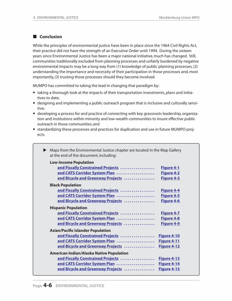
4. ENVIRONMENTAL JUSTICE Mecklenburg-Union MPO
Page 4-6 ENVIRONMENTAL JUSTICE
Conclusion
While the principles of environmental justice have been in place since the 1964 Civil Rights Act, their practice did not have the strength of an Executive Order until 1994. During the sixteen years since Environmental Justice has been a major national initiative, much has changed. Still, communities traditionally excluded from planning processes and unfairly burdened by negative environmental impacts may be a long way from (1) knowledge of public planning processes, (2) understanding the importance and necessity of their participation in those processes and, most importantly, (3) trusting those processes should they become involved.
MUMPO has committed to taking the lead in changing that paradigm by:
taking a thorough look at the impacts of their transportation investments, plans and initia-tives to date;designing and implementing a public outreach program that is inclusive and culturally sensi-tive;developing a process for and practice of connecting with key grassroots leadership, organiza-tion and institutions within minority and low-wealth communities to insure effective public outreach in those communities; andstandardizing these processes and practices for duplication and use in future MUMPO proj-ects.
Maps from the Environmental Justice chapter are located in the Map Gallery at the end of the document, including:
Low-Income Population and Fiscally Constrained Projects . . . . . . . . . . . . . . . . . . Figure 4-1 and CATS Corridor System Plan . . . . . . . . . . . . . . . . . . . . Figure 4-2 and Bicycle and Greenway Projects . . . . . . . . . . . . . . . . Figure 4-3
Black Population and Fiscally Constrained Projects . . . . . . . . . . . . . . . . . . Figure 4-4 and CATS Corridor System Plan . . . . . . . . . . . . . . . . . . . . Figure 4-5 and Bicycle and Greenway Projects . . . . . . . . . . . . . . . . Figure 4-6
Hispanic Population and Fiscally Constrained Projects . . . . . . . . . . . . . . . . . . Figure 4-7 and CATS Corridor System Plan . . . . . . . . . . . . . . . . . . . . Figure 4-8 and Bicycle and Greenway Projects . . . . . . . . . . . . . . . . Figure 4-9
Asian/Pacifi c Islander Population and Fiscally Constrained Projects . . . . . . . . . . . . . . . . . . Figure 4-10 and CATS Corridor System Plan . . . . . . . . . . . . . . . . . . . . Figure 4-11 and Bicycle and Greenway Projects . . . . . . . . . . . . . . . . Figure 4-12
American Indian/Alaska Native Population and Fiscally Constrained Projects . . . . . . . . . . . . . . . . . . Figure 4-13 and CATS Corridor System Plan . . . . . . . . . . . . . . . . . . . . Figure 4-14 and Bicycle and Greenway Projects . . . . . . . . . . . . . . . . Figure 4-15
Under the former Intermodal Surface Transportation Effi ciency Act (ISTEA), all MPOs were required to consider 15 planning factors in the development of transportation plans and programs. The enactment of the Transportation Equity Act for the 21st Century (TEA-21) reduced the number of planning factors to seven.
Most recently enacted in 2005, the Safe, Accountable, Flexible, Effi cient Transportation Equity Act for Users (SAFETEA-LU) added emphasis in two areas: security and the environment. Security is now an additional, stand-alone planning factor, signaling increased importance. Environment is expanded to coordinate transportation with the planning of sustainable development and growth patterns. Accordingly, MPO considers projects and strategies that will address the fol-lowing factors:
5.1 Economic Vitality
The Mecklenburg Union MPO has worked extensively over the years with NCDOT and other state and federal agencies on transportation projects that enhance the economic prosperity of the area.
A signifi cant development is the formation of a regional transportation alliance involving the four MPOs and two Rural Planning Organizations (RPOs) in the Charlotte Region. The new or-ganization—CRAFT (Charlotte Regional Alliance for Transportation)—is committed to ensuring that the economic growth and vitality of the entire area will be complemented by a transporta-tion system developed in a regional matter.
The alliance marks a coordinated effort to guide the Charlotte region in broader planning to serve the rapidly merging urban areas. The four MPOs in the Charlotte region—Cabarrus-Rowan, Gaston, Rock Hill-Fort Mill and Mecklenburg-Union—have signed a Memorandum of Agreement for working cooperatively on regional transportation issues and have begun meet-ing on an adopted schedule. The two RPOs, Lake Norman and Rocky River, were added to CRAFT in 2004. Together, these six organizations formally represent the vast majority of the region.
Also important is the completion of I-485 and widening of I-77 and I-85. These freeways will continue to provide important access to other parts of the country and benefi t the MUMPO area economy by improved transportation for people and goods, and by increased tourism.
The implementation of an effi cient transportation system that includes mass transit and bicycle and pedestrian facilities, such as greenways, will preserve the area’s reputation as a desirable place to locate businesses.
5.0
PLANNING FACTORS Plan
nin
g Facto
rs
PLANNING FACTORS 5-1
5. PLANNING FACTORS Mecklenburg-Union MPO
Page 5-2 PLANNING FACTORS
5.2 Safety
MUMPO takes a number of measures to increase the safety of the transportation system for all users. The Charlotte Department of Transportation (CDOT) produces an annual inventory of high accident locations to identify where there may be a need for safety improvements. Projects are then developed to improve the conditions. NCDOT also conducts similar studies and has a safety program to address these needs.
MUMPO also supports the implementation of other projects to ensure the safety and security of its users. These include:
the construction of median guard rails on freeways,the replacement of defi cient bridges and structures,the construction of sidewalks on all non-freeway road projects,the addition of bike lanes on roadways, and programs to improve safety at school crossings.
5.3 Security
When SAFETEA-LU became law in 2005, security became a separate planning factor required in the state and metropolitan planning process. This was the fi rst transportation reauthorization after the September 11, 2001 terrorist attacks, and the security of the nation’s transportation in-frastructure was a key goal. The Charlotte region is a large urban area with important infrastruc-ture, facilities, utilities and population and employment centers essential for security planning.
Securing and managing incidents at these sites is addressed by a range of organizations through out the region, including transportation and law enforcement agecies. Various safety and security plans address interagency coordination and areas of responsibility. The transporta-tion plans include strategies to reduce crashes and the transportation impacts of such incidents, while law enforcement and emergency management plans generally focus on managing inci-dents after they occur, including evacuations and security property and people.
5.4 Accessibility and Mobility Options
Increasing the accessibility and mobility options available to people and for freight is one of the most important objectives of MUMPO. This is achieved by:
integrating land use and transportation planning,providing the necessary resources to enhance the existing transportation system,expanding the existing transit system,implementing fi xed route mass transit options, andexpanding shipping facilities at Charlotte/Douglas International Airport.
Land use and transportation policies are being instituted that support transit ridership, walking and bicycling—and reduce dependency on the automobile. More compact development pat-terns at activity centers and along transit corridors will make the transit system more economi-cally self-sustaining. In neighborhoods, transit-oriented development that emphasizes a mix of
5. PLANNING FACTORS2035 Long-Range Transportation Plan
PLANNING FACTORS 5-3
Plan
nin
g Facto
rs
uses and easy pedestrian access to shopping and services could reduce the need to drive. TheMecklenburg-Union urban area has been a major shipping hub for the Southeast. Continued support of this hub is provided through widening and maintaining the interstate system and improved access to the multi-modal facility at Charlotte/Douglas International Airport and other intermodal facilities in the area.
5.5 Environmental Protection, Energy Conservation and
Sustainable Development
MUMPO is committed to protecting and enhancing the environment, promoting energy con-servation and prioritizing investments that encourage more sustainable growth patterns.
The member governments within the urban area look to protect their important resources by enacting environmentally sensitive land use policies, developing transportation choices and promoting air quality education programs.
Land use policies include buffers around the rivers and streams, impact fees for runoff caused by impervious surfaces, and roadway designs that mitigate runoff impacts in critical watershed areas. Land use decisions are being made to direct growth to reduce travel demand, which in turn leads to energy conservation and reduced pollutants.
5.6 System Integration and Connnectivity
MUMPO has developed and supports programs and projects that enhance the integration and connectivity of a multi-modal transportation system.
The proposed intermodal facility at the Charlotte/Douglas International Airport provides a critical link for movement of goods between rail, highway and air.
Ambitious transit plans provide opportunities for people to enjoy a more mobile system that allows them to conveniently access many parts of the urban area.
Park-and-Ride Lots enable auto commuters to access the current bus and rail system and will be available for the expanding rapid transit system.
Bicycle racks on buses allow people the fl exibility to access bus stops by bike, improving the attractiveness of the system.
MUMPO’s policy to add sidewalks to non-freeway roadways enables citizens to leave their vehicle at home for short trips.
Mecklenburg County’s growing greenway system provides connectivity for pedestrians and bicyclists between neighborhoods, schools, shopping areas and employment centers.
The Charlotte Department of Transportation and other MUMPO members also emphasize con-nectivity between neighborhoods, whether vehicular, bicycle, pedestrian—or a combination of the three. Providing and expanding connectivity creates a linked network that can minimize congrestion and reduce unnecessary trips on thoroughfares.
5. PLANNING FACTORS Mecklenburg-Union MPO
Page 5-4 PLANNING FACTORS
5.7 Effi cient System Management and Operations
Congestion Management Process
In 1994, the Mecklenburg-Union Technical Coordination Committee prepared a Congestion Management Study in cooperation with the North Carolina Department of Transportation (NCDOT). The study was implemented in 1995 and identifi es improvements to reduce traffi c congestion at intersections throughout the planning area. Projects are selected for inclusion in the City of Charlotte’s Capital Improvement Program or the NCDOT Transportation Improvement Program. The City continues to coordinate with NCDOT on this effort through installation and monitoring of coordinated traffi c signals and video surveillance cameras.
Traffi c Monitoring System
The City of Charlotte assists NCDOT by collecting site-specifi c information on Highway Perfor-mance Management System sample locations. Both the City and the State complete counts at these locations. In a typical year, the City of Charlotte collects the following travel data through-out the planning area: up to 500 48-hour automatic traffi c counts; up to 250 12-hour manual traffi c counts; and approximately 50 radar speed studies and travel time surveys.
In addition, the City of Charlotte collects speed and classifi cation automatic traffi c counts and performs studies on these data. Each September, the City conducts vehicle occupancy surveys at 23 locations in the Uptown area (Charlotte’s central business district). The City annually up-dates Uptown’s off-street parking inventory and peak-hour demand for parking. This includes verifying the existing inventory of parking supply, identifying new parking supply and collecting information on parking rates. The City is also implementing a vehicular way-fi nding system in the Uptown area.
Safety Management System
The Charlotte Department of Transportation (CDOT) compiles accident data on all streets within Charlotte, except the freeways. These data are used to identify hazardous locations. CDOT holds monthly safety meetings to develop low-cost safety treatments to reduce accidents at problem locations. The safety improvements might include supplemental signing, pavement marking revisions, signal timing changes, turn prohibitions, and pedestrian and traffi c safety educational campaigns. The City also works with the Traffi c Safety Unit of NCDOT’s Traffi c Engineering Branch in implementing safety improvements on the State highway system.
Traffi c Operations Plan
The non-capital measures above are complemented by a program of capital improvements. CDOT develops a Traffi c Operations Plan every two years that describes capital projects de-signed to improve safety at hazardous intersections. This plan lists the City’s high-accidents locations and high-congestion locations, and recommends improvement measures. The Traffi c Operations Plan is used to select intersection and safety improvement projects for inclusion in the City’s Five-Year Capital Improvement Program (CIP) or the North Carolina Statewide Trans-portation Improvement Program (STIP).
5. PLANNING FACTORS2035 Long-Range Transportation Plan
PLANNING FACTORS 5-5
5.8 Preservation of the Existing System
MUMPO has worked with NCDOT for many years in establishing and maintaining a transporta-tion planning program that incorporates a standard set of planning principles as recommended by the Federal Aid Highway Act of 1962. The planning principles require the development of a safe and effi cient transportation system by:
maximizing utilization of the existing facilities,increasing operational effi ciency and altering travel demands when appropriate, and minimizing adverse impacts to the natural, social and economic environments.
The preservation of the system includes preserving or even improving both the safety and capacity of the existing system through the use of access management principles. The Transpor-tation Research Board and Institute for Transportation Engineers have promulgated extensive research-based guidelines for access management that are used by local and NCDOT agencies in the review of land development proposals. Efforts are made for early collaboration between the local jurisdiction and NCDOT to ensure that the Thoroughfare Plan hierarchies are consid-ered in access approvals.
The highest manifestation of this collaboration is the NC 73 Transportation/Land Use Plan and subsequent NC 73 Council of Planning formed to further the goals of the corridor plan. This 2004 plan, a fi rst in North Carolina, covers a 35-mile long corridor of NC 73 with fi ve munici-palities, three counties and two NCDOT divisions. Developed collaboratively with the three Chambers of Commerce in the area, a key component of the plan is using access management to preserve the public’s transportation investment in the corridor while furthering the land use goals of the individual communities. The NC 73 Council of Planning meets quarterly to share best practices and ensure that the document and collaboration can evolve and stay relevant.
The Mecklenburg-Union urban area is also committed to providing the necessary resources for maintaining and preserving the existing and future transportation system.
Plan
nin
g Facto
rs
5. PLANNING FACTORS Mecklenburg-Union MPO
Page 5-6 PLANNING FACTORS
Introduction
SAFETEA-LU, enacted in 2005, expanded the number of planning factors from seven to eight by splitting safety and security into two separate factors. Before SAFETEA-LU, the factor for safety and security read: “Increase the safety and security of the transportation system for motorized and non-motorized users.” Under SAFETEA-LU, the factor now reads: “Increase the safety of the transportation system for motorized and non-motorized users” and “Increase the security of the transportation system for motorized and non-motorized users.” The intent of this change was to emphasize the importance of safety, and to acknowledge the special concerns regarding security in the wake of the events of September 11, 2001.
In the past, discussions of safety and security were woven into the Long-Range Transportation Plan’s modal chapters (highway, transit, pedestrian, bicycle, freight and aviation). This 2035 Long-Range Transportation Plan consolidates the safety and security components in a single chapter.
6.1 Safety
Safety has long been a primary concern of transportation system management, maintenance and system expansion. SAFETEA-LU places a greater emphasis on safety at the planning (LRTP) level.
One way this emphasis is refl ected is in linkages to the North Carolina Strategic Highway Safety Plan (SHSP). In 2003, North Carolina found that regardless of the continuous enhancements that had been made in the area of highway safety, there was still a need to better address the issues. To further reduce fatalities and better coordinate with agencies outside of NCDOT, the North Carolina Executive Committee for Highway Safety (ECHS) was charged to identify, prioritize, pro-mote and support all emphasis areas in the American Association of State Highway and Trans-portation Offi cials (AASHTO) Strategic Highway Safety Plan. The ECHS is comprised of experts in all disciplines related to highway safety.
Furthermore, North Carolina completed its Strategic Highway Safety Plan in 2006 (and updated it in 2007) as required by the federal SAFETEA-LU and based on AASHTO’s SHSP. As projects are developed, elements from the SHSP will be incorporated by using “access management strate-gies” to preserve capacity and enhance safety. Some typical access management strategies in-clude shared curb cuts, use of medians, and paved shoulders. MUMPO and its member govern-ments are aware of the value of these strategies and seek to include them in projects wherever possible.
6.0
SAFETY AND SECURITY
Safety
SAFETY AND SECURITY 6-1
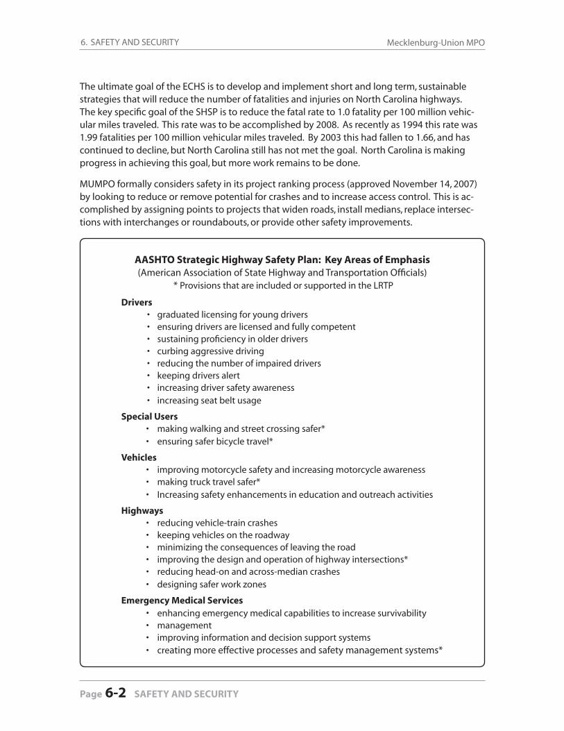
6. SAFETY AND SECURITY Mecklenburg-Union MPO
Page 6-2 SAFETY AND SECURITY
The ultimate goal of the ECHS is to develop and implement short and long term, sustainable strategies that will reduce the number of fatalities and injuries on North Carolina highways. The key specifi c goal of the SHSP is to reduce the fatal rate to 1.0 fatality per 100 million vehic-ular miles traveled. This rate was to be accomplished by 2008. As recently as 1994 this rate was 1.99 fatalities per 100 million vehicular miles traveled. By 2003 this had fallen to 1.66, and has continued to decline, but North Carolina still has not met the goal. North Carolina is making progress in achieving this goal, but more work remains to be done.
MUMPO formally considers safety in its project ranking process (approved November 14, 2007) by looking to reduce or remove potential for crashes and to increase access control. This is ac-complished by assigning points to projects that widen roads, install medians, replace intersec-tions with interchanges or roundabouts, or provide other safety improvements.
AASHTO Strategic Highway Safety Plan: Key Areas of Emphasis(American Association of State Highway and Transportation Offi cials)
* Provisions that are included or supported in the LRTP
Drivers • graduated licensing for young drivers
• ensuring drivers are licensed and fully competent • sustaining profi ciency in older drivers
• curbing aggressive driving • reducing the number of impaired drivers • keeping drivers alert • increasing driver safety awareness • increasing seat belt usage
Special Users • making walking and street crossing safer* • ensuring safer bicycle travel*
Vehicles • improving motorcycle safety and increasing motorcycle awareness • making truck travel safer* • Increasing safety enhancements in education and outreach activities
Highways • reducing vehicle-train crashes • keeping vehicles on the roadway • minimizing the consequences of leaving the road • improving the design and operation of highway intersections* • reducing head-on and across-median crashes • designing safer work zones
Emergency Medical Services • enhancing emergency medical capabilities to increase survivability • management • improving information and decision support systems • creating more effective processes and safety management systems*
6. SAFETY AND SECURITY2035 Long-Range Transportation Plan
SAFETY AND SECURITY 6-3
Safety
6.1.1. Highways
The goal of the Strategic Highway Safety Plan is to reduce the number of fatalities and to de-crease the economic impact from highway-related accidents. This goal is incorporated in this MUMPO 2035 Long-Range Transportation Plan.
Speed and Safety
The Charlotte Department of Transportation (CDOT) conducts a Speeding Awareness Campaign, and also identifi es speed-related crash corridors to target and raise awareness of problem road-way segments and intersections.
Segments of roads identifi ed as a result of higher-than-average accident rates may be included in Charlotte or NCDOT project development lists. The types of improvements implemented vary from small-scale steps, such installation of signs and/or markings, to intersection improvements and roadway corridor projects.
NCDOT implements a safety program as well, through coordination between Division 10, the Incident Management Assistance Program (IMAP), law enforcement, and MPO member commu-nities. Such improvements are refl ected in the Transportation Improvement Program as well as in the day-to-day work of fi eld forces.
Congestion Management
The recently-approved MUMPO Congestion Management Process (CMP) examines the current and planned future roadway network, identifi es causes of congestion, and explores options for reducing congestion. In addition to examining capacity constraints, it identifi es methodologies for improving system effi ciency and providing modal choices.
Safety is a consideration in the CMP, partly because roadway incidents are a signifi cant source of traffi c congestion. The CMP and LRTP recommend continued use of incident management patrols, coordination with law enforcement agencies, and implementation of safety and mobility projects by the MUMPO municipalities and the NCDOT to respond to safety trends and issues.
Additional municipal and NCDOT strategies aimed at increasing the effi ciency of the transporta-tion system without adding additional capacity to the roadways include:
• expansion of transit operations,• Advance Traveler Information Systems and Variable Message Signs (VMS), and• enforcement of “Move Over” (G.S. 20-157) and “Fender Bender” (G.S. 20-166(c2))
incident management laws
Traffi c Safety Plan
MUMPO, in coordination with the Charlotte Area Transit System and Mecklenburg County, has implemented several other transportation demand management strategies to reduce the number of single-occupant vehicles on the roads. Since 1998, the Charlotte City Council has provided funding in the Capital Investment Plan (CIP) for a Pedestrian and Traffi c Safety Plan and

6. SAFETY AND SECURITY Mecklenburg-Union MPO
Page 6-4 SAFETY AND SECURITY
its implementation. The goal of this Traffi c Safety Plan is to integrate engineering, enforcement, and education activities into a comprehensive plan to:
1) reduce the number of motor vehicle crashes and injuries;2) increase pedestrian safety;3) improve traffi c safety;4) ensure traffi c law compliance;5) modify targeted behaviors of drivers, pedestrians, and bicyclists; and6) research, evaluate, and implement new traffi c safety technologies.
Pedestrian and Bicycle Safety
MUMPO has developed a plan to address the infrastructure and safety needs of bicyclists and pedestrians through several municipal bicycle, greenway, and pedestrian plans. The majority of MUMPO’s population is covered by the 2008 Charlotte Bicycle Master Plan and Mecklenburg County. The City of Charlotte is nearing completion of a Sidewalk Master Plan. Together, these plans analyze the area’s needs and include recommendations and action steps to enhance the safety of bicyclists and pedestrians. Actions taken to date include:
implementation of prioritized sidewalk projects;a new bicycle map; bicycle routes; bicycle and sidewalk improvements included in local and state roadway projects; detailed recording and analysis of bicycle and pedestrian accidents; and local government/MPO participation in bicycle and pedestrian safety.
6.1.2 Transit
Mecklenburg County
The Charlotte Area Transit System (CATS) Offi ce of Safety and Security oversees the security op-erations of the CATS transit facilities and vehicles and manages the safety review of all plans for CATS capital improvements such as light rail. Team members are certifi ed in Crime Prevention Through Environmental Design (CPTED) procedures and conduct design reviews for all CATS capital facilities.
The General Manager for the Offi ce of Safety and Security serves as the Chairperson of CATS’ Safety and Security Review Committee. As such, the General Manager oversees the safety cer-tifi cation process with the FTA and ensures that the design criteria address the requirements of the System Safety Program Plan (SSPP).
The SSPP for CATS was created in May 2002, and updated in November 2008, with approval in February 2009. Through this plan CATS complies with the State Rail Safety Oversight Rule for rail incidents/accidents (49 CFR 659) and the U.S. Department of Homeland Security Rule affecting transit systems (49 CFR 1580.)
The Offi ce of Safety and Security is actively engaged in efforts to improve and reduce security threats to transit patrons and employees. The Offi ce operates under a set of Standard Operat-
6. SAFETY AND SECURITY2035 Long-Range Transportation Plan
SAFETY AND SECURITY 6-5
ing Procedures that are updated on an annual basis. All CATS employees are certifi ed under a Transit Worker Identifi cation Certifi cation program and are identifi ed with badges that provide access to the CATS facilities in which they work.
CATS set a safety objective as part of the City of Charlotte’s FY 2008 Business Scorecard – and met that objective. It called for a vehicular accident rate target of 0.56 (all modes preventable per 100,000 miles); the actual FY 2008 rate was 0.40.
The CATS organization has a comprehensive Emergency Response Plan (ERP) referred to as Charlotte Area Transit System Emergency Response Plan. The plan is used to guide all activity and response during a system emergency or community event.
CATS will conduct or participate in two emergency drills annually. The drills may include a full scale evacuation of the system and a Table Top exercise. Community fi rst-responders includ-ing the Charlotte Fire Department, Charlotte Mecklenburg Police Department, local FBI, NCDOT, and Charlotte Mecklenburg Emergency Management may assist the transit system in planning, coordinating, and training to prepare for the drills.
CATS has adopted the Incident Command System (ICS) structure to respond to and manage an emergency event. Management staff has been trained on ICS and will receive periodic refresher training. Vehicle operators may also receive training on ICS. Several CATS managers and su-pervisors have received certifi cation for National Incident Management System (NIMS) training through Federal Emergency Management Agency (FEMA).
The SSPP will be reviewed and, if needed, updated annually or according to the following crite-ria:
signifi cant change in service, defi ned as system expansion, extended service, or change in the operation plan;signifi cant change in service equipment, facilities, or vehicles;signifi cant change in management or organizational change and reassignment of functional responsibilities which affect operations and/or safety;signifi cant change in safety polices, goals or objectives;within 30 days of receiving change in regulatory requirements;occurrence of a signifi cant event or incident that warrants possible revision of the SSPP; oraudit results, on-site reviews, or changing trends in incident/accident data.
CATS Offi ce of Safety and Security staff are also members of a number of committees that co-ordinate law enforcement and safety activities in the Charlotte-Mecklenburg region and within North Carolina, including: the Fire Life Safety Committee, the Federal Transit Administration’s (FTA) roundtable related to transit and terrorism, and the North Carolina Joint Terrorism Task Force.
In addition to the transit facilities and vehicles under CATS’ oversight, this LRTP also includes a safety goal under the Freight Element (Chapter 11.1.6). Specifi cally, the goal is to provide a safe freight transportation system that sustains or improves existing levels of freight access and mobility.
Safety
6. SAFETY AND SECURITY Mecklenburg-Union MPO
Page 6-6 SAFETY AND SECURITY
The LRTP advances this freight safety goal in two principal ways: (1) addressing roadway op-erational issues on routes receiving signifi cant freight movement, including roadway geometry, intersection confi gurations and capacity; and (2) working closely with the NCDOT Rail Division on planning studies and project development activities for rail safety projects, including rail grade-separations at targeted locations.
Union County
The Union County Public Transportation System (UCPTS) is currently (as of late 2009) updating its safety plans to comply with state and federal regulations. The system is primarily involved in human-services delivery, with passengers picked up on a demand-response basis.
The 2009 Union County Emergency and Security Plan for Transit Vehicles plan is designed to cover various transportation emergencies, including: traffi c accidents, fi res, severe weather, bomb threat, civil disturbance, violence or a mechanical breakdown. These plan provisions cover events on or involving UCPTS vehicles, so their policies and procedures are not listed in detail in the plan document.
6.2 Security
When the Safe, Accountable, Flexible, Effi cient Transportation Equity Act: A Legacy For Users (SAFETEA-LU) became law in August, 2005, security became a separate planning factor required in the state and metropolitan transportation planning process. This was the fi rst transportation reauthorization after the September 11, 2001 terrorist attack, and security of the nation’s trans-portation infrastructure was a key goal.
The Charlotte region is a large urban area with important infrastructure facilities, utilities, and population and employment centers essential for security planning. Securing and managing in-cidents at these identifi ed sites is addressed by a range of organizations throughout the region. These organizations include transportation and law enforcement agencies. Their relevant plans and responsibilities are described in detail in the following sections.
6.2.1 Highways
The Strategic Highway Network (STRAHNET) system of public highways provides access, conti-nuity, and emergency transportation of military personnel and equipment. The 61,000 mile sys-tem, designated by the Federal Highway Administration in partnership with the Department of Defense, comprises about 45,400 miles of Interstate and defense highways and 15,600 miles of other highways. STRAHNET is complemented by about 1,700 miles of connectors — additional highway routes linking more than 200 military installations and ports to the network. Most large military convoys use the Strategic Highway Network.
STRAHNET roadways are designated for use in times of rapid mobilization and deployment of armed forces. In the MUMPO Urban Area there are four STRAHNET routes and no connec-tors. The STRAHNET routes are I-77, I-85, I-485, and US 74 from I-485 east in Union County. Any
6. SAFETY AND SECURITY2035 Long-Range Transportation Plan
SAFETY AND SECURITY 6-7
incident response strategies for these facilities would be covered in the NCDOT SHSP, although these incident response strategies are not specifi c to STRAHNET facilities.
6.2.2 Disaster Preparedness
Mecklenburg County Offi ce of Emergency Management
Charlotte-Mecklenburg Emergency Management Offi ce (CMEMO) is a local governmental agen-cy which coordinates large-scale emergency situations in Charlotte and Mecklenburg County. The agency assists emergency response departments with specialized needs and provides detailed planning procedures for incidents requiring multi-agency participation.
The CMEMO operates as a division of the Charlotte Fire Department, and develops and main-tains disaster plans for the area. It also works to prepare residents, businesses, industries, and governmental agencies for all types of hazards and emergencies.
Disaster plans for the area are developed in coordination with transportation, law enforcement, and operational agencies. These plans address issues such as evacuation, containment, and fi rst-responder actions, and are grouped under the heading of the Charlotte-Mecklenburg All Hazards Plan (CMAHP). This plan has identifi ed critical facilities and transportation system ele-ments for inclusion in the plan and its strategies for appropriate response to incidents.
The CMEMO does not have an evacuation plan covering the entire county with designated routes and operational control of the designated routes. The CMEMO has analyzed its transpor-tation network and other evacuation plans and determined that an evacuation is not adversely affected if citizens simply use all available routes to vacate an area. The CMEMO will simply close off the affected area and instruct citizens to leave the area.
The specifi c section of the CMAHP most relevant to this LRTP is the Transportation Support Service Function, found in Annex D of the CMAHP. This service function has two basic areas of responsibility: (1) to provide transportation during times of major emergencies or disasters, and (2) to provide transportation for isolated conditions such as traffi c accidents with multiple inju-ries or evacuation of day care facilities, etc. In either case, this function is to move people from a danger area or zone to a shelter or safe area. In addition, this function will provide assistance for the evacuation or movement of disabled persons.
The departments and agencies assigned this function and responsibility include: Charlotte Area Transit System (CATS) busesCharlotte-Mecklenburg School System (CMS) busesCity of Charlotte vehiclesMecklenburg County vehiclesCity and County-special equipped vehicles
These operations will be coordinated by the CMEMO, which has established lines of communica-tion and authority with CDOT, CATS, and NCDOT. The CMEMO conducts drills of these plans on as-needed basis to rehearse for specifi c events, which results in annual rehearsals at a minimum.
Security
6. SAFETY AND SECURITY Mecklenburg-Union MPO
Page 6-8 SAFETY AND SECURITY
City of Charlotte
The City of Charlotte restricts access to design drawing plans, aerial photography, and similar documentation of public infrastructure to only those individuals and organizations that require this information in the conduct of their business with the City and upon demonstration of such need. Public infrastructure includes water and sanitary sewer systems, storm water systems, public buildings, roadways and roadway bridges, telecommunication and data communication networks, and public security plans. The NCDOT observes a similar infrastructure data policy.
Charlotte-Mecklenburg Police Department
The Charlotte-Mecklenburg Police Department (CMPD) has developed a Charlotte Center City Evacuation Plan (CCCEP) for the Charlotte Central Business District (CBD). This plan was created in 2004, and is currently being updated to refl ect the recent addition of the CATS light-rail line. CATS and Charlotte Department of Transportation (CDOT) are both participating in the update. This plan currently identifi es routes to use for an evacuation out of Center City. Evacuees may drive or walk out of Center City. There are identifi ed assembly areas on the perimeter of the CBD for pick-up by CATS and CMS buses. The buses will then deliver evacuees to designated shelters.
Union County Offi ce of Emergency Management
The Offi ce of Emergency Management (OEM) has many of the same roles and responsibilities as the Charlotte-Mecklenburg Emergency Management Offi ce. They conduct regular disaster exercises with area emergency management agencies, in coordination with FEMA.
Union County has an Emergency Operations Plan, adopted in 2004. This plan is maintained by the OEM, which is a department of Union County. This plan is scheduled to be updated in late 2009, which is required due to the fi ve-year update schedule of the plan. This plan includes checklists for media contacts, inter-agency coordination, and command and control. This plan is tested at least tri-annually through table top or practical exercises.
Emergency situations may require evacuation of all or part of the County. Small-scale, localized evacuations may be needed as a result of a hazardous materials incident, major fi re or other incident. Large-scale evacuation may be needed in the event of an impending hurricane.
The OEM has a pragmatic approach to an evaluation process. It has identifi ed several highway routes allowing evacuation from various parts of the County. These include U.S. 74, U.S. 601, N.C. 16, N.C. 75, N.C. 84, N.C. 200, N.C. 205, N.C. 207, N.C. 218, and N.C. 522. The OEM expects the major-ity of residents to drive private vehicles during an evacuation, but Union County Transportation and Union County Public Schools will provide limited public transportation during emergency incidents.
Union County also serves as a “host” county to the Catawba Nuclear Site, located in York County, South Carolina. Should an accident occur at the Catawba Site, residents within a 10-mile radius of the site would be evacuated to host areas. Union County is responsible for receiving evacu-ees and making sure their needs are met. The 4,000 York County evacuees designated for Union County would use New Town Road (SR 1315) to travel to the host area, Marvin Ridge Middle School and High School.

6. SAFETY AND SECURITY2035 Long-Range Transportation Plan
SAFETY AND SECURITY 6-9
Disaster Preparedness Recommendations
1. Continue use of incident management patrols, coordination with law enforce-ment agencies, and implementation of safety and mobility projects by the City of Charlotte, Mecklenburg County, Union County and the NCDOT to respond to safety trends and issues.
2. Address roadway operational issues on routes receiving signifi cant freight move-ment, including roadway geometry, intersection confi gurations and capacity.
3. Encourage appropriate agency participation in any disaster exercises to strengthen communication and coordination protocols.
4. Work closely with the NCDOT Rail Division on planning studies and project development activities for rail safety projects, including rail grade separations at targeted locations.
5. Transportation and operational agencies should continue to coordinate consis-tent with the recommendations of the Mecklenburg All Hazards Plan, Center City Evacuation Plan, and the Union County Emergency Operations Plan.
6. Transportation agencies should ensure evacuation signage is consistent with current plan recommendations.
Source Documents:
North Carolina Department of Transportation Strategic Highway Safety Plan, 2007
Mecklenburg-Union Metropolitan Planning Organization Long-Range Transportation Plan Roadway Ranking Methodology, 2007
Mecklenburg-Union Metropolitan Planning Organization Congestion Management Process, 2009
Charlotte Area Transit System System Safety Program Plan, 2009
Charlotte-Mecklenburg Police Department Center City Evacuation Plan, undated
Charlotte-Mecklenburg All Hazards Plan, 2008
Union County Emergency Operations Plan, 2004
Union County General Operations Guidelines in Support of the Catawba Nuclear Site, 2004
Union County Transportation Emergency and Security Plan for Transit Vehicles, 2009
Security

6. SAFETY AND SECURITY Mecklenburg-Union MPO
Page 6-10 SAFETY AND SECURITY
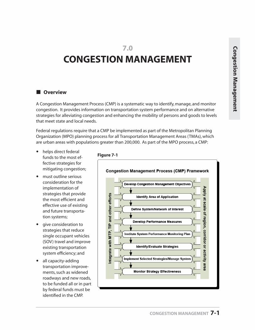
Overview
A Congestion Management Process (CMP) is a systematic way to identify, manage, and monitor congestion. It provides information on transportation system performance and on alternative strategies for alleviating congestion and enhancing the mobility of persons and goods to levels that meet state and local needs.
Federal regulations require that a CMP be implemented as part of the Metropolitan Planning Organization (MPO) planning process for all Transportation Management Areas (TMAs), which are urban areas with populations greater than 200,000. As part of the MPO process, a CMP:
helps direct federal funds to the most ef-fective strategies for mitigating congestion;
must outline serious consideration for the implementation of strategies that provide the most effi cient and effective use of existing and future transporta-tion systems;
give consideration to strategies that reduce single occupant vehicles (SOV) travel and improve existing transportation system effi ciency; and
all capacity-adding transportation improve-ments, such as widened roadways and new roads, to be funded all or in part by federal funds must be identifi ed in the CMP.
7.0
CONGESTION MANAGEMENT
Co
ng
estion
Man
agem
ent
CONGESTION MANAGEMENT 7-1
Figure 7-1
7. CONGESTION MANAGEMENT Mecklenburg-Union MPO
Page 7-2 CONGESTION MANAGEMENT
The recommendations from the CMP must then be incorporated in the regional planning pro-cess, including the Transportation Improvement Program (TIP) and the Long Range Transporta-tion Plan (identifi ed in Figure 7-1 as MTP).
Program elements of the MUMPO CMP comply with federally required elements for a CMP:
defi nition of congestion, parameters for measuring the extent of congestion, the area of application, and a targeted CMP network;development and use of performance measures;establishment of a program for data collection and performance monitoring;identifi cation and evaluation of the anticipated performance and expected benefi ts of appropriate traditional and non-traditional congestion management strategies; andidentifi cation of implementation responsibilities.
Five objectives governed the development of this Congestion Management Process and should be considered in future updates:
1. The CMP is to satisfy the federal requirements identifi ed above.
2. The CMP is to be considered at the local, MPO and State levels when identifying, ranking, and recommending capacity expansion of either highway and/or transit systems.
3. The CMP should be fl exible to meet the changing needs of the region.
4. The CMP should not be overly complex or cumbersome.
5. The CMP is incorporated in the MPO’s existing LRTP project ranking system as a func-tion of the Congestion Reduction component of the projects ranking/selection list.
The Congestion Management Program (CMP) is a component of the Metropolitan-Union Met-ropolitan Planning Organization (MPO) Long Range Transportation Plan (LRTP) as required by federal regulations.
LRTP Goals
The CMP is intended to be a component of the Long Range Transportation Plan and as such is focused on the goals set forth in the LRTP, summarized below.
Provide a safe and effi cient transportation system.
Improve the quality of life for residents of the Mecklenburg-Union MPO area.
Provide a transportation system that serves the public with mobility choices, including walk-ing, bicycling and transit options.
Provide a transportation system that is sensitive to signifi cant features of the natural and human environment.
Provide equitable transportation options for low income and minority neighborhoods.
Provide meaningful opportunities for public involvement in the transportation planning process.
7. CONGESTION MANAGEMENT2035 Long-Range Transportation Plan
CONGESTION MANAGEMENT 7-3
Defi n
ition
of C
on
gestio
n
Congestion Management Objectives
Consistent with these goals, the objective of the CMP is to develop cost-effective recommenda-tions to address congestion through prescribed mitigation strategies and to ensure that capac-ity-adding projects are warranted and prioritized through the planning process.
Improve the effi ciency of the transportation network for all modes. Utilize alternative modes to mitigate congestion where appropriate. Balance the movement of goods and people. Preserve and enhance the existing natural and built environments.
MUMPO will be revising and refi ning the goals and objectives in the 2012 update of the CMP and developing multi modal performance measures that relate directly to the new goals and objectives. During the development of the plan, the CMP will be incorporated into the plan’s public involvement process.
Defi nition of Congestion
Congestion may be defi ned differently based on relative factors such as geography, population and employment density, recurrence, and travel time delays, to name a few. According to federal guidelines, congestion is defi ned as
“the level at which transportation system performance is no longer acceptable due to traffi c interference. The level of system performance deemed acceptable by State and local offi cials may vary by type of transportation facility, geographic location (metropoli-tan area or sub-area, rural area) and/or time of day.”
Similarly, the Transportation Research Board has defi ned congestion as:
“travel time or delay in excess of that normally incurred under light or free-fl ow travel conditions.”
Identifi cation of Congestion Problems and Causes
The following are examples of particular congestion problems and causes:
Intersection DelayIntermittent disruption to traffi c fl ow can be caused by unsynchronized traffi c signals, railroad grade crossings, and sign controlled intersections. Drivers experience stops, stop-delays, and longer travel times contributing to congestion, increased fuel consumption, and air pollution. Intersections that experience heavy right and/or left turn traffi c movements without dedicated turn lanes contribute to congestion during peak hours.
Bottlenecks or Choke PointsCongestion is often caused by a reduction in the physical capacity of the roadway; for example, the number and width of lanes and shoulders, merge areas at interchange ramps, and roadway alignment (grades and curves).
IncidentsCrashes, breakdowns, debris in travel lanes, and spills can cause congestion during both peak and non-peak travel times.
7. CONGESTION MANAGEMENT Mecklenburg-Union MPO
Page 7-4 CONGESTION MANAGEMENT
Construction Work Zones Construction zones on or near the roadway result in reductions in posted speed limits, the number or width of travel lanes, lane “shifts,” lane diversions, reduction, or elimination of shoulders, and even temporary roadway closures.
Inclement WeatherWeather conditions such as rain, snow, ice, fog, or other environmental factors can affect driver behavior such that traffi c fl ow becomes congested.
Single Occupant Vehicle (SOV) TravelSOV is the predominant mode of travel within the MUMPO area, and is a major cause of con-gestion and deteriorating air quality.
Regional Defi nition of Congestion
For the purpose of establishing a framework and methodology that defi nes congestion in the MUMPO area, this Congestion Management Program identifi es congestion as:
“an increase of 50 percent or greater in travel time between congested travel conditions and free-fl ow travel conditions along roadway links for the transportation network.”
Using the regional travel demand model, all of the links (roadway segments) that met this defi ni-tion were identifi ed and further grouped into “corridors of critical concern” which generally cor-respond with the major travel sheds in the region. These corridors are comprised of one or more (parallel) roadways and have a high density of segments that meet the travel time thresholds for the defi nition of congestion.
In future CMPs the threshold may be adjusted based on any number of dynamic variables including, but not limited to demographic changes, mass transit/rapid transit system improve-ments, land use restrictions, new congestion problems on recently widened roadways, local policy changes (ordinances, codes, regulations, etc.), and changes to local area planning docu-ments and priorities. Similarly, the threshold could be adjusted based on increased tolerance for travel delay common in growing urban areas.
While there are two primary types of congestion — recurring and non-recurring — the MUMPO CMP focuses on recurring congestion by evaluating travel time changes between peak and non-peak traffi c conditions.
“Recurring” congestion tends to be concentrated into short time periods, such as typical morn-ing and evening “rush hours.” This type of congestion is evidenced by excessive traffi c volumes resulting in reduced speed and fl ow rates within the network. Bottlenecks, seasonal traffi c, and long-term construction also cause recurring congestion.
“Non-recurring” congestion is generally less predictable in that it is caused by unforeseen inci-dents that affect driver behavior such as crashes, disabled vehicles, spills, adverse weather condi-tions, special events, etc. It is recommended that future CMP’s include real time data collection of travel times on the corridors of critical concern and other roadways in the system. These travel time runs will shed light on non-recurring congestion problems and will be incorporated in the CMP accordingly.
7. CONGESTION MANAGEMENT2035 Long-Range Transportation Plan
CONGESTION MANAGEMENT 7-5
Defi n
e Co
ng
ested Lo
cation
s
Defi ne Congested Locations
CMP Network
The planning area for the MUMPO Congestion Management Program (CMP) encompasses all of Mecklenburg and Union Counties which extends beyond the typical planning area for the MPO. This area corresponds to the geography of the region’s travel demand model, the primary data source. The network consists of roads that are classifi ed as minor thoroughfare or larger.
Identifi cation of Congested Corridors
From the MUMPO CMP network, each link (or road) was analyzed to develop a universe of corri-dors of critical concern and “hot spots” where traffi c congestion occurs during peak travel times. Congestion was determined by analyzing the travel demand model output data from TransCad to calculate the percent increase in travel time between peak and off-peak periods (congested speeds vs. free fl ow speeds) for each network link (road segment). This was calculated using the following formula:
Congested Travel Time – Free Flow Travel time
Free Flow Travel Time
In order to capture the most accurate representation of highly congested links in the network and across the various rural and urban regions within the planning area, two different meth-odologies were applied to the model output data. The model results were then displayed as a shapefi le in a geographic information system (GIS). Individual road segments were combined to generate an electronic version of the previously identifi ed corridors. Model results for each link in a corridor (i.e., free fl ow and congested travel time, traffi c volumes) were used to generate descriptive corridors.
To account for network congestion differences between urban and rural conditions, several scenarios were run based on a 50 percent or greater increase in travel time and the top 10 percent of roads in the area with the highest percent change in travel time. The initial run identi-fi ed corridors on the TransCad maps by connecting multiple road segments with greater than 50 percent increase in travel time. The second, preferred methodology yielded nearly identical results in the North, Southeast, and Southwest Mecklenburg regions as the initial methodology, but also broadened the group of locations represented in Union County. Similar to the initial methodology, corridors were developed by connecting multiple road segments on the Trans-Cad maps. The difference is that congested corridors are defi ned as those ranking in the top 10 percent of all network links with the greatest percent increase in travel time and stratifi ed across each of the four geographic regions.
From the entire network of links, those identifi ed as congested for the purpose of this CMP were selected based on the top 10 percent with the greatest increase of travel time for each of four specifi c geographic regions within the MUMPO planning area. In order to account for the varying physical, demographic, geographic, and development densities, the planning area was divided into the following four regions: Union County, North Mecklenburg County, Southwest Mecklenburg County, and Southeast Mecklenburg County, as shown in Figure 7-2, below.
= % Change in travel time
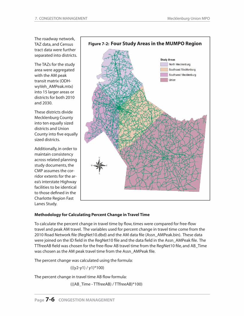
7. CONGESTION MANAGEMENT Mecklenburg-Union MPO
Page 7-6 CONGESTION MANAGEMENT
The roadway network, TAZ data, and Census tract data were further separated into districts.
The TAZs for the study area were aggregated with the AM peak transit matrix (ODH-wyVeh_AMPeak.mtx) into 15 larger areas or districts for both 2010 and 2030.
These districts divide Mecklenburg County into ten equally sized districts and Union County into fi ve equally sized districts.
Additionally, in order to maintain consistency across related planning study documents, the CMP assumes the cor-ridor extents for the ar-ea’s interstate Highway facilities to be identical to those defi ned in the Charlotte Region Fast Lanes Study.
Methodology for Calculating Percent Change in Travel Time
To calculate the percent change in travel time by fl ow, times were compared for free-fl ow travel and peak AM travel. The variables used for percent change in travel time come from the 2010 Road Network fi le (RegNet10.dbd) and the AM data fi le (Assn_AMPeak.bin). These data were joined on the ID fi eld in the RegNet10 fi le and the data fi eld in the Assn_AMPeak fi le. The TTfreeAB fi eld was chosen for the free-fl ow AB travel time from the RegNet10 fi le, and AB_Time was chosen as the AM peak travel time from the Assn_AMPeak fi le.
The percent change was calculated using the formula:
(((y2-y1) / y1)*100)
The percent change in travel time AB fl ow formula:
(((AB_Time - TTfreeAB) / TTfreeAB)*100)
Figure 7-2: Four Study Areas in the MUMPO Region
7. CONGESTION MANAGEMENT2035 Long-Range Transportation Plan
CONGESTION MANAGEMENT 7-7
The fi elds used to calculate the BA percent change in travel time were TTfreeBA and BA_Time. The percent change in travel time BA fl ow formula:
(((BA_Time - TTfreeBA) / TTfreeBA)*100)
Values for these areas were then plotted to the map using the two different travel time change thresholds described above. The same process was used for the 2030 road network. The only difference in the process occurred during the join, where the road network (RegNet30.dbd) was joined by the ID fi eld in AM data (Assn_AMPeak.bin) ID fi eld. To reiterate, upon application and analysis of both travel time change methodologies, the preferred choice was the one yielding the top 10 percent of roads in the area with the greatest percent change in travel time.
Congested Corridors
As part of the Congestion Management Process, the consultant team developed a list of con-gested corridors by analyzing travel time data for the roadway network using regional model data. The regional model data included links, volumes, travel times and mode links for each of the eight counties in the Charlotte region.
After reviewing the data, percent change in travel time was calculated to determine the level of congestion along each link. Links with signifi cant travel change were labeled as congested corridors or Corridors of Critical Concern as shown in Figure 7-3 (next page). A listing of these cor-ridors can be found in Appendix C-1 at the end of this document.
The congested corridors are grouped into following areas: inbound corridors, cross town cor-ridors, and interstate corridors.
Inbound corridors are links that are traveling from outbound areas into downtown Charlotte. Crosstown corridors are links traveling in an east/west direction across the region. Interstate corridors are links with congestion along major interstates.
Hot Spots
Additionally, a listing of “Hot Spots” was developed using the same methodology as the con-gested corridors. However, the Hot Spots are congested areas or “spots” whose length in miles were not long enough to be considered an actual link. These areas or hot spots are possibly traf-fi c congestion at a major intersection. The regional model identifi ed over 100 hot spots across the region. For purposes of this report, the list was narrowed to the top 50 most congested hot spots. A list of the “Hot Spots” can be found in Appendix C-2 at the end of this document.
Strategies Identifi ed to Reduce Congestion
Many of the conventional strategies for managing congestion along corridors in the transporta-tion network are currently in place in the MUMPO region. As this initial study addresses only the most fundamental of congestion management needs on the MUMPO network, not all of the strategies are relevant in all geographic jurisdictions at this time. Assuming the CMP develops as a more integral process for the LRTP and subsequent project planning, several of these strate-gies can grow into a more aggressive program.
Defi n
e Co
ng
ested Lo
cation
s
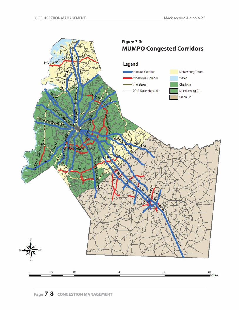
7. CONGESTION MANAGEMENT Mecklenburg-Union MPO
Page 7-8 CONGESTION MANAGEMENT
Figure 7-3:
MUMPO Congested Corridors
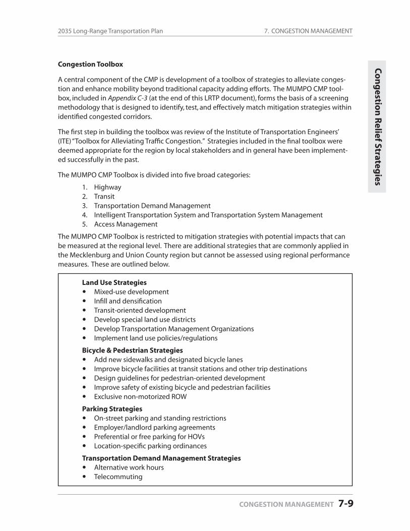
7. CONGESTION MANAGEMENT2035 Long-Range Transportation Plan
CONGESTION MANAGEMENT 7-9
Congestion Toolbox
A central component of the CMP is development of a toolbox of strategies to alleviate conges-tion and enhance mobility beyond traditional capacity adding efforts. The MUMPO CMP tool-box, included in Appendix C-3 (at the end of this LRTP document), forms the basis of a screening methodology that is designed to identify, test, and effectively match mitigation strategies within identifi ed congested corridors.
The fi rst step in building the toolbox was review of the Institute of Transportation Engineers’ (ITE) “Toolbox for Alleviating Traffi c Congestion.” Strategies included in the fi nal toolbox were deemed appropriate for the region by local stakeholders and in general have been implement-ed successfully in the past.
The MUMPO CMP Toolbox is divided into fi ve broad categories:
1. Highway2. Transit3. Transportation Demand Management4. Intelligent Transportation System and Transportation System Management5. Access Management
The MUMPO CMP Toolbox is restricted to mitigation strategies with potential impacts that can be measured at the regional level. There are additional strategies that are commonly applied in the Mecklenburg and Union County region but cannot be assessed using regional performance measures. These are outlined below.
Land Use StrategiesMixed-use developmentInfi ll and densifi cationTransit-oriented developmentDevelop special land use districtsDevelop Transportation Management OrganizationsImplement land use policies/regulations
Bicycle & Pedestrian StrategiesAdd new sidewalks and designated bicycle lanesImprove bicycle facilities at transit stations and other trip destinationsDesign guidelines for pedestrian-oriented developmentImprove safety of existing bicycle and pedestrian facilitiesExclusive non-motorized ROW
Parking StrategiesOn-street parking and standing restrictionsEmployer/landlord parking agreementsPreferential or free parking for HOVsLocation-specifi c parking ordinances
Transportation Demand Management StrategiesAlternative work hoursTelecommuting
Co
ng
estion
Relief Strateg
ies
7. CONGESTION MANAGEMENT Mecklenburg-Union MPO
Page 7-10 CONGESTION MANAGEMENT
Screening Process
A Screening Process summarized in the matrix included in Appendix C-1 (at the end of this LRTP document), was developed to identify appropriate strategies for mitigating congestion on the corridors of critical concern. There were two primary criteria dictating the types of appropriate strategies that are recommended for consideration prior to adding capacity.
First, the type of facility plays a major role in screening strategies and strategies that are not generally appropriate for the type of facility were removed from further consideration. For instance, ramp metering, typically a strategy reserved for freeways, was eliminated from consideration for arterial roadways.
The second criterion was based on inputs project committee members identifi ed as the primary causes of congestion within each corridor. This effort went beyond the issues with volume of traffi c and tried to be more specifi c about bottlenecks, parallel facilities, alterna-tive modes and other issues contributing to the congestion of the identifi ed roadways. From this information, the types of strategies still under consideration were reviewed for appropriateness to address congestion by attacking the cause.
During the course of developing the Congestion Management Program (CMP), the method for identifying congested corridors — which entailed the use of travel demand model results — led to the discovery that the methodology did not lend itself well to objectively analyzing the effect of the prescribed strategies over time. The travel demand model is neither a cost effective nor a precise enough tool to be used to test many of the prescribed strategies at the roadway corridor level. In addition, these strategies may have other impacts such as reducing the length of time for congested conditions that cannot be detected by a model.
The data collection efforts for future CMPs will include real time travel time runs and will be use-ful in monitoring the impact of prescribed congestion mitigation strategies. Therefore, the eval-uation of strategies for this CMP is based on the more subjective analysis as described above.
Incorporation of Projects in the 2035 Long-Range Transportation Plan
LRTP Project Prioritization Process
According to this 2035 Long-Range Transportation Plan, road projects are ranked according to the following criteria:
Reduces congestionProvides benefi ts that outweigh project costs Improves safety and securitySupports rapid and express bus transitSupports land use planning objectives and improves quality of lifeImproves accessibility to center city (Charlotte or Monroe)Increases accessibility to other economic centers in MUMPO and directly adjacent countiesReduces negative impacts on air qualitySupports low income and minority communities
7. CONGESTION MANAGEMENT2035 Long-Range Transportation Plan
CONGESTION MANAGEMENT 7-11
Roadway projects receive a ranking value for each of these criteria. The ranking values range from (+5), which means very high positive impact, to a (-5) which is very high negative impact. A (0) is given to projects that have no impact on improving congestion. After the project is assigned a ranking value for each criterion, the values are added up to equal a “total” score. Projects are then ranked or sorted numerically based on their total score. The projects with the highest total score are considered a higher priority and are added to the top of the Project Rank-ing/Selection List. Projects with the lowest scores are listed at the bottom of the selection list.
One of the key elements of the LRTP project prioritization process is to reduce congestion. Projects that signifi cantly reduce daily vehicle miles per lane will receive a (5) ranking value in the prioritization process. Project sponsors are encouraged to submit projects, such as widen-ing lanes or adding medians, which will help to eliminate and/or reduce congestion along major roadways in Charlotte.
The 2012 Update to the MUMPO Congestion Management Program
As the MUMPO CMP evolves over time, data collection methods will be improved and aug-mented in a multi-phased approach to refi ning the process. There are several critical compo-nents required by federal agencies that must be improved before the MUMPO CMP will be fully compliant. This section outlines the improvements to the CMP that will be incorporated in the 2012 MUMPO CMP prior to the subsequent update to MUMPO Long Range Transportation Plan. The updated CMP will be complete by December 2012.
Integration of CMP into the LRTP Project Prioritization Process
One bonus point will be assigned as a part of the LRTP ranking process under the “Reduces Con-gestion” criterion for those projects that are recommended by the CMP.
Develop Data Collection Program
MUMPO will continue to refi ne and evaluate congestion criteria and how the results of applied performance measures convey congestion problems throughout the planning area. Whereas this initial process centers on travel time delay, other factors will be considered as they relate to the defi nition of congestion within the region, the overall objectives developed for the CMP, prioritizing corridors of critical concern, evaluating mitigation strategies and monitoring the impact of the CMP on the transportation system.
To further analyze the congested corridors, the MPO will need to expand its data collection efforts to bridge the gap between traffi c model output data and travel behavior assumptions applied for development of the congestion performance measures. MUMPO—in conjunction with the City of Charlotte, CATS, NCDOT, and other local jurisdictions—should establish a means for real-time data collection that includes the following:
Travel Time Studies should be the primary means for data collection for the CMP because the change in travel time will remain the primary factor in determining congestion. There have been some travel time collection efforts by CDOT and other planning partners, but the
Co
ng
estion
Man
agem
ent

7. CONGESTION MANAGEMENT Mecklenburg-Union MPO
Page 7-12 CONGESTION MANAGEMENT
program should be formalized as soon as possible and funded through the MPO. The use of travel time studies will offer a number of advantages over the use of the travel demand model, including the ability to measure non-recurring congestion, test the length of time corridors are congested and the ability to monitor – in real time — the impact of applied mitigation strategies. Some MPOs utilize planning, engineering or statistical programs at lo-cal universities to help conduct CMP data collection. T here is a possibility that a department at UNC-Charlotte may be interested in undertaking part or all of the data collection activities and may be a cost effective solution to facilitating the establishment of the regional CMP. Privately collected data will also be investigated and considered as an option if determined to be more cost effective than real time travel time runs.
Traffi c Counts are generally conducted by NCDOT on state-owned roadways, and CDOT collects counts on heavier traveled city-owned streets. The data generated by these efforts will be incorporated in the CMP to support the prioritization of congested corridors and to evaluate/monitor prescribed mitigation strategies. MUMPO will be subsidizing this program to perform counts that supplement NCDOT counts in the areas of the region not covered by CDOT.
Transit Ridership and route productivity will continue to be monitored as part of the MUMPO CMP to assess the impact of transit strategies. As more fi xed guideway comes on-line, the capacity on transit will reach a point where it will positively impact congested con-ditions of parallel roadways at a more measurable level (i.e. length of congested conditions, increased mode split during peak periods). Additionally, the region may want to consider a higher threshold for congestion or reduce the priority for capacity adding projects on cor-ridors that have a viable transit alternative providing reasonably competitive travel times.
Percent Truck Traffi c is a critical performance measure for the prioritization of congested corridors given that the movement of goods is vital to the regional economy. The last truck count program was completed in 2000 in order to supply the regional travel demand model and will be completed on a more regular basis to support the CMP. MUMPO will incorporate truck counts in its count program in conjunction with CDOT, NCDOT and the suburban com-munities to identify those corridors serving a higher percentage of goods movement.
Intersection Level of Service, similar to traffi c counts, is not analyzed by the suburban mu-nicipalities at the same level as CDOT. MUMPO will support the suburban communities to conduct intersection LOS analyses in critical corridors to assist in monitoring the impact of mitigation strategies that relate to intersection improvements. This will only be implement-ed if the suburban communities are able to institute intersection LOS analysis programs at or near the level conducted by Charlotte DOT.
Refi ne the Defi nition of Congestion
The advent of improved data collection will afford the region the opportunity to refi ne the defi -nition of congestion to accomplish a number of objectives.
1. As the region grows, the tolerance for congestion will naturally increase in highly traveled corridors which is a primary reason to base the region’s defi nition of congestion on travel time.

7. CONGESTION MANAGEMENT2035 Long-Range Transportation Plan
CONGESTION MANAGEMENT 7-13
2. Further stratifi cation (multiple thresholds) of the defi nition of congestion based on geo-graphic location of the congested corridor; corridor characteristics (such as the presence of transit); or other factors will be evaluated and incorporated in the CMP.
3. Applying the thresholds for congestion will inherently “level the playing fi eld” between urban and suburban corridors.
Develop CMP Monitoring and Reporting
Improvements to the network can be achieved by obtaining and monitoring transportation data, developing projections, and implementing strategies for the existing and future proposed systems.
The CMP currently uses available sources of highway, transit and other data without demand-ing the development of new data needs specifi cally for this program. This is the weakest part of the CMP to date and future iterations of the process must include an objective and quantitative method for monitoring the impact of the CMP and its recommended strategies.
While additional data needs are necessary, they should be coordinated among the planning partners. In many instances, data collection improvements and intelligent transportation system technologies already in place or programmed for future implementation can benefi t both their primary purpose as well as the CMP process.
Future CMP applications will include an ongoing program of data collection to identify and monitor system defi ciencies, as well as to measure and analyze the effectiveness of alterna-tive solutions for congestion management. This program can serve to augment the project selection process by the MPO for projects ranked in the LRTP. Projects with high congestion measures will gain “bonus points” as part of the project selection and ranking process based on their emergence in the CMP. The implementation of this component of the CMP will improve its capacity as a tool in the planning process and will move it closer to full federal compliance.
Prioritization of Congested Corridors
One of the main purposes of the CMP is to supply information for the long range plan about the priorities for congestion mitigation investment dollars. Data collection limitations for the initial CMP made it impossible to develop a methodology for prioritizing projects coming out of the process and into LRTP beyond a simple “in or out” designation. The TCC will negotiate a univer-sally accepted methodology for prioritizing projects coming out of the CMP based on potential impact on congestion and the priority level of the targeted corridor.
The fi rst criterion used in the LRTP project prioritization process established the framework for implementing prioritization within the CMP. In fact, it may be advisable to essentially “house” the fi rst criterion from the LRTP process within the CMP and use that to establish the link between the CMP and the plan that is required by federal CMP guidelines. The CMP will identify those im-provements that are highly recommended, recommended and not recommended and establish a ranking of improvements. A score corresponding to the ranking will serve as the starting point for the LRTP prioritization process.
Co
ng
estion
Man
agem
ent

7. CONGESTION MANAGEMENT Mecklenburg-Union MPO
Page 7-14 CONGESTION MANAGEMENT
The TCC and planning partners should recognize that this is not an attempt to override the LRTP process because the CMP will be incorporated in the rest of the LRTP evaluation at a same weight (+5 for highly recommended, 0 for recommended and -5 for not recommended). The primary difference centers on an alternative methodology for prioritization within the CMP that is travel time based rather than focused on volumes (current LRTP process) and a new method for ranking the corridors of critical concern and identifying the areas of congestion that should be addressed fi rst.
See Appendix C of this document for the following materials:
Congested Corridors . . . . . . . . . . . . . . . . . . . . . . . . . . . Appendix C-1 Hot Spots . . . . . . . . . . . . . . . . . . . . . . . . . . . . . . . . . . . . . Appendix C-2 Mitigation Toolbox . . . . . . . . . . . . . . . . . . . . . . . . . . . . Appendix C-3
MUMPO has many of the same environmental concerns as other similarly-sized metropolitan areas. Air quality and water quality issues are high priorities in the Mecklenburg-Union planning area and in our neighboring transportation planning jurisdictions.
The transportation systems and land use decisions that affect these issues are considered in the zoning and land development practices of the individual jurisdictions and in MUMPO’s transpor-tation planning process.
The following addresses these issues, as well as the consultation and mitigation requirements of the metropolitan planning regulations.
8.1 Air Quality
Ensuring that transportation sources contribute to attainment of clean air in the Mecklenburg-Union urban area and surrounding counties is one of the highest goals of MUMPO.
In 1995, the United States Environmental Protection Agency (EPA) designated Mecklenburg County a maintenance area for 1-hour ozone and carbon monoxide National Ambient Air Qual-ity Standards (NAAQS). A “maintenance area” is an area which was formerly deemed to be in non-attainment for a specifi c pollutant, but is now in attainment, (i.e. now in compliance with EPA air quality standards).
As improvements in emission controls have resulted in signifi cant reductions in carbon monox-ide (CO) emissions from motor vehicles, attaining the air quality standards for CO has become easier during the past twenty years. Since June 15, 2005, the 1-hour ozone standard has ceased to exist.
In April, 2004, all of the MUMPO area was part of a multi-county region designated by EPA as a non-attainment area for the 8-hour ozone NAAQS of (effectively) 84 parts per billion (ppb). Air quality has steadily improved over the past 25 years for all pollutants, including ozone. Figure 8.2 (top of the next page) shows the downward trend of 8-hour ozone from 1997 to 2009.
In March, 2008, EPA revised this 8-hour ozone NAAQS standard downward to 75 ppb. On Janu-ary 6, 2010, the US Environmental Protection Agency (EPA) announced they would propose an even lower national 8-hour ozone standard, between 60 and 70 ppb. The EPA will issue a fi nal decision by August 31, 2010.
8.0
ENVIRONMENT Envirio
nm
ent
ENVIRONMENT 8-1

8. ENVIRONMENT Mecklenburg-Union MPO
Page 8-2 ENVIRONMENT
The geographic boundaries of the non-attainment area for this new ozone NAAQS will not be established until March 12, 2011 – and for this reason the new ozone NAAQS does not impact the conformity requirements for the Metrolina non-attainment area for this 2035 LRTP. How-ever, ozone will continue to be a major challenge.
On a positive note, many new federal and state controls should continue to reduce emissions from autos and light duty trucks, in addition to emissions from heavy-duty diesel vehicles and point sources. Ozone emissions have generally trended downward since 1997. Technological improvements over the past decade have caused NOx (nitrogen oxides) emissions to also trend downward. These two national trends are shown in Figure 8.3, at the top of the next page.
However, these technological improvements designed to reduce the formation of ozone precur-sors are at risk of being overcome by rapid growth and an even faster increase in vehicle miles of travel (VMT).
Another area of potential attention is the 2.5-micron particulate matter standard. In April, 2005, EPA designated Mecklenburg-Union as an “attainment” area. The extra controls on diesel ve-hicles listed above and continued improvement at the coal-fi red power plants in the surround-ing counties have been important actions in addressing this emerging pollution concern and preserving Mecklenburg-Union’s attainment designation.
Figure 8.2: HIstorical Trend of 8-Hour Ozone in the Metrolina Region
Note: The 2009 value includes ozone measurements through September 30, and has not been fully validated by the NC Division of Air Quality.
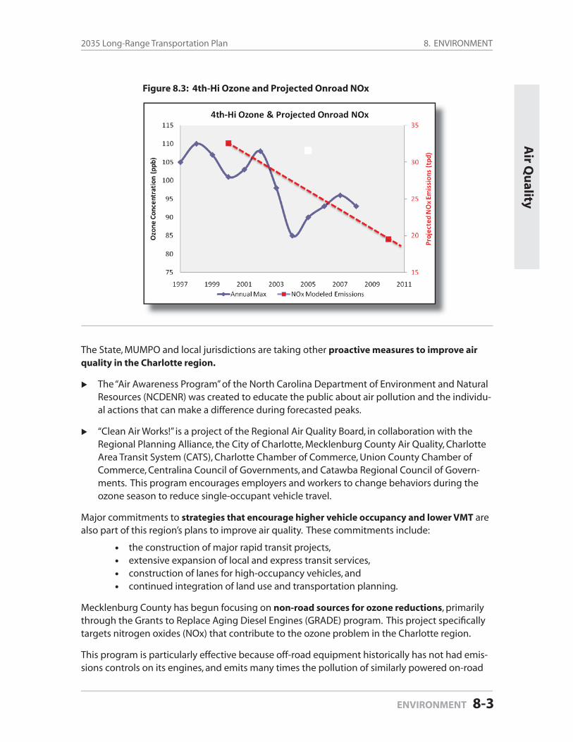
8. ENVIRONMENT2035 Long-Range Transportation Plan
ENVIRONMENT 8-3
The State, MUMPO and local jurisdictions are taking other proactive measures to improve air quality in the Charlotte region.
The “Air Awareness Program” of the North Carolina Department of Environment and Natural Resources (NCDENR) was created to educate the public about air pollution and the individu-al actions that can make a difference during forecasted peaks.
“Clean Air Works!” is a project of the Regional Air Quality Board, in collaboration with the Regional Planning Alliance, the City of Charlotte, Mecklenburg County Air Quality, Charlotte Area Transit System (CATS), Charlotte Chamber of Commerce, Union County Chamber of Commerce, Centralina Council of Governments, and Catawba Regional Council of Govern-ments. This program encourages employers and workers to change behaviors during the ozone season to reduce single-occupant vehicle travel.
Major commitments to strategies that encourage higher vehicle occupancy and lower VMT are also part of this region’s plans to improve air quality. These commitments include:
the construction of major rapid transit projects,extensive expansion of local and express transit services,construction of lanes for high-occupancy vehicles, andcontinued integration of land use and transportation planning.
Mecklenburg County has begun focusing on non-road sources for ozone reductions, primarily through the Grants to Replace Aging Diesel Engines (GRADE) program. This project specifi cally targets nitrogen oxides (NOx) that contribute to the ozone problem in the Charlotte region.
This program is particularly effective because off-road equipment historically has not had emis-sions controls on its engines, and emits many times the pollution of similarly powered on-road
Air Q
uality
Figure 8.3: 4th-Hi Ozone and Projected Onroad NOx
8. ENVIRONMENT Mecklenburg-Union MPO
Page 8-4 ENVIRONMENT
equipment. Any company that operates off-road construction equipment in the North Carolina portion of the Charlotte Non-Attainment Region is eligible to apply for funding to clean up that equipment. Funding is provided by the U.S. Environmental Protection Agency, North Carolina Division of Air Quality and the Mecklenburg County Board of County Commissioners.
MUMPO considers air quality benefi ts as a part of its current project ranking process in the development of the LRTP. The objective of the criterion in the ranking process is to improve air quality by reducing vehicle miles traveled (VMT) by increasing vehicle occupancy, encouraging non-motorized travel, or creating new roadway connections. More specifi cally, candidate proj-ects are awarded additional points to their scores for the following types of projects:
managed (HOT/HOV) lanes,signifi cantly reducing VMT by improving connectivity,accommodating bicyclists and/or pedestrians in roadway projects.
Projects that are determined to greatly induce sprawl can receive negative points in the project ranking analysis.
8.2 Water Quality
The transportation system affects water quality through atmospheric emissions and runoff from development.
MUMPO’s roadway project ranking process includes an environmental factor that seeks to assess the environmental impact of each project nominated for inclusion in the LRTP. An environmental features map was used extensively in the project ranking process, and includes features such as fl oodplains, watersheds and resources ranked by the North Caro-lina Division of Water Quality. Local knowledge of the community was used to supplement information that may not have been incorporated into the environmental features map.
Mecklenburg County has taken a proactive role in establishing buffers around creeks, streams, and rivers. Particular attention has been paid to protecting the drinking water sup-ply by addressing development issues in sensitive watershed areas.
Union County, in “Vision 2020,” has also committed to build infrastructure that promotes commercial, industrial, and agricultural growth and supports residential development while producing a sustainable living environment.
As a result of the Environmental Protection Agency’s (EPA) Phase II National Pollutant Dis-charge Elimination System (NPDES) Program—and the Goose Creek Watershed Site Specifi c Water Quality Management Plan—Indian Trail, Lake Park, Monroe, and Stallings implement stormwater management programs that establish buffer requirements along jurisdictional creeks and streams for new development.
The North Carolina Division of Water Quality (NCDWQ) administers the Post-Construction Stormwater Management regulations and the Goose Creek Watershed Site Specifi c Water Quality Management Plan for new development in the remainder of Union County. The
8. ENVIRONMENT2035 Long-Range Transportation Plan
ENVIRONMENT 8-5
Water Q
uality
Phase II and Post-Construction regulations regarding buffers, at a minimum, require built-upon areas to be located at least 30 feet landward of all perennial and intermittent surface waters. New developments located within the Duck, Goose, Six Mile, and Waxhaw Creek Watersheds require an undisturbed riparian buffer within 200 feet of waterbodies within the 100-year fl oodplain and within 100 feet of jurisdictional waterbodies not within the 100-year fl oodplain. Certain activities in the buffer areas are exempt or potentially allowable with NCDWQ approval.
Local and county governments are working with the Centralina Council of Governments and the North Carolina Ecosystem Enhancement Program to develop a watershed protec-tion plan for the Goose Creek and Crooked Creek watersheds. The Goose Creek watershed supports populations of a federally endangered freshwater mussel, the Carolina heelsplit-ter. MUMPO staff has been involved with the process due to the effects the transportation system can have on watersheds and water quality.
The efforts to lower air pollution from the transportation system will have positive impacts on water quality. The integration of land use and transportation will benefi t water quality by ensuring that proposed transportation facilities are balanced to the appropriate level of devel-opment in sensitive watershed areas.
8.3 Consultation
Section 23CFR450.322g of the metropolitan planning regulations states:
“The MPO shall consult, as appropriate, with State and local agencies responsible for land use management, natural resources, environmental protection, conservation, and historic preservation concerning the development of the transportation plan. The consultation shall involve, as appropriate: (1) comparison of transportation plans with State conservation plans or maps, if available; or (2) comparison of transportation plans to inventories of natural or historic resources, if available.”
At the start of the development of this 2035 Long Range Transportation Plan, MUMPO developed a document entitled “Consultation Process Procedures” to ensure that the appropriate agen-cies were provided the opportunity to take an active role in the LRTP’s preparation.
The fi rst step in the “Consultation Process Procedures” was to assemble a database of all federal, state and local agencies with responsibilities in the areas mentioned in the planning regulations. Once the database was established, the identifi ed contacts within the agencies were contacted and requested to provide MUMPO with their latest “maps, inventories, plans and strategies.” The contact persons were also invited to request one-on-one meetings with MUMPO staff if that were the preferred method of contact. Information received through this process was compiled in a single map.
All agencies in MUMPO’s database were invited to attend the LRTP development kick-off meet-ings held in February 2008. Three agencies—US Fish & Wildlife Service, NC Natural Resources Commission and the NC Division of Water Quality—sent representatives to one of the two meet-ings.
8. ENVIRONMENT Mecklenburg-Union MPO
Page 8-6 ENVIRONMENT
Following the February kick-off meetings, the “Consultation Process Procedures” focused on engaging the agencies through participation in MUMPO’s roadway project ranking process. All agencies were invited to participate in the Technical Coordinating Committee’s work to rank over 300 roadway projects that had been nominated for inclusion in the LRTP. Representatives of the US Environmental Protection Agency, US Fish & Wildlife Service and the NC Natural Re-sources Commission requested a meeting with MUMPO staff to discuss the ranking process and to discuss their concerns.
Furthermore, MUMPO created a “Resource Agency Consultation” section on its website and posted all appropriate information to allow agencies unable to take part in the ranking process, or who lacked adequate staff to become actively involved with the LRTP’s development, to acccess the information.
Upon completion of the project ranking process, the “Consultation Process Procedures” gave signifi cant emphasis to ensuring that the agencies were kept up-to-date on MUMPO’s work to prepare its fi scally-constrained project lists. Contact was made with the agencies at each mile-stone in that process and a request was made to provide comments on the projects.
See Appendix D for full documentation of MUMPO’s Consultation efforts and to read the com-ments that were received.
8.4 Mitigation
Section 23 CFR 450.322f7 of the metropolitan planning regulations states that Long Range Trans-portation Plans must include:
“a discussion of types of potential environmental mitigation activities and potential areas to carry out these activities, including activities that may have the greatest po-tential to restore and maintain the environmental functions affected by the metropoli-tan transportation plan. The discussion may focus on policies, programs, or strategies, rather than at the project level. The discussion shall be developed in consultation with Federal, State, and Tribal land management, wildlife, and regulatory agencies. The MPO may establish reasonable timeframes for performing this consultation.”
MUMPO’s regional perspective — combined with the 20-year planning horizons required of Long Range Transportation Plans — does not permit project-level discussion of environmental mitigation. Instead, the information presented discusses existing activities that seek to mitigate environmental impacts, potential mitigation activities, and the mitigation-related challenges faced by MUMPO.
Exiting Mitigation Activities
MUMPO has in place a series of activities that will assist in future project development through the early identifi cation of potential environmental constraints. Continued employment of these activities can result in actions such as scope changes that will result in the avoidance of re-sources at the planning level, thereby limiting the need for, and the expense of, design changes and/or environmental mitigation efforts.
8. ENVIRONMENT2035 Long-Range Transportation Plan
ENVIRONMENT 8-7
At the beginning of the LRTP development process, staff requested environmental “maps, inventories, plans and strategies” from its Consultation partners as a part of the overall Con-sultation process. The information received, along with data previously acquired, resulted in the preparation of an environmental features map (Figure 8.1 in the Map Gallery at the end of this document) that identifi ed a wide-range of environmental constraints that could potentially affect future project development. As in the past, this map will not be a static document, but will be updated as new information is made available.
The development of MUMPO’s fi scally-constrained road project list began with the nomi-nation of over 300 projects for possible inclusion in the LRTP. Each project is subjected to MUMPO’s rigorous project ranking process that includes an environmental factor that has as its objective the assessment of the anticipated effect a nominated project may have on a documented environmentally sensitive area. (The defi nition of “documented environ-mentally sensitive area” is broad; for example, it would include a wetland area not offi cially-mapped, but known to exist by local offi cials or residents.)
The environmental features map was used extensively throughout the ranking process to determine if projects would have a negative environmental impact. In recognition of the fact that all the data collected by MUMPO and shown on the map may not have captured every possible environmental constraint, the detailed knowledge of local planners and engineers was used to supplement the map’s information to ensure that a proper assess-ment of each project was made. Inclusion of the environmental factor in the project ranking process allows for early fl agging of various potential environmental impacts.
MUMPO regularly conducts analyses of projects on its Thoroughfare Plan to determine if the proposed alignments are viable. These analyses include an environmental screening component to identify potential constraints that may have to be addressed at the project development stage. In some cases, the result has been a modifi cation to the Thoroughfare Plan when the screening has determined that the constraints are signifi cant enough to warrant such action. In addition, MUMPO’s local governments conduct similar analyses that include an environmental screening, and such activities have also resulted in Thoroughfare Plan modifi cations.
Various agencies within MUMPO’s planning area also play a signifi cant role in mitigation-related activities:
Mecklenburg County and its municipalities have taken a proactive role in establishing buffers around creeks, streams, and rivers. Particular attention has been paid to protecting the drinking water supply by addressing development issues in critical watershed areas.
The Catawba Lands Conservancy and the Davidson Land Conservancy have augmented the government efforts mentioned above by working to conserve environmentally sensitive land and preserving open space.
In Union County, Indian Trail, Lake Park, Monroe, and Stallings implement stormwater management programs that establish buffer requirements along jurisdictional creeks and streams for new development. The North Carolina Division of Water Quality (NCDWQ)
Co
ng
estion
and
Mitig
ation
8. ENVIRONMENT Mecklenburg-Union MPO
Page 8-8 ENVIRONMENT
administers the Post-Construction Stormwater Management regulations and the Goose Creek Watershed Site Specifi c Water Quality Management Plan for new development in the remainder of Union County.
In addition to activities of MUMPO and its local partners, the North Carolina Ecosystem Enhance-ment Program (EEP) implements off-site mitigation projects for NCDOT where on-site mitigation is not possible. NCDOT is responsible for implementing on-site mitigation projects.
Potential Mitigation Activities
Listed below are potential reasons why mitigation might be necessary on a project, along with possible activities that could be considered when a project faces environmental constraints.
ArchaeologicalConduct archaeological excavations to ensure artifacts are not lost.Realign and/or relocate the project to avoid the affected resource.
Community ImpactsConstruct a bridge to help maintain community cohesiveness.Construct sidewalks and bike lanes.Install traffi c calming devices.Construct sound barriers.
FarmlandWork with local land conservancies or the North Carolina Agricultural Development and Farmland Preservation Trust Fund to determine ways to preserve the resource.
Fragmented Animal HabitatsBuild overpasses with vegetation or underpasses to allow animals to cross project safely.Realign and/or relocate the project to avoid the affected habitat.
Historic SitesRealign and/or relocate the project to avoid the affected site.Install landscaping to reduce visual impacts.Relocation
NoiseErect noise barriers.Depress the facility.Install landscaping to reduce impacts.
Off Site MitigationWork with local land use agencies, park departments, land conservancies, etc., to identify potential sites where off site mitigation can occur if on site mitigation is not feasible.
Threatened and Endangered SpeciesRealign and/or relocate the project to avoid the affected species.Enhance or restore degraded habitat.Create new, off site habitats.
••
••••
•
••
•••
•••
•
•••
8. ENVIRONMENT2035 Long-Range Transportation Plan
ENVIRONMENT 8-9
Challenges to Mitigation
Rapid growth is a key challenge to mitigation activities. MUMPO is located in one of the fastest growing regions of the nation, resulting in a rapidly shrinking inventory of locations where ef-fective mitigation activities can be located.
Limited fi nancial resources are a further challenge. Effective mitigation efforts are always dif-fi cult to fund, but as overall resources become more and more limited, the willingness to imple-ment mitigation projects may become harder.
8.5 Future Issues
Climate change
Climate change is an increase in the near surface temperature of the earth most often as a result of increased Greenhouse Gases (GHS).
Climate change can be addressed in transportation planning with mitigation and adaption ef-forts. “Mitigation of climate change means reducing the major causes of climate change: GHG released by human activity. Adaptation to climate change means minimizing the potential im-pacts on the transportation system from climate changes such as rising temperatures, increased intensity of storms, rising sea levels and increases in overall climate variability.” (Federal High-way Administration, Highways and Climate Change)
Many federal, state and local transportation agencies are incorporating climate change issues in their various plans and processes. The Federal Highway Administration has identifi ed four primary strategies to reduce GHG emissions from transportation:
1. Improve system and operational effi ciencies – traffi c fl ow, fuel effi ciency, and main-tenance, etc.
2. Reduce growth in vehicle miles traveled (VMT) – land use strategies, HOV lanes, transit options, connectivity, pedestrian and bicycle facilities, etc.
3. Transition to lower GHG fuels – use of biodiesel and natural gas
4. Improve vehicle technologies – more fuel effi cient-vehicles; hybrids, Corporate Average Fuel Economy (CAFE) standards.
MUMPO and its partners have already employed a number of noteworthy activities which would reduce GHG emissions, several of which are described below:
1. Charlotte Region Fast (Managed) Lanes Study
The Fast (Managed) Lanes Study was a multi-county evaluation of the feasibility of implement-ing managed lanes, including high occupancy vehicle (HOV) and high occupancy toll (HOT) lanes, throughout the Charlotte region. The study was initiated in part because of the public’s acceptance of the HOV lanes along ten miles of I-77 between Charlotte and Huntersville. HOV and HOT lanes emphasize person movement rather than vehicle movement, thereby improving a roadway’s ability to transport more people in fewer vehicles.
Futu
re Enviro
nm
ent Issu
es
8. ENVIRONMENT Mecklenburg-Union MPO
Page 8-10 ENVIRONMENT
2. Charlotte Urban Street Design Guidelines
The Charlotte City Council adopted the Urban Street Design Guidelines (USDG) in 2007. The USDGs are built upon the “complete streets” philosophy, which emphasizes that the transporta-tion network should be multi-modal, thereby making alternative modes more viable and lessen-ing the community’s reduction on every trip requiring the use of a car.
3. Connectivity Policy
Many communities have established a connectivity policy that emphasizes a system of streets providing multiple routes and connections between origins and destinations. Connectivity is important because a highly connected street network can greatly reduce trip lengths, thereby reducing vehicle miles travel which in turn results in reduced emissions.
4. Transit Planning
Mecklenburg County adopted a 1/2 cent sales tax for transit in 1998 to support a vision outlined in the 2025 Integrated Transit/Land Use Plan. The result has been the opening of North Carolina’s fi rst light rail line, signifi cant increases in bus service (including regional service to outlying cit-ies), and strong efforts to promote transit-oriented development (TOD) at existing and future rapid transit stations. The emerging transit system, and the concurrent land use planning efforts, will provide residents with options to traditional transportation and land use patterns.
5. Congestion Mitigation & Air Quality (CMAQ) Funds
MUMPO member jurisdictions have used CMAQ funds for a variety of purposes that will result in a reduced use of GHG fuels, including:
• intersection improvements-to assist in congestion and idling;• street connectivity-to reduce trip length;• bus replacement-to purchase vehicles that are more fuel effi cient;• traffi c signal priority-to decrease travel time for buses, thereby making transit a
more viable transportation option;• diesel engine retrofi ts-to eliminate old, highly-polluting engines from off-road
construction vehicles; and• greenways-to promote alternative forms of transportation.
This plan does not include a quantitative assessment of Greenhouse Gases. However, as more consistent methods to measure GHG emissions are developed, and as legislative and regulatory mandates emerge (i.e., SAFETEA-LU reauthorization), MUMPO will address them accordingly. In the meantime, MUMPO will work on providing more education about transportation and its ef-fects on climate change.
Greenhouse Gases
In December, 2009, the US Environmental Protection Agency (EPA) issued two fi ndings that will have an impact on MUMPO’s transportation planning process in the future.
8. ENVIRONMENT2035 Long-Range Transportation Plan
ENVIRONMENT 8-11
Endangerment Finding
The mix of atmospheric concentrations of six, well-mixed greenhouse gases threatens both the public health and the public welfare, both now and in the future. The six greenhouse gases are:
carbon dioxide (CO2)methane (CH4)nitrous oxide (N2O)hydrofl uorocarbons (HFCs)perfl uorocarbons (PFCs)sulfur hexafl uoride (SF6)
The EPA states that these greenhouse gases in the atmosphere constitute “air pollution” and that they threaten the public health and welfare. This fi nding is called the “Endangerment Finding.”
Cause or Contribute Finding
The combined greenhouse gas emissions from new motor vehicles and motor vehicle engines contribute to the atmospheric concentrations of these key greenhouse gases and hence to the threat of climate change. This fi nding is called the “Cause or Contribute Find-ing.”
The greenhouse gas emissions from the six sources mentioned above account for just over 23 percent of total U.S. greenhouse gas emissions. Greenhouse gas emissions from on-road ve-hicles are the second largest greenhouse gas emissions source in the United States, behind the electricity generating sector. EPA’s determination treats the emissions of the six key greenhouse gases collectively as an “air pollutant” under the Clean Air Act and paves the way for regulating emissions from cars.
Prior to this announcement, the EPA announced in May, 2009, that it would coordinate with the Department of Transportation (DOT) to set the fi rst ever federal emissions standards for greenhouse gases by proposing standards for passenger cars, light-duty trucks, and medium-duty passenger vehicles, covering model years 2012 through 2016. These vehicle categories are responsible for almost 60 percent of all U.S. transportation-related greenhouse gas emissions.
See the Map Gallery at the end of the document for:
Environmental Features Map . . . . . . . . . . . . . . . . . . . . . . . . . . . Figure 8.1
See Appendix D for the following materials:
Consultation Process Procedures . . . . . . . . . . . . . . . . . . . Appendix D-1 Consultation Process Documentation . . . . . . . . . . . . . . . Appendix D-2 Comments Received . . . . . . . . . . . . . . . . . . . . . . . . . . . . . . . Appendix D-3
••••••
Futu
re Enviro
nm
ent Issu
es
8. ENVIRONMENT Mecklenburg-Union MPO
Page 8-12 ENVIRONMENT

9.1 Existing Land Use and Economic Activity
The Mecklenburg-Union (MUMPO) planning area includes all of the local governments in Meck-lenburg County and the western and central portions of Union County (for a map of the plan-ning area, see Figure 1-1 in the Map Gallery at the end of the document).
Located in the Piedmont region of south central North Carolina, the MUMPO planning area serves as the demographic and economic focal point of the eleven county, bi-state modeling region—which included nearly 2 million people in 20051. The MUMPO planning area accounted for about half of the region’s population, with just under 979,000 people, and about 65 percent of the region’s estimated 1 million jobs in 2005 (Table 9-1 below).
Table 9-1: MUMPO and Mecklenburg County Population and Employment, 2005
Region(MUMPO) Mecklenburg County
Total Share of Region Total Share of Region
2005 Population 1,993,700 978,800 49.1% 837,900 42.0%
2005 Employment 1,002,700 652,100 65.0% 610,700 60.9%
Source: Metrolina Regional Travel Demand Model
Mecklenburg County (which includes Charlotte, the largest city in the Carolinas) contains the vast majority of both people (85.6%) and jobs (93.6%) in the MUMPO planning area. Charlotte remains the economic engine not just of the MUMPO planning area, but of the broader region as well.
Population growth in the MUMPO planning area has been driven by strong economic growth, with an economy traditionally dominated by producer services, wholesale industries, and trans-portation-related industries. The latter categories refl ect the area’s historic ability to capitalize on strong transportation connections to major east coast and midwest markets via Interstates 85 and 77, which intersect in Charlotte.
9.0
POPULATION AND LAND USE
Land
Use an
d Eco
no
my
POPULATION AND LAND USE 9-1
1 Note: For the purpose of this discussion, the “current year” is 2005, refl ecting the base year data used for the Regional Travel Demand Model. The previous 2030 Long Range Transportation Plan used 2000 base year data based on the 2000 Census.
9. POPULATION AND LAND USE Mecklenburg-Union MPO
Page 9-2 POPULATION AND LAND USE
Charlotte/Douglas International Airport is the major hub of USAirways and provides direct fl ights to many domestic and international destinations, with an average 652 daily departures on all airlines (June 2009). In 2008, Charlotte/Douglas ranked 8th nationwide in operations, 14th nationwide in passengers, and 34th nationwide in cargo (Airports Council International).
Charlotte Douglas International Airport contributes nearly $10 billion in annual total economic impact to the Charlotte region, according to a November 2005 report prepared by the Center for Transportation Policy Studies at the University of North Carolina at Charlotte (UNCC), in partner-ship with the Charlotte Chamber of Commerce.
In addition, the UNCC Urban Institute reported that over 100,000 jobs in the region are directly or indirectly related to the airport and its services (calculated by the Urban Institute, using the accepted standard developed by the Federal Aviation Administration).
Charlotte’s economy historically has been more diversifi ed than those of its regional neighbors whose job markets have been dominated by relatively low wage manufacturing sectors, such as textiles. This relative diversity, coupled with the rapid growth of major employers such as Bank of America and Duke Energy, and the general economic expansion of the 1990s, resulted in rapid employment and population growth.
Much of that previous growth was in producer services, FIRE (fi nance, insurance and real estate) and other, related services. More recent estimates suggest that Mecklenburg’s economy remains diverse, even as the spinoffs from previous rapid growth in the fi nancial sectors continue. (Dr. Thomas Hammer, “Demographic and Economic Forecasts for the Charlotte Region,” 2003)
Mecklenburg’s annual population growth rate between 2000 and 2005 (an estimated 3.2 per-cent) was third in the region behind Union County—now North Carolina’s second fastest-grow-ing county—and York County, South Carolina’s second fastest-growing county.
Union’s estimated 4.6 percent annual population growth rate in that period was dramatic, but Union’s growth resulted in just an 8.5 percent share of the region’s population in 2005, com-pared to Mecklenburg’s 42.0 percent share. The majority of the population (87 percent) and employment (89 percent) in Union County is located within the MUMPO portion of the county. York’s estimated 5.9 percent annual population growth rate resulted in just a 10.2 percent share of the region’s population in 2005.
Mecklenburg County’s relative dominance in population and employment is consistent with fi ndings that the county, unlike central counties in similar metropolitan areas across the U.S., has maintained a centralized growth pattern relative to its region (Hammer, 2003), with the core county of Mecklenburg growing more rapidly than most of the surrounding counties through-out the previous decade.
Hammer suggests that this results, in part, from an established structure of small urban places around Charlotte, each with an existing population base (albeit low when compared to Char-lotte), which makes large increases diffi cult without concomitant employment increases. The historic dependence of these towns on slow-growth industries, such as textiles, made such employment-driven population increases diffi cult to achieve.
9. POPULATION AND LAND USE2035 Long-Range Transportation Plan
POPULATION AND LAND USE 9-3
Develo
pm
ent P
atterns
9.2 Development Patterns within the MUMPO Planning Area
Growth and development patterns within the MUMPO planning area generally refl ect the fact of more people and jobs in the Mecklenburg portion versus the Union County portions of the area.
Mecklenburg County’s development pattern refl ects a strong historical preference for residen-tial and offi ce development in the southern sectors of the county and a more recent surge of growth in the north and northeast portions of Mecklenburg. Union County has remained a bed-room community for Mecklenburg County, with a signifi cant amount of commuting into Meck-lenburg County by Union County workers. This status is expected to remain true into the future.
In terms of employment, Charlotte’s Center City (downtown business district and surround-ing neighborhoods) has enjoyed a strong position, reinforced by private-sector investment and public sector policies and planning during the 1980s and 1990s, and into the fi rst decade of the 21st century. The Center City remains the single highest concentration of employment in Meck-lenburg County, with approximately 63,000 employees. The second highest concentration of service employment (offi ce and retail) is found in the SouthPark area, located in the mid-south portion of Charlotte.
Other major employment concentrations include the Airport area (west of the Center City), the University area in the northeast, and the Arrowood area (industrial/ distribution/ offi ce) in the southwest portion of the County.
Rapid development in the University area can be tied to the initial establishment and growth of the University Research Park and University City in the late 1970s and early 1980s. The Arrowood area, in contrast, has historically consisted of large manufacturing and distribution complexes in a mostly rural or suburban environment.
Following completion of the former Charlotte Coliseum in 1988, and continued growth and ex-pansion of Charlotte/Douglas International Airport, there has been continued outward develop-ment pressure along the I-77 corridor. More recently, with the completion of the southern and western portions of I-485, the Arrowood area and southwest Mecklenburg County have seen substantial growth. Much of the development in this area is campus style, single tenant offi ce space. As mentioned, Charlotte/Douglas International Airport is itself a major employment concentration.
Employment densities for the Mecklenburg-Union planning area (Figure 9-1 in the Map Gallery at the end of the document) refl ect the infl uence of these major concentrations in the Center City, South Park (southern sector), Airport (western sector), Arrowood (southwest sector) and the University area in the northeast. Additionally, southern areas of the County, at the convergence of I-485 and Highway 51, continue to emerge as employment and economic concentrations.
Completion of the southern portions of I-485 resulted in new retail and offi ce development around key interchanges. Construction of additional sections of I-485 has led other areas, mostly in the west and north, to experience heightened development activity. Much of this development is retail/offi ce, while most industrial and wholesale employment is now and his-torically has been concentrated along major transportation arteries in the northern and western portions of Charlotte and Mecklenburg County.
9. POPULATION AND LAND USE Mecklenburg-Union MPO
Page 9-4 POPULATION AND LAND USE
In the Union County portion of the MUMPO planning area, most employment is concentrated in Monroe or along the Highway 74 corridor. As previously mentioned, though, employment in the entire MUMPO planning area is heavily concentrated in Mecklenburg, rather than Union County. The vast majority of land development changes in Union county occurred because of residential development, with employment-related development lagging far behind. The airport, other intermodal facilities, headquarters sites, and the offi ce parks with freeway access are all in Meck-lenburg County.
Residential land use patterns in the MUMPO planning area generally refl ect the types of low-density development common to U.S. urban areas that grew quickly during the “Sunbelt Shift” era beginning in the 1970s (Figure 9-2 in the Map Gallery at the end of the document).
In addition to this generally low-density pattern, growth in the Mecklenburg portion of MUMPO traditionally has been highly sectoral in its development pattern. High-end residential develop-ment historically has been attracted to the southern sector of Charlotte, beginning with the fi rst streetcar suburbs (which have remained highly attractive neighborhoods), and including the relatively high density, high-priced development in the SouthPark area. The continued develop-ment in the Ballantyne area farther south is a signifi cant continuation of this trend.
Development pressures in the southern sector of Charlotte resulted in considerable activity during the 1990s and early 2000s, with relatively low density residential and retail development extending beyond the City limits and into Union County. The southeastern portion of MUMPO’s planning area has also grown, as the towns of Matthews and Mint Hill tapped into development pressure moving outward from the southern sector, as did the western portion of Union County which captured a signifi cant share of Union’s rapid growth.
Surrounding Charlotte’s Center City are some of Charlotte’s most stable residential areas (again, in the southern sector), as well as many fragile neighborhoods north and west of the Center City. These areas are established neighborhoods with relatively little recent growth, though they are beginning to experience higher density, infi ll-type development.
Additionally, areas like the South End, located between the Center City and the established neighborhoods to the south, have experienced recent residential and non-residential develop-ment. This development has been spurred by their advantageous location relative to Center City, adjacent high-priced neighborhoods, and the South Corridor Light Rail Line that opened in November, 2007. The Center City itself has also experienced a resurgence of residential develop-ment, and there were approximately 7,000 people living within the I-277 freeway loop in 2005.
Other recent residential development trends have included a housing boom in the north and northeast sectors of Mecklenburg County, and emerging development in the interchange areas near the new I-485 outer loop. Growth in the north can be attributed to the attraction of Lake Norman, the relative “small town” attractiveness of the northern towns of Davidson, Cornelius, and Huntersville, and the large amount of available vacant land.
The overall development pattern in northern Mecklenburg County is also related to the recent expansion of I-77, which has made the area more attractive to developers and residents. Resi-dential growth in the northeast, as well as some in the north, is also related to increasing em-
9. POPULATION AND LAND USE2035 Long-Range Transportation Plan
POPULATION AND LAND USE 9-5
ployment and shopping opportunities in the University area. Except for the University area, the north and northeast sectors are still relatively low-density areas.
As is the case with employment, the completion or anticipated construction of I-485 has created residential development pressures in the interchange areas. This is refl ected in new develop-ment in both the north and south sectors, as well as increased interest in the west and north-west sectors. The latter areas historically have experienced less residential development than in the south. The southwest portion of Mecklenburg County, from Arrowood to Lake Wylie, has grown rapidly over the past 20 years and the completion of I-485 through the southwest sector continues to produce signifi cant development pressure.
9.3 Land Use and Demographic Projections
Population and employment projections for the MUMPO planning area were derived using both a top-down approach (starting with projections for the eleven-county modeling region) and a bottom-up approach, using local staff input and a variety of locally-available data sources including:
goals outlined in the City of Charlotte Transportation Action Plan (May 2006);the Centers and Corridors Growth Framework analysis of centers, corridors and station areas documented in the “City of Charlotte Estimated Development Potential for Tran-sit Corridors & Activity Centers 2008-2035” (Noell Consulting Group, April 2009); andlocal “pipeline” data regarding permitted development.
The following discussion reviews the general patterns refl ected in the land use and demo-graphic projections used to produce travel forecasts analyzed for this plan.
The MUMPO planning area currently accounts for approximately 49 percent of the population and 65 percent of the employment in the eleven-county modeling region (see Figure 1-1 in the Map Gallery at the end of the document). MUMPO is projected to continue to dominate the region, with continued, though slowing, growth rates through 2035 (Table 9-2 on the next page).
MUMPO’s projected population of approximately 1,669,000 people in 2035 will still account for about 49 percent of the region’s projected population.
MUMPO will also continue to dominate the region’s employment, with a projected 1,193,500 jobs by 2035, representing 63 percent of the region’s total employment.
Mecklenburg County will continue to represent the largest percentage of population and em-ployment in the MUMPO planning area, even though Union County is projected to have higher growth rates for both population and employment over the planning period (Table 9-2).
By 2035, Mecklenburg County’s population is projected to grow by 61 percent, to about 1.35 million people.
Union County, North Carolina’s fastest growing county for the past two decades, is projected to grow to just over 373,000 people by 2035, an increase of 121 percent over the same time period.
••
•
Pro
jection
s
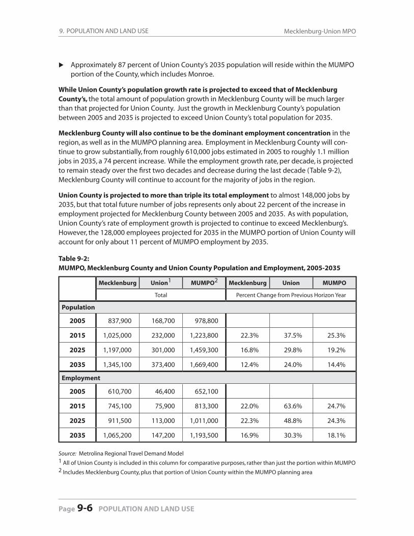
9. POPULATION AND LAND USE Mecklenburg-Union MPO
Page 9-6 POPULATION AND LAND USE
Approximately 87 percent of Union County’s 2035 population will reside within the MUMPO portion of the County, which includes Monroe.
While Union County’s population growth rate is projected to exceed that of Mecklenburg County’s, the total amount of population growth in Mecklenburg County will be much larger than that projected for Union County. Just the growth in Mecklenburg County’s population between 2005 and 2035 is projected to exceed Union County’s total population for 2035.
Mecklenburg County will also continue to be the dominant employment concentration in the region, as well as in the MUMPO planning area. Employment in Mecklenburg County will con-tinue to grow substantially, from roughly 610,000 jobs estimated in 2005 to roughly 1.1 million jobs in 2035, a 74 percent increase. While the employment growth rate, per decade, is projected to remain steady over the fi rst two decades and decrease during the last decade (Table 9-2), Mecklenburg County will continue to account for the majority of jobs in the region.
Union County is projected to more than triple its total employment to almost 148,000 jobs by 2035, but that total future number of jobs represents only about 22 percent of the increase in employment projected for Mecklenburg County between 2005 and 2035. As with population, Union County’s rate of employment growth is projected to continue to exceed Mecklenburg’s. However, the 128,000 employees projected for 2035 in the MUMPO portion of Union County will account for only about 11 percent of MUMPO employment by 2035.
Table 9-2: MUMPO, Mecklenburg County and Union County Population and Employment, 2005-2035
Mecklenburg Union1 MUMPO2 Mecklenburg Union MUMPO
Total Percent Change from Previous Horizon Year
Population
2005 837,900 168,700 978,800
2015 1,025,000 232,000 1,223,800 22.3% 37.5% 25.3%
2025 1,197,000 301,000 1,459,300 16.8% 29.8% 19.2%
2035 1,345,100 373,400 1,669,400 12.4% 24.0% 14.4%
Employment
2005 610,700 46,400 652,100
2015 745,100 75,900 813,300 22.0% 63.6% 24.7%
2025 911,500 113,000 1,011,000 22.3% 48.8% 24.3%
2035 1,065,200 147,200 1,193,500 16.9% 30.3% 18.1%
Source: Metrolina Regional Travel Demand Model1 All of Union County is included in this column for comparative purposes, rather than just the portion within MUMPO2 Includes Mecklenburg County, plus that portion of Union County within the MUMPO planning area
9. POPULATION AND LAND USE2035 Long-Range Transportation Plan
POPULATION AND LAND USE 9-7
9.4 Growth Patterns in the Mecklenburg-Union Urban Area
Over the next 30 years, growth—and the density of that growth—is expected to intensify in centers, corridors, and transit station areas. Even so, two-thirds of Mecklenburg County’s popula-tion growth will remain in the wedges (the areas between corridors) and in surrounding subur-ban towns. Maps in the Map Gallery at the end of the document (Figures 9-3 to 9-6 — see list of links on the next page) show projected population (household) and employment patterns within the MUMPO area.
The northern towns of Davidson, Cornelius, and Huntersville, and areas along Lake Norman, are expected to grow signifi cantly, as are the Northlake and University Research Park centers.
In the southwest and west areas of Mecklenburg County, the fast growing areas will include those along major transportation corridors, particularly near the interchanges with I-485 and along the streetcar line. The Whitehall area is expected to intensify with offi ce employment. Steele Creek is expected to remain strong in offi ce, retail, and residential.
In the southern and eastern portions of Mecklenburg County, the area along the Union County line is expected to be one of the most rapidly growing areas. Much of this growth will be around I-485 interchanges and in the areas between Monroe, Matthews, and Mint Hill. In addition, the southeast corridor is expected to intensify with employment towards the end of the projected growth period. SouthEnd is expected to continue to show strong growth.
Many of the future residential high-growth areas are not currently heavily populated and, therefore, their high growth rates will not necessarily equate to high population densities by 2035, particularly as they will likely continue to attract relatively low-density residential de-velopment. By 2035, the highest density residential areas within MUMPO’s planning area will continue to be in and surrounding Charlotte’s Center City, and in other established areas in the southern and eastern sectors (Figures 9-3 and 9-4 — see list of links on the next page), as well as in the south and northeast corridors.
The far southern and northern areas of Mecklenburg County will experience some higher den-sity residential development, refl ecting development in and around transit stations, but the very high growth areas in the east, southeast, and west will continue to be of relatively low-density when compared with the established higher density areas closer to the Center City. These more central areas are projected to experience some increased density through continued infi ll and redevelopment opportunities.
Employment density patterns projected for 2035 refl ect the continuation of recent trends and show intensifi cation in the current employment areas, as well as emerging concentrations along I-77, I-85, I-485 and the transit corridors and station areas.
Charlotte’s Center City and other current activity centers will continue to be the largest and densest employment concentrations. The SouthPark and University areas, for example, are projected to continue to grow and, as shown in Figure 9-6, will be major employment con-centrations in 2035.
Gro
wth
Pattern
s
9. POPULATION AND LAND USE Mecklenburg-Union MPO
Page 9-8 POPULATION AND LAND USE
Areas in and near the northern towns (particularly along I-77 and I-485) are expected to show signifi cant employment increases, and at some of those locations this will result in relatively high employment densities by 2035. Huntersville, Davidson and Cornelius are each projected to at least double their employment by 2035. (Refer to Figures 9-5 and 9-6.)
The MUMPO portion of Union County is projected to achieve high employment growth, but with a relatively low density employment pattern overall by 2035. Jobs in this area are likely to continue to concentrate along U.S. 74 and in Monroe, and to refl ect employment growth emanating from major interchanges along eastern portions of I-485.
See the Map Gallery of the end of this document for the following maps:
Household Density, 2005 . . . . . . . . . . . . . . . . . . . . . . . . . . . Figure 9-1
Employment Density, 2005 . . . . . . . . . . . . . . . . . . . . . . . . . . Figure 9-2
Change in Households, 2005-2035 . . . . . . . . . . . . . . . . . . . Figure 9-3
Household Density, 2035 . . . . . . . . . . . . . . . . . . . . . . . . . . . . Figure 9-4
Employment Change, 2005-2035 . . . . . . . . . . . . . . . . . . . . Figure 9-5
Employment Density, 2035 . . . . . . . . . . . . . . . . . . . . . . . . . . Figure 9-6

Federal regulations require a fi nancial plan as an element of the MPO’s Long Range Transporta-tion Plan. The purpose is to demonstrate that proposed investments are reasonable in the con-text of reasonably anticipated future revenues over the life of the plan and for future network years (2015, 2025, and 2035). Meeting this test is called “fi scal constraint.”
The 2035 Long Range Transportation Plan is fi scally constrained based on the analysis of revenues and costs. The transportation investments proposed to meet metropolitan transportation needs over the planning period are consistent with revenue forecasts. This chapter provides an over-view of the forecasted cost and revenue assumptions, along with the detailed research results used to derive these values. The following sections provide more detailed assumptions regard-ing revenue, capital costs, maintenance costs, and future revenue needs.
10.1 Existing Revenue Forecasts
Revenue forecasts were developed after a review of previous state and local expenditures, cur-rent funding trends, and likely future funding levels. The revenue forecasts involved consulta-tion with NCDOT and the local partners. All dollar fi gures discussed in this section were esca-lated to future-year dollars as noted below.
MUMPO and its staff discussed the impacts of upcoming increases in the nation’s vehicular fuel effi ciency standards, scheduled to take effect in 2015. Assuming no other changes, this will re-duce revenues for the NCDOT. MUMPO and its staff still assumed slight increases (approximately two percent per year) for revenue into the future by assuming that some future modifi cations to the existing tax structure would occur to keep the revenue system “whole.” Available resources will likely decline after 2015 without changes to the existing revenue sources.
Overall Assumptions for the 2035 LRTP
The annual transfer of Highway Trust funds to the General Fund will fi ll the fund-ing gap on future Turnpike Authority projects.
North Carolina’s donor state status regarding return of federal highway dollars increases from 92.5 cents to 95 cents by 2015.
Urban Loops funds will be made available for retrofi tting I-485.
The Garden Parkway from I-485 across the Catawba River into Gaston County (STIP # U-3321) will be built as a toll facility.
10.0
FINANCIAL PLAN Finan
cial Plan
FINANCIAL PLAN 10-1
continued next page
10. FINANCIAL PLAN Mecklenburg-Union MPO
Page 10-2 FINANCIAL PLAN
The Monroe Parkway (formerly Bypass/Connector) project (STIP #’s R-2559/R-3329) will be built as a toll facility.
The level of maintenance of the transportation system will remain constant through the Plan lifespan.
Local municipalities will continue to contribute funding towards LRTP projects at the same rate as past years.
10.1.1 Highway Federal and State Revenues (Equity)
The federal and state revenue forecasts were developed based on past, current, and expected future funding levels refl ected in NCDOT’s 2009-2015 Transportation Improvement Program. A key assumption is the expected modest growth of federal and state revenue for roadway proj-ects in the MUMPO area. Highway, rail, safety, bridges, resurfacing, and enhancement projects listed in the TIP were considered in the calculation of an annual allocation of future revenues.
Bicycle and pedestrian projects that are a component of a roadway project are traditionally funded as part of the roadway project. Stand-alone projects are funded through enhancement funds but due to the recent expiration of the federal transportation authorization bill (SAFETEA-LU), no estimate of future enhancement funds was calculated. It was assumed that MUMPO’s policy of including bicycle and pedestrian accommodations on all non-highway projects will still be implemented, however.
Likewise, MUMPO receives Congestion Mitigation and Air Quality (CMAQ) funds to address air quality issues, but a projection of funds available through 2035 was not estimated as part of this Plan for the same reason. After a new federal authorization bill is passed, future LRTP updates will include these funding sources in estimating available revenues.
Specifi c Revenue Assumptions for Each Horizon Year
2009-2015 Revenues are based on average annual revenues (approximately $50 million/
year) refl ected in the 2009-2015 TIP.
2016-2025 Revenues are based on the average annual amounts refl ected in the 2009-2015
TIP. State revenue sources are assumed to grow at 2.5% annually.
2026-2035 A 2.0% annual growth rate is assumed throughout the remainder of the period.
State Highway Trust funds are assumed to decrease by 30% by 2026 as a result of a majority of the urban loop projects being completed, with the Trust funds being re-allocated to Equity projects.
Overall Assumptions (continued)
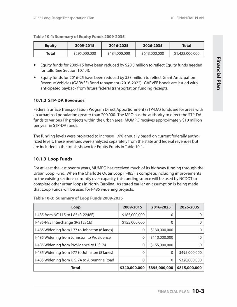
10. FINANCIAL PLAN2035 Long-Range Transportation Plan
FINANCIAL PLAN 10-3
Finan
cial Plan
Table 10-1: Summary of Equity Funds 2009-2035
Equity 2009-2015 2016-2025 2026-2035 Total
Total $295,000,000 $484,000,000 $643,000,000 $1,422,000,000
Equity funds for 2009-15 have been reduced by $20.5 million to refl ect Equity funds needed for tolls (See Section 10.1.4).
Equity funds for 2016-25 have been reduced by $33 million to refl ect Grant Anticipation Revenue Vehicles (GARVEE) Bond repayment (2016-2022). GARVEE bonds are issued with anticipated payback from future federal transportation funding receipts.
10.1.2 STP-DA Revenues
Federal Surface Transportation Program Direct Apportionment (STP-DA) funds are for areas with an urbanized population greater than 200,000. The MPO has the authority to direct the STP-DA funds to various TIP projects within the urban area. MUMPO receives approximately $10 million per year in STP-DA funds.
The funding levels were projected to increase 1.6% annually based on current federally autho-rized levels. These revenues were analyzed separately from the state and federal revenues but are included in the totals shown for Equity Funds in Table 10-1.
10.1.3 Loop Funds
For at least the last twenty years, MUMPO has received much of its highway funding through the Urban Loop Fund. When the Charlotte Outer Loop (I-485) is complete, including improvements to the existing sections currently over capacity, this funding source will be used by NCDOT to complete other urban loops in North Carolina. As stated earlier, an assumption is being made that Loop Funds will be used for I-485 widening projects.
Table 10-3: Summary of Loop Funds 2009-2035
Loop 2009-2015 2016-2025 2026-2035
I-485 from NC 115 to I-85 (R-2248E) $185,000,000 0 0
I-485/I-85 Interchange (R-2123CE) $155,000,000 0 0
I-485 Widening from I-77 to Johnston (6 lanes) 0 $130,000,000 0
I-485 Widening from Johnston to Providence 0 $110,000,000 0
I-485 Widening from Providence to U.S. 74 0 $155,000,000 0
I-485 Widening from I-77 to Johnston (8 lanes) 0 0 $495,000,000
I-485 Widening from U.S. 74 to Albemarle Road 0 0 $320,000,000
Total $340,000,000 $395,000,000 $815,000,000

10. FINANCIAL PLAN Mecklenburg-Union MPO
Page 10-4 FINANCIAL PLAN
10.1.4 Toll Gap Funds
“Gap Funding” is that money necessary to help pay for a toll project after anticipated toll rev-enues are assigned to pay for the project. Toll roads seldom pay for themselves, and a supple-mental source is required for the difference, called the “Gap”.
The two toll projects in the 2035 LRTP (Monroe Parkway and Garden Parkway) are expected to need gap funding. These gap funds will be a combination of TIFIA Loans and Revenue Bonds. In addition, $20.5 million from Equity funds are assumed to be needed for the Monroe Parkway. The Equity amount for FY 2009-2015 has been reduced by this amount in Table 10-1.
Table 10-4: Summary of Toll Gap Funds 2009-2035
Toll Gap 2009-2015 2016-2025 2026-2035
Monroe Parkway (R-2559/R-3329)
TIFIA $313,000,000 0 0
Bond $480,000,000 0 0
Equity $21,000,000 0 0
Garden Parkway (U-3321)
TIFIA $85,000,000 0 0
Bond $175,000,000 0 0
Total $1,074,000,000 0 0
10.1.5 Local Funds
The City of Charlotte has regularly asked its voters to approve transportation bonds for street and road improvements since 1962. Charlotte voters have acknowledged the need to locally fund transportation projects, and have approved almost $1 billion through 2009. Since 2002, the citizens of Huntersville and Matthews have also approved transportation bonds. For the most part, these bonds have been used for improvements on municipal roadways, but bond funds have been used to fi nance improvements to several state streets. To date no bonds have been proposed by Union County or its municipalities to pay for transportation projects.
MPO analysis assumes future bonds will be proposed and approved to meet future demands for some transportation projects. The local revenue forecast assumes enough funding to meet current and future project costs.
Table 10-5: Summary of Local Funds 2009-2035
Local 2009-2015 2016-2025 2026-2035 Total
Charlotte $100,0000,000 $200,000,000 $200,000,000 $500,000,000
Huntersville $6,000,000 $10,000,000 $10,000,000 $26,000,000
Matthews $5,000,000 $5,000,000 $5,000,000 $15,000,000
continued next page
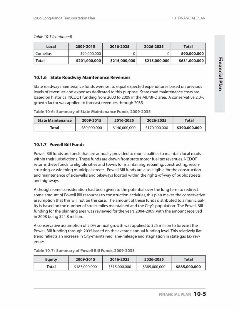
10. FINANCIAL PLAN2035 Long-Range Transportation Plan
FINANCIAL PLAN 10-5
Local 2009-2015 2016-2025 2026-2035 Total
Cornelius $90,000,000 0 0 $90,000,000
Total $201,000,000 $215,000,000 $215,000,000 $631,000,000
10.1.6 State Roadway Maintenance Revenues
State roadway maintenance funds were set to equal expected expenditures based on previous levels of revenues and expenses dedicated to this purpose. State road maintenance costs are based on historical NCDOT funding from 2000 to 2009 in the MUMPO area. A conservative 2.0% growth factor was applied to forecast revenues through 2035.
Table 10-6: Summary of State Maintenance Funds, 2009-2035
State Maintenance 2009-2015 2016-2025 2026-2035 Total
Total $80,000,000 $140,000,000 $170,000,000 $390,000,000
10.1.7 Powell Bill Funds
Powell Bill funds are funds that are annually provided to municipalities to maintain local roads within their jurisdictions. These funds are drawn from state motor fuel tax revenues. NCDOT returns these funds to eligible cities and towns for maintaining, repairing, constructing, recon-structing, or widening municipal streets. Powell Bill funds are also eligible for the construction and maintenance of sidewalks and bikeways located within the rights-of-way of public streets and highways.
Although some consideration had been given to the potential over the long term to redirect some amount of Powell Bill resources to construction activities, this plan makes the conservative assumption that this will not be the case. The amount of these funds distributed to a municipal-ity is based on the number of street-miles maintained and the City’s population. The Powell Bill funding for the planning area was reviewed for the years 2004-2009, with the amount received in 2008 being $24.8 million.
A conservative assumption of 2.0% annual growth was applied to $25 million to forecast the Powell Bill funding through 2035 based on the average annual funding level. This relatively fl at trend refl ects an increase in City-maintained lane-mileage and stagnation in state gas tax rev-enues.
Table 10-7: Summary of Powell Bill Funds, 2009-2035
Equity 2009-2015 2016-2025 2026-2035 Total
Total $185,000,000 $315,000,000 $385,000,000 $885,000,000
Finan
cial Plan
Table 10-5 (continued)
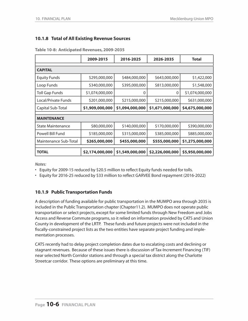
10. FINANCIAL PLAN Mecklenburg-Union MPO
Page 10-6 FINANCIAL PLAN
10.1.8 Total of All Existing Revenue Sources
Table 10-8: Anticipated Revenues, 2009-2035
2009-2015 2016-2025 2026-2035 Total
CAPITAL
Equity Funds $295,000,000 $484,000,000 $643,000,000 $1,422,000
Loop Funds $340,000,000 $395,000,000 $813,000,000 $1,548,000
Toll Gap Funds $1,074,000,000 0 0 $1,074,000,000
Local/Private Funds $201,000,000 $215,000,000 $215,000,000 $631,000,000
Capital Sub-Total $1,909,000,000 $1,094,000,000 $1,671,000,000 $4,675,000,000
MAINTENANCE
State Maintenance $80,000,000 $140,000,000 $170,000,000 $390,000,000
Powell Bill Fund $185,000,000 $315,000,000 $385,000,000 $885,000,000
Maintenance Sub-Total $265,000,000 $455,000,000 $555,000,000 $1,275,000,000
TOTAL $2,174,000,000 $1,549,000,000 $2,226,000,000 $5,950,000,000
Notes: Equity for 2009-15 reduced by $20.5 million to refl ect Equity funds needed for tolls. Equity for 2016-25 reduced by $33 million to refl ect GARVEE Bond repayment (2016-2022)
10.1.9 Public Transportation Funds
A description of funding available for public transportation in the MUMPO area through 2035 is included in the Public Transportation chapter (Chapter11.2). MUMPO does not operate public transportation or select projects, except for some limited funds through New Freedom and Jobs Access and Reverse Commute programs, so it relied on information provided by CATS and Union County in development of the LRTP. These funds and future projects were not included in the fi scally-constrained project lists as the two entities have separate project funding and imple-mentation processes.
CATS recently had to delay project completion dates due to escalating costs and declining or stagnant revenues. Because of these issues there is discussion of Tax-Increment Financing (TIF) near selected North Corridor stations and through a special tax district along the Charlotte Streetcar corridor. These options are preliminary at this time.
••
10. FINANCIAL PLAN2035 Long-Range Transportation Plan
FINANCIAL PLAN 10-7
10.2 New Revenue Forecasts
In order to evaluate the impact of additional revenues on the 2035 Long Range Transportation Plan, MUMPO staff considered several different funding scenarios (see below) that assumed ad-ditional revenues, with varying project lists that resulted from the additional revenues. MUMPO staff developed project lists that were evaluated for effectiveness in reducing congestion and air pollution.
Due to the limited effect the additional funds would have on the project list, as well as the economic downturn still in effect in late 2009, the MUMPO Board decided to approve the “No New Revenue” scenario on November 18, 2009.
Revenue Forecast Scenarios
1. No New Revenue
The fi rst scenario assumed no additional revenues beyond those in existing revenue assumptions through 2035. Both the roadway and transit project lists would be fi nancially-constrained by horizon year based on existing revenue assumptions.
2. Additional ¼ Cent Sales Tax for Roads for both Mecklenburg and Union Counties
The second scenario assumed an additional $30 million per year in Mecklenburg County and $4 million per year in Union County for highways. This additional rev-enue would fund an additional $914 million ($344 million (2016-2025) and $462 mil-lion (2026-2035) in Mecklenburg County and $46 million (2016-2025) and $62 million (2026-2035) in Union County) for highway projects. The transit project list would be the same as the fi rst scenario.
3. Additional ¼ Cent Sales Tax for Transit in Mecklenburg County
The third scenario assumed an additional $30 million per year in Mecklenburg Coun-ty for transit. This additional revenue would fund an additional $806 million (addi-tional $344 million (2016-2025) and $462 million (2026-2035) in Mecklenburg County for transit projects. The roadway project list would be the same as the fi rst scenario.
4. Additional ¼ Cent Sales Tax Split Between Roads and Transit in Mecklenburg and Union Counties
The fourth scenario assumed an additional $30 million per year in Mecklenburg County for highways and transit and $4 million per year in Union County for high-ways. This additional revenue would fund the fi nancially-constrained highway proj-ect list PLUS approximately $457 million for highway projects in Mecklenburg and Union Counties and approximately $403 million for transit projects in Mecklenburg County.
Finan
cial Plan
10. FINANCIAL PLAN Mecklenburg-Union MPO
Page 10-8 FINANCIAL PLAN
11.1 Regional Travel Demand Model
The Metrolina Regional Travel Demand Model was used to predict magnitudes and fl ows of travel based on land use projections and characteristics of highway and transit networks. More people and more jobs mean more trips will be made. In the model, trips are classifi ed by trip purpose. Broadly, trips can be grouped into three purposes:
Home-based Work: These trips are from work to home and from work back to home. They occur more heavily in peak hours and are a large component of congestion.
Home-based Other: These trips begin or end at home and cover the range of other trips that people make – those to or from school, shopping, visiting friends, or appoint-ments.
Non-home-based: These are the trips made while people are out of their residence, ei-ther at work (e.g. a trip to lunch), or between stops while running errands (e.g. a trip from the grocery store to the cleaners). Generally, given their nature, non-home-based trips are shorter than home-based trips.
Trips can be made on highways, either driving alone or carpooling/vanpooling with others; by riding transit; or by walking or biking. Two other major groups of travelers use the highway system:
Commercial vehicle and truck trips, and
External / Internal trips: these are the trips that start in the region and end somewhere outside the region (e.g. a trip to the beach) or are trips that begin outside the region
11.0
TRANSPORTATION PLAN COMPONENTS
Transp
ortatio
n P
lan
REGIONAL TRAVEL DEMAND MODEL 11.1-1
11.1 Regional Travel Demand Model
11.2 Streets and Highways
11.3 Public Transportation
11.4 Bicycle
11.5 Pedestrian
11.6 Greenway
11.7 Freight
11.8 Other Modes
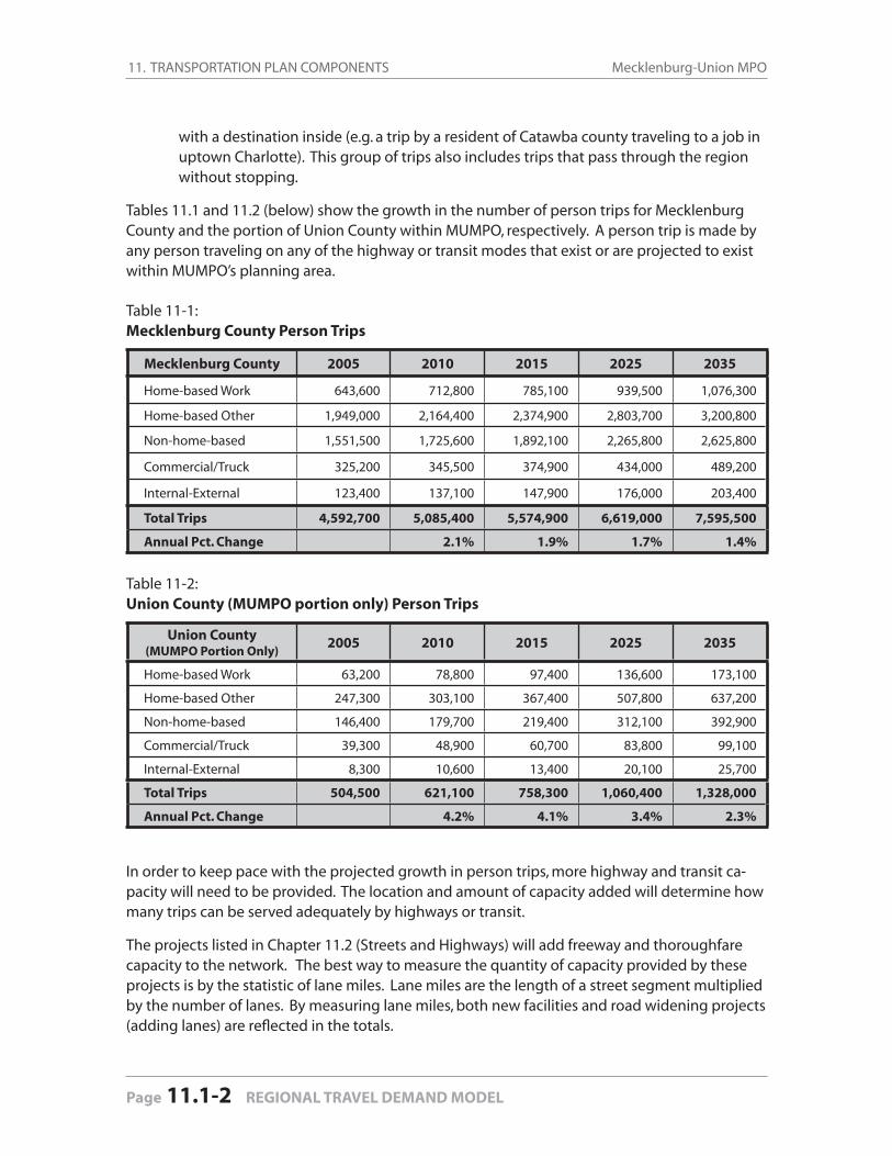
11. TRANSPORTATION PLAN COMPONENTS Mecklenburg-Union MPO
Page 11.1-2 REGIONAL TRAVEL DEMAND MODEL
with a destination inside (e.g. a trip by a resident of Catawba county traveling to a job in uptown Charlotte). This group of trips also includes trips that pass through the region without stopping.
Tables 11.1 and 11.2 (below) show the growth in the number of person trips for Mecklenburg County and the portion of Union County within MUMPO, respectively. A person trip is made by any person traveling on any of the highway or transit modes that exist or are projected to exist within MUMPO’s planning area.
Table 11-1: Mecklenburg County Person Trips
Mecklenburg County 2005 2010 2015 2025 2035
Home-based Work 643,600 712,800 785,100 939,500 1,076,300
Home-based Other 1,949,000 2,164,400 2,374,900 2,803,700 3,200,800
Non-home-based 1,551,500 1,725,600 1,892,100 2,265,800 2,625,800
Commercial/Truck 325,200 345,500 374,900 434,000 489,200
Internal-External 123,400 137,100 147,900 176,000 203,400
Total Trips 4,592,700 5,085,400 5,574,900 6,619,000 7,595,500
Annual Pct. Change 2.1% 1.9% 1.7% 1.4%
Table 11-2: Union County (MUMPO portion only) Person Trips
Union County(MUMPO Portion Only)
2005 2010 2015 2025 2035
Home-based Work 63,200 78,800 97,400 136,600 173,100
Home-based Other 247,300 303,100 367,400 507,800 637,200
Non-home-based 146,400 179,700 219,400 312,100 392,900
Commercial/Truck 39,300 48,900 60,700 83,800 99,100
Internal-External 8,300 10,600 13,400 20,100 25,700
Total Trips 504,500 621,100 758,300 1,060,400 1,328,000
Annual Pct. Change 4.2% 4.1% 3.4% 2.3%
In order to keep pace with the projected growth in person trips, more highway and transit ca-pacity will need to be provided. The location and amount of capacity added will determine how many trips can be served adequately by highways or transit.
The projects listed in Chapter 11.2 (Streets and Highways) will add freeway and thoroughfare capacity to the network. The best way to measure the quantity of capacity provided by these projects is by the statistic of lane miles. Lane miles are the length of a street segment multiplied by the number of lanes. By measuring lane miles, both new facilities and road widening projects (adding lanes) are refl ected in the totals.
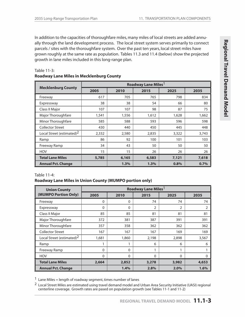
Streets and
Hig
hw
ays11. TRANSPORTATION PLAN COMPONENTS2035 Long-Range Transportation Plan
REGIONAL TRAVEL DEMAND MODEL 11.1-3
Reg
ion
al Travel Dem
and
Mo
del
In addition to the capacities of thoroughfare miles, many miles of local streets are added annu-ally through the land development process. The local street system serves primarily to connect parcels / sites with the thoroughfare system. Over the past ten years, local street miles have grown roughly at the same rate as population. Tables 11.3 and 11.4 (below) show the projected growth in lane miles included in this long-range plan.
Table 11-3: Roadway Lane Miles in Mecklenburg County
Mecklenburg CountyRoadway Lane Miles1
2005 2010 2015 2025 2035
Freeway 617 705 765 798 834
Expressway 38 38 54 66 80
Class II Major 107 107 98 87 75
Major Thoroughfare 1,541 1,556 1,612 1,628 1,662
Minor Thoroughfare 585 588 593 596 598
Collector Street 430 440 450 445 448
Local Street (estimated)2 2,332 2,580 2,835 3,322 3,743
Ramp 86 92 100 101 103
Freeway Ramp 34 43 50 50 50
HOV 15 15 26 26 26
Total Lane Miles 5,785 6,165 6,583 7,121 7,618
Annual Pct. Change 1.3% 1.3% 0.8% 0.7%
Table 11-4: Roadway Lane Miles in Union County (MUMPO portion only)
Union County(MUMPO Portion Only)
Roadway Lane Miles1
2005 2010 2015 2025 2035
Freeway 0 0 74 74 74
Expressway 0 0 2 2 2
Class II Major 85 85 81 81 81
Major Thoroughfare 372 381 387 391 391
Minor Thoroughfare 357 358 362 362 362
Collector Street 167 167 167 169 169
Local Street (estimated)2 1,681 1,860 2,198 2,898 3,567
Ramp 1 1 6 6 6
Freeway Ramp 0 0 1 1 1
HOV 0 0 0 0 0
Total Lane Miles 2,664 2,852 3,278 3,982 4,653
Annual Pct. Change 1.4% 2.8% 2.0% 1.6%
1 Lane Miles = length of roadway segment, times number of lanes2 Local Street Miles are estimated using travel demand model and Urban Area Security Initiative (UASI) regional
centerline coverage. Growth rates are pased on population growth (see Tables 11-1 and 11-2)
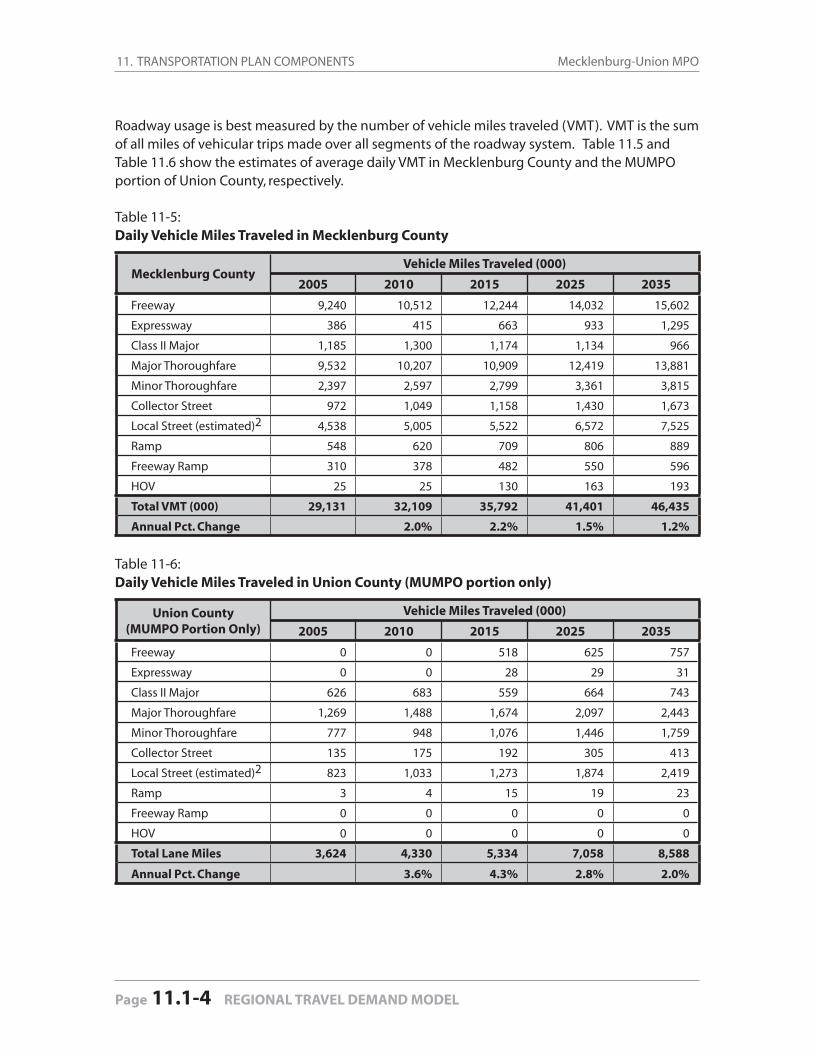
11. TRANSPORTATION PLAN COMPONENTS Mecklenburg-Union MPO
Page 11.1-4 REGIONAL TRAVEL DEMAND MODEL
Roadway usage is best measured by the number of vehicle miles traveled (VMT). VMT is the sum of all miles of vehicular trips made over all segments of the roadway system. Table 11.5 and Table 11.6 show the estimates of average daily VMT in Mecklenburg County and the MUMPO portion of Union County, respectively.
Table 11-5: Daily Vehicle Miles Traveled in Mecklenburg County
Mecklenburg CountyVehicle Miles Traveled (000)
2005 2010 2015 2025 2035
Freeway 9,240 10,512 12,244 14,032 15,602
Expressway 386 415 663 933 1,295
Class II Major 1,185 1,300 1,174 1,134 966
Major Thoroughfare 9,532 10,207 10,909 12,419 13,881
Minor Thoroughfare 2,397 2,597 2,799 3,361 3,815
Collector Street 972 1,049 1,158 1,430 1,673
Local Street (estimated)2 4,538 5,005 5,522 6,572 7,525
Ramp 548 620 709 806 889
Freeway Ramp 310 378 482 550 596
HOV 25 25 130 163 193
Total VMT (000) 29,131 32,109 35,792 41,401 46,435
Annual Pct. Change 2.0% 2.2% 1.5% 1.2%
Table 11-6: Daily Vehicle Miles Traveled in Union County (MUMPO portion only)
Union County(MUMPO Portion Only)
Vehicle Miles Traveled (000)
2005 2010 2015 2025 2035
Freeway 0 0 518 625 757
Expressway 0 0 28 29 31
Class II Major 626 683 559 664 743
Major Thoroughfare 1,269 1,488 1,674 2,097 2,443
Minor Thoroughfare 777 948 1,076 1,446 1,759
Collector Street 135 175 192 305 413
Local Street (estimated)2 823 1,033 1,273 1,874 2,419
Ramp 3 4 15 19 23
Freeway Ramp 0 0 0 0 0
HOV 0 0 0 0 0
Total Lane Miles 3,624 4,330 5,334 7,058 8,588
Annual Pct. Change 3.6% 4.3% 2.8% 2.0%
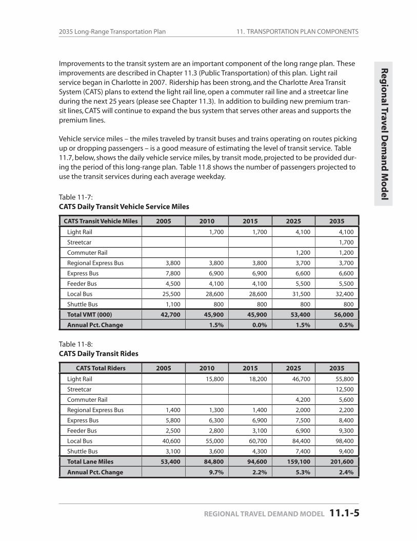
11. TRANSPORTATION PLAN COMPONENTS2035 Long-Range Transportation Plan
REGIONAL TRAVEL DEMAND MODEL 11.1-5
Reg
ion
al Travel Dem
and
Mo
del
Improvements to the transit system are an important component of the long range plan. These improvements are described in Chapter 11.3 (Public Transportation) of this plan. Light rail service began in Charlotte in 2007. Ridership has been strong, and the Charlotte Area Transit System (CATS) plans to extend the light rail line, open a commuter rail line and a streetcar line during the next 25 years (please see Chapter 11.3). In addition to building new premium tran-sit lines, CATS will continue to expand the bus system that serves other areas and supports the premium lines.
Vehicle service miles – the miles traveled by transit buses and trains operating on routes picking up or dropping passengers – is a good measure of estimating the level of transit service. Table 11.7, below, shows the daily vehicle service miles, by transit mode, projected to be provided dur-ing the period of this long-range plan. Table 11.8 shows the number of passengers projected to use the transit services during each average weekday.
Table 11-7: CATS Daily Transit Vehicle Service Miles
CATS Transit Vehicle Miles 2005 2010 2015 2025 2035
Light Rail 1,700 1,700 4,100 4,100
Streetcar 1,700
Commuter Rail 1,200 1,200
Regional Express Bus 3,800 3,800 3,800 3,700 3,700
Express Bus 7,800 6,900 6,900 6,600 6,600
Feeder Bus 4,500 4,100 4,100 5,500 5,500
Local Bus 25,500 28,600 28,600 31,500 32,400
Shuttle Bus 1,100 800 800 800 800
Total VMT (000) 42,700 45,900 45,900 53,400 56,000
Annual Pct. Change 1.5% 0.0% 1.5% 0.5%
Table 11-8: CATS Daily Transit Rides
CATS Total Riders 2005 2010 2015 2025 2035
Light Rail 15,800 18,200 46,700 55,800
Streetcar 12,500
Commuter Rail 4,200 5,600
Regional Express Bus 1,400 1,300 1,400 2,000 2,200
Express Bus 5,800 6,300 6,900 7,500 8,400
Feeder Bus 2,500 2,800 3,100 6,900 9,300
Local Bus 40,600 55,000 60,700 84,400 98,400
Shuttle Bus 3,100 3,600 4,300 7,400 9,400
Total Lane Miles 53,400 84,800 94,600 159,100 201,600
Annual Pct. Change 9.7% 2.2% 5.3% 2.4%
11. TRANSPORTATION PLAN COMPONENTS Mecklenburg-Union MPO
Page 11.1-6 REGIONAL TRAVEL DEMAND MODEL
11. TRANSPORTATION PLAN COMPONENTS Mecklenburg-Union MPO

11 Transportation Plan Components
11.2 Streets and Highways
The Mecklenburg-Union MPO planning area consists of a broad network of roadway corridors, ranging from local streets serving the needs of a neighborhood to multi-lane freeways and expressways serving regional and national trip purposes.
This network is the primary means by which people and goods are transported within and through the region. The network includes about 5,800 total miles, with approximately 55% (3,137 miles) maintained by municipalities in the urban area.
Table 11-9: Maintenance Responsibility for Roadways in Urban Area
Area Classifi cation State Maintained Locally Maintained
MUMPO Interstate 103 (miles) --
MUMPO Primary 480 --
MUMPO All 2,620 3,137
Mecklenburg County All 1,029 2,851
Union County All 1,591 286
City of Charlotte All -- 2,368
Other Towns All -- 769
11.2 Streets and Highways
11.2.1 Programmed Roadway Projects
Several highway and roadway projects, now in various stages of implementation, will provide additional capacity to meet the continuing growth projected for the Mecklenburg-Union MPO. These committed projects—presently in various stages of planning, design, land acquisition and construction—will help meet intra-regional and interstate travel demand generated by the population, employment and travel growth expected in upcoming years .
The planned roadway projects are funded either by the North Carolina Department of Trans-portation (NCDOT), Federal Highway Administration (FHWA), or municipalities. Some roadway improvements, such as expansion of the local/collector street system, will continue to be ac-complished by developers through the rezoning, subdivision and permitting process within the various MUMPO jurisdictions.
Streets and
Hig
hw
ays
STREETS AND HIGHWAYS 11.2-1
11. TRANSPORTATION PLAN COMPONENTS Mecklenburg-Union MPO
Page 11.2-2 STREETS AND HIGHWAYS
The roadway projects for which funding has been committed through 2015 are listed in Table 11-10 (facing page) and shown in Figure 11-2, Funded and Committed Projects, found in the Map Gallery at the end of this document. Minor intersection and safety projects are not in-cluded in the table or map because those projects are not deemed to be regionally signifi cant projects within the context of the 2035 Long-Range Transportation Plan.
Street and Highway Plan
MUMPO’s approach to planning for highways and streets has been to balance competing inter-ests when deciding how or when to expand or extend the existing thoroughfare network.
The underlying premise of this approach is that it is not fi nancially or politically possible to build our way out of congestion by constructing more through lanes along every congested roadway. The best way to respond to the increasing demand on the road network is to look at options from a network perspective, meaning that changes to one part of the network will impact other portions of the network, either positively or negatively.
Relationship to the Thoroughfare Plan
MUMPO has identifi ed a roadway system that, in conjunction with local streets, is expected to serve the area’s future traffi c levels. The Mecklenburg-Union Thoroughfare Plan, which was last adopted in November 2004, identifi es the future major roadways.
The Thoroughfare Plan map, Figure 11-1 in the map gallery at the end of the document, shows the alignments of the major roadways based on the following facility types: minor thorough-fares, major thoroughfares, commercial arterials, and freeways and expressways.
Implementation of the Thoroughfare Plan is accomplished through federal, state or local high-way construction projects, or by directing private interests to fund or build improvements through the land development process. Larger scale projects are most often built by the public sector, with the private sector building smaller scale projects. Local funding is typically used on streets that are part of a local network, with federal and state funds being the primary source for improvements to the roadways maintained by the North Carolina Department of Transporta-tion’s (NCDOT) roadway system.
The Thoroughfare Plan is the primary inventory of roadway projects evaluated for construction pri-oritization, and serves as the starting point from which MUMPO begins the process to determine which roadways require upgrades in ten or twenty years. The project ranking process used to develop the long-range transportation plan (LRTP) establishes project construction priorities for thoroughfares in both the local and NCDOT construction programs. (The project ranking system is described in Appendix A, along with a list of rankings received by roadway projects.)
While the Thoroughfare Plan’s focus traditionally has been on facilitating vehicular travel, it also serves as a framework for the implementation of the pedestrian and bicycle transportation network. Roads are not simply a means by which vehicles travel from point to point; they are transporta-tion corridors allowing people to travel by a variety of modes. Not every segment of the Thor-oughfare Plan is capable of permitting bicycle or pedestrian travel; however, the vast majority of the network can be part of a multimodal transportation network.
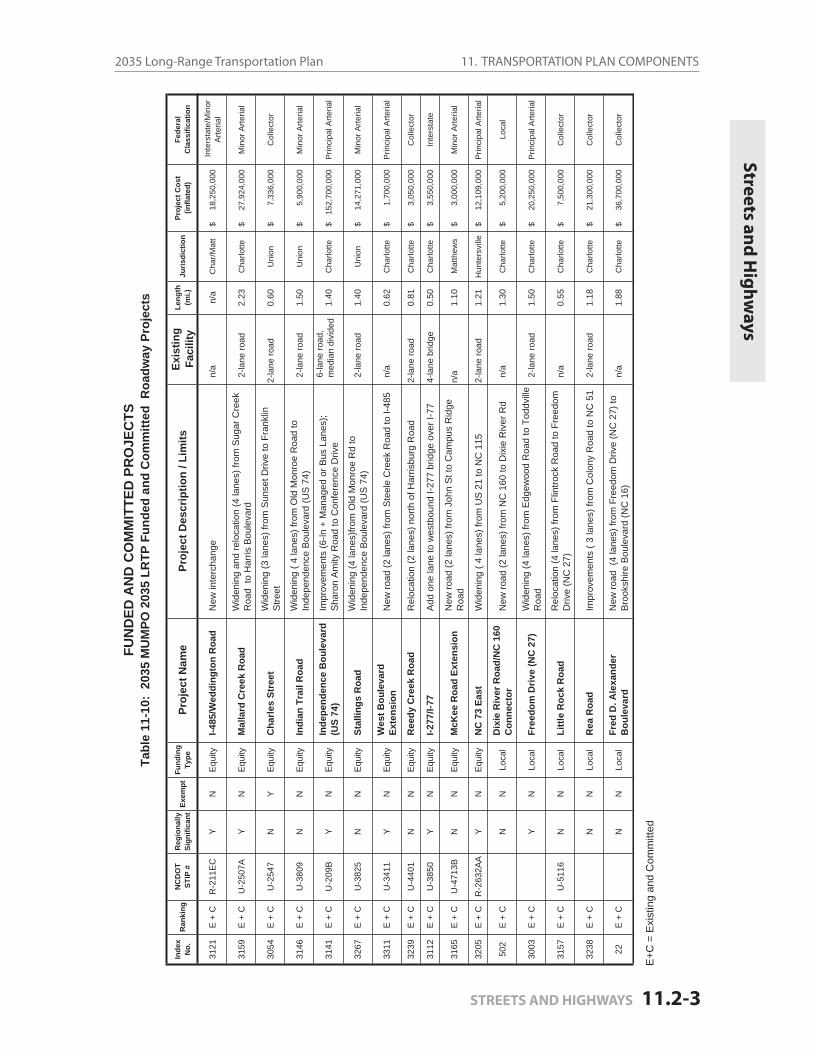
Streets and
Hig
hw
ays11. TRANSPORTATION PLAN COMPONENTS2035 Long-Range Transportation Plan
STREETS AND HIGHWAYS 11.2-3
Streets and
Hig
hw
ays
E+C
= E
xist
ing
and
Com
mitt
ed
FUN
DED
AN
DC
OM
MIT
TED
PR
OJE
CTS
Tabl
e 11
-10:
203
5 M
UM
PO 2
035
LRTP
Fun
ded
and
Com
mitt
ed R
oadw
ay P
roje
cts
Inde
xN
o.R
anki
ngN
CD
OT
STIP
#R
egio
nally
Sign
ifica
ntEx
empt
Fund
ing
Type
Proj
ect N
ame
Proj
ect D
escr
iptio
n / L
imits
Exis
ting
Faci
lity
Leng
th(m
i.)Ju
risdi
ctio
nPr
ojec
t Cos
t (in
flate
d)Fe
dera
lC
lass
ifica
tion
3121
E +
CR
-211
EC
YN
Equ
ityI-4
85/W
eddi
ngto
n R
oad
New
inte
rcha
nge
n/a
n/a
Cha
r/Mat
t18
,250
,000
$
In
ters
tate
/Min
or
Arte
rial
3159
E +
CU
-250
7AY
NE
quity
Mal
lard
Cre
ek R
oad
Wid
enin
g an
d re
loca
tion
(4 la
nes)
from
Sug
ar C
reek
R
oad
to H
arris
Bou
leva
rd2-
lane
road
2.23
Cha
rlotte
27,9
24,0
00$
Min
or A
rteria
l
3054
E +
CU
-254
7N
YE
quity
Cha
rles
Stre
etW
iden
ing
(3 la
nes)
from
Sun
set D
rive
to F
rank
lin
Stre
et2-
lane
road
0.60
Uni
on7,
336,
000
$
Col
lect
or
3146
E +
CU
-380
9N
NE
quity
Indi
an T
rail
Roa
dW
iden
ing
( 4 la
nes)
from
Old
Mon
roe
Roa
d to
In
depe
nden
ce B
oule
vard
(US
74)
2-la
ne ro
ad1.
50U
nion
5,90
0,00
0$
M
inor
Arte
rial
3141
E +
CU
-209
BY
NE
quity
Inde
pend
ence
Bou
leva
rd
(US
74)
Impr
ovem
ents
(6-ln
+ M
anag
ed o
r Bus
Lan
es);
Sha
ron
Am
ity R
oad
to C
onfe
renc
e D
rive
6-la
ne ro
ad,
med
ian
divi
ded
1.40
Cha
rlotte
152,
700,
000
$
Prin
cipa
l Arte
rial
3267
E +
CU
-382
5N
NE
quity
Stal
lings
Roa
dW
iden
ing
(4 la
nes)
from
Old
Mon
roe
Rd
to
Inde
pend
ence
Bou
leva
rd (U
S 7
4)2-
lane
road
1.40
Uni
on14
,271
,000
$
M
inor
Arte
rial
3311
E +
CU
-341
1Y
NE
quity
Wes
t Bou
leva
rd
Exte
nsio
nN
ew ro
ad (2
lane
s) fr
om S
teel
e C
reek
Roa
d to
I-48
5n/
a0.
62C
harlo
tte1,
700,
000
$
Prin
cipa
l Arte
rial
3239
E +
CU
-440
1N
NE
quity
Ree
dy C
reek
Roa
dR
eloc
atio
n (2
lane
s) n
orth
of H
arris
burg
Roa
d2-
lane
road
0.81
Cha
rlotte
3,05
0,00
0$
C
olle
ctor
3112
E +
CU
-385
0Y
NE
quity
I-277
/I-77
Add
one
lane
to w
estb
ound
I-27
7 br
idge
ove
r I-7
74-
lane
brid
ge0.
50C
harlo
tte3,
550,
000
$
Inte
rsta
te
3165
E +
CU
-471
3BN
NE
quity
McK
ee R
oad
Exte
nsio
nN
ew ro
ad (2
lane
s) fr
om J
ohn
St t
o C
ampu
s R
idge
R
oad
n/a
1.10
Mat
thew
s3,
000,
000
$
Min
or A
rteria
l
3205
E +
CR
-263
2AA
YN
Equ
ityN
C 7
3 Ea
stW
iden
ing
( 4 la
nes)
from
US
21
to N
C 1
152-
lane
road
1.21
Hun
ters
ville
12,1
09,0
00$
Prin
cipa
l Arte
rial
502
E +
CN
NLo
cal
Dix
ie R
iver
Roa
d/N
C 1
60
Con
nect
orN
ew ro
ad (2
lane
s) fr
om N
C 1
60 to
Dix
ie R
iver
Rd
n/a
1.30
Cha
rlotte
5,20
0,00
0$
Lo
cal
3003
E +
CY
NLo
cal
Free
dom
Driv
e (N
C 2
7)W
iden
ing
(4 la
nes)
from
Edg
ewoo
d R
oad
to T
oddv
ille
Roa
d2-
lane
road
1.50
Cha
rlotte
20,2
50,0
00$
Prin
cipa
l Arte
rial
3157
E +
CU
-511
6N
NLo
cal
Littl
e R
ock
Roa
d R
eloc
atio
n (4
lane
s) fr
om F
lintro
ck R
oad
to F
reed
om
Driv
e (N
C 2
7)n/
a0.
55C
harlo
tte7,
500,
000
$
Col
lect
or
3238
E +
CN
NLo
cal
Rea
Roa
dIm
prov
emen
ts (
3 la
nes)
from
Col
ony
Roa
d to
NC
51
2-la
ne ro
ad1.
18C
harlo
tte21
,300
,000
$
C
olle
ctor
22E
+ C
NN
Loca
lFr
ed D
. Ale
xand
er
Bou
leva
rdN
ew ro
ad (
4 la
nes)
from
Fre
edom
Driv
e (N
C 2
7) to
B
rook
shire
Bou
leva
rd (N
C 1
6)n/
a1.
88C
harlo
tte36
,700
,000
$
C
olle
ctor
11. TRANSPORTATION PLAN COMPONENTS Mecklenburg-Union MPO
Page 11.2-4 STREETS AND HIGHWAYS
11.2 Streets and Highways
11.2.2 Horizon Year Recommendations
Federal law requires that projects in the long-range transportation plan (LRTP) be categorized in fi nancially constrained horizon years for air quality analysis. Horizon years are no more than ten years apart (and are based on calendar years, beginning January 1, rather than fi scal years).
The projects recommended for implementation in this LRTP respond directly to projected travel demand, MPO policy decisions and available funding. In the following pages, tables with de-tailed information about each roadway project are presented for each of the three horizon years – 2015, 2025 and 2035 – as well as a map for each horizon year that highlights the location of each major roadway.
2015 Roadway Network
This network includes all of the existing major streets and highways, and over 30 new roadway widening and new construction projects that will be completed and open for traffi c by Decem-ber 31, 2015 (see Figure 11-3 in the Map Gallery at the end of this document). Projects com-pleted between now and December 31, 2015 are said to be included in the 2015 Horizon Year. Most of these projects have been or will be fully or partially funded by either the 2009-2015 State Transportation Improvement Program (STIP) or by the City of Charlotte Capital Investment Plan (CIP). The remainder will have funds appropriated from the City of Charlotte, NCDOT, pri-vate developers, or other local governments, to complete them prior to the end of 2015. Table 11-11 below (found on page 11.2-6) provides information about each project. Notable projects for Horizon Year 2015 include:
Completion of I-485, from NC 115 to I-85 near Concord Mills Widening of I-77 from Hambright Road to Catawba AvenueCompletion of the Monroe Connector/Bypass from I-485 to WingateWidening of Statesville Road from Starita Road to Keith DriveWidening of Charles Street from Franklin Street to Sunset DriveWidening of I-85 into Cabarrus County
2025 Roadway Network
The roadway projects in the network include 20 roadway widening and new construction projects that are proposed for completion between January 1, 2016 and December 31, 2025, known as the 2025 Horizon Year (see Figure 11-4 in the Map Gallery at the end of this docu-ment). Revenues anticipated from federal, state and local sources will be used to fund these projects. Table 11-12 below (found on page 11.2-7) summarizes information on each project. Selected notable projects are:
Further conversion of Independence Boulevard (US 74) to an expressway from Conference Drive to Krefeld Drive
Extension and widening of the West Blvd. from Airport Drive to I-485Widening of John Street/Old Monroe Road from I-485 to Indian Trail Road
11. TRANSPORTATION PLAN COMPONENTS2035 Long-Range Transportation Plan
STREETS AND HIGHWAYS 11.2-5
Streets and
Hig
hw
ays
Widening of I-485 from I-77 to US 74Extension of Clanton Rd. from West Boulevard to Wilkinson Boulevard
2035 Roadway Network
This network includes ten roadway widening and new construction projects proposed for completion between January 1, 2026, and December 31, 2035, known as the 2035 Horizon Year (see Figure 11-5 in the Map Gallery at the end of this document). All of these projects will be funded by anticipated revenue from federal, state and local sources. Table 11-13 below (on page 11.2-8) provides project-related information for the 2035 network. Notable projects include:
Further conversion of Independence Boulevard (US 74) to an expressway from Krefeld Drive to NC 51
Widening of I-485 between US 74 East and Albemarle Road (NC 24-27)Widening of West Catawba Ave. from Jetton Road to NC 73Widening of NC 51 from Matthews Township Parkway to Lawyers Road
See the Map Gallery at the end of the document for the following maps:
Thoroughfare Plan . . . . . . . . . . . . . . . . . . . . . . . . . . . . . . . . . . . . . . . Figure 11.1
Funded and Committed Projects . . . . . . . . . . . . . . . . . . . . . . . . . . Figure 11.2
2015 Horizon Year Projects . . . . . . . . . . . . . . . . . . . . . . . . . . . . . . . Figure 11.3
2025 Horizon Year Projects . . . . . . . . . . . . . . . . . . . . . . . . . . . . . . . Figure 11.4
2035 Horizon Year Projects . . . . . . . . . . . . . . . . . . . . . . . . . . . . . . . Figure 11.5
The following pages contain these Tables
Table 11-11: 2015 Horizon Year . . . . . . . . . . . . . . . . . . . . . . . . . . . Page 11.2-6 MUMPO 2035 LRTP Funded Projects for 2010-2015
Table 11-12: 2025 Horizon Year . . . . . . . . . . . . . . . . . . . . . . . . . . . Page 11.2-7 MUMPO 2035 LRTP Funded Projects for 2016-2025
Table 11-13: 2035 Horizon Year . . . . . . . . . . . . . . . . . . . . . . . . . . . Page 11.2-8 MUMPO 2035 LRTP Funded Projects for 2026-2035

2015
Hor
izon
Yea
rTa
ble
11-1
1: M
UM
PO 2
035
LRTP
Fun
ded
Proj
ects
for 2
010-
2015
For a
map
of t
he p
roje
cts,
see
Fig
ure
11-3
in th
e M
ap G
alle
ry a
t the
end
of t
his
docu
men
t
11. TRANSPORTATION PLAN COMPONENTS Mecklenburg-Union MPO
Page 11.2-6 STREETS AND HIGHWAYS
Inde
xN
o.R
ank
NC
DO
TST
IP #
Reg
iona
llySi
gnifi
cant
Fund
ing
Type
Proj
ect N
ame
Proj
ect D
escr
iptio
n / L
imits
Exis
ting
Faci
lity
Leng
th(m
iles)
Juris
dict
ion
Proj
ect C
ost
(infla
ted)
Fede
ral C
lass
ifica
tion
3121
E +
C*
R-2
11E
CY
Equ
ityI-4
85/W
eddi
ngto
n R
dN
ew in
terc
hang
en/
an/
aC
har/M
att
$
18,
250,
000
Inte
rsta
te/M
inor
Arte
rial
naE
+ C
R-2
248H
YE
quity
I-485
/Gar
rison
Roa
dN
ew in
terc
hang
en/
an/
aC
harlo
tte$1
,150
,000
In
ters
tate
/Loc
al
3159
E +
CU
-250
7AY
Equ
ityM
alla
rd C
reek
Roa
dW
iden
ing
and
relo
catio
n (4
lane
s) fr
om S
ugar
Cre
ek
Rd
to H
arris
Blv
d2-
lane
road
2.23
Cha
rlotte
$
27,
924,
000
Min
or A
rteria
l
3054
E +
CU
-254
7N
Equ
ityC
harle
s St
reet
Wid
enin
g (3
lane
s) fr
om S
unse
t Dr t
o Fr
ankl
in S
t2-
lane
road
0.6
Uni
on $
7,33
6,00
0 C
olle
ctor
3146
E +
CU
-380
9N
Equ
ityIn
dian
Tra
il R
oad
Wid
enin
g ( 4
lane
s) fr
om O
ld M
onro
e R
d to
In
depe
nden
ce B
lvd
(US
74)
2-la
ne ro
ad1.
5U
nion
$
5,
900,
000
Min
or A
rteria
l
3141
E +
CU
-209
BY
Equ
ityIn
depe
nden
ce B
lvd
(US
74)
Impr
ovem
ents
(6-ln
+ M
anag
ed o
r Bus
Lan
es);
Sha
ron
Am
ity R
d to
Con
fere
nce
Dr.
6-la
ne ro
ad, m
edia
n di
vide
d1.
4C
harlo
tte $
152
,700
,000
P
rinci
pal A
rteria
l
3267
E +
CU
-382
5N
Equ
itySt
allin
gs R
oad
Wid
enin
g (4
lane
s) fr
om O
ld M
onro
e R
d to
In
depe
nden
ce B
lvd
(US
74)
2-la
ne ro
ad1.
4U
nion
$
14,
271,
000
Min
or A
rteria
l
3311
E +
CU
-341
1Y
Equ
ityW
est B
lvd
Exte
nsio
nN
ew ro
ad (2
lane
s) fr
om S
teel
e C
reek
Rd
to I-
485
n/a
0.62
Cha
rlotte
$
1,
700,
000
Prin
cipa
l Arte
rial
3239
E +
CU
-440
1N
Equ
ityR
eedy
Cre
ek R
oad
Rel
ocat
ion
(2 la
nes)
nor
th o
f Har
risbu
rg R
d2-
lane
road
0.81
Cha
rlotte
$
3,
050,
000
Col
lect
or
3112
E +
CU
-385
0Y
Equ
ityI-2
77/I-
77A
dd o
ne la
ne to
wes
tbou
nd I-
277
brid
ge o
ver I
-77
4-la
ne b
ridge
0.16
Cha
rlotte
$
3,
550,
000
Inte
rsta
te
3165
E +
CU
-471
3BN
Equ
ityM
cKee
Rd
Exte
nsio
nN
ew ro
ad (2
lane
s), J
ohn
St t
o C
ampu
s R
idge
Rd
n/a
1.1
Mat
thew
s $
3,00
0,00
0 M
inor
Arte
rial
3205
E +
CR
-263
2AA
YE
quity
NC
73
East
Wid
enin
g (4
lane
s), U
S 2
1 to
NC
115
2-la
ne ro
ad1.
21H
unte
rsvi
lle $
1
2,10
9,00
0 P
rinci
pal A
rteria
l
502
E +
CN
Loca
lD
ixie
Riv
er R
d/N
C 1
60
Con
nect
orN
ew ro
ad (2
lane
s), N
C 1
60 to
Dix
ie R
iver
Rd
n/a
1.3
Cha
rlotte
$
5,
200,
000
Loc
al
3003
E +
CY
Loca
lFr
eedo
m D
rive
(NC
27)
Wid
enin
g (4
lane
s), E
dgew
ood
Rd
to T
oddv
ille
Rd
2-la
ne ro
ad1.
5C
harlo
tte $
2
0,25
0,00
0 P
rinci
pal A
rteria
l
3157
E +
CU
-511
6N
Loca
lLi
ttle
Roc
k R
oad
Rel
ocat
ion
(4 la
nes)
from
Flin
trock
Rd
to F
reed
om D
r (N
C 2
7)n/
a0.
55C
harlo
tte $
7,50
0,00
0 C
olle
ctor
3238
E +
CN
Loca
lR
ea R
oad
Impr
ovem
ents
( 3
lane
s) fr
om C
olon
y R
d to
NC
51
2-la
ne ro
ad1.
18C
harlo
tte $
2
1,30
0,00
0 C
olle
ctor
22E
+ C
NLo
cal
Fred
D. A
lexa
nder
B
oule
vard
New
road
(4
lane
s) fr
om F
reed
om D
r (N
C 2
7) to
B
rook
shire
Blv
d (N
C 1
6)n/
a1.
88C
harlo
tte $
3
6,70
0,00
0 C
olle
ctor
3067
17R
-242
0AN
Loca
lC
ity B
oule
vard
Ex
tens
ion
New
road
(4 la
nes)
from
Nea
l Rd
to M
alla
rd C
reek
Rd
Ext
ensi
onn/
a0.
78C
harlo
tte $
9,85
4,00
0 L
ocal
3000
19N
Loca
lB
eatti
es F
ord
Roa
dW
iden
ing
(4 la
nes)
, Cap
ps H
ill M
ine
Rd
to S
unse
t R
oad
2-la
ne ro
ad1.
23C
harlo
tte $
1
3,32
7,00
0 M
inor
Arte
rial
3032
37U
-513
0N
Loca
lJi
m C
ooke
Roa
dN
ew ro
ad (2
-3 la
nes)
, Nor
thcr
oss
Dr.
Ext
. to
Bai
ley
Roa
dn/
a0.
20C
orne
lius
$
5,
000,
000
Loc
al
3214
45U
-513
1N
Loca
lN
orth
cros
s D
rive
Exte
nsio
nN
ew ro
ad (3
lane
s) fr
om e
nd o
f Nor
thcr
oss
Dr t
o W
estm
orel
and
Roa
dn/
a1.
35C
orne
lius
$
3,
000,
000
Loc
al
3133
88I-5
127
YLo
cal
I-77/
Wes
tmor
elan
d R
dN
ew In
terc
hang
e, S
PU
In/
an/
aC
orne
lius
$
35,
000,
000
Inte
rsta
te/L
ocal
3132
93I-5
126
YLo
cal
I-77
Wid
enin
g (N
orth
)A
ddin
g M
anag
ed la
nes
(1/ e
ach
way
)( 6
lane
s) fr
om
Ham
brig
ht R
d to
Cat
awba
Ave
.4-
lane
road
, med
ian
divi
ded
5.72
Cor
n/H
unt/
Cha
r $
2
2,00
0,00
0 In
ters
tate
3289
103
U-5
128
NLo
cal
Stat
esvi
lle R
oad
(US
21)
Wid
enin
g (4
lane
s) fr
om N
orth
cros
s C
ente
r Ct t
o B
oat
Hou
se C
t2-
lane
road
1.83
Cor
neliu
s $
1
0,00
0,00
0 M
inor
Arte
rial
3317
122
U-5
129
NLo
cal
Wes
tmor
elan
d R
oad
Wid
enin
g (4
lane
s) fr
om W
. Cat
awba
Ave
to U
S 2
1n/
a1.
03C
orne
lius
$
15,
000,
000
Loc
al
3268
130
NLo
cal
Stat
esvi
lle R
oad
Wid
enin
g (4
lane
s) fr
om S
tarit
a R
d to
Kei
th D
r2-
lane
road
1.92
Cha
rlotte
$
21,
280,
000
Min
or A
rteria
l 33
4016
0N
Loca
lS.
Tra
de S
tree
tW
iden
ing
(4 la
nes)
, Ful
lwoo
d Ln
to W
eddi
ngto
n R
d2-
lane
road
0.75
Mat
thew
s $
8,77
5,00
0 M
inor
Arte
rial
3008
188
NLo
cal
Idle
wild
Roa
dW
iden
ing
(4 la
nes)
, Pin
ey G
rove
Rd
to D
rifte
r Dr
2-la
ne ro
ad0.
50C
harlo
tte $
8,00
0,00
0 M
inor
Arte
rial
3316
201
NLo
cal
Wes
tmor
elan
d R
oad
Wid
enin
g (4
lane
s), U
S 2
1 to
Was
ham
-Pot
ts R
d3-
lane
road
0.24
Cor
neliu
s $
2,14
9,00
0 L
ocal
30
197
R-2
248E
NLo
opA
lexa
nder
ana
Rd.
New
road
(4 la
nes)
from
NC
115
to E
astfi
eld
Rd
n/a
0.91
Cha
r/Hun
t $
2
1,45
6,00
0 L
ocal
30
0592
R-2
248E
YLo
opI-4
85N
ew fr
eew
ay (8
lane
s) fr
om N
C 1
15 to
I-85
n/a
5.40
Cha
r/Hun
t $
167
,500
,000
F
reew
ay/E
xpre
ssw
ay
3135
186
R-2
123C
EY
Loop
I-85
/ I-4
85C
onst
ruct
new
inte
rcha
nge
n/a
n/a
Cha
rlotte
$
80,
000,
000
Fre
eway
/Exp
ress
way
3169
1R
-332
9/
R-
2559
YTo
llM
onro
eC
onne
ctor
/Byp
ass
New
free
way
(4 la
nes)
, I-4
85 to
Hw
y 74
(Win
gate
) --
(to
ll ro
ad)
n/a
19.7
0U
nion
$ 8
13,5
00,0
00
Prin
cipa
l Arte
rial
3094
243
U-3
321
YTo
llG
arde
n Pa
rkw
ayN
ew fr
eew
ay (4
lane
s), I
-485
to G
asto
n C
ount
y lin
e --
(to
ll ro
ad)
n/a
1.90
Cha
rlotte
$ 2
60,0
00,0
00
Fre
eway
/Exp
ress
way
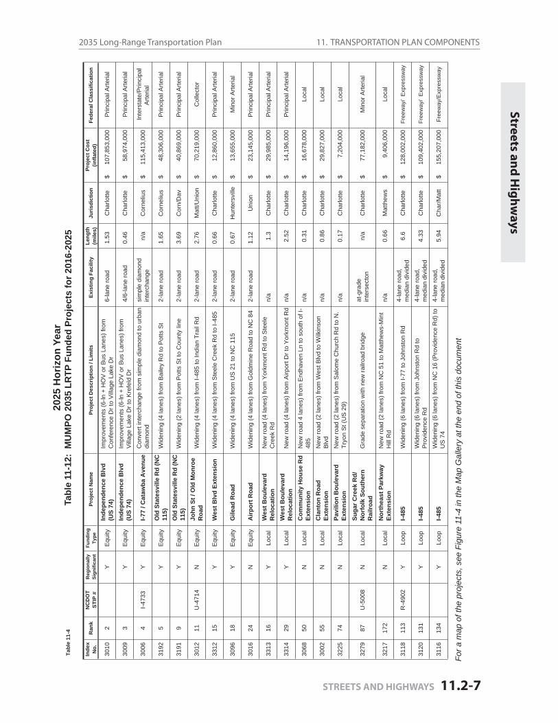
11. TRANSPORTATION PLAN COMPONENTS2035 Long-Range Transportation Plan
STREETS AND HIGHWAYS 11.2-7
Streets and
Hig
hw
ays20
25 H
oriz
on Y
ear
Tabl
e 11
-12:
MU
MPO
203
5 LR
TP F
unde
d Pr
ojec
ts fo
r 201
6-20
25
For a
map
of t
he p
roje
cts,
see
Fig
ure
11-4
in th
e M
ap G
alle
ry a
t the
end
of t
his
docu
men
t
Tabl
e 11
-4
Inde
xN
o.R
ank
NC
DO
TST
IP #
Reg
iona
llySi
gnifi
cant
Fund
ing
Type
Proj
ect N
ame
Proj
ect D
escr
iptio
n / L
imits
Exis
ting
Faci
lity
Leng
th(m
iles)
Juris
dict
ion
Proj
ect C
ost
(infla
ted)
Fede
ral C
lass
ifica
tion
3010
2Y
Equ
ityIn
depe
nden
ce B
lvd
(US
74)
Impr
ovem
ents
(6-ln
+ H
OV
or B
us L
anes
) fro
m
Con
fere
nce
Dr t
o V
illag
e La
ke D
r6-
lane
road
1.53
Cha
rlotte
$
10
7,85
3,00
0 P
rinci
pal A
rteria
l
3009
3Y
Equ
ityIn
depe
nden
ce B
lvd
(US
74)
Impr
ovem
ents
(6-ln
+ H
OV
or B
us L
anes
) fro
m
Vill
age
Lake
Dr t
o K
refe
ld D
r4/
6-la
ne ro
ad0.
46C
harlo
tte $
58,
974,
000
Prin
cipa
l Arte
rial
3006
4I-4
733
YE
quity
I-77
/ Cat
awba
Ave
nue
Con
vert
inte
rcha
nge
from
sim
ple
diam
ond
to u
rban
di
amon
dsi
mpl
e di
amon
d in
terc
hang
en/
aC
orne
lius
$
11
5,41
3,00
0 In
ters
tate
/Prin
cipa
l A
rteria
l
3192
5Y
Equ
ityO
ld S
tate
svill
e R
d (N
C
115)
Wid
enin
g (4
lane
s) fr
om B
aile
y R
d to
Pot
ts S
t2-
lane
road
1.65
Cor
neliu
s $
48,
306,
000
Prin
cipa
l Arte
rial
3191
9Y
Equ
ityO
ld S
tate
svill
e R
d (N
C
115)
Wid
enin
g (2
lane
s) fr
om P
otts
St t
o C
ount
y lin
e2-
lane
road
3.69
Cor
n/D
av $
40,
869,
000
Prin
cipa
l Arte
rial
3012
11U
-471
4N
Equ
ityJo
hn S
t / O
ld M
onro
e R
oad
Wid
enin
g (4
lane
s) fr
om I-
485
to In
dian
Tra
il R
d2-
lane
road
2.76
Mat
t/Uni
on $
70,
219,
000
Col
lect
or
3312
15Y
Equ
ityW
est B
lvd
Exte
nsio
n W
iden
ing
(4 la
nes)
from
Ste
ele
Cre
ek R
d to
I-48
52-
lane
road
0.66
Cha
rlotte
$
1
2,86
0,00
0 P
rinci
pal A
rteria
l
3096
18Y
Equ
ityG
ilead
Roa
dW
iden
ing
(4 la
nes)
from
US
21
to N
C 1
152-
lane
road
0.67
Hun
ters
ville
$
1
3,65
5,00
0 M
inor
Arte
rial
3016
24N
Equ
ityA
irpor
t Roa
dW
iden
ing
(4 la
nes)
from
Gol
dmin
e R
oad
to N
C 8
42-
lane
road
1.12
Uni
on $
23,
145,
000
Prin
cipa
l Arte
rial
3313
16Y
Loca
lW
est B
oule
vard
R
eloc
atio
nN
ew ro
ad (4
lane
s) fr
om Y
orkm
ont R
d to
Ste
ele
Cre
ek R
dn/
a1.
3C
harlo
tte $
29,
985,
000
Prin
cipa
l Arte
rial
3314
29Y
Loca
lW
est B
oule
vard
R
eloc
atio
nN
ew ro
ad (4
lane
s) fr
om A
irpor
t Dr t
o Y
orkm
ont R
dn/
a2.
52C
harlo
tte $
14,
196,
000
Prin
cipa
l Arte
rial
3068
50N
Loca
lC
omm
unity
Hou
se R
d Ex
tens
ion
New
road
4 la
nes)
from
End
have
n Ln
to s
outh
of I
-48
5n/
a0.
31C
harlo
tte $
16,
678,
000
Loc
al
3002
55N
Loca
lC
lant
on R
oad
Exte
nsio
nN
ew ro
ad (2
lane
s) fr
om W
est B
lvd
to W
ilkin
son
Blv
dn/
a0.
86C
harlo
tte $
29,
827,
000
Loc
al
3225
74N
Loca
lPa
vilio
n B
oule
vard
Ex
tens
ion
New
road
(2 la
nes)
from
Sal
ome
Chu
rch
Rd
to N
. Tr
yon
St (
US
29)
n/a
0.17
Cha
rlotte
$
7,2
04,0
00
Loc
al
3279
87U
-500
8N
Loca
lSu
gar C
reek
Rd/
N
orfo
lk S
outh
ern
Rai
lroad
Gra
de s
epar
atio
n w
ith n
ew ra
ilroa
d br
idge
at-g
rade
inte
rsec
ton
n/a
Cha
rlotte
$
7
7,18
2,00
0 M
inor
Arte
rial
3217
172
NLo
cal
Nor
thea
st P
arkw
ay
Exte
nsio
nN
ew ro
ad (2
lane
s) fr
om N
C 5
1 to
Mat
thew
s-M
int
Hill
Rd
n/a
0.66
Mat
thew
s $
9
,406
,000
L
ocal
3118
113
R-4
902
YLo
opI-4
85W
iden
ing
(6 la
nes)
from
I-77
to J
ohns
ton
Rd
4-la
ne ro
ad,
med
ian
divi
ded
6.6
Cha
rlotte
$
12
8,00
2,00
0 F
reew
ay/
Exp
ress
way
3120
131
YLo
opI-4
85W
iden
ing
(6 la
nes)
from
Joh
nsto
n R
d to
P
rovi
denc
e R
d4-
lane
road
, m
edia
n di
vide
d4.
33C
harlo
tte $
109,
402,
000
Fre
eway
/ E
xpre
ssw
ay
3116
134
YLo
opI-4
85W
iden
ing
(6 la
nes)
from
NC
16
(Pro
vide
nce
Rd)
to
US
74
4-la
ne ro
ad,
med
ian
divi
ded
5.94
Cha
r/Mat
t $
155,
207,
000
Fre
eway
/Exp
ress
way
11. TRANSPORTATION PLAN COMPONENTS Mecklenburg-Union MPO
Page 11.2-8 STREETS AND HIGHWAYS
2035
Hor
izon
Yea
rTa
ble
11-1
3: M
UM
PO 2
035
LRTP
Fun
ded
Proj
ects
for 2
026-
2035
For a
map
of t
he p
roje
cts,
see
Fig
ure
11-5
in th
e M
ap G
alle
ry a
t the
end
of t
his
docu
men
t
Inde
xN
o.R
ank
NC
DO
TST
IP #
Reg
iona
llySi
gnifi
cant
Fund
ing
Type
Proj
ect N
ame
Proj
ect D
escr
iptio
n / L
imits
Exis
ting
Faci
lity
Leng
th(m
iles)
Juris
dict
ion
Proj
ect C
ost
(infla
ted)
Fede
ral C
lass
ifica
tion
3011
6Y
Equ
ityIn
depe
nden
ce B
lvd
(US
74)
Impr
ovem
ents
(6-ln
+ H
OV
or B
us L
anes
) fro
m
Kre
feld
Dr t
o H
ayde
n W
ay4-
lane
road
, m
edia
n di
vide
d1.
19C
harlo
tte $
1
92,7
79,0
00
Prin
cipa
l Arte
rial
3142
10Y
Equ
ityIn
depe
nden
ce B
lvd
(US
74)
Impr
ovem
ents
(6-ln
+ H
OV
or B
us L
anes
) fro
m
Hay
den
Way
to N
C 5
14-
lane
road
, m
edia
n di
vide
d1.
50C
har/M
att
$
115
,268
,000
P
rinci
pal A
rteria
l
3013
12U
-500
7Y
Equ
ityN
C 5
1W
iden
ing
(4 la
nes)
from
Mat
thew
s To
wns
hip
Pkw
y to
Law
yers
Rd
2-la
ne ro
ad3.
93M
att/M
int
$
9
7,25
3,00
0 P
rinci
pal A
rteria
l
3270
13N
Equ
itySt
ates
ville
Roa
d (U
S 21
)W
iden
ing
(4 la
nes)
from
Har
ris B
lvd
to G
ilead
Rd
2-la
ne ro
ad4.
48C
har/H
unt
$
142
,403
,000
M
inor
Arte
rial
3300
20R
-255
5BY
Equ
ityW
. Cat
awba
Ave
nue
Wid
enin
g (4
lane
s) fr
om J
etto
n R
d to
NC
73
2-la
ne ro
ad2.
37C
orne
lius
$
5
7,01
1,00
0 P
rinci
pal A
rteria
l
3337
28N
Equ
ityB
ridge
ford
/N
orth
dow
nsC
onne
ctor
New
road
(2 la
nes)
from
Brid
gefo
rd L
ane
to
Nor
thdo
wns
Lan
en/
a0.
4H
unte
rsvi
lle $
25,
335,
000
Loc
al
3040
42Y
Equ
ityB
illy
Gra
ham
Pkw
y/
Mor
ris F
ield
Driv
eN
ew G
rade
Sep
arat
ion
at-g
rade
inte
rsec
tion
n/a
Cha
rlotte
$
8,53
4,00
0 F
reew
ay/E
xpre
ssw
ay
3026
57N
Loca
lA
requ
ipa
Driv
e Ex
tens
ion
New
road
(2 la
nes)
from
Mar
gare
t Wal
lace
Rd
to
Sam
New
ell R
dn/
a1.
30C
har/M
int
$
3
5,92
9,00
0 L
ocal
3108
61N
Loca
lH
ucks
Roa
d Ex
tens
ion
New
road
(4 la
nes)
from
Old
Sta
tesv
ille
Rd
(NC
11
5) to
Sta
tesv
ille
Rd
(US
21)
n/a
1.06
Cha
rlotte
$
3
3,02
2,00
0 L
ocal
3077
90N
Loca
lEa
ster
nC
ircum
fere
ntia
lN
ew ro
ad (4
lane
s) fr
om U
nive
rsity
City
Blv
d (N
C
49) t
o R
ocky
Riv
er R
dn/
a2.
86C
harlo
tte $
1
46,4
29,0
00
Col
lect
or
3119
226
YLo
opI-4
85W
iden
ing
(8 la
nes)
from
I-77
to J
ohns
ton
Rd
(incl
udin
g Jo
hnst
on R
oad
Flyo
ver)
6-la
ne ro
ad,
med
ian
divi
ded
4.33
Cha
rlotte
$
496
,470
,000
F
reew
ay/E
xpre
ssw
ay
3117
253
YLo
opI-4
85W
iden
ing
(6 la
nes)
from
US
74
to A
lbem
arle
Roa
d4-
lane
road
, m
edia
n di
vide
d9.
40M
att/M
int
$
316
,464
,000
F
reew
ay/E
xpre
ssw
ay
11. TRANSPORTATION PLAN COMPONENTS2035 Long-Range Transportation Plan
PUBLIC TRANSPORTATION 11.3 - 1
11 Transportation Plan Components
11.3 Public Transportation
11.3.1 Existing System
Fixed-route transit service in the MUMPO area is available primarily within Mecklenburg County. The only fi xed-route, fi xed-schedule transit service in Union County is one express route con-necting Uptown Charlotte and Marshville.
11.3.1.1 Mecklenburg County Public Transportation
Mecklenburg voters passed a half-cent sales tax in 1998 to fund both long- and short-range improvements to transit service in the region. The Charlotte Area Transit System (CATS) was formed in 2000 as a result.
The CATS mission is to enhance the quality of life by “providing outstanding community-wide public transportation services, while proactively contributing to progressive, sustainable region-al growth and develoment.”
CATS is a department of the City of Charlotte, but its policy board is the Metropolitan Transit Commission (MTC). The MTC is comprised of the chief elected offi cial of each member jurisdic-tion and the Board of Transportation member from NCDOT’s Tenth Division. The MTC sets policy, approves CATS’ detailed work plans and budgets, and prioritizes transit projects for the system.
CATS provides: light rail rapid transit service; fi xed-route local, express and regional express bus services; paratransit service; community/neighborhood-based shuttle services; and a multi-county vanpool program for work trip origins/destinations in Mecklenburg County.
Light Rail Service
After several years of planning, design and construction, the LYNX Blue Line began revenue ser-vice in November, 2007. The line is 9.6 miles long with 15 stations along its length.
Ridership quickly exceeded fi rst-year projections of 9,600 passengers per day, with 16,000 pas-sengers per day for several months of the fi rst year of operation. Over the entire course of 2009, daily boardings averaged slightly less than 15,000 passengers. Total ridership in FY 2009 was 5,237,244, with 37,789 revenue hours of service.
Service is available from 5:25 a.m. to 1:12 a.m. The LYNX Blue Line operates at 10-minute head-ways in the morning and afternoon peaks, 15-minute headways during midday, and 20-minute headways at night. Fares are the same as local bus service: $1.50 per one way trip.
CATS also operates the Charlotte Trolley service along a portion of this same corridor, from Atherton Mill to 9th Street.
Pu
blic Tran
spo
rtation
11. TRANSPORTATION PLAN COMPONENTS Mecklenburg-Union MPO
Page 11.3 - 2 PUBLIC TRANSPORTATION
The Historic Charlotte Trolley uses replica electric trolleys manufactured by GAMACO and serves both a transportation and tourism role. The Trolley operates scheduled service only on Saturday (10:00 a.m. to 5:00 p.m.) and Sunday (10:30 a.m. to 5:30 p.m.).
Fixed-Route Service
The fi xed-route service operated by CATS includes 39 local routes, 13 express routes, and 8 regional commuter routes. Ridership in FY 2009 was approximately 21 million boardings and CATS delivered 11.6 million revenue miles of service.
The fi xed routes operated by CATS—local and express—are shown on the CATS Existing System Map (Figure 11-6 in the Map Gallery at the end of this document). Express bus service during weekday periods is provided to Cabarrus, Gaston, Iredell, Lincoln, Union and York counties.
The transit fl eet includes 252 forty-foot buses, 40 thirty-foot buses for shuttles and commu-nity/neighborhood services, 15 rubber-wheeled trolleys for the Gold Rush downtown circulator service, and ten over-the-road coaches for commuter services. Buses for the local and express route services are accessible (low fl oor or lifts) and are equipped with bicycle racks.
Services are available in varying frequencies, seven days a week, from about 5:00 a.m. to 2:00 a.m. Fares are $1.50 for local service, $2.00 for express service and $3.00 for out-of-county com-muter service.
Sprinter Service
In September, 2009, CATS introduced Sprinter, an enhanced bus service that provides a direct connection from Center City Charlotte to the Charlotte-Douglas International Airport. Enhanced bus service includes several passenger amenities such as frequent service (20 minutes on week-days, 30 minutes on nights and weekends), effi cient stop locations and signature shelters. The service uses specially-designed hybrid fueled buses and is branded as a specialized service with a different logo and paint scheme.
Paratransit Service
Paratransit service to qualifi ed disabled residents in Mecklenburg County is provided by CATS Special Transportation Services (STS). Ridership in FY 2009 was 243,123, with 130,881 revenue hours of service.
STS is a demand response service, aided by mobile data terminals (MDCs), Automatic Vehicle Location (AVL) and computer dispatching and scheduling software. The active fl eet includes 85 vehicles.
STS provides the paratransit service required by the Americans with Disabilities Act of 1990. The ADA requires that paratransit service be provided to people who request pickups and drops-offs within three-quarters of a mile of all local bus routes during the same days and times that local buses operate. All requests for rides within Mecklenburg County beyond the ADA requirements are provided as capacity allows.
11. TRANSPORTATION PLAN COMPONENTS2035 Long-Range Transportation Plan
PUBLIC TRANSPORTATION 11.3 - 3
STSII is an expansion of the Special Transportation Service that provides limited service to the Towns of Mint Hill, Huntersville, Cornelius, Davidson and the unincorporated areas of the County with reduced operating hours and a premium fare.
STSII is not required by the Americans with Disabilities Act (ADA), so the service operates differ-ently than CATS regular STS service. STSII is provided as capacity allows. Ride requests that meet the requirements of the ADA take priority over STSII rides.
Community Circulators/Neighborhood Services
CATS provides several services to cover smaller geographic areas with fi xed-route or demand-response options.
There are seven shuttle routes that serve the general area around designated transit centers in the service area, as well as targeted neighborhoods located in-between the traditional line haul routes. In addition, there are three Village Rider routes serving the northern Mecklenburg towns and surrounding area. The fare for all of these services is $0.60.
The Gold Rush Circulator is a no-fare shuttle service that includes two routes served by rubber-wheeled trolley vehicles in downtown Charlotte.
Vanpool Program
The CATS Vanpool Program coordinates approximately 80 vanpools serving a 100-mile radius around Charlotte. FY 2009 ridership was 260,604. The CATS Vanpool program eliminated an estimated 15 million commuter miles from the regional roadway system in FY 2009.
These vanpools operate seven days a week and provide service to patrons working fi rst through third shifts.
CATS has a database that allows customers to identify vanpools and potential carpool matches by cross-referencing home and work location, and matching those with similar origins and desti-nations. This feature is described more fully on www.sharetheridenc.com.
Please see the Map Gallery at the end of the document for this map:
CATS Existing System Map . . . . . . . . . . . . . . . . . . . . . . . . Figure 11.6
11.3.1.2 Union County Public Transportation
Union County operates a demand-response public transportation system for the residents of Union County. Transportation services are provided to the clients of contracting human service agencies such as the Department of Social Services, Mental Health, ARC of Union County, Voca-tional Rehabilitation and Veterans. Other eligibility requirements:
CA
TS Existing
System
11. TRANSPORTATION PLAN COMPONENTS Mecklenburg-Union MPO
Page 11.3 - 4 PUBLIC TRANSPORTATION
a senior citizen at least 60 years of age, a developmentally disabled adult, Medicaid client ,a veteran eligible for medical treatment at a VA Hospital or clinic, physically disabled.
Clients sponsored by a human service agency pay no fare. Residents are able to request service from 7 a.m. to 4:30 p.m., Monday through Friday.
Limited transportation is also available to residents of Union County who are not eligible for transportation service through a human service agency. This is called Rural General Public (RGP) transportation. Such service is available 7 a.m. to 5 p.m., Monday through Friday. Fares range from $2 for a one-way trip within Union County to $20 for a round-trip to Charlotte.
According to the most recent information (Fiscal Year 2006-2007), Union County operates 21 vehicles and carries approximately 73,000 passengers per year. Union County provided 648,527 total service miles and 39,544 vehicle service hours. These fi gures are similar to prior year totals.
In FY 2006-07, Union County had total expenses of $1,052,000, with revenue of approximately $940,000. Both of these fi gures were up, compared to the prior year totals. Expenses increased 13.4 percent due to fuel costs, increased software maintenance costs, insurance expenses, property management costs and salary adjustments. The $110,465 defi cit was covered by local government funds.
11.3 Public Transportation
11.3.2 Public Transportation Plan
Expansion of public transportation within the Mecklenburg-Union MPO continues to be a high priority. Increases in service of varying modes, both short-term and long-term, are being studied and implemented in the plans described below.
A comprehensive Corridor System Plan was completed in 2002 and revised in 2006. The plan calls for the development of enhanced transit service in the fi ve corridors defi ned in the 2025 Integrated Transit/Land Use Plan. This comes in the form of light rail (South and Northeast); com-muter rail (North); bus rapid transit or light rail (Southeast); and streetcar (West). In addition, the plan calls for development of a Center City streetcar system to serve transit and circulation needs in Charlotte’s Uptown, as well as a streetcar route along Central Avenue, Trade Street and Beatties Ford Road to enhance transit service along some of the city’s most used transit routes.
The City of Charlotte and other Mecklenburg municipalities have used land use regulations to help implement the 2025 Integrated Transit/Land Use Plan, primarily through Transit-Oriented Development (TOD) zoning classifi cations along the South Corridor light-rail line. The North Mecklenburg communities of Cornelius, Davidson, and Huntersville have also implemented zon-ing regulations that support dense, walkable development near future commuter rail stations.
A Countywide Transit Services Plan was adopted in 2001 by the Metropolitan Transit Commis-sion (MTC) to identify and implement short-term transit improvements (up to fi ve years). The plan advanced these primary objectives:
11. TRANSPORTATION PLAN COMPONENTS2035 Long-Range Transportation Plan
PUBLIC TRANSPORTATION 11.3 - 5
Pu
blic Tran
spo
rtation
Plan
Improve service to complement rapid transit corridors. Strengthen core routes.Serve new areas—particularly Derita, Pineville, Matthews, Cornelius—and create new crosstown routes.Consider changes to other routes, areas or services as the need becomes apparent.
The plan identifi ed specifi c service improvements and included a recommended phasing plan.
The current revenue service fl eet for CATS consists of over 300 buses. The vehicles are replaced at the end of their useful life per federal guidelines, and the fl eet is expanded in conjunction with service demand as defi ned in the Countywide Transit Services Plan and refl ected in the long range fi nancial plan.
Enhanced Bus Service, similar to the current Sprinter service on Wilkinson Boulevard, will be studied and considered along various high volume transit corridors such as Route 9 (Central Av-enue), Route 7 (Beatties Ford Road) and others. These services are best suited for routes in cor-ridors with high existing ridership, signifi cant potential to attract new choice riders and multiple and/or signifi cant origin/destination nodes.
11.3.2.1 Programmed Projects 2009-2015
The following series of projects has been included in the 2009-2015 TIP to carry out Charlotte Area Transit System’s commitment to the implementation of both the 2025 Integrated Transit/Land Use Plan and Corridor System Plan. Funding of these projects is anticipated from the Section 5307 Urban Allocation, Section 5309 Capital Program, North Carolina Department of Transporta-tion Full Funding Grant Agreements, statewide earmarks, and other funding sources. A summary of the projects follows.
North Davidson Street Bus Renovation and Expansion
CATS is utilizing an American Recovery and Reinvestment Act grant to renovate and expand our existing North Davidson Bus Operations Division complex. This project includes the renovation of the existing bus garage, administration building and the construction of a new parking deck.
Bus Facility Improvements
CATS continues to invest in the planning, design and construction of numerous bus facil-ity improvements. This work ranges from coordinating new stop and shelter installations through the land development/capital improvement process, to the installation of new signs, shelters and other passenger amenities through CATS’ Transit Amenities program.
Intelligent Transportation Systems
CATS proposes the installation of various Intelligent Transportation System components, including automated interactive voice response systems, customer information technology at transit hubs, trip planning software, and other software licenses to improve the operating effi ciency of the system.
11. TRANSPORTATION PLAN COMPONENTS Mecklenburg-Union MPO
Page 11.3 - 6 PUBLIC TRANSPORTATION
Miscellaneous Equipment
This includes the purchase of support equipment, including shop, maintenance and offi ce equipment; schedule racks; and materials necessary for the upkeep of the Davidson Street bus garage.
Neighborhood Transit Centers
CATS’ Development Section works closely with Operations to monitor and assess changing market demands and service needs for new Neighborhood Transit Centers. This ongoing program provides funding to continue the planning, design and construction of neighbor-hood transit centers identifi ed in the Countywide Transit Services Plan. Funding to continue the implementation of these Neighborhood Transit Centers has been programmed.
Park and Ride Lots
CATS monitors the travel demand and market for drive approach passengers to determine park and ride needs and locations. CATS’ goal is to implement park and rides at locations that provide a high capture rate for choice riders and minimize travel time and operational costs to the transit system. The cost of this program is refl ected in the capital portion of CATS’ long range fi nancial plan.
Transit Right Of Way Protection
This project provides funds for the protective purchase of future transit corridors, the lease or purchase of existing rail rights-of-way, and participation in public-private joint develop-ments.
Charlotte Gateway Station
The terminus of the North Transit Corridor project in Charlotte is the planned site of a joint-use multimodal facility that will include a CATS bus transfer facility, Amtrak service and inter-city bus service. Located along the Norfolk-Southern Rail line in the Gateway development of Center City Charlotte, this project will link several local, state and national transit modes in one facility. This facility, near the newly relocated Johnson & Wales University Campus, will become an indispensable node in the region’s transportation system.
11.3.2.2 Horizon Year Recommendations
As noted in the preceding Street and Highway Plan (Chapter 11.2), federal law requires that projects in the long-range transportation plan (LRTP) be categorized in fi nancially constrained horizon years for air quality analysis. Horizon years are no more than ten years apart (and are based on calendar years, beginning January 1, rather than fi scal years).
This 2035 Long-Range Transportation Plan uses the horizon years 2015, 2025 and 2035. The transit service improvements for these horizon years are based on the updated fi nancial plan for the MTC-adopted 2030 Transit Corridor System Plan.
The 2007-2009 economic recession has dramatically reduced CATS’ primary revenue source, the half-percent sales tax in Mecklenburg County. This has resulted in signifi cant delays in the
11. TRANSPORTATION PLAN COMPONENTS2035 Long-Range Transportation Plan
PUBLIC TRANSPORTATION 11.3 - 7
implementation of the 2030 Transit Corridor System Plan. The following represents the rapid tran-sit projects that CATS believes it can achieve under the current fi nancial conditions.
2015 Transit Improvements
Corridor System Planning and Design:
CATS will continue to advance the planning of the Transit Corridor System Plan and the de-sign of the LYNX Blue Line Extension and the LYNX Red Line through the 2015 Horizon Year. In addition, studies to advance the Streetcar and to re-evaluate the rapid transit technology for the Southeast Corridor will be completed. However, budget constraints will prevent the completion of another Rapid Transit Corridor by this Horizon Year unless additional funding is identifi ed in the near future.
Bus Fleet Expansion:
CATS will continue to expand and optimize fi xed route bus transit service throughout the region. Our current plans call primarily for the replacement of older buses that have reached their federal useful life and expansions as needed to meet system demand.
2025 Transit Improvements
North Corridor Red Line
The Red Line is planned as a commuter rail service that will use the Norfolk Southern “O” line from the Charlotte Gateway Station on West Trade Street in Uptown Charlotte (central busi-ness district) to a station serving southern Iredell County. This project is slated for revenue service to begin by the 2025 Horizon Year.
LYNX Blue Line Extension
Formerly the Northeast Corridor, this project is in the federal “New Starts” pipeline for as-sistance with construction and is currently in the Preliminary Engineering phase of devel-opment. The project will extend the current LYNX light rail from 7th Street in Center City Charlotte northeast, through UNC Charlotte’s main Campus to I-485 at North Tryon Street. The project will be complete and open for revenue service by the 2025 Horizon Year.
Bus Fleet Expansion
CATS will continue to expand and optimize fi xed route bus transit service throughout the region. Our current plans call primarily for the replacement of older buses that have reached their federal useful life and expansions as needed to meet system demand.
2035 Transit Improvements
Streetcar
A “Portland, Oregon-type” streetcar service is proposed eastward along Central Avenue to Eastland Mall, westward to Johnson C. Smith University and then north along Beatties Ford Road to I-85. The proposed streetcar route would extend along Trade Street through the
Pu
blic Tran
spo
rtation
Plan
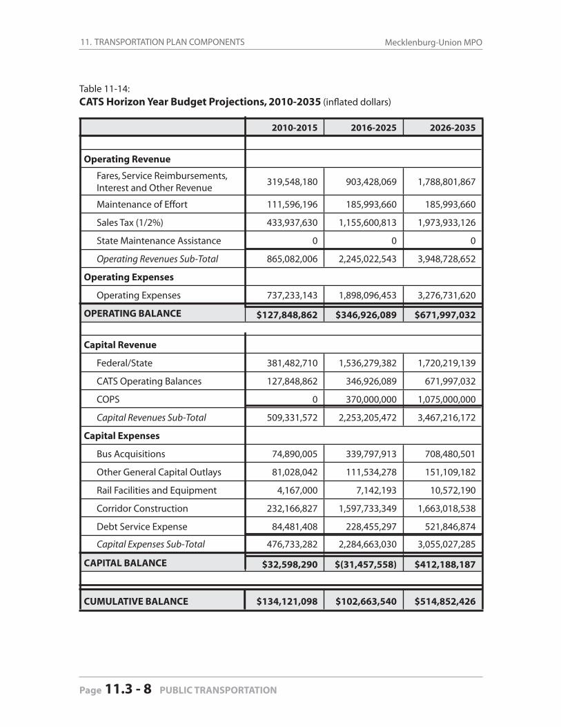
11. TRANSPORTATION PLAN COMPONENTS Mecklenburg-Union MPO
Page 11.3 - 8 PUBLIC TRANSPORTATION
Table 11-14: CATS Horizon Year Budget Projections, 2010-2035 (infl ated dollars)
2010-2015 2016-2025 2026-2035
Operating Revenue
Fares, Service Reimbursements, Interest and Other Revenue
319,548,180 903,428,069 1,788,801,867
Maintenance of Effort 111,596,196 185,993,660 185,993,660
Sales Tax (1/2%) 433,937,630 1,155,600,813 1,973,933,126
State Maintenance Assistance 0 0 0
Operating Revenues Sub-Total 865,082,006 2,245,022,543 3,948,728,652
Operating Expenses
Operating Expenses 737,233,143 1,898,096,453 3,276,731,620
OPERATING BALANCE $127,848,862 $346,926,089 $671,997,032
Capital Revenue
Federal/State 381,482,710 1,536,279,382 1,720,219,139
CATS Operating Balances 127,848,862 346,926,089 671,997,032
COPS 0 370,000,000 1,075,000,000
Capital Revenues Sub-Total 509,331,572 2,253,205,472 3,467,216,172
Capital Expenses
Bus Acquisitions 74,890,005 339,797,913 708,480,501
Other General Capital Outlays 81,028,042 111,534,278 151,109,182
Rail Facilities and Equipment 4,167,000 7,142,193 10,572,190
Corridor Construction 232,166,827 1,597,733,349 1,663,018,538
Debt Service Expense 84,481,408 228,455,297 521,846,874
Capital Expenses Sub-Total 476,733,282 2,284,663,030 3,055,027,285
CAPITAL BALANCE $32,598,290 $(31,457,558) $412,188,187
CUMULATIVE BALANCE $134,121,098 $102,663,540 $514,852,426
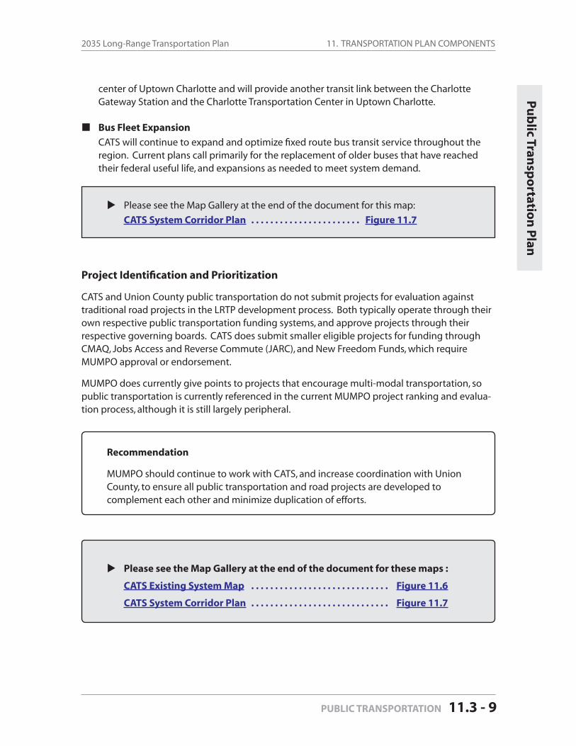
11. TRANSPORTATION PLAN COMPONENTS2035 Long-Range Transportation Plan
PUBLIC TRANSPORTATION 11.3 - 9
center of Uptown Charlotte and will provide another transit link between the Charlotte Gateway Station and the Charlotte Transportation Center in Uptown Charlotte.
Bus Fleet Expansion
CATS will continue to expand and optimize fi xed route bus transit service throughout the region. Current plans call primarily for the replacement of older buses that have reached their federal useful life, and expansions as needed to meet system demand.
Please see the Map Gallery at the end of the document for this map:
CATS System Corridor Plan . . . . . . . . . . . . . . . . . . . . . . . Figure 11.7
Project Identifi cation and Prioritization
CATS and Union County public transportation do not submit projects for evaluation against traditional road projects in the LRTP development process. Both typically operate through their own respective public transportation funding systems, and approve projects through their respective governing boards. CATS does submit smaller eligible projects for funding through CMAQ, Jobs Access and Reverse Commute (JARC), and New Freedom Funds, which require MUMPO approval or endorsement.
MUMPO does currently give points to projects that encourage multi-modal transportation, so public transportation is currently referenced in the current MUMPO project ranking and evalua-tion process, although it is still largely peripheral.
Recommendation
MUMPO should continue to work with CATS, and increase coordination with Union County, to ensure all public transportation and road projects are developed to complement each other and minimize duplication of efforts.
Please see the Map Gallery at the end of the document for these maps :
CATS Existing System Map . . . . . . . . . . . . . . . . . . . . . . . . . . . . . Figure 11.6
CATS System Corridor Plan . . . . . . . . . . . . . . . . . . . . . . . . . . . . . Figure 11.7
Pu
blic Tran
spo
rtation
Plan
11. TRANSPORTATION PLAN COMPONENTS Mecklenburg-Union MPO
Page 11.3 - 10 PUBLIC TRANSPORTATION
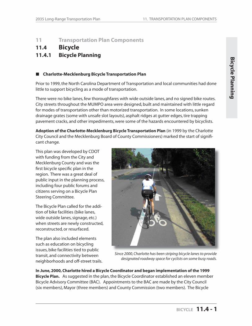
11. TRANSPORTATION PLAN COMPONENTS2035 Long-Range Transportation Plan
BICYCLE 11.4 - 1
11 Transportation Plan Components
11.4 Bicycle
11.4.1 Bicycle Planning
Charlotte-Mecklenburg Bicycle Transportation Plan
Prior to 1999, the North Carolina Department of Transportation and local communities had done little to support bicycling as a mode of transportation.
There were no bike lanes, few thoroughfares with wide outside lanes, and no signed bike routes. City streets throughout the MUMPO area were designed, built and maintained with little regard for modes of transportation other than motorized transportation. In some locations, sunken drainage grates (some with unsafe slot layouts), asphalt ridges at gutter edges, tire trapping pavement cracks, and other impediments, were some of the hazards encountered by bicyclists.
Adoption of the Charlotte-Mecklenburg Bicycle Transportation Plan (in 1999 by the Charlotte City Council and the Mecklenburg Board of County Commissioners) marked the start of signifi -cant change.
This plan was developed by CDOT with funding from the City and Mecklenburg County and was the fi rst bicycle specifi c plan in the region. There was a great deal of public input in the planning process, including four public forums and citizens serving on a Bicycle Plan Steering Committee.
The Bicycle Plan called for the addi-tion of bike facilities (bike lanes, wide outside lanes, signage, etc.) when streets are newly constructed, reconstructed, or resurfaced.
The plan also included elements such as education on bicycling issues, bike facilities tied to public transit, and connectivity between neighborhoods and off-street trails.
In June, 2000, Charlotte hired a Bicycle Coordinator and began implementation of the 1999 Bicycle Plan. As suggested in the plan, the Bicycle Coordinator established an eleven member Bicycle Advisory Committee (BAC). Appointments to the BAC are made by the City Council (six members), Mayor (three members) and County Commission (two members). The Bicycle
Bicycle P
lann
ing
Since 2000, Charlotte has been striping bicycle lanes to provide designated roadway space for cyclists on some busy roads.

11. TRANSPORTATION PLAN COMPONENTS Mecklenburg-Union MPO
Page 11.4 - 2 BICYCLE
Coordinator works to ensure the needs of bicyclists are given due consideration within normal planning and design processes for roadway projects.
In May, 2006, Charlotte adopted the Transportation Action Plan, the city’s fi rst comprehensive transportation planning document addressing multiple transportation modes and it integration with land use. This document detailed policies and goals for bicycle transportation, including the development of a new city plan devoted exclusively to bicycle transportation.
In October, 2007, the City of Charlotte adopted the Urban Street Design Guidelines (USDG’s). The USDG’s implement the Transportation Action Plan by providing a process to design streets that fi t within the context and accommodates all users, including bicyclists, by providing a safer and more comfortable street.
In September, 2008, Charlotte adopted the 2008 City of Charlotte Bicycle Plan. This new plan builds upon the lessons of the 1999 plan and updates bicycle transportation policies andrecommendations. Develop-ment of the plan was guided by a twenty-member stakeholder group and included well-attend-ed public meetings and work-shops. Roadway project manag-ers and Planning Commission staff now refer to the Charlotte Bicycle Plan when roadway and streetscape projects are being planned and designed.
Communities have also promot-ed bicycling as an alternative to automobile trips, especially for commuting to work and short trips for errands, social visits and recreation. Charlotte’s promo-tional effort is highlighted by “BIKE!Charlotte,” a weeklongseries of events.
The Charlotte Department of Transportation also developed a video that instructs motorists how to share roads with cyclists. This video is available for driver education programs. Other activities include bicycle awareness campaigns, printed materials and a bicycle program page on the CDOT website.
The City of Charlotte has constructed over fi fty miles of bike lanes throughout the city, refl ect-ing several measures that have expanded Charlotte’s bicycle facilities:
There are additional bike lanes on projects now in the design phase that will be com-pleted in upcoming years.
More people are discovering the bicycle provides health benefi ts while providing convenient transportation for sort trips.
11. TRANSPORTATION PLAN COMPONENTS2035 Long-Range Transportation Plan
BICYCLE 11.4 - 3
As streets are routinely resurfaced, it has become standard practice to provide a bike lane or additional space in the outside lane when practical.
Charlotte recently installed signage for three signed routes, with plans to sign fi ve more routes before the end of 2009, totaling almost forty miles.
The City installed numerous bicycle parking racks – an essential component of a bi-cycle transportation system – in the center city area and the area known as NoDa. The City is also developing a partnership program with local businesses to further increase the inventory of bicycle parking.
Mecklenburg County Greenways now offer about 30 miles of off–street pathways, including Mallard Creek Greenway (3.6 miles), upper McAlpine Creek Greenway (8.9 miles), lower McAlpine/McMullen Creek Greenway (5 miles), Torrance Creek Greenway (1.3 mile), Irwin Creek Greenway (1.3 mile) and Little Sugar Creek Greenway (2.4 miles).
Charlotte is planning other bikeway projects in conjunction with development of future light rail corridors
Bicycle parking requirements have been adopted as part of the City’s zoning ordi-nance.
In the spring of 2008, Charlotte was named a Bicycle Friendly Community at the bronze level by the League of American Bicyclists, in recognition of the City’s efforts to improve the local bicycle transportation environment.
MUMPO Region
Other communities in the MUMPO area have also undertaken bicycle initiatives.
Matthews and Davidson have adopted bicycle specifi c master plans. Indian Trail will begin developing a bicycle plan in the fall of 2009,
Other communities, including Cornelius, Huntersville and Pineville, have included bicycle components as part of a larger or more comprehensive plan, such as green-way/bikeway or development overlay plans.
Davidson, Huntersville, Cornelius and Matthews have striped dedicated bicycle lanes.
Bicycle parking requirements have been adopted in Davidson, Huntersville, Indian Trail, Pineville and Waxhaw.
Several communities, including Cornelius, Davidson, Huntersville, Indian Trail, Matthews and Waxhaw, have appointed a board or commission that considers bicycling issues.
Bicycle Component continued next page
Bicycle P
lann
ing
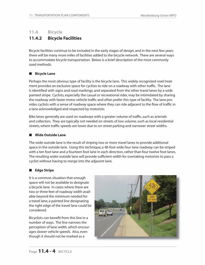
11. TRANSPORTATION PLAN COMPONENTS Mecklenburg-Union MPO
Page 11.4 - 4 BICYCLE
11.4 Bicycle
11.4.2 Bicycle Facilities
Bicycle facilities continue to be included in the early stages of design, and in the next few years there will be many more miles of facilities added to the bicycle network. There are several ways to accommodate bicycle transportation. Below is a brief description of the most commonly used methods.
Bicycle Lane
Perhaps the most obvious type of facility is the bicycle lane. This widely recognized road treat-ment provides an exclusive space for cyclists to ride on a roadway with other traffi c. The lane is identifi ed with signs and road markings, and separated from the other travel lanes by a wide painted stripe. Cyclists, especially the casual or recreational rider, may be intimidated by sharing the roadway with faster motor vehicle traffi c and often prefer this type of facility. The lane pro-vides cyclists with a sense of roadway space where they can ride adjacent to the fl ow of traffi c in a lane acknowledged and respected by motorists.
Bike lanes generally are used on roadways with a greater volume of traffi c, such as arterials and collectors. They are typically not needed on streets of low volume, such as local residential streets, where traffi c speeds are lower due to on-street parking and narrower street widths.
Wide Outside Lane
The wide outside lane is the result of striping two or more travel lanes to provide additional space in the outside lane. Using this technique, a 48-foot wide four-lane roadway can be striped with a ten foot lane and a fourteen foot lane in each direction, rather than four twelve foot lanes. The resulting wider outside lane will provide suffi cient width for overtaking motorists to pass a cyclist without having to merge into the adjacent lane.
Edge Stripe
It is a common situation that enough space will not be available to designate a bicycle lane. In cases where there are two or three feet of roadway width avail-able beyond the minimum needed for a travel lane, a painted line designating the right edge of the travel lane could be considered.
Bicyclists can benefi t from this line in a number of ways. The line narrows the perception of lane width, which encour-ages slower vehicle speeds. Also, eventhough it should not be marked as a
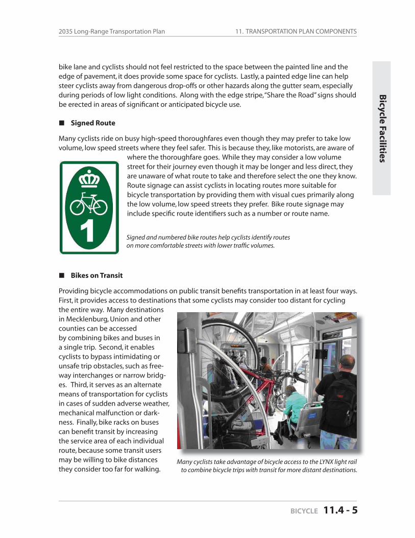
11. TRANSPORTATION PLAN COMPONENTS2035 Long-Range Transportation Plan
BICYCLE 11.4 - 5
bike lane and cyclists should not feel restricted to the space between the painted line and the edge of pavement, it does provide some space for cyclists. Lastly, a painted edge line can help steer cyclists away from dangerous drop-offs or other hazards along the gutter seam, especially during periods of low light conditions. Along with the edge stripe, “Share the Road” signs should be erected in areas of signifi cant or anticipated bicycle use.
Signed Route
Many cyclists ride on busy high-speed thoroughfares even though they may prefer to take low volume, low speed streets where they feel safer. This is because they, like motorists, are aware of
where the thoroughfare goes. While they may consider a low volume street for their journey even though it may be longer and less direct, they are unaware of what route to take and therefore select the one they know. Route signage can assist cyclists in locating routes more suitable for bicycle transportation by providing them with visual cues primarily along the low volume, low speed streets they prefer. Bike route signage may include specifi c route identifi ers such as a number or route name.
Bikes on Transit
Providing bicycle accommodations on public transit benefi ts transportation in at least four ways. First, it provides access to destinations that some cyclists may consider too distant for cycling the entire way. Many destinations in Mecklenburg, Union and other counties can be accessed by combining bikes and buses in a single trip. Second, it enables cyclists to bypass intimidating or unsafe trip obstacles, such as free-way interchanges or narrow bridg-es. Third, it serves as an alternate means of transportation for cyclists in cases of sudden adverse weather, mechanical malfunction or dark-ness. Finally, bike racks on buses can benefi t transit by increasing the service area of each individual route, because some transit users may be willing to bike distances they consider too far for walking.
Bicycle Facilities
Signed and numbered bike routes help cyclists identify routes on more comfortable streets with lower traffi c volumes.
Many cyclists take advantage of bicycle access to the LYNX light railto combine bicycle trips with transit for more distant destinations.
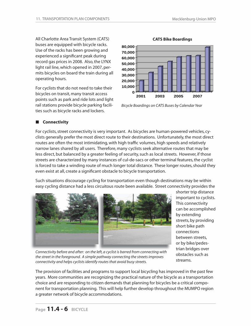
11. TRANSPORTATION PLAN COMPONENTS Mecklenburg-Union MPO
Page 11.4 - 6 BICYCLE
All Charlotte Area Transit System (CATS) buses are equipped with bicycle racks. Use of the racks has been growing and experienced a signifi cant peak during record gas prices in 2008. Also, the LYNX light rail line, which opened in 2007, per-mits bicycles on board the train during all operating hours.
For cyclists that do not need to take their bicycles on transit, many transit access points such as park and ride lots and light rail stations provide bicycle parking facili-ties such as bicycle racks and lockers.
Connectivity
For cyclists, street connectivity is very important. As bicycles are human-powered vehicles, cy-clists generally prefer the most direct route to their destinations. Unfortunately, the most direct routes are often the most intimidating, with high traffi c volumes, high speeds and relatively narrow lanes shared by all users. Therefore, many cyclists seek alternative routes that may be less direct, but balanced by a greater feeling of security, such as local streets. However, if those streets are characterized by many instances of cul-de-sacs or other terminal features, the cyclist is forced to take a winding route of much longer total distance. These longer routes, should they even exist at all, create a signifi cant obstacle to bicycle transportation.
Such situations discourage cycling for transportation even though destinations may be within easy cycling distance had a less circuitous route been available. Street connectivity provides the
shorter trip distance important to cyclists. This connectivity can be accomplished by extendingstreets, by providing short bike path connections between streets, or by bike/pedes-trian bridges over obstacles such as streams.
The provision of facilities and programs to support local bicycling has improved in the past few years. More communities are recognizing the practical nature of the bicycle as a transportation choice and are responding to citizen demands that planning for bicycles be a critical compo-nent for transportation planning. This will help further develop throughout the MUMPO region a greater network of bicycle accommodations.
010,00020,00030,00040,00050,00060,00070,00080,000
2001 2003 2005 2007
CATS Bike Boardings
Bicycle Boardings on CATS Buses by Calendar Year
Connectivity before and after: on the left, a cyclist is barred from connecting with the street in the foreground. A simple pathway connecting the streets improves connectivity and helps cyclists identify routes that avoid busy streets.
11. TRANSPORTATION PLAN COMPONENTS2035 Long-Range Transportation Plan
BICYCLE 11.4 - 7
Bicycle P
rojects
11.4 Bicycle
11.4.3 Programmed Bicycle Projects
The City of Charlotte and some other MUMPO communities are incorporating bicycle facilities in the design of their roadways. Several bicycle projects have been completed in the past few years. Examples include:
Bicycle lanes were striped on Old Pineville Road and Cindy Lane as components of larger construction projects.
Other bicycle lanes were striped by taking advantage of resurfacing opportunities, such as along Ballentyne Commons Parkway and Barrington Drive.
Additional bike lanes were provided through comprehensive redesign of the street for improved safety and livability, such as East Boulevard and Tuckaseegee Road in Charlotte and Griffi th Street in Davidson.
Additionally, there are other projects currently under design or construction which will have bicycle facilities when complete, such as Freedom Drive or the Dixie River Road realignment.
Bicycle facilities continue to be included in the early stages of design, and new facilities will be added to the bicycle transportation inventory in the coming years. There are 30.9 miles of programmed roadway projects that incorporate bikeways, primarily bike lanes and wide outside lanes.
The table below identifi es the programmed roadway projects that include bicycle improve-ments. Programmed projects have funding identifi ed and are anticipated to begin construction within the next few years.
Table 11-15: Programmed Roadway Projects with Bikeways
PROJECT NAMETYPE OFBIKEWAY
FUNDINGSOURCE
Length(Miles)
Ballantyne Commons Parkway (NC 16 to Annalexa) Bike Lanes Local 0.6
Beatties Ford Road Widening (Capps Hill Mine to Sunset) Bike Lanes State or Local 0.7
Bicycle Facilities - Program Funds n/a Local n.a
Catawba Avenue (Jetton Road to Torrence Chapel Road) WOL* State 4.1
Central Avenue (Sharon Amity to Reddman) Bike Lanes Local 0.5
Charles Street (Sunset Drive to Franklin Sreet) Bike Lanes State 0.6
City Boulevard Extension (Neal Road to Mallard Creek Ext) Bike Lanes Local 0.8
Dixie River Road/NC 160 Connector Bike Lanes Local 0.7
Table continued on next page
11. TRANSPORTATION PLAN COMPONENTS Mecklenburg-Union MPO
Page 11.4 - 8 BICYCLE
PROJECT NAMETYPE OFBIKEWAY
FUNDINGSOURCE
Length(Miles)
East Boulevard (Dilworth Road West to South Boulevard) Bike Lanes Local 0.7
Fred Alexander Boulevard (NC 27 to NC 16) Bike Lanes Local 2.5
Freedom Drive Widening (Edgewood Rd to Toddville Rd) Bike Lanes Local 1.6
Garden Parkway (I-485 to Gaston County Line) Bike Path State 1.9
Idlewild Road Widening (Harris Boulevard to Drifter Drive) Bike Lanes Local 0.7
Indian Trail Road (US 74 to Old Monroe Road) Bike Lanes State 1.5
Jim Cooke Road (Northcross Drive Ext to Bailey Road) Bike Lanes Local 0.6
Little Rock Road Relocation (Flintrock Rd to Freedom Drive) Bike Lanes Local 0.7
Mallard Creek Road (Sugar Creek to Harris Boulevard) Bike Lanes State 2.4
McKee Road (John Street to Campus Ridge Road) Bike Lanes State or Local 0.5
NC 73 East (US 21 to NC 115) WOL* State 1.0
Northcross Drive Ext (Northcross Dr to Eagleridge Way Ln) Bike Lanes Local 0.9
Rea Road (Colony Road to NC 51) Bike Lanes Local 1.0
Stallings Road (Old Monroe Road to Independence Blvd) Bike Lanes State 1.3
Statesville Road (Starita Road to Keith Road) Bike Lanes Local 1.7
Statesville Road (Northcross Center to Boat House Court) Bike Lanes Local 1.4
West Boulevard Ext (Steele Creek Road to I-485) Bike Lanes State 0.5
Westmoreland Road (Statesville Rd to Washam-Potts Rd) Bike Lanes Local 1.0
Westmoreland Road West (Catawba Ave to Statesville Rd) Bike Lanes Local 1.0
*WOL = Wide Outside Lane Total Miles = 30.9
Table 11-15 continued Programmed Roadway Projects with Bikeways
11. TRANSPORTATION PLAN COMPONENTS2035 Long-Range Transportation Plan
BICYCLE 11.4 - 9
11.4 Bicycle
11.4.4 Horizon Year Recommendations
Bicycle Plan
There are 36.6 miles of roadway projects with bikeways that are proposed in this 2035 Long-Range Transportation Plan (LRTP)—primarily bicycle lanes and wide outside lanes. This list is comprised of projects which may be undertaken by the year 2035.
The 2030 LRTP advanced the implementation of bicycle facilities, and the 2035 LRTP continues to recognize the importance of bicycle transportation as a component of the area’s mobility net-work. This advances the goals of local bicycle transportation plans and other plans adopted by the transportation planning organizations and local governments in the Charlotte-Mecklenburg region.
The development of bikeways in recent years has indicated the growing importance being placed on the bicycle as a transportation mode. This is illustrated by the signifi cant number of proposed projects which include bikeways in the 2035 LRTP.
Table 11-16: Proposed Miles of Bikeway Improvements
Table 11-17: Summary of 2035 Programmed and Proposed Bikeway Improvements
Bicycle R
ecom
men
datio
ns
Type of Bikeway Improvement
2015 2025 2035 Total
Bike Lanes 23.9 miles 20.7 miles 15.9 miles 60.5 miles
Wide Outside Lanes 5.1 miles 0 0 5.1 miles
Other 1.9 miles 0 0 1.9 miles
Total 30.9 miles 20.7 miles 15.9 miles 67.5 miles
Type of Bikeway Improvement
ProgrammedImprovements
Proposed Improvements
Total
Bike Lanes 23.9 miles 15.9 miles 60.5 miles
Wide Outside Lanes 5.1 miles 0 5.1 miles
Other 1.9 miles 0 1.9 miles
Total 30.9 miles 15.9 miles 67.5 miles
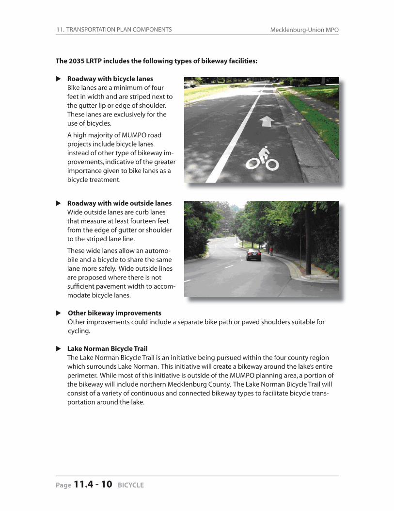
11. TRANSPORTATION PLAN COMPONENTS Mecklenburg-Union MPO
Page 11.4 - 10 BICYCLE
The 2035 LRTP includes the following types of bikeway facilities:
Roadway with bicycle lanes Bike lanes are a minimum of four
feet in width and are striped next to the gutter lip or edge of shoulder. These lanes are exclusively for the use of bicycles.
A high majority of MUMPO road projects include bicycle lanes instead of other type of bikeway im-provements, indicative of the greater importance given to bike lanes as a bicycle treatment.
Roadway with wide outside lanes Wide outside lanes are curb lanes
that measure at least fourteen feet from the edge of gutter or shoulder to the striped lane line.
These wide lanes allow an automo-bile and a bicycle to share the same lane more safely. Wide outside lines are proposed where there is not suffi cient pavement width to accom-modate bicycle lanes.
Other bikeway improvements Other improvements could include a separate bike path or paved shoulders suitable for
cycling.
Lake Norman Bicycle Trail The Lake Norman Bicycle Trail is an initiative being pursued within the four county region
which surrounds Lake Norman. This initiative will create a bikeway around the lake’s entire perimeter. While most of this initiative is outside of the MUMPO planning area, a portion of the bikeway will include northern Mecklenburg County. The Lake Norman Bicycle Trail will consist of a variety of continuous and connected bikeway types to facilitate bicycle trans-portation around the lake.
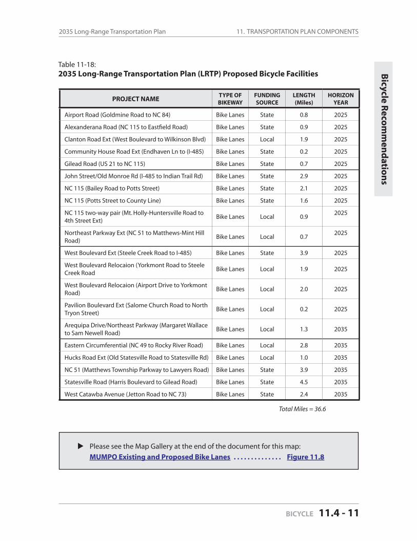
11. TRANSPORTATION PLAN COMPONENTS2035 Long-Range Transportation Plan
BICYCLE 11.4 - 11
Bicycle R
ecom
men
datio
ns
PROJECT NAMETYPE OFBIKEWAY
FUNDINGSOURCE
LENGTH(Miles)
HORIZON YEAR
Airport Road (Goldmine Road to NC 84) Bike Lanes State 0.8 2025
Alexanderana Road (NC 115 to Eastfi eld Road) Bike Lanes State 0.9 2025
Clanton Road Ext (West Boulevard to Wilkinson Blvd) Bike Lanes Local 1.9 2025
Community House Road Ext (Endhaven Ln to (I-485) Bike Lanes State 0.2 2025
Gilead Road (US 21 to NC 115) Bike Lanes State 0.7 2025
John Street/Old Monroe Rd (I-485 to Indian Trail Rd) Bike Lanes State 2.9 2025
NC 115 (Bailey Road to Potts Street) Bike Lanes State 2.1 2025
NC 115 (Potts Street to County Line) Bike Lanes State 1.6 2025
NC 115 two-way pair (Mt. Holly-Huntersville Road to 4th Street Ext)
Bike Lanes Local 0.92025
Northeast Parkway Ext (NC 51 to Matthews-Mint Hill Road)
Bike Lanes Local 0.72025
West Boulevard Ext (Steele Creek Road to I-485) Bike Lanes State 3.9 2025
West Boulevard Relocaion (Yorkmont Road to Steele Creek Road
Bike Lanes Local 1.9 2025
West Boulevard Relocaion (Airport Drive to Yorkmont Road)
Bike Lanes Local 2.0 2025
Pavilion Boulevard Ext (Salome Church Road to North Tryon Street)
Bike Lanes Local 0.2 2025
Arequipa Drive/Northeast Parkway (Margaret Wallace to Sam Newell Road)
Bike Lanes Local 1.3 2035
Eastern Circumferential (NC 49 to Rocky River Road) Bike Lanes Local 2.8 2035
Hucks Road Ext (Old Statesville Road to Statesville Rd) Bike Lanes Local 1.0 2035
NC 51 (Matthews Township Parkway to Lawyers Road) Bike Lanes State 3.9 2035
Statesville Road (Harris Boulevard to Gilead Road) Bike Lanes State 4.5 2035
West Catawba Avenue (Jetton Road to NC 73) Bike Lanes State 2.4 2035
Total Miles = 36.6
Table 11-18:2035 Long-Range Transportation Plan (LRTP) Proposed Bicycle Facilities
Please see the Map Gallery at the end of the document for this map:
MUMPO Existing and Proposed Bike Lanes . . . . . . . . . . . . . . Figure 11.8
11. TRANSPORTATION PLAN COMPONENTS Mecklenburg-Union MPO
Page 11.4 - 12 BICYCLE
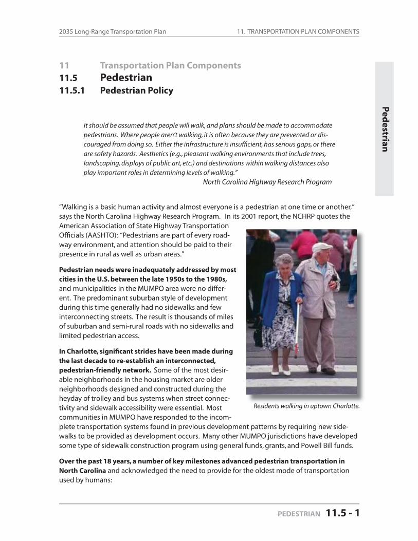
11. TRANSPORTATION PLAN COMPONENTS2035 Long-Range Transportation Plan
PEDESTRIAN 11.5 - 1
11 Transportation Plan Components
11.5 Pedestrian
11.5.1 Pedestrian Policy
It should be assumed that people will walk, and plans should be made to accommodate pedestrians. Where people aren’t walking, it is often because they are prevented or dis-couraged from doing so. Either the infrastructure is insuffi cient, has serious gaps, or there are safety hazards. Aesthetics (e.g., pleasant walking environments that include trees, landscaping, displays of public art, etc.) and destinations within walking distances also play important roles in determining levels of walking.”
North Carolina Highway Research Program
“Walking is a basic human activity and almost everyone is a pedestrian at one time or another,” says the North Carolina Highway Research Program. In its 2001 report, the NCHRP quotes theAmerican Association of State Highway Transportation Offi cials (AASHTO): “Pedestrians are part of every road-way environment, and attention should be paid to their presence in rural as well as urban areas.”
Pedestrian needs were inadequately addressed by most cities in the U.S. between the late 1950s to the 1980s, and municipalities in the MUMPO area were no differ-ent. The predominant suburban style of development during this time generally had no sidewalks and few interconnecting streets. The result is thousands of miles of suburban and semi-rural roads with no sidewalks and limited pedestrian access.
In Charlotte, signifi cant strides have been made during the last decade to re-establish an interconnected, pedestrian-friendly network. Some of the most desir-able neighborhoods in the housing market are older neighborhoods designed and constructed during the heyday of trolley and bus systems when street connec-tivity and sidewalk accessibility were essential. Most communities in MUMPO have responded to the incom-plete transportation systems found in previous development patterns by requiring new side-walks to be provided as development occurs. Many other MUMPO jurisdictions have developed some type of sidewalk construction program using general funds, grants, and Powell Bill funds.
Over the past 18 years, a number of key milestones advanced pedestrian transportation in North Carolina and acknowledged the need to provide for the oldest mode of transportation used by humans:
Ped
estrian
Residents walking in uptown Charlotte.
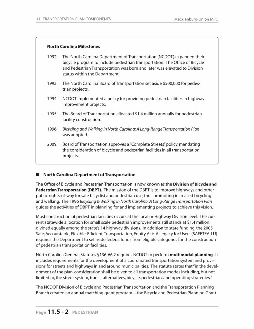
11. TRANSPORTATION PLAN COMPONENTS Mecklenburg-Union MPO
Page 11.5 - 2 PEDESTRIAN
North Carolina Milestones
1992: The North Carolina Department of Transportation (NCDOT) expanded their bicycle program to include pedestrian transportation. The Offi ce of Bicycle and Pedestrian Transportation was born and later was elevated to Division status within the Department.
1993: The North Carolina Board of Transportation set aside $500,000 for pedes-trian projects.
1994: NCDOT implemented a policy for providing pedestrian facilities in highway improvement projects.
1995: The Board of Transportation allocated $1.4 million annually for pedestrian facility construction.
1996: Bicycling and Walking in North Carolina: A Long-Range Transportation Plan was adopted.
2009: Board of Transportation approves a “Complete Streets” policy, mandating the consideration of bicycle and pedestrian facilities in all transportation projects.
North Carolina Department of Transportation
The Offi ce of Bicycle and Pedestrian Transportation is now known as the Division of Bicycle and Pedestrian Transportation (DBPT). The mission of the DBPT is to improve highways and other public rights-of-way for safe bicyclist and pedestrian use, thus promoting increased bicycling and walking. The 1996 Bicycling & Walking in North Carolina: A Long-Range Transportation Plan guides the activities of DBPT in planning for and implementing projects to achieve this vision.
Most construction of pedestrian facilities occurs at the local or Highway Division level. The cur-rent statewide allocation for small scale pedestrian improvements still stands at $1.4 million, divided equally among the state’s 14 highway divisions. In addition to state funding, the 2005 Safe, Accountable, Flexible, Effi cient, Transportation, Equity Act: A Legacy for Users (SAFETEA-LU) requires the Department to set aside federal funds from eligible categories for the construction of pedestrian transportation facilities.
North Carolina General Statutes §136-66.2 requires NCDOT to perform multimodal planning. It includes requirements for the development of a coordinated transportation system and provi-sions for streets and highways in and around municipalities. The statute states that “in the devel-opment of the plan, consideration shall be given to all transportation modes including, but not limited to, the street system, transit alternatives, bicycle, pedestrian, and operating strategies.”
The NCDOT Division of Bicycle and Pedestrian Transportation and the Transportation Planning Branch created an annual matching grant program—the Bicycle and Pedestrian Planning Grant
11. TRANSPORTATION PLAN COMPONENTS2035 Long-Range Transportation Plan
PEDESTRIAN 11.5 - 3
Ped
estrian
Initiative—to encourage municipalities to develop comprehensive bicycle plans and pedestrian plans. This program was initiated in January, 2004, and is currently administered through NC-DOT-DBPT. According to the DBPT, these grants allow municipalities to create pedestrian plans that are then approved and referenced by the NCDOT.
NCDOT Complete Streets Policy
In July, 2009, the North Carolina Board of Transportation adopted the following “Complete Streets Policy:”
“The North Carolina Department of Transportation, in its role as stewards over the transportation infrastructure, is committed to:
providing an effi cient multi-modal transportation network in North Carolina such that the access, mobility, and safety needs of motorists, transit users, bicyclists, and pedestrians of all ages and abilities are safely accommodated;
caring for the built and natural environments by promoting sustainable develop-ment practices that minimize impacts on natural resources, historic, businesses, residents, scenic and other community values, while also recognizing that trans-portation improvements have signifi cant potential to contribute to local, regional, and statewide quality of life and economic development objectives;
working in partnership with local government agencies, interest groups, and the public to plan, fund, design, construct, and manage complete street networks that sustain mobility while accommodating walking, biking, and transit opportunities safely.
This policy requires that NCDOT’s planners and designers will consider and incorpo-rate multimodal alternatives in the design and improvement of all appropriate trans-portation projects within a growth area of a town or city unless exceptional circum-stances exist. Routine maintenance projects may be excluded from this requirement if an appropriate source of funding is not available.”
Mecklenburg-Union Metropolitan Planning Organization (MUMPO)
MUMPO works with NCDOT to incorporate sidewalk construction as a matter of standard prac-tice on NCDOT projects within the urban area. Currently, NCDOT offers to construct sidewalks if municipalities fund a portion (or all) of the cost and the municipality also agrees to maintain the sidewalks once they are completed.
In addition to Charlotte, other local governments are providing the funding necessary to ensure sidewalks are added to some of the roadway projects being planned and designed by NCDOT.
MUMPO also has taken a strong stance to ensure that new roadway construction projects in-clude pedestrian facilities and at the very least provide room for future sidewalk improvements and do not create pedestrian barriers to the future provision of pedestrian ways.
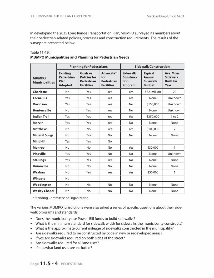
11. TRANSPORTATION PLAN COMPONENTS Mecklenburg-Union MPO
Page 11.5 - 4 PEDESTRIAN
In developing the 2035 Long Range Transportation Plan, MUMPO surveyed its members about their pedestrian-related policies, processes and construction requirements. The results of the survey are presented below.
Table 11-19: MUMPO Municipalities and Planning for Pedestrian Needs
MUMPO Municipalities
Planning for Pedestrians Sidewalk Construction
Existing Pedestrian Plan Adopted
Goals or Policies for Pedestrian Facilities
Advocate*for Pedestrian Facilities
SidewalkConstruc-tionProgram
TypicalAnnualSidewalkBudget
Ave. Miles Sidewalk Built Per Year
Charlotte No Yes Yes Yes $7.5 million 22
Cornelius Yes Yes Yes Yes None Unknown
Davidson Yes Yes Yes No $150,000 Unknown
Huntersville No Yes Yes No None Unknown
Indian Trail Yes Yes Yes Yes $350,000 1 to 2
Marvin Yes Yes Yes No None None
Matthews No No Yes Yes $100,000 2
Mineral Sprgs No Yes No No None None
Mint Hill Yes Yes No
Monroe No No No Yes $30,000 1
Pineville Yes Yes No No None Unknown
Stallings Yes Yes Yes No None None
Unionville No No No No None None
Waxhaw No Yes Yes Yes $50,000 1
Wingate No
Weddington No No No No None None
Wesley Chapel No No No No None None
* Standing Committee or Organization
The various MUMPO jurisdictions were also asked a series of specifi c questions about their side-walk programs and standards:
Does the municipality use Powell Bill funds to build sidewalks?What is the minimum standard for sidewalk width for sidewalks the municipality constructs?What is the approximate current mileage of sidewalks constructed in the municipality?Are sidewalks required to be constructed by code in new or redeveloped areas?If yes, are sidewalks required on both sides of the street?Are sidewalks required for all land uses?If not, what land uses are excluded?

11. TRANSPORTATION PLAN COMPONENTS2035 Long-Range Transportation Plan
PEDESTRIAN 11.5 - 5
Table 11-20: MUMPO Municipalities and Sidewalk Standards
MUMPOMunicipalities
Use Powell Bill Funds to Build Sidewalks
Minimum Standard Sidewalk Width
Current Mileage of Sidewalks Constructed
Sidewalks Required on Both Sides of Street?
Sidewalks Required for All Land Uses?
If Not, What Land Uses Are Exclud-ed?
Charlotte No 5 feet 2,206 Yes Yes N/A
Cornelius Yes 4 feet 20 Yes Yes N/A
Davidson Yes 5 feet Unknown Yes Yes N/A
Huntersville Yes 5 feet 188 Yes Yes N/A
Indian Trail Yes 5 feet 85 Yes No
Large Lot (4 acre) SFR or Subdivi-sions Less than 5 Lots
Marvin No N/A Unknown Yes Yes N/A
Matthews Yes 5 feet 70 Yes NoWarehouse or Industrial uses
Mineral Sprgs No N/A None N/A N/A N/A
Mint Hill No 5 feet Unknown Yes No SFR
Monroe Yes 5 feet 50 Yes Yes N/A
Pineville Yes 5 feet 5 Yes Yes N/A
Stallings Yes 5 feet 5 Yes No SFR
Unionville No N/A Unknown No No All
Waxhaw Yes 5 feet 10 Yes No SFR or duplex
Wingate No 5 feet Unknown Yes NoSFR less than25 units
Weddington No N/A Unknown No No All
Wesley Chapel No 4 feet Unknown Yes Yes
Commercial, Industrial, Small Subdivisons
Pedestrian Component continued next page
Sidew
alk Stand
ards
The responses are summarized in the following table.
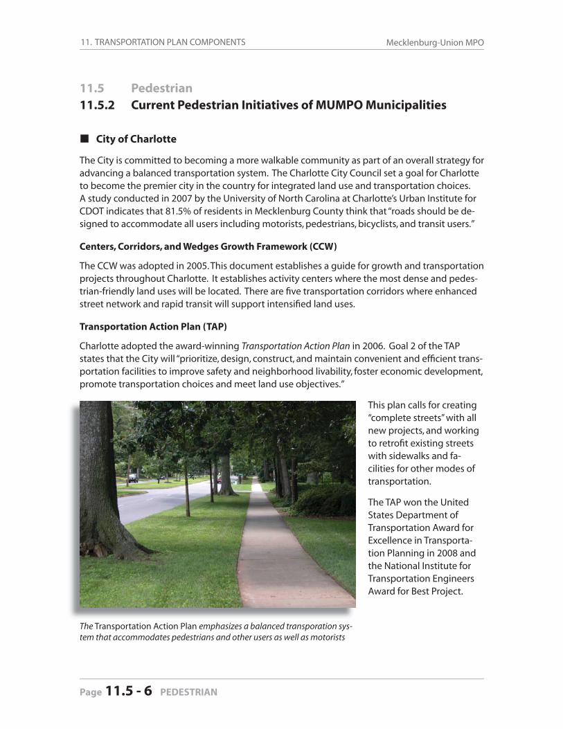
11. TRANSPORTATION PLAN COMPONENTS Mecklenburg-Union MPO
Page 11.5 - 6 PEDESTRIAN
11.5 Pedestrian
11.5.2 Current Pedestrian Initiatives of MUMPO Municipalities
City of Charlotte
The City is committed to becoming a more walkable community as part of an overall strategy for advancing a balanced transportation system. The Charlotte City Council set a goal for Charlotte to become the premier city in the country for integrated land use and transportation choices. A study conducted in 2007 by the University of North Carolina at Charlotte’s Urban Institute for CDOT indicates that 81.5% of residents in Mecklenburg County think that “roads should be de-signed to accommodate all users including motorists, pedestrians, bicyclists, and transit users.”
Centers, Corridors, and Wedges Growth Framework (CCW)
The CCW was adopted in 2005. This document establishes a guide for growth and transportation projects throughout Charlotte. It establishes activity centers where the most dense and pedes-trian-friendly land uses will be located. There are fi ve transportation corridors where enhanced street network and rapid transit will support intensifi ed land uses.
Transportation Action Plan (TAP)
Charlotte adopted the award-winning Transportation Action Plan in 2006. Goal 2 of the TAP states that the City will “prioritize, design, construct, and maintain convenient and effi cient trans-portation facilities to improve safety and neighborhood livability, foster economic development, promote transportation choices and meet land use objectives.”
This plan calls for creating “complete streets” with all new projects, and working to retrofi t existing streets with sidewalks and fa-cilities for other modes of transportation.
The TAP won the United States Department of Transportation Award for Excellence in Transporta-tion Planning in 2008 and the National Institute for Transportation Engineers Award for Best Project.
The Transportation Action Plan emphasizes a balanced transporation sys-tem that accommodates pedestrians and other users as well as motorists
11. TRANSPORTATION PLAN COMPONENTS2035 Long-Range Transportation Plan
PEDESTRIAN 11.5 - 7
Two key objectives from the TAP are:
Objective 2.1, which states that the City intends for all transportation projects to improve safety and livablility, promote transportation choices and meet land use objectives; andObjective 2.7, which calls for the City to construct 625 miles of new sidewalk by 2030.
Urban Street Design Guidelines (USDG)
The USDG were adopted in 2007. The USDG document establishes complete street guidelines for all new street construction in the city and retrofi t situations. It also recommends changes to policies and the zoning ordinance to provide for complete streets within new land development projects.
Sidewalk Retrofi t Policy and Code Requirements
The Sidewalk Retrofi t Policy was adopted in 2005. It guides the City’s prioritization of new side-walk projects within the Sidewalk Program. Sidewalk needs are identifi ed and prioritized based on criteria defi ned in this policy.
The Charlotte-Mecklenburg Land Development Standards Manual requires sidewalk to be con-structed on both sides of the street for all land uses.
The City has established Mid-Block Crossing Guidelines that provide a means of evaluating requests for mid-block crossings to provide for safer and more equitable crossings. A monthly committee meets to conduct evaluations of potential mid block crossings.
Transit
Charlotte’s Department of Transportation (CDOT) and the Charlotte Area Transit System (CATS) collaborated to create the South Corridor Infrastructure Program (SCIP). SCIP funded $50 million in infrastructure improvements around LYNX Blue Line’s South Corridor light rail stations includ-ing new sidewalks, intersection improvements, new signals, bicycle lanes, a rail trail, pedestrian lighting and street trees in close proximity to the stations.
The planned LYNX Blue Line Extension in the northeast section of the city will have a coun-terpart program called the Northeast Corridor Infrastructure Program (NECI). Its scope will be similar to that of the SCIP, building and enhancing infrastructure in the vicinity of all northeast corridor light rail stations.
Funding
The City allocates $7.5 million annually to construct and maintain sidewalks through CDOT’s Sidewalk Program. The City also provides funds for sidewalk construction on new streets in local and state projects and through the City’s Neighborhood Improvement Program.
Note: The following pages (8-12) summarize initiatives in other MUMPO municipalities, focusing on their respective codes and policies related to pedestrians, and to adopted plans that address pedes-trian issues in their jurisdiction.
Ped
estrian In
itiatives
11. TRANSPORTATION PLAN COMPONENTS Mecklenburg-Union MPO
Page 11.5 - 8 PEDESTRIAN
Town of Cornelius
Cornelius has 20 miles of existing sidewalk. The Town uses its Land Development Code and Transportation Advisory Board to coordinate new sidewalks via private sector development. Sidewalks are typically required to be built on both sides of the street, except in the Industrial campus land use which requires sidewalk on one side of the street only.
The Zoning Ordinance requires sidewalk on both sides of the street for all land uses except industrial districts, where sidewalks are only required on one side. Certain street types, such as alleys or cul-de-sacs, can be exempt from the sidewalk requirement.
Though the Town does not have a budget for sidewalk construction, it utilizes Powell Bill funds to construct them on roadway projects.
The Town has adopted the Greenway/Bikeway Master Plan (2006) and the Multimodal Transporta-tion Plan (1999) that guide the construction of new pedestrian facilities.
Town of Davidson
Davidson is a college town with an active, walkable downtown. Davidson wants to facilitate non-motorized travel to the downtown in order to create a more sustainable and healthy com-munity.
The Davidson Planning Ordinance requires that new development construct sidewalks. The Council’s Mobility Committee advocates for pedestrian facilities. The Town typically allocates approximately $150,000 per year for sidewalk construction when funding is available.
The Town Circulation Plan (2003) states that any street that is connected will receive sidewalks. The Town has completed numerous small area plans for sections of the planning area, all of which focus on improving the urban form and lessening the need for automobiles. The Town is currently updating its comprehensive plan, which will have a strong focus on walkability and connectivity.
Town of Fairview
In Fairview, sidewalks are not currently required for residential development. Because the town is almost entirely residential, commercial development requires a rezoning/site plan review by the Town and sidewalks are typically requested as part of the site plan review.
Town of Huntersville
As a result of citizen interest in pedestrian facilities, Huntersville’s Land Development Regula-tions were transformed in 1996 to emphasize a multi-modal transportation system. The devel-opment codes were also crafted to foster land use patterns that encourage pedestrian activity.
The Huntersville Subdivision Ordinance also has strong language addressing pedestrian and bicycle facilities and requires that, to the extent practicable, all streets should connect to create
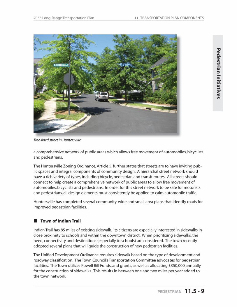
11. TRANSPORTATION PLAN COMPONENTS2035 Long-Range Transportation Plan
PEDESTRIAN 11.5 - 9
Ped
estrian In
itiatives
a comprehensive network of public areas which allows free movement of automobiles, bicyclists and pedestrians.
The Huntersville Zoning Ordinance, Article 5, further states that streets are to have inviting pub-lic spaces and integral components of community design. A hierarchal street network should have a rich variety of types, including bicycle, pedestrian and transit routes. All streets should connect to help create a comprehensive network of public areas to allow free movement of automobiles, bicyclists and pedestrians. In order for this street network to be safe for motorists and pedestrians, all design elements must consistently be applied to calm automobile traffi c.
Huntersville has completed several community-wide and small area plans that identify roads for improved pedestrian facilities.
Town of Indian Trail
Indian Trail has 85 miles of existing sidewalk. Its citizens are especially interested in sidewalks in close proximity to schools and within the downtown district. When prioritizing sidewalks, the need, connectivity and destinations (especially to schools) are considered. The town recently adopted several plans that will guide the construction of new pedestrian facilities.
The Unifi ed Development Ordinance requires sidewalk based on the type of development and roadway classifi cation. The Town Council’s Transportation Committee advocates for pedestrian facilities. The Town utilizes Powell Bill Funds, and grants, as well as allocating $350,000 annually for the construction of sidewalks. This results in between one and two miles per year added to the town network.
Tree-lined street in Huntersville
11. TRANSPORTATION PLAN COMPONENTS Mecklenburg-Union MPO
Page 11.5 - 10 PEDESTRIAN
Indian Trail has adopted the following plans that address pedestrian facilities:• The Town of Indian Trail Comprehensive Plan (2009)• Downtown Master Plan (2009)• Pedestrian Plan (2009)
Village of Marvin
The Village of Marvin recently (2009) participated in the Local Area Regional Transportation Plan, which resulted in a CTP document for Marvin, Wesley Chapel, Weddington, and Waxhaw. This plan included recommendations for multi-purpose paths, bicycle lanes, and sidewalks on certain roads within the study area. The Village intends to implement the plan recommendations as future development occurs, as well as through grant applications.
Town of Matthews
The Town of Matthews Transportation Advisory Committee advocates for pedestrians and pe-destrian facilities.
There are several ways in which sidewalks are constructed in Matthews. The Town has a policy to install sidewalks on at least one side of all thoroughfares over time. It is estimated that 65 per-cent of thoroughfares now have sidewalks. The Matthews Zoning Ordinance and the Matthews Subdivision Ordinance also require developers to construct fi ve foot wide sidewalks along the frontage of the property for all land uses except for by-right infi ll development that requires no other Town action. The Town also constructs sidewalk to link disconnected sections of sidewalk-Matthews has a budget of $100,000 along with Powell Bill funds, to construct sidewalks.
Matthews encourages construction of pedestrian facilities through the Matthews Land Use Plan (2002). The plan calls for:• developing and encouraging the use of alternate transportation modes and greater connec-
tivity between neighborhoods and local destination points, and • developing sidewalks, bikeways, and similar facilities which encourage alternative transporta-
tion choices, and connect existing portions of off-street paths for greater continuity.
Town of Mineral Springs
The Town of Mineral Springs has no sidewalk program or requirements for sidewalks. It is a very low-density rural residential area. Its focus is on developing greenways, which it believes are more appropriate for its land use pattern.
Town of Mint Hill
Many older neighborhoods are requesting sidewalks, indicating that there is an interest for side-walks within the municipality. Mint Hill has a Downtown Master Plan that proposes a greenway loop around the downtown to serve both pedestrians and bicyclists as a multi-use path. The town was awarded a pedestrian planning grant from the NCDOT in 2009.
11. TRANSPORTATION PLAN COMPONENTS2035 Long-Range Transportation Plan
PEDESTRIAN 11.5 - 11
The Town and developers will install a number of pedestrian crosswalks at several intersections in 2009 and 2010. Sidewalks projects are prioritized on the basis of need and feasibility by the Board of Commissioners each year. Sidewalks are required for all new developments and devel-opment expansions of 50 percent or greater.
City of Monroe
The City of Monroe’s Transportation Department has a sidewalk priority program that is submit-ted to the City Council for approval each year. Priorities are based primarily on safety issues and pedestrian traffi c. The citizens of Monroe have a high interest in the provision of sidewalks and greenways within the community.
The City of Monroe uses a “Detail & Design Manual” to guide sidewalk recommendations and requirements as a part of the plan review process. Sidewalks are required for all new develop-ment. Monroe has a $30,000 budget for sidewalks each year in addition to Powell Bill funds. Sidewalks are prioritized by the order of the request and Council Committee.
The City of Monroe does not have any dedicated pedestrian plans, although it is currently up-dating its Unifi ed Development Ordinance to include such provisions in its development regula-tions.
Town of Pineville
The Town’s Transportation Advisory Committee advocates for pedestrians and pedestrian facili-ties. Pineville’s Subdivision Ordinance and Zoning Ordinance require sidewalks with all changes in land use, new residential streets, and in all commercial development.
Pineville has several overlay districts it uses to guide development in various parts of the com-munity. Some specifi c recommendations include enhancing small town character in the down-town and in neighborhood mixed-use areas. These principles even carry over into the Town’s industrial district overlays.
Town of Stallings
The Town recently (2008) adopted an NCDOT-funded pedestrian plan that made recommenda-tions for pedestrian improvements throughout the community. Stallings already requires side-walks as a part of most new developments, so they are actively applying for grants to complete identifi ed gaps in the network.
Town of Unionville
In Unionville, sidewalks are not currently required for residential development. Because the town is almost entirely residential, commercial development requires a rezoning/site plan re-view by the Town and sidewalks are typically requested as part of the site plan review.
Ped
estrian In
itiatives
11. TRANSPORTATION PLAN COMPONENTS Mecklenburg-Union MPO
Page 11.5 - 12 PEDESTRIAN
Town of Waxhaw
The Town of Waxhaw Unifi ed Development Ordinance requires that sidewalks be installed through private development.
The Waxhaw 2030 Comprehensive Plan sets goals for pedestrian facilities, and the Local Area Re-gional Transportation Plan (LARTP) identifi es pedestrian improvements on future road projects in the Town. Waxhaw does not currently have an offi cial pedestrian plan, but has applied for a pedestrian planning grant from the NCDOT- DBPT in 2008. The Town recognizes a plan will be developed in the near future as Waxhaw continues to grow. The Town of Waxhaw Planning Staff has worked with developers to ensure that current and future development projects incorpo-rate pedestrian facilities in their designs. Sidewalk projects are prioritized based on a request-driven process where older requests have a higher priority.
Town of Wingate
The Town of Wingate is initiating a comprehensive land use plan in 2010 that will focus on en-hancing their downtown and linkages to Wingate University. This plan is being developed in ad-vance of the Monroe Bypass, which will reorient access to the town from the south to the north. The Town currently requires sidewalks as a part of new development, but has many sections of the town where there are no sidewalks currently installed. The Town is interested in grants to fi ll in critical gaps in the network.
Town of Weddington
Weddington currently has no requirements for pedestrian facilities. The Town does not have a sidewalk construction program, and has no codes that require sidewalk for new development.
Weddington recently (2009) participated in the Local Area Regional Transportation Plan, which resulted in a CTP document for Marvin, Wesley Chapel, Weddington, and Waxhaw. This plan in-cluded recommendations for multi-purpose paths, bicycle lanes, and sidewalks on certain roads within the study area. Facilities may be provided as a part of future road widenings.
Village of Wesley Chapel
The Village of Wesley Chapel recently (2009) participated in the Local Area Regional Transporta-tion Plan, which resulted in a CTP document for Marvin, Wesley Chapel, Weddington, and Wax-haw. This plan included recommendations for multi-purpose paths, bicycle lanes, and sidewalks on certain roads within the study area. The Village intends to implement the plan recommenda-tions as future development occurs, as well as through grant applications.
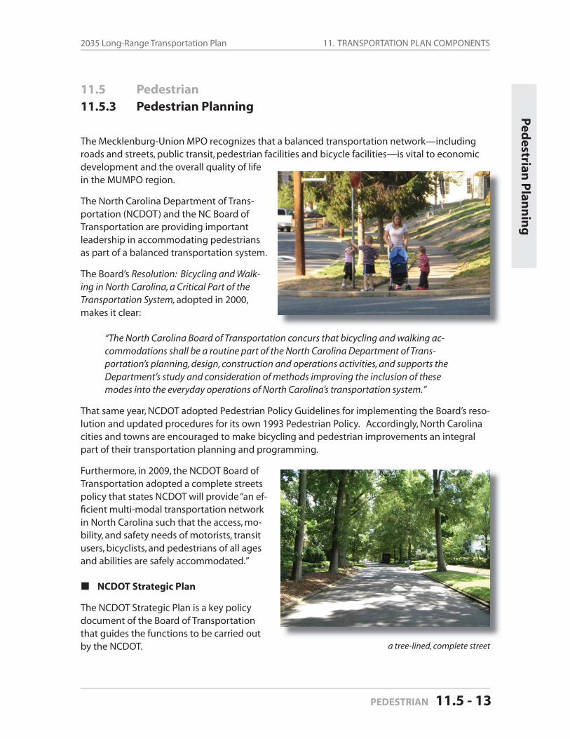
11. TRANSPORTATION PLAN COMPONENTS2035 Long-Range Transportation Plan
PEDESTRIAN 11.5 - 13
11.5 Pedestrian
11.5.3 Pedestrian Planning
The Mecklenburg-Union MPO recognizes that a balanced transportation network—including roads and streets, public transit, pedestrian facilities and bicycle facilities—is vital to economic development and the overall quality of life in the MUMPO region.
The North Carolina Department of Trans-portation (NCDOT) and the NC Board of Transportation are providing important leadership in accommodating pedestrians as part of a balanced transportation system.
The Board’s Resolution: Bicycling and Walk-ing in North Carolina, a Critical Part of the Transportation System, adopted in 2000, makes it clear:
“The North Carolina Board of Transportation concurs that bicycling and walking ac-commodations shall be a routine part of the North Carolina Department of Trans-portation’s planning, design, construction and operations activities, and supports the Department’s study and consideration of methods improving the inclusion of these modes into the everyday operations of North Carolina’s transportation system.”
That same year, NCDOT adopted Pedestrian Policy Guidelines for implementing the Board’s reso-lution and updated procedures for its own 1993 Pedestrian Policy. Accordingly, North Carolina cities and towns are encouraged to make bicycling and pedestrian improvements an integral part of their transportation planning and programming.
Furthermore, in 2009, the NCDOT Board of Transportation adopted a complete streets policy that states NCDOT will provide “an ef-fi cient multi-modal transportation network in North Carolina such that the access, mo-bility, and safety needs of motorists, transit users, bicyclists, and pedestrians of all ages and abilities are safely accommodated.”
NCDOT Strategic Plan
The NCDOT Strategic Plan is a key policy document of the Board of Transportation that guides the functions to be carried out by the NCDOT.
Ped
estrian P
lann
ing
a tree-lined, complete street
11. TRANSPORTATION PLAN COMPONENTS Mecklenburg-Union MPO
Page 11.5 - 14 PEDESTRIAN
The plan’s System Vision (available at http://www.ncdot.org/planning/StrategicPlan) states: “The transportation system in North Carolina will provide safe, affordable choices for the movement of all people and products.” The plan also notes that:
“it will be a well-maintained, reliable, multi-modal and connected system that is con-siderate of local land use plans, natural resources and the environment,” and that
“this system will be planned and operated in partnership with communities, local, regional, state and federal agencies, and private entities.”
The Strategic Plan identifi es balance, choices, partnership, open communication and safety as guiding principles that relate to pedestrian mobility. The plan sets the following basic goal and objectives:
NCDOT Strategic Plan
Goal:
Provide a safe and well-maintained interconnected transportation system that offers modal choices for the movement of all people and goods.
Objectives:
Strive to meet transportation system needs for services, construction and main-tenance.
Develop partnerships with other transportation providers.
Support the development of multi-modal transportation systems.
Ensure transportation safety through the enforcement of applicable state and federal laws.
Continuously monitor and update the department’s long-range transportation plan.
Mecklenburg-Union MPO
This 2035 Long Range Transportation Plan’s “Goals and Objectives” section contains MUMPO’s specifi c objectives for developing “a transportation system that integrates pedestrian and bicycle modes of transportation with motor vehicle transportation” and encourages the use of walking and bicycling as “additional” modes instead of as “alternative” niche modes:
Increase the design sensitivity of specifi c transportation projects to the needs of pedestrians and bicyclists.
Improve the transportation system to accommodate pedestrian and bicycle ac-cess along roadways through design and facility standards.
Increase pedestrian and bicycle safety through public awareness campaigns.
Provide linkages for pedestrian and/or bicyclists between neighborhoods, em-ployment centers, cultural facilities, institutional facilities such as schools and churches, parks, commercial areas and other businesses.
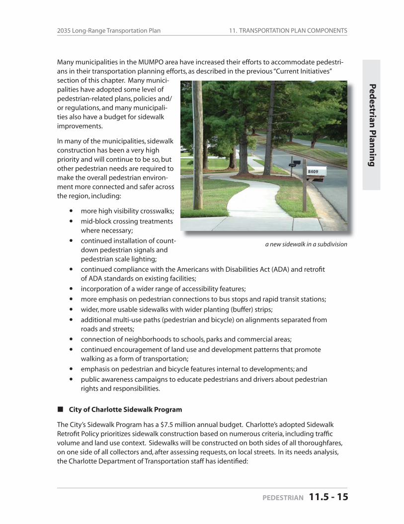
11. TRANSPORTATION PLAN COMPONENTS2035 Long-Range Transportation Plan
PEDESTRIAN 11.5 - 15
Many municipalities in the MUMPO area have increased their efforts to accommodate pedestri-ans in their transportation planning efforts, as described in the previous “Current Initiatives” section of this chapter. Many munici-palities have adopted some level of pedestrian-related plans, policies and/ or regulations, and many municipali-ties also have a budget for sidewalk improvements.
In many of the municipalities, sidewalk construction has been a very high priority and will continue to be so, but other pedestrian needs are required to make the overall pedestrian environ-ment more connected and safer across the region, including:
more high visibility crosswalks;
mid-block crossing treatments where necessary;
continued installation of count-down pedestrian signals and pedestrian scale lighting;
continued compliance with the Americans with Disabilities Act (ADA) and retrofi t of ADA standards on existing facilities;
incorporation of a wider range of accessibility features;
more emphasis on pedestrian connections to bus stops and rapid transit stations;
wider, more usable sidewalks with wider planting (buffer) strips;
additional multi-use paths (pedestrian and bicycle) on alignments separated from roads and streets;
connection of neighborhoods to schools, parks and commercial areas;
continued encouragement of land use and development patterns that promote walking as a form of transportation;
emphasis on pedestrian and bicycle features internal to developments; and
public awareness campaigns to educate pedestrians and drivers about pedestrian rights and responsibilities.
City of Charlotte Sidewalk Program
The City’s Sidewalk Program has a $7.5 million annual budget. Charlotte’s adopted Sidewalk Retrofi t Policy prioritizes sidewalk construction based on numerous criteria, including traffi c volume and land use context. Sidewalks will be constructed on both sides of all thoroughfares, on one side of all collectors and, after assessing requests, on local streets. In its needs analysis, the Charlotte Department of Transportation staff has identifi ed:
a new sidewalk in a subdivision
Ped
estrian P
lann
ing
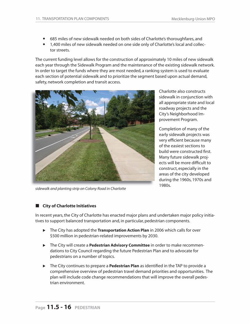
11. TRANSPORTATION PLAN COMPONENTS Mecklenburg-Union MPO
Page 11.5 - 16 PEDESTRIAN
685 miles of new sidewalk needed on both sides of Charlotte’s thoroughfares, and1,400 miles of new sidewalk needed on one side only of Charlotte’s local and collec-tor streets.
The current funding level allows for the construction of approximately 10 miles of new sidewalk each year through the Sidewalk Program and the maintenance of the existing sidewalk network. In order to target the funds where they are most needed, a ranking system is used to evaluate each section of potential sidewalk and to prioritize the segment based upon actual demand, safety, network completion and transit access.
Charlotte also constructs sidewalk in conjunction with all appropriate state and local roadway projects and the City’s Neighborhood Im-provement Program.
Completion of many of the early sidewalk projects was very effi cient because many of the easiest sections to build were constructed fi rst. Many future sidewalk proj-ects will be more diffi cult to construct, especially in the areas of the city developed during the 1960s, 1970s and 1980s.
City of Charlotte Initiatives
In recent years, the City of Charlotte has enacted major plans and undertaken major policy initia-tives to support balanced transportation and, in particular, pedestrian components.
The City has adopted the Transportation Action Plan in 2006 which calls for over $500 million in pedestrian-related improvements by 2030.
The City will create a Pedestrian Advisory Committee in order to make recommen-dations to City Council regarding the future Pedestrian Plan and to advocate for pedestrians on a number of topics.
The City continues to prepare a Pedestrian Plan as identifi ed in the TAP to provide a comprehensive overview of pedestrian travel demand priorities and opportunities. The plan will include code change recommendations that will improve the overall pedes-trian environment.
sidewalk and planting strip on Colony Road in Charlotte
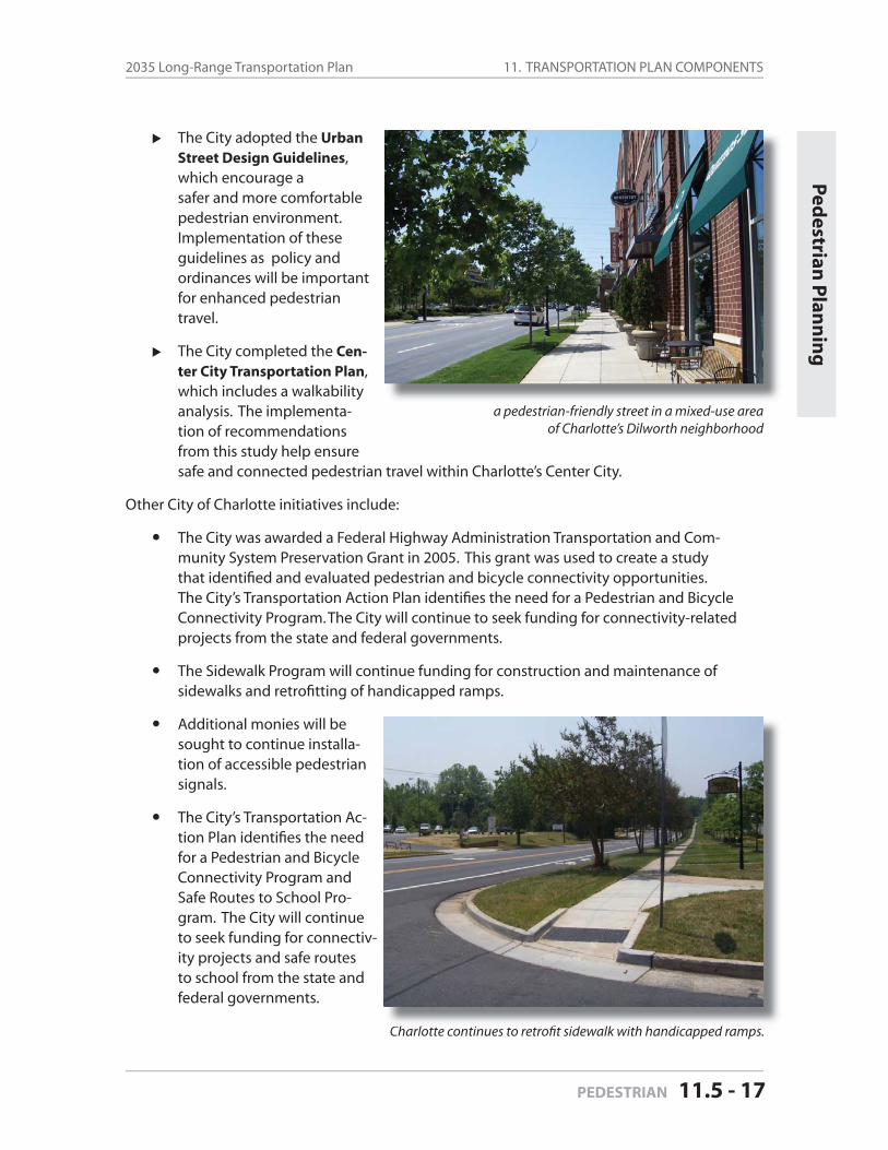
11. TRANSPORTATION PLAN COMPONENTS2035 Long-Range Transportation Plan
PEDESTRIAN 11.5 - 17
The City adopted the Urban Street Design Guidelines, which encourage asafer and more comfortable pedestrian environment. Implementation of these guidelines as policy and ordinances will be important for enhanced pedestrian travel.
The City completed the Cen-ter City Transportation Plan, which includes a walkability analysis. The implementa-tion of recommendations from this study help ensure
safe and connected pedestrian travel within Charlotte’s Center City.
Other City of Charlotte initiatives include:
The City was awarded a Federal Highway Administration Transportation and Com-munity System Preservation Grant in 2005. This grant was used to create a study that identifi ed and evaluated pedestrian and bicycle connectivity opportunities. The City’s Transportation Action Plan identifi es the need for a Pedestrian and Bicycle Connectivity Program. The City will continue to seek funding for connectivity-related projects from the state and federal governments.
The Sidewalk Program will continue funding for construction and maintenance of sidewalks and retrofi tting of handicapped ramps.
Additional monies will be sought to continue installa-tion of accessible pedestrian signals.
The City’s Transportation Ac-tion Plan identifi es the need for a Pedestrian and Bicycle Connectivity Program and Safe Routes to School Pro-gram. The City will continue to seek funding for connectiv-ity projects and safe routes to school from the state and federal governments.
a pedestrian-friendly street in a mixed-use areaof Charlotte’s Dilworth neighborhood
Charlotte continues to retrofi t sidewalk with handicapped ramps.
Ped
estrian P
lann
ing
11. TRANSPORTATION PLAN COMPONENTS Mecklenburg-Union MPO
Page 11.5 - 18 PEDESTRIAN
11. TRANSPORTATION PLAN COMPONENTS2035 Long-Range Transportation Plan
GREENWAYS 11.6 - 1
11 Transportation Plan Components
11.6 Greenways and Trails
11.6.1 History and Existing System
Greenway trail development in the MUMPO region historically has been executed largely within Mecklenburg County, although interest in trail develoment in Union County has been growing over the years.
MECKLENBURG COUNTY
The Mecklenburg County greenway system is one of the oldest in North Carolina and the south-eastern United States. In 1966, the Charlotte-Mecklenburg master plan for recreation recom-mended greenways “as logical natural elements useful in creating a sense of physical form and order within the City.” The plan proposed that greenways preserve the open space of urban residential areas while providing both active and passive recreation areas.
In 1980 the Mecklenburg County Greenway Master Plan was developed, which called for 73 miles of greenway along 14 creek corridors. The 1980 plan envisioned greenways as corridors for habitat conservation, recreation, alternative transportation, mitigation of fl ooding and pro-tection of water supply.
In 1999, the greenway plan was updated and recommended a total of 185 miles of greenway along major creek corridors throughout the County.
A separate master plan for the Little Sugar Creek Greenway was adopted by the County in 2004 for that 15-mile corridor. This plan incorporated greenways as a major component of the urban redevelopment efforts at Kings Drive near Uptown Charlotte in partnership with a private devel-oper, Charlotte-Mecklenburg Utilities Department, Mecklenburg County Storm Water Services, Central Piedmont Community College and NCDOT.
The most recent greenway master plan update was adopted in 2008 and called for the devel-opment of over 60 miles of trail by 2018. The plan identifi ed specifi c greenway corridors for development over the next fi ve and ten years.
Mecklenburg County citizens have consistently supported Park and Recreation bonds targeting both land acquisition and facility development.
In 1999, voters approved $220 million for land and $7 million for greenway trail devel-opment; in 2004, they approved $25 million for greenway trail development; and in 2008 they approved over $40 million for greenway trail development and $60 mil-lion for land acquisition.
There are greenway projects currently under design or construction in almost all areas of Meck-lenburg County, including Charlotte, Cornelius, Davidson, Huntersville and Matthews—as shown on Figure 11-9 in the “Map Gallery” at the end of this document.
Green
ways
11. TRANSPORTATION PLAN COMPONENTS Mecklenburg-Union MPO
Page 11.6 - 2 GREENWAYS
Town of Cornelius
Cornelius adopted a greenway master plan in 2004 as part of the park master plan update, which expanded on the County’s system and goals. Likewise, the town also adopted a bicycle and pedestrian master plan. Cornelius also references pedestrian goals and objectives in its comprehensive plan.
A 1.2-mile stretch of greenway in Cornelius along McDowell Creek was completed in October, 2009. It was the fi rst greenway built in the town. The town and county partnered on the design and construction of the greenway as part of an NCDOT Enhancement Grant. The greenway connects several neighborhoods in Cornelius and Huntersville to Birkdale Village, and will also include a connection to Robbins Park and Westmoreland Athletic Complex—both of which are currently under design.
Town of Davidson
Davidson adopted a Greenway Master Plan in 2009. Moreover, most of Davidson’s land use plans include pedestrian facilities and greenways as primary goals and objectives, and the town fo-cuses on the establishment of a pedestrian-friendly community. As early as 1994, the Davidson General Plan made clear the priority and focus of town policies would be geared toward pedes-trian initiatives; greenways are considered an integral part of a larger pedestrian system.
This concept is expressed by the Southeast Davidson Greenway, which is an existing pedestrian system featuring 2.8 miles of greenway trail and over fi ve miles of overland connectors featuring bicycle lanes.
Town of Huntersville
Huntersville adopted its fi rst greenway and bikeway master plan in 2007. The plan outlines strategies for both on-road and off-road bicycle facilities, and focuses primarily on the broader transportation and connectivity component of greenways, bicycle lanes and sidewalks. The 1999 Mecklenburg County Greenway Master Plan Corridors were initially used as the base for the greenway component to the town’s plan, with some modifi cations to proposed alignments.
The Town of Huntersville contains about 1.4 miles of existing greenway along Torrence Creek. A one-mile addition to the Torrence Creek Greenway is currently under design and should start construction in 2010. It will connect the existing system to several new neighborhoods and a major new retail center called Rosedale Village. Construction of McDowell Creek Greenway—connecting Birkdale Village within the Town of Huntersville to Cornelius—was completed in October 2009. It is the fi rst county greenway that connects two municipalities.
Town of Matthews
Matthews adopted a bicycle master plan in 2006 that references greenway trails, and greenways are regularly discussed at Transportation and Park and Recreation commission meetings. The Mecklenburg County Greenway Master Plan continues to be the primary greenway planning and policy guide for the town. A two-mile greenway is currently under construction near downtown Matthews along Four Mile Creek in partnership with Mecklenburg County.
11. TRANSPORTATION PLAN COMPONENTS2035 Long-Range Transportation Plan
GREENWAYS 11.6 - 3
Town of Mint Hill
Mint Hill identifi ed greenway trail development as part of their Comprehensive Transportation plan adopted in 2008. The Mecklenburg County Greenway Master Plan continues to be the pri-mary greenway planning and policy guide for the town.
Town of Pineville
The Town of Pineville adopted a pedestrian and bicycle master plan in March 2008 which refer-ences the greenway priorities listed in Mecklenburg County’s Greenway Master Plan. The town also has pedestrian-related goals and objectives in their overlay plans, and requires greenway dedications when new development adjoins a planned greenway facility. Currently, there are no developed greenway trails in Pineville, but Little Sugar Creek runs through the town limits and remains a high priority for both the county and town.
UNION COUNTY
Union County and its municipalities have generally increased their interest and implementation of greenway facilities in their jurisdictions. Plans and facilities are local in nature and focus pri-marily on streams and utility corridors for implementation. This will likely change in the future as the Carolina Thread Trail planning process for all of Union County is scheduled to begin in 2010.
City of Monroe
The City of Monroe adopted a greenway plan in 2005 and have developed one-half mile of trail near downtown. However, the City ranks interest in developing more greenways as a very high priority, and the citizens have voiced support for more greenways.
Town of Indian Trail
Indian Trail is currently developing a parks master plan. The plan will call for the development of trails in the community.
Other Municipalities in Union County
Other municipalities in Union County have comprehensive plans or pedestrian master plans that reference greenways, but no formal greenway master plan so to speak. The Towns of Wax-haw, Stallings, and Weddington do not have greenway or bicycle master plans, but do reference pedestrian connections and greenways in their comprehensive plans. With the Carolina Thread Trail initiative underway, there is the potential to have a comprehensive greenway master plan in Union County to address greenway and pedestrian needs on a regional level.
See the Map Gallery at the end of the document for this map:
Existing and Proposed Greenways . . . . . . . . . . . . . . . . . . . . Figure 11-9
Existing
Green
ways
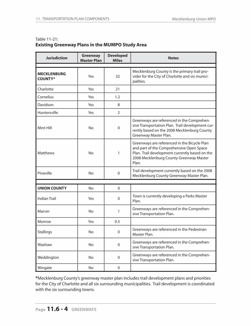
11. TRANSPORTATION PLAN COMPONENTS Mecklenburg-Union MPO
Page 11.6 - 4 GREENWAYS
Table 11-21: Existing Greenway Plans in the MUMPO Study Area
JurisdictionGreenway
Master PlanDeveloped
MilesNotes
MECKLENBURG COUNTY*
Yes 32Mecklenburg County is the primary trail pro-vider for the City of Charlotte and six munici-palities.
Charlotte Yes 21
Cornelius Yes 1.2
Davidson Yes 8
Huntersville Yes 2
Mint Hill No 0
Greenways are referenced in the Comprehen-sive Transportation Plan. Trail development cur-rently based on the 2008 Mecklenburg County Greenway Master Plan.
Matthews No 1
Greenways are referenced in the Bicycle Plan and part of the Comprehensive Open Space Plan. Trail development currently based on the 2008 Mecklenburg County Greenway Master Plan.
Pineville No 0Trail development currently based on the 2008 Mecklenburg County Greenway Master Plan.
UNION COUNTY No 0
Indian Trail Yes 0Town is currently developing a Parks Master Plan.
Marvin No 1Greenways are referenced in the Comprehen-sive Transportation Plan.
Monroe Yes 0.5
Stallings No 0Greenways are referenced in the Pedestrian Master Plan.
Waxhaw No 0Greenways are referenced in the Comprehen-sive Transportation Plan.
Weddington No 0Greenways are referenced in the Comprehen-sive Transportation Plan.
Wingate No 0
*Mecklenburg County’s greenway master plan includes trail development plans and priorities for the City of Charlotte and all six surrounding municipalities. Trail development is coordinated with the six surrounding towns.
11. TRANSPORTATION PLAN COMPONENTS2035 Long-Range Transportation Plan
GREENWAYS 11.6 - 5
11.6 Greenways and Trails
11.6.2 Programmed Greenway Projects
Mecklenburg County
Mecklenburg County passed a park bond referendum in 2004 that included $25 million for greenway trail development. The funding helped design and construct nearly 20 miles of trail along 9 creek corridors, including:
Briar Creek Greenway, Four Mile Creek Greenways (Matthews), Irwin Creek Greenway, Little Sugar Creek Greenway, McDowell Creek Greenways (Huntersville and Cornelius), Stewart Creek Greenway, Toby Creek Greenway, Torrence Creek Greenway (Huntersville), and West Branch Rocky River Creek Greenway (Davidson).
In addition to the 2004 bond referendum, the Mecklenburg Board of County Commissioners al-located an additional $18.2 million for Little Sugar Creek Greenway in 2007.
It is important to note that state and federal funding has also been involved in the County’s greenway system.
Through the NCDOT State Transportation Improvement Plan, $5.33 million has been ear-marked toward Little Sugar Creek Greenway.
Through the State, Mecklenburg County has also secured close to $600,000 in federal dol-lars through the enhancement grant program for sections of Torrence and McDowell Creek Greenways, and
$2.35 million in federal money has been secured through the American Recovery and Re-investment Act (federal stimulus money) for the construction of Toby Creek Greenway and West Branch Rocky River Greenway.
Overland connectors can be a sidewalk/bicycle lane system, a multi-use path along a street or within a utility corridor, or a rail-trail or rail with trail system. The 2008 Mecklenburg County Greenway Master Plan addresses overland connectors as essential elements to make connec-tions to the riparian-based greenway system.
One of the primary goals for greenways in the next ten years is to partner with CDOT, NCDOT, CATS and Duke Energy to utilize the existing road, rail and utility corridor systems to make con-nections between greenways. This will also be a very important component of the Carolina Thread Trail in order to make regional connections outside of the creek-based system. A similar ranking criteria and cost analysis can be used to rank overland connectors with a heavy empha-sis on partnerships.
Green
way P
rojects
11. TRANSPORTATION PLAN COMPONENTS Mecklenburg-Union MPO
Page 11.6 - 6 GREENWAYS
Union County
Union County does not have any greenway segments under construction. The few segments that currently exist were constructed in coordination with residential developments, and de-velopment activity in the county has largely stopped due to the economic downtown. The MUMPO communities in Union County frequently express interest in grant opportunities for implementing their existing plans, and this is expected to result in eventual implementation of segments.
Union County communities within the MUMPO Study Area rely largely on grants and developer agreements to construct sections of greenways. There are no comprehensive prioritized lists of anticipated future projects that represent future efforts in the County, although this is likely to change with the completion of the Union County section of the Carolina Thread Trail planning efforts.
11.6 Greenways and Trails
11.6.3 Horizon Year Recommendations
The anticipated future greenway projects referenced in this chapter are not formally included in the fi scally-constrained project list approved by MUMPO as a part of this plan. The funding sources used to implement such projects are very uneven in availability and so programming and prioritizing projects 25 years into the future is not advisable.
Still, the fi scal impact of greenway trail and other pedestrian and bicycle facilities—when looked at in aggregate throughout the MUMPO study area—is a considerable sum of money. Mecklen-burg County alone identifi ed a need for $150,000,000 in improvements over the next 10 years.
As greenways and other pedestrian and bicycle facilities are an important part of the overall transportation network, and are increasingly requested by MUMPO study area residents, the cost of providing these types of facilities should be given greater study. Non-roadway projects are an important component for the quality of transportation infrastructure desired in the region.
In recognition of this, a sub-committee—charged with advising the Technical Coordinating Committee (TCC) on development of the Transportation Improvement Plan (TIP)—proposed that:
MUMPO should set a goal of using at least 10 percent of its Federal Surface Transportation Program Direct Apportionment (STP-DA) funding on non-roadway projects.
The TCC accepted this advice with is recommendation to the MPO in May 2008 to adopt the 2009-2015 TIP with a project list that refl ected the 10 percent goal. This action was followed by the MPO’s adoption of the TIP, as recommended by the TCC.
In regard to ranking critiera, it is also suggested that MUMPO review how it accounts for its non-roadway projects in terms of both ranking criteria and fi scal implication and provide an update in the next Long Range Transportation Plan Update.
11. TRANSPORTATION PLAN COMPONENTS2035 Long-Range Transportation Plan
GREENWAYS 11.6 - 7
Green
way C
riteria
Mecklenburg County Five and Ten-Year Master Plan
The Greenway Master Plan was updated in 2008 as a part of Mecklenburg County’s Comprehen-sive Park Master Plan, and focused on a specifi c Five and Ten-Year Action Plan for greenway development. The following represent local expectations and commitments only.
The plan called for 66 projects totaling 92.8 miles at an estimated cost of $150,331,423. The Five-Year Plan doubled the existing greenway system to nearly 60 miles by 2015 utilizing land 90% owned by the County.
The Five-Year Plan presents a more aggressive goal prioritized by a set of ranking criteria. Each project was analyzed and awarded points based on the established criteria. The criteria includ-ed the following categories:
No Signifi cant Barrier to Construction Barriers such as railroads, interstates, major infrastructure, diffi cult grades, and others present
physical and fi nancial obstacles to greenway construction. Preference should be given to greenways that do not require unusually diffi cult construction or high costs.
Percent Planned Miles Developed per Park District Guarantees that all areas of the County get equal consideration for greenway development.
Points are awarded based on the percentage of greenway miles identifi ed in the Master Plan (per Park District) that are under design, construction, or currently developed. Greenway projects in Park Districts that have a smaller percentage of planned miles developed are awarded more points.
Project Partnership, Public or Private A greenway is planned and built in conjunction with another public or private project.
Examples include Carolina Thread Trail, Charlotte Housing Authority projects, Metropolitan Midtown, CPCC expansion, CDOT sidewalk extension, LUESA Stream Restoration, CMUD Relief Sewer and others. There may not be a quantifi able dollar amount known, but it is perceived that when projects are done together there are some major cost savings involved.
Funding Partnership, Public or Private Funding can limit expansion of the greenway system. Mecklenburg County Park and Recre-
ation (MCPR) has success with park and greenway bonds, but it is important to consider seek-ing additional funds from other sources, and/or partnering with other projects to save costs. Examples include seeking donations from developers through the rezoning process, partner-ing with the towns as they apply for grants, or partnering with other public agencies such as CLC, LUESA, CDOT, or CMUD.
Located within the Extraterritorial Jurisdiction of a Town MCPR has a goal of reaching out to provide equal service of park and greenway facilities
countywide. This includes the six towns in the county other than Charlotte.
Listed in Other Adopted Plans or Studies The 1999 Greenway Master Plan set a comprehensive look at the planned greenway system
for 10 years. It is also important that the Charlotte-Mecklenburg Planning Commission and
11. TRANSPORTATION PLAN COMPONENTS Mecklenburg-Union MPO
Page 11.6 - 8 GREENWAYS
the six towns in the county have established district, small area, neighborhood, corridor, and transit plans which reference greenway linkages as a key objective and policy guide. This criterion incorporates other County and municipal policies into greenway development.
The County also produced a design/development cost analysis in preparation for the 2008 bond campaign, which considered the cost for the average greenway as a base, and then added items as necessary to cover the costs of additional bridges, underpasses, additional accesses, signage, mitigation, secondary trails, parking lots, restrooms, design, contingency, infl ation costs, as well as Owner-Provided Equipment (OPE) such as pocket parks, benches, trash cans, landscaping, etc.
Carolina Thread Trail
The Carolina Thread Trail is a 15-county regional network of trails and greenways for walking, biking, commuting, and recreation. It will create a permanent legacy of conservation for more than two million people by linking communities and attractions across North and South Caro-lina. The Carolina Thread Trail will be a catalyst for economic development, land preservation and healthier communities.
The actual location of the Carolina Thread Trail will be determined over time as communities plan their trails and work with neighbors to target points of connection. The Thread concept map provides a vision for the project, but will change as conceptual lines become actual trails (Source: http://www.catawbalands.org/trail.php).
Currently, Chester, Gaston, Lincoln and York counties have adopted county-wide greenway master plans designating corridors for the Carolina Thread Trail. The Thread Trail proponents are actively seeking adoption in Cabarrus and Mecklenburg Counties. The planning process is un-derway in Catawba, Cleveland, Iredell and Stanly counties, with initial efforts in Anson, Cherokee, Iredell, Lancaster, Rowan and Union counties.
As of Fall, 2009, the Carolina Thread Trail Plan for Mecklenburg County has entered the adoption phase of the process. The fi nal alignments and amendments to the map have been made to refl ect community input and actual conditions on the group. Adoption should be completed by early 2010. The process in Union County is in the initial phases. Planning is anticipated to begin the fi rst quarter of 2010 and take approximately a year to complete.
See the Map Gallery at the end of the document for this map:
Carolina Thread Trail Map . . . . . . . . . . . . . . . . . . . . . . . . . . . . Figure 11.10
Greenway Consideration in the MUMPO Prioritization Process
MUMPO does not typically rank greenway projects as a part of its formal fi scally-constrained project ranking process, as greenway projects do not compare well to highway projects under the current evaluation process. MUMPO does assign points to projects that support land use planning, multi-modal transportation efforts, environmental protection, and improving air qual-

11. TRANSPORTATION PLAN COMPONENTS2035 Long-Range Transportation Plan
GREENWAYS 11.6 - 9
Green
way R
ecom
men
datio
ns
ity. Typically, pedestrian and bicycle facilities are added to planned roadway projects, with those projects receiving higher priority because of these non-motorized vehicular facilities.
MUMPO uses a separate Congestion Mitigation and Air Quality (CMAQ) project ranking process for prioritizing non-highway projects when eligible grant and other funding sources become available. Greenway projects are considered under this ranking process, and two projects were funded in the most recent call for projects.
Recommendations for Future Project Prioritization
1. Consider a specifi c set-aside from future STP-Direct Attributable funds for bicycle and pedestrian improvements in order to allow for a predictable revenue source for eligible projects.
2. Assign additional prioritizing weight to all transportation projects that improve bicycle and pedestrian connectivity to activity centers.
3. Increase review and recommend coordination between land use and transporta-tion plans in the MUMPO Study Area in order to further strengthen the land use and transportation connection to reduce reliance on single-occupant vehicular use.
See the Map Gallery at the end of this document for the following maps:
Existing and Proposed Greenways . . . . . . . . . . . . . . . . . . . . Figure 11-9
Carolina Thread Trail Map . . . . . . . . . . . . . . . . . . . . . . . . . . . . . Figure 11-10

11. TRANSPORTATION PLAN COMPONENTS Mecklenburg-Union MPO
Page 11.6 - 10 GREENWAYS
11. TRANSPORTATION PLAN COMPONENTS2035 Long-Range Transportation Plan
FREIGHT 11.7 - 1
11 Transportation Plan Components
11.7 Freight
11.7.1 Existing Conditions
Logistics is . . . the way products and materials are moved from point-to-point in the supply chain a critical economic driver throughout the state and in every countyan “industry of industries” comprising many fi rms that operate both independently and interdependently, relying on a common infrastructure which functions as a logistics ecosystem1
This chapter examines aspects of freight, the movement of goods, the challenges facing the industry and its importance to the families, companies, and economic future of our region. To do this, MUMPO looked at:
• previous work and outreach highlighting issues, trends, challenges and opportunities in the MUMPO region;
• potential policies to improve freight systems in the region;• partnerships and coordination with transportation agencies, other government organiza-
tions, private industry and the public; and the• impact of pending federal legislation to develop a national freight plan.
With the increasing globalization of the economy and the increasing importance of the global supply chain, freight handling and transit capacity has become an important platform for regional economic growth. Growth and prosperity in the MUMPO region rely on increasing the capacity of local infrastructure to effi ciently and effectively handle the forecasted growth of freigh, both in tonnage and value, that will use locally owned assets.
11.7.1.1 Air Cargo
Air Cargo Facility
Charlotte-Douglas International Airport is just seven miles from Uptown Charlotte, adjacent to a Foreign Trade Zone, and immediately accessible to major interstates. The Charlotte Air Cargo Center consists of approximately 500,000 sq. ft. of facilities and over 50 acres of aircraft ramp space. The airport’s three runways can accommodate all types of aircraft and measure 10,000 feet, 8,845 feet, and 7,500 feet.
To support air cargo operations, Charlotte-Douglas has a full complement of international ser-vice support organizations, including U.S. Customs, U.S. Department of Immigration and Natu-ralization and U.S. Department of Agriculture. The Charlotte Air Cargo Center has more than 70 freight forwarders, custom house brokers and professional international service providers.
Freigh
t
1. Georgia Task Force on Freight & Logistics, “Executive Summary and Recommendations” (2008)

11. TRANSPORTATION PLAN COMPONENTS Mecklenburg-Union MPO
Page 11.7 - 2 FREIGHT
Air Cargo
Norfolk Southern is relocating the one intermodal facility from uptown Charlotte to the airport. Doing so improves synergies between the modes of transportation and helps the local road net-work by consolidating the four modes of cargo transportation on one site. The new intermodal facility and a third runway are now under construction. The project costs $320 million.
Development of the proposed airport intermodal facility–and construction of the freeway that will become the Garden Parkway—are projects that enable attracting and maintaining air cargo business at the airport. The intermodal facility will allow the airport to interface with the truck-ing industry and railroad. Norfolk-Southern Railroad runs east west across the north side of the Airport.
Air Cargo Facts about the Charlotte Region
20 cargo airlines including all integrated carriers11 major passenger airlines and 7 commuter airlines2 major rail systems linking 27,000 miles of track311 trucking companies, making Charlotte #11 in U.S.57% of Fortune 500 companies have facilities in the areaNo. 1 industrial hub in Southeast U.S. and 6th largest wholesale center nationwideOver $4 billion worth of manufactured goods exported annually from North and South Carolina170,752 tons of cargo forwarded to destinations worldwide (2006)$10 billion impact by airport on local economy
source: Charlotte-Douglas International Airport
11.7.1.2 Rail Freight
Railroads
The Norfolk Southern Railroad (NS) and CSX Transportation (CSXT) are the two major rail lines serving the Charlotte region. These two rail lines link Charlotte with 44,880 miles of rail that serve the majority of states located on the east coast.
These railroads bring more than 300 trains through the Charlotte region per week. The NS rail yard is computerized and able to handle up to 28,000 rail cars a day. These railroads also work closely with the trucking fi rms in the regions and offer piggyback facilities.
Twenty-fi ve freight railroad companies operate North Carolina’s 3,379-mile rail system. Two freight railroad companies—NS and CSXT—operate over 75 percent of the state system via major and mainline routes and service the Charlotte region.
CSXT operates 34 percent of the system. Its east-west route connects Wilmington and Char-lotte to Atlanta and New Orleans.
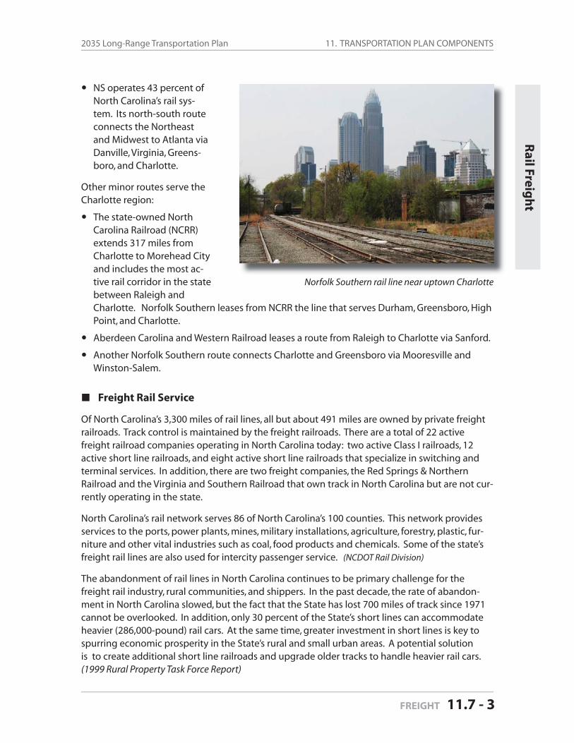
11. TRANSPORTATION PLAN COMPONENTS2035 Long-Range Transportation Plan
FREIGHT 11.7 - 3
NS operates 43 percent of North Carolina’s rail sys-tem. Its north-south route connects the Northeast and Midwest to Atlanta via Danville, Virginia, Greens-boro, and Charlotte.
Other minor routes serve the Charlotte region:
The state-owned North Carolina Railroad (NCRR) extends 317 miles from Charlotte to Morehead City and includes the most ac-tive rail corridor in the state between Raleigh andCharlotte. Norfolk Southern leases from NCRR the line that serves Durham, Greensboro, High Point, and Charlotte.
Aberdeen Carolina and Western Railroad leases a route from Raleigh to Charlotte via Sanford.
Another Norfolk Southern route connects Charlotte and Greensboro via Mooresville and Winston-Salem.
Freight Rail Service
Of North Carolina’s 3,300 miles of rail lines, all but about 491 miles are owned by private freight railroads. Track control is maintained by the freight railroads. There are a total of 22 active freight railroad companies operating in North Carolina today: two active Class I railroads, 12 active short line railroads, and eight active short line railroads that specialize in switching and terminal services. In addition, there are two freight companies, the Red Springs & Northern Railroad and the Virginia and Southern Railroad that own track in North Carolina but are not cur-rently operating in the state.
North Carolina’s rail network serves 86 of North Carolina’s 100 counties. This network provides services to the ports, power plants, mines, military installations, agriculture, forestry, plastic, fur-niture and other vital industries such as coal, food products and chemicals. Some of the state’s freight rail lines are also used for intercity passenger service. (NCDOT Rail Division)
The abandonment of rail lines in North Carolina continues to be primary challenge for the freight rail industry, rural communities, and shippers. In the past decade, the rate of abandon-ment in North Carolina slowed, but the fact that the State has lost 700 miles of track since 1971 cannot be overlooked. In addition, only 30 percent of the State’s short lines can accommodate heavier (286,000-pound) rail cars. At the same time, greater investment in short lines is key to spurring economic prosperity in the State’s rural and small urban areas. A potential solution is to create additional short line railroads and upgrade older tracks to handle heavier rail cars. (1999 Rural Property Task Force Report)
Rail Freig
ht
Norfolk Southern rail line near uptown Charlotte
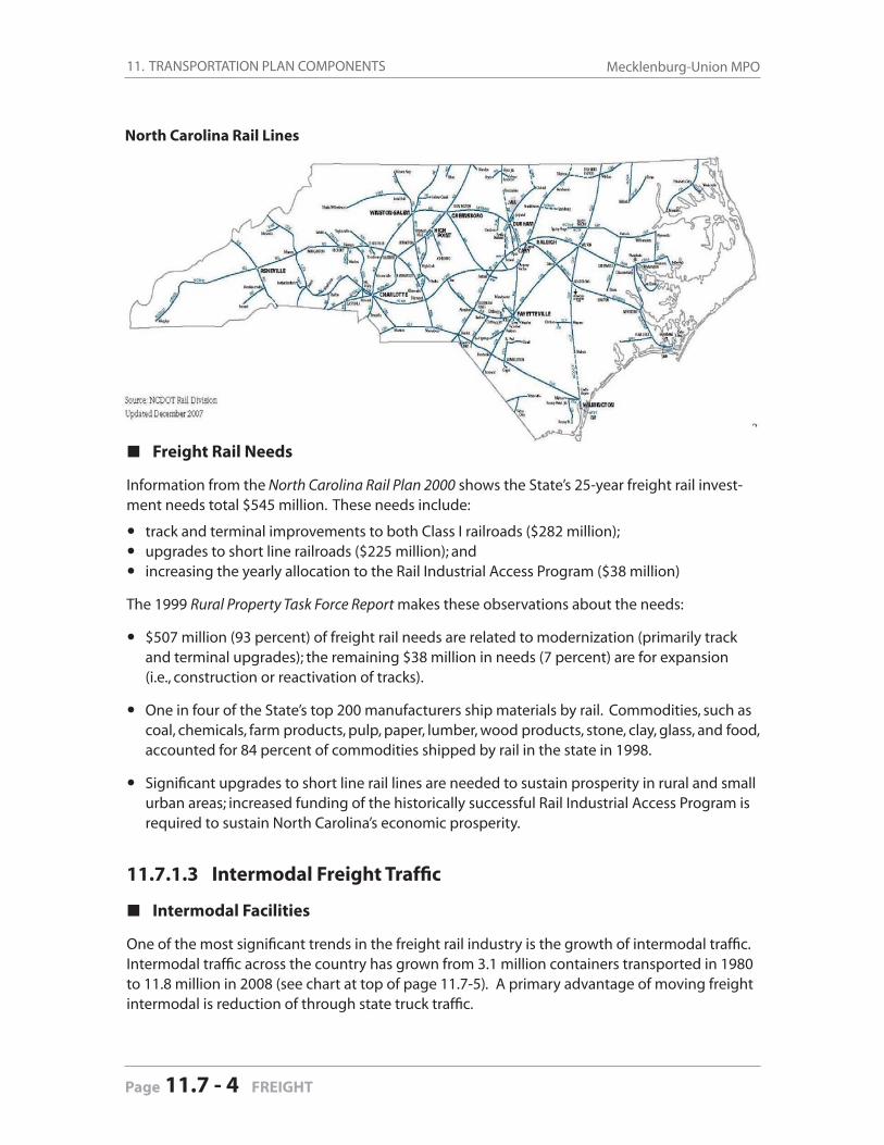
11. TRANSPORTATION PLAN COMPONENTS Mecklenburg-Union MPO
Page 11.7 - 4 FREIGHT
Freight Rail Needs
Information from the North Carolina Rail Plan 2000 shows the State’s 25-year freight rail invest-ment needs total $545 million. These needs include:
• track and terminal improvements to both Class I railroads ($282 million);• upgrades to short line railroads ($225 million); and• increasing the yearly allocation to the Rail Industrial Access Program ($38 million)
The 1999 Rural Property Task Force Report makes these observations about the needs:
$507 million (93 percent) of freight rail needs are related to modernization (primarily track and terminal upgrades); the remaining $38 million in needs (7 percent) are for expansion (i.e., construction or reactivation of tracks).
One in four of the State’s top 200 manufacturers ship materials by rail. Commodities, such as coal, chemicals, farm products, pulp, paper, lumber, wood products, stone, clay, glass, and food, accounted for 84 percent of commodities shipped by rail in the state in 1998.
Signifi cant upgrades to short line rail lines are needed to sustain prosperity in rural and small urban areas; increased funding of the historically successful Rail Industrial Access Program is required to sustain North Carolina’s economic prosperity.
11.7.1.3 Intermodal Freight Traffi c
Intermodal Facilities
One of the most signifi cant trends in the freight rail industry is the growth of intermodal traffi c. Intermodal traffi c across the country has grown from 3.1 million containers transported in 1980 to 11.8 million in 2008 (see chart at top of page 11.7-5). A primary advantage of moving freight intermodal is reduction of through state truck traffi c.
North Carolina Rail Lines
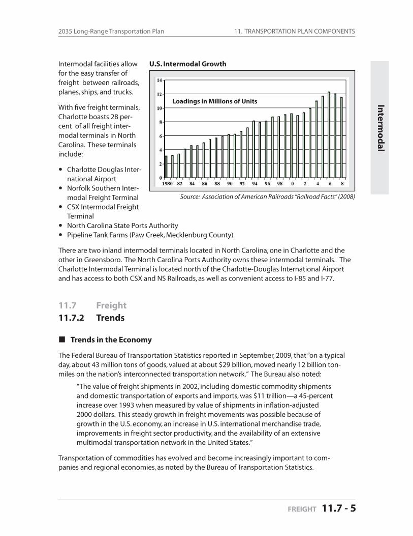
11. TRANSPORTATION PLAN COMPONENTS2035 Long-Range Transportation Plan
FREIGHT 11.7 - 5
Intermodal facilities allow for the easy transfer of freight between railroads, planes, ships, and trucks.
With fi ve freight terminals, Charlotte boasts 28 per-cent of all freight inter-modal ter minals in North Carolina. These terminals include:
Charlotte Douglas Inter-national AirportNorfolk Southern Inter-modal Freight TerminalCSX Intermodal Freight TerminalNorth Carolina State Ports AuthorityPipeline Tank Farms (Paw Creek, Mecklenburg County)
There are two inland intermodal terminals located in North Carolina, one in Charlotte and the other in Greensboro. The North Carolina Ports Authority owns these intermodal terminals. The Charlotte Intermodal Terminal is located north of the Charlotte-Douglas International Airport and has access to both CSX and NS Railroads, as well as convenient access to I-85 and I-77.
11.7 Freight
11.7.2 Trends
Trends in the Economy
The Federal Bureau of Transportation Statistics reported in September, 2009, that “on a typical day, about 43 million tons of goods, valued at about $29 billion, moved nearly 12 billion ton-miles on the nation’s interconnected transportation network.” The Bureau also noted:
“The value of freight shipments in 2002, including domestic commodity shipments and domestic transportation of exports and imports, was $11 trillion—a 45-percent increase over 1993 when measured by value of shipments in infl ation-adjusted 2000 dollars. This steady growth in freight movements was possible because of growth in the U.S. economy, an increase in U.S. international merchandise trade, improvements in freight sector productivity, and the availability of an extensive multimodal transportation network in the United States.”
Transportation of commodities has evolved and become increasingly important to com-panies and regional economies, as noted by the Bureau of Transportation Statistics.
Interm
od
al
Source: Association of American Railroads “Railroad Facts” (2008)
U.S. Intermodal Growth
Loadings in Millions of Units
11. TRANSPORTATION PLAN COMPONENTS Mecklenburg-Union MPO
Page 11.7 - 6 FREIGHT
Global Trends and Implications
In “Transportation Trends 2025,” University of Texas transportation analyst Michael Walton cites these major global trends that will affect the volume of freight traffi c in the Charlotte area.
Global Trends Increasing domestic, NAFTA, and global trade Outsourcing for comparative economic advantage in production Emergence of global trade blocs and city-state trade areas
Implications for freight transportation:• Far fl ung intermodal supply chains• Increasing freight traffi c and congestion along trade corridors and at ports, airports,
and border crossings.• Changes in location of high volume lanes and economies of scale for freight carriers• Demand for global trade infra-and info-structure• Harmonization of trade and regulatory policies• Need for more of an outward oriented US focus on changing global dynamics and
transport implications
National and Regional Trends
In “Transportation Freight Policy,” Dr. Walton further identifi es national and regional trends that will impact freight traffi c.
U.S. Trends that will impact freight traffi cExpanding supply chainsChanges in advanced manufacturing trending toward higher value productsIncreased international tradeChanges in the population and rate of growth in the US economy
Trends that could affect regional freight traffi c Increasing shift of tonnage away from West coast ports to the East coastOpening of the new, larger Panama Canal that will allow for much larger freight vesselsPotential change to “feeder” system of ships and ports refl ecting adaption to larger vesselsIncreasing use of warehouses closer to ports and less reliance on scattered warehousesUnknown impact from the increases in fuel costs and effi cienciesAvailability of reliable workers and a large logistics workforce Trucking in North Carolina is forecasted to increase by 57% by 2020Freight traffi c at the ports is expected to grow by 100% by 2020
Trends in Intermodal
The prospects for future rail intermodal business are very robust, with national tonnage volumes rising 213 percent by 2035 and the Panama Canal expansion moving more imports to East Coast ports.
11. TRANSPORTATION PLAN COMPONENTS2035 Long-Range Transportation Plan
FREIGHT 11.7 - 7
Trend
s in Freig
ht
Trends in Rail Freight
The North Carolina Department of Transportation estimates that
“between 2000 and 2030, the state’s total income is expected to increase by about $190 billion. The people and businesses that drove the increase will also drive additional congestion on the roadways and fuel the demand for addi-tional consumer goods, both of which create additional demand for freight rail services.”
(North Carolina Rail Plan, 2009)
The North Carolina Rail Plan 2009 cites key trends in four sectors that are affecting rail demand in the state and the growth in rail freight volume and tonnage:
Manufacturing — This sector, which contributes nearly 20% of the state’s gross domestic product (GDP), remains crucial. Food, beverages, tobacco and chemicals are the largest man-ufacturing sectors by production value, representing nearly 10% of the gross state product (GSP). Effi cient and reliable rail transportation is imperative to the competitiveness of North Carolina manufacturers—both to reach customers and to keep costs down.
Agriculture — The state is a top fi ve producer of hogs, broilers and tobacco. North Carolina is the ninth largest agricultural exporter in the United States. Rail services play a key role in transporting the state’s agricultural products and are crucial for bringing corn into North Carolina from the Midwest to feed the state’s livestock.
Energy — Energy consumption has been growing with North Carolina’s population, and coal, a signifi cant user of rail, accounts for about one-third of the energy consumed in the state. Today, North Carolina ranks 12th in the nation for coal consumption. It does not have the resources to supply any of its own coal needs and thus relies on shipments of coal trans-ported by rail from nearby states. Robust supplies and clean coal technologies will encour-age the continued use of coal in future years.
Construction — North Carolina’s construction industry is one of the largest in the country. It depends on rail working in conjunction with trucking to keep up with construction mate-rial demand in a timely manner.
The North Carolina Offi ce of Freight Management and Operations identifi es several initiatives underway that will affect rail demand in North Carolina, including the North Carolina Interna-tional Terminal in Brunsick County, the North Carolina Global TransPark, and additional military personnel and civilian contractors assigned to Fort Bragg.
Trends in Shipping
Expansion of the Panama Canal will fundamentally alter global shipping patterns, allowing larg-er ships to pass through its locks. With larger cargo shipments on the move, goods can reach the East Coast both easily and economically, and the market share of East Coast ports will grow over the next 10 to 20 years. This will spark competition among these ports on the East Coast as they vie for a permanent share of waterborne Trans-Pacifi c container traffi c.
11. TRANSPORTATION PLAN COMPONENTS Mecklenburg-Union MPO
Page 11.7 - 8 FREIGHT
11.7 Freight
11.7.3 Projections
Projections on the Composition of Freight
Overall, freight tonnage is expected to double nationwide by 2020. In the Southeastern U.S., the Federal Highway Administration projects an 80 percent increase by 2020.
The projected increase warrants a re-examination of how freight is handled in the region and the policies and challenges facing the industry. Road construction cannot keep pace with the expected increase in freight traffi c. Regional stakeholders must agree on goals and strategies to support the movement of freight around and through the region.
The growth in regional population coupled with the increasing number of businesses requires the region to carefully consider and plan for the projected increased in freight traffi c. Regional businesses depend on the transportation infrastructure to deliver economic competitiveness. However, major challenges must be addressed to ensure that the MUMPO region can remain competitive.
Table 11-22: Shipping Projections To, From and Within North Carolina
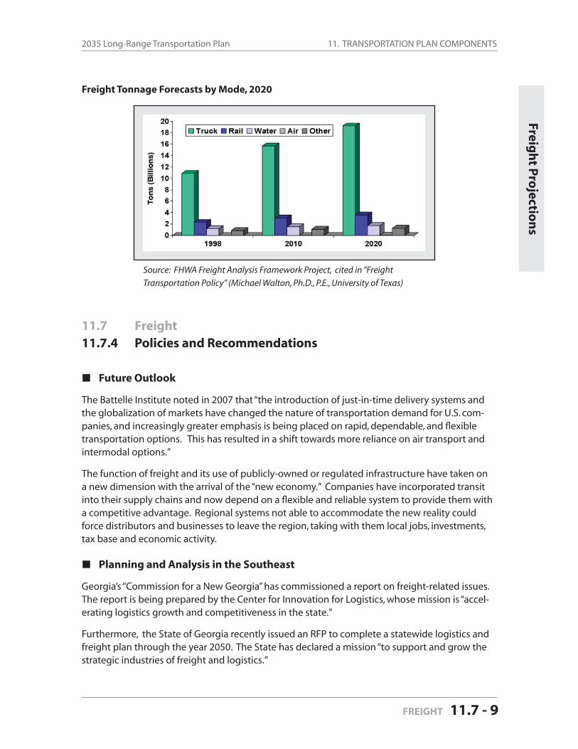
11. TRANSPORTATION PLAN COMPONENTS2035 Long-Range Transportation Plan
FREIGHT 11.7 - 9
11.7 Freight
11.7.4 Policies and Recommendations
Future Outlook
The Battelle Institute noted in 2007 that “the introduction of just-in-time delivery systems and the globalization of markets have changed the nature of transportation demand for U.S. com-panies, and increasingly greater emphasis is being placed on rapid, dependable, and fl exible transportation options. This has resulted in a shift towards more reliance on air transport and intermodal options.”
The function of freight and its use of publicly-owned or regulated infrastructure have taken on a new dimension with the arrival of the “new economy.” Companies have incorporated transit into their supply chains and now depend on a fl exible and reliable system to provide them with a competitive advantage. Regional systems not able to accommodate the new reality could force distributors and businesses to leave the region, taking with them local jobs, investments, tax base and economic activity.
Planning and Analysis in the Southeast
Georgia’s “Commission for a New Georgia” has commissioned a report on freight-related issues. The report is being prepared by the Center for Innovation for Logistics, whose mission is “accel-erating logistics growth and competitiveness in the state.”
Furthermore, the State of Georgia recently issued an RFP to complete a statewide logistics and freight plan through the year 2050. The State has declared a mission “to support and grow the strategic industries of freight and logistics.”
Freigh
t Pro
jection
s
Freight Tonnage Forecasts by Mode, 2020
Source: FHWA Freight Analysis Framework Project, cited in “Freight
Transportation Policy” (Michael Walton, Ph.D., P.E., University of Texas)
11. TRANSPORTATION PLAN COMPONENTS Mecklenburg-Union MPO
Page 11.7 - 10 FREIGHT
The City of Atlanta completed a freight land use plan in 2008 (Atlanta Regional Freight Mobility Plan and Land Use Analysis) that has been lauded by professionals in the freight industry. Stat-ing that “proactive freight planning is critical to regional economic vitality and quality of life,” the City concluded it needed to:
consider freight implications in land use planning and development review activities, andplan and design newly emerging areas to accommodate freight needs.
North Carolina State University’s Institute for Transportation Research and Education has stud-ied the freight problems in the region and offered detailed solutions. Earlier this year, Program Director Ron Hughes, Ph.D., presented objectives to USDOT for a national freight plan that incor-porates the broader challenges facing freight. The seven objectives are:
1. Improve the operations of the existing freight transportation system.2. Add physical capacity to the freight transportation system in places where invest-
ment makes economic sense.3. Use pricing to better align all costs and benefi ts between users and owners of the
freight system and to encourage deployment of productivity-enhancing techniques.4. Reduce or remove statutory, regulatory and institutional barriers to improved freight
transportation performance.5. Proactively identify and address emerging transportation needs.6. Maximize the safety and security of the freight transportation system.7. Mitigate and better manage the environmental, health, energy and community im-
pacts of freight transportation.
A nationally recognized expert in transportation and logistics—Professor C. Michael Walton, Ph.D., P.E., Department of Civil Engineering, The University of Texas at Austin—believes the goal-of transportation policy is to “support economic development through improved transportation for trade.” He has outlined a set of recommendations for North Carolina (below) that encompass a broad scope of actions. Professor Walton recommended North Carolina:
Initiate a Governor’s summit on freight/trade transportation . . . including a statewide freight advisory function . . . authority, accountability, open membership framework.
Develop a NC freight business plan. Establish a freight champion in Raleigh. Develop high level freight effi ciency and security metrics; combine public databases and
private information systems to benchmark performance (i.e., a knowledge-based system). Examine building/zoning codes, urban freight mobility strategies to bridge freight ef-
fi ciency/community livability issues.Build graduate program combining engineering, business administration, logistics, plan-ning, and public policy.Coordinate investment strategies with neighboring states.
Freight Considerations in Current MUMPO Project Ranking Process
With the increasing globalization of the economy and the increasing use of global supply chains, freight handling and transit capacity has become an important platform for regional economic

11. TRANSPORTATION PLAN COMPONENTS2035 Long-Range Transportation Plan
FREIGHT 11.7 - 11
growth. Growth and prosperity in the MUMPO region rely increasingly on the capacity of local infrastructure to effi ciently and effectively handle the forecasted growth of freight and cargo.
The Mecklenburg-Union Metropolitan Planning Organization currently considers freight in its project evaluations by assigning points to projects that serve freight terminals and intermodal sites. MUMPO should consider the following evaluations for accommodating freight in roadway improvements:
Consider and modify current project ranking criteria to include strategies for improving freight movement through the region.
Recommended Approach for Future MUMPO Activities
Assumptions:
International freight trends will have increasing infl uence on the amount of freight traffi c in the MUMPO region and ports serving the MUMPO region will be important sources for freight traffi c.
National security issues will affect the freight industry in our region.
Regional advanced manufacturing companies and logistic companies will rely on a fl exible and responsive transit system to allow the companies to compete nationally and interna-tionally.
Logistics is an important industry for employment and economic growth in the MUMPO region.
The fl exibility of freight systems in the region is affected by both physical and operational infrastructure. Since the industry is concerned about the entire system, from processing systems at ports to state truck system to highway lanes, it is important to develop a comprehensive plan for freight.
The growing regional pop-ulation will compete with freight for land and space
on the roads.
Experts, planners, and transportation offi cials have begun a dialog regarding logistic-freight challenges and possible solutions in North Carolina. But questions remain regarding the role MUMPO will play. Where does MUMPO fi t in the scenario? How can MUMPO address safety and security issues and build jobs and prosperity for the region? On the following are recommenda-tions for specifi c steps that could be taken by MUMPO.
See the Map Gallery at the end of the document for this map:
Intermodal Freight Facilities . . . . . . . . . . . . . . . . . . . . . . . . . . Figure 11.11
Freigh
t Reco
mm
end
ation
s
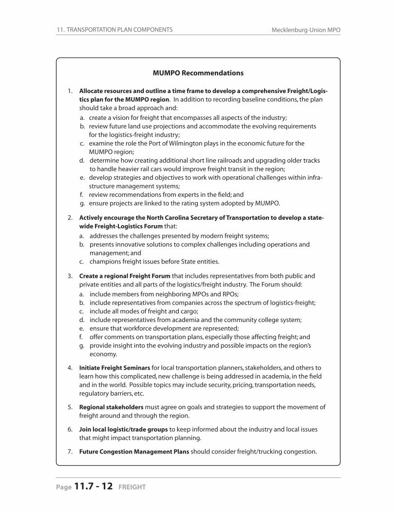
11. TRANSPORTATION PLAN COMPONENTS Mecklenburg-Union MPO
Page 11.7 - 12 FREIGHT
MUMPO Recommendations
1. Allocate resources and outline a time frame to develop a comprehensive Freight/Logis-tics plan for the MUMPO region. In addition to recording baseline conditions, the plan should take a broad approach and:
a. create a vision for freight that encompasses all aspects of the industry;b. review future land use projections and accommodate the evolving requirements for the logistics-freight industry;c. examine the role the Port of Wilmington plays in the economic future for the
MUMPO region; d. determine how creating additional short line railroads and upgrading older tracks to handle heavier rail cars would improve freight transit in the region;
e. develop strategies and objectives to work with operational challenges within infra-structure management systems;
f. review recommendations from experts in the fi eld; andg. ensure projects are linked to the rating system adopted by MUMPO.
2. Actively encourage the North Carolina Secretary of Transportation to develop a state-wide Freight-Logistics Forum that:
a. addresses the challenges presented by modern freight systems; b. presents innovative solutions to complex challenges including operations and
management; and c. champions freight issues before State entities.
3. Create a regional Freight Forum that includes representatives from both public and private entities and all parts of the logistics/freight industry. The Forum should:
a. include members from neighboring MPOs and RPOs; b. include representatives from companies across the spectrum of logistics-freight; c. include all modes of freight and cargo; d. include representatives from academia and the community college system; e. ensure that workforce development are represented; f. offer comments on transportation plans, especially those affecting freight; and g. provide insight into the evolving industry and possible impacts on the region’s
economy.
4. Initiate Freight Seminars for local transportation planners, stakeholders, and others to learn how this complicated, new challenge is being addressed in academia, in the fi eld and in the world. Possible topics may include security, pricing, transportation needs, regulatory barriers, etc.
5. Regional stakeholders must agree on goals and strategies to support the movement of freight around and through the region.
6. Join local logistic/trade groups to keep informed about the industry and local issues that might impact transportation planning.
7. Future Congestion Management Plans should consider freight/trucking congestion.
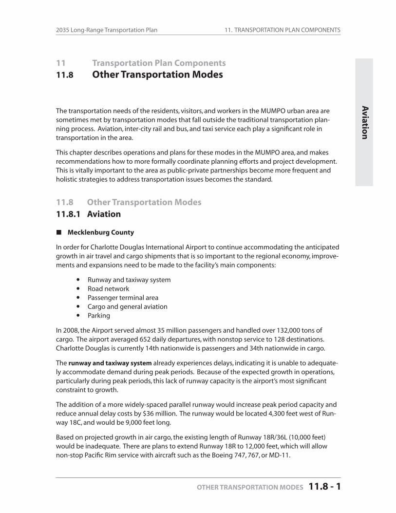
11. TRANSPORTATION PLAN COMPONENTS2035 Long-Range Transportation Plan
OTHER TRANSPORTATION MODES 11.8 - 1
11 Transportation Plan Components
11.8 Other Transportation Modes
The transportation needs of the residents, visitors, and workers in the MUMPO urban area are sometimes met by transportation modes that fall outside the traditional transportation plan-ning process. Aviation, inter-city rail and bus, and taxi service each play a signifi cant role in transportation in the area.
This chapter describes operations and plans for these modes in the MUMPO area, and makes recommendations how to more formally coordinate planning efforts and project development. This is vitally important to the area as public-private partnerships become more frequent and holistic strategies to address transportation issues becomes the standard.
11.8 Other Transportation Modes11.8.1 Aviation
Mecklenburg County
In order for Charlotte Douglas International Airport to continue accommodating the anticipated growth in air travel and cargo shipments that is so important to the regional economy, improve-ments and expansions need to be made to the facility’s main components:
Runway and taxiway system Road network Passenger terminal area Cargo and general aviation Parking
In 2008, the Airport served almost 35 million passengers and handled over 132,000 tons of cargo. The airport averaged 652 daily departures, with nonstop service to 128 destinations. Charlotte Douglas is currently 14th nationwide is passengers and 34th nationwide in cargo.
The runway and taxiway system already experiences delays, indicating it is unable to adequate-ly accommodate demand during peak periods. Because of the expected growth in operations, particularly during peak periods, this lack of runway capacity is the airport’s most signifi cant constraint to growth.
The addition of a more widely-spaced parallel runway would increase peak period capacity and reduce annual delay costs by $36 million. The runway would be located 4,300 feet west of Run-way 18C, and would be 9,000 feet long.
Based on projected growth in air cargo, the existing length of Runway 18R/36L (10,000 feet) would be inadequate. There are plans to extend Runway 18R to 12,000 feet, which will allow non-stop Pacifi c Rim service with aircraft such as the Boeing 747, 767, or MD-11.
Aviatio
n
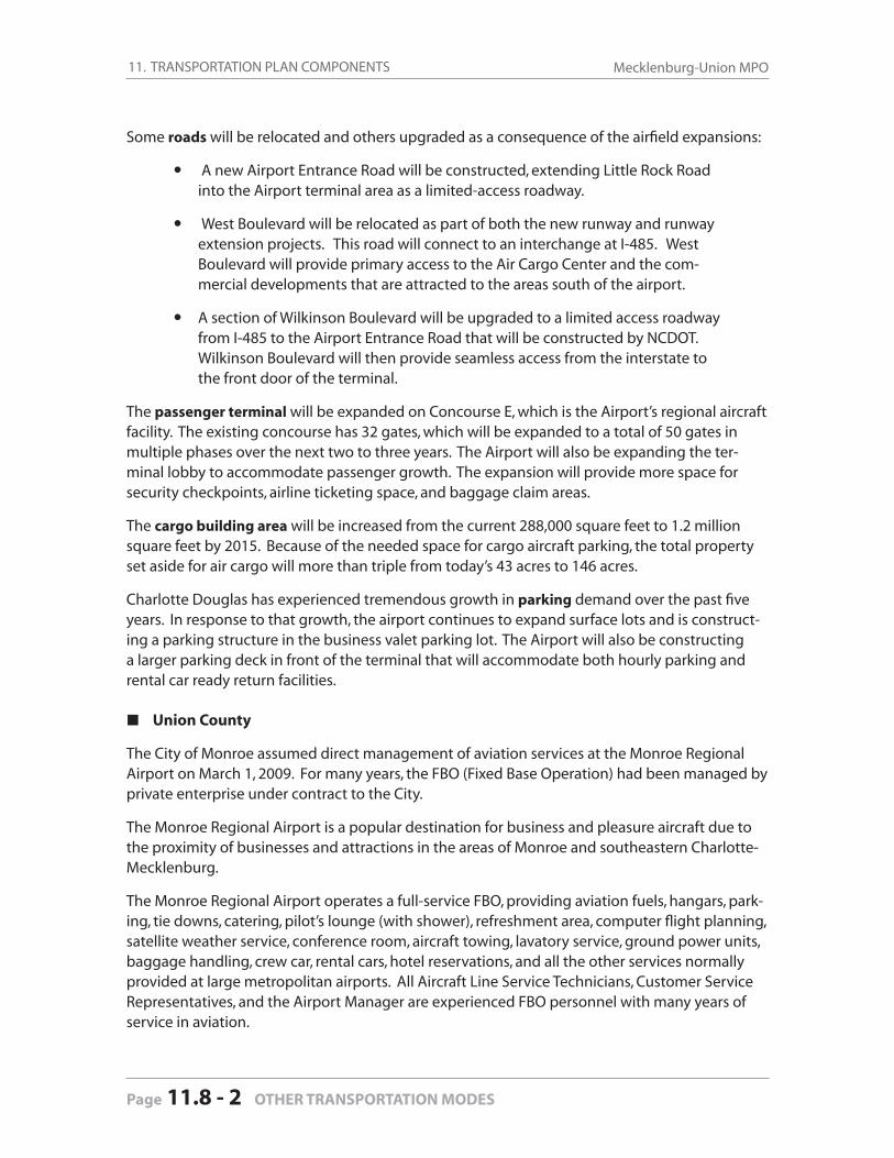
11. TRANSPORTATION PLAN COMPONENTS Mecklenburg-Union MPO
Page 11.8 - 2 OTHER TRANSPORTATION MODES
Some roads will be relocated and others upgraded as a consequence of the airfi eld expansions:
A new Airport Entrance Road will be constructed, extending Little Rock Road into the Airport terminal area as a limited-access roadway.
West Boulevard will be relocated as part of both the new runway and runway extension projects. This road will connect to an interchange at I-485. West Boulevard will provide primary access to the Air Cargo Center and the com-mercial developments that are attracted to the areas south of the airport.
A section of Wilkinson Boulevard will be upgraded to a limited access roadway from I-485 to the Airport Entrance Road that will be constructed by NCDOT. Wilkinson Boulevard will then provide seamless access from the interstate to the front door of the terminal.
The passenger terminal will be expanded on Concourse E, which is the Airport’s regional aircraft facility. The existing concourse has 32 gates, which will be expanded to a total of 50 gates in multiple phases over the next two to three years. The Airport will also be expanding the ter-minal lobby to accommodate passenger growth. The expansion will provide more space for security checkpoints, airline ticketing space, and baggage claim areas.
The cargo building area will be increased from the current 288,000 square feet to 1.2 million square feet by 2015. Because of the needed space for cargo aircraft parking, the total property set aside for air cargo will more than triple from today’s 43 acres to 146 acres.
Charlotte Douglas has experienced tremendous growth in parking demand over the past fi ve years. In response to that growth, the airport continues to expand surface lots and is construct-ing a parking structure in the business valet parking lot. The Airport will also be constructing a larger parking deck in front of the terminal that will accommodate both hourly parking and rental car ready return facilities.
Union County
The City of Monroe assumed direct management of aviation services at the Monroe Regional Airport on March 1, 2009. For many years, the FBO (Fixed Base Operation) had been managed by private enterprise under contract to the City.
The Monroe Regional Airport is a popular destination for business and pleasure aircraft due to the proximity of businesses and attractions in the areas of Monroe and southeastern Charlotte-Mecklenburg.
The Monroe Regional Airport operates a full-service FBO, providing aviation fuels, hangars, park-ing, tie downs, catering, pilot’s lounge (with shower), refreshment area, computer fl ight planning, satellite weather service, conference room, aircraft towing, lavatory service, ground power units, baggage handling, crew car, rental cars, hotel reservations, and all the other services normally provided at large metropolitan airports. All Aircraft Line Service Technicians, Customer Service Representatives, and the Airport Manager are experienced FBO personnel with many years of service in aviation.
11. TRANSPORTATION PLAN COMPONENTS2035 Long-Range Transportation Plan
OTHER TRANSPORTATION MODES 11.8 - 3
Inter-C
ity Rail
The Monroe Regional Airport meets the service needs of corporate and private aircraft from small piston engine aircraft to larger turboprop and jet aircraft. This includes over eighty air-craft based at the airport and the daily transient aircraft. A modern terminal building and FBO employees welcome passengers and pilots upon their arrival at Monroe. The terminal building is also the home of the Monroe Economic Development Offi ce.
Over the years, the City of Monroe has made improvements to enhance the usefulness of the airport. The airport has a 5,500 foot runway with a full-length taxiway, an ILS (instrument land-ing system), remote radio clearance delivery for instrument fl ights, an automatic weather obser-vation system, full runway and taxiway lighting systems, and the recent addition of improved approach lights to aid in landing of instrument fl ights.
The City of Monroe is also planning for the future of the airport. Currently, there are plans to strengthen and lengthen the runway to accommodate much larger aircraft. There are also plans to build a new maintenance hangar and build additional storage hangars.
11.8 Other Transportation Modes11.8.2 Inter-City Rail
The Charlotte region has a long history of rail service for both passenger and freight. Passenger rail popularity surged in 1990 in the Charlotte region when the state of North Carolina began daily round trip service between Charlotte and New York on the Carolinian. In the past decade, passenger rail boardings grew by 242 percent, placing a strain on the existing Amtrak station.
Amtrak Service
Charlotte’s current Amtrak station is located on Tryon Street, approximately two miles north of the Uptown business district. Constructed in the 1960s, the station does not meet all of the cur-rent North Carolina or Americans with Disabilities Act (ADA) standards for disabled access in and around the station and platforms. The parking lot contains only 60 unfenced spaces.
The station is in an existing railroad freight yard, creating confl icts for both freight and passen-ger rail traffi c. As an interim measure to better accommodate the growing crowds, the NCDOT and Amtrak expanded the waiting room and added a ticket window in 2002.
Pedestrian access and connections to other transportation modes are inadequate at the current station. The region’s main business, government and cultural center is two miles away and there are no connections to inter-city buses or rental cars nearby. CATS provides local transit service to the station, but passengers who wish to connect to CATS Route 11 must cross four lanes of busy traffi c (with no traffi c light or crosswalk) to travel downtown to either reach their destina-tions or connect to other transit services.
The current schedule consists of three trains — the Piedmont, the Carolinian, and the Crescent. These three trains provide six daily trips to and from Charlotte on the following scheduled times:

11. TRANSPORTATION PLAN COMPONENTS Mecklenburg-Union MPO
Page 11.8 - 4 OTHER TRANSPORTATION MODES
2:03 AM Crescent northbound departure to New York 2:45 AM Crescent southbound departure to New Orleans 7:40 AM Carolinian northbound departure to New York (via Raleigh) 10:02 AM Piedmont southbound arrival from Raleigh 5:05 PM Piedmont northbound departure to Raleigh 8:24 PM Carolinian southbound arrival from New York (via Raleigh)
Southeast High Speed Rail (SEHSR) Corridor
In 1992 the U.S. Department of Transportation designated fi ve national high-speed rail corridors across the country. The original Southeast High Speed Rail (SEHSR) Corridor — extending from Washington, D.C. through Richmond and Raleigh to Charlotte — has been identifi ed as the most economically viable high speed rail corridor in the country.
The Southeast High Speed Rail program is designed to provide an alternative to the overbur-dened highway and airport networks. Because of its slower speed, the existing passenger rail service is not competitive with these two modes, but the proposed SEHSR service could reduce travel time between Charlotte and Washington from the current ten hours to an estimated six to seven and one half hours.
In October, 2002, the North Carolina and Virginia transportation departments completed a Tier I Environmental Impact Statement (EIS) for the Washington, DC to Charlotte, NC portion of the corridor. The Tier I EIS took a broad look at potential impacts along nine possible routes and identifi ed the preferred route. The second study phase – Tier II – includes more specifi c analysis along the preferred route, and was completed in 2004.
The American Recovery and Reinvestment Act (ARRA) includes $8 billion to deploy high-speed passenger rail systems and improve intercity passenger rail across the country. The U.S. Depart-ment of Transportation will award the funds on a competitive basis, and NCDOT is aggressively pursuing this funding to use for further development of the Southeast High Speed Rail Corridor between Charlotte and Washington, D.C.
NCDOT has submitted applications for 90 rail projects totaling about $4 billion for ARRA fund-ing. The list includes more than $900 million for projects that are considered “shovel ready” and more than $3 billion for corridor development projects, which will involve Virginia and North Carolina. The projects will not only improve service for current train passengers, but they will also help establish the framework for SEHSR. In late January, 2010, $545 million was awarded from ARRA for the rail corridor.
Proposed Multimodal Station
A new multimodal station in Charlotte, including a rail passenger facility, is being planned to better serve the increasing number of passengers and accommodate Norfolk Southern’s desire to separate passenger and freight operations.
NCDOT has completed an engineering feasibility study for a multimodal station on West Trade Street that would create a vastly improved rail and transportation center serving the Charlotte region and the state. The station could include a new inter-city bus terminal as well.
11. TRANSPORTATION PLAN COMPONENTS2035 Long-Range Transportation Plan
OTHER TRANSPORTATION MODES 11.8 - 5
Inter-C
ity Bu
s and
Taxi
The proposed station’s site boundaries are Trade Street, Fourth Street, Graham Street, and the Norfolk Southern Railroad. Property acquisition totaling 27 acres was completed in February, 2004. The timing of the multimodal station’s advancement to the Preliminary Engineering/En-vironmental Impact Statement (PE/EIS) phase is based on continued federal and state funding. Development of the new station and related track improvements is estimated to cost between $110-207 million. The facility would likely be built in phases concurrently with improvements are made to the regional transit system and North Carolina’s rail services.
11.8 Other Transportation Modes11.8.3 Inter-City Bus
Mecklenburg County
Greyhound Lines, Inc. serves the Charlotte region from its terminal located on West Trade Street. There are approximately 86 daily arrivals and departures serving the entire continental United States. Six local and nine express CATS routes, as well as the Gold Rush Red Line uptown circula-tor, serve the Greyhound terminal. This permits Greyhound’s passengers convenient access to the Charlotte Transportation Center and other transportation terminals in the region. As noted in the previous section, NCDOT is currently acquiring land on West Trade Street for construction of a new multimodal station that could include a new inter-city bus terminal.
Union County
There is no inter-city bus service provided in Union County at present, and no public plans to introduce new service.
11.8 Other Transportation Modes11.8.4 Taxi Services
Passenger vehicle-for-hire services are an integral mode of transportation in the Charlotte region. Under City Code, the City of Charlotte regulates the industry within the corporate limits for safety, fares, and number of approved companies and vehicles. Effective July, 2001, the City ordinance was revised to include regulation of not only metered vehicles (taxicabs) but also non-metered vehicles (limousines, shuttle vans, special needs vehicles, and executive cars).
Mecklenburg County
There are presently 13 approved taxicab companies located in Charlotte, operating a combined total of 411 vehicles. These companies provide on-demand services to destinations throughout the Charlotte region. The distribution of vehicles is spread fairly evenly across service providers, with all companies having at least 30 vehicles in their fl eet.
Aside from on-call services typically provided by taxi companies, Mecklenburg County’s Social Services has contracted with cab companies to offer reduced fare service to the elderly and disabled within the community. Additionally, CATS contracts with taxi operators to provide free
11. TRANSPORTATION PLAN COMPONENTS Mecklenburg-Union MPO
Page 11.8 - 6 OTHER TRANSPORTATION MODES
rides home (up to twice a month) to vanpool and express bus riders who have emergency, medi-cal appointments or unplanned work schedule changes.
Union County
There are currently seven taxicab companies providing service within Union County, operating 46 vehicles. These companies provide on-demand services in a similar manner to those com-panies in Mecklenburg County, although due to the more residential and low-density nature of Union County, they almost exclusively provide services on an on-call basis.
11.8 Other Transportation Modes11.8.5 Coordination with LRTP Development
MUMPO currently does not consider the modes described in this chapter — aviation, inter-city rail, inter-city bus and taxi services — in the development of its Long-Range Transportation Plan (LRTP) project list and rankings.
The airport and rail projects currently in the NCDOT TIP are developed by the NCDOT Rail and Aviation divisions, as well as CATS, Charlotte-Mecklenburg Airport and Monroe Regional Airport. MUMPO does approve amendments to the TIP to include such projects, but typically has very little to do with the actual development of the projects or coordination with the proposing agency.
For CATS’ transit projects in Mecklenburg County, the Metropolitan Transit Commission (MTC) governs all decisions. Union County Transportation, governed by the Union County Board of Commissioners, makes all public transportation decisions in Union County.
This 2035 Long-Range Transportation Plan includes the following goals related to “other transpor-tation modes”:
Goal 1 Ensure development of area transportation projects is coordinated across modes.
Strategies Include NCDOT rail and aviation divisions on TCC and MUMPO agenda distribu-
tion lists. Copy NCDOT rail and aviation divisions on all relevant MUMPO comments for
project development reviews.
Goal 2 Increase awareness of area transportation plans.
Strategy Include inter-city bus and rail agencies and companies on relevant TCC and
MUMPO project and plan development processes.
Updating the Long-Range Transportation Plan allows MUMPO, as it does any MPO, the opportu-nity to incorporate the most recent data, identify any changes in factors affecting travel demand, and modify policies, programs or projects based on the most recent information and conditions. This 2035 Long-Range Transportation Plan (LRTP) is different from the previous LRTP (the 2030 LRTP produced and adopted four years ago) for the general reasons mentioned above.
MUMPO is responsible for long-range transportation planning and programming for an area where jobs and households have grown rapidly during the past thirty years. Demographic projections (Chapter 9) show growth is expected to continue at a rapid pace for the foreseeable future, even given the major economic downturn that has been experienced over the past two years. Prior to this downturn, even when the national economy’s job growth slowed and tens of thousands of manufacturing jobs evaporated from other counties in the Carolinas, Mecklenburg and Union counties continued to steadily attract new jobs and residents.
That growth increased the demand for transportation facilities and services in MUMPO’s plan-ning area. MUMPO’s past commitments to investing in transportation infrastructure helped the area attract and cope with the current population growth in and travel patterns. The additional economic activity has signifi cantly increased freight and goods movement in the region.
This LRTP describes the investments in freeways, other roadways, and rapid and other forms of transit that will provide additional capacity to serve the increase in travel demands projected through 2035. Funds will be spent on projects identifi ed in this LRTP to widen and extend freeways and other roadways in the MUMPO planning area. The number of projects is almost 2/3 less than in the previous LRTP but almost as costly. Additionally, hundreds of millions of dollars are anticipated to be spent to greatly expand transit services, particularly in Mecklenburg County, and to enhance the effi ciency and capacity of intermodal freight facilities and Charlotte/Douglas International Airport.
Challenges
The 2030 Long-Range Transportation Plan noted four specifi c challenges facing area MPO’s. These challenges, which are even more compelling today in this bi-state metropolitan region, are:
1. responding effectively to regional issues – from managing growth to developing collaborative solutions across various jurisdictional boundaries;
2. providing more transportation choices – beyond building roadways solely for motor vehicles;
3. securing additional project fi nancing; and4. demonstrating conformity with North and South Carolina’s State Implementation Plan(s) for
attaining (or not violating) the National Ambient Air Quality Standards.
12.0
Conclusion Co
nclu
sion
CONCLUSION 12-1
12. CONCLUSION Mecklenburg-Union MPO
Page 12-2 CONCLUSION
1. Regional Issues
While this LRTP refl ects and incorporates several regional data collection and modeling initia-tives, there are still various regional planning issues that will need to be addressed in upcoming LRTPs prepared by MUMPO and adjacent MPOs. The following regional initiatives were success-fully accomplished during the past decade:
compiling the fi rst-ever inventory of land uses and socio-economic data, producing the fi rst-ever regional projections of employment and population, creating a new travel forecasting model covering all or parts of ten counties in the bi-state region, and preparing the fi rst-ever region-wide forecasts of highway and transit travel.
As a result of this work, a strong technical foundation for transportation and other related types of planning now exists in the Greater Charlotte region. However, the organizational foundation for implementing ongoing planning efforts involving the region’s four MPOs is more tenuous than are the technical data and travel forecasting model described above.
The region’s four MPOs collaborated to accomplish the technical activities accomplished during the past three years. Updating the demographic, economic and land use data, as well as any other travel-related assumptions necessary to produce travel forecasts, must now evolve into a continuous undertaking so that the investments made to date in regional data and the new travel forecasting model are not wasted. Travel fl ows and air quality impacts are already affect-ing the entire region, which is an area larger than that included in all four MPOs.
The need to prepare forecasts based on region-wide highway or transit networks, and region-wide land use or socio-economic assumptions, will make the MPOs more interdependent. Crafting the agreements to update data required for modeling and to produce new forecasts involving the four MPOs and various other entities to establish the funding and staffi ng arrange-ments remains to be accomplished.
2. Transportation Choices
The projections of future traffi c cannot be accommodated solely on roadways identifi ed on the MPO’s Thoroughfare Plan. With increasing interest in creating pedestrian-scale activity centers and/or villages, a greater emphasis on multimodal choices is necessary.
Consequently, MUMPO’s LRTP recommends extensive expansions of the services provided by the Charlotte Area Transit System. One rapid transit corridor — the South Corridor — opened for service in 2007. Ultimately, a fi ve-corridor rapid transit system is expected to provide a new form of transportation capacity that will make available high-quality transportation services for an ever-growing percentage of persons traveling in Mecklenburg County.
However, since large increases in population and employment are also projected to occur be-yond Mecklenburg County, the growth in the magnitude of travel across Mecklenburg County’s boundaries will account for increasing percentages of the travel occurring on area freeways. HOV and/or HOT lanes will need to be part of the region’s future transportation network.

12. CONCLUSION2035 Long-Range Transportation Plan
CONCLUSION 12-3
Co
nclu
sion
Constructing toll roads or instituting managed lanes can help create new revenues to meet the challenge of securing all the fi nancing necessary for transportation projects in this rapidly growing region.
3. Financing
MUMPO and the adjacent MPOs will need to devise new funding arrangements and give more priority to serving travel crossing the boundaries of MPOs, especially to implement facilities intended to serve transit riders and/or persons traveling in carpools or vanpools.
While innovative fi nancing methods (particularly managed lanes and toll roads) are being proposed, additional fi nancial partnerships will become more important in order to build and/or operate transportation facilities that cross MPO boundaries. Extensions of transit guideways or bus routes beyond Mecklenburg County will require local funding commitments to cover portions of the construction and/or operating costs.
Reaching agreements on the transit funding levels to be allocated to each MPO, counties within MPOs, or other local governments, will take continued negotiations. Without undertaking and successfully concluding those negotiations — probably focused on specifi c transit project or service proposals — offering transit options for travel across Mecklenburg County will not be possible.
4. Air Quality Standards
Continued employment and population growth in MUMPO’s planning area – and in the other areas that also comprise the bi-state metropolitan area – will increase the vehicle starts and miles of travel that are this area’s leading cause of air pollution. The entire region’s ability to successfully demonstrate air quality conformity will remain a crucial issue. Demonstrating how this LRTP complies with the air quality conformity requirements is the subject of a separate, but related document.
Next Steps
The MUMPO Board will adopt a 2035 Long Range Transportation Plan based on assum-ing no new revenues. MUMPO staff has been directed to begin preparing the next LRTP soon after the adoption of the 2035 LRTP.


APPENDIX A
Project Ranking Methodology
Mecklenburg-Union Metropolitan Planning OrganizationLong-Range Transportation PlanRoadway Ranking Methodology
Approved by the MPO, November 14, 2007
Introduction
The purpose of the Mecklenburg-Union Metropolitan Planning Organization’s (MUMPO) Plan Ranking Criteria for Major Roadway Project’s process is to facilitate determination of the region’s project priorities to be used in development of a fi scally constrained Long-Range Transportation Plan (LRTP).
The Safe, Accountable, Flexible, Effi cient Transportation Equity Act: A Legacy for Users (SAFETEA-LU) calls for an LRTP development process that documents a methodology for ranking project requests that refl ects local and metropolitan mobility, environmental and air quality goals.
Objective
The process outlined below is designed to address roadway needs. The Technical Coordinating Committee (TCC) will use the procedure to develop a draft project priority list. This draft prior-ity list will be used as a starting point by the Metropolitan Planning Organization (MPO) for the approval of a fi nal LRTP roadway project priority list.
The MPO may reorder projects at its discretion based upon its members’ knowledge of the urban area and the policies of their communities. Therefore, the TCC will make its technical rec-ommendation on a draft priority list based on the procedure described below, and the MPO may make any changes deemed appropriate.
Procedure for Ranking Projects
The Meetings are scheduled to allow staff to rank projects in a given geography. Each meeting consists of MUMPO staff and staff from the jurisdictions in its area. The meetings cover the fol-lowing geographies:
1) Northern Mecklenburg County towns, and north Charlotte (generally from I-485 to the Iredell County Line)
2) Charlotte3) Southern Mecklenburg County towns and south Charlotte (generally from
I-485 to the Union County Line)4) Union County
A. P
roject R
ank
ing
Meth
od
olo
gy
APPENDIX A A-1

APPENDIX A Mecklenburg-Union MPO
Page A-2 APPENDIX A
The number of meetings for each area is not pre-determined, as the number of projects in each varies. Projects reviewed are either those from the most recent LRTP or those identifi ed by staff or elected offi cials from MUMPO area jurisdictions. Each project is given as much time as needed to discuss each of the criterion in depth. The criteria are awarded individual scores by majority rule, but usually are based on group consensus.
For Criterion #1(Reduces Congestion), point values are based on travel demand model outputs which determine per lane volumes. Those volumes are matched to point values noted in the criterion’s two tables.
Once the criteria have received individual scores and those scores have been totaled, the proj-ects are ranked in priority order (the higher the score, the higher the priority). If total project scores are tied, then staff will review which of the tied projects has the highest number of crite-ria with scores of fi ve, then four, and so on. If a tie persists, then the overall ranking committee votes to break it.
After the draft priority list is developed, it is then forwarded to the MPO as the TCC’s recom-mended roadway project priorities for the urban area.
Project Scoring
The points that can be assigned in this ranking process range from a maximum of positive fi ve (+5) to a minimum of negative fi ve (-5).
A cap on the maximum or minimum number of points has been established in many of the categories. The objective of establishing caps is to refl ect the relative importance of the criteria.
Scores in the Reduces Congestion criterion are assigned through outputs from the regional travel demand model.
Scores in the Supports Local Land Use and Improves Quality of Life criterion are established by local land use or transportation planners, subject to consultation with the ranking group. Only one (+5) score per jurisdiction is permitted.
In the event of a tie, the project receiving the highest number of (+5) scores will be ranked higher. If both projects receive the same number of (+5) scores, the project to be ranked higher will be the one with the highest number of (+4) scores. If necessary, the process will continue until the higher ranking project is established.
As noted below, a (+5) score suggests that the project has a very high positive im-pact on the criterion in question. Conversely, a (-5) score suggests that the project has a very high negative impact on the criterion.
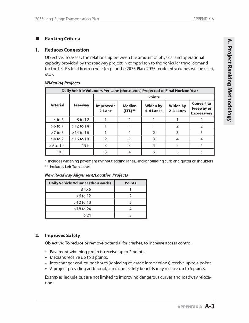
APPENDIX A2035 Long-Range Transportation Plan
APPENDIX A A-3
Ranking Criteria
1. Reduces Congestion
Objective: To assess the relationship between the amount of physical and operational capacity provided by the roadway project in comparison to the vehicular travel demand for the LRTP’s fi nal horizon year (e.g., for the 2035 Plan, 2035 modeled volumes will be used, etc.).
Widening Projects
Daily Vehicle Volumers Per Lane (thousands) Projected to Final Horizon Year
Arterial Freeway
Points
Improved*2-Lane
Median(LTL)**
Widen by 4-6 Lanes
Widen by 2-4 Lanes
Convert to Freeway or Expressway
4 to 6 8 to 12 1 1 1 1 1
>6 to 7 >12 to 14 1 1 1 2 2
>7 to 8 >14 to 16 1 1 2 3 3
>8 to 9 >16 to 18 2 2 3 4 4
>9 to 10 19+ 3 3 4 5 5
10+ 3 4 5 5 5
* Includes widening pavement (without adding lanes),and/or building curb and gutter or shoulders
** Includes Left Turn Lanes
New Roadway Alignment/Location Projects
Daily Vehicle Volumes (thousands) Points
3 to 6 1
>6 to 12 2
>12 to 18 3
>18 to 24 4
>24 5
2. Improves Safety
Objective: To reduce or remove potential for crashes; to increase access control.
Pavement widening projects receive up to 2 points.Medians receive up to 3 points.Interchanges and roundabouts (replacing at-grade intersections) receive up to 4 points.A project providing additional, signifi cant safety benefi ts may receive up to 5 points.
Examples include but are not limited to improving dangerous curves and roadway reloca-tion.
A. P
roject R
ank
ing
Meth
od
olo
gy
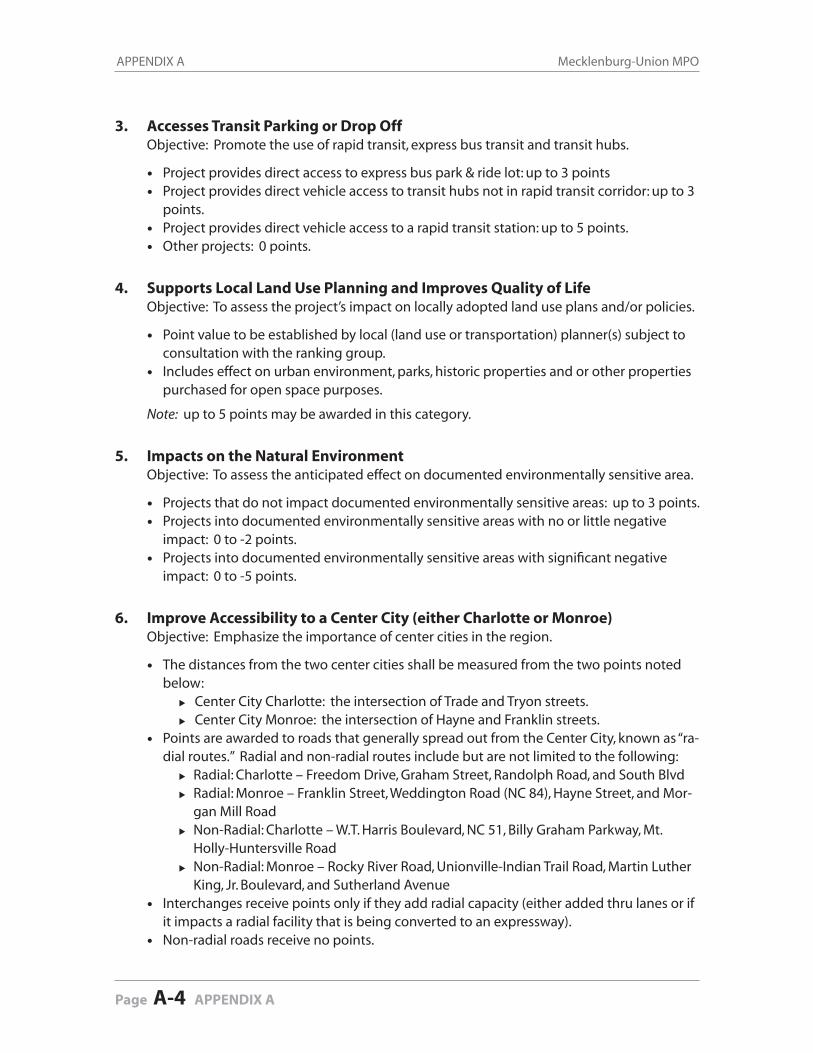
APPENDIX A Mecklenburg-Union MPO
Page A-4 APPENDIX A
3. Accesses Transit Parking or Drop OffObjective: Promote the use of rapid transit, express bus transit and transit hubs.
Project provides direct access to express bus park & ride lot: up to 3 pointsProject provides direct vehicle access to transit hubs not in rapid transit corridor: up to 3 points.Project provides direct vehicle access to a rapid transit station: up to 5 points.Other projects: 0 points.
4. Supports Local Land Use Planning and Improves Quality of LifeObjective: To assess the project’s impact on locally adopted land use plans and/or policies.
Point value to be established by local (land use or transportation) planner(s) subject to consultation with the ranking group.Includes effect on urban environment, parks, historic properties and or other properties purchased for open space purposes.
Note: up to 5 points may be awarded in this category.
5. Impacts on the Natural EnvironmentObjective: To assess the anticipated effect on documented environmentally sensitive area.
Projects that do not impact documented environmentally sensitive areas: up to 3 points.Projects into documented environmentally sensitive areas with no or little negative impact: 0 to -2 points. Projects into documented environmentally sensitive areas with signifi cant negative impact: 0 to -5 points.
6. Improve Accessibility to a Center City (either Charlotte or Monroe)Objective: Emphasize the importance of center cities in the region.
The distances from the two center cities shall be measured from the two points noted below:
Center City Charlotte: the intersection of Trade and Tryon streets.Center City Monroe: the intersection of Hayne and Franklin streets.
Points are awarded to roads that generally spread out from the Center City, known as “ra-dial routes.” Radial and non-radial routes include but are not limited to the following:
Radial: Charlotte – Freedom Drive, Graham Street, Randolph Road, and South BlvdRadial: Monroe – Franklin Street, Weddington Road (NC 84), Hayne Street, and Mor-gan Mill RoadNon-Radial: Charlotte – W.T. Harris Boulevard, NC 51, Billy Graham Parkway, Mt. Holly-Huntersville RoadNon-Radial: Monroe – Rocky River Road, Unionville-Indian Trail Road, Martin Luther King, Jr. Boulevard, and Sutherland Avenue
Interchanges receive points only if they add radial capacity (either added thru lanes or if it impacts a radial facility that is being converted to an expressway).Non-radial roads receive no points.
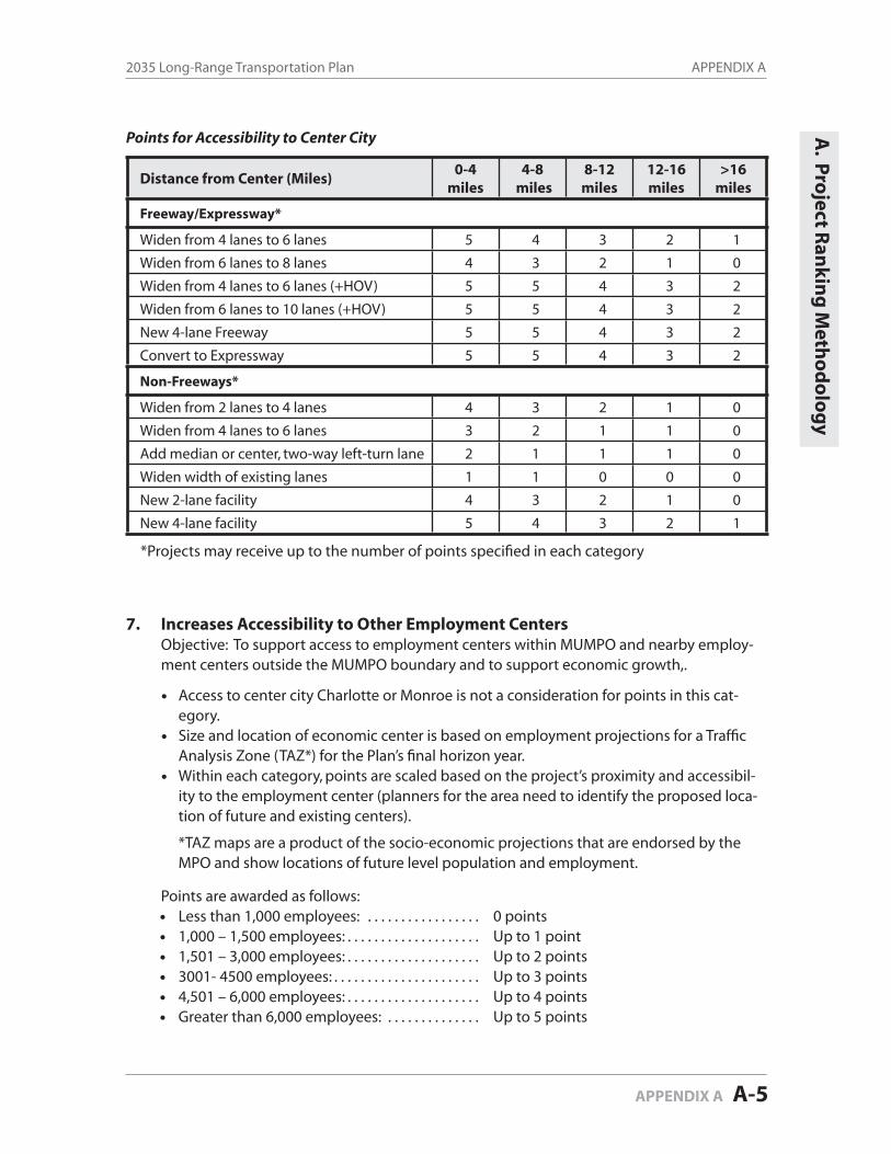
APPENDIX A2035 Long-Range Transportation Plan
APPENDIX A A-5
Distance from Center (Miles)0-4
miles4-8
miles8-12miles
12-16miles
>16miles
Freeway/Expressway*
Widen from 4 lanes to 6 lanes 5 4 3 2 1
Widen from 6 lanes to 8 lanes 4 3 2 1 0
Widen from 4 lanes to 6 lanes (+HOV) 5 5 4 3 2
Widen from 6 lanes to 10 lanes (+HOV) 5 5 4 3 2
New 4-lane Freeway 5 5 4 3 2
Convert to Expressway 5 5 4 3 2
Non-Freeways*
Widen from 2 lanes to 4 lanes 4 3 2 1 0
Widen from 4 lanes to 6 lanes 3 2 1 1 0
Add median or center, two-way left-turn lane 2 1 1 1 0
Widen width of existing lanes 1 1 0 0 0
New 2-lane facility 4 3 2 1 0
New 4-lane facility 5 4 3 2 1
*Projects may receive up to the number of points specifi ed in each category
7. Increases Accessibility to Other Employment CentersObjective: To support access to employment centers within MUMPO and nearby employ-ment centers outside the MUMPO boundary and to support economic growth,.
Access to center city Charlotte or Monroe is not a consideration for points in this cat-egory.Size and location of economic center is based on employment projections for a Traffi c Analysis Zone (TAZ*) for the Plan’s fi nal horizon year.Within each category, points are scaled based on the project’s proximity and accessibil-ity to the employment center (planners for the area need to identify the proposed loca-tion of future and existing centers).
*TAZ maps are a product of the socio-economic projections that are endorsed by the MPO and show locations of future level population and employment.
Points are awarded as follows: Less than 1,000 employees: . . . . . . . . . . . . . . . . . 0 points 1,000 – 1,500 employees: . . . . . . . . . . . . . . . . . . . . Up to 1 point 1,501 – 3,000 employees: . . . . . . . . . . . . . . . . . . . . Up to 2 points 3001- 4500 employees: . . . . . . . . . . . . . . . . . . . . . . Up to 3 points 4,501 – 6,000 employees: . . . . . . . . . . . . . . . . . . . . Up to 4 points Greater than 6,000 employees: . . . . . . . . . . . . . . Up to 5 points
Points for Accessibility to Center City A. P
roject R
ank
ing
Meth
od
olo
gy
APPENDIX A Mecklenburg-Union MPO
Page A-6 APPENDIX A
8. Impacts on Air QualityObjective: To improve air quality by reducing vehicle miles traveled (VMT by increasing ve-hicle occupancy, encouraging non-motorized travel, or creating new roadway connections.
Points are awarded as follows:5 or more miles of managed lanes . . . . . . . . . . . . . . . . . . . . . . . . . . . . . . . Up to 2 points4 or fewer miles of managed lanes . . . . . . . . . . . . . . . . . . . . . . . . . . . . . . . Up to 1 pointProjects that signifi cantly reduce VMT by improving connectivity . . Up to 2 pointsProjects that greatly induce sprawl. . . . . . . . . . . . . . . . . . . . . . . . . . . . . . . From -3 to -1 pointsProjects that accommodate bicyclists and/or pedestrians . . . . . . . . . . Up to 1 pointOther roadway projects . . . . . . . . . . . . . . . . . . . . . . . . . . . . . . . . . . . . . . . . . . 0 points
9. Supports Low Income and Minority Communities Objective: To avoid adverse impacts and promote positive social and ecnomic effects on
minority and low-income populations.
Compare positive connectivity/accessibility benefi ts to negative community impacts.
Low income communities are defi ned by percentage of households below Federal pov-erty guidelines in relation to total households in Census tracts. Minority communities are defi ned by the percentage of minorities in relation to total population in Census tracts.
Note: Up to 5 points may be awarded in this category
10. Promotes Intermodal Connectivity Objective: Improve access to existing and potential intermodal facilities.
Charlotte-Douglas International Airport, Monroe Regional Airport, West Trade Multi-modal Station, or National Highway System Designated Freight Terminals receive up to 5 points.Potential truck terminal locations on US or NC numbered route next to freeway up to 3 points.Existing intermodal sites with 300 or more truck trips per day up to 3 points.Existing intermodal sites with 100 or more truck trips per day up to 2 points.
Note: Number of points dependent on distance from intermodal site
11. Provides Benefi ts That Outweigh Project Costs Objective: To compare the project’s accumulation of positive ratings and specifi c benefi cial
impacts versus the project’s estimated per/mile construction costs and specifi c, negative impacts.
Point selection is subject to but not limited to the issues below: Includes consideration of ROW reservation or dedication, developer participation and portions completed by others.Additional points may be awarded to the last segment of a multi-phased project..
Note: Up to 5 points may be awarded in this category
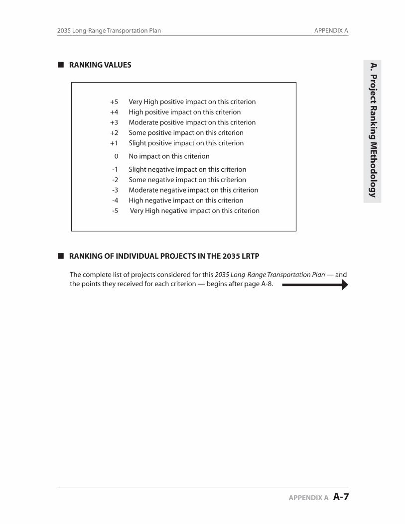
APPENDIX A2035 Long-Range Transportation Plan
APPENDIX A A-7
A. P
roject R
ank
ing
MEth
od
olo
gy
RANKING VALUES
+5 Very High positive impact on this criterion
+4 High positive impact on this criterion
+3 Moderate positive impact on this criterion
+2 Some positive impact on this criterion
+1 Slight positive impact on this criterion
0 No impact on this criterion
-1 Slight negative impact on this criterion
-2 Some negative impact on this criterion
-3 Moderate negative impact on this criterion
-4 High negative impact on this criterion
-5 Very High negative impact on this criterion
RANKING OF INDIVIDUAL PROJECTS IN THE 2035 LRTP
The complete list of projects considered for this 2035 Long-Range Transportation Plan — and the points they received for each criterion — begins after page A-8.
APPENDIX A Mecklenburg-Union MPO
Page A-8 APPENDIX A

MU
MPO
203
5 LR
TPR
oadw
ay C
andi
date
Pro
ject
Lis
t and
Dat
a (T
able
A-1
)
Proj
ect
ID
2035
MPO
Ran
k
Fund
edin
203
5 Pl
an?
TIP
Num
ber
Proj
ect
Proj
ect L
imits
Exi
stin
g L
anes
Typ
eFu
ndin
gSo
urce
Sphe
reSy
stem
Red
uce
Con
gest
ion
Impr
oves
Safe
ty
Acc
ess T
rans
it Pa
rkin
g or
Dro
p O
ff
Supp
orts
Loc
al
Lan
d U
se
Plan
ning
&
Impr
oves
Qua
lity
of L
ife
Impa
cts o
n th
e N
atur
alE
nvir
onm
ent
Impr
oves
Cen
ter
City
A
cces
s to
Cha
rlot
te o
r M
onro
e
Incr
ease
sA
cces
sibi
lilty
to
Oth
erE
mpl
oym
ent
Cen
ters
Impa
cts
on A
ir
Qua
lity
Supp
orts
Low
In
com
e an
dM
inor
ityC
omm
uniti
es
Prom
otes
Inte
rmod
alC
onne
ctiv
ity
Ben
efit/
Cos
tT
otal
Scor
e
3169
1Y
esR
-255
9/R
-332
9M
onro
e C
onne
ctor
/Byp
ass (
US
74)
I-48
5 to
US
74 (W
inga
te)
n/a
New
Fre
eway
(4)
Toll
Uni
on C
ount
ySt
ate
55
05
-25
01
12
527
3010
2Y
esIn
depe
nden
ce B
oule
vard
(US
74)
Con
fere
nce
Dr.
to V
illag
e La
ke D
r.6
lane
sEx
pres
sway
(6+H
OV
or B
W)
Equi
tyC
harlo
tteSt
ate
44
53
04
01
00
425
3009
3Y
esIn
depe
nden
ce B
oule
vard
(US
74)
Vill
age
Lake
Dr.
to K
refe
ld D
r.4/
6 la
nes
Expr
essw
ay (6
+HO
V o
r BW
)Eq
uity
Cha
rlotte
Stat
e5
45
3-1
40
10
04
2530
064
Yes
I-47
33I-
77 /
Cat
awba
Ave
.In
terc
hang
esi
mpl
e di
amon
d in
terc
hang
eC
onve
rt to
Urb
an D
iam
ond
Equi
tyC
orne
lius
Stat
e5
43
51
03
10
03
2531
925
Yes
Old
Sta
tesv
ille
Rd.
(NC
115
)B
aile
y R
d to
Pot
ts S
treet
2-la
ne, u
ndiv
ided
Wid
enin
g (4
), M
edia
n, B
ike
Lane
sEq
uity
Cor
neliu
sSt
ate
53
54
30
21
00
225
3011
6Y
esIn
depe
nden
ce B
oule
vard
(US
74)
Kre
feld
Dr.
to H
ayde
n W
ay4-
lane
s, m
edia
n di
vide
dEx
pres
sway
(6+H
OV
or B
W)
Equi
tyC
harlo
tteSt
ate
54
53
-14
01
00
425
3019
7Y
esR
-224
8EA
lexa
nder
ana
Roa
dN
C 1
15 to
Eas
tfiel
d R
d.n/
aN
ew R
oad
(4),
Med
ian,
Bik
e La
neLo
opC
harlo
tte a
nd
Hun
ters
ville
Stat
e5
33
41
04
20
03
25
3193
8Y
esN
C 1
15 T
wo-
Way
Pai
rM
t. H
olly
-Hun
ters
ville
to 4
th E
xt.
Impr
ovem
ents
to M
ain
Stre
et, n
ew ti
e-in
s to
NC
11
5
Wid
enin
g (2
), N
ew R
oad
(2),
Med
ian,
B
ike
Lane
sLo
cal
Hun
ters
ville
Stat
e2
45
52
03
1-1
03
24
3191
9Y
esO
ld S
tate
svill
e R
d. (N
C 1
15)
Potts
Stre
et to
Cou
nty
Line
2-la
ne, u
ndiv
ided
Wid
enin
g (2
), B
ike
Lane
sEq
uity
Cor
neliu
s and
D
avid
son
Stat
e3
25
43
03
12
01
24
3142
10Y
esIn
depe
nden
ce B
oule
vard
(US
74)
Hay
den
Way
to N
C 5
14-
lane
, med
ian
divi
ded
Expr
essw
ay (6
Lan
es +
HO
V o
r Bus
way
)Eq
uity
Cha
rlotte
and
M
atth
ews
Stat
e5
45
4-1
40
00
02
23
3012
11Y
esU
-471
4Jo
hn S
treet
/Old
Mon
roe
Roa
dI-
485
to In
dian
Tra
il R
oad
2-la
ne, u
ndiv
ided
Wid
enin
g (4
), M
edia
n, B
ike
Lane
sEq
uity
Mat
thew
s and
U
nion
Cou
nty
Stat
e5
30
51
04
10
13
23
3013
12Y
esU
-500
7N
C 5
1 (M
atth
ews-
Min
t Hill
Roa
d)M
atth
ews T
owns
hip
Pkw
y to
Law
yers
Rd.
2-la
ne, u
ndiv
ided
Wid
enin
g (4
), M
edia
n, B
ike
Lane
sEq
uity
Mat
thew
s and
M
int H
illSt
ate
53
15
10
31
00
423
3270
13Y
esSt
ates
ville
Roa
d (U
S 21
)H
arris
Blv
d. to
Gile
ad R
d.2-
lane
, und
ivid
edW
iden
ing
(4) M
edia
n, w
osl
Equi
tyC
harlo
tte a
nd
Hun
ters
ville
Stat
e5
31
4-1
05
10
23
23
3205
14N
oR
-263
2AA
NC
73
East
US
21 to
NC
115
2-la
ne, u
ndiv
ided
Wid
enin
g (4
), M
edia
n, B
ike
Lane
sEq
uity
Hun
ters
ville
Stat
e5
44
4-1
03
1-1
04
2333
1215
Yes
Wes
t Bou
leva
rd E
xten
sio n
Stee
le C
reek
Rd.
to I-
485
n/a
New
Roa
d (4
), B
ike
Lane
sEq
uity
Cha
rlotte
Stat
e5
30
30
40
10
34
2333
1316
No
Wes
t Bou
leva
rd R
eloc
atio
n (N
C 1
60)
Yor
kmon
t Rd.
to S
teel
e C
reek
Rd.
n/a
New
Roa
d (4
), B
ike
Lane
sLo
cal
Cha
rlotte
Stat
e5
30
30
40
10
34
2330
6717
Yes
R-2
420A
City
Bou
leva
rd E
xten
sion
Nea
l Rd.
to M
alla
rd C
reek
Rd
Exte
nsio
nn/
aN
ew R
oad
(4),
Bik
e La
nes
Loca
lC
harlo
tteSt
ate
34
14
-10
43
01
423
3096
18Y
esG
ilead
Roa
dU
S 21
to N
C 1
152-
lane
, und
ivid
edW
iden
ing
(4),
Bik
e La
nes
Equi
tyH
unte
rsvi
lleSt
ate
43
44
10
31
00
323
3000
19Y
esB
eatti
es F
ord
Roa
dC
apps
Hill
Min
e R
d. to
Sun
set R
d .2-
lane
road
Wid
enin
g (4
), B
ike
Lane
sLo
cal
Cha
rlotte
Stat
e3
31
31
30
13
14
23
3300
20Y
esR
-255
5BW
. Cat
awba
Ave
nue
Jetto
n R
d. to
NC
73
2-la
ne, u
ndiv
ided
Wid
enin
g (4
), M
edia
n, B
ike
Lane
sEq
uity
Cha
rlotte
and
H
unte
rsvi
lleSt
ate
54
04
00
51
00
322
3075
21N
oEa
ster
n C
ircum
fere
ntia
l Roa
dId
lew
ild R
oad
to U
S 74
2-la
ne, u
ndiv
ided
Wid
enin
g (4
)/New
(4),
Med
ian,
Bik
e La
nes
Equi
tyC
harlo
tte a
nd
Mat
thew
sSt
ate
53
53
00
12
00
322
3294
22N
oIn
depe
nden
ce B
oule
vard
(US
74)
NC
51
to I-
485
4-la
ne, m
edia
n di
vide
dEx
pres
sway
(6 L
anes
+H
OV
or B
usw
ay)
Equi
tyM
atth
ews
Stat
e5
41
41
30
00
04
22
3016
23Y
esA
irpor
t Roa
dG
oldm
ine
Roa
d to
NC
84
2-la
ne, u
ndiv
ided
Wid
en (4
), M
edia
n, B
ike
Lane
s (so
me
new
alig
n)Eq
uity
Uni
on C
ount
ySt
ate
13
04
00
41
05
422
3203
24N
oR
-263
2AB
NC
73
East
NC
115
to D
avid
son-
Con
cord
Rd.
2-
lane
, und
ivid
edW
iden
ing
(4),
Med
ian
Equi
tyC
orne
lius a
nd
Hun
ters
ville
Stat
e5
34
4-1
03
10
03
22
3219
25N
oO
ld C
harlo
tte H
ighw
ayW
esle
y C
hape
l-Sto
uts R
oad
to R
ocky
Riv
er R
d.2-
lane
, und
ivid
edW
iden
ing
(upg
rade
4-la
ne),
Bik
e La
nes,
Side
wal
ksEq
uity
Uni
on C
ount
ySt
ate
53
04
00
41
02
322
3293
26N
oR
oose
velt
Blv
d. (U
S 74
)H
anov
er D
rive
to w
este
rn M
onro
e C
orp.
Lim
its4-
lane
, div
ided
Wid
en (6
), M
edia
n, B
ike
Lane
s, Si
dew
alks
Equi
tyU
nion
Cou
nty
Stat
e5
23
40
04
10
03
22
3337
27Y
esB
ridge
ford
Ln.
-Nor
thdo
wns
Ln.
Con
nect
o rN
orth
cros
s Driv
e to
US
21
n/a
New
Roa
dEq
uity
Hun
ters
ville
Stat
e4
40
40
04
30
03
2233
1428
Yes
Wes
t Bou
leva
rd R
eloc
atio
n (N
C 1
60)
Airp
ort D
r. to
Yor
kmon
t Rd.
n/a
New
Roa
d (4
) /W
iden
ing
(4),
Bik
e Lo
cal
Cha
rlotte
Stat
e4
30
30
40
10
34
2230
6129
No
Che
stnu
t Lan
e/U
S 74
Con
nect
orO
ld M
onro
e R
oad
to U
S 74
n/a
New
Roa
d (4
), M
edia
nEq
uity
Uni
on C
ount
ySt
ate
54
04
-10
33
00
321
3101
30N
oH
ambr
ight
Roa
d Ex
tens
ion
Ever
ette
Kei
th R
d. to
Eas
tfiel
d R
d. (l
imits
cha
nged
)n/
aN
ew R
oad
(4),
Med
ian,
Bik
e La
nes
Equi
tyH
unte
rsvi
lleSt
ate
43
54
-20
32
00
221
3221
31N
oU
-471
4O
ld M
onro
e R
oad
Indi
an T
rail
Rd.
to W
esle
y C
hape
l-Sto
uts R
d.2-
lane
, und
ivid
edW
iden
ing
(4),
Med
ian,
Bik
e La
nes,
Side
wal
ksEq
uity
Uni
on C
ount
ySt
ate
43
05
00
41
01
321
3288
32N
oSt
ates
ville
Roa
d (U
S 21
)G
ilead
Rd.
to H
olly
Poi
nt D
rive
2-la
ne, u
ndiv
ided
Wid
enin
g (4
) Med
ian,
wos
lEq
uity
Hun
ters
ville
Stat
e5
33
4-1
03
10
03
2130
6333
No
Chu
rch
St. E
xten
sion
McC
ord
Rd.
to M
ayes
Rd.
n/a
New
Roa
d (2
) (34
'FF)
Loca
lH
unte
rsvi
lleLo
cal
33
54
-10
31
00
321
3231
34N
oPo
tts-S
loan
Con
nect
orN
C 1
15 to
Grif
fith
St2-
lane
, und
ivid
ed2-
lane
, und
ivid
ed, b
ike
lane
sLo
cal
Dav
idso
nLo
cal
33
45
00
13
00
221
3298
35N
oV
erho
eff D
rive
East
NC
115
Con
nect
or to
Mea
cham
Far
m D
rive
New
Roa
d ne
w a
lignm
ent
Rai
lroad
Ove
rpas
sLo
cal
Hun
ters
ville
Loca
l3
40
41
02
10
24
2130
3236
Yes
Jim
Coo
ke R
oad
Exte
nsio
nB
aile
y R
d.to
Nor
thcr
oss D
r. Ex
t.n/
aN
ew R
oad
(2-3
), B
ike
Lane
sLo
cal
Cor
neliu
sSt
ate
34
34
-10
32
00
321
3287
37N
oU
nive
rsity
City
Bou
leva
rd (N
C 4
9)N
. Try
on S
t. (U
S 29
) to
I-48
54-
lane
, div
ided
Wid
enin
g (6
), B
ike
Lane
sEq
uity
Cha
rlotte
Stat
e5
20
50
04
10
03
2030
3938
No
Bill
y G
raha
m P
arkw
ayJo
sh B
irmin
gham
Pkw
y. to
I-85
4 la
ne ro
ad,
Wid
enin
g (6
)Eq
uity
Cha
rlotte
Stat
e5
20
21
04
00
42
20
3190
39N
oO
ld S
tate
svill
e R
d. (N
C 1
15)
4th
St. E
xt. t
o B
aile
y R
d.
2-la
ne, u
ndiv
ided
Wid
enin
g (4
) Med
ian,
Bik
e La
nes
Equi
tyC
orne
lius a
nd
Hun
ters
ville
Stat
e5
33
40
02
10
02
20
3223
40N
oPa
rk R
oad
John
ston
Roa
d to
NC
51
2-la
ne, u
ndiv
ide d
Wid
en(4
), M
edia
n, B
ike
Lane
sEq
uity
Pine
vill e
Stat
e3
30
51
03
11
03
2030
4041
Yes
Bill
y G
raha
m P
arkw
ay/M
orris
Fie
ld D
rive
Gra
de S
epar
atio
nn/
aN
ew G
rade
Sep
arat
ion
Equi
tyC
harlo
tteSt
ate
44
02
00
31
03
320
3207
42N
oR
-263
2AB
NC
73
Wes
tW
. Cat
awba
Ave
. to
Nor
thcr
oss D
r.4-
lane
, med
ian
divi
ded
Wid
enin
g (4
-6),
Med
ian
Equi
tyH
unte
rsvi
lleSt
ate
43
23
00
31
00
420
3110
43N
oH
unte
rsvi
lle-C
onco
rd R
oad
NC
115
to A
sbur
y C
hape
l rel
ocat
ion
2-la
ne, u
ndiv
ided
Wid
enin
g (2
), B
ike
Lane
sEq
uity
Hun
ters
ville
Stat
e4
24
3-1
03
10
13
2032
1444
Yes
Nor
thcr
oss D
rive
Ext.
Jim
Coo
ke R
d. E
xt. t
o Ea
gle
Rid
ge L
ane
n/a
New
Roa
d (3
), B
ike
Lane
sLo
cal
Cor
neliu
sLo
cal
32
34
-10
43
00
220
3228
45N
oPo
plar
Ten
t Chu
rch
Roa
dH
wy
73 to
Hun
ters
ville
-Con
cord
2-la
ne, u
ndiv
ided
Wid
enin
g (4
), M
edia
nEq
uity
Hun
ters
vill e
Stat
e3
30
34
03
10
03
20
3015
46N
oA
irpor
t Ent
ranc
e R
oad
I-85
to C
harlo
tte-D
ougl
as In
t'l A
irpor
tn/
aN
ew E
xpre
ssw
ay (4
) (In
terc
hang
e w
/ US -
29/7
4)Eq
uity
Cha
rlotte
Stat
e5
31
01
04
1-1
50
19
3204
47N
oN
C 7
3 Ea
stD
avid
son-
Con
cord
Rd.
to C
abar
rus C
ount
y Li
ne2-
lane
, und
ivid
edW
iden
ing
(4),
Med
ian
Equi
tyD
avid
son
and
Hun
ters
ville
Stat
e5
30
40
02
10
04
19
3001
48N
oB
illy
Gra
ham
Par
kway
/NC
160
(Wes
t In
terc
hang
en/
aN
ew In
terc
hang
eEq
uity
Cha
rlotte
Stat
e3
40
2-1
03
0-1
54
1930
6849
Yes
Com
mun
ity H
ouse
Roa
d Ex
tens
ion
Endh
aven
Ln.
to so
uth
of I-
485
n/a
New
Roa
d (4
), B
ike
Lane
sLo
cal
Cha
rlotte
Loca
l5
40
3-1
03
20
03
1931
8950
No
Old
Sta
tesv
ille
Rd.
(NC
115
)H
ambr
ight
Rd.
to M
t Hol
ly-H
unte
rsvi
lle R
d2-
lane
, und
ivid
edW
iden
ing
(4) M
edia
n, B
ike
Lane
sEq
uity
Hun
ters
ville
Stat
e5
34
31
00
00
12
1930
6951
No
Dav
idso
n Ea
stsi
de C
onne
ctor
Dav
idso
n-C
onco
rd R
d. to
NC
115
n/a
New
Roa
d (2
), B
ike
Lane
sEq
uity
Dav
idso
nSt
ate
22
14
-10
53
00
319
3164
52N
oM
cKee
Roa
d Ex
tens
ion
Cam
pus R
idge
Roa
d to
Ste
vens
Mill
Roa
dn/
aN
ew R
oad
(4),
Med
ian,
Bik
e La
nes
Equi
tyM
atth
ews a
nd
Uni
on C
ount
ySt
ate
44
24
-10
11
00
419
3055
53N
oC
harlo
tte A
venu
eD
icke
rson
Blv
d. to
Roc
ky R
iver
Roa
d2-
lane
, und
ivid
edW
iden
ing
(4),
Med
ian,
Bik
e La
nes,
Side
wal
ksEq
uity
Uni
on C
ount
ySt
ate
43
01
14
01
01
419
3002
54Y
esC
lant
on R
oad
Exte
nsio
n W
est B
lvd.
to W
ilkin
son
Blv
d. (U
S 29
-74)
n/a
New
Roa
d (2
), B
ike
Lane
sLo
cal
Cha
rlotte
Loca
l3
43
4-2
01
22
02
1933
3655
No
Chu
rch
St. E
xten
sio n
Ram
ah C
h. R
d. to
McC
ord
Rd.
2-
lane
, und
ivid
edN
ew R
oad
(2),
Wid
enin
g, B
ike
Lane
s Lo
cal
Hun
ters
ville
Loca
l3
34
40
01
10
03
19
3026
56Y
esA
requ
ipa
Dr.
/ Nor
thea
st P
arkw
ayM
arga
ret W
alla
ce R
oad
to S
am N
ewel
l Roa
dn/
aN
ew R
oad
(2),M
edia
n, B
ike
Lane
sLo
cal
Cha
rlotte
and
M
atth
ews
Loca
l2
34
4-1
20
11
03
19
3100
57N
oH
ambr
ight
Roa
dM
cCoy
Rd.
to M
t. H
olly
-Hun
ters
ville
Rd.
2-la
ne, u
ndiv
ided
Wid
enin
g (2
), M
edia
n, B
ike
Lane
sEq
uity
Hun
ters
vill e
Stat
e1
33
41
04
10
02
1930
9958
No
Ham
brig
ht R
oad
Mt.
Hol
ly-H
unte
rsvi
lle R
d. to
NC
115
2-la
ne, u
ndiv
ided
Wid
enin
g (4
), M
edia
n, B
ike
Lane
sEq
uity
Hun
ters
ville
Stat
e1
33
41
04
10
02
1931
1159
No
Hun
ters
ville
-Con
cord
Roa
dA
sbur
y C
hape
l rel
ocat
ion
to C
ount
y Li
ne2-
lane
, und
ivid
edW
iden
ing
(2),
Bik
e La
nes
Equi
tyH
unte
rsvi
lleSt
ate
42
23
-10
31
02
319
3108
60Y
esH
ucks
Roa
d Ex
tens
ion
Old
Sta
tesv
ille
Rd.
(NC
115
) to
Stat
esvi
lle R
d. (U
S 21
)n/
aN
ew R
oad
(4),
Bik
e La
nes
Loca
lC
harlo
tteLo
cal
23
24
00
32
00
319
3136
61N
oU
-491
3Id
lew
ild R
oad
Mec
k./U
nion
Co.
Lin
e to
Indi
an-T
rail/
Fairv
iew
Rd
2-la
ne, u
ndiv
ided
Wid
enin
g (4
), M
edia
n, B
ike
Lane
sEq
uity
Uni
on C
ount
ySt
ate
53
04
-10
31
00
318
Pag
e 1
of 5
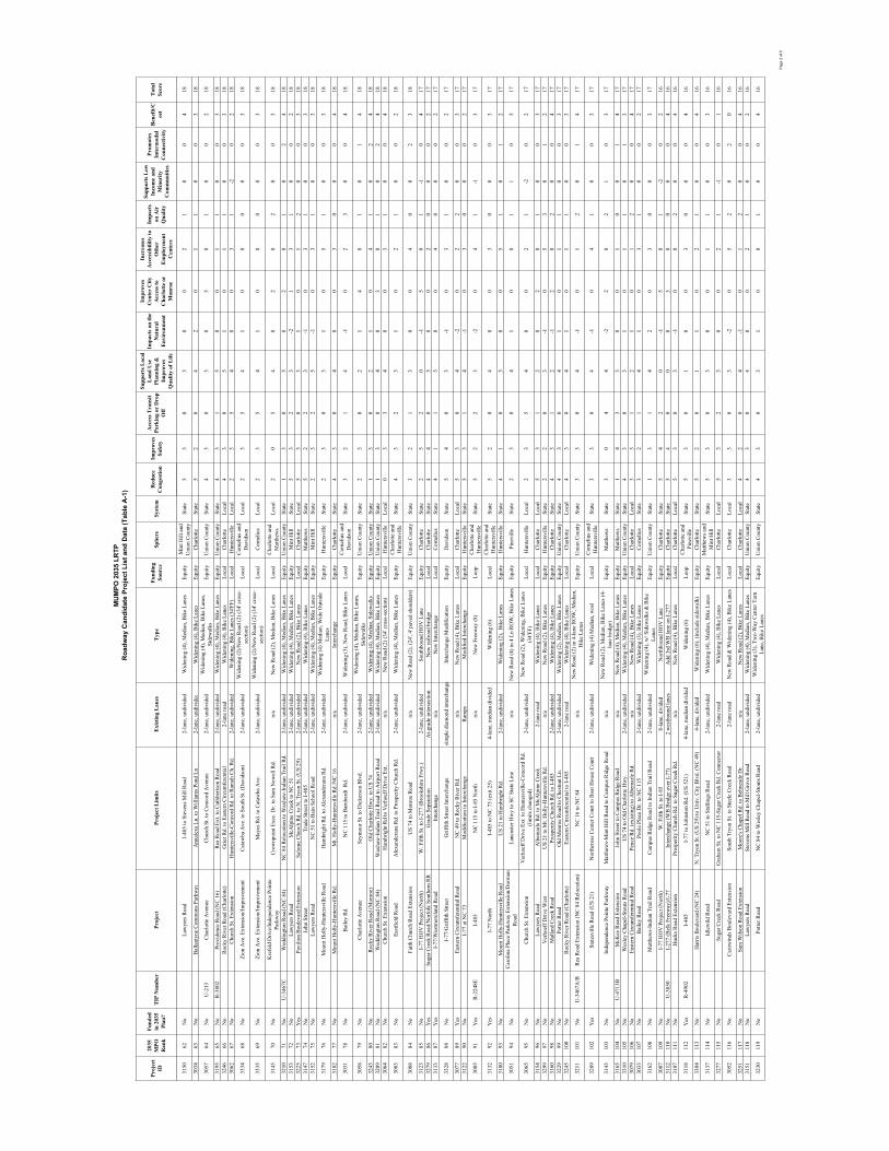
MU
MPO
203
5 LR
TPR
oadw
ay C
andi
date
Pro
ject
Lis
t and
Dat
a (T
able
A-1
)
Proj
ect
ID
2035
MPO
Ran
k
Fund
edin
203
5 Pl
an?
TIP
Num
ber
Proj
ect
Proj
ect L
imits
Exi
stin
g L
anes
Typ
eFu
ndin
gSo
urce
Sphe
reSy
stem
Red
uce
Con
gest
ion
Impr
oves
Safe
ty
Acc
ess T
rans
it Pa
rkin
g or
Dro
p O
ff
Supp
orts
Loc
al
Lan
d U
se
Plan
ning
&
Impr
oves
Qua
lity
of L
ife
Impa
cts o
n th
e N
atur
alE
nvir
onm
ent
Impr
oves
Cen
ter
City
A
cces
s to
Cha
rlot
te o
r M
onro
e
Incr
ease
sA
cces
sibi
lilty
to
Oth
erE
mpl
oym
ent
Cen
ters
Impa
cts
on A
ir
Qua
lity
Supp
orts
Low
In
com
e an
dM
inor
ityC
omm
uniti
es
Prom
otes
Inte
rmod
alC
onne
ctiv
ity
Ben
efit/
Cos
tT
otal
Scor
e
3150
62N
oLa
wye
rs R
oad
I-48
5 to
Ste
vens
Mill
Roa
d2-
lane
, und
ivid
edW
iden
ing
(4),
Med
ian,
Bik
e La
nes
Equi
tyM
int H
ill a
nd
Uni
on C
ount
ySt
ate
53
03
00
21
00
418
3034
63N
oB
alla
ntyn
e C
omm
ons P
arkw
a yA
nnal
exa
Ln. t
o W
illia
ms P
ond
Ln2-
lane
, und
ivid
edW
iden
ing
(4),
Bik
e La
nes
Equi
tyC
harlo
tteSt
ate
52
04
20
11
00
318
3057
64N
oU
-213
Cha
rlotte
Ave
nue
Chu
rch
St. t
o C
onco
rd A
venu
e2-
lane
, und
ivid
edW
iden
ing
(4),
Med
ian,
Bik
e La
nes,
Side
wal
ksEq
uity
Uni
on C
ount
ySt
ate
43
03
05
01
00
218
3195
65N
oR
-380
2Pr
ovid
ence
Roa
d (N
C 1
6)R
ea R
oad
Ext.
to C
uthb
erts
on R
oad
2-la
ne, u
ndiv
ided
Wid
enin
g (4
), M
edia
n, B
ike
Lane
sEq
uity
Uni
on C
ount
ySt
ate
43
15
00
11
00
318
3246
66N
oR
ocky
Riv
er R
oad
(Cha
rlotte
)G
rier R
d. to
Eas
tern
Circ
umfe
rent
ial
2-la
ne ro
adW
iden
ing
(4),
Bik
e La
nes
Loca
lC
harlo
tteLo
cal
43
05
10
11
00
318
3062
67N
oC
hurc
h St
. Ext
ensi
on
Hun
ters
ville
-Con
cord
Rd.
to R
amah
Ch.
Rd.
2-la
ne, u
ndiv
ided
Wid
enin
g, B
ike
Lane
s (34
'FF)
Loca
lH
unte
rsvi
lleLo
cal
23
54
00
31
-20
218
3334
68N
oZi
on A
ve. E
xten
sion
/Impr
ovem
ent
Cat
awba
Ave
. to
Sout
h St
. (D
avid
son)
2-la
ne, u
ndiv
ided
Wid
enin
g (2
)/New
Roa
d (2
) (34
' cro
ss-
sect
ion)
Loca
lC
orne
lius a
nd
Dav
idso
nLo
cal
23
54
10
00
00
318
3335
69N
oZi
on A
ve. E
xten
sion
/Impr
ovem
ent
May
es R
d. to
Cat
awba
Ave
.2-
lane
, und
ivid
edW
iden
ing
(2)/N
ew R
oad
(2) (
34' c
ross
-se
ctio
n)Lo
cal
Cor
neliu
sLo
cal
23
54
10
00
00
318
3145
70N
oK
refe
ld D
rive/
Inde
pend
ence
Poi
nte
Park
way
Cro
wnp
oint
Exe
c. D
r. to
Sam
New
ell R
d.n/
aN
ew R
oad
(2),
Med
ian,
Bik
e La
nes
Loca
lC
harlo
tte a
nd
Mat
thew
sLo
cal
20
54
02
02
00
318
3210
71N
oU
-346
7CW
eddi
ngto
n R
oad
(NC
84)
NC
84
Rel
ocat
ion
to W
axha
w-I
ndia
n Tr
ail R
d.2-
lane
, und
ivid
edW
iden
ing
(4),
Med
ian,
Bik
e La
nes
Equi
tyU
nion
Cou
nty
Stat
e1
30
50
20
10
24
1831
5372
No
Law
yers
Roa
dM
cAlp
ine
Cre
ek to
NC
51
2-la
ne, u
ndiv
ided
Wid
enin
g (4
), M
edia
n, B
ike
Lane
sEq
uity
Min
t Hill
Stat
e5
32
3-2
13
10
02
1832
2573
Yes
Pavi
lion
Bou
leva
rd E
xten
sion
Salo
me
Chu
rch
Rd.
to N
. Try
on S
t. (U
S 29
)2-
lane
, und
ivid
edN
ew R
oad
(2),
Bik
e La
nes
Loca
lC
harlo
tteLo
cal
53
03
10
12
00
318
3147
74N
oJo
hn S
treet
Trad
e St
reet
to I-
485
2-la
ne, u
ndiv
ided
Wid
enin
g (4
), B
ike
Lane
sEq
uity
Mat
thew
sSt
ate
52
23
-10
31
00
318
3152
75N
oLa
wye
rs R
oad
NC
51
to B
ain
Scho
ol R
oad
2-la
ne, u
ndiv
ided
Wid
enin
g (4
), M
edia
n, B
ike
Lane
sEq
uity
Min
t Hill
Stat
e2
32
5-1
03
10
03
18
3179
76N
oM
ount
Hol
ly-H
unte
rsvi
lle R
oad
Ham
brig
ht R
d. to
Ale
xand
eran
a R
d.2-
lane
, und
ivid
edW
iden
ing
(4) M
edia
n, W
ide
Out
side
La
nes
Equi
tyH
unte
rsvi
lleSt
ate
23
03
10
51
00
318
3182
77N
oM
ount
Hol
ly-H
unte
rsvi
lle R
d.M
t. H
olly
-Hun
ters
ville
Rd.
/NC
16
n/a
Inte
rcha
nge
Equi
tyC
harlo
tteSt
ate
43
04
00
30
00
418
3031
78N
oB
aile
y R
d.
NC
115
to B
arnh
ardt
Rd.
2-la
ne, u
ndiv
ided
Wid
enin
g (3
), N
ew R
oad,
Bik
e La
nes
Loca
lC
orne
lius a
nd
Dav
idso
nSt
ate
32
14
-10
23
00
418
3058
79N
oC
harlo
tte A
venu
eSe
ymou
r St.
to D
icke
rson
Blv
d.2-
lane
, und
ivid
edW
iden
ing
(4),
Med
ian,
Bik
e La
nes,
Side
wal
ksEq
uity
Uni
on C
ount
ySt
ate
23
02
14
01
01
418
3243
80N
oR
ocky
Riv
er R
oad
(Mon
roe)
Old
Cha
rlotte
Hw
y. to
US
742-
lane
, und
ivid
edW
iden
ing
(4),
Med
ian,
Sid
ewal
ksEq
uity
Uni
on C
ount
ySt
ate
13
02
10
41
02
418
3209
81N
oW
eddi
ngto
n R
oad
(NC
84)
Wax
haw
-Ind
ian
Trai
l Roa
d to
Airp
ort R
oad
2-la
ne, u
ndiv
ided
Wid
enin
g (4
), M
edia
n, B
ike
Lane
sEq
uity
Uni
on C
ount
ySt
ate
13
04
03
01
02
418
3064
82N
oC
hurc
h St
. Ext
ensi
onH
ambr
ight
Rd
to V
erho
eff D
rive
Ext.
n/a
New
Roa
d (2
) (34
' cro
ss-s
ectio
n)Lo
cal
Hun
ters
ville
Loca
l0
33
40
03
10
04
18
3083
83N
oEa
stfie
ld R
oad
Ale
xand
eran
a R
d. to
Pro
sper
ity C
hurc
h R
d.2-
lane
, und
ivid
edW
iden
ing
(4),
Med
ian,
Bik
e La
nes
Equi
tyC
harlo
tte a
nd
Hun
ters
ville
Stat
e4
32
31
02
10
02
18
3088
84N
oFa
ith C
hurc
h R
oad
Exte
nsio
nU
S 74
to M
onro
e R
oad
n/a
New
Roa
d (2
), (2
4', 4
' pav
ed sh
ould
ers)
Equi
tyU
nion
Cou
nty
Stat
e3
21
30
04
00
23
18
3123
85N
oI-
77 H
OV
Pro
ject
(Nor
th)
W. F
ifth
St. t
o I-
277
(Bro
oksh
ire F
rwy.
)2-
lane
, und
ivid
edSo
uthb
ound
HO
V L
ane
Equi
tyC
harlo
tteSt
ate
25
20
-15
01
-10
417
3279
86Y
esSu
gar C
reek
Roa
d/N
orfo
lk S
outh
ern
RR
Gra
de S
epar
atio
nA
t-gra
de in
ters
ectio
nN
ew ra
ilroa
d br
idge
Loca
lC
harlo
tteSt
ate
44
05
00
20
00
217
3133
87Y
esI-
77/W
estm
orel
and
Roa
dIn
terc
hang
en/
aN
ew In
terc
hang
eLo
cal
Cor
neliu
sSt
ate
41
15
00
40
00
217
3328
88N
oI-
77/G
riffit
h St
reet
Grif
fith
Stre
et In
terc
hang
esi
mpl
e di
amon
d in
terc
hang
eIn
terc
hang
e M
odifi
catio
nEq
uity
Dav
idso
nSt
ate
54
03
-10
31
00
217
3077
89Y
esEa
ster
n C
ircum
fere
ntia
l Roa
dN
C 4
9 to
Roc
ky R
iver
Rd.
n/a
New
Roa
d (4
), B
ike
Lane
sLo
cal
Cha
rlotte
Loca
l5
30
4-2
02
20
03
1731
2290
No
I-77
at N
C 7
3 M
odifi
catio
n to
Inte
rcha
nge
Ram
psM
odifi
ed In
terc
hang
eEq
uity
Hun
ters
ville
Stat
e5
31
4-1
03
00
02
17
3005
91Y
esR
-224
8EI-
485
NC
115
to I-
85 N
orth
n/a
New
Fre
eway
(8)
Loop
Cha
rlotte
and
H
unte
rsvi
lleSt
ate
52
23
-20
41
-10
317
3132
92Y
esI-
77 N
orth
I-48
5 to
NC
73
(exi
t 25)
4-la
ne, m
edia
n di
vide
dW
iden
ing
(6)
Loca
lC
harlo
tte a
nd
Hun
ters
ville
Stat
e5
20
40
03
00
03
17
3180
93N
oM
ount
Hol
ly-H
unte
rsvi
lle R
oad
US
21 to
Ham
brig
ht R
d.2-
lane
, und
ivid
edW
iden
ing
(2),
Bik
e La
nes
Equi
tyH
unte
rsvi
lleSt
ate
41
03
00
51
01
217
3051
94N
oC
arol
ina
Plac
e Pa
rkw
ay E
xten
sion
/Dor
man
R
oad
Lanc
aste
r Hw
y to
SC
Sta
te L
ine
n/a
New
Roa
d (4
) in
4 Ln
RO
W, B
ike
Lane
sEq
uity
Pine
ville
Stat
e2
30
41
00
11
05
17
3065
95N
oC
hurc
h St
. Ext
ensi
on
Ver
hoef
f Driv
e Ex
t. to
Hun
ters
ville
-Con
cord
Rd.
(li
mits
cha
nged
)2-
lane
, und
ivid
edN
ew R
oad
(2),
Wid
enin
g, B
ike
Lane
s (3
4'FF
)Lo
cal
Hun
ters
ville
Loca
l2
35
40
02
1-2
02
17
3154
96N
oLa
wye
rs R
oad
Alb
emar
le R
d. to
McA
lpin
e C
reek
2-la
ne ro
adW
iden
ing
(4),
Bik
e La
nes
Loca
lC
harlo
tteLo
cal
53
12
02
01
00
317
3299
97N
oV
erho
eff D
rive
Wes
tU
S 21
to M
t. H
olly
-Hun
ters
ville
Rd.
n/a
New
Roa
d (2
), B
ike
Lane
sEq
uity
Hun
ters
ville
Stat
e2
20
3-1
05
30
12
1731
6098
No
Mal
lard
Cre
ek R
oad
Pros
perit
y C
hurc
h R
d. to
I-48
5 2-
lane
, und
ivid
edW
iden
ing
(4),
Bik
e La
nes
Equi
tyC
harlo
tteSt
ate
43
12
-12
02
00
417
3229
99N
oPo
tter R
oad
Old
Mon
roe
Roa
d to
Che
stnu
t Ln.
2-la
ne, u
ndiv
ided
Wid
enin
g (2
), M
edia
n, B
ike
Lane
sEq
uity
Uni
on C
ount
ySt
ate
43
04
10
11
00
317
3245
100
No
Roc
ky R
iver
Roa
d (C
harlo
tte)
East
ern
Circ
umfe
rent
ial t
o I-
485
2-la
ne ro
adW
iden
ing
(4),
Bik
e La
nes
Loca
lC
harlo
tteLo
cal
43
04
10
11
00
317
3211
101
No
U-3
467A
/BR
ea R
oad
Exte
nsio
n (N
C 8
4 R
eloc
atio
n)N
C 1
6 to
NC
84
n/a
New
Roa
d (2
) in
4-la
ne R
OW
, Med
ian,
B
ike
Lane
sEq
uity
Uni
on C
ount
ySt
ate
33
04
-10
12
01
417
3289
102
Yes
Stat
esvi
lle R
oad
(US
21)
Nor
thcr
oss C
ente
r Cou
rt to
Boa
t Hou
se C
ourt
2-la
ne, u
ndiv
ided
Wid
enin
g (4
) Med
ian,
wos
lLo
cal
Cor
neliu
s and
H
unte
rsvi
lleSt
ate
33
04
-10
41
00
317
3143
103
No
Inde
pend
ence
Poi
nte
Park
way
Mat
thew
s-M
int H
ill R
oad
to C
ampu
s Rid
ge R
oad
n/a
New
Roa
d (2
), M
edia
n, B
ike
Lane
s (4-
lane
brid
ge)
Equi
tyM
atth
ews
Stat
e3
04
4-2
20
21
03
17
3165
104
No
U-4
713B
McK
ee R
oad
Exte
nsio
nJo
hn S
treet
to C
ampu
s Rid
ge R
oad
n/a
New
Roa
d (4
), M
edia
n, B
ike
Lane
sEq
uity
Mat
thew
sSt
ate
14
33
00
10
01
417
3310
105
No
Wes
ley
Cha
pel-S
tout
s Roa
dU
S 74
to O
ld C
harlo
tte H
wy.
2-la
ne, u
ndiv
ided
Wid
enin
g (4
), M
edia
n, B
ike
Lane
sEq
uity
Uni
on C
ount
ySt
ate
43
03
10
11
01
317
3079
106
No
East
ern
Circ
umfe
rent
ial R
oad
Penc
e R
d. (e
xist
ing)
to A
lbem
arle
Rd.
n/a
New
Roa
d (4
), B
ike
Lane
sLo
cal
Cha
rlotte
Loca
l3
31
21
01
20
04
1730
3310
7N
oB
aile
y R
oad
Pool
e Pl
ace
Dr.
to N
C 1
15
2-la
ne, u
ndiv
ided
Wid
enin
g (3
), B
ike
Lane
sEq
uity
Cor
neliu
sSt
ate
32
14
10
31
00
217
3162
108
No
Mat
thew
s-In
dian
Tra
il R
oad
Cam
pus R
idge
Roa
d to
Indi
an T
rail
Roa
d2-
lane
, und
ivid
edW
iden
ing
(4),
w/ S
idew
alks
& B
ike
Lane
sEq
uity
Uni
on C
ount
ySt
ate
13
14
20
30
00
317
3007
109
No
I-77
HO
V P
roje
ct (N
orth
)W
. Fift
h St
. to
I-85
8-la
ne, d
ivid
edN
orth
boun
d H
OV
Lan
eEq
uity
Cha
rlotte
Stat
e5
42
0-1
50
1-2
02
1631
1211
0N
oU
-385
0I-
277
(Bel
k Fr
eew
ay)/I
-77
Inte
rcha
nge
(WB
Brid
ge o
ver I
-77)
2 w
estb
ound
lane
sA
dd 3
rd W
B la
ne o
n I-
277
Equi
tyC
harlo
tteSt
ate
54
00
03
00
00
416
3107
111
No
Huc
ks R
oad
Exte
nsio
nPr
ospe
rity
Chu
rch
Rd.
to S
ugar
Cre
ek R
d.n/
aN
ew R
oad
(4),
Bik
e La
nes
Loca
lC
harlo
tteLo
cal
53
03
-10
02
00
416
3118
112
Yes
R-4
902
I-48
5I-
77 to
John
ston
Rd.
(US
521)
4-la
ne, m
edia
n di
vide
dW
iden
ing
(6)
Loop
Cha
rlotte
and
Pi
nevi
lleSt
ate
53
01
00
30
00
416
3304
113
No
Har
ris B
oule
vard
(NC
24)
N. T
ryon
St.
(US
29) t
o U
niv.
City
Blv
d. (N
C 4
9)4-
lane
, div
ided
Wid
enin
g (6
), (in
clud
e si
dew
alk)
Eq
uity
Cha
rlotte
Stat
e5
20
11
02
10
04
16
3137
114
No
Idle
wild
Roa
dN
C 5
1 to
Sta
lling
s Roa
d2-
lane
, und
ivid
edW
iden
ing
(4),
Med
ian,
Bik
e La
nes
Equi
tyM
atth
ews a
nd
Min
t Hill
Stat
e5
30
30
01
10
03
16
3277
115
No
Suga
r Cre
ek R
oad
Gra
ham
St.
to N
C 1
15-S
ugar
Cre
ek R
d. C
onne
ctor
2-la
ne ro
adW
iden
ing
(4),
Bik
e La
nes
Loca
lC
harlo
tteLo
cal
53
23
00
21
-10
116
3052
116
No
Car
owin
ds B
oule
vard
Ext
ensi
onSo
uth
Tryo
n St
. to
Stee
le C
reek
Roa
d2-
lane
road
New
Roa
d &
Wid
enin
g (4
), B
ike
Lane
sLo
cal
Cha
rlotte
Loca
l3
30
3-2
05
20
20
16
3251
117
No
Sam
Wils
on R
oad
Exte
nsio
nM
oore
's C
hape
l Rd.
to B
elm
eade
Dr.
n/a
New
Roa
d (2
), B
ike
Lane
sLo
cal
Cha
rlotte
Loca
l4
20
4-1
01
20
04
1631
5111
8N
oLa
wye
rs R
oad
Stev
ens M
ill R
oad
to M
ill G
rove
Roa
d2-
lane
, und
ivid
edW
iden
ing
(4),
Med
ian,
Bik
e La
nes
Equi
tyU
nion
Cou
nty
Stat
e4
30
40
02
10
02
16
3230
119
No
Potte
r Roa
d N
C 8
4 to
Wes
ley
Cha
pel-S
tout
s Roa
d2-
lane
, und
ivid
edW
iden
ing
(3),
Two-
Way
Cen
ter T
urn
Lane
, Bik
e La
nes
Equi
tyU
nion
Cou
nty
Stat
e4
30
31
00
10
04
16
Pag
e 2
of 5
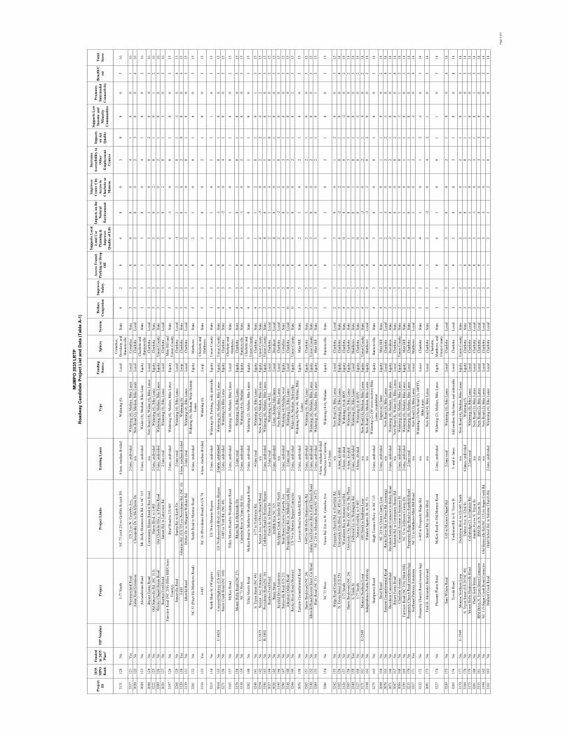
MU
MPO
203
5 LR
TPR
oadw
ay C
andi
date
Pro
ject
Lis
t and
Dat
a (T
able
A-1
)
Proj
ect
ID
2035
MPO
Ran
k
Fund
edin
203
5 Pl
an?
TIP
Num
ber
Proj
ect
Proj
ect L
imits
Exi
stin
g L
anes
Typ
eFu
ndin
gSo
urce
Sphe
reSy
stem
Red
uce
Con
gest
ion
Impr
oves
Safe
ty
Acc
ess T
rans
it Pa
rkin
g or
Dro
p O
ff
Supp
orts
Loc
al
Lan
d U
se
Plan
ning
&
Impr
oves
Qua
lity
of L
ife
Impa
cts o
n th
e N
atur
alE
nvir
onm
ent
Impr
oves
Cen
ter
City
A
cces
s to
Cha
rlot
te o
r M
onro
e
Incr
ease
sA
cces
sibi
lilty
to
Oth
erE
mpl
oym
ent
Cen
ters
Impa
cts
on A
ir
Qua
lity
Supp
orts
Low
In
com
e an
dM
inor
ityC
omm
uniti
es
Prom
otes
Inte
rmod
alC
onne
ctiv
ity
Ben
efit/
Cos
tT
otal
Scor
e
3131
120
No
I-77
Nor
thN
C 7
3 (e
xit 2
5) to
Grif
fith
St (e
xit 3
0)4-
lane
, med
ian
divi
ded
Wid
enin
g (6
)Lo
cal
Cor
neliu
s,D
avid
son,
and
H
unte
rsvi
lleSt
ate
42
04
00
30
00
316
3317
121
Yes
Wes
tmor
elan
d R
oad
US
21 to
W. C
ataw
ba A
ve.
2-la
ne, u
ndiv
ided
Wid
enin
g (4
), M
edia
n, B
ike
Lane
sLo
cal
Cor
neliu
sSt
ate
33
04
00
41
00
116
3030
122
No
Aut
en R
oad
Exte
nsio
nC
hesa
peak
e D
r. to
McA
llist
er D
r.n/
aN
ew R
oad
(2),
Med
ian,
Bik
e La
nes
Loca
lC
harlo
tteLo
cal
23
02
00
23
00
416
3020
123
No
Ale
xand
eran
a R
oad
Mt.
Hol
ly-H
unte
rsvi
lle R
d. to
NC
115
2-la
ne, u
ndiv
ided
Wid
en (4
), M
edia
n, B
ike
Lane
Equi
tyC
harlo
tte a
nd
Hun
ters
ville
Stat
e1
32
30
04
10
02
16
3048
124
No
Bry
ant F
arm
s Roa
dC
omm
unity
Hou
se R
oad
to R
ea R
oad
n/a
New
Roa
d (4
), W
iden
(4),
Bik
e La
nes
Loca
lC
harlo
tteLo
cal
33
13
10
02
00
316
3222
125
No
Old
Sta
tesv
ille
Rd.
(NC
115
)H
arris
Blv
d. to
I-48
52-
lane
, und
ivid
edW
iden
ing
(4),
Bik
e La
nes
Equi
tyC
harlo
tteSt
ate
33
13
02
01
01
216
3309
126
No
Wes
ley
Cha
pel-S
tout
s Roa
dO
ld C
harlo
tte H
wy.
to P
otte
r Roa
d2-
lane
, und
ivid
edW
iden
ing
(4),
Med
ian,
Bik
e La
nes
Equi
tyU
nion
Cou
nty
Stat
e3
30
31
02
10
03
1630
3612
7N
oB
eatti
es F
ord
Roa
dSu
nset
Rd.
to L
akev
iew
Rd.
2-la
ne ro
adW
iden
ing
(4),
Bik
e La
nes
Loca
lC
harlo
tteLo
cal
13
03
02
01
30
316
3197
128
No
Fairv
iew
Roa
d (N
C 2
18) (
Min
t Hill
/Uni
on
Cou
nty)
Brie
f Roa
d to
US
601
2-la
ne, u
ndiv
ided
Wid
enin
g (4
), M
edia
n, B
ike
Lane
sEq
uity
Min
t Hill
and
U
nion
Cou
nty
Stat
e5
30
4-1
00
10
03
15
3268
129
No
Stat
esvi
lle R
oad
Star
ita R
d. to
Kei
th D
r.2-
lane
road
Wid
enin
g (4
), B
ike
Lane
sLo
cal
Cha
rlotte
Loca
l5
30
-11
30
1-1
04
1531
2013
0Y
esI-
485
John
ston
Rd.
(US
521)
to P
rovi
denc
e R
d. (N
C 1
6)4-
lane
, med
ian
divi
ded
Wid
enin
g (6
) Lo
opC
harlo
tteSt
ate
52
02
00
20
00
415
3139
131
No
Idle
wild
Roa
dD
rifte
r Dr.
to M
arga
ret W
alla
ce R
d.2-
lane
road
Wid
enin
g (4
), B
ike
Lane
sLo
cal
Cha
rlotte
Loca
l5
30
21
00
10
03
15
3201
132
No
NC
51
(Pin
evill
e-M
atth
ews R
oad)
Sard
is R
oad
to M
onro
e R
oad
4-la
ne, u
ndiv
ided
Wid
enin
g (6
), M
edia
n, W
ide
Out
side
La
nes
Equi
tyM
atth
ews
Stat
e5
30
21
00
10
03
15
3116
133
Yes
I-48
5N
C 1
6 (P
rovi
denc
e R
oad)
to U
S 74
4-
lane
, med
ian
divi
ded
Wid
enin
g (6
) Lo
opC
harlo
tte a
nd
Mat
thew
sSt
ate
52
02
00
21
00
315
3213
134
No
Nor
th M
ain
St. (
Win
gate
)U
S 74
to M
onro
e B
ypas
s 2-
lane
, und
ivid
edW
iden
ing
(4),
Park
ing,
wid
e si
dew
alks
Equi
tyU
nion
Cou
nty
Stat
e1
20
51
01
11
03
15
3014
135
No
U-4
024
Con
cord
Hig
hway
(US
601)
US
74 (R
oose
velt
Blv
d.) t
o M
onro
e B
ypas
s2-
lane
, und
ivid
edW
iden
ing
(4),
Med
ian,
Bik
e La
nes
Equi
tyU
nion
Cou
nty
Stat
e4
30
3-1
40
10
01
1532
7113
6N
oSt
eele
Cre
ek R
oad
(NC
160
) I-
485
to Y
ork
Rd.
(NC
49)
2-la
ne, u
ndiv
ided
Wid
enin
g (4
) Bik
e La
nes
Equi
tyC
harlo
tteSt
ate
43
02
-20
41
00
315
3163
137
No
McK
ee R
oad
Tille
y M
orris
Roa
d to
Wed
ding
ton
Roa
d2-
lane
, und
ivid
edW
iden
ing
(4),
Med
ian,
Bik
e La
nes
Loca
lC
harlo
tte a
nd
Mat
thew
sSt
ate
43
13
10
01
00
215
3178
138
No
Mou
nt H
olly
Roa
d (N
C 2
7)R
hyne
Rd.
to B
elm
eade
Dr.
2-la
ne ro
adW
iden
ing
(4),
Bik
e La
nes
Equi
tyC
harlo
tteSt
ate
43
03
01
01
00
315
3338
139
No
NC
73
Wes
tC
ataw
ba R
iver
to V
ance
Rd.
Ext
.2-
lane
, und
ivid
edW
iden
ing
(4-6
), M
edia
nEq
uity
Hun
ters
ville
Stat
e4
30
3-1
02
10
03
15
3282
140
No
Tille
y M
orris
Roa
dM
cKee
Roa
d to
Mat
thew
s-W
eddi
ngto
n R
oad
2-la
ne, u
ndiv
ided
Wid
enin
g (2
), M
edia
n, B
ike
Lane
sEq
uity
Cha
rlotte
and
U
nion
Cou
nty
Stat
e4
30
30
01
10
03
15
3248
141
No
S. T
ryon
Stre
et (N
C 4
9)I-
77 to
Yor
kmon
t Rd.
4-la
ne ro
adW
iden
ing
(6),
Bik
e La
nes
Equi
tyC
harlo
tteSt
ate
42
01
12
01
01
315
3254
142
No
U-3
619
Secr
est
Ave
. Ext
ensi
onSe
cres
t Ave
. to
Oliv
e B
ranc
h R
oad
n/a
New
Roa
d (5
), M
edia
n, B
ike
Lane
s Eq
uity
Uni
on C
ount
ySt
ate
33
04
-30
22
-12
315
3196
143
No
R-3
802
Prov
iden
ce R
oad
(NC
16)
Cut
hber
tson
Roa
d to
Wax
haw
Byp
ass
2-la
ne, u
ndiv
ided
Wid
enin
g (4
), M
edia
n, B
ike
Lane
sEq
uity
Uni
on C
ount
ySt
ate
23
14
00
11
00
315
3037
144
No
Bea
tties
For
d R
oad
Fren
ch S
t. to
Dix
on S
t.2-
lane
road
Wid
enin
g (4
), 44
'LL
Loca
lC
harlo
tteLo
cal
20
22
14
00
20
215
3038
145
No
Bea
ty S
treet
Grif
fith
St to
NC
115
2-la
ne, u
ndiv
ided
2-la
ne, d
ivid
ed, b
ike
lane
sLo
cal
Dav
idso
nLo
cal
13
34
00
11
00
215
3149
146
No
Kre
feld
Driv
e Ex
tens
ion
McA
lpin
e C
reek
to S
ardi
s Rd.
Nor
thn/
aN
ew R
oad
(2),
Bik
e La
nes
Loca
lC
harlo
tteLo
cal
13
42
-22
02
00
315
3290
147
No
Stat
esvi
lle R
oad
(US
21)
Boa
t Hou
se C
ourt
to C
ataw
ba A
ve2-
lane
, und
ivid
edW
iden
ing
(4) M
edia
n, w
osl
Equi
tyC
orne
lius
Stat
e1
30
40
03
10
03
1531
4814
8N
oJo
hnst
on-O
ehle
r Roa
dPr
ospe
rity
Rid
ge R
d. to
Mal
lard
Cre
ek R
d.2-
lane
road
Wid
enin
g (2
), B
ike
Lane
sLo
cal
Cha
rlotte
Loca
l0
40
31
03
10
03
1532
4414
9N
oR
ocky
Riv
er R
oad
(Mon
roe)
US
74 to
Mon
roe
Byp
ass/
Con
nect
or2-
lane
, und
ivid
edW
iden
(4),
Med
ian,
Sid
ewal
ksEq
uity
Uni
on C
ount
ySt
ate
03
04
00
21
02
315
3076
150
No
East
ern
Circ
umfe
rent
ial R
oad
Law
yers
Roa
d to
Idle
wild
Roa
d2-
lane
, und
ivid
edW
iden
ing
(4)/N
ew (4
), M
edia
n, B
ike
Lane
sEq
uity
Min
t Hill
Stat
e3
30
21
02
10
03
15
3303
151
No
Har
ris B
oule
vard
(NC
24)
I-48
5 to
Mt H
olly
-Hun
ters
ville
Rd.
2-la
ne, u
ndiv
ided
Wid
enin
g (4
), B
ike
Lane
sEq
uity
Cha
rlotte
Stat
e3
30
21
02
10
03
1531
4015
2N
oId
lew
ild R
oad/
Secr
est S
hort
Cut
Roa
dIn
dian
Tra
il/Fa
irvie
w R
d to
Fai
th C
hurc
h R
oad
2-la
ne, u
ndiv
ided
Wid
enin
g (4
), M
edia
n, B
ike
Lane
sEq
uity
Uni
on C
ount
ySt
ate
33
03
00
21
00
315
3200
153
No
Bla
ir R
oad
(NC
51)
NC
218
to A
lbem
arle
Roa
d (N
C 2
4/27
)2-
lane
, und
ivid
edW
iden
ing
(4),
Med
ian,
Bik
e La
nes
Equi
tyM
int H
illSt
ate
23
03
00
21
01
315
3206
154
No
NC
73
Wes
tV
ance
Rd.
Ext
. to
W. C
ataw
ba A
ve.
4-la
ne, m
edia
n di
vide
d N
orth
cros
s to
Cat
awba
, re
st 2
-lane
sW
iden
ing
(4-6
), M
edia
n Eq
uity
Hun
ters
ville
Stat
e2
30
31
02
10
03
15
3242
155
No
Rid
ge R
oad
Exte
nsio
nPr
ospe
rity
Chu
rch
Rd.
to E
astfi
eld
Rd.
n/a
New
Roa
d (4
), B
ike
Lane
sLo
cal
Cha
rlotte
Loca
l2
31
30
01
20
03
1531
8315
6N
oN
. Try
on S
treet
(US
29)
Uni
vers
ity C
ity B
lvd.
(NC
49)
to I-
485
4-la
ne, d
ivid
edW
iden
ing
(6),
Bik
e La
nes
Equi
tyC
harlo
tteSt
ate
51
-14
-22
01
00
414
3126
157
No
I-77
Sou
thW
oodl
awn
Rd.
to N
atio
ns F
ord
Rd.
6-la
nes,
divi
ded
Wid
enin
g (1
0) &
HO
VEq
uity
Cha
rlotte
Stat
e4
31
00
50
1-2
02
1433
0515
8N
oH
arris
Bou
leva
rd (N
C 2
4)U
nive
rsity
City
Blv
d. (N
C 4
9) to
The
Pla
za4-
lane
, div
ided
Wid
enin
g (6
), B
ike
Lane
sEq
uity
Cha
rlotte
Stat
e5
20
10
03
10
02
1433
4015
9Y
esS.
Tra
de S
t.Fu
llwoo
d Ln
. to
Wed
ingt
on R
d.2-
lane
, und
ivid
edW
iden
ing
(4),
Bik
e La
nes
Loca
lM
atth
ews
Stat
e5
10
30
10
10
03
1431
2716
0N
oI-
77 S
outh
Nat
ions
For
d R
d. to
I-48
56-
lane
s, di
vide
dW
iden
ing
(8) &
HO
VEq
uity
Cha
rlotte
Stat
e3
31
00
50
1-1
02
1431
7116
1N
oU
-254
9M
onro
e N
orth
ern
Loop
601
Nor
th to
Sou
ther
n Lo
opn/
aN
ew R
oad
(4),
Med
ian,
Bik
e La
nes
Equi
tyU
nion
Cou
nty
Stat
e4
20
2-3
02
14
02
1431
4416
2N
oIn
depe
nden
ce P
oint
e Pa
rkw
ayW
inds
or S
quar
e D
r. to
NC
51
n/a
New
Roa
d (2
), M
edia
n, B
ike
Lane
sEq
uity
Mat
thew
sLo
cal
20
44
-32
02
00
314
3275
163
No
Stum
ptow
n R
oad
Hug
h To
ranc
e Pk
wy.
to N
C 1
152-
lane
, und
ivid
edW
iden
ing
(2) (
30' c
ross
-sec
tion)
Bik
e La
nes,
roun
dabo
ut
Equi
tyH
unte
rsvi
lleSt
ate
43
03
00
01
00
314
3044
164
No
Brie
f Roa
dN
C 2
18 to
Uni
on C
ount
y Li
ne2-
lane
, und
ivid
edIm
prov
ed 2
lane
sEq
uity
Min
t Hill
Stat
e4
20
31
01
10
02
1430
7816
5N
oEa
ster
n C
ircum
fere
ntia
l Roa
dR
ocky
Riv
er R
d. to
Pen
ce R
d. (e
xist
ing)
n/a
New
Roa
d (4
), B
ike
Lane
sLo
cal
Cha
rlotte
Loca
l3
30
2-1
02
2-1
04
1430
7116
6N
oD
avid
son-
Con
cord
Roa
dD
avid
son
East
side
Con
nect
or to
Bai
ley
Roa
d2-
lane
, und
ivid
edW
iden
ing
(4),
Med
ian,
Bik
e La
nes
Equi
tyD
avid
son
Stat
e2
40
20
02
10
03
1430
4716
7N
oB
ryan
t Far
ms R
oad
John
ston
Rd.
to C
omm
unity
Hou
se R
d.n/
aN
ew R
oad
(4),
Wid
en (4
), B
ike
Lane
sLo
cal
Cha
rlotte
Stat
e2
30
30
00
20
04
1430
5616
8N
oC
harlo
tte A
venu
eC
onco
rd A
venu
e to
Sey
mou
r St.
2-la
ne, u
ndiv
ided
Wid
enin
g (4
), M
edia
n, B
ike
Lane
sEq
uity
Uni
on C
ount
ySt
ate
23
01
14
01
-11
214
3199
169
No
Fairv
iew
Roa
d (N
C 2
18) (
Min
t Hill
)N
C 5
1 to
Jeff
erso
n C
olon
y D
r.2-
lane
, und
ivid
edW
iden
ing
(4),
Med
ian,
Bik
e La
nes
Equi
tyM
int H
illSt
ate
23
04
10
11
00
214
3233
170
No
Pros
perit
y C
hurc
h R
oad
(nor
ther
n le
g)Pr
ospe
rity
Rid
ge R
oad
to E
astfi
eld
Roa
d2-
lane
road
Wid
enin
g (4
), M
edia
n, B
ike
Lane
sLo
cal
Cha
rlotte
Stat
e2
30
40
01
10
03
1432
1717
1Y
esN
orth
east
Par
kway
Ext
ensi
onN
C 5
1 to
Mat
thew
s-M
int H
ill R
oad
n/a
New
Roa
d (3
), B
ike
Lane
sLo
cal
Mat
thew
sLo
cal
22
03
10
21
-10
414
3232
172
No
Pros
perit
y C
hurc
h R
oad
(wes
tern
leg)
I-48
5 to
Pro
sper
ity R
idge
Rd.
n/a
Wid
enin
g (2
)/New
Roa
d (2
), (4
0'FF
), B
ike
Lane
sLo
cal
Cha
rlotte
Stat
e2
20
41
01
2-1
03
14
3091
173
No
Fred
D. A
lexa
nder
Bou
leva
rdSu
nset
Rd.
to H
arris
Blv
d.n/
aN
ew R
oad
(4),
Bik
e La
nes
Loca
lC
harlo
tteSt
ate
21
12
-20
42
10
314
3227
174
No
Plea
sant
Pla
ins R
oad
McK
ee R
oad
to O
ld M
onro
e R
oad
2-la
ne, u
ndiv
ided
Wid
enin
g (2
), M
edia
n, B
ike
Lane
sEq
uity
Cha
rlotte
,M
atth
ews,
and
Uni
on C
ount
ySt
ate
13
04
10
01
10
314
3249
175
No
Sam
Wils
on R
oad
I-85
to M
oore
s Cha
pel R
d.2-
lane
road
Wid
enin
g (4
), B
ike
Lane
sLo
cal
Cha
rlotte
Loca
l1
30
30
02
10
04
14
3285
176
No
Tyvo
la R
oad
Yor
kmon
t Rd.
to S
. Try
on S
t.5-
and
6- l
anes
Add
med
ian,
bik
e la
nes,
and
side
wal
ksLo
cal
Cha
rlotte
Loca
l1
30
20
03
10
04
14
3170
177
No
U-2
549
Mon
roe
Nor
ther
n Lo
opD
icke
rson
Blv
d. to
US
601
Nor
thn/
aN
ew R
oad
(4),
Med
ian,
Bik
e La
nes
Equi
tyU
nion
Cou
nty
Stat
e3
21
20
02
10
03
1431
8417
8N
oN
. Try
on S
treet
(US
29/N
C 4
9)D
alto
n A
ve. t
o 32
nd S
t.4-
lane
s, un
divi
ded
Wid
enin
g (5
)Eq
uity
Cha
rlotte
Stat
e3
20
20
20
11
03
1431
7517
9N
oM
ount
Hol
ly-H
unte
rsvi
lle R
oad
Cal
labr
idge
Ct.
to O
akda
le R
d.2-
lane
road
Wid
enin
g (4
), B
ike
Lane
sLo
cal
Cha
rlotte
Loca
l2
30
31
02
10
02
1432
8118
0N
oTh
irty
Sixt
h St
reet
Ata
ndo
Ave
to N
. Try
on S
t.n/
aN
ew R
oad
(2),
Bik
e La
nes
Loca
lC
harlo
tteLo
cal
23
03
-10
31
01
214
3333
181
No
IBM
Driv
e-N
. Try
on S
treet
Con
nect
orIB
M D
r. to
N. T
ryon
St.
n/a
New
Roa
d (2
), B
ike
Lane
sLo
cal
Cha
rlotte
Loca
l2
20
20
03
30
02
1431
9418
2N
oN
C 1
15-S
ugar
Cre
ek R
oad
Con
nect
orO
ld S
tate
svill
e R
d.(N
C 1
15) t
o Su
gar C
reek
Rd.
n/a
New
Roa
d (2
), B
ike
Lane
sLo
cal
Cha
rlotte
Loca
l2
21
3-1
01
31
02
1431
6118
3N
oM
alla
rd C
reek
Roa
dO
dell
Scho
ol R
d. to
Sal
ome
Chu
rch
Rd.
2-la
ne, u
ndiv
ided
Wid
enin
g (4
), B
ike
Lane
sLo
cal
Cha
rlotte
Loca
l1
31
21
20
10
03
14
Pag
e 3
of 5
MU
MPO
203
5 LR
TPR
oadw
ay C
andi
date
Pro
ject
Lis
t and
Dat
a (T
able
A-1
)
Proj
ect
ID
2035
MPO
Ran
k
Fund
edin
203
5 Pl
an?
TIP
Num
ber
Proj
ect
Proj
ect L
imits
Exi
stin
g L
anes
Typ
eFu
ndin
gSo
urce
Sphe
reSy
stem
Red
uce
Con
gest
ion
Impr
oves
Safe
ty
Acc
ess T
rans
it Pa
rkin
g or
Dro
p O
ff
Supp
orts
Loc
al
Lan
d U
se
Plan
ning
&
Impr
oves
Qua
lity
of L
ife
Impa
cts o
n th
e N
atur
alE
nvir
onm
ent
Impr
oves
Cen
ter
City
A
cces
s to
Cha
rlot
te o
r M
onro
e
Incr
ease
sA
cces
sibi
lilty
to
Oth
erE
mpl
oym
ent
Cen
ters
Impa
cts
on A
ir
Qua
lity
Supp
orts
Low
In
com
e an
dM
inor
ityC
omm
uniti
es
Prom
otes
Inte
rmod
alC
onne
ctiv
ity
Ben
efit/
Cos
tT
otal
Scor
e
3018
184
No
Alb
emar
le R
oad/
Har
ris B
oule
vard
(NC
24
/27)
Con
vert
to In
terc
hang
en/
aN
ew In
terc
hang
eEq
uity
Cha
rlotte
Stat
e5
41
-21
12
00
01
13
3135
185
Yes
R-2
123C
EI-
85 N
orth
/I-48
5 N
orth
In
terc
hang
en/
aN
ew in
terc
hang
eLo
opC
harlo
tteSt
ate
54
00
00
20
-10
313
3129
186
No
I-77
Sou
thI-
277
(Bel
k Fw
y.) t
o W
oodl
awn
Roa
d6-
lane
s, di
vide
dW
iden
ing
(10)
& H
OV
Equi
tyC
harlo
tteSt
ate
43
10
-15
01
-20
213
3008
187
Yes
Idle
wild
Roa
dPi
ney
Gro
ve R
d. to
Drif
ter D
r.2-
lane
road
Wid
enin
g (4
), B
ike
Lane
sLo
cal
Cha
rlotte
Stat
e5
30
2-1
00
10
03
13
3202
188
No
Pine
ville
-Mat
thew
s Roa
d (N
C 5
1)I-
485
to R
ea R
d.4-
lane
, und
ivid
edW
iden
ing
(6),
Bik
e La
nes
Equi
tyC
harlo
tte a
nd
Pine
ville
Stat
e5
10
2-1
03
10
02
13
3341
189
No
McK
ee R
oad
Wed
ding
ton
Rd.
to P
leas
ant P
lain
s Rd.
2-la
ne, u
ndiv
ided
Wid
enin
g (4
), B
ike
Lane
sEq
uity
Cha
rlotte
and
M
atth
ews
Stat
e4
30
20
01
10
02
13
3308
190
No
Wax
haw
Par
kway
NC
75
E. o
f Tow
n to
NC
75
W. o
f Tow
n2-
lane
, und
ivid
edN
ew R
oad
(4),
Med
ian,
Bik
e La
nes,
Side
wal
ksEq
uity
Uni
on C
ount
ySt
ate
33
04
-20
21
00
213
3130
191
No
I-77
Sou
thI-
485
to S
outh
Car
olin
a Li
ne6-
lane
s, di
vide
dW
iden
ing
(8) &
HO
VEq
uity
Cha
rlotte
Stat
e2
21
00
40
10
03
1330
7019
2N
oD
avid
son-
Con
cord
Roa
dB
aile
y R
oad
to N
C 7
32-
lane
, und
ivid
edW
iden
ing
(4) M
edia
n, B
ike
Lane
sEq
uity
Dav
idso
nSt
ate
14
03
-10
21
00
313
3302
193
No
Har
ris B
oule
vard
(NC
24)
Rea
mes
Rd.
to I-
485
2-la
ne, u
ndiv
ided
Wid
enin
g (6
), B
ike
Lane
sEq
uity
Cha
rlotte
Stat
e1
30
11
02
10
04
13
3286
194
No
Tyvo
la R
oad
S. T
ryon
St.
to I-
775-
and
6- l
anes
Add
med
ian,
bik
e la
nes,
and
side
wal
ksLo
cal
Cha
rlotte
Loca
l1
30
20
02
10
04
13
3318
195
No
Wilg
rove
-Min
t Hill
Roa
dN
C 5
1 to
Alb
emar
le R
oad
(NC
24-
27)
2-la
ne, u
ndiv
ided
Wid
enin
g (3
), B
ike
Lane
sEq
uity
Min
t Hill
Stat
e1
20
41
02
10
02
1333
3219
6N
oG
ribbl
e R
oad
Stal
lings
Roa
d to
Indi
an T
rail
Roa
d2-
lane
, und
ivid
edW
iden
ing
(3)
Equi
tyU
nion
Cou
nty
Stat
e0
20
41
03
00
03
1331
0319
7N
oH
arris
burg
Roa
dEa
ster
n C
ircum
fere
ntia
l to
I-48
52-
lane
, und
ivid
edW
iden
ing
(4),
Bik
e La
nes
Equi
tyC
harlo
tteSt
ate
33
03
00
01
00
313
3105
198
No
Huc
ks R
oad
Exte
nsio
nSu
gar C
reek
Rd.
to O
ld S
tate
svill
e R
d. (N
C 1
15)
n/a
New
Roa
d (4
), B
ike
Lane
sLo
cal
Cha
rlotte
Loca
l3
32
2-1
00
20
02
13
3253
199
No
Sard
is R
oad
Sard
is R
oad
Nor
th to
NC
51
2-la
ne, u
ndiv
ided
Wid
enin
g (4
), M
edia
n, B
ike
Lane
sLo
cal
Cha
rlotte
and
M
atth
ews
Loca
l3
30
20
20
10
02
13
3316
200
Yes
Wes
tmor
elan
d R
oad
US
21 to
Was
ham
-Pot
ts R
d.3-
lane
, und
ivid
edW
iden
ing
(4),
Med
ian,
Bik
e La
nes
Loca
lC
orne
lius
Loca
l3
30
31
00
10
02
1330
2420
1N
oA
rdre
y K
ell R
oad
Exte
nsio
nPr
ovid
ence
Rd
(NC
16)
to T
illey
Mor
ris R
d.n/
aN
ew R
oad
(2),
Med
ian,
Bik
e La
nes
Loca
lC
harlo
tteLo
cal
23
13
00
02
00
213
3074
202
No
East
ern
Circ
umfe
rent
ial R
oad
Law
yers
Roa
d to
NC
24/
27n/
aN
ew R
oad
(4),
Med
ian,
Bik
e La
nes
Equi
tyC
l & M
HSt
ate
23
12
-10
21
00
313
3098
203
No
Grie
r Roa
dW
.T. H
arris
Blv
d. to
Roc
ky R
iver
Rd.
2-la
ne ro
adW
iden
ing
(4),
Bik
e La
nes
Loca
lC
harlo
tteLo
cal
13
03
10
11
00
313
3241
204
No
Rid
ge R
oad
Pros
perit
y C
hurc
h R
d. to
Bea
rd R
d.2-
lane
road
Wid
enin
g (4
), B
ike
Lane
sLo
cal
Cha
rlotte
Loca
l1
30
3-1
03
10
03
1332
5520
5N
oSe
vent
h St
reet
Cha
rlotte
tow
ne A
v. to
Lau
rel A
v.3-
lane
, und
ivid
edW
iden
ing
(4) 1
0' la
nes
Loca
lC
harlo
tteLo
cal
52
00
12
00
00
212
3128
206
No
I-77
Sou
th/N
atio
ns F
ord
Roa
dN
atio
ns F
ord
Rd.
Inte
rcha
nge
sim
ple
diam
ond
inte
rcha
nge
Upg
rade
Inte
rcha
nge
Equi
tyC
harlo
tteSt
ate
33
00
05
00
-20
312
3124
207
No
I-77
HO
V P
roje
ct (S
outh
)I-
277
(Bel
k Fr
wy.
) to
W. F
ourth
St.
8-la
ne, d
ivid
edA
dd H
OV
Equi
tyC
harlo
tteSt
ate
23
20
-15
01
-10
112
3301
208
No
Har
ris B
oule
vard
Alb
emar
le R
d. to
Idle
wild
Rd.
4-la
ne, u
ndiv
ided
Med
ian
Loca
lC
harlo
tteLo
cal
43
01
00
20
00
212
3035
209
No
Bea
tties
For
d R
oad
Mt.
Hol
ly-H
unte
rsvi
lle R
oad
to N
C 7
32-
lane
, und
ivid
edW
iden
(2),
Bik
e A
ccom
mod
atio
nsEq
uity
Hun
ters
ville
Stat
e4
20
3-1
00
10
03
1230
7221
0N
oD
ixie
Riv
er R
oad/
Old
Dow
d C
onne
ctor
Dix
ie R
iver
Roa
d N
. to
Old
Dow
d R
d.n/
aN
ew R
oad
(4),
Bik
e La
nes
Loca
lC
harlo
tteLo
cal
23
04
-40
23
01
112
3082
211
No
East
field
Roa
dPr
ospe
rity
Chu
rch
Rd.
to C
abar
rus C
ount
y Li
ne2-
lane
, und
ivid
edW
iden
ing
(4),
Med
ian,
Bik
e La
nes
Equi
tyC
harlo
tte a
nd
Hun
ters
ville
Stat
e3
30
31
00
00
02
12
3238
212
No
Rea
Roa
dC
olon
y R
d. to
Pin
evill
e-M
atth
ews R
d. (N
C 5
1)2-
lane
road
Wid
enin
g (4
), B
ike
Lane
sLo
cal
Cha
rlotte
Loca
l3
30
3-2
10
10
03
12
3138
213
No
Idle
wild
Roa
dM
arga
ret W
alla
ce R
oad
to N
C 5
12-
lane
, und
ivid
edW
iden
ing
(4),
Med
ian,
Bik
e La
nes
Equi
tyM
atth
ews a
nd
Min
t Hill
Stat
e2
30
3-1
01
10
03
12
3176
214
No
Mou
nt H
olly
-Hun
ters
ville
Roa
dM
ount
Hol
ly R
d. to
Cou
loak
Dr.
2-la
ne ro
adW
iden
ing
(4),
Bik
e La
nes
Loca
lC
harlo
tteLo
cal
23
03
10
01
00
212
3181
215
No
Mou
nt H
olly
-Hun
ters
ville
Roa
dB
eatti
es F
ord
Rd.
to A
lexa
nder
ana
Rd.
2-la
ne, u
ndiv
ided
Wid
enin
g (4
), B
ike
Lane
sEq
uity
Cl &
Hn
Stat
e2
30
30
01
10
02
1232
6921
6N
oSt
ates
ville
Roa
d (U
S 21
) Su
nset
Rd.
to H
arris
Blv
d.2-
lane
, und
ivid
edW
iden
ing
(4) B
ike
Lane
sEq
uity
Cha
rlotte
Stat
e2
30
2-1
20
10
03
1230
4921
7N
oB
ryan
t Far
ms R
oad
Rea
Roa
d to
Ard
rey
Kel
l2-
lane
road
New
Roa
d (2
), B
ike
Lane
sLo
cal
Cha
rlotte
Loca
l2
21
3-1
00
20
03
12
3059
218
No
Che
stnu
t Lan
eM
atth
ews-
Wed
ding
ton
Rd.
to O
ld M
onro
e R
d.2-
lane
road
New
Roa
d (4
), W
iden
ing
(4),
Bik
e La
nes
Equi
tyU
nion
Cou
nty
Stat
e1
30
30
01
10
03
12
3212
219
No
Nev
in R
oad
Ext.
Bla
ck W
alnu
t Ln.
to IB
M D
r.n/
aN
ew ro
ad (3
), B
ike
Lane
sLo
cal
Cha
rlotte
Loca
l1
30
2-1
02
30
02
1232
6622
0N
oSt
allin
gs R
oad
US
74 to
Cou
nty
Line
2-la
ne, u
ndiv
ided
Wid
enin
g (4
), M
edia
n, B
ike
Lane
sEq
uity
Uni
on C
ount
ySt
ate
13
03
-10
21
00
312
3187
221
No
Nat
ions
For
d R
oad
Tyvo
la R
d. to
I-77
2-la
ne ro
adW
iden
ing
(4),
Bik
e La
nes
Loca
lC
harlo
tteLo
cal
12
03
13
01
-10
212
3188
222
No
Nat
ions
For
d R
oad
Arr
owoo
d R
d. to
Heb
ron
St.
2-la
ne ro
adW
iden
ing
(4),
Bik
e La
nes
Loca
lC
harlo
tteLo
cal
12
02
13
01
00
212
3326
223
No
Eucl
id A
venu
e Ex
tens
ion
E. M
oreh
ead
St. t
o St
onew
all S
t.n/
aN
ew R
oad
(2),
Bik
e La
nes
Loca
lC
harlo
tteLo
cal
11
03
12
03
00
112
3045
224
No
Bro
oksh
ire B
oule
vard
(NC
16)
Idah
o D
r. to
I-85
4-la
ne, m
edia
n di
vide
dC
onve
rt to
Exp
ress
way
Equi
tyC
harlo
tteSt
ate
52
01
13
00
-30
211
3119
225
Yes
I-48
5I-
77 to
John
ston
Rd.
(US
521)
6-la
ne, m
edia
n di
vide
dW
iden
ing
(8) (
incl
. Joh
nsto
n R
d.
Flyo
ver)
Loop
Cha
rlotte
and
Pi
nevi
lleSt
ate
52
01
00
20
-10
211
3172
226
No
Mon
roe
Roa
dSh
aron
Am
ity R
d. to
Ram
a R
d.4-
lane
, und
ivid
edM
edia
nLo
cal
Cha
rlotte
Loca
l4
30
01
10
00
02
1132
3522
7N
oPr
ovid
ence
Roa
d (N
C 1
6)Q
ueen
s Rd.
to B
riar C
reek
4-la
ne, u
ndiv
ided
Med
ian
Loca
lC
harlo
tteSt
ate
43
0-1
12
00
00
211
3259
228
No
Shop
ton
Roa
d W
est E
xten
sion
Sout
h Tr
yon
St. t
o Zo
ar R
d.n/
aN
ew R
oad
(2),
Bik
e La
nes
Loca
lC
harlo
tteLo
cal
42
01
00
02
00
211
3004
229
No
Free
dom
Driv
e / M
t. H
olly
Roa
d (N
C 2
7)Fr
ed D
. Ale
xand
er B
lvd.
to T
om S
adle
r Rd.
2-la
ne, u
ndiv
ided
Wid
enin
g (4
)/ N
ew R
oad
(4),
Bik
e La
nes
Equi
tyC
harlo
tteSt
ate
33
03
-22
00
00
211
3272
230
No
Stee
le C
reek
Roa
d (N
C 1
60)
Yor
k R
oad
(NC
49)
to S
outh
Car
olin
a Li
ne2-
lane
, und
ivid
edW
iden
ing
(4) B
ike
Lane
sEq
uity
Cha
rlotte
Stat
e3
30
2-2
02
10
02
1131
6623
1N
oU
-471
3AM
cKee
Roa
d Ex
tens
ion
Plea
sant
Pla
ins R
oad
to Jo
hn S
treet
n/a
New
(4),
Med
ian,
Bik
e La
nes
Equi
tyM
atth
ews
Stat
e3
00
3-1
00
21
03
1131
7723
2N
oM
ount
Hol
ly-H
unte
rsvi
lle R
oad
Oak
dale
Rd.
to B
eatti
es F
ord
Rd.
2-la
ne ro
adW
iden
ing
(4),
Bik
e La
nes
Loca
lC
l & H
nSt
ate
23
03
00
01
00
211
3257
233
No
Shea
rer R
oad
Ext.
NC
73
to E
. Roc
ky R
iver
2-la
ne, u
ndiv
ided
4-la
ne, m
edia
n di
vide
d, b
ike
lane
sEq
uity
Dav
idso
nSt
ate
23
03
-10
20
00
211
3093
234
No
Free
dom
Driv
e (N
C 2
7)To
ddvi
lle R
d. to
Fre
d D
. Ale
xand
er B
lvd.
2-la
ne, u
ndiv
ided
Wid
enin
g (4
), B
ike
Lane
sLo
cal
Cha
rlotte
Stat
e1
30
2-1
30
10
02
11
3252
235
No
Sard
is C
h. R
d./U
nion
ville
-Ind
ian
Trai
l Rd.
Secr
est S
hortc
ut R
oad
to U
S 74
2-la
ne, u
ndiv
ided
Wid
enin
g (4
), M
edia
n, B
ike
Lane
sEq
uity
Uni
on C
ount
ySt
ate
13
03
-10
11
00
311
3273
236
No
Stev
ens M
ill R
oad
US
74 to
Idle
wild
Roa
d2-
lane
, und
ivid
edW
iden
ing
(4),
Med
ian,
Bik
e La
nes
Equi
tyU
nion
Cou
nty
Stat
e1
30
20
02
10
02
11
3278
237
No
Suga
r Cre
ek R
oad
NC
115
-Sug
ar C
reek
Rd.
Con
nect
or to
Har
ris B
lvd.
2-la
ne ro
adW
iden
ing
(4),
Bik
e La
nes
Loca
lC
harlo
tteLo
cal
13
13
-10
11
-10
311
3095
238
No
Gar
rison
Roa
d D
ixie
Riv
er R
oad
N. t
o D
ixie
Riv
er R
oad
S.2-
lane
, und
ivid
edW
iden
ing
(2),
New
Roa
d (2
), B
ike
Lane
sLo
cal
Cha
rlotte
Loca
l1
20
3-2
02
20
03
11
3186
239
No
Nat
ions
For
d R
oad
Tryo
n St
. to
Tyvo
la R
d.2-
lane
road
Wid
enin
g (4
), B
ike
Lane
sLo
cal
Cha
rlotte
Loca
l1
20
21
30
1-1
02
1132
2024
0N
oO
ld C
onco
rd R
oad
W.T
. Har
ris B
lvd.
Eas
t to
Uni
vers
ity C
ity B
lvd.
2-la
ne ro
adW
iden
ing
(4),
Bik
e La
nes
Loca
lC
harlo
tteLo
cal
12
03
01
01
00
311
3284
241
No
Tyvo
la R
oad
Wes
t Blv
d. T
o Y
orkm
ont R
d.2-
lane
road
Wid
enin
g (4
), B
ike
Lane
sLo
cal
Cha
rlotte
Loca
l0
30
30
20
10
02
1130
9424
2Y
esG
arde
n Pa
rkw
ayI-
485
to G
asto
n C
ount
y Li
nen/
aN
ew F
reew
ay (4
), w
/ Bik
e Pa
thTo
llC
harlo
tteSt
ate
51
02
-20
20
-24
010
3224
243
No
Park
Roa
dSe
lwyn
Av.
to F
airv
iew
Rd.
4-la
ne ro
adW
iden
ing
(5),
add
north
boun
d la
neLo
cal
Cha
rlotte
Loca
l5
20
10
00
00
02
1032
9524
4N
oV
ance
Rd.
Ext
ensi
onM
t. H
olly
-Hun
ters
ville
Rd.
to H
ambr
ight
Rd.
n/a
New
Roa
d (4
), M
edia
n, B
ike
Lane
sEq
uity
Hun
ters
ville
Stat
e4
20
3-3
04
-20
02
1032
5624
5N
oSh
aron
Am
ity R
oad
Prov
iden
ce R
d. to
Wat
er O
ak R
d.4-
lane
, und
ivid
edM
edia
nLo
cal
Cha
rlotte
Loca
l4
30
-20
02
00
03
1032
6124
6N
oSo
uth
Bou
leva
rdSh
aron
Rd.
Wes
t to
Wes
tingh
ouse
Blv
d.4-
lane
, und
ivid
edM
edia
n, B
ike
Lane
sLo
cal
Cha
rlotte
Loca
l4
30
-10
10
10
02
1032
8024
7N
oTh
e Pl
aza
Park
woo
d A
ve. t
o M
athe
son
Ave
.4-
lane
, und
ivid
edM
edia
nLo
cal
Cha
rlotte
Loca
l4
30
-20
20
00
03
1030
4624
8N
oB
rook
shire
Fre
eway
(NC
16)
I-
77 to
Bea
tties
For
d R
d. N
B R
amps
4-la
ne, m
edia
n di
vide
dA
dd w
estb
ound
aux
iliar
y la
neEq
uity
Cha
rlotte
Stat
e3
40
00
00
00
03
1033
2124
9N
oW
ilkin
son
Bou
leva
rd (U
S 29
/74)
Moo
re's
Cha
pel R
d. to
NC
7 (G
asto
n C
ount
y)ex
istin
g 4-
lane
brid
geR
epla
ce C
ataw
ba R
iver
Brid
ge (6
)Eq
uity
Cha
rlotte
Stat
e3
40
0-2
10
10
12
1031
0625
0N
oH
ucks
Roa
d Ex
tens
ion
Stat
esvi
lle R
d. to
Nor
thla
ke C
ente
r Pkw
y.n/
aN
ew R
oad
(4),
Bik
e La
nes
Loca
lC
harlo
tteLo
cal
12
04
-10
22
00
010
Pag
e 4
of 5
MU
MPO
203
5 LR
TPR
oadw
ay C
andi
date
Pro
ject
Lis
t and
Dat
a (T
able
A-1
)
Proj
ect
ID
2035
MPO
Ran
k
Fund
edin
203
5 Pl
an?
TIP
Num
ber
Proj
ect
Proj
ect L
imits
Exi
stin
g L
anes
Typ
eFu
ndin
gSo
urce
Sphe
reSy
stem
Red
uce
Con
gest
ion
Impr
oves
Safe
ty
Acc
ess T
rans
it Pa
rkin
g or
Dro
p O
ff
Supp
orts
Loc
al
Lan
d U
se
Plan
ning
&
Impr
oves
Qua
lity
of L
ife
Impa
cts o
n th
e N
atur
alE
nvir
onm
ent
Impr
oves
Cen
ter
City
A
cces
s to
Cha
rlot
te o
r M
onro
e
Incr
ease
sA
cces
sibi
lilty
to
Oth
erE
mpl
oym
ent
Cen
ters
Impa
cts
on A
ir
Qua
lity
Supp
orts
Low
In
com
e an
dM
inor
ityC
omm
uniti
es
Prom
otes
Inte
rmod
alC
onne
ctiv
ity
Ben
efit/
Cos
tT
otal
Scor
e
3029
251
No
Asb
ury
Cha
pel R
d.Ea
stfie
ld R
d. to
Ram
ah C
hurc
h R
d.2-
lane
, und
ivid
edW
iden
(2),
New
Loc
atio
n, B
ike
Lane
Equi
tyH
unte
rsvi
lleSt
ate
33
03
-30
02
00
210
3117
252
Yes
I-48
5U
S 74
to A
lbem
arle
Roa
d4-
lane
, med
ian
divi
ded
Wid
enin
g (6
) Lo
opM
atth
ews a
nd
Min
t Hill
Stat
e3
20
20
01
00
02
10
3109
253
No
Hug
h To
ranc
e Pa
rkw
ay E
xt.
Wyn
field
Cre
ek P
kwy.
to B
eatti
es F
ord
Rd.
n/a
New
Roa
d (2
), B
ike
Lane
sEq
uity
Hun
ters
ville
Loca
l3
00
3-2
00
30
03
1031
5825
4N
oM
. L. K
ing
Jr. B
oule
vard
Ext
ensi
onN
C 2
00 to
Sou
ther
n Lo
opn/
aN
ew R
oad
(4),
Med
ian,
Bik
e La
nes
Equi
tyU
nion
Cou
nty
Stat
e2
30
3-2
00
10
03
1032
2625
5N
oPe
nce
Roa
d R
eloc
atio
nPe
nce
Rd.
to H
arris
burg
Rd.
n/a
New
Roa
d (2
), B
ike
Lane
sLo
cal
Cha
rlotte
Loca
l2
30
1-2
20
20
02
1032
9625
6N
oV
ance
Rd.
Ext
ensi
onG
ilead
Rd.
to N
C 7
3n/
aN
ew R
oad
(4),
Med
ian,
Bik
e La
nes
Equi
tyH
unte
rsvi
lleSt
ate
23
03
01
0-1
00
210
3319
257
No
Wilg
rove
-Min
t Hill
Roa
d Ex
tens
ion
Alb
emar
le R
d. to
Har
risbu
rg R
d.n/
aN
ew R
oad
(2),
Bik
e La
nes
Loca
lC
harlo
tteLo
cal
23
03
-20
02
00
210
3320
258
No
Wilk
inso
n B
lvd.
/Bill
y G
raha
m P
kwy.
(US
29/7
4)N
W Q
uadr
ant
n/a
Ram
p &
con
nect
ion
to S
ervi
ce R
oad
Equi
tyC
harlo
tteSt
ate
23
00
-10
10
02
310
3276
259
No
Stum
ptow
n R
oad
Ext.
NC
115
to R
amah
Chu
rch
Rd.
n/a
New
(2) M
edia
n, B
ike
Lane
sEq
uity
Hun
ters
ville
Stat
e2
10
3-1
00
20
03
1030
4126
0N
oB
lair
Roa
d Ex
tens
ion
Alb
emar
le R
d. to
Roc
ky R
iver
Chu
rch
Rd.
n/a
New
Roa
d (2
), B
ike
Lane
sLo
cal
Cha
rlotte
Loca
l2
00
30
01
10
03
1032
9226
1N
oC
onco
rd H
ighw
ay (U
S 60
1)R
idge
Roa
d to
Law
yers
Roa
d2-
lane
, und
ivid
edW
iden
ing
(4),
Med
ian,
Bik
e La
nes
Equi
tyU
nion
Cou
nty
Stat
e1
30
20
10
10
02
10
3156
262
No
Leba
non
Roa
dEa
ster
n C
ircum
fere
ntia
l to
NC
51
2-la
ne, u
ndiv
ided
Wid
enin
g (2
), B
ike
Lane
s, C
urb
&
Gut
ter
Equi
tyM
int H
illLo
cal
12
03
00
11
00
210
3042
263
No
Bre
vard
Stre
etFi
fth S
t. to
Tw
elfth
St.
2-3
lane
s (on
e w
ay)
Con
vert
to tw
o-w
ay tr
affic
Loca
lC
harlo
tteLo
cal
10
03
13
00
00
210
3050
264
No
Cal
dwel
l Stre
etFi
fth S
t. to
Tw
elfth
St.
3-4
lane
s (on
e w
ay)
Con
vert
to tw
o-w
ay tr
affic
Loca
lC
harlo
tteLo
cal
10
03
13
00
00
210
3053
265
No
Car
owin
ds B
oule
vard
Ext
ensi
onSh
opto
n R
oad
Wes
t to
Stee
le C
reek
Roa
d2-
lane
road
New
Roa
d &
Wid
enin
g (2
), B
ike
Lane
sLo
cal
Cha
rlotte
Loca
l0
30
20
02
20
01
10
3090
266
No
Fifth
Stre
et E
xten
sion
McD
owel
l St.
to K
ings
Dr.
n/a
Exte
nd la
ne fr
om 5
th S
t. ra
mp
to K
ings
D
r.Lo
cal
Cha
rlotte
Loca
l0
13
2-2
20
30
01
10
3262
267
No
Sout
h B
oule
vard
Ty
vola
Rd.
to A
rchd
ale
Dr.
4-la
ne, u
ndiv
ided
Med
ian
Loca
lC
harlo
tteLo
cal
43
0-1
01
00
00
29
3114
268
No
I-27
7/M
int S
treet
Inte
rcha
nge
n/a
Rev
ise
inte
rcha
nge
Equi
tyC
harlo
tteSt
ate
31
00
04
00
00
19
3134
269
No
I-85
/ B
illy
Gra
ham
Par
kway
Inte
rcha
nge
n/
aC
onve
rt to
Urb
an D
iam
ond
Equi
tyC
harlo
tteSt
ate
14
01
00
00
01
29
3168
270
No
Mis
sion
Hill
s Roa
d Ex
tens
ion
Cro
ssw
inds
Rd.
to L
awye
rs R
d.n/
aN
ew R
oad
(2),
Bik
e La
nes
Loca
lC
harlo
tteLo
cal
32
02
-30
12
00
29
3216
271
No
Nor
thea
st H
unte
rsvi
lle M
inor
Tho
roug
hfar
e H
unte
rvill
e-C
onco
rd R
d. to
Dav
idso
n-C
onco
rd R
d.n/
aN
ew R
oad
(2),
Bik
e La
nes
Equi
tyH
unte
rsvi
lleSt
ate
20
03
-10
21
00
29
3174
272
No
Mou
nt H
olly
Nor
th L
oop
(NC
27)
Mt.
Hol
ly-H
unte
rsvi
lle R
d. to
Cat
awba
Riv
ern/
aN
ew R
oad
(4),
Bik
e La
nes
Equi
tyC
harlo
tteSt
ate
13
02
-22
02
-10
29
3274
273
No
Stev
ens M
ill R
oad
Idle
wild
Roa
d to
Law
yers
Roa
d2-
lane
, und
ivid
edW
iden
ing
(4),
Med
ian,
Bik
e La
nes
Equi
tyU
nion
Cou
nty
Stat
e1
30
2-2
02
10
02
933
2227
4N
oW
ilkin
son
Bou
leva
rd (U
S 29
/74)
Littl
e R
ock
Rd.
to I-
485
4-la
ne, d
ivid
edW
iden
ing
(6)
Equi
tyC
harlo
tteSt
ate
11
01
-12
01
01
39
3247
275
No
Rog
ers R
oad
Old
Cha
rlotte
Hw
y .to
Wes
ley
Cha
pel -
Stou
ts R
d.2-
lane
, und
ivid
edW
iden
ing
(upg
rade
2-la
ne),
Med
., B
ike
Lane
s, Si
dew
alks
Equi
tyU
nion
Cou
nty
Stat
e0
30
30
00
10
02
9
3185
276
No
Nat
ions
For
d R
oad
Wes
tingh
ouse
Blv
d. to
Sou
th C
arol
ina
Line
2-la
ne ro
adW
iden
ing
(4),
Bik
e La
nes
Equi
tyC
harlo
tte a
nd
Pine
ville
Stat
e0
20
3-1
20
10
02
9
3339
277
No
Ver
hoef
f Driv
e O
ld V
erho
eff D
rive
to N
C 1
152-
lane
, und
ivid
edW
iden
ing
(2)/N
ew R
oad
(2) (
34' c
ross
-se
ctio
n), B
ike
Lane
sLo
cal
Hun
ters
ville
Loca
l0
10
31
01
10
02
9
3043
278
No
Bre
vard
Stre
etSt
onew
all S
t. to
Tra
de S
t.3-
4 la
nes (
one
way
)C
onve
rt to
two-
way
traf
ficLo
cal
Cha
rlotte
Loca
l0
00
31
30
00
02
931
2527
9N
oI-
3311
EI-
77 N
orth
I-27
7 to
I-85
wid
en e
x. 1
1' la
nes t
o 12
'W
iden
SB
lane
s to
std.
wid
thEq
uity
Cha
rlotte
Stat
e0
20
-10
50
00
02
832
6028
0N
oSo
uth
Bou
leva
rdW
oodl
awn
Rd.
to T
yvol
a R
d.4-
lane
, und
ivid
edM
edia
nLo
cal
Cha
rlotte
Loca
l4
30
-10
10
00
01
832
5828
1N
oSh
eare
r Roa
d Ex
t.E.
Roc
ky R
iver
to G
rey
Rd.
2-la
ne, u
ndiv
ided
2-la
ne, b
ike
acco
mod
atio
n Eq
uity
Dav
idso
nSt
ate
02
04
00
01
00
18
3264
282
No
Mon
roe
Sout
hern
Loo
pR
ocky
Riv
er R
oad
to S
tack
Roa
dn/
aN
ew R
oad
(4),
Med
ian,
Bik
e La
nes
Equi
tyU
nion
Cou
nty
Stat
e3
30
2-2
00
10
01
832
6528
3N
oM
onro
e So
uthe
rn L
oop
Stac
k R
oad
to U
S 74
Eas
tn/
aN
ew R
oad
(4),
Med
ian
Equi
tyU
nion
Cou
nty
Stat
e3
30
2-2
00
10
01
830
9228
4N
oFr
ed D
. Ale
xand
er B
oule
vard
Bro
oksh
ire B
lvd.
(NC
16)
to S
unse
t Rd.
n/a
New
Roa
d (4
), B
ike
Lane
sLo
cal
Cha
rlotte
Loca
l3
10
2-3
01
20
02
832
3628
5N
oPr
ovid
ence
Roa
d (N
C 1
6)Fa
irvie
w R
d. to
Old
Pro
vide
nce
Rd.
4-la
ne, d
ivid
edW
iden
ing
(6),
Bik
e La
nes
Equi
tyC
harlo
tteSt
ate
31
00
01
01
00
28
3023
286
No
Arc
hdal
e D
r.-Sh
opto
n R
d. C
onne
ctor
Nat
ions
For
d R
d. to
Sou
th T
ryon
St.
n/a
New
Roa
d (2
), B
ike
Lane
sLo
cal
Cha
rlotte
Loca
l2
01
2-2
01
22
00
832
5028
7N
oSa
m W
ilson
Roa
dO
ld D
owd
Rd.
to I-
852-
lane
road
Wid
enin
g (4
), B
ike
Lane
sLo
cal
Cha
rlotte
Loca
l1
30
2-2
00
10
03
831
0428
8N
oH
ovis
Roa
dR
ozze
lles F
erry
Rd.
to N
C 1
62-
lane
, und
ivid
edIm
prov
emen
t 26'
LLLo
cal
Cha
rlotte
Loca
l1
20
20
01
00
02
830
8728
9N
oFa
irvie
w R
oad
(Cha
rlotte
)C
arm
el R
d. to
NC
16
(Pro
vide
nce
Rd.
)4-
lane
, div
ided
Wid
enin
g (6
), B
ike
Lane
sLo
cal
Cha
rlotte
Loca
l5
20
-10
00
10
00
732
9729
0N
oV
ance
Rd.
Ext
ensi
onH
ambr
ight
Rd.
to G
ilead
Rd.
n/a
New
Roa
d (4
), M
edia
n, B
ike
Lane
sEq
uity
Hun
ters
ville
Stat
e4
20
3-2
10
-20
01
732
3429
1N
oPr
ospe
rity
Chu
rch
Roa
d Ex
t.Ea
stfie
ld R
oad
to D
avid
son-
Con
cord
Roa
dn/
aN
ew R
oad
(4),
Med
ian,
Bik
e La
nes
Equi
tyH
unte
rsvi
lleSt
ate
41
02
-10
2-2
00
17
3102
292
No
Har
risbu
rg R
oad
I-48
5 to
Cab
arru
s Cou
nty
line
2-la
ne, u
ndiv
ided
Wid
enin
g (4
), B
ike
Lane
sEq
uity
Cha
rlotte
Stat
e2
30
-10
00
10
02
732
1829
3N
oO
dell
Scho
ol R
oad
I-48
5 to
Cab
arru
s Cou
nty
Line
2-la
ne, u
ndiv
ided
Wid
enin
g (6
), B
ike
Lane
sEq
uity
Cha
rlotte
Loca
l1
20
0-1
10
10
03
733
0729
4N
oW
asha
m-P
otts
Roa
dW
estm
orel
and
Rd.
to N
C 1
152-
lane
, und
ivid
edW
iden
ing
(4),
Bik
e La
nes
Equi
tyC
orne
lius
Loca
l1
20
21
00
00
01
730
6629
5N
oC
hurc
h St
reet
Ston
ewal
l St.
to I-
277
WB
Ram
p3-
lane
road
Wid
enin
g (4
), B
ike
Lane
(1)
Loca
lC
harlo
tteLo
cal
10
00
13
01
00
17
3291
296
No
Con
cord
Hig
hway
(US
601)
Law
yers
Roa
d to
Cab
arru
s Cou
nty
Line
2-la
ne, u
ndiv
ided
Wid
enin
g (4
), M
edia
n, B
ike
Lane
sEq
uity
Uni
on C
ount
ySt
ate
03
02
-21
01
00
27
3115
297
No
I-27
7/N
. Try
on S
treet
/N. C
aldw
ell S
treet
Inte
rcha
nge
n/a
Rev
ise
inte
rcha
nge
Loca
lC
harlo
tteSt
ate
01
03
02
00
00
17
3086
298
No
East
way
Driv
eK
ilbor
ne D
r. to
Sug
ar C
reek
Rd.
4-la
ne, u
ndiv
ided
Wid
enin
g (6
), B
ike
Lane
sLo
cal
Cha
rlotte
Loca
l5
20
-10
00
1-1
00
632
3729
9N
oR
ando
lph
Roa
dC
olon
ial A
v. to
Lau
rel A
v.4
8-ft.
lane
sW
iden
ing
to 4
10-
ft. la
nes
Loca
lC
harlo
tteLo
cal
12
0-1
11
00
00
26
3097
300
No
Gra
ham
Stre
et (N
C 4
9/U
S 29
)Te
nth
St. t
o Si
xth
St.
2 ex
istin
g 9'
lane
sW
iden
to 1
0" la
nes
Equi
tyC
harlo
tteSt
ate
02
01
01
00
00
26
3017
301
No
Alb
emar
le R
oad
(NC
27)
Cen
tral A
v. to
Har
ris B
lvd.
4-la
ne, m
edia
n di
vide
dW
iden
Med
ian
Equi
tyC
harlo
tteSt
ate
41
0-1
01
00
00
05
3240
302
No
Rem
ount
Roa
d Ex
tens
ion
Gre
enla
nd A
v. to
Cam
p G
reen
St.
n/a
New
Roa
d (2
), B
ike
Lane
sLo
cal
Cha
rlotte
Loca
l3
20
-21
01
1-3
02
530
2730
3N
oA
rling
ton
Chu
rch
Roa
dB
rief R
oad
to N
C 2
18n/
aN
ew R
oad
(2),
Bik
e La
nes
Equi
tyM
int H
illSt
ate
10
02
-20
01
00
35
3089
304
No
Faith
Chu
rch
Roa
d Ex
tens
ion
Mon
roe
Roa
d to
Pot
ter R
oad
n/a
New
Roa
d (2
), (2
4', 4
' pav
ed sh
ould
ers)
Equi
tyU
nion
Cou
nty
Stat
e1
00
3-3
02
00
02
5
3113
305
No
I-27
7/Fo
urth
Stre
etIn
terc
hang
en/
aR
evis
e in
terc
hang
eLo
cal
Cha
rlotte
Stat
e1
00
00
20
00
02
530
2830
6N
oA
rling
ton
Chu
rch
Roa
dA
lbem
arle
Rd.
to R
ocky
Riv
er C
h. R
d.n/
aN
ew R
oad
(2),
Bik
e La
nes
Equi
tyU
nion
Cou
nty
Stat
e2
00
00
00
20
00
431
9830
7N
oN
C 2
18
US
601
to N
C 2
052-
lane
, und
ivid
edW
iden
ing
(4),
Med
ian,
Bik
e La
nes
Equi
tyU
nion
Cou
nty
Stat
e0
30
1-3
00
10
02
4
Pag
e 5
of 5

B. P
ub
lic Invo
lvemen
tB
. Pu
blic In
volvem
ent
APPENDIX B-1
APPENDIX B
Public Involvement
February 2008 Open House Meeting Materials . . . . . . . Pages B-2 to B-6
August 2009 Public Meeting Materials . . . . . . . . . . . . . . . Pages B-7 to B-10
February 2010 Open House Meeting Materials . . . . . . . Pages B-11 to B-12
LRTP Brochure . . . . . . . . . . . . . . . . . . . . . . . . . . . . . . . . . . . . . Pages B-13 to B-14
Publication Affi davits . . . . . . . . . . . . . . . . . . . . . . . . . . . . . . Pages B-15 to B-22
APPENDIX B Mecklenburg-Union MPO
Page B-2 APPENDIX B
APPENDIX B2035 Long-Range Transportation Plan
APPENDIX B B-3
B. P
ub
lic Invo
lvemen
t
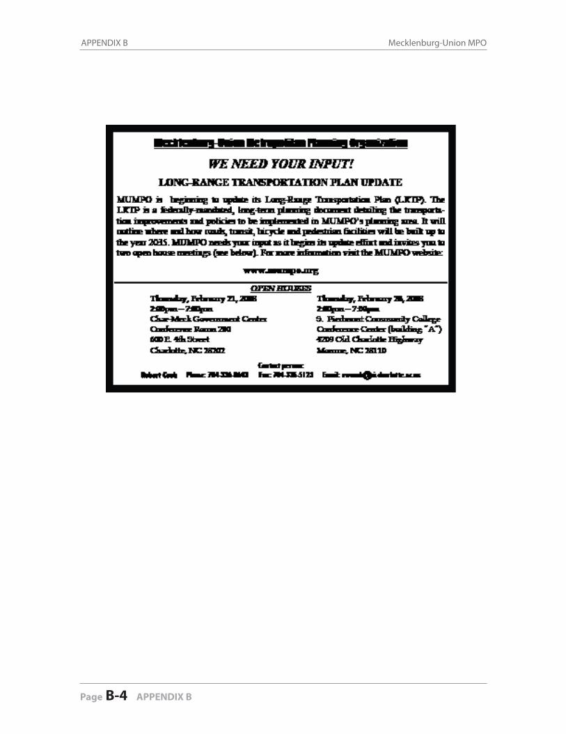
APPENDIX B Mecklenburg-Union MPO
Page B-4 APPENDIX B
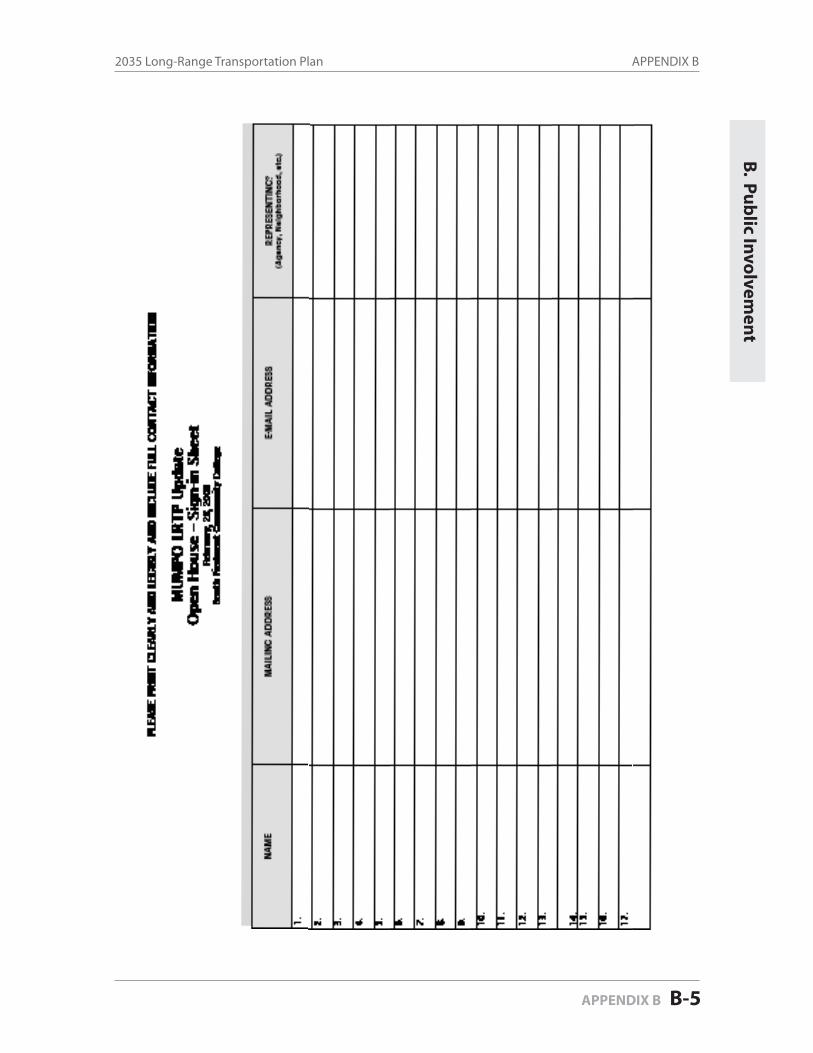
APPENDIX B2035 Long-Range Transportation Plan
APPENDIX B B-5
B. P
ub
lic Invo
lvemen
t

APPENDIX B Mecklenburg-Union MPO
Page B-6 APPENDIX B
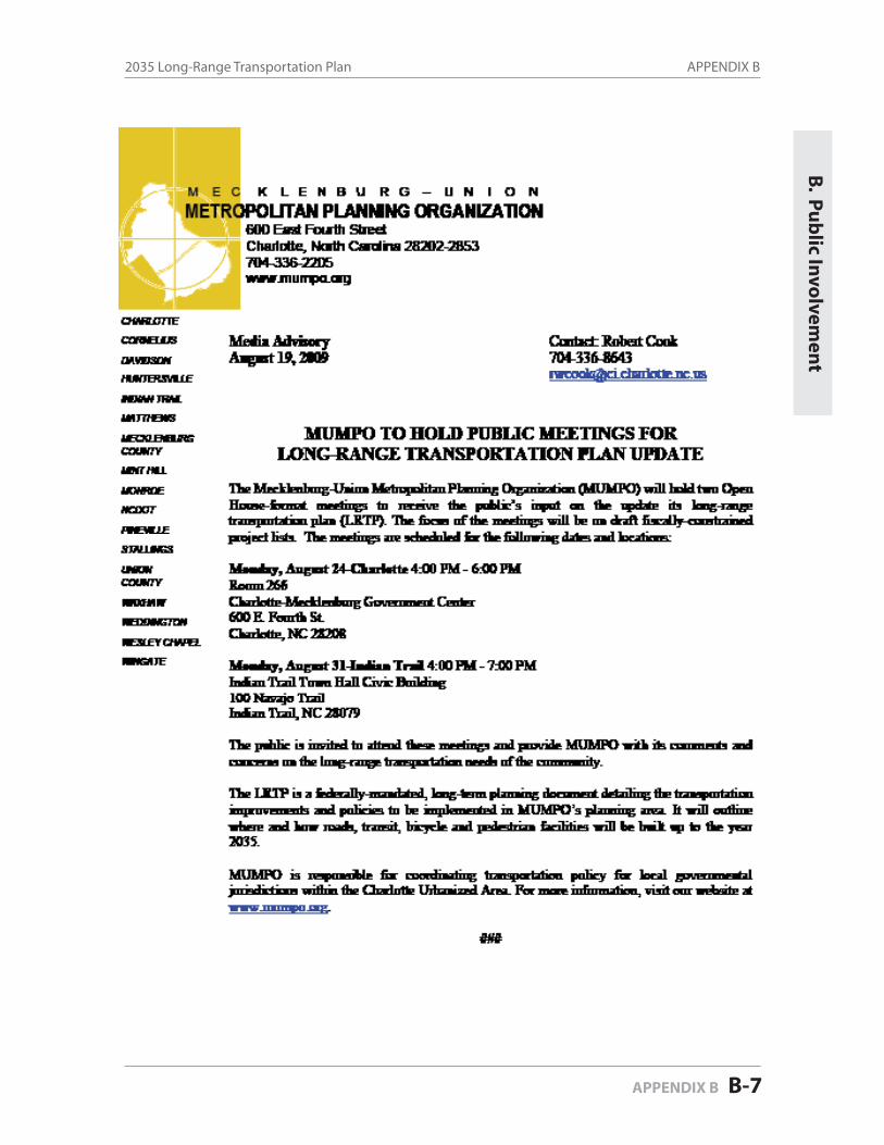
APPENDIX B2035 Long-Range Transportation Plan
APPENDIX B B-7
B. P
ub
lic Invo
lvemen
t
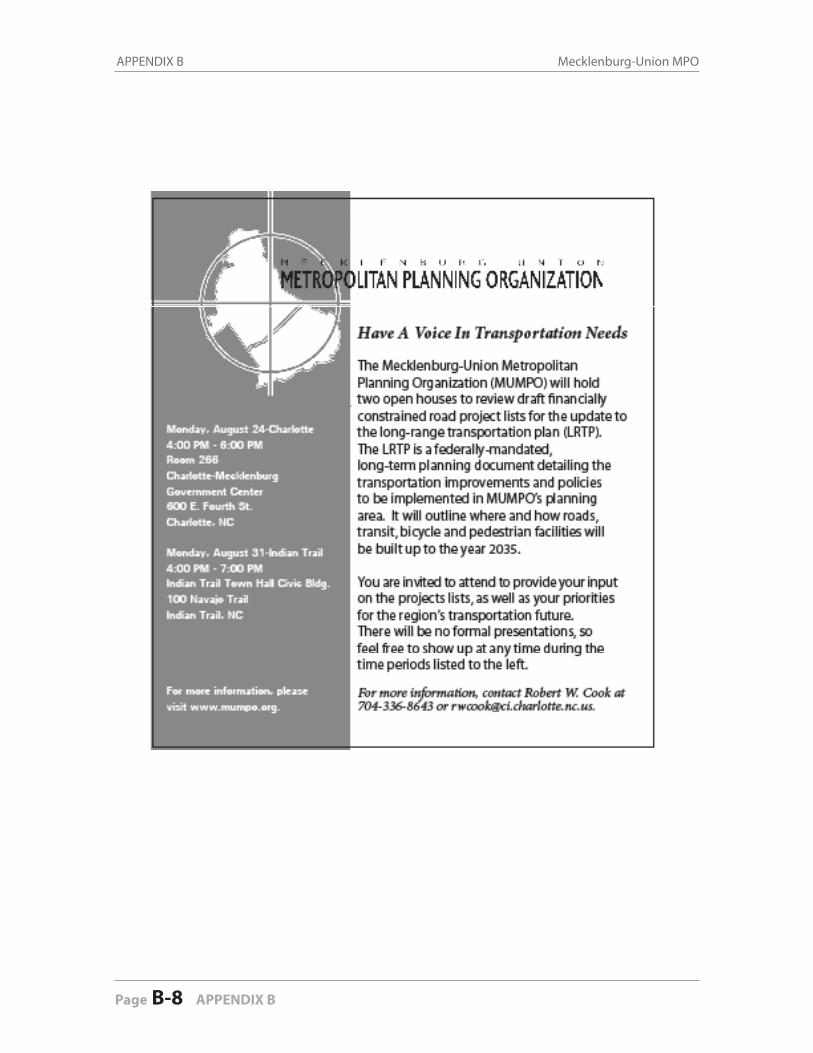
APPENDIX B Mecklenburg-Union MPO
Page B-8 APPENDIX B
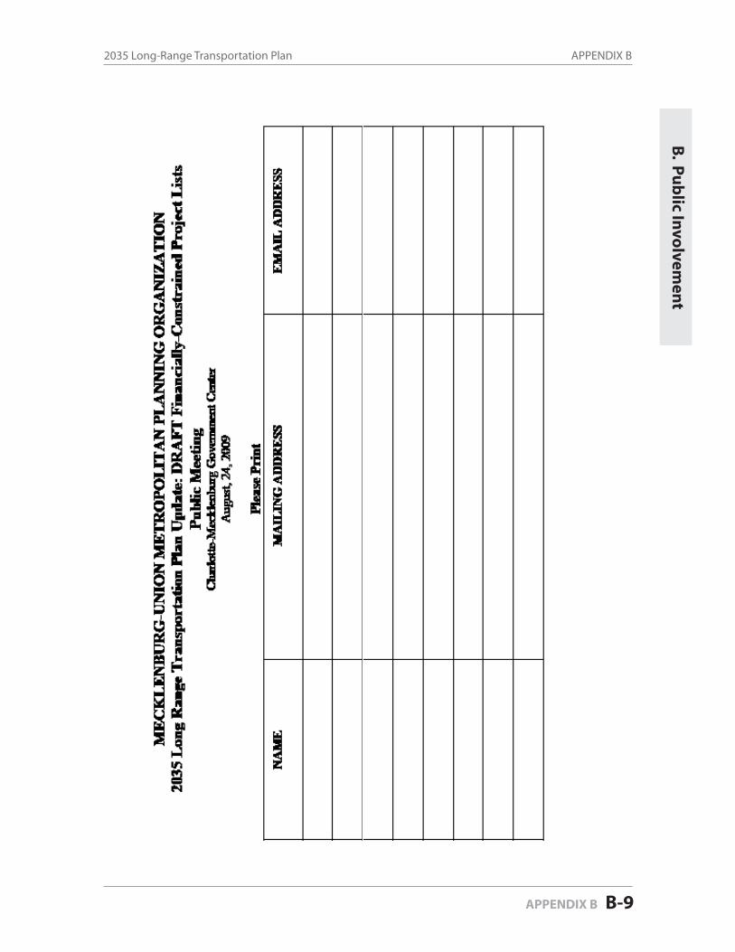
APPENDIX B2035 Long-Range Transportation Plan
APPENDIX B B-9
B. P
ub
lic Invo
lvemen
t
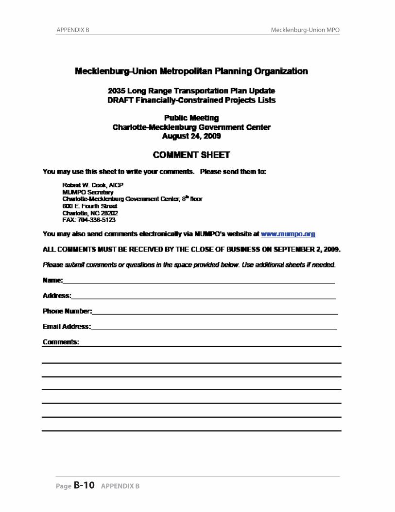
APPENDIX B Mecklenburg-Union MPO
Page B-10 APPENDIX B

APPENDIX B2035 Long-Range Transportation Plan
APPENDIX B B-11
B. P
ub
lic Invo
lvemen
t
M E C K L E N B U R G – U N I O N
METROPOLITAN PLANNING ORGANIZATION 600 East Fourth Street
Charlotte, North Carolina 28202-2853 704-336-2205 www.mumpo.org
CHARLOTTE
CORNELIUS
DAVIDSON
HUNTERSVILLE
INDIAN TRAIL
MATTHEWS
MECKLENBURGCOUNTY
MINT HILL
MONROE
NCDOT
PINEVILLE
STALLINGS
UNION COUNTY
WAXHAW
WEDDINGTON
WESLEY CHAPEL
WINGATE
Media Advisory Contact: Robert Cook February 5, 2010 704-336-8643
MUMPO TO OPEN PUBLIC COMMENT PERIOD AND HOLD PUBLIC MEETINGS FOR LONG-RANGE TRANSPORTATION PLAN UPDATE, CONFORMITY DETERMINATION REPORT & TIP AMENDMENTS
The Mecklenburg-Union Metropolitan Planning Organization (MUMPO) will open a 30-day public comment period on Friday, February 5, 2010 and hold two Open House-format meetings to receive the public’s input on its draft 2035 Long-Range Transportation Plan (LRTP), the Metrolina Conformity Determination Report and amendments to the Transportation Improvement Program to accelerate construction of the final segment of I-485. The meetings are scheduled for the following dates and locations:
Wednesday, February 24 4:00- 6:00 PM Room 266 Charlotte-Mecklenburg Government Center 600 E. Fourth St. Charlotte, NC 28202
Thursday, February 25 4:00 -6:00 PM Indian Trail Town Hall-Civic Building 100 Navajo Trail Indian Trail, NC 28079
The public is invited to attend these meetings and provide MUMPO with its comments and concerns on the three documents mentioned above. The public comment period closes on Monday, March 8, 2010.
All pertinent information can be found at MUMPO’s website at: http://www.mumpo.org/2035_LRTP.htm
The LRTP is a federally-mandated, long-term planning document detailing the transportation improvements and policies to be implemented in MUMPO’s planning area, and outlines where and how roads, transit, bicycle and pedestrian facilities will be built up to the year 2035. The conformity determination report demonstrates that the financially constrained LRTP eliminates or reduces violation of the national ambient air quality standards (NAAQS) in the nonattainment area. The TIP amendments will shift the project start dates for the final section of I-485 and the I-485/I-85 interchange from 2015 and 2018 respectively to 2011.
MUMPO is responsible for coordinating transportation policy for local governmental jurisdictions within the Charlotte Urbanized Area. For more information, visit our website at www.mumpo.org.
###

APPENDIX B Mecklenburg-Union MPO
Page B-12 APPENDIX B
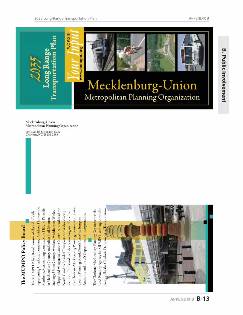
APPENDIX B2035 Long-Range Transportation Plan
APPENDIX B B-13
B. P
ub
lic Invo
lvemen
t
Long
Ran
geTr
ansp
orta
tion
Plan
2035
The M
UM
PO P
olic
y Boa
rd
Mecklenburg-UnionMetropolitan Planning Organization600 East 4th Street, 8th FloorCharlotte, NC 28202-2853
Metropolitan Planning OrganizationMecklenburg-Union
The M
UM
PO P
olic
y Boa
rd co
nsist
s of e
lecte
d offi
cials
repr
esen
ting C
harlo
tte, C
orne
lius,
Dav
idso
n, H
unte
rsvill
e, M
atth
ews,
Mec
klen
burg
Cou
nty,
Min
t Hill
and
Pine
ville
in
Mec
klen
burg
Cou
nty,
and
Indi
an T
rail,
Mon
roe,
Stall
ings
, Uni
on C
ount
y, W
axha
w, W
eddi
ngto
n, W
esley
C
hape
l and
Win
gate
in U
nion
Cou
nty.
A m
embe
r of t
he
Nor
th C
arol
ina B
oard
of T
rans
porta
tion
is als
o a v
otin
g m
embe
r. Th
e Boa
rd in
clude
s non
-vot
ing m
embe
rs fro
m
the C
harlo
tte-M
eckl
enbu
rg P
lanni
ng C
omm
issio
n, U
nion
C
ount
y Plan
ning
Boa
rd, N
orth
Car
olin
a Tur
npik
e A
utho
rity a
nd th
e US
Dep
artm
ent o
f Tra
nspo
rtatio
n.
The C
harlo
tte-M
eckl
enbu
rg P
lanni
ng D
epar
tmen
t is t
he
Lead
Plan
ning
Age
ncy f
or M
UM
PO; s
taff
supp
ort i
s also
pr
ovid
ed b
y the
Cha
rlotte
Dep
artm
ent o
f Tra
nspo
rtatio
n.
Your I
nput
we wa
ntw
ww.
mum
po.o
rg
APPENDIX B Mecklenburg-Union MPO
Page B-14 APPENDIX B
An
Intr
oduc
tion
to M
UM
PO a
nd th
e 20
35 L
RTP
Upd
ate
What i
s the L
RTP?
We wa
nt your
input!
The M
eckl
enbu
rg U
nion
Met
ropo
litan
Plan
ning
O
rgan
izatio
n (M
UM
PO) i
s res
pons
ible
for f
eder
ally
man
date
d tra
nspo
rtatio
n pl
anni
ng ac
tiviti
es w
ithin
all
of M
eckl
enbu
rg C
ount
y and
the u
rban
por
tion
of
Uni
on C
ount
y. Th
e prim
ary d
uties
of M
UM
PO
inclu
de:
Prep
arin
g lon
g ran
ge tr
ansp
orta
tion
plan
s
Prep
arin
g tra
nspo
rtatio
n-re
lated
air q
ualit
y
plan
ning
conf
orm
ity an
alyse
s
Any
oth
er tr
ansp
orta
tion
plan
ning
dut
ies
requ
ired
by fe
dera
l Law
.
What i
s MUM
PO?
Conta
ct Us!
600 E
ast F
ourth
Stree
t8t
h Floo
rCh
arlot
te, N
orth
Car
olina
2820
2Ph
one:
(704
) 336
-864
3Fa
x: (7
04) 3
36-5
123
E-m
ail:
rwco
ok@
ci.ch
arlot
te.nc
.us
One
of t
he m
ost i
mpo
rtant
dut
ies o
f MU
MPO
is to
pr
epar
e the
Cha
rlotte
regi
on’s L
ong R
ange
Tra
nspo
r-ta
tion
Plan
(LRT
P). Th
e LRT
P de
fines
pol
icies
, pr
ogra
ms a
nd p
rojec
ts to
be a
ccom
plish
ed d
urin
g at
least
the n
ext t
went
y yea
rs. B
ecau
se th
e plan
upd
ate
is to
be fi
nish
ed in
2009
, this
LRT
P wi
ll des
crib
e wh
ich ro
ads,
trans
it, an
d bi
cycle
and
pede
strian
fa
cilit
ies w
ill b
e bui
lt up
to th
e yea
r 203
5. Th
e LRT
P wi
ll also
help
loca
l gov
ernm
ents
mak
e the
ir tra
nspo
r-
MU
MPO
is u
nder
taki
ng se
vera
l act
iviti
es to
en
cour
age m
eani
ngfu
l citi
zen
parti
cipat
ion
in o
ur
LRT
P up
date
Thro
ugho
ut 20
09, M
UM
PO w
ill
prov
ide c
itize
ns an
opp
ortu
nity
to co
mm
ent o
n tra
nspo
rtatio
n pr
ojec
ts pr
opos
ed fo
r the
2030
LRT
P up
date
.
In ad
ditio
n, M
UM
PO’s w
ebsit
e con
tain
s use
ful
info
rmat
ion
on it
s tra
nspo
rtatio
n pl
ans,
work
tatio
n an
d lan
d us
e dec
ision
s bas
ed o
n th
eir av
ailab
le fu
nds a
nd co
mm
unity
obj
ectiv
es. D
ue to
air q
ualit
y co
nditi
ons c
ause
d in
par
t by t
raffi
c with
in th
e C
harlo
tte re
gion
, Fed
eral
law re
quire
s MU
MPO
to
reev
aluat
e and
upd
ate i
ts LR
TP
ever
y fou
r yea
rs. Th
e LR
TP
upda
te is
curre
ntly
unde
rway
!
prog
ram
s and
oth
er tr
ansp
orta
tion
relat
ed ac
tiviti
es.
The w
eb si
te al
so co
ntain
s inf
orm
atio
n on
the
oppo
rtuni
ties f
or ci
tizen
s to
prov
ide t
heir
inpu
t int
o M
UM
PO p
rogr
ams,
inclu
ding
the L
RTP
upda
te.
The w
ebsit
e can
be f
ound
at
ww
w.m
umpo
.org
Whe
n th
e pub
lic m
eetin
g dat
es ar
e set
, they
will
be
adve
rtise
d in
seve
ral m
edia
outle
ts an
d po
sted
on th
e M
UM
PO w
eb si
te. I
n ad
ditio
n, sp
ecial
invit
atio
ns
will b
e sen
t to
thos
e on
the M
UM
PO m
ailin
g list
. If
you
woul
d lik
e mor
e inf
orm
atio
n on
how
you
can
parti
cipat
e in
MU
MPO
’s tra
nspo
rtatio
n pl
anni
ng
proc
ess a
nd/o
r how
to h
ave y
ou o
r you
r asso
ciatio
n,
grou
p or
org
aniza
tion
adde
d to
the M
UM
PO
ing l
ist, p
lease
cont
act R
ober
t Coo
k with
M
UM
PO at
704-
336-
8643
or s
end
him
an e-
at
rwco
ok@
ci.ch
arlo
tte.n
c.us .
Meck
lenbu
rg U
nion
Metr
opoli
tan
Plan
ning
Org
aniz
ation
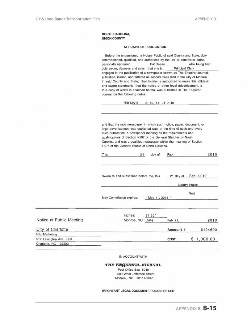
APPENDIX B2035 Long-Range Transportation Plan
APPENDIX B B-15
B. P
ub
lic Invo
lvemen
t
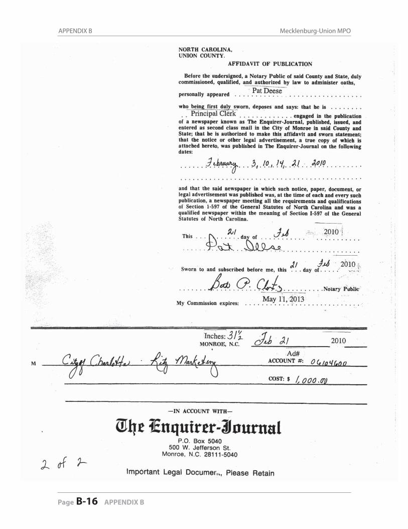
APPENDIX B Mecklenburg-Union MPO
Page B-16 APPENDIX B
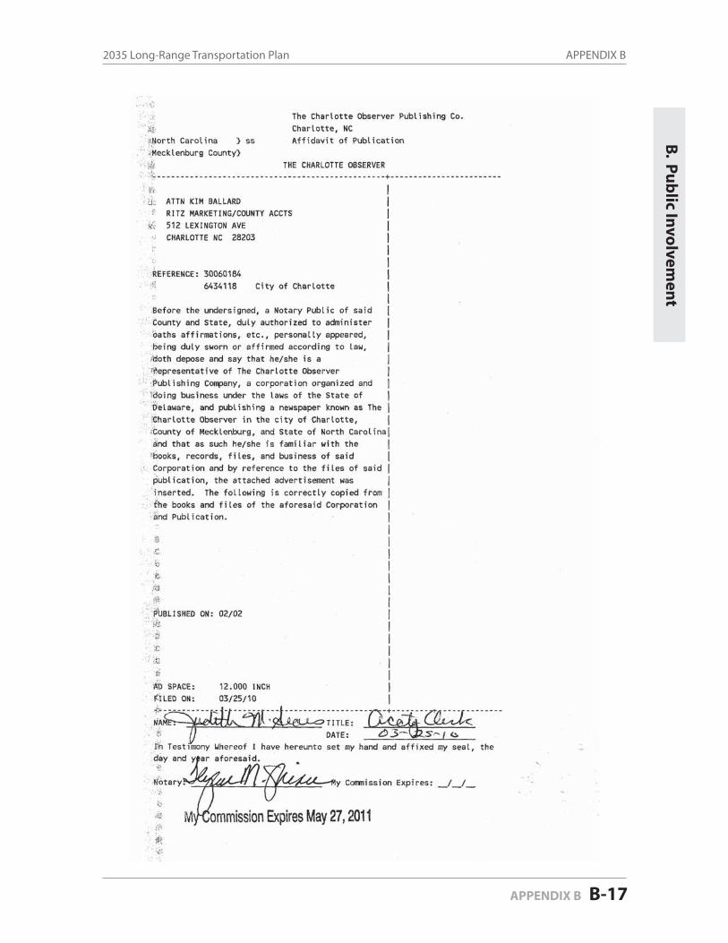
APPENDIX B2035 Long-Range Transportation Plan
APPENDIX B B-17
B. P
ub
lic Invo
lvemen
t
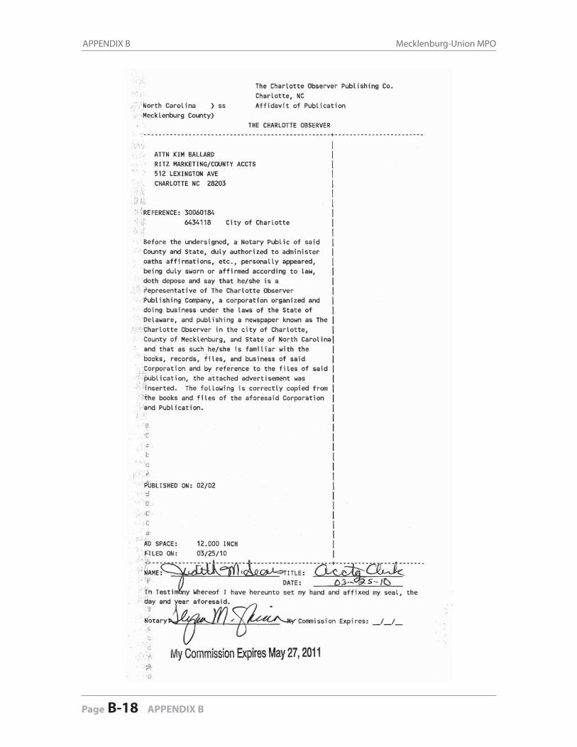
APPENDIX B Mecklenburg-Union MPO
Page B-18 APPENDIX B

APPENDIX B2035 Long-Range Transportation Plan
APPENDIX B B-19
B. P
ub
lic Invo
lvemen
t

APPENDIX B Mecklenburg-Union MPO
Page B-20 APPENDIX B
APPENDIX B2035 Long-Range Transportation Plan
APPENDIX B B-21
B. P
ub
lic Invo
lvemen
t
APPENDIX B Mecklenburg-Union MPO
Page B-22 APPENDIX B
C. C
on
gestio
n M
anag
emen
tC
. Co
ng
estion
Man
agem
ent
CONGESTION MANAGEMENT C-1
APPENDIX C
Congestion Management
C-1: Congested Corridors . . . . . . . . . . . . . . . . . . . . . . . . . . . . . . . . . . Pages C-2 to C-7
C-2: Congested Hot Spots . . . . . . . . . . . . . . . . . . . . . . . . . . . . . . . . . Page C-8 to C-9
C-3: Mitigation Strategy Toolbox . . . . . . . . . . . . . . . . . . . . . . . . . . . Pages C-10 to C-17
C-1: Congested Corridors
(two Excel charts in the following 6 pages)

APP
END
IX C
-1C
onge
sted
Cor
ridor
sM
UM
PO C
onge
stio
n M
anag
emen
t Pro
cess
Proj
ect S
cree
ning
Con
gest
ed C
orrid
orM
itiga
tion
Stra
tegi
es
Increase # of Lanes w/o Widening
Implement Geometric Design Improvements
Implement Managed Lanes
Grade Separations
Eliminate At-Grade Rail Crossings
Add Connectivity
Increase Bus Route Coverage or Frequencies
Implement Park-and-Ride Lots
Implement Rapid Transit
Install Bus Lanes
Transit Signal Prioritization
Ridesharing
Congestion Pricing
Traffic Signal Coordination (incl. add traffic signal)
Reversible Travel Lanes
Freeway Incident Detection & Management
Ramp Metering
Variable Message Signs
Left-turn Restrictions (also incl. add turn lanes)
Turn Lanes into Properties; Relocation of Driveways and
Exit Ramps
Interchange Modifications
Crafting Policies that Govern Access in Corridors
Sta
tesv
ille
Roa
dG
raha
m S
treet
to C
ataw
ba A
veS
erve
s as
an
alte
rnat
e ro
ute
for I
-77
NR
RN
RN
RN
RR
RN
RN
RN
RI
RN
RN
RN
RN
RR
NR
NC
115
I-77
Nor
th to
Bea
tty S
treet
Littl
e di
stan
ce in
betw
een
sign
als.
Clo
se p
roxi
mity
to
seve
ral i
nter
sect
ions
NR
RN
RN
RN
RR
RN
RN
RN
RI
RN
RN
RN
RN
RN
RR
At a
few
pro
blem
inte
rsec
tions
, una
ble
to m
ake
a le
ft tu
rn a
nd la
ck o
f tra
ffic
light
Ser
ves
as a
sub
regi
onal
and
a lo
cal r
oute
Acc
ess
man
agem
ent i
ssue
sLa
ck o
f lef
t tur
n la
nes
Ser
ves
as a
n al
tern
ate
rout
e fo
r I-8
5
Ser
ves
as a
n al
tern
ate
rout
e w
hen
ther
e is
an
acci
dent
on
I-77
Sig
nific
ant r
esid
entia
l dev
elop
men
t in
Hun
ters
ville
- ho
usin
g an
d sc
hool
s
Lack
of c
onne
ctiv
ity -
no e
ast/w
est c
onne
ctio
nsLa
ck o
f acc
ess
man
agem
ent
Too
man
y cu
rb c
uts
Red
uces
from
6 t
o 4
lane
s ne
ar th
e riv
erS
erve
s as
an
alte
rnat
e ro
ute
whe
n an
traf
fic in
cide
nt
occu
rs o
n I-8
5
NC
49
Sou
th1-
277
to L
ake
Wyl
ie
Rap
idly
gro
win
g ar
ea -
on la
nd u
se s
ide
cons
ider
ing
cons
olid
atin
g dr
ivew
ays
IR
NR
NR
NR
RN
RN
RN
RN
RI
IR
NR
II
NR
RR
IR
Nat
ions
For
d S
pur
Sou
th T
ryon
to W
estin
ghou
se B
lvd
Ser
ves
as a
ltern
ate
rout
e to
77
- lot
s of
peo
ple
in
Yor
k C
ount
y an
d S
C tr
avel
inbo
und.
I
RN
RN
RN
RR
NR
NR
NR
NR
IR
RN
RR
RR
R
Sou
th B
lvd.
Cal
dwel
l Stre
et to
I-48
5N
RI
NR
NR
NR
RN
RN
RN
RN
RI
RN
RN
RI
NR
NR
NR
Par
k R
oad/
Ken
ilwor
th A
ve/S
cott
Ave
I-277
to H
ighw
ay 5
1N
RI
NR
NR
NR
RN
RN
RN
RN
RI
RN
RN
RI
NR
NR
NR
Lack
of a
cces
s m
anag
emen
t
Sig
nific
ant c
omm
erci
al a
nd re
side
ntia
l dev
elop
men
t
Peo
ple
com
mut
ing
from
Uni
on C
ount
y to
M
eckl
enbu
rg C
ount
y to
acc
ess
jobs
Ser
ves
as a
ltern
ate
rout
e fo
r US
74
Mix
of c
omm
erci
al, i
ndus
trial
, and
offi
ce a
ctiv
ity
Idle
wild
Rd/
Sec
rest
Sho
rtcut
Rd
Mon
roe
Roa
d to
Fow
ler R
oad
Roa
d of
regi
onal
sig
nific
ance
and
sta
tew
ide
sign
ifica
nce.
Ess
entia
lly a
sur
face
stre
et th
at c
arrie
s m
ost t
raffi
c in
Cha
rlotte
but
is n
ot a
free
way
. I
IN
RN
RR
RI
RR
RI
IN
RN
RI
RR
R
Roc
ky R
iver
Roa
dU
S 7
4 to
NC
84
Sig
nals
not
syn
chro
nize
dI
IN
RN
RR
NR
NR
NR
NR
NR
IR
NR
NR
RR
RR
Con
cord
Ave
nue
US
74
to C
harlo
tte A
veM
ixed
use
cor
ridor
- bu
sine
ss, c
omm
erci
al,
indu
stria
lI
IN
RN
RR
NR
NR
NR
NR
NR
IR
NR
NR
RR
RR
US
601
US
74
to S
C L
ine
No
alte
rnat
ive
rout
esI
IN
RN
RR
NR
NR
NR
NR
NR
IR
NR
NR
RR
RR
US
74
I-485
to U
S 6
01 S
outh
II
NR
NR
RN
RN
RN
RN
RN
RI
RN
RN
RR
RR
R
Old
Mon
roe
RdO
ld C
harlo
tte
Hw
y/C
harlo
tte A
ve/L
anca
ster
Ave
Mec
klen
burg
Cou
nty
to B
rew
er D
r.I
IN
RN
RR
NR
NR
NR
NR
NR
IR
NR
NR
RR
RR
Icem
orle
e/Jo
hnso
n S
pur
Cha
rlotte
Ave
to N
C 7
5I
IN
RN
RR
NR
NR
NR
NR
NR
IR
NR
NR
RR
RR
Sun
set S
pur
US
74
to M
edlin
Rd.
II
NR
NR
RN
RN
RN
RN
RN
RI
RN
RN
RR
RR
RW
esle
y C
hape
l-Sto
uts
Roa
dU
S 7
4 to
Rog
ers
Rd.
.I
IN
RN
RR
NR
NR
NR
NR
NR
IR
NR
NR
RR
RR
E. 3
rd S
t./P
rovi
denc
e R
oad
Ser
ves
as a
n al
tern
ate
rout
e to
I-77
Too
man
y si
gnal
s
Par
k R
oad
Trav
el C
orrid
or
Pro
vide
nce
Roa
d
Trav
el C
orrid
or
Wilk
inso
n B
lvd
Wilk
inso
n B
lvd
NC
16
func
tions
as
a C
lass
II A
rteria
l but
des
igne
d as
a h
ybrid
arte
rial c
arry
ing
spee
ds u
p to
55
mph
I-277
to R
ea R
dA
rteria
l
I-277
to G
asto
n C
ount
y
I-77
Sou
th to
Gas
ton
Cou
nty
Arte
rial
Bea
tties
For
d R
oad
Trad
e S
treet
to G
ilead
Roa
dA
rteria
l
Bro
oksh
ire B
lvd
(S) t
o B
rook
shire
Blv
d. (N
)
Eas
tfiel
d R
oad
NC
115
to C
abar
rus
Cou
nty
Trav
el C
orrid
or
Nat
ions
For
d R
oad
Arte
rial
NC
16
Bel
lhav
en/R
ozel
les
Ferr
y R
d.
Bro
oksh
ire B
lvd
Trav
el C
orrid
or
Bea
tties
For
d R
oad
Cen
tral A
venu
e to
NC
75
7th
Stre
et/M
onro
e R
d/Jo
hn
Stre
et/O
ld M
onro
e R
d./O
ld
Cha
rlotte
Hw
y./C
harlo
tte A
ve.
Roa
dway
Ty
pe
1 2 643 5 7
Sta
tesv
ille
Roa
d
8U
S 7
4
NR
Roa
dway
Impr
ovem
ents NR
IN
RR
RN
RN
R
Tran
sit I
mpr
ovem
ents
Acc
ess
Man
agem
ent
ITS/
TSM
TDM
R
IIR
NR
IR
RR
RN
R
NR
NR
NR
NR
NR
NR
NR
NR
IR
RN
RN
R
NR
NR
RN
RN
R
NR
NR
NR
NR
NR
NR
I
NR
IR
NR
IN
RN
R
NR
I NR
RN
R
RN
R
NR
RN
R
NR
NR
RR
NR
R
NR
NR
I I
NR
IR
NR
NR
R
NR
RR
R
NR
RNR
RN
R
NR
RI
RN
R
II
NR
RI
RR
NR
IR
RI
R
Con
gest
ed C
orrid
ors
Link
sLi
mits
Cau
ses
of C
onge
stio
n
II
NR
RR
NR
RI
I IR
NR
NR
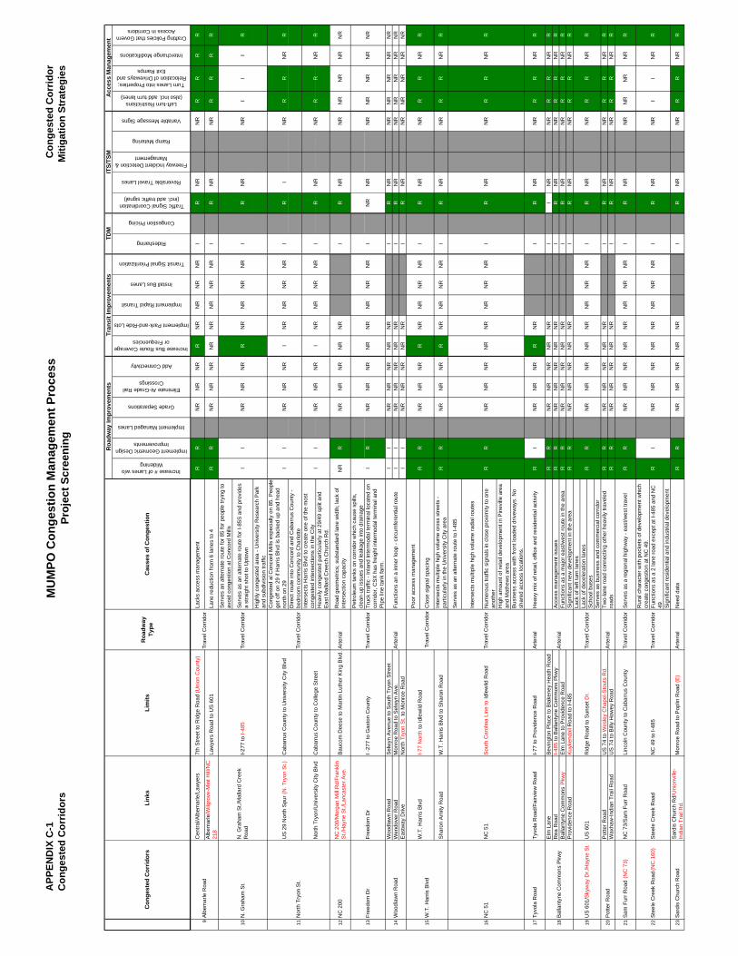
APP
END
IX C
-1C
onge
sted
Cor
ridor
sM
UM
PO C
onge
stio
n M
anag
emen
t Pro
cess
Proj
ect S
cree
ning
Con
gest
ed C
orrid
orM
itiga
tion
Stra
tegi
es
Increase # of Lanes w/o Widening
Implement Geometric Design Improvements
Implement Managed Lanes
Grade Separations
Eliminate At-Grade Rail Crossings
Add Connectivity
Increase Bus Route Coverage or Frequencies
Implement Park-and-Ride Lots
Implement Rapid Transit
Install Bus Lanes
Transit Signal Prioritization
Ridesharing
Congestion Pricing
Traffic Signal Coordination (incl. add traffic signal)
Reversible Travel Lanes
Freeway Incident Detection & Management
Ramp Metering
Variable Message Signs
Left-turn Restrictions (also incl. add turn lanes)
Turn Lanes into Properties; Relocation of Driveways and
Exit Ramps
Interchange Modifications
Crafting Policies that Govern Access in Corridors
Roa
dway
Ty
pe
Roa
dway
Impr
ovem
ents
Tran
sit I
mpr
ovem
ents
Acc
ess
Man
agem
ent
ITS/
TSM
TDM
Con
gest
ed C
orrid
ors
Link
sLi
mits
Cau
ses
of C
onge
stio
n
Ser
ves
an a
ltern
ate
rout
e fo
r 85
for p
eopl
e try
ing
to
avoi
d co
nges
tion
at C
onco
rd M
ills
Ser
ves
as a
n al
tern
ate
rout
e fo
r I-8
5S a
nd p
rovi
des
a st
raig
ht s
hot t
o U
ptow
n
Hig
hly
cong
este
d ar
ea -
Uni
vers
ity R
esea
rch
Par
k an
d su
bdiv
isio
n tra
ffic
Con
gest
ed a
l Con
cord
Mill
s es
peci
ally
on
85. P
eopl
e ge
t off
on 2
9 if
Har
ris B
lvd
is b
acke
d up
and
hea
d no
rth o
n 29
Dire
ct ro
ute
into
Con
cord
and
Cab
arru
s C
ount
y -
bedr
oom
com
mun
ity to
Cha
rlotte
Inte
rsec
ts H
arris
Blv
d to
cre
ate
one
of th
e m
ost
cong
este
d in
ters
ectio
ns in
the
City
Hea
vily
con
gest
ed p
artic
ular
ly a
t 29/
49 s
plit
and
Eas
t Mal
lard
Cre
ech
Chu
rch
Rd.
12N
C 2
00N
C 2
00/M
orga
n M
ill R
d/Fr
ankl
in
St./
Hay
ne S
t./La
ncas
ter A
ve.
Bau
com
Dee
se to
Mar
tin L
uthe
r Kin
g B
lvd.
Arte
rial
Roa
d ge
omet
rics;
sub
stan
dard
lane
wid
th; l
ack
of
inte
rsec
tion
capa
city
NR
RN
RN
RN
RN
RN
RI
RN
RN
RN
RN
RN
RN
R
Pet
role
um ta
nks
on c
orrid
or w
hich
cau
se s
pills
, cl
ean-
up is
sues
and
leak
age
into
dra
inag
eTr
uck
traffi
c - I
nlan
d In
term
odal
term
inal
loca
ted
on
corr
idor
, CS
X h
as fr
eigh
t int
erm
odal
term
inal
and
P
ipe
line
tank
farm
.W
oodl
awn
Roa
dS
elw
yn A
venu
e to
Sou
th T
ryon
Stre
etI
IN
RN
RN
RN
RN
RI
RN
RN
RN
RN
RN
RN
RW
endo
ver R
oad
Mon
roe
Roa
d to
Sel
wyn
Ave
. I
IN
RN
RN
RN
RN
RI
RN
RN
RN
RN
RN
RN
RE
astw
ay D
rive
Nor
th T
ryon
St.
to M
onro
e R
oad
II
NR
NR
NR
NR
NR
IR
NR
NR
NR
NR
NR
NR
Poo
r acc
ess
man
agem
ent
Clo
se s
igna
l spa
cing
Sha
ron
Am
ity R
oad
W.T
. Har
ris B
lvd
to S
haro
n R
oad
Inte
rsec
ts m
ultip
le h
igh
volu
me
cros
s st
reet
s -
parti
cula
rly in
the
Uni
vers
ity C
ity a
rea
RR
NR
NR
NR
RN
RN
RN
RN
RI
RN
RN
RR
RN
RR
Ser
ves
as a
n al
tern
ate
rout
e to
I-48
5
Inte
rsec
ts m
ultip
le h
igh
volu
me
radi
al ro
utes
Num
erou
s tra
ffic
sign
als
in c
lose
pro
xim
ity to
one
an
othe
rH
igh
amou
nt o
f ret
ail d
evel
opm
ent i
n P
inev
ille
area
an
d M
athe
ws
area
Bus
ines
s ac
cess
with
fron
t loa
ded
driv
eway
s. N
o sh
ared
acc
ess
loca
tions
.
17Ty
vola
Roa
dTy
vola
Roa
d/Fa
irvie
w R
oad
I-77
to P
rovi
denc
e R
oad
Arte
rial
Hea
vy m
ix o
f ret
ail,
offic
e an
d re
side
ntia
l act
ivity
RI
NR
NR
NR
RN
RI
RN
RN
RR
RN
RR
Elm
Lan
eB
evin
gton
Pla
ce to
Bla
kene
y H
eath
Roa
dR
RN
RN
RN
RN
RN
RI
IN
RN
RR
RN
RR
Rea
Roa
dI-4
85 to
Bal
lant
yne
Com
mon
s P
kwy
Acc
ess
man
agem
ent i
ssue
sR
RN
RN
RN
RN
RN
RI
RN
RN
RR
RN
RR
Bal
lant
yne
Com
mon
s P
kwy
Elm
Lan
e to
Pro
vide
nce
Roa
dFu
nctio
ns a
s a
maj
or e
ast/w
est r
oute
in th
e ar
eaR
RN
RN
RN
RN
RN
RI
RN
RN
RR
RN
RR
Pro
vide
nce
Roa
dK
uyke
ndal
l Roa
d to
I-48
5S
igni
fican
t new
dev
elop
men
t in
the
area
RR
NR
NR
NR
NR
NR
IR
NR
NR
RR
NR
RLa
ck o
f lef
t tur
n la
nes
Lack
of d
ecel
erat
ion
lane
sS
choo
l bus
esS
erve
s as
bus
ines
s an
d co
mm
erci
al c
orrid
orP
otte
r Roa
dU
S 7
4 to
Wes
ley
Cha
pel-S
tout
s R
d.R
RN
RN
RN
RN
RN
RI
RN
RN
RR
RN
RR
Wax
haw
-Indi
an T
rail
Roa
dU
S 7
4 to
Bill
y H
owey
Roa
dR
RN
RN
RN
RN
RN
RI
RN
RN
RR
RN
RR
21S
am F
urr R
oad
(NC
73)
NC
73/
Sam
Fur
r Roa
dLi
ncol
n C
ount
y to
Cab
arru
s C
ount
yTr
avel
Cor
ridor
Ser
ves
as a
regi
onal
hig
hway
- ea
st/w
est t
rave
lR
RN
RN
RN
RN
RN
RN
RN
RN
RI
RN
RN
RN
RN
RN
RR
Rur
al c
hara
cter
with
poc
kets
of d
evel
opm
ent w
hich
cr
eate
con
gest
ion
at N
C 4
9.Fu
nctio
ns a
s a
2 la
ne ro
ad e
xcep
t at I
-485
and
NC
49 S
igni
fican
t res
iden
tial a
nd in
dust
rial d
evel
opm
ent
23S
ardi
s C
hurc
h R
oad
Sar
dis
Chu
rch
Rd/
Uni
onvi
lle-
Indi
an T
rail
Rd.
Mon
roe
Roa
d to
Pop
lin R
oad
(E)
Arte
rial
Nee
d da
taR
RN
RN
RN
RN
RN
RI
RN
RN
RR
RN
RR
19 22
Func
tions
an
a in
ner l
oop
- circ
umfe
rent
ial r
oute
16
Two-
lane
road
con
nect
ing
othe
r hea
vily
trav
eled
ro
ads
Lack
s ac
cess
man
agem
ent
Lane
redu
ctio
n fro
m 6
lane
s to
4La
wye
rs R
oad
to U
S 6
01
14
Cen
tral/A
lbem
arle
/Law
yers
Tr
avel
Cor
ridor
Cab
arru
s C
ount
y to
Col
lege
Stre
et
Cab
arru
s C
ount
y to
Uni
vers
ity C
ity B
lvd
I-77
Nor
th to
Idle
wild
Roa
d
NC
49
to I-
485
I-277
to I-
485
N. G
raha
m S
t./M
alla
rd C
reek
R
oad
Alb
emar
le/W
ilgro
ve-M
int H
ill/N
C
218
Trav
el C
orrid
or
Trav
el C
orrid
or
Ste
ele
Cre
ek R
oad
Trav
el C
orrid
or
Bal
lant
yne
Com
mon
s P
kwy
Ste
ele
Cre
ek R
oad
(NC
160
)
US
601
/Sky
way
Dr./
Hay
ne S
t.
US
29
Nor
th S
pur (
N. T
ryon
St.)
Nor
th T
ryon
/Uni
vers
ity C
ity B
lvd
NC
51
NC
51
Woo
dlaw
n R
oad
Free
dom
Dr
Nor
th T
ryon
St.
I -27
7 to
Gas
ton
Cou
nty
Free
dom
Dr
10 139 11
N. G
raha
m S
t.
Alb
emar
le R
oad
Arte
rial
15W
.T. H
arris
Blv
dW
.T. H
arris
Blv
d
Sou
th C
arol
ina
Line
to Id
lew
ild R
oad
2018
Arte
rial
Pot
ter R
oad
US
601
7th
Stre
et to
Rid
ge R
oad
(Uni
on C
ount
y)
Rid
ge R
oad
to S
unse
t Dr.
Trav
el C
orrid
or
Trav
el C
orrid
or
Trav
el C
orrid
or
Arte
rial
Trav
el C
orrid
or
NR
NR
NR
NR
NR
NR
NR
IR
R
NR
NR
NR
NR
NR
NR
NR
R
NR
NR
RN
RN
RI
R
NR
R
RR
R
RR
NR
NR
NR
IR
RN
RN
RN
RI
NR
R
NR
NR
NR
NR
NR
NR
II
R
NR
IN
RN
RN
R
NR
RN
RI
RI
NR
R
NR
NR
RR
R
NR
NR
NR
NR
NR
RI
IN
RN
RN
R
R
NR
NR
NR
NR
NR
I
RN
RN
RN
RN
RN
R
RR
NR
NR
RR
NR
NR
IN
R
NR
NR
NR
NR
NR
NR
NR
IN
R
NR
I
R
RR
NR
NR
NR
RN
RN
RN
RN
RN
RN
RN
RN
R
RI
NR
NR
R
NR
NR
NR
R
RR
RN
RN
RN
RN
RN
RI
II
NR
R R
NR
NR
NR
NR
RR
NR
RRR
II
R
IR
NR
NR
NR
II
NR
NR
R R
II
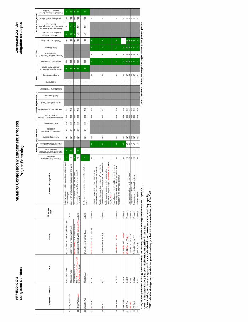
APP
END
IX C
-1C
onge
sted
Cor
ridor
sM
UM
PO C
onge
stio
n M
anag
emen
t Pro
cess
Proj
ect S
cree
ning
Con
gest
ed C
orrid
orM
itiga
tion
Stra
tegi
es
Increase # of Lanes w/o Widening
Implement Geometric Design Improvements
Implement Managed Lanes
Grade Separations
Eliminate At-Grade Rail Crossings
Add Connectivity
Increase Bus Route Coverage or Frequencies
Implement Park-and-Ride Lots
Implement Rapid Transit
Install Bus Lanes
Transit Signal Prioritization
Ridesharing
Congestion Pricing
Traffic Signal Coordination (incl. add traffic signal)
Reversible Travel Lanes
Freeway Incident Detection & Management
Ramp Metering
Variable Message Signs
Left-turn Restrictions (also incl. add turn lanes)
Turn Lanes into Properties; Relocation of Driveways and
Exit Ramps
Interchange Modifications
Crafting Policies that Govern Access in Corridors
Roa
dway
Ty
pe
Roa
dway
Impr
ovem
ents
Tran
sit I
mpr
ovem
ents
Acc
ess
Man
agem
ent
ITS/
TSM
TDM
Con
gest
ed C
orrid
ors
Link
sLi
mits
Cau
ses
of C
onge
stio
n
Roc
ky R
iver
Roa
dS
ecre
st S
hortc
ut R
oad
to G
oldm
ine
Roa
dR
oad
geom
etric
s - c
urbi
ng/w
iden
ing
road
s (n
arro
w 2
la
ne ro
adw
ays)
RR
NR
NR
NR
NR
NR
IR
NR
NR
RI
NR
R
Gol
dmin
e R
oad
Airp
ort R
oad
to R
ocky
Riv
er R
oad
Lack
of l
eft t
urn
lane
s an
d su
bsta
ndar
d la
ne w
idth
IR
NR
NR
NR
NR
NR
IR
NR
NR
RR
NR
R
Sec
rest
Sho
rtcut
Roa
dS
teve
ns M
ill R
d. to
Roc
ky R
iver
Roa
dla
ck o
f dec
eler
atio
n la
nes
and
turn
lane
sR
IN
RN
RN
RN
RN
RI
RN
RN
RR
RN
RR
25N
C 7
5/W
alku
p A
veN
C 7
5/Fr
ankl
in S
t./M
orga
n M
ill
Rd/
Wal
kup
Ave
. Roa
dM
artin
Lut
her K
ing
Blv
d to
Sut
herla
nd A
ve. A
rteria
lIn
ters
ectio
n ca
paci
ty. S
igna
l exi
sts
but s
till
cong
este
dN
RR
NR
NR
NR
NR
NR
IR
NR
NR
NR
NR
NR
R
26C
harlo
tte A
veC
harlo
tte A
veC
hurc
h S
treet
to C
onco
rd A
veA
rteria
l B
ottle
neck
due
to c
hang
e fro
m m
ulti-
lane
s to
two
lane
sR
IN
RN
RN
RN
RN
RI
RN
RN
RN
RN
RN
RR
27I-7
7 S
outh
I-77
SSo
uth
Car
olin
a Li
ne to
Tra
de S
t. Fr
eew
ayN
RI
RN
RN
RN
RI
NR
RI
RR
IU
nabl
e to
wid
en d
ue to
loca
tion
of e
xist
ing
neig
hbor
hood
s an
d ca
usew
ay a
t Lak
e N
orm
an
Four
lane
hig
hway
then
redu
ces
to 3
lane
s in
the
north
boun
d di
rect
ion
betw
een
I-485
and
Gile
ad R
d.
Traf
fic b
ack
up o
n ra
mps
- lit
tle c
ue s
paci
ng
beca
use
of c
lose
pro
xim
ity to
Sta
tesv
ille
Rd.
at e
xits
23
, 25,
and
28.
29I-4
85 W
est
I-485
WI-7
7Nor
th to
I-77
Sou
thFr
eew
ayN
ot re
ally
a c
onge
sted
cor
ridor
but
cou
ld b
ecom
e m
ore
cong
este
d w
ith th
e ai
rpor
t exp
ansi
on a
nd
relo
catio
n of
the
Inte
rmod
al te
rmin
al.
NR
IR
NR
NR
NR
IN
RR
IR
RI
30I-4
85 S
outh
I-485
SU
S 7
4 E
ast
to I-
77 S
outh
Free
way
NR
IR
NR
NR
NR
IN
RR
IR
II
31I-4
85 E
ast
I-485
EU
S-7
4 E
ast t
o I-8
5 N
orth
Free
way
NR
IN
RN
RN
RN
RI
NR
RI
RR
IC
omm
uter
s tra
velin
g in
bot
h di
rect
ions
NR
IN
RN
RN
RN
RI
NR
RI
RR
IC
onge
stio
n at
Con
cord
Mill
sN
RI
NR
NR
NR
NR
IN
RR
IR
RI
33I-8
5 W
est
I-85
WG
asto
n C
o Li
ne to
I-77
Free
way
Onl
y co
nges
ted
durin
g pe
ak p
erio
dsN
RI
NR
NR
NR
NR
IN
RR
IR
RI
34I-2
77I-2
77I-7
7N to
I-77
SFr
eew
ayW
eavi
ng is
sues
NR
IN
RN
RN
RN
RI
NR
RI
RR
I
*Gre
y sh
adin
g in
dica
tes
stra
tegy
not
app
ropr
iate
for r
oadw
ay ty
pe b
ased
on
cong
estio
n to
olbo
x in
App
endi
x C
.
Tr
avel
Cor
ridor
= P
aral
lel r
oadw
ays
serv
ing
the
sam
e pr
imar
y tr
avel
pat
tern
*Let
ter "
I" in
dica
tes
stra
tegy
has
bee
n im
plem
ente
d on
cor
ridor
in th
e pa
st.
*Gre
en s
hadi
ng in
dica
tes
stra
tegy
sho
uld
be c
onsi
dere
d/ev
alua
ted
on ro
adw
ay p
rior t
o ad
ding
cap
acity
.*"
NR
" in
dica
tes
stra
tegy
is a
ppro
pria
te fo
r gen
eral
road
way
type
but
not
reco
mm
ende
d as
par
t of t
he C
MP.
28
I-85
Eas
t32
Free
way
I-77
Nor
th
Cab
arru
s C
o Li
ne to
I-77
I-85
E
I-77
NIre
dell
Co
Line
to T
rade
St.
Free
way
Roc
ky R
iver
Roa
dA
rteria
l24
RR
NR
NR
IR
NR
NR
NR
IR
II
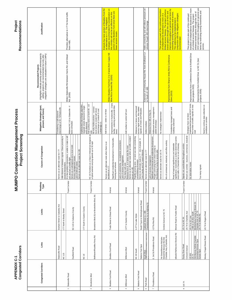
APP
END
IX C
-1C
onge
sted
Cor
ridor
sM
UM
PO C
onge
stio
n M
anag
emen
t Pro
cess
Proj
ect S
cree
ning
Proj
ect
Rec
omm
enda
tions
Sta
tesv
ille
Roa
dG
raha
m S
treet
to C
ataw
ba A
veS
erve
s as
an
alte
rnat
e ro
ute
for I
-77
Con
side
ring
a sp
lit d
iam
ond
inte
rcha
nge
at N
C 7
3/S
tate
svill
e
NC
115
I-77
Nor
th to
Bea
tty S
treet
Littl
e di
stan
ce in
bet
wee
n si
gnal
s. C
lose
pro
xim
ity to
se
vera
l int
erse
ctio
nsA
t a fe
w p
robl
em in
ters
ectio
ns, u
nabl
e to
mak
e a
left
turn
and
lack
of t
raffi
c lig
htS
erve
s as
a s
ubre
gion
al a
nd a
loca
l rou
teA
cces
s m
anag
emen
t iss
ues
Lack
of l
eft t
urn
lane
sS
erve
s as
an
alte
rnat
e ro
ute
for I
-85
Impl
emen
ted
inte
rcha
nge
upgr
ades
Upg
rade
sim
ple
diam
ond
to s
ingl
e po
int d
iam
ond
Add
aux
iliar
y la
nes
at N
orth
85
- 1/2
m
ile
Mt H
olly
Rd/
Bro
oksh
ire -
conn
ect
loca
l stre
et to
cre
ate
half
clov
er
inte
rcha
nge
at C
oola
ck D
r and
C
alla
brid
ge C
t.
Ser
ves
as a
n al
tern
ate
rout
e w
hen
ther
e is
an
acci
dent
on
I-77
Add
4 la
nes
- wid
en to
44
feet
Sig
nific
ant r
esid
entia
l dev
elop
men
t in
Hun
ters
ville
- ho
usin
g an
d sc
hool
s
Impr
ovem
ents
in H
unte
rsvi
lle -
2 la
ne
faci
lity
- wid
enin
g an
d pr
ovid
e bi
ke
lane
s.
Lack
of c
onne
ctiv
ity -
no e
ast/w
est c
onne
ctio
nsLa
ck o
f acc
ess
man
agem
ent
Too
man
y cu
rb c
uts
Red
uces
from
6 t
o 4
lane
s ne
ar th
e riv
erS
erve
s as
an
alte
rnat
e ro
ute
whe
n an
traf
fic in
cide
nt
occu
rs o
n I-8
5
NC
49
Sou
th1-
277
to L
ake
Wyl
ie
Rap
idly
gro
win
g ar
ea -
on la
nd u
se s
ide
cons
ider
ing
cons
olid
atin
g dr
ivew
ays
Nat
ions
For
d S
pur
Sou
th T
ryon
to W
estin
ghou
se R
oad
Ser
ves
as a
ltern
ate
rout
e to
77
- lot
s of
peo
ple
in
Yor
k C
ount
y an
d S
C tr
avel
inbo
und.
S
outh
Blv
d.C
aldw
ell S
treet
to I-
485
Par
k R
oad/
Ken
ilwor
th A
ve/S
cott
Ave
Cha
rlotte
tow
ne A
v to
Hig
hway
51
Lack
of a
cces
s m
anag
emen
tW
iden
ed fr
om 4
85 to
Hw
y 51
Sig
nific
ant c
omm
erci
al a
nd re
side
ntia
l dev
elop
men
tP
eopl
e co
mm
utin
g fro
m U
nion
Cou
nty
to
Mec
klen
burg
Cou
nty
to a
cces
s jo
bs
Ser
ves
as a
ltern
ate
rout
e fo
r US
74
No
stra
tegi
es im
plem
ente
d
Mix
of c
omm
erci
al, i
ndus
trial
, and
offi
ce a
ctiv
ity
Idle
wild
Rd/
Sec
rest
Sho
rtcut
Rd
Mon
roe
Roa
d to
Fow
ler R
oad
Roa
d of
regi
onal
sig
nific
ance
and
sta
tew
ide
sign
ifica
nce.
Ess
entia
lly a
sur
face
stre
et th
at c
arrie
s m
ost t
raffi
c in
Cha
rlotte
but
is n
ot a
free
way
.
Roc
ky R
iver
Roa
dU
S 7
4 to
NC
84
Sig
nals
not
coo
rdin
ated
thro
ugho
ut c
orrid
or
Con
cord
Ave
nue
US
74
to C
harlo
tte A
veM
ixed
use
cor
ridor
- bu
sine
ss, c
omm
erci
al, i
ndus
trial
US
601
US
74
to S
C L
ine
No
alte
rnat
ive
rout
esU
S 7
4I-4
85 to
US
601
Sou
thO
ld M
onro
e R
dOld
Cha
rlotte
M
eckl
enbu
rg C
ount
y to
Bre
wer
Dr.
Icem
orle
e/Jo
hnso
n S
pur
Cha
rlotte
Ave
to N
C 7
5S
unse
t Spu
rU
S 7
4 to
Med
lin R
d.
Wes
ley
Cha
pel-S
tout
s R
oad
US
74
to R
oger
s R
oad
Nee
d to
con
tinue
dat
a co
llect
ion
on
cond
ition
s in
cor
ridor
NC
16
Bel
lhav
en/R
ozel
les
Ferr
y R
d.
Trav
el C
orrid
or
Trav
el C
orrid
or
Bro
oksh
ire B
lvd
(S) t
o B
rook
shire
Blv
d. (N
)
Trav
el C
orrid
or
Bea
tties
For
d R
oad
Bea
tties
For
d R
oad
Trad
e S
treet
to G
ilead
Roa
dA
rteria
l
Wilk
inso
n B
lvd
Wilk
inso
n B
lvd
Bro
oksh
ire B
lvd
I-277
to R
ea R
dA
rteria
l
I-277
to G
asto
n C
ount
yA
rteria
l
Add
ed m
edia
ns
Too
man
y si
gnal
s
Sta
tesv
ille
Roa
d
Eas
tfiel
d R
oad
NC
115
to C
abar
rus
Cou
nty
Trav
el C
orrid
or
Nat
ions
For
d R
oad
Arte
rial
Cen
tral A
venu
e to
NC
75
7th
Stre
et/M
onro
e R
d/Jo
hn
Stre
et/O
ld M
onro
e R
d./O
ld
Cha
rlotte
Hw
y./C
harlo
tte A
ve.
Roa
dway
Ty
pe
1 2 643 5
E. 3
rd S
t./P
rovi
denc
e R
oad
7 8
Par
k R
oad
US
74
Pro
vide
nce
Roa
d
Rec
omm
ende
d Pr
ojec
ts(H
ighl
ight
s in
dica
te p
riorit
y pr
ojec
ts w
here
acap
acity
ad
ding
pro
ject
s ar
e re
com
men
ded
but o
nly
afte
r m
itiga
tion
stra
tegi
es a
re e
valu
ated
in fu
ture
CM
Ps)
Wid
en S
tate
svill
e R
d be
twee
n H
arris
Rd.
and
Gile
ad
Rd.
(203
5)
Just
ifica
tion
Pro
vide
s al
tern
ativ
e to
I-77
for l
ocal
traf
fic
from
I-48
5.
Wid
ened
NC
115
to S
tate
svill
e - 4
la
nes
w/m
edia
n
Add
med
ian
to c
ontro
l lef
t tur
n
Stra
tegi
es h
ave
not b
een
impl
emen
ted
beca
use
NC
DO
T lim
its
the
num
ber o
f tra
ffic
sign
als
on th
at
road
Impr
ovem
ents
from
Con
fere
nce
Driv
e to
Kre
feld
Driv
e
(two
proj
ects
202
5)
Impr
ovem
ents
from
Kre
feld
Driv
e to
NC
51
(two
proj
ects
203
5)
Con
side
ring
man
aged
lane
s an
d ro
adw
ay e
xten
sion
Con
gest
ed C
orrid
ors
Miti
gatio
n St
rate
gies
(pas
t, pr
esen
t, an
d fu
ture
)Li
nks
Lim
itsC
ause
s of
Con
gest
ion
Add
ress
ed a
sses
s m
anag
emen
t -
adde
d dr
ivew
ays
Ser
ves
as a
n al
tern
ate
rout
e to
I-77
NC
16
Func
tions
as
a C
lass
II A
rteria
l but
des
igne
d as
a
hybr
id a
rteria
l car
ryin
g sp
eeds
up
to 5
5 m
ph
I-77
Sou
th to
Gas
ton
Cou
nty
Wid
ened
to 4
lane
s an
d im
prov
ed
acce
ss m
gmt i
ssue
s. A
lso
adde
d si
gnal
s at
Cho
ke a
nd P
alis
ades
Impr
ovem
ents
from
Sha
ron
Am
ity R
d to
Con
fere
nce
Driv
e (2
015)
This
pro
ject
is p
art o
f the
con
tinue
d tra
nsiti
on
of In
depe
nden
ce B
oule
vard
to m
ore
of a
lim
ited
acce
ss fr
eew
ay. T
he p
roje
ct e
nhan
ce
trans
it op
tions
thro
ugh
the
use
of H
OV
and
im
prov
es th
roug
hput
on
gene
ral u
se la
nes
by
rest
rictin
g tu
rnin
g m
ovem
ents
and
acc
ess.
Th
is w
iden
ing
to b
e im
plem
ente
d in
co
njun
ctio
n w
ith th
e m
itiga
tion
stra
tegi
es
reco
mm
ende
d
This
pro
ject
is a
lso
part
of th
e co
ntin
ued
trans
ition
of I
ndep
ende
nce
Bou
leva
rd to
mor
e of
a li
mite
d ac
cess
free
way
. The
pro
ject
en
hanc
e tra
nsit
optio
ns th
roug
h th
e us
e of
H
OV
and
impr
oves
thro
ughp
ut o
n ge
nera
l use
la
nes
by re
stric
ting
turn
ing
mov
emen
ts a
nd
acce
ss.
Ext
ensi
on o
f Com
mun
ity H
ouse
Rd.
from
End
have
n Ln
to
Sou
th o
f I 4
85A
dds
conn
ectiv
ity a
nd w
ill re
lieve
pre
ssur
e on
Jo
hsto
n R
oad/
I-485
inte
rcha
nge
Wid
en B
eatti
es F
ord
from
2 to
4 la
nes
from
Cap
ps H
ill
Min
e R
d to
Sun
set R
d. (2
015)
Ext
ends
four
lane
sec
tion
of B
eatti
es F
ord
Rd
as a
ltern
ativ
e to
I-77
. The
miti
gatio
n st
rate
gies
reco
mm
ende
d fo
r con
side
ratio
n on
th
is c
orrid
or w
ill n
ot b
e as
effe
ctiv
e on
this
po
rtion
of t
he B
eatti
es F
ord
sinc
e th
ere
are
few
er a
cces
s is
sues
.
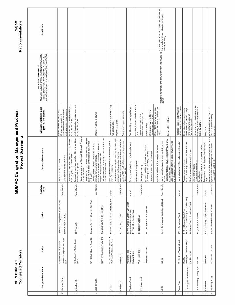
APP
END
IX C
-1C
onge
sted
Cor
ridor
sM
UM
PO C
onge
stio
n M
anag
emen
t Pro
cess
Proj
ect S
cree
ning
Proj
ect
Rec
omm
enda
tions
Roa
dway
Ty
pe
Rec
omm
ende
d Pr
ojec
ts(H
ighl
ight
s in
dica
te p
riorit
y pr
ojec
ts w
here
acap
acity
ad
ding
pro
ject
s ar
e re
com
men
ded
but o
nly
afte
r m
itiga
tion
stra
tegi
es a
re e
valu
ated
in fu
ture
CM
Ps)
Just
ifica
tion
Con
gest
ed C
orrid
ors
Miti
gatio
n St
rate
gies
(pas
t, pr
esen
t, an
d fu
ture
)Li
nks
Lim
itsC
ause
s of
Con
gest
ion
Inst
alle
d do
uble
left
turn
lane
sW
iden
ed la
nes
from
3 to
4M
ade
inte
rsec
tion
impr
ovem
ents
Mad
e pe
dest
rian
impr
ovem
ents
Ser
ves
an a
ltern
ate
rout
e fo
r 85
for p
eopl
e try
ing
to
avoi
d co
nges
tion
at C
onco
rd M
ills
Wid
ened
lane
to s
tand
ard
wid
th a
nd
adde
d le
ft tu
rn la
nes
Ser
ves
as a
n al
tern
ate
rout
e fo
r I-8
5S a
nd p
rovi
des
a st
raig
ht s
hot t
o U
ptow
nM
ade
inte
rsec
tion
impr
ovem
ents
and
ad
ded
left
turn
lane
s
Hig
hly
cong
este
d ar
ea -
Uni
vers
ity R
esea
rch
Par
k an
d su
bdiv
isio
n tra
ffic
Con
gest
ed a
l Con
cord
Mill
s es
peci
ally
on
85. P
eopl
e ge
t off
on 2
9 if
Har
ris B
lvd
is b
acke
d up
and
hea
d no
rth o
n 29
Dire
ct ro
ute
into
Con
cord
and
Cab
arru
s C
ount
y -
bedr
oom
com
mun
ity to
Cha
rlotte
Inte
rsec
ts H
arris
Blv
d to
cre
ate
one
of th
e m
ost
cong
este
d in
ters
ectio
ns in
the
City
Hea
vily
con
gest
ed p
artic
ular
ly a
t 29/
49 s
plit
and
Eas
t M
alla
rd C
reec
h C
hurc
h R
d.
12N
C 2
00N
C 2
00/M
orga
n M
ill R
d/Fr
ankl
in
St./
Hay
ne S
t./La
ncas
ter A
ve.
Bau
com
Dee
se to
Mar
tin L
uthe
r Kin
g B
lvd.
Arte
rial
Roa
d ge
omet
rics;
sub
stan
dard
lane
wid
th; l
ack
of
inte
rsec
tion
capa
city
Con
side
red
roun
dabo
uts
but f
undi
ng
was
not
ava
ilabl
eP
etro
leum
tank
s on
cor
ridor
whi
ch c
ause
spi
lls, c
lean
-up
issu
es a
nd le
akag
e in
to d
rain
age
Wid
ened
to 3
lane
s
Truc
k tra
ffic
- Inl
and
Inte
rmod
al te
rmin
al lo
cate
d on
co
rrid
or, C
SX
has
frei
ght i
nter
mod
al te
rmin
al a
nd
Pip
e lin
e ta
nk fa
rm.
Add
ed p
lant
ing
and
side
wal
ks
Woo
dlaw
n R
oad
Sel
wyn
Ave
nue
to S
outh
Try
on S
treet
Wen
dove
r Roa
dM
onro
e R
oad
to S
elw
yn A
ve.
Eas
tway
Driv
eN
. Try
on S
t. to
Mon
roe
Roa
d
Poo
r acc
ess
man
agem
ent
Inte
rcha
nge
proj
ect p
lann
ed a
t Har
ris
Blv
d.
Clo
se s
igna
l spa
cing
Roa
dway
ext
ensi
on u
nder
co
nstru
ctio
n on
Law
yers
Rd.
Sha
ron
Am
ity R
oad
W.T
. Har
ris B
lvd
to S
haro
n R
oad
Inte
rsec
ts m
ultip
le h
igh
volu
me
cros
s st
reet
s -
parti
cula
rly in
the
Uni
vers
ity C
ity a
rea
Inst
all a
med
ian
Ser
ves
as a
n al
tern
ate
rout
e to
I-48
5W
iden
ing
to T
owns
hip
Pkw
y to
La
wye
rs fr
om 2
to 4
lane
s
Inte
rsec
ts m
ultip
le h
igh
volu
me
radi
al ro
utes
Wid
en N
C 5
1 fro
m fo
ur to
six
lane
s be
twee
n S
ardi
s R
oad
and
Mon
roe
Roa
d.N
umer
ous
traffi
c si
gnal
s in
clo
se p
roxi
mity
to o
ne
anot
her
Hig
h am
ount
of r
etai
l dev
elop
men
t in
Pin
evill
e ar
ea
and
Mat
hew
s ar
eaB
usin
ess
acce
ss w
ith fr
ont l
oade
d dr
ivew
ays.
No
shar
ed a
cces
s lo
catio
ns.
17Ty
vola
Roa
dTy
vola
Roa
d/Fa
irvie
w R
oad
I-77
to P
rovi
denc
e R
oad
Arte
rial
Hea
vy m
ix o
f ret
ail,
offic
e an
d re
side
ntia
l act
ivity
Pro
pose
d pr
ojec
t to
wid
en C
arm
el
Rd.
to P
rovi
denc
e fro
m 4
to 6
lane
s
Rea
Rd
I-485
to B
lake
ney
Hea
th R
oad
Acc
ess
man
agem
ent i
ssue
sS
igna
l int
erse
ctio
n Im
prov
emen
tsB
alla
ntyn
e C
omm
ons
Pkw
yP
iper
Gle
n D
r to
Bal
lant
yne
Com
mon
s P
kwy
Func
tions
as
a m
ajor
eas
t/wes
t rou
te in
the
area
Bry
ant F
arm
s R
d E
xten
sion
pro
ject
Pro
vide
nce
Rd.
Kuy
kend
all R
oad
to P
rovi
denc
e R
oad
Sig
nific
ant n
ew d
evel
opm
ent i
n th
e ar
eaFa
rm-to
-mar
ket p
roje
ct o
n C
omm
unity
Hou
se R
d.La
ck o
f lef
t tur
n la
nes
Lack
of d
ecel
erat
ion
lane
sS
choo
l bus
esS
erve
s as
bus
ines
s an
d co
mm
erci
al c
orrid
or
20P
otte
r Roa
dP
otte
r Rd
US
74
to W
esle
y C
hape
l-Sto
uts
Roa
dA
rteria
lTw
o-la
ne ro
ad c
onne
ctin
g ot
her h
eavi
ly tr
avel
ed
road
sN
eed
data
21S
am F
urr (
NC
73)
NC
73/
Sam
Fur
r Roa
dLi
ncol
n C
ount
y to
Cab
arru
s C
ount
yTr
avel
Cor
ridor
Ser
ves
as a
regi
onal
hig
hway
- an
d se
rves
as
the
only
si
gnifi
cant
eas
t/wes
t tho
roug
hfar
e be
twee
n I-8
5 (c
ross
ing
I-77)
and
NC
150
Wid
enin
g in
ters
tate
from
NC
115
to
NC
73
- qua
dran
t roa
dway
in
ters
ectio
n.
19U
S 6
01
169 11 14
Law
yers
Roa
d to
US
601
Cen
tral/A
lbem
arle
/Law
yers
NC
51
Alb
emar
le/W
ilgro
ve-M
int H
ill/N
C
218
Wid
ened
road
way
to 6
lane
s
Cab
arru
s C
ount
y to
Col
lege
Stre
et
Cab
arru
s C
ount
y to
Uni
vers
ity C
ity B
lvd
I-77N
to Id
lew
ild R
oad
Trav
el C
orrid
or
Trav
el C
orrid
or
US
29
Nor
th S
pur (
N. T
ryon
St.)
N. G
raha
m S
t.
I 277
to G
asto
n C
ount
yFr
eedo
m D
r
Nor
th T
ryon
/Uni
vers
ity C
ity B
lvd
NC
51
18
7th
Stre
et to
Rid
ge R
oad
(Uni
on C
ount
y)
Trav
el C
orrid
or
Woo
dlaw
n R
oad
Free
dom
Dr
Nor
th T
ryon
St.
10
Arte
rial
15
Trav
el C
orrid
or
13
Alb
emar
le R
oad
I-277
to I-
485
N. G
raha
m S
t./M
alla
rd C
reek
R
oad
Trav
el C
orrid
or
Bal
lant
yne
Com
mon
s P
kwy
Rid
ge R
oad
to S
unse
t Dr.
US
601
/Sky
way
Dr./
Hay
ne S
t.
W.T
. Har
ris B
lvd
W.T
. Har
ris B
lvd
Sou
th C
arol
ina
stat
e lin
e to
Idle
wild
Roa
dTr
avel
Cor
ridor
Lack
s ac
cess
man
agem
ent
Lane
redu
ctio
n fro
m 6
lane
s to
4Tr
avel
Cor
ridor
Func
tions
an
a in
ner l
oop
- circ
umfe
rent
ial r
oute
No
stra
tegi
es w
ere
impl
emen
ted
due
to fu
ndin
g an
d be
caus
e th
e ro
ad is
ow
ned
by N
CD
OT.
Con
side
red
impr
ovin
g si
gnal
tim
ings
Add
an
addi
tiona
l lan
e
Wid
enin
g fro
m M
atth
ews
Tow
nshi
p P
kwy
to L
awye
rs R
d (2
035)
Cou
ld s
erve
as
an a
ltern
ativ
e ro
ute
for U
S 7
4 bu
t sho
uld
eval
uate
miti
gatio
n st
rate
gies
be
fore
wid
enin
g.
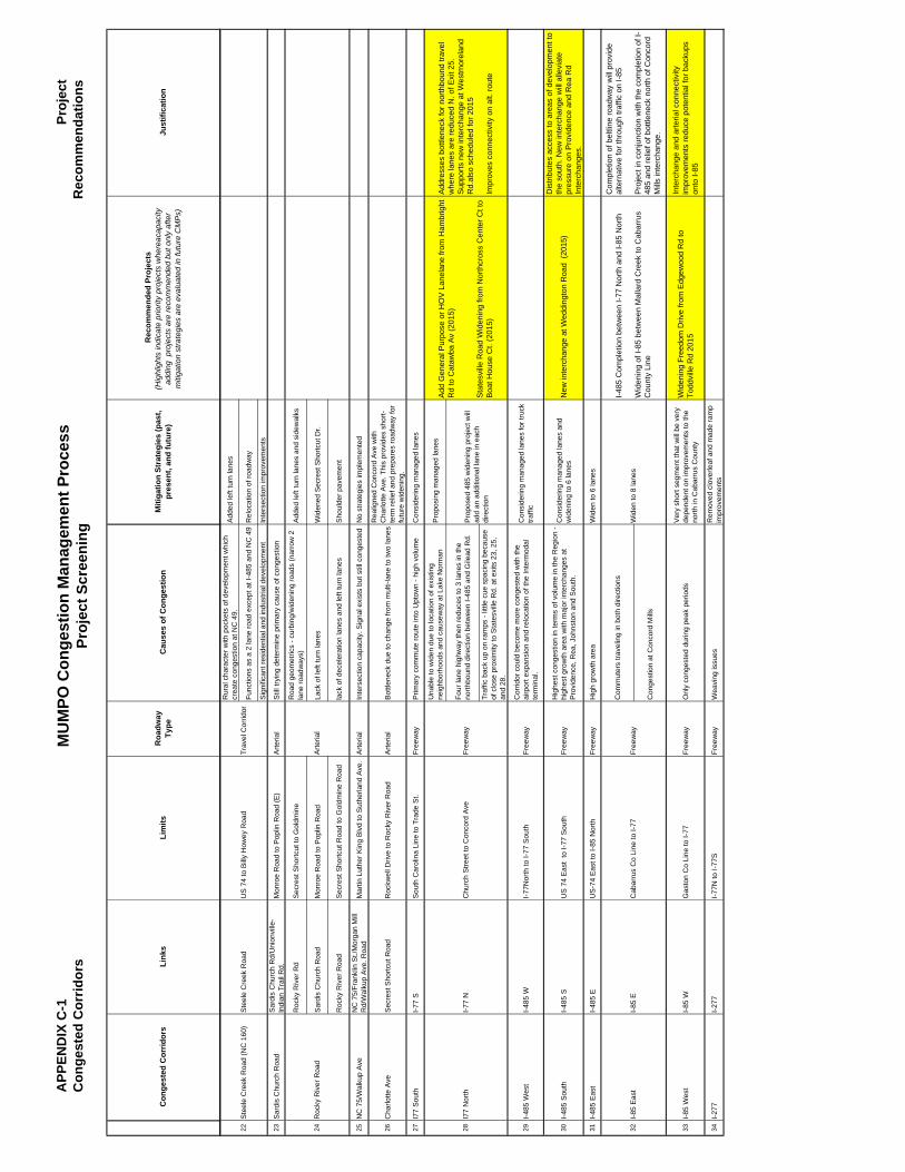
APP
END
IX C
-1C
onge
sted
Cor
ridor
sM
UM
PO C
onge
stio
n M
anag
emen
t Pro
cess
Proj
ect S
cree
ning
Proj
ect
Rec
omm
enda
tions
Roa
dway
Ty
pe
Rec
omm
ende
d Pr
ojec
ts(H
ighl
ight
s in
dica
te p
riorit
y pr
ojec
ts w
here
acap
acity
ad
ding
pro
ject
s ar
e re
com
men
ded
but o
nly
afte
r m
itiga
tion
stra
tegi
es a
re e
valu
ated
in fu
ture
CM
Ps)
Just
ifica
tion
Con
gest
ed C
orrid
ors
Miti
gatio
n St
rate
gies
(pas
t, pr
esen
t, an
d fu
ture
)Li
nks
Lim
itsC
ause
s of
Con
gest
ion
Rur
al c
hara
cter
with
poc
kets
of d
evel
opm
ent w
hich
cr
eate
con
gest
ion
at N
C 4
9.A
dded
left
turn
lane
s
Func
tions
as
a 2
lane
road
exc
ept a
t I-4
85 a
nd N
C 4
9R
eloc
atio
n of
road
way
Sig
nific
ant r
esid
entia
l and
indu
stria
l dev
elop
men
tIn
ters
ectio
n im
prov
emen
ts
23S
ardi
s C
hurc
h R
oad
Sar
dis
Chu
rch
Rd/
Uni
onvi
lle-
Indi
an T
rail
Rd.
Mon
roe
Roa
d to
Pop
lin R
oad
(E)
Arte
rial
Stil
l try
ing
dete
rmin
e pr
imar
y ca
use
of c
onge
stio
n
Roc
ky R
iver
Rd
Sec
rest
Sho
rtcut
to G
oldm
ine
Roa
d ge
omet
rics
- cur
bing
/wid
enin
g ro
ads
(nar
row
2
lane
road
way
s)A
dded
left
turn
lane
s an
d si
dew
alks
Sar
dis
Chu
rch
Roa
dM
onro
e R
oad
to P
oplin
Roa
d La
ck o
f lef
t tur
n la
nes
Wid
ened
Sec
rest
Sho
rtcut
Dr.
Roc
ky R
iver
Roa
dS
ecre
st S
hortc
ut R
oad
to G
oldm
ine
Roa
dla
ck o
f dec
eler
atio
n la
nes
and
left
turn
lane
sS
houl
der p
avem
ent
25N
C 7
5/W
alku
p A
veN
C 7
5/Fr
ankl
in S
t./M
orga
n M
ill
Rd/
Wal
kup
Ave
. Roa
dM
artin
Lut
her K
ing
Blv
d to
Sut
herla
nd A
ve.
Arte
rial
Inte
rsec
tion
capa
city
. Sig
nal e
xist
s bu
t stil
l con
gest
edN
o st
rate
gies
impl
emen
ted
26C
harlo
tte A
veS
ecre
st S
hortc
ut R
oad
Roc
kwel
l Driv
e to
Roc
ky R
iver
Roa
dA
rteria
l B
ottle
neck
due
to c
hang
e fro
m m
ulti-
lane
to tw
o la
nes
Rea
ligne
d C
onco
rd A
ve w
ith
Cha
rlotte
Ave
. Thi
s pr
ovid
es s
hort-
term
relie
f and
pre
pare
s ro
adw
ay fo
r fu
ture
wid
enin
g.
27I7
7 S
outh
I-77
SS
outh
Car
olin
a Li
ne to
Tra
de S
t. Fr
eew
ayP
rimar
y co
mm
ute
rout
e in
to U
ptow
n - h
igh
volu
me
Con
side
ring
man
aged
lane
s
Una
ble
to w
iden
due
to lo
catio
n of
exi
stin
g ne
ighb
orho
ods
and
caus
eway
at L
ake
Nor
man
Pro
posi
ng m
anag
ed la
nes
Four
lane
hig
hway
then
redu
ces
to 3
lane
s in
the
north
boun
d di
rect
ion
betw
een
I-485
and
Gile
ad R
d.
Traf
fic b
ack
up o
n ra
mps
- lit
tle c
ue s
paci
ng b
ecau
se
of c
lose
pro
xim
ity to
Sta
tesv
ille
Rd.
at e
xits
23,
25,
an
d 28
.
29I-4
85 W
est
I-485
WI-7
7Nor
th to
I-77
Sou
thFr
eew
ayC
orrid
or c
ould
bec
ome
mor
e co
nges
ted
with
the
airp
ort e
xpan
sion
and
relo
catio
n of
the
Inte
rmod
al
term
inal
.
Con
side
ring
man
aged
lane
s fo
r tru
ck
traffi
c
30I-4
85 S
outh
I-485
SU
S 7
4 E
ast
to I-
77 S
outh
Free
way
Hig
hest
con
gest
ion
in te
rms
of v
olum
e in
the
Reg
ion
- hi
ghes
t gro
wth
are
a w
ith m
ajor
inte
rcha
nges
at
Pro
vide
nce,
Rea
, Joh
nsto
n an
d S
outh
.
Con
side
ring
man
aged
lane
s an
d w
iden
ing
to 6
lane
sN
ew in
terc
hang
e at
Wed
ding
ton
Roa
d (2
015)
Dis
tribu
tes
acce
ss to
are
as o
f dev
elop
men
t to
the
sout
h. N
ew in
terc
hang
e w
ill a
llevi
ate
pres
sure
on
Pro
vide
nce
and
Rea
Rd
Inte
rcha
nges
.
31I-4
85 E
ast
I-485
EU
S-7
4 E
ast t
o I-8
5 N
orth
Free
way
Hig
h gr
owth
are
aW
iden
to 6
lane
s
Com
mut
ers
trave
ling
in b
oth
dire
ctio
ns
Con
gest
ion
at C
onco
rd M
ills
33I-8
5 W
est
I-85
WG
asto
n C
o Li
ne to
I-77
Free
way
Onl
y co
nges
ted
durin
g pe
ak p
erio
dsV
ery
shor
t seg
men
t tha
t will
be
very
de
pend
ent o
n im
prov
emen
ts to
the
north
in C
abar
rus
Cou
nty
Wid
enin
g Fr
eedo
m D
rive
from
Edg
ewoo
d R
d to
To
ddvi
lle R
d 20
15
Inte
rcha
nge
and
arte
rial c
onne
ctiv
ity
impr
ovem
ents
redu
ce p
oten
tial f
or b
acku
ps
onto
I-85
34I-2
77I-2
77I-7
7N to
I-77
SFr
eew
ayW
eavi
ng is
sues
Rem
oved
clo
verle
af a
nd m
ade
ram
p im
prov
emen
ts
22 28
Wid
en to
8 la
nes
I-85
Eas
t32
Pro
pose
d 48
5 w
iden
ing
proj
ect w
ill
add
an a
dditi
onal
lane
in e
ach
dire
ctio
n
Cab
arru
s C
o Li
ne to
I-77
I-85
EFr
eew
ay
I77
Nor
thI-7
7 N
Free
way
Ste
ele
Cre
ek R
oad
Trav
el C
orrid
orU
S 7
4 to
Bill
y H
owey
Roa
dS
teel
e C
reek
Roa
d (N
C 1
60)
24
I-485
Com
plet
ion
betw
een
I-77
Nor
th a
nd I-
85 N
orth
Wid
enin
g of
I-85
bet
wee
n M
alla
rd C
reek
to C
abar
rus
Cou
nty
Line
Com
plet
ion
of b
eltli
ne ro
adw
ay w
ill p
rovi
de
alte
rnat
ive
for t
hrou
gh tr
affic
on
I-85
Pro
ject
in c
onju
nctio
n w
ith th
e co
mpl
etio
n of
I-48
5 an
d re
lief o
f bot
tlene
ck n
orth
of C
onco
rd
Mill
s in
terc
hang
e.
Add
ress
es b
ottle
neck
for n
orth
boun
d tra
vel
whe
re la
nes
are
redu
ced
N. o
f Exi
t 25.
S
uppo
rts n
ew in
terc
hang
e at
Wes
tmor
elan
d R
d.al
so s
ched
uled
for 2
015
Impr
oves
con
nect
ivity
on
alt.
rout
e
Add
Gen
eral
Pur
pose
or H
OV
Lan
elan
e fro
m H
ambr
ight
R
d to
Cat
awba
Av
(201
5)
Sta
tesv
ille
Roa
d W
iden
ing
from
Nor
thcr
oss
Cen
ter C
t to
Boa
t Hou
se C
t. (2
015)
Roc
ky R
iver
Roa
dA
rteria
l
Chu
rch
Stre
et to
Con
cord
Ave
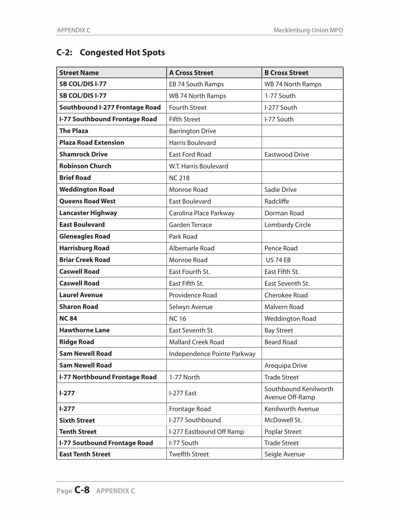
C-2: Congested Hot Spots
Street Name A Cross Street B Cross Street
SB COL/DIS I-77 EB 74 South Ramps WB 74 North Ramps
SB COL/DIS I-77 WB 74 North Ramps 1-77 South
Southbound I-277 Frontage Road Fourth Street I-277 South
I-77 Southbound Frontage Road Fifth Street I-77 South
The Plaza Barrington Drive
Plaza Road Extension Harris Boulevard
Shamrock Drive East Ford Road Eastwood Drive
Robinson Church W.T. Harris Boulevard
Brief Road NC 218
Weddington Road Monroe Road Sadie Drive
Queens Road West East Boulevard Radcliffe
Lancaster Highway Carolina Place Parkway Dorman Road
East Boulevard Garden Terrace Lombardy Circle
Gleneagles Road Park Road
Harrisburg Road Albemarle Road Pence Road
Briar Creek Road Monroe Road US 74 EB
Caswell Road East Fourth St. East Fifth St.
Caswell Road East Fifth St. East Seventh St.
Laurel Avenue Providence Road Cherokee Road
Sharon Road Selwyn Avenue Malvern Road
NC 84 NC 16 Weddington Road
Hawthorne Lane East Seventh St. Bay Street
Ridge Road Mallard Creek Road Beard Road
Sam Newell Road Independence Pointe Parkway
Sam Newell Road Arequipa Drive
I-77 Northbound Frontage Road 1-77 North Trade Street
I-277 I-277 EastSouthbound Kenilworth Avenue Off-Ramp
I-277 Frontage Road Kenilworth Avenue
Sixth Street I-277 Southbound McDowell St.
Tenth Street I-277 Eastbound Off Ramp Poplar Street
I-77 Soutbound Frontage Road I-77 South Trade Street
East Tenth Street Twelfth Street Seigle Avenue
APPENDIX C Mecklenburg-Union MPO
Page C-8 APPENDIX C
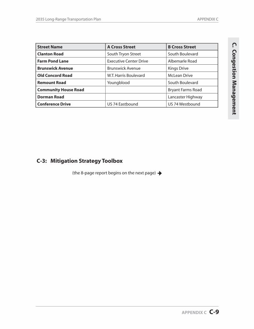
Street Name A Cross Street B Cross Street
Clanton Road South Tryon Street South Boulevard
Farm Pond Lane Executive Center Drive Albemarle Road
Brunswick Avenue Brunswick Avenue Kings Drive
Old Concord Road W.T. Harris Boulevard McLean Drive
Remount Road Youngblood South Boulevard
Community House Road Bryant Farms Road
Dorman Road Lancaster Highway
Conference Drive US 74 Eastbound US 74 Westbound
C-3: Mitigation Strategy Toolbox
(the 8-page report begins on the next page)
APPENDIX C2035 Long-Range Transportation Plan
APPENDIX C C-9
C. C
on
gestio
n M
anag
emen
t
CON
GES
TIO
N M
AN
AG
EMEN
T TO
OLB
OX
PREP
ARE
D B
Y: U
RS C
ORP
OR
ATIO
N
NO
VEM
BER
2009
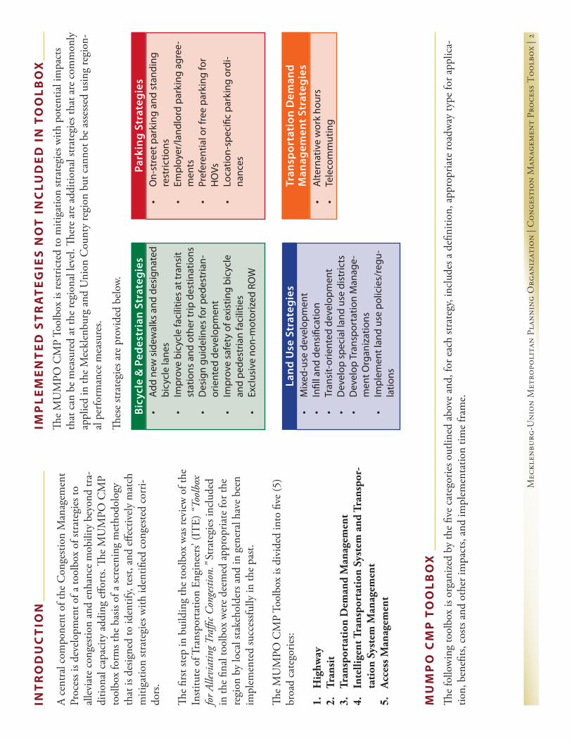
Mec
klen
burg
-Uni
on M
etro
poli
tan
Plan
ning
Org
aniz
atio
n | C
onge
stio
n M
anag
emen
t Pr
oces
s T
oolb
ox |
2
A ce
ntra
l com
pone
nt o
f the
Con
gesti
on M
anag
emen
t Pr
oces
s is d
evel
opm
ent o
f a to
olbo
x of
stra
tegi
es to
al
levi
ate
cong
estio
n an
d en
hanc
e m
obili
ty b
eyon
d tr
a-di
tiona
l cap
acity
add
ing
effor
ts. Th
e M
UM
PO C
MP
tool
box
form
s the
bas
is of
a sc
reen
ing
met
hodo
logy
th
at is
des
igne
d to
iden
tify,
test,
and
effe
ctiv
ely
mat
ch
miti
gatio
n str
ateg
ies w
ith id
entifi
ed c
onge
sted
corr
i-do
rs.
The
first
step
in b
uild
ing
the
tool
box
was
revi
ew o
f the
In
stitu
te o
f Tra
nspo
rtat
ion
Engi
neer
s’ (I
TE)
“To
olbo
x fo
r Alle
viat
ing T
raffi
c Con
gesti
on.”
Stra
tegi
es in
clud
ed
in th
e fin
al to
olbo
x w
ere
deem
ed a
ppro
pria
te fo
r the
re
gion
by
loca
l sta
keho
lder
s and
in g
ener
al h
ave
been
im
plem
ente
d su
cces
sfully
in th
e pa
st.
The
MU
MPO
CM
P To
olbo
x is
divi
ded
into
five
(5)
broa
d ca
tego
ries:
1.
Hig
hway
2.
Tran
sit
3.
Tran
spor
tati
on D
eman
d M
anag
emen
t4.
Inte
llige
nt T
rans
port
atio
n Sy
stem
and
Tra
nspo
r-ta
tion
Sys
tem
Man
agem
ent
5.
Acc
ess M
anag
emen
t
INT
RO
DU
CT
ION
Bicy
cle
& P
edes
tria
n St
rate
gies
•Ad
dne
ws
idew
alks
and
des
igna
ted
bicy
cle
lane
s•
Impr
ove
bicy
cle
faci
litie
sat
tran
sit
stat
ions
and
oth
ertr
ipd
estin
atio
ns•
Des
ign
guid
elin
esfo
rped
estr
ian-
orie
nted
dev
elop
men
t•
Impr
ove
safe
tyo
fexi
stin
gbi
cycl
ean
dpe
dest
rian
faci
litie
s•
Excl
usiv
eno
n-m
otor
ized
RO
W
Land
Use
Str
ateg
ies
•M
ixed
-use
dev
elop
men
t•
Infil
land
den
sific
atio
n•
Tran
sit-
orie
nted
dev
elop
men
t•
Dev
elop
spe
cial
land
use
dis
tric
ts•
Dev
elop
Tra
nspo
rtat
ion
Man
age-
men
tOrg
aniz
atio
ns•
Impl
emen
tlan
dus
epo
licie
s/re
gu-
latio
ns
Park
ing
Stra
tegi
es•
On-
stre
etp
arki
nga
nds
tand
ing
rest
rictio
ns•
Empl
oyer
/land
lord
par
king
agr
ee-
men
ts•
Pref
eren
tialo
rfre
epa
rkin
gfo
rH
OVs
•Lo
catio
n-sp
ecifi
cpa
rkin
gor
di-
nanc
es
Tran
spor
tati
on D
eman
d
Man
agem
ent S
trat
egie
s•
Alte
rnat
ive
wor
kho
urs
•Te
leco
mm
utin
g
The
MU
MPO
CM
P To
olbo
x is
restr
icte
d to
miti
gatio
n str
ateg
ies w
ith p
oten
tial i
mpa
cts
that
can
be
mea
sure
d at
the
regi
onal
leve
l. Th
ere
are
addi
tiona
l str
ateg
ies t
hat a
re c
omm
only
ap
plie
d in
the
Mec
klen
burg
and
Uni
on C
ount
y re
gion
but
can
not b
e as
sess
ed u
sing
regi
on-
al p
erfo
rman
ce m
easu
res.
Thes
e str
ateg
ies a
re p
rovi
ded
belo
w.
IMP
LE
ME
NT
ED
ST
RA
TE
GIE
S N
OT
IN
CLU
DE
D I
N T
OO
LB
OX
The
follo
win
g to
olbo
x is
orga
nize
d by
the
five
cate
gorie
s out
lined
abo
ve a
nd, f
or e
ach
strat
egy,
incl
udes
a d
efini
tion,
app
ropr
iate
road
way
type
for a
pplic
a-tio
n, b
enefi
ts, c
osts
and
othe
r im
pact
s, an
d im
plem
enta
tion
time
fram
e.
MU
MP
O C
MP
TO
OL
BO
X
Mec
klen
burg
-Uni
on M
etro
poli
tan
Plan
ning
Org
aniz
atio
n | C
onge
stio
n M
anag
emen
t Pr
oces
s T
oolb
ox |
3
Stra
tegy
Cong
esti
on Im
pact
sCo
sts
& O
ther
Impa
cts
Road
way
Typ
eIm
plem
enta
tion
Per
iod
Impl
emen
tatio
n Pe
riods
:
Shor
t-te
rm: 1
-5 y
ears
Med
ium
Term
: 5-1
0 ye
ars
Lo
ng Te
rm: 1
0+ y
ears
•Ar
teria
ls: S
hort
-term
•Fr
eew
ay: M
ediu
m-te
rm•
Con
struc
tion
&
Engi
neer
ing
•M
aint
enan
ce•
Lim
ited
Spac
e fo
r Inc
i-de
nt R
espo
nse
if sh
ould
er
rem
oved
•Sa
fety
, if m
edia
n re
mov
ed
•In
crea
se c
apac
ityAl
l
Take
s adv
anta
ge o
f exc
ess w
idth
in h
ighw
ay
cros
s-se
ctio
n (in
clud
ing
med
ians
or s
houl
ders
) us
ed fo
r bre
akdo
wn
lane
s or m
edia
n.
1a. I
ncre
ase
Num
ber
of L
anes
wit
hout
W
iden
ing
Roa
d
Impl
emen
tati
on P
erio
d
1.
HIG
HW
AY
•Sh
ort-t
erm
•C
osts
vary
by
type
of
desig
n•
Impr
ove
mob
ility
•Re
duce
con
gesti
on b
y im
prov
ing
bottl
enec
ks•
Incr
ease
traffi
c flo
w a
nd
impr
ove
safe
ty
All
Incl
udes
wid
enin
g to
pro
vide
shou
lder
s, ad
-di
tiona
l tur
n la
nes a
t int
erse
ctio
ns, i
mpr
oved
sig
ht li
nes,
and
auxi
liary
lane
s to
impr
ove
mer
ging
and
div
ergi
ng. U
ncon
vent
iona
l int
er-
sect
ions
incl
ude
quad
rant
road
way
, bow
tie,
an
d ro
unda
bout
s.
1b. I
mpl
emen
t Geo
met
ric
Des
ign
Im-
prov
emen
ts/U
ncon
vent
iona
l Int
erse
ctio
n Tr
eatm
ents
•M
ediu
m-te
rm•
Cos
ts de
pend
on
con-
struc
tion-
-sep
arat
e RO
W
cost,
bar
rier s
epar
ated
co
sts, c
ontr
aflow
cos
ts•
Annu
al o
pera
tions
and
en
forc
emen
t•
Can
cre
ate
envi
ronm
enta
l an
d co
mm
unity
impa
cts
•Re
duce
regi
onal
VM
T•
Redu
ce tr
ansit
del
ay•
Redu
ce re
gion
al tr
ips
•In
crea
se v
ehic
le o
ccu-
panc
y•
Impr
ove
trav
el ti
mes
•Re
duce
tran
sit d
elay
or
incr
ease
tran
sit tr
avel
Free
way
Incl
udes
HO
V, H
OT,
and
truc
k on
ly la
nes.
Can
incl
ude
cons
truc
ting
sepa
rate
RO
W, c
on-
struc
ting
barr
iers
, and
impl
emen
ting
cont
ra
flow
lane
s.
1c. M
anag
ed L
anes
•M
ediu
m-te
rm•
Con
struc
tion
&
En
gine
erin
g su
bsta
ntia
l fo
r gra
de se
para
tion
•M
aint
enan
ce m
ay v
ary
by a
rea
•In
crea
se c
apac
ity•
Impr
ove
mob
ility
Maj
or A
rter
ials
Invo
lves
con
vert
ing
exist
ing
maj
or a
rter
i-al
s with
sign
alize
d in
ters
ectio
ns in
to “s
uper
str
eets”
that
restr
ict l
eft-t
urn
mov
emen
ts. C
an
incl
ude
grad
e-se
para
tion.
1d. S
uper
Str
eet A
rter
ials
Mec
klen
burg
-Uni
on M
etro
poli
tan
Plan
ning
Org
aniz
atio
n | C
onge
stio
n M
anag
emen
t Pr
oces
s T
oolb
ox |
4
Stra
tegy
Cong
esti
on Im
pact
sCo
sts
& O
ther
Impa
cts
Road
way
Typ
eIm
plem
enta
tion
Per
iod
Impl
emen
tatio
n Pe
riods
:
Shor
t-te
rm: 1
-5 y
ears
Med
ium
Term
: 5-1
0 ye
ars
Lo
ng Te
rm: 1
0+ y
ears
•Lo
ng-te
rm•
Cos
t var
y•
Can
cre
ate
envi
ronm
en-
tal l
and
and
com
mun
ity
impa
cts
•In
crea
se c
apac
ity•
Impr
ove
mob
ility
All
1.
HIG
HW
AY
(C
ON
T’D
)
Adds
new
hig
hway
lane
s; tr
aditi
onal
way
to
deal
with
con
gesti
on
1f. H
ighw
ay W
iden
ing
by A
ddin
g La
nes
•Sh
ort-t
erm
•Lo
st re
venu
e pe
r rid
er•
Cap
ital c
osts
per p
asse
n-ge
r trip
•O
pera
ting
costs
per
pas
-se
nger
trip
like
ly d
ecre
ase
•O
pera
ting
subs
idie
s ne
eded
to re
plac
e lo
st fa
re re
venu
e•
Alte
rnat
ive
finan
cial
ar-
rang
emen
ts ne
ed to
be
nego
tiate
d w
ith d
onor
ag
enci
es
•Re
duce
dai
ly V
MT
•Re
duce
con
gesti
on•
Incr
ease
tran
sit ri
ders
hip
All
This
enco
urag
es a
dditi
onal
tran
sit u
se, t
o th
e ex
tent
that
hig
h fa
res a
re a
real
bar
rier t
o tr
an-
sit. F
or M
UM
PO re
gion
, inc
lude
s ozo
ne a
lert
da
ys a
nd e
vent
pas
ses.
2a. R
educ
e Tr
ansi
t Far
es2
. T
RA
NS
IT
•Sh
ort-t
erm
•C
apita
l cos
ts pe
r pas
sen-
ger t
rip•
Incr
ease
in o
pera
ting
costs
•
New
bus
pur
chas
es li
kely
•Re
duce
dai
ly V
MT
•D
ecre
ase
trav
el ti
me
•In
crea
se tr
ansit
ride
rshi
p
All
This
prov
ides
bet
ter a
cces
sibili
ty to
tran
sit to
a
grea
ter s
hare
of t
he p
opul
atio
n. In
crea
sing
frequ
ency
mak
es tr
ansit
mor
e at
trac
tive
to u
se.
2b. I
ncre
ase
Bus
Rou
te C
over
age
or F
re-
quen
cies
Addi
tiona
l con
nect
ivity
opt
ions
can
alle
viat
e co
nges
tion.
1g. A
dd C
onne
ctiv
ity
Prog
ram
All
•In
crea
se c
apac
ity•
Impr
ove
mob
ility
•C
ost v
ary
•C
an c
reat
e en
viro
nmen
-ta
l lan
d an
d co
mm
unity
im
pact
s
1e. E
limin
ate
At-G
rade
Rai
l Cro
ssin
gsAr
teria
ls•
Impr
ove
mob
ility
•In
crea
se tr
affic
flow
and
im
prov
e sa
fety
•C
onstr
uctio
n &
Engi
neer
ing
costs
•Lo
ng-te
rm
Mec
klen
burg
-Uni
on M
etro
poli
tan
Plan
ning
Org
aniz
atio
n | C
onge
stio
n M
anag
emen
t Pr
oces
s T
oolb
ox |
5
Stra
tegy
Cong
esti
on Im
pact
sCo
sts
& O
ther
Impa
cts
Road
way
Typ
eIm
plem
enta
tion
Per
iod
Impl
emen
tatio
n Pe
riods
:
Shor
t-te
rm: 1
-5 y
ears
Med
ium
Term
: 5-1
0 ye
ars
Lo
ng Te
rm: 1
0+ y
ears
•M
ediu
m-te
rm•
Stru
ctur
e co
sts fo
r tra
nsit
statio
ns•
Redu
ce re
gion
al V
MT
•In
crea
se m
obili
ty a
nd
tran
sit e
ffici
ency
Free
way
Maj
or A
rter
ial
Trav
el C
orrid
orC
an b
e us
ed in
con
junc
tion
with
man
aged
la
nes a
nd/o
r exp
ress
bus
serv
ices
. They
are
pa
rtic
ular
ly h
elpf
ul fo
r enc
oura
ging
man
aged
la
ne u
se fo
r lon
ger d
istan
ce c
omm
ute
trip
s.
2c. I
mpl
emen
ting
Par
k-an
d-R
ide
Lots
•Lo
ng-te
rm•
Cap
ital c
osts
per p
as-
seng
er•
New
syste
ms r
equi
re la
rge
up-fr
ont c
apita
l out
lays
&
ong
oing
sour
ces o
f op-
erat
ing
subs
idie
s, in
ad-
ditio
n to
fund
s tha
t may
be
obt
aine
d fro
m fe
dera
l so
urce
s, un
der i
ncre
as-
ingl
y tig
ht c
ompe
titio
n.
•Re
duce
dai
ly V
MT
Trav
el C
orrid
ors
This
best
serv
es d
ense
urb
an c
ente
rs w
here
tr
avel
ers c
an w
alk
to th
eir d
estin
atio
ns. R
apid
tr
ansit
from
subu
rban
are
as c
an so
met
imes
be
enha
nced
by
prov
idin
g pa
rk-a
nd-r
ide
lots.
2d. I
mpl
emen
t Rap
id T
rans
it
2.
TR
AN
SIT
(C
ON
T’D
)
•M
ediu
m-te
rm•
New
bus
pur
chas
es li
kely
Se
para
te R
OW
cos
ts•
Annu
al o
pera
tions
and
en
forc
emen
t•
Can
cre
ate
envi
ronm
enta
l an
d co
mm
unity
impa
cts
•In
crea
se tr
ansit
use
and
im
prov
e bu
s tra
vel t
imes
Trav
el C
orrid
ors
This
invo
lves
add
ing
new
lane
s for
bus
trav
el
only.
Can
incl
ude
new
par
k-an
d-rid
e lo
ts.
2e. I
nsta
ll B
us L
anes
•M
ediu
m-te
rm (t
ypic
ally
in
corp
orat
ed in
to ro
ad
proj
ects
•O
pera
ting
and
mai
nte-
nanc
e co
sts p
er si
gnal
•Si
gnal
ized
inte
rsec
tions
pe
r mile
cos
ts va
riabl
e
•Im
prov
e tr
ansit
trav
el
time
•In
crea
se tr
ansit
use
Trav
el C
orrid
ors
Invo
lves
spec
ial t
reat
men
t for
tran
sit a
t tra
ffic
signa
ls. S
igna
l pre
empt
ion
for r
ail a
nd a
djus
t-in
g re
d or
gre
en p
hase
for b
us.
2f. T
rans
it S
igna
l Pri
orit
izat
ion
•M
ediu
m-te
rm to
Lon
g-te
rm (l
onge
r ter
m fo
r new
fa
cilit
ies)
•Ad
min
istra
tive
costs
•In
crea
sed
reve
nue
per
pass
enge
r trip
•In
crea
se tr
ansit
use
•In
crea
se m
obili
ty a
nd
tran
sit e
ffici
ency
n/a
Invo
lves
con
struc
tion
of n
ew o
r exp
ansio
n of
ex
istin
g fa
cilit
ies u
tilize
d by
tran
sit p
asse
nger
s.
2g. C
onst
ruct
Add
itio
nal T
rans
it C
ente
r or
Exp
and
Exis
ting
Tra
nsit
Cen
ter
Mec
klen
burg
-Uni
on M
etro
poli
tan
Plan
ning
Org
aniz
atio
n | C
onge
stio
n M
anag
emen
t Pr
oces
s T
oolb
ox |
6
Stra
tegy
Cong
esti
on Im
pact
sCo
sts
& O
ther
Impa
cts
Road
way
Typ
eIm
plem
enta
tion
Per
iod
Impl
emen
tatio
n Pe
riods
:
Shor
t-te
rm: 1
-5 y
ears
Med
ium
Term
: 5-1
0 ye
ars
Lo
ng Te
rm: 1
0+ y
ears
2.
TR
AN
SIT
(C
ON
T’D
)
•Sh
ort-t
erm
•Sa
ving
s per
car
pool
&
vanp
ool r
ider
s•
Cos
ts pe
r yea
r per
free
pa
rkin
g sp
ace/
trip
pro
-vi
ded
•Ad
min
istra
tive
costs
•M
ost c
ost-e
ffect
ive
•Re
duce
wor
k V
MT
•Re
duce
SO
V tr
ips
Trav
el sh
eds
Rid
esha
ring
prog
ram
s are
typi
cally
arr
ange
d/en
cour
aged
thro
ugh
empl
oyer
s or t
rans
port
a-tio
n m
anag
emen
t age
ncie
s (T
MA)
, whi
ch
prov
ide
ride-
mat
chin
g se
rvic
es. R
ides
harin
g in
clud
es c
arpo
ols,
vanp
ools,
and
Gua
rant
eed
Rid
e H
ome
prog
ram
s.
3a. R
ides
hari
ng
•M
ediu
m-te
rm•
Impl
emen
tatio
n an
d m
aint
enan
ce c
osts
vary
•Su
bsta
ntia
l cap
ital i
nves
t-m
ent r
equi
red
•D
ecre
ase V
MT
•In
crea
se tr
ansit
and
non
-m
otor
ized
mod
e sh
ares
•Re
duce
del
ay•
Redu
ce tr
ansit
del
ay o
r in
crea
se tr
ansit
trav
el
times
Free
way
Mot
orist
s pay
for u
se o
f cer
tain
road
s and
br
idge
s. Th
is in
clud
es u
se o
f tra
ditio
nal t
oll
road
s. In
MU
MPO
regi
on, a
lso e
ncom
pass
es
chan
ge in
par
king
pric
es o
n ce
rtai
n da
ys to
en
cour
age
use
of a
ltern
ativ
es m
odes
.
3b. C
onge
stio
n Pr
icin
g
4.
INT
EL
LIG
EN
T T
RA
NS
PO
RTA
TIO
N S
YS
TE
M &
TR
AN
SP
OR
TAT
ION
SY
ST
EM
MA
NA
GE
ME
NT
•Sh
ort-t
erm
•O
pera
tions
and
mai
nte-
nanc
e co
sts p
er si
gnal
•Si
gnal
ized
inte
rsec
tions
pe
r mile
cos
ts va
riabl
e
•Im
prov
e tr
avel
tim
es•
Redu
ce th
e nu
mbe
r of
stops
•Re
duce
veh
icle
del
ay a
nd
asso
ciat
ed e
miss
ions
Arte
rials
This
impr
oves
traffi
c flo
w a
nd re
duce
s em
is-sio
ns b
y m
inim
izing
stop
s on
arte
rial s
treet
s.
4a. T
raffi
c Si
gnal
Coo
rdin
atio
n
•Sh
ort-t
erm
•Ba
rrie
r sep
arat
ed c
osts
per
mile
•O
pera
tion
costs
per
mile
•M
aint
enan
ce c
osts
vary
•Ty
pica
lly re
quire
s med
ian
rem
oval
- sa
fety
impa
cts
•O
verh
ead
signs
con
fusin
g
•In
crea
se p
eak
dire
ctio
n ca
paci
ty•
Redu
ce p
eak
trav
el ti
mes
•Im
prov
e m
obili
ty
Arte
rials
Thes
e ar
e ap
prop
riate
whe
re tr
affic
flow
is
high
ly d
irect
iona
l.
4b. R
ever
sibl
e Tr
avel
Lan
es
•M
ediu
m-te
rm
•St
ruct
ure
costs
for s
tatio
n an
d in
terc
hang
e•
Incr
ease
tran
sit u
se•
Incr
ease
mob
ility
and
tr
ansit
effi
cien
cy
Free
way
Prov
ides
dire
ct c
onne
ctio
n to
par
k an
d rid
e lo
ts
2h. C
onst
ruct
Tra
nsit
Onl
y In
terc
hang
e
3.
TR
AN
SP
OR
TAT
ION
DE
MA
ND
MA
NA
GE
ME
NT
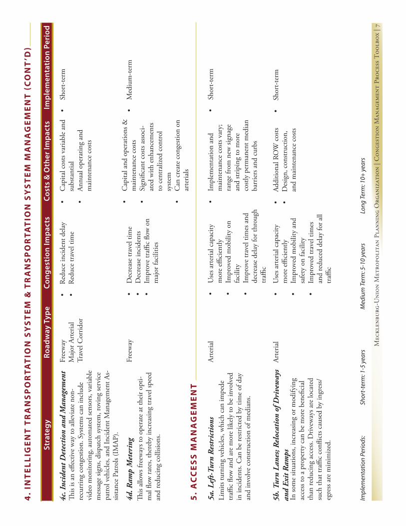
Mec
klen
burg
-Uni
on M
etro
poli
tan
Plan
ning
Org
aniz
atio
n | C
onge
stio
n M
anag
emen
t Pr
oces
s T
oolb
ox |
7
Stra
tegy
Cong
esti
on Im
pact
sCo
sts
& O
ther
Impa
cts
Road
way
Typ
eIm
plem
enta
tion
Per
iod
Impl
emen
tatio
n Pe
riods
:
Shor
t-te
rm: 1
-5 y
ears
Med
ium
Term
: 5-1
0 ye
ars
Lo
ng Te
rm: 1
0+ y
ears
•Sh
ort-t
erm
•C
apita
l cos
ts va
riabl
e an
d su
bsta
ntia
l•
Annu
al o
pera
ting
and
mai
nten
ance
cos
ts
•Re
duce
inci
dent
del
ay•
Redu
ce tr
avel
tim
eFr
eew
ayM
ajor
Art
eria
lTr
avel
Cor
ridor
This
is an
effe
ctiv
e w
ay to
alle
viat
e no
n-re
curr
ing
cong
estio
n. S
yste
ms c
an in
clud
e vi
deo
mon
itorin
g, a
utom
ated
sens
ors,
varia
ble
mes
sage
sign
s, di
spat
ch sy
stem
, rov
ing
serv
ice
patro
l veh
icle
s, an
d In
cide
nt M
anag
emen
t As-
sista
nce
Patro
ls (I
MAP
).
4c. I
ncid
ent D
etec
tion
and
Man
agem
ent
•M
ediu
m-te
rm•
Dec
reas
e tr
avel
tim
e•
Dec
reas
e in
cide
nts
•Im
prov
e tr
affic
flow
on
maj
or fa
cilit
ies
Free
way
This
allo
ws f
reew
ays t
o op
erat
e at
thei
r opt
i-m
al fl
ow ra
tes,
ther
eby
incr
easin
g tr
avel
spee
d an
d re
duci
ng c
ollis
ions
.
4d. R
amp
Met
erin
g
4.
INT
EL
LIG
EN
T T
RA
NS
PO
RTA
TIO
N S
YS
TE
M &
TR
AN
SP
OR
TAT
ION
SY
ST
EM
MA
NA
GE
ME
NT
(C
ON
T’D
)
•C
apita
l and
ope
ratio
ns &
m
aint
enan
ce c
osts
•Si
gnifi
cant
cos
ts as
soci
-at
ed w
ith e
nhan
cem
ents
to c
entr
alize
d co
ntro
l sy
stem
•C
an c
reat
e co
nges
tion
on
arte
rials
•Sh
ort-t
erm
•Im
plem
enta
tion
and
mai
nten
ance
cos
ts va
ry;
rang
e fro
m n
ew si
gnag
e an
d str
ipin
g to
mor
e co
stly
perm
anen
t med
ian
barr
iers
and
cur
bs
•U
ses a
rter
ial c
apac
ity
mor
e effi
cien
tly•
Impr
oved
mob
ility
on
faci
lity
•Im
prov
e tr
avel
tim
es a
nd
decr
ease
del
ay fo
r thr
ough
tr
affic
Arte
rial
Lim
its tu
rnin
g ve
hicl
es, w
hich
can
impe
de
traffi
c flo
w a
nd a
re m
ore
likel
y to
be
invo
lved
in
inci
dent
s. C
an b
e re
stric
ted
by ti
me
of d
ay
and
invo
lve
cons
truc
tion
of m
edia
ns.
5a. L
eft-
Turn
Res
tric
tion
s
5.
AC
CE
SS
MA
NA
GE
ME
NT
•Sh
ort-t
erm
•Ad
ditio
nal R
OW
cos
ts•
Des
ign,
con
struc
tion,
an
d m
aint
enan
ce c
osts
•U
ses a
rter
ial c
apac
ity
mor
e effi
cien
tly•
Impr
oved
mob
ility
and
sa
fety
on
faci
lity
•Im
prov
ed tr
avel
tim
es
and
redu
ced
dela
y fo
r all
traffi
c
Arte
rial
In so
me
situa
tions
, inc
reas
ing
or m
odify
ing
acce
ss to
a p
rope
rty
can
be m
ore
bene
ficia
l th
an re
duci
ng a
cces
s. D
rivew
ays a
re lo
cate
d su
ch th
at tr
affic
confl
icts
caus
ed b
y in
gres
s/eg
ress
are
min
imize
d.
5b. T
urn
Lane
s; R
eloc
atio
n of
Dri
vew
ays
and
Exit
Ram
ps

Mec
klen
burg
-Uni
on M
etro
poli
tan
Plan
ning
Org
aniz
atio
n | C
onge
stio
n M
anag
emen
t Pr
oces
s T
oolb
ox |
8
Stra
tegy
Cong
esti
on Im
pact
sCo
sts
& O
ther
Impa
cts
Road
way
Typ
eIm
plem
enta
tion
Per
iod
Impl
emen
tatio
n Pe
riods
:
Shor
t-te
rm: 1
-5 y
ears
Med
ium
Term
: 5-1
0 ye
ars
Lo
ng Te
rm: 1
0+ y
ears
5.
AC
CE
SS
MA
NA
GE
ME
NT
(C
ON
T’D
)
•Sh
ort-t
erm
•D
esig
n an
d co
nstr
uctio
n co
sts•
Use
s roa
dway
cap
acity
m
ore
effici
ently
•Im
prov
ed m
obili
ty
Impr
oved
trav
el ti
me
and
redu
ced
dela
y fo
r thr
ough
tr
affic
•Fe
wer
inci
dent
s due
to
few
er c
onfli
ct p
oint
s
Free
way
Invo
lves
dec
reas
ing
wea
ving
sect
ion
on fr
ee-
way
s.
5c. I
nter
chan
ge M
odifi
cati
ons
•Sh
ort-t
erm
•D
esig
n an
d co
nstr
uctio
n co
sts d
urin
g im
plem
enta
-tio
n•
Long
term
impa
cts
•U
ses a
rter
ial c
apac
ity
mor
e effi
cien
tly•
Impr
oved
mob
ility
Im
prov
ed tr
avel
tim
e an
d re
duce
d de
lay
for t
hrou
gh
traffi
c
Arte
rials
Trav
el C
orrid
orC
an in
clud
e dr
ivew
ay sp
acin
g an
d po
licie
s for
ne
w b
usin
ess a
ppro
vals.
5d. C
raft
Pol
icie
s tha
t Gov
ern
Acce
ss in
C
orri
dors
APPENDIX C Mecklenburg-Union MPO
Page C-18 APPENDIX C

D. En
viron
men
tD
. Enviro
nm
ent
APPENDIX D-1
APPENDIX D
Environment
D-1: Consultation Process Procedures . . . . . . . . . . . . . . . . . . . . . . . . . . . . Page D-1
D-2: Consultation Process Documentation . . . . . . . . . . . . . . . . . . . . . . . . Page D-3
D-3: Comments Received . . . . . . . . . . . . . . . . . . . . . . . . . . . . . . . . . . . . . . . . Page D-7
D-1: Consultation Process Procedures
Mecklenburg-Union Metropolitan Planning Organization2035 Long-Range Transportation Plan
Consultation Process Procedures
The Mecklenburg-Union Metropolitan Planning Organization (MUMPO) is committed to devel-oping “a transportation system that preserves and enhances the natural and built environment.” If this goal is to be achieved, the preparation of the long-range transportation plan (LRTP) must be guided by a comprehensive analysis of potential environmental constraints.
The purpose of this document is to outline the procedures MUMPO will follow in order to achieve this goal by fulfi lling and exceeding its responsibilities in relation to the Consultation process (23 CFR 450.322(g)) as it develops its 2035 Long-Range Transportation Plan. While not a formal part of MUMPO’s adopted Public Involvement Plan (PIP), these procedures are in the spirit of that document, which seeks to make public involvement, in its broadest sense, a means by which high quality transportation planning is accomplished.
Communication Methods
The Consultation process involves many agencies with offi ces outside the Charlotte area. In order to be as effective as possible, our primary means of communicating with the resource agencies will be by e-mail; however, other means will be used if preferred by a specifi c agency, if e-mail contact is not possible, or if the nature of the correspondence requires it.
MUMPO maintains a website (www.mumpo.org) that reaches a wide audience and, due to the dispersed nature of agency locations, will be relied upon to post relevant information. This will allow for information to be reviewed at times other than traditional meetings. The website has been updated with a section devoted to the Consultation process, and can be found at: www.mumpo.org/2035_LRTP_RAC.htm. Hardcopies of any document will be provided on request.
APPENDIX D Mecklenburg-Union MPO
Page D-2 APPENDIX D
Databases
Address List MUMPO will strive to develop and maintain an address list of all federal, state and local agencies responsible for land use management, natural resources, environmental protec-tion, conservation and historic preservation. The purpose of this will be to ensure that our outreach is as comprehensive as possible.
Environmental Data All agencies on the address list will be contacted and requested to provide the latest maps, inventories, plans and strategies. This request will be made as early as possible to ensure that the LRTP’s development is informed by the agencies’ information from the outset. The data will be used in MUMPO’s roadway project ranking process as staff and members of the Technical Coordinating Committee (TCC) compare the submitted information to the existing and proposed roadway network.
Outreach Efforts
There are several milestones in the preparation of an LRTP where the input of resource agencies will be crucial. MUMPO is committed to including the agencies at the following milestones:
LRTP Development Kick Off The PIP recommends that an Open House be held to begin the LRTP development effort. This event provides all concerned parties (resource agencies, public interest groups, the gen-eral public, etc.) with an opportunity to discuss signifi cant issues and concerns before any substantive work on LRTP preparation has begun.
Roadway Project Ranking This is a technical analysis of roadway projects nominated for potential inclusion in the LRTP by MUMPO’s member jurisdictions. The roadways are analyzed using the project ranking cri-teria adopted by the MPO (see Appendix A for details on the project ranking methodology. One criterion is entitled “Impacts on the Natural Environment,” which attempts to gauge a project’s potential environmental impact. Invitations will be extended to participate in the roadway project ranking process.
Final Project List Review The fi nal project list is the result of the roadway project ranking process. It is likely that some project scopes, descriptions, and/or limits will have been changed as a result of the technical review. The list will be endorsed by the Technical Coordinating Committee (TCC) and MPO and therefore is the list from which the fi scally constrained LRTP will be developed. To the greatest extent possible, documentation of the scores assigned to the “Impacts on the Natu-ral Environment” will be provided. A map of all projects will be available.
As this list constitutes the comprehensive list of potential LRTP projects, this review period will also provide MUMPO with the opportunity to discuss potential system-level mitigation strategies as per 23 CFR 450.322 (f )(7).
APPENDIX D2035 Long-Range Transportation Plan
APPENDIX D D-3
D. En
viron
men
t
Final Scored Project List Review The technical analysis is not complete until the “Reduces Congestion” criterion (from the project ranking criteria) scores are assigned by the travel demand model. This review will provide the agencies with an opportunity to review the fi nal, scored project list.
Draft Fiscally Constrained Project List Review After MUMPO develops its fi nancial plan, it will assess its future revenue and cost assump-tions against the project list and develop a draft project list which assigns projects to the LRTP’s horizon years.
Final Fiscally Constrained Project List Review The review of this list will take place in conjunction with the standard 30-day public com-ment period required for the LRTP.
On-Going Consultation
MUMPO recognizes that resource agencies have limited staff and resources, so it is important to note that while the above specifi c outreach efforts are important, other interaction with the resource agencies is welcomed. MUMPO’s website will be frequently updated with relevant information, allowing the agencies to analyze information at any time. Moreover, MUMPO en-courages individual agencies to contact staff with questions, comments, concerns, etc. about any project.
D-2: Consultation Process Documentation
Mecklenburg-Union Metropolitan Planning Organization2035 Long-Range Transportation Plan
Consultation Process Documentation
The information below documents MUMPO’s efforts to engage local, state and federal agencies involved with land use management, conservation, natural resources, environmental protec-tion and historic preservation in the development of the 2035 Long-Range Transportation Plan. These efforts are being undertaken to satisfy the Consultation requirements as outlined in 23 CFR 450.322(g).
1. The MUMPO website was updated on December 18, 2007 with a section on the 2035 Plan update. The section included a subsection entitled Resource Agency Consultation (RAC), and contained information that would assist those on MUMPO’s Consultation address lists with reviewing adopted documents. As of December 22, 2009 the RAC section included the following information:
APPENDIX D Mecklenburg-Union MPO
Page D-4 APPENDIX D
2030 LRTP 2030 LRTP Amendment II- May 2007 2030 LRTP Amendment - September 2005 Project Horizon Year Maps Goals & Objectives
2007-2013 State Transportation Improvement Program (This was the TIP in effect at the time the information was posted.)
2009-2015 State Transportation Improvement Program - Draft (The 2009-2015 TIP was in its “draft” stage at the time the information was posted.)
2030 Charlotte Area Transit System Corridor System Plan
Mecklenburg-Union Thoroughfare Plan
Roadway Project Ranking Criteria
MUMPO Contact Information
2035 LRTP Roadway Ranking Project List
Financially-constrained project lists based on varying revenue scenarios
2. A memo was sent to all agencies listed on the Local Consultation Address List and State & Federal Consultation Address List on December 18, 2007. This memo notifi ed the agencies that MUMPO was beginning the effort to update the LRTP and requested their “participation in the development and review of our Plan.” A specifi c request was made for the agencies’ latest “adopted maps, inventories, plans and strategies.” The stated response deadline was January 18, 2008. The memo referenced MUMPO’s website and the information available in the RAC section.
3. An e-mail was sent to all* parties on both Consultation address lists on January 7, 2008 notifying them that MUMPO’s project ranking process would begin in the near future and that they were invited to participate. Prior to this date, the RAC section of the website was updated to include this same information. The e-mail stated that the agencies would be contacted as soon as meetings were scheduled.
4. Southern Towns Meeting-January 17, 2008. This meeting allowed staff to meet with Meck-lenburg County’s southern towns (Matthews, Mint Hill (absent), Pineville) and the County’s Land Use & Environmental Services Agency (LUESA) staff to review maps depicting the cur-rent networks along with environmental features.
5. An email was sent on January 25, 2008 to all agencies on our Local Consultation Address List and State & Federal Consultation Address List notifying them of the dates of MUMPO’s LRTP update kick-off meetings on February 21 (Mecklenburg) and February 28 (Union).
6. An email was sent on February 1, 2008 to all agencies on our Local Consultation Address List and State & Federal Consultation Address List notifying them of the dates of MUMPO’s project ranking meetings.
7. A postcard was sent on February 6, 2008 to all agencies on our Local Consultation Address List and State & Federal Consultation Address List notifying them of the dates of MUMPO’s LRTP update kick-off meetings on February 21 (Meck;enburg) and February 28 (Union).
••••
APPENDIX D2035 Long-Range Transportation Plan
APPENDIX D D-5
D. En
viron
men
t
8. A presentation was made to the Union County Planners group on February 14, 2008. Those in attendance were asked to mark up maps to indicate such items as, new or pro-posed residential subdivisions, new or proposed commercial developments, updated envi-ronmental information (natural and human environment), etc.
9. The two LRTP kick-off meetings were held on Thursday, February 21 and Thursday, Feb-ruary 28, 2008. The February 21 meeting was held in conjunction with the Gaston MPO and provided an opportunity to meet with three environmental agencies: USF&W; WRC; DWQ (Feb 28 meeting).
10. June 4, 2008: E-mailed resource agencies seeking their input on how best to review MUMPO’s project list, which was endorsed at the May 21, 2008 MPO meeting.
11. July 10, 2008: Phone conversation with Suzanne Klimek, Director of Operations for the NC Ecosystem Enhancement Program (EEP). Discussed the basics of why the EEP was contact-ed as a part of MUMPO’s Consultation and Mitigation efforts. Committed to meeting with EEP staff in August to review the project list, map and other pertinent LRTP-related mate-rial, as well as to review the MPO process and how EEP can assist in the LRTP development process, particularly with the Mitigation component.
12. July 14, 2008: A presentation was made to the Charlotte-Mecklenburg Planning Commis-sion to discuss the LRTP and the Consultation requirements.
13. July 31, 2008: A meeting was held with EPA (Chris Militscher), US Fish & Wildlife Service (Marella Buncick) and the NC Wildlife Resources Commission (Marla Chambers) at the Char-lotte-Mecklenburg Government Center. The purpose of this meeting was to:• Familiarize agencies with MUMPO’s LRTP development• Introduce the full range of roadway projects that may go into the fi nal LRTP• Obtain feedback on the agencies’ concerns• Discuss MUMPO’s roadway ranking process & LRTP development• Review of projects and environmental comments• Discuss of agencies’ concerns
The EPA provided additional feedback in the form of a letter dated October 10, 2008.
14. August 21, 2008: Met with representatives of the Ecosystem Enhancement Program (EEP) of NC DENR. (Suzanne Klimek; Beth Harmon, James Stanfi ll) The primary purpose of the meeting was to discuss the required Mitigation element of the LRTP, but also to discuss the Consultation requirements. MPO staff conducted a Power Point presentation to introduce MUMPO (and MPOs in general) to the EEP. EEP staff discussed its role in the provision of mitigation for NCDOT projects.
15. September 4, 2008: Made presentation to Mecklenburg County’s Environmental Policy Coordinating Council (EPCC). The EPCC is a citizen advisory council formed to provide advi-sory services to the Mecklenburg County Board of Commissioners, specifi cally with regard to compiling and prioritizing important and strategic environmental issues the advisory boards, City, County and Towns are facing and/or addressing within the County and is made up of the following representatives:
APPENDIX D Mecklenburg-Union MPO
Page D-6 APPENDIX D
Chair of the Air Quality Commission,Chair of the Waste Management Advisory Board,Chair of the Stormwater Advisory Committee,Chair of the Planning Commission,Chair of the Zoning Board of Adjustment,Chair of the Park and Recreation Commission, andChair of the Building Development Commission.
Additionally, the EPCC consists of the following members by invitation:A representative of the Lake Norman Marine Commission,A representative of the Mt. Island Lake Marine Commission,A representative of the Lake Wylie Marine Commission,A representative of the Mecklenburg-Union Metropolitan Planning Organization,Chair of the Charlotte-Mecklenburg Utilities Committee,Chair of the Transit Services Advisory Committee,A representative from the City of Charlotte,A representative from the Town of Huntersville,A representative from the Town of Matthews,A representative from the Town of Cornelius,A representative from the Town of Pineville,A representative from the Town of Davidson, andA representative from the Town of Mint Hill
16. June 18, 2009: An email was sent to all parties on MUMPO’s Resource Agency Consultation (RAC) distribution list notifying them of the upcoming release of the fi nal ranked project list.
17. July 6, 2009: Email sent to all parties on MUMPO’s Resource Agency Consultation (RAC) distribution list notifying them that the initial ranked project list was available for review. The email included a link to MUMPO’s website where the list could be viewed; the ranking methodology was also attached.
18. August 7, 2009: Email sent to all parties on MUMPO’s Resource Agency Consultation (RAC) distribution list notifying them that draft fi nancially-constrained roadway project lists were available for review. The lists and maps provided information on road projects being con-sidered as a part of three scenarios being analyzed. The fi rst scenario assumed that no ad-ditional revenue will be available, the second scenario assumed 1/8 (0.125) of a cent of new revenue for roadways, and the third scenario assumed 1/4 (0.25) of a cent of new revenue for roadways. Comments were requested by September 2, 2009.
19. October 22, 2009: Email sent to all parties on MUMPO’s Resource Agency Consultation (RAC) distribution list notifying them that MUMPO had updated its long-range transpor-tation plan (LRTP) update information by preparing maps that overlaid draft 2035 LRTP roadway networks on the environmental features map.
APPENDIX D2035 Long-Range Transportation Plan
APPENDIX D D-7
D. En
viron
men
t
Comments Received
US EPA 10-10-08LUESA/EPCC 11-9-09US Fish & Wildlife 11-13-09
Regularly Scheduled Staff Meetings
In addition to the above correspondence, MUMPO held monthly staff-level meetings of interest-ed and affected parties who were a part of the LRTP development process. This group met the third Wednesday of each month between May 2009 and January 2010 to review the process, so-licit peer review, and manage the plan document development. The invited agencies included:
Charlotte Department of Transportation NCDOT-Transportation Planning BranchCharlotte Area Transit SystemUnion County Public WorksNorth Carolina Turnpike AuthorityMecklenburg County Parks and RecreationFederal Highway AdministrationTown of HuntersvilleCity of Monroe
Members of this group wrote and reviewed all sections of the plan, but did not specifi cally ad-dress environmental issues with projects. Rather, the staff members incorporated these issues into the overall plan.
D-3: Comments Received (pages D-8 through D-15)
APPENDIX D Mecklenburg-Union MPO
Page D-8 APPENDIX D
APPENDIX D2035 Long-Range Transportation Plan
APPENDIX D D-9
D. En
viron
men
t
APPENDIX D Mecklenburg-Union MPO
Page D-10 APPENDIX D
APPENDIX D2035 Long-Range Transportation Plan
APPENDIX D D-11
D. En
viron
men
t
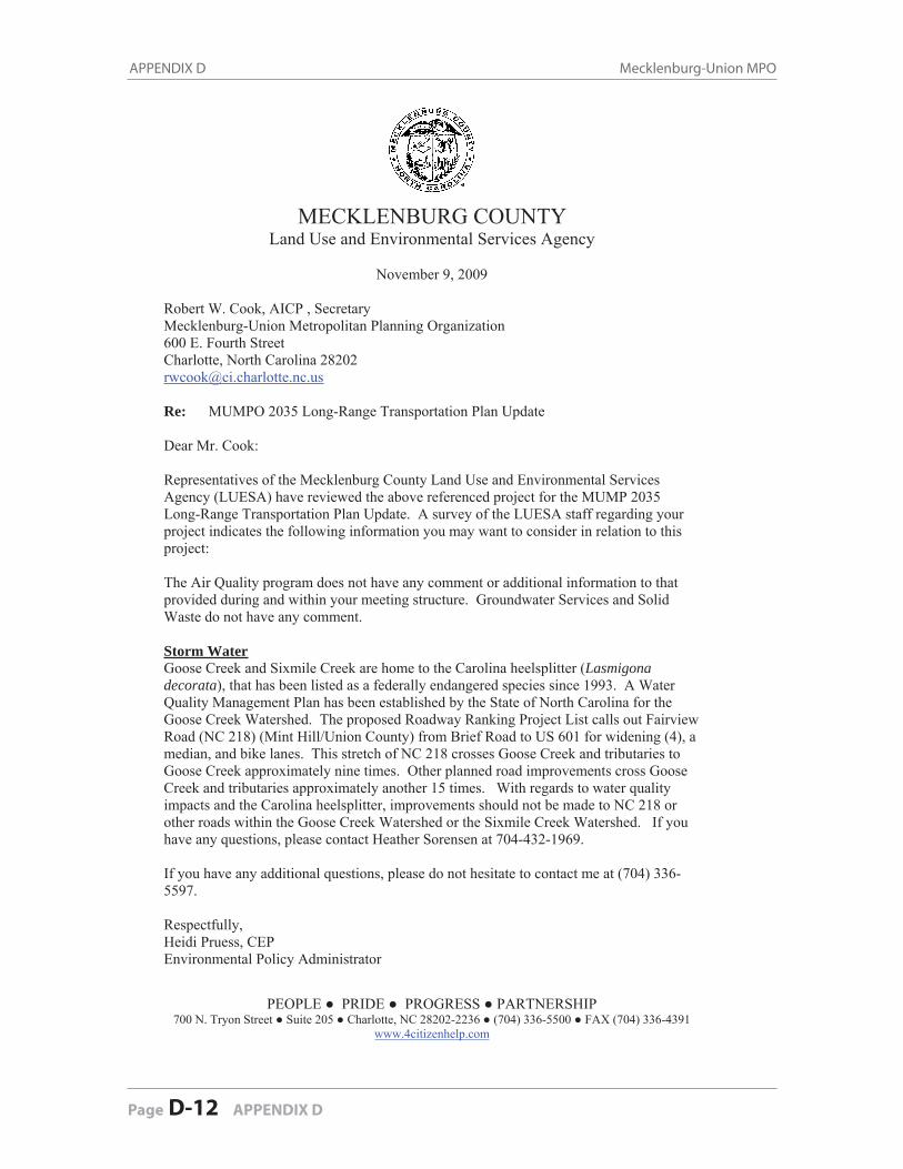
APPENDIX D Mecklenburg-Union MPO
Page D-12 APPENDIX D
PEOPLE ● PRIDE ● PROGRESS ● PARTNERSHIP 700 N. Tryon Street ● Suite 205 ● Charlotte, NC 28202-2236 ● (704) 336-5500 ● FAX (704) 336-4391
www.4citizenhelp.com
MECKLENBURG COUNTYLand Use and Environmental Services Agency
November 9, 2009
Robert W. Cook, AICP , Secretary Mecklenburg-Union Metropolitan Planning Organization 600 E. Fourth Street Charlotte, North Carolina 28202 [email protected]
Re: MUMPO 2035 Long-Range Transportation Plan Update
Dear Mr. Cook:
Representatives of the Mecklenburg County Land Use and Environmental Services Agency (LUESA) have reviewed the above referenced project for the MUMP 2035 Long-Range Transportation Plan Update. A survey of the LUESA staff regarding your project indicates the following information you may want to consider in relation to this project:
The Air Quality program does not have any comment or additional information to that provided during and within your meeting structure. Groundwater Services and Solid Waste do not have any comment.
Storm WaterGoose Creek and Sixmile Creek are home to the Carolina heelsplitter (Lasmigonadecorata), that has been listed as a federally endangered species since 1993. A Water Quality Management Plan has been established by the State of North Carolina for the Goose Creek Watershed. The proposed Roadway Ranking Project List calls out Fairview Road (NC 218) (Mint Hill/Union County) from Brief Road to US 601 for widening (4), a median, and bike lanes. This stretch of NC 218 crosses Goose Creek and tributaries to Goose Creek approximately nine times. Other planned road improvements cross Goose Creek and tributaries approximately another 15 times. With regards to water quality impacts and the Carolina heelsplitter, improvements should not be made to NC 218 or other roads within the Goose Creek Watershed or the Sixmile Creek Watershed. If you have any questions, please contact Heather Sorensen at 704-432-1969.
If you have any additional questions, please do not hesitate to contact me at (704) 336-5597.
Respectfully, Heidi Pruess, CEP Environmental Policy Administrator
APPENDIX D2035 Long-Range Transportation Plan
APPENDIX D D-13
D. En
viron
men
t
file:///K|/users/PC/Share/Mpotcc/LRTP/2035%20Plan/Consultation/Comments%20Received/US%20Fish%20&%20Wildlife%2011-13-09.htm
From: [email protected]: Friday, November 13, 2009 12:40 PMTo: Cook, Robert (Planning)Subject: Re: MUMPO Long-Range Transportation Plan Update
Bob,
I finally had time to look at the maps of the fiscally constrained projects. Is it safe to assume the most likely set to be selected will be the ones with no new funding? In any case, I looked at that map and the" with sales tax" map and there are no projects that appear to be of great concern to the FWS, with the obvious exception of the Monroe/By-pass and Connector and we're fully engaged on that one.
Thanks for the opportunity to review and comment. If you should have specific questions about individual projects or if I missed anything about the overall program, please let me know.
marella
marella buncick USFWS160 Zillicoa St. Asheville, NC 28801 828-258-3939 ext 237
People don't resist change, they resist being changed.
"Cook, Robert (Planning)" <[email protected]>
10/22/2009 01:27 PM
To "Barren, Loretta (FHWA)" <[email protected]>, "Basham, Stuart" <[email protected]>, "Bean, Douglas" <[email protected]>, "Black, Richard (Union Planning)" <[email protected]>, "Blackburn, Lauren (Davidson Historic)" <[email protected]>, "Boothe, Laura" <[email protected]>, "Brooks, Vicky (Mineral Springs)" <[email protected]>, "Buncick, Marella (US FWS)" <[email protected]>, "Burke, Neil" <[email protected]>, "Byrd, Anganette" <[email protected]>, "Cable, Dave (CLC)" <[email protected]>, "Chambers, Marla (NC WRC)" <[email protected]>, "Christy Shumate ([email protected])" <[email protected]>, "Clark, Cheri (Lake Park)" <[email protected]>, "Clark, Julie" <[email protected]>, "Conrad, Phil (CRMPO)" <[email protected]>, "Cunningham, David (UC Env Health)" <[email protected]>, Davidson Lands Conservancy
file:///K|/users/PC/Share/Mpotcc/LRTP/2035%20Plan/C...%20Received/US%20Fish%20&%20Wildlife%2011-13-09.htm (1 of 3) [1/4/2010 1:16:57 PM]
APPENDIX D Mecklenburg-Union MPO
Page D-14 APPENDIX D
<[email protected]>, "[email protected]" <[email protected]>,"Dorsett, Jerry (One NC Naturally)" <[email protected]>,"Douglass, Kim (DENR)" <[email protected]>, "Duston, Bill (COG)" <[email protected]>, "Edwards, Jonathon (Marvin)" <[email protected]>, "Garges, James R" <[email protected]>, "Gibbs, Tim" <[email protected]>, "Gledhill-Earley, Renee (SHPO)" <[email protected]>, "Graham, Hank (GUAMPO)" <[email protected]>, "Gray, Carroll (LKN Trans Comm)" <[email protected]>, "Gray, Stewart" <[email protected]>, "Hansen, Bjorn (Lake Norman RPO)" <[email protected]>, "Helms, Amy (UC Stormwater)" <[email protected]>, "Hennessy, John (DWQ)" <[email protected]>, "Homewood, Sue (DAQ)" <[email protected]>, "Hooper, David (RFATS)" <[email protected]>, "Jennifer Harris ([email protected])" <[email protected]>, "Khan, Zahid (NC Land Resources)" <[email protected]>, "Klimek, Suzanne" <[email protected]>,Lake Norman Marine Commission <[email protected]>, "Lawing, Annette (Mt. Island Marine Comm)" <[email protected]>, "LeBlanc, Jennifer (CLC)" <[email protected]>, "Lespinasse, Polly (DENR-Water Quality)" <[email protected]>, "Lund, Steven (USACOE)" <[email protected]>, "Matthews,Kathy (EPA-Wetlands)" <[email protected]>, "McCollum, Amy (Weddington Hist. Dist)" <[email protected]>, "Melton, Keith (FTA)" <[email protected]>, "Militscher, Chris (EPA)" <[email protected]>, "Mintz, John (NC Archeology)" <[email protected]>, "Monroe, Jim" <[email protected]>, "Moser, Wayne (US Soil & Water Conservation)" <[email protected]>, "NC Dept Agriculture & Farmland Preservation" <[email protected]>, "Newman, Gray (Meck Soil & Water Conservation)" <[email protected]>, "Partin, Becky (Cornelius Historic)" <[email protected]>, "Patton, Ron (SCDOT)" <[email protected]>, "Peele, Linwood (NC Water Resources Catawba)" <[email protected]>, "Polimeni, Nicholas" <[email protected]>, "Pruess, Heidi B" <[email protected]>, "Ralston, James (NC Water & Soil Conservation)" <[email protected]>, "Rhodes, Darren (DCA)" <[email protected]>, "Rogers, John (Planning)" <[email protected]>, "Rogers, Richard (Clean Water Mgt Trust Fund)" <[email protected]>,"Rushing, Ann (Monroe Historic Dist)" <[email protected]>,"Saxby Chaplin ([email protected])" <[email protected]>,"Schumak, Bern (Clean Water Mgt Trust Fund)" <[email protected]>,"Simpson, Jerry (UC Coop Ext)" <[email protected]>,"Stoogenke, Dana (RRRPO)" <[email protected]>, "[email protected]" <[email protected]>, "Wager, Jason (COG Fairview)" <[email protected]>, "Yonts, Woody (NC Water
Resources Rocky River)" <[email protected]>cc
Subject MUMPO Long-Range Transportation Plan Update
APPENDIX D2035 Long-Range Transportation Plan
APPENDIX D D-15
D. En
viron
men
t
file:///K|/users/PC/Share/Mpotcc/LRTP/2035%20Plan/Consultation/Comments%20Received/US%20Fish%20&%20Wildlife%2011-13-09.htm
Resource Agency Consultation Partner:
The Mecklenburg-Union Metropolitan Planning Organization (MUMPO) has updated its long-range transportation plan (LRTP) update information by preparing maps that overlay draft 2035 LRTP roadway networks on our environmental features map. These new maps will make reviewing our draft project lists much easier. The new maps can be found by clicking on this link: Maps
The original project lists and accompanying maps can be viewed by clicking on this link: Project Lists & Maps.Hardcopies of all maps are available upon request.
The lists and maps provide information on road projects being considered as a part of three scenarios now being analyzed. The first scenario assumes that no additional revenue will be available, the second scenario assumes 1/8 (0.125) of a cent of new revenue for roadways, and the third scenario assumes 1/4 (0.25) of a cent of new revenue for roadways. It is anticipated that the MPO will act on a specific scenario on November 18, 2009.
A request for comments on the projects associated with the draft scenarios was made in August, and a deadline of September 2, 2009 was established. Because of the additional information that may make your review easier, the comment period has been reopened and any comments you have would be appreciated by November 11, 2009. MUMPO staff is available to meet with you to review the draft lists to discuss them in greater detail. Please contact Robert Cook to make the necessary arrangements.
Please call the number below if you have any questions.
Robert W. Cook, AICPSecretaryMecklenburg-Union Metropolitan Planning Organization600 E. Fourth StreetCharlotte, North Carolina 28202704-336-8643
APPENDIX D Mecklenburg-Union MPO
Page D-16 APPENDIX D
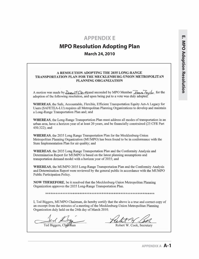
APPENDIX E
MPO Resolution Adopting PlanMarch 24, 2010
E. MP
O A
do
ptio
n R
esolu
tion
APPENDIX A A-1
Related Documents