Prepared under contract with: Emergency Planning Consultants San Diego, California Carolyn J. Harshman, CEM

Welcome message from author
This document is posted to help you gain knowledge. Please leave a comment to let me know what you think about it! Share it to your friends and learn new things together.
Transcript

Prepared under contract with: Emergency Planning Consultants
San Diego, California Carolyn J. Harshman, CEM

2
Prepared by:
2
Hazard Mitigation Plan City of Long Beach
Credits Special Thanks Planning Team:
Agency Name Department Job Title
City of Long Beach David Ashman, Co-Chair Disaster Preparedness Bureau
Manager
Christopher Rowe, Co-Chair Fire Assistant Fire Chief
Reggie Harrison, Advisor City Manager’s Office Deputy City Manager
Steve Bateman Long Beach Gas & Oil (LBGO)
Manager
Michael Beckman Police Commander
John Blood Airport Manager
Diane Brown Health & Human Services Bioterrorism Coordinator
Derek Burnham Development Services Manager
Ken Campbell Parks, Recreation & Marine (PRM)
Superintendent
Phil Carroll LBGO Principal Construction Inspector
Steve Choi Human Resources Safety Officer
Joel Cook Police Lieutenant
Arthur Cox Public Works Superintendent
Arlen Crabtree Disaster Preparedness Bureau
Grants Officer
Steven Gay Water Manager
Troung Huynh Development Services Superintendent
Michael Johnson Health & Human Services Superintendent
Daniel Kane Port of Long Beach (POLB) Security Manager
Norman Maeshima Technology Services Telecommunications Officer
Eric Matusak Police Police Officer
Chris Morgan Police Lieutenant
Jeffrey Ohs Fire Battalion Chief
Sandra Palmer Financial Management Financial Services Officer
Tina Parmalee Technology Services GIS Officer
Aaron Perkins LBGO Mechanical Engineer Associate
Georgia Pon Development Services Analyst

3
Prepared by:
3
Hazard Mitigation Plan City of Long Beach
David Segura Fire Deputy Fire Chief
Curtis Tani Technology Services Director
Olivia Valero Financial Management Accounting Operations Officer
Karl Zittel Airport Superintendent
Emergency Planning Consultants
Carolyn J. Harshman Consultant President
Acknowledgements City of Long Beach City Council
Bob Foster, Mayor Dr. Robert Garcia, Vice Mayor, 1st District Suja Lowenthal, Councilmember, 2nd District Gary DeLong, Councilmember, 3rd District Patrick O'Donnell, Councilmember, 4th District Gerrie Schipske, Councilmember, 5th District Dee Andrews, Councilmember, 6th District James Johnson, Councilmember, 7th District Al Austin, Councilmember, 8th District Steven Neal, Councilmember, 9th District
Consulting Services
Emergency Planning Consultants
Project Manager: Carolyn J. Harshman, CEM Lead Research Assistant: Alex L. Fritzler
3665 Ethan Allen Avenue San Diego, California 92117 Phone: 858-483-4626 [email protected] www.carolynharshman.com
4
Prepared by:
4
Hazard Mitigation Plan City of Long Beach
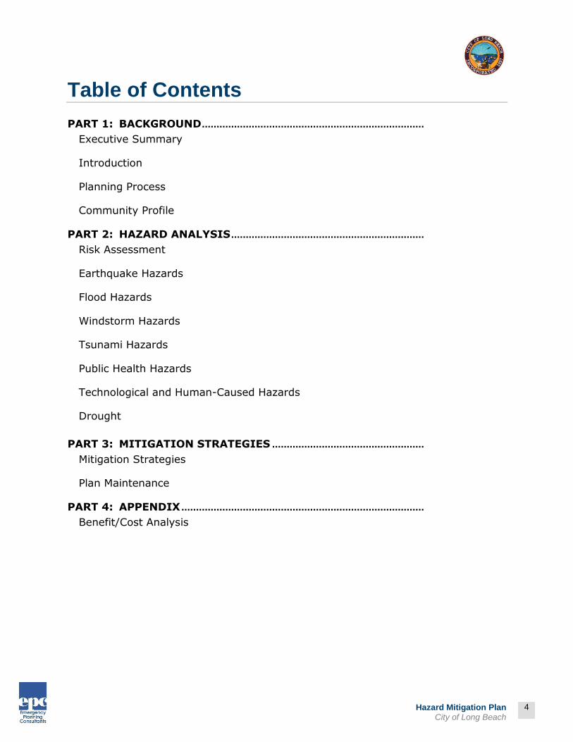
Table of Contents
PART 1: BACKGROUND ............................................................................
Executive Summary
Introduction
Planning Process
Community Profile
PART 2: HAZARD ANALYSIS ..................................................................
Risk Assessment
Earthquake Hazards
Flood Hazards
Windstorm Hazards
Tsunami Hazards
Public Health Hazards
Technological and Human-Caused Hazards
Drought
PART 3: MITIGATION STRATEGIES ....................................................
Mitigation Strategies
Plan Maintenance
PART 4: APPENDIX ...................................................................................
Benefit/Cost Analysis

5
Prepared by:
5
Hazard Mitigation Plan City of Long Beach
List of Mitigation Plan Attachments, Figures, Tables, and Maps
Type Section
Introduction
Map 1-1 Regional Map of Long Beach
Planning Process
Attachment 1-1 Notice of Stakeholder Workshop
Attachment 1-2 Input from Stakeholder Workshop
Attachment 1-3 Sign-In from Stakeholder Workshop
Attachment 1-4 Notice of Availability of Draft Plan
Table 1-1 Planning Team Timeline
Table 1-2 Planning Team Level of Participation
Table 1-3 Existing Processes and Programs
Attachment 1-3 City Council Resolution
Attachment 1-4 Planning Team Sign-In Sheets – February 21, 2013
Attachment 1-5 Planning Team Sign-In Sheets – February 28, 2013
Attachment 1-6 Planning Team Sign-In Sheets – March 7, 2013
Attachment 1-7 Planning Team Sign-In Sheets – August 8, 2013
Community Profile
Map 1-3 City of Long Beach - Parks and Schools
Figure 1-1 Historical Population
Figure 1-2 City Demographics
Table 1-4 Population Age Characteristics for Long Beach (2000-2010)
Table 1-5 Housing Characteristics
Table 1-6 Age of Housing Stock
Map 1-4 City of Long Beach Land Use Map
Table 1-7 City of Long Beach Industry
Table 1-8 City of Long Beach Occupation
Risk Assessment
Table 2-1 Calculated Priority Risk Index
Table 2-2 Calculated Priority Risk Index Ranking for City of Long Beach
Table 2-3 Vulnerability: Location, Extent, and Probability for City of Long Beach
Table 2-4 Impacts of Hazards on Critical/Essential Facilities in the City of Long Beach
Table 2-5 Impacts of Hazards to Land Use Categories in the City of Long Beach

6
Prepared by:
6
Hazard Mitigation Plan City of Long Beach
Type Section
Earthquake Hazards
Table 2-6 Significant Regional Earthquake Events (Magnitude 5.0 or Greater)
Table 2-7 Major Active Faults in the Long Beach Region
Map 2-1 Regional Fault Map
Map 2-2 City of Long Beach Earthquake Hazard Areas
Map 2-3 Seismic Shaking Intensities for the Newport-Inglewood Fault M6.9
Map 2-4 Seismic Shaking Intensities for the San Andreas Fault M7.8
Map 2-5 Shake Intensity Map - San Andreas Scenario M7.8
Map 2-6 General Building Stock Damage
Map 2-7 HAZUS - Total Debris
Map 2-8 Probability of Earthquake M>6.7 within 30 Years
Table 2-8 Modified Mercalli Intensity Scale
Map 2-9 Liquefaction Potential Areas – City of Long Beach
Flood Hazards
Table 2-8 Historical Record of Large Floods in Los Angeles County
Map 2-10 100-Year Flood Zone
Map 2-11 Groundwater Upwelling
Map 2-12 Flood Zones and County-Operated Critical Facilities
Windstorm Hazards
Table 2-9 Beaufort Wind Scale
Tsunami Hazards
Table 2-10 Tsunami Events in California 1930-2013
Map 2-13 Tsunami Inundation Map – Long Beach Quadrangle
Technological & Human Caused Hazards
Table 2-11 History of Civil Disturbances in Los Angeles County
Table 2-12 Historic Airplane Accidents in Southern California
Map 2-14 California Natural Gas Pipeline Systems
Drought Hazards
Table 2-
Mitigation Strategies
Table 3-1 Mitigation Actions Matrix
7
Prepared by:
7
Hazard Mitigation Plan City of Long Beach
Note: The maps in this plan were provided by the City of Long Beach, County of Los Angeles, Federal Emergency Management Agency (FEMA), or were acquired from public Internet sources. Care was taken in the creation of the maps contained in this Plan, however they are provided "as is". The City of Long Beach cannot accept any responsibility for any errors, omissions or positional accuracy, and therefore, there are no warranties that accompany these products (the maps). Although information from land surveys may have been used in the creation of these products, in no way does this product represent or constitute a land survey. Users are cautioned to field verify information on this product before making any decisions. Mandated Contents In an effort to assist the reader and reviewer of this document the jurisdiction has inserted the mandated contents as identified in the Disaster Mitigation Act of 2000 (Public Law – 390), as specifically identified in the Local Multi-Hazard Mitigation Planning Guidance (July 2008) and revised in Local Mitigation Planning Handbook (March 2013). Following is an example of those references – inserted as footnotes throughout the plan.
*EXAMPLE*
ELEMENT A: PLANNING PROCESS | A1
A1. Does the Plan document the planning process, including how it was prepared and who was involved
in the process for each jurisdiction? (Requirement §201.6(c)(1))

8
Prepared by:
8
Hazard Mitigation Plan City of Long Beach
PART 1: BACKGROUND
The Mitigation Plan was prepared in response to Disaster Mitigation Act of 2000 (DMA 2000). DMA 2000 (also known as Public Law 106-390) requires state and local governments to prepare Mitigation Plans to document their Mitigation Planning process, and identify hazards, potential losses, mitigation needs, goals, and strategies. This type of planning supplements the City’s comprehensive emergency management program. This document is a federally mandated update to the 2005 Hazard Mitigation Plan for the City of Long Beach. Under DMA 2000, each state and local government must have a federally approved Mitigation Plan to be eligible for hazard mitigation grant funding.
The Disaster Mitigation Act of 2000 (DMA 2000) is intended to facilitate cooperation between state and local governments, prompting them to work together. Through collaboration, mitigation needs can be identified before disasters strike, resulting in faster allocation of resources and more effective risk reduction projects.
Mitigation Planning Benefits Planning ahead helps residents, businesses, and government agencies effectively respond when disasters strike; and keeps public agencies eligible for Hazard Mitigation Grant Program (HMGP)
funding. The long-term benefits of mitigation planning include:
Greater understanding of hazards faced by a community Use of limited resources on hazards with the greatest effect on a community Financial savings through partnerships for planning and mitigation Reduced long-term impacts and damages to human health and structures, and lower
repair costs More sustainable, disaster-resistant communities.
Hazard Land Use Policy in City of Long Beach Planning for hazards is an integral element of the City’s land use planning program. The City has a General Plan and the implementing ordinances that are required to comply with statewide land use planning regulations. The continuing challenge faced by local officials is to keep the network of local plans effective in responding to the changing conditions and needs of diverse communities, particularly in light of the very active seismic region in which we live. Planning for hazards requires a thorough understanding of the various hazards facing the City and region as a whole. Additionally, it’s important to take an inventory of the structures and contents of various City holdings. These inventories should include the compendium of hazards

9
Prepared by:
9
Hazard Mitigation Plan City of Long Beach
facing the City, the built environment at risk, the personal property that may be damaged by hazard events and most of all, the people who live in the shadow of these hazards.
Mitigation Resources The City of Long Beach created a Planning Team (Planning Team) charged with the responsibility of creating this Hazard Mitigation Plan. The Planning Team utilized the resources of a variety of regional, state, and federal agencies. Some of the key agencies include:
California Office of Emergency Services (Cal OES) is responsible for disaster mitigation, preparedness, response, recovery, and the administration of federal funds after a major disaster declaration;
Southern California Earthquake Center (SCEC) gathers information about earthquakes, integrates information on earthquake phenomena, and communicates this to end-users and the general public to increase earthquake awareness, reduce economic losses, and save lives.
California Department of Forestry and Fire Protection (CAL FIRE) is responsible for all aspects of wildland fire protection on private and state properties, and administers forest practices regulations, including landslide mitigation, on non-federal lands.
California Division of Mines and Geology (DMG) is responsible for geologic hazard characterization, public education, and the development of partnerships aimed at reducing risk.
California Division of Water Resources (DWR) plans, designs, constructs, operates, and maintains the State Water Project; regulates dams; provides flood protection and assists in emergency management. It also educates the public, serves local water needs by providing technical assistance
FEMA provides hazard mitigation guidance, resource materials, and educational materials to support implementation of the capitalized DMA 2000.
United States Census Bureau (USCB) provides demographic data on the populations affected by natural disasters.
United States Department of Agriculture (USDA) provides data on matters pertaining to land management.
The Planning Team consisted of City staff from various departments who worked with Emergency Planning Consultants using the following approach to create the 2014 Mitigation Plan:
Identify hazards posing a significant threat Profile these hazards Estimate inventory at risk and potential losses associated with these hazards Review and incorporate existing documents, data, and technical information pertaining to
hazards and present mitigation activities Develop and analyze HAZUS data and mapping resources Develop mitigation strategies and goals that address these hazards Develop plan maintenance procedures for implementation after the joint review by Cal
OES and FEMA and FEMA approval.
10
Prepared by:
10
Hazard Mitigation Plan City of Long Beach
Planning Process Phases* Throughout the project, the City followed its traditional approach to developing policy documents, including preparation of the First Draft Plan, then making the First Draft Plan available to the public and outside agencies electronically as well as in a Stakeholder Workshop. The workshop involved a brief presentation on the background of the planning process as well as a review of the Mitigation Actions Matrix. Attendees were encouraged to ask questions and make recommendations to the Matrix and overall Plan. The Second Draft Plan incorporated the input from the Stakeholder Workshop. The Third Draft Plan included any amendments following distribution of the Second Draft Plan to the Planning Team. The Third Draft Plan was made available to the public, outside agencies, and to the City Council members in advance of the City Council public meeting. Following the Council meeting, the Final Draft Plan was prepared including discussions and decisions at the City Council meeting. See the next page for a graphic depicting the various activities within the planning phases.
* ELEMENT A: PLANNING PROCESS | A3
A3. Does the Plan document how the public was involved in the planning process during the drafting stage? (Requirement §201.6(b)(1))

11
Prepared by:
11
Hazard Mitigation Plan City of Long Beach
PLANNING PHASES
Plan Writing Phase (First Draft Plan)
Plan Review Phase (Second
Draft Plan)
Plan Adoption Phase (Third Draft Plan)
Plan Approval Phase
(Final Draft Plan)
Plan Implementation
Phase
Planning Team input – research, meetings, writing, review of First Draft Plan
Notice and participate in Stakeholder Workshop
Incorporate input from public, outside agencies, and Stakeholder Workshop into Second Draft Plan
Second Draft Plan available for review by Planning Team, City department heads, public, and outside agencies
Incorporate input review of Second Draft Plan into Third Draft Plan
Public notice of upcoming City Council public meeting including posting of Third Draft Plan
Distribute Third Draft Plan to the City Council in advance of the public meeting
Present Third Draft Plan to the City Council
City Council Adopts Plan
Incorporate input from the City Council public meeting into Final Draft Plan
Submit Final Draft Plan to Cal OES and FEMA for review
Amend Final Draft Plan as required by FEMA regulations
Receive FEMA approval
Incorporate date of FEMA approval into Final Plan
Conduct Planning Team meetings
Integrate mitigation action items into budget, CIP and other funding and strategic documents

12
Prepared by:
12
Hazard Mitigation Plan City of Long Beach
How is the Plan Organized? The structure of the plan enables people to use a section of interest to them and allows the City to review and update sections when new data is available. The ease of incorporating new data into the plan will result in a Mitigation Plan that remains current and relevant to the City of Long Beach. Following is a description of each of the sections of the plan: PART 1: BACKGROUND Executive Summary The Executive Summary provides a very general overview of mitigation planning, the planning process, and the steps involved in implementing the plan. Introduction The Introduction describes the background and purpose of developing the Mitigation Plan for the City of Long Beach. Planning Process This section describes the mitigation planning process including 1) Planning Team involvement, 2) extended Planning Team support, 3) stakeholder involvement; 4) public involvement, and 5) integration of existing data and plans. Community Profile The section presents the history, geography, demographics, and socioeconomics of the City of Long Beach. It provides valuable information on the demographics and history of the region. PART 2: HAZARD ANALYSIS This section provides information on the process used to assess the demographics and development patterns for the community along with an assessment of the hazards. Risk Assessment This section provides information on hazard identification, vulnerability and risk associated with hazards in the City of Long Beach. Hazard Specific Evaluation Each hazard specific evaluation section includes a discussion on the seven hazards identified as posing significant threats to the community. The seven hazards include:
Earthquake
Flood Windstorm
Tsunami
Public Health Hazards
Technological and Human-Caused Hazards
Drought Each hazard specific evaluation includes information on the history, hazard causes, hazard characteristics, and hazard assessment.

13
Prepared by:
13
Hazard Mitigation Plan City of Long Beach
PART 3: MITIGATION STRATEGIES Mitigation Strategies This section highlights the Mitigation Actions Matrix and: 1) past accomplishments; 2) planning approach; 3) goals and objectives; 4) identification, analysis, and implementation of mitigation activities; 5) prioritized mitigation activities; and 6) next steps. Plan Maintenance This section provides information on plan implementation, monitoring and evaluation. PART 4: APPENDIX The plan appendix is designed to provide users of the Mitigation Plan with additional information to assist them in understanding the contents of the mitigation plan, and potential resources to assist them with implementation. Benefit/Cost Analysis This section describes FEMA's requirements for benefit cost analysis in hazards mitigation, as well as various approaches for conducting economic analysis of proposed mitigation activities.
Mitigation Planning Process The process for creating the 2014 Mitigation Plan started with identifying members for the Planning Team. Each team member represented different City department and specific divisions within those departments with a role in mitigation efforts. The Planning Team met and identified characteristics and consequences of natural, technological, and human-caused hazards with significant potential to affect the City. It is important to note that the City Council adopted the City’s first Hazard Mitigation Plan in 2005. The Planning Team utilized the contents from the 2005 Plan to create this 2014 document. Hazard mitigation strategy and goals were developed by understanding the risk posed by the identified hazards. The group also determined hazard mitigation activities and priorities to include scenarios for both present and future conditions. The final Mitigation Plan will be implemented

14
Prepared by:
14
Hazard Mitigation Plan City of Long Beach
through various projects, changes in day-to-day city operations, and through continued hazard mitigation development. Through a series of Planning Team meetings, Mitigation Action Items identified in the 2005 Plan were reviewed and status information documented.
Participating Organizations For mitigation planning to be successful; like all community planning; it requires collaboration with, and support from, federal, state, local, and regional governments; citizens; the private sector; universities; and non-profit organizations. The Planning Team consulted a variety of sources to ensure that the planning process results in practicable actions tailored to local needs and circumstances. Organizations and agencies outside of the City were invited to participate in the review of the Draft Hazard Mitigation Plan during the plan development phase. The list of agencies is located in the Planning Process section. Input gathered through this external review process have been itemized and incorporated into the plan.
Mitigation Plan Jurisdiction and Scope The City’s Mitigation Plan affects the areas within the City boundaries, with emphasis on City owned facilities and land. This plan provides a framework for planning for natural hazards, public health emergencies, and technological and human-caused hazards. The resources and background information in the plan address existing and future land development throughout the City of Long Beach.
Risk Assessment Risk assessment is the identification of risks posed by a hazard and the corresponding impacts to the community. This process involves five steps: identify hazards, profile hazards, inventory critical assets, assess risks, and assess vulnerability of future development.
Step 1: Identify Hazards The Planning Team identified the hazards that could significantly impact the City by referencing the City General Plan, County of Los Angeles All-Hazard Mitigation Plan (2014), the City’s Emergency Operations Plan (2007), and a long list of internet resources from regional, state, and federal agencies. The Planning Team ranked the hazards based on the probability, magnitude/severity, warning time, and duration. That analysis yielded the following hazards as posing the greatest risk to the City of Long Beach: earthquakes, floods, windstorms, tsunamis, public health emergencies, technological and human-caused events, and drought.
Step 2: Profile Hazards Hazard profiles determine the extent to which each hazard could impact the City. Each hazard profile contains the following information:
Background and local conditions Historic frequency and probability of occurrence Severity
15
Prepared by:
15
Hazard Mitigation Plan City of Long Beach
Historic losses and impacts Designated hazard areas
Other factors considered include potential impact, onset, frequency, hazard duration, cascading effects, and recovery time for each hazard. Using this information, the Planning Team assessed the relative risk of each hazard ranging from severe risk to no risk. Where applicable, the source(s) of information, data, and maps showing vulnerable areas and relevant community components are provided.
Step 3: Inventory Critical Assets
Once hazards and profiles were established, locations of critical facilities were plotted and analyzed. To estimate losses from each hazard (number of structures, value of structures and number of people), the Planning Team used local resources; Census data; Hazards U.S.- Multi-Hazard (HAZUS-MH), a Geographic Information System (GIS) risk assessment methodology; and other GIS capabilities. The inventory of assets shows a range of resources that could be lost or damaged for each hazard such as population, general building stock (residential and commercial), critical facilities (hospitals, police and fire stations, and transportation systems), and utilities.
Step 4: Assess Risks Estimated losses to structures and their contents, as well as the losses to structure use and function, were identified (as data was available).
Step 5: Vulnerability Analysis of Future Development This step provides a general description of City facilities and contents in relation to the identified hazards so that mitigation options can be considered in land use planning and future land use decisions. This Mitigation Plan provides comprehensive description of the character of the City of Long Beach in the Community Profile Section. This description includes the geography and environment, population and demographics, land use and development, housing and community development, employment and industry, and transportation and commuting patterns. Analyzing these components of the City of Long Beach helps to identify potential problem areas and serves as a guide for incorporating the goals and ideas contained in this mitigation plan into other community development plans.
Mitigation Goals The risk assessment and public input involved a review of past mitigation actions, future goals, and appropriate mitigation strategies. The Planning Team identified five mitigation goals that summarize the hazard reduction outcome the City wants to achieve:
Protect Life and Property Enhance Public Awareness Preserve Natural Systems Encourage Partnerships and Implementation Strengthen Emergency Services
16
Prepared by:
16
Hazard Mitigation Plan City of Long Beach
These goals guided the development and implementation of specific mitigation activities. Many of the mitigation objectives and action items come from current programs. Emphasis was placed on the effectiveness of the activities with respect to their estimated cost.
Plan Writing* Preparation of the First Draft Plan resulted from input from the Planning Team and assistance from the consultant. Once the Team had an opportunity to review the First Draft Plan, the document was posted on the City’s website and invitations were distributed to the public and outside agencies announcing the availability of the Plan and the Stakeholder Workshop. The remainder of the plan writing phase consisted of conducting the Stakeholder Workshop and incorporating the input gathered from the public and outside agencies into the Second Draft Plan. Please see additional information and graphic earlier in the Executive Summary with header “Planning Process Phases”.
Plan Development and Review The Planning Team was dedicated to including as many perspectives and stakeholders as possible in the Plan development and review processes. The plan development process involved: 1) Planning Team members, 2) Department Heads, 3) External Organizations (adjoining jurisdictions, utilities, special districts), 4) Public, and 5) City Council members.
Plan Adoption† The 2005 Mitigation Plan was originally prepared and adopted by the City Council on October 19, 2004 and received FEMA approval on October 5, 2005. The 2014 Mitigation Plan is an update to the original Plan and was presented to City Council for adoption on _________, 2014. A copy of the City Council Resolution is located in the Planning Process section.
Plan Approval The 2014 Mitigation Plan was submitted to Cal OES and FEMA for a joint review. FEMA approved the Plan on ____________________. A copy of the letter of approval is located in the Planning Process Section.
* ELEMENT A: PLANNING PROCESS | A3
A3. Does the Plan document how the public was involved in the planning process during the drafting stage? (Requirement §201.6(b)(1))
† ELEMENT E: PLAN ADOPTION | E1
E1. Does the Plan include documentation that the plan has been formally adopted by the governing body of the
jurisdiction requesting approval? (Requirement §201.6(c)(5))

17
Prepared by:
17
Hazard Mitigation Plan City of Long Beach
Point of Contact To request information or provide comments regarding this mitigation plan, please contact:
Plan Maintenance Mitigation Planning is an ongoing process involving changes as new hazards occur, as the area develops, and as more is learned about hazards and their impacts. The Planning Team will monitor changing conditions, help implement mitigation activities, annually review the plan to determine if City goals are being met, and provide an update to Cal OES and FEMA every five years. In addition, the Planning Team will review After-Action Reports generated after any disaster that impacts the City, and revise the plan, as needed.
Contact David Ashman, Manager Disaster Preparedness Bureau – City of Long Beach [email protected]
Mailing Address 2990 Redondo Avenue
Long Beach, CA 90806
Telephone Number (562) 570-9250
18
Prepared by:
18
Hazard Mitigation Plan City of Long Beach
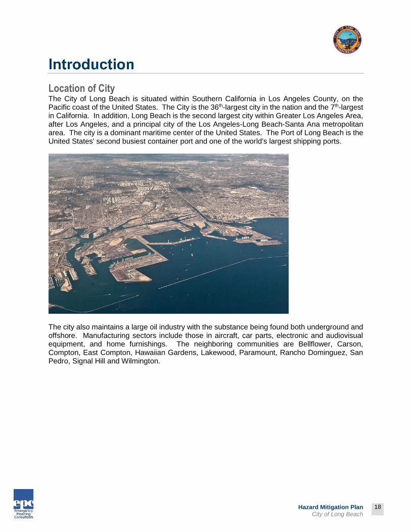
Location of City The City of Long Beach is situated within Southern California in Los Angeles County, on the Pacific coast of the United States. The City is the 36th-largest city in the nation and the 7th-largest in California. In addition, Long Beach is the second largest city within Greater Los Angeles Area, after Los Angeles, and a principal city of the Los Angeles-Long Beach-Santa Ana metropolitan area. The city is a dominant maritime center of the United States. The Port of Long Beach is the United States' second busiest container port and one of the world's largest shipping ports.
The city also maintains a large oil industry with the substance being found both underground and offshore. Manufacturing sectors include those in aircraft, car parts, electronic and audiovisual equipment, and home furnishings. The neighboring communities are Bellflower, Carson, Compton, East Compton, Hawaiian Gardens, Lakewood, Paramount, Rancho Dominguez, San Pedro, Signal Hill and Wilmington.

19
Prepared by:
19
Hazard Mitigation Plan City of Long Beach
Map 1-1: Physical Relationship of Long Beach
Why Develop a Mitigation Plan? As the costs of damage from disasters to metropolitan areas across the country continue to increase, the City realizes the importance of identifying effective ways to reduce vulnerability to disasters. Mitigation plans assist communities in reducing risk from hazards by identifying resources, information, and strategies for risk reduction, while helping to guide and coordinate mitigation activities throughout the City. The plan provides a set of action items to reduce risks from hazards through education and outreach programs and to foster the development of partnerships, and implementation of preventative activities such as land use programs that restrict and control development in areas subject to damage from hazards. The resources and information within the Mitigation Plan:
Establish a basis for coordination and collaboration among agencies and the public of City of Long Beach;
Identify and prioritize future mitigation projects; and Assist in meeting the requirements of federal assistance programs.
The Mitigation Plan works in conjunction with other City plans, including the Emergency Operations Plan, General Plan, and Capital Improvement Program.
Why Plan for Hazards in City of Long Beach? Hazards impact residents, businesses, property, the environment, and the economy of City of Long Beach, exposing the community to financial and emotional costs of recovery. The risk associated with hazards increases as more people move to areas affected by hazards. In addition to the natural hazards, the Planning Team opted to also include public health emergencies and technological and human-caused hazards into the 2014 Plan Update. The inevitability of hazards, and the growing population and activity within the City create an urgent need to develop strategies, coordinate resources, and increase public awareness to reduce risk and prevent loss from future hazard events. Identifying the risks posed by hazards, and developing strategies to reduce the impact of a hazard event can assist in protecting life and property of citizens and communities. Local residents and businesses can work together with the City to create a Mitigation Plan that addresses the potential impacts of hazard events.

20
Prepared by:
20
Hazard Mitigation Plan City of Long Beach
Hazard Mitigation Legislation and Grants Relevant hazard mitigation legislation and grants are highlighted below.
Hazard Mitigation Grant Program In 1974, Congress enacted the Robert T. Stafford Disaster Relief and Emergency Act, commonly referred to as the Stafford Act. In 1988, Congress established the Hazard Mitigation Grant Program (HMGP) via Section 404 of the Stafford Act. Regulations regarding HMGP implementation based on the DMA 2000 were initially changed by an Interim Final Rule (44 CFR Part 206, Subpart N) published in the Federal Register on February 26, 2002. A second Interim Final Rule was issued on October 1, 2002. The HMGP helps states and local governments implement long-term
hazard mitigation measures for natural hazards by providing federal funding following a federal disaster declaration. Eligible applicants include state and local agencies, Indian tribes or other tribal organizations, and certain nonprofit organizations. In California, the HMGP is administered by Cal OES. Examples of typical HMGP projects include:
Property acquisition and relocation projects Structural retrofitting to minimize damages from earthquake, flood, high wind, wildfire,
or other natural hazards Elevation of flood-prone structures Vegetative management programs, such as:
o Brush control and maintenance o Fuel break lines in shrubbery o Fire-resistant vegetation in potential wildland fire areas
Pre-Disaster Mitigation Program The Pre-Disaster Mitigation Program (PDM) was authorized by §203 of the Stafford Act, 42 United States Code (USC), as amended by §102 of the DMA 2000. Funding is provided through the National Pre-Disaster Mitigation Fund to help state and local governments (including Indian tribal governments) implement cost-effective hazard mitigation activities that complement a comprehensive mitigation program. In Fiscal Year 2009, two types of grants (planning and competitive) were offered under the PDM Program. Planning grants allocate funds to each state for Mitigation Plan development. Competitive grants distribute funds to states, local governments, and federally recognized Indian tribal governments via a competitive application process. FEMA reviews and ranks the submittals based on pre-determined criteria. The minimum eligibility requirements for competitive grants include participation in good standing in the National Flood Insurance Program (NFIP) and a FEMA-approved Mitigation Plan. (Source: http://www.fema.gov/fima/pdm.shtm)
“Floods and hurricanes
happen. The hazard itself
is not the disaster – it’s our
habits, it’s how we build
and live in those
areas…that’s the disaster.”
Craig Fugate,
FEMA Director

21
Prepared by:
21
Hazard Mitigation Plan City of Long Beach
Flood Mitigation Assistance Program The Flood Mitigation Assistance (FMA) Program was created as part of the National Flood Insurance Reform Act (NFIRA) of 1994 (42 U.S.C. 4101). Financial support is provided through the National Flood Insurance Fund to help states and communities implement measures to reduce or eliminate the long-term risk of flood damage to buildings, manufactured homes, and other structures insurable under the NFIP. Three types of grants are available under FMA: planning, project, and technical assistance. Planning grants are available to states and communities to prepare Flood Mitigation Plans. NFIP-participating communities with approved Flood Mitigation Plans can apply for project grants to implement measures to reduce flood losses. Technical assistance grants in the amount of 10 percent of the project grant are available to the state for program administration. Communities that receive planning and/or project grants must participate in the NFIP. Examples of eligible projects include elevation, acquisition, and relocation of NFIP-insured structures. (Source: http://www.fema.gov/fima/fma.shtm)
Disaster Mitigation Act of 2000 DMA 2000 (DMA 2000) was signed by President Clinton on October 30, 2000 (Public Law 106-390). Section 322 primarily deals with the development of Mitigation Plans. The Interim Final Rule for planning provisions (44 CFR Part 201) was published in the Federal Register twice: February 26, 2002 and October 1, 2002. The Mitigation Planning requirements are implemented via 44 CFR Part 201.6. DMA 2000 was designed to establish a national program for pre-disaster mitigation, streamline disaster relief at the federal and state levels, and control federal disaster assistance costs. Congress believed these requirements would produce the following benefits:
Reduce loss of life and property, human suffering, economic disruption, and disaster costs.
Prioritize hazard mitigation at the local level with increased emphasis on planning and public involvement, assessing risks, implementing loss reduction measures, and ensuring critical facilities/services survive a disaster.
Promote education and economic incentives to form community-based partnerships and leverage non-federal resources to commit to and implement long-term hazard mitigation activities.
Under DMA 2000 state and local government (each city, county, and special district), and tribal government must develop a Mitigation Plan to be eligible to receive HMGP funds. Every mitigation plan, which must be reviewed by the state and approved by FEMA, should address the following items:
Plan Promulgation
Planning Process including Public Involvement
Hazard Identification and Risk Assessment
Mitigation Strategy
Plan Implementation and Maintenance Procedures
Specific State Requirements

22
Prepared by:
22
Hazard Mitigation Plan City of Long Beach
State and Federal Support While the City has primary responsibility for developing and implementing hazard mitigation strategies, they are not alone. Various state and federal partners and resources help local agencies with mitigation planning. Cal OES is the lead agency for mitigation planning support to local governments. In addition, FEMA offers grants, tools, and training. The Planning Team utilized the following regulations and guidance in preparing the Hazard Mitigation Plan:
DMA 2000 (Public Law 106-390, October 10, 2000) 44 CFR Parts 201 and 206, Mitigation Planning and Hazard Mitigation Grant Program,
Interim Final Rule, October 1, 2002 44 CFR Parts 201 and 206, Mitigation Planning and Hazard Mitigation Grant Program,
Interim Final Rule, February 26, 2002 How-To Guide for Using HAZUS-MH for Risk Assessment, (FEMA 433), February 2004 Mitigation Planning “How-to” Series (FEMA 386-1 through 9 available at:
http://www.fema.gov/fima/planhowto.shtm) Getting Started: Building Support For Mitigation Planning (FEMA 386-1) Understanding Your Risks: Identifying Hazards and Estimating Losses (FEMA 386-2) Developing the Mitigation Plan: Identifying Mitigation Actions and Implementing Strategies
(FEMA 386-3) Bringing the Plan to Life: Implementing the Mitigation Plan (FEMA 386-4) Using Benefit-Cost Review in Mitigation Planning (FEMA 386-5) Integrating Historic Property and Cultural Resource Considerations into Mitigation
Planning (FEMA 386-6) Integrating Manmade Hazards Into Mitigation Planning (FEMA 386-7) Multi-Jurisdictional Mitigation Planning (FEMA 386-8) Using the Mitigation Plan to Prepare Successful Mitigation Projects (FEMA 386-9) State and Local Plan Interim Criteria Under the DMA 2000, July 11, 2002, FEMA Mitigation Planning Workshop For Local Governments-Instructor Guide, July 2002, FEMA Report on Costs and Benefits of Natural Hazard Mitigation, Document #294, FEMA LHMP Development Guide – Appendix A - Resource, Document, and Tool List for Local
Mitigation Planning, December 2, 2003, Cal OES Local Mitigation Plan Review Guide, October 1, 2011, FEMA Local Mitigation Planning Handbook, March 2013, FEMA

23
Prepared by:
23
Hazard Mitigation Plan City of Long Beach
Hazards U.S. – Multi-Hazard In 1997, FEMA developed a standardized model for estimating losses caused by an earthquake. Hazards U.S. (HAZUS) addressed the need for more effective national, state, and local planning and the need to identify areas that face the highest risk and potential for loss. Hazards U.S. Multi-Hazard (HAZUS-MH) provides models to estimate potential losses from floods (coastal and riverine) and winds (hail, hurricane, tornado, tropical cyclone, and thunderstorm). HAZUS-MH applies engineering and scientific risk calculations developed by hazard and information technology experts to provide defensible damage and loss estimates. This methodology provides a consistent framework for assessing risk across a variety of hazards.
HAZUS-MH uses Geographic Information System technology to produce detailed maps and analytical reports on physical damage to building stock, critical facilities, transportation systems, and utilities. The damage reports cover induced damage (debris, fire, hazardous material, and inundation) and direct economic and social losses (casualties, shelter requirements, and economic impacts), promoting standardization. HAZUS maps contained in this document were created by the County of Los Angeles. Maps showing proximity of hazards were provided by City of Long Beach – GIS.
Who Does the Mitigation Plan Affect? The Mitigation Plan affects the areas within the City of Long Beach boundaries and City owned facilities and land. This plan provides a framework for planning for natural hazards. The resources and background information in the plan are applicable Citywide and to City-owned facilities outside of the City boundaries, and the goals and recommendations provide groundwork for local mitigation plans and partnerships. Map 1-1 shows the regional proximity of the City to its adjoining communities.
HAZUS-MH uses
Geographic Information
System technology to
produce detailed maps and
analytical reports on
physical damage to
building stock, critical
facilities, transportation
systems, and utilities.

Prepared by:
24
Hazard Mitigation Plan City of Long Beach
Map 1-2: Regional Map of Long Beach (Source: City of Long Beach)

25
Prepared by:
25
Hazard Mitigation Plan City of Long Beach
Plan Methodology*
DMA 2000 emphasizes the importance of participatory planning in the development of Mitigation Plans. This Mitigation Plan was written using the best available information from a wide variety of sources. Throughout the planning process, the City made a concerted effort to gather information from City and County departments, as well as state and federal agencies, the local business community, Long Beach residents, and other stakeholders. The Planning Team solicited information from internal and external departments and agencies with specific knowledge of natural hazards and past historical events, as well as planning and zoning codes, ordinances, and recent planning decisions. The hazard mitigation strategies contained in this plan were developed through an extensive planning process involving local businesses and residents.
Who Participated in Developing the Plan? The Mitigation Plan is the result of a collaborative planning effort between City of Long Beach citizens, public agencies, non-profit organizations, the private sector, regional, and state and federal organizations. Public participation played a key role in development of goals and action items.
* ELEMENT A: PLANNING PROCESS | A1
A1. Does the Plan document the planning process, including how it was prepared and who was involved in the process for each jurisdiction? (Requirement §201.6(c)(1))
Hazard Mitigation
Plan
External Organizations
Planning Team
Citizens
Stakeholders
City Council
26
Prepared by:
26
Hazard Mitigation Plan City of Long Beach
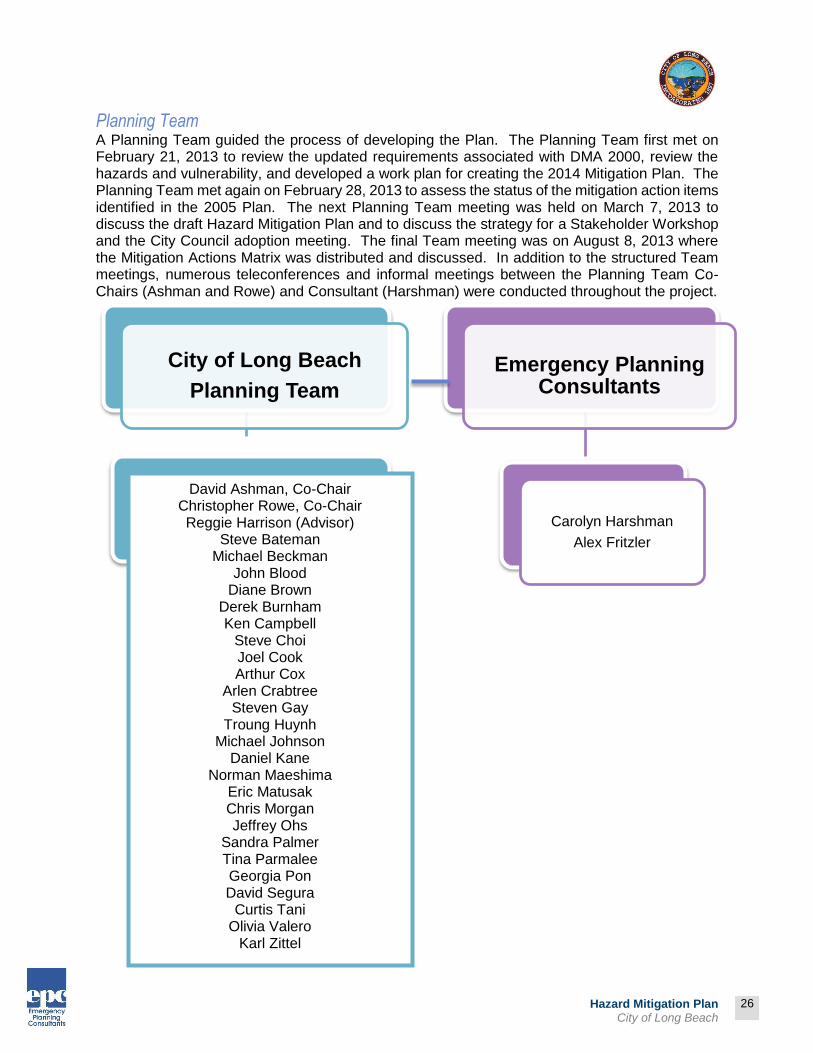
Planning Team A Planning Team guided the process of developing the Plan. The Planning Team first met on February 21, 2013 to review the updated requirements associated with DMA 2000, review the hazards and vulnerability, and developed a work plan for creating the 2014 Mitigation Plan. The Planning Team met again on February 28, 2013 to assess the status of the mitigation action items identified in the 2005 Plan. The next Planning Team meeting was held on March 7, 2013 to discuss the draft Hazard Mitigation Plan and to discuss the strategy for a Stakeholder Workshop and the City Council adoption meeting. The final Team meeting was on August 8, 2013 where the Mitigation Actions Matrix was distributed and discussed. In addition to the structured Team meetings, numerous teleconferences and informal meetings between the Planning Team Co-Chairs (Ashman and Rowe) and Consultant (Harshman) were conducted throughout the project.
City of Long Beach
Planning Team
Emergency Planning Consultants
Carolyn Harshman
Alex Fritzler
David Ashman, Co-Chair Christopher Rowe, Co-Chair Reggie Harrison (Advisor)
Steve Bateman Michael Beckman
John Blood Diane Brown
Derek Burnham Ken Campbell
Steve Choi Joel Cook Arthur Cox
Arlen Crabtree Steven Gay
Troung Huynh Michael Johnson
Daniel Kane Norman Maeshima
Eric Matusak Chris Morgan Jeffrey Ohs
Sandra Palmer Tina Parmalee Georgia Pon David Segura
Curtis Tani Olivia Valero
Karl Zittel

27
Prepared by:
27
Hazard Mitigation Plan City of Long Beach
Public Participation*† The planning process included opportunities for a wide range of private citizens, business owners, City staff, and other public agency representatives. Supporting materials from those meetings and discussions are located in this Section. To facilitate communication between the Planning Team and Long Beach residents, and to involve the public in ongoing planning and evaluation, this plan will be available to the public through a variety of venues including the City’s website and City Hall. The Planning Team recognizes that community involvement increases the likelihood that hazard mitigation will become a standard consideration in the City’s evolution.
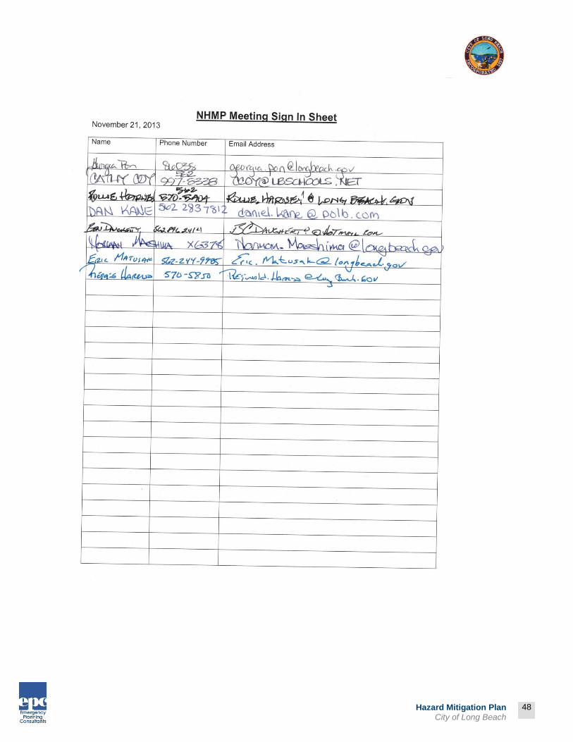
Notice of Stakeholder Workshop A notice announcing the Stakeholder Workshop was posted on November 12, 2013 (See notice and distribution list in Attachment 1-1). The “stakeholders” were members of a standing committee of Non-Governmental Organizations that assist the City of Long Beach in its emergency management activities. The workshop offered invitees an opportunity to learn about hazard mitigation and provide their expertise and insight into the planning process as well as individual mitigation action items. The Workshop was conducted on November 21, 2013 and lasted 2 hours. The presentation consisted of a PowerPoint by members of the Planning Team. The PowerPoint included a brief overview of the need for hazard mitigation planning, a description of the planning process, and updates on the community profile since the writing of the first plan, and a review of FEMA’s six mitigation measure categories: Prevention, Property Protection, Public Education & Awareness, Natural Resource Protection, Emergency Services, and Structural Projects. Next, examples of mitigation action items were shared with the audience. Nearly 30 mitigation actions from the Draft Plan were presented and discussed with the audience. Review comments were documented and available for review in Attachment 1-2. The sign-in sheets are located in Attachment 1-3.
Notice of Availability of Draft Plan Prior to City Council A notice of availability for public review of the Third Draft Hazard Mitigation Plan was posted on ____ 2014 (See notice in Attachment 1-4). The notices were posted at City Hall; the Post Office; the Library; and on the City’s website. No review comments were received.
* ELEMENT A: PLANNING PROCESS | A2
A2. Does the Plan document an opportunity for neighboring communities, local and regional agencies involved in hazard mitigation activities, agencies that have the authority to regulate development as well as other interests to be involved in the planning process? (Requirement §201.6(b)(2))
† ELEMENT A: PLANNING PROCESS | A3
A3. Does the Plan document how the public was involved in the planning process during the drafting stage? (Requirement §201.6(b)(1))

28
Prepared by:
28
Hazard Mitigation Plan City of Long Beach
Planning Team Involvement The Planning Team was responsible for the following tasks:
Establish plan development goals Prepare timetable for plan completion Ensure plan meets DMA 2000 requirements, and federal and state guidelines Organize and oversee public involvement Solicit participation of government agencies, businesses, residents, and other
stakeholders Gather information (such as existing data and reports) Confirm status of mitigation action items written in 2005 Assist with developing new mitigation action items Develop, revise, adopt, and maintain plan Participate in Planning Team meetings and City County public meeting
The Planning Team, with support from other City staff and local organizations, identified and profiled hazards; determined hazard rankings; estimated potential exposure or losses; evaluated development trends and specific risks; and developed mitigation goals, objectives, and activities. During its meetings the Planning Team gathered and shared information, assessed risks, identified critical facilities, developed mitigation strategies, and provided continuity throughout plan development to ensure the plan addresses jurisdiction-specific hazard vulnerabilities and mitigation strategies. Members communicated regularly by phone and email between group meetings. The Planning Team will meet annually after the plan is adopted. Members will provide project direction and oversight, assist with plan evaluation, and convene supplementary meetings as-needed.

Prepared by:
29
Hazard Mitigation Plan City of Long Beach
Table 1-1: Planning Team Timeline
Feb
ruar
y
Mar
ch
Apr
il
May
June
July
Aug
ust
Sep
tem
ber
Oct
ober
Nov
embe
r
Dec
embe
r
Janu
ary
2014
Feb
ruar
y
Mar
ch
Apr
il
May
June
July
Aug
ust
Sep
tem
ber
Oct
ober
Contracted with Emergency Planning Consultants (EPC)
X
Research and Writing of 2014 Plan
X X X X X
Planning Team Meetings (2/21/13, 2/28/13, 3/7/13, 8/8/13)
XX X X
Review and Comment on Draft Plan by Planning Team
X X
Conduct Stakeholder Workshop
X
Review and Comment on Draft Plan by Department Heads
X
Review and Comment by Public and External Agencies
X
Present 2014 Plan to City Council at Public Meeting

Prepared by:
30
Hazard Mitigation Plan City of Long Beach
Feb
ruar
y
Mar
ch
Apr
il
May
June
July
Aug
ust
Sep
tem
ber
Oct
ober
Nov
embe
r
Dec
embe
r
Janu
ary
2014
Feb
ruar
y
Mar
ch
Apr
il
May
June
July
Aug
ust
Sep
tem
ber
Oct
ober
Finalizing the Plan - Cal OES and FEMA Review

Prepared by:
31
Hazard Mitigation Plan City of Long Beach
Table 1-2: Planning Team Level of Participation*
Issu
e R
equ
est fo
r
Pro
po
sal
Co
ntr
act
with E
PC
Re
sea
rch
and W
ritin
g
of
201
4 P
lan
Pla
nn
ing T
ea
m M
eetin
g
2/2
1/1
3
Pla
nn
ing T
ea
m M
eetin
g
2/2
8/1
3
Pla
nn
ing T
ea
m M
eetin
g
3/7
/13
Pla
nn
ing T
ea
m M
eetin
g
8/8
/13
Re
vie
w a
nd
Com
me
nt
on D
raft P
lan b
y
Pla
nn
ing T
ea
m
Att
end
S
take
ho
lder
Wo
rksh
op
Att
end
City C
oun
cil
Pu
blic
Me
etin
g
Fin
aliz
e t
he P
lan a
nd
Ca
l O
ES
/FE
MA
Re
vie
w
City of Long Beach
David Ashman X X X X X X X X
Steve Bateman X X X X X
Michael Beckman X X
John Blood X X
Diane Brown X X X X
Derek Burnham X
Ken Campbell X X X
Phil Carroll X X X
Steve Choi X X X X X
* ELEMENT A: PLANNING PROCESS | A1
A1. Does the Plan document the planning process, including how it was prepared and who was involved in the process for each jurisdiction? (Requirement §201.6(c)(1))

Prepared by:
32
Hazard Mitigation Plan City of Long Beach
Issu
e R
equ
est fo
r
Pro
po
sal
Co
ntr
act
with E
PC
Re
sea
rch
and W
ritin
g
of
201
4 P
lan
Pla
nn
ing T
ea
m M
eetin
g
2/2
1/1
3
Pla
nn
ing T
ea
m M
eetin
g
2/2
8/1
3
Pla
nn
ing T
ea
m M
eetin
g
3/7
/13
Pla
nn
ing T
ea
m M
eetin
g
8/8
/13
Re
vie
w a
nd
Com
me
nt
on D
raft P
lan b
y
Pla
nn
ing T
ea
m
Att
end
S
take
ho
lder
Wo
rksh
op
Att
end
City C
oun
cil
Pu
blic
Me
etin
g
Fin
aliz
e t
he P
lan a
nd
Ca
l O
ES
/FE
MA
Re
vie
w
Joel Cook X X
Arthur Cox X X X X
Arlen Crabtree X X X X
Steven Gay X
Reggie Harrison X X X X X
Troung Huynh X
Michael Johnson X X X X X
Daniel Kane X X
Norman Maeshima X X X X X
Eric Matusak X X X X X
Chris Morgan X X
Jeffrey Ohs X X X X
Sandra Palmer X

Prepared by:
33
Hazard Mitigation Plan City of Long Beach
Issu
e R
equ
est fo
r
Pro
po
sal
Co
ntr
act
with E
PC
Re
sea
rch
and W
ritin
g
of
201
4 P
lan
Pla
nn
ing T
ea
m M
eetin
g
2/2
1/1
3
Pla
nn
ing T
ea
m M
eetin
g
2/2
8/1
3
Pla
nn
ing T
ea
m M
eetin
g
3/7
/13
Pla
nn
ing T
ea
m M
eetin
g
8/8
/13
Re
vie
w a
nd
Com
me
nt
on D
raft P
lan b
y
Pla
nn
ing T
ea
m
Att
end
S
take
ho
lder
Wo
rksh
op
Att
end
City C
oun
cil
Pu
blic
Me
etin
g
Fin
aliz
e t
he P
lan a
nd
Ca
l O
ES
/FE
MA
Re
vie
w
Tina Parmalee X X X X X
Aaron Perkins X X
Georgia Pon X X X X X
Christopher Rowe X X X X X X
David Segura X
Curtis Tani X
Olivia Valero X X X X X
Karl Zittel X
Consultant
Carolyn Harshman, President, EPC
X X X X
X X

34
Prepared by:
34
Hazard Mitigation Plan City of Long Beach
Outside Agency Involvement A variety of organizations, agencies, and individuals provided data and expertise during the plan development phase. Non-governmental organizations involved in the City’s emergency management activities were invited to participate in the November 2013 Stakeholder Workshop. External jurisdictions, utilities, and special districts were invited to review the plan and contribute to the development of mitigation action items (see Attachment 1-1 or the invitation and distribution list). A summary of gathered comments can be reviewed in Attachment ___.
State and Federal Guidelines and Requirements for Mitigation Plans Following are the Federal requirements for approval of a mitigation plan:
Open public involvement, with public meetings that introduce the process and project requirements.
The public must be afforded opportunities for involvement in identifying and assessing risk, drafting a plan, and public involvement in approval stages of the plan.
Community cooperation with an opportunity for other local government agencies, the business community, educational institutions, and non-profits to participate in the process.
Incorporation of local documentation including the local General Plan, the Zoning Ordinance, the Building Codes, and other pertinent documents.
The following components must be part of the planning process:
Complete documentation of the planning process A detailed risk assessment on hazard exposures in the City A comprehensive mitigation strategy, which describes the goals and objectives, including
proposed strategies, programs and actions to avoid long-term vulnerabilities A plan maintenance process, which describes the method and schedule of monitoring,
evaluating and updating the plan and integration of the Mitigation Plan into other planning mechanisms
Formal adoption by the City Council Plan review by Cal OES Plan approval by FEMA
These requirements are identified in greater detail in the following plan sections and supporting documentation. Public participation opportunities were created through use of a public workshop and meetings with representatives from businesses and school districts. In addition, the makeup of a Planning Team ensured a constant exchange of data and input from outside organizations. Through its consultant, Emergency Planning Consultants, the City had access to numerous existing mitigation plans from around the country, as well as current FEMA Mitigation Planning standards (386 series) and the State of California Mitigation Plan Guidance. Other reference materials consisted of state, county, and city mitigation plans, including:
County of Los Angeles All-Hazards Mitigation Plan (2013) State of California Multi-Hazard Mitigation Plan (2010)

35
Prepared by:
35
Hazard Mitigation Plan City of Long Beach
Hazard specific research: City staff collected data and compiled research on five hazards: earthquakes, floods, landslides, windstorms, and tsunamis. Research materials came from the City’s General Plan, the City’s Hazard Analysis contained in the Emergency Operations Plan, and state agencies including Cal OES and CAL FIRE. The City of Long Beach staff conducted research by referencing long time City of Long Beach employees and locating City of Long Beach information in historical documents. Information was also incorporated from after-action documentation provided for previous proclaimed and declared disasters. The City of Long Beach staff identified current mitigation activities, resources, and programs, and potential action items from research materials.
Hazard Mitigation Programs The City of Long Beach adheres to the Stafford Act, the California Emergency Services Act, and DMA 2000, which require local governments to develop and implement Mitigation Plans. Cities and counties have intimate knowledge of local geography, and they are on the front line with personnel and equipment during a disaster. Local governments are in the best position to assess their strengths, weaknesses, opportunities, and constraints.
Coordination with Federal Policies The City is involved in the NFIP, which helps the City receive funding for flood insurance and flood mitigation projects. Data from the NFIP was used in the risk assessment, resulting in a number of mitigation activities. The City’s continued involvement in NFIP supports this plan.
National Flood Insurance Program
Established in 1968, the NFIP provides federally-backed flood insurance to homeowners, renters, and businesses in communities that adopt and enforce floodplain management ordinances to reduce future flood damage. The City of Long Beach adopted a floodplain management ordinance and has Flood Insurance Rate Maps (FIRM) that show floodways, 100-year flood zones, and 500-year flood zones. The Development Services Director is designated as floodplain administrator.
Current Mitigation Programs The City intends to incorporate mitigation planning as an integral component of daily operations; the Planning Team will work to integrate mitigation strategies into the general operations of the City and partner organizations. After conducting a capability assessment (Risk Assessment), the Planning Team will identify additional policies, programs, practices, and procedures that could be modified to address mitigation activities. In addition, the City intends to implement the plan through its involvement in FEMA and Cal OES programs. Table 1-3: Existing Processes and Programs identifies existing processes/programs through which the plan could be implemented.

36
Prepared by:
36
Hazard Mitigation Plan City of Long Beach
Table 1-3: Existing Processes and Programs*
Process Action Implementation of Plan
Administrative Departmental or organizational work plans, policies, and procedural changes
City Manager’s Office Development Services Department Public Works Department Fire Department Police Department Other departments as appropriate
Administrative Other plans Reference plan in Emergency Operations Plan Address plan findings and incorporate mitigation
activities in General Plan
Budgetary Capital and operational budgets
Include line item mitigation measures in budget as appropriate
Regulatory Executive orders, ordinances, and other directives
Building Code Capital Improvement Plan (Require hazard
mitigation in design of new construction) Comprehensive Planning (Institutionalize hazard
mitigation in land use and new construction) National Flood Insurance Program Storm Water Management Plan Zoning Ordinance
Funding Traditional and nontraditional sources
Once plan is approved, seek authority to use bonds, fees, loans, and taxes to finance projects
Seek assistance from federal and state government, foundation, nonprofit, and private sources, such as Hazard Mitigation Grant Program
Research grant opportunities through U.S. Department of Housing and Urban Development, Community Development Block Grant
Partnerships Creative funding and initiatives
Community volunteers In-kind resources Public-private partnerships State support
Partnerships Advisory bodies and Planning Teams
Disaster Council (city and county) Inter-Agency Coordination Group Disaster Management Area Coordinators
* ELEMENT C. MITIGATION STRATEGY | C1
C1. Does the plan document each jurisdiction’s existing authorities, policies, programs and resources and its ability to expand on and improve these existing policies and programs? (Requirement §201.6(c)(3))

37
Prepared by:
37
Hazard Mitigation Plan City of Long Beach
Use of Existing Data* The Planning Team gathered and reviewed existing data and plans during plan development. Numerous electronic and hard copy documents were used to support the planning process:
2030 City of Long Beach General Plan (dated 2010) 2035 County of Los Angeles General Plan (dated 2014) 2014 County of Los Angeles All Hazards Mitigation Plan HAZUS reports – County of Los Angeles (2014) Historic GIS maps and local inventory data Local Flood Insurance Rate Maps
City of Long Beach documents will be updated as needed to reflect the mitigation strategies identified in the Mitigation Strategies section.
Federal Data A variety of federal data was collected and used throughout the mitigation planning process:
Census data FEMA “How To” Mitigation Series (386-1 to 386-9) National Oceanic and Atmospheric Administration statistics
The length of this list demonstrates the importance of mitigation planning in existing programs. Implementing the plan through existing programs is identified as a mitigation action in the Mitigation Strategies Section. The description of the implementation process and potential funding sources is provided.
Plan Adoption Adoption of the plan by the local governing body demonstrates the City’s commitment to meeting mitigation goals and objectives. Governing body approval legitimizes the plan and authorizes responsible agencies to execute their responsibilities. The City Council can adopt the Mitigation Plan before or after it has been reviewed and approved by Cal OES and FEMA. The resolution of adoption by the City Council is located in the Planning Process section.
City Council Public Meeting The City of Long Beach conducted one public meeting concerning the creation of the Mitigation Plan. The City Council heard the item on _____, 2014.
* ELEMENT A: PLANNING PROCESS | A4
A4. Does the Plan describe the review and incorporation of existing plans, studies, reports, and technical information? (Requirement §201.6(b)(3))

38
Prepared by:
38
Hazard Mitigation Plan City of Long Beach
Invitation Process The Planning Team identified possible public notice sources. On ____________, the agenda item concerning this Plan was posted on the City website. In addition, it was posted at City Hall and the Library.
Results The Planning Team prepared the staff report for City Council, including an overview of the Hazard Analysis, Mitigation Goals, and Mitigation Actions. The staff report concluded with a summary of the input received during the public review of the document. The meeting participants were encouraged to present their views and make suggestions on possible mitigation actions. The Council was supportive of the overall goal established by the Planning Team to become a more disaster resistant community. The City Council commended the Planning Team representatives for its dedication and efforts to satisfy the DMA 2000 requirements. The City Council voted ______________ (results) to adopt the 2014 Hazard Mitigation Plan.

39
Prepared by:
39
Hazard Mitigation Plan City of Long Beach
Attachment 1-1: Notices and Distribution List for Stakeholder Workshop

40
Prepared by:
40
Hazard Mitigation Plan City of Long Beach

41
Prepared by:
41
Hazard Mitigation Plan City of Long Beach

42
Prepared by:
42
Hazard Mitigation Plan City of Long Beach
Stakeholder Invitees
Name Title Organization
Alhadeff, Ginger Director of Safety LB Memorial
Arbini-Madonna, Margaret CEO American Red Cross
Arlauskas, Theodore Lieutenant Colonel - 224th SB National Guard (Redondo Ave)
Armstrong, Joel Major - Installation Commander
National Guard (Los Alamitos)
Becerra, Art Sergeant Major - 224th SB National Guard (Redondo Ave)
Bishea, Gregory FBI
Burn, Erin Trauma Coordinator LB Memorial
Campbell-Jay, Chris American Red Cross
Carbuto, Michael CSULB
Coy, Cathy Emergency Prep Program Mgr LB Unified School District
Cruz, Joe Public Safety Director LB Memorial
Curtis, Catherine Emergency Planning Manager Southern California Edison
Daugherty, Ben President of LB CERT LB CERT
David, Jesse Disaster Coordinator LB Community Hospital
Dollarhide, Kathy Emergency Preparedness Coordinator
St. Mary's Medical Center
Fabiszewski, Kristen Asst Director SHS CSULB
Field, Matt Emergency Preparedness Coordinator
Boeing
Gabaldon, Alex Detective Signal Hill PD
Gastelum, George K9 Officer - Public Safety Dept LB Memorial
Goodwin, Rick Detective Sergeant CSULB
Grand Pre, Renee 40th ID HHB Commander National Guard (Los Alamitos)
Hayes, Brendan Manager EHS Long Beach City College
Hickman, Ken Chief of School Safety & Em Preparedness
LB Unified School District
Jackmon, Marvin Region Manager Southern California Edison
Johnson, Mike Operations Manager KKJZ
Kim, Pete (Col) Chief of Staff National Guard (Los Alamitos)
Kowdziej, Jason Captain - 224th SB National Guard (Redondo Ave)
Krug, Mike Assistant Fire Chief Avalon Fire Dept.
Lee, Dan Assistant General Manager LB Convention Center
Lister, Carina District Emergency Coordnator (ARES)
Ham Radio Operators Group
Marcoux, Tom Security Manager LB Convention Center
Margita, Caryn Lieutenant Commander US Coast Guard
Mark, Ron Capt. Signal Hill PD Signal Hill Police
McDonald, Ken President/CEO LB Transit

43
Prepared by:
43
Hazard Mitigation Plan City of Long Beach
Stakeholder Invitees
Name Title Organization
Morgan, Anita Special Agent FBI
Oliveros, Victor 1st Sergeant - 224th SB National Guard (Redondo Ave)
Padron, Margie Director of Business Support Services
Long Beach City College
Patterson, Jeremy Emergency Mgmt Coordinator TSA - Airport
Perez, Fernando (Captain) Operations Officer Civil Support Team
Pieper, Eric Chief, Safety and Emergency Mgmt
Veterans Administration
Plantz, Karen Community Services Manager City of Lakewood
Reeb, Jeffery AFN Coordinator LA County OEM
Rieger, Roger System Security Administrator LB Transit
Rosene, Jonathan Emergency Mgmt/Prepared Coordinator
CSULB
Salerno, Tom CEO St. Mary's Medical Center
Schivley, Christopher Commander CSULB
Schoch, Prisilla Gov't Operations Liaison American Red Cross
Shrubb, Steve Disaster Response Coordinator
LB Memorial
Solorzano, Fernando Chief of Police CSULB
Thomas, Desiree Director of Trauma LB Memorial
Weiner, David Asst. Chief of Police Veterans Administration

44
Prepared by:
44
Hazard Mitigation Plan City of Long Beach
Attachment 1-2: Input from Stakeholder Workshop
Minutes Stakeholder Workshop
November 21, 2013
1. A brief PowerPoint was presented by Carolyn Harshman of Emergency Planning Consultants. The PowerPoint included and overview of the purpose of hazard mitigation planning, a summary of the planning process to date, and a discussion on several of the mitigation action items identified in the 2014 Plan Update. 2. Mitigation Action Items The following Action Items were selected by the Planning Team for sharing with the Stakeholders because of the nature of the item and its relationship to the represented non-governmental organizations. The following comments were captured during a facilitated discussion:
a. Multi-Hazard (MH) 4 – recommend adding more specific language about intent b. MH 16 – continue City’s existing practice of reviewing building permits and
discretionary permits for compliance with regulations c. MH 22 – select alternates uses d. MH 26 – good as is e. MH 35 – consider insurance sector as a possible partner, also CSULB, CERT,
spiritual community f. MH 51 – good as is g. MH 52 – possibly also radio/cell phone towers powered with solar h. MH 55 – good as is i. MH 57 – expand capabilities and resources to continue growth, team development,
volunteer assets j. MH 61 – partner with American Red Cross and Long Beach Unified School District k. MH 62 – add other “resource” options – written, electronic, social media l. MH 63 – partner with American Red Cross, FEMA, Cal OES m. MH 105 – good as is n. MH 106 – good as is o. MH 110 – good as is p. MH 122 – Health Department is active in this area q. MH 137 – consider grant funded option for expansion r. MH 140 – fuel/fuel storage also important, also look at internal vs external
application s. MH 145 – good as is t. MH 150 – existing technology exists already through USGS, Cal Tech,
myhazards.gov (Cal OES website) u. Earthquake (EQ) 6 – good as is v. EQ 11 – invest/partner on system w. Flood (FLD) 15 – good as is x. Windstorm (WS) 2 – good as is y. Tsunami (TSU) 5 – upgrade/revisit z. Human-Caused (HC) 9 – follow-up with building information, also increase school
safety

45
Prepared by:
45
Hazard Mitigation Plan City of Long Beach
Attachment 1-3: Stakeholder Workshop Sign-In Sheet

46
Prepared by:
46
Hazard Mitigation Plan City of Long Beach

47
Prepared by:
47
Hazard Mitigation Plan City of Long Beach
48
Prepared by:
48
Hazard Mitigation Plan City of Long Beach

49
Prepared by:
49
Hazard Mitigation Plan City of Long Beach
Attachment 1-4: Notice of Availability of Draft Plan

50
Prepared by:
50
Hazard Mitigation Plan City of Long Beach
Attachment 1-5: City Council Minutes*
* ELEMENT E: PLAN ADOPTION | E1
E1. Does the Plan include documentation that the plan has been formally adopted by the governing body of the
jurisdiction requesting approval? (Requirement §201.6(c)(5))

51
Prepared by:
51
Hazard Mitigation Plan City of Long Beach
Attachment 1-6: Planning Team Sign-In Sheets – February 21, 2013

52
Prepared by:
52
Hazard Mitigation Plan City of Long Beach

53
Prepared by:
53
Hazard Mitigation Plan City of Long Beach
Attachment 1-7: Planning Team Sign-In Sheets – February 28, 2013
54
Prepared by:
54
Hazard Mitigation Plan City of Long Beach
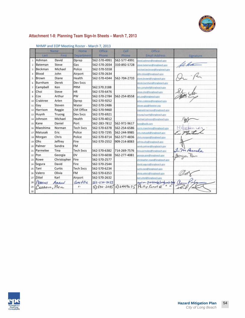
Attachment 1-8: Planning Team Sign-In Sheets – March 7, 2013

55
Prepared by:
55
Hazard Mitigation Plan City of Long Beach
Attachment 1-9: Planning Team Sign-In Sheets – August 8, 2013

56
Prepared by:
56
Hazard Mitigation Plan City of Long Beach

57
Prepared by:
57
Hazard Mitigation Plan City of Long Beach
Attachment 1-10: Planning Team Presentation Materials

58
Prepared by:
58
Hazard Mitigation Plan City of Long Beach
Attachment 1-11: Stakeholder Meeting Presentation Materials

59
Prepared by:
59
Hazard Mitigation Plan City of Long Beach
City of Long Beach Long Beach, with a population of approximately 462,000, covers 51 square miles in southwest Los Angeles County and is the 7th-largest city in California. It has some of the best shoreline, marinas and beaches in Southern California, and a superb climate moderated by pleasant ocean breezes. The City of Long Beach is recognized as the home of the Queen Mary, the Aquarium of the Pacific, the Long Beach Grand Prix, America's cargo gateway to the Pacific Rim through the Port of Long Beach (the Nation's second business container port), one of the world's most environmentally safe off-shore oil operations and numerous major business and commercial enterprises.
Long Beach has also been recognized by USA Today as the most diverse city in the United States- one of the City’s strongest assets. The City’s ethnic breakdown is approximately 40% Hispanic, 29% White, 14% Black, 13% Asian, and 4% all other ethnicities. Long Beach is a full-service city providing customary municipal services through departments such as police, fire, public works, library and parks, recreation, and marine. The City also owns and operates a leading deep water port, offshore and onshore oil production, a gas utility, a water utility, a commercial airport, a public health department, a convention and entertainment center, two historic ranchos, three marinas and five municipal golf courses. Long Beach is strategically located in the Southern California basin and is less than a 30-minute drive to Los Angeles and Orange County business centers. The City, widely recognized as a very desirable and livable community, is known for its unique neighborhoods, quality schools, excellent hospitals and noted arts and cultural resources.

60
Prepared by:
60
Hazard Mitigation Plan City of Long Beach
City of Long Beach
FAST FACTS
Incorporated: February 10, 1888, then dis-incorporated July 24, 1896. Second incorporation effective December 13, 1897
Size: ~51 square miles
Elevation: 0 feet (Sea Level)
Zip Codes: 90713, 90731, 90740, 90755, 90802, 90803, 90804, 90805, 90806, 90807, 90808, 90810, 90813, 90814, 90815, 90822, 90831
Population: 462,257 (as of 2010 Census)
Major Industries: Shipping, Oil, Manufacturing (Aircraft, Car Parts, Electronic)
Average Days of Sunshine: 345
Major Highways: 710 Long Beach Freeway (north/south) 405 San Diego Freeway (north/south) 605 San Gabriel River Freeway (north/south) Route 1 Pacific Coast Highway (east/west) State Route 91 (east/west)

61
Prepared by:
61
Hazard Mitigation Plan City of Long Beach

62
Prepared by:
62
Hazard Mitigation Plan City of Long Beach
Map 1-3: City of Long Beach - Parks and Schools (Source: City of Long Beach)

63
Prepared by:
Hazard Mitigation Plan City of Long Beach
Infrastructure This section provides an overview of the critical infrastructure that serves the City. The City is generally well-served by major freeways and arterial roadways, though the presence of numerous geological features results in discontinuous road segments. The characteristics of the existing transportation-related infrastructure are outlined below.
Regional Freeways Four freeways provide regional access to the City: the San Diego Freeway (I-405), the Long Beach Freeway (I-710), the San Gabriel River Freeway (I-605), and State Route 91. The location and abundance of these freeways will facilitate the orderly evacuation of large numbers of persons so long as they are undamaged following a disaster. See Map 1-3 above for proximity of freeways.
Local Roadways The dominant roadways in the City include Pacific Coast Highway, 7th Street, Long Beach Boulevard, Cherry Avenue, and Lakewood Boulevard. While these local arterial roadways are sufficient in accommodating local residents, a large-scale City-wide evacuation of workers may be constrained. Efforts are needed to ensure that these roadways are kept free and unobstructed at all times.
Bridges There are numerous man-made and natural features found in the City, including the Port of Long Beach channels and major regional freeways (I-405, I-710, I-605), that require bridges. Currently, a $1.1 billion project is underway to build a new bridge to span the Port of Long Beach’s back channel. This bridge, the Gerald Desmond Bridge Replacement, will be higher to allow additional clearance for larger, more efficient cargo ships, and will also be wider, to ease the flow of cars and trucks that use the bridge. The collapse or damage to any one of these bridge structures following a major disaster could impede both evacuation and emergency response efforts following a major disaster.
Utilities All utility services for the City of Long Beach are adequate and readily available to accommodate future growth. Major utility services in the City include the following:
Electricity Southern California Edison Company (SCE) provides basic electrical service for all residential and non-residential customers within the City. Power is available to most service areas, with underground lines situated along several of the major streets. There are no under-served areas, and there are no constraints to additional electric service needed for future development.
Natural Gas The Long Beach Gas & Oil Department (LBGO) provides basic residential and business gas services. The LBGO maintains multiple gas lines to serve Long Beach customers. There are no under-served areas, and the Department does not foresee any constraints to substantial future development within the City.

64
Prepared by:
Hazard Mitigation Plan City of Long Beach
Communications Various companies provide home and business phone service, as well as offering fiber optics capabilities. Video and data lines are also accessible to each residence via an existing network. There are currently no under-served areas.
Water The Long Beach Water Department provides water and sewer services to nearly half a million people through more than 90,000 service connections. Long Beach receives its potable (drinking) water supply from two main sources, groundwater and imported water. Ownership of pumping rights allows over half of the City’s water supply needs to be produced from groundwater wells located within the City. The other portion of the City's potable (drinking) water supply is treated surface water purchased from the Metropolitan Water District of Southern California (MWD). This water originates from two sources: the Colorado River, via the 242-mile Colorado River Aqueduct and Northern California's Bay-Delta region, via the 441-mile California Aqueduct.
Climate The climate in Long Beach is consistent with the region’s temperate weather patterns. The average daily temperatures range between 45°F and 85°F with August being the warmest month on average. Average annual precipitation averages between 13 to 16” per year with most of this precipitation occurring during the winter months. (Source: www.city-data.com)
Population and Demographics The population of City of Long Beach has steadily increased from the mid-1800s through 2010. Recently, the population has seen a half percentage point (.5%) increase from 2000 to 2010 according to the U.S. Census.

65
Prepared by:
Hazard Mitigation Plan City of Long Beach
Figure 1-1: Historical Population
(Source: www.City-Data.com)
According to the 2010 Census figures, the demographic makeup of the City is as follows:
Figure 1-2: City Demographics
(Source: 2010 U.S. Census)
Age of the City’s Population The age characteristics are important in determining emergency preparedness and mitigation planning actions (e.g. varying needs of young versus seniors). The Median age in the City of Long Beach is approximately 33 years old according to the 2010 U.S. Census.
358,921 361,379
426,499 459,699 462,257
-
50,000
100,000
150,000
200,000
250,000
300,000
350,000
400,000
450,000
500,000
1970 1980 1990 2000 2010
Population (#)
Year
Historic Population (1970-2010)
29%
41%
14%
13%
3%
Demographics (%)
White alone
Hispanic
Black
Asian
Other
Hispanic – 188,412 (40.8%)
White alone – 135,698 (29.4%)
Black alone – 59,925 (13.0%)
Asian alone – 58,286 (12.6%)
American Indian alone – 1,349 (0.3%)
Native Hawaiian and Other Pacific Islander alone – 4,915 (1.1%)
Some other race – 1,118 (0.2%) Two or more races – 12,572 (2.7%)

66
Prepared by:
Hazard Mitigation Plan City of Long Beach
Table 1-4: Population Age Characteristics for Long Beach (2000-2010)
(Source: U.S. Census - 2010)
Age Category 2000 2010 Change (#) Change (%)
Under 5 38,587 32,474 - 6,113 -16%
5-19 110,532 97,846 - 12,686 -11%
20-34 115,220 112,420 - 2,800 -2%
35-54 125,732 130,548 + 4,816 4%
55-64 29,549 46,134 + 16,585 56%
65+ 41,902 42,835 + 933 2%
Total: 461,552 462,257 735 0.2%
Housing Characteristics Following is a summary of housing types located in the Community. This is a factor in emergency preparedness because search and rescue operations are much more challenging in high-density neighborhoods. Table 1-5: Housing Characteristics
(Source: U.S. Census – 2010)
Unit Type Units - # Units - %
1-unit, detached 71,680 41.2%
1-unit, attached 10,190 5.8%
2-4 units 23,404 13.4%
5+ units 66,764 38.3%
Mobile Home 1,430 0.8%
Boat, RV, Van, etc. 718 0.4%
Total 174,366 100%
Table 1-6 depicts the 2010 U. S. Census statistics indicating the age of the housing units within the City. Age of housing stock is important because older buildings are generally more vulnerable to the effects of strong ground motion during earthquakes.
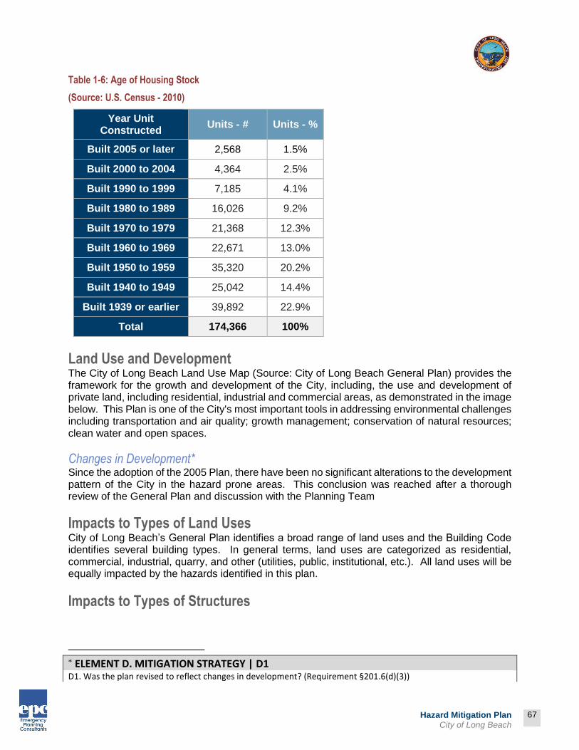
67
Prepared by:
Hazard Mitigation Plan City of Long Beach
Table 1-6: Age of Housing Stock
(Source: U.S. Census - 2010)
Year Unit Constructed
Units - # Units - %
Built 2005 or later 2,568 1.5%
Built 2000 to 2004 4,364 2.5%
Built 1990 to 1999 7,185 4.1%
Built 1980 to 1989 16,026 9.2%
Built 1970 to 1979 21,368 12.3%
Built 1960 to 1969 22,671 13.0%
Built 1950 to 1959 35,320 20.2%
Built 1940 to 1949 25,042 14.4%
Built 1939 or earlier 39,892 22.9%
Total 174,366 100%
Land Use and Development The City of Long Beach Land Use Map (Source: City of Long Beach General Plan) provides the framework for the growth and development of the City, including, the use and development of private land, including residential, industrial and commercial areas, as demonstrated in the image below. This Plan is one of the City's most important tools in addressing environmental challenges including transportation and air quality; growth management; conservation of natural resources; clean water and open spaces.
Changes in Development* Since the adoption of the 2005 Plan, there have been no significant alterations to the development pattern of the City in the hazard prone areas. This conclusion was reached after a thorough review of the General Plan and discussion with the Planning Team
Impacts to Types of Land Uses City of Long Beach’s General Plan identifies a broad range of land uses and the Building Code identifies several building types. In general terms, land uses are categorized as residential, commercial, industrial, quarry, and other (utilities, public, institutional, etc.). All land uses will be equally impacted by the hazards identified in this plan.
Impacts to Types of Structures
* ELEMENT D. MITIGATION STRATEGY | D1
D1. Was the plan revised to reflect changes in development? (Requirement §201.6(d)(3))

68
Prepared by:
Hazard Mitigation Plan City of Long Beach
City of Long Beach’s General Plan identifies a broad range of land uses and the Building Code identifies several building types. In general terms, structures are categorized as residential, commercial, industrial, institutional, park, and mixed-use zones. Map 1-4: City of Long Beach Land Use Map (Source: City of Long Beach General Plan)

69
Prepared by:
69
Hazard Mitigation Plan City of Long Beach
Employment and Industry Educational services, health care and social assistance are the principal employment activities in the City of Long Beach, as indicated below.
Table 1-7: City of Long Beach Industry
(Source: U.S. Census - 2010)
Industry Number Percent %
Civilian Employed Population (16 years and over) 214,291 100 %
Agriculture, forestry, fishing and hunting, and mining 954 0.4%
Construction 10,836 5.1%
Manufacturing 23,973 11.2%
Wholesale Trade 7,679 3.6%
Retail Trade 23,315 10.9%
Transportation and Warehousing, and Utilities 14,536 6.8%
Information 5,064 2.4%
Finance and insurance, and real estate and rental and leasing
12,292 5.7%
Professional, scientific, and management, and administrative and waste management services
24,700 11.5%
Educational services, and health care and social assistance
48,369 22.6%
Arts, entertainment, and recreation, and accommodation and food services
22,586 10.5%
Other services, except public administration 11,645 5.4%
Public administration 8,342 3.9%
The majority of employees working within Long Beach are within management, business, science, and arts occupations. Table 1-8: City of Long Beach Occupation
(Source: U.S. Census - 2010)
Occupation Number Percent
Civilian Employed Population (16 years and over)
214,291 100%
Management, business, science, and arts occupations
74,648 34.8%
Service occupations 41,095 19.2%
Sales and office occupations 55,865 26.1%

70
Prepared by:
70
Hazard Mitigation Plan City of Long Beach
Natural resources, construction, and maintenance occupations
15,559 7.3%
Production, transportation, and material moving occupations
27,124 12.7%

71
Prepared by:
71
Hazard Mitigation Plan City of Long Beach
PART 2: HAZARD ANALYSIS
What is a Risk Assessment? Conducting a risk assessment can provide information regarding: the location of hazards; the value of existing land and property in hazard locations; and an analysis of risk to life, property, and the environment that may result from natural, technological, and human-caused hazard events. Specifically, the five levels of a risk assessment are as follows:
1) Hazard Identification This section is the description of the geographic extent, potential intensity, and the probability of occurrence of a given hazard. Maps are used in this plan to display hazard identification data. The City of Long Beach identified a wide range of natural, human-caused, and technological hazards based on the California Mitigation Plan, County of Los Angeles Mitigation Plan, the City’s General Plan, and the City’s Emergency Operations Plan to identify all possible hazard sources. These hazards included: earthquake, flood, wildfire, landslide, windstorm, dam failure, tsunami, seiche, terrorism, public health emergency, infestation, drought, climate change, civil disobedience, transportation emergency, power failure, and agricultural loss. Review of the documents identified above provided insights into determining which of the hazards is most likely to have a significant negative impact on the City. Significance was defined as a hazard event that would result in the declaration of a local disaster. Based on that definition, it was concluded that the hazards posing the greatest threat are: earthquakes, floods, windstorms and tsunamis. Then, utilizing FEMA’s Calculated Priority Risk Index (CPRI) hazard ranking technique, the Planning Team was able to compare the identified hazards.
1. Hazard Identification
2. Profiling Hazard Events
3. Vulnerability Assessment/Inventory of Existing Assets
4. Risk Analysis
5. Assessing Vulnerability/Analyzing Development Trends

72
Prepared by:
72
Hazard Mitigation Plan City of Long Beach
Prioritizing Hazards
The CPRI value is obtained by assigning varying degrees of risk to four categories for each hazard, and then calculating an index value based on a weighting scheme.
The four criteria in the CPRI are Probability (45%), Magnitude/Severity (30%), Warning Time (15%) and Duration (10%).
For each of the criteria, there are four (4) options from which to choose: 1,2,3,4. Zero (0) is the value taken when an option is not assigned.
CPRI Example:
CPRI: Earthquake–San Andreas Fault M7.8
Probability = Likely = 3 Magnitude/Severity = Critical = 3 Warning Time = Less than 6 hours = 4 Duration = Less than 6 hours = 1
Here’s how to calculate the CPRI for Earthquake at this location: CPRI = [(3 x 0.45) + (3 x 0.30) + (4 x 0.15) + (1 x 0.10)] = 2.95

Prepared by:
73
Hazard Mitigation Plan City of Long Beach
Table 2-1: Calculated Priority Risk Index (Source: FEMA G235 Emergency Planning Course, 2010)
CPRI Category
Degree of Risk Assigned Weighting Factor
Level ID Description Index Value
Probability
Unlikely Extremely rare with no documented history of occurrences or events. Annual probability of less than 1 in 1,000 (<0.1%)
1
45% Possibly
Rare occurrences. Annual probability between 1 in 1,000 and 1 in 100 (0.1%-1%)
2
Likely Periodic occurrences with at least 2 or more documented historic events. Annual probability of between 1 in 100 and 1 in 10 (1%-10%)
3
Highly Likely Frequent events with a well-documented history of occurrence. Annual probability of greater than 1 in 10 (>10%)
4
Magnitude/ Severity
Negligible
Negligible property damages (less than 5% of critical and non-critical facilities and infrastructure owned by the Jurisdiction). Injuries or illnesses are treatable with first aid and there are no deaths. Negligible loss of quality of life. Shut down of critical public facilities for less than 24 hours.
1
30%
Limited
Slight property damage (greater than 5% and less than 25% of critical and non-critical facilities and infrastructure owned by the Jurisdiction). Injuries or illnesses do not result in permanent disability, and there are no deaths. Moderate loss of quality of life. Shut down of critical public facilities for more than 1 day and less than 1 week.
2
Critical
Moderate property damage (greater than 25% and less than 50% of critical and non-critical facilities and infrastructure owned by the Jurisdiction). Injuries or illnesses result in permanent disability and at least 1 death. Shut down of critical public facilities for more than 1 week and less than 1 month.
3
Catastrophic
Severe property damage (greater than 50% of critical and non-critical facilities and infrastructure owned by the Jurisdiction). Injuries and illnesses result in permanent disability and multiple deaths. Shut down of critical public facilities for more than 1 month.
4
Warning Time
> 24 hours Population will receive greater than 24 hours of warning. 1
15% 12–24 hours Population will receive between 12-24 hours of warning. 2
6-12 hours Population will receive between 6-12 hours of warning. 3
< 6 hours Population will receive less than 6 hours of warning. 4
Duration < 6 hours Disaster event will last less than 6 hours 1 10%

Prepared by:
74
Hazard Mitigation Plan City of Long Beach
< 24 hours Disaster event will last less than 6-24 hours 2
< 1 week Disaster event will last between 24 hours and 1 week. 3
> 1 week Disaster event will last more than 1 week 4
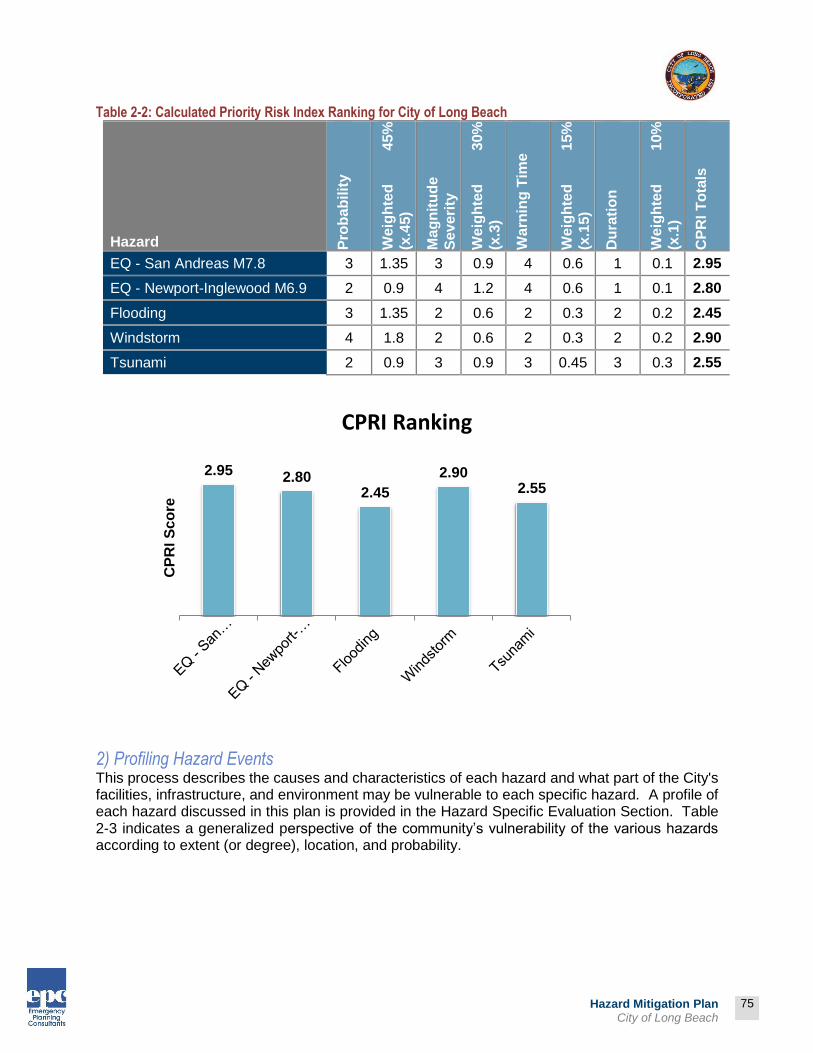
75
Prepared by:
75
Hazard Mitigation Plan City of Long Beach
Table 2-2: Calculated Priority Risk Index Ranking for City of Long Beach
Hazard Pro
bab
ilit
y
We
igh
ted
4
5%
(x.4
5)
Ma
gn
itu
de
Se
ve
rity
We
igh
ted
3
0%
(x.3
)
Wa
rnin
g T
ime
We
igh
ted
1
5%
(x.1
5)
Du
rati
on
We
igh
ted
1
0%
(x.1
)
CP
RI
To
tals
EQ - San Andreas M7.8 3 1.35 3 0.9 4 0.6 1 0.1 2.95
EQ - Newport-Inglewood M6.9 2 0.9 4 1.2 4 0.6 1 0.1 2.80
Flooding 3 1.35 2 0.6 2 0.3 2 0.2 2.45
Windstorm 4 1.8 2 0.6 2 0.3 2 0.2 2.90
Tsunami 2 0.9 3 0.9 3 0.45 3 0.3 2.55
2) Profiling Hazard Events This process describes the causes and characteristics of each hazard and what part of the City's facilities, infrastructure, and environment may be vulnerable to each specific hazard. A profile of each hazard discussed in this plan is provided in the Hazard Specific Evaluation Section. Table 2-3 indicates a generalized perspective of the community’s vulnerability of the various hazards according to extent (or degree), location, and probability.
2.95 2.802.45
2.902.55
CP
RI S
co
re
CPRI Ranking

76
Prepared by:
76
Hazard Mitigation Plan City of Long Beach
Table 2-3: Vulnerability: Location, Extent, and Probability for City of Long Beach *†
Hazard Location (Where)
Extent
(How Big an Event)
Annual Probability
(How Often)¹
Earthquake
Entire Project Area
The Southern California Earthquake Center (SCEC) in 2007 concluded that there is a 99.7 % probability that an earthquake of M6.7 or greater will hit California within 30 years. Earthquake would most likely originate from the San Andreas fault.
Likely
Flood Southeastern and southwestern corners of the Project Area
FEMA 100 Year Flood Zones Likely
Windstorm
Entire Project Area 50 miles per hour or greater Highly Likely
Tsunami Southern Boundary – Port of Long Beach
Maximum Run-Up (12 meters) Possible
¹Annual Probability is defined as: Unlikely = (<.01%), Possible = (.01%-1%), Likely = (1%-10%), Highly Likely = (>10%)
* ELEMENT B: HAZARD IDENTIFICATION AND RISK ASSESSMENT | B1
B1. Does the Plan include a description of the type, location, and extent of all natural hazards that can affect each jurisdiction(s)? (Requirement §201.6(c)(2)(i))
† ELEMENT B: HAZARD IDENTIFICATION AND RISK ASSESSMENT | B2
B2. Does the Plan include information on previous occurrences of hazard events and on the probability of future
hazard events for each jurisdiction? (Requirement §201.6(c)(2)(i))
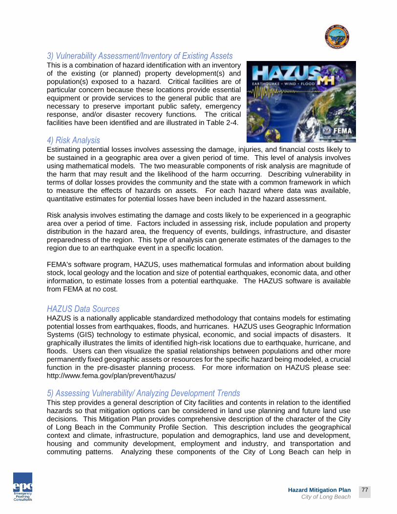
77
Prepared by:
77
Hazard Mitigation Plan City of Long Beach
3) Vulnerability Assessment/Inventory of Existing Assets This is a combination of hazard identification with an inventory of the existing (or planned) property development(s) and population(s) exposed to a hazard. Critical facilities are of particular concern because these locations provide essential equipment or provide services to the general public that are necessary to preserve important public safety, emergency response, and/or disaster recovery functions. The critical facilities have been identified and are illustrated in Table 2-4.
4) Risk Analysis Estimating potential losses involves assessing the damage, injuries, and financial costs likely to be sustained in a geographic area over a given period of time. This level of analysis involves using mathematical models. The two measurable components of risk analysis are magnitude of the harm that may result and the likelihood of the harm occurring. Describing vulnerability in terms of dollar losses provides the community and the state with a common framework in which to measure the effects of hazards on assets. For each hazard where data was available, quantitative estimates for potential losses have been included in the hazard assessment. Risk analysis involves estimating the damage and costs likely to be experienced in a geographic area over a period of time. Factors included in assessing risk, include population and property distribution in the hazard area, the frequency of events, buildings, infrastructure, and disaster preparedness of the region. This type of analysis can generate estimates of the damages to the region due to an earthquake event in a specific location. FEMA's software program, HAZUS, uses mathematical formulas and information about building stock, local geology and the location and size of potential earthquakes, economic data, and other information, to estimate losses from a potential earthquake. The HAZUS software is available from FEMA at no cost.
HAZUS Data Sources HAZUS is a nationally applicable standardized methodology that contains models for estimating potential losses from earthquakes, floods, and hurricanes. HAZUS uses Geographic Information Systems (GIS) technology to estimate physical, economic, and social impacts of disasters. It graphically illustrates the limits of identified high-risk locations due to earthquake, hurricane, and floods. Users can then visualize the spatial relationships between populations and other more permanently fixed geographic assets or resources for the specific hazard being modeled, a crucial function in the pre-disaster planning process. For more information on HAZUS please see: http://www.fema.gov/plan/prevent/hazus/
5) Assessing Vulnerability/ Analyzing Development Trends This step provides a general description of City facilities and contents in relation to the identified hazards so that mitigation options can be considered in land use planning and future land use decisions. This Mitigation Plan provides comprehensive description of the character of the City of Long Beach in the Community Profile Section. This description includes the geographical context and climate, infrastructure, population and demographics, land use and development, housing and community development, employment and industry, and transportation and commuting patterns. Analyzing these components of the City of Long Beach can help in

78
Prepared by:
78
Hazard Mitigation Plan City of Long Beach
identifying potential problem areas and can serve as a guide for incorporating the goals and ideas contained in this mitigation plan into other community development plans.
Critical and Essential Facilities Facilities critical to government response activities (i.e., life safety and property and environmental protection) include: local government 9-1-1 dispatch centers, local government emergency operations centers, local police and fire stations, local public works facilities, local communications centers, schools (shelters), and hospitals. Also, facilities that, if damaged, could cause serious secondary impacts are also considered "critical”. A hazardous materials facility is one example of this type of critical facility. Essential facilities are those facilities that are vital to the continued delivery of key City services or that may significantly impact the City’s ability to recover from the disaster. These facilities include but are not limited to: schools (hosting shelters); buildings such as the jail, law enforcement center, public services building, community corrections center, the courthouse, and juvenile services building and other public facilities. Existing and Critical Facilities Vulnerable to Hazards illustrates the critical facilities within City of Long Beach and the vulnerability of those facilities to the identified hazards.
79
Prepared by:
79
Hazard Mitigation Plan City of Long Beach
Table 2-4: Impacts of Hazards on Critical/Essential Facilities in the City of Long Beach
(Source: City of Long Beach GIS)

80
Prepared by:
80
Hazard Mitigation Plan City of Long Beach
Critical and Essential Facilities
Address: Name: Ea
rth
qu
ak
e
Flo
od
Win
ds
torm
Tsu
na
mi
Pu
bli
c H
ealt
h
Ev
en
ts
Tec
hn
olo
gic
al
Ev
en
ts
1 World Trade Center Long Beach World Trade Center
X X
X X
3601 Dock Street (POLB) Dow Chemical / Vopak
X X X X X X
901 W. 12th Street Air Products And Chemical X X X X
709 W. 16th Street Pacific Gas Exchange X X X X X
6801 2nd Street
Long Beach Water Department - Seawater Desalinization Test Facility
X X X X
598 E. Anaheim Street Shell Oil Company X X X X
2400 E. Artesia Boulevard
Edgington Oil Company Inc.
X X X X
4901 E. Carson Street Long Beach City College X X X X
3976 Cherry Avenue Air Gas Industries X X X X
4150 Donald Douglas Drive
Gulfstream Aerospace Corporation
X X X X
420 Henry Ford Avenue Tidelands Oil - Terminal Island
X X X X X X
1445 Judson Avenue Global Oil Production LLC X X X X X
3495 Lakewood Boulevard Gulfstream Aerospace
X X X X
3855 Lakewood Boulevard The Boeing Company
X X X X
6605 Long Beach Boulevard Equilon #135454
X X X X
1920 Lugger Way Petro Diamond Terminal Company
X X X X X
1305 E. Pacific Coast Highway Long Beach City College
X X X X
1790 Palo Verde Avenue, #A
Texaco Refining And Marketing
X X X X
5843 Paramount Boulevard Globe Gas Corporation
X X X X
5905 Paramount Boulevard
Arco Terminal Services Corp
X X X X
230 S. Pico Avenue Tidelands Oil - Z Water Injection Plant
X X X X
Critical and Essential Facilities

81
Prepared by:
81
Hazard Mitigation Plan City of Long Beach
Address: Name: Ea
rth
qu
ak
e
Flo
od
Win
ds
torm
Tsu
na
mi
Pu
bli
c H
ealt
h
Ev
en
ts
Tec
hn
olo
gic
al
Ev
en
ts
1300 Pier B Street Arco Terminal Services Corporation
X X X X
1850 Pier B Street National Gypsum Company X X X X X
1400 Pier C Street, #B-56-57
Arco Terminal Services Corporation
X X X X X X
1405 Pier C Street, #C73 World Oil Company
X X X X X X
228 Pier D Avenue Tidelands Oil - X&Y Tank Farm
X X X X X X
1150 Pier E Street Tidelands Oil - Water Injection Plant
X X X X X
750 Pier F Avenue Tidelands Oil - Micellar Plant
X X X X X
1004 Pier F Avenue Chem-Oil Long Beach Marine Terminal
X X X X X
1390 Pier F Avenue Tidelands Oil - Water Injection Plant
X X X X X
1280 Pier J Avenue Tidelands Oil - J Water Injection Plant
X X X X X
700 E. Shoreline Drive Shoreline Marine Fuel X X X X
3333 E. Spring Street Gulfstream Aerospace X X X X
692 Studebaker Road Edison Pipeline & Terminal (EPTC)
X X X X
3014 Studebaker Road Tosco Al-Sal Oil Company X X X X
300 Pier T Avenue (POLB) BP / Arco Terminal 1
X X X X X
1300 Pier B Street (POLB) BP / Arco Terminal 2
X X X X
1400 West Pier C Street (POLB) BP / Arco Terminal 3
X X X X X X
1004 Pier F Avenue Berth 209-211A Chem-Oil Marine Terminal
X X X X X
1720 Termino Avenue Community Hospital Long Beach
X X
Tsu
nam
i
X X
4800 Los Coyotes Boulevard East Police Substation
X X X X
2665 W. Seaside Avenue (Pier T Avenue)
NRG Long Beach Generation Plant
X X X X X X
1920 Lugger Way (POLB)
Petro-Diamond Terminal Company
X X X X X
Critical and Essential Facilities
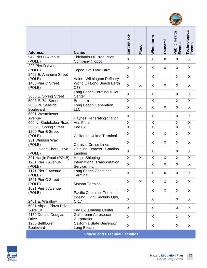
82
Prepared by:
82
Hazard Mitigation Plan City of Long Beach
Address: Name: Ea
rth
qu
ak
e
Flo
od
Win
ds
torm
Tsu
na
mi
Pu
bli
c H
ealt
h
Ev
en
ts
Tec
hn
olo
gic
al
Ev
en
ts
949 Pier G Avenue (POLB)
Tidelands Oil Production Company (Topco)
X X X X X
228 Pier D Avenue (POLB) Topco X-Y Tank Farm
X X X X X X
2402 E. Anaheim Street (POLB) Valero Wilmington Refinery
X X X X
1405 Pier C Street (POLB)
World Oil Long Beach Berth C73
X X X X X X
3605 E. Spring Street Long Beach Terminal II Jet Center
X X X X
5003 E. 7th Street Breitburn X X X X
2665 W. Seaside Boulevard
Long Beach Generation, LLC
X X X X X X
6801 Westminster Avenue Haynes Generating Station
X X X X
690 N. Studebaker Road Aes Plant X X X X
3605 E. Spring Street Fed Ex X X X X
1200 Pier E Street (POLB) California United Terminal
X X X X X
231 Windsor Way (POLB) Carnival Cruise Lines
X X X X X
320 Golden Shore Drive (POLB)
Catalina Express - Catalina Landing
X X X X
301 Hanjin Road (POLB) Hanjin Shipping X X X X X X
1281 Pier J Avenue (POLB)
International Transportation Service, Inc.
X X X X X
1171 Pier F Avenue (POLB)
Long Beach Container Terminal
X X X X X
1521 Pier C Street (POLB) Matson Terminal
X X X X X X
1521 Pier J Avenue (POLB) Pacific Container Terminal
X X X X X
2401 E. Wardlow Boeing Flight Security Ops, C-17
X X X X
5001 Airport Plaza Drive, Suite 10 Fed Ex (Loading Center)
X X X X
4150 Donald Douglas Drive
Gulfstream Aerospace Corporation
X X X X
1250 Bellflower Boulevard
California State University, Long Beach
X X X X
Critical and Essential Facilities

83
Prepared by:
83
Hazard Mitigation Plan City of Long Beach
Address: Name: Ea
rth
qu
ak
e
Flo
od
Win
ds
torm
Tsu
na
mi
Pu
bli
c H
ealt
h
Ev
en
ts
Tec
hn
olo
gic
al
Ev
en
ts
6204 E. 2nd Street City of Long Beach Marine Maintenance
X X X X X
3980 E. 7th Street Verizon California Incorporated
X X X X
1411 W. 14th Street Nextel Communications X X X X X
3333 Airport Way LBUSD - Food Service Branch
X X X X
1126 Loma Avenue Southern California Edison Company (Substation)
X X X X
4300 Long Beach Boulevard Nextel Communications
X X X X
555 E. Ocean Boulevard Nextel Communications X X X X
275 Magnolia Boulevard Long Beach Municipal Courts
X X X X
501 W. Ocean Boulevard
Glen Anderson Federal Building General Services Administration
X X X X
3050 Orange Avenue Nextel Communications X X X X
3090 Pacific Avenue Airtouch Cellular X X X X
6801 Westminster Avenue
Department of Water & Power-Haynes
X X X X
3500 Nimitz Road (POLB)
Defense Fuel Supply Point, Pier T12
X X X X X
700 Block of Hanjin Way (POLB) Substation Pier A
X X X X X
2400 E. Spring Street CNG X X X X
1800 E. Wardlow Road CNG (WATER) X X X X
400 W. Broadway CNG (POLICE) X X X X
400 W. Broadway Police Department Jail X X X X
120 Henry Ford Avenue CNG (ERRF) X X X X X X
120 Henry Ford Avenue Serrf X X X X X X
1835 Santa Fe Avenue West Police Division X X X X
1259 Pier F Avenue (POLB) Jacobsen Pilot Service, Inc.
X X X X X
4891 Atlantic Boulevard North Police Substation X X X X
2980 Nimitz Road, Pier T (POLB)
U.S. Department of Transportation
X X X X X
4100 East Donald Douglas Drive
Long Beach Terminal/Daugherty Field
X X X X
4600 East Spring Street United Parcel Service (Loading Center)
X X X X
Critical and Essential Facilities
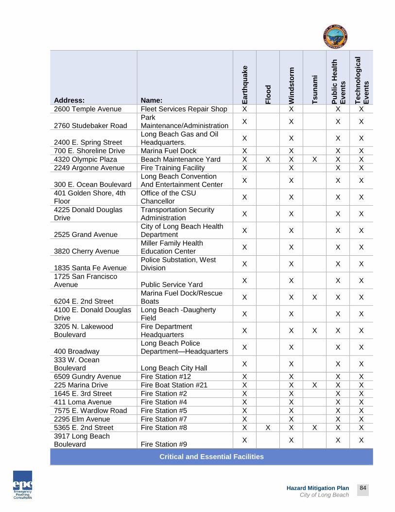
84
Prepared by:
84
Hazard Mitigation Plan City of Long Beach
Address: Name: Ea
rth
qu
ak
e
Flo
od
Win
ds
torm
Tsu
na
mi
Pu
bli
c H
ealt
h
Ev
en
ts
Tec
hn
olo
gic
al
Ev
en
ts
2600 Temple Avenue Fleet Services Repair Shop X X X X
2760 Studebaker Road Park Maintenance/Administration
X X X X
2400 E. Spring Street Long Beach Gas and Oil Headquarters.
X X X X
700 E. Shoreline Drive Marina Fuel Dock X X X X
4320 Olympic Plaza Beach Maintenance Yard X X X X X X
2249 Argonne Avenue Fire Training Facility X X X X
300 E. Ocean Boulevard Long Beach Convention And Entertainment Center
X X X X
401 Golden Shore, 4th Floor
Office of the CSU Chancellor
X X X X
4225 Donald Douglas Drive
Transportation Security Administration
X X X X
2525 Grand Avenue City of Long Beach Health Department
X X X X
3820 Cherry Avenue Miller Family Health Education Center
X X X X
1835 Santa Fe Avenue Police Substation, West Division
X X X X
1725 San Francisco Avenue Public Service Yard
X X X X
6204 E. 2nd Street Marina Fuel Dock/Rescue Boats
X X X X X
4100 E. Donald Douglas Drive
Long Beach -Daugherty Field
X X X X
3205 N. Lakewood Boulevard
Fire Department Headquarters
X X X X X
400 Broadway Long Beach Police Department—Headquarters
X X X X
333 W. Ocean Boulevard Long Beach City Hall
X X X X
6509 Gundry Avenue Fire Station #12 X X X X
225 Marina Drive Fire Boat Station #21 X X X X X
1645 E. 3rd Street Fire Station #2 X X X X
411 Loma Avenue Fire Station #4 X X X X
7575 E. Wardlow Road Fire Station #5 X X X X
2295 Elm Avenue Fire Station #7 X X X X
5365 E. 2nd Street Fire Station #8 X X X X X X
3917 Long Beach Boulevard Fire Station #9
X X X X
Critical and Essential Facilities
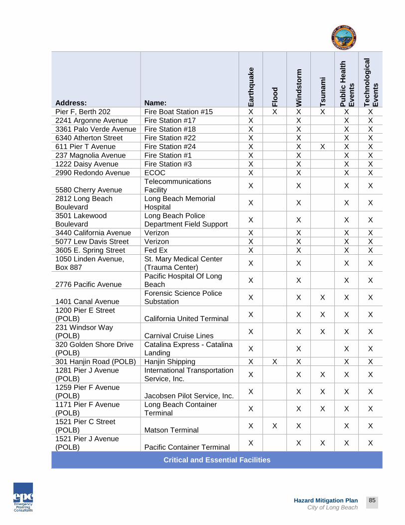
85
Prepared by:
85
Hazard Mitigation Plan City of Long Beach
Address: Name: Ea
rth
qu
ak
e
Flo
od
Win
ds
torm
Tsu
na
mi
Pu
bli
c H
ealt
h
Ev
en
ts
Tec
hn
olo
gic
al
Ev
en
ts
Pier F, Berth 202 Fire Boat Station #15 X X X X X X
2241 Argonne Avenue Fire Station #17 X X X X
3361 Palo Verde Avenue Fire Station #18 X X X X
6340 Atherton Street Fire Station #22 X X X X
611 Pier T Avenue Fire Station #24 X X X X X
237 Magnolia Avenue Fire Station #1 X X X X
1222 Daisy Avenue Fire Station #3 X X X X
2990 Redondo Avenue ECOC X X X X
5580 Cherry Avenue Telecommunications Facility
X X X X
2812 Long Beach Boulevard
Long Beach Memorial Hospital
X X X X
3501 Lakewood Boulevard
Long Beach Police Department Field Support
X X X X
3440 California Avenue Verizon X X X X
5077 Lew Davis Street Verizon X X X X
3605 E. Spring Street Fed Ex X X X X
1050 Linden Avenue, Box 887
St. Mary Medical Center (Trauma Center)
X X X X
2776 Pacific Avenue Pacific Hospital Of Long Beach
X X X X
1401 Canal Avenue Forensic Science Police Substation
X X X X X
1200 Pier E Street (POLB) California United Terminal
X X X X X
231 Windsor Way (POLB) Carnival Cruise Lines
X X X X X
320 Golden Shore Drive (POLB)
Catalina Express - Catalina Landing
X X X X
301 Hanjin Road (POLB) Hanjin Shipping X X X X X
1281 Pier J Avenue (POLB)
International Transportation Service, Inc.
X X X X X
1259 Pier F Avenue (POLB) Jacobsen Pilot Service, Inc.
X X X X X
1171 Pier F Avenue (POLB)
Long Beach Container Terminal
X X X X X
1521 Pier C Street (POLB) Matson Terminal
X X X X X
1521 Pier J Avenue (POLB) Pacific Container Terminal
X X X X X
Critical and Essential Facilities

86
Prepared by:
86
Hazard Mitigation Plan City of Long Beach
Address: Name: Ea
rth
qu
ak
e
Flo
od
Win
ds
torm
Tsu
na
mi
Pu
bli
c H
ealt
h
Ev
en
ts
Tec
hn
olo
gic
al
Ev
en
ts
4801 Airport Plaza (POLB)
Port of Long Beach Administration Building
X X X X X
2700 Nimitz Road (POLB) Sea Launch
X X X X X
2980 Nimitz Road, Pier T (POLB)
U.S. Department Of Transportation
X X X X X
4100 E. Donald Douglas Drive
Long Beach Terminal/Daugherty Field
X X X X
2401 E. Wardlow Boeing Flight Security Ops, C-17
X X X X
5001 Airport Plaza Drive, Suite 10 Fed Ex (Loading Center)
X X X X
1249 Pier F Avenue Port of Long Beach Joint Command Control Center
X X X X X
4150 Donald Douglas Drive
Gulfstream Aerospace Corporation
X X X X
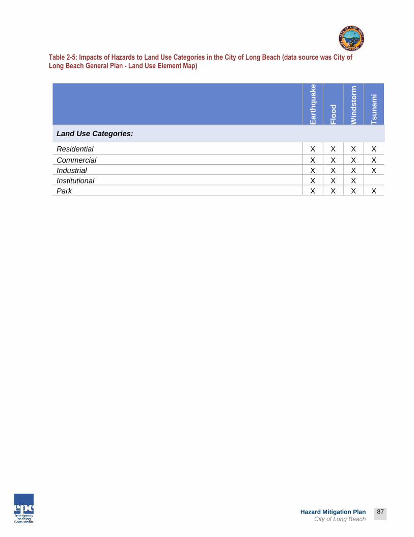
87
Prepared by:
87
Hazard Mitigation Plan City of Long Beach
Table 2-5: Impacts of Hazards to Land Use Categories in the City of Long Beach (data source was City of Long Beach General Plan - Land Use Element Map)
Ea
rth
qu
ak
e
Flo
od
Win
ds
torm
Tsu
na
mi
Land Use Categories:
Residential X X X X
Commercial X X X X
Industrial X X X X
Institutional X X X
Park X X X X

88
Prepared by:
88
Hazard Mitigation Plan City of Long Beach
Hazard Identification and Risk Assessment Definition An earthquake is a sudden, rapid shaking of the ground caused by the breaking and shifting of rock beneath the Earth's surface. For hundreds of millions of years, the forces of plate tectonics have shaped the Earth as the huge plates that form the Earth's surface move slowly over, under, and past each other. Sometimes the movement is gradual. At other times, the plates are locked together, unable to release the accumulating energy. When the accumulated energy grows strong enough, the plates break free causing the ground to shake. Most earthquakes occur at the boundaries where the plates meet; however, some earthquakes occur in the middle of plates. The major form of direct damage from most earthquakes is damage to construction. Bridges are particularly vulnerable to collapse, and dam and water tank failure may generate major downstream flooding. Buildings vary in susceptibility, dependent upon construction and the types of soils on which they are built. Earthquakes destroy power and telephone lines; gas, sewer, or water mains; which, in turn, may set off fires and/or hinder firefighting or rescue efforts. The hazard of earthquakes varies from place to place, dependent upon the regional and local geology. Where earthquakes have struck before, they will strike again. Earthquakes strike suddenly, without warning. Earthquakes can occur at any time of the year and at any time of the day or night. Ground movement during an earthquake is seldom the direct cause of death or injury. Most earthquake-related injuries result from collapsing walls, flying glass, and falling objects as a result of the ground shaking, or people trying to move more than a few feet during the shaking. Much of the damage in earthquakes is predictable and preventable.
Previous Occurrences of Earthquakes* City of Long Beach Although there are several faults within the vicinity of the City, notably including the Newport-Inglewood Fault, the most recent earthquake to impact the City was from Northridge Earthquake. The 1933 Long Beach Earthquake occurred on Sunday, March 10, 1933 at 5:54 pm. The 6.4 magnitude earthquake hit on the Newport-Inglewood fault off the coast of Newport Beach. The
* ELEMENT B: HAZARD IDENTIFICATION AND RISK ASSESSMENT | B2
B2. Does the Plan include information on previous occurrences of hazard events and on the probability of future hazard events for each jurisdiction? (Requirement §201.6(c)(2)(i))

89
Prepared by:
89
Hazard Mitigation Plan City of Long Beach
earthquake was felt for 15 seconds in 10 counties of Southern California and resulted in $50 million in damage ($900 million in 2013 dollars).
Impacts to the region:
Brick buildings with unreinforced masonry failed catastrophically
120 deaths and 5,000 injured
20,000 homes damaged
19 fires reported due to broken gas lines
127 breaks in water mains
Liquefaction occurred on the coast
75% of schools destroyed Response and recovery activities:
Residents took shelter in parks
National Guard fed breakfast in every park next morning
Sailors and Marines came from Fort McArthur with supplies
Red Cross maintained First Aid stations at hospital and camps
30 feeding centers serving 83,000 residents daily
Left: Long Beach Press Telegram Building, Right: 4th St. Elm & Atlantic

90
Prepared by:
90
Hazard Mitigation Plan City of Long Beach
In addition to causing structural damage, Long Beach experienced 127 breaks in water distribution mains. Nineteen fires were reported in Long Beach during the night of
the earthquake, with seven the result of broken gas lines. Liquefaction also occurred along much of the sparsely-populated coast between the cities of Newport Beach and Long Beach. Immediately following the incident, the City of Long Beach had to respond to the needs of its citizens. Many
residents, having lost their homes, took shelter in the parks. Fortunately, part of the Pacific Fleet had just returned to their home base in Long Beach Harbor after a six-month cruise, and the U.S. Navy sent ashore emergency supplies and about 2,000 sailors and Marines. The Army also sent men and supplies from Fort McArthur in San Pedro. The National Guard set up food kitchens, and by 6:00 a.m. the next morning, people were served breakfast in every park in the city. Water was also trucked in for those in areas where water mains had broken.
Los Angeles County Since seismologists started recording and measuring earthquakes, there have been tens of thousands of recorded earthquakes in Los Angeles County, most with a magnitude below three. The table as follows describes the historical earthquake events in Los Angeles County (Magnitude 5.0 or greater).
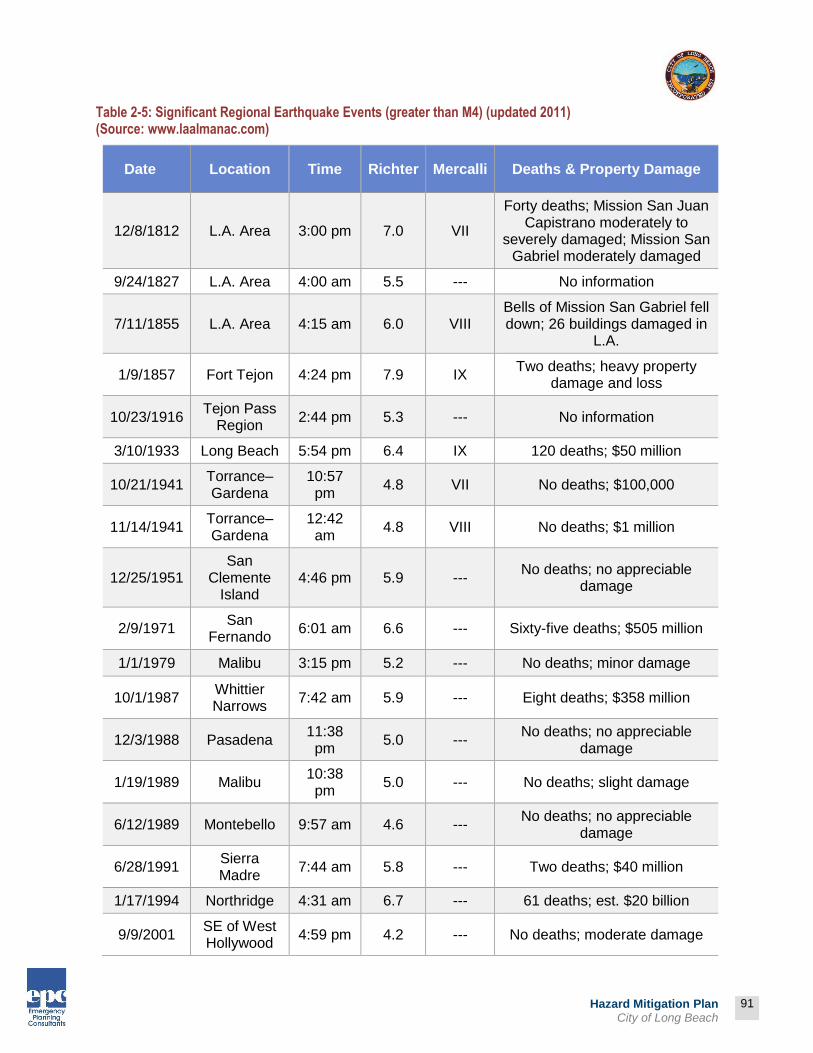
91
Prepared by:
91
Hazard Mitigation Plan City of Long Beach
Table 2-5: Significant Regional Earthquake Events (greater than M4) (updated 2011) (Source: www.laalmanac.com)
Date Location Time Richter Mercalli Deaths & Property Damage
12/8/1812 L.A. Area 3:00 pm 7.0 VII
Forty deaths; Mission San Juan Capistrano moderately to
severely damaged; Mission San Gabriel moderately damaged
9/24/1827 L.A. Area 4:00 am 5.5 --- No information
7/11/1855 L.A. Area 4:15 am 6.0 VIII Bells of Mission San Gabriel fell down; 26 buildings damaged in
L.A.
1/9/1857 Fort Tejon 4:24 pm 7.9 IX Two deaths; heavy property
damage and loss
10/23/1916 Tejon Pass
Region 2:44 pm 5.3 --- No information
3/10/1933 Long Beach 5:54 pm 6.4 IX 120 deaths; $50 million
10/21/1941 Torrance–Gardena
10:57 pm
4.8 VII No deaths; $100,000
11/14/1941 Torrance–Gardena
12:42 am
4.8 VIII No deaths; $1 million
12/25/1951 San
Clemente Island
4:46 pm 5.9 --- No deaths; no appreciable
damage
2/9/1971 San
Fernando 6:01 am 6.6 --- Sixty-five deaths; $505 million
1/1/1979 Malibu 3:15 pm 5.2 --- No deaths; minor damage
10/1/1987 Whittier Narrows
7:42 am 5.9 --- Eight deaths; $358 million
12/3/1988 Pasadena 11:38 pm
5.0 --- No deaths; no appreciable
damage
1/19/1989 Malibu 10:38 pm
5.0 --- No deaths; slight damage
6/12/1989 Montebello 9:57 am 4.6 --- No deaths; no appreciable
damage
6/28/1991 Sierra Madre
7:44 am 5.8 --- Two deaths; $40 million
1/17/1994 Northridge 4:31 am 6.7 --- 61 deaths; est. $20 billion
9/9/2001 SE of West Hollywood
4:59 pm 4.2 --- No deaths; moderate damage
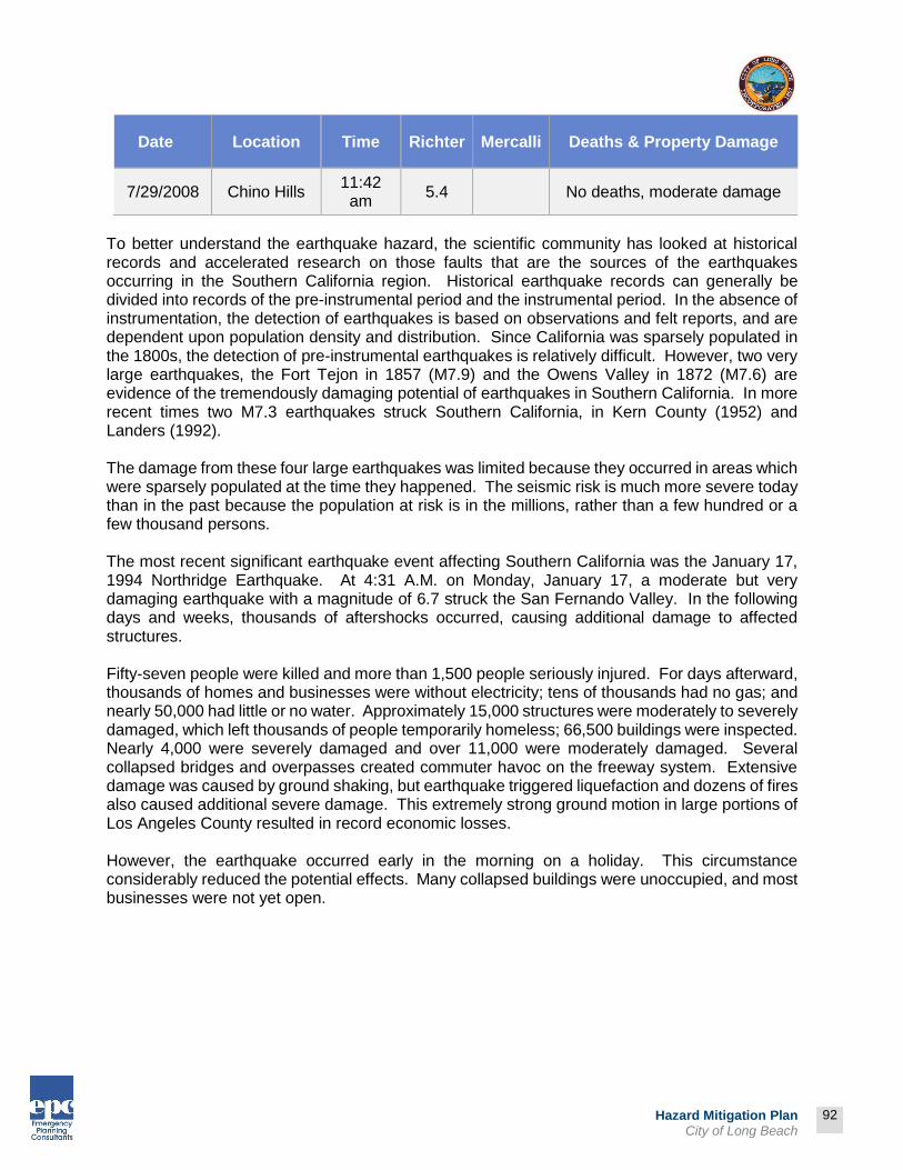
92
Prepared by:
92
Hazard Mitigation Plan City of Long Beach
Date Location Time Richter Mercalli Deaths & Property Damage
7/29/2008 Chino Hills 11:42 am
5.4 No deaths, moderate damage
To better understand the earthquake hazard, the scientific community has looked at historical records and accelerated research on those faults that are the sources of the earthquakes occurring in the Southern California region. Historical earthquake records can generally be divided into records of the pre-instrumental period and the instrumental period. In the absence of instrumentation, the detection of earthquakes is based on observations and felt reports, and are dependent upon population density and distribution. Since California was sparsely populated in the 1800s, the detection of pre-instrumental earthquakes is relatively difficult. However, two very large earthquakes, the Fort Tejon in 1857 (M7.9) and the Owens Valley in 1872 (M7.6) are evidence of the tremendously damaging potential of earthquakes in Southern California. In more recent times two M7.3 earthquakes struck Southern California, in Kern County (1952) and Landers (1992). The damage from these four large earthquakes was limited because they occurred in areas which were sparsely populated at the time they happened. The seismic risk is much more severe today than in the past because the population at risk is in the millions, rather than a few hundred or a few thousand persons. The most recent significant earthquake event affecting Southern California was the January 17, 1994 Northridge Earthquake. At 4:31 A.M. on Monday, January 17, a moderate but very damaging earthquake with a magnitude of 6.7 struck the San Fernando Valley. In the following days and weeks, thousands of aftershocks occurred, causing additional damage to affected structures. Fifty-seven people were killed and more than 1,500 people seriously injured. For days afterward, thousands of homes and businesses were without electricity; tens of thousands had no gas; and nearly 50,000 had little or no water. Approximately 15,000 structures were moderately to severely damaged, which left thousands of people temporarily homeless; 66,500 buildings were inspected. Nearly 4,000 were severely damaged and over 11,000 were moderately damaged. Several collapsed bridges and overpasses created commuter havoc on the freeway system. Extensive damage was caused by ground shaking, but earthquake triggered liquefaction and dozens of fires also caused additional severe damage. This extremely strong ground motion in large portions of Los Angeles County resulted in record economic losses. However, the earthquake occurred early in the morning on a holiday. This circumstance considerably reduced the potential effects. Many collapsed buildings were unoccupied, and most businesses were not yet open.
93
Prepared by:
93
Hazard Mitigation Plan City of Long Beach
Historical and geological records show that California has a long history of seismic events. Southern California is probably best known for the San Andreas Fault, a 400 mile long fault running from the Mexican border to a point offshore, west of San Francisco. “Geologic studies show that over the past 1,400 to 1,500 years large earthquakes have occurred at about 130 year intervals on the Southern San Andreas Fault. As the last large earthquake on the Southern San Andreas occurred in 1857, that section of the fault is considered a likely location for an earthquake within the next few decades.”
Earthquake Threat The City of Long Beach is located within a seismically active region located at the junction of the Transverse Ranges and the Peninsular Ranges in the Southern California region. These two physiographic provinces experience ongoing seismic activity associated with the lateral movement of the North American and Pacific tectonic plates. The San Andreas Fault system, located approximately 55 miles northeast of the City, delineates the boundary where these two plates are joined. Major faults located within the surrounding region that may affect the City in the future include the following:
San Andreas Fault The aforementioned San Andreas fault is considered most likely to produce a large seismic event within the next 100 years. The San Andreas fault lies approximately 55 miles northeast of the City. Geologic evidence suggests that a major earthquake (7.5 to 8.5 Richter magnitude) has a 50% chance of occurring within the next 30 years. An earthquake of this magnitude is comparable to the 1906 San Francisco earthquake and has the potential for causing considerable damage in the Southern California region. Map 2-3 illustrates the potential seismic shaking intensities of a M7.8 earthquake occurring on the San Andreas Fault. Perceived shaking from an earthquake of this magnitude would be strong to severe. Newport-Inglewood Fault An earthquake occurring along the Newport-Inglewood fault could impact Long Beach more severely than a San Andreas induced earthquake. The Newport-Inglewood fault is located within City limits and roughly parallels Interstate-405. Evidence suggests that a major earthquake on this fault (6.0 to 6.5 Richter magnitude) has a 15% to 50% probability of occurrence within the next 100 years. A 6.5 magnitude earthquake could produce severe ground shaking lasting from 12 to 18 seconds. Map 2-2 illustrates the potential seismic shaking intensities of a M6.9 earthquake occurring on the Newport-Inglewood Fault.
In addition to the above faults, a substantial number of previously unknown blind-thrust faults are now known to traverse the Los Angeles region. These faults are very deep and generally do not exhibit surface displacement common with the other types of faults. The two most recent damaging earthquakes in the Southern California region, the 1987 Whittier earthquake and the 1994 Northridge earthquake, originated from previously unknown blind thrust faults. Major faults found in the vicinity of the City are noted in Table 2-6 and Map 2-1.
California has a long history of seismic events
and is probably best known for the San Andreas Fault, a 400 mile long fault running from the Mexican border to a point offshore,
west of San Francisco.
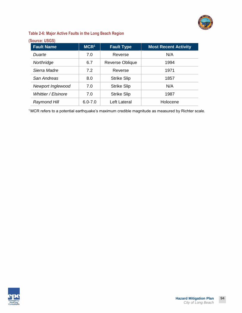
94
Prepared by:
94
Hazard Mitigation Plan City of Long Beach
Table 2-6: Major Active Faults in the Long Beach Region
(Source: USGS)
Fault Name MCR1 Fault Type Most Recent Activity
Duarte 7.0 Reverse N/A
Northridge 6.7 Reverse Oblique 1994
Sierra Madre 7.2 Reverse 1971
San Andreas 8.0 Strike Slip 1857
Newport Inglewood 7.0 Strike Slip N/A
Whittier / Elsinore 7.0 Strike Slip 1987
Raymond Hill 6.0-7.0 Left Lateral Holocene
1 MCR refers to a potential earthquake’s maximum credible magnitude as measured by Richter scale.
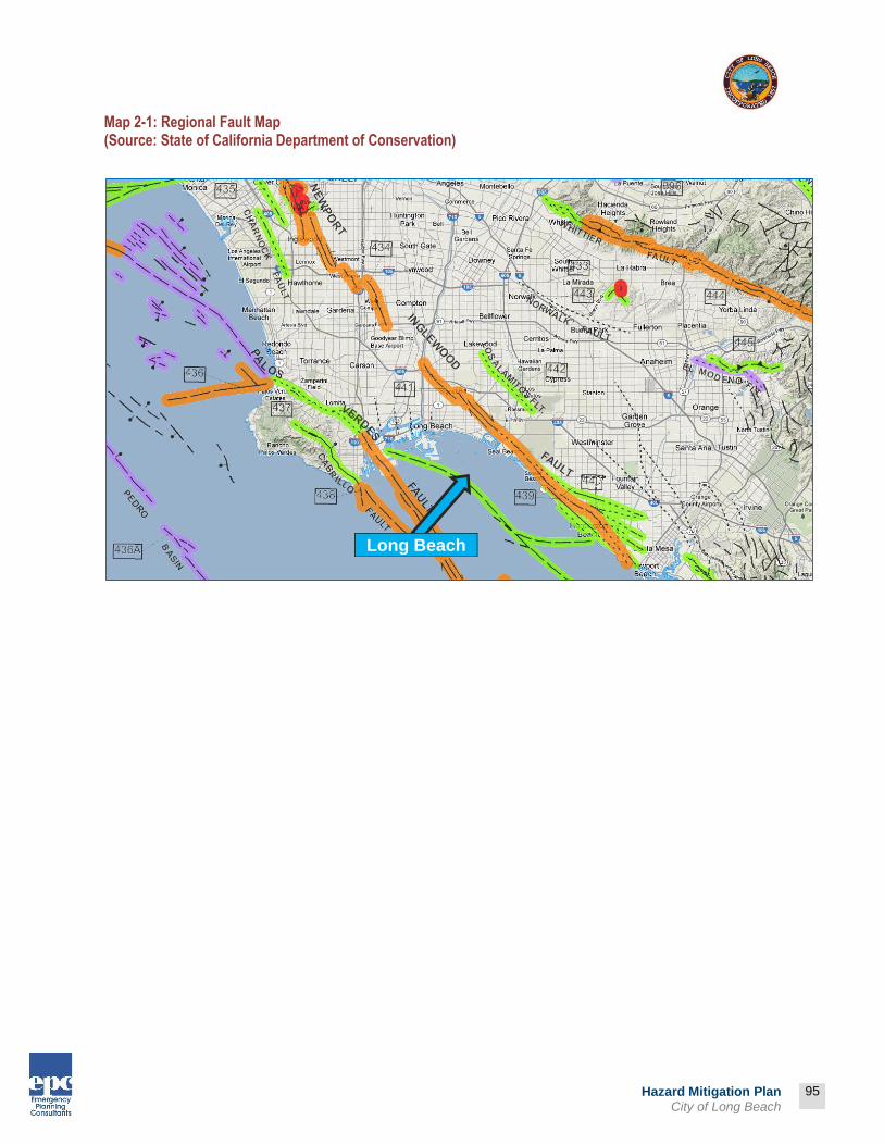
95
Prepared by:
95
Hazard Mitigation Plan City of Long Beach
Map 2-1: Regional Fault Map (Source: State of California Department of Conservation)
Long Beach

96
Prepared by:
96
Hazard Mitigation Plan City of Long Beach
Map 2-2: City of Long Beach Earthquake Hazard Areas (Source: City of Long Beach)

97
Prepared by:
97
Hazard Mitigation Plan City of Long Beach
Map 2-3: Seismic Shaking Intensities for the Newport-Inglewood Fault M6.9
(Source: State of California Department of Conservation)

98
Prepared by:
98
Hazard Mitigation Plan City of Long Beach
Map 2-4: Seismic Shaking Intensities for the San Andreas Fault M7.8 (Source: State of California Department of Conservation)

Prepared by:
99
Hazard Mitigation Plan City of Long Beach
Los Angeles County The following are seismic intensity maps that were developed by County of Los Angeles Office of Emergency Management – GIS during the 2012 update to the All-Hazard Mitigation Plan. The maps provide valuable insights into the regional ramifications of a significant seismic event.
Map 2-5: Shake Intensity Map - San Andreas Scenario M7.8
(Source: County of Los Angeles Office of Emergency Management – GIS)

Prepared by:
100
Hazard Mitigation Plan City of Long Beach
Map 2-6: General Building Stock Damage
(Source: County of Los Angeles Office of Emergency Management – GIS)

Prepared by:
101
Hazard Mitigation Plan City of Long Beach
Map 2-7: HAZUS - Total Debris
(Source: County of Los Angeles Office of Emergency Management – GIS)

102
Prepared by:
102
Hazard Mitigation Plan City of Long Beach
Probability The 2007 Working Group on California Earthquake Probabilities (WGCEP 2007), a multi-disciplinary collaboration of scientists and engineers, has released the Uniform California Earthquake Rupture Forecast (UCERF), the first comprehensive framework for comparing earthquake possibilities throughout all of California. In developing the UCERF, the 2007 Working Group revised earlier forecasts for Southern California (WGCEP 1995) and the San Francisco Bay Area (WGCEP 2003) by incorporating new data on active faults and an improved scientific understanding of how faults rupture to produce large earthquakes. It extended the forecast across the entire state using a uniform methodology, allowing for the first time, meaningful comparisons of earthquake probabilities in urbanized areas such as Los Angeles and San Francisco Bay Area, as well as comparisons among the large faults in different parts of the State. The study was organized by the Southern California Earthquake Center, the U.S. Geological Survey, and the California Geological Survey, and it received major support from the California Earthquake Authority, which is responsible for setting earthquake insurance rates statewide. According to the new forecast, California has a 99.7% chance of having a magnitude 6.7 or larger earthquake during the next 30 years. The likelihood of an even more powerful quake of magnitude 7.5 or greater in the next 30 years is 46%. Map 2-8: Probability of Earthquake M>6.7 within 30 Years (Source: USGS)

103
Prepared by:
103
Hazard Mitigation Plan City of Long Beach
Regulatory Background The State regulates development within California to reduce or mitigate potential hazards from earthquakes or other geologic hazards. Development in potentially seismically active areas is also governed by the Alquist-Priolo Earthquake Fault Zoning Act and the Seismic Hazards Mapping Act. The 1933 Long Beach Earthquake resulted in the Field Act, affecting school construction. The 1971 Sylmar Earthquake brought another set of increased structural standards. Similar re-evaluations occurred after the 1989 Loma Prieta Earthquake and 1994 Northridge Earthquake. These code changes have resulted in stronger and more earthquake resistant structures.
Measuring and Describing Earthquakes A tool used to describe earthquake intensity is the Magnitude Scale. The Magnitude Scale is sometimes referred to as the Richter Scale. The two are similar but not exactly the same. The Magnitude Scale was devised as a means of rating earthquake strength and is an indirect measure of seismic energy released. The Scale is logarithmic with each one-point increase corresponding to a 10-fold increase in the amplitude of the seismic shock waves generated by the earthquake. In terms of actual energy released, however, each one-point increase on the Richter scale corresponds to about a 32-fold increase in energy released. Therefore, a Magnitude 7 (M7) earthquake is 100 times (10 X 10) more powerful than a M5 earthquake and releases 1,024 times (32 X 32) the energy. The Modified Mercalli Scale (MMI) is another means for rating earthquakes, but one that attempts to quantify intensity of ground shaking. Intensity under this scale is a function of distance from the epicenter (the closer to the epicenter the greater the intensity), ground acceleration, duration of ground shaking, and degree of structural damage. This rates the level of severity of an earthquake by the amount of damage and perceived shaking.

104
Prepared by:
104
Hazard Mitigation Plan City of Long Beach
Table 2-7: Modified Mercalli Intensity Scale
MMI
Value
Description of
Shaking Severity
Summary Damage
Description Used
on 1995 Maps
Full Description
I Not Felt
II Felt by persons at rest, on upper floors, or favorably placed.
III Felt indoors. Hanging objects swing. Vibration like passing of light trucks. Duration estimated. May not be recognized as an earthquake.
IV Hanging objects swing. Vibration like passing of heavy trucks; or sensation of a jolt like a heavy ball striking the walls. Standing motorcars rock. Windows, dishes, doors rattle. In the upper range of IV, wooden walls and frame creak.
V Light Pictures Move
Felt outdoors; direction estimated. Sleepers wakened. Liquids disturbed, some spilled. Small unstable objects displaced or upset. Doors swing, close, open. Shutters, pictures move. Pendulum clock stop, start, change rate.
VI Moderate Objects Fall Felt by all. Many frightened and run outdoors. Persons walk unsteadily. Windows, dishes, glassware broken. Knickknacks, books, etc., off shelves. Pictures off walls. Furniture moved or overturned. Weak plaster and masonry D cracked.
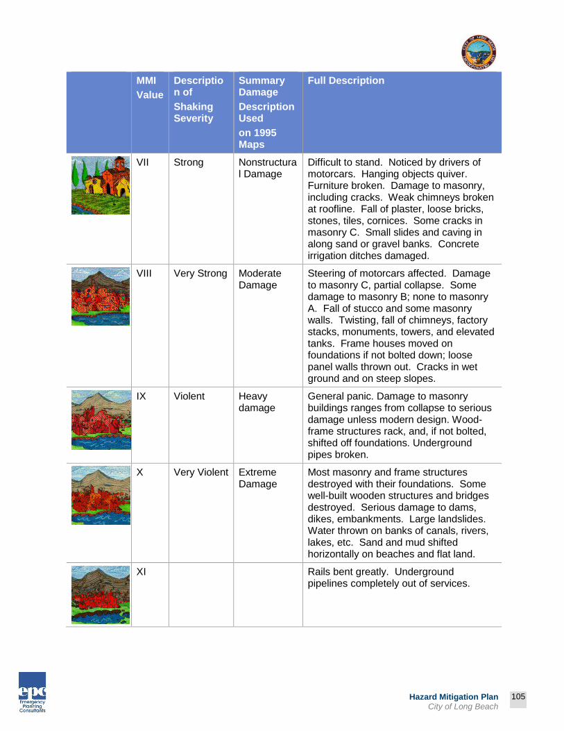
105
Prepared by:
105
Hazard Mitigation Plan City of Long Beach
MMI
Value
Description of
Shaking Severity
Summary Damage
Description Used
on 1995 Maps
Full Description
VII Strong Nonstructural Damage
Difficult to stand. Noticed by drivers of motorcars. Hanging objects quiver. Furniture broken. Damage to masonry, including cracks. Weak chimneys broken at roofline. Fall of plaster, loose bricks, stones, tiles, cornices. Some cracks in masonry C. Small slides and caving in along sand or gravel banks. Concrete irrigation ditches damaged.
VIII Very Strong Moderate Damage
Steering of motorcars affected. Damage to masonry C, partial collapse. Some damage to masonry B; none to masonry A. Fall of stucco and some masonry walls. Twisting, fall of chimneys, factory stacks, monuments, towers, and elevated tanks. Frame houses moved on foundations if not bolted down; loose panel walls thrown out. Cracks in wet ground and on steep slopes.
IX Violent Heavy damage
General panic. Damage to masonry buildings ranges from collapse to serious damage unless modern design. Wood-frame structures rack, and, if not bolted, shifted off foundations. Underground pipes broken.
X Very Violent Extreme Damage
Most masonry and frame structures destroyed with their foundations. Some well-built wooden structures and bridges destroyed. Serious damage to dams, dikes, embankments. Large landslides. Water thrown on banks of canals, rivers, lakes, etc. Sand and mud shifted horizontally on beaches and flat land.
XI Rails bent greatly. Underground pipelines completely out of services.

106
Prepared by:
106
Hazard Mitigation Plan City of Long Beach
MMI
Value
Description of
Shaking Severity
Summary Damage
Description Used
on 1995 Maps
Full Description
XII Damage nearly total. Large rock masses displaced. Lines of sight and level distorted. Objects thrown into air.

107
Prepared by:
107
Hazard Mitigation Plan City of Long Beach
Earthquake Related Hazards Ground shaking, landslides, liquefaction, and amplification are the specific hazards associated with earthquakes. The severity of these hazards depends on several factors, including soil and slope conditions, proximity to the fault, earthquake magnitude, and the type of earthquake.
Ground Shaking Ground shaking is the motion felt on the earth's surface caused by seismic waves generated by the earthquake. It is the primary cause of earthquake damage. The strength of ground shaking depends on the magnitude of the earthquake, the type of fault, and distance from the epicenter (where the earthquake originates). Buildings on poorly consolidated and thick soils will typically see more damage than buildings on consolidated soils and bedrock. Seismic activity along nearby or more distant fault zones are likely to cause ground shaking within the City limits.
Fault Rupture Fault rupture refers to the actual “tearing apart” of the ground surface along a fault trace resulting from an earthquake. The effects of fault rupture are typically mitigated by placing structures at a specified distance from the known fault trace. The State of California has promulgated regulations prohibiting the placement of structures over, or in close proximity to, a known fault trace through the implementation of the Alquist-Priolo Special Studies Zones (APSSZ). There is designated APSSZ (known as the southern Newport-Inglewood Fault Zone) in the City.
Liquefaction Liquefaction occurs when ground shaking causes wet granular soils to change from a solid state to a liquid state. This results in the loss of soil strength and the soil's ability to support weight. Buildings and their occupants are at risk when the ground can no longer support these structures. Liquefaction generally occurs during significant earthquake activity, and structures located on soils such as silt or sand may experience significant damage during an earthquake due to the instability of structural foundations and the moving earth. Many communities in Southern California are built on ancient river bottoms and have sandy soil. In some cases this ground may be subject to liquefaction, depending on the depth of the water table. In accordance with the Seismic Hazard Mapping Act, the California Division of Mines and Geology has evaluated liquefaction susceptibility for most of the Long Beach area. The following map shows the results of these studies.
Soil liquefaction is a
seismically induced form
of ground failure, which
has been a major cause of
earthquake damage in
southern California.
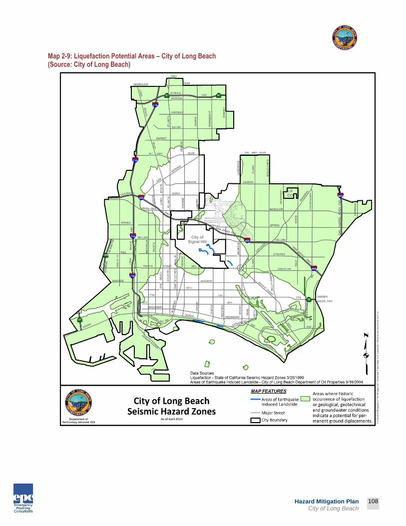
108
Prepared by:
108
Hazard Mitigation Plan City of Long Beach
Map 2-9: Liquefaction Potential Areas – City of Long Beach (Source: City of Long Beach)

109
Prepared by:
109
Hazard Mitigation Plan City of Long Beach
Vulnerability Following major earthquakes, extensive search and rescue operations may be required to assist trapped or injured persons. Emergency medical care, food and temporary shelter would be required for injured or displaced persons. In the event of a truly catastrophic earthquake, identification and burial of the dead would pose difficult problems. Mass evacuation may be essential to save lives, particularly in areas below dams. Many families could be separated, particularly if the earthquake should occur during working hours, and a personal inquiry or locator system would be essential to maintain morale. Emergency operations could be seriously hampered by the loss of communications and damage to transportation routes within, and to and from, the disaster area and by the disruption of public utilities and services. Extensive federal assistance could be required and could continue for an extended period. Efforts would be required to remove debris and clear roadways, demolish unsafe structures, assist in reestablishing public services and utilities, and provide continuing care and welfare for the affected population, including temporary housing for displaced persons. In general, the population is less at risk during non-work hours (if at home) as wood-frame structures are relatively less vulnerable to major structural damage than are typical commercial and industrial buildings. Transportation problems are intensified if an earthquake occurs during work hours, as significant numbers of employees would be stranded in the City. An earthquake occurring during work hours would clearly create major transportation problems for those displaced workers. In addition to the loss of production capabilities, the economic impact on the City from a major earthquake would be considerable in terms of loss of employment and loss of tax base. Also, a major earthquake could cause serious damage and/or outage to computer facilities. The loss of such facilities could curtail or seriously disrupt the operations of banks, insurance companies, and other elements of the financial community. In turn, this could affect the ability of local government, business and the population to make payments and purchases.
Vulnerability Assessment The effects of earthquakes span a large area, and large earthquakes occurring in many parts of the Southern California region would probably be felt throughout the region. However, the degree to which the earthquakes are felt, and the damages associated with them may vary. At risk from earthquake damage are large stocks of old buildings and bridges: many high-tech and hazardous materials facilities: extensive sewer, water, and natural gas pipelines; earth dams; petroleum pipelines; and other critical facilities and private property located in the county. The relative or secondary earthquake hazards, which are liquefaction, ground shaking, amplification, and earthquake-induced landslides, are just as devastating as the earthquake.

110
Prepared by:
110
Hazard Mitigation Plan City of Long Beach
Impact of Earthquakes in the City of Long Beach* Based on the risk assessment, it is evident that earthquakes will continue to have potentially devastating economic impacts to certain areas of the City. Impacts that are not quantified, but can be anticipated in future events, include:
Injury and loss of life; Commercial and residential structural damage; Disruption of and damage to public infrastructure; Secondary health hazards e.g. mold and mildew; Damage to roads/bridges resulting in loss of mobility; Significant economic impact (jobs, sales, tax revenue) upon the community; Negative impact on commercial and residential property values; and Significant disruption to students and teachers as temporary facilities and relocations
would likely be needed.
* ELEMENT B: HAZARD IDENTIFICATION AND RISK ASSESSMENT | B3
B3. Is there a description of each identified hazard’s impact on the community as well as an overall summary of the community’s vulnerability for each jurisdiction? (Requirement §201.6(c)(2)(ii))

111
Prepared by:
111
Hazard Mitigation Plan City of Long Beach
Hazard Identification and Risk Assessment Definition A flood is defined as an overflowing of water onto an area of land that is normally dry. Floods generally occur from natural causes, usually weather-related, such as a sudden snow melt, often in conjunction with a wet or rainy spring or with sudden and very heavy rainfalls. Floods can, however, result from human causes as a dam impoundment bursting. Dam break floods are usually associated with intense rainfall or prolonged flood conditions. In the Los Angeles County area, an earthquake can cause dam failure. The greatest threat to people and property is normally in areas immediately below the dam since flood discharges decrease as the flood wave moves downstream. For floodplain management purposes, the following discussion describes the Federal Emergency Management Agency (FEMA) definition of “100-year flood.” The term "100-year flood" is misleading. It is not a flood that will occur once every 100 years. Rather, it is the flood elevation that has a one percent chance of being equaled or exceeded each year. Thus, a 100-year flood could occur more than once in a relatively short period of time. The 100-year flood, which is the standard used by most federal and state agencies, is used by the National Flood Insurance Program (NFIP) as the standard for floodplain management and to determine the need for flood insurance. A structure located within a special flood hazard area shown on a map has a 26 percent chance of suffering flood damage during a 30 year period.
Previous Occurrences of Flooding* City of Long Beach In spite of the region’s semi-arid climate, it has experienced flood-related events during its history. In recent history, the City has experienced isolated flooding damage from El Nino storms (1998). Nonetheless, major floods have impacted the surrounding region and throughout Los Angeles County. Major floods that have impacted the County are summarized below. Table 2-8: Historical Record of Large Floods in Los Angeles County
(Source: NOAA)
Date Loss Estimation
Source of Estimate Comments
1995 $50 million National Oceanic and Atmospheric Association Flash Flood
1995 $50 thousand National Oceanic and Atmospheric Association Flood/Flash Flood
2005 $1 million National Oceanic and Atmospheric Association Flash Flood
2007 $300 thousand National Oceanic and Atmospheric Association Flash Flood
2010 $3.2 million National Oceanic and Atmospheric Association Flash Flood
* ELEMENT B: HAZARD IDENTIFICATION AND RISK ASSESSMENT | B2
B2. Does the Plan include information on previous occurrences of hazard events and on the probability of future hazard events for each jurisdiction? (Requirement §201.6(c)(2)(i))

112
Prepared by:
112
Hazard Mitigation Plan City of Long Beach
Flood Threat The size and frequency of a flood in a particular area depends on a complex combination of conditions, including the amount, intensity, and distribution of rainfall previous moisture condition and drainage patterns. The magnitude of a flood is measured in terms of its peak discharge, which is the maximum volume of water passing a point along a channel in a given amount of time, usually expressed in cubic feet per second (cfs). Floods are usually referred to in terms of their chance of occurrence. For example, a 100-year flood has a 1% chance of occurring in any given year. The Federal Emergency Management Agency (FEMA) establishes base flood heights and inundation areas for 100-year and 500-year flood zones. The 100-year flood zone is defined as the area that could be inundated by the flood which has a one percent probability of occurring in any given year. The 500-year flood is defined as the flood which has a 0.2 percent probability of occurring in any given year. The City participates in the National Flood Insurance Program (NFIP). Created by Congress in 1968, the NFIP makes flood insurance available in communities that enact minimum floodplain management rules consistent with the Code of Federal Regulations §60.3.
City of Long Beach Map 2-9 below identifies areas within the City that have the potential to be impacted in the event of a 100-year or 500-year flood. According to FEMA, the built areas of the City are in Flood Zone X, meaning that the area is not located within a 100-yearflood plain. FEMA maps showing areas that require flood insurance are maintained at City Hall.
Rainfall As mentioned earlier in the Community Profile, the average rainfall in the City of Long Beach is between 13 -16” per year. However, large storms can cause quick bursts of rapid rainfall in a very short period of time. The soil in the City is generally not able to effectively absorb water quickly, nor is it able to absorb a large volume of water. Therefore, when the region does experience heavy rain, or rain over a period of days or weeks, flash flooding is a common problem.
El Niño El Niño is a disruption of the ocean-atmosphere system in the tropical Pacific having important consequences. Among these consequences is increased rainfall across the southern tier of the United States, which has caused destructive flooding, and drought in the West Pacific. Observations of conditions in the tropical Pacific are considered essential for the prediction of short term (a few months to 1 year) climate variations. El Niño (Spanish name for the male child), initially referred to a weak, warm current appearing annually around Christmas time along the coast of Ecuador and Peru, and lasting only a few weeks, to a month or more. Every three to seven years, an El Niño event can last for many months, having significant economic and atmospheric consequences worldwide. During the past forty years, ten of these major El Niño events have been recorded, the worst of which occurred in 1997-1998. Previous to this, the El Niño event in 1982-1983 was the strongest. Some of the El Niño events have persisted more than one year.

113
Prepared by:
113
Hazard Mitigation Plan City of Long Beach
Severity Floods threaten life and property. People and animals can drown; structures and their contents destroyed; roads, bridges, and railroad tracks can be washed out; and crops ruined. Floods can create health hazards due to the discharge of raw sewage from damaged septic tank leach fields, sewer lines, and sewage treatment plants; or due to hazardous materials carried off by raging waters.
Flood Terminology Floodplain A floodplain is a land area adjacent to a river, stream, lake, estuary, or other water body that is subject to flooding. This area, if left undisturbed, acts to store excess flood water. The floodplain is made up of two sections: the floodway and the flood fringe.
100-Year Flood The 100-year flooding event is the flood having a one percent chance of being equaled or exceeded in magnitude in any given year. Contrary to popular belief, it is not a flood occurring once every 100 years. The 100-year floodplain is the area adjoining a river, stream, or watercourse covered by water in the event of a 100-year flood. The schematic below shows the relationship of the floodplain and the floodway.

114
Prepared by:
114
Hazard Mitigation Plan City of Long Beach
Map 2-10: 100-Year Flood Zone
(Source: City of Long Beach)
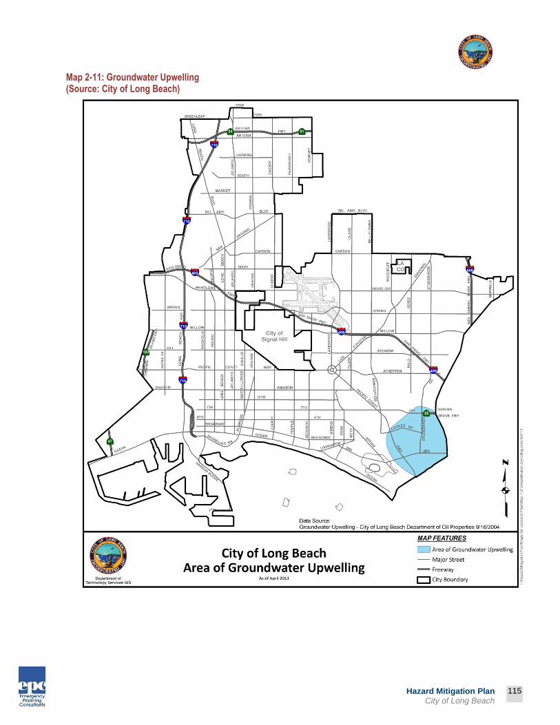
115
Prepared by:
115
Hazard Mitigation Plan City of Long Beach
Map 2-11: Groundwater Upwelling (Source: City of Long Beach)

Prepared by:
116
Hazard Mitigation Plan City of Long Beach
Map 2-12: Flood Zones and County-Operated Critical Facilities – Fourth District
(Source: County of Los Angeles GIS)

117
Prepared by:
117
Hazard Mitigation Plan City of Long Beach
Types of Flooding Urban Flooding As land is converted from fields or woodlands to roads and parking lots, it loses its ability to absorb rainfall. Urbanization of a watershed changes the hydrologic systems of the basin. Heavy rainfall collects and flows faster on impervious concrete and asphalt surfaces. The water moves from the clouds, to the ground, and into streams at a much faster rate in urban areas. Adding these elements to the hydrological systems can result in flood waters that rise very rapidly and peak with violent force. The City of Long Beach has a high concentration of impermeable surfaces that either collect water, or concentrate the flow of water in unnatural channels. During periods of urban flooding, streets can become swift moving rivers and basements can fill with water. Storm drains often back up with vegetative debris causing additional, localized flooding.
Riverine Flooding Riverine flooding is the overbank flooding of rivers and streams. The natural processes of riverine flooding add sediment and nutrients to fertile floodplain areas. Flooding in large river systems typically results from large-scale weather systems that generate prolonged rainfall over a wide geographic area, causing flooding in hundreds of smaller streams, which then drain into the major rivers. Shallow area flooding is a special type of riverine flooding. FEMA defines shallow flood hazards as areas that are inundated by the 100-year flood with flood depths of only one to three feet. These areas are generally flooded by low velocity sheet flows of water.
Dam Failure Flooding Loss of life and damage to structures, roads, and utilities may result from a dam failure. Economic losses can also result from a lowered tax base and lack of utility profits. These effects would certainly accompany the failure of one of the major dams impacting the City of Long Beach. The primary flood control facilities with potential to impact the City include the Santa Fe Dam and Reservoir and Whittier Narrows Dam. Whittier Narrows Dam The following information was copied from the U.S. Army Corps of Engineers website focusing on their Dam Safety Program:
Whittier Narrows Dam is a flood risk management and water conservation project constructed in 1957 and operated by the U.S. Army Corps of Engineers, Los Angeles District. The project is located, as its name implies, at the "Whittier Narrows,” a natural gap in the hills that form the southern boundary of the San Gabriel Valley. The Rio Hondo and the San Gabriel Rivers flow through this gap and are impounded by the reservoir. Whittier Narrows Dam received a Dam Safety Action Class II, or DSAC II, rating in December 2008 based on a Screen Portfolio Risk Analysis conducted in May 2006. A DSAC II rating is given to dams where failure could begin during normal operations or be initiated as the consequence of an event. The likelihood of failure from one of these occurrences, prior to remediation, is too high to assure public safety; or the combination of life or economic consequences with probability of failure is very high. Whittier Narrows Dam received a DSAC II rating because of the potential for: • Overtopping of dam due to inoperable gates after major seismic event • Loss of pool due to seepage and piping along the utility conduits and control facilities

118
Prepared by:
118
Hazard Mitigation Plan City of Long Beach
• Loss of pool due to erosion and head-cutting of the embankment during a Project Maximum Flood (PMF) • Loss of pool due to seepage and piping of foundation during normal to high pool levels As a result of Whittier Narrows Dam’s DSAC II rating, the Corps has implemented the following Interim Risk Reduction Measures, or IRRMs: • Remote monitoring • Inspection and monitoring • Flood mapping • Update the Emergency Action Plan annually • Inspect toe drain and gallery • The Corps completed an Issue Evaluation Study (IES) that confirmed the Carbon Canyon Dam DSAC Rating and recommended initiating a Dam Safety Modification Study. What’s next? • Conducting a tabletop exercise (2013) • Rehabilitate the relief well (2014) • Repair toe drain and conduit (2014) • Pre-positioning of materials (2014) • Modifications are needed to address potential failure modes at Whittier Narrows Dam. The Corps will begin a Dam Safety Modification Study to be completed in July 2014. In the study, engineers will develop and evaluate scenarios to modify the dam to withstand failure during rare events. A Dam Safety Modification Study is similar to a feasibility study, with a similar projected duration of two to three years. The result of the study will be a recommended mitigation plan that will undergo peer review, go through an approval process and, depending on availability of funds, ultimately be designed and constructed.
Because dam failure can have severe consequences, FEMA requires that all dam owners develop Emergency Action Plans (EAP) for warning, evacuation, and post-flood actions. Although there may be coordination with county officials in the development of the EAP, the responsibility for developing potential flood inundation maps and facilitation of emergency response is the responsibility of the dam owner. The City of Long Beach is actively involved with the Corps of Engineers concerning the status of the Whittier Narrows Dam, including the various exercises and studies mentioned above.

Prepared by:
119
Hazard Mitigation Plan City of Long Beach
Map 2-13: Dam Inundation Zones and County-Operated Critical Facilities – Fourth District
(Source: County of Los Angeles GIS)
120
Prepared by:
120
Hazard Mitigation Plan City of Long Beach
NFIP Participation* The City of Long Beach participates in NFIP. Unfortunately, FEMA flood maps are not entirely accurate. These studies and maps represent flood risk at the point in time when FEMA completed the studies, and does not incorporate planning for floodplain changes in the future due to new development. Although FEMA is considering changing that policy, it is optional for local communities. The FEMA FIRM maps for the City of Long Beach were last updated September 26, 2008. Map 2-9 represents the current status of the FIRM map. Human-caused and natural changes to the environment have changed the dynamics of storm water run-off since then.
Vulnerability
Vulnerability Assessment A vulnerability assessment combines the floodplain boundary, generated through hazard identification, with an inventory of the property within the floodplain. Understanding the population and property exposed to hazards will assist in reducing risk and preventing loss from future events. Because site-specific inventory data and inundation levels given for a particular flood event (10-year, 25-year, 50-year, 100-year, and 500-year) are not readily available, calculating a community’s vulnerability to flood events is not straightforward. The amount of property in the floodplain, as well as the type and value of structures on those properties, should be calculated to provide a working estimate for potential flood losses.
Impact of Flooding in the City of Long Beach† Floods and their impacts vary by location and severity of any given flood event, and likely only affect certain areas of the Long Beach during specific times. Based on the risk assessment, it is evident that floods will continue to have devastating economic impact to certain areas of the city. Impact that is not quantified, but anticipated in future events includes:
Injury and loss of life; Commercial and residential structural damage; Disruption of and damage to public infrastructure; Secondary health hazards e.g. mold and mildew Damage to roads/bridges resulting in loss of mobility Significant economic impact (jobs, sales, tax revenue) upon the community Negative impact on commercial and residential property values and Significant disruption to students and teachers as temporary facilities and relocations
would likely be needed.
Property Loss Resulting from Flooding Events
* ELEMENT C. MITIGATION STRATEGY | C2
C2. Does the Plan address each jurisdiction’s participation in the NFIP and continued compliance with NFIP requirements, as appropriate? (Requirement §201.6(c)(3)(ii)) † ELEMENT B: HAZARD IDENTIFICATION AND RISK ASSESSMENT | B3
B3. Is there a description of each identified hazard’s impact on the community as well as an overall summary of the community’s vulnerability for each jurisdiction? (Requirement §201.6(c)(2)(ii))

121
Prepared by:
121
Hazard Mitigation Plan City of Long Beach
The type of property damage caused by flood events depends on the depth and velocity of the flood waters. Faster moving flood waters can wash buildings off their foundations and sweep cars downstream. Pipelines, bridges, and other infrastructure can be damaged when high waters combine with flood debris. Extensive damage can be caused by basement flooding and landslide damage related to soil saturation from flood events. Most flood damage is caused by water saturating materials susceptible to loss (i.e., wood, insulation, wallboard, fabric, furnishings, floor coverings, and appliances). In many cases, flood damage to homes renders them unlivable.
Repetitive Loss Properties* Repetitive Loss Properties (RLPs) are most susceptible to flood damages; therefore, they have been the focus of flood hazard mitigation programs. Unlike a countywide program, the Floodplain Management Plan (FMP) for repetitive loss properties involves highly diversified property profiles, drainage issues, and property owner’s interest. It also requires public involvement processes unique to each RLP area. The objective of an FMP is to provide specific potential mitigation measures and activities to best address the problems and needs of communities with repetitive loss properties. A repetitive loss property is one for which two or more claims of $1,000 or more have been paid by the National Flood Insurance Program (NFIP) within any given ten-year period. According to FEMA resources, there are no Repetitive Loss Properties (RLPs) within the City of Long Beach.
Business/Industry Flood events impact businesses by damaging property and by interrupting business. Flood events can cut off customer access to a business as well as close a business for repairs. A quick response to the needs of businesses affected by flood events can help a community maintain economic vitality in the face of flood damage. Possible sources of relief to businesses could include funding to assist owners in elevating or relocating flood-prone business structures. Business owners eligible for NFIP insurance are strongly encouraged to maintain their insurance coverage.
Public Infrastructure Publicly owned facilities are a key component of daily life for all citizens of the county. Damage to public water and sewer systems, transportation networks, flood control facilities, emergency facilities, and offices can hinder the ability of the government to deliver services. Government can take action to reduce risk to public infrastructure from flood events, as well as craft public policy that reduces risk to private property from flood events.
Roads During hazard events, or any type of emergency or disaster, dependable road connections are critical for providing emergency services. Roads systems in the City of Long Beach are maintained by multiple jurisdictions. Federal, state, county, and city governments all have a stake in protecting roads from flood damage. Road networks often traverse floodplain and floodway areas. Transportation agencies responsible for road maintenance are typically aware of roads at risk from flooding.
Storm Water Systems * ELEMENT B: HAZARD IDENTIFICATION AND RISK ASSESSMENT | B4
B4. Does the Plan address NFIP insured structures within the jurisdiction that have been repetitively damaged by floods? (Requirement §201.6(c)(2)(ii))
122
Prepared by:
122
Hazard Mitigation Plan City of Long Beach
Local drainage problems are common throughout the City of Long Beach. The City of Long Beach Public Works staff is aware of local drainage threats. The problems are often present where storm water runoff enters culverts or goes underground into storm sewers. Inadequate maintenance can also contribute to the flood hazard in urban areas.
Debris in the Storm Drains Storm water pollution is urban runoff water that picks up pollutants as it flows through the storm drain system – a network of channels, gutters and pipes that collect runoff from city streets, neighborhoods, farms, construction sites and parking lots – and empties directly into local waterways. Unlike sewage, which goes to treatment plants, urban runoff flows untreated through the storm drain system. Anything thrown, swept or poured into the street, gutter or a catch basin – the curbside openings that lead into the storm drain system – can flow directly into our channels, creeks, bays and ocean. This includes pollutants like trash, pet waste, cigarette butts, motor oil, anti-freeze, runoff from pesticides and fertilizers, paint from brushes and containers rinsed in the gutter, and toxic household chemicals. Contaminated urban runoff is an uncontrolled nonpoint source of pollution into local waters, and contributes to beach closures. Litter, leaves and other debris clog catch basins causing flooding when it rains. It is illegal for businesses without a permit to discharge wastewater or other materials into the storm drain system.
Water Quality Environmental water quality problems include bacteria, toxins, and pollution.
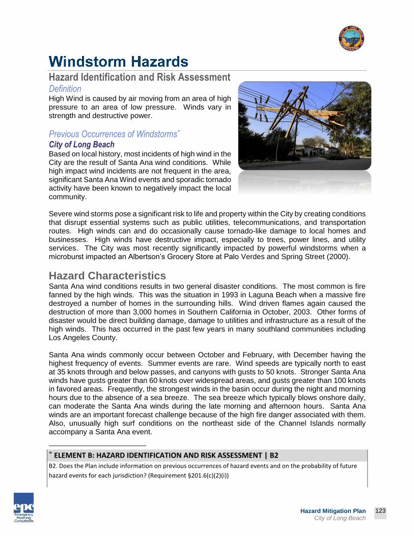
123
Prepared by:
123
Hazard Mitigation Plan City of Long Beach
Hazard Identification and Risk Assessment Definition High Wind is caused by air moving from an area of high pressure to an area of low pressure. Winds vary in strength and destructive power.
Previous Occurrences of Windstorms* City of Long Beach Based on local history, most incidents of high wind in the City are the result of Santa Ana wind conditions. While high impact wind incidents are not frequent in the area, significant Santa Ana Wind events and sporadic tornado activity have been known to negatively impact the local community. Severe wind storms pose a significant risk to life and property within the City by creating conditions that disrupt essential systems such as public utilities, telecommunications, and transportation routes. High winds can and do occasionally cause tornado-like damage to local homes and businesses. High winds have destructive impact, especially to trees, power lines, and utility services. The City was most recently significantly impacted by powerful windstorms when a microburst impacted an Albertson’s Grocery Store at Palo Verdes and Spring Street (2000).
Hazard Characteristics Santa Ana wind conditions results in two general disaster conditions. The most common is fire fanned by the high winds. This was the situation in 1993 in Laguna Beach when a massive fire destroyed a number of homes in the surrounding hills. Wind driven flames again caused the destruction of more than 3,000 homes in Southern California in October, 2003. Other forms of disaster would be direct building damage, damage to utilities and infrastructure as a result of the high winds. This has occurred in the past few years in many southland communities including Los Angeles County. Santa Ana winds commonly occur between October and February, with December having the highest frequency of events. Summer events are rare. Wind speeds are typically north to east at 35 knots through and below passes, and canyons with gusts to 50 knots. Stronger Santa Ana winds have gusts greater than 60 knots over widespread areas, and gusts greater than 100 knots in favored areas. Frequently, the strongest winds in the basin occur during the night and morning hours due to the absence of a sea breeze. The sea breeze which typically blows onshore daily, can moderate the Santa Ana winds during the late morning and afternoon hours. Santa Ana winds are an important forecast challenge because of the high fire danger associated with them. Also, unusually high surf conditions on the northeast side of the Channel Islands normally accompany a Santa Ana event.
* ELEMENT B: HAZARD IDENTIFICATION AND RISK ASSESSMENT | B2
B2. Does the Plan include information on previous occurrences of hazard events and on the probability of future
hazard events for each jurisdiction? (Requirement §201.6(c)(2)(i))

124
Prepared by:
124
Hazard Mitigation Plan City of Long Beach
Santa Ana Winds
(Source: http://upload.wikimedia.org/wikipedia/commons/f/fa/Santa_ana_wind1.jpg) The Beaufort Scale below, coined and developed by Sir Francis Beaufort in 1805, illustrates the effect that varying wind speed can have on structures: Table 2-9: Beaufort Wind Scale
(Source: http://www.compuweather.com/decoder-charts.html)
Beaufort Force
Speed (mph)
Wind Description - Effects on Land
0 Less 1 Calm - Smoke rises vertically
1 1-3 Light - Smoke drift shows direction of wind, but wind vanes do not
2 4-7 Light Breeze - Wind vanes move; Leaves rustle; You can feel wind on the face
3 8-12 Gentle Breeze - Leaves and small twigs move constantly; Small, light flags are extended
4 13-18 Moderate Breeze - Wind lifts dust and loose paper; Small branches move
5 19-24 Fresh Breeze - Small trees with leaves begin to move
6 25-31 Strong Breeze - Large branches move; Telegraph wires whistle; Hard to hold umbrellas
7 32-38 Near Gale - Whole trees move; Resistance felt walking into wind
8 39-46 Gale - Twigs and small branches break off trees; Difficult to walk
9 47-54 Strong Gale - Slight structural damage

125
Prepared by:
125
Hazard Mitigation Plan City of Long Beach
Beaufort Force
Speed (mph)
Wind Description - Effects on Land
10 55-63 Storm - Trees broken or uprooted; Considerable structural damage
11 64-73 Violent Storm - Seldom experienced inland; Considerable structural damage
12 >74 Hurricane - Widespread damage. Very rarely experienced on land.
What are Santa Ana Winds? “Santa Ana winds are generally defined as warm, dry winds that blow from the east or northeast (offshore). These winds occur below the passes and canyons of the coastal ranges of Southern California and in the Los Angeles and Riverside County basins. Santa Ana winds often blow with exceptional speed in the Santa Ana Canyon (the canyon from which it derives its name). Forecasters at the National Weather Service offices in Oxnard and San Diego usually place speed minimums on these winds and reserve the use of "Santa Ana" for winds greater than 25 knots.” These winds accelerate to speeds of 35 knots as they move through canyons and passes, with gusts to 50 or even 60 knots. “The complex topography of Southern California combined with various atmospheric conditions create numerous scenarios that may cause widespread or isolated Santa Ana events. Commonly, Santa Ana winds develop when a region of high pressure builds over the Great Basin (the high plateau east of the Sierra Mountains and west of the Rocky Mountains including most of Nevada and Utah). Clockwise circulation around the center of this high pressure area forces air downslope from the high plateau. The air warms as it descends toward the California coast at the rate of five degrees F per 1,000 feet due to compressional heating. Thus, compressional heating provides the primary source of warming. The air is dry since it originated in the desert, and it dries out even more as it is heated.” These regional winds typically occur from October to March, and, according to most accounts are named either for the Santa Ana River Valley where they originate, or for the Santa Ana Canyon, southeast of Los Angeles, where they pick up speed.
Vulnerability Life and Property Based on the history of the region, windstorm events can be expected, perhaps annually, across widespread areas of the region. This can result in the involvement of City emergency response personnel during a wide-ranging windstorm or microburst tornadic activity. Both residential and commercial structures with weak reinforcement are susceptible to damage. Wind pressure creates a direct and frontal assault on a structure, pushing walls, doors, and windows inward. Conversely, passing currents creates lift suction forces that pull building components and surfaces outward. With extreme wind forces, the roof or entire building can fail causing considerable damage. Debris carried along by extreme winds can directly contribute to loss of life and indirectly to the failure of protective building envelopes, siding, or walls. When severe windstorms strike, downed trees, power lines, and damaged property can be major hindrances to emergency response and disaster recovery.

126
Prepared by:
126
Hazard Mitigation Plan City of Long Beach
Utilities Historically, falling trees are the major cause of power outages in the region. Windstorms such as strong microbursts and Santa Ana Wind conditions cause flying debris and downed utility lines. For example, tree limbs breaking in winds of only 45 mph can be thrown over 75 feet. Overhead power lines can be damaged, even in relatively minor windstorm events. Falling trees bring electric power lines down to the pavement, creating the possibility of lethal electric shock.
Infrastructure Windstorms damage buildings, power lines, and other property, and infrastructure, due to falling trees and branches. During wet winters, saturated soils cause trees to become less stable and more vulnerable to uprooting from high winds.
Increased Fire Threat Perhaps the greatest danger from windstorm activity in Southern California comes from the combination of the Santa Ana winds with the major fires that occur every few years in the urban/wildland interface. With the Santa Ana winds driving the flames, the speed and reach of the flames is even greater than in times of calm wind conditions.
Transportation Windstorm activity impacts local transportation in addition to the problems caused by downed trees and electrical wires blocking streets and highways. During periods of extremely strong Santa Ana winds, major highways can be temporarily closed to truck and recreational vehicle traffic. However, typically these disruptions are not long lasting, nor do they carry a severe long term economic impact on the region.
127
Prepared by:
127
Hazard Mitigation Plan City of Long Beach
Impact of Windstorms in City of Long Beach* Based on the risk assessment, it is evident that Windstorms continue to have potentially devastating economic impact to certain areas of the City. Impact that is not quantified, but can be anticipated in future events, include:
Injury and loss of life Commercial and residential structural damage Disruption of and damage to public infrastructure Secondary Health hazards e.g. mold and mildew Damage to roads/bridges resulting in loss of mobility Significant economic impact (jobs, sales, tax revenue) upon the community Negative impact on commercial and residential property values Significant disruption to students and teachers as temporary facilities and relocations
would likely be needed.
* ELEMENT B: HAZARD IDENTIFICATION AND RISK ASSESSMENT | B3
B3. Is there a description of each identified hazard’s impact on the community as well as an overall summary of the community’s vulnerability for each jurisdiction? (Requirement §201.6(c)(2)(ii))

128
Prepared by:
128
Hazard Mitigation Plan City of Long Beach
Hazard Identification and Risk Assessment
Definition The phenomenon we call “tsunami” (soo-NAH-mee) is a series of traveling ocean waves of extremely long length generated primarily by earthquakes occurring below or near the ocean floor. Underwater volcanic eruptions and landslides can also generate tsunamis. In the deep ocean, the tsunami waves move across the deep ocean with a speed exceeding 500 miles per hour, and a wave height of only a few inches. Tsunami waves are distinguished from ordinary ocean waves by their great length between wave crests, often exceeding 60 miles in length or more, and time between these crests, ranging from 10 minutes to an hour. As they reach the shallow waters of the coast, the waves slow down and the water can pile up into a wall of destruction up to 30 feet or more in height. The effect can be amplified where a bay, harbor or lagoon funnels the wave as it moves inland. Large tsunamis have been known to rise over 100 feet. Even a tsunami 1-3 feet high can be destructive, ultimately causing many deaths and injuries. Tsunamis typically are classified as either local or distant. Tsunamis from local sources usually result from earthquakes occurring off nearby coasts. Tsunamis from distant sources are the most common type observed along the California Coast. Tsunamis generated by earthquakes in South America and the Aleutian-Alaskan region have posed a greater hazard to the West Coast of the United States than locally generated tsunamis. There is a history of Pacific-wide tsunamis occurring every 10 to 20 years. (Source: TyCom EIR, 9/2001)
Previous Occurrences of Tsunamis* City of Long Beach Fortunately, the City of Long Beach has yet to be significantly impacted by a Tsunami event. However, if a significant tsunami event should occur, the consequences would be great. The impact could cause loss of life, destroy numerous structures, and force many residents to evacuate. Even if all residents and visitors were safely evacuated, the damage to property would still be tremendous.
* ELEMENT B: HAZARD IDENTIFICATION AND RISK ASSESSMENT | B2
B2. Does the Plan include information on previous occurrences of hazard events and on the probability of future hazard events for each jurisdiction? (Requirement §201.6(c)(2)(i))

129
Prepared by:
129
Hazard Mitigation Plan City of Long Beach
Tsunami Characteristics Tsunami Causes There are many causes of tsunamis but the most prevalent is earthquakes. In addition, landslides, volcanic eruptions, explosions, and even the impact of cosmic bodies, such as meteorites, can generate tsunamis.
Plate Tectonics Plate Tectonic Theory is based on an earth model characterized by a small number of lithospheric plates, 40 to 150 miles thick that float on a viscous under-layer called the asthenosphere. These plates, which cover the entire surface of the earth and contain both the continents and sea floor, move relative to each other at rates of up to several inches per year. The region where two plates come in contact is called a plate boundary, and the way in which one plate moves relative to another determines the type of boundary. The types of movement that creates a boundary is: 1) spreading, where the two plates move away from each other; 2) subduction, where the two plates move toward each other and one slides beneath the other; and 3) transform, where the two plates slide horizontally past each other. Subduction zones are characterized by deep ocean trenches, and the volcanic islands or volcanic mountain chains associated with the many subduction zones around the Pacific Rim are sometimes called the Ring of Fire.(Source: http://www.prh.noaa.gov/itic/library/about_tsu/faqs.html - 1)
Earthquakes and Tsunamis An earthquake can be caused by volcanic activity, but most are generated by movements along fault zones associated with the plate boundaries. Most strong earthquakes, representing 80% of the total energy released worldwide by earthquakes, occur in subduction zones where an oceanic plate slides under a continental plate or another younger oceanic plate. Not all earthquakes generate tsunamis. To generate a tsunami, the fault where the earthquake occurs must be underneath or near the ocean, and cause vertical movement of the sea floor over a large area, hundreds or thousands of square miles. “By far, the most destructive tsunamis are generated from large, shallow earthquakes with an epicenter or fault line near or on the ocean floor.” (Source: http://www.prh.noaa.gov/itic/library/about_tsu/faqs.html#1) The amount of vertical and horizontal motion of the sea floor, the area over which it occurs, the simultaneous occurrence of slumping of underwater sediments due to the shaking, and the efficiency with which energy is transferred from the earth’s crust to the ocean water are all part of the tsunami generation mechanism. The sudden vertical displacements over such large areas, disturb the ocean's surface, displace water, and generate destructive tsunami waves. (Source: http://www.prh.noaa.gov/itic/library/about_tsu/faqs.html#1) Although all oceanic regions of the world can experience tsunamis, the most destructive and repeated occurrences of tsunamis are in the Pacific Rim region.
Tsunami Threat How Fast? Unnoticed tsunami waves can travel at the speed of a commercial jet plane, over 500 miles per hour. They can move from one side of the Pacific Ocean to the other in less than a day. This great speed makes it important to be aware of the tsunami as soon as it is generated. Scientists can predict when a tsunami will arrive at various places by knowing the source characteristics of the earthquake that generated the tsunami and the characteristics of the sea

130
Prepared by:
130
Hazard Mitigation Plan City of Long Beach
floor along the paths to those places. Tsunamis travel much slower in more shallow coastal waters where their wave heights begin to increase dramatically.
How Big? Offshore and coastal features can determine the size and impact of tsunami waves. Reefs, bays, entrances to rivers, undersea features, and the slope of the beach all help to modify the tsunami as it attacks the coastline. When the tsunami reaches the coast and moves inland, the water level can rise many feet. In extreme cases, water level has risen to more than 50 feet for tsunamis of distant origin and over 100 feet for tsunami waves generated near the earthquake’s epicenter. The first wave may not be the largest in the series of waves. One coastal community may see no damaging wave activity while in another nearby community destructive waves can be large and violent. The flooding can extend inland by 1,000 feet or more, covering large expanses of land with water and debris.
How Frequent? Since scientists cannot predict when earthquakes will occur, they cannot determine exactly when a tsunami will be generated. However, by looking at past historical tsunamis and run-up maps, scientists know where tsunamis are most likely to be generated. Past tsunami height measurements are useful in predicting future tsunami impact and flooding limits at specific coastal locations and communities.
Severity A major tsunami occurring near the planning area could cause deaths and injuries, extensive property damage, fires, hazardous material spills, and other dangers for properties within a mile of the coastline. The time of day and season of the year would have a profound impact on the number of dead and injured and the amount of property damage to the region as a whole. Support of damage control and disaster relief could be required from other local governments and private organizations, as well as the state and federal governments.
Types of Tsunamis Pacific-Wide and Regional Tsunamis Tsunamis can be categorized as “local” and “Pacific-Wide.” Typically, a Pacific-Wide tsunami is generated by major vertical ocean bottom movement in offshore deep trenches. A “local” tsunami can be a component of the Pacific-Wide tsunami in the area of the earthquake or a wave that is confined to the area of generation within a bay or harbor and caused by movement of the bay itself or landslides. In less than a day, tsunamis can travel from one side of the Pacific to the other. However, people living near areas where large earthquakes occur may find that the tsunami waves will reach their shores within minutes of the earthquake. For these reasons, the tsunami threat to many areas such as Alaska, the Philippines, Japan and the United States West Coast can be immediate (for tsunamis from nearby earthquakes which take only a few minutes to reach coastal areas) or less urgent (for tsunamis from distant earthquakes which take from three to 22 hours to reach coastal areas).

131
Prepared by:
131
Hazard Mitigation Plan City of Long Beach
History of Regional Tsunamis Local A local tsunami may be the most serious threat as it strikes suddenly, sometimes before the earthquake shaking stops. Alaska has had six serious local tsunamis in the last 80 years and Japan has had many more.
Local History of Tsunamis Tsunamis have been reported since ancient times. They have been documented extensively in California since 1806. Although the majority of tsunamis have occurred in Northern California, Southern California has been impacted as well. In the 1930’s, four tsunamis struck the Los Angeles County, Orange County, and San Diego County coastal areas. In Orange County the tsunami wave reached heights of 20 feet or more above sea level. In 1964, following the Alaska Earthquake (Magnitude 8.2), tidal surges of approximately 4 feet to 5 feet hit the Huntington Harbor area causing moderate damage. Most recently, the 2011 M8.9 earthquake in Japan triggered tsunamis as far as the California coast, with Crescent City experiencing the most damage. Table 2-10: Tsunami Events in California 1930-2013 (Source: Worldwide Tsunami Database, www.ngdc.noaa.gov)
Date Location Maximum Run up*(m) Earthquake Magnitude
08/31/1930 Redondo Beach 6.10 5.2
08/31/1930 Santa Monica 6.10 5.2
08/31/1930 Venice 6.10 5.2
03/11/1933 La Jolla 0.10 6.3
03/11/1933 Long Beach 0.10 6.3
08/21/1934 Newport Beach 12.00 Unknown
02/09/1941 San Diego Unknown 6.6
10/18/1989 Monterey 0.40 7.1
10/18/1989 Moss Landing 1.00 7.1
10/18/1989 Santa Cruz 0.10 7.1
04/25/1992 Arena Cove 0.10 7.1
04/25/1992 Monterey 0.10 7.1
09/01/1994 Crescent City 0.14 7.1
11/04/2000 Point Arguello 5.00 Unknown
6/15/2005 N. California 0.10 7.2
* Maximum Run up (M) -The maximum water height above sea level in meters. The run-up is the height the tsunami reached above a reference level such as mean sea level. It is not always clear which reference level was used.

132
Prepared by:
132
Hazard Mitigation Plan City of Long Beach
Tsunami Hazard Assessment Hazard Identification The tsunami threat to the planning area is considered low. Although the risk is considered low, the impacts could be high.
Damage Factors of Tsunamis Tsunamis cause damage in three ways: 1) inundation, 2) wave impact on structures, and 3) erosion.
“Strong, tsunami-induced currents lead to the erosion of foundations and the collapse of bridges and sea walls. Flotation and drag forces move houses and overturn railroad cars. Considerable damage is caused by the resultant floating debris, including boats and cars that become dangerous projectiles that may crash into buildings, break power lines, and may start fires. Fires from damaged ships in ports or from ruptured coastal oil storage tanks and refinery facilities can cause damage greater than that inflicted directly by the tsunami. Of increasing concern is the potential effect of tsunami draw down, when receding waters uncover cooling water intakes of nuclear power plants.”
(Source: http://www.prh.noaa.gov/itic/library/about_tsu/faqs.html#1)
Tsunami Formation
Tsunamis are due to large off-shore earthquakes and ocean landslides. Dangerous tsunamis would most likely originate in the Aleutian and Chilean offshore submarine trenches. The planning area’s vulnerable properties have a west-southwest facing orientation that may be vulnerable to tsunamis or tidal surges from the south and from the west.
Landslides Although less common worldwide, tsunami waves can be generated from the displacement of water resulting from rock falls, icefall, and sudden submarine landslides. These types of events

133
Prepared by:
133
Hazard Mitigation Plan City of Long Beach
may be caused spontaneously from the instability and sudden failure of submarine slopes. The ground motions of a strong earthquake can also sometimes trigger them. In the 1980's, earth moving and construction work of an airport runway along the coast of Southern France, triggered an underwater landslide, which generated destructive tsunami waves in the harbor of Thebes, Egypt.
Tsunami Watches and Warnings Warning System The tsunami warning system in the United States is a function of the National Oceanic and Atmospheric Administration’s (NOAA) National Weather Service. Development of the tsunami warning system was impelled by the disastrous waves generated in the 1964 Alaska Tsunami, which surprised Hawaii and the U.S. West Coast, taking a heavy toll in life and property. The disastrous 1964 tsunami resulted in the development of a regional warning system in Alaska. The National Tsunami Warning Center (NTWC) is in Palmer, Alaska. This facility is the nerve center for an elaborate telemetry network of remote seismic stations in Alaska, Washington, California, Colorado, and other locations. Tidal data is also telemetered directly to the NTWC from eight Alaskan locations. Tidal data from Canada, Washington, Oregon, and California are available via telephone, teletype, and computer readout.
Notification The National Warning System (NAWAS) is an integral part of the National Tsunami Warning Center. Reports of major earthquakes occurring anywhere in the Pacific Basin that may generate seismic sea waves are transmitted to the Honolulu Observatory for evaluation. An National Tsunami Warning Center is also in place for public notification of earthquakes in the Pacific Basin near Alaska, Canada, and Northern California. The Observatory Staff determines action to be taken and relays warnings over the NAWAS circuits to inform and warn West Coast states. The State NAWAS circuit is used to relay the information to the Orange County Operational Area warning center which will in turn relay the information to local warning points in coastal areas. The same information is also transmitted to local jurisdictions over appropriate radio systems, teletype, and telephone circuits to ensure maximum dissemination. Los Angeles County will use the Emergency Alert System (EAS) to warn the public of an anticipated tsunami. A Tsunami Watch Bulletin is issued if an earthquake has occurred in the Pacific Basin and could cause a tsunami. A Tsunami Warning Bulletin is issued when an earthquake has occurred and a tsunami is spreading across the Pacific Ocean. When a threat no longer exists, a cancellation bulletin is issued.
Community Tsunami Issues What is Susceptible to Tsunami? As shown on Map 7-1 the greatest vulnerability to tsunamis are properties located near Oceanfront and the the Port of Long Beach. Tsunami “maximum run-up” projections were modeled by the University of Southern California and distributed by the California Office of Emergency Services for the purposes of identifying tsunami hazards. The tsunami model was the result of a combination of inundation modeling and onsite surveys and shows maximum projected inundation levels from tsunamis along the

134
Prepared by:
134
Hazard Mitigation Plan City of Long Beach
entire coast of Los Angeles County. The maximum run-up for the maps below is approximately 42 feet. This means that based on the scenario tsunami, the displaced water level would be approximately 42 feet above the normal tide for that day and time.
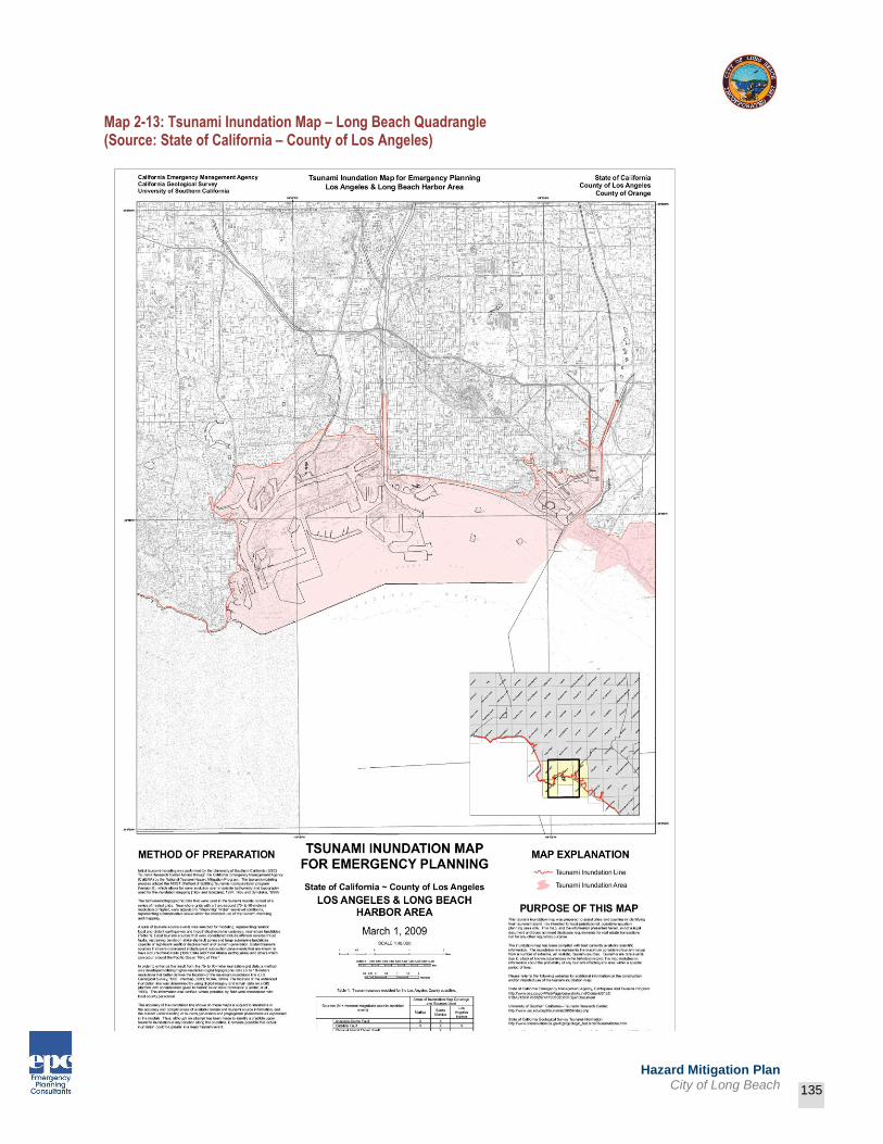
135
Prepared by:
135
Hazard Mitigation Plan City of Long Beach
Map 2-13: Tsunami Inundation Map – Long Beach Quadrangle (Source: State of California – County of Los Angeles)

136
Prepared by:
136
Hazard Mitigation Plan City of Long Beach
Residential Residential property along the coast could also be devastated. A large tsunami could potentially destroy or damage hundreds of homes situated along the bluff tops and spread debris throughout the coastal zone. Any residential structure with weak reinforcement would be susceptible to damage or could be impacted by significant coastal erosion.
Commercial A tsunami event would impact these businesses by damaging property and by interrupting business and services. Any commercial structure with weak reinforcement would be susceptible to damage or could be impacted by significant coastal erosion.
Recreational The City’s offshore areas are popular for many types of marine recreational activities, including sun bathing, scuba diving, surfing, kayaking, fishing and sailing. If a tsunami were to occur on a peak holiday weekend, of example, it could devastate the entire coastal area and result in a significant loss of life.
Infrastructure Tsunamis (and earthquakes) can damage buildings, power lines, and other property and infrastructure due to flooding. Tsunamis can result in collapsed or damaged buildings or blocked roads and bridges, damaged traffic signals, streetlights, and parks, among others. Damage to public water and sewer systems, transportation networks, and flood channels would greatly impact daily life for residents. Roads blocked by objects during a tsunami may have severe consequences to people who are attempting to evacuate or who need emergency services. Emergency response operations can be complicated when roads are blocked or when power supplies are interrupted. Industry and commerce can suffer losses from interruptions in electric services and from extended road closures. They can also sustain direct losses to buildings, personnel, and other vital equipment. There are direct consequences to the local economy resulting from tsunamis related to both physical damages and interrupted services.
Impact of Tsunamis in the City of Long Beach* Based on the risk assessment, it is evident that tsunamis will continue to have potentially devastating economic impacts to certain areas of the City. Impacts that are not quantified, but can be anticipated in future events, include:
Injury and loss of life Disruption of and damage to City infrastructure Secondary health hazards e.g. mold and mildew Significant economic impact (jobs, sales, tax revenue) upon the staff and students Significant disruption to students and teachers as temporary facilities and relocations
would likely be needed
* ELEMENT B: HAZARD IDENTIFICATION AND RISK ASSESSMENT | B3
B3. Is there a description of each identified hazard’s impact on the community as well as an overall summary of the community’s vulnerability for each jurisdiction? (Requirement §201.6(c)(2)(ii))

137
Prepared by:
137
Hazard Mitigation Plan City of Long Beach
Epidemic/Pandemic
Hazard Identification Vaccines, antibiotics, and improved living conditions resulted in dramatic declines in communicable diseases in the latter part of the 20th Century. However, infectious diseases have become an increasing threat to all persons in Los Angeles County due to a variety of factors such as: population growth (overcrowding, aging, migration), methods of food production (large scale, wide distribution, importation), environmental changes (drought, encroachment of humans on wild areas, global warming), microbial adaptation (resistance to antibiotics, re-assortment of genetic material), changes in health care (drugs causing immunosuppression, widespread use of antibiotics), and human behavior (travel, diet, sexual behavior, compromised immune systems). Problems (infection or illness) would be identified by a variety of entities:
Clinicians (urgent care, hospitals, clinics)
Pharmacists
Veterinarians
Animal Control
Vector Control
Emergency medical personnel (first responders, EMT’s, Paramedics, ER personnel)
Laboratorians
Pathologists
Coroner
Current epidemic threats include:
West Nile Virus
- Mosquitoes spread this virus. A small proportion of persons infected develop systems, which can range from fever and body aches to encephalitis. West Nile Virus was first detected in the United States in New York City in 1999 and has moved westward in subsequent years, causing epidemics across the country.
Antibiotic-resistant microorganisms
- Widespread and improper use of antibiotics and insufficient use of control measures has resulted in resistance to antibiotics. Methicillin-resistant Staphylococcus aureus (MRSA) has become resistant to many other antibiotics and a new strain recently began circulating in the community.
Pandemic influenza
- ‘Pandemic’ refers to a worldwide epidemic. New influenza strains with pandemic potential can appear when animal and human strains have the opportunity to exchange genetic material resulting in a virulent strain that can infect humans. This could happen at any time.

138
Prepared by:
138
Hazard Mitigation Plan City of Long Beach
Reemergence of Severe Acute Respiratory Syndrome (SARS)
- SARS likely emerged from an animal or animals in China to infect humans. Reemergence could occur at any time, since the actual source is unknown and cannot be eradicated.
Food borne illness
- Contaminated food sources and human error can cause food borne outbreaks. Small food borne outbreaks occur frequently.
Bioterrorism
- The diseases of greatest concern include anthrax, smallpox, plague, tularemia, botulism, and viral hemorrhagic fevers.
Impact
Injury and loss of life
Commercial and residential structural damage
Disruption of and damage to public infrastructure
Secondary Health hazards e.g., mold and mildew
Damage to roads/bridges resulting in loss of mobility
Significant economic impact (jobs, sales, tax revenue) upon the community
Negative impact on commercial and residential property values
Significant disruption to students and teachers as temporary facilities and relocations are needed
Local Conditions Because of the nature of epidemic and pandemic hazards it is difficult to identify specific locations or populations clusters that would be vulnerable to a particular hazardous event. As such, no specific infrastructure, government structure, population centers have been identified as being targets or at any greater risk than any other location.

139
Prepared by:
139
Hazard Mitigation Plan City of Long Beach
Hazardous Materials Release
Hazard Identification Virtually all sectors of the region’s economy use materials that, if improperly stored, handled, transported, or disposed of, can create public health and environmental risks. Definitions of hazardous materials vary from source to source. The current descriptions used in Federal and State legislation include:
A hazardous material is one that is ignitable, reactive, corrosive, toxic, or any combination of these properties (Resource Conservation and Recovery Act).
A hazardous material is a substance or combination of substances which, because of its quantity, concentration or physical, chemical, or infectious characteristics may:
Cause, or significantly contribute to an increase in mortality or an increase in serious irreversible or incapacitating reversible illness; or
Pose a substantial present or potential hazard to humans or the environment (State Health and Safety Code, Chapter 6.5).
A hazardous material is an injurious substance, including pesticides, herbicides, toxic metals and chemicals, liquefied material gas, explosives, volatile chemicals, and nuclear fuels (California Government Code). Hazardous materials are typically stored in secured, on-site areas, in small containers or large aboveground or underground storage tanks.
Hazardous materials are transported throughout the region on a daily basis. The California Highway Patrol has designated the County’s interstate system as hazardous materials transportation corridors; however surface streets are also used to transport hazardous materials from suppliers to customers. The California Highway Patrol is the primary regulatory authority for intrastate transport of hazardous materials.
The Federal Department of Transportation (DOT) is the primary regulatory authority for interstate transport of hazardous materials. DOT regulations establish criteria for safe handling procedures (e.g., packaging, marking, labeling, and routing). Criteria also exist regarding personnel qualifications, inspections, and equipment specifications.
Weather has many complex and important effects on the impact of hazardous material incidents. For instance, as wind increases in velocity, the plume or emissions from the incident increases. Likewise, precipitation (annual total, seasonal distribution and storm intensity) may increase the spread of hazardous materials. Both wind and precipitation may compound health concerns related to degraded air or water quality. Impacts Hazardous material incidents might conceivably cause the following issues:
Potential for fires and explosions
Disruption of transportation systems
Need for highly specialized responders
140
Prepared by:
140
Hazard Mitigation Plan City of Long Beach
Destruction of utilities and other public services
Damage to public infrastructure and facilities
Residential displacement, including evacuations
Individuals trapped and injured in unsafe conditions
Health issues related to discharges or releases
Need for emergency food, shelter, and medical care
Economic impacts, both short and long-term
Water pollution and quality degradation
Local Conditions The following locations, however, could subject the Planning Area to significant hazardous materials incidents:
1. Ports – Port of Los Angeles and Port of Long Beach; potential hazardous materials/terrorism/transportation incidents
The Planning Area is characterized by year-round mild to warm temperatures and light winds. The dominant wind pattern is daytime, offshore breezes from the northwest, occasionally broken by very strong Santa Ana winds from the northeasterly direction, resulting in wind velocities of up to 70 miles per hour. The Santa Ana winds typically occur during the autumn and winter months.
The predominant offshore breezes could assist in the dispersal of airborne pollutants; however an inversion layer of warm air occasionally overlaps the offshore breezes and may trap pollutants, particularly during the summer months. This phenomenon may compound health concerns related to degraded air quality.
Civil Disturbance
Hazard Identification The spontaneous disruption of normal, orderly conduct and activities in urban areas, or the outbreak of rioting or violence that is of a large nature, is referred to as a civil disturbance. Civil disturbance can be spurred by specific events or can be the result of long-term displeasure with authority. Civil disturbance is usually distinguished by the need for outside assistance from law enforcement and/or fire services. Civil disturbance may be precipitated or manifested in a number of ways, including but not limited to the following: Civil disturbance might conceivably cause the following impacts:
Spontaneous reactions to verdicts in high-profile trials
Spontaneous reactions to organized sporting event outcomes
Organized reactions or demonstrations
Targeting of public facilities
Targeting of private highly visible establishments
Local population demonstrations
Transient population demonstrations

141
Prepared by:
141
Hazard Mitigation Plan City of Long Beach
Hit and run tactics
Diversion tactics masking other motives
Indiscriminate acts of arson and vandalism While the motivation behind civil disturbance may be known, the exact extent and type of activity that will occur is less certain. During an outbreak of civil disturbance, the potential for multiple incidents is very high. Impacts
Significant injuries and deaths
Potential for fires and explosions
Potential for looting and theft
Disruption of transportation systems
Looting and widespread property theft
Interference with law enforcement activities
Destruction of utilities and other public services
Damage to public infrastructure and facilities
Residential displacement, including evacuations
Individuals trapped and injured in unsafe conditions
Need for emergency food, shelter, and medical care
Economic impacts, both short and long-term The threat to law enforcement and other responding personnel can be severe and bold in nature, due to the fervor and defiance of authority that typically accompanies acts of civil disturbance. Securing of critical infrastructure and services is necessary and may include a need for law enforcement escorts for maintenance and inspection crews. Table 2-11: History of Civil Disturbances in Los Angeles County
Disturbance Location Date Deaths Injuries Damage
Occupy Movement
Port of Long Beach 2011 0 0 N/A
Rodney King Riot
City of Los Angeles 1992 53 2300 N/A
Watts Riot South Central Los Angeles
1965 32 874 $45
million
Occupy Movement (2001) The Occupy movement is an international protest movement against social and economic inequality, its primary goal being to make the economic and political relations in all societies less vertically hierarchical and more flatly distributed. Local groups often have different foci, but among the movement's prime concerns is the belief that large corporations and the global financial system control the world in a way that disproportionately benefits a minority, undermines democracy and is unstable. The first Occupy protest to receive wide coverage was Occupy Wall Street in New York City's Zuccotti Park, which began on September 17, 2011. By October 9, Occupy protests had taken

142
Prepared by:
142
Hazard Mitigation Plan City of Long Beach
place or were ongoing in over 95 cities across 82 countries, and over 600 communities in the United States. Rodney King Riot (1992) On April 29, 1992, following the not guilty verdicts of four Los Angeles Police Officers accused of beating motorist Rodney King, violence erupted at the intersection of Florence and Normandie in South Los Angeles. At the same time, individuals at the corner of 67th Street and 11th Avenue were revolting against passer-bys and motorists. Black residents were outraged that four LAPD officers received not guilty verdicts from an all-white jury in Simi Valley, despite the videotape evidence of the beating of Rodney King, and the testimonial by veteran police officers on behalf of the prosecution. From April 29, 1992 at approximately 3:30 p.m. until May 1st, the violence raged on. The National Guard were called in to bring calm to the City, and by Friday afternoon the violence and looting were subdued. The most violent urban revolt that the United States had ever experienced in the twentieth century resulted in 52 deaths, 2,499 injuries, 6,559 arrests, 1,120 building damaged, 2,314 stores damaged and close to 1 billion in damages.
If we go back to 1992 and examine the precipitating factor of the riot, economics actually played a small role influencing the revolt. Yes, there was a recession in Los Angeles and around the country, unemployment was at an all-time high, high levels of poverty probably exacerbated the riots that took place, but the critical events and underlying factors to the revolt were the beating of Rodney King in 1991, the probation sentence handed down on Sun Ja Doo, a Korean store clerk that shot Latasha Harlins, a 15 year old black girl, in the back of the head after a dispute over orange juice, and the acquittal of the four LAPD officers. In the Sun Ja Doo incident the jury came back with a second-degree murder conviction, but Judge Joyce Karlin, a white woman, did the unheard of when she sentenced Doo to five years probation. This is what I believe paved the way for the worst urban riot in contemporary history and the fact that over 50% of the damaged or destroyed property was Korean owned was no accident, and is the reason why many characterize this event as an uprising or a revolt. Although many of the images captured certainly show those acting as opportunists taking advantage of an unfortunate situation, at the same time there was an organized attack against Korean establishments within South LA and outside of the black community along Vermont and Western Avenues, north of the black community. Relations between blacks and Koreans in Los Angeles have often been full of tension and there is housing evidence that suggests that those tensions are still present in 2002.
The critical factors that influenced the events of April 29, 1992 all took place within the criminal justice sector of society with the police department central to the events. This is where he must look to address the question of a potential third Los Angeles riot. Chief Daryl Gates was held accountable for the type of relationship that was created between the police and minority communities in South LA and his response to the first day of the riot was considered dismal. Also let us not forget history, when in 1965 people took to the streets of Los Angeles in protest the day following alleged police abuses after the arrest of a Marquette Frye on 116th Street and Avalon. Chief William Parker was also highly criticized for the sharp divide that was created between the black community and the militaristic police, and resentment towards the police grew worse every year since Parker took over as Chief in 1950 up until the violence erupted in 1965. One indication of the increasing tension between the police and the community was the number of complaints that blacks filed between 1950 and 1965. Parker claimed no responsibility during a commission and when asked what sparked the riot he replied "someone threw a rock, and like monkeys in a zoo, they all started throwing rocks."
All of the seven race riots of 1964 were also sparked by an incident of police misconduct. The Otto Kerner Commission of 1968 stated that police actions led to outbreaks in half of the cases

143
Prepared by:
143
Hazard Mitigation Plan City of Long Beach
studied and those that believe that another revolt will take place will need to examine law enforcement and the criminal justice system. If the LAPD of LASD engage in any inappropriate activity such as excessive force or unlawful officer involved shootings, an outbreak of violence is definitely possible. Let us not forget what happened in Cincinnati in April 2001 when the shooting death of Timothy Thomas, 19, whose death touched off three days of riots. Cincinnati police officer Steven Roach was later found not guilty of negligent homicide in the shooting, but these are the types of events that will determine if Los Angeles will see part three. Under Bernard Parks inappropriate activity from the rank and file was highly unlikely with the disciplinary system that he had in place, but the actions of the next police chief may determine if what happened in 1965 and 1992 will occur again.
Watts Riot (1965) The Watts Riot began on August 11, 1965 in Los Angeles, California when the Los Angeles Police pulled over Marquette Frye, whom they suspected of driving drunk. While police questioned Frye and his brother, a group of people began to gather around the scene. A struggle ensued shortly after Frye's mother Rena arrived on the scene, resulting in the arrest of all three family members. Police used their batons to subdue Frye and his brother, angering the growing crowd. Shortly after police left, tensions boiled over and the rioting began. What followed was six days of rioting that claimed the lives of 34 people, injured 1,100 and caused estimated $100 million dollars damage.
One of the few structures in Watts that remained untouched by the damage was the Watts Towers, a group of tall steel sculptures constructed by Italian immigrant Sam Rodia (often erroneously called Simon Rodia).
Local Conditions The Planning Team recognizes that there is a possibility of civil disturbance in the future.
Terrorism
Hazard Identification The United States Department of Justice defines terrorism as “the unlawful use of force or violence committed by a group or individual against persons or property to intimidate or coerce a government, the civilian population, or any segment thereof, in furtherance of political or social objectives.” Weapons of Mass Destruction (WMDs) are defined in Federal Government Code as any “explosive, incendiary, or poison gas, bomb, grenade, rocket having a propellant charge of more than four ounces, missile having an explosive or incendiary charge of more than one quarter ounce, mine or device similar to the above; poison gas; any weapon involving a disaster organism; or any weapon that is designed to release radiation or radioactivity at a level dangerous to human life.” WMDs are usually classified according to the acronym C-B-R-N-E, or Chemical, Biological, Radiological, Nuclear, Explosive. Chemical: Chemical agents are poisonous vapors, aerosols, liquids, and solids that have toxic effects on people, animals, or plants. They can be released by bombs or sprayed from aircraft, boats, and vehicles. They can be used as a liquid to create a hazard to people and the environment. Some chemical agents may be odorless and tasteless. They can have an immediate effect (a few seconds to a few minutes) or a delayed effect (two to 48 hours). While

144
Prepared by:
144
Hazard Mitigation Plan City of Long Beach
potentially lethal, chemical agents are difficult to produce and deliver in lethal concentrations. Outdoors, the agents often dissipate rapidly. Biological: Biological agents are organisms or toxins that can kill or incapacitate people, livestock, and crops. The three basic groups of biological agents that would likely be used as weapons are bacteria, viruses, and toxins. Most biological agents are difficult to grow and maintain. Many break down quickly when exposed to sunlight and other environmental factors, while others, such as anthrax spores, are very long lived. Biological agents can be dispersed by spraying them into the air, by infecting animals that carry the disease to humans and by contaminating food and water. Radiological: Terrorist use of a radiological dispersion device – often called a “dirty nuke” or “dirty bomb” – is considered far more likely than use of a nuclear explosive device. A RDD combines a conventional explosive device – such as a bomb – with radioactive material. It is designed to scatter dangerous and sub-lethal amounts of radioactive material over a general area. Such RDDs appeal to terrorists because they require limited technical knowledge to build and deploy compared to a nuclear device. Also, the radioactive materials in RDDs are widely used in medicine, agriculture, industry, and research, and are easier to obtain than weapons grade uranium or plutonium. Nuclear: A nuclear blast is an explosion with intense light and heat, a damaging pressure wave, and widespread radioactive material that can contaminate the air, water, and ground surfaces for miles around. A nuclear device can range from a weapon carried by a missile launched by a hostile nation or terrorist organization, to a small portable nuclear devise transported by an individual. All nuclear devices cause deadly effects when exploded, including blinding light, intense heat (thermal radiation), initial nuclear radiation, blast, and secondary fires caused by the destruction or a heat pulse. Explosives: Explosive devices are common terrorist weapons. Terrorists do not have to look far to find out how to make explosive devices; the information is readily available in books and other information sources. The materials needed for an explosive device can be found in many places including variety, hardware, and auto supply stores. Explosive devices are highly portable using vehicles and humans as a means of transport. They are easily detonated from remote locations or by suicide bombers. Homeland Security Advisory System (HSA System): The HSA System is meant to guide the adoption of protective measures when specific information to a particular sector or region is received. The HSA System combines information on threats with vulnerability assessments and provides communications to public safety officials and the public.
Homeland Security Threat Advisories (HSA Advisories): HSA Advisories contain actionable information about incidents involving, or threats targeting, critical national networks, infrastructure, or assets. HSA Advisories could, for example, relay newly developed procedures that, when implemented, would significantly improve security. They could also suggest a needed change in readiness posture, protective actions, or response. Advisories are targeted to Federal, state, and local governments, as well as private sector organizations and international partners.

145
Prepared by:
145
Hazard Mitigation Plan City of Long Beach
Homeland Security Information Bulletins (HIS Bulletins): HIS Bulletins communicate information of interest to the nation’s critical infrastructures that do not meet the timeliness, specificity, or significance thresholds of warning messages. Information may include statistical reports, periodic summaries, incident response or reporting guidelines, common vulnerabilities, and configuration standards or tools. It also may include preliminary requests for information. Bulletins are targeted to Federal, state, and local governments, as well as private organizations and international partners.
The National Terrorism Advisory System, or NTAS, replaces the color-coded Homeland Security Advisory System (HSAS). This new system will more effectively communicate information about terrorist threats by providing timely, detailed information to the public, government agencies, first responders, airports and other transportation hubs, and the private sector. These alerts will include a clear statement that there is an imminent threat or elevated threat. Using available information, the alerts will provide a concise summary of the potential threat, information about actions being taken to ensure public safety, and recommended steps that individuals, communities, businesses and governments can take to help prevent, mitigate or respond to the threat.
Like the Los Angeles County Operational Area, the Cities have chosen to take a broad approach to terrorism planning, instead of developing specific plans for each potential terrorist target. Nationwide experience demonstrates that there are no longer targets or population groups that are “off limits” to terrorists. Impacts Terrorism incidents might conceivably cause the following impacts:
Significant injuries and deaths
Potential for fires and explosions
Disruption of transportation systems
Interference with law enforcement activities
Destruction of utilities and other public services
Damage to public infrastructure and facilities
Residential displacement, including evacuations
Individuals trapped and injured in unsafe conditions
Need for emergency food, shelter, and medical care
Economic impacts, both short and long-term

146
Prepared by:
146
Hazard Mitigation Plan City of Long Beach
Need for highly specialized responders
Health issues related to discharges or releases
Water pollution and quality degradation\
Local Conditions Throughout California and Los Angeles County there is a nearly limitless number of potential terrorist targets, including government facilities; schools; religious institutions; gathering places (shopping centers, entertainment venues, etc.); abortion clinics; power plants and other utility infrastructure; transportation infrastructure; oil refineries, water storage facilities; locations of high profile individuals; and, financial institutions. The City contains many of the aforementioned potential terrorist targets and is located nearby a multitude of others.
Energy Shortage
Hazard Identification Loss of electrical services would mean a potential life-threatening situation in the case of electricity for medically dependent residents, and a public health threat if the services are disrupted for some time due to accidental or terrorist acts. An energy shortage is any interruption or loss of electrical service due to disruption of power generation or transmission caused by an accident, sabotage, natural hazards, equipment failure, or fuel shortage. These interruptions can last anywhere from a few seconds to several days. Energy Shortages are considered significant only if the local Emergency Management Organization is required to coordinate basic services such as the provision of food, water, and heating as a result. Energy Shortages are common with severe weather and winter storm activity. The massive 2011 Southern California electricity outage brought to light many critical issues surrounding the state’s power generation and distribution system, including its dependency on out-of-state resources. Although California has implemented effective energy conservation programs, the state continues to experience both population growth and weather cycles that contribute to a heavy demand for power. Hydro-generation provides approximately 25% of California’s electric power, with the balance coming from fossil fuels, nuclear, and green sources. As experienced in 2000 and 2001, blackouts can occur due to losses in transmission or generation and/or extremely severe temperatures that lead to heavy electric power consumption. Impact
Injury and loss of life
Disruption of and damage to public infrastructure (particularly water distribution and sewer management)
Secondary Health hazards e.g., mold and mildew
Economic impacts (jobs, sales, tax revenue) upon the community
Significant disruption to population centers
Dangerous threats posed to health care facilities
Disruption to delivery of emergency services

147
Prepared by:
147
Hazard Mitigation Plan City of Long Beach
Local Conditions The effects of an energy shortage would affect all occupants of the City. Perhaps most at risk would be medically challenged individuals with health care equipment reliant on electricity (e.g. oxygen), businesses, emergency service locations, and vulnerable populations center (e.g. schools).
Radiological Accidents
Hazard Identification There are two operating nuclear power plants (NPP) in California: the Diablo Canyon Power Plant in San Luis Obispo County, and the San Onofre Nuclear Generating Station (SONGS) in San Diego County. Two other nuclear power plants, Humboldt Bay and Rancho Seco, are not operational, but have spent fuel stored on-site. There are three emergency zones established around SONGS to educate and, if necessary, evacuate the people who live and work near the plant. The zones are: the Emergency Planning Zone (10-mile radius), the Public Education Zone (20-mile radius), and the Ingestion Pathway Zone (50-mile radius). Given the distance of the City from SONGS, it does not fall within any of the SONGS emergency zones.
Transportation Accidents
Hazard Identification Ports The Port of Long Beach, also known as Long Beach’s Harbor Department, is the second busiest container port in the USA after the Port of Los Angeles, which it adjoins. Acting as a major gateway for U.S.-Asian trade, the port occupies 3,200 acres of land with 25 miles of waterfront in the City of Long Beach. Airplane Accidents Airline accidents are listed as a “low” threat because the number of deaths and extent of property damage is considerably less than say, a large earthquake. Following is a summary of the airplane accidents that have happened since 1987 in the region.

148
Prepared by:
148
Hazard Mitigation Plan City of Long Beach
Table 2-12: Historic Airplane Accidents in Southern California (Source: http://www.ntsb.gov/aviationquery/index.aspx)
Event Date
Probable Cause Released
Location Make / Model Event Severity
Type of Air Carrier Operation and Carrier Name (Doing Business As)
12/7/1987 1/4/1989 San Luis Obispo
British Aerospace BAE-146-200
Fatal (43)
SCHD Pacific Southwest Airlines
2/1/1991 8/5/1993 Los Angeles Boeing 737-300
Fatal (34)
SCHD USAir
1/31/2000 5/29/2003 Port Hueneme Douglas MD-83
Fatal(88) SCHD Alaska Airlines Inc.
2/16/2000 9/17/2003 Rancho Cordova
Douglas DC-8-71F
Fatal (3) NSCH Part 121: Air Carrier Emery Worldwide Airlines Inc.
A major air crash that occurs in a heavily populated area can result in considerable loss of life and property. The impact of a disabled aircraft as it strikes the ground creates the likely potential for multiple explosions, resulting in intense fires. Regardless of where the crash occurs, the resulting explosions and fires have the potential to cause injuries, fatalities and the destruction of property at and adjacent to the impact point. The time of day when the crash occurs may also have a profound effect on the number of dead and injured.
Local Conditions The skies above the Planning Area are heavily occupied by aircraft originating and departing from a number of airports located in the region. The airports nearest the Planning Area which handle the greatest amount of air traffic are as follows:
Los Angeles International Airport (LAX): as of 2012 was ranked as the 3rd busiest airport in the United States.
Long Beach Municipal Airport (LGB): as of 2009 was ranked as the 26th busiest airport in the United States.
Zamperini Field (TOA): is a City-owned (Torrance) public use airport.
Water Shortage
Hazard Identification In light of the fact Planning Area residents and businesses rely on imported water, it’s impossible to separate drought from water supply shortages. Drought is defined as a deficiency of precipitation over an extended period of time, usually a season or more. This deficiency results in a water shortage for some activity, group, or environmental sector. Drought should be considered relative to some long-term average condition of balance between precipitation and evapotranspiration (i.e., evaporation + transpiration) in a particular area, a condition often perceived as "normal". It is also related to the timing (e.g., principal season of occurrence, delays

149
Prepared by:
149
Hazard Mitigation Plan City of Long Beach
in the start of the rainy season, occurrence of rains in relation to principal crop growth stages) and the effectiveness of the rains (e.g., rainfall intensity, number of rainfall events). Other climatic factors such as high temperature, high wind, and low relative humidity are often associated with it in many regions of the world and can significantly aggravate its severity. Drought should not be viewed as merely a physical phenomenon or natural event. Its impacts on society result from the interplay between a natural event (less precipitation than expected resulting from natural climatic variability) and the demand people place on water supply. Human beings often exacerbate the impact of drought. Recent droughts in both developing and developed countries and the resulting economic and environmental impacts and personal hardships have underscored the vulnerability of all societies to this natural hazard. One dry year does not normally constitute a drought in California, but serves as a reminder of the need to plan for droughts. California's extensive system of water supply infrastructure — its reservoirs, groundwater basins, and inter-regional conveyance facilities — mitigates the effect of short-term dry periods for most water users. Defining when a drought begins is a function of drought impacts to water users. Hydrologic conditions constituting a drought for water users in one location may not constitute a drought for water users elsewhere, or for water users having a different water supply. Individual water suppliers may use criteria such as rainfall/runoff, amount of water in storage, or expected supply from a water wholesaler to define their water supply conditions. The figure below illustrates several indicators commonly used to evaluate California water conditions. The percent of average values are determined for measurement sites and reservoirs in each of the State's ten major hydrologic regions. Snow pack is an important indicator of runoff from Sierra Nevada watersheds, the source of much of California's developed water supply.

150
Prepared by:
150
Hazard Mitigation Plan City of Long Beach
Drought is a gradual phenomenon. Although droughts are sometimes characterized as emergencies, they differ from typical emergency events. Most natural disasters, such as floods or forest fires, occur relatively rapidly and afford little time for preparing for disaster response. Droughts occur slowly, over a multiyear period. There is no universal definition of when a drought begins or ends. Impacts of drought are typically felt first by those most reliant on annual rainfall - ranchers engaged in dry land grazing, rural residents relying on wells in low-yield rock formations, or small water systems lacking a reliable source. Criteria used to identify statewide drought conditions do not address these localized impacts. Drought impacts increase with the length of a drought, as carry-over supplies in reservoirs are depleted and water levels in groundwater basins decline.
There are four different ways that drought can be defined:
1) Meteorological - a measure of departure of precipitation from normal. Due to climatic differences what is considered a drought in one location may not be a drought in another location. 2) Agricultural - refers to a situation when the amount of moisture in the soil no longer meets the needs of a particular crop. 3) Hydrological - occurs when surface and subsurface water supplies are below normal. 4) Socioeconomic - refers to the situation that occurs when physical water shortage begins to affect people.
Impact
90
155
125
100
7060
120
100
115
165
110
40
95
185
120
8575
60
100110
85
150
130
55
85
290
125
90
65
30
100120
75 70
185
55
0
50
100
150
200
250
300
1996 1997 1998 1999 2000 2001 2002 2003 2004 2005 2006 2007
Pe
rce
nt
of
Ave
rag
eWater Supply Conditions
Snowpack Precipitation Runoff to Date Reservoir Storage

151
Prepared by:
151
Hazard Mitigation Plan City of Long Beach
Health complications from limited or use of non-potable water
Disruption of and damage to public infrastructure (contamination to water distribution systems, blockages in sewer system)
Loss to governments, commercial, and residential properties of landscaping materials
Economic impacts (jobs, sales, tax revenue) upon the community
Added cost of bottled and other water sources
Compromises to hygiene
Dangerous threats posed to health care facilities
Disruption to delivery of emergency services (e.g. firefighting)
Local Conditions The Planning Team has not identified any specific locations that would be specifically vulnerable during a drought.
Natural Gas Pipeline Incidents
Hazard Identification Virtually all natural gas, which accounts for about 28 percent of energy consumed annually, is transported by transmission pipelines. Although California is a leader in exploring and implementing alternative energy sources such as wind and solar, the expansion of traditional energy sources, such as natural gas, continues. Compounding the potential risk is the age and gradual deteriorating of the gas transmission system due to natural causes. Significant failure, including pipe breaks and explosions, can result in loss of life, injury, property damage, and environmental impacts. Causes of and contributors to pipeline failures include construction errors, material defects, internal and external corrosion, operational errors, control system malfunctions, outside force damage, subsidence, and seismicity. Growth in population, urbanization, and land development near transmission pipelines, together with addition of new facilities to meet new demands, may increase the likelihood of pipeline damage due to human activity and the exposure of people and property to pipeline failures.
The map below shows the location and ownership of the natural gas pipeline system. Many of the pipelines are located in areas with high seismic activity, crossing the San Andreas and other active faults.

152
Prepared by:
152
Hazard Mitigation Plan City of Long Beach
Map 2-15: California Natural Gas Pipeline Systems (Source: California Energy Commission, http://www.energy.ca.gov/maps/Natural_Gas_Pipelines.pdf)
Generally speaking, transmission lines are large‐diameter steel pipes carrying natural gas at high pressure and compressed to provide higher carrying capacity. Transmission lines are both interstate and intrastate, with the latter connecting to smaller distribution lines delivering gas directly to homes and businesses. Data compiled by the Pipeline and Hazardous Materials Safety Administration (PHMSA) report a total of 115,291 miles of gas pipelines in California, of which 12,414 are classified as gas transmission lines, 403 are gas‐gathering lines, and the majority, 102,475, are for gas distribution. Nearly 40 percent of gas transmission lines are located in Los Angeles, Kern, and San Bernardino counties.

153
Prepared by:
153
Hazard Mitigation Plan City of Long Beach
San Bruno Gas Transmission Line Explosion
On September 9, 2010, a 30-inch steel natural gas transmission pipeline owned and operated by PG&E ruptured and exploded in the City of San Bruno residential neighborhood. The blast and ensuing inferno resulted in 8 confirmed deaths, 66 reported injuries, 34 destroyed structures, and 8 damaged structures. Cal OES has identified preliminary damage estimates at $15.4 million, including $2.5 million for debris removal, $10.2 million for protective measures, $2.1 million for roads and bridges, and $0.6 million for utilities and other facilities. Investigations into the cause of the explosion are under way by the National Safety Transportation Board (NSTB), the California Public Utilities Commission (CPUC), and PG&E. Although it will not be confirmed until official
investigations are completed, initial speculation points to the weakening of the 60‐year‐old pipeline due to corrosion. The day after the explosion, the CPUC asked PG&E to provide a list of its top 100 high-priority projects to upgrade or replace portions of the pipeline for reasons of public safety, as well as information on the status of listed projects. The list was published on September 21, 2010. Although targeted for repair several years ago, the San Bruno pipeline was not on the list.
Impact
Injury and loss of life
Catastrophic damage to natural gas pipe
Disruption of and damage to public infrastructure
Damage to roads and bridges
Secondary fires and explosions
Economic impacts (jobs, sales, tax revenue) upon the community
Significant demands on emergency services
Local Conditions There are natural gas transmission pipelines within the Planning Area, as well as adjoining communities.

154
Prepared by:
154
Hazard Mitigation Plan City of Long Beach
PART 3: MITIGATION STRATEGIES
Overview of Mitigation Strategy As the cost of damage from natural disasters continues to increase nationwide, the City of Long Beach recognizes the importance of identifying effective ways to reduce vulnerability to disasters. Mitigation Plans assist communities in reducing risk from natural hazards by identifying resources, information and strategies for risk reduction, while helping to guide and coordinate mitigation activities throughout the City. The plan provides a set of action items to reduce risk from natural hazards through education and outreach programs, and to foster the development of partnerships. Further, the plan provides for the implementation of preventative activities, including programs that restrict and control development in areas subject to damage from natural hazards. The resources and information within the Mitigation Plan:
1. Establish a basis for coordination and collaboration among agencies and the public in the City of Long Beach;
2. Identify and prioritize future mitigation projects; and 3. Assist in meeting the requirements of federal assistance programs
The Mitigation Plan is integrated with other City plans including the City of Long Beach Emergency Operations Plan, the General Plan and its associated Environmental Impact Report, the Capital Improvement Plan, as well as department specific standard operating procedures.
Mitigation Measure Categories Following is FEMA’s list of mitigation categories. The activities identified by the Planning Team are consistent with the six broad categories of mitigation actions outlined in FEMA publication 386-3 Developing the Mitigation Plan: Identifying Mitigation Actions and Implementing Strategies.
Prevention: Government administrative or regulatory actions or processes that influence the way land and buildings are developed and built. These actions also include public activities to reduce hazard losses. Examples include planning and zoning, building codes, capital improvement programs, open space preservation, and storm water management regulations.
Property Protection: Actions that involve modification of existing buildings or structures to protect them from a hazard, or removal from the hazard area. Examples include acquisition, elevation, relocation, structural retrofits, storm shutters, and shatter-resistant glass.
Public Education and Awareness: Actions to inform and educate citizens, property owners, and elected officials about hazards and potential ways to mitigate them. Such actions include outreach projects, real estate disclosure, hazard information centers, and school-age and adult education programs.
Natural Resource Protection: Actions that, in addition to minimizing hazard losses preserve or restore the functions of natural systems. Examples include sediment and erosion control, stream corridor restoration, watershed management, forest and vegetation management, and wetland restoration and preservation.
155
Prepared by:
155
Hazard Mitigation Plan City of Long Beach
Emergency Services: Actions that protect people and property during and immediately following a disaster or hazard event. Services include warning systems, emergency response services, and protection of critical facilities.
Structural Projects: Actions that involve the construction of structures to reduce the impact of a hazard. Such structures include dams, levees, floodwalls, retaining walls, and safe rooms.
Planning Approach The four-step planning approach outlined in the FEMA publication, Developing the Mitigation Plan: Identifying Mitigation Actions and Implementing Strategies (FEMA 386-3) was used to develop this plan:
Develop mitigation goals and objectives - The risk assessment (hazard characteristics, inventory, and findings), along with municipal policy documents, were utilized to develop mitigation goals and objectives. Identify and prioritize mitigation actions - Based on the risk assessment, goals and objectives, existing literature/resources, and input from participating entities, mitigation activities were identified for each hazard. Activities were 1) qualitatively evaluated against the goals and objectives, and other criteria; 2) identified as high, medium, or low priority; and 3) presented in a series of hazard-specific tables. Prepare implementation strategy - Generally, high priority activities are recommended for implementation first. However, based on community needs and goals, project costs, and available funding, some medium or low priority activities may be implemented before some high priority items. Document mitigation planning process - The mitigation planning process is documented throughout this plan.
Goals* The Planning Team developed mitigation goals to avoid or reduce long-term vulnerabilities to hazards. These general principles clarify
desired outcomes. The goals are based on the risk assessment and Planning Team input, and represents a long-term vision for hazard reduction or enhanced mitigation capabilities. They are compatible with community needs and goals expressed in other planning documents prepared by the City. Each goal is supported by mitigation action items. The Planning Team developed these action items through its knowledge of the local area, risk assessment, review of past efforts, identification of mitigation activities, and qualitative analysis. The five mitigation goals and descriptions are listed below.
* ELEMENT C. MITIGATION STRATEGY | C3
C3. Does the Plan include goals to reduce/avoid long-term vulnerabilities to the identified hazards? (Requirement §201.6(c)(3)(i))
FEMA defines Goals as
general guidelines that
explain what you want to
achieve. They are usually
broad policy-type
statements, long-term, and
represent global visions.
FEMA defines Mitigation
Activities as specific actions
that help you achieve your
goals and objectives.

156
Prepared by:
156
Hazard Mitigation Plan City of Long Beach
Protect Life and Property Implement activities that assist in protecting lives by making homes, businesses, infrastructure, critical facilities, and other property more resistant to losses from natural, human-caused, and technological hazards. Improve hazard assessment information to make recommendations for avoiding new development in high hazard areas and encouraging preventative measures for existing development in areas vulnerable to natural, human-caused, and technological hazards.
Enhance Public Awareness Develop and implement education and outreach programs to increase public awareness of the risks associated with natural, human-caused, and technological hazards. Provide information on tools; partnership opportunities, and funding resources to assist in implementing mitigation activities.
Preserve Natural Systems Support management and land use planning practices with hazard mitigation to protect life. Preserve, rehabilitate, and enhance natural systems to serve hazard mitigation functions.
Encourage Partnerships and Implementation Strengthen communication and coordinate participation with public agencies, citizens, non-profit organizations, business, and industry to support implementation. Encourage leadership within the City and public organizations to prioritize and implement local and regional hazard mitigation activities.
Strengthen Emergency Services Establish policy to ensure mitigation projects for critical facilities, services, and infrastructure. Strengthen emergency operations by increasing collaboration and coordination among public agencies, non-profit organizations, business, and industry. Coordinate and integrate hazard mitigation activities where appropriate, with emergency operations plans and procedures. The Planning Team also developed hazard-specific mitigation goals, which appear later in this Section.
Public Participation Public input during development of the mitigation plan assisted in creating plan goals. Meetings with the Planning Team, a Stakeholder Workshop, and distribution of the plan to adjoining jurisdictions, utilities, and special districts served as an effective means to verify goals and mitigation action items.
On November 21, 2013, the Stakeholder Workshop was conducted. Invitees were members of

157
Prepared by:
157
Hazard Mitigation Plan City of Long Beach
the Non-Governmental Organizations standing committee that assists the City of Long Beach with emergency management issues and activities. The workshop included a review of the purpose of hazard mitigation and mitigation action items recommended by the Planning Team.
How are the Mitigation Action Items Organized?
The action items are a listing of activities in which City agencies and citizens can be engaged to reduce risk. Each action item includes an estimate of the timeline for implementation. The action items are organized within the following Mitigation Actions Matrix (Table 3-1), which lists all of the multi-hazard (actions that reduce risks for more than one specific hazard) and hazard-specific action items included in the mitigation plan. Data collection and research and the public participation process resulted in the development of these action items. The Matrix includes the following information for each action item:
Funding Source The action items can be funded through a variety of sources, possibly including: operating budget/general fund, development fees, Community Development Block Grant (CDBG), Hazard Mitigation Grant Program (HMGP), other Grants, private funding, Capital Improvement Plan, and other funding opportunities.
Coordinating Organization The Mitigation Actions Matrix assigns primary responsibility for each of the action items. The hierarchies of the assignments vary – some are positions, others departments, and other Planning Teams. The primary responsibility for implementing the action items falls to the entity shown as the “Coordinating Organization”. The coordinating organization is the agency with regulatory responsibility to address hazards, or that is willing and able to organize resources, find appropriate funding, or oversee activity implementation, monitoring, and evaluation. Coordinating organizations may include local, county, or regional agencies that are capable of or responsible for implementing activities and programs.
Plan Goals Addressed The plan goals addressed by each action item are included as a way to monitor and evaluate how well the mitigation plan is achieving its goals once implementation begins. The plan goals are organized into the following five areas:
Protect Life and Property Enhance Public Awareness Preserve Natural Systems Encourage Partnerships and Implementation Strengthen Emergency Services
Comments Department representatives provided status updates on each of the mitigation action items identified in the 2005 Plan. The Status was indicated in the comments column using the following categories: Ongoing, New, Revised, Completed, Deleted, and Deferred.

158
Prepared by:
158
Hazard Mitigation Plan City of Long Beach
Ranking Priorities* To assist with implementing the Hazard Mitigation Plan the Planning Teams adopted the following process for ranking mitigation action items. Designations of “High”, “Medium”, and “Low” priority have been assigned to each action item using the following criteria: Does the Action:
solve the problem?
address Vulnerability Assessment?
reduce the exposure or vulnerability to the highest priority hazard?
address multiple hazards?
benefits equal or exceed costs?
implement a goal, policy, or project identified in the General Plan or Capital Improvement Plan?
Can the Action:
be implemented with existing funds?
be implemented by existing state or federal grant programs?
be completed within the 5-year life cycle of the LHMP?
be implemented with currently available technologies? Will the Action:
be accepted by the community?
be supported by community leaders?
adversely impact segments of the population or neighborhoods?
require a change in local ordinances or zoning laws?
positive or neutral impact on the environment?
comply with all local, state and federal environmental laws and regulations? Is there:
sufficient staffing to undertake the project?
existing authority to undertake the project? During the prioritization meeting of the Planning Team, department representatives were provided worksheets for each of their assigned action items. Answers to the criteria above determined the priority according to the following scale. 1-6 = Low priority 7-12 = Medium priority 13-18 = High priority
* ELEMENT C. MITIGATION STRATEGY | C5
C5. Does the Plan contain an action plan that describes how the actions identified will be prioritized (including cost benefit review), implemented, and administered by each jurisdiction? (Requirement §201.6(c)(3)(iv)); (Requirement §201.6(c)(3)(iii))

159
Prepared by:
159
Hazard Mitigation Plan City of Long Beach
Mitigation Actions Matrix*†‡§ Following is Table 3-1: Mitigation Actions Matrix which identifies the existing and future mitigation activities developed by the Planning Team. Note: “Funding Source”, “Ranking”, and “Comments” are new columns since the 2005 NHMP.
* ELEMENT C. MITIGATION STRATEGY | C4
C4. Does the Plan identify and analyze a comprehensive range of specific mitigation actions and projects for each jurisdiction being considered to reduce the effects of hazards, with emphasis on new and existing buildings and infrastructure? (Requirement §201.6(c)(3)(ii))
† ELEMENT C. MITIGATION STRATEGY | C5
C5. Does the Plan contain an action plan that describes how the actions identified will be prioritized (including cost benefit review), implemented, and administered by each jurisdiction? (Requirement §201.6(c)(3)(iv)); (Requirement §201.6(c)(3)(iii))
‡ ELEMENT D. MITIGATION STRATEGY | D2
D2. Was the plan revised to reflect progress in local mitigation efforts? (Requirement §201.6(d)(3))
§ ELEMENT D. MITIGATION STRATEGY | D3
D3. Was the plan revised to reflect changes in priorities? (Requirement §201.6(d)(3))
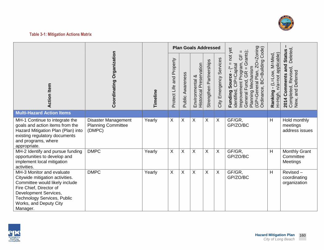
Prepared by:
160
Hazard Mitigation Plan City of Long Beach
Table 3-1: Mitigation Actions Matrix
Ac
tio
n Ite
m
Co
ord
inati
ng
Org
an
iza
tio
n
Tim
eli
ne
Plan Goals Addressed
Fu
nd
ing
So
urc
e -
(*
= n
ot
yet
iden
tified
, C
IP=
Cap
ita
l
Impro
vem
en
t P
rogra
m, G
F =
Ge
ne
ral F
un
d, G
R =
Gra
nts
);
Pla
nn
ing M
echa
nis
m
(GP
=G
enera
l P
lan,
ZO
=Z
on
ing
Ord
inan
ce,
BC
=B
uild
ing C
ode
)
Ra
nk
ing
- (
L=
Lo
w, M
=M
ed,
H=
Hig
h,
n/a
=n
ot a
pp
lica
ble
)
2014 C
om
me
nts
an
d S
tatu
s –
Co
mp
lete
d, R
evis
ed, D
ele
ted
,
Ne
w,
and
Defe
rre
d
Pro
tect
Life a
nd
Pro
pe
rty
Pu
blic
Aw
are
ne
ss
En
viro
nm
enta
l &
His
torical P
reserv
ation
Str
eng
the
n P
art
ners
hip
s
City E
merg
en
cy S
erv
ices
Multi-Hazard Action Items
MH-1 Continue to integrate the goals and action items from the Hazard Mitigation Plan (Plan) into existing regulatory documents and programs, where appropriate.
Disaster Management Planning Committee (DMPC)
Yearly X X X X X GF/GR, GP/ZO/BC
H Hold monthly meetings address issues
MH-2 Identify and pursue funding opportunities to develop and implement local mitigation activities.
DMPC Yearly X X X X X GF/GR, GP/ZO/BC
H Monthly Grant Committee Meetings
MH-3 Monitor and evaluate Citywide mitigation activities. Committee would likely include Fire Chief, Director of Development Services, Technology Services, Public Works, and Deputy City Manager.
DMPC Yearly X X X X X GF/GR, GP/ZO/BC
H Revised – coordinating organization
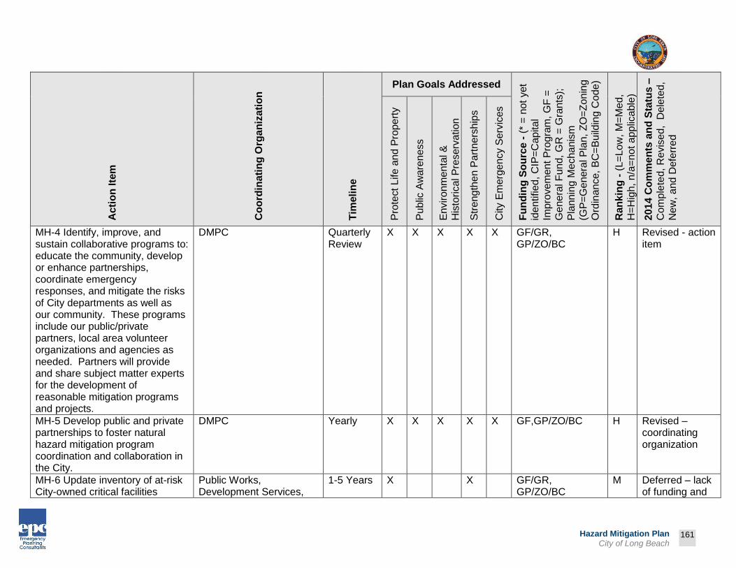
Prepared by:
161
Hazard Mitigation Plan City of Long Beach
Ac
tio
n Ite
m
Co
ord
inati
ng
Org
an
iza
tio
n
Tim
eli
ne
Plan Goals Addressed
Fu
nd
ing
So
urc
e -
(*
= n
ot
yet
iden
tified
, C
IP=
Cap
ita
l
Impro
vem
en
t P
rogra
m, G
F =
Ge
ne
ral F
un
d, G
R =
Gra
nts
);
Pla
nn
ing M
echa
nis
m
(GP
=G
enera
l P
lan,
ZO
=Z
on
ing
Ord
inan
ce,
BC
=B
uild
ing C
ode
)
Ra
nk
ing
- (
L=
Lo
w, M
=M
ed,
H=
Hig
h,
n/a
=n
ot a
pp
lica
ble
)
2014 C
om
me
nts
an
d S
tatu
s –
Co
mp
lete
d, R
evis
ed, D
ele
ted
,
Ne
w,
and
Defe
rre
d
Pro
tect
Life a
nd
Pro
pe
rty
Pu
blic
Aw
are
ne
ss
En
viro
nm
enta
l &
His
torical P
reserv
ation
Str
eng
the
n P
art
ners
hip
s
City E
merg
en
cy S
erv
ices
MH-4 Identify, improve, and sustain collaborative programs to: educate the community, develop or enhance partnerships, coordinate emergency responses, and mitigate the risks of City departments as well as our community. These programs include our public/private partners, local area volunteer organizations and agencies as needed. Partners will provide and share subject matter experts for the development of reasonable mitigation programs and projects.
DMPC Quarterly Review
X X X X X GF/GR, GP/ZO/BC
H Revised - action item
MH-5 Develop public and private partnerships to foster natural hazard mitigation program coordination and collaboration in the City.
DMPC Yearly X X X X X GF,GP/ZO/BC H Revised – coordinating organization
MH-6 Update inventory of at-risk City-owned critical facilities
Public Works, Development Services,
1-5 Years X X GF/GR, GP/ZO/BC
M Deferred – lack of funding and

Prepared by:
162
Hazard Mitigation Plan City of Long Beach
Ac
tio
n Ite
m
Co
ord
inati
ng
Org
an
iza
tio
n
Tim
eli
ne
Plan Goals Addressed
Fu
nd
ing
So
urc
e -
(*
= n
ot
yet
iden
tified
, C
IP=
Cap
ita
l
Impro
vem
en
t P
rogra
m, G
F =
Ge
ne
ral F
un
d, G
R =
Gra
nts
);
Pla
nn
ing M
echa
nis
m
(GP
=G
enera
l P
lan,
ZO
=Z
on
ing
Ord
inan
ce,
BC
=B
uild
ing C
ode
)
Ra
nk
ing
- (
L=
Lo
w, M
=M
ed,
H=
Hig
h,
n/a
=n
ot a
pp
lica
ble
)
2014 C
om
me
nts
an
d S
tatu
s –
Co
mp
lete
d, R
evis
ed, D
ele
ted
,
Ne
w,
and
Defe
rre
d
Pro
tect
Life a
nd
Pro
pe
rty
Pu
blic
Aw
are
ne
ss
En
viro
nm
enta
l &
His
torical P
reserv
ation
Str
eng
the
n P
art
ners
hip
s
City E
merg
en
cy S
erv
ices
including buildings and infrastructure. Develop photo inventories, building asset lists, and equipment lists.
Fire, Parks-Recreation-Marine (PRM)
staffing. Revised – action item and coordinating organization
MH-7 Strengthen emergency services preparedness and response by linking emergency services with natural hazard mitigation programs and enhancing public education on a local scale.
Deleted – redundant with other action items
MH-8 Develop, enhance, and implement education programs aimed at mitigating natural hazards, and reducing the risk to residents, public agencies, private property owners, businesses, and schools.
DMPC Yearly X X X X GF/GR, GP/ZO/BC
H Deleted – redundant with other action items
MH-9 Use technical knowledge of natural ecosystems and events to link natural resource
Deleted – not practical

Prepared by:
163
Hazard Mitigation Plan City of Long Beach
Ac
tio
n Ite
m
Co
ord
inati
ng
Org
an
iza
tio
n
Tim
eli
ne
Plan Goals Addressed
Fu
nd
ing
So
urc
e -
(*
= n
ot
yet
iden
tified
, C
IP=
Cap
ita
l
Impro
vem
en
t P
rogra
m, G
F =
Ge
ne
ral F
un
d, G
R =
Gra
nts
);
Pla
nn
ing M
echa
nis
m
(GP
=G
enera
l P
lan,
ZO
=Z
on
ing
Ord
inan
ce,
BC
=B
uild
ing C
ode
)
Ra
nk
ing
- (
L=
Lo
w, M
=M
ed,
H=
Hig
h,
n/a
=n
ot a
pp
lica
ble
)
2014 C
om
me
nts
an
d S
tatu
s –
Co
mp
lete
d, R
evis
ed, D
ele
ted
,
Ne
w,
and
Defe
rre
d
Pro
tect
Life a
nd
Pro
pe
rty
Pu
blic
Aw
are
ne
ss
En
viro
nm
enta
l &
His
torical P
reserv
ation
Str
eng
the
n P
art
ners
hip
s
City E
merg
en
cy S
erv
ices
management and land use organizations to mitigation activities and technical assistance.
MH-10 Update Public Safety Element and Seismic Safety Element of the City’s General Plan
Development Services 1-5 years X X X X X GF/GR, GP/ZO/BC
M Deferred – lack of funding and staffing
MH-11 Ensure SEMS-mandated plans, training and exercises are updated and implemented.
Disaster Preparedness, Fire, Police, Public Works, Health
Yearly X X X X GR,GP/ZO/BC H Provided ICS training for all City Staff (NIMS), Revised – coordinating organization
MH-12 Expand Mitigation Plan to include man-made hazards (HAZMAT, terrorism, etc.). Thorough hazard analysis will be completed and the man-made risks will be added. This section of the plan will be classified as
Completed – incorporated into the 2014 Plan update

Prepared by:
164
Hazard Mitigation Plan City of Long Beach
Ac
tio
n Ite
m
Co
ord
inati
ng
Org
an
iza
tio
n
Tim
eli
ne
Plan Goals Addressed
Fu
nd
ing
So
urc
e -
(*
= n
ot
yet
iden
tified
, C
IP=
Cap
ita
l
Impro
vem
en
t P
rogra
m, G
F =
Ge
ne
ral F
un
d, G
R =
Gra
nts
);
Pla
nn
ing M
echa
nis
m
(GP
=G
enera
l P
lan,
ZO
=Z
on
ing
Ord
inan
ce,
BC
=B
uild
ing C
ode
)
Ra
nk
ing
- (
L=
Lo
w, M
=M
ed,
H=
Hig
h,
n/a
=n
ot a
pp
lica
ble
)
2014 C
om
me
nts
an
d S
tatu
s –
Co
mp
lete
d, R
evis
ed, D
ele
ted
,
Ne
w,
and
Defe
rre
d
Pro
tect
Life a
nd
Pro
pe
rty
Pu
blic
Aw
are
ne
ss
En
viro
nm
enta
l &
His
torical P
reserv
ation
Str
eng
the
n P
art
ners
hip
s
City E
merg
en
cy S
erv
ices
“operational” and will not be available to the public.
MH-13 Incorporate the building inventory into the hazard assessment.
Deleted – redundant with other action items
MH-14 Ensure compliance to rebuilding in conformance with applicable codes, specifications, and standards.
Deleted – compliance would be automatic so item is not necessary
MH-15 Ensure repairs or construction funded by Federal disaster assistance conform to applicable codes and standards.
Deleted – compliance would be automatic so item is not necessary
MH-16 Review existing zoning regulations to ensure adequacy in reducing the amount of future development in area with identified hazards.
Development Services 1-5 years X X X X GF/GR, GP/ZO/BC
L Revised – added clarity to action item, coordinating organization

Prepared by:
165
Hazard Mitigation Plan City of Long Beach
Ac
tio
n Ite
m
Co
ord
inati
ng
Org
an
iza
tio
n
Tim
eli
ne
Plan Goals Addressed
Fu
nd
ing
So
urc
e -
(*
= n
ot
yet
iden
tified
, C
IP=
Cap
ita
l
Impro
vem
en
t P
rogra
m, G
F =
Ge
ne
ral F
un
d, G
R =
Gra
nts
);
Pla
nn
ing M
echa
nis
m
(GP
=G
enera
l P
lan,
ZO
=Z
on
ing
Ord
inan
ce,
BC
=B
uild
ing C
ode
)
Ra
nk
ing
- (
L=
Lo
w, M
=M
ed,
H=
Hig
h,
n/a
=n
ot a
pp
lica
ble
)
2014 C
om
me
nts
an
d S
tatu
s –
Co
mp
lete
d, R
evis
ed, D
ele
ted
,
Ne
w,
and
Defe
rre
d
Pro
tect
Life a
nd
Pro
pe
rty
Pu
blic
Aw
are
ne
ss
En
viro
nm
enta
l &
His
torical P
reserv
ation
Str
eng
the
n P
art
ners
hip
s
City E
merg
en
cy S
erv
ices
MH-17 Improve hazard assessment information to make recommendations for discouraging new development and encouraging preventative measures for existing development in areas vulnerable to natural hazards.
Deleted – redundant with other action items
MH-18 Use the Mitigation Plan to help the City’s General Plan meet State regulations designed to protect life and property from natural disasters and hazards through planning strategies that restrict development in areas of known hazards. (California Coastal Commission, State Lands Commission)
Deleted – redundant with other action items
MH-19 Coordinate and integrate natural hazard mitigation activities, where appropriate, with the City’s Emergency Operations Plan.
Disaster Preparedness Yearly X X X X X GF/GR, GP/ZO/BC
M Procedures developed to mitigate hazards as they are identified,
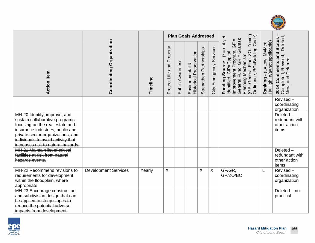
Prepared by:
166
Hazard Mitigation Plan City of Long Beach
Ac
tio
n Ite
m
Co
ord
inati
ng
Org
an
iza
tio
n
Tim
eli
ne
Plan Goals Addressed
Fu
nd
ing
So
urc
e -
(*
= n
ot
yet
iden
tified
, C
IP=
Cap
ita
l
Impro
vem
en
t P
rogra
m, G
F =
Ge
ne
ral F
un
d, G
R =
Gra
nts
);
Pla
nn
ing M
echa
nis
m
(GP
=G
enera
l P
lan,
ZO
=Z
on
ing
Ord
inan
ce,
BC
=B
uild
ing C
ode
)
Ra
nk
ing
- (
L=
Lo
w, M
=M
ed,
H=
Hig
h,
n/a
=n
ot a
pp
lica
ble
)
2014 C
om
me
nts
an
d S
tatu
s –
Co
mp
lete
d, R
evis
ed, D
ele
ted
,
Ne
w,
and
Defe
rre
d
Pro
tect
Life a
nd
Pro
pe
rty
Pu
blic
Aw
are
ne
ss
En
viro
nm
enta
l &
His
torical P
reserv
ation
Str
eng
the
n P
art
ners
hip
s
City E
merg
en
cy S
erv
ices
Revised – coordinating organization
MH-20 Identify, improve, and sustain collaborative programs focusing on the real estate and insurance industries, public and private sector organizations, and individuals to avoid activity that increases risk to natural hazards.
Deleted – redundant with other action items
MH-21 Maintain list of critical facilities at risk from natural hazards events.
Deleted – redundant with other action items
MH-22 Recommend revisions to requirements for development within the floodplain, where appropriate.
Development Services Yearly X X X GF/GR, GP/ZO/BC
L Revised – coordinating organization
MH-23 Encourage construction and subdivision design that can be applied to steep slopes to reduce the potential adverse impacts from development.
Deleted – not practical
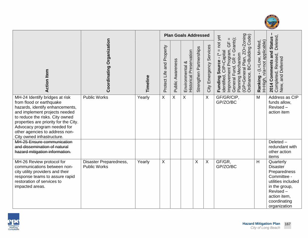
Prepared by:
167
Hazard Mitigation Plan City of Long Beach
Ac
tio
n Ite
m
Co
ord
inati
ng
Org
an
iza
tio
n
Tim
eli
ne
Plan Goals Addressed
Fu
nd
ing
So
urc
e -
(*
= n
ot
yet
iden
tified
, C
IP=
Cap
ita
l
Impro
vem
en
t P
rogra
m, G
F =
Ge
ne
ral F
un
d, G
R =
Gra
nts
);
Pla
nn
ing M
echa
nis
m
(GP
=G
enera
l P
lan,
ZO
=Z
on
ing
Ord
inan
ce,
BC
=B
uild
ing C
ode
)
Ra
nk
ing
- (
L=
Lo
w, M
=M
ed,
H=
Hig
h,
n/a
=n
ot a
pp
lica
ble
)
2014 C
om
me
nts
an
d S
tatu
s –
Co
mp
lete
d, R
evis
ed, D
ele
ted
,
Ne
w,
and
Defe
rre
d
Pro
tect
Life a
nd
Pro
pe
rty
Pu
blic
Aw
are
ne
ss
En
viro
nm
enta
l &
His
torical P
reserv
ation
Str
eng
the
n P
art
ners
hip
s
City E
merg
en
cy S
erv
ices
MH-24 Identify bridges at risk from flood or earthquake hazards, identify enhancements, and implement projects needed to reduce the risks. City owned properties are priority for the City. Advocacy program needed for other agencies to address non-City owned infrastructure.
Public Works Yearly X X X X GF/GR/CIP, GP/ZO/BC
M Address as CIP funds allow, Revised – action item
MH-25 Ensure communication and dissemination of natural hazard mitigation information.
Deleted – redundant with other action items
MH-26 Review protocol for communications between non-city utility providers and their response teams to assure rapid restoration of services to impacted areas.
Disaster Preparedness, Public Works
Yearly X X X GF/GR, GP/ZO/BC
H Quarterly Disaster Preparedness Committee - utilities included in the group, Revised – action item, coordinating organization

Prepared by:
168
Hazard Mitigation Plan City of Long Beach
Ac
tio
n Ite
m
Co
ord
inati
ng
Org
an
iza
tio
n
Tim
eli
ne
Plan Goals Addressed
Fu
nd
ing
So
urc
e -
(*
= n
ot
yet
iden
tified
, C
IP=
Cap
ita
l
Impro
vem
en
t P
rogra
m, G
F =
Ge
ne
ral F
un
d, G
R =
Gra
nts
);
Pla
nn
ing M
echa
nis
m
(GP
=G
enera
l P
lan,
ZO
=Z
on
ing
Ord
inan
ce,
BC
=B
uild
ing C
ode
)
Ra
nk
ing
- (
L=
Lo
w, M
=M
ed,
H=
Hig
h,
n/a
=n
ot a
pp
lica
ble
)
2014 C
om
me
nts
an
d S
tatu
s –
Co
mp
lete
d, R
evis
ed, D
ele
ted
,
Ne
w,
and
Defe
rre
d
Pro
tect
Life a
nd
Pro
pe
rty
Pu
blic
Aw
are
ne
ss
En
viro
nm
enta
l &
His
torical P
reserv
ation
Str
eng
the
n P
art
ners
hip
s
City E
merg
en
cy S
erv
ices
MH-27 Review strategy to maintain all forms of communications and the facilities required to support communications should natural hazards events cause damages.
Technology Services Yearly X X X X GF,GP/ZO/BC M Revised – action item
MH-28 Review Preliminary Damage Assessment process to ensure efficiency and effectiveness.
Development Services, Public Works, Disaster Preparedness
1-3 years X X X X GF/GR, GP/ZO/BC
M Revised – coordinating organization
MH-29 Maintain communication lines and response protocols between transportation entities (i.e. Public Works, CalTrans, LA County) to prioritize and identify strategies to deal with road problems and traffic control.
Public Works Yearly X X X GF/GR, GP/ZO/BC
M Revised – action item
MH-30 Provide new home and property buyers with information on quality redevelopment and safe housing development.
Deleted – not practical
MH-31 Review City zoning regulations to ensure adequacy
Deleted – redundant with

Prepared by:
169
Hazard Mitigation Plan City of Long Beach
Ac
tio
n Ite
m
Co
ord
inati
ng
Org
an
iza
tio
n
Tim
eli
ne
Plan Goals Addressed
Fu
nd
ing
So
urc
e -
(*
= n
ot
yet
iden
tified
, C
IP=
Cap
ita
l
Impro
vem
en
t P
rogra
m, G
F =
Ge
ne
ral F
un
d, G
R =
Gra
nts
);
Pla
nn
ing M
echa
nis
m
(GP
=G
enera
l P
lan,
ZO
=Z
on
ing
Ord
inan
ce,
BC
=B
uild
ing C
ode
)
Ra
nk
ing
- (
L=
Lo
w, M
=M
ed,
H=
Hig
h,
n/a
=n
ot a
pp
lica
ble
)
2014 C
om
me
nts
an
d S
tatu
s –
Co
mp
lete
d, R
evis
ed, D
ele
ted
,
Ne
w,
and
Defe
rre
d
Pro
tect
Life a
nd
Pro
pe
rty
Pu
blic
Aw
are
ne
ss
En
viro
nm
enta
l &
His
torical P
reserv
ation
Str
eng
the
n P
art
ners
hip
s
City E
merg
en
cy S
erv
ices
of restrictions to reduce future development in high hazard areas.
other action items
MH-32 Compile a directory of out-of-area contractors to help with repairs /reconstruction so that restoration occurs in a timely manner.
Deleted – limited staff and resources
MH-33 Partner with other organizations and agencies in the community to identify grant programs and foundations that may support mitigation activities.
DMPC Yearly X X GF, GP/ZO/BC H Established monthly Grant Committee, DMAC resources, Revised – coordinating organization
MH-34 Allocate City resources and assistance to mitigation projects when and where possible to do so.
City Manager, Financial Management, Public Works
Yearly X X GF/GR, GP/ZO/BC
M Proceeding as funding will allow Revised – coordinating organization
MH-35 Identify all organizations within the jurisdiction that have
DMPC Yearly X X X X X GF/GR, GP/ZO/BC
H Quarterly NGO meetings will

Prepared by:
170
Hazard Mitigation Plan City of Long Beach
Ac
tio
n Ite
m
Co
ord
inati
ng
Org
an
iza
tio
n
Tim
eli
ne
Plan Goals Addressed
Fu
nd
ing
So
urc
e -
(*
= n
ot
yet
iden
tified
, C
IP=
Cap
ita
l
Impro
vem
en
t P
rogra
m, G
F =
Ge
ne
ral F
un
d, G
R =
Gra
nts
);
Pla
nn
ing M
echa
nis
m
(GP
=G
enera
l P
lan,
ZO
=Z
on
ing
Ord
inan
ce,
BC
=B
uild
ing C
ode
)
Ra
nk
ing
- (
L=
Lo
w, M
=M
ed,
H=
Hig
h,
n/a
=n
ot a
pp
lica
ble
)
2014 C
om
me
nts
an
d S
tatu
s –
Co
mp
lete
d, R
evis
ed, D
ele
ted
,
Ne
w,
and
Defe
rre
d
Pro
tect
Life a
nd
Pro
pe
rty
Pu
blic
Aw
are
ne
ss
En
viro
nm
enta
l &
His
torical P
reserv
ation
Str
eng
the
n P
art
ners
hip
s
City E
merg
en
cy S
erv
ices
programs or interests in natural hazards mitigation.
include updates on Hazard Mitigation Plans, Revised – coordinating organization
MH-36 Identify new sources of support such as philanthropic foundations, community foundations, and professional organizations such as the Urban Land Institute or American Planning Association who might be able to provide technical or financial support for recovery planning.
Deleted – lack of funding and staffing
MH-37 Identify additional opportunities for partnering with citizens, private contractors, and other jurisdictions to increase availability of resources (equipment, staffing, and expertise) for response efforts.
DMPC Yearly X X X X *, GP/ZO/BC M Monthly Disaster Preparedness Committee, Revised – coordinating
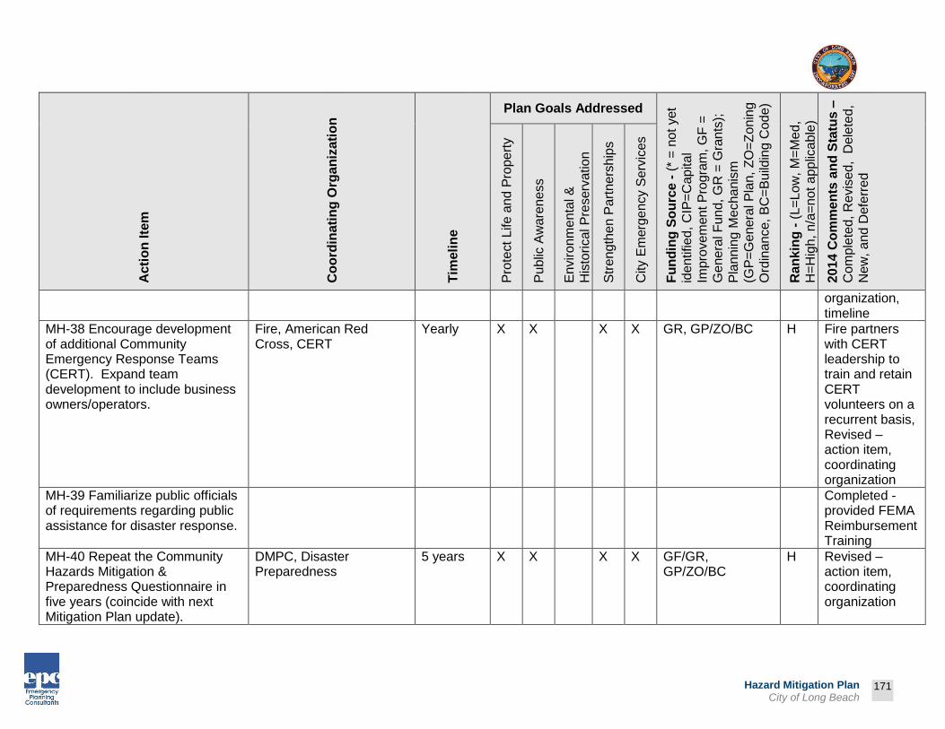
Prepared by:
171
Hazard Mitigation Plan City of Long Beach
Ac
tio
n Ite
m
Co
ord
inati
ng
Org
an
iza
tio
n
Tim
eli
ne
Plan Goals Addressed
Fu
nd
ing
So
urc
e -
(*
= n
ot
yet
iden
tified
, C
IP=
Cap
ita
l
Impro
vem
en
t P
rogra
m, G
F =
Ge
ne
ral F
un
d, G
R =
Gra
nts
);
Pla
nn
ing M
echa
nis
m
(GP
=G
enera
l P
lan,
ZO
=Z
on
ing
Ord
inan
ce,
BC
=B
uild
ing C
ode
)
Ra
nk
ing
- (
L=
Lo
w, M
=M
ed,
H=
Hig
h,
n/a
=n
ot a
pp
lica
ble
)
2014 C
om
me
nts
an
d S
tatu
s –
Co
mp
lete
d, R
evis
ed, D
ele
ted
,
Ne
w,
and
Defe
rre
d
Pro
tect
Life a
nd
Pro
pe
rty
Pu
blic
Aw
are
ne
ss
En
viro
nm
enta
l &
His
torical P
reserv
ation
Str
eng
the
n P
art
ners
hip
s
City E
merg
en
cy S
erv
ices
organization, timeline
MH-38 Encourage development of additional Community Emergency Response Teams (CERT). Expand team development to include business owners/operators.
Fire, American Red Cross, CERT
Yearly X X X X GR, GP/ZO/BC H Fire partners with CERT leadership to train and retain CERT volunteers on a recurrent basis, Revised – action item, coordinating organization
MH-39 Familiarize public officials of requirements regarding public assistance for disaster response.
Completed - provided FEMA Reimbursement Training
MH-40 Repeat the Community Hazards Mitigation & Preparedness Questionnaire in five years (coincide with next Mitigation Plan update).
DMPC, Disaster Preparedness
5 years X X X X GF/GR, GP/ZO/BC
H Revised – action item, coordinating organization

Prepared by:
172
Hazard Mitigation Plan City of Long Beach
Ac
tio
n Ite
m
Co
ord
inati
ng
Org
an
iza
tio
n
Tim
eli
ne
Plan Goals Addressed
Fu
nd
ing
So
urc
e -
(*
= n
ot
yet
iden
tified
, C
IP=
Cap
ita
l
Impro
vem
en
t P
rogra
m, G
F =
Ge
ne
ral F
un
d, G
R =
Gra
nts
);
Pla
nn
ing M
echa
nis
m
(GP
=G
enera
l P
lan,
ZO
=Z
on
ing
Ord
inan
ce,
BC
=B
uild
ing C
ode
)
Ra
nk
ing
- (
L=
Lo
w, M
=M
ed,
H=
Hig
h,
n/a
=n
ot a
pp
lica
ble
)
2014 C
om
me
nts
an
d S
tatu
s –
Co
mp
lete
d, R
evis
ed, D
ele
ted
,
Ne
w,
and
Defe
rre
d
Pro
tect
Life a
nd
Pro
pe
rty
Pu
blic
Aw
are
ne
ss
En
viro
nm
enta
l &
His
torical P
reserv
ation
Str
eng
the
n P
art
ners
hip
s
City E
merg
en
cy S
erv
ices
MH-41 Develop Debris Management Plan for future disaster events including supporting documentation and contracts.
Public Works, Financial Management, Disaster Preparedness
1-5 years X X X X GF/GR, GP/ZO/BC
H New
MH-42 Enhance weather monitoring to attain earlier severe storm warnings.
Disaster Preparedness, Technology Services
Yearly X X X X X GF/GR, GP/ZO/BC
H To date iNWS and other web based programs are available, Revised – coordinating organization
MH-43 Improve communication among the adjoining transportation entities in order to improve coordination of emergency transportation route maintenance.
Deleted – not practical
MH-44 Establish a committee to work on animal specific evacuation and sheltering needs. The committee will have
PRM Yearly X X X X GF/GR, GP/ZO/BC
M Revised – action item, coordinating organization

Prepared by:
173
Hazard Mitigation Plan City of Long Beach
Ac
tio
n Ite
m
Co
ord
inati
ng
Org
an
iza
tio
n
Tim
eli
ne
Plan Goals Addressed
Fu
nd
ing
So
urc
e -
(*
= n
ot
yet
iden
tified
, C
IP=
Cap
ita
l
Impro
vem
en
t P
rogra
m, G
F =
Ge
ne
ral F
un
d, G
R =
Gra
nts
);
Pla
nn
ing M
echa
nis
m
(GP
=G
enera
l P
lan,
ZO
=Z
on
ing
Ord
inan
ce,
BC
=B
uild
ing C
ode
)
Ra
nk
ing
- (
L=
Lo
w, M
=M
ed,
H=
Hig
h,
n/a
=n
ot a
pp
lica
ble
)
2014 C
om
me
nts
an
d S
tatu
s –
Co
mp
lete
d, R
evis
ed, D
ele
ted
,
Ne
w,
and
Defe
rre
d
Pro
tect
Life a
nd
Pro
pe
rty
Pu
blic
Aw
are
ne
ss
En
viro
nm
enta
l &
His
torical P
reserv
ation
Str
eng
the
n P
art
ners
hip
s
City E
merg
en
cy S
erv
ices
representatives from all areas of the City including veterinarians, pet store owners, the Humane Society, animal shelters, the Animal Control Division, other agencies and local interested parties.
MH-45 Develop informational literature on recommended disaster response plans and emergency supply kits and for animals/pets and have them available in veterinary clinics and pet stores.
PRM, American Red Cross
Yearly X X X GF/GR, GP/ZO/BC
M Created materials to educate families on pet emergency plans, Revised – action item, coordinating organization
MH-46 Incorporate the training goals and objectives used by Fire/EMS, Police, Public Works, Health and Human Services in order to foster unified command relationships. Combine all City
Deleted – redundant with other action items
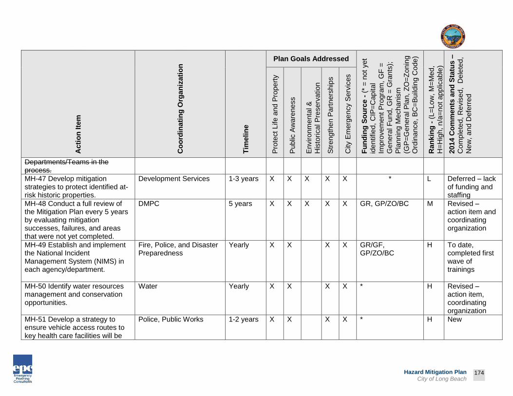
Prepared by:
174
Hazard Mitigation Plan City of Long Beach
Ac
tio
n Ite
m
Co
ord
inati
ng
Org
an
iza
tio
n
Tim
eli
ne
Plan Goals Addressed
Fu
nd
ing
So
urc
e -
(*
= n
ot
yet
iden
tified
, C
IP=
Cap
ita
l
Impro
vem
en
t P
rogra
m, G
F =
Ge
ne
ral F
un
d, G
R =
Gra
nts
);
Pla
nn
ing M
echa
nis
m
(GP
=G
enera
l P
lan,
ZO
=Z
on
ing
Ord
inan
ce,
BC
=B
uild
ing C
ode
)
Ra
nk
ing
- (
L=
Lo
w, M
=M
ed,
H=
Hig
h,
n/a
=n
ot a
pp
lica
ble
)
2014 C
om
me
nts
an
d S
tatu
s –
Co
mp
lete
d, R
evis
ed, D
ele
ted
,
Ne
w,
and
Defe
rre
d
Pro
tect
Life a
nd
Pro
pe
rty
Pu
blic
Aw
are
ne
ss
En
viro
nm
enta
l &
His
torical P
reserv
ation
Str
eng
the
n P
art
ners
hip
s
City E
merg
en
cy S
erv
ices
Departments/Teams in the process.
MH-47 Develop mitigation strategies to protect identified at-risk historic properties.
Development Services 1-3 years X X X X X * L Deferred – lack of funding and staffing
MH-48 Conduct a full review of the Mitigation Plan every 5 years by evaluating mitigation successes, failures, and areas that were not yet completed.
DMPC 5 years X X X X X GR, GP/ZO/BC M Revised – action item and coordinating organization
MH-49 Establish and implement the National Incident Management System (NIMS) in each agency/department.
Fire, Police, and Disaster Preparedness
Yearly X X X X GR/GF, GP/ZO/BC
H To date, completed first wave of trainings
MH-50 Identify water resources management and conservation opportunities.
Water Yearly X X X X * H Revised – action item, coordinating organization
MH-51 Develop a strategy to ensure vehicle access routes to key health care facilities will be
Police, Public Works 1-2 years X X X X * H New

Prepared by:
175
Hazard Mitigation Plan City of Long Beach
Ac
tio
n Ite
m
Co
ord
inati
ng
Org
an
iza
tio
n
Tim
eli
ne
Plan Goals Addressed
Fu
nd
ing
So
urc
e -
(*
= n
ot
yet
iden
tified
, C
IP=
Cap
ita
l
Impro
vem
en
t P
rogra
m, G
F =
Ge
ne
ral F
un
d, G
R =
Gra
nts
);
Pla
nn
ing M
echa
nis
m
(GP
=G
enera
l P
lan,
ZO
=Z
on
ing
Ord
inan
ce,
BC
=B
uild
ing C
ode
)
Ra
nk
ing
- (
L=
Lo
w, M
=M
ed,
H=
Hig
h,
n/a
=n
ot a
pp
lica
ble
)
2014 C
om
me
nts
an
d S
tatu
s –
Co
mp
lete
d, R
evis
ed, D
ele
ted
,
Ne
w,
and
Defe
rre
d
Pro
tect
Life a
nd
Pro
pe
rty
Pu
blic
Aw
are
ne
ss
En
viro
nm
enta
l &
His
torical P
reserv
ation
Str
eng
the
n P
art
ners
hip
s
City E
merg
en
cy S
erv
ices
protected from blockage as a result of a disaster.
MH-52 Develop inventory of backup power resources (generators) for critical City facilities, hospitals, and nursing homes. Encourage upgrading of resources, as necessary.
Fire, Disaster Preparedness, Public Works
1-2 years X X X X GF/GR, GP/ZO/BC
H Revised – action item, coordinating organization, Grant application submitted for generators as a backup power source
MH-53 Enhance emergency services to increase the efficiency of mutual aid wildfire response and recovery activities.
Fire Yearly X X X X GR, GP/ZO/BC H Active participant in EMAC program
MH-54 Enhance response capability of City fire, police, and emergency medical services personnel to meet the special needs of our most vulnerable residents including access and functional needs populations.
Disaster Preparedness, Fire, Police
Yearly X X X X GR, GP/ZO/BC H LA County SNAP and Vial of Life programs are in place, special equipment and procedures for

Prepared by:
176
Hazard Mitigation Plan City of Long Beach
Ac
tio
n Ite
m
Co
ord
inati
ng
Org
an
iza
tio
n
Tim
eli
ne
Plan Goals Addressed
Fu
nd
ing
So
urc
e -
(*
= n
ot
yet
iden
tified
, C
IP=
Cap
ita
l
Impro
vem
en
t P
rogra
m, G
F =
Ge
ne
ral F
un
d, G
R =
Gra
nts
);
Pla
nn
ing M
echa
nis
m
(GP
=G
enera
l P
lan,
ZO
=Z
on
ing
Ord
inan
ce,
BC
=B
uild
ing C
ode
)
Ra
nk
ing
- (
L=
Lo
w, M
=M
ed,
H=
Hig
h,
n/a
=n
ot a
pp
lica
ble
)
2014 C
om
me
nts
an
d S
tatu
s –
Co
mp
lete
d, R
evis
ed, D
ele
ted
,
Ne
w,
and
Defe
rre
d
Pro
tect
Life a
nd
Pro
pe
rty
Pu
blic
Aw
are
ne
ss
En
viro
nm
enta
l &
His
torical P
reserv
ation
Str
eng
the
n P
art
ners
hip
s
City E
merg
en
cy S
erv
ices
communications, Revised – action item, coordinating organization
MH-55 Ensure preventive maintenance programs are in place and appropriately funded to maintain the community's infrastructure and minimize the potential for system failure because of or during a disaster.
Public Works, PRM, Financial Management
Yearly X X X X GF/CIP/GR, GP/ZO/BC
H Re-evaluate and continue as funds are available, Revised – action item
MH-56 Publicize the Emergency
Management Institute’s
Independent Study Courses
available to the public to include
but not limited to Emergency
Preparedness USA, Hazardous
Material: Citizen Orientation,
Animals in Disaster, Disaster
Mitigation for Homeowners.
Deleted – limited staff and resources

Prepared by:
177
Hazard Mitigation Plan City of Long Beach
Ac
tio
n Ite
m
Co
ord
inati
ng
Org
an
iza
tio
n
Tim
eli
ne
Plan Goals Addressed
Fu
nd
ing
So
urc
e -
(*
= n
ot
yet
iden
tified
, C
IP=
Cap
ita
l
Impro
vem
en
t P
rogra
m, G
F =
Ge
ne
ral F
un
d, G
R =
Gra
nts
);
Pla
nn
ing M
echa
nis
m
(GP
=G
enera
l P
lan,
ZO
=Z
on
ing
Ord
inan
ce,
BC
=B
uild
ing C
ode
)
Ra
nk
ing
- (
L=
Lo
w, M
=M
ed,
H=
Hig
h,
n/a
=n
ot a
pp
lica
ble
)
2014 C
om
me
nts
an
d S
tatu
s –
Co
mp
lete
d, R
evis
ed, D
ele
ted
,
Ne
w,
and
Defe
rre
d
Pro
tect
Life a
nd
Pro
pe
rty
Pu
blic
Aw
are
ne
ss
En
viro
nm
enta
l &
His
torical P
reserv
ation
Str
eng
the
n P
art
ners
hip
s
City E
merg
en
cy S
erv
ices
MH-57 Teach CERT classes to
interested citizens in the City to
assist their neighbors during
emergencies. These courses will
be taught in various locations
throughout the City, utilizing the
staff resources including EMS,
Fire, Police and external
resources including American
Red Cross.
Fire, CERT Yearly X X X X GR, GP/ZO/BC H Developed and implemented program
MH-58 Conduct annual tabletop
disaster exercises with police,
fire, emergency management,
and other disaster response
departments and agencies.
Disaster Preparedness Yearly X X X X GF/GR, GP/ZO/BC
H Quarterly Department Head Meetings used to train staff.
MH-59 Pre-position first response
equipment and personnel at large
venues during scheduled events.
Fire, Police, Public Works Yearly X X X X GF, GP/ZO/BC M Included in EAPs as necessary, Revised – action item,

Prepared by:
178
Hazard Mitigation Plan City of Long Beach
Ac
tio
n Ite
m
Co
ord
inati
ng
Org
an
iza
tio
n
Tim
eli
ne
Plan Goals Addressed
Fu
nd
ing
So
urc
e -
(*
= n
ot
yet
iden
tified
, C
IP=
Cap
ita
l
Impro
vem
en
t P
rogra
m, G
F =
Ge
ne
ral F
un
d, G
R =
Gra
nts
);
Pla
nn
ing M
echa
nis
m
(GP
=G
enera
l P
lan,
ZO
=Z
on
ing
Ord
inan
ce,
BC
=B
uild
ing C
ode
)
Ra
nk
ing
- (
L=
Lo
w, M
=M
ed,
H=
Hig
h,
n/a
=n
ot a
pp
lica
ble
)
2014 C
om
me
nts
an
d S
tatu
s –
Co
mp
lete
d, R
evis
ed, D
ele
ted
,
Ne
w,
and
Defe
rre
d
Pro
tect
Life a
nd
Pro
pe
rty
Pu
blic
Aw
are
ne
ss
En
viro
nm
enta
l &
His
torical P
reserv
ation
Str
eng
the
n P
art
ners
hip
s
City E
merg
en
cy S
erv
ices
coordinating organization
MH-60 Work with the
organizations involved in shelter
management (ARC and schools)
to share information about local
shelters.
PRM, American Red Cross
Yearly X X X X GF/GR, GP/ZO/BC
M American Red Cross and PRM completed training, Revised – coordinating organization
MH-61 Create and make
available information to City
residents on “shelter-in-place”
procedures.
Fire, American Red Cross, Disaster Preparedness
Yearly X X X X GF/GR, GP/ZO/BC
M Red Cross provided information via handouts and website (includes annual revision/update), Revised – action item, coordinating organization

Prepared by:
179
Hazard Mitigation Plan City of Long Beach
Ac
tio
n Ite
m
Co
ord
inati
ng
Org
an
iza
tio
n
Tim
eli
ne
Plan Goals Addressed
Fu
nd
ing
So
urc
e -
(*
= n
ot
yet
iden
tified
, C
IP=
Cap
ita
l
Impro
vem
en
t P
rogra
m, G
F =
Ge
ne
ral F
un
d, G
R =
Gra
nts
);
Pla
nn
ing M
echa
nis
m
(GP
=G
enera
l P
lan,
ZO
=Z
on
ing
Ord
inan
ce,
BC
=B
uild
ing C
ode
)
Ra
nk
ing
- (
L=
Lo
w, M
=M
ed,
H=
Hig
h,
n/a
=n
ot a
pp
lica
ble
)
2014 C
om
me
nts
an
d S
tatu
s –
Co
mp
lete
d, R
evis
ed, D
ele
ted
,
Ne
w,
and
Defe
rre
d
Pro
tect
Life a
nd
Pro
pe
rty
Pu
blic
Aw
are
ne
ss
En
viro
nm
enta
l &
His
torical P
reserv
ation
Str
eng
the
n P
art
ners
hip
s
City E
merg
en
cy S
erv
ices
MH-62 Utilize Neighborhood
Resource Centers for distribution
of natural hazard public
awareness materials.
Development Services Yearly X X X * L Revised – coordinating organization, Deferred – lack of funding and staffing
MH-63 Develop public awareness
materials that address weather-
related natural hazards.
DMPC, American Red Cross, Public Information Officer (PIO)
Yearly X X X X * M Red Cross and National Weather Service provided information via handouts and website, Revised – coordinating organization
MH-64 Distribute weather-related
disaster preparedness literature
to all property owners. Include
information on tropical storms,
Deleted – redundant with other action items

Prepared by:
180
Hazard Mitigation Plan City of Long Beach
Ac
tio
n Ite
m
Co
ord
inati
ng
Org
an
iza
tio
n
Tim
eli
ne
Plan Goals Addressed
Fu
nd
ing
So
urc
e -
(*
= n
ot
yet
iden
tified
, C
IP=
Cap
ita
l
Impro
vem
en
t P
rogra
m, G
F =
Ge
ne
ral F
un
d, G
R =
Gra
nts
);
Pla
nn
ing M
echa
nis
m
(GP
=G
enera
l P
lan,
ZO
=Z
on
ing
Ord
inan
ce,
BC
=B
uild
ing C
ode
)
Ra
nk
ing
- (
L=
Lo
w, M
=M
ed,
H=
Hig
h,
n/a
=n
ot a
pp
lica
ble
)
2014 C
om
me
nts
an
d S
tatu
s –
Co
mp
lete
d, R
evis
ed, D
ele
ted
,
Ne
w,
and
Defe
rre
d
Pro
tect
Life a
nd
Pro
pe
rty
Pu
blic
Aw
are
ne
ss
En
viro
nm
enta
l &
His
torical P
reserv
ation
Str
eng
the
n P
art
ners
hip
s
City E
merg
en
cy S
erv
ices
high winds, drought, severe
storms, etc.
MH-65 Continue to distribute
letters to all property owners on
the importance of water
conservation and availability of
water saving devices for homes.
Water Yearly X X X GF, GP/ZO/BC M Information is provided in mailers and on website
MH-66 Provide business
continuity workshops for business
owners to learn the importance of
disaster mitigation and how to
create an emergency operations
plan for their businesses.
Deleted – lack of funding and staffing
MH-67 Train EMS, Fire, Police,
Public Works, Health & Human
Services and other support
personnel in Unified Command
using the National Incident
Management System (NIMS)
model. By understanding the role
Fire, Police, Public Works, Health
Yearly X X X X GF/GR, GP/ZO/BC
H Revised – coordinating organization

Prepared by:
181
Hazard Mitigation Plan City of Long Beach
Ac
tio
n Ite
m
Co
ord
inati
ng
Org
an
iza
tio
n
Tim
eli
ne
Plan Goals Addressed
Fu
nd
ing
So
urc
e -
(*
= n
ot
yet
iden
tified
, C
IP=
Cap
ita
l
Impro
vem
en
t P
rogra
m, G
F =
Ge
ne
ral F
un
d, G
R =
Gra
nts
);
Pla
nn
ing M
echa
nis
m
(GP
=G
enera
l P
lan,
ZO
=Z
on
ing
Ord
inan
ce,
BC
=B
uild
ing C
ode
)
Ra
nk
ing
- (
L=
Lo
w, M
=M
ed,
H=
Hig
h,
n/a
=n
ot a
pp
lica
ble
)
2014 C
om
me
nts
an
d S
tatu
s –
Co
mp
lete
d, R
evis
ed, D
ele
ted
,
Ne
w,
and
Defe
rre
d
Pro
tect
Life a
nd
Pro
pe
rty
Pu
blic
Aw
are
ne
ss
En
viro
nm
enta
l &
His
torical P
reserv
ation
Str
eng
the
n P
art
ners
hip
s
City E
merg
en
cy S
erv
ices
of each discipline will result in a
cohesive performance of their
assigned tasks yielding an overall
emergency response that is not
only effective, but rapid with
optimal outcome.
MH-68 Distribution of information
on fire safety, smoke alarms and
sprinkler systems to homeowners
of structures built before 1980.
Fire Yearly X X X X GF, GP/ZO/BC M Outreach through media and web content
MH-69 Maintain and publicize
availability of preparedness
information and materials at Fire
Stations and City Hall. The
locations will stock materials that
may include: Emergency
Preparedness Guidebook,
FEMA’s Are You Ready, and
other brochures on disaster
supplies kits and plans, etc.
Fire, American Red Cross, Disaster Preparedness
Yearly X X X X GF, GP/ZO/BC M Health Department and Red Cross provide information via handouts and websites, Revised – action item, coordinating organization

Prepared by:
182
Hazard Mitigation Plan City of Long Beach
Ac
tio
n Ite
m
Co
ord
inati
ng
Org
an
iza
tio
n
Tim
eli
ne
Plan Goals Addressed
Fu
nd
ing
So
urc
e -
(*
= n
ot
yet
iden
tified
, C
IP=
Cap
ita
l
Impro
vem
en
t P
rogra
m, G
F =
Ge
ne
ral F
un
d, G
R =
Gra
nts
);
Pla
nn
ing M
echa
nis
m
(GP
=G
enera
l P
lan,
ZO
=Z
on
ing
Ord
inan
ce,
BC
=B
uild
ing C
ode
)
Ra
nk
ing
- (
L=
Lo
w, M
=M
ed,
H=
Hig
h,
n/a
=n
ot a
pp
lica
ble
)
2014 C
om
me
nts
an
d S
tatu
s –
Co
mp
lete
d, R
evis
ed, D
ele
ted
,
Ne
w,
and
Defe
rre
d
Pro
tect
Life a
nd
Pro
pe
rty
Pu
blic
Aw
are
ne
ss
En
viro
nm
enta
l &
His
torical P
reserv
ation
Str
eng
the
n P
art
ners
hip
s
City E
merg
en
cy S
erv
ices
MH-70 Consider expanding the
Region I (Local Emergency
Preparedness Committee’s
(LEPC) responsibilities to include
mitigation planning and disaster
preparedness education
activities.
Deleted - limited funding and staffing
MH-71 Utilize the media for the
distribution and publication of
hazard information.
PIO Yearly X X X GF, GP/ZO/BC H Use of print and social media
MH-72 Strategize on updating
existing emergency
preparedness booth to include
“how to” mitigation materials.
The new booth could include
pictures and information, such as
those contained in FEMA’s
Retrofitting for Homeowners
Guide, Elevating Your Flood
Prone Home, how to elevate
Disaster Preparedness 1-4 years X X X X GF/GR M Deferred – limited funding and staffing, Revised – action item and coordinating organization

Prepared by:
183
Hazard Mitigation Plan City of Long Beach
Ac
tio
n Ite
m
Co
ord
inati
ng
Org
an
iza
tio
n
Tim
eli
ne
Plan Goals Addressed
Fu
nd
ing
So
urc
e -
(*
= n
ot
yet
iden
tified
, C
IP=
Cap
ita
l
Impro
vem
en
t P
rogra
m, G
F =
Ge
ne
ral F
un
d, G
R =
Gra
nts
);
Pla
nn
ing M
echa
nis
m
(GP
=G
enera
l P
lan,
ZO
=Z
on
ing
Ord
inan
ce,
BC
=B
uild
ing C
ode
)
Ra
nk
ing
- (
L=
Lo
w, M
=M
ed,
H=
Hig
h,
n/a
=n
ot a
pp
lica
ble
)
2014 C
om
me
nts
an
d S
tatu
s –
Co
mp
lete
d, R
evis
ed, D
ele
ted
,
Ne
w,
and
Defe
rre
d
Pro
tect
Life a
nd
Pro
pe
rty
Pu
blic
Aw
are
ne
ss
En
viro
nm
enta
l &
His
torical P
reserv
ation
Str
eng
the
n P
art
ners
hip
s
City E
merg
en
cy S
erv
ices
critical structures and utilities and
information on the NFIP.
MH-73 Integrate the Mitigation Plan with the Capital Improvement Plans to ensure that development does not encroach on known hazard areas.
Public Works, Development Services
Yearly X X X X X GF, GP/ZO/BC H Deferred – Lack of funding and staffing. Revised – coordinating organization
MH-74 Establish City priorities for restoration of the community’s infrastructure/utilities and access to critical public facilities following a disaster.
Public Works, Development Services, Water, Gas and Oil
Following Disaster
X X X X X GF/GR, GP/ZO/BC
H Deferred – Lack of funding and staffing. Revised – coordinating organization
MH-75 Enhance Fire
Department’s Speaker’s Bureau
to include natural hazard topics.
Completed
MH-76 Create and maintain a database with information to track the status of City-owned or occupied facilities repairs or reconstruction.
Public Works Yearly X X X X GF, GP/ZO/BC M Capital Project and Management and Work Order Management

Prepared by:
184
Hazard Mitigation Plan City of Long Beach
Ac
tio
n Ite
m
Co
ord
inati
ng
Org
an
iza
tio
n
Tim
eli
ne
Plan Goals Addressed
Fu
nd
ing
So
urc
e -
(*
= n
ot
yet
iden
tified
, C
IP=
Cap
ita
l
Impro
vem
en
t P
rogra
m, G
F =
Ge
ne
ral F
un
d, G
R =
Gra
nts
);
Pla
nn
ing M
echa
nis
m
(GP
=G
enera
l P
lan,
ZO
=Z
on
ing
Ord
inan
ce,
BC
=B
uild
ing C
ode
)
Ra
nk
ing
- (
L=
Lo
w, M
=M
ed,
H=
Hig
h,
n/a
=n
ot a
pp
lica
ble
)
2014 C
om
me
nts
an
d S
tatu
s –
Co
mp
lete
d, R
evis
ed, D
ele
ted
,
Ne
w,
and
Defe
rre
d
Pro
tect
Life a
nd
Pro
pe
rty
Pu
blic
Aw
are
ne
ss
En
viro
nm
enta
l &
His
torical P
reserv
ation
Str
eng
the
n P
art
ners
hip
s
City E
merg
en
cy S
erv
ices
System (PW) database captures info
MH-77 Prepare a policy that identifies which types of repairs and/or reconstruction, if any, would be exempt from local codes, particularly zoning and land development codes.
Development Services 1-5 years X X X X GF/GR, GP/ZO/BC
M Deferred – lack of funding and staffing, Revised – coordinating organization
MH-78 Determine capacity in local construction and debris landfills to absorb the estimated inflow of disaster/restoration debris and set up agreements to use these sites.
Public Works, Financial Management
1-2 years X X X X GF/GR, GP/ZO/BC
M Deferred – lack of funding and staffing, Revised – coordinating organization
MH-79 Coordinate with American
Red Cross to deliver a variety of
training courses, including: CPR,
Basic First Aid, Introduction to
Disaster Services, Mass Care,
Shelter Operations, babysitting,
Healthcare Provider, and pet first-
Fire, American Red Cross, Disaster Preparedness
Yearly X X X GF, GP/ZO/BC M Red Cross programs are offered at City facilities and schedules maintained jointly, Revised – action item,

Prepared by:
185
Hazard Mitigation Plan City of Long Beach
Ac
tio
n Ite
m
Co
ord
inati
ng
Org
an
iza
tio
n
Tim
eli
ne
Plan Goals Addressed
Fu
nd
ing
So
urc
e -
(*
= n
ot
yet
iden
tified
, C
IP=
Cap
ita
l
Impro
vem
en
t P
rogra
m, G
F =
Ge
ne
ral F
un
d, G
R =
Gra
nts
);
Pla
nn
ing M
echa
nis
m
(GP
=G
enera
l P
lan,
ZO
=Z
on
ing
Ord
inan
ce,
BC
=B
uild
ing C
ode
)
Ra
nk
ing
- (
L=
Lo
w, M
=M
ed,
H=
Hig
h,
n/a
=n
ot a
pp
lica
ble
)
2014 C
om
me
nts
an
d S
tatu
s –
Co
mp
lete
d, R
evis
ed, D
ele
ted
,
Ne
w,
and
Defe
rre
d
Pro
tect
Life a
nd
Pro
pe
rty
Pu
blic
Aw
are
ne
ss
En
viro
nm
enta
l &
His
torical P
reserv
ation
Str
eng
the
n P
art
ners
hip
s
City E
merg
en
cy S
erv
ices
aid at locations throughout the
City.
coordinating organization
MH-80 Develop a program to
educate the public on existing
disaster-related self-help
agencies and resources available
within the City.
Disaster Preparedness, American Red Cross
Yearly X X GF/GR, GP/ZO/BC
M Information provided via handouts and web content, Revised – coordinating organization
MH-81 Establish website links
with outside disaster relief
agencies such as the Hospital
and County Social Services.
Completed
MH-82 Post the Mitigation Plan
on the City’s website.
PIO, Disaster Preparedness
Yearly X X X X GF, GP/ZO/BC H Pending completion of Draft 2014 update, Revised – coordinating organization
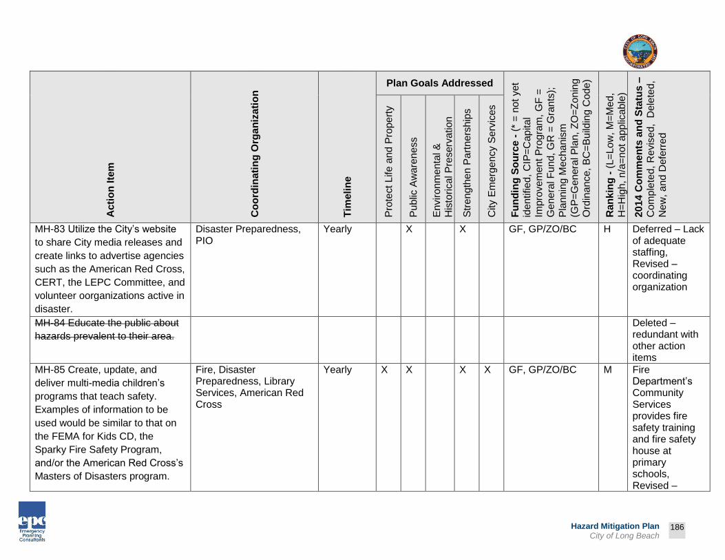
Prepared by:
186
Hazard Mitigation Plan City of Long Beach
Ac
tio
n Ite
m
Co
ord
inati
ng
Org
an
iza
tio
n
Tim
eli
ne
Plan Goals Addressed
Fu
nd
ing
So
urc
e -
(*
= n
ot
yet
iden
tified
, C
IP=
Cap
ita
l
Impro
vem
en
t P
rogra
m, G
F =
Ge
ne
ral F
un
d, G
R =
Gra
nts
);
Pla
nn
ing M
echa
nis
m
(GP
=G
enera
l P
lan,
ZO
=Z
on
ing
Ord
inan
ce,
BC
=B
uild
ing C
ode
)
Ra
nk
ing
- (
L=
Lo
w, M
=M
ed,
H=
Hig
h,
n/a
=n
ot a
pp
lica
ble
)
2014 C
om
me
nts
an
d S
tatu
s –
Co
mp
lete
d, R
evis
ed, D
ele
ted
,
Ne
w,
and
Defe
rre
d
Pro
tect
Life a
nd
Pro
pe
rty
Pu
blic
Aw
are
ne
ss
En
viro
nm
enta
l &
His
torical P
reserv
ation
Str
eng
the
n P
art
ners
hip
s
City E
merg
en
cy S
erv
ices
MH-83 Utilize the City’s website
to share City media releases and
create links to advertise agencies
such as the American Red Cross,
CERT, the LEPC Committee, and
volunteer oorganizations active in
disaster.
Disaster Preparedness, PIO
Yearly X X GF, GP/ZO/BC H Deferred – Lack of adequate staffing, Revised – coordinating organization
MH-84 Educate the public about
hazards prevalent to their area.
Deleted – redundant with other action items
MH-85 Create, update, and
deliver multi-media children’s
programs that teach safety.
Examples of information to be
used would be similar to that on
the FEMA for Kids CD, the
Sparky Fire Safety Program,
and/or the American Red Cross’s
Masters of Disasters program.
Fire, Disaster Preparedness, Library Services, American Red Cross
Yearly X X X X GF, GP/ZO/BC M Fire Department’s Community Services provides fire safety training and fire safety house at primary schools, Revised –

Prepared by:
187
Hazard Mitigation Plan City of Long Beach
Ac
tio
n Ite
m
Co
ord
inati
ng
Org
an
iza
tio
n
Tim
eli
ne
Plan Goals Addressed
Fu
nd
ing
So
urc
e -
(*
= n
ot
yet
iden
tified
, C
IP=
Cap
ita
l
Impro
vem
en
t P
rogra
m, G
F =
Ge
ne
ral F
un
d, G
R =
Gra
nts
);
Pla
nn
ing M
echa
nis
m
(GP
=G
enera
l P
lan,
ZO
=Z
on
ing
Ord
inan
ce,
BC
=B
uild
ing C
ode
)
Ra
nk
ing
- (
L=
Lo
w, M
=M
ed,
H=
Hig
h,
n/a
=n
ot a
pp
lica
ble
)
2014 C
om
me
nts
an
d S
tatu
s –
Co
mp
lete
d, R
evis
ed, D
ele
ted
,
Ne
w,
and
Defe
rre
d
Pro
tect
Life a
nd
Pro
pe
rty
Pu
blic
Aw
are
ne
ss
En
viro
nm
enta
l &
His
torical P
reserv
ation
Str
eng
the
n P
art
ners
hip
s
City E
merg
en
cy S
erv
ices
action item, coordinating organization
MH-86 Enhance boater safety
materials that are targeted toward
severe storms. Distribute the
materials at all local marinas in
the City.
PRM Yearly X X X X GF, GP/ZO/BC H Marine Bureau provides information to boating community
MH-87 Work with the Visitor &
Convention Bureau and business
development organization to alert
tourists to the potential of natural
hazard areas and what to do if a
natural hazard occurs during their
visit to the City.
DMPC, Disaster Preparedness
Yearly X X X X GF, GP/ZO/BC M Hospitality operations have required plans for mitigation and emergency management, Revised – coordinating organization
MH-88 Develop and distribute
media releases to local
newspapers and radio stations
about pre-disaster information.
PIO Yearly X X X X GF, GP/ZO/BC H Developing pre-vetted statements for distribution.

Prepared by:
188
Hazard Mitigation Plan City of Long Beach
Ac
tio
n Ite
m
Co
ord
inati
ng
Org
an
iza
tio
n
Tim
eli
ne
Plan Goals Addressed
Fu
nd
ing
So
urc
e -
(*
= n
ot
yet
iden
tified
, C
IP=
Cap
ita
l
Impro
vem
en
t P
rogra
m, G
F =
Ge
ne
ral F
un
d, G
R =
Gra
nts
);
Pla
nn
ing M
echa
nis
m
(GP
=G
enera
l P
lan,
ZO
=Z
on
ing
Ord
inan
ce,
BC
=B
uild
ing C
ode
)
Ra
nk
ing
- (
L=
Lo
w, M
=M
ed,
H=
Hig
h,
n/a
=n
ot a
pp
lica
ble
)
2014 C
om
me
nts
an
d S
tatu
s –
Co
mp
lete
d, R
evis
ed, D
ele
ted
,
Ne
w,
and
Defe
rre
d
Pro
tect
Life a
nd
Pro
pe
rty
Pu
blic
Aw
are
ne
ss
En
viro
nm
enta
l &
His
torical P
reserv
ation
Str
eng
the
n P
art
ners
hip
s
City E
merg
en
cy S
erv
ices
MH-89 Create and deliver public
service announcements on
personal preparedness as well as
mitigation steps and strategies.
Develop media plan to share
information
Fire, Disaster Preparedness, PIO
Yearly X X X X GF, GP/ZO/BC M Revised – coordinating organization & LBTV is providing PSAs & pre-disaster planning tips
MH-90 Maintain supplies and
training associated with use of
ATC-20 standards (building
inspections following disaster).
Development Services Yearly X X X X GF/GR, GP/ZO/BC
M Deferred – Lack of adequate staffing, Revised – coordinating organization
MH-91 Promote CERT through
the Chamber of Commerce to
gain business participation.
Fire Yearly X X X X GF, GP/ZO/BC M Deferred – Lack of adequate staffing, Revised – coordinating organization
MH-92 Develop training on the
Mitigation Plan for the Planning
Development Services 1-2 years X X X X GF, GP/ZO/BC L Revised – coordinating organization, Deferred – lack

Prepared by:
189
Hazard Mitigation Plan City of Long Beach
Ac
tio
n Ite
m
Co
ord
inati
ng
Org
an
iza
tio
n
Tim
eli
ne
Plan Goals Addressed
Fu
nd
ing
So
urc
e -
(*
= n
ot
yet
iden
tified
, C
IP=
Cap
ita
l
Impro
vem
en
t P
rogra
m, G
F =
Ge
ne
ral F
un
d, G
R =
Gra
nts
);
Pla
nn
ing M
echa
nis
m
(GP
=G
enera
l P
lan,
ZO
=Z
on
ing
Ord
inan
ce,
BC
=B
uild
ing C
ode
)
Ra
nk
ing
- (
L=
Lo
w, M
=M
ed,
H=
Hig
h,
n/a
=n
ot a
pp
lica
ble
)
2014 C
om
me
nts
an
d S
tatu
s –
Co
mp
lete
d, R
evis
ed, D
ele
ted
,
Ne
w,
and
Defe
rre
d
Pro
tect
Life a
nd
Pro
pe
rty
Pu
blic
Aw
are
ne
ss
En
viro
nm
enta
l &
His
torical P
reserv
ation
Str
eng
the
n P
art
ners
hip
s
City E
merg
en
cy S
erv
ices
Commission and others involved
in the development process.
of funding and staffing
MH-93 Maintain list of internal
training resources by department
and share training opportunities.
Disaster Preparedness Yearly X X X X GF, GP/ZO/BC H Deferred – Lack of adequate staffing, Revised – coordinating organization
MH-94 Ensure adequacy and
functionality of the alternate
ECOC.
Technology Services, Disaster Preparedness
Yearly X X X X GF, GP/ZO/BC H Deferred – Lack of adequate staffing, Revised – coordinating organization
MH-95 Build and maintain new
Emergency & Operations Center
(ECOC).
Completed
MH-96 Maintain database in
existing hazard GIS system of all
previous loss properties in the
Technology Services 1-2 years X X X X GF, GP/ZO/BC L Deferred – lack of funding and staffing

Prepared by:
190
Hazard Mitigation Plan City of Long Beach
Ac
tio
n Ite
m
Co
ord
inati
ng
Org
an
iza
tio
n
Tim
eli
ne
Plan Goals Addressed
Fu
nd
ing
So
urc
e -
(*
= n
ot
yet
iden
tified
, C
IP=
Cap
ita
l
Impro
vem
en
t P
rogra
m, G
F =
Ge
ne
ral F
un
d, G
R =
Gra
nts
);
Pla
nn
ing M
echa
nis
m
(GP
=G
enera
l P
lan,
ZO
=Z
on
ing
Ord
inan
ce,
BC
=B
uild
ing C
ode
)
Ra
nk
ing
- (
L=
Lo
w, M
=M
ed,
H=
Hig
h,
n/a
=n
ot a
pp
lica
ble
)
2014 C
om
me
nts
an
d S
tatu
s –
Co
mp
lete
d, R
evis
ed, D
ele
ted
,
Ne
w,
and
Defe
rre
d
Pro
tect
Life a
nd
Pro
pe
rty
Pu
blic
Aw
are
ne
ss
En
viro
nm
enta
l &
His
torical P
reserv
ation
Str
eng
the
n P
art
ners
hip
s
City E
merg
en
cy S
erv
ices
City to be used in future
mitigation activities.
MH-97 Continue collection of
HAZMAT reports from local
facilities to enhance and prepare
emergency responders in the
event of a “secondary impact”
incident at these facilities.
Health & Human Services, Fire
Yearly X X X X X GF, GP/ZO/BC H Revised – coordinating organization
MH-98 Determine how, when, and under what circumstances government will demolish property or structures.
City Manager, City Attorney
2 years X X X GF/GR, GP/ZO/BC
M Deferred – lack of funding and staffing, Revised – coordinating organization
MH-99 Retrofit bridges and
tunnels.
Public Works Yearly X X X GF/CIP, GP/ZO/BC
H Renovations will continue as funds are available.
MH-100 Incorporate new Mitigation Plan Hazard Analysis
Deleted – redundant with
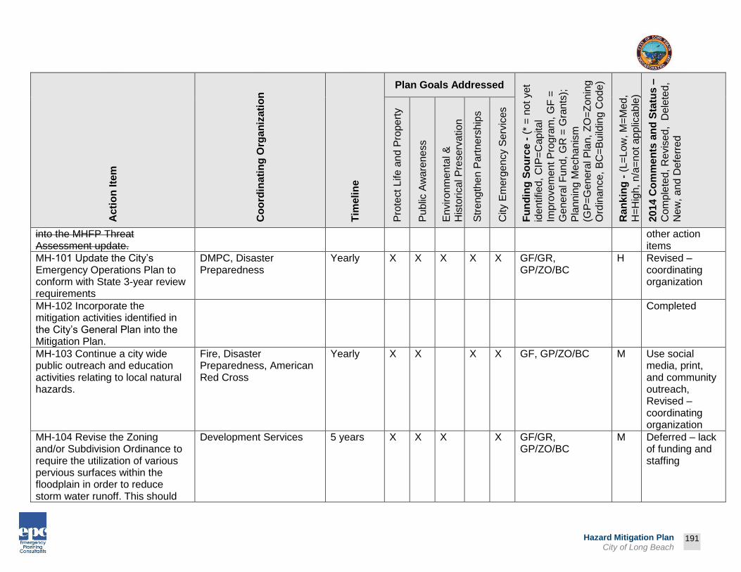
Prepared by:
191
Hazard Mitigation Plan City of Long Beach
Ac
tio
n Ite
m
Co
ord
inati
ng
Org
an
iza
tio
n
Tim
eli
ne
Plan Goals Addressed
Fu
nd
ing
So
urc
e -
(*
= n
ot
yet
iden
tified
, C
IP=
Cap
ita
l
Impro
vem
en
t P
rogra
m, G
F =
Ge
ne
ral F
un
d, G
R =
Gra
nts
);
Pla
nn
ing M
echa
nis
m
(GP
=G
enera
l P
lan,
ZO
=Z
on
ing
Ord
inan
ce,
BC
=B
uild
ing C
ode
)
Ra
nk
ing
- (
L=
Lo
w, M
=M
ed,
H=
Hig
h,
n/a
=n
ot a
pp
lica
ble
)
2014 C
om
me
nts
an
d S
tatu
s –
Co
mp
lete
d, R
evis
ed, D
ele
ted
,
Ne
w,
and
Defe
rre
d
Pro
tect
Life a
nd
Pro
pe
rty
Pu
blic
Aw
are
ne
ss
En
viro
nm
enta
l &
His
torical P
reserv
ation
Str
eng
the
n P
art
ners
hip
s
City E
merg
en
cy S
erv
ices
into the MHFP Threat Assessment update.
other action items
MH-101 Update the City’s Emergency Operations Plan to conform with State 3-year review requirements
DMPC, Disaster Preparedness
Yearly X X X X X GF/GR, GP/ZO/BC
H Revised – coordinating organization
MH-102 Incorporate the mitigation activities identified in the City’s General Plan into the Mitigation Plan.
Completed
MH-103 Continue a city wide public outreach and education activities relating to local natural hazards.
Fire, Disaster Preparedness, American Red Cross
Yearly X X X X GF, GP/ZO/BC M Use social media, print, and community outreach, Revised – coordinating organization
MH-104 Revise the Zoning and/or Subdivision Ordinance to require the utilization of various pervious surfaces within the floodplain in order to reduce storm water runoff. This should
Development Services 5 years X X X X GF/GR, GP/ZO/BC
M Deferred – lack of funding and staffing

Prepared by:
192
Hazard Mitigation Plan City of Long Beach
Ac
tio
n Ite
m
Co
ord
inati
ng
Org
an
iza
tio
n
Tim
eli
ne
Plan Goals Addressed
Fu
nd
ing
So
urc
e -
(*
= n
ot
yet
iden
tified
, C
IP=
Cap
ita
l
Impro
vem
en
t P
rogra
m, G
F =
Ge
ne
ral F
un
d, G
R =
Gra
nts
);
Pla
nn
ing M
echa
nis
m
(GP
=G
enera
l P
lan,
ZO
=Z
on
ing
Ord
inan
ce,
BC
=B
uild
ing C
ode
)
Ra
nk
ing
- (
L=
Lo
w, M
=M
ed,
H=
Hig
h,
n/a
=n
ot a
pp
lica
ble
)
2014 C
om
me
nts
an
d S
tatu
s –
Co
mp
lete
d, R
evis
ed, D
ele
ted
,
Ne
w,
and
Defe
rre
d
Pro
tect
Life a
nd
Pro
pe
rty
Pu
blic
Aw
are
ne
ss
En
viro
nm
enta
l &
His
torical P
reserv
ation
Str
eng
the
n P
art
ners
hip
s
City E
merg
en
cy S
erv
ices
include utilizing the use of various pervious surfaces in parking lots in recreational areas near the floodplain.
MH-105 Upgrade the existing generator and electrical systems at Long Beach Airport.
Completed (2004)
MH-106 Install new public address system at Long Beach Airport.
Completed (2004)
MH-107 Replace Long Beach Airport’s existing 1,500 gallon Aircraft Rescue Firefighting vehicle with a 3,000 gallon vehicle and replacement of the existing rapid response fire fighting vehicle with a new rapid response vehicle.
Completed (2005)
MH-108 Complete Americans with Disabilities Act (ADA) building upgrades in various locations throughout the City.
Development Services, Public Works
Yearly X X X GF, GP/ZO/BC M Renovations are completed as funds are available, Revised –

Prepared by:
193
Hazard Mitigation Plan City of Long Beach
Ac
tio
n Ite
m
Co
ord
inati
ng
Org
an
iza
tio
n
Tim
eli
ne
Plan Goals Addressed
Fu
nd
ing
So
urc
e -
(*
= n
ot
yet
iden
tified
, C
IP=
Cap
ita
l
Impro
vem
en
t P
rogra
m, G
F =
Ge
ne
ral F
un
d, G
R =
Gra
nts
);
Pla
nn
ing M
echa
nis
m
(GP
=G
enera
l P
lan,
ZO
=Z
on
ing
Ord
inan
ce,
BC
=B
uild
ing C
ode
)
Ra
nk
ing
- (
L=
Lo
w, M
=M
ed,
H=
Hig
h,
n/a
=n
ot a
pp
lica
ble
)
2014 C
om
me
nts
an
d S
tatu
s –
Co
mp
lete
d, R
evis
ed, D
ele
ted
,
Ne
w,
and
Defe
rre
d
Pro
tect
Life a
nd
Pro
pe
rty
Pu
blic
Aw
are
ne
ss
En
viro
nm
enta
l &
His
torical P
reserv
ation
Str
eng
the
n P
art
ners
hip
s
City E
merg
en
cy S
erv
ices
action item, coordinating organization
MH-109 Complete various structural repairs and improvements to existing critical facilities.
Public Works Yearly X X GF, GP/ZO/BC M Renovations are completed as funds are available, Revised – action item
MH-110 Design and construct Emergency Communications & Operations Center (ECOC).
Completed
MH-111 Repair residential streets to correct drainage problems and pavement failure.
Public Works Yearly X X GF/GR, GP/ZO/BC
H Implemented annual repair programs
MH-112 Install Opticom unit on traffic signals at prioritized intersections in order to enhance emergency vehicle response times and operational safety by allowing emergency vehicles to pre-empt signal timing.
Completed (2004)

Prepared by:
194
Hazard Mitigation Plan City of Long Beach
Ac
tio
n Ite
m
Co
ord
inati
ng
Org
an
iza
tio
n
Tim
eli
ne
Plan Goals Addressed
Fu
nd
ing
So
urc
e -
(*
= n
ot
yet
iden
tified
, C
IP=
Cap
ita
l
Impro
vem
en
t P
rogra
m, G
F =
Ge
ne
ral F
un
d, G
R =
Gra
nts
);
Pla
nn
ing M
echa
nis
m
(GP
=G
enera
l P
lan,
ZO
=Z
on
ing
Ord
inan
ce,
BC
=B
uild
ing C
ode
)
Ra
nk
ing
- (
L=
Lo
w, M
=M
ed,
H=
Hig
h,
n/a
=n
ot a
pp
lica
ble
)
2014 C
om
me
nts
an
d S
tatu
s –
Co
mp
lete
d, R
evis
ed, D
ele
ted
,
Ne
w,
and
Defe
rre
d
Pro
tect
Life a
nd
Pro
pe
rty
Pu
blic
Aw
are
ne
ss
En
viro
nm
enta
l &
His
torical P
reserv
ation
Str
eng
the
n P
art
ners
hip
s
City E
merg
en
cy S
erv
ices
MH-113 Update status of action items in the Hazard Mitigation Plan Matrix on an annual basis.
DMPC, Disaster Preparedness
Yearly X X X X X GF/GR, GP/ZO/BC
H Deferred – lack of funding and staffing, Revised – coordinating organization
MH-114 Consider incorporating man-made and technological hazards in future updates to the Mitigation Plan.
Completed (2013)
MH-115 Identify opportunities and funding to establish a Hazardous Materials Team.
Completed
MH-116 Develop tabletop exercises with assistance from Public Safety in order to better identify mapping needs for emergency response situations and EOC activations.
Technology Services - GIS
1-2 years X X X X X GF, GP/ZO/BC M Deferred – lack of funding and staffing
MH-117 Coordinate community outreach and education activates with the American Red Cross. Utilize information published by
DMPC, American Red Cross
Yearly X X X GF, GP/ZO/BC M American Red Cross, FEMA, BeReady, and other website
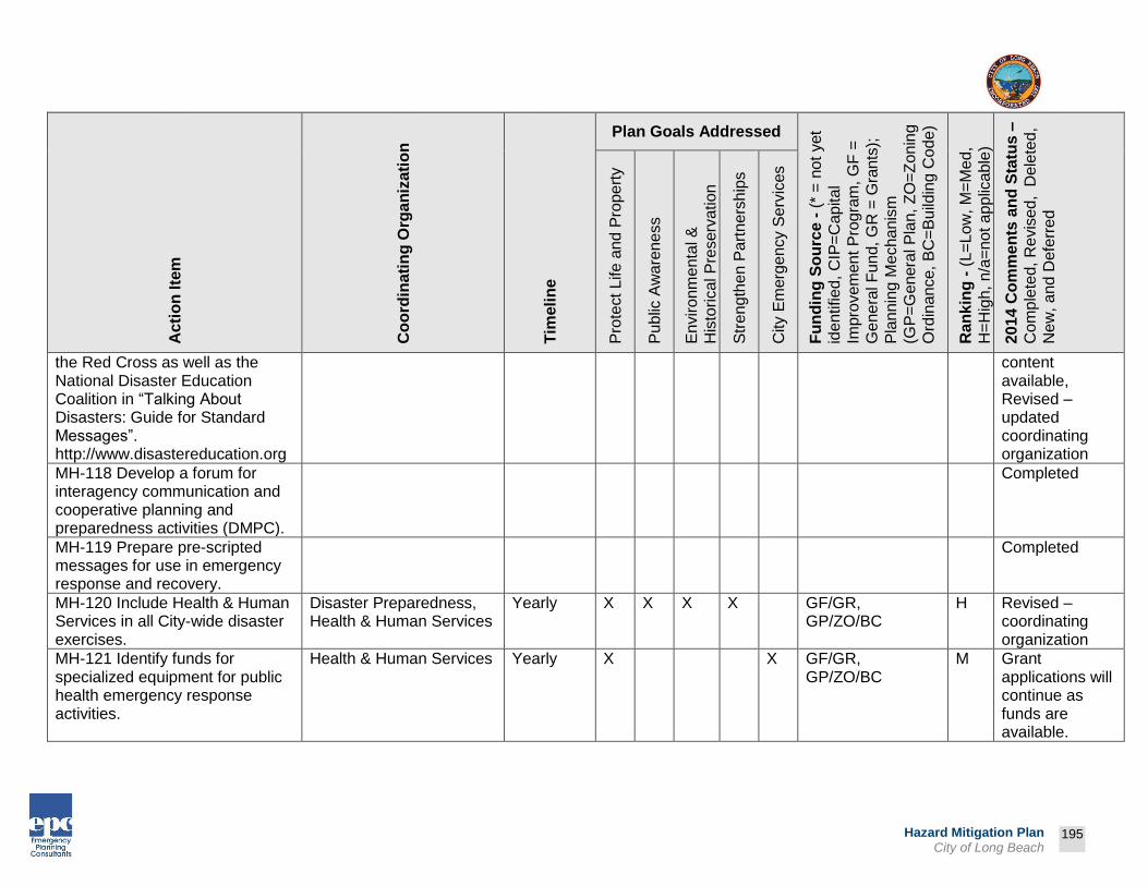
Prepared by:
195
Hazard Mitigation Plan City of Long Beach
Ac
tio
n Ite
m
Co
ord
inati
ng
Org
an
iza
tio
n
Tim
eli
ne
Plan Goals Addressed
Fu
nd
ing
So
urc
e -
(*
= n
ot
yet
iden
tified
, C
IP=
Cap
ita
l
Impro
vem
en
t P
rogra
m, G
F =
Ge
ne
ral F
un
d, G
R =
Gra
nts
);
Pla
nn
ing M
echa
nis
m
(GP
=G
enera
l P
lan,
ZO
=Z
on
ing
Ord
inan
ce,
BC
=B
uild
ing C
ode
)
Ra
nk
ing
- (
L=
Lo
w, M
=M
ed,
H=
Hig
h,
n/a
=n
ot a
pp
lica
ble
)
2014 C
om
me
nts
an
d S
tatu
s –
Co
mp
lete
d, R
evis
ed, D
ele
ted
,
Ne
w,
and
Defe
rre
d
Pro
tect
Life a
nd
Pro
pe
rty
Pu
blic
Aw
are
ne
ss
En
viro
nm
enta
l &
His
torical P
reserv
ation
Str
eng
the
n P
art
ners
hip
s
City E
merg
en
cy S
erv
ices
the Red Cross as well as the National Disaster Education Coalition in “Talking About Disasters: Guide for Standard Messages”. http://www.disastereducation.org
content available, Revised – updated coordinating organization
MH-118 Develop a forum for interagency communication and cooperative planning and preparedness activities (DMPC).
Completed
MH-119 Prepare pre-scripted messages for use in emergency response and recovery.
Completed
MH-120 Include Health & Human Services in all City-wide disaster exercises.
Disaster Preparedness, Health & Human Services
Yearly X X X X GF/GR, GP/ZO/BC
H Revised – coordinating organization
MH-121 Identify funds for specialized equipment for public health emergency response activities.
Health & Human Services Yearly X X GF/GR, GP/ZO/BC
M Grant applications will continue as funds are available.

Prepared by:
196
Hazard Mitigation Plan City of Long Beach
Ac
tio
n Ite
m
Co
ord
inati
ng
Org
an
iza
tio
n
Tim
eli
ne
Plan Goals Addressed
Fu
nd
ing
So
urc
e -
(*
= n
ot
yet
iden
tified
, C
IP=
Cap
ita
l
Impro
vem
en
t P
rogra
m, G
F =
Ge
ne
ral F
un
d, G
R =
Gra
nts
);
Pla
nn
ing M
echa
nis
m
(GP
=G
enera
l P
lan,
ZO
=Z
on
ing
Ord
inan
ce,
BC
=B
uild
ing C
ode
)
Ra
nk
ing
- (
L=
Lo
w, M
=M
ed,
H=
Hig
h,
n/a
=n
ot a
pp
lica
ble
)
2014 C
om
me
nts
an
d S
tatu
s –
Co
mp
lete
d, R
evis
ed, D
ele
ted
,
Ne
w,
and
Defe
rre
d
Pro
tect
Life a
nd
Pro
pe
rty
Pu
blic
Aw
are
ne
ss
En
viro
nm
enta
l &
His
torical P
reserv
ation
Str
eng
the
n P
art
ners
hip
s
City E
merg
en
cy S
erv
ices
MH-122 Conduct pharmaceutical stockpile exercises.
Health & Human Services, Police
Yearly X X X X X GF/GR, GP/ZO/BC
H Revised – coordinating organization
MH-123 Conduct regional forums on public health disasters.
Health & Human Services Yearly X X GF/GR, GP/ZO/BC
M Programs will continue as funds are available.
MH-124 Maintain and regularly exercise Health and Human Services staff and functions.
Health & Human Services Yearly X X GF/GR, GP/ZO/BC
H Programs will continue as funds are available.
MH-125 Train Health & Human Services staff on ICS and SEMS.
Health & Human Services, Disaster Preparedness
Yearly X X X X GF/GR, GP/ZO/BC
M Revised – coordinating organization
MH-126 Train community on Health & Human Services’ role in a disaster.
Health & Human Services Yearly X X X GF/GR, GP/ZO/BC
H Deferred – lack of funding and staffing
MH-127 Train City’s first responders and community service partners in the Department of Health & Human Services’ disaster response plans.
Health & Human Services Yearly X X X X X GF/GR, GP/ZO/BC
H Programs will continue as funds are available.

Prepared by:
197
Hazard Mitigation Plan City of Long Beach
Ac
tio
n Ite
m
Co
ord
inati
ng
Org
an
iza
tio
n
Tim
eli
ne
Plan Goals Addressed
Fu
nd
ing
So
urc
e -
(*
= n
ot
yet
iden
tified
, C
IP=
Cap
ita
l
Impro
vem
en
t P
rogra
m, G
F =
Ge
ne
ral F
un
d, G
R =
Gra
nts
);
Pla
nn
ing M
echa
nis
m
(GP
=G
enera
l P
lan,
ZO
=Z
on
ing
Ord
inan
ce,
BC
=B
uild
ing C
ode
)
Ra
nk
ing
- (
L=
Lo
w, M
=M
ed,
H=
Hig
h,
n/a
=n
ot a
pp
lica
ble
)
2014 C
om
me
nts
an
d S
tatu
s –
Co
mp
lete
d, R
evis
ed, D
ele
ted
,
Ne
w,
and
Defe
rre
d
Pro
tect
Life a
nd
Pro
pe
rty
Pu
blic
Aw
are
ne
ss
En
viro
nm
enta
l &
His
torical P
reserv
ation
Str
eng
the
n P
art
ners
hip
s
City E
merg
en
cy S
erv
ices
MH-128 Prepare Mental Health response plan to disasters. Note: County Mental Health Department is the lead and City of Long Beach will assist in the development and oversight of the plan.
Health & Human Services, Los Angeles County Health Department
1-5 years X X X X X GF/GR, GP/ZO/BC
M Revised – action item, Programs will continue as funds are available.
MH-129 Develop a Memorandum of Understanding with the American Red Cross on mutual aid with Public Health/City.
Health & Human Services, Disaster Preparedness
1 year X X GF/GR, GP/ZO/BC
M Deferred – lack of funding and staffing, Revised – coordinating organization
MH-130 Enhance public health communications equipment to meet City’s first response standards.
Health & Human Services Yearly X X X X GF/GR, GP/ZO/BC
M Deferred – lack of funding and staffing
MH-131 Continue to work with first responders on force protection issues for pharmaceutical distribution sites.
Health & Human Services, Police
Yearly X X X X GF/GR, GP/ZO/BC
M Revised – coordinating organization

Prepared by:
198
Hazard Mitigation Plan City of Long Beach
Ac
tio
n Ite
m
Co
ord
inati
ng
Org
an
iza
tio
n
Tim
eli
ne
Plan Goals Addressed
Fu
nd
ing
So
urc
e -
(*
= n
ot
yet
iden
tified
, C
IP=
Cap
ita
l
Impro
vem
en
t P
rogra
m, G
F =
Ge
ne
ral F
un
d, G
R =
Gra
nts
);
Pla
nn
ing M
echa
nis
m
(GP
=G
enera
l P
lan,
ZO
=Z
on
ing
Ord
inan
ce,
BC
=B
uild
ing C
ode
)
Ra
nk
ing
- (
L=
Lo
w, M
=M
ed,
H=
Hig
h,
n/a
=n
ot a
pp
lica
ble
)
2014 C
om
me
nts
an
d S
tatu
s –
Co
mp
lete
d, R
evis
ed, D
ele
ted
,
Ne
w,
and
Defe
rre
d
Pro
tect
Life a
nd
Pro
pe
rty
Pu
blic
Aw
are
ne
ss
En
viro
nm
enta
l &
His
torical P
reserv
ation
Str
eng
the
n P
art
ners
hip
s
City E
merg
en
cy S
erv
ices
MH-132 Exercise Health Department evacuation capacity to a disaster event.
Health & Human Services Yearly X X X GF/GR, GP/ZO/BC
H Deferred – lack of funding and staffing
MH-133 Exercise Health Department’s Department Operations Center in response to natural disaster evacuation exercise.
Health & Human Services Yearly X X GF/GR, GP/ZO/BC
H Programs will continue as funds are available.
MH-134 Maintain Health Department Safety Committee and provide appropriate staff training as determined by City’s Safety Department.
Health & Human Services Yearly X X GF/GR, GP/ZO/BC
H Programs will continue as funds are available.
MH-135 Develop and maintain a platform for intra-departmental and inter-agency cooperation.
DMPC Yearly X X X X X GF/GR, GP/ZO/BC
H Monthly Disaster Management Planning Committee & DMAC Participation, Revised – coordinating organization
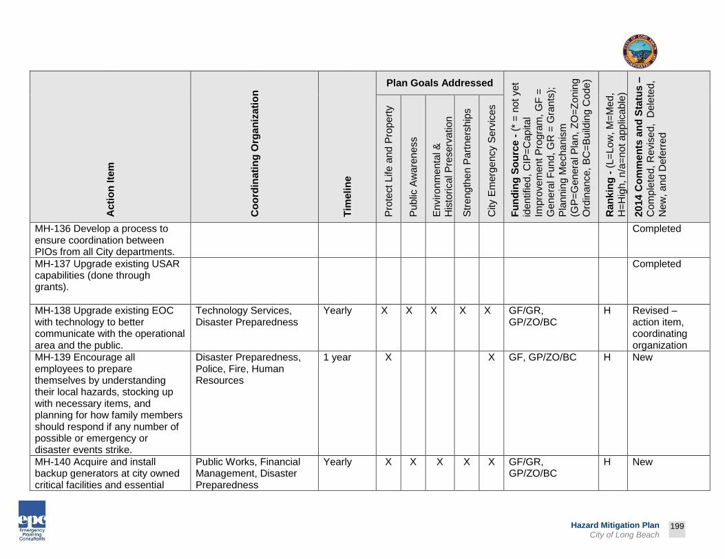
Prepared by:
199
Hazard Mitigation Plan City of Long Beach
Ac
tio
n Ite
m
Co
ord
inati
ng
Org
an
iza
tio
n
Tim
eli
ne
Plan Goals Addressed
Fu
nd
ing
So
urc
e -
(*
= n
ot
yet
iden
tified
, C
IP=
Cap
ita
l
Impro
vem
en
t P
rogra
m, G
F =
Ge
ne
ral F
un
d, G
R =
Gra
nts
);
Pla
nn
ing M
echa
nis
m
(GP
=G
enera
l P
lan,
ZO
=Z
on
ing
Ord
inan
ce,
BC
=B
uild
ing C
ode
)
Ra
nk
ing
- (
L=
Lo
w, M
=M
ed,
H=
Hig
h,
n/a
=n
ot a
pp
lica
ble
)
2014 C
om
me
nts
an
d S
tatu
s –
Co
mp
lete
d, R
evis
ed, D
ele
ted
,
Ne
w,
and
Defe
rre
d
Pro
tect
Life a
nd
Pro
pe
rty
Pu
blic
Aw
are
ne
ss
En
viro
nm
enta
l &
His
torical P
reserv
ation
Str
eng
the
n P
art
ners
hip
s
City E
merg
en
cy S
erv
ices
MH-136 Develop a process to ensure coordination between PIOs from all City departments.
Completed
MH-137 Upgrade existing USAR capabilities (done through grants).
Completed
MH-138 Upgrade existing EOC with technology to better communicate with the operational area and the public.
Technology Services, Disaster Preparedness
Yearly X X X X X GF/GR, GP/ZO/BC
H Revised – action item, coordinating organization
MH-139 Encourage all employees to prepare themselves by understanding their local hazards, stocking up with necessary items, and planning for how family members should respond if any number of possible or emergency or disaster events strike.
Disaster Preparedness, Police, Fire, Human Resources
1 year X X GF, GP/ZO/BC H New
MH-140 Acquire and install backup generators at city owned critical facilities and essential
Public Works, Financial Management, Disaster Preparedness
Yearly X X X X X GF/GR, GP/ZO/BC
H New

Prepared by:
200
Hazard Mitigation Plan City of Long Beach
Ac
tio
n Ite
m
Co
ord
inati
ng
Org
an
iza
tio
n
Tim
eli
ne
Plan Goals Addressed
Fu
nd
ing
So
urc
e -
(*
= n
ot
yet
iden
tified
, C
IP=
Cap
ita
l
Impro
vem
en
t P
rogra
m, G
F =
Ge
ne
ral F
un
d, G
R =
Gra
nts
);
Pla
nn
ing M
echa
nis
m
(GP
=G
enera
l P
lan,
ZO
=Z
on
ing
Ord
inan
ce,
BC
=B
uild
ing C
ode
)
Ra
nk
ing
- (
L=
Lo
w, M
=M
ed,
H=
Hig
h,
n/a
=n
ot a
pp
lica
ble
)
2014 C
om
me
nts
an
d S
tatu
s –
Co
mp
lete
d, R
evis
ed, D
ele
ted
,
Ne
w,
and
Defe
rre
d
Pro
tect
Life a
nd
Pro
pe
rty
Pu
blic
Aw
are
ne
ss
En
viro
nm
enta
l &
His
torical P
reserv
ation
Str
eng
the
n P
art
ners
hip
s
City E
merg
en
cy S
erv
ices
facilities. Encourage private providers of critical and essential resources and facilities to install backup generators at their facilities.
MH-141 Continue enforcement of weight and truck travel restrictions especially as they relate hazardous materials transportation. Specifically provide training, equipment, and administrative support to commercial enforcement efforts.
Police Department 1 year X X GF/GR, GP/ZO/BC
H New
MH-142 Prepare a response plan, as well as a training and exercise program for mass casualty incidents involving all modes of transportation to include the investigation of such accidents. Response plans should include all city safety departments. Exercise Plan
Disaster Preparedness, Police, Fire, Public Works
2 years X X GF/GR, GP/ZO/BC
H New

Prepared by:
201
Hazard Mitigation Plan City of Long Beach
Ac
tio
n Ite
m
Co
ord
inati
ng
Org
an
iza
tio
n
Tim
eli
ne
Plan Goals Addressed
Fu
nd
ing
So
urc
e -
(*
= n
ot
yet
iden
tified
, C
IP=
Cap
ita
l
Impro
vem
en
t P
rogra
m, G
F =
Ge
ne
ral F
un
d, G
R =
Gra
nts
);
Pla
nn
ing M
echa
nis
m
(GP
=G
enera
l P
lan,
ZO
=Z
on
ing
Ord
inan
ce,
BC
=B
uild
ing C
ode
)
Ra
nk
ing
- (
L=
Lo
w, M
=M
ed,
H=
Hig
h,
n/a
=n
ot a
pp
lica
ble
)
2014 C
om
me
nts
an
d S
tatu
s –
Co
mp
lete
d, R
evis
ed, D
ele
ted
,
Ne
w,
and
Defe
rre
d
Pro
tect
Life a
nd
Pro
pe
rty
Pu
blic
Aw
are
ne
ss
En
viro
nm
enta
l &
His
torical P
reserv
ation
Str
eng
the
n P
art
ners
hip
s
City E
merg
en
cy S
erv
ices
should include the investigation of large scale incidents.
MH-143 Train city staff in the County of Los Angeles’s SNAP program and encourage residents to register for the program.
Police, Fire Department 1 year X X X GF, GP/ZO/BC H New
MH-144 Complete Harbor Department Climate Change Study to determine expectations to the Port, impacts to critical infrastructure, and develop further mitigation measures for both short term (current infrastructure) and long term mitigation methods (future construction and/or major modifications.
Port 1-5 years X X X X X GF/GR, GP/ZO/BC
H New
MH-145 Continue pilot Electrical Power Assessment to validate current as built electrical grid, and develop contingencies for
Port 1-5 years X X X X X GF/GR, GP/ZO/BC
H New

Prepared by:
202
Hazard Mitigation Plan City of Long Beach
Ac
tio
n Ite
m
Co
ord
inati
ng
Org
an
iza
tio
n
Tim
eli
ne
Plan Goals Addressed
Fu
nd
ing
So
urc
e -
(*
= n
ot
yet
iden
tified
, C
IP=
Cap
ita
l
Impro
vem
en
t P
rogra
m, G
F =
Ge
ne
ral F
un
d, G
R =
Gra
nts
);
Pla
nn
ing M
echa
nis
m
(GP
=G
enera
l P
lan,
ZO
=Z
on
ing
Ord
inan
ce,
BC
=B
uild
ing C
ode
)
Ra
nk
ing
- (
L=
Lo
w, M
=M
ed,
H=
Hig
h,
n/a
=n
ot a
pp
lica
ble
)
2014 C
om
me
nts
an
d S
tatu
s –
Co
mp
lete
d, R
evis
ed, D
ele
ted
,
Ne
w,
and
Defe
rre
d
Pro
tect
Life a
nd
Pro
pe
rty
Pu
blic
Aw
are
ne
ss
En
viro
nm
enta
l &
His
torical P
reserv
ation
Str
eng
the
n P
art
ners
hip
s
City E
merg
en
cy S
erv
ices
repower in event of widespread and prolonged loss.
MH-146 Identify and pursue funding for Harbor District owned bridges that fail to meet current earthquake standards.
Port 1-5 years X X X X X GF/GR, GP/ZO/BC
H New
MH-147 Identify, improve, and plan Port Cargo Infrastructure seismic and other hazard retrofit and replacement strategies to oil terminals, cargo facilities, and cargo equipment.
Port 1-5 years X X X X X GF/GR, GP/ZO/BC
H New
MH-148 Develop and identify emergency and contingency fuel supplies and capabilities that can be utilized during regional disruption. Fuel will be needed for emergency and first response vessels/vehicles; salvage vessels; and pilot and harbor assist tugs.
Port 1-5 years X X X X X GF/GR, GP/ZO/BC
H New
MH-149 Acquire LAR-IAC4 digital aerial data, Oblique Imagery, and
Technology Services 1-3 years X X X GF, GP/ZO/BC H New
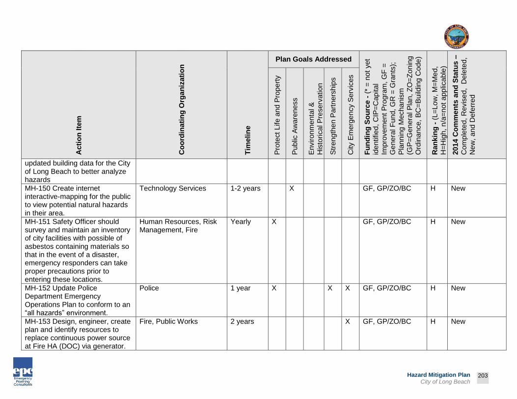
Prepared by:
203
Hazard Mitigation Plan City of Long Beach
Ac
tio
n Ite
m
Co
ord
inati
ng
Org
an
iza
tio
n
Tim
eli
ne
Plan Goals Addressed
Fu
nd
ing
So
urc
e -
(*
= n
ot
yet
iden
tified
, C
IP=
Cap
ita
l
Impro
vem
en
t P
rogra
m, G
F =
Ge
ne
ral F
un
d, G
R =
Gra
nts
);
Pla
nn
ing M
echa
nis
m
(GP
=G
enera
l P
lan,
ZO
=Z
on
ing
Ord
inan
ce,
BC
=B
uild
ing C
ode
)
Ra
nk
ing
- (
L=
Lo
w, M
=M
ed,
H=
Hig
h,
n/a
=n
ot a
pp
lica
ble
)
2014 C
om
me
nts
an
d S
tatu
s –
Co
mp
lete
d, R
evis
ed, D
ele
ted
,
Ne
w,
and
Defe
rre
d
Pro
tect
Life a
nd
Pro
pe
rty
Pu
blic
Aw
are
ne
ss
En
viro
nm
enta
l &
His
torical P
reserv
ation
Str
eng
the
n P
art
ners
hip
s
City E
merg
en
cy S
erv
ices
updated building data for the City of Long Beach to better analyze hazards
MH-150 Create internet interactive-mapping for the public to view potential natural hazards in their area.
Technology Services 1-2 years X GF, GP/ZO/BC H New
MH-151 Safety Officer should survey and maintain an inventory of city facilities with possible of asbestos containing materials so that in the event of a disaster, emergency responders can take proper precautions prior to entering these locations.
Human Resources, Risk Management, Fire
Yearly X GF, GP/ZO/BC H New
MH-152 Update Police Department Emergency Operations Plan to conform to an “all hazards” environment.
Police 1 year X X X GF, GP/ZO/BC H New
MH-153 Design, engineer, create plan and identify resources to replace continuous power source at Fire HA (DOC) via generator.
Fire, Public Works 2 years X GF, GP/ZO/BC H New

Prepared by:
204
Hazard Mitigation Plan City of Long Beach
Ac
tio
n Ite
m
Co
ord
inati
ng
Org
an
iza
tio
n
Tim
eli
ne
Plan Goals Addressed
Fu
nd
ing
So
urc
e -
(*
= n
ot
yet
iden
tified
, C
IP=
Cap
ita
l
Impro
vem
en
t P
rogra
m, G
F =
Ge
ne
ral F
un
d, G
R =
Gra
nts
);
Pla
nn
ing M
echa
nis
m
(GP
=G
enera
l P
lan,
ZO
=Z
on
ing
Ord
inan
ce,
BC
=B
uild
ing C
ode
)
Ra
nk
ing
- (
L=
Lo
w, M
=M
ed,
H=
Hig
h,
n/a
=n
ot a
pp
lica
ble
)
2014 C
om
me
nts
an
d S
tatu
s –
Co
mp
lete
d, R
evis
ed, D
ele
ted
,
Ne
w,
and
Defe
rre
d
Pro
tect
Life a
nd
Pro
pe
rty
Pu
blic
Aw
are
ne
ss
En
viro
nm
enta
l &
His
torical P
reserv
ation
Str
eng
the
n P
art
ners
hip
s
City E
merg
en
cy S
erv
ices
MH-154 Develop, equip, and deploy a surge capacity-staffing plan for one additional urban search and rescue (USAR) vehicle.
Fire 3 years X X GF, GP/ZO/BC H New
MH-155 Ensure the completion of the specific assigned portion of the Emergency Operations Directory including resource information and guidelines for incident management.
Fire, Police, Public Works, Disaster Preparedness
2 years X X GF, GP/ZO/BC H New
MH-156 Develop a comprehensive response plan and protocols to define philosophy, resources, guidelines and contacts for large-scale events such as acts of terrorism or regional disasters.
Fire, Police, Health, Disaster Preparedness
2 years X X GF, GP/ZO/BC H New
Earthquake Action Items

Prepared by:
205
Hazard Mitigation Plan City of Long Beach
Ac
tio
n Ite
m
Co
ord
inati
ng
Org
an
iza
tio
n
Tim
eli
ne
Plan Goals Addressed
Fu
nd
ing
So
urc
e -
(*
= n
ot
yet
iden
tified
, C
IP=
Cap
ita
l
Impro
vem
en
t P
rogra
m, G
F =
Ge
ne
ral F
un
d, G
R =
Gra
nts
);
Pla
nn
ing M
echa
nis
m
(GP
=G
enera
l P
lan,
ZO
=Z
on
ing
Ord
inan
ce,
BC
=B
uild
ing C
ode
)
Ra
nk
ing
- (
L=
Lo
w, M
=M
ed,
H=
Hig
h,
n/a
=n
ot a
pp
lica
ble
)
2014 C
om
me
nts
an
d S
tatu
s –
Co
mp
lete
d, R
evis
ed, D
ele
ted
,
Ne
w,
and
Defe
rre
d
Pro
tect
Life a
nd
Pro
pe
rty
Pu
blic
Aw
are
ne
ss
En
viro
nm
enta
l &
His
torical P
reserv
ation
Str
eng
the
n P
art
ners
hip
s
City E
merg
en
cy S
erv
ices
EQ-1 Update earthquake hazard mapping data for the City and improve technical analysis of earthquake hazards.
Technology Services - GIS
Yearly X X X X GF, GP/ZO/BC L Deferred – lack of funding and staffing
EQ-2 Identify funding sources for structural and nonstructural retrofitting of buildings projects. Projects structures must be identified as seismically vulnerable.
DMPC, Public Works Yearly X X GF,CIP, GP/ZO/BC
H CIP projects are completed as funding is available, Revised – action item, coordinating agency
EQ-3 Conduct seismic strength evaluations of critical facilities in the City to identify vulnerabilities for mitigation of City-owned and occupied, and public infrastructure to meet current seismic standards.
Public Works Yearly X X X X X GF/GR, GP/ZO/BC
H Deferred – lack of funding and staffing
EQ-4 Encourage reduction of non-structural and structural earthquake hazards in homes,
Development Services 1-2 years X X X GF/GR, GP/ZO/BC
L Deferred – lack of funding and staffing
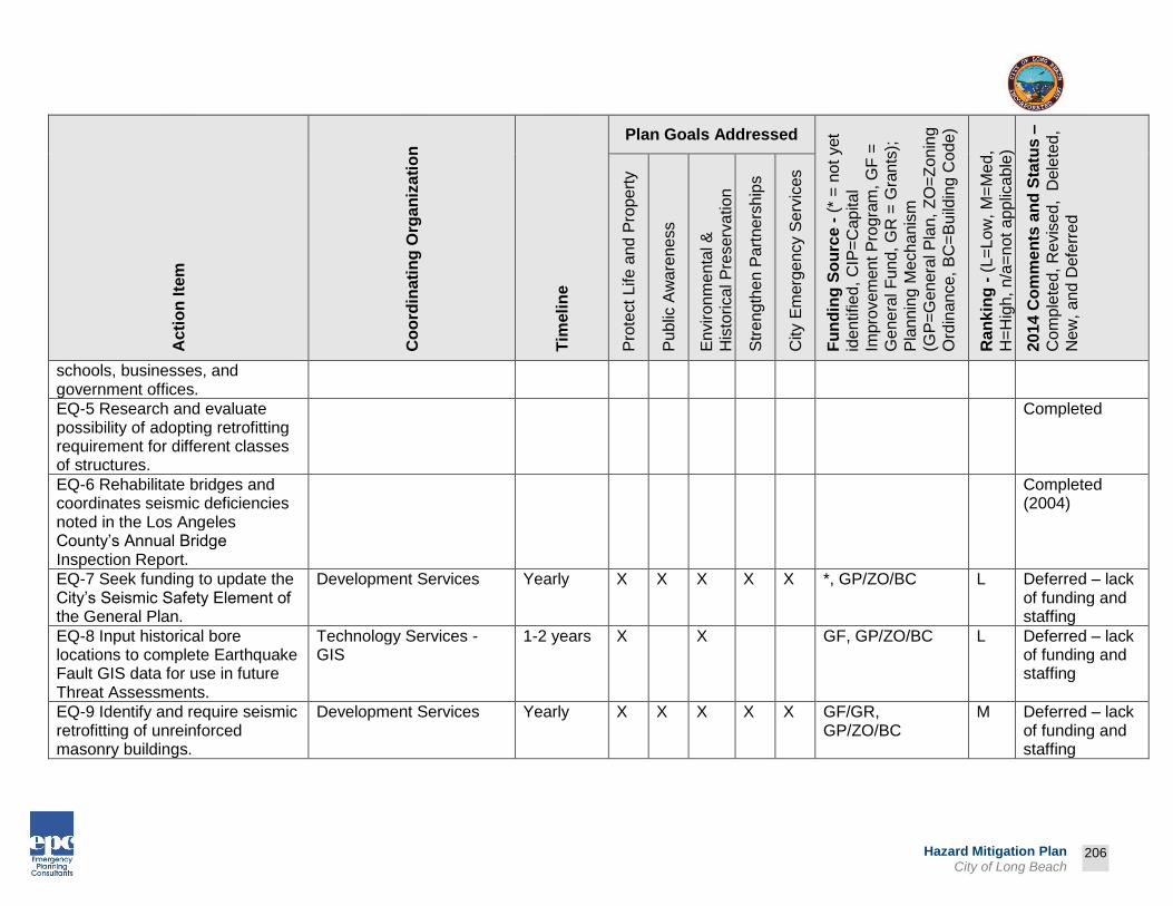
Prepared by:
206
Hazard Mitigation Plan City of Long Beach
Ac
tio
n Ite
m
Co
ord
inati
ng
Org
an
iza
tio
n
Tim
eli
ne
Plan Goals Addressed
Fu
nd
ing
So
urc
e -
(*
= n
ot
yet
iden
tified
, C
IP=
Cap
ita
l
Impro
vem
en
t P
rogra
m, G
F =
Ge
ne
ral F
un
d, G
R =
Gra
nts
);
Pla
nn
ing M
echa
nis
m
(GP
=G
enera
l P
lan,
ZO
=Z
on
ing
Ord
inan
ce,
BC
=B
uild
ing C
ode
)
Ra
nk
ing
- (
L=
Lo
w, M
=M
ed,
H=
Hig
h,
n/a
=n
ot a
pp
lica
ble
)
2014 C
om
me
nts
an
d S
tatu
s –
Co
mp
lete
d, R
evis
ed, D
ele
ted
,
Ne
w,
and
Defe
rre
d
Pro
tect
Life a
nd
Pro
pe
rty
Pu
blic
Aw
are
ne
ss
En
viro
nm
enta
l &
His
torical P
reserv
ation
Str
eng
the
n P
art
ners
hip
s
City E
merg
en
cy S
erv
ices
schools, businesses, and government offices.
EQ-5 Research and evaluate possibility of adopting retrofitting requirement for different classes of structures.
Completed
EQ-6 Rehabilitate bridges and coordinates seismic deficiencies noted in the Los Angeles County’s Annual Bridge Inspection Report.
Completed (2004)
EQ-7 Seek funding to update the City’s Seismic Safety Element of the General Plan.
Development Services Yearly X X X X X *, GP/ZO/BC L Deferred – lack of funding and staffing
EQ-8 Input historical bore locations to complete Earthquake Fault GIS data for use in future Threat Assessments.
Technology Services - GIS
1-2 years X X GF, GP/ZO/BC L Deferred – lack of funding and staffing
EQ-9 Identify and require seismic retrofitting of unreinforced masonry buildings.
Development Services Yearly X X X X X GF/GR, GP/ZO/BC
M Deferred – lack of funding and staffing

Prepared by:
207
Hazard Mitigation Plan City of Long Beach
Ac
tio
n Ite
m
Co
ord
inati
ng
Org
an
iza
tio
n
Tim
eli
ne
Plan Goals Addressed
Fu
nd
ing
So
urc
e -
(*
= n
ot
yet
iden
tified
, C
IP=
Cap
ita
l
Impro
vem
en
t P
rogra
m, G
F =
Ge
ne
ral F
un
d, G
R =
Gra
nts
);
Pla
nn
ing M
echa
nis
m
(GP
=G
enera
l P
lan,
ZO
=Z
on
ing
Ord
inan
ce,
BC
=B
uild
ing C
ode
)
Ra
nk
ing
- (
L=
Lo
w, M
=M
ed,
H=
Hig
h,
n/a
=n
ot a
pp
lica
ble
)
2014 C
om
me
nts
an
d S
tatu
s –
Co
mp
lete
d, R
evis
ed, D
ele
ted
,
Ne
w,
and
Defe
rre
d
Pro
tect
Life a
nd
Pro
pe
rty
Pu
blic
Aw
are
ne
ss
En
viro
nm
enta
l &
His
torical P
reserv
ation
Str
eng
the
n P
art
ners
hip
s
City E
merg
en
cy S
erv
ices
EQ-10 Promote and provide technical information for voluntary retrofitting of existing structures.
Development Services Yearly X X X X X GF/GR, GP/ZO/BC
M Deferred – lack of funding and staffing
EQ-11 Invest in an earthquake early warning system to notify first responders of an eminent earthquake threat and ensure that systems are in place to prepare stations (PD/Fire) for an earthquake (open doors, stop elevators, etc.).
Police, Fire, Technology Services, Disaster Preparedness
2 years X X X GR, GP/ZO/BC H New
Flood/Dam Failure Action Items
FLD-1 Develop better flood warning systems. Explore the use of current technology to enhance the system.
Public Works, Technology Services, Disaster Preparedness
Yearly X X X X X GF/GR, GP/ZO/BC
H Revised – coordinating organization
FLD-2 Enhance data and mapping for floodplain information within the City and identify and map flood-prone areas outside of designated floodplains.
Technology Services
Yearly X X X X X GF/GR, GP/ZO/BC
H Deferred – lack of funding and staffing

Prepared by:
208
Hazard Mitigation Plan City of Long Beach
Ac
tio
n Ite
m
Co
ord
inati
ng
Org
an
iza
tio
n
Tim
eli
ne
Plan Goals Addressed
Fu
nd
ing
So
urc
e -
(*
= n
ot
yet
iden
tified
, C
IP=
Cap
ita
l
Impro
vem
en
t P
rogra
m, G
F =
Ge
ne
ral F
un
d, G
R =
Gra
nts
);
Pla
nn
ing M
echa
nis
m
(GP
=G
enera
l P
lan,
ZO
=Z
on
ing
Ord
inan
ce,
BC
=B
uild
ing C
ode
)
Ra
nk
ing
- (
L=
Lo
w, M
=M
ed,
H=
Hig
h,
n/a
=n
ot a
pp
lica
ble
)
2014 C
om
me
nts
an
d S
tatu
s –
Co
mp
lete
d, R
evis
ed, D
ele
ted
,
Ne
w,
and
Defe
rre
d
Pro
tect
Life a
nd
Pro
pe
rty
Pu
blic
Aw
are
ne
ss
En
viro
nm
enta
l &
His
torical P
reserv
ation
Str
eng
the
n P
art
ners
hip
s
City E
merg
en
cy S
erv
ices
FLD-3 Analyze each repetitive flood property within the City and identify feasible mitigation options.
Public Works, Property Management,
Yearly X X GF/GR, GP/ZO/BC
H Deferred – lack of funding and staffing
FLD-4 Recommend revisions to requirements for development within the floodplain, where appropriate.
Development Services 2 years X X X *, GP/ZO/BC L Deferred - lack of updated floodplain data
FLD-5 Identify surface water drainage obstructions for all parts of the City.
Public Works Yearly X X X X GF/GR, GP/ZO/BC
H Deferred – lack of funding and staffing
FLD-6 Continue to compile and coordinate surface water management plans and data throughout the City.
Public Works Yearly X X X X GF/GR, GP/ZO/BC
H Deferred – lack of funding and staffing
FLD-7 Enact a local ordinance that prohibits draining, filling, or construction of buildings, roads, or other infrastructure in designated wetlands. This would help to protect the flood-control function of the wetland, preserve
Development Services 1 year X X X X *, GP/ZO/BC L Deferred - lack of funding and staffing

Prepared by:
209
Hazard Mitigation Plan City of Long Beach
Ac
tio
n Ite
m
Co
ord
inati
ng
Org
an
iza
tio
n
Tim
eli
ne
Plan Goals Addressed
Fu
nd
ing
So
urc
e -
(*
= n
ot
yet
iden
tified
, C
IP=
Cap
ita
l
Impro
vem
en
t P
rogra
m, G
F =
Ge
ne
ral F
un
d, G
R =
Gra
nts
);
Pla
nn
ing M
echa
nis
m
(GP
=G
enera
l P
lan,
ZO
=Z
on
ing
Ord
inan
ce,
BC
=B
uild
ing C
ode
)
Ra
nk
ing
- (
L=
Lo
w, M
=M
ed,
H=
Hig
h,
n/a
=n
ot a
pp
lica
ble
)
2014 C
om
me
nts
an
d S
tatu
s –
Co
mp
lete
d, R
evis
ed, D
ele
ted
,
Ne
w,
and
Defe
rre
d
Pro
tect
Life a
nd
Pro
pe
rty
Pu
blic
Aw
are
ne
ss
En
viro
nm
enta
l &
His
torical P
reserv
ation
Str
eng
the
n P
art
ners
hip
s
City E
merg
en
cy S
erv
ices
water quality, and ensure adequate in-stream flow.
FLD-8 Research and prepare a policy that identifies measures intended to minimize the risk of coastal erosion. This includes development, construction and daily operations/maintenance measures.
Public Works, Development Services, PRM
2-4 years X X X *, GP/ZO/BC L Deferred – lack of funding and staffing, Revised – action item and coordinating organization
FLD-9 Distribute information on
the National Flood Insurance
Program to local businesses in or
near the floodplain.
Completed
FLD-10 Coordinate in-house
training sessions on the
regulations associated with NFIP.
Public Works 1-3 years X X X *, GP/ZO/BC L Deferred – lack of funding and staffing
FLD-11 Review the City’s
floodplain ordinance to be sure it
is in full compliance with the
NFIP.
Public Works 1-3 years X X X *, GP/ZO/BC L Deferred – lack of funding and staffing
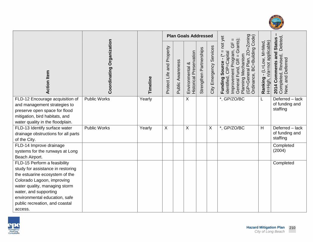
Prepared by:
210
Hazard Mitigation Plan City of Long Beach
Ac
tio
n Ite
m
Co
ord
inati
ng
Org
an
iza
tio
n
Tim
eli
ne
Plan Goals Addressed
Fu
nd
ing
So
urc
e -
(*
= n
ot
yet
iden
tified
, C
IP=
Cap
ita
l
Impro
vem
en
t P
rogra
m, G
F =
Ge
ne
ral F
un
d, G
R =
Gra
nts
);
Pla
nn
ing M
echa
nis
m
(GP
=G
enera
l P
lan,
ZO
=Z
on
ing
Ord
inan
ce,
BC
=B
uild
ing C
ode
)
Ra
nk
ing
- (
L=
Lo
w, M
=M
ed,
H=
Hig
h,
n/a
=n
ot a
pp
lica
ble
)
2014 C
om
me
nts
an
d S
tatu
s –
Co
mp
lete
d, R
evis
ed, D
ele
ted
,
Ne
w,
and
Defe
rre
d
Pro
tect
Life a
nd
Pro
pe
rty
Pu
blic
Aw
are
ne
ss
En
viro
nm
enta
l &
His
torical P
reserv
ation
Str
eng
the
n P
art
ners
hip
s
City E
merg
en
cy S
erv
ices
FLD-12 Encourage acquisition of
and management strategies to
preserve open space for flood
mitigation, bird habitats, and
water quality in the floodplain.
Public Works
Yearly X *, GP/ZO/BC L Deferred – lack of funding and staffing
FLD-13 Identify surface water
drainage obstructions for all parts
of the City.
Public Works Yearly X X X *, GP/ZO/BC H Deferred – lack of funding and staffing
FLD-14 Improve drainage
systems for the runways at Long
Beach Airport.
Completed (2004)
FLD-15 Perform a feasibility
study for assistance in restoring
the estuarine ecosystem of the
Colorado Lagoon, improving
water quality, managing storm
water, and supporting
environmental education, safe
public recreation, and coastal
access.
Completed

Prepared by:
211
Hazard Mitigation Plan City of Long Beach
Ac
tio
n Ite
m
Co
ord
inati
ng
Org
an
iza
tio
n
Tim
eli
ne
Plan Goals Addressed
Fu
nd
ing
So
urc
e -
(*
= n
ot
yet
iden
tified
, C
IP=
Cap
ita
l
Impro
vem
en
t P
rogra
m, G
F =
Ge
ne
ral F
un
d, G
R =
Gra
nts
);
Pla
nn
ing M
echa
nis
m
(GP
=G
enera
l P
lan,
ZO
=Z
on
ing
Ord
inan
ce,
BC
=B
uild
ing C
ode
)
Ra
nk
ing
- (
L=
Lo
w, M
=M
ed,
H=
Hig
h,
n/a
=n
ot a
pp
lica
ble
)
2014 C
om
me
nts
an
d S
tatu
s –
Co
mp
lete
d, R
evis
ed, D
ele
ted
,
Ne
w,
and
Defe
rre
d
Pro
tect
Life a
nd
Pro
pe
rty
Pu
blic
Aw
are
ne
ss
En
viro
nm
enta
l &
His
torical P
reserv
ation
Str
eng
the
n P
art
ners
hip
s
City E
merg
en
cy S
erv
ices
FLD-16 Repair and maintain
seawalls located in Downtown
and Alamitos Bay Marinas as well
as on Naples Island.
Public Works Yearly X X GF/GR, GP/ZO/BC
H Repair completed in 2004, annual restoration project continues
FLD-17 Complete structural
improvements to storm
water/urban runoff systems.
Completed (2004)
FLD-18 Regulate construction in
designated floodplains via
elevation of structures or flood
proofing.
Development Services Yearly X X *, GP/ZO/BC Deferred – lack of funding and staffing
Earth Movement Action Items
EM-1 Improve knowledge of earth movement hazard areas and understanding of vulnerability and risk to life and property in hazard-prone areas.
Deleted – hazard removed from 2014 Plan

Prepared by:
212
Hazard Mitigation Plan City of Long Beach
Ac
tio
n Ite
m
Co
ord
inati
ng
Org
an
iza
tio
n
Tim
eli
ne
Plan Goals Addressed
Fu
nd
ing
So
urc
e -
(*
= n
ot
yet
iden
tified
, C
IP=
Cap
ita
l
Impro
vem
en
t P
rogra
m, G
F =
Ge
ne
ral F
un
d, G
R =
Gra
nts
);
Pla
nn
ing M
echa
nis
m
(GP
=G
enera
l P
lan,
ZO
=Z
on
ing
Ord
inan
ce,
BC
=B
uild
ing C
ode
)
Ra
nk
ing
- (
L=
Lo
w, M
=M
ed,
H=
Hig
h,
n/a
=n
ot a
pp
lica
ble
)
2014 C
om
me
nts
an
d S
tatu
s –
Co
mp
lete
d, R
evis
ed, D
ele
ted
,
Ne
w,
and
Defe
rre
d
Pro
tect
Life a
nd
Pro
pe
rty
Pu
blic
Aw
are
ne
ss
En
viro
nm
enta
l &
His
torical P
reserv
ation
Str
eng
the
n P
art
ners
hip
s
City E
merg
en
cy S
erv
ices
EM-2 Research and evaluate possible landslide warning system.
Deleted – hazard removed from 2014 Plan
EM-3 Limit activities in identified potential and historical landslide areas through regulations and public outreach.
Deleted – hazard removed from 2014 Plan
EM-4 Improve knowledge of earth movement hazard areas and understanding of vulnerability and risk to life and property in hazard-prone areas.
Deleted – hazard removed from 2014 Plan
Windstorm Action Items
WS-1 Develop and implement a city wide programs to keep trees from threatening lives, property, and public infrastructure during windstorm events.
Public Works, Parks, Recreation & Marine
Yearly X X GF/GR/CIP, GP/ZO/BC
H Deferred – lack of funding and staffing
WS-2 Encourage electrical utilities to use underground construction methods where
Development Services Yearly X X GF, GP/ZO/BC H Revised – coordinating organization

Prepared by:
213
Hazard Mitigation Plan City of Long Beach
Ac
tio
n Ite
m
Co
ord
inati
ng
Org
an
iza
tio
n
Tim
eli
ne
Plan Goals Addressed
Fu
nd
ing
So
urc
e -
(*
= n
ot
yet
iden
tified
, C
IP=
Cap
ita
l
Impro
vem
en
t P
rogra
m, G
F =
Ge
ne
ral F
un
d, G
R =
Gra
nts
);
Pla
nn
ing M
echa
nis
m
(GP
=G
enera
l P
lan,
ZO
=Z
on
ing
Ord
inan
ce,
BC
=B
uild
ing C
ode
)
Ra
nk
ing
- (
L=
Lo
w, M
=M
ed,
H=
Hig
h,
n/a
=n
ot a
pp
lica
ble
)
2014 C
om
me
nts
an
d S
tatu
s –
Co
mp
lete
d, R
evis
ed, D
ele
ted
,
Ne
w,
and
Defe
rre
d
Pro
tect
Life a
nd
Pro
pe
rty
Pu
blic
Aw
are
ne
ss
En
viro
nm
enta
l &
His
torical P
reserv
ation
Str
eng
the
n P
art
ners
hip
s
City E
merg
en
cy S
erv
ices
possible to reduce power outages from windstorms.
WS-3 Increase public awareness of windstorm mitigation activities.
Disaster Preparedness, PIO
Yearly X X X GF, GP/ZO/BC H Use print and social media, Revised – coordinating organization
WS-4 Develop codes relating to wind-resistant building siting and construction.
Completed
Tsunami Action Items
TSU-1 Secure funding to contract with a consultant to conduct a technical analysis of the tsunami threat.
Deleted – work completed through efforts of the State of California
TSU-2 Review findings of special research on tsunami threat to Long Beach coastal areas. Amend codes, regulations, and response plans as necessary.
Public Works, Development Services
1-2 years X X X *, GP/ZO/BC L Deferred – lack of funding and staffing, Revised – coordinating organization

Prepared by:
214
Hazard Mitigation Plan City of Long Beach
Ac
tio
n Ite
m
Co
ord
inati
ng
Org
an
iza
tio
n
Tim
eli
ne
Plan Goals Addressed
Fu
nd
ing
So
urc
e -
(*
= n
ot
yet
iden
tified
, C
IP=
Cap
ita
l
Impro
vem
en
t P
rogra
m, G
F =
Ge
ne
ral F
un
d, G
R =
Gra
nts
);
Pla
nn
ing M
echa
nis
m
(GP
=G
enera
l P
lan,
ZO
=Z
on
ing
Ord
inan
ce,
BC
=B
uild
ing C
ode
)
Ra
nk
ing
- (
L=
Lo
w, M
=M
ed,
H=
Hig
h,
n/a
=n
ot a
pp
lica
ble
)
2014 C
om
me
nts
an
d S
tatu
s –
Co
mp
lete
d, R
evis
ed, D
ele
ted
,
Ne
w,
and
Defe
rre
d
Pro
tect
Life a
nd
Pro
pe
rty
Pu
blic
Aw
are
ne
ss
En
viro
nm
enta
l &
His
torical P
reserv
ation
Str
eng
the
n P
art
ners
hip
s
City E
merg
en
cy S
erv
ices
TSU-3 Train regulatory and response staff in tsunami threat.
Completed – quarterly Department Head Training
TSU-4 Develop and conduct training and exercises relating to tsunami response.
Completed – quarterly Department Head Training
TSU-5 Develop a warning system in the City to notify residents of impending tsunami activity.
Completed - Reverse 9-1-1, Nixel, e-Notify, KKJZ Radio, etc.
TSU-6 Develop a tsunami education campaign to prepare residents.
Completed - Red Cross provides preparedness info on website
Public Health Action Items
PH-1 Establish a process for screening potentially contaminated victims of a public
Fire, Health & Human Services, American Red Cross
3 years X GR, GP/ZO/BC H New

Prepared by:
215
Hazard Mitigation Plan City of Long Beach
Ac
tio
n Ite
m
Co
ord
inati
ng
Org
an
iza
tio
n
Tim
eli
ne
Plan Goals Addressed
Fu
nd
ing
So
urc
e -
(*
= n
ot
yet
iden
tified
, C
IP=
Cap
ita
l
Impro
vem
en
t P
rogra
m, G
F =
Ge
ne
ral F
un
d, G
R =
Gra
nts
);
Pla
nn
ing M
echa
nis
m
(GP
=G
enera
l P
lan,
ZO
=Z
on
ing
Ord
inan
ce,
BC
=B
uild
ing C
ode
)
Ra
nk
ing
- (
L=
Lo
w, M
=M
ed,
H=
Hig
h,
n/a
=n
ot a
pp
lica
ble
)
2014 C
om
me
nts
an
d S
tatu
s –
Co
mp
lete
d, R
evis
ed, D
ele
ted
,
Ne
w,
and
Defe
rre
d
Pro
tect
Life a
nd
Pro
pe
rty
Pu
blic
Aw
are
ne
ss
En
viro
nm
enta
l &
His
torical P
reserv
ation
Str
eng
the
n P
art
ners
hip
s
City E
merg
en
cy S
erv
ices
health disaster as a pre-admission requirement prior to being allowed into a Red Cross shelter. Victims of an incident that involves any level of contamination (biological, radiological, or chemical) and thus a public health threat will be assessed and triaged at the secured incident site (red zone).
Technological and Human-Caused Action Items
HC-1 Provide training and equipment to effectively deal with civil disturbances
Police Yearly X GR/GF, GP/ZO/BC
H New
HC-2 Continue to develop an effective information-gathering analysis and sharing capability to enhance event and incident management. Enhance threat assessment sharing and evaluation efforts to deter, prevent, and respond to terrorism
Police 1-6 years X X X GR, GP/ZO/BC H New

Prepared by:
216
Hazard Mitigation Plan City of Long Beach
Ac
tio
n Ite
m
Co
ord
inati
ng
Org
an
iza
tio
n
Tim
eli
ne
Plan Goals Addressed
Fu
nd
ing
So
urc
e -
(*
= n
ot
yet
iden
tified
, C
IP=
Cap
ita
l
Impro
vem
en
t P
rogra
m, G
F =
Ge
ne
ral F
un
d, G
R =
Gra
nts
);
Pla
nn
ing M
echa
nis
m
(GP
=G
enera
l P
lan,
ZO
=Z
on
ing
Ord
inan
ce,
BC
=B
uild
ing C
ode
)
Ra
nk
ing
- (
L=
Lo
w, M
=M
ed,
H=
Hig
h,
n/a
=n
ot a
pp
lica
ble
)
2014 C
om
me
nts
an
d S
tatu
s –
Co
mp
lete
d, R
evis
ed, D
ele
ted
,
Ne
w,
and
Defe
rre
d
Pro
tect
Life a
nd
Pro
pe
rty
Pu
blic
Aw
are
ne
ss
En
viro
nm
enta
l &
His
torical P
reserv
ation
Str
eng
the
n P
art
ners
hip
s
City E
merg
en
cy S
erv
ices
events. Evaluate program with training and exercise needs. Sharing should occur between LBPD, LASD, LAPD, USCG, FBI, JRIC, and other regional partners.
HC-3 Prepare a response plan, as well as a training and exercise program for transportation accidents involving radiological materials. Response plans should include all city safety departments. Training and Exercise Plan should include the investigation of such accidents.
Police, Fire, Public Works, Health & Human Services
1-2 years X X GR/GF, GP/ZO/BC
H New
HC-4 Provide assistance to CSULB, LBCC, LBUSD & local private schools in the form of planning, training, and exercises for campuses to minimize school violence. Encourage school district to utilize the latest
Police, LBUSD, LBCC, CSUSB
Yearly X X GR/GF, GP/ZO/BC
H New

Prepared by:
217
Hazard Mitigation Plan City of Long Beach
Ac
tio
n Ite
m
Co
ord
inati
ng
Org
an
iza
tio
n
Tim
eli
ne
Plan Goals Addressed
Fu
nd
ing
So
urc
e -
(*
= n
ot
yet
iden
tified
, C
IP=
Cap
ita
l
Impro
vem
en
t P
rogra
m, G
F =
Ge
ne
ral F
un
d, G
R =
Gra
nts
);
Pla
nn
ing M
echa
nis
m
(GP
=G
enera
l P
lan,
ZO
=Z
on
ing
Ord
inan
ce,
BC
=B
uild
ing C
ode
)
Ra
nk
ing
- (
L=
Lo
w, M
=M
ed,
H=
Hig
h,
n/a
=n
ot a
pp
lica
ble
)
2014 C
om
me
nts
an
d S
tatu
s –
Co
mp
lete
d, R
evis
ed, D
ele
ted
,
Ne
w,
and
Defe
rre
d
Pro
tect
Life a
nd
Pro
pe
rty
Pu
blic
Aw
are
ne
ss
En
viro
nm
enta
l &
His
torical P
reserv
ation
Str
eng
the
n P
art
ners
hip
s
City E
merg
en
cy S
erv
ices
construction techniques to reduce the threat of school violence.
HC-5 Heighten Security at public gatherings special events, and critical community facilities and industries.
Police Yearly X X GF, GP/ZO/BC H New
Drought Action Items
DR-1 Continue to provide property owners with water conservation tips.
Water Department Yearly X X X X X GF H New
DR-2 Continue to encourage property owners to landscape with drought resistant materials.
Development Services Yearly X X X X X GF H New
DR-3 Research and prepare City policy requiring future developments and retrofitting of existing City-owned landscaping to be drought resistant and to utilize reclaimed water.
Public Works 1-5 years X X X X X GF H New
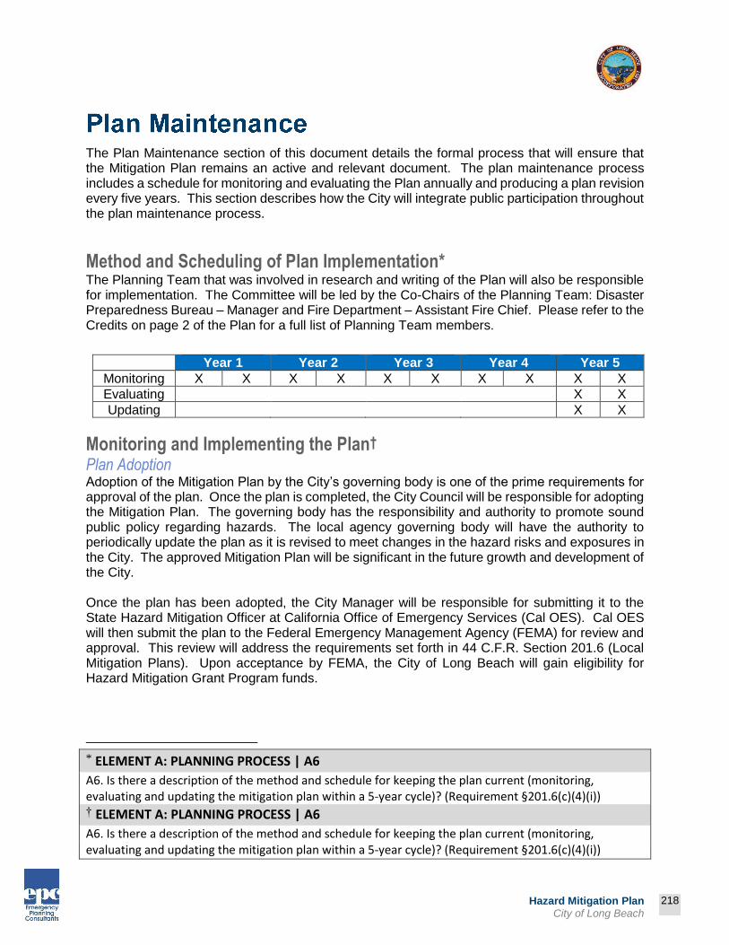
218
Prepared by:
218
Hazard Mitigation Plan City of Long Beach
The Plan Maintenance section of this document details the formal process that will ensure that the Mitigation Plan remains an active and relevant document. The plan maintenance process includes a schedule for monitoring and evaluating the Plan annually and producing a plan revision every five years. This section describes how the City will integrate public participation throughout the plan maintenance process.
Method and Scheduling of Plan Implementation* The Planning Team that was involved in research and writing of the Plan will also be responsible for implementation. The Committee will be led by the Co-Chairs of the Planning Team: Disaster Preparedness Bureau – Manager and Fire Department – Assistant Fire Chief. Please refer to the Credits on page 2 of the Plan for a full list of Planning Team members.
Year 1 Year 2 Year 3 Year 4 Year 5
Monitoring X X X X X X X X X X
Evaluating X X
Updating X X
Monitoring and Implementing the Plan† Plan Adoption Adoption of the Mitigation Plan by the City’s governing body is one of the prime requirements for approval of the plan. Once the plan is completed, the City Council will be responsible for adopting the Mitigation Plan. The governing body has the responsibility and authority to promote sound public policy regarding hazards. The local agency governing body will have the authority to periodically update the plan as it is revised to meet changes in the hazard risks and exposures in the City. The approved Mitigation Plan will be significant in the future growth and development of the City. Once the plan has been adopted, the City Manager will be responsible for submitting it to the State Hazard Mitigation Officer at California Office of Emergency Services (Cal OES). Cal OES will then submit the plan to the Federal Emergency Management Agency (FEMA) for review and approval. This review will address the requirements set forth in 44 C.F.R. Section 201.6 (Local Mitigation Plans). Upon acceptance by FEMA, the City of Long Beach will gain eligibility for Hazard Mitigation Grant Program funds.
* ELEMENT A: PLANNING PROCESS | A6
A6. Is there a description of the method and schedule for keeping the plan current (monitoring, evaluating and updating the mitigation plan within a 5-year cycle)? (Requirement §201.6(c)(4)(i))
† ELEMENT A: PLANNING PROCESS | A6
A6. Is there a description of the method and schedule for keeping the plan current (monitoring, evaluating and updating the mitigation plan within a 5-year cycle)? (Requirement §201.6(c)(4)(i))

219
Prepared by:
219
Hazard Mitigation Plan City of Long Beach
Convener The City Council will adopt the Mitigation Plan and the Planning Team will take responsibility for plan maintenance and implementation. The City Manager or designee, will serve as a Convener to facilitate the Planning Team meetings, and will assign tasks such as updating and presenting the Plan to the members of the Planning Team. Plan implementation and evaluation will be a shared responsibility among all of the Planning Team members. The City Manager will have authority to prepare and approve future amendments to the Mitigation Plan.
Planning Team The Planning Team will be responsible for coordinating implementation of plan action items and undertaking the formal review process. The convener will assign representatives from City departments, divisions, and agencies, including, but not limited to, the current Planning Team. In order to make the Planning Team as broad and useful as possible, the City Manager may choose to involve other relevant organizations and agencies in hazard mitigation. These additional appointments could include:
A representative from the American Red Cross A representative from a county government emergency response agency A representative from a non-governmental organization
The Planning Team will meet no less than semi-annually. Meeting dates will be scheduled once the final Planning Team has been established. These meetings will provide an opportunity to discuss the progress of the action items and maintain the partnerships that are essential for the sustainability of the mitigation plan.
Implementation through Existing Programs* The City of Long Beach addresses statewide planning goals and legislative requirements through its General Plan, CIP, and City Building and Safety Codes the Mitigation Plan provides a series of recommendations - many of which are closely related to the goals and objectives of existing planning programs. The City of Long Beach will implement the recommended mitigation action items through existing programs and procedures. The City of Long Beach Building and Safety Department is responsible for adhering to the State of California’s Building and Safety Codes. In addition, the Planning Team will work with other agencies at the state level to review, develop and ensure Building and Safety Codes are adequate to mitigate or prevent damage by hazards. This is to ensure that life-safety criteria are met for new construction. Some of the goals and action items in the Mitigation Plan may be achieved through activities recommended in the CIP. Various city departments develop the CIP and review it on an annual basis. Upon annual review of the CIP, the Planning Team will work with the city departments to identify areas where the Mitigation Plan action items are consistent with CIP goals and integrate them where appropriate.
* ELEMENT C. MITIGATION STRATEGY | C6
C6. Does the Plan describe a process by which local governments will integrate the requirements of the mitigation plan into other planning mechanisms, such as comprehensive or capital improvement plans, when appropriate? (Requirement §201.6(c)(4)(ii))

220
Prepared by:
220
Hazard Mitigation Plan City of Long Beach
Within six months of formal adoption of the Mitigation Plan, the recommendations listed above will be incorporated into the process of existing planning mechanisms at the City level. The Planning Team meetings will provide an opportunity for members to report back on the progress made on the integration of mitigation planning elements into City planning documents and procedures.
Economic Analysis of Mitigation Projects FEMA's approach to identifying the costs and benefits associated with hazard mitigation strategies, measures, or projects fall into two general categories: benefit/cost analysis and cost-effectiveness analysis. Conducting benefit/cost analysis for a mitigation activity can assist communities in determining whether a project is worth undertaking now, in order to avoid disaster-related damages later. Cost-effectiveness analysis evaluates how best to spend a given amount of money to achieve a specific goal. Determining the economic feasibility of mitigating hazards can provide decision-makers with an understanding of the potential benefits and costs of an activity, as well as a basis upon which to compare alternative projects. Given federal funding, the Planning Team will use a FEMA-approved benefit/cost analysis approach to identify and prioritize mitigation action items. For other projects and funding sources, the Planning Team will use other approaches to understand the costs and benefits of each action item and develop a prioritized list. For more information regarding economic analysis of mitigation action items, please see Part 4: Appendix - Benefit/Cost Analysis.
Evaluating and Updating the Plan* Formal Review Process The Mitigation Plan will be evaluated on an annual basis to determine the effectiveness of programs, and to reflect changes in land development or programs that may affect mitigation priorities. The evaluation process includes a firm schedule and timeline, and identifies the agencies and organizations participating in plan evaluation. The Convener or designee will be responsible for contacting the Planning Team members and organizing the annual meeting. Planning Team members will be responsible for monitoring and evaluating the progress of the mitigation strategies in the Plan. The Planning Team will review the goals and action items to determine their relevance to changing situations in the City, as well as changes in State or Federal policy, and to ensure they are addressing current and expected conditions. The Planning Team will also review Section 3: Risk Assessment portion of the Plan to determine if this information should be updated or modified, given any new available data. The coordinating organizations responsible for the various action items will report on the status of their projects, the success of various implementation processes, difficulties encountered, success of coordination efforts, and which strategies should be revised.
* ELEMENT A: PLANNING PROCESS | A6
A6. Is there a description of the method and schedule for keeping the plan current (monitoring, evaluating and updating the mitigation plan within a 5-year cycle)? (Requirement §201.6(c)(4)(i))

221
Prepared by:
221
Hazard Mitigation Plan City of Long Beach
The Convener will assign the duty of updating the Plan to one or more of the Planning Team members. The designated Planning Team members will have three months to make appropriate changes to the Plan before submitting it to the Planning Team members. The Planning Team will also notify all holders of the City plan when changes have been made. Every five years the updated plan will be submitted to the State Hazard Mitigation Officer at the California Office of Emergency Services and the Federal Emergency Management Agency for review. The City Manager is authorized to approve future updates and amendments to the Mitigation Plan.
Continued Public Involvement* The City of Long Beach is dedicated to involving the public directly in the continual review and updates to the Mitigation Plan. Copies of the plan will be catalogued and made available at City hall and at the City operated public library. The existence and location of these copies will be publicized in City newsletters and on the City website. This site will also contain an email address and phone number where people can direct their comments and concerns. A public meeting will also be held after each evaluation or when deemed necessary by the Planning Team. The meetings will provide the public a forum in which they can express their concerns, opinions, or ideas about the Plan. The Planning Division will be responsible for using City resources to publicize the annual public meetings and maintain public involvement through the City web page, and the City Council agenda.
* ELEMENT A: PLANNING PROCESS | A5
A5. Is there discussion of how the community(ies) will continue public participation in the plan maintenance process? (Requirement §201.6(c)(4)(iii))

222
Prepared by:
222
Hazard Mitigation Plan City of Long Beach
PART 4: APPENDIX
Benefit/cost analysis is a key mechanism used by the California Office of Emergency Services, the Federal Emergency Management Agency, and other state and federal agencies in evaluating hazard mitigation projects, and is required by the Robert T. Stafford Disaster Relief and Emergency Assistance Act, Public Law 93-288, as amended. This appendix outlines several approaches for conducting economic analysis of hazard mitigation projects. It describes the importance of implementing mitigation activities, different approaches to economic analysis of mitigation strategies, and methods to calculate costs and benefits associated with mitigation strategies. Information in this section is derived in part from: The Interagency Hazards Mitigation Team, State Mitigation Plan, and Federal Emergency Management Agency Publication 331, Report on Costs and Benefits of Hazard Mitigation. This section is not intended to provide a comprehensive description of benefit/cost analysis, nor is it intended to provide the details of economic analysis methods that can be used to evaluate local projects. It is intended to: 1) raise benefit/cost analysis as an important issue, and 2) provide some background on how economic analysis can be used to evaluate mitigation projects.
Why Evaluate Mitigation Strategies? Mitigation activities reduce the cost of disasters by minimizing property damage, injuries, and the potential for loss of life, and by reducing emergency response costs, which would otherwise be incurred. Evaluating hazard mitigation provides decision-makers with an understanding of the potential benefits and costs of an activity, as well as a basis upon which to compare alternative projects.
Evaluating mitigation projects is a complex and difficult undertaking, which is influenced by many variables. First, natural disasters affect all segments of the communities they strike, including individuals, businesses, and public services such as fire, police, utilities, and schools. Second, while some of the direct and indirect costs of disaster damages are measurable, some of the costs are non-financial and difficult to quantify in dollars. Third, many of the impacts of such events produce “ripple-effects” throughout the community, greatly increasing the disaster’s social and economic consequences. While not easily accomplished, there is value, from a public policy perspective, in assessing the positive and negative impacts from mitigation activities, and obtaining an instructive benefit/cost comparison. Otherwise, the decision to pursue or not pursue various mitigation
options would not be based on an objective understanding of the net benefit or loss associated with these actions.
Evaluating hazard
mitigation provides
decision-makers with an
understanding of the
potential benefits and
costs of an activity, as well
as a basis upon which to
compare alternative
projects.
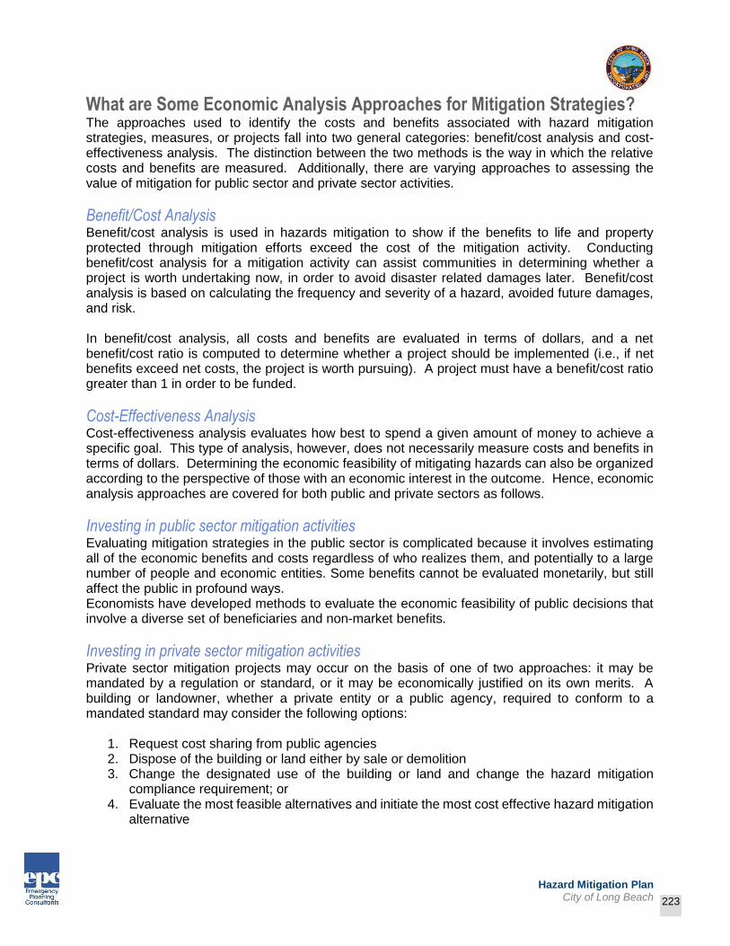
223
Prepared by:
223
Hazard Mitigation Plan City of Long Beach
What are Some Economic Analysis Approaches for Mitigation Strategies? The approaches used to identify the costs and benefits associated with hazard mitigation strategies, measures, or projects fall into two general categories: benefit/cost analysis and cost-effectiveness analysis. The distinction between the two methods is the way in which the relative costs and benefits are measured. Additionally, there are varying approaches to assessing the value of mitigation for public sector and private sector activities.
Benefit/Cost Analysis Benefit/cost analysis is used in hazards mitigation to show if the benefits to life and property protected through mitigation efforts exceed the cost of the mitigation activity. Conducting benefit/cost analysis for a mitigation activity can assist communities in determining whether a project is worth undertaking now, in order to avoid disaster related damages later. Benefit/cost analysis is based on calculating the frequency and severity of a hazard, avoided future damages, and risk. In benefit/cost analysis, all costs and benefits are evaluated in terms of dollars, and a net benefit/cost ratio is computed to determine whether a project should be implemented (i.e., if net benefits exceed net costs, the project is worth pursuing). A project must have a benefit/cost ratio greater than 1 in order to be funded.
Cost-Effectiveness Analysis Cost-effectiveness analysis evaluates how best to spend a given amount of money to achieve a specific goal. This type of analysis, however, does not necessarily measure costs and benefits in terms of dollars. Determining the economic feasibility of mitigating hazards can also be organized according to the perspective of those with an economic interest in the outcome. Hence, economic analysis approaches are covered for both public and private sectors as follows.
Investing in public sector mitigation activities Evaluating mitigation strategies in the public sector is complicated because it involves estimating all of the economic benefits and costs regardless of who realizes them, and potentially to a large number of people and economic entities. Some benefits cannot be evaluated monetarily, but still affect the public in profound ways. Economists have developed methods to evaluate the economic feasibility of public decisions that involve a diverse set of beneficiaries and non-market benefits.
Investing in private sector mitigation activities Private sector mitigation projects may occur on the basis of one of two approaches: it may be mandated by a regulation or standard, or it may be economically justified on its own merits. A building or landowner, whether a private entity or a public agency, required to conform to a mandated standard may consider the following options:
1. Request cost sharing from public agencies 2. Dispose of the building or land either by sale or demolition 3. Change the designated use of the building or land and change the hazard mitigation
compliance requirement; or 4. Evaluate the most feasible alternatives and initiate the most cost effective hazard mitigation
alternative

224
Prepared by:
224
Hazard Mitigation Plan City of Long Beach
The sale of a building or land triggers another set of concerns. For example, real estate disclosure laws can be developed which require sellers of real property to disclose known defects and deficiencies in the property, including earthquake weaknesses and hazards to prospective purchasers. Correcting deficiencies is expensive and time consuming, but their existence can prevent the sale of the building. Conditions of a sale regarding the deficiencies and the price of the building can be negotiated between a buyer and seller.
How Can an Economic Analysis be Conducted? Benefit/cost analysis and cost-effectiveness analysis are important tools in evaluating whether or not to implement a mitigation activity. A framework for evaluating alternative mitigation activities is outlined below:
1. Identify the Alternatives: Alternatives for reducing risk from hazards includes structural projects
to enhance disaster resistance, education and outreach, and acquisition or demolition of exposed properties, among others. Different mitigation project assists in minimizing risk to hazards, but do so at varying economic costs.
2. Calculate the Costs and Benefits: Choosing economic criteria is essential to systematically
calculating costs and benefits of mitigation projects and selecting the most appropriate alternative. Potential economic criteria to evaluate alternatives include:
Determine the project cost. This may include initial project development costs, and repair and operating costs of maintaining projects over time.
Estimate the benefits. Projecting the benefits or cash flow resulting from a project can be difficult. Expected future returns from the mitigation effort depend on the correct specification of the risk and the effectiveness of the project, which may not be well known. Expected future costs depend on the physical durability and potential economic obsolescence of the investment. This is difficult to project. These considerations will also provide guidance in selecting an appropriate salvage value. Future tax structures and rates must be projected. Financing alternatives must be researched, and they may include retained earnings, bond and stock issues, and commercial loans.
Consider costs and benefits to society and the environment. These are not easily measured, but are assessed through a variety of economic tools including existence value or contingent value theories. These theories provide quantitative data on the value people attribute to physical or social environments. Even without hard data, however, impact of structural projects to the physical environment or to society should be considered when implementing mitigation projects.
Determine the correct discount rate. Determination of the discount rate can just be the risk-free cost of capital, but it may include the decision maker’s time preference and also a risk premium. Including inflation should also be considered.
3. Analyze and Rank the Alternatives: Once costs and benefits have been quantified, economic
analysis tools can rank the alternatives. Two methods for determining the best alternative given varying costs and benefits include net present value and internal rate of return.
Net present value. Net present value is the value of the expected future returns of an investment minus the value of expected future cost expressed in today’s dollars. If the net present value is greater than the project costs, the project is determined feasible for

225
Prepared by:
225
Hazard Mitigation Plan City of Long Beach
implementation. Selecting the discount rate, and identifying the present and future costs and benefits of the project calculates the net present value of projects.
Internal Rate of Return. Using the internal rate of return method to evaluate mitigation projects provides the interest rate equivalent to the dollar returns expected from the project. Once the rate has been calculated, it is compared to rates earned by investing in alternative projects. Projects may be feasible to implement when the internal rate of return is greater than the total costs of the project.
Once the mitigation projects are ranked on the basis of economic criteria, decision-makers can consider other factors, such as risk; project effectiveness; and economic, environmental, and social returns in choosing the appropriate project for implementation.
How are Benefits of Mitigation Calculated? Economic Returns of Hazard Mitigation The estimation of economic returns, which accrue to building or land owner as a result of hazard mitigation, is difficult. Owners evaluating the economic feasibility of mitigation should consider reductions in physical damages and financial losses. A partial list follows:
Building damages avoided Content damages avoided Inventory damages avoided Rental income losses avoided Relocation and disruption expenses avoided Proprietor’s income losses avoided
These parameters are estimated using observed prices, costs, and engineering data. The difficult part is to correctly determine the effectiveness of the hazard mitigation project and the resulting reduction in damages and losses. Equally as difficult is assessing the probability that an event will occur. The damages and losses should only include those that will be borne by the owner. The salvage value of the investment are important in determining economic feasibility. Salvage value becomes more important as the time horizon of the owner declines. This is important because most businesses depreciate assets over a period of time.
Additional Costs from Hazards Property owners should also assess changes in a broader set of factors that change as a result of a large natural disaster. These are usually termed “indirect” effects, but they have a very direct effect on the economic value of the owner’s building or land. They are positive or negative, and include changes in the following:
Commodity and resource prices Availability of resource supplies Commodity and resource demand changes Building and land values Capital availability and interest rates Availability of labor Economic structure Infrastructure Regional exports and imports Local, state, and national regulations and policies

226
Prepared by:
226
Hazard Mitigation Plan City of Long Beach
Insurance availability and rates Changes in the resources and industries listed above are more difficult to estimate and require models that are structured to estimate total economic impacts. Total economic impacts are the sum of direct and indirect economic impacts. Total economic impact models are usually not combined with economic feasibility models. Many models exist to estimate total economic impacts of changes in an economy. Decision makers should understand the total economic impacts of natural disasters in order to calculate the benefits of a mitigation activity. This suggests that understanding the local economy is an important first step in being able to understand the potential impacts of a disaster, and the benefits of mitigation activities.
Additional Considerations Conducting an economic analysis for potential mitigation activities can assist decision-makers in choosing the most appropriate strategy for their community to reduce risk and prevent loss from hazards. Economic analysis saves time and resources from being spent on inappropriate or unfeasible projects. Several resources and models are listed on the following page that assist in conducting an economic analysis for hazard mitigation activities. Benefit/cost analysis is complicated, and the numbers may divert attention from other important issues. It is important to consider the qualitative factors of a project associated with mitigation that cannot be evaluated economically. There are alternative approaches to implementing mitigation projects. Many communities are looking towards developing multi-objective projects. With this in mind, opportunity rises to develop strategies that integrate hazard mitigation with projects related to watersheds, environmental planning, community economic development, and small business development, among others. Incorporating hazard mitigation with other community projects can increase the viability of project implementation.
Resources CUREe Kajima Project, Methodologies For Evaluating The Socio-Economic Consequences Of Large Earthquakes, Task 7.2 Economic Impact Analysis, Prepared by University of California, Berkeley Team, Robert A. Olson, VSP Associates, Team Leader; John M. Eidinger, GandE Engineering Systems; Kenneth A. Goettel, Goettel and Associates Inc.; and Gerald L. Horner, Hazard Mitigation Economics Inc., 1997. Federal Emergency Management Agency, Benefit/Cost Analysis of Hazard Mitigation Projects, Riverine Flood, Version 1.05, Hazard Mitigation Economics Inc., 1996. Federal Emergency Management Agency Report on Costs and Benefits of Natural Hazard Mitigation. Publication 331, 1996. Goettel and Horner Inc., Earthquake Risk Analysis Volume III: The Economic Feasibility of Seismic Rehabilitation of Buildings in The City of Portland, Submitted to the Bureau of Buildings, City of Portland, August 30, 1995. Goettel and Horner Inc., Benefit/Cost Analysis of Hazard Mitigation Projects Volume V, Earthquakes, Prepared for FEMA’s Hazard Mitigation Branch, October 25, 1995. Horner, Gerald, Benefit/Cost Methodologies for Use in Evaluating the Cost Effectiveness of Proposed Hazard Mitigation Measures, Robert Olson Associates, Prepared for Oregon State Police, Office of Emergency Management, July 1999.
227
Prepared by:
227
Hazard Mitigation Plan City of Long Beach
Interagency Hazards Mitigation Team, State Mitigation Plan, (Oregon State Police – Office of Emergency Management, 2000). Risk Management Solutions, Inc., Development of a Standardized Earthquake Loss Estimation Methodology, National Institute of Building Sciences, Volume I and II, 1994. VSP Associates, Inc., A Benefit/Cost Model for the Seismic Rehabilitation of Buildings, Volumes 1 and 2, Federal Emergency Management Agency, FEMA, Publication Numbers 227 and 228, 1991. VSP Associates, Inc., Benefit/Cost Analysis of Hazard Mitigation Projects: Section 404 Hazard Mitigation Program and Section 406 Public Assistance Program, Volume 3: Seismic Hazard Mitigation Projects, 1993. VSP Associates, Inc., Seismic Rehabilitation of Federal Buildings: A Benefit/Cost Model, Volume 1, Federal Emergency Management Agency, FEMA, Publication Number 255, 1994.
Related Documents