1 January 2017 Logan-Albert Catchment Action Plan 2017 – 2020 Resilient Rivers Initiative

Welcome message from author
This document is posted to help you gain knowledge. Please leave a comment to let me know what you think about it! Share it to your friends and learn new things together.
Transcript

1January 2017Logan-Albert Catchment Action Plan 2017 – 2020Resilient Rivers Initiative

Contents
Executive summary ......................................................................................................4
About this action plan ..................................................................................................6 Scope and purpose ...................................................................................................6 Development of the plan ..........................................................................................7 Rationale for regional investment in Logan-Albert catchment ....................................8
Catchment in context ...................................................................................................9 The Logan-Albert catchment .....................................................................................9 Geology and soils of the catchment ..........................................................................10 Macrochannels .........................................................................................................11 Land uses, vegetation cover and infrastructure ..........................................................12 Policy and managment context .................................................................................15 Key catchment assets ................................................................................................18
Action plan ...................................................................................................................19 Assets and investment map ......................................................................................22 Risk treatment plan ...................................................................................................23
Review of progress .......................................................................................................29 Appendix....................................................................................................................... 30 Attachment A – Previous studies and planning activities ............................................30 Attachment B – Previous studies and planning activities ............................................31

4
Executive summary
The Resilient Rivers Initiative vision is: “By 2045, the catchments of South East Queensland (SEQ) will support a resilient, productive, liveable and growing region.”
This vision is documented in the Resilient Rivers Regional Strategy (2015-2025), which also has supporting goals and measures of success. The development of a Logan-Albert Catchment Action Plan has been identified as a priority as part of this Strategy.
The primary focus of the Logan-Albert Catchment Action Plan is addressing the very high risk of sediment movement from the catchment due to past and present land uses and its downstream impact on rivers, the estuary and Moreton Bay.
The catchment is the location for significant urban growth. These growth areas will require new water supplies in the near future. In turn, the values and services provided by the catchment and its waterways will be under increasing pressure from the large areas of development planned for the lower and middle catchment, including the Bromelton industrial area and the Greater Flagstone and Yarrabilba Priority Development Areas.
The middle and upper headwaters of the Logan and Albert Rivers contain large intact vegetation remnants, parts of which are protected areas, including World Heritage rainforests. These core bushlands provide important soil cover, assisting with the slowing of water movement down the catchment providing flood and drought resilience.
The estuary provides the residents of the region with a key recreational and commercial fishery. The fishery is also being restricted by fish passage barriers upstream in the rivers.
The supply of drinking water in the catchment is increasingly coming under pressure. The Logan and Albert Rivers supply water to a number of towns that are not connected to the region’s water grid. Greater controls are required at the standalone Water Treatment Plants (WTP) due to upstream recreational and animal based agricultural uses (e.g. chicken farms, dairies and grazing) to provide safe and reliable water supply, which increases the cost to supply water.
The Scenic Rim Important Agricultural Area consists of productive soils that are considered part of a strategically significant agricultural area in SEQ. Erosion is a risk to productivity and can cause a loss of soil, crops, fertilisers, pesticides, and access to irrigation water.
The size of the catchment and range of issues presents a challenge for effective short term management.
Given that a significant portion of the catchment is undergoing rapid growth and land use change, the priority for management investment is ensuring that these activities, including residential and industrial development, do not contribute additional threats.
Protection of existing key natural assets of the catchment such as the core bushland areas which provide erosion protection is critical in the short term and this is reflected in the Action Plan.
The following table outlines the actions to be undertaken between 2017-2020 and the associated Measures of Success from the Resilient Rivers Regional Strategy (2015-2025).

Logan-Albert on-ground actions Regional level measures of success
• Improve capacity to implement and ensure compliance of existing requirements for erosion and sediment control on construction sites by establishing a targeted 10 year program for the high growth areas
Four on-ground works completed
Six industry best management practice projects implemented
• Within the context of a coordinated engagement program, work with landholders to protect and maintain riparian areas of high value and enhance those with a high risk in the priority investment areas.
• Kooralbyn, Rathdowney and broader Canungra water supply offtake to reduce contaminants by exclusion of stock, waste management and riparian protection
• Develop a continuous Albert River riparian corridor between Cedar Creek and the Stanmore Road Bridge through a targeted program of weed management, riparian planting and landowner engagement, with an initial focus on key Council and State assets
• Prepare a coordinated and strategic weed and pest control plan that includes: a sustained funding model; improved weed and pest mapping and data collection to determine high priority sites; coordinated biocontrol releases; and community led actions
• Remove Luscombe Weir to improve fisheries outcomes
Logan-Albert policy and planning actions Measures of success (to be determined as part of the reporting framework)
• Quantify the effect of sediment on fisheries and recreation values in the Logan River estuary to determine quantity of investment required and provide a strong evidence base for investment
• Investigate the establishment of Soil Conservation Project Areas under the Soil Conservation Act 1986 for high risk erosion areas
• Encourage land use in the mid and upper catchment to be matched to land use suitability by mapping Agricultural Land Use Class C and D
• Establish a specific mechanism to strengthen existing institutional arrangements to ensure developments within water supply buffer areas comply with the outcomes and measures within the Seqwater Development Guidelines: Development Guidelines for Water Quality Management in Drinking Water Catchments 2012
• Clarify jurisdiction, thresholds and compliance performance for environmental relevant activities associated with animal-based farming and industry within the Rathdowney, Kooralbyn, Canungra and Cedar Grove WTP offtake zones
• Investigate options to minimise the impacts of the disposal of spent chicken farm litter on horticultural and turf farms within the Rathdowney, Kooralbyn and Cedar Grove WTP offtake zones
• Prepare a recreation management plan for the Albert River catchment, which includes investigating options to improve management of camping sites upstream of the Canungra water supply offtake
• Improve landholder management of the riparian zone by clarifying the rights and responsibilities of landholders
• Consider including the core bushland and linkages in the middle to upper catchment as Matters of Local Significance within the new Scenic Rim Regional Council Planning Scheme
• Logan Water Business and Logan Water Infrastructure Branches will identify opportunities to incorporate water quality offsets schemes into their effluent management strategy in order to perform bank rehabilitation within the Logan-Albert catchment
6
About this action plan
The Logan-Albert Catchment Action Plan 2017-2020 has been prepared as part of the Resilient Rivers Initiative which has the following 30-year vision for the SEQ region:
“By 2045, the catchments of SEQ will support
a resilient, productive, liveable and growing region.”
This vision is documented in the Regional Strategy (2015–2025) which has the following supporting goals:
• Keep soil on our land and out of our waterways to support agricultural productivity and improve water quality.
• Help protect our region’s water security so it can support the current and future population of SEQ.
• Improve the climate resilience of our region.
• Promote partnerships with strong leadership to deliver a coordinated approach to catchment management in SEQ.
The purpose of Logan-Albert Catchment Action Plan is to:
• Use a whole of catchment approach to collaboratively identify actions that will help to achieve the vision of the Resilient Rivers Initiative.
• Identify actions that are underpinned by the best of our knowledge and understanding and reflect the values of the community.
• Provide a single strategic framework and rationale for coordinated investment by stakeholders.
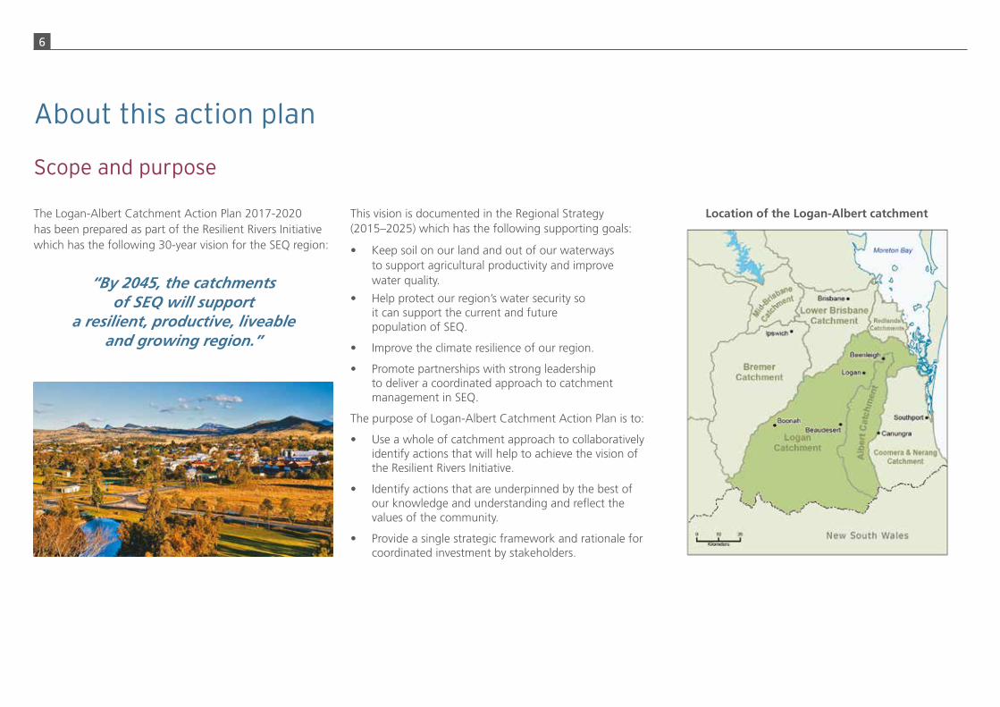
Location of the Logan-Albert catchment
Scope and purpose

7
Development of the Plan occurred during the period December 2015 – November 2016 and was overseen by a project team consisting of representatives from City of Gold Coast, Logan City Council, Redland City Council, Scenic Rim Regional Council, Seqwater, Queensland Departments of Natural Resources and Mines and Environment and Heritage Protection, Healthy Waterways and Catchments and Queensland Urban Utilities.
The Resilient Rivers Taskforce reviewed aspects of the Plan as it proceeded. The Taskforce was supported by the executive level Catchment Action Plans Working Group, which nominated the representatives for the project team.
Logan City Council and Redland City Council provided funding towards the preparation of the Plan and assisted with the provision of venues for project team activities. Council of Mayors (SEQ) provided the coordination and project management capacity on behalf of the project team.
The Department of Environment and Heritage Protection’s Wetlands Program provided invaluable data and consolidated the current understanding of the catchment processes occurring at the landscape scale. A number of supporting factual publications have been prepared and are available on the Wetlands Program website.
The process undertaken to develop the Plan followed that endorsed by the Resilient Rivers Taskforce.
The Catchment Action Plan has been endorsed by City of Gold Coast, Logan City Council, Redland City Council, and Scenic Rim Regional Council.
This Logan-Albert Catchment Action Plan builds on previous studies and planning activities. Key catchment-wide studies are described in Attachment A.
Development of the plan Recommended steps for the preparation of a catchment action plan (CAP)
Recommended activities and decision points Recommended outputs
Understand system components and processes Data, maps, potenlal threat identification and assessments, detailed analyses, models, animations
Description of catchment’s assets within the context of the regional goals including description of condition
and trends, levels of service where available
Gather information and gain an agreed understanding (Walking the landscape, targeted consultancies)
Define catchment values/key assets and objeclves Draft agreed objectives for the catchment’s values/assets
Issues analysisObjectives to be defined based on Resilient Rivers
Initiative regional goals
Undertake risk assessmentRisk register and associated maps and data
Agreed outcomes for the catchment’s values/assetsAssess risks to catchment values/assets to inform
risk treatment plan
Identify draft management actions (risk treatment plan)
Prioritise management actions Draft CAP document, including draft rationale for regional investment and draft list
of management actionsInvestigate initial feasibility and likelihood of success
of draft management actions, with political input
Publication of CAPFinal CAP document including priority action list and
measures of success/KPIs, review processSeek endorsement from relevant Councils and investigating organisations

8
The Logan-Albert catchment contains one of the fastest growing areas in SEQ. The northern end of City of Gold Coast is part of this growth corridor, along with the State-designated Priority Development Areas (PDAs) of Greater Flagstone, Yarrabilba and Bromelton.
The lower Logan River corridor is vitally important to the region as a floodplain. Maintaining this function will allow the high growth areas to occur without the social and economic costs associated with poor past planning decisions in other river corridors. Much of the lower Logan River corridor is in private ownership and regional investment in key public recreation nodes and setbacks along with strong regulation will allow this floodplain function to continue.
The Logan-Albert estuary links to internationally recognised Ramsar-listed wetlands within Southern Moreton Bay. Protection of this asset is therefore required to meet our international commitments.
The Scenic Rim region is set to become a rural lifestyle focus for SEQ. Its atmospheric villages and high quality
boutique agricultural enterprises will attract Brisbane and Logan urban visitors and will become an increasingly attractive area for tree-changers with an accompanying increase in land values for a quality lifestyle.
The catchment contains important agricultural areas with associated industries located within 100 km radius of the major population centres of the region.
While the villages of the middle and upper catchment are currently not connected to the SEQ water grid, water utilities have systems in place to ensure good quality water supply. However, the cost of this is increasing and improving the resilience of the catchments within 2 km of water offtakes is a high priority for best practice water supply to maintain these villages into the future.
Agriculture in the middle and upper catchments located on good quality soils and supported by irrigation will continue to be important economically to the catchment.
Over time these areas will become more valuable as the high-end agricultural focus for the area develops. Ensuring soil loss from these areas is minimised is vital for the enterprises and downstream communities.
Key parts of the catchment are highly valued recreational areas used by the whole of the SEQ community. Regional investment in recreational facilities will improve the user experience and ensure pressures on waterways are minimised.
The upper catchment contains regionally and nationally unique vegetation remnants providing numerous services including flood protection, groundwater recharge for downstream irrigation, and the significant biodiversity areas of the World Heritage Border Ranges. The area contains the highest mountains of SEQ and is popular for recreation. Protection of the core remnants through planning, investment and acquisition is a priority for the catchment.
Investment in the waterways of the Logan-Albert catchment will ensure this economically important area of the region continues to maintain its green and liveable image.
Rationale for regional investment in the Logan-Albert catchment

9
Catchment in context
The Logan-Albert catchment
The Logan-Albert catchment is the third largest in SEQ with a combined area of approximately 3,800 km2. It is located to the south of Brisbane with its headwaters in the McPherson and Main Ranges on the NSW border. The Albert River joins the Logan River near Eagleby, 11 km upstream of its mouth.
The Logan River flows north for approximately 180 km discharging into the southern part of Moreton Bay a Ramsar listed area. It is tidal for approximately the first 60 km up to the Maclean Bridge. Waterways flowing into the Logan River include Teviot Brook, Burnett, Mount Barney, Palen, Running and Christmas creeks in the upper catchment, Sandy, Knapps, Cannon and Allan creeks in the mid catchment and Flagstone, Scrubby and Slacks creeks in the lower catchment. Parts of the Logan catchment are located within Logan City Council, Redland City Council and Scenic Rim Regional Council.
The Albert River marks the border between City of Gold Coast and Logan City Council and contains part of Scenic Rim Regional Council. The Albert River is approximately 163 km long and is tidal for approximately 35 km. Its tributaries include Canungra, Cedar, Cainbable, Kerry and Duck creeks.
This section of the Plan is drawn from the Logan-Albert catchment description and issues technical report and map journals prepared as part of the overall project and are therefore the primary reference source. Other sources not included in the above are referenced.
!
!
!
!
!
!
!
!
!
!
!
!
!
!
!
!
!
!
! !
!
!!
!
!
!
!
!
!
!
!
!
!
!!
!
!
!
!
!
!
!
!
!
!
!
!!
!
!
!
!
!
!!
!
!
!!
!
!
!
!!
!
!
!
!
!
!
!!
!
!
!
!
!
!!
!
!
!
!
!
!
!
!
!
!
!
!
!
!
!
!
!
!
!
!
!
!
!
!
!
!
!!
!
!!
!!
!
!
!
!
!
!
!
!
!
!
!
!
!
!
!
!!
!
!
!
!
!
!
!
!
!
!!
!
!
!
! !
!
!
!!
!
!
!
!
!
!!
!
!
!
!
!
!
!
!!
!
!
!
!
!
!
! !
!
!
! !
!!
!
!
!
!
!!
!
!
!
!
!
!
! !!
!
!
!
!
Brisbane RiverCatchment
CITY OF GOLD COAST COUNCIL
IPSWICH CITYCOUNCIL
REDLAND CITYCOUNCIL
LOGAN CITYCOUNCIL
BRISBANE CITYCOUNCIL
SCENIC RIMREGIONAL COUNCIL
Bremer RiverCatchment
Coomera& Nerang Rivers
Catchment
WyaralongDam
LakeMaroon
Advancetown Lake
LakeMoogerah Al
bert
Riv
er
Albe
rtRi
ver
Loga
nRi
ver
Loga
nR.
Logan River
Can
ungr
aCreek
Runn ing Ck
Cai nba
bleC
reekKnapp Creek
Burnett Creek
Tevio
t Brook
MidAlbert River
subcatchmentLowerTeviot Brook
subcatchment
Palen Creeksubcatchment
UpperTeviot Brook
subcatchment
Upper WesternLogan River
subcatchment
WesternLogan River
subcatchment
Lower AlbertRiver
subcatchment
Upper EasternLogan River
subcatchment
UpperAlbert River
subcatchment
LowerLogan River
subcatchment
CanungraCreek
subcatchment
EasternLogan River
subcatchment
Rathdowney
Boonah Beaudesert
Logan
Beenleigh
Legend!! Town
River / creek
State boundary
! Local government boundary
Catchment
Reservoir
SubcatchmentsCanungra Creek
Eastern Logan River
Lower Albert River
Lower Logan River
Lower Teviot Brook
Mid Albert River
Palen Creek
Upper Albert River
Upper Eastern Logan River
Upper Teviot Brook
Upper Western Logan River
Western Logan River
D:\Workspace\d161027 Logan Albert CAP\m2 overview_v02.mxd
N e w S o u t h W a l e s0 10 205 15
Kilometers
For a detailed understanding of the catchment visit www.wetlandinfo.ehp.qld.gov.au/wetlands/ecology/processes-systems/water/catchment-stories/

10
A number of investigations into soil and erosion management have occurred for the Logan-Albert catchment (Attachment B) and the information provided here is a brief summary of key sources.
The soils of the catchment are complex however three main geological types influence the catchment – Lamington Formation (basalts), Gatton Marburg Formation (sandstones), and Walloon Subgroup.
The eastern headwaters of the catchment are underlain by basalt, which enables high amounts of water infiltration and recharge of groundwater. This provides an important contribution to springs, creeks, wetlands, groundwater dependent ecosystems and terrestrial vegetation year round. These headwaters are also steep, leading to fast runoff of surface waters.
Most of the western headwaters are underlain by impervious rock. These parts of the catchment have lower groundwater recharge potential, and provide for fast surface water runoff, especially where the landforms are steep.
Gravels or clays are derived from the basalts with finer materials easily transported in suspension, contributing to turbidity at the estuary.
Marburg Sandstone erodes relatively easily. Sand derived from the Marburg Sandstone formation is stored for long periods on the bed of the river and on the active floodplain.
The Gatton Marburg soil types show major to severe erosion over 30 percent of their area. Knapps and Cannon creeks have broad hectare forms of sheet and gully erosion of these infertile soils across 50 percent and 25 percent of the catchment respectively.
Up to 30 percent of the Albert basalt group along the eastern lower foothills of the Logan River are severely eroded. There is severe erosion across 25 percent of the upper reaches of the Widgee sub-catchment, including a high density and intensity of land slips associated with broad hectare erosion. Gully erosion is significant in areas of the Albert Right sub-catchment with relatively high intensity land slips.
There are large areas of alluvium on low-lying land, particularly on the Logan River upstream of the Teviot Brook confluence and throughout the lower reaches.
Understanding grazing land types helps with management decisions such as land use and associated limitations,
Geology and soils of the catchment
maintaining pasture composition, pasture utilisation rates, and suitable sown pastures. For example, long term spelling may be required in some of the infertile Marburg sandstones.
Safe, pasture utilisation rates for these soil types across the Logan-Albert Catchment are:
• Alluvial soils, basalt uplands 35 percent
• Heavy clay soils 30 percent
• Basalt hills and ridges 25 percent
• Sandstones, duplex soils 20 percent
• Grey/brown clays, sodic soils 10-20 percent.
11
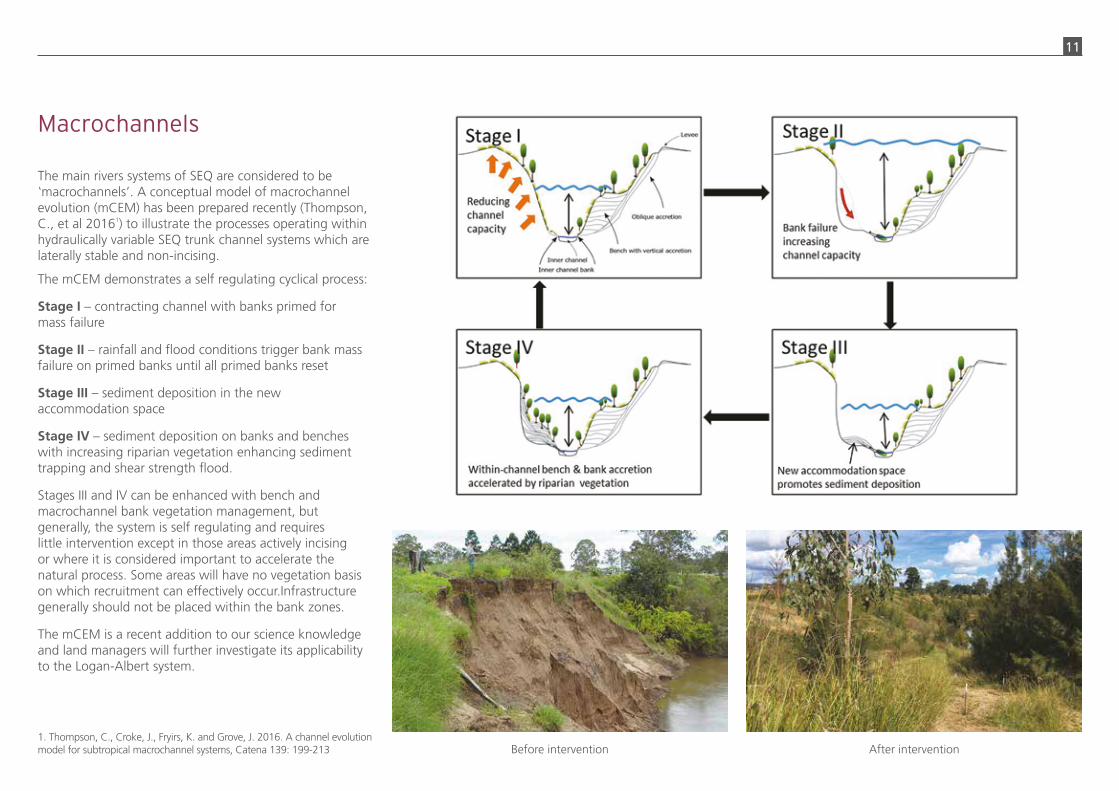
The main rivers systems of SEQ are considered to be macrochannels’. A conceptual model of macrochannel evolution (mCEM) has been prepared recently (Thompson, C., et al 20161) to illustrate the processes operating within hydraulically variable SEQ trunk channel systems which are laterally stable and non-incising.
The mCEM demonstrates a self regulating cyclical process:
Stage I – contracting channel with banks primed for mass failure
Stage II – rainfall and flood conditions trigger bank mass failure on primed banks until all primed banks reset
Stage III – sediment deposition in the new accommodation space
Stage IV – sediment deposition on banks and benches with increasing riparian vegetation enhancing sediment trapping and shear strength flood.
Stages III and IV can be enhanced with bench and macrochannel bank vegetation management, but generally, the system is self regulating and requires little intervention except in those areas actively incising or where it is considered important to accelerate the natural process. Some areas will have no vegetation basis on which recruitment can effectively occur.Infrastructure generally should not be placed within the bank zones.
The mCEM is a recent addition to our science knowledge and land managers will further investigate its applicability to the Logan-Albert system.
1. Thompson, C., Croke, J., Fryirs, K. and Grove, J. 2016. A channel evolution model for subtropical macrochannel systems, Catena 139: 199-213
Macrochannels
‘
Before intervention After intervention
12
The major land uses in the catchment are grazing native vegetation (55 percent), residential and farm infrastructure (15 percent) and nature conservation (11 percent).
Most of the upper and mid catchment is used for grazing on native (unimproved) pastures, with cropping along the alluvial channel.
Large areas of remnant bushland are located in the upper and mid catchment, with some in protected areas such as National Parks. These include the World Heritage Areas of the Border Ranges. Waterways within these areas are considered to have high conservation value and are designated as High Ecological Value (HEV) waterways under the Environmental Protection (Water) Policy 2009, where the intent is to maintain or achieve an effectively unmodified waterway condition. The upper catchment includes Mount Barney, Lamington, Main Range and Mount Chinghee national parks and is Heritage Listed as the Gondwana Rainforests of Australia. There are relatively large areas of mangrove forest lining the lower reaches and eucalypt vegetation across the mid and lower catchment.
A variety of agriculture occurs in the catchment includes intensive dairies, intensive horticulture, poultry, horse studs, hoop pine plantations, hobby farms, turf farms, sugar cane (lower reaches) and aquaculture (prawn farming).
Urban and rural residential uses are concentrated in the middle to lower catchment. The population of the City of Logan is approximately 308,000 with most residents located within the catchment. Key towns or suburbs in the Logan catchment include Boonah, Rathdowney, Beaudesert, Jimboomba, Yarrabilba, Flagstone, Logan Village and Logan Central. Key towns in the Albert catchment include Tambourine, Canungra, Cedar Creek (South) and Beenleigh.
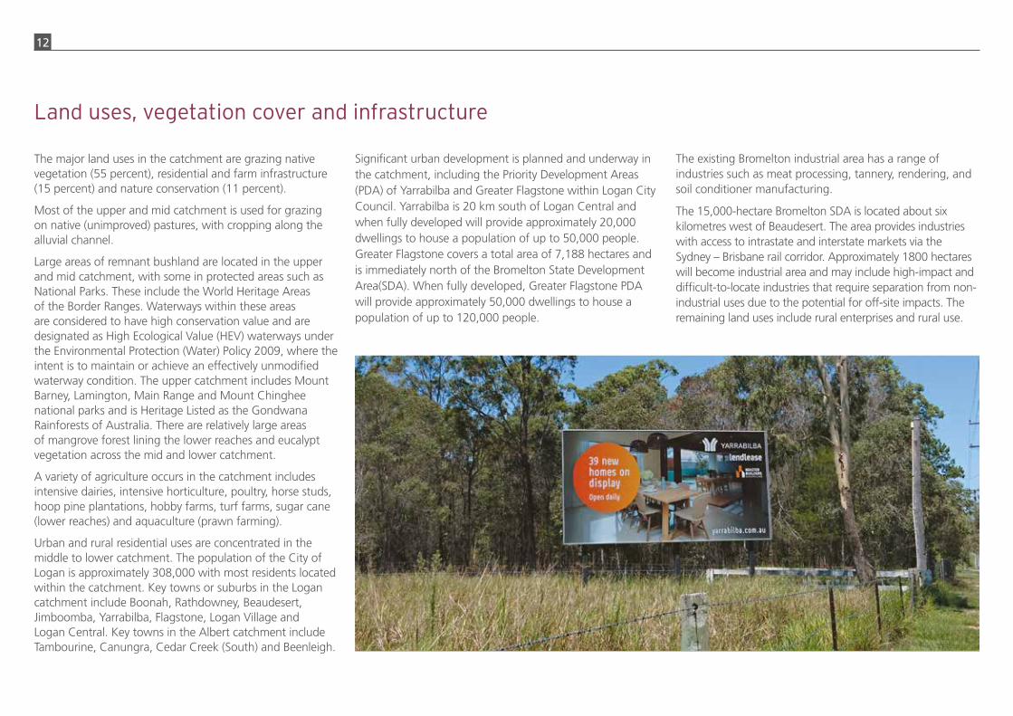
Significant urban development is planned and underway in the catchment, including the Priority Development Areas (PDA) of Yarrabilba and Greater Flagstone within Logan City Council. Yarrabilba is 20 km south of Logan Central and when fully developed will provide approximately 20,000 dwellings to house a population of up to 50,000 people. Greater Flagstone covers a total area of 7,188 hectares and is immediately north of the Bromelton State Development Area(SDA). When fully developed, Greater Flagstone PDA will provide approximately 50,000 dwellings to house a population of up to 120,000 people.
The existing Bromelton industrial area has a range of industries such as meat processing, tannery, rendering, and soil conditioner manufacturing.
The 15,000-hectare Bromelton SDA is located about six kilometres west of Beaudesert. The area provides industries with access to intrastate and interstate markets via the Sydney – Brisbane rail corridor. Approximately 1800 hectares will become industrial area and may include high-impact and difficult-to-locate industries that require separation from non-industrial uses due to the potential for off-site impacts. The remaining land uses include rural enterprises and rural use.
Land uses, vegetation cover and infrastructure

13
!!
!!
!!
!! !!!!
!!
!!
!!
!!
!!
Brisbane RiverCatchment
Albert RiverCatchment
Logan RiverCatchment
Bremer RiverCatchment
Coomera& Nerang Rivers
Catchment
WyaralongDam
LakeMaroon
Advancetown Lake
LakeMoogerah
Albert River
Albe
rtRi
ver
Cann
onCree k
Loga
nRi
ver
Loga
nR.
Logan River
Can
ungr
a Cr ee
k
R
u nning Ck
Cai nbable
Cr eekKnapp Cre ek
Burne
tt Creek
Teviot Broo
kBromelton
FlagstoneYarrabilba
North
Bahrs Scrub Steiglitz
Park Ridge
Rathdowney
BoonahBeaudesert
Jimboomba
Logan
Beenleigh
D:\Workspace\d161027 Logan Albert CAP\m5 SEQ RP land use_v03.mxd
N e w S o u t h W a l e s0 10 205 15
Kilometers
Legend
SEQ Regional Plan 2009-2031Regional Landuse Categories
Urban Footprint
Rural Living Area
Regional Landscape and RuralProduction Area
Proposed SEQ Regional PlanLanduse Categories changes(ShapingSEQ, draft 2016)
Draft Urban Footprint
Draft Rural Living Area
Draft Priority Agricultural Area
Priority Development AreaBromelton State Development Area
14
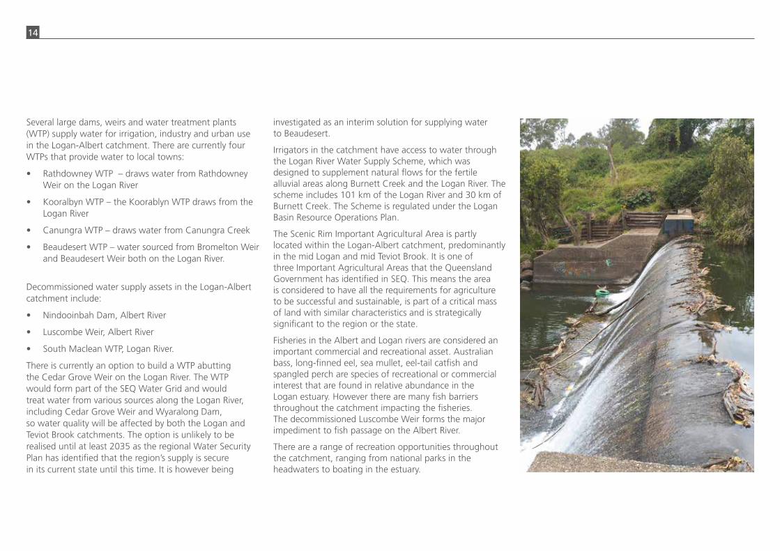
Several large dams, weirs and water treatment plants (WTP) supply water for irrigation, industry and urban use in the Logan-Albert catchment. There are currently four WTPs that provide water to local towns:
• Rathdowney WTP – draws water from Rathdowney Weir on the Logan River
• Kooralbyn WTP – the Koorablyn WTP draws from the Logan River
• Canungra WTP – draws water from Canungra Creek
• Beaudesert WTP – water sourced from Bromelton Weir and Beaudesert Weir both on the Logan River.
Decommissioned water supply assets in the Logan-Albert catchment include:
• Nindooinbah Dam, Albert River
• Luscombe Weir, Albert River
• South Maclean WTP, Logan River.
There is currently an option to build a WTP abutting the Cedar Grove Weir on the Logan River. The WTP would form part of the SEQ Water Grid and would treat water from various sources along the Logan River, including Cedar Grove Weir and Wyaralong Dam, so water quality will be affected by both the Logan and Teviot Brook catchments. The option is unlikely to be realised until at least 2035 as the regional Water Security Plan has identified that the region’s supply is secure in its current state until this time. It is however being
investigated as an interim solution for supplying water to Beaudesert.
Irrigators in the catchment have access to water through the Logan River Water Supply Scheme, which was designed to supplement natural flows for the fertile alluvial areas along Burnett Creek and the Logan River. The scheme includes 101 km of the Logan River and 30 km of Burnett Creek. The Scheme is regulated under the Logan Basin Resource Operations Plan.
The Scenic Rim Important Agricultural Area is partly located within the Logan-Albert catchment, predominantly in the mid Logan and mid Teviot Brook. It is one of three Important Agricultural Areas that the Queensland Government has identified in SEQ. This means the area is considered to have all the requirements for agriculture to be successful and sustainable, is part of a critical mass of land with similar characteristics and is strategically significant to the region or the state.
Fisheries in the Albert and Logan rivers are considered an important commercial and recreational asset. Australian bass, long-finned eel, sea mullet, eel-tail catfish and spangled perch are species of recreational or commercial interest that are found in relative abundance in the Logan estuary. However there are many fish barriers throughout the catchment impacting the fisheries. The decommissioned Luscombe Weir forms the major impediment to fish passage on the Albert River.
There are a range of recreation opportunities throughout the catchment, ranging from national parks in the headwaters to boating in the estuary.

15
Objectives and Environmental Values (EVs) under the Environmental Planning (Water) Policy 2009 to ensure the water is usable for the purposes defined in the EVs (e.g. drinking water, stock water, irrigation, recreation, aquatic ecosystems). DEHP’s catchment management interest focuses on reducing the source of pollutants entering waterways through capacity building, research and industry-partnerships for improving land management. The Wetlands Team within DEHP promote and deliver wetland information and tools including the WetlandInfo website, and manages the cross-government Queensland Wetlands Program.
The Department of Natural Resources and Mines is the lead agency for natural resource and catchment management. It’s role includes the regulation of instream work under the Water Act 2000 to maintain the physical integrity of the watercourses and manage the take of water for irrigation and other purposes. This department works closely with Seqwater.
The Department of Agriculture and Fisheries (DAF) regulates fisheries, piggeries, cattle, intensive feedlot and chicken farms. Dairies are part of DAF’s jurisdiction but as these are not regulated DAF’s involvement is in response to complaints.
Department of Infrastructure, Local Government and Planning (DILGP) administers the Sustainable Planning Act 2009 setting the policy for planning and development through the overarching objectives of the Act, the State Planning Policy (SPP), Regional Plans, for planning schemes and development assessment. The SPP sets the State’s policy direction for 16 State’s Interest including water quality.
Economic Development Queensland (EDQ) is a specialist land use planning and property development unit within the DILGP. EDQ engages with State and Local government, the development industry and the public to identify, plan, facilitate and deliver property development and infrastructure projects. EDQ drives a range of development projects including regional residential projects and industrial activities. Development applications for Priority Development Areas are assessed by EDQ. Although these areas fall under special planning arrangements, environmental legislative requirements still apply.
Water utilities
Water is distributed and wastewater collected and treated in the catchment by Gold Coast Water (business of City of Gold Coast), Logan Water, (business of Logan City Council), Queensland Urban Utilities and Redland Water (business of Redland City Council). These entities buy bulk water from Seqwater and operate under various Acts and policies, including the:
• South-East Queensland Water (Distribution and Retail Restructuring) Act 2009
• Water Supply (Safety and Reliability) Act 2008
• Environmental Protection Act 1994, including the Environmental Protection (Water) Policy 2009.
This legislation includes standards for the operation of wastewater systems, including licensed discharge criteria for protection of waterway environmental values.
The water utilities have been investigating opportunities associated with DEHP’s 2014 policy Flexible options for managing point source water emissions: A voluntary market-
Policy and management context
The organisations with a primary policy and management interest in the Logan-Albert catchment include four local governments (City of Gold Coast, Logan City Council, Redland City Council, and Scenic Rim Regional Council), the Queensland Government, Queensland Urban Utilities, and Seqwater.
Councils
City of Gold Coast, Logan, Redland and Scenic Rim councils invest in infrastructure asset management and recreational area management. These include managing council nature reserves and parks, providing stormwater infrastructure and planning for flood risk. Local councils also invest considerably in catchment management works, have some devolved responsibilities such as local laws relating to on-site sewerage facilities, vegetation and pest management and waterway pollution including erosion and sediment control from construction sites. Councils have a major role in land use planning as per State legislation. City of Gold Coast, Logan and Redland councils have businesses that distribute water and collect and treat wastewater. Scenic Rim Regional Council supports the Scenic Rim River Improvement Trust which has strong legal powers to action on-ground works in the mid and upper Logan and Albert rivers.
Queensland Government
The Department of Environment and Heritage Protection (DEHP) has involvement in regulatory, policy and catchment management roles. DEHP regulates Environmentally Relevant Activities, such as STPs and sand and gravel extraction under the Environmental Protection Act 1994. At a policy level, DEHP sets Water Quality

16
water to sustain household and business needs for our growing region and is underpinned by the Water Security Program which details how this is achieved including the risks and influences we need to manage, the many options available to us, and how we make the best choices for the region.
Seqwater adheres to the Australian Drinking Water Guidelines 2011. The guidelines contain six principles which highlight the importance of understanding the nature of the source water, the risks and hazards involved in sourcing water from catchments, and how to manage these issues and mitigate risks.
Seqwater owns and operates a number of water storages and weirs in the catchment supplying water to irrigation schemes and supporting local producers.
Extension services
Extension service providers influence and facilitate coordination of the management of land and water within the catchment. Some examples of such service providers are SEQ Healthy Waterways and Catchments Ltd, the Queensland Department of Agriculture and Fisheries, Queensland Dairyfarmers Organisation, Agforce, Growcom and agricultural
based mechanism for nutrient management. This policy is a mechanism for providing an alternative investment option for point source operators to meet their requirements under the Environmental Protect Act 1994. For example, the QUU’s Beaudesert pilot project on the Logan has undertaken upstream streambank restoration to compensate for increased STP discharges to receiving waters. In a practical sense, this means investment by the water utilities to mitigate nutrient pollution can be targeted at the significant sources of nutrients in the catchment. This may include sediment-bound nutrients.
Seqwater
Seqwater is the bulk water authority for SEQ and works collaboratively with stakeholders, customers and community to deliver safe, secure and cost-effective water and catchment services to more than three million people. On behalf of the community, the organisation manages water supply assets including dams, weirs, water treatment plants, reservoirs, pumps and pipelines as well as climate-resilient water sources.
In 2015, Seqwater released Water for life – a 30-year plan for providing safe, secure and cost-effective drinking water for SEQ. This long-term plan will provide enough
service businesses. Community based organisations such as local landcare and catchment management associations are key sources of information and often provide extension services.
Private landowners
The majority of land is in private ownership and so the interests of land managers are an important consideration within the management context. A landowner will have lifestyle and/or business goals, as well as land and water use rights and responsibilities, to consider. Goals and circumstances may change over time.

17

18
Key catchment assetsThe catchment’s key assets and the services they provide are set out below. A summary of main threats to the assets is also provided.
AssetServices provided by asset
Threats to asset Source of threats/contributing factors
Estuary (including seagrass, mangroves, wetlands and remnant coastal vegetation e.g. Carbrook Wetlands)
Fisheries (recreational and commercial), recreation, aquaculture (prawn farming), protection from storm surge, biodiversity
Sediment, fish passage barriers, reduced mangrove coverage
• Sediment re-suspension due to tidal processes• Construction phase and increased imperviousness from PDAs and SDA
(Yarrabilba, Greater Flagstone and Bromelton)• Development in riparian zones• Luscombe Weir is the key fish passage barrier on the Albert River• Coarse and fine sediments from upstream bank and gully erosion
Areas mapped as part of the Scenic Rim Important Agricultural Area Productive soils Erosion of productive soils
• Farming practices• Siting of infrastructure
Standalone drinking water supply schemes at Kooralbyn, Rathdowney and Canungra
Drinking water supply
Pathogens
• Rathdowney – key sources are livestock (grazing, chicken farms and dairies) • Kooralbyn – key sources are livestock (grazing, dairies and chicken farms) • Canungra – key sources are the Canungra showground and campgrounds
and a dairy
Water supply for the proposed Cedar Grove Water Treatment Plant (WTP) (includes Wyaralong Dam and Cedar Grove Weir)
Turbidity, pathogens, organics, nutrients, salinity
• On-site STPs in the catchment which are not well regulated for pathogens• Bromelton Industrial Area • Poultry farms, dairies, grazing • Horticulture particularly where poultry waste is used • Sewage Treatment Plants at Kooralbyn and Beaudesert• Proposed STP at Cedar Grove for Yarrabilba and Greater Flagstone
Main channel of Logan River (downstream of Bromelton Weir to the estuary) Flood mitigation, water
cleansing, fisheries (recreational and commercial), biodiversity, recreation
Sediment, reduced riparian vegetation coverage, fish passage barriers, urban development
• Construction phase and increased imperviousness from PDAs and SDA (Yarrabilba, Greater Flagstone and Bromelton)
• Development in riparian zones and floodplain• Luscombe Weir is the key fish passage barrier on the Albert River purposes
Main channel of Albert River (downstream of Luscombe Weir to confluence with Logan River)
Core bushland and linkages (mid to upper catchment)
Erosion protection, flood mitigation, groundwater recharge, water cleansing, biodiversity
Reduced vegetation coverage, invasive species
• Land management practices such as vegetation clearing, stock access and excessive controlled burns
• Vegetation clearing for urban development or agricultural purposes

19
Action plan
Regional investment drivers
• To promote partnerships with strong leadership to deliver a coordinated approach to catchment management in SEQ• To keep soil on our land and out of our waterways to support agricultural productivity and improve water quality • To help protect our region’s water security so it can support the current and future population of SEQ• To improve the climate resilience of our region
Assets at risk
• Fisheries, aquaculture, habitat, water quality and recreation values provided by the estuary • Productive soils of the Scenic Rim Important Agricultural Area • Drinking water supply for Canungra, Rathdowney and Kooralbyn • Drinking water supply for the proposed Cedar Grove Water Treatment Plant• Flood mitigation and water cleansing (from riparian vegetation) services of the main channel of the Logan River (downstream of Bromelton Weir to the
estuary)• Fisheries and recreation values provided by the main channel of the Albert River (downstream of Luscombe weir to confluence with Logan River)• Erosion protection, biodiversity preservation, flood mitigation, groundwater recharge and water cleansing (from riparian vegetation) services provided by the
core bushland and linkages in the Scenic Rim Regional Council area

20
Logan-Albert on-ground actions
• Within the context of a coordinated engagement program, work with landholders to protect and maintain riparian areas of high value and enhance those with a high risk in the priority investment areas. (see investment map on following page)
• Work with landholders who are within 2 km upstream of the Kooralbyn, Rathdowney and broader Canungra water supply offtake to reduce contaminants by exclusion of stock, waste management and riparian protection
• Develop a continuous Albert River riparian corridor between Cedar Creek and the Stanmore Road Bridge through a targeted program of weed management, riparian planting and landowner engagement, with an initial focus on key Council and State assets
• Prepare a coordinated and strategic weed and pest control plan that includes: a sustained funding model; improved weed and pest mapping and data collection to determine high priority sites; coordinated biocontrol releases; and community led actions
• Remove Luscombe Weir to improve fisheries outcomes
• Quantify the effect of sediment on fisheries and recreation values in the Logan River estuary to determine quantity of investment required and provide a strong evidence base for investment
• Improve capacity to implement and ensure compliance of existing requirements for erosion and sediment control on construction sites by establishing a targeted 10 year program for the high growth areas
21
Blank Page
Logan-Albert policy and planning actions
• Quantify the effect of sediment on fisheries and recreation values in the Logan River estuary to determine quantity of investment required and provide a strong evidence base for investment
• Investigate the establishment of Soil Conservation Project Areas under the Soil Conservation Act 1986 for high risk erosion areas
• Encourage land use in the mid and upper catchment to be matched to land use suitability by mapping Agricultural Land Use Class C and D
• Establish a specific mechanism to strengthen existing institutional arrangements to ensure developments within water supply buffer areas comply with the outcomes and measures within the Seqwater Development Guidelines: Development Guidelines for Water Quality Management in Drinking Water Catchments 2012
• Clarify jurisdiction, thresholds and compliance performance for environmental relevant activities associated with animal-based farming and industry within the Rathdowney, Kooralbyn, Canungra and Cedar Grove WTP offtake zones
• Investigate options to minimise the impacts of the disposal of spent chicken farm litter on horticultural and turf farms within the Rathdowney, Kooralbyn and Cedar Grove WTP offtake zones
• Prepare a recreation management plan for the Albert River catchment, which includes investigating options to improve management of camping sites upstream of the Canungra water supply offtake
• Improve landholder management of the riparian zone by clarifying the rights and responsibilities of landholders
• Consider including the core bushland and linkages in the middle to upper catchment as Matters of Local Significance within the new Scenic Rim Regional Council Planning Scheme
• Logan Water Business and Logan Water Infrastructure Branches will identify opportunities to incorporate water quality offsets schemes into their effluent management strategy in order to perform bank rehabilitation within the Logan-Albert catchment

22
!!
!!
!!
!! !!!!
!!
!!
!!
!!
Brisbane RiverCatchment
Bremer RiverCatchment
Coomera& Nerang Rivers
Catchment
Brisbane RiverCatchment
WyaralongDam
LakeMaroon
Advancetown Lake
LakeMoogerah
Moreton
Bay
Mount BarneyCore
Lamington Core
TamborineMountain
Core
Wyaralong Kooralbyn
Core
Flinders PeakCore
CedarGrove Weir
Luscombe Weir
Alb
ert R
ive
r
CanungraCreek
WidgeeCr eek
OakyC
reek
CainbableC
reek
Alber
tR
ive r
Knapp Creek
RunningC
reek
BurnettCr eek
Loga
nRi
ver
Loga
nR.
L ogan
Riv
er
Logan River
Cann
onCreek
Christma
s Creek
Tevi
otBr
ook
Rathdowney
Boonah Beaudesert
Logan
Beenleigh
YarrabilbaPDA
GreaterFlagstone
PDA
BromeltonSDA
Canungra WTP
RathdowneyWTP
KooralbynWTP offtake
N e w S o u t h W a l e s0 10 205 15
Kilometers
Assets
Standalone water supply scheme
$+ Cedar Grove Weir
Estuary
Scenic Rim Important AgriculturalArea
Main river channels
Core bushland and linkages
Core bushland
Critical Linkage (remnant andregrowth vegetation)
Investment AreasFuture vegetation linkage
Priority Development Area (PDA) andState Development Area (SDA)
2km upstream of WTP
$+ Luscombe Weir
Focal reaches
Assets and investment map

23
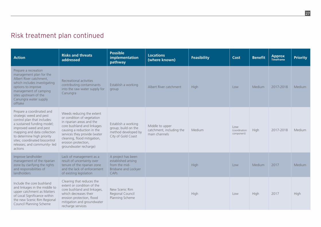
Risk treatment planThe actions in the Action Plan have been developed through a risk assessment and prioritisation process.
ActionRisks and threats addressed
Possible implementation pathway
Locations (where known)
Feasibility Cost Benefit Approx Timeframe
Priority
Develop a continuous Albert River riparian corridor in priority sites
Targeted program of weed management riparian planting and landowner engagement
Albert River between Cedar Creek and the Stanmore Road Bridge
Initial focus on State and Council assets
Medium Medium High 2017-2020 High
Work with landholders to protect and maintain high value riparian areas and enhance areas of high risk
Streambank and gully erosion as a result of land management practices causing a decline in fisheries, habitat, water quality (after fisheries) and recreation services of the estuary due to sediment
Initial sites as per the investment map
Undertake an assessment to identify priority areas and on-ground works
Establish a coordinated catchment-wide engagement program
Initial sites as per the investment map
High Medium High 2017 High
Investigate the establishment of Soil Conservation Project Areas under the Soil Conservation Act 1986 for high risk erosion areas
Erosion as a result of land management practices causing a decline in fisheries and recreation services of the estuary
Investigate preparing a project plan for high risk areas in consultation with individual owners
Knapps Creek
Cannon CreekUnknown Low High 2017 Medium
Improve capacity to implement and ensure compliance of existing requirements for erosion and sediment control on construction sites
Sediment eroding from construction sites causing a decline in fisheries and recreation services of the estuary
Establish a ten year program
Priority focus on urban development in Yarrabilba, Greater Flagstone and Bromelton
Consider Local Government controlled growth areas within program such as Bahrs Scrub, Meadowbrook and Park Ridge
Medium – previous concerted efforts (e.g. Sunshine Coast Council) have been effective but only where there is strong organisational support
Low-Medium
High Continue High

24
ActionRisks and threats addressed
Possible implementation pathway
Locations (where known)
Feasibility Cost Benefit Approx Timeframe
Priority
Encourage land use in the mid and upper catchment to be matched to land suitability by mapping Agricultural Land Use Class C and D
Erosion as a result of land management practices causing a decline in fisheries and recreation services of the estuary
Investigate use planning controls and/or strategic purchase of land where multiple benefits can be achieved
Updated soil mapping that includes the location of Class C and D agricultural land will be available from Department of Natural Resources and Mines in 2018
Unknown Low-high Medium 2018-2020 Medium
Remove Luscombe Weir to improve fisheries outcomes
The risk of movement of catadromous fish species (i.e. short-finned eel (Anguilla australis), long-finned eel (Anguilla reinhardtii), Australian bass (Macquaria novemaculeata), jungle perch (Kuhlia rupestris), Mangrove Jack (Lutjanus argentimaculatus) and sea mullet (Mugil cephalus) being restricted by weirs, culverts and dams
Coordination between City of Gold Coast, Logan City Council and DAF
Luscombe Weir on the Albert River
High – Luscombe Weir is the major barrier to fish movement. City of Gold Coast has already undertaken a number of studies to investigate options
High High 2018-2020 Medium
Work with landholders who are within 2 km upstream of the Kooralbyn, Rathdowney and Canungra water supply offtakes to reduce contaminants by exclusion of stock, waste management and riparian protection
Raw water contaminant loads (protozoa, turbidity and ammonia) exceed the treatment capacity of the WTPs leading to a disruption, or increased cost, to supply water
Coordinated land management programs to prioritise sites
2 km upstream of the Kooralbyn and Rathdowney water supply offtakes
Upstream of the Canungra water supply offtake
Medium Medium High Continue High
Risk treatment plan continued

25
ActionRisks and threats addressed
Possible implementation pathway
Locations (where known)
Feasibility Cost Benefit Approx Timeframe
Priority
Strengthen existing institutional arrangements to ensure developments within water supply buffer areas comply with the outcomes and measures within the Seqwater Development Guidelines: Development Guidelines for Water Quality Management in Drinking Water Catchments 2012
Development and activities contributing contaminants at water supply offtakes
Seqwater, Scenic Rim Regional Council and Coordinator-General to establish a working group with input from additional stakeholders and investigate a specific mechanism
Water supply buffer areas High Low Medium 2017 High
Investigate options to minimise the impacts of the disposal of spent chicken farm litter on horticultural and turf farms within the Rathdowney, Kooralbyn and Cedar Grove WTP offtake zones
Waste from chicken farms contributing contaminants into the raw water supply for water supply offtakes
Establish a working group
Middle to upper catchment (see map in Catchment Report that shows the location of existing chicken farms)
Medium Low Medium 2017 High
Clarify jurisdiction, thresholds and compliance performance for environmental relevant activities associated with animal-based farming and industry within the Rathdowney, Kooralbyn, Canungra and Cedar Grove WTP offtake zones
Agricultural and industry activities contributing contaminants into the raw water supplies for Rathdowney, Kooralbyn, Canungra and Cedar Grove
Establish a working group
Sites of particular concern are upstream of Kooralbyn, Rathdowney and Canungra water supply and proposed Cedar Grove WTP
Medium Low Medium 2017 Medium
Risk treatment plan continued

26
27
ActionRisks and threats addressed
Possible implementation pathway
Locations (where known)
Feasibility Cost Benefit Approx Timeframe
Priority
Prepare a recreation management plan for the Albert River catchment, which includes investigating options to improve management of camping sites upstream of the Canungra water supply offtake
Recreational activities contributing contaminants into the raw water supply for Canungra
Establish a working group
Albert River catchment High Low Medium 2017-2018 Medium
Prepare a coordinated and strategic weed and pest control plan that includes: a sustained funding model; improved weed and pest mapping and data collection to determine high priority sites; coordinated biocontrol releases; and community- led actions
Weeds reducing the extent or condition of vegetation in riparian areas and the core bushland and linkages causing a reduction in the services they provide (water cleaning, flood mitigation, erosion protection, groundwater recharge)
Establish a working group; build on the method developed by City of Gold Coast
Middle to upper catchment, including the main channels
MediumLow
(coordination component)
High 2017-2018 Medium
Improve landholder management of the riparian zone by clarifying the rights and responsibilities of landholders
Lack of management as a result of uncertainty over tenure of the riparian zone and the lack of enforcement of existing legislation
A project has been established arising from the mid-Brisbane and Lockyer CAPs
High Low Medium 2017 Medium
Include the core bushland and linkages in the middle to upper catchment as Matters of Local Significance within the new Scenic Rim Regional Council Planning Scheme
Clearing that reduces the extent or condition of the core bushland and linkages, which decreases their erosion protection, flood mitigation and groundwater recharge services
New Scenic Rim Regional Council Planning Scheme
High Low High 2017 High
Risk treatment plan continued
28
Blank Page
ActionRisks and threats addressed
Possible implementation pathway
Locations (where known)
Feasibility Cost Benefit Approx Timeframe
Priority
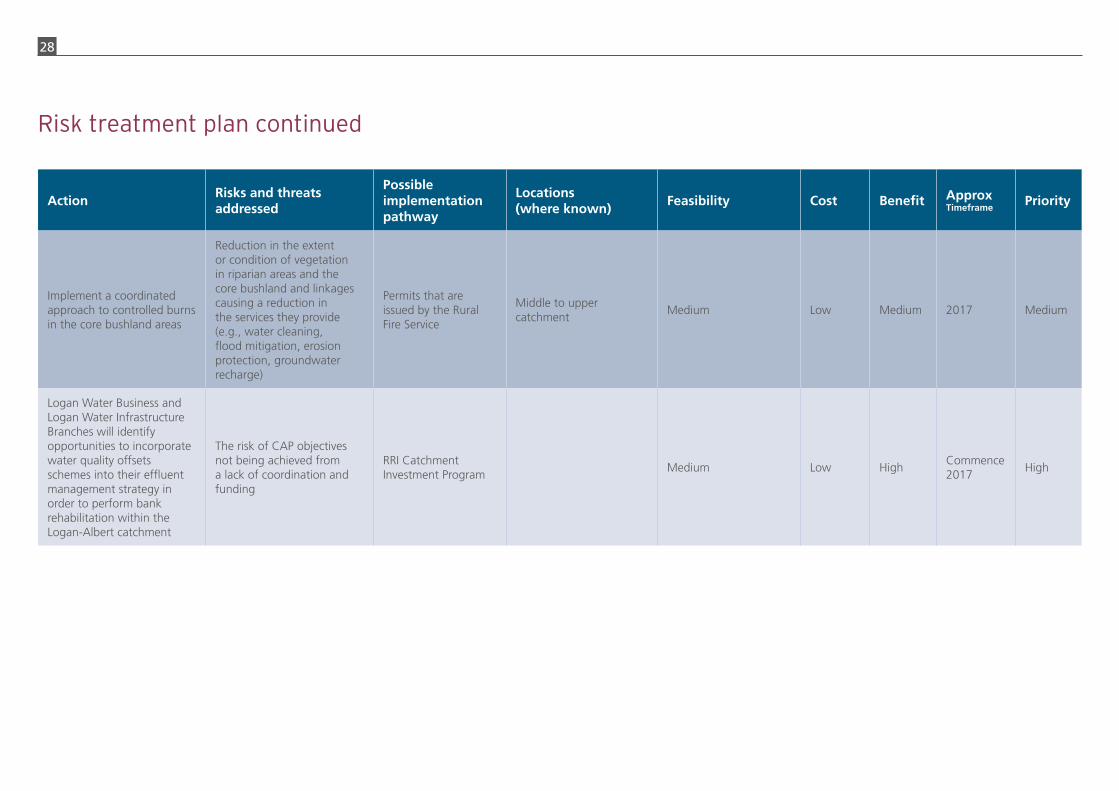
Implement a coordinated approach to controlled burns in the core bushland areas
Reduction in the extent or condition of vegetation in riparian areas and the core bushland and linkages causing a reduction in the services they provide (e.g., water cleaning, flood mitigation, erosion protection, groundwater recharge)
Permits that are issued by the Rural Fire Service
Middle to upper catchment
Medium Low Medium 2017 Medium
Logan Water Business and Logan Water Infrastructure Branches will identify opportunities to incorporate water quality offsets schemes into their effluent management strategy in order to perform bank rehabilitation within the Logan-Albert catchment
The risk of CAP objectives not being achieved from a lack of coordination and funding
RRI Catchment Investment Program
Medium Low HighCommence 2017
High
Risk treatment plan continued

29
Review of progress
Information gaps and emerging studies
This Action Plan and supporting documents will be updated by January 2020 with relevant information that arises.
A number of knowledge gaps were identified during the preparation of the Action Plan.
An up-to-date understanding of stability or erosion risk in priority sub-catchments is required which is sufficient to identify specific sites to undertake works. Available information is currently not at a scale sufficient for site specific, detailed actions to be identified. Healthy Waterways and Catchments is undertaking an assessment of threats soil at a sub-catchment scale across SEQ. The resulting tool may assist investors to initially identify priority sub-catchments for future investment for streambank and gully remediation.
The Logan River Vision Study is being conducted by Logan City Council and is due for release in 2017. It will provide information to inform planning and development decisions in the lower catchment.
The fisheries (commercial and recreational) of the estuary were identified through the preparation of the Action Plan to be an important value provided by that asset. The effect of sediment on fisheries in the Logan River estuary is not fully understood. Logan City Council has commissioned an economic study on the value of the Logan River.
Detailed risk to infrastructure and assets from flooding was identified as an information gap. Currently the risk is considered to be low, but as the area within the catchment
becomes more urbanised, there is potential for flooding impacts to increase even under average rainfall conditions due to increased impermeable surfaces. The floodplain of the Logan and Albert rivers currently provides invaluable capacity. An agreed floodplain risk management plan for the catchment is arguably required.
The Department of Natural Resources and Mines is undertaking a landscape assessment to address catchment management and resource planning issues in the Logan and Albert catchment. The Logan-Albert Resource Assessment project will produce an updated data set of land resource information at a scale of 1:50,000 to 1:100,000 (including soil mapping) that provides information to assist landholders and regulatory authorities to identify land suitable and unsuitable for agricultural production.
The SEQ Regional Plan is being reviewed in 2016-17 and may inform a future review of this Action Plan.
Monitoring and evaluation
Progress on action implementation will be monitored through the reporting framework to be established under the Resilient Rivers Initiative, including an evaluation to be conducted in 2018. The reporting framework will incorporate the SEQ Healthy Waterways Report Card (water quality) and other key information sets such as wetland extent changes via the WetlandInfo website.
Monitoring by CSIRO as part of the Terrestrial Ecosystem Research Networks’ SEQ peri-urban supersite on the Logan River may inform this Plan.

30
Attachment A. Previous studies and planning activities – catchment wide
Study/Investigation Prepared by Description
Logan-Albert Rivers Catchment Management Strategy
Logan and Albert Rivers Catchment Association Incorporated, 2003
A comprehensive and ambitious implementation plan with six themes (caring for land; caring for water; caring for biodiversity; caring for coasts and seas; understanding and participating; and integrated planning and coordinated management). The 122 actions are grouped into the following categories: participative research, education/extension on-ground action and legislative recommendations. A key strength of the plan was that it ‘attempt[ed] to blend scientific knowledge with community initiatives and “fill the gap” that currently exists between the two’.
Logan-Albert Catchments Action Plan 2007-2012
SEQ Healthy Waterways Partnership, 2007
Part of the SEQ Healthy Waterways Strategy 2007-2012. The target for the action plan was “[by] 2026, the Logan-Albert catchments will be managed, and rehabilitated to achieve the Environmental Values and Water Quality Objectives of the Logan-Albert catchments’ waterways and the Moreton Bay receiving waters.” Six major areas seen as critical to address in order to achieve this and the other catchments action plans: Point source pollution management, non-urban diffuse source pollution management, water sensitive urban design, protection and conservation, ecosystem health monitoring, communication, education and motivation. Water quality was the sole focus and only actions that organisations had committed to undertake were included.
Total Water Cycle Management Plan for Redland City Council
BMT WBM, 2013 for Redland City Council
A comprehensive suite of actions were identified for the parts of Serpentine Creek, Native Dog Creek and California Creek that are in Redland City Council. These include rural best management practices for grazing land and poultry farms, rehabilitation of poorly performing water bodies, improved management of unsealed roads and restricting 4WD access to waterways. To mitigate impacts from development in the catchment of Native Dog Creek, BMT WBM recommended increased implementation and enforcement of erosion and sediment control, and ‘better than existing’ requirements for stormwater management.
Logan Waterways and Wetlands Recovery Plan 2014-2024
Logan City Council, 2014
This plan is the key document setting the City of Logan’s strategic direction for its waterways. The vision for Logan’s waterways is to work together to support healthy rivers and wetlands that sustain Logan’s culture, lifestyle and livelihood. The three strategic outcomes of the plan is to strengthen community connection, sustaining productive waterways and enhancing waterway health and resilience. Council is delivering the actions listed within the plan to protect and recover Logan’s waterways and encourage Logan residents, government, business and industry to assist with its implementation
Gold Coast Catchment Management Strategy
WBM, 2002 for Gold Coast City Council
Aquatic and Riparian Ecological Assessment Study, Volume 7 – Logan-Albert Catchment. This assessment study supplemented the Nature Conservation Strategy to produce a catchment based ecological assessment of all waterways of the Gold Coast. The report provides an environmental resource management database to identify pressures on aquatic and riparian ecosystems, provide recommendations for further studies and provide management recommendation for maintenance and enhancement of aquatic and riparian ecosystems in the City of Gold Coast.
Biodiversity Strategy 2015-2025
Scenic Rim Regional Council, 2015
The role of the Strategy is to inform Council planning and operational activities including the development and implementation of the Planning Scheme and policies. It will also assist Council decision making and community initiatives and drive a range of targets, strategies and actions that will deliver the corporate vision. Identifies the core bushland areas within the Council Local Government Area.
SEQ NRM Plan Update SEQ Catchments Ltd, 2016
A SEQ region-wide natural asset condition assessment and identification of targets. Contains region-wide maps of key natural assets. Actions identified for ‘local area’ refer to the preparation of Catchment Action Plans. Supplemented by the SEQ Natural Assets Atlas, Update 2015.

31
Attachment B. Previous studies and planning activities – soils and erosion
Study/Investigation Prepared by Description
Logan River and Tributaries River Habitat and Processes Study
Hydrobiology Pty Ltd, January 2002
Provides a ‘state of’ the catchment report including condition and trends. Identified condition targets and management strategies.
Geomorphic assessment of Rivers Series: Logan-Albert Catchment
Department of Natural Resources, Mines and Energy, April 2004
Description of reaches (geomorphic breakdown) for streams in the catchment.
The distribution of erosion in the upper catchments of the Logan and Albert Rivers
Land Resource Assessment and Management Pty Ltd, July 2007
Identified severe irreversible erosion in Knapps and Cannon Creeks catchments. Recommended addressing grazing land management and the management of roads and riparian zones in more severely eroded areas.
Sediment sources and transport to the Logan-Albert River estuary during the January 2008 flood event
CSIRO, 2010With a focus on turbidity in the estuary, identified the principal sediment source areas and processes that occurred during the flood event.
Biophysical characteristics Lockyer, Bremer and Albert-Logan Catchments
Department of Primary Industries and Fisheries, July 2009
Prepared to support the FarmFLOW project as part of the Healthy Country Project.
Rehabilitation priorities Knapp Creek – Final Report
Jon Olley et al, December 2009Prepared as part of the Healthy Country Project. Desktop study providing detailed sediment budgets and management priorities for the sub-catchment.

32
Images courtesy of Council of Mayors (SEQ), Seqwater, Department of Environment and Heritage Protection, SEQ Catchments, Healthy Waterways, Logan City Council, Redland City Council, Scenic Rim Regional Council, Queensland Urban Utilities and City of Gold Coast
Related Documents