Localization of Wireless Terminals using Smart Sensing Shahrokh Valaee Wireless and Internet Research Lab (WIRLab) Dept of Electrical and Computer Engineering University of Toronto www.comm.utoronto.ca/~valaee

Localization of Wireless Terminals using Smart Sensing Shahrokh Valaee Wireless and Internet Research Lab (WIRLab) Dept of Electrical and Computer Engineering.
Dec 19, 2015
Welcome message from author
This document is posted to help you gain knowledge. Please leave a comment to let me know what you think about it! Share it to your friends and learn new things together.
Transcript
Localization of Wireless Terminals using Smart Sensing
Shahrokh ValaeeWireless and Internet Research Lab (WIRLab)Dept of Electrical and Computer EngineeringUniversity of Torontowww.comm.utoronto.ca/~valaee

2
Wireless and Internet Research Laboratory (WIRLab)
A laboratory built by funds from: Canadian Foundation for Innovation (CFI) Ontario Innovation Trust (OIT) Several industrial partners
The research focus at WIRLab is on Wireless Networks and Signal Processing

3
WIRLab Architecture The equipment is organized into multiple layers to
emulate various networking architectures: Core network with high-end L2/L3 switches and soft
routers; Several access points with capability for multiple
standard support; Numerous wireless devices such as notebooks, PDAs,
wireless cameras, etc, for mesh or multi-hop communications;
Wireless robots for mobility management; Sensors equipped with localization devices for
environmental monitoring and location estimation; DSRC/WAVE devices for fast MAC and rapid network
acquisition used in mobile communications at vehicular speeds.
The lab can simulate almost all network configurations and various topologies.

4
Team of Researchers last six years
Director: Shahrokh Valaee Professors on Sabbatical: 7 Visiting Researchers: 4,
(LG Electronics, SONY, ETRI)
Post-doctoral Fellows: 6 PhD Students: 15 MASc Students: 15 Visiting PhD Students: 7 Visiting MASc Students: 1 Undergrad students: 40+
5
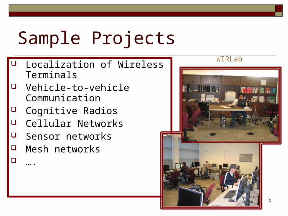
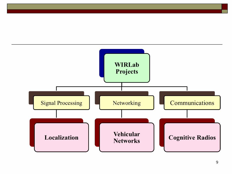
Sample Projects Localization of Wireless Terminals Vehicle-to-vehicle Communication Cognitive Radios Cellular Networks Sensor networks Mesh networks ….
WIRLab

6
Cellular Networks High Bandwidth
communication for Maglev Trains
PAPR reduction through network coding (LGE) Joint patent
Instantly Decodable Network Coding (IDNC)
Spectrum Sensing

7
Vehicular Networks
Low latency communications for vehicular environment
Opportunistic Network Coding for data broadcast
Enhanced reliability through Positive Orthogonal Codes
V2X (pedestrian, cyclists) communications
Localization of vehicles

Localization of Wireless Nodes
8
Localization of mobile phones Compressive Sensing
Patent licensed Android and Windows
implementation SLAM Crowdsourcing Using Camera for Localization
9
Localization of Wireless Terminals using Smart Sensing Indoor Localization

11
Objective
To design an accurate indoor navigation system that can be easily deployed on commercially available mobile devices without any hardware modification.

Motivation
Regulations: E911
Commercial: shopping mall advertisement
Assistive: visually challenged
Precision
increases
12

Where Am I?
13
Sense the environment and find your location

Sensors in Mobile Phones RF Signal Scanner Accelerometer Gyroscope Barometer Magnetometer Thermometer Photometer …
14
Software Sensors
Orientation
Rotation Matrix
Gravity
Linear Accelerometer
Rotation Vector
Game Rotation Vector
Camera GPS …

Integrated Solution
15
Localize and
Track

RF Sensing & Localization Beacon-based
Proximity RSS-based
Fingerprinting Time-of-Arrival
GPS
16

iBeacon Uses Bluetooth Low Energy
(BLE)
Small battery-operated transmitters
Used in consumer market
17

Localization based on Proximity
18

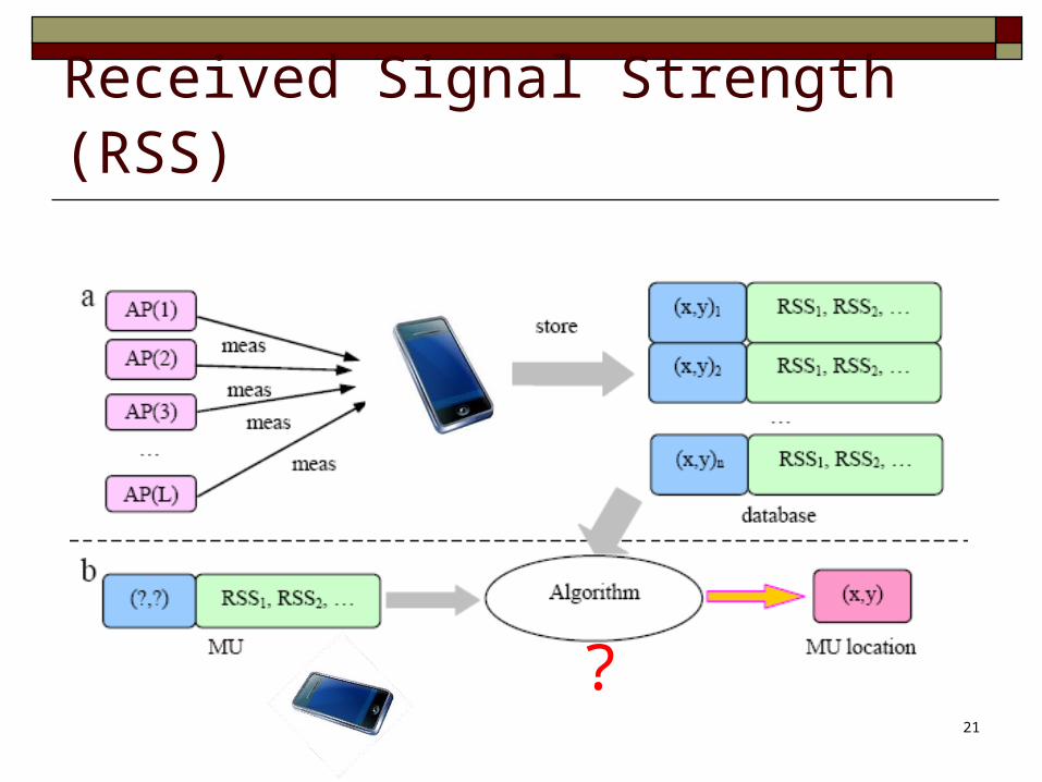
Localization via RF Fingerprinting Off-line measurements (site survey) On-line localization

20
Fingerprinting
Collect fingerprints and store
Measure and compare
Off-line
On-line
21
Received Signal Strength (RSS)
?
22
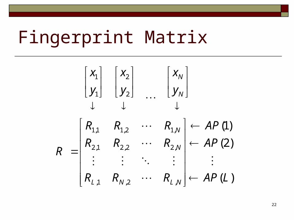
Fingerprint Matrix
)(
)2(
)1(
,2,1,
,22,21,2
,12,11,1
2
2
1
1
LAP
AP
AP
RRR
RRR
RRR
R
y
x
y
x
y
x
NLNL
N
N
N
N

23
Online Localization
The problem is underdetermined if L < N infinite solutions
L: no. of WiFi access points
N: no. of fingerprints
Radio map MeasurementUnknown Location
Assuming sparsity

Compressive Sensing The location of user can be found via the following convex programming
Number of samples: C K log(N)24
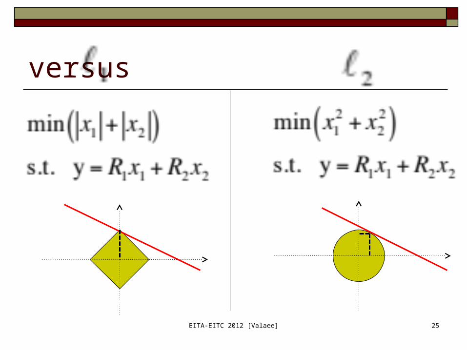
versus
EITA-EITC 2012 [Valaee] 25

26
Skip the details
Indoor Navigation
System
Patents and Licenses S. Valaee, C. Feng, and A. W. S. Au, “System, Method, and Computer
Program for Anonymous Localization,” US non-prov patent, EFS ID 9022070, Application ID 12/966493 filed Dec 2010, Notice of Allowance issue on 12/05/2014.
S. Valaee, C. Feng, and A, Au, “System, Method, and Computer Program for Anonymous Localization,” Canadian patent, Reference no. 100 5050700 M, filed Dec 2010.
S. Valaee and C. Feng, “System, Method, and Computer Program for Dynamic Generation of a Radio Map for Indoor Positioning of Mobile Devices, “US Patent Application, Application number 13/927510, Filed June 26, 2013.
27

CNIB Testbed Demo
28Canadian National Institute for the Blind

Evaluation Results
29
30 blind subjects interviewed by a doctor 15 testing group 15 control group
3 tests for each subject

30
Bayview Village Shopping Center

31
Accuracy (positioning in BV)
Site Survey via Crowd Sourcing Accelerometer Sensing Step Counter

Off-line Phase A radio map includes
A grid of points (labeled points) in the service area
RSS measurements at each point
33
AP(2)
AP(L) AP(l)
AP(1)
Access Points (APs)
Labelled Points (reference points) Data Points
MAC1
MAC2
MAC3
MAC4
MAC5
MAC6
MAC7
- 89
- 78
- 91
- 85
- 92
- 77
- 72
33

34
Off-line Phase: Speedup
Collect RSS readings while walking
Need for a location estimation method
AP(2)
AP(L) AP(l)
AP(1)
Access Points (APs)
Labelled Points Data Points
Auto-Labelled Points

35
Android Motion Sensors
Take advantage of various sensors information. Each Android device has a combination of:
Accelerometer Gyroscope Magnetic Field sensor (compass) ….
Linear Acceleration Information

36
Position Estimation with Step Counter
Position can be estimated given the initial location, speed, and heading directions
With the help of accelerometer, it is possible to make a step counter to estimate the coordinates of RSS readings
Acceleration samples

37
Step Counter Accuracy
Test1 Test2 Test3 Test4 Test5 Test6
Phone Samsung S1
Samsung S1
Samsung Tab
Motorola RAZR
HTC Desire Z
LG Nexus 4
Tester id P1 P1 P1 P1 P2 P3
Actual steps:
40 60 60 80 50 100
Counted steps:
39 60 60 79 49 98
Accuracy 97.5% 100% 100% 98.75% 98% 98%

38
Speedup in Data Acquisition
Manually labeled data:21 labeled points in approx. 15 min.
Bahen Centre 4th floor, 70m x 80m
Auto-labeled data:347 labeled points in approx. 12 min.
39
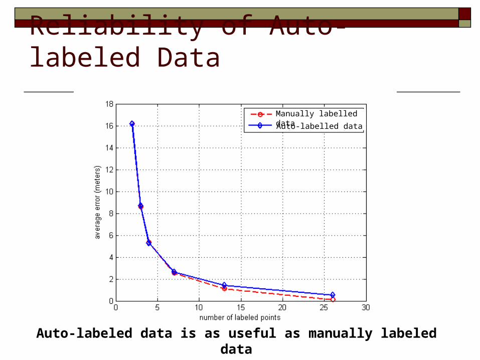
Reliability of Auto-labeled Data
Auto-labeled data is as useful as manually labeled data
Manually labelled dataAuto-labelled data

40
Crowd Sourcing
Traces from casual users The answer to several issues:
Removing the training phase Radio map maintenance
Using Graph theory, we can build a completely unsupervised system Combine traces from multiple users to build the radio
map
Demos
41
Floor DetectionPressure Sensing
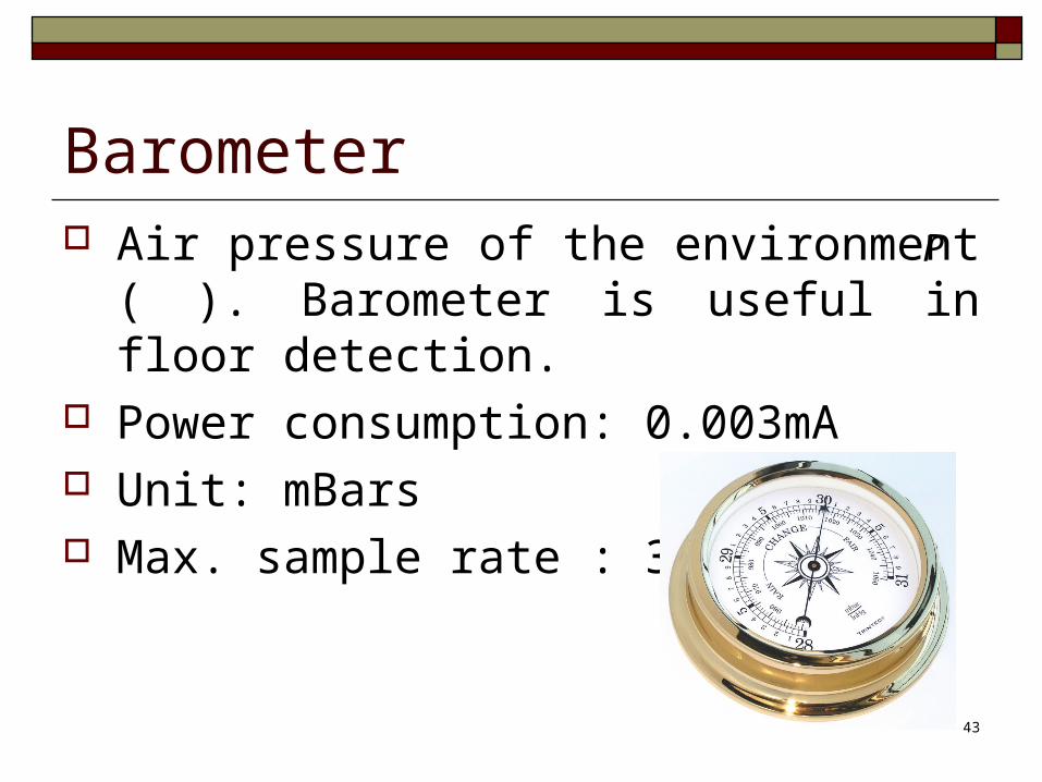
Barometer Air pressure of the environment ( ).
Barometer is useful in floor detection. Power consumption: 0.003mA Unit: mBars Max. sample rate : 30 Hz
43
P

Barometric Data Air pressure for different floors of Bahen
Centre.
440 5 10 15 20 25 30 35 40 45 50
994
994.5
995
995.5
996
996.5
997
997.5
998
998.5
999Air Pressure, Bahen building, sunny day
Time(s)
Pre
ssur
e(m
Bar
)
1st floor
2nd floor3rd floor
4th floor
5th floor
6th floor7th floor
8th floor

Floor detection
View of 3D Map
0
500
1000
1500
0
500
1000
1500
20000
2
4
6
8
45
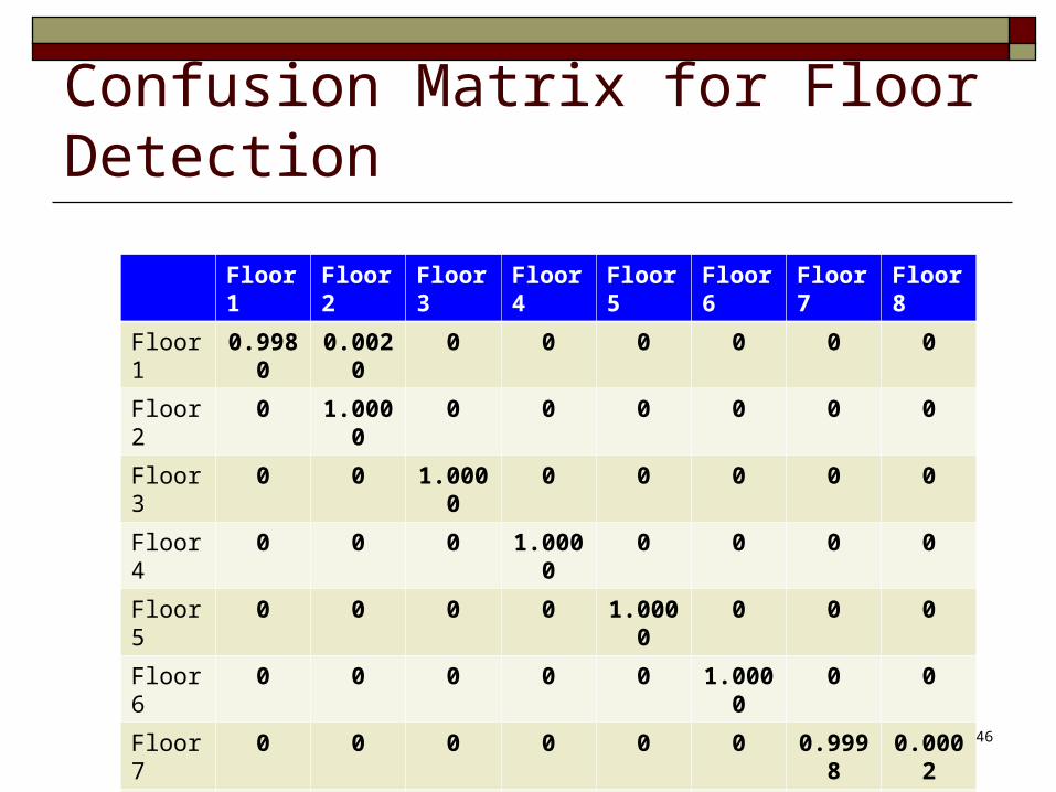
Confusion Matrix for Floor Detection
Floor 1 Floor 2 Floor 3 Floor 4 Floor 5 Floor 6 Floor 7 Floor 8
Floor 1 0.9980 0.0020 0 0 0 0 0 0
Floor 2 0 1.0000 0 0 0 0 0 0
Floor 3 0 0 1.0000 0 0 0 0 0
Floor 4 0 0 0 1.0000 0 0 0 0
Floor 5 0 0 0 0 1.0000 0 0 0
Floor 6 0 0 0 0 0 1.0000 0 0
Floor 7 0 0 0 0 0 0 0.9998 0.0002
Floor 8 0 0 0 0 0 0 0 1.0000
46

Transmit sensor data of the phone to a PC running MATLAB in real-time.
We deploy algorithms in MATLAB rather than JAVA. Much Faster!
Implementation of Algorithms
47

Conclusion Sensory data from smartphones can be used to
localize wireless devices indoors Compressive Sensing is used to enhance sensing
and localization Accelerometer and Gyro are used for
crowdsourcing Pressure sensor is used for floor detection Direct connection between sensor data and
MATLAB reduces the implementation time 48
Related Documents