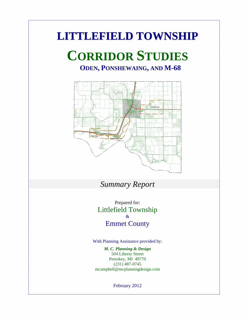
L L I I T T T T L L E E F F I I E E L L D D T T O O W W N N S S H H I I P P CORRIDOR STUDIES ODEN, PONSHEWAING, AND M-68 Summary Report Prepared for: Littlefield Township & Emmet County With Planning Assistance provided by: M. C. Planning & Design 504 Liberty Street Petoskey, MI 49770 (231) 487-0745 [email protected] February 2012

Welcome message from author
This document is posted to help you gain knowledge. Please leave a comment to let me know what you think about it! Share it to your friends and learn new things together.
Transcript
LLIITTTTLLEEFFIIEELLDD TTOOWWNNSSHHIIPP
CORRIDOR STUDIES ODEN, PONSHEWAING, AND M-68
Summary Report
Prepared for: Littlefield Township
& Emmet County
With Planning Assistance provided by:
M. C. Planning & Design 504 Liberty Street
Petoskey, MI 49770 (231) 487-0745
February 2012
1.0 INTRODUCTION Background
Littlefield Township is under the jurisdiction of Emmet County regarding Planning and Zoning.
The Littlefield Township Planning Committee serves in an advisory capacity to provide local
input to the County Planning Commission on planning and zoning matters in Littlefield
Township. At the present time Littlefield Township is content with the arrangement of having
Emmet County administer the zoning regulations covering Littlefield Township, based on
Township input.
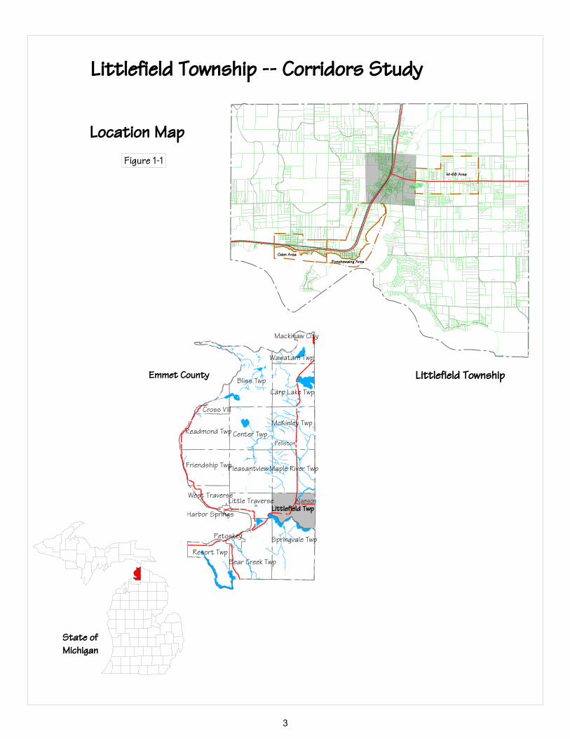
Littlefield Township, with support from Emmet County, conducted a series of three corridor
studies. The three areas of focus are Oden, Ponshewaing and along M-68, just outside of
Alanson, (see Figure 1-1) for the limits of each study area. In order for Littlefield Township to
have a basis for providing additional input on potential zoning ordinance changes, three key
areas in the Township were studied in detail, and the input from property owners sought. By
pursuing a series of corridor studies, the Township was able to direct time and resources to the
areas known to be more complicated in terms of planning and zoning; and thus identify the
issues, examine a number of concepts to address the identified issues and present a preferred
alternative for each area.
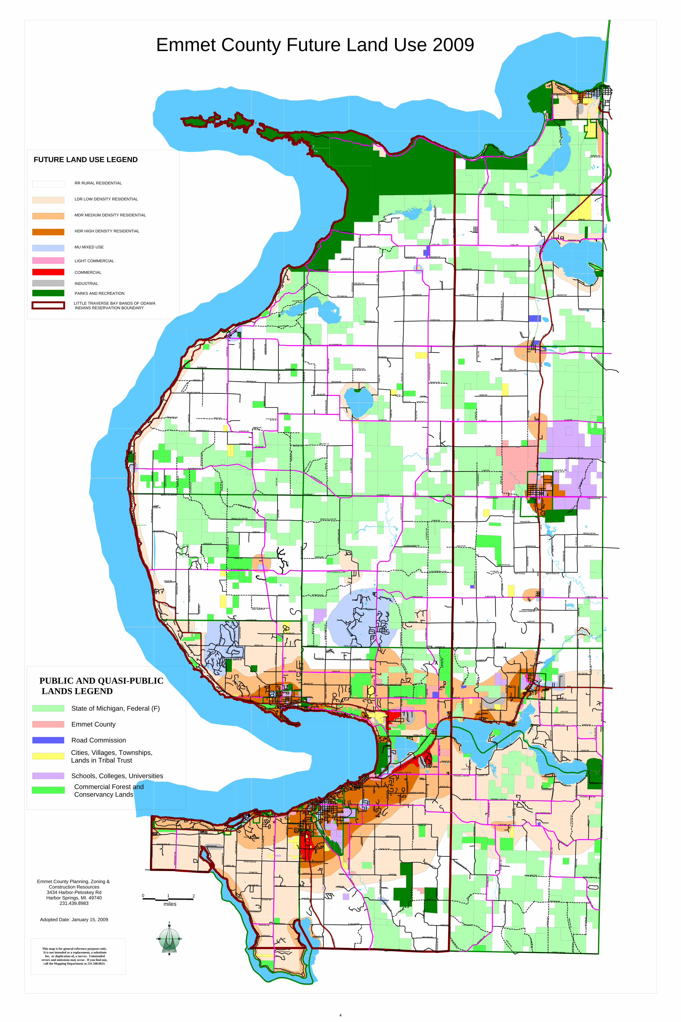
In 2009, the Emmet County Planning Commission and County Board of Commissioners adopted
a Master Plan to guide future growth and development in Emmet County. While the future land
use map of the County Master Plan provides a general direction for future, (see Figure 1-2), it is
county-wide and is general in nature. This study allowed the Township to build-upon the recent
master planning work done at the County level, and further review and refine how and where the
Township would like to guide growth and development for these three corridor areas. The
locally proposed or refined development strategies for these three corridors are provided to the
Littlefield Township Board, following review and finalization by the Littlefield Township
Planning Committee. The Township Board can then, at their discretion, decide whether and
when to send any or all of the recommendations of this study to the County Planning
Commission for consideration as the Emmet County Zoning Ordinance is fully reviewed.
1
By pursuing a series of corridor studies, the Township was able to direct time and resources to
the areas known to be more complicated in terms of planning and zoning; and thus identify the
issues, examine a number of concepts to address the identified issues and present a preferred
alternative for each area. The strategies and recommendations of this study provide Littlefield
Township a strong basis for requesting consideration of potential zoning ordinance changes, as
related to the three corridor areas in the Township.
Each corridor study was designed to: 1) Identify local issues and concerns; 2) Review existing
conditions (opportunities and constraints), including but not limited to the existing land uses,
environmental factors, planned future land use and the existing zoning for each area; 3) Identify
Factors for consideration and obtain public input; 4) Present corridor options for public
discussion; and 5) Identify strategies and recommendations.
The consultant worked with the Township and County on each of the corridor study areas. A
questionnaire was developed for each corridor and mailed to property owners within the defined
study area for each Corridor, in order to more accurately gauge the views of property owners in
each corridor area. The initial findings for each corridor area were presented at a public forum
specific to the individual corridor, and additional public input was solicited. Following the
public forum, all input was considered and strategies and recommendations were developed and
refined. The findings for each study area are discussed separately in this summary report.
2
Oden Area
Ponshewaing Area
M-68 Area
Bliss TwpCarp Lake Twp
Wawatam Twp
McKinley TwpCenter TwpReadmond Twp
Cross Vill
Friendship TwpPleasantviewMaple River Twp
West TraverseLittle Traverse
Springvale Twp
Bear Creek TwpResort Twp
Alanson
Pellston
Mackinaw City
Harbor Springs
Petoskey
Littlefield Twp
Littlefield Township -- Corridors Study
Location MapFigure 1-1
State ofMichigan
Emmet County Littlefield Township
3
N L
AM
KIN
RD
S LAM
KIN
RD
W T
OW
NLI
NE
RD
KAWE-GOMA RD
BOYNTON RD
M-119
N L
AK
E SH
OR
E D
R
CH
UR
CH
RD
BEAC
H RD
N LA
KE S
HORE
DR
TER
PEN
ING
RD
S LAKE SHORE DR
LOW
ER SH
OR
E DR
TROUP RD
FIVE
MIL
E C
REE
K R
D
GEA
RY
RD
N H
AN
NA
H R
D
MIDDLE VILLAGE DR
W ROBINSON RD
WIL
DER
NE S
S R
D
LON
E R
OC
K R
D
JOH
NST
ON
RD
PIKE RD
ORCHARD RD
VOR
CE
RD
WIL
KINS
ON RD
ISLAND VIEW RD
GU
LLY
RD
WORMWOOD LN
N LAKE SHORE DR
DIVISION RD
LOWER SHORE DR
MIDDLE RD
FIVE
MIL
E C
REE
K R
D
CU
MM
ING
SLN
TRILLIUM TR
WEB
B R
D
RADLE RD
S B
EAC
ON
HIL
L LN
TREE
IDYLWILDE DR
WINDEMIRE DR
OTIS LN
TIM
BER
PINE
TR
CAND
LEW
OOD
MA
PLE
WA
Y
BIRCHWOOD
S LAKE SHORE DR
TUR
FWA
Y TR
L
HU
GH
STO
N R
D
FAIR
WA
YS D
R
STONEY
HILL CT
GOLFVI
EW R
D
PINECREST
PASS
GR
EENB
RIA
R R
D
GREENBRIAR RD
N S
TATE
RD
N STATE RD
TRICK RD
OSBORNE RD
BECKON RD
CHIPPEWA DR
N S
TAT E
RD OA
K D
R
CEM
ETER
Y R
D
RID
GE
RD
GRIFFIN DR
COOK PT DR
WINDW
ARDPSG
MARION
DR
HURD RD
NISWANDER RD
MIDDLE VILLAGE DR
N S
TATE
RD
N F
RA
NK
RD
LA COUNT RD
WEST WOOD LN
W STUTSMANVILLE RD
FISHER RD
CEM
ETE R
Y R
D
MIDDLE RD
W LAKE ST
HUGHSTON RD
LIG
HTF
OO
T R
D
HIL
L R
D
FORSTER RD
DIVISION RD
LOO
KO
UT
DR
W VAN RD
W VAN RD
QUARTER MILE RD
RU
GG
ED R
D
ST N
ICH
OL A
S R
D
ZULSKI RD
MELODY LN
JOHNSTONHILL RD
TEA
L R
D
GR
EGO
RY
RD
CET
AS
RD
MELODY LN
PALMER RD
W ROBINSON RD
MOO
SE J
AW R
D
S ST
AT E
RD
DR
HO
YT R
D
BESTER RD
PENNSYLVANIA AVBEACH
E LAKE RD
HO
YT R
D
QUICK RD
POINT DR
STUR
GEO
N BA
Y DR W STURGEON BAY TR
N LAKE
SHORE DR
N LAKE
SHORE
DR
WYCAMP RD
WRESSEL RD
FOREST
RIDGE RD
WARWICK RD
WEL
SHEI
MER
RD
EMM
ET H
EIG
HTS
RD
BIG
FO
OT
RD
W BRUTUS RD
HEYNIG RD
AMYS
WAY
FISH
ER R
D
S ST
ATE
RD
CET
AS
RD
WEL
SHEI
MER
RD
S L A
RK
S LA
KE
RD
MIDDLE VILLAGE RD
W STUTSMANVILLE RD
SERVA RD
ZMIK
L Y R
D
ABRAMS RD
N L
AR
KS
LAK
E R
D
BECKON RDDZE
DZI
E R
D
ZMIK
LY R
D
HARBOR PETOSKEY RD
CATOB RD
EMM
ET H
EIG
HTS
RD
QUICK RD
W LEVERING RD
WYCAMP RD
CREEKSIDE RD
AB
RA
MS
RD
ABRAMS RD
BEACH RD
S PL
EASA
NTV
IEW
RD
HED
RIC
K R
D
CATOB RD
FERN AV
HED
RIC
K R
D
HIGHLANDS PIKE
HEATHER DR
GREYST
ONE CT
WOODHILL RD
HEATHER DR
HO
RTO
N B
AY
RD
US-31
PRESERVE DR
TOW
NL I
NE
RD
STOLT RD
MARTINCHEK RD
COASTAL WOODS CT
STOLT RD
PENINSULA DR
VISTA DRCOASTAL RIDGE DR
CA
MP
DA
GG
ETT
RD
OLD US 31
MANTHEI RD
KIEBEL RD
TOW
NSE
ND
RD LA
KE
GR
OVE
RD
US-31
CROOKED TREE DR
STUMP RD
INTERTOWN RD
BLA
CK
BIR
D R
D
KALCHIK RD
LAKE GR
OVE RD
HEMLOCK LN
DEPEW RD
MORFORD RDINDIAN GARDEN RD
BLACKBIRD RD
SCHOOL RD
RES
OR
T PI
KE
RD
SHERIDAN RD
US-31
WILLIAMS RD
CEM
ETER
Y R
D
STERZIK RD
EPPL
ER R
D
HUNTERS RIDGE RD
LINWOOD LN
US-
1 31
GREG RD
INDI
AN G
ARDE
N DR
INDIAN GARDEN DR
RIVER RD
US-
131
AN
DE R
SON
RD
LEARS RD
KEMP RD
INTERTOWN RD
HO
WA
RD
RD
US-131
E GRULER RD
STER
LY R
D
CLICK RD
RIVER RD
HOAG RD
BAYV
IEW
LN
LITT
LEC
EDA
R D
R
COUNTRY CLUB RD
BO
YER
RD
N D
IVIS
ION
RD
E MITCHELL RD
ATKINS RD
NORTH-MEN DR
HA
AS
RD
SHANLEY RD
MC
DO
UG
AL
RD
CED
AR
VA
LLEY
RD
JENSEN RD
CED
AR
VA
LLEY
RD
CLICK RD
ONE MILE RD
W GILL RDW B
L ISS
RD
W LAKEVIEW RD
STRONG RD
W B
LISS
RD C
AN
BY
RD
VALL
EY R
D
CA
NB
Y R
D
E ROBINSON RD
N L
AR
KS
LAK
E R
D
E VAN RD
VALL
EY R
D
LECHOWICZ RD
CA
NB
Y R
D
PYJAR RD
MC
CLE
AR
Y R
D
ELD
ER R
D
MUNGER RD
ELLI
S R
D
VALLEY RD N WILSON RD
MAYLE RD
N P
LEA
S AN
TVIE
W R
D
CENTER RD
VALL
EY R
D
ELY RD
NIC
HO
LS R
D
CO
SEN
S R
D
CASSIDY RD
GARBER RD
KEI
SER
RD
N P
L EA
SAN
T VIE
W R
D
BODZICK RD
ELDER RD
MUNGER RD
MUNGER RD
PHIL
LIPS
RD
E GILL RD
POPA
L R
D
ELY RD
CAMP RD
N D
UR
KA
LIC R
D
ELY
BR
IDG
E R
D
CO
OK
RD
E VAN RD
OR
CH
AR
D R
D
DRIER RD
OLD
SC
HO
OL
HO
USE
RD
E LEVERING RD
SCHMALZRIED RD
HIA
R R
D
LUESING RD
BIL
L R
D
READMOND
BA
LL R
D
BALL RD
STRA
ITS
CECI
L BA
Y RD
POINTE DRE WILDERNESS PARK DR
VIEW DR
REED
RD
LITZ
NER
DR
PACHY RD
US-31
POTT ER
RD
KEIS
ER L
N
HOAR RD
REED
RD
US -
31
WH
EELI
NG
RD
US-31
MA
CK
INA
C H
WY
PARADISE TR
HAYES LN
E GILL RD
DOW RD
OLIVER RD LINSLEY RD
INDUSTRIAL DR
TOW
NLI
NE
RD
DOUGLAS LAKE RD
E BR
ANCH
TR
US-
31
E VAN RD
SILV
ER S
TRA
ND
RD
S N
ICO
LET
RD
S N
OK
OM
IS S
T
W CENTRAL AV
RIDGE RD
E W
ILD
ERN
ESS
PAR
K R
D
VALLEY DR
TRAILS END RDFR
ENC
H LA
KE R
D
I-75
I-75
I-75
I-75
I-75
I-75
I-75
I-75
I-75
WINNIWAY ST
E LEVERING RD
DEKRUIF RD
LAKE SHORE DR
BLAKE DR
SOMMERS RD
SOM
MER
S RD
INGLESIDE RD
PAQUET RD
MA
CK
INA
C H
WY
US-31
E HATHAWAY RD
BATHING
BEACH RD
HARBOR PETO
SKEY RD
PICKEREL LAKE RD
GREENWOOD RD
KO
LIN
SKI R
D
E MITCHELL RD
ALC
AN
RD
MA
PLEW
OO
D D
R ATKINS RD
GREENWOOD RD
SUR
REY
LN
LINTLONG RD
E BEAR RIVER RD
EVERGREEN TR
KING RD
BEN
AL
RD
KING RD
KR
AU
SE R
D
POWELL RD
FOCHTM
AN IND
PARK DR
VISAVIS LN
BEL
LMER
RD
US-3
1
HIAW
ATHA T
R
N C
ON
WA
Y R
D
N F
LETC
HER
RD
PICKEREL LAKE RD
SCHMITT RD
AM
AC
HER
RD
BURKE RD
COUNTRYVIEW RD
RUSTIC RD
COUNTRY CLUB RD
BELLMER RD
S A
YR R
D
POWERS RD
GRAHAM RD
GRAHAM RD
JOY
LN
JOHNSON RD
MAXWELL RD
TAYLOR RD
KING R
D
MA
XWEL
L R
D
STR
AD
DLI
NG
RD
GOKEE RD
JOH
NSO
N R
D
RU
SSET
RD
BER
GER
RD
S SI
LVER
CR
EEK
RD
GREENWOOD RD
S B
LAN
CH
AR
D R
D
AT K
INS
RD
BRUBAKER RD
RUSTIC RD
HEN
CY
RD
CHANNEL RD
PICKEREL LAKE RD
RUSSELLKUEBLER
MOORE RDLUC
E ST
BLU
MK
E R
D
ODEN RD
CHANNEL RD
ODENISLAND RD
WELSH RD
E MITCHELL RD
MA
XWEL
L R
D
WEL
SH R
D
HANNON RD
TRAILS END RD
S ELLSWORTH RD
ARTESIAN LN
N E
LLSW
OR
TH R
DE
MIT
CH
ELL
RD
RO
Y R
D
BACK WEST RD
LAC
RUE
DR
LAK
EVIE
W R
D
BANWELL RD
MC
CA
RTH
Y D
RMCCARTHY DR
E MITCHELL RD
COUNTY LINE RD HEA
T ON
RD
NEWSON RD
BERRY CREEK RD
ATC
HIS
ON
RD
HA
RM
ON
RD
FIRELIN
E RD H
EATO
N R
D
HO
PPE R
RD
TWIL
DO
RD
BOTSFORD LN
BA
NW
ELL
RD
TOWNSHIP
BO
TSFO
RD
RD
PICKEREL LAKE RD
PARK RD
CAMPPETOSEGA RD
FELTER DR FELTER LN
COORS RDMIS
SIO
N R
D
N M
ILLE
R R
D
HAINES RD
OR
CH
AR
D R
D
BO
Y ER
HI L
L R
D
WILDWOOD RD
S SE
LDO
N R
D
HA
RB
OR
PET
OSK
EY R
D
WOODVIEW DR
W CONWAY RD
MIN
K R
DCHADDER
DUVERNAY LN HIDEAWAY RD
CLA
YTO
N R
D
DO
N
MO
ELLE
R D
R
PINE
RD
MANITOBA TR
BEAUX RIVAGES DR
TROUT
CREEK DR
VALLEY RD
CH
AD
DER
DO
N R
D
E BRUTUS RD
S PL
EASA
NTV
IEW
RD
N C
ON
WA
Y R
D
SCHEIRSCHMIDT RD
N C
ON
WA
Y R
D
KIPP RD
KIP
P R
D
DA
YTO
N R
D
SMOKEY LN
EDWARD RD
E STUTSMANVILLE RD
CAMP RD
N A
YR R
D
PHELPS RD
TOWER RD
HIND
S RD
N A
YR R
D
VALLEY RD
CR
UM
P R
D
EDDS RD
MO
OR
E R
D
EDDS RD
CLEMENT RD
VALL
EY R
D
CU
LP R
D
E ROBINSON RD
S D
UR
KA
LIC
RD
LOCKWOOD RD
CLARK RD
E BRUTUS RD
RED
SC
HO
OL
RD
SUN
NY
RID
GE
RD
SPR
ING
ST
MARINA RD
MIL
TON
RD
US-
31
HO
NEY
SETT
E R
D
KIL
MER
RD
CROOKED RIVER RD
CUPP RD
VALLEY RD
BA
NW
ELL
RD
OLD STAGE-COACH DR
POWERS RD
US-3
1
MIL
TON
RD
ARMOCK RD
RINGLER RD
JOHNSON RD
S MILTO
N ST
POPL
AR
DR
US-
31
KU
GLE
R R
D
PIN
E TR
GR
EGO
RY
RD
RED SCHOOL MAPLE RIVER RD
MARATHON WAY
MIS
SIO
N R
D
OLD
STA
TE R
D
SNID
ER R
D
E BRUTUS RD
CED
AR
RD
GR
IGSB
Y R
D
DEVILS
ELBOW
DR
BA
RN
EY R
D
MIL
LER
RD
SMITH RD
N M
ILLE
R R
D
HILLTOP RD
M-68
PLAI
NS R
D
SAND RD
WOODLAND RD
PLA
I NS
RD
E BRANCH R
D
E ROBINSON RD
0 1 2
miles
MU MIXED USE
COMMERCIAL
INDUSTRIAL
LIGHT COMMERCIAL
PARKS AND RECREATION
LITTLE TRAVERSE BAY BANDS OF ODAWA INDIANS RESERVATION BOUNDARY
RR RURAL RESIDENTIAL
LDR LOW DENSITY RESIDENTIAL
MDR MEDIUM DENSITY RESIDENTIAL
HDR HIGH DENSITY RESIDENTIAL
FUTURE LAND USE LEGEND
Emmet County Future Land Use 2009
State of Michigan, Federal (F)
Cities, Villages, Townships, Lands in Tribal Trust
Schools, Colleges, Universities
Emmet County
Road Commission
PUBLIC AND QUASI-PUBLIC LANDS LEGEND
Commercial Forest and Conservancy Lands
This map is for general reference purposes only. It is not intended as a replacement, a substitute
for, or duplication of, a survey. Unintendederrors and omissions may occur. If you find one,
call the Mapping Department at 231.348.0631.
Emmet County Planning, Zoning & Construction Resources
3434 Harbor-Petoskey RdHarbor Springs, MI. 49740
231.439.8983
Adopted Date: January 15, 2009
4
Administrator
Typewritten Text
Administrator
Typewritten Text
HP_Owner
Typewritten Text
HP_Owner
Typewritten Text
HP_Owner
Typewritten Text
HP_Owner
Typewritten Text
Figure 1-2
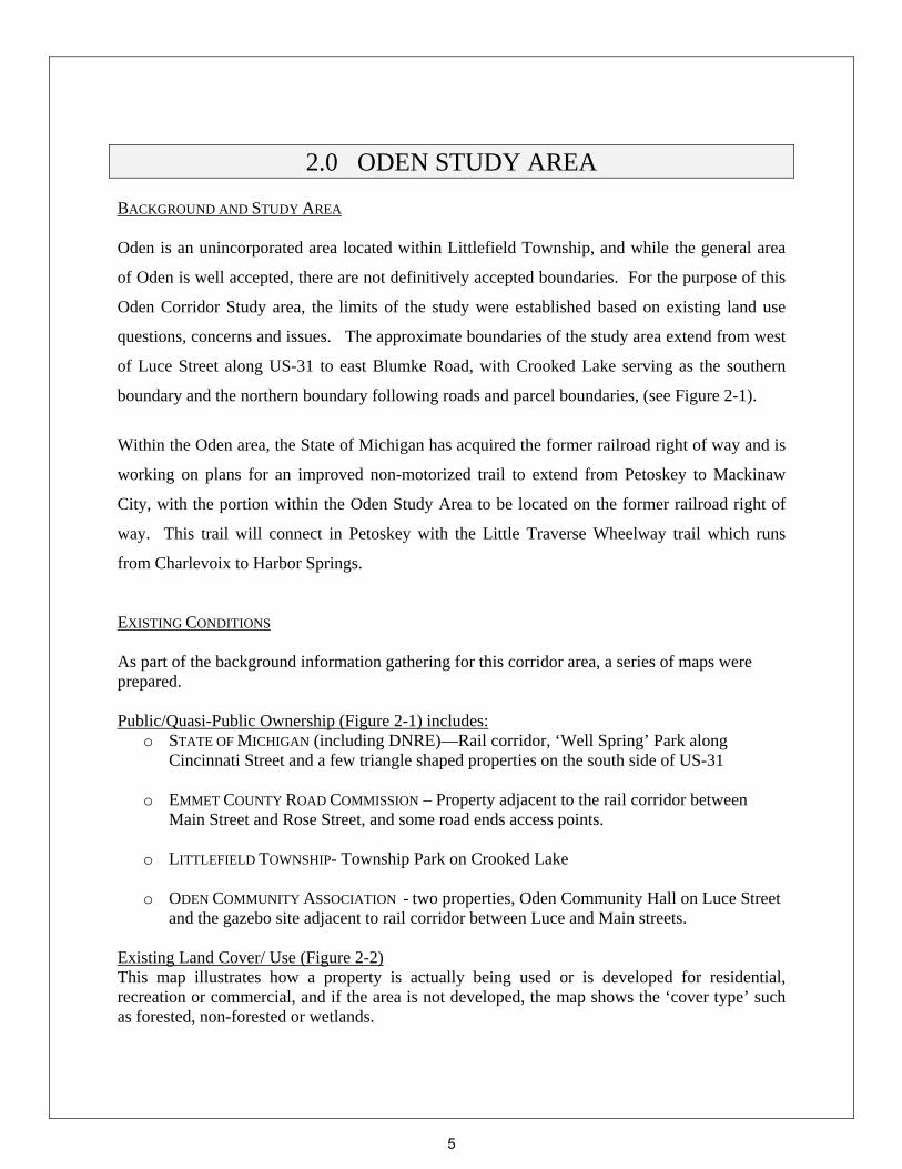
2.0 ODEN STUDY AREA BACKGROUND AND STUDY AREA Oden is an unincorporated area located within Littlefield Township, and while the general area
of Oden is well accepted, there are not definitively accepted boundaries. For the purpose of this
Oden Corridor Study area, the limits of the study were established based on existing land use
questions, concerns and issues. The approximate boundaries of the study area extend from west
of Luce Street along US-31 to east Blumke Road, with Crooked Lake serving as the southern
boundary and the northern boundary following roads and parcel boundaries, (see Figure 2-1).
Within the Oden area, the State of Michigan has acquired the former railroad right of way and is
working on plans for an improved non-motorized trail to extend from Petoskey to Mackinaw
City, with the portion within the Oden Study Area to be located on the former railroad right of
way. This trail will connect in Petoskey with the Little Traverse Wheelway trail which runs
from Charlevoix to Harbor Springs.
EXISTING CONDITIONS As part of the background information gathering for this corridor area, a series of maps were prepared. Public/Quasi-Public Ownership (Figure 2-1) includes:
o STATE OF MICHIGAN (including DNRE)—Rail corridor, ‘Well Spring’ Park along Cincinnati Street and a few triangle shaped properties on the south side of US-31
o EMMET COUNTY ROAD COMMISSION – Property adjacent to the rail corridor between
Main Street and Rose Street, and some road ends access points.
o LITTLEFIELD TOWNSHIP- Township Park on Crooked Lake
o ODEN COMMUNITY ASSOCIATION - two properties, Oden Community Hall on Luce Street and the gazebo site adjacent to rail corridor between Luce and Main streets.
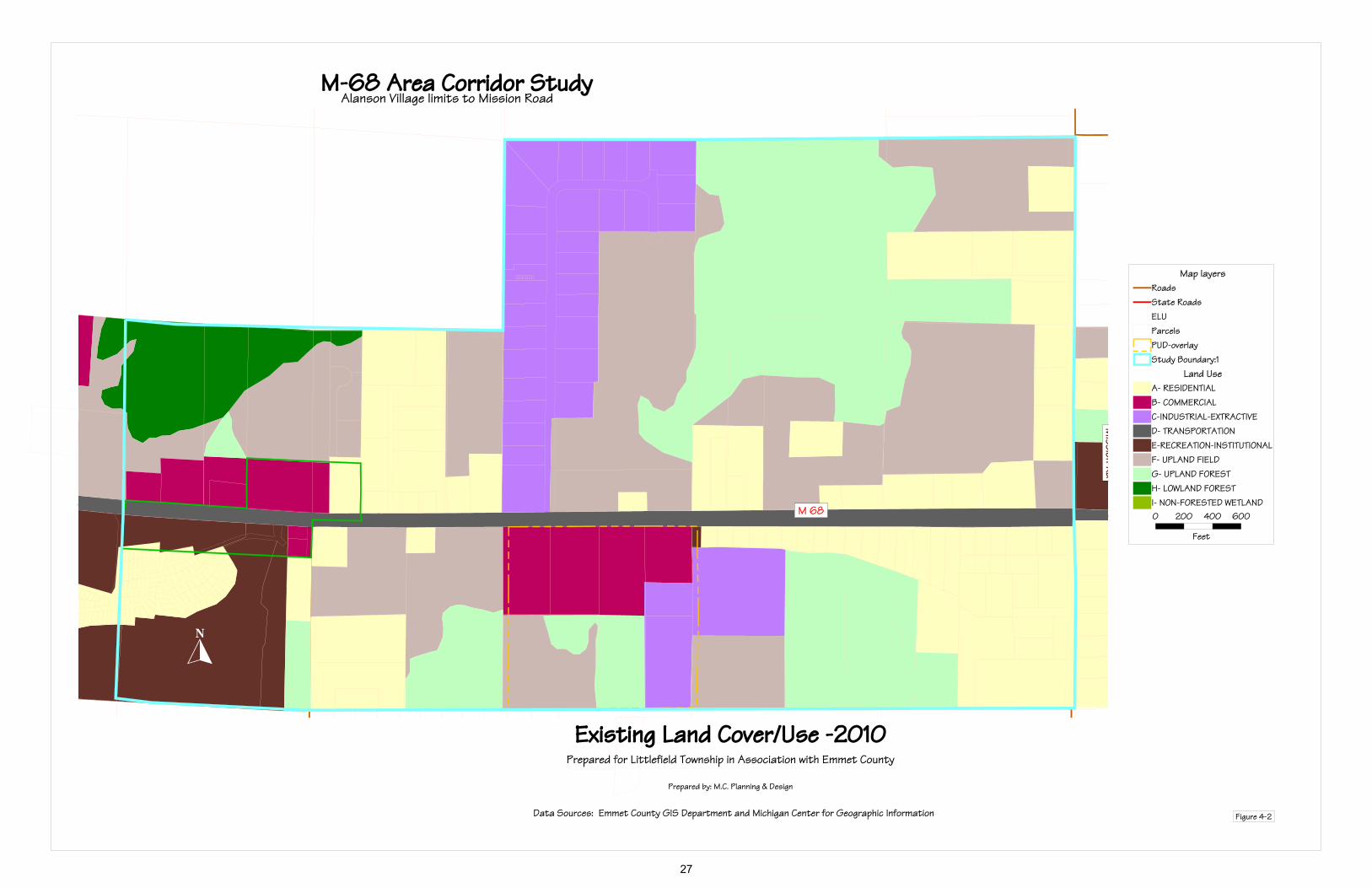
Existing Land Cover/ Use (Figure 2-2) This map illustrates how a property is actually being used or is developed for residential, recreation or commercial, and if the area is not developed, the map shows the ‘cover type’ such as forested, non-forested or wetlands.
5

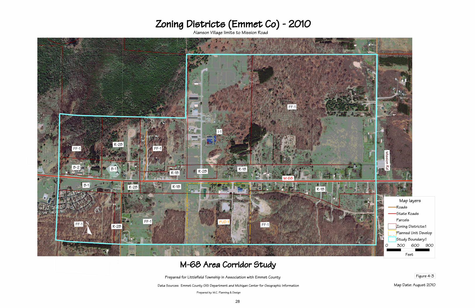
Existing Zoning Districts (Figure 2-3) This map shows the Emmet County Zoning Districts within the Oden Study Area. A summary chart of uses for the applicable zoning districts is located in Appendix A – Oden Supplemental materials. Future Land Use (Figure 2-4) This map is an excerpt from the Emmet County Future Land Use Map (provided in Figure 1-2), provided to show an enlargement of the Oden study area. Within the limits of the study area the planned future uses shown are high density residential, medium density residential and recreation. FACTORS FOR CONSIDERATION
Some of the potential factors identified at the start of this study with assistance from Township officials and Emmet County planning staff included:
1. Safety issues with US-31 (both vehicular and pedestrian);
2. Mix of zoning districts along the water (and the associated uses allowed);
3. B-1 zoned property –the quantity zoned versus that currently used as residential in the Oden study area;
4. Trail connections and services – to be coordinated with trail improvements
PUBLIC INPUT
A questionnaire was mailed to all property owners within the defined Oden study area in order to solicit input on the ‘factors for consideration’ (listed above). The mailing list was purged for duplicates, so only one was sent to each named property owner and only one per mailing address; a total of 183 questionnaires were sent and 38 responses were received for a response rate of 21%. Summary of Study Area survey findings (details provided in Appendix A) What connections between the Rail Trail and other recreation areas/facilities should be explored/facilitated?
Little Traverse Wheelway (Charlevoix –Petoskey-Harbor Springs trail) Petoskey – Mackinaw City trail (to be improved) Beach Area park Fish Hatchery Upgrade park with fountain Boat launch and Restrooms None – taxes high enough
Other comments Surface type, Playground at Oden Community hall
What connections to area businesses or services should be explored/facilitated? None /OK as is Alanson and Petoskey Food/Beverage establishments and Convenience Stores
Other Comments – Provide tax rebates for business located at public facilities
6

Oden Area Corridor – Public/Quasi-Public Lands
Prepared for: Littlefield Township and Emmet County Prepared by: M.C. Planning & Design
Data Sources: Emmet County GIS Department and Michigan Center for Geographic Information Figure 2-1
7

Oden Area Corridor –2010 Existing Land Use/Land Cover
Prepared for: Littlefield Township and Emmet County Prepared by: M.C. Planning & Design
Data Sources: Emmet County GIS Department and Michigan Center for Geographic Information Figure 2-2
8
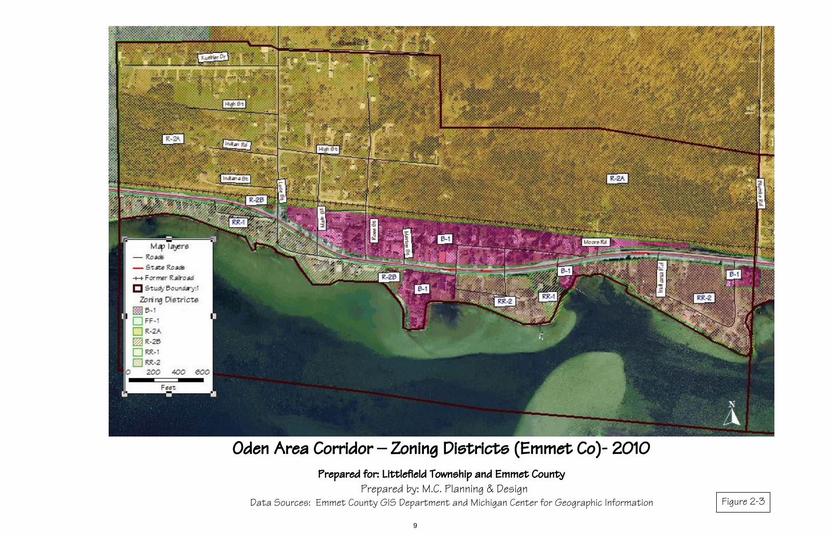
Oden Area Corridor – Zoning Districts (Emmet Co)- 2010
Prepared for: Littlefield Township and Emmet County Prepared by: M.C. Planning & Design
Data Sources: Emmet County GIS Department and Michigan Center for Geographic Information Figure 2-3
9
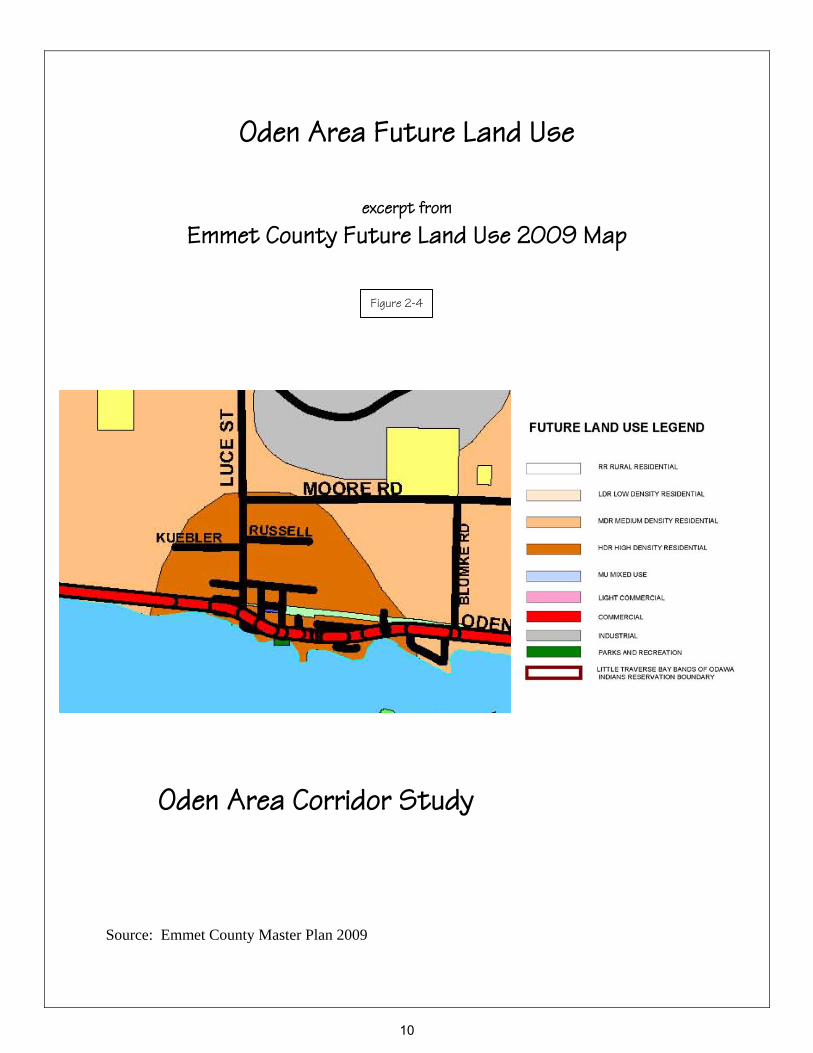
Oden Area Future Land Use
excerpt from
Emmet County Future Land Use 2009 Map
Oden Area Corridor Study Source: Emmet County Master Plan 2009
Figure 2-4
10
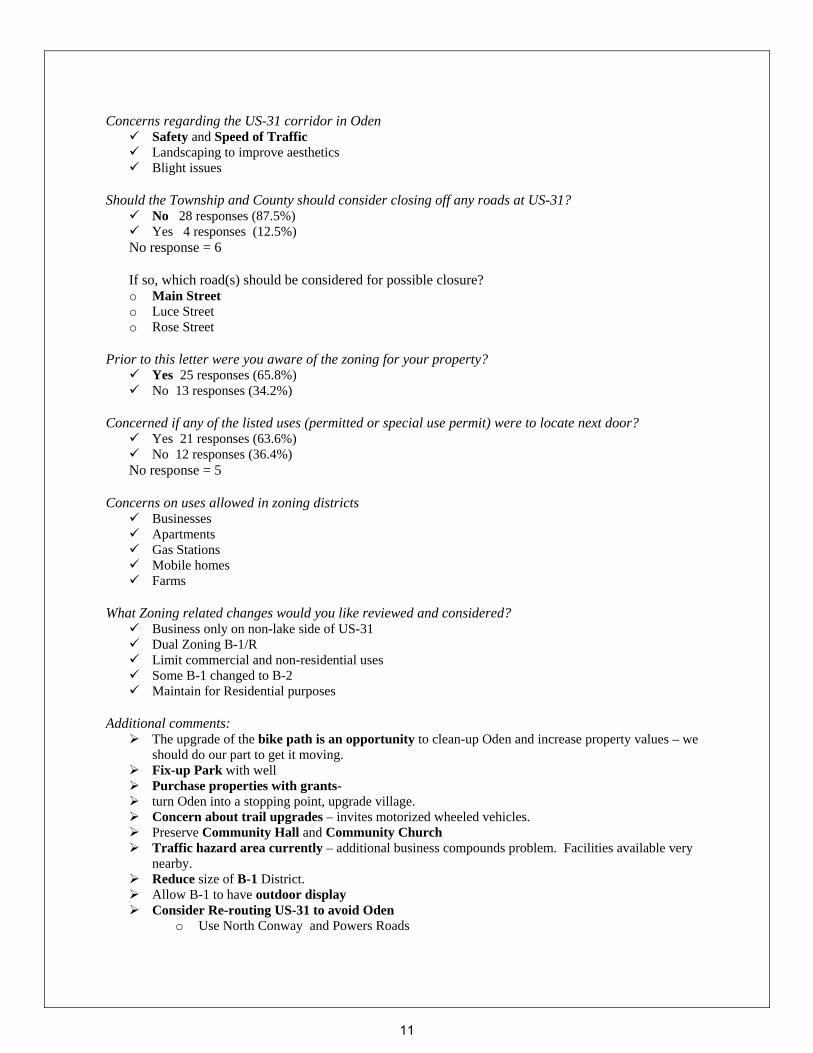
Concerns regarding the US-31 corridor in Oden Safety and Speed of Traffic Landscaping to improve aesthetics Blight issues
Should the Township and County should consider closing off any roads at US-31?
No 28 responses (87.5%) Yes 4 responses (12.5%)
No response = 6
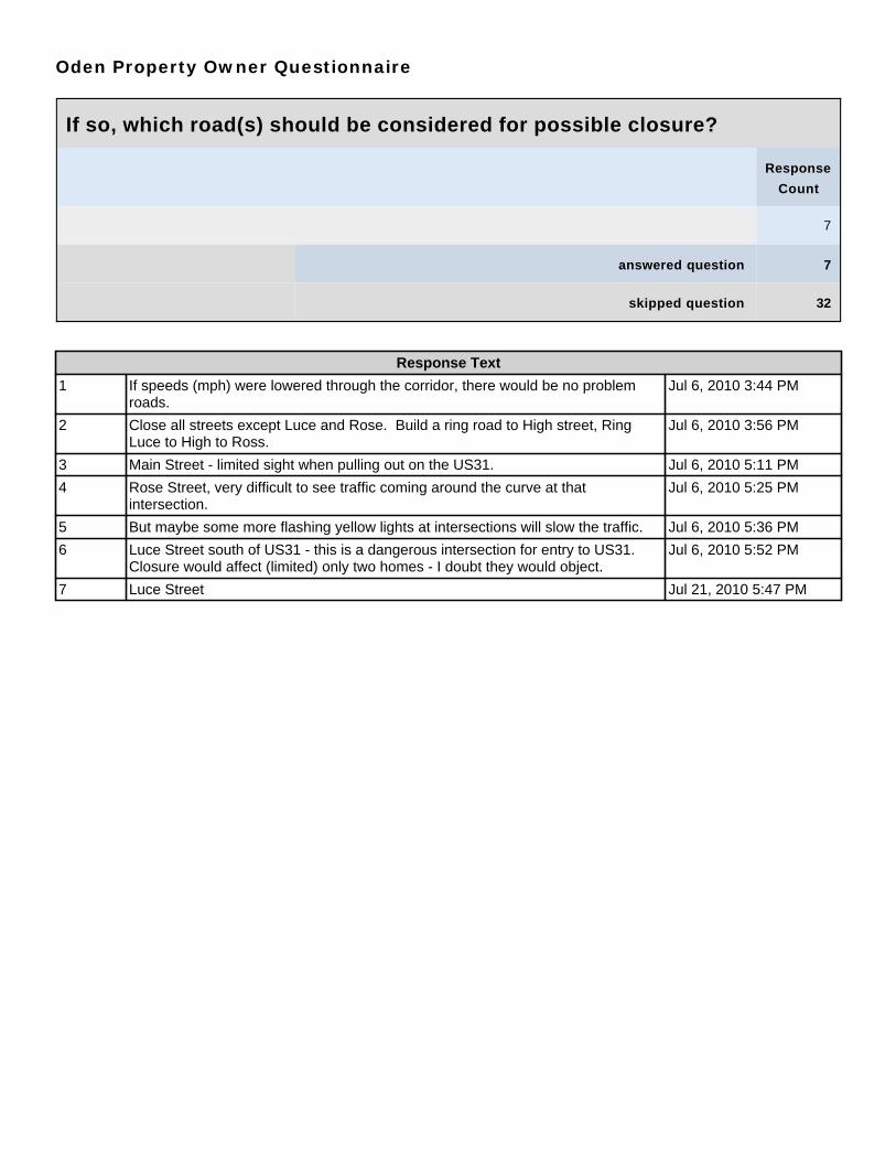
If so, which road(s) should be considered for possible closure? o Main Street o Luce Street o Rose Street
Prior to this letter were you aware of the zoning for your property?
Yes 25 responses (65.8%) No 13 responses (34.2%)
Concerned if any of the listed uses (permitted or special use permit) were to locate next door?
Yes 21 responses (63.6%) No 12 responses (36.4%)
No response = 5 Concerns on uses allowed in zoning districts
Businesses Apartments Gas Stations Mobile homes Farms
What Zoning related changes would you like reviewed and considered?
Business only on non-lake side of US-31 Dual Zoning B-1/R Limit commercial and non-residential uses Some B-1 changed to B-2 Maintain for Residential purposes
Additional comments:
The upgrade of the bike path is an opportunity to clean-up Oden and increase property values – we should do our part to get it moving.
Fix-up Park with well Purchase properties with grants- turn Oden into a stopping point, upgrade village. Concern about trail upgrades – invites motorized wheeled vehicles. Preserve Community Hall and Community Church Traffic hazard area currently – additional business compounds problem. Facilities available very
nearby. Reduce size of B-1 District. Allow B-1 to have outdoor display Consider Re-routing US-31 to avoid Oden
o Use North Conway and Powers Roads
11
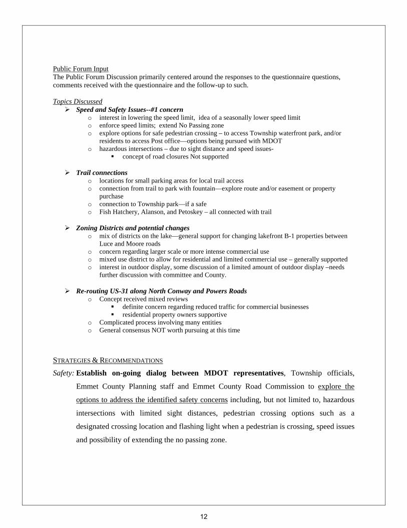
Public Forum Input The Public Forum Discussion primarily centered around the responses to the questionnaire questions, comments received with the questionnaire and the follow-up to such. Topics Discussed
Speed and Safety Issues--#1 concern o interest in lowering the speed limit, idea of a seasonally lower speed limit o enforce speed limits; extend No Passing zone o explore options for safe pedestrian crossing – to access Township waterfront park, and/or
residents to access Post office—options being pursued with MDOT o hazardous intersections – due to sight distance and speed issues-
concept of road closures Not supported
Trail connections o locations for small parking areas for local trail access o connection from trail to park with fountain—explore route and/or easement or property
purchase o connection to Township park—if a safe o Fish Hatchery, Alanson, and Petoskey – all connected with trail
Zoning Districts and potential changes o mix of districts on the lake—general support for changing lakefront B-1 properties between
Luce and Moore roads o concern regarding larger scale or more intense commercial use o mixed use district to allow for residential and limited commercial use – generally supported o interest in outdoor display, some discussion of a limited amount of outdoor display –needs
further discussion with committee and County.
Re-routing US-31 along North Conway and Powers Roads o Concept received mixed reviews
definite concern regarding reduced traffic for commercial businesses residential property owners supportive
o Complicated process involving many entities o General consensus NOT worth pursuing at this time
STRATEGIES & RECOMMENDATIONS
Safety: Establish on-going dialog between MDOT representatives, Township officials,
Emmet County Planning staff and Emmet County Road Commission to explore the
options to address the identified safety concerns including, but not limited to, hazardous
intersections with limited sight distances, pedestrian crossing options such as a
designated crossing location and flashing light when a pedestrian is crossing, speed issues
and possibility of extending the no passing zone.
12
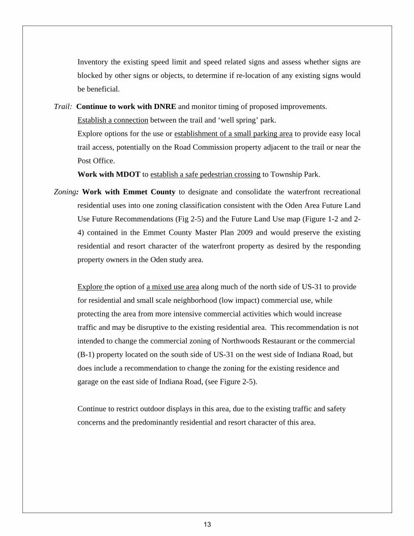
Inventory the existing speed limit and speed related signs and assess whether signs are
blocked by other signs or objects, to determine if re-location of any existing signs would
be beneficial.
Trail: Continue to work with DNRE and monitor timing of proposed improvements.
Establish a connection between the trail and ‘well spring’ park.
Explore options for the use or establishment of a small parking area to provide easy local
trail access, potentially on the Road Commission property adjacent to the trail or near the
Post Office.
Work with MDOT to establish a safe pedestrian crossing to Township Park.
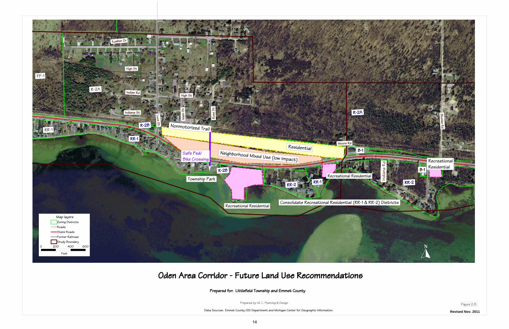
Zoning: Work with Emmet County to designate and consolidate the waterfront recreational
residential uses into one zoning classification consistent with the Oden Area Future Land
Use Future Recommendations (Fig 2-5) and the Future Land Use map (Figure 1-2 and 2-
4) contained in the Emmet County Master Plan 2009 and would preserve the existing
residential and resort character of the waterfront property as desired by the responding
property owners in the Oden study area.
Explore the option of a mixed use area along much of the north side of US-31 to provide
for residential and small scale neighborhood (low impact) commercial use, while
protecting the area from more intensive commercial activities which would increase
traffic and may be disruptive to the existing residential area. This recommendation is not
intended to change the commercial zoning of Northwoods Restaurant or the commercial
(B-1) property located on the south side of US-31 on the west side of Indiana Road, but
does include a recommendation to change the zoning for the existing residence and
garage on the east side of Indiana Road, (see Figure 2-5).
Continue to restrict outdoor displays in this area, due to the existing traffic and safety
concerns and the predominantly residential and resort character of this area.
13
Luce St
Mai
n St
Rose
St
Moore Rd
RR-1
R-2A
FF-1
R-2B
RR-2 RR-1 RR-2
R-2B
High StIndian Rd
Indiana St
High St
Kuebler Dr
Russell St
Blumke Rd
R-2A
I ndi
ana
R d
RR-1
Recreational Residential
Recreational Residential
Consolidate Recreational Residential (RR-1 & RR-2) Districts
RecreationalResidential
Neighborhood Mixed Use (low impact)
Residential
Nonmotorized Trail
Township Park
Safe Ped/Bike Crossing
B-1
B-1
Oden Area Corridor - Future Land Use Recommendations
Prepared by: M. C. Planning & Design
Data Sources: Emmet County GIS Department and Michigan Center for Geographic Information.
Prepared for: Littlefield Township and Emmet County
Figure 2-5
0 200 400 600
Feet
Map layersZoning DistrictsRoadsState RoadsFormer RailroadStudy Boundary
Revised Nov. 2011
14
3.0 PONSHEWAING STUDY AREA BACKGROUND
The Ponshewaing study area incorporates the older primarily summer development on small lots
(pre-dating zoning) between US-31 and Crooked Lake, and the area along US-31 from Blumke
Road to Powers Road, (see Figure 3-1).
Within the Ponshewaing study area, the former railroad right-of-way is primarily in private
ownership. The current plans for this portion of the Petoskey to Mackinaw City non-motorized
trail, are to locate the separate trail within the US-31 right-of-way on the north or west side of
US-31 within the Ponshewaing study area. This trail will connect at M-119 with the Little
Traverse Wheelway trail which runs from Charlevoix to Harbor Springs.
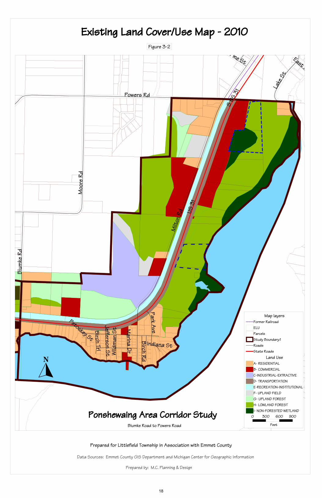
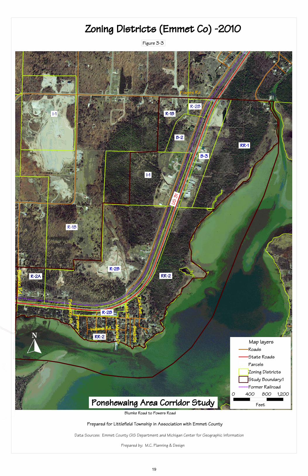
EXISTING CONDITIONS As part of the background information gathering for this corridor area, a series of maps were prepared. Study Area and Protected Lands (Figure 3-1) This map shows the limits of the study area as well as the only quasi-public properties in the study area, on an aerial photo for ease of orientation. There are no public properties within the study area and the only quasi-public properties are three parcels of land owned and protected by the Little Traverse Conservancy. Existing Land Cover/Use (Figure 3-2) The Existing Land Cover/Use map illustrates how areas within the Ponshewaing study area are actually being used, or what type of development exists on a portion of a property, such as residential, commercial, or industrial/extractive; or if an area is not developed or actively used the area is mapped based on the cover type, such as upland forest, upland field, or wetland. Existing Zoning (Figure 3-3) This map shows the Emmet County Zoning Districts within the Ponshewaing Study Area. A summary chart of the uses for the applicable zoning districts is provided in Appendix B – Ponshewaing Supplemental materials. Future Land Use (Figure 3-4) This map is an excerpt from the Emmet County Future Land Use Map (provided in Figure 1-2), provided to show an enlargement of the Ponshewaing study area, (see Figure 3-4). The primary future uses planned within this study area are high density residential in the vicinity of ‘the
15
curve’ and along Powers Road, medium density residential primarily north and west of US-31 and light commercial on the east side of US-31 at the northern portion of the study area. FACTORS FOR CONSIDERATION
Some of the potential factors identified at the start of this study with assistance from Township officials and Emmet County planning staff included:
1. Safety issues with US-31 (both vehicular and pedestrian), sight distances and hazardous intersections;
2. Mix of zoning districts (and the associated uses allowed);
3. B-2 and B-3 zoned property near the Alanson Village limits – “gateway” to Alanson.
4. Trail connections and services – to be coordinated with trail improvements.
PUBLIC INPUT
A questionnaire was mailed to all property owners within the defined Ponshewaing study area in order to solicit input on the ‘factors for consideration’ (listed above). The mailing list was purged for duplicates, so only one was sent to each named property owner and only one per mailing address; a total of 132 questionnaires were sent and 38 responses were received for a response rate of 28.8%.
Summary of Study Area survey findings (details provided in Appendix B)
What connections between the planned non-motorized trail to other recreation areas/facilities should be explored/facilitated?
Little Traverse Wheelway (Charlevoix –Petoskey-Harbor Springs trail) Petoskey – Mackinaw City trail (to be improved) Downtown Alanson connection & River Park Connect to snowmobile trails Possible boardwalk at the Lake and Boat launch Signs to direct trail users to points of interest None (8)
What connections to area businesses or services should be explored/facilitated?
Downtown Alanson Safe crossing for US-31 to access The Fort and lake Redirect Golf and Ski traffic along Powers Snowmobile access None /OK as is
Concerns regarding the US-31 corridor through Ponshewaing
Safety on S-curve o Speed of Traffic, need speed study Powers to Blumke o Safety for pedestrian crossing o Traffic Light – Lake Street and US-31
Limit commercial development Preservation of greenbelt for Ponshewaing Re-route US-31
16

Study Area and Protected LandsFigure 3-1
Ponshewaing Area Corridor StudyBlumke Road to Powers Road
Prepared for Littlefield Township in Association with Emmet County
Data Sources: Emmet County GIS Department and Michigan Center for Geographic Information
Prepared by: M.C. Planning & Design
US 3
1
Milt
on R
d
Moo
re R
d
Powers Rd
Blum
ke R
d
Lake
St
Birc
h R d
Park Ave
Birc
h St
Birch Trl
Je ff erson St
Marina DrW
ildm
an S
t
Petoskey St
Pine St
Indiana St
S US
31
East
Conservancy Property
Conservancy Property
0 300 600 900
Feet
Map layersRoadsState RoadsFormer RailroadParcels Study Boundary
17
US 3
1
Milt
on R
d
Moo
re R
d
Powers Rd
Blum
ke R
d
Lake
St
Birch RdPark A
veBirch TrlJefferson St
Marina Dr
Wild
man
St
Petoskey St
Pine St
Indiana St
S US
31
East A
Existing Land Cover/Use Map - 2010Figure 3-2
Ponshewaing Area Corridor StudyBlumke Road to Powers Road
Prepared for Littlefield Township in Association with Emmet County
Data Sources: Emmet County GIS Department and Michigan Center for Geographic Information
Prepared by: M.C. Planning & Design
0 300 600 900
Feet
Map layersFormer RailroadELUParcels Study Boundary:1RoadsState Roads
Land UseA- RESIDENTIALB- COMMERCIALC-INDUSTRIAL-EXTRACTIVED- TRANSPORTATIONE-RECREATION-INSTITUTIONALF- UPLAND FIELDG- UPLAND FORESTH- LOWLAND FORESTI- NON-FORESTED WETLAND
18
US 3
1
Blumke Rd
RR-2
B-2
Park Ave
Lake StBirch S t
Indiana Rd
Marina Dr
Ceda
r Ln
Petoskey St
Powers Rd
I-1
RR-2
R-1B
R-2AR-2B
R-2B
B-3
RR-1
R-2B
R-1B
I-1
Zoning Districts (Emmet Co) -2010Figure 3-3
Ponshewaing Area Corridor StudyBlumke Road to Powers Road
Prepared for Littlefield Township in Association with Emmet County
Data Sources: Emmet County GIS Department and Michigan Center for Geographic Information
Prepared by: M.C. Planning & Design
0 400 800 1,200
Feet
Map layersRoadsState RoadsParcels Zoning DistrictsStudy Boundary:1Former Railroad
19

Ponshewaing Area Future Land Use
excerpt from
Emmet County Future Land Use 2009 Map
Ponshewaing Area Corridor Study Source: Emmet County Master Plan 2009
Figure 3-4
20
Should the Township and County consider limiting new access on to US-31 in Ponshewaing? Yes 30 responses (78.9%) No 8 responses (21.1%)
If so, which road(s) should be considered for possible changes?
o US-31 and Lake Street (by The Fort) –flashing light o The S-curve on US-31 o Close Park Street at US-31--dangerous
Prior to this letter were you aware of the zoning for your property?
Yes 25 responses (67.6%) No 12 responses (32.4%)
No response = 1 Concerns on uses allowed in zoning districts
Additional commercial Utility and public service facilities Multi –family dwellings Schools Mobile homes Farms Churches Boat launches
What Zoning related changes would you like reviewed and considered?
Traffic impacts of any changes Mobile homes eliminated from zoning districts Property maintenance/Upkeep issues – regulations needed No condo/multi family dwellings Enforce existing covenants B-2 and B-3 should be allowed to have outdoor display No changes
Do you want to encourage additional Commercial use in Ponshewaing Study Area?
No 31 (81.5 %) Yes 3 Yes with some restrictions (4)
Additional comments:
Keep Ponshewaing as noncommercial as possible Existing businesses are good – do not add more. Many safety concern at the S-curve and for pedestrian crossing Lower speed limits
Public Forum Input
The Ponshewaing area corridor public forum discussion centered primarily on the topics and responses received to the questionnaire, and follow-up questions and comments regarding such.
21

Topics Discussed Safety and Access Management
Potential road closure
Concerns regarding changes to business zoning that would create non-conforming businesses.
Outdoor display—desired by business owners in the B-3 district
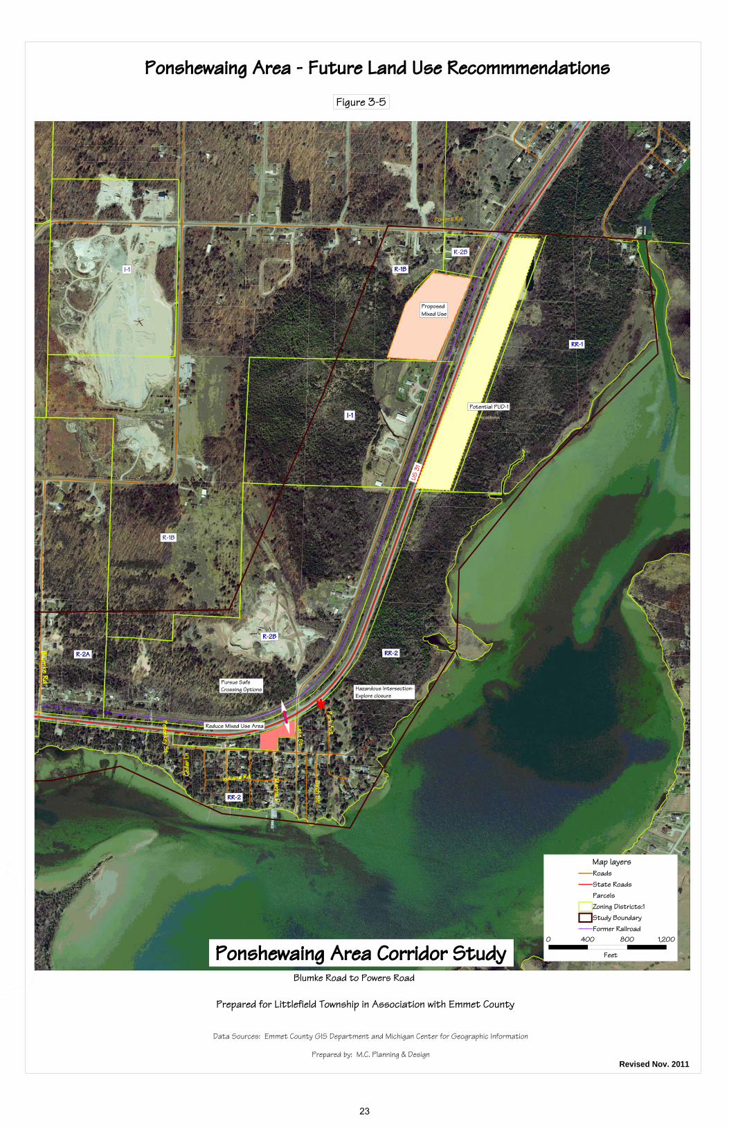
A potential boardwalk on the south and east side of US-31 from Ponshewaing to Alanson. STRATEGIES & RECOMMENDATIONS Zoning: Encourage local property owners to work together to propose a PUD overlay which
would meet the Township goal of aesthetically enhancing the entrance to Alanson, with
landscaping requirements, improved access management with internal connections and
allowing defined and limited (such as 200 sf) outdoor display.
Work with Emmet County planning staff to explore reducing the size of the Mixed
Use Area (R-2B district) in the vicinity of The Fort, to include only the store and Ryde
Marina.
At the north end of the study area, pursue a mixed use area on Milton Street to R-2B to
provide a transition area.
Safety: Work with MDOT and the Emmet County Road Commission to explore the closure of
Park Street, to eliminate a hazardous intersection since the area is served by other
roads.
Pursue the implementation of some access management measures to restrict any new
accesses to US-31 within this study area, in order to improve safety.
Explore and pursue options for safe pedestrian crossings at The Fort to serve both the
residential area and the store.
Trail: Work with DNRE to provide landscaping as part of the trail improvements. Explore the concept of a boardwalk on the east side of US-31, to provide pedestrian
access to Alanson without crossing US-31. This potentially could be considered as part
of the PUD overlay discussed above, if the property owners wish to pursue the PUD
option.
22
US 3
1
Blumke Rd
RR-2
Park Ave
Lake St
Birch St
Indiana Rd Marina Dr
Ceda
r Ln
Petoskey St
Powers Rd
I-1
RR-2
R-1B
R-2A
R-2B
B-3
RR-1
R-2B
R-1B
I-1
<
Hazardous Intersection-Explore closure
Pursue SafeCrossing Options
Reduce Mixed Use Area
Potential PUD-1
ProposedMixed Use
Ponshewaing Area - Future Land Use RecommmendationsFigure 3-5
Ponshewaing Area Corridor StudyBlumke Road to Powers Road
Prepared for Littlefield Township in Association with Emmet County
Data Sources: Emmet County GIS Department and Michigan Center for Geographic Information
Prepared by: M.C. Planning & DesignRevised Nov. 2011
0 400 800 1,200
Feet
Map layersRoadsState RoadsParcels Zoning Districts:1Study BoundaryFormer Railroad
23
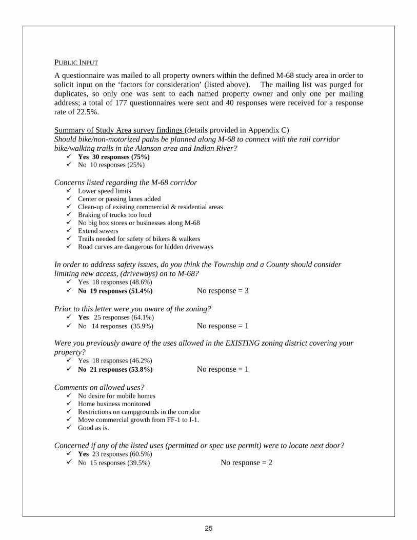
4.0 M-68 STUDY AREA BACKGROUND The M-68 study area is immediately adjacent to the eastern boundary of the Village of Alanson
along M-68 to Mission Road, (see Figure 4-1). This area serves as the eastern entrance to the
Village of Alanson and provides a mix of land uses.
EXISTING CONDITIONS As part of the background information gathering for the M-68 corridor area, a series of maps were prepared. Study Area Map (Figure 4-1) includes: This map shows the extent of the study area over an aerial photo base for ease of orientation. The only publicly owned parcel in the study area is one parcel on M-68 owned by the Emmet County Road Commission. Existing Land Cover/ Use (Figure 4-2) This map illustrates how a property is actually being used or is developed for residential, recreation or commercial, and if the area is not developed, the map shows the ‘cover type’ such as forested, non-forested or wetlands. Existing Zoning Districts (Figure 4-3) This map shows the Emmet County Zoning Districts within the M-68 Study Area. A summary chart of uses for the applicable zoning districts is located in Appendix C – M-68 Supplemental materials. Future Land Use (Figure 4-4) This map is an excerpt from the Emmet County Future Land Use Map (provided in Figure 1-2), provided to show an enlargement of the M-68 study area. FACTORS FOR CONSIDERATION
Some of the potential factors identified at the start of this study with assistance from Township officials and Emmet County planning staff included:
1. Speed/Safety issues—including the number of driveways;
2. Mix of zoning districts along the M-68;
3. The mix of existing residential and commercial uses;
4. Trail connections and services – to be coordinated with any PUD overlay districts
24
PUBLIC INPUT
A questionnaire was mailed to all property owners within the defined M-68 study area in order to solicit input on the ‘factors for consideration’ (listed above). The mailing list was purged for duplicates, so only one was sent to each named property owner and only one per mailing address; a total of 177 questionnaires were sent and 40 responses were received for a response rate of 22.5%. Summary of Study Area survey findings (details provided in Appendix C) Should bike/non-motorized paths be planned along M-68 to connect with the rail corridor bike/walking trails in the Alanson area and Indian River?
Yes 30 responses (75%) No 10 responses (25%)
Concerns listed regarding the M-68 corridor
Lower speed limits Center or passing lanes added Clean-up of existing commercial & residential areas Braking of trucks too loud No big box stores or businesses along M-68 Extend sewers Trails needed for safety of bikers & walkers Road curves are dangerous for hidden driveways
In order to address safety issues, do you think the Township and a County should consider limiting new access, (driveways) on to M-68?
Yes 18 responses (48.6%) No 19 responses (51.4%) No response = 3
Prior to this letter were you aware of the zoning?
Yes 25 responses (64.1%) No 14 responses (35.9%) No response = 1
Were you previously aware of the uses allowed in the EXISTING zoning district covering your property?
Yes 18 responses (46.2%) No 21 responses (53.8%) No response = 1
Comments on allowed uses?
No desire for mobile homes Home business monitored Restrictions on campgrounds in the corridor Move commercial growth from FF-1 to I-1. Good as is.
Concerned if any of the listed uses (permitted or spec use permit) were to locate next door?
Yes 23 responses (60.5%) No 15 responses (39.5%) No response = 2
25

M-68 Area Corridor Study AreaAlanson Village limits to Mission Road
Prepared for Littlefield Township in Association with Emmet County
Data Sources: Emmet County GIS Department and Michigan Center for Geographic Information
Prepared by: M.C. Planning & DesignMap Date: August 2010
Figure 4-1
Mission Rd
Keys
tone
Par
k Dr
Sha
dy M
aple
Ln
Lake
view
Rd
County RoadCommission
26
M-68 Area Corridor StudyAlanson Village limits to Mission Road
Existing Land Cover/Use -2010Prepared for Littlefield Township in Association with Emmet County
Data Sources: Emmet County GIS Department and Michigan Center for Geographic Information
Prepared by: M.C. Planning & Design
M 68
Missi on R d
0 200 400 600
Feet
Map layersRoadsState RoadsELUParcels PUD-overlayStudy Boundary:1
Land UseA- RESIDENTIALB- COMMERCIALC-INDUSTRIAL-EXTRACTIVED- TRANSPORTATIONE-RECREATION-INSTITUTIONALF- UPLAND FIELDG- UPLAND FORESTH- LOWLAND FORESTI- NON-FORESTED WETLAND
Figure 4-2
27
M-68 Area Corridor Study
Alanson Village limits to Mission RoadZoning Districts (Emmet Co) - 2010
Prepared for Littlefield Township in Association with Emmet County
Data Sources: Emmet County GIS Department and Michigan Center for Geographic Information
Prepared by: M.C. Planning & Design
Map Date: August 2010
Figure 4-3
M 68
FF-1
FF-1
I-1
FF-1
FF-1
FF-1 Mission RdB-1B-2
PUD-1R-2B
FF-1
B-1
R-2BFF-1
R-1B R-2B
I-1
R-1B
R-1BR-2B R-1B
0 300 600 900
Feet
Map layersRoadsState RoadsParcels Zoning Districts:1Planned Unit DevelopStudy Boundary:1
28
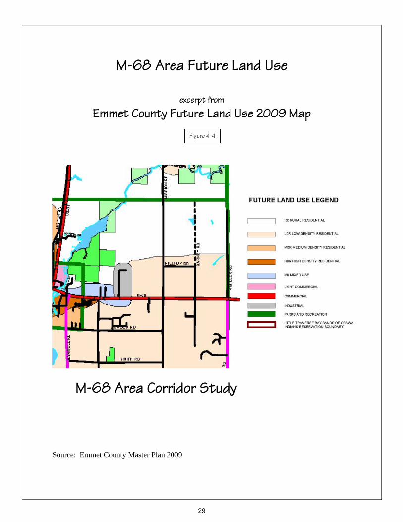
M-68 Area Future Land Use
excerpt from
Emmet County Future Land Use 2009 Map
M-68 Area Corridor Study Source: Emmet County Master Plan 2009
Figure 4-4
29
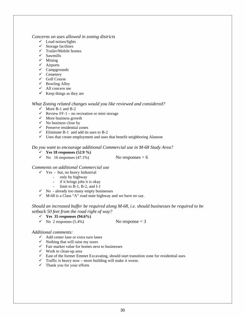
Concerns on uses allowed in zoning districts Loud noises/lights Storage facilities Trailer/Mobile homes Sawmills Mining Airports Campgrounds Cemetery Golf Course Bowling Alley All concern me Keep things as they are
What Zoning related changes would you like reviewed and considered?
More B-1 and B-2 Review FF-1 – no recreation or mini storage More business growth No business close by Preserve residential zones Eliminate B-1 and add its uses to B-2 Uses that create employment and uses that benefit neighboring Alanson
Do you want to encourage additional Commercial use in M-68 Study Area?
Yes 18 responses (52.9 %) No 16 responses (47.1%) No responses = 6
Comments on additional Commercial use
Yes - but, no heavy Industrial - only by highway - if it brings jobs it is okay - limit to B-1, B-2, and I-1
No - already too many empty businesses M-68 is a Class “A” road state highway and we have no say.
Should an increased buffer be required along M-68, i.e. should businesses be required to be setback 50 feet from the road right of way?
Yes 35 responses (94.6%) No 2 responses (5.4%) No response = 3
Additional comments:
Add center lane or extra turn lanes Nothing that will raise my taxes Fair market value for homes next to businesses Work to clean-up area East of the former Emmet Excavating, should start transition zone for residential uses Traffic is heavy now – more building will make it worse. Thank you for your efforts
30
Public Forum Discussion topics and additional Input Promote Trail Connections – to Petoskey to Mackinaw City Trail, and to Indian River (North Central
State Trail)
Extend Sewer when needed for business
Utilize areas currently zoned for business and/or industrial before expanding
Consider additional Planned Unit Development overlay on south side of M-68
Consider expanded R-2B District on north side of M-68
Explore center turn lane idea with MDOT
Existing commercial and industrial property available
Allow for retail and wholesale agricultural and farm forest related activities
Promote sustainable activities and recycling related activities
Allow for activities and uses that stabilize and enhance the economic viability of adjoining residential, commercial and industrial uses.
STRATEGIES & RECOMMENDATIONS
Zoning: Pursue mixed use to include light commercial and residential for the areas north and
south of M-68 and west of the Industrial Park, (see Figure 4-5), in order to have more
influence over access management issues (internal connections and shared access
drives), increased setbacks, potential trail location on south side of M-68 and
landscaping. The intent is to allow for a mix of uses to be reviewed and determined at
time the use is established.
Explore an additional area for Transitional Uses, for the area identified as
Transitional Uses on Figure 4-5, including exploration of appropriate uses to be
allowed and serve as a transition from the industrial park and proposed commercial to
the FF-1 and R-1B zoning to the east.
Plan for future commercial uses for identified areas fronting on M-68, to allow for a
transition area and provide for a mix of uses, (see Figure 4-5).
Consistent with the Emmet County Future Land Use 2009 map, and much of the public
input regarding this corridor, maintain the area east of the industrial park as Farm-
Forest and Residential at this time. When the area of the industrial park and the areas
to the west zoned for mixed use or commercial are primarily built out, then the
Township may wish to revisit this issue.
31

Safety: Explore with MDOT the potential options regarding turn lanes, regulations on jake
braking.
Trail: Pursue future trail location on either side of M-68, include trail easement or similar
as a condition of any PUD-1 overlay areas that are established on M-68 to facilitate
connection to the Petoskey to Mackinaw City trail in Alanson.
32

M-68 Area Corridor Study
Alanson Village limits to Mission Road
M-68 Corridor - Future Land Use Recommendations
Prepared for Littlefield Township in Association with Emmet County
Data Sources: Emmet County GIS Department and Michigan Center for Geographic Information
Prepared by: M.C. Planning & DesignFigure 4-5
Commercial Area
Future Non-motorized Trail
Mixed Use Area RecommendedTransitional Uses Area
Revised Nov. 2011
Industrial Area
M 68
R-2B
B-1R-2B R-1B
B-2B-1
FF-1
FF-1
I-1
FF-1
FF-1
FF-1
Mission Rd
PUD-1
R-2B
FF-1
R-2B
FF-1
I-1
R-1B
R-1B
Existing PUD overlay
TransitionalUses
MIXED USELight Commercial/Residential
MIXED USELight Commercial/Residential
Industrial
Commercial
Commercial
Future Non-motorized trail - either side
0 400 800 1,200
Feet
Map layersRoadsState RoadsParcels Zoning Districts:1Planned Unit DevelopStudy Boundary
33
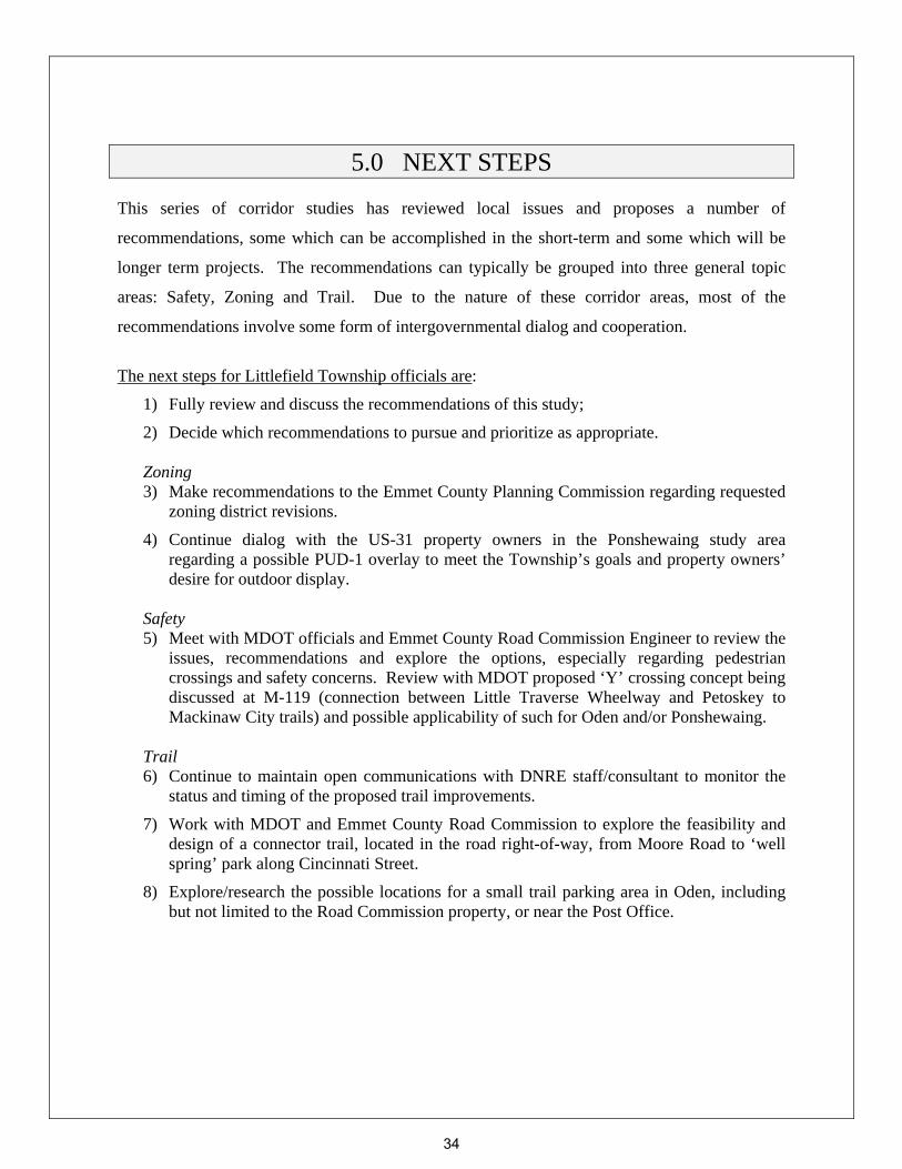
5.0 NEXT STEPS This series of corridor studies has reviewed local issues and proposes a number of
recommendations, some which can be accomplished in the short-term and some which will be
longer term projects. The recommendations can typically be grouped into three general topic
areas: Safety, Zoning and Trail. Due to the nature of these corridor areas, most of the
recommendations involve some form of intergovernmental dialog and cooperation.
The next steps for Littlefield Township officials are:
1) Fully review and discuss the recommendations of this study;
2) Decide which recommendations to pursue and prioritize as appropriate. Zoning 3) Make recommendations to the Emmet County Planning Commission regarding requested
zoning district revisions.
4) Continue dialog with the US-31 property owners in the Ponshewaing study area regarding a possible PUD-1 overlay to meet the Township’s goals and property owners’ desire for outdoor display.
Safety 5) Meet with MDOT officials and Emmet County Road Commission Engineer to review the
issues, recommendations and explore the options, especially regarding pedestrian crossings and safety concerns. Review with MDOT proposed ‘Y’ crossing concept being discussed at M-119 (connection between Little Traverse Wheelway and Petoskey to Mackinaw City trails) and possible applicability of such for Oden and/or Ponshewaing.
Trail 6) Continue to maintain open communications with DNRE staff/consultant to monitor the
status and timing of the proposed trail improvements.
7) Work with MDOT and Emmet County Road Commission to explore the feasibility and design of a connector trail, located in the road right-of-way, from Moore Road to ‘well spring’ park along Cincinnati Street.
8) Explore/research the possible locations for a small trail parking area in Oden, including but not limited to the Road Commission property, or near the Post Office.
34

APPENDIX A
Oden Area Corridor Study Supplemental Materials
Zoning Districts Use Comparison Matrix
Questionnaire
• Tally • Comments
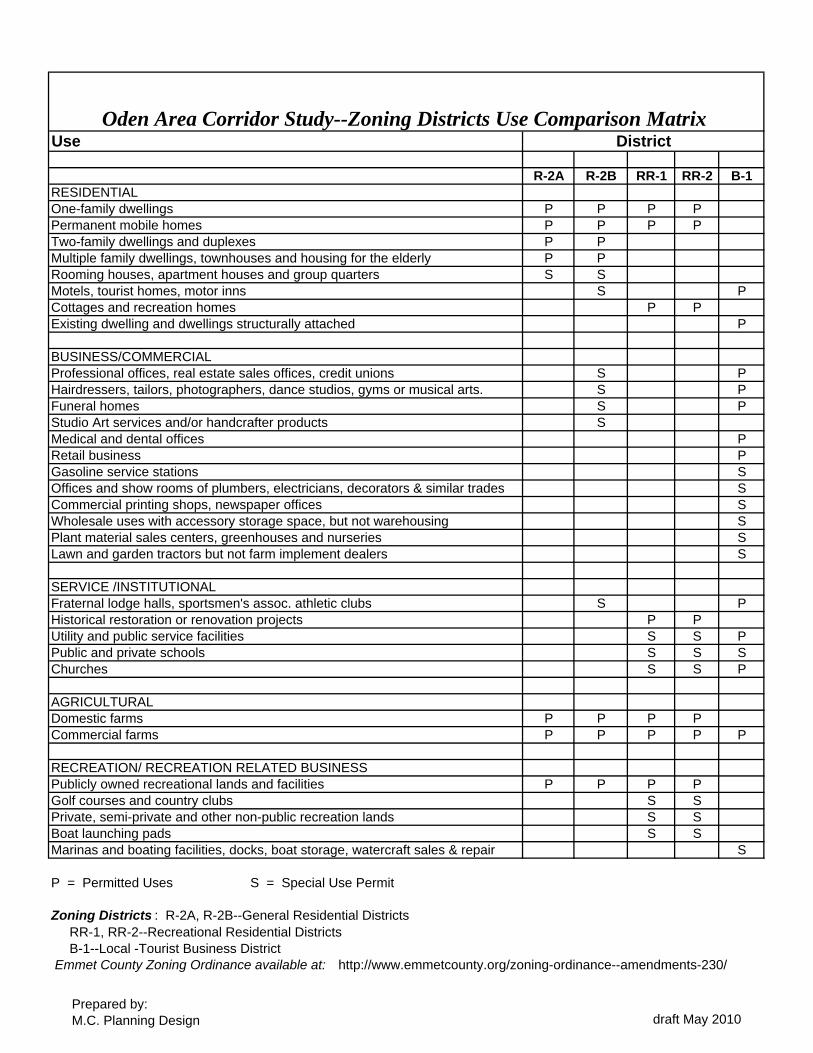
Use
R-2A R-2B RR-1 RR-2 B-1RESIDENTIALOne-family dwellings P P P PPermanent mobile homes P P P PTwo-family dwellings and duplexes P PMultiple family dwellings, townhouses and housing for the elderly P PRooming houses, apartment houses and group quarters S SMotels, tourist homes, motor inns S PCottages and recreation homes P PExisting dwelling and dwellings structurally attached P
BUSINESS/COMMERCIALProfessional offices, real estate sales offices, credit unions S PHairdressers, tailors, photographers, dance studios, gyms or musical arts. S PFuneral homes S PStudio Art services and/or handcrafter products SMedical and dental offices PRetail business PGasoline service stations SOffices and show rooms of plumbers, electricians, decorators & similar trades SCommercial printing shops, newspaper offices SWholesale uses with accessory storage space, but not warehousing SPlant material sales centers, greenhouses and nurseries SLawn and garden tractors but not farm implement dealers S
SERVICE /INSTITUTIONALFraternal lodge halls, sportsmen's assoc. athletic clubs S PHistorical restoration or renovation projects P PUtility and public service facilities S S PPublic and private schools S S SChurches S S P
AGRICULTURALDomestic farms P P P PCommercial farms P P P P P
RECREATION/ RECREATION RELATED BUSINESSPublicly owned recreational lands and facilities P P P PGolf courses and country clubs S SPrivate, semi-private and other non-public recreation lands S SBoat launching pads S SMarinas and boating facilities, docks, boat storage, watercraft sales & repair S
P = Permitted Uses S = Special Use Permit
Zoning Districts : R-2A, R-2B--General Residential Districts RR-1, RR-2--Recreational Residential Districts B-1--Local -Tourist Business District Emmet County Zoning Ordinance available at: http://www.emmetcounty.org/zoning-ordinance--amendments-230/
DistrictOden Area Corridor Study--Zoning Districts Use Comparison Matrix
Prepared by:M.C. Planning Design draft May 2010
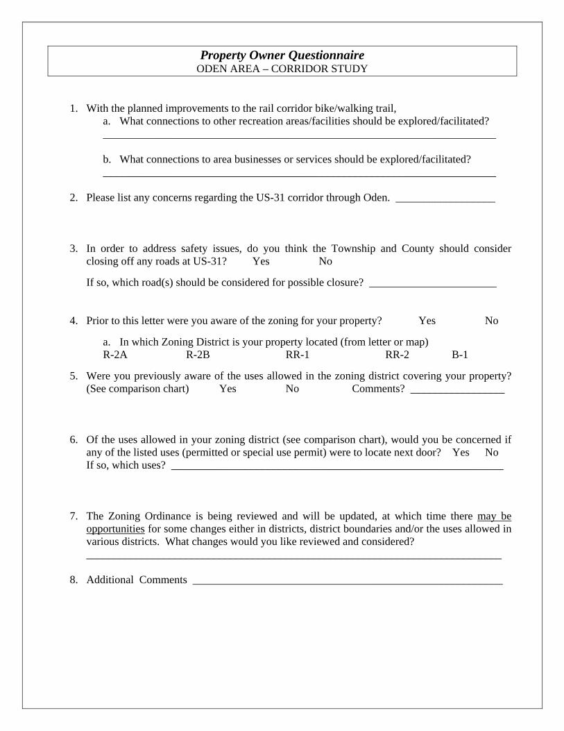
Property Owner Questionnaire ODEN AREA – CORRIDOR STUDY
1. With the planned improvements to the rail corridor bike/walking trail, a. What connections to other recreation areas/facilities should be explored/facilitated? _______________________________________________________________________ b. What connections to area businesses or services should be explored/facilitated? _______________________________________________________________________
2. Please list any concerns regarding the US-31 corridor through Oden. __________________
3. In order to address safety issues, do you think the Township and County should consider
closing off any roads at US-31? Yes No
If so, which road(s) should be considered for possible closure? _______________________ 4. Prior to this letter were you aware of the zoning for your property? Yes No
a. In which Zoning District is your property located (from letter or map) R-2A R-2B RR-1 RR-2 B-1
5. Were you previously aware of the uses allowed in the zoning district covering your property?
(See comparison chart) Yes No Comments? _________________
6. Of the uses allowed in your zoning district (see comparison chart), would you be concerned if
any of the listed uses (permitted or special use permit) were to locate next door? Yes No If so, which uses? ____________________________________________________________
7. The Zoning Ordinance is being reviewed and will be updated, at which time there may be
opportunities for some changes either in districts, district boundaries and/or the uses allowed in various districts. What changes would you like reviewed and considered? ___________________________________________________________________________
8. Additional Comments ________________________________________________________
Oden Property Owner Questionnaire
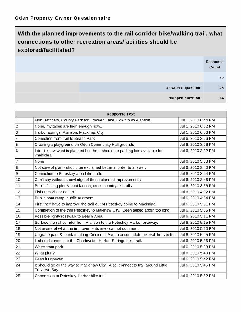
With the planned improvements to the rail corridor bike/walking trail, what
connections to other recreation areas/facilities should be
explored/facilitated?
Response
Count
25
answered question 25
skipped question 14
Response Text
1 Fish Hatchery, County Park for Crooked Lake, Downtown Alanson. Jul 1, 2010 6:44 PM
2 None, my taxes are high enough now... Jul 1, 2010 6:52 PM
3 Harbor springs, Alanson, Mackinac City Jul 1, 2010 6:56 PM
4 Conection from trail to Beach Park Jul 6, 2010 3:26 PM
5 Creating a playground on Oden Community Hall grounds Jul 6, 2010 3:26 PM
6 I don't know what is planned but there should be parking lots available forvhehicles.
Jul 6, 2010 3:32 PM
7 None Jul 6, 2010 3:38 PM
8 Not sure of plan - should be explained better in order to answer. Jul 6, 2010 3:40 PM
9 Conniction to Petoskey area bike path. Jul 6, 2010 3:44 PM
10 Can't say without knowledge of these planned improvements. Jul 6, 2010 3:46 PM
11 Public fishing pier & boat launch, cross country ski trails. Jul 6, 2010 3:56 PM
12 Fisheries visitor center. Jul 6, 2010 4:02 PM
13 Public boat ramp, public restroom. Jul 6, 2010 4:54 PM
14 First they have to improve the trail out of Petoskey going to Mackniac. Jul 6, 2010 5:01 PM
15 Completion of the trail Petoskey to Makinaw City. Been talked about too long. Jul 6, 2010 5:05 PM
16 Possible light/crosswalk to Beach Area. Jul 6, 2010 5:11 PM
17 Surface the rail corridor from Alanson to the Petoskey-Harbor bikeway. Jul 6, 2010 5:15 PM
18 Not aware of what the improvements are - cannot comment. Jul 6, 2010 5:20 PM
19 Upgrade park & fountain along Cincinnati Ave to accomadate bikers/hikers better. Jul 6, 2010 5:25 PM
20 It should connect to the Charlevoix - Harbor Springs bike trail. Jul 6, 2010 5:36 PM
21 Water front park. Jul 6, 2010 5:38 PM
22 What plan? Jul 6, 2010 5:40 PM
23 Keep it unpaved. Jul 6, 2010 5:42 PM
24 It should go all the way to Mackinaw City. Also, connect to trail around LittleTraverse Bay.
Jul 6, 2010 5:45 PM
25 Connection to Petoskey-Harbor bike trail. Jul 6, 2010 5:52 PM

Oden Property Owner Questionnaire
What connections to area businesses or services should be
explored/facilitated?
Response
Count
12
answered question 12
skipped question 27
Response Text
1 Link should be from Petoskey to Alanson - would be a very well traveled bikeroute if pavaed.
Jul 1, 2010 6:44 PM
2 This is Oden ... not many business around right here. The Windjammer is alreadyquite well served.
Jul 1, 2010 6:52 PM
3 None Jul 1, 2010 6:56 PM
4 No marinas Jul 6, 2010 3:28 PM
5 None Jul 6, 2010 3:38 PM
6 Give tax rebates to businesses located at public facilities. Jul 6, 2010 3:56 PM
7 No further expansions in this already congested area. Jul 6, 2010 4:48 PM
8 Convenience store (e.g. water, first aid, snacks) Jul 6, 2010 4:54 PM
9 It does a good job connecting to most places I can travel. Jul 6, 2010 5:01 PM
10 Any establishment that provides food and beverage should be recognized alongtrail.
Jul 6, 2010 5:25 PM
11 It should connect to the Alanson business district. Jul 6, 2010 5:36 PM
12 Fish Hatchery, Dairy Queen, an Artesian Well. Jul 6, 2010 5:52 PM

Oden Property Owner Questionnaire
Please list any concerns regarding the US-31 corridor through Oden.
Response
Count
27
answered question 27
skipped question 12
Response Text
1 Shabby Jul 1, 2010 6:44 PM
2 The speed on 31 is too fast, should be 35 MPH. Jul 1, 2010 6:56 PM
3 Bad corner at Main & 31 Jul 6, 2010 3:26 PM
4 I don't know id there are any widening or better shoulders anywhere - wideningnot good in my area.
Jul 6, 2010 3:32 PM
5 People drive way too fast. Jul 6, 2010 3:36 PM
6 A left turn lane would be very helpful. Jul 6, 2010 3:37 PM
7 Blight ordinance is not enforced. Jul 6, 2010 3:38 PM
8 Sidewalks are needed!! 35 mph, enforced and a safe crossover to other side of31.
Jul 6, 2010 3:44 PM
9 None Jul 6, 2010 3:46 PM
10 Make roadway or streetscape attracting with landscape flowering trees, bushes -brick paved walkways, streetlights with antique poles. Place quonsot huts alongthe way to house artist colony.
Jul 6, 2010 3:56 PM
11 Traffic, visibility when turning off side streets. Jul 6, 2010 4:02 PM
12 Privacy, additional congesteion, safety, trespassing. Jul 6, 2010 4:48 PM
13 At 45 mph, speed limit is too high, very dangerous for parking, consider reducingto 35 mph.
Jul 6, 2010 4:54 PM
14 The speed is too high in the curves north of Oden (Luce street) and too many carspass on the right - off the road.
Jul 6, 2010 5:01 PM
15 Dangerous intersection US 31 to Main - same for US 31 to Rose. Jul 6, 2010 5:05 PM
16 The curves in the highway between Luce & Rose are limited sight for drivers. Nota safe area for pedestrians to cross at to get to Lake.
Jul 6, 2010 5:11 PM
17 Move US 31 from Conway to a general course of North Conway Rd - Powell toAlanson - cut off much lake congestion and improve safety.
Jul 6, 2010 5:15 PM
18 Eliminate any passing lanes between Oden and Alanson. Jul 6, 2010 5:20 PM
19 Build a nice looking boundry/barrier structure that will discourage people fromcutting through private property.
Jul 6, 2010 5:25 PM
20 The traffic moves too fast through Oden. It shoul be 35mph maximum from theWindjammer Marina to Northwoods Restraurant, and it should be strictly enforced.Traffic now moves at 50-60mph, which is much too fast in a populated area.
Jul 6, 2010 5:36 PM
21 Off some side streets it's hard to get on US 31. Jul 6, 2010 5:37 PM
22 Speed - the ability to stop. Jul 6, 2010 5:38 PM
23 Speed & signage. Jul 6, 2010 5:40 PM
24 Keep US31 where it is and the rail trail where it is. Jul 6, 2010 5:42 PM

Response Text
25 Far too many cars for a resort area. Elderly people live on lake and walk to postoffice. Remember Henry Brode was killed a few years age crossing US31 to goto post offie.
Jul 6, 2010 5:45 PM
26 It would be nice to see the highway follow a path along the north edge of the oldrailroad grade - this could reduce noise and traffic entry concerns along thecottage area.
Jul 6, 2010 5:52 PM
27 US-31 should have lower speed limit in Oden or at least - divert the roadsomeplace else.
Jul 21, 2010 5:47 PM

Oden Property Owner Questionnaire
In order to address safety issues, do you think the Township and County
should consider closing off any roads at US-31?
Response
Percent
Response
Count
Yes 15.2% 5
No 84.8% 28
answered question 33
skipped question 6
Oden Property Owner Questionnaire
If so, which road(s) should be considered for possible closure?
Response
Count
7
answered question 7
skipped question 32
Response Text
1 If speeds (mph) were lowered through the corridor, there would be no problemroads.
Jul 6, 2010 3:44 PM
2 Close all streets except Luce and Rose. Build a ring road to High street, RingLuce to High to Ross.
Jul 6, 2010 3:56 PM
3 Main Street - limited sight when pulling out on the US31. Jul 6, 2010 5:11 PM
4 Rose Street, very difficult to see traffic coming around the curve at thatintersection.
Jul 6, 2010 5:25 PM
5 But maybe some more flashing yellow lights at intersections will slow the traffic. Jul 6, 2010 5:36 PM
6 Luce Street south of US31 - this is a dangerous intersection for entry to US31.Closure would affect (limited) only two homes - I doubt they would object.
Jul 6, 2010 5:52 PM
7 Luce Street Jul 21, 2010 5:47 PM

Oden Property Owner Questionnaire
Prior to this letter were you aware of the zoning for your property?
Response
Percent
Response
Count
Yes 64.1% 25
No 35.9% 14
answered question 39
skipped question 0
Oden Property Owner Questionnaire
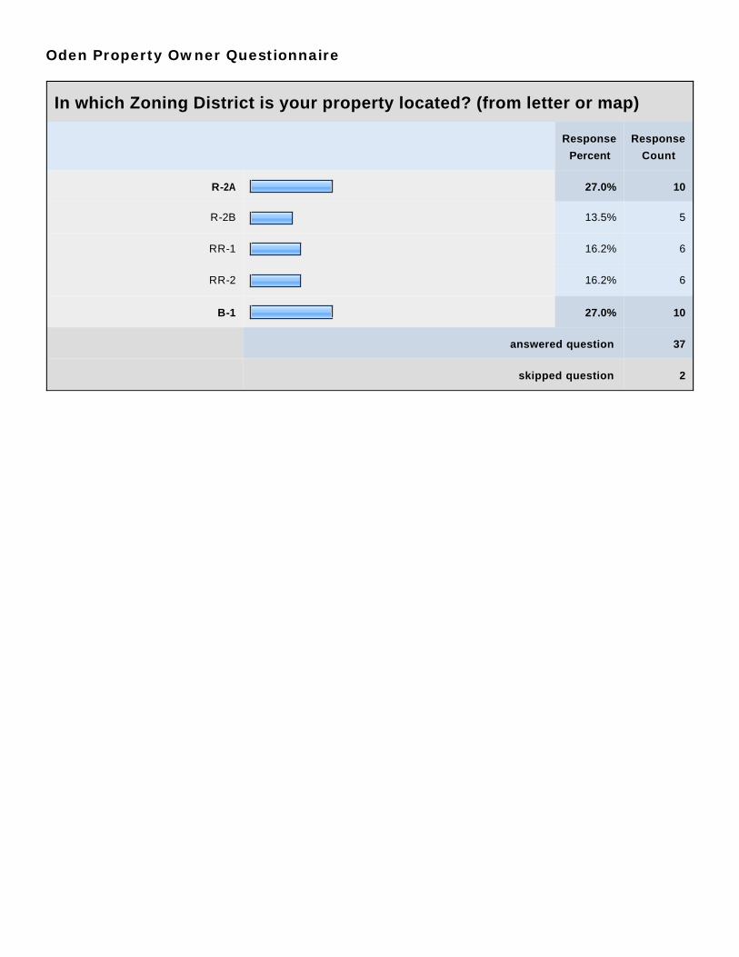
In which Zoning District is your property located? (from letter or map)
Response
Percent
Response
Count
R-2A 27.0% 10
R-2B 13.5% 5
RR-1 16.2% 6
RR-2 16.2% 6
B-1 27.0% 10
answered question 37
skipped question 2
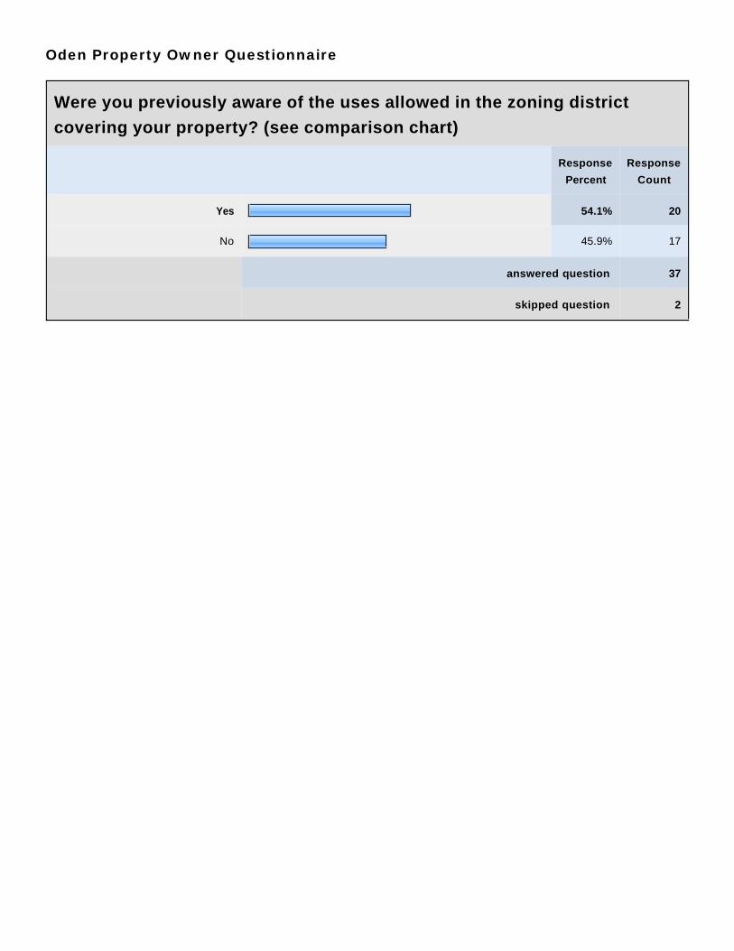
Oden Property Owner Questionnaire
Were you previously aware of the uses allowed in the zoning district
covering your property? (see comparison chart)
Response
Percent
Response
Count
Yes 54.1% 20
No 45.9% 17
answered question 37
skipped question 2

Oden Property Owner Questionnaire
Comments on allowed uses?
Response
Count
8
answered question 8
skipped question 31
Response Text
1 Residential homes and cabins. Jul 6, 2010 3:28 PM
2 Keep my property as is. Jul 6, 2010 3:56 PM
3 It concerns me to see the high-trafic businesses allowed in my neighborhood ofseasonal and year round homes.
Jul 6, 2010 4:02 PM
4 Limited information. Jul 6, 2010 4:48 PM
5 Didn't know I could raise chickens, etc... Jul 6, 2010 5:01 PM
6 I was surprised to see thay Mobile Homes are allowed in RR-1. Since there is notenough room for farms in RR-1, that permitted use should be removed. Also, noroom for golf course & country clubs, so that special use permitted option shouldbe removed.
Jul 6, 2010 5:36 PM
7 Residential Jul 6, 2010 5:40 PM
8 Generally Jul 6, 2010 5:45 PM
Oden Property Owner Questionnaire
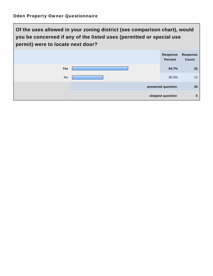
Of the uses allowed in your zoning district (see comparison chart), would
you be concerned if any of the listed uses (permitted or special use
permit) were to locate next door?
Response
Percent
Response
Count
Yes 64.7% 22
No 35.3% 12
answered question 34
skipped question 5
Oden Property Owner Questionnaire
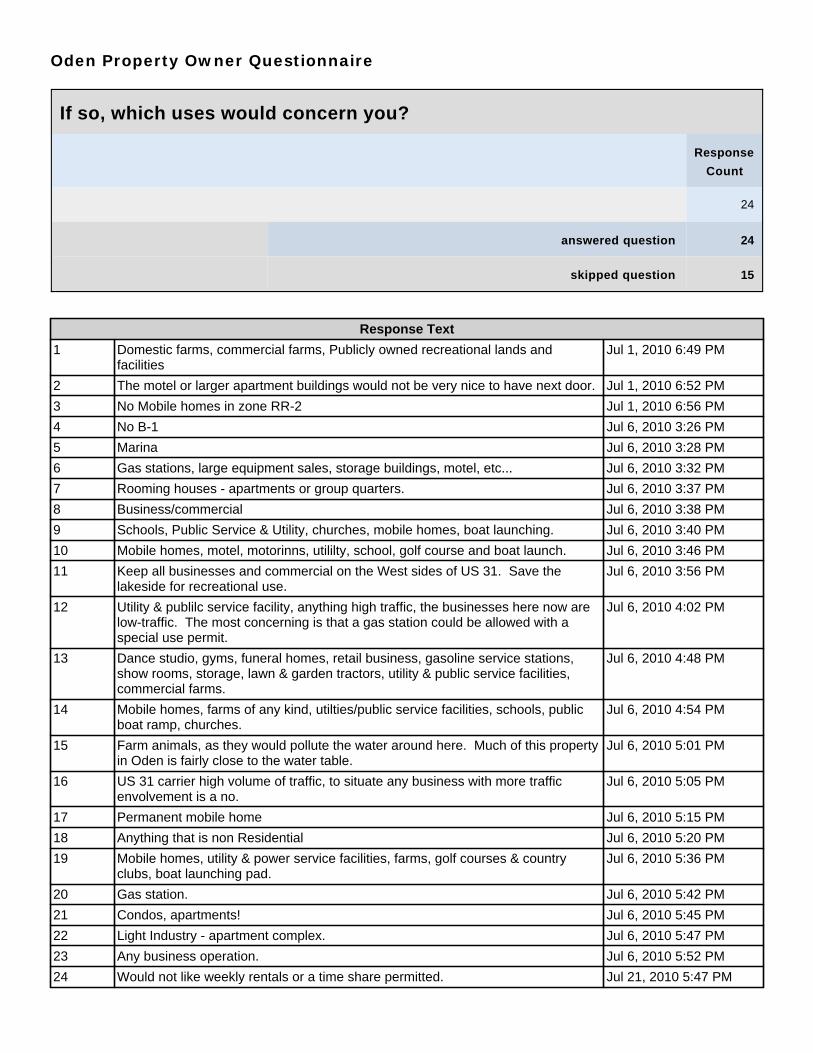
If so, which uses would concern you?
Response
Count
24
answered question 24
skipped question 15
Response Text
1 Domestic farms, commercial farms, Publicly owned recreational lands andfacilities
Jul 1, 2010 6:49 PM
2 The motel or larger apartment buildings would not be very nice to have next door. Jul 1, 2010 6:52 PM
3 No Mobile homes in zone RR-2 Jul 1, 2010 6:56 PM
4 No B-1 Jul 6, 2010 3:26 PM
5 Marina Jul 6, 2010 3:28 PM
6 Gas stations, large equipment sales, storage buildings, motel, etc... Jul 6, 2010 3:32 PM
7 Rooming houses - apartments or group quarters. Jul 6, 2010 3:37 PM
8 Business/commercial Jul 6, 2010 3:38 PM
9 Schools, Public Service & Utility, churches, mobile homes, boat launching. Jul 6, 2010 3:40 PM
10 Mobile homes, motel, motorinns, utililty, school, golf course and boat launch. Jul 6, 2010 3:46 PM
11 Keep all businesses and commercial on the West sides of US 31. Save thelakeside for recreational use.
Jul 6, 2010 3:56 PM
12 Utility & publilc service facility, anything high traffic, the businesses here now arelow-traffic. The most concerning is that a gas station could be allowed with aspecial use permit.
Jul 6, 2010 4:02 PM
13 Dance studio, gyms, funeral homes, retail business, gasoline service stations,show rooms, storage, lawn & garden tractors, utility & public service facilities,commercial farms.
Jul 6, 2010 4:48 PM
14 Mobile homes, farms of any kind, utilties/public service facilities, schools, publicboat ramp, churches.
Jul 6, 2010 4:54 PM
15 Farm animals, as they would pollute the water around here. Much of this propertyin Oden is fairly close to the water table.
Jul 6, 2010 5:01 PM
16 US 31 carrier high volume of traffic, to situate any business with more trafficenvolvement is a no.
Jul 6, 2010 5:05 PM
17 Permanent mobile home Jul 6, 2010 5:15 PM
18 Anything that is non Residential Jul 6, 2010 5:20 PM
19 Mobile homes, utility & power service facilities, farms, golf courses & countryclubs, boat launching pad.
Jul 6, 2010 5:36 PM
20 Gas station. Jul 6, 2010 5:42 PM
21 Condos, apartments! Jul 6, 2010 5:45 PM
22 Light Industry - apartment complex. Jul 6, 2010 5:47 PM
23 Any business operation. Jul 6, 2010 5:52 PM
24 Would not like weekly rentals or a time share permitted. Jul 21, 2010 5:47 PM

Oden Property Owner Questionnaire
The Zoning Ordinance is being reviewed and will be updated, at which
time there may be opportunities for some changes either in districts,
district boundaries and/or the uses allowed in various districts. What
changes would you like reviewed and considered?
Response
Count
17
answered question 17
skipped question 22
Response Text
1 Some B-1 changed to B-2 Jul 1, 2010 6:46 PM
2 Change some B-1 to B-2 Jul 1, 2010 6:47 PM
3 Some B-1 change to B-2 Jul 1, 2010 6:48 PM
4 Home at corner of 31 & Indian Point should be RR-2, east side of east entrance ofIndian Point.
Jul 6, 2010 3:26 PM
5 Duel zoning . . . B1/R Jul 6, 2010 3:44 PM
6 None Jul 6, 2010 3:46 PM
7 Keep all businesses and commercial on the West sides of US 31. Save thelakeside for recreational use.
Jul 6, 2010 3:56 PM
8 I'd rather my neighborhood not be B-1. Jul 6, 2010 4:02 PM
9 Maintain as much of the district as possible for Residential purposes. Jul 6, 2010 4:48 PM
10 Uses for RR-1 adjusted to eliminate Mobile homes, farms of any kind,utilties/public service facilities, schools, public boat ramp, churches.
Jul 6, 2010 4:54 PM
11 I don't think there is a need for more marinas, docks, etc... Jul 6, 2010 5:01 PM
12 Rental homes need to be cleaned up - maybe some restrictions in this areaenforced.
Jul 6, 2010 5:11 PM
13 Cannot comment - insufficient knowledge as a summer resident. Jul 6, 2010 5:20 PM
14 None Jul 6, 2010 5:25 PM
15 Mobile homes, utility & power service facilities, farms, golf courses & countryclubs, boat launching pad. Why aren't RR-1 and RR-2 the same? Their uses lookidentical. The B-1 District North of US 31 is too large for the amount of businessthere.
Jul 6, 2010 5:36 PM
16 Elimination of non usage in the zoned usage. Jul 6, 2010 5:40 PM
17 I would like to stay R-2A. Jul 6, 2010 5:42 PM
Oden Property Owner Questionnaire
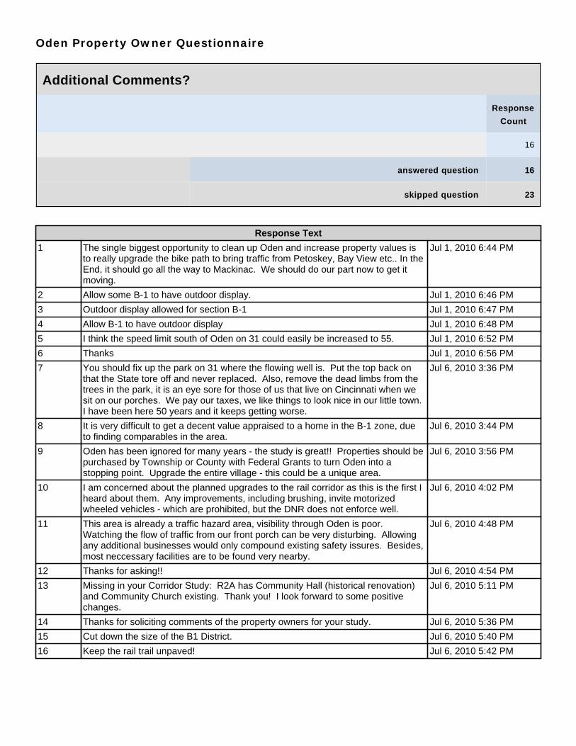
Additional Comments?
Response
Count
16
answered question 16
skipped question 23
Response Text
1 The single biggest opportunity to clean up Oden and increase property values isto really upgrade the bike path to bring traffic from Petoskey, Bay View etc.. In theEnd, it should go all the way to Mackinac. We should do our part now to get itmoving.
Jul 1, 2010 6:44 PM
2 Allow some B-1 to have outdoor display. Jul 1, 2010 6:46 PM
3 Outdoor display allowed for section B-1 Jul 1, 2010 6:47 PM
4 Allow B-1 to have outdoor display Jul 1, 2010 6:48 PM
5 I think the speed limit south of Oden on 31 could easily be increased to 55. Jul 1, 2010 6:52 PM
6 Thanks Jul 1, 2010 6:56 PM
7 You should fix up the park on 31 where the flowing well is. Put the top back onthat the State tore off and never replaced. Also, remove the dead limbs from thetrees in the park, it is an eye sore for those of us that live on Cincinnati when wesit on our porches. We pay our taxes, we like things to look nice in our little town.I have been here 50 years and it keeps getting worse.
Jul 6, 2010 3:36 PM
8 It is very difficult to get a decent value appraised to a home in the B-1 zone, dueto finding comparables in the area.
Jul 6, 2010 3:44 PM
9 Oden has been ignored for many years - the study is great!! Properties should bepurchased by Township or County with Federal Grants to turn Oden into astopping point. Upgrade the entire village - this could be a unique area.
Jul 6, 2010 3:56 PM
10 I am concerned about the planned upgrades to the rail corridor as this is the first Iheard about them. Any improvements, including brushing, invite motorizedwheeled vehicles - which are prohibited, but the DNR does not enforce well.
Jul 6, 2010 4:02 PM
11 This area is already a traffic hazard area, visibility through Oden is poor.Watching the flow of traffic from our front porch can be very disturbing. Allowingany additional businesses would only compound existing safety issures. Besides,most neccessary facilities are to be found very nearby.
Jul 6, 2010 4:48 PM
12 Thanks for asking!! Jul 6, 2010 4:54 PM
13 Missing in your Corridor Study: R2A has Community Hall (historical renovation)and Community Church existing. Thank you! I look forward to some positivechanges.
Jul 6, 2010 5:11 PM
14 Thanks for soliciting comments of the property owners for your study. Jul 6, 2010 5:36 PM
15 Cut down the size of the B1 District. Jul 6, 2010 5:40 PM
16 Keep the rail trail unpaved! Jul 6, 2010 5:42 PM

APPENDIX B
Ponshewaing Area Corridor Study Supplemental Materials
Zoning Districts Use Comparison Matrix
Questionnaire
• Tally • Comments
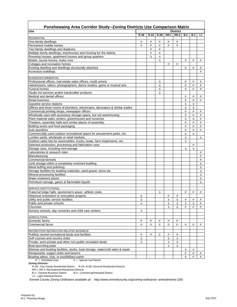
UseR-1B R-2A R-2B RR-1 RR-2 B-2 B-3 I-1
RESIDENTIALOne-family dwellings P P P P PPermanent mobile homes P P P P PTwo-family dwellings and duplexes P PMultiple family dwellings, townhouses and housing for the elderly P PRooming houses, apartment houses and group quarters S SMotels, tourist homes, motor inns S P P PCottages and recreation homes P PExisting dwelling and dwellings structurally attached P P PAccessory buildings P
BUSINESS/COMMERCIALProfessional offices, real estate sales offices, credit unions S P P PHairdressers, tailors, photographers, dance studios, gyms or musical arts. S P P PFuneral homes S P P PStudio Art services and/or handcrafter products SMedical and dental offices P P PRetail business P P PGasoline service stations S SOffices and show rooms of plumbers, electricians, decorators & similar trades S SCommercial printing shops, newspaper offices P P PWholesale uses with accessory storage space, but not warehousing P P PPlant material sales centers, greenhouses and nurseries S S PTheaters, assembly halls and similar places of assembly. P P PBottling works and food packaging. P P PAuto laundries P P PCommercially used outdoor recreational space for amusement parks, etc, S SLumber yards, wholesale or retail markets. S SOutdoor sales lots for automobiles, trucks, boats, farm implements, etc. SSelected production, processing and fabrication uses PStorage uses, including mini-storage S SLaboratories & research sites PManufacturing PCommercial kennels PJunk storage within a completely enclosed building SMetal buffing and polishing SStorage facilities for building materials, sand gravel, stone etc. SMineral processing facilities SWater treatment plants SPetroleum storage, gases & flammable liquids S
SERVICE /INSTITUTIONALFraternal lodge halls, sportsmen's assoc. athletic clubs S P P PHistorical restoration or renovation projects S P PUtility and public service facilities S S S P P PPublic and private schools S S S S S PChurches S S P P PNursery schools, day nurseries and child care centers S
AGRICULTURALDomestic farms P P P P PCommercial farms P P P P P P P P
RECREATION/ RECREATION RELATED BUSINESSPublicly owned recreational lands and facilities P P P P PGolf courses and country clubs S S SPrivate, semi-private and other non-public recreation lands S S SBoat launching pads S SMarinas and boating facilities, docks, boat storage, watercraft sales & repair S SRestaurants, supper clubs and taverns P P PBowling alleys, club, or pool/billiard parlor P P P P = Permitted Uses S = Special Use PermitZoning Districts : R-1B-- One Family Residential District R-2A, R-2B--General Residential Districts RR-1, RR-2--Recreational Residential Districts B-2-- General Business District B-3-- Commercial/Industrial District I-1-- Light Industrial District Emmet County Zoning Ordinance available at: http://www.emmetcounty.org/zoning-ordinance--amendments-230/
DistrictPonshewaing Area Corridor Study--Zoning Districts Use Comparison Matrix
Prepared by:M.C. Planning Design July 2010
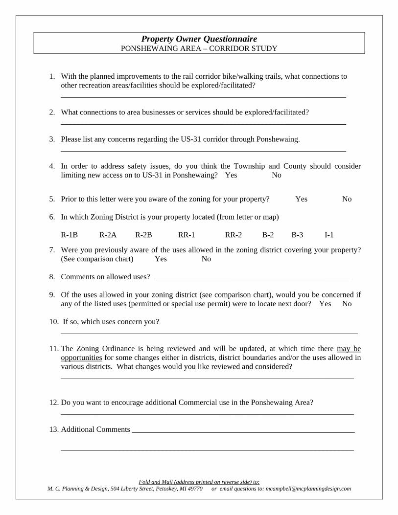
Property Owner Questionnaire PONSHEWAING AREA – CORRIDOR STUDY
1. With the planned improvements to the rail corridor bike/walking trails, what connections to other recreation areas/facilities should be explored/facilitated? _________________________________________________________________________
2. What connections to area businesses or services should be explored/facilitated?
_________________________________________________________________________ 3. Please list any concerns regarding the US-31 corridor through Ponshewaing.
_________________________________________________________________________ 4. In order to address safety issues, do you think the Township and County should consider
limiting new access on to US-31 in Ponshewaing? Yes No
5. Prior to this letter were you aware of the zoning for your property? Yes No 6. In which Zoning District is your property located (from letter or map)
R-1B R-2A R-2B RR-1 RR-2 B-2 B-3 I-1
7. Were you previously aware of the uses allowed in the zoning district covering your property?
(See comparison chart) Yes No 8. Comments on allowed uses? __________________________________________________ 9. Of the uses allowed in your zoning district (see comparison chart), would you be concerned if
any of the listed uses (permitted or special use permit) were to locate next door? Yes No
10. If so, which uses concern you? ____________________________________________________________________________
11. The Zoning Ordinance is being reviewed and will be updated, at which time there may be
opportunities for some changes either in districts, district boundaries and/or the uses allowed in various districts. What changes would you like reviewed and considered? ___________________________________________________________________________
12. Do you want to encourage additional Commercial use in the Ponshewaing Area?
___________________________________________________________________________
13. Additional Comments _________________________________________________________
___________________________________________________________________________
Fold and Mail (address printed on reverse side) to: M. C. Planning & Design, 504 Liberty Street, Petoskey, MI 49770 or email questions to: [email protected]
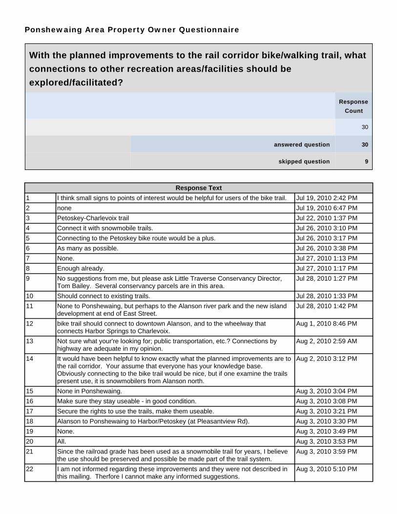
Ponshewaing Area Property Owner Questionnaire
With the planned improvements to the rail corridor bike/walking trail, what
connections to other recreation areas/facilities should be
explored/facilitated?
Response
Count
30
answered question 30
skipped question 9
Response Text
1 I think small signs to points of interest would be helpful for users of the bike trail. Jul 19, 2010 2:42 PM
2 none Jul 19, 2010 6:47 PM
3 Petoskey-Charlevoix trail Jul 22, 2010 1:37 PM
4 Connect it with snowmobile trails. Jul 26, 2010 3:10 PM
5 Connecting to the Petoskey bike route would be a plus. Jul 26, 2010 3:17 PM
6 As many as possible. Jul 26, 2010 3:38 PM
7 None. Jul 27, 2010 1:13 PM
8 Enough already. Jul 27, 2010 1:17 PM
9 No suggestions from me, but please ask Little Traverse Conservancy Director,Tom Bailey. Several conservancy parcels are in this area.
Jul 28, 2010 1:27 PM
10 Should connect to existing trails. Jul 28, 2010 1:33 PM
11 None to Ponshewaing, but perhaps to the Alanson river park and the new islanddevelopment at end of East Street.
Jul 28, 2010 1:42 PM
12 bike trail should connect to downtown Alanson, and to the wheelway thatconnects Harbor Springs to Charlevoix.
Aug 1, 2010 8:46 PM
13 Not sure what your're looking for; public transportation, etc.? Connections byhighway are adequate in my opinion.
Aug 2, 2010 2:59 AM
14 It would have been helpful to know exactly what the planned improvements are tothe rail corridor. Your assume that everyone has your knowledge base.Obviously connecting to the bike trail would be nice, but if one examine the trailspresent use, it is snowmobilers from Alanson north.
Aug 2, 2010 3:12 PM
15 None in Ponshewaing. Aug 3, 2010 3:04 PM
16 Make sure they stay useable - in good condition. Aug 3, 2010 3:08 PM
17 Secure the rights to use the trails, make them useable. Aug 3, 2010 3:21 PM
18 Alanson to Ponshewaing to Harbor/Petoskey (at Pleasantview Rd). Aug 3, 2010 3:30 PM
19 None. Aug 3, 2010 3:49 PM
20 All. Aug 3, 2010 3:53 PM
21 Since the railroad grade has been used as a snowmobile trail for years, I believethe use should be preserved and possible be made part of the trail system.
Aug 3, 2010 3:59 PM
22 I am not informed regarding these improvements and they were not described inthis mailing. Therfore I cannot make any informed suggestions.
Aug 3, 2010 5:10 PM

Response Text
23 I can't think of any. Aug 3, 2010 5:18 PM
24 Connect to trail from Petoskey to Harbor Springs; develop trail northwardly. Aug 3, 2010 5:24 PM
25 Nothing in Ponshewaing really - maybe a flashing yellow caution light at the Fortfor pedestrian crossing from bike path, also it might slow traffic at the curve.
Aug 3, 2010 5:43 PM
26 None that I can think of. Aug 3, 2010 6:08 PM
27 Possible boardwalk at Lake and boat launch. Aug 4, 2010 2:35 PM
28 It should go to Mackinaw City and also join the Petoskey-Harbor Springs trail. Aug 4, 2010 2:38 PM
29 River/Bridge area. Aug 4, 2010 2:41 PM
30 None. Aug 4, 2010 2:43 PM
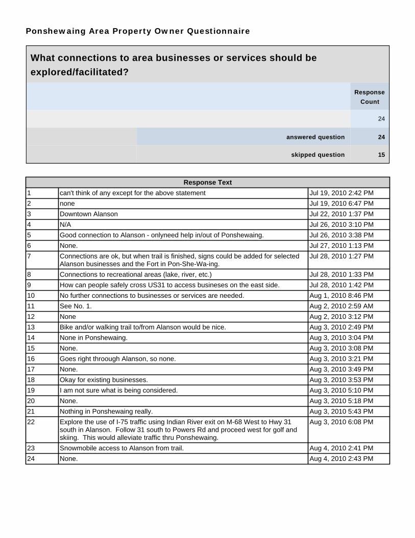
Ponshewaing Area Property Owner Questionnaire
What connections to area businesses or services should be
explored/facilitated?
Response
Count
24
answered question 24
skipped question 15
Response Text
1 can't think of any except for the above statement Jul 19, 2010 2:42 PM
2 none Jul 19, 2010 6:47 PM
3 Downtown Alanson Jul 22, 2010 1:37 PM
4 N/A Jul 26, 2010 3:10 PM
5 Good connection to Alanson - onlyneed help in/out of Ponshewaing. Jul 26, 2010 3:38 PM
6 None. Jul 27, 2010 1:13 PM
7 Connections are ok, but when trail is finished, signs could be added for selectedAlanson businesses and the Fort in Pon-She-Wa-ing.
Jul 28, 2010 1:27 PM
8 Connections to recreational areas (lake, river, etc.) Jul 28, 2010 1:33 PM
9 How can people safely cross US31 to access busineses on the east side. Jul 28, 2010 1:42 PM
10 No further connections to businesses or services are needed. Aug 1, 2010 8:46 PM
11 See No. 1. Aug 2, 2010 2:59 AM
12 None Aug 2, 2010 3:12 PM
13 Bike and/or walking trail to/from Alanson would be nice. Aug 3, 2010 2:49 PM
14 None in Ponshewaing. Aug 3, 2010 3:04 PM
15 None. Aug 3, 2010 3:08 PM
16 Goes right throough Alanson, so none. Aug 3, 2010 3:21 PM
17 None. Aug 3, 2010 3:49 PM
18 Okay for existing businesses. Aug 3, 2010 3:53 PM
19 I am not sure what is being considered. Aug 3, 2010 5:10 PM
20 None. Aug 3, 2010 5:18 PM
21 Nothing in Ponshewaing really. Aug 3, 2010 5:43 PM
22 Explore the use of I-75 traffic using Indian River exit on M-68 West to Hwy 31south in Alanson. Follow 31 south to Powers Rd and proceed west for golf andskiing. This would alleviate traffic thru Ponshewaing.
Aug 3, 2010 6:08 PM
23 Snowmobile access to Alanson from trail. Aug 4, 2010 2:41 PM
24 None. Aug 4, 2010 2:43 PM
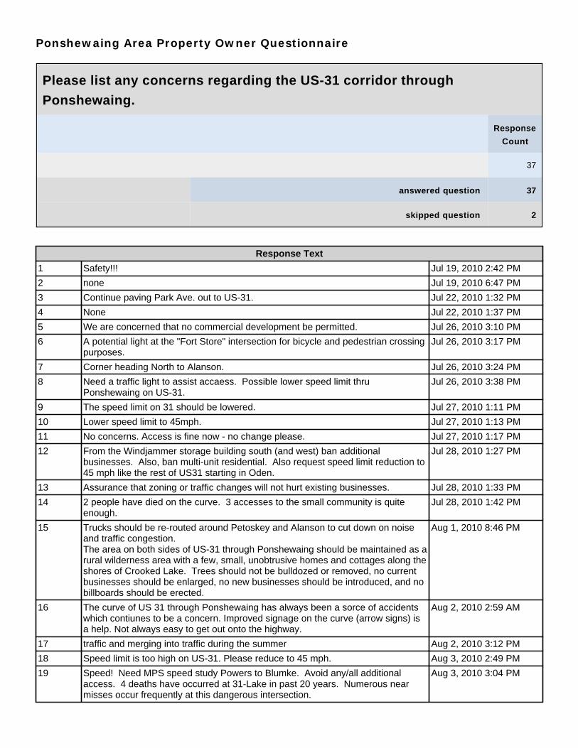
Ponshewaing Area Property Owner Questionnaire
Please list any concerns regarding the US-31 corridor through
Ponshewaing.
Response
Count
37
answered question 37
skipped question 2
Response Text
1 Safety!!! Jul 19, 2010 2:42 PM
2 none Jul 19, 2010 6:47 PM
3 Continue paving Park Ave. out to US-31. Jul 22, 2010 1:32 PM
4 None Jul 22, 2010 1:37 PM
5 We are concerned that no commercial development be permitted. Jul 26, 2010 3:10 PM
6 A potential light at the "Fort Store" intersection for bicycle and pedestrian crossingpurposes.
Jul 26, 2010 3:17 PM
7 Corner heading North to Alanson. Jul 26, 2010 3:24 PM
8 Need a traffic light to assist accaess. Possible lower speed limit thruPonshewaing on US-31.
Jul 26, 2010 3:38 PM
9 The speed limit on 31 should be lowered. Jul 27, 2010 1:11 PM
10 Lower speed limit to 45mph. Jul 27, 2010 1:13 PM
11 No concerns. Access is fine now - no change please. Jul 27, 2010 1:17 PM
12 From the Windjammer storage building south (and west) ban additionalbusinesses. Also, ban multi-unit residential. Also request speed limit reduction to45 mph like the rest of US31 starting in Oden.
Jul 28, 2010 1:27 PM
13 Assurance that zoning or traffic changes will not hurt existing businesses. Jul 28, 2010 1:33 PM
14 2 people have died on the curve. 3 accesses to the small community is quiteenough.
Jul 28, 2010 1:42 PM
15 Trucks should be re-routed around Petoskey and Alanson to cut down on noiseand traffic congestion.The area on both sides of US-31 through Ponshewaing should be maintained as arural wilderness area with a few, small, unobtrusive homes and cottages along theshores of Crooked Lake. Trees should not be bulldozed or removed, no currentbusinesses should be enlarged, no new businesses should be introduced, and nobillboards should be erected.
Aug 1, 2010 8:46 PM
16 The curve of US 31 through Ponshewaing has always been a sorce of accidentswhich contiunes to be a concern. Improved signage on the curve (arrow signs) isa help. Not always easy to get out onto the highway.
Aug 2, 2010 2:59 AM
17 traffic and merging into traffic during the summer Aug 2, 2010 3:12 PM
18 Speed limit is too high on US-31. Please reduce to 45 mph. Aug 3, 2010 2:49 PM
19 Speed! Need MPS speed study Powers to Blumke. Avoid any/all additionalaccess. 4 deaths have occurred at 31-Lake in past 20 years. Numerous nearmisses occur frequently at this dangerous intersection.
Aug 3, 2010 3:04 PM
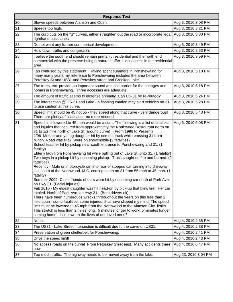
Response Text
20 Slower speeds between Alanson and Oden. Aug 3, 2010 3:08 PM
21 Speeds too high. Aug 3, 2010 3:21 PM
22 The curb cuts on the "S" curves, either straighten out the road or incorporate legalrighthand pass lanes.
Aug 3, 2010 3:30 PM
23 Do not want any further commerical development. Aug 3, 2010 3:49 PM
24 Hold down traffic and congestion. Aug 3, 2010 3:53 PM
25 I believe the south end should remain primarily residential and the north endcommercial with the preserve being a natural buffer. Limit access in the residentialarea.
Aug 3, 2010 3:59 PM
26 I an confused by this statement. Having spent summers in Ponshewaing formany many years my reference to Ponshewaing includes the area betweenPetoskey St and US31 and Petoskey street and Crooked Lake.
Aug 3, 2010 5:10 PM
27 The trees, etc. provide an important sound and site barrier for the cottages andhomes in Ponshewaing. Three accesses are adequate.
Aug 3, 2010 5:18 PM
28 The amount of traffic seems to increase annually. Can US-31 be re-routed? Aug 3, 2010 5:24 PM
29 The intersection @ US-31 and Lake - a flashing caution may alert vehicles on 31to use caution at this curve.
Aug 3, 2010 5:28 PM
30 Speed limit should be 45 not 55 - they speed along that curve - very dangerous!There are plenty of accesses - no more needed.
Aug 3, 2010 5:43 PM
31 Speed limit lowered to 45 mph would be a start. The following is a list of fatalitiesand injuries that occured from approximately the Northwood Restaurant north on31 to 1/2 mile north of Lake St (around curve) (From 1996 to Present)2/96 Mother and young daughter hit by cement truck while crossing 31 fromMilton. Road was slick. Were on snowmobile (2 fatalities)School teacher hit by pickup near south entrance to Ponshewaing and 31. (1fatality)Elderly lady from Ponshewaing hit while pulling out of Lake St. onto 31. (1 fatality)Two boys in a pickup hit by oncoming pickup. Truck caught on fire and burned. (2fatalities)Recently - Male on motorcycle ran into rear of stopped car turning into drivewayjust south of the Northwood. M.C. coming south on 31 from 55 mph to 45 mph. (1fatality)Summer 2009- Close friends of ours were hit by oncoming car north of Park Ave.on Hwy 31. (Facial injuries)Feb 2010 - My eldest daughter was hit head-on by pick-up that blew tire. Her cartotaled. North of Park Ave. on Hwy 31. (Both drivers ok)There have been numerouos wrecks throoughout the years on this less than 2mile span - some fatalities, some injuries, that have slipped my mind. The speedlimit must be lowered to 45 mph from the Northwood to the Alanson City limits.This stretch is less than 2 miles long. 5 minutes longer to work, 5 minutes longercoming home. Isn't it worth the lives of our loved ones?
Aug 3, 2010 6:08 PM
32 None. Aug 4, 2010 2:35 PM
33 The US31 - Lake Street intersection is difficult due to the curve on US31. Aug 4, 2010 2:38 PM
34 Preservation of green shelterbelt for Ponshewaing. Aug 4, 2010 2:41 PM
35 Drive the speed limit! Aug 4, 2010 2:43 PM
36 No access roads on the curve! From Petoskey Steet east. Many accidents therenow.
Aug 4, 2010 6:47 PM
37 Too much traffic. The highway needs to be moved away from the lake. Aug 23, 2010 3:04 PM
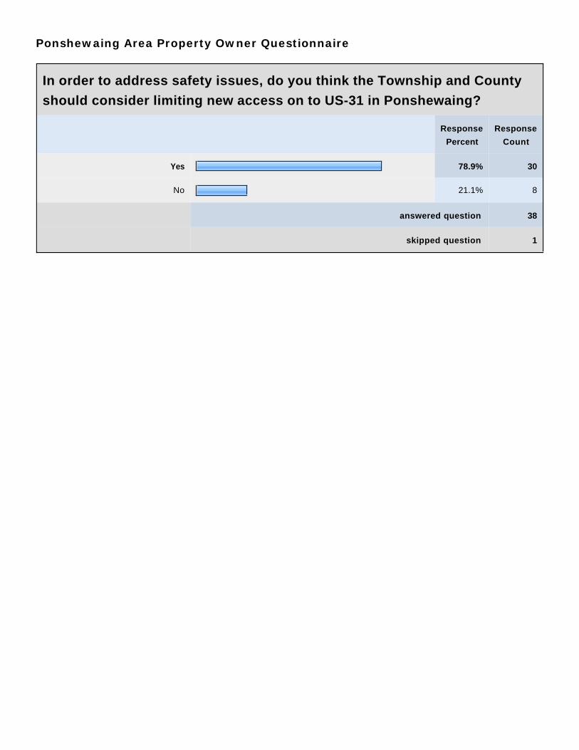
Ponshewaing Area Property Owner Questionnaire
In order to address safety issues, do you think the Township and County
should consider limiting new access on to US-31 in Ponshewaing?
Response
Percent
Response
Count
Yes 78.9% 30
No 21.1% 8
answered question 38
skipped question 1

Ponshewaing Area Property Owner Questionnaire
Prior to this letter were you aware of the zoning for your property?
Response
Percent
Response
Count
Yes 67.6% 25
No 32.4% 12
answered question 37
skipped question 2

Ponshewaing Area Property Owner Questionnaire
In which Zoning District is your property located? (from letter or map)
Response
Percent
Response
Count
R-1B 0.0% 0
R-2A 0.0% 0
R-2B 5.1% 2
RR-1 0.0% 0
RR-2 84.6% 33
B-2 0.0% 0
B-3 10.3% 4
I-1 0.0% 0
answered question 39
skipped question 0

Ponshewaing Area Property Owner Questionnaire
Were you previously aware of the uses allowed in the zoning district
covering your property? (see comparison chart)
Response
Percent
Response
Count
Yes 55.6% 20
No 44.4% 16
answered question 36
skipped question 3
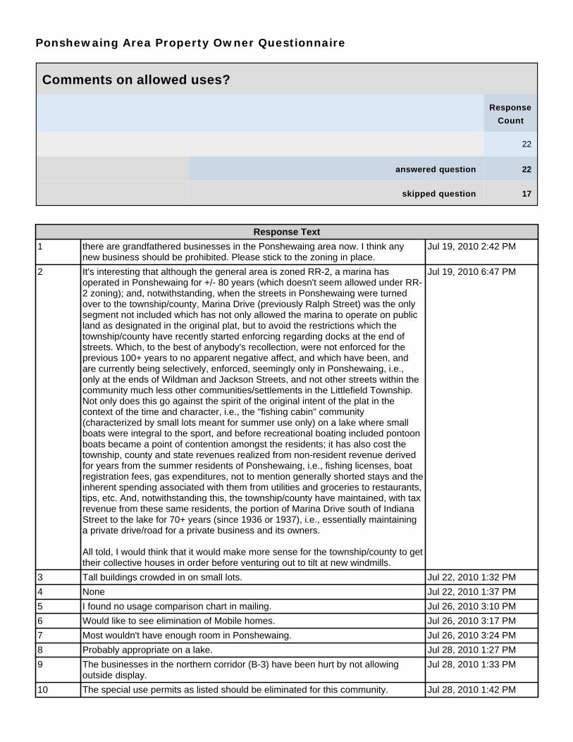
Ponshewaing Area Property Owner Questionnaire
Comments on allowed uses?
Response
Count
22
answered question 22
skipped question 17
Response Text
1 there are grandfathered businesses in the Ponshewaing area now. I think anynew business should be prohibited. Please stick to the zoning in place.
Jul 19, 2010 2:42 PM
2 It's interesting that although the general area is zoned RR-2, a marina hasoperated in Ponshewaing for +/- 80 years (which doesn't seem allowed under RR-2 zoning); and, notwithstanding, when the streets in Ponshewaing were turnedover to the township/county, Marina Drive (previously Ralph Street) was the onlysegment not included which has not only allowed the marina to operate on publicland as designated in the original plat, but to avoid the restrictions which thetownship/county have recently started enforcing regarding docks at the end ofstreets. Which, to the best of anybody's recollection, were not enforced for theprevious 100+ years to no apparent negative affect, and which have been, andare currently being selectively, enforced, seemingly only in Ponshewaing, i.e.,only at the ends of Wildman and Jackson Streets, and not other streets within thecommunity much less other communities/settlements in the Littlefield Township.Not only does this go against the spirit of the original intent of the plat in thecontext of the time and character, i.e., the "fishing cabin" community(characterized by small lots meant for summer use only) on a lake where smallboats were integral to the sport, and before recreational boating included pontoonboats became a point of contention amongst the residents; it has also cost thetownship, county and state revenues realized from non-resident revenue derivedfor years from the summer residents of Ponshewaing, i.e., fishing licenses, boatregistration fees, gas expenditures, not to mention generally shorted stays and theinherent spending associated with them from utilities and groceries to restaurants,tips, etc. And, notwithstanding this, the township/county have maintained, with taxrevenue from these same residents, the portion of Marina Drive south of IndianaStreet to the lake for 70+ years (since 1936 or 1937), i.e., essentially maintaininga private drive/road for a private business and its owners.
All told, I would think that it would make more sense for the township/county to gettheir collective houses in order before venturing out to tilt at new windmills.
Jul 19, 2010 6:47 PM
3 Tall buildings crowded in on small lots. Jul 22, 2010 1:32 PM
4 None Jul 22, 2010 1:37 PM
5 I found no usage comparison chart in mailing. Jul 26, 2010 3:10 PM
6 Would like to see elimination of Mobile homes. Jul 26, 2010 3:17 PM
7 Most wouldn't have enough room in Ponshewaing. Jul 26, 2010 3:24 PM
8 Probably appropriate on a lake. Jul 28, 2010 1:27 PM
9 The businesses in the northern corridor (B-3) have been hurt by not allowingoutside display.
Jul 28, 2010 1:33 PM
10 The special use permits as listed should be eliminated for this community. Jul 28, 2010 1:42 PM
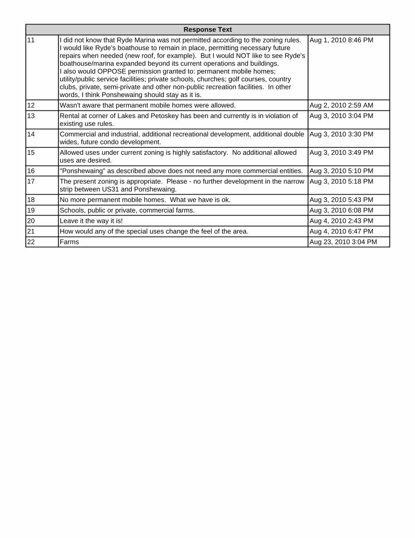
Response Text
11 I did not know that Ryde Marina was not permitted according to the zoning rules.I would like Ryde's boathouse to remain in place, permitting necessary futurerepairs when needed (new roof, for example). But I would NOT like to see Ryde'sboathouse/marina expanded beyond its current operations and buildings.I also would OPPOSE permission granted to: permanent mobile homes;utility/public service facilities; private schools, churches; golf courses, countryclubs, private, semi-private and other non-public recreation facilities. In otherwords, I think Ponshewaing should stay as it is.
Aug 1, 2010 8:46 PM
12 Wasn't aware that permanent mobile homes were allowed. Aug 2, 2010 2:59 AM
13 Rental at corner of Lakes and Petoskey has been and currently is in violation ofexisting use rules.
Aug 3, 2010 3:04 PM
14 Commercial and industrial, additional recreational development, additional doublewides, future condo development.
Aug 3, 2010 3:30 PM
15 Allowed uses under current zoning is highly satisfactory. No additional alloweduses are desired.
Aug 3, 2010 3:49 PM
16 "Ponshewaing" as described above does not need any more commercial entities. Aug 3, 2010 5:10 PM
17 The present zoning is appropriate. Please - no further development in the narrowstrip between US31 and Ponshewaing.
Aug 3, 2010 5:18 PM
18 No more permanent mobile homes. What we have is ok. Aug 3, 2010 5:43 PM
19 Schools, public or private, commercial farms. Aug 3, 2010 6:08 PM
20 Leave it the way it is! Aug 4, 2010 2:43 PM
21 How would any of the special uses change the feel of the area. Aug 4, 2010 6:47 PM
22 Farms Aug 23, 2010 3:04 PM
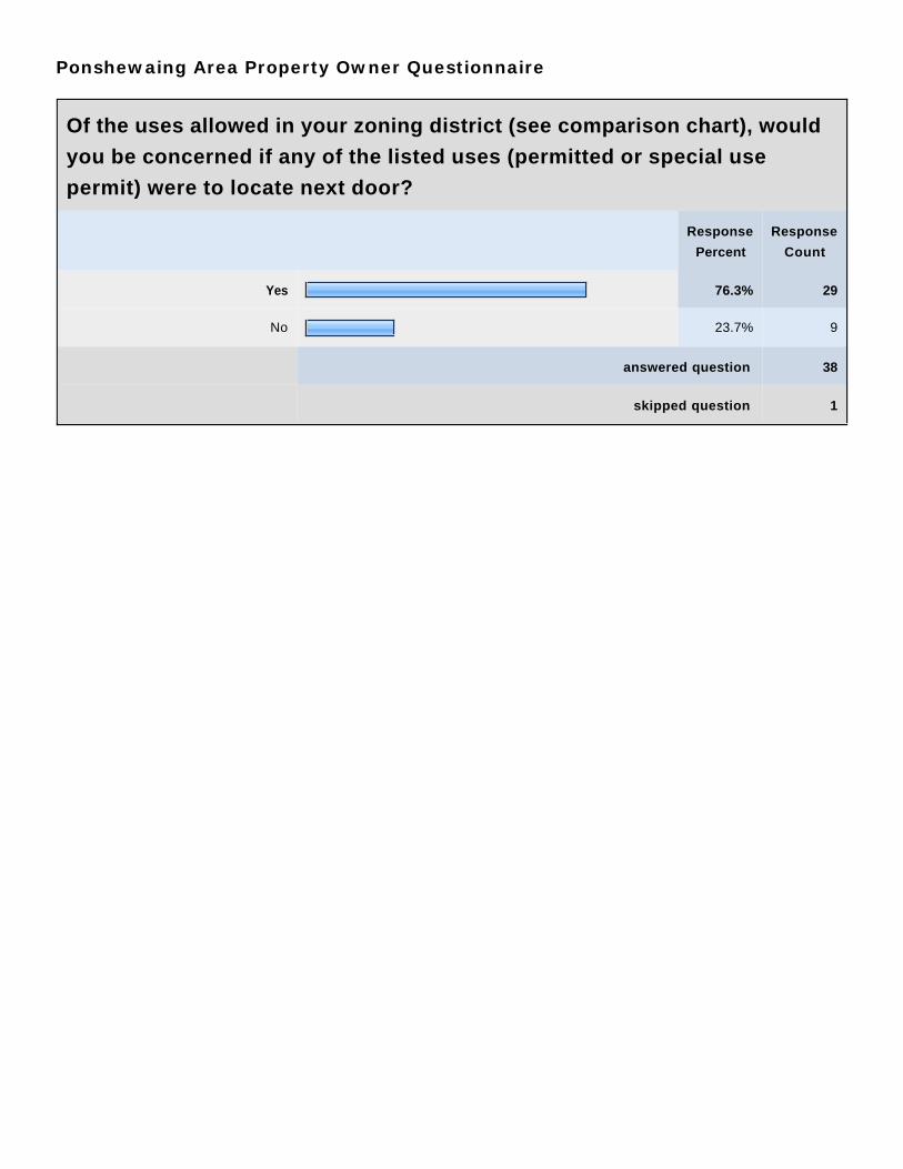
Ponshewaing Area Property Owner Questionnaire
Of the uses allowed in your zoning district (see comparison chart), would
you be concerned if any of the listed uses (permitted or special use
permit) were to locate next door?
Response
Percent
Response
Count
Yes 76.3% 29
No 23.7% 9
answered question 38
skipped question 1

Ponshewaing Area Property Owner Questionnaire
If so, which uses would concern you?
Response
Count
31
answered question 31
skipped question 8
Response Text
1 mobile homes for one. Anything other than single family dwellings and/or cottagesshould be prohibited.
Jul 19, 2010 2:42 PM
2 Loud noises Jul 22, 2010 1:32 PM
3 Multiple family dwellings, Motels, tourist homes, motor inns, rooming houses, apt.house, group quarters.
Jul 22, 2010 1:35 PM
4 No usage chart given. However, no deviation from RR2 status. Jul 26, 2010 3:10 PM
5 Permanent mobile homes. Jul 26, 2010 3:12 PM
6 Mobile homes, church, lodges. Jul 26, 2010 3:17 PM
7 None - particularly Jul 26, 2010 3:24 PM
8 Mobile homes,Lodge halls, Utility and public service facilities,Public and privateschools, Churches,Domestic farms,, Commercial farms, Pubicly owned recreationlands and facilities, golf courses, Private recreation lands, boat lauching pads.
Jul 26, 2010 3:38 PM
9 Mobile homes; commercial farms. Jul 27, 2010 1:17 PM
10 Every one. Except for Ryde Marina and the Fort. This has been a (mostlysummer) residential area for 115 years.
Jul 28, 2010 1:27 PM
11 Separate retail from industrial businesses. Jul 28, 2010 1:33 PM
12 All of the service/institutional, agricultural and rec./business permits. Jul 28, 2010 1:42 PM
13 See above, question #8. I would oppose anything that is currently listed on thechart as requiring special use permit. I would like to see those things notpermitted under any circumstance.
Aug 1, 2010 8:46 PM
14 Mobile home or utility/public service facilities. We have an empty lot next to uswhich is quite small and vertually unbuildable for normal housing, but would notlike the facilites mentioned built there.
Aug 2, 2010 2:59 AM
15 I woould rather it be zoned R-1B, but of course that would eliminate cottages. Inother words, zoning will allow for recreation related businesses and services, Wealready have a marina which is not according to the zoning. The Fort is hardly arecreation related business, nor does it fit under the business/commercialcategories for a R-2B. It just seems like the guy with the biggest pocket winswhen it comes to zoning, not necessarily what the people living there want.
Aug 2, 2010 3:12 PM
16 Domestic/Commercial farms, public & private schools, churches, utility and publicservice facilities.
Aug 3, 2010 2:49 PM
17 Duplexes, laundramats, multiple families in one family dwellings. (corner Lake &Petoskey - Stark Rental)
Aug 3, 2010 3:04 PM
18 Mobile homes along Lake. Aug 3, 2010 3:08 PM
19 No room in Ponshewaing. That the platted subdivisions of Ponshewaing is a goodexample of bad planning, tiny lots.
Aug 3, 2010 3:21 PM
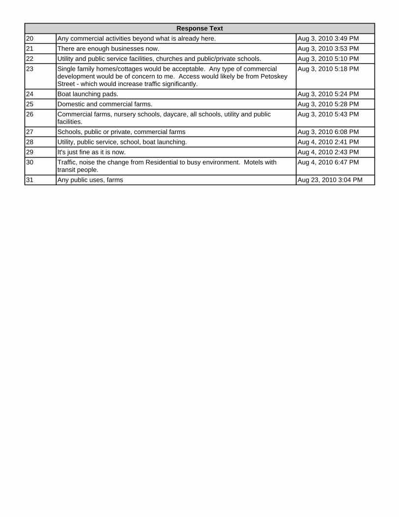
Response Text
20 Any commercial activities beyond what is already here. Aug 3, 2010 3:49 PM
21 There are enough businesses now. Aug 3, 2010 3:53 PM
22 Utility and public service facilities, churches and public/private schools. Aug 3, 2010 5:10 PM
23 Single family homes/cottages would be acceptable. Any type of commercialdevelopment would be of concern to me. Access would likely be from PetoskeyStreet - which would increase traffic significantly.
Aug 3, 2010 5:18 PM
24 Boat launching pads. Aug 3, 2010 5:24 PM
25 Domestic and commercial farms. Aug 3, 2010 5:28 PM
26 Commercial farms, nursery schools, daycare, all schools, utility and publicfacilities.
Aug 3, 2010 5:43 PM
27 Schools, public or private, commercial farms Aug 3, 2010 6:08 PM
28 Utility, public service, school, boat launching. Aug 4, 2010 2:41 PM
29 It's just fine as it is now. Aug 4, 2010 2:43 PM
30 Traffic, noise the change from Residential to busy environment. Motels withtransit people.
Aug 4, 2010 6:47 PM
31 Any public uses, farms Aug 23, 2010 3:04 PM

Ponshewaing Area Property Owner Questionnaire
The Zoning Ordinance is being reviewed and will be updated, at which
time there may be opportunities for some changes either in districts,
district boundaries and/or the uses allowed in various districts. What
changes would you like reviewed and considered?
Response
Count
26
answered question 26
skipped question 13
Response Text
1 I would like mobile homes eliminated from zoning districts except for mobile homeparks.
Jul 19, 2010 2:42 PM
2 Given the novelty of the original Ponshewaing plat, and the fact that the ends ofmost of the streets do not extend the last 1/4 of a block, I would like to see thoseportions abandoned and restored to the original intent, i.e., the benefit and use ofthe community as a whole.
Jul 19, 2010 6:47 PM
3 Big trees trimmed! (on the road to the lake). Two cars or trucks can't pull overwhen another comes.
Jul 22, 2010 1:32 PM
4 Unkown at this time. Jul 22, 2010 1:37 PM
5 No changes, but allow second story fire escapes. Jul 26, 2010 3:10 PM
6 Permanent mobile homes. Jul 26, 2010 3:12 PM
7 Elimination of mobile homes, churches, lodges. Jul 26, 2010 3:17 PM
8 More control on commercial property upkeep. Need rules for outside storage andjunk piles - not only commercial but residential.
Jul 26, 2010 3:38 PM
9 From the Windjammer storage building south (and west) ban additionalbusinesses. Also, ban multi-unit residential. Also request speed limit reduction to45 mph like the rest of US31 starting in Oden.
Jul 28, 2010 1:27 PM
10 Allow public display in B-3. Jul 28, 2010 1:33 PM
11 Uses and kinds of development. Single family vs multi family dwellings. Jul 28, 2010 1:42 PM
12 See my responses to questions #8 and 10. Aug 1, 2010 8:46 PM
13 Concerned about the R-2B zoning of the property north of Petoskey St. Would notlike to see business or commercial facilities or motels built there.
Aug 2, 2010 2:59 AM
14 Additional access onto route 31 creating more and more traffic saftey issues.Limit the expansion of the present marina business.
Aug 2, 2010 3:12 PM
15 Domestic/Commercial farms, public & private schools, churches, utility and publicservice facilities. Elimination of the above uses either via permitted or specialallowances.
Aug 3, 2010 2:49 PM
16 Enforce existing covenants: Docks at end of Lakes & Petoskey, streets & alleys;off shore boat anchoring; trees, buildings located in 5 alleyways.
Aug 3, 2010 3:04 PM
17 Limit development. Aug 3, 2010 3:08 PM
18 Anything that would limit strip development along US31. Aug 3, 2010 3:21 PM
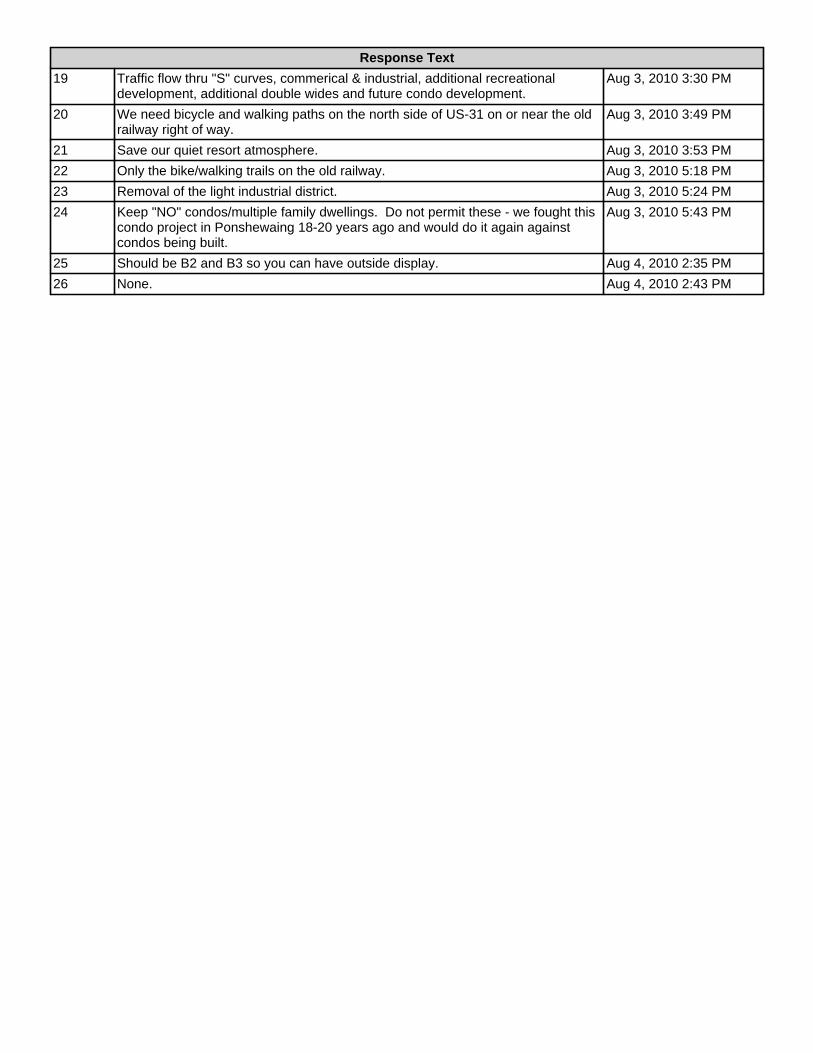
Response Text
19 Traffic flow thru "S" curves, commerical & industrial, additional recreationaldevelopment, additional double wides and future condo development.
Aug 3, 2010 3:30 PM
20 We need bicycle and walking paths on the north side of US-31 on or near the oldrailway right of way.
Aug 3, 2010 3:49 PM
21 Save our quiet resort atmosphere. Aug 3, 2010 3:53 PM
22 Only the bike/walking trails on the old railway. Aug 3, 2010 5:18 PM
23 Removal of the light industrial district. Aug 3, 2010 5:24 PM
24 Keep "NO" condos/multiple family dwellings. Do not permit these - we fought thiscondo project in Ponshewaing 18-20 years ago and would do it again againstcondos being built.
Aug 3, 2010 5:43 PM
25 Should be B2 and B3 so you can have outside display. Aug 4, 2010 2:35 PM
26 None. Aug 4, 2010 2:43 PM

Ponshewaing Area Property Owner Questionnaire
Do you want to encourage additional Commercial use in the Ponshewaing
Area?
Response
Count
39
answered question 39
skipped question 0
Response Text
1 Absolutely NOT! Jul 19, 2010 2:42 PM
2 no Jul 19, 2010 6:47 PM
3 No Jul 22, 2010 1:32 PM
4 No Jul 22, 2010 1:35 PM
5 Yes Jul 22, 2010 1:37 PM
6 No!!! Jul 26, 2010 3:10 PM
7 No. Jul 26, 2010 3:12 PM
8 If thought out correctly and places in correct locations. Jul 26, 2010 3:17 PM
9 Not necessarily. Limited opportunity. Should be only along US-31. Jul 26, 2010 3:24 PM
10 No. Jul 26, 2010 3:38 PM
11 No. Jul 27, 2010 1:11 PM
12 Absolutely not. Jul 27, 2010 1:13 PM
13 NO NO NO Jul 27, 2010 1:17 PM
14 No. No commercial needs, no reason to change a pleasant, successful residentialcommunity.
Jul 28, 2010 1:27 PM
15 Yes Jul 28, 2010 1:33 PM
16 Absolutely no. Jul 28, 2010 1:42 PM
17 No No No No No! Aug 1, 2010 8:46 PM
18 No. Should remain primarily residential. Ryde Marine and The Fort are longstanding commercial properties that direcly serve the community, but would notlike to see other commericial building that are not there primarily to serve thePonshewaing community.
Aug 2, 2010 2:59 AM
19 No...definitely not!!!!!! It will add to traffic problems and lots of businesses alongroute 31 into Petoskey have failed leaving old empty sites.
Aug 2, 2010 3:12 PM
20 No. Aug 3, 2010 2:49 PM
21 Absolutely, no. Aug 3, 2010 3:04 PM
22 No. Aug 3, 2010 3:08 PM
23 No. Aug 3, 2010 3:21 PM
24 No! Aug 3, 2010 3:30 PM
25 No - definitely not. Aug 3, 2010 3:49 PM
26 No! Aug 3, 2010 3:53 PM

Response Text
27 As stated above I believe the north end and south end are two completelydifferent zoning districts. Commercial use should be encouraged in the north andnot the south.
Aug 3, 2010 3:59 PM
28 No. Aug 3, 2010 5:10 PM
29 No. Aug 3, 2010 5:18 PM
30 No. Aug 3, 2010 5:24 PM
31 No. Aug 3, 2010 5:28 PM
32 Definitely, NO! We have our cottage here because it is a nice residential area andwe do not want commercial businesses going up in the Ponshewaing area. Wehave been coming to the Ponshewaing Area and lived in the summer here for 44years! We don't want condos - only single family homes!
Aug 3, 2010 5:43 PM
33 No. Aug 3, 2010 6:08 PM
34 Yes, of course. Aug 4, 2010 2:35 PM
35 No. Aug 4, 2010 2:38 PM
36 Absolutely not. Aug 4, 2010 2:41 PM
37 No. Aug 4, 2010 2:43 PM
38 Not from Park Street to just past Petoskey St. Aug 4, 2010 6:47 PM
39 No Aug 23, 2010 3:04 PM
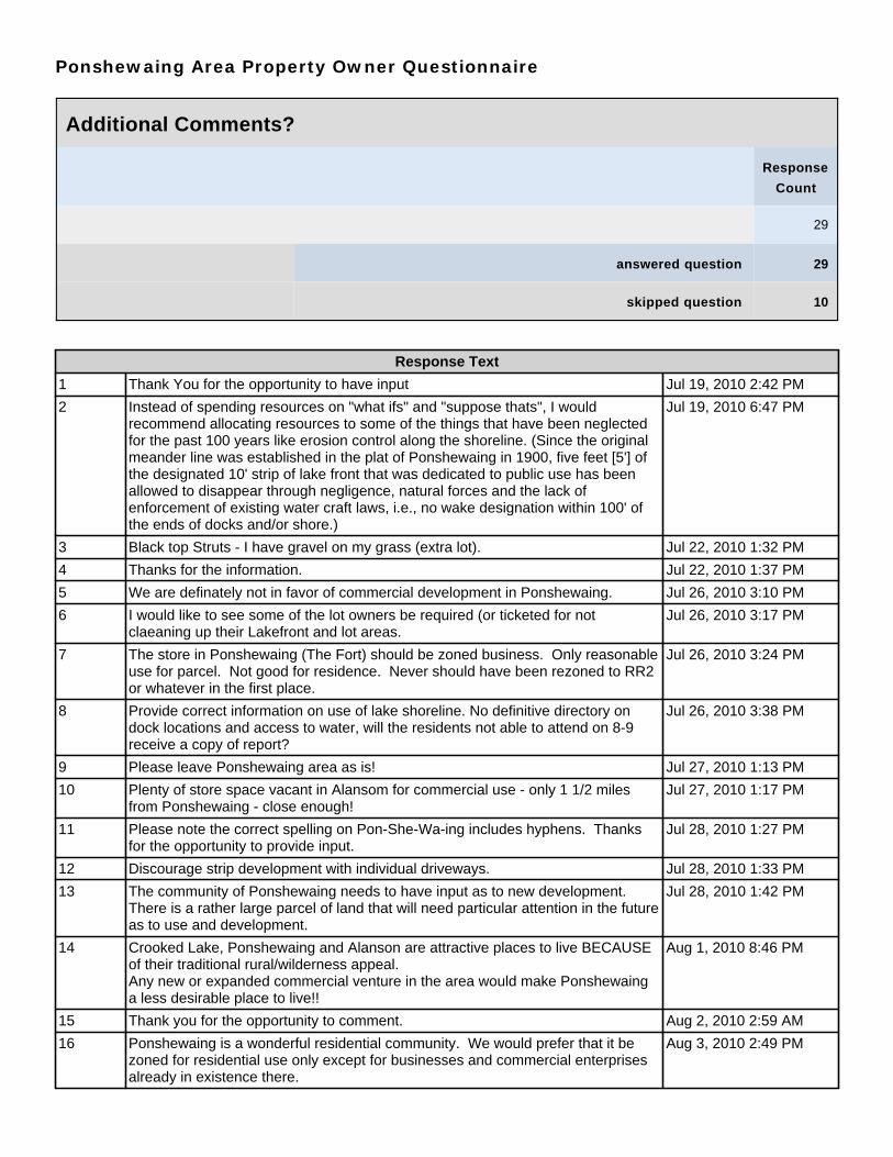
Ponshewaing Area Property Owner Questionnaire
Additional Comments?
Response
Count
29
answered question 29
skipped question 10
Response Text
1 Thank You for the opportunity to have input Jul 19, 2010 2:42 PM
2 Instead of spending resources on "what ifs" and "suppose thats", I wouldrecommend allocating resources to some of the things that have been neglectedfor the past 100 years like erosion control along the shoreline. (Since the originalmeander line was established in the plat of Ponshewaing in 1900, five feet [5'] ofthe designated 10' strip of lake front that was dedicated to public use has beenallowed to disappear through negligence, natural forces and the lack ofenforcement of existing water craft laws, i.e., no wake designation within 100' ofthe ends of docks and/or shore.)
Jul 19, 2010 6:47 PM
3 Black top Struts - I have gravel on my grass (extra lot). Jul 22, 2010 1:32 PM
4 Thanks for the information. Jul 22, 2010 1:37 PM
5 We are definately not in favor of commercial development in Ponshewaing. Jul 26, 2010 3:10 PM
6 I would like to see some of the lot owners be required (or ticketed for notclaeaning up their Lakefront and lot areas.
Jul 26, 2010 3:17 PM
7 The store in Ponshewaing (The Fort) should be zoned business. Only reasonableuse for parcel. Not good for residence. Never should have been rezoned to RR2or whatever in the first place.
Jul 26, 2010 3:24 PM
8 Provide correct information on use of lake shoreline. No definitive directory ondock locations and access to water, will the residents not able to attend on 8-9receive a copy of report?
Jul 26, 2010 3:38 PM
9 Please leave Ponshewaing area as is! Jul 27, 2010 1:13 PM
10 Plenty of store space vacant in Alansom for commercial use - only 1 1/2 milesfrom Ponshewaing - close enough!
Jul 27, 2010 1:17 PM
11 Please note the correct spelling on Pon-She-Wa-ing includes hyphens. Thanksfor the opportunity to provide input.
Jul 28, 2010 1:27 PM
12 Discourage strip development with individual driveways. Jul 28, 2010 1:33 PM
13 The community of Ponshewaing needs to have input as to new development.There is a rather large parcel of land that will need particular attention in the futureas to use and development.
Jul 28, 2010 1:42 PM
14 Crooked Lake, Ponshewaing and Alanson are attractive places to live BECAUSEof their traditional rural/wilderness appeal.Any new or expanded commercial venture in the area would make Ponshewainga less desirable place to live!!
Aug 1, 2010 8:46 PM
15 Thank you for the opportunity to comment. Aug 2, 2010 2:59 AM
16 Ponshewaing is a wonderful residential community. We would prefer that it bezoned for residential use only except for businesses and commercial enterprisesalready in existence there.
Aug 3, 2010 2:49 PM

Response Text
17 Ponshewaing is either R2B or RR2. The existing marina, marina parking andoutlying buildings are not included on the comparison matris ???
Aug 3, 2010 3:04 PM
18 Make sure all options are fully discussed & open to public before proceeding. Aug 3, 2010 3:08 PM
19 Once development happens, even if it creates hazerdous conditions on US31, itcan't be undone.
Aug 3, 2010 3:21 PM
20 Majority of Ponshewaing owners are 2nd & 3rd generation. Plus many of theseowners vacationed in Ponshewaing as children and now bring their children andgrandchildren. I believe most owners would agree to leave the neighborhood restin its raw and beautiful history.
Aug 3, 2010 3:30 PM
21 This area has been a reacreational family owned area for many years. Familileslove the corridor. No changes should be made!
Aug 3, 2010 3:49 PM
22 Keep Ponshewaing as noncommercial as possible. Aug 3, 2010 3:53 PM
23 I would appreciate being informed regarding the changes under consideration. Iam responding without really understanding the implication of questions or myanswers.
Aug 3, 2010 5:10 PM
24 Our family has vacationed in Ponshewaing since my grandfather and father cameup here in the early 1910's. We have owned property here since 1952. Fivegenerations have enjoyed this exciptional vacation spot for many families. Pleasedon't alter it. Thanks for your consideration.
Aug 3, 2010 5:18 PM
25 We need and use Ryde Marina. Ryde Marina is ok. We like "The Fort" store - it isjust fine. Having The Fort in Ponshewaing is great! Nice store. That's all wewant.
Aug 3, 2010 5:43 PM
26 Close Park Ave at 31. With the curve from south of "the Fort" coming north, thenorthbound cars (@55 mph) gives exiting from Park Ave a false sense of speedand cars are closer than you realize. Will have 2 paved exits out of Ponshewaing.Add flasher lilght at US31 and Lake St.
Aug 3, 2010 6:08 PM
27 You should be allowed to use your property any way you want to if you own it. Aug 4, 2010 2:35 PM
28 Please leave as is! Aug 4, 2010 2:43 PM
29 These areas have a need to stay permanent families and resort. Many of us aresummer residents and chose this area (by choilce or otherwise) for the way it isnow.
Aug 4, 2010 6:47 PM
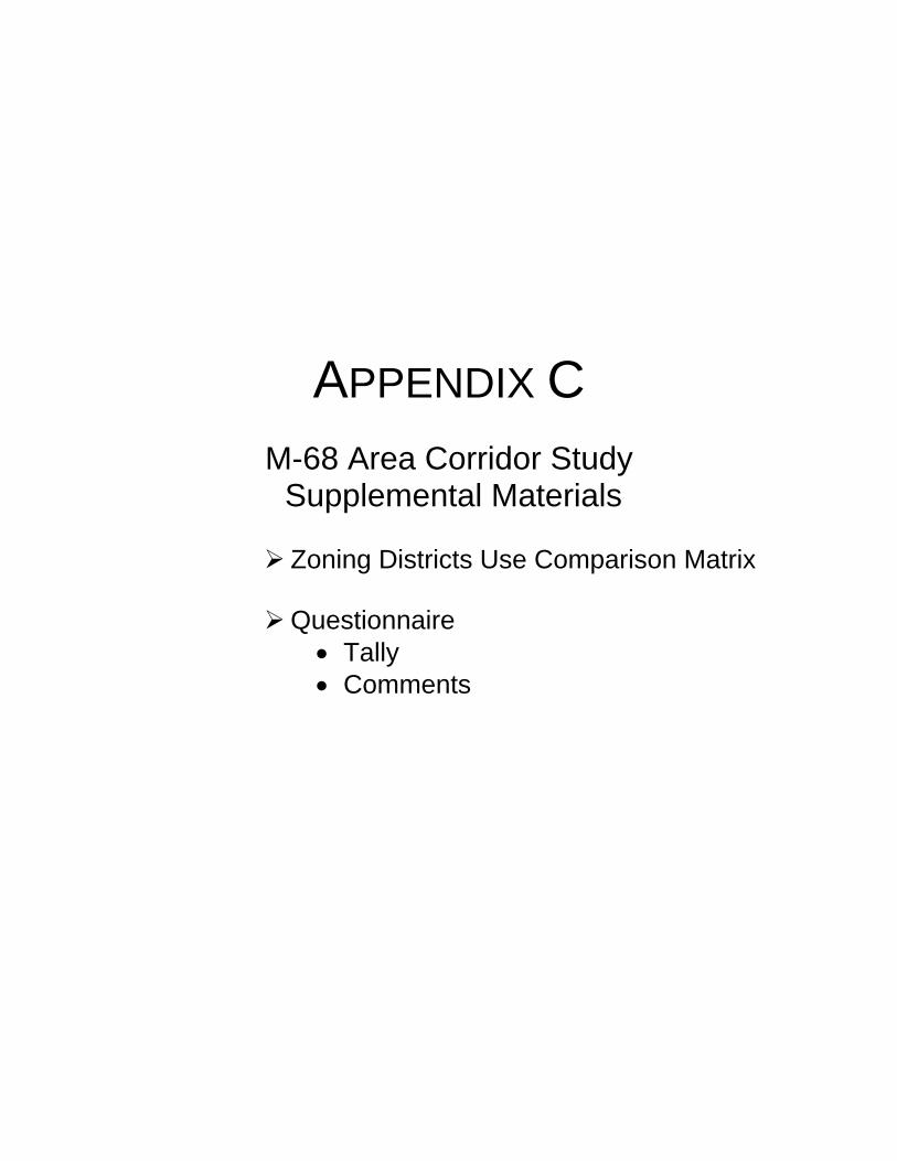
APPENDIX C
M-68 Area Corridor Study Supplemental Materials
Zoning Districts Use Comparison Matrix
Questionnaire
• Tally • Comments
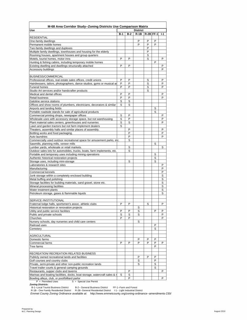
Use DistrictB-1 B-2 R-1B R-2B FF-1 I-1
RESIDENTIALOne-family dwellings P P PPermanent mobile homes P P PTwo-family dwellings and duplexes PMultiple family dwellings, townhouses and housing for the elderly PRooming houses, apartment houses and group quarters SMotels, tourist homes, motor inns P P S PHunting & fishing cabins, including temporary mobile homes PExisting dwelling and dwellings structurally attached P P PAccessory buildings P
BUSINESS/COMMERCIALProfessional offices, real estate sales offices, credit unions P P S PHairdressers, tailors, photographers, dance studios, gyms or musical ar P P S PFuneral homes P P S PStudio Art services and/or handcrafter products SMedical and dental offices P P PRetail business P P PGaloline service stations S SOffices and show rooms of plumbers, electricians, decorators & similar t S SAirports and landing fields SPortable roadside stands for sale of agricultural products SCommercial printing shops, newspaper offices S P PWholesale uses with accessory storage space, but not warehousing S P PPlant material sales centers, greenhouses and nurseries S S PLawn and garden tractors but not farm implement dealers STheaters, assembly halls and similar places of assembly. P PBottling works and food packaging. P PAuto laundries P PCommercially used outdoor recreational space for amusement parks, etc. SSawmills, planning mills, veneer mills SLumber yards, wholesale or retail markets. S SOutdoor sales lots for automobiles, trucks, boats, farm implements, etc. SPortable and temporary uses including mining operations SAuthentic historical restoration projects SStorage uses, including mini-storage S SLaboratories & research sites PManufacturing PCommercial kennels PJunk storage within a completely enclosed building SMetal buffing and polishing SStorage facilities for building materials, sand gravel, stone etc. SMineral processing facilities SWater treatment plants SPetroleum storage, gases & flammable liquids S
SERVICE /INSTITUTIONALFraternal lodge halls, sportsmen's assoc. athletic clubs P P S PHistorical restoration or renovation projects SUtility and public service facilities P P S P PPublic and private schools S S S PChurches P P PNursery schools, day nurseries and child care centers SRailroad uses PCemetery S
AGRICULTURALDomestic farms P P PCommercial farms P P P P P PTree farms P
RECREATION/ RECREATION RELATED BUSINESSPublicly owned recreational lands and facilities P P PGolf courses and country clubs S PPrivate, semi-private and other non-public recreation lands S STravel trailer courts & general camping grounds SRestaurants, supper clubs and taverns P PMarinas and boating facililties, docks, boat storage, watercraft sales & r S SBowling alleys, club, or pool/billiard parlor P P P = Permitted Uses S = Special Use PermitZoning Districts : B-1--Local Tourist Business District B-2-- General Business District FF-1--Farm and Forest R-1B-- One Family Residential District R-2B--General Residential District I-1-- Light Industrial District Emmet County Zoning Ordinance available at: http://www.emmetcounty.org/zoning-ordinance--amendments-230/
M-68 Area Corridor Study--Zoning Districts Use Comparison Matrix
Prepared by:M.C. Planning Design August 2010
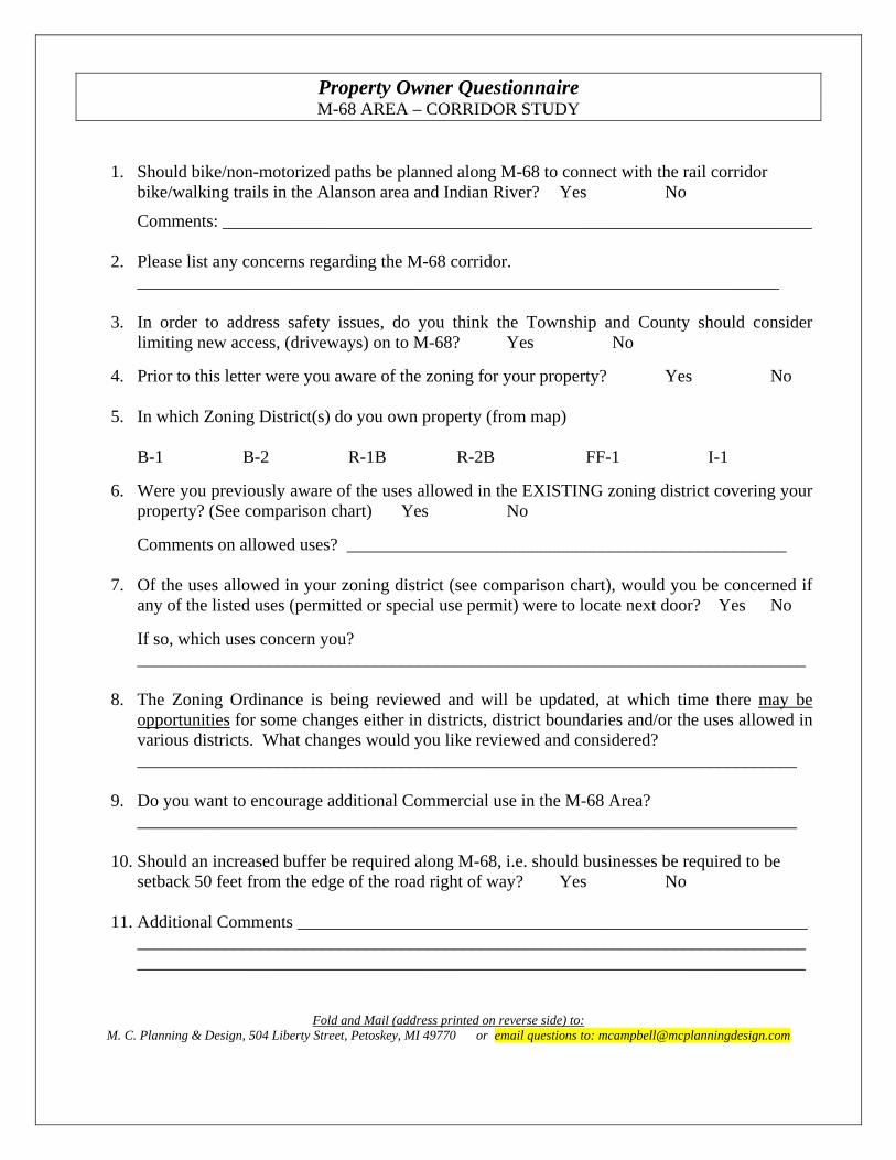
Property Owner Questionnaire M-68 AREA – CORRIDOR STUDY
1. Should bike/non-motorized paths be planned along M-68 to connect with the rail corridor bike/walking trails in the Alanson area and Indian River? Yes No
Comments: ___________________________________________________________________ 2. Please list any concerns regarding the M-68 corridor.
_________________________________________________________________________ 3. In order to address safety issues, do you think the Township and County should consider
limiting new access, (driveways) on to M-68? Yes No
4. Prior to this letter were you aware of the zoning for your property? Yes No 5. In which Zoning District(s) do you own property (from map)
B-1 B-2 R-1B R-2B FF-1 I-1
6. Were you previously aware of the uses allowed in the EXISTING zoning district covering your
property? (See comparison chart) Yes No
Comments on allowed uses? __________________________________________________ 7. Of the uses allowed in your zoning district (see comparison chart), would you be concerned if
any of the listed uses (permitted or special use permit) were to locate next door? Yes No
If so, which uses concern you? ____________________________________________________________________________
8. The Zoning Ordinance is being reviewed and will be updated, at which time there may be
opportunities for some changes either in districts, district boundaries and/or the uses allowed in various districts. What changes would you like reviewed and considered? ___________________________________________________________________________
9. Do you want to encourage additional Commercial use in the M-68 Area?
___________________________________________________________________________ 10. Should an increased buffer be required along M-68, i.e. should businesses be required to be
setback 50 feet from the edge of the road right of way? Yes No
11. Additional Comments __________________________________________________________ ____________________________________________________________________________ ____________________________________________________________________________
Fold and Mail (address printed on reverse side) to: M. C. Planning & Design, 504 Liberty Street, Petoskey, MI 49770 or email questions to: [email protected]
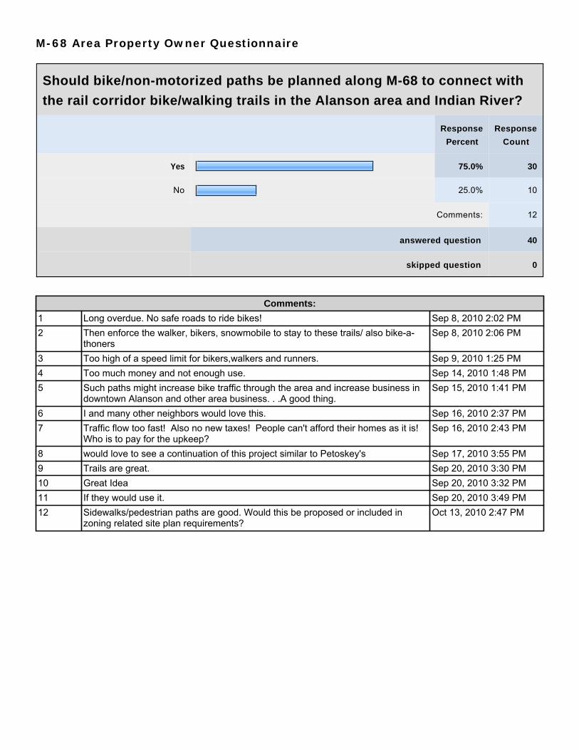
M-68 Area Property Owner Questionnaire
Should bike/non-motorized paths be planned along M-68 to connect with
the rail corridor bike/walking trails in the Alanson area and Indian River?
Response
Percent
Response
Count
Yes 75.0% 30
No 25.0% 10
Comments: 12
answered question 40
skipped question 0
Comments:
1 Long overdue. No safe roads to ride bikes! Sep 8, 2010 2:02 PM2 Then enforce the walker, bikers, snowmobile to stay to these trails/ also bike-a-
thonersSep 8, 2010 2:06 PM
3 Too high of a speed limit for bikers,walkers and runners. Sep 9, 2010 1:25 PM4 Too much money and not enough use. Sep 14, 2010 1:48 PM5 Such paths might increase bike traffic through the area and increase business in
downtown Alanson and other area business. . .A good thing.Sep 15, 2010 1:41 PM
6 I and many other neighbors would love this. Sep 16, 2010 2:37 PM7 Traffic flow too fast! Also no new taxes! People can't afford their homes as it is!
Who is to pay for the upkeep?Sep 16, 2010 2:43 PM
8 would love to see a continuation of this project similar to Petoskey's Sep 17, 2010 3:55 PM9 Trails are great. Sep 20, 2010 3:30 PM10 Great Idea Sep 20, 2010 3:32 PM11 If they would use it. Sep 20, 2010 3:49 PM12 Sidewalks/pedestrian paths are good. Would this be proposed or included in
zoning related site plan requirements?Oct 13, 2010 2:47 PM

M-68 Area Property Owner Questionnaire
Please list any concerns regarding the M-68 corridor.
Response
Count
23
answered question 23
skipped question 17
Response Text
1 Speed limits entering and leaving are too high. Sep 8, 2010 2:02 PM2 Keeping bikers, walkers, snowmobiles on these trails will be much safer for them
and motorists.Sep 8, 2010 2:06 PM
3 Slow down speed limit approching town. Sep 8, 2010 2:22 PM4 Need wider pavement for bikers, walkers and runners. Sep 9, 2010 1:25 PM5 Location of some zoning district. Some uses allowed in R-1B and R-2B Sep 14, 2010 1:36 PM6 Make a longer turn off land/center turn lane. Sep 14, 2010 1:40 PM7 Ugly old trailers/ 2 homes on small piece of property. Sep 14, 2010 1:42 PM8 Busy highway already have a sholder for biking. Sep 14, 2010 1:44 PM9 Needs attention to aesthetics, more concentration of commercial areas. The
commercial and residential combination is unsightly.Sep 15, 2010 1:41 PM
10 Engine braking by truck going down hill into Alanson. Sep 16, 2010 2:03 PM11 No ingine brake on large trucks, "signs". Sep 16, 2010 2:07 PM12 Bike/walkway would make for a much safer path to Indian River. Sep 16, 2010 2:37 PM13 Too much traffic during tourist season Sep 16, 2010 2:43 PM14 I don't want to see businesses all along M-68. Sep 16, 2010 2:44 PM15 Clean up the properties along the highway. Sep 20, 2010 3:30 PM16 Louies Market needs a passing lane. Sep 20, 2010 3:32 PM17 No big box stores/sprawl. Sep 20, 2010 3:35 PM18 Big truck and ambulance corridor - very noisy. Sep 20, 2010 3:38 PM19 Semi trucks shifting gears to slow down to town wakes us up at 4:30 & 5:00 in
mornings.Sep 21, 2010 6:13 PM
20 The road curves too much for hidden driveways. Oct 4, 2010 2:30 PM21 A comprehensive plan obviously. My personal concern relates to the eventual
zoning plan and zoning uses, and who and the criteria for determining same.Oct 13, 2010 2:47 PM
22 We would like to have sewers extended East. Oct 13, 2010 2:49 PM23 Speed limit should be slower until past Keystone Industrial Park. Oct 13, 2010 2:54 PM

M-68 Area Property Owner Questionnaire
In order to address safety issues, do you think the Township and County
should consider limiting new access, (driveways) on to M-68?
Response
Percent
Response
Count
Yes 48.6% 18
No 51.4% 19
answered question 37
skipped question 3
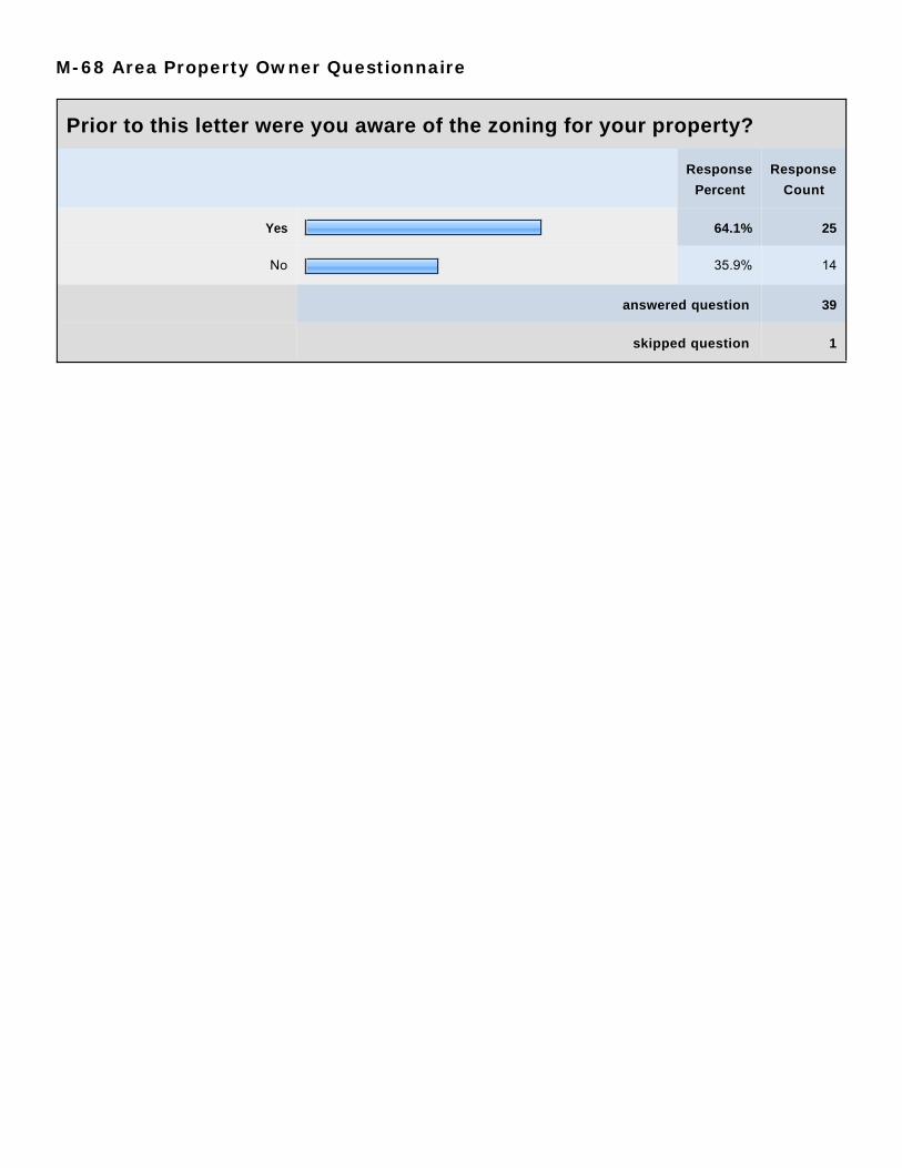
M-68 Area Property Owner Questionnaire
Prior to this letter were you aware of the zoning for your property?
Response
Percent
Response
Count
Yes 64.1% 25
No 35.9% 14
answered question 39
skipped question 1

M-68 Area Property Owner Questionnaire
In which Zoning District(s) do you own property? (from map)
Response
Percent
Response
Count
B-1 10.8% 4
B-2 0.0% 0
R-1B 18.9% 7
R-2B 8.1% 3
FF-1 62.2% 23
I-1 13.5% 5
answered question 37
skipped question 3
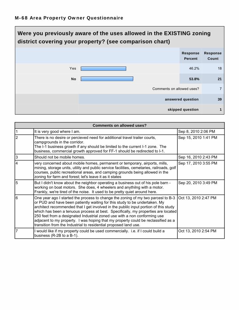
M-68 Area Property Owner Questionnaire
Were you previously aware of the uses allowed in the EXISTING zoning
district covering your property? (see comparison chart)
Response
Percent
Response
Count
Yes 46.2% 18
No 53.8% 21
Comments on allowed uses? 7
answered question 39
skipped question 1
Comments on allowed uses?
1 It is very good where I am. Sep 8, 2010 2:06 PM2 There is no desire or percieved need for additional travel trailer courts,
campgrounds in the corridor.The I-1 business growth if any should be limited to the current I-1 zone. Thebusiness, commercial growth approved for FF-1 should be redirected to I-1.
Sep 15, 2010 1:41 PM
3 Should not be mobile homes. Sep 16, 2010 2:43 PM4 very concerned about mobile homes, permanent or temporary, airports, mills,
mining, storage units, utility and public service facilities, cemetaries, railroads, golfcourses, public recreational areas, and camping grounds being allowed in thezoning for farm and forest; let's leave it as it states
Sep 17, 2010 3:55 PM
5 But I didn't know about the neighbor operating a business out of his pole barn -working on boat motors. She does, 4 wheelers and anythilng with a motor.Frankly, we're tired of the noise. It used to be pretty quiet around here.
Sep 20, 2010 3:49 PM
6 One year ago I started the process to change the zoning of my two parcesl to B-3or PUD and have been patiently waiting for this study to be undertaken. Myarchitect recommended that I get involved in the publilc input portion of this studywhich has been a tenuous process at best. Specifically, my properties are located250 feet from a designated Industrial zoned use with a non conforming useadjacent to my property. I was hoping that my property could be reclassified as atransition from the Industrial to residential proposed land use.
Oct 13, 2010 2:47 PM
7 I would like if my property could be used commercially. i.e. if I could build abusiness (R-2B to a B-1).
Oct 13, 2010 2:54 PM
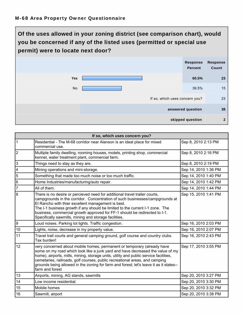
M-68 Area Property Owner Questionnaire
Of the uses allowed in your zoning district (see comparison chart), would
you be concerned if any of the listed uses (permitted or special use
permit) were to locate next door?
Response
Percent
Response
Count
Yes 60.5% 23
No 39.5% 15
If so, which uses concern you? 23
answered question 38
skipped question 2
If so, which uses concern you?
1 Residential - The M-68 corridor near Alanson is an ideal place for mixedcommercial use.
Sep 8, 2010 2:13 PM
2 Multiple family dwelling, rooming houses, motels, printing shop, commercialkennel, water treatment plant, commercial farm.
Sep 8, 2010 2:16 PM
3 Things need to stay as they are. Sep 8, 2010 2:19 PM4 Mining operations and mini-storage. Sep 14, 2010 1:36 PM5 Something that made too much noise or too much traffic. Sep 14, 2010 1:40 PM6 Home Industries/manufacturing/auto repair. Sep 14, 2010 1:42 PM7 All of them. Sep 14, 2010 1:44 PM8 There is no desire or percieved need for additional travel trailer courts,
campgrounds in the corridor. Concentration of such businesses/campgrounds atEl Rancho with thier excellent management is best.The I-1 business growth if any should be limited to the current I-1 zone. Thebusiness, commercial growth approved for FF-1 should be redirected to I-1.Specifically sawmills, mining and storage facilities.
Sep 15, 2010 1:41 PM
9 Loud noises. Parking lot lights. Traffic congestion. Sep 16, 2010 2:03 PM10 Lights, noise, decrease in my property value. Sep 16, 2010 2:07 PM11 Travel trail courts and general camping ground, golf course and country clubs.
Tax burden!Sep 16, 2010 2:43 PM
12 very concerned about mobile homes, permanent or temporary (already havesome on my road which look like a junk yard and have decreased the value of myhome), airports, mills, mining, storage units, utility and public service facilities,cemetaries, railroads, golf courses, public recreational areas, and campinggrounds being allowed in the zoning for farm and forest; let's leave it as it states--farm and forest
Sep 17, 2010 3:55 PM
13 Airports, mining, AG stands, sawmills Sep 20, 2010 3:27 PM14 Low income residential. Sep 20, 2010 3:30 PM15 Mobile homes Sep 20, 2010 3:32 PM16 Sawmill, airport Sep 20, 2010 3:38 PM

If so, which uses concern you?
17 The neighbor operating a business out of his pole barn. Sep 20, 2010 3:49 PM18 Mini storage and airports/landing fields. Sep 21, 2010 6:13 PM19 Cemetery, railroad uses, airports, sawmill, mining . Sep 27, 2010 2:25 PM20 Airports, golf courses, trailer courts, campgrounds, bowling alley. Oct 4, 2010 2:30 PM21 I believe in highest and best use and assume that public input would be required
prior to any proposed change. Ant that a governing body would review anyproposed use.Uses that may generate higher levels of noise, higher levels of light pollution, andenterprises that peddle sexually explicit materials and are sexually orientated.Additionally, I would be concerned with enterprises that utilize hazardouschemicals or pathogens.
Oct 13, 2010 2:47 PM
22 Single family homes Oct 13, 2010 2:49 PM23 Commercial Oct 13, 2010 2:50 PM

M-68 Area Property Owner Questionnaire
The Zoning Ordinance is being reviewed and will be updated, at which
time there may be opportunities for some changes either in districts,
district boundaries and/or the uses allowed in various districts. What
changes would you like reviewed and considered?
Response
Count
16
answered question 16
skipped question 24
Response Text
1 Just the one stated in question 1. Sep 8, 2010 2:06 PM2 Not sure. Sep 8, 2010 2:22 PM3 Possibly more B-1 and B-2 in close to the village. Sep 9, 2010 1:27 PM4 Remove: Mini-Storage buildings from FF-1 District to R-1B District.
Rezone B-1 Districts that front FF-1 Districts to R-1B Districts.Remove: Utilities & Public Service Facilities, Public & Private School, NurserySchools, day nurseries and child care centers from R-1B Districts and add them toR-2B Districts.Rezone current FF-1 Districts that are behind B-1 or B-2 Districts to R-2BDistricts.Eliminate B-1 Districts and add its uses (Permitted & Special Use Permit) to B-2Districts.
Sep 14, 2010 1:36 PM
5 You need more B-1 and B-2. Sep 14, 2010 1:38 PM6 Preserve residential zones, concentrate business/commercial as much as
possible.Sep 15, 2010 1:41 PM
7 Not familiar. Sep 16, 2010 2:07 PM8 All for FF-1 Farm and forest is no longer farm and forest when all recreation and
business are brought in.Sep 16, 2010 2:43 PM
9 those I listed in #7 I would like removed from FF-1. Sep 17, 2010 3:55 PM10 Outdoor display/retail. Sep 20, 2010 3:30 PM11 More business Sep 20, 2010 3:32 PM12 No businesses close by. Sep 20, 2010 3:49 PM13 El Rancho has front part B-1, would like to be like the rest FF-1. Sep 21, 2010 6:13 PM14 Uses that create employment opportunities and uses that benefit the neighboring
Alanson community. Possibly a special use zoning district that may be proposedon a case by case basis if that use entails or fosters positive environmental impactor other positive community related externalities which are sustainable andcompatible to the corridor district as a whole.
Oct 13, 2010 2:47 PM
15 Commercial, we need business growth. Oct 13, 2010 2:49 PM16 None Oct 13, 2010 2:50 PM

M-68 Area Property Owner Questionnaire
Do you want to encourage additional Commercial use in the M-68 Area?
Response
Percent
Response
Count
Yes 52.9% 18
No 47.1% 16
If yes, specifically where? 7
answered question 34
skipped question 6
If yes, specifically where?
1 I don't see why not as long as it isn't heavy Industrial. Sep 8, 2010 2:22 PM2 But limit commercial growth to B-1, B-2 and I-1 as able. Sep 15, 2010 1:41 PM3 No, But it is a class "A" Road State Highway. We have no say. Sep 16, 2010 2:07 PM4 Already have too many and empty or in foreclosure. Sep 16, 2010 2:43 PM5 Anythilng that brings jobs is okay. Sep 20, 2010 3:38 PM6 Yes, as long as it is by the highway. Sep 20, 2010 3:49 PM7 To a certain extent. Oct 4, 2010 2:30 PM
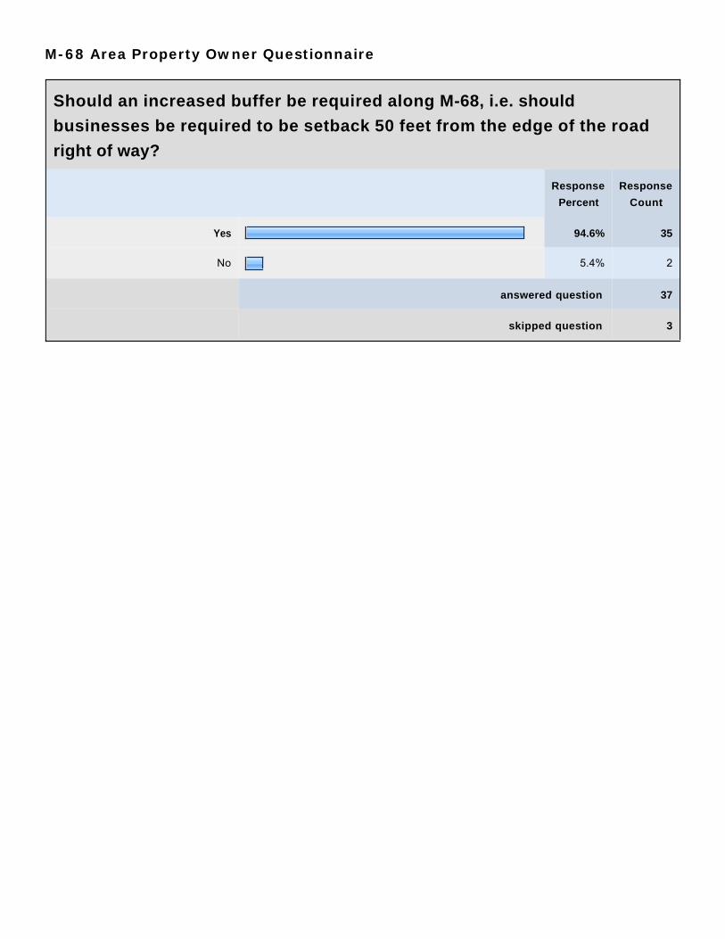
M-68 Area Property Owner Questionnaire
Should an increased buffer be required along M-68, i.e. should
businesses be required to be setback 50 feet from the edge of the road
right of way?
Response
Percent
Response
Count
Yes 94.6% 35
No 5.4% 2
answered question 37
skipped question 3

M-68 Area Property Owner Questionnaire
Additional Comments?
Response
Count
12
answered question 12
skipped question 28
Response Text
1 Provide extra lanes for turning traffic i.e. El Rancho Park, Louies, Banwell Roadand Lakeview Road.
Sep 8, 2010 2:02 PM
2 A center turn lane in certain areas would increase safety. Sep 8, 2010 2:13 PM3 I sure as hell hope that all this bullshit doesn't raise my taxes. I'm struggling now
as it is on $80.00 per week.Sep 8, 2010 2:19 PM
4 Pay fair market value for residential homes next to business. Sep 14, 2010 1:40 PM5 Thank you for soliciting our thoughts. Sep 15, 2010 1:41 PM6 Thanks for your effort. Sep 16, 2010 2:07 PM7 please work to clean up the junky areas on the roads Sep 17, 2010 3:55 PM8 All business from Ranch RV to Emmet Exc. Sep 20, 2010 3:30 PM9 Draw the line at Sid Bakers. Sep 20, 2010 3:32 PM10 The traffic is heavy now - with more building it can only get worse. Oct 4, 2010 2:30 PM11 Question 3: Yes this should be a stated goal and requirement with the ultimate
determination being made at time of site plan review and approval based on theinput of a traffic/highway design professional.
Question 10: Yes. Excluding landscaping improvements over the existingrequirements and signage needs to be addresses within this PUD zone.
It would be nice if thought and consideration could be given to creating a"Designated District", such as the "M-68 Corridor District" This district could havea "Committee" comprised of property owners from within this district. ThisCommittee or Board would have no de facto legislative power but rather be asounding board in the decision making process. If this scenario could beimplemented, it may improve the participation of property owners located withinthe district. If a board or committee were set up, they could set specific goals andfoster improvement of the district. The idea is to establish a group to keep thingsmoving forward. In the future, this corridor will obviously be affected with otherissues and pressures other than just zoning issues.
Oct 13, 2010 2:47 PM
12 East of the former Emmet Excavating Company - should start transition zone forresidential uses.Thank you for your efforts!
Oct 13, 2010 2:49 PM
Related Documents