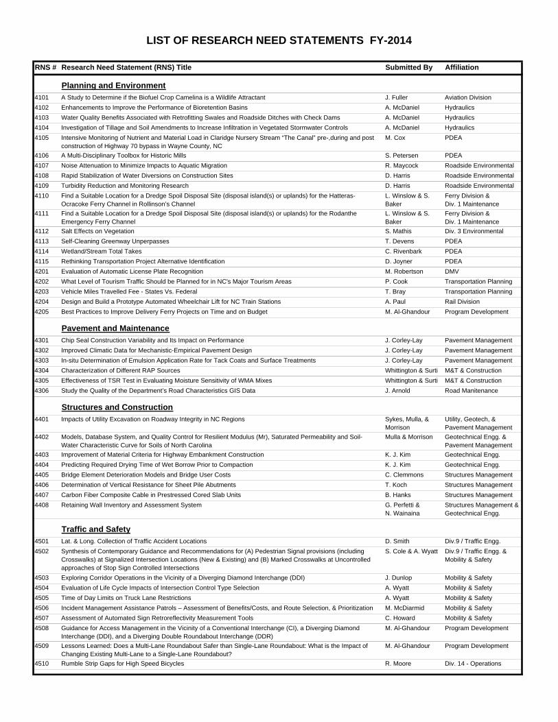
LIST OF RESEARCH NEED STATEMENTS FY-2014 RNS # Research Need Statement (RNS) Title Submitted By Affiliation Planning and Environment 4101 A Study to Determine if the Biofuel Crop Camelina is a Wildlife Attractant J. Fuller Aviation Division 4102 Enhancements to Improve the Performance of Bioretention Basins A. McDaniel Hydraulics 4103 Water Quality Benefits Associated with Retrofitting Swales and Roadside Ditches with Check Dams A. McDaniel Hydraulics 4104 Investigation of Tillage and Soil Amendments to Increase Infiltration in Vegetated Stormwater Controls A. McDaniel Hydraulics 4105 Intensive Monitoring of Nutrient and Material Load in Claridge Nursery Stream “The Canal” pre-,during and post construction of Highway 70 bypass in Wayne County, NC M. Cox PDEA 4106 A Multi-Disciplinary Toolbox for Historic Mills S. Petersen PDEA 4107 Noise Attenuation to Minimize Impacts to Aquatic Migration R. Maycock Roadside Environmental 4108 Rapid Stabilization of Water Diversions on Construction Sites D. Harris Roadside Environmental 4109 Turbidity Reduction and Monitoring Research D. Harris Roadside Environmental 4110 Find a Suitable Location for a Dredge Spoil Disposal Site (disposal island(s) or uplands) for the Hatteras- Ocracoke Ferry Channel in Rollinson’s Channel L. Winslow & S. Baker Ferry Division & Div. 1 Maintenance 4111 Find a Suitable Location for a Dredge Spoil Disposal Site (disposal island(s) or uplands) for the Rodanthe Emergency Ferry Channel L. Winslow & S. Baker Ferry Division & Div. 1 Maintenance 4112 Salt Effects on Vegetation S. Mathis Div. 3 Environmental 4113 Self-Cleaning Greenway Unperpasses T. Devens PDEA 4114 Wetland/Stream Total Takes C. Rivenbark PDEA 4115 Rethinking Transportation Project Alternative Identification D. Joyner PDEA 4201 Evaluation of Automatic License Plate Recognition M. Robertson DMV 4202 What Level of Tourism Traffic Should be Planned for in NC's Major Tourism Areas P. Cook Transportation Planning 4203 Vehicle Miles Travelled Fee - States Vs. Federal T. Bray Transportation Planning 4204 Design and Build a Prototype Automated Wheelchair Lift for NC Train Stations A. Paul Rail Division 4205 Best Practices to Improve Delivery Ferry Projects on Time and on Budget M. Al-Ghandour Program Development Pavement and Maintenance 4301 Chip Seal Construction Variability and Its Impact on Performance J. Corley-Lay Pavement Management 4302 Improved Climatic Data for Mechanistic-Empirical Pavement Design J. Corley-Lay Pavement Management 4303 In-situ Determination of Emulsion Application Rate for Tack Coats and Surface Treatments J. Corley-Lay Pavement Management 4304 Characterization of Different RAP Sources Whittington & Surti M&T & Construction 4305 Effectiveness of TSR Test in Evaluating Moisture Sensitivity of WMA Mixes Whittington & Surti M&T & Construction 4306 Study the Quality of the Department’s Road Characteristics GIS Data J. Arnold Road Manitenance Structures and Construction 4401 Impacts of Utility Excavation on Roadway Integrity in NC Regions Sykes, Mulla, & Morrison Utility, Geotech, & Pavement Management 4402 Models, Database System, and Quality Control for Resilient Modulus (Mr), Saturated Permeability and Soil- Water Characteristic Curve for Soils of North Carolina Mulla & Morrison Geotechnical Engg. & Pavement Management 4403 Improvement of Material Criteria for Highway Embankment Construction K. J. Kim Geotechnical Engg. 4404 Predicting Required Drying Time of Wet Borrow Prior to Compaction K. J. Kim Geotechnical Engg. 4405 Bridge Element Deterioration Models and Bridge User Costs C. Clemmons Structures Management 4406 Determination of Vertical Resistance for Sheet Pile Abutments T. Koch Structures Management 4407 Carbon Fiber Composite Cable in Prestressed Cored Slab Units B. Hanks Structures Management 4408 Retaining Wall Inventory and Assessment System G. Perfetti & N. Wainaina Structures Management & Geotechnical Engg. Traffic and Safety 4501 Lat. & Long. Collection of Traffic Accident Locations D. Smith Div.9 / Traffic Engg. 4502 Synthesis of Contemporary Guidance and Recommendations for (A) Pedestrian Signal provisions (including Crosswalks) at Signalized Intersection Locations (New & Existing) and (B) Marked Crosswalks at Uncontrolled approaches of Stop Sign Controlled Intersections S. Cole & A. Wyatt Div.9 / Traffic Engg. & Mobility & Safety 4503 Exploring Corridor Operations in the Vicinity of a Diverging Diamond Interchange (DDI) J. Dunlop Mobility & Safety 4504 Evaluation of Life Cycle Impacts of Intersection Control Type Selection A. Wyatt Mobility & Safety 4505 Time of Day Limits on Truck Lane Restrictions A. Wyatt Mobility & Safety 4506 Incident Management Assistance Patrols – Assessment of Benefits/Costs, and Route Selection, & Prioritization M. McDiarmid Mobility & Safety 4507 Assessment of Automated Sign Retroreflectivity Measurement Tools C. Howard Mobility & Safety 4508 Guidance for Access Management in the Vicinity of a Conventional Interchange (CI), a Diverging Diamond Interchange (DDI), and a Diverging Double Roundabout Interchange (DDR) M. Al-Ghandour Program Development 4509 Lessons Learned: Does a Multi-Lane Roundabout Safer than Single-Lane Roundabout: What is the Impact of Changing Existing Multi-Lane to a Single-Lane Roundabout? M. Al-Ghandour Program Development 4510 Rumble Strip Gaps for High Speed Bicycles R. Moore Div. 14 - Operations

Welcome message from author
This document is posted to help you gain knowledge. Please leave a comment to let me know what you think about it! Share it to your friends and learn new things together.
Transcript
LIST OF RESEARCH NEED STATEMENTS FY-2014
RNS # Research Need Statement (RNS) Title Submitted By Affiliation
Planning and Environment4101 A Study to Determine if the Biofuel Crop Camelina is a Wildlife Attractant J. Fuller Aviation Division
4102 Enhancements to Improve the Performance of Bioretention Basins A. McDaniel Hydraulics
4103 Water Quality Benefits Associated with Retrofitting Swales and Roadside Ditches with Check Dams A. McDaniel Hydraulics
4104 Investigation of Tillage and Soil Amendments to Increase Infiltration in Vegetated Stormwater Controls A. McDaniel Hydraulics
4105 Intensive Monitoring of Nutrient and Material Load in Claridge Nursery Stream “The Canal” pre-,during and post construction of Highway 70 bypass in Wayne County, NC
M. Cox PDEA
4106 A Multi-Disciplinary Toolbox for Historic Mills S. Petersen PDEA
4107 Noise Attenuation to Minimize Impacts to Aquatic Migration R. Maycock Roadside Environmental
4108 Rapid Stabilization of Water Diversions on Construction Sites D. Harris Roadside Environmental
4109 Turbidity Reduction and Monitoring Research D. Harris Roadside Environmental
4110 Find a Suitable Location for a Dredge Spoil Disposal Site (disposal island(s) or uplands) for the Hatteras-Ocracoke Ferry Channel in Rollinson’s Channel
L. Winslow & S. Baker
Ferry Division & Div. 1 Maintenance
4111 Find a Suitable Location for a Dredge Spoil Disposal Site (disposal island(s) or uplands) for the Rodanthe Emergency Ferry Channel
L. Winslow & S. Baker
Ferry Division & Div. 1 Maintenance
4112 Salt Effects on Vegetation S. Mathis Div. 3 Environmental
4113 Self-Cleaning Greenway Unperpasses T. Devens PDEA
4114 Wetland/Stream Total Takes C. Rivenbark PDEA
4115 Rethinking Transportation Project Alternative Identification D. Joyner PDEA
4201 Evaluation of Automatic License Plate Recognition M. Robertson DMV
4202 What Level of Tourism Traffic Should be Planned for in NC's Major Tourism Areas P. Cook Transportation Planning
4203 Vehicle Miles Travelled Fee - States Vs. Federal T. Bray Transportation Planning
4204 Design and Build a Prototype Automated Wheelchair Lift for NC Train Stations A. Paul Rail Division
4205 Best Practices to Improve Delivery Ferry Projects on Time and on Budget M. Al-Ghandour Program Development
Pavement and Maintenance4301 Chip Seal Construction Variability and Its Impact on Performance J. Corley-Lay Pavement Management
4302 Improved Climatic Data for Mechanistic-Empirical Pavement Design J. Corley-Lay Pavement Management
4303 In-situ Determination of Emulsion Application Rate for Tack Coats and Surface Treatments J. Corley-Lay Pavement Management
4304 Characterization of Different RAP Sources Whittington & Surti M&T & Construction
4305 Effectiveness of TSR Test in Evaluating Moisture Sensitivity of WMA Mixes Whittington & Surti M&T & Construction
4306 Study the Quality of the Department’s Road Characteristics GIS Data J. Arnold Road Manitenance
Structures and Construction4401 Impacts of Utility Excavation on Roadway Integrity in NC Regions Sykes, Mulla, &
MorrisonUtility, Geotech, & Pavement Management
4402 Models, Database System, and Quality Control for Resilient Modulus (Mr), Saturated Permeability and Soil-Water Characteristic Curve for Soils of North Carolina
Mulla & Morrison Geotechnical Engg. & Pavement Management
4403 Improvement of Material Criteria for Highway Embankment Construction K. J. Kim Geotechnical Engg.
4404 Predicting Required Drying Time of Wet Borrow Prior to Compaction K. J. Kim Geotechnical Engg.
4405 Bridge Element Deterioration Models and Bridge User Costs C. Clemmons Structures Management
4406 Determination of Vertical Resistance for Sheet Pile Abutments T. Koch Structures Management
4407 Carbon Fiber Composite Cable in Prestressed Cored Slab Units B. Hanks Structures Management
4408 Retaining Wall Inventory and Assessment System G. Perfetti & N. Wainaina
Structures Management & Geotechnical Engg.
Traffic and Safety4501 Lat. & Long. Collection of Traffic Accident Locations D. Smith Div.9 / Traffic Engg.
4502 Synthesis of Contemporary Guidance and Recommendations for (A) Pedestrian Signal provisions (including Crosswalks) at Signalized Intersection Locations (New & Existing) and (B) Marked Crosswalks at Uncontrolled approaches of Stop Sign Controlled Intersections
S. Cole & A. Wyatt Div.9 / Traffic Engg. & Mobility & Safety
4503 Exploring Corridor Operations in the Vicinity of a Diverging Diamond Interchange (DDI) J. Dunlop Mobility & Safety
4504 Evaluation of Life Cycle Impacts of Intersection Control Type Selection A. Wyatt Mobility & Safety
4505 Time of Day Limits on Truck Lane Restrictions A. Wyatt Mobility & Safety
4506 Incident Management Assistance Patrols – Assessment of Benefits/Costs, and Route Selection, & Prioritization M. McDiarmid Mobility & Safety
4507 Assessment of Automated Sign Retroreflectivity Measurement Tools C. Howard Mobility & Safety
4508 Guidance for Access Management in the Vicinity of a Conventional Interchange (CI), a Diverging Diamond Interchange (DDI), and a Diverging Double Roundabout Interchange (DDR)
M. Al-Ghandour Program Development
4509 Lessons Learned: Does a Multi-Lane Roundabout Safer than Single-Lane Roundabout: What is the Impact of Changing Existing Multi-Lane to a Single-Lane Roundabout?
M. Al-Ghandour Program Development
4510 Rumble Strip Gaps for High Speed Bicycles R. Moore Div. 14 - Operations
PLANNING AND ENVIRONMENT RESEARCH IDEAS

4101 NORTH CAROLINA DEPARTMENT OF TRANSPORTATION
Your Name: Jennifer Fuller, P.E. DATE: Aug 17, 2012
Branch / Unit: Division of Aviation- Airport Development
TITLE of your Research Idea: A Study to Determine if the Biofuel Crop Camelina is a Wildlife Attractant.
Background: The U.S. Department of Agriculture (USDA) is authorized to protect American agriculture and other resources from damage associated with wildlife. The primary authority for Wildlife Services (WS) is the Act of March 2, 1931 (46 Stat. 1468; 7 U.S.C.426-426b) as amended, and the Act of December 22, 1987 (101Stat. 1329-331, 7 U.S.C. 426c). Wildlife Services duties are conducted in cooperation with Federal, State, and local agencies; private organizations, and individuals. The WS program uses an Integrated Wildlife Damage Management (IWDM) approach (sometimes referred to as IPM or “Integrated Pest Management”) in which a series of methods may be used or recommended to reduce wildlife damage. IWDM is described in Chapter 1, 1-7 of the Animal Damage Control Program Final Environmental Impact Statement (USDA, 1994). These methods include the alteration of cultural practices as well as habitat and behavioral modification to prevent damage. Controlling wildlife damage may require that the offending animal(s) are killed or that the populations of the offending species be reduced. Wildlife has been shown to be hazardous to air travel (resulting in loss of human life and substantial expense from aircraft damage), most often in the immediate airport environment. USDA Wildlife Services has a long history of involvement with NC Airports, assisting them in identification and management of their most serious wildlife hazards. USDA Wildlife Biologists along with NCSU researchers would be involved with this research.
What is the Specific Problem or Issue? The purpose of this Cooperative Service Agreement is to fund research to determine if the biofuel crop Camelina (Camelina sativa L.) is attractive to wildlife. Research protocols have been developed to determine if airports can generate revenue by planting Camelina without attracting wildlife to the crop.
List Research Objectives and Tasks: To determine the best methods for researching the production of Camelina (Camelina sativa L.) at airports in North Carolina, we agree that the best compromise between cost-efficiency and statistically-sound science would be to do a study in one geographic region of North Carolina. Due to local environmental variations within the region, we will select four candidate airports to establish bird and mammalian surveys. Data collected from these surveys will be analyzed and published following the survey period. To generate a statistically valid sample of bird usage of Camelina, the study design will consist of four airports with three survey days of bird observations per month at each airport. A survey day is defined as observations at a site conducted during each of the following intervals: morning, midday, and evening. These surveys will be conducted over a 16 month study to observe growth periods and assess the attractant value of Camelina to wildlife in differing growth phases over time. To estimate mammalian attraction to Camelina, WS has determined that one night-time survey per month will be conducted at each airport using infrared night vision equipment.
What Would be the Product[s] of the Research? Data that will support NC Airports in this region of the state in cultivating Camelina for the purpose of revenue production and biofuel supply.
How Will You or Others Use the Product[s]? Airports in this region of NC will be encouraged to begin cultivation of Camelina for the purpose of revenue production and biofuel supply.
How Will the Product Benefit the Department? This product will provide report data for use in professional publications and press releases for The Department that will draw positive attention to The Department’s support of both NC Airports and the production of cleaner fuels and of course the mission to protect the safety of the traveling public.
Other Comments: This data will be used by the USDA Wildlife Services and North Carolina State University to increase their understanding of the production of biofuels.
Approval (Division official or Unit Head) Richard Walls Aviation Director
Print Name Signature Title

4102 NORTH CAROLINA DEPARTMENT OF TRANSPORTATION
CALL FOR NEW RESEARCH IDEA
Your Name: Andy McDaniel DATE: August 15, 2012
Branch / Unit: Hydraulics Unit
TITLE of your Research Idea: Enhancements to Improve the Performance of Bioretention Basins
Background: Bioretention basins are one of the key stormwater control measures (SCMs) to treat stormwater in the non-road environment, especially in nutrient-sensitive watersheds. During a review of available research data for the NCDOT Jordan/Falls Stormwater Loads Accounting Tool, it became apparent that there was a paucity of NCDOT research data available on bioretention basins. Tracking SCM performance data is an important requirement of NCDOT’s NPDES permit. Additionally, there is a need to understand how specific design changes can affect the performance of these systems.
What is the Specific Problem or Issue? There is a need for additional performance data for bioretention basins in a transportation environment. Additionally, there is a need to characterize if specific design enhancements such as media (e.g., sand versus expanded slate) or configuration (with or without internal water storage zone) can materially improve the performance of bioretention basins in removing total suspended solids (TSS), nutrients and other parameters of concern.
List Research Objectives and Tasks: The research should achieve the following objectives:
Monitor existing systems in the non-road environment to characterize the performance of bioretention basins, specifically effluent total suspended solids and nutrient concentrations
Identify key design measures that enhance the performance of these systems Retrofit as feasible existing systems so as to compare temporally (pre- versus post-retrofit) or spatially (with
another similar system) to make conclusions on the effectiveness of these design enhancements on performance
What Would be the Product[s] of the Research? (Note: Progress reports and the Final report are NOT considered a “product,” but “deliverables.”) Performance data from a variety of configurations of bioretention systems, as well as design recommendations based on effectiveness of various design enhancements on the performance of these systems
How Will You or Others Use the Product[s]? This data will serve to improve design guidance for bioretention systems in a non-road environment, and also improve the dataset of SCM performance. Additionally, the knowledge and data acquired from this research will be used to update the Department’s nutrient load accounting tool approved by the NC Environmental Management Commission for the Department’s compliance with the Jordan and Falls Lake nutrient management strategy regulations.
How Will the Product Benefit the Department? (e.g., increase operational efficiency, decrease costs, enhance safety, etc. Indicate short term and/or long term benefit) The Department will have more reliable data on these systems, as required by the permit and for future accounting tools. Also, if any of the enhancements prove promising, the Department could observe a long-term cost savings through an ability to meet regulatory requirements using design features with a demonstrated capacity for savings through improved performance or reduced footprint.
Other Comments:
Approval (Division official or Unit Head) David Chang State Hydraulics Engineer
Print Name Signature Title
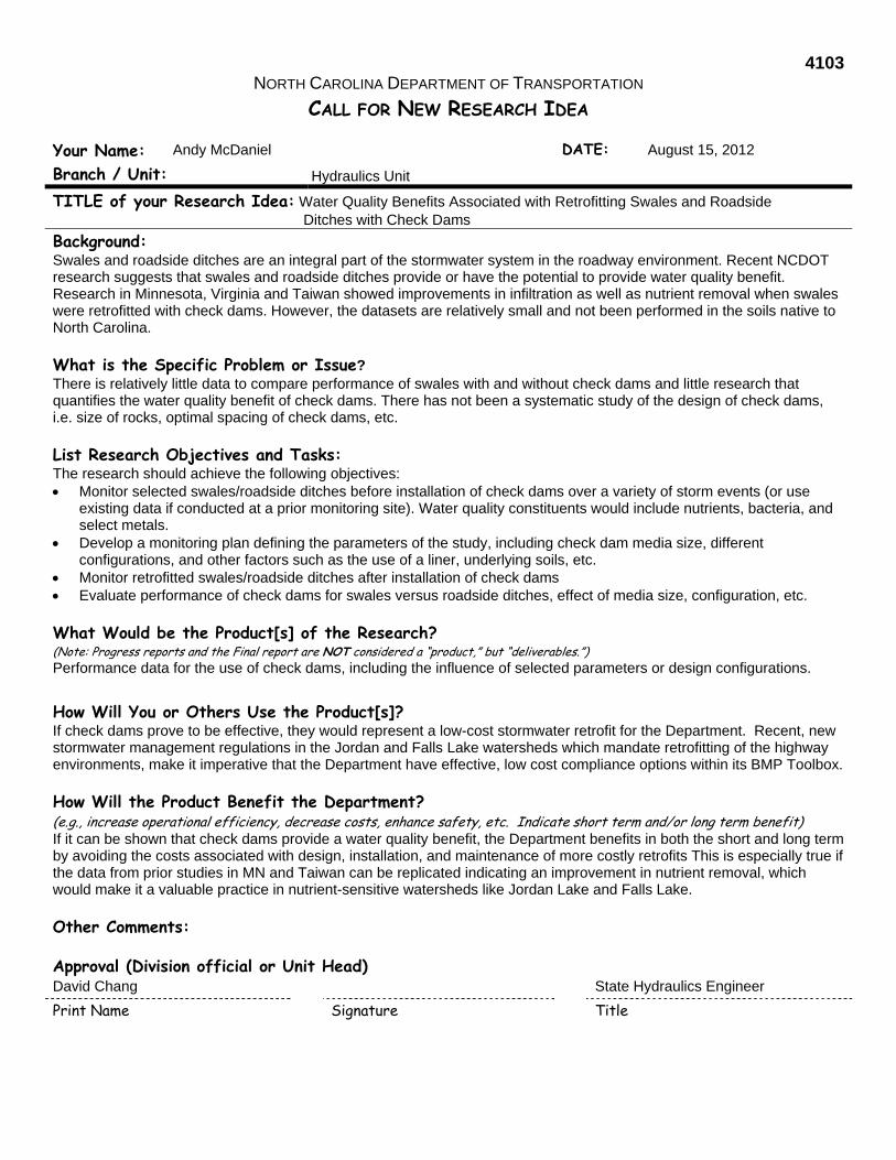
4103 NORTH CAROLINA DEPARTMENT OF TRANSPORTATION
CALL FOR NEW RESEARCH IDEA
Your Name: Andy McDaniel DATE: August 15, 2012
Branch / Unit: Hydraulics Unit
TITLE of your Research Idea: Water Quality Benefits Associated with Retrofitting Swales and Roadside Ditches with Check Dams
Background: Swales and roadside ditches are an integral part of the stormwater system in the roadway environment. Recent NCDOT research suggests that swales and roadside ditches provide or have the potential to provide water quality benefit. Research in Minnesota, Virginia and Taiwan showed improvements in infiltration as well as nutrient removal when swales were retrofitted with check dams. However, the datasets are relatively small and not been performed in the soils native to North Carolina.
What is the Specific Problem or Issue? There is relatively little data to compare performance of swales with and without check dams and little research that quantifies the water quality benefit of check dams. There has not been a systematic study of the design of check dams, i.e. size of rocks, optimal spacing of check dams, etc.
List Research Objectives and Tasks: The research should achieve the following objectives: Monitor selected swales/roadside ditches before installation of check dams over a variety of storm events (or use
existing data if conducted at a prior monitoring site). Water quality constituents would include nutrients, bacteria, and select metals.
Develop a monitoring plan defining the parameters of the study, including check dam media size, different configurations, and other factors such as the use of a liner, underlying soils, etc.
Monitor retrofitted swales/roadside ditches after installation of check dams Evaluate performance of check dams for swales versus roadside ditches, effect of media size, configuration, etc.
What Would be the Product[s] of the Research? (Note: Progress reports and the Final report are NOT considered a “product,” but “deliverables.”) Performance data for the use of check dams, including the influence of selected parameters or design configurations.
How Will You or Others Use the Product[s]? If check dams prove to be effective, they would represent a low-cost stormwater retrofit for the Department. Recent, new stormwater management regulations in the Jordan and Falls Lake watersheds which mandate retrofitting of the highway environments, make it imperative that the Department have effective, low cost compliance options within its BMP Toolbox.
How Will the Product Benefit the Department? (e.g., increase operational efficiency, decrease costs, enhance safety, etc. Indicate short term and/or long term benefit) If it can be shown that check dams provide a water quality benefit, the Department benefits in both the short and long term by avoiding the costs associated with design, installation, and maintenance of more costly retrofits This is especially true if the data from prior studies in MN and Taiwan can be replicated indicating an improvement in nutrient removal, which would make it a valuable practice in nutrient-sensitive watersheds like Jordan Lake and Falls Lake.
Other Comments:
Approval (Division official or Unit Head) David Chang State Hydraulics Engineer
Print Name Signature Title
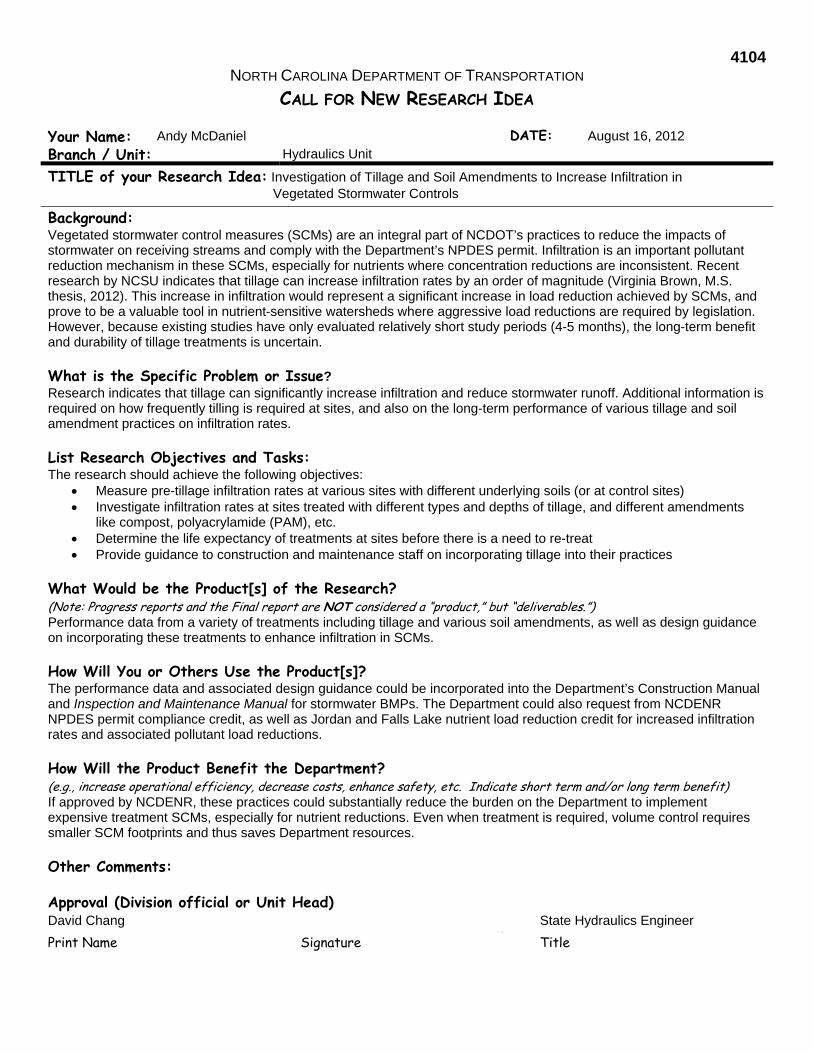
4104 NORTH CAROLINA DEPARTMENT OF TRANSPORTATION
CALL FOR NEW RESEARCH IDEA
Your Name: Andy McDaniel DATE: August 16, 2012
Branch / Unit: Hydraulics Unit
TITLE of your Research Idea: Investigation of Tillage and Soil Amendments to Increase Infiltration in Vegetated Stormwater Controls
Background: Vegetated stormwater control measures (SCMs) are an integral part of NCDOT’s practices to reduce the impacts of stormwater on receiving streams and comply with the Department’s NPDES permit. Infiltration is an important pollutant reduction mechanism in these SCMs, especially for nutrients where concentration reductions are inconsistent. Recent research by NCSU indicates that tillage can increase infiltration rates by an order of magnitude (Virginia Brown, M.S. thesis, 2012). This increase in infiltration would represent a significant increase in load reduction achieved by SCMs, and prove to be a valuable tool in nutrient-sensitive watersheds where aggressive load reductions are required by legislation. However, because existing studies have only evaluated relatively short study periods (4-5 months), the long-term benefit and durability of tillage treatments is uncertain.
What is the Specific Problem or Issue? Research indicates that tillage can significantly increase infiltration and reduce stormwater runoff. Additional information is required on how frequently tilling is required at sites, and also on the long-term performance of various tillage and soil amendment practices on infiltration rates.
List Research Objectives and Tasks: The research should achieve the following objectives:
Measure pre-tillage infiltration rates at various sites with different underlying soils (or at control sites) Investigate infiltration rates at sites treated with different types and depths of tillage, and different amendments
like compost, polyacrylamide (PAM), etc. Determine the life expectancy of treatments at sites before there is a need to re-treat Provide guidance to construction and maintenance staff on incorporating tillage into their practices
What Would be the Product[s] of the Research? (Note: Progress reports and the Final report are NOT considered a “product,” but “deliverables.”) Performance data from a variety of treatments including tillage and various soil amendments, as well as design guidance on incorporating these treatments to enhance infiltration in SCMs.
How Will You or Others Use the Product[s]? The performance data and associated design guidance could be incorporated into the Department’s Construction Manual and Inspection and Maintenance Manual for stormwater BMPs. The Department could also request from NCDENR NPDES permit compliance credit, as well as Jordan and Falls Lake nutrient load reduction credit for increased infiltration rates and associated pollutant load reductions.
How Will the Product Benefit the Department? (e.g., increase operational efficiency, decrease costs, enhance safety, etc. Indicate short term and/or long term benefit) If approved by NCDENR, these practices could substantially reduce the burden on the Department to implement expensive treatment SCMs, especially for nutrient reductions. Even when treatment is required, volume control requires smaller SCM footprints and thus saves Department resources.
Other Comments:
Approval (Division official or Unit Head) David Chang State Hydraulics Engineer
Print Name Signature Title

4105 NORTH CAROLINA DEPARTMENT OF TRANSPORTATION
CALL FOR NEW RESEARCH NEEDS
Your Name: Marissa Cox DATE: 8/16/2012
Branch / Unit: PDEA-NES
TITLE of your Research Idea: Intensive Monitoring of Nutrient and Material Load in Claridge Nursery Stream “The Canal” pre-,during and post construction of Highway 70 Bypass in Wayne County, NC
Background: NCDOT is performing on-site mitigation on the NC Forest Service’s Claridge Nursery to offset jurisdictional stream impacts associated with TIP R-2554. As part of the project, NCDOT partnered with NCFS to perform in-stream monitoring pre-TIP/stream construction. Additional stream monitoring pre-, during and post-TIP and stream construction are still needed to get a clear picture of the effects on hydrology and water quality that occur throughout the various stages of both a road construction and a stream restoration project.
What is the Specific Problem or Issue: There is a lack of research on 1) the effects of stream restoration projects on water quality 2) the effects of road construction on hydrology and water quality. Furthermore, to date there is no research that has measured the detrimental impacts (e.g. nutrient and material loads) while they occur (during a road and/or stream construction.
List Research Objectives and Tasks: Objective: To obtain 3 years of water quality data at Claridge Nursery’s stream “the Canal”. Year 1 - establish detailed loads and dynamics for the preconstruction phase. Years 2 and 3 - document the effects of road construction on nutrient loads and potential abatement along the monitored stream. Tasks: Install new monitoring devices at the three existing monitoring stations set up for Proj. Number HWY-2009-28.
What Would be the Product[s] of the Research? (Note: Progress reports and the Final report are NOT considered a “product,” but “deliverables.”) Water quality data pre-, during and post construction of both a NCDOT road and stream restoration project
How Will You or Others Use the Product[s]? The products (data) from this research project will assist the NCDOT-PDEA-NES-ICI/mitigation Group in determining when to construct on-site mitigation projects as well assist in making credit ratio determination especially in scenarios where the hypothesized stream improvement via stream mitigation activities (not involving changed to stream dimensions, pattern or profile) will be water quality related.
How Will the Product Benefit the Department? (e.g., increase operational efficiency, decrease costs, enhance safety, etc. Indicate short term and/or long term benefit) This data and the assistance/guidance it will provide will ultimately benefit the department through potential cost savings through proper mitigation construction phasing as well as improved mitigation credit ratios which ultimately result in cost savings as well.
Other Comments:
Approval (Division official or Unit Head)
Phillip Harris Head – NES - PDEA Print Name Signature Title
4106 NORTH CAROLINA DEPARTMENT OF TRANSPORTATION
CALL FOR NEW RESEARCH NEEDS
Your Name: Shane Petersen DATE: 8/16/2012
Branch / Unit: PDEA-HES
TITLE of your Research Idea: A Multi-Disciplinary Toolbox for Historic Mills
Background: Historic-period mill complexes and associated buildings in North Carolina are traditionally located near the core areas of communities and along essential transportation routes. Not surprisingly, such properties are often subsumed into modern transportation facility Rights-of-Way or immediately adjacent NCDOT maintained property. This conjunction has caused problems in the management of cultural resources, wetland biotic communities, community resources, and engineering safety issues. Historic mills constitute one of the more frequently encountered challenges in the human environment associated with NCDOT bridge projects.
What is the Specific Problem or Issue: Because historic mills are composed of a variety of natural and human environmental resources, as well as maintenance and safety concerns, each property presents a unique series of challenges. Unfortunately, these challenges are often addressed in isolation by the various groups within NCDOT, without regard to tasks faced by other disciplines within the Department. Such lack of coordination frequently results in less desirable solutions and difficulty achieving NCDOT’s stated mission.
List Research Objectives and Tasks: The multi-disciplinary toolbox will include basic guidelines for the identification of historic mill complexes across North Carolina and their associated elements, structured in such a way that non-specialized NCDOT personnel might recognize such resources when proposed projects may impact them. The toolbox also will include a historic framework for assessing National Register of Historic Places (NRHP) eligibility, cultural significance, and potential adverse impacts to eligibility and significance as well as possible routes towards mitigation. Similarly it will facilitate addressing how the extant features of a mill complex relate to existing biotic communities and natural resource inventories. The toolbox will provide for the assessment of the beneficial role a property might play as a local community resource and potential tourism generator.
What Would be the Product[s] of the Research? (Note: Progress reports and the Final report are NOT considered a “product,” but “deliverables.”) The research will result in the creation of an outline of characteristic elements for use in the evaluation of historic mills during transportation planning along with a series of “tools” that may be applied as necessary to the unique characteristics of each property to avoid, preserve, or mitigate NCDOT actions in regards to these mill complexes. The final presentation will be contained in a hard-copy document, but may also be presented as a web-tool.
How Will You or Others Use the Product[s]? The outline of characteristic mill complex elements can be used by any NCDOT personnel in the earliest stages of a project to recognize when such resources are present and to create a reference framework for future solutions. Cultural resources staff can use the product to assist in fully identifying the associated archaeological and architectural elements of the resource and establish both cultural significance and NRHP eligibility (where appropriate). This product can be used to integrate the surveys generated by the roadway/structure design, natural environment, and community impacts staff, in conjunction with the cultural resources staff, into multi-disciplinary solutions that address transportation project impacts to mill complexes throughout the state.
How Will the Product Benefit the Department? (e.g., increase operational efficiency, decrease costs, enhance safety, etc. Indicate short term and/or long term benefit) By providing pathways to integrate data and solutions into multi-disciplinary approaches, NCDOT’s Preconstruction and Division staff can create truly context-sensitive transportation solutions in relation to a relatively common set of resource challenges. By so doing, environmental resource identification and evaluation timeframes can be reduced, community objections can be met with proactive solutions, and facility construction, maintenance, and safety needs can be addressed in a manner that does not necessarily sacrifice mill elements. The toolbox will allow the Department to address historic mills in a manner which maintains the safety and efficiency of the transportation system with accountability and environmental sensitivity, while potentially enhancing the economy, health and well-being of the local community.
Approval (Division official or Unit Head)
Drew Joyner Head – HES - PDEA Print Name Signature Title

4107 NORTH CAROLINA DEPARTMENT OF TRANSPORTATION
CALL FOR NEW RESEARCH NEEDS
Your Name: Robin L. Maycock DATE: 8/22/12
Branch / Unit: Roadside Environmental Unit
TITLE of your Research Idea: Noise Attenuation to Minimize Impacts to Aquatic Migration
Background: The US Army Corps of Engineers and NCDENR Division of Water Quality authorize construction in waters of the US with permit conditions limiting in-water construction during moratoriums to protect anadromous fish migration and trout spawning season. Review and approval by the USFWS, NMFS and NCWRC are also required for permit approval. Additional bridge replacement projects have been funded by the recent legislature and will require an intensive effort to complete work within allotted timeframes. The existing moratoriums may likely impede project delivery for these projects and other bridge projects that follow typical funding mechanisms. So finding a way to waive the moratoriums by reducing the impacts of construction noise is needed.
What is the Specific Problem or Issue? The protections of anadromous fish migration and trout during spawning seasons limit the work that can be done by NCDOT in the rivers and streams of North Carolina. Moratoriums on in-water work severely limit bridge work that is allowed during several months of the year. Noise attenuation can reduce adverse impacts by the use of bubble curtains around pile driving activities, allowing certain construction activities to proceed during the moratoriums without adversely impacting protected fish species.
List Research Objectives and Tasks: Review existing literature to determine research findings on use of hydro-acoustic measures to attenuate noise during bridge construction. Interview NMFS, USFWS, NCWRC staff to determine possibility of lifting moratoriums and conducting pilot studies. Determine cost/benefit of use of noise curtains to allow work during moratoriums. Perform research in-situ to determine effectiveness of noise attenuation methods.
What Would be the Product[s] of the Research? (Note: Progress reports and the Final report are NOT considered a “product,” but “deliverables.”) Literature review, cost-benefit analysis, research results to support permit variance on construction moratoriums.
How Will You or Others Use the Product[s]? Facilitate bridge program completion by getting agency approval to waive moratoriums when using noise attenuation. Determine the cost effectiveness of when to use noise attenuation.
How Will the Product Benefit the Department? (e.g., increase operational efficiency, decrease costs, enhance safety, etc. Indicate short term and/or long term benefit) Long term: Increase program delivery and efficiency Short term: Open dialogue on noise attenuation options
Other Comments:
Approval (Division official or Unit Head) Don Lee State Roadside Environmental Engineer
Print Name Signature Title

4108 NORTH CAROLINA DEPARTMENT OF TRANSPORTATION
CALL FOR NEW RESEARCH NEEDS
Your Name: David Harris, P.E. DATE: August 15, 2012
Branch / Unit: Roadside Environmental Unit
TITLE of your Research Idea: Rapid Stabilization of Water Diversions on Construction Sites
Background: There is increasing pressure to reduce the off-site environmental impacts of road construction, primarily in nearby streams and lakes. It is likely that within the next 5 years the US Environmental Protection Agency will require all states to comply with a turbidity standard (Effluent Limit Guideline) for stormwater discharges from construction sites. It is important to begin to assemble a suite of practices which will allow compliance with environmental requirements and goals without significantly impacting the cost of highway construction.
What is the Specific Problem or Issue? Recent studies funded by NCDOT have demonstrated that the major sources of sediment and turbidity on active construction sites are often the diversions used to channel overland flow into settling areas such as sediment basins and silt fences. Because these ditches are usually in use for short periods of time, the only erosion control used is check dams to slow the flow. These unprotected conveyances can be the main source of sediment in sediment trapping devices, along with areas around the devices where water enters them across bare ground. Practices that can economically reduce this source of sediment may be available and need to be evaluated. In particular, a hydraulically-applied cement-based product may provide nearly complete erosion control protection at a cost similar to or less than rolled erosion control products.
List Research Objectives and Tasks: Evaluate the ability of several options for stabilizing diversion ditches. This will include the following, compared to bare soil:
1. Jute matting (the least expensive rolled erosion control product). 2. Jute matting with polyacrylamide applied to the soil first (rate can be varied). 3. Excelsior blanket. 4. Hydraulically applied, cement-based product.
What Would be the Product[s] of the Research? The results will provide a guide for methods to stabilize diversion ditches to reduce sediment and turbidity issues in discharges from construction sites.
How Will You or Others Use the Product[s]? If one or more of the systems proves to be successful, these can be included in future erosion and sediment control plans, particularly in sensitive watersheds. There may be other applications of the hydraulically-applied cement product, such as temporary stockpile and slope stabilization.
How Will the Product Benefit the Department? (e.g., increase operational efficiency, decrease costs, enhance safety, etc. Indicate short term and/or long term benefit) This could provide a method to greatly reduce sediment removal costs and improve the quality of stormwater discharges during construction projects.
Other Comments:
Approval (Division official or Unit Head) Don Lee State Roadside Environmental Engineer
Print Name Signature Title

4109 NORTH CAROLINA DEPARTMENT OF TRANSPORTATION
CALL FOR NEW RESEARCH NEEDS
Your Name: David Harris, P.E. DATE: August 15, 2012
Branch / Unit: Roadside Environmental Unit
TITLE of your Research Idea: Turbidity Reduction and Monitoring Research
Background: There is increasing pressure to reduce the off-site environmental impacts of road construction, primarily in nearby streams and lakes. It is likely that within the next 5 years the US Environmental Protection Agency will require all states to comply with a turbidity standard (Effluent Limit Guideline) for stormwater discharges from construction sites. It is important to begin to assemble a suite of practices which will allow compliance with environmental requirements and goals without significantly impacting the cost of highway construction.
What is the Specific Problem or Issue? The EPA is evaluating the feasibility of setting a turbidity effluent limit for construction runoff. Several states have already begun to monitor construction effluent to determine what is practical and acceptable. NCDOT will need to begin developing a protocol for monitoring effluent to determine turbidity levels. The Department needs to identify what is practical and feasible for its land disturbing activities.
List Research Objectives and Tasks: 1. Identify monitoring procedures and equipment that will accurately record turbidity levels and still be cost effective. 2. Acquire a variety of surface dewatering outlet devices and determine the best methods for monitoring their
effluent. 3. Acquire or build a portable rainfall simulator and conduct erosion and vegetation establishment testing under
controlled and field conditions. 4. Test new products that will reduce turbidity during the construction process and seeding and mulching process. 5. Incorporate improved process and monitoring procedure in NCDOT Erosion and Sediment Control Certification
training.
What Would be the Product[s] of the Research? The results will provide a guide for methods to reduce turbidity and provide a cost effective means of monitoring turbidity in construction effluent. Incorporate improved techniques into training and certification process.
How Will You or Others Use the Product[s]? If a cost effective means of monitoring turbidity is identified then the State will benefit from the cost savings associated with turbidity monitoring and turbidity reduction.
How Will the Product Benefit the Department? (e.g., increase operational efficiency, decrease costs, enhance safety, etc. Indicate short term and/or long term benefit) This could provide a method to greatly reduce sediment removal costs and improve the quality of stormwater discharges during construction projects. Identifying a cost effective means of monitoring turbidity will save the Department substantial funds that could be used to build highways.
Other Comments:
Approval (Division official or Unit Head) Don Lee State Roadside Environmental Engineer
Print Name Signature Title

4110 NORTH CAROLINA DEPARTMENT OF TRANSPORTATION
CALL FOR NEW RESEARCH NEEDS
Your Name: Lance Winslow / Sterling Baker DATE: August 20, 2012
Branch / Unit: Ferry Division / DOH Division One
TITLE of your Research Idea: Find a Suitable Location for a Dredge Spoil Disposal Site (disposal island(s) or uplands) for the Hatteras-Ocracoke Ferry Channel in Rollinson’s Channel.
Background: The Hatteras-Ocracoke Ferry Channel is a major way of transporting Ocracoke Island residents, tourists, and supplies from Hatteras Island to Ocracoke communities on a daily basis. Cora June Island is a spoil site that can be used in the event the channel becomes impassable for the ferries, but it is located about 4 miles from the ferry channel. A spoil site would be beneficial located closer to the Hatteras-Ocracoke Ferry Channel.
What is the Specific Problem or Issue? Since the Hatteras-Ocracoke Ferry Channel is located in a highly dynamic environment close to Hatteras Inlet, the channel frequently becomes shallow. There is currently one spoil island available, Cora June Island, but can be as far away as 4 miles from the problem areas. There is the need for an additional spoil island closer to Hatteras Inlet not only for location, but to handle more dredge spoil. There are no available locations available on land due to the amount of residential and business locations in the area, as well as National Park Service property.
List Research Objectives and Tasks: The Research Objectives and Tasks would be to find a suitable location for a dredge spoil island within close enough proximity to allow pipeline dredging for channel depths deep enough to allow safe passage of ferries on a daily basis. The spoil site(s) would need to be within 1-2 miles of the Hatteras-Ocracoke Ferry Channel, and have minimal effect on Submerged Aquatic Vegetation, shell bottom, and other important marine habitats. Any spoil sites(s) would need to be large enough to accommodate any dredge spoil produced in the next 15 years.
What Would be the Product[s] of the Research? (Note: Progress reports and the Final report are NOT considered a “product,” but “deliverables.”) A study showing suitable locations for a dredge spoil island to accommodate pipeline dredging of the Hatteras-Ocracoke Ferry Channel.
How Will You or Others Use the Product[s]? The study would allow for the permitting and construction of dredge spoil site(s) that would be used to deposit dredge spoil from the Hatteras-Ocracoke Ferry Channel to allow safe passage of ferries on a daily basis.
How Will the Product Benefit the Department? (e.g., increase operational efficiency, decrease costs, enhance safety, etc. Indicate short term and/or long term benefit) The study would allow for the availability to pipeline dredge the Hatteras-Ocracoke Ferry Channel when needed for the safe passage of ferries. Having the spoil sites/island(s) available would decrease the cost of dredging, decrease the amount of time to dredge the channel, increase the operating efficiencies of the ferries, and enhance the safety of the traveling ferries and its passengers.
Other Comments:
Approval (Division official or Unit Head) Harold Thomas Director – Ferry Division
Print Name Signature Title

4111 NORTH CAROLINA DEPARTMENT OF TRANSPORTATION
CALL FOR NEW RESEARCH NEEDS
Your Name: Lance Winslow / Sterling Baker DATE: August 8, 2012
Branch / Unit: Ferry Division / DOH-Division One
TITLE of your Research Idea: Find a Suitable Location for a Dredge Spoil Disposal Site (disposal island(s) or uplands) for the Rodanthe Emergency Ferry Channel.
Background: The Rodanthe Emergency Ferry Channel is essential to getting emergency personnel, equipment, and supplies to Hatteras Island communities after a major storm event the makes the Herbert C. Bonner bridge and/or Highway 12 impassable. The N. C. Ferry Division runs ferries during these emergency situations from Stumpy Point to Rodanthe. This situation occurred last in September 2011 after Hurricane Irene. This emergency route is also used by all NCDOT personnel/contractors associated with reconstruction or recovery efforts post storm.
What is the Specific Problem or Issue? Currently, the Rodanthe Emergency Ferry Channel is becoming too shallow to allow safe passage of the ferries. There is currently one landward dredge spoil site available, but it is not large enough to accommodate the amount of dredge spoil necessary to dredge the channel to necessary depths. There are no available locations available on land due to the amount of residential and business locations in the area, as well as U. S. Fish and Wildlife property.
List Research Objectives and Tasks: The Research Objectives and Tasks would be to find a suitable location for a dredge spoil site(s) within a close enough proximity to allow pipeline dredging for channel depths deep enough to allow safe passage of ferries during emergency situations. The spoil site(s) would need to be within 1-2 miles of the Rodanthe Channel, and have minimal effect on Submerged Aquatic Vegetation, shell bottom, and other important marine habitats. Any spoil sites(s) would need to be large enough to accommodate any dredge spoil produced in the next 15 years.
What Would be the Product[s] of the Research? (Note: Progress reports and the Final report are NOT considered a “product,” but “deliverables.”) A study showing suitable locations and a matrix guiding the Department in the best sites to seriously pursue for dredge spoil sites(s) to accommodate pipeline dredging of the Rodanthe Emergency Ferry Channel.
How Will You or Others Use the Product[s]? The study would help facilitate the permitting and construction of dredge spoil site(s) that would be used to deposit dredge spoil from the Rodanthe Emergency Ferry Channel to allow safe passage of ferries during emergency situations.
How Will the Product Benefit the Department? (e.g., increase operational efficiency, decrease costs, enhance safety, etc. Indicate short term and/or long term benefit) The study would allow for the availability to pipeline dredge the Rodanthe Emergency Ferry Channel when needed for the safe passage of ferries. Having the spoil sites/island(s) available would decrease the cost of dredging, decrease the amount of time to dredge the channel, increase the operating efficiencies of the ferries, and enhance the safety of the traveling ferries and its passengers. The spoil islands would also allow dredging of the channel when needed in the future.
Other Comments:
Approval (Division official or Unit Head) Harold Thomas Director – Ferry Division
Print Name Signature Title

4112 NORTH CAROLINA DEPARTMENT OF TRANSPORTATION
CALL FOR NEW RESEARCH NEEDS
Your Name: Stonewall Mathis DATE: 08/04/2012
Branch / Unit: Division of Highways Division 3 Environmental Unit
TITLE of your Research Idea: Salt Effects on Vegetation
Background: Salt, brine, etc. used for ice control can have detrimental effects on roadside vegetation. Much vegetation adjacent to roads is subject to environmental stress. The addition of high salt concentrations can only further impair vegetation’s natural balances and accentuate this stress. Loss of vegetation through the misapplication of deicing salts increases highway maintenance costs. What is the Specific Problem or Issue? The issue is whether the use of salt, brine, etc. for ice control is having detrimental effects on roadside grass establishment. I am aware of other applications in history where salt rendered the ground unsuitable for vegetation growth. While I have no evidence to suggest that this has been a problem on the highway system, this thought has occurred to me as to whether we may be setting ourselves up for a problem. List Research Objectives and Tasks: Objective: Determine whether the use of salt, brine, etc. has a detrimental effect on roadside grasses. Tasks: Set up a series of studies based on actual usage of salt, brine in the highway environment for both short and long term studies. Study various locations for geographic region comparison and salt, brine usage comparison (for instance southeastern NC uses less salt/brine than the mountain areas). Could coordinate with the maintenance units as to locations and salt/brine usage amounts and study any effects on vegetation. What Would be the Product[s] of the Research? (Note: Progress reports and the Final report are NOT considered a “product,” but “deliverables.”) The product would be a determination as to whether the usage of salt, brine, etc. has detrimental effects on roadside grasses. If the determination is no, then great carry on as usual. If the determination is yes, then we may want to start investigating other ice control products/methods. How Will You or Others Use the Product[s]? See previous answer. How Will the Product Benefit the Department? (e.g., increase operational efficiency, decrease costs, enhance safety, etc. Indicate short term and/or long term benefit) The product would potentially benefit the department by enhancing safety, saving money, and reducing the potential for environmental damage. If roadside grasses are deteriorated, the erosion of highway shoulders can occur resulting in unsafe shoulder areas and pavement failure which are unsafe and cost money to repair. Also the eroded material may result in turbidity and sediment loss which can be detrimental to the environment. Other Comments: Approval (Division official or Unit Head)
D. Chad Kimes Div. 3 – Operations Engineer Print Name Signature Title


4114 NORTH CAROLINA DEPARTMENT OF TRANSPORTATION
CALL FOR NEW RESEARCH NEEDS
Your Name: Chris Rivenbark DATE: 8/3/2012
Branch / Unit: PDEA-Natural Environment Section
TITLE of your Research Idea: Wetland/Stream Total Takes
Background: Often new location projects impact wetlands and/or streams. Occasionally the Department has to account for impacts to these resources even though we do not actually disturb them. These impacts are considered total takes and are basically the result of the resource being isolated or fragmented.
What is the Specific Problem or Issue? There is often little rational that goes into decision that determines a total take. The Department could be accounting for impacts that may or may not actually occur. This could result in paying for mitigation that could be unnecessary.
List Research Objectives and Tasks: Determine which scenarios/situations are appropriate for total takes Examine past projects that had total take occurrences and evaluate the outcome
What Would be the Product[s] of the Research? (Note: Progress reports and the Final report are NOT considered a “product,” but “deliverables.”) A more definitive process (flow chart?) for determination of when total takes are appropriate.
How Will You or Others Use the Product[s]? The process will allow NCDOT staff and environmental agencies to more accurately account for impacts associated with highway projects.
How Will the Product Benefit the Department? (e.g., increase operational efficiency, decrease costs, enhance safety, etc. Indicate short term and/or long term benefit) It could decrease wetland/stream mitigation costs. Additionally, by reducing mitigation needs, more mitigation would be available for other projects. Both benefits would be considered long term.
Other Comments:
Approval (Division official or Unit Head)
Phillip Harris Head – NES - PDEA Print Name Signature Title
4115 NORTH CAROLINA DEPARTMENT OF TRANSPORTATION
CALL FOR NEW RESEARCH NEEDS
Your Name: Drew Joyner, PE DATE: August 30, 2012
Branch / Unit: Human Environment Section, PDEA
TITLE of your Research Idea: Rethinking Transportation Project Alternative Identification
Background: The framework for transportation project alternative identification occurs during the combined NEPA and Merger process at NCDOT. Alternatives are developed both before and after project scoping. Alternatives are then narrowed at Concurrence Point 2, which identifies alternatives to carry forward for further study. Study Corridors and Alternatives are developed by the Roadway Design Unit in coordination with Project Development & Environmental Analysis Unit. Resource Agencies typically control the identification of alternatives to carry forward, and all must concur, along with NCDOT and often FHWA, for that to happen.
What is the Specific Problem or Issue? Each Resource Agency is charged with avoiding or minimizing effects to the resources over which it has jurisdiction. Agencies sometimes require the development of a so-called “avoidance alternative” that minimizes natural environmental impacts, but which sometimes would result in “Significant” human environmental impacts (through the middle of towns or communities). The subsequent and often tremendous community controversy often dooms the alternative and puts the project development process into very time consuming and expensive re-do loops. The community controversy, furthermore, has resulted in a loss or lack of trust by the public towards NCDOT.
List Research Objectives and Tasks: The objective of this research would be to assess how other states and the associated resources agencies identify and then screen in or screen out project alternatives. This would allow for more realistic comparisons of different alternatives in the preferred alternative or LEDPA (Least Environmentally Damaging Practicable Alternative) selection process.
What Would be the Product[s] of the Research? (Note: Progress reports and the Final report are NOT considered a “product,” but “deliverables.”) The product of this report would be a survey of other states’ project development processes, including detailed information about alternative development and screening, and programmatic agreements about alternative development and screening, if applicable.
How Will You or Others Use the Product[s]? The outcome would be data to support programmatic agreements with resource agencies that would allow for likely fatally flawed alternatives, including and especially those with likely significant human environmental impacts, to be screened out or eliminated early.
How Will the Product Benefit the Department? (e.g., increase operational efficiency, decrease costs, enhance safety, etc. Indicate short term and/or long term benefit) The Department would benefit from notably shorter project development schedules, reduced costs in environmental studies of fatally flawed alternatives, and a reduction of significant community controversy.
Approval (Division official or Unit Head) Drew Joyner Head-PDEA-HES
Print Name Signature Title

4202 NORTH CAROLINA DEPARTMENT OF TRANSPORTATION
CALL FOR NEW RESEARCH NEEDS Your Name: Pam R. Cook DATE: 8/1/12
Branch / Unit: Transportation Planning Branch (TPB)
TITLE of your Research Idea: What Level of Tourism Traffic Should be Planned for in NC’s Major Tourism Areas
Background: For long-range planning determination of the base year counts is critical since they are used for future year projection. Future year projections are one of the ways future deficiencies are determined which lead to recommendations in the CTP. In the Transportation Planning Branch it is standard practice to choose a typical weekday as your base count. Yet this practice does not always address the needs in some of the State’s areas where tourism is a major industry. How do other major seasonal tourist areas in the U.S. deal with the great variance in traffic counts over a year?
What is the Specific Problem or Issue? What should be the “best practice” for determining base year counts in locations that are major tourists’ attractions? Should NCDOT plan for a period when tourism is at its lowest, highest, or somewhere in between? It may not be most effective to plan for the worst case scenario, but should some consideration be given to tourism. When developing a travel demand model there are other issues along with counts to be considered i.e. # of tourists and # employees (seasonal).
List Research Objectives and Tasks: 1) A literature review to find out what others are doing to address these issues 2) How to adjust external travel models to account for peak season tourist travel? 3) How to adjust employment to account for peak season hiring? 4) How to represent travel from hotel/motel locations that are residences for tourists? (and tourists are not counted by the
census as residents) 5) Can/should scenarios be created that can represent peak season travel separately from other seasons? 6) Are there strategies that have been successfully applied elsewhere to address peak season travel that do not necessarily
build infrastructure that is then under-utilized in the off season? 7) What are land use and urban form issues that need to be considered when addressing peak season travel demand? Can
the character of the destination be preserved (one reason tourists want to visit) while addressing peak season travel demand?
8) Determine the ideal daily trips to use in analysis in major tourist destinations (many of NC coastal and mountain communities). 9) Determine the best base line AADT to use and projection methodology.
What Would be the Product[s] of the Research? (Note: Progress reports and the Final report are NOT considered a “product,” but “deliverables.”) Guidance for base line traffic counts to use for deficiency analysis and future projects in study areas that are tourist destinations for part of the year (Boone, Lake Lure, Blowing Rock, Topsail, areas Atlantic Beach, etc.). Guidance as to what percent of tourist traffic / seasonal traffic should be considered during deficiency analysis (base year and future year).
How Will You or Others Use the Product[s]? It would be used during the development of Comprehensive Transportation Plans (CTPs) in these communities. It would provide guidance as to the best practice for NCDOT employees for planning in areas with significant seasonal traffic variance. It would give guidance as to the extent of tourist traffic that must be taken into consideration in the planning process.
How Will the Product Benefit the Department? (e.g., increase operational efficiency, decrease costs, enhance safety, etc. Indicate short term and/or long term benefit) The Department needs to make a decision as to what is the best planning practice for these types of areas: What is an acceptable level of service for facilities during tourist season, and what part of the tourist season should be considered: peak, mid-peak, beginning of the peak, end of peak. Consistent methodology/ documented approach for completing this analysis that is both reproducible and defensible.
Approval (Division official or Unit Head) Mike Bruff Manager - TPB
Print Name Signature Title

4203
NORTH CAROLINA DEPARTMENT OF TRANSPORTATION
CALL FOR NEW RESEARCH IDEA
Your Name: Tyler Bray DATE: 8/2/12
Organization / Branch / Unit: Transportation Planning Branch (TPB)
TITLE of the Research Idea: Vehicle Miles Traveled Fee – States vs. Federal
Background: In the 2040 Plan, a VMT fee was researched to see how much money it would generate in North Carolina. Basically, it could replace state gas tax revenue. The problem is how you implement such a fee if it was just NC doing it and not surrounding states or the country as a whole. The short answer, you can’t at least, that is what we think. The other issue that we would like addressed is the privacy part of recording such information. How do you get that information to enforce the fee without infringing on people’s right to privacy.
What is the Specific Problem or Issue? How would implementation of VMT work at individual state level, regional-state level, or country level? What are solutions for addressing the issue of privacy or collection of VMT?
List Research Objectives and Tasks: What VMT fee implementation look like and how successful would it be for just a state or for the whole country? Come up with the best solution for gathering VMT information that does not infringe on privacy.
What Would be the Product[s] of the Research? NC’s best practices for implementing VMT as an individual state. NC’s best practices for implementing VMT as part of a federal VMT fee system.
How Will You or Others Use the Product[s]? We could use this to start developing future funding sources.
How Will the Product Benefit the Department? (e.g., increase operational efficiency, decrease costs, enhance safety, etc. Indicate short term and/or long term benefit) Get us ahead of the game when it comes to revamping our revenue structure instead of waiting 8 years for it to fail and trying to fix it at the last minute.
Other Comments:
Approval (Division official or Unit Head)
Mike Bruff Manager - TPB Print Name Signature Title


4205 NORTH CAROLINA DEPARTMENT OF TRANSPORTATION
CALL FOR NEW RESEARCH NEEDS
Your Name: Majed Al-Ghandour, Ph.D., P.E. DATE: 8/24/2012
Branch / Unit: Program Development Branch
TITLE of your Research Idea: Best Practices to Improve Delivery Ferry Projects on Time and on Budget
Background: The Project Management Unit (PMU) under the Program Development Branch of the North Carolina Department of Transportation (NCDOT) is responsible for authorization of funds for various State Transportation Improvement program (STIP) projects encompassing preliminary engineering (PE), right-of-way acquisition (ROW), utility relocation, construction (CON), mitigation, and landscape development. Focusing on the Ferry projects will be part of this research to assist how to improve deliver Ferry projects on time and on budget due to limitation of funds compared to highways and other modes.
What is the Specific Problem or Issue? The Transportation program has significant problems with scope growth, cost increases, and time design delays after a project is programmed in a STIP. The Ferry projects have certain funds, requirements, and the timeline. NCDOT may need some research in this area to translate the results directly into practice and guidance to improve Ferry projects delivery with optimization Federal, State, and Earmarks funds (time limited).
List Research Objectives and Tasks: Review current literature relevant to project delivery based on financial and scheduling managements, best practices, and quality
tools for Ferry projects. What is the best practice NCDOT is needed compared to nationwide practice to let more Ferry projects. Evaluate current standards and determine on budget and on time analysis including the current network schedule and
incorporation with the costs for Ferry projects. Communicate and improve the method of scheduling (time) and financial (cost) assessment for Ferry projects. Develop a conceptual framework, methodology, and tools for estimating cost and time of Ferry projects before PE set
(Preconstruction). Improve a tool, what if scenarios, for a Ferry project in terms of time and cost ease of use for the advice seeker (project
management and senior executives). Integrate scheduling changes with the funding components for Ferry projects. Develop the best practices for implementing an early Ferry project definition process (planning, design, row (if any) and
constructions). Improve when a baseline scope, cost, and schedule should be finalized for cost management of a Ferry project. Determine the best practice what is the appropriate percent completion of engineering/design prior to programming a Ferry project. Provide new knowledge on which NCDOT engineers and practitioners can base their decisions and incorporate better utilize these
tools for delivery Ferry project on time and on budget.
What Would be the Product[s] of the Research? (Note: Progress reports and the Final report are NOT considered a “product,” but “deliverables.”) Develop Ferry Projects Delivery Guidelines. Tools, models, and innovative practices. Real-time interactive models. Document analysis and report recommendations.
How Will You or Others Use the Product[s]? Engineers will use supportive tools for producing, manipulating, and presenting for delivery Ferry projects on time and on budget. Time and Cost managements are getting more engaging and interactive for the policy makers and stakeholders to use Federal
funds and Earmarks on time. Increase number of lets for the Ferry projects per fiscal year.
How Will the Product Benefit the Department? (e.g., increase operational efficiency, decrease costs, enhance safety, etc. Indicate short term and/or long term benefit) Bring the organization to state-of-the art standard of Ferry project delivery and time and cost managements. Improve the practice of funding and scheduling of Ferry project to enhance reduce delays and cost of projects. Increase the strategic assessment of Ferry projects
Approval (Division official or Unit Head) Calvin Leggett, P.E. Branch Manager
Print Name Signature Title

PAVEMENT AND MAINTENANCE RESEARCH IDEAS

4301 NORTH CAROLINA DEPARTMENT OF TRANSPORTATION
CALL FOR NEW RESEARCH NEEDS
Your Name: Judith Corley-Lay DATE: August 7, 2012
Branch / Unit: Operations/Pavement Management Unit
TITLE of your Research Idea: Chip Seal Construction Variability and Its Impact on Performance
Background: NCDOT has undertaken a broad range of research projects on our maintenance/preservation surface treatments. Several of these projects have involved construction of test sections and efforts were made to control variability during construction of the sites. Despite these efforts, application rates for emulsions were found to be highly variable, even when the distributor had been calibrated at the beginning of the day. Chip spreaders also may result in construction variability. This project is to identify the sources and magnitudes of construction variability in surface treatments. It will also determine the impact of the variability (for example, low emulsion rate with high chip spreader rate versus high emulsion rate with low chip spreader rate) on the performance. It is hoped that the project will result in methods to reduce construction variability.
What is the Specific Problem or Issue? Surface treatments have good performance when the correct balance between emulsion rate and chip application rate is achieved. When this balance is not achieved, bleeding can occur (along with surface friction issues), or excessive aggregate can be lost under traffic, increasing tort claim risk. The first step in controlling construction variability is identifying its causes and its impacts. From this, potential solutions can be identified.
List Research Objectives and Tasks: Identify the sources of construction variability and materials variability. Determine the range of the variability and the impact over the range on performance of the surface treatment. Identify methods that can reduce the variability. Specific tasks could include the following: 1. Literature review 2. Using the literature review and a panel of surface treatment experts, identify sources of variability in surface treatment construction. 3. Test impact of varying each source of variability over a range of values. 4. Identify those variables having the most significant impact on performance. 5. Identify methods to reduce the variability of these key variables and test performance impact. 6. Final report
What Would be the Product[s] of the Research? (Note: Progress reports and the Final report are NOT considered a “product,” but “deliverables.”) This project will result in a list of the top 2 to 4 variables in construction of a surface treatment, the impact of each one on the performance of a surface treatment and possible methods of controlling the variability.
How Will You or Others Use the Product[s]? The product will allow our road oil crews or contracted companies to focus on key factors that impact performance of chip seals. Hopefully the report will assist crews in implementing methods to control variability.
How Will the Product Benefit the Department? (e.g., increase operational efficiency, decrease costs, enhance safety, etc. Indicate short term and/or long term benefit) Reducing the variability in construction of surface treatments will result in a more uniform service life for the treatment, and a reduction in corrective actions to recently treated roadways.
Other Comments:
Approval (Division official or Unit Head) Judith Corley-Lay State Pavement Management Engineer
Print Name Signature Title

4302 NORTH CAROLINA DEPARTMENT OF TRANSPORTATION
CALL FOR NEW RESEARCH NEEDS
Your Name: Judith Corley-Lay DATE: August 8, 2012
Branch / Unit: Operations/Pavement Management Unit
TITLE of your Research Idea: Improved Climatic Data for Mechanistic-Empirical Pavement Design
Background: NCDOT has implemented ME pavement design using AASHTOware Pavement ME Design (formerly called DARWin-ME). In developing the design software, the number of years of climatic data for each US location was reduced from 20 years to 5 years. This same 5 year data set is repeated over and over to make up the full analysis period (for example, six repetitions for a 30 year analysis period). While the 5 years may in fact be adequate, there is a danger that if the weather is unusually wet or dry, hot or cold during that 5 year sample, this is repeated many times during the analysis. Imagine that there is a two year drought during the 5 years. 40 percent of the time throughout the pavement analysis period would consist of this unusual climate data. If there is a two year drought in a 20 year climatic data set, the percentage of the time in drought is reduced to 10 percent. It is the goal of ME pavement design to mimic the actual performance of the pavement, so the most realistic climate data set should be used. The Canadian provinces have maintained accurate climate data for 30 years and are using their own data sets for ME design. Mississippi DOT has developed, through research, 20 year data sets for ME design.
What is the Specific Problem or Issue? Five year climatic data sets are too short to adequately represent climatic conditions over a 30 to 50 year analysis period. It is desired to have 20 year data sets for each location in Pavement ME design so that designers have confidence that unusual weather in one or two years is not impacting the design.
List Research Objectives and Tasks: Develop 20 year climatic history files for each site. Some data will be missing. Develop a strategy to “fill in” missing data. Test the data sets in Pavement ME-design and report the magnitude of change in pavement design between the 5 year and the 20 year climatic files. 1. Literature review. Identify the data elements in the climatic data sets and the sources for these data. 2. Obtain data for a minimum 20 year period. 3. Identify missing or erroneous data and develop methods to “fill gaps.” 4. Test each data set and location, first in Pavement ME-Design with 5-year data sets, then with 20 year data sets. 5. Final report
What Would be the Product[s] of the Research? (Note: Progress reports and the Final report are NOT considered a “product,” but “deliverables.”) This project will result in a directly implementable product of climate data sets with at least 20 years of data for each NC site in Pavement ME Design. The impact of the short climate data sets will be tested and understood.
How Will You or Others Use the Product[s]? The product will allow pavement designers to more accurately predict performance of pavement designs, without the issue of anomalies in the five year data sets. It is anticipated that the work will be immediately implemented into pavement design.
How Will the Product Benefit the Department? (e.g., increase operational efficiency, decrease costs, enhance safety, etc. Indicate short term and/or long term benefit) The product will improve confidence in the performance of pavements designed with Pavement ME-Design.
Other Comments: This is a critical need.
Approval (Division official or Unit Head) Judith Corley-Lay State Pavement Management Engineer
Print Name Signature Title

4303 NORTH CAROLINA DEPARTMENT OF TRANSPORTATION
CALL FOR NEW RESEARCH NEEDS
Your Name: Judith Corley-Lay DATE: August 7, 2012
Branch / Unit: Operations/Pavement Management Unit
TITLE of your Research Idea: In-situ Determination of Emulsion Application Rate for Tack Coats and Surface Treatments.
Background: In the past, liquid asphalt was used for both tack coats and for surface treatments. Currently, the majority of bonding agent for both applications is emulsion. The emulsion is a mixture of small asphalt droplets and additives suspended in a base of water. During the “breaking” process, excess water evaporates from the surface, leaving a residue of material that serves as the bonding agent with either hot mixed asphalt (tack coat) or aggregate (chip seal). The emulsion application rate is key to the performance of the final product, but is highly variable from location to location and difficult to measure in the field. Currently we only use the quantity of emulsion used over the length of paving to estimate the application rate. This can result in over-application in some locations and under-application in other locations, resulting in distresses like bleeding, raveling or debonding. Development of a method to measure emulsion application rate in the field can be instrumental in improving performance by providing a method of quality assurance with regard to application rate.
What is the Specific Problem or Issue? A field test is needed to determine application rate at specific locations along a roadway in order to provide quality control of emulsion application rate during construction.
List Research Objectives and Tasks: Identify issues in determining application rate in the field. Identify potential tests and try the most promising ones, both in the laboratory and in the field. If a suitable test is found, develop a recommended testing protocol for quality control. 1. Literature review 2. Using the literature review and previous research, identify potential tests to measure emulsion application rate in the field. 3. Use field and laboratory studies to determine if the identified tests are suitable for quality control purposes. 4. If a suitable test is identified, develop a recommended testing protocol, including test frequency, for quality control in the field. 5. Final report
What Would be the Product[s] of the Research? (Note: Progress reports and the Final report are NOT considered a “product,” but “deliverables.”) This project will result in a test method and test protocol to allow field tests of emulsion application rates along a roadway.
How Will You or Others Use the Product[s]? The product will provide a test method with protocols for quality control of emulsion application rate for both tack coats and chip seals.
How Will the Product Benefit the Department? (e.g., increase operational efficiency, decrease costs, enhance safety, etc. Indicate short term and/or long term benefit) Debonding is a significant distress in highway construction, but does not generally appear during the one year period following the end of the project. This distress has become increasing frequent with increased use of emulsion tack. Similarly, both raveling and bleeding distresses occur on surface treated roadways and are related to emulsion application rate. Reductions in these distresses will result in improved performance of roadways and reduced maintenance costs to correct defects.
Other Comments:
Approval (Division official or Unit Head) Judith Corley-Lay State Pavement Management Engineer Print Name Signature Title
4304 NORTH CAROLINA DEPARTMENT OF TRANSPORTATION
CALL FOR NEW RESEARCH IDEA
Your Name: Todd Whittington and Nilesh Surti DATE: 07/27/2012
Branch / Unit: Materials and Tests Unit/Construction Unit
TITLE of your Research Idea: Characterization of Different RAP Sources
Background: Use of Recycled Asphalt Pavement (RAP) in asphalt pavement construction is increasing significantly, considering cost savings and sustainability. The binder properties of asphalt mixtures containing RAP are a function of the virgin binder grade, as well as, the properties of the binder contributed by RAP. Recycled binder from different RAP sources exhibit different stiffness levels. This is due to different virgin binders used in the construction of the recycled pavements and the extent of oxidative hardening due to environmental effects and overall age of the recycled pavement sources.
What is the Specific Problem or Issue? The objective of the ongoing research projects RP 2012-04 and RP 2013-06 is to place limits on percentage of contributed binder by RAP, instead of percentage by weight specification limits. As part of this ongoing research, extensive testing of asphalt containing different virgin binder grades and percentages of recycled binder is being performed, and blending charts are being developed to determine allowable amounts of recycled binder. Since recycled binders from different RAP sources exhibit different properties, the limits determined for binder from a single RAP source are not directly applicable to all RAP sources. It is desirable to investigate the variability of recycled binder properties across different RAP sources to develop a framework that enables selection of the appropriate amount of RAP based on its binder properties. RAP samples obtained from different locations in the same stockpile can be used to determine variability within a single source.
List Research Objectives and Tasks: Identify different RAP stockpiles based on age and virgin binder grade used in the recycled pavement such that the
recycled binder extracted from the RAP exhibit varying stiffness levels. Obtain three samples from different locations of one of the above selected stockpiles to determine the variability within
a single source. Extract binder from the RAP material and perform binder testing on the recycled binder, and blends containing
different percentages of recycled binder. Virgin binder grades used for preparing blends are PG 58-22, PG 64-22 and PG 70-22 as specified by NCDOT for surface mixtures.
Develop blending charts to determine the maximum allowable recycled binder based on the blended binder properties for different RAP materials and virgin binder grade combinations.
Develop a draft specification for utilizing recycled binder limits for different RAP materials, including sampling/testing protocol for use by NCDOT to determine variability within RAP stockpiles.
What Would be the Product[s] of the Research? Knowledge for design engineers of the appropriate amount of RAP to be used based on percentage recycled binder
for different RAP sources as well as the appropriate virgin binder grade to be used. Sampling/testing protocol for use by NCDOT engineers to determine variability within RAP stockpiles.
How Will You or Others Use the Product[s]? Engineers will use these products to better determine virgin binder grades for use with higher contributed recycled binder percentages based on properties of the RAP binder. Recycled binder percentage limits will be determined for different RAP sources which allows better characterization of the blended binder.
How Will the Product Benefit the Department? Characterize blended binder based on the properties of recycled binder from RAP. Reduce costs of hot mix asphalt by allowing higher recycled binder contents in HMA. Increase the environmental stewardship of the Department by diverting recycled asphalt pavement material to
become a beneficial product in new pavement construction.
Approval (Division official or Unit Head) Chris Peoples State Materials Engineer Print Name Signature Title

4305 NORTH CAROLINA DEPARTMENT OF TRANSPORTATION
CALL FOR NEW RESEARCH NEEDS
Your Name: Todd Whittington and Nilesh Surti DATE: 7/20/2012
Branch / Unit: Materials and Tests Unit/Construction Unit
TITLE of your Research Idea: Effectiveness of TSR Test in Evaluating Moisture Sensitivity of WMA Mixes
Background: The Warm Mix Asphalt (WMA) technology is increasingly gaining traction in North Carolina. Two methodologies used in the production of WMA – Foaming and use of Zeolite additives such as Advera, utilize addition of moisture in order to achieve mixing and compaction at lower temperatures compared to the Hot-Mix asphalt mixes. The benefits of using WMA mixes are well documented, i.e., economic and environmental benefits due to lower energy demand during production and reduced emissions at the plant and the paver during construction. However, concerns still remain regarding the moisture susceptibility of these mixes and its effect on pavement performance. Currently, TSR is the only test used to assess the moisture susceptibility of WMA mixes. It has been observed in some instances, mixes produced with moisture-based WMA technology fail the NCDOT moisture sensitivity specification even with the use of antistrip additives. However, pavement sections constructed using these mixes have been observed to perform as well as HMA pavements to date. The validity of the current TSR test is therefore in question with regards to the use and approval of WMA mixes in North Carolina.
What is the Specific Problem or Issue? NCDOT requires that asphalt mixtures used in pavement construction meet the NCDOT moisture sensitivity specifications before a Job Mix Formula (JMF) is approved. WMA mixes have been observed to fail the current TSR tests. However, pavements constructed with these same mixes in the US and in North Carolina have performed well to date. Either the current TSR test protocol needs to be modified or a new test is needed for WMA mixes.
List Research Objectives and Tasks: The objectives of the proposed research are:
1. To evaluate if the residual trapped moisture in WMA mixes effects the TSR test results, and investigate if curing of compacted specimens is required for WMA mixes.
2. To evaluate rutting potential of these mixes in moisture conditioned state using the Asphalt Pavement Analyzer (APA) test so that physical rutting in these mixes can be compared directly to TSR ratio and Indirect Tensile Strength.
3. To evaluate performance based properties such as dynamic modulus (E*) in conditioned and unconditioned state to investigate if there is real degradation of modulus or strength suggested by TSR test.
4. To explore alternate test methods such as non-destructive acoustic emission test that can be used in lieu of TSR test for WMA mixes.
5. To develop recommendations for modifications in current test protocols and/or suggest new test protocol(s).
What Would be the Product[s] of the Research? (Note: Progress reports and the Final report are NOT considered a “product,” but “deliverables.”)
1. A revised TSR test protocol for moisture based WMA technology, if applicable 2. DARWin-ME performance model coefficients for unconditioned and conditioned WMA mixes 3. A new non-destructive Acoustic Emission based test method to detect moisture sensitivity of asphalt mixes
How Will You or Others Use the Product[s]? A revised or a new method will ensure that NCDOT will not eliminate use of potentially good performing WMA mixes that would otherwise not be approved based on the current TSR testing. In addition, data developed from this study can be used by PMU for performance based moisture damage assessment for NC pavements.
How Will the Product Benefit the Department? (e.g., increase operational efficiency, decrease costs, enhance safety, etc. Indicate short term and/or long term benefit) The product of this research will help NCDOT better assess the potential for moisture damage in asphalt mixes and pavement, and reduce premature pavement failures leading to savings in maintenance and rehabilitation costs.
Other Comments:
Approval (Division official or Unit Head) Chris Peoples State Materials Engineer
Print Name Signature Title

4306 NORTH CAROLINA DEPARTMENT OF TRANSPORTATION
CALL FOR NEW RESEARCH NEEDS
Your Name: Jonathan Arnold DATE: 9/5/12
Branch / Unit: Asset Management
TITLE of your Research Idea: Study the Quality of the Department’s Road Characteristics GIS Data
Background: The Department has maintained database of roadway characteristics information for approximately thirty years and the tools, techniques, and personnel responsible for this data have changed significantly. These changes have led us to a situation in which no one really knows or understands the underlying quality of this data. The importance of this data is growing as the Department is becoming more data driven and many more uses and users of our GIS data are being discovered.
What is the Specific Problem or Issue? The quality of our road characteristics GIS data is unknown or at least not known well enough to report with a reasonable degree of confidence.
List Research Objectives and Tasks: Identify and recommend how to objectively measure and report on the quality of the data. Measure the quality of the data. Make recommendations for which data items should be improved and in what order.
What Would be the Product[s] of the Research? (Note: Progress reports and the Final report are NOT considered a “product,” but “deliverables.”) A quality measurement for all or a selected set of data items included in the road characteristics data. Recommendations for which data items should be improved and in what order.
How Will You or Others Use the Product[s]? This information will be used to communicate the quality of the data to all end users of this data so that the data will be used most appropriately. This information will also be used to advise the prioritization of quality improvement efforts to be conducted by the owners of the data items.
How Will the Product Benefit the Department? (e.g., increase operational efficiency, decrease costs, enhance safety, etc. Indicate short term and/or long term benefit) This product will increase the quality of one of the most foundational datasets used by the Department for reporting of system mileages and conditions. This product is used for many different purposes including a primary role in the determination of NC’s federal apportionments (approx. $1 billion annually) by FHWA through the Highway Performance Monitoring System and can also be used internally to drive decision making from both a network level and a project level.
Other Comments:
Approval (Division official or Unit Head)
Lonnie Watkins Management Systems Engineer Print Name Signature Title

STRUCTURES AND CONSTRUCTION RESEARCH IDEAS

4401 NORTH CAROLINA DEPARTMENT OF TRANSPORTATION
CALL FOR NEW RESEARCH NEEDS
Your Name: Dewayne Sykes, Mohammed Mulla, Clark Morrison DATE: 8/6/2012
Branch / Unit: Utility Unit, Geotechnical Engineering Unit, and Pavement Management
TITLE of your Research Idea: Impacts of Utility Excavation on Roadway Integrity in NC Regions
Background: Public and private utility companies/agencies excavate in and adjacent to roads using non-positive shoring such as trench boxes to keep the cost low. Unfortunately this kind of shoring can cause subsurface damages to our road system and created additional maintenance costs. Soil excavation can result in soil movement which can cause roadway damages. NCDOT currently requires only positive shoring system for most utilities excavation. Positive shoring is defined as continuous contact of the shoring system to the retained soil (sheet piles, solider piles with panels etc.) are needed for utility installation and/or repair, replacement of water and sewer lines. Utility excavation in roadways using non positive shoring systems have been observed to be one of the most significant causes of premature pavement deterioration, particularly in urban roads, in North Carolina. The premature damage to pavements results in high maintenance/rehabilitation costs and causes significant loss of pavement life and creates possible dangerous driving conditions. However, with proper soil investigations, trench boxes may be utilized for a specific duration, depth and soil type. This research should determine the specific conditions of when to allow the utilization of the trench box without positive shoring that results in minimum damage to our pavement system. Additionally, the research should predict the zone of influence to be repaired during construction.
What is the Specific Problem or Issue? Damaging road-pavement caused by utility excavation and installation.
List Research Objectives and Tasks: The main goal of this research is to determine: 1. The impacts of the damage zone caused by utility cuts using trench boxes (non-positive shoring) to urban roads in
NC. 2. The depth, the dimensions, and the duration of the cut section with minimum damage to our pavement 3. The type of the excavated soil that will produce minimum damage to our pavement 4. Construction methods to limit/mitigate the causes of pavement damage 5. Field testing methods to determine the type and strength of soil and acceptability of using trench box or not. 6. Predict the roadway area to be repaired during construction.
What Would be the Product[s] of the Research? (Note: Progress reports and the Final report are NOT considered a “product,” but “deliverables.”) Guidelines of when to allow trench box excavation and prediction of the roadway area to be repaired.
How Will You or Others Use the Product[s]? 1. To help evaluate the most appropriate and cost effective construction method for utility excavation. 2. The guideline will minimize the risk for pavement damage-premature detrition. 3. Will alert the utility contractors and our district engineers with the potential damage form trench box excavations. 4. It will help us establish state wide utility excavation policy.
How Will the Product Benefit the Department? (e.g., increase operational efficiency, decrease costs, enhance safety, etc. Indicate short term and/or long term benefit) Will decrease costs; enhance safety for both short and long term. The following organizations will benefit from this research. NCDOT Utilities Unit, NCDOT Asset Management, NCDOT Pavement Management, NCDOT Divisions and NCDOT Geotechnical Engineering Unit.
Other Comments:
Approval (Division official or Unit Head)
Print Name Signature Title

4402 NORTH CAROLINA DEPARTMENT OF TRANSPORTATION
Your Name: Mohammed Mulla and Clark Morrison DATE: 8/16/2012
Branch / Unit: Geotechnical Engineering Unit and Pavement Management
TITLE of your Research Idea: Models, Database System, and Quality Control for Resilient Modulus (Mr), Saturated Permeability and Soil-Water Characteristic Curve for Soils of North Carolina
Background: Pavements are constructed on compacted soils that are usually unsaturated. The resilient modulus, saturated permeability, and the soil-water characteristic curve are important input variables for the design of pavements against fatigue and rutting failures. These parameters are inputs to the Darwin ME pavement design software where they are used to calculate stresses and strains in pavement structures and to predict pavement distress. The properties depend on the gradation and the mineralogy of the soil. There exists a need to develop simple predictive models for resilient modulus, saturated permeability, and soil-water characteristic curves for subgrade soils in different regions of North Carolina.
What is the Specific Problem or Issue? There are no simple models or predictive models for resilient modulus saturated permeability or soil-water characteristic curves for
subgrade soils in regions of North Carolina. No searchable Database for Mr values based on soil type and regions
List Research Objectives and Tasks: To develop simple models for the prediction of resilient moduli, saturated permeability and soil-water characteristic curve of
subgrade soils. To study the seasonal variation of pore suction and consequent variation of resilient moduli and permeability. To develop in situ testing methods to predict or to correlate the resilient moduli during construction. To develop database system to correlate the Mr, and other soil properties for each region in NC
TASKS The main research tasks of the proposed study will be: Perform a series of laboratory and in situ tests to evaluate: (a) strength, (b) compaction characteristics, (c) soil-water characteristic
curve, (d) resilient moduli. These tests will be done on different soil types from different regions of NC. Test specimens will be prepared with different initial constitutive conditions and then subjected to different level of loading. A comprehensive data set will be developed.
Using the data compiled and statistical analyses, separate empirical models will be developed for the prediction of resilient moduli, saturated permeability and soil-water characteristic curve in terms of key variables. The values of model parameters for different soil types will also be developed and recommended.
What Would be the Product[s] of the Research? (Note: Progress reports and the Final report are NOT considered a “product,” but “deliverables.”) Simple models or predictive models for resilient moduli, saturated permeability and soil-water characteristic curve for subgrade
soils in different regions of North Carolina. Develop database system to compile all Mr values, and other soil properties for soils in NC.
At the completion of the proposed study, a short course will be given for the NCDOT engineers to explain the basic ideas underlying the completed research and to train them for using the developed models and the database.
How Will You or Others Use the Product[s]? The final outcome of the proposed research will be easy to use models, which may be used by NCDOT engineers to make predictions for resilient moduli and other soil properties of commonly encountered soils (under a set of environmental and constitutive conditions) in different regions of North Carolina. These models will be simple equations and will require basic soil strength and compaction tests parameters. This will greatly improve the pavement design and performance prediction reflecting more realistic field conditions. Develop quality control process for the construction inspection verification of design parameters for the resilient modulus.
How Will the Product Benefit the Department? (e.g., increase operational efficiency, decrease costs, enhance safety, etc. Indicate short term and/or long term benefit) Decrease cost and enhance performance of pavements by improving the inputs for pavement design. Limit test samples to reduce laboratory time to meet project schedules Improve the correlation of Mr for each region Mr Database to will enhance the prediction of Mr for planning and design.
The following NCDOT organizations will benefit from this research: Asset Management, Pavement Management, Divisions, Geotechnical Engineering Unit, and Material and test Unit.
Approval (Division official or Unit Head)
Print Name Signature Title

4403 NORTH CAROLINA DEPARTMENT OF TRANSPORTATION
CALL FOR NEW RESEARCH NEEDS
Your Name: K. J. Kim DATE: 7-31-2012
Branch / Unit: Geotechnical Engineering Unit
TITLE of your Research Idea: Improvement of Material Criteria for Highway Embankment Construction
Background: A combination of unclassified excavation material and borrow material is used for highway embankment construction. Currently, the NCDOT Standard Specification Section 1018 specifies borrow material criteria, which are solely based on the soil’s plasticity index (PI). There are other material properties than PI that may affect the performance of the borrow material. On the other hand, there are no specific criteria that govern the soil from unclassified excavation that is used for embankment construction. Since unclassified excavation and/or borrow excavation are a major contract item in many projects, the criteria governing these materials are a very important element of highway design and construction. It is urgent to examine the current borrow material criteria and develop more rational and optimum criteria for both borrow material and unclassified excavation material in terms of economy and constructability.
What is the Specific Problem or Issue? 1. It is not known how the current borrow material criteria were developed or how rational they are. The current borrow
criteria solely based on PI seem to be insufficient to be used effectively in all highway projects. 2. There are no specific criteria for the soils from unclassified excavation that are used for embankment construction. 3. The borrow material meeting the current borrow criteria and the unclassified excavation material sometimes cause
problems during construction such as difficulty of compaction, subgrade instability, or slope failure. 4. Insufficient criteria for both borrow material and unclassified excavation material resulted in construction delays,
disputes, claims, cost overruns, or waste of good materials in many projects. 5. It is becoming more difficult to secure borrow material sources within an economical distance from project sites, which
necessitates development of more rational and optimum criteria for borrow material and unclassified excavation material.
List Research Objectives and Tasks: 1. Review the NCDOT’s current criteria for borrow material and unclassified excavation material and the practice of
highway embankment construction. 2. Survey and review the construction problems associated with borrow and unclassified excavation material. 3. Perform both laboratory and in-site testing of selected soil samples representing different geologic regions of NC. 4. Perform engineering analysis of different criteria options. 5. Develop rational and economical criteria for borrow and unclassified excavation material for different geologic regions
of NC.
What Would be the Product[s] of the Research? (Note: Progress reports and the Final report are NOT considered a “product,” but “deliverables.”) Rational and economical criteria for borrow and unclassified excavation material for different geologic regions of NC.
How Will You or Others Use the Product[s]? 1. The products will be used to improve the criteria for borrow and unclassified excavation material used for highway
embankment construction. 2. Geotechnical Engineering Unit will use the products in the subsurface investigation and design recommendations for
highway earthworks (embankments and excavations). 3. Division offices and Construction Unit will use the products for highway earthworks.
How Will the Product Benefit the Department? (e.g., increase operational efficiency, decrease costs, enhance safety, etc. Indicate short term and/or long term benefit) 1. More rational and economical design of highway earthworks (short and long term benefits). 2. Better quality construction of highway embankments (short and long term benefits). 3. Reduce construction disputes, claims, delays, cost overruns, or waste of good materials (short and long term benefits). 4. Reduce long-term maintenance cost of highways (long term benefit).
Approval (Division official or Unit Head) Njoroge Wainaina State Geotechnical Engineer
Print Name Signature Title

4404 NORTH CAROLINA DEPARTMENT OF TRANSPORTATION
CALL FOR NEW RESEARCH NEEDS
Your Name: K. J. Kim DATE: August 1, 2012
Branch / Unit: Geotechnical Engineering Unit
TITLE of your Research Idea: Predicting Required Drying Time of Wet Borrow Prior to Compaction
Background: One of the most common problems encountered by earthwork contractors during wet periods or when preparing to compact borrow material that is significantly wet of the specified range of water content is estimating how long it will take for the soil to dry. Intuitively, it is known that soil dries faster in warmer, dryer weather and takes longer when temperatures are cooler and weather is wetter; however there are no published guides on predicting this behavior. The need to maintain construction schedules, and often the desire to accelerate construction and minimize cost-overruns associated with construction delays, suggests research in this area could be very cost effective and beneficial to many highway construction projects.
What is the Specific Problem or Issue? At present the NCDOT has no published information to which contractors can refer to determine “best practices” for drying soil and methods for estimating how long the process will take as a function of soil type, average temperature, amount of sunlight and other significant factors.
List Research Objectives and Tasks: 1.Extract from the agricultural literature the available data related to soil drying and mathematical models for predicting moisture loss from soils (drying);2. Conduct laboratory tests on a variety of soils to develop a data base of drying rates as a function of critical parameters including temperature, radiant energy (sunlight intensity), humidity and wind speed; 3. Develop or validate an existing mathematical model (developing appropriate model parameters) to predict drying rates as a function of soil type, lift thickness, weather conditions and field mixing practices;4. Measure moisture loss at a number of field sites at different times of year to calibrate, modify and validate the predictive capability of the model.
What Would be the Product[s] of the Research? (Note: Progress reports and the Final report are NOT considered a “product,” but “deliverables.”) The research should produce design charts and graphs that will enable contractors and NCDOT construction managers and engineers to estimate the likely required time for soil at a given moisture content to be dried to a desired moisture content as a function of initial moisture content, soil type, weather conditions, lift thickness and tilling activities.
How Will You or Others Use the Product[s]? It is anticipated that NCDOT professionals will be able to evaluate quantitatively the likely impact of wet borrow material on construction schedules. Moreover, the research products could provide the basis for a guide that the NCDOT might choose to develop and provide to contractors to enable them to predict drying times, plan effective drying strategies and to evaluate the potentially negative impact upon their work by choosing to use a borrow material that is significantly wet of the specified optimum when drying conditions are not optimum.
How Will the Product Benefit the Department? (e.g., increase operational efficiency, decrease costs, enhance safety, etc. Indicate short term and/or long term benefit) Although compaction of fills is a very important part of NCDOT work, there are no published guidelines for predicting how long one should expect a required amount of drying to take. The proposed research will provide the NCDOT with a process and procedure for predicting the required length of time and data to provide to contractors to educate them, thus reducing the potential for costly delays in the field and claims. The ability to predict the drying time quantitatively will also enhance effective use of earth material and subsequently reduce earthwork cost.
Approval (Division official or Unit Head) Njoroge Wainaina State Geotechnical Engineer
Print Name Signature Title

4405 NORTH CAROLINA DEPARTMENT OF TRANSPORTATION
CALL FOR NEW RESEARCH NEEDS
Your Name: Cary Clemmons DATE: 08/23/2012
Branch / Unit: Structures Management Unit
TITLE of your Research Idea: Bridge Element Deterioration Models and Bridge User Costs
Background: The Optimization Analysis algorithm in our Bridge Management System relies on deterioration models and system user costs to determine the most efficient use of MR&R (Maintenance, Rehabilitation, and Replacement) funding. These tables require periodic updating.
What is the Specific Problem or Issue? The models and user cost tables were last updated in 2002 by NCSU\Civil Engineering (under Dr. David Johnston). The update was done as part of Research Project NC/2001-018.
List Research Objectives and Tasks: Determine effective deterioration rates for bridge elements; deck, superstructure and substructure by material type. Revise annual user costs to reflect current market values.
What Would be the Product[s] of the Research? (Note: Progress reports and the Final report are NOT considered a “product,” but “deliverables.”) Updated, revised deterioration models and user cost tables.
How Will You or Others Use the Product[s]? We will utilize the revised data in our BMS Optimization Analysis routines.
How Will the Product Benefit the Department? (e.g., increase operational efficiency, decrease costs, enhance safety, etc. Indicate short term and/or long term benefit) The product will improve the results of optimization analysis, providing more accurate budget forecasting and project candidate selection.
Other Comments:
Approval (Division official or Unit Head)
Greg Perfetti State Structures Engineer Print Name Signature Title

4406 NORTH CAROLINA DEPARTMENT OF TRANSPORTATION
CALL FOR NEW RESEARCH NEEDS
Your Name: Tom Koch, P.E. DATE: 8/23/12
Branch / Unit: Structures Management & Geotechnical Engineering Units
TITLE of your Research Idea: Determination of Vertical Resistance for Sheet Pile Abutments
Background: Sheet pile abutments are being incresingly used as a means of protecting end bent piles from scour. Typically, the bearign piles are drivent 1½ feet behind standard sheet pile PZ 27 Grade 50. The sheet piles are assumed to carry no vertical loads; they are assumed to only provide protection for the bearing piles.
What is the Specific Problem or Issue? The specific issue is that the desing and analysis methods DOT currently uses do not account for the system behavior of all components. The vertical resistance provided by the sheet piles is typically not considered. As a result, the full capacity of the foundation system is not beign fully realized or utilized.
List Research Objectives and Tasks:
1. Develop an analytical model of the vertical pile / sheet pile system. 2. Consider instrumentation of a sheet pile abutment to validate the analytical model. 3. Develop design procedures, in accordance with LRFD design methodology.
What Would be the Product[s] of the Research? (Note: Progress reports and the Final report are NOT considered a “product,” but “deliverables.”) Design procedures, load factors, resistance factors, etc. needed for Geotechnical and Structural Engineers to determine resistance provided by sheet piles in NCDOT's typical sheet pile abutment detail.
How Will You or Others Use the Product[s]? The product will enable SMU to design more cost-effective foundations. If DOT can eliminate an average of just one pile per abutment, the cost savings would be $5,000 per bridge.
How Will the Product Benefit the Department? (e.g., increase operational efficiency, decrease costs, enhance safety, etc. Indicate short term and/or long term benefit) The product of this research will result in cost savings because it may allow DOT Engineers to use fewer vertical piles if a rational method could be developed for quantifying the contribution of the sheet piles to the vertical resistance of the abutment.
Other Comments:
Approval (Division official or Unit Head) Greg Perfetti & Njoroge Wainaina
State Structures Engineer & State Geotechnical Engineer
Print Name Signature Title
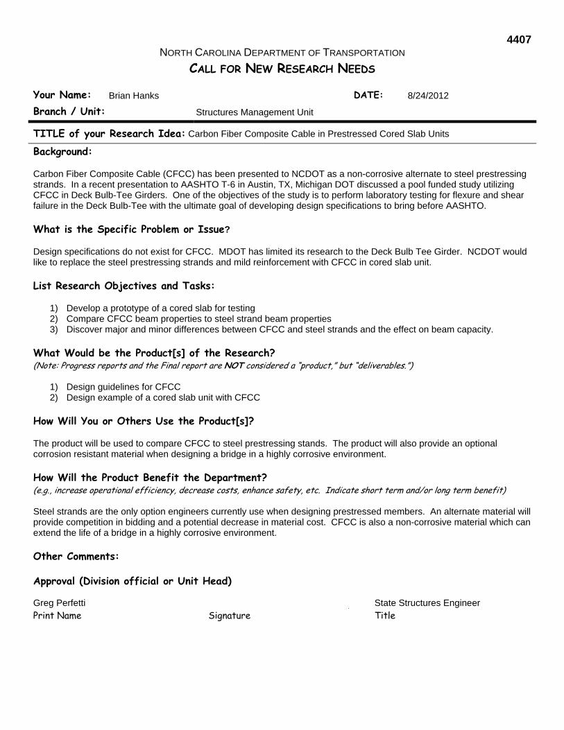
4407 NORTH CAROLINA DEPARTMENT OF TRANSPORTATION
CALL FOR NEW RESEARCH NEEDS
Your Name: Brian Hanks DATE: 8/24/2012
Branch / Unit: Structures Management Unit
TITLE of your Research Idea: Carbon Fiber Composite Cable in Prestressed Cored Slab Units
Background: Carbon Fiber Composite Cable (CFCC) has been presented to NCDOT as a non-corrosive alternate to steel prestressing strands. In a recent presentation to AASHTO T-6 in Austin, TX, Michigan DOT discussed a pool funded study utilizing CFCC in Deck Bulb-Tee Girders. One of the objectives of the study is to perform laboratory testing for flexure and shear failure in the Deck Bulb-Tee with the ultimate goal of developing design specifications to bring before AASHTO.
What is the Specific Problem or Issue? Design specifications do not exist for CFCC. MDOT has limited its research to the Deck Bulb Tee Girder. NCDOT would like to replace the steel prestressing strands and mild reinforcement with CFCC in cored slab unit.
List Research Objectives and Tasks:
1) Develop a prototype of a cored slab for testing 2) Compare CFCC beam properties to steel strand beam properties 3) Discover major and minor differences between CFCC and steel strands and the effect on beam capacity.
What Would be the Product[s] of the Research? (Note: Progress reports and the Final report are NOT considered a “product,” but “deliverables.”)
1) Design guidelines for CFCC 2) Design example of a cored slab unit with CFCC
How Will You or Others Use the Product[s]? The product will be used to compare CFCC to steel prestressing stands. The product will also provide an optional corrosion resistant material when designing a bridge in a highly corrosive environment.
How Will the Product Benefit the Department? (e.g., increase operational efficiency, decrease costs, enhance safety, etc. Indicate short term and/or long term benefit) Steel strands are the only option engineers currently use when designing prestressed members. An alternate material will provide competition in bidding and a potential decrease in material cost. CFCC is also a non-corrosive material which can extend the life of a bridge in a highly corrosive environment.
Other Comments:
Approval (Division official or Unit Head)
Greg Perfetti State Structures Engineer Print Name Signature Title

4408 NORTH CAROLINA DEPARTMENT OF TRANSPORTATION
CALL FOR NEW RESEARCH NEEDS
Your Name: Greg Perfetti, P.E. & Njoroge Wainaina, P.E. DATE: 8/23/12
Branch / Unit: Structures Management & Geotechnical Engineering Units
TITLE of your Research Idea: Retaining Wall Inventory and Assessment System
Background: Several types of earth retaining walls are utilized by NCDOT across the State. They include MSE, soil-nail, tie-back, gravity, cantilever, and pile panel walls. Many older retaining walls currently in service lack as-built information and in some cases the wall locations are unknown. A statewide retaining wall inventory and management system would be beneficial in aiding NCDOT inspect, repair and maintain the transportation infrastructure.
What is the Specific Problem or Issue? Older retaining walls lack documentation on the installation location, construction materials, as-built geometry, soil conditions, and post-construction repairs. The lack of information and presents the inability to plan for inspection, repairs and maintenance of the wall assets.
List Research Objectives and Tasks: 1. Develop the framework for a wall inventory and management system; similar to the WIGINS Bridge Management
System. 2. Utilize resources, such as the National Park Service's Retaining Wall Inventory and Condition Assessment Program
and NCHRP's Guide to Asset Management of Earth Retaining Structures (Oct. 2009) to develop the best practices. 3. Initially, consider critical walls, such as those adjacent to bridges. However, the long term strategy is to include all
earth retaining walls in the management system.
What Would be the Product[s] of the Research? (Note: Progress reports and the Final report are NOT considered a “product,” but “deliverables.”)
1. A framework for developing an earth retaining wall inventory and management system. 2. An inventory of critical retaining walls across the state. 3. A proof-of-concept for predicting the condition of older in-service retaining walls.
How Will You or Others Use the Product[s]? The product will of this research will facilitate building an inventory of retaining walls across the State. The retaining wall management system will facilitate inspection, repair and maintenance of retaining walls.
How Will the Product Benefit the Department? (e.g., increase operational efficiency, decrease costs, enhance safety, etc. Indicate short term and/or long term benefit) The retaining wall inventory and management system will provide SMU and GEU information for making data-driven engineering decisions when construction, maintaining, or replacing retaining walls. This system will promote more efficient management of the State's transportation infrastructure.
Other Comments:
Approval (Division official or Unit Head) Greg Perfetti & Njoroge Wainaina
State Structures Engineer & State Geotechnical Engineer
Print Name Signature Title
TRAFFIC AND SAFETY
RESEARCH IDEAS

4501 NORTH CAROLINA DEPARTMENT OF TRANSPORTATION
CALL FOR NEW RESEARCH NEEDS
Your Name: Donald L. Smith DATE: 08/01/12
Branch / Unit: Div. 9 /Traffic Engineering
TITLE of your Research Idea: Lat. & Long. Collection of Traffic Accident Locations
Background: Deputy Division Traffic Engineer for Division Nine
What is the Specific Problem or Issue? The inability to accurately and quickly collect locations of traffic accidents along roadways or at intersections. Currently traffic accidents are referenced from a cross Road or Municipal / County line. There are several factors that facilitate in the erroneous reporting of locations of traffic accidents. Some of these include: Multiple Route Designations on the same road, Route numbers change across intersections, Route Designations changing over the years, Road Names change in and out of Municipalities, Roads that loop back to the same road, inaccurate mile-posting of Routes. These references to cross streets and the Direction “From” and “Towards” are generally not accurate enough to determine the precise location. Collecting this data is time consuming for the Officer. It can also be hazardous at times, having to walk along a roadway.
List Research Objectives and Tasks: Use the current DMV Crash Report Form DMV-349 and use the “Latitude” and “Longitude” fields to determine the location of the accident.
What Would be the Product[s] of the Research? (Note: Progress reports and the Final report are NOT considered a “product,” but “deliverables.”) An online aerial mapping tool for the Patrolman / Officer to use to generate the location of the accident. Information collected in these fields would be extracted with the other Form Data that is used in the Traffic Engineering Accident Analysis System (TEAAS) program.
How Will You or Others Use the Product[s]? The Traffic Safety Unit in Raleigh would use this data to generate Arc-Map shape files for online access to be used by multiple Units within NCDOT.
How Will the Product Benefit the Department? (e.g., increase operational efficiency, decrease costs, enhance safety, etc. Indicate short term and/or long term benefit) It would allow for timely, accurate reporting of accident locations which will facilitate in collecting and determining corrective actions if warranted.
Other Comments:
Approval (Division official or Unit Head)
J. P. Couch Div. 9 Traffic Engineer Print Name Signature Title

4502 NORTH CAROLINA DEPARTMENT OF TRANSPORTATION
Your Name: Scot Cole & Tony Wyatt DATE: August 13, 2012
Branch / Unit: Division 10 Operations & TM&SD Traffic Safety / Field Operations
TITLE of your Research Idea: Synthesis of Contemporary Guidance and Recommendations for (A) Pedestrian Signal provisions (including Crosswalks) at Signalized Intersection Locations (New & Existing) and (B) Marked Crosswalks at Uncontrolled approaches of Stop Sign Controlled Intersections.
Background: North Carolina continues to realize significant growth and as part of that growth additional traffic of all modes is being experienced. Simultaneously efforts are underway to improve the function of our streets and highways with a balanced modal approach that increase the opportunities and accessibility of /for pedestrians, bicycles and transit. Traditionally North Carolina could apply essentially RURAL (no pedestrian) and URBAN (some pedestrian) approaches to road corridor and function decisions – however now with the explosion of suburban areas and the improved interconnectivity of urban areas, decisions regarding road infrastructure and traffic controls are more complex and sensitive.
What is the Specific Problem or Issue? The lack of clarity, guidance, and support in the 2009 MUTCD (Manual on Uniform Traffic Control Devices) and Other practitioner references for NCDOT Point-of-Attack Decision Making Engineers specific to both ( A.) Pedestrian Signals /Crosswalk provisions at signalized intersections and (B.) Marked Crosswalks at Uncontrolled approaches of Stop Sign Controlled Intersections are the two Specific Problem Focus Areas identified under this concept statement. (A) North Carolina’s Highway System has in excess of 9,000 traffic signals and while many are in well-defined central business districts with varying degrees of pedestrian usage and accessibility/infrastructure, even more of the signals are in areas that are rural or suburban or possibly even transitioning between urban and rural. In an unconstrained (resources/& and manpower and time) model it would be ideal to have full pedestrian provisions (pedestrian display heads, marked crosswalks, and even crosswalks/trails and connectivity) at all locations that regularly serve pedestrians, unfortunately the reality of budgetary and resource constraints is very evident and as such NCDOT Engineers are having to make the determination on case by case basis with little support for decisions to defer installation and even less resources with which to install the treatments. How the agency approaches the consistency/basis for denials for requests of additional provisions at locations lacking basic pedestrian infrastructure (no sidewalks/no connectivity/no usage) is also an important area of concern. (B) NCDOT is asked routinely to mark crosswalks at various location, but other than reviewing the sight distance, agency staff have very little else on which to base crosswalk go/no-go decisions. Variables include ADT, speed limit/operating speed, amount and type of pedestrian activity, pedestrian crash history, roadside environment, area factors, signing options, flasher/beacon options, lighting, etc. We are often caught in a no-win scenario, as there is evidence of pedestrians crossing. Marking such a crossing may indicate it is safe and we endorse this location (encouraging more to cross), but not marking may infer that we are not willing to promote a safe crossing (after which someone may be injured).
There is an increasingly wide range of local approaches to attempt to manage/prioritize these installations (pedestrian signals and marked crosswalks) and the necessary investments (initial cost/operational costs/perpetual maintenance) unfortunately the variability in application has resulted in system traffic control inconsistencies that are often difficult to defend and more difficult to justify.
List Research Objectives and Tasks: Documentation of National guidance (synthesis) of other State/Municipal practices/polices/general statutes/requirements regarding criteria for (1) including/excluding pedestrian signals at new or existing/upgraded traffic signal installations and (2) Marked Crosswalks at Uncontrolled approaches of Stop Sign Controlled Intersections and (3) How to consistently address denials of pedestrian provisions when there is no pedestrian infrastructure/sidewalk, extremely low usage or no connectivity. Literature research / survey effort to include (insert Bucky text) Information researched will include identification of practice gaps and contradictions, a thorough Statewide Survey of Existing practices and identified issues/needs, a thorough national synthesis of existing guidance (updated with Complete Street Considerations and MUTCD 2009 Content), and a summary of recommendations / action plan for NCDOT and local governments (municipalities, MPO/RPO) possibly utilizing the NC Section of Institute of Transportation Engineers to formalize improved more consistent statewide practice and deliver training.
What Would be the Product[s] of the Research? (Note: Progress reports and the Final report are NOT considered a “product,” but “deliverables.”) A published Comprehensive Synthesis of Contemporary Practices / Policies regarding Pedestrian Signal Provisions at Signalized Intersections (New – Existing - Upgraded) and Marked Crosswalks at Uncontrolled approaches of Stop Sign Controlled Intersections, A comprehensive Gap Analysis for Both the Pedestrian Signal and marked Crosswalk provisions and Marked Crosswalks issues/topics– regarding what is missing / needed, a set of comprehensive recommendations (to improve current practice) for agency consideration, an action plan for implementation, training and future monitoring/evaluation and adjustment. The report should address the resources that would be needed to accomplish recommended actions – especially as it would pertain to potential retrofit approaches for locations that are already signalized but lack pedestrian signal provisions. The products will include traditional PowerPoint Summary Presentation (background/findings/recommendations/Action Plan), signature ready TEPPL practice and an associated summary PDF brochure as part of the deliverable. Deliverable could also include guidelines/criteria for effective engineering evaluation / decision support tools such as a decision matrix and even specific Crosswalk Go/No-Go decision trees. . (Note: This effort could be split into two separate independent research efforts and conducted by separate research institutions).
How Will You or Others Use the Product[s]? NCDOT, local government, PEF and anyone involved in traffic control, intersection safety, and accessibility decisions will benefit from and utilize the findings to improve our approaches to whether or not to include pedestrian signal provisions at signalized intersections and when to utilize Marked Crosswalks at Uncontrolled approaches of Stop Sign Controlled Intersections – and to be able to improve the consistency of application of these devices to locations that will provide the most benefit to the traveling public.
How Will the Product Benefit the Department? (e.g., increase operational efficiency, decrease costs, enhance safety, etc. Indicate short term and/or long term benefit) While North Carolina has been very progressive in regard to adoption of Complete Street Approaches, and even the Statewide adoption of Count Down Pedestrian Signal provisions – some of the practices for Pedestrian Signal provisions/marked crosswalks at signalized Intersections and Marked Crosswalks at Uncontrolled Approaches of Stop Sign Controlled Intersections rely on traditional rural/urban definitions and the need for and presence of basic pedestrian infrastructure (sidewalks) and other features. There continues to be significant concern/debate over the investment of limited resources and required ongoing / perpetual maintenance for locations that have very limited pedestrian utilization/demand – however the realization is that North Carolina is continuing to grow and the nature of our state’s transportation system and choices are rapidly evolving. It is our hope that this synthesis/action plan can serve as an additional key set of knowledge tools to aid in the thoughtful consideration of whether or not to include pedestrian signals and provisions at a location (new or existing). Approval (Division official or Unit Head)

4503 NORTH CAROLINA DEPARTMENT OF TRANSPORTATION
CALL FOR NEW RESEARCH NEEDS
Your Name: James Dunlop DATE: 1 August 2012
Branch / Unit: Transportation Mobility and Safety Division/Congestion Management Section
TITLE of your Research Idea: Exploring Corridor Operations in the Vicinity of a Diverging Diamond Interchange (DDI)
Background: The Diverging Diamond Interchange (DDI) is becoming a very popular alternative interchange design being implemented across the United States. NCDOT has about twelve DDIs either under contract or in design at this time. Reasons include 1) efficient 2-phase signal operation at the two interchange ramp terminals, 2) free-flowing left turn maneuvers off the arterial, 3) retrofit capabilities at existing (tight) diamond interchanges, 4) reduced conflict points, and most importantly 5) reduced cost of the interchange compared to its predecessor, the Single Point Interchange. However, little is known about the effectiveness of the DDI in relation to nearby intersections along the corridor which are already proving to be problematic. Given the popularity of the DDI across the State and nation, it is inherent that the NCDOT be proactive in investigating this issue to invest tax payer dollars wisely.
What is the Specific Problem or Issue? Current research underway by the Federal Highway Administration focuses on the safety and operational effectiveness of the interchange only. Recent studies of the few interchanges currently installed show that, for the most part, the DDI is very efficient and safe; however, nearby upstream intersections cause spillback into the DDI while downstream intersections starve the DDI leading to lost capacity at the interchange. In addition, given the lack of public support for many unconventional designs (especially at retrofit intersections/interchanges), it is essential that NCDOT consider corridor level improvements when installing a DDI to make sure that the facility is being fully utilized.
List Research Objectives and Tasks: Review current state of the practice for DDI’s and alternative corridor level designs. Identify initial inventory of options for corridor level improvements that reduce the number of signal phases while
considering the issues of closely spaced intersections in the vicinity of the DDI. Ask national level experts for advice on alternatives not identified by the team. Obtain detailed construction plans of current and future DDI installations in NC and other States along with any
additional corridor improvements. Develop a working list that identifies the trade-offs of each design based on geometry, signal phasing, etc. Identify a core group of working alternatives for analysis. Perform traffic analysis of various DDI configurations with each alternative identified. Submit a final report documenting the trade-offs of each design alternative.
What Would be the Product[s] of the Research? Guidelines for best practices to reduce signal phasing along corridors with DDI installations, especially those that are currently (or predicted) to have moderate to heavy traffic volumes.
How Will You or Others Use the Product[s]? Better decision making at the planning level to make sound recommendations on potential corridor level improvements that maximize throughput for the entire system and not just the interchange.
How Will the Product Benefit the Department? The research will give the Department a better understanding of the corridor level impacts of traditional and alternative intersections in the near vicinity of the DDI to improve overall throughput along arterials, especially those along current or future strategic corridors.
Approval (Division official or Unit Head) Kevin Lacy State Traffic Engineer
Print Name Signature Title

4504 NORTH CAROLINA DEPARTMENT OF TRANSPORTATION
CALL FOR NEW RESEARCH NEEDS
Your Name: Anthony Wyatt DATE: August 14, 2012
Branch / Unit: Traffic Safety Unit
TITLE of your Research Idea: Evaluation of Life Cycle Impacts of Intersection Control Type Selection
Background: Common solutions to traffic safety concerns at two-way stop controlled intersections are retrofits including all way stop (AWS) controlled intersections, signalization, and roundabouts. Each of these intersection types has unique advantages and limitations. In particular, the life cycle costs associated with signalization add a considerable burden to NCDOT resources, while conversion to an AWS controlled intersection requires minimal improvement funding while still delivering safety benefits. However, there are concerns about the delays experienced by mainline traffic volumes at AWS controlled intersections that should be considered against the costs of signalization or roundabout installation.
What is the Specific Problem or Issue? Some two-way stop controlled intersections in the state face safety concerns and are being retrofitted to traffic signals in many cases. In the process, the potential benefits of an all way stop controlled intersection are often overlooked as they are not well-documented and there is concern for high delay for AWS controlled intersections. Documented research is needed to establish the conditions under which all way stop controlled intersections or other alternatives are preferred instead of signals.
List Research Objectives and Tasks: This research will attempt to understand the life cycle impacts of the selection of intersection control types through the following tasks: 1) review literature on life cycle costs and intersection performance, 2) develop an analysis framework, 3) identify North Carolina intersections for study, 4) plan data collection efforts, 5) collect data, 6) evaluate and analyze data, and 7) report findings.
What Would be the Product[s] of the Research? (Note: Progress reports and the Final report are NOT considered a “product,” but “deliverables.”) The primary research product will be intersection comparison guidance in relation to costs, delay, and safety impacts of various intersection types.
How Will You or Others Use the Product[s]? NCDOT can utilize this information to support the evaluation of intersection control strategies for various intersections. The results will allow NCDOT to compare user delay, safety, and costs at all way stop, two-way stop, signalized intersections, and roundabouts. The guidance will include peak and off-peak analysis while considering balanced and unbalanced flow conditions.
How Will the Product Benefit the Department? (e.g., increase operational efficiency, decrease costs, enhance safety, etc. Indicate short term and/or long term benefit) The findings from the research effort would help NCDOT make well-informed decisions about the various aspects of intersection control types that impact the motoring public and NCDOT resources.
Other Comments:
Approval (Division official or Unit Head) Kevin Lacy State Traffic Engineer
Print Name Signature Title
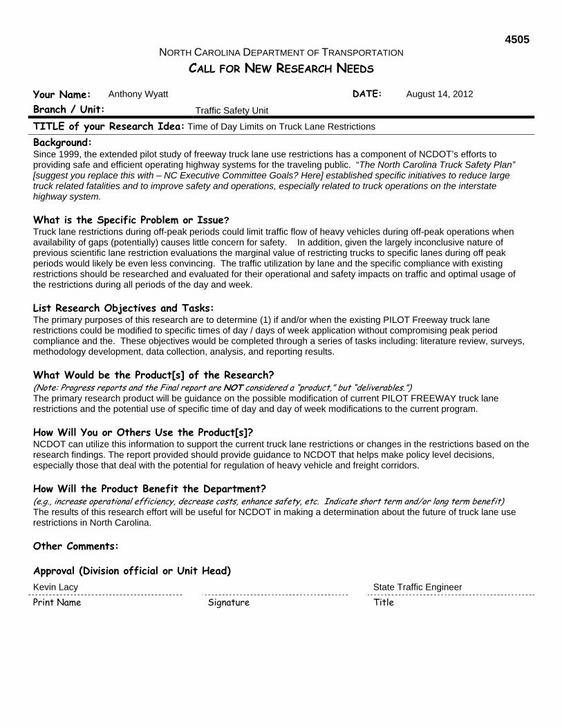
4505 NORTH CAROLINA DEPARTMENT OF TRANSPORTATION
CALL FOR NEW RESEARCH NEEDS
Your Name: Anthony Wyatt DATE: August 14, 2012
Branch / Unit: Traffic Safety Unit
TITLE of your Research Idea: Time of Day Limits on Truck Lane Restrictions
Background: Since 1999, the extended pilot study of freeway truck lane use restrictions has a component of NCDOT’s efforts to providing safe and efficient operating highway systems for the traveling public. “The North Carolina Truck Safety Plan” [suggest you replace this with – NC Executive Committee Goals? Here] established specific initiatives to reduce large truck related fatalities and to improve safety and operations, especially related to truck operations on the interstate highway system.
What is the Specific Problem or Issue? Truck lane restrictions during off-peak periods could limit traffic flow of heavy vehicles during off-peak operations when availability of gaps (potentially) causes little concern for safety. In addition, given the largely inconclusive nature of previous scientific lane restriction evaluations the marginal value of restricting trucks to specific lanes during off peak periods would likely be even less convincing. The traffic utilization by lane and the specific compliance with existing restrictions should be researched and evaluated for their operational and safety impacts on traffic and optimal usage of the restrictions during all periods of the day and week.
List Research Objectives and Tasks: The primary purposes of this research are to determine (1) if and/or when the existing PILOT Freeway truck lane restrictions could be modified to specific times of day / days of week application without compromising peak period compliance and the. These objectives would be completed through a series of tasks including: literature review, surveys, methodology development, data collection, analysis, and reporting results.
What Would be the Product[s] of the Research? (Note: Progress reports and the Final report are NOT considered a “product,” but “deliverables.”) The primary research product will be guidance on the possible modification of current PILOT FREEWAY truck lane restrictions and the potential use of specific time of day and day of week modifications to the current program.
How Will You or Others Use the Product[s]? NCDOT can utilize this information to support the current truck lane restrictions or changes in the restrictions based on the research findings. The report provided should provide guidance to NCDOT that helps make policy level decisions, especially those that deal with the potential for regulation of heavy vehicle and freight corridors.
How Will the Product Benefit the Department? (e.g., increase operational efficiency, decrease costs, enhance safety, etc. Indicate short term and/or long term benefit) The results of this research effort will be useful for NCDOT in making a determination about the future of truck lane use restrictions in North Carolina.
Other Comments:
Approval (Division official or Unit Head) Kevin Lacy State Traffic Engineer
Print Name Signature Title
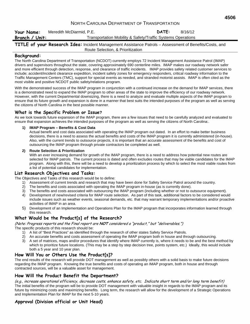
4506 NORTH CAROLINA DEPARTMENT OF TRANSPORTATION
Your Name: Meredith McDiarmid, P.E. DATE: 8/16/12
Branch / Unit: Transportation Mobility & Safety/Traffic Systems Operations
TITLE of your Research Idea: Incident Management Assistance Patrols – Assessment of Benefits/Costs, and Route Selection, & Prioritization
Background: The North Carolina Department of Transportation (NCDOT) currently employs 72 Incident Management Assistance Patrol (IMAP) drivers and supervisors throughout the state, covering approximately 690 centerline miles. IMAP makes our roadway network safer and more efficient through detection, response, and clearance of traffic incidents. IMAP provides safety related customer services to include; accident/incident clearance expedition, incident safety zones for emergency responders, critical roadway information to the Traffic Management Centers (TMC), support for special events as needed, and stranded motorist assists. IMAP is often cited as the most visible and positive NCDOT public safety/relations program.
With the demonstrated success of the IMAP program in conjunction with a continued increase on the demand for IMAP services, there is a demonstrated need to expand the IMAP program to other areas of the state to improve the efficiency of our roadway network. However, with the current Departmental downsizing, there is a need to analyze and evaluate multiple aspects of the IMAP program to ensure that its future growth and expansion is done in a manner that best suits the intended purposes of the program as well as serving the citizens of North Carolina in the best possible manner.
What is the Specific Problem or Issue? As we look towards future expansion of the IMAP program, there are a few issues that need to be carefully analyzed and evaluated to ensure that expansion achieves the intended purposes of the program as well as serving the citizens of North Carolina:.
1) IMAP Program – Benefits & Cost Data Actual benefit and cost data associated with operating the IMAP program out dated. In an effort to make better business decisions, there is a need to assess the actual benefits and costs of the IMAP program it is currently administered (in-house). Also, with the current trends to outsource projects, it is important that an accurate assessment of the benefits and cost of outsourcing the IMAP program through private contractors be completed as well.
2) Route Selection & Prioritization With an ever increasing demand for growth of the IMAP program, there is a need to address how potential new routes are selected for IMAP patrols. The current process is dated and often excludes routes that may be viable candidates for the IMAP program. Along with this, there will be a need to develop a prioritization process by which to select the most viable routes from a list of potential candidates for implementation.
List Research Objectives and Tasks: The Objectives and Tasks of this research would be to define:
1) Assessment of current trends and research that may have been done for Safety Service Patrol around the country. 2) The benefits and costs associated with operating the IMAP program in-house (as is currently done). 3) The benefits and costs associated with outsourcing the IMAP program (including whether or not to outsource equipment). 4) Development of new/revised criteria for IMAP route selection. As part of this task, additional factors to be considered would
include issues such as weather events, seasonal demands, etc. that may warrant temporary implementations and/or proactive activities of IMAP in an area.
5) Development of an Implementation and Operations Plan for the IMAP program that incorporates information learned through this research.
What Would be the Product[s] of the Research? (Note: Progress reports and the Final report are NOT considered a “product,” but “deliverables.”) The specific products of this research should be:
1) A list of “Best Practices” as identified through the research of other states Safety Service Patrols. 2) An accurate benefits and costs assessment of operating the IMAP program both in house and through outsourcing. 3) A set of matrices, maps and/or procedures that identify where IMAP currently is, where it needs to be and the best method by
which to prioritize future locations. (This may be a step by step decision tree, points system, etc.) Ideally, this would include both a 5 year and 10 year plan.
How Will You or Others Use the Product[s]? The end results of the research will provide DOT management as well as possibly others with a solid basis to make future decisions regarding the IMAP program. Knowing the true benefits and costs of operating an IMAP program, both in house and through contracted sources, will be a valuable asset for management.
How Will the Product Benefit the Department? (e.g., increase operational efficiency, decrease costs, enhance safety, etc. Indicate short term and/or long term benefit) The initial benefits of the program will be to provide DOT management with valuable insight in regards to the IMAP program and its future by minimizing costs and maximizing benefits. Long term, the research will allow for the development of a Strategic Operations and Implementation Plan for IMAP for the next 5-10 years.
Approval (Division official or Unit Head)

4507 NORTH CAROLINA DEPARTMENT OF TRANSPORTATION
CALL FOR NEW RESEARCH IDEA
Your Name: Chris Howard DATE: 08/30/2011
Affiliation: Signing and Delineation Standards
TITLE of your Research Idea: Assessment of Automated Sign Retroreflectivity Measurement Tools
Background: Automated asset inventory is a hot topic among federal and state transportation agencies in the past few years. Roadway assets and pavement distress are among the two most studied transportation features across the country. The primary motivation for collecting this data using automated methods is the ability to keep staff out of the roadway, especially high speed facilities such as interstates. The other reason is that it can be done more efficiently. Current studies are already underway looking at the feasibility of vendors collecting data for roadway assets; however, another key area is still missing. This particular research effort piggybacks on current research being conducted by NCDOT. In light MUTCD requirements for sign retroreflectivity, there is a need to determine the best practice for collecting sign retroreflectivity data along various roadway types. Methods for sign replacement could be done by yearly visual nighttime inspections, mass replacement, actual field measurements using a retroreflectometer, etc. One method being explored recently is the use of automated methods, such as LIDAR and other recently patented devices. This proposal seeks to formally evaluate these up-and-coming technologies ability to collect useful and accurate retroreflectivity data and, assuming they work, provide guidance about when those technologies should be deployed for a safety, operational, and cost standpoint.
What is the Specific Problem or Issue? The MUTCD is requiring that all States have a plan for replacing signs based on retroreflectivity standards. There are multiple methods for doing sign replacement, noted earlier; however, given the advent of newer technology in the asset data collection field, there may be reason to use automated methods if they can provide accurate and dependable data.
List Research Objectives and Tasks: Determine the current state of the practice through a literature search, obtain a list of vendors who claim to collect this data, get estimates from vendors to collect data on a predetermined road course, collect manual retroreflectivity data for comparison purposes, analyze vendor data sets against field measurements, and provide a final report documenting the findings and any guidelines.
What Would be the Product[s] of the Research? Will provide a concrete determination of the current practices for collecting sign retroreflectivity using automated methods and their ability to collect that data accurately.
How Will You or Others Use the Product[s]? Assuming one or more methods can accurately collect retroreflectivity, NCDOT will have another tool at their disposal to collect sign inventory data.
How Will the Product Benefit the Department? Automated methods of asset extraction are safer to conduct than traditional methods, especially those that require field personnel to work in and around the roadway. This method has the potential to be used in instances where an automated extraction makes more sense. In addition, it is possible that this method is more efficient and cost effective.
Other Comments:
Approval (Division official or Unit Head) Kevin Lacy State Traffic Engineer
Print Name Signature Title

4508 NORTH CAROLINA DEPARTMENT OF TRANSPORTATION
Your Name: Majed Al-Ghandour, Ph.D., P.E. DATE: 8/24/2012
Branch / Unit: Program Development Branch
TITLE of your Research Idea: Guidance for Access Management in the Vicinity of a Conventional Interchange (CI), a Diverging Diamond Interchange (DDI), and a Diverging Double Roundabout Interchange (DDR)
Background: NCHRP Synthesis 332 provided a review on crossroads in the vicinity only of a Freeway Interchange (Conventional) and nothing about other types such as DDI and DDR. FHWA introduces the DDI design to accommodate left-turning movements at signalized, grade-separated interchanges of arterials and limited-access highways while eliminating the need for left-turn phasing (FHWA-HRT-07-048). DDI shows a safety benefits by reducing the conflicts points from 26 (conventional) to 14 (DDI) and where the conflicts points spread out throughout interchange. DDI provides a better sight distance at turns and pedestrian crossings are shorter. DDI also shows operational benefits by supporting a unique phase combinations, simple left and right turns from all directions, only two phases needed with short cycle length and a better signal network synchronization. DDI adds more cost benefits such as existing bridge can be used or less bridge structure and additional right-of-way rarely needed. NCDOT may need some research in this area to translate the results directly into practice and guidance to improve access spacing and access management value. What is the Specific Problem or Issue? Which interchanges (CI, DDI, and DDR) is considered as the best solution in some cases for the NCDOT interchanges? Why and where can we design them (rural, urban, and suburban)? What is the standard access spacing factors should be analyzed for each interchange? What is the impact on each interchange area to the land use life cycle cost and access management value? What is the best practice NCDOT is needed compared to nationwide practice to determine access points in the vicinity of interchanges (CI, DDI, and DDR)? What are the variations of the speed, crossroad facilities, and sight distances, and others to be addressed for crossroads, access points, and fringes? What is the spillback from any of these vicinity interchanges (CI, DDI, and DDR) onto the nearest road access point? What are some of the limitations of the DDI in terms of access management compared to CI? The DDI works best when there is at least one heavy left turn movement and/or unbalanced thru movements. What are other options helps access points? What are more innovative geometric designs to be considered for DDIs such as DDR? More challenges will be the channelization turns at roundabouts, how can be evaluated? How we can accommodate Pedestrians and Bicyclists on or in the vicinity area of these interchanges? Do we have a visualization tools to demonstrate Access Management values and concepts in the vicinity of interchanges (CI, DDI, and DDR) during planning and design? List Research Objectives and Tasks: Review current literature relevant to CI, DDI and DDR interchanges, best practices, safety and operational features, cost, and
limitations. Brief evaluate current practice for the NCDOT standards in designing intersections, interchanges, DDI: the operations, benefits,
limitations. Develop a conceptual framework, methodology, and guides access management for vicinity interchanges (CI, DDI, and DDR) and
selection criteria. Determine ways to solve some issues involving DDI & DDR and their impacts on access points. Provide new knowledge on which NCDOT engineers and practitioners can base their decisions and incorporate better utilize these
tools for optimum DDI & DDR design to have good case studies of access management areas. Explore the safety and operational performance of interchanges (CI, DDI, and DDR). Perform traffic analysis and trade-off analysis related to the need to use interchanges (CI, DDI, and DDR) with access
management concepts. Optimize the cost benefits from variations of interchanges (CI, DDI, and DDR) to the land use. Accommodation for Pedestrians and Bicyclists on access points in the vicinity of interchanges (CI, DDI, and DDR). What Would be the Product[s] of the Research? Develop Access Management Guidelines for spacing from ramps and access points of crossroads, sites, areas, etc. Tools, models, and innovative practices. Document analysis and report recommendations. How Will You or Others Use the Product[s]? Engineers will use supportive criteria, standards, innovations for producing, manipulating, and presenting for delivery project with
interchanges (CI, DDI, and DDR) with a good in vicinity access management access points.
How Will the Product Benefit the Department? Bring the organization to state-of-the art standard of designing access management and roads in vicinity of interchanges (CI, DDI,
and DDR). Improve the practice of designing interchanges (CI, DDI, and DDR) to Pedestrians and Bicyclists on access points in the vicinity of
the interchange. Approval (Division official or Unit Head) Calvin Leggett, P.E. Branch Manager Print Name Signature Title

4509 NORTH CAROLINA DEPARTMENT OF TRANSPORTATION
Your Name: Majed Al-Ghandour, Ph.D., P.E. DATE: 8/24/2012
Branch / Unit: Program Development Branch
TITLE of your Research Idea: Lessons Learned: Does a Multi-Lane Roundabout Safer than Single-Lane Roundabout: What is the Impact of Changing Existing Multi-Lane to a Single-Lane Roundabout?Background: A roundabout is a one-way, yield-controlled circular intersection, whose configuration can vary in number of approaches and circulating lanes, in which traffic flows counterclockwise around a central island. In recent years, roundabouts have become progressively more popular as an innovative operational and safety key for both low- and high-volume travel demands. NCDOT and other agencies (cities, towns, and locals) began designing and building roundabouts on state roads in urban and rural areas. Based on the latest estimate number of Roundabout reported from the Transportation Mobility and Safety Division – NCDOT are 165 installed in NC (approximately 5 are only a Multi-lane roundabouts).
For example, recently City of Raleigh installed 3 roundabouts at Hillsborough Street and one of them was a multi-lane roundabout. Roundabouts must be designed to meet the needs of all road users, including vehicle drivers, pedestrians (including those with disabilities such as visual impairment), and bicyclists. Recently, several crashes reported on this site, Hillsborough Street multi-lane roundabout, mandatory the city to reconfigure it back to a single-lane roundabout.
The goals from this research idea are to undertaken a safety assessment for Multi-Lane Roundabouts for the North Carolina Department of Transportation (NCDOT) before install them. The main objective is to develop models that predict the future number of crashes on multi-lane roundabouts at North Carolina and what are the best practices to reconfigure it and reduce number of circulation lanes. Different configurations for roundabouts need different type of predicated crash models too. NCDOT and locals may need some research in this area to translate the results directly into practice and guidance to improve reconfiguring roundabout design to determine the impacts. What is the Specific Problem or Issue? Crashes reported on the Hillsborough Street- What are lessons learned? How to address the question: How NCDOT transportation planners, traffic engineers and decision-makers efficiently can predict
the safety assessment and the performance of multi-lane roundabouts. There is a need to develop models that predict the future number of crashes on roundabouts at North Carolina. Different configurations for roundabout will have different type of crash models too.
Are other state‘s crash models transferable and transparence to North Carolina Roundabouts? What are the best practices to reconfigure and to redesign existing number of circulating lanes? What are the impacts of changing existing number of circulating lanes of a roundabout on the cost, geometry components,
Bicyclists, Pedestrians, pedestrian crosswalks, etc.?List Research Objectives and Tasks: Review current literature relevant to a multi-lane roundabouts and reconfiguring roundabouts, best practices, safety and
operational features, cost, and limitations. Brief evaluate current practice for the NCDOT standards in designing multi-lane roundabout and crash models. Develop a conceptual framework, methodology, and guides and selection criteria for changing an existing roundabout. Determine ways to solve some issues involving multi-lane roundabout and crash models. Provide new knowledge on which NCDOT engineers and practitioners can base their decisions and incorporate better utilize these
tools for optimum multi-lane roundabout design to have good case study what is the crash improvement for Hillsborough site, as an example.
Explore the safety and operational performance impact of multi-lane roundabout changed to a single-lane roundabout. Optimize the cost benefits from variations of multi-lane roundabout changed to a single-lane roundabout. Accommodation for Pedestrians and Bicyclists after a multi-lane roundabout changed to a single-lane roundabout. What Would be the Product[s] of the Research? Develop NCDOT roundabout Guidelines, impacts and predicted models. Tools, models, and innovative practices. Document analysis and report recommendations.How Will You or Others Use the Product[s]? Engineers will use supportive criteria, standards, innovations for producing, manipulating, assessment, and presenting of multi-lane
roundabout changed to a single-lane roundabout as lessons learned!
How Will the Product Benefit the Department? Bring the NCDOT to state-of-the art standard of designing roundabout to be safer and developing a consistent guidelines for of
multi-lane roundabout if changed to a single-lane roundabout. Pedestrians and Bicyclists accommodation if a multi-lane roundabout changed to a single-lane roundabout. Approval (Division official or Unit Head)
Calvin Leggett, P.E. Branch Manager Print Name Signature Title

4510 NORTH CAROLINA DEPARTMENT OF TRANSPORTATION
CALL FOR NEW RESEARCH IDEA
Your Name: Reuben E. Moore DATE: 08/28/2012
Affiliation: NCDOT Division 14 - Operations
TITLE of your Research Idea: Rumble Strip Gaps for High Speed Bicycles
Background: Richard C. Moeur in his paper entitled “Analysis of Gap Patterns in Longitudinal Rumble Strips to Accommodate Bicycle Travel” studied gaps in rumble strips for speeds up to 25 – 26 mph, as reported in Transportation Research Record TRB 1705, Paper No. 00-0248, Pages 93-98. Higher speeds were not studied.
What is the Specific Problem or Issue? Cyclists have reported they can travel above 35 mph travelling down a 7% grade such as we have on US 23-74, which also carries state bicycle route #2, the Mountains to the Sea Trail. They reported that they cannot navigate between the existing twelve-foot gaps.
List Research Objectives and Tasks: Perform a similar study as Richard C. Moeur, but include bicycle speeds up to 40 mph.
What Would be the Product[s] of the Research? (Note: Progress reports and the Final report are NOT considered a “product,” but “deliverables.”) Project Special Provisions with guidance on length of gaps in rumble strips relative to the grade of the highway.
How Will You or Others Use the Product[s]? May use gaps other than twelve feet on roadway projects.
How Will the Product Benefit the Department? (e.g., increase operational efficiency, decrease costs, enhance safety, etc. Indicate short term and/or long term benefit) Increased safety for cyclists, less occasions of cyclists using the travel lane.
Other Comments:
Approval (Division official or Unit Head) Joel B. Setzer Division Engineer – Div. 14
Print Name Signature Title
Related Documents