8-1 8.0 LETTERS OF COMMENT ON THE DRAFT EIR AND REVISED DRAFT EIR AND RESPONSES 8.1 Introduction A draft version of the EIR for the proposed Harmony Grove South Project (SCH #2015081071) was circulated for public review April 20, 2017 to June 20, 2017. During public review, a court decision eliminated ability to use one of the Project analysis elements for greenhouse gases (GHG). As a result, a revised Table S-2, GHG EIR section, and supporting technical data, were recirculated from February 22, 2018 to April 9, 2018. During the initial public review period, a total of 54 letters of public comment were received. During recirculation, an additional 17 letters were received. This section of the Final EIR (FEIR) presents copies of comments on the Draft EIR (DEIR), as well as the recirculated Revised DEIR (RDEIR) received in written form during the two public review periods, and the County of San Diego’s responses to those comments. The County’s responses to comments on the DEIR and RDEIR represent a good-faith, reasoned effort to address the environmental issues identified by the comments. Under the CEQA Guidelines, the County is not required to respond to all comments on the DEIR or RDEIR, but only those comments that raise environmental issues. In accordance with California Environmental Quality Act (CEQA Guidelines 15088 and 15204), the County has independently evaluated the comments and prepared the attached written responses on significant environmental issues raised. CEQA does not require the County to conduct every test or preform all research, study, and experimentation recommended or demanded by commenters. Rather, CEQA requires the County to provide a good faith, reasoned analysis supported by factual information. To fulfill these requirements, the County experts in planning and environmental sciences consulted with and independently reviewed analysis responding to the DEIR comments prepared by experts identified in the DEIR’s list of preparers, which include experts in planning, aesthetics, agriculture, air quality, biology, cultural resources, geology and soils, greenhouse gas emissions, hazards and hazardous materials, hydrology and water quality, land use planning, mineral resources, noise, population and housing, public services, recreation, transportation and traffic, utilities and service systems, energy, and environmental studies, each of whom has years of educational and field experience in specific categories of environmental sciences; is familiar with the Project and the environmental conditions in the vicinity of the Project; and is familiar with the federal, state and local rules and regulations (including CEQA) applicable to the Project site. Accordingly, the County staff’s final analyses provided in these responses to comments are backed by substantial evidence. Likewise, the County Counsel’s Office independently reviewed the expert-supported factual responses to the comments. The focus of the responses is on significant environmental issues raised in the comments, as specified by Section 15088(c) of the (CEQA) Guidelines. Detailed responses are not provided to comments on the merits of the Proposed Project. When a comment is not directed to significant environmental issues, the responses indicate that the comment has been acknowledged and no further response is necessary.

Welcome message from author
This document is posted to help you gain knowledge. Please leave a comment to let me know what you think about it! Share it to your friends and learn new things together.
Transcript

8-1
8.0 LETTERS OF COMMENT ON THE DRAFT EIR AND REVISED DRAFT EIR AND RESPONSES
8.1 Introduction
A draft version of the EIR for the proposed Harmony Grove South Project (SCH #2015081071) was circulated for public review April 20, 2017 to June 20, 2017. During public review, a court decision eliminated ability to use one of the Project analysis elements for greenhouse gases (GHG). As a result, a revised Table S-2, GHG EIR section, and supporting technical data, were recirculated from February 22, 2018 to April 9, 2018. During the initial public review period, a total of 54 letters of public comment were received. During recirculation, an additional 17 letters were received.
This section of the Final EIR (FEIR) presents copies of comments on the Draft EIR (DEIR), as well as the recirculated Revised DEIR (RDEIR) received in written form during the two public review periods, and the County of San Diego’s responses to those comments.
The County’s responses to comments on the DEIR and RDEIR represent a good-faith, reasoned effort to address the environmental issues identified by the comments. Under the CEQA Guidelines, the County is not required to respond to all comments on the DEIR or RDEIR, but only those comments that raise environmental issues. In accordance with California Environmental Quality Act (CEQA Guidelines 15088 and 15204), the County has independently evaluated the comments and prepared the attached written responses on significant environmental issues raised. CEQA does not require the County to conduct every test or preform all research, study, and experimentation recommended or demanded by commenters. Rather, CEQA requires the County to provide a good faith, reasoned analysis supported by factual information.
To fulfill these requirements, the County experts in planning and environmental sciences consulted with and independently reviewed analysis responding to the DEIR comments prepared by experts identified in the DEIR’s list of preparers, which include experts in planning, aesthetics, agriculture, air quality, biology, cultural resources, geology and soils, greenhouse gas emissions, hazards and hazardous materials, hydrology and water quality, land use planning, mineral resources, noise, population and housing, public services, recreation, transportation and traffic, utilities and service systems, energy, and environmental studies, each of whom has years of educational and field experience in specific categories of environmental sciences; is familiar with the Project and the environmental conditions in the vicinity of the Project; and is familiar with the federal, state and local rules and regulations (including CEQA) applicable to the Project site. Accordingly, the County staff’s final analyses provided in these responses to comments are backed by substantial evidence. Likewise, the County Counsel’s Office independently reviewed the expert-supported factual responses to the comments.
The focus of the responses is on significant environmental issues raised in the comments, as specified by Section 15088(c) of the (CEQA) Guidelines. Detailed responses are not provided to comments on the merits of the Proposed Project. When a comment is not directed to significant environmental issues, the responses indicate that the comment has been acknowledged and no further response is necessary.
Chapter 8.0 Harmony Grove Village South Project Letters of Comment on the Draft EIR Draft Final Environmental Impact Report and Revised Draft EIR and Responses
8-2
The remainder of this chapter contains:
• Lists of Agencies, Organizations and Individuals that Commented on the DEIR or RDEIR, respectively
• Global Responses (responses that address multiple comments on the same topic, organized so that important elements relevant to the comments are provided in one place)
• Individual Comment Letters Received and Responses, divided into DEIR and RDEIR sections
8.2 Lists of Agencies, Organizations and Individuals that Commented on the DEIR and RDEIR
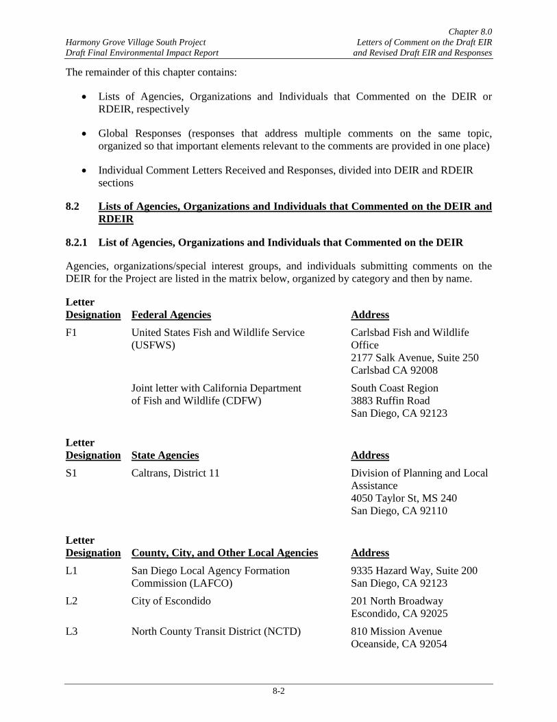
8.2.1 List of Agencies, Organizations and Individuals that Commented on the DEIR
Agencies, organizations/special interest groups, and individuals submitting comments on the DEIR for the Project are listed in the matrix below, organized by category and then by name.
Letter Designation Federal Agencies Address F1 United States Fish and Wildlife Service
(USFWS) Carlsbad Fish and Wildlife Office 2177 Salk Avenue, Suite 250 Carlsbad CA 92008
Joint letter with California Department of Fish and Wildlife (CDFW)
South Coast Region 3883 Ruffin Road San Diego, CA 92123
Letter Designation State Agencies Address S1 Caltrans, District 11 Division of Planning and Local
Assistance 4050 Taylor St, MS 240 San Diego, CA 92110
Letter Designation County, City, and Other Local Agencies Address L1 San Diego Local Agency Formation
Commission (LAFCO) 9335 Hazard Way, Suite 200 San Diego, CA 92123
L2 City of Escondido 201 North Broadway Escondido, CA 92025
L3 North County Transit District (NCTD) 810 Mission Avenue Oceanside, CA 92054

Chapter 8.0 Harmony Grove Village South Project Letters of Comment on the Draft EIR Draft Final Environmental Impact Report and Revised Draft EIR and Responses
8-3
Letter Designation Organizations Address O1 San Dieguito Planning Group P.O. Box 2789
Rancho Santa Fe, CA 92067 O2 Endangered Habitats League 8424 Santa Monica Blvd.,
Suite A 592 Los Angeles, CA 90069
O3a,b,c Shute, Mihaly & Weinberger, LLP on behalf of Elfin Forest Harmony Grove Town Council
396 Hayes ‘Street San Francisco, CA 94102
O4a Delano & Delano on behalf of The Escondido Creek Conservancy (TECC)
220 W. Grand Avenue Escondido, CA 92025
O4b Richard Horner on behalf of TECC Box 551, 1752 NW Market Street Seattle WA 98107
O4c Hamilton Biological, Inc. on behalf of TECC
316 Monrovia Avenue Long Beach, CA 90803
O5 Rincon Band of Luiseño Indians 1 West Tribal Road Valley Center, CA 92082
O6 Elfin Forest Harmony Grove Town Council (Jacqueline Arsivaud)
20223 Elfin Forest Road Elfin Forest, CA 92029
O7 Cleveland National Forest Foundation (CNFF) and Save Our Forest and Ranchlands (SOFAR)
P.O. Box 475 Descanso, CA 91916
O8 Pauma Band of Luiseño Indians [email protected] O9 San Luis Rey Band of Mission Indians 1889 Sunset Drive
Vista, CA 92081 O10 County Friends of a Better Bow No Address Provided.
Unavailable

Chapter 8.0 Harmony Grove Village South Project Letters of Comment on the Draft EIR Draft Final Environmental Impact Report and Revised Draft EIR and Responses
8-4
Letter Designation Individuals Address I1 Andrew Laderman 2710 Surrey Lane
Escondido, CA 92029 I2 Linda Schubert 2847 Fishers Place
Escondido, CA 92029 I3 Jessica Dummer 2966 Cordrey Drive
Escondido, CA 92029 I4 William A & Merlyn Porter 2964 Milpas Drive
Escondido, CA 92029 I5 Karin Hathaway 20031 Elfin Forest Lane
Elfin Forest, CA 92029 I6 Alan Lasnover 19951 Elfin Forest Lane
Elfin Forest, CA 92029 I7 Amy Molenaar 9115 Harmony Grove Road
Escondido, CA 92029 I8 Victor and Maria Gonzalez [email protected] I9 Bonnie Baumgartner 20049 Elfin Forest Lane
Elfin Forest, CA 92029-6005 I10 Mary Kubota [email protected] I11 Bill Osborn 2952 Milpas Drive
Escondido, CA 92029 I12 David Radel 18394 Via Ambiente
Rancho Santa Fe, CA 92067 I13 Lounsbery Ferguson Altona & Peak
(on behalf of Jeff Johnston) 960 Canterbury Place, Suite 300 Escondido, CA 92025-3870
I14 Erin Gottlieb (Johnson) 2681 Overlook Point Drive Escondido, CA 92029
I15 Eric Neubauer [email protected] I16 Angelique Hartman 2848 Country Club Drive
Harmony Grove, CA I17 Erin Dummer 2966 Cordrey Drive
Escondido, CA 92029 I18 JP Theberge (Vice-chair, EFHG Town
Council) 20223 Elfin Forest Road Elfin Forest, CA 92029
I19 Julie Neubauer [email protected] I20 Justine Hennessy 2442 Live Oak Road
Escondido, CA 92029

Chapter 8.0 Harmony Grove Village South Project Letters of Comment on the Draft EIR Draft Final Environmental Impact Report and Revised Draft EIR and Responses
8-5
Letter Designation Individuals Address I21 Steve Walsh 3052 Hill Valley Drive
Escondido, CA 92029 I22 Kulbinder Bains 2395 Johnston Road
Escondido, CA 92029 I23 Marilyn Johnson-Kozlow [email protected] I24 Mary Cross 7150 Circa de Media
Elfin Forest, CA 92029 I25 Matt and Erin Kennedy 2792 Overlook Point Drive
Escondido, CA 92029 I26 Nancy Goodrich Elfin Forest, CA 92029 I27 Patricia Borchmann 1141 Carrotwood Glen
Escondido, CA 92026 I28 Patrick Molenaar [email protected] I29 Richard Murphy [email protected] I30 Reina Reeves 2753 Overlook Point Drive
Escondido, CA 92029 I31 Laura Rader 2752 Crownpoint Place
Escondido, CA 92027 I32 Brenda Koenig 2262 Montemar Avenue
Escondido, CA 92027 I33 Jean Walton 2382 Harmony Grove Road
Escondido, CA 92029 I34 Natasha Kay-Hazou [email protected] I35 Andria Sanchez [email protected] I36 Kendra Nuth 3017 Starry Night Drive
Escondido, CA 92029 I37 Debbie O' Neill and Jonathan Dummer [email protected] I38 Fabiola, Gisella, Paco Theberge c/o [email protected] I39a,b Kevin Barnard 2708 Country Club Drive
Escondido, CA 92029

Chapter 8.0 Harmony Grove Village South Project Letters of Comment on the Draft EIR Draft Final Environmental Impact Report and Revised Draft EIR and Responses
8-6
8.2.2 List of Agencies, Organizations and Individuals that Commented on the RDEIR
Agencies, organizations/special interest groups, and individuals submitting comments on the RDEIR for the Project are listed in the matrix below, organized by category and then by name.
Letter Designation State Agencies Address RS1 CAL FIRE, Department of Forestry and Fire
Protection, San Diego Unit 2249 Jamacha Road El Cajon, CA 92019
RS2 Caltrans, District 11 Division of Planning and Local Assistance 4050 Taylor St, MS 240 San Diego, CA 92110
Letter Designation County, City, and Other Local Agencies Address RL1 SANDAG (Late) 401 B Street, Suite 800
San Diego, CA 92101
Letter Designation Organizations Address RO1 California Native Plants Society,
San Diego Chapter P.O. Box 121390 San Diego, CA 92112
RO2 Delano & Delano on behalf of The Escondido Creek Conservancy (TECC)
220 W. Grand Avenue Escondido, CA 92025
RO3 Elfin Forest Harmony Grove Town Council (Jacqueline Arsivaud)
20223 Elfin Forest Road Elfin Forest, CA 92029
RO4 Endangered Habitats League 8424 Santa Monica Blvd., Suite A 592 Los Angeles, CA 90069
RO5 Rincon Band of Luiseño Indians 1 West Tribal Road Valley Center, CA 92082
RO6 Shute, Mihaly & Weinberger, LLP on behalf of Elfin Forest Harmony Grove Town Council
396 Hayes Street San Francisco, CA 94102
Letter Designation Individuals Address RI1 Karen Binns 2637 Deer Springs Place
San Marcos, CA 92069 RI2 Mary Cross 7150 Circa de Media
Elfin Forest, CA 92029

Chapter 8.0 Harmony Grove Village South Project Letters of Comment on the Draft EIR Draft Final Environmental Impact Report and Revised Draft EIR and Responses
8-7
Letter Designation Individuals Address RI3 Natasha Kay-Hazou 9237 Harmony Grove Road
Escondido, CA 92029 RI4 Kira Lakin 952 Chardonney Way
Escondido, CA 92029 RI5 Richard Murphy [email protected] RI6 Debbie O' Neill and Jonathan Dummer [email protected] RI7 Scott Sutherland (Two emails on April 9,
Late) [email protected]
8.3 Global Responses
Eight “global” responses have been prepared for this FEIR; they relate to land use planning items and fire response, preparation and evacuation issues, Project baseline conditions, and greenhouse gas analysis-related discussion. As noted above, a number of the comments received on the DEIR addressed the same or similar issues and environmental concerns. Rather than repeat responses to recurring comments in each letter, the responses outlined in Sections 8.3.1 through 8.3.8 address multiple comments on the same topic, placing discussion of important elements relevant to the comments in one place. These responses are provided in the following order:
• Project Consistency with General Plan Policy LU-1.4
• General Plan/Community Plan Amendments CEQA Impact Analysis
• Fire Hazards Impact Analysis
• Adequacy of Emergency Evacuation and Access
• Baseline Conditions
• Regional Plan Conformity
• Carbon Offsets
• Climate Action Plan
8.3.1 Project Consistency with General Plan Policy LU-1.4
Some commenters assert that the County of San Diego (County) is precluded by law from approving the Project because the Project does not comply with General Plan Policy LU-1.4. Under California’s Planning and Zoning Law, in order for a project to be approved by a county or city, it must be determined that the project is consistent with that jurisdiction’s general plan. (Friends of Lagoon Valley [2007] 154 Cal.App.4th 807, 815; see also Citizens of Goleta Valley
Chapter 8.0 Harmony Grove Village South Project Letters of Comment on the Draft EIR Draft Final Environmental Impact Report and Revised Draft EIR and Responses
8-8
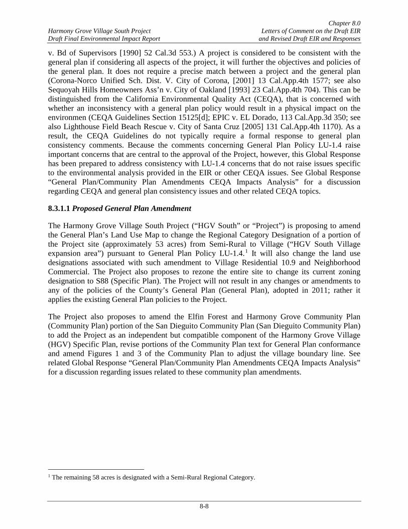
v. Bd of Supervisors [1990] 52 Cal.3d 553.) A project is considered to be consistent with the general plan if considering all aspects of the project, it will further the objectives and policies of the general plan. It does not require a precise match between a project and the general plan (Corona-Norco Unified Sch. Dist. V. City of Corona, [2001] 13 Cal.App.4th 1577; see also Sequoyah Hills Homeowners Ass’n v. City of Oakland [1993] 23 Cal.App.4th 704). This can be distinguished from the California Environmental Quality Act (CEQA), that is concerned with whether an inconsistency with a general plan policy would result in a physical impact on the environmen (CEQA Guidelines Section 15125[d]; EPIC v. EL Dorado, 113 Cal.App.3d 350; see also Lighthouse Field Beach Rescue v. City of Santa Cruz [2005] 131 Cal.App.4th 1170). As a result, the CEQA Guidelines do not typically require a formal response to general plan consistency comments. Because the comments concerning General Plan Policy LU-1.4 raise important concerns that are central to the approval of the Project, however, this Global Response has been prepared to address consistency with LU-1.4 concerns that do not raise issues specific to the environmental analysis provided in the EIR or other CEQA issues. See Global Response “General Plan/Community Plan Amendments CEQA Impacts Analysis” for a discussion regarding CEQA and general plan consistency issues and other related CEQA topics.
8.3.1.1 Proposed General Plan Amendment
The Harmony Grove Village South Project (“HGV South” or “Project”) is proposing to amend the General Plan’s Land Use Map to change the Regional Category Designation of a portion of the Project site (approximately 53 acres) from Semi-Rural to Village (“HGV South Village expansion area”) pursuant to General Plan Policy LU-1.4.1 It will also change the land use designations associated with such amendment to Village Residential 10.9 and Neighborhood Commercial. The Project also proposes to rezone the entire site to change its current zoning designation to S88 (Specific Plan). The Project will not result in any changes or amendments to any of the policies of the County’s General Plan (General Plan), adopted in 2011; rather it applies the existing General Plan policies to the Project.
The Project also proposes to amend the Elfin Forest and Harmony Grove Community Plan (Community Plan) portion of the San Dieguito Community Plan (San Dieguito Community Plan) to add the Project as an independent but compatible component of the Harmony Grove Village (HGV) Specific Plan, revise portions of the Community Plan text for General Plan conformance and amend Figures 1 and 3 of the Community Plan to adjust the village boundary line. See related Global Response “General Plan/Community Plan Amendments CEQA Impacts Analysis” for a discussion regarding issues related to these community plan amendments.
1 The remaining 58 acres is designated with a Semi-Rural Regional Category.

Chapter 8.0 Harmony Grove Village South Project Letters of Comment on the Draft EIR Draft Final Environmental Impact Report and Revised Draft EIR and Responses
8-9
8.3.1.2 Consistency with General Plan Policy LU-1.4
Some comments have been received that question the County’s ability to approve the Project, asserting that the Project does not comply with General Plan Policy LU-1.4 and the Community Development Model. Policy LU-1.4 states:
Village Expansion. Permit new Village Regional Category designated land uses only where contiguous with an existing or planned Village and where all of the following criteria are met:
• Potential Village development would be compatible with environmental conditions and constraints, such as topography and flooding
• Potential Village development would be accommodated by the General Plan road network
• Public facilities and services can support the expansion without a reduction of services to other County residents
• The expansion is consistent with community character, the scale, and the orderly and contiguous growth of a Village area
In determining whether a project complies with the General Plan, the Board of Supervisors is uniquely qualified to interpret the provisions of the General Plan, and its decision carries a strong presumption of regularity if supported by findings and substantial evidence (No Oil, Inc. v. City of Los Angeles [1987] 196 Cal.App.3d 223, 243 and Eureka Citizens for Responsible Gov’t v. City of Eureka [2007] 147 CA 4th 357). The County’s determination as to whether the Project is consistent with the General Plan will not be set aside by a court unless the County has acted arbitrarily, capriciously, or without evidential support (No Oil, Inc. v. City of Los Angeles, supra, 196 Cal.App.3d 223, at p. 243). Where a provision of the general plan might be considered ambiguous, the court will defer to the local government’s resolution of that ambiguity so long as the interpretation adopted is reasonable (Save Our Peninsula Committee v. Monterrey County Bd. Of Supervisors (2001) 87 Cal.App.4th 99, 142). The function of the court is not to micromanage, but rather to simply decide whether substantial evidence supports the conclusion that the project is consistent with General Plan policies (Save Our Heritage Organization v. City of San Diego et al. [2015] 237 Cal.App.4th 163; see also Sequoyah Hills Homeowners Assn. v. City of Oakland [1993] 23 Cal.App.4th 704, 719–720).
A number of cases provide a framework for determining the meaning of general plan policies, which is similar to the analysis that is used to interpret statutes, contracts, and other instruments. The primary goal in construing the meaning of a statute is to ascertain its legislative intent to effectuate the purpose of the law (No Oil, Inc. v. City of Los Angeles, supra, 196 Cal.App.3d 223, at p. 244). When a term appears in several places in the same statute, the term is to be interpreted in a consistent manner throughout the statute. This rule assumes that the legislative body will draft a statute in a way that is “internally consistent in its use of language and in the way its provisions work together” (Ratzlaf v. United States, 510 U.S. 135, 143 [1994]; see also Gustafson v. Alloyd Co., 513 U.S. 561, 570 1995]; and Wisconsin Dep’t of Revenue v. William

Chapter 8.0 Harmony Grove Village South Project Letters of Comment on the Draft EIR Draft Final Environmental Impact Report and Revised Draft EIR and Responses
8-10
Wrigley, Jr. Co., 505 U.S. 214, 225 [1992]. Finally, Courts have also consistently held that additional words or language should not be added to a statute when interpreting its meaning based on the theory that if that were the intent of the author, the word would have been included in the first place(01 Iselin v. United States, 270 U.S. 245, 250 [1926]; see also Lamie v. United States Trustee, 540 U.S. 526, 537 [2004] -- [courts should not add an “absent word” to a statute…]). With this background, the requirements of LU-1.4 are discussed below.
8.3.1.3 HGV is an Existing Village
Policy LU-1.4 permits future expansions of existing or planned villages provided all of the criteria of the Policy are met. The first issue that needs to be resolved is whether HGV is a village. At least one comment received contends that the Project is inconsistent with Policy LU-1.4 because it is not contiguous to the village boundary line shown in Figure 3 of the Community Plan. This comment is related to understanding the meaning of the term ‘village’ in Policy LU-1.4 in that it implies that only the portion of HGV that is located within the village boundary line would be considered a village. (This assertion also requires changing the text of Policy LU-1.4 from “contiguous with an existing or planned Village” to “contiguous to an existing or planned village boundary line.” [emphasis added] See discussion below regarding the topic of the Village Boundary line and Global Response “General Plan/Community Plan Amendments CEQA Impacts Analysis” for a discussion regarding this topic.)
How the General Plan Defines Village
The County can reasonably determine that when a term appears in several places in the same statute (as the term “village” appears throughout the General Plan), the term can be interpreted in a manner that is consistent with its usage throughout the statute (in this case, the General Plan). This interpretation is guided by the basic principle that a statute should be read as a harmonious whole, with its separate parts being interpreted within their broader statutory context (United Savings Ass’n v. Timbers of Inwood Forest Associates, 484 U.S. 365, 371 [1988]; citations omitted). Therefore, in determining the meaning of village, we look to the General Plan's usage of this term.
The term village is used throughout the General Plan to describe “areas” within the County that contain the highest population and development densities that are located within walking distance of commercial services, employment centers, civic uses, and transit areas if feasible. The General Plan states that:
The Village category identifies areas [emphasis added] where a higher intensity and a wide range of land uses are established or have been planned. Typically, Village areas [emphasis added] function as the center of community planning areas and contain the highest population and development densities. Village areas [emphasis added] are typically served by both water and wastewater system (General Plan, page 3-7).
The word village is described as “areas” that should contain community‐serving private and public facilities as well as connections that play an important role in supporting a village's vitality and mobility. These village attributes can be achieved through a variety of planning tools,

Chapter 8.0 Harmony Grove Village South Project Letters of Comment on the Draft EIR Draft Final Environmental Impact Report and Revised Draft EIR and Responses
8-11
such as, interconnected streets and roadway networks, incorporation of pedestrian connections, and providing public amenities that can be enjoyed by its residents. These elements allow a village to interact and capitalize on its various features thus improving the village's economy and creating a sense of place, and community identity (General Plan, page 3-31).
Other Planning Sources that Define Village
Other planning sources have similarly defined villages as areas or communities that consist of intangible characteristics that create a sense of place usually by the incorporation of social/cultural elements. These elements include capturing the identity of the local area and providing functions that are associated with a community (“Village Planning Handbook, A guide for Community Planning,” September 1993, pages 7-10). Villages are considered residential centers that are supported by commercial and community services. Typical uses include general stores that sell groceries, feed supplies and other similar type products, restaurants, and facilities that cater to specific community needs. A village has a typical walking range of approximately 0.5-mile radius and provides gathering places that attract activity and provide a sense of community. (See “Defining Rural Character and Planning for Rural Lands - A Rural Element Guide.” in State of Washington Department of Community, Trade, and Economic Development, [1994: 19-21]).
HGV was Adopted as a Village
HGV, approved in 2007 as a master planned community, was intended to be a village as that term is used under General Plan Policy LU-1.4.2 In particular, the HGV Specific Plan (HGV SP 04-03, Jan. 2007) describes HGV as a 468-acre “rural-themed” village with a small community/commercial core. The HGV Specific Plan divides the 468-acre site into four Planning Areas (PAs) and assigns uses, acreages, densities and zoning restrictions to each of these PAs. Each of the four PAs was designed to be similar in housing type, topographic setting, and uses (id at 21).
When HGV was originally brought before the Legislative bodies for consideration, it was characterized “as a new rural village that was an outgrowth of the GP 2020 process” (County’s Planning and Land Use Department Report to the Planning Commission, dated December 15, 2006 [PC Report]). The PC Report took into consideration its location adjacent to urban Escondido and San Marcos. The PC Report describes HGV as:
While Harmony Grove is rural in character it is affected by the increasing urbanization taking place in San Marcos to the north and Escondido to the east. This project proposes a new rural village that was an outgrowth of the GP 2020 process. Rather than accommodating expected growth by proposing another standard subdivision on the fringe of the sprawling urban center of Escondido,
2 Since HGV was approved before the General Plan Update was adopted in 2011, its planning structure does not
completely correspond with the County’s current General Plan requirements. Although the current General Plan Regional Categories are applied to HGV (Village and Semi-Rural), its General Plan Land Use Designation is Specific Plan, a Land Use designation that is no longer used by the General Plan to designate land uses in the County (see General Plan Land Use Designation Map, Figure LU-A-19). Therefore, HGV’s land uses are regulated by the zoning found in its Specific Plan.

Chapter 8.0 Harmony Grove Village South Project Letters of Comment on the Draft EIR Draft Final Environmental Impact Report and Revised Draft EIR and Responses
8-12
this project took into account unique historic, geographic and locational factors to create a new village that would complement the surrounding rural areas (PC Report, page 4).
Community Plan Characterizes HGV as Village
The Community Plan also characterizes HGV as a Village. The Community Plan states “It is, primarily a residential village that provides a range of for-sale housing to accommodate broad market needs” (Community Plan, page 48; see also Community Plan SPA-1.1). Similar to the language used in HGV’s Specific Plan, the Community Plan described HGV as a master planned community consisting of approximately 468 acres located both north and south of the intersection of Harmony Grove Road and Country Club Drive, in other words encompassing all four PAs (id at 58). The Community Plan describes HGV as:
The Harmony Grove Village Specific Plan Area is comprised of approximately 468 acres located both north and south of the intersection of Harmony Grove Road and Country Club Drive in the community east [sic] of the City of Escondido known as Harmony Grove. It is, primarily a residential village that provides a range of for-sale housing to accommodate broad market needs. It contains a maximum of 742 detached residential units, resulting in an average gross density of 1.6 dwelling units per acre. Residential lots range in size from under 5,000 square feet to over two acres… (Community Plan, page 58).
HGV is Comprised of Four Planning Areas
The “Village Center” is located in PA 1, approximately 2,100 feet (or less than 0.5 mile) from the HGV South Village expansion area. The Village Center includes the densest residential neighborhoods of HGV (519 units), commercial development, institutional uses, creek channels, open space areas and public and private streets (HGV SP 04-03, Figure 7). As further discussed below, the HGV South Village expansion area is physically connected to PA 1 through a series of design elements, such as the Escondido Creek floodway3 (rehabilitated creeks), and a portion of County Club Drive (public streets).
PA 4 borders the western boundary line of the HGV South Village expansion area and the Regional Category Designation is Semi-Rural. PA 4 includes the following uses: limited residential uses, a commercial equestrian facility, and a small retail center that would sell horse supplies and other typical C-35 zone uses (HGV SP 04-03, page 53). The C-35 zone is compatible with the Village Core Mixed Use Land Use Designation (San Diego County Ordinance, Section 2050, Compatibility Matrix). The Village Core Mixed Use Land Use Designation was adopted as a part of the General Plan and is allowed only within areas designated Village Regional Category. Thus, the land uses assigned to PA 4 are consistent with both the Village Regional Category and Village Land Use Designation as used by the General Plan today. 3 The northern portion of the Project and HGV are physically connected as a part of the same Escondido Creek
floodway which consists of the common channel of Escondido Creek and the adjacent portions of the floodplain that are reasonably required to efficiently carry and discharge the associated 100-year flood flow (FEMA 2012a, refer to Exhibit A of the Project Drainage Study in EIR Appendix M 1).

Chapter 8.0 Harmony Grove Village South Project Letters of Comment on the Draft EIR Draft Final Environmental Impact Report and Revised Draft EIR and Responses
8-13
The commercial equestrian facility (“Equestrian Ranch”) is located in PA 4 and is described in the HGV Specific Plan as “These 22 acres represent almost 5 percent of Harmony Grove Village” [emphasis added] (HGV SP 04-03, page 58). The Equestrian Ranch is considered a key feature of HGV’s “rural themed” identity that honors Harmony Grove's equestrian roots, and it ensures HGV’s consistency with the Community Plan. See Community Plan Goal LU-1.9 (create an attractive equestrian community that encourages environmentally sensitive, responsible horse keeping) and Community Plan Policy LU-1.9.5 (support opportunities for home horse keepers to board a very small number of horses to help defray costs of keeping their own animals).
Based on the discussion above, the word “village” means an “area” that is composed of various elements or attributes that together create a community with a sense of place or identity, provides a network of connections and public amenities, and promotes economic and social vitality. The notion that only the portion of HGV that is located within the village boundary line should be considered a village is inapposite with the village land use pattern described in the General Plan, HGV’s Specific Plan and/or the Community Plan.
When the County approved HGV as a village, it approved all four PAs that together would create an “area” or a community with a “rural themed” identity that would honor the Harmony Grove equestrian history. All four PAs were designed to be linked by parks, public streets and a multi-use trail system that would accommodate the residents from all four PAs and address the needs of its residents. The Community Plan calls for the “Village” (HGV) to create a sense of community for the existing as well as new residents by providing access to its public trails/walkways to the Commercial area, parklands, trails along the waterways (creeks and channels), and the public equestrian facility (Community Plan Policy SPA-5.1.1). Again, all of these amenities are located throughout the four PAs, and in particular, the public equestrian facility mentioned in the Community Plan is located in PA 4. Nowhere does the HGV Specific Plan or the Community Plan distinguish between the four PAs or state that PA 4 is not a part of the “rural themed village” of HGV. The PC Report describes the four PAs within the context of the Specific Plan as:
A Specific Plan is proposed that sets forth the specific policies intended to regulate development within the project and includes the following land uses: 742 units of single-family residential uses; 2 acres of commercial uses; 12 acres of institutional uses that include a fire station, wastewater treatment facility and a site for unspecified civic uses; a 22-acre equestrian ranch; and 189 acres of parks, recreation areas and open space. A Rezone will implement the Specific Plan by changing the existing Use Regulations, Development Regulations and Special Area Regulations in the existing zones to include the S88 Specific Planning Area Use Regulations. A total of five new zones will include regulations appropriate for the implementation of the type of development expected within the five Planning Areas set forth by the Specific Plan. Densities range from .4 to 20 dwelling units per acre. Minimum lot size ranges from 2,200 square feet up to over 2 acres (PC Report, page 1).
Thus, it is reasonable for the County to conclude that HGV consists of all four PAs, and is not limited to the area within the village boundary line shown in Figure 3 of the Community Plan. The term “village boundary line” has been specifically defined in the General Plan to mean “a

Chapter 8.0 Harmony Grove Village South Project Letters of Comment on the Draft EIR Draft Final Environmental Impact Report and Revised Draft EIR and Responses
8-14
mechanism” to be used in community plans that identify areas to which development should be directed. (General Plan, page 1-11.) However, it does not define the term “village” in the context of General Plan Policy LU-1.4. Not only does the addition of the term “boundary line” to Policy LU-1.4 not fit in the overall context of the General Plan, but if the Board of Supervisors intended to use the term “village boundary line” it would have certainly done so. In fact, this term has been carefully defined (to mean something different) and is used elsewhere in the General Plan. Although the Community Plan currently identifies the existing HGV Boundary as the area in which development should be directed, it cannot be interpreted in a manner that would make it internally inconsistent with General Plan Policies, such as LU-1.4 that allows villages to be expanded under certain circumstances. Therefore, HGV South intends on amending its Regional Category Designation, General Plan Land Uses, and Figures 1 and 3 of the Community Plan to incorporate the HGV South Village expansion area within the HGV Boundary line as allowed by Policy LU-1.4. (See also discussion below regarding the topic of the Village Boundary line in Global Response “General Plan /Community Plan Amendments CEQA Impacts Analysis.”)
Finally, some have commented that the Project is inconsistent with General Plan Policy LU-1.4 because PA 4 is not designated Village Regional Category. Again, to come to this conclusion the actual wording of Policy LU-1.4 would need to be amended to read “contiguous to an existing or planned village Regional Category” [emphasis added]. As discussed above, if the Board of Supervisors wanted Policy LU-1.4 to be so worded, it would have easily included this specific phrase into Policy LU-1.4. The County can reasonably conclude that the term Village Regional Category would not fit in the context put forward by the commenter. This phrase was already used in the same Policy LU-1.4 in an entirely different context to mean a type of land use, not a place (Village Regional Category types of land can be permitted if contiguous with an existing or planned village). The term Village Regional Category is defined in the General Plan to mean one of three broad sets of development classifications in the County that do not specify allowable land uses, but rather the general regional structure, character, scale, and intensity of development (General Plan, page 3-6). As a result, it does not regulate allowed uses or intensities of individual development proposals (General Plan, page 3-6).
In the case of PA 4, its Regional Category Designation would not be determinative of whether or not it is a part of HGV. In summary, although its Regional Category Designation is Semi-Rural (and HGV’s Land Use Designation is Specific Plan), its permitted land uses under the HGV Specific Plan are consistent with both the Village Regional Category and Village Land Use Designation4 Also as explained above, PA 4 also plays a vital and important role in establishing HGV’s rural identity that honors Harmony Grove's equestrian roots, ensuring HGV’s
4 The HGV Specific Plan allows for a number of uses in PA 4, including General Commercial/Limited Residential
(C-35) zone designation uses (HGV Specific Plan, page 53). Under the County’s Compatibility Matrix (San Diego County Ordinance, Section 2050, Compatibility Matrix) C-35 uses are considered compatible with and are permitted by right under General Commercial (C-1) and Village Core Mixed Use (C-5) Land Use Designations. Both of these Land Use Designations are compatible with the Village Regional Category (Table LU-1).

Chapter 8.0 Harmony Grove Village South Project Letters of Comment on the Draft EIR Draft Final Environmental Impact Report and Revised Draft EIR and Responses
8-15
consistency with the Community Plan,5 and providing amenities to the entire HGV (public equestrian facility, public streets, creek rehabilitation).
8.3.1.4 The Project is Contiguous to HGV
Policy LU-1.4 permits new Village Regional Category-designated land uses only where contiguous with an existing or planned Village. The word “contiguous” is not defined in Policy LU-1.4, and some comments have been received that contend that the Project is not contiguous to the village boundary line. The comments assert that the Merriam-Webster Dictionary defines contiguous to mean “being in actual contact,” “touching along a boundary or at a point - the 48 contiguous states” or “touching or connected throughout in an unbroken sequence” (Merriam-Webster Dictionary, https://www.merriam-webster.com/dictionary/contiguous (Merriam-Webster, n.d. Web. 23 July 2017).6
However, the DEIR used the definition provided by the 2015 Random House Dictionary of American English. As stated in the DEIR, page 1-2, that dictionary defines “contiguous” as “touching, in contact, or being close without touching.” Also, the Webster's New World College Dictionary defines contiguous to mean “in physical contact; touching along all or most of one side; near, next, or adjacent.” The term “adjacent” is defined as near or close (to something); adjoining (Webster's New World College Dictionary, Fifth Edition Copyright (2014) by Houghton Mifflin Harcourt Publishing Company (http://www.yourdictionary.com/contiguous#websters, as of August 15, 2017).
Even under the Merriam-Webster Dictionary definition advocated by the commenter, the HGV South Village expansion area would still be considered contiguous with HGV. The HGV South Village expansion area has actual physical contact with HGV along Country Club Drive in which both of the property owners retain the underlying fee interest in their respective properties up to the center line of the roadway. The HGV South Village expansion area is also contiguous to PA 1 in that it is physically connected to PA 1 through the Escondido Creek floodway and a portion of Country Club Drive. The roadway is a design feature of PA 1 and plays an important role in the overall function of HGV. Similar to the example used in Merriam-Webster Dictionary of what constitutes contiguous - the “48 contiguous states,” not all of the states physically touch, but the states are still considered connected or “contiguous” through a series of points of contact.
When words have different meanings, the court will often look at the context of its usage in the statute. Here, the word contiguous is used in Policy LU-1.4 in the context of directing future growth in the County by expanding existing or planned villages. The General Plan states that: “The core concept for the County’s development directs future growth to areas where existing or planned infrastructure and services can support growth and locations within or adjacent to existing communities” [emphasis added] (General Plan, page 3-5). Therefore, the definition of
5 Ensures HGV’s consistency with the Community Plan by creating an attractive equestrian community that
encourages environmentally sensitive, responsible horse keeping (Community Plan Goal LU-1.9) and supports opportunities for home horse keepers to board a very small number of horses to help defray costs of keeping their own animals (Community Plan Policy LU-1.9.5).
6 For purposes of addressing the meaning of contiguous, we put aside the contention that Policy LU-1.4 should be interpreted to mean village boundary line instead of an existing or planned village. (Please see discussion above.)

Chapter 8.0 Harmony Grove Village South Project Letters of Comment on the Draft EIR Draft Final Environmental Impact Report and Revised Draft EIR and Responses
8-16
“contiguous” as defined in the DEIR is the more accurate meaning when considered in the context of the General Plan.
Also, the need for areas within a village to touch or have actual contact is not supported by general village design principles. The land use patterns for typical villages have a walking range of approximately 0.5-mile radius and provide gathering places that attract activity and provide a sense of community. (See Washington Department of Community, Trade, and Economic Development 1994:19-21.) As such, the idea that a village expansion area must physically touch an existing or planned village is an overly limiting interpretation of Policy LU-1.4 that is not based on common village design principles. The General Plan further states that “a Village would reflect a development pattern that is characterized as compact, higher density development that is located within walking distance of commercial services, employment centers, civic uses, and transit (when feasible)” (General Plan, page 3-7). This concept of placing higher density development within walking distance to a variety of other types of uses also supports the idea that a village expansion area does not have to “touch” an existing or planned village.
It is reasonable for the County to determine that contiguous, as used in Policy LU-1.4, means that development should be directed to areas adjacent to existing or planned villages where infrastructure and services can best support growth. This interpretation is consistent with the actual language found in Policy LU-1.4 that requires potential expansions to be accommodated by the General Plan road network, and that public facilities and services support the expansion without a reduction of services to other County residents. Both of these requirements can be satisfied without needing to physically touch the border of an existing or planned village. Likewise, development can be consistent with community character, the scale, and the orderly growth of a village, without having to be in actual physical contact with that village. As further described below, the HGV South Village expansion area is located adjacent or contiguous to HGV, where existing or planned infrastructure and services can support growth
The HGV South Village expansion area is contiguous to HGV in that it is located approximately 2,100 feet (less than 0.5 mile) from the HGV Village Center and 500 feet from the intersection of Harmony Grove Road and Country Club Drive. A County park, located in PA 1, is located just across the street and within 300 feet of the HGV South Village expansion area. (This 2.8-acre site is designated with a Village Regional Category and provides an additional community gathering place for both sites.) The Equestrian Ranch, which has been described as a part of HGV, lies immediately to the west of the HGV South Village expansion area, across Country Club Drive. The Country Club Drive Trail planned as a part of the HGV Specific Plan, and the County’s Community Trails Master Plan, extends along the west side of Country Club Drive and establishes an important walkable link between HGV’s Village Center, the Equestrian Ranch, and HGV South.
In a larger planning context, the HGV South Village expansion area is also part of the same flat valley in which HGV is located and is part of the same drainage basin and valley view shed. Rugged terrain can be found on the HGV site to the east and west while rugged terrain on the Project site can primarily be found in the south and southwest portion of the land, essentially creating a contiguous flat valley floor for both sites to locate development. This flat valley is surrounded by approximately 20 prominent ridgetops that measure approximately 1,000 to 2,000

Chapter 8.0 Harmony Grove Village South Project Letters of Comment on the Draft EIR Draft Final Environmental Impact Report and Revised Draft EIR and Responses
8-17
feet in height. These ridgetops form a dramatic physical setting for the Harmony Grove valley in which both HGV and the Project are a part.
8.3.1.5 Compatible with Environmental Conditions and Constraints
The Project has been designed to: preserve the largest block of open space on the Project site, maintain existing drainage patterns to the extent feasible, balance steep slope preservation with biological open space preservation, maintain significant visual resources, and consider the existing landform and natural environment. The development would be concentrated mainly in areas of the site which contain non-native grassland. Sensitive biological habitat is located in the southern portion of the site and consists of southern mixed chaparral, a small patch of coast live oak woodland, and jurisdictional drainages. Approximately 35 acres of open space will be preserved within the southern portion of the site, which would be dedicated as required by the County and remain as biological open space. The preservation of biological open space is primarily possible due to the compact nature of the development. This is described throughout the EIR, in Chapter 1.0, and Subchapters 2.1 and 2.3 in particular.
The Project would construct a new bridge over Escondido Creek which will raise the current roadway from its current location, allowing the creek to return to a more natural state. In other words, this Project would contribute to the rehabilitation of this creek which is also an important feature of HGV (HGV SP 04-03, page 2). It will enhance the wetland areas and provide better quality habitat for fish and birds. The bridge will also create a safer wildlife crossing for species traveling east-west along the creek as they will pass under the bridge and not cross vehicular traffic (EIR, page 1-6).
All on-site grading and improvements for HGV South are designed to avoid the existing 100-year floodplain except for a very small area allocated to a wastewater treatment and wastewater reclamation facility (WTWRF) that will be raised out of the floodplain (see EIR Table 1-2, Project Design Features). As described in Subchapter 2.1, the Project’s grading plan reflects the natural topography, in that it the Project would generally follow the site topography, rising and falling with the underlying elevations.
As noted, Project grading would respect, and conform to, overall existing topography on site. This means that although the planned, precise site elevations at any specific point internal to the Project site may deviate from the existing elevation, based on preliminary grading plans, the post-Project cross sections follow the natural rise and fall in site topography overall and always meet the existing topography within the site at the grading perimeter. It also means that following completion of Project implementation, the off-site viewer would not be expected to be aware of large-scale changes in underlying topography (EIR, Subchapter 2.1, page 2.1-50). It should also be noted that post-grading, only 32 acres, or 29 percent of the site, would contain lots and streets. The remainder of the Project site (i.e., 71 percent) would consist of biological open space, parks or landscaped/revegetated swaths located between pads (EIR, Chapter 1.0).
Finally, the iconic ridgeline surrounding the valley would be preserved. The development would be concentrated in the flatter areas of the site; however, some encroachment into steep slope areas would occur (see EIR Subchapter 2.1, pages 2.1-42, 47, 58 and 60). The Project would comply with the RPO steep slopes criteria through a waiver for encroachment into insignificant

Chapter 8.0 Harmony Grove Village South Project Letters of Comment on the Draft EIR Draft Final Environmental Impact Report and Revised Draft EIR and Responses
8-18
slopes, an exception for access roads, and strict compliance with remaining lot encroachment percentages of less than 10 percent; each of which follows RPO criteria. These elements are addressed in detail under the “County of San Diego Resource Protection Ordinance, Steep Slopes,” discussion, in EIR Section 3.1.5, with additional detail on insignificant steep slopes provided in Subchapter 2.1. The Project has been designed to preserve a large block (34.8 acres, or 31 percent of the Project) of contiguous open space, including southern mixed chaparral with narrow endemic species, a small patch of coast live oak woodland, and (non-RPO) jurisdictional drainages. The Project would maintain existing drainage patterns to the extent feasible, create an opportunity to re-establish a drainage feature that was largely eliminated from the site due to early agricultural activities, and maintain significant visual resources (EIR, Section 3.1.5, page 3.1.5-25).
8.3.1.6 Accommodates the General Plan Road Network
A buildout analysis was conducted to determine whether the proposed land use changes would require any changes to the Mobility Element roadway classifications. Primary access to HGV South is provided by two roads, Mobility Element Harmony Grove Road and non-Mobility Element Country Club Drive. The Traffic Impact Analysis (TIA) prepared for the Project by Linscott, Law & Greenspan (LLG 2017), Appendix D of the EIR, indicates that the General Plan’s roadway network does not exceed build-out projections with the inclusion of the Project. The existing land use would allow 222 dwelling units, while the proposed land plan would allow 453 dwelling units. As shown in EIR Table 2.2-9, Roadway Segment Operations under Buildout Conditions, all roadway segments are calculated to operate at acceptable LOS D or better both with and without the Project except for the segment of Country Club Drive between Auto Park Way and Hill Valley Drive, which is not a part of the County’s General Plan roadway network because it is located within the City of Escondido.
Even though this segment is not within the County’s roadway network, Mitigation measures M-TR-1a and M-TR-1b are proposed to improve operations on the Country Club Drive segment between Auto Park Way and Hill Valley Drive and would adequately mitigate the impacts to this segment of the roadway. Because this roadway segment is located within the City of Escondido, however, the impacts are identified as remaining significant and unavoidable for purposes of CEQA. The City of Escondido is ultimately responsible for the approval/implementation of those improvements, and as such, the County cannot guarantee ultimate implementation or the timing of the mitigation. In any event, under build-out of the Project, the Project would not decrease LOS to an unacceptable level compared to the General Plan land use.
8.3.1.7 Public Facilities and Services Support Expansion
Compliance with General Plan Policies, County ordinances, and mitigation measures identified through the environmental review process and project approval process would ensure that public facilities and services needed to support HGV South would not result in a reduction of services to other County residents. HGV South would be required to provide the infrastructure and facilities needed to provide services to the Project either directly or through the payment of fees (Policy LU-12.1). A phasing plan has been provided as a part of the Project’s Specific Plan to ensure that such facilities would be available at the appropriate time (Policy LU-12.2). Service providers would be required to provide “will-serve” letters indicating that they can provide

Chapter 8.0 Harmony Grove Village South Project Letters of Comment on the Draft EIR Draft Final Environmental Impact Report and Revised Draft EIR and Responses
8-19
service to HGV South prior to the recordation of final maps and the issuance of any building permits for the Project. (Community Facility Availability Forms have been received from service providers indicating that service will be available to HGV South [County Policy I-84]).
The Rancho Santa Fe Fire Protection District (RSFFPD) is responsible for providing emergency services to the Project. HGV South would be required to pay development impact fees pursuant to the County’s Fire Mitigation Fee Ordinance, Section 810.301, et seq., to fund its fair share of the capital facilities and equipment needed to serve HGV South. The fee is collected to fund capital facilities and equipment needed to serve new development (Section 810.308). Since a new fire station is being constructed approximately 1.3 miles from the most distant structure, fees collected under this Ordinance could go to pay for other equipment or facilities needed by the fire district serving HGV South. The ongoing costs of providing services to the Project would be provided by existing property taxes and any special assessments imposed on property owners to fund such services. HGV South may decide to annex into an existing community facility district or establish its own assessment district. A Call Volume Assessment was prepared to determine current capability for Fire Station 5 to respond to emergencies (fire, medical, vehicular, rescue, etc.) with the addition of the Project (Dudek 2017; and accepted by both RSFFPD and the County). As shown in Table 2 of the Assessment, the combined call generation from existing residents, Harmony Grove Village, and Harmony Grove Village South will have an insignificant impact on Fire Station 5. Based on this anticipated call volume, Fire Station 5 would not be considered a busy station when compared to standard utilization rates for busy fire stations (five or six calls per day for a rural station) and will be able to respond to emergency calls within the General Plan response time requirements.
Several options for providing wastewater service to HGV South have been analyzed. Sewer facilities or improvements may be constructed on site or off site as needed to serve the Project. HGV South would be served by the Rincon Del Diablo Water District, with water service being extended to the site. Drainage and water quality facilities would be constructed on site by the Applicant. HGV South is located in the Escondido Union Elementary and High School Districts and would be required to pay the appropriate fees as required by State law. Although there are no schools located in HGV or HGV South, there are some schools presently assigned to serve the area, and Facility Availability Forms have been received.
Seven public parks are planned within the Project site, ranging from approximately 0.08 to 0.54 acre in size. Amenities within these public parks are anticipated to include a horseshoe pit, barbeque areas, picnic tables, and/or informal play areas. In addition, any in lieu fees paid by the Project under the County Park Lands Dedication Ordinance would be used to improve parks within the larger existing HGV area. The Project also includes six private parks, which would range from approximately 0.1 to 0.82 acre in size. A system of public and private multi-use trails will be constructed that are intended to serve pedestrians, equestrians, and other non-motorized forms of travel and would weave throughout the Project; providing links to the existing and planned off-site San Diego County trail system and to HGV via the bridge over Escondido Creek.

Chapter 8.0 Harmony Grove Village South Project Letters of Comment on the Draft EIR Draft Final Environmental Impact Report and Revised Draft EIR and Responses
8-20
8.3.1.8 Consistent with the Scale and Orderly and Contiguous Growth of HGV
The Project is proposing to develop the HGV South Village expansion area in a manner consistent with the scale and orderly and contiguous growth of HGV. The HGV South Village expansion area will locate the Project’s densest residential neighborhoods within 0.5 mile of HGV’s Village Center (PA 1), an area described in HGV’s Specific Plan as the heart of the community. HGV’s Village Center is surrounded by a variety of single-family residential uses on lots that range in size from approximately 2,500 square feet near the Village Center to 1.5 acres further away from the core. Over two-thirds of all residences within HGV will be located within the Village Center (approximately 519 homes). Approximately 53 acres of HGV South is designated with a Village Regional Category. The remaining 58 acres is designated with a Semi-Rural Regional Category. Within the Village Regional Category, the General Plan Land Use Designations applied to the site include Village Residential 10.9 (VR-10.9) and Neighborhood Commercial. The HGV South Village Residential expansion area provides for a maximum of 423 dwelling units, which equates to a density of approximately 8.4 dwelling units per acre (du/ac). This is consistent with the density of HGV’s Village Center of approximately 8.7 dwelling units per acre. As such, both these areas will become part of the same compact, walkable village. Residents will be encouraged to walk to amenities and services that are within 0.5 mile (approximately 2,100 feet), and less than a 10-minute walk from both the HGV Village Center and the commercial/civic uses of HGV South.
Surrounding the HGV South Village expansion area along the western, southern, and eastern perimeter, will be Semi-Rural Residential designated areas with a density of 0.5 dwelling unit per acre. Up to 30 dwelling units are proposed within the Semi-Rural Residential area in addition to open space. This establishes a development pattern that is less dense around the perimeter.
Country Club Drive will be improved to enhance the Project’s connection with the HGV Village Center, and a multi-use pathway will provide a pedestrian linkage to both HGV and HGV South. In particular, a north-south, multi-use trail (10 feet in width), was already approved as part of the County’s Community Trails Master Plan and the approved HGV Specific Plan. The 10-foot planned trail extends along the west side of Country Club Drive, via the bridge over Escondido Creek to the south entry of HGV South and will connect HGV’s Village Center directly to HGV South. The HGV Specific Plan describes this trail as an important walkable link between HGV’s Village Center, the Equestrian Ranch, HGV South and other multi-use trails that extend further south and connect to the Del Dios Highlands Preserve (DDHP) and Elfin Forest Recreational Reserve (EFRR). The Project will also enhance connections to HGV by encouraging pedestrian activity along Country Club Drive by providing a five- to six-foot pathway along the east side of Country Club Drive and by providing landscaping, shade trees, and interpretive signage and constructing a bridge over Escondido Creek to replace the existing substandard “Arizona” crossing. This bridge would further enhance the connection between HGV South and HGV.
The proximity of the Project's higher density, residential neighborhoods to HGV and its Village Center decreases the need for infrastructure and allows services to be provided more efficiently. The Project has been designed to provide a wider range of housing options that are not only compatible with the housing options of HGV but also enhance the viability of the commercial uses located in the adjacent Village Center. Both HGV and HGV South, when combined, create a range of housing opportunities that will result in an economically vibrant community.
Chapter 8.0 Harmony Grove Village South Project Letters of Comment on the Draft EIR Draft Final Environmental Impact Report and Revised Draft EIR and Responses
8-21
8.3.1.9 Consistent with Community Character
HGV South is proposing to expand the HGV village in a manner that is consistent with the community character of HGV and the surrounding areas. The Community Plan identifies HGV as a “residential village” or “rural-themed village” composed of four PAs that include a pedestrian-oriented mixed-use core that combines commercial, residential, live/work, recreational and public uses and open space, green belt system, creek channels, and an equestrian ranch. The Community Plan emphasizes the need for HGV to preserve the unique features of a rural lifestyle while integrating the urban lifestyle of a Village. In approving HGV, the County determined that it was a logical extension of an urban designation and was considered compatible with the existing character of the community and the more urban uses of the surrounding jurisdictions (HGV SP 04-03, Page 124).
HGV South is proposing to expand the HGV village to become part of the same compact, walkable community that will be connected by an integrated network of multi-use trails and pathways to the Village Center and the periphery of the HGV Specific Plan area. Design features that are compatible with a rural equestrian theme were encouraged to be used in HGV; and this is continued in HGV South with a robust landscaping plan that takes advantage of the limited hardscape to provide notable vegetated swaths within the Project, rural architectural references, less dense structural development along the southwest, south, and southeastern perimeters, and consistent notable visual elements associated with equestrian fencing along trails and pathways. HGV South features the most intense uses within 0.5 mile of the adjacent HGV Village Center where HGV’s highest densities are also located. The Project has been designed to provide a wider range of housing options that are compatible with the housing options of HGV and will enhance the viability of the commercial uses located in the adjacent HGV Village Center. Both HGV and HGV South, when combined, create a range of housing opportunities that will result in an economically vibrant community.
HGV South will provide a transition from the existing surrounding semi-rural and rural uses by maintaining the perimeter of the site within the existing Semi-Rural regional category. Lower intensity single-family uses (typically with larger lot sizes) would be located within this area in addition to designated open space. These designated open space areas would reduce visual effects along the Project’s perimeter, provide views to natural areas, and contribute to a rural and open environment.
The design principles outlined in the Project’s Specific Plan will ensure that the community character will be maintained. In particular, the Project’s Design Guidelines are intended to ensure overall cohesiveness between HGV South and HGV. HGV South is designed to accommodate a system of interconnected trails and pathways that encourage pedestrian and bicycle activity and establish important links to HGV, the DDHP, and the EFRR. As described in Subchapter 2.1, the Project’s grading plan reflects the natural topography, in that the Project would follow the site topography, rising and falling with the underlying elevations. Project grading would respect, and conform to, overall existing topography on site. HGV South proposes to utilize consistent street trees, similar planting materials, lighting, signage, walls, fences, and architecture to provide a continuous link between HGV and HGV South, strengthening the concept that the two communities constitute one unified village. The architectural design is rural in inspiration and is described as Western Farmhouse/Cottage; the style reflects a quaint, casual

Chapter 8.0 Harmony Grove Village South Project Letters of Comment on the Draft EIR Draft Final Environmental Impact Report and Revised Draft EIR and Responses
8-22
character that is compatible with the look of the rural character and agricultural heritage of the Harmony Grove community. The Project’s architectural design guidelines identify elements that should be used to reduce the apparent size, bulk, and scale of proposed buildings. The smaller lot single-family development would replicate the character and design of the existing development, which reflects rural, farmhouse styles. Multi-family housing types would be designed to appear as detached single-family homes or re-purposed rustic/agricultural buildings. HGV South Village expansion area will portray a total of 229 buildings clustered in this area. Parking would be located internal to the development.
Excluding RPO-permitted encroachment percentages into steep slopes allowed by lot and/or for public utilities and roads; the Project’s encroachment onto RPO steep slopes is limited to isolated and insignificant steep slopes that are not highly visible or distinguishable. The steep slope areas where encroachment would occur are considered insignificant because the slopes are not visually notable or interesting topographic features, not part of an identifiable peak, promontory, or ridgeline, and are not perceived as an integral element of the surrounding peaks that are a part of the Harmony Grove setting. Identification of these slopes as insignificant follows RPO guidance and requirements, and their effects specifically do not impact the features noted, which provide so much of the community character in this area (see detailed discussion in EIR Subchapter 2.1).
8.3.1.10 Community Plans Cannot Prohibit Future Amendments to the General Plan Land Use Maps
A comment was received that asserts that the village boundary line, delineated on Figure 3 of the Community Plan, prohibits growth from occurring outside of the HGV village boundary line. This comment presupposes that no future amendments to the County’s Land Use Maps can occur. This opinion is contrary to the clear intent expressed in Policy LU-1.4 that allows for expansions to existing villages or in Policy LU-1.2 that allows new villages to be established.
The Regional Categories Map and the Land Use Maps of the General Plan are graphic representations of the Land Use Framework and the related goals and policies of the General Plan, including LU-1.4 that permits future expansions of existing villages and LU-1.2 that permits new villages (General Plan, page 3-18). Village boundary lines in community plans are similar to the Land Use Maps of the General Plan and are also subject to future modifications.
HGV South proposes to amend Figures 1 and 3 of the Community Plan to incorporate the HGV South Village expansion area within the village boundary line and revise related portions of the Community Plan text. Although the Community Plan currently identifies the existing “Harmony Grove Village Boundary” as the only area in which development should be directed, the General Plan allows for the expansion of an existing village under the circumstances outlined in Policy LU- 1.4. Since community plans cannot be interpreted in a manner that would undermine the policies of the General Plan, the current location of the village boundary line does not preclude the Board of Supervisors from approving HGV South and amending the current village boundary line to include HGV South. General Plan Policy LU-2.2 clearly states that general plan policies take precedence over community plan policies. The goals and policies of the Land Use Element of the General Plan, which include LU-1.4, allows for future expansions of existing villages (see also General Plan, page 3-20). Therefore, community plan policies cannot be interpreted in a

Chapter 8.0 Harmony Grove Village South Project Letters of Comment on the Draft EIR Draft Final Environmental Impact Report and Revised Draft EIR and Responses
8-23
manner that will limit the County’s authority to expand existing or planned villages pursuant to General Plan Policy LU-1.4.
8.3.1.11 Project is Consistent with the Community Development Model
A comment was received that the redesignation of a portion of the Project site from Semi-Rural to Village would be inconsistent with the Community Development Model (CDM) because it would remove the Semi-Rural and Rural buffers around HGV and allow dense development outside the HGV village core. This statement is incorrect in that the majority of the Semi-Rural and Rural buffers around HGV will remain intact; only the HGV South Village expansion area will be redesignated as Village. Upon the approval of the Project, the HGV South expansion area will be designated with a Regional Category of Village, and will, in turn, be surrounded by Semi-Rural uses that transition to Rural uses. In any event, the General Plan does not require absolute strict compliance with the CDM; it recognized that this model could be affected by the diversity of the County’s unincorporated communities as shown by the General Plan, which depicts an imperfect example of the CDM (General Plan, page 3-23).
The Project has been designed to expand HGV consistent with the CDM. The Project's densest residential neighborhoods will be located towards the central portion of the Project site and within 0.5 mile from HGV's Village Center. The density will decrease the farther away one travels from the Project’s core. As described above, the HGV South Village expansion area will have densities comparable to the HGV Village Center, where the majority of HGV's homes are located on lots that range in size from approximately 2,500 square feet near the Village Center to 1.5 acres further away from the core. Together HGV and HGV South will form one seamless, unified village, cohesive and interconnected by a series of trails, pathways, and amenities, as well as design.
The area surrounding the HGV South Village expansion area, along with the western, southern, and eastern perimeter, will be maintained with the existing Semi-Rural regional category designation. Semi-Rural Residential land uses with a density of 0.5 dwelling unit per acre will be located within this area. The Project’s perimeter will also transition to the surrounding semi-rural areas by featuring 35 acres of permanent biological open space, 20 acres of naturalized open space, and 16 acres of landscaped areas. Naturalized Open Space is made up of areas which may be graded during HGV South development but would be revegetated in accordance with fire resistive native and/or drought tolerant plant materials. The surrounding Semi-Rural Regional Category lands will transition to Rural Regional Category areas (see HGV SP 04-03, Figure 8).
8.3.2 General Plan/Community Plan Amendments CEQA Impact Analysis
Some comments were received that challenge the Project’s DEIR, suggesting that it did not adequately analyze the Project’s consistency with the goals and policies of the County’s General Plan, adopted in 2011 (General Plan) or the Elfin Forest and Harmony Grove Community Plan portion of the San Dieguito Community Plan (Community Plan). Some commenters also contend that the County of San Diego (County) is prohibited from amending the Community Plan and that these amendments would create “internal inconsistencies” with the General Plan and the Community Plan. Finally, some commenters assert that the County is precluded by law from

Chapter 8.0 Harmony Grove Village South Project Letters of Comment on the Draft EIR Draft Final Environmental Impact Report and Revised Draft EIR and Responses
8-24
approving the Project because the Project would result in an impermissible inconsistency within the General Plan. This global response was prepared to address these issues.
8.3.2.1 Proposed General Plan Amendment
The Harmony Grove Village South Project (HGV South, or Project) is proposing to amend the General Plan’s Land Use Map to change the Regional Category Designation of a portion of the Project site from Semi-Rural to Village (“HGV South Village expansion area”) pursuant to General Plan Policy LU-1.4. (See also the related Global Response “Project Consistency with General Plan Policy LU-1.4.”) It will also change the land uses associated with such amendment to Village Residential 10.9 and Neighborhood Commercial. The Project also proposes to rezone the entire site to change its current zoning designation to S88 (Specific Plan). The Project will not result in any changes or amendments to any of the policies of the General Plan; rather it applies the existing General Plan policies to the Project.
The Project also proposes to amend the Community Plan to add the Project as an independent but compatible component of the Harmony Grove Village (HGV) Specific Plan, revise portions of the Community Plan text for clarity and amend Figures 1 and 3 of the Community Plan to adjust the HGV (village) boundary line. The full text changes to the Community Plan were circulated during public review of the Project and are still available on the County website for the Project. In particular, the project is proposing to amend Community Plan Policy LU-2.2.1 in order to prevent the possibility of conflict between the General Plan and the Community Plan. HGV South is proposing to amend Policy LU-2.2.1 as follows:
Policy LU-2.2.1 Ensure that the number of urban residences does not greatly exceed that of the rural residences residential and equestrian character of in the greater unincorporated communities of Harmony Grove and Eden Valley is maintained by adherence to the Community Development Model and the Community Plan Policies set forth in Section 1.1 “Community Character.”
8.3.2.2 Distinguishing between CEQA and Planning Issues
The comments that were received can be grouped into two distinct categories that are either related to the California Environmental Quality Act (CEQA) or general plan conformance. CEQA is concerned with whether an inconsistency between a project and the General Plan would result in a physical impact on the environment (CEQA Guidelines Section 15125[d]; EPIC v. EL Dorado, 113 Cal. App.3d 350; see also Lighthouse Field Beach Rescue v. City of Santa Cruz [2005] 131 Cal.App.4th 1170). This can be distinguished from determining whether a finding of general plan consistency can be made in order to approve a project. Under California’s Planning and Zoning Law, in order for a project to be approved by a county or city, it must be determined that the project is consistent with that jurisdiction’s general plan (Friends of Lagoon Valley [2007] 154 Cal.App.4th 807, 815; see also Citizens of Goleta Valley v. Bd of Supervisors [1990] 52 Cal.3d 553). However, no project can completely satisfy every policy stated in the general plan and state law does not impose such a requirement (Save Our Heritage Org. v. City of San Diego [2015] 237 CA4th 163). It has been well established that state law does not require a precise match between a project and the general plan, nor does a project need to be in perfect conformity with each and every general plan policy. Rather, to be consistent, a project must be

Chapter 8.0 Harmony Grove Village South Project Letters of Comment on the Draft EIR Draft Final Environmental Impact Report and Revised Draft EIR and Responses
8-25
compatible or in harmony with a general plan’s objectives, goals, and policies. A project is considered to be compatible with the general plan if considering all aspects of the project, it will further the objectives and policies of the general plan (Corona-Norco Unified Sch. Dist. V. City of Corona [2001] 13 Cal.App.4th 1577; see also Sequoyah Hills Homeowners Ass’n v. City of Oakland [1993] 23 Cal.App.4th 704). Although CEQA Guidelines do not require a formal response to general plan consistency comments, this Global Response has been prepared to address both categories of comments.
8.3.2.3 General Plan Related Issues
Some of the commenters assert that the County is prohibited from amending the Project’s current land use designation because these land uses were originally established in accordance with the Community Development Model (CDM) to direct growth to HGV, not to areas outside it. They claim that any such amendment would, therefore, be inconsistent with General Plan. They further contend that the HGV Boundary line was “negotiated” with community advocates to provide a firm limit on where future growth can occur within the community. The commenters also contend that the proposed amendments to the Community Plan (HGV Boundary line and to Policy LU 2.2.1) would create impermissible inconsistencies within the General Plan. Finally, the commenters state that the Project’s proposed amendment to the HGV Boundary line would be inconsistent with Policy LU-2.2.1 of the Community Plan and would create internal inconsistencies within that Plan.
For purposes of this analysis, we first turn to the General Plan to put into proper perspective the hierarchical relationship between the General Plan and the County’s many community plans. General Plan Policy LU-2.2 makes it clear that General Plan policies take precedence over community plan policies and that community plans cannot be interpreted in a manner that would undermine the policies of the General Plan. General Plan Policy LU-2.2 states as follows:
Community Plans are part of the General Plan. These plans focus on a particular region or community within the overall General Plan area. They are meant to refine the policies of the General Plan as they apply to a smaller geographic region and provide a forum for resolving local conflicts. As legally required by State law, Community Plans must be internally consistent with General Plan goals and policies of which they are apart. They cannot undermine the policies of the General Plan. Community Plans are subject to adoption, review, and amendment by the Board of Supervisors in the same manner as the General Plan.
Therefore, even though community plans are an integral part of the County’s General Plan, these documents must still be internally consistent with the General Plan’s goals and policies of which they are apart. This means that community plans must be read and interpreted in the context of the goals and policies set forth in the General Plan and cannot be interpreted in isolation.
Community Development Model
The notion that the County is prohibited from amending the Project’s current land use designation because these land uses were originally established in accordance with the CDM presupposes that no future amendment to the County’s Land Use Maps could ever occur. The

Chapter 8.0 Harmony Grove Village South Project Letters of Comment on the Draft EIR Draft Final Environmental Impact Report and Revised Draft EIR and Responses
8-26
opinion expressed by the commenters that such amendments to the County’s Land Use Maps are prohibited is contrary to the clear intent expressed in the General Plan by Policy LU-1.4 that allows existing or planned villages to be expanded or Policy LU-1.2 that allows new villages to be established. In fact, the General Plan specifically states that the Regional Categories Map and the Land Use Maps of the General Plan are graphic representations of the Land Use Framework and the related goals and policies of the General Plan, including Policies like LU-1.4 and LU-1.2 (General Plan, page 3-18). State law requires a general plan to be integrated and internally consistent, both among the elements and within each element. This means that internal consistency requires that diagrams in the land use, circulation, open space and natural resource elements reflect the written policies and programs of those elements (Government Code section 65300.5; see also Concerned Citizens of Calaveras County v. Board of Supervisors of Calaveras County [1985] 166 Cal.App.3d 90).
Similar to the Land Use Maps of the General Plan, the HGV Boundary line depicted in Figure 3 of the Community Plan, must be viewed in conjunction with the language of the General Plan’s Goals and Policies which expressly provide authority to make future amendments as determined appropriate by the County Board of Supervisors (General Plan, page 3-18). Although the Community Plan currently identifies the existing HGV Boundary as the area in which development should be directed, it cannot be interpreted in a manner that would make it internally inconsistent with General Plan Policies, such as LU-1.4. In fact, the Community Plan also contemplates that future amendments may be needed to reflect changing community attitudes. The Community Plan provides that “[T]he annual review provides the opportunity for the Plan to be updated and amended, as appropriate, to reflect changes in the community vision, conditions or attitudes… It shall be the responsibility of the County to implement the [Community] Plan, to monitor progress towards its implementation, and to amend the [Community] Plan when necessary” (Community Plan, page 5). Therefore, HGV South intends on amending its Regional Category Designation, General Plan Land Uses, and Figures 1 and 3 of the Community Plan to incorporate the HGV South Village expansion area within the HGV Boundary line as allowed by Policy LU-1.4.
The commenters incorrectly assume that the redesignation of a portion of the Project site from Semi-Rural to Village would be inconsistent with the CDM. They also incorrectly state that the Project would remove the Semi-Rural and Rural buffers around HGV, allowing dense development outside the HGV village core. However, the majority of the Semi-Rural and Rural buffers around HGV will remain intact; only the HGV South Village expansion area will be redesignated as Village and will become a part of the same village as HGV. The Project will be consistent with the CDM in that the HGV South expansion area will be designated with a Regional Category of Village, and will, in turn, be surrounded by Semi-Rural uses that transition to Rural uses. (Please see the Global Response “Project Consistency with General Plan Policy LU-1.4” in Section 8.3.1 for more details regarding the Project’s conformance with the CDM.)
Negotiated Boundary Line
Some of the comments that have been received contend the HGV Boundary line was “negotiated” with community advocates to provide a firm limit on where future growth can occur; stating that “community advocates carefully selected areas where Harmony Grove would grow.” The notion that the County “negotiated” the HGV Boundary line with community

Chapter 8.0 Harmony Grove Village South Project Letters of Comment on the Draft EIR Draft Final Environmental Impact Report and Revised Draft EIR and Responses
8-27
advocates and is therefore precluded from amending it, is contrary to well established California law that prohibits the unlawful delegation of legislative authority. A legislative body may not contract away its police power by restricting future legislative actions to the consent of other property owners. This would be considered an unlawful surrender of the County's legislative authority and an invalid “contracting” away of its police powers. (See City and County of San Francisco v. Cooper, 13 Cal.3d 898 [1975]; “It is a familiar principle of law that no legislative board, by normal legislative enactment, may divest itself or future boards of the power to enact legislation within its competence.” See also Avco Community Developers, Inc. v. South Coast Regional Com. [1976] 17 C3d 785 and Pardee Construction Co. V. City of Camarillo [1984] 37 C3d, 465.)
Inconsistency with General Plan
Some of the comments received incorrectly contend that the proposed amendments to the Community Plan would create impermissible inconsistencies with General Plan Policies, like Goal LU-2 or Policy LU-1.3. Both policies focus on designation of land use in patterns to create or enhance communities and preserve surrounding rural lands. The Project would support and enhance the community by providing additional amenities in concert with existing HGV. Specifically, gathering place amenities would be provided that would be open to the Harmony Grove community as a whole, pathways and trails would be provided that would support non-vehicular modes of travel between areas south of Escondido Creek (connecting to HGV sidewalks and paths north of Harmony Grove Road as well as planned regional trails), and the crossing of the Escondido Creek (currently an “Arizona” crossing and subject to flooding and intermittent closure) would be improved by a bridge for all travelers to use. Country Club Drive also would be improved south of Harmony Grove Road to include three lanes, improving access/egress during potential emergency events for residents south of the creek. Specific to preserving rural lands, the Project has set approximately 35 acres aside as open space in the southerly portion of the Project that connect to open space south and east of the Project, and abut a range of lot uses to the southwest. Within the developable areas of the Project, larger lot uses are provided along the development perimeter.7 The Project affects only the Project site, and supports preservation of surrounding rural lands through the set-aside. As described below, the DEIR compared the Project (which includes the amendments to the Community Plan) to the existing General Plan to determine whether any inconsistency would result in an environmental impact. Also, the Specific Plan provides a similar analysis of the Project’s consistency with the General Plan. Both documents determined that the Project would be compatible or in in harmony with the General Plan’s objectives, goals, and policies. Please refer to the Global Response “Project Consistency with General Plan Policy LU-1.4” in Section 8.3.1, and to the HGV South Specific Plan, Section VI “General Plan Consistency Analysis” for a detailed discussion regarding the Project’s conformance with the General Plan. In any event, the Board of Supervisors is considered uniquely qualified to interpret the provisions of the General Plan, and its decision carries a strong presumption of regularity if supported by findings
7 HGV South provides a transition from the Village portion of the site through maintaining the perimeter of the site
within the existing Semi-Rural regional category along the southwestern, southern, and eastern property boundaries. Lower intensity single-family uses (typically with larger lot sizes) are planned in this area in addition to designated open space.

Chapter 8.0 Harmony Grove Village South Project Letters of Comment on the Draft EIR Draft Final Environmental Impact Report and Revised Draft EIR and Responses
8-28
and substantial evidence (No Oil, Inc. v. City of Los Angeles [1987] 196 Cal.App.3d 223, 243 and Eureka Citizens for Responsible Gov’t v. City of Eureka 2007 147 CA4th 357).
Inconsistency with Community Plan
Finally, the commenters contend that the Project’s proposed amendment to the HGV Boundary line would be inconsistent with Community Plan Policy LU-2.2.1 and would create internal inconsistencies within this Community Plan. Although the Community Plan may have expressed a desire to limit the number of urban residences that could be built within the communities of Harmony Grove and Elfin Forest, the strict interpretation of this Policy provided by some of the commenters would be inconsistent with General Plan Policies that allow existing or planned villages to be expanded or new villages to be established. Clearly, these General Plan policies indicate that land use designations were not intended to be locked in forever. There are also numerous other policies in the General Plan that contemplate that future growth will occur and provide direction with respect to its future planning; such as M-2.1 (require development projects to provide road improvements), M-3.1 (require development to dedicate right-of-way), S-3.1 (require development to be located to provide adequate defensibility), and COS-2.2 (requiring development to be sited in least biologically sensitive areas). The General Plan states that it is intended to be a dynamic document and must be periodically updated to respond to changing community needs (General Plan, p. 1-15). Even the Community Plan contemplates that future amendments to the Community Plan may occur when necessary to implement the plan (Community Plan, page 5).
The General Plan also states that:
the policies contained within this General Plan were written to be a clear statement of policy but also to allow flexibility when it comes to implementation. Policies cannot be applied independently; rather, implementation of the policies must be balanced with one another. For example, a policy to conserve open space is not a mandate for the preservation of 100 percent of the existing undeveloped land in the County. It must be balanced with other policies that allow development and other uses of the land (General Plan, p. 1-5).
Similarly, the County cannot apply Community Plan Policy LU-2.2.1 in a vacuum freezing all future development in perpetuity. Rather, community plan policies must be interpreted in the context of other policies found within the General Plan, such as General Plan Policy LU-1.4 that allows existing or planned villages to be expanded.
Policy LU-2.2.1 must be interpreted in the broader context of other Community Plan goals and policies, such as Goal LU-2.2 that explains how the preservation of lifestyle must be balanced with accommodating growth; and provides the basic framework for the application of LU-2.2.1. It explains that “development of these parcels outside the proposed Harmony Grove Village Boundary (refer to Figure 3) with an urban, clustered, or suburban design [emphasis added] threatens the continued existence of the rural residential and equestrian character of Elfin Forest/ Harmony Grove.”

Chapter 8.0 Harmony Grove Village South Project Letters of Comment on the Draft EIR Draft Final Environmental Impact Report and Revised Draft EIR and Responses
8-29
The County can reasonably interpret LU-2.2.1 together with General Policy LU-1.4 to mean that expansion of an existing or planned village is not considered a typical urban, clustered or suburban development that would threaten the rural residential and equestrian character of Elfin Forest/Harmony Grove. In other words, an expansion of a village under General Plan Policy LU-1.4 would accommodate growth without affecting the existing community character of the surrounding area because village densities could only be located contiguous to an existing village and not allowed to be indiscriminately dropped into the greater community. One of the findings that need to be made in order to expand an existing village is that the expansion must be consistent with community character, the scale, and the orderly and contiguous growth of a Village area.
HGV is already designated a village and is located away from the rural residential neighborhoods of Elfin Forest and Harmony Grove. HGV is described in the Community Plan as “primarily a residential village” that contains dense urban residential uses, commercial uses, and recreational and public amenities. In approving HGV, the County determined that it was a logical extension of an urban designation and was considered compatible with the existing character of the community and the more urban uses of the surrounding jurisdictions (HGV SP 04-03, page 124).
The Community Plan clearly anticipated that urban residences would be located in HGV. An expansion allowed under General Plan Policy LU-1.4 would not undermine the underlying intent of the Community Plan to preserve the rural residential and equestrian character of the remaining Elfin Forest and Harmony Grove communities. The majority of the Semi-Rural and Rural buffers around HGV will remain intact; only the HGV South Village expansion area will be redesignated as Village. The Project is expanding the existing HGV by concentrating similar village uses contiguous to HGV as part of the same village design. In fact, the “Village Center” of HGV is located approximately 2,100 feet (or less than 0.5 mile) from the HGV South Village expansion area. The Project will provide a transition to the existing surrounding semi-rural and rural uses by retaining semi-rural uses around the perimeter of the Project site that includes lower intensity single-family uses (typically with larger lot sizes) and open space areas. The open space areas will reduce any visual effects along the Project’s perimeter, provide views to natural areas, and contribute to a rural and open environment (see also the Global Response to Project Consistency with General Plan LU-1.4).
Finally, the Project is proposing to amend Policy LU-2.2.1 to remove any confusion with respect to its meaning and to ensure consistency with the General Plan. The amendment would ensure that the rural residential and equestrian character of the greater unincorporated communities of Harmony Grove and Eden Valley be maintained by requiring adherence to the CDM and Section 1.1 (“Community Character”) of the Community Plan. It would replace the current numerical requirement that urban residences not greatly exceed rural residences with clear language that requires consistency with the Community Development Model and Section 1.1 of the Community Plan. Arguably, and based on the above discussion, numerical restrictions are not the most effective planning tool for maintaining community character. The Community Plan contemplated that the County may be required to make future amendments from time to time to as necessary to implement the plan (Community Plan, page 5).
The General Plan provides the Board of Supervisors with authority to amend Community plans in the same manner as the General Plan. (General Plan Policy LU-2.2) As described above, the

Chapter 8.0 Harmony Grove Village South Project Letters of Comment on the Draft EIR Draft Final Environmental Impact Report and Revised Draft EIR and Responses
8-30
County cannot “negotiate” or contract away its future right to exercise its land use authority as may be suggested by the commenters.
8.3.2.3 CEQA Related issues
Project Consistency Analysis
Some of the comments that were received challenge the Project’s DEIR by suggesting that the DEIR did not adequately analyze the Project’s consistency with the goals and policies of the General Plan or Community Plan. CEQA requires an environmental document to analyze any project inconsistencies with general plan policies that could result in an environmental impact. The proper basis for such analysis is to compare a project with the existing general plan (CEQA Guidelines §15125[d]). Also, when a proposed project includes a general plan amendment, this means that the general plan amendment must be compared to the existing physical conditions (EPIC v. El Dorado, 113 Cal.App.3d 350).
The Project’s DEIR analyzed any potential physical environmental impacts that would result from Project approval and the concomitant amendment of the Regional Land Use Element Map to change the regional land use category from Semi-Rural to Village. The EIR properly compares the proposed General Plan amendment to the existing physical conditions in order to disclose the future physical impacts that would result from such amendment on the existing physical environment.
The Project DEIR frames the General Plan consistency analysis in Subchapter 1.4 under Environmental Setting. DEIR Subchapter 1.4 provides the Project Environmental Setting including the existing physical characteristics of the Project site (site size, parcel allocation, land uses, built structures, topography, water resources, vegetation and habitat, and jurisdictional waters) as well as its present regional context (defining highways, elevation, watershed, climate, surrounding development and densities, regional conservation plans) and its current land use planning context (current general plan and community plan land uses). Chapters 2.0 and 3.0 measure Project impacts and significance against the “existing physical conditions” described in Subchapter 1.4 and the additional details are provided within each topic heading discussion.
CEQA is concerned only with whether an inconsistency with a general plan policy would result in a physical impact on the environment (Lighthouse Field Beach Rescue v. City of Santa Cruz [2005] 131 Cal.App.4th 1170.) As a whole, the analysis found within the DEIR provides the public and decision-makers with sufficient analysis in that regard. More particularly, the Project’s DEIR provides an analysis of whether the Project is consistent with the General Plan and the Community Plan under each of the appropriate subsections of the DEIR and in Section 3.1.5, Land Use and Planning as required by CEQA. The analysis included the relevant goals, policies, and objectives of both the General Plan and Community Plan correlated with each of the various topics covered by the DEIR. It covers the full spectrum of Project-specific issues; including for example, Project location, biological and agricultural resource protection measures, connectivity via trails and pathways, water and energy efficient buildings, water and sewer district coordination, fire safety and planning, schools, parks, integrated transportation planning, shade trees and drought tolerant landscaping, dark sky protective lighting, and facility operational standards. Please refer to each topic area of the DEIR for a thorough discussion.
Chapter 8.0 Harmony Grove Village South Project Letters of Comment on the Draft EIR Draft Final Environmental Impact Report and Revised Draft EIR and Responses
8-31
Secondary Effects of Plan Amendments
Some commenters assert that the Project’s DEIR fails to consider the broad potential environmental impacts of development that would result if the Project’s proposed General Plan and Community Plan amendments were approved by the County. In particular, they assert that a DEIR must analyze a plan amendment's maximum development potential.
The commenter mischaracterizes the Project’s proposed General Plan amendment as proposing changes that would “loosen development restrictions intended to strictly control growth in the unincorporated County.” Rather, the Project is proposing to amend the General Plan’s Land Use Map to re-designate only a portion of the Project site from a Semi-Rural Regional Category to a Regional Category Village, pursuant to General Plan Policy LU-1.4, and to change the land uses associated with such amendment. The Project will not result in any changes or amendments to any of the policies of the County’s General Plan; rather it applies the County’s existing General Plan policies to the Proposed Project site. Consequently, the Project’s proposed General Plan Amendment would not result in any changes to County’s General Plan that would increase the potential for development Countywide.
Due to the existing Rural and Semi-Rural land use designation in lands surrounding the Project site, any future projects that would require a general plan amendment to increase density would be subject to approval by the County and would be individually evaluated for impacts. Therefore, approval of the Proposed Project generally would not be expected to make it easier for future projects to be approved, nor more likely that future growth would occur based upon the land use change associated with this Project. Regardless, the potential for growth inducement as a secondary effect was analyzed in Subchapter 1.8, Growth Inducement, in the DEIR.
The very few parcels in the vicinity of the Project are smaller and would not support much additional housing. It was concluded that Project-related significant growth-inducing effects would not occur relative to the General Plan amendment. The DEIR analysis states as follows:
Figures 1-3 and 1-4 depict surrounding land uses. As illustrated, most of the land west of the Project is already developed or lies within an approved development plan, with the exception of a small section of Semi-Rural (4) to the west of the Project, and south of Country Club Drive. Scattered within that area, there are seven unbuilt parcels, all in individual ownerships, that range in size from 0.81 acre to 3.46 acres. At this time, there are no known plans for development in this area. Parcels to the east are primarily developed as privately-owned estate residential, to the west with large lot residential, and to the south (and east of the southern part of the Project site), there is existing open space preserve, which would preclude significant growth-inducing effects. In addition, portions of adjacent large lot parcels that currently support low density uses are often topographically constrained with steep slopes and/or sensitive biological resources. Significant growth-inducing effects would be substantially constrained.
Any impacts related to wildland fire hazards, traffic, air quality and climate change resulting from potential future growth would be individually addressed in the environmental documents prepared for such projects and are, at this point, completely speculative. New projects would have to deal with related traffic, air quality and climate change effects, as well as a host of other

Chapter 8.0 Harmony Grove Village South Project Letters of Comment on the Draft EIR Draft Final Environmental Impact Report and Revised Draft EIR and Responses
8-32
sensitive resources normally addressed in County EIRs. No precise cumulative assessment can be provided as they are not “past, present and probable future projects” (emphasis added) in conformance with CEQA Guidelines Section 15130(b)(1). No defensible analysis can be presented, and no additional review is required.
Relative to the request to amend Figures 1 and 3 of the Community Plan to adjust the HGV Boundary line, the conclusions discussed above are the same. Similar to the discussion above for the General Plan Amendment, moving the HGV Boundary line is only related to the expansion of HGV pursuant to General Policy LU-1.4 and affects only the Proposed Project.
A future adjustment of the HGV Boundary Line would mean that village uses would be expanded to areas beyond what is currently allowed under the General Plan Land Use Maps. Any such amendment would be subject to approval by the County and would be individually evaluated for impacts. In addition, specific findings of consistency with the General Plan would be required to be made by the Legislative body. Finally, the ability to modify the HGV Boundary line would also depend on the development potential of the surrounding land. No expansion could occur to the south or to the southern portion of areas to the east, as that land is in permanent open space reserve, and no further expansion could occur to the north, as that area is already within the village. That leaves a speculative potential for development along a portion of the Project’s boundary to the east, which is constrained by the area’s close proximity to the City of Escondido, the existing larger-lot residential uses currently located in the area, and by sensitive habitat and steep slopes that are located throughout this area. Other areas west of the Project are largely built out and include a diverse array of residential uses. The Harmony Grove Spiritualist Association is currently being rebuilt not to exceed its previous unit count. One and two-story homes are located on lots in the 5,000 to 10,000 s.f. range in the flatter areas of this western sector and multiple story (three- and four-story) residences are present on larger parcels in the vicinity. Beyond the boundary line issue, additional developments would need to conform to other relevant community plan policies. If they cannot do so, they would be denied, or the General Plan would need to be revised. If they can do so, of course, then the concern that the future unknown project would adversely affect the community would be moot.
The Project also proposes to amend Community Plan Policy LU-2.2.1 to remove any confusion with respect to its meaning and to ensure consistency with the General Plan. This amendment would not undermine the underlying intent of the Policy to maintain the residential and equestrian character of Elfin Forest and Harmony Grove. However, rather than apply a numerical equation to uphold community character it would require adherence to the CDM and the community character policies of the Community Plan. Any proposed development would still need to seek an amendment to the General Plan if proposing a development that is not currently allowed under the General Plan, which would, in turn, require the County’s approval after appropriate CEQA analysis.
8.3.3 Fire Hazards Impact Analysis
Several comments have been received that assert that the DEIR failed to adequately evaluate whether the Project would expose people or structures to a significant risk of loss, injury, or death involving wildland fire and that its conclusions are not supported by substantial evidence. A comment was received that asserts the Project failed to consider the risk associated with locating in the Wildland Urban Interface (WUI). Some comments contend that the Project will

Chapter 8.0 Harmony Grove Village South Project Letters of Comment on the Draft EIR Draft Final Environmental Impact Report and Revised Draft EIR and Responses
8-33
exacerbate existing public safety risks given its location in the WUI. This Global Response has been prepared to address these and other related issues.
8.3.3.1 Fire Hazards were Adequately Analyzed in the DEIR
Based on County Guidelines for Determining Significance – Wildland Fire and Fire Protection (2011e), a significant impact to public safety or the environment would occur if: a project cannot demonstrate compliance with all applicable fire codes; a comprehensive Fire Protection Plan (FPP) has been accepted but a project is inconsistent with its recommendations; or a project does not meet the emergency response objectives identified in the Public Facilities Element of the County General Plan or offer feasible alternatives that achieve comparable emergency response objectives.
Section 3.1.4.2 of the DEIR (refer to FEIR Section 3.1.3, Hazards and Hazardous Materials), concluded that the Project would not expose people or structures to a significant risk of loss, injury or death from wildland fires because the Project would comply with the FPP accepted by the Fire Authority Having Jurisdiction (FAHJ) and would be in compliance with the fire codes by including, as design features of the Project, the specifically developed measures and features detailed in Section 5.2.1.2 of the FPP. As an integral part of this analysis the Project’s dead-end road length and potential secondary access issues were also thoroughly evaluated within the Project’s FPP (Dudek 2016), the Wildfire Risk Analysis report (Rohde & Associates 2016), and by San Diego County Fire Authority (SDCFA) and Rancho Santa Fe Fire Protection District (RSFFPD).8 The Project’s specifically designed features involve a layered approach to fire safety that was customized for the Project site and the fire hazards presented. While wildfires under extreme wind conditions can be unpredictable, the Project was determined to include the necessary features (e.g., appropriate fuel management zones, ignition-resistant building features, water supply, etc.) to perform well during wildfires. Also, with implementation of the planned fire station (already operating as a temporary station), located 1.3 miles to the north of HGV South, travel time to all Project lots (including the most distant) would be within 2 minutes and 50 seconds, which is well below the General Plan’s five-minute travel time standard and the Project would comply with the emergency response objectives identified in the Public Facilities Element of the County General Plan.
Section 3.1.3.3 of the FEIR finds that the Project’s contribution to a potential cumulative impact would be less than cumulatively considerable with respect to wildland fire hazards based on implementation of the corresponding fire protection Project features, including conformance with building and fire codes, provisions for alternative ingress/egress, ongoing maintenance of roads, infrastructure, vegetation management, and defensible space. Fire and emergency medical response from the full new fire station being built in HGV within 1.3 miles from the most distant
8 The Wildfire Risk Analysis Report was prepared for the San Diego County Fire Authority’s Fire Marshal, by
Rohde & Associates in 2016. The Rohde & Associates team conducted an analysis of: (1) a wildland fire assessment and tactical plan for the greater Harmony Grove community, using the County-wide standard assessment process and planning tools; and (2) a site-specific analysis of the proposed HGV South Project related to application of Building/Fire Code and requested variance to existing regulations. The Rohde Report was included as a reference document for the HGV South DEIR at https://www.sandiegocounty.gov/content/dam/sdc/ pds/ProjectPlanning/hgvs/Harmony%20Grove%20Village%20South%20Public%20Review/HARMONY%20GROVE%20VILLAGE%20SOUTH%20WILDFIRE%20RISK%20ANALYSIS.pdf.

Chapter 8.0 Harmony Grove Village South Project Letters of Comment on the Draft EIR Draft Final Environmental Impact Report and Revised Draft EIR and Responses
8-34
portion of HGV South would result in an increase in service availability and a reduction in the travel times for fire service calls in the cumulative project area. The Project’s contribution of 0.3 call per day with respect to the new fire station in the cumulative project area is considered insignificant.
8.3.3.2 The DEIR Conclusions are Supported by Substantial Evidence
Fire Protection Plan
An FPP was prepared (Dudek 2016, EIR Appendix L), which is the basis for the information and impact determinations contained within Section 3.1.3 of the FEIR. The FPP was prepared consistent with the requirements of the County Consolidated Fire Code (2014 CCFC and 2014 CFC Ordinance #10337), California Code of Regulations, Title 14, Fire Safe Regulations, RSFFPD Fire Code (Ordinance 2014-01A) and the County of San Diego Guidelines for Determining Significance and Report Format, Wildland Fire and Fire Protection (2010).
The purpose of the FPP is to assess the potential impacts of the Project resulting from wildland fire hazards and identify the measures necessary to adequately avoid those impacts. As part of the assessment, this plan considered the fire risk presented by the site, including: property location and topography, geology (soils and slopes), combustible vegetation (fuel types), climatic conditions, fire history, and the proposed land use and configuration. The FPP also addressed compliance with fire regulations and evaluated anticipated emergency response conditions of the developed Project. Using reconnaissance data and modeling, the FPP also evaluates potential impacts resulting from wildland fire hazards based on surrounding land uses/open space and known wind patterns/wildfire patterns and identifies the measures necessary to adequately mitigate those impacts. The recommended measures, as set forth in the FPP, have been incorporated into the Project as project design features, or PDFs.
Wildland Fire Behavior Assessment
A wildland fire behavior assessment was prepared as part of the FPP to assess the potential impacts resulting from wildland fire hazards and identify the measures necessary to adequately mitigate those impacts. A comment was received that this modeling was deficient in its scope, characterization of the vegetative communities and weather data without specifying which data would be more appropriate. However, BehavePlus was selected to model the fire behavior for this Project because of its ability to utilize fine detail and select specific modeling locations. Specifically collected terrain and fuel data at this site were used for this modeling effort. Project locations that would represent “worst case” conditions due to slope, fuels, and wind alignments were selected. The fire behavior modeling was conducted for vegetative types that surround the proposed development. The vegetation types are represented primarily by three fuel models as shown in Table 1 of the FPP. The fuel models selected also included weather inputs based on 44 years of weather data required by San Diego County Fire Authority (SDCFA) for use in FPP modeling efforts. Fuel model typing was completed in the field concurrent with site hazard evaluations. Based on field analysis, four worst-case scenarios for wildland fires were evaluated for the Project site. A more detailed discussion of the BehavePlus analysis, including weather input variables, is presented in Appendix E of the FPP. As a result of the findings of the fire modeling, PDFs were incorporated into the Project, including fuel modification zones (FMZs),

Chapter 8.0 Harmony Grove Village South Project Letters of Comment on the Draft EIR Draft Final Environmental Impact Report and Revised Draft EIR and Responses
8-35
use of ignition resistant building materials, and other design features in order to reduce the risk of fire hazard. Section 3.1.4.3 of the DEIR and Section 5.2 of the FPP analyzed the design features to determine whether the features would reduce the risk of exposure of people or structures to a significant risk of loss, injury or death from wildland fires.
8.3.3.3 The Project Complies with the Fire Codes and is Consistent with the Recommendations Described in an Accepted FPP
Several comments have been received that incorrectly assert that the Project does not comply with the County’s Fire Code requirements. However, the FPP explains that the Proposed Project complies with all applicable fire code regulations, including but not limited to the California Fire Code, the Consolidated County Fire Code, and County Fire Code, with one modification (allowed under the CCR to address conditions of a site) which was accepted by the Fire Code Official. A request for a modification from Section 503.1.3 of the CCR with respect to dead-end road lengths was accepted by the Fire Code Official because the topographical, geological, and environmental conditions of the site make compliance with this standard infeasible. The topography and environmental conditions that make compliance with the 800-foot dead end road length infeasible were reviewed by County and fire staff. It was determined that the site is constrained by a number of environmental factors that include valuable biological habitat in the southern portion of the Project and terrain that is often steep, with hills that do not allow for straight access routes, requiring on-site streets to curve in order to meet required grade and curve roadway requirements. Finally, the Project’s location adjacent to existing development constrained the location of on-site streets in order to avoid adding traffic to off-site private streets south of the Project entrance. The FPP provides a detailed discussion of the dead-end road length requirements and how the Project meets the intent of the code through a layered and redundant fire protection and evacuation system.
The Fire Code Official may grant a modification from such requirements pursuant to CCR Section 96.1.104.8. A modification may be granted when the modification is in compliance with the intent and purpose of the code, and such modification does not lessen health, life, and fire safety requirements. The Fire Code Official granted the Project a modification from the dead-end length requirements of the CCR based on the findings that are described in Section 5.2.1.2 of the Project’s FPP (Dudek 2016). The Fire Code Official concluded that: (1) an alternative approach has been developed that meets the intent of the code through the implementation of a list of specifically developed measures, and features; and (2) such modification does not lessen health, life, and fire safety requirements.
Several comments received also incorrectly assert that under Fire Code Section 503.1.2, the only “acceptable” mitigation for exceeding dead-end road length requirements is providing secondary access. However, Fire Code Section 503.1.2 does not state this proposition. Rather, it provides the statutory authority for the Fire Code Official to require more than one fire apparatus access road based on the potential for impairment of a single road by vehicle congestion, the condition of terrain, climatic conditions or other factors that could limit access (as discussed further below).
Some commenters incorrectly assert that there is no evidence to support the conclusion that the Project’s layered and redundant fire protection and evacuation system meets the intent of the
Chapter 8.0 Harmony Grove Village South Project Letters of Comment on the Draft EIR Draft Final Environmental Impact Report and Revised Draft EIR and Responses
8-36
Fire Code. This is incorrect; the layered system of protections and evacuation system described in the FPP was thoroughly evaluated and confirmed by an independent third party (fire planning consultant Rohde & Associates) in the Wildfire Risk Analysis report, as well as by SDCFA and Rancho Santa Fe Fire Protection District (RSFFPD). In particular, the Project’s dead-end road length and secondary access were thoroughly evaluated within the Project’s FPP (Dudek 2016), the Wildfire Risk Analysis report (Rohde & Associates 2016), and by SDCFA, RSFFPD, and the County. The FPP was also analyzed according to industry standards and San Diego County/RSFFPD requirements for determining significance following the 2010 County of San Diego Guidelines for Determining Significance. The FPP was found adequate and complete by both the County and the RSFFPD Fire Marshal.
As described in the FPP and FEIR Section 3.1.3, the Project will provide alternative fire protection features that are site specific and are designed specifically to address modification from the dead-end road length requirements and the secondary access constraints of the site. Specifically, the Project has developed an alternative approach that meets the intent of the code through the implementation of a list of site-customized measures and features (see Section 5.2.1.2 of the FPP and Chapter 7.0, List of Mitigation Measures and Project Design Features of the EIR). These measures and features supported a finding by the RSFFPD (FAHJ) that the intent of the code has been met and does not lessen health, life, and fire safety requirements (RSFFPD FPP acceptance letter prepared by Chief Tony Michel – August 2016). Most of the primary components of the layered fire protection system provided by the Project are required by the RSFFPD and state codes. These measures have proven effective for minimizing structural vulnerability to wildfire and extinguishing interior fires, should embers succeed in entering a structure (with the inclusion of required interior sprinklers (required in the 2010 Building/Fire Code update). (Even though these measures are now required by the latest Building and Fire Codes, at one time, they were used as mitigation measures for buildings in WUI areas, because they were known to reduce structure vulnerability to wildfire. These measures performed so well, they were adopted into local and state codes.)
One of the most significant measures is the enhancement of Country Club Drive to include an additional travel lane that is within 800 feet of all Project structures. The additional travel lane provides additional capacity for evacuation that would occur throughout the Project site from the southernmost Project entrance northward to Harmony Grove Road, including the bridge over Escondido Creek. The EIR also incorporated other features, including: (1) three separate access ways off of Country Club Drive that is part of a looped interior road system so if one or both of the southern roads are blocked, the northern roadway would still be accessible by all residents; (2) no gates or speed bumps or humps allowed within the Project, primarily to facilitate fast emergency response by the fire department, but also facilitating unimpeded traffic flow (ingress and/or egress) in the case of emergency; and; (3) parking requirements that far exceed the available resident and guest parking standards in order to maintain the Project roads as unobstructed travel lanes so that emergency response vehicles are not hindered during responses.
8.3.3.4 The Specifically Developed Features are Appropriate Project Design Features
Some comments incorrectly characterize the fire protection features that were incorporated into the design of the Project as mitigation measures used to avoid identifying significant impacts.

Chapter 8.0 Harmony Grove Village South Project Letters of Comment on the Draft EIR Draft Final Environmental Impact Report and Revised Draft EIR and Responses
8-37
The commenters state that the EIR’s analysis of the Proposed Project conflates project design features with mitigation measures, in violation of the Court of Appeal’s decision in Lotus v. Department of Transportation (2014) 223 Cal.App.4th 645. In that case, the court determined that the discussion of certain impacts in an EIR was inadequate because, rather than identifying a standard of significance and describing the impacts, the EIR assumed that special construction techniques would be incorporated into the project; neither did the EIR disclose what standard would be used to determine whether residual impacts remaining after incorporating the construction techniques would be “significant” under CEQA.
Unlike mitigation measures, the PDFs described above are true components of the Project’s design that cannot be separated from the Project itself and have been incorporated into the design of the Project to address potential Project effects on the environment. CEQA Guidelines 15070(b)(1) and 15126.4(a)(1)(A) specifically permit the incorporation of project design features into a project for the purpose of avoiding or reducing its potential environmental effects. The fire protection features do not constitute “mitigation” measures because the features are a part of the project itself and are not the result of any “subsequent action” proposed to mitigate or offset the associated adverse environmental impacts of the project (Berkeley Hillside Preservation v. City of Berkeley [2015] 241 Cal.App.4th 943, 961).
The DEIR has not cited vague special measures (as occurred in Lotus) to forego further analysis. The Project’s PDFs have been taken into account prior to making a significance determination. The DEIR identified the relevant threshold of significance and addressed whether the threshold would be exceeded and why, and described how the environmental protection feature would, based on substantial evidence (as described above) maintain and effectively result in a less-than-significant level.
The description of the fire protection features, such as the enhancement of Country Club Drive to include an additional travel lane, have been integrated into the design of the Project to be implemented as part of the Project. This approach is consistent with CEQA (e.g., Wollmer v. City of Berkeley [2011] 193 Cal.App.4th 1329 [citing road improvements to support city’s conclusion that a project would not result in traffic impacts].) Some of the fire protection features are based on mandatory regulatory compliance (e.g., specific requirements of a fire code or Title 24 building requirements). In Citizens for Environmental Responsibility v. State ex rel. 14th Agricultural Association (2015) 242 Cal.App.4th 555, the court found that a manure management plan implemented to prevent water pollution during a proposed rodeo was a preexisting measure adopted and implemented as part of the normal operations of the fairground and was a project design measure. Because these improvements are a part of the Project, the DEIR appropriately incorporated these improvements into its analysis of the Project’s impacts with respect to fire hazards (see, e.g., Berkeley Hillside Preservation v. City of Berkeley [2015] 60 Cal.4th 1086 [for purposes of CEQA analysis, city appropriately assumed a project would be constructed as proposed]). In any event, all PDFs become conditions of the Project that are included within Chapter 7.0. and are therefore enforceable and mandatory in nature.

Chapter 8.0 Harmony Grove Village South Project Letters of Comment on the Draft EIR Draft Final Environmental Impact Report and Revised Draft EIR and Responses
8-38
8.3.3.5 The Project Meets the Emergency Response Objectives Identified in the Public Facilities Element of the County General Plan
The RSFFPD is responsible for providing emergency services to the Project from Harmony Grove Fire Station 5. The area’s new station is staffed by career personnel provided by the RSFFPD (currently from a temporary station until the new permanent station is constructed). Emergency ambulance service for this area is outsourced to a private vendor. The new Harmony Grove Village Station is less than 1.3 miles to every structure proposed on the HGV South site and the engine can respond within three minutes travel time, which is within the County’s General Plan response travel time standard of five minutes.
Generally, in San Diego County each agency is responsible for structural fire protection and CAL FIRE typically provides wildland fire protection within their area of responsibility. However, mutual aid agreements enable non-lead fire agencies to respond to fire emergencies outside their district boundaries. In the Project area, fire agencies cooperate on a statewide master mutual aid agreement for wildland fires and there are mutual and automatic aid agreements in place with neighboring fire agencies (north zone agencies and San Diego City). These typically include interdependencies that exist among the region’s fire protection agencies for structural and medical responses but are primarily associated with the peripheral “edges” of each agency’s boundary. These agreements are voluntary, as no local governmental agency can exert authority over another.
Table 8.3.3-1, Summary of HGV South Responding Fire Stations, presents a summary of the location, equipment, staffing levels, maximum travel distance, and estimated travel time for the nearby stations that would respond to a fire or medical emergency at the HGV South Project. Travel distances are derived from SANGIS Geographic Information System (GIS) road data while travel times are calculated using nationally recognized National Fire Protection Association (NFPA) 1710 and Insurance Services Office (ISO) Public Protection Classification Program’s Response Time Standard.
The San Diego County General Plan utilizes a 5-minute response time goal for urban areas and up to a 20-minute or more response time for rural areas. The five minutes is for travel time and is based on the time typically involved in a room fire reaching the point of “flashover” where control is very difficult and the critical time following a heart attack or stroke for medical intervention. From a fire perspective, the ignition resistant features and interior sprinklers provided the Project’s residences will effectively minimize fires and extend the occurrence of flashover. Sprinklers have proven very effective at limiting interior fires to the room of origin, and by doing so, extending the time needed for firefighter intervention. The Project is well within these critical response times. Travel time to the HGV South site for the first responding engine from the new station to the most remote area of the Project is within three minutes. Secondary response would arrive within 5 to 5.5 minutes from Escondido Station 6.
Emergency Service Level and Capacity
As presented in Table 8.3.3-2, Summary of Population and Estimated Call Generation, using RSFFPD’s calculated 100 annual calls per 1,000 population, the combined call generation from existing residents, HGV, and HGV South will have an insignificant impact on Fire Station 5. Per

Chapter 8.0 Harmony Grove Village South Project Letters of Comment on the Draft EIR Draft Final Environmental Impact Report and Revised Draft EIR and Responses
8-39
the RSFFPD, current call volumes are low and due to the fact that the temporary station is new, call tracking is just beginning. At build out of the two HGV projects, the combined calculated call volume would be 442 calls per year, or an average of 1.2 calls per day. RSFFPD indicates that they will run between one and two additional calls per day into Escondido and/or San Marcos under automatic aid agreements.
Of the 1.2 calls per day, 60-percent would be attributed to HGV, just under 40-percent to HGV South, and less than 1 percent to existing residents. The majority of calls would be expected to be medical-related calls, consistent with typical emergency call statistics. These estimates are likely overly conservative due to the per capita call factors, which are based on an average of all demographics and sociological populations, including dense, urban areas which, on average, result in higher call volumes. A development like HGV South would typically include a demographic that results in fewer calls, per capita, resulting in an overly conservative estimate.
Based on this anticipated call volume, Fire Station 5 would not be considered a busy station when compared to standard utilization rates for busy fire stations (5 or 6 calls per day for a rural station and 7 to 10 calls for urban stations). Based on the projected population and call volume projections in this Fire Station’s first-in area, it is expected that the call load associated with buildout of the planned HGV and HGV South Project will be at levels where response times will be consistent with the General Plan response time requirements for emergency calls. The HGV South Project’s contribution of 0.4 call per day is considered insignificant.
8.3.3.6 Project Adequately Analyzed its Location in the WUI Pursuant to Appendix G of the CEQA Guidelines
A comment was received that asserts that the Project would contribute to even greater fire risk by developing in the WUI, where wildlands regularly burn, thereby exacerbating environmental hazards or conditions that already exist. The commenter further asserts that the DEIR failed to adequately evaluate the mitigation measures needed to address these fire hazards. The commenter incorrectly characterized the DEIR as concluding that the Project would not significantly increase fire hazards in the WUI solely because the Project would convert ignitable fuels into a developed landscape.
The DEIR evaluated the fire hazards that currently exist within the vicinity of the Project site and its potential effect on the Project, as well as the potential increased wildfire hazard that may result from the Proposed Project. The FPP determined that given the climatic, vegetative, and topographic characteristics, location within a WUI, and fire history of the area, the Project site, once developed, would be subject to occasional off-site wildfires that would be expected to be potentially fast moving and of primarily low- to moderate intensity. The Santa Ana threat was considered minimal post-development because there is a lack of wildland fuels to the north, where HGV is under development. The Project’s FPP recognized that the area has been designated a very high fire hazard severity zone. As such, it is required to implement important fire safety measures including ignition resistant construction materials and methods for all structures, fuel modification on the perimeter and throughout the Project, access, water, and many others (refer to the Project’s FPP). This same robust fire protection system provides protections from on-site fire spreading to off-site vegetation. Accidental fires within the landscape or structures in the Project will have limited ability to spread off site. The landscape

Chapter 8.0 Harmony Grove Village South Project Letters of Comment on the Draft EIR Draft Final Environmental Impact Report and Revised Draft EIR and Responses
8-40
throughout the Project and on its perimeter will be maintained and much of it irrigated, which further reduces its ignition potential. Structures will be ignition-resistant on the exterior and the interiors will be protected with automatic sprinkler systems, which have a very high success rate for confining fires or extinguishing them. The HGV South community will also have a strong resident outreach program that raises fire awareness among its residents.
Fire and building codes developed specifically for homes and communities built in very high fire hazard areas (Chapter 7A of the California Building Code) have been developed to provide a high level of ignition resistance. The structures in the Project have been designed to ignition resistance levels necessary for the worst-case fire scenario given the site’s fuels, terrain, and extreme weather conditions. Research indicates that new, master planned communities subject to ignition-resistant building standards and a system of fire protection that includes fire apparatus access, improved water for fire flow, and managed and maintained site-wide fuel modification, perform very well in wildfire situations (Insurance Institute for Business and Home Safety 2008). The building codes developed for construction in high and very high fire hazard zones are working to minimize the vulnerability of new residences and other structures to wildfires. There are numerous examples of master planned communities built to ignition-resistant standards and include HOA-managed FMZs that have been tested by wildfire and functioned as they were intended.
This same fire protection system has been found by fire reports, independent researchers, as well as USGS researchers (2015), to perform well against wildfires. San Diego County after-fire assessments indicate strongly that the ignition-resistive standards of the fire and building codes are working in reducing structural loss during a wildfire: Of the approximately 15,000 homes within the 2003 wildfires perimeter, 14 percent (2,137) were destroyed. However, of the 400 homes built to the 2001 County fire and building codes (the most recent at the time), only 4 percent (17) were destroyed. Further, of the 8,300 homes that were within the 2007 wildfires perimeter, 13 percent were destroyed. In comparison, there were 1,218 homes in the fire-damaged area that were built under the 2004 County fire and building codes. Of these more recently built (or more fire-resistive) homes, only 24 were destroyed – a “loss” rate of only 2 percent. It has been reasoned by fire officials conducting after-fire assessments that damage to the structures built to the latest codes is likely to have resulted from unmaintained flammable landscape plantings or objects next to structures or open windows or doors (Hunter 2008).
Newer communities, especially those within jurisdictions that have adopted the latest State Fire and Building Codes (like San Diego County), and that have a well-defined and maintained fuel modification zone requirement, perform well against wildfires. Examples include 4S Ranch in San Diego County, Stevenson’s Ranch in Santa Clarita, Serrano Heights and many others in Orange County. Conversely, when structures are lost, it is typically in older communities that were built before strict ignition-resistant construction was required and where suitable fuel modification is not present. The results are clear after numerous post-wildfire after action assessments (San Diego County 2003 and 2007 fire storms; Institute for Business and Home Safety 2008; SDCFA personal communication with Dudek 2007, 2010; Orange County Fire Authority 2008) which indicate that losses are primarily from older communities and losses in newer communities are typically limited to damage, not loss of the structure.

Chapter 8.0 Harmony Grove Village South Project Letters of Comment on the Draft EIR Draft Final Environmental Impact Report and Revised Draft EIR and Responses
8-41
The Project’s perimeter FMZs and site-wide landscaping restrictions will serve to separate wildland fuels from the structures by at least 100 feet and/or reduce the fuel loads so that less heat is generated. Heat dissipates across distances and Cohen’s (1995, 1996, 2000, 2003) research confirms that a distance of 30 feet (the Project provides at least 100 feet) is adequate for separating the site’s ignition resistant structures from vegetation heat sources.
Based on the ignition resistance of the structures to wildfire flames, the primary other means to any wildland urban interface structure is from burning embers/fire brands. The Project has addressed this by requiring code-exceeding ember resistant vents on all structures. The fire protection system that the Project will implement is based on these significant threats and mitigates the most likely avenues of ignitions, resulting in a development that is considered to include a relatively low risk.
Further, the multiple unit structures require an enhanced fire sprinkler system which is a structure protection system versus a life safety system for single-family residences. These systems have historically performed very well to minimize fire spread inside a structure and in most cases, to extinguish the fire.
As described in Section 3.1.4.3 of the DEIR, the Project analyzed whether it would expose people or structures to a significant risk of loss, injury or death from wildland fires. The DEIR concluded that the Project would not significantly increase fire hazards because the Project incorporated into its design, the measures identified in the FPP, including the additional fire protection systems, fuel modification/ vegetation management and other PDFs. These Project design features render the Project defensible and more able to withstand fire. Therefore the commenter incorrectly asserted that the only reason the DEIR concluded that the Project would not significantly increase fire hazards was because the Project would convert ignitable fuels into a developed landscape. The fact that the site would be largely converted from readily ignited fuels to ignition resistant landscape was only one reason the Project was determined not to contribute to a cumulative wildland fire risk. Section 3.1.4.3 of the DEIR also identified that the Project’s contribution to a potential cumulative impact would be less than cumulatively considerable with respect to wildland fire hazards based on the implementation of the FPP, associated landscaping plans, and other design features. 8.3.4 Adequacy of Emergency Evacuation and Access
Several comments have been received that assert that the DEIR failed to provide an adequate evaluation of the potential emergency evacuation impacts associated with the Project as required by CEQA. Some comments contend that the Project’s DEIR failed to analyze public safety risks associated with evacuating residents of the Project and the risk it introduces to the safe evacuation of surrounding residents. This Global Response has been prepared to address these specific concerns. Please also see the companion Global Response: “Fire Hazards Impact Analysis” for a thorough discussion on related issues.

Chapter 8.0 Harmony Grove Village South Project Letters of Comment on the Draft EIR Draft Final Environmental Impact Report and Revised Draft EIR and Responses
8-42
8.3.4.1 The Project would Impair Implementation of or Physically Interfere with an Adopted Emergency Response Plan or Emergency Evacuation Plan
The determination of whether or not a project has a significant effect on the environment is based on the thresholds described in the environmental document. These thresholds of significance can be adopted by the local agency or can be based upon those standards set forth in Appendix G of the CEQA Guidelines (14 Cal Code Regs [CEQA Guidelines] Section 15064). Based on Appendix G of the CEQA Guidelines, the DEIR used the following Determination of Significance: whether the Project would impair implementation of either the Operational Area Emergency Plan or the Multi-Jurisdictional Hazard Mitigation Plan or interfere with evacuation activities conducted in accordance with these documents.
Section 3.1.4 of the DEIR identified two relevant emergency response plans related to the Project; the Operational Area Emergency Response Plan and the San Diego County Multi-Jurisdictional Hazard Mitigation Plan. Both of these plans develop goals and objectives for the County of San Diego Office of Emergency Services (OES) with regard to large-scale natural or man-made disasters.
The Operational Area Emergency Plan provides guidance for emergency planning and requires subsequent plans to be established by each jurisdiction that has responsibilities in a disaster situation. The Multi-Jurisdictional Hazard Mitigation Plan provides the framework for emergency response throughout the County, including at the Project site. It includes an overview of the risk assessment process, identifies hazards present in the jurisdiction, hazard profiles, and vulnerability assessments. The Project would not impair implementation of either the Operational Area Emergency Plan or the Multi-Jurisdictional Hazard Mitigation Plan or interfere with evacuation activities conducted in accordance with these documents. The primary requirements of an evacuation plan are to identify evacuation routes and to prepare residents for an emergency event. It is a key document for Incident Command when an emergency event occurs in the area.
The Project is consistent with the framework of emergency response as required in the above plans, as well as the goals, objectives and actions required by the County. The Project will utilize the “Ready! Set! Go!” evacuation approach. This program is supported by most fire agencies and focuses on education, awareness and preparedness for those living in the wildland-urban interface (WUI) areas. The Project’s homeowners’ association (HOA) will be required to distribute “Ready! Set! Go!” information, encourage homeowners to prepare their own individual evacuation plans, and stress familiarization with maps showing the evacuation routes, temporary evacuation points and pre-identified safety zones.
8.3.4.2 The DEIR Analyzed Public Safety Risks Associated with Evacuation of the Project
Some comments assert that the DEIR did not thoroughly analyze the Project’s ability to evacuate in various emergency scenarios. Some comments conflate the Project’s secondary access with the ability to egress from the site in the case of an emergency. Other comments incorrectly contend that the Project has only one point of ingress/egress as a result of its inability to provide secondary access. Additional related concerns were raised related to the Project having adequate roadway capacity available to accommodate emergency vehicle access and emergency

Chapter 8.0 Harmony Grove Village South Project Letters of Comment on the Draft EIR Draft Final Environmental Impact Report and Revised Draft EIR and Responses
8-43
evacuation of residents out of the community. Finally, questions were raised regarding evacuating equine and other large animals, and roadway capacity with respect to evaluating the impact to existing community, the Project, Harmony Grove Village (HGV) and Valiano residents. Each of these issues is discussed below.
8.3.4.3 Evacuation Scenarios were Analyzed
The DEIR Analyzed the Project’s Ability to Evacuate in an Emergency
The Project’s FPP and Wildfire Risk Analysis Report (Rohde & Associates 2016), as well as the Rancho Santa Fe Fire Protection District (RSFFPD) and County, analyzed evacuation of the Project under a variety of scenarios. The worst-case conditions -- based on realized weather and fuel conditions -- were modeled, historical wildfires were compared, and design features, which were consistent across the various assessments, were integrated into the Project based on that analysis.
The first evacuation scenario analyzed within the Project’s FPP (Section 5.2.1.2) is based on a wildfire evacuation which allows at least several hours for evacuations to occur and when there are no anticipated fire issues along the Project access routes. The analysis considers the evacuation complete when all vehicles along Country Club Drive south of Harmony Grove Road have reached areas out of wildfire exposed areas, which may be as close as HGV, just north of HGV, or into Escondido. The analysis assumes that the evacuation is not a late evacuation; i.e., evacuations that begin or are still occurring as a wildfire encroaches upon evacuation routes. Late evacuations have proven to be the most dangerous scenario for evacuating residents Modeling indicated that the spread rate would be between 1.7 and 17 mph, depending on the fuel type that is being consumed. For instance, the grass and shrub fuels modeled would tend to burn faster while the Escondido Creek fuels, because of their higher fuel moisture, and their larger fuel sizes, would tend to spread fire slower.
The FPP’s evacuation planning also considers the possibility of wildfire igniting within the Harmony Grove area, closer to the Project and not allowing several hours for evacuation. It is this very scenario that was the nexus for developing a contingency plan for the Project, and for existing residents who may not have defensible properties. The contingency plan would enable fire and law enforcement officials the ability to cease evacuations or modify evacuations so that vehicles would not be exposed to wildland fire. The most likely approach would be to temporarily refuge residents within the Project’s well-protected structures, which includes residences and a club house. Further, persons could be directed into HGV north of Harmony Grove Road to temporarily refuge from wildfire. Please refer to Section 5.2.1.2 of the Project’s FPP for more information regarding this contingency option.
In some fire emergencies, likely excluding shorter notice events, Harmony Grove Road would be available for evacuation. HGV residents would likely utilize Country Club Drive to the north/northeast into Escondido. During a wildfire evacuation, law enforcement and fire responders would evaluate conditions and fire spread, and that information would inform continued evacuations. Law enforcement understands the importance of maintaining clear intersections to support evacuating residents. In an evacuation where HGV and HGV South (and potentially other valley residents as well) were evacuating simultaneously, emergency managers

Chapter 8.0 Harmony Grove Village South Project Letters of Comment on the Draft EIR Draft Final Environmental Impact Report and Revised Draft EIR and Responses
8-44
(OES, law enforcement, fire personnel, and others) would determine how to maintain traffic flow out of the area into Escondido, or, depending on conditions, to areas away from the wildfire or other threat. This may include directing traffic along Harmony Grove Road toward Rancho Santa Fe and the coastal communities. If a traffic surge or road blockage occurred, the decision makers would have a contingency to temporarily refuge residents within HGV and/or HGV South, including existing residents that do not have the same level of protection.
Country Club Drive’s Enhanced Design Measures Provide Adequate Capacity to Evacuate in the Case of an Emergency
A comment also incorrectly stated that the DEIR failed to provide an analysis that demonstrated that the Project would have adequate roadway capacity available to accommodate emergency vehicle access and emergency evacuation of residents out of the community. The FPP analyzes evacuation from the Project and the area to the south/west along Country Club Drive which would be widened from its intersection with Harmony Grove Road to the southernmost HGV South Project entrance to three minimum 12-foot-wide travel lanes. This provides additional capacity for evacuation. The three access points into the Project from Country Club Drive provide the ability to move vehicles out while responding emergency personnel travel inbound. In an emergency, two lanes can be designated for egress while one lane would remain available to responding emergency vehicles. The FPP includes a conservative estimate of the number of vehicles, which accounts for existing residents, as stated in the FPP on page 34:
The project’s traffic engineer states that each lane can effectively handle 1,900 vehicles per hour. There are roughly 60 existing residential units that rely on Country Club Drive as their only means of ingress/egress. With the maximum unit site plan for HGVS, an additional 453 residences would be added. If a conservative estimate of three cars per household is used (the California average is roughly 2.7 vehicles – U.S. Census Bureau 2016), there would be a total of approximately 1,584 vehicles seeking egress, assuming worst case. The actual number of vehicles would likely be much lower than this. For example, if a fire occurred during the daylight hours, many of the vehicles would already be off-site. If a fire occurred at night, families are likely to evacuate in one or two vehicles. Conservatively assuming three vehicles per household are evacuating, with one lane, all existing and proposed residences could evacuate within one hour and still be approximately 316 vehicles below the capacity. The extra evacuation lane essentially doubles the capacity and provides a significant buffer of 2,216 vehicles per hour over what would otherwise be necessary.
In some fire emergencies, likely excluding shorter notice events, Harmony Grove Road would be available for evacuation. HGV residents would likely utilize Country Club Drive to the north/northeast into Escondido. During a wildfire evacuation, law enforcement and fire responders would evaluate conditions and fire spread, and that information would inform continued evacuations. Law enforcement understands the importance of maintaining clear intersections to support evacuating residents. In an evacuation where HGV and HGV South (and potentially other valley residents as well) were evacuating simultaneously, emergency managers (OES, law enforcement, fire personnel, and others) would determine how to maintain traffic flow out of the area into Escondido, or, depending on conditions, to areas away from the wildfire or

Chapter 8.0 Harmony Grove Village South Project Letters of Comment on the Draft EIR Draft Final Environmental Impact Report and Revised Draft EIR and Responses
8-45
other threat. This may include directing traffic along Harmony Grove Road toward Rancho Santa Fe and the coastal communities. If a traffic surge or road blockage occurred, the decision makers would have a contingency to temporarily refuge residents within HGV and/or HGV South, including existing residents that do not have the same level of protection.
Evacuation Challenges and Potential Hazards Posed when Evacuating Large Animals
A comment was raised that the FPP and the DEIR did not analyze the evacuation challenges and potential hazards posed when evacuating large animals by horse trailers. It should be noted that animal evacuations present a host of other types of challenges. For example, livestock owners do not always have the means to load and trailer their livestock out of the area. Further, most wildfire evacuation relief shelters or commercial lodging facilities do not allow people to bring in pets or other animals. Sorensen and Vogt (2006) indicate that an issue receiving increasing attention is what evacuees do with pets or other animals such as livestock when they leave their homes and whether having pets or animals impacts their decision to evacuate. In any event, large animal evacuations are an integral component of the Unified San Diego County Emergency Services Organization and County of San Diego Operational Area Emergency Operations Plan (2014). Department of Animal Services and the San Diego Humane Society are both participating agencies that during an emergency. Per the Evacuation Annex of this document:
The San Diego County Department of Animal Services (DAS) has plans in place to transport and shelter pets in a disaster under Annex O of the OA EOP, including the Animal Control Mutual Aid Agreement. Animal Control Officers, the San Diego Humane Society, and private animal care shelters will assist in the rescue, transport, and sheltering of small and large animals. In addition, potential volunteer resources and private groups should be identified and tracked in WebEOC. Only non-emergency resources and personnel, such as public and private animal services agencies, will be used to rescue and transport animals during an evacuation effort. In most cases, DAS and the OA EOC will coordinate and attempt to collocate animal shelters with people shelters.
Short-time frame wildfires may require an alternative approach and that approach requires animal owners in rural areas to plan for these events and create contingencies when evacuation may not be possible. This applies with or without development of larger communities.
Evaluating the Addition of Project Traffic to Area Roads including Existing and Projected Growth
The existing roadway capacity was also analyzed in detail in the Project Traffic Impact Analysis (TIA) completed by Linscott, Law & Greenspan (LLG 2017), and summarized in Subchapter 2.2, Transportation/Traffic of the EIR. The addition of Project traffic to area roads was evaluated, including full build out of HGV and other existing and projected growth. Project effects were studied for road segments and intersections in both the County and the City of Escondido. Where significant impacts were identified, mitigation also was identified; including widening, signal upgrades, re-striping, payment into the County Transportation Impact Fee or City programs, etc. Although such improvements would be made for the primary purpose of improving daily traffic flows, such improvements would also improve evacuation conditions.

Chapter 8.0 Harmony Grove Village South Project Letters of Comment on the Draft EIR Draft Final Environmental Impact Report and Revised Draft EIR and Responses
8-46
The only identified unmitigated impacts are located within the City of Escondido and are a function of CEQA process rather than a likely physical impact.
In any event, it would be infeasible to build roads large enough to handle a mass evacuation without some level of congestion during a mass evacuation, given the infrequency of mass evacuations and the many variables involved in emergency situations. Instead, evacuation plans call for evacuations to be implemented in phases, with numerous evacuation routes, based on predetermined trigger points so smaller percentages of the evacuees are on the road at the same time. When a wildfire occurs, if it reaches a predetermined trigger point, then the population segment located in a particular vulnerable area downwind of that trigger point would be evacuated. Then, when the fire reaches the next trigger point, the next phase of evacuation would occur. This would allow smaller groups of people and correspondingly fewer vehicles to more freely evacuate.
The Project Provides Multiple Egress Points from the Project Site
Even though it is not feasible for the Project to provide Fire Code-conforming secondary access from the Project site, the Project was designed with three points of open and ungated ingress/egress from the Project site onto Country Club Drive. The additional lane proposed within the Project and on Country Club Drive further facilitates these three access points. The Proposed Project would widen Country Club Drive to three lanes in lieu of secondary access. This would improve the function of the existing intersection with Harmony Grove Road and provide for additional capacity to expedite emergency access out of or into the site. It would provide additional emergency evacuation and three separate access ways within the Project. (These access roads are part of a looped interior road system that ensures that the northern roadway can be accessible by all residents.) This widening would benefit the Project, as well as other residents south of Harmony Grove Road in case of emergency. Although not providing secondary access per se, there would be four ingress and egress routes available for the project (Rohde & Associates 2016).
Additional capacity for evacuation would occur throughout the Project by providing travel lanes within 800 feet of all Project structures. The additional travel lane would be included on Country Club Road from the southernmost Project entrance northward to Harmony Grove Road, including the bridge over Escondido Creek. Country Club Drive would also be widened from its intersection with Harmony Grove Road to the southernmost HGV South Project entrance to three minimum 12-foot-wide travel lanes (Appendix G) which would provide additional capacity for evacuation. Once vehicles reach Harmony Grove Road, multiple options are available for egress, including to the north, east, and/or west (FPP, page 32).
In addition, the Wildfire Risk Analysis Report (Rohde & Associates 2016) analyzed site access and egress using existing and proposed roads. There are four potential evacuation routes that were identified that could carry traffic north of Escondido Creek out of the community that would be available under some circumstances, and two that offer good escape alternatives. (This recommendation considers the proposed road and bridge improvements on Country Club Dr. as proposed by the Applicant.) As explained in the Wildfire Risk Analysis Report:

Chapter 8.0 Harmony Grove Village South Project Letters of Comment on the Draft EIR Draft Final Environmental Impact Report and Revised Draft EIR and Responses
8-47
Concern had been expressed that only one route was proposed for access/egress to the proposed development site rather than the code required construction of two, and that a variance would be requested/required for the project to move forward. In contrast, the consultant staff and public safety officials who participated in the field tour of the site unanimously agreed that the site has 4 potential routes of egress during evacuation, two with strong viability. All participants expressed comfort that the proposed variance for the 800-foot single access road was acceptable.
The feasibility of the Project providing Fire Code-conforming secondary access to the north, south, east and west of the Project site was analyzed with both County staff and RSFFPD input. However secondary access routes have proven infeasible based upon this evaluation (FPP Appendix C), which reviewed eight options.
FPP Secondary Access Alternative 4 (here after referred to as Option 4) was determined to be the one option that had the least physical challenges and could provide additional residential access/egress if improved. Option 4 would require improving a privately owned off-site road that connects with Johnston Road and eventually intersects with Citracado Parkway to the east of the HGV South Project. It traverses an existing easement road that currently provides access for four property owners to the east of the project. The easement road extends 3,200 feet from Country Club Drive to Johnston Road and includes a roadway footprint of paved and unpaved sections ranging from 10 feet to approximately 18 feet in width. A sharp “S” curve located approximately 1,000 feet from Country Club Drive combines with a narrow paved section of road and steep terrain to result in curve turning radii that does not meet the County standard of 28-foot minimum for a residential driveway. The road also traverses side slope conditions with existing vegetation (including native habitat) above and below the road. This road is currently passable by high-ground clearance vehicles, but is gated at two locations. Grade ranges between approximately 6 and 25 percent and averages approximately 8 percent. There is an Irrevocable Offer of Dedication (IOD) on the easterly portions of the road.
Johnston Road (Option 4) was analyzed in Section 3.1.4 of the DEIR assuming the existing roadway footprint with potential expansions into currently undeveloped but largely disturbed adjacent land. Any improvement areas that might contain native vegetation at the time of construction and therefore result in small areas of potentially significant impacts (including if a road modification is not approved) would be mitigated for using the same thresholds and standards as the Proposed Project; as identified in Subchapter 2.3 of the EIR. No known archaeological or historical sites were noted for this area in the Project records search; potential location of currently unknown sites that may be located beneath the surface would be addressed as identified in Subchapter 2.4 of the EIR. Visual effects would remain similar to the existing scarring across the hills east of the Project; any minimal widening in focused areas would not be expected to meaningfully differentiate from the existing condition. Noise effects would likely to be limited to construction in focused areas, which would be localized and short-term in nature, and therefore less than significant; but in any event would be mitigated in accordance with other construction mitigation measures identified in Subchapter 2.5 of the EIR.

Chapter 8.0 Harmony Grove Village South Project Letters of Comment on the Draft EIR Draft Final Environmental Impact Report and Revised Draft EIR and Responses
8-48
The results of that analysis indicated that if access easements could be obtained, and a modification/variance to the County’s roadway standards would be granted, improvements to Johnston Road would result in a useable access way for residential access/egress during emergency conditions; but would not conform to the Fire Code as secondary access. Secondary access that conforms to the Fire Code is not feasible (FEIR Section 3.1.3) because full improvements to road width, grade, and turning radii cannot be made to accommodate emergency vehicles. For instance, widening to a full 24-foot width to support contemporaneous ingress/egress lanes, and to a full 28 feet at curves to accommodate emergency vehicle turning radii would not be feasible given the existing slope grades. It also was found infeasible due to the difficulty in obtaining legal access rights. In any event, Johnson Road was identified as an existing road that could provide residential access/egress during emergency conditions but would not conform to the Fire Code as secondary access.
Since Fire Code-conforming secondary access was determined as not being feasible given the constraints described above, the Project developed the alternative approach for secondary access that meets the intent of the code through the implementation of a list of specifically developed measures and features as described in the FPP and as detailed above.
8.3.4.4 Speculative Simulations Regarding Various Evacuation Scenarios are not Required by CEQA
Several commenters requested additional traffic analysis to evaluate various evacuation scenarios. It is important to note that precise specifics and simulations regarding various evacuation scenarios and timing of fire events are wholly speculative and beyond the requirements of an EIR. CEQA only requires analysis of reasonably foreseeable impacts (CEQA Guidelines Section 15064[d]). This means that CEQA does not require analysis of impacts that are too remote or speculative (In Re Bay-Delta Programmatic Environmental Impact Report Coordinated Proceedings [2008] 43Cal.4th.1143, 1173). Evacuation specifics will be wholly determined by the fire event, the direction the fire is moving, and directions issued by emergency fire personnel at the time. Wildfires are fluid events that require situational awareness, scenario pre-planning, and contingencies. It is anticipated that the worst-case evacuation for the greater Harmony Grove region would occur in a similar manner to many other San Diego County planning areas. In the event of a wildland fire in the area, evacuation and contingency plans are an early part of a wildfire’s tactical planning process by an Incident Command team. A contingency plan is one of the immediate priorities for development by Incident Command when a wildfire event occurs in a WUI area.
It is also important to note that County fire and law enforcement agencies have successfully evacuated very large numbers of people over the last 15 years in large fire events. Each event resulted in lessons learned and millions of dollars spent to resolve encountered issues (San Diego County Operational Area Emergency Operations Plan Evacuation Annex 2014). The residents of San Diego County's WUI areas, including Harmony Grove, will benefit from these improvements in available resources, quick fire detection and notification technology and overall coordination of evacuation efforts to minimize the occurrence of congestion on evacuation routes. For example, grid lock on roadways during evacuations is most often the result of intersections; therefore, clearing intersections to keep traffic moving out of the area is anticipated

Chapter 8.0 Harmony Grove Village South Project Letters of Comment on the Draft EIR Draft Final Environmental Impact Report and Revised Draft EIR and Responses
8-49
to be a focus of evacuation planning for the greater Harmony Grove region during a large wildfire.
Therefore, the Project was not found to result in adverse effects on evacuation. To the contrary, the presence of ignition-resistant development would be likely to provide a fuel break for some adjacent uses currently within the WUI and would also facilitate easier evacuation for all existing residences currently using the two-lane portion of Country Club Drive south of Escondido Creek and the narrow at-grade crossing.
8.3.4.5 Shelter-In-Place
Several comments have been received that assert that the DEIR failed to provide an adequate analysis of the potential fire hazard associated with the shelter-in-place method. Some of the comments misinterpret the proposed temporary safe refuge with the concept of “shelter in place” and also classify the Project as shelter in place, which it is not. This response has been prepared to specifically address this concern.
If directed by emergency personnel, the Project can offer temporary refuge if early, safe evacuation is not possible. Several commenters questioned the feasibility of the proposed temporary refuge area proposed on the Project site. The Project would enable emergency responders/decision makers to utilize some form of temporarily refuging residents, on site during wildfire emergencies. The Project’s FPP specifically addresses the possibility that Country Club Drive may not be available during a fire evacuation. The Project, due to its inclusion of code-exceeding fire protection features, enables residents and neighbors with the ability to temporarily refuge on site (FPP pages 38 and 39) within their defensible homes or at the community building. County OES and personnel from emergency responding fire and law enforcement agencies would have the ability, in the event that a wildfire occurs in the immediate Project vicinity with little to no time to evacuate, to make a determination whether temporary safe refuge of residents would be appropriate or warranted.
As noted, some of the comments mis-classify the Project as shelter in place. Specifically, the communities within RSFFPD that are designated shelter-in-place communities (the only such designated communities in the County), do not rely solely on shelter in place. Also, even in The Crosby, Cielo and other shelter-in-place communities, the first and preferred priority is early evacuation. During the 2007 Witch Creek Fire, RSFFPD evacuated residents of The Crosby and did so early, several hours before fire approached the community. Shelter in place should be considered as a contingency solution for instances when an early evacuation is not possible. Fire officials recognize that sheltering in an ignition-resistant community, like The Crosby or HGV South, is safer than a late evacuation. The concept of shelter in place was conservatively used for developing the Project’s fire protection system. It has been determined that it in some instances, it is more preferred to refuge people on site, in their well-protected homes or other Project buildings, than to start or continue an evacuation that could result in persons in vehicles being exposed to fire.
Moreover, adequate timeframe for evacuations are expected, based on fire behavior modeling and fire spread rates; during which OES, law enforcement and fire personnel would coordinate an orderly evacuation of the Project well ahead of fire encroachment (FPP pages 37 and 38). It is

Chapter 8.0 Harmony Grove Village South Project Letters of Comment on the Draft EIR Draft Final Environmental Impact Report and Revised Draft EIR and Responses
8-50
unlikely that evacuations would be occurring in a “late” scenario as it would likely be determined in that situation that residents would be safer in their own well-protected homes. This decision process would be consistent with most new developments (approximately 2007 and newer) where late evacuations would be avoided and provided a contingency based on the fire ignition resistance of newer, maintained communities. The Project would also provide options for temporarily refuge for residents from the existing community if a nearby fire ignition made it unsafe to evacuate out of the area, as existing residents may be directed into HGV South or northward on the improved Country Club Drive to HGV.
While not a classified as a shelter-in-place facility, the Project’s inclusion of a 5,000 ft2 community Club House structure (FPP page 39) will serve multiple functions for the community. The structure will be provided additional fire protection features and will be available to temporarily house community residents, and existing adjacent residents if they are not able to evacuate the area due to a late evacuation scenario. The Club House is not intended, or needed, to house all HGV South residents, as the code-exceeding fire protection features of the residential structures and landscapes will provide the ability for residents to remain in their protected homes. Depending on the nature of the wildfire, it may be directed by responding law enforcement or fire personnel that perimeter homes (those closest to the perimeter fuel modification areas) relocate to the Club House while others remain in their homes. In this case, there is anticipated to be room at the Club House to accommodate these residents as well as neighboring residents.
Many of the comments received reference a burned “shelter in place” community in Ramona, but provide no further details regarding the community name, facts that it was built to the same ignition-resistant standards as proposed for the Project, included maintained fuel modification, and could actually be called a shelter-in-place community. The only designated shelter in place communities in San Diego County are in Rancho Santa Fe. Comments also compared potential evacuation of the Project and surrounding area with that of an evacuation in Portugal but again provide no comparison details. The roadway conditions, evacuation process, emergency management oversite, wildland fuels, number of persons and vehicles, distance to safe areas, and options for temporarily refuging on site are not compared and contrasted between Portugal and HGV South and would indicate that a direct comparison is not valid. The Portugal wildfire was burning in eucalyptus and pine forest, which would produce a much more aggressive fire than the coastal sage scrub and grasslands around the Project site and larger Harmony Grove Valley. Many other fire protection features built into the Project and measures routinely enacted by emergency personnel in San Diego County are not available and were not employed in the Portugal fire. Further, the fact that wildfire related deaths are most often due to late evacuations, like those that occurred in Portugal, was duly considered in preparation of the Project’s FPP and the 3rd party Wildfire Risk Analysis prepared for the HGV South Project.
8.3.5 Baseline Conditions
The following Global Response addresses issues related to Harmony Grove Village (HGV) being included within the baseline environmental condition (an existing condition) in the Project’s EIR for the topic areas of aesthetics, traffic and traffic-reliant technical issues, such as noise, air quality, and greenhouse gases (GHGs). These are topics heavily affected by and affecting surrounding and ambient conditions. For all other topic areas of the EIR, the baseline condition

Chapter 8.0 Harmony Grove Village South Project Letters of Comment on the Draft EIR Draft Final Environmental Impact Report and Revised Draft EIR and Responses
8-51
is the existing environmental conditions as of the time the Notice of Preparation (NOP) was published. This includes topics such as biological resources, cultural and paleontological resources, etc., or those topics focused most closely on Project site conditions. The description of the Project baseline and the reasons for including HGV are detailed in Subchapters 1.4, and 2.1, and Section 3.1.5 of the EIR. The County determined that by including HGV in the baseline condition for the topic areas of aesthetics, traffic and traffic-reliant technical issues (noise, air quality, and GHG), information would be provided to the decision-makers and the public to allow the environmental consequences of the Project (with the presence of HGV) to be weighed as a whole rather than on an existing condition analysis that would provide only a portion of the relevant information. In 2007, the County approved the designation of an approximately 470-acre area of land in the center of Harmony Grove Valley to become a new village to contain 742 single-story and two-story homes in village massing. (HGV’s approved entitlements assumed first occupancy as early as 2008, with full build-out of the Village occurring as early as 2013.) At the time of issuance of the Project’s NOP (2015), most of the buildable portion of the HGV site was graded, resulting in a large expanse of raw soil. Country Club Drive had been widened, Harmony Grove Village Parkway had been newly constructed, and Harmony Grove Road had been realigned and was in the process of being improved. Overall, roadway widths had been widened, additional lanes were present, and striping was completed on these wider roadways. Vertical construction of HGV was underway and home sales had begun. (Vertical construction is still ongoing, with increasing rates of occupancy as additional homes are completed.) In fact, at issuance of the NOP, HGV homes were present on both the east and west sides of Country Club Drive. The grading and the base construction for the HGV Water Reclamation Facility were complete with preliminarily landscaped slopes and structures in place. HGV’s “Fourth of July Park” and a private HGV recreational area with a clubhouse and pool had been constructed. The HGV project constructed fenced mixed-use trails along Country Club Drive north of Harmony Grove Road and along Harmony Grove Road project footage north of Escondido Creek (Aesthetics, page 2.1-13.) All of the required roadway improvements were completed or under construction and all have since been completed, with the exception of one improvement, for which ultimate roadway width is already in place (see Table 8.3.5-1, Harmony Grove Village Roadway Network Assumption Status). As shown, the conditions assumed in the EIR/TIA match those of the conditions shown in Table 8.3.5.-1, with the improvements having already been completed. The law supports the inclusion of HGV in the baseline conditions of the Project’s EIR. Neither CEQA nor the CEQA Guidelines mandate a uniform, inflexible rule for determining the existing baseline conditions for a project. Since environmental conditions may vary from year to year, the baseline might take into consideration conditions that have existed over a range of time. In some circumstances, peak impacts or recurring periods of resource scarcity may be as important environmentally as average conditions. Where environmental conditions are expected to change quickly during the period of environmental review for reasons other than a proposed project, project effects might reasonably be compared to predicted conditions at the expected date of approval rather than conditions at the time the analysis is begun. In Save Our Peninsula Committee v. Monterey County Board of Supervisors (2001) 87 Cal.App.4th 99, the Court agreed that “the date for establishing baseline cannot be a rigid one. In some cases, conditions closer to

Chapter 8.0 Harmony Grove Village South Project Letters of Comment on the Draft EIR Draft Final Environmental Impact Report and Revised Draft EIR and Responses
8-52
the date the project is approved are more relevant to a determination whether the project’s impacts will be significant.” The case cited by a commenter, Neighbors for Smart Rail v. Exposition Metro Line Construction Authority (2013) 57 Cal.4th 439, 447, is distinguishable from the factual situation presented in this EIR. The Final EIR in the Neighbors for Smart Rail used projected traffic conditions in the year 2030 as its baseline to evaluate the project’s traffic and related impacts. This baseline data also relied on assumptions regarding planned growth and funded transportation improvements proposed in the Sothern California Association of Governments Regional Transportation Plan. In other words, the baseline was based on “assumptions” and “guesstimates” set more than two decades after the expected date of the project’s approval in 2007. Although the Court held that that particular baseline was inadequate, the Court clearly stated that an agency may, where appropriate, adjust its existing conditions baseline to account for a major change in environmental conditions that are expected to occur when the project begins operations. “In so adjusting its existing conditions baseline, an agency exercises its discretion on how best to define such a baseline under the circumstance of rapidly changing environmental conditions” (Neighbors for Smart Rail, 57 Cal.4th). In this EIR there is no assumption or “guesstimate” as to when HGV will be constructed since it is already under construction and homes are being sold; a condition that has been ongoing for over 1.5 years. HGV’s website describes a variety of single-family home designs with five distinctive neighborhoods currently for sale. The website describes a thriving community: “Harmony Grove's convenient North County location has something for everyone. Situated at the edge of Elfin Forest with over 11 miles of nature trails, puts you right in the center of it all with San Marcos, Lake Hodges, the San Diego Zoo Safari Park and downtown Escondido's dining and entertainment hotspots all nearby.” (https://www.calatlantichomes.com/pages/1741-san-diego-hgv-master.html, incorporated herein by this reference and available for public review.) People have already moved into the HGV community, and more will join in the near future as homes are being sold. The baseline is not set a decade out from the expected date of the Project’s approval; rather, the baseline reflects near-term existing conditions. The County has exercised its discretion in adjusting its existing conditions baseline, under the circumstance of the rapidly changing environmental conditions posed by the HGV project. Unlike the inadequate speculative, far-forward looking baseline in the Smart Rail, this baseline is adequate and more accurately represents existing conditions. See also Save Our Peninsula Committee v. Monterey County Bd. of Supervisors (2001) 87 Cal.App. 4th 99, 126 noting “traffic levels as of the time the project is approved may be a more accurate representation of the existing baseline against which to measure the impacts of a project.” A comment also cites Communities for A Better Environment v. South Coast Air Quality Management District (2010) 48 Cal.4th 310, in which the District erred in using the maximum permitted operational levels of four boilers of a permitted cogeneration plant as a baseline. The Court in Communities for A Better Environment determined that maximum permitted operational levels were not an appropriate baseline because, as the District acknowledged, the operation of the four boilers simultaneously was not the norm and in fact, actual emissions at the site had never reached the maximum permitted level.

Chapter 8.0 Harmony Grove Village South Project Letters of Comment on the Draft EIR Draft Final Environmental Impact Report and Revised Draft EIR and Responses
8-53
This is not the case here. The EIR’s baseline is not based on a hypothetical condition. People have already moved into the homes offered at HGV and additional people are continuing to purchase these homes. According to Real Estate Economics’ new home market survey spanning the entire greater San Diego market area, dated “Third Quarter 2017,” HGV reports 259 sales and 162 closings. All of the required roadway improvements are completed but one. The existing improvements are adequate to carry all Project traffic, and the existing full width pavement required to complete striping is already in place (see Table 8.3.5-1). Major infrastructure has been constructed, including significant amenities for the HGV community. All such facts further substantiate the existence of a growing community. A comment cites Woodward Park (2007) 150 Cal.App.4th 683, in which a City erred in comparing a project's impacts with those of a large-scale (more than 600,000 square feet) office and office-related retail development that could be built consistently with the existing zoning and plan designations. However, the project assumption was based on conjecture at best and not on the existence of any approved project. The City had not advanced any reason why this approach was required as compared to the existing physical conditions that are “normally” the baseline. The word “normally” as used in CEQA Guidelines Section 15125 is most reasonably understood as recognizing with respect to individual projects that the physical conditions existing exactly at the time the NOP is published or at the time the environmental analysis begins may not be representative of the generally existing conditions and, therefore, an agency may exercise its discretion to apply appropriate methodology to determine the existing baseline conditions. The County determined that if the presence of HGV was not included in the Project’s existing condition, the baseline would be misleading or without informational value and would not best define the study area which is subject to this rapidly changing environmental condition. In fact, if the study area did not include HGV it would have been outdated immediately after the Project’s NOP was issued and an unnecessarily artificial image of the existing condition would not accurately reflect the Project’s impacts. If the County had simply taken the precise condition of the existing setting in August 2015 as baseline, the Project DEIR would have received comments (and rightly so) that the number of existing cars on area roads had already changed from those assumed in modeling, that the baseline construction state of HGV had already changed due to new homes and varied grading, that disturbed and graded areas south of Harmony Grove Road and west of Country Club Drive had changed to completed park settings as opposed to mass graded dirt, etc. Instead, the County determined that the existing setting was rapidly changing, and this approach was therefore considered the most analytically conservative and of most informational value. It takes into consideration the constantly changing condition of an area that is under development and is being transformed on a daily basis. The Project’s analysis in that regard used a realistic baseline that provides the most accurate picture practically possible of potential environmental impacts that accounts for a major change in environmental conditions expected to occur before the Project’s implementation. In fact this area has already transformed due to park installation and completion, and additional home construction and occupancy (affecting traffic numbers and road use patterns) from the time of the Project’s NOP to the end of the comment period for the Project’s EIR.

Chapter 8.0 Harmony Grove Village South Project Letters of Comment on the Draft EIR Draft Final Environmental Impact Report and Revised Draft EIR and Responses
8-54
If the existing setting reflected the existing condition on the date of NOP issuance (August 2015), it would have been misleading, providing an artificial image of the existing condition that would have been used as the basis for Project effects. For instance (and building upon the above examples), using the NOP baseline would have resulted in the Project being analyzed against a setting of large expanses of graded and raw soil, partial (but visible grid-like) development, and vegetation at installation size or of young age. This would result in a large-scale highly disturbed existing condition of the valley floor against which the visual and community character effects of the buildout condition of the Proposed Project would have been minimized with lower associated impacts. Rather, the Project’s EIR conservatively analyzed the Project’s impacts based upon the presence of HGV, thereby resulting in analysis truly focusing on the Project’s visual effect, rather than it just being a small extension of a much larger disturbance area. Also, the incorporation of full traffic loading onto area streets by HGV provided the most accurate and most conservative (most impactful) assessment of traffic and traffic-reliant technical issues, such as noise, air quality, and GHG, when combined with Project effects. In order for the traffic analysis to be informative and not misleading, it was clear that all of HGV’s roadway improvements were nearing completion and as such should be included in describing the underlying roadway conditions. However, these roadway improvements would also provide additional capacity at a number of the impacted locations, therefore the addition of HGV’s traffic volumes to the overall street system both in the County and the City of Escondido would reduce the available capacity area-wide that would otherwise be available for the Proposed Project, creating a more accurate and conservative picture of the Project’s likely impacts. It also allowed for incorporation of HGV-associated noise into modeling, which would have been less conservative if only the number of existing community residences occupied in August 2015 were used to provide baseline numbers relative to traffic-generated noise on area roadways. The assumption that HGV will be present when the Project’s construction begins provides a more conservative analysis in which impacts associated with the Proposed Project are given full weight and the existing conditions effects were not underestimated due to rapidly changing conditions. This approach is considered the most analytically conservative and to be of most informational value. It does not tie analyses to a point in time which has already changed since the NOP issuance and takes into consideration the already-approved development of HGV under construction, with associated traffic levels also subject to constant flux. Thus the existing physical environmental conditions would have been misleading and without informational value and would not provide a reasonable baseline if HGV was not factored in the baseline in some fashion. The assumption that construction of HGV will be completed and thus occupied is based on a contemporaneous set of circumstances that have largely already occurred. By November 2013, mass grading and initial lot preparation had occurred from Harmony Grove Road north to the vicinity of Harmony Heights Road, as well as on both sides of Country Club Drive to west of Wilgen Drive. The large central drainage feature bisecting the development and reconstructing part of a drainage eliminated during on-site agricultural activities is already visible in photographs from that period (now covered where it does not provide a central drainage feature and completed, which presents a far less disturbed “existing condition”). Connections to off-site

Chapter 8.0 Harmony Grove Village South Project Letters of Comment on the Draft EIR Draft Final Environmental Impact Report and Revised Draft EIR and Responses
8-55
drainage features south of Harmony Grove Road and associated with the HGV community park are also visible. By the NOP, the wastewater reclamation facility was largely constructed, homes had been completed and were for sale, Fourth of July Park, a community club house and pool facilities, etc. were all available. At this point, all of HGV’s roadway improvements assumed in the Project’s traffic analysis are in place except one (for which full width is already present to accommodate the last restriping). The HGV wastewater reclamation facility has been completed, and there are enough residential uses on site to support operations. The HGV community park south of Harmony Grove Road and the County equestrian park south of Harmony Grove Road) have been constructed and are in use. HGV has reported the sale of 259 homes as of the third quarter last year. While it is generally true that the construction of HGV is based upon market conditions as stated by one commenter, in the backdrop of the present widespread regional housing scarcity, it is reasonable and not speculative to assume that housing sales will continue toward ultimate HGV completion. This is especially true in light of the immense cost incurred by the developers to date in constructing that project’s many improvements and amenities. 8.3.6 Regional Plan Conformity
A number of comments addressed vehicular travel projected for the Project based on the locations of planned growth anticipated under regional plans. Issues raised included the location of the Project, the availability of services and amenities requiring travel, conformance to the County General Plan and the SANDAG’s San Diego Forward: The Regional Plan (Regional Plan), the number of trips associated with the Project; and the use of on-site design features to reduce GHG emissions. Each of the plan conformance issues is addressed below in more detail.
8.3.6.1 The Project Location is Consistent with Goals to Reduce Sprawl and Site New Development Adjacent to Jobs, Services and Shopping
Several comments state that the General Plan (and the Regional Plan9) recognize that projects should be built in appropriate locations. These comments go on to say that the Project is “several miles from the nearest services and much further from job centers in and near the City of San Diego,” that the County is planning development in “far flung areas” and that the EIR is “disingenuous” in its analysis as it seeks to double the planned population in a rural location, far from jobs, services, and shopping; and ignores state and County policies that expressly disfavor sprawl and direct growth to locations that will minimize VMT.
The County agrees that the location of a project is directly related to the number of miles traveled by future residents of that project in order to access these jobs, services and shopping opportunities. Distance from those services and amenities plays an important role in trip length. The County disagrees, however, with regard to conclusions about these issues relative to the HGV South Project.
In order to respond to goals related to reductions in miles traveled and urban sprawl, the County reduced development goals within eastern portions of the County by 20 percent in the 2011 General Plan. Figures 1-1 and 1-2 in Chapter 1.0 of the General Plan, (available at https://www.sandiegocounty.gov/pds/generalplan.html and incorporated herein by reference), 9 The SANDAG Regional Plan incorporates the Regional Comprehensive Plan (RCP) and the Regional
Transportation Plan and its Sustainable Community Strategy (RTP/SCS).

Chapter 8.0 Harmony Grove Village South Project Letters of Comment on the Draft EIR Draft Final Environmental Impact Report and Revised Draft EIR and Responses
8-56
depict the County as a whole, with areas under County (as opposed to incorporated cities) jurisdiction as generally the eastern two-thirds of the County overall – and including all the area from the eastern boundaries of the cities of Oceanside, Escondido, Poway, Santee, El Cajon, La Mesa, Lemon Grove, and Chula Vista to the Imperial County line to the east. As described on page 1-2 of the General Plan, growth was:
targeted primarily in the western portions of the unincorporated County, where there is the opportunity for additional development... [and] shifts 20 percent of future growth from eastern backcountry areas to western communities. This change reflects the County’s commitment to a sustainable growth model that facilitates efficient development near infrastructure and services, while respecting sensitive natural resources and protection of existing community character in its extensive rural and semi‐rural communities.
The Project is consistent with this focus. It is located between two incorporated cities at the western extent of County jurisdiction (City land abuts the Project to the south and is within less than 950 feet to the east), and includes areas within the City of Escondido sphere of influence – which also extends west and north of Harmony Grove Road west of Cordrey Drive.
Regarding access to jobs and shopping resources, a number of comments stated that the Project is located a substantial distance from those services. It is acknowledged that the Project vicinity still contains some semi-rural residential uses, that the Project parcels are identified for semi-rural (0.5 acre) residential uses in the General Plan, and that there is immediately adjacent permanent open space to the south and southeast. However, the area is not undeveloped or unserved, and placement of the Project in this location does not constitute “sprawl.”
The Project consists of parcels identified for SR-0.5 uses in the adopted General Plan and is also largely zoned with categories (A-70 and Rural Residential) assuming minimum 0.5 acre lots. This allows general planning for approximately220 homes without consideration for slopes or other constraints. The Project is contiguous with HGV. Proximity to an existing village is identified in the General Plan policies as an area to specifically review when looking at placement of housing and the reader is referred to the Global Response “Project Consistency with General Plan Policy LU-1.4” in Section 8.3.1 of this FEIR for more detailed discussion. It is in immediate proximity to recreational amenities provided by the County (community parks), utilities (water lines and potential hook into the HGV water reclamation facility [WRF; the HGV WRF is less than 600 feet from the Project’s northern boundary]), paved roads, and HGV (additional parks and planned limited commercial, as well as the above-noted WRF). Secondarily, it is located near the cities of San Marcos and Escondido, both of which contain shopping, educational and job opportunities, as well as public transit hubs. Proximity to these uses and amenities is depicted on Figure 8.3.6-1, HGV + HGV South Adjacent Land Uses. The combination of location in the western extent of the County, within less than 0.5 mile from developed uses in the City of Escondido, immediate adjacency to City boundary on the south side and abutting County developed uses and City sphere of influence on the west – combined with the contiguous nature of HGV existing and planned uses – indicate that the EIR is not “disingenuous” in its analysis.

Chapter 8.0 Harmony Grove Village South Project Letters of Comment on the Draft EIR Draft Final Environmental Impact Report and Revised Draft EIR and Responses
8-57
As noted above, City of Escondido lands abut the southern Project boundary, and developed City uses are less than 0.5 mile from the Project boundary. The City of San Marcos uses are within 2.0 miles to the north and the closest City boundary is approximately 1.1 mile to the northwest. The boundary of the incorporated city of Encinitas is approximately 4.0 miles westerly, and the northern portions of the City of San Diego along the I-15 corridor, are within approximately 4.4 miles. Most of the jobs are aggregated along the SR 78 corridor, stretching from Carlsbad to Escondido. This latter area provides approximately 300,000 jobs (Newstar 2017, based on U.S. Census and State of California Department of Finance database).
Review of the Project setting (see EIR Figures 1-1 and 1-3) clearly shows the developed nature of the area. This is not a rural location far from jobs, services and shopping. As stated in the EIR:
Palomar Medical Center is located approximately 2 miles to the north and Stone Brewery is located approximately 1.5 miles to the north as a crow flies. The Escondido Research and Technology Center (ERTC), an industrial/commercial, employment and services locus, is located within 1 mile north-northeast of the Project, accessed by Harmony Grove Road. Other opportunities include the large big box uses at Valley Parkway and I-15 and along Auto Park Way. … this Project is within 3.0 miles of the Nordahl Transit Station (EIR page 1-28).
Also, as shown on the 2016 SANDAG Smart Growth Concept Map and Smart Growth Concept Map North County Subregion,10 south of SR 78, Harmony Grove Road at its connection with Citracado Parkway accesses an “Existing Major Employment Area.” Just west of this area along the northern extent of Country Club Drive is an area identified as a “Potential Special Use Area” that already contains commercial/light industrial uses in the City of Escondido.
In conclusion on this point, one comment cites the Regional Plan Summary relative to sprawl, and “growing out,” indicating that the Project does not comply. The text from the Regional Plan Summary is:
Rather than growing “out” as we have in the past, more compact communities are envisioned, providing housing, jobs, and services closer to one another, and giving residents more choices in where to live and how to get around. At the same time, the forecast anticipates an increase in land preserved as open space.
It is also noted that SANDAG provided a letter in response to the Revised DEIR that is part of the FEIR. In that letter, they reiterate support for the vision and goals of the General Plan Update, stating:
In 2011, SANDAG supported the vision and goals of the County of San Diego General Plan Update, which shifted "20% of future growth from eastern backcountry areas to western communities ... reflect[ing] the County's commitment to a sustainable growth model that facilitates efficient development near infrastructure and services, while respecting natural resources and
10 Available at: http://www.sandag.org/index.asp?classid=12&projectid=296&fuseaction=projects.detail.

Chapter 8.0 Harmony Grove Village South Project Letters of Comment on the Draft EIR Draft Final Environmental Impact Report and Revised Draft EIR and Responses
8-58
protection of existing community character in its extensive rural and semi-rural communities."
SANDAG supports the goals and objectives that are currently laid out in the 2011 County of San Diego General Plan, as they encourage smart, sustainable growth and reinforce the principles set forth in the 2015 Regional Plan. Other County of San Diego planning documents, such as the recently adopted Climate Action Plan, reinforce the vision and goals of the County of San Diego's General Plan. While SANDAG realizes that general plans are meant to be dynamic documents updated to reflect market forces and population growth and trends, SANDAG supports key land-use principles that preserve natural resources and limit urban sprawl (emphasis added.)
The Project is fully consistent with this – proposing village extension to incorporate the proposed community, and located close to major travel thoroughfares such as I-15 and SR 78 and within biking distance of two cities, while retaining approximately 35 percent of the site in permanently preserved open space.
8.3.6.2 The Project is Clear in Impact Assessment and Provides Relevant Reductions in GHG Emissions
Concern is voiced over increased density, and that Project increases were not identified in the RTP. Please see the discussion above (“The Project Location is Consistent with Goals to Reduce Sprawl and Site New Development Adjacent to Jobs, Services and Shopping”) regarding proximity of the Project to other developed uses, jobs, shopping and amenities in general. The location of the Project to those job and shopping opportunities and amenities are directly applicable to the topic of vehicular emissions. Also relevant, is how those emissions contribute to other Project GHG emissions and factors to make up the total of Project GHG emissions. In the end, it is the total amount of GHGs emitted that must be addressed under CEQA. The sources only become relevant as they vary in ways and methods with which they can be controlled. As such, each effort made on site to reduce Project-related GHGs, regardless of source, is directly relevant to the ultimate total of GHGs emitted. The reader is referred to the detailed list provided in FEIR Subchapter 2.7, on Table 1-2, Project Design Features, and in Chapter 7.0, List of Mitigation Measures and Project Design Features.
The differences in planned uses for the Project site between the 2011 General Plan and the Proposed Project (the “plan to plan” comparison) are expressly detailed in Chapter 1.0, Project Description, Location and Environmental Setting; Subchapters 2.6 and 2.7; Section 3.1.5, Land Use and Planning; Chapter 4.0, Project Alternatives; and additionally mentioned in other sections of the EIR. The effect of time between County approval of a project requiring a GPA and the time that SANDAG documents update regional analyses to incorporate those development plans, is discussed relative to planned land uses provided to SANDAG in Subchapter 2.6, Air Quality, and the current disconnect between the planning agency documents is identified as a significant impact. Relative to plan inconsistency being “clear evidence of significant GHG impacts,” the significance of the GHG impacts is based on the analyzed threshold and the amount of GHG emissions. The requested discussion of the “implications of this unplanned growth on regional and state climate change and air quality goals,” is provided.
Chapter 8.0 Harmony Grove Village South Project Letters of Comment on the Draft EIR Draft Final Environmental Impact Report and Revised Draft EIR and Responses
8-59
As shown in Subchapter 2.6, the Project would not result in emissions of criteria pollutants exceeding any of the noted thresholds. The “plan to ground” analysis, therefore, reaches less than significant conclusions.
As noted in a recent study11, the County is only projected to issue building permits for 26 percent of the 22,412 units allocated to it by the state in its Regional Housing Needs Allocation process by 2020. The County is therefore behind in provisions of projected housing. The associated question is where that housing could be located. The reader is referred to the discussion above (“The Project Location is Consistent with Goals to Reduce Sprawl and Site New Development Adjacent to Jobs, Services and Shopping”) regarding how the Project is planned in the western portion of the County; located adjacent to and within 0.5 mile of developed uses in Escondido, and within approximately 1.1 mile of the closest San Marcos boundary, as described in Section 8.3.6.1, above. The analysis of Project efforts to reduce GHG emissions through design, coupled with its location and minimization of off-site vehicular trips, complies with County planning efforts to reduce sprawl and associated emissions.
8.3.6.3 Conclusion: The Project is Consistent with the SANDAG Regional Plan
Pursuant to State Government Code Section 65080(b)(2)(K), an SCS does not: (1) regulate the use of land; (2) supersede the land use authority of cities and counties; or (3) require that a local jurisdiction’s land use policies and regulations (such as the County General Plan), be consistent with it. SB 375 does, however, make regional and local planning agencies responsible for developing those strategies as part of the federally required metropolitan transportation planning process and the state-mandated housing element process. In this case, the County looks to projects within its jurisdiction to both support attainment of existing housing commitments as well as demonstrate that the Project complies with County requirements to minimize contributions to GHG emissions, as appropriate.
The Project also proposes implementation of on-site reductions, and, as discussed earlier, the Project site is located in the vicinity of areas defined by SANDAG as an “Existing Major Employment Area” and “Potential Special Use Area.” The Smart Growth Concept Maps (http://www.sdforward.com/pdfs/Final_PDFs/The_Plan_combined.pdf) were developed by SANDAG as part of the RCP, which was incorporated into the Regional Plan to illustrate the location of existing, planned, and potential smart growth areas.
The 2011 General Plan assumed potential for approximately 220 homes (without consideration for slopes or other constraints). That land designation was assumed in regional modeling completed by SANDAG and incorporated into Regional Plan analyses and projections. Although the full Proposed Project was not included in the 2011 General Plan and is therefore not part of the existing and planned project listing provided by the County to SANDAG for inclusion in the Regional Plan, it is included as a reasonably foreseeable (cumulative) project in the County CAP SEIR, certified in February 2018.12 The Project also provides mitigation for Project-related 11 Incorporated herein by this reference and available for public review at: http://www.sdchamber.org/wp-
content/uploads/2017/03/Housing-Score-Card.pdf. 12 It is acknowledged that the CAP and SEIR are currently being challenged. However, the challenge does not
require an injunction against processing the proposed Project.

Chapter 8.0 Harmony Grove Village South Project Letters of Comment on the Draft EIR Draft Final Environmental Impact Report and Revised Draft EIR and Responses
8-60
emissions through purchase of offset credits. Please see Global Response: Carbon Offsets in Section 8.3.7 of this FEIR for additional information on that program. Relevant to the current discussion, however, is the conservative nature of that mitigation. Projects proposing GPAs in the County understand that GHG emissions associated with those projects’ development and vehicular use are already incorporated into County and SANDAG planning efforts relative to use patterns and vehicular emissions. Only those GPA-proposed uses exceeding the adopted General Plan would result in emissions that are not currently specifically accounted for in the current Regional Plan and require additional Applicant-provided mitigation. Nonetheless, the Project takes a conservative approach and proposes to offset all of its Project-related vehicular GHG emissions, to attain no net new emissions (i.e., carbon neutral). This would result in no increases in Project-related emissions over those anticipated as part of the Regional Plan based on General Plan approved growth assumptions, and, in fact, would result in reductions above and beyond what is required because some emissions for the Project were approved in the General Plan and, therefore, anticipated in the Regional Plan. Therefore, the Project is consistent.
Additional information related to the topic of plan conformity is provided in Global Responses: Project Consistency with General Plan Policy LU-1.4, and General Plan/Community Plan Amendments CEQA Impact Analysis.
8.3.7 Carbon Offsets
Some comments questioned the effectiveness of Mitigation Measures M-GHG-1 and M-GHG-2, (referred to collectively as “GHG Mitigation Measures”) described in the recirculated Revised Draft EIR (RDEIR), Subchapter 2.7, and Greenhouse Gas Emissions Technical Report Addendum. In particular, the comments seem to imply that the purchase of such offsets from a registry is inappropriate, such measures are not feasible or effective, and the GHG Mitigation Measures fail to comply with the rule that proposed offsets must be not otherwise required. Finally, the commenter confuses the obligation to purchase and retire carbon credits with the payment of mitigation fees.
8.3.7.1 Mitigation Measures - M-GHG-1 and M-GHG-2
The Project’s mitigation commitment consists of both attenuation provided through on-site Project Design Features (PDFs), as discussed in the Project’s Specific Plan, listed in Table 1-2, Project Design Features, and in Chapter 7.0, List of Mitigation Measures and Project Design Features, of this EIR, and off-site Mitigation Measures M-GHG-1 and M-GHG-2. The focus of this global response is on Mitigation Measures M-GHG-1 and M-GHG-2.
Mitigation Measure M-GHG-1 addresses the Project’s construction-related GHG emissions. It requires the Project to purchase and retire carbon credits, in the amount of 4,411 MT CO2e, which reflects the total construction-related GHG emissions including a one-time vegetation loss after applying all PDFs and reductions (RDEIR, p. 2.7-31). Mitigation Measure M-GHG-2 addresses the Project’s operational-related GHG emissions, and similarly requires the Project to purchase and retire carbon offsets for the incremental portion of the project within the Site Plan13 in a quantity sufficient to offset, for a 30-year period, the operational GHG emissions from that 13 Please note that all of the Project’s zones as described in the Specific Plan have a “D” designator, as described in
M-GHG-2.
Chapter 8.0 Harmony Grove Village South Project Letters of Comment on the Draft EIR Draft Final Environmental Impact Report and Revised Draft EIR and Responses
8-61
incremental amount of development to net zero. The Project will be required to reduce the annual emissions by 5,222 MT CO2e/year for a 30-year period (project life) or a total of 156,660 MT CO2e. (Ibid.)
The GHG Mitigation Measures must comply with the following performance standards and requirements:
• The carbon offsets that are purchased to reduce GHG emissions shall achieve real, permanent, quantifiable, verifiable, and enforceable reductions as set forth in Cal. Health & Saf. Code Section 38562(d)(1). “
• One carbon offset credit shall mean the past reduction or sequestration of one metric ton of carbon dioxide equivalent that is “not otherwise required” (CEQA Guidelines section 15126.4[c][3]).
• Carbon offsets shall be purchased through a California Air Resources Board (CARB)-approved registry, such as the Climate Action Reserve, American Carbon Registry, or Verified Carbon Standard, or any registry approved by CARB to act as a registry under the State’s cap-and-trade program. If no CARB-approved registry is in existence, then the Applicant or its designee shall purchase off-site carbon offset credits from any other reputable registry or entity to the satisfaction of the Director of PDS.
• The County will consider, to the satisfaction of the Director of PDS, the following geographic priorities for GHG reduction features, and off-site carbon offset projects: (1) Project design features/on-site reduction measures; (2) off site within the unincorporated areas of the County of San Diego; (3) off site within the County of San Diego; (4) off site within the State of California; (5) off site within the United States; and (6) off site internationally.”
Both GHG Mitigation Measures require GHG emissions credits to be secured by the Project Applicant in advance of when the projected emissions will be generated by the Project. For instance, Mitigation Measure M-GHG-1 requires all of the construction and vegetation removal emissions associated with the project to be offset prior to the County’s issuance of the first grading permit for the Project. This includes construction emissions for all grading, site preparation, vegetation removal, worker trips, building construction and architectural coatings related to GHG emissions. Mitigation Measure M-GHG-2 requires the operational emissions associated with the incremental amount of development within a Site Plan being permitted, to be offset prior to the County’s issuance of building permits for development within that Site Plan for a 30-year period (Id. at p. 2.7-31). In other words, each permitted development that occurs within the site plan being permitted would be required to reduce or sequester 30 years of projected emissions in advance of the operational emissions being generated, which could be several years depending on when development is constructed in advance of such emissions being generated by the Project. In particular, FEIR Table 2.7-4, Operational GHG Emissions and Off-site Carbon Offsets per Land Use, lists each of the Project’s land uses and provides the operational emissions reduction obligation for each such use. This allows the County to calculate the amount of emissions offset credits required for each building permit issued by the County for the Project.

Chapter 8.0 Harmony Grove Village South Project Letters of Comment on the Draft EIR Draft Final Environmental Impact Report and Revised Draft EIR and Responses
8-62
8.3.7.2 The 30-year Mitigation Obligation
Regarding the 30 years of offset credits, a 30-year project life is an appropriate period to use to mitigate the Project's GHG emissions to net zero emissions. A 30-year project life represents the reasonable current limit of scientific and evidentiary data for the Project, given current modeling tools, the changing regulatory structure, the level of uncertainty beyond 2050 with respect to regulatory programs mandating further reductions in GHG emissions, and other available information. The use of 30-year project life is a methodological determination that is supported by CARB and local air districts and widely used in CEQA. Therefore, the County has exercised its discretion to determine that a 30-year project life is reasonable and is supported by substantial evidence as discussed below:
• CARB, the State agency charged with the responsibility and expertise to administer the State's GHG emissions policies (Cal. Health & Saf. Code Section 38510), has identified several recent examples of sustainable land use development projects in California that have demonstrated that it is feasible to design projects that achieve zero net additional GHG emissions and such projects have used a 30-year project life. CARB, for example, has approved the use of a 30-year project life when certifying AB 900 "leadership Projects," which are required to mitigate all project-related GHG emissions to net zero (see Pub. Resources Code, §§ 21178-21189.3, 21183, subd. [c]).14 CARB has also identified the Newhall Ranch Resource Management and Development Plan and Spineflower Conservation Plan, in which the applicant, Newhall Land and Farming Company, proposed a commitment to achieve net-zero GHG emissions for a very large-scale residential (21,242 units) and commercial specific planned development in Santa Clarita Valley with a 30-year project life (see page 136 of CARB's The 2017 Climate Change Scoping Plan Update).
• Guidance from the South Coast Air Quality Management District (SCAQMD) supports using a 30-year project life to analyze a project's GHG emissions under CEQA.15
• Executive Order (EO) S-3-05·established 2050 as the target year for an 80 percent reduction in statewide GHG emissions below 1990 levels. The regulatory framework for achieving this target will require transforming California’s transportation, energy, and industrial sectors. As such, the future GHG emission profiles for these sectors are not generally known. In addition, modeling emissions significantly beyond 2050 requires speculation about GHG emissions that is not knowable or known.16 The DEIR assumed
14 The cited documentation for the referenced AB 900 projects is located at https://www.opr.ca.gov/s_californiajobs.php. 15 SCAQMD, Draft Guidance Document – Interim CEQA GHG Significance Threshold, Attachment E, pp. 3-16
(Oct. 2008); 7 see also id., Figure 3-1, p. 3-11 and Table 3-4, pp. 3-18. Indeed, SCAQMD recognized that a shorter project life (i.e., less than 30 years) can be appropriate for use in modeling under certain circumstances (see id., Figure B-3, pp. B-10).
16 In the 2017 Climate Change Scoping Plan Update: The Proposed Strategy for Achieving California’s 2030 Greenhouse Gas Target, CARB identified its “Proposed Scoping Plan Scenario” for achievement of SB 32’s 2030 mandate. As part of that scenario, CARB identified the following emissions-reducing strategies: amendment of the Low Carbon Fuel Standard to secure an 18 percent reduction in the carbon intensity of transportation fuels (the existing standard requires a 10 percent reduction); implementation of the Cleaner Technology and Fuels Scenario in its Mobile Source Strategy to increase the penetration of near-zero and zero emissions technology and to reduce vehicle miles traveled; implementation of its Short-Lived Climate Plan in order to reduce methane and other

Chapter 8.0 Harmony Grove Village South Project Letters of Comment on the Draft EIR Draft Final Environmental Impact Report and Revised Draft EIR and Responses
8-63
construction of the project would begin in July 2018 and end in 2021.17 Assuming this date is now later in the future based on when a grading permit for construction or site plan permits for operations would be obtained, the 30-year mitigation period would likely extend beyond the planning horizon for EO S-3-05 of 2050 (i.e., a site plan permit may be obtained after 2020). Therefore, the 30-year period of time has been determined to be a period of time for which GHG emissions can be reasonably estimated without undue speculation.
• Additional support for use of the 30-year project life is accepted by lead agencies across California when evaluating a project’s construction and operation GHG emissions. It is industry practice to amortize construction emissions for residential and commercial projects over a 30-year period, which corresponds to the assumed operational life of such projects. Examples include:
o Certified Final EIR for the Otay Ranch University Villages Project (SCH No. 2013071077; November 2014), Lead Agency: City of Chula Vista, GHG Consultant: Dudek, Global Climate Change Section at pages 5.14-21 and 5.14-24 (available at: http://www.chulavistaca.gov/home/showdocument?id=8453);
o Draft EIR for the Qualcomm Stadium Reconstruction Project (SCH No. 2015061061; August 2015), Lead Agency: City of San Diego, GHG Consultant: AECOM, Greenhouse Gas Emissions Section at pages 4.5-14, 4.5-16 and 4.5-19 (available at: https://www.sandiego.gov/sites/default/files/legacy/cip/pdf/stadiumeir/chap4.pdf).
This 30-year period is used in CEQA documents for projects throughout California. Further, Project modeling analysis likely overestimates the Project's GHG emissions because the modeling does not take into account reasonably foreseeable regulatory programs and other governmental strategies and technological factors that likely will result in further reductions in GHG emissions levels throughout California (and that are needed to achieve the 2030 and 2050 targets). The County recognizes that the Project will likely exist beyond 30 years. During and
GHGs; adoption of regulations to attain a 20 percent reduction in GHG emissions from refineries; and, continuation of the cap-and-trade program, with a post-2020 decline in the emissions cap (2017 Scoping Plan Update, Table II-1, pages 34-37). Related to this, the “Cleaner Technologies and Fuels Scenario” of CARB’s Mobile Source Strategy (May 2016) is based on the assumption that the combined car and light trucks sales of zero emission vehicles and plug-in hybrid electric vehicles will reach 100 percent by 2050 (Mobile Source Strategy, page 36). On page 65 of the Mobile Source Strategy, CARB similarly observes that: “The updated Vision analysis shows the vast majority of the on-road fleet must be ZEVs and PHEVs by 2050 in order to meet GHG targets, requiring sales to achieve nearly 100 percent ZEVs (BEVs, FVCs, and PHEVs combined) by that point.” Therefore, CARB, with the contemplated amendment of its Advanced Clean Cars regulation described in the Mobile Source Strategy, is striving to ensure that 5.3 million combined ZEVs and PHEVs statewide are on California’s roadways in 2050 (Mobile Source Strategy, page 65). The referenced “Vision analysis” is based on a multi-pollutant scenario planning tool that quantifies changes in criteria air pollutants (and their pre-cursors), GHG emissions, toxic air contaminants and petroleum usage as various technologies become widespread in vehicle and equipment fleets (Mobile Source Strategy, page 6).
17 The DEIR anticipated that construction activities would commence in July 2018 and conclude in 2021. This was the estimated construction schedule when the DEIR was prepared. The estimated construction date is now likely to be further into the future. The DEIR, however, continues to provide an accurate and conservative assessment of the Project’s construction and operations emissions. Cleaner technologies and equipment are anticipated to continue and would reduce emissions in the future.

Chapter 8.0 Harmony Grove Village South Project Letters of Comment on the Draft EIR Draft Final Environmental Impact Report and Revised Draft EIR and Responses
8-64
after the 30-year project life period, the Project will be subject to a range of existing and future regulatory standards and policies applicable to the built environment. California is expected to implement numerous additional policies, regulations, and programs to reduce statewide emissions to achieve the GHG reduction goals of SB 32 and Executive Order S-3-05.
8.3.7.3 Carbon Offset Credits are a Recognized Form of CEQA Mitigation
As set forth in Subchapter 2.7, Greenhouse Gas Emissions, “After analyzing and requiring all reasonable and feasible on-site measures for avoiding or reducing GHG emissions, including the project design features and strategies recommended by CARB in the Scoping Plan Second Update, the Applicant has committed to reducing Project emissions to “net zero” through the purchase of additional off-site carbon credits” (see RDEIR, p. 2.7-31).
The use of carbon offset credits is a well-established method for mitigating project-level GHG emissions. The adoption of California Global Warming Solutions Act of 2006 (AB 32) required that California reduce GHG emissions through a comprehensive program of regulatory and market mechanisms to the 1990 emission levels by the year 2020. The State legislature when adopting AB 32, delegated CARB with the responsibility to implement and develop the programs and requirements necessary to achieve the GHG emissions reduction mandates of AB 32. Among the responsibilities given to CARB, AB 32 authorized CARB to adopt market-based mechanisms, which could include carbon offset credits. In particular, CARB’s Scoping Plan must “identify and make recommendations on direct emission reduction measures, alternative compliance mechanisms, market-based compliance mechanisms, and potential monetary and nonmonetary incentives” to achieve the 2020 goal, and achieve “the maximum technologically feasible and cost-effective GHG emission reductions” by 2020 and maintain and continue reductions beyond 2020.
On December 14, 2017, CARB adopted The 2017 Climate Change Scoping Plan Update (Second Update) (CARB 2017). CARB recognized that where further project design or regional investments are infeasible or not proven to be effective, it may be appropriate and feasible to mitigate project emissions through purchasing and retiring carbon offset credits issued by a recognized and reputable voluntary carbon registry (2017 Climate Change Scoping Program (Second Update), page 102).
The utilization of carbon offset credits to mitigate GHG emissions is expressly authorized by CEQA Guidelines Section 15126.4(c)(3). The CEQA Guidelines recognize that off-site mitigation, which may include purchase of offsets, may be used as mitigation for GHG emissions.
When establishing the CEQA Guidelines for GHG mitigation, the California Natural Resources Agency (CNRA) and the Governor’s Office of Planning and Research (OPR) addressed the legitimacy of offsets as follows:
The Initial Statement of Reasons...cites several sources discussing examples of offsets being used in a CEQA context. Further, the CARB Scoping Plan describes offsets as way to provide regulated entities a source of low-cost emission reductions, and … encourage the spread of clean, efficient technology within and

Chapter 8.0 Harmony Grove Village South Project Letters of Comment on the Draft EIR Draft Final Environmental Impact Report and Revised Draft EIR and Responses
8-65
outside California. The Natural Resources Agency finds that the offset concept is consistent with the existing CEQA Guidelines’ definition of “mitigation,” which includes “[r]ectifying the impact by repairing, rehabilitating, or restoring the impacted environment” and “[c]ompensating for the impact by replacing or providing substitute resources or environments.
8.3.7.4 The GHG Mitigation Measures are Feasible and Effective Mitigation Measures
There is substantial evidence that the GHG Mitigation Measures will be effective in reducing or avoiding the Project’s significant impacts. The Project’s GHG Mitigation Measures established clear performance standards ensuring the effectiveness of the mitigation by requiring the purchase of carbon offset credits from CARB-approved registries. The GHG Mitigation Measures were developed in accordance with the principles concerning the adequacy of mitigation measures and includes requirements, performance standards, and terms that are sufficiently clear to enable the County’s monitoring and enforcement of the mitigation measure in the event the EIR is certified and the Project is approved. (See Citizens for Responsible and Open Government v. City of Grand Terrace (2008) 160 Cal. App. 4th 1323.)
As required by the GHG Mitigation Measures, there are specific performance standards and requirements that must be adhered to by the Applicant. First, the carbon offsets to be purchased to reduce GHG emissions shall achieve real, permanent, quantifiable, verifiable, and enforceable reductions as set forth in Cal. Health & Saf. Code Section 38562(d)(1). A carbon offset credit is clearly defined to mean the past reduction or sequestration of one metric ton of carbon dioxide equivalent that is “not otherwise required” (CEQA Guidelines section 15126.4[c][3]). Second, carbon offsets shall be purchased through a CARB-approved registry, such as the Climate Action Reserve, American Carbon Registry, or Verified Carbon Standard, or any registry approved by CARB to act as a registry under the State’s cap-and-trade program. If no CARB-approved registry is in existence, then the Applicant or its designee shall purchase off-site carbon offset credits from any other reputable registry or entity to the satisfaction of the Director of PDS. Finally, the County will consider geographic priorities for GHG reduction features, and off-site carbon offset projects.
The use of carbon registries provides a mechanism to ensure credits will actually reduce carbon emissions. The use of such registries to purchase and retire carbon credits enable companies and organizations to invest proactively in projects that will reduce GHG emissions forecasted to occur once the projects are fully implemented. It provides a trusted, transparent resource for companies and organizations, such as land developers, manufacturing facilities, and other large projects, to reduce their carbon footprints in a responsible, consistent and accountable manner.
As an example of the transparent process used by registries, CARB-approved registries (e.g., Climate Action Reserve) track the reductions issued on their websites in a publicly-accessible transparent process. When offsets are retired, a specific serial number associated with the offset credits are transferred to the purchaser of the offset credits and removed from use by others in the voluntary market or from use by compliance offset projects under Cap-and-Trade. The serial numbers have a vintage year and the registries list the reasons why the credits were retired. The projects listed for credits on the CARB-approved registries are verified (typically annually) by a licensed and approved third-party verifier to ensure that the offset projects continue to reduce

Chapter 8.0 Harmony Grove Village South Project Letters of Comment on the Draft EIR Draft Final Environmental Impact Report and Revised Draft EIR and Responses
8-66
emissions as stated. If the third-party verifier conducts an audit of the project and determines that the projects are no longer reducing emissions or are reducing emissions to a lesser degree than anticipated, the registries will remove those credits in question from the projects so that they can no longer be purchased as mitigation.
Some commenters incorrectly state that the Project could purchase offsets from an “unspecified registry without providing a mechanism to ensure credits will actually reduce carbon emissions at all much less in the same quantity” that the Project will generate. As described above, the registry in which such offsets are to be purchased is not “unspecified.” The GHG Mitigation Measures require carbon offset credits to be purchased through a CARB-approved registry (i.e., Climate Action Reserve, Verified Carbon Standard, American Carbon Registry), if none of the above are in existence, then from another CARB-approved registry, and if no CARB-approved registry is in existence, then another “reputable registry” or entity, that is satisfactory to the Director of PDS, may be used. The use of such carbon registries is consistent with the Scoping Plan Second Update that recognizes that a project’s emissions may be mitigated through the purchase and retirement of carbon credits issued by a “recognized and reputable, accredited carbon registry” (Scoping Plan Second Update, page 102). Also, the County’s Climate Action Plan (CAP) adopted approximately one week before the Project’s RDEIR was published, “requires” the use of CARB-approved registries, such as the Climate Action Reserve, Verified Carbon Standard, and American Carbon Registry (see CAP SEIR Section 2.7.5.1; made available for public review and can be found at the following website; https://www.sandiegocounty.gov/content/sdc/pds/ceqa/Climate_Action_Plan_Public_Review.html). Regardless of the registry, the GHG Mitigation Measures still require compliance with the described performance standards that are set forth therein. Thus, the purchase of carbon offsets must achieve real, permanent, quantifiable, verifiable, additional and enforceable reductions as follows:
• Real: offsets may only be issued for emissions reductions that are a result of complete emissions accounting.
• Permanent: the emissions reductions must be permanent and not be reversed. For example, in the context of forestry, offset project developers must demonstrate that the carbon sequestered in trees will not be released to the atmosphere after the fact; i.e., that the trees will not be cut down.
• Quantifiable: the emissions reductions from an activity must be quantified, and offsets may only be issued in an amount that corresponds to emissions that have been quantified. This is accomplished by adhering to standardized quantification methodologies called “protocols.”
• Validated: to receive offset credits, emission reductions must be documented and transparent enough to be capable of objective review by a neutral, third-party verifier.
• Enforceable: to be eligible to generate offsets from reputable programs, the implementation of the activity must represent the legally binding commitment of the offset project developer. Once the developer undertakes the activity, the developer is under a legal obligation to carry it out.

Chapter 8.0 Harmony Grove Village South Project Letters of Comment on the Draft EIR Draft Final Environmental Impact Report and Revised Draft EIR and Responses
8-67
• Additional: the GHG emissions reductions generated by an activity must be additional, meaning that they are only eligible to generate offsets if they would not have occurred without the offset activity. This is accomplished by adhering to the applicable protocol.
In any event, the GHG Mitigation Measures list three registries that are currently available and have been approved by CARB. In particular, CARB accepts carbon offsets issued by the Climate Action Reserve, American Carbon Registry and Verified Carbon Standard methodologies (see, e.g., Cal. Code Regs., Tit. 17, Section 95990[c][5]).
For example, the Climate Action Reserve (CAR) was established in 2006. The purpose of the CAR is to track and register voluntary projects that reduce GHG emissions. The CAR also establishes guidelines to ensure that the offset credits are credible and high-quality emission reductions from projects. This is done by using protocols that have been developed by CAR and expert stakeholder groups, subject to stakeholder engagement, some of which were approved through public review, and approved by CAR’s board of directors. Protocols developed by the CAR [one CARB-approved registry] employ a standards-based approach for ensuring additionality. Information about these CARB-approved registries, including information about process and protocols can be found at the following links:
• CAPCOA GHG Rx: http://www.capcoa.org/ghg-rx/
• Climate Action Reserve: http://www.climateactionreserve.org/
• Verified Carbon Standard: http://www.v-c-s.org/
• American Carbon Registry: http://americancarbonregistry.org/
Each of these registries develops its own protocols for estimating emission reductions or adopts parts of or full protocols from other registries. Projects that follow these protocols can be implemented to accrue offsets to be listed and tracked through the relevant registry. These offsets can then be retired (resulting in a net reduction in GHG emissions) or sold on the open market as a commodity. The registries ensure that the emissions are offset from projects listed on their registries. An activity can only generate carbon offset credits if the project developer of the offset project demonstrates the environmental integrity of the activity by meeting specific standards. Carbon offset registries have developed a broad consensus around the standards that are necessary to ensure that offsets are real, permanent, quantifiable, verifiable, enforceable, and additional.
These carbon offset registries measure compliance with approved protocols using rigorous, standardized review processes and such protocols have been upheld by the court (Our Children’s Earth Foundation v. CARB [2015] 234 Cal.App.4th 870, 880). In 2011, CARB formally adopted its own protocols. CARB’s protocols were challenged as violating AB 32 because they purportedly failed to accurately ensure additionality as required by the act, but the court sided with CARB, finding that CARB’s protocols based on Climate Action Reserve’s protocols are a “workable method of ensuring additionality with respect to offset credits” (Our Children’s Earth Foundation at p. 889). CARB has since expanded its program to accept carbon offsets issued

Chapter 8.0 Harmony Grove Village South Project Letters of Comment on the Draft EIR Draft Final Environmental Impact Report and Revised Draft EIR and Responses
8-68
under American Carbon Registry and Verified Carbon Standard methodologies (see, e.g., Cal. Code Regs., Tit. 17, Section 95990(c)(5)).
In Our Children’s Earth Foundation v. CARB the Court of Appeal recognized the validity of carbon offsets:
[P]rotocols developed by the Climate Action Reserve (Reserve) employ a standards-based approach for ensuring additionality. The Reserve is a national nonprofit organization that (1) develops standards for evaluating, verifying and monitoring GHG emission inventories and reduction projects in North America; (2) issues offset credits for those projects; and (3) tracks offset credits over time “in a transparent, publicly-accessible system.” A primary goal of the Reserve is to establish conservative GHG accounting which will ensure that GHG emission reductions are “real, permanent, additional, verifiable, and enforceable by contract.” In formulating its standards-based protocols, the Reserve identifies types of emission reduction projects that are both subject to quantification and appropriate for assessment pursuant to performance-based additionality tests (Id at 879-880).
When approving a GHG reduction project, a climate registry requires that the offset project undertake the following steps to receive offsets credits:
• Listing or Registration: Apply to list or register the proposed GHG emission reduction project with the climate registry. The climate registry will review the application and accept it only if it complies with the applicable climate registry requirements.
• Independent, Qualified Third-Party Confirmation of Reduction or Sequestration: Once a GHG emission reduction project has begun, a climate registry will require the offset project developer to retain an independent, qualified, third-party to verify the reduction or sequestration achieved by the project. Each climate registry has adopted stringent requirements applicable to the accreditation of third parties and only such third parties are qualified to verify and audit the activities under the applicable registry rules. Most climate registry rules and protocols require “boots on the ground” audits, although in certain instances desktop reviews may be sufficient.
• Registry Approval and Issuance: The final step under most climate registry rules and protocols involves the issuance of the offsets. Registry rules and protocols require the project developer to apply for issuance and to provide the verification report prepared by the independent, qualified third-party. The registry will typically review a verification report and, to the extent that the registry finds that the report complies with the applicable registry requirements, the registry will issue the offsets to the account of the project developer.
• Carbon Offset Retirement: Each registry has adopted rules and procedures governing the retirement or cancellation of offsets. Typically these rules or procedures involve the transfer of the offset serial numbers from a registry account and ensure that once a carbon

Chapter 8.0 Harmony Grove Village South Project Letters of Comment on the Draft EIR Draft Final Environmental Impact Report and Revised Draft EIR and Responses
8-69
offset credit has been retired, the retirement is permanent and the carbon offset cannot be further used in any manner.
One commenter attaches Exhibit B, which discusses the effectiveness of offsets used under the Clean Development Mechanism, and Exhibit C, which states that carbon credits are worthless in reducing emissions. The County does not agree with these statements. First, the offsets credits that are purchased and retired by the GHG Mitigation Measures would be additional for the reasons described above.
Second, the commenter merely citing two articles that question the validity of Clean Development Mechanism (CDM) established as part of the Kyoto Protocol, and other international offset programs do not prove that offsets in compliance with CARB-approved protocols are ineffective. In fact, registries cannot list offsets for purchase in the market until the offsets are proven effective and are retired. The CARB-approved registries contain offset credits from outside the United States, however, all these projects are held to the same protocols and performance standards as offset credits listed from projects in California or the United States. Many international offset projects adhere to specific protocols to the Country where the project is implemented (see, e.g., Climate Action Reserve protocols on Mexico Boilers, Mexico Forest, Mexico Landfill, Mexico Livestock, and Mexico Ozone Depleting Substances. Accessed on April 30, 2018 at http://www.climateactionreserve.org/how/protocols/). Therefore, they are equally effective as mitigation under CEQA. All offsets, whether in San Diego County, California, the United States, or international would still be required to ensure that the offsets are carbon offsets that achieve real, permanent, quantifiable, verifiable, additional and enforceable reductions (Cal. Health & Safety Code Section 38562[d][1]), and would equally contribute to reduction in global climate change effects. Regardless of location, the carbon offset registries ensure that the “reduction is in addition to any greenhouse gas emission reduction otherwise required by law or regulation, and any other greenhouse gas emission reduction that otherwise would occur” (Cal. Health & Saf. Code Section 38562[d][2]).
For more on the adequacy of the Clean Development Mechanism (CDM), see the United Nations page on Climate Change. Available: http://unfccc.int/kyoto_protocol/mechanisms/ clean_development_mechanism/items/2718.php. According to the United Nations, a CDM project must provide emission reductions that are additional to what would otherwise have occurred. The projects must qualify through a rigorous and public registration and issuance process.
8.3.7.5 Geographic Hierarchy and On-site Feasible Mitigation
Although recognizing the global scale and context of GHG emissions, the GHG Mitigation Measures include a geographic priority for GHG reduction features and GHG reduction projects and programs as follows:
1. project design features/on-site reduction measures,
2. off site within the unincorporated areas of the County of San Diego,
3. off site within the County of San Diego,

Chapter 8.0 Harmony Grove Village South Project Letters of Comment on the Draft EIR Draft Final Environmental Impact Report and Revised Draft EIR and Responses
8-70
4. off site within the State of California,
5. off site within the United States, and
6. off site internationally.
Thus, geographic priorities would focus first on local reduction features (including projects and programs that would reduce GHG emissions) to ensure that reduction efforts achieved locally would provide co-benefits. This geographic hierarchy is consistent with 2017 Climate Change Scoping Plan (November 2017, page 102). CARB recommended that lead agencies prioritize on-site design features and direct investments in GHG reductions in the vicinity of a project to help generate real demand side benefits and local jobs. However, CARB also recognized that it might be appropriate to mitigate project emissions through purchasing and retiring carbon credits issued by a recognized and reputable, accredited carbon registry when on-site measures or regional investments are infeasible or non-effective.
Thus, all feasible on-site measures must be incorporated into the project, and analysis must be provided that clearly demonstrates how all feasible on-site measures had been incorporated. Only upon exhaustion of all on-site feasible mitigation options can an applicant consider off-site mitigation options. International offsets are last on the geographic hierarchy and would only be allowed if the applicant demonstrates infeasibility of the other options in the order of hierarchy. Only after all on-site feasible measures have been incorporated and analyzed can the purchase of carbon offsets be considered.
Here, the Project includes numerous on-site design features as described in the Project’s Specific Plan, listed in Table 1-2 and in Chapter 7.0 of the EIR, and required as conditions of approval from the County of San Diego. These features include: (1) charging infrastructure for zero emission vehicles in residential development areas (the Project will plumb for EV charging station for every residential unit); (2) water conservation strategies; (3) solid waste diversion strategies; (4) solar/photovoltaic systems for all residential units and the Center House; (5) compliance with the 2016 California Title 24 Energy Code (which went into effect on January 1, 2017); and (6) installation of a minimum of 2,045 trees within the Project site. Specific to item 5, the following energy efficient items will be included in all residential units: improved HVAC systems with sealed (tight) air ducts; enhanced ceiling, attic and wall insulation; install energy conserving appliances such as whole house fans; high-efficiency water heaters; energy-efficient three coat stucco exteriors; energy efficient appliances; programmable thermostat timers; roof anchors and pre-wiring to allow for the installation of PV systems where such systems are not installed as part of Project implementation; and high-efficiency window glazing.
Also, Attachment D (CARB Scoping Plan Onsite Mitigation Evaluation) to the Supplemental Letter by Ldn Consulting, dated Feb. 16, 2018, contains an assessment of the Project’s implementation of applicable mitigation concepts for land use development projects identified by CARB in Appendix B of its 2017 Climate Change Scoping Plan. As illustrated therein, the Project implements a wide range of strategies that will reduce GHG emissions on the Project site.

Chapter 8.0 Harmony Grove Village South Project Letters of Comment on the Draft EIR Draft Final Environmental Impact Report and Revised Draft EIR and Responses
8-71
However, it is important to note that GHG emissions represent a global, cumulative impact. This was recently acknowledged by the California Supreme Court in Center for Biological Diversity et al., v. California Department of Fish and Wildlife, and The Newhall Land and Farming Company, 62 Cal. 4th 204 (2015.) The Supreme Court stated that:
First, because of the global scale of climate change, any project’s contribution is unlikely to be significant by itself…With respect to climate change, an individual project’s emissions will most likely not have any appreciable impact on the global problem by themselves, but they will contribute to the significant cumulative impact caused by greenhouse gas emissions from other sources around the globe…Second, the global scope of climate change and the fact that carbon dioxide and other greenhouse gases, once released into the atmosphere, are not contained in the local area of their emission means that the impacts to be evaluated are also global rather than local (Id at 211).
At the end of the day, CEQA leaves the issue of geographic preferences to the lead agencies. The Natural Resources Agency in their Final Statement of Reasons for Regulatory Action (2009) which amended the CEQA Guidelines to address GHG emissions pursuant to Senate Bill 97, expressly rejected invitations to establish any sort of mitigation hierarchy for GHG emissions in CEQA Guidelines Section 15126.4(c):
OPR and the Resources Agency recognize that there may be circumstances in which requiring on-site mitigation may result in various co-benefits for the project and local community, and that monitoring the implementation of such measures may be easier. However, CEQA leaves the determination of the precise method of mitigation to the discretion of lead agencies.
8.3.8 2018 Climate Action Plan
A number of comments conflate concerns related to the County of San Diego’s Climate Action Plan (CAP) with the Harmony Grove Village South Project (Project). In response to those comments, this topical response provides further information regarding the County’s CAP, and its effect with respect to the Project. As demonstrated below, the Project would not obstruct implementation of the CAP or the County’s ability to attain the greenhouse gas GHG reduction targets and goal set forth therein.
8.3.8.1 The County’s 2018 Climate Action Plan
On February 14, 2018, the County’s Board of Supervisors (Board) adopted a CAP to reduce GHG emissions consistent with state legislative requirements. The County’s CAP includes strategies and measures to reduce emissions in the unincorporated communities of San Diego County and from County government operations. The Board’s adoption of the CAP is the culmination of a multi-year plan development process that followed from the judicial invalidation (see Sierra Club v. County of San Diego [Case No. D064243]) of the County’s prior CAP, which was previously adopted in 2012 as directed by the 2011 General Plan Update.

Chapter 8.0 Harmony Grove Village South Project Letters of Comment on the Draft EIR Draft Final Environmental Impact Report and Revised Draft EIR and Responses
8-72
The adopted CAP includes six chapters: (1) Introduction; (2) Greenhouse Gas Emissions Inventory, Projections, and Reduction Targets; (3) Greenhouse Gas Reduction Strategies and Measures; (4) Climate Change Vulnerability, Resiliency, and Adaptation; (5) Implementation and Monitoring; and (6) Public Outreach and Engagement. The CAP sets the following County-specific GHG reduction targets and a goal: by 2020, a 2 percent reduction from 2014 levels; by 2030, a 40 percent reduction from 2014 levels; and, a goal of 77 percent reduction from 2014 levels by 2050. The CAP is designed to achieve those targets by 2020 and 2030 and make progress toward the 2050 GHG reduction goal through the implementation of multiple strategies and measures applicable to five general categories of GHG emission sources: (1) Built Environment and Transportation; (2) Energy; (3) Solid Waste; (4) Water and Wastewater; and (5) Agriculture and Conservation. The Board also adopted Guidelines for Determining Significance: Climate Change and Appendix A: Final Climate Action Plan Consistency Review Checklist (Checklist). The County set forth the following threshold of significance:
A proposed project would have a less than significant cumulatively considerable contribution to climate change impacts if it is found to be consistent with the County’s Climate Action Plan; and, would normally have a cumulatively considerable contribution to climate change impacts if it is found to be inconsistent with the County’s Climate Action Plan.
To determine whether discretionary projects will have a significant impact, the County utilizes the CAP’s Checklist; that sets forth a two-step process for determining significance. Step 1 (Land Use Consistency) assesses a project’s consistency with the growth projections and land use assumptions made in the CAP. If a project is consistent with the projections in the CAP, its associated growth (in terms of GHG emissions) was accounted for in the CAP’s emissions projections and would not increase emissions beyond what is anticipated in the CAP or inhibit the County from reaching its reduction targets. If a project is consistent with the existing General Plan land use designation(s), it can be determined to be consistent with the CAP projections and can move forward to Step 2 (CAP Measures Consistency) of the CAP Checklist. Step 2 of the Checklist contains the CAP GHG reduction measures that projects are required to implement to ensure compliance with the CAP. Also, a project that is inconsistent with existing General Plan or zoning designations but which would propose an equivalent or less GHG-intensive project when compared to the existing designations can move to Step 2.
If an amendment is proposed to the existing land use and/or zoning designation that would increase density or intensity above that which is allowed under the existing General Plan designations, the project must prepare a separate, more detailed project-level GHG analysis. The project also is required to demonstrate compliance with each of the relevant CAP measures identified in the Checklist. The intent of implementing all relevant measures in the CAP Checklist is to ensure GPA projects are implementing measures required of General Plan consistent projects. Additionally, in order to support a determination that such a project would not conflict with the CAP and would not make a cumulatively considerable contribution to global climate change, the project is required to demonstrate that it results either in “no net increase” in GHG emissions from additional density or intensity above that identified in the County’s 2011 General Plan Update or “no net increase over baseline conditions (i.e., carbon neutrality).” In doing so, a project must first demonstrate compliance with relevant CAP measures in the Checklist and then achieve any feasible reductions through on-site design

Chapter 8.0 Harmony Grove Village South Project Letters of Comment on the Draft EIR Draft Final Environmental Impact Report and Revised Draft EIR and Responses
8-73
features and mitigation measures, followed by off-site mitigation. The specific applicable requirements outlined in the Checklist and additional feasible reductions shall be required as a condition of project approval.
8.3.8.2 The Project’s Recirculated GHG analysis
As way of background, the Project’s Draft EIR (DEIR) was circulated for public comment in 2017. It evaluated the potential environmental impacts associated with the proposed Project’s GHG emissions, based on the "County Efficiency Metric" of the 2016 Guidance Document. During the public review period of the Project’s DEIR, the Superior Court in Sierra Club v. County of San Diego, Case No. 2012-0101054/Golden Door Properties LLC v. County of San Diego, Case No. 2016-0037402 (April 28, 2017) ruled that the County’s Efficiency Metric could not be used to provide the basis for CEQA review of GHG impacts for development proposals within the unincorporated County. This ruling is currently under appeal by the County of San Diego. As a result of the court’s ruling, the Project’s Greenhouse Gas Analyses Report was updated to reflect this judicial decision even though it is currently under appeal. A supplemental analysis (Supplement; included in the recirculated Revised DEIR as Appendix J) was prepared that utilized the significance criteria in Appendix G of the CEQA Guidelines as related to GHG emissions. The revised GHG subchapter of the DEIR, as well as the amended Appendix J (Revised GHG Analysis), was circulated for public comment from February 22 to April 9, 2018.
The Project was determined to have less than significant impacts as mitigated based on Appendix G of the CEQA Guidelines and did not rely on the threshold of significance using an efficiency metric, nor did it tier from the CAP. CEQA provides that the determination of whether or not a project has a significant effect on the environment is based on the thresholds described in the environmental document. These thresholds of significance can be adopted by the local agency or can be based upon those standards set forth in Appendix G of the CEQA Guidelines (14 Cal Code Regs [“CEQA Guidelines”] Section 15064). In other words, CEQA allows individual projects to be approved using thresholds developed on a project-by-project basis. CEQA Guidelines 15064.4(a) states:
[t]he determination of the significance of greenhouse gas emissions calls for a careful judgment by the lead agency consistent with the provisions in section 15064. A lead agency should make a good-faith effort, based to the extent possible on scientific and factual data, to describe, calculate or estimate the amount of greenhouse gas emissions resulting from a project. A lead agency shall have discretion to determine, in the context of a particular project, whether to … [use a quantitative model or qualitative model].
Therefore, Subsection 2.7.2.1 of the RDEIR explains that consistent with CEQA Guidelines 15064.4, the GHG analysis for the Project appropriately relies upon a threshold based on the exercise of careful judgement and believed to be appropriate in the context of this particular project: net zero GHG emissions.
CARB in its release draft of its Proposed Scoping Plan Update for 2030, states that local governments can consider discretionary approvals and entitlements for individual projects through the CEQA process absent an adequate CAP by implementing all feasible measures to

Chapter 8.0 Harmony Grove Village South Project Letters of Comment on the Draft EIR Draft Final Environmental Impact Report and Revised Draft EIR and Responses
8-74
reduce GHG emissions (see page 136 of CARB’s Draft Scoping Plan Update for 2030). Furthermore, the contention that a project cannot be approved without an adopted CAP or that a project must wait until a CAP is adopted, was recently rejected by the Superior Court in Sierra Club v. County of San Diego, Case No. 2012-0101054/Golden Door Properties LLC v. County of San Diego, Case No. 2016-0037402 (April 28, 2017; “Second Supplemental Petition”). The Court denied the Sierra Club's request for an injunction prohibiting the County from processing and approving new large-scale developments on undeveloped land in San Diego County until the County approved a lawful CAP and thresholds. The Court held that an injunction to prohibit the County from undertaking its planning process is too broad, would embroil the court in County operations the court is not equipped to oversee and raises due process concerns that could prejudice the applicants of such projects. Therefore, the court in the Second Supplemental Petition specifically rejected the assertion that the County could not process individual projects or make project-specific GHG threshold determinations. In other words, there is no court order prohibiting the County from approving development projects prior to completion of the CAP, or that only a CAP-based significance threshold should be used by the County.
The CAP was adopted by the County’s Board of Supervisors approximately one week before the Project’s Revised GHG Analysis was recirculated on February 22, 2018. Given the Project’s unique situation of being processed while the County’s CAP has been in constant flux and is still the subject of litigation; the most appropriate and conservative way for the Project to achieve less than significant impacts is for the Applicant to commit to achieve carbon neutrality through all feasible on-site design measures and off-site mitigation, such as through purchase of carbon credits. Because the CAP is still under challenge, and it is uncertain if the CAP will remain exactly as currently proposed, the analysis takes a conservative approach and proves the Project achieves less than significant impacts independently rather than relying on CAP consistency alone as a basis for Project approval. Nonetheless, the Project does not conflict with the CAP because it would achieve a no net increase in GHG emissions (i.e., carbon neutrality).
A comment also incorrectly implied that the Project’s Revised GHG Analysis somehow relied on the CAP. As noted above, the Project was independently determined to have less than significant impacts as mitigated based on Appendix G of the CEQA Guidelines.
8.3.8.3 The Project and The CAP
As discussed above, the Revised GHG Analysis did not tier from the CAP. However, it is consistent with and does not conflict with the CAP. The Project would achieve no net increase in GHG emissions (i.e., carbon neutrality) over existing baseline conditions (which are assumed to be zero) with the implementation of the Project’s recommended design features and mitigation measures. As the Project will achieve carbon neutrality, the Project will not interfere or affect attainment of the CAPs GHG reduction targets and goal. Also, the Project is consistent with and would not conflict with the County’s CAP because the Project would implement all feasible and applicable CAP measures (see Appendix D of the Supplement which contains the CAP Checklist completed so as to provide a Project-specific evaluation)18. Finally, Mitigation Measures M-GHG-1 and M-GHG-2 that require the Project to purchase and retire carbon offsets in a quantity sufficient to reduce emissions effects to net zero, is in accord with the Mitigation
18 Available for public review at https://www.sandiegocounty.gov/pds/advance/climateactionplan.html.

Chapter 8.0 Harmony Grove Village South Project Letters of Comment on the Draft EIR Draft Final Environmental Impact Report and Revised Draft EIR and Responses
8-75
Measure M-GHG-1 from the County’s Final Supplemental EIR (SCH No. 2016101055) for its CAP. (Please see Global Response: Carbon Offsets in this chapter of this Final EIR [FEIR] for further information regarding the Project’s use of carbon offsets.)
Specifically, in order to achieve net zero GHG emissions, the Project would implement numerous on-site design features for which quantitative GHG reduction benefits were estimated, but in many cases, no reduction was taken (see RDEIR, Table 2.7-3, Estimated Annual GHG Emissions with Project Design Features and State and Federal Mandates). The Project includes numerous feasible on-site design features as described in the Project’s Specific Plan, listed in FEIR Table 1-2 and in Chapter 7.0 of the Draft EIR, and required as conditions of approval from the County of San Diego. These features include: (1) charging infrastructure for zero emission vehicles in residential development areas (the Project will plumb for EV charging station for every residential unit); (2) water conservation strategies; (3) solid waste diversion strategies; (4) solar/photovoltaic systems for all residential units and the Center House; and (5) compliance the 2016 California Title 24 Energy Code (which went into effect on January 1, 2017). The following energy efficient items will be included in all residential units: improved HVAC systems with sealed (tight) air ducts; enhanced ceiling, attic and wall insulation; energy conserving appliances such as whole house fans; high-efficiency water heaters; energy-efficient three coat stucco exteriors; energy efficient appliances; programmable thermostat timers; roof anchors and pre-wiring to allow for the installation of PV systems where such systems are not installed as part of Project implementation; high-efficiency window glazing; and (6) installation of a minimum of 2,045 trees within the Project site. In addition, the Project is conditioned to include all relevant measures in the CAP Checklist. As such, the Project’s design features and implementation of the relevant measures in the CAP Checklist represent all feasible measures to reduce GHG emissions on site (Global Response: Carbon Offsets and Appendix J to this FEIR).
Since the Project would mitigate its GHG emissions to a no net increase above baseline conditions (i.e., carbon neutral), the Project’s mitigation framework for GHG emissions would not interfere or affect attainment of the CAPs GHG reduction targets and goal and, therefore, would be consistent with and not conflict with the County’s recently adopted CAP. Since the mitigated Project would have no net increase in the GHG emissions level, the Project would not result in a considerable contribution to cumulative global GHG emissions. For information on carbon offsets as a mechanism to mitigate Project-related GHG emissions as a feasible, established, and commonly recognized approach utilized in the discretionary development review process please see Global Response: Carbon Offsets. Regarding the Project’s consistency with the Regional Plan, please see Global Response: Regional Plan Conformity in this chapter of this FEIR.) Finally, because the Project will implement all feasible on-site measures to reduce GHG emissions, the Project complies with the CARB's Second Update to the Scoping Plan (CARB 2017)19, which states that: “achieving no net additional increase in GHG emissions, resulting in no contribution to GHG impacts is an appropriate overall objective for new development.”
8.3.8.4 Consistency with the General Plan
19 Available for public review at https://www.arb.ca.gov/cc/scopingplan/scoping_plan_2017.pdf.

Chapter 8.0 Harmony Grove Village South Project Letters of Comment on the Draft EIR Draft Final Environmental Impact Report and Revised Draft EIR and Responses
8-76
Comments were received that incorrectly claim that the General Plan prevents the County from approving projects that do not rely on a County approved CAP. Although General Plan Policy COS‐20.1 specifically required the County to prepare and implement a CAP, nothing in the General Plan prohibits the County from approving development projects using project-specific thresholds pending completion of the CAP. (See General Plan policies and mitigation measures COS-20.1, COS-20.2, CC-1.2, and CC-1.8.)
The General Plan includes multiple goals and policies that would reduce the adverse effects of climate change. Table I-1 in the General Plan identifies a number of policies that carry out the primary objectives of compliance with AB 32 (see Global Responses: Regional Plan Conformity and Project Consistency with General Plan Policy LU-1.4; EIR Section 3.1.5, Land Use and Planning; as well as Appendix J for Project-specific policies). The Goal COS-15 of the Conservation and Open Space Element promotes sustainable architecture and building techniques that reduce emissions of criteria pollutants and GHGs while protecting public health and contributing to a more sustainable environment (see COS-15.1, COS-15.2, COS-15.3, COS-15.5, and COS-15.7). Goal COS-14 would reduce emissions from GHG by promoting the application of various land use development techniques. (See San Diego County General Plan Update Final EIR (SCH) #2002111067, page 2-17-27, available for public review at: https://www.sandiegocounty.gov/content/dam/sdc/pds/gpupdate/docs/BOS_Aug2011/EIR/FEIR_2.17_-_Climate_Change_2011.pdf.)
The General Plan’s Final EIR also identified a number of mitigation measures that would minimize the potentially significant impacts related to AB 32. The preparation of a CAP was one mitigation measure to address GHG emissions from buildout under the General Plan. There were 17 other mitigation measures that specifically dealt with climate change. The Board of Supervisors' unchallenged findings indicated that the various measures in combination would mitigate the impact related to GHG emissions and compliance with AB 32 to a less than significant level (id at page 2-17-28). Therefore, nothing in the General Plan substantiates the claim that a project cannot be found to be consistent with the General Plan until a new CAP is adopted. To the contrary, the General Plan’s many policies can be applied on a project basis and all the project-level mitigation measures that could be included in a CAP can be implemented at a project level without a CAP.
8.4 Individual Comments and Responses
Each comment letter is provided below in the order shown in Subchapter 8.2 of this chapter. The letters are provided in side-by-side format with their responses. Each letter is identified as being authored by representatives of a federal agency (F), state agency (S), local agency (L), organization (O) or individual (I). Within those designations, the comments are identified by number (e.g., F1, O3) and the issues within each comment letter are bracketed and numbered. Responses are numbered to correspond with the bracketed comments and are located immediately adjacent to the comments as possible, within a side-by-side format. Comment letters received during public review of the recirculated RDEIR are prefaced with a capital “R.”

Chapter 8.0 Harmony Grove Village South Project Letters of Comment on the Draft EIR Draft Final Environmental Impact Report and Revised Draft EIR and Responses
8-77
Table 8.3.3-1 SUMMARY OF HGV SOUTH RESPONDING FIRE STATIONS
Station Location Equipment Staffing Maximum
Travel Distance*
Travel Time**
Escondido FD Station 1
310 North Quince St. Escondido, California 92029
Paramedic Engine Truck Company Brush Engine Ambulance
27 4.24 miles 7 min 52 sec
Escondido FD Station 6
1735 Del Dios Hwy Escondido, California 92029
Type 1 Engine Brush Engine Ambulance
15 2.76 miles 5 min 21 sec
Elfin Forest/ Harmony Grove
20223 Elfin Forest Rd. Elfin Forest, California 92029
2- Type 1 Engines 2-Brush Engines BLS Ambulance
9 4.97 miles 9 min 6 sec
New Harmony Grove Station 5
Country Club Dr. Escondido, California 92029
Type 1 Engine 9 1.28 miles 2 min 50 sec
* Distance measured to most remote portion of Project site. ** Assumes travel to the primary Project’s furthest structure in the southeast, and application of the ISO formula, T=0.65+1.7D (T = time and D = distance). The ISO response travel time formula discounts speed for intersections, vehicle deceleration and acceleration, and does not include turnout time.
Table 8.3.3-2 SUMMARY OF POPULATION AND ESTIMATED CALL GENERATION
Community Number of Residences
Estimated Population (3.5 persons per
residence)
Calculated Annual
Call Load*
Total Calls/Day
Harmony Grove Village South 453 1,586 158.6 0.4 Harmony Grove Village 749 2,621 262.1 0.7 Existing Residential 60 210 21.0 <0.06
Totals 1,262 4,417 442 1.2** *Annual call load is determined based on RSFFPD’s average of 100 calls per 1,000 persons, or per capita call volume of 0.1/year. **Automatic aid calls average between one and two per day, for a combined total of up to three calls per day

Chapter 8.0 Harmony Grove Village South Project Letters of Comment on the Draft EIR Draft Final Environmental Impact Report and Revised Draft EIR and Responses
8-78
THIS PAGE INTENTIONALLY LEFT BLANK

Chapter 8.0 Harmony Grove Village South Project Letters of Comment on the Draft EIR Draft Final Environmental Impact Report and Revised Draft EIR and Responses
8-79
Table 8.3.5-1 HARMONY GROVE VILLAGE ROADWAY NETWORK ASSUMPTION STATUS
Location Description/Permit Condition Assumption in TIA Current Status Aerial
Intersections Intersection #6. Citracado Parkway/Avenida Del Diablo
Restrict left-turns
Completed a – Restricted left-turns: EB/WB/SB
Partially Completed a – Restricted left-turns: EB/WB/SB
Intersection #17. Harmony Grove Road/Country Club Drive
Install Signal Completed Completed
Intersection #19. Harmony Grove Road/Harmony Grove Village Parkway
Install Signal Completed Completed
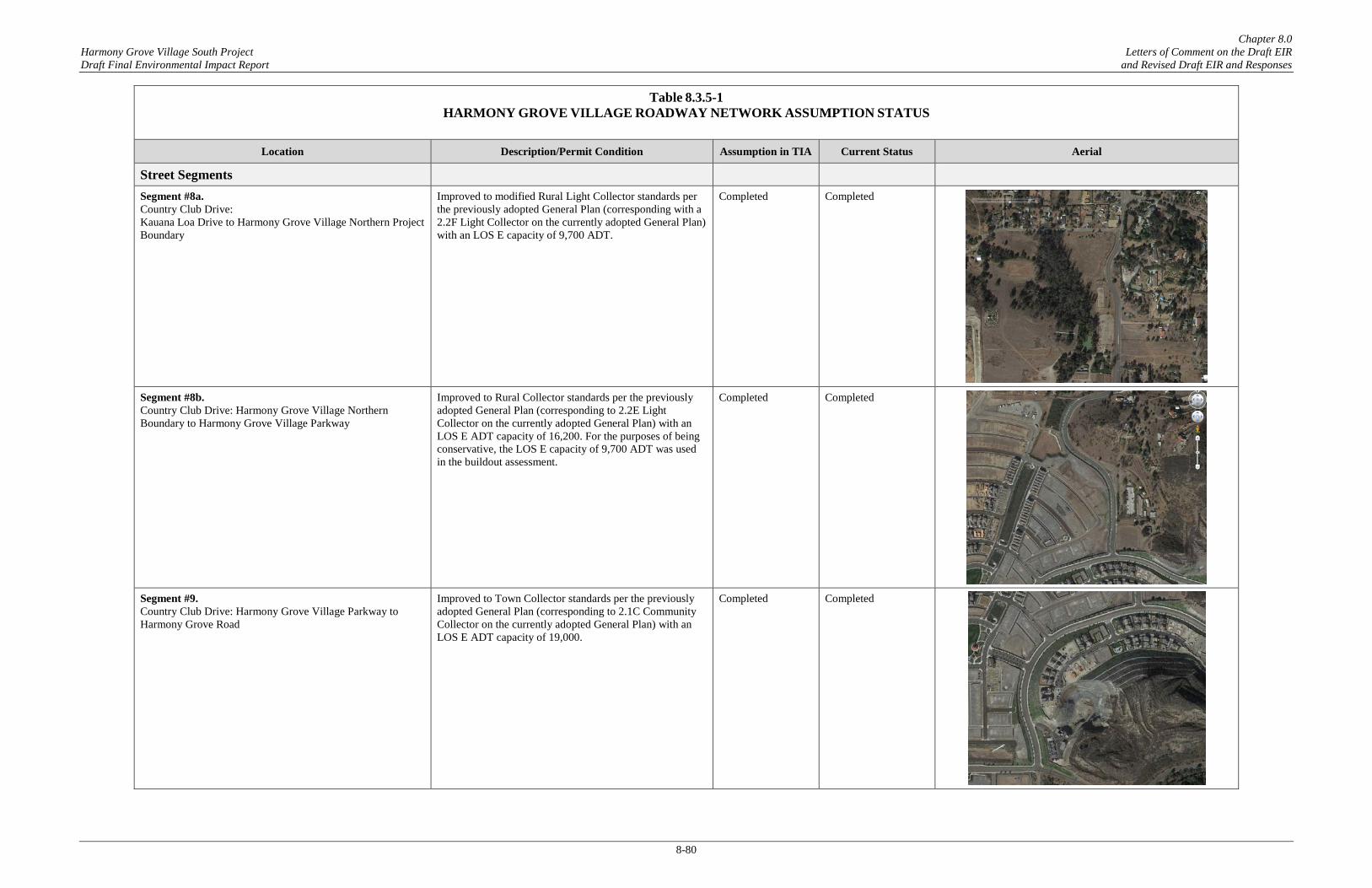
Chapter 8.0 Harmony Grove Village South Project Letters of Comment on the Draft EIR Draft Final Environmental Impact Report and Revised Draft EIR and Responses
8-80
Table 8.3.5-1 HARMONY GROVE VILLAGE ROADWAY NETWORK ASSUMPTION STATUS
Location Description/Permit Condition Assumption in TIA Current Status Aerial
Street Segments Segment #8a. Country Club Drive: Kauana Loa Drive to Harmony Grove Village Northern Project Boundary
Improved to modified Rural Light Collector standards per the previously adopted General Plan (corresponding with a 2.2F Light Collector on the currently adopted General Plan) with an LOS E capacity of 9,700 ADT.
Completed Completed
Segment #8b. Country Club Drive: Harmony Grove Village Northern Boundary to Harmony Grove Village Parkway
Improved to Rural Collector standards per the previously adopted General Plan (corresponding to 2.2E Light Collector on the currently adopted General Plan) with an LOS E ADT capacity of 16,200. For the purposes of being conservative, the LOS E capacity of 9,700 ADT was used in the buildout assessment.
Completed Completed
Segment #9. Country Club Drive: Harmony Grove Village Parkway to Harmony Grove Road
Improved to Town Collector standards per the previously adopted General Plan (corresponding to 2.1C Community Collector on the currently adopted General Plan) with an LOS E ADT capacity of 19,000.
Completed Completed

Chapter 8.0 Harmony Grove Village South Project Letters of Comment on the Draft EIR Draft Final Environmental Impact Report and Revised Draft EIR and Responses
8-81
Table 8.3.5-1 HARMONY GROVE VILLAGE ROADWAY NETWORK ASSUMPTION STATUS
Location Description/Permit Condition Assumption in TIA Current Status Aerial
Segment #10. Harmony Grove Road: Wilgen Drive to Country Club Drive
Paved width of 54 feet with curb and gutters for an LOS E capacity of 19,000 ADT. Although the County of San Diego General Plan Mobility Element, classifies this segment as a 2.2E Light Collector with an LOS E capacity of 16,200 ADT, because the roadway has been improved to 2.2C Light Collector standards (19,000 ADT), this capacity was used in all near-term and buildout analyses.
Completed – 2.2C Light Collector @ 19,000 ADT
Completed – 2.2C Light Collector @ 19,000 ADT
Segment #11. Harmony Grove Road: Country Club Drive to Harmony Grove Village Parkway
Paved width of 28 feet where feasible. Built to these standards, the roadway functions as a modified Rural Light Collector with an LOS E capacity of 16,200 ADT.
Completed b Completed b
Segment #14a. Harmony Grove Village Parkway: Country Club Drive to Harmony Grove Road (not analyzed independently from Segment 14b)
Paved width of 54 feet including curb, gutter and sidewalks for an LOS E capacity of 19,000 ADT.
Completed Completed

Chapter 8.0 Harmony Grove Village South Project Letters of Comment on the Draft EIR Draft Final Environmental Impact Report and Revised Draft EIR and Responses
8-82
Table 8.3.5-1 HARMONY GROVE VILLAGE ROADWAY NETWORK ASSUMPTION STATUS
Location Description/Permit Condition Assumption in TIA Current Status Aerial
Segment #14b. Harmony Grove Village Parkway: Harmony Grove Road to Citracado Parkway (not analyzed independently from Segment 14a)
Paved width of 40 feet including curb, gutter and sidewalks for an LOS E capacity of 16,200 ADT.
Completed Completed
Citracado Parkway: Avenida Del Diablo to Harmony Grove Village Parkway
Constructed to connect to Avenida Del Diablo. Completed Completed
Source: Harmony Grove Village South Traffic Impact Analysis - LLG Engineers (April 6, 2017) Footnotes: a. Two (2) northbound/southbound thru lanes were assumed at this intersection per the Citracado Parkway Extension EIR improvements. One (1) lane is constructed in each direction today and pavement is in place to support future restriping. With the existing
configuration, no new impacts would occur at this intersection with the addition of Project traffic. b. Harmony Grove Road from Country Club Drive to Harmony Grove Village Parkway has been improved to 28’ paved width “where feasible”, per Permit Condition “B” from TM 5365RPL, February 7, 2017. The Harmony Grove Road intersection approaches to
Country Club Drive and Harmony Grove Village Parkway have been improved along this segment.

HGV + HGV South Adjacent Land UsesHARMONY GROVE VILLAGE SOUTH
Figure 8.3.6-1
I:\PR
OJE
CTS
\K\K
OV
\KO
V-01
_Har
mon
yGro
veSE
\Map
\EN
V\E
IR\F
ig8-
3-6-
1_H
GV
_Adj
acen
tLan
dUse
s.ind
d
KO
V-01
5/0
7/18
-RK
Source: Project Design Consultants, 2018
HARMONY GROVE VILLAGE
MIXED RESIDENTIAL
MOBILEHOME
MOBILEHOME
MED-LOW MIXED-USE
MIXED-USE +RESIDENTIAL
COMMERCIAL / LIGHT INDUSTRIAL / MIXED USE
COSTCOCENTER
AUTOMALL
PALOMAR MEDICAL CENTER
STONE BREWING
MED-HIGH MIXED-USEBI
G B
OX
RETAIL
HARMONY GROVE
VILLAGE SOUTH
HGV WRF
0.5 MILE
1 MILE
1.5 MILE
2 MILE
2.5 MILE
HARMONY GROVE VILLAGE
MIXED RESIDENTIAL
MOBILEHOME
MOBILEHOME
MED-LOW MIXED-USE
MIXED-USE +RESIDENTIAL
COMMERCIAL / LIGHT INDUSTRIAL / MIXED USE
COSTCOCENTER
AUTOMALL
PALOMAR MEDICAL CENTER
STONE BREWING
MED-HIGH MIXED-USE
BIG
BO
X
RETAIL
HARMONY GROVE
VILLAGE SOUTH
HGV WRF
0.5 MILE
1 MILE
1.5 MILE
2 MILE
2.5 MILE
Related Documents