List of meeting materials Phase 2 Working Group Meeting #4 January 27, 2020, 6:00 pm Beacon Middle School 19483 John J. Williams Highway Lewes, DE 19958 List of meeting materials .............................................................................. page 1 Agenda ................................................................................................................. 2 Presentation .......................................................................................................... 3 Draft minutes of October 28, 2019 Working Group meeting ............................... 61 List of upcoming meetings .................................................................................. 69 Updated implementation plan ............................................................................. 70 1

Welcome message from author
This document is posted to help you gain knowledge. Please leave a comment to let me know what you think about it! Share it to your friends and learn new things together.
Transcript
List of meeting materials Phase 2 Working Group Meeting #4
January 27, 2020, 6:00 pm Beacon Middle School 19483 John J. Williams Highway Lewes, DE 19958
List of meeting materials .............................................................................. page 1
Agenda ................................................................................................................. 2
Presentation .......................................................................................................... 3
Draft minutes of October 28, 2019 Working Group meeting ............................... 61
List of upcoming meetings .................................................................................. 69
Updated implementation plan ............................................................................. 70
1

Agenda Phase 2 Working Group Meeting #4 January 27, 2020, 6:00 pm Beacon Middle School 19483 John J. Williams Highway Lewes, DE 19958 1. Introduction
Welcome
Summary of notebook materials
Approval of October 28, 2019 meeting minutes
2. Delaware Transit Corporation initiatives in the study area 3. Phase 2 implementation status
Overall status update
New recommendations to be initiated in 2020
Items requiring Working Group input ‐ C-6: identify key turn lane locations ‐ C-8: comments on Savannah Road two-way left-turn lane ‐ C-11: clarify intent of recommendation
4. Public comment
5. Adjourn
2

Phase 2Working Group Meeting #4
January 27, 2020
3

Agenda
• Introduction• Welcome• Summary of notebook materials• Approval of October 28, 2019 minutes
• Delaware Transit Corporation initiatives in the study area
• Phase 2 implementation status• Public comment
2
4

Introduction
• Welcome• Summary of notebook materials
• Agenda• Presentation• Draft minutes of October 28 Working Group
meeting• List of upcoming meetings• Updated implementation plan
• Approval of October 28, 2019 meeting minutes
3
5

DTC PRESENTATION
6

Delaware Transit CorporationJohn Sisson
Chief Executive Officer
7

DART Bus ServiceRouting
8

DART Bus ServiceFrequency
Mon ‐ Thurs Fri ‐ Sun Mon ‐ Fri Saturday
201: LTC to Rehoboth 15 ‐ 30 Min 10 ‐ 15 Min 30 Min 30 Min 201: LTC to Rehoboth
203: LTC to Dewey 30 Min 30 Min ‐ ‐ 203: LTC to Dewey
204: LTC to Lewes 30 Min 30 Min 30 Min 30 Min 204: LTC to Lewes
206: Georgetown to LTC
11 Round Trips 8 Round Trips 11 Round Trips 8 Round Trips206: Georgetown to
LTC208: Rehoboth PNR to
OC9 Round Trips 9 Round Trips ‐ ‐
208: Rehoboth PNR to OC
215: Millsboro to Rehoboth PNR
11 Round Trips 10 Round Trips 11 Round Trips 10 Round Trips215: Millsboro to Rehoboth PNR
305: Wilm ‐ Dover ‐ Rehoboth PNR
‐ 3 Round Trips (Sat & Sun) ‐ ‐305: Wilm ‐ Dover ‐ Rehoboth PNR
307: Dover to LTC 5 Round Trips ‐ 5 Round Trips ‐ 307: Dover to LTC
Beach Bus (May ‐ Sept) Year Round
9

DART Bus ServiceRidership
200,000
210,000
220,000
230,000
240,000
250,000
260,000
270,000
280,000
290,000
2016 2017 2018 2019
Overall Beach Bus Ridership Comparison
10

DART Bus ServiceRidership by Route
2019 Beach Bus SeasonRoute Ridership201 200,803 203 23,796 204 16,145206 16,388208 15,624 215 8,714305 3,177
Total 284,647
11

Fares
• One‐Way: $2; Reduced Fare: 80¢• Daily Pass: $4.20• 7‐Day Pass: $18• 30‐Day Pass: $65• Park & Rides: Free parking; fare paid upon boarding
12

TechnologyDART Transit App• Transit information at your fingertips• Launched in November 2018• Real‐time information/bus tracking• Trip planning• Bus stop and route information• Mobile fare payment through DART Pass• Paratransit Estimated Time of Arrival (ETA)/bus trackerNEW
DART Transit
13

TechnologyDART Pass App• Mobile fare payment• Launched in August 2018• Fares available for purchase
• One‐Way Ride• Reduced Fare One‐Way Ride (ID required upon boarding)• Daily Pass• 7‐Day Pass (consecutive day)• 30‐Day Pass (consecutive day)• Paratransit ADA & Non‐ADA Demand ResponseNEW
DART Pass
14

When Transit Works• Direct and frequent service• Productive origins and destinations• Population density• Safe and efficient pedestrian access• Supported by community
15

What Route 204 Offers• Directness of service• Frequency (30 min)• Operates from 6 am to 11 pm year round Monday – Saturday• Operates from 6 am to 2 am during Beach Season daily• Comparable to car travel: 24 min by bus; 18 min by car• Destinations within ¼ mile of bus stops
16

Route 204 RidershipAverage Summer Beach Bus
452 riders per weekday
Average Year Round
241 riders per weekday
‐Summer Beach Bus ridership
17

City of Lewes Destinations
18

MiltonAvg. Weekday Ridership• 206: 197 riders• 303: 199 riders
• Avg. of 6 riders to/from Milton
206 and 303 Connection
19

307 Deviation Analysis• 5.7 miles• Adds appx. 17 min
to 69 minute one‐way trip (+25%)
• Limited places to turn bus around
• More deviations = more time = less frequency = less desirable
20

MiltonMilton to Lewes Potential• Milton is walkable and growing• Continue discussion with Milton Mayor and Town officials• Continue to review for service improvements
Milton to Lewes Service Challenges• No direct route between Milton and Lewes Transit Center• Lack of transit generators between Milton and Lewes Transit Center• Low density along route• Low existing ridership on Route 303
21

Shelter Availability
• 4 shelters installed last year
• 6 shelters replaced with new style last year
22

Example of Current Shelters
23

Next Steps
• Evaluate need for increased frequency on Route 204• Identify location for Park & Ride west of SR 1• Improve connection between 303 and 206• Explore Route 204 connection to Cape Henlopen State Park• Investigate potential for micro‐transit• Improve bus stops and install more bus shelters• Continue community input
• Sussex County Working Group – Feb. 6th at Del Tech • Resort Advisory Committee (RAC) – March Date TBD
24

Phase 2 Implementation Plan Update
25

78 recommendations 6
Implement policies and procedures to make the area more efficient, sustainable and beautiful (8 priorities out of 27 recommendations)
Make the most of existing roadway infrastructure (8 priorities out of 20 recommendations)
Make walking, bicycling, and transit more viable as alternatives to driving (5 priorities out of 15 recommendations)
Invest in new infrastructure to support anticipated growth (3 priorities out of 9 recommendations)
Recommendations to be implemented under current DelDOT projects or initiatives (7 recommendations)
26

Previous status (as of October 2019)
33 of 78 recommendations in progress or completed
• 7 of 7 in Category A – to be addressed by current DelDOT projects or initiatives
• 9 of 27 in Category B – policies and procedures
• 11 of 20 in Category C – make the most of existing infrastructure
• 4 of 15 in Category D – bicycle, pedestrian, transit
• 2 of 9 in Category E – major infrastructure improvements
7
27

Current status (as of January 2020)
42 of 78 recommendations in progress, ongoing, or completed, an increase of 9
• 5 recommendations were completed or are now classified as ongoing
• 5 recommendations are newly in progress
• Action has been taken on 13 of the 15 recommendations listed at the beginning of Phase 2 as “Priority for 2019”
5 recommendations will be initiated in 2020
8
28

Category A 9
StatusOct 2019
Jan 2020 Change
COMPLETE 4 5+1
-1IN PROGRESS 3 2
Total A 7 7 -
Number of recommendations by status
being addressed by current DelDOT projects and initiatives
29

Category A progress 10
• A-1 – Review the need for grade separating or restricting crossings between Frederica and Lewes before eliminating signals in this area
• Complete• Results of studies were presented at the
October Working Group meeting
30

Category A progress 11
• A-5 – Evaluate one way service roads as part of the Minos Conaway Road grade separation project
• Status: Complete• Clarified that service roads under design are
two-way to provide better mobility
31

Category B 12
StatusOct 2019
Jan 2020 Change
COMPLETE 3 4 +1ONGOING 0 2 +2IN PROGRESS 6 5 -1Priority for 2019 2 2 -Initiate in 2020 0 2 +2Longer-term 16 12 -4Total B 27 27 -
Number of recommendations by status
Policies and procedures
32

Category B progress 13
• B-3 – Study the feasibility and anticipated effectiveness of modifying signage, starting in Milford, to encourage through drivers (to points outside the Route 1 corridor between Lewes and Dewey Beach) to use Route 113, Route 5, Route 23, etc.
• DelDOT is planning to install variable message signs that show travel time via SR 1 and US 113.
33

Category B progress 14
• B-7 – Continue TID studies both east and west of Route 1
• A public workshop will be held for the Henlopen TID on February 5, 2020.
• Because most available land on the east side of Route 1 has already been developed or approved for development, there is limited value to a TID in this area.
34

Category B progress 15
• B-8 – Study the feasibility of a parking management system to alert travelers when parking lots at major destinations are full
• To be initiated in 2020• Will be coordinated with variable message
signs under B-3
35

Category B progress 16
• B-9 – Study enhancing New Road per Byway Master Plan
• Clarified responsible parties• A final draft of the Byway Master Plan is
under review
36

Category B progress 17
• B-13 – Study alternatives to both meter and slow southbound traffic approaching Five Points
• Complete; will be monitored
37

Category B progress 18
• B-16 – Increase the importance of considering noise and lighting impacts of major transportation project recommendations per regulations
• Lighting is installed based on DelDOT’s Lighting Design Guidelines.
• Noise impacts of transportation projects are evaluated based on Federal requirements (23 CFR 772) and DelDOT’s Transportation Noise Policy
• Now classified as ongoing
38

Category B progress 19
• B-21 – Study frequency and causes of emergency vehicle preemption and make recommendations to balance emergency vehicle access with traveler mobility
• DelDOT recently completed a signal hardware update and installed new equipment that should reduce the disruption of preemption
• Now classified as ongoing
39

Category B progress 20
• B-24 – Improve tourism oriented destination signage along Route 1
• In progress• Sussex County Tourism is taking the lead on
this effort in conjunction with municipalities
40

Category B progress 21
• B-25 – Identify the costs and benefits of dedicating Nassau Commons Boulevard to public use
• To be initiated in 2020
41

Category C 22
StatusOct 2019
Jan 2020
Change
COMPLETE 1 1 -
ONGOING 0 1 +1
IN PROGRESS 10 10 -
Initiate in 2020 0 2 +2
Longer-term 9 6 -3
Total C 20 20 -
Number of recommendations by status
Make the most of existing roadway infrastructure
42

Category C progress 23
• C-5 – Improve the intersection of Cave Neck Road, Sweet Briar Road, and Hudson Road• Clarified status: a project is proposed in the FY 21 - 26 CTP
43

Category C progress 24
• C-6 – Study the feasibility of lengthening left and right turn lanes throughout the study area• To be initiated in 2020• Help us understand locations that are important to you!
44

Category C progress 25
• C-8 – Study the feasibility of restriping two lane sections of Savannah Road with a two way left turn lane• Comments on the report provided at the October Working Group meeting?
45

Category C progress 26
• C-10 – Continue to improve traffic signal phasing, timing and coordination using real time monitoring and control technologies• Now classified as ongoing
46

Category C progress 27
• C-11 – Develop concepts and estimates for bringing roads in the study area to DelDOT standard, including shoulders• It isn’t clear whether this recommendation was meant to apply to state system roads, subdivision streets, or both
47
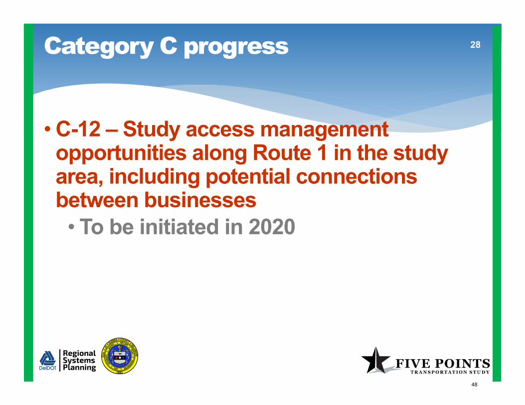
Category C progress 28
• C-12 – Study access management opportunities along Route 1 in the study area, including potential connections between businesses• To be initiated in 2020
48

Category C progress 29
• C-13 – Study the feasibility of eliminating unsignalized crossovers on Route 1• Clarified that this recommendation refers to crossovers between Five Points and Route 24
49

Category C progress 30
• C-15 – Study the feasibility of lengthening the southbound acceleration lane on Route 1 at Minos Conaway Road
• Feasibility is confirmed• Design is complete• Implementation is anticipated this spring
50

Category D 31
StatusOct 2019
Jan 2020 Change
COMPLETE 0 0 -
IN PROGRESS 4 6 +2
Initiate in 2020 0 1 +1
Priority for 2019 2 0 -2
Longer-term 9 8 -1
Total D 15 15 -
Number of recommendations by status
Walking, bicycling, and transit
51
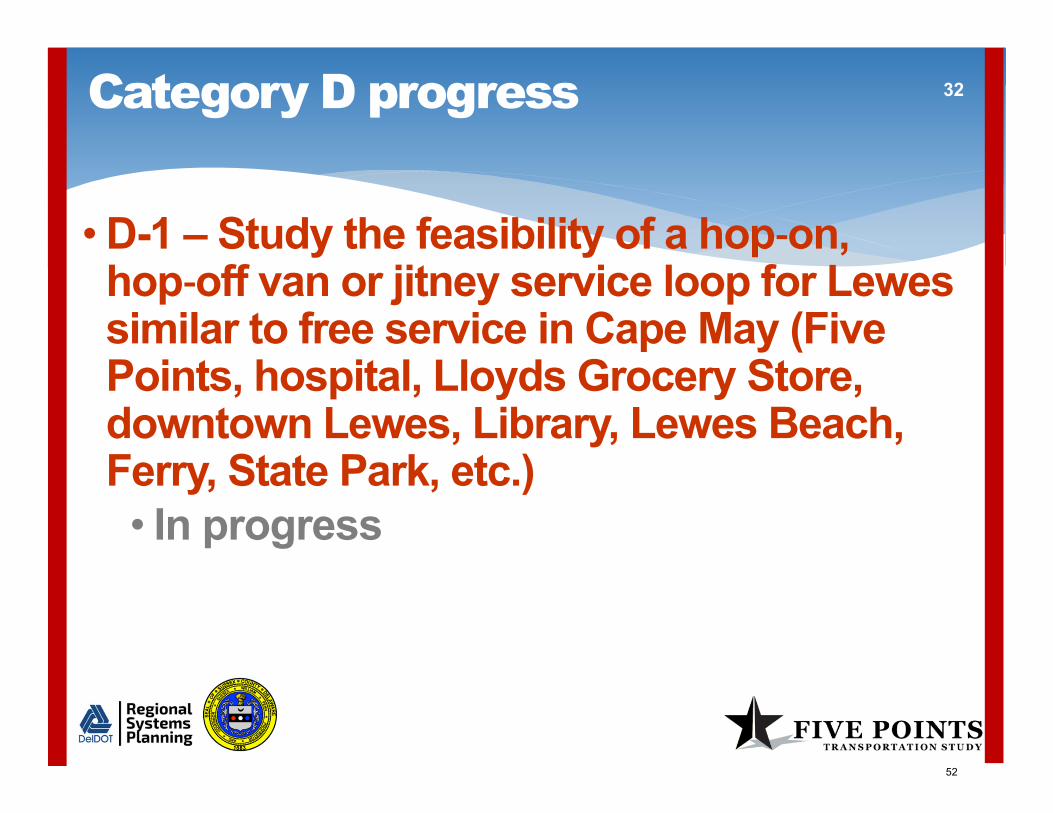
Category D progress 32
• D-1 – Study the feasibility of a hop on, hop off van or jitney service loop for Lewes similar to free service in Cape May (Five Points, hospital, Lloyds Grocery Store, downtown Lewes, Library, Lewes Beach, Ferry, State Park, etc.)• In progress
52

Category D progress 33
• D-7 – Study the feasibility of transit service to tie the Milton/Red Mill Pond/Minos Conaway Road area into the transit network• In progress
53
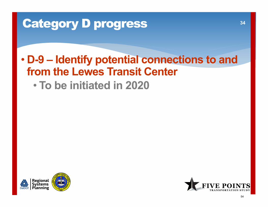
Category D progress 34
• D-9 – Identify potential connections to and from the Lewes Transit Center• To be initiated in 2020
54

Category E 35
StatusOct 2019
Jan 2020 Change
COMPLETE 0 0 -
IN PROGRESS 2 3 +1
Longer-term 7 6 -1
Total E 9 9 -
Number of recommendations by status
New infrastructure
55

Category E progress 36
• E-7 – Evaluate the potential transportation benefits, costs, and impacts of a new through road connecting Postal Lane with the intersection of Old Landing Road/Airport Road• In progress• Idea is being considered as part of the Henlopen TID study
56

Phase 2 implementation plan
• Next steps• Continue work on recommendations• Provide email progress updates in February
and March• Publish the draft of our 2019 annual report
in early April
37
57

Phase 2 implementation plan
• Next steps• Continue work on recommendations• Provide email progress updates in February
and March• Publish the draft of our 2019 annual report
in early April• Convene the Working Group on
April 27, 2020• Conduct a public workshop in May
38
58

Public comment 39
59

Thank you for your participation!
Jenn Cinelli-MillerProject Planner
Delaware Department of [email protected]
302.760.2549
40
Next meetingMonday, April 27, 2020
6:00 pmBeacon Middle School
60

DRAFT
Page 1 of 8
Meeting Minutes Phase 2 Working Group Meeting #3 October 28, 2019, 6:00 pm Beacon Middle School 19483 John J. Williams Highway Lewes, DE 19958 Members present: I.G. Burton Greg Christmas Robert Fischer Dennis Forney Doug Hudson DJ Hughes Carole Kohr Todd Lawson Sen. Ernesto B. Lopez Lloyd Schmitz Rep. Peter Schwartzkopf Josh Thomas Helen Truitt Gail Van Gilder
Members absent: Scott Green Rev. Wendell B. Hall Christian Hudson Kim Hoey Stevenson Rep. Steve Smyk Ann Marie Townshend
There were 24 members of the public in attendance. Names of those who signed in are listed at the end of these notes. The meeting began with a quorum of 14 Working Group members present. Andrew Bing welcomed everyone and noted that the public will have the opportunity to comment at the end of the meeting. Andrew went over the agenda and summarized the contents of the meeting packet that was provided to the members of the Working Group at the meeting.
61

DRAFT
Page 2 of 8
The minutes of the July 29, 2019 Working Group meeting were approved unanimously. Implementation Plan Status Jeff Riegner described the implementation plan status and progress that has been made since the July 29 Working Group meeting. One recommendation changed status from “Priority for 2019” to “In progress”. 33 of the 78 recommendations are now either completed or in progress, an increase of one since July 2019. The progress is described in detail in the presentation slides and on the implementation plan status spreadsheet. This information is in the Working Group meeting packet, and is available to the public on the Five Points website at 5points.deldot.gov. Savannah Road two-way left turn study Mark Luszcz, DelDOT’s Deputy Director for Design, presented information from the draft technical memorandum prepared for the study. The study looked at the feasibility of restriping a two-way left turn lane between Wescoats Road and Drake Knoll Road within the existing pavement section. The memorandum identified both pros and cons for a two-way center left turn lane. Rear end crashes involving stopped vehicles waiting to make a left turn (6 of 40 total crashes) are susceptible to correction. The center lane can provide areas with a median for traffic calming and pedestrian refuge for pedestrian crossings. However, the shoulder width would be reduced to approximately five feet, so stopped mail or trash trucks would partially block the travel lane. Traffic would travel closer to roadside objects such as utility poles and closer to bicyclists riding in the shoulder. A two-way left turn lane cannot be implemented with striping alone. The shoulder is not built to handle vehicle traffic so some pavement reconstruction would be needed. Mark stated that the memorandum did not make a recommendation and is still a draft. The draft memorandum is included in the Working Group meeting packet. Bob Fischer asked about sidewalks on either side of Savannah Road. Mark replied that there are some sidewalks but many gaps. There is a current project to install five-foot wide sidewalk on one side of Savannah Road that pre-dates the Working Group. Bob noted that the SR 1/Minos Conaway Road grade separation project includes a shared-use path that bicyclists can use as well as pedestrians, and that may be something to consider for Savannah Road. Rep Schwartzkopf recommended that the two-way left turn lane be extended north of Drake Knoll Road to at least as far as Sussex Drive, because left turns to the school cause a bottleneck.
62

DRAFT
Page 3 of 8
Dennis Forney asked whether there is a threshold for crash reduction that is used in evaluating benefit. Mark replied there is not. Gail Van Gilder commented that Savannah Road is a Lewes scenic byway. The byway committee should be involved early in the planning stage of this project. Savannah Road does not have a master plan like New Road and Kings Highway, but the lessons learned from those plans should be applied to Savannah Road. Andrew asked Working Group members to provide any additional comments after they have had a chance to review the draft memorandum. Savannah Road sidewalks There are two current projects in the CTP that involve sidewalks: the Old Orchard Road relocation project will install sidewalks on both sides up to Wescoats Road, and a separate sidewalk project is under design to install a sidewalk on the south side of Savannah Road from the Georgetown-Lewes Trail to Quaker Lane. The DelDOT team will examine both CTP projects and private development projects to determine the limits of sidewalks in those plans and will develop concepts to address remaining gaps. Bob Fischer said it is important to have interconnectivity between the Trail and Savannah Road. Jeff responded that isn’t necessarily part of the Savannah Road project, but it is applicable to another recommendation of the Working Group that has not yet been started (D-2). Jeff noted that DelDOT’s trails have provided a good spine, and now communities are asking how they can get to the trails from their neighborhoods. Connections to the trails are a logical next step. DelDOT Project Development Process update Drew Boyce, DelDOT’s Director of Planning, informed the group that DelDOT is now using a biennial Capital Transportation Program or CTP. The CTP is developed every two years. DelDOT is currently developing the FY 2012-26 CTP. A public workshop for Sussex County was held in Georgetown on September 25. Ten new projects were presented along with projects already in progress. The Council on Transportation (COT), appointed by the governor, provides oversight and direction. The COT will meet in December to review the CTP and will act by March 1, 2020. The CTP then goes to the legislature to write and pass a bond bill. Once an approved bond bill is signed by the Governor, existing projects can continue forward. New projects will begin in the later three years of the program.
63

DRAFT
Page 4 of 8
Gail Van Gilder said work on Kings Highway at Dartmouth Drive and at Clay Road needs to begin sooner rather than later. Biking and walking are not safe. She is concerned about possible delay in developer funding to improve the intersection of Kings Highway and Clay Road. Drew responded that the project for Kings Highway from SR 1 to Freeman Highway per the Byway Master Plan is already in the CTP and DelDOT is working to move it forward. If funding becomes available, they would look for ways to advance the project. The developer is responsible for contributing. Rep. Schwartzkopf said Clay Road is dangerous, and asked what the developer is responsible for. DJ Hughes noted that developers have constructed improvements to Gills Neck Road and have contributed right of way. Helen Truitt asked for improved notification of your rights as a bicyclist. There is a need for “Stop Sign Ahead” signs and notification to bicyclists that they must stop. Doug Hudson commented that we need to promote personal responsibility and caution. Carole Kohr said Delaware laws are ambiguous when it comes to bicyclists. Bikes must reduce speed, and stop only if needed for a safety reason. If bikes and vehicles reach an intersection at the same time, the bike or vehicle on the left is supposed to yield to the one on the right. The law is confusing. SR 1 grade separations and crossovers Mark Luszcz presented the results of DelDOT’s studies of summer 2019 traffic conditions, focusing on safety conditions between Milford and Five Points after removal of the traffic signal at SR 16. DelDOT compared mid-August summer Saturday peak conditions in 2016, 2017, 2018, and 2019 in terms of volumes and travel times. DelDOT reviewed 2019 hourly traffic for each day from mid-May through the end of September and selected the peak hour of traffic flow for each day. The highest hourly volumes were typically on Saturdays with a few exceptions, like July 4. August 17 was the Saturday selected for detailed review.
64

DRAFT
Page 5 of 8
SR 1 between Dover and Milford has the highest southbound peak hour volume, with over 3,000 vehicles per hour in 2019. The US 113 split in Milford draws more than one-third of southbound volume off SR 1, but some volume gets added back to SR 1 from intersections further south. Replacement of signals to the north with grade separated intersections did not significantly affect downstream travel times. DelDOT collected video data at four key locations on SR 1 in mid-July and mid-August to check for standing queues and for gaps in traffic. 158 hours of daytime summer video were reviewed from a camera located between Minos Conaway Road and Nassau Road (north). No standing queues were noted on southbound SR 1. Gaps in southbound traffic were measured from video at each of four camera locations for a ten-minute period in the peak hour on Saturday, August 17.
• At the location north of Pine Haven Road (6.6 miles north of SR 16), there were acceptable gaps 23% of the time within the 10 minutes, and the gaps occur at random times.
• At the location just south of the SR 16 signal, volume was higher but there were acceptable gaps 34% of the time within the 10 minutes. The signal created gaps during the red interval for SR 1 traffic.
• At the location south of Cave Neck Road, 4.2 miles south of SR 16, there were acceptable gaps 9% of the time, with 5 acceptable gaps in 10 minutes.
• And at the location north of Nassau Road (north) 5.5 miles south of SR 16, there was only one acceptable gap in 10 minutes.
Mark showed bar charts of the gaps at each location that demonstrate how the effect of the SR 16 signal on gaps disappears before Cave Neck Road. This is because the traffic disperses as it travels south of the signal and because more volume is added from side roads south of SR 16, filling in some gaps. Residents are correct in their observations that there are very few gaps. However, the removal of the signal at SR 16 will not affect those conditions. Therefore, the SR 1 and SR 16 grade separated intersection will proceed as scheduled. To address the lack of peak period gaps, DelDOT has a program of crossover projects to improve safety for the short term. Mark described nine locations where projects will be constructed or begin design in 2020. The Minos Conaway Road and Cave Neck Road grade separation projects will provide more permanent solutions.
65

DRAFT
Page 6 of 8
The material presented shows only a fraction of the data that DelDOT reviewed. All the data is available for review upon request. Andrew asked for questions from the Working Group members. Working Group Questions Dennis Forney asked whether all crashes on SR 1 can be attributed to drivers proceeding without a sufficient gap. Mark Luszcz responded that it varies by location; for example, there are rear end crashes at the traffic signal at Tulip Drive that operates on Sunday. At the crossovers, it’s predominantly angle crashes. Gail Van Gilder did not agree that the peak hour begins at 9 AM; she believes it is later. Mark responded that on that day in that section, 9 AM – 10 AM was measured as the highest volume hour. Gail Van Gilder asked what happens between Nassau and Five Points. Mark said video was not taken there, but once you get south of Nassau, there are virtually no gaps during the peak hours. Gail noted that at the Five Points intersection, traffic trying to get onto Route 9 goes through the yellow light and blocks the intersection, backing everything up. Mark agreed that is a problem, but is a different issue. The studies DelDOT has done shows that removal of the signal at SR 16 won’t increase backups at Five Points. Bob Fischer stated that DelDOT’s studies have demonstrated to his satisfaction that the SR 16 signal removal will not make problems worse. Bob also said the proposed crossover treatments would be good for safety even if the SR 16 signal was not removed. They will mitigate problems that exist now. DJ Hughes stated he observed traffic backed up to Red Mill Pond on two summer Saturdays in 2018. He agreed that peak Saturday volumes occur earlier in the day than they used to in the past. He said that the Minos Conaway Road grade separation should be done first because that location has the highest number of crashes. Gail Van Gilder and Greg Christmas also stated that they thought the grade separations should be implemented from south to north. Greg Christmas noted that the Working Group meeting did not provide enough time to consider all the information presented and register concerns. Andrew Bing said that Working Group members can take their time to review the materials and email Jenn Cinelli-Miller with concerns.
66

DRAFT
Page 7 of 8
Mark Luszcz said the SR 16, Cave Neck Road, and Minos Conaway Road grade separations were all long-term recommendations of the Corridor Capacity Preservation Program which addresses safety and other priorities. The Capital Transportation Program (CTP) that was approved six years ago established the project schedules. That CTP went through the public hearing process and was approved by the Council on Transportation. Mark said that all the grade separation projects are moving forward as fast as possible. Delaying the SR 16 project will not speed up the implementation of grade separations at Minos Conaway Road or Cave Neck Road. Since DelDOT’s studies demonstrate that removing the SR 16 signal will not make matters worse at Cave Neck Road or Minos Conaway Road, DelDOT will proceed with the SR 16 project schedule. DelDOT is also implementing short term improvements at crossovers to improve safety. Jeff summarized the next steps in the Working Group process:
• Meetings will be held every three months, with the next meeting on January 27, 2020 at Beacon Middle School.
• Meetings will generally be the last Monday of the month.
• Email progress updates will be sent in months that there is no meeting.
• An annual report will be prepared in early 2020.
• A public workshop will be held in the spring of each year. Andrew said that the future meetings would be much like this one, presenting progress made on the recommendations and getting further input from the Working Group and public. Public comments
• George Dellinger thanked DelDOT for the workshops and information on YouTube. He then said he is concerned about the risks that locals experience at intersections getting onto and across Route 1. DelDOT’s Corridor Capacity Preservation Program is concerned about free-flowing traffic for tourists. What DelDOT is doing by constructing SR 16 first is eliminating more gaps.
• Margaret Fischer said that trail crossings at Minos Conaway Road and at Old Orchard Road are invisible to drivers. The signs are too small and hard to read even at 35 mph, and some drivers go faster. Warning signs are needed farther back from the trail.
67

DRAFT
Page 8 of 8
• Neil Schreck commented there have already been three crashes at Cave Neck Road that he and his friends have documented since the crossover treatment was put in this summer. A crash with injury happened October 18. Plus, there are fender-benders that don’t get documented. DelDOT is making improvements but we’re still not seeing results.
• Theresa Baldwin thanked DelDOT for proactively planning for transportation solutions. She then commented that she opposes the Old Orchard Road realignment project that runs through the Village of Five Points. It will make Old Orchard Road a gateway to Business Route 9 and cause a significant decline in the walkability of the Village of Five Points. The east-west transportation system should begin at Savannah Road and Route 1. This should include a plan for walkability to the Lewes Park and Ride is needed. Although close in proximity, the Park and Ride is not walkable by residents living east of Route 1.
Andrew adjourned the meeting at 7:55 pm. Public sign-in list Baker, Kathleen Baldwin, Ed Baldwin, Theresa Becker, Ted Chiesi, Bill Crawford, Linda Christensen, Bob DeBoissiere, Dan Dellinger, George
Fischer, Margaret Gaeckle, Bill Gaeckle, Christine Hain, Suzanne Hoechner, Joe McGill, Brian Melda, Alda O'Hagan, Diana Quinn, Ann
Schmitz, Kat Schreck, Neil Steinback, Robert Stone, Pat Veneziano, Jim Veneziano, Rose
68

List of upcoming meetings Phase 2 Working Group Meeting #5
April 27, 2020, 6:00 pm Beacon Middle School 19483 John J. Williams Highway Lewes, DE 19958 Public Workshop
May 2020 Date, time, and location to be determined Meeting #6
July 27, 2020, 6:00 pm Location to be determined Meeting #7
October 26, 2020, 6:00 pm Location to be determined
Meeting dates, times, locations, and agendas are subject to change.
See the Delaware Public Meeting Calendar at publicmeetings.delaware.gov
for official meeting notices.
69

FIVE POINTS TRANSPORTATION STUDY $ < $200K * <3 years ◊ Low$$ $200K ‐ $2M * * 3‐10 years ◊ ◊ Medium$$$ $2M ‐ $20M * * * >10 years ◊ ◊ ◊ High
January 27, 2020 DRAFT (red text indicates changes since previous update) $$$$ $20M ‐ $200M$$$$$ > $200M
Category ID PriorityOld idea
no.Working Group recommendation Assumed lead agency
Other responsible parties (if any)
Studycost
Studytimeframe
Imp.cost
Imp.timeframe
Imp.impacts
Status Remarks
A 1 N/A 25Review the need for grade separating or restricting crossings between Frederica and Lewes before eliminating signals in this area
DelDOT ‐ Traffic $ * N/A N/A N/A COMPLETEStudies have been completed, with results presented to the Working Group in October 2019. DelDOT is proceeding with a program of grade separations and crossover improvements.
A 2 N/A 42Evaluate Tulip Drive connection to Route 1 as part of the Minos Conaway Road grade separation project
DelDOT ‐ PD South $ * $$ * * ◊ ◊ COMPLETETulip Drive connection is now part of the Minos Conaway project.
A 3 N/A 53
Study the feasibility of increasing the proposed Route 24 bypass of Millsboro from
one lane in each direction to two lanes in each direction
DelDOT ‐ PD South $$ * * $$$$ ** ◊ ◊ ◊ COMPLETEThis effort was completed as part of the US 113 Millsboro ‐South Area Supplemental DEIS. A two‐lane bypass was found to be adequate for future demand.
A 4 N/A 54Study options for signage to direct appropriate traffic, i.e. local, boat, U of D and walking/biking areas, under the Nassau Bridge
DelDOT ‐ PD South $ * TBD TBD TBD IN PROGRESS
This will be addressed as part of the Minos Conaway project. Documentation of signing will be available when semi ‐final plans are completed and the public will have the opportunity to comment. Coordinate with recommendation B‐24.
A 5 N/A 55Evaluate one‐way service roads as part of the Minos Conaway Road grade separation project
DelDOT ‐ PD South $ * $$ * * ◊ ◊ COMPLETEService roads are now part of the project; they are two‐way to provide better mobility. Please see the project page for additional information.
A 6 N/A 82Study the feasibility of extending the eastbound widening of Route 24 to Love Creek
DelDOT ‐ PD South $ * $$$ * * ◊ ◊ ◊ COMPLETE
The current project, design of which is nearing completion, extends the four‐lane section on SR 24 to a point west of Beacon Middle School. Widening to three lanes (one through lane in each direction plus a center left ‐turn lane) will extend to the Love Creek bridge. The Henlopen TID study anticipates that widening of the bridge will be needed by 2040.
A 7 N/A 83Study the feasibility of widening or adding through lanes on Plantation Road from Route 24 to Cedar Grove Road and Postal Lane
DelDOT ‐ PD South/Planning $ * $$$ * * ◊ ◊ ◊ IN PROGRESSThe Henlopen TID effort is studying widening of Plantation Road and an extension of Mulberry Knoll Road. See recommendations E‐2 and E‐3.
B 1 Y 34Require new developments to plan for interconnections to any future development areas and monitor to ensure implementation
Sussex County DelDOT $ * N/A N/A N/APriority
recommendation for 2019
Addressed in the County's comprehensive plan and currently required for commercial properties. Implementation for residential developments will be considered.
B 2 Y 86
Consider modifications to land development requirements and/or the Development Coordination Manual that require additional buffers/setbacks for all new developments for future road expansion
Sussex County DelDOT $ * N/A N/A N/APriority
recommendation for 2019
Addressed in the County's 2018 comprehensive plan update; more work is needed.
B 3 Y 4
Study the feasibility and anticipated effectiveness of modifying signage, starting in Milford, to encourage through drivers (to points outside the Route 1 corridor between Lewes and Dewey Beach) to use Route 113, Route 5, Route 23, etc.
DelDOT ‐ TrafficPrivate partner(s) such as Waze
$ * $$ * ◊ COMPLETE
An additional sign was installed on southbound SR 1 south of Thompsonville Road to identify municipal destinations and distances. Anticipated effectiveness of guide signs is decreasing as more and more people rely on GPS/route guidance systems. DelDOT is planning to install variable message signs that show travel time via SR 1 and US 113.
IMPLEMENTATION PLAN STATUS REPORT
A. Recommendations to be implemented under current DelDOT projects or initiatives
B. Implement policies and procedures to make the area more efficient, sustainable, and beautiful
Page 1 of 7 70

FIVE POINTS TRANSPORTATION STUDY $ < $200K * <3 years ◊ Low$$ $200K ‐ $2M * * 3‐10 years ◊ ◊ Medium$$$ $2M ‐ $20M * * * >10 years ◊ ◊ ◊ High
January 27, 2020 DRAFT (red text indicates changes since previous update) $$$$ $20M ‐ $200M$$$$$ > $200M
Category ID PriorityOld idea
no.Working Group recommendation Assumed lead agency
Other responsible parties (if any)
Studycost
Studytimeframe
Imp.cost
Imp.timeframe
Imp.impacts
Status Remarks
IMPLEMENTATION PLAN STATUS REPORT
B 4 Y 91
Improve advance acquisition process to allow DelDOT to more quickly acquire land needed for transportation improvements and acquire available land within the Five Points Study Area (e.g., Creative Concepts)
General Assembly DelDOT $ * * N/A N/A N/A COMPLETENew advance acquisition regulations were approved in 2018. Now proactive purchases will be feasible.
B 5 Y 50Study the feasibility of converting the Arby’s driveway between Route 1 and Savannah Road into a publicly‐accessible road
DelDOT ‐ Planning
DelDOT ‐ Real Estate and PD South; property
owners
$ * $$ * * ◊ IN PROGRESSDelDOT is reviewing potential options. Coordinate with B‐1 and C‐12.
B 6 Y 14Incorporate more walkable, bikeable, mixed‐use town centers into the comprehensive plan
Sussex County $ * N/A N/A N/A Longer term
B 7 Y 89Continue TID studies both east and west of Route 1
DelDOT ‐ PlanningSussex County, City of Lewes
$$ * TBD TBD TBD IN PROGRESS
The Henlopen TID study (west of Route 1) future year traffic analysis and identification of improvements is completed and was reviewed with County staff this fall. Public involvement will begin with a public workshop on February 5, 2020. That study conducted traffic analysis related to Recommendations A ‐6, A‐7, C‐1, C‐3, C‐7, C‐19, E‐2, and E‐3. Because most available land on the east side of Route 1 has already been developed or approved for development, there is limited value to a TID in this area.
B 8 Y 62Study the feasibility of a parking management system to alert travelers when parking lots at major destinations are full
DelDOT ‐ Planning, Traffic
DelDOT Traffic, property owners,
businesses,DNREC, private
partner(s)
$$ * $$$ * * ◊To be initiated in
2020Coordinate with recommendation B‐3.
B 9 N 69Study enhancing New Road per Byway Master Plan
DelDOT
City of Lewes, Sussex County,
Delaware Greenways
N/A N/A $$$ * * ◊ ◊ ◊ IN PROGRESSA Master Plan study is underway and at the final draft stage. See https://www.lardnerklein.com/new‐road‐corridor‐master‐plan
B 10 N 94Endorse "don't block the box" legislation with camera enforcement
General AssemblyDelaware State Police, DelDOT
$ * * $$ * ◊ Longer‐term
B 11 N 87Ensure cost savings from transportation projects within the study area are re‐invested in projects within the study area
General Assembly $ * N/A N/A N/A Longer‐term
B 12 N 15Study relaxed height limits as part of the comprehensive plan to increase density
Sussex County $ * N/A N/A N/A Longer‐term
B 13 N 95Study alternatives to both meter and slow southbound traffic approaching Five Points
DelDOT $ * TBD TBD TBD COMPLETEDelDOT has implemented speed reduction pavement markings along SR 1 southbound approaching the Nassau Bridge.
B 14 N 36Identify locations where trees can safely be planted within the right of way
DelDOT $ * $$ * * ◊ Longer‐term
Page 2 of 7 71

FIVE POINTS TRANSPORTATION STUDY $ < $200K * <3 years ◊ Low$$ $200K ‐ $2M * * 3‐10 years ◊ ◊ Medium$$$ $2M ‐ $20M * * * >10 years ◊ ◊ ◊ High
January 27, 2020 DRAFT (red text indicates changes since previous update) $$$$ $20M ‐ $200M$$$$$ > $200M
Category ID PriorityOld idea
no.Working Group recommendation Assumed lead agency
Other responsible parties (if any)
Studycost
Studytimeframe
Imp.cost
Imp.timeframe
Imp.impacts
Status Remarks
IMPLEMENTATION PLAN STATUS REPORT
B 15 N 17
Identify all locations in the study area with poor drainage and make recommendations for potential inclusion in the Capital Transportation Program or developer requirements
DelDOT Sussex County $ * $$$ * * * ◊ ◊ Longer‐term
B 16 N 16Increase the importance of considering noise and lighting impacts of major transportation project recommendations per regulations
DelDOT $ * N/A N/A N/A ONGOING
B 17 N 56Evaluate the use of land made available by narrowing lanes for landscape and multi‐modal trails or parks
DelDOT $ * $$ * * ◊ Longer‐term
B 18 N 26Study potential locations and designs for aesthetically pleasing gateways to coastal Sussex County
Sussex CountyDelDOT, City of Lewes, Byway Committee
$ * $$ * * ◊ Longer‐term
B 19 N 75Study the feasibility of mounting clear, consistent, day/night address/block numbering signage along Route 1
DelDOTSussex County
Tourism$ * $$ * ◊ Longer‐term
B 20 N 80Consider whether CTP funding should be allocated based on population growth
DelDOTCouncil on
Transportation$ * * N/A N/A N/A Longer‐term
B 21 N 7
Study frequency and causes of emergency vehicle preemption and make recommendations to balance emergency vehicle access with traveler mobility
DelDOTEmergency
service providers$ * $$ * ◊ ONGOING
DelDOT has completed a signal hardware update and installed new equipment that should reduce the disruption of pre‐emption. Minimizing the impact of pre‐emption is an ongoing effort.
B 22 N 2Require bike parking as a condition of certain new developments
Sussex County $ * N/A N/A N/A IN PROGRESSDiscussions with developers occur as plans are submitted. Bike parking recommendations are made for some site plans.
B 23 N 35Use an app to warn people of congestion on Route 1 and recommend alternative routes
DelDOT $ * N/A N/A N/A COMPLETE DelDOT app is in place and continually being updated.
B 24 N 49Improve tourism‐oriented destination signage along Route 1
Sussex County Tourism DelDOT $ * $ * ◊ IN PROGRESSSussex County Tourism is taking the lead on this effort in conjunction with municipalities. Coordinate with recommendation A‐4.
B 25 N 28Identify the costs and benefits of dedicating Nassau Commons Boulevard to public use
DelDOTSussex County,
propertyowner
$ * $$ * * ◊ ◊To be initiated in
2020
B 26 N 21
Bring in nationally recognized planners and engineers to provide new, creative ideas that draw from examples in other parts of the country
DelDOT Sussex County $ * N/A N/A N/A Longer‐term
B 27 N 9Develop a better process for constituents to request transportation improvements
DelDOT
General Assembly, Sussex County, Council on Transportation
$ * N/A N/A N/A Longer‐term
C 1 Y 20Conduct a corridor study on Route 9 to determine the feasibility of widening to four lanes
DelDOT ‐ Planning $$ * * $$$$ * * * ◊ ◊ ◊ IN PROGRESS
Being considered by Henlopen TID study, with limits from Ward Avenue to just west of Old Vine Boulevard. DelDOT will initiate a planning study for this effort. A project is proposed in the FY 21 ‐ 26 CTP.
C. Make the most of existing roadway infrastructure
Page 3 of 7 72

FIVE POINTS TRANSPORTATION STUDY $ < $200K * <3 years ◊ Low$$ $200K ‐ $2M * * 3‐10 years ◊ ◊ Medium$$$ $2M ‐ $20M * * * >10 years ◊ ◊ ◊ High
January 27, 2020 DRAFT (red text indicates changes since previous update) $$$$ $20M ‐ $200M$$$$$ > $200M
Category ID PriorityOld idea
no.Working Group recommendation Assumed lead agency
Other responsible parties (if any)
Studycost
Studytimeframe
Imp.cost
Imp.timeframe
Imp.impacts
Status Remarks
IMPLEMENTATION PLAN STATUS REPORT
C 2 Y 72Conduct a study at Route 9 and Minos Conaway Road to determine if a traffic signal is warranted and install a signal if warranted
DelDOT ‐ Traffic $ * $$ * ◊ COMPLETEStudy is complete, recommending installation of a southbound right‐turn lane on Minos Conaway Road and keeping stop sign control. A project is proposed in the FY 21 ‐ 26 CTP.
C 3 Y 64
Initiate a capital project to improve the intersection of Old Landing and Warrington Road (developer funding and concept are available)
DelDOT ‐ PD South N/A N/A $$$ * * ◊ ◊ IN PROGRESS A project is proposed in the FY 21 ‐ 26 CTP.
C 4 Y 11Improve the Canary Creek bridge on New Road to reduce flooding
DelDOT ‐ Bridge N/A N/A $$$ * * ◊ ◊ ◊ IN PROGRESS
A project has been initiated under DelDOT's Bridges/State of Good Repair budget. Construction cannot begin until after the Old Orchard Road/Savannah Road intersection project is complete, in order maintain adequate traffic circulation.
C 5 Y 92Improve the intersection of Cave Neck Road, Sweet Briar Road, and Hudson Road
DelDOT ‐ PD South $ * $$$ * * ◊ ◊ IN PROGRESS A project is proposed in the FY 21 ‐ 26 CTP.
C 6 Y 102Study the feasibility of lengthening left ‐ and right‐turn lanes throughout the study area
DelDOT ‐ Traffic $ * $$$$ * * * ◊ ◊ ◊To be initiated in
2020Locations will be identified.
C 7 Y 104Study the feasibility of improving Minos Conaway Road with appropriate lane widths, shoulder widths, turn lanes, curvature, etc.
DelDOT ‐ Planning/Traffic $ * $$$ * * * ◊ ◊ ◊ IN PROGRESS
A curve compliance study completed in February 2019 and signage improvements were implemented in March 2019. A preliminary concept is being considered as part of the Henlopen TID study.
C 8 Y 103Study the feasibility of restriping two ‐lane sections of Savannah Road with a two‐way left‐turn lane
DelDOT ‐ Traffic $ * $$ * * ◊ IN PROGRESSAn assessment has been prepared. Providing a two‐way left‐turn lane is potentially feasible, but there are pros and cons to this idea. Implementation would likely involve more than striping.
C 9 Y* 73
Evaluate potential short‐term safety and operational improvements at Route 9, Plantation Road, and Beaver Dam Road while longer‐term improvements are under development
DelDOT Traffic/PD South $ * $ * ◊ IN PROGRESS
Evaluating extension of the second westbound Route 9 through lane west of the Plantation Road connector. Initial study shows that this improvement may have some safety benefits. Potential direct access to Lowe's from Route 1 may reduce traffic at this location.
C 10 Y* 32Continue to improve traffic signal phasing, timing and coordination using real time monitoring and control technologies
DelDOT ‐ Traffic $ * $ * ◊ ONGOINGThis is a core function of DelDOT Traffic, and is done on an ongoing basis. Pre‐emption improvements are in progress; see recommendation B‐21.
C 11 N 68Develop concepts and estimates for bringing roads in the study area to DelDOT standard, including shoulders
DelDOT $$ * * $$$$$ * * * ◊ ◊ ◊ Longer‐termSussex County recently introduced an ordinance to upgrade standards for new roads as they are built.
C 12 N 98Study access management opportunities along Route 1 in the study area, including potential connections between businesses
DelDOT Sussex County $ * $$$ * * ◊ ◊ ◊To be initiated in
2020Consideration of direct access to Lowe's from Route 1 may be considered in the short term.
C 13 N 22Study the feasibility of eliminating unsignalized crossovers on Route 1
DelDOT $ * $$ * * ◊ Longer‐termThis recommendation refers to crossovers between Five Points and Route 24.
C 14 N 51Study the feasibility of installing a “YOUR SPEED” display on southbound Route 1 at Nassau Road
General Assembly DelDOT $ * $ * ◊ Longer‐term
C 15 N 38Study the feasibility of lengthening the southbound acceleration lane on Route 1 at Minos Conaway Road
DelDOT $ * $$ * ◊ IN PROGRESS Design complete, with implementation anticipated this spring.
Page 4 of 7 73

FIVE POINTS TRANSPORTATION STUDY $ < $200K * <3 years ◊ Low$$ $200K ‐ $2M * * 3‐10 years ◊ ◊ Medium$$$ $2M ‐ $20M * * * >10 years ◊ ◊ ◊ High
January 27, 2020 DRAFT (red text indicates changes since previous update) $$$$ $20M ‐ $200M$$$$$ > $200M
Category ID PriorityOld idea
no.Working Group recommendation Assumed lead agency
Other responsible parties (if any)
Studycost
Studytimeframe
Imp.cost
Imp.timeframe
Imp.impacts
Status Remarks
IMPLEMENTATION PLAN STATUS REPORT
C 16 N 84
Study the feasibility of providing driveway access from Beacon Middle School and Love Creek Elementary School onto Mulberry Knoll Road
DelDOTSussex County, Cape Henlopen School District
$ * $$$ * * ◊ ◊ Longer‐term
C 17 N 27Conduct capacity analyses at study area intersections to identify the need for turn lanes
DelDOT $$ * $$$$ * * ◊ ◊ Longer‐term
C 18 N 60
Improve lane markings and signs at identified intersections: Five Points, Dartmouth Drive/Kings Highway, Plantation Road/Beaver Dam Road
DelDOT $ * $ * ◊ Longer‐term Immediate maintenance concerns are being addressed now.
C 19 N 78Study the feasibility of an all ‐way STOP at Beaver Dam Road and Kendale Road
DelDOT $ * $ * ◊ IN PROGRESS Being considered by Henlopen TID study.
C 20 N 48Study the feasibility of replacing the HAWK signal with a full signal at Holland Glade Road, potentially with a fourth leg at the outlets
DelDOT ‐ Development Coordination
$ * $$ * ◊ IN PROGRESSDelDOT is studying how this could be implemented in conjunction with development activity.
D. Make walking, bicycling, and transit more viable as alternatives to driving
D 1 Y 79
Study the feasibility of a hop ‐on, hop‐off van or jitney service loop for Lewes similar to free service in Cape May (Five Points, hospital, Lloyds Grocery Store, downtown Lewes, Library, Lewes Beach, Ferry, State Park, etc.)
DTCCity of Lewes,
DRBA$ * $$ * ◊ IN PROGRESS
D 2 Y 5Study the feasibility of potential connections for walking and bicycling between existing neighborhoods, along streets, and to trails
Sussex County (as part of comprehensive plan)
DelDOT ‐ Planning $$ * $$$ * * * ◊ ◊ Longer‐termA new Mobility Committee is proposed under the comprehensive plan. This committee and/or the Working Group could play a role in this effort.
D 3 Y 96Develop design guidance to separate pedestrians and bicyclists from highway traffic using aesthetic treatments
DelDOT Sussex County $ * TBD TBD TBD Longer‐term
D 4 Y 90Develop concepts and estimates for filling all sidewalk gaps along New Road and Old Orchard Road
DelDOT ‐ Planning $ * $$$ * * ◊ ◊ ◊ IN PROGRESS
Portions will be built by current CTP projects on Old Orchard Road and SR 1/Minos Conaway Road, as well as by developer projects. The New Road Master Plan will identify remaining gaps on New Road.
D 5 Y 71Develop concepts and estimates for filling all sidewalk gaps along Savannah Road between Lewes and Five Points
DelDOT ‐ Planning $ * $$$ * * ◊ ◊ ◊ IN PROGRESS
Portions will be built by current CTP projects on Old Orchard Road and on Savannah Road (between the Georgetown‐Lewes Trail and Quaker Road). Assessment of remaining gaps is underway. To be coordinated with C‐8.
D 6 Y* 52Study the feasibility of pedestrian bridges over Route 1 at specific locations
DelDOT $ * $$$ * * * ◊ ◊ Longer‐term
D 7 N 59Study the feasibility of transit service to tie the Milton/Red Mill Pond/Minos Conaway Road area into the transit network
DTC $ * $$ * ◊ IN PROGRESS
D 8 N 81Study the feasibility of a park and ride lot on Route 24 at the edge of the study area
DTC DelDOT $ * $$$ * * ◊ ◊ ◊ Longer‐term
D 9 N 23Identify potential connections to and from the Lewes Transit Center
DelDOT $ * $$ * * ◊To be initiated in
2020
Page 5 of 7 74

FIVE POINTS TRANSPORTATION STUDY $ < $200K * <3 years ◊ Low$$ $200K ‐ $2M * * 3‐10 years ◊ ◊ Medium$$$ $2M ‐ $20M * * * >10 years ◊ ◊ ◊ High
January 27, 2020 DRAFT (red text indicates changes since previous update) $$$$ $20M ‐ $200M$$$$$ > $200M
Category ID PriorityOld idea
no.Working Group recommendation Assumed lead agency
Other responsible parties (if any)
Studycost
Studytimeframe
Imp.cost
Imp.timeframe
Imp.impacts
Status Remarks
IMPLEMENTATION PLAN STATUS REPORT
D 10 N 6Study the feasibility of a barrier in the median of Route 1 to deter pedestrian crossings at inappropriate locations
DelDOT $ * $$$ * * ◊ Longer‐term
D 11 N 67Study the feasibility of providing shelters at bus stops ‐ Context Sensitive i.e. cottage beach style shelters
DTC $ * $$ * ◊ Longer‐term
D 12 N 41Identify publicly‐ and privately‐owned land in the study area that may be used for trails
DelDOT $ * $$$$ * * * ◊ ◊ Longer‐term
D 13 N 1Identify locations in the study area where bike parking can be provided
DelDOT $ * $ * ◊ Longer‐term
D 14 N 43
Study the feasibility of signing and/or pavement markings that will improve bicyclist comfort turning left from Dartmouth Drive onto Route 1
DelDOT ‐ Traffic $ * $ * ◊ IN PROGRESS
Bike box design is complete, but the bike box concept will be introduced at a less complex location first. In the meantime, bicyclists may cross SR 1 with pedestrian signals. Additional safety measures may be considered as part of the CTP project on Kings Highway.
D 15 N 47Study opportunities for pedestrian crossings on Kings Highway and Freeman Highway
DelDOT, DRBA $ * $$ * * ◊ IN PROGRESS
Signs were installed in May 2018. Additional pedestrian facilities may be included with the Kings Highway CTP project as proposed by the Kings Highway/Gills Neck Road Byway Master Plan.
E 1 Y 66Study the feasibility of a grade separation at Five Points
DelDOT ‐ Planning $$ * * $$$$ * * * ◊ ◊ ◊ Longer‐termThis effort will depend on the results of studies under A ‐7, E‐2, and E‐3. Additionally, the shorter term improvements and CTP projects will impact the scope of the study as well.
E 2 Y 70
Evaluate the potential transportation benefits, costs, and impacts of a new road parallel to Plantation Road connecting Mulberry Knoll Road to Route 9; require any new development in this area to build this road to state specifications one parcel at a time
DelDOT ‐ Planning Sussex County $$ * * $$$$ * * * ◊ ◊ ◊ IN PROGRESSIdea is being considered as part of the Henlopen TID study. DelDOT will initiate a planning study for this effort. Coordinate with A‐7 and E‐3.
E 3 Y 8
Develop a plan for grid road patterns where land is available, working with property owners and developers, including a series of roads that connect Route 9, Route 23, and Route 24 between Plantation Road and Dairy Farm Road
DelDOT ‐ PlanningSussex County, property owners and developers
$$ ** $$$$ * * * ◊ ◊ ◊ IN PROGRESSIdea is being considered as part of the Henlopen TID study. Coordinate with A‐7 and E‐2.
E 4 N 29Evaluate the potential transportation benefits, costs, and impacts of a new road connecting Route 1 north of Five Points and the Vineyards
DelDOT $$ * * $$$ * * * ◊ ◊ ◊ Longer‐term
E 5 N 44Look at east/west traffic as a system: Minos Conaway (starting at Route 9), New, Old Orchard, and Clay Roads
DelDOT ‐ Planning,PD South
$$ * TBD TBD TBD Longer‐term
E 6 N 57
Study the feasibility, benefits, costs, and impacts of potential service roads along Route 1, including whether narrowing the median would facilitate provision of service roads
DelDOT $$ * * $$$$$ * * * ◊ ◊ ◊ Longer‐term
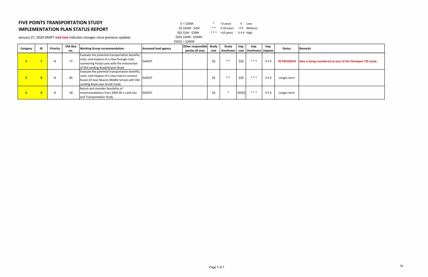
E. Invest in new infrastructure to support anticipated growth
Page 6 of 7 75
FIVE POINTS TRANSPORTATION STUDY $ < $200K * <3 years ◊ Low$$ $200K ‐ $2M * * 3‐10 years ◊ ◊ Medium$$$ $2M ‐ $20M * * * >10 years ◊ ◊ ◊ High
January 27, 2020 DRAFT (red text indicates changes since previous update) $$$$ $20M ‐ $200M$$$$$ > $200M
Category ID PriorityOld idea
no.Working Group recommendation Assumed lead agency
Other responsible parties (if any)
Studycost
Studytimeframe
Imp.cost
Imp.timeframe
Imp.impacts
Status Remarks
IMPLEMENTATION PLAN STATUS REPORT
E 7 N 77
Evaluate the potential transportation benefits, costs, and impacts of a new through road connecting Postal Lane with the intersection of Old Landing Road/Airport Road
DelDOT $$ * * $$$ * * * ◊ ◊ ◊ IN PROGRESS Idea is being considered as part of the Henlopen TID study.
E 8 N 85
Evaluate the potential transportation benefits, costs, and impacts of a new road to connect Route 24 near Beacon Middle School with Old Landing Road near Arnell Creek
DelDOT $$ * * $$$ * * * ◊ ◊ ◊ Longer‐term
E 9 N 30Revisit and consider feasibility of recommendations from 2003 SR 1 Land Use and Transportation Study
DelDOT $$ * $$$$$ * * * ◊ ◊ ◊ Longer‐term
Page 7 of 7 76
Related Documents