1. List of Appendices I Color Photos 1. Historic Photos of Flood Events 2. Ramona Grasslands Wildlife Area II Tables 1. Santa Maria Creek Flood Protection Corridor: Priority Properties 2. Santa Maria Creek Flood Protection Corridor: Adjacent Property Owners III Maps 1. Santa Maria Creek Flood Protection Corridor: Geographic Location and Regional Context/ FEMA Flood Plain Overlay. IV Flood Related News Articles V List of Sensitive Species VI Documentation of Community Support VII Willing Seller Letters VIII Financial Summary IX Section 497.7 Checklist

Welcome message from author
This document is posted to help you gain knowledge. Please leave a comment to let me know what you think about it! Share it to your friends and learn new things together.
Transcript

1. List of Appendices
I Color Photos 1. Historic Photos of Flood Events 2. Ramona Grasslands Wildlife Area
II Tables
1. Santa Maria Creek Flood Protection Corridor: Priority
Properties 2. Santa Maria Creek Flood Protection Corridor: Adjacent
Property Owners III Maps
1. Santa Maria Creek Flood Protection Corridor: Geographic Location and Regional Context/ FEMA Flood Plain Overlay.
IV Flood Related News Articles V List of Sensitive Species VI Documentation of Community Support VII Willing Seller Letters VIII Financial Summary IX Section 497.7 Checklist

I. Color Photos
1. Historic Photos of Flood Events 2. Ramona Grasslands Wildlife Area

1998 East end Voorhes Ln.
Etcheverry Creek joins Tributary from Hidden Valley Road

February 1980 Confluence of Etcheverry Creek and Santa Maria Creek
Westerly view from property at 17279 Voorhes Ln. Ramona, CA
1998 Etcheverry Creek
East end Voorhes Ln.
Cummings South/East Tributary from Highland Valley Rd.
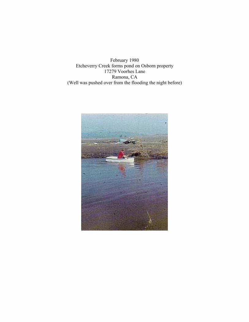
February 1980 Etcheverry Creek forms pond on Osborn property
17279 Voorhes Lane Ramona, CA
(Well was pushed over from the flooding the night before)

Ramona Grasslands Wildlife Area
White Heron in Vernal Pool Cagney Property

II Tables
1. Santa Maria Creek Flood Protection Corridor: Priority Properties
2. Santa Maria Creek Flood Protection Corridor: Adjacent
Property Owners

Rank Property Name Owner/Contact Address City State Zip APNS Acres Total Dev? # Homes
1 CAGNEY WILLIAM J TRUST THERESA MORRISON 23 CORPORATE PLAZA DR #205 NEWPORT BEACH CA 92660 2771210200 79.10(under contract) 2771210300 119.53
2810101400 23.222810101200 21.702820100100 160.002820100200 10.002820100300 10.002820100400 20.002820100500 10.002820100600 10.002820103500 20.00 483.6 N/A
2 McARTHUR, MARK 215 N EASTERN SLOPE LOOP TUCSON AZ 85748 2761110500 80.00 Y(OAK COUNTRY ESTATES/ DON WHITE ) 2770500100 41.47 Y
2770500600 338.27 Y2771110700 78.41 Y2771110800 39.10 Y2771210700 77.28 Y2770502100 112.31 766.8 Y 65
4 805 PROPERTIES GENE DRISCOLL 7338 TURNFORD DR SAN DIEGO CA 92119 2820104300 282.56 Y2830510100 25.05 Y2820103000 98.52 Y2830210100 39.95 Y2830210200 66.02 512.1 Y 150
5 HARDY DEAN A+ ILANA K 501 W. BROADWAY PLAZA #218 SAN DIEGO CA 92101 2820100800 30.002820103400 40.00 70.0
6 HOBBS LINDER C+MARY P TRS 4701 SURREY DRIVE CORONA DEL MAR CA 92625 2820103600 40.00 40.0
Table 1: Santa Maria Creek Flood Protection Corridor: Priority Properties. Acreages are approximate. "Dev?" indicates parcels for which development proposals are pending, as of February 2003.
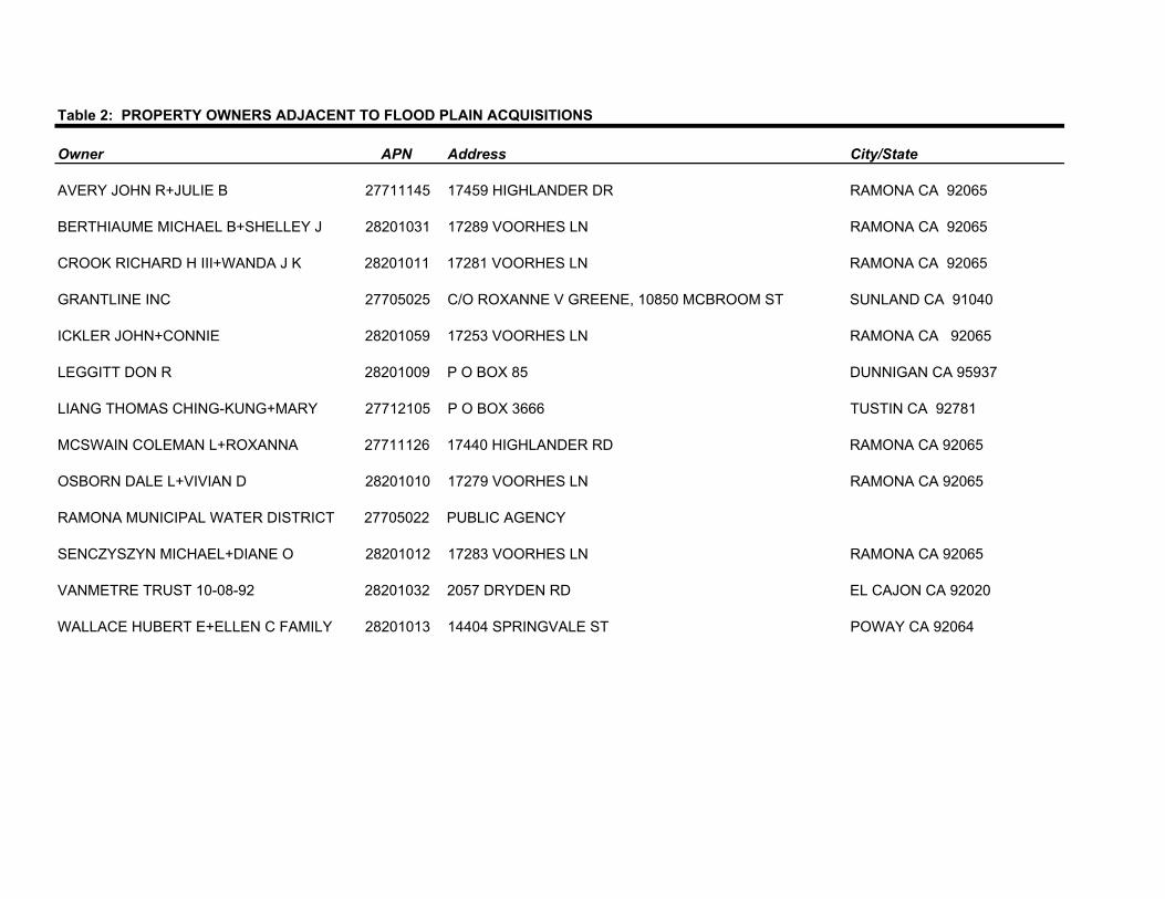
Owner APN Address City/State
AVERY JOHN R+JULIE B 27711145 17459 HIGHLANDER DR RAMONA CA 92065
BERTHIAUME MICHAEL B+SHELLEY J 28201031 17289 VOORHES LN RAMONA CA 92065
CROOK RICHARD H III+WANDA J K 28201011 17281 VOORHES LN RAMONA CA 92065
GRANTLINE INC 27705025 C/O ROXANNE V GREENE, 10850 MCBROOM ST SUNLAND CA 91040
ICKLER JOHN+CONNIE 28201059 17253 VOORHES LN RAMONA CA 92065
LEGGITT DON R 28201009 P O BOX 85 DUNNIGAN CA 95937
LIANG THOMAS CHING-KUNG+MARY 27712105 P O BOX 3666 TUSTIN CA 92781
MCSWAIN COLEMAN L+ROXANNA 27711126 17440 HIGHLANDER RD RAMONA CA 92065
OSBORN DALE L+VIVIAN D 28201010 17279 VOORHES LN RAMONA CA 92065
RAMONA MUNICIPAL WATER DISTRICT 27705022 PUBLIC AGENCY
SENCZYSZYN MICHAEL+DIANE O 28201012 17283 VOORHES LN RAMONA CA 92065
VANMETRE TRUST 10-08-92 28201032 2057 DRYDEN RD EL CAJON CA 92020
WALLACE HUBERT E+ELLEN C FAMILY 28201013 14404 SPRINGVALE ST POWAY CA 92064
Table 2: PROPERTY OWNERS ADJACENT TO FLOOD PLAIN ACQUISITIONS

III Map
1. Santa Maria Creek Flood Protection Corridor: Geographic Location and
Regional Context/ FEMA Flood Plain Overlay.

��������������
����
������ ��������
�������
�������
������������ ��������
��������������
����������
������ ��� �
������������ ���� �
���
����
����
����� ����
������� ���������
�������������������������������
�����������
�����
�����
�
�������
�������
����������������������������� ��������������!������"
������
���������
����
����
����
����
����
����������������
�� ����������������#����$��%��&��'��(���)��
��*������++����+�������,������'�����-�$����%������
������������.�))��(���*���#����������
����
�����������-�$����%/00�����������1�%/00�����������������200�����������������
����3���$��%�������$&�����������$&�� ���**����������#����,�
���)�+������.�))��(���*���#��������������3���$��%����������
�
0 042 / ����+
Related Documents