S cientists integrate models to assess the impacts of climate change and climate variability on water resources and ecosystems. In this context, integration occurs between atmospheric and hydrologic models by downscaling and bias correcting Global Circulation Models (GCM) climate projections (e.g., precipitation and temperature data sets) and feeding these data as boundary conditions into a hydrologic model. Integrated models can help water managers and policymakers make more informed decisions when planning for future climate conditions, such as managing for changes in the timing and quantity of available water (Hay et al. 2002; Salathé 2004; Hanson and Dettinger 2005; Maurer and Hidalgo 2008). Downscaling is an important step in integrated modeling because the spatial resolution of GCM simulated temperature and precipitation (~100 – 250 km) is too coarse for watershed-scale hydrologic modeling. As such, downscaling approaches combine GCM climate output with regional climate models (RCMs) and/ or sub-regional climate information to alleviate the scale problem (Hay et al. 2002; Fowler et al. 2007; Maurer and Hidalgo 2008; Huntington and Niswonger 2011). In mountainous environments, it is especially important to incorporate fine-scale information into coarse GCM projections for hydrologic modeling because of the altitude-dependence of precipitation and temperature that is not reflected at the GCM resolution (Seager and Vecchi 2010). Downscaling GCM data is necessary to properly simulate hydrologic processes that are sensitive to altitude (e.g., snow pack development, snowmelt runoff, soil moisture, and evapotranspiration). Many methods have been used for downscaling GCM output to a finer spatial resolution, and most result in temperature and precipitation data sets at spatial resolutions around 10 km (Lettenmaier UNIVERSITIES COUNCIL ON WATER RESOURCES JOURNAL OF CONTEMPORARY WATER RESEARCH & EDUCATION ISSUE 147, PAGES 17-27, MARCH 2012 Linking Global Climate Models to an Integrated Hydrologic Model: Using an Individual Station Downscaling Approach John F. Mejia 1 , Justin Huntington 1 , Benjamin Hatchett 1 , Darko Koracin 1 , and Richard G. Niswonger 2 1 Desert Research Institute, Reno, NV; 2 USGS, Carson City, NV Abstract: This paper implements an individual station-based downscaled approach based on a quantil– quantile bias correction mapping to further downscale regional gridded simulated output into individual station locations. We describe and propose a framework to optimize the usefulness of this downscaling approach over small watersheds in mountain regions, where downscale gridded data (~10km) is still too coarse for use in sub-regional hydrologic simulation studies. Two regional downscaled data sets were downscaled to individual station locations: the Desert Research Institute-Regional Climate Model based on the Weather Research and Forecasting model (DRI-RCM; 12 km resolution); and the US Bureau of Reclamation Bias-Corrected Spatial Disaggregation (BCSD; 12 km resolution). We applied the station- based downscaled data in the integrated hydrologic model, GSFLOW, as adapted to the Incline Creek watersheds in the northeastern Lake Tahoe basin. Hydrologic model results showed that the proposed downscaled approach provides reasonable downscaled climate data that can be used to evaluate sub- regional scale hydrologic processes. Keywords: Dynamical and statistical downscaling, integrated hydrological modeling 17 UCOWR JOURNAL OF CONTEMPORARY WATER RESEARCH & EDUCATION

Welcome message from author
This document is posted to help you gain knowledge. Please leave a comment to let me know what you think about it! Share it to your friends and learn new things together.
Transcript

Scientists integrate models to assess the impacts of climate change and climate variability on water resources and ecosystems. In this
context, integration occurs between atmospheric and hydrologic models by downscaling and bias correcting Global Circulation Models (GCM)climate projections (e.g., precipitation and temperature data sets) and feeding these data as boundary conditions into a hydrologic model. Integrated models can help water managers and policymakers make more informed decisions when planning for future climate conditions, such as managing for changes in the timing and quantity of available water (Hay et al. 2002; Salathé 2004; Hanson and Dettinger 2005; Maurer and Hidalgo 2008). Downscaling is an important step in integrated modeling because the spatial resolution of GCM simulated temperature and precipitation (~100 – 250 km) is too coarse for watershed-scale hydrologic modeling. As such,
downscaling approaches combine GCM climate output with regional climate models (RCMs) and/or sub-regional climate information to alleviate the scale problem (Hay et al. 2002; Fowler et al. 2007; Maurer and Hidalgo 2008; Huntington and Niswonger 2011).
In mountainous environments, it is especially important to incorporate fine-scale information into coarse GCM projections for hydrologic modeling because of the altitude-dependence of precipitation and temperature that is not reflected at the GCM resolution (Seager and Vecchi 2010). Downscaling GCM data is necessary to properly simulate hydrologic processes that are sensitive to altitude (e.g., snow pack development, snowmelt runoff, soil moisture, and evapotranspiration). Many methods have been used for downscaling GCM output to a finer spatial resolution, and most result in temperature and precipitation data sets at spatial resolutions around 10 km (Lettenmaier
Universities CoUnCil on Water resoUrCes JoUrnal of Contemporary Water researCh & edUCation
issUe 147, pages 17-27, marCh 2012
Linking Global Climate Models to an Integrated Hydrologic Model: Using an Individual Station
Downscaling Approach John F. Mejia1, Justin Huntington1, Benjamin Hatchett1,
Darko Koracin1, and Richard G. Niswonger2
1Desert Research Institute, Reno, NV; 2USGS, Carson City, NV
Abstract: This paper implements an individual station-based downscaled approach based on a quantil–quantile bias correction mapping to further downscale regional gridded simulated output into individual station locations. We describe and propose a framework to optimize the usefulness of this downscaling approach over small watersheds in mountain regions, where downscale gridded data (~10km) is still too coarse for use in sub-regional hydrologic simulation studies. Two regional downscaled data sets were downscaled to individual station locations: the Desert Research Institute-Regional Climate Model based on the Weather Research and Forecasting model (DRI-RCM; 12 km resolution); and the US Bureau of Reclamation Bias-Corrected Spatial Disaggregation (BCSD; 12 km resolution). We applied the station-based downscaled data in the integrated hydrologic model, GSFLOW, as adapted to the Incline Creek watersheds in the northeastern Lake Tahoe basin. Hydrologic model results showed that the proposed downscaled approach provides reasonable downscaled climate data that can be used to evaluate sub-regional scale hydrologic processes.Keywords: Dynamical and statistical downscaling, integrated hydrological modeling
17
UCOWRJournal of Contemporary Water researCh & eduCation
et al. 1999; Wood et al. 2002; Salathé 2003; Wood et al. 2004; Maurer and Hidalgo 2008), making further downscaling necessary for watershed-scale hydrologic modeling, which is typically at a scale of <1 km.
Downscaling methods generally fall into three categories, statistical, dynamical, and hybrid statistical-dynamical downscaling. Statistical methods are the most commonly used (Wilby et al. 2004); however, dynamical and hybrid methods are becoming more popular due to their ability to incorporate non-stationary, regional-scale atmospheric processes into downscaled results (Leung et al. 2003). Statistical downscaling refers to modifying GCM output such that the statistical characteristics of the output (e.g., probability of occurrence) are consistent with the statistical characteristics of fine-scale climate data, typically taken from climate stations. Dynamical downscaling refers to the use of RCMs to produce climate data through regional-scale atmospheric simulations at a spatial scale smaller than the GCMs scale. Typically, RCMs simulate climate at scales between 10 and 50 km using initial and boundary conditions provided by GCMs, and they require large computational resources relative to
statistical approaches. However, RCMs provide a more realistic representation of regional climate processes as compared to statistical downscaling, yet the accuracy depends largely, as is the case with statistical downscaling, on the large-scale results provided by GCMs (Piani et al. 2010).
Statistical downscaling approaches are computationally efficient and are easily reproducible, but they rely on relationships that are invariant in a changing climate between large-scale GCM and regional scale climate variables (Sharma et al. 2007). The efficiency of statistical downscaling facilitates the use of many different GCM model outputs and scenarios to generate a wide range of climate projections, which is useful considering model uncertainty (Tebaldi and Knutti 2007; Pielke et al. 2009). Primary drawbacks associated with statistical downscaling include: (1) the stationary assumption of the regression relationships may not hold for climate conditions other than the training period; (2) no consideration of physical processes (i.e., land atmospheric interactions and feedbacks); (3) the prediction skill is limited to the skill of the input data; and (4) the necessity to have long-term, reliable observational datasets to develop statistical relationships.
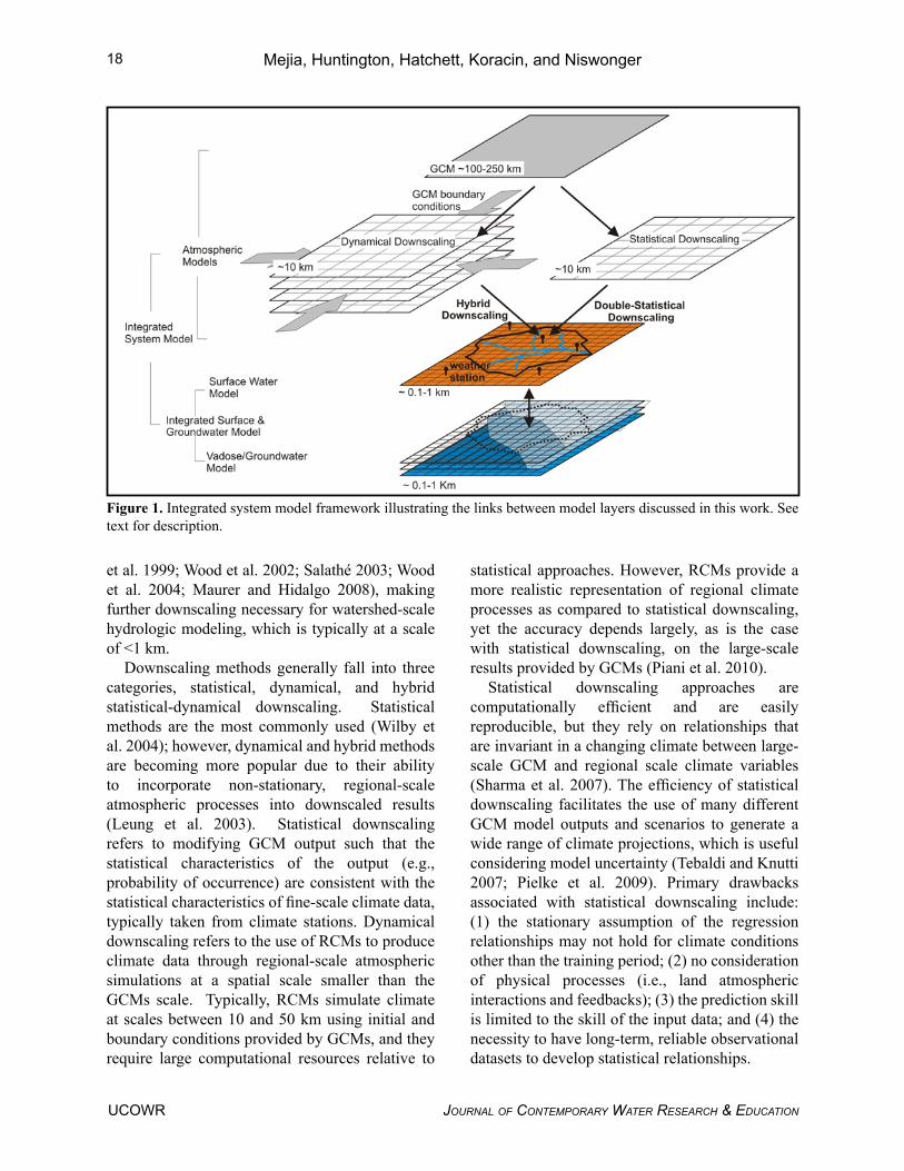
Figure 1. Integrated system model framework illustrating the links between model layers discussed in this work. See text for description.
Mejia, Huntington, Hatchett, Koracin, and Niswonger18
Journal of Contemporary Water researCh & eduCationUCOWR
A new approach is presented herein for downscaling projections of temperature and precipitation from GCMs to a scale appropriate for forcing catchment-scale hydrologic models. The approach consists in a statistical downscaling method for bias correction to further downscale gridded simulated output from different regional downscaled gridded datasets to individual weather stations. When this method is combined with gridded dynamical downscaling approaches we call it a “hybrid downscaling”, and when combined with gridded statistical downscaling approaches we call it “double-statistical downscaling.” Figure 1 illustrates the hybrid and the double-statistical approach, including the steps involved and necessary modeling components. GCM model output provides large-scale bottom and lateral boundary conditions to the dynamical downscaling, which is further downscaled to the hydrologic model grid or individual weather stations using the hybrid approach. Alternatively, GCM model output can be re-gridded using statistical downscaling strategies and further downscaled using the double-statistical approach. In this work, we illustrate the application of the hybrid and double downscaled approach to simulate coupled surface and ground water interactions in three mountainous watersheds in the Lake Tahoe and Truckee River basins. These watersheds are of special interest because they provide water to nearby developed basins, and significant hydrologic change has been observed and associated with climate change in the region (Coats 2010; Huntington and Niswonger 2011). We show that the new hybrid approach improves the simulated climate and resulting hydrologic conditions in the mountainous watersheds modeled by Huntington and Niswonger (2011) relative to solely using dynamic or statistical downscaling approaches.
Data and Methodology Dynamic Downscaling
Dynamically downscaled simulations presented herein use a high-resolution regional climate models based on the Advanced Research - Weather and Research Forecasting model (WRFV3.2; Skamarock et al. 2008). RCM simulations are forced with the larger-scale GCM results that are
used to define bottom and lateral boundaries for the RCM domain (Figure 1). WRF is a weather forecasting model that has been adapted to run for much longer time periods, referred to as “climate mode” (decades instead of day-to-week long forecasts). Studies done by researchers at the Desert Research Institute (DRI), as well as other research groups, have found WRF to be suitable for regional to sub-regional dynamical downscaling purposes and climate change assessment (Takle et al. 2007; Qian et al. 2009; Salathé et al. 2009; Mejia and Koracin 2011; Mejia et al. 2011). DRI uses a version of WRF that was modified for long-term climate simulations, called DRI-RCM. For this study, DRI-RCM was integrated for the period 1982-2007 over the western United States at 36 and 12 km resolution using GCM bottom and lateral boundaries from the National Center for Atmospheric Research-Community Climate System Model model version 3.0 (NCAR-CCSM3). In this work, only simulated daily 12 km minimum and maximum temperature and precipitation data were used.
Statistical Downscaling
Statistical downscaled data for this work is based on the US Bureau of Reclamation bias corrected and spatially disaggregated climate projections approach (Bias-Corrected Spatial Disaggregation; Maurer et al. 2007). The BCSD method is used to downscale monthly data, and uses a random resampling technique to generate daily values at 12 km grid size of minimum and maximum temperature and precipitation. BCSD has been applied for 16 different GCMs and 3 different emission scenarios; however, this work only uses the BCSD data for one NCAR-CCSM3 for comparison to the DRI-RCM model output.
Hybrid and Double-Statistical Downscaling
As described, the hybrid and double-statistical downscaling approaches combine both dynamical and statistical techniques, respectively, to generate climate projections that are appropriately scaled for use in a hydrologic model. They involve further post-processing of gridded climate projections to individual station locations, which is similar to weather forecasting applications, wherein model
Linking Global Climate Models
UCOWRJournal of Contemporary Water researCh & eduCation
19

output is post-processed to produce site-specific statistical information (Klein and Glahn 1974). RCM simulations exhibit biases and inaccuracies (Feser et al. 2011), and the statistical downscaling part of the hybrid approach objectively removes such biases by matching observed statistics, while retaining day-to-day variability of the simulated weather phenomena. The hybrid downscaling approach combines, the physics-based realism of dynamical downscaling with the computational efficiency of statistical downscaling, whereas the double-statistical approach removes scale and altitude specific biases from gridded statistical downscaled data (e.g., BCSD data). The steps in the implementation of the hybrid approach are: (i) quality control of primary weather station data; (ii) interpolation of gridded output from RCM (this work uses DRI-RCM) to horizontal station location using bi-linear approach (alternative options include, inverse distance, nearest neighborhood, and multilinear interpolation); (iii) detrending low-frequency modes; (iv) bias-correction using the quantile-quantile mapping technique from the empirical Cumulative Distribution Function (Panofsky and Brier 1968); and (v) re-trending.
The steps in the implementation of the double-statistical approach are the same as in the hybrid approach except for step (ii), where output from the RCM is replaced for gridded statistical downscaling data (this work uses BCSD). Drawbacks of these individual station downscaling approaches include those of the dynamical and statistical downscaling approaches, as described above.
Hydrologic Model (GSFLOW)
The GSFLOW is an integration of the USGS Precipitation-Runoff Modeling System and a Newton formulation of the USGS Modular Ground Water Flow Model (MODFLOW-NWT; Niswonger et al. 2011). GSFLOW was designed specifically for decade-to-century long simulation of surface and ground water flow while accounting for connections and interactions among terrestrial systems, streams, lakes, wetlands, and ground water. GSFLOW has been applied to simulate surface-ground water interaction in several basins across the United States (Niswonger et al. 2006; Hunt et al. 2008; Markstrom et al. 2008; Huntington and Niswonger 2011).
GSFLOW requires weather variables of
Figure 2. (Left) GSFLOW Study Area – 3 watersheds in eastern Sierra. Incline, Third, and Galena Creeks – 52 km2. Also shown in the location of the meteorological stations, Tahoe City (1897 m ASL) and Mt Rose (2696 m ASL), providing daily precipitation. (Right) Illustration of local biases introduced by complex terrain. For example, nearest simulated temperature near the station A’ will be systematically cooler temperatures (as those from higher elevations in grid point A). This type of bias is smaller over flatter terrain (B and B’). Notice that interpretation of physical parameters is sensitive to choice of horizontal interpolation scheme (e.g., bi-linear interpolation, nearest neighborhood, inverse distance).
20 Mejia, Huntington, Hatchett, Koracin, and Niswonger
Journal of Contemporary Water researCh & eduCationUCOWR
daily maximum and minimum temperature and precipitation to compute daily water and energy balances. Figure 2 shows the location of the study area and the location of the weather stations used as meteorological boundary conditions in GSFLOW. Climate is distributed spatially across the model (1900 m – 3000 m ASL) at 60 m resolution based on the parameter-elevation regression on independent slopes model mean monthly precipitation patterns (Daly et al. 1994), and daily temperature and precipitation recorded at the Natural Resource Conservation Service Mt. Rose SNOTEL station located at 2,696 m elevation, and the Tahoe City National Oceanic and Atmospheric Administration cooperative-observer weather station, located within 20 km of the model domain at 1,897 m (ASL). Figure 2 also
illustrates the hydrologic model area and the 12 km grid cell representing the resolution of climate data provided by the BCSD and DRI-RCM, where it is clearly evident that further interpolation of climate is necessary to properly simulate the spatial distribution of climate over the watershed. Observed and simulated (NCAR-CCSM3, BCSD, hybrid and double-statistical) meteorological information for the period 1982-2008 was used to develop individual station climate projections as input for the hydrologic model.
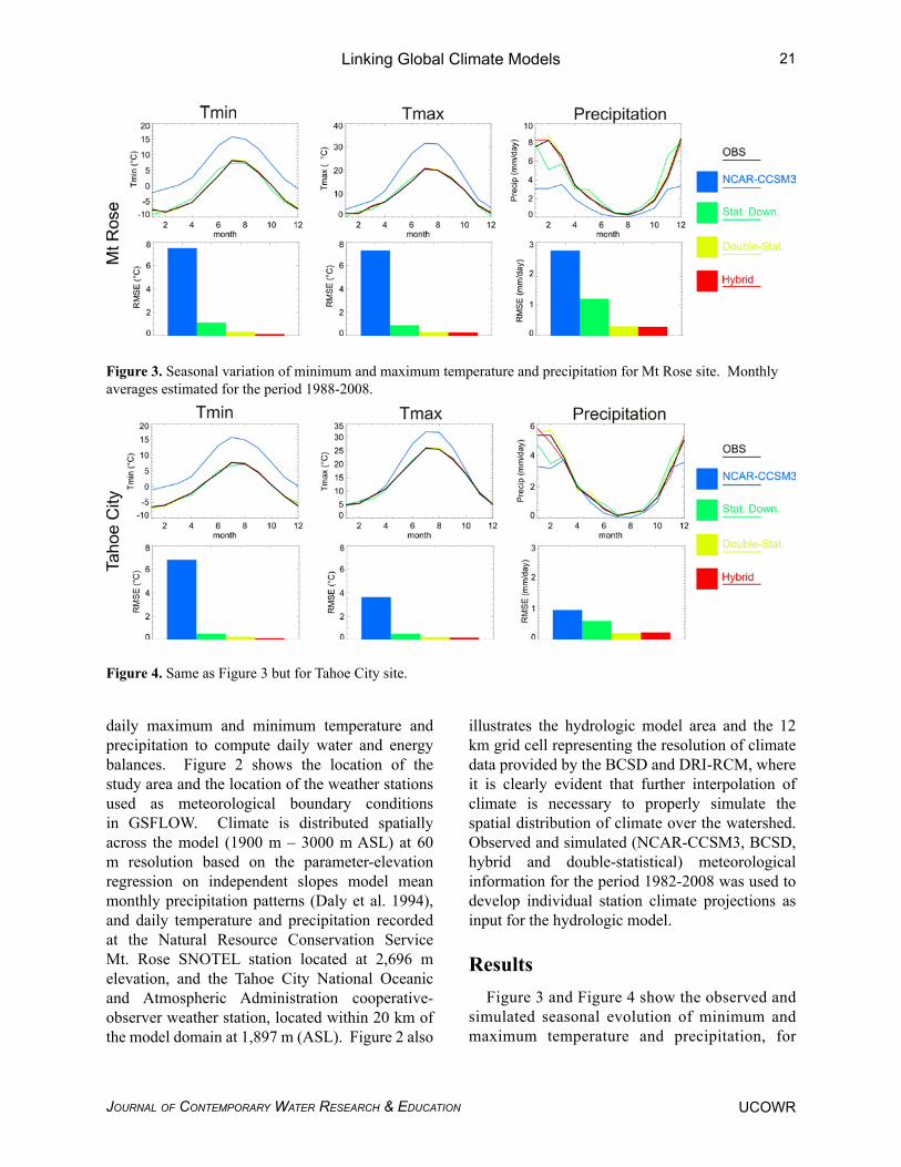
ResultsFigure 3 and Figure 4 show the observed and
simulated seasonal evolution of minimum and maximum temperature and precipitation, for
Figure 3. Seasonal variation of minimum and maximum temperature and precipitation for Mt Rose site. Monthly averages estimated for the period 1988-2008.
Figure 4. Same as Figure 3 but for Tahoe City site.
Linking Global Climate Models
UCOWRJournal of Contemporary Water researCh & eduCation
21

Mt. Rose and Tahoe City, respectively. Results are shown for statistical, double-statistical, and hybrid downscaling projections. Statistical downscaling alone captures the overall season-al evolution of these parameters for both sites, but for Mt. Rose it shows a noticeable tempera-ture offset during the spring and a precipitation offset during the winter. On the other hand, downscaling this information using the double-statistical and hybrid approaches reduce the root-mean-squared error relative to solely us-ing the statistical downscaling approaches. Par-ticularly, all downscaling methods show similar behavior except for winter precipitation. There the hybrid approach shows some improvement, presumably due to more realistic winter synop-tic conditions. For illustration purposes, we also show the results from interpolating the coarser NCAR-CCSM3 to the specific sites. Not sur-prisingly, the coarser NCAR-CCSM3 shows a poorer fit to the measured data. Coarse GCMs products smooth out the relief creating lower mountain peaks and associated warmer tem-perature bias, and underestimate cold season precipitation at both Mt. Rose and Tahoe City (Mejia et al. 2011).
Daily values of temperature and precipitation produced by hindcast simulations typically compare poorly to measured values. Improving simulated daily climate conditions is important for accurately simulating hydrologic processes. The occurrence of freezing and below freezing conditions (Tmin < 0 °C) must be simulated accurately to simulate snowpack development and melt, and the resulting runoff and streamflow in snow-dominated basins. Accurately simulating the correct threshold temperatures that are used by the model to determine the type of precipitation (snow or rain) is a difficult problem in hydrologic modeling. Thus, snowpack development and melt by simply evaluating the Tmin < 0 °C is rather arbitrary. The use of this threshold is solely to test variability of surface temperature fluctuations of the different downscaling approaches. Simulated minimum temperatures for Mt Rose based on NCAR-CCSM3 underestimates the number of days below freezing during the cold season (Oct.-May), where only 21 percent of this time is simulated as below freezing as compared to the measured data
showing that temperatures are below freezing 58 percent of the time. The hybrid approach simulates the percent of the cold season below freezing much better than the GCM (57 percent as compared to 21 percent) and slightly better than solely using statistical (45 percent) and double-statistical (55 percent) downscaling.
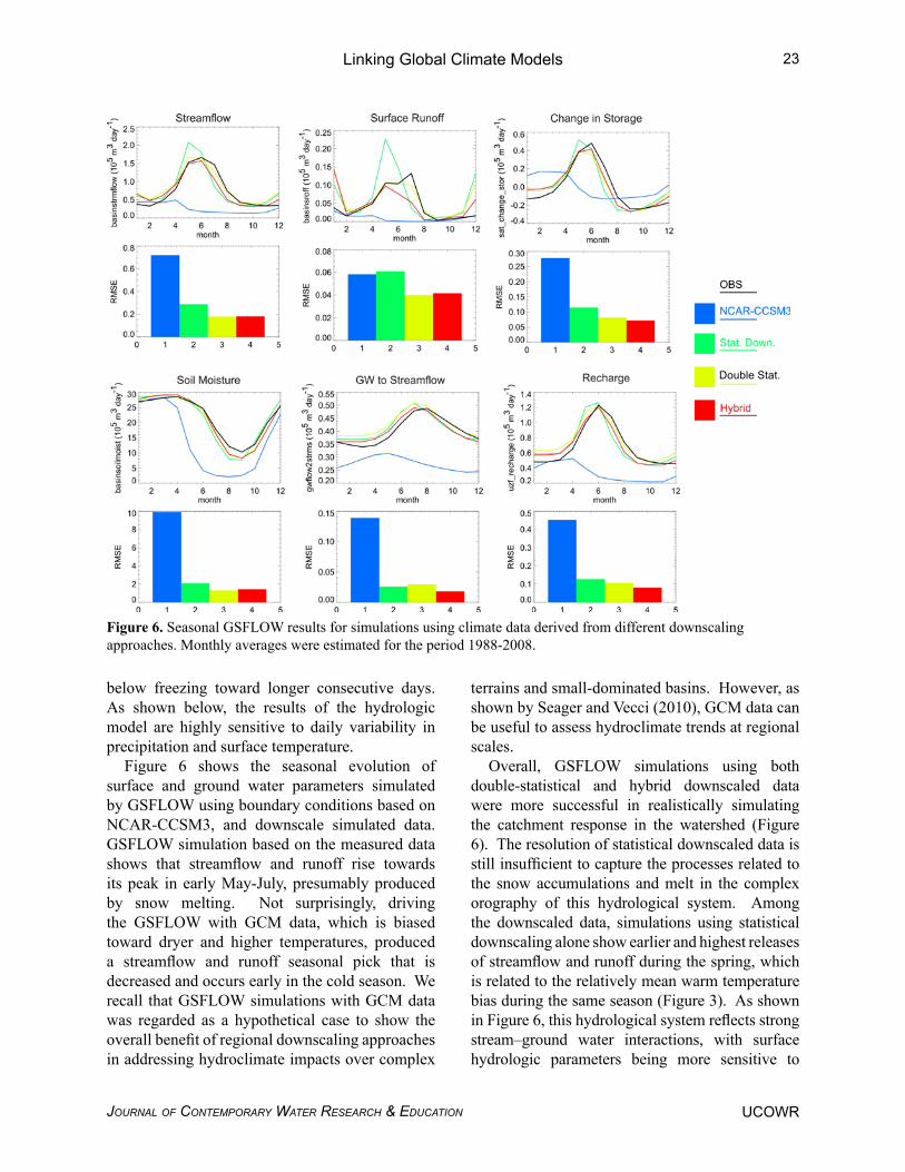
Figure 5 shows the distribution of days below freezing and highlights differences among the different downscaling approaches. Despite being biased toward higher temperatures, NCAR-CCSM3 overestimates the number of short consecutive days with below freezing temperatures. Figure 5 also shows that all downscaling strategies more accurately simulate the number of days below freezing as compared to NCAR-CCSM3. In general, differences are more apparent for number of short “excursions” of consecutive days below freezing. The differences among the downscaling approaches for number of long excursions of consecutive days below freezing become less apparent. The hybrid approach shows more realistic daily variability as evidenced by the comparison to measured days below freezing, but it slightly overestimates the number of short consecutive days below freezing. Both statistical and double- statistical approaches shift the distribution of days
Figure 5. Frequency of number of days below freezing based on minimum temperature at Mt. Rose surface station for the period 1988 to 2008.
22
Double Stat.
Mejia, Huntington, Hatchett, Koracin, and Niswonger
Journal of Contemporary Water researCh & eduCationUCOWR
below freezing toward longer consecutive days. As shown below, the results of the hydrologic model are highly sensitive to daily variability in precipitation and surface temperature.
Figure 6 shows the seasonal evolution of surface and ground water parameters simulated by GSFLOW using boundary conditions based on NCAR-CCSM3, and downscale simulated data. GSFLOW simulation based on the measured data shows that streamflow and runoff rise towards its peak in early May-July, presumably produced by snow melting. Not surprisingly, driving the GSFLOW with GCM data, which is biased toward dryer and higher temperatures, produced a streamflow and runoff seasonal pick that is decreased and occurs early in the cold season. We recall that GSFLOW simulations with GCM data was regarded as a hypothetical case to show the overall benefit of regional downscaling approaches in addressing hydroclimate impacts over complex
terrains and small-dominated basins. However, as shown by Seager and Vecci (2010), GCM data can be useful to assess hydroclimate trends at regional scales.
Overall, GSFLOW simulations using both double-statistical and hybrid downscaled data were more successful in realistically simulating the catchment response in the watershed (Figure 6). The resolution of statistical downscaled data is still insufficient to capture the processes related to the snow accumulations and melt in the complex orography of this hydrological system. Among the downscaled data, simulations using statistical downscaling alone show earlier and highest releases of streamflow and runoff during the spring, which is related to the relatively mean warm temperature bias during the same season (Figure 3). As shown in Figure 6, this hydrological system reflects strong stream–ground water interactions, with surface hydrologic parameters being more sensitive to
Figure 6. Seasonal GSFLOW results for simulations using climate data derived from different downscaling approaches. Monthly averages were estimated for the period 1988-2008.
Double Stat.
Linking Global Climate Models
UCOWRJournal of Contemporary Water researCh & eduCation
23
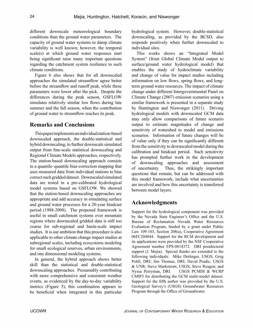
different downscale meteorological boundary conditions than the ground water parameters. The capacity of ground water systems to damp climate variability is well known; however, the temporal scale(s) at which ground water responses start being significant raise many important questions regarding the catchment system resilience to such climate conditions.
Figure 6 also shows that for all downscaled approaches the simulated streamflow agree better before the streamflow and runoff peak, while these parameters were lower after the pick. Despite the differences during the peak season, GSFLOW simulates relatively similar low flows during late summer and the fall season, when the contribution of ground water to streamflow reaches its peak.
Remarks and ConclusionsThis paper implements an individual station-based
downscaled approach, the double-statistical and hybrid downscaling, to further downscale simulated output from fine-scale statistical downscaling and Regional Climate Models approaches, respectively. The station-based downscaling approach consists in a quantile–quantile bias-correction mapping that uses measured data from individual stations to bias correct such gridded dataset. Downscaled simulated data are tested in a pre-calibrated hydrological model systems based on GSFLOW. We showed that the station-based downscaling approaches are appropriate and add accuracy in simulating surface and ground water processes for a 20-year hindcast period (1988-2008). The proposed framework is useful in small catchment systems over mountain regions where downscaled gridded data is still too coarse for sub-regional and basin-scale impact studies. It is our ambition that this procedure is also applicable to other climate change impact studies at subregional scales, including ecosystems modeling for small ecological reserves, urban environments, and one dimensional modeling systems.
In general, the hybrid approach shows better skill than the statistical and double-statistical downscaling approaches. Presumably contributing with more comprehensive and consistent weather events, as evidenced by the day-to-day variability metrics (Figure 5), this combination appears to be beneficial when integrated in this particular
hydrological system. However, double-statistical downscaling, as provided by the BCSD, also responds positively when further downscaled to individual sites.
This works shows an “Integrated Model System” (from Global Climate Model output to surface/ground water hydrological model) that enables the study of hydroclimate variability and change of value for impact studies including information on low flows, spring flows, and long-term ground water resources. The impact of climate change under different Intergovernmental Panel on Climate Change (2007) emission scenarios using a similar framework is presented in a separate study by Huntington and Niswonger (2011). Driving hydrological models with downscaled GCM data may only allow comparisons of future scenario output to estimate magnitudes of change and sensitivity of watershed to model and emissions scenarios. Information of future changes will be of value only if they can be significantly different from the sensitivity to downscaled model during the calibration and hindcast period. Such sensitivity has prompted further work in the development of downscaling approaches and assessment of uncertainty. Thus, the strikingly important questions that remain, but can be addressed with this model framework, include what uncertainties are involved and how this uncertainty is transferred between model layers.
AcknowledgmentsSupport for the hydrological component was provided by the Nevada State Engineer’s Office and the U.S. Bureau of Reclamation Nevada Water Resources Evaluation Program, funded by a grant under Public Law 109-103, Section 208(a), Cooperative Agreement 06FC204044. Support for the RCM development and its applications were provided by the NSF Cooperative Agreement number EPS-0814372. DRI postdoctoral support (J. Mejia). Special thanks are extended to the following individuals: Mike Dettinger, USGS; Greg Pohll, DRI; Jim Thomas, DRI; David Prudic, USGS & UNR; Steve Markstrom, USGS; Steve Reagen; and Nyssa Perryman, DRI. USGS PCMDI & WCRP CMIP3 for distributing the GCM multi-model dataset. Support for the fifth author was provided by the U.S. Geological Survey’s (USGS) Groundwater Resources Program through the Office of Groundwater.
24 Mejia, Huntington, Hatchett, Koracin, and Niswonger
Journal of Contemporary Water researCh & eduCationUCOWR
Author Bios and Contact InformationJohn Mejia is an assistant research professor at the Desert Research Institute. His research focuses on the development of “statistical” and “dynamical” based downscaling techniques using Global Climate Modeling products into space scales relevant for regional and local impact studies, and on the implementation of transportable methodologies to improve the applicability of such products into climate impact studies. He may be contacted at [email protected] or at Desert Research Institute, 2215 Raggio Parkway, Reno, NV 89512.
Justin Huntington is an assistant research hydroclimatologist at the Desert Research Institute. His research areas include integrated hydrologic modeling, climate, land surface energy balance measurement and modeling, and remote sensing. He can be contacted at [email protected].
Ben Hatchett is a graduate student in Atmospheric Sciences at the Desert Research Institute in Reno, Nevada. He is interested in Earth’s landscapes. He can be contacted at [email protected].
Darko Koracin, a Research Professor at DRI, has over 20 years of experience in managing atmospheric, dispersion, renewable energy, climate, and air quality studies as well as developing and adapting numerical and computational models for various applications. He investigates weather and climate phenomena through the development and application of high-resolution mesoscale meteorological models, microscale models, as well as global and regional climate models. His expertise includes assessing the emission, transport, and dispersion of environmental pollutants using regulatory and advanced air quality models for complex terrain and principles of artificial intelligence. He can be contacted at [email protected].
Richard Niswonger, a research hydrologist at the US Geological Survey, works on numerical model development and application as applied to surface-water and groundwater interaction problems around the world. He has published codes for the MODFLOW family of programs, and was a co-developer of the integrated hydrologic model, GSFLOW. He can be contacted at [email protected].
ReferencesCoats, R. 2010. Climate change in the Tahoe basin:
regional trends, impacts and drivers, Climatic Change. 102 (3):435-466. DOI 10.1007/s10584-010-9828-3.
Daly, C., R.P. Neilson, and D.L. Phillips, 1994. A statistical-topographic model for mapping climatological precipitation over mountanious terrain. Journal of Applied Meteorology 33: 140-158.
Feser, F., B. Rockel, H. von Storch, J. Winterfeldt, and M. Zahn, 2011. Regional climate models add value to Global Model Data – A Review and selected Examples, Bulletin of the American Meteorological Society; e-View, doi: 10.1175/2011BAMS3061.1.
Fowler, H. J., S. Blenkinsop, and C. Tebaldi. 2007. Linking climate change modelling to impacts studies: recent advances in downscaling techniques for hydrological modelling. International Journal of Climatology 27:1547-1578.
Hanson, R. T. and M. D. Dettinger. 2005. Ground Water/Surface Water Response to global Climate Simulations, Santa Clara-Calleguas Basin, Ventura, California. Journal of the American Water Resources Association 41 (3):517–536. doi: 10.1111/j.1752-1688.2005.tb03752.x.
Hay, L. E., M. P. Clark, R. L. Wilby, W. J. Gutowski, G. H. Leavesley, Z. Pan, R. W. Arritt, E. S. Takle. 2002. Use of Regional Climate Model Output for Hydrologic Simulations. Journal of Hydrometeorology 3: 571–590.
Hunt, R.J., D.E. Prudic, J.F. Walker, and M.P. Anderson. 2008. Importance of unsaturated zone flow for simulating recharge in a humid climate. Ground Water 46(4): 551-560. doi:10.1111/j.1745-6584.2007.00427.x.
Huntington, J.L. and R.G. Niswonger. 2011. Role of surface and groundwater interactions on declining baseflows in snow dominated regions: An integrated modeling approach. Geophysical Research Letter, (submitted).
IPCC. 2007. Intergovernmental Panel on Climate Change (IPCC) Fourth Assessment Working Group I Report. Climate Change 2007 The Physical Science Basis. ISBN 978 0521 88009-1.
Klein, William H. and H. R. Glahn. 1974. Forecasting local weather by means of model output statistics. Bulletin of the American Meteorological Society 55: 1217–1227.
Lettenmaier, D.P., A. W. Wood, R. N. Palmer, E. F. Wood, and E. Z. Stakhiv. 1999. Water resources implications of global warming: A US regional perspective. Climate Change 43: 537–579.
Leung, L.R., L.O. Mearns, F. Giorgi, and R.L. Wilby. 2003. Workshop on regional climate research: Needs and opportunities. Bulletin of the American Meteorological Society 84: 89-95.
25
UCOWRJournal of Contemporary Water researCh & eduCation
Linking Global Climate Models

Markstrom, S.L., R.G. Niswonger, R.S. Regan, D.E. Prudic, and P.M. Barlow. 2008. GSFLOW-Coupled Ground-water and Surface-water FLOW model based on the integration of the Precipitation-Runoff Modeling System (PRMS) and the Modular Ground-Water Flow Model (MODFLOW-2005). U.S. Geological Survey Techniques and Methods 6-D1, 240 p.
Maurer, E. P. and H. G. Hidalgo. 2008. Utility of daily vs. monthly large-scale climate data: An intercomparison of two statistical downscaling methods. Hydrology and Earth System Sciences 12: 551–563, doi:10.5194/hess-12-551-2008.
Maurer, E. P., L. Brekke, T. Pruitt, and P. B. Duffy. 2007. Fine-resolution climate projections enhance regional climate change impact studies. Eos Transactions, American Geophysical Union 88(47): 504.
Mejia, J., D. Koracin, E. M. Wilcox, and K. E. Kunkel. 2011. Assessment of AOGCM Biases for RCM Applications over the Great Basin in the Western U.S. Proceedings from 91st American Meteorological Society Annual Meeting, Joint Session 22: Regional Climate Modeling to Improve Climate Variability and Change Projections, American Meteorological Society. January 27, 2011. Seattle, WA.
Mejia, J. and D. Koracin. 2011. High-resolution regional climate simulations of precipitation patterns over the western U.S using WRF, Regional Climate Modeling to Improve Climate Variability and Change Projections at the Local Scale. Proceedings from 91st American Meteorological Society Annual Meeting. American Meteorological Society. January 27, 2011. Seattle, WA.
Niswonger, R.G., D.E. Prudic, and R.S. Regan. 2006. Documentation of the Unsaturated-Zone Flow (UZF1) Package for Modeling Unsaturated Flow between the Land Surface and the Water table with MODFLOW-2005. U.S. Geological Survey Techniques and Methods Book 6, Chapter A19, 62 p.
Niswonger, R.G., S. Panday, and I. Motomu. 2011. MODFLOW-NWT, A Newton Formulation for MODFLOW-2005. U.S. Geological Survey Techniques and Methods, 6-A37, 44p.
Panofsky, H. A. and G. W. Brier. 1968. Some Application of Statistics to Meteorology. Pennsylvania State University, pp224.
Piani, C., J. O. Haerter, and E. Coppola, 2010. Statistical bias correction for daily precipitation in regional climate models over Europe. Theoretical and Applied Climatology 99: 187–192.
Pielke, R. A., Sr., and Coauthors, 2009. Climate change: The need to consider human forcings
besides greenhouse gases. Eos, Transactions, American Geophysical Union 90: 413, doi:10.1029/2009EO450008.
Qian ,Y., S. J. Ghan, and L. R. Leung. 2009. Downscaling hydroclimatic changes over the Western U.S. based on CAM subgrid scheme and WRF regional climate simulations. International Journal of Climatolology DOI: 10.1002/joc.1928.
Salathé, E. P, L R. Leung, Y. Qian, and Y. Zhang. 2009. Regional Climate Model Projections for the State of Washington. Available online at http://cses.washington.edu/db/pdf/wacciach2rcm643.pdf.
Salathé, E. P. 2003. The effect of various precipitation downscaling methods on the simulation of streamflow in a rainshadow river basin. International Journal of Climatology 23: 887-901.
Salathé, E. P. 2004. Methods for selecting and downscaling simulations of future global climate with application to hydrologic modeling. International Journal of Climatology 25:419-436.
Seager, R. and G. Vecchi. 2010. Greenhouse warming and the 21st century hydroclimate of southwestern North America. Proceedings of the Natlional Academy of Scienes of the United States of America 107 (50): 21277-21282.
Sharma, D., A. D. Gupta, and M. S. Babel. 2007. Spatial disaggregation of bias corrected GCM precipitation for improved hydrologic simulation: Ping River basin, Thailand. Hydrology and Earth Systems Science 11: 1373–1390.
Skamarock, W. C., J. B. Klemp, J. Dudhia, D. O. Gill, D. M. Barker, M. Duda, X.-Y. Huang, W. Wang and J. G. Powers. 2008. NCAR Technical Note. http://www.mmm.ucar.edu/wrf/users/docs/arw_v3.pdf.
Takle, E. S., W. J. Gutowski Jr., R. W. Arritt, J. Roads, I. Meinke, B. Rockel, C. G. Jones, and A. Zadra. 2007. Transferability intercomparison: An opportunity for new insight on the global water cycle and energy budget. Bulletin of the American Meteorological Society 88: 375-384.
Tebaldi, C and R. Knutti. 2007. The use of the multi-model ensemble in probabilistic climate projections. Philosophical Transactions of the Royal Society A –Mathematical Physical and Engineering Sciences 365: 2053–2075.
Wilby, R.L., S.P. Charles, E. Zorita, B. Timbal, P. Whetton, and L.O. Mearns. 2004. Guidelines for use of climate scenarios developed from statistical downscaling methods. Available from the DDC of IPCC TGCIA, 27 pp.
26 Mejia, Huntington, Hatchett, Koracin, and Niswonger
Journal of Contemporary Water researCh & eduCationUCOWR
Wood, A., E.P. Maurer, A. Kumar, and D.P. Lettenmaier. 2002. Long range experimental hydrologic forecasting for the eastern United States. Journal of Geophysical Research 107 (D20): 4429, doi:10.1029/2001JD000659, 2002.
Wood, A. W., L. R. Leung, V. Sridhar, and D. P. Lettenmaier. 2004. Hydrologic implications of dynamical and statistical approaches to downscaling climate model outputs. Climatic Change 62 (1-3): 189-216.
27
UCOWRJournal of Contemporary Water researCh & eduCation
Linking Global Climate Models
Related Documents