Quickly capture high-accuracy 3D point clouds and panoramic imagery with LiBackpack. Survey and map indoor as well as outdoor spaces with ease. Accelerate you LiDAR data capture with LiBackpack from GreenValley International. Specifications DGC50 C50 System Weight (incl. camera) 8.6kg 7.1kg Relative Accuracy 3cm 3cm Absolute Accuracy 5-10cm N/A Power Consumption 50W 40W LiDAR LiDAR Sensors 2 1 Num of Channels 16 channels 16 channels Scan Range 100m@20%reflectance 100m@20%reflectance FOV (degree) Vertical(-90~90) Horizontal 360 Vertical(-15~15) Horizontal 360 Scan Rate (single return) 600,000 p/sec 300,000 p/sec DGC50 C50 GNSS Module Channels GPS: L1 C/A, L1C, L2C, L2P, L5. GLONASS: L1, C/A, L2C, L2P, L3, L5 BEIDOU: B1. B2 N/A Accuracy 1cm+1ppm N/A Working Mode Backpack Backpack+Handheld Camera Resolution 3840*1920 3840*1920 Frame Rate 30 30 FOV (degree) 360 360 Pixel 18 MP 18 MP 2120 University Ave, Berkeley, CA, USA 94704 I www.greenvalleyintl.com I [email protected] LIBACKPACK Wearable LiDAR Scanning System Stable Performance Accurate Positioning Lightweight and Portable Visible Light Data Affordable and Easy to Use 3 cm Relative Accuracy and 300,000 p/sec Capture Reality in 3D Gather and colorize high-fidelity LiDAR measurements at a rate of 600,000 p/sec to produce point cloud data with densities over 1,000 point per square meter. Real-Time Point Cloud Display Control data collection via any WiFi enabled device and watch point clouds render in real-time from your tablet or smartphone. Easy to Carry Lightweight structure and cushioning make the LiBackpack comfortable to use. User-friendly Data Processing LiFuser-BP makes working with LiBackpack data quick and painless with its one-click workflows. LiBackpack DGC50 LiBackpack C50 Via Jacopo Ruffini 9/1a 16128, GENOVA, ITALY I www.lidar-italia.it I info@lidar-italia.it (value added reseller)

Welcome message from author
This document is posted to help you gain knowledge. Please leave a comment to let me know what you think about it! Share it to your friends and learn new things together.
Transcript
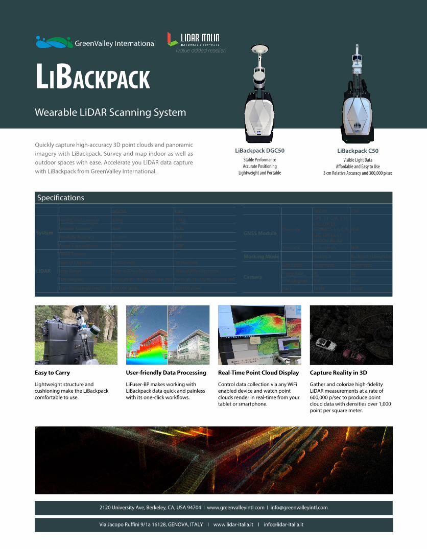
Quickly capture high-accuracy 3D point clouds and panoramic imagery with LiBackpack. Survey and map indoor as well as outdoor spaces with ease. Accelerate you LiDAR data capture with LiBackpack from GreenValley International.
Specifications
DGC50 C50
System
Weight (incl. camera) 8.6kg 7.1kg
Relative Accuracy 3cm 3cm
Absolute Accuracy 5-10cm N/A
Power Consumption 50W 40W
LiDAR
LiDAR Sensors 2 1
Num of Channels 16 channels 16 channels
Scan Range 100m@20%reflectance 100m@20%reflectance
FOV (degree) Vertical(-90~90) Horizontal 360 Vertical(-15~15) Horizontal 360
Scan Rate (single return) 600,000 p/sec 300,000 p/sec
DGC50 C50
GNSS ModuleChannels
GPS: L1 C/A, L1C, L2C, L2P, L5.GLONASS: L1, C/A, L2C, L2P, L3, L5BEIDOU: B1. B2
N/A
Accuracy 1cm+1ppm N/A
Working Mode Backpack Backpack+Handheld
Camera
Resolution 3840*1920 3840*1920
Frame Rate 30 30
FOV (degree) 360 360
Pixel 18 MP 18 MP
2120 University Ave, Berkeley, CA, USA 94704 I www.greenvalleyintl.com I [email protected]
LiBackpackWearable LiDAR Scanning System
Stable PerformanceAccurate Positioning
Lightweight and Portable
Visible Light DataAffordable and Easy to Use
3 cm Relative Accuracy and 300,000 p/sec
Capture Reality in 3D
Gather and colorize high-fidelity LiDAR measurements at a rate of 600,000 p/sec to produce point cloud data with densities over 1,000 point per square meter.
Real-Time Point Cloud Display
Control data collection via any WiFi enabled device and watch point clouds render in real-time from your tablet or smartphone.
Easy to Carry
Lightweight structure and cushioning make the LiBackpack comfortable to use.
User-friendly Data Processing
LiFuser-BP makes working with LiBackpack data quick and painless with its one-click workflows.
LiBackpack DGC50 LiBackpack C50
Via Jacopo Ruffini 9/1a 16128, GENOVA, ITALY I www.lidar-italia.it I [email protected]
(value added reseller)
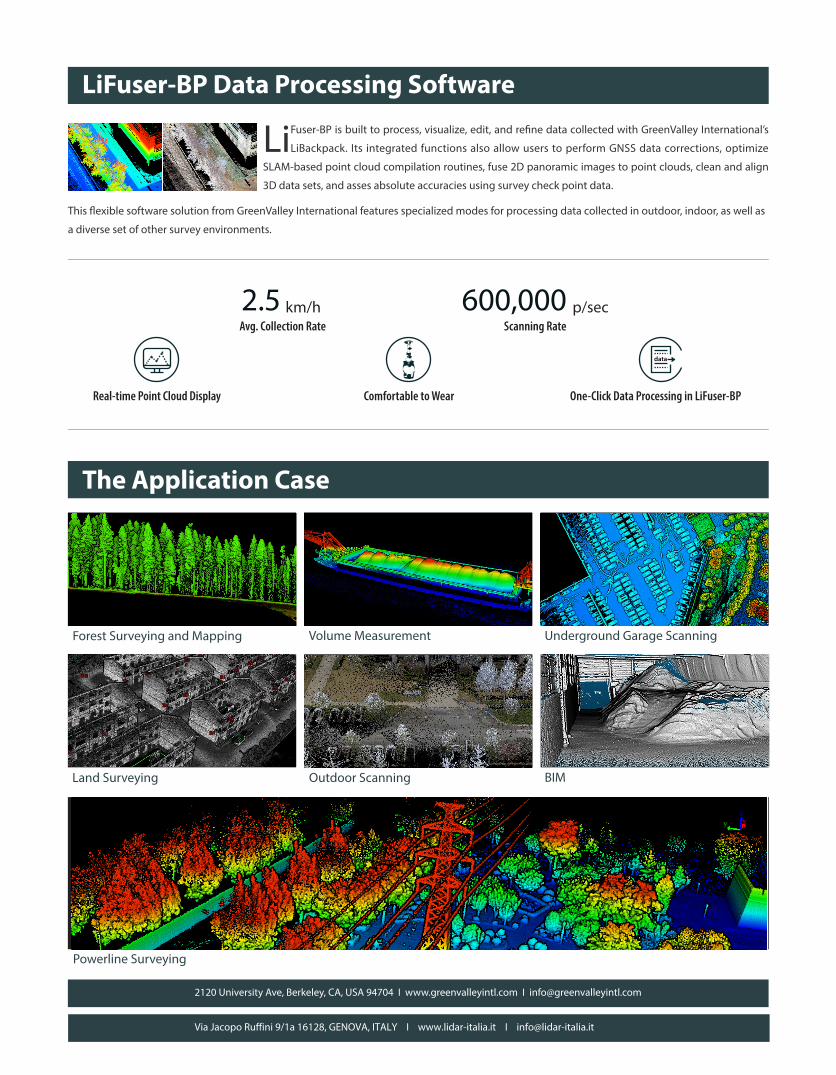
LiFuser-BP Data Processing Software
The Application Case
LiFuser-BP is built to process, visualize, edit, and refine data collected with GreenValley International’s
LiBackpack. Its integrated functions also allow users to perform GNSS data corrections, optimize
SLAM-based point cloud compilation routines, fuse 2D panoramic images to point clouds, clean and align
3D data sets, and asses absolute accuracies using survey check point data.
This flexible software solution from GreenValley International features specialized modes for processing data collected in outdoor, indoor, as well as
a diverse set of other survey environments.
2120 University Ave, Berkeley, CA, USA 94704 I www.greenvalleyintl.com I [email protected]
Avg. Collection Rate
One-Click Data Processing in LiFuser-BP
Scanning Rate
Real-time Point Cloud Display Comfortable to Wear
2.5 km/h 600,000 p/sec
data
Forest Surveying and Mapping
Powerline Surveying
Volume Measurement Underground Garage Scanning
BIMLand Surveying Outdoor Scanning
Via Jacopo Ruffini 9/1a 16128, GENOVA, ITALY I www.lidar-italia.it I [email protected]
Related Documents