LESSONS FROM NEPAL'S EARTHQUAKE FOR THE INDIAN HIMALAYAS AND THE GANGETIC PLAINS Edited by: Prof. S.P. Singh, Mr. Sudarshan C. Khanal, Prof. Madhu Joshi

Welcome message from author
This document is posted to help you gain knowledge. Please leave a comment to let me know what you think about it! Share it to your friends and learn new things together.
Transcript
LESSONS FROM NEPAL'S EARTHQUAKE FOR THE INDIAN HIMALAYAS AND THE GANGETIC PLAINSEdited by: Prof. S.P. Singh, Mr. Sudarshan C. Khanal, Prof. Madhu Joshi
XPR
ESSI
ON
S: 9
2195
5256
3
Doc
. No.
XPS
0605
1661
3
Supported by Tata Trusts
Knowledge Partner
G. B. Pant Institute of Himalayan Environment and Development, Almora
CENTRAL HIMALAYAN ENVIRONMENT ASSOCIATION
06, Waldorf Compound, Mallital, Nainital, 263001 Uttarakhand, India
t. 91 - 05942 233099t./f. 91 – 05942 233099e. [email protected] [email protected]
ALHIMAL
AYAN
ENVIRONMENT ASSOCIATIO
N
TCE
N

LESSONS FROM NEPAL'S EARTHQUAKE FOR THE INDIAN HIMALAYAS AND THE GANGETIC PLAINS

Dedicated to
Late Dr. Pushkin Phartiyal
Edited by
Prof. S.P. Singh, FNAChair, CHEA & Formerly, Vice Chancellor, H.N.B. Garhwal University, 09, Waldorf Compound, Mallital, Nainital
Mr. Sudarshan C. KhanalManager - Research, Planning and Communication, Asia Network for Sustainable Agriculture and Bioresources (ANSAB), Kathmandu, Nepal
Prof. Madhu JoshiFormerly, Professor, English Department, D.S.B. Campus, Kumaun University, Nainital
LESSONS FROM NEPAL'S EARTHQUAKE FOR THE INDIAN HIMALAYAS AND THE GANGETIC PLAINS
Design and RealisationXpressions Print & Graphics Pvt LtdUnit No. 150, Ist Floor, Vipul Trade Center,Sohna Road, Gurgaon-122002M. 9219552563
Doc No. XPS060516613
Material from this publication may be used for educational purposes provided due credit is given.
© CENTRAL HIMALAYAN ENVIRONMENT ASSOCIATION (CHEA)
Publication Coordinator:Mr. Kundan Bisht, CHEA, Nainital
C O N T E N T S
Preface
A Summary of Deliberations, Lessons and Recommendation from the Seminar
i iii
Increasing Gender Responsiveness During Disaster Response and Reconstruction - A Short Reflection from Nepal's Earthquake
B.R. Paudyal 056
2015 Nepal Earthquake: An Overview of ANSAB's Field Observations and Experiences
Bhishma P. Subedi andSudarshan C. Khanal
064
Doctor Jagdish Baidya 074 V Mahalingam and Debabrata Roy
Prevalence, Socio-demographic and Quality of Life (QOL) Correlates of Post-Traumatic Stress Disorder (PTSD) among the June 2013 Disaster Victims of Uttarakhand
078
Nepal Earthquake 2015: Local Planning for Relief and Recovery
Vandana Chauhan and Kshitij Gupta
084
A Short Note on the Impact of the Earthquake on the Mountain Ecology in Langtang National Park, Nepal
Madan Koirala 092 Dikshya Devkota
Relief and Recovery Efforts of Gorkha Foundation after 2015 EQ in Nepal – a Note on the Ground Perspectives
098 A. K. M. Khorshed Alam and Aktarul Ahsan
Bangladesh's Experience of the Nepal Earthquake: a Story of the Impact on a Seemingly Unconnected Region
102
Extant Seismicity and Regional Tectonic Interpretation: An illustration from Kumaun Himalaya, Uttarakhand, India.
030Charu C. Pant, Vivekanand Pathak and Santosh Joshi
xvi
The Way Forward
R. K. Dahal
Lessons Learnt from the 2015 Gorkha Earthquake in Nepal on the Engineering Geological Perspectives
015
Study of Kedarnath Disaster, 2013
A. Chevuturi, R.M. Devi and A.P. Dimri
045
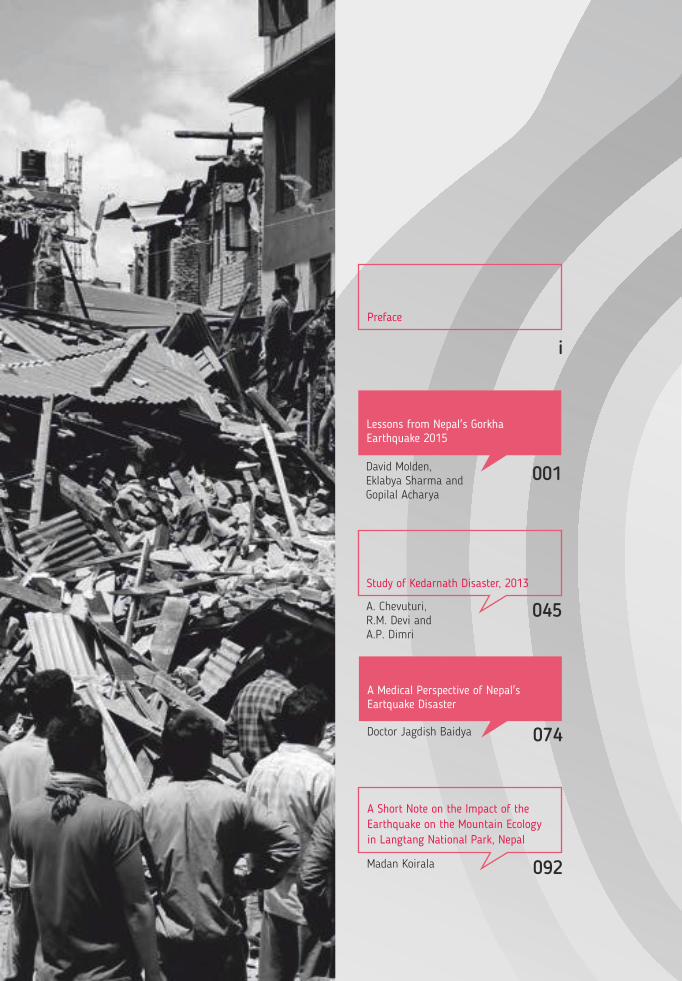
001David Molden, Eklabya Sharma and Gopilal Acharya
Lessons from Nepal's Gorkha Earthquake 2015
A Medical Perspective of Nepal's Eartquake Disaster
C O N T E N T S
Preface
A Summary of Deliberations, Lessons and Recommendation from the Seminar
i iii
Increasing Gender Responsiveness During Disaster Response and Reconstruction - A Short Reflection from Nepal's Earthquake
B.R. Paudyal 056
2015 Nepal Earthquake: An Overview of ANSAB's Field Observations and Experiences
Bhishma P. Subedi andSudarshan C. Khanal
064
Doctor Jagdish Baidya 074 V Mahalingam and Debabrata Roy
Prevalence, Socio-demographic and Quality of Life (QOL) Correlates of Post-Traumatic Stress Disorder (PTSD) among the June 2013 Disaster Victims of Uttarakhand
078
Nepal Earthquake 2015: Local Planning for Relief and Recovery
Vandana Chauhan and Kshitij Gupta
084
A Short Note on the Impact of the Earthquake on the Mountain Ecology in Langtang National Park, Nepal
Madan Koirala 092 Dikshya Devkota
Relief and Recovery Efforts of Gorkha Foundation after 2015 EQ in Nepal – a Note on the Ground Perspectives
098 A. K. M. Khorshed Alam and Aktarul Ahsan
Bangladesh's Experience of the Nepal Earthquake: a Story of the Impact on a Seemingly Unconnected Region
102
Extant Seismicity and Regional Tectonic Interpretation: An illustration from Kumaun Himalaya, Uttarakhand, India.
030Charu C. Pant, Vivekanand Pathak and Santosh Joshi
xvi
The Way Forward
R. K. Dahal
Lessons Learnt from the 2015 Gorkha Earthquake in Nepal on the Engineering Geological Perspectives
015
Study of Kedarnath Disaster, 2013
A. Chevuturi, R.M. Devi and A.P. Dimri
045
001David Molden, Eklabya Sharma and Gopilal Acharya
Lessons from Nepal's Gorkha Earthquake 2015
A Medical Perspective of Nepal's Eartquake Disaster
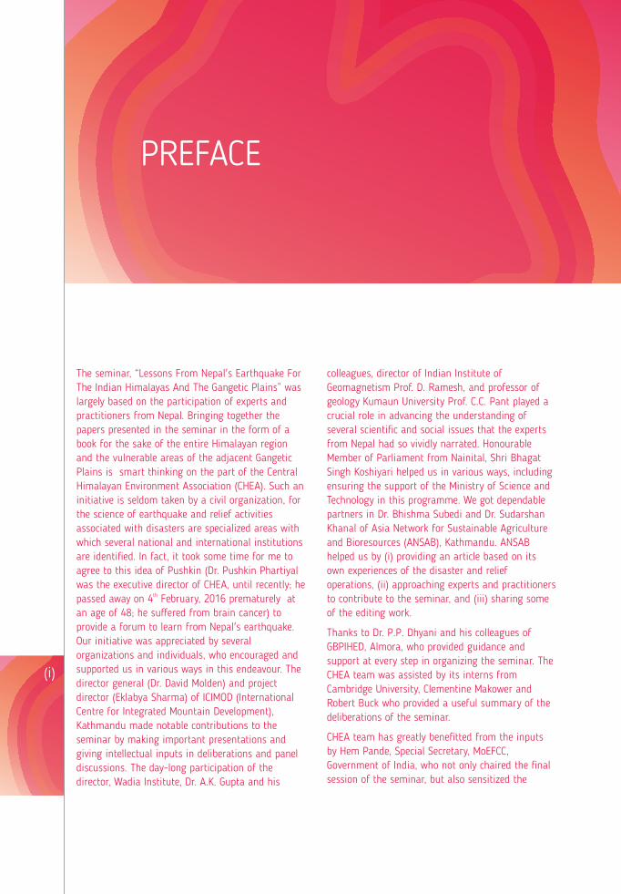
The seminar, “Lessons From Nepal's Earthquake For The Indian Himalayas And The Gangetic Plains” was largely based on the participation of experts and practitioners from Nepal. Bringing together the papers presented in the seminar in the form of a book for the sake of the entire Himalayan region and the vulnerable areas of the adjacent Gangetic Plains is smart thinking on the part of the Central Himalayan Environment Association (CHEA). Such an initiative is seldom taken by a civil organization, for the science of earthquake and relief activities associated with disasters are specialized areas with which several national and international institutions are identified. In fact, it took some time for me to agree to this idea of Pushkin (Dr. Pushkin Phartiyal was the executive director of CHEA, until recently; he
thpassed away on 4 February, 2016 prematurely at an age of 48; he suffered from brain cancer) to provide a forum to learn from Nepal's earthquake. Our initiative was appreciated by several organizations and individuals, who encouraged and supported us in various ways in this endeavour. The director general (Dr. David Molden) and project director (Eklabya Sharma) of ICIMOD (International Centre for Integrated Mountain Development), Kathmandu made notable contributions to the seminar by making important presentations and giving intellectual inputs in deliberations and panel discussions. The day-long participation of the director, Wadia Institute, Dr. A.K. Gupta and his
colleagues, director of Indian Institute of Geomagnetism Prof. D. Ramesh, and professor of geology Kumaun University Prof. C.C. Pant played a crucial role in advancing the understanding of several scientific and social issues that the experts from Nepal had so vividly narrated. Honourable Member of Parliament from Nainital, Shri Bhagat Singh Koshiyari helped us in various ways, including ensuring the support of the Ministry of Science and Technology in this programme. We got dependable partners in Dr. Bhishma Subedi and Dr. Sudarshan Khanal of Asia Network for Sustainable Agriculture and Bioresources (ANSAB), Kathmandu. ANSAB helped us by (i) providing an article based on its own experiences of the disaster and relief operations, (ii) approaching experts and practitioners to contribute to the seminar, and (iii) sharing some of the editing work.
Thanks to Dr. P.P. Dhyani and his colleagues of GBPIHED, Almora, who provided guidance and support at every step in organizing the seminar. The CHEA team was assisted by its interns from Cambridge University, Clementine Makower and Robert Buck who provided a useful summary of the deliberations of the seminar.
CHEA team has greatly benefitted from the inputs by Hem Pande, Special Secretary, MoEFCC, Government of India, who not only chaired the final session of the seminar, but also sensitized the
(i)
PREFACE
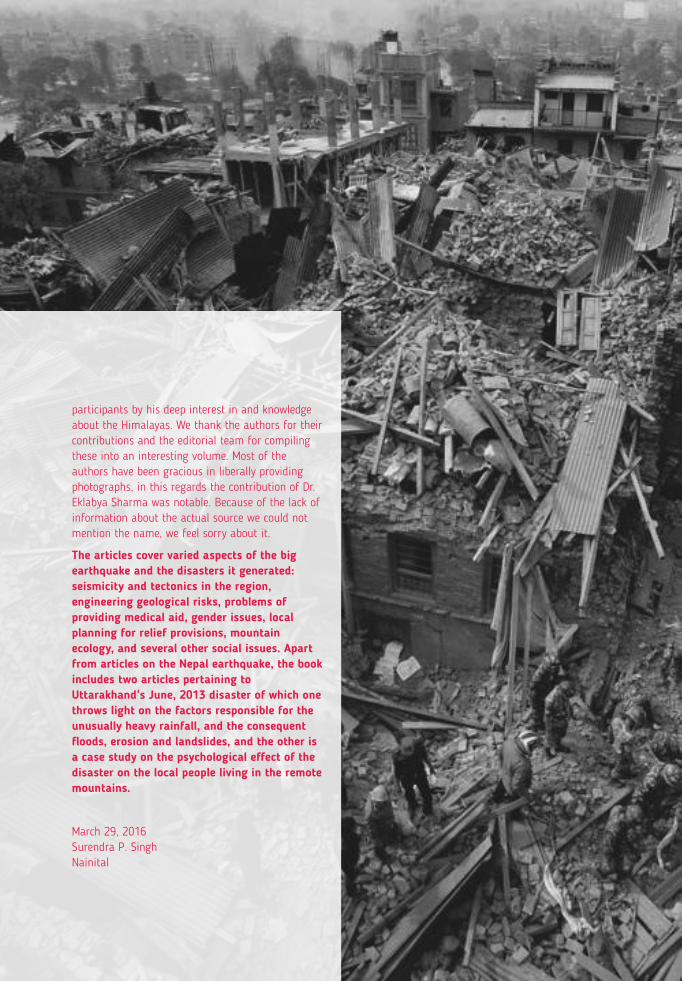
participants by his deep interest in and knowledge about the Himalayas. We thank the authors for their contributions and the editorial team for compiling these into an interesting volume. Most of the authors have been gracious in liberally providing photographs, in this regards the contribution of Dr. Eklabya Sharma was notable. Because of the lack of information about the actual source we could not mention the name, we feel sorry about it.
The articles cover varied aspects of the big earthquake and the disasters it generated: seismicity and tectonics in the region, engineering geological risks, problems of providing medical aid, gender issues, local planning for relief provisions, mountain ecology, and several other social issues. Apart from articles on the Nepal earthquake, the book includes two articles pertaining to Uttarakhand's June, 2013 disaster of which one throws light on the factors responsible for the unusually heavy rainfall, and the consequent floods, erosion and landslides, and the other is a case study on the psychological effect of the disaster on the local people living in the remote mountains.
March 29, 2016Surendra P. SinghNainital
The seminar, “Lessons From Nepal's Earthquake For The Indian Himalayas And The Gangetic Plains” was largely based on the participation of experts and practitioners from Nepal. Bringing together the papers presented in the seminar in the form of a book for the sake of the entire Himalayan region and the vulnerable areas of the adjacent Gangetic Plains is smart thinking on the part of the Central Himalayan Environment Association (CHEA). Such an initiative is seldom taken by a civil organization, for the science of earthquake and relief activities associated with disasters are specialized areas with which several national and international institutions are identified. In fact, it took some time for me to agree to this idea of Pushkin (Dr. Pushkin Phartiyal was the executive director of CHEA, until recently; he
thpassed away on 4 February, 2016 prematurely at an age of 48; he suffered from brain cancer) to provide a forum to learn from Nepal's earthquake. Our initiative was appreciated by several organizations and individuals, who encouraged and supported us in various ways in this endeavour. The director general (Dr. David Molden) and project director (Eklabya Sharma) of ICIMOD (International Centre for Integrated Mountain Development), Kathmandu made notable contributions to the seminar by making important presentations and giving intellectual inputs in deliberations and panel discussions. The day-long participation of the director, Wadia Institute, Dr. A.K. Gupta and his
colleagues, director of Indian Institute of Geomagnetism Prof. D. Ramesh, and professor of geology Kumaun University Prof. C.C. Pant played a crucial role in advancing the understanding of several scientific and social issues that the experts from Nepal had so vividly narrated. Honourable Member of Parliament from Nainital, Shri Bhagat Singh Koshiyari helped us in various ways, including ensuring the support of the Ministry of Science and Technology in this programme. We got dependable partners in Dr. Bhishma Subedi and Dr. Sudarshan Khanal of Asia Network for Sustainable Agriculture and Bioresources (ANSAB), Kathmandu. ANSAB helped us by (i) providing an article based on its own experiences of the disaster and relief operations, (ii) approaching experts and practitioners to contribute to the seminar, and (iii) sharing some of the editing work.
Thanks to Dr. P.P. Dhyani and his colleagues of GBPIHED, Almora, who provided guidance and support at every step in organizing the seminar. The CHEA team was assisted by its interns from Cambridge University, Clementine Makower and Robert Buck who provided a useful summary of the deliberations of the seminar.
CHEA team has greatly benefitted from the inputs by Hem Pande, Special Secretary, MoEFCC, Government of India, who not only chaired the final session of the seminar, but also sensitized the
(i)
PREFACE
participants by his deep interest in and knowledge about the Himalayas. We thank the authors for their contributions and the editorial team for compiling these into an interesting volume. Most of the authors have been gracious in liberally providing photographs, in this regards the contribution of Dr. Eklabya Sharma was notable. Because of the lack of information about the actual source we could not mention the name, we feel sorry about it.
The articles cover varied aspects of the big earthquake and the disasters it generated: seismicity and tectonics in the region, engineering geological risks, problems of providing medical aid, gender issues, local planning for relief provisions, mountain ecology, and several other social issues. Apart from articles on the Nepal earthquake, the book includes two articles pertaining to Uttarakhand's June, 2013 disaster of which one throws light on the factors responsible for the unusually heavy rainfall, and the consequent floods, erosion and landslides, and the other is a case study on the psychological effect of the disaster on the local people living in the remote mountains.
March 29, 2016Surendra P. SinghNainital
This summary was largely based on notes prepared during the seminar by Clementine Makower and Robert Buck of Cambridge University (working at CHEA as interns) and inputs of Rapporteurs; Prof. S.P. Singh, Chair CHEA gave final shape to it.
The seminar entitled 'Lessons from Nepal's Earthquake for the Indian Himalayas and the Gangetic Plains: for Adaptive Planning and Strengthening Resilience' was held at the Indian National Science Academy (INSA), New Delhi, on 20th August 2015. The seminar was organised by the Central Himalayan Environment Association (CHEA) and attended by representatives from parliament, development workers, scientists and journalists. The 7.8 magnitude Nepal earthquake occurred on 25th April and was followed by 370 aftershocks including one of 7.3 magnitude on 12th May. The seminar aimed to create a forum where experts and representatives from different groups could pool lessons in both preparedness and response learnt from the Nepal earthquakes. It also hoped to discuss how such lessons could be applied to the Indian Himalayas and the Gangetic Plains to reduce loss of life and livelihood should a large earthquake occur in this 'seismic gap' in the future. The Seminar was unique as it developed a mechanism to learn from the presentations of experts and professionals from Nepal and their interaction on various issues related to the earthquake with Indian experts and decision makers.
Seminar Background and ProcessMost of the Indian Himalayas and Gangetic Plains have not witnessed such a major earthquake since long, and they have been in, what geologists call, a "seismic gap" for centuries. It is an ominous sign for the future. Needless to say, it calls for preparedness to reduce the impact of large earthquakes and other disasters induced by factors such as global climate change. A centre at Kumaun University, Nainital alone has observed over 7,000 small tremors during the last few years in areas around it. It may also be mentioned that, not only are the Himalayas unusually vulnerable to earthquakes, the surrounding plains are also unsafe; the Delhi-Aravali belt, for example, is no less threatened. The adjacent Gangetic plains, where population density frequently exceeds 1,000 per km², and where the urban growth is now unusually rapid needs to be included while developing preventive measures about earthquakes.
As of now, it is not possible to predict an earthquake accurately, but it is in our hands to take up preventive measures to reduce the resulting damages. We felt that someone should take a lead to loudly tell all concerned that the entire Himalayan region should start earthquake preparedness right now. There is an enormous scope for transferring knowledge and experience across the regions with similar geographical and cultural characteristics.
In most of the developing countries there is a huge gap with regard to governance, awareness, education and sensitisation between what presently exists and what is required to deal with disasters
caused by earthquakes and other factors. In this context, it is important not to lose the hands-on experience gained while addressing the various issues of disasters and rehabilitating the affected civilization. Deliberations are required on various issues, namely expanding the role of philanthropy, regional cooperation, science-society connect and preventive measures to remove barriers which restrict knowledge-sharing and flow of ideas to meet the challenges, and promoting the restoration process.
We need to use science effectively to learn from the earthquake events about their predictability and to reduce losses. Scientists need to use earthquakes as an opportunity to improve their scientific understanding. However, equally important in this regard is dealing with the emerging issues of governance and developing innovative programmes for sensitisation, awareness-development and capacity-building at various levels. In this direction, it is proposed to take one of the early steps i.e., creating a forum to learn from those involved in managing Nepal during the post-earthquake period.
The seminar, a collaborative initiativeIn organizing the seminar, CHEA was actively supported by some mountain-specific institutions such as GBP Himalayan Institute of Environment and Development (GBPIHED), an institute of the Ministry of Environment, Forests and Climate Change, GoI mandated for the Indian Himalayan Region, International Centre for Integrated Mountain Development (ICIMOD, an intergovernmental organisation for Hindu-Kush Himalayas), Nepal, Asia Network for Sustainable Agriculture and Bioresources (ANSAB), Kathmandu, Wadia Institute of Himalayan Geology, Dehradun and Indian Institute of Geomagnetism, Mumbai. The Tata Trusts, Mumbai, Indian Himalayan Climate Adaptation Programme (IHCAP) of Swiss Development Cooperation, New Delhi and All India Disaster Management Institute (AIDMI), Ahmadabad encouraged the organisers not only by providing valuable suggestions to make the event more meaningful but also extending financial support for the seminar. By holding the seminar at the Indian
National Science Academy, Delhi, we tried to draw the attention of people at the national level.
Experts from Nepal and India took the trouble to share their in-depth insight and travelled long distances despite their busy schedule. National Planning Commission, Nepal and Government of Nepal extended their support by way of facilitating participation of the Nepalese Experts. This clearly reflects the regional cooperation and the mutual concern for trans-boundary learning and sharing for the security of mountain regions and their people. In a way, CHEA made the seminar an event of cooperation at the trans-boundary level.
We were very successful in making experts from Nepal interested in participating in the seminar; this was made possible largely because of the ANSAB, Kathmandu.
Inaugural Session
Dr. P. P. Dhyani, Director of G. B. Pant Institute of Himalayan Environment and Development and Councillor of CHEA opened the seminar by expressing his condolences towards the victims of the Nepal earthquakes as well as emphasising that the earthquake provides an invaluable opportunity for other areas of the Himalayas to learn from Nepal's experiences and make appropriate earthquake preparations. He introduced and welcomed the honourable guests present on the stage.
INSA Senior Scientist and Chairman of CHEA Professor SP Singh began by showcasing the inadequacy of earthquake preparations in the Indian Himalayas, a region which faces as high a risk as Nepal. The high density of population in the adjacent Gangetic plain makes it highly vulnerable to disasters. He emphasised the importance of cross-boundary collaboration in learning, research and preparation; earthquakes do not recognize political boundaries.
Professor Singh went on to show the range of fields that the question of earthquakes and preparedness covers. He suggested that ecologists should
(iv)(iii)
A Summary of Deliberations, Lessons and Recommendations from the Seminar
Lessons from Nepal's Earthquake for the Indian Himalayas and the Gangetic Plains
investigate whether earthquake impacts on forests differ from those on other land uses and suggested that preparation should be mainstreamed in urban planning. He posed some thought-provoking questions:
Could forests be safe for taking shelter during an earthquake?
Are forest lands less affected by earthquake shocks?
Can open spaces be created in cities both for safety during tremors and for other environmental and human needs?
How can the problem of housing density be addressed in mountain regions where both horizontal and vertical spreads are limited?
Prof Singh also referred to Japan's 'earthquake kits' – basic provisions kept near the front door for use during and after an earthquake. Perhaps, most importantly, he spoke about the need for an information exchange system, perhaps headed by ICIMOD, and a regular assessment to monitor progress. He concluded by recommending humility; India is far less prepared than it should be.
Dr. David Molden, Director General of ICIMOD, in his keynote address began by emphasising that the Hindu Kush Himalayan Region is highly vulnerable to natural disasters and demands our protection. He gave a brief outline of the seismology of the Himalayas, noting that the Indian plate is still moving north so the region continues to be seismically active.
Dr. Molden went on to talk about the Nepal earthquake itself in some detail, calling it a 'relatively good earthquake', as the specific frequency of vibrations had a lesser damaging effect on buildings. Furthermore, it was a Saturday so, despite over 30,000 classrooms being destroyed, the death toll of children was limited. He used a 'shake map'to show how the vibrations propagated south towards the Gangetic Plains, highlighting that the dangers of earthquakes do not only affect mountainous regions. He also used a 2005 seismic map to show that Uttarakhand has the potential for an earthquake of 8.6 magnitude, and that the
potential death toll is over 400,000, the largest of any region along the Himalayan arc.
Dr. Molden explained that some of the most damaging and longest-lasting effects of the Nepal earthquake were psychological, which were worsened by the large aftershock of May 12 which occurred just as the aftershocks were dying down and people were gaining confidence again. Psychological effects have huge economic repercussions. For example, many physically able people were too traumatised to help with relief efforts, reducing effectiveness.
Dr. Molden detailed the effects of the earthquakes on traditional livelihoods and the lessons that can be learnt. Damage was worst in the countryside where 8 million livelihoods were affected. Seeds are traditionally stored inside the house in breakable containers and were thus scattered by the earthquake. Traditional varieties have ecological and cultural value so a protection method such as seed banks should be found. Furthermore, livestock is often kept on the ground floor of buildings and is therefore destroyed by building collapse. Damage to these two assets has a significant and long-term impact on livelihoods.
He observed a shift in cultural norms with women engaging in construction. Next, Dr. Molden informed that ICIMOD utilised their expertise in geo-information, surveillance and mapping to direct rescue efforts. He mentioned that people were overwhelmed by the many different sources of information, ranging from government information to rumours spread through loudspeakers on the streets, and the confusion caused panic. Dr. Molden highlighted the need for coordinated information control. The government and ICIMOD are currently collaborating to develop such a system.
Dr. Molden expressed concern that large earthquakes have taken place in the Himalayas recently, in Kashmir in 2005 and Sikkim in 2011, but adequate preparations were still not in place. He briefly discussed the recently conceived Sendai Framework for disaster risk reduction (2015-2030), drew particularly on its fourth central concept: 'build back
better', hoping that the disasters in Nepal during the spring of 2015 will allow the whole Himalayan region to do this. He made the following recommendations:
Education – All people should be educated in how to find a safe place in a house or have a plan to exit it.
Construction – is there a way to cheaply retrofit traditional houses? Earthquake resistant buildings do not have to be a cultural eyesore. He emphasised that building cost-effective earthquake resistant buildings is possible.
Strict building codes for all new buildings and training in earthquake-resistant designs for engineers and masons – this is taking place in Nepal.
Collaborate with the community to design hazard maps.
Design a mechanism for coordinated and decentralised relief with a clear command structure.
Honourable Chairman of the Committee on Petitions and Member of Parliament Mr. Koshyari spoke about the relationship between politics and science. He mentioned that politicians can add little insight to the seminar, but can learn from the contributions of others and hopefully influence policy decisions in the future. He mentioned the need for collaboration between different stakeholders and regions and stated that representatives from Nepal need not thank the Indian army for their contribution to relief efforts; as part of the Himalayan region India has a responsibility to offer support.
Mr. Koshyari released AIDMI's 134th issue, which outlines the application of the Sendai Framework to Nepal's recovery.
Dr. Bimala Rai Paudyal, Honourable Member of the National Planning Commission, Kathmandu extended thanks to the Indian government for their immediate practical and moral support. She noted that the Nepalese government took just two hours to organise an emergency meeting, despite it being a Saturday.
Dr. Bimala Rai Paudyal emphasized three themes concerned with the disasters. Firstly, she mentioned the importance of social equity in reducing earthquake losses; more women were killed as they tried to go back inside houses to save their children and belongings. Secondly, she highlighted the need to contextualise learning. Many children had been taught to 'duck, hold and cover' in schools, but this only saves lives if buildings are earthquake resistant; many children were found dead hiding under tables in Nepal. Thirdly, Dr. Bimala Rai Paudyal said that despite the remarkable response of volunteer organisations, the opportunity to capitalise on local self-help groups was missed. In future, local groups should be equipped with appropriate skills for earthquake preparation and recovery, so that relief efforts can be carried out by those close-by, with extensive local knowledge.
Technical Session: Sharing The Nepal Experiences
(vi)(v)
Lessons from Nepal's Earthquake for the Indian Himalayas and the Gangetic Plains
(viii)(vii)
Lessons from Nepal's Earthquake for the Indian Himalayas and the Gangetic Plains
(viii)(vii)
Lessons from Nepal's Earthquake for the Indian Himalayas and the Gangetic Plains
This session was chaired by Mr. Hem Pande, Special Secretary of Ministry of Environment, Forest and Climate Change and Dr. David Molden, Director General of ICIMOD. Mr. Hem Pande began the session by reiterating the importance of partnership between neighbouring countries in relation to the environment.
Dr. Bhishma Subedi, executive director of the Asia Network for Sustainable Agriculture and Bioresources (ANSAB), began by outlining the difference between relief and recovery, emphasising that short-term support is, of course important, but there is a need to innovate a long-term vision where recovery leads to development. This calls for a trustworthy state-led mechanism with clear guidelines and regulations, with necessary flexibility and creditworthiness to allow for field operations by multiple actors.
Dr. Subedi praised the response of the Nepalese government in mobilising resources such as the army, and the solidarity of the international community. However, he emphasised that local communities could also have contributed substantially to relief and recovery. He discussed difficulties in knowing how to deliver resources
effectively and inequality in relief efforts some –areas received little to no aid whereas others had more than was needed. He also spoke of inappropriate efforts such as delivering beef products to a Hindu region.
He suggested that local relationships be capitalised on to address these issues in the future. For example, hazard and relief mapping should be carried out with local involvement and a network of community members. A system for prioritising distribution should also be created, including information about vulnerability, demographics, access, etc. The combination of aid from organisations and the contextual knowledge of local organisations would allow for more effective relief and recovery. For this to happen, communities need
to be properly equipped with practical information, capacity building for emergency operations and have decent public infrastructure.
Dr. Bimala Rai Paudyal, Honourable Member of the National Planning Commission, Nepal, spoke about how women were disproportionately affected by the earthquake in rural areas because of the outmigration of males and women delaying their escape by returning to their homes for their children.
Dr. Paudyal also discussed that relief packages were gender-blind and ignored the specific immediate requirements of women and girls including clothes, sanitary products, medicines for reproductive health, care for new mothers and security to deal with the increased risk of trafficking.
She emphasised that this oversight occurred because women were not represented in central decision-making. The government was also unequipped to deal with the flow of traffickers. Certain steps were taken during relief efforts to address gender needs. For example, the Ministry of Women established Protection Clusters at the district level to respond to the needs of women and children and set up mobile clinics for pregnant women and new mothers. However, coverage was extremely limited and the response missed the opportunity to mobilise women-led self-help groups. In order to rectify this in future, the Ministry of Women needs more authority and clearer coordination.
Dr. Paudyal went on to discuss the Post Disaster Need Assessment in which the government assessed the needs of 23 different sectors with the aim of mainstreaming gender equality and social inclusion (GESI). A section of each chapter was dedicated to GESI. She emphasised that reconstruction is an opportunity to reduce everyday gender inequalities rather than enhance them and identified three ways to do this:
1. Address the practical needs of women and children in relief and rehabilitation packages.
2. Empower women as agents for reconstruction by mobilising local groups.
3. Change the rules of the game for addressing gender inequality across the country, for example by developing employment which looks beyond traditional gender roles.
Mrs Vandana Chauhan of All India Disaster Mitigation Institute (AIDMI) informed that AIDMI ensured that their efforts responded to the needs of communities and were inclusive of poor, indigenous and female-headed households. It provided aid to even very remote areas, including those which no other relief organisation had reached. In the rehabilitation phase AIDMI contributed materials to create temporary shelters for the monsoon season. The institute also carried out baseline surveys of livelihood and shelter requirements and a vulnerability assessment for long-term recovery and future planning.
She detailed the learning outcomes that AIDMI took from the experience:
Needs
Outside accommodation as people did not want to stay indoors.
Creation of temporary learning centres.
Food security and adequate nutrition local —context often ignored.
Psychosocial support.
All support should be delivered after consultation with the local community.
Coordination and camp management
Some organisations dump large quantities of relief materials but this causes chaos; a uniform approach for distribution is required; looting of relief material was seen in some villages.
A dedicated national disaster management authority should be established for better preparation for emergencies.
Utilisation of manpower
Rescue teams were used inefficiently the large —numbers could have helped in relief distribution.
Media
Horrific media coverage was frightening for children
in Nepal and India who were already in a fragile state.
The media should be controlled so that information goes to the right time at the right place.
Dr. Eklabya Sharma, Director of Programmes and Operations at ICIMOD focused on the role of information and its communication in earthquake preparation, relief and recovery. He identified the need for both a broad overview and locally detailed information to achieve a coordinated response which would save response time and save lives. Examples include information about helicopter landing sites, atmospheric conditions, hazard mapping and landslide vulnerability and the capacity of local actors to distribute relief. He explained that the epicentre of earthquakes in this region is likely to be in the mountains, so all mitigation and response strategies should follow a mountain-specific approach. This includes preparing for secondary hazards such as avalanches and landslides and making adequate preparations for distributing relief materials to remote areas in the hilly terrain.
He called for coordination of information about seismic activity across the Himalayan arc with governments collaborating with international experts and NGOs to raise overall awareness. He also detailed the need for an institutional structure to funnel information to various levels. Furthermore, he explained that although the response from neighbouring countries was commendable, it made processing and distribution of information difficult as there were so many sources. A centralised system is required to ensure that information reaches those who are able to act on it.
Professor C.C. Pant, professor of Geology at Kumaun University, Nainital, spoke about earthquake monitoring in eastern Uttarakhand, where rock type and tectonic conditions are identical to those of Nepal. He noted the frequent occurrence of natural disasters, and stated that casualties are increasing at roughly 6% per year due to an increase in the number of people occupying hazardous land due to land demand, development and a decline in agricultural activity. He mentioned two recent
(x)(ix)
Panel On Learning From Nepal's Earthquake
Lessons from Nepal's Earthquake for the Indian Himalayas and the Gangetic Plains
Uttarakhand earthquakes, the 6.1 magnitude 1991 quake and the 6.8 magnitude 1999 quake, as evidence that this is an inherently vulnerable state. However, Uttarakhand has not experienced a 'great earthquake', ie one with a magnitude of 8 or more on the Richter scale, since the 1930s.
Professor Pant explained that the Himalayan region is a natural laboratory to study tectonics. Continued convergence results in the accumulation of strain which is periodically released as earthquakes whose epicentres are distributed close to the arc running along the plate boundary. The seismicity pattern revealed by his research shows two main earthquake belts in Uttarakhand which extend directly south of the main Himalayan arc. Uttarakhand earthquakes occur at a relatively shallow depth of 15-20km. This indicates that the crust is not capable of storing large amounts of energy, therefore limiting the magnitude of earthquakes that can take place. However, certain segments of the crust are locked and are therefore accumulating unreleased energy.
He concluded with a warning than an earthquake of even magnitude 5-7, something quite possible, near Nainital could be catastrophic due to the high population density as well as the potential for landslides and flooding.
Dr. Sushil Kumar, Scientist, Waida Institute of Himalayan Geology continued the theme of earthquake monitoring and analysis. His research uses a network of broadband seismometers which send realtime data about each earthquake with a magnitude of 1.8 or higher to a centre in Dehradun. He noted that this work currently lacks the precision necessary to predict great earthquakes, stating that seismometers need to be sensitive to magnitude 1 earthquakes at least. He discussed collaboration with international experts including work on predicting earthquakes from animal behaviour in China and sharing predictions and observations with an Iceland research centre.
Questions from the floor
1. How can this data be used to reduce earthquake risk?
This is a question for town planners, not researchers.
2. Would it be possible to induce several small earthquakes to relieve stress?
Technically this may be possible — lubricants could be inserted into the ground but this requires substantial funds and greater decision-making powers.
3. How can people be persuaded to actually follow building codes?
De-market risky areas.
Use hazard maps to disseminate accurate information.
This requires a more substantial overall shift in legal system and governance.
Varied geology also poses a problem; a slight change in rock type/soil depth across the region means that building codes need to be different in each area.
As a panelist, Dr. David Molden, Director General, ICIMOD emphasized that short-term relief should somehow support a long-term vision to boost development in vulnerable areas of Nepal.
He highlighted two overall themes from the afternoon lectures. Firstly, there is a need for coordinated and accurate information which goes to the right people to increase efficiency of relief efforts. Information collection should capitalise on local knowledge and local people should be mobilised to disseminate and use this more effectively. This requires coordination, which is difficult. Specifically, he mentioned building safe schools, addressing construction through building codes and retrofitting and designing an information system for hazard mapping and transport. He also noted that addressing inequalities, particularly those pertaining to gender, is important for preparation; women could be empowered to prepare for future earthquakes and aid relief efforts.
Mr. Kamal Kishore, Member of the National Disaster Management Authority identified four major learning points from the seminar and discussed how the experiences of Nepal can be used to better prepare the Indian Himalayas for large future earthquakes.
1. What should be done with the information and the lessons learnt? Mr. Kishore explained that
the process of utilising this information is already underway. All Indian states and districts are required to have a disaster management plan, with 548 out of 675 districts currently fulfilling this requirement. However, he queried whether these could be effectively put into practice should a similar earthquake occur.
2. Understanding and communicating the risk. He noted that communication of risk is difficult because risk is constantly changing due to the interaction between human and environmental systems. He called for continued investment in understanding and updating information about the risks involved.
3. Construction. Mr. Kishore remained positive about the potential of construction methods to reduce the impacts of earthquakes, citing the successful retrofitting of Kathmandu schools and the high number of buildings in Kathmandu that withstood the earthquake. He suggested that 70% of buildings in Nepal will be earthquake safe in ten years. He suggested that the challenge is not cost but lack of social demand in areas which have not suffered a large earthquake for hundreds of years.
4. Multi-hazard view point. Mr. Kishore highlighted the importance of a multi-risk approach involving new construction techniques and land-use planning in hazardous areas. He emphasised that difficult decisions and compromises will have to be made.
The Chair, Mr. Hem Pande stressed the importance of working together rather than as individual actors and of establishing a system with increased accountability for decision-makers in order to overcome the 'blame game'. He mentioned the triple solution of science, technology and infrastructure but emphasised that coordination and partnership are required to make the best use of these.
Dr. Pushkin Phartiyal expressed the gratitude of CHEA to all participants and closed the seminar.
(xi)
A summary of the lessons and recommendations that emerged from the Workshop (seminar) on “Lessons from Nepal's Earthquake for the Indian Himalayas and the Gangetic Plains: for Adaptive Planning and Strengthening Resilience”
A. Aftershocks and landslides:
Earthquakes in Himalayas generate many aftershocks over a long period. The April 25 earthquake was accompanied by hundreds of aftershocks; the one of 7.3 magnitude on May 12, 2015 was too big for an aftershock.
Earthquakes in Himalayas trigger many landslides, and long after the incident (about 3000 landslides flowed in the wake of the Nepal earthquake).
B. Impact and vulnerability:
Food security
Earthquakes adversely affect food production processes by damaging seed storage structures, killing livestock and destroying their sheds.
Tourism
Tourism is a major victim of disasters. It takes a long time to restore the confidence of tourists.
Social inequality
Social inequality in earthquake losses is a major issue. In Nepal earthquake more women died than men, and more houses of the poor collapsed than of rich people. Women trafficking has already become an issue of governance
Small earthquakes
What is the environmental impact of small and frequent earthquakes (below 6 magnitude) in the
Lessons
Create a well developed management of open space shelters for several months.
Communal open spaces should be large in cities so that people taking shelter are not in the range of falling buildings.
Open spaces are needed not only to provide shelter but also medical aid. No one would expect doctors and patients to remain inside hospital buildings even if they are safe, when shocks keep on coming.
While developing hydroelectric power projects and other large construction activity, landslide factor should also be kept in view.
B. Impact and vulnerability:
Food security
Seed storage containers need to be improved and traditional livestock sheds modified in consultation with the local people.
Tourism
Disaster gives an opportunity to remodel tourism so that more benefits go to local people. For example, one can explore the scope of increasing people's right over central assets and nature's beauty to enhance their share in the benefits of tourism.
Social inequality
Women should be included in central decision making with regard to disasters.
The government and NGOs should promote corrective measures.
Hazard maps should be used for future construction and building designs should be made more earthquake resistant.
Small earthquakes
True, earthquakes occur several miles deep inside mountains, but the energy released
Action recommended
frequently might Himalayas? Is it a relevant scientific question or not?
Risk maps
Old debris sites are more vulnerable to earthquake damages. That is why Pithoragarh, Sikkim and Gangtok are at risk.
C. Preparedness:
The Indian Himalayan region is less prepared than Nepal for earthquake-driven disasters, though it is equally vulnerable. For example, the number of seismicity measuring stations is lower in the Indian Himalayan states.
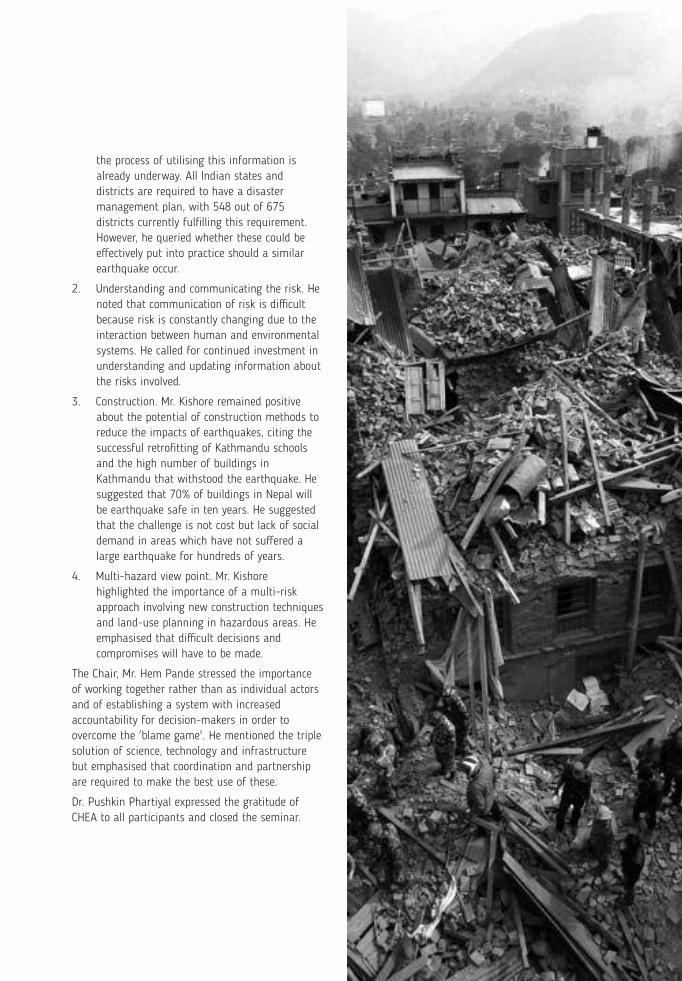
The lack of preparedness for earthquakes should be seen in view of the fact that nearly 9000 people died in the Nepal earthquake, while in Chile far lower (< 1000) mortalities occurred with an earthquake of more than 8 magnitude. In Nepal mortalities could have been far greater, had it not been day-time and a holiday. Over 30000 school buildings collapsed in the Nepal Earthquake.
Collaboration among the Himalayan countries about earthquake problems is weak.
Earthquake risk maps are required for detailed planning.
Local organizations could not be engaged fully in aid relief.
D. Information system and media:
Learning and instructions should be contextualized. For example, it is unsafe to hide under a table when buildings are not earthquake resistant. Similarly, most Hindus in Nepal and India do not eat beef, so
Learning
cause a chain of reactions involving mountains surfaces and rocks and stones present there.
Risk maps
Its implications need to be thoroughly analyzed and relevant actions taken.
C. Preparedness:
A team of experts should be put in place immediately to take stock of the situation and suggest necessary measures in the direction of preparedness.
Establish an Information Exchange System (IES), about earthquake seismicity involving all Himalayan countries and other vulnerable mountain regions of the world under the leadership of ICIMOD. This may be supported by periodical meetings of experts to improve the understanding of the subject, particularly with regard to vulnerability, risk and prediction of earthquakes.
Prepare earthquake risk maps, not only for mountains but also vulnerable areas of the plains where population densities are unusually high such as Gangetic basins; keep on improving them periodically.
Local organizations can effectively contribute to provide relief, so they need to be appropriately trained, and encouraged to play their role.
D. Information system and media:
Supply and services need to be worked out in detail, keeping in view customs, culture, and tradition.
While providing relief, the first preference should be
Action recommended
(xiv)(xiii)
Lessons from Nepal's Earthquake for the Indian Himalayas and the Gangetic Plains
A summary of the lessons and recommendations that emerged from the Workshop (seminar) on “Lessons from Nepal's Earthquake for the Indian Himalayas and the Gangetic Plains: for Adaptive Planning and Strengthening Resilience”
A. Aftershocks and landslides:
Earthquakes in Himalayas generate many aftershocks over a long period. The April 25 earthquake was accompanied by hundreds of aftershocks; the one of 7.3 magnitude on May 12, 2015 was too big for an aftershock.
Earthquakes in Himalayas trigger many landslides, and long after the incident (about 3000 landslides flowed in the wake of the Nepal earthquake).
B. Impact and vulnerability:
Food security
Earthquakes adversely affect food production processes by damaging seed storage structures, killing livestock and destroying their sheds.
Tourism
Tourism is a major victim of disasters. It takes a long time to restore the confidence of tourists.
Social inequality
Social inequality in earthquake losses is a major issue. In Nepal earthquake more women died than men, and more houses of the poor collapsed than of rich people. Women trafficking has already become an issue of governance
Small earthquakes
What is the environmental impact of small and frequent earthquakes (below 6 magnitude) in the
Lessons
Create a well developed management of open space shelters for several months.
Communal open spaces should be large in cities so that people taking shelter are not in the range of falling buildings.
Open spaces are needed not only to provide shelter but also medical aid. No one would expect doctors and patients to remain inside hospital buildings even if they are safe, when shocks keep on coming.
While developing hydroelectric power projects and other large construction activity, landslide factor should also be kept in view.
B. Impact and vulnerability:
Food security
Seed storage containers need to be improved and traditional livestock sheds modified in consultation with the local people.
Tourism
Disaster gives an opportunity to remodel tourism so that more benefits go to local people. For example, one can explore the scope of increasing people's right over central assets and nature's beauty to enhance their share in the benefits of tourism.
Social inequality
Women should be included in central decision making with regard to disasters.
The government and NGOs should promote corrective measures.
Hazard maps should be used for future construction and building designs should be made more earthquake resistant.
Small earthquakes
True, earthquakes occur several miles deep inside mountains, but the energy released
Action recommended
frequently might Himalayas? Is it a relevant scientific question or not?
Risk maps
Old debris sites are more vulnerable to earthquake damages. That is why Pithoragarh, Sikkim and Gangtok are at risk.
C. Preparedness:
The Indian Himalayan region is less prepared than Nepal for earthquake-driven disasters, though it is equally vulnerable. For example, the number of seismicity measuring stations is lower in the Indian Himalayan states.
The lack of preparedness for earthquakes should be seen in view of the fact that nearly 9000 people died in the Nepal earthquake, while in Chile far lower (< 1000) mortalities occurred with an earthquake of more than 8 magnitude. In Nepal mortalities could have been far greater, had it not been day-time and a holiday. Over 30000 school buildings collapsed in the Nepal Earthquake.
Collaboration among the Himalayan countries about earthquake problems is weak.
Earthquake risk maps are required for detailed planning.
Local organizations could not be engaged fully in aid relief.
D. Information system and media:
Learning and instructions should be contextualized. For example, it is unsafe to hide under a table when buildings are not earthquake resistant. Similarly, most Hindus in Nepal and India do not eat beef, so
Learning
cause a chain of reactions involving mountains surfaces and rocks and stones present there.
Risk maps
Its implications need to be thoroughly analyzed and relevant actions taken.
C. Preparedness:
A team of experts should be put in place immediately to take stock of the situation and suggest necessary measures in the direction of preparedness.
Establish an Information Exchange System (IES), about earthquake seismicity involving all Himalayan countries and other vulnerable mountain regions of the world under the leadership of ICIMOD. This may be supported by periodical meetings of experts to improve the understanding of the subject, particularly with regard to vulnerability, risk and prediction of earthquakes.
Prepare earthquake risk maps, not only for mountains but also vulnerable areas of the plains where population densities are unusually high such as Gangetic basins; keep on improving them periodically.
Local organizations can effectively contribute to provide relief, so they need to be appropriately trained, and encouraged to play their role.
D. Information system and media:
Supply and services need to be worked out in detail, keeping in view customs, culture, and tradition.
While providing relief, the first preference should be
Action recommended
(xiv)(xiii)
Lessons from Nepal's Earthquake for the Indian Himalayas and the Gangetic Plains
The message is that people in the Himalayan region and adjoining Gangetic Plains need to learn to live with earthquakes and other disasters, of which those induced by global climate change are predicted to increase in the future. The seminar emphasized the importance of collaboration among Himalayan countries about improving learning from earthquakes and other disasters, both from the stand-point of providing services and measures required to reduce damages and mortalities. ICIMOD is the most appropriate organization in the Hindu-Kush Himalayan region to initiate collaborative processes. The processes may include sharing of data, ideas, experiences and progress on management of relief operations etc. A kind of periodical stock-taking about the preparedness and scientific advancement about earthquakes in the Himalayas may help a lot in mainstreaming earthquake issues in developmental activities. ICIMOD might also need to take initiatives to promote knowledge inputs from developed countries which have been able to drastically reduce mortalities and damage to infrastructures due to earthquakes. The need is also to take steps to enable scientists from all over the world to freely use an earthquake event to improve its scientific knowledge.
At the national level, GBPIHED, Almora could be given the responsibility of organizing collaboration among concerned organizations. It may be pointed out that while some arrangement with regard to earthquakes exists at the national and state levels, the capacity of the local bodies to prepare people to
food aid having beef was of little use.
More effective information systems than those presently in place are required during disasters to reduce rumours, panic and chaos, and to make relief distribution effective.
Lack of coordination limits relief distribution.
Media's role was evident; there is a lot of scope to strengthen it.
E. Research:
The protective role of forests with regard to earthquake is not known.
Psychological effects of earthquakes and other disasters can have long-term effects including decline in mountain tourism and increase in migration and consequent depopulation.
There is need for improving the knowledge of seismology to assess risk.
F. Restoration:
What can be the main mantra for restarting development after an earthquake?
We cannot afford to ignore the social crisis a mega-disaster causes.
Learning
given to shelter and light (to keep young girls safe).
These would need to be supported by education and awareness programmes.
Design coordinated and decentralized relief systems with clear command structure.
The media can be used as an effective tool for spreading information, but media could also cause chaos. It needs to be thoroughly analyzed and improved.
E. Research:
Conduct research on the effectiveness of forests as shelter for people when aftershocks keep on coming. Are forested lands less affected by landslides and earthquake tremors? It could be a research issue. Research is required also to identify deep rooted trees that are likely to be more protective to slopes.
Long term plans would need to be developed to restore psychological balance. This calls for research and development of a new body of knowledge.
For this global collaboration needs to be expanded, and a periodical evaluation system put in place.
F. Restoration:
Short term relief should support a long-term goal to boost development.
Pay attention to social restoration of affected people, particularly children, women and poor people.
Action recommended
deal with earthquakes and other similar disasters is very low, while actual steps are to be taken at that level.
The apex institute for Environment and Development in the Indian Himalayan region, GBPIHED could connect the various activities to existing programmes such as National Mission on Sustaining Himalayan Ecosystems (NMSHE) under the National Mission on Climate Change being implemented by Department of Science and Technology (DST), Government of India and Ministry of Environment, Forests and Climate Change (MoEFCC), Government of India's various initiatives and specifically the National Mission on Himalayan Studies. The main tasks are makeing a coordinated use of knowledge scattered across various institutes and other bodies, and getting the emerging actions incorporated into governance at central, state and local body level. For example, one of the lessons of the seminar was that cities need numerous open sites, large enough to enable local people to escape falling buildings. How to create such spaces in already congested cities will require proactive and interactive roles of administration, judiciary and civil organizations at various levels. Taking adequate measures to deal with earthquakes will also demonstrate that the population supporting capacities of our cities are less than perceived and necessary adjustments need to be made.
THE WAY FORWARD
(xvi)(xv)
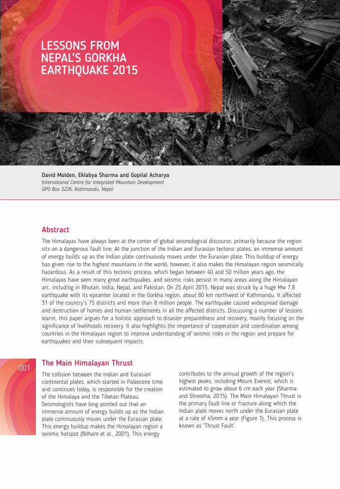
David Molden, Eklabya Sharma and Gopilal AcharyaInternational Centre for Integrated Mountain Development GPO Box 3226, Kathmandu, Nepal
LESSONS FROM NEPAL'S GORKHA EARTHQUAKE 2015
AbstractThe Himalayas have always been at the center of global seismological discourse, primarily because the region sits on a dangerous fault line. At the junction of the Indian and Eurasian tectonic plates, an immense amount of energy builds up as the Indian plate continuously moves under the Eurasian plate. This buildup of energy has given rise to the highest mountains in the world; however, it also makes the Himalayan region seismically hazardous. As a result of this tectonic process, which began between 40 and 50 million years ago, the Himalayas have seen many great earthquakes, and seismic risks persist in many areas along the Himalayan arc, including in Bhutan, India, Nepal, and Pakistan. On 25 April 2015, Nepal was struck by a huge Mw 7.8 earthquake with its epicenter located in the Gorkha region, about 80 km northwest of Kathmandu. It affected 31 of the country's 75 districts and more than 8 million people. The earthquake caused widespread damage and destruction of homes and human settlements in all the affected districts. Discussing a number of lessons learnt, this paper argues for a holistic approach to disaster preparedness and recovery, mainly focusing on the significance of livelihoods recovery. It also highlights the importance of cooperation and coordination among countries in the Himalayan region to improve understanding of seismic risks in the region and prepare for earthquakes and their subsequent impacts.
The Main Himalayan Thrust The collision between the Indian and Eurasian continental plates, which started in Paleocene time and continues today, is responsible for the creation of the Himalaya and the Tibetan Plateau. Seismologists have long pointed out that an immense amount of energy builds up as the Indian plate continuously moves under the Eurasian plate. This energy buildup makes the Himalayan region a seismic hotspot (Bilham et al., 2001). This energy
001
Figure 1: The Main Himalayan Thrust seen with global fault lines.
The history of large Himalayan earthquakes stretches back for centuries (Figure 2). A large earthquake presumably occurred in 1505 (8.9 » Mw) in an area west of Kathmandu that stretches to Himachal Pradesh in India. Other large earthquakes in eastern Nepal along the Indian border of Bihar occurred in 1255 (8.4 » Mw) and 1934 (8.2 » Mw) (see Sapkota et al., 2013). More recently another large earthquake (8.6 » Mw) occurred in Assam, India, in 1950. The area ruptured during the recent 2015 earthquake in Nepal also saw similar ruptures in 1833 and 1866. In October 2005, an Mw 7.6 earthquake in Pakistan left more than 85,000 people dead. The quake had its epicenter about 19 km northeast of Muzaffarabad, Pakistan, 100 km away from capital Islamabad. More than 139,000 people were injured and another 3.5 million rendered homeless. Since the earthquake struck on a school day, about 19,000 children lost their lives, mostly when school buildings collapsed. The earthquake affected more than 500,000 families.
On 18 September 2011, a 6.9 Mw earthquake hit Sikkim, close to Indo-Nepal border. The earthquake was felt across northeast India, Nepal, Bhutan, Bangladesh, and southern Tibetan Autonomous Region of China. About 110 people died, and there were reports of substantial structural damages.
More recently, on 4 January 2016, an Mw 6.7 earthquake struck the Indian state of Manipur in the Northeast. The quake, with its epicenter in Tamenglong district, occurred at a depth of 17 km and was felt in Bangladesh, Myanmar, and Bhutan. Reports stated that at least 11 people were killed, more than 200 were injured, and numerous buildings sustained damage.
Figure 2: Historical earthquakes along the Himalayan fault lines. Source: Roger Bilham
contributes to the annual growth of the region's highest peaks, including Mount Everest, which is estimated to grow about 6 cm each year (Sharma and Shrestha, 2015). The Main Himalayan Thrust is the primary fault line or fracture along which the Indian plate moves north under the Eurasian plate at a rate of 45mm a year (Figure 1). This process is known as 'Thrust Fault'.
Lessons from Nepal's Earthquake for the Indian Himalayas and the Gangetic Plains
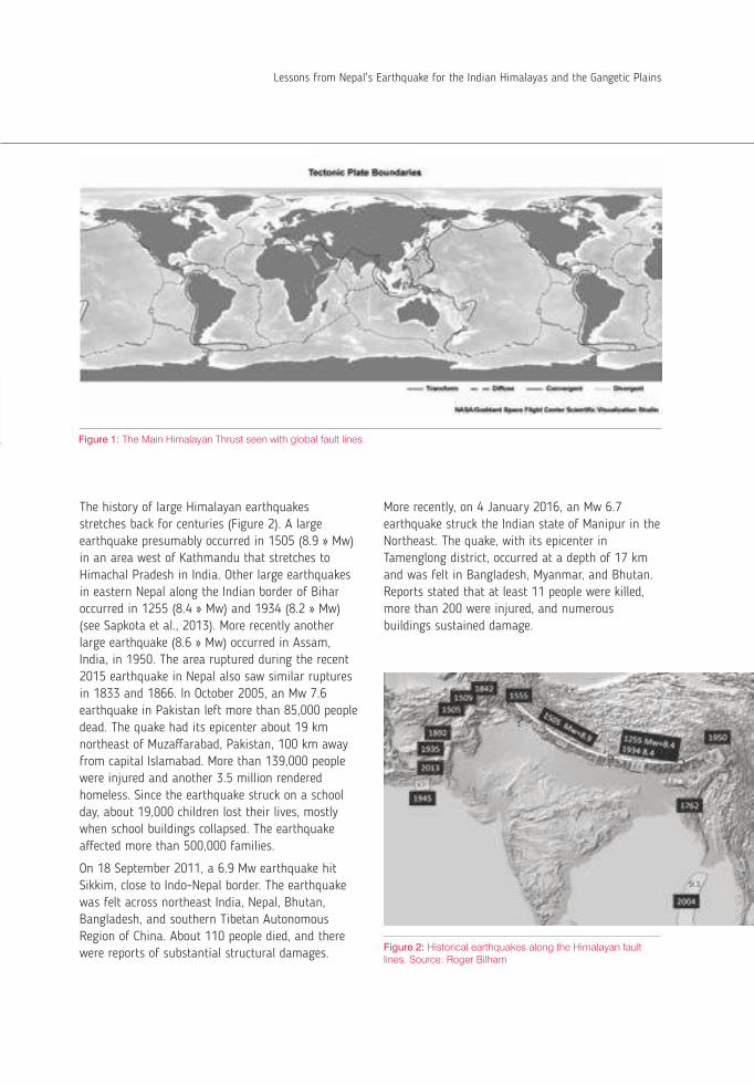
LESSONS FROM NEPAL'S GORKHA EARTHQUAKE 2015
004003
Greater details on the history of earthquakes in India and Himalaya can be found in Bilham (2004).
Day, Date & Time of Occurrence: Mw 7.8, Saturday, 25 April 2015, 11:56 am Nepal Standard Time. Major aftershock: Mw 7.3, 12 May 2015, 12:50 pm NS 8,773 (4,843 females) people killed 22,304 people injured 8 million people affected; 2.8 million people
displaced 505,577 private homes fully damaged 278,907 private homes partially damaged 2,638 government houses fully damaged 3,393 government houses partially damaged 446 public health facilities fully damaged 765 public health facilities partially damaged 32,145 classrooms fully damaged 999,000 children out of school after the quake 700,000 additional people pushed below poverty
line 5,000,000 workers affected 239 micro hydro-powers affected 2,900 structures of cultural and religious
significance affected
In the 14 most affected districts, the earthquake destroyed the livelihoods of 5.4 million people (over 66% of total affected population) About 135,200 tonnes of foodstuff, 17,290 large
livestock, 40,976 small livestock, and 507,665 poultry animals have been lost
More than 3.5 million people are food insecure,
and some 180,000 people engaged in tourism are extremely vulnerable
The agriculture sector suffered total damage and loss of NPR 28.4 billion (USD 284 million), with maximum losses (86%) in Nepal's mountains and hills
Out of the 150 million work days lost, 130 million (88%) are from the 14 most affected districts
The average value of per capita disaster effect is highest in the mountains (NPR 219,503/USD 2,195) and the lowest in Inner Terai (NPR 50,813/USD 508), with an average of NPR 130,115 (USD 1,301) in the 14 most affected districts
The per capita disaster effect is negatively correlated (-0.55) with the Human Development Index and positively correlated with poverty (0.46) and the Nepal Earthquake Severity Index (0.74), indicating that less developed and poor communities, many of which are in mountain areas, endured a larger portion of disaster impacts
About 26% of the damaged houses belong to women-headed households and 41% to Dalits and members of indigenous communities
Women-headed households suffered the largest damage, followed by those from Adivasi Janjati communities
Poor women and disadvantaged groups suffered more in terms of death, person years of life lost, injury, displacement, and impacts on other livelihood assets
Box 1: Nepal earthquake: Key facts.
Source: NPC (2015), NDRRIP (2015)
Overview of the Gorkha earthquake
On 25 April 2015 at 11:56am local time, the Himalayan country of Nepal was struck by a huge Mw 7.8 earthquake with its epicenter located in the Gorkha region, about 80 km northwest of Kathmandu. The earthquake occurred at the subduction interface along the Himalayan arc between the Indian plate and the Eurasian plate (Avouac, 2003; Ader et al., 2012). Several
aftershocks, including a major Mw7.3 one on 12 May in the northeast of Kathmandu, caused additional damage. More than 415 aftershocks greater than Mw4.0 were recorded as on 13 December 2015 (NSC, 2015; also see Figure 3 up to 27 May 2015).
Figure 3: Plot showing earthquakes measuring more than 4 Magnitude (ML) since the 25 April 2015 earthquake and aftershocks till 27 May 2015. Source: Nepal Seismological Centre
The impact of the Gorkha Earthquake was devastating (see Box 1). It affected 39 of the country's 75 districts (NPC, 2015) and more than 8 million people. The official death toll was 8,773, with another 23,304 injured, more than 785,000 homes damaged or destroyed, and about 2.8 million people displaced. The earthquake also triggered numerous secondary geo-hazards, including landslide-dammed rivers, future mass movements (landslides/debris flows), glacial lake moraine failures, and avalanches (ICIMOD, 2015a).
Apart from taking lives, damaging homes, and displacing people, the total value of the damage and loss caused by the earthquake is estimated at USD 7 billion (USD 1 = NPR 100), which is equivalent to about a third of Nepal's Gross Domestic Product (NPC, 2015). The total loss in the agriculture sector, the main source of livelihood in most earthquake-affected areas, is estimated at around NPR 28.4 billion (USD 284 million), of which NPR 16.4 billion (58%) is direct damages (NPC, 2015).
Impact of the 2015 Gorkha EarthquakeDamage to human settlements, public infrastructures, and cultural heritage
The earthquake caused widespread damage and destruction of homes and human settlements in all the affected districts (Photo 1).
Up until 30 May 2015, it was estimated that around 500,000 homes were comprehensively damaged and more than 250,000 partially damaged (NPC, 2015). In some settlements like the Barpak Village of Gorkha District, the epicenter of the 2015 earthquake, almost every home was completely damaged. The village overnight had become a tent settlement. Most damages to homes and human settlement were seen in the rural areas, including many remote and inaccessible mountain communities. However, emerging cities and several neighborhoods in the Kathmandu Valley also saw severe damage to housing and human settlements.
A total of 446 public health facilities, including hospitals, primary health care centres, and health posts, were completely destroyed, and another 765 health facilities or administrative structures were partially damaged (NPC, 2015). This severely affected the reach and response to healthcare needs of the affected people. Similarly, hundreds of educational facilities were destroyed or damaged. The National Planning Commission has put the total damages and losses in the education sector at NPR 31.3 billion.
Lessons from Nepal's Earthquake for the Indian Himalayas and the Gangetic Plains
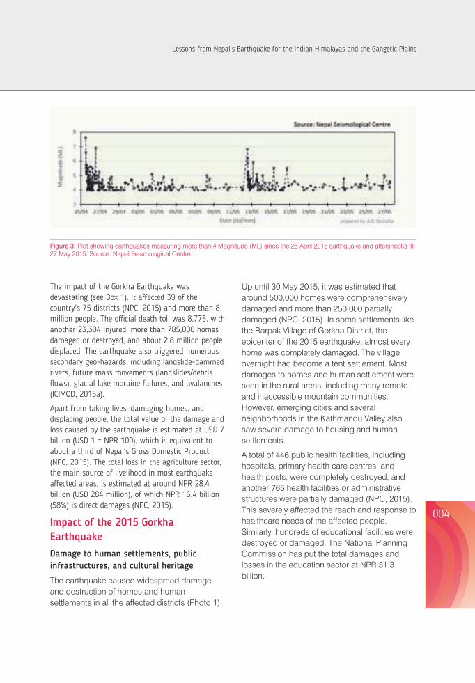
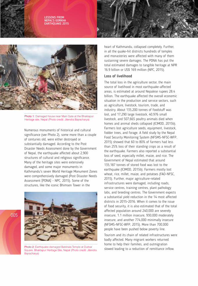
LESSONS FROM NEPAL'S GORKHA EARTHQUAKE 2015
006005
Photo 1: Damaged house near Main Gate at the Bhaktapur Heritage site, Nepal (Photo credit: Jitendra Bajracharya)
Numerous monuments of historical and cultural significance (see Photo 2), some more than a couple of centuries old, were either destroyed or substantially damaged. According to the Post Disaster Needs Assessment done by the Government of Nepal, the earthquake affected about 2,900 structures of cultural and religious significance. Many of the heritage sites were extensively damaged, and some major monuments in Kathmandu's seven World Heritage Monument Zones were comprehensively damaged (Post Disaster Needs Assessment [PDNA] – NPC, 2015). Some of the structures, like the iconic Bhimsen Tower in the
heart of Kathmandu, collapsed completely. Further, in all the quake-hit districts hundreds of temples and monasteries were affected with many of them sustaining severe damages. The PDNA has put the total estimated damages to tangible heritage at NPR 16.9 billion or US$ 169 million (NPC, 2015).
Loss of livelihood
The total loss in the agriculture sector, the main source of livelihood in most earthquake-affected areas, is estimated at around Nepalese rupees 28.4 billion. The earthquake affected the overall economic situation in the production and service sectors, such as agriculture, livestock, tourism, trade, and industry. About 135,200 tonnes of foodstuff was lost, and 17,290 large livestock, 40,976 small livestock, and 507,665 poultry animals died when homes and animal sheds collapsed (ICIMOD, 2015b). Farmers lost agriculture seeds, equipment, livestock, fodder trees, and forage. A field study by the Nepal Food Security Monitoring System (NFSMS-NFSC-WFP, 2015) showed that 60 to 80% of farmers had less than 25% loss of their standing crops as a result of the earthquake. Farmers also reported a substantial loss of seed, especially millet, maize, and rice. The Government of Nepal estimated that around 135,187 tonnes of stored food was lost to the earthquake (ICIMOD, 2015b). Farmers mostly lost wheat, rice, millet, maize, and potatoes (FAO-NFSC, 2015). Further, major agriculture-related infrastructures were damaged, including roads, service centres, training centres, plant pathology labs, and breeding centres. The Government expects a substantial yield reduction in the 14 most affected districts in 2015-2016. When it comes to the issue of food security, it is also estimated that of the total affected population around 240,000 are severely insecure, 1.1 million insecure, 930,000 moderately insecure, and another 774,000 minimally insecure (NFSMS-NFSC-WFP, 2015). More than 700,000 people have been pushed below poverty line.
Tourism and its chain of related infrastructures were badly affected. Many migrant workers returned home to help their families, and outmigration slowed leading to a reduction of remittance inflow. Photo 2: Earthquake damaged Batshala Temple at Durbar
Square, Bhaktapur Heritage Site, Nepal (Photo credit: Jitendra Bajracharya)
Additionally, the earthquake caused large-scale damage to forests and ecosystem services, affecting people's forest-based incomes. Systematic analysis of satellite images has estimated forest loss of 2.2% in six of the earthquake-affected districts. Of the 20 protected areas seven have been affected, including a World Heritage Site (Sagarmatha National Park) and two Ramsar sites (Gosaikunda and Gokyo) that are globally significant in terms of mountain ecosystem and its rich biodiversity (ICIMOD, 2015b).
Overall, the lives and livelihoods of 5.4 million people in the 14 most severely affected districts, accounting for over two-thirds of the 8 million living in the 31 affected districts, were the hardest hit. With the exception of the Kathmandu Valley, these severely affected districts are essentially rural mountains and hills where subsistence agriculture is the main livelihood activity. The disaster's impact on agriculture-based livelihoods and food security is particularly worrying as it has damaged people's homes, as well as their productive resources, employment, and means of living. The major worry now is that the affected people may resort to negative coping mechanisms, like selling off their livelihood assets and over exploitation of the natural resource base, for their immediate survival. Therefore, a proper understanding of the livelihood impact of the earthquake in the severely affected districts is crucial.
Geo-hazards
The earthquake caused several secondary geo-hazards. More than 3,000 landslides occurred in the steep mountains and hills throughout the earthquake affected zone, posing additional risk to people and infrastructure (ICIMOD, 2015a). For example, the landslide that blocked the Kali Gandaki River in Myagdi district caused the river's water to accumulate in a reservoir behind the landslide dam. The water overtopped and breached the natural dam, sending a flood of more than 2 million cubic meters of water downstream. There were other large mass movements generated by the earthquake and its aftershocks or other secondary effects. For instance, scientists noted a zone of widespread,
intense landslide incidence that ran east-west, approximately parallel to the transition between the Lesser and High Himalayas (Kargel et al., 2015). In other words, the highest densities of earthquake-related landslides were distributed within the broad area between the two biggest shocks. This zone contained numerous rock falls and debris avalanches, which were individually localised but together had a catastrophic impact on roads and villages. Subsequently, a group of scientists mapped 4,312 co-seismic and post-seismic landslides (ICIMOD, 2015a).
Many of the larger villages in the Langtang Valley were comprehensively destroyed by air pressure waves (sweeping down the steep slope), landslides, and avalanches in the aftermath of the earthquake. The avalanches made of snow and ice mixed with rock accelerated down the steep valley slopes, displacing the air and creating strong pressure waves. As a result the eight highest villages in the Langtang Valley were damaged or completely destroyed and many lives were lost. Early analysis of photographs and satellite imagery suggested that the debris and ice had accumulated in the past near an elevation of about 4,500 meter above mean sea level as a result of ice avalanches and rock fall from Langtang Lirung (ICIMOD, 2015a).
As relief and recovery operations picked up soon after the earthquake, ICIMOD's geo-hazards and geo-information task force worked round the clock to process and analyse satellite data to inform relief interventions.
Lessons from the Nepal EarthquakeCommunication infrastructure is vital
The demand for information rises exponentially in a disaster situation like the one Nepal faced, and therefore collecting, managing, processing, and disseminating timely and reliable information becomes critical to disaster relief and recovery operations. That's why a good communication infrastructure is vital in such mega disasters. The central and local governments must institute an effective command and control mechanism for good
Lessons from Nepal's Earthquake for the Indian Himalayas and the Gangetic Plains
communication so that accurate and timely information is available for the actors in the field. Disaster communication strategies, timely media engagement, and reliable and fast internet connectivity with large band widths are other critical issues. The Nepal experience showed a huge gap in the demand and supply of information, especially given the country's formidable physical terrain. Moreover, responding to a disaster of such a scale requires people to work round the clock, and providing that kind of information in a short period is very challenging. Are responders on the ground getting the right kind of information they are looking for? Are information suppliers providing accurate information? These are some of the questions we need to ask.
Information flow even before the earthquake was questionable. Both state and non-state actors don't seem to have learned from the lessons of the past. Numerous seismologists have carried out research on earthquakes along the Himalayan arc, and yet not much information seems to have been passed down to the people. In the recent earthquake, even the Government didn't seem to have the necessary information to quell people's fears and anxiety immediately after the disaster.
In such a situation, there is the need for integrated data and information system, and arrangements should be in place for effective coordination and communication between central and local service providers. Such a mechanism would also facilitate the coordination of international disaster response teams. There were more than 20 response teams within the first three days after the earthquake (UNISDR, 2015).
Stringent building codes
In Nepal most infrastructures are vulnerable to hazards, especially buildings and homes in both rural and urban areas. The Government of Nepal has pointed out that the large-scale destruction of homes was primarily from the seismic vulnerability of unreinforced masonry homes in the rural countryside (NPC, 2015). It was these 'low strength…brittle buildings' that suffered most
intensive and comprehensive damages in all the 31 districts that witnessed intense ground shaking. Thus, one of the more critical components to earthquake preparedness in Nepal has to be a stringent adherence to building codes. At the moment, very few house owners seem to follow the building codes, and most homes are built by owners themselves. A study of 1,000 buildings in Kathmandu by the National Society for Earthquake Technology-Nepal showed that over 90% are non-engineered (NSET, 2012). There is also the need to train masons and provide technical training in seismic resilience for engineers and other specialists.
In rural Nepal, the issue is even more urgent since all homes are non-engineered. The village of Barpak under Gorkha district stands a clear testimony to how a major earthquake can flatten an entire village within a matter of seconds. Further, most homes are built informally by untrained local carpenters and masons using the traditional mix of mud and stones, technically considered as 'low strength masonry' (NSET, 2002). In recent times, thatched roofs are being replaced by corrugated iron roofs. Therefore, given that these homes come crumbling down or sustain damage even during moderate ground shaking, it probably is time to encourage rural residents to use low cost and locally available light building materials like bamboo, straw, grass, jute sticks, leaves, thatch, and timber. This will not only lessen damage to people and property, but also curtail overall economic loss. However, the Government should familiarize people with these low-cost techniques.
In heavily populated urban centers like Kathmandu, the government must evaluate the seismic performance of each structure and make necessary recommendations. A common building codes compliance strategy should be implemented in urban centers. The government of Nepal could take examples from earthquake-prone countries like Japan that have developed state-of-the-art structural technology over the years. One way of building back a better Nepal is by continually advancing the building standards. It's heartening to
note that National Society for Earthquake Technology-Nepal has already started training masons on safer construction as part of the ongoing Building Code Implementation Programme. Such programmes should be focusing on building institutional and local capacity to enforce Nepal's National Building Code.
Safeguard vital infrastructure
Experiences from around the world have shown that economic losses are substantially reduced if vital infrastructure like schools and hospitals remain safe from the disaster. While schools act as temporary shelters for displaced people, hospitals provide essential services to those injured or hurt in the disaster. However, both schools and hospitals should have sound emergency power and communications systems to deal with what is most often a chaotic situation. While the exact number of schools and other educational institutes damaged by the earthquake is not known, it has been reported that the total damages and losses in the education sector were estimated at NPR 31.3 billion. The damages to educational infrastructure and physical asset were estimated at NPR 28 billion (NPC, 2015). Further, educational services in the affected districts were severely disrupted with most schools remaining closed for a couple of months following the earthquake. It was later found that out of 35,000 public and private schools, only about 350 to 400 were retrofitted (NDRRIP, 2015). The schools that were retrofitted with earthquake-proof technology actually did survive the disaster. The death toll among schoolchildren would have been significant if the earthquake had struck on a school day instead of a Saturday, the day when schools remain closed in Nepal.
A total of 446 public health facilities (including 5 hospitals, 12 primary health care centres, 417 health posts, and 12 others) and 16 private facilities were completely destroyed, and another 765 health facilities or administrative structures were partially damaged. Further, nearly 84 percent of the completely damaged health facilities were in the 14 most affected districts (NPC, 2015). This severely affected the reach and response to healthcare needs
of the affected people, and already vulnerable populations were deprived of access to timely healthcare services. If healthcare facilities are retrofitted and remain unaffected by disasters, they would be better prepared to deal with the injuries as well as reach well-coordinated services to the affected populace. All this calls for a robust emergency plan in the health sector.
Improve coordination
Disasters unleash chaos in the absence of a preplanned coordination mechanism to deal with the aftermath. This is what happened in Nepal's case following the earthquake. Coordination was lacking, roles were not clear, and much time and resources were lost in a disorganized relief and rescue effort. For example, responders on the ground didn't know who to turn to for correct information, and foreign helicopter pilots had difficulty accessing crucial flight information. Indeed, one of ICIMOD's first interventions was to assist helicopter pilots doing rescue and relief missions. From 29 April, a team of ICIMOD scientists worked from Tribhuvan International Airport in Kathmandu providing crucial flight information to pilots and dispatchers to help them navigate unfamiliar terrain, identify destinations, map potential flight paths, and plan appropriate landing sites using satellite remote sensing and GIS data information.
Therefore, a coordinated but decentralized response mechanism is what governments need in disasters like the one Nepal faced. The mechanism has to take into account that hundreds of government agencies, security forces, non-state actors, charities, NGOs, private sector, faith groups, and volunteers turn up for action following a disaster, and coordinating them for effective services delivery becomes a massive task. Moreover, response to disasters like the Nepal earthquakes warrants regional and internal collaboration. Here too ICIMOD's geo-hazards task force played a critical role bringing together a broad international coalition representing the Governments of India (Indian Space Research Organization), Pakistan (Space and Upper Atmosphere Research Commission), China (Chinese
LESSONS FROM NEPAL'S GORKHA EARTHQUAKE 2015
008007
Lessons from Nepal's Earthquake for the Indian Himalayas and the Gangetic Plains

Academy of Sciences), and Nepal, as well as other bodies like the National Aerospace and Space Administration, the University of Arizona, United States Agency for International Development, Environmental System Research Institute, Japan Aerospace Exploration Agency, Digital Globe, US Geological Survey, and signatories to the International Charter on Space and Major Disasters, among others. The task force worked around the clock to process and analyse satellite data to inform relief and recovery operations. The task force is now preparing a Status Report focusing mainly on landslides and glacial lakes.
It is important to keep pace with emerging new technologies and innovations in disaster response, and the tools must be customized so that they can be effectively used in the mountain context. To this effect ICIMOD, in close collaboration with Nepal's Ministry of Home Affairs and with technical support from Esri developed and deployed a 'Nepal Earthquake 2015: Disaster Relief and Recovery Information Platform' (http://apps.geoportal.icimod.org/ndrrip/). The Platform was formally integrated by the Ministry of Home Affairs as part of its own 'Nepal DRR Portal'. The Platform was created as a single-gateway for validated data and information related to the earthquake to enable judicious planning and decision-making on resource allocation and mobilization and foster coordination among various actors on the ground.
Strengthen preparedness
One of the lessons we learn after each disaster is that preparedness is critical and necessary safeguards must be put in place. Approach to preparedness in the mountain areas should be different, keeping in mind access infrastructures (helicopters landing sites, bridges, roads, etc.), mountain hazards (weather forecasting and early warning systems) and good information systems. Such an approach should be developed for all the mountain areas of the Himalayan Arc. Preparedness must take into account other forms of disasters in the region and accordingly prepare the responses. For example, flood situations would require a totally
different kind of response and interventions.
Drills and simulations must be conducted and communities must be involved in mapping risk and writing disaster management plans. Safe settlement areas must be identified and hazard-prone areas zoned. Safe areas for food and seed storage must be identified, and community resilience models and strategies must be implemented. Vital go-kits must be distributed, public awareness should be raised, and emergency plans must be rehearsed.
Build strong knowledge base
Countries in the Hindu Kush Himalayas, like Nepal, are highly susceptible to geo-hazards posing grave risk to settlements and infrastructures. This is where knowledge and specialized institutions can play a critical role by providing geo-information to the governments and other actors with satellite-based data and analyses to inform rescue and relief. Similarly, an inventory of landslides, landslide flood dams, avalanches, and GLOFS, their categorization according to the associated risks, and susceptibility zoning is essential for the relocation of inhabitants, resettlement, and construction. In the long-term, risk identification, hazard zoning, and proper land use planning are recommended.
A robust and dynamic knowledge base should be created taking into account: seismic activities in the Himalayan Arc, hazard mapping, risk identification and mitigation measures, and resilience knowledge about mountain people. The knowledge base should be linked to end-to-end information flow systems for response, and critical information should be available at the lowest administrative units like VDCs in Nepal or Wards in India. The knowledge base must also feature pre-disaster information focusing on: livelihood framework for short-, medium-, and long-term interventions; geo-hazards assessment and mitigation framework; environmental security framework; and earthquake safety building codes and enforcement systems should exist.
Post-disaster trauma and vulnerable groups
About 4.1 million people within 75 km and 1.4 million within 50 km radius were exposed to intense
LESSONS FROM NEPAL'S GORKHA EARTHQUAKE 2015
010009
Figure 3: Distribution of 2015 Nepal earthquakes and aftershocks
There is a need to create a system for post-disaster crisis and trauma counseling as longer-term recovery and rehabilitation are considered. This must not only take into account obvious physical injuries but also psychological impacts. Studies have shown that psychological problems among earthquake survivors do decline over time; however a small segment could continue to experience persistent trauma. Therefore, it is important that this segment of people receive continuous care and treatment until they recover fully. Marginalized and vulnerable groups like Dalits, women, and children might require extra effort in post-disaster care as they are most likely to be victims, yet are least likely to have easy access to these facilities.
Of the total deaths of 8,773 people, 55% were female (NPC, 2015). In the village of Barpak, the epicenter of the earthquake, 70% of deaths
constituted women. It was reported that women, children, senior citizens, and minorities were the most vulnerable segments, and women alone constituted the single largest disadvantaged group to be adversely affected across key sector (NPC, 2015). Therefore, these vulnerable groups need special focus in disaster preparedness. There have been media reports of sharp increase in flesh trade and trafficking after the earthquake.
Build resilience: livelihood recovery
Livelihood recovery should be the top priority in the reconstruction and recovery process after a major disaster. Livelihood recovery requires a comprehensive strategic plan that involves efficient multi-organizational coordination with clear communication, defined roles and responsibilities for the different actors, and strong governance (ICIMOD, 2015b). The plan must take into account
ground shaking in the Nepal earthquake (UNISDR, 2015; also see Figure 4). The disaster claimed lives, displaced people, wiped out homes, damaged infrastructures, and crippled people's lives. Many people witnessed the death of their loved ones,
friends, and neighbors. They saw damage and destruction first-hand. The psychosocial consequences of the earthquake was felt at various levels - individual, family, and community levels.
Lessons from Nepal's Earthquake for the Indian Himalayas and the Gangetic Plains
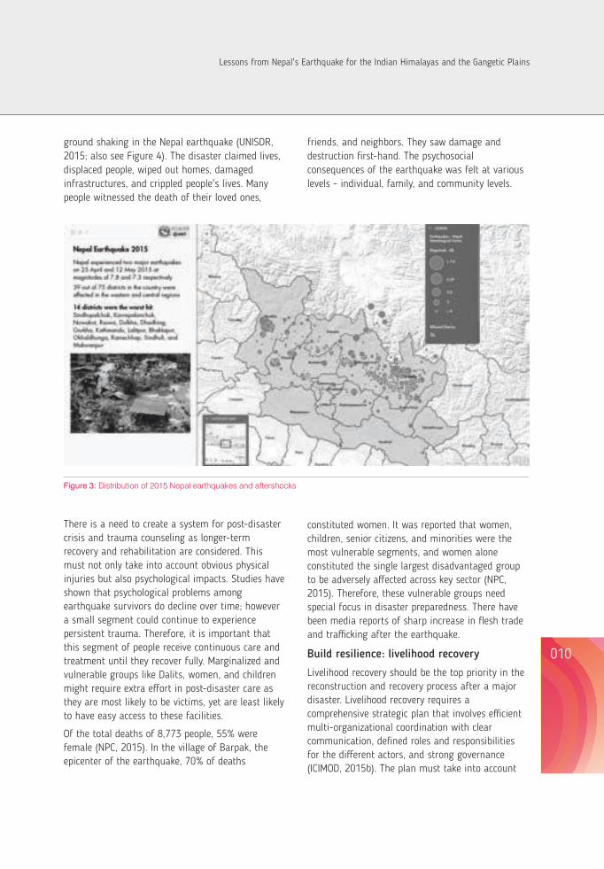
Academy of Sciences), and Nepal, as well as other bodies like the National Aerospace and Space Administration, the University of Arizona, United States Agency for International Development, Environmental System Research Institute, Japan Aerospace Exploration Agency, Digital Globe, US Geological Survey, and signatories to the International Charter on Space and Major Disasters, among others. The task force worked around the clock to process and analyse satellite data to inform relief and recovery operations. The task force is now preparing a Status Report focusing mainly on landslides and glacial lakes.
It is important to keep pace with emerging new technologies and innovations in disaster response, and the tools must be customized so that they can be effectively used in the mountain context. To this effect ICIMOD, in close collaboration with Nepal's Ministry of Home Affairs and with technical support from Esri developed and deployed a 'Nepal Earthquake 2015: Disaster Relief and Recovery Information Platform' (http://apps.geoportal.icimod.org/ndrrip/). The Platform was formally integrated by the Ministry of Home Affairs as part of its own 'Nepal DRR Portal'. The Platform was created as a single-gateway for validated data and information related to the earthquake to enable judicious planning and decision-making on resource allocation and mobilization and foster coordination among various actors on the ground.
Strengthen preparedness
One of the lessons we learn after each disaster is that preparedness is critical and necessary safeguards must be put in place. Approach to preparedness in the mountain areas should be different, keeping in mind access infrastructures (helicopters landing sites, bridges, roads, etc.), mountain hazards (weather forecasting and early warning systems) and good information systems. Such an approach should be developed for all the mountain areas of the Himalayan Arc. Preparedness must take into account other forms of disasters in the region and accordingly prepare the responses. For example, flood situations would require a totally
different kind of response and interventions.
Drills and simulations must be conducted and communities must be involved in mapping risk and writing disaster management plans. Safe settlement areas must be identified and hazard-prone areas zoned. Safe areas for food and seed storage must be identified, and community resilience models and strategies must be implemented. Vital go-kits must be distributed, public awareness should be raised, and emergency plans must be rehearsed.
Build strong knowledge base
Countries in the Hindu Kush Himalayas, like Nepal, are highly susceptible to geo-hazards posing grave risk to settlements and infrastructures. This is where knowledge and specialized institutions can play a critical role by providing geo-information to the governments and other actors with satellite-based data and analyses to inform rescue and relief. Similarly, an inventory of landslides, landslide flood dams, avalanches, and GLOFS, their categorization according to the associated risks, and susceptibility zoning is essential for the relocation of inhabitants, resettlement, and construction. In the long-term, risk identification, hazard zoning, and proper land use planning are recommended.
A robust and dynamic knowledge base should be created taking into account: seismic activities in the Himalayan Arc, hazard mapping, risk identification and mitigation measures, and resilience knowledge about mountain people. The knowledge base should be linked to end-to-end information flow systems for response, and critical information should be available at the lowest administrative units like VDCs in Nepal or Wards in India. The knowledge base must also feature pre-disaster information focusing on: livelihood framework for short-, medium-, and long-term interventions; geo-hazards assessment and mitigation framework; environmental security framework; and earthquake safety building codes and enforcement systems should exist.
Post-disaster trauma and vulnerable groups
About 4.1 million people within 75 km and 1.4 million within 50 km radius were exposed to intense
LESSONS FROM NEPAL'S GORKHA EARTHQUAKE 2015
010009
Figure 3: Distribution of 2015 Nepal earthquakes and aftershocks
There is a need to create a system for post-disaster crisis and trauma counseling as longer-term recovery and rehabilitation are considered. This must not only take into account obvious physical injuries but also psychological impacts. Studies have shown that psychological problems among earthquake survivors do decline over time; however a small segment could continue to experience persistent trauma. Therefore, it is important that this segment of people receive continuous care and treatment until they recover fully. Marginalized and vulnerable groups like Dalits, women, and children might require extra effort in post-disaster care as they are most likely to be victims, yet are least likely to have easy access to these facilities.
Of the total deaths of 8,773 people, 55% were female (NPC, 2015). In the village of Barpak, the epicenter of the earthquake, 70% of deaths
constituted women. It was reported that women, children, senior citizens, and minorities were the most vulnerable segments, and women alone constituted the single largest disadvantaged group to be adversely affected across key sector (NPC, 2015). Therefore, these vulnerable groups need special focus in disaster preparedness. There have been media reports of sharp increase in flesh trade and trafficking after the earthquake.
Build resilience: livelihood recovery
Livelihood recovery should be the top priority in the reconstruction and recovery process after a major disaster. Livelihood recovery requires a comprehensive strategic plan that involves efficient multi-organizational coordination with clear communication, defined roles and responsibilities for the different actors, and strong governance (ICIMOD, 2015b). The plan must take into account
ground shaking in the Nepal earthquake (UNISDR, 2015; also see Figure 4). The disaster claimed lives, displaced people, wiped out homes, damaged infrastructures, and crippled people's lives. Many people witnessed the death of their loved ones,
friends, and neighbors. They saw damage and destruction first-hand. The psychosocial consequences of the earthquake was felt at various levels - individual, family, and community levels.
Lessons from Nepal's Earthquake for the Indian Himalayas and the Gangetic Plains

the biophysical and socio-economic characteristics of earthquake-affected regions. A livelihood recovery strategy should ensure the long-term sustainability and resilience of livelihoods to future disasters. It must be people-centered, participatory, pro-poor, gender inclusive, transparent and accountable, environmentally sustainable, and recognize mountain specificities. It requires engaging and coordinating diverse stakeholders, strengthening the skills and capacity of affected people, tapping the potentials of internal and external job markets, facilitating structural transformation from low to high productive sectors, ensuring gender equity and social inclusion, promoting community empowerment, and integrating ecosystem and biodiversity conservation into the livelihood recovery process. For Nepal, revitalizing farming and tourism sector, and revitalizing micro-, small-, and medium-sized enterprises would play a critical role in the revitalization of livelihoods.
Livelihood recovery interventions usually include three overlapping phases of livelihood provisioning (relief-based operations), livelihood protection (restoration to pre-disaster conditions), and livelihood promotion, in terms of improving the pre-existing conditions by reducing the structural vulnerability of the whole livelihood system (ICIMOD, 2015b). However, the success of a post-disaster recovery programme will depend very much on how well an enabling policy and institutional environment is created beyond reconstruction. It is important to explore innovative recovery models by encouraging private sector participation to maximize synergies. For example, construction materials could be sourced locally instead of importing them at a higher price from abroad. The focus must be to develop an institutional framework to allow better disaster mitigation and risk management for future natural disasters through knowledge gathering, sharing, and dissemination, and by developing innovative tools to engage community participation for reconstruction efforts taking into consideration socio-cultural, environmental, and economic aspects in the mountain environment.
As reconstruction and recovery efforts continue in Nepal, the emphasis must also be on learning vital
lessons from similar experiences elsewhere and adopting good practices and innovative options for post-disaster livelihood recovery. Synergies must be created to harmonize multiple initiatives from multiple agencies, and the government must create enabling support mechanisms and ensure adequate resources. In the long-term, the focus must be on building resilience. Experiences show that building community resilience to shocks is more cost effective than humanitarian response. A stronger livelihood base for people is the essential building block of resilience. In addition, communities need better protection. For DRR this can be conceptualized around three pillars: capacity building for better risk assessment, and for forecasting and communicating early warning messages to the last mile; institution building for good risk governance at regional, national, river basin, and community levels; and the choice of appropriate technologies for developing information systems for forecasting and early warning, and technologies for improving infrastructure safety to make them climate resilient.
Opportunity to build back better
When it comes to the concept of “building back better” as spelt out in the Sendai Framework, putting livelihood recovery at the center is crucial. This would mean not only restoring livelihoods and communities to their pre-disaster conditions, but also developing long-term strategy for the transition from reconstruction and restoration to sustainable livelihoods that are more resilient to future disasters. Governments must develop long-term framework where efforts, from early on, must focus on people and revitalizing their livelihoods. Such a framework should particularly spell out short-term priorities as well as inform long-term policies and strategies providing guidelines for the effective design and implementation of livelihood recovery efforts. A sustainable livelihood recovery strategy must identify emerging opportunities, engage local people and institutions in recovery planning and implementation, reach out to the most vulnerable groups like women and other poor and marginalized communities, design sector-specific recovery
strategies, and adopt an integrated approach that brings together employment-intensive reconstruction, skills development of local people, enterprise development, microfinance, and social protection. Besides, in countries like Nepal where remittances substantially fuel the national economy, ways must be explored to broaden scope for remittances to help economic recovery.
Disaster risk reduction primarily focuses on mitigation, preparedness, response, and recovery. The Sendai Framework for Disaster Risk Reduction (2015–2030) has identified four priorities for action: understanding disaster risk; strengthening disaster risk governance to manage disaster risk; investing in disaster risk reduction for resilience, and; enhancing disaster preparedness for effective response and to “Build Back Better” in recovery, rehabilitation, and reconstruction (UNISDR, 2015). The lesson we have learnt from disasters in the past is that the recovery, rehabilitation, and reconstruction phase is a critical opportunity to build back better, mainly through integrating disaster risk reduction into development planning. This would include promoting the resilience of new and existing critical infrastructure, including water, transportation and telecommunication infrastructure, and educational and health facilities so that they remain safe, effective, and operational during and after disasters in order to provide life-saving and essential services.
One clear example of “build back better” is already visible in Nepal's brick industry. Almost every brick kiln in the Kathmandu Valley was damaged by the 2015 earthquake, and 90% of workers left the valley which brought the production to almost zero. As damaged homes and other public and private infrastructures are being rebuilt the demand for building materials like bricks spiked exponentially. As kiln owners now have started to rebuild the kilns, this comes with the opportunity to introduce cleaner and worker-friendly brick kiln technologies. Indeed, ICIMOD's Atmosphere Initiative is currently championing the new design intended to optimize on construction cost, energy efficiency, and seismic safety. Together with the Federation of Nepal Brick Industries – Technology Research and Development
Committee and other stakeholders like Greentech Knowledge Solutions Pvt. Ltd., MinErgy Pvt. Ltd., and the International Finance Corporation, ICIMOD is leading the collaboration for the new design. The new kilns will consume 30% less energy than the existing ones and commensurate their emission reductions. If the design is adopted widely, Kathmandu could witness the largest air pollutant emission reduction.
ConclusionGiven that the HKH region is a major disaster hotspot in the world, and given the vulnerability of mountain people as exposed by the Nepal earthquake, concerted efforts are required on disaster risk management. Understanding that the HKH region as a whole is under severe seismic stress, the learnings from Nepal should be transferred to other areas in the region.
The Himalayan region faces a greater uncertainty of earthquakes and the question comes to peoples' mind on when, where and how big? Science has not developed enough to really predict earthquakes and even California in US is still struggling to develop reliable early warning systems of earthquake. People living in the Himalayan region and downstream areas have to learn to adapt and live with earthquakes. It is extremely important that countries sharing the Himalayan region come forward to cooperative on scientific regional research for better understanding earthquakes and their impact for future preparedness.
The Sendai Framework provides a solid basis to the region to work collectively towards reducing disaster risks for a safer and resilient society. This would include strengthening DRR-related activities such as bridging science, technology, and innovations to increase resilience; collaborating on multi-hazard early warning system, and hazard and vulnerability assessment for climate change adaptation; building capacity on DRR and resilience; engaging the private sector; and improving DRR governance and investments, among others. While a lot of efforts at community level is needed, there is also the need to invest in governments' ability to respond. This
LESSONS FROM NEPAL'S GORKHA EARTHQUAKE 2015
012011
Lessons from Nepal's Earthquake for the Indian Himalayas and the Gangetic Plains
would not only improve emergency response capacity, but also ensure that emergency plans are ready when disasters strike.
Unfortunately, in many a case, the sense of urgency often slackens as the memory of damage,
destruction, and distress fades away with time until the next big disaster rears its ugly head. It is without a doubt worth every effort to stay alert, and put safeguards in place now in our fragile yet special mountain areas.
References Ader T, Avouac J P, Liu-Zeng J, Lyon-Caen H, Bollinger L, Galetzka J, Genrich J, Thomas M, Chanard K, Sapkota S N, Rajaure
S, Shrestha P, Ding L and Flouzat M (2012) Convergence rate across the Nepal Himalaya and interseismic coupling on the Main Himalayan Thrust: Implications for seismic hazard, J. Geophys. Res. 117, B04403, doi: 10.1029/2011JB009071.
Avouac J P (2003) Mountain building, erosion and the seismic cycle in the Nepal Himalaya. Advances in Geo-physics 46: 1-80.
Bilham R (2004) Earthquakes in India and the Himalaya: tectonics, geodesy and history. Annals of Geophysics 47 (2/3): 839-858.
Bilham R, Gaur V K and Molnar P (2001) Himalayan seismic hazard. Science 293: 1442-1444. FAO-NFSC (2015) Nepal earthquake: Agricultural Livelihood Impact Appraisal in six most affected districts Food Security
Cluster. Kathmandu, Nepal: Food and Agriculture Organization of the United Nations & Nepal Food Security Cluster, Government of Nepal.
ICIMOD (2015a) Geo-hazards in the aftermath of the 25 April 2015 (12 Baisakh 2072) Earthquake: Rapid Analysis Prepared for the Government of Nepal. Kathmandu: International Centre for Integrated Mountain Development.
ICIMOD (2015b) Strategic Framework for Resilient Livelihoods in Earthquake-Affected Areas of Nepal. Kathmandu: International Centre for Integrated Mountain Development.
Kargel JS, Leonard GJ et. al. (2015) Geomorphic and geologic controls of geohazards induced by Nepal's 2015 Gorkha Earthquake. Science Express 17 December 2015 Pages 1-18.
NDRRIP (2015) Nepal Earthquake 2015: Disaster Relief and Recovery Information Platform. http://apps.geoportal.icimod.org/ndrrip/
NFSMS-NFSC-WFP (2015) A report on the food security impact of the 2015 earthquake Food Security Cluster. Kathmandu, Nepal: Nepal Food Security Monitoring System (NFSMS), Nepal Food Security Cluster (NFSC), & World Food Programme (WFP).
NPC (2015) Nepal Earthquake 2015: Post Disaster Needs Assessment. Kathmandu: National Planning Commission, Government of Nepal.
NSET (2002) Earthquake: A Manual for Designers and Builders. Kathmandu: National Society for Earthquake Technology-Nepal. Available at http://www.nset.org.np/nset2012/images/publicationfile/20110816230617.pdf (accessed 3 March 2016)
NSET (2012) National Society for Earthquake Technology-Nepal, Kathmandu, Nepal. http://www.nset.org.np/nset2012/NSC (2015) Ministry of Industry, Government of Nepal. http://www.seismonepal.gov.np/Sapkota S N, Bollinger L, Klinger Y, Tapponnier P, Gaudemer Y, and Tiwari D (2013) Primary surface ruptures of the great
Himalayan earthquakes in 1934 and 1255. Nature Geoscience 6: 71-76. Sharma E, and Shrestha AB (2015) Nepal 2015 Earthquake: Uncertainty Prevails in the Himalayan Arc. Proceedings of
Indian National Science Academy, 81(3): 557-560.UNISDR (2015). Third UN World Conference on Disaster Risk Reduction: Sendai Framework for Disaster Risk Reduction
2015-2030. http://www.unisdr.org/we/coordinate/sendai-framework (accessed 27 September 2015)
LESSONS FROM NEPAL'S GORKHA EARTHQUAKE 2015
014013
Barpak Village - Epicenter of the Nepal Gorkha Earthquake 2015 Photo ICIMOD
Pukhulachhi - before and after Nepal Earthquake 2015
Sakhu VDC Damage - Nepal Earthquake 2015
Bhaktapur, Neapl Earthquake 2015 Photo 2 ICIMOD
Lessons from Nepal's Earthquake for the Indian Himalayas and the Gangetic Plains
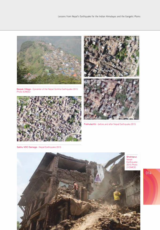
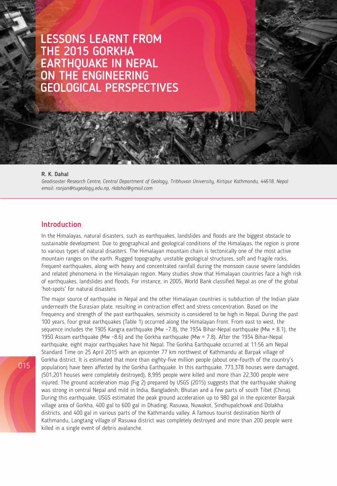
R. K. DahalGeodisaster Research Centre, Central Department of Geology, Tribhuvan University, Kirtipur Kathmandu, 44618, Nepalemail: [email protected], [email protected]
LESSONS LEARNT FROM THE 2015 GORKHA EARTHQUAKE IN NEPAL ON THE ENGINEERING GEOLOGICAL PERSPECTIVES
IntroductionIn the Himalayas, natural disasters, such as earthquakes, landslides and floods are the biggest obstacle to sustainable development. Due to geographical and geological conditions of the Himalayas, the region is prone to various types of natural disasters. The Himalayan mountain chain is tectonically one of the most active mountain ranges on the earth. Rugged topography, unstable geological structures, soft and fragile rocks, frequent earthquakes, along with heavy and concentrated rainfall during the monsoon cause severe landslides and related phenomena in the Himalayan region. Many studies show that Himalayan countries face a high risk of earthquakes, landslides and floods. For instance, in 2005, World Bank classified Nepal as one of the global 'hot-spots' for natural disasters.
The major source of earthquake in Nepal and the other Himalayan countries is subduction of the Indian plate underneath the Eurasian plate, resulting in contraction effect and stress concentration. Based on the frequency and strength of the past earthquakes, seismicity is considered to be high in Nepal. During the past 100 years, four great earthquakes (Table 1) occurred along the Himalayan front. From east to west, the sequence includes the 1905 Kangra earthquake (Mw ~7.8), the 1934 Bihar-Nepal earthquake (Mw = 8.1), the 1950 Assam earthquake (Mw ~8.6) and the Gorkha earthquake (Mw = 7.8). After the 1934 Bihar-Nepal earthquake, eight major earthquakes have hit Nepal. The Gorkha Earthquake occurred at 11:56 am Nepal Standard Time on 25 April 2015 with an epicenter 77 km northwest of Kathmandu at Barpak village of Gorkha district. It is estimated that more than eighty-five million people (about one-fourth of the country's population) have been affected by the Gorkha Earthquake. In this earthquake, 773,378 houses were damaged, (501,201 houses were completely destroyed), 8,995 people were killed and more than 22,300 people were injured. The ground acceleration map (Fig 2) prepared by USGS (2015) suggests that the earthquake shaking was strong in central Nepal and mild in India, Bangladesh, Bhutan and a few parts of south Tibet (China). During this earthquake, USGS estimated the peak ground acceleration up to 980 gal in the epicenter Barpak village area of Gorkha, 400 gal to 600 gal in Dhading, Rasuwa, Nuwakot, Sindhupalchowk and Dolakha districts, and 400 gal in various parts of the Kathmandu valley. A famous tourist destination North of Kathmandu, Langtang village of Rasuwa district was completely destroyed and more than 200 people were killed in a single event of debris avalanche.
015
Table 1. Major earthquakes in Nepal and their damage records
Figure 1: Location map of the Gorkha Earthquake with epicenter, aftershocks, affected districts and amount of upliftment. Earthquake data is collected from www.nsc.gov.np and upliftment data is cited from ARIA (2015).
016
Year Epicenter Magnitude Deaths Houses Destroyed
1934 East Nepal 8.1 (MW) 8,519 people died, out of Over 200,000 buildings and which 4,296 died in temples damaged, about 55,000 Kathmandu Valley alone buildings affected in Kathmandu Valley (12,397 completely destroyed)
1936 Annapurna 7.0 (ML) Record not available Record not available
1954 Kaski 6.4 (ML) Record not available Record not available
1965 Taplejung 6.1 (ML) Record not available Record not available
1966 Bajhang 6.0 (ML) 24 6,544 houses damaged (1,300 collapsed)
1980 Chainpur 6.5 (ML) 103 25,086 buildings damaged (12,817 completely destroyed)
1988 Udayapur 6.5(ML) 721 66,382 buildings damaged
2011 Sikkim/Nepal 6.9(ML) 6 died and 30 injured 14, 544 house damaged (6,435 border (2 died in Kathmandu completely destroyed) valley alone)
2015 Barpak village 7.6 (ML) 8,995 died and more than 773,378 houses damaged 7.8 (MW) 22,300 injured (501,201 completely destroyed)
ML - Local Magnitude, MW - Moment Magnitude
Region of 2 m upliftment
Region of 4 m upliftment
Region of 6 m upliftment
Kathmandu
District boundary Aftershock after the main event 7.3 Mw Aftershock of May 12, 2015 7.8 Mw main shake of April 25, 2015
MFT
Lessons from Nepal's Earthquake for the Indian Himalayas and the Gangetic Plains
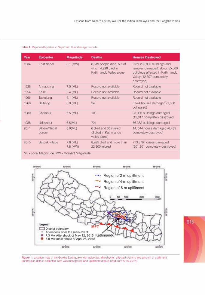
R. K. DahalGeodisaster Research Centre, Central Department of Geology, Tribhuvan University, Kirtipur Kathmandu, 44618, Nepalemail: [email protected], [email protected]
LESSONS LEARNT FROM THE 2015 GORKHA EARTHQUAKE IN NEPAL ON THE ENGINEERING GEOLOGICAL PERSPECTIVES
IntroductionIn the Himalayas, natural disasters, such as earthquakes, landslides and floods are the biggest obstacle to sustainable development. Due to geographical and geological conditions of the Himalayas, the region is prone to various types of natural disasters. The Himalayan mountain chain is tectonically one of the most active mountain ranges on the earth. Rugged topography, unstable geological structures, soft and fragile rocks, frequent earthquakes, along with heavy and concentrated rainfall during the monsoon cause severe landslides and related phenomena in the Himalayan region. Many studies show that Himalayan countries face a high risk of earthquakes, landslides and floods. For instance, in 2005, World Bank classified Nepal as one of the global 'hot-spots' for natural disasters.
The major source of earthquake in Nepal and the other Himalayan countries is subduction of the Indian plate underneath the Eurasian plate, resulting in contraction effect and stress concentration. Based on the frequency and strength of the past earthquakes, seismicity is considered to be high in Nepal. During the past 100 years, four great earthquakes (Table 1) occurred along the Himalayan front. From east to west, the sequence includes the 1905 Kangra earthquake (Mw ~7.8), the 1934 Bihar-Nepal earthquake (Mw = 8.1), the 1950 Assam earthquake (Mw ~8.6) and the Gorkha earthquake (Mw = 7.8). After the 1934 Bihar-Nepal earthquake, eight major earthquakes have hit Nepal. The Gorkha Earthquake occurred at 11:56 am Nepal Standard Time on 25 April 2015 with an epicenter 77 km northwest of Kathmandu at Barpak village of Gorkha district. It is estimated that more than eighty-five million people (about one-fourth of the country's population) have been affected by the Gorkha Earthquake. In this earthquake, 773,378 houses were damaged, (501,201 houses were completely destroyed), 8,995 people were killed and more than 22,300 people were injured. The ground acceleration map (Fig 2) prepared by USGS (2015) suggests that the earthquake shaking was strong in central Nepal and mild in India, Bangladesh, Bhutan and a few parts of south Tibet (China). During this earthquake, USGS estimated the peak ground acceleration up to 980 gal in the epicenter Barpak village area of Gorkha, 400 gal to 600 gal in Dhading, Rasuwa, Nuwakot, Sindhupalchowk and Dolakha districts, and 400 gal in various parts of the Kathmandu valley. A famous tourist destination North of Kathmandu, Langtang village of Rasuwa district was completely destroyed and more than 200 people were killed in a single event of debris avalanche.
015
Table 1. Major earthquakes in Nepal and their damage records
Figure 1: Location map of the Gorkha Earthquake with epicenter, aftershocks, affected districts and amount of upliftment. Earthquake data is collected from www.nsc.gov.np and upliftment data is cited from ARIA (2015).
016
Year Epicenter Magnitude Deaths Houses Destroyed
1934 East Nepal 8.1 (MW) 8,519 people died, out of Over 200,000 buildings and which 4,296 died in temples damaged, about 55,000 Kathmandu Valley alone buildings affected in Kathmandu Valley (12,397 completely destroyed)
1936 Annapurna 7.0 (ML) Record not available Record not available
1954 Kaski 6.4 (ML) Record not available Record not available
1965 Taplejung 6.1 (ML) Record not available Record not available
1966 Bajhang 6.0 (ML) 24 6,544 houses damaged (1,300 collapsed)
1980 Chainpur 6.5 (ML) 103 25,086 buildings damaged (12,817 completely destroyed)
1988 Udayapur 6.5(ML) 721 66,382 buildings damaged
2011 Sikkim/Nepal 6.9(ML) 6 died and 30 injured 14, 544 house damaged (6,435 border (2 died in Kathmandu completely destroyed) valley alone)
2015 Barpak village 7.6 (ML) 8,995 died and more than 773,378 houses damaged 7.8 (MW) 22,300 injured (501,201 completely destroyed)
ML - Local Magnitude, MW - Moment Magnitude
Region of 2 m upliftment
Region of 4 m upliftment
Region of 6 m upliftment
Kathmandu
District boundary Aftershock after the main event 7.3 Mw Aftershock of May 12, 2015 7.8 Mw main shake of April 25, 2015
MFT
Lessons from Nepal's Earthquake for the Indian Himalayas and the Gangetic Plains
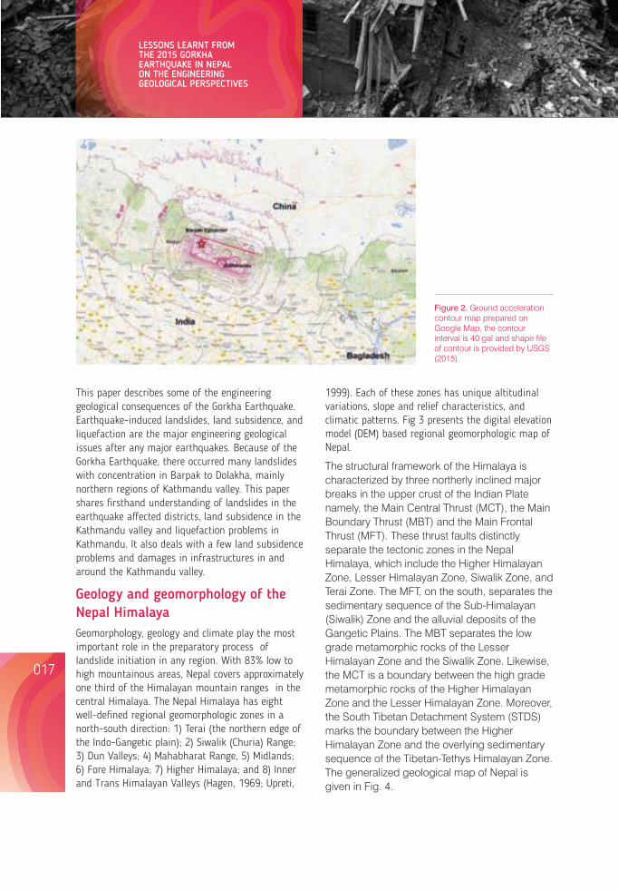
018017
This paper describes some of the engineering geological consequences of the Gorkha Earthquake. Earthquake-induced landslides, land subsidence, and liquefaction are the major engineering geological issues after any major earthquakes. Because of the Gorkha Earthquake, there occurred many landslides with concentration in Barpak to Dolakha, mainly northern regions of Kathmandu valley. This paper shares firsthand understanding of landslides in the earthquake affected districts, land subsidence in the Kathmandu valley and liquefaction problems in Kathmandu. It also deals with a few land subsidence problems and damages in infrastructures in and around the Kathmandu valley.
Geology and geomorphology of the Nepal Himalaya Geomorphology, geology and climate play the most important role in the preparatory process of landslide initiation in any region. With 83% low to high mountainous areas, Nepal covers approximately one third of the Himalayan mountain ranges in the central Himalaya. The Nepal Himalaya has eight well-defined regional geomorphologic zones in a north-south direction: 1) Terai (the northern edge of the Indo-Gangetic plain); 2) Siwalik (Churia) Range; 3) Dun Valleys; 4) Mahabharat Range, 5) Midlands; 6) Fore Himalaya; 7) Higher Himalaya; and 8) Inner and Trans Himalayan Valleys (Hagen, 1969; Upreti,
1999). Each of these zones has unique altitudinal variations, slope and relief characteristics, and climatic patterns. Fig 3 presents the digital elevation model (DEM) based regional geomorphologic map of Nepal.
The structural framework of the Himalaya is characterized by three northerly inclined major breaks in the upper crust of the Indian Plate namely, the Main Central Thrust (MCT), the Main Boundary Thrust (MBT) and the Main Frontal Thrust (MFT). These thrust faults distinctly separate the tectonic zones in the Nepal Himalaya, which include the Higher Himalayan Zone, Lesser Himalayan Zone, Siwalik Zone, and Terai Zone. The MFT, on the south, separates the sedimentary sequence of the Sub-Himalayan (Siwalik) Zone and the alluvial deposits of the Gangetic Plains. The MBT separates the low grade metamorphic rocks of the Lesser Himalayan Zone and the Siwalik Zone. Likewise, the MCT is a boundary between the high grade metamorphic rocks of the Higher Himalayan Zone and the Lesser Himalayan Zone. Moreover, the South Tibetan Detachment System (STDS) marks the boundary between the Higher Himalayan Zone and the overlying sedimentary sequence of the Tibetan-Tethys Himalayan Zone. The generalized geological map of Nepal is given in Fig. 4.
Ground acceleration during
Gorkha
Earthquake, contour line interval 40 gal
Kathmandu
Barpak, 7.8 Mw
Figure 3. DEM based regional geomorphic map of Nepal (modified after Dahal and Hasegawa 2008). Inset shows location of Nepal in the Himalaya. The light grey colored contours are ground acceleration contours in 40 gal interval.
Figure 4.Generalized geological map of Nepal (modified after Dah al and Hasegawa, 2008)
Figure 2. Ground acceleration contour map prepared on Google Map, the contour interval is 40 gal and shape file of contour is provided by USGS (2015).
LESSONS LEARNT FROM THE 2015 GORKHA EARTHQUAKE IN NEPAL ON THE ENGINEERING GEOLOGICAL PERSPECTIVES
Lessons from Nepal's Earthquake for the Indian Himalayas and the Gangetic Plains
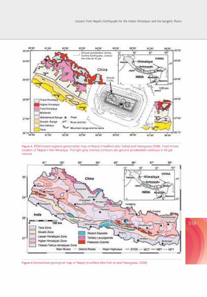
018017
This paper describes some of the engineering geological consequences of the Gorkha Earthquake. Earthquake-induced landslides, land subsidence, and liquefaction are the major engineering geological issues after any major earthquakes. Because of the Gorkha Earthquake, there occurred many landslides with concentration in Barpak to Dolakha, mainly northern regions of Kathmandu valley. This paper shares firsthand understanding of landslides in the earthquake affected districts, land subsidence in the Kathmandu valley and liquefaction problems in Kathmandu. It also deals with a few land subsidence problems and damages in infrastructures in and around the Kathmandu valley.
Geology and geomorphology of the Nepal Himalaya Geomorphology, geology and climate play the most important role in the preparatory process of landslide initiation in any region. With 83% low to high mountainous areas, Nepal covers approximately one third of the Himalayan mountain ranges in the central Himalaya. The Nepal Himalaya has eight well-defined regional geomorphologic zones in a north-south direction: 1) Terai (the northern edge of the Indo-Gangetic plain); 2) Siwalik (Churia) Range; 3) Dun Valleys; 4) Mahabharat Range, 5) Midlands; 6) Fore Himalaya; 7) Higher Himalaya; and 8) Inner and Trans Himalayan Valleys (Hagen, 1969; Upreti,
1999). Each of these zones has unique altitudinal variations, slope and relief characteristics, and climatic patterns. Fig 3 presents the digital elevation model (DEM) based regional geomorphologic map of Nepal.
The structural framework of the Himalaya is characterized by three northerly inclined major breaks in the upper crust of the Indian Plate namely, the Main Central Thrust (MCT), the Main Boundary Thrust (MBT) and the Main Frontal Thrust (MFT). These thrust faults distinctly separate the tectonic zones in the Nepal Himalaya, which include the Higher Himalayan Zone, Lesser Himalayan Zone, Siwalik Zone, and Terai Zone. The MFT, on the south, separates the sedimentary sequence of the Sub-Himalayan (Siwalik) Zone and the alluvial deposits of the Gangetic Plains. The MBT separates the low grade metamorphic rocks of the Lesser Himalayan Zone and the Siwalik Zone. Likewise, the MCT is a boundary between the high grade metamorphic rocks of the Higher Himalayan Zone and the Lesser Himalayan Zone. Moreover, the South Tibetan Detachment System (STDS) marks the boundary between the Higher Himalayan Zone and the overlying sedimentary sequence of the Tibetan-Tethys Himalayan Zone. The generalized geological map of Nepal is given in Fig. 4.
Ground acceleration during
Gorkha
Earthquake, contour line interval 40 gal
Kathmandu
Barpak, 7.8 Mw
Figure 3. DEM based regional geomorphic map of Nepal (modified after Dahal and Hasegawa 2008). Inset shows location of Nepal in the Himalaya. The light grey colored contours are ground acceleration contours in 40 gal interval.
Figure 4.Generalized geological map of Nepal (modified after Dah al and Hasegawa, 2008)
Figure 2. Ground acceleration contour map prepared on Google Map, the contour interval is 40 gal and shape file of contour is provided by USGS (2015).
LESSONS LEARNT FROM THE 2015 GORKHA EARTHQUAKE IN NEPAL ON THE ENGINEERING GEOLOGICAL PERSPECTIVES
Lessons from Nepal's Earthquake for the Indian Himalayas and the Gangetic Plains
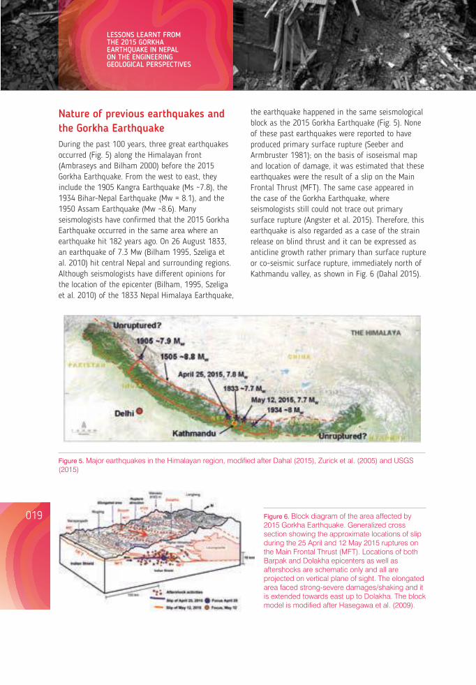
Nature of previous earthquakes and the Gorkha EarthquakeDuring the past 100 years, three great earthquakes occurred (Fig. 5) along the Himalayan front (Ambraseys and Bilham 2000) before the 2015 Gorkha Earthquake. From the west to east, they include the 1905 Kangra Earthquake (Ms ~7.8), the 1934 Bihar-Nepal Earthquake (Mw = 8.1), and the 1950 Assam Earthquake (Mw ~8.6). Many seismologists have confirmed that the 2015 Gorkha Earthquake occurred in the same area where an earthquake hit 182 years ago. On 26 August 1833, an earthquake of 7.3 Mw (Bilham 1995, Szeliga et al. 2010) hit central Nepal and surrounding regions. Although seismologists have different opinions for the location of the epicenter (Bilham, 1995, Szeliga et al. 2010) of the 1833 Nepal Himalaya Earthquake,
020019
After the main shock of the 2015 Gorkha Earthquake, more than 120 subsequent aftershocks occurred eastward of the main shock. Mw 7.3 aftershock hit on 12 May 2015 at 80 km NE of Kathmandu. Most earthquakes are shallow angle thrust faulting on decollement of Main Frontal Thrust. Fig. 6 illustrates the Mw 7.8 earthquake (mainshock) and the distribution of aftershocks of magnitude 4 or larger that occurred over the next six months. Fig. 6 also shows fault displacement during the earthquake. The red star is the epicenter, while the purple arrow shows the direction of rupture propagation towards the southeast (Dahal 2015a). Contours in Fig. 7 show the rupture front in 5 second increments after rupture initiation. Arrows show the direction and amount of motion of the rocks above the fault with respect to the rocks below the fault (IRIS, 2015). Main shock slip was directed towards east from hypocenter. Maximum fault displacement of about 6 m (USGS 2015 and ARIA 2015) occurred in the rupture zone about 20 km north east of Kathmandu (see Fig. 1). The seismic block dimension is approximately 120 x 80 km. Researchers are now concentrating on the mechanism of the Gorkha Earthquake rupture. Apparently, earthquake risk associated with the Gorkha Earthquake is complicated. It is now
the earthquake happened in the same seismological block as the 2015 Gorkha Earthquake (Fig. 5). None of these past earthquakes were reported to have produced primary surface rupture (Seeber and Armbruster 1981); on the basis of isoseismal map and location of damage, it was estimated that these earthquakes were the result of a slip on the Main Frontal Thrust (MFT). The same case appeared in the case of the Gorkha Earthquake, where seismologists still could not trace out primary surface rupture (Angster et al. 2015). Therefore, this earthquake is also regarded as a case of the strain release on blind thrust and it can be expressed as anticline growth rather primary than surface rupture or co-seismic surface rupture, immediately north of Kathmandu valley, as shown in Fig. 6 (Dahal 2015).
Figure 5. Major earthquakes in the Himalayan region, modified after Dahal (2015), Zurick et al. (2005) and USGS (2015)
Figure 6. Block diagram of the area affected by 2015 Gorkha Earthquake. Generalized cross section showing the approximate locations of slip during the 25 April and 12 May 2015 ruptures on the Main Frontal Thrust (MFT). Locations of both Barpak and Dolakha epicenters as well as aftershocks are schematic only and all are projected on vertical plane of sight. The elongated area faced strong-severe damages/shaking and it is extended towards east up to Dolakha. The block model is modified after Hasegawa et al. (2009).
understood that the slip on the southward more than 40 km (see Fig. 1) section of MFT (south of Kathmandu valley) is uncertain and its future movement is not clear. Future movement may either take place as post-seismic creep along the un-ruptured part of the MFT or it can be expressed as anticline growth below the immediate north of Kathmandu (see Fig. 6) or future slip will be at the southern part of the Kathmandu valley, which will generate very shallow earthquake or there will be again huge movement of entire block toward south and surface rupture of MFT will be appeared at south on the boundary of Terai and Siwaliks.
Shaking estimates in the epicenter region are poorly constrained because of fewer intensity observations and absence of strong ground motion data. Likewise, predominantly strong to very strong shaking was focused around the aftershock hypocenter, and severe shaking was elongated eastward from Barpak (epicenter of April 25 2015) to Dolakha (May 12, 2015) as seen in ground acceleration map (see Fig. 2 and Fig. 3).
Figure 7. Fault displacement during Gorkha Earthquake (map source IRIS, 2015)
Ground response in Kathmandu valleyKathmandu valley consists of soft soil layers of lacustrine origin. Various geotechnical borehole explorations suggested that the lacustrine soils in different regions of the valley are geotechnically complex in nature and soil thickness varies from place to place. Maximum depth of the lacustrine deposit is as high as 500 m in the central part of the valley. The soil deposit in the valley is not homogeneous, and both vertical and horizontal heterogeneities are common. The large variations in sediment thickness in the peripheral and the central part are responsible for change in characteristics of the seismic waves and the amplification process of the strong ground motion. Past earthquakes suggest that spectral amplification is common in lacustrine sediments of Kathmandu valley, and they are playing a major role in the intensification of seismic energy.
LESSONS LEARNT FROM THE 2015 GORKHA EARTHQUAKE IN NEPAL ON THE ENGINEERING GEOLOGICAL PERSPECTIVES
Lessons from Nepal's Earthquake for the Indian Himalayas and the Gangetic Plains
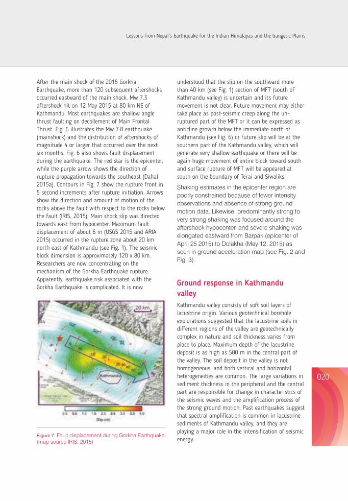
Nature of previous earthquakes and the Gorkha EarthquakeDuring the past 100 years, three great earthquakes occurred (Fig. 5) along the Himalayan front (Ambraseys and Bilham 2000) before the 2015 Gorkha Earthquake. From the west to east, they include the 1905 Kangra Earthquake (Ms ~7.8), the 1934 Bihar-Nepal Earthquake (Mw = 8.1), and the 1950 Assam Earthquake (Mw ~8.6). Many seismologists have confirmed that the 2015 Gorkha Earthquake occurred in the same area where an earthquake hit 182 years ago. On 26 August 1833, an earthquake of 7.3 Mw (Bilham 1995, Szeliga et al. 2010) hit central Nepal and surrounding regions. Although seismologists have different opinions for the location of the epicenter (Bilham, 1995, Szeliga et al. 2010) of the 1833 Nepal Himalaya Earthquake,
020019
After the main shock of the 2015 Gorkha Earthquake, more than 120 subsequent aftershocks occurred eastward of the main shock. Mw 7.3 aftershock hit on 12 May 2015 at 80 km NE of Kathmandu. Most earthquakes are shallow angle thrust faulting on decollement of Main Frontal Thrust. Fig. 6 illustrates the Mw 7.8 earthquake (mainshock) and the distribution of aftershocks of magnitude 4 or larger that occurred over the next six months. Fig. 6 also shows fault displacement during the earthquake. The red star is the epicenter, while the purple arrow shows the direction of rupture propagation towards the southeast (Dahal 2015a). Contours in Fig. 7 show the rupture front in 5 second increments after rupture initiation. Arrows show the direction and amount of motion of the rocks above the fault with respect to the rocks below the fault (IRIS, 2015). Main shock slip was directed towards east from hypocenter. Maximum fault displacement of about 6 m (USGS 2015 and ARIA 2015) occurred in the rupture zone about 20 km north east of Kathmandu (see Fig. 1). The seismic block dimension is approximately 120 x 80 km. Researchers are now concentrating on the mechanism of the Gorkha Earthquake rupture. Apparently, earthquake risk associated with the Gorkha Earthquake is complicated. It is now
the earthquake happened in the same seismological block as the 2015 Gorkha Earthquake (Fig. 5). None of these past earthquakes were reported to have produced primary surface rupture (Seeber and Armbruster 1981); on the basis of isoseismal map and location of damage, it was estimated that these earthquakes were the result of a slip on the Main Frontal Thrust (MFT). The same case appeared in the case of the Gorkha Earthquake, where seismologists still could not trace out primary surface rupture (Angster et al. 2015). Therefore, this earthquake is also regarded as a case of the strain release on blind thrust and it can be expressed as anticline growth rather primary than surface rupture or co-seismic surface rupture, immediately north of Kathmandu valley, as shown in Fig. 6 (Dahal 2015).
Figure 5. Major earthquakes in the Himalayan region, modified after Dahal (2015), Zurick et al. (2005) and USGS (2015)
Figure 6. Block diagram of the area affected by 2015 Gorkha Earthquake. Generalized cross section showing the approximate locations of slip during the 25 April and 12 May 2015 ruptures on the Main Frontal Thrust (MFT). Locations of both Barpak and Dolakha epicenters as well as aftershocks are schematic only and all are projected on vertical plane of sight. The elongated area faced strong-severe damages/shaking and it is extended towards east up to Dolakha. The block model is modified after Hasegawa et al. (2009).
understood that the slip on the southward more than 40 km (see Fig. 1) section of MFT (south of Kathmandu valley) is uncertain and its future movement is not clear. Future movement may either take place as post-seismic creep along the un-ruptured part of the MFT or it can be expressed as anticline growth below the immediate north of Kathmandu (see Fig. 6) or future slip will be at the southern part of the Kathmandu valley, which will generate very shallow earthquake or there will be again huge movement of entire block toward south and surface rupture of MFT will be appeared at south on the boundary of Terai and Siwaliks.
Shaking estimates in the epicenter region are poorly constrained because of fewer intensity observations and absence of strong ground motion data. Likewise, predominantly strong to very strong shaking was focused around the aftershock hypocenter, and severe shaking was elongated eastward from Barpak (epicenter of April 25 2015) to Dolakha (May 12, 2015) as seen in ground acceleration map (see Fig. 2 and Fig. 3).
Figure 7. Fault displacement during Gorkha Earthquake (map source IRIS, 2015)
Ground response in Kathmandu valleyKathmandu valley consists of soft soil layers of lacustrine origin. Various geotechnical borehole explorations suggested that the lacustrine soils in different regions of the valley are geotechnically complex in nature and soil thickness varies from place to place. Maximum depth of the lacustrine deposit is as high as 500 m in the central part of the valley. The soil deposit in the valley is not homogeneous, and both vertical and horizontal heterogeneities are common. The large variations in sediment thickness in the peripheral and the central part are responsible for change in characteristics of the seismic waves and the amplification process of the strong ground motion. Past earthquakes suggest that spectral amplification is common in lacustrine sediments of Kathmandu valley, and they are playing a major role in the intensification of seismic energy.
LESSONS LEARNT FROM THE 2015 GORKHA EARTHQUAKE IN NEPAL ON THE ENGINEERING GEOLOGICAL PERSPECTIVES
Lessons from Nepal's Earthquake for the Indian Himalayas and the Gangetic Plains
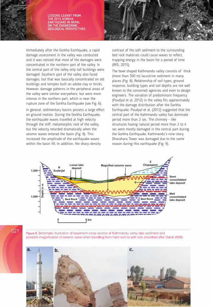
Immediately after the Gorkha Earthquake, a rapid damage assessment in the valley was conducted and it was noticed that most of the damages were concentrated in the northern part of the valley. In the central part of the valley only tall buildings were damaged. Southern part of the valley also faced damages, but that was basically concentrated on old buildings and temples built on adobe clay or bricks. However, damage patterns in the peripheral areas of the valley were similar everywhere, but were more intense in the northern part, which is near the rupture zone of the Gorkha Earthquake (see Fig. 6).
In general, sedimentary basins possess a large effect on ground motion. During the Gorkha Earthquake, the earthquake waves travelled at high velocity through the stiff, metamorphic rock of the valley, but the velocity retarded dramatically when the seismic waves entered the basin (Fig. 8). This increased the amplitude of the earthquake waves within the basin fill. In addition, the sharp density
contrast of the soft sediment to the surrounding bed rock materials could cause waves to reflect, trapping energy in the basin for a period of time (IRIS, 2015).
The bowl shaped Kathmandu valley consists of thick (more than 300 m) lacustrine sediment in many places (Fig. 8). Relationship of soil types, ground response, building types and soil depths are not well known to the concerned agencies and even to design engineers. The variation of predominant frequency (Poudyal et al. 2012) in the valley fits approximately with the damage distribution after the Gorkha Earthquake. Poudyal et al. (2012) suggested that the central part of the Kathmandu valley has dominate period more than 2 sec. The chimney – like structures having natural period more than 2 to 4 sec were mostly damaged in the central part during the Gorkha Earthquake. Kathmandu's nine-story Dharahara Tower was damaged due to the same reason during this earthquake (Fig. 9).
Bed Rock
Bed Rock
Well consolidated lake deposit
Semi consolidated lake deposit
Loose lake deposit
Magnified seismic wave
N
Sudarijal
S
Chapagaon
1,500
1,000 Dep
th in
m
0 5 km
Figure 9. Schematic illustration of basement cross section of Kathmandu valley lake sediment and possible magnification of seismic wave when travelling from hard rock to soft rock (modified after Dahal 2006)
Topographic effect In general, topographic features are basically responsible for dissipation of seismic energy (e.g. Gilbert and Knopoff, 1960), and extremely high ground accelerations are usually observed at sites located on topographic ridges and edges (Ambraseys and Srbulov 1995; Miles and Keefer 2000; Lin et al. 2003; Uchida et al. 2004). Observations of the damage patterns of several earthquakes, namely the 1987 Whittier Narrows, California earthquake, the 1989 Loma Prieta (California) earthquake, the 1994 Northridge, California earthquake, the 1999 Chi-Chi earthquake of Taiwan, the 2004 Chuetsu earthquake of Niigata Prefecture, Japan, the 2005 Kashmir earthquake of Pakistan, the 2010 Haiti Earthquake, and the 2011 Sikkim-Nepal Earthquake of Nepal (Dahal et al. 2013) indicate the occurrence of intense shaking in elevated ridges of rugged topography. In the Gorkha earthquake, topographic effects were very significant in the towns and villages on the ridges. Geli et al. (1988) have reported that buildings on crests suffer more damage than those located at the base, and they conclude that there is always significant amplification of frequencies corresponding to wavelengths nearly equal to mountain width at hilltops with respect to the base. In the case of the Gorkha Earthquake, it was quite well observed in Chautara and Sangachowk town in Sidhupalchowk district. Many houses on the ridges were damaged (Fig. 10) and many cracks were observed on the ridge. Similarly, an amplification-deamplification pattern on slopes leads to a strong energy accumulation on the upper part of the slope. From the field observations, it is found that the number of landslides is higher on or near the crests of hills and mountains. To evaluate topographic effect for the landsliding process, the topographic curvature of the most damaged area was calculated in GIS and cross checked with the earthquake-induced landslide inventory. Digital Elevation Model (DEM) of 30 m pixel size was used for this purpose. In total, 70% of earthquake-induced landslides were found on ridge slope pixel and 30% were found on valley slope pixel. This data clearly suggested that during the Gorkha Earthquake also, there was high frequency of
earthquake-induced landslides on or near the crests of mountains or hills.
Figure 10. Earthquake damaged houses in Chautara town
Engineering geological issues after the Gorkha Earthquake Earthquake-induced landslides, land subsidence and liquefaction were the three major engineering geological issues which were observed after the Gorkha Earthquake in most of the 14 severely affected districts of Nepal. Chinese territory on the north also faced a few earthquake-induced landslides and damages to the roads.
Earthquake-Induced landslide
Earthquake-induced slope failures are one of the most damaging natural disasters. Commonly, damage from earthquake-induced slope failures is
022021
LESSONS LEARNT FROM THE 2015 GORKHA EARTHQUAKE IN NEPAL ON THE ENGINEERING GEOLOGICAL PERSPECTIVES
Lessons from Nepal's Earthquake for the Indian Himalayas and the Gangetic Plains
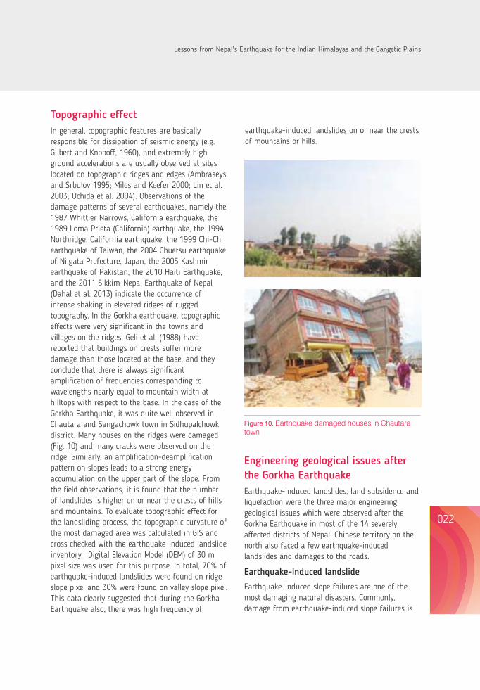
Immediately after the Gorkha Earthquake, a rapid damage assessment in the valley was conducted and it was noticed that most of the damages were concentrated in the northern part of the valley. In the central part of the valley only tall buildings were damaged. Southern part of the valley also faced damages, but that was basically concentrated on old buildings and temples built on adobe clay or bricks. However, damage patterns in the peripheral areas of the valley were similar everywhere, but were more intense in the northern part, which is near the rupture zone of the Gorkha Earthquake (see Fig. 6).
In general, sedimentary basins possess a large effect on ground motion. During the Gorkha Earthquake, the earthquake waves travelled at high velocity through the stiff, metamorphic rock of the valley, but the velocity retarded dramatically when the seismic waves entered the basin (Fig. 8). This increased the amplitude of the earthquake waves within the basin fill. In addition, the sharp density
contrast of the soft sediment to the surrounding bed rock materials could cause waves to reflect, trapping energy in the basin for a period of time (IRIS, 2015).
The bowl shaped Kathmandu valley consists of thick (more than 300 m) lacustrine sediment in many places (Fig. 8). Relationship of soil types, ground response, building types and soil depths are not well known to the concerned agencies and even to design engineers. The variation of predominant frequency (Poudyal et al. 2012) in the valley fits approximately with the damage distribution after the Gorkha Earthquake. Poudyal et al. (2012) suggested that the central part of the Kathmandu valley has dominate period more than 2 sec. The chimney – like structures having natural period more than 2 to 4 sec were mostly damaged in the central part during the Gorkha Earthquake. Kathmandu's nine-story Dharahara Tower was damaged due to the same reason during this earthquake (Fig. 9).
Bed Rock
Bed Rock
Well consolidated lake deposit
Semi consolidated lake deposit
Loose lake deposit
Magnified seismic wave
N
Sudarijal
S
Chapagaon
1,500
1,000 Dep
th in
m
0 5 km
Figure 9. Schematic illustration of basement cross section of Kathmandu valley lake sediment and possible magnification of seismic wave when travelling from hard rock to soft rock (modified after Dahal 2006)
Topographic effect In general, topographic features are basically responsible for dissipation of seismic energy (e.g. Gilbert and Knopoff, 1960), and extremely high ground accelerations are usually observed at sites located on topographic ridges and edges (Ambraseys and Srbulov 1995; Miles and Keefer 2000; Lin et al. 2003; Uchida et al. 2004). Observations of the damage patterns of several earthquakes, namely the 1987 Whittier Narrows, California earthquake, the 1989 Loma Prieta (California) earthquake, the 1994 Northridge, California earthquake, the 1999 Chi-Chi earthquake of Taiwan, the 2004 Chuetsu earthquake of Niigata Prefecture, Japan, the 2005 Kashmir earthquake of Pakistan, the 2010 Haiti Earthquake, and the 2011 Sikkim-Nepal Earthquake of Nepal (Dahal et al. 2013) indicate the occurrence of intense shaking in elevated ridges of rugged topography. In the Gorkha earthquake, topographic effects were very significant in the towns and villages on the ridges. Geli et al. (1988) have reported that buildings on crests suffer more damage than those located at the base, and they conclude that there is always significant amplification of frequencies corresponding to wavelengths nearly equal to mountain width at hilltops with respect to the base. In the case of the Gorkha Earthquake, it was quite well observed in Chautara and Sangachowk town in Sidhupalchowk district. Many houses on the ridges were damaged (Fig. 10) and many cracks were observed on the ridge. Similarly, an amplification-deamplification pattern on slopes leads to a strong energy accumulation on the upper part of the slope. From the field observations, it is found that the number of landslides is higher on or near the crests of hills and mountains. To evaluate topographic effect for the landsliding process, the topographic curvature of the most damaged area was calculated in GIS and cross checked with the earthquake-induced landslide inventory. Digital Elevation Model (DEM) of 30 m pixel size was used for this purpose. In total, 70% of earthquake-induced landslides were found on ridge slope pixel and 30% were found on valley slope pixel. This data clearly suggested that during the Gorkha Earthquake also, there was high frequency of
earthquake-induced landslides on or near the crests of mountains or hills.
Figure 10. Earthquake damaged houses in Chautara town
Engineering geological issues after the Gorkha Earthquake Earthquake-induced landslides, land subsidence and liquefaction were the three major engineering geological issues which were observed after the Gorkha Earthquake in most of the 14 severely affected districts of Nepal. Chinese territory on the north also faced a few earthquake-induced landslides and damages to the roads.
Earthquake-Induced landslide
Earthquake-induced slope failures are one of the most damaging natural disasters. Commonly, damage from earthquake-induced slope failures is
022021
LESSONS LEARNT FROM THE 2015 GORKHA EARTHQUAKE IN NEPAL ON THE ENGINEERING GEOLOGICAL PERSPECTIVES
Lessons from Nepal's Earthquake for the Indian Himalayas and the Gangetic Plains
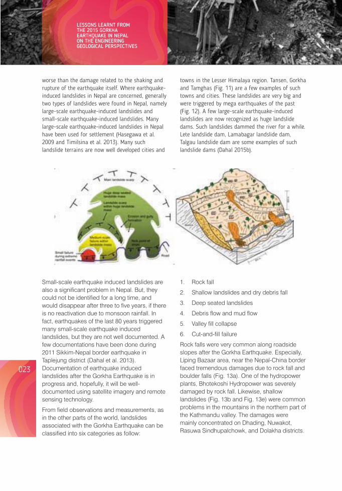
Small-scale earthquake induced landslides are also a significant problem in Nepal. But, they could not be identified for a long time, and would disappear after three to five years, if there is no reactivation due to monsoon rainfall. In fact, earthquakes of the last 80 years triggered many small-scale earthquake induced landslides, but they are not well documented. A few documentations have been done during 2011 Sikkim-Nepal border earthquake in Taplejung district (Dahal et al. 2013). Documentation of earthquake induced landslides after the Gorkha Earthquake is in progress and, hopefully, it will be well-documented using satellite imagery and remote sensing technology.
From field observations and measurements, as in the other parts of the world, landslides associated with the Gorkha Earthquake can be classified into six categories as follow:
worse than the damage related to the shaking and rupture of the earthquake itself. Where earthquake-induced landslides in Nepal are concerned, generally two types of landslides were found in Nepal, namely large-scale earthquake-induced landslides and small-scale earthquake-induced landslides. Many large-scale earthquake-induced landslides in Nepal have been used for settlement (Hasegawa et al. 2009 and Timilsina et al. 2013). Many such landslide terrains are now well developed cities and
towns in the Lesser Himalaya region. Tansen, Gorkha and Tamghas (Fig. 11) are a few examples of such towns and cities. These landslides are very big and were triggered by mega earthquakes of the past (Fig. 12). A few large-scale earthquake-induced landslides are now recognized as huge landslide dams. Such landslides dammed the river for a while. Lete landslide dam, Lamabagar landslide dam, Talgau landslide dam are some examples of such landslide dams (Dahal 2015b).
1. Rock fall
2. Shallow landslides and dry debris fall
3. Deep seated landslides
4. Debris ow and mud ow
5. Valley fill collapse
6. Cut-and-fill failure
Rock falls were very common along roadside slopes after the Gorkha Earthquake. Especially, Liping Bazaar area, near the Nepal-China border faced tremendous damages due to rock fall and boulder falls (Fig. 13a). One of the hydropower plants, Bhotekoshi Hydropower was severely damaged by rock fall. Likewise, shallow landslides (Fig. 13b and Fig. 13e) were common problems in the mountains in the northern part of the Kathmandu valley. The damages were mainly concentrated on Dhading, Nuwakot, Rasuwa Sindhupalchowk, and Dolakha districts.
Deep – seated large-scale landslides were not noticed after the earthquake, but there were many cracks on the upper part of the slopes, which could trigger huge valley collapse or landslide anytime. A few huge failures (Fig. 13c) were seen in the old landslide mass in the Rasuwa district, north of Kathmandu. The Gorkha Earthquake happened during the dry season. As a result, no debris ow and mudow problems were noticed in the affected areas, but due to debris avalanche in Langtang village (Fig. 13d), more than 200 people were killed, and a
village in Langtang, which was a popular tourist destination, is now a part of history. Valley fill collapses were common along some roads in Kathmandu valley. Roads near the Kathmandu Airport (Fig. 13f) faced valley fill collapse problems. Cut-and-fill failures were common in roadside slopes of the mountain roads after the Gorkha Earthquake. In many places, roads crumbled down after the earthquake. Typical examples of earthquake-induced failures are shown in Fig. 13.
a.
b.
c.
d.
f.
e.
Figure 13. Various kinds of Earthquake - induced landslides in the affected area of Gorkha Earthquake.
024023
LESSONS LEARNT FROM THE 2015 GORKHA EARTHQUAKE IN NEPAL ON THE ENGINEERING GEOLOGICAL PERSPECTIVES
Lessons from Nepal's Earthquake for the Indian Himalayas and the Gangetic Plains
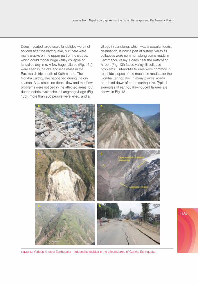
Small-scale earthquake induced landslides are also a significant problem in Nepal. But, they could not be identified for a long time, and would disappear after three to five years, if there is no reactivation due to monsoon rainfall. In fact, earthquakes of the last 80 years triggered many small-scale earthquake induced landslides, but they are not well documented. A few documentations have been done during 2011 Sikkim-Nepal border earthquake in Taplejung district (Dahal et al. 2013). Documentation of earthquake induced landslides after the Gorkha Earthquake is in progress and, hopefully, it will be well-documented using satellite imagery and remote sensing technology.
From field observations and measurements, as in the other parts of the world, landslides associated with the Gorkha Earthquake can be classified into six categories as follow:
worse than the damage related to the shaking and rupture of the earthquake itself. Where earthquake-induced landslides in Nepal are concerned, generally two types of landslides were found in Nepal, namely large-scale earthquake-induced landslides and small-scale earthquake-induced landslides. Many large-scale earthquake-induced landslides in Nepal have been used for settlement (Hasegawa et al. 2009 and Timilsina et al. 2013). Many such landslide terrains are now well developed cities and
towns in the Lesser Himalaya region. Tansen, Gorkha and Tamghas (Fig. 11) are a few examples of such towns and cities. These landslides are very big and were triggered by mega earthquakes of the past (Fig. 12). A few large-scale earthquake-induced landslides are now recognized as huge landslide dams. Such landslides dammed the river for a while. Lete landslide dam, Lamabagar landslide dam, Talgau landslide dam are some examples of such landslide dams (Dahal 2015b).
1. Rock fall
2. Shallow landslides and dry debris fall
3. Deep seated landslides
4. Debris ow and mud ow
5. Valley fill collapse
6. Cut-and-fill failure
Rock falls were very common along roadside slopes after the Gorkha Earthquake. Especially, Liping Bazaar area, near the Nepal-China border faced tremendous damages due to rock fall and boulder falls (Fig. 13a). One of the hydropower plants, Bhotekoshi Hydropower was severely damaged by rock fall. Likewise, shallow landslides (Fig. 13b and Fig. 13e) were common problems in the mountains in the northern part of the Kathmandu valley. The damages were mainly concentrated on Dhading, Nuwakot, Rasuwa Sindhupalchowk, and Dolakha districts.
Deep – seated large-scale landslides were not noticed after the earthquake, but there were many cracks on the upper part of the slopes, which could trigger huge valley collapse or landslide anytime. A few huge failures (Fig. 13c) were seen in the old landslide mass in the Rasuwa district, north of Kathmandu. The Gorkha Earthquake happened during the dry season. As a result, no debris ow and mudow problems were noticed in the affected areas, but due to debris avalanche in Langtang village (Fig. 13d), more than 200 people were killed, and a
village in Langtang, which was a popular tourist destination, is now a part of history. Valley fill collapses were common along some roads in Kathmandu valley. Roads near the Kathmandu Airport (Fig. 13f) faced valley fill collapse problems. Cut-and-fill failures were common in roadside slopes of the mountain roads after the Gorkha Earthquake. In many places, roads crumbled down after the earthquake. Typical examples of earthquake-induced failures are shown in Fig. 13.
a.
b.
c.
d.
f.
e.
Figure 13. Various kinds of Earthquake - induced landslides in the affected area of Gorkha Earthquake.
024023
LESSONS LEARNT FROM THE 2015 GORKHA EARTHQUAKE IN NEPAL ON THE ENGINEERING GEOLOGICAL PERSPECTIVES
Lessons from Nepal's Earthquake for the Indian Himalayas and the Gangetic Plains
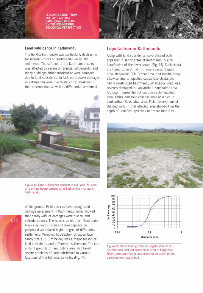
026025
Land subsidence in Kathmandu
The Gorkha Earthquake was particularly destructive for infrastructures on Kathmandu valley lake sediments. The soft soil of the Kathmandu valley was affected by severe differential settlements, and many buildings either subsided or were damaged due to land subsidence. In fact, earthquake damages in Kathmandu were due to structural weakness of the constructions, as well as differential settlement
Liquefaction in Kathmandu Along with land subsidence, several sand boils appeared in sandy areas of Kathmandu due to liquefaction of the lower strata (Fig. 15). Such strata are found to be 2m -5m in many cases (Bagdol area, Dhapakhel GEM School area, and Imadol area). Likewise, due to liquefied subsurface strata, the newly constructed Kathmandu-Bhaktapur Road was severely damaged in Laukanthali-Kaushaltar area. Although houses did not subside in the liquefied layer, tilting and road collapse were observed in Laukanthali-Kaushaltar area. Field observations of the dug wells in that affected area showed that the depth of liquefied layer was not more than 8 m.
Grain Size Distribution Curve
0102030405060708090
100
0.01 0.1 1Diameter, mm
% P
assi
ng
Lessons for the Indian Himalayan RegionSeismologists are of the opinion that there is a high probability of a mega earthquake in western Nepal and Uttarakhand state of India. This earthquake will be very devastating, and it is expected that it will affect the Indian Himalayas and the plain area of south including Delhi. The Gorkha Earthquake has shown a very clear picture of possible devastation in the Indian Himalaya after the earthquake. To synthesize possible effect of topography, old landslide mass and river blockade from landslide dam, a traverse was done in Delhi-Haridwar-Srinagar section. Field observations suggested that the construction technology of residential houses in plain area of India is also not different from that of
a.
Fig. 16.
Figure 14. Land subsidence problem in cut -and- fill area of a private house compound in Budhanilkantha, north Kathmandu.
of the ground. Field observations during rapid damage assessment in Kathmandu valley showed that nearly 40% of damages were due to land subsidence only. The houses on old river flood plain, black clay deposit area and lake deposits on peripheral area faced higher degree of differential settlement. Moreover, liquefaction of subsurface sandy strata (2-5 m below) was a major reason of land subsidence and differential settlement. The cut-and-fill grounds of land poling area also faced severe problems of land subsidence in various locations of the Kathmandu valley (Fig. 14).
Figure 15. Sand boiling sites at Bagdol (South of Kathmandu and old ood plain area of Bagamati River) area and Grain size distribution curve of soil samples from sand boil.
Nepal. Likewise, the road construction practice is also not different. Narrow road alignment with rocky roadside slopes (Fig. 16) are common scenario in both countries. Although road quality is better in the Indian Himalaya than in the Nepal Himalaya, the slope management practice is the same. As a result, as in the case of Gorkha Earthquake in Nepal, the roads in the Indian Himalaya will also not be able to be used after great or major earthquakes.
To understand landslide nature and associated landslide process in the Nepal Himalaya, a study of large-scale landslides was conducted in central Nepal (Timilsina et al. 2013). The study evaluated the large-scale landslides in terms of geological, geomorphological and geotechnical characteristics with distribution probability, and has revealed that rock types are the most important causative factors in case of landslides in central Nepal. Most of the landslides are occurring in the range of 20-40 degree slope. About 70% of the large-scale landslides were found to be in phyllite and slate. Similarly, metasandstone, limestone and dolomite have experienced landslides. Similarly, evaluation of the influence of fold axis and foliation direction showed that most of the large-scale landslides were found to have occurred on dip slopes. In many cases, large-scale landslides caused many landslide dams in central Nepal. In fact, there are many large-scale landslide dams in the Nepal Himalaya, which blocked the major rivers for a long time. During the Gorkha Earthquake, settlements in the old landslide mass faced extensive damages (Fig. 17). The old landslide mass and landslide topography of the Indian Himalaya are very much similar to the Nepal Himalaya (Fig. 18) and similar cases could be observed in both Himalayas. Problematic old landslide mass is now facing surface failure problem in the Indian Himalaya as in the Nepal Himalaya (see Fig. 12). One landslide site in Alakananda River, near Srinagar, is creating serious problems of rock fall every day and many traffic accidents occurs on the site. In fact, this site is a typical chronic landslide problem of the Indian Himalaya. The mitigation measures on the site (Fig. 19) is also very insufficient and the design of the mitigative structures was not done properly. Similar
Figure 16. a. Rocky roadside slope in the Indian Himalaya, and b. Rocky roadside slope in the Nepal Himalaya
b.
LESSONS LEARNT FROM THE 2015 GORKHA EARTHQUAKE IN NEPAL ON THE ENGINEERING GEOLOGICAL PERSPECTIVES
Lessons from Nepal's Earthquake for the Indian Himalayas and the Gangetic Plains
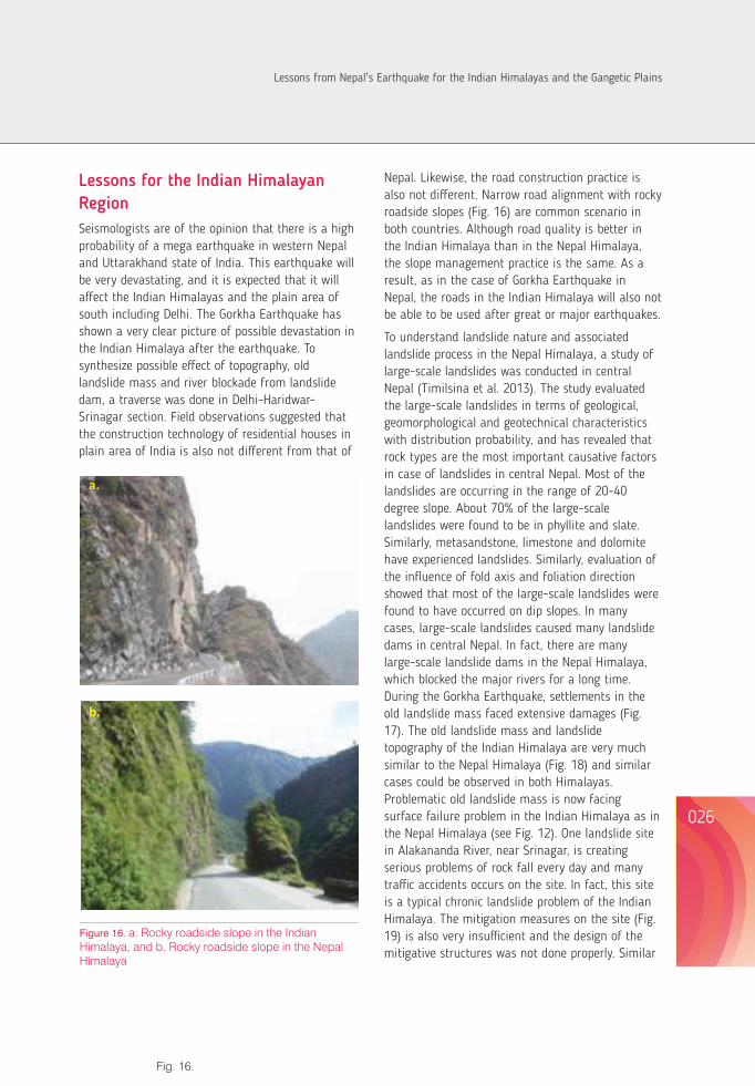
026025
Land subsidence in Kathmandu
The Gorkha Earthquake was particularly destructive for infrastructures on Kathmandu valley lake sediments. The soft soil of the Kathmandu valley was affected by severe differential settlements, and many buildings either subsided or were damaged due to land subsidence. In fact, earthquake damages in Kathmandu were due to structural weakness of the constructions, as well as differential settlement
Liquefaction in Kathmandu Along with land subsidence, several sand boils appeared in sandy areas of Kathmandu due to liquefaction of the lower strata (Fig. 15). Such strata are found to be 2m -5m in many cases (Bagdol area, Dhapakhel GEM School area, and Imadol area). Likewise, due to liquefied subsurface strata, the newly constructed Kathmandu-Bhaktapur Road was severely damaged in Laukanthali-Kaushaltar area. Although houses did not subside in the liquefied layer, tilting and road collapse were observed in Laukanthali-Kaushaltar area. Field observations of the dug wells in that affected area showed that the depth of liquefied layer was not more than 8 m.
Grain Size Distribution Curve
0102030405060708090
100
0.01 0.1 1Diameter, mm
% P
assi
ng
Lessons for the Indian Himalayan RegionSeismologists are of the opinion that there is a high probability of a mega earthquake in western Nepal and Uttarakhand state of India. This earthquake will be very devastating, and it is expected that it will affect the Indian Himalayas and the plain area of south including Delhi. The Gorkha Earthquake has shown a very clear picture of possible devastation in the Indian Himalaya after the earthquake. To synthesize possible effect of topography, old landslide mass and river blockade from landslide dam, a traverse was done in Delhi-Haridwar-Srinagar section. Field observations suggested that the construction technology of residential houses in plain area of India is also not different from that of
a.
Fig. 16.
Figure 14. Land subsidence problem in cut -and- fill area of a private house compound in Budhanilkantha, north Kathmandu.
of the ground. Field observations during rapid damage assessment in Kathmandu valley showed that nearly 40% of damages were due to land subsidence only. The houses on old river flood plain, black clay deposit area and lake deposits on peripheral area faced higher degree of differential settlement. Moreover, liquefaction of subsurface sandy strata (2-5 m below) was a major reason of land subsidence and differential settlement. The cut-and-fill grounds of land poling area also faced severe problems of land subsidence in various locations of the Kathmandu valley (Fig. 14).
Figure 15. Sand boiling sites at Bagdol (South of Kathmandu and old ood plain area of Bagamati River) area and Grain size distribution curve of soil samples from sand boil.
Nepal. Likewise, the road construction practice is also not different. Narrow road alignment with rocky roadside slopes (Fig. 16) are common scenario in both countries. Although road quality is better in the Indian Himalaya than in the Nepal Himalaya, the slope management practice is the same. As a result, as in the case of Gorkha Earthquake in Nepal, the roads in the Indian Himalaya will also not be able to be used after great or major earthquakes.
To understand landslide nature and associated landslide process in the Nepal Himalaya, a study of large-scale landslides was conducted in central Nepal (Timilsina et al. 2013). The study evaluated the large-scale landslides in terms of geological, geomorphological and geotechnical characteristics with distribution probability, and has revealed that rock types are the most important causative factors in case of landslides in central Nepal. Most of the landslides are occurring in the range of 20-40 degree slope. About 70% of the large-scale landslides were found to be in phyllite and slate. Similarly, metasandstone, limestone and dolomite have experienced landslides. Similarly, evaluation of the influence of fold axis and foliation direction showed that most of the large-scale landslides were found to have occurred on dip slopes. In many cases, large-scale landslides caused many landslide dams in central Nepal. In fact, there are many large-scale landslide dams in the Nepal Himalaya, which blocked the major rivers for a long time. During the Gorkha Earthquake, settlements in the old landslide mass faced extensive damages (Fig. 17). The old landslide mass and landslide topography of the Indian Himalaya are very much similar to the Nepal Himalaya (Fig. 18) and similar cases could be observed in both Himalayas. Problematic old landslide mass is now facing surface failure problem in the Indian Himalaya as in the Nepal Himalaya (see Fig. 12). One landslide site in Alakananda River, near Srinagar, is creating serious problems of rock fall every day and many traffic accidents occurs on the site. In fact, this site is a typical chronic landslide problem of the Indian Himalaya. The mitigation measures on the site (Fig. 19) is also very insufficient and the design of the mitigative structures was not done properly. Similar
Figure 16. a. Rocky roadside slope in the Indian Himalaya, and b. Rocky roadside slope in the Nepal Himalaya
b.
LESSONS LEARNT FROM THE 2015 GORKHA EARTHQUAKE IN NEPAL ON THE ENGINEERING GEOLOGICAL PERSPECTIVES
Lessons from Nepal's Earthquake for the Indian Himalayas and the Gangetic Plains
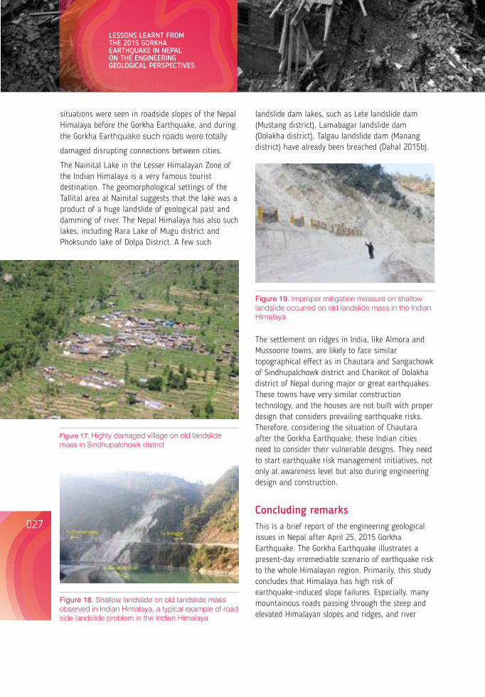
028027
situations were seen in roadside slopes of the Nepal Himalaya before the Gorkha Earthquake, and during the Gorkha Earthquake such roads were totally
damaged disrupting connections between cities.
The Nainital Lake in the Lesser Himalayan Zone of the Indian Himalaya is a very famous tourist destination. The geomorphological settings of the Tallital area at Nainital suggests that the lake was a product of a huge landslide of geological past and damming of river. The Nepal Himalaya has also such lakes, including Rara Lake of Mugu district and Phoksundo lake of Dolpa District. A few such
Figure 17. Highly damaged village on old landslide mass in Sindhupalchowk district
The settlement on ridges in India, like Almora and Mussoorie towns, are likely to face similar topographical effect as in Chautara and Sangachowk of Sindhupalchowk district and Charikot of Dolakha district of Nepal during major or great earthquakes. These towns have very similar construction technology, and the houses are not built with proper design that considers prevailing earthquake risks. Therefore, considering the situation of Chautara after the Gorkha Earthquake, these Indian cities need to consider their vulnerable designs. They need to start earthquake risk management initiatives, not only at awareness level but also during engineering design and construction.
landslide dam lakes, such as Lete landslide dam (Mustang district), Lamabagar landslide dam (Dolakha district), Talgau landslide dam (Manang district) have already been breached (Dahal 2015b).
Figure 18. Shallow landslide on old landslide mass observed in Indian Himalaya, a typical example of road side landslide problem in the Indian Himalaya
Figure 19. Improper mitigation measure on shallow landslide occurred on old landslide mass in the Indian Himalaya
Concluding remarks This is a brief report of the engineering geological issues in Nepal after April 25, 2015 Gorkha Earthquake. The Gorkha Earthquake illustrates a present-day irremediable scenario of earthquake risk to the whole Himalayan region. Primarily, this study concludes that Himalaya has high risk of earthquake-induced slope failures. Especially, many mountainous roads passing through the steep and elevated Himalayan slopes and ridges, and river
valleys are prone to high risks. Soft sediment usually possesses heterogeneity in site response characteristic, which was well observed in Kathmandu valley during the Gorkha Earthquake. Therefore, the behavior of the surface deposit, as well as the layer underneath should be taken into consideration during seismic risk studies in the plain area having soft sediment, such as wide river valleys, old lake deposits and Terai Plains. During earthquake in the Himalaya, liquefaction is a common issue of the lacustrine sediments and river channel deposits. For the future, planning of cities, including Kathmandu and those in the Terai Plain, should be done with proper evaluation of liquefaction hazard in accordance with the recently developed geoscientific tools. Topographical effect on hill settlements during an earthquake is another significant problem that needs to be addressed through suitable structural design of buildings in rural and town areas of the Himalaya.
It is high time that the researchers on earthquakes in the Indian Himalaya need to work closely with those working in Nepal Himalaya to understand the earthquake risks in the villages and cities of the Himalayan region. This involves both earthquake resistance engineering design and earthquake geotechnical engineering investigation of the rural areas in the two countries for sustainable infrastructure planning.
AcknowledgementsI would like to acknowledge Prof. Dr. Shuichi Hasegawa (Kagawa University, Japan) for his guidance in writing this paper and I sincerely thank Dr. Manita Timilsina (Geotech Solutions International) for her cooperation in field investigation and data collection.
ReferencesAmbraseys N and Bilham R. 2000 A note on the Kangra Ms = 7.8 earthquake of 4 April 1905, Current Science, 79: pp. 45-
50.
Ambraseys N and Srbulov M. 1995 Earthquake induced displacement of slopes. Soil Dyn. Earthqu. Eng, 14: pp. 59– 71.
Angster S, Fielding E J, Wesnousky S, Pierce I, Chamlagain D, Gautam D, Upreti B N, Kumahara Y, Nakata T, 2015) Field Reconnaissance after the 25 April 2015 M 7.8 Gorkha Earthquake, Seismological Research Letters 86(6):1506-1513.
ARIA 2015, M7.8 Gorkha, Nepal Earthquake, April 25, 2015, http://aria.jpl.nasa.gov/node/43 (accessed on 2015/11/25)
Bilham R, Location and magnitude of the 1833 Nepal earthquake and its relation to the rupture zones of contiguous great Himalayan earthquakes. Current Science, 69, 2, 1995: 101-128.
Dahal R.K, 2015a Engineering Geological Issues after Gorkha Earthquake 2015 in Nepal - a preliminary understanding, Proceedings of 10th Asian Regional Conference of IAEG, Kyoto, Japan, September 26-27, 2015. 7p.
Dahal RK, 2015b Consequences of large-scale landslide dams in the Nepal Himalaya, Proceeding of EGNM 2015, Indian Society of Engineering Geologists, October 2015, 10p.
Dahal RK, Bhandary NP, Timilsina M, Yatabe R, and Hasegawa S 2013 Earthquake Induced Landslides in the Roadside Slopes of East Nepal After Recent September 18, 2011, In Eds Ugai ,K., Yagi, H., Wakai, A., Earthquake Earthquake Induced Landslides, Springer Berlin Heidelberg, pp. 149-157.
Dahal RK, Hasegawa S 2008 Representative rainfall thresholds for landslides in the Nepal Himalaya, Geomorphology, 100: No. 3-4, 429-443.
Geli L, Bard PY, Jullien B1988 The effect of topography on earthquake ground motion: a review and new results, Bulletin of the Seismological Society of America, 78: No. 1, 42-63.
Gilbert F and Knopoff L1960 Seismic Scattering from Topographic irregularities, Journal of Geophysical Research 65: 3437-3444.
LESSONS LEARNT FROM THE 2015 GORKHA EARTHQUAKE IN NEPAL ON THE ENGINEERING GEOLOGICAL PERSPECTIVES
Lessons from Nepal's Earthquake for the Indian Himalayas and the Gangetic Plains
030029
HasegawaS, Dahal RK, Yamanaka M, Bhandary N P, Yatabe R, and Inagaki H2009 Causes of large-scale landslides in the Lesser Himalaya of central Nepal, Environmental Geology, 57: No. 6, 1423-1434.
IRIS 2015: Magnitude 7.8 NEPAL, Saturday, April 25, 2015 at 06:11:26 UTC, document available in http://www.iris.edu/hq/files/programs/education_and_outreach/retm/tm_150425_nepal/150425 _Nepal.pdf (accessed on 2015/7/15).
Lin CW, Shieh CL, Yuan BD, Shieh YC, Liu SH and Lee SY2003 Impact of Chi-Chi earthquake on the occurrence of landslides and debris flows: example from the Chenyulan River watershed, Nantou, Taiwan, Engineering Geology 71: 49-61
MilesSB and Keefer DK 2000 Evaluation of seismic slope-performance models using a regional case study, Environmental & Engineering Geoscience, 6: No. 1, 25-39
PaudyalYR, Yatabe R, Bhandary NP and Dahal RK 2012 A study of local amplification effect of soil layers on ground motion in the Kathmandu Valley using microtremor analysis, Earthq Eng & Eng Vib. 11: 257-268.
Seeber L. and Armbruster J 1981 Great detachment earthquakes along the Himalaya arc and long-term forecasting in earthquake prediction: An International Review, Maurice Ewing Series. 4: 259-279.
Szeliga W, Hough S, Martin S & Bilham R. Intensity, Magnitude, Location, and Attenuation in India for Felt Earthquakes since 1762. Bulletin of the Seismological Society of America 100, 2, 2010: 570-584.
USGS 2015: The April-May 2015 Nepal Earthquake Sequence, document available in http://earthquake.usgs.gov/learn/topics/Nepal_Slides.pdf (accessed on 2015/7/15).
ZurickD, Pacheco J, Shrestha B and Bajracharya B 2005 Atlas of the Himalaya, International Centre for Integrated Mountain Development (ICIMOD), 96p.
Charu C. Pant, Vivekanand Pathak and Santosh JoshiDepartment of Geology, Centre of Advanced Study, Kumaun University, [email protected]; [email protected]; [email protected]
EXTANT SEISMICITY AND REGIONAL TECTONIC INTERPRETATION: AN ILLUSTRATION FROM KUMAUN HIMALAYA, UTTARAKHAND, INDIA.
AbstractThe Kumaun-Garhwal Himalaya, a part of Central Seismic Gap, is the unruptured segment between 1905 Kangra earthquake and 2015 Gorkha earthquake. A data set of earthquake events from the period of 1999-2007 has been analysed along with the detailed geomorphological investigations in major river valleys of Kumaun Himalaya to understand change in surface morphology related to active tectonics of the region. Various geomorphic features of active tectonics viz. unpaired terraces, paleochannels, springs, waterfalls, fault facet, fault scarps, ponding of rivers, deep gorges, uplifted potholes, extensive landslides, paleolake deposits, fluvio lacustrine deposits, tilted Quaternary deposits, laterally shifted river channels etc. have been identified along the traverses that were taken. It is evident by the recurrent seismicity and geomorphic developments of the region that fault/thrusts which delimit the tectonic boundaries of the region were reactivated during Quaternary time. The earthquake events in Kumaun Himalaya lies between two major intracrustal boundary thrusts namely the Main Central Thrust (MCT) in North and the Main boundary Thrust in South, where most of the seismicity has been observed in South of MCT and in North of Almora thrust (AT). The hypocentral distributions of earthquake events are found of shallower depths and most of them are distributed above the plane of detachment. The source parameters of earthquake events like Seismic Moment, Stress Drop and Source radius has also been calculated. Magnitude (ML) of the events ranges from 0.2-5.1; seismic moment (Mo) ranges from 7.52x10¹⁰ N-m from magnitude 1.7 to 4.70x10¹⁴ N-m for the magnitude 2.4. The source radius (r) of the analyzed events is between 97 m and 620 m and stress drop (Δσ) ranges from 0.04 bar for the magnitude 1.4 to 134 bar for the 3.4 magnitude earthquake. The Peak Ground Velocity (PGV) and Peak Ground Acceleration (PGA) values suggests that the region is receiving smaller values of velocity and acceleration, when compared with the values of the two well-known recent Chamoli (1991) and Uttarkashi (1999) earthquakes. The observed low level of acceleration and less distribution of seismicity near MBT might be an indication of the view that the sudden release of accumulated energy might occur near MBT. It is evident from the GPS measurements that the detachment below MBT is more strongly coupled than the MCT and further north of it. The seismic and geologic information together indicate that the north-eastern and western part of the Kumaun Himalaya is Neotectonically as well as seismically an active part.
Key words – Geomorphology, Kumaun Himalayas, Neotectonics, Peak ground acceleration, Seismotectonics
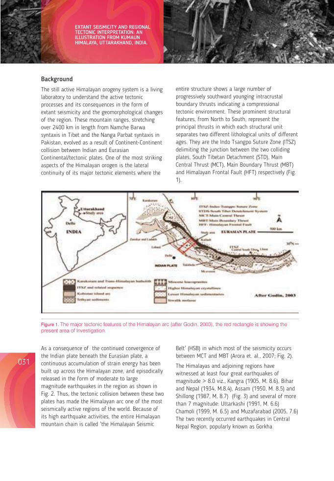
032031
EXTANT SEISMICITY AND REGIONAL TECTONIC INTERPRETATION: AN ILLUSTRATION FROM KUMAUN HIMALAYA, UTTARAKHAND, INDIA.
Background
The still active Himalayan orogeny system is a living laboratory to understand the active tectonic processes and its consequences in the form of extant seismicity and the geomorphological changes of the region. These mountain ranges, stretching over 2400 km in length from Namche Barwa syntaxis in Tibet and the Nanga Parbat syntaxis in Pakistan, evolved as a result of Continent-Continent collision between Indian and Eurasian Continental/tectonic plates. One of the most striking aspects of the Himalayan orogen is the lateral continuity of its major tectonic elements where the
entire structure shows a large number of progressively southward younging intracrustal boundary thrusts indicating a compressional tectonic environment. These prominent structural features, from North to South, represent the principal thrusts in which each structural unit separates two different lithological units of different ages. They are the Indo Tsangpo Suture Zone (ITSZ) delimiting the junction between the two colliding plates, South Tibetan Detachment (STD), Main Central Thrust (MCT), Main Boundary Thrust (MBT) and Himalayan Frontal Fault (HFT) respectively (Fig. 1).
Figure 1. The major tectonic features of the Himalayan arc (after Godin, 2003), the red rectangle is showing the present area of Investigation.
As a consequence of the continued convergence of the Indian plate beneath the Eurasian plate, a continuous accumulation of strain energy has been built up across the Himalayan zone, and episodically released in the form of moderate to large magnitude earthquakes in the region as shown in Fig. 2. Thus, the tectonic collision between these two plates has made the Himalayan arc one of the most seismically active regions of the world. Because of its high earthquake activities, the entire Himalayan mountain chain is called 'the Himalayan Seismic
Belt' (HSB) in which most of the seismicity occurs between MCT and MBT (Arora et. al., 2007; Fig. 2).
The Himalayas and adjoining regions have witnessed at least four great earthquakes of magnitude > 8.0 viz., Kangra (1905, M. 8.6), Bihar and Nepal (1934, M.8.4), Assam (1950, M. 8.5) and Shillong (1987, M. 8.7) (Fig. 3) and several of more than 7 magnitude: Uttarkashi (1991, M. 6.6) Chamoli (1999, M. 6.5) and Muzafarabad (2005, 7.6) The two recently occurred earthquakes in Central Nepal Region, popularly known as Gorkha
earthquake or Pokhra earthquake (2015, M. 7.8) and Kodari earthquake (2015, M. 7.2) continue to affect the life and development activities in the region (Fig. 3). These earthquakes along the Himalayan region indicate that the entire range is seismically highly active and capable of producing a large magnitude earthquake.
More than 2400 km long, with varying width of 230-320 km, mountain chains are divisible from west to east into three distinct regions the Western, the Central and the Eastern Himalaya. The present area of investigation constitutes the eastern part of the state of Uttarakhand in central Himalaya, a 320 km long stretch of the mountains between the Kali River forming the Indo-Nepal border in the east and the Tons-Pabar valleys forming the eastern border of Himachal Pradesh in the west. The Uttarakhand Himalayas is divided into following regions from North to south : (1) Trans Himalayas, (2) Higher
Figure 2. The Spatial distribution of earthquake events in the NW Himalayas including Garhwal-Kumaun Himalaya (shown by Black Square). The epicentral distribution is parallel to the tectonic trend of the Himalayas and the other cluster being parallel to the Aravali trend (After B.R. Arora et al, 2007).
Himalayas, (3) Lesser Himalayas, (4) Siwalik, and (5) Bhavar and Tarai. The state is highly vulnerable to multi geo-hazards viz. earthquakes, landslides, cloud bursts, flash-floods and avalanches. With regard to earthquake risk, the state falls in the highest seismic risk zones of the country i.e. Zone V and IV. In the disaster prone map of the country, Uttarakhand has attained its position among the first five states in respect of natural hazards. On the basis of administrative division the state is divided into two regions, Garhwal and Kumaun regions and the present study is concerned with the latter. This region has experienced two devastating earthquakes of magnitude >6.0 in the last two decades namely the Uttarkashi earthquake in 1991 and the Chamoli earthquake in 1999 (Fig. 2 Rajendran et. al., 2000, Rastogi, 2000).
Lessons from Nepal's Earthquake for the Indian Himalayas and the Gangetic Plains
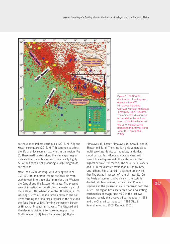
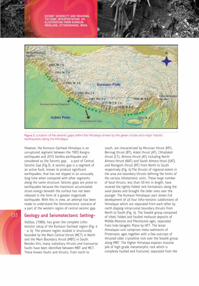
034033
EXTANT SEISMICITY AND REGIONAL TECTONIC INTERPRETATION: AN ILLUSTRATION FROM KUMAUN HIMALAYA, UTTARAKHAND, INDIA.
Figure 3. Location of the seismic gaps within the Himalaya shown by the green circles and major historic earthquakes along the Himalaya.
However, the Kumaun-Garhwal Himalaya is an unruptured segment between the 1905 Kangra earthquake and 2015 Gorkha earthquake and considered as the Seismic gap a part of Central Seismic Gap (Fig.3). A seismic gap is a segment of an active fault, known to produce significant earthquakes, that has not slipped in an unusually long time when compared with other segments along the same structure. Seismic gaps are prone to earthquakes because the maximum accumulated strain energy beneath the surface has not been released in the form of a greater magnitude earthquake. With this in view, an attempt has been made to understand the Seismotectonic scenario of a part of the western region of central seismic gap.
Geology and Seismotectonic Setting-Valdiya, (1980), has given the complete Litho-tectonic setup of the Kumaun-Garhwal region (Fig. 4 - a, b). The present region studied is structurally bounded by the Main Central thrust (MCT) in North and the Main Boundary thrust (MBT) in South. Besides this, many subsidiary thrusts and transverse faults have been identified between MBT and MCT. These known faults and thrusts, from north to
south, are characterized by Munsiari thrust (MT), Berinag thrust (BT), Askot thrust (AT), Chhiplakot thrust (CT), Almora thrust (AT) including North Almora thrust (NAT) and South Almora thust (SAT), and Ramgarh thrust (RT) from North to South respectively (Fig. 4).The thrusts of regional extent in the area are boundary thrusts defining the limits of the various lithotectonic units. These large number of local thrusts, less than 50 km in length, have severed the tightly folded rock formations along the axial planes and brought the older ones over the younger. The Kumaun Himalayan part shows full development of all four litho-tectonic subdivisions of Himalayas which are separated from each other by north dipping intracrustal boundary thrusts from North to South (Fig. 4). The Siwalik group composed of tilted, folded and faulted moliasse deposits of Middle Miocene and Pleistocene ages, separated from Indo Gengetic Plane by HFT. The lesser Himalayan unit comprises meta-sediments of Proterozoic ages together with a few outcrops of thrusted older crystalline rock over the Siwalik group along MBT. The Higher Himalaya exposes massive pile of high grade metamorphic rock which is complexly faulted and fractured, separated from the
Lesser Himalaya by the MCT. The Tethys Himalaya lies over the Higher Himalaya, and includes a thick pile of sedimentary rocks of Precambrian to lower Eocene ages and sandwich between MCT and STD. These four lithotectonic units have been characterized by distinct lithological composition, stratigraphic succession, structural pattern and magmatic history. The Kumaun Himalaya exposes several nappes of metamorphic rock brought southward over a long distance by imbricate thrusting. These are as follows:
(i) The autochthonous unit of Damtha and Tejam Groups of the Precambrian sedimentaries exposed in the vast windows in the inner (northern) belt of the Lesser Himalaya.
(ii) The KrolNappe of the outer (southern) Himalaya constituted of the Jaunsar and Mussoorie groups of sediments. In the Inner Lesser Himalaya the Krol Nappeis represented by Berinag Nappe made up of the lithostratigraphic unit which also form a part of the Jaunsar Group of the Krol Nappe.
(iii) The Ramgarh Nappe and its extensions that cover parts of the Berinag and Krol Nappes consisting of the upper part of the Damtha
Group of the autochthonouszone.
(iv) The Almora Nappe, its klippen and the root at the base of the Great Himalaya, made up of medium grade metamorphic intruded by syntectonic and deformed granitic suites (Valdiya 1980).
In Kumaun Himalaya, many faults/thrusts transverse oblique to those major thrusts that delimits the tectonic boundaries of the region, and are reactivated during Quaternary time. This is evident by the recurrent seismicity, geomorphic developments and by geodetic surveys (Valdiya 2001c, Pant et al. 2013, Pathak et al. 2013). The extension of Delhi - Aravali structures into the Himalayan region has also played an important role in the tectonics of the Kumaun Himalaya and is probably a major cause of the complex nature of seismicity of the region (Singh et. Al., 2012). According to Srivastava and Mitra (1994), the Kumaun Himalaya evolved by an overall forelandward progression of thrusting, with some reactivation along the Main central thrust (MCT), Munsiari thrust (MT) and Main Boundary thrust (MBT).
Figure 4. General Geological and Structural map of the area (a, after Valdiya, 1980 and b, after Valdiya, 2001c). The maps showing the different lithological and tectonic units from north to south and each lithological group are separated from one another by major intracrustal boundary thrusts.
Lessons from Nepal's Earthquake for the Indian Himalayas and the Gangetic Plains
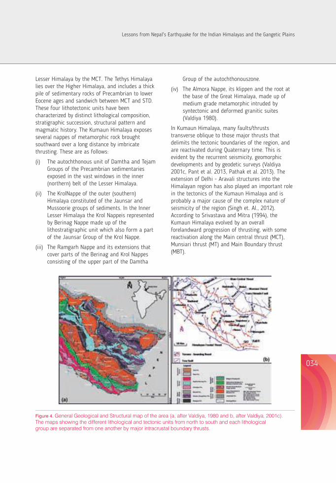
034033
EXTANT SEISMICITY AND REGIONAL TECTONIC INTERPRETATION: AN ILLUSTRATION FROM KUMAUN HIMALAYA, UTTARAKHAND, INDIA.
Figure 3. Location of the seismic gaps within the Himalaya shown by the green circles and major historic earthquakes along the Himalaya.
However, the Kumaun-Garhwal Himalaya is an unruptured segment between the 1905 Kangra earthquake and 2015 Gorkha earthquake and considered as the Seismic gap a part of Central Seismic Gap (Fig.3). A seismic gap is a segment of an active fault, known to produce significant earthquakes, that has not slipped in an unusually long time when compared with other segments along the same structure. Seismic gaps are prone to earthquakes because the maximum accumulated strain energy beneath the surface has not been released in the form of a greater magnitude earthquake. With this in view, an attempt has been made to understand the Seismotectonic scenario of a part of the western region of central seismic gap.
Geology and Seismotectonic Setting-Valdiya, (1980), has given the complete Litho-tectonic setup of the Kumaun-Garhwal region (Fig. 4 - a, b). The present region studied is structurally bounded by the Main Central thrust (MCT) in North and the Main Boundary thrust (MBT) in South. Besides this, many subsidiary thrusts and transverse faults have been identified between MBT and MCT. These known faults and thrusts, from north to
south, are characterized by Munsiari thrust (MT), Berinag thrust (BT), Askot thrust (AT), Chhiplakot thrust (CT), Almora thrust (AT) including North Almora thrust (NAT) and South Almora thust (SAT), and Ramgarh thrust (RT) from North to South respectively (Fig. 4).The thrusts of regional extent in the area are boundary thrusts defining the limits of the various lithotectonic units. These large number of local thrusts, less than 50 km in length, have severed the tightly folded rock formations along the axial planes and brought the older ones over the younger. The Kumaun Himalayan part shows full development of all four litho-tectonic subdivisions of Himalayas which are separated from each other by north dipping intracrustal boundary thrusts from North to South (Fig. 4). The Siwalik group composed of tilted, folded and faulted moliasse deposits of Middle Miocene and Pleistocene ages, separated from Indo Gengetic Plane by HFT. The lesser Himalayan unit comprises meta-sediments of Proterozoic ages together with a few outcrops of thrusted older crystalline rock over the Siwalik group along MBT. The Higher Himalaya exposes massive pile of high grade metamorphic rock which is complexly faulted and fractured, separated from the
Lesser Himalaya by the MCT. The Tethys Himalaya lies over the Higher Himalaya, and includes a thick pile of sedimentary rocks of Precambrian to lower Eocene ages and sandwich between MCT and STD. These four lithotectonic units have been characterized by distinct lithological composition, stratigraphic succession, structural pattern and magmatic history. The Kumaun Himalaya exposes several nappes of metamorphic rock brought southward over a long distance by imbricate thrusting. These are as follows:
(i) The autochthonous unit of Damtha and Tejam Groups of the Precambrian sedimentaries exposed in the vast windows in the inner (northern) belt of the Lesser Himalaya.
(ii) The KrolNappe of the outer (southern) Himalaya constituted of the Jaunsar and Mussoorie groups of sediments. In the Inner Lesser Himalaya the Krol Nappeis represented by Berinag Nappe made up of the lithostratigraphic unit which also form a part of the Jaunsar Group of the Krol Nappe.
(iii) The Ramgarh Nappe and its extensions that cover parts of the Berinag and Krol Nappes consisting of the upper part of the Damtha
Group of the autochthonouszone.
(iv) The Almora Nappe, its klippen and the root at the base of the Great Himalaya, made up of medium grade metamorphic intruded by syntectonic and deformed granitic suites (Valdiya 1980).
In Kumaun Himalaya, many faults/thrusts transverse oblique to those major thrusts that delimits the tectonic boundaries of the region, and are reactivated during Quaternary time. This is evident by the recurrent seismicity, geomorphic developments and by geodetic surveys (Valdiya 2001c, Pant et al. 2013, Pathak et al. 2013). The extension of Delhi - Aravali structures into the Himalayan region has also played an important role in the tectonics of the Kumaun Himalaya and is probably a major cause of the complex nature of seismicity of the region (Singh et. Al., 2012). According to Srivastava and Mitra (1994), the Kumaun Himalaya evolved by an overall forelandward progression of thrusting, with some reactivation along the Main central thrust (MCT), Munsiari thrust (MT) and Main Boundary thrust (MBT).
Figure 4. General Geological and Structural map of the area (a, after Valdiya, 1980 and b, after Valdiya, 2001c). The maps showing the different lithological and tectonic units from north to south and each lithological group are separated from one another by major intracrustal boundary thrusts.
Lessons from Nepal's Earthquake for the Indian Himalayas and the Gangetic Plains
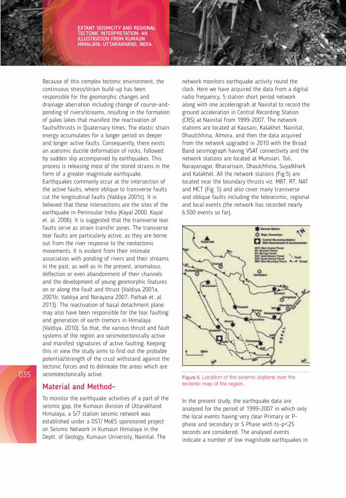
036035
EXTANT SEISMICITY AND REGIONAL TECTONIC INTERPRETATION: AN ILLUSTRATION FROM KUMAUN HIMALAYA, UTTARAKHAND, INDIA.
Because of this complex tectonic environment, the continuous stress/strain build-up has been responsible for the geomorphic changes and drainage aberration including change of course-and-ponding of rivers/streams, resulting in the formation of paleo lakes that manifest the reactivation of faults/thrusts in Quaternary times. The elastic strain energy accumulates for a longer period on deeper and longer active faults. Consequently, there exists an aseismic ductile deformation of rocks, followed by sudden slip accompanied by earthquakes. This process is releasing most of the stored strains in the form of a greater magnitude earthquake. Earthquakes commonly occur at the intersection of the active faults, where oblique to transverse faults cut the longitudinal faults (Valdiya 2001c). It is believed that these intersections are the sites of the earthquake in Peninsular India (Kayal 2000. Kayal et. al. 2006). It is suggested that the transverse tear faults serve as strain transfer zones. The transverse tear faults are particularly active, as they are borne out from the river response to the neotectonic movements. It is evident from their intimate association with ponding of rivers and their streams in the past, as well as in the present, anomalous deflection or even abandonment of their channels and the development of young geomorphic features on or along the fault and thrust (Valdiya 2001a, 2001b; Valdiya and Narayana 2007; Pathak et. al. 2013). The reactivation of basal detachment plane may also have been responsible for the tear faulting and generation of earth tremors in Himalaya (Valdiya, 2010). So that, the various thrust and fault systems of the region are seismotectonically active and manifest signatures of active faulting. Keeping this in view the study aims to find out the probable potential/strength of the crust withstand against the tectonic forces and to delineate the areas which are seismotectonically active.
Material and Method- To monitor the earthquake activities of a part of the seismic gap, the Kumaun division of Uttarakhand Himalaya, a 5/7 station seismic network was established under a DST/ MoES sponosored project on Seismic Network in Kumaun Himalaya in the Deptt. of Geology, Kumaun University, Nainital. The
network monitors earthquake activity round the clock. Here we have acquired the data from a digital radio frequency, 5 station short period network along with one accelerograh at Nainital to record the ground acceleration in Central Recording Station (CRS) at Nainital from 1999-2007. The network stations are located at Kausani, Kalakhet, Nainital, Dhaulchhina, Almora, and then the data acquired from the network upgraded in 2010 with the Broad Band seismograph having VSAT connectivity and the network stations are located at Munsiari, Toli, Narayanagar, Bhararisain, Dhaulchhina, Suyalkhark and Kalakhet. All the network stations (Fig.5) are located near the boundary thrusts viz. MBT, RT, NAT and MCT (Fig. 5) and also cover many transverse and oblique faults including the teleseismic, regional and local events (the network has recorded nearly 6,500 events so far).
Figure 5. Location of the seismic stations over the tectonic map of the region.
In the present study, the earthquake data are analysed for the period of 1999-2007 in which only the local events having very clear Primary or P-phase and secondary or S Phase with ts–p<25 seconds are considered. The analysed events indicate a number of low magnitude earthquakes in
the Kumaun region (Fig.6). The p-wave velocity model of Khattri et al., (1989) has been used in the present study to determine the Epicentral and Hypocentral parameters of the earthquake events including Lattitude, Longitude and Depth. The Hypocentral parameters are computed in Seisan: an earthquake analysis software, using the hypo 71 programme developed by Lee and Lahr in 1975. The source parameters of earthquake events viz., stress drop, source radius, and seismic moment has been carried out from the spectral analysis of P-wave in the vertical component of the displacement spectra using Brune's model and formulation. (Brune, 1970; Sharma & Wasan, 1994).
Mo = 4 v3 DAo/R.... (i), r = 2.34v/2 fc.... (ii), = 7Mo/16r3.... (iii)
Where Where Mo, ρ, v, r, Fc, Δσ, D, Ao, and R denote seismic moment, density at the source, P-wave velocity at the source, source radius, corner frequency, stress drop, epicentral distance, low frequency spectral level of P-wave, and radiation pattern, respectively.
To find out the visible signatures of neotectonic activity, detailed field investigations were carried out along the major river valleys viz. Kali, Dhauliganga, Goriganga, Ramganga east, Kosi, Saryu, Gagas and Ramganga west of the Kumaun Himalaya (Fig. 4). The river valley sediments are the best indicator of any geological or climatic changes that occur over a period of time in any region, so traversing along these river valleys were undertaken. The authors mapped all the visible geomorphic features like abandoned channels, uplifted terraces, tilted Quaternary deposits, waterfalls, uplifted potholes, fluvial terraces, fluvio-lacustrine deposits, triangular fault facets/fault scarps etc. The different levels of fluvial terraces indicate as many pulses of Quaternary uplift along the faults. The seismic and geologic information together indicate that the north-eastern and western part of the Kumaun Himalaya is neotectonically as well as seismically an active part.
Seismicity of the areaThe earthquake data, acquired by deploying an earthquake monitoring network in Kumaun
Himalayan region, are analysed in detail and source parameters have been calculated. Most of the micro-earthquake events are indicating a shallow focal depth.
The epicentral distribution map showing the distribution of seismicity over the region and its concentration between the MCT and MBT, indicate that the region is accumulating strain and releasing it in the form of earthquakes. Most of the seismicity of the region is concentrated between south of MCT and North of AT. The hypocentral/depth distribution along with the major thrust of the region show that most of the events are located at shallower depths (10-25 km, Fig. 7) and this indicates that the activity is mostly above the plane of detachment.
Figure 6. Epicentral distribution of earthquake events against the tectonic framework of the region as recorded by the network
The stress-drop value is a measure of the difference between the stresses across a fault before and after an earthquake rupture and it is directly related to the energy released during an earthquake. In the
Lessons from Nepal's Earthquake for the Indian Himalayas and the Gangetic Plains
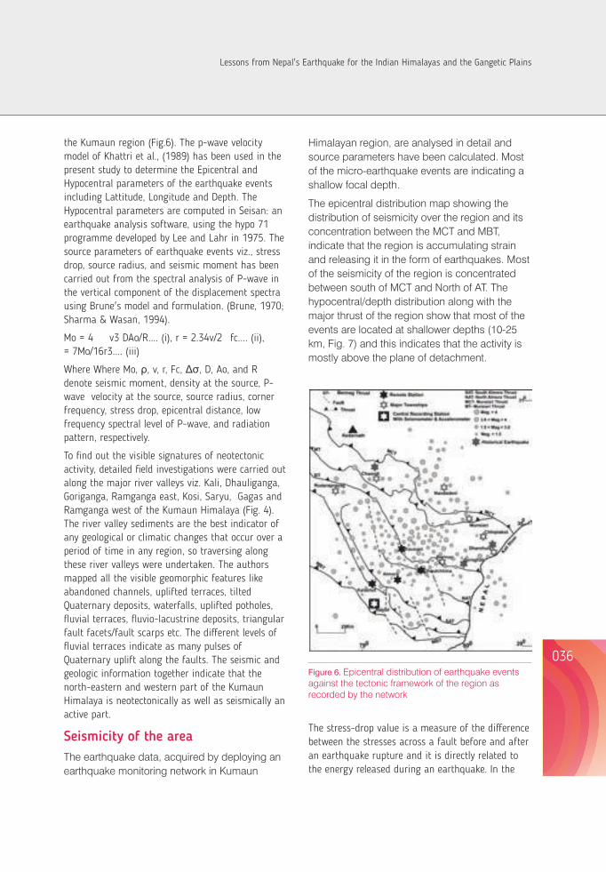
036035
EXTANT SEISMICITY AND REGIONAL TECTONIC INTERPRETATION: AN ILLUSTRATION FROM KUMAUN HIMALAYA, UTTARAKHAND, INDIA.
Because of this complex tectonic environment, the continuous stress/strain build-up has been responsible for the geomorphic changes and drainage aberration including change of course-and-ponding of rivers/streams, resulting in the formation of paleo lakes that manifest the reactivation of faults/thrusts in Quaternary times. The elastic strain energy accumulates for a longer period on deeper and longer active faults. Consequently, there exists an aseismic ductile deformation of rocks, followed by sudden slip accompanied by earthquakes. This process is releasing most of the stored strains in the form of a greater magnitude earthquake. Earthquakes commonly occur at the intersection of the active faults, where oblique to transverse faults cut the longitudinal faults (Valdiya 2001c). It is believed that these intersections are the sites of the earthquake in Peninsular India (Kayal 2000. Kayal et. al. 2006). It is suggested that the transverse tear faults serve as strain transfer zones. The transverse tear faults are particularly active, as they are borne out from the river response to the neotectonic movements. It is evident from their intimate association with ponding of rivers and their streams in the past, as well as in the present, anomalous deflection or even abandonment of their channels and the development of young geomorphic features on or along the fault and thrust (Valdiya 2001a, 2001b; Valdiya and Narayana 2007; Pathak et. al. 2013). The reactivation of basal detachment plane may also have been responsible for the tear faulting and generation of earth tremors in Himalaya (Valdiya, 2010). So that, the various thrust and fault systems of the region are seismotectonically active and manifest signatures of active faulting. Keeping this in view the study aims to find out the probable potential/strength of the crust withstand against the tectonic forces and to delineate the areas which are seismotectonically active.
Material and Method- To monitor the earthquake activities of a part of the seismic gap, the Kumaun division of Uttarakhand Himalaya, a 5/7 station seismic network was established under a DST/ MoES sponosored project on Seismic Network in Kumaun Himalaya in the Deptt. of Geology, Kumaun University, Nainital. The
network monitors earthquake activity round the clock. Here we have acquired the data from a digital radio frequency, 5 station short period network along with one accelerograh at Nainital to record the ground acceleration in Central Recording Station (CRS) at Nainital from 1999-2007. The network stations are located at Kausani, Kalakhet, Nainital, Dhaulchhina, Almora, and then the data acquired from the network upgraded in 2010 with the Broad Band seismograph having VSAT connectivity and the network stations are located at Munsiari, Toli, Narayanagar, Bhararisain, Dhaulchhina, Suyalkhark and Kalakhet. All the network stations (Fig.5) are located near the boundary thrusts viz. MBT, RT, NAT and MCT (Fig. 5) and also cover many transverse and oblique faults including the teleseismic, regional and local events (the network has recorded nearly 6,500 events so far).
Figure 5. Location of the seismic stations over the tectonic map of the region.
In the present study, the earthquake data are analysed for the period of 1999-2007 in which only the local events having very clear Primary or P-phase and secondary or S Phase with ts–p<25 seconds are considered. The analysed events indicate a number of low magnitude earthquakes in
the Kumaun region (Fig.6). The p-wave velocity model of Khattri et al., (1989) has been used in the present study to determine the Epicentral and Hypocentral parameters of the earthquake events including Lattitude, Longitude and Depth. The Hypocentral parameters are computed in Seisan: an earthquake analysis software, using the hypo 71 programme developed by Lee and Lahr in 1975. The source parameters of earthquake events viz., stress drop, source radius, and seismic moment has been carried out from the spectral analysis of P-wave in the vertical component of the displacement spectra using Brune's model and formulation. (Brune, 1970; Sharma & Wasan, 1994).
Mo = 4 v3 DAo/R.... (i), r = 2.34v/2 fc.... (ii), = 7Mo/16r3.... (iii)
Where Where Mo, ρ, v, r, Fc, Δσ, D, Ao, and R denote seismic moment, density at the source, P-wave velocity at the source, source radius, corner frequency, stress drop, epicentral distance, low frequency spectral level of P-wave, and radiation pattern, respectively.
To find out the visible signatures of neotectonic activity, detailed field investigations were carried out along the major river valleys viz. Kali, Dhauliganga, Goriganga, Ramganga east, Kosi, Saryu, Gagas and Ramganga west of the Kumaun Himalaya (Fig. 4). The river valley sediments are the best indicator of any geological or climatic changes that occur over a period of time in any region, so traversing along these river valleys were undertaken. The authors mapped all the visible geomorphic features like abandoned channels, uplifted terraces, tilted Quaternary deposits, waterfalls, uplifted potholes, fluvial terraces, fluvio-lacustrine deposits, triangular fault facets/fault scarps etc. The different levels of fluvial terraces indicate as many pulses of Quaternary uplift along the faults. The seismic and geologic information together indicate that the north-eastern and western part of the Kumaun Himalaya is neotectonically as well as seismically an active part.
Seismicity of the areaThe earthquake data, acquired by deploying an earthquake monitoring network in Kumaun
Himalayan region, are analysed in detail and source parameters have been calculated. Most of the micro-earthquake events are indicating a shallow focal depth.
The epicentral distribution map showing the distribution of seismicity over the region and its concentration between the MCT and MBT, indicate that the region is accumulating strain and releasing it in the form of earthquakes. Most of the seismicity of the region is concentrated between south of MCT and North of AT. The hypocentral/depth distribution along with the major thrust of the region show that most of the events are located at shallower depths (10-25 km, Fig. 7) and this indicates that the activity is mostly above the plane of detachment.
Figure 6. Epicentral distribution of earthquake events against the tectonic framework of the region as recorded by the network
The stress-drop value is a measure of the difference between the stresses across a fault before and after an earthquake rupture and it is directly related to the energy released during an earthquake. In the
Lessons from Nepal's Earthquake for the Indian Himalayas and the Gangetic Plains
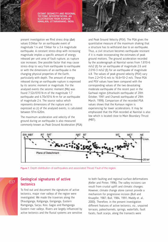
present investigation we ffind stress drop (Δσ) values 0.04bar for an earthquake event of magnitude 1.4 and 134bar for a 3.4 magnitude earthquake. A constant stress-drop with increasing magnitude implies a specific amount of energy released per unit area of fault rupture, as rupture size increases. One possible factor that may cause stress-drop to vary from earthquake to earthquake or with the dimensions of an earthquake is the changing physical properties of the Earth, particularly with depth. The amount of energy released during an earthquake rupture is expressed by its seismic moment or magnitude. For the analysed events the seismic moment (Mo) was found 7.52x10¹⁰ N-m of the magnitude 1.7 earthquake and 4.70x10¹⁴ N-m for an earthquake of magnitude 2.4. The source radius which represents dimensions of the rupture and is expressed as (r) of the analysed events, is calculated between 97m-620m.
The maximum acceleration and velocity of the ground during an earthquake is also measured commonly known as Peak Ground Acceleration (PGA)
and Peak Ground Velocity (PGV). The PGA gives the quantitative measure of the maximum shaking that a structure has to withstand due to an earthquake. Thus, a civil structure becomes earthquake resistant if it is made incorporating the estimates of peak ground motions. The ground acceleration recorded by the accelerograph at Nainital varies from 1.810-6 m/s2 (E) for an earthquake of magnitude 2.6 and 2.010-3 m/s2 (E) for an earthquake of magnitude 4.8. The values of peak ground velocity (PGV) vary from 2.2×10⁻⁶ m/s to 16.6×10⁻² m/s. These PGA and PGV values have been compared with the corresponding values of the two devastating moderate earthquake of the recent past in the Garhwal region (Uttarkashi earthquake of 20th October, 1991 and Chamoli earthquake of 29th March, 1999). Comparison of the recorded PGA values shows that the Kumaun region is experiencing far lower accelerations. It may be emphasized that the PGA recorded at Nainital is also low which is located close to Main Boundary Thrust (MBT).
Figure 7. Depth distribution of earthquakes and associated Thrust/ Fault of the region.
to both faulting and regional surface deformations (Keller and Pinter, 1996). The valley incisions can result from crustal uplift and climatic changes. However, climate change alone cannot provide a mechanism for progressive incision (Bull and Knuepfer, 1987; Bull, 1984, 1991; Maddy et. al., 2000). Therefore, in the present investigation different features of active tectonics, viz., unpaired terraces, paleochannels, springs, waterfalls, fault facets, fault scarps, along the transects were
studied. The spatial distribution pattern of such features has been used as a reliable tool of documenting the active tectonics of Himalayan terrain (Valdiya 1986, 2001c; Goswami and Pant 2008; Pathaket. al. 2013, 2015).
The Dhauliganga River runs along a north–south trending Dhauliganga Fault. In Dhauliganga river valley, from Tawaghat to Chirkila many ancient and recently active landslides are observed. Thick landslide deposits were seen from Khela village to Chirkila. Bali et al. (2002) also noticed several landslides within a short distance. A great waterfall of 280 m (Fig. 8C) is seen on the left bank of Dhauliganga and there are a number of seasonal and perennial waterfalls along the valley. The nature of seismicity and movements along faults and
thrust are one of the major triggering parameters of landslides in this region. The Kali River marks the entire eastern boundary of Kumaun, separating it from Nepal. The Kali River is a roaring stream flowing in gorges with rare preservation of terraces at the upper reaches, while downstream it has a wide valley, covered with huge boulders, gravel and sand, with deposition of paired and unpaired terraces commonly related to the different phases of rejuvenation along major active faults (Nakata, 1975; Valdiya, 1986; Sah and Virdi, 1997). Several geomorphic signatures of neotectonic activities are seen during field investigation in the Kali valley. The River Kali which flows in the deep gorges is characterized by high gradient, turbulent flow and exposing bedrocks. There are a number of waterfalls
Figure 8. Geomorphological signature of active tectonics along Kali and Dhauliganga river valley (A-C). A, Development of Three-Four level of unpaired terraces at Dharchula (India) and Darchula (Nepal) & triangular fault facet along Dharchula fault; B, Three parallel abandoned channel belt at Nigalpani along Kali river; C, 280 m waterfall development on left bank of Dhauliganga river valley. Terrace- T1, T2, T3 ; Abandoned Channels- P1,P2,P3.
038037
EXTANT SEISMICITY AND REGIONAL TECTONIC INTERPRETATION: AN ILLUSTRATION FROM KUMAUN HIMALAYA, UTTARAKHAND, INDIA.
Geological signatures of active tectonicsTo find out and document the signatures of active tectonics, major river valleys of the region were investigated. We made the traverses along the Dhauliganga, Kaliganga, Goriganga, Eastern Ramganga, Saryu, Kosi, Gagas and Ramganga Eastern river valleys. Rivers are largely influenced by active tectonics and the fluvial systems are sensitive
Lessons from Nepal's Earthquake for the Indian Himalayas and the Gangetic Plains
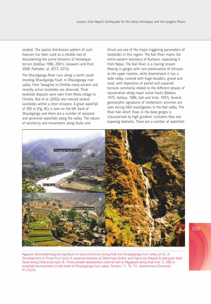
present investigation we ffind stress drop (Δσ) values 0.04bar for an earthquake event of magnitude 1.4 and 134bar for a 3.4 magnitude earthquake. A constant stress-drop with increasing magnitude implies a specific amount of energy released per unit area of fault rupture, as rupture size increases. One possible factor that may cause stress-drop to vary from earthquake to earthquake or with the dimensions of an earthquake is the changing physical properties of the Earth, particularly with depth. The amount of energy released during an earthquake rupture is expressed by its seismic moment or magnitude. For the analysed events the seismic moment (Mo) was found 7.52x10¹⁰ N-m of the magnitude 1.7 earthquake and 4.70x10¹⁴ N-m for an earthquake of magnitude 2.4. The source radius which represents dimensions of the rupture and is expressed as (r) of the analysed events, is calculated between 97m-620m.
The maximum acceleration and velocity of the ground during an earthquake is also measured commonly known as Peak Ground Acceleration (PGA)
and Peak Ground Velocity (PGV). The PGA gives the quantitative measure of the maximum shaking that a structure has to withstand due to an earthquake. Thus, a civil structure becomes earthquake resistant if it is made incorporating the estimates of peak ground motions. The ground acceleration recorded by the accelerograph at Nainital varies from 1.810-6 m/s2 (E) for an earthquake of magnitude 2.6 and 2.010-3 m/s2 (E) for an earthquake of magnitude 4.8. The values of peak ground velocity (PGV) vary from 2.2×10⁻⁶ m/s to 16.6×10⁻² m/s. These PGA and PGV values have been compared with the corresponding values of the two devastating moderate earthquake of the recent past in the Garhwal region (Uttarkashi earthquake of 20th October, 1991 and Chamoli earthquake of 29th March, 1999). Comparison of the recorded PGA values shows that the Kumaun region is experiencing far lower accelerations. It may be emphasized that the PGA recorded at Nainital is also low which is located close to Main Boundary Thrust (MBT).
Figure 7. Depth distribution of earthquakes and associated Thrust/ Fault of the region.
to both faulting and regional surface deformations (Keller and Pinter, 1996). The valley incisions can result from crustal uplift and climatic changes. However, climate change alone cannot provide a mechanism for progressive incision (Bull and Knuepfer, 1987; Bull, 1984, 1991; Maddy et. al., 2000). Therefore, in the present investigation different features of active tectonics, viz., unpaired terraces, paleochannels, springs, waterfalls, fault facets, fault scarps, along the transects were
studied. The spatial distribution pattern of such features has been used as a reliable tool of documenting the active tectonics of Himalayan terrain (Valdiya 1986, 2001c; Goswami and Pant 2008; Pathaket. al. 2013, 2015).
The Dhauliganga River runs along a north–south trending Dhauliganga Fault. In Dhauliganga river valley, from Tawaghat to Chirkila many ancient and recently active landslides are observed. Thick landslide deposits were seen from Khela village to Chirkila. Bali et al. (2002) also noticed several landslides within a short distance. A great waterfall of 280 m (Fig. 8C) is seen on the left bank of Dhauliganga and there are a number of seasonal and perennial waterfalls along the valley. The nature of seismicity and movements along faults and
thrust are one of the major triggering parameters of landslides in this region. The Kali River marks the entire eastern boundary of Kumaun, separating it from Nepal. The Kali River is a roaring stream flowing in gorges with rare preservation of terraces at the upper reaches, while downstream it has a wide valley, covered with huge boulders, gravel and sand, with deposition of paired and unpaired terraces commonly related to the different phases of rejuvenation along major active faults (Nakata, 1975; Valdiya, 1986; Sah and Virdi, 1997). Several geomorphic signatures of neotectonic activities are seen during field investigation in the Kali valley. The River Kali which flows in the deep gorges is characterized by high gradient, turbulent flow and exposing bedrocks. There are a number of waterfalls
Figure 8. Geomorphological signature of active tectonics along Kali and Dhauliganga river valley (A-C). A, Development of Three-Four level of unpaired terraces at Dharchula (India) and Darchula (Nepal) & triangular fault facet along Dharchula fault; B, Three parallel abandoned channel belt at Nigalpani along Kali river; C, 280 m waterfall development on left bank of Dhauliganga river valley. Terrace- T1, T2, T3 ; Abandoned Channels- P1,P2,P3.
038037
EXTANT SEISMICITY AND REGIONAL TECTONIC INTERPRETATION: AN ILLUSTRATION FROM KUMAUN HIMALAYA, UTTARAKHAND, INDIA.
Geological signatures of active tectonicsTo find out and document the signatures of active tectonics, major river valleys of the region were investigated. We made the traverses along the Dhauliganga, Kaliganga, Goriganga, Eastern Ramganga, Saryu, Kosi, Gagas and Ramganga Eastern river valleys. Rivers are largely influenced by active tectonics and the fluvial systems are sensitive
Lessons from Nepal's Earthquake for the Indian Himalayas and the Gangetic Plains
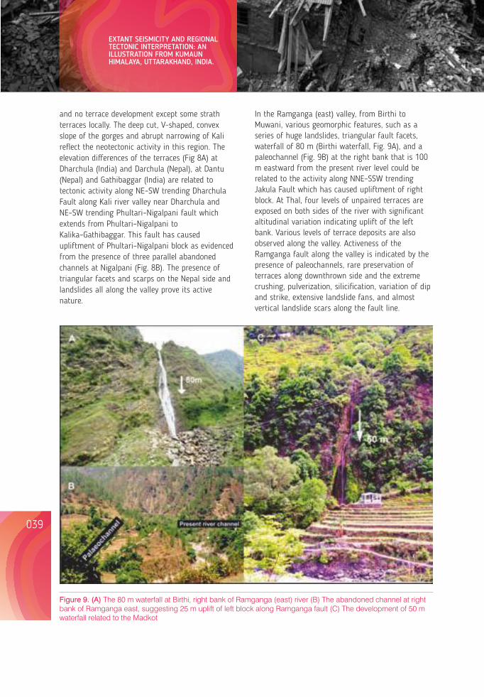
and no terrace development except some strath terraces locally. The deep cut, V-shaped, convex slope of the gorges and abrupt narrowing of Kali reflect the neotectonic activity in this region. The elevation differences of the terraces (Fig 8A) at Dharchula (India) and Darchula (Nepal), at Dantu (Nepal) and Gathibaggar (India) are related to tectonic activity along NE–SW trending Dharchula Fault along Kali river valley near Dharchula and NE–SW trending Phultari–Nigalpani fault which extends from Phultari–Nigalpani to Kalika–Gathibaggar. This fault has caused upliftment of Phultari–Nigalpani block as evidenced from the presence of three parallel abandoned channels at Nigalpani (Fig. 8B). The presence of triangular facets and scarps on the Nepal side and landslides all along the valley prove its active nature.
040039
EXTANT SEISMICITY AND REGIONAL TECTONIC INTERPRETATION: AN ILLUSTRATION FROM KUMAUN HIMALAYA, UTTARAKHAND, INDIA.
Figure 9. (A) The 80 m waterfall at Birthi, right bank of Ramganga (east) river (B) The abandoned channel at right bank of Ramganga east, suggesting 25 m uplift of left block along Ramganga fault (C) The development of 50 m waterfall related to the Madkot
In the Ramganga (east) valley, from Birthi to Muwani, various geomorphic features, such as a series of huge landslides, triangular fault facets, waterfall of 80 m (Birthi waterfall, Fig. 9A), and a paleochannel (Fig. 9B) at the right bank that is 100 m eastward from the present river level could be related to the activity along NNE–SSW trending Jakula Fault which has caused upliftment of right block. At Thal, four levels of unpaired terraces are exposed on both sides of the river with significant altitudinal variation indicating uplift of the left bank. Various levels of terrace deposits are also observed along the valley. Activeness of the Ramganga fault along the valley is indicated by the presence of paleochannels, rare preservation of terraces along downthrown side and the extreme crushing, pulverization, silicification, variation of dip and strike, extensive landslide fans, and almost vertical landslide scars along the fault line.
Geomorphic signatures of neotectonics were also investigated in the Gori Ganga River valley from Jauljibi to Madkot. The presence of water falls (Fig. 9C), uplifted terraces, paleochannels, sulphur springs, old and active landslides along the valley suggesting movement along NW–SE trending Baram Fault and NNW–SSE trending Madkot Fault which passes through the valley.
Figure 10. Geomorphological development along Kosi valley (A - C) represents the channel morphology, the deep gorges with U shaped meander and deep gorges with steep valley walls & ponding of river.
The Saryu River at Bageshwar shows spectacular features of active tectonics. The Saryu River flows in a very wide course from Bageshwar to Balighat. The Pungar River is a major tributary of the Saryu River flowing in a wide valley that abruptly narrows to a straight V-shaped gorge and old and recent landslide deposits, all along the slopes. The deep cut V-shaped or convex slopes of gorges and the abrupt narrowing of the Pungar River downstream and crossing the faults reflect the youthful nature of the terrain. The deep valley gorges and high channel gradient of tributary streams and knickpoints along the thalweges indicate a high rate of rejuvenation along the Mandalsera–Chhana fault (MCF).
The Kosi River flows through a geomorphologically mature terrain and reflects the modification by neotectonics that has led to the development of paired and unpaired terraces across the river, wide river channels with very gentle slopes, river ponding, deep gorge with convex valley walls, entrenched meanders and palaeolacustirne deposits in various transects (Fig. 10). This evidence indicates the neotectonic activity in the zones of the NAT and the South Almora Thrust (SAT).
The NAT passes through the Binta (Gagas River) valley. The little runoff in a very wide river valley is a misfit in nature, and development of unpaired terraces is seemingly from the activity along the NAT, 3–5 m thick lacustrine mud is observed at Bari village as well as at Binta on the left bank of the Gagas River. Similarly, at Panargaon and Bahwalipokhar a 12–25 m thick fluvio-lacustrinemud deposit is exposed (Fig. 11A, B). The lacustrine mud deposits extend for over 12 km between Bari and Bhet villages. The ancient Bari Lake may have an extent of 12 × 2–3 km, probably the largest palaeolake in the central sector of the Himalaya recorded so far. This lake was developed from the ponding or daming of the Gagas River. Disappearance of this large lake may be because of sediment filling and possibly by the breaching of the tectonic dam produced by sudden movements along NAT passing along the Gagas River valley. The local seismicity along NAT is quite high. The existence of the palaeolake also suggests that the NAT is quite active even today. This indicates that the
Lessons from Nepal's Earthquake for the Indian Himalayas and the Gangetic Plains
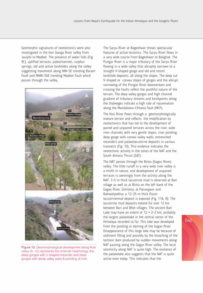
and no terrace development except some strath terraces locally. The deep cut, V-shaped, convex slope of the gorges and abrupt narrowing of Kali reflect the neotectonic activity in this region. The elevation differences of the terraces (Fig 8A) at Dharchula (India) and Darchula (Nepal), at Dantu (Nepal) and Gathibaggar (India) are related to tectonic activity along NE–SW trending Dharchula Fault along Kali river valley near Dharchula and NE–SW trending Phultari–Nigalpani fault which extends from Phultari–Nigalpani to Kalika–Gathibaggar. This fault has caused upliftment of Phultari–Nigalpani block as evidenced from the presence of three parallel abandoned channels at Nigalpani (Fig. 8B). The presence of triangular facets and scarps on the Nepal side and landslides all along the valley prove its active nature.
040039
EXTANT SEISMICITY AND REGIONAL TECTONIC INTERPRETATION: AN ILLUSTRATION FROM KUMAUN HIMALAYA, UTTARAKHAND, INDIA.
Figure 9. (A) The 80 m waterfall at Birthi, right bank of Ramganga (east) river (B) The abandoned channel at right bank of Ramganga east, suggesting 25 m uplift of left block along Ramganga fault (C) The development of 50 m waterfall related to the Madkot
In the Ramganga (east) valley, from Birthi to Muwani, various geomorphic features, such as a series of huge landslides, triangular fault facets, waterfall of 80 m (Birthi waterfall, Fig. 9A), and a paleochannel (Fig. 9B) at the right bank that is 100 m eastward from the present river level could be related to the activity along NNE–SSW trending Jakula Fault which has caused upliftment of right block. At Thal, four levels of unpaired terraces are exposed on both sides of the river with significant altitudinal variation indicating uplift of the left bank. Various levels of terrace deposits are also observed along the valley. Activeness of the Ramganga fault along the valley is indicated by the presence of paleochannels, rare preservation of terraces along downthrown side and the extreme crushing, pulverization, silicification, variation of dip and strike, extensive landslide fans, and almost vertical landslide scars along the fault line.
Geomorphic signatures of neotectonics were also investigated in the Gori Ganga River valley from Jauljibi to Madkot. The presence of water falls (Fig. 9C), uplifted terraces, paleochannels, sulphur springs, old and active landslides along the valley suggesting movement along NW–SE trending Baram Fault and NNW–SSE trending Madkot Fault which passes through the valley.
Figure 10. Geomorphological development along Kosi valley (A - C) represents the channel morphology, the deep gorges with U shaped meander and deep gorges with steep valley walls & ponding of river.
The Saryu River at Bageshwar shows spectacular features of active tectonics. The Saryu River flows in a very wide course from Bageshwar to Balighat. The Pungar River is a major tributary of the Saryu River flowing in a wide valley that abruptly narrows to a straight V-shaped gorge and old and recent landslide deposits, all along the slopes. The deep cut V-shaped or convex slopes of gorges and the abrupt narrowing of the Pungar River downstream and crossing the faults reflect the youthful nature of the terrain. The deep valley gorges and high channel gradient of tributary streams and knickpoints along the thalweges indicate a high rate of rejuvenation along the Mandalsera–Chhana fault (MCF).
The Kosi River flows through a geomorphologically mature terrain and reflects the modification by neotectonics that has led to the development of paired and unpaired terraces across the river, wide river channels with very gentle slopes, river ponding, deep gorge with convex valley walls, entrenched meanders and palaeolacustirne deposits in various transects (Fig. 10). This evidence indicates the neotectonic activity in the zones of the NAT and the South Almora Thrust (SAT).
The NAT passes through the Binta (Gagas River) valley. The little runoff in a very wide river valley is a misfit in nature, and development of unpaired terraces is seemingly from the activity along the NAT, 3–5 m thick lacustrine mud is observed at Bari village as well as at Binta on the left bank of the Gagas River. Similarly, at Panargaon and Bahwalipokhar a 12–25 m thick fluvio-lacustrinemud deposit is exposed (Fig. 11A, B). The lacustrine mud deposits extend for over 12 km between Bari and Bhet villages. The ancient Bari Lake may have an extent of 12 × 2–3 km, probably the largest palaeolake in the central sector of the Himalaya recorded so far. This lake was developed from the ponding or daming of the Gagas River. Disappearance of this large lake may be because of sediment filling and possibly by the breaching of the tectonic dam produced by sudden movements along NAT passing along the Gagas River valley. The local seismicity along NAT is quite high. The existence of the palaeolake also suggests that the NAT is quite active even today. This indicates that the
Lessons from Nepal's Earthquake for the Indian Himalayas and the Gangetic Plains
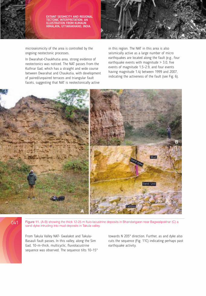
microseismicity of the area is controlled by the ongoing neotectonic processes.
In Dwarahat–Chaukhutia area, strong evidence of neotectonics was noticed. The NAT passes from the Kuthrar Gad, which has a straight and wide course between Dwarahat and Chaukutia, with development of paired/unpaired terraces and triangular fault facets, suggesting that NAT is neotectonically active
in this region. The NAT in this area is also seismically active as a large number of micro earthquakes are located along the fault (e.g., four earthquake events with magnitude > 3.0, five events of magnitude 1.5–2.9, and four events having magnitude 1.4) between 1999 and 2007, indicating the activeness of the fault (see Fig. 6).
Figure 11. (A-B) showing the thick 12-25 m uio-lacustrine deposits in Bhandarigaon near Bagwalipokhar (C) a sand dyke intruding into mud deposits in Takula valley.
From Takula Valley NAT- Gwalakot and Takula-Basauli fault passes. In this valley, along the Sim Gad, 10-m-thick, multicyclic, fluviolacustrine sequence was observed. The sequence tilts 10–15°
Discussion and conclusions
The analysis of the earthquake events acquired from the network suggests that the most of the events are of low magnitude located in shallow depths. The seismicity is high above the plane of detachment (20-25 km). The stress drop values of most of the events are low and indicating low strength bearing capacity of the upper crust of the region. Most of the earthquake events are concentrated between the MCT and MBT or north of it.
It is evident from the present data that most of the seismicity is clustered between Main Central Thrust (MCT) and Berinag Thrust (BT). Three seismic zones (1) Between Main Central Thrust and Berinag Thrust, (2) North of Main Central Thrust near Nandadevi, and (3) Northeastern part of Kumaun and adjoining part of western Nepal along Kali valley were identified. The present study shows that MCT is active at present as evident from the seismological data and morphotectonic investigations near MCT. Presently, most of the seismic activities are taking place south of MCT and its subsidiary thrusts. The events are concentrated between the MCT and BT and NAT (Fig. 6), this indicating again that this part is more seismically active compared to the remaining Kumaun Lesser Himalaya region. Earthquakes of magnitude 3 or less are frequently occurring in this region.
The peak ground acceleration (PGA) values of the events vary from 1.8×10⁻⁶ m/s2 (E) for the earthquake of magnitude 2.6 to 2.0×10⁻³ m/s2(E) for earthquake of magnitude 4.8. The values of peak ground velocity (PGV) vary from 2.2×10⁻⁶ m/s to 16.6×10⁻² m/s. The PGA and PGV indicate the maximum values of acceleration and velocity during an earthquake and show two asperities in the region, one along NW–SE direction almost parallel to the thrusts of regional extent, viz. Main Central Thrust, Munsiari Thrust, Berinag Thrust, North Almora Thrust and other is orthogonally along N–S/NNW–SSE directions. These areas are more prone to earthquakes and are thus relatively more seismically hazardous. The PGV are high in Dharchula and adjoining part of western Nepal, Nandadevi and nearby places, Bhararisain and Rudraprayag areas.
It is evident from the neotectonic investigations in the various river valleys of the Kumaun Himalaya that the various thrusts and faults running parallel or transversely through the area are neotectonically active. Various geomorphic features (e.g., unpaired terraces, ponding of rivers, deep gorges with convex walls, uplifted potholes, extensive landslides, palaeolake deposits, paleochannels, laterally shifted river channels etc.) are indications of the neotectonic activity.
The river valleys have been affected by several natural hazards like landslides, mass movements, flash floods, cloud-bursts and earthquakes. Slopes in the region were formed by combining the effect of geomorphic, tectonic and climatic process and the landslides frequently occur during the monsoon. The highly deformed, fractured and shattered rocks of Great Himalaya and the proximity of active thrusts and fault zones might have played a major role in rock falls and landslides in the region. In these valleys, low magnitude earthquakes are frequently occurring; the epicenters of these earthquakes lie along the transverse fault/thrust. These earthquakes are associated with the tectonically active faults and thrusts. This seismic activity is a reflection of the neotectonic adjustment. Most of the micro earthquakes have occurred around and along these thrusts/faults. Although the magnitude and stress drop values are low, it strongly indicates that the region is accumulating strain energy which might be released in the form of a destructive earthquake. Some of the transverse faults (such as the Dwarahat–Chaukhutia fault) are quite active as a large number of earthquake events are recorded in the proximity of the fault. The surface deformational features in a different river valley indicate that the region is undergoing neotectonic rejuvenation. The flats of the major river valleys are being used by the fast growing population for various forms of construction and agricultural activities. In these valleys the anthropogenic activities have disturbed the unconsolidated river material. The Himalayan region has a great potential to generate hydroelectric power which is the backbone of the economy of the state; therefore many hydroelectric power generation plants have
towards N 205° direction. Further, as and dyke also cuts the sequence (Fig. 11C) indicating perhaps past earthquake activity.
042041
EXTANT SEISMICITY AND REGIONAL TECTONIC INTERPRETATION: AN ILLUSTRATION FROM KUMAUN HIMALAYA, UTTARAKHAND, INDIA.
Lessons from Nepal's Earthquake for the Indian Himalayas and the Gangetic Plains
been operating or are under construction in the region.
The observed low level of acceleration near MBT and low stress drop values from the events of the region might be an indication of the view that the sudden release of accumulated energy might occur near MBT. It is evident from the GPS measurements that the detachment below MBT is more strongly coupled than the MCT and further north of it (Gahlaut Pers. Comm.). With respect to the Indian plate the motion of GPS sites increases towards the North and reaches 18 mm/year in Tethyan Himalayan zone and 7 mm/year in MBT zone. However, the MBT does not show much velocity of the plate motion and seems to be a locked part. This is evident from the less concentration of the seismicity in or nearby the MBT zone. So, perhaps there is a strong possibility of a higher magnitude earthquake in or nearby MBT Zone. It could have a devastating effect in the northern Gangatic Plains in general and particularly towns such as Nainital which has a large population living on fragile steep hill slopes as well as in towns in the plains such as Haldwani, Rudrapur, Ramgarh, Ramnagar, Tanakpur etc. Hence, a good knowledge of historical and present seismicity is essential for assessing seismic hazard. This needs special attention and it is the need of hour to monitor the
tectonically active faults for a better understanding of the neotectonics/seismotectonics of the area by deploying a dense network of seismograph, Global Positioning System (GPS) or multiparametry observatory. On the basis of less distribution of the seismic network in the region, it is difficult to predict when the region will experience the next great earthquake in the near future but the occurrence of a major earthquake cannot be ruled out. The data generated in the present study could be used in land-use planning for implementation of various socioeconomic activities and hazard zone mapping/hazard management in the central sector of the Himalayan arc.
Acknowledgements-
The authors express their sincere gratitude to the DST, New Delhi and Ministry of Earth Sciences (MoES), New Delhi for sponsoring the SNKH project. Dr. B.K. Bansal, Advisor and Head Geosciences, MoES, New Delhi and Dr. V K Gahlaut, NGRI, Hyderabad are acknowledged for fruitful discussions and suggestions. We are thankful to the Head, Centre of Advanced Study in Geology, Kumaun University, Nainital for providing the infrastructural facility to the project.
ReferencesArora BR Kumar N Chambak SK 2007.Seismic regime of the N-W Himalaya' VB Smirnov, V Gitis A Lyvuvshin A Punomerov AD Zevylov C Sobolov (I.P.E. Moscow).
Bali RYudhbir Sharma AK, Ranhotra PS 2002.Landslide microzonation of Tawaghat- Sobla area Kumaun Himalaya- In Pant, C.C and Sharma, A.K. (eds.). Aspects of Geology and Environment of Lesser Himalaya, Ganodaya Prakshan, 475p.
Brune JN 1970. Tectonic stress and spectra of seismic shear waves from earthquakes. Journal of Geophysical Research, 75, 4997–5009.
Bull WB 1984.Tectonic Geomorphology. Jour. Geol. Educ. 32, 310-314.
Bull WB 1991.Geomorphic response to climate change. Oxford University Press, Newyork.
Bull WB, Knuepfer PLK 1987. Adjustment by the Charwell River, New Zealand, to uplift and climate changes. Geomorphology, 1: 15–32.
Godin L 2003. Structural evolution of the Tethyan sedimentary sequence in the Annapurna area, Central Nepal Himalaya. Jounral of Asian earth science, 22: 307-328.
Goswami PK Pant CC 2008.Morphotectonic evolution of the Binau–Ramganga– Naurar transverse valley, southern Kumaun Lesser Himalaya.Current Science, 94 (12), 1640–1645.
Kayal JR 2000. Seismotectonic study of the two recent SCR earthquakes in central India. Journal Geological society of India, 55: 123-138.
Kayal JR,Mukhopadhyay S2006. Seismotectonics of the 2001 Bhuj earthquake (M 7.7) in western India: constraints from aftershock. Indian Jour. Geophys. Union, 10: 45-57.
Keller A, Edward Pinter N 1996. Active tectonics: Earthquake, uplift and landscape.Prentice Hall, Upper Saddle River, New Jersey 07458, 338p.
Khattri KN 1987. Great earthquakes, seismicity gaps and potential for earthquake disaster along the Himalayan plate boundary. Tectonophysics, 38: 79-92.
Khattri KN,Chander R, Gaur VK,Sarkar I, Kumar S 1989.New seismological results on the tectonics of the Garhwal Himalaya. Proceedings of Indian Academy of Science (Earth and Planeary Science), 98: 91-109.
Lee WHK, Lahr JC 1975 Hypo71 (revised): A computer program for determining hypocenter, magnitude and first motion pattern of local earthquakes. U.S. Geol. Surv. Open-File Rep., 75-311: 1-116.
Maddy D,Bridgland DR, Green CP 2000. Crustal uplift in southen England: Evidences from the river terrace records. Geomorphology, 33: 167–181.
Nakata T1975.On Quaternary tectonics around the Himalaya.Sci. Rep. Tohuko Univ. 7th Ser. (Geogr). 25: 111–118.
Pant CC,Pathak V,Darmwal GS 2013.Seismotectonic and neotectoincinvestigation in a part of 'Central Seismic Gap' Uttarakhand , India. Zeitscchrift fur Geomorphologie, 58 (1): 59-79.
PathakV, Pant CC,Darmwal GS 2013. Geomorphological and seismological investigations in a part of western Kumaun Himalaya, Uttarakhand, India. Geomorphology, 193: 81-90.
Pathak V, Pant CC,Darmwal GS 2015.Geomorphological features of active tectonics and ongoing seismicity of northeasternKumaun Himalaya, Uttarakhand, India. Jour. Earth Syst. Sci., 124, No. 6, August 2015, pp. 1143–1157.
Rajendran K, Rajendran CP, Jain SK, Murty CVR,Arlekar JN 2000. The Chamoli earthquake, Garhwal Himalaya: Field observations and implications for seismic hazard.Cur. Sci., 78 45-51.
Rastogi BK2000. Chamoli earthquake of magnitude 6.6 on March 1999, Jour.Geol.Soc.India, 55: 505-514.
Sah MP,Virdi NS 1997.Geomorphic signatures of neotectonic activity along the Sumdo Fault, Spiti valley, District Kinnaur, Himanchal Pradesh. Himalayan Geol., 18: 81–92.
Sharma ML, Wason HR1994. Occurrence of low stress drop earthquake in the GarhwalHimalayaregion.PhysicsoftheEarthandPlanetaryInteriors,85:265–272.
Singh C, Singh A, Bharathi Srivastava VK, Bansal AR, Chadda RK 2012. Frequency-dependent body wave attenuation characterstics in the Kumaun Himalaya.Tectonophysics, 524-525: 37-42.
Srivastava P, Mitra G 1994. Thrust geometry and deep structure of the outer and lesser Himalaya, Kumaun and Garhwal, India: implication for evolution of the Himalayan fold-and-thrust belt. Tectonics, 13:89-109.
Valdiya KS1980. Geology of Kumaun Lesser Himalaya.U.P.The Himachal Times Press Dehradun, Wadia Institute of Himalayan Geology Dehradun (291 pp.).
Valdiya KS 1986.Neotectonic activities in the Himalayan Belt.In: Proc. of International Symposium on Neotectonics in South Asia; Survey of India, Dehradun, pp. 241–267.
Valdiya KS 1993.Uplift and geomorphic rejuvenation of the Himalaya in the Quaternary period; Curr. Sci. 64 873–885.
Valdiya KS2001a. River response to continuing movements and the scarp development in central Sahyadri and adjoining coastal belt. Journal Geological Society of India, 57: 13-30.
Valdiya KS2001b. Tectonic resurgence of the Mysore plateau and surrounding region in cratonoc southern India. Current Science, 81: 1068-1088.
Valdiya KS2001c. Reactivation of terrane-defining boundary thrusts in central sector of the Himalaya: implications. Current Science, 81 (11): 1418-1431.
Valdiya KS, Narayana AC2007. River response to neotectonic activity: example from Kerla, India. Jour. Geol. Soc. India, 70:427-443.
Valdiya KS2010. The making of India: Geodynamic evolution. Macmillan, New Delhi, 816p.
044043
EXTANT SEISMICITY AND REGIONAL TECTONIC INTERPRETATION: AN ILLUSTRATION FROM KUMAUN HIMALAYA, UTTARAKHAND, INDIA.
Lessons from Nepal's Earthquake for the Indian Himalayas and the Gangetic Plains

A. Chevuturi#, R.M. Devi@ and A.P. Dimri#,*#School of Environmental Sciences, Jawaharlal Nehru University, New Delhi, India@Ecological Informatics Division, Indian Institute of Information Technology and Management, Kerala, India
*Corresponding Address: Dr. A. P. Dimri, School of Environmental Sciences, Jawaharlal Nehru University, New Delhi, 110067, India, Email: [email protected]
STUDY OF KEDARNATH DISASTER, 2013
045 046
AbstractA natural disaster with torrential downpour and subsequent flash floods led to one of the worst natural disasters on 16-17 June 2013 devastating Kedarnath region in Uttarakhand. Natural geomorphological vulnerability and unregulated anthropogenic activities have made this region prone to such disasters. Extreme precipitation during 16-17 June 2013 corresponded to massive flooding of rivers. Loss of life and property, destruction of infrastructure, and massive devastation to the ecology were caused by the disaster. WRF model is used to simulate the Kedarnath disaster and model simulated precipitation showed similar intensity and spatial distribution of precipitation against observation data. This extreme precipitation event was caused due to merging of two weather systems (Western Disturbance and Indian Summer Monsoon trough) over a region of variable orography. Further, the moisture incursion over this region of enhanced instability caused the formation of a temporary cloud cluster which persisted over Uttarakhand on 17 June 2013.
Keywords: Flashfloods, Kedarnath disaster, Monsoon, Precipitation, Western Disturbance
IntroductionKedarnath experienced incessant rain between 14 and 17 June 2013 (Rautela 2014) and there was a particularly heavy downpour on 16 (1715 IST) and 17 June 2013 (0645 IST) (Dobhal et al 2013). Heavy torrential rainfall on 16 and 17 June 2013 along with bursting of moraine deposit dammed lake led to mass movement, debris flow and flash floods in
the Kedarnath region (Dobhal et al 2013; Sati 2013; Sharma et al 2013). On 16 June 2013, flood in the Saraswati and Dudh Ganga catchment areas, resulted in erosion and accumulation of eroded sediment and water struck the Kedarnath town. It was followed by devastation of the settlements, agricultural fields, and the loss of thousands of lives
(Kala 2014; Rautela 2013). Flooding in Kedarnath on 16 June 2013 washed off the pedestrian bridges over Mandakini connecting Kedarnath to Rambara, and thus turning Kedarnath into an island. Flood water washed off Sanatan Dharm Sabha guest house, Shankaracharya Samadhi and a few other structures in the vicinity of the temple. Chaurabari Tal was intact on 16 June 2013, while Rambara and Gaurikund were devastated in the night. Due to heavy rains between 16 and 17 June, the Chaurabari lake (which is 400 m long, 200 m wide along with a depth of 15–20 m) collapsed along with subsequent melting of glaciers (Rautela 2013). Rapid melting of snow (Dobhal et al 2013; Rao et al 2014; Srinivasan 2013) in combination with heavy rainfall (Table 1) resulted in slope failure (Sati 2013; Sharma et al 2013), which led to landslides and corresponding blockade and collection of water in the Mandakini river (Srinivasan 2013; Sharma et al 2013) creating a potential danger from dammed lake outburst (Dobhal et al 2013; Rao et al 2014; Rautela 2013). Geologically the region is prone to landslide, erosion, fluvial flow and mass wasting (Sati 2013). The interaction of active mountain building with the gradational agent in intense weather condition produces large amount of debris and loose soil that are unstable and cause disaster when equilibrium is disturbed (Pandey & Pandey 2013). It may be noted that a strong interaction between westerlies and south easterly monsoon resulted in huge amount of rainfall in a short time causing flash flood and devastation (IMD 2013a; Dube et al 2013).
According to Dube et al (2013) Uttarakhand received more than 340 mm of rainfall on 17 June 2013 which is 375% more than its monsoon period daily normal i.e. 65.9 mm. Though in Dehradun the rainfall was very intense, heavy and more in amount, huge destruction occurred in Kedarnath. Flood waters of Mandakini ravaged Rambara, Gaurikund and Sonprayag in the morning hours of 17 June 2013. Accumulation of millions of gallons of water in the moraine dammed lake for 3 days weakened the dam's strength, finally causing the massive disaster in Uttarakhand (Kala 2014; Rautela 2013). Though intense Indian summer monsoon
(ISM) rainfall and landslides are natural disasters, anthropogenic activities in Alaknanda valley contributed majorly towards worsening the impact of this natural disaster (Kala 2014). This study aims to understand the cause of the extreme precipitation over Uttarakhand leading to the natural disaster. Due to unavailability of fine resolution dataset for a detailed analysis, Numerical Weather Prediction (NWP) technique is used to simulate the event and further analyse it. Objectives of the study are to analyze the extreme precipitation event that occurred during 16-17 June 2013 and to examine the large scale flow to understand the cause of the event. Such a study could also help meteorological departments and policy makers in the development of early warning and prediction systems for mitigation of such disasters. As prevention is not possible, the aim should be to minimize causalities and the damage to infrastructures.
Disaster Impact
Sphere India (2013) reported huge number of causalities and damages. By 21 June 2013. 9 out of 13 districts of Uttarakhand were affected viz. Rudraprayag, Chamoli, Uttarkashi, Tehri, Pithoragarh, Bageshwar, Almora and Dehradun, resulting in numerous deaths of local people and tourists washing away of 600-700 houses and mortality of 5000-6000 animals. According to an estimate the June disaster resulted in the death of 44120 people and the destruction of 1800 villages and 2500 houses, 150 bridges, and 17,000 sq km road (Kala 2014). Sphere India (2013) released on 2 July 2013 detailed the damage of electricity supply in 382 villages, 1,642 roads including national highways and, 147 bridges, 2232 houses and 968 water supply schemes. Two helicopters crashed during rescue operations. The approximate cost of damaged bridges and roads was 285 million US$, that of dam projects 30million US$, and loss to state tourism was worth 195 million US$ (Kala 2014). This natural disaster, caused due to a meteorological phenomenon, can also be considered a manmade disaster (Kala 2014; Sati 2013). This is not the most intense rainfall this region has ever received for the first time (Mishra & Srinivasan
Lessons from Nepal's Earthquake for the Indian Himalayas and the Gangetic Plains
2013) but this disaster was one of the worst disasters of India (Srinivasan 2013). The unplanned and haphazard construction, mismanaged tourism – related activities along with mining and dam activities were the major anthropogenic factors that worsened the impact (Kala 2014).
Synoptic Situation
A monsoon low pressure area developed over Bay of Bengal on 12 June 2013 and moved eastwards touching Odisha and north coastal Andhra Pradesh on 13 June 2013 and reached upto Rajasthan and adjoining places like Haryana and Uttar Pradesh on 18 June 2013 (IMD 2013a). The synoptic feature became unique as there was a marked advance in arrival of monsoon (Dube et al 2014; IMD 2013a). Monsoon trough was formed due to low pressure system and seen passing through Bikaner, Gwalior, Gaya and Imphal and across the Gangetic West Bengal. Western disturbance (WD) in the form of a trough was also observed around west Rajasthan on 16 June 2013 and moved towards east Rajasthan and northern regions of India (Punjab, Haryana, Uttarakhand and adjoining areas) up to 18 June 2013 finally moving towards east on 19 June 2013 (IMD 2013b). A preliminary report of IMD (2013a) shows the progress of southeast monsoon current from south to northwest up to Uttarakhand and simultaneously movement of a WD across north India from west to east. The westerlies and the monsoon system merged over Uttarakhand and neighbouring regions during the period (IMD 2013a). Strength of monsoon wind became weak as it reached Himalayas due to which south easterly wind gained strength (> 40 kts) bringing moisture from Arabian sea and Bay of Bengal into Uttarakhand, Uttar Pradesh and Himachal (IMD 2013a). An IMD (2013b) report indicated that on 15 June 2013 at 0000 UTC the monsoon low was found over Madhya Pradesh and adjoining Chhattisgarh and strong southeasterly (20-30 kts) prevailing in northern plains. Low pressure prevailed in north Rajasthan along with cyclonic circulation, where the monsoon current weakened (5-10 kts) over the region on 18 June 2013 at 0000 UTC. There was no south-easterly monsoon component from the Bay of Bengal (IMD 2013a; Dube et al 2013). Finally, it was
concluded that there was interaction between trough in the westerlies and the strong monsoon flow along with low pressure in Northern region (Dube et al 2014; IMD 2013a). Due to this the lower tropospheric wind developed and converged over Uttarkhand and the neighbouring regions triggering heavy precipitation over Uttarakhand region (IMD 2013a; IMD 2013b; Dube et al 2014).
Experimental design and DataIn this study, Weather Research and Forecast (WRF) model (version 3.0) with Advanced Research WRF (ARW) as dynamic solver is used for the numerical simulation of the event (Wang et al 2010; Skamarock et al 2008). The model domain is set over India having central point at 75°E and 20°N as shown in Fig. 1. Model is simulated at triple nest (27 km, 9 km and 3 km) to downscale the coarser global model input to a very fine resolution (Fig. 1 and Table 2). Model is simulated for 96 hrs starting from 14 June 20013 1200UTC to 19 June 2013 1200UTC with 108s as time interval for model integration (Table 2). Five day simulation is necessary for better understanding of the meteorological processes responsible for formation and interaction of two different weather systems resulting in heavy precipitation and other synoptic systems that ultimately led to the worst disaster.
NCEP's (National Centre for Environmental Prediction) global data assimilation system (GDAS) and global forecast system final run analysis output were used as the initial and lateral boundary conditions (ICBC) for the model simulation. This data is available at 6h interval at 1°×1° spatial resolution. The input data was downloaded from 14 June 2013 1200UTC to 19 June 2013 1200UTC. Three different observational analyses were used in the study. Tropical Rainfall Measuring Mission (TRMM) data developed by NASA and Japan Aerospace Exploration Agency (JAXA) give 3hourly rainfall dataset (3B42 V7) with resolution 0.25°×0.25° (Huffman et al 2007). Modern Era Retrospective-analysis for Research and Applications (MERRA) 3hourly analysis dataset (inst3_3d_asm_Cp) with a spatial resolution of 0.5°×0.7° (Rienecker et al 2011) provided by NASA
is used as observational analysis. The daily outgoing longwave radiation (OLR) (Liebmann and Smith 1996) dataset provided by Earth Systems Research Laboratory (ESRL), National Oceanic and Atmospheric Administration USA, with 2.5°×2.5° spatial resolution is another verification dataset used.
Results and DiscussionModel simulated daily accumulated precipitation along with the corresponding observation is represented in Fig. 3. Precipitation started a day before as observed in model simulation but high intensity precipitation was observed over Uttarakhand during 16 and 17 June 2013. Similar high intensity precipitation in these two days was also seen in the observational analysis (TRMM) as well as from the station data tabulated in Table 2. On comparison of model simulation with observation data, it is observed that the model is able to capture the precipitation distribution on 16 and 17 June 2013, showing extreme precipitation over Uttarakhand particularly. The model overestimates the precipitation intensity; however, when compared with the station data, the model simulated rainfall shows a better match. The daily accumulated precipitation intensity over certain rainfall stations recorded precipitation over 300 mm on 17 June 2013 (Table 1). Similarly, model simulated daily precipitation in certain locations also exceeded 300 mm. But location specific comparison with station data shows that model forecast does not show a perfect match. The TRMM observation analysis is not representing the accurate precipitation intensity scale due to insufficient passes of the satellites over this region during the event and loss of the station data during the disaster (Mishra & Srinivasan 2013).
Large scale wind and geopotential height at 850 hPa is shown in Fig. 3a-h. It depicts the formation of low pressure over Odisha and Madhya Pradesh (Fig. 3a and 3e, 16 June 2013 1200UTC), moving towards Rajasthan and finally reaching over Uttarakhand (17 June 2013 1200UTC). Thus, the model-simulated output shows a good match with the observation analysis. The low pressure is
associated with the curved south-westerly flow. This is the low level jet associated with ISM current (Lau et al 2012) and is warmer wind flow from the tropics responsible for the moisture transport. The warm low level jet, bringing in moisture develops large scale instability associated with the ISM. This low level jet seen in the model simulation and the observation is the Arabian Sea branch of the ISM as it flows from the Arabian Sea towards the Indian landmass. During this time period there is no influence of the Bay of Bengal branch of the ISM. Similar large scale flow pattern at lower troposphere is reported in the meteorological bulletin of IMD (2013a). Another notable thing that is seen in the figure is the very rapid advance of the monsoon trough from eastern-central India to the Himalayan region within the span of 3 days. Such a rapid migration of the monsoon trough is the cause of the unexpected extreme precipitation.
Fig. 3i-p shows the geopotential height, wind and wind speed at 200 hPa from 15 to 18 June 2013. In the figure, clear westerly flow is seen between 30° N and 40° N. This is the South Westerly Jet (SWJ) existing at the mid- to upper-troposphere (16 June 2013 1200 UTC). During summers with the northward movement of inter-tropical convergence zone, this SWJ moves further north and does not impact India (Lau et al 2012). But as observed in the Fig. 3k and 3o, a deep trough (17 June 2013 1200 UTC) is formed in the SWJ. This amplitude of the trough is large enough for the disturbance to impact north-western India. This trough in the mid to upper troposphere is the migratory WD. From 15 June 2013 to 18 June 2013, eastward movement is observed in this trough. The eastward movement is due to the migration of the disturbance within the SWJ. As the WD reaches north-western India on 15 June 2013, it interacts with the Himalayan topography. This acts as a barrier that slows the migration of the disturbance. Along with it, the amplitude of the WD trough increases from 16-17 June 2013. The deepening of the trough causes the influence of the WD to be observed over Uttarakhand for a longer period due to slowing down of the movement. The upper level disturbance in the SWJ generates baroclinic instability (Dimri
048047
STUDY OF KEDARNATH DISASTER, 2013 Lessons from Nepal's Earthquake for the Indian Himalayas and the Gangetic Plains
and Chevuturi 2014) in the atmospheric column.
With the above discussion, it can be concluded that on 17 June 2013 both upper level WD and lower level monsoon trough had migrated towards Uttarakhand. Such a placement of these two weather systems will cause an interaction between them at the mid-troposphere level, 500 hPa (figure not shown). This interaction between the two in a region of variable topography, ultimately enhanced the precipitation forming mechanism. To further understand the interaction, the model simulated daily OLR along with its corresponding observation (Fig. 5). OLR is an indicator of the clouding condition or precipitation globally and low OLR values represent dense cloud cover and vice versa. Thus, along with OLR in Fig. 4, shows the satellite imagery (Fig. 4i-k) with the cloud cover for further verifying the results. Figs. 4a and 4e, show two distinct clouding zones on 15 June 2013 as demarcated by circles. The cloud cover depicted by the solid black circle over central India is associated with the ISM. The clouding demarcated by the dotted line over northern Indian is associated with the migratory WD. Before 16 June 2013, both the cloud systems were at two different locations i.e. cloud cover associated with ISM trough was at Central India (Madhya Pradesh and its surrounding region) whereas the cloud system associated with WDs was seen at northern part of India (Upper part of Jammu and Kashmir). On 16 June 2013, the monsoon trough shows a northward movement, whereas the WD shows slight eastward movement (Fig. 4b and 4f). On 17 June 2013, these two separate cloud clusters merged to form a single larger cloud cluster (Fig. 4c and 4g). This cloud cluster can be termed as temporary cloud cluster (TCC) and is demarcated by a black rectangle in the Fig. 4. It substantiates the claim of the interaction of the WD and monsoon trough exactly over the Uttarakhand region. The TCC persists over Uttarakhand from 17-18 June 2013 and later showed an eastward movement after which it weakened. Similarities are observed on comparing the model simulated results (Fig. 4) with the Kalpana satellite image (Fig. 4i-k). A clear picture of two distinct cloud clusters is seen as the incoming
WD and ISM trough and ISM trough shifted upwards. These merge later on 17 June 2013 to form the TCC as seen in Fig. 4j (identified by the rectangle drawn). The persistence of TCC over Uttarakhand is associated with the increased precipitation intensity on 17 June 2013.
ConclusionsIn this study it is observed that model is able to capture the spatial distribution and precipitation intensity but can't simulate exact location specific rainfall. Sudden increase in the precipitation corresponded to time of flooding of rivers and ultimately caused the devastation. The study reveals that this event was caused due to interaction of WDs and ISM trough. ISM advanced early and reached northern India on 15 June 2013. At the same time a WD with large amplitude migrated towards northern India. These two weather systems merged directly over Uttarakhand on 17 June 2013. This interaction of the low level ISM trough and upper level WD caused development of instability that spanned the whole tropospheric column. ISM developed convective instability which was enhanced by the baroclinic instability due to the frontal WD system. Subsequently, there was moisture incursion towards Uttarakhand along LLJ of ISM. It interacted with Himalayan orography in the region of enhanced instability, introducing buoyant air parcels. This enhanced instability developed over Uttarakhand and orographic interaction of moisture caused the rapid ascent of moisture laden air. The rise in water vapour, along with the air parcel condensation, led to the formation of dense and heavy cloud cluster. This cloud cluster termed as TCC was the result of merging of the two weather system. The TCC lasted over Uttarakhand for approximately two days causing wide spread torrential rain.
The present study is a preliminary study describing the meteorological phenomena which was the cause of the extreme event of summer 2013. In this study different physical processes occurring within the atmosphere during the weather event are studied in greater detail. But the detailed dynamics, thermodynamics and microphysics of this event are
required to be studied in greater detail. Future studies will also benefit by making improvement in model simulation outputs. For this, precise and thorough sensitivity analysis of the model with different parameterization schemes can be carried out. Also the lacunae in data availability can be overcome by assimilation of different data sources like satellite and radar data within the model simulation.
AcknowledgementsThe authors acknowledge Research Data Archive at the National Center for Atmospheric Research, Computational and Information Systems Laboratory for providing FNL dataset. Acknowledge National Centre for Atmospheric Research Staff for providing MERRA data. NASA and JAXA for providing TRMM data. Interpolated OLR data provided by NOAA/ESRL. The authors thank the IMD for providing synoptic information.
Table 1. Heavy rainfall records over Uttarakhand during the June disaster (mm/day) (Source: IMD 2013)
PLACE 14Jun2013 15Jun2013 16Jun2013 17Jun2013 18Jun2013
DEHRADUN 93.4 53.5 219.9 370.2 11.8
CHAMOLI 1 37 58 76 100
JOSHIMATH 0 31.4 41.9 113.8 78.6
KARNPRAYAG 8.2 7 88 89.6 82.3
TEHRI 3.7 33.5 121.9 168.9 53.4
RUDRAPRAYAG 4 11.8 89.4 92.2 59.2
UTTARKASHI 15 35 129 162 19
Table 2. Model details of WRF model
Model WRF Version 3.0
Map Projection Lambert conformal
Horizontal Resolution Triple Nest: 27 km, 9 km & 3 km
Simulation temporal extent 1200UTC 14 June 2013 to 1200UTC 19 June 2013
Central Point of Domain 75° E 20° N
Horizontal Grid Scheme Arakawa C-grid
Time integration scheme Time split integration - 2nd order Runge-Kutta scheme
Time Step 108 sec
Cloud Microphysics WRF single moment 3 class (WSM3)
Land surface model Noah Land Surface Model
Radiation Scheme Shortwave - Dudhia Scheme
Longwave - Rapid Radiative Transfer Model (RRTM)
Planetary boundary layer Physics Yonsei University Scheme
Cumulus Parameterization Kain-Fritsch Scheme
050049
STUDY OF KEDARNATH DISASTER, 2013 Lessons from Nepal's Earthquake for the Indian Himalayas and the Gangetic Plains
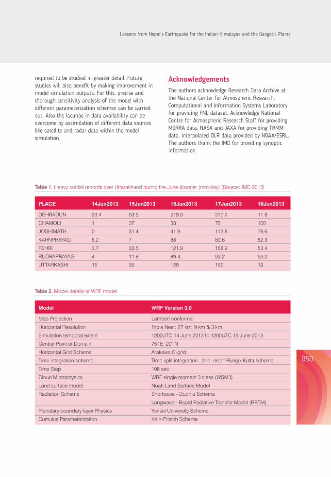
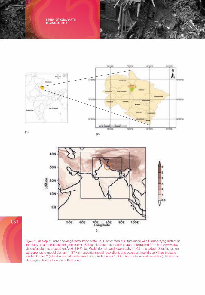
052051
STUDY OF KEDARNATH DISASTER, 2013
(a)(b)
(c)
Figure 1: (a) Map of India showing Uttarakhand state, (b) District map of Uttarakhand with Rudraprayag district as the study area represented in green color. (Source: District boundaries shapefile extracted from http://www.diva-gis.org/gdata and created on ArcGIS 9.3). (c) Model domain and topography (*103 m; shaded). Shaded region corresponds to model domain 1 (27 km horizontal model resolution), and boxes with solid black lines indicate model domain 2 (9 km horizontal model resolution) and domain 3 (3 km horizontal model resolution). Blue color plus sign indicates location of Kedarnath.
Figure 2: Daily accumulated precipitation (mm) for 27 km horizontal model resolution for 15June2013 to 18 June 2013. (e-h) same as (a-d) but with TRMM 3B42 V7 dataset. Black plus sign depicts the location of Kedarnath.
Lessons from Nepal's Earthquake for the Indian Himalayas and the Gangetic Plains
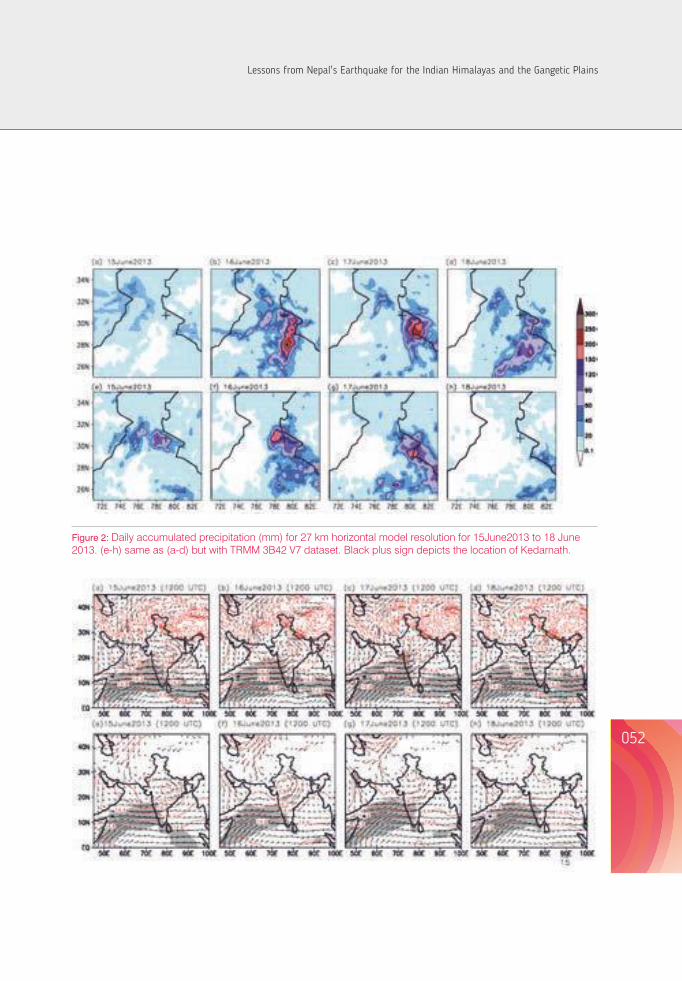
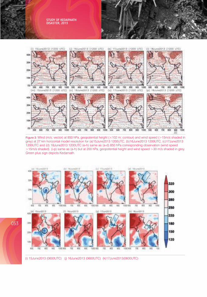
(i) 15June2013 (0600UTC) (j) 16June2013 (0600UTC) (k)17June2013(0600UTC)
Figure 3: Wind (m/s; vector) at 850 hPa, geopotential height (×102 m; contour) and wind speed (>15m/s shaded in grey) at 27 km horizontal model resolution for (a)15June2013 1200UTC, (b)16June2013 1200UTC, (c)17June2013 1200UTC and (d) 18June2013 1200UTC (e-h) same as (a-d) 850 hPa corresponding observation (wind speed >15m/s shaded). (i-p) same as (a-h) but at 200 hPa, geopotential height and wind speed >30 m/s shaded in grey. Green plus sign depicts Kedarnath.
Figure 4: Daily mean outgoing longwave radiation (W/m2) at 27 km horizontal model resolution (a) 15 June 2013, (b) 16 June 2013, (c) 17 June 2013 and (d) 18 June 2013 and (e-h) same as (a-d) but with corresponding observation analysis. Kalpana satellite images showing development of cloud at 0600 UTC from (i-k) 15 June 2013 to 17June 2013.
(Source: IMD, 2013a)
ReferencesDimri AP & Chevuturi A. 2014. Model sensitivity analysis study for western disturbances over the Himalayas. Meteorology
and Atmospheric Physics, 123(3-4): 155-180.
Dobhal DP, Gupta AK, Mehta M & Khandelwal DD. 2013. Kedarnath disaster: facts and plausible causes. Current Science, 105(2): 171-174.
Dube A, Ashrit R, Ashish A, Sharma K, Iyengar GR, Rajgopal EN & Basu S. 2013. Performance of NCMRWF Forecast Models in Predicting the Uttarakhand Heavy Rainfall Event during 17 - 18 June 2013. Ministry of Earth Sciences, 1-30.
Dube A, Ashrit R, Ashish A, Sharma K, Iyengar GR, Rajagopal EN & Basu S. 2014. Forecasting the heavy rainfall during Himalayan flooding-June 2013. Weather and Climate Extremes, DOI: 10.1016/j.wace.2014.03.004.
Huffman GJ, Adler RF, Bolvin DT, Gu G, Nelkin EJ, Bowman KP, Hong Y, Stocker EF & Wolff DB. 2007. The TRMM Multi-satellite Precipitation Analysis: Quasi-Global, Multi-Year, Combined-Sensor Precipitation Estimates at Fine Scale. Journal of Hydrometeor, 8: 38-55.
IMD. 2013a. A preliminary report on heavy rainfall over Uttarakhand during 16-18 June 2013. India Meteorological Department, Ministry of Earth Sciences. ww.imd.gov.in/doc/uttrakhand_report_04_09_2013.pdf?. Visited 20 February 2014.
Kala CP. 2014. Deluge, disaster and development in Uttarakhand Himalayan region of India: Challenges and lessons for disaster management. International journal of disaster risk reduction, 8: 143-152.
Lau WK, Waliser DE & Goswami BN. 2012. South Asian monsoon. In Intraseasonal variability in the atmosphere-ocean climate system. Springer Berlin Heidelberg, 21-72.
054053
STUDY OF KEDARNATH DISASTER, 2013 Lessons from Nepal's Earthquake for the Indian Himalayas and the Gangetic Plains
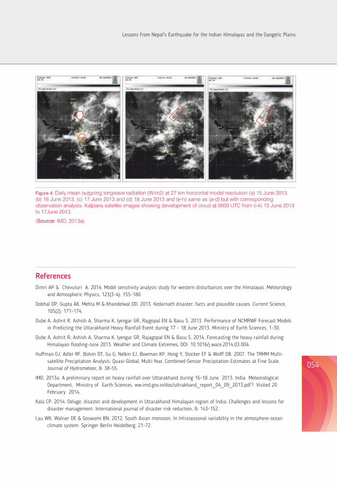
Liebmann B & Smith CA. 1996. Description of a Complete (Interpolated) Outgoing Longwave Radiation Dataset, Bulletein of American Meteorological Society, 77: 1275-1277.
Mishra A & Srinivasan J. 2013. Did a cloud burst occur in Kedarnath during 16 and 17 June 2013. Current Science, 105(10): 1351-1352.
Pandey P & Pandey AK. 2013. Uttarakhand disaster of June 2013: geological issues of a Himalayan state. (Personal communication).
Rao KHV, Rao VV, Dadhwal VK & Diwakar PG. 2014. Kedarnath flash floods: a hydrological and hydraulic simulation study. Current Science, 106(4): 598-603.
Rautela P. 2013. Lessons learnt from the Deluge of Kedarnath, Uttarakhand, India. Asian Journal of Environment and Disaster Management, 5(2): 43-51.
Rienecker MM., Suarez MJ, Gelaro R, Todling R, Bacmeister J, Liu E, Bosilovich MG, Schubert SD, Takacs L, Kim GK, Bloom S, Chen J, Collins D, Conaty A, da Silva A, Gu W, Joiner J, Koster RD, Lucchesi R, Molod A, Owens T, Pawson S, Pegion P, Redder CR, Reichle R, Robertson FR, Ruddick AG, Sienkiewicz M & Woollen J. 2011. MERRA: NASA's modern-era retrospective analysis for research and applications. Journal of climate, 24: 3624-3648.
Sati VP. 2013. Extreme Weather Related Disasters: A Case Study of Two Flashfloods Hit Areas of Badrinath and Kedarnath Valleys, Uttarakhand Himalaya, India. Journal of Earth Science and Engineering, 3: 562-568.
Sharma M, Mishra SK & Tyagi S. 2013. The Impact of Torrential Rainfall in Kedarnath, Uttarakhand, India during June, 2013, International Research Journal of Environment Sciences, 2(9): 34-37.
Skamarock WC, Klemp JB, Dudhia J, Gill DO, Barker DM, Duda MG, Huang X, Wang W & Powers JG. 2008. A Description of the Advanced Research WRF Version. http://www.mmm.ucar.edu/wrf/users/docs/arw_v3.pdf. Visited 22 March 2014.
Sphere India. 2013. Situation report - 5: Flood incident in Uttarakhand, http://www.sphereindia.org.in/Download/Sitrep5%20Flood%20Incident%20in%20Uttarakhand.pdf. Visited 26 March 2014.
Srinivasan J. 2013. Predicting and managing extreme rainfall. Current Science, 105(1): 7-8.
Wang W, Barker DM, Bruy`ere C, Duda MG, Dudhia J, Gill DO, Michalakes J, Rizvi S. 2010. WRF Version 3 Modeling System User's Guide. http://www.mmm.ucar.edu/wrf/users/docs/user_guide_V3.0/ARWUsersGuideV 3.pdf. Visited 25 April 2014.
056055
Dr. B.R. Paudyal²Former Member of National Planning Commission of the Government of Nepal
INCREASING GENDER RESPONSIVENESS DURING DISASTER RESPONSE AND RECONSTRUCTION : A SHORT REFLECTION FROM NEPAL'S EARTHQUAKE¹
Abstract The 2015 Nepal Earthquake affected livelihoods of around 8 million people, nearly one third of the total Nepalese population. In spite of continuous awareness activities and investment in preparedness from the Government of Nepal, the impact of the earthquake was devastating, showing that there was much more that needed to be done. This paper explores gender specific aspects of the earthquake in terms of impact and needs for relief, recovery and reconstruction. Taking note of the gender-specific needs and the occurrence of gender-based violence, exploitation, and stigmatization that affects women's capacity to live with dignity, this paper highlights the importance of gender mainstreaming into early relief and recovery initiatives, post-disaster need assessment, and reconstruction plans related to decision making as a way of reducing vulnerabilities of and empowering women in the long run. The paper argues that shift in paradigm – from addressing women-specific needs as beneficiaries to supporting women's space and capacity as an active agent of reconstruction – is necessary in order to shift from short-term relief to longer-term gender transformation through reconstruction.
Key words: Disaster Management, Gender Mainstreaming, Nepal Earthquake, Post Disaster Need Assessment (PDNA), Relief and Reconstruction
1This paper is based on the presentation made by Dr Bimala Rai Paudyal at a conference on 'Learning From Nepal's Earthquake' at INSA, New Delhi in August 20152Dr Bimala Rai Paudyal is former Member of National Planning Commission of the Government of Nepal, who also led Post Disaster Need Assessment (PDNA)-Gender Equality and Social Inclusion (GESI) and Social Protection thematic teams.
Introduction Nepal has witnessed several natural disasters in the past few years, including landslides, floods and earthquakes. The most recent disaster was an earthquake of 7.6 magnitude on 25th April 2015 and a series of aftershocks thereafter. The immediate effect of the earthquake was the loss of nearly 9,000 human lives, massive damage to public, private and community properties worth nearly US $7 billion and disruption of social services and livelihood of nearly 8 million people, which is about one-third of the country's total population (NPC 2015). In addition, there are far-reaching economic and social consequences of the earthquake with a heightened risk of increase in the number of poor and vulnerable people in the country.
Disasters compound social and economic inequities and vulnerabilities in society, disproportionately affecting the poor, women, children, elderly and people with disability. The 2015 Nepal earthquake also had differential impact on men and women; among the nearly 9,000 dead, nearly 55% were women and girls(NPC 2015).The earthquake had also left a significant number of people injured. Over 22,000 people were severely injured and about 5,000 acquired disability due to the earthquake, of which more than 50% were women (NPC 2015).The larger share of women and girls among the affected is attributed to the traditional gender roles that tend to confine women inside their home for household chores. It has also been reported that the women, who were inside their house during the earthquake, delayed their own escape, as they were busy searching for and rescuing children and the elderly before they themselves came out.
The post-disaster needs and the capacity to access and benefit from relief, rescue and recovery response differ between men and women. The Post Disaster Need Assessment (PDNA) carried out by the National Planning Commission after the earthquake has identified specific needs and priorities of women and girls along different sectors that need to be addressed during earthquake recovery and reconstruction. PDNA has also identified strategic interventions that will capacitate women and girls
to become more resilient on their own in future. While the building of resilience requires strengthening of all dimensions of livelihoods, namely physical, natural, human, financial and social capital, it also requires mainstreaming of gender perspectives throughout the recovery and reconstruction processes. This will not only address specific needs and priorities of women and girls in the short run, but also contribute to their empowerment while building their resilience in the long run.
The purpose of this chapter is to highlight the importance of gender mainstreaming in early relief and recovery initiatives, post-disaster need assessment and reconstruction plans, as a way of reducing gender based vulnerabilities and empowering women and girls in the long run. The following section presents the gender specific needs in relief and recovery phases along with discussion of some good practices observed during the phases. It then discusses the gender specific needs and elements of post-earthquake reconstruction, and finally presents the lessons learnt for mainstreaming women in disaster preparedness and management.
Earthquake relief and recovery: gender specific needsThe earthquake has produced disproportionate effect among different people and has magnified the pre-existing poverty and vulnerabilities of some specific groups, because of the differences in their roles and responsibilities, unequal access to assets and capabilities, and the social and cultural dimensions of inequities that exist in society. The rural communities, poor households, and women and girls suffered more, compared to the urban communities, non-poor and men.
The biological and practical needs of women and girls differ from those of men and boys. The earthquake affected 31 districts out of 75 and 14 of them were crisis hit. PDNA estimated that there were 2.8 million women in the 14 districts, out of which 140,819 were of reproductive age. A significant number of women were pregnant and
lactating mothers. PDNA reports that a total of 10,328 babies are born every month in these districts, thus adding more number of women needing access to birth centres, reproductive health services, obstetric care and right food. A total of 794,000 girls were below the age of 14 years, and a significant number of girls above 14 years were adolescent (NPC 2015).
Gender specificity of needs and priorities are evident in terms of shelter, clothes, food, security, sanitation, health and communication. Gender sensitivity in preparation of the relief package and procedure is important to respond to these specific needs and priorities of women and girls. Unless the gender specific needs are addressed during the relief and recovery period, the affected population cannot be prepared for their active participation in reconstruction, which is an important aspect of resilience.
The following are some of the gender specific needs that were evident during the post-earthquake relief and recovery:
a) Safe shelter: The earthquake damaged about half a million houses that brought all the members of the households including men, women, boys and girls under the open sky. The need for shelter was equal for all the members, but the privacy and security needs of women and girls were much higher and more sensitive than those for men and boys. When temporary shelters were provided for more than one family to live together, it was realized that there was a need for creating a separate space for women and girls, where they could change their dresses, feed their babies and take naps when tired or stressed. The lesson is that when a shelter is provided to a family, it is important to ensure that space and bedding materials are enough for the male and female members to sleep separately. Furthermore, temporary shelters should have provision of adequate number of toilets and sanitation arrangement specific to the use of women and girls. It is also important to ensure that there is adequate light in and around the shelter for security reasons.
b) Proper communication of relief information and women-friendly distribution procedure: About 26% of the households were headed by women in the earthquake-affected districts(NPC 2015).Women heads of the households faced specific challenges related to access to information and mobility. There were several cases where women either did not receive information about distribution of relief material and ways of accessing the material, or found it difficult to arrange human resources to reach the distribution point and receive the material. It is, therefore, important to confirm that relief-specific information reaches every household and the procedures to access these packages are also women-friendly.
c) Food and clothing: There was loss of food grains, livestock, vegetables, clothes and other necessary items for immediate as well as future use of the families. With this loss, pregnant women, lactating mothers, children and the elderly were more vulnerable as they lacked adequate food and shelter. Therefore, it is important that food provided during the relief period is appropriate and of nutritive value, especially for pregnant women, lactating mothers and babies and small children, who are usually women's responsibility. Apart from food and general clothing, it is also important to consider the specific clothing requirement for adolescent girls and women in the relief packages.
d) Health and sanitation: The earthquake resulted in severe damage to health services and centres. A total of 446 public health facilities including 5 hospitals, 12 primary health care centres and 417 health posts were completely destroyed by the earthquake (NPC 2015). Similarly, it is reported that most of the birth centres in the earthquake-affected districts had been damaged. There was an increased burden on the country's health services for addressing the health needs of newborn babies, pregnant women and lactating mothers besides the treatment of over 22,000 injured people (NPC 2015). In this situation,
058057
INCREASING GENDER RESPONSIVENESS DURING DISASTER RESPONSE AND RECONSTRUCTION : A SHORT REFLECTION FROM NEPAL'S EARTHQUAKE
Lessons from Nepal's Earthquake for the Indian Himalayas and the Gangetic Plains
there was a need of mobile and temporary health camps with adequate facilities. For gender specific health needs, it is important to arrange women doctors and gynaecologists attending the mobile clinics. It needs to be considered that mobilization of general team of doctors with exclusive focus on the injured often creates a situation, where the health needs of the pregnant, new mothers, babies and lactating mothers get neglected resulting in long term health consequences. In addition, women and girls need to be informed about personal safety and hygiene, as they are the ones who often look after the sick and injured and are exposed to risks of infection.
e) Schooling and counselling: The earthquake has caused massive damage to the education sector. It has affected a total of 8,242 public schools and fully destroyed more than 25,000 classrooms (NPC 2015). The education sector also experienced loss of toilets, water, sanitation and hygiene facilities, early childhood development centres (ECDCs), school equipment, learning material and public libraries. Damages to schools and the loss of basic facilities affected all the children; but the bigger sufferers were girls and adolescents as their privacy and security concerns made the parents reluctant to send them to classes offered under the open sky and without basic facilities.
It is also important to note that during the transition period after the earthquake and other disasters, it is usually the girls who drop out of school to help their families, especially their mothers, to manage household chores and take care of babies in the new environment. Experience suggests that the girls who drop out of school during the post disaster period are exposed to greater risk of child labour, sexual harassment and trafficking. Similarly, the loss of family members, livestock and property from the earthquake poses psychosocial risk to household members, especially to women and girls, who are more closely associated with the family. Psychosocial counselling to the affected population is an
urgent requirement to help the affected women, girls and adolescents.
f) Security and violence: Because of their roles and responsibilities at the household level, women and girls are more exposed to outside forces and are more vulnerable to violence during disasters. For example, along with responsibilities of regular household chores, such as cooking, sanitation and washing, which are specific to women and girls, they need to collect firewood and water even from remote or dangerous places where physical security is inadequate and sexual harassment can be a threat. Other problems, such as girl trafficking, child labour, domestic violence, and verbal and physical harassment can also rise after a big disaster. Thus, it is important to identify potential risks that are often specific to the context. Relief and recovery initiatives need to ensure that there is enough information to all women and girls about the possible risks of security and violence and the ways to mitigate them. It is important to ensure that security personnel are deployed and are accessible to women; these security personnel should be aware of all possible types of violence and well equipped with policies, resources and authority to protect women and girls at risks.
Generally, post-disaster search, rescue and relief operations do not differentiate between gender and other means, because the immediate priority of such operations is to save all those affected from situations of danger. The same principle was applied during the early response to the 2015 Nepal earthquake. It is, however, important to note that a gender-neutral approach to relief and recovery might often intensify vulnerability among women and girls, in both the short and the long run. Addressing the specific needs of women and girls as mentioned above will help these women and girls to meet their basic livelihood needs and dignity, and to protect them from further vulnerability and build capacity for resilience, as well. Nepal's experiences in this respect will help to mainstream gender dimensions in preparedness for relief, rescue and rehabilitation in future.
Good practices and learning during the relief and recovery period
The Government of Nepal, with support from different development organisations, activated the protection cluster immediately after the earthquake in order to respond to the specific needs of women, children and other vulnerable groups. The protection cluster was led by the Ministry of Women, Children and Social Welfare and carried out activities in the affected districts in close collaboration with organizations working closely with women and children. In collaboration with UN agencies, civil society, individuals and private organizations, it established spaces for women and children in some temporary settlements and distributed dignity kits that contained clothing as well as basic hygiene products to the affected women and girls to meet their immediate needs. Mobile clinics and separate space for newly delivered/lactating mothers was provided in some places. The Government also introduced policy measures to regulate mobility and other security arrangements to protect women and children from violence and trafficking. Such protection-specific interventions provided much needed assistance to a significant number of women and children and protected them from further vulnerability; however, these measures were constrained because of limited coverage and a large proportion of affected population remained beyond the reach of such gender-specific support.
One of the major challenges to mainstream gender responsiveness in the early relief and recovery iniatives was a lack of participation of women in the central and district level decision-making, especially on what the relief packages and processes should contain. Another challenge was the limited capacity of the protection cluster in the affected districts in terms of material and human resources. This limited the timely and effective outreach to the affected communities and also limited the efforts to mainstream gender responsiveness throughout the process. A clear strategy and arrangement for mobilisation of women's groups, cooperatives and self help networks in communities could have been utilized for the mobilization of local human resources and increased effectiveness and coverage
of gender responsive relief and recovery initiatives. This mostly remained a missed opportunity.
Mainstreaming gender equality and social inclusion (GESI) during the PDNA was one of the best practices that did not only assess gender specific loss and damage in all major sectors, but also identified gender and inclusion specific needs and recovery strategies. The PDNA applied a two-pronged approach to mainstream GESI. A stand-alone approach looked at specific vulnerabilities, challenges and need of the vulnerable segments of population such as women, children, people with disability, elderly and marginalised caste and ethnic groups. It recommended a number of recovery and reconstruction strategies to protect these groups and allow them to live with dignity. The next crosscutting approach looked at specific challenges faced by women and other vulnerable groups and outlined gender specific recovery strategies in different sectors including agriculture, employment, forestry, infrastructure, health, education and tourism. The PDNA provides a solid basis for gender responsive reconstruction that is resilient.
Post-earthquake reconstruction: elements and gender needs Disasters can have material, human and social costs. But when relief, recovery and reconstruction interventions are designed in a more cautious way, these events can also provide an opportunity to build resilience in the long run while recovering from the current damage. Therefore, the major objective of reconstruction should be not only to recover from the damage and restore overall infrastructure, economy and society, but also to rebuild better infrastructure and make individuals, communities and society more resilient to multiple hazards and disasters in future. It also needs to be taken into account that during reconstruction, building with an inclusive and empowering approach can positively contribute towards addressing some of the inequities and inequalities in society.
Major elements of reconstruction can be grouped as physical infrastructure, livelihood and productive sector, social sector rehabilitation, and disaster risk reduction and management. All these elements have
060059
INCREASING GENDER RESPONSIVENESS DURING DISASTER RESPONSE AND RECONSTRUCTION : A SHORT REFLECTION FROM NEPAL'S EARTHQUAKE
Lessons from Nepal's Earthquake for the Indian Himalayas and the Gangetic Plains
specific gender needs that need to be addressed for reconstruction towards building resilience of the individuals, community and the country.
a. Physical infrastructure: This includes reconstruction of private residential houses, non-residential private and public buildings (hospitals, schools, offices), and restoration of key infrastructures (roads, bridges, transport, water supply, storage, power lines, irrigation canals), heritage structures and memorials. Community driven reconstruction, use of local material and local products, use of local human resources and the best use of Nepali coping mechanisms and community level institutions, including community groups, mother groups and cooperatives, provides a strong base for reconstruction initiatives as it provides economic opportunities at the local level and the institutions are well aware of the context and needs at the local level. Some of the challenges of women-headed households such as lack of family labour to rebuild their houses and other specific constraints for accessing information, skills and technical and material support from the state and non-state actors to build private houses need to be addressed. Considering the economic and job opportunities after the earthquake, the women labor force that usually performs less skilled jobs in the construction sector should be encouraged by engaging them in skilled labor after providing them with skill training. It will not only empower them economically but also make them self employed and resilient for future shocks of disasters such as 2015 Nepal Earthquake.
b. Livelihood and economic reconstruction: This includes reviving productive sectors, mainly agriculture, tourism, enterprises and skills that aim at improving production, economic growth as well as employment and services. During reconstruction, livelihoods and productive sectors need to be revived in such a way that it includes not only recovery of the loss and damage because of the earthquake, but also building of resilience against future shocks and disasters.
The agriculture sector involves around 75% of the total labour force, out of which around 70% consists of women (ILO 2014 and NPC 2015). Small livestock and kitchen gardening are mainly done by women farmers and are often their only independent source of income. In the earthquake affected districts, farmers, including a significant proportion of women population, have lost not only the land and a season for agricultural operation, but also agricultural inputs including seeds, tools and equipment and market access for the products that have been produced with great difficulty. Migration of male members from village has already resulted in the feminisation of agricultural work in many villages as the male members have been migrating to cities and abroad in search of income and options for livelihood; this phenomena has grown after the earthquake. This, compounded with the loss of agricultural inputs and land, has compounded the management responsibility of women. Agriculture reviving strategy should focus on the specific needs of these women farmers and reach them with appropriate information, skills, technology, input and material as well as management counselling. Without focusing on women farmers and equipping them with skills, knowledge, input and confidence, the strategy to revive agriculture and making it resilient cannot be sustained.
Similarly, the tourism sector involves a significant number of women. Nearly 50% of the total workforce in tourism services consists of women and it is reported that more than 50% home stays in the earthquake-affected districts are owned and managed by women (NPC 2015). Recovery in the tourism sector should ensure that the ownership and management of homestays remain with women, reviving employment in this sector, and that tourism-based industries invest in women to prepare them with management skills for engagement in the sector.
c. Social rehabilitation: This includes reviving and restructuring of social sectors and services such as education, health and public services,
reestablishment of social institutions and networks, and protection of women, children, elderly and people with disability from further vulnerability and mental health recovery. Following the concept of Build Back Better, reconstruction should consider designing and rebuilding of public buildings, especially the infrastructures related to health, education, local government and sectorial service centers by ensuring access to the people who are disproportionally affected by the earthquake. The needs to be considered are for children and people with disability because of their limited ability to move, communicate and use the remaining infrastructure for safety, and other vulnerable segments of the population such as single women, orphaned children and the elderly. Protection and rehabilitation efforts need to ensure that these vulnerable groups are aware of reconstruction and their possible contribution during the process, which will help them to participate in the process not only as beneficiaries but also as active agents. This approach builds their confidence, social capital and allows them to live with dignity, which is important for a resilient society.
d. Disaster risk reduction and management: As outlined earlier in this article, disasters are not neutral. Disaster risk reduction (DRR) strategies, therefore, need to focus on specific challenges of the vulnerable population groups and prepare them with knowledge, skills and equipment to minimise the impact of disasters and enable them to manage them effectively.
One of the important lessons from DRR preparedness is that the local neighbouring communities, groups and cooperatives, because of their proximity, are the most accessible support centres for the affected population immediately after the disaster. No matter how prepared the central mechanism is, it takes time for central and district authorities to reach for rescue and relief in the affected communities. Therefore, for better preparedness and timely response, it is important that the local communities are organised and equipped with skills, knowledge,
equipment, space and authority to engage in relief, rescue, recovery and reconstruction from the beginning. This also applies to resilience-related information, knowledge, skills and preparedness. This requires local institution building and empowering local groups and institutions with DRR related preparedness.
Due to widespread migration of males from rural communities in Nepal, it is usually women and adolescent girls that are dominant in the rural population. Once capacitated with better knowledge and skills, they can contribute significantly in hazard and vulnerability mapping and designing the response, as they are knowledgeable in the local context. It is, therefore, important to provide space for women and girls to raise their voices and participate in local level DRR design and implementation. At the same time, DRR initiatives including information, skills, technology and equipment could focus more on the viewpoint of women and girls, so that they can be implemented effectively at the local level.
Ways forward for increasing gender responsiveness during disaster response and reconstruction As discussed earlier, men and women have specific needs and the needs are more prominent during disaster. A blanket approach to relief, rehabilitation and reconstruction is not sufficient to recover and build resilience. Often, relief and recovery interventions that seem neutral in principle are not neutral when gender and other socio-economic factors of the affected population are considered. When these differences are not considered and integrated into the response mechanism, it can increase, reinforce, or reduce the existing inequalities. Gender responsiveness in relief and recovery requires an institutional mechanism, with clear responsibly and authority, and enough stock of materials needed to reach women so as to respond to their practical gender needs. In addition, addressing inequities in general will minimize the disproportionate impact of disasters on women. Therefore, disaster relief and recovery should go
062061
INCREASING GENDER RESPONSIVENESS DURING DISASTER RESPONSE AND RECONSTRUCTION : A SHORT REFLECTION FROM NEPAL'S EARTHQUAKE
Lessons from Nepal's Earthquake for the Indian Himalayas and the Gangetic Plains
along with broader equitable development initiatives.
Gender responsiveness during disaster response and reconstruction could be achieved through the following broad strategies:
Response to disaster during relief, rescue and recovery needs to identify and respond to the practical needs of women and girls, especially those related to security, shelter, food, clothes and reproductive health, along with continuing and promoting their livelihood opportunities, which help them to live with dignity.
When reviving livelihood and productive sectors, it is important to identify and respond to the specific needs and priorities of women farmers, women entrepreneurs, women workers in the informal and service sectors. In addition, while considering the job opportunities created during reconstruction, it is important to capacitate women with skill-based training so as to offer them jobs that enable them to earn cash and promote equality in the long run.
Women's specific needs are better identified when they are involved in the process of need assessment. Similarly, when women's organizations such as women cooperatives and groups are mobilized, the implementation and monitoring of interventions become effective and relevant to them. Therefore, it is important to ensure that women are not only seen as receivers of relief and rehabilitation but also as active agents for rescue, relief and rehabilitation.
Building and strengthening women's organizations by equipping them with knowledge, skills and technology to ensure better preparedness to manage disasters will not only build community resilience but also empower women socially and politically. In addition, strengthening the management capacity of women in disaster preparedness, relief and recovery will improve efficiency of disaster management in the long run while addressing the vacuum of productive rural population created due to the migration of the male members.
If reconstruction involves creating new settlements and asset building, it is necessary to ensure that the ownership of these infrastructures and assets do not perpetuate the existing inequality. The new tenure arrangement should promote women's ownership or at least joint ownership between men and women.
When new public buildings are constructed or retrofitting is done, it should be ensured that the new public infrastructures are inclusive and accessible to women, children and people with disability.
During disaster, community cohesiveness increases and people from all class, caste and ethnicity live and eat together. Interventions can capitalise and promote this culture, as this contributes to social capital, which is an important element of reconstruction promoting community resilience. Participation of local people could be increased during relief, recovery and reconstruction interventions not only as a labour force but equally during need identification, intervention, design, implementation and monitoring. This will also increase the effectiveness of the disaster response and reconstruction program.
Literature cited NPC. 2015. Post Disaster Need Assessment, Volume B,
Sector Report. National Planning Commission, Kathmandu (Nepal)
ILO.2014. Nepal Labour Market Update. ILO Country Office for Nepal, Kathmandu (Nepal)
064063
Bhishma P. Subedi, Ph.D.Sudarshan C. KhanalAsia Network for Sustainable Agriculture and Bioresources (ANSAB) Corresponding email: [email protected]
2015 NEPAL EARTHQUAKE:AN OVERVIEW OF ANSAB'S FIELD OBSERVATIONS AND EXPERIENCES
AbstractThis paper presents the lessons drawn from an analysis of the situation in terms of loss, damages and needs and effectiveness of response on immediate relief and recovery after the terrible earthquake that hit Nepal on April 25, 2015 and a series of over 400 major aftershocks that spread over the next 6 months. This is based on ANSAB's first- hand experience and involvement in providing immediate relief support to some affected communities, assessment of the situation, and design and implementation of a program for community relief and recovery. The damage and loss due to the earthquake were not limited to human lives; it severely affected economic, social, psychological and environmental dimensions, as well. Earthquake responses from government, civil society organizations, individuals and international communities were noteworthy, especially with regard to rescue and relief operations. It was found that the disaster preparedness at national and local level was insufficient and the efforts related to recovery and sustainable development were minimal, if not absent. The key lessons are organized under the aid and resources mobilization, disaster planning and preparedness, and implementation. These could be relevant to the Indian Himalayas and Gangetic Plains for taking preventive measures and developing appropriate response mechanisms to handle such a disaster more effectively and to reduce its impact.
Key words: Disaster Management, Earthquake, Nepal, Preparedness, Relief and Recovery,
IntroductionThe 7.6 magnitude earthquake that hit Nepal on April 25, 2015 was the worst earthquake to hit Nepal in 80 years, and was followed by a series of over 400 major aftershocks of above 4 magnitude through November 2015 (see Fig. 1 for the epicentres of the earthquake and the aftershocks). It is hard to believe that Kathmandu was raised by
1 m and shifted to 3 m south during the earthquake (Bilham 2015). Since most of the Indian Himalayas and Gangetic Plains are believed to be in seismic gap for centuries, they may face such large earthquakes any time in future. The region is also vulnerable to other disasters, such as flooding, landslides and drought, which are being predicted to
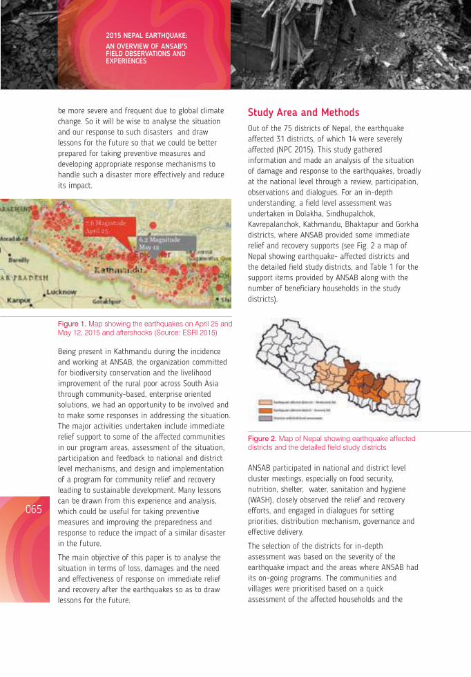
be more severe and frequent due to global climate change. So it will be wise to analyse the situation and our response to such disasters and draw lessons for the future so that we could be better prepared for taking preventive measures and developing appropriate response mechanisms to handle such a disaster more effectively and reduce its impact.
Study Area and MethodsOut of the 75 districts of Nepal, the earthquake affected 31 districts, of which 14 were severely affected (NPC 2015). This study gathered information and made an analysis of the situation of damage and response to the earthquakes, broadly at the national level through a review, participation, observations and dialogues. For an in-depth understanding, a field level assessment was undertaken in Dolakha, Sindhupalchok, Kavrepalanchok, Kathmandu, Bhaktapur and Gorkha districts, where ANSAB provided some immediate relief and recovery supports (see Fig. 2 a map of Nepal showing earthquake- affected districts and the detailed field study districts, and Table 1 for the support items provided by ANSAB along with the number of beneficiary households in the study districts).
Figure 1. Map showing the earthquakes on April 25 and May 12, 2015 and aftershocks (Source: ESRI 2015)
Being present in Kathmandu during the incidence and working at ANSAB, the organization committed for biodiversity conservation and the livelihood improvement of the rural poor across South Asia through community-based, enterprise oriented solutions, we had an opportunity to be involved and to make some responses in addressing the situation. The major activities undertaken include immediate relief support to some of the affected communities in our program areas, assessment of the situation, participation and feedback to national and district level mechanisms, and design and implementation of a program for community relief and recovery leading to sustainable development. Many lessons can be drawn from this experience and analysis, which could be useful for taking preventive measures and improving the preparedness and response to reduce the impact of a similar disaster in the future.
The main objective of this paper is to analyse the situation in terms of loss, damages and the need and effectiveness of response on immediate relief and recovery after the earthquakes so as to draw lessons for the future.
Figure 2. Map of Nepal showing earthquake affected districts and the detailed field study districts
Support items Number of beneficiary Households
Immediate support
Temporary shelter package 488
Food and nutrition 806
First aid medicines 162
Semi permanent shelter
CGI sheets and building kits 1,917
Semiautomatic brick machines (2)
Table 1: Support items provided by ANSAB and the number of beneficiary households in the study districts
ANSAB participated in national and district level cluster meetings, especially on food security, nutrition, shelter, water, sanitation and hygiene (WASH), closely observed the relief and recovery efforts, and engaged in dialogues for setting priorities, distribution mechanism, governance and effective delivery.
The selection of the districts for in-depth assessment was based on the severity of the earthquake impact and the areas where ANSAB had its on-going programs. The communities and villages were prioritised based on a quick assessment of the affected households and the
current needs. Information on these aspects was collected from ANSAB's field staff and its network including local partners, community forest user groups (CFUGs) and local government bodies. The final selection of the target villages/communities was done in coordination with the government stakeholders, namely District Disaster Response Committee (DDRC) and Village Disaster Response Committee (VDRC).
Selection of beneficiaries for each community was done through a standard process developed by ANSAB in collaboration with local partners. The beneficiary households for immediate support were selected after a participatory well-being ranking of the affected households in the presence of community leaders along with 15-20 members of the community and representatives of VDRC, Ward Citizen Forums, local political leaders and CFUGs. The determination of socio-economic status of a household for ranking was based on property, income, family size, number of dependent family members, educational level of family members, and social status within the society.
For distribution of semi-permanent shelter support, a well-being ranking of the households was done considering the following criteria:
(i) No or negligible access to shelter, including owners with only one house that had been destroyed
(ii) Women and/or elderly and disabled headed families, whose houses were completely destroyed
(iii) High dependency ratio of children, elderly or pregnant women in the family
(iv) No or negligible livelihood sources.
The final list was then registered in the DDRC as a record in the government office. This would also prevent the overlapping of similar relief materials, if provided by any other agencies. The information and data were analysed to draw lessons at national, district and community level that would be useful to the government, international aid agencies, civil society organizations, local communities and individuals.
Results and DiscussionMajor losses and damages
The losses and damages caused by the earthquake were enormous. It claimed lives of over 9,000 people and caused over 22,000 human injuries (NPC 2015). The loss was not limited to human lives, but also extended to economic, social, psychological and environmental parameters.
Economic losses. The loss and damage were significant in physical assets, goods and services. The earthquake damaged over 900,000 houses and other structures including about 8,000 schools, nearly 30,000 classrooms, and over 1,000 health centres in the country (NPC 2015). A rapid assessment carried out by ANSAB in Dolakha, Sindhupalchok and Kavrepalanchok districts within a week after the earthquake showed that there was significant loss of individual houses, and community and government buildings. About 80% to 85% of the total houses were damaged in 33 villages and municipalities in these districts forcing about 25,000 households to seek temporary shelter under tents (ANSAB 2015a). It is estimated that the earthquake caused losses worth US $2 billion and damage worth US $5 billion totalling US $7 billion at national level that is over a quarter of the country's GDP (NPC 2015).
066065
2015 NEPAL EARTHQUAKE:AN OVERVIEW OF ANSAB'S FIELD OBSERVATIONS AND EXPERIENCES
Lessons from Nepal's Earthquake for the Indian Himalayas and the Gangetic Plains
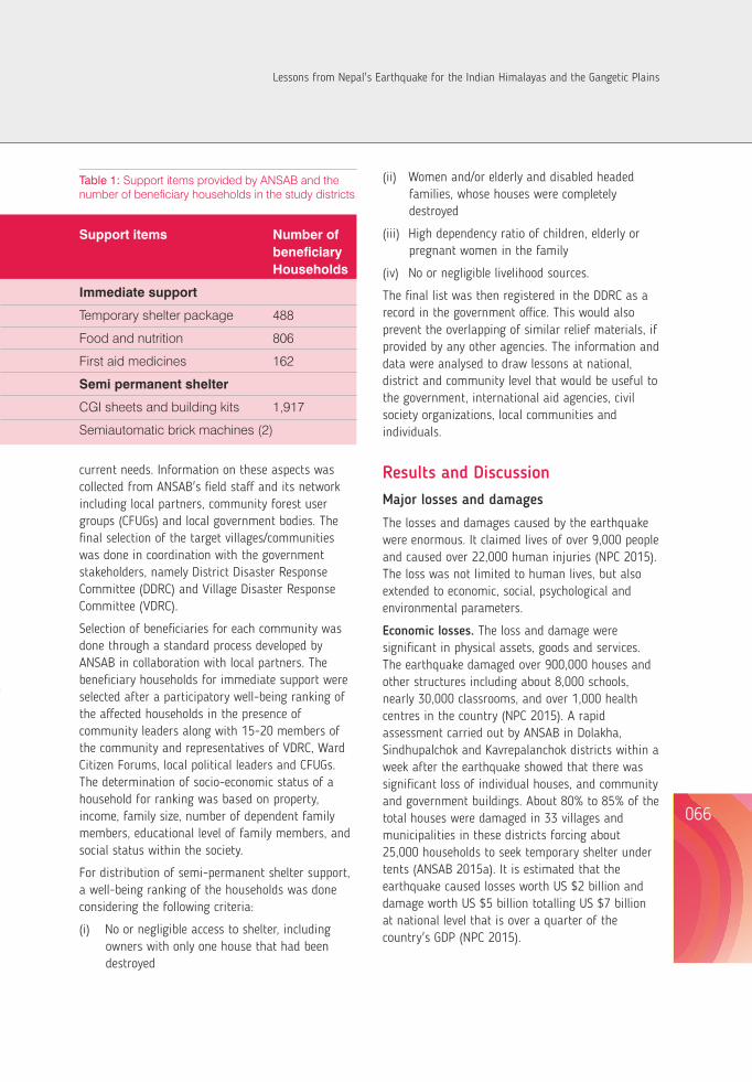
Livelihood impact. If we consider the economic dimensions affected due to the loss of physical assets, goods and services by the earthquake, such as reduced economic activities, labour availability for productive sectors and access to public services, the total economic loss is way higher than economic worth of direct loss and damage. The earthquake affected livelihoods of half of the populations in 31 earthquake hit districts (NPC 2015), which comes to around 8 million people, or one third of the country's total population.
The agricultural livelihood in the mountains suffered high levels of damage as the earthquake caused the loss of productive livelihood assets, such as stored crops, particularly rice, maize and millet, their seed stocks, and livestock. The loss of seed stock is a threat to household food security once the standing crops are harvested. It is reported that about 57,000 farm animals died because of the earthquake (NPC 2015). The livestock holding of households was higher than the national average in the districts severely affected by the earthquake, and the livestock are still a major source of household income. Their deaths caused a severe income shock to the households. There was also the reduction of labour availability for agriculture and other sectors as the households struggled to meet more urgent shelter needs for themselves and their livestock.
Besides agriculture, the livelihood of people dependent on other sectors, such as tourism, was directly impacted. As major trekking routes and popular tourist destinations, such as Langtang and Everest were damaged, the tourism sector was badly impacted. It is a huge economic loss because 487,500 jobs were generated by the sector in 2014. Within a month after the earthquake, about 80% of the hotel reservations were cancelled and an estimated 45,000 tourists had left the country (NEF 2015). Similarly, the livelihood of the poor and vulnerable was affected with damages to the local infrastructures, especially roads and bridges and disruption of basic public services, such as health posts and schools. These people are particularly dependent on the infrastructure for their access to labour and commodity markets and public services for accumulation of human capital.
Because of the impact of the earthquake on livelihood, including severe income shock, an increased number of people were pushed into poverty. NPC (2015) has estimated that an additional 700,000 people, that comes to about 3% of the total population, have been pushed below the poverty line.
Social and psychological impact. The increased stress and fear due to the loss of relatives, uncertainty and insecurity caused social and psychological impact to the general public. People were scared and traumatised with increased worries, restlessness, and chronic fear, as a large number of people witnessed the unexpected deaths and destructions.
Furthermore, the earthquakes, the series of aftershocks and the corresponding news featuring earth ruptures in many areas inducing risk of future landslides incited widespread fear and uncertainty about the future. With constant fear of catastrophe, people with their family members stayed and slept outside their houses in tents for many days. Many children often feared and did not dare to return to their houses. Although it could not be solely attributed to the earthquake, data from the Nepal Police during three months before and after the earthquake showed that there was a 41% increase in suicide rate in the country.
It is also interesting to note that women started to take on a larger responsibility of rebuilding sectors like agriculture and livestock in some of the affected areas where the male population has out-migrated in the labour market.
Damage to environment and cultural heritage. The impact of the earthquake on the natural and cultural heritage was huge. It led to several avalanches, including the one in the Mount Everest area that killed at least 18 people and triggered several landslides, both dry and wet (NPC 2015). It is reported that tens of thousands of landslides distributed over an area of about 35,000 km2 in the country were triggered by the earthquakes and aftershocks (Collins and Randall 2015). Landslides and cracks occurred in forestland, cultivated land, water sources and settlement areas thus posing
widespread environmental and social threats. ANSAB's assessment in 7 VDCs and a municipality of Dolakha district after the earthquake shows that there were at least 150 landslides and cracks that covered an area of 735,999 m², which is about 3.4% of the total land surveyed. Some of those landslides also caused blockage of the rivers and streams changing their natural flow (ANSAB 2015b).
The earthquake damaged over 700 historical, cultural and religious monuments (DoA 2015). It included the total demolition of many monuments of international recognition, preserved for centuries, such as the 9-storied Dhararaha tower built in the mid eighteenth century, the Kasthamandap temple, from which the name of Kathmandu originated and
which is believed to be established in the twelfth century, and many temples around Kathmandu and Bhaktapur Durbar Squares that are listed as UNESCO heritage sites.
Need for assistance and effectiveness of response
As presented in Fig 1, ANSAB's rapid assessment in Dolakha, Sindhupalchok and Kavrepalanchok districts shows that the immediate priority needs of the community were food, nutrition and shelter. For the recovery of the affected population, there was also a need for improved shelter, food and nutrition, access to community services, and revival of economic activities (see Fig. 1).
Figure 3: Immediate relief and medium to long-term recovery needs of earthquake affected communities
The government, civil society organizations, individuals and international communities responded to the disaster in various ways. As in many similar cases elsewhere in the past, the response to rescue and relief activities was relatively widespread, but the emphasis on recovery and sustainable development was found to be minimal, if not absent.
Government. The Government of Nepal mobilized its machinery for search, rescue and relief operation. About 130,000 army, police and armed police force were deployed to provide one to one support to the affected people (MoHA 2015). The role and performance of the security forces in relief operation was well-received by the people in the affected areas. Public hospitals provided continuous service
at their premises, and the government formed and mobilized about 50 national medical teams (MoHA 2015). The government formalized DDRCs and VDRCs within a week after the incident to coordinate relief operations. The DDRCs' role was to channel relief materials to VDC level to be distributed through VDRC and their ward level subcommittees. The government also formulated “one window” policy for reconstruction assistance, to route earthquake donations through the Prime Minister's Disaster Relief Fund, organized the International Conference on Nepal's Reconstruction, where development partners and donor community pledged US $4.4 billion in aid, and established Nepal Reconstruction Authority (NRA) for post-earthquake reconstruction activities.
068067
2015 NEPAL EARTHQUAKE:AN OVERVIEW OF ANSAB'S FIELD OBSERVATIONS AND EXPERIENCES
Lessons from Nepal's Earthquake for the Indian Himalayas and the Gangetic Plains
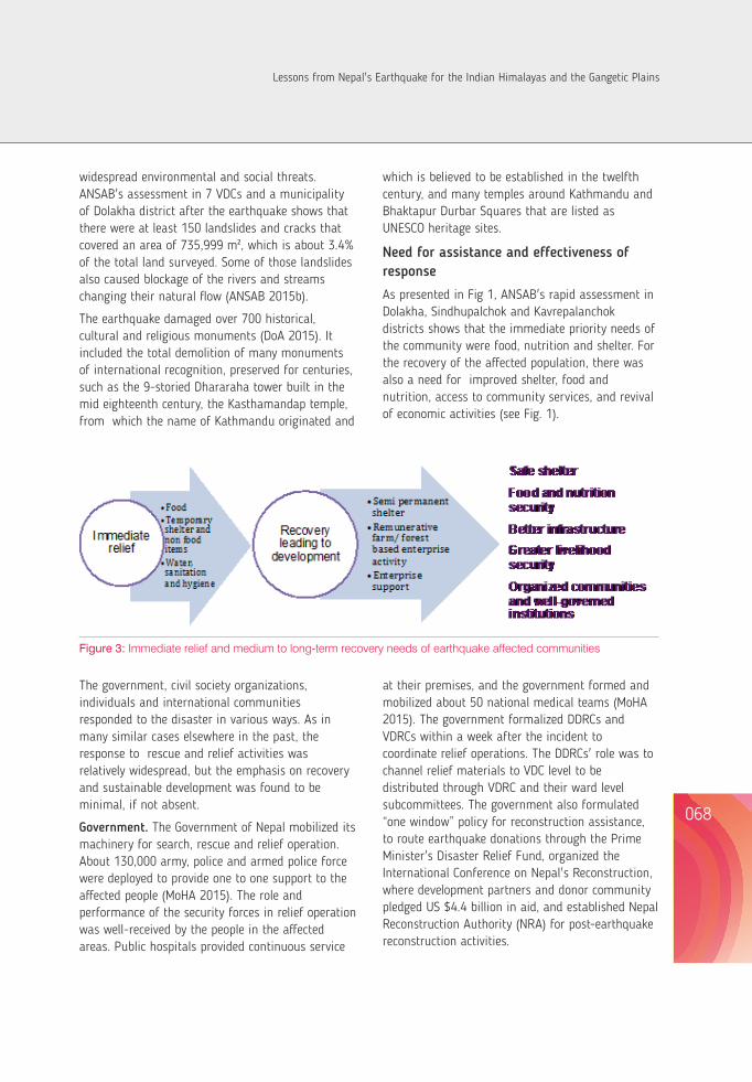
While the role of the Nepalese government in mobilising resources for rescue and setting up of district level and village level mechanism was noteworthy, some of the decisions and activities of the government created confusion. In the beginning, the government's decision to seize aid, donations, money and material, and route them through the Prime Minister's Disaster Relief Fund, without identifying a right mechanism, raised concerns among the donors.
The priority for taking rapid action for relief, recovery and reconstruction was sidelined due to the on-going unstable political situation. Soon after the earthquake, the government got involved in political issues related to the drafting of the constitution and addressing related disturbances that followed. The NRA was activated only after 8 months as the bill to establish it remained pending until December 2015 due to the conflict between the major political parties. Although the government had decided to implement reconstruction activities through the National Planning Commission for the time being, it could not take any significant action.
Civil society organizations and individuals. The people at the local level demonstrated notable resilience during the earthquake. Some of the important observations were the presence of a strong 'people to people' relationship at the local level, even among the affected population and voluntary mobilization of youth from different parts of the country. Community solidarity and social cohesion remained strong or even increased after the earthquake. Community organizations, such as CFUGs, played an important role in mobilizing support items in their community.
The distribution of relief materials was found to become more effective when there was a well thought-out distribution mechanism that involved local communities and stakeholders in decision-making and that was harmonized with the government system. For example, ANSAB's response activities that utilized the existing community level organizations, namely the CFUGs and local enterprises for aid coordination, was well - received by the recipients and other partners working in the
affected areas. Community level mechanisms worked closely with the local people, knowing the local context and avoiding conflicts at their locality. They also emphasized the distribution of aid to needy households. Because of their strong ties with the communities, they also collected detailed information of the damages and needs at the local level with greater speed.
In the initial days, relief distribution was delayed and uneven. The gaps in and duplication of relief efforts were clearly observed as different aid providers acted without any coordination, often focusing their distribution on more accessible areas along the highways and intact roads. Some individuals and organizations were merely interested in self-promotion. In many cases, the providers were not sensitive to the specific needs of women, children and the elderly. This led to increased confusion and tension in some places. However, the formation of local relief distribution committees has improved coordination and reduced the gap and duplication of relief effort.
International communities. Search and rescue teams from 34 countries, and at least 150 foreign medical teams came to Nepal after the earthquake (NPC 2015, MoHA 2015). Individuals from different parts of the world provided cash and in-kind donations. There were many international relief organizations that came to Nepal and provided humanitarian support after the earthquake.
However, the activities of some individuals and groups was a seemed suspicious to the people; there doubt that they had a hidden agenda of taking advantage of the situation, such as self-promotion, human trafficking and spreading of their religion. As some of them came to Nepal for the first time with little or no knowledge of the local context, there were some inappropriate efforts, such as brining water when filtration was needed, and delivering beef products to a Hindu region.
Overall PreparednessThere were several evidences to indicate that overall preparedness was inadequate to meet the earthquake hazards. The country had developed
standards for building houses and other infrastructure but it was not able to implement them properly in most of the places. The government hastily reformed the building codes after the disaster, clearly indicating that the previous standards were not up to the mark. There was no evacuation plan and no safe places were identified for major disasters including earthquakes. As such, there is still a general lack of proper standards and enforcement with regard to public buildings, open spaces and services. This was evident from the fact that a higher percentage of public buildings and public infrastructure were damaged in comparison to private houses.
Some activities are being undertaken by the government in partnership with other organizations for earthquake preparedness, mostly on raising community level awareness in some parts of the country. There were news items in newspapers and social media that in some villages in Sindhupalchok districts, people who were already outside their houses went inside and hid under tables, instead of remaining outside or going to safer places. Similarly, in Kirtipur, more than half of the people who took earthquake preparedness training some days before the event got injured during the earthquake because of faulty instructions.
Some Key Lessons Our analysis shows that the key areas where effectiveness and efficiency of the actions could be improved relate to aid and resource mobilization, disaster planning and preparedness, and implementation. Some of the key lessons on each of these areas are presented below.
Aid and resource mobilization. A key lesson learntfrom the experience is that it is important to have a trustworthy government-led coordination mechanism, with clear guidelines and effective regulations, that is flexible enough to allow direct operations of multiple partners at the field level. This would facilitate a fair distribution of relief efforts to the needy with effective participation of all stakeholders. This will also increase the credibility of the response activities among donors and well-
meaning individuals, as they are concerned with effective use and mobilization of their efforts to meet the affected population's needs. The mechanism, at the same time, could consider standards and methods so that the donors who have genuine motives are distinguished from those with vested motives, such as exploitation of resources and people as well as self-promotion.
For more effective fund mobilization, the government should know the context and its capability and identify the right mechanism accordingly. Once the mechanism is determined, the intention should be clearly communicated to the donors, relevant stakeholders and the communities concerned so that there is no or minimum confusion among them, if any.
Design, planning and preparedness. A well thought-out design and planning, using scientific data and community knowledge, would be effective to match delivery with need. This would help minimize the gaps in and duplication of efforts, cater to specific needs of women, children and elderly more effectively, avoid inappropriate support, and balance efforts in relief and recovery. Such planning exercises and practices should be mindful of not losing the long-term perspective even in providing short-term support.
Local knowledge and social capital could be capitalised to address preparedness issues in the future. For example, participatory hazard and relief mapping and establishment of a network of community members, who can communicate and provide support, should be completed before an earthquake occurs. Similarly, provision and maintenance of open space and public infrastructure could be done well in advance so that the affected population could go to safer places when a disaster occurs.
It is obvious that local communities can play an important role if they are better prepared and equipped with more practical information on emergency response, enhanced capacity for emergency operation, and good governance mechanism. This would also increase resilience and adaptive capacity at the local level. The importance
070069
2015 NEPAL EARTHQUAKE:AN OVERVIEW OF ANSAB'S FIELD OBSERVATIONS AND EXPERIENCES
Lessons from Nepal's Earthquake for the Indian Himalayas and the Gangetic Plains
of community level mechanism was also emphasized after the earthquake when the government -level effort was not so effective, as the country was not able to provide timely response to the earthquake- affected communities because of the country's instability and the government's focus on the Constitution. Even in a normal situation, involvement of local community organizations would be effective in delivering timely relief support.
The effectiveness of information on earthquake preparedness increases if it includes practical, useful and context- specific information. If the information is out of context, it produces unintended negative results.
The revival of local economic activities and resumption of basic public services would be helpful for the reduction of poverty resulting from the earthquake. It is important to be mindful of promoting resilient livelihood recovery at the community level while providing relief support. For example, ANSAB's support with silpaulin tents for the operation of the community-based briquette enterprises in Sindhupalchok district along with the immediate relief material (food, medicine and shelter) enabled them to resume their enterprises, which were closed after the earthquake.
Implementation or delivery. While proper planning and preparedness is essential, it is the proper implementation that produces the desired outcomes. Disciplined and sincere efforts in implementation are necessary; they should be built on clearly defined mechanism and make use of justified criteria of distribution acceptable to stakeholders. It is possible only when there is trust among the stakeholders. For example, the identification of beneficiaries and based on well-being rankingcommunity consensus by ANSAB increased the trust and cooperation among the stakeholders and affected households.
It is possible to create synergy through collaboration with government agencies and other organizations. Organizations with similar type of support activities could collaborate for better delivery of their goods and services. For this, government mechanisms, such as NRA, DDRC and VDRC can play an
important role by providing information and guidance as well as coordination of activities addressing the issues related to gaps and duplications of support.
The trustworthiness of supporting organizations among local communities is vital for effective services. Local communities feel comfortable in working with already established, trustworthy organizations and participate wholeheartedly in relief and recovery activities. An organization that has a clear vision and mission and that works at the community level in harmony with the government system is better equipped for effective delivery, local resource mobilization and strengthening good governance. This would also help to maintain law and order, establish peace and harmony in society and ensure sustainability of recovery work.
Furthermore, working with enterprises (especially those which play the role of a lead firm in industries based on community-produced products) and communities that are at the forefront and understand the community needs could be considered for the effective mobilization of support activities. The combination of external aid and scientific knowledge from national organisations and the contextual knowledge and staff of the local organisations would allow for more effective relief and recovery.
AcknowledgementAll ANSAB staff contributed through participation in the Earthquake Response Program in one way or the other. Thanks are due to Puspa Lal Ghimire for his contribution to program design and drawing lessons, and to Shambhu Charmakar, Kabita Gyawali and Aakriti Poudel for their participation in program implementation and field assessment. We are grateful to Aveda, Estee Lauder, blue moon fund, Relief International, FSC International Center and various individuals for their financial contribution to our program.
072071
2015 NEPAL EARTHQUAKE:AN OVERVIEW OF ANSAB'S FIELD OBSERVATIONS AND EXPERIENCES
Confirmation of the beneficiaries before distribution of relief materials
Community members receive support from the distribution center
An elder community member after she receives support items
Lessons from Nepal's Earthquake for the Indian Himalayas and the Gangetic Plains
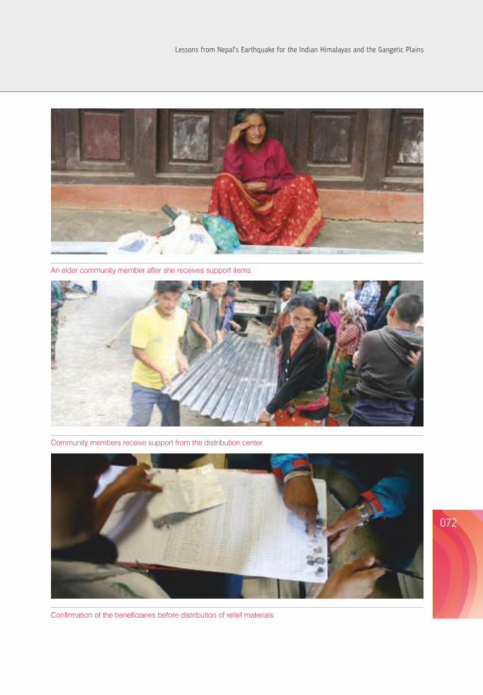
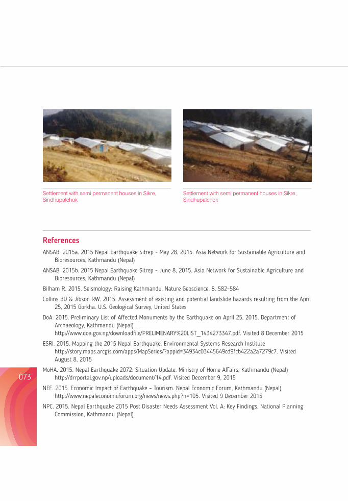
074073
Although there has been speculation of a major earthquake in Nepal for many years, the 7.8 Richer scale event of 25th April 2015, did take all of us by surprise. The epicenter was in Barpak, Gorkha, 300 km west of Kathmandu. A blessing was that it was a Saturday, a holiday in Nepal with all schools closed. The consequences of an earthquake of this magnitude on a busy working day would have been absolutely disastrous.
Being a Saturday, the hospital was operational for emergency and basic routine treatments and was sparsely staffed. A panic reaction escalated through all the sections of the hospital with everyone clambering to get out into the open. The loss of power made all movements for the sick and non-ambulatory patients challenging. At B&B Hospital, our hospital disaster plan was immediately put into operation, under the leadership of the hospital disaster management Director who was in the hospital at the time.
The first victim arrived within 15 minutes of the earthquake and after that patients continued to pour in. Immediate emergency arrangements for triaging and emergency treatment began, along with evacuation of the in-patients of the hospital. Because the phones were not functional,
Settlement with semi permanent houses in Sikre, Sindhupalchok
Settlement with semi permanent houses in Sikre, Sindhupalchok
ReferencesANSAB. 2015a. 2015 Nepal Earthquake Sitrep - May 28, 2015. Asia Network for Sustainable Agriculture and
Bioresources, Kathmandu (Nepal)
ANSAB. 2015b. 2015 Nepal Earthquake Sitrep - June 8, 2015. Asia Network for Sustainable Agriculture and Bioresources, Kathmandu (Nepal)
Bilham R. 2015. Seismology: Raising Kathmandu. Nature Geoscience, 8. 582–584
Collins BD & Jibson RW. 2015. Assessment of existing and potential landslide hazards resulting from the April 25, 2015 Gorkha. U.S. Geological Survey, United States
DoA. 2015. Preliminary List of Affected Monuments by the Earthquake on April 25, 2015. Department of Archaeology, Kathmandu (Nepal) http://www.doa.gov.np/downloadfile/PRELIMENARY%20LIST_1434273347.pdf. Visited 8 December 2015
ESRI. 2015. Mapping the 2015 Nepal Earthquake. Environmental Systems Research Institute http://story.maps.arcgis.com/apps/MapSeries/?appid=34934c03445649cd9fcb422a2a7279c7. Visited August 8, 2015
MoHA. 2015. Nepal Earthquake 2072: Situation Update. Ministry of Home Affairs, Kathmandu (Nepal) http://drrportal.gov.np/uploads/document/14.pdf. Visited December 9, 2015
NEF. 2015. Economic Impact of Earthquake – Tourism. Nepal Economic Forum, Kathmandu (Nepal) http://www.nepaleconomicforum.org/news/news.php?n=105. Visited 9 December 2015
NPC. 2015. Nepal Earthquake 2015 Post Disaster Needs Assessment Vol. A: Key Findings. National Planning Commission, Kathmandu (Nepal)
A MEDICAL PERSPECTIVE OF NEPAL'S EARTQUAKE DISASTER
communication was hampered. Patients were made to lie on makeshift beds (mattresses) on the floor of the hospital parking area. Patients brought dead were laid aside.
Outside, the morgue was immediately full. Groups of caregivers identified and categorized patients for treatment and discharge, hospital admission and emergency intervention. These activities ensued in a scenario where aftershocks continued unabated, scaring everyone to new heights.
I arrived at the hospital about an hour after the first shake, having made a difficult road journey from another hospital in the city where I was attending a surgical meeting. Along the road, I encountered multiple roadblocks in the form of fallen trees and rubble from collapsed buildings. I heaved a big sigh of relief when I saw B&B Hospital standing safe and sound, and immediately started co-ordinating all the hospital activities in collaboration with our Disaster Director. The challenges were –
1) Emergency power for our generators
2) Organizing teams to provide continuing services to deal with the emergencies that were continuing to flow.
3) Oxygen requirements were increased – how to secure more and steady supplies
Doctor Jagdish Lal BaidyaMD, B&B Hospital Pvt. Ltd., Gwarko, Lalitpur, Nepal
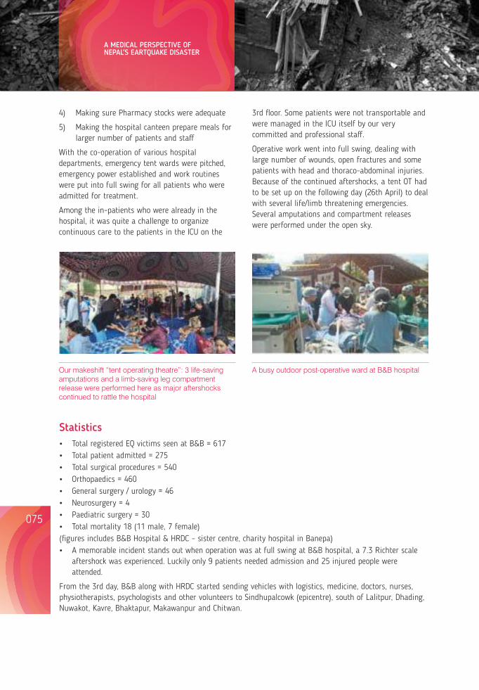
075
4) Making sure Pharmacy stocks were adequate
5) Making the hospital canteen prepare meals for larger number of patients and staff
With the co-operation of various hospital departments, emergency tent wards were pitched, emergency power established and work routines were put into full swing for all patients who were admitted for treatment.
Among the in-patients who were already in the hospital, it was quite a challenge to organize continuous care to the patients in the ICU on the
Our makeshift “tent operating theatre”: 3 life-saving amputations and a limb-saving leg compartment release were performed here as major aftershocks continued to rattle the hospital
Statistics Total registered EQ victims seen at B&B = 617 Total patient admitted = 275 Total surgical procedures = 540 Orthopaedics = 460 General surgery / urology = 46 Neurosurgery = 4 Paediatric surgery = 30 Total mortality 18 (11 male, 7 female) (figures includes B&B Hospital & HRDC – sister centre, charity hospital in Banepa) A memorable incident stands out when operation was at full swing at B&B hospital, a 7.3 Richter scale
aftershock was experienced. Luckily only 9 patients needed admission and 25 injured people were attended.
From the 3rd day, B&B along with HRDC started sending vehicles with logistics, medicine, doctors, nurses, physiotherapists, psychologists and other volunteers to Sindhupalcowk (epicentre), south of Lalitpur, Dhading, Nuwakot, Kavre, Bhaktapur, Makawanpur and Chitwan.
3rd floor. Some patients were not transportable and were managed in the ICU itself by our very committed and professional staff.
Operative work went into full swing, dealing with large number of wounds, open fractures and some patients with head and thoraco-abdominal injuries. Because of the OT had continued aftershocks, a tentto be set up on the following day (26th April) to deal with several life/limb threatening emergencies. Several amputations and compartment releases were performed under the open sky.
A busy outdoor post-operative ward at B&B hospital
Ruins of Sipaghat town at Kavre-Sindhupalchowk border
problems not directly related to the earthquake were brought to B&B. Total care was given free of cost to the patients and their attendees which included treatment, food and logistics.
HRDC relief bus navigating a 'caved in' road in the backdrop of an earthquake destroyed resort: Bhotechowr, Sindhupalchowk
The ruins of a 4 storey tall school in Sangachowk, Sindhupalchowk. The ground oor has collapsed completely! The headmaster told us that, had it been a school day, they could have lost upto 400 children
Dr. Banskota and Dr. Baidya examining patients in an ESAR clinic, Sunkhani
Dr. Ashok Banskota examining an elderly lady in an ESAR clinic in Sunkhani,
076
A total of 98 comprehensive health and relief camps have been conducted, providing services to nearly 45,000 people. From the outreach clinic, patients with many surgical, urological and orthopaedics
A MEDICAL PERSPECTIVE OF NEPAL'S EARTQUAKE DISASTER Lessons from Nepal's Earthquake for the Indian Himalayas and the Gangetic Plains
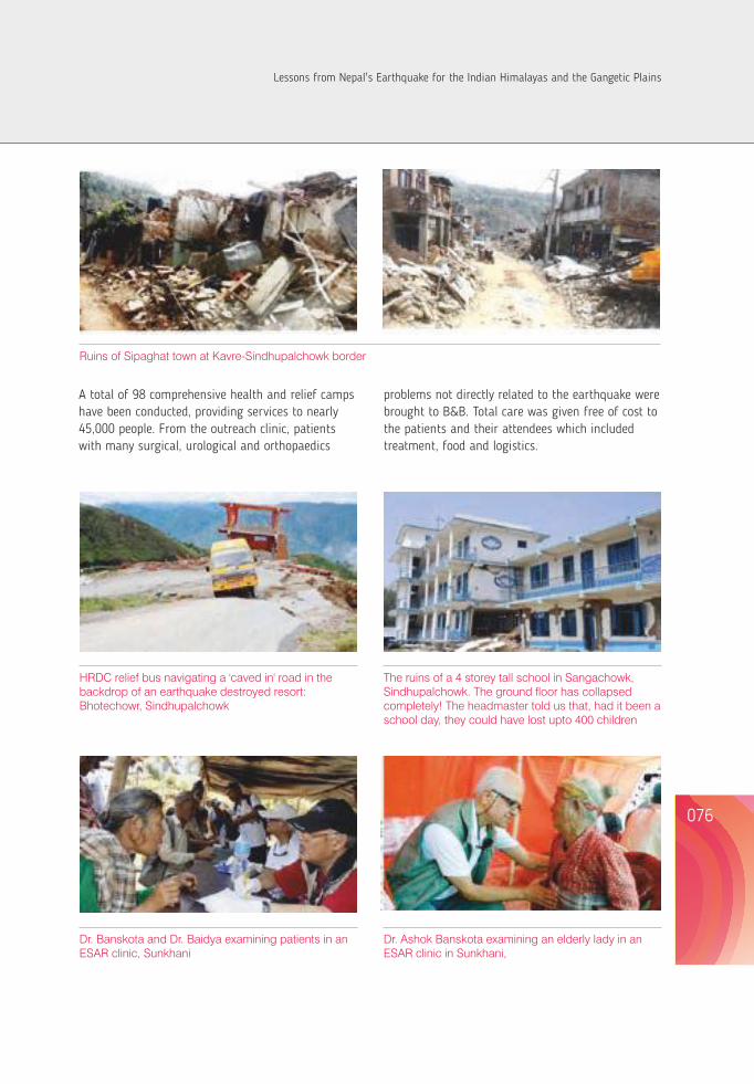
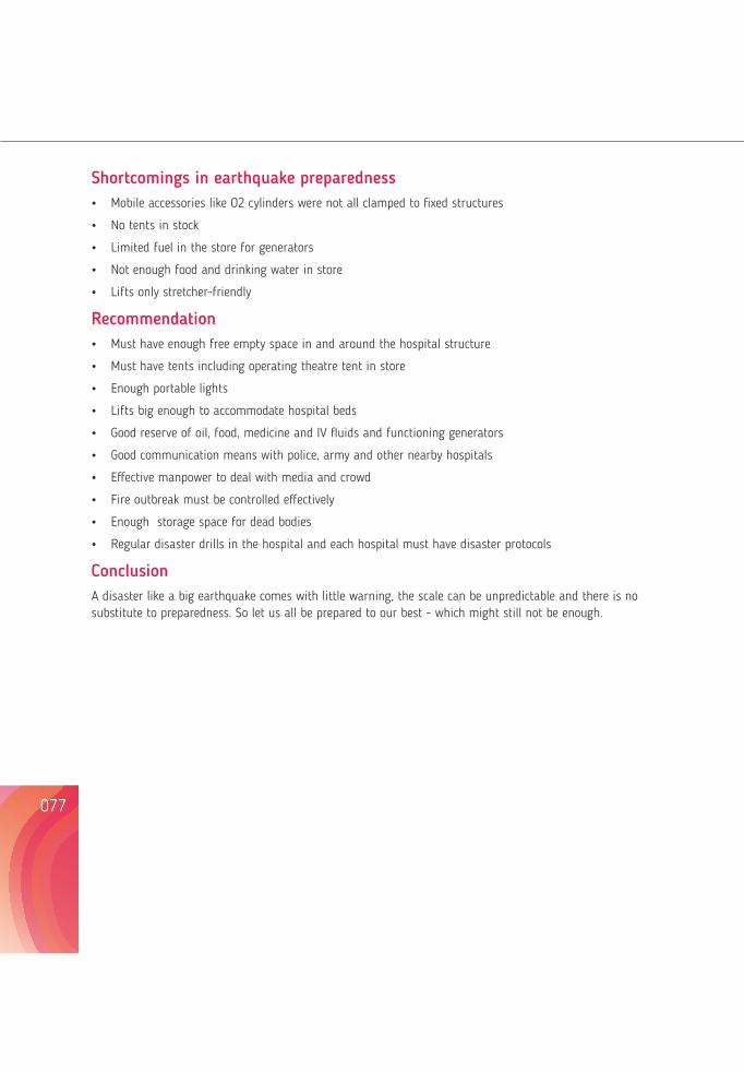
Shortcomings in earthquake preparedness Mobile accessories like O2 cylinders were not all structures clamped to fixed
No tents in stock
Limited fuel in the store for generators
water in store Not enough food and drinking
Lifts only stretcher-friendly
Recommendation Must have enough free empty space in and around the hospital structure
Must have tents including operating theatre tent in store
Enough portable lights
Lifts big enough to accommodate hospital beds
Good reserve of oil, food, medicine and IV fluids and functioning generators
Good communication means with police, army and other nearby hospitals
Effective manpower to deal with media and crowd
Fire outbreak must be controlled effectively
Enough storage space for dead bodies
Regular disaster drills in the hospital and each hospital must have disaster protocols
ConclusionA disaster like a big earthquake comes with little warning, the scale can be unpredictable and there is no substitute to preparedness. So let us all be prepared to our best - which might still not be enough.
PREVALENCE, SOCIO-DEMOGRAPHIC AND QUALITY OF LIFE (QOL) CORRELATES OF POST-TRAUMATIC STRESS DISORDER (PTSD) AMONG THE JUNE 2013 DISASTER VICTIMS OF UTTARAKHAND
*Mahalingam V, **. Roy Debabrata
*Assistant Professor, Swami Rama Himalayan University, Dehradun, Uttarakhand, India.**Professor/Controller of Examination, Swami Rama Himalayan University, Dehradun, Uttarakhand, India.
Debabrata Roy, Controller of Examination, Swami Rama Himalayan University, Doiwala, Dehradun, Uttarakhand, India.248016
Email ID: [email protected]
Abstract In view of June 2013 Disaster of Uttarakhand, a study was designed to look into 'not too visible' areas of loss, in terms of Post-Traumatic Stress Disorders (PTSD) and Health related Quality of Life (H-QOL) of the disaster victims. Purpose: The main objective of the study was to estimate the magnitude/prevalence of PTSD and assess Health related QOL with potential relationship between variables of PTSD and Health related QOL among the Disaster victims. As many as 2667 disaster victims were sampled by multi-stage probability sampling in a cross sectional study with key respondents being 'head of the family', 'next to head of the family', 'any individual directly injured during Disaster', aged 14 years and non alcoholics. Study instruments used were essentially WHO endorsed PTSD-S and WHOQOL- BREF tools besides a structured, pre-tested instrument to elicit Socio- Demographic data. About half (51%) of the disaster victims were diagnosed with PTSD. Key socio-demographic and other variables, namely, gender, education, occupation, family income, marital status, kind of disaster exposure, frequency of disaster, type of loss and type of exposure significantly affected development of PTSD. The health related QOL was found to be negatively correlated with PTSD among the disaster victims. Sensitization and capacity building of both providers and community to proactively take appropriate measures in minimizing/mitigating PTSDs and thereby ensure desired QOL are of paramount importance. Our findings are relevant to the earthquake (April 25, 2014) affected people of Nepal.
Keywords: Disasters, Traumatic Stress Disorder, Quality of Life, Uttarakhand and June 2013 disasters
077
078
Inclusion Criteria:Considering the 'Head' and 'Next to Head' of all the households (1129) to be 2258 i.e. (02×1129) and assuming 50% of the sampled households i.e.564 households having at least 01 injured person ,who was > 14 years of age and non- alcoholic, i.e 564.(564×01) subjects, estimated sample population size was 2822.
Study tool:1. PTSD Checklist – Civilian Version (PCL-S) score
was used to find the magnitude/ Prevalence of PTSD among Disaster victims.
2. WHOQOL- BREF was used to measure Health related QOL.
3. A structured, pre-tested instrument to elicit socio-behavioural & demographic data.
Results:It was found that a total of 1372 (51%) of the sampled population was afflicted with PTSD with PCL-S SCORE< 50 (Table 1). Observation on potential socio-demographic correlates (Table 2) showed that more females (27%) suffered from PTSD than males (24.5%); the difference however was not statistically significant, implying no association of development of PTSD with Gender of the victims. Formally educated disaster victims (39.8%) afflicted with PTSD outnumbered the victims with PTSD who had non-formal education (12%). Educational status of the victims was strongly associated with development of PTSD.The disaster victims who were employed (32.7%),married (46%) and had monthly family income between Rupees 5000-20000 (41.1%) suffered PTSD more than those unemployed , unmarried and having family income <Rs 5000/ per month respectively. All three variables of occupation, marital status and family income showed highly significant association with development of PTSD. Further, victims exposed to disasters involving Water (26%), exposed more than once to a disaster (32%) and also the ones reporting
up to 3 weeks' continuous exposure to disaster (27.6%) developed PTSD more than those exposed to disasters either on Land or Road, those exposed only once to a disaster and the ones reporting up to 4 weeks' continuous exposure to a disaster respectively; differences in proportion of subjects in terms of 'kind of disaster exposed to' and 'frequency of exposure to a disaster' were significant. Those victims who experienced 'life threatening' situations (34%), suffered impairment and/ or lost property (41.4%) during disaster were found to have PTSD more than those having suffered 'non-life threatening' conditions(18%) and or incurring 'no loss of property'(10%). Both 'type of exposure' and 'type of loss' proved to be strongly associated with development of PTSD in victims.
Scores measuring PTSD and Quality of life (QOL) of disaster victims were found negatively correlated i.e. r=-0.91 at the level of p<0.05 (Table 3). The beta score (-1.259) in correlation indicates that a rise of a single unit of PTSD score results in a fall of QOL score by 1.259 units among the disaster victims. Scores for different domains of QOL i.e. Physical, Psychological, Social and environmental were also correlated negatively with PTSD score at the level of p<0.05.
DiscussionMore than half of the of the disaster victims were diagnosed with Post Traumatic Stress Disorder (PTSD) morbidity suggested by PCL-S. This estimated prevalence is considerably less than the reported rates from comparable study settings whereas 70.9% of the tsunami victims had a diagnosis of PTSD (Michele et al. 2008, Nilamadhab et al. 2014). This finding is also consistent with that of 'Ventotene street disaster' study that PTSD was the most prevalent disorder after trauma. However, the subjects who had not seen dead or injured people were more likely to receive no psychiatric diagnosis (Michele et al. 2008). Additionally, post-disaster psychiatric presentation in adolescents was a conglomeration of PTSD, depression and anxiety symptoms. The prevalences of PTSD, major
depressive disorder and generalised anxiety disorder were 26.9%, 17.6% and 12.0% respectively (Nilamadhab et al. 2006). After the tornado in eastern North Carolina, 59% victims met the criteria for acute PTSD, 19% of whom had a severe form (Madakasira & O' Biren 1987). Elderly and younger adult disaster exposed victims in cities closer to the higher exposure had significantly higher index PTSD scores than elderly and adult victims in more distant locations (Goenjian 1994). After exposure to severe trauma, either an earthquake or violence, adults are at high risk of developing severe or chronic posttraumatic stress reactions that are associated with chronic anxiety and depressive reactions (Goenjian et al. 2000).
It is evident from a study by Goenjian et.al (1995) that females are more likely than males to report symptoms of post-traumatic stress disorder. The results of our study show difference in vulnerability to PTSD between those who had no formal education and those who were formally educated. Analogous studies report contradictory findings on this vulnerability with PTSD prevalence being inversely proportional to level of education (Priebe et al. 2009, Niaz 2006). Such contradictions can be explained by population specific demographic attributes, socio-cultural dynamics, study setting etc.
Comparable studies endorse our finding that developing PTSD following a disaster is significantly associated with severity of exposure to the disaster and life events, stressors after disaster (e.g., loss of house, furniture, appliances, vehicles, property ) including experiencing financial loss (e.g., lost job, fall in household income) Orlee 2000, Cerda 2013). . In the present study, the physical injury caused by earthquake and deaths of family members were found as risk factors of PTSD. A study done by Moreau C, Zisook S (2002) in Iran after Bam earthquake also reports higher incidence and symptoms of PTSD in those who lost a near- dear one (Moreau & Zisook 2002).
Our data indicates that PTSD among the victims of
IntroductionDisasters are traumatic events that are experienced by many people and may result in a wide range of mental and physical health consequences. Studies report effects of disasters that are quite severe, with clinically significant distress or diagnosable disorders, the most frequently reported condition being Post Traumatic Stress Disaster (PTSD), followed by depression, and then other anxiety disorders (NNorris et al. 2013)). The Asia Pacific region experiences sixty percent of world's natural disasters. India, on account of its geographical locus standi and climate and geological setting, is among the worst affected theatres of disaster in the south east region; this increasingly causes more injury, disability, mental illness, disease and death, adding to the health and economic burden of an already impoverished nation (Menon & Kara 2006). In June 2013, a cloudburst on the North Indian state of Uttarakhand caused devastating floods and landslides in the country's worst natural disaster since the 2004 tsunami. The June 2013 disaster of Uttarakhand not only damaged infrastructure ofbillions of rupees, but also resulted in mortality of thousands of people. In remote areas of high mountains people were left helpless for weeks and months. The present study has been designed to study magnitude of Post Traumatic Stress Disorder (PTSD), its socio-demographic correlates and potential association with Health related Quality of Life (HQOL) of Disaster victims. This study, we expect, will give an idea of psychological disturbances that disaster- affected people have to undergo for months after the event. This will apply also to Nepal's earthquake.
Material and Methods: An observational cross sectional study design was employed in a study setting of the flash flood -affected community of Ukimath teshil, Rudrapyrag District of Uttrakhand. A total of 2822 study subjects were sampled by multi-stage probability sampling (systematic random sampling with appropriate sampling interval)
PREVALENCE, SOCIO-DEMOGRAPHIC AND QUALITY OF LIFE (QOL) CORRELATES OF POST-TRAUMATIC STRESS DISORDER (PTSD) AMONG THE JUNE 2013 DISASTER VICTIMS OF UTTARAKHAND
079
080
Lessons from Nepal's Earthquake for the Indian Himalayas and the Gangetic Plains
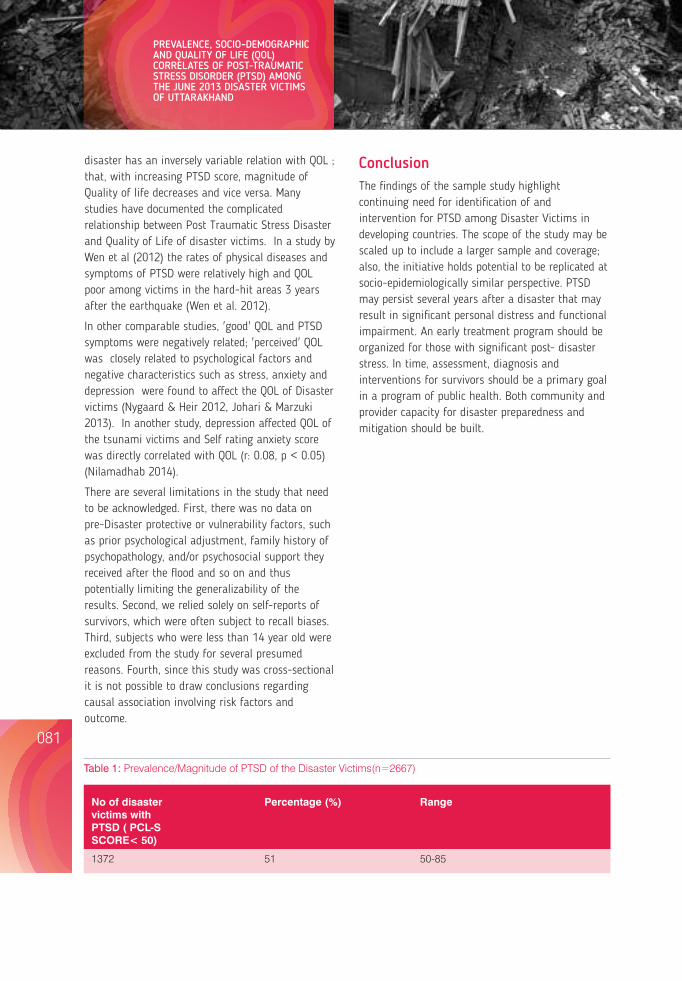
disaster has an inversely variable relation with QOL ; that, with increasing PTSD score, magnitude of Quality of life decreases and vice versa. Many studies have documented the complicated relationship between Post Traumatic Stress Disaster and Quality of Life of disaster victims. In a study by Wen et al (2012) the rates of physical diseases and symptoms of PTSD were relatively high and QOL poor among victims in the hard-hit areas 3 years after the earthquake (Wen et al. 2012).
In other comparable studies, 'good' QOL and PTSD symptoms were negatively related; 'perceived' QOL was closely related to psychological factors and negative characteristics such as stress, anxiety and depression were found to affect the QOL of Disaster victims (Nygaard & Heir 2012, Johari & Marzuki 2013). In another study, depression affected QOL of the tsunami victims and Self rating anxiety score was directly correlated with QOL (r: 0.08, p < 0.05) (Nilamadhab 2014).
There are several limitations in the study that need to be acknowledged. First, there was no data on pre-Disaster protective or vulnerability factors, such as prior psychological adjustment, family history of psychopathology, and/or psychosocial support they received after the flood and so on and thus potentially limiting the generalizability of the results. Second, we relied solely on self-reports of survivors, which were often subject to recall biases. Third, subjects who were less than 14 year old were excluded from the study for several presumed reasons. Fourth, since this study was cross-sectional it is not possible to draw conclusions regarding causal association involving risk factors and outcome.
ConclusionThe findings of the sample study highlight continuing need for identification of and intervention for PTSD among Disaster Victims in developing countries. The scope of the study may be scaled up to include a larger sample and coverage; also, the initiative holds potential to be replicated at socio-epidemiologically similar perspective. PTSD may persist several years after a disaster that may result in significant personal distress and functional impairment. An early treatment program should be organized for those with significant post- disaster stress. In time, assessment, diagnosis and interventions for survivors should be a primary goal in a program of public health. Both community and provider capacity for disaster preparedness and mitigation should be built.
Table 1: Prevalence/Magnitude of PTSD of the Disaster Victims(n=2667)
No of disaster Percentage (%) Rangevictims with PTSD ( PCL-S SCORE< 50)
1372 51 50-85
Table 2: Socio-demographic and associated correlates of PTSD disaster victims (n=2667)
Variables Frequency and Percentage(% Significance PTSD<50 PTSD>50 level
Gender Male 667(25%) 654(24.5%) .006 Female 628(23.5%) 718(27%)
Educational Status No Formal 209(7.5%) 315(12%) .0001 Primary 515(19%) 536(20%) Secondary 446(17%) 420(16%) Tertiary 125(4.7%) 101(3.8%)
Occupation Skilled 231(8.7%) 176(6.6%) .0001 Non- Skill 728(27.4%) 704(26.1%) No Occupation 336(13.2%) 492(18%)
Family Monthly Income <5000 30(1.1%) 146(5.5%) .0001 5001-10000 584(22.2%) 490(18.1%) 10001-20000 561(21%) 612(23%) >20000 120(4.5%) 124(4.6%)
Marital Status Single 42(1.4%) 141(5.2%) .0001 Married 1247(47%) 1225(46%) Separated 6(.2%) 6(.2%)
Kind of Disaster Exposure Water 613(23%) 689(26%) .0001 Land 329(12%) 443(17%) Road 353(13%) 240(9%)
Frequency of Exposure 1 523(20%) 518(19%) .001 2 399(15%) 362(14%) 3 373(14%) 492(18%)
Duration of Exposure 1week 568(21%) 553(21%) .215 2week 96(3.6%) 117(4.4%) 3week 60(2.2%) 58(2.2%) 4week 571(21.4%) 644(24.2%)
Type of Exposure Life threatening 60(2%) 903(34%) .0001 Non Life threatening 1235(46%) 469(18%)
Type of Loss Impairment 12(.4%) 356(13.2%) .0001 Loss of Property 53(2.2%) 754(28.2%) None 1230(46%) 262(10%)
PREVALENCE, SOCIO-DEMOGRAPHIC AND QUALITY OF LIFE (QOL) CORRELATES OF POST-TRAUMATIC STRESS DISORDER (PTSD) AMONG THE JUNE 2013 DISASTER VICTIMS OF UTTARAKHAND
081 082
Lessons from Nepal's Earthquake for the Indian Himalayas and the Gangetic Plains
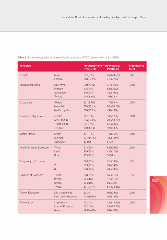
disaster has an inversely variable relation with QOL ; that, with increasing PTSD score, magnitude of Quality of life decreases and vice versa. Many studies have documented the complicated relationship between Post Traumatic Stress Disaster and Quality of Life of disaster victims. In a study by Wen et al (2012) the rates of physical diseases and symptoms of PTSD were relatively high and QOL poor among victims in the hard-hit areas 3 years after the earthquake (Wen et al. 2012).
In other comparable studies, 'good' QOL and PTSD symptoms were negatively related; 'perceived' QOL was closely related to psychological factors and negative characteristics such as stress, anxiety and depression were found to affect the QOL of Disaster victims (Nygaard & Heir 2012, Johari & Marzuki 2013). In another study, depression affected QOL of the tsunami victims and Self rating anxiety score was directly correlated with QOL (r: 0.08, p < 0.05) (Nilamadhab 2014).
There are several limitations in the study that need to be acknowledged. First, there was no data on pre-Disaster protective or vulnerability factors, such as prior psychological adjustment, family history of psychopathology, and/or psychosocial support they received after the flood and so on and thus potentially limiting the generalizability of the results. Second, we relied solely on self-reports of survivors, which were often subject to recall biases. Third, subjects who were less than 14 year old were excluded from the study for several presumed reasons. Fourth, since this study was cross-sectional it is not possible to draw conclusions regarding causal association involving risk factors and outcome.
ConclusionThe findings of the sample study highlight continuing need for identification of and intervention for PTSD among Disaster Victims in developing countries. The scope of the study may be scaled up to include a larger sample and coverage; also, the initiative holds potential to be replicated at socio-epidemiologically similar perspective. PTSD may persist several years after a disaster that may result in significant personal distress and functional impairment. An early treatment program should be organized for those with significant post- disaster stress. In time, assessment, diagnosis and interventions for survivors should be a primary goal in a program of public health. Both community and provider capacity for disaster preparedness and mitigation should be built.
Table 1: Prevalence/Magnitude of PTSD of the Disaster Victims(n=2667)
No of disaster Percentage (%) Rangevictims with PTSD ( PCL-S SCORE< 50)
1372 51 50-85
Table 2: Socio-demographic and associated correlates of PTSD disaster victims (n=2667)
Variables Frequency and Percentage(% Significance PTSD<50 PTSD>50 level
Gender Male 667(25%) 654(24.5%) .006 Female 628(23.5%) 718(27%)
Educational Status No Formal 209(7.5%) 315(12%) .0001 Primary 515(19%) 536(20%) Secondary 446(17%) 420(16%) Tertiary 125(4.7%) 101(3.8%)
Occupation Skilled 231(8.7%) 176(6.6%) .0001 Non- Skill 728(27.4%) 704(26.1%) No Occupation 336(13.2%) 492(18%)
Family Monthly Income <5000 30(1.1%) 146(5.5%) .0001 5001-10000 584(22.2%) 490(18.1%) 10001-20000 561(21%) 612(23%) >20000 120(4.5%) 124(4.6%)
Marital Status Single 42(1.4%) 141(5.2%) .0001 Married 1247(47%) 1225(46%) Separated 6(.2%) 6(.2%)
Kind of Disaster Exposure Water 613(23%) 689(26%) .0001 Land 329(12%) 443(17%) Road 353(13%) 240(9%)
Frequency of Exposure 1 523(20%) 518(19%) .001 2 399(15%) 362(14%) 3 373(14%) 492(18%)
Duration of Exposure 1week 568(21%) 553(21%) .215 2week 96(3.6%) 117(4.4%) 3week 60(2.2%) 58(2.2%) 4week 571(21.4%) 644(24.2%)
Type of Exposure Life threatening 60(2%) 903(34%) .0001 Non Life threatening 1235(46%) 469(18%)
Type of Loss Impairment 12(.4%) 356(13.2%) .0001 Loss of Property 53(2.2%) 754(28.2%) None 1230(46%) 262(10%)
PREVALENCE, SOCIO-DEMOGRAPHIC AND QUALITY OF LIFE (QOL) CORRELATES OF POST-TRAUMATIC STRESS DISORDER (PTSD) AMONG THE JUNE 2013 DISASTER VICTIMS OF UTTARAKHAND
081 082
Lessons from Nepal's Earthquake for the Indian Himalayas and the Gangetic Plains
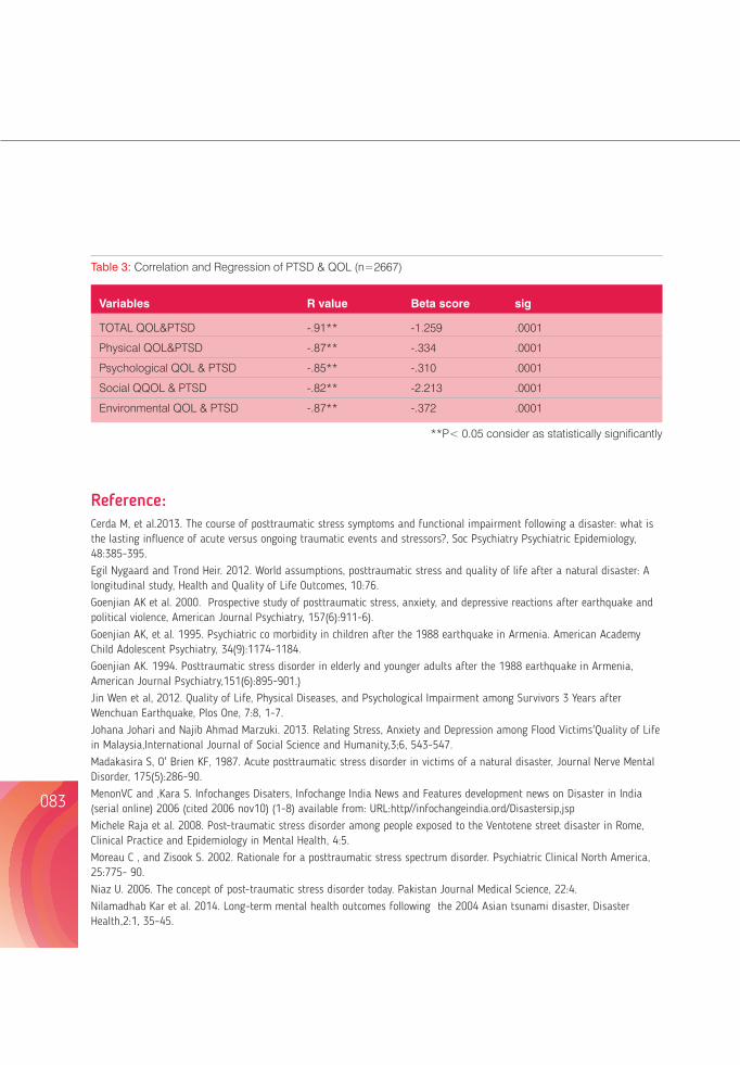
Reference:Cerda M, et al.2013. The course of posttraumatic stress symptoms and functional impairment following a disaster: what is the lasting influence of acute versus ongoing traumatic events and stressors?, Soc Psychiatry Psychiatric Epidemiology, 48:385-395.Egil Nygaard and Trond Heir. 2012. World assumptions, posttraumatic stress and quality of life after a natural disaster: A longitudinal study, Health and Quality of Life Outcomes, 10:76.Goenjian AK et al. 2000. Prospective study of posttraumatic stress, anxiety, and depressive reactions after earthquake and political violence, American Journal Psychiatry, 157(6):911-6).Goenjian AK, et al. 1995. Psychiatric co morbidity in children after the 1988 earthquake in Armenia. American Academy Child Adolescent Psychiatry, 34(9):1174-1184.Goenjian AK. 1994. Posttraumatic stress disorder in elderly and younger adults after the 1988 earthquake in Armenia, American Journal Psychiatry,151(6):895-901.)Jin Wen et al, 2012. Quality of Life, Physical Diseases, and Psychological Impairment among Survivors 3 Years after Wenchuan Earthquake, Plos One, 7:8, 1-7.Johana Johari and Najib Ahmad Marzuki. 2013. Relating Stress, Anxiety and Depression among Flood Victims'Quality of Life in Malaysia,International Journal of Social Science and Humanity,3;6, 543-547.Madakasira S, O' Brien KF, 1987. Acute posttraumatic stress disorder in victims of a natural disaster, Journal Nerve Mental Disorder, 175(5):286-90.MenonVC and ,Kara S. Infochanges Disaters, Infochange India News and Features development news on Disaster in India (serial online) 2006 (cited 2006 nov10) (1-8) available from: URL:http//infochangeindia.ord/Disastersip,jsp Michele Raja et al. 2008. Post-traumatic stress disorder among people exposed to the Ventotene street disaster in Rome, Clinical Practice and Epidemiology in Mental Health, 4:5.Moreau C , and Zisook S. 2002. Rationale for a posttraumatic stress spectrum disorder. Psychiatric Clinical North America, 25:775- 90. Niaz U. 2006. The concept of post-traumatic stress disorder today. Pakistan Journal Medical Science, 22:4.Nilamadhab Kar et al. 2014. Long-term mental health outcomes following the 2004 Asian tsunami disaster, Disaster Health,2:1, 35–45.
Table 3: Correlation and (n=2667) Regression of PTSD & QOL
Variables R value Beta score sig
TOTAL QOL&PTSD -.91** -1.259 .0001
Physical QOL&PTSD -.87** -.334 .0001
Psychological QOL & PTSD -.85** -.310 .0001
Social QQOL & PTSD -.82** -2.213 .0001
Environmental QOL & PTSD -.87** -.372 .0001
**P< 0.05 consider as statistically significantly
NEPAL EARTHQUAKE 2015: LOCAL PLANNING FOR RELIEF AND RECOVERY
Vandana Chauhan and Kshitij Gupta
All India Disaster Mitigation Institute, Ahmadabad
083
084
AbstractThe devastating quakes which struck Nepal on the 25th April and 12th May, 2015 have threatened to rupture the social, economic and political fabric of this small Himalayan nation.
Not only did this disaster leave thousands of Nepalese people homeless, it also destroyed critical infrastructure along with damaging several UNESCO heritage sites in the country. This, in turn, threatened livelihoods and delivery of critical services. The response from the global community was swift but the sincerest of efforts were frustrated by the sheer scale of the disaster.
However, disguised opportunity is the inevitable result of any crisis. As a disaster-ravaged Nepal staggers towards recovery, it is faced with several challenges; notable among these are putting the indigent nation's economy on the growth track again, sustainably rehabilitating the displaced and ensuring an equitable and sustainable recovery. All these challenges can be met with effective local level planning in the country.
This paper takes stock of various issues around local planning, i.e. at the Village Development Committee (VDC) and District Development Committee (DDC) level. This paper is based on the work of All India Disaster Mitigation Institute's (AIDMI) relief work following the Nepal quakes. The objective of this paper is to highlight how robust planning and action at the local level can improve the response capacity leading to an effective recovery in post disaster situations. This paper advocates embedding disaster risk reduction (DRR) at the heart of development planning at the local level in Nepal to empower its people and communities to respond and recover from crises in a dignified and sustainable manner.
Key Words: Gender, Local level planning, Media role, Rehabilitation, Relief support
This paper is organized in the following five compartments:
instant relief support rehabilitation phase key issues for response and local level planning lessons learnt for local level disaster management planning long term recovery and local level planning
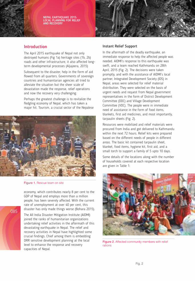
IntroductionThe April 2015 earthquake of Nepal not only destroyed humans (Fig 1a) heritage sites (1b, 2b) roads and other infrastructure, it also affected long-term developmental processes (Aljajeera, 2015)
Subsequent to the disaster, help in the form of aid flowed from all quarters. Governments of sovereign countries and humanitarian agencies all tried to alleviate the situation but the sheer scale of devastation made the response, relief operations and now the recovery very challenging.
Perhaps the greatest challenge is to revitalize the fledgling economy of Nepal, which has taken a major hit. Tourism, a crucial sector of the Nepalese
Instant Relief Support
In the aftermath of the deadly earthquake, an immediate response to help the affected people was needed. AIDMI's response to this earthquake was swift, and a team reached Kathmandu on 28th April, 2015 (Fig. 2). The decisions were taken promptly, and with the assistance of AIDMI's local partner, Integrated Development Society (IDS) in Nepal, areas were selected for relief material distribution. They were selected on the basis of urgent needs and request from Nepal government representatives in the form of District Development Committee (DDC) and Village Development Committee (VDC). The people were in immediate need of assistance in the form of food items, blankets, first aid medicines, and most importantly, tarpaulin sheets (Fig. 2).
Resources were mobilized and relief materials were procured from India and got delivered to Kathmandu within the next 72 hours. Relief kits were prepared based on the different needs of people in different areas. The basic kit contained tarpaulin sheet, blanket, food items, hygiene kit, first aid, and a small torch to support a family of 5 upto 10 days.
Some details of the locations along with the number of households covered at each respective location are given in Table 1:
economy, which contributes nearly 8 per cent to the GDP of Nepal and employs more than a million people, has been severely affected. With the current rate of unemployment at over 40 per cent, this disaster has only made things worse (Bohara 2015).
The All India Disaster Mitigation Institute (AIDMI) joined the ranks of humanitarian organizations undertaking relief activities in the aftermath of this devastating earthquake in Nepal. The relief and recovery activities in Nepal have highlighted some crucial findings. Chief among them is embedding DRR sensitive development planning at the local level to enhance the response and recovery capacities of Nepal.
Figure 1. Rescue team on site
085 086
Figure 2. Affected community members with relief rations
Fig. 2
Table 1: Location and number of households to which aid was given by AIDMI
Location District No. of Households Covered
Bhumlichowk VDC Gorkha district 503
Sudal VDC Bhaktapur district 210
Sankhu Village Kathmandu district 100*
Pangratar VDC Sindhupal Chowk district 200
Total 1013
The initiative taken by the officials at the village development committee (VDC) and district development committee (DDC) were exemplary. An efficient leadership at the local level plays an important role in saving lives during disasters provided the efforts are supported by proper institutional measures.
Rehabilitation Phase
The rehabilitation phase was around temporary shelters (Figs. 3 and 4). These temporary shelters were strategically designed to support the affected households during the monsoon season for two years. These shelters were made of local materials and traditional techniques and they were expected to survive for 6 to 24 months. Furthermore the designing of permanent shelters will be taken up and conceptualized using locally available materials, sustainable approach and contextualizing the design with the local environment.
Another important activity undertaken in this phase was a baseline survey on livelihood and shelter to plan for long term recovery. This baseline survey revealed some interesting findings; chief among them was the need for diversification of livelihood options for the affected populace. The victims of this quake were largely dependent on agriculture and allied sectors. In order to ensure that their livelihoods are not threatened by another impending disaster, it is necessary to provide more livelihood options to the affected people. This also reducesoutmigrations.
As mentioned earlier, the rate of unemployment in Nepal is more than 40 percent. Most of the
migration taking place in Nepal is distress migration, where people leave their villages because of the compulsions of finding work elsewhere. A detailed vulnerability assessment was done in order to plan for disaster risk reduction (DRR) initiatives for long term recovery. This vulnerability assessment focused on many aspects such as social, economic, political and even cultural vulnerability in the country.
Key Issues for Response and Local Level Planning
To ensure that a robust response for an effective recovery can take place, DRR sensitive local level planning needed to be integrated with the agenda of the various Village Development Committees (VDCs) and District Development Committees (DDCs). As per AIDMI's observation, the following clusters
Figure 3a. A temporary camp for children
NEPAL EARTHQUAKE 2015: LOCAL PLANNING FOR RELIEF AND RECOVERY
Lessons from Nepal's Earthquake for the Indian Himalayas and the Gangetic Plains
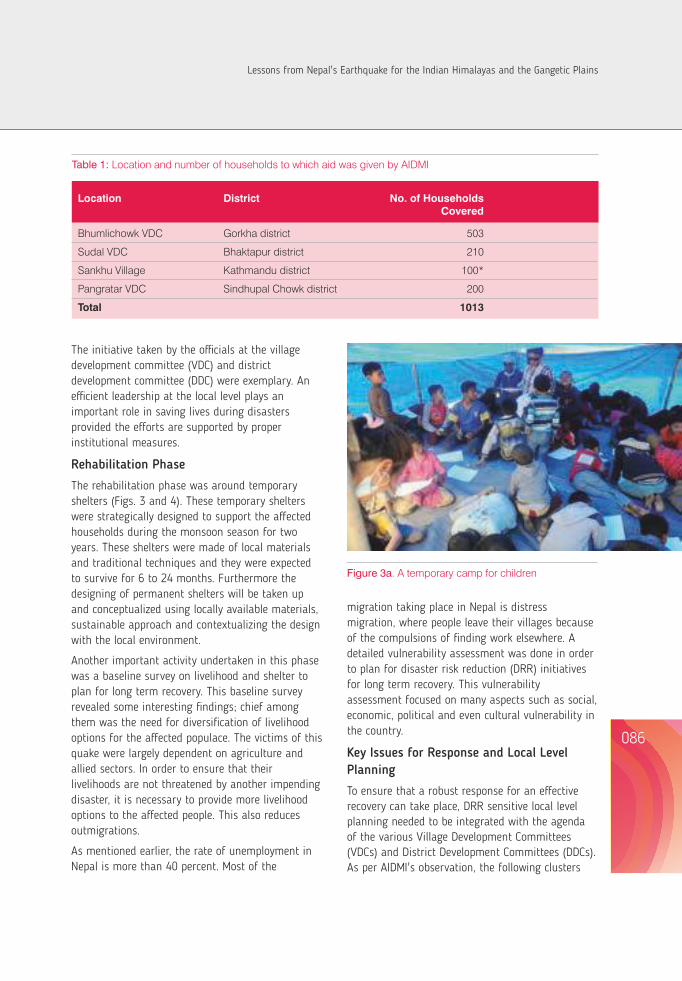
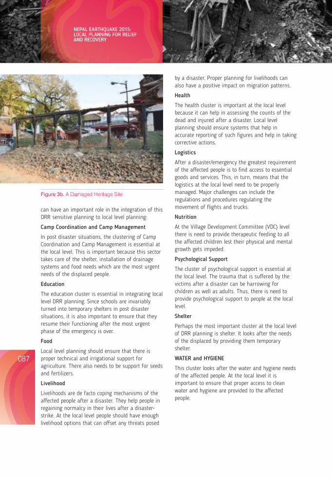
can have an important role in the integration of this DRR sensitive planning to local level planning:
Camp Coordination and Camp Management
In post disaster situations, the clustering of Camp Coordination and Camp Management is essential at the local level. This is important because this sector takes care of the shelter, installation of drainage systems and food needs which are the most urgent needs of the displaced people.
Education
The education cluster is essential in integrating local level DRR planning. Since schools are invariably turned into temporary shelters in post disaster situations, it is also important to ensure that they resume their functioning after the most urgent phase of the emergency is over.
Food
Local level planning should ensure that there is proper technical and irrigational support for agriculture. There also needs to be support for seeds and fertilizers.
Livelihood
Livelihoods are de facto coping mechanisms of the affected people after a disaster. They help people in regaining normalcy in their lives after a disaster-strike. At the local level people should have enough livelihood options that can offset any threats posed
by a disaster. Proper planning for livelihoods can also have a positive impact on migration patterns.
Health
The health cluster is important at the local level because it can help in assessing the counts of the dead and injured after a disaster. Local level planning should ensure systems that help in accurate reporting of such figures and help in taking corrective actions.
Logistics
After a disaster/emergency the greatest requirement of the affected people is to find access to essential goods and services. This, in turn, means that the logistics at the local level need to be properly managed. Major challenges can include the regulations and procedures regulating the movement of flights and trucks.
Nutrition
At the Village Development Committee (VDC) level there is need to provide therapeutic feeding to all the affected children lest their physical and mental growth gets impeded.
Psychological Support
The cluster of psychological support is essential at the local level. The trauma that is suffered by the victims after a disaster can be harrowing for children as well as adults. Thus, there is need to provide psychological support to people at the local level.
Shelter
Perhaps the most important cluster at the local level of DRR planning is shelter. It looks after the needs of the displaced by providing them temporary shelter.
WATER and HYGIENE
This cluster looks after the water and hygiene needs of the affected people. At the local level it is important to ensure that proper access to clean water and hygiene are provided to the affected people.
Figure 3b. A Damaged Heritage Site
Lessons Learnt for Local Level Disaster Management Planning
Based on the relief and rehabilitation work undertaken by AIDMI and its partner organizations in the wake of the Nepal earthquake, some important lessons related to local level disaster management planning came to the fore. These lessons are as follows:
A dedicated, well-prepared national disaster management authority to manage emergency situations
Unfortunately, Nepal did not possess NDMA when this earthquake struck. The result of this lack of governance-structure only exacerbated the impact of the deadly quakes. Some experts have even gone to the extent of saying that despite receiving substantial aid, Nepal, due to its inadequate governance structures, could not deploy all the resources effectively.
Thus, one of the most important lessons from this disaster is the importance of establishing an NDMA in Nepal. Such a body should also be spread across the local level by delegating adequate powers and responsibilities to its respective village development committees (VDCs) and district development committees (DDCs). Such a bottom-up governance structure focusing on DRR would help Nepal to effectively recover from any future shocks.
Uniformity of approach in relief operations
One of the greatest drawbacks of local level planning observed in the relief operations was a lack of uniformity of approach. In the immediate aftermath of the Nepal earthquake, several humanitarian and government agencies scampered all over the country to provide much needed succor to the affected populace. The problem was that there was little coordination between these agencies. The result was a haphazard and inconsistent relief operation. This also resulted in redundancy of tasksand lead to situations where one part of the affected area was repeatedly supplied with relief material by various agencies, while another part was totally ignored.
Need-based relief support
Context is important in relief operations. Context is established by conducting a swift needs assessment before undertaking relief operations. Sadly, this was not the case after the Nepal earthquake because a lot of humanitarian agencies provided relief support to the affected populace without factoring in their needs. This resulted in a lot of wastage as a lot of relief material was not even used by the affected people.
For instance, there were trucks full of biscuits that were lying completely unused as the affected people did not need biscuits but entire food kits. This shows how the best of intentions of humanitarian agencies might not translate into results.
Durability of the relief support
It is important to ensure the quality and durability of the relief support given to the affected people. For instance, it was observed that many tarpaulin sheets distributed in the relief operations were of inferior quality. Some of these sheets were already torn while others got torn as soon as they reached the hands of the people.
Relief distribution mechanism
For the relief distribution mechanism to be effective there should be a relief distribution mechanism that keeps a proper record of the number, quantity, area and type of relief material distributed. Such a system could help in inter-agency coordination where different agencies can focus on different areas to avoid redundancy of effort and maximize their collective impact.
Resilient construction technology and practices
It is now conventional wisdom that the geo-physical location of Nepal is a hotbed of seismic activity. Many experts believe that another major earthquake can strike the nation again. In light of this, the country needs to adopt resilient construction technology and practices. Laws to this effect are already present in the country but remain largely unenforced.
The National Building Code of Nepal enacted in 1994 has remained largely unenforced.
087 088
NEPAL EARTHQUAKE 2015: LOCAL PLANNING FOR RELIEF AND RECOVERY
Lessons from Nepal's Earthquake for the Indian Himalayas and the Gangetic Plains
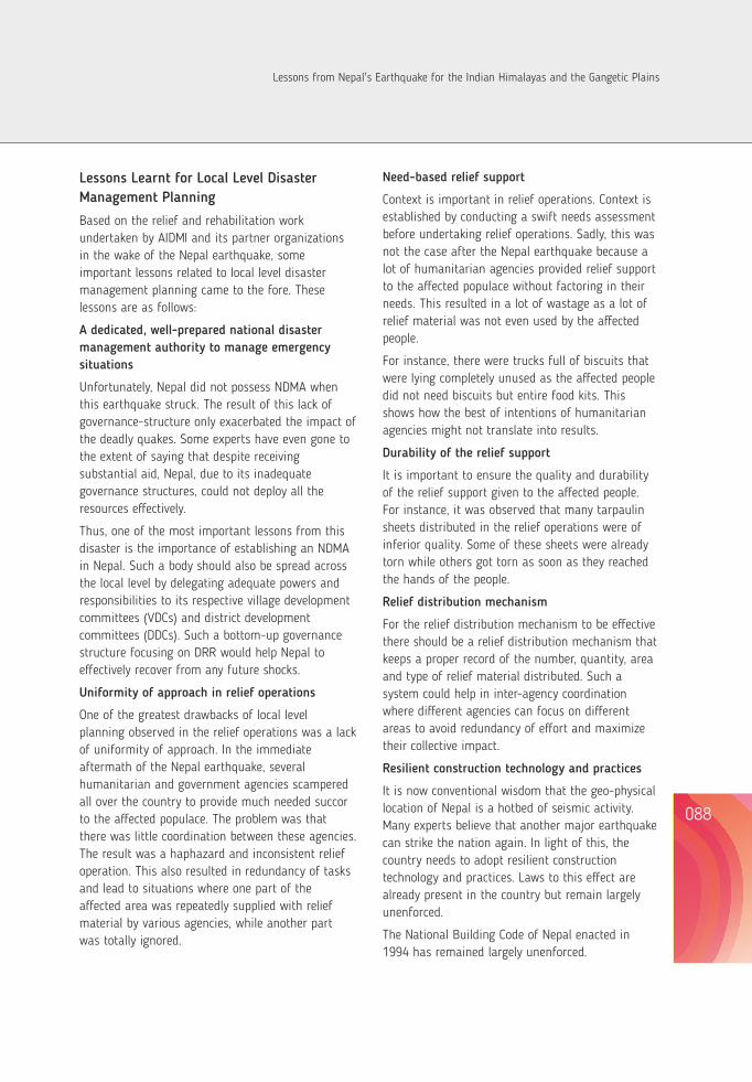
can have an important role in the integration of this DRR sensitive planning to local level planning:
Camp Coordination and Camp Management
In post disaster situations, the clustering of Camp Coordination and Camp Management is essential at the local level. This is important because this sector takes care of the shelter, installation of drainage systems and food needs which are the most urgent needs of the displaced people.
Education
The education cluster is essential in integrating local level DRR planning. Since schools are invariably turned into temporary shelters in post disaster situations, it is also important to ensure that they resume their functioning after the most urgent phase of the emergency is over.
Food
Local level planning should ensure that there is proper technical and irrigational support for agriculture. There also needs to be support for seeds and fertilizers.
Livelihood
Livelihoods are de facto coping mechanisms of the affected people after a disaster. They help people in regaining normalcy in their lives after a disaster-strike. At the local level people should have enough livelihood options that can offset any threats posed
by a disaster. Proper planning for livelihoods can also have a positive impact on migration patterns.
Health
The health cluster is important at the local level because it can help in assessing the counts of the dead and injured after a disaster. Local level planning should ensure systems that help in accurate reporting of such figures and help in taking corrective actions.
Logistics
After a disaster/emergency the greatest requirement of the affected people is to find access to essential goods and services. This, in turn, means that the logistics at the local level need to be properly managed. Major challenges can include the regulations and procedures regulating the movement of flights and trucks.
Nutrition
At the Village Development Committee (VDC) level there is need to provide therapeutic feeding to all the affected children lest their physical and mental growth gets impeded.
Psychological Support
The cluster of psychological support is essential at the local level. The trauma that is suffered by the victims after a disaster can be harrowing for children as well as adults. Thus, there is need to provide psychological support to people at the local level.
Shelter
Perhaps the most important cluster at the local level of DRR planning is shelter. It looks after the needs of the displaced by providing them temporary shelter.
WATER and HYGIENE
This cluster looks after the water and hygiene needs of the affected people. At the local level it is important to ensure that proper access to clean water and hygiene are provided to the affected people.
Figure 3b. A Damaged Heritage Site
Lessons Learnt for Local Level Disaster Management Planning
Based on the relief and rehabilitation work undertaken by AIDMI and its partner organizations in the wake of the Nepal earthquake, some important lessons related to local level disaster management planning came to the fore. These lessons are as follows:
A dedicated, well-prepared national disaster management authority to manage emergency situations
Unfortunately, Nepal did not possess NDMA when this earthquake struck. The result of this lack of governance-structure only exacerbated the impact of the deadly quakes. Some experts have even gone to the extent of saying that despite receiving substantial aid, Nepal, due to its inadequate governance structures, could not deploy all the resources effectively.
Thus, one of the most important lessons from this disaster is the importance of establishing an NDMA in Nepal. Such a body should also be spread across the local level by delegating adequate powers and responsibilities to its respective village development committees (VDCs) and district development committees (DDCs). Such a bottom-up governance structure focusing on DRR would help Nepal to effectively recover from any future shocks.
Uniformity of approach in relief operations
One of the greatest drawbacks of local level planning observed in the relief operations was a lack of uniformity of approach. In the immediate aftermath of the Nepal earthquake, several humanitarian and government agencies scampered all over the country to provide much needed succor to the affected populace. The problem was that there was little coordination between these agencies. The result was a haphazard and inconsistent relief operation. This also resulted in redundancy of tasksand lead to situations where one part of the affected area was repeatedly supplied with relief material by various agencies, while another part was totally ignored.
Need-based relief support
Context is important in relief operations. Context is established by conducting a swift needs assessment before undertaking relief operations. Sadly, this was not the case after the Nepal earthquake because a lot of humanitarian agencies provided relief support to the affected populace without factoring in their needs. This resulted in a lot of wastage as a lot of relief material was not even used by the affected people.
For instance, there were trucks full of biscuits that were lying completely unused as the affected people did not need biscuits but entire food kits. This shows how the best of intentions of humanitarian agencies might not translate into results.
Durability of the relief support
It is important to ensure the quality and durability of the relief support given to the affected people. For instance, it was observed that many tarpaulin sheets distributed in the relief operations were of inferior quality. Some of these sheets were already torn while others got torn as soon as they reached the hands of the people.
Relief distribution mechanism
For the relief distribution mechanism to be effective there should be a relief distribution mechanism that keeps a proper record of the number, quantity, area and type of relief material distributed. Such a system could help in inter-agency coordination where different agencies can focus on different areas to avoid redundancy of effort and maximize their collective impact.
Resilient construction technology and practices
It is now conventional wisdom that the geo-physical location of Nepal is a hotbed of seismic activity. Many experts believe that another major earthquake can strike the nation again. In light of this, the country needs to adopt resilient construction technology and practices. Laws to this effect are already present in the country but remain largely unenforced.
The National Building Code of Nepal enacted in 1994 has remained largely unenforced.
087 088
NEPAL EARTHQUAKE 2015: LOCAL PLANNING FOR RELIEF AND RECOVERY
Lessons from Nepal's Earthquake for the Indian Himalayas and the Gangetic Plains
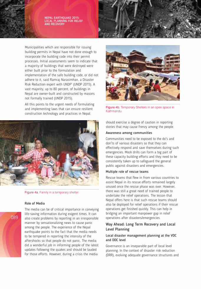
Municipalities which are responsible for issuing building permits in Nepal have not done enough to incorporate the building code into their permit processes. Initial assessments seem to indicate that a majority of buildings that were destroyed were either built prior to the formulation and implementation of the safe building code, or did not adhere to it, said Ramraj Narasimhan, a Disaster Risk Reduction expert with UNDP' (UNDP 2015). A vast majority, up to 80 percent, of buildings in Nepal are owner-built and constructed by masons not formally trained (UNDP 2015).
All this points to the urgent needs of formulating and implementing laws that can ensure resilient construction technology and practices in Nepal.
Figure 4a. Family in a temporary shelter
Role of Media
The media can be of critical importance in conveying life-saving information during exigent times. It can also create problems by reporting in an irresponsible manner by sensationalizing news to cause panic among the people. The experience of the Nepal earthquake points to the fact that the media needs to be tempered in reporting the intensity of the aftershocks so that people do not panic. The media did a wonderful job in informing people of the latest updates following the quakes and should be lauded for those efforts. However, during a crisis the media
should exercise a degree of caution in reporting stories that may cause frenzy among the people.
Awareness among communities
Communities need to be exposed to the do's and don'ts of various disasters so that they can effectively respond and save themselves during such emergencies. Mock drills can form a big part of these capacity building efforts and they need to be consistently taken up to safeguard the general public against disasters and emergencies.
Multiple role of rescue teams
Rescue teams that flew in from various countries to assist Nepal in its rescue efforts remained largely unused once the rescue phase was over. However, there was still a great need of trained people to undertake the relief operations. The lesson that Nepal offers here is that such rescue teams should also be deployed for relief operations if their rescue operations get finished quickly. This can help in bridging an important manpower gap in relief operations after disasters/emergencies.
Way Ahead: Long Term Recovery and Local Level Planning
Local disaster management planning at the VDC and DDC level
Governance is an inseparable part of local level planning. In the context of disaster risk reduction (DRR), evolving adequate governance structures and
Figure 4b. Temporary Shelters in an open space in Kathmandu.
institutional measures for effective management of disasters and emergencies becomes imperative at the local level. This implies that disaster management planning in Nepal should be carried out at the village development committee (VDC) and the district development committee (DDC). The outcome of these efforts will be district disaster management plans (DDMPs) and village disaster management plans (VDMPs).
This will have two clear-cut advantages. Firstly, local level disaster management planning will also lead to local level vulnerability assessment. This will help in the identification and contextualization of local risks. Secondly, this would promote a bottom-up and inclusive perspective to the potential impacts of disasters, which would eventually lead to locally suited mitigation measures. All such measures in local level planning will improve the overall long term recovery in post disaster/emergency situations.
Figure 5. A woman stands in front of partially damaged houses
School Safety and Local Planning
Children are by far the most vulnerable group exposed to the potential impact of disasters. Since children spend a major part of their time in schools, it is imperative to safeguard schools from the potential impact of disasters. Local level planning can play a vital role in safeguarding schools. All the schools of a particular area can form elected disaster management committees (DMCs), consisting of both students and teachers. These DMCs can carry out essential vulnerability assessments of
their school and help in the formulation of a School Disaster Management Plan (SDMP). All such DMCs of an area can be connected to their respective village development committee (VDC) or district development committee (DDC). These local bodies, in turn, can help in the mobilization of resources to the schools for undertaking DRR activities.
All such measures will help in safeguarding schools and children during disasters and emergencies. This, in turn, will improve the long term recovery in Nepal.
Climate Change Adaptation and local level planning
It is widely known that climate change will increase the frequency and intensity of hydro-meteorological disasters. Planning for DRR at the local level will remain incomplete if it does not include adaptation strategies. Adaptation to climate change works best if it is dictated by the actions of communities at the local level. The VDCs and DDCs can take proactive steps in mainstreaming climate change adaptation in DRR planning. Adaptation strategies can be made part of the VDMPs or DDMPs at the local level to maximize their impact and relevance. All these measures will boost long term recovery after a disaster in Nepal.
Focus on Gender
A lot of observers have cited that gender issues have not been adequately addressed in the DRR context of Nepal (Fig 5 and 6). Even the post disaster needs assessment (PDNA) carried out by the government of Nepal did not adequately focus on gender issues. Institutional structures such as VDCs and DDCs can have a provision of having elected female heads to represent the needs and wants of women. Similarly, in the relief and rehabilitation phase, the special needs of women should be focused upon. Including women in an inclusive manner at the various phases of DRR planning and action will lead to a positive impact on long term recovery in Nepal.
Risk Transfer Approaches
A lot of times, disasters not only physically harm the communities they strike, they also economically
089 090
NEPAL EARTHQUAKE 2015: LOCAL PLANNING FOR RELIEF AND RECOVERY
Lessons from Nepal's Earthquake for the Indian Himalayas and the Gangetic Plains
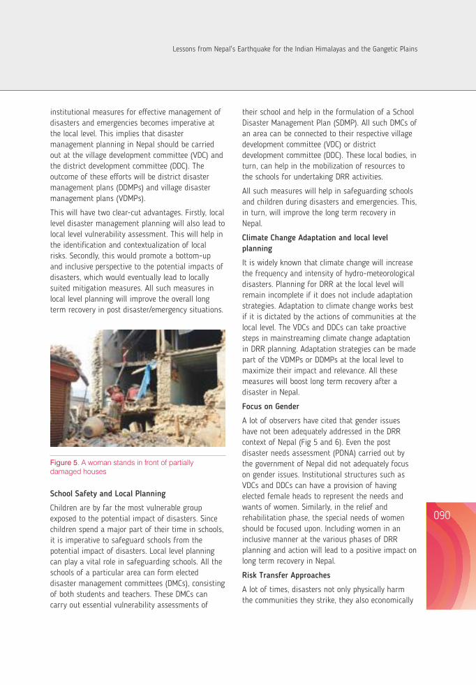
Municipalities which are responsible for issuing building permits in Nepal have not done enough to incorporate the building code into their permit processes. Initial assessments seem to indicate that a majority of buildings that were destroyed were either built prior to the formulation and implementation of the safe building code, or did not adhere to it, said Ramraj Narasimhan, a Disaster Risk Reduction expert with UNDP' (UNDP 2015). A vast majority, up to 80 percent, of buildings in Nepal are owner-built and constructed by masons not formally trained (UNDP 2015).
All this points to the urgent needs of formulating and implementing laws that can ensure resilient construction technology and practices in Nepal.
Figure 4a. Family in a temporary shelter
Role of Media
The media can be of critical importance in conveying life-saving information during exigent times. It can also create problems by reporting in an irresponsible manner by sensationalizing news to cause panic among the people. The experience of the Nepal earthquake points to the fact that the media needs to be tempered in reporting the intensity of the aftershocks so that people do not panic. The media did a wonderful job in informing people of the latest updates following the quakes and should be lauded for those efforts. However, during a crisis the media
should exercise a degree of caution in reporting stories that may cause frenzy among the people.
Awareness among communities
Communities need to be exposed to the do's and don'ts of various disasters so that they can effectively respond and save themselves during such emergencies. Mock drills can form a big part of these capacity building efforts and they need to be consistently taken up to safeguard the general public against disasters and emergencies.
Multiple role of rescue teams
Rescue teams that flew in from various countries to assist Nepal in its rescue efforts remained largely unused once the rescue phase was over. However, there was still a great need of trained people to undertake the relief operations. The lesson that Nepal offers here is that such rescue teams should also be deployed for relief operations if their rescue operations get finished quickly. This can help in bridging an important manpower gap in relief operations after disasters/emergencies.
Way Ahead: Long Term Recovery and Local Level Planning
Local disaster management planning at the VDC and DDC level
Governance is an inseparable part of local level planning. In the context of disaster risk reduction (DRR), evolving adequate governance structures and
Figure 4b. Temporary Shelters in an open space in Kathmandu.
institutional measures for effective management of disasters and emergencies becomes imperative at the local level. This implies that disaster management planning in Nepal should be carried out at the village development committee (VDC) and the district development committee (DDC). The outcome of these efforts will be district disaster management plans (DDMPs) and village disaster management plans (VDMPs).
This will have two clear-cut advantages. Firstly, local level disaster management planning will also lead to local level vulnerability assessment. This will help in the identification and contextualization of local risks. Secondly, this would promote a bottom-up and inclusive perspective to the potential impacts of disasters, which would eventually lead to locally suited mitigation measures. All such measures in local level planning will improve the overall long term recovery in post disaster/emergency situations.
Figure 5. A woman stands in front of partially damaged houses
School Safety and Local Planning
Children are by far the most vulnerable group exposed to the potential impact of disasters. Since children spend a major part of their time in schools, it is imperative to safeguard schools from the potential impact of disasters. Local level planning can play a vital role in safeguarding schools. All the schools of a particular area can form elected disaster management committees (DMCs), consisting of both students and teachers. These DMCs can carry out essential vulnerability assessments of
their school and help in the formulation of a School Disaster Management Plan (SDMP). All such DMCs of an area can be connected to their respective village development committee (VDC) or district development committee (DDC). These local bodies, in turn, can help in the mobilization of resources to the schools for undertaking DRR activities.
All such measures will help in safeguarding schools and children during disasters and emergencies. This, in turn, will improve the long term recovery in Nepal.
Climate Change Adaptation and local level planning
It is widely known that climate change will increase the frequency and intensity of hydro-meteorological disasters. Planning for DRR at the local level will remain incomplete if it does not include adaptation strategies. Adaptation to climate change works best if it is dictated by the actions of communities at the local level. The VDCs and DDCs can take proactive steps in mainstreaming climate change adaptation in DRR planning. Adaptation strategies can be made part of the VDMPs or DDMPs at the local level to maximize their impact and relevance. All these measures will boost long term recovery after a disaster in Nepal.
Focus on Gender
A lot of observers have cited that gender issues have not been adequately addressed in the DRR context of Nepal (Fig 5 and 6). Even the post disaster needs assessment (PDNA) carried out by the government of Nepal did not adequately focus on gender issues. Institutional structures such as VDCs and DDCs can have a provision of having elected female heads to represent the needs and wants of women. Similarly, in the relief and rehabilitation phase, the special needs of women should be focused upon. Including women in an inclusive manner at the various phases of DRR planning and action will lead to a positive impact on long term recovery in Nepal.
Risk Transfer Approaches
A lot of times, disasters not only physically harm the communities they strike, they also economically
089 090
NEPAL EARTHQUAKE 2015: LOCAL PLANNING FOR RELIEF AND RECOVERY
Lessons from Nepal's Earthquake for the Indian Himalayas and the Gangetic Plains
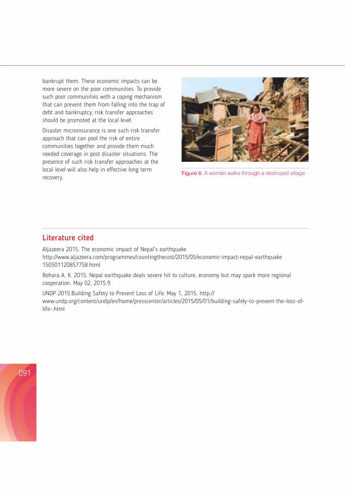
bankrupt them. These economic impacts can be more severe on the poor communities. To provide such poor communities with a coping mechanism that can prevent them from falling into the trap of debt and bankruptcy, risk transfer approaches should be promoted at the local level.
Disaster microinsurance is one such risk transfer approach that can pool the risk of entire communities together and provide them much needed coverage in post disaster situations. The presence of such risk transfer approaches at the local level will also help in effective long term recovery.
Literature citedAljazeera 2015. The economic impact of Nepal's earthquake http://www.aljazeera.com/programmes/countingthecost/2015/05/economic-impact-nepal-earthquake 150501120857758.html
Bohara A. K. 2015. Nepal earthquake deals severe hit to culture, economy but may spark more regional cooperation. May 02, 2015.9
UNDP 2015.Building Safety to Prevent Loss of Life. May 1, 2015. http:// www.undp.org/content/undp/en/home/presscenter/articles/2015/05/01/building-safely-to-prevent-the-loss-of-life-.html
A SHORT NOTE ON THE IMPACT OF THE EARTHQUAKE ON THE MOUNTAIN ECOLOGY IN LANGTANG NATIONAL PARK, NEPAL
Madan Koirala
Professor, Central Department of Environmental Science, Tribhuvan University & Member, Climate Change Council, Govt. of Nepal
091 092
AbstractThis is a preliminary note on the post-earthquake impact on the mountain ecology of Langtang National Park, Nepal with Rapid Environmental Assessment (REA) and secondary literature such as satellite imagery. The forest cover was heavily affected by landslides and the deposition of avalanche at the down reach of the study area. An avalanche of 5.43km² area destroyed Ghodatabela village, a site of tourist importance, and killed more than 250 people. Also 8 villages were washed away.
Wildlife species Himalayan Goral (Naemorhedus goral), musk deer (Moschuschrysogaster), red panda (Ailurusfulgens), thar (Hemitragusjemlahicus), and wild boar (Susscrofa), among others were buried in the avalanches. Fourteen herds of Himalayan Gorals (Naemorhedus goral) numbering 344 were buried.
The landslides and avalanches about 1500 ha of Gobresalla destroyed about 20,000 trees, including(Pinuswallichiana) forest. Conflict is rising between the national park and local people in terms of using natural resources especially forests for settlement and firewood. Earthquake victims from neighboring villages have encroached upon the national park in several areas.
Key words: Avalanche, Fauna, Flora, Landslide, Rapid Environmental Assessment
IntroductionMany natural phenomenan in human history have left scars in different periods of time. The April 25, 2015 Nepal earthquake with 7.6 magnitude is one of them. The earthquake had left 8,790 dead, and 22,300 injured (GoN, 2015). The destruction was widespread covering residential and government buildings, heritage sites, schools and health posts, rural roads, bridges, water supply systems,
agricultural land, trekking routes, hydropower plants and sports facilities (GoN, 2015).
Nepal Himalaya, lying in the convergent boundary of Indian plate and Tibetan plate, is highly vulnerable to earthquakes The country lies in the central Himalaya range between 26°22' and 30°27' N Latitude and 80°04' and 88°12' E longitudes (Fig.1) and is rich in biodiversity (NBSAP, 2014). Its
Figure 6. A woman walks through a destroyed village
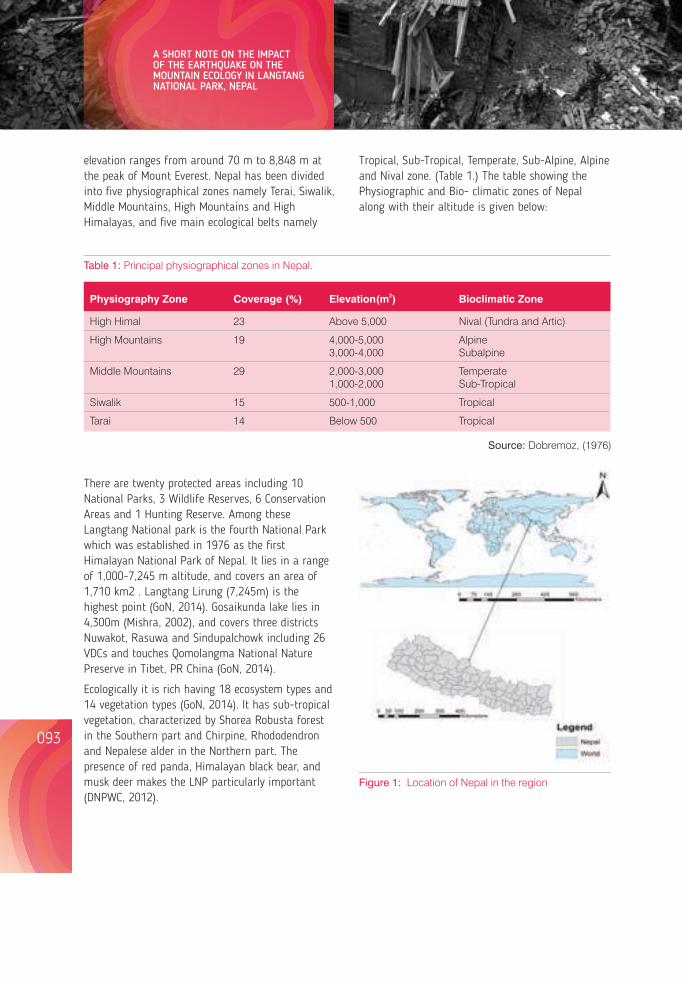
elevation ranges from around 70 m to 8,848 m at the peak of Mount Everest. Nepal has been divided into five physiographical zones namely Terai, Siwalik, Middle Mountains, High Mountains and High Himalayas, and five main ecological belts namely
Tropical, Sub-Tropical, Temperate, Sub-Alpine, Alpine and Nival zone. (Table 1.) The table showing the Physiographic and Bio- climatic zones of Nepal along with their altitude is given below:
Table 1: Principal physiographical zones in Nepal.
Figure 1: Location of Nepal in the region
Figure 2: Nepal showing 5 ecological regions (NBSAP 2014)
Figure 3:Langtang National Park including three districts (Bastola, 2015)
Figure 4:Ecological zones of Langtang National Park including three districts (Bastola, 2015)
where trails were accessed and people could meet for interaction. Report of visual observation was also brought by the students, under the guidance of Professors.
Secondary Data
Literature Review
Literature related to impact of Disaster on Natural Environment especially focusing on national parks were reviewed in detail.
093 094
A SHORT NOTE ON THE IMPACT OF THE EARTHQUAKE ON THE MOUNTAIN ECOLOGY IN LANGTANG NATIONAL PARK, NEPAL
2Physiography Zone Coverage (%) Elevation(m ) Bioclimatic Zone
High Himal 23 Above 5,000 Nival (Tundra and Artic)
High Mountains 19 4,000-5,000 Alpine 3,000-4,000 Subalpine
Middle Mountains 29 2,000-3,000 Temperate 1,000-2,000 Sub-Tropical
Siwalik 15 500-1,000 Tropical
Tarai 14 Below 500 Tropical
There are twenty protected areas including 10 National Parks, 3 Wildlife Reserves, 6 Conservation Areas and 1 Hunting Reserve. Among these Langtang National park is the fourth National Park which was established in 1976 as the first Himalayan National Park of Nepal. It lies in a range of 1,000-7,245 m altitude, and covers an area of 1,710 km2 . Langtang Lirung (7,245m) is the highest point (GoN, 2014). Gosaikunda lake lies in 4,300m (Mishra, 2002), and covers three districts Nuwakot, Rasuwa and Sindupalchowk including 26 VDCs and touches Qomolangma National Nature Preserve in Tibet, PR China (GoN, 2014).
Ecologically it is rich having 18 ecosystem types and 14 vegetation types (GoN, 2014). It has sub-tropical vegetation, characterized by Shorea Robusta forest in the Southern part and Chirpine, Rhododendron and Nepalese alder in the Northern part. The presence of red panda, Himalayan black bear, and musk deer makes the LNP particularly important (DNPWC, 2012).
Source: Dobremoz, (1976)
The main objective of the present study is to give a preliminary assessment of the loss of biodiversity of Langtang valley.
Methods
A Rapid Environmental Assessment (REA) was carried by a group of graduate students of Central Department of Environmental Science, Tribhuvan University. Since, the students were already oriented with the Disaster Preparedness as a part of their curriculum, it became convenient to mobilize them quickly. The assessment covered the Rasuwa district
Lessons from Nepal's Earthquake for the Indian Himalayas and the Gangetic Plains
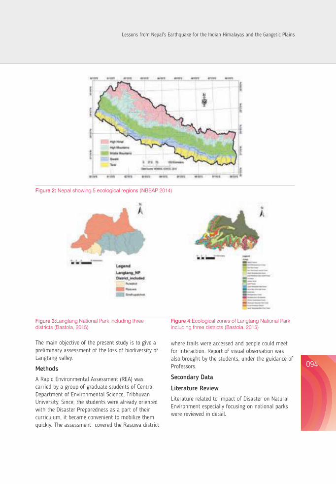
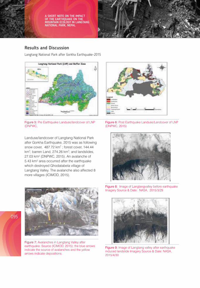
Landuse/landcover of Langtang National Park after Gorkha Earthquake, 2015 was as following
2snow cover, 487.72 km ; forest cover, 144.44 2 2km ; barren Land, 274.26 km ; and landslides,
27.03 km² (DNPWC, 2015). An avalanche of 5.43 km² area occurred after the earthquake which destroyed Ghodatabela village of Langtang Valley. The avalanche also affected 8 more villages (ICIMOD, 2015).
Results and DiscussionLangtang National Park after Gorkha Earthquake-2015
Figure 5: Pre Earthquake Landuse/landcover of LNP (DNPWC,
Figure 6: Post Earthquake Landuse/Landcover of LNP (DNPWC, 2015)
Figure 7: Avalanches in Langtang Valley after earthquake. Source (ICIMOD, 2015); the blue arrows indicate the source of avalanches and the yellow arrows indicate depositions.
Figure 8: Image of Langtangvalley before earthquake Imagery Source & Date: NASA, 2015/3/29
Figure 9: Image of Langtang valley after earthquake induced landslide Imagery Source & Date: NASA, 2015/4/30
Impact on Flora and Fauna
Many wild animals, namely ghoral (Naemorhedus goral), musk deer (Moschus chrysogaster), red panda (Ailurus fulgens), tahr (Hemitragus jemlahicus), and wild boar (Susscrofa) among others were buried in the avalanches. According to the primary survey done by CDES students, previously there were fourteen herds of Himalayan gorals (Naemorhedus goral) with a total population of 344. Due to avalanches four herds of gorals were completely buried with each herd comprising 18 to 20 in number. According to Rapid Environmental Assessment done after the quake 57 Himalayan tahr (Hemitragus jemlahicus), and 2 wild boar (Susscrofa) were found dead in LNP. Himalayan Tahr is listed as nearly threatened species by IUCN. The rehabilitation and reconstruction programmes have encroached upon the habitat of red panda (Ailurus fulgens) too (Lekhak, 2015).
Because of the avalanches about 20,000 trees weredestroyed. REA reports that about 1500 ha of Gobre salla a blue pine (Pinus wallichiana) forest was destroyed by the earthquake induced landslides. Following the post-earthquake crisis, conflict has risen between the national park and local people about the use of natural resources, especially forests for settlement and firewood. Furthermore, earthquake victims from neighboring villages have encroached upon the majority of national park area from Ramche to Dhunche (Lekhak, 2015).
The earthquake severely affected infrastructure andrelated tourism.
According to Ghodatabela Hotel Association (GHA), most of the hotels were completely destroyed in Ghodatobela area, and trekking routes between Langtang and Manaslu areas were severely damaged. Tamang Heritage trail between Rasuwaghadi and Tatopani was also destroyed.
Gosainkunda Lake has its own ecological, economic as well as religious value. Every year during Janai Purnima, Gosaikunda fair used to invite thousands of internal as well as external tourists. But after the earthquake Gosaiankunda fair has lost its charm due to destruction for Ganeshgauda-Kunda Route.
The long-term impact is yet to be obsesrved, since, Langtang National Park is one of the important National Parks for trekking and scientific study among researchers.
ConclusionIt is rather difficult to draw a conclusion so soon after the event; however, the impact of widespread destruction is going to be long lasting. Landslide has washed out not only the trekking routes but also the trails leading to many of the villages. Survivors and relatives of the avalanche victims are in trauma and depression. Both agriculture and the hotel business which provide the livelihood of the locals will take a long time for restoration. Loss of natural environment in the form of forest or wildlife has not been precisely assessed but can be enormous.
ACKNOWLEDGEMENTSEr. Ajay Bhakta Mathema for providing the multilayered primary data of the GIS of the study area.
Dr Dinesh R Bhuju for sharing the preliminary finding and the ongoing progress on the Rapid Environmental Assessment of Rasuwa district.
Kumod Lekhak, for sharing the finding of the REA done in the Rasuwa district especially that of LangtangNational Park.
Shanta Bastola, for the primary assisting me in availingdata, GIS map preparation, retrieving from source and helping in interpretation.
095 096
A SHORT NOTE ON THE IMPACT OF THE EARTHQUAKE ON THE MOUNTAIN ECOLOGY IN LANGTANG NATIONAL PARK, NEPAL
Lessons from Nepal's Earthquake for the Indian Himalayas and the Gangetic Plains
ReferencesDepartment of National Parks and Wildlife Conservation (DNPWC), 2015. Rapid Environmental Assessment of Langtang National Park (Unpublished Report) Ministry of Forests and Soil Conservation, Government of Nepal.
Department of National Parks and Wildlife Conservation (DNPWC), 2012. Ministry of Forests and Soil Conservation, GoN. Langtang National Park, an Introduction.
Dobremez JF 1976. Le Nepal ecologieetbiiogeographie. (Ed.) CNRS, Paris.
Government of Nepal 2014. Nepal National Biodiversity Strategy and Action Plan 2014-2020. Ministry of Forests and Soil Conservation.
Government of Nepal, 2015. National Panning Commission, Post Disaster Needs Assessment, Nepal Earthquake 2015.
ICIMOD 2015. Villages in Langtang Valley destroyed by landslides and pressure waves during the 25 April earthquake, Kathmandu, Nepal.
ICIMOD 2015. Mountain Hydrology, Landsat 8 reveals extent of earthquake disaster in Langtang Valley.
Lekhak K 2015. Rapid Environmental Assessment on the Impact of earthquake in Rasuwa district (Unpublished Report).
Lord A 2015. Nepal quake: Report on situation in Langtang.
Nepali Times2015. Langtang is gone.
drrportal.gov.np/uploads/document/14
https://www.google.com.np/url?sa=t&rct=j&q=&esrc=s&source=web&cd=5&cad=rja&uact=8&ved=0CDsQFjAEahUKEwiI4suC88PIAhVRj44KHfh1Aio&url=http%3A%2F%2Fdrrportal.gov.np%2Fuploads%2Fdocument%2F14.pdf&usg=AFQjCNEe94QlBVRd7fYqHhAgrH92TiLRAw&sig2=56SNeBIi_PYnMmJogvKAsg
RELIEF AND RECOVERY EFFORTS OF GORKHA FOUNDATION AFTER 2015 EQ IN NEPAL - A NOTE ON THE GROUND PERSPECTIVES
Dikshya Devkota
Board Member, Gorkha Foundation Nepal, [email protected]
097 098
AbstractGorkha Foundation (GF) has been working in Gorkha since 2008 in the sector of livelihood, education and healthcare. After the Gorkha earthquake, Gorkha Foundation Nepal worked for relief, rehabilitation and reconstruction.
GF coordinated relief activities in inaccessible and remote areas of Gorkha district (mainly close to China Border) by using helicopters because of the bad road condition and the rainfall after the quake. Other areas were approached by tractors and by porters with great difficulty. Solar lights, tarpaulins, mats and food were most-used relief materials.
Volunteers from all over the world joined us in our effort. With the help of those volunteers we have already accomplished rebuilding of schools. The rise of material and transportation prices is the main challenge in rebuilding of this area.
Key words: Gorkha, Earthquake, Relief, Reconstruction, Counselling
Gorkha Foundation (GF) has been working in Gorkha since 2008 as a nonprofit, grass roots organization working towards improving living conditions and strengthening the economy in Gorkha region, in the sector of livelihood and education.
The Gorkha Foundation is working with several volunteer groups and international organizations to address the devastation that the earthquake has left behind. Many villagers in Gorkha are under siege, struggling to survive from the earthquake and its aftershocks. It is very clear that remote mountain
communities at the EPICENTER – THE GORKHA DISTRICT, have very serious issues. Whole villages have been devastated and rains that accompanied the aftershocks triggered destructive landslides and threatened more danger to habitation, and to existing food supplies. The Gorkha Foundation (GF) team is busy trying to coordinate more relief and rehabilitation to reach isolated communities such as Chekampar, Samaguan, Lho, Prok, Sridibas which are only accessible by helicopter or on foot.
The focus of Gorkha foundation is on the epicenter
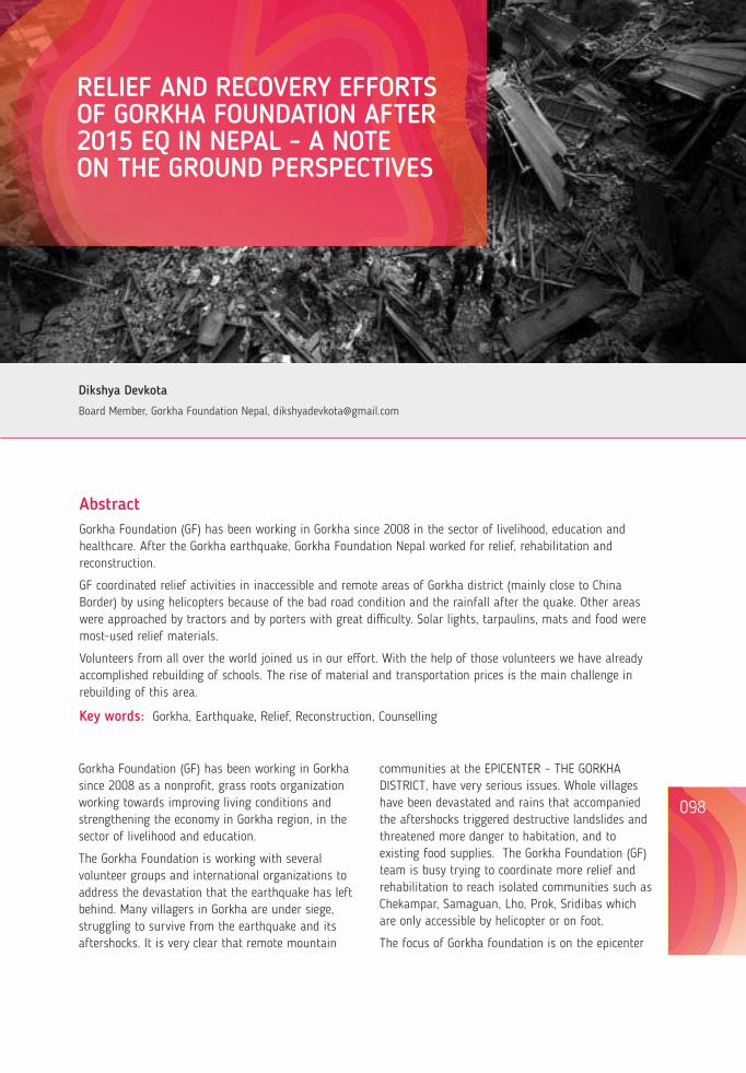
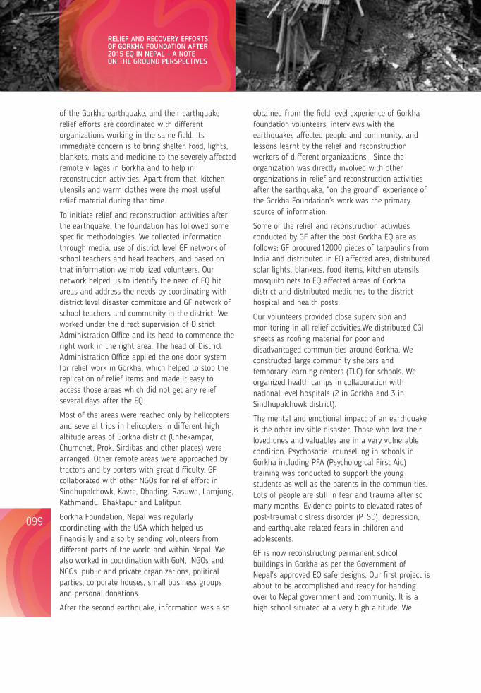
of the Gorkha earthquake, and their earthquake relief efforts are coordinated with different organizations working in the same field. Its immediate concern is to bring shelter, food, lights, blankets, mats and medicine to the severely affected remote villages in Gorkha and to help in reconstruction activities. Apart from that, kitchen utensils and warm clothes were the most useful relief material during that time.
To initiate relief and reconstruction activities after the earthquake, the foundation has followed some specific methodologies. We collected information through media, use of district level GF network of school teachers and head teachers, and based on that information we mobilized volunteers. Our network helped us to identify the need of EQ hit areas and address the needs by coordinating with district level disaster committee and GF network of school teachers and community in the district. We worked under the direct supervision of District Administration Office and its head to commence the right work in the right area. The head of District Administration Office applied the one door system for relief work in Gorkha, which helped to stop the replication of relief items and made it easy to access those areas which did not get any relief several days after the EQ.
Most of the areas were reached only by helicopters and several trips in helicopters in different high altitude areas of Gorkha district (Chhekampar, Chumchet, Prok, Sirdibas and other places) were arranged. Other remote areas were approached by tractors and by porters with great difficulty. GF collaborated with other NGOs for relief effort in Sindhupalchowk, Kavre, Dhading, Rasuwa, Lamjung, Kathmandu, Bhaktapur and Lalitpur.
Gorkha Foundation, Nepal was regularly coordinating with the USA which helped us financially and also by sending volunteers from different parts of the world and within Nepal. We also worked in coordination with GoN, INGOs and NGOs, public and private organizations, political parties, corporate houses, small business groups and personal donations.
After the second earthquake, information was also
obtained from the field level experience of Gorkha foundation volunteers, interviews with the earthquakes affected people and community, and lessons learnt by the relief and reconstruction workers of different organizations . Since the organization was directly involved with other organizations in relief and reconstruction activities after the earthquake, “on the ground” experience of the Gorkha Foundation's work was the primary source of information.
Some of the relief and reconstruction activities conducted by GF after the post Gorkha EQ are as follows; GF procured12000 pieces of tarpaulins from India and distributed in EQ affected area, distributed solar lights, blankets, food items, kitchen utensils, mosquito nets to EQ affected areas of Gorkha district and distributed medicines to the district hospital and health posts.
Our volunteers provided close supervision and monitoring in all relief activities.We distributed CGI sheets as roofing material for poor and disadvantaged communities around Gorkha. We constructed large community shelters and temporary learning centers (TLC) for schools. We organized health camps in collaboration with national level hospitals (2 in Gorkha and 3 in Sindhupalchowk district).
The mental and emotional impact of an earthquake is the other invisible disaster. Those who lost their loved ones and valuables are in a very vulnerable condition. Psychosocial counselling in schools in Gorkha including PFA (Psychological First Aid) training was conducted to support the young students as well as the parents in the communities. Lots of people are still in fear and trauma after so many months. Evidence points to elevated rates of post-traumatic stress disorder (PTSD), depression, and earthquake-related fears in children and adolescents.
GF is now reconstructing permanent school buildings in Gorkha as per the Government of Nepal's approved EQ safe designs. Our first project is about to be accomplished and ready for handing over to Nepal government and community. It is a high school situated at a very high altitude. We
have already started several other projects simultaneously. We are also providing support to schools in Gorkha with furniture, computers with internet facilities, e-library.
The activities and efforts should be transparent and accountable. We should be cautious about opportunity seekers, price hike, black marketing of essential items, interest based organizations. The role of security forces (army, police, and armed police) were commendable and their capacity building and better planned and systematic response mechanism were productive.
EQ drills, posters, pamphlets, street plays, radio /TV program can be used for creating awareness. Lots of volunteers and development workers were rushed into EQ hit areas with no coordination and a majority without the government's approval; it seemed as though they are competing with each other to get hold of villages and replication of relief items was also a major problem. Efforts should be carried out in a coordinated manner rather than on an individual or ad-hoc basis; permission from the Government and monitoring and supervision by the Government is essential. We should identify open and safe spaces for post EQ relief and recovery activities.
Challenges in logistic arrangement and cost of reconstruction are high in inaccessible areas (e.g. a sack of cement costs NRs 550.00 in Kathmandu whereas it cost Rs 1100.00 at Nepane Gorkha where we are constructing schools). Since there is interrupted electric supply in reconstruction sites, we have to depend on generators for various works.
Disaster Equipment, Preparedness is essential.Communication, Medical Support, Hygiene Kits should be ensured at district and strategic community levels.
We would like to thank Gorkha Foundation USA, OLE Nepal, UNHCR, World Food Program, Himalayan Climate Initiative, Karmapa Gumba, National Institute of Neuro Hospital and Allied Sciences, Bibeksheel Nepali, Nepal Share & Nyano Sansar, Youth Action Nepal, Volunteers from India, USA, UK, and Israel, Nepali students, teachers and head teachers from Gorkha.
099 100
RELIEF AND RECOVERY EFFORTS OF GORKHA FOUNDATION AFTER 2015 EQ IN NEPAL - A NOTE ON THE GROUND PERSPECTIVES
First helicopter drop for Chum Valley By GF1, Picture Taken by Neema Lama
Local participation on rebuilding school at Nepane Kerabari, Picture taken By Basanta Devkota
Lessons from Nepal's Earthquake for the Indian Himalayas and the Gangetic Plains
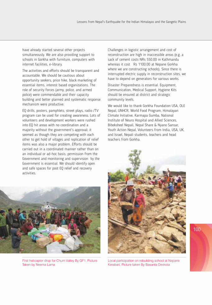
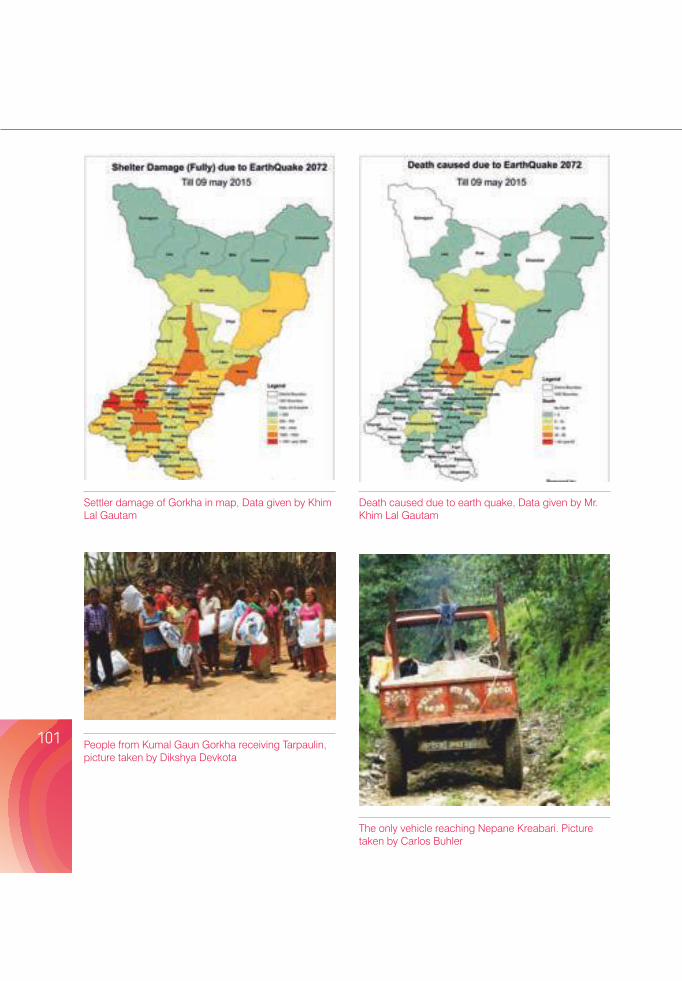
Settler damage of Gorkha in map, Data given by Khim Lal Gautam
Death caused due to earth quake, Data given by Mr. Khim Lal Gautam
People from Kumal Gaun Gorkha receiving Tarpaulin, picture taken by Dikshya Devkota
The only vehicle reaching Nepane Kreabari. Picture taken by Carlos Buhler
BANGLADESH'S EXPERIENCE OF THE NEPAL EARTHQUAKE: A STORY OF THE IMPACT ON A SEEMINGLY UNCONNECTED REGION
A. K. M. Khorshed Alam¹* and Aktarul Ahsan²
¹Bangladesh Geological Society, ²Geological Survey of Bangladesh, 153 Pioneer Road, Segunbagicha, Dhaka 1000, Bangladesh*e-mail: [email protected]
101 102
AbstractThe impact of the 25 April 2015 Nepal earthquake (7.8) in Bangladesh was assessed based on the reports published in the national daily newspapers, interviews with local residents, information from government reports, data from different relevant websites, and field visits in Dhaka city. The main shock and aftershocks caused a few casualties and some damage to physical structures, and created fear among a large population of the country. Some people were injured as they ran out of homes, schools, shopping malls, offices and workplaces in fear. This event highlighted the need of public awareness and longterm preparedness in the country for earthquake risk reduction. Research is also necessary to assess the influence of seismic events on land, hydrology and environment in the country, which provides information on the risk of the region from earthquake.
Key words: Bangladesh and Bengal basin, earthquake risk reduction, natural hazard, Nepal Earthquake 2015,
IntroductionBangladesh is surrounded by high seismic regions and the seismicity is deeply related to plate tectonic behaviour in and around Bangladesh. It experienced several major earthquakes during the last 250 years (namely Arakan earthquake of 1762 (>8?), Cachar earthquake of 1869 (7.5), Bengal earthquake of 1885 (7.0), Great Assam earthquake of 1897 (8.7), Srimangal earthquake of 1918 (7.6), Dhubri earthquake of 1930 (7.1), Nepal-Bihar earthquake of 1934 (8.3), Assam earthquake of 1950 (8.6)) and has been affected by small earthquakes occasionally
(Figure 1). Well-written documents (Oldham 1882, Middlemiss 1885, Oldham 1899, Stuart 1920, Gee 1934, Anon 1939) give details of the impacts of those earthquakes. However, very little is known about the 1762 earthquake (Iyenger et al. 1999). Because of the morphotectonic continuity, those earthquakes affected the country although most of the epicentres of large earthquakes were beyond its border. During the last few years, the country experienced low magnitude earthquakes which occurred within its territory (Sylhet earthquake of
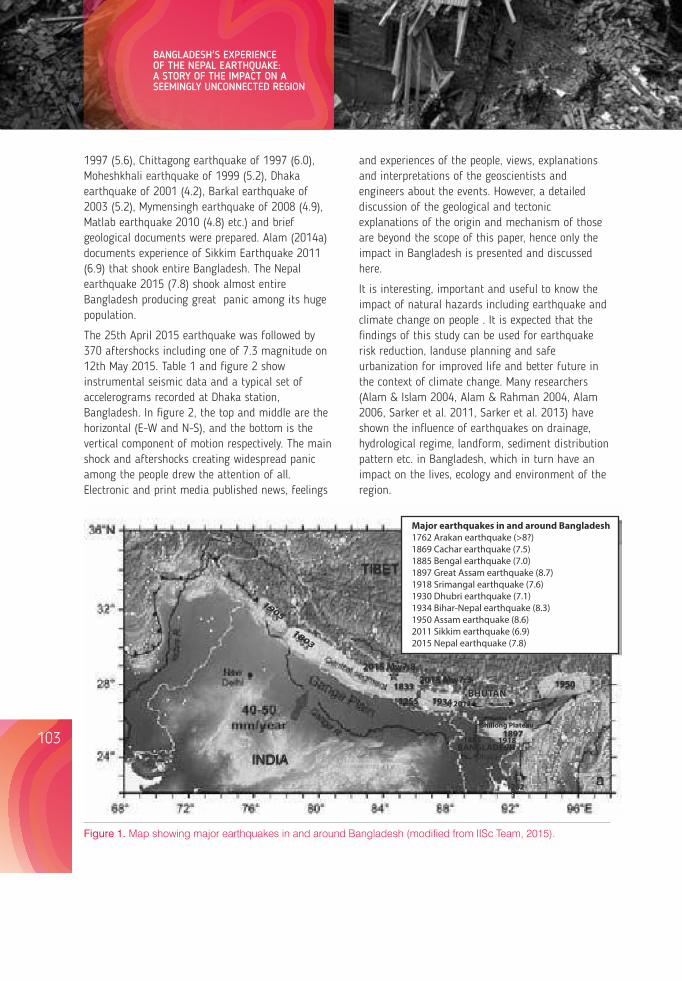
1997 (5.6), Chittagong earthquake of 1997 (6.0), Moheshkhali earthquake of 1999 (5.2), Dhaka earthquake of 2001 (4.2), Barkal earthquake of 2003 (5.2), Mymensingh earthquake of 2008 (4.9), Matlab earthquake 2010 (4.8) etc.) and brief geological documents were prepared. Alam (2014a) documents experience of Sikkim Earthquake 2011 (6.9) that shook entire Bangladesh. The Nepal earthquake 2015 (7.8) shook almost entire Bangladesh producing great panic among its huge population.
The 25th April 2015 earthquake was followed by 370 aftershocks including one of 7.3 magnitude on 12th May 2015. Table 1 and figure 2 show instrumental seismic data and a typical set of accelerograms recorded at Dhaka station, Bangladesh. In figure 2, the top and middle are the horizontal (E-W and N-S), and the bottom is the vertical component of motion respectively. The main shock and aftershocks creating widespread panic among the people drew the attention of all. Electronic and print media published news, feelings
and experiences of the people, views, explanations and interpretations of the geoscientists and engineers about the events. However, a detailed discussion of the geological and tectonic explanations of the origin and mechanism of those are beyond the the scope of this paper, hence onlyimpact in Bangladesh is presented and discussed here.
It is interesting, important and useful to know the impact of natural hazards including earthquake and climate change on people . It is expected that the findings of this study can be used for earthquake risk reduction, landuse planning and safe urbanization for improved life and better future in the context of climate change. Many researchers (Alam & Islam 2004, Alam & Rahman 2004, Alam 2006, Sarker et al. 2011, Sarker et al. 2013) have shown the influence of earthquakes on drainage, hydrological regime, landform, sediment distribution pattern etc. in Bangladesh, which in turn have an impact on the lives, ecology and environment of the region.
Figure 1. Map showing major earthquakes in and around Bangladesh (modified from IISc Team, 2015).
Table 1. Seismological data on Nepal earthquakes 2015 from different sources.
Date NEIC, USGS IMD NSC BMD
25/04/2015 M 7.8 7.9 ML 7.6 7.5 28.231°N,84.731°E 28.1°N, 84.6°E 28.24°N,84.75°E 28°04.80N,84°51.60E 8.2 Km 10 Km 11:56 Nepal time 745 km NW of Dhaka 06:11:25 UTC 06:11:25 UTC station 06:27:20 UTC
M 6.6 6.6 6.6 6.6 28.224°N,84.822°E 28.1°N, 28.28°N, 27.80°N, 10Km 84.8°E 84.72°E 86.19°E 612km NW of 06:45:21 UTC 10 Km 12:30 Nepal time Dhaka station 06:45:20 UTC 13:09:08 BST
26/04/2015 M6.7 6.9 6.9 6.6 27.771°N,86.017°E 27.6°N, 85.9°E 27.84°N,86.05°E 27.80°N, 86.19°E 22.9 Km 10 Km 12:54Nepal time 612 km NW of 07:09:10 UTC 07:09:08 UTC Dhaka station 13:09:08 BST
27/4/2015 5.3 26.99ºN, 88.3ºE (Near Siliguri, India- Bangladesh Border) 413km NW of Dhaka station 18:35:52 BST (DMIC 2015c)
(NEIC: National Earthquake Information Center, IMD: India Meteorological Department, NSC: National Seismological Center-Nepal, BMD: Bangladesh Meteorological Department).
Several studies on earthquakes have been done (Morgan & McIntire 1959, Coates & Alam 1990, Hossain 1989, Goodbred et al. 2000, Alam 2003, Khan 2005, Steckler et al. 2008, Alam & Islam 2004, Alam 2006, Morino et al. 2013, Morino et al. 2014, Alam et al. 2014, Alam 2014a&b, Ahsan et al. 2015) to understand the seismotectonic behaviour of different elements operative in the country as well as the region. Aims of these researches and studies were to provide a safe and better life to the 160 million populations living in this small country located in a tectonically active region mostly with thick cover of unconsolidated alluvial and deltaic sediments.
During the last couple of decades, Bangladesh has developed awareness regarding mechanisms for cyclones in coastal areas and flooding in river basins. Disasters can be substantially reduced if the people are well informed and motivated towards a
culture of disaster prevention and resilience. Training on earthquake preparedness has been started in schools and hospitals. Seismic microzonations of three major cities (Dhaka, Chittagong and Sylhet) during the first phase and other eight cities and towns during the second phase were completed under Comprehensive Disaster Management Program (CDMP) with the objective to reduce the earthquake risk and build cities resilient to earthquakes (Morino et al. 2013). Moreover, Standing Orders on Disaster (SOD) 2010 give responsibilities of risk reduction and emergency response to all ministries of the government for implementation at all levels. Earthquake Preparedness and Awareness Committee, in compliance with the Disaster Management Act 2012, was formed in order to prepare the nation for earthquake risk management.
103 104
BANGLADESH'S EXPERIENCE OF THE NEPAL EARTHQUAKE: A STORY OF THE IMPACT ON A SEEMINGLY UNCONNECTED REGION
TIBE T
BANGLADESHINDIA
2015 Mw7.82015 Mw7.3
1885 1918
1762
Major earthquakes in and around Bangladesh1762 Arakan earthquake (>8?)1869 Cachar earthquake (7.5)1885 Bengal earthquake (7.0)1897 Great Assam earthquake (8.7)1918 Srimangal earthquake (7.6)1930 Dhubri earthquake (7.1) 1934 Bihar-Nepal earthquake (8.3)1950 Assam earthquake (8.6)2011 Sikkim earthquake (6.9)2015 Nepal earthquake (7.8)
Shillong Plateau
Dhaka
2011
1950
1897
1934
1833
1255
1905
1803
BHUTAN
Lessons from Nepal's Earthquake for the Indian Himalayas and the Gangetic Plains
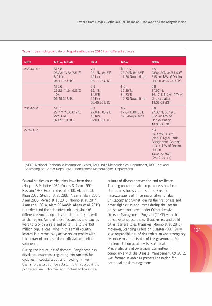
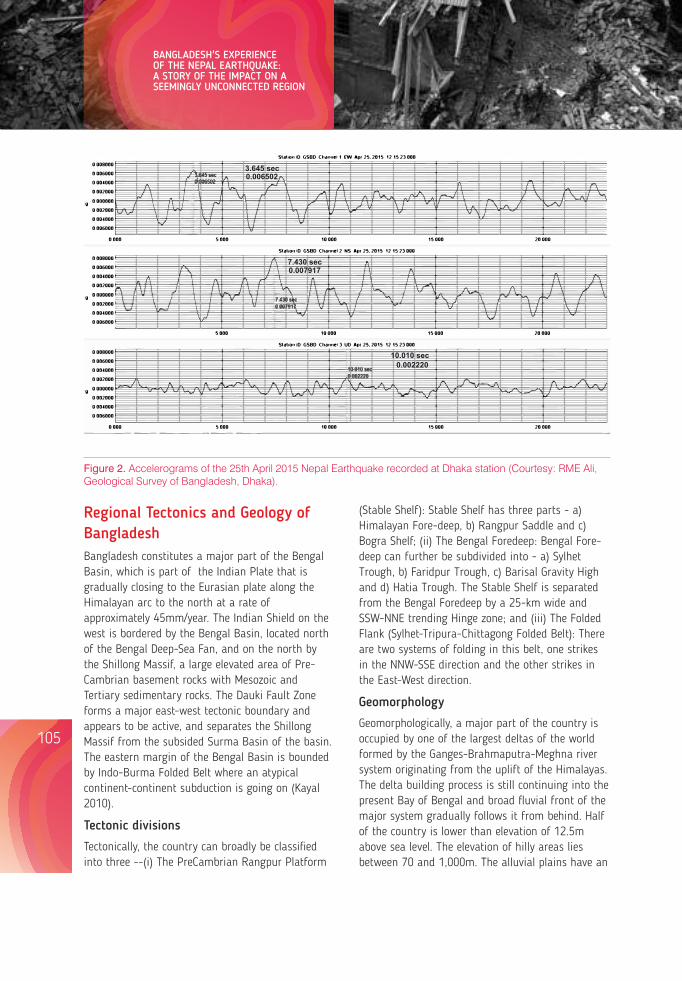
Figure 2. Accelerograms of the 25th April 2015 Nepal Earthquake recorded at Dhaka station (Courtesy: RME Ali, Geological Survey of Bangladesh, Dhaka).
Regional Tectonics and Geology of BangladeshBangladesh constitutes a major part of the Bengal Basin, which is part of the Indian Plate that is gradually closing to the Eurasian plate along the Himalayan arc to the north at a rate of approximately 45mm/year. The Indian Shield on the west is bordered by the Bengal Basin, located north of the Bengal Deep-Sea Fan, and on the north by the Shillong Massif, a large elevated area of Pre-Cambrian basement rocks with Mesozoic and Tertiary sedimentary rocks. The Dauki Fault Zone forms a major east-west tectonic boundary and appears to be active, and separates the Shillong Massif from the subsided Surma Basin of the basin. The eastern margin of the Bengal Basin is bounded by Indo-Burma Folded Belt where an atypical continent-continent subduction is going on (Kayal 2010).
Tectonic divisions
Tectonically, the country can broadly be classified into three --(i) The PreCambrian Rangpur Platform
(Stable Shelf): Stable Shelf has three parts - a) Himalayan Fore-deep, b) Rangpur Saddle and c) Bogra Shelf; (ii) The Bengal Foredeep: Bengal Fore-deep can further be subdivided into - a) Sylhet Trough, b) Faridpur Trough, c) Barisal Gravity High and d) Hatia Trough. The Stable Shelf is separated from the Bengal Foredeep by a 25-km wide and SSW-NNE trending Hinge zone; and (iii) The Folded Flank (Sylhet-Tripura-Chittagong Folded Belt): There are two systems of folding in this belt, one strikes in the NNW-SSE direction and the other strikes in the East-West direction.
Geomorphology
Geomorphologically, a major part of the country is occupied by one of the largest deltas of the world formed by the Ganges-Brahmaputra-Meghna river system originating from the uplift of the Himalayas. The delta building process is still continuing into the present Bay of Bengal and broad fluvial front of the major system gradually follows it from behind. Half of the country is lower than elevation of 12.5m above sea level. The elevation of hilly areas lies between 70 and 1,000m. The alluvial plains have an
elevation from about 90m in the north-western part of the country to 0m along the coastal part. Apart from these, there are three tracts of terraces with a maximum elevation of 40m.
Geology
Geologically, 80% of the surface and near surface of the country is formed of Holocene deposits (Alam et. al. 1990). Eight percent area is covered with Pleistocene clay residuum in the three uplifted terraces and the Tertiary sedimentary rocks cover 12% (Figure 3). The Tertiary rocks forming small hills occupy the eastern and north-eastern parts of it. The oldest exposed rock is the Tura Sandstone of Paleocene age but older rocks like Mesozoic, Paleozoic and Precambrian Basement have been encountered in the drill holes in the north-western part. Mainly sandstone, siltstone, shale and claystone represent the Tertiary rocks. The Holocene deposits, consisting of unconsolidated sand, silt and clay of varying amounts, are the products of piedmont, alluvial, fluvial, deltaic or coastal processes. Through a long geological time (Permian to Recent) the basement of Bengal basin, below a thick sedimentary cover, has been severely faulted
and fractured which are covered under Holocene surficial deposits. All these materials behave differently during various geo-dynamic activities and geological hazards.
ObjectivesThe main objective of this article is to summarise the effect of Nepal Earthquake in relation to Bangledesh.
Data and MethodsThis research was based mainly on the reports about the earthquakes and aftershocks, published in daily newspapers. Information was taken from twelve daily newspapers (nine Bangla and three English) published from Dhaka during 26-28th April 2015, and 2 newspapers (one Bangla and one English) on 5th and on 13th May 2015 to collect maximum information with a good coverage. Immediately after the quakes, websites of five newspapers and one news media were visited to collect first-hand information. Seismological data were collected from the websites of Bangladesh Meteorological Department, National Earthquake
Figure 3. Generalized Geological Map of Bangladesh (modified from Alam et al. 1990).
105 106
BANGLADESH'S EXPERIENCE OF THE NEPAL EARTHQUAKE: A STORY OF THE IMPACT ON A SEEMINGLY UNCONNECTED REGION
3.645 sec3.645 sec
0.0065020.006502
7.430 sec
7.430 sec
0.007917
0.007917
10.010 sec
10.010 sec
0.002220
0.002220
csd Coastal depositsdsd Deltaic depositsppc Paludal depositsasd Alluvial depositsafd Alluvial fan depositsrb Barind clay residuumrm Madhupur clay residuumTs Tertiary sedimentary rocks Fault
csd
csd
csd
dsd
dsd
dsddsd
dsd
dsd
dsd
dsddsd
dsd
dsd
dsd
dsd
dsd
dsd
ppc ppc
ppc
ppc
ppc
ppc
ppc
ppc
ppc
ppc
ppcppc
ppc
ppc
asd
asd
asdasd
asd
asd
asd
asd
asd
asd
asd
asd
asd
asdasd
asd
afd
afd
afd afd afd
afd
afdafd
afd afd
afd
rb
rb
rb
rb
rb
rb
rm
rm
rm
rm
rm
Ts
Ts
Ts
Ts
Ts
Ts
Ts
Ts
TsTs
Ts
Ts
Ts
LEGEND
- - -- - -- - -
- - -- - -
- - -
- - -
- - -
- - - - - - - -
- - - - -
- - - - - - - - -- - - - - - - - - - -
- - - - - - - - - - - - -- - - - - - - -
- - - - - -
- - - - - - - - - - - - - -
- - - -
- - - -
- - - - - - - -
- - -
- - -
- -
- -
- - -
- - -
- - -- - -
- - -
- - -
- - - -
- - -
- - -- -
-
-
-
--
- --
- --
- -- -
- -- - -- --
--
-
--
-
- -
- - - -- -- -
- -- -
Rangpur
Rajshahi
MymensinghSylhet
DHAKA
Khulna
Barisal
Chittagong
B a y o f B e n g a l
I N D I A
I N D I AI N D I A
I N D I A
I N D I A
M Y A N M
A R
Divisional HQ
Capital City
88 90 92
26
24
22
o
o
o
o
o o
100km
Lessons from Nepal's Earthquake for the Indian Himalayas and the Gangetic Plains
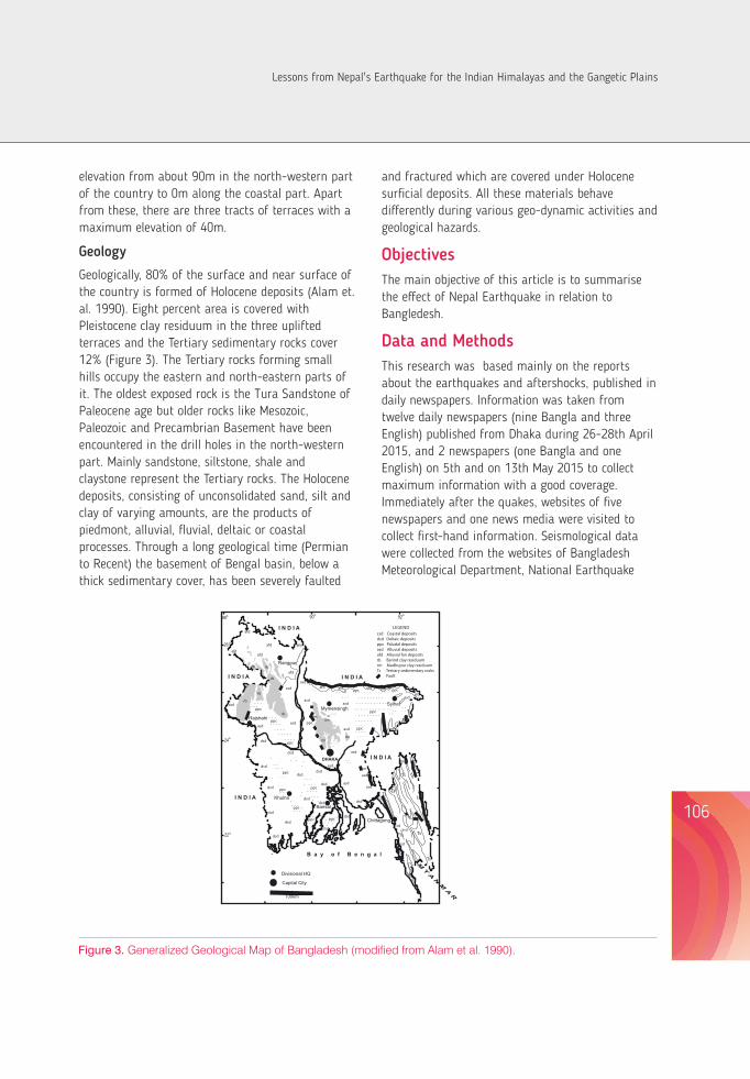
Figure 2. Accelerograms of the 25th April 2015 Nepal Earthquake recorded at Dhaka station (Courtesy: RME Ali, Geological Survey of Bangladesh, Dhaka).
Regional Tectonics and Geology of BangladeshBangladesh constitutes a major part of the Bengal Basin, which is part of the Indian Plate that is gradually closing to the Eurasian plate along the Himalayan arc to the north at a rate of approximately 45mm/year. The Indian Shield on the west is bordered by the Bengal Basin, located north of the Bengal Deep-Sea Fan, and on the north by the Shillong Massif, a large elevated area of Pre-Cambrian basement rocks with Mesozoic and Tertiary sedimentary rocks. The Dauki Fault Zone forms a major east-west tectonic boundary and appears to be active, and separates the Shillong Massif from the subsided Surma Basin of the basin. The eastern margin of the Bengal Basin is bounded by Indo-Burma Folded Belt where an atypical continent-continent subduction is going on (Kayal 2010).
Tectonic divisions
Tectonically, the country can broadly be classified into three --(i) The PreCambrian Rangpur Platform
(Stable Shelf): Stable Shelf has three parts - a) Himalayan Fore-deep, b) Rangpur Saddle and c) Bogra Shelf; (ii) The Bengal Foredeep: Bengal Fore-deep can further be subdivided into - a) Sylhet Trough, b) Faridpur Trough, c) Barisal Gravity High and d) Hatia Trough. The Stable Shelf is separated from the Bengal Foredeep by a 25-km wide and SSW-NNE trending Hinge zone; and (iii) The Folded Flank (Sylhet-Tripura-Chittagong Folded Belt): There are two systems of folding in this belt, one strikes in the NNW-SSE direction and the other strikes in the East-West direction.
Geomorphology
Geomorphologically, a major part of the country is occupied by one of the largest deltas of the world formed by the Ganges-Brahmaputra-Meghna river system originating from the uplift of the Himalayas. The delta building process is still continuing into the present Bay of Bengal and broad fluvial front of the major system gradually follows it from behind. Half of the country is lower than elevation of 12.5m above sea level. The elevation of hilly areas lies between 70 and 1,000m. The alluvial plains have an
elevation from about 90m in the north-western part of the country to 0m along the coastal part. Apart from these, there are three tracts of terraces with a maximum elevation of 40m.
Geology
Geologically, 80% of the surface and near surface of the country is formed of Holocene deposits (Alam et. al. 1990). Eight percent area is covered with Pleistocene clay residuum in the three uplifted terraces and the Tertiary sedimentary rocks cover 12% (Figure 3). The Tertiary rocks forming small hills occupy the eastern and north-eastern parts of it. The oldest exposed rock is the Tura Sandstone of Paleocene age but older rocks like Mesozoic, Paleozoic and Precambrian Basement have been encountered in the drill holes in the north-western part. Mainly sandstone, siltstone, shale and claystone represent the Tertiary rocks. The Holocene deposits, consisting of unconsolidated sand, silt and clay of varying amounts, are the products of piedmont, alluvial, fluvial, deltaic or coastal processes. Through a long geological time (Permian to Recent) the basement of Bengal basin, below a thick sedimentary cover, has been severely faulted
and fractured which are covered under Holocene surficial deposits. All these materials behave differently during various geo-dynamic activities and geological hazards.
ObjectivesThe main objective of this article is to summarise the effect of Nepal Earthquake in relation to Bangledesh.
Data and MethodsThis research was based mainly on the reports about the earthquakes and aftershocks, published in daily newspapers. Information was taken from twelve daily newspapers (nine Bangla and three English) published from Dhaka during 26-28th April 2015, and 2 newspapers (one Bangla and one English) on 5th and on 13th May 2015 to collect maximum information with a good coverage. Immediately after the quakes, websites of five newspapers and one news media were visited to collect first-hand information. Seismological data were collected from the websites of Bangladesh Meteorological Department, National Earthquake
Figure 3. Generalized Geological Map of Bangladesh (modified from Alam et al. 1990).
105 106
BANGLADESH'S EXPERIENCE OF THE NEPAL EARTHQUAKE: A STORY OF THE IMPACT ON A SEEMINGLY UNCONNECTED REGION
3.645 sec3.645 sec
0.0065020.006502
7.430 sec
7.430 sec
0.007917
0.007917
10.010 sec
10.010 sec
0.002220
0.002220
csd Coastal depositsdsd Deltaic depositsppc Paludal depositsasd Alluvial depositsafd Alluvial fan depositsrb Barind clay residuumrm Madhupur clay residuumTs Tertiary sedimentary rocks Fault
csd
csd
csd
dsd
dsd
dsddsd
dsd
dsd
dsd
dsddsd
dsd
dsd
dsd
dsd
dsd
dsd
ppc ppc
ppc
ppc
ppc
ppc
ppc
ppc
ppc
ppc
ppcppc
ppc
ppc
asd
asd
asdasd
asd
asd
asd
asd
asd
asd
asd
asd
asd
asdasd
asd
afd
afd
afd afd afd
afd
afdafd
afd afd
afd
rb
rb
rb
rb
rb
rb
rm
rm
rm
rm
rm
Ts
Ts
Ts
Ts
Ts
Ts
Ts
Ts
TsTs
Ts
Ts
Ts
LEGEND
- - -- - -- - -
- - -- - -
- - -
- - -
- - -
- - - - - - - -
- - - - -
- - - - - - - - -- - - - - - - - - - -
- - - - - - - - - - - - -- - - - - - - -
- - - - - -
- - - - - - - - - - - - - -
- - - -
- - - -
- - - - - - - -
- - -
- - -
- -
- -
- - -
- - -
- - -- - -
- - -
- - -
- - - -
- - -
- - -- -
-
-
-
--
- --
- --
- -- -
- -- - -- --
--
-
--
-
- -
- - - -- -- -
- -- -
Rangpur
Rajshahi
MymensinghSylhet
DHAKA
Khulna
Barisal
Chittagong
B a y o f B e n g a l
I N D I A
I N D I AI N D I A
I N D I A
I N D I A
M Y A N M
A R
Divisional HQ
Capital City
88 90 92
26
24
22
o
o
o
o
o o
100km
Lessons from Nepal's Earthquake for the Indian Himalayas and the Gangetic Plains
Information Center of US Geological Survey, India Meteorological Department and National Seismological Centre-Nepal. These sites were visited several times to get latest information. To collect data on tilted buildings, site visits in limited extent were made in Dhaka city. Interviews of local residents were taken to know their feelings and observations about the quake(s) and its impact. In order to get a suitable coverage, the interviewees were considered from different parts of the country. Reports of local administration on earthquakes available from 6 districts were reviewed for district level data and information. Website of Disaster Management Information Centre (DMIC) of the Ministry of Disaster Management and Relief was browsed for the situation report. At the end, all the data analysed, and information was compiled and and findings, interpretation and explanation have been presented.
Result and DiscussionNewspapers published district-wise earthquake reports. It may be mentioned here that all administrative activities in the country are operated through 8 divisions and 64 districts under these divisions. For the present study, all the collected data and information were compiled district-wise. For geological interpretation, the compilation was then arranged according to the indicators given in Modified Mercalli Intensity (MMI) Scale 1931 (Reiter 1990) which was later compared with the geological map of Bangladesh to explain the relationship between the indicators and local geology. Findings from the study and qualitative analysis are discussed below.
Intensity map
Analytical results show that almost the entire country experienced earthquake tremors except a few south and south-eastern districts. An intensity map was prepared following MMI Scale 1931 (Figure 4) on the basis of the feelings of the people, their rushing out of buildings due to panic, shaking of buildings, movement of hanging objects, development of cracks in buildings, falling of plaster, tilting and subsidence of buildings and
generation of waves in water bodies. Maximum intensity was found to be VI in Bangladesh assigned on the basis of generation of waves in water bodies. Generations of waves on water were reported from Dinajpur (interview), Rangpur (interview), Nilphamari and Gaibandha, Natore, Kushtia, Jessore districts (Naya Diganta 2015), Dhaka city (The Daily Star 2015) and Savar near Dhaka (interview). The waves generated in Dhaka and Savar were reported to be large. Although generation of waves in waterfalls at level VII of MMI Scale occured, we kept the evidence of generation of waves in Dhaka or Savar in level VI because no other evidence of level VII was noticed here.
An attempt has been made here to give a geoscientific explanation on the relationship between shaking effect and local geology. Most severe tremors in the country were felt in the north-western part. This part is close to the epicentral region and geologically occupied by Tista fan, Barind Tract and floodplains. The tremors were least felt in the Old Ganges Delta in the south-western part and in Meghna estuarine part. Other than NW part, relatively higher tremors were felt in Dhaka which lies on the Madhupur tract and in areas covered with relatively older sediments. Besides these, tremors were felt in the rest of the country. However, very little or no information of tremors was reported from the eastern part and eastern hilly areas of the country which could have happened due to longer distance from the epicentral region. Barind and Madhupur tracts are uplifted terraces covered with Pleistocene oxidized soil (Figure 3); Tista fan is composed mainly of sand, where sand is slightly oxidized in the western part of the fan; deltaic part is composed of sandy and clayey silt, and organic rich silt and clay in the mangrove swamp; estuarine deposits are composed of silty clay and clayey silt; floodplain sediments consist of coarse sand, fine silty sand and fine sandy to clayey silt; whereas paludal deposits are composed of clay, peat and silt (Alam et al. 1990).
Casualties
Thirteen persons died (Prothom Alo 2015ab&d, The Daily Star 2015ab&e, Samakal 2015a&b, Dainik
Janakantha 2015a, Daily Ittefaq 2015a&b, Amader Somoy 2015a, NewAge 2015a&b, DMIC 2015a), including one child and four women, because of the earthquake and aftershocks. Among them the child died of head injury (Thakurgaon), one died of boat sinking (Sunamganj), two died of wall (Bogra) and soil collapses (Rangpur) and others died of heart attack due to panic (Pabna, Tangail, Sherpur, Laxmipur, Kurigram, Gaibandha, Kishoreganj and Panchgarh).
Panic among people
All the newspapers published reports of fear, rushing out, injury, and unconsciousness from all over the country. The earthquake caused panic, particularly among the school students and factory workers. Many of them were injured while rushing
out. Among students, primary school students had greater incidents of panic. Reports of rushing out by factory workers came from Dhaka, Savar (Dhaka), Gazipur, Narayanganj, Manikganj, Mymensingh, Comilla, Ishwardi (Pabna) and Nilphamari (Dainik Janakantha 2015a, Samakal 2015a, Prothom Alo 2015a, Amader Somoy 2015b, Daily Ittefaq 2015a, DMIC 2015a). In some areas in the north-western part of the country, namely in Dinajpur (interview, The Daily Star 2015c), Nilphamari and Panchgarh (Dainik Janakantha 2015c), people remained out of their homes even during the nights and spent sleepless nights taking shelter in open spaces because of the fear of probable quakes. This panic situation lasted for several days, as there was a fear of aftershocks after this large earthquake.
Figure 4. Intensity Map of Bangladesh of 25 April 2015 Nepal Earthquake
Injury
Reports of injuries came from Panchgarh, Thakurgaon, Nilphamari, Kurigram, Rangpur and Gaibandha districts (Daily Ittefaq 2015a, Amader Somoy, 2015b, Daily Janakantha 2015a, Samakal 2015a&b); Naogaon, Rajshahi, Bogra, Pabna and Sirajganj districts (Naya Digonta 2015, Daily
Janakantha 2015a, Amader Somoy 2015a&b, Samakal 2015a, Prothom Alo 2015a, The Daily Star 2015e, Dainik Janakantha 2015a, Daily Ittefaq, 2015a); Kushtia, Magura and Jhenidah districts (Samakal 2015a, Prothom Alo 2015a, Amader Somoy 2015b); Jamalpur, Sherpur, Mymensingh districts (Prothom Alo 2015a, (Samakal 2015a,
107 108
BANGLADESH'S EXPERIENCE OF THE NEPAL EARTHQUAKE: A STORY OF THE IMPACT ON A SEEMINGLY UNCONNECTED REGION
VI
VI
V-VI
III-IV
III-IV
III-IV
III-IVIV-V
IV-V
I-II
I-II
I-II
Panchgarh
Thakurgaon
Dinajpur
NilphamariLalmonirhat
RangpurKurigram
Gaibandha
Jaypurhat
Naogaon Bogra
Rajshahi
Nababganj
Natore
Jamalpur
Sherpur
Mymensingh
Netrakona
KishoreganjTangailSirajganj
Pabna
Sunamganj Sylhet
Habiganj
Moulvibazar
Brahmanbaria
Comilla
Manikganj
Gazipur
Narshingdi
DHAKA Narayanganj
KushtiaMeherpur
Chuadanga
Jhenidah Magura
Jessore
Faridpur
Gopalganj
Rajbari
Madaripur
Shariatpur
Munshiganj
Narail
KhulnaBagerhat
Satkhira Barisal
PatuakhaliBarguna
BholaPirojpur
Chandpur
LaxmipurFeni
Noakhali
Chittagong
Bandarban
Rangamati
Khagrachari
Cox’s Bazar
B a y o f B e n g a l
I N D I A
I N D I AI N D I A
I N D I A
I N D I A
M Y A N M
A R
District HQ
Divisional HQ
Capital City
88 90 92
26
24
22
o
o
o
o
o o
100km
Lessons from Nepal's Earthquake for the Indian Himalayas and the Gangetic Plains
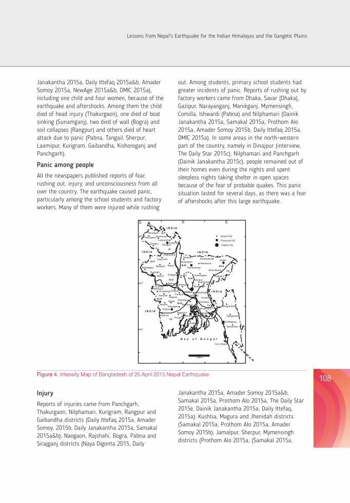
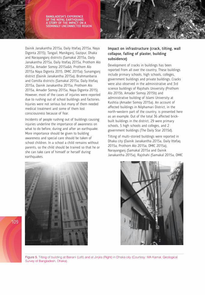
Dainik Janakantha 2015a, Daily Ittefaq 2015a, Naya Digonta 2015); Tangail, Manikganj, Gazipur, Dhaka and Narayanganj districts (Samakal 2015a, Daily Janakantha 2015a, Daily Ittefaq 2015a, Prothom Alo 2015a, Amader Somoy 2015a&b, Prothom Alo 2015a Naya Digonta 2015, DMIC 2015a); Sunamganj district (Dainik Janakantha 2015a); Brahmanbaria and Comilla districts (Samakal 2015a, Daily Ittefaq 2015a, Dainik Janakantha 2015a, Prothom Alo 2015a, Amader Somoy 2015a, Naya Digonta 2015). However, most of the cases of injuries were reported due to rushing out of school buildings and factories. Injuries were not serious but many of them needed medical treatment and some of them lost consciousness because of fear.
Incidents of people rushing out of buildings causing injuries underline the importance of awareness on what to do before, during and after an earthquake. More importance should be given to building awareness and special care should be taken of school children. In a school a child remains without parents, so the child should be trained so that he or she can take care of himself or herself during earthquakes.
Impact on infrastructure (crack, tilting, wall collapse, falling of plaster, building subsidence)
Development of cracks in buildings has been reported from all over the country. These buildings include primary schools, high schools, colleges, government buildings and private buildings. Cracks were also observed in the administrative and 3rd science buildings of Rajshahi University (Prothom Alo 2015b, Amader Somoy 2015b) and administrative building of Islami University at Kushtia (Amader Somoy 2015a). An account of affected buildings in Nilphamari District, in the north-western part of the country, is presented here as an example. Out of the total 36 affected brick-built buildings in the district, 29 were primary schools, 5 high schools and colleges, and 2 government buildings (The Daily Star 2015d).
Tilting of multi-storied buildings were reported in Dhaka city (Dainik Janakantha 2015a, Daily Ittefaq 2015a, Prothom Alo 2015a, DMIC 2015a), Narayanganj (Samakal 2015a and Dainik Janakantha 2015a), Rajshahi (Samakal 2015a, DMIC
Figure 5. Tilting of building at Banani (Left) and at Jinjira (Right) in Dhaka city (Courtesy: MA Kamal, Geological Survey of Bangladesh, Dhaka).
2015a), Naogaon (Dainik Janakatha 2015a), Natore (Amader Somoy 2015b, DMIC 2015c), Bogra (Amader Somoy 2015b) and Khulna (Daily Ittefaq 2015a and Amader Somoy 2015b). Figure 5 shows two tilted buildings of Dhaka city.
Occurrences of wall collapse in Panchgarh and Dupchachia, Sonatala and Nandigram of Bogra districts (Daily Ittefaq 2015a, Naya Digonta 2015, Samakal 2015a, Dainik Janakantha 2015a); soil collapse in dug wells in Rangpur district (Prothom Alo 2015b); fall of plater in Gaibandha, Tanor and Godagari of Rajshahi, Sirajganj and Kishoreganj districts (Daily Ittefaq 2015b, Amader Somoy 2015b); building subsidence in Khulna city, Manikganj, Bhaluka of Mymansingh districst and Basundhara in Dhaka city (Daily Ittefaq 2015a, Naya Digonta 2015, Amader Somoy 2015a, Dainik Janakantha 2015a) were reported.
Development of cracks, fall of plaster in buildings and tilting and subsidence of buildings could be due to faulty design, use of poor quality construction material, old age, or weak foundation of the buildings. A the nature detailed survey to identifyand degree of cracks in the buildings and to determine the cause of tilting should be carried out throughout the country. This survey will help to identify problems and to take remedial measures for safety. The country is mostly covered with thick unconsolidated Holocene sediments having shallow water table, which is favourable for liquefaction during earthquake shaking causing damages to buildings and foundations.
Impact on natural bodies
Generation of waves was reported in pond water and other water bodies in Dinajpur (interview), Nilphamari, Gaibandha, Natore, Kushtia, Jessore (Naya Digonta 2015), Bhaluka of Mymensingh (interview). Wave generation was also reported in the water of Dhanmondi lake in Dhaka city and water tank in Savar of Dhaka (The Daily Star 2015a and interview); and water of Surma river in Doarabazar of Sunamganj (NewAge 2015b); the latter resulted in a boat-capsize causing one death. Shaking of trees was noticed in Nilphamari (Naya Digonta 2015).
Other impacts
Some incidents after the earthquake, such as temporary disruption of mobile phone network in Dhaka (interview), explosion of electric transformer that affected feeder transmission lines, and road accident in Dinajpur (Naya Diganta 2015), and interruption of services at hospitals in Dhaka (Amader Somoy 2015b) and Rangpur (Daily Ittefaq 2015a), that caused fear among the general pubic, were reported. In Rajshahi University campus, swinging cables generated sparking in the power distribution line (interview). In another incident, the continuous movement of machines and swinging of ceiling fans in a garment factory at Savar in Dhaka that produced deep noise and chaos during the earthquake caused fear among the workers (Dainik Janakantha 2015a). However, Naya Diganta (2015) reported, quoting the Managing Director, that in Barapukuria Coal Mine of Dinajpur one of the two did not situation have any damage; a panickhappened also at the airport but that did not hinder normal operations (Dainik Janakantha 2015a).
Emergency response
Although there was no severe damage from the earthquake, the government responded immediately to initiate emergency assessment activities to ascertain the extent of the impact of the earthquake and to provide awareness messages on dos and don'ts in the print and electronic media (DMIC 2015a&b). Emergency responses, specially rescue and relief, were carried out by different departments, namely hospitals, fire service, public works and local administration (Samakal 2015a, Naya Digonta 2015, The Daily Star 2015c, Prothom Alo 2015a, Daily Janakantha 2015a, Amader Somoy 2015a). To reduce fear and assure safety, a number of private factories and schools in different parts of the country were temporarily closed (Amader Somoy 2015b, Naya Diganta 2015).
ConclusionsAlmost entire Bangladesh experienced shaking from the 25th April 2015 Nepal earthquake and many aftershocks. The maximum intensity was estimated
109 110
BANGLADESH'S EXPERIENCE OF THE NEPAL EARTHQUAKE: A STORY OF THE IMPACT ON A SEEMINGLY UNCONNECTED REGION
Lessons from Nepal's Earthquake for the Indian Himalayas and the Gangetic Plains
to be VI of the main earthquake. Thirteen human lives were lost in different parts of the country from injury, wall and soil collapse, boat sinking, and sudden heart failure. Tilting of multi-storied buildings and development of cracks in many public and private buildings were reported. There was wide-spread fear resulting from the earthquake among the general population throughout the country. This situation lasted a couple of days, especially in the north-western part of the country, because of frequent aftershocks.
It is expected that Bangladesh will experience earthquakes in future, like this and others in the past, because of the country's tectonic and geologic characteristics, which will have an impact on the country's human population and natural systems. The Nepal earthquake of 2015 gave us an alarm for better preparedness for earthquake risk reduction. We must pay attention to the following from the geoscientific point of view.
For improved knowledge on earthquake geology and better understanding of seismotectonic behaviour of this region, geological studies including seismological, paleoseismological, tectonic geomorphology, neotectonics should be continued. This will provide most needed information for taking steps for earthquake risk assessment and reduction in the country. Earthquakes, also including the low magnitude ones (<6), should be studied to know their impact on environment and its habitants. We have observed the evidence of changes in geomorphology and hydrological regime in Bangladesh, because of seismic events. These changes obviously have an impact on environment and the livelihood of the local population. Research should be carried on how and to what extent these changes affect the environment, and it could also be evaluated in the context of climate change.
As morphotectonic elements and earthquakes know no political boundary, it is necessary to strengthen the collaboration among the neighbouring countries on earthquake issues. The first author gave such a proposal after the Sikkim earthquake of 2011 at a seismological workshop organized by UNESCO in 2013. Considering the importance of cross-boundary
collaboration in research, learning and preparedness, appropriate steps should be taken. Sharing of knowledge should not only be limited within scientific communities but the lessons of the Nepalese people should also be shared.
Till now, no warning system for earthquakes has been developed. Preparedness is the only way to save life and property from the earthquake hazard. The impact from the current earthquake and the country's experience towards it emphasized that we urgently need intensive awareness -building activities among the citizens of the country. Existing awareness- building activities should be strengthened, focusing on what to do before, during and after an earthquake. Media can play an important role in the awareness- building process. Special attention should be given to students, teachers and members of management committees of schools to chaos reduce the students' fear and during an earthquake. Gupta (2015) emphasized regular earthquake drills that can help in reducing loss.
Bangladesh has observed rapid urban expansion with the increase of population and economic development over the last few decades, almost disregarding the country's geological condition and building code. There is a need of a national building code and its strict enforcement for safe andearthquake -resilient urbanisation.
ReferencesAhsan A, Kali E, Coudurier-Curveur A, Woerd J van der, Tapponnier P, Alam AKMK, Sorvigenaleon I, Banerjee P &
Catherine D. 2015. Active faulting in Raghunandan Anticline, NE Bengal basin, implications for future earthquake hazards (Abs). American Geophysical Union (AGU). Fall Meeting USA (accepted).
Alam AKMK. 2003. Neotectonics of the Ganges-Brahmaputra Delta, Bangladesh. Proceedings of 4th South Asia Geological Congress (GEOSAS-IV). New Delhi (India): 175-181.
Alam AKMK & Rahman M. 2004. Implication of Seismicity on the Landforms of the Northern Bangladesh (Abs). Workshop Report on the Fourth International Workshop on Seismic Analysis in the South Asia Region. United Nations Educational, Scientific and Cultural Organization (UNESCO). Paris (France): 51-52.
Alam AKMK & Islam MB. 2004. Response of the Someswari River (Bangladesh) to Neotectonics. Bangladesh Geoscience Journal, 10: 27-37. ISSN 1028-6845.
Alam AKMK. 2006. Detection of Neotectonics Signature Using Remote Sensing Techniques in the North Central Part of Bangladesh, University of Rajshahi (Unpublished PhD Thesis).
Alam AKMK. 2014a. Sikkim Earthquake 2011: Bangladesh Experience, In: Montomoli C. et al. (eds): Proceedings for the 29th Himalaya-Karakoram-Tibet Workshop, Lucca (Italy).
Alam AKMK. 2014b. Holocene Tectonics of the Bengal Delta, Bangladesh: Important in Development Planning (extended abstract), Pre-Conference Volume ISBN 978-81-920724-4-9, Convention of Indian Geological Congress and International Conference. (India): 56-58.
Alam AKMK, Tapponnier P, Banerjee P, Woerd J van der, Kali E, Ahsan A & Coudurier-Curveur A. 2014. Active Deformation and Seismicity of the NE Part of Bangladesh. Souvenir. 1st Bangladesh Earthquake Exhibition 2014, Dhaka (Bangladesh): 12-15.
Alam MK, Hassan AKMS, Khan MR & Whitney JW. 1990. Geological Map of Bangladesh. Geological Survey of Bangladesh, Dhaka. Scale 1: 1 000 000.
Anon. 1939. The Bihar-Nepal Earthquake of 1934. Memoirs of the Geological Survey of India, 73.
Coates DA & Alam AKMK. 1990. The Mymensingh Terrace: Evidence of Holocene Deformation in the Delta of the Brahmaputra River, Central Bangladesh. Geological Society of America Abstracts with Programs, USA, 22 (1): 310.
Gee ER. 1934. The Dhubri Earthquake of the 3rd July, 1930. Memoirs of the Geological Survey of India, 65(1).
Goodbred SL Jr & Kuehl SA. 2000. The significance of large sediment supply, active tectonism and eustasy on margin sequence development: Late Quaternary stratigraphy and evolution of the Ganges-Brahmaputra Delta. Sedimentary Geology, Elsevier science BV, 133: 227-248.
Hossain KM. 1989. Seismicity and Tectonics of Bangladesh. International Centre of Theoretical Physics, Trieste (Italy). Internal Report.
IISc Team. 2015. Learning from the April 25, 2015, Nepal earthquake. Ministry of Earth Sciences and the Indian Institute of Science, Bangalore (India).
Iyengar RN, Sharma D & Siddiqui JM. 1999. Earthquake history of India in medieval times, Indian Journal Hist. Science. 34: 181 – 237.
Kayal JR. 2010. Seismotectonics of Northeast India and Bangladesh Region: An appraisal, In R Ahsan, MS Islam, A Shahriar, MA Noor & TM Al-Hussaini (eds): Proceedings of the 3rd International Earthquake Symposium, Dhaka (Bangladesh): 13-18.
Khan AA. 2005. Paleoseismicity, Characterization of Active Faults and Fault Rupture Recurrences in Bangladesh, In TM Al-Hussaini, MJ Alam, MA Ansary, & AA Khan (eds): Proceedings of the 1st Bangladesh Earthquake Symposium, Dhaka (Bangladesh): 63-70.
Middlemiss CS. 1885. Report on the Bengal Earthquake of July 14th 1885. Records of the Geological Survey of India, XVIII: 200-221.
111 112
BANGLADESH'S EXPERIENCE OF THE NEPAL EARTHQUAKE: A STORY OF THE IMPACT ON A SEEMINGLY UNCONNECTED REGION
Lessons from Nepal's Earthquake for the Indian Himalayas and the Gangetic Plains
Morgan JP & McIntire WG. 1959. Quaternary Geology of the Bengal Basin, East Pakistan and India. Geological Society of America Bulletin, 70: 319-342.
Morino M, Kamal ASMM, Ali RME, Talukder A & Khan MH. 2013. Report of active fault mapping in Bangladesh : Paleo-seismological study of the Dauki fault and the Indian-Burman plate boundary fault; Comprehensive Disaster Management Program, Ministry of Disaster Management and Relief.
Morino M, Kamal ASMM, Akhter SH, Rahman MZ, Ali RME, Talukder A, Khan MMH, Matsuo J & Kaneko F. 2014. A paleo-seismological study of the Dauki fault at Jaong, Sylhet, Bangladesh: Historical seismic events and an attempted rupture segmentation model, Journal of Asian Earth Sciences, 91: 218–226.
Oldham T. 1882. The Cachar Earthquake of 10th January 1869; Memoirs of the Geological Survey of India, 19(1).
Oldham RD. 1899. Report on the Great Earthquake of 12th June, 1897; Memoirs of the Geological Survey of India, 29.
Panizza M. 1981. Geomorphology and earthquake hazard in environmental planning, In G Plamentola & P Acquafredda (eds): Proceedings of the International Conference on Seismic Zones in the Mediterranean Area, Basilicata (Italy): 203-207.
Sarker MH, Akter J, Ferdous MR & Noor F. 2011. Sediment dispersal processes and management in coping with climate change in the Meghna Estuary, Bangladesh. Proceedings ICCE Workshop, IAHS Publ. 349.
Sarker MH, Akter, J & Rahman MM. 2013. Century-Scale Dynamics of the Bengal Delta and Future Development, 4th International Conference on Water & Flood Management (ICWFM-2013): 91-104.
Steckler MS, Akhter SH, & Seeber L. 2008. Collision of the Ganges–Brahmaputra Delta with the Burma Arc: implications for earthquake hazard. Earth Planetary Science Letter, 273: 367–378.
Stuart M. 1920. The Srimangol Earthquake of 8th July, 1918; Memoirs of the Geological Survey of India, 46(1).
Gupta HK. 2015. The Mw 7.8 April 2015 Nepal Earthquake, Journal of Geological Society of India, 85(6): 641-646.
Reiter L. 1990. Earthquake Hazard Analysis, Columbia University Press, New York.
Amader Somoy 2015a. Earthquake trembles the country. 26 April 2015.
Amader Somoy 2015b. Earthquake Again. 27 April 2015.
Amader Somoy 2015c. Quakes Trouble Hospital Patients. 27 April 2015.
Amader Somoy 2015d. Quake Shakes the country third day. 28 April 2015.
The Bangladesh Today. 2015. Powerful earthquake kills hundreds in Nepal 7.5 magnitude shakes Bangladesh. 26 April 2015.
Bhorer Kagoj 2015. Quake again in capital: People in Panic. 27 April 2015.
Daily Ittefaq 2015a. Earthquake shock entire country. 26 April 2015.
Daily Ittefaq 2015b. Earthquake shaking in whole country again. 27 April 2015.
Daily Janakantha 2015a. Earthquake jolted whole country including capital. 26 April 2015.
Daily Janakantha 2015b. Earthquake again--2 dead in Sherpur and Gaibandha. 27 April 2015.
Daily Janakantha 2015c. Earthquake again shock the country: origin in Darjeeling. 28 April 2015.
Daily Janakantha 2015d. Sleepless night in northern region quake panic. 28 April 2015.
Kaler Kantha 2015. Quake in the country again. 28 April 2015.
Naya Digonta 2015a. The country jolted: 3 dead. 26 April 2015.
NEW AGE, 2015a. Tremor jolts Bangladesh. 26 April 2015.
NEWAGE, 2015b. Fresh tremor jolts Bangladesh. NewAge, April 27 2015.
Prothom Alo 2015a. Whole country shock. 26 April 2015.
Prothom Alo 2015b. Quake Felt again in Bangladesh. 27 April 2015.
113
BANGLADESH'S EXPERIENCE OF THE NEPAL EARTHQUAKE: A STORY OF THE IMPACT ON A SEEMINGLY UNCONNECTED REGION
114
Prothom Alo 2015c. Dead raised 4000 in devastated Nepal. 28 April 2015.
Prothom Alo 2015d. Strong earthquake in Nepal again. 13 May 2015.
Samakal 2015a. Country shake suddenly., 26 April 2015.
Samakal 2015b. Country shake again. 27 April 2015.
The Daily Star, 2015a. Shocks spark panic. 26 April 2015.
The Daily Star, 2015b. Wake-up call. 27 April 2015.
The Daily Star, 2015c. Aftershocks continue. 28 April 2015
The Daily Star, 2015d. Earthquakes in Late April--34 schools among 36 bldgs in Nilphamari develop cracks. 5 May 2015.
The Daily Star 2015e. Nepal quake, aftershock jolt Bangladesh panicked woman dies in Panchgarh. 13 May 2015.
DMIC 2015ab&c, Situation Reports [Earthquakes], Ministry of Disaster Management and Relief, (http://www.cdmp.org.bd/ visited 25/4/2015, 26/4/2015, 27/4/2015 & later).
http://www.esamakal.net/(visited 25-04-2015).
http://bdnews24.com/(visited 25-04-2015).
http://www.jugantor.com/(visited 25-04-2015).
http://www.ittefaq.com.bd/ (visited 25-04-2015).
http://edailyjanakantha.com/ (visited 25-04-2015).
http://www.prothom-alo.com/(visited 25-04-2015).
http://earthquake.usgs.gov/earthquakes/eventpage/ (visited 25/4/2015, 26/4/2015, 30/4/2015 & later).
http://www.seismonepal.gov.np/ (last visited 08/07/2015).
http://www.imd.gov.in/section/seismo/dynamic/LMONTH.HTM (visited 26/4/2015 & later).
http://www.bmd.gov.bd/ (visited 25/04/2015 & later).
Lessons from Nepal's Earthquake for the Indian Himalayas and the Gangetic Plains
Organizing Team (CHEA):
Dr. Pankaj Tewari
Mr. Dhiraj Joshi
Mr. Narendra Singh Bisht
Mr. Pratap Singh Nagarkoti
Mr. Kundan Bisht
Mr. Surendra Singh Bhandari
Ms. Swati Bisht
Mr. Mohan Bhatt
Ms. Clementine Makower
Mr. Robert Buck
Workshop Team
Workshop Convenors:Prof. S.P. Singh, Chair, CHEA & Formerly, Vice Chancellor, H.N.B. Garhwal University
Dr. P.P. Dhyani, Director, GBPIHED, Government of India, Kosi-Katarmal, Almora
Organizing Committee:Dr. Bhishma P. Subedi, Executive Director, ANSAB, Kathmandu, Nepal
Prof. S. C. Garkoti, School of Environmental Sciences, Jawaharlal Nehru University, New Delhi
Dr. Subrat Sharma, Scientist, GBPIHED, Kosi-Katarmal, Almora
Dr. Ashish Tewari, Department of Forestry and Env. Sc., Kumaun University
Organizing Secretary:Late Dr. Pushkin Phartiyal, Executive Director, CHEA

LESSONS FROM NEPAL'S EARTHQUAKE FOR THE INDIAN HIMALAYAS AND THE GANGETIC PLAINSEdited by: Prof. S.P. Singh, Mr. Sudarshan C. Khanal, Prof. Madhu Joshi
XPR
ESSI
ON
S: 9
2195
5256
3
Doc
. No.
XPS
0605
1661
3
Supported by Tata Trusts
Knowledge Partner
G. B. Pant Institute of Himalayan Environment and Development, Almora
CENTRAL HIMALAYAN ENVIRONMENT ASSOCIATION
06, Waldorf Compound, Mallital, Nainital, 263001 Uttarakhand, India
t. 91 - 05942 233099t./f. 91 – 05942 233099e. [email protected] [email protected]
ALHIMAL
AYAN
ENVIRONMENT ASSOCIATIO
N
TCE
N
Related Documents


![Nepal's Telecom User reaches 84.77% [infographics]](https://static.cupdf.com/doc/110x72/540317658d7f72d64a8b4892/nepals-telecom-user-reaches-8477-infographics.jpg)