Corangamite Catchment Management Authority Final Report Leigh River sediment sourcing and transport Job 6003051

Welcome message from author
This document is posted to help you gain knowledge. Please leave a comment to let me know what you think about it! Share it to your friends and learn new things together.
Transcript
Corangamite Catchment Management Authority
Final Report
Leigh River sediment sourcing and transport Job 6003051

Corangamite Catchment Management Authority – Leigh River sedimentation
Leigh River report V5.doc ii
Corangamite Catchment Management Authority
Leigh River sediment sourcing and transport Job 6003051
Document History:
ISSUE DATE
REV. NO.
AUTHOR CHECKED APPROVED COMMENTS
13/10/03 Rob Ferguson
Ross Hardie draft - sent to client for review by Matt Bowler and Greg Peters
26/2/04 V3 Rob Ferguson
Ross Hardie Draft Final Report
2/3/04 V4 Rob Ferguson
Ross Hardie Ross Hardie Final Report
March 2004
APPROVED CHECKED
DATE DATE

Corangamite Catchment Management Authority – Leigh River sedimentation
Leigh River report V5.doc iii
Executive Summary Introduction This report has been prepared by Earth Tech Engineering (Earth Tech) for the Corangamite Catchment Management Authority (CCMA) to investigate the sources of sediment in the Leigh Catchment and sediment transport and deposition within the Leigh River.
The Leigh River is a major catchment of the Barwon River. The lower Leigh River has been identified as having been subject to active sediment deposition. The sediment deposition can
o reduce channel capacity, increasing the rate of overbank flooding, and
o Reduce streambed diversity, reducing habitat suitability and availability for filamentous algae, macroinvertebrates and fish.
A key task of this investigation has been to identify the major sources of sediment upstream of the lower Leigh River, and assess a range of management options and to identify knowledge gaps which inhibit effective management.
Approach Investigations were initially focused on Woodbourne Creek, selected as a sub-catchment understood to be representative of sub-catchments on the sedimentary rocks of the Leigh River catchment. The initial investigations revealed that Woodbourne Creek is not a major source of sediment to the Leigh River. The primary effort for the remainder of this investigation has been to identify the major sediment sources to the Lower Leigh River from other areas of the Catchment.
The investigations comprised site inspections, literature review, discussion with local stakeholders and aerial photograph interpretation.
Findings
Key findings of this investigation have included the following:
• Woodbourne Creek is not a major source of sediment and is not supplying large volumes of sand to the Leigh River
• The main source of sediment in the catchment at the present day is bank erosion along the main channel between south Ballarat and Napoleons. These sediments are mainly sand and silt.
• The material derived from this bank erosion is being carried downstream through the mid-catchment gorge to the channel in the Shelford - Inverleigh area. The period of residence of sediment, and rate of sediment movement, within the gorge is not well understood.
• A secondary sediment source is the intact valley fills located on tributary streamlines in the north western parts of the catchment. Knickpoints are starting to retreat into these extensive stores of readily eroded sediment. Identifying, then protecting the fills that are still unincised is a second priority for sediment management within the Leigh River catchment.
Corangamite Catchment Management Authority – Leigh River sedimentation
Leigh River report V5.doc iv
Recommendations
A range of investigations and activities are recommended to form the basis for sediment management in the Leigh River Catchment. Recommended investigations and actions include the following:
Ballarat to Napoleons Bank Erosion - Partly Confined Reach
The main channel in this area is currently the major source of sediment to the Leigh River. This should be the highest priority for management. The cause of the bank erosion is not clear. Two actions are recommended:
• It is recommended that a major streamside riparian planting and management program be developed and initiated through this reach. Regardless of the cause of the erosion, the solution to the problem will include revegetation.
• Further it is recommended that the cause of the erosion be investigated to guide the sediment management program through this reach. Outcomes from this investigation would include specific strategies to assist sediment control, such as revegetation, rock rip rap, and pile field based streambank erosion control.
Cut and Fill
The cut and fill reaches are subcatchments located to the north west of the Leigh River Catchment. These subcatchments are secondary sources of sediment. Highest priority within these sub catchments will be
• Protection of intact systems
• Control of active gullying where sediment has direct access to the Leigh River.
The implementation of a stream categorisation project for the catchment would assist in the identification of these high priority subcatchments.
Gorge Reach
The gorge reach transports sediment to the Lower Leigh River. Some sediment is stored in this reach. It is not clear how much and how long sediment is temporally stored in the reach. The volume of sediment held in storage within the gorge will impact on the rate of recovery of the Lower Leigh River.
A detailed analysis of sediment stores and annual transport rates in this reach would assist management of the lower Leigh River.
Lower Leigh - Deposition Reach
This reach is subject to active deposition. Upstream sediment control, particularly in the partly confined reach, will result in a reduction in the volume of material delivered to this reach. However it is not clear how long it will take for the cut in sediment supply to be reflected in changes in this reach. Ongoing sediment stores within the Gorge reach may continue to supply sediment to the Lower Leigh River.
It is recommended that:
• Upstream sediment sources be controlled (refer above)

Corangamite Catchment Management Authority – Leigh River sedimentation
Leigh River report V5.doc v
• An assessment of sediment stores and transport rates within the gorge be undertaken (refer above)
• Sediment deposition and bed form be monitored in the lower Leigh River
• Large Woody Debris be installed to increase bed diversity in the lower Leigh River
• Sediment extractions be undertaken if sediment stores in the gorge are high and ongoing sedimentation in the Lower Leigh is likely to continue into the medium term despite the control of upstream sediment supply.

Corangamite Catchment Management Authority – Leigh River sedimentation
Leigh River report V5.doc vi
Corangamite Catchment Management Authority Leigh River sediment sourcing and transport Final Report
Job 6003051
Contents Executive Summary.................................................................................................iii Glossary ................................................................................................................................. viii Acknowledgements ................................................................................................................ viii 1.0 Introduction ................................................................................................1 1.1 Leigh Catchment ...................................................................................................... 1 2.1 History ...................................................................................................................... 2 2.2 Geology .................................................................................................................... 2 2.3 Physiography............................................................................................................ 2 2.3 Geomorphic Assessment ......................................................................................... 4 2.3 Geomorphic Assessment ......................................................................................... 4 2.4 Human impact .......................................................................................................... 4 3.0 Reach Characteristics................................................................................6 3.1 Headwaters .............................................................................................................. 6 3.2 Cut and fill................................................................................................................. 6 3.3 Partly confined.......................................................................................................... 7 3.4 Gorge...................................................................................................................... 11 4.0 Woodbourne Catchment..........................................................................15 5.0 Summary of sediment transport in the Leigh River catchment...........18 5.1 Pre-European impact.............................................................................................. 18 5.2 c.1870..................................................................................................................... 18 5.3 Present day ............................................................................................................ 18 5.4 Summary ................................................................................................................ 22 6.0 Reach summaries and management recommendations ......................23 6.1 Upstream of Ballarat- Headwater reaches ............................................................. 23 6.2 Sebastopol to Woodland Village - Cut and fill reaches .......................................... 23 6.3 South Ballarat to Napoleon- Partly confined reaches ............................................ 23 6.4 Napoleon to Willangi - Gorge (sediment transport) reach...................................... 24 6.5 Willangi to Barwon River - Alluvial continuous (sediment deposition) reach ......... 25 6.6 Woodbourne Creek ................................................................................................ 26 6.7 Summary of knowledge gaps ................................................................................. 26 7.0 References ................................................................................................28

Corangamite Catchment Management Authority – Leigh River sedimentation
Leigh River report V5.doc vii
List of Figures Figure 1 Geomorphic divisions on the Ballarat 1:100,000 map sheet. ..................................... 3 Figure 2 Headcut at 0751958 5822987, looking up the valley onto the intact fill surface......... 7 Figure 3 Topographic map of the partly confined valley river type, along Yarrowee River in
the Cambrian Hill area........................................................................................................ 8 Figure 4 Looking downstream on the main channel from the one land road bridge at the very
southern end of the Ballarat urban area ............................................................................ 8 Figure 5 Map show the distribution of bank erosion and river type classification in the upper
Leigh River. ........................................................................................................................ 10 Figure 6 Large woody debris dam formed around a mid-channel willow, and associated
bank erosion, in the main channel at Glassons Road........................................................ 11 Figure 7 Topographic map of the Leigh River gorge, in the area south of the Grand Junction
Bridge ................................................................................................................................ 12 Figure 8 On the left, the gorge in Leigh River from 761772 5796393. .................................... 12 Figure 9 Topographic map of the Leigh Valley immediately downstream of Shelford. ............ 13 Figure 10 Looking upstream along the Leigh River . ................................................................ 14 Figure 11 Aerial photograph of Woodbourne Catchment. ...................................................... 16 Figure 12 Woodbourne Creek east of Bamgamie Road .......................................................... 17 Figure 13 The confluence of Woodbourne Creek and Leigh River .......................................... 17 Figure 14 Schematic summary of processes in the Leigh River catchment before the arrival
of European in c.1830. ...................................................................................................... 19 Figure 15 Schematic summary of processes in the Leigh River catchment when mining
related impacts were apparent throughout the catchment, c.1870. . ................................ 20 Figure 16 Schematic summary of processes in the Leigh River catchment at the present
day. . .................................................................................................................................. 21

Corangamite Catchment Management Authority – Leigh River sedimentation
Leigh River report V5.doc viii
Glossary Term Definition aggradation Local deposition of material eroded or excavated elsewhere,
including aggradation of naturally eroded material in streams. degradation Erosional removal of materials from one place to another.
Degradation lowers the elevation of streambeds and flood plains. confluence The junction of two streams. dynamic equilibrium A state of equilibrium for the channel is considered to involve
relatively equal rates of degradation and aggradation. Dynamic equilibrium recognises that significant changes may occur rapidly in response to events such as flooding and fire resulting in dynamic short term change but that over the long term there are relatively equal rates of degradation and aggradation.
fluvial geomorphology The study of the evolution and configuration of landforms as produced by the action of a river or stream. A term usually applied to the study of stream changes caused by erosion and deposition (see also geomorphology).
geomorphology The study of the evolution and configuration of landforms (see also fluvial-geomorphology).
hydraulics The physical science and technology of the static and dynamic behaviour of fluids.
hydrology The scientific study of the properties, distribution and effects of water on the Earth's surface, in the soil and underlying rocks and in the atmosphere.
planform The form of a stream as viewed directly from above (such as can be seen in aerial photographs).
reach The basic stream management unit. A length of stream with similar characteristics.
riparian From the Latin word for riverbank. Pertaining to riverbanks. Riparian vegetation refers to the vegetation along streambanks.
riverine Relating to or resembling a river.
stream power The ability of a stream to do work. Calculated as shear stress times flow velocity.
Acknowledgements This report has been prepared by the following Earth Tech staff:
Heinz de Chelard Fieldwork and analysis
Chris Arnott Aerial photograph interpretation
Rob Ferguson Aerial photograph interpretation, design, report author
Ross Hardie Project management, technical review and quality control

Corangamite Catchment Management Authority – Leigh River sedimentation
Leigh River report V5.doc 1
1.0 Introduction This report investigates sediment sourcing and transport in the Leigh River catchment. The report has two main objectives:
1. To ascertain the main sources of sedimentation in the Leigh River Catchment. Woodbourne Creek was selected for more detailed investigation as it has been considered to be representative of sub-catchments on Paleozoic sedimentary rocks within the Leigh River catchment. Additionally it has actively eroding tributaries and there was a level of concern that these may be contributing significant volumes of sand and silt to the Leigh River.
2. Investigate the broad-scale distribution of sediment sourcing, transport and depositional processes in the Leigh River catchment.
These objectives have been addressed through a review of historical data, aerial photographs (both recent and historic) and field investigations.
The name Leigh River Catchment is used in this report, rather than the Yarrowee River. The Yarrowee River becomes the Leigh River where the Yarrowee meets Woodbourne Creek.
1.1 Leigh Catchment The Leigh River Catchment is a north-bank tributary of the Barwon River. Its headwater are in the Ballarat area. It is an elongate catchment and the Leigh River flows from north to south. Headwater areas are up to 500 m in elevation, with the Leigh's confluence with the Barwon at around 80 m above sea level.

Corangamite Catchment Management Authority – Leigh River sedimentation
Leigh River report V5.doc 2
2.0 Overview of the Leigh Catchment
2.1 History The first Europeans to arrive in the Ballarat area were squatters in 1837. Gold was discovered in 1851 and by mid-1853 there were 20,000 men working the Ballarat goldfield. Between 1854-58, 2.5 million ounces of gold were extracted from the area. A total of 21 million ounces have been extracted from the Ballarat goldfield since 1851 In 1869 the population of Ballarat reached 60,000.
The grasslands of the basalts plains in the southern section of the catchment have been used for grazing, initially supplying meat to the goldfields of the Ballarat area. The Inverleigh area was explored by Europeans in the 1830's, and the area around the confluence of the Leigh and Barwon River was first farmed in 1837. The township of Inverleigh was proclaimed in 1854.
2.2 Geology The Leigh Catchment is dominated by Paleozoic sedimentary rocks and granites in the north of the catchment. Rich gold deposits occur within these rocks, and have been extensively mined. Volcanism in Tertiary period produced extensive lava flows, many of which filled pre-existing valley network. The southern area of the catchment was inundated by the sea during the Tertiary, and younger lava flows were deposited on marine sedimentary rocks.
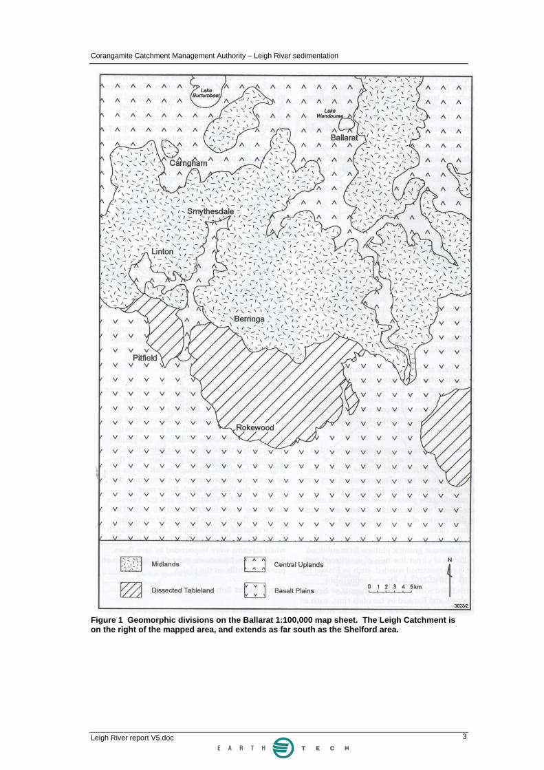
2.3 Physiography There are four main landforms in the Leigh Catchment (Figure 1).
Midlands are on sedimentary rocks, and are characterised by undulating hills of less than 100 m relief, cut by broad rounded valleys. The surface of this landform is often associated with deeply weathered clay profiles, which support poor soils. Granitic areas form subdued low hills.
Dissected tablelands form on younger sedimentary rocks, with extensive ferruginisation of soils by groundwater processes. Soil erosion and saline discharge are often found on this landform.
Central uplands form on basalt and support rich soils.
Basalt Plains dominate the southern, low relief part of the catchment and were formed by extensive lava flows.
The headwater zone of the Leigh River is largely in the Ballarat urban area. Streams are bedrock confined, or have been in some cases completely rock armoured
Corangamite Catchment Management Authority – Leigh River sedimentation
Leigh River report V5.doc 3
Figure 1 Geomorphic divisions on the Ballarat 1:100,000 map sheet. The Leigh Catchment is on the right of the mapped area, and extends as far south as the Shelford area.

Corangamite Catchment Management Authority – Leigh River sedimentation
Leigh River report V5.doc 4
2.3 Geomorphic Assessment Initial investigations of the Leigh Catchment focused on the Woodburn Creek sub-catchment, as this area was perceived to be a major source of sediment. The most recent (2000) aerial photos were examined for this area, along with a range of older aerial photos. The 2000 photos were examined for the northern part of the catchment.
Ground field checks were carried out by Heinz de Chelard and Rob Ferguson, in conjunction with CCMA and Landcare personnel. Heinz de Chelard visited the Woodbourne Creek sub-catchment on September 23 2003. Rob Ferguson had a one-day tour down the length of the catchment with Matt Bowler of the CCMA on October 6 2003. Chris Arnott did the air photograph analysis of the Woodbourne Creek sub-catchment.
2.4 Human impact Extensive gold mining has occurred within the upper part of the Leigh Catchment since gold was discovered n 1851. Mining impacts influenced the river in two ways.
Firstly, alluvial mining literally turned over large areas of valley floor of the Leigh River between Ballarat and Garibaldi. Floodplain deposits were removed in order to access gold-bearing gravels.
Secondly, mining on the valley hillsides removed large volumes of rock, and tailings heaps are seen on the hillsides in this area. These deposits have not been specifically examined as part of this report, but the silt and sand fractions will have been weathered out from these deposits and transported into the Leigh River. Large areas of the catchment around Ballarat were cleared of native vegetation to supply timber for mining purposes such as pit props.
Historical reports provide insight into the nature and extent of the mining practices. The Geelong Advertiser of June 7 1872 noted that the "River Leigh glides past and is gradually washing away the mullock left on [alluvial] claims which have long since been worked out and deserted. The primary cause of so many floods has been the washing down of mullock, which has filled in deep holes in the river and so shallowed the bed that when heavy rains have fallen the channel has not been deep enough to contain the waters." The role of vegetation clearance in the Ballarat area was also commented on: "in the first years of the diggings, timber being plentiful, was wasted... the balance was allowed to lie alongside the river to be washed down by floods, and thus scores of breakwaters [large woody debris dams] have been made between Inverleigh and Shelford, and throw back the waters." While this report notes the direct impact of timber getting into the channel and causing LWD dams, it fails to note the impact that land clearance would have had on the hydrology of the Leigh River. Runoff would have been greatly increased when the forests were cleared, increasing the amount and speed with which water drained into the Leigh River.
The same article reports that "sludge", commonly 18-24 inches (45-60 cm), and in places on the inside of bends in the river, up to 5-6 feet (150-180 cm) thick, was deposited on floodplains. Black, rich highly productive soils were covered by the "sludge", greatly reducing the value of properties in the Shelford - Inverleigh area. These deposits now form part of the floodplain stratigraphy of this part of the valley floor, forming the upper layer which is referred to as Post Mining Alluvium (PMA).

Corangamite Catchment Management Authority – Leigh River sedimentation
Leigh River report V5.doc 5
The Geelong Advertiser of September 14 1880 noted that at Teesdale "nearly the whole of the low lying lands near the creek have been covered with a considerable thickness of barren sand." By 1880, embankments had been built along the Leigh River at Shelford, which prevented the September 14 1880 flood from inundating the town.

Corangamite Catchment Management Authority – Leigh River sedimentation
Leigh River report V5.doc 6
3.0 Reach Characteristics It is not in the scope of this report to present a systematic analysis of the all the types of river found within the Leigh Catchment, nor map their distribution in detail. However, on the basis of the geomorphic observations carried out to date, a range of different types of river pattern are present in the catchment.
3.1 Headwaters The majority of small stream lines are in this category. The stream is generally steep with the bed and bank largely resting on bedrock. The valley is generally no wider than the width of the channel i.e. there is no floodplain. This river type is generally stable as there are no floodplain deposit to erode.
The Ballarat urban area covers approximately 30 km2, the majority of which is in headwater zones of the Leigh River. Some of the stream lines in this area are piped or concrete lined and riparian vegetation in urban areas particularly is degraded. This area produces a higher rate of runoff per unit area than farmland.
3.2 Cut and fill This river type was observed in a number of locations west of the Yarrowee in the area of Dog Trap and Winter Creeks. The defining feature of this river type during its fill stage is that it does not have a continuous channel. Instead, the valley floor is covered by a broad, low angle swamp. This phase is also referred to as the Intact Fill stage.
The cut phase takes place when a headcut or knickpoint retreats up through the swamp, eroding a channel. This process is analogous to gullying, but can occur on a much larger scale potentially releasing large volumes of sediment into the resultant stream. Active headcuts were observed in the western part of the catchment (see Figure 2).
Identifying the distribution of this type of river has become a key management priority in other Australian catchments. Not only are intact fills rare types of river, but protecting them from becoming sediment sources is a high priority. It is often relatively simple to stop these valley fills from erosion, but once erosion has commenced it is extremely difficult to stop. A systematic, Leigh or Barwon River catchment assessment of river type in order to identify potential sediment sources is recommended as a follow-up to this investigation.

Corangamite Catchment Management Authority – Leigh River sedimentation
Leigh River report V5.doc 7
Figure 2 Headcut at 0751958 5822987, looking up the valley onto the intact fill surface. The recently formed channel immediately downstream of the road bridge at this location 1.5 km west of Durham Lead is around 1.5 m deep and several metres wide. This process is generating considerable volumes of sediment, which will be transported downstream. Flow is from left to right. The scarp visible behind the trees is approximately 70 cm high.
3.3 Partly confined This type of river characterises much of the Leigh River between the southern outskirts of Ballarat and the Grand Junction Bridge in the mid-catchment. In this type of river, the valley is frequently of a highly irregular shape i.e. in the area between Napoleons and Grenville Hill. The channel ranges across the valley floor, frequently abutting against the side of the valley (Figure 3). The shape of the valley enforces to a large extent the size and shape of floodplains that can form.
The area in which this channel type occurs is in the upper part of the catchment, which has been heavily impacted by gold mining since 1851. Gold mining practices most directly impacted on this part of the river. The extent of alluvial gold mining in the main Leigh River is uncertain. The structure of the floodplains as exposed at bank erosion sites (see Figure 4) is finer grained material (silt and sand) overlaying channel gravel and coarse sand. These sands are silts almost certainly represent Post Mining Alluvium, although in the absence of carbon or luminescence dating, field identification based on sedimentology or floodplain stratigraphy alone is not always completely reliable. This is a 'natural' style of floodplain formation, which suggests that if wholesale dredging occurred along the Yarrowee River then floodplain recovery has been rapid.

Corangamite Catchment Management Authority – Leigh River sedimentation
Leigh River report V5.doc 8
Figure 3 Topographic map of the partly confined valley river type, along Yarrowee River in the Cambrian Hill area. Note that the channel of the river swings across the entire floor of the valley. Winter Creek enters from the west.
Figure 4 Looking downstream on the main channel from the one land road bridge at the very southern end of the Ballarat urban area (0750639 5832837). Bank retreat of many metres has occurred at this site and appears to be ongoing. The banks are up to 2.5 m high, and consist of around 2 m of silt and sand overlaying gravel. Bank erosion occurs as flows on the outside of minor bends encroach against the base of the bank. The gravels at the base bank are prone to erosion. With the supporting gravels cut away, the overlaying silts and sands topple in to the channel. The bar in the channel is armoured with gravel, making it a relatively stable surface and prevents the bed from degrading or lowering. Flow is from right to left.
Corangamite Catchment Management Authority – Leigh River sedimentation
Leigh River report V5.doc 9
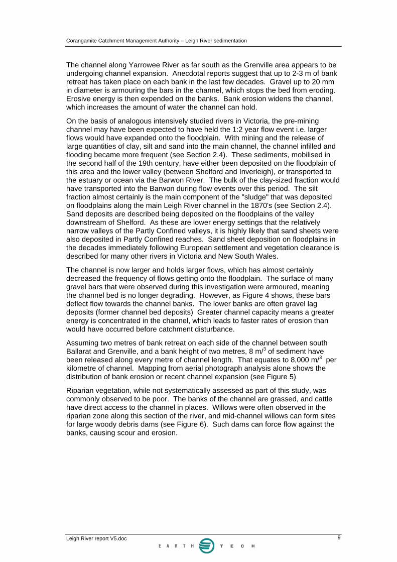
The channel along Yarrowee River as far south as the Grenville area appears to be undergoing channel expansion. Anecdotal reports suggest that up to 2-3 m of bank retreat has taken place on each bank in the last few decades. Gravel up to 20 mm in diameter is armouring the bars in the channel, which stops the bed from eroding. Erosive energy is then expended on the banks. Bank erosion widens the channel, which increases the amount of water the channel can hold.
On the basis of analogous intensively studied rivers in Victoria, the pre-mining channel may have been expected to have held the 1:2 year flow event i.e. larger flows would have expanded onto the floodplain. With mining and the release of large quantities of clay, silt and sand into the main channel, the channel infilled and flooding became more frequent (see Section 2.4). These sediments, mobilised in the second half of the 19th century, have either been deposited on the floodplain of this area and the lower valley (between Shelford and Inverleigh), or transported to the estuary or ocean via the Barwon River. The bulk of the clay-sized fraction would have transported into the Barwon during flow events over this period. The silt fraction almost certainly is the main component of the "sludge" that was deposited on floodplains along the main Leigh River channel in the 1870's (see Section 2.4). Sand deposits are described being deposited on the floodplains of the valley downstream of Shelford. As these are lower energy settings that the relatively narrow valleys of the Partly Confined valleys, it is highly likely that sand sheets were also deposited in Partly Confined reaches. Sand sheet deposition on floodplains in the decades immediately following European settlement and vegetation clearance is described for many other rivers in Victoria and New South Wales.
The channel is now larger and holds larger flows, which has almost certainly decreased the frequency of flows getting onto the floodplain. The surface of many gravel bars that were observed during this investigation were armoured, meaning the channel bed is no longer degrading. However, as Figure 4 shows, these bars deflect flow towards the channel banks. The lower banks are often gravel lag deposits (former channel bed deposits) Greater channel capacity means a greater energy is concentrated in the channel, which leads to faster rates of erosion than would have occurred before catchment disturbance.
Assuming two metres of bank retreat on each side of the channel between south Ballarat and Grenville, and a bank height of two metres, 8 m/3 of sediment have been released along every metre of channel length. That equates to 8,000 m/3 per kilometre of channel. Mapping from aerial photograph analysis alone shows the distribution of bank erosion or recent channel expansion (see Figure 5)
Riparian vegetation, while not systematically assessed as part of this study, was commonly observed to be poor. The banks of the channel are grassed, and cattle have direct access to the channel in places. Willows were often observed in the riparian zone along this section of the river, and mid-channel willows can form sites for large woody debris dams (see Figure 6). Such dams can force flow against the banks, causing scour and erosion.

Corangamite Catchment Management Authority – Leigh River sedimentation
Leigh River report V5.doc 10
Figure 5 Map show the distribution of bank erosion and river type classification in the upper Leigh River.

Corangamite Catchment Management Authority – Leigh River sedimentation
Leigh River report V5.doc 11
Figure 6 Large woody debris dam formed around a mid-channel willow, and associated bank erosion, in the main channel at Glassons Road (0749821 5829622). Both photos show the same jam from different angles looking downstream. The bank retreat is due to the debris dam directing flow towards the bank, where erosion up to 3 m back from the channel and up to c.10 m long has occurred. Note also the grassed mid-channel (centre foreground) and bank attached (mid-photo) bars. A revegetation strategy is underway immediately upstream of this site.
3.4 Gorge The middle reaches of the Leigh River are a gorge, which is a narrow valley floor which allows no room for the channel to move laterally or develop floodplains. Only small sections of sediment accumulation occur in the form of bars or benches, and these will be relatively frequently reworked by flood events. Flood powers are generally expected to be high in gorge settings, as all the water is concentrated over a limited cross sectional area.
The gorge is an efficient conduit and transports all the sediment that enters it downstream over years to decades. Figure 7 shows the Leigh River gorge in the area of the Grand Junction Bridge. Figure 8 shows a flood event in the gorge and a point bar at a lower flow stage.

Corangamite Catchment Management Authority – Leigh River sedimentation
Leigh River report V5.doc 12
Figure 7 Topographic map of the Leigh River gorge, in the area south of the Grand Junction Bridge (circled). The river is confined within bedrock in the floor of a valley less than 50 m wide.
Figure 8 On the left, the gorge in Leigh River from 761772 5796393. The valley margins are often bare rock in this gorge, and the river is confined within a zone generally less than 50 m wide. Sediment accumulation is largely restricted to bars like the point bar seen in the photo on the right, taken at the bridge near Mt Mercer (756885 5810903. Such deposits would be frequently reworked by flow events such as that shown in the photo on the left, where flood waters occupy the entire width of the valley floor.

Corangamite Catchment Management Authority – Leigh River sedimentation
Leigh River report V5.doc 13
3.5 Alluvial continuous Just north of Shelford the valley widens to around 1-1.5 km in width (see Figure 9). Floodplains extend for several kilometres down each side of the moderately sinuous channel. The energy (stream power) of the channel in this reach is considerably lower than that of the gorge reach upstream. This decreases the ability of the channel to transport sand, leading to aggradation within the channel.
The banks of the river in the area south of Shelford are sandy. It is not certain if this reflects the overall nature of the floodplain sediments, but if it does, it means the floodplain will be relatively easily eroded by the river. Reports from 1872 (see Section 2.4) describe "sludge" being deposited on the floodplains. These silty sediments buried crops and reduced the productivity of these floodplains.
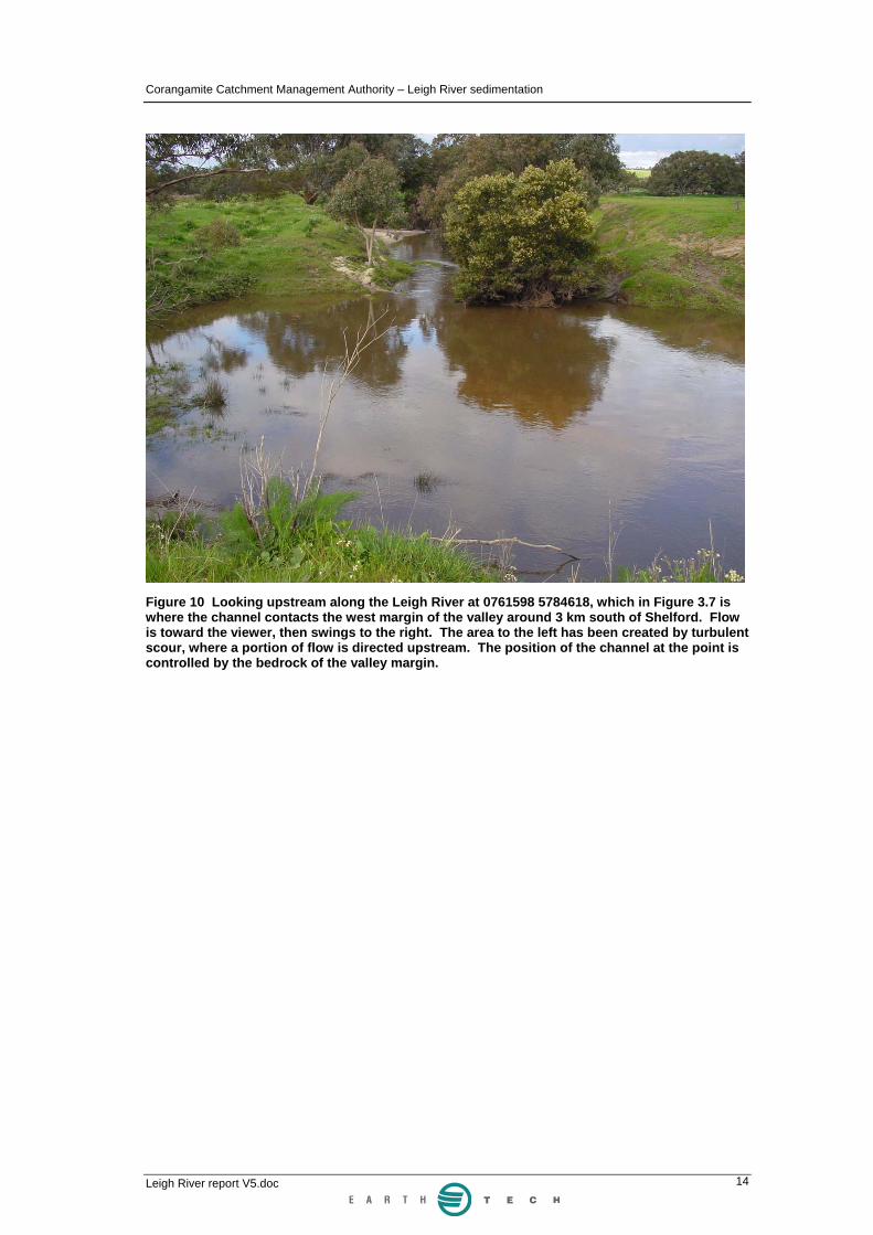
Flow events in the spring 2003 deposited sand within the channel in this part of the river. Figure 10 shows the channel at the location circled in Figure 9. The channel bed in homogenous and flat except at tight bends where scour occurs. Habitat values are minimal in this type of sand bed stream. Minor bank erosion is being caused by stock accessing the channel.
Figure 9 Topographic map of the Leigh Valley immediately downstream of Shelford. The valley is between 1 and 1.5 km wide and the channel meanders within that, only occasionally abutting the side of the valley. The circle shows the location of the photo in Figure 10.
Corangamite Catchment Management Authority – Leigh River sedimentation
Leigh River report V5.doc 14
Figure 10 Looking upstream along the Leigh River at 0761598 5784618, which in Figure 3.7 is where the channel contacts the west margin of the valley around 3 km south of Shelford. Flow is toward the viewer, then swings to the right. The area to the left has been created by turbulent scour, where a portion of flow is directed upstream. The position of the channel at the point is controlled by the bedrock of the valley margin.

Corangamite Catchment Management Authority – Leigh River sedimentation
Leigh River report V5.doc 15
4.0 Woodbourne Catchment Woodbourne Catchment had been identified as a potential sediment source to the Leigh River. Gullying in particular was perceived to be a source of sediment. Figure 11 is an aerial photograph of much of the Woodbourne Catchment area.
The 2000 aerial photos were systematically examined for evidence of widespread and/or large scale erosion, both along stream lines and on hillslopes. Hill-side gullying was observed at two locations (763300 5799000 and 763100 5800000) on Woodbourne Creek, in both cases immediately east of the Bamganie Road (circled in Figure 11). Minor slope erosion was observed along the hillsides above many streamlines in Woodbourne Catchment, but this is not on a major scale at all.
Streamlines in Woodbourne Catchment were investigated at a number of locations, in order to see if the sediment was being transported to the Leigh River.
Figure 12 shows a tributary of Woodbourne Creek at c.763650 5799100, at the west end of Glenetive Road. There is no evidence of any storage of sand at this point, and the stream is transporting minimal quantities of sand along its bed. This location is downstream of gully at 763100 5800000, which suggests that this gully is contributing minor amounts of sand into Woodbourne Creek.
Figure 13 shows the confluence of the Woodbourne Creek with the Leigh River, and there is no evidence of Woodbourne Creek transporting sand into the Leigh River. There are no significant volumes of sand stored in the bed of Woodbourne Creek at any locations that were visited on foot.
In summary, Woodbourne Catchment does not appear to be a major source of sediment that is being contributed to the Leigh River. The two main gullies identified from aerial photograph analysis are not contributing significant quantities of sand or silt to Woodbourne Creek, and Woodbourne Creek is not delivering sand into the Leigh River.

Corangamite Catchment Management Authority – Leigh River sedimentation
Leigh River report V5.doc 16
Figure 11 Aerial photograph of Woodbourne Catchment. Areas of gullying circled in red, arrow location of Figure 12. See text for additional details.

Corangamite Catchment Management Authority – Leigh River sedimentation
Leigh River report V5.doc 17
Figure 12 Woodbourne Creek east of Bamganie Road (see Figure 11. c.763650 5799100). There is no evidence of sand storage and little sand transport at this location.
Figure 13 The confluence of Woodbourne Creek and Leigh River (main flow, towards viewer). Woodbourne Creek comes in from the right in the foreground. There is no evidence at this location of sand being supplied from Woodbourne Creek into the Leigh River channel.

Corangamite Catchment Management Authority – Leigh River sedimentation
Leigh River report V5.doc 18
5.0 Summary of sediment transport in the Leigh River catchment Sediment sourcing and transport in the Leigh River catchment can be broken down into components, based on processes and their distribution geographically and in time. A fundamental breakdown of river catchments identifies three main zones:
• source
• transfer
• deposition
These process zones are looked at over three time intervals, which are schematically summarised in the Figures 1-3:
• pre-European impact on the catchment (i.e. before 1830)
• c.1870, when mining impacts were extensive
• the present day
5.1 Pre-European impact Native vegetation was intact, stabilising the catchment and ensuring that only very minor quantities of sediment (probably silt and clay sized material on the whole) reached the main channel in the source zone area (see Figure 14). Limited sediment therefore was transported through the gorge transfer zone and into the deposition zone of the alluvial continuous reach. The channel in the deposition zone had extensive riparian vegetation, a variable bed which provided abundant habitat.
5.2 c.1870 Mining had been underway in the source zone for 20 years by this stage, with direct alluvial mining in the channel and floodplain zones and reworking of mullock heaps both contributing large amounts of gravel, sand, silt and clay to the main channel (see Figure 15). Vegetation had been extensively cleared in the source zone area, which would have increased runoff and sediment yield. Log jams were common in the channel. The rapidly expanding Ballarat urban area would have been a major sediment source and would be yielding increased runoff.
Sand, silt and clay were being transported through the transfer zone of the gorge, and extensive deposition of "sludge" and in some cases sand was underway on the floodplain of the deposition zone in the Shelford area. Silt and clay were also being carried through the deposition zone to the Barwon River, and the clay fraction transported to the coast.
5.3 Present day Mining is supplying little sediment as mullock heaps are now stable. The main channel is now expanding laterally, and bank erosion in the source zone is now the biggest source of sediment in the catchment (see Figure 16). Intact valley fills in the western part of the source zone are now becoming sediment sources. Knickpoints were observed to be retreating through some of valley fills, releasing sediment, and others may be under threat.

Corangamite Catchment Management Authority – Leigh River sedimentation
Leigh River report V5.doc 19
Figure 14 Schematic summary of processes in the Leigh River catchment before the arrival of European in c.1830. See text for discussion.

Corangamite Catchment Management Authority – Leigh River sedimentation
Leigh River report V5.doc 20
Figure 15 Schematic summary of processes in the Leigh River catchment when mining related impacts were apparent throughout the catchment, c.1870. See text for discussion.

Corangamite Catchment Management Authority – Leigh River sedimentation
Leigh River report V5.doc 21
Figure 16 Schematic summary of processes in the Leigh River catchment at the present day. See text for discussion.
Corangamite Catchment Management Authority – Leigh River sedimentation
Leigh River report V5.doc 22
The Ballarat urban area is expanding, but sediment control programs are reducing sediment input to the main channel.
Sediment from the source zone is being transported through the transfer zone of the gorge. Deposition of "sludge" and sand on the floodplains in the deposition zone is now less than in the 1870's, as the channel now has a greater capacity than it did then. However, the channel is now aggrading in this area, which means smaller floods are now inundating the floodplains. If this trend continues, along with continued sediment supply to this zone, then silt and sand deposition on these floodplains becomes increasingly likely.
5.4 Summary Sediment sourcing, transport and deposition processes have greatly altered in the Leigh River catchment since 1830. Mining practices and vegetation clearance released large volumes of sediment into the upper Leigh River in the second half of the 19th century. Some clay sized sediments were deposited on the floodplains around Shelford, but much would have been carried to the Barwon River and to the coast as suspended sediment load. Much of the silt carried through the gorge would have been deposited as "sludge" on the floodplains around Shelford, with the remainder of this fraction carried to the Barwon River as suspended sediment in the main channel. Much of the sand produced during this time was deposited on the floodplains around Shelford, with the rest infilling the channel and being transported towards the Barwon River as bedload in the channel.
In recent decades, mining has contributed little sediment to the upper Leigh River channel. However the main channel is this area is now expanding, and the bank erosion associated with this is releasing gravel, sand and silt into the main channel. This is carried through the gorge, and the sand fraction is causing channel aggradation in the Shelford area. Additionally, intact valley fills in the upper part of the catchment are starting to release sediment via knick point retreat processes.
The cause of the on-going channel widening in the Leigh River is uncertain at this stage. The entire catchment and the channel have undergone major changes since Europeans arrived in the area. The catchment has contributed increased runoff to the channel, and there was a massive increase in sediment supply to the channel in the second half of the 19th century. Channel expansion may be a response to the subsequent decrease in sediment supply. However it should be noted that numerous streams of a similar size have undergone similar channel expansion without any mining activities occurring. Catchment and riparian zone vegetation clearance on there own are frequently sufficient to instigate major channel dimension alterations.

Corangamite Catchment Management Authority – Leigh River sedimentation
Leigh River report V5.doc 23
6.0 Reach summaries and management recommendations This study has raised a range of issues relating to sediment sourcing, transport and deposition within the Leigh River catchment. A summary of processes and management recommendations are provided below.
6.1 Upstream of Ballarat- Headwater reaches
Summary of Processes Aerial photograph analysis revealed no major erosion or sediment sourcing in this area, however urban development, particularly new housing estates, usually produces increased levels of sediment erosion. Urban areas, with high percentage of impervious ground cover, yield higher rates of runoff than vegetated catchments.
Management Recommendations Sediment sourcing in the Ballarat urban area should be monitored. Recent structures such as the Yarrowee - Redan Wetland Projects, have been installed to regulate discharge, trap sediment and control water quality.
6.2 Sebastopol to Woodland Village - Cut and fill reaches
Summary of Processes Cut and fill river types have been noted on some tributaries in the northwest part of the catchment, but their distribution has not been mapped as part of this project. At least one of these tributaries was observed to have a knick point retreating up through the valley fill, producing a channel and releasing sediment. These are a potential sediment source to the Leigh River where such gullying is within close hydraulic proximity to the Leigh River.
Management Recommendations Knick point retreat should be controlled to prevent channels forming in intact valley fills. Bed control structures such as chutes or grassed ramps together with revegetation works are most likely to be required.
It is recommended that a systematic assessment of the catchment be undertaken to map all the cut and fill reaches. The highest priority for management should be:
1. Intact valley fills
2. Gullying systems with direct hydraulic connectivity to the Leigh River.
6.3 South Ballarat to Napoleon- Partly confined reaches
Summary of Processes Active or recently active bank erosion has been mapped from aerial photograph analysis as occurring along approximately 13% of the length of the main Leigh River channel between south Ballarat and Hardie Hill. On the basis of the ground and remote sensing investigations, this bank erosion is the believed to be the main source of sediment (predominantly silt, sand and lesser amounts of gravel) presently contributing to the sediment load of the Leigh River. Further detailed studies would

Corangamite Catchment Management Authority – Leigh River sedimentation
Leigh River report V5.doc 24
be required to establish when channel expansion commenced, but it would have been after the initial input of silt, sand and gravel from mullock heaps adjacent to the channel.
Bank erosion in this part of the channel is likely to be the result of one or a combination of the following factors
1. Increased runoff associated with the development of Ballarat
2. A reduction in upstream sediment supply. The subject reach of stream may have adjusted to a higher sediment load associated with mining and other landuse changes. The cut off in sediment supply from upstream sources following the cessation of mining and improved landuse may now be causing the reworking of post-mining sediments. An armour layer has now formed in the bed of this reach. Excess sediment transport capacity associated with the reduction in sediment supply may now be manifest in bank erosion through channel expansion.
3. A reduction in instream and riparian vegetation
• Riparian vegetation protects soil from erosion
• Instream and riparian vegetation reduces stream velocity and increases the trapping of sediment.
Management Recommendations The observed bank erosion can be controlled through a number of approaches, including but not limited to:
• Instream and riparian vegetation management including stock control and revegetation
• rock beaching the eroding bank
• alignment training in the form pile fields
It is recommended that a revegetation program be developed and implemented through this reach. Vegetation establishment is likely to address most of the erosion issues. However there would be some value in a more detailed geomorphic analysis of the reach to identify stream powers and velocity to identify reaches where vegetation alone is unlikely to address the erosion issues. In these locations additional structural bank stabilisation works may also be warranted.
6.4 Napoleon to Willangi - Gorge (sediment transport) reach
Summary of Processes The gorge occupies a long length of the middle section of the Leigh River. It is geomorphically robust as the channel banks and bed are bedrock. There is minor bar and bench formation within this reach but it is not a source of sediment. Sediment is effectively flushed through this type of river over years to decades. The sand presently in the gorge has been contributed since mining commenced in 1851, and sand was deposited on floodplains downstream of the gorge in the 1870's. Much of the sand presently in gorge may have been derived from channel expansion in recent decades. Sand entering the gorge will eventually be

Corangamite Catchment Management Authority – Leigh River sedimentation
Leigh River report V5.doc 25
transported the length of the gorge and carried into the lower energy alluvial continuous reach in the Shelford - Inverleigh area.
Management Recommendation Management options for sand in a high energy gorge environment are limited if the aim is to try and reduce the amount of sand being transported to the downstream alluvial continuous reach. Sediment extractions and stabilisation of sediment are not likely to be a feasible approach to controlling supply from this reach to the Lower Leigh River.
It is recommended that sediment volumes held in storage through this reach be assessed and these be compared with sediment transport rates to identify the likely annual load and period of which sediment will be supplied to the Lower Leigh River from this reach.
6.5 Willangi to Barwon River - Alluvial continuous (sediment deposition) reach
Summary of Processes This is the main depositional zone within the Leigh River catchment. The river has far less capacity to transport sediment than the gorge immediately upstream. The channel is aggrading and is now a flat, homogenous bed with minimal available habitat. There may be significant heavy metal contamination of the sand in this reach, which would need to be investigated before any sediment extraction or removal were contemplated.
Management Recommendations A range of management options could be considered for dealing with the sand aggrading the channel in this area.
It is recommended that
1. Upstream sediment supply control works be undertaken (refer above)
2. The effectiveness of upstream sediment control works on the sediment delivery to the lower Leigh River be monitored through repeat stream bed survey in the lower Leigh River
3. The ongoing rate and period of sediment supply from the gorge reach to the lower Leigh River be assessed through a sediment store and transport analysis (refer above)
4. Large woody debris be considered for installation in the lower Leigh River to increase bed diversity
5. Sediment extractions only be undertaken if the rate of sediment supply to the lower Leigh River is not likely to be impacted by upstream sediment control works for a significant period of time.

Corangamite Catchment Management Authority – Leigh River sedimentation
Leigh River report V5.doc 26
6.6 Woodbourne Creek
Summary of Processes Woodbourne Catchment is not a major source of sediment to the Leigh River. Gullies in the catchment are releasing some sediment. However there is no evidence of significant volumes of sand being transported out of Woodbourne Creek into the Leigh River.
Management Recommendations Sediment control works in the Woodbourne Creek Catchment is not required in regard to impacts on the Leigh River. However there may be local priorities dictated by protection of local assets and landholder willingness to participate that may justify sediment management programs in this subcatchment.
6.7 Summary of knowledge gaps As outlined above we recommend that a program of erosion control be implemented on the reach of the Leigh River between south Ballarat and Napoleons. This is the primary source of sediment to the Leigh River. The program of management would be supported by and enhanced through improved understanding of stream processes. The following set of investigations, discussed in the reach summary recommendations above, are recommended.
The extent of the Cut and Fill reaches within the Leigh River catchment is not known. A complete River Styles assessment of the entire catchment would identify the reaches of this type that are under threat from knick point retreat, a process that could contribute large volumes of sediment to the Leigh River upstream of the mid-catchment gorge.
Bank erosion between south Ballarat and the Grenville Hill area needs systematic assessment. Historical records such as maps, bridge or other surveyed cross sections, and all available aerial photographs need to be analysed to establish when channel expansion commenced and what rates of bank erosion are over recent decades. This assessment should include topographic survey and hydraulic analysis to identify locations at which vegetation establishment alone will not address the ongoing erosion. A prioritised bank erosion management plan can be developed from this.
A comprehensive riparian vegetation management plan should be developed for the main Leigh River channel in conjunction with the bank erosion assessment.
The sediment management program would benefit from an analytical assessment of sediment transport and deposition. The gorge transports all the sediment it receives through its entire length, transporting it to the depositional zone in the alluvial continuous reach. The amount of sediment temporarily stored in the gorge needs to be assessed in order to see how much sand will be exported from this reach (assuming sourcing from partly confined reaches ceases). This could be undertaken through aerial photograph analysis and probing a series of transects in the gorge. Sediment transport modelling can then be undertaking to assess potential rates of sediment supply from the gorge and the capacity of the channel in the alluvial continuous reach to transport sediment. Augering on the floodplain around Shelford would provide sedimentological information on how much PMA has been deposited here, and when combined with historic gauge or bridge cross

Corangamite Catchment Management Authority – Leigh River sedimentation
Leigh River report V5.doc 27
section data, will indicate how channel dimensions have changed since the influx of "sludge" and sand to this area.
Sediment quality in the alluvial continuous reach may be poor, reflecting heavy metal contamination from mining-related activities in the upper catchment. If sediment extraction is to be considered in the Lower Leigh River, a thorough chemical investigation will have to be carried out.

Corangamite Catchment Management Authority – Leigh River sedimentation
7.0 References Geelong Advertiser, 7th June, 1872.
Geelong Advertiser, 14th September, 1880.
Taylor, D H, Whitehead, M L, Olshina, A and Leonard J G (1996) Ballarat 1:100 000 Map Geological Report, Geological Survey Report No. 101. Geological Survey of Victoria.
Related Documents
![Interplay between spatially explicit sediment sourcing ...efi.eng.uci.edu/papers/efg_185.pdfnear-channel erosion of bluffs, banks, and ravines) [Belmont et al., 2011], the legacy-sediment](https://static.cupdf.com/doc/110x72/61150ac699471a4af8163e93/interplay-between-spatially-explicit-sediment-sourcing-efienguciedupapersefg185pdf.jpg)