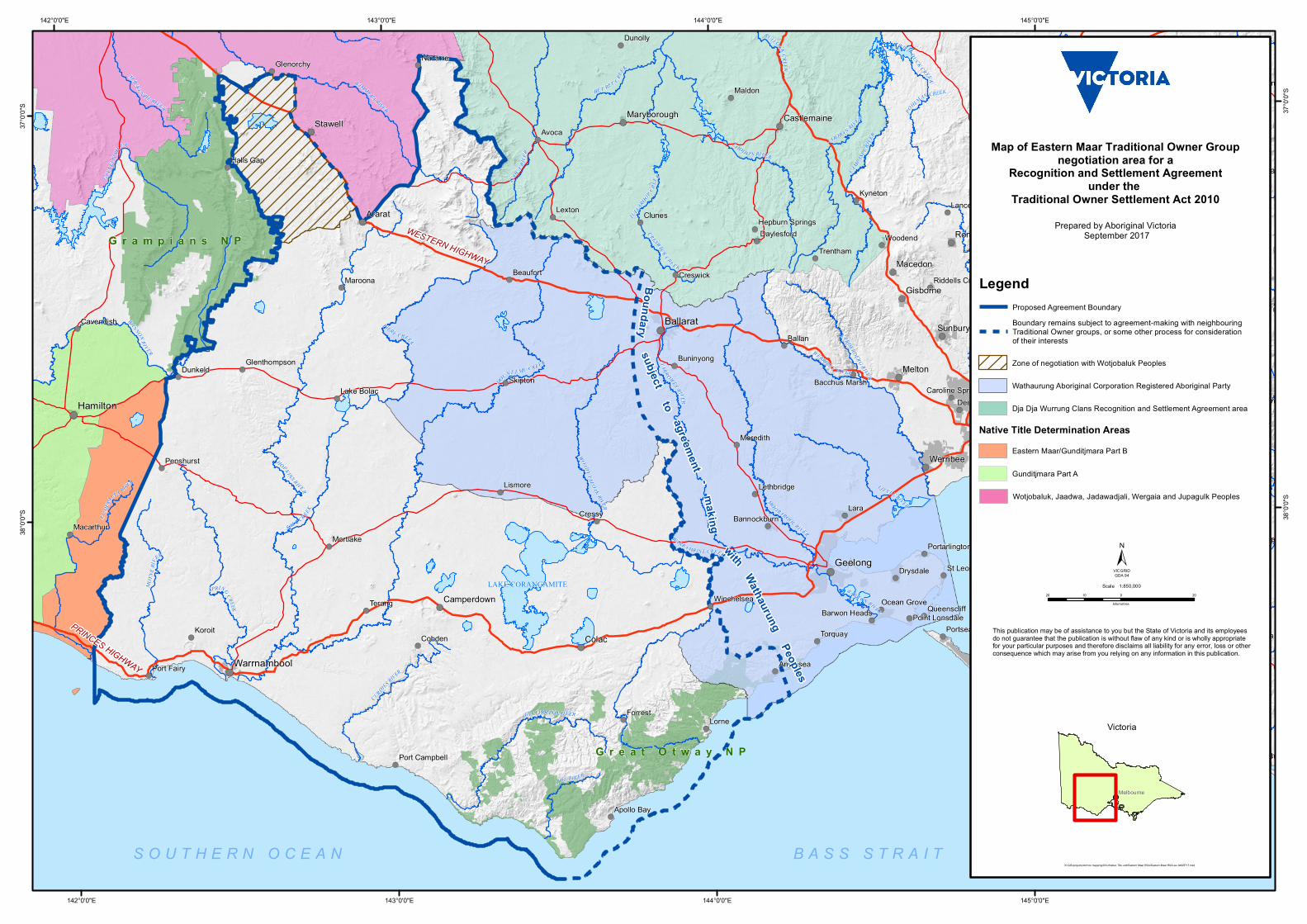
! ( ! ( ! ( ! ( ! ( ! ( ! ( ! ( ! ( ! ( ! ( ! ( ! ( ! ( ! ( ! ( ! ( ! ( ! ( ! ( ! ( ! ( ! ( ! ( ! ( ! ( ! ( ! ( ! ( ! ( ! ( ! ( ! ( ! ( ! ( ! ( ! ( ! ( ! ( ! ( ! ( ! ( ! ( ! ( ! ( ! ( ! ( ! ( ! ( ! ( ! ( ! ( ! ( ! ( ! ( ! ( ! ( ! ( ! ( ! ( ! ( ! ( ! ( ! ( ! ( ! ( ! ( ! ( ! ( ! ( ! ( ! ( ! ( ! ( Grampians NP Great Otway NP LAKE CORANGAMITE H O P K I N S R I V E R MOU N T E MU CR E E K W IM M E R A R I VE R L O DD O N RI V ER F I E R Y C R E E K W E RR I B EE RI V E R B A R W O N R I V E R W A N N O N R I V E R C A M PA S P E R IV E R A V OC A R I VE R C OL IB A N R I V E R B ET B ET C RE E K S A L T CR E E K S PR I N G C R E E K L IT T L E R IVER E U M ERA L L A R I VE R C U R DI E S RIV ER W O A D Y Y A L OA K RI V E R MO O R A BO OL R I V E R G E L L I B RAN D R IV ER TULL ARO O P C R E E K G L E NE L G R I V E R Y A R R O W EE RI V E R A I R E R I V E R M O Y N E R I V E R M A C K E N ZIE R I V E R L ER DE RD ER G R IV E R WA RR A M B I NECR E E K C R ESW I C K C R E E K P O H L M A N CRE EK W IL D D UCK C R E E K B U LL O C K C R E E K R K S Lara Avoca Nyora Lorne Koroit Ballan Lexton Bunyip Maldon Cobden Cressy Clunes Terang Merton Kyneton Portsea Forrest Skipton Dunolly Maroona Navarre Lismore Woodend Torquay Dunkeld Meredith Drysdale Trentham Beaufort Mortlake Creswick Anglesea Penshurst Cavendish Glenorchy Macarthur Deer Park Warburton Halls Gap Inverloch Buninyong Daylesford Lethbridge Lancefield Apollo Bay Port Fairy Winchelsea Lake Bolac Bannockburn Queenscliff Ocean Grove St Leonards Glenthompson Barwon Heads Bacchus Marsh Port Campbell Portarlington Point Lonsdale Riddells Creek Hepburn Springs Caroline Springs Colac Romsey Melton Ararat Sunbury Stawell Macedon Werribee Gisborne Alexandra Camperdown Castlemaine Maryborough Geelong Ballarat Hamilton Warrnambool PRINCES HIGHWAY WESTERN HIGHWAY 145°0'0"E 145°0'0"E 144°0'0"E 144°0'0"E 143°0'0"E 143°0'0"E 142°0'0"E 142°0'0"E 37°0'0"S 37°0'0"S 38°0'0"S 38°0'0"S This publication may be of assistance to you but the State of Victoria and its employees do not guarantee that the publication is without flaw of any kind or is wholly appropriate for your particular purposes and therefore disclaims all liability for any error, loss or other consequence which may arise from you relying on any information in this publication. K:\GIS\projects\Ad hoc mapping\DOJ Native Title unit\Eastern Maar RSA\Eastern Maar RSA-wv-04SEP17.mxd Map of Eastern Maar Traditional Owner Group negotiation area for a Recognition and Settlement Agreement under the Traditional Owner Settlement Act 2010 Prepared by Aboriginal Victoria September 2017 SOUTHERN OCEAN BASS STRAIT Boundary subject to agreement with Wathaurung Peoples - making 20 0 20 10 kilometres 1:850,000 Scale ± VICGRID GDA 94 Victoria Melbourne Legend Native Title Determination Areas Proposed Agreement Boundary Boundary remains subject to agreement-making with neighbouring Traditional Owner groups, or some other process for consideration of their interests Zone of negotiation with Wotjobaluk Peoples Wathaurung Aboriginal Corporation Registered Aboriginal Party Dja Dja Wurrung Clans Recognition and Settlement Agreement area Eastern Maar/Gunditjmara Part B Gunditjmara Part A Wotjobaluk, Jaadwa, Jadawadjali, Wergaia and Jupagulk Peoples

Welcome message from author
This document is posted to help you gain knowledge. Please leave a comment to let me know what you think about it! Share it to your friends and learn new things together.
Transcript
!(
!(
!(
!(
!(
!(
!(
!(
!( !(
!(
!(
!(
!(
!(
!(
!(
!(
!(
!(
!(
!(
!(
!(
!(
!(
!(
!(
!(
!(
!(
!(
!(
!(
!(
!(
!(
!(
!(
!(
!(
!(
!(
!(
!(
!(
!(
!(
!(
!(
!(
!(
!(
!(
!(
!(
!(
!(
!(
!(
!(
!(
!(
!(
!(
!(
!(
!(
!(
!(
!(
!(
!(
!(
!(
!(
!(
!(
!(
!(
!(
!(
!(
!(
!(
!(
!(
!(!(
!(
!(
!(
!(
!(
!(
!(
!(
!(
!(
!(
!(
!(
!(
!(
!(
!(
!(
!(
!(
!(
!(
!(
!(
!(
!(
!(
!(
!(
!(
!( !(
!(
!(
!(
!(
!(
G r a m p i a n s N P
G r e a t O t w a y N P
LAKE CORANGAMITE
HOPK INS RIVER
MOUNT EMU CRE EK
Y ARRA R IVE R
WIMMERA RIVER
L ODD O N RIVER
FIERY CREEK
WERRIBEE RIVER
BARWON RIVER
WANNON RIVER
GOUL BURN RIVER
CAMPASP
E RIVE
R
AVOCA RI
VER
COLIBAN RIVER
BET BET C REEK
YEA RIVER
SAL T CR EEK
ACHE
RON
RIVE
R
SPRING CREEK
BASS RIVER
DEEP CREE
K
LIT TLE RIVER
HUGH ES CREEK
EUME
RA
LLA RIVER
PLEN
TYRI
VER
CURDIES RIVER
WOADY YALOAK RIVER
MOO RABOOL RIVER
GELLIBRAND RIVER
TULL
AROOP CREEK
BUNYIP RIVER
GLENE
LGRIV
ER
YAR ROWEE RIVER
AIRE RIV ER
MOYN
ERI
VER
MACKEN ZIE RIVER
LERDERDERG RIVER
MURRIND INDI RIVER
WARRAMBINE CREEK
POWLETT RIVER
W ATTS RIVER
CRESWICK CRE EK
KURKURUC CREEK
PO
HLMAN CREEK
LANG LANG RI VER
W ILD DUCK CREEK
MARIB YRNONG RIVER
BULLOCKCRE EK
LITTLE YARR A RIVER
SUGA
RLOAF CREEK
SEVE N CREEKS
Yea
Lara
Avoca
Nyora
Cowes
Lorne
Koroit
Ballan
Lexton
Bunyip
Maldon
Somers
Cobden
Cressy
Clunes
Wallan
Terang
Merton
Berwick
Kyneton
Portsea
Forrest
Skipton
Dunolly
Maroona
Kilmore
Navarre
Rosebud
Seville
Lismore
Woodend
Torquay
Dunkeld
Tooradin
Cockatoo
Meredith
Drysdale
Box Hill
Trentham
Belgrave
Beaufort
Hastings
Mortlake
Lilydale
Creswick
Flinders
San Remo
Anglesea
Kinglake
Moorabbin
Lang Lang
Broadford
Dandenong
Penshurst
Cavendish
Glenorchy
Macarthur
Deer Park
Frankston
Warburton
Halls Gap
Inverloch
Buninyong
Heidelberg
Daylesford
Somerville
Lethbridge
Cranbourne
Yarra Glen
Lancefield
Apollo Bay
Port Fairy
Warrandyte
Whittlesea
Winchelsea
Flowerdale
Lake Bolac
Crib Point
Puckapunyal
Craigieburn
Bannockburn
Koo wee rup
Queenscliff
Tullamarine
Hurstbridge
Ocean Grove
St Leonards
Glenthompson
Barwon Heads
Bacchus Marsh
Port Campbell
Portarlington
Point Lonsdale
Riddells Creek
Yarra Junction
Hepburn Springs
Caroline Springs
Heathcote Junction
Colac
Romsey
Melton
Ararat
Seymour
Sunbury
Stawell
Macedon
Werribee
Gisborne
Pakenham
Wonthaggi
Alexandra
CamperdownMornington
Healesville
CastlemaineMaryborough
Geelong
Ballarat
Hamilton
Warrnambool
Melbourne
PRINCES HIGHWAY
WESTERN HIGHWAY
145°0'0"E
145°0'0"E
144°0'0"E
144°0'0"E
143°0'0"E
143°0'0"E
142°0'0"E
142°0'0"E37
°0'0"S 37
°0'0"S
38°0'
0"S 38°0'
0"S
This publication may be of assistance to you but the State of Victoria and its employeesdo not guarantee that the publication is without flaw of any kind or is wholly appropriatefor your particular purposes and therefore disclaims all liability for any error, loss or otherconsequence which may arise from you relying on any information in this publication.
K:\GIS\projects\Ad hoc mapping\DOJ Native Title unit\Eastern Maar RSA\Eastern Maar RSA-wv-04SEP17.mxd
Map of Eastern Maar Traditional Owner Groupnegotiation area for a
Recognition and Settlement Agreementunder the
Traditional Owner Settlement Act 2010Prepared by Aboriginal Victoria
September 2017
S O U T H E R N O C E A N B A S S S T R A I T
Boundarysubject to
agreement
withWathaurung Peoples
- making20 0 2010
kilometres
1:850,000Scale
±VICGRIDGDA 94
Victoria
Melbourne
Legend
Native Title Determination Areas
Proposed Agreement BoundaryBoundary remains subject to agreement-making with neighbouringTraditional Owner groups, or some other process for considerationof their interests
Zone of negotiation with Wotjobaluk Peoples
Wathaurung Aboriginal Corporation Registered Aboriginal Party
Dja Dja Wurrung Clans Recognition and Settlement Agreement area
Eastern Maar/Gunditjmara Part B
Gunditjmara Part A
Wotjobaluk, Jaadwa, Jadawadjali, Wergaia and Jupagulk Peoples
Related Documents