Latitude-Longitude • The globe is an oblate spheroid • Circles are placed on globe to determine locations • These circles are called parallels of latitude and meridians of longitude Wikipedia 1

Welcome message from author
This document is posted to help you gain knowledge. Please leave a comment to let me know what you think about it! Share it to your friends and learn new things together.
Transcript

Latitude-Longitude
• The globe is an oblate spheroid • Circles are placed on globe to determine locations • These circles are called parallels of latitude and meridians of longitude
Wikipedia
1
Latitude-Longitude
• Latitude lines are the horizontal circles drawn on a globe. • The starting latitude is 0o and is known as the Equator. • Latitude is always the first point plotted and will always be listed as how many degrees
North or South of the Equator that point lies. • Keep in mind that the two extreme latitudes are the North Pole (90oN) and the South
Pole (90oS).
Geography World
2

Latitude-Longitude
• Longitude lines are the vertical circles drawn on a map. • The starting longitude is 0o and is known as the Prime Meridian. This meridian is defined as the
longitude line that starts at the North Pole, travels through Greenwich, England, and ends at the South Pole.
• Longitude is always the second point plotted and will always be listed as how many degrees West or East of the Prime Meridian that point lies.
• Keep in mind that the extreme longitude is 180o and is called the International Date Line. New York City is roughly 41oN 73oW.
Geography World
3

Latitude-Longitude
• A mercator projection is a flat version of the globe • Much easier to work with • Locations toward each pole (eg. Greenland, Antarctica) appear larger than reality due to
“stretching”
Wikipedia
4

Latitude-Longitude
• When locating points that lie between two adjacent latitudes or longitudes (ex. between 41oN and 42oN) a smaller unit is desired.
• A degree of spacing is made up of 60 smaller units called arcminutes. One degree is equal to 60'. Therefore, fractions of a degree are equal to some number of arcminutes. For example, ½ degree equals 30', ¾ degree equals 45’, and so forth.
5

Latitude-Longitude
• The distance that separates one latitude degree from another (ex. between 41oN and 42oN) can be given as 60 nm (nautical miles) or 69 mi (statute miles).
• Ex: the distance between 23oS and 25oS is two degrees. There are 120 nm (2 x 60) or 138 mi (2 x 69) between these two points.
• Keep in mind that the relationship of 1 degree = 60 nm or 69 mi only works for latitudes because longitude line spacing is not constant. Meridians of longitude narrow as one moves poleward.
6

Latitude-Longitude
• Learn the United States (either full spelling or two-lettered postal code)
Wikipedia
7
Latitude-Longitude
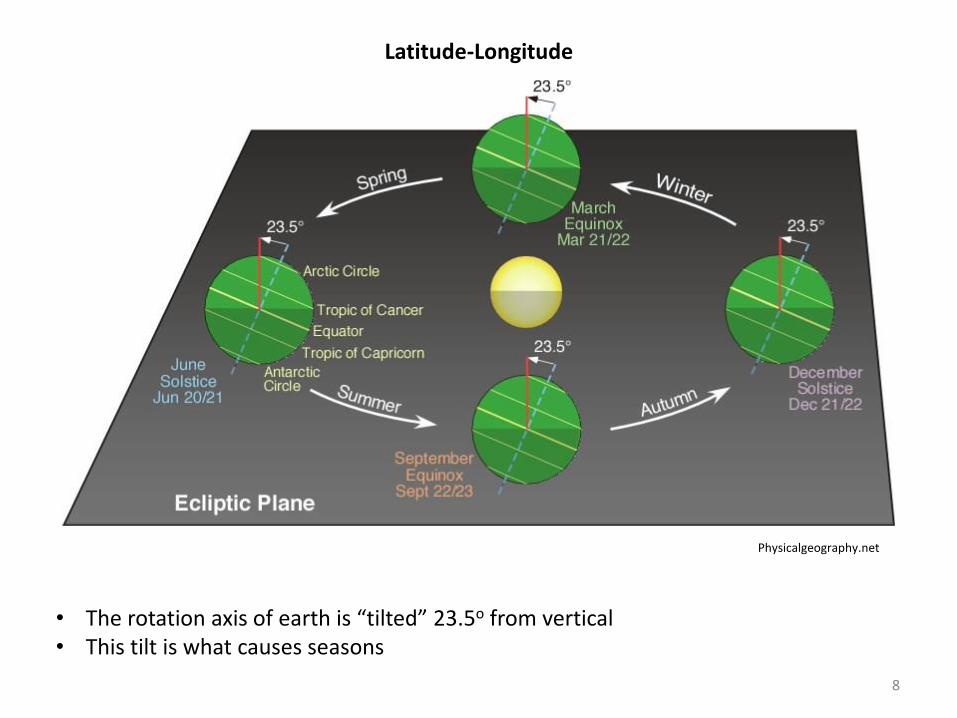
• The rotation axis of earth is “tilted” 23.5o from vertical • This tilt is what causes seasons
Physicalgeography.net
8

Latitude-Longitude
• Solstices are times of the year when the noon sun angle is highest or lowest • Equinoxes are times of the year when the vertical rays of the sun strike the equator at
noon. There are 12 hours of day and night for all locations
Physicalgeography.net
9

Latitude-Longitude
• Solstices are times of the year when the noon sun angle is highest or lowest
Physicalgeography.net
10

Latitude-Longitude
• Blue curve represents the latitude where the sun’s vertical rays strike the Earth • Key locations:
• Equinoxes: 0o (Equator) • Summer Solstice: 23.5oN (Tropic of Cancer) • Winter Solstice: 23.5oS (Tropic of Capricorn)
Physicalgeography.net
11

Latitude-Longitude
Noon Sun Angle (SA) = 90o – N
where N = Distance in latitude between Observer and Sun’s vertical rays
Ex: What is the sun angle for a Selden observer (41oN) on the summer solstice? Sun’s vertical rays strike 23.5oN on summer solstice. Therefore, N = 41o - 23.5o = 17.5o
SA = 90o – 17.5o = 72.5o
Ex: What is the lowest possible noon sun angle for a Selden observer? Sun’s vertical rays are farthest south and strike 23.5oS on winter solstice. Therefore, N = 41o + 23.5o = 64.5o
SA = 90o – 64.5o = 25.5o
12
Related Documents