Lateglacial ice-cap dynamics in NW Scotland: evidence from the fjords of the Summer Isles region Martyn S. Stoker a, * , Tom Bradwell a , John A. Howe b , Ian P. Wilkinson c , Kate McIntyre b a British Geological Survey, Murchison House, West Mains Road, Edinburgh EH9 3LA, UK b Scottish Association for Marine Science, Oban, Argyll PA37 1QA, UK c British Geological Survey, Kingsley Dunham Centre, Keyworth, Nottingham NG12 5GG, UK article info Article history: Received 6 May 2009 Received in revised form 28 August 2009 Accepted 14 September 2009 abstract The seaboard of western Scotland is a classic fjord landscape formed by glaciation over at least the last 0.5 Ma. We examine the glacial geology preserved in the fjords (or sea lochs) of the Summer Isles region of NW Scotland using high-resolution seismic data, multibeam swath bathymetry, seabed sediment cores, digital terrain models, aerial photographs, and field investigations. Detailed analyses include seismic facies and lithofacies interpretations; sedimentological and palaeoenvironmental analyses; and radiocarbon dating of selected microfauna. Our results indicate that the Pleistocene sediments of the Summer Isles region, on- and offshore, can be subdivided into several lithostratigraphic formations on the basis of seismic character, geomorphology and sedimentology. These are: subglacial tills; ice-distal and glacimarine facies; ice-proximal and ice-contact facies; moraine assemblages; and Holocene basin fill. The submarine landscape is also notable for its large-scale mass-movement events – the result of glaciodynamic, paraglacial or seismotectonic processes. Radiocarbon dating of marine shells indicate that deglaciation of this part of NW Scotland was ongoing between 14 and 13 ka BP – during the Lateglacial Interstadial (Greenland Interstadial 1) – consistent with cosmogenic surface-exposure ages from previous studies. A sequence of numerous seafloor moraine ridges charts oscillatory retreat of the last ice sheet from a buoyant calving margin in The Minch to a firmly grounded margin amongst the Summer Isles in the early part of Lateglacial Interstadial (GI-1) (pre-14 ka BP). Subsequent, punctuated, frontal retreat of the ice mass occurred in the following w1000 years, during which time ice-cap outlet glaciers became topographically confined and restricted to the fjords. A late-stage readvance of glaciers into the inner fjords occurred soon after 13 ka BP, which calls into question the accepted limits of ice extent during the Younger Dryas Stadial (Greenland Stadial 1). We examine the wider implications of our chronostratigraphic model, discussing the implications for British Ice Sheet deglaciation, Lateglacial climate change, and the style and rates of fjord sedimentation. Ó 2009 NERC. Published by Elsevier Ltd. All rights reserved. 1. Introduction The seaboard of western Scotland is a classic fjord landscape with a highly indented, glacially sculpted coastline that incises landwards into the mountainous hinterland (Fig. 1). The longest fjords (or sea lochs) range from 10 to 30 km, and commonly exceed 150 m at their maximum water depth. Maximum-recorded sedi- ment infill (sea bed–rockhead) is between 50 and 70 m in Loch Nevis (Boulton et al., 1981) and Loch Etive (Howe et al., 2002), and locally up to 100 m in Loch Broom (Stoker et al., 2006; Stoker and Bradwell, in press). It has recently been proposed that the major fjords in NW Scotland most probably formed tributaries that fed the Minch palaeo-ice stream; a shelf-crossing ice-stream that dominated the northwestern sector of the British Ice Sheet (BIS) (Stoker and Bradwell, 2005; Bradwell et al., 2007, 2008c)(Fig. 1). Thus, this landscape has evolved for at least the last 500,000 years; the interval of time that the BIS has repeatedly expanded onto, and retreated from, the adjacent continental shelf (Stoker et al., 1994). In this paper we examine the glacial geology of the fjords in the Summer Isles region of NW Scotland (Figs. 1 and 2), onshore and offshore, in order to examine the style of Late Pleistocene deglaci- ation, the pattern and rates of sedimentation, and to further explore palaeo-ice-sheet dynamics during periods of rapid global climate change. Despite their obvious importance as a connection between the terrestrial and marine glacial records, Scotland’s fjords have * Corresponding author. Tel.: þ44 131 650 0374. E-mail address: [email protected] (M.S. Stoker). Contents lists available at ScienceDirect Quaternary Science Reviews journal homepage: www.elsevier.com/locate/quascirev 0277-3791/$ – see front matter Ó 2009 NERC. Published by Elsevier Ltd. All rights reserved. doi:10.1016/j.quascirev.2009.09.012 Quaternary Science Reviews 28 (2009) 3161–3184

Welcome message from author
This document is posted to help you gain knowledge. Please leave a comment to let me know what you think about it! Share it to your friends and learn new things together.
Transcript

lable at ScienceDirect
Quaternary Science Reviews 28 (2009) 3161–3184
Contents lists avai
Quaternary Science Reviews
journal homepage: www.elsevier .com/locate/quascirev
Lateglacial ice-cap dynamics in NW Scotland: evidence from the fjordsof the Summer Isles region
Martyn S. Stoker a,*, Tom Bradwell a, John A. Howe b, Ian P. Wilkinson c, Kate McIntyre b
a British Geological Survey, Murchison House, West Mains Road, Edinburgh EH9 3LA, UKb Scottish Association for Marine Science, Oban, Argyll PA37 1QA, UKc British Geological Survey, Kingsley Dunham Centre, Keyworth, Nottingham NG12 5GG, UK
a r t i c l e i n f o
Article history:Received 6 May 2009Received in revised form28 August 2009Accepted 14 September 2009
* Corresponding author. Tel.: þ44 131 650 0374.E-mail address: [email protected] (M.S. Stoker).
0277-3791/$ – see front matter � 2009 NERC. Publisdoi:10.1016/j.quascirev.2009.09.012
a b s t r a c t
The seaboard of western Scotland is a classic fjord landscape formed by glaciation over at least the last0.5 Ma. We examine the glacial geology preserved in the fjords (or sea lochs) of the Summer Isles regionof NW Scotland using high-resolution seismic data, multibeam swath bathymetry, seabed sedimentcores, digital terrain models, aerial photographs, and field investigations. Detailed analyses includeseismic facies and lithofacies interpretations; sedimentological and palaeoenvironmental analyses; andradiocarbon dating of selected microfauna. Our results indicate that the Pleistocene sediments of theSummer Isles region, on- and offshore, can be subdivided into several lithostratigraphic formations onthe basis of seismic character, geomorphology and sedimentology. These are: subglacial tills; ice-distaland glacimarine facies; ice-proximal and ice-contact facies; moraine assemblages; and Holocene basinfill. The submarine landscape is also notable for its large-scale mass-movement events – the result ofglaciodynamic, paraglacial or seismotectonic processes. Radiocarbon dating of marine shells indicate thatdeglaciation of this part of NW Scotland was ongoing between 14 and 13 ka BP – during the LateglacialInterstadial (Greenland Interstadial 1) – consistent with cosmogenic surface-exposure ages fromprevious studies. A sequence of numerous seafloor moraine ridges charts oscillatory retreat of the last icesheet from a buoyant calving margin in The Minch to a firmly grounded margin amongst the SummerIsles in the early part of Lateglacial Interstadial (GI-1) (pre-14 ka BP). Subsequent, punctuated, frontalretreat of the ice mass occurred in the following w1000 years, during which time ice-cap outlet glaciersbecame topographically confined and restricted to the fjords. A late-stage readvance of glaciers into theinner fjords occurred soon after 13 ka BP, which calls into question the accepted limits of ice extentduring the Younger Dryas Stadial (Greenland Stadial 1). We examine the wider implications of ourchronostratigraphic model, discussing the implications for British Ice Sheet deglaciation, Lateglacialclimate change, and the style and rates of fjord sedimentation.
� 2009 NERC. Published by Elsevier Ltd. All rights reserved.
1. Introduction
The seaboard of western Scotland is a classic fjord landscapewith a highly indented, glacially sculpted coastline that inciseslandwards into the mountainous hinterland (Fig. 1). The longestfjords (or sea lochs) range from 10 to 30 km, and commonly exceed150 m at their maximum water depth. Maximum-recorded sedi-ment infill (sea bed–rockhead) is between 50 and 70 m in LochNevis (Boulton et al., 1981) and Loch Etive (Howe et al., 2002), andlocally up to 100 m in Loch Broom (Stoker et al., 2006; Stoker andBradwell, in press). It has recently been proposed that the major
hed by Elsevier Ltd. All rights rese
fjords in NW Scotland most probably formed tributaries that fedthe Minch palaeo-ice stream; a shelf-crossing ice-stream thatdominated the northwestern sector of the British Ice Sheet (BIS)(Stoker and Bradwell, 2005; Bradwell et al., 2007, 2008c) (Fig. 1).Thus, this landscape has evolved for at least the last 500,000 years;the interval of time that the BIS has repeatedly expanded onto, andretreated from, the adjacent continental shelf (Stoker et al., 1994).In this paper we examine the glacial geology of the fjords in theSummer Isles region of NW Scotland (Figs. 1 and 2), onshore andoffshore, in order to examine the style of Late Pleistocene deglaci-ation, the pattern and rates of sedimentation, and to further explorepalaeo-ice-sheet dynamics during periods of rapid global climatechange.
Despite their obvious importance as a connection betweenthe terrestrial and marine glacial records, Scotland’s fjords have
rved.
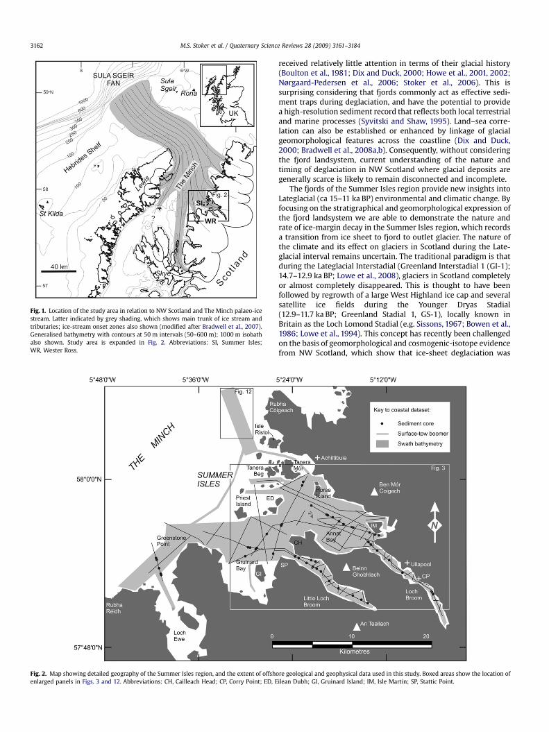
Fig. 1. Location of the study area in relation to NW Scotland and The Minch palaeo-icestream. Latter indicated by grey shading, which shows main trunk of ice stream andtributaries; ice-stream onset zones also shown (modified after Bradwell et al., 2007).Generalised bathymetry with contours at 50 m intervals (50–600 m); 1000 m isobathalso shown. Study area is expanded in Fig. 2. Abbreviations: SI, Summer Isles;WR, Wester Ross.
Fig. 2. Map showing detailed geography of the Summer Isles region, and the extent of offshoenlarged panels in Figs. 3 and 12. Abbreviations: CH, Cailleach Head; CP, Corry Point; ED, E
M.S. Stoker et al. / Quaternary Science Reviews 28 (2009) 3161–31843162
received relatively little attention in terms of their glacial history(Boulton et al., 1981; Dix and Duck, 2000; Howe et al., 2001, 2002;Nørgaard-Pedersen et al., 2006; Stoker et al., 2006). This issurprising considering that fjords commonly act as effective sedi-ment traps during deglaciation, and have the potential to providea high-resolution sediment record that reflects both local terrestrialand marine processes (Syvitski and Shaw, 1995). Land–sea corre-lation can also be established or enhanced by linkage of glacialgeomorphological features across the coastline (Dix and Duck,2000; Bradwell et al., 2008a,b). Consequently, without consideringthe fjord landsystem, current understanding of the nature andtiming of deglaciation in NW Scotland where glacial deposits aregenerally scarce is likely to remain disconnected and incomplete.
The fjords of the Summer Isles region provide new insights intoLateglacial (ca 15–11 ka BP) environmental and climatic change. Byfocusing on the stratigraphical and geomorphological expression ofthe fjord landsystem we are able to demonstrate the nature andrate of ice-margin decay in the Summer Isles region, which recordsa transition from ice sheet to fjord to outlet glacier. The nature ofthe climate and its effect on glaciers in Scotland during the Late-glacial interval remains uncertain. The traditional paradigm is thatduring the Lateglacial Interstadial (Greenland Interstadial 1 (GI-1);14.7–12.9 ka BP; Lowe et al., 2008), glaciers in Scotland completelyor almost completely disappeared. This is thought to have beenfollowed by regrowth of a large West Highland ice cap and severalsatellite ice fields during the Younger Dryas Stadial(12.9–11.7 ka BP; Greenland Stadial 1, GS-1), locally known inBritain as the Loch Lomond Stadial (e.g. Sissons, 1967; Bowen et al.,1986; Lowe et al., 1994). This concept has recently been challengedon the basis of geomorphological and cosmogenic-isotope evidencefrom NW Scotland, which show that ice-sheet deglaciation was
re geological and geophysical data used in this study. Boxed areas show the location ofilean Dubh; GI, Gruinard Island; IM, Isle Martin; SP, Stattic Point.

M.S. Stoker et al. / Quaternary Science Reviews 28 (2009) 3161–3184 3163
ongoing during the first half of the Lateglacial Interstadial(14.7–13.7 ka BP) and, by inference, that some ice masses probablysurvived throughout this entire period into the Younger Dryas(Bradwell et al., 2008b). We test the hypothesis of ‘Interstadial icesurvival’ using accelerator mass spectrometry (AMS) radiocarbondating of marine shells together with analysis of microfaunalassemblages in sea bed sediment cores recovered from the fjords.All data referred to in this paper are expressed in calendar years(ka BP), and radiocarbon dates have been calibrated, whereappropriate, using Fairbanks et al. (2005).
2. Regional setting
For the purposes of this study, the Summer Isles region isa convenient term to describe all the waters, islands and headlandsbetween the promontories of Rubha Reidh in the south and RubhaCoigeach in the north. The area includes the mountain massifs ofBen Mor Coigach, and An Teallach. In this study, the focus of ourinvestigations is in Loch Broom, Little Loch Broom, and the watersaround the Summer Isles (Fig. 2). Twelve main islands comprise theSummer Isles group: Tanera Mor, Tanera Beg, Priest Island andHorse Island being the largest, plus a number of skerries. Isle Martinand Gruinard Island are separate outlying islands located in LochKanaird and Gruinard Bay, respectively. Loch Broom and Little LochBroom represent the major sea lochs or fjords: Loch Broom is 15 kmlong and 0.5–1.5 km wide, whereas Little Loch Broom is 12 km longand 0.5–2.0 km wide.
Fig. 3. Integrated swath bathymetric image and NextMa
The bathymetric image of the Summer Isles region (Fig. 3)reveals the juxtaposition of shallow, commonly linear, northwest-trending, submarine banks, less than 40 m below present-day sealevel, and deeply incised fjord troughs, up to 180 m deep, withsteep sides (5–40�), flat bottoms and undulating thalwegs (lowestpoint of elevation within the troughs) (Stoker et al., 2006). Thetroughs represent the offshore continuation of the modern sealochs of Loch Broom and Little Loch Broom which, for descriptivepurposes, are here separated into a number of discrete basins: theSoutheast, South and North Annat basins, and the Coigach, Tanera,Skerries and South Priest basins (Figs. 3 and 4). At present-day, thegreatest water depths (160–180 m) occur in the South Priest andSkerries basins. Whereas a bedrock sill separates Little Loch Broomfrom the South Priest Basin, there is connectivity between some ofthe other basins (e.g. South Annat and North Annat basins toSkerries Basin) (Fig. 3) in the form of narrow gorges, interpreted asmeltwater channels, that are commonly several kilometres longand typically have steep up-and-down long profiles (Bradwell et al.,2008a). The whole fjord region is separated from The Minch bya wide zone of bedrock that includes the Summer Isles (Figs. 3and 4).
The bedrock geology of the study area is dominated by coarsered, thick-bedded Torridonian sandstone of Neoproterozoic age,which forms the bulk of the surrounding mountains, e.g. Ben MorCoigach, Beinn Ghobhlach and An Teallach. Sporadic inliers ofArchaean Lewisian orthogneiss occur in places, onto which theTorridonian sandstone was unconformably deposited. A north–south-trending strip of Cambro-Ordovician rocks, mainly quartzite
p digital terrain model of the Summer Isles region.
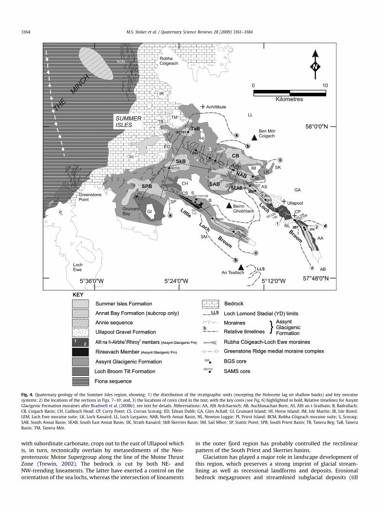
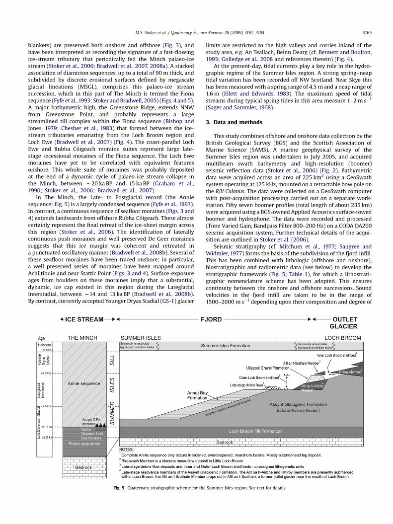
Fig. 4. Quaternary geology of the Summer Isles region, showing: 1) the distribution of the stratigraphic units (excepting the Holocene lag on shallow banks) and key morainesystems; 2) the locations of the sections in Figs. 7–10; and, 3) the locations of cores cited in the text, with the key cores (see Fig. 6) highlighted in bold. Relative timelines for AssyntGlacigenic Formation moraines after Bradwell et al. (2008b); see text for details. Abbreviations: AA, Allt Ardcharnich; AB, Auchlunachan Burn; AS, Allt an t-Srathain; B, Badrallach;CB, Coigach Basin; CH, Cailleach Head; CP, Corry Point; CS, Corran Scoraig; ED, Eilean Dubh; GA, Glen Achall; GI, Gruinard Island; HI, Horse Island; IM, Isle Martin; IR, Isle Ristol;LEM, Loch Ewe moraine suite; LK, Loch Kanaird; LL, Loch Lurgainn; NAB, North Annat Basin; NL, Newton Loggie; PI, Priest Island; RCM, Rubha Coigeach moraine suite; S, Scoraig;SAB, South Annat Basin; SEAB, South East Annat Basin; SK, Strath Kanaird; SkB Skerries Basin; SM, Sail Mhor; SP, Stattic Point; SPB, South Priest Basin; TB, Tanera Beg; TaB, TaneraBasin; TM, Tanera Mor.
M.S. Stoker et al. / Quaternary Science Reviews 28 (2009) 3161–31843164
with subordinate carbonate, crops out to the east of Ullapool whichis, in turn, tectonically overlain by metasediments of the Neo-proterozoic Moine Supergroup along the line of the Moine ThrustZone (Trewin, 2002). The bedrock is cut by both NE- andNW-trending lineaments. The latter have exerted a control on theorientation of the sea lochs, whereas the intersection of lineaments
in the outer fjord region has probably controlled the rectilinearpattern of the South Priest and Skerries basins.
Glaciation has played a major role in landscape development ofthis region, which preserves a strong imprint of glacial stream-lining as well as recessional landforms and deposits. Erosionalbedrock megagrooves and streamlined subglacial deposits (till
M.S. Stoker et al. / Quaternary Science Reviews 28 (2009) 3161–3184 3165
blankets) are preserved both onshore and offshore (Fig. 3), andhave been interpreted as recording the signature of a fast-flowingice-stream tributary that periodically fed the Minch palaeo-icestream (Stoker et al., 2006; Bradwell et al., 2007, 2008a). A stackedassociation of diamicton sequences, up to a total of 90 m thick, andsubdivided by discrete erosional surfaces defined by megascaleglacial lineations (MSGL), comprises this palaeo-ice streamsuccession, which in this part of The Minch is termed the Fionasequence (Fyfe et al.,1993; Stoker and Bradwell, 2005) (Figs. 4 and 5).A major bathymetric high, the Greenstone Ridge, extends NNWfrom Greenstone Point, and probably represents a largestreamlined till complex within the Fiona sequence (Bishop andJones, 1979; Chesher et al., 1983) that formed between the ice-stream tributaries emanating from the Loch Broom region andLoch Ewe (Bradwell et al., 2007) (Fig. 4). The coast-parallel LochEwe and Rubha Coigeach moraine suites represent large late-stage recessional moraines of the Fiona sequence. The Loch Ewemoraines have yet to be correlated with equivalent featuresonshore. This whole suite of moraines was probably depositedat the end of a dynamic cycle of palaeo-ice stream collapse inthe Minch, between w20 ka BP and 15 ka BP (Graham et al.,1990; Stoker et al., 2006; Bradwell et al., 2007).
In The Minch, the Late- to Postglacial record (the Anniesequence: Fig. 5) is a largely condensed sequence (Fyfe et al., 1993).In contrast, a continuous sequence of seafloor moraines (Figs. 3 and4) extends landwards from offshore Rubha Coigeach. These almostcertainly represent the final retreat of the ice-sheet margin acrossthis region (Stoker et al., 2006). The identification of laterallycontinuous push moraines and well preserved De Geer morainessuggests that this ice margin was coherent and retreated ina punctuated oscillatory manner (Bradwell et al., 2008b). Several ofthese seafloor moraines have been traced onshore; in particular,a well preserved series of moraines have been mapped aroundAchiltibuie and near Stattic Point (Figs. 3 and 4). Surface-exposureages from boulders on these moraines imply that a substantial,dynamic, ice cap existed in this region during the LateglacialInterstadial, between w14 and 13 ka BP (Bradwell et al., 2008b).By contrast, currently accepted Younger Dryas Stadial (GS-1) glacier
Fig. 5. Quaternary stratigraphic scheme for the
limits are restricted to the high valleys and corries inland of thestudy area, e.g. An Teallach, Beinn Dearg (cf. Bennett and Boulton,1993; Golledge et al., 2008 and references therein) (Fig. 4).
At the present-day, tidal currents play a key role in the hydro-graphic regime of the Summer Isles region. A strong spring–neaptidal variation has been recorded off NW Scotland. Near Skye thishas been measured with a spring range of 4.5 m and a neap range of1.6 m (Ellett and Edwards, 1983). The maximum speed of tidalstreams during typical spring tides in this area measure 1–2 m s�1
(Sager and Sammler, 1968).
3. Data and methods
This study combines offshore and onshore data collection by theBritish Geological Survey (BGS) and the Scottish Association ofMarine Science (SAMS). A marine geophysical survey of theSummer Isles region was undertaken in July 2005, and acquiredmultibeam swath bathymetry and high-resolution (boomer)seismic reflection data (Stoker et al., 2006) (Fig. 2). Bathymetricdata were acquired across an area of 225 km2 using a GeoSwathsystem operating at 125 kHz, mounted on a retractable bow pole onthe R/V Calanus. The data were collected on a GeoSwath computerwith post-acquisition processing carried out on a separate work-station. Fifty seven boomer profiles (total length of about 235 km)were acquired using a BGS-owned Applied Acoustics surface-towedboomer and hydrophone. The data were recorded and processed(Time Varied Gain, Bandpass Filter 800–200 Hz) on a CODA DA200seismic acquisition system. Further technical details of the acqui-sition are outlined in Stoker et al. (2006).
Seismic stratigraphy (cf. Mitchum et al., 1977; Sangree andWidmier, 1977) forms the basis of the subdivision of the fjord infill.This has been combined with lithologic (offshore and onshore),biostratigraphic and radiometric data (see below) to develop thestratigraphic framework (Fig. 5; Table 1), for which a lithostrati-graphic nomenclature scheme has been adopted. This ensurescontinuity between the onshore and offshore successions. Soundvelocities in the fjord infill are taken to be in the range of1500–2000 m s�1 depending upon their composition and degree of
Summer Isles region. See text for details.
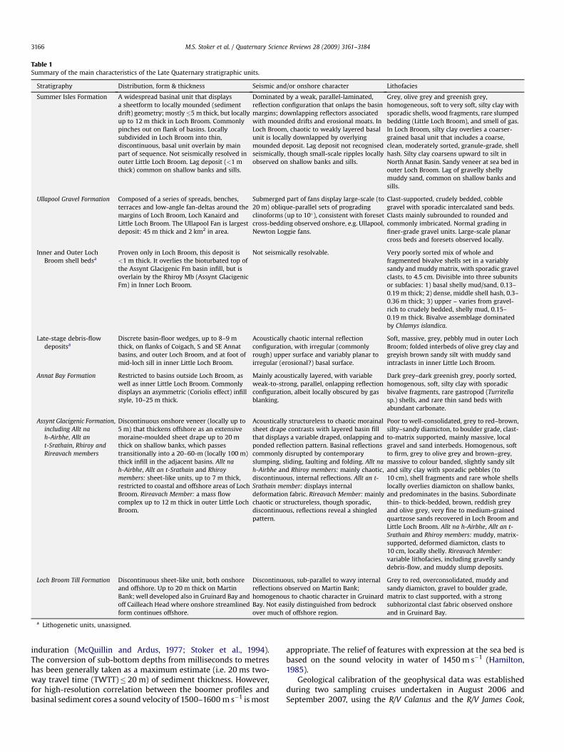
Table 1Summary of the main characteristics of the Late Quaternary stratigraphic units.
Stratigraphy Distribution, form & thickness Seismic and/or onshore character Lithofacies
Summer Isles Formation A widespread basinal unit that displaysa sheetform to locally mounded (sedimentdrift) geometry; mostly�5 m thick, but locallyup to 12 m thick in Loch Broom. Commonlypinches out on flank of basins. Locallysubdivided in Loch Broom into thin,discontinuous, basal unit overlain by mainpart of sequence. Not seismically resolved inouter Little Loch Broom. Lag deposit (<1 mthick) common on shallow banks and sills.
Dominated by a weak, parallel-laminated,reflection configuration that onlaps the basinmargins; downlapping reflectors associatedwith mounded drifts and erosional moats. InLoch Broom, chaotic to weakly layered basalunit is locally downlapped by overlyingmounded deposit. Lag deposit not recognisedseismically, though small-scale ripples locallyobserved on shallow banks and sills.
Grey, olive grey and greenish grey,homogeneous, soft to very soft, silty clay withsporadic shells, wood fragments, rare slumpedbedding (Little Loch Broom), and smell of gas.In Loch Broom, silty clay overlies a coarser-grained basal unit that includes a coarse,clean, moderately sorted, granule-grade, shellhash. Silty clay coarsens upward to silt inNorth Annat Basin. Sandy veneer at sea bed inouter Loch Broom. Lag of gravelly shellymuddy sand, common on shallow banks andsills.
Ullapool Gravel Formation Composed of a series of spreads, benches,terraces and low-angle fan-deltas around themargins of Loch Broom, Loch Kanaird andLittle Loch Broom. The Ullapool Fan is largestdeposit: 45 m thick and 2 km2 in area.
Submerged part of fans display large-scale (to20 m) oblique-parallel sets of progradingclinoforms (up to 10�), consistent with foresetcross-bedding observed onshore, e.g. Ullapool,Newton Loggie fans.
Clast-supported, crudely bedded, cobblegravel with sporadic intercalated sand beds.Clasts mainly subrounded to rounded andcommonly imbricated. Normal grading infiner-grade gravel units. Large-scale planarcross beds and foresets observed locally.
Inner and Outer LochBroom shell bedsa
Proven only in Loch Broom, this deposit is<1 m thick. It overlies the bioturbated top ofthe Assynt Glacigenic Fm basin infill, but isoverlain by the Rhiroy Mb (Assynt GlacigenicFm) in Inner Loch Broom.
Not seismically resolvable. Very poorly sorted mix of whole andfragmented bivalve shells set in a variablysandy and muddy matrix, with sporadic gravelclasts, to 4.5 cm. Divisible into three subunitsor subfacies: 1) basal shelly mud/sand, 0.13–0.19 m thick; 2) dense, middle shell hash, 0.3–0.36 m thick; 3) upper – varies from gravel-rich to crudely bedded, shelly mud, 0.15–0.19 m thick. Bivalve assemblage dominatedby Chlamys islandica.
Late-stage debris-flowdepositsa
Discrete basin-floor wedges, up to 8–9 mthick, on flanks of Coigach, S and SE Annatbasins, and outer Loch Broom, and at foot ofmid-loch sill in inner Little Loch Broom.
Acoustically chaotic internal reflectionconfiguration, with irregular (commonlyrough) upper surface and variably planar toirregular (erosional?) basal surface.
Soft, massive, grey, pebbly mud in outer LochBroom; folded interbeds of olive grey clay andgreyish brown sandy silt with muddy sandintraclasts in inner Little Loch Broom.
Annat Bay Formation Restricted to basins outside Loch Broom, aswell as inner Little Loch Broom. Commonlydisplays an asymmetric (Coriolis effect) infillstyle, 10–25 m thick.
Mainly acoustically layered, with variableweak-to-strong, parallel, onlapping reflectionconfiguration, albeit locally obscured by gasblanking.
Dark grey–dark greenish grey, poorly sorted,homogenous, soft, silty clay with sporadicbivalve fragments, rare gastropod (Turritellasp.) shells, and rare thin sand beds withabundant carbonate.
Assynt Glacigenic Formation,including Allt nah-Airbhe, Allt ant-Srathain, Rhiroy andRireavach members
Discontinuous onshore veneer (locally up to5 m) that thickens offshore as an extensivemoraine-moulded sheet drape up to 20 mthick on shallow banks, which passestransitionally into a 20–60-m (locally 100 m)thick infill in the adjacent basins. Allt nah-Airbhe, Allt an t-Srathain and Rhiroymembers: sheet-like units, up to 7 m thick,restricted to coastal and offshore areas of LochBroom. Rireavach Member: a mass flowcomplex up to 12 m thick in outer Little LochBroom.
Acoustically structureless to chaotic morainalsheet drape contrasts with layered basin fillthat displays a variable draped, onlapping andponded reflection pattern. Basinal reflectionscommonly disrupted by contemporaryslumping, sliding, faulting and folding. Allt nah-Airbhe and Rhiroy members: mainly chaotic,discontinuous, internal reflections. Allt an t-Srathain member: displays internaldeformation fabric. Rireavach Member: mainlychaotic or structureless, though sporadic,discontinuous, reflections reveal a shingledpattern.
Poor to well-consolidated, grey to red–brown,silty–sandy diamicton, to boulder grade, clast-to-matrix supported, mainly massive, localgravel and sand interbeds. Homogenous, softto firm, grey to olive grey and brown–grey,massive to colour banded, slightly sandy siltand silty clay with sporadic pebbles (to10 cm), shell fragments and rare whole shellslocally overlies diamicton on shallow banks,and predominates in the basins. Subordinatethin- to thick-bedded, brown, reddish greyand olive grey, very fine to medium-grainedquartzose sands recovered in Loch Broom andLittle Loch Broom. Allt na h-Airbhe, Allt an t-Srathain and Rhiroy members: muddy, matrix-supported, deformed diamicton, clasts to10 cm, locally shelly. Rireavach Member:variable lithofacies, including gravelly sandydebris-flow, and muddy slump deposits.
Loch Broom Till Formation Discontinuous sheet-like unit, both onshoreand offshore. Up to 20 m thick on MartinBank; well developed also in Gruinard Bay andoff Cailleach Head where onshore streamlinedform continues offshore.
Discontinuous, sub-parallel to wavy internalreflections observed on Martin Bank;homogenous to chaotic character in GruinardBay. Not easily distinguished from bedrockover much of offshore region.
Grey to red, overconsolidated, muddy andsandy diamicton, gravel to boulder grade,matrix to clast supported, with a strongsubhorizontal clast fabric observed onshoreand in Gruinard Bay.
a Lithogenetic units, unassigned.
M.S. Stoker et al. / Quaternary Science Reviews 28 (2009) 3161–31843166
induration (McQuillin and Ardus, 1977; Stoker et al., 1994).The conversion of sub-bottom depths from milliseconds to metreshas been generally taken as a maximum estimate (i.e. 20 ms two-way travel time (TWTT)� 20 m) of sediment thickness. However,for high-resolution correlation between the boomer profiles andbasinal sediment cores a sound velocity of 1500–1600 m s�1 is most
appropriate. The relief of features with expression at the sea bed isbased on the sound velocity in water of 1450 m s�1 (Hamilton,1985).
Geological calibration of the geophysical data was establishedduring two sampling cruises undertaken in August 2006 andSeptember 2007, using the R/V Calanus and the R/V James Cook,

Fig. 6. Graphic logs of key BGS and SAMS cores used in this study, showing predominant lithology, gross sedimentary structure, position of subsamples and dated horizons alonga transect from the Tanera Basin to Inner Loch Broom. Cores located in Figs. 4 and 7–10.
Table 2BGS and SAMS (asterisk) key core location data.
BGS Sample No. Latitude (N) Longitude (W) Water depth (m) Core length (m)
57-06/262 57.9624 05.3609 48 4.7457-06/267 57.8655 05.1063 49 4.7357-06/269 57.9145 05.2213 83 4.9657-06/277 57.9417 05.2696 77 4.6457-06/278 57.9421 05.2717 78 3.9857-06/279 57.9422 05.2728 80 3.52GC101* 57.9936 05.3792 88 2.79
M.S. Stoker et al. / Quaternary Science Reviews 28 (2009) 3161–3184 3167
respectively, which recovered sediment cores from 50 samplestations (Fig. 2). These cruises utilised the SAMS 3-m gravity corer(2006) and the BGS 6-m vibrocorer and 15-m rock drill (2007). All ofthe cores have been examined in terms of their sedimentology.A transect of seven cores representative of the inner and outer fjordregion were examined in detail in this study, in terms of theirlithology, sedimentary structure and microfaunal content (Fig. 6;Table 2). However, the entire core database was utilised in thedevelopment of the lithostratigraphic framework presented herein.
Twenty-one samples were analysed for their foraminiferalcontent (Table 3), with specimens picked from dry residues. Up toa maximum of 300 specimens were counted for the foraminifera,although in some cases entire populations were identified wherethe counts were smaller and the fauna were impoverished.A number of single and paired bivalve mollusc shells were identi-fied and several were used to obtain accelerator mass spectrometry(AMS) radiocarbon ages (Table 4). Whole single valves of Glossushumanus and Nucula sulcata, and a paired shell of Lucinoma borealiswere sampled from SAMS core GC101, whereas a large paired shellof Arctica islandica was recovered from core BGS 57-06/279, andsingle valves of A. islandica and Chlamys islandica were taken fromBGS core 57-06/267. The shells are mostly well preserved and non-abraded, the exception being C. islandica that shows minor abrasionon the edge. These samples were subsequently prepared for datingat the Natural Environment Research Council Radiocarbon Labo-ratory at East Kilbride, UK. All offshore 14C dates reported here arecorrected with a marine reservoir age of 405� 40 yr (Harkness,1983), and calibrated to calendar years (Table 4) based on theFairbanks0107 calibration curve (Fairbanks et al., 2005).
Onshore mapping was carried out using a combination of digitaland traditional data-capture techniques. Geomorphologicalfeatures and superficial deposits were mapped onscreen in a GISusing 1:10,000-scale stereo- and monoscopic colour aerial photo-graphs and high-resolution digital surface models (NEXTMapBritain). In general, hillshaded NEXTMap data were used to high-light areas of interest, typically at w1:20,000; these were thenmapped in detail using orthorectified colour aerial photographs atw1:5000. Geological field surveys of key areas were conductedbetween May 2004 and 2009.
4. Results
The seismic, lithological and palaeontological characteristics ofthe fjord stratigraphy, both onshore and offshore, are summarisedbelow and in Table 1. The radiocarbon analyses are presented at theend of the section.

Table 3Distribution of foraminifera in BGS vibrocores 57-06/262, 57-06/267, 57-06/268, 57-06/269, 57-06/277, 57-06/278 and 57-06/279.
M.S. Stoker et al. / Quaternary Science Reviews 28 (2009) 3161–31843168
4.1. Fjord stratigraphy
The fjord succession is divided into five main lithostratigraphicformations: 1) Loch Broom Till Formation (oldest); 2) Assynt Gla-cigenic Formation; 3) Annat Bay Formation; 4) Ullapool GravelFormation; and, 5) Summer Isles Formation (Fig. 5). Of these, onlythe Annat Bay and Summer Isles Formations are exclusivelyoffshore units. The Assynt Glacigenic Formation includes fourlocally defined members: the Allt na h-Airbhe, Allt an t-Srathain,and Rhiroy members in Loch Broom, and the Rireavach Member inLittle Loch Broom (Fig. 4). In addition, we have identified twolithogenetic units – ‘Late-stage debris flows’ and the ‘Inner andOuter Loch Broom shell beds’ – that are locally mappable deposits,but are not easily correlatable to specific formations. Although
Table 4AMS 14C dates.
Laboratory code Core Depth in core (m) Dated material Conve
SUERC-20449 57-06/279 2.71–2.77 Arctica islandica 12710SUERC-20450 GC101 0.54–0.59 Glossus humanus 3966SUERC-20451 GC101 1.04 Nucula sulcata 7247SUERC-20452 GC101 2.71 Lucinoma borealis 12593SUERC-20453 57-06/267 2.00–2.07 Arctica islandica 7610SUERC-20454 57-06/267 3.50–3.55 Chlamys islandica 11613
a Marine reservoir correction 405� 40 (Harkness, 1983).b Faribanks0107 calibration curve (Fairbanks et al., 2005), based on adjusted age.
coastal exposures of the Loch Broom Till, Assynt Glacigenic andUllapool Gravel Formations are included to assist the descriptionand interpretation of these units, younger terrestrial paraglacialand postglacial deposits are not considered in this paper.
Seismic reflection profiles (Figs. 7–10) reveal the distribution,geometry and internal character of the various units that comprisethe fjord succession, which is commonly up to 60 m thick in theoverdeepened basins. Beneath the shallow banks, the bedrocksurface is generally discernible as a high-amplitude reflector at thebase of the glacial succession (Fig. 8a). In contrast, the nature of theacoustic basement in the basins is more chaotic in texture, andirregular in form towards the base of the fjord. The possibleoccurrence of stacked, compacted till, or mass-flow depositsderived from the sidewall of the fjord prior to the deposition of the
ntional age (14C yr BP) Adjusteda age (14C yr BP) Calibratedb age (cal yr BP)
� 42 12305� 58 14111� 98� 37 3561� 54 3853� 72� 36 6842� 54 7670� 44� 41 12188� 51 13973� 73� 38 7205� 55 8012� 53� 40 11208� 56 13047� 59
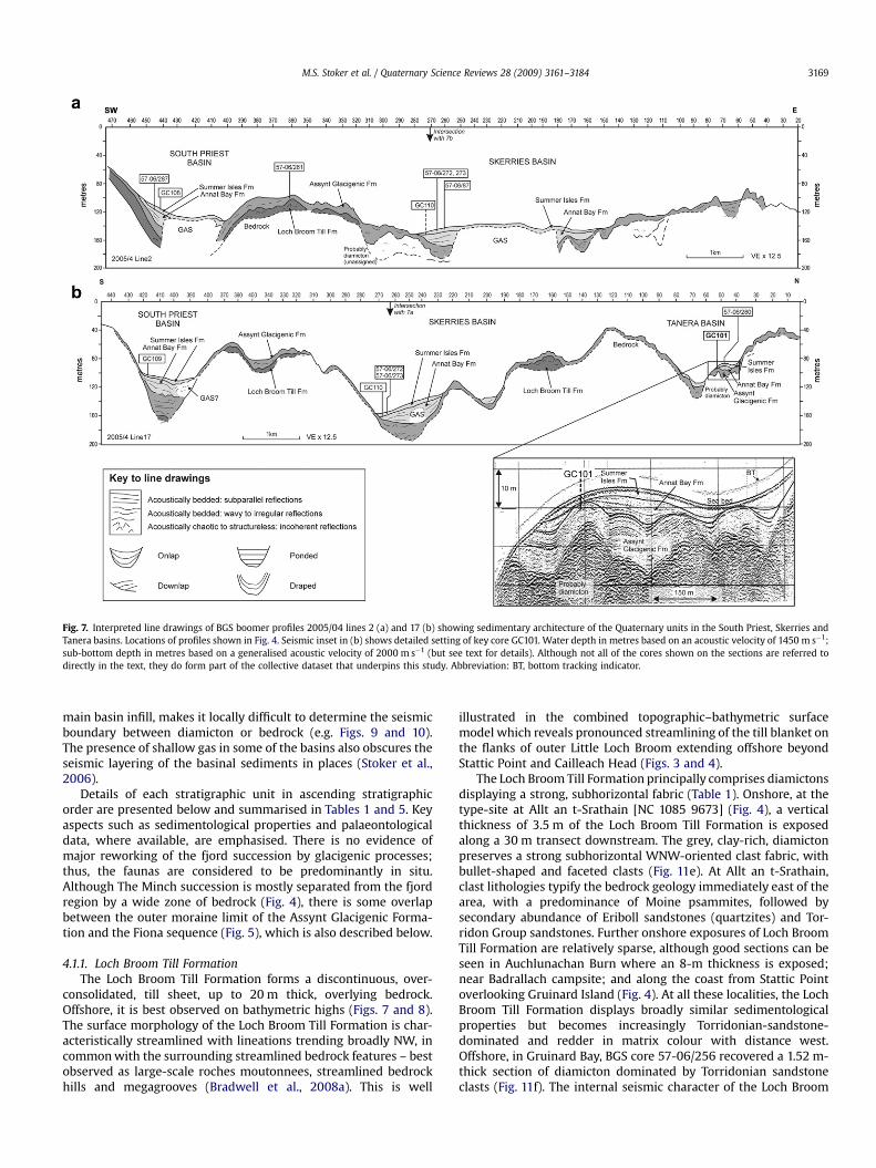
Fig. 7. Interpreted line drawings of BGS boomer profiles 2005/04 lines 2 (a) and 17 (b) showing sedimentary architecture of the Quaternary units in the South Priest, Skerries andTanera basins. Locations of profiles shown in Fig. 4. Seismic inset in (b) shows detailed setting of key core GC101. Water depth in metres based on an acoustic velocity of 1450 m s�1;sub-bottom depth in metres based on a generalised acoustic velocity of 2000 m s�1 (but see text for details). Although not all of the cores shown on the sections are referred todirectly in the text, they do form part of the collective dataset that underpins this study. Abbreviation: BT, bottom tracking indicator.
M.S. Stoker et al. / Quaternary Science Reviews 28 (2009) 3161–3184 3169
main basin infill, makes it locally difficult to determine the seismicboundary between diamicton or bedrock (e.g. Figs. 9 and 10).The presence of shallow gas in some of the basins also obscures theseismic layering of the basinal sediments in places (Stoker et al.,2006).
Details of each stratigraphic unit in ascending stratigraphicorder are presented below and summarised in Tables 1 and 5. Keyaspects such as sedimentological properties and palaeontologicaldata, where available, are emphasised. There is no evidence ofmajor reworking of the fjord succession by glacigenic processes;thus, the faunas are considered to be predominantly in situ.Although The Minch succession is mostly separated from the fjordregion by a wide zone of bedrock (Fig. 4), there is some overlapbetween the outer moraine limit of the Assynt Glacigenic Forma-tion and the Fiona sequence (Fig. 5), which is also described below.
4.1.1. Loch Broom Till FormationThe Loch Broom Till Formation forms a discontinuous, over-
consolidated, till sheet, up to 20 m thick, overlying bedrock.Offshore, it is best observed on bathymetric highs (Figs. 7 and 8).The surface morphology of the Loch Broom Till Formation is char-acteristically streamlined with lineations trending broadly NW, incommon with the surrounding streamlined bedrock features – bestobserved as large-scale roches moutonnees, streamlined bedrockhills and megagrooves (Bradwell et al., 2008a). This is well
illustrated in the combined topographic–bathymetric surfacemodel which reveals pronounced streamlining of the till blanket onthe flanks of outer Little Loch Broom extending offshore beyondStattic Point and Cailleach Head (Figs. 3 and 4).
The Loch Broom Till Formation principally comprises diamictonsdisplaying a strong, subhorizontal fabric (Table 1). Onshore, at thetype-site at Allt an t-Srathain [NC 1085 9673] (Fig. 4), a verticalthickness of 3.5 m of the Loch Broom Till Formation is exposedalong a 30 m transect downstream. The grey, clay-rich, diamictonpreserves a strong subhorizontal WNW-oriented clast fabric, withbullet-shaped and faceted clasts (Fig. 11e). At Allt an t-Srathain,clast lithologies typify the bedrock geology immediately east of thearea, with a predominance of Moine psammites, followed bysecondary abundance of Eriboll sandstones (quartzites) and Tor-ridon Group sandstones. Further onshore exposures of Loch BroomTill Formation are relatively sparse, although good sections can beseen in Auchlunachan Burn where an 8-m thickness is exposed;near Badrallach campsite; and along the coast from Stattic Pointoverlooking Gruinard Island (Fig. 4). At all these localities, the LochBroom Till Formation displays broadly similar sedimentologicalproperties but becomes increasingly Torridonian-sandstone-dominated and redder in matrix colour with distance west.Offshore, in Gruinard Bay, BGS core 57-06/256 recovered a 1.52 m-thick section of diamicton dominated by Torridonian sandstoneclasts (Fig. 11f). The internal seismic character of the Loch Broom

Fig. 8. Interpreted line drawing of BGS boomer profile 2005/04 line 36 showing sedimentary architecture of the Quaternary units on Martin Bank and in the North Annat Basin.Location of profile shown in Fig. 4. Seismic insets (a) and (b) show detailed setting of key cores 57-06/262, and 57-06/277–279, respectively. Water depth in metres based on anacoustic velocity of 1450 m s�1; sub-bottom depth in metres based on a generalised acoustic velocity of 2000 m s�1 (but see text for details). Although not all of the cores shown onthe sections are referred to directly in the text, they do form part of the collective dataset that underpins this study. See Fig. 7 for key to line drawing. Abbreviations: BT, bottomtracking indicator; SBM, sea bed multiple.
M.S. Stoker et al. / Quaternary Science Reviews 28 (2009) 3161–31843170
Till Formation is variable (Table 1); however, the occurrence of sub-parallel, flat-lying, reflections on Martin Bank (Fig. 8) is consistentwith an internal shear fabric. No fossils have been found in this unit.
On the basis of its sedimentology, and morphostratigraphicexpression, the Loch Broom Till Formation is interpreted as a subgla-cial lodgement till. Although it is separated from The Minch by a widezone of bedrock (Fig. 4), it is most likely correlated with the upper partof the Fiona sequence, which preserves streamlined MSGLs locally atthe top (present-day sea bed) of a palaeo-ice stream diamictonsequence (Stoker and Bradwell, 2005; Bradwell et al., 2007).
4.1.2. Assynt Glacigenic FormationThe Assynt Glacigenic Formation is the most extensive Quater-
nary deposit in the Summer Isles region (Figs. 4 and 5), rangingfrom a discontinuous onshore veneer to thick infill deposits in theadjacent offshore basins (Table 1; Figs. 7–10). A major characteristicof this unit on- and offshore is its well-developed moraine system.The scale and nature of the moraine morphology varies: on thenorthern flanks of Loch Lurgainn, around Achiltibuie, and on thesouthern slopes of Little Loch Broom (Figs. 3 and 4) morainicmounds and ridges are best developed where the glacigenic sedi-ments exceed w2 m in thickness. By comparison, moraines onMartin Bank and Cadail Bank are 1–20 m high, range from a fewhundred metres to w3 km in length, and most display spacings of100–1000 m (Stoker et al., 2006). Some of these moraines can betraced into, and locally across, the adjacent basins (Fig. 4). Intricateplan morphologies (Fig. 3) and asymmetric cross-profiles
(e.g. Fig. 8a) led Bradwell et al. (2008b) to interpret these features asrecessional push moraines and, in places, De Geer moraines. Severalof the sea bed ridges can be traced to join with moraines onshore.As a mappable unit offshore, the Assynt Glacigenic Formation ismost easily recognised on seismic profiles landward of the SummerIsles bedrock zone (Fig. 4). However, the swath bathymetric datareveal that the recessional moraines characteristic of this unitextend to ca 5 km west of the bedrock zone, where they are delicatefeatures superimposed on bedrock and on an older sequence ofmore substantial moraines – the Rubha Coigeach–Loch Ewemoraines – associated with the uppermost part of the Fionasequence (Figs. 4 and 12). Consequently, we interpret the outer-most of the younger moraine sequence to mark the offshore limit ofthe Assynt Glacigenic Formation.
On Martin Bank, numerous smaller ridges (Fig. 8a) occur in thespaces between the main ridges, buried below a more acousticallyisotropic infill (see below). These are several metres high andspaced at intervals of <100 m. It is uncertain whether or not theseare smaller recessional end-moraine ridges or subglacial crevasse-squeeze ridges. Their position is taken to mark the approximatecontact zone between the Loch Broom Till and Assynt GlacigenicFormations on Martin Bank; perhaps marking the top of a zone ofreworking of the former unit, where internal reflections in the LochBroom Till Formation appear to be truncated. This basal deposit hasbeen sampled in BGS core 57-06/262 (Figs. 6, 8 and 11c), whichrecovered 0.64 m of massive, sandy diamicton, with randomlyorientated clasts of mainly Moine lithologies up to cobble grade
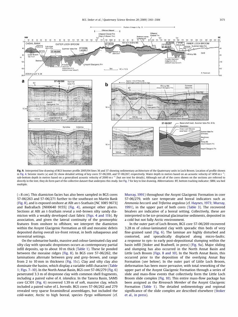
Fig. 9. Interpreted line drawing of BGS boomer profile 2005/04 lines 36 and 37 showing sedimentary architecture of the Quaternary units in Loch Broom. Location of profile shownin Fig. 4. Seismic insets (a) and (b) show detailed setting of key cores 57-06/269, and 57-06/267, respectively. Water depth in metres based on an acoustic velocity of 1450 m s�1;sub-bottom depth in metres based on a generalised acoustic velocity of 2000 m s�1 (but see text for details). Although not all of the cores shown on the sections are referred todirectly in the text, they do form part of the collective dataset that underpins this study. See Fig. 7 for key to line drawing. Abbreviations: BT, bottom tracking indicator; SBM, sea bedmultiple.
M.S. Stoker et al. / Quaternary Science Reviews 28 (2009) 3161–3184 3171
(<8 cm). This diamicton facies has also been sampled in BGS cores57-06/263 and 57-06/271 further to the southeast on Martin Bank(Fig. 8), and is exposed onshore at Allt an t-Srathain [NC 1085 9673]and Badrallach [NH0640 9155] (Fig. 4), amongst other places.Sections at Allt an t-Srathain reveal a red–brown silty sandy dia-micton with a weakly developed clast fabric (Figs. 4 and 11b). Byassociation, and given the lateral continuity of the geomorphicfeatures from onshore to offshore, we interpret the diamictonwithin the Assynt Glacigenic Formation as till and morainic debrisdeposited during overall ice-front retreat, in both subaqueous andterrestrial settings.
On the submarine banks, massive and colour-laminated clay andsilty clay with sporadic dropstones occurs as contemporary partialinfill deposits, up to about 10 m thick (Table 1). These lie pondedbetween the moraine ridges (Fig. 8). In BGS core 57-06/262, thelaminations alternate between grey and grey–brown, and rangefrom 2 to 10 mm in thickness (Fig. 11c). Clay and silty clay alsodominate the basins, which display a variable infill character (Table1; Figs. 7–10). In the North Annat Basin, BGS core 57-06/279 (Fig. 6)penetrated 3.3 m of dropstone clay with common shell fragments,including a paired valve of A. islandica. In the Tanera Basin, SAMScore GC101 (Fig. 6) recovered 1.39 m of soft, massive clay, whichincluded a paired valve of L. borealis. BGS cores 57-06/262 and 279revealed very sparse foraminiferal assemblages, but included thecold-water, Arctic to high boreal, species Pyrgo williamsoni (cf.
Murray, 1991) throughout the Assynt Glacigenic Formation in core57-06/279, with rare temperate and boreal indicators such asAmmonia beccarii and Trifarina angulosa (cf. Haynes, 1973; Murray,1991), in the upper part of both cores (Table 3). The recoveredbivalves are indicative of a boreal setting. Collectively, these areinterpreted to be ice-proximal glacimarine sediments, deposited ina cold but not fully Arctic environment.
In the outer part of Loch Broom, BGS core 57-06/269 recovered3.28 m of colour-laminated clay with sporadic thin beds of veryfine-grained sand (Fig. 6). The laminae are highly disturbed andcontorted, and sporadically displaced along micro-faults;a response to syn- to early post-depositional slumping within thebasin infill (Stoker and Bradwell, in press) (Fig. 9a). Major slidingand slumping has also occurred in the North Annat Basin andLittle Loch Broom (Figs. 8 and 10). In the North Annat Basin, thisoccurred prior to the deposition of the overlying Annat BayFormation (see below). In the outer part of Little Loch Broom,deformation has been more pervasive, with total reworking of theupper part of the Assynt Glacigenic Formation through a series ofslide and mass-flow events that collectively form the Little LochBroom slide complex (Fig. 10). This entire mass-flow package hasbeen assigned as the Rireavach Member of the Assynt GlacigenicFormation (Table 1). The detailed sedimentology and regionalsignificance of the slide complex are described elsewhere (Stokeret al., in press).
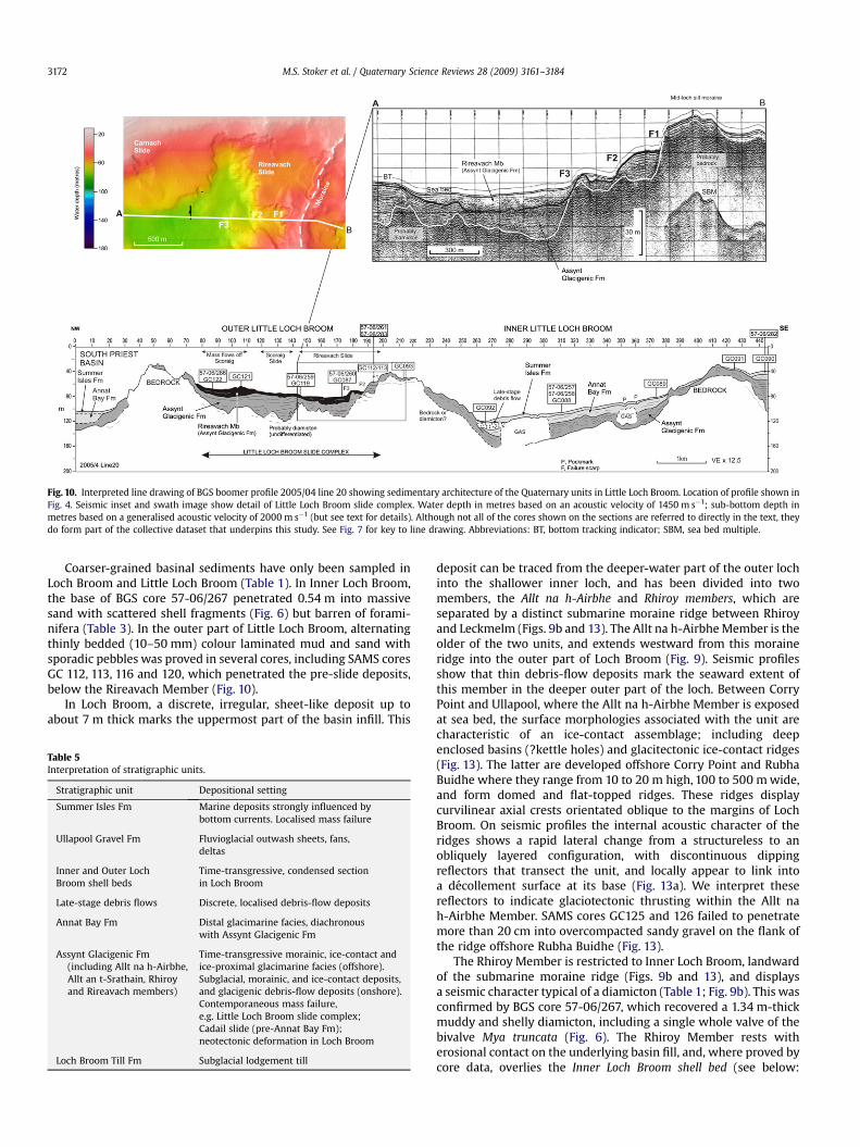
Fig. 10. Interpreted line drawing of BGS boomer profile 2005/04 line 20 showing sedimentary architecture of the Quaternary units in Little Loch Broom. Location of profile shown inFig. 4. Seismic inset and swath image show detail of Little Loch Broom slide complex. Water depth in metres based on an acoustic velocity of 1450 m s�1; sub-bottom depth inmetres based on a generalised acoustic velocity of 2000 m s�1 (but see text for details). Although not all of the cores shown on the sections are referred to directly in the text, theydo form part of the collective dataset that underpins this study. See Fig. 7 for key to line drawing. Abbreviations: BT, bottom tracking indicator; SBM, sea bed multiple.
M.S. Stoker et al. / Quaternary Science Reviews 28 (2009) 3161–31843172
Coarser-grained basinal sediments have only been sampled inLoch Broom and Little Loch Broom (Table 1). In Inner Loch Broom,the base of BGS core 57-06/267 penetrated 0.54 m into massivesand with scattered shell fragments (Fig. 6) but barren of forami-nifera (Table 3). In the outer part of Little Loch Broom, alternatingthinly bedded (10–50 mm) colour laminated mud and sand withsporadic pebbles was proved in several cores, including SAMS coresGC 112, 113, 116 and 120, which penetrated the pre-slide deposits,below the Rireavach Member (Fig. 10).
In Loch Broom, a discrete, irregular, sheet-like deposit up toabout 7 m thick marks the uppermost part of the basin infill. This
Table 5Interpretation of stratigraphic units.
Stratigraphic unit Depositional setting
Summer Isles Fm Marine deposits strongly influenced bybottom currents. Localised mass failure
Ullapool Gravel Fm Fluvioglacial outwash sheets, fans,deltas
Inner and Outer LochBroom shell beds
Time-transgressive, condensed sectionin Loch Broom
Late-stage debris flows Discrete, localised debris-flow deposits
Annat Bay Fm Distal glacimarine facies, diachronouswith Assynt Glacigenic Fm
Assynt Glacigenic Fm(including Allt na h-Airbhe,Allt an t-Srathain, Rhiroyand Rireavach members)
Time-transgressive morainic, ice-contact andice-proximal glacimarine facies (offshore).Subglacial, morainic, and ice-contact deposits,and glacigenic debris-flow deposits (onshore).Contemporaneous mass failure,e.g. Little Loch Broom slide complex;Cadail slide (pre-Annat Bay Fm);neotectonic deformation in Loch Broom
Loch Broom Till Fm Subglacial lodgement till
deposit can be traced from the deeper-water part of the outer lochinto the shallower inner loch, and has been divided into twomembers, the Allt na h-Airbhe and Rhiroy members, which areseparated by a distinct submarine moraine ridge between Rhiroyand Leckmelm (Figs. 9b and 13). The Allt na h-Airbhe Member is theolder of the two units, and extends westward from this moraineridge into the outer part of Loch Broom (Fig. 9). Seismic profilesshow that thin debris-flow deposits mark the seaward extent ofthis member in the deeper outer part of the loch. Between CorryPoint and Ullapool, where the Allt na h-Airbhe Member is exposedat sea bed, the surface morphologies associated with the unit arecharacteristic of an ice-contact assemblage; including deepenclosed basins (?kettle holes) and glacitectonic ice-contact ridges(Fig. 13). The latter are developed offshore Corry Point and RubhaBuidhe where they range from 10 to 20 m high, 100 to 500 m wide,and form domed and flat-topped ridges. These ridges displaycurvilinear axial crests orientated oblique to the margins of LochBroom. On seismic profiles the internal acoustic character of theridges shows a rapid lateral change from a structureless to anobliquely layered configuration, with discontinuous dippingreflectors that transect the unit, and locally appear to link intoa decollement surface at its base (Fig. 13a). We interpret thesereflectors to indicate glaciotectonic thrusting within the Allt nah-Airbhe Member. SAMS cores GC125 and 126 failed to penetratemore than 20 cm into overcompacted sandy gravel on the flank ofthe ridge offshore Rubha Buidhe (Fig. 13).
The Rhiroy Member is restricted to Inner Loch Broom, landwardof the submarine moraine ridge (Figs. 9b and 13), and displaysa seismic character typical of a diamicton (Table 1; Fig. 9b). This wasconfirmed by BGS core 57-06/267, which recovered a 1.34 m-thickmuddy and shelly diamicton, including a single whole valve of thebivalve Mya truncata (Fig. 6). The Rhiroy Member rests witherosional contact on the underlying basin fill, and, where proved bycore data, overlies the Inner Loch Broom shell bed (see below:
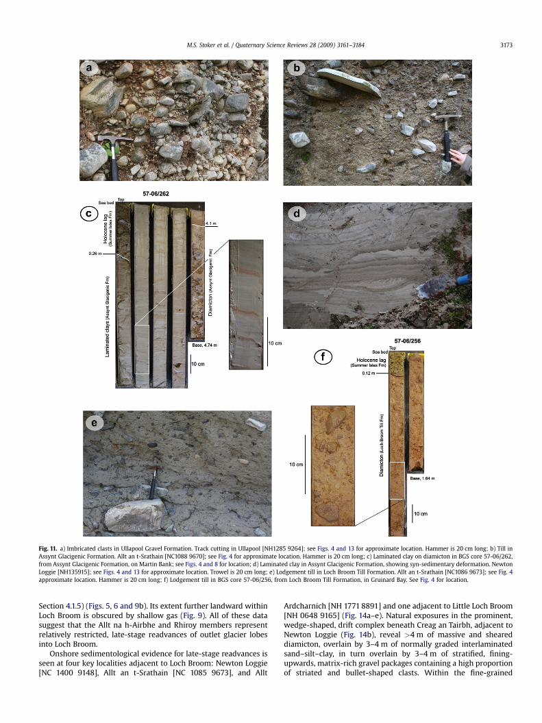
Fig. 11. a) Imbricated clasts in Ullapool Gravel Formation. Track cutting in Ullapool [NH1285 9264]; see Figs. 4 and 13 for approximate location. Hammer is 20 cm long; b) Till inAssynt Glacigenic Formation. Allt an t-Srathain [NC1088 9670]; see Fig. 4 for approximate location. Hammer is 20 cm long; c) Laminated clay on diamicton in BGS core 57-06/262,from Assynt Glacigenic Formation, on Martin Bank; see Figs. 4 and 8 for location; d) Laminated clay in Assynt Glacigenic Formation, showing syn-sedimentary deformation. NewtonLoggie [NH135915]; see Figs. 4 and 13 for approximate location. Trowel is 20 cm long; e) Lodgement till in Loch Broom Till Formation. Allt an t-Srathain [NC1086 9673]; see Fig. 4approximate location. Hammer is 20 cm long; f) Lodgement till in BGS core 57-06/256, from Loch Broom Till Formation, in Gruinard Bay. See Fig. 4 for location.
M.S. Stoker et al. / Quaternary Science Reviews 28 (2009) 3161–3184 3173
Section 4.1.5) (Figs. 5, 6 and 9b). Its extent further landward withinLoch Broom is obscured by shallow gas (Fig. 9). All of these datasuggest that the Allt na h-Airbhe and Rhiroy members representrelatively restricted, late-stage readvances of outlet glacier lobesinto Loch Broom.
Onshore sedimentological evidence for late-stage readvances isseen at four key localities adjacent to Loch Broom: Newton Loggie[NC 1400 9148], Allt an t-Srathain [NC 1085 9673], and Allt
Ardcharnich [NH 1771 8891] and one adjacent to Little Loch Broom[NH 0648 9165] (Fig. 14a–e). Natural exposures in the prominent,wedge-shaped, drift complex beneath Creag an Tairbh, adjacent toNewton Loggie (Fig. 14b), reveal >4 m of massive and sheareddiamicton, overlain by 3–4 m of normally graded interlaminatedsand–silt–clay, in turn overlain by 3–4 m of stratified, fining-upwards, matrix-rich gravel packages containing a high proportionof striated and bullet-shaped clasts. Within the fine-grained
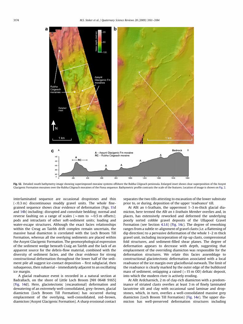
Fig. 12. Detailed swath bathymetry image showing superimposed moraine systems offshore the Rubha Coigeach peninsula. Enlarged inset shows clear superposition of the AssyntGlacigenic Formation moraines over the Rubha Coigeach moraines of the Fiona sequence. Bathymetric profile contrasts the scale of the features. Location of image is shown on Fig. 2.
M.S. Stoker et al. / Quaternary Science Reviews 28 (2009) 3161–31843174
interlaminated sequence are occasional dropstones and thin(<0.3 m) discontinuous muddy gravel units. The whole fine-grained sequence shows clear evidence of deformation (Figs. 11dand 14b) including: disrupted and convolute bedding; normal andreverse faulting on a range of scales (wmm to w0.5 m offsets);pods and intraclasts of other soft-sediment units; loading andwater-escape structures. Although the exact facies relationshipswithin the Creag an Tairbh drift complex remain uncertain, themassive basal diamicton is correlated with the Loch Broom TillFormation, whereas all the overlying sediments are placed withinthe Assynt Glacigenic Formation. The geomorphological expressionof the sediment wedge beneath Craig an Tairbh and the lack of anapparent source for the debris-flow material, combined with thediversity of sediment facies, and the clear evidence for strongconstructional deformation throughout the lower half of the sedi-ment pile all suggest ice-contact deposition – first subglacial, thensubaqueous, then subaerial – immediately adjacent to an oscillatingice margin.
A glacial readvance event is recorded in a natural section atBadrallach, on the shore of Little Loch Broom [NH 0648 9165](Fig. 14d). Here, glaciotectonic (excavational) deformation anddewatering of an extremely well-consolidated, grey–brown, glacialdiamicton (Loch Broom Till Formation) has occurred duringemplacement of the overlying, well-consolidated, red–brown,diamicton (Assynt Glacigenic Formation). A sharp erosional contact
separates the two tills attesting to excavation of the lower substrateprior to, or during, deposition of the upper ‘readvance’ till.
At Allt an t-Srathain, the uppermost 1–3 m-thick glacial dia-micton, here termed the Allt an t-Srathain Member overlies and, inplaces, has extensively reworked and deformed the underlyingpoorly sorted cobble gravel deposits of the Ullapool GravelFormation (see Section 4.1.6) (Fig. 14c). The degree of reworkingranges from a subtle re-alignment of gravel clasts (i.e. a flattening ofdip direction) to a pervasive deformation of the whole 1–2 m thickgravel unit, including incorporation of rip-up clasts, compressionalfold structures, and sediment-filled shear planes. The degree ofdeformation appears to decrease with depth, suggesting thatemplacement of the overriding diamicton was responsible for thedeformation structures. We relate this facies assemblage toconstructional glaciotectonic deformation associated with a localreadvance of the ice margin over glaciofluvial outwash. The limit ofthe readvance is clearly marked by the outer edge of the bulldozedmass of sediment, onlapping a raised (þ15 m OD) deltaic deposit,into which the modern river is actively eroding.
At Allt Ardcharnich, 2 m of clay-rich diamicton with a predom-inance of striated clasts overlies at least 3 m of finely laminatedlacustrine silt and clay with occasional sand laminae and drop-stones, which, in turn, overlies a well-consolidated massive greydiamicton (Loch Broom Till Formation) (Fig. 14e). The upper dia-micton has well-preserved deformation structures including
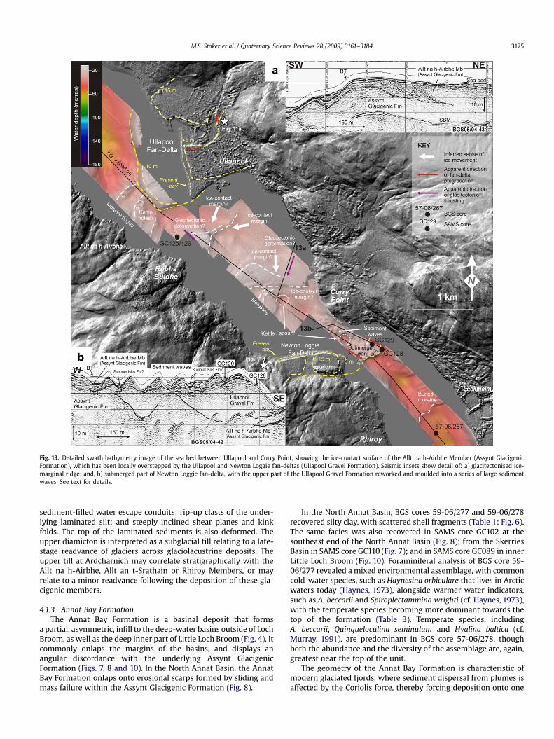
Fig. 13. Detailed swath bathymetry image of the sea bed between Ullapool and Corry Point, showing the ice-contact surface of the Allt na h-Airbhe Member (Assynt GlacigenicFormation), which has been locally overstepped by the Ullapool and Newton Loggie fan-deltas (Ullapool Gravel Formation). Seismic insets show detail of: a) glacitectonised ice-marginal ridge; and, b) submerged part of Newton Loggie fan-delta, with the upper part of the Ullapool Gravel Formation reworked and moulded into a series of large sedimentwaves. See text for details.
M.S. Stoker et al. / Quaternary Science Reviews 28 (2009) 3161–3184 3175
sediment-filled water escape conduits; rip-up clasts of the under-lying laminated silt; and steeply inclined shear planes and kinkfolds. The top of the laminated sediments is also deformed. Theupper diamicton is interpreted as a subglacial till relating to a late-stage readvance of glaciers across glaciolacustrine deposits. Theupper till at Ardcharnich may correlate stratigraphically with theAllt na h-Airbhe, Allt an t-Srathain or Rhiroy Members, or mayrelate to a minor readvance following the deposition of these gla-cigenic members.
4.1.3. Annat Bay FormationThe Annat Bay Formation is a basinal deposit that forms
a partial, asymmetric, infill to the deep-water basins outside of LochBroom, as well as the deep inner part of Little Loch Broom (Fig. 4). Itcommonly onlaps the margins of the basins, and displays anangular discordance with the underlying Assynt GlacigenicFormation (Figs. 7, 8 and 10). In the North Annat Basin, the AnnatBay Formation onlaps onto erosional scarps formed by sliding andmass failure within the Assynt Glacigenic Formation (Fig. 8).
In the North Annat Basin, BGS cores 59-06/277 and 59-06/278recovered silty clay, with scattered shell fragments (Table 1; Fig. 6).The same facies was also recovered in SAMS core GC102 at thesoutheast end of the North Annat Basin (Fig. 8); from the SkerriesBasin in SAMS core GC110 (Fig. 7); and in SAMS core GC089 in innerLittle Loch Broom (Fig. 10). Foraminiferal analysis of BGS core 59-06/277 revealed a mixed environmental assemblage, with commoncold-water species, such as Haynesina orbiculare that lives in Arcticwaters today (Haynes, 1973), alongside warmer water indicators,such as A. beccarii and Spiroplectammina wrighti (cf. Haynes, 1973),with the temperate species becoming more dominant towards thetop of the formation (Table 3). Temperate species, includingA. beccarii, Quinqueloculina seminulum and Hyalina baltica (cf.Murray, 1991), are predominant in BGS core 57-06/278, thoughboth the abundance and the diversity of the assemblage are, again,greatest near the top of the unit.
The geometry of the Annat Bay Formation is characteristic ofmodern glaciated fjords, where sediment dispersal from plumes isaffected by the Coriolis force, thereby forcing deposition onto one
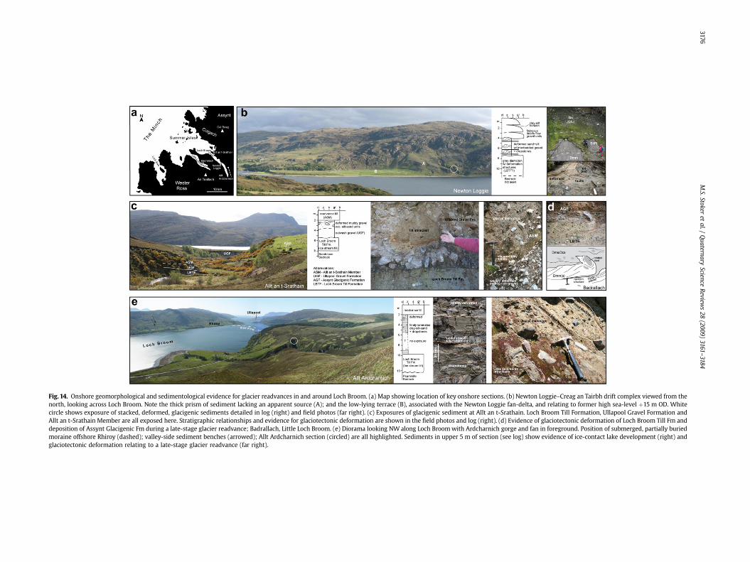
Fig. 14. Onshore geomorphological and sedimentological evidence for glacier readvances in and around Loch Broom. (a) Map showing location of key onshore sections. (b) Newton Loggie–Creag an Tairbh drift complex viewed from thenorth, looking across Loch Broom. Note the thick prism of sediment lacking an apparent source (A); and the low-lying terrace (B), associated with the Newton Loggie fan-delta, and relating to former high sea-level þ15 m OD. Whitecircle shows exposure of stacked, deformed, glacigenic sediments detailed in log (right) and field photos (far right). (c) Exposures of glacigenic sediment at Allt an t-Srathain. Loch Broom Till Formation, Ullapool Gravel Formation andAllt an t-Srathain Member are all exposed here. Stratigraphic relationships and evidence for glaciotectonic deformation are shown in the field photos and log (right). (d) Evidence of glaciotectonic deformation of Loch Broom Till Fm anddeposition of Assynt Glacigenic Fm during a late-stage glacier readvance; Badrallach, Little Loch Broom. (e) Diorama looking NW along Loch Broom with Ardcharnich gorge and fan in foreground. Position of submerged, partially buriedmoraine offshore Rhiroy (dashed); valley-side sediment benches (arrowed); Allt Ardcharnich section (circled) are all highlighted. Sediments in upper 5 m of section (see log) show evidence of ice-contact lake development (right) andglaciotectonic deformation relating to a late-stage glacier readvance (far right).
M.S.Stoker
etal./
Quaternary
ScienceReview
s28
(2009)3161–3184
3176
M.S. Stoker et al. / Quaternary Science Reviews 28 (2009) 3161–3184 3177
side of the depositional basin (Syvitski, 1989). Its absence in LochBroom and the outer part of Little Loch Broom is consistent withsediment derivation from a local source, i.e. a fjord glacier-margin,though the absence of dropstones sampled in any of the coressuggests that the unit was deposited in an ice-distal glacimarinesetting. The mix of temperate and cold–arctic foraminiferal speciesimplies a mixing of both Atlantic and Arctic water masses duringdeposition (Kristensen et al., 2000). At the present-day, A. beccariiand H. orbiculare are occasionally found living together in areassuch as Nova Scotia, where the seasonal environmental conditions(temperature, salinity) vary considerably (Robertson and Mann,1980; Scott et al., 1980).
4.1.4. Late-stage debris flows (lithogenetic unit)A number of discrete, localised, basin-floor wedges occur on
the flanks of several basins, including outer Loch Broom, innerLittle Loch Broom, Coigach Basin, and South and South East Annatbasins. They generally occur sandwiched between the Annat Bayand Summer Isles Formations (e.g. Fig. 10), though where theformer is absent they separate the Assynt Glacigenic and SummerIsles Formations (e.g. Fig. 9). Their seismic character and geometry(Table 1) is a characteristic acoustic response of debris-flowdeposits (Nardin et al., 1979; Embley, 1980). This is consistent withtheir lithofacies characteristics, which includes soft, pebbly,muddy diamicton recovered in SAMS core GC123 in Loch Broom(Fig. 9), and folded beds of clay and sandy silt with intraclasts ofmuddy sand in SAMS core GC092 in Little Loch Broom (Fig. 10)(Stoker et al., in press).
4.1.5. Inner and Outer Loch Broom shell beds (lithogenetic unit)This lithogenetic unit is presently only recognised in Loch
Broom where it has been sampled in BGS core 57-06/269 in theouter loch (Outer Loch Broom shell bed, 0.68 m thick), and 57-06/267 in the inner loch (Inner Loch Broom shell bed, 0.64 m thick)(Figs. 6 and 9).
The shell beds are divisible into three subunits or subfacies(Table 1), of which the lower and middle sections are comparable inboth cores, but the upper sections are different. The basal muddysand/sandy mud section contains common whole and fragmentedshells of C. islandica and A. islandica, whereas the middle sectioncomprises a denser hash with a predominance of large single valvesof C. islandica and subordinate Tridonta elliptica, which showevidence of boring, abrasion and encrustation. The shells arerandomly orientated in both of these sections. In core 57-06/269,the upper section contains abundant gravel clasts mixed withwhole and fragmented shells, including T. elliptica, whereas in core57-06/267, it consists of a crudely bedded accumulation of sub-horizontally aligned shells, dominated by C. islandica. The abun-dance of shell material contained within the shell bed contrastsmarkedly with the underlying deposits of the Assynt GlacigenicFormation, where shell material is either absent (57-06/269) ormuch reduced in abundance and lacking C. islandica (57-06/267).
Foraminiferal analysis of the shell beds revealed mixed assem-blages (Table 3). In the Outer Loch Broom shell bed, core 57-06/269proved a warm water assemblage including an abundance ofA. beccarii together with species such as Bulimina elongata(cf. Haynes, 1973; Murray, 1985, 1991) and H. baltica intermixedwith the presence of the cold-water species H. orbiculare, Elphidiumincertum and E. excavatum clavatum (cf. Wilkinson, 1979; Murray,1991). In core 57-06/267, the Inner Loch Broom shell bed containedvery rare E. excavatum clavatum mixed with more common warmerwater species, including Q. seminulum and Cibicides lobatulus.
On the basis of their stratigraphic context, these shell beds arecorrelated to form part of the same lithogenetic unit, which weinterpret as an environmentally condensed section (sensu Kidwell,
1998) that accumulated under highly variable and fluctuatingenvironmental conditions. The beds probably represent in situdeath assemblages, dominated by the bivalve C. islandica, whoseabundance is comparable to modern Canadian Arctic fjords whereextensive concentrations form shell pavements on the floor of thefjord (Dale et al., 1989). The possible significance of the gravel-richupper section of the Outer Loch Broom shell bed is discussedfurther in Section 5.1.
4.1.6. Ullapool Gravel FormationThe Ullapool Gravel Formation is a fluvioglacial highstand
deposit, dominated by cobble-grade gravel (Table 1; Fig. 11a),occurring in coastal locations within the study area – most notablyaround the margins of Loch Broom, Little Loch Broom and LochKanaird (Fig. 4). The fan-deltas at Ullapool and Newton Loggie, inLoch Broom, form two of the most distinctive onshore occurrencesof this unit, the limits of which have been extended offshore intothe loch using swath bathymetric data (Fig. 13). The Ullapool fan-delta is a large >30 m thick sandy gravel accumulation thatprogrades into the fjord, more than halfway across Loch Broom.Swath bathymetry and boomer profiles indicate that this fan-deltadeposit oversteps, and therefore postdates, the ice-contactgeomorphology associated with the Allt na h-Airbhe Member of theAssynt Glacigenic Formation (Figs. 9 and 13). However, 2 km to theNW, a similar fan-delta within the Ullapool Gravel Formation islocally overlain and reworked by the glacigenic Allt an t-SrathainMember (Fig. 14c). The geometry of these fan-delta deposits hasbeen further modified by post-depositional changes in relative sealevel. The Ullapool fan-delta preserves former shorelines atapproximately þ15 m, þ5 m, present-day (i.e. 0 m), and –10 m OD(Fig. 13). The raised sea-level evidence is also observed onshore atRhue and Newton Loggie; however, a submerged surface offshoreNewton Loggie at ca –20 m (Fig. 13b) may relate to an earlysubaqueous ice-contact stage in fan-delta development. Oneoffshore core – SAMS core GC129 (Fig. 13) – tested the submergedfan-delta offshore Newton Loggie and proved 0.29 m of gravel ina muddy sandy matrix. The top of this submerged fan-delta hasbeen reworked and moulded into several large sediment waves, upto 70 m wide and 5 m high. Partial burial by a discontinuous veneerof gravelly muddy sand (SAMS core GC129: Summer Isles Forma-tion?) indicates that these waves are not active, and therefore notpart of the present-day hydrodynamic regime (see Section 5.2).
4.1.7. Summer Isles FormationThe Summer Isles Formation occurs widely throughout the
offshore region, being thickest in the basins but occurs as a seis-mically unresolvable lag deposit on shallow banks (Table 1). In thebasins, the contact with the underlying Annat Bay Formation (andolder units) is commonly an erosional unconformity (Fig. 7b); thetop of the unit is marked by the present-day sea bed, which is alsolocally an erosional surface on the flanks of the basins, and on oradjacent to intrabasinal highs where discrete scours are developed(Figs. 7 and 8b). The effect of shallow gas release from the basins isalso noted at the sea bed by the localised development of pock-marks (Stoker et al., 2006) (Fig. 8b).
The thickest accumulations of the Summer Isles Formationoccur in Loch Broom, where its mounded seismic character,geometry and lithofacies (Table 1), together with rapid lateralchanges in thickness (Fig. 9), resemble sediment drift deposits(Faugeres et al., 1999; Stow et al., 2002). In Loch Broom, a thin basalunit occupies localised scours cut into the underlying Assynt Gla-cigenic Formation (Stoker and Bradwell, in press), and is down-lapped by the thicker and more prominent drift-like deposits(Fig. 9b). This basal unit was sampled in BGS core 57-06/267, whichproved a 0.16 m-thick shell hash, including several large valves of
M.S. Stoker et al. / Quaternary Science Reviews 28 (2009) 3161–31843178
A. islandica, overlain by an w0.3 m-thick medium- to coarse-grained, muddy, slightly gravelly and shelly sand, which gradesupwards into silty clay at about 1.6 m depth in the core (Fig. 6). Thenumerous BGS and SAMS cores penetrating this unit show that thesilty clay lithofacies, with sporadic shells and organic material,forms the main component of the Summer Isles Formation withinthe basins.
Microfaunal analysis of the basinal sediments of the SummerIsles Formation provided a variable record of foraminiferal assem-blages. BGS cores 57-06/277, 57-06/278 and 57-06/279 in the NorthAnnat Basin revealed rich warm water assemblages dominated byA. beccarii, Bulimina marginata (cf. Haynes, 1973; Murray, 1985,1991) and B. elongata (Table 3). In Loch Broom, the same specieslargely predominate in BGS cores 57-06/269 and 57-06/267, thoughthe frequency and diversity of species in the upper part of the unitis very variable. In the outer loch, BGS core 57-06/268, whichsampled a mounded sediment drift (Fig. 9), revealed only a sparse,poorly preserved, fauna including rare A. beccarii. In the inner loch,A. beccarii is absent where sampled from the upper part of the unitin core 57-06/267, whereas BGS core 57-06/264 was totally barrenof calcareous microfossils. Additional macrofaunal identificationincludes intact bivalve shells of N. sulcata and G. humanus, recov-ered from SAMS core GC101 in the Tanera Basin.
The geometry of the basinal deposits together with the evidencefor both scouring and reworking at both the base and top (sea bed) ofthe Summer Isles Formation suggests that its deposition has been
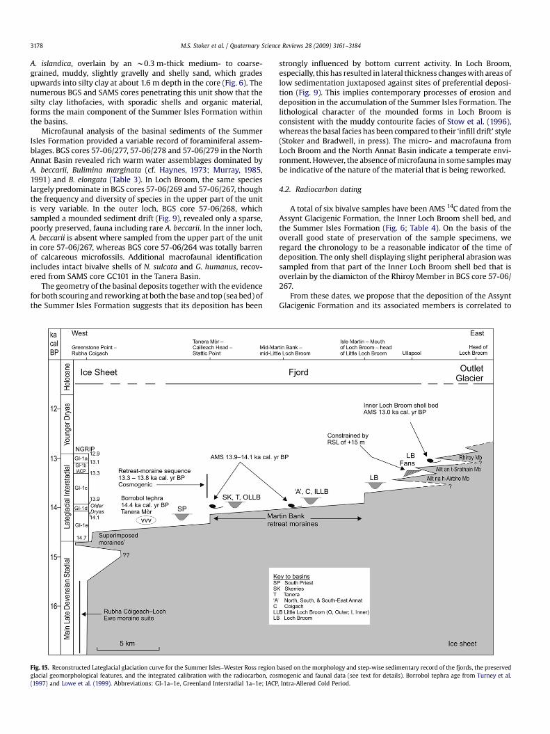
Fig. 15. Reconstructed Lateglacial glaciation curve for the Summer Isles–Wester Ross regionglacial geomorphological features, and the integrated calibration with the radiocarbon, cos(1997) and Lowe et al. (1999). Abbreviations: GI-1a–1e, Greenland Interstadial 1a–1e; IACP
strongly influenced by bottom current activity. In Loch Broom,especially, this has resulted in lateral thickness changes with areas oflow sedimentation juxtaposed against sites of preferential deposi-tion (Fig. 9). This implies contemporary processes of erosion anddeposition in the accumulation of the Summer Isles Formation. Thelithological character of the mounded forms in Loch Broom isconsistent with the muddy contourite facies of Stow et al. (1996),whereas the basal facies has been compared to their ‘infill drift’ style(Stoker and Bradwell, in press). The micro- and macrofauna fromLoch Broom and the North Annat Basin indicate a temperate envi-ronment. However, the absence of microfauna in some samples maybe indicative of the nature of the material that is being reworked.
4.2. Radiocarbon dating
A total of six bivalve samples have been AMS 14C dated from theAssynt Glacigenic Formation, the Inner Loch Broom shell bed, andthe Summer Isles Formation (Fig. 6; Table 4). On the basis of theoverall good state of preservation of the sample specimens, weregard the chronology to be a reasonable indicator of the time ofdeposition. The only shell displaying slight peripheral abrasion wassampled from that part of the Inner Loch Broom shell bed that isoverlain by the diamicton of the Rhiroy Member in BGS core 57-06/267.
From these dates, we propose that the deposition of the AssyntGlacigenic Formation and its associated members is correlated to
based on the morphology and step-wise sedimentary record of the fjords, the preservedmogenic and faunal data (see text for details). Borrobol tephra age from Turney et al., Intra-Allerød Cold Period.

M.S. Stoker et al. / Quaternary Science Reviews 28 (2009) 3161–3184 3179
the Lateglacial Interstadial (Greenland Interstadial 1). In the TaneraBasin, SAMS core GC101 produced an age of 13,973�73 years BPfrom the L. borealis valve, whereas an age of 14,111�98 years BPwas determined from A. islandica in BGS core 57-06/279 in theNorth Annat Basin. In Loch Broom, an age of 13,047� 59 years BPwas determined from C. islandica taken from the Inner Loch Broomshell bed in BGS core 57-06/267, beneath the Rhiroy Member of theAssynt Glacigenic Formation. On the basis of these dates, wepropose that glacially influenced sedimentation prevailed in thefjords of the Summer Isles region between ca 14 and 13 ka BP.
An early Holocene date of 8012� 53 years BP was obtained fromA. islandica recovered from a shell hash at the base of the SummerIsles Formation in BGS core 57-06/267, immediately overlying theRhiroy Member. This implies that the Rhiroy Member was depos-ited at some time during the interval ca 13–8 ka BP. Further
Fig. 16. Schematic reconstructions of Lateglacial ice-sheet retreat in NW Scotland. Timeslicesice thickness uncertain, therefore nunataks not shown. (a) End GS-2: ice sheet grounded widentified.) (b) GI-1e: ice sheet calving back to stable grounded position offshore Rubha CoigeReadvance’) moraine probably represents onshore equivalent. (c) GI-1d: Lobate ice margin sand at Aultbea are likely age-equivalents. (d) GI-1c: ice-cap outlet glaciers terminating at theby glaciers. (e) GI-1a: period of outlet glacier oscillations in the vicinity of Ullapool (ca 13.5Surrounding feeder valleys may also have been largely ice-free at this time; mountain ice fie(f) GS-1: restricted (but reinvigorated?) ice cap and cirque glaciation in periphery of study areDryas Stadial. Total deglaciation of NW Scotland probably by 11.5 ka BP.
discussion of this age model is presented in Section 5.1. Dates of7670� 44 and 3853�72 years BP from N. sulcata and G. humanus,respectively, in SAMS core GC101 confirm that the Summer IslesFormation represents Holocene postglacial marine sedimentationin the fjords.
5. Discussion
It has been well established for many years that the Lateglacialinterval (15–10 ka BP) in northern Britain was characterised by aninherently unstable climate – a flickering transition from glacial tointerglacial conditions (e.g. Gray and Lowe, 1977; Lowe et al., 1999;Brooks and Birks, 2000). Changes in deglacial surface water circu-lation along the Hebridean continental margin (Kroon et al., 1997),together with palaeoclimatic data derived from fossil beetle and
show ice extent at various intervals during the period from >15 ka to 12.5 ka BP. Note:est of Rubha Coigeach and Rubha Mor headlands. (No onshore moraine equivalents
ach and Rubha Mor following thermal maximum (ca 14.5 ka BP). Gairloch (‘Wester Rosstationary at Achiltibuie-Stattic Point Moraine. Onshore moraines around Loch Lurgainnpresent-day coastline in Loch Kanaird and Little Loch Broom. Loch Broom still occupied
ka BP) followed by ice-free, open marine, conditions in Inner Loch Broom (ca 13 ka BP).lds still exist. Final late-stage readvance back into Loch Broom (early Younger Dryas?).a (Fisherfield, Beinn Dearg, Assynt and isolated mountains) during mid-to-late Younger
M.S. Stoker et al. / Quaternary Science Reviews 28 (2009) 3161–31843180
midge assemblages in terrestrial sediments from Scotland, Englandand Wales (Mayle et al., 1999) reveal the following Lateglacial eventstratigraphy for the British Isles: (a) a rapid warming ca 14.8 ka BPto a thermal maximum between 14.7 and 14.5 ka BP; (b) a subse-quent step-wise decline in temperature, punctuated by coolreversals at ca 14 and 13.5 ka BP, terminating in (c) a severe 1200-yrcold event – the Younger Dryas Stadial (GS-1). This variation inclimate shows remarkable compatibility with the Greenland ice-core data, which has been shown to be a robust record of envi-ronmental change throughout the North Atlantic region (Bjorcket al., 1998; Lowe et al., 2008).
Key questions still remain concerning the extent of ice cover andthe nature of glacier fluctuations in Scotland during this phase ofclimatic instability. Did glaciers in Scotland disappear completelyduring the Lateglacial Interstadial? Did glaciers grow anew fromcorries and high-altitude sites in the Younger Dryas? And howextensive and how responsive were Scotland’s glaciers at varioustimes during the Lateglacial period (GS-1 vs GI-1). Previously, thisquestion has been largely addressed from a land-based perspective(Gray and Lowe, 1977; Benn, 1997; Clapperton, 1997; Benn andLukas, 2006; Golledge et al., 2008; and references therein).However, it is clear that any attempt to understand the deglacialrecord of the British Ice Sheet must take both the marine andterrestrial records of change into consideration. For example, Kroonet al. (1997) reported evidence for a phase of ice rafting along theHebridean margin during GI-1b (the Intra-Allerød Cold Period,IACP); whilst our study has revealed that a highly dynamic andglacially influenced sedimentary regime prevailed in the fjords ofthe Summer Isles region during the Lateglacial Interstadial (frombefore 14 ka to ca 13 ka BP). It therefore seems implausible toinvoke complete deglaciation of NW Scotland during the LateglacialInterstadial. In Fig. 15, we present an event stratigraphy and glaci-ation curve for the Summer Isles region that combines the radio-carbon dates from this study, with other published radiometric andcosmogenic dates from this area. In the following discussion, thisframework provides the basis for assessing Lateglacial ice-sheet/ice-cap dynamics in NW Scotland based on (1) age-constrained ice-margin reconstruction, and (2) style of sedimentation.
5.1. Age model and ice-margin reconstruction
Regional evidence suggests that open arctic-water conditionsprevailed in The Minch ca 16–15 ka BP, with the ice-sheet marginlocated at or close to the present-day coastline (Peacock, 1975;Graham et al., 1990; Stoker and Bradwell, 2005; Everest et al.,2006; Stone and Ballantyne, 2006). In the Summer Isles region, weinfer this position to correspond with the ‘older’ suite of moraines,the Rubha Coigeach–Loch Ewe moraines (Figs. 4 and 16a), which,as yet, have not been correlated with moraines onshore. Wepropose that this line, from offshore Rubha Coigeach to the mouthof Loch Ewe, essentially forms the position of the ice-sheet marginas it stabilised following the demise of the Minch palaeo-icestream (Bradwell et al., 2007). The subsequent eastward retreat ofthe ice margin led to the development of fjordic and topograph-ically controlled outlet glaciers in this part of NW Scotland. Theproposed age model and ice-margin reconstructions (presented inFigs. 15 and 16) are based on a diverse set of new and previouslypublished onshore and offshore data.
The outer limit of the Assynt Glacigenic Formation ‘younger’moraine suite is clearly superimposed on the ‘older’ RubhaCoigeach–Loch Ewe moraine suite (Fig. 12), and represents a majorreadvance during ice-sheet deglaciation in NW Scotland. Thetiming and magnitude of this initial retreat and subsequent read-vance is still poorly constrained; however, a combination ofradiocarbon and cosmogenic dates suggests that this event
occurred prior to 14 ka BP (i.e. before GI-1d) (Bradwell et al., 2008b;Ballantyne et al., 2009) (Fig. 15). A core recovered from an isolationbasin on Tanera Mor (Fig. 2) sampled tephra shards at 5.7 m depthwith Borrobol affinities (Roberts et al., 1998). The Borrobol tephra isdated elsewhere to ca 14.4 ka BP (Turney et al., 1997; Pyne-O’Donnell, 2007); although the true stratigraphic nature of theBorrobol ash layer in Scotland is still debated, making its use asa definitive isochron uncertain (Pyne-O’Donnell et al., 2008). In theadjacent Tanera and North Annat basins, marine shells from prox-imal glaciomarine sediments have been dated to 13.9 ka and14.1 ka BP (this study) (Table 4). This is not inconsistent withcosmogenic exposure ages from boulders on moraines within theAssynt Glacigenic Formation at Achitibuie and near Sail Mhor,which indicate that the series of recessional moraines extendinglandward from the Summer Isles (Fig. 4) were probably depositedduring the first few centuries of the Lateglacial Interstadial (Brad-well et al., 2008b). A total of six 10Be exposure ages (Bradwell et al.,2008b; Ballantyne et al., 2009) from the distinct and well-con-strained Achiltibuie-Eilean Dubh-Stattic Point limit (timeline a inFig. 4) point to a minimum age of ca 13.5 ka BP for this moraine, andan Older Dryas (GI-1d) age has been proposed for this oscillation(Bradwell et al., 2008b; and reasserted by Ballantyne et al., 2009).All of these data suggest that the Summer Isles region was onlystarting to become ice-free from ca 14.0 ka BP onwards. This isconsistent with the infill stratigraphy of the fjord basins immedi-ately landward of the Summer Isles bedrock sill, which contains noevidence for a major grounded readvance from within the fjordregion out beyond the Rubha Coigeach headland.
On the basis of the chronological framework, it is tempting tospeculate on the timing and formation mechanism of the delicateoverprinted moraines offshore Rubha Coigeach. We propose thatthis regional ice-sheet position, represented by the outermostAssynt Glacigenic Formation moraine, was probably associatedwith the Lateglacial thermal maximum (GI-1e; ca 14.5 ka BP) –possibly in response to internally forced glaciological instabilitytriggered by a large-scale calving event. Such a phenomenon wouldbe expected when abrupt warming causes the glacier terminus tothin, forcing the ice-sheet margin to calve en masse and retreat toa point where its terminal thickness just exceeds the point offlotation (Van der Veen, 1996; Benn et al., 2007). Calving events ofthis kind have been reported from many contemporary tidewaterglaciers in response to late 20th century warming (e.g. Cook et al.,2005; Joughin et al., 2008). Calving rates may also have beenenhanced by tidal stress, for which high tidal amplitudes and peakbed stress vectors have been predicted for the NW European shelfin the period from 15 to 11 ka BP (Uehara et al., 2006). Stabilisationof the ice-sheet margin, by grounding in shallower water, depositedDe Geer moraines. The delicate, well preserved, geomorphologicalform and the discontinuous expression of these De Geer morainesaround Rubha Coigeach and offshore Greenstone Point indicatea near-buoyant or lightly grounded ice margin (sensu Benn et al.,2007), consistent with terminus stabilisation following a wide-spread ‘mass-reduction’ or calving event. The absence of thesemoraines beyond this point indicates that the ice-sheet margin wasprobably floating immediately prior to this time, when relative sealevels were at least 30 m higher than present (Shennan et al., 2006).
The identification of a particular moraine type (delicate DeGeers), and style of marginal dynamics (grounding transition), andits likely association with a discrete climatic event (GI-1e; thermalmaximum) opens the possibility of further constraining the age ofthe Summer Isles moraine sequence. In the light of the collectiveevidence it seems most appropriate to place the British Ice Sheetmargin at the outermost Assynt Glacigenic Formation moraine(offshore Rubha Coigeach and Greenstone Point) at ca 14.5 ka BP,immediately after the GI-1e ‘thermal maximum’ (Fig. 16b).
M.S. Stoker et al. / Quaternary Science Reviews 28 (2009) 3161–3184 3181
Deglaciation in the following few centuries was of a lightlygrounded ice margin retreating to the southeast, occasionallypinning on the outermost bathymetric highs of the submerged partof the Summer Isles sill. As relative sea levels began to fall, and theice front encountered the main Tanera Mor-Eilean Dubh bathy-metric high (Fig. 4), the marginal zone became more firmlygrounded as the terminus pinned on the topography of the islands(Fig. 16c). Ice sheet retreat would have slowed accordingly. Thisperiod probably coincided with the Older Dryas cold interval (GI-1d), already associated with the dated Achiltibuie-Stattic Pointmoraine onshore (ca 14 ka BP; Bradwell et al., 2008b; Ballantyneet al., 2009) and recorded in the Greenland ice cores at 14.1–13.9 ka BP (Rasmussen et al., 2006; Lowe et al., 2008). Landward ofthis feature, the large closely spaced sea bed moraines from EileanDubh to Martin Bank probably represent firmly grounded oscilla-tions and stillstands punctuating overall ice-front retreat during GI-1c (13.9–13.3 ka BP) (Fig. 16d). We propose from this sequence ofevents that the Summer Isles ice lobe had retreated back to thevicinity of Ullapool by ca 13.5–13.3 ka BP.
The Inner Loch Broom shell bed has been dated at 13,047� 53years BP, and suggests that Little Loch Broom and two-thirds ofLoch Broom were ice free by this time. However, the glacigenicRhiroy Member diamicton (within the Assynt Glacigenic Forma-tion) overlies this shell bed in Inner Loch Broom (Fig. 6). Weinterpret this to represent just one of a number of local readvancesof ice back into the fjord in the vicinity of Ullapool (Figs. 15 and 16e).The Allt na h-Airbhe Member represents an initial readvanceoffshore Ullapool; the ice-contact landform assemblage associatedwith this member was subsequently overstepped by the fan-deltahighstand deposits of the Ullapool Gravel Formation (Fig. 13). Thelatter was probably deposited when relative sea level in this areawas about þ15 m OD (Sissons and Dawson, 1981; Shennan et al.,2006). The Allt an t-Srathain Member onshore overlies, reworksand in places oversteps the Ullapool Gravel Formation, suggestingthat this glacial readvance is equivalent to, or just postdates, theþ15-m sea level highstand. In Loch Broom, the gravel-rich uppersection of the Outer Loch Broom shell bed (Fig. 6) may representice-rafted dropstones deposited in association with one or both ofthese readvances. Collectively, this evidence constrains the age ofthe youngest offshore readvance, the Rhiroy Member, to the latestInterstadial–Younger Dryas (GI-1–GS-1) interval. As the presentlyaccepted Younger Dryas ice limits in this part of NW Scotland arerestricted to the mountain valleys and corries to the south and eastof the study area (Sissons, 1977; Bennett and Boulton, 1993;Finlayson and Bradwell, 2007) (Fig. 16f), it seems reasonable toassume that the Allt na h-Airbhe, Allt an t-Srathain, and Rhiroyglacigenic members all represent time-transgressive pre-cursors tothe Younger Dryas readvance (during GI-1a). Alternatively, andmore controversially, the Rhiroy Member may represent renewedice cap growth during the initial phase of the Younger Dryaschronozone (13.0–12.5 ka BP). This interpretation leaves the statusof the Younger Dryas readvance in NW Scotland uncertain.
Perhaps the most significant aspect of our age model is thatnone of the various dating methods (analytical, seismostratigraphicor geomorphic) are contradictory. Collectively, they describepunctuated recession of a dynamically evolving ice marginthroughout the Lateglacial Interstadial. Thus, we propose that theSummer Isles region experienced deglaciation from ca 15 to13 ka BP, interrupted by numerous readvances and ice-front oscil-lations of varying magnitude. Projecting backwards along a palaeo-ice-sheet flow line (Fig. 15), we suggest that Tanera Mor was ice freejust before ca 14.2 ka BP; Isle Martin was ice free by ca 13.7 BP;Ullapool and Corry Point were probably ice free by ca 13.5 ka BP;and Inner Loch Broom soon after. This represents an average ice-margin retreat rate of 20 m a�1 over 1500 years (based on Tanera
Mor to Corry Point), if the numerous ice-marginal oscillations arediscounted. Glaciers re-advanced into Loch Broom for the finaltime, as far as Rhiroy, some time after 13 ka BP. In further support ofthis model, our faunal data, recovered from several fjord cores,indicate fluctuating climatic conditions with mixed assemblages ofboreo-arctic and temperate species. Such mixing is not unexpectedwhen one considers the deglacial surface circulation record fromthe Hebrides margin, where rapid oscillations in sea-surfacetemperature and salinity attest to the frequent displacement of coolpolar water by relatively warm saline water throughout the Late-glacial Interstadial and into the Younger Dryas interval (Kroon et al.,1997). The evidence of ice-rafting at this latitude during the IACP(Kroon et al., 1997) might also be expected if, as our study suggests,tidewater glaciers persisted in NW Scottish fjords into the latterhalf of the Lateglacial Interstadial (GI-1c–a).
5.2. Style of sedimentation
Syvitski et al. (1987) recognise five stages of fjord infilling:(1) glacier-filled; (2) retreating tidewater glaciers; (3) hinterlandglaciers that still contribute meltwater and sediment to the fjord;(4) completely deglaciated, with fjord sedimentation responding tonormal marine and paraglacial processes; and, (5) fjords completelyinfilled and isolated from the sea. The fjords of the Summer Isles–Wester Ross region are currently in stage 4 of the infill process, andmost likely have been since the early Holocene onset of deposition ofthe Summer Isles Formation. The basinal sediments that comprisethis unit were deposited by normal marine processes stronglyinfluenced by bottom currents, with only minor input of gravity-driven deposits. However, most of the sediment accumulationwithin the fjord basins relates to stages 1–3 when glacial and gla-cimarine sediment processes were active during and after the lastmajor ice advance. In the following discussion, the distinctionbetween proximal and distal glacimarine zones is based on Powell(1984), who defined the ice-proximal zone as up to 5 km from thetidewater ice margin, with the ice distal zone (w10s of km) beyond.
Lodgement till of the Loch Broom Till Formation was depositedat the base of the glacier-filled fjords when the Summer Isles regionacted as a tributary of the Minch palaeo-ice stream during the MainLate Devensian Stadial (Greenland Stadial 2: GS-2). In The Minch,an equivalent till deposit was formed in the upper part of the Fionasequence. Following the collapse of the ice stream, the recessionalRubha Coigeach–Loch Ewe moraine suite developed as the icemargin stabilised at or near to the present-day coastline at ca 16–15 ka BP (Figs. 4, 15 and 16a). These are just part of a series ofoffshore moraines that have previously been identified in TheMinch (cf. Bishop and Jones, 1979; Chesher et al., 1983; Fyfe et al.,1993), and which we now associate with the retreating ice-sheetmargin. The moraines that comprise the Rubha Coigeach–Loch Ewesuite are large; offshore Rubha Coigeach they range from 50 to250 m wide and 5–25 m high (Fig. 12), whereas the Loch Ewemoraine is up to 2 km wide (Fig. 4) and 20–30 m high (Stoker et al.,2006). The scale of the latter moraine, in particular, suggests thatthe pre-Interstadial ice-sheet margin in this region (Fig. 15a) mayhave been quasi-stable for a substantial period of time – probablypinned by the broad bedrock sill connecting Rubha Coigeach andGreenstone Point (Fig. 4).
Following the phase of ice-sheet oscillations during GI-1e and1d (Fig. 16b and c), the ice margin would have undergone a changein frontal morphology and hypsometry; evolving from a coherentlinear ‘ice-sheet’ margin into separate lobes of topographicallycontrolled fjord glaciers. Large tidewater-glacier termini wouldhave co-existed in Loch Broom, Little Loch Broom, Gruinard Bay andLoch Ewe. The timeline (a in Fig. 4) afforded by the coherent sea bedmoraine ridge between Achiltibuie and Stattic Point, (Fig. 3),
M.S. Stoker et al. / Quaternary Science Reviews 28 (2009) 3161–31843182
implies that the South Priest Basin was the first of the fjord basinsto become exposed (Bradwell et al., 2008b). The sequential patternof moraine ridges on Martin Bank indicates that the Skerries,Tanera and outer Little Loch Broom basins were next to becomeopen, followed by the Coigach, Annat, and inner Little Loch Broombasins (b and c in Fig. 4). Episodic oscillations of the grounded icemargin on Martin Bank is demonstrated by individual morainesdisplaying intricate, occasionally bifurcating, morphologies –a function of having been pushed forward by up to several hundredmetres (Bradwell et al., 2008b).
The main deglacial stratigraphic units are the Assynt Glacigenicand Annat Bay formations, whose relationships are regarded astime-transgressive (Figs. 5 and 14). The Assynt Glacigenic Forma-tion forms an extensive onshore-to-offshore deposit composed ofice-contact and proximal glacimarine facies (Fig. 4). On land and onthe shallow marine banks, diamicton is associated with themoraine ridges, whereas proximal glacimarine dropstone clay/siltyclay accumulated between the ridges on the banks, and morepredominantly in the adjacent basins (Fig. 8). However, the variableseismic–stratigraphic style of the basinal proglacial sediments(Figs. 7–10) is indicative of fluctuating energy conditions andchanging sedimentary processes as the ice margin retreated, mostlikely ranging from low-energy suspension sedimentation (drapedconfiguration) to higher-energy turbidite and sediment gravityflow deposition (ponded, chaotic) (Syvitski, 1989). Due to thelimited penetration of the cores, not all of the seismic facies withinthe Assynt Glacigenic Formation have been tested.
As individual basins became increasingly distant from thegrounding line(s), distal glacimarine sediments of the Annat BayFormation accumulated in all of the basins outside Loch Broom, andin the inner part of Little Loch Broom (Fig. 4). The asymmetricgeometry of this unit is a characteristic of sediment plume-derivedmaterial that has been deflected to the side of the fjord basin by theCoriolis force (Syvitski, 1989). In the Skerries Basin (Fig. 7b), thesediment plume was derived from an ice margin to the east; thusthe plume would be classically deflected to the northern side of thebasin (i.e. to the right in the northern hemisphere). In contrast, thepattern in the South Priest Basin is more complex, as the basin haspotential entry points from the north, east and south, which wouldresult in an anticlockwise gyre (right-hand deflection at all entrypoints) with sediment accumulating on both the southern andnorthern flanks (Figs. 3 and 7a). The depositional geometry mayalso have been enhanced by the changing hydrodynamic condi-tions, for which a strong palaeotidal regime is predicted during thisinterval (Uehara et al., 2006). The reason for the absence of theAnnat Bay Formation in outer Little Loch Broom is unknown,though it may be that the shallow depth of the mid-loch sill(currently 25 m water depth) coupled with the greater depth of theinner loch (Fig. 10) combined to act as an effective sediment trap forany material derived from the adjacent hinterland or the head ofthe loch (Fig. 4). Its total absence from Loch Broom is tentativelyattributed to the predominance of this basin as an ice-contact–ice-proximal depocentre. Loch Broom contains the thickest accumu-lation (up to 100 m) of the Assynt Glacigenic Formation, which mayreflect multiple tidewater grounding lines from adjacent valleys,such as Allt an t-Srathain, Glen Achall and numerous side valleystowards the head of the loch. On this basis, it is probable that LochBroom acted more as a source of sediment plumes that fed thebasins outside of the loch. Unlike Little Loch Broom, there is anopen connection to the outside basins via the South and South EastAnnat basins (Fig. 3). The North Annat and Coigach basins wereprobably fed by grounding line sediment plumes derived froma tidewater glacier in Loch Kanaird.
Local complexity to this general pattern of sedimentationincludes the effects of mass failure throughout the Summer Isles
region. Large-scale mass failures, such as the Cadail Slide in theNorth Annat Basin (Fig. 8), and the Little Loch Broom Slide Complex(Stoker et al., in press) (Fig. 10), have disrupted and displaced thedeposits of the Assynt Glacigenic Formation. This unit has also beendeformed in outer Loch Broom, where the basin-floor deposits haveundergone slumping and folding (Stoker and Bradwell, in press).The Cadail Slide pre-dates deposition of the Annat Bay Formation,whereas the deformation in Loch Broom occurred prior to depo-sition of the Outer Loch Broom shell bed, dated (by correlation withthe Inner Loch Broom shell bed) as no younger than about 13 ka BP.By association, the Little Loch Broom Slide Complex has beenassigned a similar age. Paraglacial landscape readjustment andearthquake-shock, induced by glacial unloading, have been inferredas potential triggers of mass failure (Stoker and Bradwell, 2009;Stoker et al., in press). The late-stage debris-flow deposits, whichpost-date the Annat Bay Formation, but are pre-Holocene, arefurther indicators of Lateglacial slope instability.
The sediment-accumulation rate in the Summer Isles fjord basinsranges from 50 to 100 mm a�1 (based on combined thickness ofAssynt Glacigenic and Annat Bay formations (50–100 m) asmeasured from the seismic profiles, divided by the total period ofdeposition (w1000 yr), and averaged across an entire basin). This isconsistent with the>10 mm a�1 accumulation rate that Syvitski andShaw (1995) use to classify fjords with a high sediment-accumula-tion rate. However, these high rates of accumulation are likely to beminimum estimates when one considers that most sediment withinan ice-contact–ice-proximal basin accumulates very rapidly at thecontemporary grounding line (Powell, 1991). In the temperateglacial fjords of southeastern Alaska, modern-day sediment-accu-mulation rates up to 13,000 mm a�1 have been measured within300 m of the glacier terminus (Cowan and Powell, 1991).
The fjord basins essentially became starved of sediment oncethe glaciers had reached the hinterland. Even prior to the late-stageglacier oscillation in Loch Broom, the accumulation of the Inner andOuter Loch Broom shell beds indicates that siliciclastic input wasprimarily linked to availability from the glacier front. The fan-deltasassociated with the Ullapool Gravel Formation represent the lastmain glacially related input to the basin, though this was largelyrestricted to the periphery of the fjord. As the ice cap area graduallyreduced, the amount of sediment feeding the offshore basinsdeclined markedly; hence the accumulation of the shell beds.Excluding the late-stage Loch Broom (Rhiroy) oscillation, sedi-mentation in the fjord basins between about 13 and 8 ka BP,including the Younger Dryas, was negligible, and only resumed inthe early Holocene with the deposition of the Summer IslesFormation. The geometry of this unit was influenced by bottom-currents: an initially vigorous flow, represented by coarse basalfacies in Loch Broom (ca 8 ka BP) and probably also the large-scalegravel waves that rework the top of the Newton Loggie fan delta,stabilised and reduced in energy from about 7.5 ka BP (TaneraBasin). Subsequent deposition of finer-grained, commonly moun-ded, sediments became predominant. Whilst this is indicative of anactive Holocene tidal current regime, comparable with otherScottish fjords such as Loch Etive (Nørgaard-Pedersen et al., 2006),the decline in tidal stress during the Holocene is consistent withpredicted models of tidal evolution on the NW European shelf(Uehara et al., 2006).
6. Conclusions
� On the basis of swath bathymetry, high-resolution seismicprofiles, offshore cores and onshore exposures we haveestablished an onshore–offshore lithostratigraphic scheme forLateglacial–Holocene deglaciation and sedimentation in theSummer Isles region of NW Scotland.

M.S. Stoker et al. / Quaternary Science Reviews 28 (2009) 3161–3184 3183
� The fjord succession consists of five main lithostratigraphicformations: 1) Loch Broom Till Formation (oldest); 2) AssyntGlacigenic Formation; 3) Annat Bay Formation; 4) UllapoolGravel Formation; and, 5) Summer Isles Formation. The AssyntGlacigenic Formation is further divided, locally, into fourmembers: the Allt na h-Airbhe, Allt an t-Srathain and RhiroyMembers in Loch Broom, and the Rireavach Member in LittleLoch Broom. The ‘Late-stage debris flows’ and ‘Inner and OuterLoch Broom shell beds’ are identified as lithogenetic units –locally mappable, but not easily correlated to specific formations.� Whereas the Loch Broom Till Formation is a subglacial lodge-
ment till linked to the Minch ice-stream succession, theremaining units preserve a record of subsequent deglaciation.The Assynt Glacigenic Formation is the most widespread unitand consists of time-transgressive ice-contact and ice-proximalglacimarine and terrestrial glacigenic facies deposited acrossthe whole region – including headlands, valleys, shallowmarine banks and the deep floors of the fjord basins. A suite ofover 50 seafloor moraine ridges, traced from Rubha Coigeach–Greenstone Point into the inner parts of Loch Broom and LittleLoch Broom, chart oscillatory retreat of the British Ice Sheetfrom a buoyant calving margin in The Minch to topographicallyconfined ice-cap outlet glaciers in the fjords. The Annat BayFormation consists of ice-distal glacimarine deposits, laiddown diachronous with the Assynt Glacigenic Formation. TheAllt na h-Airbhe, Allt an t-Srathain and Rhiroy Members of theAssynt Glacigenic Formation represent late-stage readvances ofglaciers into Loch Broom; their association with the fan-deltadeposits of the Ullapool Gravel Formation marks the oscillatoryretreat of outlet glaciers from the fjords. The Summer IslesFormation is an exclusively Holocene marine unit.� Macro- and micropalaeontological indicators reveal fluctuating
climatic conditions during the deposition of the Assynt Glaci-genic and Annat Bay formations, as well as the Inner and OuterLoch Broom shell beds, with mixed assemblages of boreo-arcticand temperate species recovered in cores from the fjord. Thefaunal mixing indicates that glacially influenced marine sedi-ments were deposited in a cold but not fully Arcticenvironment.� Radiocarbon AMS dating of bivalve shells from the fjord sedi-
ments indicates that the Summer Isles region became ice freebetween ca 14 and 13 ka BP (i.e. within Greenland Interstadial1). This is consistent with previous onshore cosmogenic dates,and is further supported by our palaeoenvironmental datafrom basinal deposits.� Ice-margin reconstruction suggests an average ice-margin
retreat rate of w20 m a�1. Sediment thicknesses within theSummer Isles fjords indicate a high sediment-accumulationrate, with a minimum estimate ranging from 50 to 100 mm a�1.� We find increasingly strong evidence for ice survival in NW
Scotland during the Lateglacial Interstadial (GI-1), with thestep-wise retreat of the ice sheet punctuated by numerousreadvances of varying magnitudes. This work confirms thatglaciers in this part of northern Scotland were considerablylarger in the Older Dryas period than during the subsequentYounger Dryas Stadial. Furthermore, our data also suggest thatglaciers re-advanced into Inner Loch Broom some time after13 ka BP – calling into question the accepted limits of YoungerDryas Stadial (GS-1) glaciation in NW Scotland.
Acknowledgements
We would like to thank the masters and crew of the R/V Calanusand R/V James Cook for their skill and assistance during thecollection of the geophysical and geological datasets. Alan
Stevenson and Martin Smith are thanked for their continuingsupport of the project, and for their comments on an earlier versionof this manuscript. We also thank James Scourse and an anonymousreferee for their thoughtful and positive reviews. Mark Garnett atthe NERC radiocarbon laboratory in East Kilbride, Glasgow, under-took the AMS radiocarbon dating. The paper is published with thepermission of the Executive Director, BGS (NERC).
References
Ballantyne, C.K., Schnabel, C., Xu, S., 2009. Readvance of the last British Ice Sheetduring Greenland Interstade (GI-1): the Wester Ross Readvance, NW Scotland.Quaternary Science Reviews 28, 783–789.
Benn, D.I., 1997. Glacier fluctuations in Western Scotland. Quaternary International38/39, 137–147.
Benn, D.I., Lukas, S., 2006. Younger Dryas glacial landsystems in North West Scot-land: an assessment of modern analogues and palaeoclimatic implications.Quaternary Science Reviews 25, 2390–2408.
Benn, D.I., Warren, C.R., Mottram, R.H., 2007. Calving processes and the dynamics ofcalving glaciers. Earth-Science Reviews 82, 143–179.
Bennett, M.R., Boulton, G.S., 1993. Deglaciation of the Younger Dryas or LochLomond Stadial ice-field in the northern Highlands, Scotland. Journal ofQuaternary Science 8, 133–145.
Bishop, P., Jones, E.J.W., 1979. Patterns of glacial and post-glacial sedimentation in theMinches, North-West Scotland. In: Banner, F.T., Collins, M.B., Massie, K.S. (Eds.),The North-West European Shelf Seas: the Sea Bed and the Sea in Motion – 1.Geology and Sedimentology. Elsevier, Amsterdam, pp. 89–194.
Bjorck, S., Walker, M.J.C., Cwynar, L.C., Johnsen, S., Knudsen, K.-L., Lowe, J.J.,Wohlfarth, B., INTIMATE members, 1998. An event stratigraphy for the Lasttermination in the North Atlantic region based on the Greenland ice-core record:a proposal by the INTIMATE group. Journal of Quaternary Science 13, 283–292.
Boulton, G.S., Chroston, P.N., Jarvis, J., 1981. A marine seismic study of late Quater-nary sedimentation and inferred glacier fluctuations along western Inverness-shire, Scotland. Boreas 10, 39–51.
Bowen, D.Q., Rose, J., McCabe, A.M., Sutherland, D.G., 1986. Correlation of Quater-nary glaciations in England, Ireland, Scotland and Wales. Quaternary ScienceReviews 4, 299–340.
Bradwell, T., Stoker, M.S., Larter, R., 2007. Geomorphological signature and flowdynamics of The Minch palaeo-ice stream, northwest Scotland. Journal ofQuaternary Science 22, 609–617.
Bradwell, T., Stoker, M.S., Krabbendam, M., 2008a. Megagrooves and streamlinedbedrock in NW Scotland: the role of ice streams in landscape evolution.Geomorphology 97, 135–156.
Bradwell, T., Fabel, D., Stoker, M.S., Mathers, H., McHargue, L., Howe, J.A., 2008b. Icecaps existed throughout the Lateglacial Interstadial in northern Scotland.Journal of Quaternary Science 23, 401–407.
Bradwell, T., Stoker, M.S., Golledge, N.R., Wilson, C.K., Merritt, J.W., Long, D.,Everest, J., Hestvik, O.B., Stevenson, A.G., Hubbard, A.L., Finlayson, A.G.,Mathers, H.E., 2008c. The northern sector of the last British Ice Sheet:maximum extent and demise. Earth-Science Reviews 88, 207–226.
Brooks, S.J., Birks, H.J.B., 2000. Chironomid-inferred Lateglacial air temperatures atWhitrig Bog, southeast Scotland. Journal of Quaternary Science 15, 759–764.
Chesher, J.A., Smythe, D.K., Bishop, P., 1983. The Geology of the Minches, InnerSound and Sound of Raasay, 83/6. Report of the Institute of Geological Sciences.
Clapperton, C.M., 1997. Greenland ice cores and North Atlantic sediments: impli-cations for the Last Glaciation in Scotland. In: Gordon, J.E. (Ed.), Reflections onthe Ice Age in Scotland: an Update on Quaternary Studies. Scottish NaturalHeritage, Glasgow, pp. 45–58.
Cook, A.J., Fox, A.J., Vaughan, D.G., Ferrigno, J.G., 2005. Retreating glacier fronts onthe Antarctic Peninsula over the past half-century. Science 22, 541–544.
Cowan, A.A., Powell, R.D., 1991. Ice-proximal sediment accumulation rates ina temperate glacial fjord, southeastern Alaska. In: Anderson, J.B., Ashley, G.M.(Eds.), Glacial Marine Sedimentation: Paleoclimatic Significance. GeologicalSociety of America Special Paper, 261, pp. 61–73.
Dale, J.E., Aitken, A.E., Gilbert, R., Risk, M.J., 1989. Macrofauna of Canadian ArcticFjords. Marine Geology 85, 331–358.
Dix, J.K., Duck, R.W., 2000. A high-resolution seismic stratigraphy from a Scottishsea loch and its implications for Loch Lomond Stadial deglaciation. Journal ofQuaternary Science 15, 645–656.
Ellett, D.J., Edwards, A., 1983. Oceanography and inshore hydrography of the InnerHebrides. Proceedings of the Royal Society of Edinburgh 83B, 143–160.
Embley, R.W., 1980. The role of mass transport in the distribution and character ofdeep ocean sediments with special reference to the North Atlantic. MarineGeology 38, 23–50.
Everest, J.D., Bradwell, T., Fogwill, C.J., Kubik, P.W., 2006. Cosmogenic 10Be ageconstraints for the Wester Ross readvance moraine: insights into British ice-sheet behaviour. Geografiska Annaler 88A, 9–17.
Fairbanks, R.G., Mortlock, R.A., Chiu, T.C., Kaplan, A., Guilderson, T.P., Fairbanks, T.W.,Bloom, A.L., 2005. Marine radiocarbon calibration curve spanning 0 to 50,000years B.P. based on paired 230Th/234U/238U and 14C dates on pristine corals.Quaternary Science Reviews 24, 1781–1796.

M.S. Stoker et al. / Quaternary Science Reviews 28 (2009) 3161–31843184
Faugeres, J.-C., Stow, D.A.V., Imbert, P., Viana, A., 1999. Seismic features diagnostic ofcontourite drifts. Marine Geology 162, 1–38.
Finlayson, A.G., Bradwell, T., 2007. Evidence for Loch Lomond Stadial ice capglaciation of the Beinn Dearg Massif, Northern Scotland. Quaternary Newsletter113, 10–17.
Fyfe, J.A., Long, D., Evans, D., 1993. United Kingdom Offshore Regional Report: theGeology of the Malin–Hebrides Sea Area. HMSO for the British GeologicalSurvey, London.
Golledge, N.R., Hubbard, A., Sugden, D.E., 2008. High-resolution numerical simu-lation of Younger Dryas glaciation in Scotland. Quaternary Science Reviews 27,888–904.
Graham, D.K., Harland, R., Gregory, D.M., Long, D., Morton, A.C., 1990. The biostra-tigraphy and chronostratigraphy of BGS borehole 78/4, North Minch. ScottishJournal of Geology 26, 65–75.
Gray, J.M., Lowe, J.J., 1977. The Scottish Lateglacial environment: a synthesis. In:Gray, J.M., Lowe, J.J. (Eds.), Studies in the Scottish Lateglacial Environment.Pergamon Press, Oxford, pp. 163–181.
Hamilton, E.L., 1985. Sound velocity as a function of depth in marine sediments.Journal of the Acoustic Society of America 78, 1348–1355.
Harkness, D.D., 1983. The extent of natural 14C deficiency in the coastal environ-ment of the United Kingdom. In: Proceedings of the First InternationalSymposium on C-14 and Archaeology. PACT 8, 351–364.
Haynes, J.R., 1973. Cardigan Bay Recent foraminifera. Bulletin of the British Museum(Natural History) (Zoology Suppl. 4), 245.
Howe, J.A., Overnall, J., Inall, M.E., Wilby, A.D., 2001. A side-scan sonar image ofa glacially-overdeepened sea loch, upper Loch Etive, Argyll. Scottish Journal ofGeology 37, 3–10.
Howe, J.A., Shimmield, T., Austin, W.E.N., Longva, O., 2002. Post-glacial depositionalenvironments in a mid-high latitude glacially-overdeepened sea loch, innerLoch Etive, western Scotland. Marine Geology 185, 417–433.
Joughin, I., Howat, I., Alley, R.B., Ekstrom, G., Fahnestock, M., Moon, T., Nettles, M.,Truffer, M., Tsai, V.C., 2008. Ice-front variation and tidewater behaviour onHelheim and Kangerdlugssuaq Glaciers, Greenland. Journal of GeophysicalResearch 113, F01004. doi:10.1029/2003JF000837.
Kidwell, S.M., 1998. Time-averaging in the marine fossil record: overview of strat-egies and uncertainties. Geobios 30, 977–995.
Kristensen, P., Gibbard, P., Knudsen, K.L., Ehlers, J., 2000. Last Interglacial stratig-raphy at Ristinge Klint, South Denmark. Boreas 29, 103–116.
Kroon, D., Austin, W.E.N., Chapman, M.R., Ganssen, G.M., 1997. Deglacial surfacecirculation changes in the northeastern Atlantic: temperature and salinityrecords off NW Scotland on a century scale. Paleoceanography 12, 755–763.
Lowe, J.J., Ammann, B., Birks, H.H., Bjorck, S., Coope, G.R., Cwynar, L., de Beaulieu, J.L.,Mott, R.J., Peteet, D.M., Walker, M.J.C., 1994. Climatic changes in areas adjacentto the North Atlantic during the last glacial–interglacial transition (14–9 ka BP):a contribution to IGCP-253. Journal of Quaternary Science 9, 185–198.
Lowe, J.J., Birks, H.H., Brooks, S.J., Coope, G.R., Harkness, D.D., Mayle, F.E.,Sheldrick, C., Turney, C.S.M., Walker, M.J.C., 1999. The chronology of palae-oenvironmental changes during the Last Glacial–Holocene transition: towardsan event stratigraphy for the British Isles. Journal of the Geological Society,London 156, 397–410.
Lowe, J.J., Rasmussen,S.O., Bjorck, S.,Hoek, W.Z., Steffensen, J.P., Walker, M.J.C., Yu, Z., theINTIMATE group, 2008. Synchronisation of palaeoenvironmental events in theNorth Atlantic region during the Last Termination: a revised protocol recom-mended by the INTIMATE group. Quaternary Science Reviews 27, 6–17.
Mayle, F.E., Bell, M., Birks, H.H., Brooks, S.J., Coope, G.R., Lowe, J.J., Sheldrick, C.,Shijie, L., Turney, C.S.M., Walker, M.J.C., 1999. Climate variations in Britainduring the Last Glacial–Holocene transition (15.0–11.5 cal ka BP): comparisonwith the GRIP ice-core record. Journal of the Geological Society, London 156,411–423.
McQuillin, R., Ardus, D.A., 1977. Exploring the Geology of Shelf Seas. Graham &Trotman, London.
Mitchum, J.R., Vail, P.R., Sangree, J.B., 1977. Seismic stratigraphy and global changesof sea level. Part 6: stratigraphic interpretation of seismic reflection patterns indepositional sequences. In: Payton, C.E. (Ed.), Seismic Stratigraphy d Applica-tions to Hydrocarbon Exploration. American Association of Petroleum Geolo-gists Memoir, 26, pp. 117–133.
Murray, J.W., 1985. Recent foraminifera from the North Sea (Forties and Ekofiskareas and the continental shelf of western Scotland). Journal of Micro-palaeontology 4, 117–125.
Murray, J.W., 1991. Ecology and Palaeoecology of Benthic Foraminifera. LongmanScientific & Technical, 397 pp.
Nardin, T.R., Hein, F.J., Gorsline, D.S., Edwards, B.D., 1979. A Review of Mass Move-ment Processes, Sediment and Acoustic Characteristics, and Contrasts in Slopeand Base-of-Slope Systems Versus Canyon-Fan-Basin Floor Systems. In: Societyof Economic Palaeontologists and Mineralogists Special Publication, 27 61–73.
Nørgaard-Pedersen, N., Austin, W.E.N., Howe, J.A., Shimmield, T., 2006. The Holo-cene record of Loch Etive, western Scotland: influence of catchment and rela-tive sea level changes. Marine Geology 228, 55–71.
Peacock, J.D., 1975. Scottish late- and post-glacial marine deposits. In:Gemmell, A.M.D. (Ed.), Quaternary Studies in North East Scotland. Departmentof Geography, University of Aberdeen, Aberdeen, pp. 45–48.
Powell, R.D., 1984. Glacimarine processes and inductive lithofacies modelling of iceshelf and tidewater glacier sediments based on Quaternary examples. MarineGeology 57, 1–52.
Powell, R.D., 1991. Grounding-line systems as second-order controls on fluctuationsof tidewater termini of temperate glaciers. In: Anderson, J.B., Ashley, G.M. (Eds.),Glacial Marine Sedimentation: Paleoclimatic Significance. Geological Society ofAmerica Special Paper, 261, pp. 75–93.
Pyne-O’Donnell, S.D.F., 2007. Three new distal tephras in sediments spanning theLast Glacial–Interglacial transition in Scotland. Journal of Quaternary Science22, 559–570.
Pyne-O’Donnell, S.D.F., Blockley, S., Turney, C., Lowe, J., 2008. Distal volcanic ashlayers in the Lateglacial Interstadial (GI-1): problems of stratigraphic discrim-ination. Quaternary Science Reviews 27, 72–84.
Rasmussen, S.O., Andersen, K.K., Svensson, A.M., 2006. A new Greenland ice corechronology for the last glacial termination. Journal of Geophysical Research 111,D06102.
Roberts, S.J., Turney, C.S.M., Lowe, J.J., 1998. Icelandic tephra in Late-glacial sedi-ments of Scotland (14–9,000 14C BP). Froðskaparrit 46, 335–339.
Robertson, A.I., Mann, K.H., 1980. The role of isopods and amphipods in the initialfragmentation of eelgrass detritus in Nova Scotia, Canada. Marine Biology 59,63–69.
Sager, G., Smaller, R., 1968. Atlas der Gezeitenstrome fur die Nordsee, den Kanal unddie Irische See, 2nd, Seehydrographischer Dienst der DDR, Rostock.
Sangree, J.B., Widmier, J.M., 1977. Seismic stratigraphy and global changes of sealevel. Part 9: interpretation of clastic depositional sequences. In: Payton, C.E.(Ed.), Seismic Stratigraphy d Applications to Hydrocarbon Exploration. Amer-ican Association of Petroleum Geologists Memoir, 26, pp. 165–184.
Scott, D.B., Schafer, C.T., Medioli, F.S., 1980. Eastern Canadian foraminifera:a framework for comparison. Journal of Foraminiferal Research 10,205–234.
Shennan, I., Hamilton, S., Hillier, C., Hunter, A., Woodall, R., Bradley, S., Milne, G.,Brooks, A., Bassett, S., 2006. Relative sea-level observations in western Scotlandsince the Last Glacial Maximum for testing models of glacial isostatic landmovements and ice-sheet reconstructions. Journal of Quaternary Science 21,601–613.
Sissons, J.B., 1967. The Evolution of Scotland’s Scenery. Oliver & Boyd, Edinburgh.Sissons, J.B., 1977. The Loch Lomond Readvance in the Northern Mainland of Scot-
land. In: Gray, J.M., Lowe, J.J. (Eds.), Studies in the Scottish Lateglacial Envi-ronment. Pergamon, Oxford, pp. 45–59.
Sissons, J.B., Dawson, A.G., 1981. Former sea-levels and ice limits in part of WesterRoss, northwest Scotland. Proceedings of the Geologists’ Association 92,115–124.
Stoker, M.S., Bradwell, T., 2005. The Minch palaeo-ice stream, NW sector of theBritish–Irish Ice Sheet. Journal of the Geological Society, London 163, 425–428.
Stoker, M.S., Bradwell, T. Neotectonic deformation in a Scottish fjord, Loch Broom,NW Scotland. Scottish Journal of Geology, in press.
Stoker, M.S., Leslie, A.B., Scott, W.D., Briden, J.C., Hine, N.M., Harland, R.,Wilkinson, I.P., Evans, D., Ardus, D.A., 1994. A record of late Cenozoic stratig-raphy, sedimentation and climate change from the Hebrides Slope, NE AtlanticOcean. Journal of the Geological Society, London 151, 235–249.
Stoker, M.S., Bradwell, T., Wilson, C.K., Harper, C., Smith, D., Brett, C., 2006. Pristinefjord landsystem preserved on the sea bed in the Summer Isles region, NWScotland. Scottish Journal of Geology 42, 89–99.
Stoker, M.S., Wilson, C.R., Howe, J.A., Bradwell, T., Long, D. Paraglacial slope insta-bility in Scottish fjords: examples from Little Loch Broom, NW Scotland. In:Austin, W.E.N., Howe, J.A., Forwick, M., Powell, R., Paetzel, M., (Eds.), FjordicDepositional Systems. Geological Society, London, Special Publications, in press.
Stone, J.O., Ballantyne, C.K., 2006. Dimensions and deglacial chronology of the OuterHebrides Ice Cap, northwest Scotland: implications of cosmic ray exposuredating. Journal of Quaternary Science 21, 75–84.
Stow, D.A.V., Reading, H.G., Collinson, J.D., 1996. Deep seas. In: Reading, H.G. (Ed.),Sedimentary Environments: Processes, Facies and Stratigraphy, third ed.Blackwell Science, Oxford, pp. 395–453.
Stow, D.A.V., Faugeres, J.-C., Howe, J.A., Pudsey, C.J., Viana, A.R., 2002. Bottomcurrents, contourites and deep-sea sediment drifts: current state of the art. In:Stow, D.A.V., Pudsey, C.J., Howe, J.A., Faugeres, J.-C., Viana, A.R. (Eds.), Deep-Water Contourite Systems: Modern Drifts and Ancient Series, Seismic andSedimentary Characteristics. Geological Society, London, Memoirs, 22, pp. 7–20.
Syvitski, J.P.M., 1989. On the deposition of sediment within glacier-influencedfjords: oceanographic controls. Marine Geology 85, 301–329.
Syvitski, J.P.M., Shaw, J., 1995. Sedimentology and geomorphology of fjords. In:Perillo, G.M.E. (Ed.), Geomorphology and Sedimentology of Estuaries. Devel-opments in Sedimentology, 53. Elsevier Science BV, Amsterdam, pp. 113–178.
Syvitski, J.P.M., Burrell, D.C., Skei, J.M., 1987. Fjords: Processes and Products.Springer-Verlag, New York.
Trewin, N.H., 2002. The Geology of Scotland, fourth ed. The Geological Society,London.
Turney, C.S.M., Harkness, D.D., Lowe, J.J., 1997. The use of micro-tephra horizons tocorrelate lake sediment successions in Scotland. Journal of Quaternary Science12, 525–531.
Uehara, K., Scourse, J.D., Horsburgh, K.J., Lambeck, K., Purcell, A., 2006. Tidalevolution of the northwest European shelf seas from the Last Glacial Maximumto the present. Journal of Geophysical Research 111, C09025. doi:10.1029/2006JC003531.
Van der Veen, C.J., 1996. Tidewater calving. Journal of Glaciology 42, 375–385.Wilkinson, I.P., 1979. Taxonomy, morphology and distribution of the Quaternary to
Recent foraminifer Elphidium clavatum Cushman. Journal of Paleontology 53,628–641.
Related Documents


![The influence of refugial population on Lateglacial and ...people.geo.su.se/barbara/pdf/Feurdean_et_al_2007_RPP_f[1].pdf · The influence of refugial population on Lateglacial and](https://static.cupdf.com/doc/110x72/5e0a4f17dfca9e635f10a958/the-influence-of-refugial-population-on-lateglacial-and-1pdf-the-influence.jpg)


