Late-Quaternary paleoenvironmental evolution of Lesina lagoon (southern Italy) from subsurface data Marianna Ricci Lucchi a, * , Flavia Fiorini b , Maria Luisa Colalongo a , Pietro Vittorio Curzi c a University of Bologna, Dipartimento di Scienze della Terra e Geologico-Ambientali, Via Zamboni 67, 40127 Bologna, Italy b Dalhousie University, Department of Earth Sciences, Halifax, NS B3H 4J1, Canada c University of Bologna, Dipartimento di Ingegneria delle Strutture, dei Trasporti, delle Acque, del Rilevamento, del Territorio, Viale Risorgimento 2, 40136 Bologna, Italy Received 2 November 2004; received in revised form 1 September 2005; accepted 7 September 2005 Abstract Integrated sedimentological and micropaleontological (foraminifers and ostracods) analyses of two 55 m long borehole cores (S3 and S4) drilled in the subsurface of Lesina lagoon (Gargano promontory — Italy) has yielded a facies distribution characteristic of alluvial, coastal and shallow-marine sediments. Stratigraphic correlation between the two cores, based on strong similarity in facies distribution and AMS radiocarbon dates, indicates a Late Pleistocene to Holocene age of the sedimentary succession. Two main depositional sequences were deposited during the last 60-ky. These sequences display poor preservation of lowstand deposits and record two major transgressive pulses and subsequent sea-level highstands. The older sequence, unconformably overlying a pedogenized alluvial unit, consists of paralic and marine units (dated by AMS radiocarbon at about 45–50,000 years BP) that represent the landward migration of a barrier-lagoon system. These units are separated by a ravinement surface (RS1). Above these tansgressive deposits, highstand deposition is characterised by progradation of the coastal sediments. The younger sequence, overlying an unconformity of tectonic origin, is a 10 m-thick sedimentary body, consisting of fluvial channel sediments overlain by transgressive–regressive deposits of Holocene age. A ravinement surface (RS2), truncating the transgressive (lagoonal and back-barrier) deposits in core S4, indicates shoreface retreat and landward migration of the barrier/ lagoon system. The overlying beach, lagoon and alluvial deposits are the result of mid-Holocene highstand sedimentation and coastal progradation. D 2005 Elsevier B.V. All rights reserved. Keywords: Lesina lagoon (Italy); Late Quaternary; Sea-level changes; Foraminifers; Ostracods 1. Introduction The Late Quaternary evolution of several coastal and deltaic systems in the Mediterranean area has been shown to be controlled mostly by relative sea-level changes (Oomkens, 1970; Coutellier and Stanley, 1987; Tesson et al., 1990, 1993; Gensous and Tesson, 1996, 1998; Somoza et al., 1998; Amorosi and Milli, 2001). In Italy, high-resolution stratigraphic studies of the response of the coastal system to Late Quaternary sea-level fluctuations, obtained from integrated sedi- mentological and paleontological investigation of bore- hole cores, have been carried out mainly in the Venice Lagoon (Massari et al., 2004), in the Po Plain (Amorosi 0037-0738/$ - see front matter D 2005 Elsevier B.V. All rights reserved. doi:10.1016/j.sedgeo.2005.09.003 * Corresponding author. Fax: +39 51 2094522. E-mail address: [email protected] (M. Ricci Lucchi). Sedimentary Geology 183 (2006) 1 – 13 www.elsevier.com/locate/sedgeo

Welcome message from author
This document is posted to help you gain knowledge. Please leave a comment to let me know what you think about it! Share it to your friends and learn new things together.
Transcript
www.elsevier.com/locate/sedgeo
Sedimentary Geology
Late-Quaternary paleoenvironmental evolution of Lesina lagoon
(southern Italy) from subsurface data
Marianna Ricci Lucchi a,*, Flavia Fiorini b,
Maria Luisa Colalongo a, Pietro Vittorio Curzi c
a University of Bologna, Dipartimento di Scienze della Terra e Geologico-Ambientali, Via Zamboni 67, 40127 Bologna, Italyb Dalhousie University, Department of Earth Sciences, Halifax, NS B3H 4J1, Canada
c University of Bologna, Dipartimento di Ingegneria delle Strutture, dei Trasporti, delle Acque, del Rilevamento, del Territorio,
Viale Risorgimento 2, 40136 Bologna, Italy
Received 2 November 2004; received in revised form 1 September 2005; accepted 7 September 2005
Abstract
Integrated sedimentological and micropaleontological (foraminifers and ostracods) analyses of two 55 m long borehole cores
(S3 and S4) drilled in the subsurface of Lesina lagoon (Gargano promontory — Italy) has yielded a facies distribution characteristic
of alluvial, coastal and shallow-marine sediments. Stratigraphic correlation between the two cores, based on strong similarity in
facies distribution and AMS radiocarbon dates, indicates a Late Pleistocene to Holocene age of the sedimentary succession.
Two main depositional sequences were deposited during the last 60-ky. These sequences display poor preservation of lowstand
deposits and record two major transgressive pulses and subsequent sea-level highstands. The older sequence, unconformably
overlying a pedogenized alluvial unit, consists of paralic and marine units (dated by AMS radiocarbon at about 45–50,000 years
BP) that represent the landward migration of a barrier-lagoon system. These units are separated by a ravinement surface (RS1).
Above these tansgressive deposits, highstand deposition is characterised by progradation of the coastal sediments.
The younger sequence, overlying an unconformity of tectonic origin, is a 10 m-thick sedimentary body, consisting of fluvial
channel sediments overlain by transgressive–regressive deposits of Holocene age. A ravinement surface (RS2), truncating the
transgressive (lagoonal and back-barrier) deposits in core S4, indicates shoreface retreat and landward migration of the barrier/
lagoon system. The overlying beach, lagoon and alluvial deposits are the result of mid-Holocene highstand sedimentation and
coastal progradation.
D 2005 Elsevier B.V. All rights reserved.
Keywords: Lesina lagoon (Italy); Late Quaternary; Sea-level changes; Foraminifers; Ostracods
1. Introduction
The Late Quaternary evolution of several coastal and
deltaic systems in the Mediterranean area has been
shown to be controlled mostly by relative sea-level
0037-0738/$ - see front matter D 2005 Elsevier B.V. All rights reserved.
doi:10.1016/j.sedgeo.2005.09.003
* Corresponding author. Fax: +39 51 2094522.
E-mail address: [email protected] (M. Ricci Lucchi).
changes (Oomkens, 1970; Coutellier and Stanley,
1987; Tesson et al., 1990, 1993; Gensous and Tesson,
1996, 1998; Somoza et al., 1998; Amorosi and Milli,
2001). In Italy, high-resolution stratigraphic studies of
the response of the coastal system to Late Quaternary
sea-level fluctuations, obtained from integrated sedi-
mentological and paleontological investigation of bore-
hole cores, have been carried out mainly in the Venice
Lagoon (Massari et al., 2004), in the Po Plain (Amorosi
183 (2006) 1–13
M. Ricci Lucchi et al. / Sedimentary Geology 183 (2006) 1–132
et al., 1999a,b, 2004), in the Tevere delta (Bellotti et al.,
1994; Amorosi and Milli, 2001), and the Ombrone river
plain (Carboni et al., 2002).
To develop a better understanding of the local effects
of past sea-level changes along the Adriatic coast, more
data are required, especially from the southern Adriatic
area, where very few data are available at present. The
Adriatic coast of Apulia, for instance, is marked by
several marine terraces and by undifferentiated strati-
graphic units of uncertain age. Morphological and geo-
logical studies in this area (see Mastronuzzi and Sanso,
2002a,b and references therein), integrated with abso-
lute age determinations through racemization methods,
have attempted to reconstruct the various phases of
coastal evolution.
The major purpose of this paper is to present new
data on the Late Quaternary evolution of the southern
Adriatic coast, through investigation of the subsurface
sedimentary record. In fact, although geomorphological
evidence can provide useful insights into the past en-
vironmental conditions, a more detailed imprint of
events during the Quaternary can be gained from the
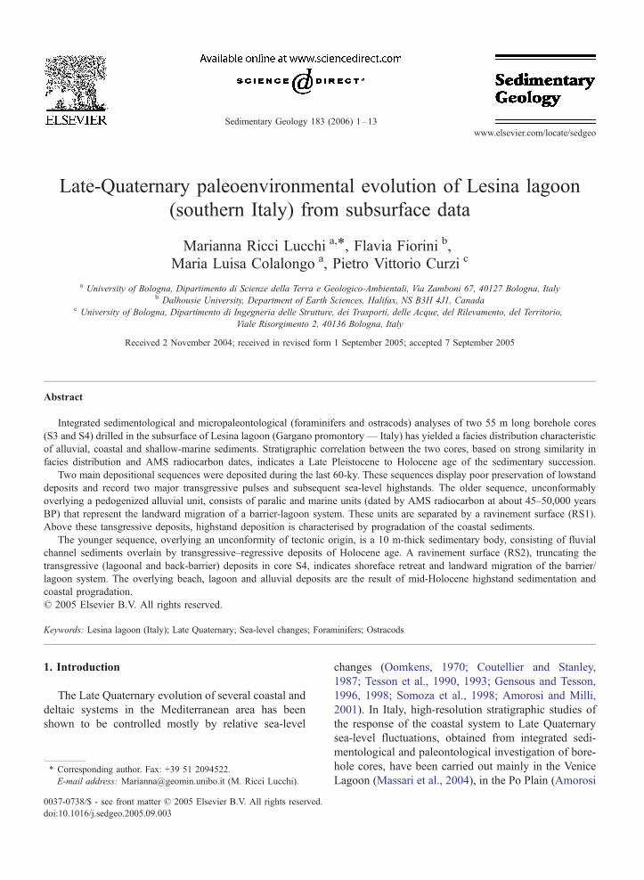
Fig. 1. Location of Lesina lagoon with positio
sedimentary record, which shows good preservation in
the subsurface.
The presence of two lakes (Lesina and Varano, Fig.
1) along the northern coast of the Gargano promontory
offered the chance to preserve lengthy sequences of
virtually undisturbed deposits that can be used for
paleoenvironmental investigations. In particular, our
work is based on integrated sedimentological and
micropaleontological (foraminifers, ostracods) analysis
of two borehole cores from the Lesina lagoon (Fig. 1),
together with radiocarbon dating. Changes in frequency
and distribution of benthic foraminifers and ostracods
play a key role in facies characterisation, and in estab-
lishing the link between sedimentary evolution and Late
Quaternary sea-level fluctuations. In particular, benthic
foraminifers and ostracods occur abundantly in paralic
and marginal marine depositional systems, whereas
ostracods are recorded also in lacustrine and swamp
sediments. Their occurrences and distributions are
strongly linked to environmental parameters, such as
water depth, salinity and type of substrate, and are very
useful for interpreting the complexity of subenviron-
n of the cores mentioned in this paper.
M. Ricci Lucchi et al. / Sedimentary Geology 183 (2006) 1–13 3
ments and microenvironments that characterise margin-
al marine systems and reflect sea-level fluctuations.
2. Site description
Lesina lagoon is located in the southern Adriatic
coast (Apulia region, Italy) on the northern side of
the Gargano promontory (41.888N; 15.458E; Fig. 1).The lagoon, separated from the Adriatic Sea by a 1–
2 km wide beach ridge, extends East–West for about
22 km and is 3 km wide. The average water depth is
0.8 m, while the maximum depth is less than 2 m.
Two channels connect the lagoon to the sea, and
freshwater inflow is ensured by several small rivers
(Fig. 1).
Lesina is an eutrophic lagoon and exhibits strong
seasonal variations of temperature (ranging from 7 8Cin winter to 26 8C in summer) and salinity (between
11 and 34 psu). Moreover, the western part generally
exhibits higher salinity values than the eastern area.
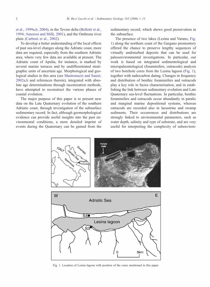
Fig. 2. Geological sketch map of Apulian regio
The low tidal range of southern Adriatic Sea, com-
bined with the moderate freshwater input and the low
efficiency of water exchanges with the sea, suggest that
the hydrological balance in the Lesina lagoon is strongly
affected by atmospheric conditions.
3. Geological and geomorphological setting
The Gargano promontory is the most uplifted area
(1050 m a.s.l.) of the Apulian region, which represents
the foreland of both the Apenninic (to the West) and
Dinaric (to the East) orogens (Fig. 1). The Apulian
foreland (Fig. 2) is made up of a Precambrian crystalline
basement and a 6 km thick Mesozoic sedimentary cover.
This cover comprises a continental Permo-Triassic suc-
cession (fluvio-deltaic terrigenous facies, Verrucano),
overlain by 1 km thick anhydrite–dolomitic Triassic
successions (Burano Anhydrite) and 3–5 km thick Ju-
rassic–Cretaceous carbonate platform sediments. This
succession is capped by thin, discontinuous Tertiary
n (after Mastronuzzi and Sanso, 2002a).
M. Ricci Lucchi et al. / Sedimentary Geology 183 (2006) 1–134
and Quaternary deposits (Ricchetti et al., 1988; Doglioni
et al., 1994).
At the Gargano promontory, late Pliocene–Pleisto-
cene calcarenites unconformably overlie the Mesozoic
carbonate platform sequence. These deposits are
crossed by numerous faults with E–W, WNW–ESE
and NW–SE orientation.
From the Middle Pleistocene onwards, the superposi-
tion of regional uplift and glacio-eustatic sea-level
changes produced a number of marine-terrace deposits,
often associated with aeolianites, along the Apulian coast
(Mastronuzzi and Sanso, 2002a,b). The oldest marine-
terrace deposits contain volcanic products of Monte
Vulture, a volcano that was active in Middle Pleisto-
cene. The youngest deposits are of Tyrrhenian age
(Cotecchia et al., 1971; Dai Pra and Stearns, 1977;
Hearthy and Dai Pra, 1992).
Three main Holocene aeolian units are recognised
along the southern Adriatic Apulian coasts by Mas-
tronuzzi and Sanso (2002a). A mid-Holocene dune
belt formed by beach progradation during a relative
sea-level highstand. A second dune belt developed
mostly about 2500 years BP. During this time of
general coastal plain progradation, the Fortore River
(Fig. 1) created a cuspate delta and its sediments,
being transported by long-shore current, fed the spits
which definitely closed, in Roman times, the Lesina
lagoon first and then Varano Lake (Fig. 1). A third
discontinuous aeolian belt was deposited during me-
dieval times.
A detailed Upper Quaternary stratigraphy of the
Adriatic subsurface near Gargano Promontory has
been recently reconstructed by Ridente and Trincardi
(2002) and Cattaneo et al. (2003).
4. Material and methods
Two 55 m long borehole cores (S3 and S4) were
collected with a wireline system and sediment samples
stored in plastic liners.
Core S4 is located on the beach ridge between the
Adriatic Sea and Lesina lagoon, whereas core S3 is
on the opposite and landward side of the lagoon
(Fig. 1).
Several sedimentary features (colour, texture, struc-
tures, lamination) and the type and concentration of
accessory materials (including paleosols, plant frag-
ments and organic matter) were used to identify major
facies associations.
Eighty-four sediment samples about 2 cm thick were
taken for micropaleontological study. Positions of the
samples in the cores are shown in Fig. 3. Samples were
labelled with a number that corresponds to the distance
(in metres) from the top of the cores.
The samples were dried in an oven (at about 60
8C), sieved through a 63 Am mesh and dried again.
Benthic foraminifers and ostracods were studied in
order to provide additional data for paleoenvironmen-
tal interpretation. Identifications relied mainly upon
original descriptions and also works by AGIP
(1982), Cimerman and Langer (1991), Sgarrella and
Moncharmont Zei (1993), Yassini and Jones (1995)
and Hayward et al. (1999), Guernet et al. (2003).
Paleoenvironmental interpretation of foraminifer and
ostracod associations was based upon comparison of the
analysed microfauna with recent foraminifers and ostra-
cods described in several studies from the Mediterra-
nean area: Colalongo (1969), von Daniels (1970),
Bonaduce et al. (1975), Albani and Serandrei Barbero
(1982, 1990), Bizon and Bizon (1984), Venec-Peyre
(1984), Jorissen (1987, 1988), Albani et al. (1991),
Murray (1991), Sgarrella and Moncharmont Zei
(1993), Bellotti et al. (1994), Coppa et al. (1994), Masoli
et al. (1995), Melis et al. (1995), Montenegro and Pug-
liese (1995, 1996), Donnici and Serandrei Barbero
(2002) and Samir et al. (2003). Microfaunistic associa-
tions similar to those described in this paper have been
found also in Quaternary subsurface deposits of the Po
Plain (Fiorini and Vaiani, 2001; Amorosi et al., 2004;
Fiorini, 2004) and Tevere delta.
Two mollusc samples were collected for AMS 14C
dating: at 12.36 m depth in core S3, and at 27.47 m
depth in core S4. Dating was carried out by the Na-
tional Ocean Sciences AMS (NOSAMS) of the Woods
Hole Oceanographic Institution, Woods Hole, MA
(USA).
5. Sedimentology and micropaleontology
Lihological features and micropaleontological con-
tent provide the basis for detailed facies characterisa-
tion of the sediment cores. 21 different lithofacies
were identified and grouped into 8 facies associations,
as shown in Table 1. Among these, three are related to
sedimentary environments developing in the back-bar-
rier zone: lagoons, swamps and back-barrier beaches
(Fig. 3). Within the lagoon facies association, slight
paleoenvironmental differences, from inner to open
lagoon/bay, were identified by foraminifer and ostra-
cod assemblages. A 10 m thick bedset of fluvial
channel deposits, occurring in core S4 only, represents
the main distinctive element between the two cores.
Stratigraphy of both cores is described in ascending
order.

Fig. 3. Lithology, micropaleontology (foraminifers and ostracods), facies associations and sequence stratigraphic interpretation of cores S3 and S4.
SB1: sequence boundary of the post-Tyrrhenian depositional sequence, TS1: post-Tyrrhenian transgressive surface, RS1: post-Tyrrhenian ravine-
ment surface, SB2: sequence boundary of the Last Glacial to Holocene depositional sequence, TS2: Holocene transgressive surface, RS2: Holocene
ravinement surface, LST: lowstand systems tract, TST: transgressive systems tract, HST: highstand systems tract, IVF: incised-valley fill. Position
of the maximum flooding surfaces (MFS) is approximate.
M. Ricci Lucchi et al. / Sedimentary Geology 183 (2006) 1–13 5
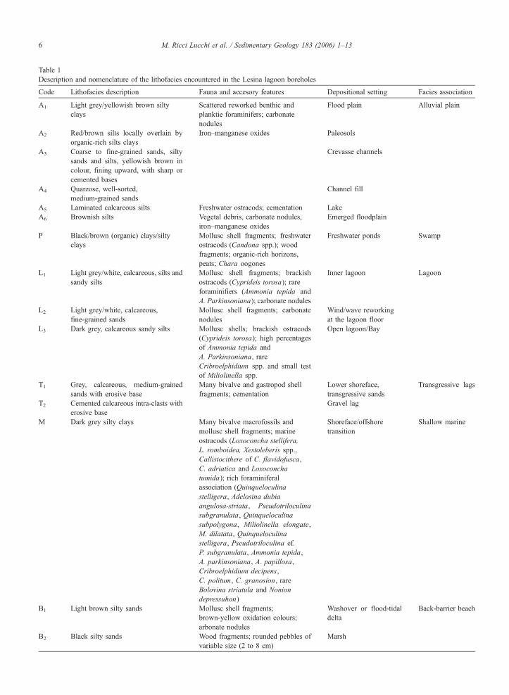
Table 1
Description and nomenclature of the lithofacies encountered in the Lesina lagoon boreholes
Code Lithofacies description Fauna and accesory features Depositional setting Facies association
A1 Light grey/yellowish brown silty
clays
Scattered reworked benthic and
planktie foraminifers; carbonate
nodules
Flood plain Alluvial plain
A2 Red/brown silts locally overlain by
organic-rich silts clays
Iron–manganese oxides Paleosols
A3 Coarse to fine-grained sands, silty
sands and silts, yellowish brown in
colour, fining upward, with sharp or
cemented bases
Crevasse channels
A4 Quarzose, well-sorted,
medium-grained sands
Channel fill
A5 Laminated calcareous silts Freshwater ostracods; cementation Lake
A6 Brownish silts Vegetal debris, carbonate nodules,
iron–manganese oxides
Emerged floodplain
P Black/brown (organic) clays/silty
clays
Mollusc shell fragments; freshwater
ostracods (Candona spp.); wood
fragments; organic-rich horizons,
peats; Chara oogones
Freshwater ponds Swamp
L1 Light grey/white, calcareous, silts and
sandy silts
Mollusc shell fragments; brackish
ostracods (Cyprideis torosa); rare
foraminifiers (Ammonia tepida and
A. Parkinsoniana); carbonate nodules
Inner lagoon Lagoon
L2 Light grey/white, calcareous,
fine-grained sands
Mollusc shell fragments; carbonate
nodules
Wind/wave reworking
at the lagoon floor
L3 Dark grey, calcareous sandy silts Mollusc shells; brackish ostracods
(Cyprideis torosa); high percentages
of Ammonia tepida and
A. Parkinsoniana, rare
Cribroelphidium spp. and small test
of Miliolinella spp.
Open lagoon/Bay
T1 Grey, calcareous, medium-grained
sands with erosive base
Many bivalve and gastropod shell
fragments; cementation
Lower shoreface,
transgressive sands
Transgressive lags
T2 Cemented calcareous intra-clasts with
erosive base
Gravel lag
M Dark grey silty clays Many bivalve macrofossils and
mollusc shell fragments; marine
ostracods (Loxoconcha stellifera,
L. romboidea, Xestoleberis spp.,
Callistocithere of C. flavidofusca,
C. adriatica and Loxoconcha
tumida); rich foraminiferal
association (Quinqueloculina
stelligera, Adelosina dubia
angulosa-striata, Pseudotriloculina
subgranulata, Quinqueloculina
subpolygona, Miliolinella elongate,
M. dilatata, Quinqueloculina
stelligera, Pseudotriloculina ef.
P. subgranulata, Ammonia tepida,
A. parkinsoniana, A. papillosa,
Cribroelphidium decipens,
C. politum, C. granosion, rare
Bolovina striatula and Nonion
depressuhon)
Shoreface/offshore
transition
Shallow marine
B1 Light brown silty sands Mollusc shell fragments;
brown-yellow oxidation colours;
arbonate nodules
Washover or flood-tidal
delta
Back-barrier beach
B2 Black silty sands Wood fragments; rounded pebbles of
variable size (2 to 8 cm)
Marsh
M. Ricci Lucchi et al. / Sedimentary Geology 183 (2006) 1–136
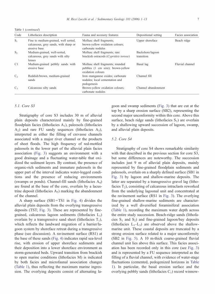
Table 1 (continued)
Code Lithofacies description Fauna and accesory features Depositional setting Facies association
S1 Fine to medium-grained, well sorted,
calcareous, grey sands, with sharp or
erosive base
Mollusc shell fragments;
brown-yellow oxidation colours;
carbonate nodules
Upper shoreface Beach ridge
S2 Medium-grained, well-sorted,
calcareous, grey sands with silty
lenses
Mollusc shell fragments; rare
brackish ostracods (Cyprideis torosa)
Backshore/lagoon
transition
C1 Medium-grained pebbly sands with
erosive base
Mollusc shell fragments; rounded
pebbles (1 cm size); brown-yellow
oxidation colours
Basal lag Fluvial channel
C2 Reddish/brown, medium-grained
sands
Iron–manganese oxides; carbonate
nodules; local cementation and
pedogenesis
Channel fill
C3 Calcareous silty sands Brown-yellow oxidation colours;
carbonate nodules
Channel abandonment
M. Ricci Lucchi et al. / Sedimentary Geology 183 (2006) 1–13 7
5.1. Core S3
Stratigraphy of core S3 includes 30 m of alluvial
plain deposits characterized mainly by fine-grained
floodplain facies (lithofacies A1), paleosols (lithofacies
A2) and rare FU sandy sequences (lithofacies A3),
interpreted as either the filling of crevasse channels
associated with a major river channel or the products
of sheet floods. The high frequency of red-mottled
paleosols in the lower part of the alluvial plain facies
association (Fig. 3) suggests an environment with a
good drainage and a fluctuating water-table that oxi-
dized the sediment layers. By contrast, the presence of
organic-rich sediments and immature paleosols in the
upper part of the interval indicates water-logged condi-
tions and the presence of reducing environments
(swamps or ponds). Channel-fill sands (lithofacies A4)
are found at the base of the core, overlain by a lacus-
trine deposit (lithofacies A5) marking the abandonment
of the channel.
A sharp surface (SB1=TS1 in Fig. 4) divides the
alluvial plain deposits from the overlying transgressive
deposits (TST; Fig. 3). These are represented by fine-
grained, calcareous lagoon sediments (lithofacies L1)
overlain by a transgressive sand sheet (lithofacies T1),
which reflects the landward migration of a barrier/la-
goon system by shoreface retreat during a transgressive
phase (see discussion). A ravinement surface (RS1) at
the base of these sands (Fig. 4) indicates rapid sea-level
rise, with erosion of upper shoreface sediments and
their deposition into a lower shoreface environment as
storm-generated beds. Upward transition from brackish
to open marine conditions (lithofacies M) is indicated
by both facies and microfaunal association changes
(Table 1), thus reflecting the maximum marine ingres-
sion. The overlying deposits consist of alternating la-
goon and swamp sediments (Fig. 3) that are cut at the
top by a sharp erosion surface (SB2), representing the
second major unconformity within this core. Above this
surface, beach ridge sands (lithofacies S1) are overlain
by a shallowing upward succession of lagoon, swamp,
and alluvial plain deposits.
5.2. Core S4
Stratigraphy of core S4 shows remarkable similarity
with that described in the previous section for core S3,
but some differences are noteworthy. The succession
includes just 9 m of alluvial plain deposits, mainly
represented by fine-grained floodplain sediments and
paleosols, overlain on a sharply defined surface (SB1 in
Fig. 3) by lagoon and shallow-marine deposits. The
latter are separated by a transgressive gravel lag (litho-
facies T2), consisting of calcareous intraclasts reworked
from the underlying lagoonal unit and concentrated at
the ravinement surface (RS1 in Fig. 3). The overlying
fine-grained shallow-marine sediments are character-
ized by a well diversified foraminiferal association
(Table 1), recording the maximum water depth across
the entire study succession. Beach-ridge sands (lithofa-
cies S1 and S2) and fine-grained lagoon/bay deposits
(lithofacies L1–L3) are observed above the shallow-
marine unit. These coastal deposits are truncated by a
strong erosion surface related to a major unconformity
(SB2 in Fig. 5). A 10 m-thick coarse-grained fluvial
channel unit lies above this surface. This facies associ-
ation has been recorded only in this core (see Fig. 3)
and is represented by a FU sequence interpreted as the
filling of a fluvial channel, with evidence of water-stage
fluctuations (cemented, pedogenized horizons in Table
1). In particular, the basal erosion surface and the
overlying pebbly sands (lithofacies C1) record winnow-
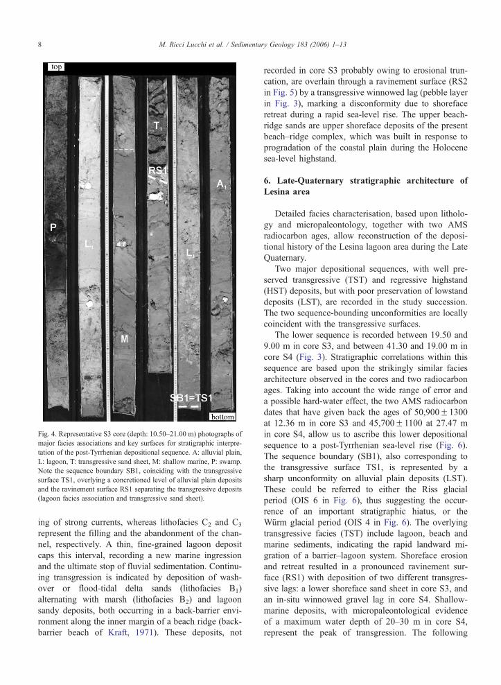
Fig. 4. Representative S3 core (depth: 10.50–21.00 m) photographs of
major facies associations and key surfaces for stratigraphic interpre-
tation of the post-Tyrrhenian depositional sequence. A: alluvial plain,
L: lagoon, T: transgressive sand sheet, M: shallow marine, P: swamp.
Note the sequence boundary SB1, coinciding with the transgressive
surface TS1, overlying a concretioned level of alluvial plain deposits
and the ravinement surface RS1 separating the transgressive deposits
(lagoon facies association and transgressive sand sheet).
M. Ricci Lucchi et al. / Sedimentary Geology 183 (2006) 1–138
ing of strong currents, whereas lithofacies C2 and C3
represent the filling and the abandonment of the chan-
nel, respectively. A thin, fine-grained lagoon deposit
caps this interval, recording a new marine ingression
and the ultimate stop of fluvial sedimentation. Continu-
ing transgression is indicated by deposition of wash-
over or flood-tidal delta sands (lithofacies B1)
alternating with marsh (lithofacies B2) and lagoon
sandy deposits, both occurring in a back-barrier envi-
ronment along the inner margin of a beach ridge (back-
barrier beach of Kraft, 1971). These deposits, not
recorded in core S3 probably owing to erosional trun-
cation, are overlain through a ravinement surface (RS2
in Fig. 5) by a transgressive winnowed lag (pebble layer
in Fig. 3), marking a disconformity due to shoreface
retreat during a rapid sea-level rise. The upper beach-
ridge sands are upper shoreface deposits of the present
beach–ridge complex, which was built in response to
progradation of the coastal plain during the Holocene
sea-level highstand.
6. Late-Quaternary stratigraphic architecture of
Lesina area
Detailed facies characterisation, based upon litholo-
gy and micropaleontology, together with two AMS
radiocarbon ages, allow reconstruction of the deposi-
tional history of the Lesina lagoon area during the Late
Quaternary.
Two major depositional sequences, with well pre-
served transgressive (TST) and regressive highstand
(HST) deposits, but with poor preservation of lowstand
deposits (LST), are recorded in the study succession.
The two sequence-bounding unconformities are locally
coincident with the transgressive surfaces.
The lower sequence is recorded between 19.50 and
9.00 m in core S3, and between 41.30 and 19.00 m in
core S4 (Fig. 3). Stratigraphic correlations within this
sequence are based upon the strikingly similar facies
architecture observed in the cores and two radiocarbon
ages. Taking into account the wide range of error and
a possible hard-water effect, the two AMS radiocarbon
dates that have given back the ages of 50,900F1300
at 12.36 m in core S3 and 45,700F1100 at 27.47 m
in core S4, allow us to ascribe this lower depositional
sequence to a post-Tyrrhenian sea-level rise (Fig. 6).
The sequence boundary (SB1), also corresponding to
the transgressive surface TS1, is represented by a
sharp unconformity on alluvial plain deposits (LST).
These could be referred to either the Riss glacial
period (OIS 6 in Fig. 6), thus suggesting the occur-
rence of an important stratigraphic hiatus, or the
Wurm glacial period (OIS 4 in Fig. 6). The overlying
transgressive facies (TST) include lagoon, beach and
marine sediments, indicating the rapid landward mi-
gration of a barrier–lagoon system. Shoreface erosion
and retreat resulted in a pronounced ravinement sur-
face (RS1) with deposition of two different transgres-
sive lags: a lower shoreface sand sheet in core S3, and
an in-situ winnowed gravel lag in core S4. Shallow-
marine deposits, with micropaleontological evidence
of a maximum water depth of 20–30 m in core S4,
represent the peak of transgression. The following
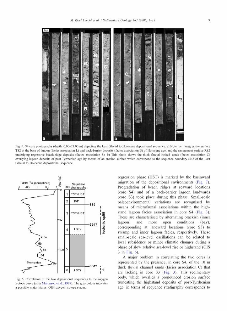
Fig. 5. S4 core photographs (depth: 0.00–21.00 m) depicting the Last Glacial to Holocene depositional sequence. a) Note the transgressive surface
TS2 at the base of lagoon (facies association L) and back-barrier deposits (facies association B) of Holocene age, and the ravinement surface RS2
underlying regressive beach-ridge deposits (facies association S). b) This photo shows the thick fluvial-incised sands (facies association C)
overlying lagoon deposits of post-Tyrrhenian age by means of an erosion surface which correspond to the sequence boundary SB2 of the Last
Glacial to Holocene depositional sequence.
Fig. 6. Correlation of the two depositional sequences to the oxygen
isotope curve (after Martinson et al., 1987). The grey colour indicates
a possible major hiatus. OIS: oxygen isotope stages.
M. Ricci Lucchi et al. / Sedimentary Geology 183 (2006) 1–13 9
regression phase (HST) is marked by the basinward
migration of the depositional environments (Fig. 7).
Progradation of beach ridges at seaward locations
(core S4) and of a back-barrier lagoon landwards
(core S3) took place during this phase. Small-scale
paleoenvironmental variations are recognised by
means of microfaunal associations within the high-
stand lagoon facies association in core S4 (Fig. 3).
These are characterised by alternating brackish (inner
lagoon) and more open conditions (bay),
corresponding at landward locations (core S3) to
swamp and inner lagoon facies, respectively. These
small-scale sea-level oscillations can be related to
local subsidence or minor climatic changes during a
phase of slow relative sea-level rise or highstand (OIS
3 in Fig. 6).
A major problem in correlating the two cores is
represented by the presence, in core S4, of the 10 m
thick fluvial channel sands (facies association C) that
are lacking in core S3 (Fig. 3). This sedimentary
body, which overlies a pronounced erosion surface
truncating the highstand deposits of post-Tyrrhenian
age, in terms of sequence stratigraphy corresponds to
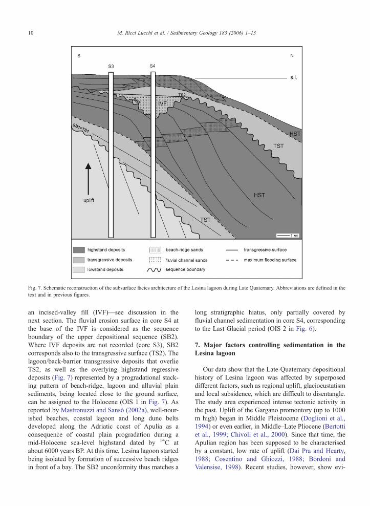
Fig. 7. Schematic reconstruction of the subsurface facies architecture of the Lesina lagoon during Late Quaternary. Abbreviations are defined in the
text and in previous figures.
M. Ricci Lucchi et al. / Sedimentary Geology 183 (2006) 1–1310
an incised-valley fill (IVF)—see discussion in the
next section. The fluvial erosion surface in core S4 at
the base of the IVF is considered as the sequence
boundary of the upper depositional sequence (SB2).
Where IVF deposits are not recorded (core S3), SB2
corresponds also to the transgressive surface (TS2). The
lagoon/back-barrier transgressive deposits that overlie
TS2, as well as the overlying highstand regressive
deposits (Fig. 7) represented by a progradational stack-
ing pattern of beach-ridge, lagoon and alluvial plain
sediments, being located close to the ground surface,
can be assigned to the Holocene (OIS 1 in Fig. 7). As
reported by Mastronuzzi and Sanso (2002a), well-nour-
ished beaches, coastal lagoon and long dune belts
developed along the Adriatic coast of Apulia as a
consequence of coastal plain progradation during a
mid-Holocene sea-level highstand dated by 14C at
about 6000 years BP. At this time, Lesina lagoon started
being isolated by formation of successive beach ridges
in front of a bay. The SB2 unconformity thus matches a
long stratigraphic hiatus, only partially covered by
fluvial channel sedimentation in core S4, corresponding
to the Last Glacial period (OIS 2 in Fig. 6).
7. Major factors controlling sedimentation in the
Lesina lagoon
Our data show that the Late-Quaternary depositional
history of Lesina lagoon was affected by superposed
different factors, such as regional uplift, glacioeustatism
and local subsidence, which are difficult to disentangle.
The study area experienced intense tectonic activity in
the past. Uplift of the Gargano promontory (up to 1000
m high) began in Middle Pleistocene (Doglioni et al.,
1994) or even earlier, in Middle–Late Pliocene (Bertotti
et al., 1999; Chivoli et al., 2000). Since that time, the
Apulian region has been supposed to be characterised
by a constant, low rate of uplift (Dai Pra and Hearty,
1988; Cosentino and Ghiozzi, 1988; Bordoni and
Valensise, 1998). Recent studies, however, show evi-

M. Ricci Lucchi et al. / Sedimentary Geology 183 (2006) 1–13 11
dence of still active tectonics in the study area, as
documented by (i) tectonic reactivation of pre-existing
structures that have exerted a major control on Neogene
to Quaternary sedimentation (Chivoli et al., 2000), (ii)
rapid coseismic movements, which have been recorded
during the Late Holocene along the northern coast of
Gargano (Mastronuzzi and Sanso, 2002c), and (iii) high
seismicity of the Gargano area (Tinti et al., 1995; Del
Gaudio and Pierri, 2001; Del Gaudio et al., 2002).
Facies architecture within the studied succession
reveals that tectonics probably exerted a major control
in the formation of the two sequence boundaries (SB1
and SB2). In particular, by attributing the alluvial
deposits underlying SB1 to OIS 6 (Fig. 6), tectonics
could account for the lack of transgressive deposits of
Tyrrhenian age. Marine terraced deposits of Tyrrhenian
age have been only recognised along the Ionian Apu-
lian coast by a distinctive faunal assemblage containing
the index fossil Strombus bubonius Lmk (Cotecchia et
al., 1971; Dai Pra and Stearns, 1977; Hearthy and Dai
Pra, 1992; Bordoni and Valensise, 1998). In contrast,
marine terraces in the study area (southern Adriatic
coast of Apulia) have been generically referred to the
Middle–Late Pleistocene by Mastronuzzi and Sanso
(2002b). On the second hypothesis, accepting a more
recent, OIS 4 age for the lowstand continental deposits,
a significant contribution by glacioeustacy cannot be
excluded.
A major tectonic control on sequence development
can be also assumed for the lower boundary of the
overlying depositional sequence (SB2). Uplift in the
hinterland (Fig. 7) led to fluvial incision in the adjacent
areas, resulting in seaward tilting of the post-Tyrrhenian
sequence, and deposition of the IVF in the newly created
topographic low. This hypothesis can explain the differ-
ence in depth (about 20 m) at which TS1 and RS1
surfaces are encountered in core S3 and S4 (Fig. 3).
Despite an overall tectonic influence on sequence
boundary formation, a significant eustatic control on
internal facies architecture is testified to within both
sequences by an obvious transgressive–regressive ten-
dency. In particular, the upper sequence of Late Pleisto-
cene to Holocene age displays several features in
common with respect to the eustatically controlled coe-
val sequences of the Mediterranean area (Oomkens,
1970; Coutellier and Stanley, 1987; Somoza et al.,
1998; Amorosi et al., 1999a,b; Amorosi and Milli,
2001). In the lower part of the sequence, these include
the presence of incised-valley fluvial deposits, coupled
with the important stratigraphic hiatus recorded in the
interfluves. Similarly, the retrogradational stacking
pattern of barrier/lagoon sediments followed by pro-
gradation of a coastal plain can be related to the
Holocene sea-level rise and subsequent highstand,
thus suggesting a key role of eustacy on sedimentation
(Fig. 7).
8. Conclusions
Integrated sedimentological and micropaleontologi-
cal investigations of two 50 m-thick cores from the
subsurface of Lesina lagoon show a vertical cyclic
pattern of facies, including continental, paralic and
shallow-marine deposits. Particularly, the lower part
of the study succession is characterised by alluvial
plain sediments, locally pedogenized. In contrast, the
remaining part of the succession was formed in a
variety of depositional environments, from coastal
(swamp, lagoon, bay) to shallow marine.
Vertical distribution of facies associations and the
identification of important stratigraphic surfaces (se-
quence boundaries, transgressive and ravinement sur-
faces) allow us to distinguish two major depositional
sequences representing the last 60 ky. Deposition of
these sequences was controlled by both tectonic and
eustatism.
The older sequence, composed uniquely by trans-
gressive and highstand deposits, has been assigned to a
post-Tyrrhenian sea-level oscillation on the basis of two
radiocarbon dates. Sequence boundary (SB1) formation
can alternatively be considered to be controlled by
either tectonics or eustatism, depending on the age
attribution of the underlying lowstand deposits. Trans-
gressive deposits of this sequence represent the land-
ward migration of a barrier/lagoon system. Small-scale
sea-level changes within this system and the maximum
marine ingression have been distinguished by variations
in microfaunal content. Subsequent highstand deposi-
tion is represented by progradation of the coastal/la-
goon environments.
The overlying sequence of Late Pleistocene to Holo-
cene age displays two distinct phases of deposition. In
particular, formation of sequence boundary (SB2) and
deposition of the overlying incised-valley fluvial sands
have been interpreted to be controlled by tectonic activ-
ity. On the other hand, the upper part of the sequence,
consisting of beach ridge, lagoon and alluvial plain
deposits, can be referred to the Holocene sea-level rise
and highstand, thus enhancing the role of eustacy.
Acknowledgments
This work was supported by COFIN-MURST 1997
funds (coordinator: E. Rabbi). We are grateful to P.
M. Ricci Lucchi et al. / Sedimentary Geology 183 (2006) 1–1312
Ferrieri for help in opening and photographing the
cores. Special thanks to A. Amorosi and F. Ricci Lucchi
for their helpful suggestions and careful reading of the
manuscript. We are also grateful to the anonymous
reviewers for their helpful suggestions, and to K.A.W.
Crook for editorial advice.
References
AGIP, 1982. Foraminiferi Padani (Terziario e Quaternario), pp. LI–LII
Milan.Albani, A., Serandrei Barbero, R., 1982. A Foraminiferal
fauna from the Lagoon of Venice, Italy. J. Foraminiferal Res. 12,
234–241.
Albani, A., Serandrei Barbero, R., 1990. I Foraminiferi della
Laguna e del Golfo di Venezia. Mem. Sci. Geol. Padova 42,
271–341.
Albani, A., Favero, V., Serandrei Barbero, R., 1991. The distribu-
tion and ecological significance of recent Foraminifera in the
Lagoon South of Venice (Italy). Rev. Esp. Micropaleontol. 23,
29–45.
Amorosi, A., Milli, S., 2001. Late Quaternary depositional architecture
of Po and Tevere river deltas (Italy) and worldwide comparison
with coeval deltaic successions. Sediment. Geol. 144, 357–375.
Amorosi, A., Colalongo, M.L., Pasini, G., Preti, D., 1999a. Sedimen-
tary response to Late Quaternary sea-level changes in the Romagna
coastal plain (northern Italy). Sedimentology 46, 99–121.
Amorosi, A., Colalongo, M.L., Fusco, F., Pasini, G., Fiorini, F.,
1999b. Glacio-eustatic control of continental-shallow marine cy-
clicity from Late Quaternary deposits of the south-eastern Po Plain
(Northern Italy). Quat. Res. 52, 1–13.
Amorosi, A., Colalongo, M.L., Fiorini, F., Fusco, F., Pasini, G.,
Vaiani, S.C., Sarti, G., 2004. Paleogeographic and paleoclimatic
evolution of the Po Plain from 150-ky core records. Glob. Planet.
Change 40, 55–78.
Bellotti, P., Carboni, M.G., Di Bella, L., Palagi, I., Valeri, P.,
1994. Benthic foraminiferal assemblages in the depositional
sequence of the Tiber Delta. Boll. Soc. Paleontol. Ital., Spec.
vol. 2, 29–40.
Bertotti, G., Casolari, E., Picotti, V., 1999. The gargano promontory: a
Neogene contractional belt within the Adriatic plate. Terra Nova
11, 168–173.
Bizon, G., Bizon, J.J., 1984. Ecologie des Foraminiferes en Mediter-
ranee nord-occidentale. P. Distribution des foraminiferes sur le
plateau continental au large du Rhone. In: Bizon, J.J., Burollet,
P.F. (Eds.), Ecologie des microorganismes en Mediterranee occi-
dentale. ECOMED, AFTP, Paris, pp. 84–94.
Bonaduce, G., Ciampo, G., Masoli, M., 1975. Distribution of Ostra-
coda in the Adriatic Sea. Pubbl. Stn. Zool. Napoli 40, 1–304.
Bordoni, P., Valensise, G., 1998. Deformation of the 125 ka marine
terrace in Italy: tectonic implications. In: Stewart, I.S., Vita-Finzi,
C. (Eds.), Coastal Tectonics, Geol. Soc. London, Spec. Publ., vol.
146, pp. 71–110.
Carboni, M.G., Bergamin, L., Di Bella, L., Iamundo, F., Pugliese,
N., 2002. Palaeoecological evidences from foraminifers and
ostracods on Late Quaternary sea-level changes in the Ombrone
river plain (central Tyrrhenian coast, Italy). Geobios 35 (suppl.1),
40–50.
Cattaneo, A., Correggiari, A., Langone, L., Trincardi, F., 2003. The
late-Holocene Gargano subaqueous delta, Adriatic shelf: sediment
pathways and supply fluctuations. Mar. Geol. 193, 61–91.
Chivoli, C., De Feyter, A.J., Pompucci, A., 2000. Wrench zone
reactivation in the Adriatic Block: the example of the Mattinata
Fault System (SE Italy). Boll. Soc. Geol. Ital. 119, 3–8.
Cimerman, F., Langer, M.R., 1991. Mediterranean Foraminifera:
Academia Scientiarum et Artium Slovenica. Ljubljana, Classis
IV, 30, 1-118.
Colalongo, M.L., 1969. Ricerche sugli Ostracodi nei fondali antistanti
il delta del Po. Giorn. Geol. 36 (2), 335–362.
Coppa, M.G., Siani, G., Russo, B., 1994. The Holocene Foraminiferal
assemblage of the continental margin between Agropoli and Capo
Palinuro (Tyrrhenian Sea, Italy). Boll. Soc. Paleontol. Ital., Spec.
Vol. 2, 67–91.
Cosentino, D., Ghiozzi, E., 1988. Considerazioni sulle velocita di
sollevamento di depositi eutirreniani dell’Italia meridionale e della
Sicilia. Mem. Soc. Geol. Ital. 41, 653–665.
Cotecchia, V., Dai Pra, G., Magri, G., 1971. Sul Tirreniano della
costa ionica salentina (Puglia). Datazione di un campione di
coralli con il metodo del 230Th / 234U. Geol. Appl. Idrogeol. 6,
105–112.
Coutellier, V., Stanley, D.J., 1987. Late Quaternary stratigraphy and
paleogeography of the eastern Nile delta, Egypt. Mar. Geol. 77,
257–275.
Dai Pra, G., Stearns, C.E., 1977. Sul Tirreniano di Taranto. Datazioni su
coralli con il metodo del 230Th/ 234dU. Geol. Rom. 16, 231–242.
Dai Pra, G., Hearty, P.J., 1988. I livelli marini pleistocenici del Golfo
di Taranto. Mem. Soc. Geol. Ital. 41, 637–644.
Del Gaudio, V., Pierri, P., 2001. Seismicity and seismic hazard of
Abulia (Southern Italy). Abstract VI Workshop Italy-Romania,
Bari, 9-12 May, Italy.
Del Gaudio, V., Mastronuzzi, G., Sanso, P., 2002. Tracking down a
tsunami-generative fault in the Gargano region (southern Italy).
Abstract XXVII General Assembly European Geophysical Soci-
ety, Nice, 21–26 April, France.
Doglioni, C., Mongelli, F., Pieri, P., 1994. The Puglia uplift (SE
Italy): an anomaly in the foreland of the Apenninic subduction
due to buckling of a thick continental lithosphere. Tectonics 13,
1309–1321.
Donnici, S., Serandrei Barbero, R., 2002. The benthic foraminiferal
communities of the northern Adriatic continental shelf. Mar.
Micropaleontol. 44, 93–123.
Fiorini, F., 2004. Benthic foraminiferal associations from Upper
Quaternary deposits of southeastern Po Plain, Italy. Micropaleon-
tology 50, 45–58.
Fiorini, F., Vaiani, S.C., 2001. Benthic foraminifers and transgres-
sive–regressive cycles in the Late Quaternary subsurface sedi-
ments of the Po Plain near Ravenna (Northern Italy). Boll. Soc.
Paleontol. Ital. 40, 357–404.
Gensous, B., Tesson, M., 1996. Sequence stratigraphy, seismic pro-
files, and cores of Pleistocene deposits on the Rhone continental
shelf. Sediment. Geol. 105, 183–190.
Gensous, B., Tesson, M., 1998. Postglacial deposits of the Rhone
shelf (western Mediterranean): stratigraphic organization, sedi-
mentary budget and preservation potential. Volume Abstract 15th
International Sedimentological Congress, Alicante, p. 374.
Guernet, C., Lemeille, F., Sorel, D., Bourdillon, C., Berge-Thierry,
C., Manakou, M., 2003. Les ostracodes et le Quaternaire
d’Aigion (golfe de Corinth, Grece). Rev. Micropaleontol. 46,
73–93.
Hayward, B.W., Grenfell, H.R., Reid, C.M., Hayward, K.A., 1999.
Recent New Zealand shallow water Foraminifera: taxonomy,
ecologic distribution, biogeography, and use in paleoenvironmen-
tal assessment. Inst. Geol. Nucl. Sci. Monogr. 21 (Lower Hutt).

M. Ricci Lucchi et al. / Sedimentary Geology 183 (2006) 1–13 13
Hearthy, P.J., Dai Pra, G., 1992. The age and stratigraphy of Middle
Pleistocene and younger deposits along the Gulf of Taranto
(Southeast Italy). J. Coast. Res. 8 (4), 82–105.
Jorissen, F.J., 1987. The distribution of benthic Foraminifera in the
Adriatic Sea. Mar. Micropaleontol. 12 (1), 21–48.
Jorissen, F.J., 1988. Benthic Foraminifera from the Adriatic Sea;
principles of phenotypic variation. Utrecht Micropaleontol. Bull.
37, 1–176.
Kraft, J.C., 1971. Sedimentary facies patterns and geologic history
of a Holocene marine transgression. GSA Bull. 82, 2131–2158.
Martinson, D.G., Pisias, N.G., Hays, J.D., Imbrie, J., Moore Jr., T.C.,
Shackleton, N.J., 1987. Age dating and the orbital theory of the
ice ages — development of a high resolution 0 to 300,000 year
chronostratigraphy. Quat. Res. 27, 1–29.
Masoli, M., Melis, R., Montenegro, M.E., Pugliese, N., 1995. Osser-
vazioni sulle faune a ostracodi e foraminiferi delle lagune di
Marano e Grado. Atti Mus. Geol. Paleontol. Monfalcone, Quad.
Spec. 3, 155–162.
Massari, F., Rio, D., Serandrei Barbero, R., Asioli, A., Capraro, L.,
Fornaciari, E., Vergerio, P.P., 2004. The environment of Venice
area in the past two million years. Palaeogeogr. Palaeoclimatol.
Palaeoecol. 202, 273–308.
Mastronuzzi, G., Sanso, P., 2002a. Holocene coastal dune develop-
ment and environmental changes in Apulia (southern Italy). Sed-
iment. Geol. 150, 139–152.
Mastronuzzi, G., Sanso, P., 2002b. Pleistocene sea-level changes,
sapping processes and development of valley networks in the
Abulia region (southern Italy). Geomorphology 46, 19–34.
Mastronuzzi, G., Sanso, P., 2002c. Holocene uplift rates and historical
rapid sea-level changes at the Gargano promontory, Italy. J. Quat.
Sci. 17 (5–6), 593–606.
Melis, R., Pugliese, N., Degrassi, C., 1995. Ostracofauna del Lago di
Mezzo e del Lago Inferiore (Mantova, Lombardia — Italia). Atti
Mus. Geol. Paleontol. Monfalcone, Quad. Spec. 3, 65–70.
Montenegro, M.E., Pugliese, N., 1995. Ostracodi della laguna di
Orbetello: tolleranza ed opportunismo. Atti Mus. Geol. Paleontol.
Monfalcone, Quad. Spec. 3, 71–80.
Montenegro, M.E., Pugliese, N., 1996. Autecological remarks on the
ostracod distribution in the Marano and Grado Lagoons (Northern
Adriatic Sea Italy). In: Cherchi, A. (Ed.), Autecology of Selected
Fossil Organisms: Achievements and Problems, Boll. Soc.
Paleontol. Ital., Spec. Vol., vol. 3, pp. 123–132.
Murray, J.W., 1991. Ecology and Palaeoecology of Benthic Forami-
nifera. Longman Scientific and Technical, London, pp. 1–397.
Oomkens, E., 1970. Depositional sequences and sand distribution in
the post-glacial Rhone delta complex. In: Morgan, J.P. (Ed.),
Deltaic Sedimentation — Modern and Ancient, Soc. Econ.
Paleontol. Mineral. Spec. Publ., vol. 15, pp. 198–212.
Ricchetti, G., Ciaranfi, N., Luperto Sinni, E., Monelli, F., Pieri, P.,
1988. Geodinamica ed evoluzione sedimentaria e tettonica
dell’Avampaese apulo. Mem. Soc. Geol. Ital. 41, 57–82.
Ridente, D., Trincardi, F., 2002. Eustatic and tectonic control on
deposition and lateral variability of Quaternary regressive
sequences in the Adriatic basin (Italy). Mar. Geol. 184, 273–293.
Samir, A.M., Abdou, H.F., Zazou, S.M., El-Menhawey, W.H., 2003.
Cluster analysis of recent benthic Foraminifera from the north-
western Mediterranean coast of Egypt. Rev. Micropaleontol. 46,
111–130.
Sgarrella, F., Moncharmont Zei, M., 1993. Benthic Foraminifera of
the Gulf of Naples (Italy): systematics and autoecology. Boll. Soc.
Paleontol. Ital. 32, 145–264.
Somoza, L., Barnolas, A., Arasa, A., Maestro, A., Rees, J.G., Her-
nandez-Molina, F.J., 1998. Architectural stacking patterns of the
Ebro delta controlled by Holocene high-frequency eustatic fluc-
tuations, delta-lobe switching and subsidence processes. Sedi-
ment. Geol. 117, 11–32.
Tesson, M., Gensous, B., Allen, G.P., Ravenne, C., 1990. Late
Quaternary deltaic lowstand wedges on the Rhone continental
shelf, France. Mar. Geol. 91, 325–332.
Tesson, M., Allen, G.P., Ravenne, C., 1993. Late Pleistocene shelf-
perched lowstand wedges on the Rhone continental shelf. In:
Posamantier, H.W., Summerhayes, C.P., Haq, B.U., Allen, G.P.
(Eds.), Sequence Stratigraphy and Facies Associations, Int. Assoc.
Sediment. Spec. Publ., vol. 18, pp. 183–196.
Tinti, S., Maramai, A., Favali, P., 1995. The Gargano promontory: an
important Italian seismogenetic–tsunamigenic area. Mar. Geol.
122, 227–241.
Venec-Peyre, M.T., 1984. Ecologie des Foraminiferes en Mediterra-
nee nord-occidentale. N. Etude de la distribution des Foramini-
feres vivant dans la Baie de Banyuls-Sur-Mer. In: Bizon, J.J.,
Burollet, P.F. (Eds.), Ecologie des Microorganismes en Mediter-
ranee Occidentale. ECOMED, AFTP, Paris, pp. 60–80.
von Daniels, C.H., 1970. Quantitative okologische analyse der zeitli-
chen und raumlichen verteilung rezenter foraminiferen im Limski
Kanal bei Rovinj (nordliche Adria). Gott. Arb. Geol. Palaontol. 8,
1–142.
Yassini, I., Jones, B.G., 1995. Foraminiferida and Ostracoda from
Estuarine and Shelf Environments on the Southeastern Coast of
Australia. University of Wollongong Press, pp. 1–484.
Related Documents


