UNCORRECTED PROOF Quaternary International ] (]]]]) ]]]–]]] Late Pleistocene wetting and drying in the NW Kalahari: an integrated study from the Tsodilo Hills, Botswana David S.G. Thomas a, *, George Brook b , Paul Shaw c , Mark Bateman a , Kurt Haberyan d , Christopher Appleton e , David Nash f , Sue McLaren g , Frances Davies c a Department of Geography, University of Sheffield, Sheffield S10 2TN, UK b Department of Geography, University of Georgia, Athens, GA 30602, USA c Centre for Environmental Change, University of Luton, Park Square, Luton LU1 3JU, UK d Department of Biology, Northwest Missouri State University, Maryville, MO 64468, USA e Department of Biology, University of Natal, Private Bag X10, Daldridga 4014, South Africa f School of the Environment, University of Brighton, Cockcroft Building, Lewes Road, Brighton BN2 4GJ, UK g Department of Geography, University of Leicester, Leicester LE1 7RH, UK Received 8 August 2002 Abstract The sediments and landforms at the Tsodilo Hills, in the northwestern Kalahari desert, provide an opportunity to directly investigate the late Quaternary wetting and drying of the region from evidence at a single site. Lacustrine carbonates, including incorporated molluscs and diatoms, a lake shoreline feature and stabalised linear dunes were investigated for their constituent palaeoenvironmental signals. Chronometric control is provided by calibrated 14 C; AMS and OSL dating. The evidence suggests that linear dune construction has not occurred since the Last Glacial Maximum, with particular development from 36 to 28 ka: Lake stands indicating wetter regional conditions than present occurred at 40–32 ka; with more seasonal conditions from 36 ka; and at 27–12 ka with a possible drying out at 22–19 ka: Data are consistent with other independent studies from the region, and with recent evidence obtained from Atlantic cores off the coast of Namibia. It is concluded that careful consideration of multi-proxy data from a single location can assist in resolving discrepancies that arise from independent studies of lake, cave and dune records in the Kalahari. r 2002 Published by Elsevier Science Ltd. 1. Introduction African rainfall displays marked spatial variability at a range of time scales (Nicholson, 2000). Investigations of proxy evidence of climatic and environmental changes in the interior of southern Africa, recently reviewed and re-evaluated by Thomas and Shaw (2002), suggest a temporally and spatially complex picture of changes during the late Quaternary period. Speleothem (e.g. Holmgren et al., 1995; Brook et al., 1998), palaeolake (e.g. Shaw et al., 1997), and palaeodune (e.g. Stokes et al., 1997; Thomas et al., 2000) data indicate that the region possesses datable sedimentary and geomorphic evidence of hydrological changes during the last 100 ka; a situation that was not being effectively exploited a decade ago (Thomas and Shaw, 1991). Rigorous interpretation of these data can only enhance attempts to model climate change outcomes (e.g. Partridge et al., 1999) and identify forcing mechanisms of change (e.g. Partridge et al., 1997; De Menocal et al., 1993). Contributions of these data to such goals have however been limited by a number of problems. These include understanding the climatic and environmental controls on dune sediment accumulation, improving the application and resolution of dating techniques, and resolving, or understanding the reasons for, apparent conflicts in the records of change derived from different sedimentary and geomorphic sources. Advances in understanding modern dune dynamics are now informing the environmental interpretation of dated palaeodune deposits (for example, in Thomas et al., 2000). Models of aeolian system responses to ARTICLE IN PRESS 1 3 5 7 9 11 13 15 17 19 21 23 25 27 29 31 33 35 37 39 41 43 45 47 49 51 53 55 57 59 61 63 65 67 69 71 73 3B2v7:51c GML4:3:1 JQI : 797 Prod:Type:COM pp:1215ðcol:fig::NILÞ ED:Ramesh PAGN: n:s: SCAN: Rajendra *Corresponding author. Tel.: +44-114-22-27909; fax: +44-114-279- 7912. E-mail address: d.s.thomas@sheffield.ac.uk (D.S.G. Thomas). 1040-6182/02/$ - see front matter r 2002 Published by Elsevier Science Ltd. PII:S1040-6182(02)00135-0

Welcome message from author
This document is posted to help you gain knowledge. Please leave a comment to let me know what you think about it! Share it to your friends and learn new things together.
Transcript

UNCORRECTED PROOF
Quaternary International ] (]]]]) ]]]–]]]
Late Pleistocene wetting and drying in the NW Kalahari: anintegrated study from the Tsodilo Hills, Botswana
David S.G. Thomasa,*, George Brookb, Paul Shawc, Mark Batemana, Kurt Haberyand,Christopher Appletone, David Nashf, Sue McLareng, Frances Daviesc
a Department of Geography, University of Sheffield, Sheffield S10 2TN, UKb Department of Geography, University of Georgia, Athens, GA 30602, USA
c Centre for Environmental Change, University of Luton, Park Square, Luton LU1 3JU, UKd Department of Biology, Northwest Missouri State University, Maryville, MO 64468, USA
e Department of Biology, University of Natal, Private Bag X10, Daldridga 4014, South Africaf School of the Environment, University of Brighton, Cockcroft Building, Lewes Road, Brighton BN2 4GJ, UK
g Department of Geography, University of Leicester, Leicester LE1 7RH, UK
Received 8 August 2002
Abstract
The sediments and landforms at the Tsodilo Hills, in the northwestern Kalahari desert, provide an opportunity to directly
investigate the late Quaternary wetting and drying of the region from evidence at a single site. Lacustrine carbonates, including
incorporated molluscs and diatoms, a lake shoreline feature and stabalised linear dunes were investigated for their constituent
palaeoenvironmental signals. Chronometric control is provided by calibrated 14C; AMS and OSL dating. The evidence suggests that
linear dune construction has not occurred since the Last Glacial Maximum, with particular development from 36 to 28 ka: Lake
stands indicating wetter regional conditions than present occurred at 40–32 ka; with more seasonal conditions from 36 ka; and at
27–12 ka with a possible drying out at 22–19 ka: Data are consistent with other independent studies from the region, and with recent
evidence obtained from Atlantic cores off the coast of Namibia. It is concluded that careful consideration of multi-proxy data from
a single location can assist in resolving discrepancies that arise from independent studies of lake, cave and dune records in the
Kalahari.
r 2002 Published by Elsevier Science Ltd.
1. Introduction
African rainfall displays marked spatial variability ata range of time scales (Nicholson, 2000). Investigationsof proxy evidence of climatic and environmentalchanges in the interior of southern Africa, recentlyreviewed and re-evaluated by Thomas and Shaw (2002),suggest a temporally and spatially complex picture ofchanges during the late Quaternary period. Speleothem(e.g. Holmgren et al., 1995; Brook et al., 1998),palaeolake (e.g. Shaw et al., 1997), and palaeodune(e.g. Stokes et al., 1997; Thomas et al., 2000) dataindicate that the region possesses datable sedimentaryand geomorphic evidence of hydrological changesduring the last 100 ka; a situation that was not being
effectively exploited a decade ago (Thomas and Shaw,1991).
Rigorous interpretation of these data can onlyenhance attempts to model climate change outcomes(e.g. Partridge et al., 1999) and identify forcingmechanisms of change (e.g. Partridge et al., 1997; DeMenocal et al., 1993). Contributions of these data tosuch goals have however been limited by a number ofproblems. These include understanding the climatic andenvironmental controls on dune sediment accumulation,improving the application and resolution of datingtechniques, and resolving, or understanding the reasonsfor, apparent conflicts in the records of change derivedfrom different sedimentary and geomorphic sources.Advances in understanding modern dune dynamics arenow informing the environmental interpretation ofdated palaeodune deposits (for example, in Thomaset al., 2000). Models of aeolian system responses to
ARTICLE IN PRESS
1
3
5
7
9
11
13
15
17
19
21
23
25
27
29
31
33
35
37
39
41
43
45
47
49
51
53
55
57
59
61
63
65
67
69
71
73
3B2v7:51cGML4:3:1 JQI : 797 Prod:Type:COM
pp:1215ðcol:fig::NILÞED:Ramesh
PAGN: n:s: SCAN: Rajendra
*Corresponding author. Tel.: +44-114-22-27909; fax: +44-114-279-
7912.
E-mail address: [email protected] (D.S.G. Thomas).
1040-6182/02/$ - see front matter r 2002 Published by Elsevier Science Ltd.
PII: S 1 0 4 0 - 6 1 8 2 ( 0 2 ) 0 0 1 3 5 - 0

UNCORRECTED PROOF
external forcing factors are a further aid to theinterpretation of Quaternary dune deposits (e.g. Kocur-ek, 1998). Meanwhile luminescence dating of dunedeposits has, during the 1990s, greatly enhanced thecontribution of these extensive palaeoforms to under-standing southern African Quaternary environments(e.g. Stokes et al., 1997). The relatively large errors onindividual ages has hindered the resolution of duneactivity chronologies, but this is now being overcome bythe use of single rather than multiple aliquot laboratoryprotocols (Wintle, 1999).
In lake and dune studies, identification of the peakperiods of sediment accumulation and thus geomorphicactivity has been hindered by having a small number ofages derived from each of a relatively large number ofsites, rather than having stratigraphically continuousdeposits to investigate. Fitting data to probabilityfunctions has recently been used in an attempt toovercome this problem (e.g. Singhvi and Wintle, 1999).A more commonly used approach has been to clusterages from different locations to achieve frequencydistributions of ages (e.g. Brook et al., 1998). Thisapproach has also been adapted in an attempt todemonstrate spatial differences in the timing of duneactivity in the Kalahari region (e.g. Stokes et al., 1997;Thomas et al., 2000).
Despite these efforts to enhance data utility, majorissues remain unresolved. One area of uncertaintyderives from overlaps in central-southern African lateQuaternary chronologies of more humid and drierconditions, derived from different proxy data sources(Thomas and Shaw, 2002). Whether these overlaps areartefacts of the application of different dating techni-ques, of different system sensitivities to climate changesor to other factors, they are a major hindrance toachieving robust palaeoenvironmental interpretations.As well as continuing to apply the approaches identifiedabove, a further route is to investigate sites that yieldcontiguous or stratigraphically interdigitated evidenceof both wetter and drier conditions. Such sites areinfrequent in the southern African interior, but wherethey do exist they allow issues of the comparability ofdifferent data sources and compatibility of differentanalytical methods to be explored. One such site existsat the Tsodilo Hills in northwestern Botswana, whereKalahari palaeodunes are onlapped by palaeolakesediments. The location also benefits from being thesite of extensive archaeological investigations that haveyielded further palaeoenvironmental information. Inthis paper we describe a detailed field and laboratoryinvestigation of the lacustrine and aeolian features of thearea and their associated organic remains. The goal is toprovide both a better resolved chronology of environ-mental changes at this important World Heritagearchaeological site and a contribution to better under-
standing the timing of regional humid and arid events inthe late Quaternary.
2. The study area
The Tsodilo Hills are a group of inselbergs composedof schist, quartzite and marble, located 40 km southwestof the Okavango River in an area today receiving about600 mm of rainfall/yr (Fig. 1). Except for a series ofsmall ephemeral springs and seeps in the three mainhills, respectively called the Male, Female and ChildHills, there is no surface water at the site today. Withover 3500 recorded paintings, the hills are the richestrock art centre in Botswana. Archaeological excavationsat the Depression and White Paintings rock shelters, andat Rhino Cave, have provided information on humanresidence in the hills back to about 100 ka (Robbinset al., 1994). At Depression a Late Stone Age (LSA)artefact assemblage was discovered while at WhitePaintings and Rhino there is evidence of both LSAand Middle Stone Age (MSA) use of the sites. LSAlevels are rich in Claridae (catfish) and Cichlidae (perch-like fish) bones and also contain the bones of reedbuckand lechwe, both wetland mammals. Fish bones are alsofound in lower MSA levels. Although the fish may havearrived by portage from the Okavango they may havealso derived from the nearby Xeidum/Ncamasere Riverduring periods of wetter climate and more constantflow, or even from the immediate vicinity of the TsodiloHills (Robbins et al., 1994).
Grove (1969) identified a flat plain of about 5 km2 atthe foot of the Tsodilo Hills, stretching south towardsthe vegetated linear dunes that are common in this partof the northwestern Kalahari. The plain is formed by asheet of calcrete containing gastropod shells, and inplaces is covered by shallow sandy sediments, possiblyredistributed from the adjacent dunes. Grove suggestedthat the plain marked the site of an ephemeral shallowlake that was fed by runoff and seepage from the hills.Brook et al. (1992) reported calibrated (CAL) radio-carbon ages of 20.6 and 17:5 ka for two samples oflacustrine carbonate from this area and, based ondiatom analysis, suggested that a lake at 17.5 CAL kaBP may have dried out seasonally and received wind-blown sand while at 20.6 CAL ka BP there was a morepermanent, deeper water body. The linear dunes in thevicinity of Tsodilo have not previously been investigatedbut recent studies of northwest Kalahari dunes suggestseveral periods of regional dune development andaridity during the late Quaternary, within 115–95, 46–41, 32–20, 16–13, 10–8 and 5–4 ka ago (Thomas et al.,2000). These authors also note that at the regional levelthere are marked overlaps in the chronologies of drierand wetter conditions, most notably at 48–44, 16–14 and5–4 ka: Examination of air photographs reveals that
ARTICLE IN PRESS
1
3
5
7
9
11
13
15
17
19
21
23
25
27
29
31
33
35
37
39
41
43
45
47
49
51
53
55
57
59
61
63
65
67
69
71
73
75
77
79
81
83
85
87
89
91
93
95
97
99
101
103
105
107
109
111
D.S.G. Thomas et al. / Quaternary International ] (]]]]) ]]]–]]]2
JQI : 797

UNCORRECTED PROOF
where the Tsodilo calcrete plain abuts the linear duneson its southern margin, a shoreline feature has devel-oped, cut into the northern most dune (Fig. 2). Thisoffers the potential to investigate directly the relation-ship between the age of dune development and asubsequent lacustrine phase.
3. Field sampling
Lacustrine and aeolian deposits were sampled fordating and, in the case of the lake sediments, forinvestigation of their fossil content. Samples of lacus-trine carbonate were collected from four areas of thelake basin (Fig. 2): southwest of the Male and Femalehills (Areas 1–3) and from south west of the Child Hill(Area 4). These areas were considered to be representa-tive of the range of carbonates in the basin. These areaswere identified as locations with well-defined lacustrinecarbonate exposure and depressions within a generallake floor area; they have not to date been surveyed to
ascertain precise relative altitudes. Although the carbo-nate varies from soft marl to hard and crystallinecalcrete, hardness prevented significant penetration intothe deposits so that their full thickness is unknown. Allsamples were taken in the 0–10 cm depth range. Somedeposits contain numerous, intact shells while otherslack even shell fragments. Particularly in the marls it isclear that the shells were deposited in a carbonate mud,which now forms the matrix of the deposit. In theabsence of survey data the absolute depths of thepalaeo-lake are not known, but are unlikely to exceed 5–7 m; giving a context to the terms shallow (dm) and deep(m) in the following section.
Linear dunes to the south of the hills are part ofextensive dune systems in the middle and northernKalahari; as such they have not formed specifically fromsediment that may have been deflated out of the Tsodilolake basin. Dune sediments were sampled for OSLdating at three locations, from dunes 1 km apart(Fig. 2). The dune ridges rise up to 10 m aboveintervening interdune areas, and support a mixed open
ARTICLE IN PRESS
1
3
5
7
9
11
13
15
17
19
21
23
25
27
29
31
33
35
37
39
41
43
45
47
49
51
53
55
57
59
61
63
65
67
69
71
73
75
77
79
81
83
85
87
89
91
93
95
97
99
101
103
105
107
109
111
(b)
(a)
Fig. 1. Location map, showing the position of the Tsodilo Hills and other places mentioned in the text.
D.S.G. Thomas et al. / Quaternary International ] (]]]]) ]]]–]]] 3
JQI : 797

UNCORRECTED PROOF
savanna woodland. At each site a sample pit up to 2 mdeep was hand-dug in the crestal region and theexposure described. Three samples were collected at arange of depths from site Kal98/16, two from siteTSD2GN and one from Kal98/17. Sampling proceduresfollowed those used by Stokes et al. (1997) and Thomaset al. (2000), with samples extracted from the sides ofsample pits by hammering light-tight PVC tubes into thepit wall, capping the open end rapidly on extraction andfinally wrapping tubes in a light-tight bag. At TSD2GNaugering through sediments resulted in the deep sampleTSD2GN, from 4:9 m below the dune surface. Theshoreline feature cut into and banked against thenorthern linear dune was also sampled at two locationsfor OSL dating. The silty and indurated nature of thesediments prevented sample pits being dug beyond 1 m:Two samples were collected from each pit. At the Kal 98sites an EG & E Micronomad multi-channel gamma-spectrometer was used to measure radioactivity at eachof the sample points, generating data for the subsequentcalculation of dose rates.
4. Methods and results
4.1. Lake carbonates
4.1.1. Sediments
The morphological and sedimentological character-istics of the lacustrine calcretes were examined at onesite in area 1 and two sites in area 4. At all threelocations calcretes were exposed as a series of semi-continuous slabs up to 15 cm in thickness forming apavement with polygonal cracking and surficial micro-karst features such as pitting. These slabs were devel-oped above weakly cemented lacustrine sediments and,in area 4, exhibit anticlinal structures suggesting lateraldisplacement during cementation. In general the carbo-nate materials are greyish-white in colour but theexposure surfaces in all areas were coated with aweathered brown laminar calcrete rind up to 5 mm inthickness (as noted previously by Brook et al., 1992).The calcretes contain a universally high percentage ofcalcium carbonate, but varied considerably in terms of
ARTICLE IN PRESS
1
3
5
7
9
11
13
15
17
19
21
23
25
27
29
31
33
35
37
39
41
43
45
47
49
51
53
55
57
59
61
63
65
67
69
71
73
75
77
79
81
83
85
87
89
91
93
95
97
99
101
103
105
107
109
111
Fig. 2. Annotated air photograph of the Tsodilo location. Sample sites are indicated, along with the four areas investigated within the lake basin.
The Child Hill, and sample Area 1, are located to the immediate north of this air photograph.
D.S.G. Thomas et al. / Quaternary International ] (]]]]) ]]]–]]]4
JQI : 797

UNCORRECTED PROOF
their degree of induration, ranging from soft marls (inarea 1) to well-cemented varieties (area 4).
Multiple samples were collected from each of thethree sites. These were subsequently split and analysedin resin-impregnated thin-section using a petrologicalmicroscope. Samples from area 4 were also examined byscanning electron microscope (SEM). Broken fragmentsof each sample were mounted on stubs and then coatedin a mixture of palladium and gold before being placedin the SEM.
All calcretes consist of host sediment dominated byrounded sand-sized quartz clasts and minor quantities ofbioclasts within a micritic low-Mg calcite matrix. Thesamples included intact and comminuted molluscremains, together with diatoms and calcified roots andfilaments as well as a few pollen grains. The calcreteswere all distinctly multiphase in origin, comprising earlystage glaebular structures typical of calcium carbonatecementation in near-surface settings (Goudie, 1983;Watson and Nash, 1997) surrounded by a relativelystructureless micritic calcite matrix, with late-phasecalcite lining pores and voids. In thin-section, theglaebular structures can be seen to contain variableamounts of host sediment, but commonly incorporatethe greatest amount of shell material, which wouldsuggest that molluscs were mainly extant during earlyphases of carbonate deposition. Some shell fragmentsare present within the surrounding matrix but these areusually less well preserved. Within most glaebules theinitial phase of cementation appears to have beendominated by grain-coating iron-rich micritic calcitewith localised evidence of grain-fretting of quartzfragments. Glaebules are commonly surrounded byirregular, iron-rich laminar micrite overgrowths, whichwould suggest either cessation of carbonate depositionor a possible phase of partial dissolution. Glaebuledevelopment was followed by a phase of grain-coatingcalcite deposition which cemented the majority of thecalcrete together. This is largely structureless, but isrelatively porous and, again, includes evidence of grain-fretting. The final phase of non-biogenic carbonateemplacement appears to have been in the form oflocalised late-stage deposition of micritic to microspari-tic calcium carbonate lining pores and other void spaces.
Under the SEM, a number of different phases ofcement generation are evident coating the lithoclasts,shell fragments and glaebules. The earliest cements arepatchily developed thin rims of micrite. Subsequentlythicker rim and pore filling cement development has ledto a fairly indurated predominantly micritic calcretedeposit. Fig. 3a is a SEM micrograph showing a typicaloccurrence of well-developed micritic cement in asample from area 4. Within the pore spaces anddeveloped on the surfaces of the earlier stages of cementare products of various biogenic processes. Calcifiedroots and other filaments are patchily preserved within
these deposits and associated with these are needle fibrecements that often form meshes of acicular randomlyoriented calcite needles. The needles found in thelacustrine calcretes here appear to be much shorter(average length of about 30 mm) than those found in therhizosphere of late Quaternary aeolianite and beachdeposits from Almer!ıa province in southern Spain(which range in length from 80–180 mm in length;McLaren, 1995). The smaller needle fibres may be as aresult of lower rates of evapotranspiration in the TsodiloHills area in comparison to Almer!ıa. According toGoldstein (1988) needle fibre cements are commonlyfound in association with saprophytic basidomycetefungi, which suggests that the deposit was in thesubaerial environment by the time this cement type
ARTICLE IN PRESS
1
3
5
7
9
11
13
15
17
19
21
23
25
27
29
31
33
35
37
39
41
43
45
47
49
51
53
55
57
59
61
63
65
67
69
71
73
75
77
79
81
83
85
87
89
91
93
95
97
99
101
103
105
107
109
111
Fig. 3. SEM micrographs showing: (a) typical appearance of lacus-
trine calcrete matrix with abundant micritic cement coating grains
(x2.5k). (b) Typical biogenic cements showing needle fibres (x1.10k).
D.S.G. Thomas et al. / Quaternary International ] (]]]]) ]]]–]]] 5
JQI : 797

UNCORRECTED PROOF
formed. Fig. 3b shows an example of the needle fibrecements as seen under the SEM at a magnification of1:10k. In summary, the lacustrine calcretes from TsodiloHills range from being loose marl sediment to well-indurated and comprise small amounts of quartz sand,abundant micritic low Mg-calcite cement and variousorganic materials (including fossilized molluscs, diatomsand calcified plant matter). They formed as a result ofmultiple phases of micritic calcite precipitation in anevaporative near-surface setting, with possible periodsof subaerial exposure during their development. Theearliest phases of cementation were dominated by non-biogenic precipitates, with subsequent phases includinggreater inputs from biological processes. During theselatest periods of cementation it is likely that the calcreteswere in the subaerial environment and only exposed tooccasional wetting.
4.1.2. Molluscs
Mollusc shells were removed from 17 calcrete sampleswhere shell density was visually high. The shells wereremoved from the matrix using a sharp probe. Well-preserved shells were identified to characterise the rangeof species present; as some of the shell material wasextensively damaged no population counts were taken.Twelve species of small freshwater mollusc wereidentified (Table 1). All are present in the OkavangoRiver system at the present day. Absent from the sitewere a number of common Okavango species, such asthe larger gastropods and bivalves, including union-acean bivalves that have a larval stage dependent onfish.
The six pulmonates identified require access to atmo-spheric oxygen and are associated with aquatic plants inshallow environments. By contrast the prosobranchsextract oxygen from water and generally live in bottomsediments; their greater life span requiring morepermanent water bodies. The remaining species, thebivalve Corbicula fluminalis and the limpet Ferissa sphave small populations but can exist in a range ofaquatic environments. The overall population suggests ahigh calcium concentration (o5–40 mg l�1), a pH in therange 6.5–8 and average water temperatures around 24–261C: The presence of Melanoides tuberculata is criticalin that the species is a poor aestivator, unable to survivein ephemeral water bodies. However, it is tolerant ofmoderately high salinity and is frequently the last speciesto survive in a desiccating water body. Its localabundance in some samples (75% in KAL/98/19/2)may represent the drying up of a long standing pool.
The abundant mollusc population indicates thepresence of an extensive lake. Area 1 was dominatedby pulmonates, suggesting shallow water with denseaquatic vegetation on the south and east margins of thelake, whilst the four species in Area 2 indicate slightlydeeper and more permanent water in the west. Area 3
contains the full range of species present, with 8 samplesyielding Melanoides tuberculata. Here the lake wouldhave been deepest and most permanent, a substantialpool fed by runoff and seepage from the area betweenthe Male and Female Hills.
4.1.3. Diatoms
Diatoms were first reported from two samples of LakeTsodilo sediment by Brook et al. (1992). In this study,six samples covering the four lake areas and linked toradiocarbon dates (see next section) have been studiedusing the following protocol. Additional samples with-out population counts have been used to establish thefull range of species present. Samples of approximately25 g were weighed, placed in 250 ml beakers andcovered with distilled water; concentrated HCl was thenadded in small increments to dissolve the carbonatefraction. When additional HCl caused no effervescence,samples were rinsed through a 300 \m brass sieve toremove larger particles. The material passing the sievewas mixed with distilled water in beakers, and 30–60%was transferred into 15 ml centrifuge tubes. Aftercentrifugation (5 min at 3000 rpm) and decantation,5 ml of 30% H2O2 was added, the samples were mixedby Vortex mixer and placed in a water bath at 701C:Peroxide was replaced periodically until no furtherreaction was observed. Clay particles were removed bythree 20-min treatments with 0:1 M sodium pyropho-sphate ðNa4P2O7Þ at 601C following Bates et al. (1978).Earlier tests indicated that diatom dissolution is notnoticeable after 2 h at this temperature.
Samples were vortexed and allowed to settle for 15 s(to allow larger sand grains to settle) before aliquotswere withdrawn by micropipette from a depth of about5 mm in the centrifuge tubes. Each aliquot was added toa 100 \l drop of distilled water on a coverslip andallowed to evaporate at room temperature, then heatedon a hotplate set at ‘‘high’’ ð6001CÞ for 15 min: Thecoverslips were allowed to cool and inverted onto awarm drop of Hyrax mounting medium.
Diatom species were identified at 600 and 1000xmagnification before counting at 600x. For dense slidesrandom coordinates were used (based on the micro-scope’s stage) to locate individual fields-of-view forcounting; from 21 to 46 fields were required toencounter 300 valves. For sparse slides, diatoms werecounted along transects near the middle of the coverslipuntil at least 300 valves had been encountered. Diatomabundance was later estimated for these sparse prepara-tions by counting the number of valves found in 30randomly located fields inside the debris area. Toestimate the area of the debris, the slide was placedover finely ruled graph paper and the number of gridintersections covered by the debris area was estimated(116–177 intersections per slide).
ARTICLE IN PRESS
1
3
5
7
9
11
13
15
17
19
21
23
25
27
29
31
33
35
37
39
41
43
45
47
49
51
53
55
57
59
61
63
65
67
69
71
73
75
77
79
81
83
85
87
89
91
93
95
97
99
101
103
105
107
109
111
D.S.G. Thomas et al. / Quaternary International ] (]]]]) ]]]–]]]6
JQI : 797

UNCORRECTED PROOF
ARTIC
LEIN
PRES
S
13579
11
13
15
17
19
21
23
25
27
29
31
33
35
37
39
41
43
45
47
49
51
53
55
57
59
61
63
65
Table 1
Freshwater molluscs present in selected samples of lacustrine carbonate
Sample ID Family
PROSOBRANCHIA PULMONATA LA.
Bellamya Pilaoccidentalis Lanistres Melanoides Melanoides Lymnaea Afrogyrus sp Biomphalaria Bulinus c.f. Bulinus Bulinus Corbicula c.f.
capilata sp tuberculata victoriae natalensis Ceratophalus sp pfeifferi globosis depressus tropicus fluminalis
Area 1
TH91-19 X X X
TH91-20 X X X
TH91-21 X
TH91-22 X X X X X
TSOD92-6 X X
Area 2
TH91-1 X X X
TH91-12 X
TH91-13 X
Area 3
TH91-4 X X X
TH91-8 X X X X
TH91-18 X
TSOD92-7 X X X X* X X
TSOD92-8 X X X X X X
TSOD92-9 X X X
TSOD92-10 X X
TSOD92-11 X X
TSOD92-12 X X X
TSOD92-13 X X X
KAL98/19/2 X X X X
Xn or B tropicus.
D.S
.G.
Th
om
as
eta
l./
Qu
atern
ary
Intern
atio
na
l]
(]]]])
]]]–]]]
7
JQI:
797

UNCORRECTED PROOF
Diatom identifications and ecology are based onGasse (1986), Van Meel (1954), Patrick and Reimer(1966, 1975), Richardson et al. (1978), and Krammerand Lange-Bertalot (1991). The results of the analysesare summarised in Table 2; interpretation is based ontaxa that exceed 5% of all diatoms, with taxa above15% indicated in bold. Overall the diatom flora hasmore in common with the Boteti River and the slightlyalkaline terminal lakes of the Okavango system (Tho-mas and Shaw, 1991; Shaw et al., 1997) than the moreacid waters of the Okavango Delta itself (Ellery, 1987;Cronberg et al., 1995). In Area 1 sample TH91-22(1) isdominated by Epithemia sorex, Pseudostaurosira brevis-
triata and Rhopalodia gibberula, suggesting shallowoligotrophic waters with a pH of around 7.7. Theyounger sample TH91-21 was diatom rich and domi-nated by the benthic taxa E. sorex, R. gibberula,Cymbella cistula and Denticula kuetzingii, representinga shallower and increasingly eutrophic water body.Sample KAL98/15/2, with an early Holocene matrixage, contained sponge spicules and a small number ofdamaged valves, mostly E. sorex, indicating a persistingdesiccation trend.
Area 2 is represented by a single sample (TH91-1)which was diatom poor, but contained a range ofbenthic and planktonic forms. The data suggest aseasonally variable lake probably dominated byNitzschia lancelettula in the wet season, and Mastogloia
elliptica and Encyonema muelleri in the dry season. Thelake was shallow and fairly fresh, with frequent orintense mixing, perhaps intensified by the funnelling ofthe northeast wind between the Male and Female Hills.Area 3 is represented by the two dated samples,TSOD92-11 and TH91-8(1). TSOD92-11 is very poorin valves, and, with the exception of Stephanocyclus
meneghiniana, dominated by benthic species whichsuggest a very shallow oligotrophic lake at around pH8. Conversely TH91-8(1) is abundant in diatoms with awide range of tolerance. The presence of Cymbella
cymbiformis and R. gibberula, indicative of low salinityand pH below 8 is balanced by medium saline taxa suchas E. muelleri and M. elliptica, suggesting seasonaleutrophic conditions A single sample from the base ofthe Child Hill represents Area 4. Only 68 valves werepresent on the slide, suggesting poor conditions fordiatom preservation. Two species, E. zebra and R.
gibberula, made up the entire population, again suggest-ing a seasonal, sometimes desiccating, shallow lake.
Within the limitations imposed by our incompleteknowledge of the ecology of the species present and theirrelative preservation, there is a consistent indication of ashallow lake, varying seasonally in area, depth and pH(7.5–8.5), but with seasonal desiccation only in periph-eral areas. The water was rich in calcium, but probablydeficient in silica, unlike the Okavango Delta. Trophic
ARTICLE IN PRESS
1
3
5
7
9
11
13
15
17
19
21
23
25
27
29
31
33
35
37
39
41
43
45
47
49
51
53
55
57
59
61
63
65
67
69
71
73
75
77
79
81
83
85
87
89
91
93
95
97
99
101
103
105
107
109
111
Tab
le2
Dia
tom
sin
sele
cted
sam
ple
so
fla
cust
rin
eca
rbo
nate
by
%o
fto
tal
valv
eco
un
t
Sam
ple
IDA
rea
Valv
e/g
NA
VIC
UL
AC
EA
EE
PIT
HE
MIA
CE
AE
BA
CIL
LA
RIA
CE
AE
TH
AL
.F
RA
GIL
AR
IAC
EA
E
(mill)
Mast
oglo
iaE
ncy
onem
aD
iplo
nei
sG
om
phonem
aC
ym
bel
laC
ym
bel
laD
enti
cula
Den
ticu
laR
hopalo
dia
Epit
hem
iaE
pit
hem
iaN
itzs
chia
Nit
zsch
iaS
tephanocy
clus
Fra
gil
ari
aP
seudost
auro
sira
elli
pti
cadanse
im
uel
leri
elli
pti
ca2
spcy
mbif
orm
isci
stula
tenuis
kuet
zingii
gib
bule
ria
sore
xze
bra
lance
lett
ula
den
ticu
lam
eneg
hin
iana
pin
na
tabre
vist
riata
BB
BB
BB
BB
BB
BP
P/E
PP
P
TH
91-2
1A
rea
13.7
14.0
9.0
37.0
TH
91-2
2(1
)1.0
3.2
7.1
17.7
11.9
19.6
3.5
3.5
18.6
TH
91-1
Are
a2
0.2
39.3
9.0
5.6
3.2
21.5
3.5
10.2
8.3
8.3
3.0
TH
91-8
(1)
Are
a3
4.7
9.3
10.0
7.7
17.4
6.8
7.4
4.2
3.5
TS
OD
92-1
10.0
03
15.0
37.0
5.0
9.0
10.0
TH
91-2
4A
rea
40.0
748.0
51.0
Sp
ecie
sB
;b
enth
ic,
P;
pla
nk
ton
ic,
E;
Ep
iph
yti
c.
D.S.G. Thomas et al. / Quaternary International ] (]]]]) ]]]–]]]8
JQI : 797

UNCORRECTED PROOF
status varied in time, probably related to lake depth,wind strength and nutrient loading.
4.1.4. Radiocarbon ages
Twelve radiocarbon ages were obtained from samplesof the carbonate matrix material, and one conventional14C age and five AMS (accelerator mass spectrometry)ages from samples of the mollusc shells (Table 3). Ageshave been calibrated (Original ages under 18 ka usingCalib v4.0 (Stuiver et al., 1999), older ages formulai-cally) to allow direct comparison with OSL ages. Agesfor Kal98/15/2 and Kal98/19/2 were provided by theNERC Radiocarbon laboratory, East Kilbride and agesfor TH91-21, TH91-22(1), TH91-1, TH91-8(1) andTSOD92-11 by Beta Analytic Inc., Miami. All otherages were provided by the Center for Applied IsotopeStudies, University of Georgia.
The outer 20% of shell by weight was removed priorto material being hydrolysed to CO2 for analysis.Together these observations and procedures make usconfident that the ages represent true shell ages. The
ages derived from carbonate matrix samples are, giventhe previous observations on carbonate development atTsodilo, likely to be less clearly interpreted. The matrixmust have developed after the shells were deposited, butformation (and thus ages) may represent several phasesof development. For paired samples (i.e. where a shelland matrix age both exist from one site) Table 3 showsthat matrix ages are 18–51% younger than the shellages. Shaw and Thomas (1993) reported a similar butless pronounced relationship from other middle Kala-hari shell and matrix dates. Ages may be over estimatedif samples have been affected by a hard water effect, butthis is unlikely to add more than 1000 yr to determinedages (Brook et al., 1992). The Tsodilo radiocarbon agesfrom calcrete matrix samples therefore most likelyrepresent a smoothed assay of development ages.
ARTICLE IN PRESS
1
3
5
7
9
11
13
15
17
19
21
23
25
27
29
31
33
35
37
39
41
43
45
47
49
51
53
55
57
59
61
63
65
67
69
71
73
75
77
79
81
83
85
87
89
91
93
95
97
99
101
103
105
107
109
111
Table 3
Radiocarbon ages, mollusc and diatom summaries for lacustrine sediment samples. Ages are calibrated following procedures described in the text
Sample ID Shell date Matrix date Molluscs Diatoms
Area 1
TH91-22(2) 193617147
TH91-22(1) 171837140 8409738 Shallow, occ.dry Shallow, oligotrophic, pH c7.7
TH91-23 166477185
TH91-21 13742796 Shallow, occ.dry Shallow, eutrophic, alk.
KAL98/15/2 103757110 Shallow, oligotrophic, seasonally ephemeral
KAL98/18/1 Shallow, oligotrophic, pH c7.7
TH91-19 Shallow, occ.dry
TH91-20 Shallow, occ.dry
TSOD92-6 Shallow, occ.dry
Area 2
TH91-1 226997305 136637165 Shallow, seasonal, pH c8
TH91-12 ephemeral
TH91-13 ephemeral
Area 3
KAL98/19/2 o41 ka Deep, permanent
TSOD92-11 360827188 Deep, permanent Shallow, oligotrophic pH c8
TH91-8(1) 321657423 264987405 Deep, permanent Seasonal, eutrophic, pH c8
TH91-5(1) 239667186
TH91-18 228607585 Shallow with veg.
TSOD90-2 210357246
TSOD90-1 181777208
TSOD92-8 147867481
TH91-4 Shallow with veg.
TSOD92-7 Deep, permanent
TSOD92-9 Deep, permanent
TSOD92-10 Deep, permanent
TSOD92-12 Deep, permanent
TSOD92-13 Deep, permanent
Area 4
TH91-24 254727186 Shallow, seasonally ephemeral
D.S.G. Thomas et al. / Quaternary International ] (]]]]) ]]]–]]] 9
JQI : 797
UNCORRECTED PROOF
4.2. Dune and shoreline sediments
4.2.1. Dune and shoreline sediments
Linear dune sediments in the vicinity of the TsodiloHills are in the Munsell colour range of 10YR hues(pale- light yellowish- brown) and have mean particlesize values in the 2.1–2.3 phi range. Samples contained91–95% sand size sediment, the remainder being in thesilt fraction, with sorting values of 1.0–1.2 phi. Thesevalues are all within the range of sediment character-istics of linear dunes elsewhere in the Kalahari. Theshoreline sediment samples were different from the dunedeposits, possessing 10YR hues, with individual coloursin the brown to brownish-grey range. Samples were finerand less well sorted than the dune sands, with meangrain size values in the 3.4–4.3 phi range, sorting of 2.4–2.7, and silt contents of 66–76%. Up to 6% of thesamples were comprised of clay and 20–27% in the siltfraction.
4.2.2. Luminescence dating
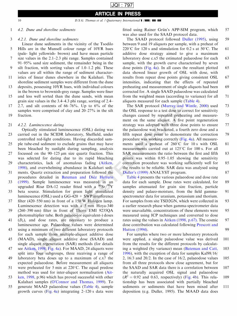
Optically stimulated luminescence (OSL) dating wascarried out in the SCIDR laboratory, Sheffield, undercontrolled red-light conditions. Having discarded sam-ple tube-end sediment to exclude grains that may havebeen bleached by sunlight during sampling, analysisfocussed on the 90–125 mm size quartz fraction. Thiswas selected for dating due to its rapid bleachingcharacteristics, lack of anomalous fading (Aitken,1998), and overwhelming abundance in Kalahari sedi-ments. Quartz extraction and preparation followed theprocedures detailed in Bateman and Di!ez Herrero(1999). Sample luminescence was measured in anupgraded Ris� DA-12 reader fitted with a 90Sr=90Ybeta source. Stimulation for green light stimulatedluminescence (OSL) used a GG-420 + SWP interferencefilter (420–550 nm) in front of a 150 W Halogen lamp.Luminescence detection was with a 5 mm Hoya-340(260–390 nm) filter in front of Thorn EMI 9235QAphotomultiplier tube. Both palaeo-(or equivalent-) dosesðDeÞ; and dose rates, are necessary to produce aluminescence age. Palaeodose values were determinedusing a minimum of two different laboratory protocolsfor each sample from multiple-aliquot additive dose(MAAD), single aliquot additive dose (SAAD) andsingle aliquot regeneration (SAR) methods (for detailssee Aitken, 1998; Fig. 4a). For MAAD, 24 aliquots weresplit into four subgroups, three receiving a range oflaboratory beta doses up to a maximum of c.x7 theexpected palaeodose. Before measurement all aliquotswere preheated for 5 min at 2201C: The equal predosemethod was used for inter-aliquot normalisation (Ait-ken, 1998, p.96) which has proved successful with otherKalahari samples (O’Connor and Thomas, 1999). Togenerate MAAD palaeodose values (Table 4), samplegrowth curves (Fig. 4a) integrating 2–120 s data were
fitted using Rainer Gr .un’s APP-SIM program, whichwas also used for the SAAD protocol data.
The SAAD protocol followed Duller (1995), usingbetween 9 and 19 aliquots per sample, with a preheat of2201C for 120 s and stimulation for 0:2 s at 501C: Theadditive dose strategy aimed to give a maximumlaboratory dose c.x5 the estimated palaeodose for eachsample, with the growth curve characterised by sevendose points (Fig. 4a). In all cases the resultant plotteddata showed linear growth of OSL with dose, withresults from repeat dose points giving consistent OSLintensities, indicating that the effects of repeatedpreheating and measurement of single aliquots had beencorrected for. A single SAAD palaeodose was calculatedfrom the weighted mean (according to variance) for allaliquots measured for each sample (Table 4).
The SAR protocol (Murray and Wintle, 2000) usedthe OSL response to a test dose to correct for sensitivitychanges caused by repeated preheating and measure-ment on the same aliquot. A five point regenerationstrategy was adopted with three dose points to ensurethe palaeodose was bracketed, a fourth zero dose and afifth repeat dose point to demonstrate the correctionprocedure was working correctly (Fig. 4a). All measure-ments used a preheat of 2601C for 10 s with OSLmeasurements carried out at 1251C for 100 s: For allSAR measurements the ratio between the first and fifthpoints was within 0.95–1.05 showing the sensitivitycorrection procedure was working sufficiently well forthe results to be reliable. SAR data was analysed usingDuller’s (1999) ANALYST program.
Table 4 presents the various palaeodose and dose ratedata for each sample. Dose rates were calculated, forsamples attenuated for grain size fraction, particledensity and palaeo-moisture, from the field gamma-spectrometer data for uranium, potassium and thorium.For samples from site TSD2GN, which were collected ina earlier research phase when gamma-spectrometer datawere unavailable, concentrations of these elements weremeasured using ICP techniques and converted to doserates using the values in Aitken (1998, p.67). The cosmicdose contribution was calculated following Prescott andHutton (1994).
For samples where two or more laboratory protocolswere applied, a single palaeodose value was derivedfrom the results for the different protocols by calculat-ing a weighted (by variance) mean (Bateman and Catt,1996), with the exception of data for samples Kal98/16/2, 16/3 and 20/2. In the case of 16/2, palaeodose valuesfrom all three protocols show close agreement, but forthe SAAD and SAR data there is a correlation betweenthe naturally acquired OSL signal and palaeodose(R2 ¼ 0:92 and 0.63, respectively) (Fig. 4b). This rela-tionship has been associated with partially bleachedsediments or sediments that have been mixed afterdeposition (e.g. Duller, 1995). The MAAD data does
ARTICLE IN PRESS
1
3
5
7
9
11
13
15
17
19
21
23
25
27
29
31
33
35
37
39
41
43
45
47
49
51
53
55
57
59
61
63
65
67
69
71
73
75
77
79
81
83
85
87
89
91
93
95
97
99
101
103
105
107
109
111
D.S.G. Thomas et al. / Quaternary International ] (]]]]) ]]]–]]]10
JQI : 797

UNCORRECTED PROOF
ARTICLE IN PRESS
1
3
5
7
9
11
13
15
17
19
21
23
25
27
29
31
33
35
37
39
41
43
45
47
49
51
53
55
57
59
61
63
65
67
69
71
73
75
77
79
81
83
85
87
89
91
93
95
97
99
101
103
105
107
109
111
(a)
(b)
Fig. 4. (a) Examples of luminescence growth curves for the different OSL protocols used in the study. (b) SAAD and SAR data showing
reproducibility of data from runs of multiple aliquots of sediment from the same samples. MAAD data show calculated De as a function of OSL
stimulation time.
D.S.G. Thomas et al. / Quaternary International ] (]]]]) ]]]–]]] 11
JQI : 797

UNCORRECTED PROOF
not support this, however, as palaeodose plotted againststimulation time produces a plateau, suggestive ofsufficient bleaching. The MAAD palaeodose value onlywas therefore used for this sample. The SAADpalaeodose for Kal 98/16/3 is much higher than SARand MAAD values, which are in good agreement witheach other. SAAD data have a significant correlationbetween naturally acquired signal and palaeodose ðr2 ¼0:63Þ (Fig. 4b). In contrast the SAR data shows no suchcorrelation ðr2 ¼ 0:47Þ and the MAAD data forms agood plateau: neither therefore gives evidence of mixing/partial bleaching, and the final palaeodose for thissample was determined from these data. SAAD andMAAD palaeodose values for Kal98/20/2 are muchlarger than that from the SAR protocol (Table 1).SAAD naturally acquired signal–palaeodose data cor-relate significantly with r2 ¼ 0:96 (Fig. 4b). Althoughthe MAAD data does shows a plateau which is inagreement with the SAR palaeodose values, this onlyoccurs after 30 s of stimulation time by which time themajority of acquired luminescence signal has beenevicted. Given the doubts about the MAAD and SAADdata, palaeodose from the SAR protocol was used in theage determination.
4.2.3. Dune and shoreline ages
Table 4 shows OSL age determinations expressed inreal years before present (2000) to 71 S.D. Dune agesfrom the upper 2 m of dune bodies are stratigraphicallycorrect, and fall within the 35–28 ka ago (plus errors)range. This is consistent with ages reported from siteswithin the extensive linear dune fields in the CapriviStrip, northern Namibia, 200 km to the north andnorthwest (Thomas et al., 2000). Younger ages are
notably absent: all other dated dune sites in the northernand middle Kalahari yield dune sediment ages youngerthan 25 ka ago (Stokes et al., 1998; O’Connor andThomas, 1999), though it can be noted that agesyounger than 20 ka ago are also absent from the Caprividunes. Sample TSD2GN/2, at 4:9 m depth representinga location mid-way down the total dune profile, an ageof 9879 ka ago. This is within the range of the oldestdune ages from the degraded dunes in westernZimbabwe (Stokes et al., 1998). OSL ages from theshoreline feature are notably younger than the dunesediments, with the deeper samples from 0:8 m yieldingages of 18 ka and the shallower samples ages of 13–11 ka:
5. Discussion: environmental changes at Tsodilo
The data provide an opportunity to discuss thetemporal and spatial dynamics of environmentalchanges in the vicinity of the Tsodilo Hills. The OSLages indicate that dune development in this area has notoccurred since the Last Glacial Maximum and that itpredated a high stand of Lake Tsodilo, when theshoreline incision into the northernmost dune occurred.Data from the organisms present in the lacustrinecarbonates provide a record of changes in water qualityand seasonality in Lake Tsodilo (Table 3) with Fig. 5summarising the temporal and spatial behaviour ofLake Tsodilo during the last 30; 000 yr:
Precipitation in this summer rainfall area is princi-pally a direct function of movements of the ITCZ, whichhas been dynamic in its location during the lateQuaternary (Braconnot et al., 2000). Both orbital
ARTICLE IN PRESS
1
3
5
7
9
11
13
15
17
19
21
23
25
27
29
31
33
35
37
39
41
43
45
47
49
51
53
55
57
59
61
63
65
67
69
71
73
75
77
79
81
83
85
87
89
91
93
95
97
99
101
103
105
107
109
111
Table 4
Palaeodoses, Dose rates and OSL age estimates for samples from Tsodilo Hills, Botswana
Site Lab code Depth (m) Palaeodoses Dose rate Age estimates
SAAD (Gy) SAR MAAD Combined ðGy ka�1Þ (ka)
Linear dunes samples
Kal/98/16/2 Shfd98096 0.70 13.5172.61 10.8371.69 12.4371.96 442719 28.174.6
16/1 Shfd98097 1.10 15.1672.39 14.7672.10 14.9371.69 15.1971.66 431719 35.174.2
16/3 Shfd98098 1.75 22.2073.18 15.2771.96 15.9471.58 15.6671.68 442719 35.474.1
Kal/98/17/1 Shfd98099 1.20 14.0771.94 472719 29.874.4
TSD2GN/1/2 Shfd97060 1.00 15.2171.18 450714 33.872.8
Shfd97061 4.90 35.3773.14 360711 98.179.2
Shoreline samples
Kal/98/20/1 Shfd98100 0.40 6.5970.79 5.9070.92 6.6570.98 6.6570.85 565720 11.871.6
20/2 Shfd98101 0.80 15.0871.40 10.1970.66 15.4371.41 10.1970.66 553719 18.471.4
Kal/98/21/1 Shfd98102 0.40 7.3670.51 563719 13.171.0
21/2 Shfd98103 0.80 9.9471.07 551719 18.072.0
D.S.G. Thomas et al. / Quaternary International ] (]]]]) ]]]–]]]12
JQI : 797

UNCORRECTED PROOF
forcing (Partridge et al., 1997) and Atlantic SST (seasurface temperature) (Little et al., 1997) have beenproposed as the major drivers of changes rainfallchanges in the southern African interior at millennialtimescales (see Thomas and Shaw, 2002). The presenceof a lake at the foot of the Tsodilo Hills is a directreflection of increased effective precipitation (P–E) inthe region. Channels do not lead into the lake basin, andwhile runoff from the relatively small hills may accountfor localised ponding in the area immediately adjacentto the foot of the Male and Female hills, it is extremelyunlikely to account solely for increases in standing water
throughout the basin. Brook et al. (1992) suggested thatseepage from the surrounding porous aeolian sands willhave contributed to accumulation. It can further benoted that the hills lie along a structural lineament thatis probably a fault (Mallick et al., 1981), which also linksto the Ncamasere valley (e.g. Nash et al., 1994) 20 km tothe north (Fig. 1). Together, these factors will favour theaccumulation of standing water at the Tsodilo Hillsduring times of greater regional rainfall. Molluscremains suggest that deep permanent water bodiesoccurred in areas 1 and 3 from 40 ka up to perhaps32 ka; with diatom evidence suggesting conditionsbecame more seasonal and eutrophic from 36 ka:Significant dune construction, probably associated withclimatic conditions both drier and windier than today(Thomas et al., 2000), occurred from at least 36 ka agoto 28 ka: Currently the middle and northern Kalahariare low wind energy environments (Thomas et al., 2000),such that a reduction in contemporary P–E alone isunlikely to be sufficient to lead to dune construction.Late Quaternary wind energy maxima in southernAfrica may be associated with ridging anticyclonicconditions over the southern Indian Ocean (Prell andVan Campo, 1986), and an increase in wind energy,above present levels, at 36–28 ka; would also have beennecessary to facilitate dune construction at this time.Little et al. (1997) identify from SE Atlantic Ocean coreevidence periods of increased SE trade wind strengthand zonation, implicitly contributing to more aridconditions in the region, at �36:7–32.7 and 29–26:1 kaago. This is in good agreement with the evidence fromTsodilo.
Data from throughout the basin indicate that lacus-trine conditions predominated from 27–22 and 19–12 ka: The break between 22 and 19 ka may indicate adrying out of the basin and coincides with LGMregional aridity as proposed by Partridge et al. (1999),and the period of aridity at 21–17:5 ka determined byNing et al. (2000) from pollen evidence contained inAtlantic cores off the north Namibia coast. Interestinglyhowever, there is no evidence for dune construction atthis time from this or other studies of northern andmiddle Kalahari palaeodunes (Thomas et al., 2000;Thomas and Shaw, 2002), or from Brook et al.’s (1998)investigation of arid episodes from sediments in theAikab, Algamas and Guinas Meer cenotes (Fig. 1) in theOtavi mountains of northern Namibia, at the samelatitude. Water conditions during 18–11 ka were suffi-cient to permit lake margin incision into the dune bodyand the development of a shoreline feature. It can benoted that this episode corresponds to the gap betweenarid phases identified by Ning et al. (2000) at 21–17.5and 14.3–12:6 ka: The mollusc and diatom evidenceindicate that lake conditions were by no meansconsistent during the end Pleistocene, with water qualityand extent both fluctuating.
ARTICLE IN PRESS
1
3
5
7
9
11
13
15
17
19
21
23
25
27
29
31
33
35
37
39
41
43
45
47
49
51
53
55
57
59
61
63
65
67
69
71
73
75
77
79
81
83
85
87
89
91
93
95
97
99
101
103
105
107
109
111
Fig. 5. Summary of the temporal and spatial dynamics of Lake
Tsodilo.
D.S.G. Thomas et al. / Quaternary International ] (]]]]) ]]]–]]] 13
JQI : 797

UNCORRECTED PROOF
6. Conclusion
This study has three important implications. First, itdemonstrates that by careful consideration of multi-proxy data from a discrete location, it is possible toadvance understanding of the relationship in the timingof late Quaternary wetter and drier phases in theKalahari. This has helped to resolve some of theuncertainties concerning the timing of wetter and drierconditions that have arisen from independent studies ofKalahari lake, cave and dune records. The number ofsites in the Kalahari where aeolian and lacustrinerecords are found in stratigraphic association is howeverlimited, such that this approach cannot necessarily beapplied throughout the Kalahari region as a whole.
Second, comparisons between the Tsodilo record andthe SST (Little et al., 1997) and terrestrial pollen (Ninget al., 2000) records from southeast Atlantic oceansediment cores indicate a promising level of correlationbetween the marine and terrestrial records.
Third, this study suggests that while the northernKalahari has been geomorphologically dynamic duringthe late Pleistocene, with marked variations in regionaleffective rainfall, it was geomorphologically ‘quiet’during the Holocene, with no evidence from this studyarea of hydrological variations sufficient to generateeither water bodies capable of supporting lacustrineorganisms or sand dune development and accumulation.
References
Aitken, M.J., 1998. An Introduction to Optical Dating. Oxford
University Press, Oxford, 267pp.
Bateman, M.D., Catt, J.A., 1996. An absolute chronology for the
raised beach and associated deposits at Sewerby, East Yorkshire,
England. Journal of Quaternary Science 11, 389–395.
Bateman, M.D., Di!ez Herrero, A., 1999. Thermoluminescence dates
and palaeoenvironmental information of the late Quaternary sand
deposits, Tierra de Pinares, Central Spain. Catena 34, 277–291.
Bates, C.D., Coxon, P., Gibbard, P.L., 1978. A new method for the
preparation of clay-rich sediment samples for palynological
investigation. New Phytologist 81, 459–463.
Braconnot, P., Joussaume, S., de Noblet, N., Ramstein, G., 2000. Mid-
Holocene and Last Glacial Maximum African monsoon changes as
simulated within the Paleoclimate Modelling Intercomparison
Project. Global and Planetary Change 26, 51–66.
Brook, G.A., Haberyan, K.A., de Filippis, S., 1992. Evidence of a
shallow lake at Tsodilo Hills, Botswana, 17500 to 15000 yr BP:
further confirmation of a widespread Late Pleistocene humid
period in the Kalahari Desert. Palaeoecology of Africa 23, 165–
175.
Brook, G.A., Cowart, J.B., Brandt, S.A., 1998. Comparison of
Quaternary environmental change in eastern and southern Africa
using cave speleothem, tufa and rock shelter sediment data. In:
Alsharan, A., Glennie, K.W., Wintle, G.L., Kendall, C.G. StC
(Eds.), Quaternary Deserts and Climate Change. Balkema,
Rotterdam, pp. 239–250.
Cronberg, G., Gieske, A., Martins, E., Prince-Nengu, J., Stenstrom, I-
M., 1995. Hydrobiological studies of the Okavango Delta and
Kwando/Linyanti/Chobe River, Botswana. 1. Surface water
quality analysis. Botswana Notes and Records, Vol. 27, pp. 151–
226.
De Menocal, P.B., Ruddiman, W.F., Pokras, E.K., 1993. Influences of
high- and low-latitude processes on African terrestrial climate:
Pleistocene eolian records. Palaeooceanography 8, 209–242.
Duller, G.A.T., 1995. Luminescence dating of sediments using single
aliquots: methods and applications. Radiation Measurements 24,
217–226.
Duller, G.A.T., 1999. Luminescence Analyst computer programme v
2.18. Department of Geography and Environmental Science.
University of Wales, Aberystwyth.
Ellery, K., 1987. Wetland plant community composition and succes-
sional processes in the Mauachira River system of the Okavango
Delta. Unpublished M.Sc. Thesis, University of the Witwatersrand.
Gasse, F., 1986. . East African diatoms: taxonomy, ecological
distribution. Bibliotheca Diatomologica, Vol. 11. Cramer, Stutt-
gart.
Goldstein, R.H., 1988. Palaeosols of late Pennsylvanian strata, New
Mexico. Sedimentology 35, 777–803.
Goudie, A.S., 1983. Calcrete. In: Goudie, A.S., Pye, K (Eds.),
Chemical Sediments and Geomorphology. Academic Press, Lon-
don, pp. 93–131.
Grove, A.T., 1969. Landforms and climatic change in the Kalahari and
Ngamiland. Geographical Journal 135, 191–212.
Holmgren, K., Karlen, W., Shaw, P.A., 1995. Palaeoclimatic
significance of variations in stable isotopic composition and
petrology of a late Pleistocene stalagmite from Botswana.
Quaternary Research 43, 320–328.
Kocurek, G., 1998. Aeolian system response to external forcing
factors—a sequence stratigraphic view of the Saharan region. In:
Alsharan, A., Glennie, K.W., Wintle, G.L., Kendall, C.G. StC
(Eds.), Quaternary Deserts and Climate Change. Rotterdam,
Balkema, pp. 327–337.
Krammer, K., Lange-Bertalot, H., 1991. Bacillariophyceae. Vol. 2. In:
Ettl, H., Gerloff, J., Heyning, H., Mollenhauer, D. (Eds.),
Susswasserflora von Mitteleuropa. Fisher, Stuttgart.
Little, M.G., Scheneider, R.R., Kroon, D., Price, B., Bickert, T.,
Wefer, G., 1997. Rapid palaeooceanographic changes in the
Benguela upwelling system for the last 160,000 years as indicated
by abundances of planktonic foraminefera. Palaeogeography,
Palaeclimatlogy, Palaeoecology 130, 135–161.
Mallick, D.I.J., Habgood, F., Skinner, A.C., 1981. . A geological
interpretation of Landsat imagery and air photography of
Botswana. Overseas Geology and Mineral Resources, Vol. 56.
IGS, London.
McLaren, S.J., 1995. Early carbonate diagenetic fabrics in the
rhizosphere of late Pleistocene aeolian sediments. Journal of the
Geological Society 152, 173–181.
Murray, A.S., Wintle, A.G., 2000. Luminescence dating of quartz
using an improved single-aliquot regenerative-dose protocol.
Radiation Measurements 32, 57–73.
Nash, D.J., Thomas, D.S.G., Shaw, P.A., 1994. Timescales, environ-
mental change and dryland valley development. In: Millington,
A.C., Pye, K (Eds.), Environmental Change in Drylands. Wiley,
Chichester, pp. 25–42.
Nicholson, S.E., 2000. The nature of rainfall variability over Africa on
time scales of decades to millenia. Global and Planetary Change 26,
137–158.
Ning, S., Dupont, L.M., Eug, H-J., Scheider, R., 2000. Correlation
between vegetation in southwestern Africa and oceanic upwelling
in the past 21,000 years. Quaternary Research 54, 72–80.
O’Connor, P., Thomas, D.S.G., 1999. The timing and environmental
significance of Late Quaternary linear dune development in western
Zambia. Quaternary Research 52, 44–55.
ARTICLE IN PRESS
1
3
5
7
9
11
13
15
17
19
21
23
25
27
29
31
33
35
37
39
41
43
45
47
49
51
53
55
57
59
61
63
65
67
69
71
73
75
77
79
81
83
85
87
89
91
93
95
97
99
101
103
105
107
109
111
D.S.G. Thomas et al. / Quaternary International ] (]]]]) ]]]–]]]14
JQI : 797

UNCORRECTED PROOF
Partridge, T.C., Demenocal, P.B., Lorentz, S.A., Paiker, M.J., Vogel,
J.C., 1997. Orbital forcing of climate over South Africa: a 200,000-
year rainfall record from the Pretoria Salt Pan. Quaternary Science
Reviews 16, 1125–1133.
Partridge, T.C., Scott, L., Hamilton, J.E., 1999. Synthetic reconstruc-
tions of southern African environments during the Last Glacial
Maximum (21–28 kyr) and the Holocene Altithermal (8–6 kyr).
Quaternary International 57/58, 207–214.
Patrick, R., Reimer, C.W., 1966. The Diatoms of the United States,
Vol. 1, Monograph 13. Academy of Natural Sciences, Philadelphia.
Patrick, R., Reimer, C.W., 1975. The Diatoms of the United States,
Vol. 2(1), Monograph 13. Academy of Natural Sciences, Philadel-
phia.
Prell, W.L., Van Campo, E., 1986. Coherent response of Arabian Sea
upwelling and pollen transport to late Quaternary monsoonal
winds. Nature 323, 526–529.
Prescott, J.R., Hutton, J.T., 1994. Cosmic ray contributions to dose
rates for luminescence and ESR dating: large depths and long-term
time variations. Radiation Measurements 23, 497–500.
Richardson, J.L., Harvey, T.J., Holdship, S.A., 1978. Diatoms in the
history of shallow East Africa lakes. International Revue Gestam-
men Hydrobiologica 54, 175–176.
Robbins, L., Murphy, M.L., Stewart, K.M., Campbell, A.C., Brook,
G.A., 1994. Barbed bone points, paleoenvironment and the
antiquity of fish exploitation in the Kalahari Desert, Botswana.
Journal of Field Archaeology 21, 257–264.
Shaw, P.A., Thomas, D.S.G., 1993. Geomorphological processes,
environmental change and landscape sensitivity in the Kalahari
region of Southern Africa. In: Thomas, D.S.G., Alison, R.J (Eds.),
Landscape Sensitivity. Wiley, Chichester, pp. 83–92.
Shaw, P.A., Stokes, S., Thomas, D.S.G., Davies, F.B.M., Holmgren,
K., 1997. Palaeoecology and age of a late Quaternary high lake
level in the Makgadikgadi Basin of the Middle Kalahari,
Botswana. South African Journal of Science 93, 273–276.
Singhvi, A.K., Wintle, A.G., 1999. Luminescence dating of aeolian and
coastal sand and silt deposits applications and implications. In:
Goudie, A.S., Livingstone, I., Stokes, S (Eds.), Aeolian Environ-
ments, Sediments and Landforms. Wiley, Chichester, pp. 293–317.
Stokes, S., Thomas, D.S.G., Washington, R., 1997. Multiple episodes
of aridity in southern Africa since the last interglacial period.
Nature 388, 154–158.
Stokes, S., Haynes, G., Thomas, D.S.G., Horrocks, J.L., Higginson,
M., Malifa, M., 1998. Punctuated aridity in southern Africa during
the last glacial cycle: the chronology of linear dune construction in
the northeastern Kalahari. Paleogeography, Palaeoclimatology,
Palaeoecology 137, 305–322.
Stuiver, M., Reimer, P.J., Reimer, R., 1999. CALIB Radiocarbon
Calibration. http://depts.washington.edu/qil/calib/.
Thomas, D.S.G., Shaw, P.A., 1991. The Kalahari Environment.
Cambridge University Press, Cambridge.
Thomas, D.S.G., Shaw, P.A., 2002. Late Quaternary environmental
change in central southern Africa: new data, synthesis, issues and
prospects. Quaternary Science Reviews 21, 783–797.
Thomas, D.S.G., O’Connor, P.W., Bateman, M.D., Shaw, P.A.,
Stokes, S., Nash, D.J., 2000. Dune activity as a record of late
Quaternary aridity in the Northern Kalahari: new evidence from
northern Namibia interpreted in the context of regional arid and
humid chronologies. Palaeogeography, Palaeoclimatology, Pa-
laeoecology 156, 243–259.
Van Meel, L., 1954. Le Phytoplancton. In: Exploration hydrobiolo-
gique due Lac Tanganyika, Vol. IV, fasc 1B. Institut Royal des
Sciences Naturelles du Belgique, Brussels.
Watson, A., Nash, D.J., 1997. Desert crusts and varnishes. In:
Thomas, D.S.G (Ed.), Arid Zone Geomorphology, 2nd Edition.
Wiley, Chichester, pp. 69–107.
Wintle, A.G., 1999. Optical dating in southern Africa. Southern
African Journal of Science 95, 181–186.
ARTICLE IN PRESS
1
3
5
7
9
11
13
15
17
19
21
23
25
27
29
31
33
35
37
39
41
43
45
47
49
51
53
55
57
D.S.G. Thomas et al. / Quaternary International ] (]]]]) ]]]–]]] 15
JQI : 797
Related Documents